Embed Size (px)
Citation preview
rssN 0110-4705
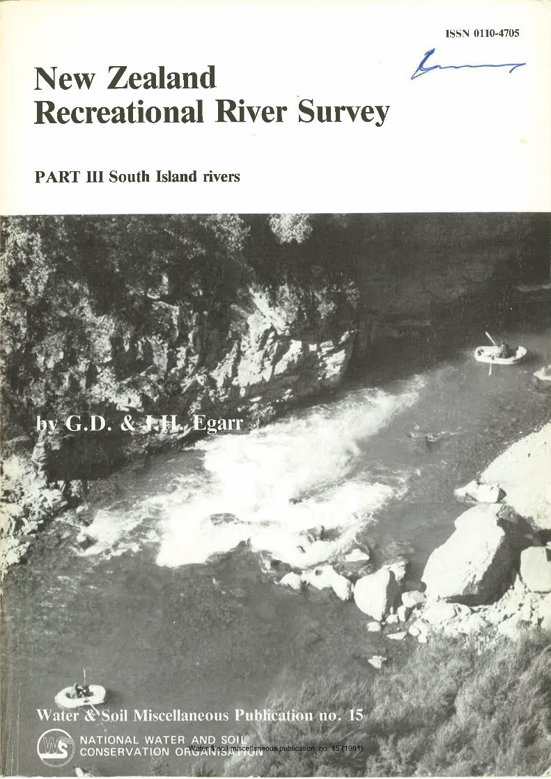
New ZeulandRec reational River Survey
PART III South Island rivers
Water & soil miscellaneous publication no. 15 (1981)
New ZealandRecreational River Survey
An investigation into the recreational potentialof New Zealand's inland waterways
PART IIISummaries of South Island rivers
G. f). and J. II. Egarr
with the assistance ofNZ Jet Boat Association, Department of Lands and Survey,
Ministry for Recreation and Sport, andCommission for the Environment
Published for the
New Zeùand Canoeing Associationby the
National Water and Soil Conservation Organisation
by
Water & soil miscellaneous publication no. 15 (1981)
New Z,ealand RecrBational River Survey Part III
G.D. & J.H. EgarrNZ Canoeing Associrlion
water & Soil Miscellaneous Publication No. 15, 1981. l60pp., I map. lSSNollG4705
An investigation into the potential of New Zealand rivers for recreation by motorlaunch, jet boat, drift boat, raft, canoe/kayak, pack floating and swimming has been
made by the New Zealand Canoeing Association.Part III contains the results for the South Island rivers and major lakes. Each river is
described by location, river mouth/confluence location, map reference, length, average
gradient, recreational use, scenic description, scenic value and recreational value.
Part I of the report contains conclusions and recommendations, while Part lldescribes the North Island rivers.
Cover photograph by Mannering & Associates Ltd'
National Library of New Zealand Cataloguing-in-Publication dalaEGARR, C.D. (Graham David), 1949-
New Zealand recreational river suruey : an investigation into therecreational potential of New Zealand's inland waterways / by C.D.and J.H. Egarr; with lhe assistance ofthe NZ Jet Boat Association...[et øt.1. - Wellington : National Water and Soil ConservationOrganisation for New Zealand C¿noeing Association, l98l-
v. - (r'Vater & soil miscellaneous publication, ISSN 0l 10-4705).
- (New Zealand Water and Soil Division)Pt 3: Summaries of South lsland rivers. - 1981. - lv' -
(Water & soil miscellaneous publication, ISSN 0ll0-4705 i no'15).333.78450993 I
l. Rivers - New Zealand - Recreational use. l. Egarr, J.H'(Jan Hazel), l95l- . ll. New Zealand Jel Boat Association. Ill.New Zealand Canoeing Association. lV. Title. V. Tille: Summaries
of South lsland rivers. Vl. Series.
C¡fchment numbers have been ¡dded for e¡sc of ldenlific¡tlonand use by Calchment Authorities and olher orgrn¡saaions. The
texf is printed w¡lhoul alteration (ap¡rl from minor co¡¡eclion
and editing) and fhe opinions expressed arc lhose of the rulhorsand not necessarily fhose of lhe Nalional W¡ler ¡nd Soil C¡rn'
servrlion organisalion.
(Ð Crown copyright 1981.
Water & Soil Division, Ministry of Works and Development,P.O. Box l2-Ml, Wellington, New Zealand.
Water & soil miscellaneous publication no. 15 (1981)
CONTBNTS
Balclutha to TaieriTaieri to Waitaki and Southern Lakes ............ 89
South Canterbury........ .............101North Canterbury ........ ............113Kaikoura Coast to Marlborough Sounds .-.......129Nelson fo Cape Farewell .............f43Index by river name . ..... . .... ....... 153
Index by catchment number ........157
south eastern coast of the South Island has been
numbered 103.0. The Fleming River, a tributary ofthe Tautuku, has been numbered 103.1. For those
rivers that alter dramatically in character along theirlength, each section has been dealt with as if it were
a tiibutary of the main river. Consequently, theBuller River has been numbered 14.0' and its sec-
tion from Lyell to Westport has been given thenumber 14.6. The Inangahua River, a large
tributary of the Buller flowing into this section has
been numbered 14.6.1 to 14'6.4 (third-ordernumbers). The tributaries of the Waitaki, however,have a slightly different numbering system because
of the complex nature of the catchment. Thetributaries have been given first-order numbers'
LocationThere are brief notes on the location of each
river to help identification. This is useful where
there are rivèrs of the same name e.g' Waiau, Ach-eron, Kowhai, Blackwater.
River mouth/confluence locationTo further help with identification, the river
mouth, confluence or end of section has been given
the grid reference as it appears on the New ZealandMap Series 1 Topographicalmaps of scale l:63360.
MapsTopographical maps of Series I and l8 (Scale
l:633-60-anã l:250 000) that cover the particularriver, or river section, are listed'
LengthThe total length of the river in kilometres is given
from its source as shown on the NZMS I maps.
Average gradientThe gradient for the middle section of the river
or rivei section is given. These are approximateonly.
Recreational use
This section of each summary provides a shortationalion re-actualthe re-
port where each recreational mode is described and
ihe reasottt why other recreational uses have been
excluded from this survey'
page
..... .. 75
NOTBS FOR PART IIIThis volume comprises summaries of the investiga-tion into the recreational potential of the InlandWaterways of the South lsland of New Zealand.These summaries must be read in conjunction withPart I which defines and explains the terms anddefinitions used. These summaries have been based
upon the data collected from the 'River RecreationAssessrnent Sheets' discussed in Part I' However,the following points should be noted:
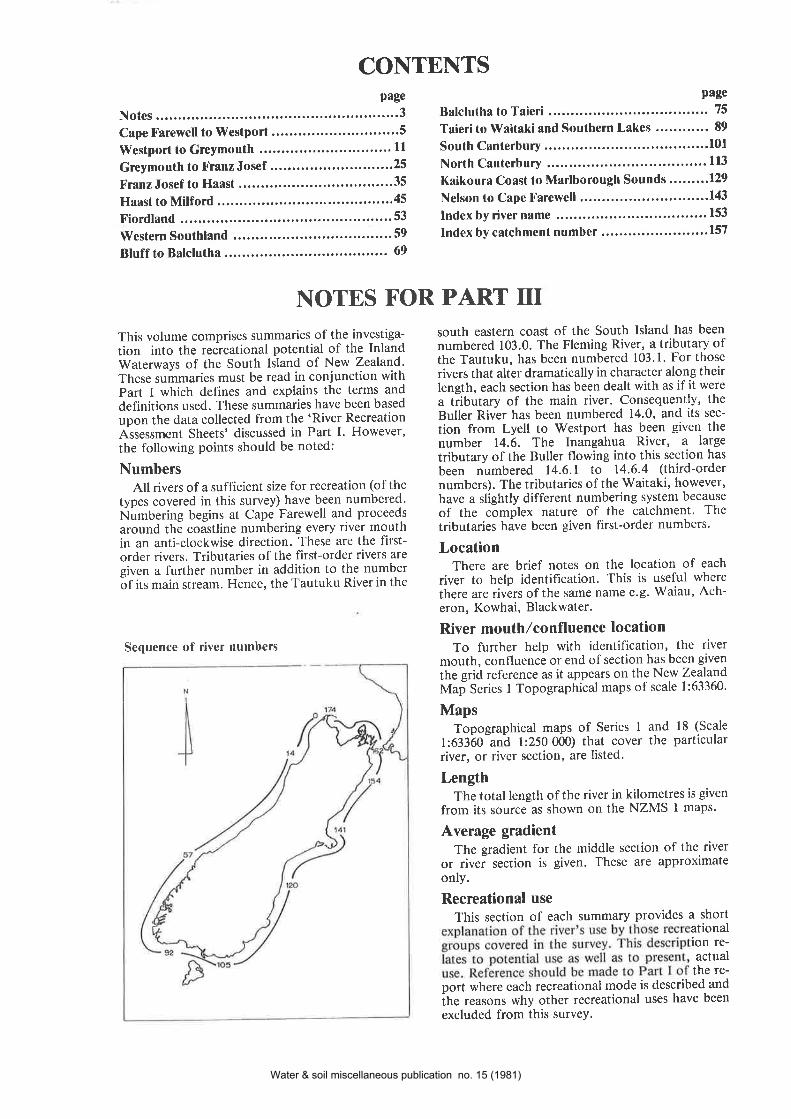
NumbersAll rivers of a sufficient size for recreation (of the
types covered in this survey) have been numbered'Numbering begins at Cape Farewell and proceeds
around thè coastline numbering every river mouthin an anti-clockwise direction' These are the first-order rivers. Tributaries of the first-order rivers are
given a further number in addition to the numberóf its main stream. Hence, the Tautuku River in the
Sequence of river numbers
Water & soil miscellaneous publication no. 15 (1981)
The following recreational modes are used:Motor launches - Includes all power-driven craft
Jet boats
driven by submerged screw orpropeller.
- All jet boats except the verysmall 'mini-jets' which mayrravigatc rivcrs furtllcr thalr thedistances noted in the riversummaries.
- Oared or paddle-poweredcraft, generally small solid-skinned dinghies and inflatablerubber rafts of 3 metres ormore. They usually drift down-stream using oars or paddlesfor lateral movement across thecurrent to avoid obstacles.
- Generally constructed fromvehicle inner tubes and prop-elled by paddles. Less man-oeuverable than canoes but aresmaller than drift boats. Oftenused on small, rocky rivers ofhigh gradient where numerousportages are required.
Drift boafs
Raff
Canoes,/kayaks - We refer to the modern glass-fibre craft now commerciallyavailable. Many of the older,canvas-skinned kayaks are notcapable of handling the waterconditions found on manyNew Zealand rivers.
Pack floatinC - Swimmers who float downrivers with the assistance ofadditional buoyancy such assmall inner tubes, lilos (or-airbeds), tramping packs or lifejackets. Crash helmets areusually worn.
Swimming - People who 'splash about' andswim in a separate pool on ariver and who do not travel anydistance downstream as dopack floaters.
Scenic descriptionThis section comprises short notes on the
appearance of the river and the valley as seen fromthe river level. No attempt has been made to scien-tifically analyse the vista in this section but we haveattempted to reflect the aesthetic judgement of the
average informed layman, who will be the recrea-tionalist using the resource. Refer to the relevantchapter in Part I.
Scenic valueAll rivers have been given a value on a six-point
scale, namely: - Dull
- Uninspiring
- Moderate
- Picturesque
- Impressive
- ExceptionalAn explanation about the factors relating to this
value will be found in Part I of the survey report.
Recreational valueEach river has been given a value according to its
value as an actual and potential recreational re-source. These values do not relate to actual usagenumbers. The factors relating to this value includeproximity to urban population, ease of access, de-gree ofskill required in the resource use, absence ofpollution and other health hazards, and absence ofscenic misfits. A full list of relevant factors is pro-vided in Part I of the survey report.
Where applicable, the skill factor (degree of dif-ficulty encountered by recreationalists) has beennoted according to the internationally recognisedriver grading from I to the most difficult, 6. A totalrecreational value has been given on a five-pointscale, namely:
- Insignificant
- Low
- Intermediate
- High
- Exceptional
ConclusionConclusions and recommendations resulting
from the survey can be found in Part I of the re-port.
CautionThese summqries sre not intended as river guides
and by noting present use of o resource we in noway recommend that use. We hqve assumed, at alltimes, thøt competenl qnd experienced recre-ationalists will be using the resource so that, whilewe may note lhat certain rivers are used, this in noway implies that unskilled recreationalists mayossume lhat they are capøble of using that resource.
Water & soil miscellaneous publication no. 15 (1981)
8.0 OpararaRiver ........................ I9.0 KarameaRiver....................... 8
10.0 LittleS/anganui River .............. 9ll.0 MokihinuiRiver ..................... 9
12.0 Ngakawau River ..................... 913.0 Coastal Streams ...... 9
Water & soil miscellaneous publication no. 15 (1981)

Water & soil miscellaneous publication no. 15 (1981)
I.O WESTHAVEN INI,ET(WHANGANUI INLET)
Location: The Westhaven Inlet (also known as Whanganui
Inlet or West Whanganui Inlet) is a large inlet in the West
õoast below Farewell Spit. A scenic road passes along the
inland shore of the inlet and over a number of causeways
which span the numerous small rivers and creeks that flowinto the inlet. The main rivers are Coal Creek, Mangarakau
Stream, Muddy Creek, Bone Creek and the Wairoa River'
River mouth location: NZMSI, Sl &'53/965142'Maps: NZMSl8, Sheet l3 Golden Bay; NZMSl, Sheet Sl & 53
Collingwood and Farewell.Iængtñ: Main river - Wairoa: 8km (includes North Branch)'
Average gradient: 1:166 6mlkm.
vers fl haven Inlet are
e mud a great deal ofhe uP in thick bushexcept which has some
old logging roads. Canoeists and small craft could navigate a
short áistance upstream provided they were to launch on the
upstream side of the causewaY.
Scenic description: The inlet lies in the remote bush-clad area
of North Wèst Nelson State Forest Park' The lower, tidalreaches of the inlet dry out at low tide exposing mud flats that
are not particularly scenic' Otherwise, this is a remarkable area
of bush and tranquil water.
Scenic value: Impressive.Recreational Yalue: Low.
craft (rafts, canoes and drift boats).
Scenic description: The Anatori flows down a well defined
valley in a .aihe. twisting fashion' Thick bush covers the hill-
sides over all but the lower 3km which have been cleared' High
Iimestone bluffs lie to the west over the lower 3km of the river'
Scenic value: ImPressive.Recreational value: Insignificant'
4.O TURIMA\ryI\il RIYER 965000
Location: The Turimawiwi R'iver flows north through bush
onto the coast 5.5km below the Anatori River'
River mouth location: NZMSI, S2/751968'Maps: NZMSl8, Sheet 13 Golden Bay; NZMSI, Sheet 52
Kahurangi; NZMSI, Sheet S7 HeaPhY'
Iængth: l7km.Aveiage gradient: l:150 6.7mlkm.
flows over shingle for most of its length.
Scenic description: The Turimawiwi lies in a remote' natural
forest area in a deep, well defined valley. It is ¡nuch like the
Anatori.
Scenic value: ImPressiveRecreational value: Insignificant.
2.0 PATURAU RIVER 971000
Location: The Paturau River flows north from the Wakamar-
u.u iunga on the north-western coast to turn west and onto
the coast a little south of Westhaven Inlet.
River mouth location: NZMSI, 32/863073'Maps: NZMSl8, Sheet 13 Golden Bay; NZMSI, Sheet 52
Kahurangi.Length:29km.Average Gradient: l:375 2.7m/km'
Recreational use: A very shallow river with numerous snags' Itis seldom used for boating except during the white-bait season'
'Ihe river is sometimes canoed but needs above normal flows
for satisfactory use. It is not noted ome
iogging tracks which provide acces The
iãlä ímarejet boaìable but are high
flow.
t area of this river lies
farmed and is ratherdeal of scrub andin the river and tree
stumps on the land.
Scenic value: UninsPiring.Recreational value: Insignificant.
3.0 ANATORT RIVER, 967000
5.0 BIG RIVER 962000
Location: The Big River, a little north of Kahurangi Point,
flows into the Tasman in a wide, lagoon-like river mouth area
and like the Turimawiwi and Anatori Rivers, it lies in thick
bush.River mouíh location: NZMS1, 32/100923.Maps: NZMSIS, Sheet 13 Golden Bay; NZMSI, Sheet 52
Kahurangi; NZMSI, Sheet S7 HeaPhY.
Iængth:31km.Average gradient: l:85 I l.8m/km.
RECR"EATIONAL USE:Motor launches: The Big River lies in remote bush country
without easy access. I section of the
Heaphy Track crosses . The river has
uppâr"ntty never been , although it isoiìufficient size for b attractive area
for boaters. The problem of access is the sole reason for itsneglect. Two masiive fault lines cross the lower river and it is
believed that these create rapids. The survey was not able to in-
spect this river and its full recreational potential is unknown'The sentiments of local boaters are that the Karamea and Ana-
tori rivers offer similar recreational resources without the isola-
tion problems.
Scenic description: The river lies in a remote bush-clad valley ofsteep gradient.
Scenic value: ImPressive.Recreafional value: Low'
Location: The Anatori River flows north through thick bush
to flow onto the west coast at the road end, south of West-
haven Inlet.
Water & soil miscellaneous publication no. 15 (1981)
6.0 HEAPHY RIYER 959000
Localion: The Ileaphy River flows in a huge, senri-cir.cular pat-tern out from the Tasman Mountains in North West NelsonState Forest Park, to enter the Tasman Sea north ol'Karamea.
River mouth location: NZMSI, S7 /557657 .
Maps: NZMSIS, Sheet 13 Golden Bay; NZMSI, Sheet S7Heaphy.Length: 37km.Average gradient: Slight.
RECREATIONAL USE:Motor launches: No access and difficult river mouth bar. Notused,Jef boats: 3km have been boated at low water, lOkm when it isflowing high. Requires a 30km sea journey and a bar crossing.Not used to any great extent.Driff boats: Difficult access and shallow water limits its use.Rafts: Has been rafted over the lower l0km. Flat water notthought as being of great value apart from the scenery,Canoes/kayaks: The lower lTkm have been canoed over ashingle bed with snags. There are no real rapids in this section.Pack floating, swimming: Often floated by trampers using theHeaphy Track but it is not of sufficient value to be the mainreason for tramping in the area.
Scenic description: Limestone bluffs and the dense native bushimpress upon one that this is a remote area, extremely scenicand tranquil. The Heaphy Track which follows the lower riveris renowned as a scenic walk.
Scenic value: Impressive.Recreational Value: Low.
7.0 KOHAIHAI RIVER 955OOO
Localion: The Kohaihai River lies some 14km south of theHeaphy. It is much smaller.River mouth location: NZMSl, Sl2155051l.Maps: NZMSIS, Sheet 13 Golden Bay; NZMSI, Sheet Sl2Karamea.Length:19km.Average gradient: l:21 48m,/km.
Recreational use and scenic description: The Kohaihai River isa small river flowing through thick bush much like the Heaphybut it does not have the shingle flats and the wide valley floorwhich are found on the Heaphy. The bush comes down to theriver channel itself and overhangs the water. The river has notbeen used by boaters although it is large enough, at least forcanoeing. The gradient would create exciting rapids whenflooded, but the exact extent of this is unknown. Access hasbeen the main reason for its lack of use.
Scenic value: Impressive.Recreational value: Insignificant.
8.0 OPARARA RIVER 952000
Location: The Oparara River flows south towards Karameafrom the coastal hills, turning west onto the coast 5km northof the Karamea River mouth.River mouth location: NZMS I , SIZ/ 553397 .
Maps: NZMSIS, Sheet 13 Golden Bay; NZMSI, Sheet Sl2Karamea.Iængth:30km.Average gradient: l:62 l6m/km.
RECREATIONAL USE:Motor launches: The large lagoon at the river mouth may beused by the smallest of powered craft. Water weeds could pose
I
problems and there are snags. The edges of the lagoon areswampy, making for difficult launching. The river is notnavigable for any great distance due to snags.Jet boats: Has been boated over the lower 4km to above thebridge with the best launching approximately one kilometreabove the bridge.Drift boats, raffs: Not used to any great ex¿ent, as the entireboatable length is of very low gradient, flat, slow moving andabounds with snags.Canoes,/kayaks: Canoeable from Fenian Creek but access isdifficult.Pack floating, swimming: Unused.
Scenic description: The Oparara River is a small river flowingthrough limestone bluffs and there are two fascinating andimpressive natural arches of limestone over the river. The firstis at NZMSI, 312/631450. Logging roads penerrate rhe bushand provide the only accessible route into the area.
Scenic value: Impressive.Recrealional value: Low.
9.0 KARAMEA RIVER 951000Locationl The Karamea makes a wicle, northwarcls semi-
River mouth location: NZMSI, Sl2/54633iMaps: NZMSIS, Sheet 13 Golden Bay; NZMSI, Sheet Sl2Karamea; Sl3 Cobb; Sl8 Little Wanganui.Iængth: 83km.,4.verage gradient: l :62 l 6m / km.
RECREATIONAL USE:Motor launches: Launching facilities are available in the rivermouth lagoon with a number of boats using the river mouth foraccess to the sea. There is limited navigation upstream as theriver shallows rapidly above the bridge.Jet boats: l3km are normally navigable above the bridgewhich takes boaters up into the gorge. Rapids tend to restrictnavigation at the Cuckoo River confluence. Considered to beexcellent boating and difficult when the river is low.Drift boafs: Has been boated from Karamea Bend in g-foot
filËTåTl i,'"J,,ig::r;iî,:flat but is actually muchsmaller icate. There arenumerous shallows.Rafts: The river has been rafted from the Taipo confluencebut there were numerous portages around boulder sieve rapidsand shallows which made the trip rather laborious.Canoes,/kayaks: The Karamea has been canoed from theTaipo confluence but it is easier to consider it as onlycanoeable from Karamea Bend because numerous shallowrapids require difficult portages above that point. The rivercontains a number of difficult navigable rapids and is a tripfor the more experienced only. This is a very iemote area.Pack floating, swimming: Considerable lengths of theKaramea and its tributaries have been floated but this isnormally only as part of a hunting or tramping trip, not as arecreational activity in itself. Numerous snags and hugeboulders can make pack floating hazardous and it is nòtrecommended.
Scenic description: The Karamea flows through thick bushand extremely rugged terrain, so rugged that experienced bush-
Water & soil miscellaneous publication no. 15 (1981)
men would find it difficult to cover 5km a day through the un-tracked areas. Access into the area is via walking tracks overlow passes and this is the main reason for its lack of use. How-ever, a number of parties have rafted, boated and canoed theriver in recent years.
The Karamea is not of boatable size above the Taipoconfluence and the Saxon Falls. From the Taipo to KarameaBend there are a number of bony, rocky rapids with longlengths of quiet water created by earthquake slip dams withdead trees along the lake margins. The boulders which createthe dams are huge, most at least the size of a house.
The lower river, below the Karamea Bend, consists of longtengths of shingle and stone rapids and five massiveearthquake dams. The Karamea Gorge contains a number ofgood rapids and very fast water. Bush covers the hills over theentire length of the river coming right down to water level.
Scenic value: Exceptional.Recreational value: Intermediate.
1O.O LITTLE \ryANGANUIRIYER
948000
Location: The Little Wanganui River is a small stream flowingwestwards down a low valley onto the coast a little south ofKaramea.River mouth location: NZMSI, Sl7 & Sl8/508167.Maps: NZMSI8, Sheet l3 Golden Bay; NZMSI, Sheet Sl7 &Sl8 Little Wanganui.Length:29km.Average gradient: l:60 l6mlkm.
RBCREATIONAL USE:Motor launches: Some small power craft use the river moutharea for launching for a sea trip. Otherwise not used.Jet boats: It is generally navigable for lOkm above the bridgeand with high flow some of the tributaries ofler interesting andscenic deviations. The launching site is immediately above themain road bridge. There are numerous snags and the river be-comes narrow in places.Drift boats, rafts: A popular trip is from the road end nearScobie Clearing down to the main road. lt runs over a
shingle bed with bush on eitber one bank or the other, but hasa good deal of cleared land in the valley floor. This riverprovides 16km of quiet floating to the river mouth. Log snagsneed avoiding and there are some willows which sweep thewater. Tidal Creek has been canoed and has access off themain road.Pack fioating, swimming: Not used to any great extent. Logsnags could be hazardous.
Scenic descripfion: Much of the lower river valley has beencleared and pongas, fern, blackberry and scrub tend to dom-inate. Native bush re-growth covers the hillsides. The river is
small and quiet, flowing over a shingle bed. The water tends tobe discoloured in the lower river area.
Scenic value: Picturesque.Rec¡eational value: Intermediate.
[ 1.0 MOKIHINUI RIVER 943000
Location: The Mokihinui River consists of three maintributaries - the South Branch, the North Branch and theHemphill River, which converge and flow out to the sea southof Karamea Bluffs, via a narrow gorge above Seddonville.River mouth location: NZMSI, Sl7 & Sl8/399008Maps: NZMSlS, Sheet l5 Buller; NZMSI, Sheet Sl7 & Sl8Little Wanganui; S23 & S24 Westport.Length: 27km (from confluence of tributaries). 53km (includ-ing the South Branch).Average gradient: 1:170 6m,/km.
RECREATIONAL USE:Molor launches: The river mouth area is often used for launch-ing power craft but navigation is limited upstream because ofshingle shallows.Jet boats: 8km are navigable above the main road bridge beforefinally being stopped by a rocky rapid. It is boatable furtherwith high flows.Drifl boats, rafts, canoes/kayaks: Most of the Mokihinui andits tributaries are of braided shingle, or at least have extensiveshingle beaches along either bank. A massive slip brought downby the Murchison earthquake btocked the river in the uppergorge area and this has created unboatable rapids for a shortdistance. Below this, in the gorge itself, there are a number oibouldery rapids requiring skill to negotiate. An excellent tripbut limited because of the lack of access to the upper river area.It is often canoed and rafted from the gorge down to the mainroad bridge and is a pleasant and easy trip.Pack floating, swimming: Unknown. The upper river area is
normally too shallow, the gorge is too boisterous and the lowerriver probably sees some local use only.
Scenic description: The Mokihinui River in the gorge area is avery scenic river valley with thick bush and rugged gorge walls.The upper river valley contains extensive grassy river flats anda good deal of swampy land. Most of this is a result ofsedimentation behind the earthquake slip dam ol 1929. Thelake that formed behind the slip silted up in 10 years and onemight expect the proposed dam in the lower area to silt up overa similar length of time, consequently destroying the rugged-ness of the gorge as it is now.The Mokihinui is a favourite trip for jet boaters who seem toappreciate the scenery.
Scenic value: Impressive,Recreational value: Low.
T2.O NGAKA\ryAU RIVER 939000
Location: The Ngakawau is a small river flowing in a westerlydirection through a deep gorge and onto the coast at Hector,north of Westport.River mouth location: NZMSI, 523 &.524/343905.Maps: NZMSIS, Sheet 15 Buller; NZMSI, Sheet S23 & S24
Westport; S25 Matiri.Iængth:23km..{verage gradienf : I :83 l2mlkm.
Recreational use and scenic description: The Ngakawau Rivergorge is said to be incredibly scenic but the survey membersfound it little diffelent from the other river gorges on this sec-
tion of the coast. The gorge is created by a cleft in the hillssome 300m deep in the fbrm ol a deep vee and is bush-clad.The suddenness of the cutting is certainly surprising. The riverbed is shingle with low shingle banks, normally with insulficientwater for boating. There is no easy access above the gorgewhich is not itself boatable as much of the river's water comesfrom Charming Creek whose confluence is below the gorge.The lower section of the river provides some picnic areas butthe derelict nature of this old coal town is not as attractive as
many other river mouth areas,
Scenic value: Picturesque.Recre¡tional value: Low.
I3.O COASTAL STREAMSBetween the Ngakawau and the Buller river mouths, there area number of small coastal streams. These include theWaimangaroa, Whareatea and Orowaiti Rivers. The first two
Water & soil miscellaneous publication no. 15 (1981)

are both much the same: stony and shingle rivers with a widebed with a small and shallow watercourse which wandersdown the centre of the shingle, Toitoi, gorse and broom coverthe banks giving a somewhat untidy appearance. Neither arenormally boatable although the larger one, the Waimangaroa,may be canoeable when llooded. The Orowaiti River ismuddy, swampy und boatablc only over its tidsl length'
Scenic value: Uninspiring.Recreational value: Insignificant.
10
Water & soil miscellaneous publication no. 15 (1981)
WESTPORT TO GREYMOUTH
Buller RiverBuller River - Lake Rotoiti to
Gowan confluenceThe Buller's Upper Tributaries .....Buller River - Cowan River to
Owen RiverCowan River ........Owen RiverBuller River - Owen River to
MurchisonMangles River ........Buller River - Murchison to
Newton Flat .....Matakitaki River .........MatiriRiverUpper Maruia to Warwick River
confluenceMaruia River -
\üarwick Riverto Paenga
14.4.5 Maruia River - Paenga to theBuller..
14.4.6 Tributaries of the Maruia ........ .. '.14.4.7 Rahu River14.4.8 Deepdale River,........14.5 Buller River - Newton FIat
to Lyell14.6 Buller River - Lyell
to Vy'estPort14.6.1 Inangahua River - inland of
Reefton14.6.2 lnangahua River - Reefton to
Inangahua Landing
14.6.3 Lower lnangahua River .. 18
14.6.4 Tributaries of thclnangahua l8
14.6.5 Ohika-nui River and BlackwaterRiver . 18
15.0 Totara (BigTotara) River ..........., l816.0 Waitakere (Nile) River 19
l7 .O Tiropahi (Four Mile) River '..... ' '.. l918.0 Fox River 19
19.0 Bullock Creek ..... l920.0 PorarariRiver ........ .' 19
14.0t4.l
t4.l.l14.2
t4.2.114.2.214.3
t4.3.1t4.4
t4.4.t14.4.2t4.4.3
t4.4.4
l3
l3l3
l3l3t4
t415
l5
t4l4
l5
r6
l6l6t6t6
2l.0 Punakaiki River22.0 Ten Mile Creek23.0 Grey River23.1 Upper Crey River23.2 Middle Crey River23.3 Lower Grey River23.3.1 Mawheraiti (Little Grey) River ......23.3.2 Snowy River and Blackwater
River ........23.3.3 Rough River and Big River23.3.4 Ahaura River - Upper Tributaries23.3.5 Ahaura Gorge23.3.6 Haupiri River ......23.3.7 Nelson Creek and Lake
Hochstetter23.3.8 Crooked River ........23.3.9 Lake Brunner and Lady Lake ..'...23.3.10 Orangipuku, Eastern Hohonu and
Poerua Rivers ...... '23.3.11 Arnold River .....
l92020202021
2l
2l22222223
2323
23
t7
t7
t7
l8
2424
11
Water & soil miscellaneous publication no. 15 (1981)

Water & soil miscellaneous publication no. 15 (1981)
roads follow the river for almost its entire length so that access
is never a problem. We have divided the river into six sections
for this survey.
14.0 BULLER RIVER
I4.I BULLER RIVER -LAKE ROTOITI
I4.I.I THE BULLER'S UPPERTRIBUTARIES
There are a number of small rivers that flow into the Nelson
lakes and into the Upper Buller. Most of these can only be
boated after rain, and contain insufficient flow for pack float
ing for any significant length. Most lie within the Nelson
Lakes National Park'The Travers River flows into the head of Lake Rotoiti' To
etween the twoe road end' TheswiftlY through
flooded conditions it offers a very exciting trip'
Scenic value: ImPressive.Recreational value: Low.
14.2 BULLER RIVER -
932000
932620TO GOWAN CONFLUENCE 932520
Location: The Buller flows out of the West Bay of Lake
Rotoiti over a steep, shingle and stony bed, flowing north-west
to junction with the Gowan River at Gowan Bridge.
Section end locationt NZMSI, 526/9'737'72.
Maps: NZMSIS, Sheet 15 Buller; NZMSI, Sheet 326 Hope;
533 St Arnaud.Length:28.5km.Average gradient: L:40 24m/km.
RECREATIONAL USE:Motor launches: Too shallow'J.t Uo"ttt Only the lower section of this part of the Buller is
n.gãtiuUf., up to the Speargrass Creek confluence' Even with
ffÃ. hteh flow it ii not negotiable above the main road
bridge. The river is generally considered.to offer water for
expeiienced boaters except when flowin-g high'Dr'iff boats, rafts: The uiper portion of the,river, down to the
Howard River confluencé, is often too shallow and stony for
itrã fuig.. rafts and drift boats. This section is considered to
frovidã excellent water, especially when flowing at above
normal levels.Canoes/kayaks: A very popular trip containing some easy
*ãi.i *it¡ ä short, shallow section below the lake of moderate
äää."rtv (Grade ) to l)' A national slalom champioqship was
held in "tdZt
on the river immediately above the main road
Uii¿g. U.lo* the lake, but it is not quite up 1o international
stanãards of water difficulty. This section of the river is nor-
mally canoed in a single daY.
Pack floating: Excellent lilo trip from the lake to the brlclge
(2km) but it" becomes too shallow over the smaller gravel
¡eto* ttte bridge, and consequently is ofless inte¡est'
Swirnming: Thire are a numbet of picnic spots along the river'
but the oñe above the main road bridge is the most frequently
used.
Scenic description: The Buller flows out of the West Bay ofLake Rotoiti over a steep shingle slide and then into large
rocks creating constant white water for some 2km' The banks
are clothed iribeech, with grass and matagouri scrub in smallclearings. There is a little manuka. Below the main road
bridgeihe river opens out onto shingle flats and is braided.inman-y places. Tñe land is cleared and is in grass with
matãgoìri scrub. Below the Howard River junction the river
vallefcloses in again through a short section of beech forest,
and in this section there are a number of easy rapids'
Scenic value: Picturesque.Recreational value: Intermediate.
Location: From the junction with the Gowan River, the Buller
*n, ou.t large roiks in a general westerly direction tojunction with the Owen River.-Section
end Iocalion: NZMSI ,525/8&804'Maps: NZMSl8, Sheet 15 Buller; NZMS1, Sheet 526 Hope;
S25 Matiri.[ængth: l3km.Average gradient: l:125 8m/km'
canoeist.
Scenic value: Picturesque.Recreationa! value: High'
GOWAN RIVERTO OWEN RIVER
14.2.1 GOWAN RIVER
9325209325r0
932520
Location: The Gowan River flows out of Lake Rotoroa into
ih. Bull"t at a very fast rate (estimated in excess of 7 knots)'
13
Water & soil miscellaneous publication no. 15 (1981)
River confluence location: NZMSI, 526/973'172.Maps: NZMSlS, Sheet 15 Buller; NZMSI, Sheet 52ó Hope;S33 St Arnaud.Length: I l.5km.Average gradienf: l:60 l6m,/km.
RECREATIONAL USE:Motor launches: Too shallow.Jet boats: Boatable for approximately 2km from the lake. Athigh flow a longer distance may be possible. Fallen trees fre-quently obstruct navigation.Drift boats, rafts: A popular trip but can be hazardous as thefast current can sweep craft into fallen trees before the craftcan take avoiding action. Rapids become bigger as the Bulleris approached.Canoes/kayaks: A very popular trip recommended forexperienced canoeists only, as the sieve conditions created bythe fast current and fallen trees can create dangerous situa-tions. The river is fast flowing but is without large rapids.Pack floating, swimming: Not used because of the very swiftwater.
Scenic description: The Gowan River flows through a beechforest with an often narrow margin between river and farmedland. From the river, this has all the appearance of a thick for-est. The river runs clear and sparkling over shingle and smallstones. There is a great deal ol fern and blackberry in theundergrowth which tends to detract from the river's surround-rngs.
Scenic value: Picturesque.Recreational value: High.
T4.2.2 OWEN RIVER 932510
Locationl The Owen River flows south from its beginnings inthe Marino Mountains, through the Owen State Forest to joinwith the Buller on the right bank 20km above Murchison.River confluence location: NZMSI, 525/864804.Maps: NZMSlS, Sheet l5 Buller; NZMSI, Sheet S25 Matiri;526 Hope.fængth:24km.Average gradient: l:80 l2m,/km.
Recreational use and scenic description: The Owen River is asmall, willow-lined, shingle river flowing into the Buller. It isseldom boated and would only have sufficient flow during orafter rain. Willows are common over the lower lengths andmay provide some problems when the river is flowing abovenormal levels.
Scenic value: Moderate.Recreational value : Insignificant.
14.3 BULLER RIVER - OWEN RIVERTO MURCHISON
Localion: From the Owen River confluence to a little aboveMurchison the Buller flows south, turning west after theMangles River joins it. There are a number of short gorge sec-
tions but the river flows predominantly over a shingle bed withwide beaches.Sectlnn cnd locafion: NZIvlSl, 532/746678.Maps: NZMSl8, Sheet 15 Buller; NZMSI, Sheet S25 Matiri;532 Murchison.Iængth: l9km.Average gradient: I : 170 6mlkm.
RECREATIONAL USE:Mofor launches: Normally too shallow with only shortsections of deep water.
14
Jet boats: Boatable over the entire section. A short, rockygorge above Murchison has many shingle shallows.Considered as providing water for experienced boaters.Dritt boats, rafts: Excellent water without big rapids throughan open, cleared valley and short, rocky gorges.Canoes/kayaks: Excellent water suitable for novice canoeistsbut retaining sufficient rapids to keep the more experiencedinterested.Pack floating, swimming: Some isolated swimming spots,particularly at the Murchison camping ground and on the smallpicnic spots a few kilometres above. Seldom floated.Scenic description: At the Owen River confluence, the Bullerflows through a narrow cutting between hills and in this shortsection there are a number of small rapids. Scrub and beechcover the hillsides. The valley soon opens up and willows maketheir appearance, but do not tine the banks very thickly.Shingle beaches merge with the surrounding farmland withsome short sections of rock banks. Short, gorgeJike sectionsoccur near Doctor's Creek, and then the river reverts back toopen shingle flats. One kilometre above the Mangles Riverconfluence the river enters a deep, narrow and rocky gorge, butwith very low banks, opening up again near the Murchisoncamping ground and is quite open at Murchison itseff. Farm-land surrounds the river with high, rocky and fern-covered hillsflanking the larmed valley floor. Rugged, bush-covered hillsare visible in the near distance providing an attractive vista olfarm and bush country.
Scenic value: Picturesque.Recreational value: High.
14.3.1 MANGLES RIVER 932460Locafion: The Mangles River collects its rvater from theTiraumea and the Tutaki Rivers and flows west into the Bullerthrough a nanow gorge upstream of Murchison.River confluence location: NZMSI , 532/i91682.Maps: NZMSl8, Sheet l5 Buller; NZMSI, Sheet S32Murchison; S33 St Arnaud.Iængth: 32km (includes the Tiraumea River),Average gradient: I :125 8m/km.
Recreational use: The Tutaki and Tiraumea are normally tooshallow for boating and the Mangles can only be used lrom theconfluence of those streams. Cenerally, it can be boated onlybelow the Blackwater confluence. The river flows through anumber of narrow, smooth, water-worn rock gorges with anumber of chute-type rapids. The river is a good canoeing, liloand raft trip - a little too narrow for drift boats and too smallfor jet boats. There are a number of beautiful swimming holesand picnic spots.
Scenic description: The Mangles is a shingle bed river forsome distance below the Tiraumea confluence. It then flowsinto a narrow channel before opening ùp again into a shingleriver. Short gorges and open shingle flats alternate down theriver. The gorges are enclosed between smooth water-wornrock and rocky banks. Shingle beaches line the river over mostof its length. Beech, manuka and scrub cover the banks alongthe river. Willows occur only in isolated areas. The last gorge,the narrowest, leads directly into the Buller. The river is slowmoving and there are a number of tranquil pools which arepopular for picnicking.
Scenic value: Picturesque.Recreational value: Intermediate.
14.4 BULLER RIVER - MURCHISONTO NEWTON FLAT
Location: From Murchison the Buller flows into the uppergorge and over the uprhrust fault that created the A¡iki Falls
Water & soil miscellaneous publication no. 15 (1981)
during the 1929 Murchison earthquake. It is this section of theriver which contains the big rapids.Section end location: NZMSI ,532/603698.Maps: NZMSIS, Sheet 15 Buller; NZMSI, Sheet S25 Matiri;532 Murchison.Length: 17km.Average gradient: l:350 2.9m/km.
RECREATIONAL USE: The Buller is the only major NewZealand river remaining that has its rapids intact and notdrowned by hydro lakes. For this reason it is particularlyvaluable in providing powerful white water for those canoeistsand jet boaters who may be seeking experience before tacklingthe larger rivers found overseas. This section of the Bullercontains the hardest rapids on the riverMoto¡ launches: Not used on this section of the Buller.Jet boats: Generally only boatable in flood or near flood con-ditions which lessen the steepness of the rapids, particularly
'Jet Boat Rapid' and Ariki Falts . Both rapids are navigable
only by the most experienced boaters and then only when it is
running very high.Drift boats, rafts: A very popular trip - ideal for the largerdinghies and rubber rafts. Rapids of this degree of difficulty(Grade 3 and 4) on a river of this size are unusual in thiscountry, which makes this section of river a very valuableresource.Canoes/kayaks: One of the most popular trips in the area withrapids considered as suitable for experienced canoeists only,but all are portagable so that even the novice canoeist might use
this section. These rapids generally become more difficult withlower flows and with extreme low flows they become un-navigable.Pack floating, swimming: Unsuitable due to very boisterouswater.
Scenic description: From Murchison the Buller flows quietlyover a wide shingle bed with numerous shallows. The Mataki-taki River flows in this area. lmmediately above the State High-way 6 bridge (Sullivan's Bridge) the firs¡ ol the big rapids be-gins. These lie within gorge-like rocky walls with heavy bush onthe hills further back. Upstream, willows and farmland flankthe river. Below the Sullivan's Bridge Rapid lie the WhaleCreek Rapid and Jet Boat Rapid with the last of the big rapids(Ariki Falls) as marked on the topographical maps. All arenavigable by experienced boaters except during low flow. Fromthe river the nearby road is not visible and the bush and rockygorge walls dominate the scenery. Sandflies are thick in thisarea.
Scenic value: Impressive.Recreational value: ExcePtional.
Canoes/kayaks: This river offers some of the best canoeing inthe area, second only to the short section of the Buller belowMurchison. Earthquake Rapid is used as a slalom site for oneof the few international standard courses in the South lsland.Most canoe trips begin at the Clenroy River and go down to theBuller confluence. Rapids are of Grade 3 difficulty.Pack floating, swimming: Unused.
Scenic description: The Matakitaki f'lows down from the Spen-ser Range as a small, braided shingle river. lt has a narrow bedabove Horse Terrace Bridge. Farmland and scrub-covered hillsflank the river. There is a great deal of blackberry and lern inthe area. From the bridge the river flows over a stony, gravelbottom in a single channel, with a number ol small rapids. Be-low Ten Mile Creek the river enters a short gorge. Rocky andscrub-covered banks flank the river and there are a number oflarge rapids in this area. From this gorge the river opens out in-to an area of low islands, gravel chutes and willows beforetumbling over Earthquake Rapid, an old slip created by theMurchison earthquake. The river is fairly quiet below thisrapid. Rocky banks, iern and blackberry with numerous wil-lows dominate the river banks.
Scenic value: Moderate.Recreational value: High.
14.4.2 MATIRI RIVER 932440
Location: The Matiri River drains the Matiri State Forest andflows into the Buller at Murchison, from the right bank. It has
a number of small lakes in its upper reaches.River confluence location: NZMSI, 532/'741684.Maps: NZMSI8, Sheet 15 Buller; NZMS1, Sheet S25 Matiri;532 Murchison.Iængth: 36km.Average gradient: l:125 8m,/km.
Recreational use and scenic description: The Matiri River is asmaller river than either the Matakitaki or the Mangles, andcan only be jet boated with high flow. It is canoeable andraftable for a considerable distance over a quiet flowing shinglebed. Beech trees which overhang the banks provide a pleasantscene; there is a lot of blackberry and fern on the banks. Thereare some good swimming holes but they are not used to anygreat extent.
Scenic value: Picturesque.Recreational value: Low.
932420
The Maruia is one of the Buller's longest tributaries. It rises inthe south-west Spenser Range and runs west as far as SpringsJunction before turning north, flowing over the impressiveMaruia Falls and into the Buller, a few kilometres below Mur-chison. The upper reaches of the Maruia are rather braided in ashingle bed, but the lower reaches flow quietly through a verypretty gorge. This river has been divided into three sections forthe survey.
14.4,3 UPPER MARUIA TO WAR\ryICKRIVER CONFLUENCE 932428
Location: The Maruia rises in the south-west Spenser Rangeand flows west to Springs Junction for 29km and then northfor a further 32km where the Warwick River joins it on theright.Section end location: NZMSI, 539/639305.
14.4.1 MATAKITAKI RIVER 932450 MARUTA RrVERLocation: The Matakitaki River has its origins on the north-western slopes of the Spenser Mountains and flows north tojoin the Buller near Murchison.River confluence location: NZMSI, 532/745678.Maps: NZMSIS, Sheet 15 Buller; NZMSI, Sheet S32 Murch-ison; S33 StArnaud; S40 Spenser.Length:74km.Average gradient: lt2l0 4.8m/km.
RECREATIONAL USE:Motor launches: Too shallow.Jet boats: Has been boated for 24km with a rocky rapid -Earthquake Rapid - splitting the river into two boatablesections. lgkm of boating in the vicinity of Six Mile Creek. Therapid is at NZMSI, 532/749623. Difficult water except in theupper reaches where the river is open and braided. The rivercannot be boated in summer il it is very low.Drift boals, rafts: Some excellent water from the Clenroy Riverdownstream to the Buller.
15Water & soil miscellaneous publication no. 15 (1981)
Maps: NZMSIS, Sheet 15 Buller; NZMSI, Sheet S39 Maruia;546 Lewis.Iængth: 6l km.Average gradient: l:80 12mlkm (at Springs Junction).
Recreational use and scenic descriplion: The upper MaruiaRiver is generally too small and shallow over a braided shinglebed for any craft other than the smallest rafts and canoes. Jet
boats have been used, but only in flood conditions. Logs float-ing in the river during floods may cause some navigational pro-blems. Picnicking and swimming are popular activities belowthe Maruia Springs Hotel in summer, The river, from the hotelwhich is the highest boatable point, is shallow and braided overa bed of stones and gravel. There are a number of steep rapids.In some places, such as immediately below the Alfred Riverconfluence, the valley closes in a little and rock outcrops linethe banks. The surrounding hills are covered in beech forestwhich makes the area particularly scenic. From the main roadbridge the valley opens out into a large, farmed river flat ofgrassland with some matagouri scrub. The river flows swiftlythrough this area and is often bordered by willows.
Scenic value: Impressive.Recreational value: Intermediate.
14.4.4 MARUIA RIVER - WARWICKRIVER TO PAENGA
Locafion: From the Warwick River confluence, the MaruiaRiver flows away from the main road around the western sideof Mount Rutland, then meets the main road again at NZMSI,532/638455 and flows north for 5km to Paenga.
Section end location: NZMSI, 532/634504.Maps: NZMSlS, Sheet l5 Buller; NZMSI, Sheet S32 Murch-ison; S39 Maruia.Length:22km.Average gradient: l:210 4.8m/km.
Recreafional use and scenic description: From the WarwickRiver confluence, the Maruia River flows away from the mainroad around the western side of Mount Rutland, a beautifularea of dense beech forest. The river is narrowed downbetween rocky banks and there are a number of steep rapidsbetween Deer Creek and Coffee Creek. Between the rapids arelengthy sections of quiet flowing pools. From where the riveremerges from the bush it reverts to a shingle bed and willowsoccur at irregular intervals along the banks. The river is confin-ed between farmland and scrub-covered hills (fern) and doesnot have the extensive valley flats found upstream. The river isa popular canoe and raft trip but jet boaters generally lind theriver very shallow. The section of river behind Mount Rutlandis also an ideal lilo trip with good swimming pools between therapids. Access to this area is by walking track only. The river isjet boated up to Coffee Creek only and this requires above nor-mal flows.
Scenic value: Exceptional.Recreational value: High.
14.4.5 MARUIA RIVER - PAENGA, TOTHE BLTLLER
Location: From Paenga the Maruia River flows quietly northfor l lkm to the falls (at NZMSI, 532/683594) which are somel0 metres in height. Below the falls the river flows quietly to theBuller.River confluence location: NZMSI, 532/645686.Maps: NZMSl8, Sheet 15 Buller; NZMSI, Sheet S32 Murchi-son.Iængth:2lkm.Average gradient: Slight (except for the falls).
16
RECREATIONAL USE:Motor launches: Normally too shallow,Jet boats: Boatable up to the loot of the falls with aboveaverage flows. This section of the river is considered to be
difficult and for experienced boaters only.Drift boats, rafts, canoes/kayaks: Very good water forboaters and canoeists, generally very easy water down to tllcfalls with some good, but easy rapids below. Above the falls,the gorge is considered to be very scenic with mossy clay banksand beech forest above.Pack floating: Seldom used.Swimmingl Some deep pools in the section above the falls areused and the pool at their foot is used a great deal in summer.
Scenic description: From Paenga the river flows over shinglebut becomes deeper approaching the Lower Maruia Bridgeabove Shenandoah where it becomes smooth, quiet and slowflowing. The river quietly flows down to the falls as a deep riverbetween high clay banks with beech overhanging the banks.There is usually only a narrow margin of beech, but lrom theriver the farmland and road are not apparent. The falls rvere
created by the 1929 Murchison earthquake. Below the lalls is alarge pool and then the river flows between narrow shinglebeaches and willows down to the Buller. Scrub (fern) andfarmland flank the river.
Scenic value: Exceptional.Recreational value: High.
14.4.6 TRIBUTARIES OF THE MARUIAApart from the Rahu, the Warwick is the only boatable riverflowing into the Maruia. It has been canoed when flowinghigh, but normally is very shallow and stony. Willowsoverhang the channel obstructing navigation in some places.
14.4.7 RAHU RIVER 932429
Location: The Rahu River is a small stream of steep gradientcarrying rain water run-off, but containing little water formost of its length. It rises from a lake in the Victoria Rangeand flows south-east until NZMSI 546 58801 l, where it turnsabruptly north to junction with the Maruia River belowSprings Junction.River confluence location: NZMSI, 546/621065.Maps: NZMSlS, Sheet l5 Buller; NZMSI, Sheet 546 Lervis.Length: l5km.Average gradient: l:60 l6m,/km.Recreational use and scenic description: The Rahu is normallyfar too small to boat and t'lows through a jumble of rocks andboulders in a thick beech forest. With rain and high flow theriver quickly swells to a torrent, creating a relentless stretch oldifficult rapids for a considerable dis'tance alongside StateHighway 7.
Scenic value: Picturesque.Recreational value: Insignificant.
14.4.8 DEEPDALE RIYDR 932390
Location: This small river rises on the Victoria Range and flowsnorth to join the Buller near Newton Flat. It lies withinthick beech forest over its entire length and has no easy access.River confluence location: NZMSI, 532/586699.Maps: NZMSI8, Sheet 15 Buller; NZMSI, Sheet S32 Murchi-son.Iængth:32km.Average gradient: l:125 8m/km (lower river).
Water & soil miscellaneous publication no. 15 (1981)
Rec¡eational use and scenic description: Although of sufficient
size lor canoes and other small river craft, this river has never
been used for recreation as far as is known. It lies in a narrow
rocky bed through thick beech forest' It has no easy access as itlies on the left bank of the Buller where roads do not reach, and
there is no walking track' The river has been ignored in favour
of more accessible rivers.
Scenic value: ImPressive.Recreational value: Insignificant.
14.5 BULLER RIVER _ NEWTONFLAT TO LYELL
Location: From Newton Flat the Buller loops northwards and
thence into a deep valley. Earthquake slips in this section have
made lakes with-bouldery rapids at the end, the biggest being
that formed by the lnangahua earthquake'Section end location: NZMS1, 532/495672'fvfuprt NZfnfSlS, Sheet 15 Buller; NZMS1, Sheet S32 Murchi-
son,Length: l9km.Average gradient: Slight'
RECRF]ATIONAL USE:Motor launches: Unused although small power boats might use
are often run.Drifl boats, rafts: From the bottom of the earthquake lake a
trip.Pack floating, Swimming: Unused. Very boisterous water and
the long scrämble dowñ the bank undoubtedly puts people
off.
Scenic description: The lgkm of the Buller below Newton Flat
are predominantly flat as they contain the earthquake lake
formed in 1968. Below this, however, the river flows over
numerous boulders down to Lyell Creek and thereupon be-
comes quiet and placid again. The river flows deep in a valley
with steep sides - not a gorge or canyon' but sloping, beech-
covered -hilltidet.
Some scrub, particularly fern and broom,grows on the river banks and on the right bank below the road'IVlttt ttt" reflections on the more placid sections, and with the
white water offset by the dark greens of the beech, this area is
particularly scenic. The historic gold mining area also lends an
air of interest.
Scenic va!ue: ImPressive.Recreational value: High.
14.6 BULLER. RIVER - LYELLTO WESTPORT
Location: From Lyell the Buller flows slowly westwards
towards Westport, turning north-west, where State Highway 6
joins with S.H.69.River mouth location: NZMSI, 523 8¿524/082759'Maps: NZMSl8, Sheet 15 Bulter; NZMSI, Sheet S23 & S24
Westport; 53l Buller.Length: 59km.Average gradient: Slight.
RECREATIONAL USEIMotor launches! Many powered craft use the river from theharbour at Westport upstream, although log snags and shal-lows may restrict navigation by larger craft. Only jet boats are
able to navigate as far as Lyell.Jet boats: Boatable, placid water exists as far as Lyell Creek,
but the river is seldom boated as it lacks excitement; in fact,many boaters look upon it as little different from driving a car
along a main road. (The upper reaches of the Buller near the
Owen River are far more popular). The scenery is certainly
interesting but not more so than other nearby rivers such as
the Upper Grey.Drift
-b-oats, rafts, canoes/kayaks: These craft seldom use this
section of the river because of lack of current and rapids'Some service clubs run 'raft' races on sections of the river butthis is more a gimmicky than a genuine recreational use ol the
river.Pack floating: Unused.Swimming: Not a great deal of use, although there are
numerous excellent pools.
Scenic descripfion: This section is said to be the most scenic onthe river, and it undoubtedly is, although perhaps rivalled bythe Maruia. lt is, lrom a motorist's point ol view, a particularly
scenic area with the placid river winding towards the sea bet-
ween bush-clad hills. Scenic reserves maintain the natural bush
cover over most of this dislance' The river is slow, almost slug-
gish and contains interesting reflections of the hillsides' Shingle
beaches line the river over most of its length. Willows occur
near the Inangahua Junction and downstream from that point'
Rock bluffs such as those at Hawk's Crag add interest'
Scenic Value: Exceptional.Recreational value: Intermediate.
The Inangahua River is the biggest of the Buller's tributaries.It begins in the Victoria Range to the west of Springs Junction
and flows beside State Highway 7 to Reefton and then beside
S.H.69 to join the Buller in the middle ol the Lower Buller
Gorge at Inangahua Junction. The river has been divided into
three sections.
INANGAHUA RIVER 932290
T4.6.1 INANGAHUAOF REEFTON
RIVER - INI,AND
Location¡ The Inangahua flows from the Victoria Range in anortherly direction through bush and farmland to Reefton.Section end location: NZMSI, 538/316287.Maps: NZMSl8, Sheet l5 Buller; NZMSl, Sheet S38 Reefton;S45 Ahaura.Length:29km.Average Gradient: 1 :105 9.6mlkm.
Recreational use and scenic description: The Inangahua is aown totinanthevIn this
shingle bed. The river has been canoed in high flow conditionsfrom the Tobias Bridge and, no doubt, could be rafted underhigh flow conditions too. Most trips begin at Branch Bridge.
The river is not jet boated above Reefton, nor is it used forswimming except at Black's Point.
Scenic value: Picturesque.Recrealional value: Intermediate'
17
Water & soil miscellaneous publication no. 15 (1981)
14.6.2 INANGAHUA RIVER _ REEFTONTO INANGAHUA LANDING
Location: From Reefton the Inangahua flows along a shinglebed and is very braided in a very wide river valley.Section end locationr NZMSI, 53l/359536.Maps; NZMS18, Sheet l5 Buller; NZMSI, Sheet 53l Buller;538 Reefton.Iængth:29km.Average gradienl: Slight.
RECREATIONAL USE:Mofor launches: Too shallow and stony.Jet boats: Only with high flow may this river be boated up toReefton. The new bridge at Inangahua Landing has left metalin the river which can createhazardous water. Otherwise goodboating water.Drift boats, rafts: Although not used a great deal, this sectionof the river contains a number of steep and swift shingle rapidsthat are most enjoyable. The long sections of quiet andshallow water between rapids detract from the excitement ofthe river.Canoes,/kayaks: Not used to any great extent except whenflowing high. In these conditions the quieter sections maintaina fast current and the rapids become more difficult andinteresting. Otherwise the river is considered as offering littlefor canoeists.Pack floating, swimming: Seldom used.
Scenic description: Below Reefton the river flows over a wide,shingle bed over the very wide valley floor. The valley isfarmed and is in grassland but retains bush and scrub-coveredhillsides. Willows are common along the margin between farmand shingle and there is a great deal of gorse and broom on thetarms and in the shingle islands in the river which detractfrom the scenery. There are numerous logs and driftwooddeposited on the shingle beaches. In places the river bed is upto one kilometre wide and the river is braided. The river be-comes confined to a single channel upstream of lnangahuaLanding Bridge.
Scenic value: Uninspiring.Recreational value: Low,
14.6.3 LOWER INANGAHUA RIVER
Locafion: Theriver, below Inangahua Landing, is confined toa single channel between low, rocky and shingle banks withblocks of stone placed on the banks on most corners toprevent erosion. The river flows north-east to join the Buller atInangahua Junction.
River confluence Iocation: NZMSI, 53l/405608.Maps: NZMSIS, Sheet 15 Buller; NZMSI, Sheet 53l Buller.Iængth: l2km.Average gradient: Slight.
RECREATIONAL USE:Motor launches: Too shallow over most of its length althoughshallow draught boats might use the last kilometre or so.Jet boats: Boatable to Inangahua Landing under most flowconditions with some interesting rapids to negotiate and someshingle shallows, but not particularly exciting.Drift boats, rafts: There are some rapids created by isolatedboulders in the river and a number of shingle shallows; other-wise the river is fast flowing but placid. The river is not used toany great extent over this length by ralters.Canoes,/kayaks: Canoed often. Considered easy and inferiorto the Buller which has the better scenery.Pack floating, swimming: Not used to any great extent except
18
a little upstream of the junction. There are numerous goodswimming holes.
Scenic descriplion: From the Inangahua Landing Bridge theriver is confined to a single channel with some depth,although there are a number of wide, shallow, shingle shoals.In numerous placcs rock has been placed on the river banks toprevent the erosion of soft shingle banks. Willows grow alongmost of the length of the river and gorse covers the banks. Nota particularly scenic area.
Scenic value: Uninspiring.Recreational value: lntermediate.
14.6.4 TRIBUTARIES OF THEINANGAHUA
There are a number of boatable tributaries of the lnangahuaof which those on the right bank have road access. The leftbank tributaries are the Te Wharau (or Stony) River, FletcherCreek, McMurray Creek and Giles Creek. Te Wharau River isthe largest, a braided shingle river over most of its lowersection but inaccessible in its upper reaches where there are anumber of rapids. The other left bank tributaries are all verysmall shingle creeks,
The right bank tributaries are much larger and are the Wai-tahu River, the Awarau (or Larry) River, Boatman's Creek,Landing Creek and Rough Creek. The Waitahu River is acces-sible by road 8km above its confluence with the Inangahua andprovides a short, braided, shingle trip lor canoeists and smallrafts. Beneath the main road bridge the old bridge piles (ofwood) have been cut off at water level which creates lethal ob-structions.
The Awarau River is small with dangerous snags and withoutaccess. Boatman's Creek is very shallow and small and is notused for boating. Landing Creek is much the same. Most ofthese rivers flow over wide shingle beds with a considerableamount of gorse and broom.
Scenic value: Uninspiring.Recreafional value: Insi gnificant.
14.6.5 OHIKA.NUI RIVERBLACKWATER RIVER
932120932170
Location: These two rivers flow north from the PaparoaRange into the lower Buller Gorge. Neither has vehicle accessinto their upper river valleys.Rive¡ confluence location: Ohika-nui - NZMSI 53l/t95616Blackwater - NZMSI S3l/265612.Maps: NZMSI8, Sheet 15 Buller; NZMSI, Sheet 53l Buller.Iængth: Ohika-nui - 23km, Blackwater - l9km.Average gradienl: Ohika-nui - l:80 l2m/km, Blackwater -l:125 8m./km.
River confluence location: Ohika-nui - NZMSI, 53l/195616Blackwater - NZMSI, S3l/265612.predominantly beech. The bed is clear of logs and with ahigher than normal flow it is canoeable but is not navigable bylarger craft. The Ohika-nui is larger, stony and contains someinteresting rapids but access is awkward.
Scenic value: Picturesque.Recreational value: Low.
I5.O TOTARA RIVER 929000(BIG TOTARA RrVER)
Localion: The Totara River f'lows west to the sea at thesouthern end of the Okari Lagoon, I 7km south of l¡y'estport.
Water & soil miscellaneous publication no. 15 (1981)
River mouth location: NZMSI, 530/966600'
Maps: NZMSlS, Sheet l5 Buller; NZMSI, Sheet S30
Charleston; 53 I Buller.Length: l9km.Average gradient: Slight.
Recreational use and scenic description: The northernmost
boatable river south of the Buller would normally be the Big
Totara River which flows down to the Okari Lagoon' The
Okari River, immediately to the north of the Big Totara River,
is really too small and shallow. The Totara River has a shallow
shinglé bed with a large metal extraction plant near the main
road which has widened the bed considerably. The river is shal-
low but does offer a quiet trip when running high over the 4kment and the river is
mostly Pakihi scrubhas a few stands of
milled).
Scenic value: UninsPiring.Recreational value: Insignificant.
16.0 WAITAKERE OR NILB 928OOO
RIVERLocation: The Nile River is a small stream flowing onto the
coast south of the Buller.River mouth location: NZMSI, 530/949553'Maps: NZMSlS, Sheet l5 Buller; NZMSI, Sheet S30
Charleston.Length:28km.Average Gradient: Slight.
Recreational use and scenic description: The Nile River has
vehicle access providing easy use of the lower 5km of its lengthdown to the main road. The river is only usable by the smallest
of craft such as canoes. Rafts frequently run aground on the
shallows. The river is surrounded by pakihi country, scrub and
gorse, ancl has some impressive limestone bluffs at the valley
edge.
Scenic Yalue: Picturesque.Recreational value: Low.
17.0 TIROPAHI OR FOURMILE RIVER 926000
Location: The Tiropahi flows onto the west coast at Needle
Point, 60km north of GreYmouth.River mouth location: NZMSl, 330/919482.Maps: NZMSlS, Sheet l5 Buller; NZMSI, Sheet S30
Charleston.Length: l9km.Average Gradient: Slight.
Recreationa! use and scenic description: The Tiropahi is
generally too small and shallow for any recreational use
Itnougñ it may be usable after heavy rain. It flows through low
scrub country, pakihi, manuka, gorse and fern'
Scenic value: UninsPiring.Recreational Value: Insignificant.
18.0 FOX RMR 924m0
Location: The Fox River flows onto the west coast at
Woodpecker Bay (Tiromoana).River mouth location: NZMSI, 537/894390.Maps: NZMSlS, Sheet l5 Buller; NZMSI, Sheet S37 Puna-
kaiki.
Iængth: l5km.Average gradient: l:125 8m/km'
Recreational use and scenic description: Unlike the rivers
further north which flow through pakihi country, tbe Fox
flows through native bush and is enclosed by large limestone
bluffs. Shoit sections of the river are braided, but on the
whole the river retains a single channel and flows quietly overa sandy and shingle bed. There is no easy access other than at
the river mouth so that the river has not been used for boating.It is a small river and is very shallow.
Scenic value: lmpressive.Recreational value: Insigni ficant.
19.0 BULLOCK CREEK 923000
Location: A small creek flowing onto the west coast a littlenorth of Punakaiki.River mouth location: NZMSI, S37l855305'Maps: NZMS18, Sheet l5 Buller; NZMSI, Sheet S37
Punakaiki.Længth: l7km.Average gradient: l:125 8m,/km.Recreà-tioìal use and scenic description: Bullock Creek has an
following its right bank linking the upperroad. The river is normally far too small forits last kilometre drops suddenly through
coast in a narrow gutter' The river has a
number of massive limestone caves in the upper valley and
these are the biggest cave systems on the coast. Apart from the
cleared valley, iñe area remains in logged-over bush with high
limestone bluffs.
Scenic value: Picturesque.Recreational value: Insignificant.
20.O PORARARI RIVER 922000
Location: The Porarari River is a small' clear-flowing river
that enters the sea at Punakaiki'River mouth location: NZMSI, 537/852300'
Maps: NZMSlS, Sheet l5 Buller; NZMSI, Sheet S37
Punakaiki.Length:20km.Average gradient: 1:125 8m/km.
downstream. The river is not used by other boaters'
Scenic vslue: ImPressive.Recre¡tional value I Insignificant'
2I.O PUNAKAIKI RIVER 921000
Location: The Punakaiki is a small river flowing onto the
coast south of Dolomite Point, at Punakaiki'River mouth location: NZMSI, 537/844278.Maps: NZMSlS, Sheet l5 Buller; NZMSl, Sheet S37
Punakaiki.Iængth:24km.Average gradient: l:125 8m/km.
19
Water & soil miscellaneous publication no. 15 (1981)
Recreational use and scenic description: The Punakaiki isnormally a smaller river than the Porarari but can flood to a
much larger river as it has a far bigger catchment area. Theriver has been canoed and the lower lOkm or so jet boatedwhen in flood. The river flows through a wide valley, withbush-covered hills on either side; the valley floor is in grasswith a few willows; the river bed has line gravel and sand.Large limestone bluffs occur on the valley edges and there arenumerous caves in this area from which small creeks flow. Arough track up the valley could provide access for canoeistsand other boaters, except that, when the river is flowing highand at its best, the track is flooded out.
Scenic value: Impressive.Recreational value: Low.
22.0 TEN MILE CREEK 916000
Localion: Ten Mile Creek flows onto the west coast l6kmnorth of Greymouth.River mouth location: NZMSI, 544/784021.Maps: NZMSI8, Sheet 15 Buller; NZMSI, Sheet S44 Grey-mouth.Length: l5km.Average gradient: 1 :40 25m / km.
Recreational use and scenic description: Ten Mile Creek is themost frequently used of all the small coastal streams on the westcoast. lt is best with above normal flows but is canoeable andraftable at normal flow and has been liloed. It is a shallow riverwith large rocks contained in a narrow channel between highbanks. A road which services the numerous mines in the middlereaches of the river provides good access. Scrub and regen-erated bush cover the hills.
Scenic value: Moderate.Recreational val ue: Intermediate.
23.0 GREY RIVER 914000
The Grey River rises on the main alpine divide and flows west-wards to the Tasman. Its major tributary, the Ahaura, alsorises on the main divide. Several other important streams jointhe Grey from the coastal Paparoa Range. There are some in-credibly scenic gorges in the middle and upper reaches of theriver with the best in the Ahaura River. The wider, braided andterraced lower river area is farmed. Both the main valley andmany of the tributaries saw alluvial gold mining and dredgingoperations which have left heaps of tailings now covered ingorse. The Ahaura saw gold mining on a larger scale by theChinese community; relics of this era are still to be seen, pro-viding one of the most historically interesting areas on thecoast. The Grey and most of its tributaries drain lakes.
23.1 UPPER GREY RIVER
RECREATIONAL USE:Motor launches: Too shallow.Jet boats: Some boaters, after negotiating Gentle AnnieGorge, have boated into the lower reaches of the Upper GreyRiver but the gorge is always the main object of the trip. Thetop section ofthe river, with road access, is too shallow for jetboating.Drift boats, rafts: Only marginally boatable in size and hasnot seen a great deal of activity from rafters as the middlesection is much preferred. There are a number of good rapidsbut they need above normal flows to provide good raftingwater.Canoes/kayaks: UPPER GREY - Canoeable from BrownGrey confluence. There are a number of shallow, rocky rapidsand bouldery rapids that offer very good water forexperienced canoeists but not so difficult as to prevent thenovice from attempting the trip.BROWN GREY - Generally too shallow except after rain.BLUE GREY - Said to be canoeable from immediatelybelow the lake. Stony and rocky with some good rapids.MAY CREEK - Too shallow,ROBINSON RIVER - Canoeable from the Forestry Hut areadepending upon flow; needs rain. Has only walking access andis consequently seldom used.Pack floating: Has been used for floating by hunters andtrampers who have enjoyed the trip but the floating was only aby-product of their being in the area - not a primaryrecreational activity.Swimming: Access restricts the Grey's use. The Maruia is moreaccessible and is similar.
Scenic description: The Blue Grey River (Clear Grey River)flows from Lake Christabel and is generally considered to bethe source of the Grey River. The river is shallow and flowsover sharp rocks in a very scenic beech forest area. The smallerBrown Grey River is much the same and it too, flows throughthick beech forest. The rocks are covered in a thick carpet ofmosses and delicate ferns. The Upper Grey River flows steeplydown from the Mount Alexander area in a very rocky bed andinto a wide and shallow valley area. From the Blue Grey con-fluence the river flows over a stony bed, often of gravel, butmore usually of small bouldery rocks. The river is bordered byan attractive area of natural beech forest. From the RobinsonRiver confluence the valley opens out onto braided shingleflats.
Scenic value: Exceptional.Recreational value: Inte¡mediate.
23.2 MIDDLE GREY RIVERLocation: From the braided river flats of the Upper Grey, theGrey flows into an impressive gorge opposite Mount Harata.A second gorge is situated a little downstream from theAlexander River confluence before opening up into braidedriver again beyond the Clarke River, down tb Ikamatua.
Section end location: NZMSI, S45/153078.Maps: NZMSIS, Sheet 15 Buller; NZMSI, Sheet S45 Ahaura.Length:3lkm.Average gradient: l:315 3.2m/km.
RECREATIONAL USE:Motor launches: Normally too shallow.Jet boats: Excellent water with large pressure waves in thegorge. Considered as suitable for experienced drivers only.Often an above normal flow is required to negotiate theshallows above lkamatua which is the closest launching area.Drift boats, rafts: Some of the best water on the coast, apartfrom the Buller, for drift boats and rafts. A number of largepressure-wave rapids in a particularly scenic gorge. The size ofthe river provides good, powerful water with ample room tomanoeuvre.
914000
Locafion: The Upper Grey River rises on Mount Alexander,west of Springs Junction. It flows south to join the Brown CreyRiver on the right bank and later, on the left bank, the BlueGrey River (often known as the Clear Crey River) flows in.From this point the river turns south-west, is joined by MayCreek and I 2km later the Robinson River joins from the left, as
does the Tass River. The Crey then flows over a wide bed toGentle Annie Gorge.
Section end location: NZMSI, 545/401991.Mapsr NZMSIS, Sheet 15 Buller; NZMSI, Sheet S45 Ahaura;546 Lewis.Iængth:29km.Average gradient: l:190 5.3mlkm.
20
Water & soil miscellaneous publication no. 15 (1981)
Canoes/kayaks: Excellent water with plenty of rapids. Coodacc€ss at the launching area and exit area with isolated scenicgorges between - a rarity on the coast. Water of Grade 3
suitable for the average canoeist as well as providing aninteresting trip for the experts.Fack floating: Not used specifically for floating trips, mainlybecause of the length of the trip between access points, andbecause of the powerful current in places. Some trampers havefloated in the area.Swimming: Only at the lkamatua Bridge.
Scenic description: From the braided section of river valley theGrey flows into a narrow gorge known as the Gentle AnnieGorge. In this gorge there are a number of rapids containinglarge pressure waves. The majority of these rapids are createdby large boulders placed in the river by massive earthquakeslips. The rapids ease above the Alexander River confluencebefore plunging into a second gorge. This second gorge is
unlike the first in that it has few rapids and is both placid andtranquil. The gorge is narrow with high, often overhangingclay cliffs, very mossy and dripping with water. The river bedis very deep and is a deep green colour. Below the Clarke Riverthe gorge widens gradually and shingle beaches occur, Theriver then suddenly leaves the beech forest which has formerlyenclosed the river, and now becomes braided over a wide rivervalley with broom, gorse and other such weeds growing on theshingle.
Scenic value: Exceptional.Recreational value: Exceptional.
23.3 LOWER GREY RIVERLocation: The Crey River from the Ikamatua Bridge is usuallyreferred to as the Lower Grey. From Ikamatua the river flowssouth-\ilest, and south, after collecting water from the
Mawheraiti River (Little Grey River). The river is very wideand braided except at Dobson where the bed closes in to a
short gorge. The river is only tidal for a very short distance.River mouth location: NZMSl, 544/724894'Maps: NZMSl8, Sheet 15 Buller; NZMSI, Sheet S44 Grey-mouth; S45 Ahaura.Length:52km.Average gradient: slight.
RECREATIONAL USE:Motor Launches: Deep water suitable for small screw-drivencraft exists at least as far upstream as the Arnold R-iver con-fluence. The river is flat but has a swift current, particularly atKiwi Point.Jet boats: Boatable over the full length of this river section pro-viding an easy and pleasant trip over the wide, braided riverflats.Drift boafs: Not used to any great extent because of lack ofcurrent in the braided section where it may also be rathershallow. There are few rapids.Rafts: Flat water and generally low scenic value has resulted inlittle use.Canoes/kayaks: Not used a great deal because of the lack ofrapids. Short sections may be used from time to time merelybecause of its close proximity to urban populations. Youngstersuse small canoes for fishing at Greymouth itself.Pack floating: Unused.Swirnming: Some use except at Kiwi Point where the increasein current has caused some drownings of which a suspectedmurder case has given notoriety to the area.
Scenic description: The Grey, from lkamatua, is terriblybraided from the bridge down as far as Stillwater where theArnold River flows in. ln places the river is over l.5km wide
from one channel to the other. The islands tend to be coveredin broom, gorse, ragwort and other weeds with willows along
the banks of the main channels. The hills beyond the river arecovered in stunted, logged-over bush and scrub; particularlyprominent are gorse and bracken fern. The flat land beyondthe actual river channel has remains ofthe gold dredge tailingsand is swampy in places. At Stillwater the river flows into a
narrow channel and has a swift current with numerous eddies.The river banks show the remains ol old mining operations and
the foundations of now abandoned buildings. The railway line
is an eyesore. Below Dobson, the river widens a little again and
becomes tidal below the main road bridge.
Scenic Value: Uninspiring.Recrealional value: Intermediate,
23 "3.1 MA1VHERAITI RIVER 914290(LITTLE GREY RIVER)
Location: This river rises near the Inangahua River, north ofReefton, but flows southwards away from the Inangahua, tojunction with the Grey near lkamatua. It is also called theLittle Grey River.River confluence location: NZMSI, S45l139086.Maps: NZMSIS, Sheet 15 Buller; NZMSI Sheet S38 Reefton;S45 Ahaura.Iængth:33km.Average gradient: Slight.
RECREATIONAL USE:Motor launches: Too shallow for most power craft. The riveris shallow over shingle and old gold dredge tailings.Jet boats: Seldom boated because it is too shallow, unlike the
Grey which has far more water and it offers identicat water tothat found on the Grey below the gorge.
Drift boats, rafts, canoes/kayaks: Seldom used as the Grey is
similar with more water.Pack floating: Unused.Swimming: Some swimming spots, but generally the river isvery shallow and not suitable for swimming.
Scenic description: At the confluence of the Mawheraiti andthe Grey there are large expanses ol gold dredge tailings that
have created braided river conditions. Corse and similar scrubgrows on the mounds of shingle. The river is essentially agravel bed flowing through dairy farm country. Steep shinglestreams such as Stony Creek, Rough and Tumble Creek andCasolis Creek all flow into the river, normally only a trickle ofwater over the stones except after rain when they become tor-rents of water. The hills on either side ol the valley are bush orscrub-covereci.
Scenic value: Uninspiring.Recreational Value: Insignificant.
23.3.2 SNO}VY RIVERBLACK}VATER RIVER
9r4292914293
Location: The Snowy and Blackwater Rivers run roughlyparallel to each other through attractive beech forest and then,in their lower reaches, over dredge tailings, before joining the
Mawheraiti River. A number of tributaries enter the
Blackwater River 4km above the main road; of these Big River
is the only boatable one. The Snowy River is bigger but its char-acteristics are much the same.River confluence localion: Snowy - NZMSI, S38/1691l9Blackwater - NZMSI, S38/169120.Maps: NZMSl8, Sheet l5 Buller; NZMSI, Sheet S38 Reefton;Sheet S45 Ahaura.Length: Snowy - 28km.Blackwater - 30km (includes Big River).Average gradient: Snowy - l:105 9.6mlkm.Blackwater - l:145 6.9mlkm.
21
Water & soil miscellaneous publication no. 15 (1981)
Recreational use and scenic description: The Snowy River flowsbetween very rocky banks, almost a low gorge, through attrac-tive beech forest. The river is often narrow so that in manyplaces, the beech trees overhang and meet across the
river, forming a canopy filtering the light through. The riverbed is a popular area for recreational gold panners and is tooshallow for boating of any sort except when flowing high afterrain, when it offers a most exciting trip for canoeists, rafters,and drift boaters. The river is too narrow for jet boating.From the point where the river leaves the beech forest atHukawai the rocky banks stop and the river flows over a widevalley floor of shingle - the remains of gold dredging opera-tions. The valley floor is now farmed but contains a consider-able amount of gorse. The Blackwater River is much the samebut contains less beech. It has a number of feeders so that inthe beech forest area the river exists only as a number of shal-low creeks. The dredge tailing area is far more extensive.
Scenic value: Snowy - Impressive.Blackwater - Uninspiring.Recreational value: Snowy - Intermediate.Blackwater - Insignificant.
23.3.3 ROUGH RIVERBIG RIVER
914280914220
Location: These two rivers are both tributaries flowing intothe Grey River from the north. Big River should not beconfused with the Big River which is the major feeder of theBlackwater River (23.3.2). Rough River is also known as theOtututu River.River confluence location: Rough River - NZMSI, S45/136086.Big River - NZMSI, 545/032028.Maps: NZMSlS, Sheet l5 Buller; NZMSI, Sheet S38 Reelton;Sheet S45 Ahaura.Lengthr Rough River - 2'7km (includes Gordon Creek).Big River - 24km.Average gradient: Rough River - Slight.Big River - l:145 6.9m/km.Recreational use and scenic description: Both these rivers flowthrough low bush and, in the lower sections only, throughopen farmland. They are shallow, shingle rivers with somelarger rocks. Rough River is the larger and is very braided inits lower reaches, Both are too shallow for boating in summerand require rain to raise their levels sufficently even forcanoeing. Big River has been jet boated in a fresh, but isnormally too shallow for this. Gorse and other scrub iscommon.
Scenic value: Moderate.Recreation¡l value: Insignificant.
AHAURA RIVER 914190
The Ahaura River collects water from the Trent, Tutaekuriand Waiheke Rivers and flows west to join the Haupiri Riverwhich drains Lake Haupiri and Lake Ahaura. The river thenflows north before swinging west again through the beautifulAhaura Gorge to finally junction with the Grey on theOhinetakitaki Plain. The lower gorge contains fascinating relicsof the old Chinese gold diggings. The river has been divided in-to two sections for this survey.
23.3.4 AHAURA RIVER -UPPER TRIBUTARIESOf the upper tributaries, the Waiheke and the Tutaekuri bothwere used as pack-tracks over the main divide into Canterbury.The Waiheke is the old track over Amuri Pass into the Doubt-
22
ful River Valley and f he Tutaekuri has the Hope River on theother side of the divide.The Waiheke River flows down a long, low valley and is pre-dominantly a shingle bed river flowing through beech forestwith a margin of tussock grass along the banks. The Tutaekuriis much like the Waiheke, only larger. The Trent River, to thesouth, is more braided and again, flows through bccch lbrcst.All these rivers are of canoeable or raftable size for most of theyear except in late summer. Shallows may pose problems forthe more bulky craft and the rivers are best with high flows orin spring with melting snow leeding them.The Waikiti River is boatable by very small craft from the
road down to the Ahaura and is used for access to the upperriver area. The other rivers in this area, apart from theHaupiri, have no vehicle access, The Waikiti is a shallow,stony river, flowing very fast. The Ahaura in this area is awide, braided river, running clear and fast but very shallow'The river valley is wide with extensive grassy flats between theriver and the surrounding beech-clad hills. The Nancy River ismuch the same, but far smaller.Jet boats have been launched in Lake Haupriri and havenavigated the Haupiri and upper Ahaura Rivers, but high orspring flows are required for this, and the rivers are all too shal-low in summer for jet boating. The Waiheke, Tutaekuri andTrent Rivers are all boatable for some distance with high flows.
Scenic value: Impressive.Recreational value: High.
23.3.5 AHAURA GORGE
Location: The term 'gorge' hardly describes the section of theAhaura below the Hamer Flat adequately as there are no reallyhuge bluffs, nor is the bed particularly narrow. The formerbraided river does, however, become confined to a single chan-ne[. It junctions with the Grey at Ahaura.River confluence location: NZMSI, 545/024007.Maps: NZMSlS, Sheet l5 Buller; NZMSI, Sheet S45 Ahaura.Length: 33km (Hamer Flat to confluence).Average gradient: l:500 l.9mlkm.
RECREATIONAL USE:
Motor launcbes: Too shallow under most conditions.Jet boats: Boatable all year round to the Earthquake Rapid at
NZMSI 545/212893 and with high flow boatable up to LakeHaupiri and into the upper tributaries. This is one of the mostused rivers on the West Coast for boating.Drift boats, rafts: Although not having big rapids, apart fromEarthquake Rapid, this river offers excellent boating throughquiet and tranquil gorges in sparkling clear water. The sceneryis unmatched by anything else in the area. Suitable for novicerafters and boaters,Canoes/kayaks: An extremely popular trip' The scenery isparticularly attractive and the river is relatively easy for such a
considerable distance without the sluggishness found in thelower Buller. The gorges are particularly unique, beingsomewhat akin to the papa gorges of the North Island'sWanganui River.Pack floating: Seldom used although it would offer an
enjoyable but slow trip.Swimming: Considerable use is made of the river at the mainroad bridge.
Scenic description: From the braided upper area the river flowsinto a narrowing valley clothed in thick beech forest with someisolated pine. The river flows swiltly over crystal clear waterwith large deep green pools on the river corners. There are anumber of shallow, shingle rapids and a few bouldery rapidsabout Earthquake Rapid, which is the largest rapid on theriver. The river valley widens lower down providing a view ol
Water & soil miscellaneous publication no. 15 (1981)
the surrounding hills and becomes a wide, gentle-flowing riverover shingle banks.
Scenic value: Exceptional.Recreational value: Exceptional
23,3.6 HAUPIRI RIVER 9t4195
Location: The Haupiri River flows north past Kopara tojunction with the Ahaura in its upper braided section. Itcollects water from Lakes Haupiri and Ahaura by small, shortstreams, before it joins the Ahaura River.River confluence locationl NZMSI, 552/268'796.Maps: NZMSI8, Sheet l5 Buller; NZMSI, Sheet S52 HarperPass.Length: 33km.Average gradient: l:475 2.lm/km.
Recreational use and scenic description: Lake Haupiri is atranquil and scenic lake with thick beech forest along itsnorthern shore, and swamp along its southern shore. It drainsinto the Haupiri River via a short channel. The Haupiri isoften used by jet boaters and small craft from the lake down in-to the Ahaura. Only with higher flows is the river jet boatedabove the lake outlet but can be canoed year round (althoughlack of access has restricted its use). The Haupiri River is ashingle bed river and flows predominantly through beech forestwith some farmed land along the river margins from Koparadownstream. Ferns and flax often cover the banks in the lowerreaches of the river.
Scenic Value: Exceptional,Recreational value: High.
23.3.7 NELSON CREEK ANDLAKE HOCHSTETTER 9141s0
Location: Lake Hochstetter lies in an area of milled andstanding beech forest, south of Ahaura and to the east ofNgahere. A small creek drains the southern, swampy shore ofthe lake and becomes the left branch of Nelson Creek. NelsonCreek proper drains the forested area south-west of the lake. Itflows into the Crey at Ngahere.River confluence location: NZMSI, 544/940956.Maps: NZMSl8, Sheet 15 Buller; NZMSI, Sheet S44 Grey-mouth; S45 Ahaura.Length: 30km (includes right branch).Average gradient: l:745 6.9m/km.
Recreational use and scenic descriptionr Lake Hochstetter isoften boated upon and has a rough boat launching ramp. Theonly access to the lake is via a logging road which has an often-locked gate. Nelson Creek has been jet boated but requires aminor flood to become boatable. The river is often canoedfrom Nelson Creek settlement, and from higher points whenflowing high. It offers an easy trip over a shingle and stone bedwith numerous shallows.Lake Hochstetter is much like the other lakes in this area;native bush covers the shoreline (beech being the dominantspecies with some totara, miro and rimu). There is also a largepine plantation but this is not apparent from the lake or itsshoreline. The lake does not have as scenic an outlook as otherlakes in the area because the bush has been milled over and thelake is set at a higher altitude so that the surrounding hills arenot visible. Thus the lake has a more windswept and bleakappearance. The shoreline is swampy to the south where theleft branch of Nelson Creek drains the lake over a small weir.Wasps are a problem in this area in summer.Nelson Creek is a very stony river of low gradient some 6 metreswide. The banks are scrubby with dead trunks standing proudabove the fern, gorse and manuka. There is often a narrow
margin of beech forest along the river bank. In the lower riverarea the river flows in a serpentine manner over dredge tailingswith higher banks set further back from the river channel.
Scenic value: Moderate.Recreational value: Low.
23.3.8 CROOKED RIVER 914067
Location: Crooked River drains the northern slopes of the Kai-mata Range through the Otira Kopara State Forest before flow-ing onto the flat, somewhat swampy land of Rotomanu and TeKinga. It then meanders over an alluvial plain to form a deltaon the northern shore of Lake Brunner which ultimately drainsinto the Grey via the Arnold River.River confluence location: NZMSI, S50 & 551/974699.Maps: NZMSIS, Sheet l8 Hurunui; NZMSI, Sheet S52Harper Pass; S50 & 55l Hokitika.Iængth:36km.Average gradient: Lower river - slight.Upper river - l:7014.3mlkm.
RECREATIONAL USE:Motor launches: Far too shallow.Jef boats: Boatable to the gorge except in late summer when
shallow water restricts travel upstream. Almost always boatableas far as Lady Lake Creek. Logs and railway iron groynes are a
major obstacle.Drift boats, rafts: Normally a Iittle too shallow and slow overthe lower reaches of the river and the upper river area can betoo small with sudden drops. Seldom rafted.Canoes/kayaks: The lower river is canoeable but seldom used,as it offers very easy water through farmland without anysignificant rapids. The upper river is, however, often canoedover the few kilometres above fhe bridge at the bottom of thegorge - from NZMSI ,552/112639 to 087662. A slalom ol in-ternational standards of difficulty has been held over this sec-
tion of water on a number of occasions. The river is of Grade 3
difficulty and said to be suitable lor the more experienced only.Access is via a metalled farm track with a walking track goingfurther upstream.Pack floating: The upper gorge (the same area mentioned as us-ed for canoeing) has often been liloed and floated and oflersgood water for these activities.Swimming: Some good pools at the lower gorge area.
Scenic description: The river in the upper catchment is rockywith hard, sharp-edged bedrock and boulders with water cas-
cading over short rapids with quiet pools between' Over thelower 4km there are three principal drops, the largest of whichis alittle over one metre in height. Below these chutes the bed
gradually changes to gravel and shingle and flattens out consid-erably on reaching the Rotomanu Bridge, then flows f¡omthick bush onto farmland. The tiver then meanders overshingle shallows and between willows and tree stumps down tothe delta on the northern shore of Lake Brunner. Below Te
Kinga the river becomes sluggish and a little muddy. The thick'attractive bush of the upper catchment changes suddenly atRotomanu to open farmland with patches of native timber andswamp.
Scenic value: Upper river - Impressive.Lower River - Unispiring.Recreafional value: Upper river - High.Lower river - Intermediate.
23.3.9 LAKE BRUNNER AND 914067LADY LAKE
Location: Lake Brunner (Maori name Moana Kotuku) lies in aglacial basin east of Greymouth. Crooked River, draining
23Water & soil miscellaneous publication no. 15 (1981)
lrom the alpine divide, has a large growing delta that has filledthe eastern end of the lake, rvhile in the south the smallOrangipuku River is building a delta out from the glacial valley
between the Hohonu Range and Te Kinga. The EasternHohonu River is smaller. The Arnold River drains the lake intothe hydro lake (Lake Ullstrom) and thence into the ArnoldRiver proper. To the east ol l,ake Brt¡nner and irj the river flatsbuilt up from silt from the Crooked River are two small lakes
- Kangaroo Lake, which has no outlet except drainage
through swampy land, and Lady Lake which has a small creek
flowing into the Crooked River. South of Lake Brunner is thePoerua River. Lake Whitestone is a mere pond in the swamp-lands, south of Kangaroo Lake.
Recreational use and scenic description: Of the lakes, thesmall Lady Lake is the most scenic, Being smaller andsheltered (closer in behind the hills) it has a very tranquil airabout it whilst Lake Brunner can be exposed to high winds. Ayacht club races on Lake Brunner and it is a popular site forcatamaran yachts which prefer flat water with high windspeeds. Power boat racing is also very popular on the lake.Lady Lake is surrounded by native bush with swamp growthon the southern shore. Reeds grow on the perimeter of thelake. Access to the smaller lakes is not easy - most lie withinprivately owned farm land. Lady Lake has a margin of bush,particularly kahikatea, which makes access awkward, butprovides most of the lake's charm.Lady Lake can be jet boated into by means of the very narrowLady Lake Creek. However, a trip up this creek involvesparting flax and other reeds in order that the boat may slipthrough. Canoeists often get into the lake from the road atRotomanu and then across the lake and go down the creek tothe Crooked River. This area is valued for its peace andquietness and the wealth of wildlife. Lake Brunner is seldomused by canoeists.
Scenic value: Lady Lake and Creek - Exceptional.Lake Brunner - Moderate.Recreational value: Lady Lake and Creek - High.Lake Brunner - High.
23.3.10 ORANGIPUKU, EASTERN 914067HOHONU AND POERUA RIVERS
Location: The Orangipuku River drains the eastern edge ofthe Hohonu Range and flows for most of its length throughthe farmed flats at the foot of the range.The Eastern Hohonu River drains the northern side of theHohonu Range and makes a large, curving path throughmilled bush to enter Lake Brunner on its eastern shore. TheBig Hohonu River is also known as the Greenstone River andis a tributary of the Taramakau River (q.v.). The Poeruadrains Lake Poerua and flows into the Crooked River.River confluence location: NZMSI, S50 & 551 -Orangipuku - 941635Eastern Hohonu - 923686Poerua - 015ó7tMaps: NZMSIS, Sheet 17 Hokitika; NZMSI, Sheet S52Harper Pass; S50 & 55l Hokitika.Lengths: Orangipuku - 1lkm. Eastern Hohonu - l9km.Poerua - 8km.Average gradient: Slight (in all rivers).
Recreational use and scenic description: The Orangipuku isdivided up into many tributaries of which Bruce Creek is thelargest. None of the tributaries are of boatable size and tend tobe little more than farm drains as the land at the foot of theHohonu Range is rather swampy. The Orangipuku keeps closeto the edge of the bush and does not drain farmland. It has aswampy bed, is shallow and flows quietly through the bush atthe foot of the range with some swampy growth on the rightbank. It has no rapids but the lower reaches may be canoedyear round; jet boated onl¡ after rain and then not in the fish-
24
ing season. Lady Lake Creek and the Crooked River are to bepreferred by all recreational groups.The Eastern Hohonu River flows beneath the road west ol Mit-chells. It is a very rocky and bouldery creek with a mere trickleof water and is unboatable except after rain when it becomesquite a torrent. It floods quickly and the water rushes down thebed at a terrific rate providing demanding white water. It maywell be too violent for canoeing or rafting and certainly, withoverhanging trees, is too dangerous for liloing. A few kilo-metres below the road the gradient eases and the river meandersthrough the bush, becoming swampy before entering the lake.The Poerua drains Lake Poerua and flows into the Crooked.It is much like the Orangipuku in character only smaller andmore swampy.
Scenic value: Moderate.Recreational value: Insignicant.
23.3.1I ARNOLD RIVER 914060Location: The Arnold River draius Lake Brunner and flowsnorth-west into the Grey at Stillwater. It has a hydro-electricdam on the upper river l3km below the lake and it backs upwater for some 4km in what is known as Lake Ullstronl.River confluence locafion: NZMSI, SM/8'169N.Maps: NZMSl8, Sheet l5 Buller; Sheet l7 Hokitika; NZMSI,Sheet S44 Creymouth; 55l Hokitika.Lengfh: 29km.Average gradient: l:600 1.7m,/km.
RECREATIONAL USE:Motor launches: Some small craft may, with care, navigate lheupper reaches of the river lrom Lake Brunner down into LakeUllstrom. There are shallows and the odd log snag to be watch-ed for by screw-driven craft.Jet boats: Easy boating over flat water from Lake Brunner tothe hydro dam, launching at the lake or at the dam. The lowerriver is for experienced boaters only and contains numerousbouldery rapids with some over-hanging trees to make thingseven more interesting. The river has a fast current.Drift boats: Excellent water from the dam and the powerhouse over bouldery rapids. Water covers the boulders so thattight manouvering is not required except at very low flows.Generally considered to be of moderate difficulty.Canoes/kayaks: Excellent water for those canoeists of averageability. Rapids of Grade 2 decreasing in difficulty as you godown the river. Above the dam the river is flat andslow moving but the scenery makes up for lack of interest inriver and rapids.Pack floating: Many trees make floating a little hazardous,otherwise a good trip for the first 5km or so below the dam.Swimming: Numerous pools, the best being at thepowerhouse. Seldom swum in except by locals.
Scenic description: From Lake Brunner the river flows quietlythrough a very scenic area of native bush. The river is flat andalmost still providing interesting reflections of thesurrounding bush and its margins of swamp plants (reeds andflaxes). The native bush soon gives way to willows and openfarmland. There is a noticeable current as the river enters thelake and spreads out with a mixture of bush and willows alongthe lake edge - the right bank being the section containing thebush.From the dam the water flows over a number of boulderyrapids and is bordered by willows. The powerhouse tail-raceboosts the water level back to normal and the river then f'lowsquickly over bouldery rapids down the valley between willorvs.Gorse, blackberry and other scrub are noticeable in this area.Farmland lies on either bank, the right bank being lower andless interesting. The left bank contains a few exotic trees such aspine. From Kohiri the river becomes wider and splits around a
large island the rapids become easier.
Scenic value: Moderate.Recreationsl value: High.
Water & soil miscellaneous publication no. 15 (1981)
GREYMOUTH TO FRANZ JOSEF
24.0 New River25.0 TaramakauRiver.......'25.1 UpperTaramakau River ..'.'.....".25.1.1 Otira River25.1.2 Rolleston River ."..'..25.2 LowerTaramakau River ............'25.2.1 Taipo River and Wainihinihi
Rivers25.2.2 Creenstone or Big Hohonu River ..26.0 Arahura River ...."'..27.0 Small Coastal Streams28.0 Hokitika River ......'.28.1 Upper Hokitika River .......".....'.28.1.1 Mungo River ....'...28.1.2 Whitcombe River .....'.'.28.2 Lower Hokitika River "'......'..'...28.2.1 Kokotahi River ...'...28.2.2 Styx River28.2.3 Toaroha River ......"
27 28.2.427 29.02721 30.027 3l.027 32.0
32.t2828 33.028 33.r28
29 34.029 35.029 35.r2929 35.229 36.030 37.030 38.0
Kaniere River .........Mahinapua Creek and Lake
MahinapuaTotara River ........MikonuiRiver ........Waitaha River .........Kakapotahi (Little Waitaha)
River........Wanganui River ........La Fontaine Stream and
lanthe Creek .......Poerua (Little Wanganui) River . ' '.Whataroa River .........Upper Whataroa and Perth
Rivers .......Lower Whataroa River ............'.'Waitangi-Taona RiverOkarito River ........Lake Mapourika and its streams .. '
30
3030303r
3r3t
323232
32
32
3333
33
25
Water & soil miscellaneous publication no. 15 (1981)

Water & soil miscellaneous publication no. 15 (1981)
24.0 NEW R.IVERLocation: Flowing out onto the west coast, south ol'Grey-mouth, are a number of small creeks ol which Mill Creek andSaltwater Creek are little more than large drains. The largest olthese creeks is New River lvhich enters the sea at Camerons.River mouth locati<¡n: NZMSI, Sheet S50 & 55l/675761.Maps: NZMSIS, Sheet l7 Hokitika; NZMSI, Sheet S50 & 551
Hokitika.Length: 36km.Average gradient: Slight.
Recreational use and scenic description: New River is a shinglebottom river with many shallow, shingle shoals. There is littlecurrent except when flooded. It is a little swampy upstream ofthe main road bridge. The valley is bordered by bluffs andscrub land with bush country beyond the immediate valleyfloor. It has a somewhat untidy and neglected look, due to thescrub, pine and swamp in the valley area. The river has a num-ber of feeding tributaries, all meandering and small. The river iscanoeable from around Marsden and has been jet boated a
short distance. It is considered to be of little interest.
Scenic valuel Uninspiring.Recreational value: Insignificant,
25.0 TARAMAKAU RIVER 91 1000
The Taramakau flows westwards from the main divide. At thehead of the Taramakau is Harper Pass which was used by thepre-European Maoris as the principal pass from Canterbury tothe West Coast on greenstone expeditions. The Taramakau has
been extensively dredged for gold. The river has been dividedinto 2 sections for this survey.
25.1 UPPER TARAMAKAU 91 1000RIVER
Location: The Taramakau River begins on the western side of awide, braided, shingle bed.Section end location: NZMSI, S52l010530.Maps: NZMSIS, Sheet 18 Flurunui; NZMSI, Sheet S52Harper Pass.Length: 34km,Average gradient: l:4224m/km - upper end. l:165 6mlkm
- lower end.
RECREATIONAL USE:Motor launches: Too shallow.Jet boats: Navigable above Jacksons only with high flow.Provides water for experienced boaters only.Drift boats, rafts: Seldom used. No big rapids, numerousshallows.Canoes/kayaks: Seldom used. Highest easily accessible pointis from the Otira-Taramakau confluence. 'Shingle chute' typerapids of up to Grade 2 difficulty suitable for novice canoeists.Pack floating: Unused.Swimming: Unused.
Scenic description: From Harper Pass the river f'lows steeplydown a beech-forested valley in a narrow stony bed' The bed ofthe river becomes steadily wider and the water channel mean-ders down the centre of the shingle bed. The hills flanking the
valley are exceptionally steep so that numerous side streams
enter as small waterfalls. In the shingle bed itself there is a lot ofgorse and broom which becomes more noticeable towards thelower end of this river section. Numerous logs litter the bed.The river becomes split in numerous channels on meeting thewaters of the Otira River.
Scenic value: Picturesque.Recreafional v¡lue: Lov¿.
912000 25.r.t orrRA RrvER 9l 1360
Localion: The Otira River flows north from the northern faceof Mount Rolleston and thence into the Otira Gorge, later tojunction with the Taramakau. Its main tributaries are theRolleston and Deception Rivers. The Otira is one of thesteepest rivers in the area.River confluence location: NZMSI, S52ll 18514.Maps: NZMSl8, Sheet 18 Hurunui; NZMSI' Sheet S52Harper Pass; S59 Otira.Length:22km.Average gradient: Above Rolleston confluence l:9I I lmlkm. Below Rolleston confluence - l:60 l6mlkm.
Recreational use and scen¡c description: Normally the OtiraRiver has insufficient water for any form of recreational use'The water cascades down between boulders and rocks andthen gradually flattens out before the Rolleston River joins it.The river is canoeable from a short distance above theRolleston River confluence. If the water were not so cold, itwould provide good lilo water too, although it is a littleshallow.From the Rolleston confluence the river is canoeable and raft-able, becoming a trifle shallow and braided below Otira. Below
Otira the river bed is flat between steep, bush-covered hillsides
and bluffs. At high flow the river becomes a mass of whitewater.
Scenic value: Picturesque.Recreational value: Low.
25.1.2 ROLLESTON RIVER 911384
Location: The Rolleston River, a tributary of the Otira River,begins between the Goldney and Barron Ranges. It is a similarriver to the Otira in all respects except size.River confluence location: NZMSI, 559/051390'Maps: NZMSlS, Sheet 1.8 Hurunui; NZMSI, Sheet S59 Otira'Length:6km.Average gradient: I : l0 lOOm/km.
Recreational use and scenic description: This river is similar tothe Otira River except that it is a little smaller, only becomingof sufficent size for canoeing or other recreational use when
flowing high. In this case, most boaters will prefer the lowerOtira. There is no road access to the Rolleston Valley.
Scenic value: Picturesque.Recreational value: Insignificant.
25.2 LOWER TARAMAKAU RIVERLocation: Below Jacksons the river flows west to Wainihinihiand then north-west to enter the sea south of Camerons town-ship. It is flatter and very braided in this section and has numer-ous bluffs on the valley walls.River mouth location: NZMSI, 550 &S5l/666743.Maps: NZMSlS, Sheet 17 Hokitika; NZMSI, Sheet S50 & 55lHokitika; S52 Harper Pass.Length:49km.Average grad¡enf : l:650 l.5mlkm.
RECREATIONAL USE:Motor launches: Normally too shallow and swift for even
small screw-driven craft.Jet boats: Boatable year round from the river mouth area toJacksons except with very low flow. Trees and logs may blocknumerous channels in some places. Offers skilled boating' bothin route-finding over the exceptionally braided bed, and intackling pressure waves often found on the corners of the up-per end of this river section.
27Water & soil miscellaneous publication no. 15 (1981)
Drift boats, rafts: The swift water over most of the length ofthis river section offers good ralting water. However, there aremany shallows created by the division of the river channel intobraided channels. Each channel tends to have cut deeply intothe shingle bed and this, with the broom covering the bed, ob-structs any good view of the river valley from low craft such as
rafts. Consequently, this river is not as attractive as it may lirstappear. The river is seldom boated.Canoes,/kayaks: Not often canoed for the reasons mentionedabove. The lower river offers water of Crade 2 difficulty suit-able for novice canoeists but still retains some interest for themore experienced canoeist.Pack floating, swimming: Unused.
Scenic descripfion: The predominant character of the LowerTaramakau is that of a braided river flowing over a wide, flatgravel bed. The bed contains a thick growth of gorse andbroom with the various channels of water etched deep into theshingle. The valley walls are very steep and bush-covered andthere are a number of bluffs created where ridges descenddown to the valley floor. At Kumara the valley closes into anarrow gut where the river flows as a single channel and oneither side of this point there are farmed river flats. Elsewhere.there is only a narrow margin of flat land between the shinglebed and the valley wall (all on the left bank). Dredge tailingsare noticeable below Kumara.
Scenic value: Uninspiring.Recreational value: Intermediate.
25.2.1 TAIPO RIVERWAINIHINIHI RIVERS
91 13l0
Location: The Taipo River begins where the Julia and MaryCreeks join in the Campbell Range. It flows steeply down anarrow valley and then plunges suddenly through a narro\ry,rocky gorge before spilling out into the Taramakau. The BigWainihinihi (or Rough Wainihinihi) is now a small river as itsheadwaters have been diverted into the Dillmanstown hydroreservoir so that the Little Wainihinihi (also known as Small orSmooth Wainihinihi) is the bigger river.River confluence location: Taipo NZMSI, S50 &s5 l/893521Wainihinihi - NZMSI, S50 & 55l/853506.Maps: NZMSl S, Sheet 17 Hokitika; NZMSI, Sheet S50 & 55lHokitika; S58 Kaniere.Iængth: Taipo - 32km (includes Mary Creek). Wainihinihi -llkm.Average gradienf : Taipo - l:80 l2mlkm. Wainihinihi - l:4024m/km.
Recreational use and scenic description: The Upper TaipoRiver is steep, flowing down a shingle and stony bed, braidedin places through a valley of beech and scrub. There are somewillows but they are few. The valley suddenly closes in anddrops over a steeper section of river bed for a distance of 4km,This is known as the gorge and is very rocky and bouldery, thewater cascading over a number of rapids that are almost falls.The river has been canoed and could be rafted but requiresskilled and experienced boaters. It is not boated often.The Big Wainihinihi River is now of insufficient size for anyrecreational use, although it could become canoeable underflood conditions. It is a stony river much like the Taipo.
Scenlc value: Moderate.Recreational value: Insignificant.
25.2.2 GREENSTONE ORBIG HOHONU RIVER
911100
Location: The Greenstone flows west from the Hohonu Rangeand into the Taramakau River at Kumara. The river was notedfor its greenstone and later was the scene of a goldrush in the
28
area upstream of its confluence with the Taramakau.River confluence location: NZMS I , S50 & S5l /i28666.Maps: NZMSlS, Sheet l7 Hokitika; NZMSt, Sheet S50 & 55tHokitika.Length: l9km.Average gradient: l:60 l6m,/km.
Recrealional use and scenic descripli<ln: In the upper catch-ment area the river is very scenic and interesting, although toosmall for recreational use in all but excepti<lnally high llows.The river flows through native bush over a rocky bed. Belowthe Creenstone settlernent (Pounamu) the bed is very stony androcky with numerous logs in the channel. The river soon runsinto the lower 5km which have the remains of rhe railings fromthe gold dredge. It is very wide and is of shingle with scrub andgorse growing in the bed. The heavy bush of the upper catch-ment gives way to cleared land with scrub, especially gorse.Some areas of the lower river have extensive pine plantations.
Scenic value: Moderate.Recreational value: Insignificant.
26.0 ARAHURA RIVER 908000
Location: The Arahura River rises in the Southern Alps atBrowning Pass and Lake Browning. It flows west, then north,then west again to reach the western lowlands north of LakeKaniere, whence it flows north-west to the sea, 8km north ofHokitika.River confluence location: NZMSI, S50 & S5l/568620.Maps: NZMSl8, Sheet l7 Hokitika; NZMSI, Sheet S50 & 55lHokitika; S58 Kaniere.Lenglh: 56km.Average gradienl: l:20 48m/km (upper river area).
Recreational use and scenic descriplion: ln common with allthe southern Westland rivers, the Arahura River has beenglaciated, and extensively sluiced and dredged for gold. Thevalley was previously a source of greenstone. This river seemsto have been neglected by boaters, jet boaters and canoeistsalike although of ample size for boating of all kinds. Thereason for its neglect is hard to fathom. The Arahuraapparently contains three gorges of which the lower liesdownstream of the road end above Millton, hence it does haveaccess that other Westland river gorges lack. The top gorgehas a steep gradient and the river tumbles over boulders. Theriver flows through extensively milled forest that is in the larerstages of regeneration. The lower river valley is farmed andcontains a great deal of scrub. The river here quietly flowsover gravel.
Scenic value: Moderate.Recreational value: Intermediate.
27.0 SMALL COASTAL STREAMSBetween the Taramakau and Arahura Rivers there are a num-ber of small streams that are all too small for recreational use(canoeing and swimming). Serpentine Creek flows into acoastal lagoon at Kumara Junction. It drains swamp and is abrandy-coloured river flowing over whitish-coloured rocks. tt isvery narrow but could be canoed or floated on for a short dis-tance. Acre Creek is much the same; slightly smaller. KapiteaCreek is longer and fast flowing but quite flat. lt drains a swam-py area too, and is bordered by lerns and flax. The WaimeaCreek is similar in size but is a muddy, sandy river wirh littleflow. Kawhaka Creek is a shingle bed creek, flowing into theArahura. It drains farmland. Hou Hou Creek, south of Ara-
Water & soil miscellaneous publication no. 15 (1981)
hura, is a very small creek flowing through flax swamp but has
little water movement.
28.0 HOKITIKA RIVER 906000
The Hokitika River is a complex system of tributaries drainingthe alpine divide and joining into the one main stream, south
of Lake Kaniere on the Westland lowlands' From there, itmeanders northwest onto the coast at Hokitika' The river isconsidered in two sections in this survey'
28.1 UPPER HOKITIKA RIVERLocation: The Hokitika River flows lrom the main divide,meeting the Mungo River belore plunging into a number olgorges. The Upper Hokitika is generally reckoned to end at the
bottom end of its gorge.Section end location: NZMSI, 558/571267.Maps: NZMSIS, Sheet l? Hokitika; NZMSI' Sheet S58
Kaniere; 565 Wilberforce.Length:3lkm.Average gradient: l:75 13.3mlkm.
Recreational use and scenic description: This section of the
Hokitika is jet boated with high flow to the junction with the
Whitcombe River. Access to the upper river is by difficultwatking track only and this has hampered the use of the riverby canoeists, rafters and other groups' The river is very roughand boisterous and very cold, thus effectively preventing itsuse by those participating in activities requiring immersion inthe water - i.e. pack floating, lilos and swimming' The riverflows from an area of glaciers, rock and alpine grasses,
through alpine scrub and beech, to lower levels of thickcanopy forest. The river is very steep, tumbling over sharp,angular boulders. From the Mungo confluence the gradientdrops to l:33 and hurtles into the Frisco Canyon, the OmataneCanyon, the Kawau Gorge and the Kakariki Canyon, allwithin the space of l lkm to the Whitcombe confluence' Fromthe confluence with the Whitcombe there are lOkm of steep,
bouldery rapids ofup to Grade 2+ difficulty. From this pointthe river flows out onto a wide alluvial valley of braided riverflats.
Scenic value: Impressive.Recreational value: Low.
28.I.1 MUNGO R,IVER 906150
Location: The Mungo River is a very small tributary of the
Hokitika high in the mountains to the east of Hokitika.River confluence locafion¡ NZMSI, 565/669163.Maps: NZMSl8, Sheet l7 Hokitika; NZMSI, Sheet 565
Wilberforce.Length: l2km (includes Park Stream).Averagc gradient: l:20 50m/km.
Recreational use and scenic descriptionl The river is much likethe Upper Hokitika and lies in alpine scrub and beech forest as
a bouldery, fast flowing river without sufficient flow to provide
boatable water. Filter conditions exist for most of its length.
Scenic value: lmpressive.Recreational value: Insignificant.
28.1.2 WHITCOMBE RIVER 906140
Loc¡lion: The Whitcombe River flows north to junction withthe Hokitika at the upper end of its lower gorge. It contains
slightly more water than does the Hokitika at the Whitcombeconfluence.
River confluence locatir¡n: NZMSI, 565/573195.Maps: NZMSlS, Sheet l7 Hokitika; NZMSI, Sheet Só4 Ian-the; 565 Wilberfbrce.Length: 23km.Average gradient: l:105 9.6mlkm.
Recreational use and scenic descriplion: Those comments madefor the Hokitika apply also to the Whitcombe River. lts valleylies in a north-south direction ancl is lower than that of theHokitika. It lies almost entirely in an area ol beech forestedhillsides. The water flows at a slower rate and is less boisterous.It offers a more practical canoe or raft trip, but again the accessproblems have prevented any great use. However, it does olleran exciting trip with rapids of up to Crade 3 + difficulty.Collier Gorge lies in the lower reaches and bouldery rapids inthe area prevent the upstream navigation of jet boats.
Scenic value: Impressive.Recreational Yalue: Low.
28.2 LOWER HOKITIKA RIVERLocation: From the Hokitika Gorge the river flows out ontoextensive braided shingle flats and flows in a general
north-westerly direction collecting water from a number ofIarge tributaries. It flows onto the coast at Hokitika.River mouth location: NZMSI, S50 & 55l/507550'Maps: NZMSIS, Sheet 17 Hokitika; NZMSI, Sheet S50 &55l Hokitika; S57 Ross; 558 Kaniere.Length:42km.Average gradient: Slight.
RECREATIONALUSE:Motor launches: Too shallow.Jet boats: Boatable for most of the year except in late summer,up to the gorge and in good flow up to the Whitcombeconfluence. The river is mostly braided shingle offeringstraightforward boating.Drifl boats: Tend to dislike the flat, braided sections. The up-
per river is preferred but seldom used because ol the access
problems.Canoes/kayaks: Olten canoed. Trips generally begin on theStyx-Kokatahi confluence. The river offers an easy trip withfew rapids over a wide, often braided section of river' The scen-
ery is not particularly notable.Pack floaling, swimming: Local use only and not significant.
Scenic description: The river flows over extensive alluvialshingle flats almost the entire distance from the gorge to the
sea. The hills flanking the valley are in bush and scrub withfarms (dairy farms) between the hills and the river bed,
although willows and shore-line scrub (predominantly gorse)
tend to obscure any sight of farms from the river itself. Thereare no rapids, the river flows quietly over shingle. There are
large areas of swampy country on the southern (left) bank.
Scenic value: Uninspiring.Recreational value: Intermediate.
28.2.1 KOKATAHI RIVER 906050Locafion: The Kokatahi River f'lows westward lrom the main
divide to junction with the Hokitika, south ol Lake Kaniere.
Its main tributary is the Styx River.
River confluence Iocation: NZMSI, 558/570421.
Maps: NZM$18 Sheet 17 Hokitika; NZMSI' Sheet S58
Kaniere.Iængth:35km.Average gradient: Slight (lower river).
29
Water & soil miscellaneous publication no. 15 (1981)
Recrcalional use and scenic descripfion: The Kokatahi is scen-
ically more interesting than thc Hokitika. lts lowcr rcachcs arc
more braidcd and contain larger patches ol scrub and gorsc butthe hills are closer, particularly the hills at the sottthern end ol'Lake Kaniere. Above the Styx conllucnce the rivcr lies in an
area ol- bush in tlre valley betwecn the main divide ancl thcBrowning Rangc. Rapids in the upper river catchment are sinr-
ilar to those lound in the Upper Hokitika except that with a
lower flow the filter conditions are more severe. The lowershingle reaches have steeper shingle rapids than thc Hokitika.The lower I I km of the Kokatahi can be jet boated and the rivcris often canoed over its lower reaches lrom the bridge ovcr thcStyx conf'luence. Dilficult access lirnits its use higher upstream.
Scenic value: Moderate.Recreational valuel High.
28.2.2 STYX RIVER 90605s
Location: The Styx River is a small tributaly of'thc Kokatahiand lies between the Kokatahi and Lake Kaniere. It does notoriginate on the main divide but drains the bushland betweenthe Arahura Valley and Lake Kaniere.River confluence location: NZMSI, 558/654356.Maps: NZMSlS, Sheet l7 Hokitika; NZMSI, Sheet S58 Kan-
Length: l9km.Average gradient: l:125 8m/km.
Recreational use and scenic description: The Styx River is asmall river flowing over a stony bed in a bush-clad valley. Thevalley floor contains a narrow margin of cleared land on eitherside of the river banks. Rapids are often very shallow, onlybarely canoeable and not rafted nor jet boated. It is generallyonly used as an avenue of access to the larger Kokatahi River.
Scenic value: Moderate.Recreational value: Low,
28.2.3 TOAROHA RIVER 906054Location: The Toaroha River is a north-flowing tributary ofthe Kokatahi River, joining the main stream a little upstreamof the Styx confluence.River confluence location: NZMSI, 558/6653M.Maps: NZMSl8, Sheet 17 Hokitika; NZMSI, Sheet S58
Kaniere.Iængth: lSkm (includes Mullin Creek).Average gradient : I :.4O 25m / km.
Recreational use and scenic description: The Toaroha River is
similar to, but slightly smaller than, the Kokatahi River. It has
a short length of braided river before it meets the Kokatahiand flows through gorges and narrow river bed through bush,particularly beech forest. Access is a problem except for thelower 3km. It requires exceptionally high flow to allow jet boatseven into its lower reaches. It is seldom canoed or rafted be-
cause of the access difficulties and, if people are going to go toany considerable trouble to gain access to the upper reaches ofa river in this area, the bigger Hokitika is preferred.
Scenic value: Impressive.Recreational value: Insignificant.
28.2.4 KANIERE RIVER 906010
Location: The Kaniere River is a small creek that drains thenorthern shore of Lake Kaniere and flows for l5km beforejoining the Hokitika River. The upper river is diverted into a
water race that flows through culverts. The creek is
consequently too small for boating.
30
River confluence locstion: NZMSI, S50 & 55l/558512.Maps: NZMSlS, Sheet ll Hokitika; NZMSI, Sheet S50 & 55lHokitika; 558 Kaniere.
Iængth: l5km.Average gradient: I : 100 l0m/km.
Scenic value: Uninspiring.Recrealional vslue: Insignificant.
29.0 MAHINAPUA CREEK 905001AND LAKE MAHINAPUA
A number ol small crceks between Ross and Hokitika drain in-to Lake Mahinapua to the coastal side ol the main road. Thelargest of these creeks is Mirror Creek which is no more than 2
metres wide, fìowing through swamplands and over somesteep, rocky areas at the edge ol the bush. The MahinapttaCreek is a very quiet [lowing creek that drains the lake into thcHokitika River at the swampy lagoon ol'the river mouth area.Launch trips once took tourists up the creek and into the lakc.Both the lake and the creek were noted lor their rcllections.
Scenic value: Impressive.Recreational value: Low,
3O.O TOTARA RIVER 9O4OOO
Location: The Totara River is a small stream l'lou,ing rìorth-westwards through bush country to enter the sea by a lengthycoastal lagoon north ol Ross.
River mouth location: NZMSI, S57/394380.Maps: NZMSlS, Sheet l7 Hokitika; NZMSI, Sheet S57 Ross.Length:25km.Average gradienf : Slight (lower reaches) l:60 l6m,/km (upperreaches).
Recreational use ¡nd scenic description: The Totara River is avery small river, normally far too small for recreational use(canoeing, rafting and such). At the main road the river isgentle flowing over shingle in a single channel, but is braidedimmediately before reaching the river mouth lagoon. Theupper reaches are stonier and flow through thick bush. Thereare numerous small tributaries, This river is one of the fewwhich has vehicle access to its upper catchment,
Scenic value: Moderate.Recreational value: Insignificant.
3I .O MIKONUI RIYER 903000
Location: The Mikonui River begins between the Mikonui andTotara State Forests and drains the extensive forest area to thesouth and east of Ross. The river enters the sea just south ofDonoghues.River mouth location: NZMSI, 557/338327.Maps: NZMSIS, Sheet 17 Hokitika; NZMSI, Sheet S57 Ross;564 Ianthe.Length: 25km (includes Explorer Creek).Average gradient: I : 125 8m/km.
Recreational use and scenic description: The Mikonui River isanother small river, larger than the 'l'otara but still too smallfor jet boating under normal conditions and only marginallycanoeable. It collects most of its water in a area of extensiveshingle flats known as Gribben Flat which is accessible by roadfrom the Totara Valley. From this braided river area the riverflows through a heavily bushed valley in a narrow channel,becoming braided again 6km above the main road bridge.The river bed is of stone and shingle and the rapids are shallowover shingle with some backlash off the rocky banks in the
Water & soil miscellaneous publication no. 15 (1981)
narrow river valley area. Normally there is insufflrcent force ofcurrent to create real white water. Log snags are common,
Scenic value: Moderate.Recreational value: Insignificant.
32.0 \ryAITAHA RIVER. 901000
Location: The Waitaha flows west from the main dividethrough three gorges - (1'he Windhover Gorge then the longerWaitaha Gorge, then, after flowing through the short, braidedKiwi Flat, the Morgan Gorge).River mouth location: NZMSI, S5't./250260.Maps: NZMSIS, Sheet l7 Hokitika; NZMS1, Sheet S57 Ross;564 Ianthe.Length: 39km (includes Stag Creek).Average gradient: l:166 6mlkm.
RECREATIONAL USE:Motor launches: Too shallow.Jet boats: Boatable almost to Morgan Corge but requires anabove normal flow before reaching its best potential for jetboating. This river tends to rise and fall quicker than many ofthe other rivers in this area.Drift boats, rafls, canoes/kayaks: Road access is provided asfar upstream as the bottom of the gorge. From this point theriver flows over shallow shingle stones giving some easy rapidswith the odd log snag. The gorges offer excellent water butaccess is a problem.
Pack floafing: Unused.Swimming: Limited use immediately below the main road.
Scenic description: The Waitaha River flows from the maindivide down á very steep, stony channel and into its first 9o196,the Windhover Gorge, at about the tree line. From this point itflows down to Kiwi Flat in a narrow rocky channel through thebush. The river is wide, flowing over shingle at Kiwi Flat andthen plunges into the short Morgan Gorge after which itgradually opens out before meeting the coastal plain. Normallythe river is only used from the road end at the tbot ol MorganGorge and from this point the river bed is mostly wide andbraided. The shingle covering the valley floor is coarse, creatingsome interesting shallow rapids with a number of logs whichneed to be avoided. The right bank of the river gradually risesto dry ground that is t'armed. Steep bush-clad hills flank theriver valley. There are few rapids below the main road bridge.
Scenic value: Moderate.Recreational value: Intermediate.
32.1 KAKAPOTAHI RIVER(LITTLE \ilAITAHA)
901 100
Location: The Kakapotahi has its origins on the Hitchin Rangeand flows north-west to junction with the Waitaha atKakapotahi (immediately below the main road bridge).River confluence location: NZMSI, 557 /273238.Mapsr NZMSlS, Sheet l7 Hokitika; NZMSI, Sheet S57 Ross;564 Ianthe.Lengfh: 25km.Average gradient: Slight (over lower river).
Recreational use and scenic description: The KakapotahiRiver is normally too small and shallow for most forms ofrecreational use but would become canoeable after rain. It isseldom jet boatable and is never used as the Waitaha offers thebetter trip when the Kakapotahi is flowing high. The river isnot braided like the Waitaha, but flows for most of its length
through bush with numerous logging tracks meeting by theriver below a large, shingle flat arca known as Happy Valley.
Scenic value: Moderate.Recreational value: Insignificant.
33.0 \ryANGANUI RIVER 897OOO
Location: The Wanganui River flows lrom the main divide in awesterly direction and then in a north-westerly direction toenter the sea at Wanganui Heads. It is a very braided river overits lower length. Ianthe Creek drains into the Wanganui belowthe main road bridge.
River mouth location: NZMSI ,563/045164.Maps: NZMSIS, Sheet 17 Hokitika; NMZSI, Sheet Só3Okarito; 564 Ianthe.Length:55km.Average gradient: l:200 5mlkm.
RECREATIONAL USE:Motor launches: Too shallow.Jef boats: Boatable for some 25km above the river mouth,launching into the lower river area below Lake Ianthe on theleft bank. Considered to offer good boating and notparticularly difficult. With high flows the river above themain road bridge may become boatable but it is difficult watersuitable for the experienced only. Bridge piles from a formerbridge above the main road bridge are ahazardous obstacle tobe avoided.
Drift boats, rafts: Seldom used as the accessible length of theriver is a little on the shallow side. Rapids are stony andshallow and do not offer the large waves sought by rafters.The first few kilometres below the main road bridge do offera fast current, but then the river becomes frustratingly shallowand braided. The river is not used below Petersen's Roadwhere most rafters will exit from the river onto the groyne atthe rubbish dump.Canoes/kayaks: Seldom used. Below the main road there are afew interesting steep shingle and stony rapids but these are in-ferior to those of the Whataroa to the south which offers sim-ilar, but slightly better canoeing water. Access above the mainroad is not easy and again, the Whataroa, being the larger ofthe two rivers, seems to be preferred if some expense and effortis to be made getting into the upper reaches.Pack floating, swimmingl Not used.
Scenic description: From the main road bridge there are
25km of braided river over a very wide shingle bed oftenlittered with logs. Above the bridge the valley is narrower andthere is a short road up the right bank and a walking trackgoing up to the Lambert River confluence which is the highestpoint from which the river would ever be of sufficient size forany form of boating, canoeing or rafting. The Lambert Riveris very steep, flowing through the bouldery Impassable Gorgeand into the Wanganui. From this point the Wanganui flowsover a shallow, but narrow shingle bed through a bush-cladvalley. There are numerous stony rapids. From a point a littleupstream of the main road bridge the river width increases tobecome very wide upstream of Lake Ianthe. Stopbanks andgroynes line the left bank and scrub-covered farmland is onthe right bank, with bush-covered hills on the right bankcoming down to the river bank from Lake Ianthe anddownstream to the river mouth.The river does not have the large areas of gorse on the shingleislands that other rivers in this area have.
Scenic value: Moderate.Recreafional value: Intermediate.
31Water & soil miscellaneous publication no. 15 (1981)
33. I LA FONTAINE STREAM 897050IANTHE CREEK 897060
Location: The La Fontaine Stream and lanthe Creek are bothtributaries of the lower ìVanganui River, Ianthe Creek flowsfrom the lake to the river and is the smaller of the tributaries.River confluence location: La Fontainc Strcam - NZI\ISl,s64/127 136.Ianthe Creek - NZMSI, 5641188117.Maps: NZMSl8, Sheet l7 Hokitika; NZMSI, Sheet Só4
lanthe.Length: La Fontaine - l7km. Ianthe Creek - 2.5km.Average gradienl: Slight.
Recreational use and scenic description: La FontaineStream and its main feeder, Harold Creek, are of canoeablesize from the main road, but are seldom ever used from so
high up. Most canoe trips start at the bridge on the LaFontaine Road. The upper reaches of the river flow slowlythrough farmland and are overhung by grass. Navigation isimpeded by water weeds, mainly water cress. The lower 7kmmeander through farmland, flax and stands of bush. lt was afavourite jet boating river but now cannot be used because olan 8km/h speed restriction on the river. lanthe Creek flowsthrough swamp and bush and is badly overgrown with swampyplants and weeds in many places. It is believed to be canoeable.
Scenic value: Impressive.Recreational value: High.
34.0 POERUA RIVER 896000(LITTLE WANGANUI)
Location: The Poerua River (also known as the LittleWanganui) rises between the Wilberg and Adams Ranges andthèn flows north to enter the sea just south of the WanganuiRiver.River mouth location: NZMS1, 563/023147.Maps: NZMSlS, Sheet l7 Hokitika; NZMSI, Sheet 563Okarito; 564 lanrhe; S72 Codley.Length: 35km.Average gradient: l:200 5mlkm.
Recreational use and scenic description: The Poerua River is asmall river compared to the Whataroa, Waitaha, Waiho andothers in the area. It does not have any great power in its flowsso that big rapids do not exist. The river flows from the hills ina heavily bushed valley and then spreads out onto wide, braid-ed, river flats above the main road bridge. The upper river areais normally too small lor most boating. At the main road bridgethe river channels are very shallow and often littered with logs.The river is braided except for a short length in the lower areawhere it is confined to a single channel by low, rocky banks.There is only a small area of larmed land and the bush comesdown to the shingle edge.The river is jet boated with high flow. The logs make for ex-citing boating and the bush is very pretty, particularly in thelower river near the Hikimutu Lagoon.
Scenic value: Impressive.Recreational value: Intermediate.
35.0 WHATAROA RIVER 893000
The Whataroa drains the glaciers to the west of the main div-ide, north of the Tasman Glacier. The main feeding glacier is
the Whymper Glacier, and the Whataroa's main upper trib-utary, the Butler River, drains those glaciers further north. Theother main tributary is the Perth River which drains the areasouth of the Garden of Eden Ice Plateau. The river has beendivided into t\,vo sections for this survey.
32
35.I UPPER WHATAROA RIVERPERTH RIVER 893250
Location: The Upper Whataroa begins in the glaciers and flowsnorth down a narrow valley to the main road bridge whereuponthe valley hecomes very open-Section end location: NZMSI, S7l/027860.Maps: NZMSIS, Sheet 17 Hokitika; NZMSI, Sheet 563Okarito; 57l Waiho.Length:24km.Average gradient: l:60 16.7m,/km,
Recreational us€ and scenic description: Jet boats may navigate, in good flow (high flow) conditions, up as far as the Perthconfluence but the river contains steep, bouldery rapids abovethe main road bridge. Considered as excellent water for onlythe most experienced boaters. Canoeists have run the riverfrom high up in the catchment using helicopters to fly in equip-ment as access is difficult, The river was reported as being veryrough and suitable for experienced canoeists only, down to thePerth.The river is particularly well liked for canoeing and rafting butits access problems place severe restrictions on its use. TheWhataroa is steep and bouldery in its upper catchment. Belowthe Butler confluence the river drops between huge blocks o[rock in a deep river valley with huge bluffs in places.
The steep hillsides are clothed in thick bush. From the swingbridge above the Perth conflence the river opens out more andthe flow is less powerful. Many canoeists have walkedupstream with their craft to this point and canoed down. Fromthis point the Perth adds sufficient flow to provide excitingwater for rafters, canoeists and jet boaters alike.The river valley is much wider, the hills less steep with anumber of rocky beaches along the water's edge.The Perth River enters the Whataroa through a narrow gorge.It has been jet boated some 3km. It is smaller than the What-aroa but otherwise is similar. Access to the Upper Perth is verydifficult and the river is seldom used.
Scenic value: Impressive,Recreational value: High.
35.2 LOWER WHATAROA RIVERLocation: From the main road bridge the Whataroa becomesexceptionally braided on its path to the sea at Abut Head.River mouth locationr NZMSI, 363/895066.Maps: NZMSIS, Sheet 17 Hokitika; NZMSI, Sheet 563Okarito; S7l Waiho.Length:29km.Average gradient: l:300 3.3mlkm.
RECREATIONAL USE:Motor launches: Too shallow except at the river mouth areawhere some whitebaiters have used outboard-powereddinghies to cross the lagoon.Jel boais: Excellent boating from the launching site offWhataroa Gorge Road. Upstream to the main road bridgethe river is exceptionally braided and some skill is needed intaking the correct channel. Rapids become more difhcult asthe bridge is approached. Downstream of the launching sitethe river is more confined, rapids are fewer and shallower.Some logs cause obstructions.Drift boats, rafts: Not used a great deal. The first fewkilometres below the main road bridge contain the only goodrapids for these craft. Considered easy boating. The rapidsthen become shallow and wide over shingle shoals. Thecurrent becomes almost sluggish, increasing at the confinedarea below Lake Rotokino.Canoes/kayaks: Good water for the less experienced canoeist,not used to any great extent.Pack floating, swimming: Not used to any great extent.
Water & soil miscellaneous publication no. 15 (1981)
Scenic description: From the main road bridge the Whataroa
River flows out onto a very wide plain over a shingle bed' The
down to the river channel confining the river to a single chan-
nel. The river then opens up again over shallow, wide pools and
flows sluggishly to the coastal lagoon' Flax and other such
plants arè-dominant in this area now, and thc gorse is less
obvious.
Scenic value: UninsPiring.Recreational value: High.
36.0 WAITANGI.TAONA RIVER 892OOO
Location: The \ilaitangi-Taona River rises in the bus country
west of the main divide and south of the Whataroa' A small
tributary draining swamp land to the west of the main river, the
Waitangiroto River, has the lamed white heron sanctuary on its
lower reaches. lt joins the Waitangi-Taona at the coast'
River rnouth location: NZMSI, 563/882039'Maps: NZMSl8, Sheet 17 Hokitika; NZMSI, Sheet 563
Okarito; S7l Waiho.Length: 50km.Average gradient: l:300 3mlkm.
Recreational use and scenic description: Only the lower 25km
have sufficent water at normal flow for boating of any form;.;ì th. ñtt road bridge the river is exceptionally wide and
braided with most of the flow filtering through the shingle
bed. Logs litter the bed creating snags in the lower river area'
The rivei flows around the eastern edge of the Okarito State
Forest and the bushed hillsides are visible from the river, but
the dominant view is of grassy paddocks and swampy land in
the lower river area. The lack of vehicle access to the lower river
area has restricted the river's use by canoeists, rafters, and driftboaters, but the river is often jet boated'
Scenic value: Moderate.Recreational value: Intermediate.
37.0 OKARITO RIVER 891000
so that from the river there is no indication that the road even
exists. There are a number of rapids of Grade 2 difficulty downas far as the Forks; thereupon the gradient eases to give a moreplacid trip, splitting into multiple channels and becomingswampy before entering the lagoon. Most.trips will exit fromthe river at the Forks Bridge.Pack floating: A nice lilo trip but has not been used to anygreat extent.Swimming: Unknown. It seems that the sea is pret'erred.
Scenic descriplion: From Lake Mapourika the Okarito Riverflows fast and shallow over a stony bed of water-worn boul-dcrs. Thick bush overhangs the river creating a passageway forthe river. Mosses and ferns hang from the clay banks. The bush
is very close to the river, often meeting overhead and it is dif-ficult to see beyond the river banks themselves' The bush opens
out and swamp plants become common in the lower river area.
Zalas Creek is a dry, bouldery channel normally too shallow forrecreation.
Scenic value: ImPressive.Recreational value: High.
38.0 LAKE MAPOURIKAAND ITS STREAMS
891210
Lake Mapourika is an attractive lake set in a scenic bush area.
It has a jetty on the southern shore for launching' The lake is
fed by a number of small creeks of which Potters Creek and
MacDonalds Creek are the largest. The two streams are nor-
mally too small for any form of boating.
Scenic value: Impressive.Recreational value: Intermediate.
Location: The Okarito River flows north beside State Highway6 from Lake Mapourika into the Okarito Lagoon. The river
flows through bush the entire distance and is joined by Zalas
Creek at the Forks where there is a small power station'River mouth Iocation: NZMSI, 563/851940 (into OkaritoLagoon).Maps: NZMSIS Sheet 17 Hokitika; NZMSI Sheet 563
Okarito; S7l Waiho.Length: 12km.Average gradient: l:90 I lmlkm'
RECREATIONAL USE:Motor launches: It is possible to use the lagoon area but there is
lots of weed about, particularly at low tide or towards the end
of summer.Jet boafs: The lagoon is normally boatable although weedy at
low tide or whenlhe river is flowing below normal levels' The
river is not normally boatable and is very swampy at the lower
end.Drift boats, rafts: The river from the lake is too narrow for
most craft. Smaller cralt could negotiate the river if care were
taken to avoid fallen trees.
Canoes/kayaks: A tremendous river, narrow and fast flowing'
ih" rine. is screened from the road by a narrow margin of bush
33
Water & soil miscellaneous publication no. 15 (1981)

-t
Water & soil miscellaneous publication no. 15 (1981)
FRANZ JOSEF TO HAAST39.0 Waiho River ........39. I Upper Waiho River and Gorge .... '39.I.I Callery River.........39.2 Lower Waiho Rivcr ....'.39.2.1 Tatare River ........39.2.2 Docherty Creek .......40.0 Omoeroa River and WaikukuPa
River........Cook - Fox River SystemCook RiverFox RiverClearwater River .
Bullock Creek ........Ohinetamatea River (Saltwater
Creek)Karangarua River .........Upper Karangarua River .............Copland River ........Lower Karangarua River .............
37
3737
37
37
37
38
38
3838
39
39
3939
393940
44.0 Manakaiaua River .........45.0 Makawhio (Jacobs) River,.,.........46.0 Mahitahi River ........47 .0 Ohinemaka River .........48.0 ParingaRiver.........48.1 Otoko River ........48.2 HallRiver48.3 The WindbaC ..............49.0 MoerakiRivcr.........50.0 WhakapohaiRiver51.0 Tawharekiri Lakes and
Waita River52.0 Haast River52.1 Upper Haast River52.2 Lower Haast River52.2.1 Burke River52.2.2 Wills River52.2.3 Landsborough Rivcr52.2.4 Clarke River ........
41.04l.l4t.24t.341.442.0
43.043.1
43.243.3
404040404t4t4l4l4t4t
4242424242424343
35Water & soil miscellaneous publication no. 15 (1981)

Water & soil miscellaneous publication no. 15 (1981)
39.0 }VAIHO RIVER 888000
considered in two sections.
39.1 UPPER \ryAIHO RIVERAND GORGE
Location: From the terminal of the Franz Josef Clacier theWaiho River flows into a narrow, bushed gorge joined by theCallery River before meeting the main road bridge and the openplain.Section end location: NZMSI, S7l/831726'Maps: NZMSl8, Sheet 17 Hokitika; NZMSI, Sheet S71
Waiho.Length:6.5km.Average gradient: I : 52 l9m / km.
RECREATIONALUSE:Motor launches: Too shallow and boisterous.Jet boats: Not normally boated' probably too boisterous and
difficult although could be boated by very experienced boaters
given a high flow.Drift boats: Very fast, bouldery rapids that could be too tightfor the larger craft. Not used at the moment but will become a
popular river when this branch of river floating develops more
experienced boaters.Rafts: Ideal water if somewhat cold. Rapids may be too tightfor the larger craft.Canoes/kayaks: Boisterous water and exceptionally cold. Suit-able for very experienced canoeists only. The river is very fast
and bouldery. Access is relatively straightforward by using the
tourist road to the terminal face of the glacier.Pack floating, swimming: Unusable because of the problem ofsilt getting in eyes. The water is exceptionally cold and rapids
too boisterous. Undercut boulders and the fast current make
this river too dangerous for swimmers.
Scenic description: From the glacier's terminal face, the Waihoflows swiftly over boulders between low banks of beech forest.The hills beyond the immediate valley floor are bush-covered.From the footbrictge elown to the Callery River confluence thegradient increases and the river cascades over a number ofbouldery rapids. The river then eases out before passing underthe main road bridge. The water is a milky blue or brown col-our, due to glacial silt.
Scenic value: Moderate.Recreational value: Intermediate.
39.I .I CALLERY RIVER 888 100
Location: The Callery River flows westwards from the
Callery, Burton and Spenser Glacier area and joins the Waihoslightly upstream of the main road bridge.River confluence location : NZMS1, S7 I / 8347 20.Maps: NZMSl8, Sheet 17 Hokitika; NZMSI, Sheet S7l
Waiho.Length:17km.Average gradient: l:35 28.6mlkm'
Recreationa! use and scenic description: The Callery River has
no vehicle access, nor easy walking access and this is a severe re-
striction on its use. The river is normally too small for jet boat-
ing. The Waiho tends to be preferred by boaters and, as far as
is known, the Callery has never been boated, rafted or canoed'The river is exceptionally bouldery and very steep. We doubtthat it is usable. Thick bush covers the gorge sides from the
Waiho confluence to the tree line.
Scenic value: Impressive.Recreational value: Insignificant.
39.2 LOWER WAIHO
Location: From the main road bridge the Waiho flows out on-
to a wide, coastal plain and the gradient eases considerably'
River mouth location: NZMSI, S7l/716852.Maps: NZMSIS, Sheet 17 Hokitika; NZMSI, Sheet S7l
Waiho.Iængth:18km.Average gradient: I : 1 50 6.7mlkm'
Recreafional use and scenic descr¡ption: From the main road
there are a number of steep, shingle rapids but the gradient
soon eases as the valley opens out. The river bed is wide with
shingle beaches bordering the channel. It is braided in places
but tends to remain in a single channel. There is a dirt track fol-lowing the river to e can-
oeists, rafters and t used
toagreatdegreeb sonlyjet boated with above normal flows'
Scenic value: Moderate.Recreational value: Intemediate'
39.2.1 TATARE RIVER 888040
Locafion: The Tatare River flows from the hills to cross
main road a little north of Franz Josef' It junctions withWaiho about lOkm below the main road bridge.
River confluence location: NZMS 1, S7 I / 7 977 95.Maps: NZMSIS, Sheet 17 Hokitika; NZMSI, Sheet S7l
Waiho.Length: l8km.Average gradient: I :100 10m/km'
Recreational use and scenic description: The Tatare River is on-
water intake the river is very steep and cascades over bouldery
rapids. There is no easy access to this section ol the river'
Scenic value: Moderate.Recreational value: Insignificant'
39,2.2 DOCHERTY CREEK 888020
Location: Docherty Creek is a small stream that flows from the
hills to cross the main road south of the Waiho River Bridge' ltjunctions with the main stream at the river mouth area'
River confluence location: NZMSI, S7l/735839'Maps: NZMSIS, Sheet 17, Hokitika; NZMSI, Sheet S7l
Waiho.Lengfh: 20km.Average gradient: l:150 6.7mlkm.
thethe
37
Water & soil miscellaneous publication no. 15 (1981)
4O.O OMOEROA RIVERWAIKUKUPA RIVBR
887000886000
Location: The Omoeroa and Waikukupa Rivers are two smallstreams flowing westwards from the Fritz Glacier area, to thecoast south of Franz Josef.River mouth location: Omoeroa - NZMSI, 37l/696824.Waikukupa - NZMSI, S7l/679795.Maps: NZMSl8, Sheet l7 Hokitika; NZMSI, Shcct S7lWaiho.l-englh: Onrocroa - 22kn. Waikukupa - 25km.Averagc gradient: Omoeroa - l:12 83m,/krn. Waikukupa -l:5 l85m/knr.
Recrcalional use and scenic dcscripfion: Both thesc rivcrs aretoo small and shallow l'or any sort ol' recreational usc. TheOrnoeroa is the smaller, being very shallow and stony rvithrìumerous lalgc boulders. Below the main road it entcrs a nar-row, bush-covered gorge until the last 4knr belbrc the coastwhen it opcns out and llows quietly over shingle.The WaikL¡kupa River is very intercsting because ol' its ex-tremely steep gradient thaf reaches l:4 over a short sectio¡r andyet contzrins l'cw waterlälls. Thc river may be canoeable whenrunning high but thc rapids created arc extremely dil'l'icult bc-cause of'thc speed ol'the currerrt. lt has never been run to date.Access to thc river other than at the main road is cxtlerlelyaw k ward.
Scenic value: Moderate.Recreaf ional value: Insignificant.
41.0 cooK - FoxRIVER SYSTEM
882000882100
Recrealional use and scenic dcscriplion: Docherly Crcck llowsdown l'rom thc mountains as a vcry slllall atld shallorv, rockycreek, cascading bctwcen bot¡lders. l"roln the nlaill load itllorvs over a stccp shingle bc'd, gradtrally llattcning otrl as itnears thc Waiho River. lt is only nrarginally boatablc (cu¡roc-
abìe) bcloiv tltc ntain ¡oad and is sclclcltn, il'cvcr, ttsccl as thcWaiho itscll' oll'crs a ntorc practical tri¡r
Scenic value: Moderate.Recreational value: Insi gni ficant,
RECREATIONAL USE:Motor launches: Too shallow.Jet boals: Boatable with high f'low over the lower l2km onlyand not above the Fox River confluence, where the river istoo shallow. The river is normally too boistcrous above themain road.Drift br¡ats, rafts: Only of interest above the main road andhere access is by walking upslream carrying gear. The Fox, be-
ing more accessible, is preferred.Canoes/kayaks: Access problems have restricted this river'suse and as it is similar to the Fox in all respects other than size,the Fox is preferred. The lower river is canoeable but placidapart from some shallow, shingle shoals. The lower Cook ismuch like the Waiho and other rivers I'urther north and conse-quently is neglected to a large degree.Pack floating, swimming: Unused.
Scenic descriptir¡nr The Cook drops vcry stccply olf l.a l)er-ouse Glacier through alpinc scrub and bush. Tltc rivcr is snlalland stony, cascading ovcr boulders. '[hc valley is narrow rvilhwooded hillsides dropping stecply ¡nto thc rivcr, but not stcepenough to lbrm a gorge and there are no rocky blu l l s. Fronl thcmain road bridge the river sudderrly opcns out onto a rvidcshingle plain, thc gradient decrcases and thc rivcr bccomcsshallow and braided. Cleared larmland borclers thc rivcr lbr thclirst lOkm below thc bridgc, then lhe wooclcd hills ol thc oldterminal moraine restrict thc river and thcrc is a grcat dcal ol'swampland near thc nìouth.
Scenic value: Impressive.Recrealional value: Low.
41.2 t'ox RtvrìR 882100
Location: The Fox River flows from the end of the FoxGlacier in a steep, rocky bed to junction with the Cook Riverwell bclow thc nraiu loatl.River confluence k¡calion: NZI\1Sl , S7O/625622.Maps: NZMSltl, Shcct l7 Hokitika; Sheet 20 Mount Cook;NZMSI, Shcet S70 (ìillespic; S7 I Waiho; S79 Mount Cook.Length: lOkm.Average gradienl: l:40 25nllkm.
RECREATIONAL USE:Motor launches: Too shallow.Jel boats: Normally too shallow but with high flow it may bepossible to boat from the Cook confluence up to at least themain road. This would provide very I'ast, dillicult water.Drifl boals, rafts, canoes/kayaks: Excellent fast and dil'l'icultwater lor the very experienced boaters and canoeists. The riveris accessible from the tourist road to tlìe terminal lace ol'theglacier, or by walking track from the'car park to thefootbridge. The water cascades over boulders and isexceptionally fast and relentless. The difficulties ease at themain road and the river becomes shallow over the braidedshingle area approaching the Cook confluence.Pack floating, swimming: Too cold and boisterous.
Scenic description: From the terminal face of the glacierthe river flows exceptionally fast over the moraine deposit -shinglc and rock - in a wide valley with rock walls andstunted bush on either side. The water is a milky colour incommon with all glacier-fed rivers and it tumbles over anumber of steep, bouldery rapids. Thick, stunted bush linesthe river down as far as the main road whereupon grasslandgrazed by sheep and beef cattle predominates.
Scenic vslue: Impressive.Recreational value: High.
The Cook Rivcr, fbrnrerly called the Weheka Rivcr, has itsnrain source orr the La Perouse Glacier to the west ol' MounlCook, but does not, in fact, come ofl'Mount Cook as MountHicks and Mount f)ampier intervene between the main dividcand the La Perouse (ìlacier. Thc Ballbur Glacier also spillswater into the Cook Rivcr whilc the Fox Glacier lþeds the FoxRiver which junctions with the Cook below the main road. Theonly other tributaly ol any sizc is the Clearwater Rivcr ¡n thevicinity ol'l.akc Matheson. tsullock Creek joins the Cook l'ronlthe south, below the main road.
4t.t cooK RrvER 882000
I-ocafion: Thc Cook River I'lows steeply ol'f the La PerouscClacier and thcn north-west through the hills and onto the widccoastal plain in a very braided river area belbre entering the sea.
Rivcr mouth location: NZMSI, 570/478657.Mapsl NZMSlS, Sheet l7 Hokitika; Sheet 20 Mount Cook;NZMS I , Sheet S70 Cillespie; S78 Bruce Bay; S79 Mount Cook.Length: 33km.Average gradienf: l:166 6m,/km (lower river).
38
Water & soil miscellaneous publication no. 15 (1981)
41.3 CLEARWATER RIVER 882050Location: The Clearwater River has its origins at the CookSaddle to the west of the main road, and has a number ol smalll'eeders draining the bush-covered hills betwcclr the Waikukupaand Fox Rivers. The river f'lows along the ntargin ol' bush be-
tween the Cook River l'lat and the Waikukupa Forest.
River confluence location: NZMSI, 570/ 535646.Maps: NZMSIS, Sheet 17 Hokitika; NZMSI, Sheet S70Gillespie; 57l Waiho.Lengthl2lkm.Average gradient: I : 150 6.6mlkm.
Rec¡eational use and scenic description: The Clearwater is wellknown as the small, gravel bed creek which you cross on thewalking track to Lake Matheson - the noted tourist area so
often depicted on postcards. The river flows along the southernboundary of the Waikukupa Forest and the open gravel andgrassland of the Cook River. The river is not really ol boatablesize but can be used in the lower reaches, by canoeists who towtheir craft upstream from the lower Cook. The river is ofcanoeable size from the confluence with the creek drainingLake Matheson but as the river spreads out in the lower shingleflats it becomes too shallow for boating and is seldom used.Scenically, the river is interesting but it flows through opengrassland and paddocks for most of its length.
Scenic value: Moderate,Recreational value: Insignificant.
41.4 BULLOCK CREEK 882060
Location: Bullock Creek flows west on the southern edge ofthe Cook River valley.Rivcr confluence lt¡cation: NZMSI, S7O/ 579624.Maps: NZMSl8, Sheet l7 Hokitika; Sheet 20 Mount Cook;NZMSI, Sheet S70 Gillespie; S78 Bruce Bay.l,ength: llkm.Average gradient: l:150 6.ómlknl.
Iìecreational use and scenic description: Like the ClearwaterRiver, Bullock Creek collects water from thc bush at the edgeof the Cook River. lt is divided by numerous leeder creeks andis lar too snrall lor boating. tsullock Creek llows lor a greaterproportion of its length through bush and is perhaps morcscenic than the Clearwater.
Scenic value: Moderate.Recreational value: Insignificant.
42.0 OHTNETAMATEA RIVER 881OOO(SALT\ilATER CREEK)
Location: The Ohinetamatea River, often known as SaltwaterCreek, flows tiom the Copland Range north before turningwest into swamplands, then north again to the sea a little southof the Cook River mouth.River mouth location: NZMSI, 570/ 466641.Maps: NZMSlS, Shcet l7 Hokitika; Sheet 20 Mount Cook;NZMSI, Sheet S70 Cillespie; S78 Bruce Bay.Length:46km.Average gradienl: Slight over lower reaches.
Recreational use and scenic description: The Ohinetamateahas often been quoted as the most scenically attractive river inthis area. Our inspection failed to agree with this sentiment.The Ohinetamatea flows over a very stony bed from the bushand is far too small for any form of recreation. It then flows,from the main road, through grassland, and swings west into
swampland and bush (mostly kahikatea, rimu and otherpodocarp). After meandering about in the swamp if flowsout to the coast through bush and scrub. We found the bushno more attractive than, for instance, that in the Okarito areaand the river is swampy, sluggish and very small whilst riverssuch as the Okarito and the Hall tend to flow at a greater rateand are clearer rivers. There is no access at the rivermouth area
and consequently it will not be used for recreation.
Scenic value: Moderate.Recreational value: Insignificant.
43.0 KARANGARUA RIVER 88OOOO
The Karangarua River I'lows north-west I'rom the HookerRange and the main divide, south ol Mount Cook. Its maintributary is the Copland River which has, at its head, thc Cop-land Pass, the main pass over the main divide into thc CookRegion. The Karangarua has been considercd in trvo scctionsfor the survey.
43.1 UPPER KARANGARUA RIVER
l,ocationr From the main divide the Karangartla Rivcr llorvssteeply down into a heavily bushed valley and out to the rrlainroad below the Copland conlluence .
Seclion end krcafion: NZMSI, 578/504500.Maps: NZMSlS, Sheet 20 Mount Cook: \ZMSl, Shect S7lì
Bruce Bay.Length: 26km.Average gradient: l:60 16.6mlkm (lower valley).
Recreational use and scenic descriplion: The Upper Kar-angarua drops very steeply I'rom the main divide area into thebushed valley below, collecting waler lrtrnl a nunrber ol verysmall side creeks. Two and a hall' kilometrcs above Casscl FIat
there is a waterf all, White Rose Falls, in a narrow gorge area.
Below the lalls the river is bouldery and steep, providing un-navigable water. Ca¡roeing, ralting, and possibly pack I'loatingare possible l'rom Casscl Flat or the Dorrglas River conl'luenccfrom which point the river is larger and less boisterous. Canoe-ists would consider the Douglas to Copland conl'luence seclionas Grade 3 water easing to Crade 2 below the Copland; that is,
suitable fbr canoeists with some experience. Walking tracksprovide the only access although there is an airstrip al Cassel
Flat. Bush covers the steep hillsides and snowtopped rnountainsstand above the valley providing tremendous scenery, althoughpeople using the river are normally looking downstream. Jc't
boats may navigate up lo the Copland conlluence rvlrich pro-vides a rough and exciting trip.
Scenic value: Impressive.Recreational value: High.
43.2 COPLAND RIVERLocation: The Copland River lies to the north of the UpperKarangarua River. It has its origins on the main divide at Cop-land Pass and then flows west to junction with the Karangarua.
River confluence location: NZMSI, 578/531457 .
Maps: NZMSIS, Sheet 20 Mount Cook; NZMSI, Sheet S78
Bruce Bay; S79 Mount Cook.Length:23km.Average gradient: l:70 l4mlkm.
Recrealional use and scenic description: The lower 2km of the
Copland can be jet boated before difficult rapids restrictfurther navigation. The river is said to be of canoeable and
raftable size from Welcome Flat and lrom this point down to
39Water & soil miscellaneous publication no. 15 (1981)
the Karangarua conl'luence there are a nutnber of' cascading
and dillicult rapicls, gradually easing, btrl ol'(ìrade 3 dill'icultyfor most of its length. Access is by walking track only a¡ld this
has timitecl use in the past. However' tlìerc seems to bc arl in-
creasing interest ilt this river, due to the loss ol'good white
water lor ral'ting in the South Canterbrrry-Mackcnz'ic llasin
arca. Thick bur,h clothet, the hills and the arc-a is scetti'-'ally sim-
ilar to the Upper Karangarua River. Thc entire river lies withinWestlancl National Park.
Scenic value: Impressive.Recreational value: Intermediate.
43.3 LOWER KARANGARUA RIVERLocation: Fronr the main road bridge the river llows ou1 onto a
wide shingle plain and remains braided to the river lnouthlagoon.River mouth krcalion: NZMSI ,578/435594'Maps: NZMS18, Sheet 20 Mount Cook; NZMSI, Sheet S78
Bruce Bay.Length: l7km.Average gradient: I :3 l0 3'2m,/km.
RECREATIONALUSE:Motor launches: Too shallow.Jet boats: Boatable. Considered to be a relatively easy tripwith normal or above normal flows but can become shallow attimes. Launching point is just below the bridge and mostboaters prefer to use the upper river, to the Coplandconfluence.Drift boats, rafts: Not used a great deal below the bridgealthough there is vehicle access over private land (private road)to a hut on the bushy hill between the river and theOhinetamatea Swamp that could be used fbr rafters leaving the
nver,Canoes/kayaks: Not used a great deal, few good rapids. Mostwhite water is created by shallow, shingle shoals. Access to thelower river is not always available.Pack floating: Not used significantly below the bridge.
Swimming: Used at the main road bridge.
Scenic description: From the main road bridge the river valleyopens out considerably to farmed river flats, very swampy inplaces. The hills on either side of the valley remain in bush.Scrub, particularly gorse, is common.
Scenic value: Uninspiring.Recreational value: Intermediate.
44.0 MANAKAIAUA RIVER 879OOO
Location: The Manakaiaua River flows from the hills south ofthe Karangarua River and onto the lower Karangarua Riverflats to the sea immediately north of Makawhio Point.River mouth location: NZMSl, 578/405538.Maps: NZMSI8, Sheet 20 Mount Cook; NZMSI, Sheet S78
Bruce Bay.Length: l8km.Average gradient: Slight (lower river).
Recreational use and scenic description: The ManakaiauaRiver flows lrom the bush above the main road, as a very
small, h s the sea in a shallowshingl i very attractive as itflows n gorse)' It could floatan un g e beach, but has norecreational use other than for boating in the river mouthlagoon area.
Scenic value: Uninspiring.Recreational value: Insignificant'
40
45.0 MAKAWHIO (JACOBS) 878000
RIVERLocation: The Makawhio River t'lorvs west to the sea lrom theHooker Range area, crossing the main road at the Jacobs Riversettlement.River mouth localion: NZMSI, 578/352505.Maps: NZMSlS, Sheet 20 Mount Cook; NZMSI, Sheet S78
Bruce Bay.Length: 33km.Average gradient: t:65 15.4mlkm.
Recreational use and scenic description: The Makawhio River
offers and sluggish w
only) to the beach oThere beaches but ofrom is not braidedlems. Flax ancl grass overhang the banks. The upper river,
above the main roacl, is of'boatable size with small islands of'
grass over the first 6km. Above this point little is knorvn ol'theiiver's character. There are no gorges in thc upper river and it
has a steady gradient down the valley. There is no casy access to
the upper catchment so that when going to some effort to get
into the headwaters of rivers in this area, larger rivers are pre-
lerred. Hence, this river is ol' 'picnic' value only.
Scenic value: Moderate.Recreational value: Low.
46.0 MAHITAHI RIVER 877000
Location: The Mahitahi River l'lows north-west to enter the sea
at Bruce Bay.River mouth location: NZMSI, 578/314464'Maps: NZMSIS, Sheet 20 Mount Cook; NZMSI, Sheet S78
Bruce Bay; S88 Landsborough.Length: 35km.Average gradient: l:125 8m/km.
Recreational use and scenic description: The Mahitahi River is
somewhat untidy scene. The river is of low gradient over most
of its length and is usable by canoes, rafts and dinghies forsome distance. However, as mentioned with respect to the
Makawhio River, the river is really only ol'picnic' interest, par-
ticularly with the very popular Hall and Paringa Rivers so close.
Scenic value: Moderate.Recreational Yalue: Low.
47.0 OHINEMAKA RIVER 876000
The Ohinemaka River has a number ol' tribtrtaries, includingBlackwater Creek, which t'low across the main road. The
Ohinemaka has an interesting lagoon at its mouth but this has
no easy access and lies in low lying swampy country. The riverand its tributaries are all far too small for boating or recrea-
tional use and need very high flows belbre becoming of sutlici-ent depth for use. The river does llow through bush and is scen-
ically interesting, but no more so than the Mahitahi.
Scenic value: Moderate.Recreational value: Insignificant.
Water & soil miscellaneous publication no. 15 (1981)
Location: The Paringa River flows north-westwards from theoutliers ol the Southern Alps to enter the Westland Bight im-mediately above Tititira Point, south-west of Brtrce Bay. Themain upper tributary is the Otoko River. In the lower basin liesLake Paringa which drains through the Hall River into the Par-inga River.River moulh locatic¡n: NZMS¡, S'77/175424.Maps: NZMSI8, Sheet 19 Haast; Sheet 20 Mount Cook;NZMS I , Sheet S77 Paringa; S78 Bruce Buy; S88Landsborough.Lengfh: 36km.Average gradient: l:250 m/km.
RI.]CREATIONAL USE:Molor launches: Normally too shallow.Jet b<¡ats: Boatable lrom the river mouth to the Otoko Riverconfluence; with higher than mean flows, well above the con-fluence until shoaling water is reached. Considered a straight-forward trip that is very attractive and scenic.Drift buats, raffs, canoes/kayaks: Seldom used mainly becausethe river does not contain any significant rapids and is relativelyshallow. The current is not particularly fäst. The scenery belowthe highest point with vehicle access (the main road bridge)does not difler significantly from other rivers further north andsouth that do have access. Above the main road bridge access is
not easy and this limits the river's use.Pack floating, swimming: Unknown - probably only 'picnic'swimming in summer.
Scenic descripfion: The Paringa, above the Otoko confluence ,
flows through thick bush over shingle shallows with some logsnags and is considered to be a pleasant trip. Access is not casy.From the Otoko confluence the banks have a margin of grasses
and swamp plants between river and bush with some exotictrees, mostly willows and pine. The river becomes progressivelywider and shallower, being braided below the main roadbridge. Bush covers the hills and there is little scrub.
Scenic value: Impressive.Recreafional value: Intermediate.
48.I OTOKO RIVER 875200Location: The Otoko River drains a small, glacier-led lakebeneath the McCardell Clacier. From this point the river l'lowswest down a bush-clad valley to junction with the ParingaRiver.River confluence location: NZMSI, 588/248261 .
Maps: NZMSlS, Sheet 20 Mount Cook; NZMSI, Sheet S88
Landsborough.Length: 20km.Average grad¡ent: l:80 12.5mlkm.
Recreational use and scenic description: The Otoko River is
much like the upper Paringa, a gentle shingle bottom river lor3km above the Paringa confluence. Above this the river be-comes progressively more stony. It is a pleasant bush lined riverwith some grassy flats at the confluence area. There are norapids except in the higher catchment where it is too small lbruse. A walking track goes some way up the river. The Otoko isjet boated 5km or so, depending upon water flow. The walkingtrack does ofler access for canoeists and rafters but the river is
seldom used as most people prefer a larger river such as theLandsborough.
Scenic value: Impressive.Recreational value: Low
48.2 HALL RIVER 875 100
Localion: 'Ihe Hall River drains Lake Paringa into the ParingaRiver.
River confluence location: NZMSI, 517 / 176170.Maps: NZMSl8, Sheet l9 Haast; NZMSI, Sheet S77 Paringa.Lenglh: 6km.Average gradienl: Slight.
Recreafional use and scenic descripfir¡n: The Hall River is a
very pleasant and scenic river meandering slorvly over a shingleand muddy bed between grassy banks and an overhanging can-opy of bush. The rivcr is narrow in places and has stumps ancllogs obstructing the passage. The lake exit is weedy. To f'loatdown the river is much like drilìing down a bush track. Theriver is jet boated and could be canoed, ral'¡ed and drilt boatedalthough there is no access to the river conl'luence and it rvouldbe necesssary to portage up the Paringa to the main road.
Scenic value: Exceptional.Recrealional value: High.
48.3 THE WINDBAG 875 105
Location: The Windbag is the main stream f eeding Lake Par-inga. lt has numerous feeder streams draining the bush countryto the south ol the lake.River confluence location: NZMSI, S'7'7 / l5{J309.Maps: NZMSl8, Sheet l9 Haast; NZMSI, Sheet S77 Paringa:S87 Haast.Lengfh: l4km.Average gradienf : Slight.
Recrealional use and sccn¡c descr¡ption: The Windbag is a rivermuch like the Okarito, only much smaller. The river meandersbeside the main road, but is screened olf lrom the highrvay by- a
margin of bush - mainly beech and rimu. The river is shallouand stouy with many logs obstructing the path. The bush is
thinner than that around the Okarito, and is not so attractive.The river is of sullicient size for rafting and canoeing but is notused olten; it requires above normal flow to become its be\t.The river is swampy around Panel Creek.
Scenic value: Moderate.Recreational value: I ntermediatc.
49.0 MOERAKI RIVER 873OOO
Localion: The Moeraki River l'lows north-west I'rorn theMataketake Range and into the Westland Bight, lorming LakeMoeraki on its way to the sea. lt is locally called the Illue River.
LrTi r<.r (\a- /^11aalralYct rltuutI tucaltult. ll¿lvrJ I , J I t/ vLLJJv,Maps: NZMSlS, Sheet l9 Haast; NZMSI, Sheet S77 Paringa;S87 Haast.Lengthl 32km (includes the lake).Average gradient: l:70 14.3mlkm.
Recreafional use and scenic descriplion¡ Froln the lake the riverflows quietly down past the main road artd thelr over shingleshallows to the sea. Some snags exist but do not obstruct thechannel. The river banks are high, bush-clad and very scenic.Above the lake the rivel is ol low gradient, flowing gently orershingle shoals and divided by grassy islands. At the point wherethe river first meets the r¡ain load it drops suddeuly over ashort section ol steep gradient creating some rapids. Bush andscrub flank the river over its entire length. The river is
canoeable and raltable, the upper river being reached by a bad-ly overgrown track.
Scenic value: Moderate.Recrealional value: lntermediate.
5O.O WHAKAPOHAI R,IVER 872OOO
Location: The Whakapohai (known locally as Little River)flo',¡/s to the sea immediately to the south ol Moeraki.
48.0 PARINGA RIVER 875m0
41Water & soil miscellaneous publication no. 15 (1981)
River morrth location: NZMSI, S7'7/Ol2i2fl.Maps: NZMSl8, Sheet l9 Haast; NZMSI, Sheet S77 Paringa;S87 Haast.Length: l7km.Average gradienf: l:75 13.3m/km.
Recreational use and scen¡c descripfion: The WhakapohaiRiver is a fast tìorving, small, shingle river with many stonybanks filtering the'current, making conditions too shallow forany lorm ol boating. ft has reasonable acccss to the r¡vermouth but has none above the main road bridge. The t'lankinghills are steep and bush-clacl and there is little in the way ol a
valley floor.
Scenic value: Moderate.Recrealional value: lnsigni licant.
5I.O TAWHAREKTRI LAKES 8690I IAND WAITA RIVER 869000
Location: Between the Haast and Whakapohai Rivers and west
of the Matake take Range lies an extensive swampy area, intowhich flou, the Waita River and Bayou Creek. Maori Riverdrains the swamp and the small Tawharekiri lakes.
River mouth location: NZMSI ,587/900226.Maps: NZMSlS, Sheet l9 Haast; NZMSI, Sheet S87 Haast.Lenglh: l9km.Average gradient: Slight.
Recreational use and scenic description: The Waita River is avery small creek flowing into swampy land, but maintaining a
flow over shingle for its entire lower length through the swamp.Maori River is a small creek draining the areas of open rvater(known as the Tawharekiri Lakes) and the swamp. The Waitaand lVlaori Rivers have been used to paddle upstream into thelakes and swamp which have scenic and wildlile interest. Thereis little intlinsic recreational interest, however.
Scenic value: lmpressive.Recreational value: Low
52.0 HAAST RIVER 868000The Haast River is a large and swift llowing river rising on thewestern side of the Haast Pass. It is joined by a number ol'tributaries of' which the Landsborough is the largest and best
known. The upper river is very steep, the lower river is wide,flat and sluggish.The river has been divided into trvo sections lor this survey.
52.1 UPPER HAAST RIVERLocation: The Haast River has it origins in the main divide tothe west of Mount Brewstcr and the David Clacicr. lt thenflorvs in a northerly direction down steep mountain slopes intoa wide allLrvial valley at the Burke River confluence.Section end krcation: NZMSI ,598/123941 .
Maps: NZMSlS, Sheet l9 Haast; NZMSI, Sheet S98 HaastPass.Length: l4km.Äverage gradienl: l:15 66.6m/km.
Recrealional use and scenic description: lmmediately north olHaast Pass the river flowing shallow over sharp rock meets theroad. It is canoeable and raftable from this point, although a
trifle shallow; the river has a reputation for rising at a
phenomenal rate after rain. It is bordered by beech l-orest overmost of its length. Rimu and other podocarp are commonlower in the river system. From the Pyke Creek confluence theriver starts to drop quickly through narrow gorges and becomes
unnavigable by any crafì. These wild conditions extend downto the 'Cates ol Haast' bridge, whereupon the gradient
42
slackens and the river bed opens up to provide enjoyablecanoeing and rafting conditions again, past Thundering CreekFalls to the Burke River Junction.
Scenic value: Impressive.Recreational value: Low
52.2 LO\ryBR HAAST RIVERLocation: From the Burke River conflucnce the Haast llowsquietly over alluvial gravel and stone ¡n a widc bed, very braid-ed, particularly below the Landsborough junction.River mouth location: NZMSI, 587/835167.Mapsl NZMSlS, Sheet l9 Haast; NZMSI, Sheet S87 Haast;S98 Haast Pass.Length: 58km.Average gradient: l:630 l.6mlkm.
Recreational use and scenic descriplion: The Lower Haast is jet
boated as far upstream as the Burke River confluence ancl is
boatable by rafts and canoes lrom this point. From the Burkeconfluence the river is shallow, flowing quietly over shingle butwith some areas of fast current where the river flows against thebank on corners. There are numerous large shingle beaclrcsalong the whole length o[ the river and it is braided l'rom theLandsborough junction. Beyond the wide alluvial flats is a nar-row margin ol flat grassland and bush-covered hills are bcyondthat. The total appearance is one of a very rvide and openvalley; mountain peaks are visible inland.The lower river is often jet boated, but is not used to any great
extent by other boaters. The river has l'ew rapids and is so u'idethat the scenery is really uninteresting. This is particularly so
below the Thomas River.
Scenic value: Moderate.Recreational value: Intermediate.
52.2.1 BURKE RIVER 868250Location: The Burke is the only leli bank tributary ol theHaast of any consequence. lt flows easl to junction rvith theHaast at the point where the Haast llorvs out onto the flat,alluvial plain.River conftuence localion: NZMSI, 598/122941 'Maps: NZMSlS, Sheet l9 Haast; NZMSI, Sheet S98 Haast
Pass.Length: l9km (includes Howe Creek).Average gradient: l:20 50m/km.
Recreational use and scenic description: The lorver 2km ol theBurke has a beautilul deep and quiet f'lowing gorge betweendramatic cliffs and steep, bush-clad hills. Above the gorge liethe 'Churn Rapids' which mark the limit ol uprvard navigatiorlby jet boats. These rapids also mark the limit to which our sur-vey penetrated as it was difficult to climb beyond the rapids. ltis unlikely that boaters would persist in portaging equipmentabove these rapids and, consequently, the river has little poten-tial use above the rapids. Thegorge is a'must' lbr jet boaters tovisit and the scenery is certainly striking.
Scenic value: lmpressive.Recrealional value: Low
52.2.2 \ryrLLS RMR 868280Location: The Wills River flows east between the main divideand the Bealey Range to junction with the Haast above theBurke River.River confluence localion: NZMSI, S98/147919.Maps: NZMSlS, Sheet l9 Haast; NZMSI, Sheet S98 HaastPass; S99 Ohau.Length: I8km.Average gradient: l:35 28.6mlkm.
Water & soil miscellaneous publication no. 15 (1981)
Scenic value: Moderate.Recreational vatue: lnsignilicant'
52.2,3 LANDSBOROUGH RIVER 868200
Localir¡n: The Landsborough flows south-west, parallel to thc
main divicle to join with the Haast as the Haast llows out onto
braided flats at Clarkes Blul'l'River confluence lt¡catit¡n: NZMSI, S87/194012'
Maps: NZMSlS, Sheet 20 Mount Cook; NZMSI' Shect S87
Haast; S88 Landsborough.Length: 60km.Average gradient: l:166 6m/km.
RF]CRT.]ATIONAL US!]:
flu"na" unclet- nor-irh high flow. This, glacial, mean and
hazardous - lor the experienced only'Drifl boats: Goocl wateialthough somewhat shallow in places'
ñat'ts: Normally ral'table from Mackenzie Creek and Kca Flat
fþd and cold.
Scenic value¡ lmPressive.Recreational value: High.
52.2.4 CLARKE RIVER 868202
Loc¡lion: The Clarke River flows sottth-wcst to the \'\'est ol'
Lanclsborough Valley with which it joins abovc thc l'andr-
borough- Haast con f'luence.
River õonfluence loc¡li¡¡n: NZMS l, 588/21504t1'
Maps: NZMSlS, Sheet 20 Mount Cook; NZMSI' Shect S88
Landsborough.Lenglh: 26km.Average gradienl: I :23C1 4.4rn,/km'
borough and consequently is uscd less'
Scenic value: lmPressive'Recrealional value: High.
43
Water & soil miscellaneous publication no. 15 (1981)

-l
Water & soil miscellaneous publication no. 15 (1981)
HAAST TO MILFORD
Okuru River ...Turnbull River ........
55.0 Hapuka River ........56.0 Waiatoto Rivcr ..........57.0 Arawata River .......5'l .l Arawata River - Upper
Tributaries5'7 .2 Jackson River ........57.2.1 Ellery Lake and Creek58.0 Cascade River ........58. I Martyr River and Old Man Rivcr ...59.0 Hope River
53.054.O
4949494950505050505r5t5t
47474747
47
484848484949
60.06t.062.062.162.262.2.t63.0g.o65.066.067.067.1
Gorge Rivcr.........Awarua River ........Hollyford River ........Upper Hollylord River ...............Lower Hollylbrd River ...............Pyke RiverKaipo RiverJohn O'Groats RiverHarrison River ........Bowen River.........Cleddau River ........Tutoko River.........
45Water & soil miscellaneous publication no. 15 (1981)

., D Þ-
Water & soil miscellaneous publication no. 15 (1981)
53.b OKURU RIVER 867000
Location: Thc Okuru Rivcr tlows north-wcst l'ronr thc lnain
clivicle south ol'Haast, to erlter the sca via a largc lagoon' The
Okuru's main tributary is thc Ngatart Rivcl'which f'lows rrol'th-
east lo join thc Okrrrtt as it llows onto its lowcr valley arca'
River mt¡ulh krcation: NZMSI, 58ó/730085.
Maps: NZMSlS, Sheet l9 Haast; NZMSI, Shect 5[Ì6 Okuru;
S87 Haast; S98 Haast Pass.
Lenglh: 43km.Averagc gradicnt: l:435 2.3m/knl.
Recreational use and scenic descripllon: The OkurLr llows
tance upstream there al'e cxtensive swamplands. The rivc| is sel-
dom usecl f'ol any fornr ol recreation mainly because ol the
proximity ol larger, similar rivcrs such as the Waiatoto' Access
is also a limiting läctor, there being only a baclly ovcrgrownwalking track. The area is used by shooters and sonre jet
boaters.
Scenic value: Picturesque.Recreational value: Low
54.0 TURNBULL RIVBR 866000
Lr¡cation: The Turnbull Rivcr, irnnrediately to the south ol'theOkuru River (with which it shales the sanle coastal lagoon) is
smaller than thc C)kuru and clrains the llrowning Range btrt ttot
the main clivicle. The mairl tribt¡tary ol'the Turnbull is the
Mueller River.River mouth krcation: NZMSI, 586/719078.Maps: NZMSl8, Sheet l9 Haast; NZMSI, Shcct 586 Okrrrtr;S87 Haast; S98 Haast Pass.
Lengfh:34km.Average gradienl: l:210 4.8m/km.
Rccreational usc and sccnic description: The Ttrrnbull River is
similar to the Okuru. However, the valley is morc confined and
there arc a number of gorges as the river flows over a bottlderybec.l. Above the Mue ller conflucnce lies Uproar Corge which is
particularly steep and wild. ge with veryr--- r- -r.. -r ...^rr^ D^r a lpn¡¡¡ lr nl'
Stgclr' UUSII-UIAu wd¡tò. u(r q ¡!¡¡6!rr v¡
quietly flowing shingle bed r re Corge the
river becomes very sluggish, water back-
ecl up by the tide in thc lagoon. Logging roâds pcnetratc onlythe lower 7km, al'ter which thick bush remains, with a good
cleal of'rimu ancl othcr poclocarp. The river is snraller than the
Okuru and sces Iittle rccreational use.
Sccnic value: Moderate.Recreational valuc: Low
55.0 HAPUKA RIVER 865000
Location: The Hapuka River is (he third and most southcrly ofthe rivers flowingìnto the C)kuru Lagoon' lt is the smallest ofthe rivers and <.lrains the exte nsive swampland inland ol'Carters
Mill. The swamplancl is fed by llumerous small streams l'lowing
off the hills between the Waiatoto and Turnbull Rivers'
River rnouth klcalit¡n: NZMSI ,586/712076'Maps: NZMSlS, Sheet l9 Haast; NZMSI, Sheet S8ó Okuru;
S97 Jackson BaY.
Lcnglh: l5km (including McPherson Cully)'Avcragc gradient: Slight.
Recrcational use ând scenic description: The Hapuka lies with
almost all its length in swamplands and has a nlultitude ol'
channels. FIax ancl other swarnp vegctalio¡l crowd in on the
nlain watcr channel. lt is possible to paddlc a canoc or dinghyupstream through thc swanlplands but this is seldom cver done'It is also possible to jet boat into the l'irst 4km or so but logs
and weeds restrict navigation considerably.
Scenic value: Moderate.Recreatir¡nal value: Low
56.0 WAIATOTO RIVER 864000Location: Thc Waiatoto is a large and a particularly bcautilulriver which flows north-wcsl I'ronì thc mairr clividc in thc vic-
inity ol MounL Aspiring. ln thc lorvcr vallcy it squcezcs be tu'ccn
the Haast and Selbourne Rattges alld entcrs the sca 9km northof the Arawata River mouth.River mouth locafion: NZMSI ,591 /608984.Maps: NZMSl8, Shect l9 Haast; NZMSI' Shcct S97 .lacksonBay; Sl06 Aspiring.l-ength: 64km.Average gradicnl: Slight ovcr lowcr Icaches'
RF]CREATIONAI, USF]:M<llor launches: Nil.Jet boats: Considerable use is madc ol'this rivcr by jet boaters
and it is thought olas being one ol the best rivcrs on the West
Coast lor boating. Approximately 23km is boatable throughthe lower gorge. The scenery is one ol thc river's drawcards'together with very clcar w¿rter and thick bush cover.Drifl boats, rafls, canoes/kayaks: Because ol' the dil'licultv olaccess ancl thc rugged mountain passes givirlg access I'rom the
east, this river valley has not been used to the extent that its l'ine
water and sccnery would warrant. Some ral'tcrs atrd canoeists
have flown into the ttpper t'eaches whe¡'c there are airstrips.Pack floating, swimming: Unused except by the odd shooter orjet boater.
Scenic dcscriplit¡n: l'he Waiatoto is probably one ol' the nlost
beautiful rivers in the Sorrrh Westland distlict. The bush
covered valley closes in rnore than it does on the silnilarArawata River to the south, and there are l\vo gorges on the
river. The first gorge is l6krr above the tnain road briclge and
the upper gorge is another Tkrl upsfream. Thcre are rapids inboth gorges although they are not dil'l'ictrlt I'or ralts' carìoes orjet boats but the rivcr does narrow down lo about 2 t¡etres inpiaces as it iiorvs between ntassive bouide rs, ibrrning iast chutcsof water. Most ol- the Waiatott'r flows quietly through the bush
with a narrow shingle beaclr margitl. Rock outcrops and
boulders are conlmon. ln places rhe river is sluggish throughdeep, clear pools that reflect the snow-capped lnountainsbeyoncl. There may be logs and other debris in the bed. The up-per gorBe is a successiorr ol huge deep pools rvith short
bouldery chutcs from one pool to the next.Hindley Creek, a southerrl bank tributary ol the lowel I'ivc'r.
flows through the lowland bush country as a bush-lilled cor-
ridor. lt has tnassive log jams and a.low cul'rent. It has been
canoed.
Scenic value: Exceptional.Recrealional value: High.
57.0 ARA\ryATA RIVER 863000
Location: The Arawata River is south ol', and slightly larger
47Water & soil miscellaneous publication no. 15 (1981)
Bonar Clacier, and Jackion Rive r in the lower catchment area.Lake Ellery drains into the lelr bank ol .lackson Rivcr.River moulh l¡¡calion: NZMSI, 597/520963.Maps: NZMSlS, Shect l9 Haast; NZMSI, Shecr S97 JacksonBay; Sl06 Aspiring.Length: 77km.Average gradicnt: Slight.
R¡]CR¡]ATIONAI, USE:Motor launches: Nil.Jet boafs: Considerable use is made ol'the Arawata River, corr-sidering its isolation l'ronr populatecl areas. lt is a lhvr¡urite ar.calor jet boaters who hunt. Thc rivcr is navigable inlo l'en Hot¡rCorge, 47km abovc the main road bridge. The rivcr is wide anclbraided, off'ering easy and very scenic river conditions.f)rift boafs, rafls, canoes/kayaks: Like thc Waiatoto, this rivcrhas very poor access except by a long portage upstream. Thcriver is wide and braided below Ten Hour Gorge. The river bcclis, in places, in excess ol l.5km widc and this tends to make thcscenery less interesting for boaters siiliug close to the watcrlevel in rafis and canoes - f'or this t.eason the Waiatoro is to bcpreferred. Ten l-lour Gorge contains excellent Crade 3 rapidswhile the gorge above, betwcen McArthur Flat and WilliamsonFlat, contains more dillicult rapids, steeper and rvith less water..Pack floaling, swimming: Little usc except by trampers anclhunters who happen to be in the area.
Scenic descriplion: The Ararvara River llows oll' the maindivide and the Snow White and Mercer Glaciers down a steep,rocky bed through beech fbrest to the Williamson frlar where irmeets Joe River. From this point the river is ol raltable andcanoeable size. The river then flows through a gorge containinga number of boisterous rapids. At the fbot ol' thc gorge thcriver meets the Williamson River and the McArthur Flat anclthen plunges into Ten Hour Gorge. This contains srecp, beech-clad hillsides ralher than massive blul'fì. Ten Hour Corge isoften jet boated by competent boaters. Frorn the lbot ol'thisgorge the river l'lows out onto a wide, braidcd shinglc valley anclremains like this down to the main road. ln places the river isconlined to a single channel with a wide margin ol shingle onthe beaches. The bush rernains some way lrom the wafer anclone can clearly see the snow-capped nrountains beyoncl thcbush. The valley is open giving a splendid vicw of thc surroun-ding countryside. Between the main road and the sca, the rivcris confined between bush and scrub-covered banks (with agreat deal of gorse) and flows swiftly to the sea.
Scenic value: Exceptional.Recrealional value: High.
57.1 ARA\ryATA RIVBR - UPPERTRIBUTARIES
In the headwaters ol'the Arawata River are a numbcr ol'swil't-flowing rivers. These include the Joe, Williamson, ancl WaiparaRivers. Those pcople seeking recreation in the area tend toprefer the larger mainstream, leaving the tributaries virtuallyunused by boaters. The Waipara River is the largest ol thctributaries and the most interesting. lt drains a small cirque lakcat the foot of the Bonar Clacier and flows through two gorgeslorming Cabin Pass Rapids and Companion Laclcler Rapidswhich are particularly boisterous and have never been attemp-ted by boaters.
57.2 JACKSON RIVER 863 100Localion: The Jackson River f'lows north-east parallcl to thccoast and some l2km inland. lt junctions with thc Arawata atArawata Bridge. lt drains the thick beech forest berween thcThompson and McArthur Ranges. A good deal ol'the flow inthe lower river comes lrom Lake Ellery.River confluence Iocalion: NZMSI, S9i /562892.
48
Mapsl NZMS 18, Shcer l9 Haast; NZMS I , Shecr S97 Jackson'sBay.Lenglh:2lkm.Average gradient: l:2O5 4.9m/km.
Recrealir¡nal use: The Jackson, because it has vehicle access upits lcf't bank, is greatly used by canoeists ancl of hcr boarers. lt isjet boated lbr a short distance clepencling upon waler flow. Thcriver is swill llowing antl clear but without rapicls.
Scenic description: The Jackson llows clown a gravel bcc| in avalley oI steady although steep graclient, giving a làst current,clear but without rapids. Thick beech lbrest comes down to theriver banks and overhangs the river giving a very pleasant tripfor canoeists and drif't boaters. Some logs littcr the gravcl beclin the lower river area.
Sccnic value: lmpressive.Rec¡eational value: High.
57.2.1 ELLERY LAKEAND CREEK
863 103
Lucalion: EIlery Creek drains l-akc Ellcry into the lorvcl.reaches ol lhe Jackson River, 2knl abovc thc Arawala con,fluence.River cr¡nfluence Iocalion: NZMSI , Sgi/S41g]-g.Maps: NZMSlS, Sheer l9 Haasr; NZMSI, Shecr S97 JacksonsBay.Length: l.5km (Ellery Creek only).Average gradient: Slighr.
Recreational use anlake nestled amongattractive lake withEllery Creek whichvery shallow, powered cral't might navigate the creek to gain ac-cess to the lake. The creek is overhung by dense beech lbrestwhich suddenly opcns up to reveal the lake, tranquil ancl quic,r.It is a scenic area.
Scenic value: lmpressive.Recreational value: lntermedia(e.
58.0 CASCADE RIVER 8590mLocalion: The Cascade River has its origins in the Recl HillsRange and flows rrorth-east, then turns norlh-tvcsl to tlìe sca.south ol Cascade Point.River mouth location: NZMSI, 596/248908.Maps: NZMSlS, Sheet l9 Haasr: NMZSI, Sheer 596 Cascacle:S97 Jackson Bay: SI05 Marrins Bay; Sl06 Aspiring.Length: 70km.Average gradient: Slight over lower l.eaches.
Recrealional use and scenic descriplion: The (-ascade River liesin very isolated country and has no vehicle access. Jet boatershave used the river but they launch at Jackson Bay then run lhe25km sea trip along the coast and into the river mouth -weather permitting, a most hazardous trip at the besf ol times.The river has not been canoed or ral'fed to our knowleclgcalthough there has been some resurgence ol interest in this areaby canoeists and ral'ters. Farming operatious in the lower. riverarea are carried out by using an airstrip and it is thought thatthis strip oflers the most lèasible means ol'access to thc area,The river originates in the Rcd Hills and drops over the 4ómetre Durwards Falls into the Cascade Cìorge which is sonrc4km in length - all in l'airly thick bush. From rhe foot ol'thegorge the river is said to be stony and fast llorving lbr somel5km before turning west and onto the coast over braidedshingle and the Hermitage Swamp. Thc.re are ¡lumerous
Water & soil miscellaneous publication no. 15 (1981)
58.I MARTYR RIVEROLD MAN RIVER
meanders in this lower section and ox-bow lakes. The river is
peacef'ul and ol low gradient.
Scenic value: Impressive.Recrealional value: Low
Scenic value: Picturesque.Recreational value: lnsignil icant.
6I.O AWARUA RIVER 853000Localion: The Awarua River is a small tidal creek llowittg otltothe northern end ol Big Bay (or Awarua Bay).Rivcr moulh location: NZMSI, Si05/047586Maps: NZMSlS, Sheet l9 Haast; NZMSI, Sheet Sl05 lllartinsBay.Length: l9km (includes the Dry Awarua).Average gradienl: Slight (tidal).
Recreational use and scenic descripfion: The Awarua drains the
small Waiuna Lagoon through bush to Big Bay (Awarua llay)'A significant length ol'this portion of thc river is tidal, andflows very slowly. The bush overhatrgs the water and thc bankstend to be swampy. The river is seldom much more than knee
deep. The river receives most ol ifs use l'rom whitebaiters whouse dinghies to travel up and down thc river. Above WaittnaLagoon a number ol'small creeks llow in, including the DryAwarua River which is the largest. lt w<-rulcl be possible to jet
boat in this area but the Hollyf'ord tends to be used rather thanthe Awarua.
Scenic value: Impressive.Recreational value: Low
62.0 HOLLYFORD RIVER 85 r000The Hollylord River rises near the Homer Saddle on thc loadto Milford Sound, and al'tcr curvitrg castwards, l'lous Irol'f h-
wards and north-westwards to cntet' thc Tasrtlan Sctt at thc nor-thern end ol Martins tsay. Nearing the coiìst the r-ivcr sidcnsout in its lower valley to l'ort¡ the long l-akc McKerrou. Thcmain tributary is the Pyke River rvhich llorvs through l-ukcWilmot to join the Hollylbrd above Lake McKerrorr'. Thc lircris considered in two parts.
62.T UPPER HOLLY}'ORDRIVER
85 1000
Localion: The Upper Hollyford is that part olthe rivcr l'rorrl its
origin in the Gertrude Valley and Black Lakc. dowrr ¡o Cttt.rtr'sCcmn
Section end location¡ NZMSI , 3122/089015Maps: NZMSIS, Sheet 22 tVakatipu; NZMSI' Sheet Sl22Hollyfbrd.Length: 23km.Average gradient: l:83 l2mlkm.
RECREATIONAL USts:Motor launches: Nil.Jet boats: Generally too small to boat except under very high
flow conditions and then only for a short distance'Drift boats, rafts: Most trips begin at Gunn's Canlp althotrghthe upper section has been run a lew times with high l'low'Canoes/kayaks: The Upper Hollyfbrd is a very poptrlar tripwith experienced canoeists, especially when the river is t'lowingat spring or high flows. Rapids are difficult and at'e ol Cl'ade 3
to 4 difficulty. Frotn Homer Huts to Falls Creek the river is
generally too small. The highest usual canoeable point is
Òa-.ra Flat or Falls Creek conl'ltrence. (This is flor HiddenFalls Creek which is much lower downstream). The best water
is just below the Marion Creek conl'luence with extremely dil'l'i-
cult water again below Roaring Creek.Pack floating: A popular lilo trip alnongst clirnbels who may be
waiting at Homer Huts tbr the weather to cleat' bel'ore attettrp-
ting a climb in the Darrans.Swimming: As above - not a warnl river!
859120859020
The Martyr ancl Old Man Rivers are both right bank tributariesof the lower Cascade River. Thc survey team did not inspecteither river and consequently, the lollowing inlormation is
reported l'rom conversations with persons claiming to know thearea.Both these streams are reported to be small. Thc Martyr Riverflows through Monkey Puzzle Corge belore entcring the lowerCascade River flats. Old Man River is a rneandcring creek I'low-ing through swampy land over shingle below the CascadePlateau. Neither river is said to be of sufl'icient siz-e lbr hoatingand we are of the opinion that thosc pcrsons who take thc con-siderable eflort to get into this region will prefer to usc thelarger Cascade River. There is a possibility that trampcrs com-ing up the Jackson River over the Martyr Sacldle might packfloat Monkey Puzzle Corge although there is barely sulf icientdepth to provide good water hcre.
Scenic value: Moderate.Recreational value: Intermediate.
59.0 HOPE RIVER 858000Locafion: The Hope River flows westwarcl to the sea which itenters via Barn Bay Tknr south ol the Cascade River mouth.River morrfh localion: NZMSI ,596/215839Maps: NZMSlS, Sheet l9 Haast; NZMSI, Sheet 596 Cascade;S97 Jackson Bay.Length: l6km.Average gradient: l:15 66.6mlkm.
Recreational use and scenic descripfion: The Hope River is a
very small river lying in thick bush country south ol'theCascade River. lt is vely isolated and is not used by boaters andis seldom visited.
Scenic value: lmpressive.Recreatir¡nal value: Insignificant.
60.0 GORGE RIVER 856000
Location: The Gorge River llows west to the sea north of'BigBay clraining the land west ol the Red Hills Range. lt lics in a
cleep, bush-clacl valley enter¡¡lg the sea through a narrow cleftin the hilts, which gives tlre river its name.River mouth l¡¡cation: NZMSI,596/ll0'711 .
Maps: NZMSl8, Sheet l9 Haast; NZMSI, 596 Cascade; Sl05Martins llay.Length: 24km.Average gradientl l:190 5.3mlkm.
Recreational use and scenic description: The Corge River, likethe Hope and Cascade Rivers, is very isolated and lies in thickbush. The upper reaches are ol lower gradient than the lowerreaches and, strangely lbr this area, there are scctions of the
river with numerous willows. They are possibly remnants ol'former days when this area was cleared and settled, especially at
Big Bay. The river lies in a bush-clad valley with a good deal ol
scrub, otherwise little is known ol the river - it has been
neither jet boate<.|, canoed nor rafted. lt is probably too snrall
except after rain.
49Water & soil miscellaneous publication no. 15 (1981)
Scenic description: The Upper Hollyford does not carry a greatdeal of water and this creates interesting white water over itsbouldery bed. Above Falls Creek the river is small but scenic -being a popular postcard view upstream towards MountTalbot. The thick bush that is a noted featule of the lowerHollyford does not oppcûr ovcr much of thc upper river valleyand the vegetation has a more stunted sub-alpine appearancethat is possibly not so attractive. The steep sheer bluffs olMount Christina and Ngatimamoe dominate the vista.
Scenic value: Impressive.Recreational valuer lntermediate.
62.2 LOWER HOLLYFORD RIVERLocafion: From Cunn's Camp the Hollyford flows norththrough bush country in a scenic valley. It joins the Pyke Riverand then lorms Lake McKerrow before joining the sea at Mar-tins Bay via a channel through flat coastal land.River mouth location: NZMSI, Sl05/950523Mapsl NZMSlS, Sheet l9 Haast; Sheet 22 Wakatipu; NZMSI,Sheet Sl05 Martins Bay; Sll3 Tutoko; Sl22 Hollyford.Length: 6lkm (includes Lake McKerrow).Average gradient: l:150 6.7m,zkm (upper section).
RECREATIONAL USE:Motor launches: Confined to Lake McKerrow and the riverbetween the lake and the sea, provided snags are avoided.Jet boats: Generally boated as far upstream as the Little HomerRapids just below Hidden Falls Creek (often mlstakenly calledHidden Falls). Little Homer Rapids are usually impassable toboats although they have been navigared at high flow by excep-tionally experienced boaters. The river is again boatable fromLittle Homer Rapids to the end of the Hollyford Valley Roadbut no further. Access to the lake and lowel river is by sea onlyand the bar commands respect.Drift boats: Tends to be a little shallow except after rain.Seldom used.Rafts: Not often run although the Little Homer Rapids areconsidered of high value when the river is high. A televisionfilm produced by Sir Edmund Hillary used a good deal oflootage of rafts on the Little Homer Rapids and the CleddauRiver. This lilm has aroused rafters' interest in the region andwe might expect more use of the river by rafters in future.Canoes/kayaks: Excellent water for canoeists with notablerapids at Moraine Creek (not always passable by canoes) andthe Little Homer Rapids below Hidden Falls Creek. Rapid dif-ficulty can exceed Grade 5 at high flow and consequently, partsof the river can only be run by the most experienced canoeists.Inexperienced canoeists may easily portage the worst rapids.Below the Little Homer Rapids the river is easy, placid andattractive.Pack floating: Unknown. The river is usually too shallow forgood floating.Swimming: Some good pools. Water is cool.
Scenic description: From Gunn's Camp the river flows steadilyover shingle with many logs down to Moraine Creek where thebed narrows with boulders as in the upper river section. Theriver then eases somewhat over shingle and stones to the LittleHomer Rapids below Hidden Falls Creek. Below these rapidsthe river becomes placid and a little swampy belore entering thehead of Lake McKerrow. Below the lake the river is tidal andflat. The bush in the deep, lormerly glaciated valley is the mostnotable feature of the Hollyford.
Scenic value: Exceptional.Recreational value: High.
62.2.1 PYKE RIVER 851050Location: The Pyke River flows south-west into the Hollyforda short distance above Lake McKerrow. lt has two large lakes
50
- Alabaster and Wilmot.River confluence localion: NZMSI, Sl l31068261Maps: NZMSlS, Sheet l9 Haast; Sheet 22 Wakatipu; NZMSI.Sheet S105 Martins Bay; Sll3 Tutoko.Length: 48km (including lakes).Average grad¡ent: 0.8m/km (including lakes).
RECREATIONAL USE:Motor launches: Nil.Jet boafs: Navigable for approximately 40km through LakesAlabaster and Wilmot. Cenerally clear of obstructions exceptfor log jams in the upper reaches. Considered good boat¡ng.Driff boals, rafts: Better than the Hollylord in that the water isdeeper and rocky rapids are absent, but the current can be slug-gish and access awkward. The river is seldom used.Canoes,/kayaks; Because of the difficulty of access this river is
seldom used - the faster Hollyford is preferred.Pack floating: Occasional trampers do use the river.Swimming: In the lakes.
Scenic description: Fine Fiordland bush scenery with a greatdeal of swamp-like vegetation around the lake perimeter anddownstream. Otherwise, as for the Hollyford.
Scenic value: Impressive.Recreational value: Intermediate.
63.0 KAIPO RIYER 850000Localion: The Kaipo River flows north-wes1 into the sea southof the Hollyford and Martins Bay.River moufh location: NZMSI, Sl05/879435Maps: NZMSlS, Sheet S22 Wakatipu; NZMSI, Sheet Sl05Martins Bay; Sll3 Tutoko.Length: 26km.Average grad¡ent: l:166 6mlkm.
Recreational use and scen¡c descr¡ption: The Kaipo is a smalland seldom used river. lt falls steeply from the hills into a heavi-ly bushed area and becomes a shingle bed river as the gradientdecreases. There are some rapids in the lower river but other-wise the river is much like the lower Hollyford or Pyke, smallerand less accessible.
Scenic value: lmpressive.Recreational value: Insignificant.
64.0 JOHN O'GROATS RIVER 848OOOThe John O'Groats River is a sreep, small river flowing into thesea between Kaipo Bay and Milford Sound. Unusable becauseof its gradient and size. Inaccessible and seldom visited.
65.0 HARRISON RIVER 847020Location: The Harrison River flows south into Milford Sound,5km from the settlement of Milford Sound.River mouth location: NZMSI, Sl l31882168Maps: NZMSIS, Sheet 22 Wakatipu; NZMSI, Sheet Sll3Tutoko.Length; I lkm.Average gradient: Approximately l:40 25m/km.
Recreational use and scenic description: The Harrison Riverwas not inspected for the survey. It is very steep and unlikely tobe used for any form ofrecreation. It flows through thick bushand has the high Wairereata Falls which are said to be worth avisit.
Scenic value: Impressive.Recreational value: Insignificant,
Water & soil miscellaneous publication no. 15 (1981)
66.0 BOWEN RrVER 847030 67.1 TUTOKO RrVER 847c/f.Location: The Bowen River flows into Milford Sound a little Localion: The Tutoko River flows off Mount Tutoko and thenorth of the head and is noted for the falls at the river mouth. Darran Mountains and joins the Cleddau 3.5km above theRiver mouth location: NZMSI , Sll3/898122 head of the sound.Maps: NZMSI8, Sheet 22 Wakatipu; NZMSI, Sheet Sl13 Riverconfluence location: NZMSI, SllS/927101Tutoko' Maps: NZMSIS, Sheet 22 Wakatipu; NZMSI, Sheet Sll3Length: 9km. Tutoko.Average gradient: Steep. Length: l3km.
Average gradient: l:20 50m/km.Recreational use and scenic description: The Bowen River isvery small and steep, tumbling over the 162 metre Bowen Falls Recreation¡l use and scenic description: The Tutoko River is ainto the sound. lt has tourist potential only and is inaccessible very steep and fast flowing mountain stream and has very de-in the upper reaches. manding rapids. It has been canoed a number of times by very
scenic varue: rmpressive. ä#å,.:::'Jäåii::lil,i,ffïil?i::J.j:ir!:Tìil; *:Recrealional value: Insignificant. màily needs above normal flow (if Fiordland rivers can ever be
said to have a normal flow as their levels fluctuate rapidly with
67.0 CLEDDAU RIVER g47000 iìlP;,irT jllålis clothed in thick rtunted bush' tvpical or the
Location: The Cleddau River flows north from the HomerTunnel area to Milford Sound. Scenic value: Impressive.River mouth location: NZMSI, 5113/900106 Recreational value: LowMaps: NZMSIS, Sheet 22 Wakatipu; NZMSI, Sheet Sl13Tutoko; S122 Hollyford.Length: l5km (includes South Branch).Average gradient: l:40 25m/km.
RECREATIONAL USE:Motor launches: Nil except at river mouth area.Jet boats: Limited. There have been boats as far upstream asthe Tutoko confluence - 3.5km. Very shallow boating.Drift boats, rafts: With high flow good water is provided andaccess is no problem as tl e main road is so near. Cood whitewater below the Chasm to the Donne-Gulliver confluences,then it becomes shallow.Canoes,/kayaks: Excellent water although shallow except afterrain. Most trips are over the section between the Chasm and theDonne-Culliver confluences. Very scenic. Needs high flowbefore offering a practical trip.Pack floating: Little used. Very shallow.Swimming: Various swimming holes are used, particularly nearthe Hostel in the lower reaches.
Scenic description: A beautiful bush-lined river with interestinglittle rapids as the river flows over shingle, rocks and bctweenboulders. The valley is flanked by high mountains, often snow-capped.
Scenic value: Impressive.Recreational value: Low
51Water & soil miscellaneous publication no. 15 (1981)

Water & soil miscellaneous publication no. 15 (1981)
The survey attempts to measure the recreational use, both pre-sent and potential, of all New Zealand's rivers of any signifi-cant size, and consequently the rivers of Fiordland must be in-cluded. These rivers are extremely remote and are seldom vis-ited (if at all) by the recreational boater. No one river standsout as being scenically unique or much more significant thanany other, although we would not claim that the scenery be-comes monotonous.On a national scale, these rivers would all have to be graded as
being scenically impressive. Recreationally, they are insignifi-
FIORDLANT)
83.084.085.086.087.088.089.090.09r.09l.l
92.092.193.0
cant with a few possible exceptions - namely the Arthur River
and the Wairaurahiri River which are accessible. We shall notgrade the scenic or recreational values unless we are of the opi-nion that the rivers are likely to be used.No detailed study or inspection was made ol the rivers between
the Aithur and Wairaurahiri. Some have been observed irom afixed wing aircraft, others were studied by aerial photographsand we might expect our descriptions to be less accurate thanfor other rivers included in this survey.
Rivers of Breaksea Sound
A NOTE ON FIORDLAND'S RIVERS
68.069.070.071.072.0'73.0
74.075.076.077.078.079.080.081.082.0
Arthur River ...Sinbad Cully ...Transit River ......Light River and Dark River .. ....... .
Wild Natives River ........Catseye River .........Ceorge River and Edith River .......Whitewater River .........Stillwater River ...Irene RiverRivers of Nancy SoundRivers of Thompson SoundRivers of Bradshaw SoundRivers of Doubtful SoundRivers of Dagg Sound
Rivers of Dusky SoundRivers of Chalky Inlet ........... .....Rivers of Preservation lnlet ....... '.Wilson River ..KiwiBurnCavendish River ......Big RiverWaitutu River ........Princess Burn and
Lake Poteriteri ...................Wairaurahiri RiverLake Hauroko's StreamsWaikoau River and
Rowallan Burn ......... 58
55
55
5555
5555
55
5556565656
565656
5656
5657
57
5'7
5'l5757
575858
Water & soil miscellaneous publication no. 15 (1981)

Water & soil miscellaneous publication no. 15 (1981)
68.0 ARTHUR RIVER 846000
Location: The Arthur River has its origins in Lake Quill fromwhere the river drops over the Sutherland Falls in one of the
country's most speðtacular falls - 579 metres in height' The
river flows beside the lower Milford Track to the head of Mil-ford Sound.River moufh location: NZMSI, Sll21888104Maps: NZMSl8, Sheet 22 Wakatipu; NZMSl. Sheet Sll2 Mil-ford; Sl13 Tutoko; S120 & Sl2l Bligh.Length: 27km. (lncludes Lake Ada).Average gradient: l:27 36.5m/km.
Description: From the foot of the Sutherland Falls the river
drops down to a lower level to become a placid river enteringLake Ada over a shingle bed. The river is very peaceful on itsjourney from Lake Ada to the sound. The tributaries of the
Arthui River are all very small and steep and not of sufficientsize for recreational use. The existence of the Milford Track
would allow small craft (canoes) to be portaged upstream as faras, say, the Quinton Huts and the river could be used from thatpoint-down. We are not aware of any such trip ever having
been undertaken and should imagine that canoeists in this area
would use the more accessible Cleddau, Tutoko, Hollyford and
Eglinton Rivers, which are of a similar nature.
69.0 SINBAD GULLY 846020
Sinbad Gully is the valley formed on the southern iace of MitrePeak and its creek flows eastwards into Milford Sound. It is not
of recreational size.
7O.O TRANSIT RIVER 845000
Location: Transit River oliginates in Lake Morton to tlìe west
of Lake Ada. From the lake, the river drops steeply into Tran-
sit Valley and thence to the beach immediately south of MilfordSound.River mouth location: NZMSI , Sll2/'740203Maps: NZMS18, Sheet 22 Wakatipu; NZMSI, Sheet Sl12 Mil-ford; Sl20 & Sl2l Bligh'Length: l6km.Average gradient: 1:18.6 54mlkm'
Description: Transit River is not a big river and has a consider-
able portion of its lower reaches flowing through a flat area ofits valley and in swamp. A tributary, the McKenzie River,drainc I alc Rnneld drons over McKenzie Falls and ioinsTransit River in its lower swampy area' To the south of TransitBeach is Poison Bay, which has an unnamed river flowingdown the valley at its head. It is probably too small for any
lorm of recreational use.
72.0 WILD NATIVES RIVER 842lAO
Locafion: Wild Natives River flows into the head of Bligh
Sound at Bounty Haven.River mouth localion: NZMSI, Sl20 & Sl2l/5728MMaps: NZMSIS, Sheet 22 Wakatipu; NZMSI, Sheet S120 &Sl2l Bligh.Length: l2km.Average gradient: l:19.7 5lmlkm.
Description: Wild Natives River was so named by Captain
Stokes of the Acheron in l85l who claimed to have come
across the legendary 'lost tribe of Fiordland' here. The river is
small although the lower reaches have been jet boated for a
short distance. Above the Pitt River confluence the river is a
raging torrent of white water flowing over boulders. The lowerriver is a quiet, shallow, gravel bed stream with numerous log
snags. Trout are common in the numerous creeks and pools.
73.0 CATSEYE RIVER 842200Location: The Catseye River flows out onto Catseye Bay via a
large lagoon between Bligh and George Sounds.River mouth location: NZMSI, Sl20 & Sl2l/450919Maps: NZMSIS, Sheet 22 Wakatipu; NZMSI, Sheet Sl20&Sl2l Bligh.Lengfh: llkm.Average gradient: l:205 5m/km (over lower reaches).
Descriptionl The Catseye River flows out into the sea via a large
lagoon much larger than the topographical maps would seem toindicate. A significant length of the lower river is tidally af-fected and it is possible to boat upstream between logs and overmud for some distance. Log jams prevent navigation in the up-per reaches.
74.0 GEORGE RIYEREDITH RIVER
841000841100
Location: Flowing into the head of George Sound are tworivers, the George and the Edith Rivers' Both rivers flow west-
ward from the Glaisnock Wilderness Area.River mouth location: NZMSI, Sl30/499723Maps: NZMSI8, Sheet 22 Wakatipu; NZMSI' Sheet Sl30Stuart.Length: George River - l3km. Edith River - l7km.Average gradient: l:28 36mlkm'
Descripiion: Tiie Edith River, towards the head of the Sound,
is the iargest of the rivers in George Sound. It flows into the
sound via Lake Alice and the Alice Falls of some 50 metres in
height. The section of the river between Lake Alice and the
sound is very swift flowing and bouldery. The upper river is
small.The George River is steep and bouldery except over the lower2km where the river splits into a number of channels over tus-
sock-covered flats and pools of water in the shingle bed. Kath-erine Creek is smaller still and lies along the track into the
Sound from the northwest arm of Lake Te Anau (middle
fiord).
75.0 WHITEWATER RIVER 84I2OO
Locotion: The Whitewater River flows eastward onto the wes-
tern shore of Ceorge Sound.River mouth location: NZMSI, Sl3O/420757Maps: NZMSIS, Sheet 22 Wakatipu; NZMSI, Sheet Sl29Caswell; Sl30 Stuart.Length: 9km.Average gradient: l:22 44.7m/km'
Description: The Whitewater River flows from a small lake and
drops steeply over the first 2km before the gradient eases. The
7T.O LIGHT RIVERDARK RIVER
843300843100
Location: Into the head of Sutherland Sound tumble two main
rivers - the Light and the Dark Rivers,River mouth location: NZMSI, Sl20 & Sl2l/645965Maps: NZMSI8, Sheet 22Wakattpu; NZMSI, Sheet S120 &S121 Bligh.Lengthl Light - l0km. Dark - l8km.Average gradient: l:20 49.Sm/km'
Descúption: The Light River is very small and rough, dropping
150 metres from Lake Dale in a very bouldery gorge before eas-
ing in gradient. Filter conditions exist over most of its length'
The Dark River, at the head of the sound, is small but may be
of canoeable or raftable size below Swanmere, a small lake at
its headwaters. It flows into Lake Grave and then drops steeply
into the sound over a bouldery bed. Sutherland Sound is muchlike a lagoon, being silted up at the mouth'
55Water & soil miscellaneous publication no. 15 (1981)
river is, no doubt, aptly named but probably far too small andwild for recreational use.
76.0 STILL\ryATER RIVER 839100Location: The Stillwater River is one of the largest rivers whichflow into the fiords. lt lies at the head of Caswell Sound. It hasits origins to the west of Lake Hankinson.River mouth location: NZMSI, 3129/376632Maps: NZMSIS, Sheet 22 tüakatipu; NZMSI, Sheet Sl29Caswell; Sl30 Stuart.Length: 28km.Average gradient: I:105 9.Sm/km.
Description: The Stillwater is of low gradient compared withmost Fiordland rivers. It flows down a wide valley throughthick bush to Lake Marchant before entering the sound. Thereare two short gorges above Lake Marchant where rapids exist.The river is said to be jet boatable into Lake Marchant andprobably higher; the river is definitely canoeable and raftable insize for some distance.Caswell Sound has a number of other smaller rivers. The nor-thern coast has Looking Class Bay and Two Thumb Bay -both with rivers of some size but of high gradient. To the southlies the Juno River which drops steeply to the sea and is prob-ably too rough for recreational use.
77 .O IRENE RIVER 8372ffiLocation: The Irene River flows in a large semi-circle into theEmelius Arm (Northern Arm) of Charles Sound.River moufh location: NZMSI, S1291300560Maps: NZMSIS, Sheet 22 Wakatipu; NZMSI, Sheet Sl29Caswell; S130 Stuart; Sl40 Te Anau.Lenglh:,27km.Average gradient: l:59 llm/km.
Description: The Irene River is another large Fiordland river. Itflows in a valley of low gradient over the lower I I km. The rivertends to be wide and shallow over a shingle bed in places, withsections of stony bed between overhanging bush. The rivermouth is wide and muddy, drying to a wide delta ar low tide.The river could be jet boated for some distance and is certainlyof raftable and canoeable size.The Gold Arm of Charles Sound has the small Windward Riverflowing into it. This river has a number of tributaries and is toosmall for boating much above the shoreline.
78.0 RIVERS OF NANCY SOUND 835OOO
Nancy Sound is a seldom visited area and has a number of smallstreams but all drop very steeply into the sound, making impos-sible f'loating water for boaters.
79.0 RIVERS OF THOMPSONSOUND
834000
Thompson Sound is the channel lying along the northern shoreof Secretary Island, the large island to the north in the entranceof Doubtful Sound. lnto this channel flow two main rivers -Namu River and the Pandora River. Both are probably toosmall fo¡ recreational use.
8O.O RIVERS OF BRADSHAW SOUNDBradshaw Sound is an extension of Thompson Sound, goingnorth-east from the junction of Thompson and DoubtfulSounds. Into the northern shore of Bradshaw flows the RumRiver, a small stream. At the head of the two arms of BradshawSound lie the Rea River and the Camelot River - the Camelotis the larger and is possibly of sufficient size to boat. Its head-
56
waters are accessible by a rugged track over the Te Au Pass viaLakes Te Au, Hilda and the south fiord of Te Anau. The riverbegins at Hidden Lake and flows over a bouldery bed and overthe Bedivere Falls before it becomes of a marginal boatablesize.
8I.O RIVERS OF DOUBTFULSOUND
832000
Doubtful Sound now has access by means of the hydro roadthat services Deep Cove. However, the public are denied ac-cess, although a tourist company does use the road. The roadcrosses the Lyvia River, but this stream is very small, and is notlikely to be used for recreational activities. It is very rocky andsteep. There are a number of streams flowing into DoubtfulSound, but they are all small, exceptionally steep, and isolated.The land to the south of Doubtful Sound, the 'forgotten sec-tor' of New Zealand, is the remotest lound anywhere in thecountry and access other than by sea is almost impossible. Thebush is very thick, the terrain difficult. It is bad enough tramp-ing through this country with a pack - to portage a raft orcanoe is next to impossible. The track north from LakeHauroko offers the only real possibility - it provides access tothe Seaforth River and Dusky Sound.
82.0 RIVERS OF DAGG SOUND 83OOOO
Dagg Sound is one of the smallest of Fiordland's Sounds and,at its head, almost links with Crooked Arm of DoubtlulSound. There is only a low land bridge between the two areasof water. Rivers dropping into the sound are all very smallcreeks.
83.0 RIVERS OF BREAKSEA 828OOO
SOUNDBetween Dagg Sound and Breaksea Sound there is a small baywith a sandy beach onto which flows the Coal River. The riverhas its origins near the head of Dagg Sound and flows southfrom Lake Paradise, through Lake Swann and Lake Beattie be-fore turning west to the coast. The river is small but probablycanoeable from Lake Beattie. Coal River is the longest of, therivers in this area, and possibly the largest. All the rivers flow-ing into Breaksea Sound are, like those of Dagg Sound, shortand very steep. The Acheron Passage leads south from the en-trance of Breaksea Sound to Dusky Sound, forming ResolutionIsland. Wet Jacket Arm leads off the Acheron Passage at itsmidpoint. Herrick Creek is its largest stream and is too smallfor recreational activity.
84.0 RIVERS OF DUSKY SOUND 824OOODusky Sound is very indented with small bays and coves. Thereare numerous islands in the sound itself, offering much shelterand interest. The rivers are all small except for the Mike Riverto the south, flowing into Cook Channel opposite CooperIsland. It links up four large lakes but is probably too steep andbouldery for any of the recreational activities we are concernedwith here. At the head of the sound lies the sizeable SeaforthRiver.The Seaforth River has access in the form of a track that linksLake Hauroko and Deep Cove. The track follows the river fora considerable distance. The river should be of boatable size(rafts, canoes) from Loch Maree where a number of tributariesadd to its bulk. The river is of low gradient from Loch Maree tothe sea,
85.0 RIVERS OF CHALKY INLETFlowing onto the coast between the entrances of Dusky Sound
Water & soil miscellaneous publication no. 15 (1981)
and Chalky Inlet is a small river draining Lake Fraser which is
of low gradient and may well be of boatable size. Lake Macar-thur, further inland, is some 370 metres higher in altitude, pro-viding a particularly steep descent down to Lake Fraser. Theriver, presumably called Fraser River, would only be boatablefrom Lake Fraser and not above that point.Chalky Inlet is shaped much like a 'Y' with the southern arm(Cunaris Sound) almost linking with Long Sound, an arm ofPreservation lnlet,Two good sized rivers flowing into Edwardson Sound, the nor-thern arm of Chalky Inlet, have a low enough gradient to offerreasonable trips. They are Lumaluma Creek and Oho Creek,which converge near the head of the sound. Oho Creek links a
number of lakes with the low Cora Lynn Falls blocking theshort distance between Lake Cadman and the sound. Luma-luma Creek is probably too small to offer a good trip exceptafter rain.Ftowing into Cunaris Sound is the Carrick River which alsolinks a number of lakes. The small Kohe Creek entering South-port at the entrance to Chalky Inlet is too small to be used forboating.
86.0 RIVERS OF PRESERVATIONINLET
Preservation Inlet is the large bay to the north of PuysegurPoint. Long Sound leads north-east from the centre of the in-let. There are no rivers flowing into the inlet that are of canoe-able size. Long Sound contains a number of small streams, butall are steep and shallow, the largest being on the southernshore. At the head of the sound lies Long Burn which is boat-able in size and of low enough gradient to offer a feasibte trip.However, access is awkward. There is a 43 metre waterfall be-tween Widgeon Lake and the sound; consequently, any tripwould be down to the lake only.
87.0 WILSON RIVER 819000Locationr The Wilson River flows south-west, east of PuysegurPoint to enter the sea at Windsor Point.River mouth location: NZMSI, Sl73 & Sl74/903212Maps: NZMSlS, Sheet 24 lnvercargill; NZMSI, Sheet S173 &Sl74 Preservation.Length: l4km.Average gradientr l:46 21.7m/km.
Description: The Wilson River flows in deep bush, scrub andtussock-covered country, onto the windswept south-westerncoast of Fiordland. The river is small and stony and does notoffer a practical trip, being too shallow over most of its length,
88.0 KIWI BURN 818000Location: East of the Wilson River and lOkm east of PuysegurPoint lighthouse is the mouth of the Kiwi Burn. lt flows souththrough a bush-covered valley and Lake Kiwi.River mouth location: NZMSI, Sl73 & Sl74/971193Maps: NZMSlS, Sheet 24 lnvercargill; NZMSI, Sheet 5166Cameron; Sl73 & Sl74 Preservation.Length: 2lkm.Average gradient: l:83.3 12m./km.
Description: The Kiwi Burn has a lower gradient than the Wil-son River and is slightly larger, making for a more feasible trip.It runs through regenerated, rather stunted bush, that is quiteattractive, Above Lake Kiwi is a 70 metre waterfall and othersteep rapids that appear to be unnavigable. Provided access
could be arranged (float plane to Lake Kiwi) this river does pre-sent a more likely trip than other rivers in the area. Access fromthe river mouth would be quite a problem because of the largesurf usually found along this coast.
89.0 CAVENDISH RIVER 816000Location: Flowing south between Lake Hakapoua and theKiwi Burn is the small Cavendish River, which tumbles into thesea over rocks.River mouth localion: NZMSI, Sl73 & 3114/093199Maps: NZMSlS, Sheet 24 lnvercargill; NZMSI, Sheet S166Cameron; Sl73 & Sl74 Preservation.Length: l9km.Average gradient: l:46 21.7m/km.
Description: The Cavendish River is steep and bouldery anddoes not represent a feasible trip lor canoeists, rafters or otherboaters. There are numerous tight rapids that we believe to be
unnavigable. The river lies in heavy bush country.
9O.O BIG RIVER 815000Location: Big River (Maori name - Patupo) has its origins tothe west of Long Sound in the Cameron Mountains. It flowssouth-east, junctions with a tributary draining Lake Monk andthen enters the northern end of Lake Hakapoua. The lake is
tidal and the river between the lake and the sea is a tidal chan-nel.River mouth location: NZMSl, Sl73 & Sl'74/140190Maps: NZMSl8, Sheet 24 lnvercargill; NZMSI, Sheet S166Cameron; S173 & Sl74 Preservation.Length: 29km (including Lake Hakapoua).Average gradient: l:133 7.5mlkm.
Description: Big River is of insufficient size for boating (canoe-ing or rafting) above the Lake Monk tributary, although it maybecome big enough after rain. There is a short, bouldery gorgesome 5km above the Lake Monk tributary confluence with verywild white water. The river is fast flowing and stony down tothe lake. Below the lake there are 2km of wide, quiet flowingriver that is affected by the tide - the river remains veryshallow.To the east of Big River lies the Aan River draining Lake Innes.It is too small for any recreational use.
91.0 WAITUTU RIVER 813000Location: East of Big River and Lake Hakapoua lies LakePoteriteri which drains into the sea via the Waitutu River. Thelake is fed by the Princess Burn.River mouth location: NZMSI, Sl73 & 3174/261169Maps: NZMSIS, Sheet 24 lnvercargill; NZMSI, Sheet 5166Cameron; Sl73 & Sl74 Preservation.Length: lOkm.Average gradient: l:,437 2.3m/km.
Description: The Waitutu River would seem to offer a feasibletrip for canoeists, rafters and drift boaters although it may be alittle too shallow for jet boats. It is of low gradient and does notflow as fast as many of the rivers in this locality. Little is knownol the river but we suspect that it is much the same as theWairaurahiri - a shingle and stone bed river with easy, shallowrapids. The forest canopy overhangs the river so that it is diffi-cult to construct a picture of it even from low flying aircraft.Access would be a severe limitation on recreational use
although float planes could fly in equipment to Lake Poteriteri.
9I.I PRINCESS BURNLAKE POTERITERI
8130008r3001
Location: Princess Burn feeds Lake Poteriteri which lies be-tween the Princess and Cameron Mountains, east of LakeHakapoua and west of the larger Lake Hauroko.River confluence location: NZMS I, 3166/ 265542.Maps: NZMSIS, Sheet 24 Invercargill; NZMSI, Sheet Sl57Heath; S166 Cameron.
57Water & soil miscellaneous publication no. 15 (1981)
Length: l5km (Princess Burn).Average gradient: l:83 l2mlkm'
Description: Lake Poteriteri lies in a deep valley between bush-
clad hills. The hills are particularly steep except at the south-
eastern end and it is difficult to even see the lake by aircraft un-
til you are directly above it. The hills shelter the lake but cause
strong gusts to ripple the water' lnto the northern end of the
lake flows the Princess Burn, the largest of the lake's trib-utaries. The burn is really too small and shallow for boating -it, too, lies in thick bush which forms a canopy over much ofthe river's length. Another small, shingle bed stream joins the
Waitutu below the lake outlet and it appears to be too shallow
for boating.
92.0 \ryAIRAURAHIRI RIVER 8O9OOO
Location: East of Lake Poteriteri lies the largest of the very
southern lakes, Lake Hauroko. The Wairaurahiri River drains
Lake Hauroko to the sea.
River mouth location: NZMSI, Sl73 & Sl74l388151Maps: NZMSIS, Sheet 24 Invercargill; NZMSI' Sheet 5167
Tuatapere; Sl73 & Sl?4 Preservation; S175 Orepuki.Length: 33km.Average gradient: l:234 4.3m/km'
RECR-EATIONAL USE:Motor launches: Not beyond the lake as the river is shallow and
very fast flowing.Jet boats: With above normal flows the river can be boated
from the lake to the sea and return. Access to the lake is avail-
able by road. The river is fast, rough and requires experienced
drivers to run it. Considered an excellent trip.Drift boats, rafts, canoes/kayaks: Excellent water - fast and
shallow with some problems from overhanging branches fromthe thick bush. The lake must be paddled some distance to the
river first and it is prone to strong gusts of wind that can be
dangerous to small craft. Access from the river mouth is noteasy. Most canoeists who have run the river have portaged
along the track to Port Craig and then paddled to Te Waewae
Bay. The river contains continuous white water of Grade 2+difficulty in an isolated and scenic area.
Pack floating: Nil. Could be used but organising food dumps
would be difficult.Swimming: Nil.
Scenic description: The river is fast and shallow over stones'
smooth rock and shingle. There is almost continuous whitewater from the lake to the sea. The forest is particularly scenic
and overhangs the banks in a number of places. The riverbanks are low and without gorges. There are few beaches,
Scenic value: Exceptional.Recreational value: High.
92.1 LAKE HAUROKO'S 8O9O5O
STREAMSFlowing into Lake Hauroko are a number of small streams.
The largest is the Hauroko Burn at the northern end of thelake. It is along this stream that the track to Manapouri's West
Arm follows and it may be possible to portage canoes and othersmall craft upstream to a suitable launching point for a trip' Nomore than 8km of the stream would ever be of boatable size'
The Russet Burn on the eastern shore and the Caroline Burn on
the western shore of the lake may also be of boatable size buthave no access. The Rooney River is too small.
Scenic value: Impressive.Recreational value: Insignificant.
58
Between Port Craig and the Waiau River lie two small rivers,
the Waikoau River and Rowallan Burn. Both are small and
shallow, being fed by numerous tributaries within a short dis-
tance of the coast; consequently, they are not of boatablelength for any distance. Logging roads approach the rivers in anumber of places, providing good access. These rivers are sel-
dom, if ever, used. They lie in logged bush.
Scenic value: Picturesque.Recreational value: lnsignificant.
93.0 WAIKOAU RIVERROWALLAN BURN
803000802000
Water & soil miscellaneous publication no. 15 (1981)
\ryESTERN SOUTHLANI)
94.0 Waiau River ........94.1 Waiau River - Upper Tributaries94.1.1 Eglinton River .......'94.1.2 Upukerora River ........94.1.3 Clinton River ...'....94.1.4 Worsley River and Glaisnock
River ....... '94.1.5 Hankinson River '.......94.2 Waiau River - Te Anau to
Manapouri94.3 Rivers of Lake ManaPouri94.3.1 Grebe River .........94.4 Waiau River - ManaPouri to
Mararoa94.4.1 Upper Mararoa River ...........'.....94.4.2 Middle Mararoa River "..............94.4.3 Lower Mararoa River '..............'.94.5 Waiau River - Mararoa to
Monowai
6l6l
6l6l
94.6 Waiau River - Monowai toClifden
94.6.1 Monowai River ........94.6.2 Wairaki River ........94.7 Waiau River - Clifden to
Te Waewae Bay ..................94.7 .l Orauea River ........95.0 Aparima (Jacobs) River ............ '.95. I Tributaries of the Aparima River . . .
96.0 Oreti River96.1 Upper Oreti River - to Lumsden ..96.2 Oreti River - Lumsden to
Winton96.3 Lower Oreti River - Winton to the
Sea ..........96.3.1 Makarewa River ........96.3.2 Hedgehope and Titipua Streams . . .
97 .0 Waihopai River ........
@64@
656565656666
66
66666767
6l6l6l
626262
6263
63
63
64
59
Water & soil miscellaneous publication no. 15 (1981)

Water & soil miscellaneous publication no. 15 (1981)
94.0 WAIAU RIVER 797OOO
The Waiau River is Southland's largest river in terms of watervolume. It flows swiftly but smoothly from Lake Te Anaudown to Lake Manapouri. This section is often jet boated andrafted by tourist companies as well as by private individuals -it is an easy but scenic trip. From Manapouri the river flowsquietly over a wide shingle bed but is dammed just below theMararoa. The water is turned back here to flow through thehydro at Deep Cove, Fiordland. This leaves the river very lowdown to the Monowai Lake outlet and the river is not used atall down to this point. The river then flows peacefully to the sea
at Te Waewae Bay.The survey considered the Waiau in five sections.
94.1 \ryAIAU RIVER._ UPPERTRIBUTARIES
The principal river flowing into Lake Te Anau is the EglintonRiver which flows beside the Te Anau-Milford Highway. Alongwith the Upukerora River, which flows into the lake immed-iately to the north of Te Anau township, the Eglinton is the on-ly river with vehicle access at a point which provides a trip forcanoeists, rafters and drift boaters. All the other rivers havedifficult access and are small. On the western shore of Lake TeAnau, between Middle Fiord and South Fiord, is the area pro-hibited because of the presence of the Notornis. No entry isallowed except 500 metres up each stream from the lake shore.The lake itself is used to a great extent by power boats andsome yachts. It would appear that the bush-covered hillsideshave led to a greater recreational use of this lake than the morebarren lakes such as Wakatipu, Hawea, Pukaki, Benmore andthe other Waitaki hydro lakes.
94.1.I EGLINTON RIVER 797520Location¡ The Eglinton River has its origins near the HollyfbrdRiver. It then flows south-westwards through Lake Fergus andLake Gunn, through beech forest and grassy river flats to final-ly flow into the nolthern end of Lake Te Anau.River confluence location: NZMSl, S130/831518Maps: NZMSI8, Sheet 22 Wakatipu; NZMSI, Sheet Sl22Hollylord; Sl30 Stuart; Sl31 Eglinton.Length: 61km.Average gradient: l:!50 ó.7mlkm.
RBCREATIONAL USE:Motor launches: Nil.Jet boats: When flowing high it has been boated for around35km over some interesting but not particularly difficult water.It is a popular fishing river and so jet boaters tend to leave it tothe fishe¡men.Drift boats: Has received little use, possibly because it can beshallow at normal flow. No particularly difficult rapids.Rafts: Of sufficient size but seldom used.Canoes/kayaks: Of sufficient size to be canoed from LakeGunn with above normal flows only. Seldom a fast current andmost of the rapids are shallow. Very scenic.Pack floating, swimming: Some good swimming pools but notused greatly.
Scenic description; The Eglinton drops rather quickly fromLake Gunn through beech forest and grassy river glades, oftenwith foxgloves adding a splash of colour that makes the arearather pretty. The river is normally shallow, flowing quietlyover shingle with a number of long pools of crystal clear water.There are steep rocky stretches in the bush. Cascade Creekboosts the river's flow considerably. From the confluence withSmithy Creek the river flows quietly over fine shingle andstones with occasional logs and clumps of grass. The river re-
mains like this, becoming wider, almost braided, down to ashort, gorge-like section between Boyd and Dunton Creeks afew kilometres above the lake. The river then flows out over awide shingle delta to the lake. For the most part the river flowsthrough beech forest and grassy river flats and is veryattractive.
Scenic value: Impressive.Recreational value: Intermediate.
94.1.2 UPUKERORA RIVER 7975MLocation: The Upukerora River flows south-west through theoutskirts of Te Anau from the Livingstone Mountains.River confluence location : NZMS I, Sl40 /7 83227
Maps: NZMSIS, Sheet 22 Wakatipu; NZMSI, Sheet Sl3lEglinton; Sl40 Te Anau; Sl4l Mavora.Lengthr 57km.Average gradient: l:133 7.Sm,/km.
Recreational use and scenic description: The Upukerora Riveris very small and often dry in late summer but has been jetboated a short distance when in a fresh. It flows over a shinglebed for its entire length in somewhat barren grassland andtussock. There is little recorded use of the river for boatingalthough it is known to attain boatable size after heavy rain.There is access to the upper river via the road to Takaro Lodgewhere the beech forest and somewhat marshy land provide ascenic area, The river is not likely to be in high demand forrecreation with the larger Eglinton and Waiau rivers so close.
Scenic value: Uninspiring.Recreational value: Insignificant.
94.1.3 CLINTON RIVER 797600Location: The Clinton flows south into the northern end ofLake Te Anau and the Milford Track follows it.River mouth location: NZMSI, SL22/915800.Maps: NZMSlS, Sheet 22 Wakatipu; NZMSI, Sheet Sl20 &Sl2l Bligh; Sl22 Hollyford.Lengthr 26km.Average gradient: l:150 6.7mlkm.
Recreational use and scenic description: The lower section ofthe Clinton is of boatable size. It is jet boated as far as theNeale Burn confluence and is canoeable aqd raftable for somedistance further. However, canoeists and rafters will need toportage some distance up the Milford Track and will also haveto paddle across the lake to the river mouth - this may explainwhy relatively few trips are made on the river. The river is muchlike the lower Hollyford and Eglinton which, with better ac-cess, are to be preferred.
Scenic value: Impressive.Recreational value: Low
94.1.4 WORSLEY RIVERGLAISNOCK RIVER
797800797700
The Worsley and Glaisnock Rivers flow east onto Lake TeAnau's western shore. The Worsley River flows into theWorsley Arm and the Glaisnock into the North Fiord. TheWorsley is sometimes of sufficient depth to jet boat but theGlaisnock, being smaller, is seldom boated. Both rivers are ofsufficient size to canoe and raft but access is awkward and theyare never used. Scenically they are much like the Clinton.
94.1,5 HANKINSON RIVER 7979MLocation: The Hankinson River is the short channel betweenLake Hankinson and Prospectors Bay in the North West Arm
61Water & soil miscellaneous publication no. 15 (1981)
of Lake Te Anau.River mouth location: NZMSI, Sl30/621586.Maps: NZMSl8, Sheet 22 Wakatipu; NZMSI, Sheet Sl30Stuart.Length: 0.5km.Average gradient: l:96.5 10.3mlkm.
Recreational use and scenic description: The Hankinson Riveris short and steep, very rocky and is one continuous rapid ofwhite water. It is considered to be a most exciting and en-joyable jet boat and canoe trip even though it is so short. Theriver gives access to the lakes. Lake Thompson is some 6lmetres higher in altitude, 2.5km upstream from Lake Hankin-son, providing a very steep, fast and rough trip - probably tooshallow for jet boaters. Access is a limiting factor in its use. TheWapiti River flows into Lake Thompson and is thought to be
too small for boating. These lakes and rivers lie in thick forest,mostly of beech.
Scenic value: Impressive.Recreational value: Intermediate.
94.2 IVAIAU RIVER _ 797490TE ANAU TO MANAPOURI '797450
Location: From Lake Te Anau the Waiau flows south to LakeManapouri bordering Fiordland National Park on the rightbank, with grassland on the left bank.Section end location: NZMSI, 3149/670101.Maps: NZMSIS, Sheet ?Alnvercargill, NZMSI, Sheet Sl49Manapouri.Length:20km.Average gradient: Approximately l:650 l.5mlkm.
RECREATIONAL USE:Motor launches: It is possible to use this section of the riverwith small, outboard-powered craft provided care is taken tolift the motor in areas of shallows. It is not used often bypowered craft.Jet boats: A very popular trip considered to be easy andsuitable for learners and family outings. The river has someshallows that are easily avoided and no rapids. Scenicallyinteresting.Drift boats: A popular trip although without the thrill of whitewater.Rafts: A commercial tourist company operates along thissection of the river and it is a particularly popular trip.Canoes./kayaks: Not used a gteat deal because of the lack ofwhite water. However, it is a valued trip scenically.Pack floating: Unused - probably because of lack of whitewater.Swimming: Powerful and fast flowing water discouragesswimmers. Few quiet pools that are easily accessible. The lakeis preferred.
Scenic description: The outlet from Lake Te Anau is
controlled and intending boaters must launch below thecontrol works. From this point the river flows very swiftly butsmoothly over a rocky bed between bushJined (beech) banks.The left bank has high clay cliffs, often crumbling into thewater. The right bank is lower. The river is clear and the bed isrocky but there is ample depth over the rocks so that whitewater and pressure waves do not develop. Eddies are common.From Horseshoe Bend down to Boulder Reach, small white topwaves may develop in the wide bed. The river twists and turnsthrough large loops.
Scenic value: Impressive.Recrealional value: High.
94.3 RIVERS OF LAKE 797450MANAPOURI
The only river of any significant size flowing into LakeManapouri is the Grebe River.
94.3,1 GREBE RIVER 797452
Location: The Grebe River flows north into the South Arm ofLake Manapouri.River confluence location: NZMS l, Sl 49 / 47 6982.Maps: NZMSIS, Sheet Z Invercargill; NZMSI, Sheet Sl49Manapouri; Sl58 Monowai.Lcngth:37km.Average gradient: 1:290 3. m/km.
Recreational use and scenic description: The Grebe River is ac-cessible from the Monowai-Deep Cove road. However, theroad is closed to the public although permission can be obtain-ed from the Borland Saddle Tours Company.The Grebe River is small and flows over shingle with steeprocky sections in places, through beech lorest and open grass-
land with matagouri and other scrub.The upper section, down to the Percy Stream confluence, is
usually too small for boating, but with high flow it offers aquiet trip not unlike the Eglinton River. Below Percy Streamthe gradient increases and the river flows over boulders withnumerous sharp falls creating interesting white water enjoyedby canoeists and similar craft. In high water conditions this sec-
tion of the river becomes continuous white water. The river is
not jet boated.
Scenic value: Moderate.Recreational value: Intermediate,
94.4 \ryAIAU RIVER -MANAPOURI TO MARAROALocation: The Waiau River leaves the southern end of LakeManapouri and flows south-east to junction with the MararoaRiver. lmmediately below the Mararoa junction lies a damwhich diverts the Waiau water back to Lake Manapouri. Thelake now drains through the Deep Cove Hydro-electricScheme.Section end focat¡on: NZMSI, Sl49/673012.Maps: NZMSIS, Sheet 24 Invercargill; NZMSI, Sheet Sl49Manapouri,Length: lOkm.Average gradient: Slight.
RECREATIONAL USE:Motor launches: Most of the l0km to the dam is now neg-otiable by small craft. The former lake outlet is now used as asmall marina for mooring launches used on the lake. The riveris flat with a barely perceptible current.Jet boats: Flat water navigable to the dam.Drift boats, rafts, canoes/kayaks: Flat water scenically similarto the Wa¡au between Te Anau and Manapouri and not usedgreatly by these recreational groups because of the lack of cur-rent and rapids.Pack floating: Nil.Swimming: Limited use - the lake seems to be preferred.
Scenic description: The river flows from the lake in a deep,bush-lined channel, placid and tranquil. The bush on the leftbank soon gives way to barren tussock grassland and the bankstend to be of crumbling clay and shingle. There are a number ofshingle beaches especially lower in the section where the Mara-roa flows in.
Scenic value: Picturesque.Recreation¡l value: Intermediate.
MARAROA RIVER 797420
The Mararoa River is one of the most heavily used recreationalrivers in Southland although in summer it becomes too shallow.
62Water & soil miscellaneous publication no. 15 (1981)
It has its origins between Lakes Te Anau and Wakatipu in avalley dividing the Livingstone and Thompson Ranges. Fromthis upper tussock valley the river forms the two Mavora Lakesthen flows south through small rocky gorges and into wide allu-vial plains before joining the Waiau below Lake Manapouri.The upper section near the Mavora Lakes is the most used' Thesurvey considered the Mararoa in three sections.
94.4.1 UPPER MARAROA RIVERLocation: The Mararoa River has its origins in the LivingstoneMountains from where it flows south to junction with the smallWindon Burn and forms the North and South Mavora Lakes.
Section end location: NZMS l,Sl4l/152340.Maps: NZMSIS, Sheet 22 Wakatipu; NZMSI, Sheet Sl31Eglinton; Sl4l Mavora.Length: Including the two lakes - 50km.Average gradient: Slight.
Recreational use and scenic description: Above the lakes theMararoa is a small, shallow river meandering via numerousseparate channels through swampy tussock country andthrough numerous tarns. The river is a slow moving creek, run-ning over shingle for most of its length.The Windon Burn joins the river shortly before the Mararoaflows into the North Mavora Lake. The river is certainly toosmall for recreational use in this area. The lakes themselves arequite beautiful, quiet, peaceful and tranquil. Beech forestcovers the hills down to the water's edge in the South Lake,with open tussock country a¡ound the North Lake. In places,especially in late summer, the beaches can be muddy. The riverbetween the two lakes is quiet flowing through a tussock area.The South Lake is smaller and considerably more scenic.Power boats are prohibited on the lower lake.
Scenic value: Picturesque.Recreational Value: Low.
94.4.2 MIDDLE MARAROA RIVER
Location: From the South Mavora Lake the river flows southalongside the Snowden Forest on the right bank and opentussock-covered river terraces on the left.Section end Iocation: NZMSI, Sl50/060170.Maps: NZMSl8, Sheet 22 Wakatipu; NZMSI, Sheet Sl4lMavora; Sl50 Mossburn.f ^-^4L.4<1.-!çrrH,rrr. ¿JÄrrr.Average gradient: 1:125 8m,/km.
RECREATIONAL USE:Motor launches: Not possible to use the river below the SouthMavora Lake.Jet boats: Normally too shallow to go beyond the lake.Drift boats: The first gorge may be a little too narrow andrough for all but the smallest craft. With above normal flowsgood water exists. One rapid may need to be portaged.Rafts: Possible to raft from the lake at high flow, Excitingwater for the first 5km or so.Canoes/kayaks: Rapids of Grade 3 + can be generated in thefirst gorge. The Southland Canoe Club uses a section of theriver below the small foot swing bridge as a slalom site. It is
normally too small in summer for use, but with a good flow itis the only slalom course south of the Ahuriri River withGrade 3 water needed for slaloms of national standard and as
such is a particularly valuable stretch of river.Pack floating: Unused at the moment but does offer a goodtrip.Swimming: Little used - most picnicking is centred on theeastern shore of the South Mavora Lake and swimming ismore frequent there.
Scenic description: From the lake the current gradually
increases but flows smoothly without rapids for some
distance, then enters a gorgeJike section with hard rock banksand sharp edged rock fragments in the bed. The rapidsbecome progressively larger as the gradient increases, withthree notable drops over boulders. The river banks are nothigh and portages are straightforward through the beech
forest. In late summer the river can become too low forboating. The rapids ease and the river bank on the left opensout onto grassy tussock country with matagouri scrub- The
river is shallow and of gravel down to a small swing bridge
whereupon it squeezes through another short stretch ol low,gorge-like banks. (This is the slalom canoeing site)' The bed
then widens again over fine shingle with some larger lumps ofrock creating white water. The river gradually becomes widerand shallower with rapids less lrequent.
Scenic value: Impressive.Recreational value: High.
94.4.3 LO\ilER MARAROA RIVERLocation: From the point where fhe river leaves the SnowdenForest and the road, it flows out onto a wide grassy plain, southto the Waiau.
River confluence location : NZM S I, Sl 49 / 7 46962.Maps: NZMSIS, Sheet 24 Invercargill; NZMS1, Sheet Sl49Manapouri; Sl 50 Mossburn.Length:45km.Average gradient: l:190 5.3m,/km.
RECREATIONAL USE:Motor launches: Too shallow. Not used at all.Jet boats: Exciting few kilometres from the Waiau junctionwhen the river is flowing high. Length will depend upon levels.The river is shallow and stony and some skill is required to pickthe deepest channels. The water is swift and steep as it flowsinto the Waiau.Drift boats, rafls: Not used as the river becomes very shallowand the rapids are little more than riffles over shoals. Theupper section is preferred and this section is ignored.Canoes/kayaks: Canoeable except in late summer when theriver is very shallow. Rapids are easy riffles over shoals in themain part - suitable for novice use and not used often. TheOreti and Aparima rivers are similar and closer to populationcentres.Pack floatirrg: Too shaÌlow.Swimming: Some deep pools but the Oreti and Aparima,being similar and closer to towns, are much more heavily used'
Scenic description: From the point where the river leaves the
road it flows out onto wide atluvial shingle flats and old riverterraces now covered in tussock and grassland. The river is wide
and shallow, braided in places and with a slow current' There
are numerous shingle shoals. In some places, as beneath the
State Highway 94 bridge, the current is squeezed up against
low, crumbling, stony banks. Some broom, gorse and the occa-
sional low stunted willow grow along the banks in the lower end
of this river section, Matagouri is the most frequent river bank
scrub. From the main road down to the Mararoa cotrfluence
the river'tends to run in a single channel as the gradient in-
creases. The landscape tends to be dry and barren' The White-stone River is much smaller than the Mararoa and much toosmall for boating. It joins the Mararoa some distance below the
S.H. 94 bridge.
Scenic value: Uninspiring.Recreational value: Intermediate.
63Water & soil miscellaneous publication no. 15 (1981)
94.5 WAIAU RIYER _ 797æ0MARAROA TO MONOWAT 797370
Localion: The Waiau River, upon leaving the diversion dambelow the Mararoa, flows south through scrub and tussockcountry to the Monowai confluence.
Section end location: NZMSl, Sl58/695759.Maps: NZMSI8, SheetZ Invercargill; NZMSI, Sheet Sl49Manapouri; Sl58 Monowai.Length:27km.Average gradient: Slight.
Recreational use and scenic description: Below the diversiondam there seems to be a certain amount of seepage so thatwater lies in the old river bed even in late summer, with a per-ceptible flow in winter and spring. However, it is shallow andseldom deep enough for recreational use. The bed is stony withwide beaches of rocks with crumbling banks clothed in coarsetussock and matagouri scrub. A number of small creeks flowinto the river along the left bank and these add to the flow suf-ficiently to create moving water by the time the Waiau reachesthe Monowai junction. The tussock country with some beechforest is somewhat akin to the Upper Mararoa River which is tobe preferred. This section of the river was used a lot until thedam was built. The main side creeks are Whare Creek and Red-cliff Creek but neither is of sufficient size for boating, beingsteep and stony with normally only a trickle of water. AtMonowai the river banks change dramatically from high,crumbling shingle to a narrow rocky gorge, There is insufficientflow to create rapids but there is a large quiet pool near theroad bridge to Monowai which is used for splashing about andswimming in summer.
Scenic value: Uninspiring,Recreational value: Insignificant.
94.6 WAIAU RIVER -MONOWAI TO CLIFDENLocation: From the Monowai confluence the Waiau Riverflows south in a somewhat meandering pattern to Clifden.Section end location: NZMSI, 3167/795454Maps: NZMSl8, Sheet 24 Invercargill; NZMSI, Sheet Sl58Monowai; Sl67 Tuatapere.Length: 43km.Average gradient: l:575 l.1m/km.
RECREATIONAL USE:Motor launches: Normally far too shallow.Jet boats: Excellent water with high flow. The hydro workshave left only marginal boating water for most of the year. Fewrapids.Drift boats, rafts: Good water although it tends to be shallow,especially in summer when it may be unnavigable. Few goodrapids although the scenery tends to make up for it.Canoes/kayaks: This is now the most frequently used sectionof the Waiau for canoeists. Considered as offering a good tripfor the less experienced canoeists without demanding rapids.Pack floating; Unused.Swimming: Some good pools but not used to any great extent.
Scenic description: Below Blackmount the Waiau flowsthrough the eastern extremity of the Dean Forest and on theleft bank, Taylors Bush and Mangapiri Bush, which add greatlyto the scenic attributes of the area. For the most part the riverlies in tussock grassland that becomes very dry and barren insummer. Most of the river's use comes in winter or spring whenwater levels are at their maximum. The banks tend to be ofcrumbling shingle with narrow gravel beaches although thereare areas of rock banks which are low and not large enough tobe described as bluffs. Some outcrops ofhard rock occur in theriver bed creating some small rapids. Willows occur in the lower
64
end of this river section. The river does not flow swiftly and isquiet and peaceful at Clifden.From the Wairaki River confluence the river splits over shallowshingle islands.
Scenic value: Moderate,Recreational value: High.
94.6.T MONO\ryAI RIVER 797370Location: The Monowai River drains Lake Monowai into theWaiau River near Blackmount. The lake has been raised to pro-vide extra storage for hydro-electricity generation. The river iscontrolled by a dam at the lake outlet and has a powerhouse atthe Waiau confluence.River confluence location: NZMSI, Sl58/695759Maps: NZMSIS, Sheet 24 Invercargill; NZMSI, Sheet Sl58Monowai.Length: lOkm.Average gradient: l:137 7.3m/km.
RECREATIONAL USE:Motor launches: Nil.Jet boafs: Nil - too shallow. The dam at the lake outlet pre-vents the passage of boats and the lower end is blocked by thepowerhouse and its canals. There is no satisfactory launchingalong the river which would probably be too short to offer aworthwhile trip by itself.Drift boats, rafts: Too shallow for most of its length with over-hanging trées creating awkward obstructions in-a number ofplaces.Canoes,/kayaks: Not used a great deal although of sufficientsize when the dam is letting water pass. Rapids are of shallowshingle and are easy, provided that canoeists exit before reach-ing the beginning of the canals flowing down to the power-house.Pack floating: Not used.Swimming: At the lake end. Swimming is prohibited at thelower end.
Scenic description: The river leaves the lake outlet dam to flowover a shallow gravel bed between overhanging trees - mostlybeech with some willows. For most of the river's length beech,manuka and matagouri grow along the river banks. Most of theriver's gradient occurs in the lower end of the river wherecanoeing or boating is ill-advised because the canals take waterinto the powerhouse. The old river bed carries little water overthe lower 2km to the Waiau.
Scenic value: Moderate,Recreational value: Low.
94.6.2 WAIRAKI RIVER 797320Location: The Wairaki River flows into the Waiau betweenMonowai and Clifden, draining the dry tussock country to thenorth.River conffuence locafion: NZMSI, Sl6i /766568Maps: NZMSIS, Sheet 24 lnvercargill; NZMSI, Sheet Sl58Monowai; Sl59 Morley; Sl67 Tuatapere.Length: 45km (includes Letham Burn).Average gradient: l:80 12.5m,/km.
Recreational use and scenic description: The Wairaki Riverflows in a steep shingle and stony bed with only a small quantityof water trickling down it in channels around islands covered inscrub. The river passes through open grassland for most of itslength. With rain the river can rise suddenly to become a tor-rent of water flowing swiftly but remaining shallow. It is notboated at all as far as is known.
Scenic value: Uninspiring.Recreational value: Insignificant.
Water & soil miscellaneous publication no. 15 (1981)
94.7 WAIAU RIVER _ CLIFDEN TOTE WAE}VAE BAY
Locafion: From the road bridge at Clifden the Waiau River
flows slowly south to the sea at Te Waewae.River mouth location: NZMSI, Sl75/116250Maps: NZMSlS, Sheet 24 Invercargill; NZMSI' Sheet S167
Tuatapere; Sl75 Orepuki.Length: 29km.Average gradient: l:900 1.lmlkm'
RECREATIONAL USE:Motor launches: It is possible to use small craft with outboardmotors over this length ol the river provided the propeller is
lifted when passing over shallows' The river is not used to anygreat extent by such craft.Jet boats: Most jet boaters prefer the upper river between
Manapouri and Te Anau. However, the bottom section is oftenboated to Clifden and beyond depending upon water levels'
Considered easy boating to Clifden with the river shallowingout above that point.Drift boals, rafts: Slow current becoming sluggish does not of-fer attractive water for these cralt. Used, but not often.Canoes/kayaks: Not used to any great extent because of the
sluggish current and the lack of rapids. An easy trip.Pack floating: Unused,Swimming: Some quiet pools are used.
Scenic description: The Waiau River from Clifden runs wide
and flat with a number of shallow shingle shoals, particularly in
summer. At a number of points along this reach of river, beech
trees overhang ancl there are numerous willows. Crassland withscattered scrub covers the country beyond the immediate riverbanks. There is generally a narrow shingle beach between riverbank and water channel. The water is clear with a steady, slug-
gish current. Below the Tuatapere Bridge the river becomes
braided into two or three channels in places and is shallow.
Scenic valuet Moderate.Recreational value: Intermediate.
94.7.1 ORAUEA RIVER 797170
Location: Tlic Orauea River has its crigins in the swampy land-
immediately to the south of Ohai between Nightcaps and
Birchwood. It flows west for a short distance to join the slightly
larger Ohai Stream and its tributary, the Morley Stream, and
then flows south to junction with the Waiau a little upstream ofTuatapere.River confluence location: NZMS1, 3167 /797364
Maps: NZMS18, Sheet 24 lnvercargill; NZMSI, Sheet S167
Tuatapere; Sl68 NightcaPs.Length: 72km (includes Ohai and Morley Streams)
Average gradient: Slight.
Recreational use and scenic description: This river is often ofcanoeable size from Ohai but is seldom used. lt cannot be used
by wide craft because it is choked with willows in many places'
TÎe river tends to be narrow and muddy, flowing between
grassy banks with willows and log snags. Below Fendwick the
úillo*r stand back further from the river allowing easier navi-gation. The stream is quiet flowing and without rapids or white
later. Below Pukemaori a lew beech trees add interest but the
predominant vista is of open' swampy, farmland' lt is, in fact,
iittle more than a farm creek and drain meandering through its
rural setting.
Scenic value: UninsPiring'Recreational value: Insignificant'
95.0 APARTMA (JACOBS)RIVER
789000
Locafion: The Aparima River rises in the swampy valleys of the
Takitimu Mountains to the south of Mossburn. lt then flows
south over a shallow alluvial shingle bed to enter Foveaux Strait
at Riverton through a large estuary. The river is also known as
Jacobs River, although Aparima is the more common name'
but Jacobs River Estuary is the usual name for the river mouth
afea.River mouth location: NZMSI, 3176/073061Maps: NZMSIS, Sheet 24 lnvercargill; NZMSI, Sheet Sl50
Moisburn; Sl59 Morley; Sl68 Nightcaps; S176 Riverton'Length: l45km (includes Waterloo Burn)Average gradient: Slight.
RECREATIONAL USE:Motor launches: Only used in the estuary and the tidal length
of the river. A number of fishing craft are based in the estuary'
Jet boats: When high can be boated for the lower 32km and is
considered to be tiicky and exciting with numerous shallow
rapids and snags. Most trips launch at Thornby and not at the
estuary.Drift úoats, rafls: Generally little use is made of this river by
such craft, due to the shallow water and lack of big rapids ex-
cept when flooded, in which case rivers such as the Mataura of-
fer better water. Not used to any great extent.
there are high water levels'
Pack floating: Unused.Swimming: Some pools are used, especially in the lower river
area, usually associated with picnicking.
The riverbecomes friverside I
e cause o -
panses of shingle are left exposed. Roads follow much of the
river allowing easy access.
The river is seldom used above the Dunrobin Valley where the
river is very shallow, even in spring. From this valley down-
stream the river flows over shallow shingle, ollen split intonumerous channels around gorse and broom-covered islets'
Bush and they obstruct any view beyond the immediate river
bed.
Scenic value: Moderate.Recreational value: Low.
95.I TRIBUTARIES OF THE APARIMAThere are three main tributaries of the Aparima. They are the
Hamilton Burn, the Otautau Stream and the Pourakino River'
Hamilton Burn and a number of small creeks flow into the
65Water & soil miscellaneous publication no. 15 (1981)
few trees. The Orautau Stream is a small, shallow, shingle bedstream flowing between grassy banks - much like an opendrain. None are of sulficient size for recreational use exieptwhen flowing well above normal water levels.
Scenic value: lJninspiring.Recreational value: Low.
96.0 ORETI RIVER 786000The Oreti River has its origins in the Thompson Mounta¡ns im-mediately to the east of the North Mavora Lake. lt then flowssouth from the hills into the Oreri Valley. The Hidden Burntributary almost links with the Von River that flows into LakeWakatipu. Once into the tussock-covered valley the river flowsquietly over a shingle bed south and southeast to Mossburn,and to Lumsden where it turns south through a pass in theHokonui Hills at Dipton. The river rhen wanders over theplains to the sea at the New River estuary, south of lnvercargill.The river remains much the same over its entire length, withãutgorges, in a fashion much like the Aparima Rive¡. For conve_nience we have considered the river in three sections.
96.1 UPPER ORETI RIVER -TO LUMSDENLocation: From the river's origin, the Oreti flows souththrough a well-defined valley and onto a wider, tussock-covered plain near the Mavora lakes, and then continues southand east to Mossburn and Lumsden where the river resumes itssoutherly course again.Section end location: NZMSI, Sl60/386860Maps: NZMSIS, Sheet 22 Wakatipu; Sheet 24 Invercargill;NZMSI, Sheet Sl4l Mavora; Sl50 Mossburn; Sl60 Lumsden.Length: 92km.Average gradient: Slight.
Recreational use and scenic description: This upper section ofthe Oreti is usually too shallow for boating, except betweenMossburn and Lumsden where there is good canoeing waterwithout rapids and requiring a low skill factor in its uie. Theriver flows through a grassy valley in a shingle bed betweencrumbling shingle banks. The valley hills are often covered inscrub and beech but tussock grasslands grazed by sheep andbeef cattle predominate. The water channel is braided overmost of its length, particularly from the Windley River con_fluence downstream. Just above Mossburn, scrub makes its ap-pearance on the low islands in the river bed and along the banks
- mostly broom and gorse. Small willows appear at Lumsdenbut the river bed is clear of obstructions to this point. Im-mediately above the S.H. 94 bridge at Lumsden the river turnsa sharp right hand bend known as .The Elbow' ancl rapids maybe encountered here at high flow. The Mossburn to Lumsdensection is the most practical trip on the river for canoeists whenthere is sufficient flow. The lower river sections lack interest.
Scenic value: Moderate.Recreational value: Low.
96.2 ORETI RIVER - LUMSDEN TO\ryINTON
Location: From Lumsden the Oreti flows south over alluvialplains broken only above Dipton by the Hokonui Hills.Section end location: NZMSI, 3168/293360Maps: NZMSIS, Sheet 24 Invercargill; NZMSI, Sheer 5160Lumsden; Sl68 Nightcaps; S169 Winton.Length: 60km.Average gradient: l:400 2.5m/km.
66
Recreational use and scenic description: From Lumsden toWinton the river is flat and braided, flowing over a wide shinglebed with numerous small, low islands of grass, scrub (gorse andbroom) and other weedy growths. The river banks are linedwith willows effectively blocking any view from the river of thesurrounding flat landscape. Short |engths of stopbanks com-prised of boulders occur from time to time. Willow snags createthe only major obstacles for boaters,Other than in late summer, the river can be jet boated to Dip-ton and with above normal flows, to Lumsden. Canoeists coulduse the river except in summer but they seldom do as the river isshallow and ol little interest. Some swimming holes occur fromtime to time.
Scenic value: Uninspiring.Recreational value: Low.
96.3 LO\ryER ORETI RIVER -WINTON TO THE SEALocalion: From Winton the river flows on its southerly path ina somewhat meandering fashion to enter the sea at lnvercargillin the New River Estuary.River mouth location: NZMSI, SlSl/300950Maps: NZMSIS, Sheer 24 Invercargill; NZMSI, Sheet 516gNightcaps; 5176 Riverton; SlSl and Sl82 Omanui and Bluff.Length: 60km.Average gradient: Slight.
Recreational use and scenic description: Belorv the WintonBridge (on S.H. 96) the river remains much the same as in theupper section, but the meanders are bigger and more pro-nounced, the willows thicker and more constant, the river lessbraided and the bed narrower. Willows can create problems fornavigation and there are occasional snags. As the river ap-proaches the S.H. 99 bridge and the Makarewa confluence thebanks become muddy and swampy with llax and other swampvegetation, Stopbanks occur more often than in the upperriver. The river is of sufficient size to be jet boated for mosi ofthe year and is regularly canoed. It is considered an easy tripand not particularly interesting. There are a number of srvim-ming holes.
Scenic value: Uninspiring.Recreational value: Intermediate.
96.3.1 MAKAREWA RIVER 786120Location: The Makarewa River drains the low lying, slighrlyswampy and drained farmland to the north-east of Invercargilland empties into the Oreti River below Wallacetown. It is theOreti's largest tributary.River confluence location : NZMS l, Sl7 6/ 268069Maps: NZMSIS, Sheet 24 Invercargill; NZMSI, Sheet S169Winton; Sl76 Riverton; Sl77 lnvercargill.Length: l05km.Average gradient: Slight.
Recreational use and scenic description: The Makarewa is avery meandering stream which exists for part of its length as adrain through former swampland. Much of its length has beenartificially deepened and straightened out. lt is of canoeablesize from the S.H. 96 bridge near Hedgehope but is nor usedmuch at all, The rlver is nalrow, flowing between soll banks ot'around 3 to 5 metres in height. There are no rapids and the cur-rent is slow with water weeds on the edges of the channel.There are few willows and the river channel is open for most ofits length with gorse being the tallest vegetation. A freezingworks and sewage treatment station are situated in the lowerreaches and may aflect the water quality.
Scenic value: Uninspiring.Recreational value: lnsignificant.
Water & soil miscellaneous publication no. 15 (1981)
96.3.2 HEDGEHOPE STREAM 786126
TITIPUA STREAM 786T26
Scenic value: UninsPiring'Recreational value: Insignificant.
97.0 WAIHOPAI RIVER 785000
I-ocalion: The Waihopai River is a very small creek that flows
in a general westerly direction through the northern suburbs ofInvercargill and into the New River Estuary'River mouth location: NZMSI, SlSl/344960Maps: NZMSl8, Sheet 24 lnvercargill; NZMSI' Sheet Sl77 ln-vercargill; SlSl & Sl82 Omanui and Bluff'Length: 38km (drains)'Average gradient: Slight.
local children seem to derive any use from this river'
Scenic value: UninsPiring.Recreational value: Insignificant.
67Water & soil miscellaneous publication no. 15 (1981)

Water & soil miscellaneous publication no. 15 (1981)
BLUFF TO BATCTUTIIA
98.0 Mataura River .........98.1 Upper Mataura River - to Athol ..98.2 Mataura Gorge - Athol to
Tomogalak98.3 Mataura River - Tomogalak
to Gore98.3.1 Waikaia River98.3.2 Waimea Stream98.3.3 Waikaka Stream98.4 Mataura River - Gore to
Wyndham98.5 Mataura River - Wyndham to
the Sea
_98.5. t
99.0100.0
Mokoreta (Wyndham) River andMimihau Stream
Waimahaka and Titiroa Streams ...Tokanui River and Waipapa
Stream101.0 Waikawa River102.0103.0103. I104.0105.0
WaipatiRiver ........
7l7l
7t
7l7l7272
72
72
Tautuku RiverFleming RiverTahakopa River ........Catlins River .........
7273
73
73
137373
7374
74
106.0 Owaka, Glenomaru andPuerua Rivers .......
69
Water & soil miscellaneous publication no. 15 (1981)

Water & soil miscellaneous publication no. 15 (1981)
98.0 MATAURA RIVER 775ffi0The Mataura River rises on the eastern side of the Eyre Moun-tains and flows east to the valley extending lrom the southernshores ol Lake Wakatipu. The river turns south, then east, torun through a pass between the Mataura and Carvie moun-tains. The remainder of its course is through the rolling flatfarmlands of the Waikaia, Waimea and Mataura Plains.The main tributaries are the Waikaia and Mokoreta Rivers.The river has been considered in five sections.
98.I UPPER MATAURA RIVER 775870TO ATHOL
Localion: The Mataura has its origins to the west of LakeWakatipu and flows as a small creek down to the valley form-ing the southern shore ol Lake Wakatipu. The river flows as aquiet stream south-west to Athol where it joins the Eyre Streamand turns east.Section end location: NZMSI, Sl5l/488094Maps: NZMSIS, Sheet 22 Wakatipu; Sheet 24 Invercargill;NZMSI, Sheet Sl42 Kingston; Sl5l Nokomai.Length: 57km.Average gradient: l:600 1.7m,/km.
Recreafional use and scenic descripfion: The Mataura River isseldom of sufficient size for canoeing down to Athol, althoughit becomes so with flooding. The river has been jet boated be-tween Athol and Carston when in flood, although some prob-lems are experienced with the willows that line the banks. Thecurrent is not fast and the river flows quietly over shingle, withnumerous shoals and snags to be avoided. The river is verysmall from its beginnings down to the railway bridge at Fair-light. Immediately above Fairlight, willows appear along theriver banks and in the bed itself. The river bed is shallow withshingle beaches sloping down into the vvater channel.From Fairlight to Garston the river moves along with a goodcurrent but willows overhang the river providing some prob-lems to navigation. The land here is rather bare with tussockgrassland and willows provide the only trees in the area. BelowGarston low stopbanks are common and the willows becomeworse.
Scenic value: Picturesque.Recreational value: Low.
98,2 MATAURA GORGE - 775720ATHOL TO TOMOGALAK
Location: From the Eyre Stream confluence at Athol the Mat-aura turns east and flows through a shallow gorge, joining theNokomai before flowing out onto the plains near Waikaiawhere the Tomogalak Stream joins it.Section end localion: NZMSI, Sl60/558808Maps: NZMSlS, Sheet 24 lnvercargill; NZMSI, Sheet S15lNokomai; Sl60 Lumsden.Length: 55km.Average gradienf: l:650 l.5mlkm.
Recreational use and scenic description: The Mataura collectswater from the Eyre Stream except in late summer when theriver may be dry. The Eyre Stream has a shallow shingle bedrunning between stopbanks over its lower length, down to theMataura in somewhat barren surroundings. The Mataura con-tinues from the Eyre Stream in a shallow shingle bed lined bywillows. The river banks are of low, crumbling shingle and soil,often covered in gorse and matagouri scrub. The area is verydry in summer, leaving the river too low for recreational use ex-cept for fishing and canoeing over short distances. There are norapids in the 33km of gorge. With high flow there may be somebacklash off bluffs. The river is seldom of suificient depth forjet boating except in near flood. Because of the lack of white
water the river has not been used greatly in this region andfishermen have the river largely to themselves. This may wellchange with the damming of the Clutha rivers, as this area has arugged interesting character.There are willows for most of the river's length but these be-come more common from the point where it leaves the hills andflows onto the Waikaia Plains. The warer is generally clean andpleasant to paddle on. From the gorge end down to the Tomo-galak confluence the bed widens and becomes shallower. Boththe Nokomai River and Tomogalak Stream are too small andshallow for recreational use.
Scenic value: lmpressive.Recreational value: Intermediate.
98.3 MATAURA RIVER -TOMOGALAK TO GORELocalion: From the Tomogalak confluence the Mataura turnseast over the Waimea Plains to Gore.River section end: NZMSI, S|TO/843412Maps: NZMS18, Sheet 24 lnvercargill; NZMSI, Sheer Sl60Lumsden; Sl69 Winton; Sl70 Core.Length: 66km.Average gradient: l:770 l.3m/km.
Recreational use and scenic descriptionl From the confluencewith the Tomogalak Stream the Mataura River spreads out on-to the Waimea Plains, becoming wider and shallower. Willowscontinue to line the banks and sweep the water with theirbranches for most of the distance to Core. ln the lOkm abovethe Waikaia River confluence the river becomes braided andsplits around grass-covered islands. The river, in summer, be-comes hopelessly shallow for boating and is not often used forrecreation. There are no rapids other than shingle shallows un-til almost to Gore, where there are the first signs ol hard bed-rock that creates rock ledges throwing up small rapids. Suchrapids are more common in the lower river.
Scenic value: Moderate.Recreational value: Low.
98.3.I WAIKAIA RIVER 775670Location: The Waikaia River has its origins in a scenic beech-clad valley south of the Carrick Range between the Garvie andUmbrella Mountains. It flows south to join the Mataura, eastof Riversdale at Wendon.River confluence location: NZMSI, 3160/709673Maps: NZMSIS, Sheet 24 lnvercargill; Sheet 25 Dunedin;NZMSI, Sheet Sl43 Alexandra; Sl52 Roxburgh; Sl60 Lums-den; Slól Heriot.Length: l09km (includes East Branch).Average gradient: Slight (lower river area).
Recreational use and scen¡c descr¡ption: The Waikaia begins intwo branches (the East and West) to the west of Alexandra highin rugged tussock country and flows as a tiny bouldery channelin a deep valley down to an incredibly scenic beech-clad valleywest of the Umbrella Range. Unfortunately the river is toosmall to boat in at this point, although there are some goodswimming pools. The river flows out onto a narrow farmedvalley, across which it meanders between low, willow-linedbanks. The river might be canoed from the Waikaia settlement,particularly below the Dome Burn confluence whilst ralts andother craft could use the river below, depending upon waterflows at the time. The river here is of low gradient and has atendency to wander across its wide shingle bed, leaving a deepchannel flowing into the willows in many places. There are norapids to speak of. Unfortunately, the most scenic area does
71
Water & soil miscellaneous publication no. 15 (1981)
not coincide with that section of the river with sufficient depth
and flow to be recreationally useful.
Scenic value: Moderate,Recreational values Low.
98.3.2 WAIMEA STREAM 775560
Location: The Waimea Stream flows over the Waimea Plains, a
tract of level gravelly land between Core and Lumsden' The
stream meanders south-east to join the Mataura at Mandeville.
River confluence location: NZMSI, 3169/'135542
Maps: NZMSlS, Sheet 24 lnvercargill; NZMSI, Sheet Sl60
Lumsden; Sl69 Winton'Length: 57km.Average gradient: Slight.
Recreational use and scenic description: The Waimea has its
origins as a very small creek in the hills to the east of Lumsden
near the Tomogalak Stream. Below Lumsden the river exists as
a drain which becomes steadily larger and flows into a natural,meandering bed near Balfour. Willows are common and
obstruct the flow in places. The banks are grassy' almost swam-
py, although the bed is of gravel and not mud. Logs and snags
may also pose problems for boaters. Stopbanks confine the
river near Mandeville. The river may be canoed although it is
flat and canoeists prefer the Mataura which is similar butlarger. Other larger craft would find diffìculty in navigating the
stream.
Scenic value: UninsPiring.Recreational value: lnsignifican t.
98.3.3 WAIKAKA STREAM 775420
Location: The Waikaka Stream flows south from the hill coun-try north of Gore and drains the farmland between Gore and
the Pomahaka catchment. It enters the Mataura River at Gore.
River confluence location: NZMSI, Sl70/846399Maps: NZMSIS, Sheet 25 Dunedin; NZMSI, Sheet 516lHeriot, Sl70 Core.Length: 70km.Average gradient: Slight.
Recreational use and scenic description: The Waikaka exists as
a very small stream in two branches (the east and west) whichcombine north of Maitland before flowing south throughWillowbank to East Core. There is normally little flow in theriver but it could be canoed lrom Maitland and boated bylarger craft further downstream. It would not attain suflicientsize lor jet boating, except with extreme floods at which timethe numerous willows would hamper navigation. Willowschoke the river bed for most of its length making impossibleboating conditions for anything other than very short lengths.The stream enters the Mataura as a shallow ditch. There are norapids. The main area of willorv problems is between Maitlandand McNab, the river having clear lengths above there, butbroom and gorse detract from the appearance ofthe river in the
upper reaches. The Pukerau Stream, which follows the mainroad to Gore and enters the Waikaka at McNab, is a mere
creek.
Scenic value: Uninspiring.Recreational value: Insignificant.
98.4 MATAURA RIVER _ GORE TOWYNDHAM
Location: From Core the Mataura flows south as a flat, slug-gish river through Mataura and on to Wyndham over a numberof rock ledges.Section end location: NZMSI, Sl78/751137
72
Maps: NZMSl8, Sheet 24 Invercargill; NZMSI, Sheet Sl70Gore; Sl78 Wyndham.Length: 36km.Average gradienl! l:700 l.4mlkm.
Recrealional use and scenic description: Below Gore the essen-
tial nature of the Mataura, a wide shingle bed river flanked bywillows, does not alter except that the shingle beaches on eitherside of the river are smaller and there are periodic outcrops of ahard, smooth rock which creates some mild rapids. Betweenthe paper mill and the freezing works at Mataura there is a weirabout 1.5 metres in height;200 metres downstream there is anatural rock weir or small waterfall. These obstructions effec-tively prevent the upstream navigation of jet boats and are notrun by canoeists, rafters or other craft. Possibly the waterlallcould be run but the presence of the weir, which creates a
powerful and dangerous stopper wave close beneath the sill ofthe weir, convinces most boaters to portage this section.Below Core extensive willow clearing has been carried out andthis may eventually extend downstream. However, the river is
wide enough so that small craft can avoid running into the wil-lows. Cravel and sandy beaches flank the river channel but theyare not as extensive as in the upper river. Beneath the Wynd-ham Bridge lie old wooden bridge piles cut off just below nor-mal summer water level. These can be hazardous. Jet boats use
the river up to Mataura and this section is also a popular, easy
trip for canoeists. Other craft seldom use the river.
Scenic value: Moderate.Recreational value: Intermediate.
98.5 MATAURA RIVER _ WYNDHAMTO THE SEA
Location: From Wyndham the Mataura flows quietly and slug-gishly down to the sea via Toetoes Harbour at Fortrose.River mouth Iocation: NZMSI, SlSl & 3182/734821Maps: NZMSlS, Sheet 24 Invercargill; NZMSI, Sheet Sl77 ln-vercargill; Sl78 Wyndham; SlSl & Sl82 Omanui and Bluff.Length: 57km.Average gradient: Slight.
Recreational use and scenic description: The river below Wynd-ham tends to flow quietly between low beaches and grassy
banks. Large willows line the banks draping their branches intothe water. They become smaller and occur only occasionallybelow the Seaward Downs. The river becomes tidal and swam-py, the shingle bed giving way to mud. The river is jet boatedalong this section and sometimes canoed and navigated bypower boats.
Scenic value: Moderate.Recreational value: Intermediate.
98.5.1 MOKORETA 0ryYNDHAM) 77sr30RIVER AND MIMIHAU 775180STREAM
The Mimihau and Mokoreta Streams are two small rivers flow-ing west into the Mataura at Wyndham. The Mokoreta Riverlies in the valley to the south of the smaller Mimihau. Bothdrain the western edge of the Tautuku Forest. They are of lowgradient and flow quietly through the branches of overhangingwillows. Both rivers are said to be canoeable but it is hard toimagine why anyone would want to do so. Farmland flanks therivers and they are both muddy and discoloured lrom drainage.Most boaters prefer the larger Mataura.
Scenic value: Uninspiring.Recreational value: lnsignificant.
Water & soil miscellaneous publication no. 15 (1981)
99.0 \ryAIMAHAKA ANDTITIROA STREAMS
The Waimahaka and Titiroa Streams flow south into ToetoesHarbour, draining the swampy land south of Wyndham. Boththese streams are very small, more like drains than rivers, flow-ing between grassy banks through dairy larms. There is hardlyany current and fences often cross the channel. ln the lowerriver, near the harbour. scrub and gorse grow along the banks.Canoeists and small power craft could use the lower, tidal sec-
tions of these rivers, or the Titiroa could be floated down fromFleming Road. The rivers are used, particularly in associationwith whitebaiting, but have no particular recreational value.
Scenic value: Uninspiring.Recreational value: Low.
Recreational use and scenic descripfion: The Waipati River issmall and overgrown with broom, gorse and other weeds beforeit enters the bush below the main road. The river is small andshallow and there are numerous log jams to be portagedaround in the bush section. The river is only just of sufficientsize for canoeing and would not ofler suitable water lor othercraft. The bush is very scenic.
Scenic value: Picturesque.Recreational value: Insignificant.
IO3.O TAUTUKU RIVER 761000Location: The Tautuku River and its main tributary, the Flem-ing River, flow east through rugged bush country on theMaclennan Range and onto the sea at Tautuku Bay, which isthe site ol an old whaling station.River mouth location: NZMSI, 3184/268817Maps: NZMSIS, Sheet 25 Dunedin; NZMSI, Sheet Sl83Tokanui; Sl84 Papatowai.Length: l9km,Average grad¡ent: l:46O 2.2m/km.
Recreational use and scenic description: The Tautuku Riverflows for its entire length through dense bush and is not a largeriver. Canoeists could float down the lower length ol the riverfrom the main road bridge, by pushing aside the vegerarion asthey go. This would be easier at lull tide than at orher rimes. lrwould be easier, however, to get into the tidal section by usingthe Fleming River which is more open. Above the main road,the river is not of boatable size for craft larger than canoes.
Scenic value: Exceptional.Recreational value: Low.
IO3.I FLEMING RIVER 76lOtOThe Fleming River flows south-east to join the Tautuku at thetidal river mouth area. It crosses the main road in a large clear-ing, whilst the remainder ol the river lies in dense bush. Thisriver is much smaller than the Tautuku and is badly overgrown,with numerous logs blocking the channel. lt is not of suflicientsize for canoeing above the main road.
Scenic value: Impressive.Recreational value: Low.
IO4.O TAHAKOPA RIVER 759000Location: The Tahakopa River flows east to the sea a littlesouth of Long Point, south of the Catlins River estuary.River mouth location: NZMSI, Sl84/304863Maps: NZMSIS, Sheet 25 Dunedin; NZMSI, Sheet St78Wyndham; Sl83 Tokanui; Sl84 Papatowai.Length: 44km.Average gradient: l:460 2.2m/km.
RECREATIONAL USE:Motor Iaunches: Used in the river mouth and estuary only. Tooshallow for boating above the tidal limit.Jel boats: Estuary area and tidal section of river only.Drift boats: Local people have rowed downstream to the est-uary from Tahakopa settlement, although it can be shallow insummer unless there has been heavy rain.Rafts: Considerable use is made of the river by local people,mostly below Tahakopa settlement.Canoes/kayaks: A local outdoor adventure schooI makes con-siderable use of the river, particularly the lower l5km and theestuary.Pack floating: Unknown - possibly little used.Swimming: Unknown. Some good pools exist, especially atTahakopa.
7740t0774000
IOO.O TOKANUI RIVERWAIPAPA STREAM
7720m770000
The Tokanui River lies in a wide well defined valley to the westof Catlins State Forest through which the main road (S.H. 92)passes. The Waipapa is a smaller stream flowing south to thecoast east of the Tokanui River mouth. The Tokanui River is a
meandering, muddy creek which it may be possible to canoefrom Tokanui itsell. However, the river lies within farmlandfor its entire length and is very muddy and contains discardedfarm equipment and other assorted junk. It is not likely to be
used for recreation. Swamps tend to be the major obstacle tobe portaged although willows also occur.The Waipapa Stream is similar but smaller. The Waipohatuand Waikopikopiko Streams further east, which flow into theHaldane Estuary, drain a segment of Catlins Forest but theytoo are s\ùampy and do not offer recreational iacilities.
Scenic value: Uninspiring.Recreational value: Insignificant.
101.0 wArKA\ryA RMR 766000Location: The Waikawa River flows south from the Mokoretaand Catlins Forests in a number of tributaries; (the East andWest Branches are the main feeder streams). The river thenflows as a meandering creek into Waikawa Harbour.River mouth location: NZMSI, Sl83/013801Maps: NZMSl8, Sheet 25 Dunedin; NZMSI, Sheet Sl83Tokanui.Length: 38km (includes West Branch).Average gradient: Slight.
Recreational use and scenic description: The river may becanoed from the main road, or from a point immediately abovethe main road but is not of sufficient size for larger craft. Theriver flows over a bed of mud ancl shingle between overgrownbanks of grasses and weeds. The valley floor is swampy but theriver has a definite current. There are numerous snags to beavoided but no rapids. Waikawa Harbour has wide mud flatsexposed at low tide. The river itself, separate from the tidal har-bour, is seldom used.
Scenic value: Moderate.Recreational value: Insignificant.
IO2,O WAIPATI RIVER 763000Location: The Waipati River is a small river flowing to the sea
east of Waikawa Harbour near Chaslands Mistake.River mouth location: NZMSI, 3184/202788Maps: NZMSIS, Sheet 25 Dunedin; NZMSI, Sheet Sl83Tokanui; Sl 84 Papatowai.Length: 23km.Average gradient: Slight.
73Water & soil miscellaneous publication no. 15 (1981)
Scenic Description: A margin of native bush (beech and thenative white pine in particular) screens off the cleared valleythrough which the river flows and the roads that follow it, butthe thickly-bushed hillsides are visible giving a wilderness
appearance for river users. The river is shallow and slow, flow-ing over shingle and logs.
In the lower river a swampy forest provides a change in scenery
and the bird life is a notable feature.The river opens to a large lagoon hemmed in by thick bush.
There are no rapids of any significance on the river.
Scenic value: Impressive.Recrealional value: High.
I05,O CATLINS RIVER 755000
Localion: The Catlins River is a small creek flowing south-east
and opening out to a tidal lake and estuary south of Nugget
Point.River mouth location: NZMSI, Sl84/500964Maps: NZMSl8, Sheet 25 Dunedin; NZMSI, Sheet Sl79 Bal-
clutha; Sl84 Papatowai.Lengfh: 54km.Average gradient: Slight.
Recrealional use and scenic description: Above the tidal limitthe Catlins River is not of sufficient size for recreational use;
however, the lower Catlins lake and estuary is a popular wild-fowl shooting area in the season, and is also used for boating,especially when the tide is in.The river has only a little flow and the banks are muddy andcovered in flax and similar vegetation. Snags are common in theriver.
Scenic value: Moderate.Recreational value: Low.
106.0 OWAKA RIYERGLENOMARU RIVERPUERUA RIVER
755030752012752010
Between the Catlins River and the mouth oI the Clutha lie threesmall rivers, no more than creeks. The Owaka flows south-eastinto the Catlins River mouth lagoon itself, whilst theGlenomaru and the Puerua flow out to Port Molyneux, justsouth ol the Clutha River mouth. None o I these rivers are nor-mally boated as all are slow moving and choked with willows.They function as drains to carry water ofl the low-lying landsouth ol the Clutha delta. The Puerua has deviation drains cutto avoid the worst of its meanders and has stopbanks along itslower length.
Scenic value: Uninspiring.Recreational value: Insignificant.
74Water & soil miscellaneous publication no. 15 (1981)
BATCLUTIIA TO TAIERI
107.0 Clutha Catchment107. I Lake Wanaka and Tributaries ......107. l.l Makarora River ........107.1.2 Fish River107.1.3 Young River ........107 .l.4 Wilkin River ........107.1.5 Matukituki River ........107 .1.6 Motatapu River ........107.2 Clutha River - Wanaka to
Lowburn
Alexandra107.4.1 Fraser River ..
8080
8l8t8l8282
8282
82
107.5 Clutha River - Roxburgh Hydro ..107.5.1 Manuherikia River - to Falls Dam107.5,2 Manuherikia River - The Three
Gorges107 .5.3 Lower Manuherikia River ...........107.5.4 lda Burn107.5.5 Dunstan Creek ........lO7.5.6 Manor Burn ........107.6 Clutha River - Roxburgh to
Beaumont107.6.1 Teviot River ........lO7.7 Clutha River - Beaumont to
BalcluthaTuapeka River ........Waitahuna River ........Upper Pomahaka River - to the
Leithen Burn .........Pomahaka River - Leithen Burn
to Conical Hill ..........Pomahaka River - Conical Hill
to ClydevalePomahaka River - Clydevale to
the cluthaWaikoikoiStreamWaipahiStreamWaiwera River ........Clutha River - InchcluthaLake Tuakitoto ...........Tokomairiro River ..Akatore Creek .......
r07.2.1t07.2.2107.2.3107.2.4t07.2.5107.2.6107.3
107.3.1107.3.2107.3.3t07.3.4107.3.5107 .3.6t07.3.'lI 07.3.8t07.3.9t07.4
Hunter River ........Timaru River ........Dingle Burn ........Hawea River ........Cardrona River ..."....Lindis River ...Clutha River - The Cromwell
Gap ........Kawarau River .....Shotover River ........Arrow River ........Nevis RiverBannockburn .............Dart RiverRees RiverCreenstone River ........Caples River ........Clutha River - Cromwell to
83
83
84848484
85
8585
8586
86
86
86
86
868787
8787
878787
7777
77
77-t7
7878
78
't8
79't9
79797980
107.7.t107.7.2107.7.3
t07.7.4
to7.7.5
107.7.6
107.7.7t07.7.8107.7.9107.8107.8.1108.0109.0
82
83
75
Water & soil miscellaneous publication no. 15 (1981)

Water & soil miscellaneous publication no. 15 (1981)
IO7.O THE CLUTHACATCHMENT 752000
The Clutha has the largest catchment of any river in New Zea-land and is reputed to have the greatest mean volume of water
- it is certainly the largest river in the South lsland. (We be-lieve that the Buller River, when flooding in about 1926, attain-ed 13000 cumecs - the largest volume ol water recorded in anyNew Zealand river).The Clutha's catchment is diverse - on the fhr western edgethe country is mountainous; in the centre there are large basinsof essentially dry landscape with rugged ranges and extensiveriver flats; on the eastern and southern fringe the country isgenerally lower, with rolling, mature landscape and swamp.The Maori name for the Clutha is'Mata-au', said to refer tosurface currents, a reference no doubt to the swirling eddies tobe encountered over most of its length. The Europeans namedthe river the Clutha down as far as Cromwell where the Kaw-arau comes in, and the remainder was known as the Molyneux,but now the whole of the river is referred to as the Clutha.The Clutha drains Lake Wanaka, and its two main tributariesdrain Lake Hawea (Hawea River) and Lake Wakatipu (Kaw-arau River). The other main tributaries are the Manuherikiaand the Pomahaka. When considering the rivers of the Cluthacatchment which include the Shotover and the Makarora, it issoon realised that these are the best lecreational rivers in theSouthland-Otago area. Unfbrtunately the hydro schemes cen-tred on Clyde threaten to destroy most of the white water, andassociated works such as silt dams in the Shotover, will effec-tively pacify the remainder.This survey looked at the rivers assuming that the dams werenot to be built, i.e. as they existed over the summer of 1977/1978. We will deal firstly with the rivers of Lake Wanaka, thentake the Clutha, segment by segrnent in seven parts, and witheach we will dìscuss the tributaries coming in. This will meanthat after the first segment we will follow with the Hawea River,Lake Hawea and its tributaries. After the third segment willcome the Kawarau and tributaries of Lake Wakatipu.
IO7.I LAKE WANAKA ANDTRIBUTARIES
7s2990
Lake Wanaka is the feeder lake of the Clutha River. lnto thelake flow a number of good canoeing rivers, the most popularbeing the Matukituki which flows from Mount Aspiring. Themain tributary feeding Lake Wanaka is the Makarora Riverwhich flows south from Haast Fass. The Wilkin River is a trib-utary of the Makarora and is well used.
IO7 .I.I MAKARORA RIVER 752994Localion: The Makarora River flows westwards from a valleybetween the main divide and the Young Range, meets the FishRiver and the main Haast Pass highway and turns south onto awide river flat. lt then flows south-west into the head of LakeWanaka.River confluence location: NZMSI, Sl07/966586Maps: NZMSI8, Sheet 19 Haast; NZMSI, Sheet S98 HaastPass; S107 Makarora.Length: 44km.Average gradient: l:190 5.3mlkm (lower river).
RECREATIONAL USE:Motor launches: Too shallow.Jct boats: Navigable from Lake Wanaka to the Blue Junctionwith above normal flow, although the river has been boated toCameron Flat with very high flow. Considered excellent boat-ing especially exciting in the upper reaches. Shallow rockyrapids and very attractive.Drift boats: Tends to be a little shallow, especially in the lowerriver near the outlet into the lake.Rafts: Acceptable for ral'ts, although no big pressure waves.
Canoes/kayaks: Excellent water - considered suitable for nov-ices.Pack floating: Not used although the gorge provides a mag-nificent lilo trip which is thoroughly enjoyable, if a little cold.Swimming: Little used except by trampers in the area. Coldwater.
Scenic description: The Makarora collects its water in a narrowriver valley and then tumbles down a ravine between tall, bush-lined gorge walls. In the gorge rhere are a number of dilficultrapids. Upon meeting the Fish River the gorge opens out onroKiwi and Cameron Flats, providing a level, grass-covered areaover which the river flows in a gravel bed. The river then passesthrough a number ol'such flats with a short, rocky gorgeseparating one flat from the next. Thick bush encloses the riveron both banks. Finally, upstream olthe Wilkin River, the riveropens out onto the last river flat which lasts down to the headof the lake; the river becomes shallow and braided.There are some stunted willows but they do not dominate thescene,
Scenic value: Impressive.Recreational value: High.
IO7.I.2 FISH RIVER 752994Locafion: The Fish River flows east ofl the main divide toHaast Pass, turning south to join the Makarora below theMakarora Corge.River confluence localion: NZMSI, S98/109818Maps: NZMSlS, Sheet l9 Haast; NZMSI, Sheet S98 HaastPass.Length: lOkm.Average gradient: l:10 100m,/km.
Recreational use and scenic descripfion: The Fish River is sim-ilar to the upper Makarora Gorge except that it is smaller andsteeper. Logs often obstruct the flow.The river is beautifully clear and tumbles over low waterfälls,all of which could be run by a competent canoeist. Access isdifficult. The river offers an excellent lilo or pack-floating tripprovided care is taken to avoid logs that may obstruct the mainchannel.
Scenic value: Impressive.Recrealional value: Low.
IO7 .1.3 YOUNG RIVER 7s2994Location: The Young River flows in two main branches fromthe northern and southern sides of Mount Awful. Thesebranches join to flow as a single channel down to the MakaroraRiver, 4km north of Makarora.River confluence location: NZMSI, 598/023726Maps: NZMSIS, Sheet 19 Haast; NZMSI, Sheet S98 HaastPass.Length: 2lkm (includes North Branch).Average gradient: l:75 l3m/km.
Recreational use and scenic descriptir¡n: From the confluenceof the North and South Branches, the Young River is
canoeable over shingle flats but it then enters a long gorge thatis particularly boisterous and is thought to be too tight andrough for canoeing, although it is often pack-floated. Canoe-ing could begin at Ram Flat, giving 2km of good enjoyablewater, Access is not easy however. Only the lower one kilo-metre is jet boated before the rapids become too tight and shal-low. With extreme high flow the river could be boated to RamFlat, Beech forest overhangs the river and is particularlyattractive.
Scenic value: Impressive.Recreational value: Low.
77Water & soil miscellaneous publication no. 15 (1981)
IO7.I.4 WILKIN RIYER 752994
Localion: The Wilkin River flows east from the main divide tojoin the Makarora 5km above the lake.River confluence location: NZMSI, SIOT /977640Maps: NZMSlS, Sheet l9 Haast; NZMSI, Sheet Sl06 Aspir-ing; Sl07 Makarora.Length: 34km (includes South Branch).Average gradient: l:150 6.7mlkm.
RECREATIONAL USE:Motor launches: Too shallow.Jel boats: l3km of water to Kerin Forks under normal flow andonly a little further with high flow. Considered fast and excitingwith the very upper section needing experienced boaters.Drift boats: As for jet boats, Access upstream a problem.Rafts: From Kerin Forks. The river has few big rapids.Canoes/kayaks: Three sections are canoeable - the upperriver fllats below the confluence of the North and South Bran-ches which provide easy shallow canoeing; a short section overJumbotancl Flats; and the main canoeing section from KerinForks down to the Makarora confluence. Between these sec-
tions lie boisterous gorge conditions that are not canoeable.Pack floating: Excellent water with short sections of the gorges
able to be floated.Swimming: Some good pools often used by trampers and clim-bers in the valley. Very cold water.
Scenic description: The Wilkin begins in two main branches,the North Branch originating in a very bleak corrie or cirquelake, the South Branch off the main divide. The rivers tumbleover a steep gradient to the upper river flats where they com-bine. The river then flows placidly, never more than waist deep,
over river flats in a very braided fashion. It then tumbles downa 2km gorge and onto the Jumboland Flats where it flows swift-ly over a shingle bed. This is followed by a longer gorge that is
very boisterous and contains a number of small waterfalls. Theriver becomes placid at Kerin Forks and flows swiftly withoutrapids over a shingle bed down to the Makarora. The river flatsare grassy with some swamp in the upper river flat. Beech forestclothes the hills.
Scenic value: lmpressive.Recrealional value: High.
IO7. I.5 MATUKITUKI RIVER 752992Locafion: From Mount Aspiring, the Matukituki River flowsinto the south-western shore of Lake Wanaka. A smaller trib-utary known as the East Branch flows south to join the WestBranch some 32km above the lake. A major tributary of thelower river is the Motatapu River.River confluence Iocation: NZMSI, Sll5/850205Maps: NZMSI8, Sheet 22 Wakatipu; Sheet 23 Oamaru;NZMSI, Sheet S106 Aspiring; Sl l4 Earnslaw; Sl l5 Wanaka.Lengthl 57km (lnctudes Wesl- Branch).Average gradient: l:520 l.9m/km (lower river).
RECREATIONAL USE:Motor launchesl Too shallow.Jet boats: Navigable for up to 40km, including 8km of theWest Branch, to Raspberry Hut. The East Branch may be navi-gable for a few kilometres too. Considered easy and scenic,without big rapids.Drift boats: Has received considerable use from RaspberryHut.Rafts: One commercial tourist rafting company uses this river.Canoes/kayaks: The best canoeing is from Rob Roy Streantconfluence down to Raspberry Creek which contains excellentwhite water of up to Crade 3 diflicutty. Below Raspberry Creekthe river is easy and is a popular trip with the less experiencedcanoersts.
78
Pack floating: Numerous trampers and climbers use the riverfor pack floating.Swimming: The upper reaches are used by trampers and clim-bers. Limited use is made of the lower river which is consideredless polluted than the lake.
Scenic description: Both the East and West Branches of theMatukituki flow south in well defined beech-clad valleys. Theriver bed alternates between gravel of low gradient, and boul-dery sections of higher gradient. The snow-clad peaks, includ-ing the pinnacle of Mount Aspiring, are visible over most of theriver valley. From the Aspiring Hut area the river bed becomcsnoticeably wider, with numerous steep bouldery rapids. Thebest white water lies below the Rob Roy Stream. From Rasp-berry Hut the gradient decreases and willows make their ap-pearance for the first time. The river becomes excessively braid-ed from this point down to the lake. ln late summer the rivercan be too shallow over the lower stretch. The river valley is
particularly steep and bush-clad only over the lower section.
Scenic value: Impressive.Recreational value: High.
I07.1.6 MOTATAPU RIVER 752992Location: The Motatapu River is the main tributary of theMatukituki. It rises between Mount Cardrona and the HarrisMountains and flows north to join the Matukituki below CattleFlat, a short distance above the lake.River confluence location: NZMS I, Sll5/'180227Maps: NZMSIS, Sheet 23 Oamaru; NZMSI, Sheet Sl15 Wan-aka; Sl23 Skippers; Sl24 Cardrona.Length: 46km.Average gradient: l:270 3.lm/km.
Recreational use and scenic description: Where the MotatapuRiver crosses the Motatapu Station Road there is a short ravineor saw cut gorge with boisterous rapids. This area is notnavigable by small craft although pack floaters might floatthrough the gorge when it is at summer levels. At high flow therapids may be drowned. Cenerally, the river is not used abovethis gorge as it can be shallow. The gorge itsell is quite a spec-tacle and well worth a visit. Below the gorge the river flows overa shallow bed of rocks and shingle. A second gorge, not nearlyso narrow or deep, exists above the Wanaka-Aspiring Roadand can generate white waler when flowing high, Easy, shallowwater exists down to the Matukituki.
Scenic value: Moderate.Recreational value: Low.
107.2 CLUTHA RIVER -WANAKA TO LOWBURNLocation: From Lake Wanaka the Clutha River flows east,junctioning with the Cardrona and Hawea Rivers, then flowingin large looping bends to the Lindis confluence whereupon theriver divides around numerous willowed islands.Section end location: NZMSI, 3133/034743Maps: NZMSI8, Sheet 23 Oamaru; NZMSI, Sheet Sll5Wanaka; Sl24 Cardrona; Sl33 Cromwell.Length: 69km.Average gradient: l:625 l.6m/km.
RECREATTONAL USE:Motor launches: Limited use is possible as there are numerousshallows with a swiflt current. Generally unsuitable for powerboats.Jet boats: Excellent boating requiring some skill but navigableby the average boater.
Water & soil miscellaneous publication no. 15 (1981)
Drift boats: Excellent water with a swift current. No big rapidsother than the whirlpool at 'Devil's Elbow''Rafts: This section of the river is frequently used. The numer-ous willows in the lower end of this section can be hazardous,otherwise it is an easy section of river.Canoes/kayaks: A very popular trip, especially for the less ex-perienced canoeist. Numerous swirling eddies and the vortex at
'Devil's Elbow' provide plenty of interest. Scenically interest-ing, particularly below the Lindis confluence.Pack floating: Unused. Swift current and willows make thisriver too hazardous for pack floating.Swimming; Not greatly used. Too swift, although thet-e are
some quiet back eddies that are used. However, the lakes seem
to drarv most swimmers.
Scenic description: From Lake Wanaka to the Albert TownBridge the river flows swiltly from bank to bank over a seem-ingly deep section of river bed. There are a number of small,white top waves and the odd shallow spot creating easy rapids.The river banks are barren of vegetation and consist of a looseshingle. Flat grassland borders the river banks. There is usuallya narrow margin of shingle beach and the occasional small wil-low tree, particularly on the approaches to the Luggate Bridge.There are numerous swirling cross currents and eddies' Belowthe Luggate Bridge lies the 'Devil's Elbow' Rapid, the most dif-ficult on this length of the Clutha. Below the Lindis River con-fluence lies the most scenically interesting section of the wholeof the Clutha River. Small, low islands suddenly occur,sprouting low willows among heaps of dredge tailings. ln places
the river is shallow and the willows drape into the channel. Thelandscape, beyond the river banks, remains dry and barren inappearance.
Scenic value: Impressive.Recreational value: High.
IO7.2.I HUNTER RIVER 7s2985Loeation: L,ake Hawea collects most of its water from theHunter River off the main divide. The lake is also fed by theTimaru River and Dingle Burn. The lake ultimately drains intothe Clutha via the Hawea River.River confluence locafion: NZMSI, 3108/216643Maps: NZMSlS, Sheet 20 Mount Cook; NZMSI, Sheet S99
Ohau; Sl08 Diadem.Length: 41km.Average gradient: l:190 5.3mlkm.
Recrealional use and scenic descriplion: The Hunter Riverdrains the Southern Alps in two main streams, the East andWest Blanches. These two join at 'The Forks' and then flow as
one river down shingle river flats to Lake Hawea. Much of thevalley is clothed in beech forest, with tussock grassland on theriver flats between hills and the river channel. The river is jetboated up to Ferguson Creek, where a wire rope crosses it' Theriver is canoeable, or raf table, hom 'The Forks' although thisis seldom used as access is difficult, and the river is easy withoutnotable rapids except lor a short, bouldery channel betweenForbes Flat and the lower river flat. The river becomes braidedand very shallow in the lower section shortly before entering thelake.
Scenic value: Picturesqe.Recreational value: lntermediate.
107.2.2 TIMARU RIVER 7s2986The Timaru River is a small stream flowing onto the eastern
shore of Lake Hawea. It is often dry in summer and carrieswater only in winter and spring off the snowy peaks. The riverhas never been used for boating and would seldom attain suf-ficient size other than for canoeing. Access restricts its use.
107.2.3 DINGLE BURN 752986The Dingle Burn is a small stream flowing out onto the easternshore of Lake Hawea. Like the Timaru River it can be dry insummer and is not used for boating. It is slightly larger than theTimaru River.
T07.2.4 HAWEA RIVER 752980Location: The Hawea River flows south to join the CluthaRiver at Albert Town some 5k¡n below Lake Wanaka.River confluence Iocation: NZMSI, Sll5/æ2143Maps: NZMSI8, Sheet 23 Oamaru; NZMSI, Sheet Sll5Wanaka.Length: l6km.Average gradient: l:205 4.9m/km.
RECREATIONAL USE:Motor launches: Cenerally too shallow now that the lake outletis controlled.Jet boats: Boatable to the lake outlet dam when it is operating.Can be shallow and is not difficult.Drift boats, rafts: Usable when the outlet is releasing water.Easy and not as interesting as the Upper Clutha River which is
used in preference.Canoes/kayaks: Not used greatly as the Upper Clutha is betterand much preferred. Before the control dam was built the riveroften used to flow with a far greater volume and there wasgood, fast, white water rvith large pressure waves.Pack floating: Unused.Swimming: Not used greatly - the lake seems to be preferred.
Scenic description: There is a dam at the lake outlet which con-trols the flow, as the lake is used as a holding basin for the Rox-burgh Hydro Scheme, The river tends to be low most of thetime and is braided in places, particularly as it joins the Clutha.Large rocks and boulders litter the bed providing some smallrapids when the river is flowing high. The river banks are graveland are free of willows and snags.
Scenic value: Uninspiring.Recrealional value: Low.
107.2.5 CARDRONA RIVER 752970Location: The Cardrona River f'lows in the Cardrona Valleynorth-east from the Crown Range to junction with the Cluthaat Albert Town opposite the Hawea confluence. The valley andits small tributaries were the scene of extensive mining in theearly 1860's and relics of this period still remain.River confluence location: NZMSI, Sl l51005137Maps: NZMSIS, Sheet 23 Oamaru; NZMSI, Sheet Sll5Wanaka; Sl24 Cardrona; Sl33 Cromwell.Length: 42km.Average gradient: l:125 8m/km.
Recreational use and scenic description: The Crown Range toWanaka road follows the river valley, providing excellent access
to the river. The river is small and shallow, flowing over loose
rock and gravel through tussock, briar, broom and matagouriscrub. The river gets steadily larger but is seldom of suflicientsize to canoe above the Branch Burn. The river becomes braid-ed with willows and scrub overhanging the banks. Only whenflooded does the river olfer a feasible trip for craft other thancanoes. Water is extracted from the lower river for irrigationand some seeps through the shingle bed.
Scenic value: Picturesque.Recreational value: Insignificant.
79Water & soil miscellaneous publication no. 15 (1981)
107.2.6 LINDIS RIVER 752880
Location: The Lindis River is generally well known, as it flowsbeside the Lindis Pass Highway linking the Mackenzie Basin
area with the Clutha ValleY.River confluence location: NZMSI, Sl24/ 134908
Maps: NZMSlS, Sheet 23 Oamaru; NZMSI, Shcct Sll6 Litt-dis; Sl24 Cardrona; Sl25 St Bathans.Lengthl 72km.Average gradient: l:250 4mlkm.
Recreational use and scenic description: In summer the Lindisis exceptionally shallow and small and is unable to be used forrecreational boating. In winter it can be very cold and is seldom
used. ln spring the river is able to be canoed but only with high
floods could it be jet boated or rafted. The river is a pleasant
canoe trip and is canoeable with high flows from the Pass Burnconfluence, where it flows over a rocky bed between willows.The willows generally sprout from the top ol the river banks
and do not interlere with the water flow. The river is confinedto a single, narrow channel over most ol the upper riverreaches, opening up onto a wide shingle bed at Morven Hillsbefore flowing into another gorge-like section. Another shal-
low shingle flat spreads out the river into a braided pattern at
Georges Flat. The lower river is very wide and shallow.The valley is dry with tussock and outcrops ol rock. The area is
dusty in summer and the only green growth comes from the
willows that shade the river. Overall, a pleasant trip but onlyused in spring when the river is flowing above its normal level.
Scenic value: Picturesque.Recreational value: Intermediate.
107.3 CLUTHA RIVER -THE CROM\ryELL GAPLocation: Between Lowburn and the Kawarau River conflu-ence the Clutha River squeezes through a narrow gorge known
as the'Cromwell Gap'. The Kawarau confluence at the end ofthe gorge is known as 'The Meeting of the Waters'.Section end Iocation: NZMSl, Sl33/030690Maps: NZMSl8, Sheet 23Oamaru: NZMSI, Sheet Sl33 Crom-well.Length: 5km.Average gradienf: Approximately l:500 2m/km.
RECREATIONAL USE:Motor taunches: Not used because of the boisterous nature ofthe river and the rapids.Jet boats: The Gap itself is a popular site for the most ex-
perienced drivers. Possibly, next to Fulljames Rapid on the
Waikato River, it offers the safest area of extremely big water
for boaters who wish to test their skills.Drift boats: Not used by the small dinghies although the larger
drift boats frequently run this area. The rapids become tooboisterous with high flow. One of the most popular sites in the
South Island. Most boaters would like the rapids to be longer in
length.Rafts: Excellent white water with big waves and generally a tripfor the experienced only. One of the few areas providing good
white water of sufficient size for rafting during the summer and
early autumn months.Canoes/kayaks: Probably the most popular series of rapids forexperienced Southland/Otago canoeists' The rapids can be runat all river flows although a great deal ol skill is required at very
high f1ows. These rapids are often used to measure a canoeist's
skill before progressing onto longer, harder rivers. Canoeists
from the southern half of the South Island travel expressly torun this series of rapids.Pack floating: Too boisterous.Swimming: Onty by accident.
80
Scenic description: Scenically this area is not of particular note
although it is a much photographed scene, with the wild water
of the Gap and the meeting with the waters from the Kawarau.From the Lowburn Bridge the river flows placidly betweengroves of willows. The low shingle beaches are suddenly replac-ed by low rocky banks that squeeze the river down to a narrowchannel. The river tumbles over a rocky bed that throws uplarge pressure waves and white water. The rapids end in a large
pool below the Cromwell Bridge into the far end of which flowsthe Kawarau River.Unfortunately, this area will be flooded by the Clyde Dam.
Scenic value: Picturesque.Recreational value: Exceptional.
107.3.1 KAWARAU RIVER 752740
Location: The Kawarau River is a major tributary of the CluthaRiver. lt drains Lake Wakatipu from the head of the FranktonArm and flows east through almost continuous gorges. It con-
tains the longest sections of white water in the country -namely the Nevis Bluff Rapids and the Sargood's Weir Rapids'
River confluence location: NZMSI, Sl33/029691Maps: NZMSIS, Sheet 22 Wakatipu; Sheet 23 Oamaru;NZMSI, Sheet S132 Wakatipu; Sl33 Cromwell'Length: 59km.Average gradient: l:540 l.9mlkm'
RECREATIONAL USE:Motor launches: Too boisterous with limited launching sites
along the river.Jet boats: Navigable for 9km upstream from Cromwell to the
lower end of the gorge below the Sargood's Weir Rapids, where
things become progressively more difficult'Also navigable for about lTkm downstream from the Lake
Wakatipu outlet to the Arrow River junction after which severe
rapids begin. One jet boater has been drowned in these rapids
below the Arrow. The Kawarau Dam allows only one boatthrough at a time.Drift boats, rafts, canoes/kayaks: Navigable down to the topof the Nevis Bluff Rapids (NZMSI, 5133/843705) which are
unnavigable and exceedingly dangerous' The river is again
navigable down to the remains of the Natural Bridge above
Roaring Meg, and again down to Sargood's Weir. These three
areas of side al-ing. The are at
low autu still af-ting company takes tourists on this river.Pack floating: Not used - too boisterous.Swimming: Not used.
Scenic description: The most notable feature of the Kawarau
River is the extremely narrow gorge and particularly the thun-derous Nevis Bluff Rapids - the most horrific rapids in the
country, Other rapids of note are at Sargood's Weir and the
rapids immediately upstream of the Roaring Meg powerhouse'
At the latter site there used to be a natural rock bridge across
the river. The bridge had been used from ancient times by the
beaches and small willows, but overall the landscape appears
barren. The remains of old gotd diggers' huts are still visible
and there is still some recreational gold panning done, but the
Water & soil miscellaneous publication no. 15 (1981)
river has been thoroughly panned over by now. The river is tobe flooded by hydro dams in the Upper Clutha Valley Scheme
and all the rapids will be drowned, as will all the impressivegorge scenery.
Scenic value: Impressive.Recreational value: [ntermediate.
TRIBUTARIES OF TIIE KA\ryARAUThe Kawarau has three very interesting tributaries - the Shot-over, the Arrow and the Nevis. The Shotover is by far the big-gest and is famed for its gorge scenery, having Skippers Canyonand the historic old gold workings along its length. The Arrowis seldom of sufficient size for boating whilst the Nevis is a'recently-discovered' river for canoeists and will receive moreuse once the Kawarau goes under the hydro lakes.
107.3.2 SHOTOVER RIVER 752745Location: The Shotover flows south between the Harris andRichardson Mountains, through Skippers Canyon, to junctionwith the Kawarau a few kilometres below the Lake Wakatipuoutlet.River confluence location: NZMSI, Sl32/647721Mapsr NZMSI8, Sheet 22 Wakatipu; NZMSI, Sheet Sl14Earnslaw; Sl23 Skippers; Sl32 Wakatipu.Length: 80km.Average gradient: l:250 4m/km (Skippers).
RBCRE.ATIONAL USE:Motor launches: Not used.Jet boats: Navigable for around 13km to lkm above ArthursPoint, provided arrangements are made with the jet boattourist operator who has priority use of the lower gorge. Thetourist trip up this gorge is very popular. There are few rapids,the best water being upstream in the Skippers Canyon. Thereare lTkm of boating in the Skippers Canyon with difficultrapids blocking navigation at either end of these 17km. Con-sidered exciting boating for experienced jet boaters only.Drift boats: Not used a Ereat deal but becoming popular. Ex-cellent water from Skippers down to Arthurs Point with somenarrow and fast water requiring a good deal of skill.Rafts: Two commercial tourist companies use rafts on the up-per river and one company runs the section from Arthurs Pointdown to Tucker Beach which is of less interest than the uppersection.Canoes/kayaks: The upper river above Skippers Canyon ispopular with less experienced canoeists and is used a great deal.From Skippers down to Arthurs Point is a particularly excitingtrip sought by the country's best canoeists, although it is notbeyond the ability of the average paddler. A number ofoverseas canoeists have come to New Zealand with the inten-tion of running this section of the Shotover River. FromArthurs Point down to the Kawarau is not used greatly becauseof the presence of the jet boat tourist company.Pack floating, swimming: Unused.
Scenic description: Access to the Shotover is via the SkippersRoad, which tends to discourage some would be rafters andcanoeists as tourist buses are ahazard on the road. The upperriver above Sixteen Mile Gorge is not visited often. From thisgorge, the river emerges onto a wide shingle bed and this is
often canoed down to the old silt retention dam. From thedam, the river narrows and rapids exist on corners as the riverflows into bluffs.From Deadman's Creek confluence the rapids increase. AtDeep Creek the river enters the most impressive canyon withexceptionally narrow and sharp corners and bouldery rapids.Just above Sutherlands Beach lies a section of difficult whitewater, with the most difficult rapids between Moonlight Creekand Devil's Creek. The rapids ease as the river flows to Arthurs
Point, still in a deep gorge. The jet boat operator began to blastrocks from this section of gorge in order to enable him to taketourists up the gorge and, hopefully, to Skippers. Fortunately,he was prevented from completing his work as canoeists andrafters would not have been able to use the river without thepossibitity of being involved in a collision with the tourist boat.At Arthurs Point the river enters another gorge but this time ithas placid water with strong eddies. The gorge opens out ontowide shingle beaches and remains like this down to theKawarau. The area is rather barren with a few small willows toadd a splash of green to an otherwise brown tussock vista andbarren rock outcrops. Relics from the gold digging days remainalong the banks and are of interest.
Scenic value: Exceptional.Recreational value: Exceptional.
107.3.3 ARRO\ry RIVER 7527MLocation: The Arrow River is a small river flowing in a deepgorge from the hills to the north of Arrowtown. It joins theKawarau downstream of Lake Hayes. The former gold town ofMacetown is situated on the upper river.River confluence location ¡ NZMS I, Sl32/7 427 37
Maps: NZMSl8, Sheet 22 Wakatipu; NZMSI, Sheet Sl23Skippers; Sl32 Wakatipu.Length: 42km.Average gradient: l;230 4.4m/km.
Recreational use and scenic description: Above Arrowtown,wate¡ is extracted from the river and the pipeline runs down theriver bed to Arrowtown. The river from the pipeline intake, isseldom of sufficient size for recreational boating. Above thepipeline, is the ghost town of Macetown which is well worth avisit. The river lies in a deep valley, tussock-covered and bar-ren, similar to but far smaller than the Shotover (it does nothave the grandeur of the Shotover).The river is seldom of boatable size and is not used. Willowsclog the lower river as it flows into the Kawarau.
Scenic value: Picturesque.Recreational value: Insignificant.
107.3.4 NEVIS RIVBR 752743Location: The Nevis River is a small stream rising between theHector Mountains on the west and the Garvie Mountains onthe east, flowing north between the Remarkables and the Car-rick Range to join the Kawarau River between Queenstown andCromwell.River confluence location: NZMSI, Sl33/87'76'76Maps: NZMSIS, Sheet 23 Oamaru; NZMSI, Sheet Sl33Cromwell; Sl42 Kingston; Sl43 Alexandra.Length: 58km.Average gradient: l:34 29.4m/km (lower river).
Recreational use and scenic description: The Nevis River lies inbarren and isolated country, access being via Duffers Saddlewhich lies under snow most of winter. The road meets the riverat Nevis Crossing and it is here that the Southland Canoe Clubholds slalom canoeing competitions in spring, but for most ofthe year the river is either inaccessible (under snow) or is tooshallow for boating. The river is not often of sufficient size forcraft other than canoes. Above Nevis Crossing the river tendsto be shallow, slow flowing and there are many split channels inswampy land, interspersed with sections of coarse gravel'Below Nevis Crossing the river flows into a narrow gorge withsteep rapids that offer difficult canoeing water usually damag-ing canoes, mainly because the river does not have a great
volume of water. Rapids are shallow and rocky,
Scenic value: Moderate.Recreational value: Low.
81Water & soil miscellaneous publication no. 15 (1981)
107.3.5 BANNOCKBURN 75274tThe Bannockburn is a small shallow river flowing north intothe Kawarau a little upstream of the Clutha confluence. Thisriver is subject to great fluctuations in flow from season to sea-
son but seldom reaches sufficient size even for canoeing. It is
seldom, if ever, used.
Scenic value: Moderate.Recreational value: Insignificant.
LAKE WAKATIPU AND ITSTRIBUTARIES 752746
Lake Wakatipu is a long, narrow 'S'-shaped lake, lying bet-ween a number of mountain ranges of which the Remarkableson the eastern shore are the most well known. Of all the naturalsouthern lakes, Wakatipu appears the most barren and wind-swept - almost as barren as Lake Benmore and the otherhydro lakes. The main rivers flowing into the lake are the Dart,the Rees, the Greenstone and the very small Von and AllenCreeks.
IO7 .3.6 DART RIVER 752746Location: The Dart River originates off the terminal face of theDart Glacier, south-west of Mount Aspiring, and is fed bystreams off a number of lesser glaciers. The river flows west
through a number of short gorges before turning towards thesouth to enter Lake Wakatipu over braided river flats.River confluence location: NZMSI, 3122/291915Maps: NZMSI8, Sheet 22 tüakatipu; NZMSI, Sheet Sll3Tutoko; Sl14 Earnslaw; Sl22 Hollyford.Length: 67km.Average gradient: l:350 2.9m/km.
RECREATIONAL USE:Motor launches: Too shallow.Jet boats: Cenerally boatable for 50km from the head of LakeWakatipu to the swing bridge, one kilometre above DredgeFlat. The river mouth is often tricky boating due to the river be-ing so braided over the lower 8km.Considered easy boating in a scenic area.Drift boats, rafts, canoes/kayaks: Easy water without difficultrapids but access is a problem and for this reason the river isseldom used.Pack floating: Some climbers and trampers use the river but itis not thought of as being particularly valued for this activityalone.Swimming: Not used except by trampers in the area.
Scenic description: The river flows over grassy river flats flank-ed by beech-covered hills. The river is a shingle bed river whichbecomes very braided in places, particularly over the lower8km. It forms a delta into the head of Lake Wakatipu. Thearea is very scenic with the light brown grassland, the deepgreen beech, and the snow-capped mountains and glaciersalong the skyline. In places the hills form small gorges throughwhich the river squeezes over boulders.
Scenic valuel Exceptional.Recreational value: Low.
107.3.7 REES RIVER 752746Location: The Rees River lies to the east of the Dart Valley,between the Forbes and Richardson Mountains. It joins theDart at the lake shore near Clenorchy.River confluence location: NZMS l, Sl23 /3019 14
Maps: NZMSIS, Sheet 22 Wakatipu; NZMSI, Sheet Sl14Earnslaw; Sl23 Skippers.Length: 45km.Average gradientl l:166 6m/km.
82
Recreational use and scenic dcscription: The Rees River is
smaller than the Dart but has a greater gradient providing forswifter water. With a fresh, the river can be jet boated up to thegorge at the Invincible Creek confluence and there are trickyconditions for boaters, depending upon water levels. The riveroffers good canoeing and rafting withotrt difficrrlt rapids.Wires across the river in the lower reaches can be a hazard,especially for fast moving jet boats. The scenery is much likethe Dart.
Scenic value: Impressive.Recreational value: Low.
107.3.8 GREENSTONE RIVER 752746Location: The Greenstone River flows east from the Living-stone Mountains, joins the Caples River and flows out intoLake Wakatipu on its western shore.River confluence location: NZMS I, Sl22/ 293812Maps: NZMSIS, Sheet 22 Wakatipu; NZMSI, Sheet 5122
Hollyford; Sl3l Eglinton.Length: 35km.Average gradient: l:90 llm/km. (Gorge section).
RECREATIONAL USE:Motor launches: Nil.Jet boats: 2km to the beginning of the lower gorge is boatedfrom Lake Wakatipu.Drift boats, rafts: The Greenstone Gorge is normally too smallfor these craft.Canoes/kayaks: Marginally canoeable through the gorge. It is
generally of sufficient size through the smaller lower gorge be-
low the Caples confluence. Access is a problem.Pack floating: Probably too shallow. The gorge would offer an
excellent lilo trip and being short is just about right for a daytrip, tramping in through Lake Rene and floating downstreamto the lake.Swimming: Unknown. Probably little used.
Scenic description: The Greenstone is one of the country'smost scenic rivers although a little on the small side for goodrecreational use. It flows down a relatively narrow river valleyfor most of its length but has a short gorge down to the CaplesRiver confluence and then a second very short gorge. The gorge
walls are low and contain attractive bush, mainly beech, whichoverhangs the walls. The river is shallow with a number ofstony or bouldery drops over rapids. The upper river ripplesover shingle shoals and is not of sufficient depth for boating'
Scenic valuer Exceptional.Recreational value: Low.
IO7 .3.9 CAPLES RIVER 752746The Caples River, a tributary of the Greenstone, is small andshallow flowing over shingle in a grassy river valley. It is not ofsufficient size for boating or canoeing. The scenery is superb'although not as good as the Greenstone itself.
Scenic value: Impressive.Recreational value: Insignificant.
107.4 CLUTHA RIVER -CROIVTWELL TO ALEXANDRALocation: From Cromwell to Alexandra, or from the Kawarauconfluence to the Manuherikia confluence, the Clutha flowsthrough what is known as the Cromwell Gorge, a spectacularsection of river but without white water of note.
Water & soil miscellaneous publication no. 15 (1981)
Section end location: NZMSI, Sl43/192443Maps: NZMSlS, Sheet 23 Oamaru; NZMSI, Sheet Sl33 Crom-well; Sl43 Alexandra.Length: 32km.Average gradient: l:890 l.lm/km.
RECREATIONAL USE:Motor launches: Much of the gorge is of sufficient depth forboating in small outboards a Creek
may create excessive cavitat make a
loss of power. Some shalloJet boats: Considered as providing excellent water with some
pressure waves and strong eddies to keep the best drivers occu-pied. Suitable for the average boater and scenic enough tomaintain the interest of passengers.
Drift boats: Excellent water, swift almost to Alexandra butwithout big rapids.Rafts: Good water although the lack of real white water creates
some lack of interest, especially after the excitement of the
Cromwell Cap. Scenic.Canoes/kayaks: An excellent trip for the average canoeist and
a popular club cruise. The strong cross currents and eddies pro-
viàe excellent water for novice canoeists. The lower section ofthe river provides the venue for an annual long distance canoe
race held in conjunction with the Alexandra Blossom Festival.
Pack floating, swimming: Unused.
Scenic description: From Cromwell, the Clutha flows between
barren, rocky banks with strong eddies and cross currents
created by the irregularly shaped gorge walls and the numerous
fragmented boulders along the banks. 4.5km below Cromwelllie ihe first ol the rapids - merely large pressure waves' The
most difficult rapids are near Sonora Creek. Lower in the riveris a rock island that splits the river and creates white water at
walls and road along the lelt bank provides excellent scenery
and is a notable feature of the tourist circuit; with a hydro lake
this area will depreciate in interest as the Benmore and
Aviemore Lakes have. Dredge tailings line the river near Alex-
andra and the current slows as the head of the Roxburgh hydro
lake floods back to this Point'
Scenic value: Impressive.Recreational value: High'
Recreational use and scenic descriplion: The Clutha, in the
Roxburgh reservoir, is confined between barren hillsides. There
is no current and the lake can be the subject of sudden gusts ofwind. The river is used to some extent by canoeists, but notoften as they prefer a moving current to assist them. Motorboats can often be seen on the lake and some jet boats,
although in much lesser numbers than might be found on the
Cromwell to Alexandra section of the Clutha. ln fact, the Rox-
burgh Lake is not used to the same degree as the river above the
lake. We might also expect that the new lake at Clyde will notbe used to the same degree as the river is now, unless boaters
are attracted with marinas and other facilities. A major attrac-tion on the Roxburgh Lake are the relics of the old gold diggingdays along the banks, particularly the cave and rock dwellings'The lake has drowned out the spectacular Island Basin Narrowswhich were rivals to the present Cromwell Gap. The Doctors'Falls rapids are also drowned out - these rapids were well
known and much appreciated by canoeists before the dam
flooded them.
Scenic value: Uninspiring.Recreational value: Intermediate.
MANUHERIKIA RIVER 752630
The Manuherikia flows from two main streams, the East and
West Branches, which have their origins in the Hawkdun,Wether, Ewe and St Bathans Ranges. The river then collects
behind the Falls Dam and flows south-west through Omakau to
the Clutha at Alexandra. The main tributaries are the Dunstan
Creek, Ida Burn and Manor Burn which are all small creeks
almost dry in late summer. The Manuherikia itself can be very
small in summer as its water is used for irrigation. The survey
considers this river in three sections'
107.5.I MANUHERIKIA RIVER -TO FALLS DAMLocation: The Manuberikia flows from the hills as a very small
creek and collects in a large lake to the west of Ranfurly and
north of St Bathans.Section end Iocation: NZMSI, 3125/620924Maps: NZMSlS, Sheet 23 Oamaru; NZMSl, Sheet Sll6 Lin-dis; Sl25 St Bathans.Length: 35km (includes West Branch).Average gradient: Slight.
Recreational use and scenic description: The upper Manuheri-kia, above Falls Dam, does not offer suitable water for boatingor canoeing. Above the confluence of the East and West
Branches the river is very small with a good deal of the water
flowing in drains or water races. The landscape is particularly
barren and isolated, being tussock country with some stunted
willows. The river flows quietly over shingle between low, tus-
sock-covered banks. There are some fishermen's huts standing
out in stark relief on the undulating valley floor. The reservoirs as a holding basin to maintain a
the Manuherikia so that there willr for irrigation. ln summer the res-
ervoir will be very low with a wide perimeter of mud that is
most unpleasant. The dam overflow consists of a huge funnelthat has no safety barrier. With the reservoir at a high level itwould be fatal to come within 100 metres of this overflow' We
see no reason why this overflow should remain unprotected and
without a safety grille.
Scenic value: Uninspiring.Recreational value: Low.
T07.4.1 FRASER RIVER, 752660
The Flaser River f'lows east to the Clutha at Clyde. It is very
small and almost dry over the lower reaches in late summer as
its waters are used for irrigation on nearby orchards' At the
Domain camp site there is a length of river bed badly choked
with willows. Consequently, this river has not been used forrecreation apart from some swimming by the campers.
Scenic value¡ Moderate.Recreational value: Insignificant'
107.5 CLUTHA RIVER _ROXBURGH HYDRO
Location: At Alexandra, after the confluence with the Manu-
herikia River, the Clutha floods out into a placid lake behind
the Roxburgh Hydro Dam.Section end location: NZMSI, Sl52/138179Maps: NZMS18, Sheet 23 Oamarui NZMS1, Sheet Sl43 Alex-
andra; Sl52 Roxburgh'Length: 28km.Average gradient: Nil.
83
Water & soil miscellaneous publication no. 15 (1981)
107.5.2 MANUHERIKIA RIVER _THE THREE GORGES
Location¡ From Falls Dam the Manuherikia River flows in ageneral south or south-easterly direction through three gorges
- the Falls Dam Gorge, the Lauder Corge and the OphirCorge. There is a signiäcant length of quiet water between the
Falls Dam Gorge and the Lauder Gorge.Section end location: NZMSI, 3134/284552Maps: NZMSl8, Sheet 23 Oamaru; NZMSI, Sheet Sl25 StBathans; Sl34 Omakau.Length: 60km,Average gradient: l:230 4.4m/km.
Recreational use and scenic description: The ManuherikiaRiver is small year round as the Falls Dam tends to even out theflow, reducing the peak flow and giving a good flow of watereven in late summer. About the only craft able to successfullynegotiate the river are canoes or kayaks. It would be possible torun the three gorges on a lilo but the rock is particularly sharp-edged and would probably damage inflatable craft and air-beds. The rock would also easily catch on clothing. Onecanoeist has been drowned in the Ophir Gorge after beingwedged between rocks in a short section of fast current.The upper gorge, below the Falls Dam, offers the best water forcanoeing. The gorge walls are steep and are composed of loose
rock fragments with briar and matagouri scrub. Only in the lastfew metres down to the water are there what could be describedas rock walls. The river is shallow and tumbles over a numberof rock ledges creating small falls. The bed of the river gradual-ly changes to loose gravel and the banks become lower. Near St
Bathans Road the river flows onto flat land in a wide shinglebed that becomes braided in places. Some water is drawn offinto water races for irrigation. Willows appear and sprout fromthe river bed. Dunstan Creek does not add much water to theriver flow. A little below Lauder, the river flows into LauderGorge - 4km of river flowing between low rock banks andhigh, steep, sloping hillsides of rough tussock, briar and loose
rock. The river bed is composed of large pieces of rock andboulders. Some stunted willows sprout f,rom the river edge.There are 4km of open braided river down to Omakau and thenthe river enters the Ophir Gorge which is much the same as theLauder Corge, although the hills appear to be steeper. ln thelower end of the gorge is a small weir that must be portaged bycanoeists.
Scenic value: Picturesque.Recrealional value: Low.
107.5.3 LO\ryER MANUHERIKIA RIVERLocation: Between the Chatto Creek confluence and Alex-andra where the Manuherikia joins the Clutha, the river is openand braided.River confluence location r NZMS I, Sl43 / 192443Maps: NZMSIS, Sheet 23 Oamaru; NZMSI, Sheet 5134Omakau; Sl43 Alexandra; SIM Manor Burn.Lengthr 16km.Average gradient: l:808 1.2m,/km.
Recreational use and scenic descriptionl Below the OphirGorge where more water is drawn off for irrigation, the river isparticularly shallow and flows quietly over shingle, flanked bywillows. The land on either side of the river is used for grazingor orchards and is irrigated. The river is seldom of sufficientsize for any form of boating except in flood when it may becanoed.
Scenic value: Uninspiring.Recreational value: Insignificant.
84
TRIBUTARIES OF THEMANUHERIKIA
There are a number of creeks flowing into the Manuherikia;almost all are small and dry in summer - impossible for boat-ing or canoeing. The largest are the Ida Burn, Dunstan Creekand the Manor Burn.
107.5.4 IDA BURN 752636Location: East of the Falls Dam Reservoir, lies a complicatednetwork of water races including the Johnstones Water Race,and the Mount lda Water Race. They link up with the Ida Burnwhich flows into the Manuherikia from the east above theLauder Corge.River confluence location: NZMS I, Sl34 / 4577 08Maps: NZMSIS, Sheet 23 Oamaru; NZMSI, Sheet Sl25 StBathans; Sl26 Mt lda; Sl34 Omakau; Sl35 Ranfurly.Length: 46km.Average gradient: Slight.
Recreational use and scenic description: The Ida Burn and thewater races flow on the flat valley floor and around the hillsidesflanking the valley. The country is barren and dry in summerbut greens up in winter. There are lew trees other than willowswhich are found in the lower sections of the natural waterways.Tussock and introduced grasses are the dominant vegetation.The burn flows in a shallow bed ol shingle and there are fewbanks flanking the river. The water races lie on private land andthere is no right of public access or use of the water races forrecreation; therefore property owners' permission must besought first, Numerous pipelines across gullies and low bridgesneed to be portaged but it is possible to paddle a canoe somedistance along the water races and around the hillsides so thatyou can look down upon the valley - an unusual situation forcanoeists. The water races are seldom used and the remainingwater ¡n the Ida Burn is usually insufficient for recreation.
Scenic value: Picturesque.Recrealional value: Insignificant.
107.5.5 DUNSTAN CREEK 752638Location: Dunstan Creek flows south-west off the St BathansRange, flowing through St Bathans to link with the Manu-herikia upstream of Becks.River confluence location: NZMSI, Sl34/5011'18Maps: NZMSlS, Sheet 23 Oamaru; NZMSI, Sheet Sll6 Lin-dis; Sl25 St Bathans; Sl34 Omakau.Length: 6lkm.Average gradient: l: I l0 9mlkm.
Recreational use and scenic description: Above St Bathans,Dunstan Creek is confined to a single channel in a deep valley
- it is normally too small for boating or canoeing and a gooddeal of its water is drawn off into water races for irrigation.Below St Bathans the river becomes very braided as it flows outonto the wide valley floor of the Manuherikia. The river isshallow and meanders across the valley between willows,broom and gorse.The river is never likely to attain sufficient size for recreationaluse. The small Blue Lake at St Bathans is used for boating insummer, and some swimming but its main use is in winter whenice skating and curling take place.
Scenic value: Uninspiring.Recreation¡l value: Insignificant.
107.5.6 MANOR BURN 752631Location: The Manor Burn is a small stream flowing north,then west from the Rough Bridge Hills to enter the Manuheri-
Water & soil miscellaneous publication no. 15 (1981)
kia upstream of Alexandra.River confluence tocation: NZMS l, Sl44/ 212461
Maps: NZMSIS, Sheet 23 Oamaru; NZMSI, Sheet Sl44
Manor Burn.Length: 5lkm.Average gradient: | :49 20.4m / km (middle reaches)'
Recreational use and scenic description: In the upper catch-
ment the Manor Burn has been dammed, creating two large
reservoirs linked by a narrow arm of water. These reservoirs are
used for ice skating in winter, but their main purpose is tomaintain water for summer irrigation. The rivel then flows
shy shores. Between the upper and lower reservoirs the ManorBurn is particularly steep and tumbles over a bouldery bed'
There is one dam along this length. The river is too small forboating or canoeing.
Scenic value: Moderate.Recreational value: lnsignificant'
107,6 CLUTHA RTVER _ROXBURGH TO BEAUMONT
Location: From the Roxburgh Hydro Dam the Clutha flowswith a steady current south to south-east down to Beaumont.Section end location: NZMSI, 3162/323167Maps: NZMSlS, Sheet 25 Dunedin; NZMSl' Sheet Sl52 Rox-burgh; Sl53 Teviot; Sl62 Lawrence.Length: 50km.Average gradient: l:1060 0.9mlkm.
RECREATIONAL USE:Motor launches: The river is deep for most of this section and itwould be possible to use a small outboard-powered craft on the
river, but it seems that this is not often done' We believe that
there have been some attempts to water ski on the riveralthough most of this activity is centred on the Roxburgh Lake.Jet boats: Used a great deal, considered easy.
Drift boats, raftsl Used often; a good current to move these
craft along but is not of great value because of lack oi whitewater and rapids.Canoes/kayaks: Not used a great deal above Miller's Flat.Most trips are centred along the lower part of this section. Con-sidered easy and suitable for inexperienced canoeists.Pack floating: Unused.Swimming: Some local use in quieter sections where there is less
current.
Scenic description: Below the Roxburgh Dam there is a deep
ponding area and then the river moves off over a few shallow
iocks that create eddies and small waves' The river is almost
sluggish, moving slowly from bank to bank without the eddies
and cross currents that are found in the upper reaches' Willowsks and screen off s C
enerY is more inte n
rea. The river is an h
pools. The banks k
outcrops but do not create waves or eddies'Beaches occur in the lorver end of this section from Miller'sFlat. Below Craig Flat, there are outcrops of hard smooth rockin the river bed but they do not create white water'
Scenic value: Picturesque.Recreational value: Intermediate.
IO7.6.1 TEVIOT RIVER 752470
River confluence location: NZMSI, Sl52/137103Maps: NZMSlS, Sheet 25 Dunedin; NZMSI, Sheet Sl52 Rox-
burgh; Sl53 Teviot.Length: 44km.Average gradientl l:48 20.7m/km.
Recrealional use and scenic description: Between Lake Onslow
and the Clutha the Teviot drops steeply over a narrow boulderybed in a narrow valley. The river seldom carries sufficient water
to allow the better white water sections to be canoed or rafted.In the lower reaches willows grow in the river bed and make it
unnavigable even if there were sufficient flow. Over most of the
river's length it cascades over boulders. The country tends to be
very dry.
Scenic value: Moderate.Rec¡eational value: lnsignificant.
107.7 CLUTHA RIVER -BEAUMONT TO BALCLUTHALocafion: From Beaumont the river leaves the main road and
flows south through the Beaumont Forest and farmland,gathering water from the Tuapeka, Waitahuna and PomahakaRivers,Section end location: NZMSI, Sl79/520265Maps: NZMS18, Sheet 25 Dunedin; NZMSI, Sheet Sl62 Law-rence; SlTl Waitahuna; Sl79 Balclutha.Length: 62km.Average gradient: Slight.
RECREATIONAL USE:Motor launches: Navigable to the Pomahaka confluence by
most power craft and further by smaller craft' lt seems that this
section of the river, to the Tuapeka mouth, is used often'Jet boats: One of the heaviest used sections of the river next to
the Cromwell Corge. Considered easy boating although care '
must be taken in the Beaumont Forest area where outcrops ofrock need avoiding.Drift boats, rafts: There is an annual raft race and canoe race
held over part of this section which is becoming more popular'
Most boaiers leave the water before reaching the Pomahaka
River confluence where the current decreases and becomes very
sluggish. The upper section is used considerably' Easy water
and scenic.Canoes/kayaks: Much use is made of the river from Beaumont
Bridge and along the Beaumont Forest length.
ConJidered as excellent water lor novice canoeists' Withoutrapids and the scenery is interesting.Pack floating: Unused.Swimming: Únknown' Some quiet backwaters probably used
but the water is discoloured below the Tuapeka.
Scenic description: From Beaumont to Balclutha the river is
wide and quiet flowing, between shelving shingle and mud
beaches with willows and other trees lining the banks' Occas-
ionally, as found beneath the Beaumont Bridge, there are low,
water-worn outcrops of rock that may create easy rapids' The
Beaumont State Forest on the right bank and patches of native
beech on the left bank provide a welcome sight of greenery that
is not common in this area ol Otago. Willows occur again
below the forest and become larger and thicker from the Tua-
clutha.
Scenic value: Moderate.Recreational value: High.
85
Location: The Teviot River flows south through barren hillcountry into a swampy basin between the Lammerlaw and
Lammèrmoor Ranges where a dam has created Lake Onslow'From the lake the river flows west to the Clutha at Roxburgh'
Water & soil miscellaneous publication no. 15 (1981)
IO7.7.I TUAPEKA RIVER 752t90Location: The Tuapeka River flows south-west to the lowerClutha River lrom the rolling hill country between Milton andBeaumont. lt llows through the small town of Lawrence.River confluence localion: NZMSI, SlTl/316530Maps: NZMSlS, Sheer 25 Dunedln; NZMSI, Sheer Sló2 Law-rence; SlTl Waitahuna.Length: 42km.Average gradient: Slight.
Recreational use and scenic description: The Tuapeka is asmall, muddy stream that meanders through the rolling hillcountry and is lined by willows that may impede navigation bysmall craft. The river is marginally canoeable from Lawrence,and most ol the year from Tuapeka Flat. The river is flat andthere are no rapids. From the Clutha, small craft may be able totravel a short distance upstream.
Scenic value: Uninspiring.Recreational value: Low.
107.7.2 WAITAHUNA RIVER 752120Location: The Waitahuna is a small stream, slightly larger thanthe Tuapeka, and flows south-west to the Clutha opposite thePomahaka River.River confluence location: NZMSI, SlTl/382361Maps: NZMSl8, Sheet 25 Dunedin; NZMSI, Sheet S162 Law-rence; SlTl Waitahuna.Length: 63km.Average gradient: Slight.
Recreational use and scenic descriplion: The Waitahuna, likethe Tuapeka, is a small, rather muddy stream meanderingaround the hillsides in a willow-lined bed. Farmland drains intothe river. The river is not used for recreation although canoe-able from the main road, depending upon water levels. Willowsmay obstruct navigation in places.
Scenic value: Uninspiring.Recreational value: Insignificant.
POMAHAKA RIVER 752t40The Pomahaka River flows south from the Umbrella Moun-tains turning east, south of the Blue Mountains to join theCIutha on its right bank above Balclutha, This survey considersthe Pomahaka in four sections.
107,7,3 UPPBR POMAHAKA RIVER _TO LEITHEN BURN 752146
Location: From its origin in the Umbrella Mountains thePomahaka rcmains a small stream down to Leithen Burn.Section end location: NZMSI , 316l/9'78'll5Ilfaps: NZMSlS, Sheet 25 Dunedin; NZMSI, Sheet Sl52 Rox-burgh; Sl6l Heriot.Lenglh: 69km.Average gradient: l:150 6.7mlkm.
Recreafional use and scenic description: The Pomahaka is lowin summer and unable to be used by recreational boaters. How-ever, with sufficient flow it is olten canoed, the most populartrip being lrom Hukarere (off Moa Flat Road) down to the pic-nic area at Leithen Burn (at the Dusky pine plantation). Theriver is small and flows in a narrow valley past old gold sluicingareas. There are willows along the bank that add greenery tothe otherwise brown, dry colouring ol the area. Access is usual-ly by one of the rough roads that service the area's cattle graz-ing farms.
Scenic value: Picturesque.Recreational value: Low.
86
107.7.4 POMAHAKA RIVER LEITHENBURN TO CONICAL HILL
Location: From the Leithen Burn confluence the Pomahakaturns east to flow over the flat farmland past Kelso, then southto Conical Hill.Seclion end local¡on: NZMSI, Sl70/089468Maps: NZMSIS, Sheet 25 Dunedin; NZMSI, Sheet 516lHeriot; Sl70 Gore.Length: 44km.Average gradient: Slight.
Recreational use and scenic descriplion: From the Leithen pic-nic area the river flows through flat larmland on a shallowshingle bed. In places the main channel splits around islands,leaving it very shallow. Willows are thick along the banksblocking the channel in places below Kelso and as lar down-stream as Conical Hill. With high flow the river tends to floodand flow through the willows. There are no notable rapids inthis section. The river is ol little interest for boating along thissection, being so shallow and flat. The willows also restrictnavigation. Too small for jet boating and too shallow for raft-ing and drilt boats.
Scenic value: Uninspiring.Recreational value: Low.
107.7.5 POMAHAKA RIVER - CONICALHILL TO CLYDEVALE
Localion: From Conical Hill the Pomahaka turns east past theConical Hill State Forest and south to Clydevale.Section end location: NZMSI, SlTl/247419Maps: NZMSlS, Sheet 25 Dunedin; NZMSI, Sheet Sl70 Gore;Sl?l Waitahuna.Length: 32km.Average gradient: Slight.
Recreational use and scenic description: The section betweenConical Hill and the Clydevale-Clinton Road Bridge is one ofthe most popular on the river. From Conical Hill the river con-tinues as in the upper section, quiet flowing over fine shinglewith a margin of willows along the bank. The river is clear ofwillows, As it approaches Rankleburn the river bed containslarge sections of limestone outcrops creating some difficultrapids. With very high flow the rapids are drowned out, andwith low summer flows the river can be too thin to boat orcanoe.The most dramatic rapids are downstream of the picnic area at
the Rankleburn Forest. Willows and scrub line the banks mak-ing portages diffïcult. The river then suddenly reverts back to ashallow shingle bed with shoals and riffles being the only breakfrom an otherwise smooth flowing river. With winter or springflows the river may be canoed, rafted or drift boated. Jet boatscan get up to the rapids but require near flood conditions to getbeyond them. Alternatively, jet boats may launch at ConicalHill and boat down to the rapids. lt is also a popular canoe trip.
Scenic value: Moderate.Recreational value: High.
107.7.6 POMAHAKA RIVER _CLYDEVALE TO THE CLUTHA
Location: From Clydevale the Pomahaka flows east to theClutha as a sluggish river.River confluence location: NZMSI, SlTl/366365Maps: NZMSIS, Sheet 25 Dunedin; NZMSI, Sheet SlTl Wai-tahuna.Length: l5km.Average gradient: Slight.
Water & soil miscellaneous publication no. 15 (1981)
Recreational use and scenic description: From the ClydevaleBridge (Swans Bridge) the Pomahaka is flat and has only abarely perceptible flow in summer and remains sluggish even inwinter as the Clutha floods back into the Pomahaka almost tothe Black Bridge. The river is uninteresting, willows overhangthe bank but there is generally a clear path through the centre,The bed is of shingle, changing to mud approaching theCIutha. Water weeds floating on the surface are common. Thissection of the river although usable by all forms of craft, is
seldom used.
Scenic value: Uninspiring.Recreational value: Low.
TRIBUTARIES OF THE POMAHAKAThe Pomahaka has a number of tributaries, all of which arevery small, almost drains, flowing through the rolling farmlandin this area. Most are choked with willows and are impossible tocanoe. The main streams are the Waikoikoi, Waipaki and theWaiwera.
107.7.7 WAIKOIKOI STREAM 752145The Waikoikoi Stream flows south, west of Kelso, throughswampy country before turning east to flow into the Poma-haka, downstream of Pomahaka. It meanders considerably andfor a short distance its main channel becomes obscured inswamp, reforming as a number of drains. Mostly it is chokedby willows and has toetoe and flax-like vegetation overhangingthe banks. It is not navigable by craft for any distance.
Scenic value: Uninspiring.Recreational value: lnsignificant.
107.7.8 WAIPAHI STREAM 752144The Waipahi and its tributary, the Kaiwera Stream, flow norththrough swampy land and farmland country south ol Arthur-ton meandering to join the Pomahaka at Conical Hill. TheWaipahi has little flow and most of its water comes from farmdrainage. Its bed is choked with willows and is overgrown withlong grass and toetoe. The river may be canoed from Arthurtonwhere willows have been cleared from the bed for a shortdistance. Most of the river is stagnant.
Scenic value: Uninspiring.Recreational value: Insignificant.
107.7.9 WAIWERA RIVER 752130The Waiwera River flows north-east from Clinton through rol-ling farmland to meet the Pomahaka at its confluence with theClutha River. It is a small, shallow, willow-lined stream quiteunnavigable by small craft. Downstream of Kuriwao Siding theriver is clear of willows and flows over a number of small bed-rock ledges that might be attractive to local canoeists. Theledges form small waterfalls ol up to 0.5 m in height.
Scenic value: Uninspiring.Recreational value: Insignificant.
107.8 CLUTHA RIVER _INCHCLUTHA
Location: At Balclutha the Clutha River splits into two chan-nels around an island named Inchclutha. The northern chan-nel, Matau Branch, is the longer and more frequently used thanthe southern, or Koau Branch.River mouth location: NZMSI, Sl79/575134 and 604151Maps: NZMSl8, Sheet 25 Dunedin; NZMSI, Sheet Sl79 Bal-clutha.
Length: Matau Branch - 32km. Koau Branch - 20km.Average gradienl: Slight.
Recreational use and scenic description: The two channelsaround Inchclutha are almost tidal, flat, wide and prone to de-veloping a short chop in the wind. The banks are muddy andraised with stopbanks. Willows grow along the stopbanks,although they have been cleared in places, particularly alongthe southern bank of the Koau channel. Snags are common.The river could be used by the full range of river craft althoughthe man-powered craft are seldom to be seen, no doubt due tothe lack of current.
Scenic value: Moderate.Recreational value: lntermediate.
107.8.1 LAKE TUAKITOTO 7s2020Lake Tuakitoto lies in a depression to the west of a range ofhills north of Kaitangata near the mouth ol the Clutha River.Small creeks empty into the lake, none of boatable size. Thetop end of the lake is swampy and infested with willows. Reedsand willows line the shore although the southern end tends toshallow out gradually and is clearer of swamp growth. The lakedrains into the Matau Branch. The river is a wildlife (ducks)refuge.
Scenic value: Moderate.Recreational value: Low.
IO8.O TOKOMAIRIRORIVER 748000Location: The Tokomairiro River lies north of the Clutha Rivermouth. It rises in the rolling hill country north-west of Milton.It has two main branches - the West and East Branches,which converge downstream of Milton and flow south to thesea, south of Quoin Point on Chrystalls Beach.River mouth location: NZMSI, Sl80/775290Maps: NZMSI8, Sheet 25 Dunedin; NZMSI, Sheet Sl72Milton; Sl80 Wangaloa.Length: 57km (includes East Branch).Average gradient: Slight.
Recreational use and scenic descripfion: The two upperbranches of the Tokomairiro River meander about consider-ably; they are not normally of boatable size and tend to bechoked with willows and overgrown with grass and weeds. Be-low Milton, after the two branches have combined to form asingle stream, the river becomes boatable by very small craftand canoes, but willows still block the river in places. The riveris of low gradient and swampy in the lower reaches. The areathrough which most of the river flows is intensively grazecl
Scenic value: Moderate.Recreational value: Insignificant.
TO9.O AKATORE CREEK 745000Akatore Creek is a small creek flowing onto the coast betweenthe Tokomairiro River and the Taieri River mouth. The creekenters the sea via a large area of tidal mud flats. lt is not usedgreatly for recreation.
Scenic value: Moderate.Recreational value: Low.
87Water & soil miscellaneous publication no. 15 (1981)

--- :Ð- - ¡Ð-- -iÐ-
Water & soil miscellaneous publication no. 15 (1981)
TAIERI TO \ryAITAKI ANI)SOUTHERN LAKES
12t.3tzt.3.tt22.0t22.1t22.2122.3t22.4t22.st23.0r23.1123.2123.3123.4 Ohau River123.5 Twizel River ........124.0 Ahuriri River ........124.1 Omarama River ........125.0 Minor Tributaries of the
Waitaki125.1 Otamatapaio River ........125.2 Otematata River ........125.3 HakatarameaRiver125.4 Otiake and Otekaieke Rivers .. .... '.125.5 MaerewhenuaRiver126.0 Waihao River ........127.0 Otaio, Makikihi and Hook Rivers
I10.0 Taieri RiverI l0.l Upper Taieri River110.2 Taieri River - Kye Burn to
SuttonI10.2.I Kye BurnI10.3 Taieri River - Sutton to Hindon ..I10.4 Taieri River - Hindon to Outram .
I10.5 Taieri River - Outram to the Sea ..I 10.5.1 Waipori River ........I I l.0 McColl Creek .......112.0 KaikoraiStreamI 13.0 Waters of the LeithI14.0 Waitati Stream115.0 V/aikouaiti River ........I 16.0 Pleasant River ........I17.0 Shag RiverI18.0 WaianakaruaRiverI 19.0 Kakanui River .........120.0 Waitaki River Catchment ............120.1 Waitaki Hydro Lakes ........120.2 Lower ìù/aitaki River .........121.0 Rivers of Lake Tekapo121.1 Godley River ........l2l.l.l Macaulay River .,......l2l.l.2 North-East Gorge Stream121.2 Cass River
Tekapo River .........Fork StreamRivers of Lake Pukaki ................Tasman River ........Hooker River .........Murchison River ........Jollie RiverPukaki River ........Rivers of Lake OhauHopkins River ........Dobson River ........Temple Stream
9l9l
9l9l9l929292929393
95
969696969797
979'7
97
9798989898
99
999999999999
100r00
93
9393
93
93
94949494959595
9595
89
Water & soil miscellaneous publication no. 15 (1981)

Water & soil miscellaneous publication no. 15 (1981)
I IO.O TAIERI RIVER 743000The Taieri River originates near the headwaters of the TeviotStream, in the Lammerlaw Range. It meanders northwardsaround the northern outliers of the Rock and Pillar Range. lt is
in this huge bend around the Rock and Pillar Range that theriver has numerous ox-bow lakes, This area is often known as
Taieri Lake and tends to flood easily. The river then combineswith the south-flowing Kye Burn and turns south throughHyde and Middlemarch. There are a number oIgorges betweenHyde, Middlemarch, Sutton, Pukerangi, Hindon and Outram.The river flows onto the Taieri Plains, forming Lake Waihola,breaks through a range of hills and enters the sea. The river is
considered in five separate sections.
IIO.I UPPER TAIERI RIVERLocation: The Taieri River, lrom its origin in the LammerlawRange down to the confluence with the Kye Burn, is small andmeandering. It flows north-east before turning almost 180
degrees around the Rock and Pillar Range.Section end location¡ NZMSI, 5135/907532Maps: NZMSlS, Sheet 23 Oamaru; NZMSI, Sheet Sl35 Ran-furly; Sl44 Manor Burn; Sl45 Hyde; Sl53 Teviot.Length: l2lkm.Average gradient: Slight.
Recreational use and scenic description: Cenerally speaking,the river as far downstream as the Kye Burn confluence, shouldbe discounted as a recreational river -
jt is far too small, mar-shy and a trifle unpleasant in that numerous shallows in theboggy area would be terribly frustrating.There is no significant length of good flowing water. The riverhas its source in a number of small creeks flowing in tussockcountry at the intersection of the Lammerlaw and Lammer-moor Ranges. From this point the river flows north in a shallowvalley over stones and rock slabs through barren tussock andout through a small gorge onto the Upper Taieri Plain, orTaieri Lake area. The area has numerous sites sluiced for goldand old stone slab huts and sod walls can still be seen. In theTaieri Lake area the river meanders about as a ditch in swamp-lands. It seems that after each flooding the river settles down ina different bed leaving behind ox-bow lakes and little sectionsof river bed that wriggle around in the swamp leading to noplace in particular. These meanderings are at their worst west ofPatearoa and down to Waipiata, after which the river settlesdown to a regular bed of shingle, swamp and small stuntedwillows. With the water from the Kye Burn the Taieri becomesmarginally boatable although river levels fluctuate greatly fromseason to season.
Scenic value: Picturesque.Recreational value: Insignificant.
IIO.2 TAIERI RIVER -KYE BURN TO SUTTONLocation: From the Kye Burn confluence the Taieri River turnssouth through a narrow river valley and through short gorges toMiddlemarch, and over wide shingle beds to Sutton.Section end location: NZMSI, 3154/832013Maps: NZMSI8, Sheet 23 Oamaru; NZMSI, Sheet Sl35 Ran-furly; Sl45 Hyde; Sl54 Middlemarch.Length: 72km.Average gradienf: l:790 1.3m,/km.
Recreational use and scenic description: This section of theTaieri River is normally too low for use in summer and receivesmost of its use in late winter and spring. In a wet year canoeistsmight use the river from winter right through to December. Theriver is seldom deep enough for craft other than
canoes. It has been canoed from the Kye Burn confluence. Theriver is small and shallow over fine shingle. The banks are lowwith shingle beaches along the river margins over which willowsgrow. In places the bed narrows between rocky banks, but re-tains its gravel bottom, although there may be outcrops of rockcreat¡ng small rapids. The open shingle and narrow gorge sec
tions tend to alternate down to Hyde where a more pronouncedgorge exists and then the river flows out onto a long, meander-ing shingle bed down to Sutton. Willows overhang the river,particularly from Middlemarch downstream, but they do notobstruct the flow or navigation by canoeists.Generally, this section of the river offers pleasant, easy pad-dling for the less experienced canoeist. The section from Mid-dlemarch to Sutton is heavily used.
Scenic value: Picturesque.Recrealional value: Intermediate.
IIO.2.I KYE BURN 7436/¡0Loca(ion: The Kye Burn flows south f'rom the Kakanui Moun-tains to junction with the Taieri River at the point where thecourse turns from north-east to south-east. The upper KyeBurn was a noted gold digging area and relics still exist today ol'the activities of this industry. The Kye Burn's main feederstreams are Little Kye Burn and German Creek.River confluence locafion: NZMSI, Sl35/907532Maps: NZMSlS, Sheet 23 Oamaru; NZMSI, Sheet Sl26 MtIda; Sl35 Ranfurly.Length: 39km.Average gradient: l:190 5.3mlkm.
Recreational use and scenic description: The Kye Burn is gen-erally too small for canoeing or any other form of boating,especially in the lower length as the river flows out onto a wideshingle bed. With high flow there is a fine section of rockygorge near the Dansey Pass Scenic Reserve and the Kye BurnDiggings which has white water suitable for canoeing. Theserapids would not exceed Grade 2 and few canoeists make thetrip as when this river is suitable lor canoeing the Taieri is evenbetter. A short distance below Kye Burn Diggings the riverflows out from its narrow, rocky banks and spreads into a wideshingle bed with patches of scrub and small willows. The hill-sides are tussock-covered with some gorse and rock outcrops.
Scenic value: Picturesque.Recreational value: Insignificant.
I IO.3 TAIERI RIVER -SUTTON TO HINDONLocation: At Sutton the Taieri flows into a deep gorge in whichit remains for a considerable distance down to Hindon, fìowingsouth-east beside the railway line.Section end location: NZMSI, Sl54/013910Maps: NZMSI8, Sheet 25 Dunedin; NZMSI, Sheet Sl54Middlemarch.Length: 3lkm.Average gradient: l:266 3.8m/km.
Recreational use and scenic description: The Taieri from Sut-ton to Hindon is one of the more interesting sections of theriver in terms of recreation. In summer this portion can be toolow for use, but in spring it provides excellent water for themore experienced canoeist and for the smaller rafts and driltboats. Down to the Sutton Stream confluence the Taieri con-tinues as in the upper river section, flowing over shingle and be-tween willows, but rock walls begin to close in on the river toform a rugged gorge from the Sutton Stream. There are a
number of difficult rapids (up to Crade 3) in the gorge, themost difficult being upstream of the Castle Hill Stream conflu-ence where the gorge is particularly narrow. From Castle Hill
91Water & soil miscellaneous publication no. 15 (1981)
Stream the rapids ease in difficulty and the gorge becomes less
confined.Boulders and large rocks provide most of the rapids. Smallwillows along the banks also pose problems to some degree.The river lies in a narrow gorge set in steep hill country that canhe very dry in summer. Scrr¡b is common.
Scenic value: lmpressive.Recreational value: Intermediate.
110.4 TAIERI RIVER _HINDON TO OUTRAM
Location: From Hindon the Taieri River opens out a little, re-maining in its deep valley, then flowing into another gorgesouth to the main road and the flat land around Mosgiel atOutram.Section end location: NZMSI, 5163/929739Maps: NZMSIS, Sheet 25 Dunedin; NZMSI, Sheet Sl54Middlemarch; Sló3 Mosgiel.Length: 25km.Average grad¡ent: l:700 I .4m/km.
RECREATIONAL USE:Motor launches: Too shallow.Jet boats: The lower l5km are boatable depending upon waterlevels. The river gets gradually more difficult and is finally stop-ped by a steep rapid. Rocky and swift, The lower section is easyand requires an increasing amount of skill as you proceed upthe river.Drifl boats: One rapid in particular will need to be portaged,otherwise an excellent trip if the water levels are right.Rafts: A good trip with the right water levels. Not roo boister-ous. Rocks can be very sharp and inflatables could be damagedif they do not have a canvas cover.Canoes,/kayaks: An excellent trip of moderate difficulty. Mostcanoeists portage in at a point l5km below Hindon olf MtHyde Station (NZMSl, Sl63/980800) as the best rapids lie be-low that point.Pack floating: Not used a great deal because ol long lengths offlat water. Possibly Mt Hyde to Outram offers a better tripthan from Hindon. When the water levels are at their best theriver is very cold.Swimming: At Outram Bridge and picnic area. Very popular.
Scenic description: For the first l5km from Hindon the riverlies in a deep valley without the rock walls common further up-stream. The hillsides are a little barren and dry in summer butscrub and willows addagreat deal of greenery to an otherwisedreary landscape. From Duck Point scrubby bush appears andthe river bed becomes rockier. The first difficult rapid lies atthe Mt Hyde launching area which is a bouldery rock gardenand there are similar rapids down to the Lee Stream con-fluence, the river becoming flat again down to Outram with asmall rapid below the Outram Bridge that is a popular trainingsite for canoeists.
Scenic value: Picturesque.Recreational value: High.
I IO.5 TAIERI RIVER -OUTRAM TO THE SEALocation: From the Outram Bridge the Taieri flows onto a
boggy area of flat land between Outram and Henley. Here theWaipori River enters and forms Lake Waipori and Lake Wai-hola. The river then breaks through a range of coastal hills tothe Taieri mouth.River mouth locafion: NZMSI, Sl12/9m494Maps: NZMSIS, Sheet 25 Dunedin; NZMSI, Sheet 5163Mosgiel; Sl72 Milton.
92
Length: 43km.Average gradient: Slight.
RECREATIONAL USE:Motor launches: Considerable use from the river mouth andupstream to Henley. Fishing boats often moor in the rivermouth area. Lake Waihola is used a greal deal, espec¡ally forboat racing.Jet boats: Navigable from the sea into Lake Waihola and toOutram. Considered to be easy boating. Launching site is atHenley or the river mouth.Drift boats, rafts, canoes/kayaks: Certainly usable but veryslow moving and without rapids, consequently, does not get us-ed a great deal. Lake Waihola is a popular picnic area and is us-ed for rowing regattas, sailing and generally paddling about.Pack floating: Unused. No great current.Swimming: Popular at the Outram Bridge and at a number ofother points along the river.
Scenic description: From Outram, the Taieri becomes verysluggish and slow moving without rapids. The river can be veryshallow in places down to Allanton, becoming deeper down toHenley. The river banks tend to be muddy, especially in thetidal section, with stopbanks and willows. The lower section ofthe river, from the Waipori River confluence, is particularlyscenic with scrub and bush-covered hillsides down to the riverlevel. Willows are absent.
Scenic value: Moderate.Recreational value: Intermediate.
I1O.5.I WAIPORI RIVER 743050Location: The Waipori River flows south-east from the foot ofthe Lammerlaw Range directly over the range to the east fromthe beginnings ol the Taieri. The middle reaches have beendammed forming Lake Mahinerangi, then the river falls down asteep gully onto the Taieri Plain, lorms Lake Waipori and linksup with the Taieri.River confluence locafion: NZMSI, Sl72/852568Maps: NZMSlS, Sheet 25 Dunedin; NZMSI, Sheet Sló2 Law-rence; Sl63 Mosgiel; Sl72 Milton.Length: ?9km (includes Lakes Mahinerangi and Waipori).Average gradienf I l:31.6 31.6mlkm. XXCCRecreational use and scenic descripfion: Above Lake Mahiner-angi the Waipori meanders through rolling hill country, barrenand dry in summer, and consisting of grassland with a pineplantation on the shores of the lake. The river here is lar toosmall for any lorm of boating. The lake itself is used florboating and power boat racing. From the lake water is pipeddown to the powerhouse at Waipori Falls, then into a secondreservoir and another powerhouse before flowing lree down arocky bed and eventually onto the Taieri Plain. The lowerreservoir can be lowered dramatically, exposing tree trunks andextensive mud flats that are unattractive. The river below thereservoirs can be canoed and liloed when it is running abovenormal, that is, when the powerhouse is releasing water.Requests to the power board for information regarding thetime of release of water so as to co-ordinate canoeing activitieson the lower river, have not been successful and consequently,canoeing on this river has been spasmodic. The river flows in anarrow rocky bed with overhanging beech and willow trees.lJpon reaching the plains around Mosgiel the river has stop-banks and flows into the swampy Lake Waipori which even-tually drains into the Taieri.
Scenic value: Picturesque.Recrealional value: Low.
I I 1.0 McCOLL CREEK 741000Flowing out onto the coast at Brighton, south of the Otago
Water & soil miscellaneous publication no. 15 (1981)
Peninsula, is a small lagoon into which flows the small McCollCreek. The tidal section olthis creek offers a pleasant spot for'messing about in boats'.
Scenic value: Uninspiring.Recreational value: Low.
II2.O KAIKORAI STREAM 740000The estuary to the north of Waldronville, south of the OtagoPeninsula, is much larger than the McColl Creek Inlet and isswampy. Alter flowing through the outer suburbs of Dunedinand Green lsland the Kaikorai Stream enters the KaikoraiLagoon. lt tends to be polluted and is not used for recreation.
Scenic value: Uninspiring.Recreational value: lnsigni licant.
I13.0 WATERS OF THE LEITH 735OOO
Location: The 'Waters ol the Leith' flow south-east throughthe northern suburbs of Dunedin to enter the Otago Harbouropposite Burns Point,River mouth location: NZMSI, 3164/172720Maps: NZMSlS, Sheet 25 Dunedin; NZMSI, Sheet 5164 Dun-edin.Length: IOkm.Average gradient: l:66 15.2m/km.
Recrealional use and scenic description: The Waters of theLelth flow out of the Leith Valley below the motorway as ashallow, stony and rock bedded stream, It is a very small riverwhich can only be canoed at high flow. The lower river, fromthe gardens through the university to the sea, is encased in asmooth, concrete-walled channel and has a number of weirsthat are unnavigable. At high flow, powerful stopper wavesdevelop below the weirs and this creates extremely dangerousconditions, the worst being opposite the Law Library. lt is dif-ficult to imagine why the weirs rvere placed there, but they ofleran unneeded obstruction to what could be an enjoyablepaddle.
Scenic value: Moderate.Recreational value: Low.
I I4.O \ryAITATI STREAM 734000The Waitati Stream flows north-eastwards from the hilly coun-try north ol Dunedin, and enters the sea via Blueskin Bay, Themain highway south into Dunedin follows the river a short dis-tance. Normally the stream is very shallow, almost dry, flowingover a stony bed with some lengths of shingle. The stream hasbeen used by liloists and canoeists when it has been runninghigh after a heavy fall ol rain. However, it is not used often,nor for any distance.
Scenic value: Uninspiring.Recrea[ional value: Insignificant.
I I5.O \ryAIKOUAITI RIVER 731000Location: North of the Otago Peninsula, the Waikouaiti (lbr-merly the Waikawaiti) flows northwards, in two main tributarystreams - the North and South Branches, which unite a shortdistance above the main road before flowing into the sea atWaikouaiti and Karitane.River mouth location: NZMSI, Sl55/285001Maps: NZMS18, Sheet 25 Dunedin; NZMSt, Sheet Sl55 Wai-kouaiti.Length: 44km (includes the South Branch).Average gradient: Slight.
Recreational use and scenic descriplion: Above the confluenceof the two tributaries the Waikouaiti is not generally of boat-able size for any distance. The tributaries are of low gradientand sluggish. The lower river is tidal for a good distance withrather muddy banks. The river flows through open farmlandand much farm drainage empties into the river. A major hazardin the form of old bridge piles lies downstream ol the bridge
and these must be avoided.The South Branch is the larger of the two tributaries and is
canoed a short distance in high flow. Jet boats and power boatsoften launch into the tidal section and cross the bar to gofishing. They do not navigate upstream, certainly seldom be-yond the main road bridge.
Scenic value: Uninspiring.Recreational value: Low.
I 16.0 PLEASANT RIVER 729OOO
The Pleasant River is a small tidal inlet and mudflat area be-tween Palmerston and Waikouaiti. There is a small, swampycreek flowing into the inlet but it is a mere ditch in which waterweeds float. It is not used for recreation to any significantdegree. The upper river has willows choking it.
Scenic value: Uninspiring.Recreational value: Insignificant.
II7.O SHAG RIVER 726000Location: The Shag River flows south-east on the southern sideof the Kakanui Mountains and the Horse Range, east ol theTaieri Valley.River mouth location: NZMSI, Sl55/416198Maps: NZMSI8, Sheet 23 Oamaru; NZMSI, Sheet 5146Moeraki; Sl55 Waikouaiti.Length: 63km.Average gradient: Slight.
Recreational use and scenic description: The Shag River flowsbeside S.H. 85 and there are numerous secondary roads leadingoff which cross the river, thus providing good access. The rivertends to be slow-moving over a shingle bed, reverting to a mud-dy, swampy bed in the lower reaches. Recreational use dependsupon water levels but is seldom used above Mclew Road. Theriver is lined by large willows with swampy regions of reeds andlong grass in the lower reaches. There are no rapids and theriver wanders through quiet, shallow pools that tend to be veryweedy with water plants. In places downstream of Craig Roadwillows choke much ol the river bed (between Clenpark andMeadowbank). The river becomes swampy before joining thetidal lagoon area at the river mouth. In places fences cross theriver upstream. The river is too small lor jet boating and is notused much by craft larger than canoes.
Scenic value: Moderate.Recreafional value: Low.
I I8.O WAIANAKARUA RIVER 7200n/O
The Waianakarua River is a small stream flowing east to thecoast, south of Oamaru and north of Hampden, draining theHerbert State Forest. It is narrow and shallow, bounded withoverhanging willows and long grass. When in flood it is onlymarginally boatable and then by the smallest cralt such as
canoes. It has no rapids and does not represent a usable recrea-tional resource.
Scenic value: Moderate.Recreational value: Insignificant.
93Water & soil miscellaneous publication no. 15 (1981)
I I9.O KAKANUI RIVER 717000Location: The Kakanui River is a small stream rising in theKakanui Mountains in two main branches (the North andSouth Branches) and flowing south-east to enter the sea southof Oamaru.River mouth location: NZMSI, Sl3ó/484551
Maps: NZMSI8, Sheet 23 Oamaru; NZMSI, Sheet 5136Oamaru.Lengfh: 67km.Average gradient: l:478 2.lm/km.
Recreational use and scenic description: The river is of boatablesize from the confluence of the two main streams, launchingoff Kauru Road, although the usual launching point is lower,off Gemmels Crossing Road Bridge. In summer the river maybe too low to boat. The river has a shallow flow over shingleand is lined with willows. No rapids are to be found on thisquiet flowing rural stream. Willows present the only hazard toboaters. The river can be jet boated for up to 30km in fresh, orl3km at normal flow from the river mouth.
Scenic value: Moderate.Recreational value: lntermediate.
three hydro lakes. Benmore has four launching areas; Avie-more - three; Waitaki - two, More use is made of the lowerriver and of the tributary rivers by jet boats, than the totalnumber of power craft found on the lakes themselves. Thismay alter now that the Pukaki, Ohau and Tekapo Rivers are
dry,
Drift boats. rafts: Unused.Canoes./kayaks: Some limited paddling on the lake shore. Thenorthern shore of Lake Aviemore seems to be the most popularspot. Total use is much less than the upper tributaries.Pack floating: Unused.Swimming: Some swimming on the lake shore.
Scenic description: The original Waitaki River began at thejunction of the Tekapo, Pukaki and Ohau Rivers and flowedover tussock-covered plains for a short distance before enteringthe Waitaki Gorge which now lies beneath Lake Benmore. Oneof the first trips down the river and gorge was by C'E. Manner-ing who reported that from the Pukaki confluence, which theyhad paddled down, the Waitaki was some lOkm wide and itsuddenly narrowed down so that you could 'throw a biscuitacross'. He reported eddies and whirlpools of the most for-midable character, with buffer waves wetting the gorge wallssome 3 to 4 metres above water level. But this dramatic gorge
now lies beneath the lake and sloping, tussock-covered hillsnow angle down to the water's edge, barren and scenicallywithout interest. The West Arm of the lake has some low wil-lows and has more life about it; however, the natural lakes ofOhau, Pukaki and Tekapo are considerably more interestingand have a greateÍ variety. Below the Benmore spillway there is
a short distance of flowing water with some white top waves
and strong eddies. It then flows into Lake Aviemore which has
more vegetation (willows and green grass) but this is only a nar-row margin with bare tussock hills beyond. Below the Avie-more power house is another short distance of flowing waterbefore entering Lake Waitaki. Strong gusts of wind may be en-
countered on Lakes Aviemore and Waitaki as they are open tothe west and the hills tend to funnel the wind down onto thelake surface.
Scenic value: Moderate.Recreational value: Intermediate.
120.2 LO\ryER WAITAKI RIVERLocation: Below the Waitaki Dam the Waitaki moves off to-wards the east, becoming badly braided, and then flows ontothe coast north of Oamaru.River mouth location: NZMSI, 3128/694856Maps: NZMSIS, Sheet 23 Oamaru; NZMSI, Sheet SllTOmarama; SllS Hakataramea; Sl27 Duntroon; Sl28 Waitaki.Length: 70km.Average gradient: l:300 3.3mlkm.
RECREATIONAL USE:Motor Iaunches: Normally too shallow.Jet boats: Considerable use is made of this portion of the Wai-taki and, next to the Waimakariri, it is the most frequentedriver on the east coast of the South lsland. lt is navigable fromthe sea to the dam, Launching sites are all awkward and most
need a four-wheel drive vehicle to retrieve boats.Considered as being a straightforward river with \¡/ater for skill-ed and novice boaters but without big white water.Drift boats, rafts: Some sections of swift water but the braidednature of the river and willow snags tend to put people off. Nobig waves or white water but an enjoyable trip.Canoes./kayaks: The upper sections of this part of the Waitak¡see most of the canoeing use. The river is considered technicallyeasy but willow snags can create dangerous situations' Notgreatly used compared with the rivers to the north (Rakaia and
Rangitata).
I2O.O WAITAKI RIVERCATCHMENT
7l lÒ00
The Waitaki River system encompasses a large network ofrivers and lakes draining the Southern Alps in the vicinity ofMount Cook and the mountains north of the Clutha River sys-
tem. The main rivers are the Macaulay, Godley and Cass Riverswhich drain into Lake Tekapo then via the Tekapo River intothe Waitaki. The Murchison and Tasman Claciers feed theTasman River which is joined by the Hooker River to drain intoLake Pukaki then into the Waitaki via the Pukaki River. TheDobson, Hopkins, Huxley and Temple Rivers fill Lake Ohau,and the Ahuriri drains the mountains south of Lake Ohau intothe Waitaki.The Upper Waitaki used to flow through a wild, narrow ravinenoted for its foaming and difficult rapids, but this has nowbeen flooded by the massive Lake Benmore - a hydro reser-voir. At the foot of Lake Benmore is the Aviemore hydro lakeand then lies the Waitaki hydro lake. These lakes drown outsome of the most impressive gorge country that we had, andbraided river flats below Lake Waitaki are all that remain of theoriginal river. The Upper Waitaki Hydro Scheme is nowsystematically destroying the Tekapo, Pukaki and Ohau Riversand to complete the insult to nature, the local power board is
investigating the hydro potential of the Ahuriri. All that re-mains now for the recreational boater are the inaccessible uppertributaries of the lakes and the small lower Waitaki tributaries
the Maerewhenua, Hakataramea, Otematata andOtamatapaio Rivers, but these are all very low in summer andare unable to be used.The Waitaki River itself is considered here as being in two sec-
tions and then we look at the upper lakes and their tributaries.
T2O.I THE WAITAKI HYDRO LAKESLocation: The original Waitaki River began at the confluenceof the Tekapo, Pukaki and Ohau Rivers. Now, Lake Benmorefloods this area and also forms another arm to the west up theAhuriri River valley. To the east lie the Aviemore and WaitakiLakes.Section end location: NZMSI, SllT/069153Maps: NZMSIS, Sheet 20 Mount Cook; Sheet 23 Oamaru;NZMSI, Sheet Sl09 Benmore; SllT Omarama.Length: 55km.Average gradientl Lakes - Nil, Total drop - 13l metres.
RECREATIONAL USE:Motor launches, jet boats: Considerable use is made of the
94Water & soil miscellaneous publication no. 15 (1981)
Pack floating: Unused.Swimming: Some quiet back eddies are used.
Scenic descripfion: Below the dam the river moves off lor 4kmflowing quickly before the bed widens and becomes braided
upon reaching the Hakataramea Bridge. Wide shingle beaches
and willows line the river from the Waitaki Dam to the sea andare at their worst below the Hakataramea. Rapids are shallow
shingle chutes with swift water and small waves. Below the
Hakataramea Bridge small, stubby willows cover the shingle
islands and consoliclate the shingle although the upstream edge
of the islands may be undercut so that the willows lall out ontothe water surface. Willows obscure the view considerably.
Stopbanks are common as are groynes built at right angles toprotect the river banks. Some water, especiallv along the
southern bank, is drawn off into water races'
Scenic value: Moderate.Recreational value: High.
I2T.O RIVERS OF LAKE TEKAPO 7I I39O
The principal river of Lake Tekapo is the Godley River which
drains the main divide via the Godley and Maud Claciers' TheMacaulay flows into the Godley and is of sufficient size forboating. Flowing into the lake is the small Cass River and near-by lie the popular fishing Lakes Alexandrina and McCregorwhich drain into the lake via a small water race. The TekapoRiver drains the lake into the Waitaki but is now dammed and'its waters flow in a canal to Lake Pukaki.
I2I,I GODLEY RIVER 7tt390Location: The Godley River begins from a large cirque lake atthe terminal face of the Godley and Maud Glaciers. It thenflows south in a wide shingle bed to the head of Lake Tekapo.River confluence tocation: NZMSI, 590/145253Maps: NZMSl8, Sheet 20 Mount Cook; NZMSI, Sheet S72
Godley; S79 Mount Cook; S80 Macaulay; S90 Lake Tekapo'Length: 38km.Average gradient: l:,166 6m/km.
Recreational use and scenic description: The Godley is ratherisolated although it does have privately owned tracks going up-stream on the narrow margin of river flats with some sections inthe river bed itself. The most use comes from jet boaters whohave boated the lower l9km. The river is shallow and terriblybraided over gravel. The bed is continually changing and thereare dangerous quicksands.The Codley is interesting scenically but no more so than the up-per Rangitata, Rakaia or Tasman which are similar and have
better access. There are steep mountains flanking the river' bar-ren and covered in snow grass, often under a layer of snow inwinter.
Scenic value: Picturesque.Recreational value: Low.
I2I.I.I MACAULAY RIVER 71t399Location: The Macaulay is a westwards flowing tributary of the
Godley River. It joins the Godley a short distance above LakeTekapo.River confluence location: NZMSI, S80/160310.Maps: NZMSI8, Sheet 20 Mount Cook; NZMSI, Sheet S80
Macaulay.Length: 32km.Average gradient: l:230 4.4m/km.
Recreational use and scenic description: The Macaulay flowssouth from the Two Thumb Range before turning west to theGodley. It is much like the Godley except smaller and not so
steep. It is generally too low to be jet boated and needs nearflood conditions to be used. Access is not easy for otherboaters and consequently, the similar Tasman River tends to be
used in preference.
Scenic value: Picturesque.Recreational value: Insignificant..
I2I.I.2 NORTH.EAST GORGESTREAM
711399
The North-East Gorge Stream is a small tributary of the Mac-aulay. It flows south-west from the Balaclava Saddle on theTwo Thumb Range and joins the Macaulay on its left bank. lthas been reported as being a fast, narrow, cascading streamcanoeable in spring or aiter rain. As far as is known it has notbeen canoed and our survey of the area indicates that it wouldseldom ever be considered as a trip and should be dismissed as
having much recreational potential. You would need to be very
energetic to portage a canoe or raft upstream to float down.
Scenic value: Impressive.Recreational value: lnsignificant.
T21.2 CASS RIVER 7tt396Location: The Cass River flows off the Liebig Range south ofthe Murchison Clacier and flows south below the Hazard Ridge
to join Lake Tekapo on its western shore.River confluence location: NZMSI, S90/130140Maps: NZMSlS, Sheet 20 Mount Cook; NZMSI, Sheet S79
Mount Cook; S89 Tasman; S90 Lake Tekapo.Length: 4lkm.Average gradient: l:100 l0m,/km.
Recreational use and scenic description: The Cass River flowssouth from the Liebig Range as a wide, braided, shingle bed
river and shortly before reaching Lake Tekapo, turns east andflows through a narrow gorge area at the Godley Peaks Station.The gorge is 4km in length but the bed remains in shingle so
that there are no rapids except at high flow when there may be a
few small pressure waves. Access is a problem, as for all the
rivers in this area. At the end of the gorge the river fans out toenter the lake. A small water race leads ofl to Lake Alexan-drina and Lake McGregor. The Cass is too shallow for mostforms of boating but may become canoeable with aboveaverage flows.
Scenic value: Moderate.Recreational value: Insignificant.
121.3 TEKAPO RIYER 711390Location: The original Tekapo River flowed from LakeTekapo, lrom its southern shore, south-west to join the PukakiRiver shortly before it entered Lake Benmore' Now, however,
the bed is dry and the hydro scheme diverts the river to the west
to flow into Lake Pukaki.River confluence location: NZMSI, S109/893610Maps: NZMSl8, Sheet 20 Mount Cook; NZMSI, Sheet Sl00Pukaki; Sl0l Fairlie; Sl09 Benmore.Length: 49km.Average gradient: 1:14l 7.lmlkm.
Recreational use and scenic description: The Tekapo River bed
is now dry except for a small amount of seepage into the riverbed. Fork Stream, previously flowing into the Tekapo River at
a point below the dam, is now diverted into the lake. Apartfrom the unlikely event of a dam failure, the Tekapo is nowunable to be used by boaters.Previously, the river had good white water over the first 7km as
the flow dropped over boulders, creating pressure waves of 1.5
metres in height. Below this the river spread out and became
95Water & soil miscellaneous publication no. 15 (1981)
braided, although it still flowed at a good speed. The lowerriver was prone to willow obstructions in the many braidedriver channels. Apart from the 7km down to Fork Stream con-fluence the trip was relatively straightforward and easy. Theupper section contained good white water up to Grade 3 condi-tions depending upon water levels. We do not imagine thatanyone would wish to boat the Tekapo Canal and we doubt if itis allowed; the water flows at a good speed. This river musr,consequently, be considered as unusable for recreation now.The river bed Iies in a dry tussock basin.
Scenic value: Moderate.Recreational value: Insignificant.
I2I.3.I FORK STREAM 7rt393Location: Fork Stream flows south from the hills west of theCass River and emptied into the Tekapo River below the dam.It is now included in the Upper Waitaki Hydro Scheme and isdiverted into the lake.River confluence location: NZMSI, Sl00/075946Maps: NZMSI8, Sheer 20 Mount Cook; NZMSI, Sheet Sg9Tasman; Sl00 Pukaki.Length: 40km.Average gradient: 1:105 9.5m,zkm.
Recreational use and scenic description: Fork Stream is now in-cluded in the Upper Waitaki Hydro Scheme and is dry over thelower reaches. The middle reach is included in an area used bythe army for manoeuvres and artillery practice and, althoughnot a prohibited area, it is clearly marked as a Dangerous Area.The stream is very small and normally too shallow for any formof recreational use. We should not imagine that the stream of-fers anything of value worrh taking the risk of being shot ar. ltlies in barren tussock country with some small, stunted willows.When in flood the upper reaches may provide exciting whitewater for canoeists or lilo floaters.
Scenic value: Uninspiring.Recreational value: Insignificant.
122.0 RIVERS OF LAKE PUKAKI 7I I38OThe principal river flowing into Lake pukaki is the Tasmanwhich originates off the Tasman Glacier. Its main tributariesare the Murchison, the Hooker and the Jollie. Of these, theHooker is the only one that is used to any great degree for rec-reation. The lake is not used a great deal.
122.1 TASMAN RIVERLocation: The Tasman River drains the terminal face of theTasman Glacier and is a particularly wide river flowing southinto the head of Lake Pukaki.River confluence location: NZMSI, Sl00/810990Maps: NZMSlS, Sheet 20 Mount Cook; NZMSI, Sheer S79Mount Cook; S89 Tasman; Sl00 Pukaki.Lengthl 4lkm.Average gradient: l:280 3.6m/km.
RECREATIONAL USB:Motor launches: Too shallow.Jef hoafs: Navigable for 32km or more to almost the face of theglacier. Considered as giving good boating of medium dif-ficulty.Drift boats, rafts: Not used a great deal, tends to be very shal-low in places and not suitable for the deeper craft. No rapidsother than ripples over shingle banks. euicksands make port-ages difficult.Canoes,/kayaks: Th g fast, has no bigrapids and the river ept by some can-oeists who paddle d difficult because
96
of the width of the river which provides canoeable channelssome considerable distance from the road.Pack floating, swimming: Unused. Extremely cold water andcontains glacial silt which can get into your eyes.
Scenic description: The Tasman River is a Farriculârly wideriver, being as wide as the full breadth of Lake Pukaki intowhich it flows. Over the extensive shingle bed the river mean-ders in numerous shallow channels. The water is very cold anddiscoloured with glacial silt. A margin of flat grassland andmatagouri scrub flanks the river and the steep mountain faceson either side of the valley. Snow-capped peaks dominate thenorthern vista.
Scenic value: Impressive.Recreational yalue: Intermediate.
122.2 HOOKER RIVER 7l 1388Location: The Hooker River drains the Hooker Glacier whichdivides tbe Mount Cook Range from the main divide. A smallflow is contributed by the Mueller Clacier. The Hooker meetsthe Tasman River below the Hermitage at the Ball Hut Road.River confluence location: NZMSI, 589/813280Maps: NZMSIS, Sheet 20 Mounr Cook; NZMSI, Sheet S79Mountt Cook; S89 Tasman.Length: l8km.Average gradient: l:45 22m/km.
RECREATIONAL USE:Mofor launches: Unusable.Jet boatsl With very high flows jet boats may be able to navi-gate upstream so as to almost reach the bottom swing bridge.Generally, jet boats do nor use this river.Drift boats: Usable by the very experienced from the Muellerconfluence. The most difficult section is below the lower swingbridge. To date it has not been used very often.Rafts: The larger ralts may find the river too tight, especiallybelow the lower swing bridge, then the river shallows out, giv-ing only a short distance of usable water. Not navigable abovethe Mueller.Canoes/kayaks: Considered as being one of the best whitewater trips in the area, although the short distance of rapids re-stricts its use to day trips with canoeists re-running the river anumber of times in one day's recreation.From the top bridge to the Mueller lies the most difficuh warer
- Crade 4 to 5. Easier water, although still needing a great dealof skill at and below the lower swing bridge - Grade 3. The re-mainder of the river is suitable for inexperienced canoeists.Camping facilities are excellent.Pack floating: Unused - far too cold.Swimming: Unused. The cold silt laden water is not suitable forswimming.
Scenic description: The Hooker is one of the most excitingrivers in the Mackenzie Basin now that the Pukaki River hasbeen left dry. The river lies in barren moraine shingle countrybetween high, rugged, snow-covered mountains. Low cloudand rain are frequent, giving the area a dreary appearance, butwith fine weather it is an interesting area.Vegetation is low and stunted, sub-alpine in character. On themorainc wall above the I'Iookel Clacier is the Houkcr Hut arrdthe track to this hut crosses the river in two places by means ofswing bridges. From the Hooker Glacier to the top swing bridgethe river runs over coarse shingle and boulders, leaving littleroom to float a canoe. From a point some 100 metres above thetop swing bridge and down to the confluence with the MuellerGlacier the Hooker squeezes through a narrow rocky channeland over a succession of bouldery drops. These cascades offerexcellent canoeing water for very experienced canoeists, butmay be too steep and narrow for other craft. The rock walls
Water & soil miscellaneous publication no. 15 (1981)
give way to boulders and coarse moraine shingle. The gradienteases and the river is placid until a point some 50 metres abovethe lower swing bridge where it flows down a steep incline andcascades between high shingle banks and boulders. This sectiongradually eases, the boulders become smaller so that some 200
metres below the swing bridge the river is again placid withsome small pressure waves and remains so down to the Tasman.
Scenic value: Impressive,Recreational value: High.
122.3 MURCHISON RIVER 71 1389
Location¡ The Murchison River originates on the MurchisonGlacier (east of the Tasman Clacier) and flows westwards as a
braided, shingle bed stream to the Tasman Glacier near its ter-minal face and the origin of the Tasman River.River confluence location: NZMSI, 579/846344Maps: NZMSIS, Sheet 20 Mount Cook; NZMSI, Sheet S79
Mount Cook.Length: 17km.Average gradient: l:80 l2mlkm.
Recreational use and scenic description: The Murchison Riveris inaccessible as the Tasman Clacier runs past the lower end ofthe Murchison Valley, To get into the valley it is necessary tocross the Tasman Glacier and its crevasses. Consequently,canoeists, rafters and other river recreationalists tend to use theHooker and Tasman Rivers in preference, From the MurchisonGlacier face down to the Tasman River the river is shallor¡ andbraided and if it were accessible it would only be usable bycanoes and very small craft. Otherwise, the Murchison River issimilar to the Upper Tasman.
Scenic value: Moderate.Recreational value: Insignificant.
122.4 JOLLIE RIVER 7l 1385
Little is known of the Jollie River as regards its use for rec-reation apart from the fact that it seldom carries sufficientwater for boating or canoeing except when flowing very high.There is a narrow gorge area shortly before it joins the TasmanRiver which provides very rough and steep rapids. Access is
from the left bank of the Tasman River and Lake Pukaki, somedistance from the access points to other rivers in the area andconsequently, the river is seldom visited.
Scenic value: Moderate.Recreational value: Insignificant.
122.5 PUKAKI RIVER 71 1380Location: The original Pukaki River flowed from the lower endof Lake Pukaki south and joined with the Tekapo immediatelybefore entering Lake Benmore. The Pukaki was famed for itsexcellent white water rapids and was the mecca for all ex-perienced canoeists. It is now a dry river bed.River confluence location: NZMS I, Sl09 / 87357 5
Maps: NZMSl8, Sheet 20 Mount Cook; NZMSI, Sheet Sl00Pukaki; Sl09 Benmore.Length: 23km.Averagc gradient: l:177 5.6m/km.
Recreafional use and scenic description: The Pukaki was onceknown as the best wild river in the Canterbury,/North Otagoregion as in the first 5km or so it flowed over large boulderscreating steep drops and foaming stoppers reaching Grade 4 indifficulty. The lake outlet has now been dammed and the waterflows down to the Ohau A power station. The Pukaki river bedis retained as a floodway and emergency spillway in the unlikelyevent of a problem developing in the Pukaki or Ohau Canal
which would necessitate their diversion. Other than this, the
only flows in the bed will be seepage, leaving the river quite
unusable for any form of recreation Originally the Pukakiflowed from the lake at a fantastic rate and surged down the
river bed, creating dynamic stopper waves. The river thengradually decreased in violence as the gradient decreased and
the width of the bed increased.
Scenic value: Uninspiring.Recreational value: lnsignificant.
123.0 RIVERS OF LAKE OHAU 7II37OThe main rivers flowing into Lake Ohau are the Hopkins and
Dobson Rivers which join a short distance above the lake and
flow together into the northern end of Lake Ohau' The small
Temple Stream flows from the hills to the west of the lowerHopkins and this little river provides some of the better canoe-
ing and liloing in the Ohau catchment, although it requires
abãve normal flows to give its best' The Ohau River drains the
lake into Lake Benmore.
123.1 HOPKINS RIVER 7tr370Location: The Hopkins River flows off the main divide and the
Richardson Glacier and through a narrow' rough valley to meet
a wide shingle flat before entering the head of Lake Ohau'River confluence location: NZMSI, 599/565766Maps: NZMSlS, Sheet 20 Mount Cook; NZMSI, Sheet S88
Landsborough; S99 Ohau.Length: 49km.Average gradient: l:500 2m:km'
Recreational us€ and scenic description: The Hopkins River has
some access in the form of a road upstream to a little beyond
the Temple Stream confluence, but the river below there to the
lake is biaided, shallow, and rather uninteresting for canoeists
and rafters, To take advantage of the upper river a portage is
required. The river can be jet boated to the Huxley and at high
flow lTkm above the Huxley confluence.The river has a number of small rapids. Most have plenty ofroom for jet boats to get thrflowing with small pressure wbecoming easier, with the lowto the Tasman River whichcanoeists and rafters.
Scenic value: Moderate.Recreational value: Low.
123.2 DOBSON RIVER 7tr378Location: The Dobson River flows from a valley between the
main divide, Mueller Glacier and Ben Ohau Range' It joins the
Hopkins a short distance above Lake Obau.River confluence location: NZMSI, 599/582880Maps: NZMSIS, Sheet 20 Mount Cook; NZMSI, Sheet S88
Landsborough; S89 Tasman; S99 Ohau.Length: 42km.Average gradient: l:200 Sm:km.
Recreational use and scenic descripfion: The valley of the Dob
son is not as wide as that of the Hopkins and the river is less
braided. However, lts smaller flow creates rapids much the
same as in the Hopkins - shallow over coarse gravel with some
small pressure waves. Access is by a four wheel track along the
flats beside the river bed.Canoeists and rafters, who would need to portage their craftupstreanr, find that the water is I
man, Upper Rakaia or Rangitataawkward. Jet boats navigate the loor 30km with above normal flows.
97Water & soil miscellaneous publication no. 15 (1981)
rugged and somewhat barren mountains.
Scenic value: Moderate.Recreational value: Low.
123.3 TEMPLE STREAM 7n377Location: Ternplc Strcam flows from the hills west ol the roadand above the Huxley Corge Station on the right barrk oltheHopkins River.River confluence location: NZMSI, 599/546800Maps: NZMSl8, Sheet 20 Mount Cook; NZMSI, Sheet S99
Ohau.
, Length: 20km (South Branch).Average gradient: l:40 25m/km.
Recreational use and scenic description: Above the TempleForest picnic ground the river has two tributaries that join toform the main stream. The South Branch is the larger of thetwo. With above normal flows Temple Stream provides a fast,rough trip for canoeists or lilo drifters. The river flows down arough rock channel. Conditions will alter with the water flowlevels and rapids of Grade 3 might be expected with high flows.The river is small and shallow, flanked by rock and beechforest. It offers a short but exciting trip for skilled canoeistsand tyre rafters or liloists. It is far too small for larger craft.
Scenic value: Picturesque.Recrealional value: Lorv,
123.4 OHAU RIVER 711370Location: The Ohau River flows south from the lower end ofLake Ohau and joins the Benmore hydro lake near the con-fluence of the Pukaki and Tekapo Rivers.River confluence location: NZMSI, Sl09/860571Maps: NZMSl8, Sheet 20 Mount Cook; NZMSI, Sheet Sl08Diadem; Sl09 Benmore.Length: 30km.Average gradient: l;175 5.7m/km.
Recreational use and scenic description: The Ohau River is stillflorving at the time of writing, but will soon be a dry river bedlike the Pukaki and Tekapo. At the present time it offers an ex-cellent trip for canoeists, rafters and jet boaters of mediumskill. With high flow the river gives a roller coaster ride overIarge pressure waves between Lake Ohau and the main roadbridge, flattening out to be a typical Canterbury braided riverbelow the main road as it flows onto the flat country on theshores of Lake Benmore. The river will be flooded at a pointjust below the main road, forming a new lake, Ruataniwha,and then the flow will be confined to a channel down to LakeBenmore.Consequently, the best rapids will lie beneath the lake and theremainder of the river will be a dry bed. 6km below Lake Ohaulies the largest rapid - named the 'Big Whirlie' which has beenthe scene of a number ol most enjoyable afternoons' paddlingand swimming.The Ohau area is scenically ol low interest - tussock country,dusty and stony. The river banks are of shingle with some wil-lows.
Scenic value: Uninspiring.Recreafional value: High (at present). Insignificant on comple-tion of the scheme.
123.5 TWIZEL RIVER 7lt37lThe Trvizel River is a small tributary of the Ohau River, nor-mally of insufficient size for boating or canoeing. A number ofsmall, almost dry creeks converge at Twizel to form the riverwhich flows through willows over a shallow shingle bed to theOhau River. It is too small for recreation.
98
Scenic value: Moderate.Recreational value: Insignificant,
IU.O AHURIRI RIVER 7l l3l0Localion; The Ahuriri River flows from the Barrier Range,west of Lake Ohau, and runs south ovcr a widc shinglc bcdvalley before running through a short gorge and swinging to-wards the east to Omarama. lt enters the West Arm of LakeBenmore as a very braided and shallow river. Because it is theonly major river of the Upper Waitaki catchment lelt in a f ree
flowing state, it receives agreal deal ofrecreational use. Thereare suggestions that this river too, will be dammed lor hydroelectric power. Such an event would be a great pity.
River confluence location: NZMSI, Sl7'7 /744374Maps: NZMSIS, Sheet 20 Mount Cook; NZMSI, Sheet S99Ohau; Sl08 Diadem; Sl09 Benmore; Sll6 Lindis; SllT Oma-rama.Length: 92km.Average grad¡ent: l:145 6.9mlkm.
RECREATIONAL USE:Motor launches: Too shallow at the river mouth to allow craftto navigate upstream.Jet boats: Navigable to the Ahuriri Drop a few kilometresabove the Lindis turnoff. The upper reaches can be boated inhigh flow by launching at Birchwood Station giving 25km ingood conditons.Drift boats, rafts: Of sufflcient size for rafting except in latesummer. There are no big rapids except for the Ahuriri Dropand the short, rocky gorge in that vicinity. Not used to anygreat extent. The river may be rafted more once the Ohaubecomes dry.Canoes/kayaks: An extremely popular river, usually used inconjunction with the Ohau giving a two-day series of trips. Willnow be used in conjunction with the Hooker River. Goodwater for inexperienced canoeists with the area around theAhuriri giving good training water for harder river conditions.The river is also used for slalom competition canoeing and is ofparticular value for this reason.Pack floating: Unused although the short gorge and river fromthe derelict bridge down to the Ahuriri Drop offers an excellentlilo trip.Swimming: Used to some extent, especially in the short gorgearea above the Ahuriri Drop where there are a number of largequiet pools of deep water. Most of the river is a little shallowfor good swimming. The area around Omarama is used a greatdeal for swimming.
Scenic descripfion: The section of river through the short gorgein the vicinity of the Ahuriri Drop (near the water measuringdevice) is the most used section ol the river by canoeists andother groups who like white water. The remainder ol the river ispreferred by jet boaters so that all sections of this river offer a
usable recreational facility. The river is not lake-fed and tendsto become very low in summer, but it can rise quickly givingsome high quality white water for canoeists and rafters. Accessis good via the road at Birchwood Station.The river tends to flow in a wide valley, in a single channel overa shingle bed giving shallow, easy rapids, and it meanders ex-cessively near Ben Avon Station (Birch Creek). A short shinglesection then leads down to rock outcrops, beneath a derelictbridge where the Dunedin Canoe Club hold slalom competi-tions and where the South Island National Championshipswere held in 1978.The rock outcrops are followed by another open shingle sectionand then rock banks confine the river to a low gorge. Thenoted Ahuriri Drop - a small waterfall, is located a little up-stream of the water flow measuring device. This is a favouritecanoe training area which will be of great importance with theflooding of the Clutha's Cromwell Cap. The river then opens
Water & soil miscellaneous publication no. 15 (1981)
onto wide shingle flats down to Lake Benmore and becomesbraided. Willows are prominent from the Ahuriri f)rop down-stream, while above that point the main vegetation is matagouriscrub and grassland.
Scenic value: Picturesque.Recrealional value: High.
124.1 OMARAMA RIVER 7tl3l4The Ornarama River is a small creek flowing through Omaramato the Ahuriri River. At Omarama the river offers a pleasantpool for sptashing about, although too shallow for swimming.The river is too small for other forms of recreation except inhigh flood when boaters are found on the larger Ahuriri or Ote-matata Rivers.
Scenic value: Uninspiring.Recreational value: Insignificant.
125.0 MINOR TRIBUTARIES OF THEWAITAKI
Between Lake Benmore and the river mouth, the Waitaki has a
number of small tributaries, the largest being the HakatarameaRiver. All these streams become very shallow in late summer,seldom boatable except after heavy rain and then only in springdo they provide a worthwhile trip. Most are excellent fishingrivers.
125.1 OTAMATAPAIORIVER 71131 IThe Otamatapaio River flows north-east into Lake Benmore atSailor's Cutting from the Hawkdun Range. It is a small, shinglebed stream which divides into a number of small creeks beforecrossing the main road and entering the take. lt is nearly alwaystoo small for any boating except in high flood. The area is rugg-ed and without a great cleal of vegetation cover.
Scenic value: Uninspiring.Recreational value: Insignificant.
125.2 OTEMATATA RIYER 71 1300Location: The Otematata River flows north from the RoundHills to Otematata below the Benmore Dam.River confluence location: NZMSl, 31l7 /8'75256Maps: NZMSI8, Sheet 23 Oamaru; NZMSI, Sheet Sl17Omarama; Sl26 Mt lda.Length: 5lkm (includes Cuffies Creek).Average gradient: l:125 8m/km.
Recreational use and sceniç description: Normally this rivercarries insufficient flow for boating of any variety. It flows overa shingle bed between small willows as it meets the main road.However, upstream it flows through a short, bush-clad gorgewhich, with very high flows, becomes of canoeable size once ortwice a year. We doubt that it would ever be usable by largercraft and certainly never by jet boats. Access to the upperreaches is by means of a privately-owned, rough vehicle trackfrom Otematata. The canoeing is said to be last and boulderyof up to Grade 3 conditions dependent on water levels. Thelandscape is akin to the Manuherikia River's Ophir Corge -tussock grassland with scrub and some stunted bush.
Scenic value: Moderate.Recreational value: Low.
125.3 HAKATARAMEARIVER 7ltr40Location: The Hakataramea is a left bank tributary of theWaitaki River, flowing from the Kirkliston and Hunter Ranges
to join the Waitaki River at Kurow.River confluence location: NZMSI, SllS/l22lMMaps: NZMSlS, Sheet 23 Oamaru; NZMSI, Sheet Sll0 Cave;Sl l8 Hakataramea.Lengfh: 69km.Average gradient: l:166 6mlkm.
Recreational use and scenic description: The HakatarameaRiver is of major importance lor fishing and because of thisthere is a tendency for most boaters to leave it alone so that thespawning grounds are not disturbed. It does not have anyrapids of note and so is no great loss to ¡ecreationalists. TheHakataramea River Valley Road follows the river so access is
not a problem. The river is of boatable size from the MeyersPass Road Bridge for most of the year except in summer. Here,the river flows over a wide shingle bed stream with shinglebeaches. The river maintains one or two main channels and is
shallow with no banks to confine the river. Water weeds and agreen algae slime are common. Willows become prominent inthe lower reaches and offer some shade for picnics but the land-scape is rather flat and empty of trees in the upper river area.
Scenic value: Uninspiring.Recreational value: Low.
125.4 OTIAKE RIVEROTEKAIEKE RIVER
7l I1007l1080
The Otiake and Otekaieke Rivers flow northwards onto theright bank of the Waitaki between Kurow and Duntroon. Bothare very small creeks flowing over wide shingle beds, almost dryin summer and seldom carrying sufficient flow for canoeing orboating except with high floods. Broom and willows along thebanks and in the river bed obstruct navigation even whenflooding. There are no rapids.
Scenic value: Uninspiring.Recreational value: Insignificant.
125.5 MAEREWHENU.A, RIVER 7IIO4OLocation: The Maerewhenua River (often spelt Maruwenua)flows north from the Kakanui Mountains in the vicinity olDansey Pass. The river and its tributaries (the North Branch.South Branch and Thompsons Creek) all begin as small creeksflowing down narrow gorges in the ranges.River confluence location: NZMSI, Sl27 /307958Maps: NZMSlS, Sheet 23 Oamaru; NZMSI, Sheet Sl27 Dun-troon.Length: 34km (South Branch).Average gradient: 1:105 9.ómlkm.
Recreational use and scenic description: The Dansey' Pass
Road follows the lower Maerewhenua River and providesreasonable access although much of the river lies in a shinglebed between rugged bluffs, often the water only barely cover-ing the shingle bed leaving narrow beaches of shingle betweenthe water and the rock bluffs. The river flattens oul at themotor camp where it flows out of the hills and onto flat landbefore reaching the Waitaki. The upper valley lies in tussockand scrub country; in the lower river willows and broom areprominent. From the point where the Dansey Pass Road meetsthe Livingstone - Duntroon Road the river spreads out onto a
wide shingle bed and becomes braided into two matn e hannelswith willows, gorse and broom along the banks The rirer needsabove normal flows to become boatable or canoeable. particularly along the lower reaches which are wide, shallow andmeandering. With high flow the upper gorge can create rapidsof up to Grade 3 difficulty. The river is not jet boated.
Scenic value: Moderate.Recrealional value: Low-
99Water & soil miscellaneous publication no. 15 (1981)
126.0 \ilAIHAO RIVER 7O9OOO
Locati<ln: The Waihao River flows from the Hunters Hills toenter the sea north of the Waitaki River mouth. f t has two main
branches, the North and South Branches, which converge at
Waihao Forks.River mouth location¡ NZMSI , Sl28/716059Maps: NZMSlS, Sheet 23 Oamaru; NZMSI, Sheet SllS Haka-
taramea; Sl27 Duntroon; Sl28 Waitaki.Length: 50km (South Branch).Average gradient: l:350 2.9mlkm.
RBCREATIONAL USE:Motor taunches: Generally little used as it is shallow, even in
the tidal river mouth area.Jet boats: Can be boated in a fresh, about 7km upstream intoboth the North and South Branches, and down to the sea. Nor-mally boats launch at the forks rather than lower in the river.Considered to give average boating and not noted as beinganything special.Drift boats, raftsr Not used - river tends to be flat and slug-gish with some snags. No rapids.Canoes/kayaks: Not used to any great extent. Willows are amajor problem. The current is sluggish and the scenery is aver-age. Canoeists have seldom taken the river seriously.Pack floating: Unused.Swimming: Some noted picnic spots and swimming holes whichget used by the local inhabitants.
Scenic description: The Waihao is a river considered nothingspecial, although it is used for no other reason than because it isthere. The North Branch is the larger of the two maintributaries, but it may be almost dry in summer. Its boatablelength depends very much upon water levels but access to theriver lrom Hayes Back Road is not always possible. The NorthBranch flows over a stony bed through a valley covered inbroom and gorse. Some willows overhang the river channel butdo not normally impede navigation except in the very upperreaches. The South Branch has better access and is said to have
been boated from Waihaorunga. However, from this point theriver is little more than a swampy creek with willows blockingthe bed in a number of places. Lower, the willows are not so
thick and allow small craft to get through. There is open waterbelow the Waihaorunga Road Bridge where the valley is flank-ed by clay bluffs. The river bed is ol shingle and, like the NorthBranch, does not have any rapids other than a few riffles. Theriver is boatable lor most oi the year over the gravel bed be-
tween rvillows and scrub (mainly broom).
Scenic value: Uninspiring.Recreafional value: Intermediate.
127,0 OTAIO RIVERMAKIKIHI RIVERHOOK RIVER
703000706000707000
The Otaio, Makikihi and Hook Rivers are small streams flow-ing east to the coast north of the Waihao River mouth' The
Hóok is the southern-most of the three rivers and is also the lar-
lower reaches run into the swampy Wainono Lagoon before
entering the sea.
The Makikihi River, north of the Hook, drains the Hunters
Hills and, like the Hook, is dry in summer. Its bed wanders
about considerably. It seldom reaches boatable size and is slug-
gish.Íhe Otaio is very small, flowing over a shallow shingle bed and
between grassy banks and willows. In summer it is dry and
never getJ particularly deep. It is seldom used for boating as the
Opihi is prelerred.
Scenic value: Moderate.Recreational value: fnsignificant.
100Water & soil miscellaneous publication no. 15 (1981)
SOUTH CANTERBURY
128.0 Paleora River ....... '129.0 Saltwater Creek .......130.0 Opihi River Systenr130. I Opihi River130.2 Hae Hae Te Moana (Temuka)
River ........130.2.1 \ù/aihi River130.2.2 Kakahu River ,.......130.3 Opuha River .........130.4 Tengawai River ........l3l .0 Orari Riverl3l.l OrariGorgel3l .2 Lower Orari River132.0 Rangitata River ........132.1 Upper Rangitata River Vallcy '......132.2 Rangitata Corge .... :...............'..132.3 Midãle Rangitata Riíer......132.4 Lower Rangitata River .......".'.'..132.5 Rangitata Diversion Water Race '..133.0 Hinds River134.0 Ashburton River .........
r03t03r04IMIMt04t04104r04
t05106
t06r06t06
134.1 Ashburton Upper Gorge134.2 Upper Ashburton River .....134.3 Lowcr Ashburton River ....134.4 Ashburton River -North Branch134.5 Tributaries of the Ashburton ......'135.0 Rakaia River.........135.1 UpperRakaiaRiver.........l35. l .l Mathias River .....,135.1.2 Wilberforce Rivcr ..135.1.3 Harper River ........135.1.4 Lake Stream135.1.5 Acheron River .....135.2 Rakaia Corge135.3 Lower Rakaia River .....136.0 Selwyn River ......136.1 Hororata River .........137.0 Halswell River .........138.0 Streams of Banks Peninsula139.0 Heathcote River ........
107
107
107
r03103
r03103
t0'7
108
r08t08r08r08t09r09t09r09
105
105
l0l0l0illtll
101Water & soil miscellaneous publication no. 15 (1981)

Water & soil miscellaneous publication no. 15 (1981)
128.0 PAREORA RIVER 701000Location: The Pareora River rises in the Hunters Hills west ofCave, and flows east in a shallow shingle bed before turningsouth-east through a short gorge and onto a shallow, scrub-
covered bed and thence to the sea at Pareora.River mouth location: NZMSI, Sll9/752391Maps: NZMSlS, Sheet 20 Mount Cook; NZMSl, Sheet S110
Cave; Sl I I Timaru; Sl l9 Waimate.Length: 52km.Average gradient: Slight.
Recreational use and scenic description: This river is very small,being almost dry in late summer. The gorge has a dam and thewater is extracted into a water race and pipes. A good deal ofwater spills over in all but very dry weather, but the river is
almost always too low for boating of any kind' The gorge
below the confluence with the South Branch is said to be ofsufficient size for canoeing but only for a very short distance'Broom, gorse and other scrub in the bed make for awkwardboating conditions even when flooded. Willows are commonand would impede navigation. The river is not used.
Scenic valuel Moderate.Recreational value: Insignificant.
129.0 SALTWATER CREEK 699010Saltwater Creek is the tidal arm of a small creek south ofTimaru. The creek is flat and f'lows up or down dependingupon the tide. The creek can be used by canoes and other smallcraft from the Coonoor Road to the river mouth. ìilillows andweeds grow along the river banks. Not a particularly pleasantplace to boat or picnic as the mud along the banks is thick andsticky. Most of the creek's use is from the younger canoeists.
Scenic value: Uninspiring.Recreational value: Low.
I3O.O THE OPIHI RIVER SYSTEM 696000'Ihe Opihi River drains the Two Thurnb Range and flowsthrough Burke Pass, Fairlie and Pleasant Point to enter the sea
a little south of Temuka. The Opihi has a number of tribu-taries. On the left bank, joining the Opihi at Temuka is the HaeHae Te Moana River having a number of small feeders ofwhich the largest are the Waihi River and the Kakahu River.Joining the Opihi at Pleasarìt Point is the Opuha River, and onthe right bank is the Tengawai River. All these rivers are vetysmall, and do not carry a grear volume of water, being almostdry in summer. The lower reaches carry a lot of their flow in theshingle bed, leaving only a line of shallow pools on the surfaceduring summer.
130.1 OPIHI RIVER 696000Locafion: The Opihi flows north from Burke Pass and thenturns south-east after flowing north of the Albury Range. Itenters the sea near Temuka.River mouth location: NZMSl, Sl l l/870655Maps: NZMSl8, Sheet 20 Mount Cook; NZMSI, Sheet Sl0lFairlie; Sl02 Ceraldine; Slll Timaru.Length: 82km.Average gradient: Slight.
Recreational use and scenic description: The Opihi River beginsin a shallow basin at Burke Pass and then flows in a large looptowards Fairlie. At the northern extremity of the loop the riverbed is shingle and very wide so that with high flow, the waterrushes down the bed and is always shallow. Crass often growsin the river bed itself down to Fairlie and willows line the banks
- open farmland lies beyond the willows. There are some
shallow pools that are used for swimming but in summer thereis little flow. Below Fairlie the river is confined to a narrow bedfor some lOkm. This Opihi Gorge seldom contains sufficientflow for canoeing or rafting and we know of no attempt tofloat down the gorge.At the foot of the gorge (Rockwood Bridge) the river bed opensup again to gravel as found in the upper reaches, artd runs as a
small stream meandering over shingle for the rest of its lengthto the sea. The river becomes braided and even shallower in thelower reaches below Pleasant Point. In places, such as at Hang-ing Rock (a very popular swimming and picnic point), the rivernarrows down to a single channel and there are deep swimmingpools to be found. Large willows overhanging a wide shinglebed are prominent features. Shingle extraction sites are com-mon. The river is canoed from the Temuka confluencedownstream to the Milford Lagoon. The river cannot be jetboated except in high flood. Swimming is the predominantrecreational use.
Scenic value: Moderate.Recrealional value: Low.
T30.2 HAE HAE TE MOANA RIVER(TEMUKA RrVER) 696020
Location: The Hae Hae Te Moana River flows south from the
Four Peaks Range and a little to the west of Geraldine. Afterjoining the Waihi River, it is known as the Temuka River and
then joins the Opihi.River confluence locafion: NZMSI, Sll l/835680Maps: NZMSlS, Sheet 20 Mount Cook; NZMSI, Sheet S9l
Mount Peel; Sl02 Geraldine; Sl Il Timaru.Length: 49km.Average gradient: Slight.
Recreational use and scenic descripfion: The lower TemukaRiver is often canoed from the Manse Bridge at Temuka and
down to the Opihi River mouth (Milford Lagoon)' It is the
river most often used by the Timaru Canoe Club. This section
is also a very popular picnic area, particularly between the main
road and railway bridges.Swimming is also a popular activity here. The Upper Hae Hae
Te Moana River is much smaller than the Upper Opihi butsimilar, with the river bed not as w¡de but still flanked with tallwillows and some poplars. There are no rapids even when the
river is flooding, and it is a popular trip for novice canoeists
and youngsters on tyres who float the river.
Scenic value: Picturesque.Recreational value: Intermediate.
t30.2.1 WAIHI RrVER 69602sLocation: The Waihi River flows south through Geraldine tojunction with the Hae Hae Te Moana above Temuka.River confluence location: NZMSI, S102/794'126Maps: NZMSlS, Sheet 20 Mount Cook; NZMSI, Sheet S9l
Mount Peel; Sl02 Ceraldine.Length: 44km.Average gradient: l:230 4.4m/km.
Recreational use and scenic description: The Waihi River is
very small and quiet flowing over a shingle bed lined with grassy
banks and willows. Unlike the Opihi and Hae Hae Te Moana,the V/aihi flows between narrow, low banks without shinglebeaches. With high flow the depth of the water increases toprovide canoeable water from Geraldine to the Temuka con-fluence. There are no rapids and the only obstacles are willows.Below Ceraldine the river is confined between stopbanks.There are a few swimming pools although most swimmersprefer the Temuka and Opihi.
Scenic value: Picturesque.Recreational value: Low.
103Water & soil miscellaneous publication no. 15 (1981)
130,2.2 KAKAHU RIVER 696026The Kakahu River is a small tributary of the Hae Hae TeMoana. It flows through Hilton and joins the Hae Hae TeMoana on its right bank. It is generally too small and shallowfor recreational use and tends to be choked with willows overmost of its length. Some pools may be found for splashingabout in but the water tends to be discoloured with drainagefrom the farming area.
Scenic value: Uninspiring.Recrealional value: Insignificant.
130.3 OPUHA RIVER 696080Location: The Opuha River flows south-east of Fairlie andjoins the Opihi some distance upstream of Pleasant Point.River confluence location: NZMSl, S102/556785Maps: NZMS18, Sheet 20 Mount Cook; NZMSI, Sheet S90Lake Tekapo; Sl0l Fairlie; Sl02 Geraldine.Length:5lkm.Average gradient: 1:105 9.6mlkm.
Recreational use and scenic description: The Opuha River ismuch the same as the Opihi - a wide shingle bed flanked bywillows and with a small stream of water meandering across thebed, often split into two main streams. The river is not usedabove the Skipton Bridge (S.H. 79). It is small and shallow andwould only be used for canoeing or boating with high water orflooding and even then the willows would make the river hazar-dous. There are some shallow pools which are used by childrenfor swimming and low rock dams are often constructed tomake the pools larger. The lower Opihi and Temuka rivers areused in preference.
Scenic value: Moderate.Recreational value: Insignificant.
130.4 TENGAWAI RIVER 696050Locafion: The Tengawai River drains the land south of BurkePass and flows east through Albury and Cave to join the Opihion its right bank at Pleasant Point.River confluence location: NZMSI, Sl I l/680698Maps: NZMS18, Sheet 20 Mount Cook; NZMSI, Sheet Sl0lFairlie; Sl10 Cave; Sl I I Timaru.Length: 60km (includes Hayter Stream).Average gradient: Slight.
Recreational use and scenic description: The Tengawai Riverdoes not carry much water except after heavy rain and is almostdry in summer. The river bed is wide with grass and weedsgrowing on the shingle islands. Willows line the river banks andoften creep out onto the bed. In a number of places smallgravel dams have been made to build up water for swimmingholes. The liver seldom obtains sufficient depth for boating,and when it does, is not usable above Cave. The onty use theriver has is for swimming and then only by youngsters.
Scenic value: Moderate.Recreational value: Insignificant.
131.0 ORARI RrVER 695000The Orari River is a small river south of the Rangitata RiverValley, draining the Hewson Range and flowing through alengthy gorge and out onto the south Canterbury Plains northof Temuka. This river can become very low in summer and isnot boated to any great extent. The survey considers this riverin two sections.
104
13I.I ORARI GORGELocation: The Orari River has its origin in a shallow valleysouth of the Hewson Range and is boxed in by a number of lowranges. The river flows south-east through these ranges in a
shallow gorge to the south Canterbury Plains near CoopersCreek.Section end location: NZMSI, S9l/734.070Maps: NZMSl8, Sheet 20 Mount Cook; NZMSI, Sheet S90Lake Tekapo; S9l Mount Peel.Length: 40km.Average gradient: l:125 8m,/km.
Recreational use and scenic description: The Upper Orari Riveris little more than a shallow, shingle creek flowing north-eastthrough the hills where it meets the Phantom and HewsonRivers and then turns south-east into the Orari Gorge in opentussock country, the gorge walls being of rock but not high. Aroad to Lochaber Station from Fairlie reaches the confluenceof these streams and provides for those wishing to float downthe gorge. The gorge begins with a wide shingle bed lor 4km as
the hills gradually close in, then, just below where Mount PeelCreek flows into the river, the gorge proper begins. The riverbed is predominantly shingle, the gorge walls never more than15 metres in height and the hills then gently slope upwards,covered in tussock and light scrub. Scrub becomes thickerlower in the gorge. The gorge is regularly canoed and is con-sidered to be an easy trip suitable for inexperienced boatersalthough the river needs to be flowing at spring or winter levelsto give a satisfactory trip. With high flows it could be rafted ordrift boated but not jet boated.
Scenic value: Picturesque.Recreational value: Intermediate.
131.2 LOWER ORARI RIVERLocation: From the lower end of the Orari Gorge the riverflows south-east over the south Canterbury Plains and entersthe sea north of Temuka.River mouth location: NZMSI, 3102/920703Maps: NZMSIS, Sheet 20 Mount Cook; NZMSI, Sheet S9lMount Peel; Sl02 Geraldine.Length: 4lkm.Average gradient: Slight.
Recreational use and scenic descripfion: The Orari River belowthe gorge should not be considered as offering a feasible rec-reational trip except with very high flows, and then mostboaters will prefer the larger and neaiby Rangitata River. Theriver is small and braided, very shallow between weedy banks ofbroom and willows. In places groynes of rock have been builtout into the stream to help prevent the water channel flowingover the banks. Metal extraction plants operate in a number ofplaces and may alter the stream bed from time to time. By thetime the river reaches the Victoria Bridge much of it runsthrough the river bed shingle and there will be insufficientdepth of water on the surface for boating. There are someswimming holes.
Scenic value: Uninspiring.Recreational value: Insignificant.
132.0 RANGITATA RIVER 693000The Rangitata River begins in the Southern Alps on the maindivide in two main streams, the Clyde River and the HavelockRiver. These two rivers join at the foot of the Cloudy PeakRange and flow as one stream across a wide, braided river flatwhere the celebrated sheep station of Mesopotamia is found(Samuel Butler's 'Erewhon'). The river is then confined to thewild Rangitata Gorge before flowing out onto the CanterburyPlains. At the foot of the gorge, water is extracted for power
Water & soil miscellaneous publication no. 15 (1981)
and irrigation purposes; the water race leads off to the east toeventually empty into the Rakaia River. The Rangitata is a largeriver and provides fast and exciting water, certainly the only ac-cessible Crade 4 white water left on the east coast and, as it lieswithin a day's return trip lrom Christchurch, is much used. Theriver and its tributaries are considered in lour sections here.
132.1 UPPER RANGITATARIVER VALLEY
69317t693170693 I 80
Location: The Lawrence, Clyde and Havelock Rivers flow ofl'the main divide and join to form the Rangitata River, an ex-tremely wide, braided shingle river that flows south-east beforetumbling down a short, narrow gorge.Secfion end location: NZMSI, S8l/720320Maps: NZMSI8, Sheet l7 Hokitika; Sheet 20 Mount Cook;NZMSI, Sheet S72 Codley; S80 Macaulay; S81 Mount Somers.Length: 67km (includes Clyde and Frances Rivers).Average gradient: l:190 5.3m,/km.
RECR.EATIONAL USE:Motor launches: Too shallow.Jet boats: Navigable for 40km above the gorge to the junctionof the Clyde and Havelock Rivers by launching on the southernbank opposite the Mt Harper Ice Skating Rink. The river is flatand without rapids but very shallow and terribly braided.Drift boats, rafts: Not used to any great degree mainly becauseof the shallow water and lack of rapids. The only use is theshort distance from the launching area down to the gorge sothat rafters can run the gorge.Canoes/kayaks: Not used a great deal except by those canoeistsintent on running the gorge. The upper river is braided in a
fashion similar to the upper and lower Rakaia River which haseasier access.Pack floaling: Unused. Too shallow.Swimming: Unused. Dangerous quicksands abound and theriver is very shallow, silt laden and cold.
Scenic description: The Havelock River, the Clyde River, andits tributary, the Lawrence River, are all wide, shingle riverscontaining glacial deposits and lie at the foot of eroded andsteep mountain ranges. Fast flowing, water is to be found inthese rivers but they remain shallow and without rapids. Thecoarse shingle bed is continually changing and there are exten-sive areas of quicksands that can be dangerous. In the upperleaches of these rivers they flow off glaciers and down narrowbouldery channels to the valley floor. But the rivers are toosteep and shallow for use.From the confluence of the Clyde and Havelock Rivers theriver flows out onto the very wide Rangitata Valley in four orfive main channels that are braided and shallow. The smallerPotts River, Bush Stream and Forest Creek add to the flow butdo not signilicantly alter it. The vegetation in the area is pre-dominantly tussock grassland with some matagouri and briarscrub.
Scenic value: Picturesque.Recreational value: lntermediate.
T32.2 RANGITATA GORGELocation: Between the Upper Rangitata Valley and the Cant-erbury Plains the river tumbles down a narrow ravine known as
the Rangitata Gorge.Section end location: NZMSl, 591/768283Mapsl NZMSlS, Sheet 20 Mount Cook; NZMSI, Sheet S81
Mount Somers; 59l Mount Peel.Length: 6km.Average gradient: l:150 6.7mlkm.
RECREATIONAL USE:Motor launches: Too boisterous and shallow in the rapids.Jet boats: Navigable some 3km upstream into the gorge beforebeing stopped by a waterfall which, even in high flow, is toosteep for jet boats. Very rough water requiring very skilledboaters. Not visited often.Drift boats: Seldom used as the steep drops and large stopperwaves cannot be run by the small 2.5 metre dinghies usuallyused as drift boats in this country. The larger dory type usedoverseas could run the gorge but as yet, these craft are not seen
on New Zealand rivers.Rafts: Ideal water, very boisterous and requires skilled rafters.Next to the Rangitikei River, the only really accessible, highgrade, skilled water in the country, although the Buller wouldcome close to equalling this section.Canoes/kayaks: Very fast, rugged water of Crade 4 to 5 need-ing extremely skilled canoeists. This gorge is often seen as a goalfor a South Island canoeist's career. Now that the CromwellGap on the Clutha is to be flooded, this section of water has
assumed a greater importauce.Pack floating, swimrning: Too boisterous.
Scenic description: There are a number of fast shingle chutesproviding Grade 3 water before the first waterfall or rapid inthe gorge. Centred in the first rapid is a large standing wave,
called a 'haystack' by canoeists and rafters and some skill is
needed to get through this wave. Large boulders lie on eitherside of the gorge at this rapid, then there is a 100 metre sectionof white water between solid rock walls, The hills beyond thegorge are scrub-covered - mainly matagouri, which gives thema deep green colour in contrast to the browner tussock furtherupstream. There are a number of diificult, boisterous rapidsbefore the second and third short waterfalls are reached andthen the river gradually gets easier for the lower 3km.This gorge provides some of the wildest boatable white water inthe country and of sufficient length to offer a trip in itself.
Scenic value: Impressive.Recreational value: High.
132.3 MIDDLE RANGITATA RIVERLocation: This section of the Rangitata River which extendsfrom the Klondyke Irrigation lntake down to Peel Forest is themost used section of the river in terms of number of people orhours spent on it, and as such, is a particularly valued sectionof river.Section end Iocation: NZMSI, 59l/800130Maps: NZMSlS, Sheet 20 Mount Cook; NZMSI, Sheet S9lMount Peel.Length: l9km.Average gradient: l:210 4.7m/km.
RECREATIONAL USE:Motor launches: Too shallow.Jet boats: Considered to be a rough, fast and demanding sec-
tion of water that is best tackled only by experienced boatersalthough the section below this point is easier so that the less
experienced boaters can boat upstream until reaching the limitof their skill. Because of this, this river is a valuable resourcefor boaters who desire to improve their driving skills. A pop-ular trip.Drift boats, rafts: An ideal trip although not used a great deal.The river begins with some boisterous water and gets steadilyeasier. Able to be run by the less experienced but still has
enough good rapids lor experienced rafters.Canoes/kayaks: Steep rocky rapids easing to fast shingle chutesand shallows. Considered excellent for those canoeists whohave had at least a little experience although novices have been
known to run the river with one or two capsizes. The rivergenerally has quiet pools below most of the more difficultrapids and rescues are straightforward except when flooded. Apopular trip for the full range of canoeists, from novice to ex-
105Water & soil miscellaneous publication no. 15 (1981)
pert. The upper section contains an international slalom
course.Pack floating: Usable although the water tends to be cold and
is often silt-lãden. The rapids below the intake (Slalom Rapids)
are very popular floating waters.Swimming: Not offen swum in intentionally although swim-
ming is not unknown. The best pools are in the lower river,
lrom the Peel Forest Camping Ground downstream.
Scenic description: At the water intake for the irrigation system
a rock weir was built across the river. It is composed of river
bed stones. The weir appears to be a natural feature and is easi-
ty run by canoeists and rafters, although jet boats must launch
ábove it for boating into the gorge. Cenerally the first 2kmbelow the weir are too shallow for jet boats. There are a
number of steep, bouldery rapids below the weir and it was
here that tbe British Commonwealth Invitation Slalom Canoe
Competitions were held in conjunction with the Common-wealth Cames in 1974. The course is one of the best in the
country. The gorge has, by this time, opened out into a series
of river terraces covered in grass and tussock' High clay bluffsline the river downstream and, apart from a few pine trees, the
dominant vegetation is grass with broom along the banks' It is
not until reaching Peel Forest that willows become apparent.
The rapids in the lower river consist of fast, straight runs downshingle slopes with a number of small standing waves to be run.
Scenic value: Picturesque.Recreational value: ExcePtional.
132.4 LOWER RANGITATA RIVERLocation: From Peel Forest the Rangitata River continues toflow south-east to the sea, becoming progressively more braid-ed and covered in broom, willows and scrub.River mouth location: NZMSI, S103/004768Maps: NZMSI8, Sheet 20 Mount Cook; NZMSI' Sheet S9l
Mount Peel; Sl02 Geraldine; Sl03 Hinds'Length: 44km.Average gradientl l:190 5.3mlkm'
RECREATIONAL USE:Motor launches: Too shallow. Unused.Jet boafs: Excellent boating in a braided strearn - a populartnp.Drift boats, rafts: Not used as the upper sections are used inpreference. No notable rapids and tends to become very shal-
low as it becomes braided.Canoes/kayaks: A popular trip for the inexperienced althoughthose with even a little experience much prefer the upper sec-
tion and use that to the exclusion of the lower section.Pack floating: Unused.Swimmingl Numerous swimming holes and used a great deal.
Scenic description: From Peel Forest the river becomes pro-gressively more braided and small willows appear along the
banks, together with a Ereat deal of broom and gorse on the
low islands in the river. The river is still swift flowing withstrong eddies but without rapids. There are some snags.
The clay cliffs that flanked the river in the upper section have
disappeared and thc landscapc is quitc flat. Because of the wil-lows and scrub it is difficult to see beyond the banks from theriver level.Some river protection works involving rock groynes and rail-way iron may be encountered and can be hazardous. In the
lower river large islands are common, most covered in broomand gorse.
Scenic value: Uninspiring.Recreational value: High.
106
132.5 RANGITATA DIVERSIONWATER RACE
The Rangitata Diversion Water Race
Rangitata Gorge and turns east to e
the Highbank Power Station. Thechannel that is used over the summerthe north bank of the Rangitata and turns north-east to end
near Hinds. It is used for irrigation and its volume decreases as
water is drawn off. In winter the water is used at Highbank lorpower generation. use the water race
and paddle down long the cliff toP
above the Rangita look down on the
river valley and you are given the somewhat weird illusion thatyou are paddling uphill. There are numerous low bridges thatneed to be portaged and flood gates which divert water intosecondary channels, Half a kilometre above where the water
race passes beneath Montalto Road the south flowing water
race flows out. This is generally working in the summer mon-ths. The water is led off down a very steep spillway'The main water race then turns north east over a number ofweirs (Uncanoeable!). The water race siphons beneath the
Hinds River, through a 3km pipeline, and siphons again be-
neath the North Branch of the Hinds River, the AshburtonSouth Branch, Caves Stream, Taylors Stream, and the NorthBranch of the Ashburton. The canal between the North Branchof the Ashburton siphon and the S.H. 77 siphon was used formarathon canoe races up until 1972and provides an interestingflat water paddle. The smaller, south flowing water race has
more weirs than the main canal but these are canoeable.
Unlike rivers, water races have no right of public access and
use. However, there never seems to be any objection to
canoeists using the races. Powerboats, and water skiiers towed
by cars, are banned because the wake damages the clay banks'
Scenic value: Picturesque.Recreational value: lntermediate.
I33.0 HINDS RIVER 691000
Location¡ The Hinds River has two main branches' the Northand South, of which the North Branch is the larger. lt drains
the Moorhouse Range to the south of the Ashburton River cat-
chment, and enters the sea between the Rangitata and Ashbur-ton Rivers.River mouth location: NZMSl, Sl03/140862Maps: NZMSI8, Sheet 20 Mount Cook; Sheet 2l Christ-church; NZMSI, Sheet S8l Mount Somers; S9l Mount Peel;
S92 Ashburton; Sl03 Hinds.Length: 73km (North Branch).Average gradient: Slight.
Recreational use and scenic description: The Hinds River flowsover the Canterbury Plains with a good percentage flowingthrough the river bed shingle so the river is often dry in sum-
mer. lt carries water in winter and after heavy rain. The twobranches converge at the Mayfield Bridge and may be used by
canoeists or for short lilo trips from that point when there is
suflicient flow (which is usually in winter when the weather istoo cold). The bed is lined with willows and grass often grows
in the river bed shingle. The bed is wide and free ol willows andthe river, when flowing, keeps to a single channel down the
ccntre. It is not uscd oftcn.
Scenic value: Moderate.Recreational value: Insignificant.
134.0 ASHBURTON RIVER 688000Location¡ The Ashburton River flows south-westwards frorn its
origins between the Winterslow and Moorhouse Ranges in the
Water & soil miscellaneous publication no. 15 (1981)
Southern Alps in two main branches, of which the SouthBranch is the main stream. They flow out over the CanterburyPlains before joining a short distance above Ashburton andthen flowing to the sea. The South Branch flows through twogorges of which the second is little more than a shallow valley;the upper gorge olfers the only real white water and is highlythought ol by experienced canoeists, but is only of usable size
once or twice a year. The river has been cohsidered in foursections.
134.1 ASHBURTON UPPER GORGELocation: The South Branch of the Ashburton River originateson the Ashburton Glacier in the Arrowsmith Range. lt flowsdown a valley between the Wild Mans Brother Range and BigHill Range, west of Lake Heron then into a narrow gorge belowthe Boundary Creek conflueuce and out onto open countrynear Hakatere.Section end location: NZMSI, S8l/670530Maps: NZMSlS, Sheet 20 Mount Cook; NZMSI, Sheet S72
Godley; S73 Lake Heron; S8l Mount Somers.Length: 27km.Average gradient: l:40 25m/km (Gorge).
Recreational use and scenic description: In the upper valley,above the gorge, the river is very small and shallow, flowingover a shingle bed in tussock country. The river needs springflow when the snow is melting to become of sufficient size forboating. The river suddenly passes into the gorge between rug-ged rock walls. One rapid lies beneath a huge chock-stonewedged in the gðrge walls above the river. The gorge is some
5km in length and is particularly boisterous, depending uponwater flows. Only very experienced canoeists should contem-plate using the gorge although it may be possible to get a verysmall raft through, or to float down on a lilo or tyre - how-ever, the spring flow is particularly cold. The river has not seen
much activity other than by canoeists.
Scenic value: lmpressive.Recreational value: Low.
134.2 UPPER ASHBURTON RIVERLocation: From the foot ol the Upper Ashburton Gorge theriver collects water from numerous small tributaries in a large,tussock-covered basin before moving off through a narrow,shallow valley to the Canterbury Plains. The valley is often re-ferred to as the Ashburton Corge although it is not really a
gorge in nature.Section end location: NZMSI, 58l/868376Maps: NZMSlS, Sheet 20 Mount Cook; NZMSI, Sheet S81
Mount Somers.Length: 29km.Average gradient: l:105 9.5mlkm.
Recreational use and scenic description: The Upper AshburtonRiver is confined between low stone and gravel banks andflanked by small willows. Because the river is so confined anddoes not flow over a wide shingle bed in a braided fashion, as itdoes lower downstream, it is this section of the river that offersa more feasible recreational trip. There are no big rapids butthe river flows swiftly over the stones, creating small, white-topped waves that the less experienced canoeists and rafterstend to enjoy. The river is at its best in spring.From the foot of the Upper Ashburton Gorge the river flowsout onto a wide, tussock basin in a shallow bed' 9km lower theriver becomes more confined as the hills narrow the valleydown, although there is a wide margin of flat land on eitherside of the river. The so-called Ashburton Corge begins at a
small rock bluff known as Blowing Point. The gorge is no morethan a valley between well-rounded, tussock-covered hills be-
tween the upper basin and the Canterbury Plains. The river
flows quietly but swiftly over coarse shingle and stones. Itgradually widens as it leaves the hills and becomes braided withno more than two channels, and meanders a little.The river is normally not of sufficient size for jet boating, tend-ing to be narrow so that there is little scope for running the
shallow spots from a deep channel as found on the wider rivers.With high flows, however, it is this section ol the river whichfirst attains jet boatable size. The river could be rafted, driftboated and liloed as well as canoed and these activities improvewith higher flows.
Scenic value: Picturesque.Recreational value: Intermediate.
134.3 LOWER ASHBURTON RIVERLocation: From the point where the Ashburton (South Branch)flows from the hills, near Cavendish, down to the sea, thevolume of water gradually decreases, the bed width increasesand the channel meanders over a shallow shingle bed.River mouth location: NZMSI, Sl03/265932Maps: NZMSIS, Sheet 20 Mount Cook; Sheet 2l Christ-church; NZMSI, Sheet S8l Mount Somers; S82 Methven; S92
Ashburton; S103 Hinds.Length: 64km.Average gradient: l:150 6.7mlkm.
Recreational use and scenic description: From Cavendish, theAshburton River (South Branch) becomes more braided,wider, shallower and has a decrease in water flow as a greaterpercentage seeps into the river bed shingle. Stopbanks may be
encountered along the right bank above the Ashburton Bridgebut these do not cause problems to river users when the river is
high enough to be canoed, unlike the willows which hang overthe river and may hamper navigation w¡th their drooping andoccasional broken branches.There are no rapids in the river. The North Branch adds some
flow to make the Ashburton canoeable down to the sea in allbut low summer flows. There are some swimming holes, too.
Scenic value: Moderate.Recreational value: Low.
134.4 ASHBURTON RIVER _NORTH BRANCH
688010
Location: The North Branch of the Ashburton River flowsnorth of the Winterslow Range from the Old Man Range. It is a
shorter and smaller stream than the South Branch.River confluence locationl NZMSI, 592/195136Maps: NZMSl8, Sheet 20 Mount Cook; Sheet 2l Christ-church; NZMSI, Sheet S8l Mount Somers; S82 Methven; S92Ashburton.Length: 55km.Average gradient: l:190 5.3mlkm.
Recreational use and scenic description¡ The North Branch is
generally too small in terms ol water volume to provide a rec-
reational facility. The river flows onto the Canterbury Plains atthe foot of Mount Hutt and from this point it usually disap-pears into the river bed shingle except in spring or after heavyrain. A great deal of scrub, including broom and gorse, growsin the river bed with willows particularly thick below the mainroad (S.H. 72). lt is similar to, but smaller than, the lowerregion of the South Branch.
Scenic value: Moderate.Recreational value: Insignificant.
107Water & soil miscellaneous publication no. 15 (1981)
134.5 TRIBUTARIES OF THEASHBURTON
The main tributaries of the South Branch of the Ashburton arethe Stour, Bowyers and Taylor Streams. All flow from thenorth and join the South Branch on its left bank, the Stour be-low the gorge while the other two join just above the con-fluence of the North and South Branches at Ashburton.The Stour carries only a small volume of water and is very stonywith a few small willows along the banks. It never attains suffi-cient depth to be boated or canoed although a lew small swim-ming pools have been dug into the shingle bed. It flows veryfast when carrying flood waters.Bowyers Stream usually has only a trickle of water over itsshingle bed. It does not attain sufficient depth for use exceptfor a few deep pools used for swimming. Taylors Stream is thelargest of all the tributaries although smaller and similar to theNorth Branch of the Ashburton. It it unlikely ever to attainboatable size and is lined with thick willows.Pudding Hill Stream is the largest of the North Branch's trib-utaries and is generally dry, carrying run-off after rain and isnot used for recreation.
Scenic value: Uninspiring.Recreational value: Insignificant.
135.0 RAKAIA RIVER 685000The Rakaia River is one of the largest rivers in Canterbury andrises on the main divide. It is fed initially by the Lyell Glacierand has a number of glacier-fed streams joining it, It then flowsfor some distance over braided shingle flats, through a gorgeand becomes braided again over the alluvial plains of Canter-bury. It enters the sea south of Lake Ellesmere. It is one of thebetter known rivers in the area, particularly because of the wellknown high country sheep stations in its headwaters - MtAlgidus is the best known because of the popular books olMona Ande¡son. The river has no noted rapids but has somenotoriety for a number of drownings - the very cold water andhigh winds in the gorge region have probably been contributingfactors. The river is considered here in three sections as well as
the numerous tributaries.
135.I UPPER RAKAIA RIVERLocation: The Lyell Glacier terminates in a large lake with itsdownstream shore being formed by moraine shingle. From thislake the river flows east to the Rakaia Gorge.Section end location: NZMSl, 574/109617Maps: NZMSlS, Sheet l7 Hokitika; NZMSI, Sheet S72 God-ley; S73 Lake Heron; S74 Springfield.Length: 80km.Average gradient: l:110 9. lmlkm.
RECREATIONAL USE:Motor launches: Too shallow.Jet boats: Generally navigable to the Lake Stream confluence,further with high flows but often too low in late summer. Be-cause of the fishing, there are restrictions on use of above theWilberforce junction in April, May and June. The river pro-vides good boating suitable for the skill of the average boater.Drift boats, rafts: Generally not used except by those wholaunch in the lower reaches intent upon running the gorge. Theriver can be shallow, and braided water does not make for idealrafting or drift boating water. There are no significant rapids.Canoes,/kayaks: Not a section of the river used for its ownsake, but used as a means of access to the Rakaia Gorge. Therehave been some trips by novice canoeists to gain experience inusing braided streams, because unlike the lower section of theriver downstream, this upper section does not have willows toadd additional hazards.Pack floating, swimming: Unused. Very cold water and usuallyladen with silt.
108
Scenic description: From the Lyell Glacier Lake the river flowsin a steep bed of shingle and rock, joins a similar small streamoff the Ramsey Glacier and out onto a wide valley of shinglewhereupon it splits into at least 4 or 5 main channels that linkand divide again in a braided fashion. Many small tributarystreams flow across the shingle bed a good distance before link-ing with the main streams. It remains thus for some 75km downto the beginning of the Rakaia Gorge. In places the bed is in ex-cess of 4km across. Barren, tussock-covered hillsides flank thevalley and in winter are snow-covered down to water level.Often dust storms can be seen blowing up or down the valley.Quicksands are common.
Scenic value: Picturesque.Recreational value: Intermediate.
I35.I.I MATHIAS RIVER 685 130Location: The Mathias River runs south between the maindivide on the right bank and the Rolleston Range on the left. Itjoins the Rakaia in its upper glaciated basin.River confluence locafion: NZMSI, 3731806873Maps: NZMSlS, Sheet l7 Hokitika; NZMSI, Sheet 565 Wil-berforce; S73 Lake Heron.Length: 30km.Average gradient: l:90 ll.lm,/km.
Recreational use and scenic description: The Mathias is usuallya little shallow for jet boating except when it is a raging torrentas it does become in spring after rain when the warmer weatherand rain washes snow into the river. The water is swift and deepbut does not create any notable rapids other than smallwavelets as it flows over shallows.The river is certainly large enough to canoe other than in latesummer but its poor access and lack of good white water hasresulted in its neglect. The river flows in tussock and bare scree-surfaced mountains with some stunted alpine scrub in thegullies and with some matagouri along the river banks amongstthe tussock.
Scenic value: Moderate.Recreational value: Insignificant.
135.1.2 WILBERFORCE RIVER 685080Location: The Wilberforce River flows south between the Rol-Ieston Range and the Birdwood Range to the east of, andparallel to, the Mathias River Valley. It joins the Rakaia a shortdistance above Lake Coleridge.River confluence location: NZMSI, S73l931818Maps: NZMSlS, Sheet 17 Hokitika; NZMSI, Sheet S58 Kan-iere; 565 Wilberforce; S73 Lake Heron.Length: 55km.Äverage gradient: l:100 lOm/km.
Recreational use and scenic descripfion: The Wilberforce usedto provide jet boatable water up to the Mt Algidus homesteadand higher with above normal or spring flows, but much of thewater is to be diverted into Lake Coleridge on completion of amajor hydro scheme. This involves a dam at the riverconfluence.At present the river offers a good jet boat trip over braidedshingle, not unlike the Upper Rakaia or Rangitata. The riverhas been canoed by launching into the Harper River, atributary of the Wilberforce but is not used often and offersnothing unique from other rivers in the area. Scenically theriver is a little more interesting than the Upper Rakaia andRangitata as the mountainsides have more bush and the river isless braided and confined to deeper channels.
Scenic value: Moderate.Recreational value: Low.
Water & soil miscellaneous publication no. 15 (1981)
I35.I.3 HARPER RIVER 68508 IThe Harper River is a tributary of the Wilberforce with which itjoins in the lower reaches near the northern shore of Lake Col-eridge. The Avoca River is a small tributary of the Harper andflows south between the Harper and Wilberforce Valleys. TheHarper used to be canoed down to the Wilberforce and thenceinto the Rakaia but it has now been diverted into the lake. 'Ihe
river is shallow, flowing over a wide shingle bed. Both theHarper and Avoca Rivers are small and not unlike the Rakaia.The valleys are, of course, mucb smaller so that canoeistswould feel less exposed to the strong gusts of wind that are
often encountered on the Rakaia.
Scenic value: Moderate.Recreational value: Insignificant.
135.1.4 I,AKE STREAM 685 160
Location: Lake Strearn flows north from Lake Heron to theRakaia River through a wide glacial valley. Unlike the otherrivers in the area, it is swampy and is not a braided shingle river.River confluence location: NZMSI, 573/ó91839Maps: NZMSl8, Sheet l7 Hokitika; NZMSl, Sheet S73 LakeHeron.Length: lSkm (from the lake).Average gradient: l:125 8m/km.
RECREATIONAL USE:Motor launches: Not usable below the lake outlet.Jet boats: Navigable with some problems from swamp andweeds near the lake outlet. Some exciting rapids in the middlesection and requires some skill to negotiate. A very popular tripcombined with boating the gorge and Upper Rakaia.Drift boats, rafts: Surprisingly little used and probably has stillto be discovered by rafters. The slow, swampy section near thelake outlet may cause some frustration.Canoes/l<ayaks: A very popular trip. The need to arrange per-mission to cross private land to get to the lake may be a restrict-ing factor (atthough we have never heard ol permission beingrefused to canoeists). Suitable for the less experienced with awide variety ol canoeing and some exciting rapids.Pack floaling, swimming: Cenerally too cold and isolatedalthough sonre swimming is encountered in Lake Heron.
Scenic descriplion: The first section of Lake Stream flowsthrough swamplands, the last over shingle, so that this river of-lers a wide variety of interesting scenery. Tussock-coveredhillsides with some beech and scrub f'lank the valley. LakeHeron is led by a number of small creeks and streatns ol whichthe largest is the Swin River. The land to the south of the lake is
swampy with some areas of open water, for example, the snlallMaori Lakes which are little more than mountain tarns - theyare linked with Lake Heron by the Gentleman Smith Stream.The river flows out of the lake in a shingle bed with small wil-lows and clumps of tussock in the stream. Large shingle scree
fans flow down the Cameron and Smite Rivers confining l,akeStream to a single channel. The river then splits into a numberof channels through swamp tussock. It collects at the lower endof the swamp and flows around Shaggy Hill in a rocky andshingle bed giving some enjoyable little rapids, becoming placidas it flows into the Rakaia.
Scenic value: lmpressive.Recreational value: High.
I35.I.5 ACHERON RIVER 685050Locafion: The Acheron River is a small rocky stream drainingLake Lyndon which lies in the Porters Pass region beside theArthurs Pass highway. The river flows east to the Rakaia Riverbelow Lake Coleridge. Midway down the river there is a srnalldam which feeds a water race to the lake.
River confluence location: NZMSI, 574/0@129Maps: NZMSI8, Sheet 18 Hurunui; NZMSI, Sheet S74
Springfield.Length: l8km (from Lake Lyndon).Average gradient: l:50 2Omlkm.
Recreational use and scenic description: Lake Lyndon is a
popular water ski area in summer with some ice skating inwinter. It can be used for paddling in small cralt and canoesalthough it is seldom used by these groups. The river, as itleaves the lake, is too small and shallow for use down to thedivelsion dam. The river is narrow and rocky and flowsthrough a number ol very short low gorges. The water race toLake Coleridge is too small fbr canoeing.The lower Acheron has a steep gradient and flows over sharp-edged boulders in a confined channel and may very occasional-ly flood to a sufficient depth for canoeing.Lake Coleridge and the smaller Lake Georgina are very coldand are prone to strong gusts of wind which have been thecause of a number of drownings - the bodies are seldomrecovered because of the low temperatures which prevent decayand the subsequent floating of the body. Lake Coleridge is par-ticularly deep. The Acheron and the lakes lie in tussock countrywith some matagouri scrub and willows.
Scenic value: Picturesque.Recreational value: Low.
135.2 RAKAIA GORGELocation: The Rakaia Gorge lies between the upper glaciatedbasin beneath the Southern Alps, and the lower alluvial plains.The river runs through a narrow gorge but without turbulentrapids.Section end locafion: NZMSI, 582/139584Maps: NZMSl8, Sheet l8 Hurunui; Sheet 2l Christchurch;NZMSI, Sheet S74 Springfield; S82 Methven.Length: 6.5km.Average gradient: l:400 2.5m/km.
RECREATIONAL USE:Motor launches: It would be possible to use an outboard-powered dinghy in the gorge itself although there are shallowsat either end and there is the possibility of striking them oncurves in the gorge. Few attempts have ever been made to out-board the gorge.Jet boats: A frequently-used section of water. One commercialoperator, whose service seems to be in some demand, operatesfrom the lower gorge. The gorge is said to offer easy jetboating.Drift boats, rafts: Rafts are a frequent sight in the gorge andplovide one of the easiest ways that inexperienced river floaterscan see such gorges. The Rakaia Gorge is easy boating - thescenery is the main object of the trip.Canoes/kayaks: An easy trip. The most dilficult aspect is thebraided river above the gorge over which you must paddle be-
cause access to the river at the head of the gorge itself is notpossible. High winds are the only real hazard.Pack floating, swimming: Not used because of the very coldwater although there are some swimmers who brave the condi-tions at the end of the gorge beneath the bridge. Strong cur-rents also put people offl.
Scenic descripfion: Most river users launch their craft wellabove the gorge on the left bank and then must float down-stream over a flat braided river valley to the gorge which ap-pears to close in gradually as the various channels are squeezeddown into a single swift flowing shingle bed stream. Rockbluffs form banks on either side of the narrow gorge with some
small shingle beaches on the colners. Lower in the gorge theshingle beaches disappear and the water swirls olf the bluffsproviding strong eddies and whirlpools. The river's surface is
109Water & soil miscellaneous publication no. 15 (1981)
flat but very fast without pressure waves or rapids. Thegeological formatiorts in tlrc exposed Lock bluffs are interesting.
Scenic value: Impressive.Recreational value: High.
135.3 LOWER RAKAIA RIVERLocation: From the Rakaia Corge the river flows out onto a
wide river valley, flowing south-east to the sea.
River mouth locafion: NZMSI ,593/627118Maps: NZMSIS, Sheet 2l Christchurch; NZMSI, Sheet S82
Methven; S83 Burnham; S93 Rakaia.Length: 70km.Average gradient: 1:250 4m/km.
RECREATIONAL USE:Motor launches: Generally too shallow for screw-driven craftexcept, perhaps, in the immediate river mouth area.
Jet boals: A very popular section of river from the mouth tothe gorge bridge. The river is extremely braided and some skillis needed to work the various channels and maintain a deep
channel to navigate. The very wide flat landscape is notscenically interesting and the value of the river lies in the skill inchoosing the right channel.Drift boats, rafts: Little use is made of the lower river below thegorge. The river is very braided with multiple shallow channels.There are few rapids other than small waves over shingleshallows and certainly little to offer skilled boaters.Canoes/kayaks: Not used a greal. deal because of the shallowwater. The similar Rangitata River generally has deeper andsrvilter channels which are preferred. Some canoeists use theriver mainly because of its proximity. Christchurch canoeiststend to prefer the lower Waimakariri River.Pack floating, swimming: Some swimming pools are used in thelower reaches. The river behind the Rakaia Huts fishing settle-ment and at Dobbins Ford appear to be the most popular siteswith some use at the main road bridge.
Scenic description: Below the gorge bridge the Rakaia flowsout onto a wide river valley and is very braided. Dust storms arecommon and are a major hazard. Small willows and vegetationolten grow on the low shingle islands. Below the main road theriver becomes particularly braided rvith more prominent scruband gorse in the bed. Old bridge piles and logs near the railbridge are unsightly and hazardous for canoeists and jetboaters.
Scenic value: Uninspiring.Recreational value: Low.
136.0 SELWYN RIVER 680000Location: The Selwyn River flows south-eastward from the BigBen Range between the Rakaia River and Banks Peninsula andenters Lake Ellesmere. The Selwyn begins in a number oftributary streams in the Thirteen Mile Bush Forest on thesouth-eastern slopes of the Big Ben Range.River mouth location: NZMSI, 583/838301Maps: NZMSlS, Sheet 18 Hurunui; Sheet 2l Christchurch;NZMSl, Sheet S74 Springfield; S82 Methven; S83 Burnham.Length: l00km.Average gradient: l:166 6mlkm.
RECREATIONAL USE:Motor launchesl It is possibte to boat the lake and navigate avery short distance upstream, but this is severely limited byshallows.Jet boats: Boatable at Selwyn Huts over shallows and somewillow log snags. In high flood other sections have been boatedfor very short lengths. Because of the valuable fishing in the
110
river boaters are restricted to an 8km,/h speed limit and conse-quently, deeper water than usual is requircd lor the lowerspeeds.Driff boats, rafts, canoes/kayaks: Only the lower section oltheriver offers sufficient water flor boating except with excep-tionalty high flows. A 35km section of the middle river is dry insummer with only very slight flows above there. ln many re-spects the Selwyn offers no more than one of the braided chan-nels of the Rangitata, Rakaia or lower Waimakariri. Some'pic-nic' canoeing takes place.Pack floating: Unused.Swimming: The Selwyn is one of the more popular rivers forswimming and picnics with good swimming holes lrom theheadwaters in Thirteen Mile Bush down to the river mouth withthe exception of the middle 35km which has a dry bed in sum-mer. Coes Ford and the I km ol river from Miles Drain down toSilver Stream Drain are two of the most popular swimmingplaces in Canterbury. There are good picnic spots at thebridges, too.
Scenic description: Bush Stream and the North Branch of theSelwyn are the biggest streams in the headwaters. The SouthBranch is the main stream and originates in the dry valley northof the Rakaia between the Big Ben Range and the RockwoodRange of hills. These rivers join and flow east through a smallgorge dividing the Lady Barker Range and the Wyndale Hillsand thence onto the Canterbury Plains at Glentunnel whereS.H. 72 crosses the river. The river at times reaches boatablesize above Glentunnel and may be boated by canoeists throughthe Wyndale Gorge. Most of the bed is composed of shingleand there are no significant rapids. The 'Selwyn Rapids' whichlie upstream of Glentunnel have been so-named by fishermenand are merely shallow shingle shoals of no particular note.Below Glentunnel the water begins to dissipate into the riverbed shingle leaving little surface flow. The river maintains a
single channel over the shingle bed and is lined by willows withsome gorse and broom in the bed, The flow increases in thelower area as the water is forced up from the bed, and themainstream is confined by low stopbanks.
Scenic value: Moderate.Recreational value: Intermediate,
136.1 HORORATA RIVER 680040Location: The Hororata River drains the Rockwood Range andflows eastward to join the Selwyn some distance upstream ofthe main highway bridge.River confluence location: NZMSI, 583/512478Maps: NZMSIS, Sheet 2l Christchurch; NZMSI, Sheet S82
Methven; S83 Burnham.Length: 40km (includes Boundary Stream).Average gradient: Slight.
Recreational use and scenic description: The Hororata is asmaller river than the Selwyn and tends to be dry in summer. ltis not used for recreation other than for swimming. When inflood the water rushes down the bed creating swift water with-out rapids - it is not canoed, even when in flood' \ùy'illows linethe banks. ln the lower river the flow dissipates into the riverbed shingle so that the river actually becomes smaller. TheWaireka and Hawkins Rivers, lelt bank tributaries of the
Selwyn, are similar but smaller than the Hororata and are unus-ed even for swirnming.
Scenic value: Moderate.Recreafional value: Insignificant.
Water & soil miscellaneous publication no. 15 (1981)
137.0 HALSWELT, RIVER 678000
Location: The Halswell River is the southern complement ofthe Heathcote River. It begins in the southern suburbs ofChristchurch near Wigram and then flows through Halswell,Landsdowne, Taitapu and Motukarara around the southernend of the Port Hills to empty into Lake Ellesmere.River mouth location: NZMSI, 594/945273Maps: NZMSl8, Sheet 2l Christchurch; NZMSI' Sheet S83
Burnham; S84 Christchurch; S94 Akaroa.Length: 40km.Average gradient: Slight.
Recreational use and scenic description: The Halswell Riverflows through suburbs of Christchurch as a mere drain, be-
comes bigger through shaded parklands and then as an openfarmdrain, becomes swampy and meanders through farmlandand canals to finally empty into the lake. The landscape is flatand uninteresting with a muddy bottom. Long grass and theoccasional willow are the dominant river bank vegetation. Theriver could be canoed from Taitapu and is often used althoughseldom below Motukarara as the river then flows into an
uninteresting canal or drain. The river is not used for swimmingbecause of the dirty water from drainage arld suspected pollu-tion. (The Halswell area uses septic tanks).
Scenic value: Uninspiring.Recreational value: Low.
138.0 STREAMS OF BANKS PENINSULAThe streams flowing into Lyttelton Harbour are all extremelysmall and dry in summer. The hitlsides are steep and barren so
that the gullies do not link up to form streams of any significantsize. The little st¡eam flowing into the l.read of Port Levy is used
to splash about in for picnics, but it is certainly too small forboating. Pigeon Bay's streams are even smaller. Okains Bay has
a small lagoon or estuary that could be boated on and the tidalcreek llowing into it could be floated for some 2km over mud-cly river bed. Le Bons Bay has a similar but smaller tidal creek.All the streams flowing into Akaroa Harbour are small, steep
and unused.Lake Forsyth lies to the west of Akaroa on the 'neck' of BanksPeninsula. The lake used to be popular for boating and forwater skiing but weed and algae growth has prevented these
activities now. It is dangerous for swimming because of algae
and pollution.Flowing into the lake is the stream at Little River named OkanaRiver (often mis-named Little River). It is a very small creekrneandering between grassy banks and willows. It becomes verymuddy and swampy before entering Lake Forsyth but can be
canoed from the bridge at Little River down to the lake. lt has
no other potential users. The Okana has a small tributary flow-ing into it from the east - the Okuti River which could be
canoed but is not.Other rivers flowing westwards from the Port Hills are all smalland have the appearance of drains or ditches as they enter LakeEllesmere. The only ones of any size are Price's River and theKaituna River which have some small swimming holes and pic-nic areas.Lake Ellesmere has some swimming and power boating, butmore importantly, it is the only suitable water skiing area in theregion with national championships having been held theresome years ago.
Scenic value: Moderate.Recreational value: Low.
139.0 HEATHCOTE RIVER 66ffi0Location: The Heathcote and the Avon Rivers are the tworivers that form the large estuary at Mount Pleasant, Christ-
church. The Heathcote flows at the foot of the Port Hills and
has its origins in springs in the south of Christchurch.River mouth location: NZMSI, 584/068527Maps: NZMSI8, Sheet 2l Christchurch; NZMSI' Sheet S84
Christchurch.Length: 27km.Average gradient: Slight.
Recrealional use and scenic description: This river, apart from
a short length near the Princess Margaret Hospital, is not as
asthetically pleasing as the Avon and contains considerably
more industrial waste discharge and some sewage from the
Halswell area. The pollution becomes particularly noticeable
near Woolston. The river flows through the residential and in-
dustrial are¿rs of Christchurch City and the water quality tends
to discourge most recreationalists who prefer the Avon. There
used to be some boating at Pleasant Point Domain (especially
water skiing) but because of pollution the area remains unused
now. At the river mouth there is a yacht club which operates at
high tide; white baiters use the river mouth area.
Scenic value: Uninspiring.Recreational value: Low.
111Water & soil miscellaneous publication no. 15 (1981)

Water & soil miscellaneous publication no. 15 (1981)
NORTH CANTERBURY
140.0 Avon River ...141.0 Waimakariri Rt";; : : : : : : : : : : : : :.. : : :. : :
l4l .I Upper Waimakariri River ............l4l.l.l Crow, Bealey and Hawdon Rivers141.2 Waimakariri River - Mt White
to the GorgePoulter River' .........Esk RiverWaimakariri GorgeBroken River ........Waimakariri River - Woodstock
to MotorwayKowai River SystemEyre RiverLower Waimakariri River ...... ......Cust RiverCam RiverKaiapoi River ..Groynes StreamStyx RiverAshley River .........Upper Ashley River ........Ashley GorgeLower Ashley River ....Glentui and Garry Rivers ...... . .....Okuku River .....Makerikeri River .........Saltwater Creek ........Kowai (Kowhai) River ............ ....Waipara River...Bl¡he and Motunau Rivers
r t5I l5115
I l5
ll6lt6il6il6tt7
146.0 HurunuiRiver ......................... l2l146.1 Upper Hurunui and Lakes l2l146.2 Hurunui River - Sumner to
South Branch ....................Hurunui River - South Branch ....Hurunui River - Maori Gully
and Hawarden GorgeMiddle Hurunui River ................WaitohiRiver ........Pahau River ........Hurunui River - Lowry Peaks
Gorge.......Lower Hurunui River .................Minor Tributaries of the
Hurunui River ........ 123147 .0 Buxton Creek and Jed River ........ 124148.0 Waiau River ........ 124148.1 Upper Waiau River ........ 124148.2 Middle Waiau River - to
Leslie Hills148.2.1 Hope River148.2.2 Boyle River148.2.3 Lewis River148.2.4 Hanmer River ........148.3 Waiau River - to Parnassus Gorge148.3.1 Lottery, Wandle and
Mason Rivers ..148.4 Waiau River - Parnassus Corge ...148.5 Lower Waiau River .
148.5.1 Leader River..
l2tl2t
t22122t22123
t23123
t4t.2.l14t.2.2141.3l4r.3.l141.4
t4t.4.t141.4.2141.5l4l.5.lt4t.5.2l4l.s.3t4t.5.4141.5.5t42.0142.1
142.2t42.3142.3.l142.3.2t42.3.3142.3.4143.0144.0145.0
t46.2.1146.3
t46.4146.4.1146.4.2t46.5
146.6t46.6.1
|7lt7lt7I l8I l8l8t818
t8r8l9l9l9l920
124t24t25t25125t25
t26t26t26127
t20t20120120t2t
113Water & soil miscellaneous publication no. 15 (1981)

Water & soil miscellaneous publication no. 15 (1981)

Water & soil miscellaneous publication no. 15 (1981)
140.0 AvoN RrvER 666800Location: The Avon first appears l4km upstream of Christ-church City in a number of small, spring-fed streams whichflow south-east and eastwards through the residential areas ofChristchurch and empty into the estuary with the Heathcote.River moulh location: NZMSI, 584/082566Maps: NZMSlS, Sheet 2l Christchurch; NZMSI, Sheet S84Christchurch.Length: 26km (Ilam Stream).Average gradient: Slight.
Recreational use and scenic descriplion: The Avon River ap-pears as small springs created by the underlying bedrock strata(the same as that forming the Port Hills) which forces theunderground water towards the surface. The spring water issupplemented to a considerable degree by surface run-off andstorm water drainage in the city.The river begins in numerous small drains and creeks of whichthe largest is the llam Stream which is often canoed from theCanterbury University buildings at Ilam. The streams meanderthrough the back gardens of the suburbs and then throughHagley Park and the Botanic Gardens, the commercial centreof the town and again through residential areas to the estuary.It does not flow through the industrial ¿uea and thus remainsfreer of pollution than the Heathcote. The Okeover Stream,Waimari Stream and Wairarapa Streams are smaller than the Il-am Stream but all have been canoed often.The Avon has a high aesthetic value, being bordered by trees,lawns and city parks. In the commercial area some of the older,more interesting architecture of the city borders the banks (themuseum, university buildings, law courts) as well as the moremodern town hall. There is a canoe hire firm operating near thecity centre and the river ¡eceives high usage here, as well asfrom the rowing clubs in the lower river area which use Kerr''sReach for competition events. The annual Avon Canoe Racefrom the city centre to the estuary used to attract over 100 en-tries. Power boat and sailing clubs operate in the lower riverand estuary area.
Scenic value: Impressive.Recreational value: Exceptional.
I4I.O WAIMAKARIRI RIVER 664000The Waimakariri River begins on the Southern Alps a littlesouth of Arthurs Pass. A tributary, the Bealey, flows from thepass itself. The Waimakariri flows in a shingle bed lor somedistance before passing down the very scenic gorge between thePuketeraki and Torlesse Ranges. The river continues its east-erly course over the Canterbury Plains to meet the sea north ofChristchurch in Pegasus Bay. The name apparently means'cold waters' which is due to the fact that at its head there are anumber of glaciers. The main tributaries are the Bealey,Poulter, Esk, Broken and the Kowai Rivers, and the Waimaka-riri No¡th Branch. In the river mouth area lie the Kaiapoi, Camand Styx Rivers.
I4I.I UPPER WAIMAKARIRI RIVERLocation: The Waimakariri has its origins on the main dividebelow Carrington Peak, then flows south through a boulderyvalley and thence into a wide, braided valley to Mount rWhite
Bridge. The Crow, Bealey and Hawdon are the main riversflowing into the Waimakariri in this upper section.Section end location: NZMSI, 559/220205Mapsr NZMSlS, Sheet l8 Hurunui; NZMSI, Sheet S58 Kan-iere; S59 Otira; 566 Broken River.Length: 38km.Average gradient: l:180 5.6mlkm.
RECREATIONAL USE:Motor launches: Too shallow.
Jet boats: Boatable from the sea to the Bealey Bridge overbraided shingle although the upper part of this river section be-comes steeper with a swilter current over stony rapids, oftenvery shallow, Jet boats are usually unable to penetrate beyondthe Klondyke Corner.Drift boats, rafts: Not used to any great degree mainly becausethe Mount White Bridge to Woodstock trip is such a highlight(the gorge) so that this upper section from Klondyke down tothe Mount White Bridge gets left. To run the river above Klon-dyke Corner involves a portage upstream and the river olfersnothing that cannot be found downstream.Canoes/kayaks: Not used often ahhough some canoeists dorun the Bealey River and may go on down to the Mount WhiteBridge. Braided river, although swift-flowing with no bigrapids. The lower gorge section seems to be such an attractionthat the upper river is not used.Pack floating, swirnming: The water is generally far too coldand the river is largely ignored for this activity. Some trampershave floated the Upper Waimakariri but this is not common.
Scenic description: Above the Mount White Bridge the Wai-makariri River flows swiftly but without any turbulence, over awide shingle bed, maintaining one main channel with a fewminor braided channels, particularly at high flow levels. In theupper catchment the river flows down a steep, bouldery chan-nel in a gully lined with stunted beech forest. However, thissoon flattens out onto shingle flats upon meeting the WhiteRiver. Numerous little creeks boost the flow. Wide grass flatsflank the river. It becomes braided from the Ktondyke Cornerwhere the Arthurs Pass Road meets the river and also becomesslower. Bush covers the hillsides beyond the river flats, withrugged and eroded mountain tops above the bush.
Scenic value: Impressive.Recreational valuel Intermediate.
I4T.I.1 CRO\ry RIVERBEALEY RIVERHAWDON RIVER
66/;2606&2406&200
Location: The Crow, Bealey and Hawdon Rivers all flow sotlthfrom the main divide to join the Waimakariri on its left bank.The Bealey is the largest of these rivers and has the ArthursPass Road running along its right bank. Otherwise, all threerivers are much the same.River confluence location: NZMSI, 566/088191 (Bealey River).Maps: NZMS18, Sheet l8 Hurunui; NZMSI, Sheet S59 Otira;566 Broken River.Length: l3km (Bealey River).Average gradient: l:150 6.7mlkm (lower river).
Recreational use and scenic descr¡ption; The Crow, Bealey andHawdon Rivers are all quite small and similar to the UpperWaimakariri in that they tumble down bouldery beds beforeflowing out onto open river flats and joining the Waimakaririitself. These rivers are usually too shallow for canoeing except,perhaps, for the Bealey. All three, however, would make ex-
cellent lilo trips if the water were not so cold. The Bealey is par-ticularly good after rain and in spring. The steep, bouldery sec-
tions are a little shallow and tight between the boulders to fit acanoe or raft tbrough, but immediately below these boulderysections the rivers flow over steep shingle rapids that can be lunfor a short distance before the gradient trails out. A narrowmargin of grassland flanks the water channel with beech forestcovering the lower mountain sides. Snow grass and rock top offthe beech. ln the bouldery sections the beech comes down tothe water's edge.
Scenic value: Impressive.Recreational value¡ Low.
115Water & soil miscellaneous publication no. 15 (1981)
141.2 \ryAIMAKARIRI RIVER _MOUNT WHITE TO THE GORGE
Locafion: From the Mount White Bridge the Waimakariri
flows south-east over braided river flats to the Esk River and
the beginning of the gorge.
Section end location: NZMSI, 566/408089Maps: NZMSl8, Sheet 18 Hurunui; NZMSI, Sheet S59 Otira;566 Broken River.Length: 25km.Average gradient: l:166 6mlkm.
RECREATIONAL USE:Motor launches: Unused. Too shallow'Jet boats: A popular and much used section of water which is
used as an eitension of the trip up the gorge. Easy boatingsuitable for the less experienced.Drift boats, rafts, canoes/kayaks: This section of river is used
as a means of access to the gorge. There is no satisfactory access
to the top end of the gorge so that those craft that do not, orcannot, travel upstream, launch at the Mount White Bridge
and spend a day navigating this upper section and a second day
in the gorge, camping out above the gorge. This section of the
river offers easy rafting and canoeing although the braided
channels can be a little shallow at the upper end. The water is
swift in places and is appreciated by rafters and drift boaters'Pack floating, swimming: Unused.
Scenic description: From the Mount White Bridge the riverflows in a braided fashion between the tussock-covered hills.Some scrub, mainly briar and matagouri, covers the river flatsand gullies. The river channels gradually join up to form one
main channel with a few smaller off-shoots by the time the riverreaches the Poulter confluence. One or two boulders in the
stream must be avoided between the Poulter and Esk River
confluences. In places the river has eaten into the shingle and
flows up against the banks, creating steep, scrub-covered, lowbluffs.
Scenic valu'e: Moderate.Recreational value: High.
River confluence location: NZMSt, 566/40/090Maps: NZMSlS, Sheet l8 Hurunui; NZMSI' Sheet Só0 Dam-
pier; 566 Broken River; 567 AshleY.Iængth: 48km.Average gradient: l:90 ll.lm/km'
Recreational use and scenic description: Although the lower
l3km are navigable by jet boats when flowing very high or
flooded, the river is seldo¡¡r used for recreational boating' The
Esk is much smaller than the Poulter. The river is similar to the
Poulter although it is in a lower and smaller valley and the river
bed is more confined, narrower and less braided' The valley is
predominantly a tussock-covered valley with scrub and beech
in the gullies.
Scenic value: Moderate.Recreational value: lnsignificant.
141.3 WAIMAKARIRI GORGELocation: The Waimakariri Gorge lies between the upper
braided river basin and the Canterbury Plains. The river flows
south in a dramatic gorge, cutting through the Torlesse Range'
Section end location: NZMSI, 574/403860Maps: NZMSl8, Sheet l8 Hurunui; NZMSI, Sheet 566
Broken River; S74 SPringfield.Iængth: 34km.Average gradient: l:333 3.3mlkm.
RECREATIONAL USE:Motor launches: Shallow rapids preclude the use of outboards
or other screw-driven craft.Jet boats: The most extensive use of the gorge is made by jet
boats. The rapids are not pa the scenery
is very good considering the - it would
not rival the wilderness areas , on the Up-
per Grey or West Coast rivers. The river is used by a com-
mercial -organisation
which takes tourists into the gorge, thus
providing ã -.unt by which the average city dweller may view
river gorge scenery with little effort.Drift boats: A very popular trip although the need to run the
shallow river down to the top of the gorge tends to be frustrat-
more isolated rivers such as the Clarence.
very popular.
141.2.1 POULTER RIVER 664160Location: The Poulter River flows south from the main dividein the Arthurs Pass National Park.River confluence location: NZMSI, 566/367117Maps: NZMSlS, Sheet l8 Hurunui; NZMSI, Sheet S59 Otira;566 Broken River.I-ength: 42km.Average gradient; l:400 2,5mlkm'
Recreational use and scenic description: The Poulter River lies
in a confined valley, flowing over a braided river bed. The hill-sides are covered in beech forest in the upper valley changing toscrub and then tussock in the lower valley. The valley floor has
extensive grassed river flats and the river is braided into two orthree main channels with a fine gravel bed. The river is often jet
boated for up to l5km when there is a good flow of water. Ac-cess to the upper catchment is difficult as there are no roads
other than a track which goes up the river bed itself.Canoeists and rafters could use the river but because the riveroffers little that the Waimakariri and Bealey Rivers do not it re-
mains unused.
Scenic value: Picturesque.Recreational value: Low,
141.2.2 ESK RIVER 664150Location: The Esk River lies downstream of the Poulter, flow-ing south to junction with the Waimakariri at the head of thegorge.
116 Water & soil miscellaneous publication no. 15 (1981)
bluffs flank the river with ferns and other vegetation coveringmuch of the walls. The gorge opens out onto braided river flatsagain at Woodstock. Features of the gorge are the high, rugged
bluffs and the often peaceful stretches of water between the
shallow rapids. The railway viaduct at Staircase Gully is also ofinterest.The popularity of the gorge is reflected in the wealth of detailand names shown on the topographical maps.
Scenic value: Impressive.Recreational value: Exceptional.
141.3.1 BROKEN RIVER 664r30Location: Broken River flows east from Porters Pass to theWaimakariri Gorge down a rugged gorge. A tributary, thcPorter River, flows north to join the Broken River belowPorters Pass highway.River confluence location: NZMSI, 566/184959Maps: NZMSI8, Sheet 18 Hurunui; NZMSI, Sheet 366Broken River.Length: 32km.Average gradient: l:85 12mlkm.
Recreational use and scenic description: Broken River is verysmall and shallow, flowing in a deep, narrow ravine that is
choked with boulders and has a shingle bed in the quieter sec-
tions where the slower current has not washed it away. Theriver has been canoed and liloed a number of times, although itis necessary to float on down the Otarama Gorge to Wood-stock before getting out of the river. In places there are verynarrow passageways between boulders and walls of the ravinewhich makes for difficult navigation even by canoe; in highflows this is particularly awkward. The river is steep and wild so
that canoeing is possible in short bursts between portages. ThePorter River is not of sufficient size for use. Patches of scruboccur along the river banks.
Scenic value: Moderate.Recreational value: Low.
141.4 \ryAIMAKARIRI RIVER -WOODSTOCK TO MOTORWAYLocation: From the foot of the Waimakariri Gorge the riverflows east to the sea over the Canterbury Plains, passing be-
neath the motorway bridge a short distance above the tidallimit.Section end location: NZMSI, 576/015702Maps: NZMSl8, Sheet l8 Hurunui; NZMSI, Sheet S74 Spring-field; S75 Waimakariri; 576 Kaiapoi.Length: 73km.Average gradient: Slight.
RECREATIONAL USE:Motor launches: Too shallow over the braided shingle flats.Jet boats: A very popular trip from the launching ramp at themotorway bridge up to Woodstock and the gorge. This sectionof the river is used slightly less thau the gorge, However, manyboaters consider that the braided channels require a greaterskill to navigate and this is appreciated by jet boaters.Drift boats: Little use is made of the river below the GorgeBridge, but some considerable use is made of the Woodstock-to-Gorge Bridge section. The lower, braided river gives veryshallow boating.Raffs: A large number of rafters use the upper portion of theriver, down to Thompsons Road in particular. Below this pointthe braided channels become very shallow with few rapids.Canoes/kayaks: A very popular section of river with the less-
experienced canoeist and with youth groups who use canoes,Boys' Brigade and Scouts. Access is relatively easy and there is
ample scope for camping along the river banks,
Pack floating¡ Unused. Very shallow water for most of the
river's length with a danger of being trapped in river bank pro-tection works and willows.Swimming: Extensive use is made of the Waimakariri for pic-
nics and swimming, On fine summer afternoons there can be as
many as 50Road. Thisthe poplarriver itself.may be found.
Scenic description: The overall impression of this section of the
river is one of a wide and braided river with low banks generally
covered with willows and poplars, Extensive areas of pine trees
are found alon reaches. The land islow lying and li itself, being screened
¡y ttre wiltows. nes crosses the river,
which detracts Values. River protec-
tion works, including wire ropes and rock groynes' are oftenseen. There are few rapids other than shingle shallows and
where a number of channels meet creating areas of turbulentcurrents.
Scenic value: Moderate.Recreational value: ExcePtional'
141.4.1 KOWAI RIVER SYSTEM 6&070Location: West of the Waimakariri Gorge lies an extensive net-
work of small streams which join together to flow into the
Waimakariri as the Kowai River. The main streams are the Lit-tle Kowai River, Rubicon River, Kowai River, West Branch
Kowai River and Thirteen Mile Bush Stream.
River confluence location: NZMSI, 574/430825
Maps: NZMSI8, Sheet 18 Hurunui; NZMSI, Sheet S74
Springfield.Length: 29km.Average gradient: l:90 llm,/km.
Recreational use and scenic description: The water levels in the
when flowing high but remains little used' Scrub and willows
line the banks.
Scenic value: Picturesque.Recreational value: lntermediate.
141.4.2 EYRERTVER 664060The Eyre River flows south-east to join the middle section ofthe Waimakariri River a little upstream of Coutts Island. It has
a number of small tributaries - namely Coopers Creek, Gam-mans Creek and Washpen Stream which all drain off MountOxford. The Eyre is often quite dry in summer and flows overopen farmland. The lower river is confined to stopbanks in the
form of a drain. In the Mount Oxford area the Eyre River andits tributaries are used extensively for picnics and campingalthough the lack of water flow tends to restrict water-basedrecreational activities. Some swimming is often possible inGammans Creek off Bush Road.
Scenic value: Moderate.Recreational value: Insignificant,
'117Water & soil miscellaneous publication no. 15 (1981)
141.5 LOWER WAIMAKARIRI RIVERLocation: From the motorway bridge the river continues toflow eastwards to the sea and to its mouth known as Brook-lands Lagoon. In this short tidal section the Styx, Kaiapoi, Custand Cam Rivers flow into the river.R.iver mouth location: NZMSI, 576/08686/Maps: NZMSIS, Sheet l8 Hurunui; NZMSI, Sheet 576 Kaia-poi.Length: 6.5km.Average gradient: Slight.
RECREATIONAL USE:Motor launches: Considerable use is made of the lower Wai-makariri, by two yacht clubs and one combined yacht andpower boat club, They are located at Kairaki and Stewarts Gul-ly. A number of fishermen use the lower river and cross the barto fish in the sea.Jet boats: Little used in comparison with the upper river sec-tions. Some jet boaters cross the bar for fishing expeditions.Drift boats, rafts: Essentially unused.Canoes/kayaks: Little used except by'picnic canoeists'and byyouth groups who use the area near Stewarts Cully for trainingpurposes.Pack floafing: Unused.Swimming: Some use is made of the Stewarts Gully areaalthough pollution puts most people off.
Scenic description: From the motorway bridge the river be-comes tidally affected with shingle banks and, lower, mudbanks, drying at low tide. Willows line most of the river withreeds and swamp plants in the lower river area, from StewartsGully. The river is a little polluted and discoloured.
Scenic value: Uninspiring.Recreational value: Intermediate.
14I.5. 1 CUST RIVER 66404ø'The Cust Rive¡ flows east from the Springbank region overfarmland and links up with a number of small drains to emptyinto the Kaiapoi River, near the motorway bridge. The river isoften dry in summer, and even with flooding remains a slowmoving stream. It has no known recreational use.
Scenic value: Dull.Recreational value: Insignificant.
r4t.s.2 CAMRTVER 664042The Cam River originates in Rangiora in the North and SouthBrooks, and after they join the river flows south to join theKaiapoi River at Kaiapoi. The Kaiapoi River is often mistakenlycalled the Cam below the Cam confluence. The river remains asluggish drain over its entire length and is polluted. Some smallcraft moor in the Cam and there is some canoeing by school-age children and youth groups. The lower section is tidal withwater backing up from the Kaiapoi River.
Scenic value: Uninspiring.Recreational value: Low.
I4I.5.3 KAIAPOI RIVER 664040Location: The Kaiapoi River forms with the meeting of anumber of drains and with the Cam and Cust Rivers. The riverflows through Kaiapoi to join the Waimakariri in the rivermouth area. It is tidally affected and should be considered atidal arm of the river mouth lagoon.River confluence location: NZMSI, 576/044j32Maps: NZMSlS, Sheet l8 Hurunui; NZMSI, Sheer 576 Kaia-poi.
118
Length: 9km.Average gradient: Slight.
Recreational use and scenic description: The Kaiapoi River ispolluted and this tends to restrict recreational activities. Thereis no swimming and little canoeing except by the local schoolchildren who do not have the means of travelling further to amore suitable location. There used to be a rowing club whichtrained on the river but it no longer does so. Small fishing boatsnavigate up to Kaiapoi and some large fishing boats moor in theriver. There used to be a coastal shipping port located atKaiapoi itself but this has not been used for some time. A largescow is still berthed at the Quay. Below Kaiapoi the banks arecovered in overhanging willows leaving a clear path down thecentre of the river. Small dinghies and dories are tied up atshort jetties along the banks. The river seems to have an appealof its own, although you would not describe it as attractive.The area reminds one of the Tom Sawyer and HuckleberryFinn stories.
Scenic value: Picturesque.Recreational value: Intermediate.
141.5.4 GROYNES STREAM 6&050On the outskirts of Christchurch, near the airport, is a small ar-tificial pond known as'The Croynes'. This pond is filled by anumber of drains and empties via a small stream into theWaimakariri River. The pond is a very popular picnic andswimming area and is used for training purposes by local canoeclubs and the underwater club, Canoeists often float down thestream to the Waimakariri through quiet, willow-lined pools.Farmland lies beyond the stream.
Scenic value: Picturesque.Recreational value: High.
141.5.5 STYX RIVER 6&0r0Location: The Styx River is a small, quiet stream flowingthrough the northern suburbs of Christchurch and Belfast. Itjoins the Waimakariri in Brooklands Lagoon.River confluence location: NZMSI, Sj6/065723Maps: NZMSl8, Sheet l8 Hurunui; NZMSI, Sheet 576 Kaia-poi.Length:22km.Average gradient: Slight.
Recreational use and scenic description: The river is flat andslow moving and has overhanging willows along most of itslength. The river is canoed and sometimes slvum in. The lack ofcurrent is a problem for rafts and consequently, rafters areseldom seen on the river. The Brooklands Lagoon is a popularwater skiing and swimming a¡ea. Picnics are also popular. Theriver is polluted and muddy.
Scenic value: Uninspiring.Recreational value: Low.
142.0 ASHLEY RIVER 662æ0The Ashley is a small river flowing from the puketeraki Range,a line of hills south of Lake Sumner and separaûed from themain divide by the Esk Valley, a tributary of the Waimakariri.The Ashley collects water from a number of small tributarystreams in the Lees Valley and then flows eastwards throughthe rugged Ashley Gorge. The river then becomes very braidedas it flows across the north Canterbury plains to the sea atRangiora. The main triburary of the Ashley is the Okuku. Theriver is considered in three sections.
v
Water & soil miscellaneous publication no. 15 (1981)
142.1 UPPER ASHLEY RIVBRLocation: The Upper Ashley River flows south along the
eastern side of the Puketeraki Range in a well defined gully,then it flows into a wide, flat basin where a number of tribu-taries join it. The main tributaries are the Whistler, Lillburnand Townshend Rivers.Section end location: NZMSI, 567/5699'79Maps: NZMSlS, Sheet l8 Hurunui; NZMSI, Sheet 560 Dam-pier; 567 Ashley.Length: 35km.Average gradient: t:90 llmlkm.
Recreational use and scenic description: The Ashley River,before entering the Lees Valley area, is very small, flowingsteeply down a narro\ry shingle bed gully between scrub-linedbanks. The Lillburn River joins the Ashley shortly before itflows out onto the Lees Valley. Swamp drainage adds somewater on the left bank and the river turns south-west as a shal-low shingle bed river over the flat grassland in the valley. TheWhistler River flows across the valley from the north-west. It isslightly smaller than the Ashley at this point. The two riverscombine and the Ashley continues south-west and meets theTownshend immediately before it enters the gorge, The Towns-hend is another small river. It flows down a rocky gully throughscrub to meet the Ashley; its upper catchment lies within theOxford State Forest (predominantly beech).The Upper Ashley is sometimes canoed and sees some pic-nicking, but overall, the main recreational pursuit is trampingand water based activities are not common. The rivers are allvery shallow.
Scenic value: Moderate.Recreational value: Insignificant.
142.2 ASHLEY GORGELocation: From the Lees Valley and the Townshend conflu-ence the Ashley River flows eastwards in a somewhat tortuouscourse through a gorge to the north Canterbury Plains.River section end: NZMSI, 567/&8932Maps: NZMSlS, Sheet l8 Hurunui; NZMSI, Sheet 367 Ash-ley.Lengthl 2lkm.Average gradient: l:190 5.3m,/km.
RECREATIONAL USE:Motor Iaunches: Too shallow and boisterous.Jet boats: The upper section lrom the Lees Valley down to themiddle bridge has been boated in spring when flowing high.Below the middle bridge the rapids become too narrow andboisterous for jet boats. The river is difficult boating and is runby enthusiasts only. It is easy to damage boats on the very sharprock.Drift boats: Often boated and considered excellent boatingalthough one or two rapids are often portaged, dependingupon flow levels. Requires experienced boaters and high springflow.Rafts: Inflatable craft are seldom used on the river except dur-ing floods. The rock has sharp edges which damages inflatablerafts. Smaller ralts run the gorge.Canoes/kayaks: A very popular trip from August through tolate November. The river is of insufficient size for most of theyear. Larger craft such as the open canoe, as opposed tokayaks, tend to find the rapids very tight. Suitable for skilledboaters only - Grade 3 water.Pack floating: Often used from the middle bridge down to thedomain. The water can be very cold and hypothermia is adanger. This is one of the most well used floating rivers in theChristchurch area.Swimming: Very popular pool at the domain at the foot of thegorge.
Scenic description: Over the first kilometre of the gorge belowthe Townshend River, the river flows in a shingle bed in a nar-row rock ravine with coarse scrub growing on the rock wallsand along the top. The shingle gives way to coarser rock frag-ments and solid bedrock creating easy rapids down to the mid-dle bridge. From the middle bridge the coarse shingle persists
for some distance and there is one large slide before the riverflows around Bottle Hill where there are large bouldery rapids,still confined in a rugged gorge. These rapids persist almost tothe domain. Low, thick bush and scrub grow on the hills flank-ing the gorge and in places there are erosion scars of scree, par-ticularly below the road. The rock seems to fragment into sharpedges.
Scenic value: Impressive.Recreational value: Exceptional.
142.3 LOWER ASHLEY RIVERLocation: From the loot of the Ashley Gorge the river flowseast over a wide, braided, shingle bed, crossing the CanterburyPlains to the sea at the Waikuku Beach settlement.River mouth location: NZMSI, 5761086863
Maps: NZMSI8, Sheet l8 Hurunui; NZMSI, Sheet 567
Ashley; S75 Waimakariri; 576 Kaiapoi.Length: 49km.Average gradient: l:270 3.1m/km.
RECREATIONAL USE:Motor launches: Shallow water unsuitable for these craft.Jef boats: Navigable from the sea to the gorge bridge whenflowing high, especially in spring. For most of the year the riveris almost dry with a good proportion of the flow seeping
through the river bed shingle. Suitable for skilled boaters used
to shallow water.Drift boats, rafls: Not used on the lower river because of the
shallow water and lack of rapids. In most respects the lowerWaimakariri offers simitar water and its larger size makes itmore useful.Canoes/kayaks: Not greatly used because ofthe shallow water.
Some 'picnic' canoeing and short trips in the upper end of thissection in spring when flows are up. No rapids.Pack floating: Unused.Swimming: There are numerous swimming holes. The Wai-makariri catchment tends to be used in preference.
Scenic description: From the Ashley Gorge Domain the riverflows out onto the wide Canterbury Plains and becomes a very
shallow, braided river over fine shingle. A good percentage ofthe flow seeps through the shingle and pools are formed in the
larger depressions. For much of the year you can walk across
the river without getting your knees wet. ln summer the bed is
often quite dry. After rain, or in spring, the river can be
boated. Some willows along the banks overhang the outerchannels and numerous weeds, including broom and gorse,
grow on the higher shingle islands. Stopbanks enclose the lowerriver and confine the flow to a single channel.
Scenic value: Uninspiring.Recreational value: Low.
142.3.1 GLENTUI RIYERGARRY RIVER
662080662070
The Glentui and Garry Rivers flow south-east to join the Ash-ley River between the gorge and the Okuku River. Both riversare really small creeks flowing over shingle' ln summer they arequite dry and carry only surface run-off after rain. Neither riveris ever boatable and there are few holes for swimming. Withwillows and pine giving shade in summer, the area is popularwith campers and picknickers. The Garry River has some
broom and gorse in the river bed.
119Water & soil miscellaneous publication no. 15 (1981)
Scenic value: Moderate.Recreational value: Insignificant.
142.3.2 OKUKU RrVER 662050Location: The Okuku is the biggest tributary of the Ashley.The river originates on the southern slopes of the PuketerakiRange and flows west and then turns sharply south to flowthrough two noted gorges before entering the Ashley over ashingle bed.River confluence location: NZMSI, 5751860888Maps: NZMSlS, Sheet l8 Hurunui; NZMSI, Sheet 560 Dam-pier; Só7 Ashley; S75 Waimakariri.Length: 65km.Average gradient: l:60 16.7mlkm.
Recreational use: The Okuku is a small, rugged river which be-comes usable for small craft only a few times in the year, not-ably in spring when snow melt and warm rain boost the river'sflow. The river is an ideal rafting (very small rafts only) andcanoe trip for the more experienced paddlers only. The lowerriver is used for swimming. There is a scheme to use the waterof the Okuku to provide irrigation for the orchards ofRangiora. Because of the lower summer flows when irrigationwater will be required, this will involve a dam and reservoir. Atthe present time the details of the scheme are unknown but itwill probably have some effect on recreational use.
Scenic description: From the usual launching point at Pig Flat(off Dobsons Road) the river begins as a quiet flowing streamover a shingle bed. It flows into the first gorge which has slop-ing hillsides down to the water channel and is without rockwalls normally associated with gorges. This gorge is some 6kmin length, then 8km of shingle bed follow, below Boil Gullywhere the hills are less steep.The second gorge begins where the South Branch flows in. Thisgorge is long and narrow, cascading over boulders. Its rapidsare steep and there are some particularly sharp corners.The gorge opens out onto a wide shingle bed and the river maysplit into two or three main channels and it becomes shallow.The lower gorge lies within the Mt Thomas State Foresr (pre-dominantly beech and rough scrub) and has a rugged charm.However, the difficult water encountered on this river requiresconcentration on rafting, canoeing or liloing, or whatever thesport is, and the scenery takes a secondary role.
Scenic value: Picturesque.Recreational value: High.
142.3.3 MAKERIKERI RIVER 662040The Makerikeri River flows south into the lower Ashley im-mediately upstream and across the river from Rangiora. Theriver was inspected in summer when it was quite dry; whether itever attains sufficient size for boating is unknown. We havecertainly never heard of it being boated. It would, we imagine,be canoeable when in flood and we believe that swimming holesexist. The river is lined with willows and these would providesome shade in summer. It has a fine gravel bed and is withoutinterest for those seeking white water.
Scenic value: Moderate.Recreational valuel Insignificant.
142.3.4 SALTWATER CREEK 6620r0Saltwater Creek flows quietly into the river mouth lagoon ofthe Ashley River. It is more ol a pond in nature, flanked byreeds and marsh plants and has a muddy bottom. It is tidal.The creek is swum in although it has dirty water, probably pol-luted, and some picnic canoeing and boating is indulged in. It isa pleasant picnic spot. Pine trees stand by the main road bridge
120
and lupins are common on the sandy soil flanking the pool.
Scenic value: Uninspiring.Recrealional value: Low.
t43.0 KOWAI (KOWHAT) RMR 661000Location: The Kowai River (often spelt incorrectly as Kowhai)flows from the eastern slopes of Mount Grey and then east in anumber of tributary streams through Amberley to the sea. TheSouth Branch drains the Ashley Forest and joins the mainstream at Leithfield immediately inland of the river mouth.River mouth location: NZMSI, 568 &569/125970Maps: NZMSlS, Sheet l8 Hurunui; NZMSI, Sheet 568 & 569Amberley and Motunau.Length: 30km.Average gradient: Slight.
Recreational use and scenic description: There is normally onlya small volume of surface flow in the rivers that make up theKowai catchment and most of the ríver's flow remains in theriverbed shingle. Consequently, the river is seldom used for rec-reation. Children do swim in isolated spots that have beendeepened to create pools, notably in a shallow hole in theNorth Branch adjacent to the Lawcock's Road Bridge nearAmberley. The river bed is of shingle and is wide, with largewillows along the banks or in the bed itself. With flood condi-tions one could float down the river between the willows. Thearea has a rural atmosphere with the Leithfield river moutharea being a notable holiday and recreational area based at thebeach rather fhan at the river.
Scenic value: Uninspiring.Recreational value: Insignificant.
I4.O \ryAIPARA RIVER 659000Location: The Waipara River rises in three tributaries in the hillcountry south of the Hurunui catchment. The North Branchflows south, inland of Culverden. The Middle Branch, flowingeast, is the smallest. The South Branch originates in the OkukuHills and flows east. The three branches join lTkm inland ofWaipara, with Weka Creek joining from rhe north at Waiparaitself.River mouth location: NZMSI, S68 & 569/155020Maps: NZMSIS, Sheet l8 Hurunui; NZMSI, Sheet 567 Ash-ley; Sheet 568 & S69 Amberley and Morunau.Length: 60km.Average gradient: Slight.
Recreational use and scenic description: Of the upper tribu-taries the Middle Branch is the smallest and is little more than adry creek bed for most of the year. The North Branch is asmall, willow-infested creek, far too sma.ll for recreational useand without a clear channel for any distance. It could be swumat some of the wider pools although it is generally very shallow.The South Branch is more open and flows in a low gorge buthas insufficient flow for recreational use.From the confluence of the three tributaries the river windsthrough low hill country in a narrow valley over a shingle bed.Upstream of the Lewis Pass Highway the valley opens out ontoa wide bed with the water channel meandering over the shingleand it remains like this for the entire distance to the sea. Afterflooding the stream tends to settle into a different path.Willows line the banks with smaller ones growing in the shinglebed.The lower area, below the main road bridge, is a favourite pic-nic and camping area as there are often shallow pools of waterin the shingle bed. Only when there is sufficient water (afterrain) could you swim in the depressions in the river bed.
Scenic value: Uninspiring.Recreational value: Insignificant.
Water & soil miscellaneous publication no. 15 (1981)
I45.0 BLYTHE RIVERMOTUNAU RIVER
The Motunau River is a small stream flowing onto the coastnorth of Waipara. The lower tidal area is a popular picnic andswimming area and associated water activities are possible'
Small fishing boats use the river mouth area to launch into thesea; otherwise the river above the tidal limit remains unusablefor recreation because of its small size. The Blythe River, to thenorth of the Motunau, is usually dry or has a slight trickle ofwater. It remains little used. The beach shingle can create asmall backwater which can be used for swimming but few seem
to use it because there is no easily accessible vehicle track to theriver mouth, unlike the Motunau River mouth or Buxton Creekfurther north.
Scenic value: Uninspiring.Recreational value: Low.
146.0 HURUNUI RIVER 651000The Hurunui River rises on the main divide on the eastern
slopes of the Harper Pass. The South Branch, a smaller trib-utary, lies to the south on the main divide and flows north-eastto join the main stream. ln the headwaters of the North Branchlie several Iakes of which Lakes Sumner and Taylor are thelargest and best known, The North Canterbury Electric PowerBoard propose to place a dam at the confluence of the Northand South Branches to form a hydro reservoir back to link upwith Lake Sumner. From the confluence, the Hurunui flowsthough a number of dramatic gorges before entering the Cul-verden Plains where the Mandamus, Waitohi and Pahau Riversjoin the main stream. The river continues through anothergorge before entering the sea. The Hurunui offers facilities forthe full range of river-based activities and is a particularlyvalued recreational river. The river has been considered in six
sections as well as the various tributaries.
146.1 UPPER HURUNUI AND LAKESLocation: From Harper Pass on the main divide the HurunuiRiver flows directly east down a well defined valley to LakeSumner beside the Crawford Range.Section end location: NZMSI, 553/693547Maps: NZMSl8, Sheet l8 Hu¡unui; NZMSI, Sheet S52 HarperPass; S53 Lake Sumner.Length: 37km (includes Lake).Average gradient: l;150 6.7m,/km.
Recreational use: The river above Lake Sumner is not used a
great deal. Canoeists, rafters and drift boaters would have toportage upstream in order to paddle down, and the river issomewhat like the Hope and Waiau which are more accessible.Trampers use the area greatly and float down parts of the riverbefore the shallow shingle lower reaches are met and the riverflows into the lake. The lower section of the river is often tooshallow for jet boaters to get beyond the lake itself.Lake Sumner is a very popular boating area. Jet boats oftenlaunch into the lake if they haven't already come upstreamthrough the gorge. Canoeists use the lake a great deal and theBoys' Brigade often hold their annual camps in the area andcanoe on the lake. Scouts and the physical education depart-ment of the teachers college have used the lake for canoeingtoo. Canoeists also use the lake as a means of access to the riverbelow. The water can be very cold and swimming is limited tothe hotter, late summer period.
Scenic description: The upper Hurunui flows over a rocky bedthrough a beech-clad valley that is most attractive. As the grad-
ient of the river decreases, it flows out onto a fine gravel bed
between grassy river flats that become very wide immediatelybefore entering Lake Sumner. The flats gradually shelve intothe shallow head of the lake forming a marshy margin as it
meets the lake. Much of the lake shore is beech-clad and is veryattractive, Strong winds can ruffle the lake waters and createproblems for boaters. Tussock-covered hills stand above thetree-line. Lakes Mason, Katrine, Taylor and Sheppard lie ingrassy basins to the south of Lake Sumner.
Scenic value: Impressive.Recreational value: Intermediate.
t46.2 HURUNUI RIVER _ SUMNERTO SOUTH BRANCH
Location: From Lake Sumner the Hurunui flows souththrough tussock country to junction with the South Branch.Secfion end locat¡on: NZMSI, 3û/761423Maps: NZMS18, Sheet l8 Hurunui; NZMSI, Sheet S53 LakeSumner; 560 Dampier.Length: l7km.Average gradient: l:255 3.9m/km.
RECREATIONAL USE:Motor launches: Too shallow with boisterous rapids.Jet boats: Considerable use by experienced boaters' This is aparticularly valuable piece of jet boating water for the experi-enced jet boater. lt contains a number of steep rapids and large
waves to be negotiated, ending with a short lake trip to thelaunching ramp on the Lake Sumner shore, The river is gener-
ally used in an upstream direction with only a few trips beingmade downstream.Driff boats, rafts: Used to some degree. Considered straight-forward and a good 'warm-up' for the bigger rapids below theSeaward Stream confluence. Some shallow rapids below JollieBrook may need to be portaged.Canoes/kayaks: A very valuable section of water with theSouth Island National Slalom site situated below Jollie Brook.This slalom course is noted as being suitable for novice as wellas experienced slalom canoeists.Camping facilities are available here but not in the lower river.The gorge above the Jollie Brook is noted for its steep rapidsthat are navigable by the less experienced, and they are farmore gentle than those below the Seaward Stream which re-quire a fair degree of skill.Pack floating: Used a good deal, especially from Jollie Brookdown to the South Branch confluence, after which the riverbecomes very powerful and boisterous, and too hazardous forliloes.Swimming: A number of good pools.
Scenic description: From Lake Sumner the Hurunui flows outin a gravel bed through patches of beech forest and tussockgrassland on the river flats. A great deal of matagouri scrubcovers the flats and the hillsides. There are isolated patches ofmanuka scrub too. The river flows over a shallow bed of rockdown to a short gorge above Jollie Brook. The gorge is shortand na¡row with a number of ledge rapids. The rock walls are
topped with manuka and beech. The river opens out on reach-ing Jollie Brook and flows over a bouldery bed with some con-fined sections between rock banks. Quiet pools are frequent.Another short gorge lies above the confluence of the North andSouth Branches, but there are no rapids here other than shingleshallows. Overall a gentle flowing section of river with opencountry and short gorges. Easily accessible from the road.
Scenic value: Moderate.Recreational value: High.
146.2.I HURUNUI RIVER -SOUTH BRANCH651 150
Locafion: The South Branch of the Hurunui River is muchsmaller than the North Branch. It flows east from the main
652000657000
121Water & soil miscellaneous publication no. 15 (1981)
divide over a shallow shingle bed. lts main tributary is the smallNorth Esk River which originates near the headwaters of theEsk River which flows into the Waimakariri.River confluence location: NZMSI, 560/761423Maps: NZMSl8, Sheet l8 Hurunui; NZMSI, Sheet S52 HarperPass; S53 Lake Sumner; 560 Dampier,Length: ,l4km.Average gradient: l:ll7 8.6m,/km.
Recreational use and scenic description: The South Branch ofthe Hurunui River is quiet flowing over a shallow shingle bedwith some rocks and rock banks. The river flows through a drytussock valley with a great deal of matagouri scrub. The NorthEsk River is smaller still but has beech and other bush on itsvalley sides. Access is more restricted in that no public road ex-tends up the valley for any distance. Most recreationalists,when in the area, prefer the North Branch, and thus the SouthBranch has been ignored.
Scenic value: Uninspiring.Rec¡eational value: lnsignificant.
146.3 HURUNUI RIVER _MAORI GULLY ANDHA\ryARDEN GORGE
Location: From the confluence of the North and SouthBranches of the Hurunui, the river moves off to the eastthrough a narrow gorge known as Maori Gully (so named be-cause it was a section of the greenstone route to Westland, andnumerous artifacts have been discovered there). The valleyopens up and then enters a second gorge, Hawarden Gorge,before flowing onto the Culverden Plains.Section end location: NZMS1, 36l/944460Maps: NZMSlS, Sheet l8 Hurunui; NZMSI, Sheet 560 Dam-pier; 56l Culverden.Length: 25km.Average gradient: l:l I I 9.0m/km.
RECREATIONAL USE:Motor Iaunches: Too shallow and boisterous.Jet boats: This section contains the famed 'Chutes' in theHawarden and Maori Gully Corges which are sought by themore experienced boaters. This section is usable only with agood flow of water and any decrease in the mean flow willrender thìs very valuable resource useless. Some quiet pools be-tween each rapid are of value for taking things easy before thenext rapid - a situation that does not always exist in whitewater trips. This section of the Hurunui has white water navi-gable by jet boats, as contrasted with the Rangitata Gorgewhere the rapids are too boisterous. The nearest high classwhite water is in the Cromwell Gap on the Clutha and this willsoon lie beneath a hydro lake.Drift boats: Excellent water suitable for the larger drift boats,without too many shallow shingle shoals.Rafts: Excellent water although sharp-edged rock could be aproblem for unprotected rubber inflatables. A steady currentto assist the more cumbersome craft. Moderate to high skill re-quired.Canoes/kayaks: One of the more frequently used 'hard' whitewater trips in the area and particularly valuable when the riveris flowing slightly above normal flows.Cenerally considered as Cradc 3 watcr and suitablc for thcaverage skilled canoeist but most rapids are portagable andhence the novice is not excluded from using the river. Somecanoeists may spend a whole day on the first 2 kilometres belowthe Seaward Stream 'playing' the rapids.Pack floating, swimming: Not used to any great extent as therapids become too boisterous.
Scenic description: From the confluence of the South Branchdown to the Seaward Stream on the right bank (4.5km) the
122
river flows quietly over shingle and stones with some smallpressure waves. The river here is flanked by grassland andmatagouri scrub. At Seaward Stream the river enters MaoriGully, a low rock gorge with a number of impressive ledge-typerapids. The banks are often littered with loose rock and withthe upgrading of the road above the gorge and removal of themanuka and small stunted beech trees, the gorge walls are nowbadly eroded and loose scree falls into the river. Some silverpoplar and willows have been planted to hold the banks andthese are an obvious misfit to the natural vegetation in the areaand detract somewhat from the rugged nature of the gorge.The rapids ease at Surveyors Stream and easy rapids exist downto the Hawarden Corge. Rapids in the lower gorge are not sodifficult but the gorge walls are more impressive, hìgher andgenerally shaded. One particular rapid is a very narrow chute offast white water. At the Mandamus River confluence it opensout onto braided shingle flats.
Scenic value: Moderate.Recreational value: High.
146.4 IVtrDDLE HURUNUI RIVERLocation: From the Mandamus River confluence the Hurunuiflows as a braided stream over the Culverden Plains past Bal-moral Forest to the Lowry Peaks Gorge.Section end location: NZMSI, S6l/25ffiMaps: NZMSI8, Sheet 18 Hurunui; NZMSI, Sheet 56l Cul-verden.Length: 36km.Average gradienf: l:333 3m./km.
Recreational use: This portion of the Hurunui is regularly usedby all recreational groups although not so much by rafts andpack floaters, probably because of the shallow, braided natureof the river. Jet boaters consider the river up to the foot of theHawarden Gorge as being straightforward and suitable for theless experienced although a good deal of skill is required if theriver is low. There are often problems encountered with debrison the piles of the rail bridge. Canoeists regularly use the riverfrom 'The Peaks' Station (access over private property) and theriver is used by clubs for instructional purposes.There are a number of picnic spots. The most frequented are atthe main road bridge, downstream on the right bank, and avery popular campsite upstream of the bridge on the left bankin a grove of willows and pine. The nearby Hurunui Hotel is ofhistoric interest and is a tourist curiosity which adds to thecharm of the picnic area.
Scenic description: From the Mandamus River confluence theHurunui becomes braided, although it maintains a steady cur-rent. Willows line the banks and screen off much of BalmoralForest and the farmland that flank the river. Gorse and broomscrub are common. The dry Lowry Peaks tend to dominate thedownstream vista and add some interest to an otherwise flatand dusty landscape.
Scenic value: Uninspiring.Recreational value: Intermediate.
146.4,I \ryAITOHI RIVER 651 100
Location: The Waitohi River flows east from the PuketerakiRange to join the Hurunui at the main road bridge at BalmoralForest, the river flowing south of the main stream.River confluence location: NZMSI, 56l/130356Maps: NZMSIS, Sheet l8 Hurunui; NZMSI, Sheet 560 Dam-pier; 56l Culverden.Iængth: 59km.Average gradient: l:200 5mlkm (lower river).
Water & soil miscellaneous publication no. 15 (1981)
Recreational use and scenic descriplion: The Lake Sumner
Road follows the river for some distance in its upper catchment
in the Seven Hills where it is very narrow with a shingle bed bet-the Waitohily dry withdiscolouredcant rapids.
Willows occur spasmodically along the river banks but are
small. The dominant landscape is of a small tussock grassland
rounding pasture land. The bed is often dry and farm fences
cross th;;iver. In the lower river, willows grow in the bed and
almost choke the river off completely. There are other popular
picnic and swimming areas near the main road and at the
Hurunui Domain.
Scenic value: Uninspiring.Recreafional value: Low'
Scenic descripfion: The Lowry Peaks Gorge is a gentle flowingsection of river over a shingle bed. There are no dramatic gorge
walls; rather, gentle sloping tussock hills flank a narrowly con-fined river bed. Small willows grow along the river banks.
There are no rapids but the river is swift flowing. Some pines
may be seen on the higher slopes of the hillsides.
Scenic value: Moderate.Recreational value: High.
146.6 LOWER HURUNUI RIVERLocation: From the foot of the Lowry Peaks Range Corge and
the main road the river flows north-east to the sea over a wide
shingle bed.River mouth location: NZMSI, 562/5943MMaps: NZMSIS, Sheet l8 Hurunui; NZMSI, Sheet 562
Cheviot.Length: l9km.Average gradient: Slight.
RECREATIONAL USE:Motor launches: Generally too shallow to boat above the river
mouth area. Smaller c¡aft launch off the beach for a sea tripassociated with fishing triPs.Jet boats: Boatable from the river mouth although high flows
are needed. Considered to be a gentle and easy trip with some
problems from willows at the road bridge.Driff boats, raffsl Not used greatly because of shallows'
Canoes/kayaks: Used, but not to any great extent. Most canoe-
ing is associated with picnics at the main road and at the river
móuth and camping area. Few dedicated canoeists bother withthis section of the river. No rapids.Pack floating: Unused.Swimming: Considerable use at the river mouth area and at the
camp site, also at the main road bridge'
Scenic description: A braided river trip over a wide shingle bed'
flanked by some clay coastal cliffs and bluffs, Willows are com-
mon. Thère are few rapids. The farmland in this vicinity lies
above the banks and bluffs and is not visible from the river formost of this section.
Scenic value: Moderate.Recreational value: Intermediate'
146.6.1 MINOR TRIBUTARIES OF THEHURUNUI RIVER
There are three minor tributaries of the Hurunui River worth amention.The Greta River flows beside the main road to join the river
below the bridge at the foot of the Lowry Peaks Range Gorge'
It flows in a nãrrow cleft in the hills with scrub and willows in
the bed. It is certainly far too small to boat but may form small
pools for swimming.The Waikari River joins the Hurunui upstream of the Greta at
Ethelton. It meanders about through the hill country in a
willow-infested bed. It is small and sluggish, little more than a
drain and quite unusable.The Kaiwara River, flowing south onto the Hurunui's left bank
opposite the Waikari, is similar but much smaller' None ofthése rivers are usable for boating and even in flood would be
unnavigable because of the thick willows.
Scenic value: Uninspiring.Recreational value: Insignificant.
146.4.2 PAHAU RIVER 651080
The Pahau River flows south between the Culverden and
to iau River' It then turnsoin am of the LowrY Peaks
In t the river flows between
s in out onto the Culverden
Plains where it becomes very wide and braided with willows
along it. In summer the river is a dry shingle bed with weeds' It..qnit"r a near flood to contain sufficient depth of water forany recreational use and it is not used at all,
Scenic value: Uninspiring.Recreational value: Insignificant.
146.5 HURUNUI RIVER _LO\ilRY PEAKS GORGE
Location: Below the Culverden Plains and Balmoral Forest,
the Hurunui flows in a shallow gorge south-east through the
Lowry Peaks Range and onto a narrow coastal plain, south ofCheviot.Section end location: NZMSI, 562/421323Maps: NZMSlS, Sheet l8 Hurunui; NZMSI, Sheet 56l Cul-
verden; 562 Cheviot.Length: 20km.Average gradient: l:230 4'4m/km.
RECRBATIONAL USE:Motor launches: Too shallow.Jet boats: Boatable but requires above normal flows and isgenerally too low in summer. The river is narrow, shallow and
straightforward boating when there is sufficient flow.Drift boats, rafts: Used but because of the lack of white water,
is considered inferior to the upper river sections'Canoes/kayaks: An interesting trip, easy and suitable fornovice canoeists. Many canoe clubs (four centred in Christ-
church) and youth groups (Boys' Brigade and Scouts) use this
section of the river for introductory trips to canoeing activities'Many trips launch at Cathill Station rather than use the whole
of the gorge as this allows a shorter distance to organise trans-
port between launching and exit points'Þack floating: Not used to any great extent although the river
offers a usable and gentle triP.Swimming: Considerable use at the lower end of the gorge at
the main ioad bridge. A large picnic and barbeque area here is
well patronised.
't23Water & soil miscellaneous publication no. 15 (1981)
T47.0 BUXTON CREEKJED RIVER
North of the Hurunui River mouth and flowing through Chev-iot to the sea is Jed River and Buxton Creek. They are smallwith numerous willows along the banks and in the river bed it-self. Both livets olle¡ some swimming at their mouths. ln par-ticular Buxton Creek has a build-up of beach shingle whichforms a pleasant backwater for swimming and generally splash-ing about.
Scenic value: Moderate.Recreational value: Low.
148.0 WAIAU RIVER 6/¡6000The Waiau River has its origins in the Spenser Mountainswhich lie north of the Lewis Pass area. The river flows south inthe high country then down through a steep gorge onto theHanmer Plains. The river then flows through the Leslie Hills ina second, less dramatic gorge and onto the Waiau plains,through a third gorge and onto the flat land around parnassus.A last range of hills is crossed before reaching the sea. The maintributaries are the Lewis, Hope, Boyle and Leader Rivers.
148.1 UPPER \ryAIAU RIVER &6370Location: The Waiau River has its origins in the tiny LakeThompson high in the Spenser Mountains. From this point itflows south through the Hanmer Range and into the HopeRiver. Its main tributary is the small Edwards River.Section end location: NZMSI, 554/954701Maps: NZMSlS, Sheet 15 Buller; Sheet l8 Hurunui; NZMSI,Sheet S40 Spenser; S47 Jollies; S54 Hanmer.Length: 68km.Average gradient: l:100 lOm/km.
Recreational use: The Upper Waiau River is not used to anygreat extent for recreation other than by trampers and fisher-men, mainly because of difficult access and its isolation. Somepack floaters have run short sections at the lower end, and theWaiau Gorge which lies above the Hope confluence. Jetboaters using the smaller than average 'mini jets' have pene-trated some distance up the gorge but such trips are only pos-sible with high flows. Canoeists have run the section from theEdwards River down to the Hope, but again, because of por-tages and difficult access to the Edwards, these trips are rare.Those who have run the gorge report that the river is somewhatsimilar to the Lewis and lower Boyle Rivers which would offerthe recreational facilities with considerably easier access.
Scenic description: From its origins in Lake Thompson theWaiau flows down a steep gully, through beech forest and ontoa tussock-covered valley floor over a shallow shingle bed as asmall stream. In places the stream splits into a number of chan-nels on the shingle bed, then is confined to a single channelbefore the Edwards River joins it to boost the flow. From theEdwards confluence the river flows over a shingle bed thenthrough a short gorge known as 'The Narrows' which containssteep bouldery rapids, The river then opens up onto shingleflats for a short distance before entering the llkm WaiouGorge, another narrow ravine with bouldery rapids but moreopen than 'The Narrows' upstream. Beech forest encloses thegorge and makes this section of the river one of the more at-tractive in Canterbury.The Edwards River is small and shallow and not used for rec-reation. It is similar to the upper Waiau and Lewis Rivers.
Scenic value: Impressive.Recreational value: lntermediate.
124
148.2 MIDDLE WAIAU RIVER -TO LESLIE HILLSLocalion: From the confluence with the Hope River the Waiauflows eastwards, through a short gorge and onto the HanmerPlains. On meeting the Hanmer River the Waiau turns souththrough another gorge and onto the flat shingle plains knownas the Waiau Plains.Section end loc¡lion: NZMSI, S54l16ó581Maps: NZMSI8, Sheet 18 Hurunui; NZMSI, Sheet S54Hanmer.Length: 38km.Average gradient: l:230 4.4m/km.
RECREATIONAL USE:Motor launches: Too shallow.Jet boafs: Above average flows are required to give the bestboating. Often too low in summer. A large irrigation schemewill prevent boating up into this section when it is completed.Some difficult boating is provided although the average boatershould be able to run the gorge to the Hope junction.Drift boats, rafts: Used on the section through the gorge fromthe Hanmer River down to the Manuka Island Bridge. Averageskill is required. Considered to be a valuable river for rafting.Canoes,/kayaks: A very popular trip from Hanmer River con-fluence downstream. Suitable for the less experienced exceptwhen flowing high. A wide variety of rapid types. Rapid diffi-culty up fo 2+ grade.Pack floating: Not used.Swimming: At Hanmer River confluence and at isolated pointsalong the river where there are quiet pools.
Scenic descúption: From the Hope confluence the Waiau flowsonto a wide area of shingle with a great deal of broom, flankedby low, crumbling rock banks. The hillsides are of tussockcovered with lot of scrub, mainly broom. After 4km of braidedriver the Waiau enters a 2km gorge which is merely a narrowingof the rocky banks which confine it to a single channel, deepand without rapids.The river then flows out onto the very wide and braided shingleflats that make up the Hanmer Plains. Willows are prominentalong the banks. This area is a particularly colourful area inautumn and has been depicted on numerous post cards andtourist brochures.At the Hanmer River confluence the river enters a gorge flank-ed by rock bluffs, topped with scrub-covered hills. The riverflows swiftly but without great force through the gorge over ashingle bed with some outcrops of rock and boulders, openingout again suddenly at the foot of the gorge where there is ametal extraction plant and stone crusher working. Willows andbroom are common along the river, especially where there areshingle beaches.
Scenic value: Moderate.Recreational value: High.
T48.2.I HOPE RIVER &6320Location: The Hope River flows east from the main divide tolink up with the Boyle and Lewis rivers and then into theWaiau.River conlluence location¡ NZMSI, 554/954701Maps: NZMSlS, Sheet 18 Hururrui; NZMSI, Sheet S53 LakeSumner; S54 Hanmer.Length: 46km.Average gradient: 1:250 4m/km.
Recreational use: The lower 5km are generally boatable by jetboats, and further when flowing above normal levels. The riveris shallow and without notable rapids. Because of poor vehicleaccess, the river is not often used by man-powered craft abovethe Boyle confluence.
6/¡90r0&90æ
V
Water & soil miscellaneous publication no. 15 (1981)
The upper river is sometimes pack floated by trampers and
hunters. There is a popular swimming and picnic area at the
Hope Bridge but otherwise the river appears to be neglected'
Scenic description: The river, above the Boyle confluence,flows over a shingle bed between open grassland with some
beech forest on the lower slopes olthe flanking hillsides. Mata-gouri scrub is common on the flats. In places, such as where the
small Kiwi River flows into the river, there are short rocky areas
where the hillsides have confined the river valley and the beech
forest comes down to water level' Most recreational activitybegins at the Boyle confluence where the river flows swiftlyovèr a shallow shingle bed flanked by wide, grassy flats and
scrub. The Hope then gradually closes in to a short gorge belowthe Hope Bridge. The river is deep so that no rapids develop. Itbegins to open out onto shingle shallows again shortly beforemeeting the Waiau River. Willows appear just before the HopeBridge and broom and other scrub is common along the fulllength of the river below the Boyle confluence'
Scenic value: Moderate.Recreational value: Intermediate.
148.2.2 BOYT,E RIVER 646323Location: The Boyle River flows in a southerly direction in a
valley to the east of the Lewis River on the other side of theLibretto Range. It joins the Lewis upon meeting the Lewis Pass
Highway and the two rivers flow combined as the Boyle River,south to the Hope River. The Doubtful is a main tributarybelow the Lewis confluence.River confluence locatit¡n: NZMSI, 553/814694.Maps: NZMSl8, Sheet l8 Hurunui; NZMSI, Sheet 346 Lewis;S53 Lake Sumner.Length: 43km.Average gradient: l:150 6.7mlkm.
Recreational use: The Boyle tends to be a shallow river but canflood quickly. The ¡iver is generally too shallow for jet boatingand a narrow gorge a few kilometres above the Hope Junctionoffers water too boisterous for jet boats except when drownedout by high floods. The gorge is also a little too narrow for raftsand drift boats, although moderately high flows do make thegorge boatable. Canoeists, however, make considerable use ofthe river below the Lewis confluence. Above the Lewis, access
is more difficult and few boaters, canoeists included, use theriver. Some trampers and hunters float the river. Swimming is a
popular pastime at the Lewis confluence ancl downstream nearthe Ministry of Works depot. There is also a very popular pic-nic spot and swimming area below the lower gorge and some2.5km above the confluence with the Hope.
Scenic description: Above the Lewis River confluence theBoyle is very small, flowing in a beech-clad valley flanked by a
narrow, grassy margin of river flats. From the Lewis confluencethe river flows swiftly over shingle beyond the Doubtful Riverconfluence. At the Ministry of Works camp the river flows intoa short gorge with steep rocky rapids. Another open shinglereach occurs before the second gorge. There is another shortopen space of flat land and shingle bed before the third gorge
of rugged rock bluffs with beech and scrub overhanging thetops. The river finally opens out again and flows 3km down tothe Hope River.
Scenic value: Impressive.Recreational value: High.
148.2.3 LEWIS RrVER 646396Location: The Lewis River rises on the main divide at LewisPass and runs south beside the main highway to join the BoyleRiver.
River confluence location: NZMS I, 553 /7 89797'Maps: NZMSIS, Sheet 15 Buller; NZMSI, Sheet 546 Lewis;S53 Lake Sumner.Length: l7km.Average gradient: l:60 l6m,/km.
Rec¡eational use and scenic description: The Lewis is a small,
steep river, flowing over a bouldery bed through a low beech
forest. The water, when flowing high, cascades over the
boulders and there are a number of logs lying in, or across, the
river. The river can be canoed over the lower reaches' below
Patersons Creek Bridge and the Nina River confluence de-
pending upon flow levels.The river also offers exciting lilo trips for experienced floaterswearing crash helmets. Some quiet pools could be swum in'The main activity is picnicking on the numerous grassy areas
beside the main road. The river is seldom boated as it becomes
very wild and shallow. The beech forest and small grassy glades
make for attractive scenery.
Scenic value: Impressive.Recreational value: Low.
148.2.4 HANMER RIVER &6200The Hanmer River is a small, shallow, shingle bed stream flow-ing west along the northern edge of the Amuri Range and south
oithe Hanmer Forest. The river is normally too small and
shallow for any sort ofboating or floating and is braided in sec-
tions which makes the shallowness more pronounced. It couldbe canoed when in flood but we should imagine that most
boaters would prefer the Waiau River itself' The main value lies
in the popular swimming and picnic aÍea at the Waiau con-fluencs above the Waiau Ferry Bridge. The nearby Percival
River is very small and choked with willows and may be muddy'
Scenic value: Uninspiring.Recreational value: Low.
148.3 WAIAU RIVER - TOPARNASSUS GORGE
Location¡ From the foot of the Leslie Hills Gorge the Waiau
flows in a general easterly direction in an excessively wide and
braided beã to the foot of Mount Parnassus where it enters the
hills in a narrow valleY.Section end location: NZMSI, S55 & 556/468605
Maps: NZMSl8, Sheet l8 Hurunui; NZMSl, Sheet S54 Han-
mer; S55 and 556 Parnassus.Length: 36km.,{verage gradient: l:230 4Am/km'
RECREATIONAL USE:Motor launches: Too shallow.Jet boats: A ed boaters to Pickthe best of t and avoid the ex-
tremely shall jet boat marathon
races are hel d it is on this Partthat skill is the greatest advantage.Unfortunately, the irrigation scheme currently under construc-
tion will ruin this part of the river for jet boating and, other
than under high flood, it will be unboatable here,
Drift boats, rafts, canoes/kayaks: The very shallow nature ofthis section of the river is not attractive boating for rafts, driftboats and canoes and these craft seldom use this section of the
river. Some youth groups do paddle parts of this flat section,
particularly in order to float down the Parnassus Gorge' Most
ùoaters, however, do not go beyond the Manuka lsland Bridge'
Pack floating: Unused.Swimming: Ñu-e.ous swimming holes used by the local people
with considerable use made of the pools at Waiau Bridge'
125Water & soil miscellaneous publication no. 15 (1981)
Scenic description: Below the Leslie Hills Corge lie Zkm ofvery braided shingle flats. From the Waiau Bridge, the braidedchannels tend to keep closer together, although the shingle isjust as wlde. The channels run deeper and swifter below Waiauto the Parnassus Gorge which is the river valley as it cutsthrough the Lowry Peaks Range below Mount Parnassus.Some stunted willows grow on the river bed shingle and theouter banks are generally thickly lined with willows and grass.From the river the farmland and surrounding country seem tobe some considerable distance off across the river bed. There isoften a dusty haze over the river as the wind whips up fine dustand sand. The bed is up to 2.5km in width near Rotherham.The Lowry Peaks Range is very dry and weathered.
Scenic value: Uninspiring.Recreational value: Intermediate.
148.3.I LOTTERY RIVERWANDLE RIVERMASON RIVER
646t01&6102646r00
Location: The Lottery River flows south to join the WaiauRiver at Waiau. It has two main feeders entering well down inthe catchment - the Mason and Wandle Rivers, which flowbeside S.H. 70.River confluence location: NZMSI, S55 & 556/375623 (LotteryRiver).Maps: NZMSIS, Sheet 18 Hurunui; NZMSI, Sheet S48 Char-well; S55 & 556 Parnassus.Length: 36km.Average grad¡ent: l:125 8m,zkm.
Recreational use and scenic description: The Lottery is a smallriver with little flow in summer but carrying considerable waterafter rain. It flows over shingle with clay banks often covered inwillows and silver poplar. The water channel flows down therive¡ between shingle beaches with crumbling clay banks fur-ther off. The channel splits and braids in the lower reachesespecially after the Mason and Wandle flow in. The catchmentis very eroded in places and the silver poplars have been plantedto hold the banks. The river is much like some of the very erod-ed North Island East Cape rivers. The Wandle River is similaralthough smaller and the gravel bed is made up of a largerstone. The Mason River flows in a deeper and narrow gully butcarries only a very small flow of water. There are some rockbanks on the Mason between the Mason Hills Station and theWandle confluence.All these rivers are too small fbr boating except under highflood when boaters would probably prefer larger rivers anyway.The rivers are not used for swimming or picnicking as they be-come very dusty in summer.
Scenic value: Uninspiring.Recreational value: Insignificant.
148.4 WAIAU RIVER -PARNASSUS GORGELocation: The Parnassus Gorge is that section of the Waiauthat flows through the Lowry Peaks Range and onto the nar-row coastal plain,Section end Iocation: NZMSI, S55 & 556/515531Maps: NZMSlS, Sheet l8 Hurunui; NZMSI, Sheet S55 & 556Parnassus.Length: l7km.Average gradient: l:415 2.4m/km.
RECREATIONAL USE:Motor launches: Too shallow.Jet boats: Excellent boating over flat water without rapids,shallows or other obstacles. Easy boating.
126
Drift boats, rafts: Usable but not often used. Flat waterthrough the gorge between sloping tussock-covered hillsides.No rugged bluffs.Canoes/kayaks: Not used to any great extent by canoeistsalthough youth groups who canoe use the river once or twice ayear. Flat water of little real interest.Pack floating, swimming: Unused.
Scenic description: The gorge is not a gorge in the true sense ofthe word. It is really only a narrow valley, being confined by theLowry Peaks Range on the right bank and Mount Parnassus onthe left. The river twists its way between the hills in a wideshingle bed, confined to a single channel in all but a few placesand generally flanked by a wide beach on one side or the other.The hillsides are tussock-covered with some isolated patches ofscrub. There are some small willows, but on the whole there islittle vegetation other than the tussock, The river flows at asteady rate without disturbances or rapids.
Scenic value: Moderate.Recreafional value: Intermediate.
148.5 LOWER \ryAIAU RIVERLocation: From the foot of the Lowry Peaks Range the Waiauflows east over a braided shingle plain before being confined toa narrow valley as it cuts through the southern end of theHawkswood Range and meets the sea.River mouth location: NZMSI, 562/67&62Maps: NZMSIS, Sheet l8 Hurunui; NZMSI, Sheet S55 & 556Parnassus; 562 Cheviot.Length: 22km.Average gradient: Slight.
RECREATIONAL USE:Motor launches: Some power boats could use the river mouthlagoon but there is no easy access by road to a deep enoughpool for launching and the river is too shallow to navigate tothe nearest road, the Waiau East Road. There is no significantuse of the river by power boats other than jet boats.Jet boats: Considerable use from the river mouth upstream.Most boats launch at the Waiau East Road. At present the veryIow rail and road bridge does not allow very easy navigation -in some places wires hang below the bridge deck. Hopefully,the new Waiau bridge will allow for easier boating provided theold bridge piles are fully removed and not merely cut off atwater level as has been the habit on many rivers.Drift boats, rafts: Because of the lack of vehicle access at theriver mouth, most boaters do not go beyond the roadlrailbridge.Canoes,/kayaks: Not used to any great extent except that thosecanoeists coming down the Parnassus Gorge may paddle to themain road/rail bridge. The lower river remains unused becauseof the lack of vehicle access to the mouth.Pack floating: Unused.Swimming: The river can be very swift in places and this dis-courages swimming. The river mouth area is a beautiful swim-ming spot but because of poor access, is seldom used.
Scenic description: From the foot of the gorge the Waiauspreads out again onto a very wide braided river bed. Frequentwillows add a splash of green to an otherwise brown and drylandscape. The water flows diagonally through the bridge pilesof the road,/rail bridge and this creates an extreme hazard forslower moving craft. Most jet boats use the extreme left bankwhere the bridge appears higher above the water surface. Belowthe Leader River confluence the river narrows into a single,wide channel and meanders beside a bush-clad hillside on theleft and tussock grassland on the right. It is a particularlyattractive area with the green bush, light blue water and thewide shingle beaches. The area is peaceful, no doubt becausethe lack of vehicle access keeps the crowds away.
Water & soil miscellaneous publication no. 15 (1981)
Scenic value: Impressive.Recreational value: Intermediate,
148.5.I LEADER RIVER 6/¡6020
Locafion: The Leader River is a small tributary of the Waiau
entering the main stream from the north of Parnassus'River conffuence location: NZMSI, 555 &556/621524Maps: NZMSlS, Sheet l8 Hurunt¡i; NZMSI, Sheet S55 & 55ó
Parnassus,Length: 30km.Average gradient: l:210 9. lmlkm.
Recreational use and scenic descripfion: Like the Hanmer, Lot-tery, Wandle and Mason Rivers, the Leader is a very shallowshingle bed river with willows and poplars planted along thebanks to help prevent erosion. ln summer the river seems to be
little more than a series of stagnant pools, but after rain swellsquickly to become a torrent of water.
Scenic value: Uninspiring.Recreational value: Insignificant.
127Water & soil miscellaneous publication no. 15 (1981)

Water & soil miscellaneous publication no. 15 (1981)
KAIKOURA COAST ANT)MARLBOROUGH SOUI\DS
149.0 Conway River ...150.0 Kaikoura's Southern Streams .......l5l .0 Kahutara River ..152.0 Kowhai River .........153.0 Hapuku and Puhi Puhi Rivers ......154.0 Clarence River .
154.1 Upper Clarence River .......... .......l54.l.l Acheron River ........154.2 Clarence River - Top Gorge .......154.3 Clarence River - Middle Section ..154.4 Clarence River - Middle Corge ....154.5 Clarence River - to the Lower
Gorge154.6 Clarence River - Sawtooth
Gorge154.7 Clarence River - Lower River .....154.7.1 Minor Tributaries of the
Clarence155.0 Kekerengu River ........156.0 Woodside Creek .....,..157.0 Waima (Ure) River158.0 Flaxbourne River .
158. 1 Lake Elterwater ..........159.0 Lake Crassmere ...........160.0 Blind River Catchmenr161.0 Awatere River .
l6l.l UpperAwatere River ........16l .2 Awatere River Gorges16l.2.l Tributaries of the Middle Awatere
l3tr3ll3lt3lt3t132132132t32r33133
r33
r33134
134134134134135
r35r35135
r35
161.3 Lower Awatere River ........ 136162.0 Wairau River ........ 136162.1 Upper Wairau River ........ 136162.1 .l Rainbow River ........ l3'7162.2 Middle Wairau River ........ 137
162.2.1 Branch River . 137162.2.2 Leatham River ........ 137
162.2.3 Coulter River......... 137
162.2.4 Wye River 138162.2.5 WaihopaiRiver ........ 138
162.3 Lower Wairau River .... 138
162.3.1 South Bank Tributaries 138
162.3.2 Tuamarina and WaikakahoRivers....... 139
162.3.3 Seventeen Valley Stream and theEstuary Creeks 139
163.0 Kaituna River ........ .. 139
164.0 Pelorus River ........ 139
164.1 Upper Pelorus River ........ 139164.l.l Tinline River ........ 139164.2 Lower Pelorus River ........ 139164.2.1 RaiRiver 140164.2.2 Wakamarina River ........ 140165.0 Whangamoa River ........ 140166.0 Wakapuaka River ........ 140167 .0 Maitai River ........ 140
135
136r36
129Water & soil miscellaneous publication no. 15 (1981)

¡.Ð- ¡Ë-
Water & soil miscellaneous publication no. 15 (1981)
t49.0 coN\ryAY RrVER 643000
Location h-east from the Sea-
ward Kai S.H. 70 and links uP
with the from the north' The
Conway ills to flow out to the
main road at Hundalee, and thence to the coast'
River mouth tocation: NZMSI, S55 & 556/768663
Maps: NZMSIS, Sheet l8 Hurunui; NZMS1, Sheet S48 Char-
well; S55 & 556 Parnassus.Length: 57km.Average gradient: 1:190 5.3m,/km.
RECREATIONAL USE:Motor launches: Too shallow.Jet boagorge bnormalboatersare skilled.Drift boats, rafts: Only occasionally has sufficient flow for
some use between the main road and
n in flood, from the S.H. 70 bridgerough the gorge. Considered to offer
nothing that the Waiau does not. When of sufficient size is an
easy river.Pack floating: Unused.Swimming: Ñurnetout holes in the river between the main road
and the rÑer mouth are used and are very popular'
Scenic description: Above the S'H. 70 bridge the Conway is a
small river and flo*t over a wide shingle bed in a very eroded,wide andriver thend tussockrapids ex-
some backlash off theeting the Charwell, thenh oPens out to becomedown to Hundalee and
generally unused.
Scenic value: Moderate.Recreational Yalue: Low.
150.0 KAIKOURA'S SOUTHERNSTREAMS
There are a number of very small streams north of the ConwayRiver mouth and south of Kaikoura that may provide some'\¡/ater at high flow for a limited canoe or small raft trip' Almostall are used for swimming and picnics where they cross the main
road or, from Oaro, at the river mouth area.
The Okarahia Stream is small and as it crosses the main road itis little more than one metre wide over a gtavel bed. It flows
small, even when flooded. It flows into the sea at Goose Bay
where it is used as a picnic and swimming spot.
Scenic value: Picturesque.Recreational value: Low.
151.0 KAHUTARA RIVER 634000
Location: The Kahutara River has a number of tributaries(Sawyers Creek and Kahutara North Branch) that flow off the
seaward Kaikoura Range and junction a little above where the
river crosses S.H. 70. Linton Creek, Cribb Creek and the small
Humbug Stream join the river, and combined flow to ßhe sea
immediately south of Kaikoura.River moulh location: NZMSI, 5491880877Maps: NZMSlS, Sheet 16 Kaikoura; NZMSI, Sheet S48 Char-well; S49 Kaikoura.Iængth: 30km.Average grad¡enti 1:103 9.6mlkm'
Recreafional use and scenic description: All the river tributariesand the river itself above the confluence of the tributaries, are
very steep and rocky with lengths of coarse gravel. The mainstream actually has a small waterfall. tn summer the river has
little flow but with rain the river quickly rises to become a fast
torrent. There is no access above S.H. 70 and the rivers are not
used above that point, Below S'H. 70 there are l6km of steep
shingle bed river with numerous willows overhanging the
streãm. With very heavy flows the river could be canoed,
floated and rafted, providing an extremely fast and excitingtrip; however, such trips ate Íarc. The river mouth area can be
used for swimming although most tend to prefer the sea. Over-all, the river is not used for recreation to any extent. Scenically,
tussock, scrub and willows tend to make the riveruninteresting.
Scenic value: Uninspiring.Recreational value: lnsignificant.
152.0 KOWHAI RryER 632000
Location: The Kowhai River flows east off the seaward Kai-koura Range into South Bay at Kaikoura.River mouth location: NZMSI, 549/920894Maps: NZMSIS, Sheet 16 Kaikoura; NZMSI, Sheet S49 Kai-koura.Length: 22km.Average gradient: l:62 l6m/km'
Recreational use and scenic description: The Kowhai dropssuddenly down the side of the seaward Kaikoura Range to the
sea in a bed of coarse gravel which is erosion debris from the
upper river catchment. The Kowhai carries little water except
aitèr rain or when carrying snow-melt' The river has a broadshingle bed braided by willows. Sheep and cattle graze the pas-
ture on either side of the river' There is a good deal of scrub(manuka) in the upper catchment and in the gullies leading intothe river. The river is not boatable except under high floodwhen canoeists and rafters may float downstream at some
speed. There seems to be little demand for swimming in the
river mouth area.
Scenic value: Uninspiring.Recreational value: Insignificant.
153.0 HAPUKU RIVERPUHI PUHI RIVER
629æ06290rc
Location: The Hapuku River flows east to the sea from the
seaward Kaikoura Range north of Kaikoura. A tributary, the
Puhi Puhi River, flows south to join the Hapuku at the main
road bridge.River mouth location: NZMSI, 549/015001Maps: NZMSIS, Sheet 16 Kaikoura; NZMSI, Sheet S49 Kai-
koura.Length: l7km.Average gradient: l:40 25m/km.
131
Water & soil miscellaneous publication no. 15 (1981)
Recreational use and scenic description: The Hapuku and thePuhi Puhi Rivers are much like the Kowhai - steep and flow-ing over shingle. The water flows in a wandering channel overthe gravel bed. The rivers are flanked by low rock banks andwillows, The Hapuku is a small river joined by numerous littlerivers upstream of the main road.The Puhi Puhi has a number of tributaries itself. Neither ofthese rivers nor their tributaries are of boatable size or suitablefor swimming. When flooded the river flows very fast and oftencuts into the shingle banks, washing it downstream.
Scenic value: Uninspiring.Recreational value: Insignificant.
154.0 CLARENCE RIYER 62t000The Clarence River begins on the eastern slopes of the SpenserMountains and flows south to Lake Tennyson before turningnorth-east to slice between the Inland and Seaward KaikouraRanges. The river then turns south-east to enter the sea be-tween Cape Campbell and Kaikoura. The Middle ClarenceValley, between the Kaikoura Ranges, is actually a fault angledepression some 80km in length and it is this section of the riverthat offers some of the best boating trips in the whole of thecountry. It is unique because of its variation in countryside,from alpine scrub, through beech, exposed tussock country,manuka bush and rugged gorges. Lastly, it flows through ruralsheep farming country. The river has one of the longest con-tinuous rapids of a degree of difficulty to satisfy the most ex-perienced canoeist and yet can still be run by relative new-comers to the sport, It is also one of the most frequently raftedand drift boated rivers in the country and is oftenlet boated. Itis an isolated area with still visible signs of its early pioneeringhistory.
154.1 UPPER CLARENCE RIVERLocation: The Clarence River originates off the southern slopesof Mount Belvedere and flows south through Lake Tennysonand on through a valley between the St James and CrimeaRanges, turning east as it meets the Hanmer Range, then northto the Acheron River.Secfion end locafion: NZMSI, 547/322940Maps: NZMSlS, Sheet 15 Buller; NZMSI, Sheet S40 Spenser;S47 Jollies.Length: ó7km (including Lake Tennyson).Average gradient: l:230 4.4m/km.
Recreational use: The Upper Clarence is very small until theAcheron flows in. The river has been canoed often from thelake and is rafted by the smallest rafts. Ideally, high flow or spr-ing flow offer the best water. Most use is made of the river dur-ing summer. The llkm above the Acheron River confluencehave been jet boated but this requires spring or winter flows, orheavy rain.The river is gentle flowing with numerous shallow rapids thatare well liked by even novice canoeists and rafters. Shallowsmay need portaging in summer. Swimming holes are becomingvery popular lrom where the river reaches Jacks Pass.
Scenic description: Above Lake Tennyson the river flows inbarren tussock country and bare rock. From the lake the riveris very small and shallow in a stony bed and with numerousboulders. Tussock and rock flank the river; snow lies on theground in winter. In places the river flows between low rockbanks and over shallow bouldery rapids; in other places theriver has low, tussock-covered banks. Matagouri scrub is com-mon and there may be briar in the lower reaches. Small willowsmay also be found. The area can be very cold in winter and dryln summer.
Scenic value: Picturesque.Recreational value: Intermediate.
132
I54.I.I ACHERON RIVER 621590Location: The Acheron flows south-west along the westernpart of the Inland Kaikoura Range to junction with the Clar-ence at the point where it turns on its north-easterly coursealong the fault line.River confluence location: NZMSI, S4i/32294AMaps: NZMSlS, Sheet 16 Kaikoura; NZMSI, Sheet S34 Sax-ton; S4l Molesworth; S47 Jollies; S48 Charwell.Length: 7lkm.Average gradient: l:145 6.9mlkm.
Recreational use and scenic descriplion: The Acheron flows ina shallow shingle bed over rocks, boulders and shallow ledgesbetween areas of sloping shingle beaches and low rock banks.The valley is predominantly tussock-covered with patches ofmatagouri and a considerable amount of briar. The river is notunlike the Upper Clarence and only slightly smaller, Immed-iately upstream of its confluence with the Clarence it flowsthrough an incredibly narrow and steep ravine which twists andturns as it drops some distance to a lower level (probably notcanoeable here). The river would be canoeable and raftablealthough it is not used because the Upper Clarence is similar,larger and has better access.The road along the Acheron, going to Molesworth Station hasa number of locked gates. Because of indiscriminate shooting,this area is now closed to most recreationalists - the run-holders are most unfriendly.
Scenic value: Picturesque.Recreational value: Low.
154.2 CLARENCE RIVER -TOP GORGELocation: From the Acheron confluence the Clarence turnseast, then north again, firstly over braided shingle and then intothe gorge through the Bullen Hills. The river opens onto ashingle bed again at Cloudy Hur.Section end location: NZMSI, 548/493962Maps: NZMSI8, Sheet 16 Kaikoura; NZMSI, Sheet S47 Jol-lies; S48 Charwell.Length: 27km.Average gradient: l:300 3.3m,/km.
RECREATIONAL USE:Motor launches: Too shallow and boisterous.Jet boats: Boatable with high flow, or spring flow. One par-ticular rapid in the gorge, 'The Chute', may prevent navigationdownstream for those who launch at the Acheron. The samerapid may prevent upstream travel from the sea, although it hasbeen boated. It requires experienced boaters as the rapids canbe hazardous - certainly a trip to be remembered.Drift boafs: One of the most frequently boated rivers in thecountry. Some rapids may need to be portaged in summerflows. Ideal water, especially when flowing high.Rafts: Regularly rafted since the first trip in the early 1960's.Good rafting water although the rocks in this upper gorge canbe very sharp. Suitable ior the less experienced rafters.Canoes,/kayaks: One of the most popular 'expedition' trips,most canoeists taking a week to traverse the section from theAcheron to the sea. (It can be done in 3 days).It is isolated ancl remote from'civilization', which is a par-ticular feature of this trip. Suitable for the less experienced.Some parties have numbered in excess of 20 members and mostSouth Island canoe clubs run a regular annual trip. NorthIsland canoeists are also common over summer, comrngspecifically to canoe this river.Pack floating: Not ideal because of the difficulty in arrangingfood dumps and access is awkward.Swimming: Very popular at the Acheron confluence and poolsabove that point.
Y
Water & soil miscellaneous publication no. 15 (1981)
Scenic description: The valley of the middle Clarence repre-sents a long 'wilderness' trip or expedition of 3 to 6 days formost boaters (apart from jet boaters) so that although this sur-vey has broken the river up into sections, the river ought to beconsidered as a whole. From where the Acheron joins the Clar-ence the river flows over shallow shingle shoals with some rockybanks and quiet pools. The open landscape and flanking hillsare tussock-covered and badly eroded, From the Dillon con-fluence the river flows into the top gorge between extremelyrugged cliffs with excessively contorted rock strata that is of in-terest. There is interesting bird life, particularly paradise duckancl cormorants. The rapids are easy with interest to even themost experienced boaters with one, 'The Chute', a short water-fall that is navigable. Just before 'The Chute' is a huge flat rockin the middle of the river - it is a warning that the Chute is thenext rapid.Near Cloudy Hut the river flows from the gorge onto a shinglebed. The largest tributaries - the Dillon and Hossack Riversare both shallow rivers in narrow gullies. They are without ac-cess and consequently, neither is used, nor likely to be used forrecreation.
Scenic value: Impressive.Recreational value: Exceptional.
154.3 CLARENCE RIYER -MIDDLE SECTIONLocation: From the foot of the top gorge the Clarence con-tinues north-east in the fault angle depression over a gentlevalley of shingle to meet the middle gorge at the Gloster Riverconfluence.Section end location: NZMSI, 548/622092Maps: NZMSl8, Sheet 16 Kaikoura; NZMSI, Sheet S48 Char-well.Length: 23km.Average gradient: l:300 3.3mlkm.
RECREATIONAL USE:Motor launches: Too shallow and isolated, as this section is cutoff by sections of boisterous rapids.Jet boats: Easy boating although spring, or high flows, areneeded to get into this section of the Clarence.Some steep and shallow rapids but all are straightforward.Drift boals, rafts: Frequently boated and rafted although thisshort section often tends to be shallow and frustrating, At pre-sent, there is sufficient flow even in summer to navigate theriver. Any reduction in the mean summer flow would make thissection of the river unnavigable.Canoes/kayaks: A section of quiet flowing water after theboisterous top gorge. The water flows clear and sparkling be-tween the tussock-covered hills. Some shallow rapids.Pack floating: Unused.Swimming: Numerous deep holes but lack of access cuts thisvalley off to all but those boating, tramping or hunting in thearea.
Scenic description: This section of the Clarence flows out ontoa shallow shingle bed, braided below the Palmer Stream con-fluence. The valley is tussock-covered and in mid-summer, theblue borage flowers and some green briar and willows add col-our. The tops of the ranges may be snow-capped adding morecolour and interest to the scene, The river is usually very clearwith ducks and some sea birds nesting on the shingle beaches.
Scenic value: Picturesque.Recreational value: High.
154.4 CLARENCE RIVER _MIDDLE GORGE
Location: From the Gloster River confluence the Clarenceflows into a deep gorge for a short distance before flowing outonto Quail Flat.Section end location: NZMSI, S4l/735155Maps: NZMSIS, Sheet 16 Kaikoura; NZMSI, Sheet S4lMolesworth; S48 Charwell.Length: 24km.Average gradient: l:4N 2.5m/km.
Recreational use and scenic description: The Middle Gorge ofthe Clarence does not contain any momentous rapids but doeshave some powerful eddies as the river sweeps around largebends between rock bluffs and steep hillsides. The river is gen-erally deep with one or two shallow rapids such as the one dir-ectly below Seymour or Herring Stream which is one of thesteepest shingle slides in the river - navigable by jet boats,rafts, drift boats and kayaks with ease. The river is generallyflanked by willows and other vegetation with the upper hillsidescovered in tussock and briar.
Scenic value: Picturesque.Recreational value: High.
154.5 CLARENCE RIVER _ TO THELOWER GORGE
Location: From Quail Flat the Clarence continues north-east ina shingle bed interspersed with steep bouldery rapids down tothe beginning of the lower gorge.Section end location: NZMSI, 542 &543/995321Maps: NZMS|8, Sheet 16 Kaikoura; NZMSI, Sheet S4lMolesworth; S42 & S43 Clarence.Length: 46km.Average gradient: l:166 6m,/km.
Recreational use: This section of the river is navigable by thefull range of river craft from jet boats to kayaks. The rapids aresteep and exciting. Jet boaters require a great deal of skill torun the weir. Drift boaters find the river fast with a number ofvery exciting rapids. Rafters may find some rapids a littleshallow. Canoeists enjoy the constant rapids of Crade 2+ dif-ficulty which are ideal for the average canoeist, testing lor thenovice and still of interest to the expert.
Scenic description: This middle section of the Clarence is over-looked by the snow-capped peaks of Mount Alarm, MountTapuaenuku and Mitre Peak. The hills on either side of the val-ley are tussock-covered with large areas of scrub and erosionscars exposing rugged bluffs. The area around Ravine Hut isparticularly impressive. The river is a series of steep boulderyrapids which become more difficult and longer approaching thegorge. The old station homesteads of Quail Flat and Bluff Sta-tion are of historic interest. Low, stunted beech and manukaforest begin to appear at the lower end of the section.
Scenic value: Impressive.Recreational value: Exceptional.
154.6 CLARENCE RIVER -SAWTOOTH GORGELocation: The Sawtooth Gorge, or lower gorge, of the Clar-ence is one of the most impressive river gorges in the country. Itlies at the upper end of the Seaward Kaikoura Range.Section end location: NZMSI, 542 &543/187374Maps: NZMSlS, Sheet 16 Kaikoura; NZMSI, Sheet S35 Awa-tere; S42 & S43 Clarence.Length: 55km.Average gradient: l:230 4.4m/km.
133Water & soil miscellaneous publication no. 15 (1981)
RECREATIONAL USE:Motor launches: Too shallow and boisterous.Jet boats: Navigable with all but low flows, Fast, exciting, de-
manding and hazardous. Two rapids - 'The Jaw Breaker' and'The Nosebasher' were named after incidents on jet boat tripsar¡d are typical of the golge.Drift boats: One of the best sections of drift boating water inthe country with constant rapids but none too difficult for theaverage boater. Some rapids may be a little shallow in latesummer.Rafts: Excellent continuous rapids, some of which may be a lit-tle shallow and will inflict damage if care is not taken. Fast andexciting.Canoes/kayaks: Almost continuous 50km of rapids of a degree
of difficulty to keep the average canoeist occupied for a fullday. Probably the longest section of sustained white waterrapids in the country, whose fame is spreading rapidly. Thenumber of canoeists tackling the river has doubled every year
since 1970. The trip is regarded as a 'must' by all canoeists.Pack floating: Limited use because of the difficult access.
Swimming: Little used. Swift water and difficult access. Canoe-ists are always swimming unintentionally in some of the rapids.
Scenic descriptiont The lower gorge, or Sawtooth Gorge, is aconstant series of steep, bouldery rapids leading onto sharpbluffs. The bluffs rise sheer and rugged from the water's edgealthough there is usually a narrow shingle beach on one side orthe other of the gorge. Manuka scrub and some beech coverthose hillsides not so steep. The snow-capped mountains areoften glimpsed. There are extensive areas of grassland on theleft bank but these are not apparent from the river. The boateris left with the impression that he is far from civilization andhelp. The lower end of the gorge becomes placid and deep-flowing between heavily-bushed hillsides that are most attrac-tive and a reminiscent of the lower Motu River in the NorthIsland.
Scenic value: Exceptional.Recreational value: Exceptional.
154.7 CLARENCE RIVER -LOWER RIVERLocafion: From the foot of the Sawtooth Gorge the Clarenceturns south to flow to the sea, north of Kaikoura.River mouth location: NZMSI, 542 &.543/201189Maps: NZMSlS, Sheet 16 Kaikoura; NZMSI, Sheet S42 & S43
Clarence.Length: 29km.Average gradient: l:166 6m/km.
RECREATIONAL USE:Motor launches: Too shallow.Jet boats: Exciting water from the river mouth up to the GlenAlton bridge, then becoming easier over braided shingle flats'Drift boats: Exceptionally good water although the first fewkilometres below the gorge may be a little shallow.Rafts: Particularly good water after the shallows between thegorge and the Glen Alton bridge.Canoes/kayaks: Numerous canoeists run the short sectionfrom the Glen Alton bridge to the sea because of the very longsections of white water - Grade 2 difficulty. The upper sectionoffers a quiet end to a very exciting and eventful trip from theAcheron junction.Pack floating, swimming: Not used. Water usually discolouredand has a heavy toad of silt picked up from the end of thegorge. Water cold and very swift. Stopbank works consisting ofblocks of concrete with protruding railway iron provides dan-gerous water.
134
Scenic description: The Sawtooth Gorge ends dramatically as
the heavily-bushed narrow gorge suddenly opens out into pas-
ture and gentle hillsides. The river spreads out onto a very widebraided bed, often with clouds of dust rushing across the riverbed, The river is flanked by bluffs and high walls in places. Arural sctting.Some distance below the Clen Alton Station bridge the river in-cre¿¡ses its gradient and flows over bouldery rapids to the sea.
Sea birds nest in the river shingle. Beef cattle Sraze the hillsides.
Scenic value: Impressive.Rec¡eational value: Exceptional,
154.7.I MINOR TRIBUTARIES OFTHE CLARENCE
All the tributaries of the Clarence, apart from the AcheronRiver, are very small and steep, and do not carry sufficientwater for recreation, Almost without exception the rivers are
inaccessible other than by arduous passes over the Inland orSeaward Ranges. The lower tributaries such as George Stream,Miller Stream and Wharekiri Stream are all wide shingle scree
slopes down gullies. Most lie in thick scrub and bush.
Scenic value: Picturesque.Recreational value: Insignificant.
I55.0 KEKERENGU RIVER 616000Location: The Kekerengu River flows east from the SeawardKaikoura Range to the sea some distance north of the ClarenceRiver mouth.River mouth location: NZMSI, 542 &543/277390Maps: NZMSlS, Sheet 16 Kaikoura; NZMSI, Sheet S35 Awa-tere; 536 Ward; S42 & S43 Clarence.Length: l4km.Average gradient: 1:80 l2m./km.
Recreational use and scenic description: The Kekerengu Riveris a very steep gully of shingle over which flows a small trickleof water. After rain the river becomes a torrent often moving aquantity of shingle down the bed as it flows. It is always a shal-low creek, even when flowing high. There are no pools forswimming, even at the river mouth.The river flows down a grassy valley with some pine and scrub.The small rivers to the south - Washdyke Stream and Dead-man Stream, are very small and not used at all.
Scenic value: Uninspiring.Recreational value: Insignificant.
156.0 WOODSIDE CREEK 613000Woodside Creek, which flows onto the coast at Wharanui be-
tween the Kekerengu and Waima Rivers, is a very small, steep,
shingle bed creek carrying little water. It is not used for recrea-tion.
Scenic value: Uninspiring.Recreational value: Insignificant.
157.0 WAIMA (URE) RrVER 612000Location: The Waima (often called the Ure) River flows east tothe sea south of Ward.River mouth location: NZMSI, 536/380510Maps: NZMSIS, Sheet 16 Kaikoura; NZMSI, Sheet S35
Awatere; 536 Ward.Length: 33km.Average gradient: l:100 lOm/km.
Water & soil miscellaneous publication no. 15 (1981)
Recreational use and scenic description: The Upper Waima (or
Ure) River flows down a narrow bouldery gorge that often has
insufficient water to even wet your feet - should it ever have
sufficient flow to float a tyre raft or a canoe you would have a
thrilling time of it, but this river is generally very small and
floods rapidly with rain.One of its small tributaries, Isolation Creek, flows into the
Waima through an incredibly narrow and deep râvine known as
Sawcut Gorge. The area contains some iûteresting limestone
formations and is well worth a visit. However, the river is too
Scenic value: Moderate.Recreational value: Insignificant.
158.0 FLAXBOURNE RIVER 609000
Location: The Flaxbourne and its numerous feeder streams lie
inland and slightly to the north of Ward, flowing onto the coast
forming the Ward beach.River mouth location: NZMSI, 536/436514Maps: NZMSl8, Sheet l6 Kaikoura; NZMSl, Sheet 536 Ward.Length: 38km.Average gradient: Slight.
Recreational use and scenic description: The Flaxbourne Riveris little more than a meandering dry water course of shingle'
flowing through a shallow valley and collecting some waterfrom small creeks. With rain it carries water, but otherwise re-
mains dry. Willows line much of the bed below the main roadbridge but a clear path is left down the centre of the river bed.
Above the main road bridge the bed is clearer of willows buthas some patches of scrub. The river mouth area is used forswimming but most of this is in the sea and tidal pools. The
area tends to be very dry in summer and is predominantly pas-
tureland.
Scenic value: Uninspiring.Recreational value: Insignificant.
158.1 LAKE ELTERWATER 609030Lake Elterwater is a small lake nestled in a swampy depressionalongside the main road north of the Flaxbourne River bridge.The lake drains into the Flaxbourne via a small creek. Willowslining the western shore completely obscure the lake from theroad. A picnic spot between the lake and the road is a verypopular stopping place for motorists but the lake having a
muddy bottom and swampy shore, is not used for swimming orboating. There are no public toilets at the picnic spot and con-sequently, extreme care must be exercised when walking along
the lake shore!
Scenic value: Moderate.Recreational value: lnsignificant.
159.0 LAKE GRASSMERE 604000
Lake Grassmere is a large shallow lake south of Seddon which
has a tidal inlet. The lake is used for the production of salt by
the evaporation of the sea water in the lake and the northern
and weitern shores have ponds constructed for this industry' ltwould be possible to boat along the southern shore but this is
not done. The lake is shallow and lies in somewhat barren hillcountry. Scenically, the area is of little interest' A few small
creeks drain into the lake.
Scenic value: Dull.Recreational value: Insignificant.
160.0 THE BLIND RIVER 603000
CATCHMENTThe Blind River is a network of small creeks flowing north-east-wards to the sea between Lake Grassmere and the AwatereRiver valley. The creekcourses that converge a
biggest are Hog Swampcontain sluggish or stagnstreams with rain. The water is usually dirty, Willows are com-
mon only in the lower river reaches. It would be possible to
canoe sections of these creeks when they are flowing high afterrain, but this is not done, nor do people swirl¡ in them.
Scenic value: Dull.Recreational value: Insignificant.
161.0 AWATERE RIVER 602000The Awatere River flows north-east along the western edge olthe Inland Kaikoura Range, draining the Kaikoura, Schoonerand Blairich Ranges and the Molesworth area' This region is
terribly dry in summer and deep under snow in winter so thatthe Awatere is a river of great seasonal fluctuations, being at its
best in spring. It has no lake to act as a reservoir to even out theflow fluctuations.The Molesworth area has a fast water run-off rate so that the
Awatere will rise to flood with speed after rain. The river flowsfor a considerable length through rugged gorges before openingup to wide, braided flats, It is not used lor recreation to anygreat extent; the Waihopai and Wairau being at their best when
the Awatere is, are to be preferred. The Maori name means
'swiftly flowing water' which would apply to its spring flow,definitely not its summer flow. The survey considers the river in
three sections.
161.I UPPER AWATERE RIVERLocation: The Upper Awatere is generally considered to be thatsection of the river down to the bridge at the confluence of the
Grey and Awatere Rivers (the Mount Gladstone Bridge).
Section end location: NZMSl, 535/903531Maps: NZMSIS, Sheet 16 Kaikoura; NZMSI, Sheet S34 Sax-
ton; S35 Awatere; S4l Molesworth.Length: 67km.Average gradient: l:145 6.9mlkm.
Recreational use and scenlc description: Above the MolesworthStation the Awatere River is very smatl, dry in summer, and
bounded by small willows as it flows over a shallow shingle bed
through tussock country and briars, often split into two chan-
nels. Below Molesworth the river flows over extensive shingle
flats through the tussock and becomes braided below the ToneRiver confluence. A short gorge area confines the river below
the Castle River confluençe, but flowing peacefully in its
shingle bed. Only with very high flows are there rapids or whitewater off the rock banks. The rock banks persist almost to the
Gladstone Bridge, opening out to a braided river 2km above
the bridge. In summer this section of the Awatere can be very
shallow; in winter the roads can be blocked with snow and the
area is too cold for most Ìvater activities'In spring the river could be canoed and perhaps rafted but it is
unlikely ever to be jet boated. This section of river is not ofgreat interest for boating. The area lies entirely in tussock coun-try with scrub in the gullies and willows along the river banks.All the tributaries are small with wide, shallow, shingle beds,
unusable for recreation.
Scenic value: Moderate.Recreational value: Low.
135Water & soil miscellaneous publication no. 15 (1981)
161.2 THE AWATERE RIYER GORGESLocation: From the Gladstone Bridge the Awatere flows north-east through a number of gorges down to the Medway Riverconfluence.Section end location: NZMSI, S35/148686Mops: NZMSlS, Shcct 16 Kaikoura; NZMSI, Sheer S35 Awa-tere.Length: 38km.Average gradient: l:166 6m/km.
RECREATIONAL USE:Motor launches: Too shallow.Jet boats: Can only be navigated with high flows and is seldomboatable far into the gorge. Not used a great deal.Drift boats: Seldom boated and requires very high flow to offernavigable water.Rafts: Seldom rafted. Needs near flood conditions,Canoes/kayaks: Used to some extent in spring although themain demand for canoeing water in this area comes fromChristchurch (and these people prefer the Clarence) or fromBlenheim whose people prefer the Wairau or the similar Wai-hopai which becomes excellent when the Awatere is of suffìci-ent size. Only a small number of curious canoeists ever f'loat thegorges.Pack floating, swimming: Unused.
Scenic description: From the Cladstone Bridge the river flowsover a short length of braided river before entering the firstgorge. The river seems to have cut into the bedrock which hasfractured, creating very sharp fragments. The bed has silted upwith fine shingle so that at low flow the river flows down withnarrow beaches on either side ol the water channel up to therock walls, which vary in height from a metre to 20 metres.With high flow the water rushes down with waves bouncing offthe rock walls and off the larger rock boulders that have falleninto the river bed. The walls decrease a little in size where theHodder River flows in. F¡om the Cam River confluence therock banks close in to create the central gorge which is some9km in length. The gorge is very narro\ry from the Isis Riverconfluence downstream. It contains some easy rapids, mostlyboulders in midstream and shallow shingle shoals. The gorgehas particularly high bluffs giving a very dramatic feeling to theboater floating peacefully over the shallows at the bottom ofthe gorge. The high mountains that flank the gorge are onlybarely visible from the bottom of the gorges. The main gorgeopens up a little at the Jordan River bridge but soon closes inagain, leaving sufficient width for the river to meander fromwall-to-wall over tbe shingle at the borrom of the gorge. Thegorge becomes wider and the bluffs lower to finally end at theMedway River.The valley, above the gorge, is tussock-covered with a greatdeal of matagouri, briar and other scrub. Bare rock is common.
Scenic value: Impressive.Recreational value: Intermediate.
16I.2.I TRIBUTARIES OF TI{EMIDDLE A\ryATERE
Almost all the tributaries of the Awatere are dry some time ofthe year except the Hodder River which drains the valley belowthe highest of the Kaikoura Peaks - Mounts Alarm and Tap-uaenuku. All the rivers swell into torrents with rain and are par-ticularly steep, flowing over coarse shingle and sharp-edgedrock. The Hodder River is probably the only river that couldever be boated and then only by canoeists of some ability. TheIsis River is very steep with the water filtering around boulders.The Medway River is small and of low gradient flowing throughvery eroded gorge country. None offer a practical recreationalfacility and the Awatere itself would more likely be the main at-traction to recreationalists.
Scenic value: Impressive.Recreational value: Insignificant.
136
16I.3 LOWER A\ryATERE RIVERLocation: From the Medway River confluence the Awaterecontinues to flow north over a very braided river bed.River mouth location: NZMSI, 529/432870Maps: NZMS18, Sheet 16 Kaikoura; NZMSI, Sheet S28 Blen-heiul; S29 Sctldorr; S35 Awatere.Length: 49km.Average gradient: l:250 m/km.
RECREATIONAL USE:Motor launches: Too shallow.Jet boats: Limited use seems to be made of the Awatere, prob-ably due to the shallow water and the similarity with the Wairauwhich has easier access.Drift boats, rafts: Not used. Very shallow water without rapids.Canoes,/kayaks: Not used to any great extent. Very similar tothe Wairau which is used in preference. Easy water suitable forthe novice and of little interest to the more experienced.Pack floating: Unused.Swimrning: Little used. Again, mainly because of the high useof the Wairau, the Awatere tends to be neglected.
Scenic description: From the Medway River confluence theAwatere becomes a braided river with two or three main chan-nels. Because of the very low flow even in the upper section,upon becoming braided, the A\ryatere is exceptionally shallow.It is only where the channels run together, such as at the mainroad bridge, that there is any deep, fast flowing water. In placesthe wide shingle bed is flanked by high, crumbly clay banks thatare easily eroded. Pine and similar trees can be seen along thecliff edges, but the predominant vegetarion is pasturegrassland.
Scenic value: Moderate.Recreational value: Low.
162.0 WAIRAU RIVER 601000The Wairau River is the largest river in Marlborough, rising inthe Spenser Mountains and flowing at first northwards betweenSt Arnaud Range and Raglan Range, then north-eastwards toenter the sea at Cloudy Bay. The lower river, from where itleaves the St Arnaud area, is extremely braided and terminatesin a large tidal inlet known as Big Lagoon. A long boulder bankcalled Te Pokohiwi extends south-eastwards towards the WhiteBluffs. Inland of the Boulder Bank are the Wairau Lagoons;the main one, Big Lagoon, is also known as Mataora. There aremore than 14 other pools all connected with artificial canals,constructed, it is said, by the Rangitane tribe to facilitate thehunting of swamp wildlife. Moa hunter remains have beenfound in the area. The Opawa River also flows into thelagoons. For swimming and picnicking the Wairau ranks nextin importance to the Waimakariri in the country.
162.1 UPPER WAIRAU RIYERLocation: From its origins on the.northern slopes of the CrimeaRange near the headwaters of the Clarence River the Wairauflows north through tussock country and beside the St ArnaudRange to S.H, 63 near the Nelson Lakes National Park - theorigin of the Buller River.Section end locafion: NZMSI, 533/345700Maps: NZMSlS, Shcct 15 Buller; NZMSI, Sheet S40 Spenser;S33 St Arnaud.Length: 67km.Average gradient: l:105 9.5mlkm.
RECREATIONAL USE:Motor launches: Too shallow.Jet boats: Seldom are jet boats ever able to navigate as far up-stream as this section of the river.Drift boats, rafts: The Upper Wairau can be, and usually is, a
Y
Water & soil miscellaneous publication no. 15 (1981)
little too shallow for these craft. A few times each year, particu-larly in spring and after spring rain, the river will rise giving
some good white water that can be navigated by these craft.This is not so above Rainbow River.Canoes/kayaks: This is the most popular section of the riveramongst experienced canoeists but it requires spring or abovenormal flows to give its best water, Seldom canoed above the
Rainbow confluence.Pack floating: Has been floated in the upper catchment but nota river noted for this activity.Swimming: Generally not swum in above the S.H. 63 area.
Scenic description: The hydro road linking the Wairau Valleywith the Lake Tennyson area provides easy access, although itis not a public road and is locked. There never seems to be anyproblem in obtaining permission provided that there is a gen-
uine reason for using the road and you are not a'mere tourist'.The Wairau is small and bouldery in the mountain area and oflow gradient. The river does not become of usable size untilreaching the Rainbow confluence. The Wairau Corge, abovethe Rainbow, is said to contain some difficult rocky rapidswhen running high. This is in tussock and briar country' Belowthe Rainbow confluence the river is basically a shingle bed
stream with shallow water. There are a number of rocky rapidsdown below the Hamilton River confluence where the riverflows in a narro\ry grassy bed between beech forest on the valleyhillsides. At Woolshed Flat the bed becomes wider and has a
braided channel that can be shallow. The beech forest andgrassy river flats are scenically interesting, the river sparklingclear.
Scenic value: Impressive.Recreational value: Intermediate.
162.1.1 RAINBOW RIVER 601490
The Rainbow River flows north-east to join the Wairau in itsupper catchment. It collects water from a number of steep
mountain gullies (Paske Creek, Begley Creek and Tanekaha
Creek) and then flows along a wide braided valley floor to the
Wairau. It is not of boatable size and lies in the upper tussock
country with some scrub in the gullies and along the lower hill-sides.
Scenic value: Moderate.Recreational value: Insignificant.
162.2 MIDDLE \ryAIRAU RIVERLocation: Upon reaching the Richmond Range the Wairauturns north-east in a wide valley over a shingle bed to the Wai-hopai River confluence. This section is known as the MiddleWairau.Section end location: NZMSI, 528/034997Maps: NZMS18, Sheet l6 Kaikoura; NZMSI, Sheet 526 Hope;S27 Wairau; S28 Blenheim.Length: 53km.Average gradient: l:210 4.8m/km'
RECREATIONAL USE:Motor launches: Too shallow.Jet boats: With normal flow the river is only boated to 2kmabove the Waihopai confluence, but with higher flows is
boated much fu¡ther depending upon water flow' The riverprovides some very good boating, needing a great deal of skillàt low flow and becoming easier with higher flows. lt is one ofthe few boatable rivers in the Nelson-Marlborough district and
for this reason is a valuable boating river'Drift boats, rafts: Frequently boated and rafted although needs
above normal flows for the best water' The lower river can be
maddeningly shallow in summer.Canoes,/kãyaks: A frequently used section of river by clubs, in-
dividuals, youth groups and by the Outward Bound School
who all agree on the value of the river for instructing novicecanoeists. The river is considered an easy one but with suffici-ent rapids (as below the Wash Bridge for example) to keep themore experienced occupied,Pack floating: Unused.Swimming: Although not as frequently used as the very lowerriver, this part of the river does get considerable use.
Scenic description: The Middle Wairau is a braided river overmost of its length but has sufficient gradient to produce somefast shingle chute rapids, especially when flowing above nor-mal. In places, such as beneath the Wash Bridge, the river flowsas a single stream and flows hard against rock outcrops at thevalley edge.The river has a steady current the whole way but may havesome shallow shingle shoals. The valley is very wide with thehills on the left bank having more bush (beech) than the tus-sock-covered hills to the right.A little above the Waihopai confluence the braided shingleislands are covered in broom, gorse and some manuka scrub.Some stunted willows begin to make their appearance by thistime too.
Scenic value: Moderate.Recreational value: Intermediate.
162,2.I BRANCH RIVER 601360Location: The Branch River flows north from the RaglanRange to enter the Wairau below the Wash Bridge.River confluence locafion: NZMSI, 527/5278t9Maps: NZMSlS, Sheet l6 Kaikoura; NZMSI, Sheet S27 Wai-rau; S34 Saxton.Length: 43km.Average gradient: l:105 9.5mlkm.
Recreational usc and scenic description: The Branch is a verygentle-flowing, shingle bed river with some rock outcrops andrough rock banks that can create small rapids at high flow. ltcan be canoed and rafted from the Leatham confluence almostto the Wairau, but as the river spreads out over a shingle fan toenter the Wairau, it becomes very shallow. With very high flowit provides a longer trip of some excitement. It offers good
swimming holes all year round and is more sheltered from thewind than the larger Wairau Vatley which can be prone to duststorms. Scrub (manuka, some stunted beech and matagouri)cover the hillsides.
Scenic value: Moderate.Recreational value: Intermediate'
162.2.2 LEATHAM RIVER 601361
The Leatham River flows north in a valley to the east of theBranch and joins it some 7km above the Branch-Wairau con-fluence. It is in all respects similar to the Branch and of thesame size. It has slightly better swimming holes and these re-
ceive a good deal of use.
Scenic value: Moderate.Recreafional value: Intermediate.
162.2.3 GOULTER RIVER 6013s0The Goulter River is some 30km in length, flowing from LakeChalice to the west, then turns south and east to join the north-ern bank of the Wairau around Mount Patriarch. The river is
small and has no vehicle access but has a popular trampingtrack along its left bank. The river has been floated by lilo overa short distance but not canoed, although with high flow itcould be, after a lengthy portage upstream. lt flows throughscrub and bush.
Scenic value: Picturesque.Recrealional value: Low.
137Water & soil miscellaneous publication no. 15 (1981)
162.2.4 WYE RIVER 601280The Wye River is a very small stream with a wide stony bed. Itflows north onto the south bank of the Wairau opposite theGoulter confluence. It flows through dry tussock countryhecoming a torrent of water after rain when it may provideboatable water suitable for canoeists. However, it is not likelyto be used with the nearby Branch and Leatham offering goodwater when flowing above normal levels. Access is also aproblem.
Scenic value: Uninspiring.Recreational value: Insignificant.
162.2.5 WAIHOPAI RIYER 601t20Location: The Waihopai River begins in the hills east of theLeatham and Branch River valleys. It flows north and north-east to uìtimately join the Wairau upstream of Renwick.River confluence location: NZMSI, 528/034997Maps: NZMSlS, Sheet l6 Kaikoura; NZMSI, Sheet S27 Wai-rau; S28 Blenheim; S34 Saxton.Length: 78km.Average gradient: l:200 5m,/km.
RECREATIONAL USE:Motor launches, jet boats: Too small and shallow, particularlyover the shingle at the confluence with the Wairau.Drift boats, rafts: rùy'ith above normal flows or winter flows,the gorge below the powerhouse and dam offers exciting waterfor experienced boaters. The remainder of the river tends to beshallow and much like the Branch which would offer betterboating.Canoes/kayaks: Excellent water with high flows in the gorgebelow the dam and powerhouse. Previously, the river (nowsilted up behind the dam), may have provided a more lengthytrip in the gorge. The river has a number of steep rapids in therock-walled gorge that are sought after by experienced andaverage skilled canoeists. Some of the best white water in thevlclnrty.Pack floating: Unused.Swimming: Numerous swimming pools along the river are verypopular and all are easily accessible.
Scenic description: The Waihopai River is of interest becauseof a dam built in the Waihopai Gorge many years ago. Thereservoir formed in the gorge behind the dam completely siltedup over a mere l0 year period and now the former gorge con-tains braided shingle flats with the former gorge walls existingas low rock banks flanking the shingle.The upper river is very small, flowing down a gravel bed of gen-tle gradient between rock banks, lined with scrub and tussock.There are occasional willows. The river is boosted with the flowof the Spray, but still remains small except after rain. From theSpray confluence the Waihopai enters the shingle flats whereonce the gorge stood. The river becomes a little braided in sum-mer as it approaches the dam. With high flow there is usuallysufficient water for rafting, drift boating and canoeing, but thewater is flat, without rapids, similar to the Branch River whichoffers slightly better water. Rock banks at the edge of theshingle bed are all that remain ol the former gorge. Some smallwillows grow along the banks. Tussock farmland flanks thevalley. Large willows, pine and poplars grow around the damarea. The dam is built in a narrow section of the former gorgeand when spilling water is an impressive sight. Normally a dryriver bed choked with large boulders lies between the dam andthe powerhouse. Below the powerhouse lie 7km of narrowgorge with high rock walls and bedrock ledge rapids of Grade 3
difficulty. Matagouri and gorse grow along the gorge top. Thegorge gradually decreases in height and widens to become ashingle bed stream, then becomes braided between shallow,willow-lined banks.
Scenic value: Picturesque.Recreational value: High (gorge area).
138
162.3 LO}VER \ryAIRAU RIVERLocation: From the Waihopai confluence the Wairau con-tinues east to the sea in a very braided fashion, turning south toflow into its coastal lagoon.River ¡nouth location: NZMSI, S29l339m0Maps: NZMSI8, Sheet 14 Marlborough Sounds; NZMSI,Sheet S2l Kaituna; S22 Picton; S28 Blenheim; S29 Seddon.Length: 40km.Average gradient: Slight.
RECREATIONAL USE:Motor launches: Some use is made of the lower river and theWairau Bar. Generally associated with sea fishing. Some lim-ited water skiing.Jet boats: Boatable over the whole length of this section. Theriver is one of the few boatable rivers in the area that maintainssufficient flow all year round.Generally considered an easy trip but needs some skill in sum-mer when there are shallows to be avoided,Drift boats, rafts: Not used by the serious boater because of theshallows and lack of rapids.Canoes/kayaks: Considerable use associated with'picnic'canoeists but not valued greatly by the enthusiast who prefersthe upper reaches. Considered an easy trip, In late summer thesection from Rock Ferry may be the only water in the regionwith canoeable depth and then this river becomes extremely im-portant. Outward Bound find that this lower section is theironly usable water in late summer. Many Scout and Boys' Brig-ade groups rely on this section for their summer programmes -often associated with overnight camps.Pack floating: Unused although children do splash about onvehicle tyres.Swimming: Very heavy usage wherever there is access to theriver, Because the sea does not offer safe beaches this river getsconsiderable use from Rock Ferry downstream.
Scenic description: From the Waihopai confluence the Wairaubecomes very braided amongst scrub-covered islands. The leftbank is thickly wooded in willows with numerous muddy chan-nels and somewhat swampy areas abound in the area, The rightbank tends to have a more solid and a clearer bank although itis still shingle bedded.There are stopbanks along much of the lower river. Openfarmland, much of it in orchards, Iies on the flat plains on theright bank whilst scrub and pasture-covered hillsides close inthe valley on the left.Below the Tuamarina confluence, numerous drains flow in andthe river becomes sluggish. The river flows south to the coastal,tidal lagoons.
Scenic value: Moderate.Rec¡eational value: High.
162.3.1 SOUTH BANK TRIBUTARIESThe Omaka River flows north-east, a little east of the WaihopaiRiver. It has a dry shingle bed for most of the year, carryingflood waters after rain in wintef. From Renwick the dry bed isflanked by stopbanks and it is often called the Opawa River.The bed has numerous willows above the main road.The Fairhall is also a dry water course for most of the year.These 'rivers' run through the outskirts of Blenheim and thelower reaches pick up water from numerous small drains,ditches and storm water drains, including the ditch-like TaylorRiver. From Blenheim there is usually moving water in its mud-dy Serpentine Creek, bounded by low stopbanks down to theestuary. It would be possible to float downstream on a tyre orcanoe and some children certainly do. However, it is not nor-mally considered to be a valuable recreational asset.
Scenic value: Moderate.Recreationsl value: Low.
Water & soil miscellaneous publication no. 15 (1981)
The Seventeen ValleY Stream and tto the Big Lagoon. The former is v
and gorse along its banks. OnlY witamount of moving water' Neither
Scenic value: UninsPiring.Recreational value: Insignificant.
The Tuamarina and Waikakaho Rivers flow into the Wairau on
float in them.
Scenic value: Picturesque.Recreational value: Low.
162.3.3 SEVENTEEN VALLEYSTREAM AND THEESTUARY CREEKS
601014
162.3.2 TUAMARINA RIVERWAIKAKAHO RIVER
I63.0 KAITUNA RIVER
164.0 PELORUS RIVER
RECREATIONAL USE:Motor launches: Too shallow'Jet boats: Naviga ence ovet a
bouldery bed wit ced drivers
only anå needs a ' Normallytoo shallow in summer.Drift boats, rafts: Boatable from Heringa Stream confluenceyear round except for late summer' Most trips begin at Tinline-River
confluence. Good water although can be shallow'
orus Bridge.Swimming: There are a number of popular swimming holes'
The mosl popular at Pelorus Bridge gets heavy usage all
through the summer Period.
Scenic description: The Pelorus lies in heavily-bushed country
over most of its length down to Pelorus Bridge. From TinlineRiver there is a narrow margin of cleared land along the left
bank but this lies on the river flat some height above the river so
that boaters float by, unaware that the land is not completely
bush. Some gorse tends to spoil the natural bush' The river lies
in a shingle ãnd rock gorge with low rock banks' The water is
very clear and swift.
Scenic value: ExcePtional-Recreational value: High.
601060601070
590000
589000
Location: The Kaituna River flows north beside S'H' ó to enter
Pelorus Sound at Havelock.River mouth location: NZMSI, SZI/085274Mapsl NZMS18, Sheet 14 Marlborough Sounds; NZMSI'Sheet S2l Kaituna.Length: 27km.Average gradient: Slight.
Recreational use and scenic description: The Kaituna is a small'
willow-blocked stream meandering across the farmed narrow
uuiley bet*een Pelorus Sound and the Wairau River valley' lthas á number of swampy drain-like tributaries including the
Okatu-io and Atahaua Creeks, The Kaituna is very small and
shaltow, flowing over a shingle and mud bottom between grassy
banks. ihe watãr is, however, clear when not flowing high' The
ãurr.nt is sluggish' ihe river is not used for recreation although
it does offeiiome pleasant picnic spots' It could be canoed
over very short distances between willows but this ìs not done'
Scenic value: Moderate.Recreational value¡ Low'
164.1.1 TINLINE RIVER 589160
in two sections,
164.1 UFPER PELORUS RIVERLocation: The Pelorus River has its origins in the Bryant and
Richmond Ranges east of Nelson' It flows north-east through
Uush to Pelorus-Bridge where the Rai flows in from the north'
Section end location: NZMSI, S2l/9æ259efup., NZft¡SI8, Sheet 14 Marlborough Sounds; NZMSI'
Sheet S20 Nelson; S2l Kaituna.Length: 48km.Aveiage gradient: l:310 3.2mlkm'
depth and most people prefer the Pelorus'
Scenic value: Picturesque.Recreational value: Low.
164.2 LOWER PELORUS RIVERLocation: From the Rai confluence the Pelorus continues to
nã* nottt't-.ust to Pelorus Sound and lies in a farmed' willow-
lined valley beside the main road'River mouth location: NZMSI, S2l/074297f"rupr, ÑZføS18, Sheet 14 Marlborough Sounds; NZMSI'
Sheet S2l Kaituna.Length: 2lkm.Average gradient: Slight'
RECREATIONAL USE:Moior launcnes: Small craft can navigate a short distance up
the Pelorus River irom Havelock' Shattow mud banks and log
r river.used below the Rai confluence'deal of use down to the Rai confluence and
tail off. The lower river can be muddy and
there are log snags.
Scenic description: Below the Rai confluence the river flattens
139Water & soil miscellaneous publication no. 15 (1981)
out considerably and becomes sluggish between mud andshingle banks and beaches. Willows line the banks for most ofthe distance down to the tidal limit where the willows cease andswampy land begins, There are numerous log snags in the river.
Scenic value: Moderate.Recreational value: Intermediate.
T&.2.1 RAI RIVER 589130Location: The Rai originates on the land to the east of theBryant Range and is formed by the confluence of the Ronga,Tunakino and Opouri Rivers. The Rai then flows south to jointhe Pelorus at Pelorus Bridge.River conlluence location: NZMSI, S2l/9N259Maps: NZMSI8, Sheet 14 Marlborough Sounds; NZMSI,Sheet Sl5 Rai; S2l Kaituna.Length: 26km (includes Ronga River).Average gradient: Slight over lower river.
RECREATIONAL USE:Mofor launches: Too shallow.Jet boats: Can be boated up to the falls when flowing wellabove normal. Too shallow in summer. Experienced boatersonly.Drift boats, rafts: Generally a little too shallow for these craftalthough the lower 3km have been rafted. Rapids can be a littletight. Good white water when above normal flows.Canoes/kayaks: With above normal summer flows is a verygood river over the lower 5km. In summer the river becomestoo shallow and the pollution from the piggeries upstream canprovide unhealthy water. In winter it is much used by the Out-ward Bound School which has a small cabin on the banks ofthe lower river.Pack floating: Unused.Swimming: Unhealthy water in summer but the pool below thefalls receives a good deal of use.
Scenic description: The upper tributaries of the Rai lie in farm-ed valleys flanked by steep bushed hillsides. The valleys draininto the rivers which are mere creeks with willows lining thebanks. A piggery pollutes the Brown River. From the conflu-ence of the tributary streams the Rai flows peacefully throughpaddocks and between willows over a shingle and mud bed.There are a number of rock outcrops in the bed creating rapidsfrom about 8km above the Pelorus junction. The largest rapidis a shallow ledge known as the Rai Falls which lies l.5kmabove the Pelorus junction. Beech forest lines the banks overthe lower 2km and the river is most attractive here.
Scenic value: Picturesque.Recreational value: Intermediate.
164,2.2 WAKAMARINA RIVER 589050Location: The Wakamarina River flows north off the Rich-mond Range to join the Pelorus River at Canvastown.River confluence Iocafion: NZMSI, S2l/990269Maps: NZMSIS, Sheet 14 Marlborough Sounds; NZMSI,Sheet 52l Kaituna.Length: 27km.Average gradient: l:150 6.7m/km (middle river).
RECREATIONAL USE:Motor launches; jet boats: Usually too shallow although withhigh flow jet boats may travel 5km up the river.Drift boats, rafts: Only the lower 7km or so are boatable withhigh flow, less with normal or summer flows.Canoes,/kayaks: Regularly canoed from Dead Horse Creekconfluence at the road end. This trip is only possible with highor winter flows with most ending at Muttontown Stream, Somedifficult rapids in the upper narrow sections and a much soughtafter trip when the river is flowing well. Suitable for the more
140
experienced canoeists although some novice canoeists handlethe river satisfactorily.Pack floating: Not used agreat deal although the upper sectionat the road end offers excellent lilo water.Swimming: A great deal of swimming wherever there is goodaccess to the river, which is not often.
Scenic description: From the road end (few boaters go further)the river flows through a shallow rock gorge between hillsidescovered in thick bush. The river is full of rock ledges, outcropsand the odd boulder which, when flowing at high levels, createalmost continuous white water. The river gradually changes toa shingle bed but the rock banks persist to almost the MountainCamp Creek confluence. From the water level the cleared landon the right bank is not always visible; only the immediate rug-ged rock walls and the beech trees that overhang the rock areseen. As the river spreads out in the lower reaches willows be-come common and the river current slows to become quitesluggish.
Scenic value: Picturesque.Recreational value: Intermediate.
165.0 WHANGAMOA RIVER 583M0Location: The Whangamoa River is a very small stream flowingalong the western edge of the Bryant Range and into the sea viaa small tidal inlet south of Croisilles Harbour.River mouth location: NZMSI, Sl5/878487Maps: NZMSI8, Sheet 14 Marlborough Sounds; NZMSI,Sheet S15 Rai.Lengtht 22km.Average gradient: l:65 15.4m,/km.
Recrealional use and scen¡c description: The WhangamoaRiver is very small and steep, flowing over a stony bed betweenrock banks. The river lies in part of the Whangamoa Forest andthe valley is covered in scrub and newly planted pine forest.Bracken fern and gorse are common along the banks. Normallythis river is too small for canoeing, but a few times each yearafter heavy rainfall the river becomes fast and exciting. It canbe floated by lilo. The gradient decreases and the river becomesswampy below the main road before it enters the tidal inlet.There are some pleasant picnic spots for swimming.
Scenic value: Moderate.Recreational value: Low.
166.0 WAKAPUAKA RIVER 581000The Wakapuaka River and its only sizeable tributary, the LudRiver, converge at Hira, before flowing north into DelawareBay below Pepin Island. At Hira both the Lud and the Waka-puaka are small shallow streams badly overgrown with willowsand farmland weeds. Neifher offers practical recreational use,being rather drain-like, of low gradient and sluggish. Willowsobstruct the flow down to the sea. Above Hira the Wakapuakaflows through a young forest and in spite of the blackberrypeople go through it to swim in some ol the quieter pools. Theriver has been liloed over a short distance.
Scenic value: Moderate.Recreational value¡ Low.
167.0 MAITAI RIYER 578OOOLocalion: The Maitai River is a small stream flolving from theBryant Range to the south of the Hira State Forest. It passesthrough the centre of Nelson and into Nelson Haven at theboat harbour.River mouth location: NZMSI, 314/632303Maps: NZMSl8, Sheet 14 Marlborough Sounds; NZMSI,Sheet S14 Motueka; S20 Nelson.
Y
Water & soil miscellaneous publication no. 15 (1981)
Length: 20km.Average gradient: l:125 8m/km.
RECREATIONAL USE:Motor launches: Too shallow except at the tidal limit.Jet boats: Has been boated in high flood for a short distance
above the residential area.Drift boats, rafts: Generally too shallow except when in flood'Canoes/kayaks: Usable when flowing high. Some interestingrapids and one shallow concrete ford to run. Considered easy
and of little interest.Puck floating: Not used to any great extent bccause of shallowwater.Swimming: Extremely popular, being so close to Nelson.
Scenic description: The Maitai is an extremely popular picnicarea and has numerous swimming pools. Most use is centred onthe river above the residential area and below Pole Ford Bridge.The river is stony with the gravel becoming finer as you
descend,Near the Baptist Camp the river narrows and there are largersized rocks that create some white water. The valley has opengrassland including a golf course with scrub (predominantlybracken fern and gorse) and a new forestry scheme is being est-
ablished which could affect water flows in the river.
Scenic value: Moderate.Recreational value: Intermediate.
141Water & soil miscellaneous publication no. 15 (1981)

Water & soil miscellaneous publication no. 15 (1981)
NELSON TO CAPE FAREWELL
168.0 Waimea River Catchment '.. ' '..... '168.1 Waimea River ........168.2 Wairoa River ........168.3 Lee River168.4 Roding River ........168.5 Wai-iti River .........168.6 Eighty-eight ValleY Stream169.0 Moutere Streams170.0 Motueka River ........170. I Upper Motueka River ........... '.. ' 'l70.l.l Motupiko River .........170.1.2 Rainy River170.2 Middle Motueka River ........... '...170.2.1 Tadmor River ........170.2.2 Wangapeka River .
170.2.3 Baton River170.2.4 Stanley Brook
t46t46t47147
t47147
148148
170.3 Lower Motueka River ................170.3.1 Graham River ........171.0 Riwaka River ........172.0 Colden Bay's Minor Streams .......173.0 Takaka Rivcr ........113.1 Upper Takaka and Cobb Rivers ... '173.2 LowerTakaka River ........173.2.1 Waingaro River ........173.2.2 Anatoki River ........173.2.3 Waikoropupu Stream 150
174.0 Aorere River......... 150
174.1 Aorere Gorges 150
174.2 LowerAorere River ......... 150
174.2.1 Kaituna River ........ .. 150
174.2.2 George Creek ....... 150
175.0 Pakawau River ......... l5l
148
148148
t49t49t49r49t49t49
t45145145145145146146146146
143Water & soil miscellaneous publication no. 15 (1981)

Water & soil miscellaneous publication no. 15 (1981)
168.0 WAIMEA RIVERCATCHMENT
The Waimea River system is a complex network of small
streams and rivers flowing from the hills to the south-east ofNelson and onto the Waimea Plains where they converge toform the Waimea River. The main components of the system
are the Wai-iti and the Wairoa Rivers. The main feeders of the
Wai-iti are Pigeon Valley Stream and the Eighty-Eight Valley
Stream. The feeders of the Wairoa are the Roding River'Hackett Creek, and Lee River.The Waimea is important to the region as it feeds the Waimea
which form the basis
ProPosal to constructflow for irrigation buthe Present recreatio
area. The Wairoa and the Lee are very heavily used by the riverfloaters.
168.1 WAIMEA RIVER 575000
Location: The Waimea River flows north from the confluence
of the Wai-iti and Wairoa Rivers. It enters Tasman Bay south
of Rabbit Island.River mouth location: NZMSl, S2O/501218Maps: NZMSI8, Sheet 14 Marlborough Sounds; NZMSI'Sheet S20 Nelson.Length: 8km.Average gradient: l:425 2.4m/km.
Recreational use and scenic description: The Waimea River
flows over the shingle-based Waimea Plains. The plains are pre-
dominantly dairy farms and orchards with some cropping.Small willows line the banks and from the river one can observe
the surrounding countryside. Stopbanks enclose the river as itflows peacefully over shallow shingle. The river could be jet
boated but is not used, mainly because it is so similar to the
larger and better lower Motueka River. Because of the shallow
water and lack of rapids, it is seldom rafted, drift-boated orcanoed. The river is most used for swimming, particularly at
Appleby Bridge.
Scenic value: Uninspiring.Recreational value: Low.
168.2 WAIROA RIVER 575020Location: The Wairoa River flows north off the RichmondRange through a short gorge to link with the Waimea River at
Brightwater on the plains.River confluence lircation: NZMSI, 520/480213Maps: NZMSIS, Sheet 14 Marlborough Sounds; NZMSI'Sheet S20 Nelson; S27 Wairau.Length: 4lkm.Average gradient: l:105 9.5mlkm.
RECREATIONAL USE:Motor launches, jet boats: Too shallow.Drift boats: Smaller drift boats use the gorge. Some rapids are
very steep and tight and have to be portaged'Rafts: Some use, mostly by smaller rafts.Canoes/ltayaks: Considerable use, especially in summer duringthe long evenings. Good quality white water very close to Nel-son. Grade 3 water. Not greatly used below the Lee confluence'Pack floating: Very high use by lilo and tyre floaters above the
Lee.Swimming: Numerous large, deep pools. Considerable use.
Scenic description: Above the meeting of the right and leftbranches the Wairoa is very steep and shallow' Most trips begin
where Pig Valley Stream flows into the river' The Wairoa flowsin a deep gorge from the Pig Valley Stream confluence over dif-
ficult bouldery rapids which become easier further down thegorge. Boaters may launch at a position comparable to theirability. The gorge has a margin of totara, scrub and gorse along
its rough rock walls but this bush is not always apparent fromwater level. Some small willows grow among the rocks at water
level. The hills are cleared of bush cover but contain a signifi-cant amount of scrub, fern and gorse. The river bed reverts toshingle as the gradient eases, becoming placid below the Lee
River confluence.
Scenic value: Picturesque.Recreafional value: Exceptional.
168.3 LEE RIVER 575021
Location: The Lee River originates on the Richmond and
Bryant Ranges to the east of the Wairoa' lt flows north andjoins the Wairoa before it reaches the Waimea Plains.River confluence locafion: NZMSI, 520/491136Maps: NZMSI8, Sheet 14 Marlborough Sounds; NZMSI'Sheet S20 Nelson.Length: 28km.Average gradient: l:105 9.Sm/km.
Recrealional use: The Lee River is similar to the Wairoa except
that it has a lower flow. The gorge walls are much lower so thatit is easier to scramble down the banks to the large pools ofwater and consequently, it has an even higher usage by swim-
mers and floaters. With high flow the Lee is preferred by all
floating groups to the Wairoa as the rapids become much more
difficult. The Lee and the Wairoa are used to the exclusion ofmost other Nelson rivers. Certainly the Pelorus, Baton and
Takaka Rivers never offer the same combination of difficultyand accessibility. Being a greater distance from Nelson they are
not in such high demand as the Lee and Wairoa. As far as is
known, the Lee has never been jet boated.
Scenic description: The Lee flows down a gorge of low rockbanks. There are numerous rock rapids and ledges offeringgood white water, Because the gorge walls are wider than those
found on the Wairoa, the Lee in high flow offers more roomfor larger craft to run. There are numerous open spaces beside
the river on the left bank where picnics are popular. One poolin particular (NZMSl, 520/506137) receives very heavy usage
from picnickers and swimmers and is also used for canoe train-ing. There are some willows in the short length of more placid
river above the confluence with the Wairoa.
Scenic value: Picturesque.Recreational value: ExcePtional.
168.4 RODING RIVER 575021Location: The Roding River flows south-west along the south-ern edge of the Barnicoat Range joining the Lee River and ulti-mately, the Wairoa and Waimea River system.
River confluence location: NZMSI' 520/507138Maps: NZMSIS, Sheet 14 Marlborough Sounds; NZMSI'Sheet S20 Nelson.Length: 28km.Average gradient: l:150 6.7mlkm.
Recreational use and scenic description: The Roding is a small
river with some of its flow piped to Nelson for water supply. Ashort length of the river from Roding River Road down to theLee River, has often been canoed and pack floated when flow-ing well above normal levels. The river flows down a narrowrock gorge with numerous rock and boutder rapids. It lies insteep scrub country of gorse and fern. There are a number ofwell-patronised swimming and picnic spots.
Scenic value: Uninspiring.Recreational value: Low.
145Water & soil miscellaneous publication no. 15 (1981)
168.5 \ryAI.ITI RIVER 575010Location: The Wai-iti, with the Wairoa, is the principal feederof the Waimea River, It carries less water than the Wairoa as itflows for its whole length over the shingle Waimea Plains.River confluence location: NZMSI, 520/480213Maps: NZMSIS, Sheet 14 Marlborough Sounds; NZMSI,Sheet Sl9 Tadmor; S20 Nelson.Length: 30km.Average gradient: Slight.
Recreational use and scenic descriplion: The Wai-iti Riverflows quietly over a wide shingle bed. Stony beaches flank thewater channel with low stone banks in places. Willows line thebanks. Since the river is used for irrigation it is too shallow forboating. There are no rapids, few deep pools for swimming,with some sheltered picnic spots below Wakefield.
Scenic value: Uninspiring.Recreational value: Low.
I68.6 EIGHTY.EIGHT VALLEY 575013STREAM
The Eighty-Eight Valley Stream is small and shallow flowingover shingle and gravel. It is seldom of sufficient size even forswimming. It passes through farm and orchard areas and is us-ed to some extent for irrigation; its headwaters are used forlocal water supply.
Scenic value: Uninspiring.Recreational value: Insignificant.
169.0 MOUTERE STREAMS 57r000There are a number of small streams and drains in the Mouterearea which flow together into the large tidal Moutere Inletwhich is sheltered from the sea by Jacketts Island. The streamsare all very muddy, small, sluggish and have their flow much re-duced by irrigation from December to the end of the fruit sea-son. The largest streams are the Moutere River and PowleyCreek, which are only canoeable from the main road to the in-let (2km). Although white-baited it is seldom used for swimm-ing. The rivers lie in grassy and willow-lined banks with a greatdeal of scrub. The upper catchment is predominantly farmdrainage. An extensive irrigation scheme involving a number ofsmall dams and ponding areas is being investigated at the mo-ment. The area is not in high demand for recreation with theWairoa and Motueka Rivers so close.
Scenic value: Uninspiring.Recreational value: Insignificant.
I7O.O MOTUEKA RIVER 57OOOO
The Motueka River is the largest river in the Tasman Bay area.Its main sources rise in the very dissected northern off-shootsof the Southern Alps, close to the source of the Wairau andBuller Rivers. It flows northwards to enter Tasman Bay on thewestern shore opposite Nelson City. It is a river of low gradientand has few rapids. There are numerous tributaries of boatablesize, including the Motupiko, Tadmor, Wangapeka, Baton andGraham Rivers. Most of the lower tributaries are steep androcky and require rain to raise their level sufficiently to givegood boating water. The Motueka is considered in three sec-tions.
I7O.I UPPER MOTUEKA RIVERLocation: The Upper Motueka River is that section of the riverabove Golden Downs down to the confluence with the Motu-piko River at the Kohatu Junction Bridge.
146
Section end locafion: NZMSI, S19/218088Maps: NZMSI8, Sheet 13 Golden Bay; Sheet 15 Buller;NZMSI, Sheet Sl9 Tadmor; 526 Hope; S27 Wairau.Length: 46km (includes Left Branch).Average gradient: l:105 9.Sm,zkm.
RECREATIONAL USE:Motor launches: Too shallow.Jet boats: Can be boated to Golden Downs at well above nor-mal flow over relatively easy and straightforward water, Someriver protection works in the form of large rock boulders alongthe banks may cause some problems at Golden Downs. Shallowwater,Drifl boats, rafts: Generally not used above the Kohatu Bridgeas the water is very shallow and there are no rapids of note.Willows can cause problems on corners, The lower river is pre-ferred,Canoes,/kayaks: Some use but not as much as in the lowerriver. Small river with problems from river bank willows.Pack floating: Unused.Swimming: A much-used picnic and swimming spot at theKohatu Bridge and there is some swimming at Golden Downsitself.
Scenic description: The river in this upper section is very shal-low, small and has a stony bed. Above Clen Creek the river isnormally far too small for boating. The river flows besideshingle beaches and clay banks with a great deal of broom,gorse and other scrub in a newly-planted pine forest. There areoften a number of small logs in the river - possibly from thin-ning operations in the forest upstream. More mature pinescover much of the valley hillsides although open grassland canbe glimpsed on some hilltops. Willows become very commonnear Golden Downs, often draping their branches in the river,almost blocking the channel in places. Below the ColdenDowns settlement, catchment board river bank protectionworks flank the river and, at the Kohatu Bridge, large blocks ofconcrete with railway iron can offer extremely dangerous con-ditions for boaters.
Scenic value: Uninspiring.Recreational value: Low.
170.1.1 MOTUPIKO RIVER 570160Location: The Motupiko River flows north down a shallowvalley to join the Motueka at Kohatu Junction. The river has itsorigins near Tophouse close to the Wairau Valley.River confluence locafion: NZMSI, Sl9/218088Maps: NZMSIS, Sheet 13 Golden Bay; Sheet 15 Buller;NZMSI, Sheet Sl9 Tadmor; 526 Hope.Length: 45km.Average gradient: l:lÐ 5.3m,/km.
RECREATIONAL USE:Motor launches: Far too shallow.Jet boats: Boatable only with extremely high flows, over shingleand between willows.Drift boats, rafts: Very shallow water between willows. Mostrafters prefer the lower Motueka River.Canoes,/kayaks: Not used to any great extent as the river issimilar to the Motueka but wider, shallower and with a slowerflow. Canoeable from the Rainy River confluence downstream.Pack floating: Unused.Swimming: Numerous shallow swimming holes from Koreredownstream. The most popular is at the Quinney Bush picnic¿uea.
Scenic description: The Motupiko River is very small in termsof water flow. It meanders down a wide shingle bed betweenwillows. In summer the river may be merely a series of stillpools of water in the shingle, Farmland flanks the river bedwith pine and scrub-covered hills beyond.
Scenic value: Uninspiring.Recreation¡l value: Low,
vWater & soil miscellaneous publication no. 15 (1981)
I7O.I.2 RAINY RIVERThe Rainy River flows over a shallow shingle bed in a northerlydirection to join the Motupiko some 22km above the Motuekaconfluence at Kohatu.In the upper reaches the river is flanked by beech, manuka and
willows which become prominent lower in the valley totally dis-placing the other trees. In summer the river is very shallow.rWith high flow the river flows peacefully over its stony bed
without any great disturbance - certainly without rapids. The
valley is not as wide as the Motupiko or Motueka River valleys
and in one place, a high clay blufl confines the bed' The rivercould be canoed in flood, and some people swim in the river,although the Motupiko is preferred for this.
Scenic value: Uninspiring.Recreational value: Low.
170,2 MIDDLE MOTUEKA RIVERLocation: From Kohatu down to the Baton Bridge, below the
Baton River confluence, the Motueka River becomes steadily
bigger, flowing in a cleep bed, without rapids. The maintributaries in this section are the Wangapeka and Baton Rivers.
Section end location: NZMSI, Sl3/212320Maps: NZMSlS, Sheet 13 Colden Bay; NZMSI, Sheet Sl3Cobb; Sl9 Tadmor.Length: 32km.Average gradient: l:230 4.4m/km'
R.ECREATIONAL USB:Motor la¡¡nches: Not used because of numerous shallows.Jet boats: Boatable - considered easy although shallows in the
upper reaches above the Wangapeka confluence can be tricky.Drift boats, rafts: Used to some extent with a good steady flow.The lack of rapids, however, renders this a river lor the less ex-
perienced. The enthusiasts do not use the river very much'Canoes/kayaksl Considerable use from the Wangapeka con-fluence downstream. A quiet and easy trip popular with the less
experienced.Pack floating: Not used to any great extent, probably due tothe fact that the river below Ngatimoti is similar and more ac-
cessible.Swimming: Numerous very good swimming holes, particularly
below the Stanley Brook confluence. The river receives high
use from picnickers and swimmers. Another popular spot is at
the Baton River confluence.
Scenic description: From Kohatu down to the Baton Bridge the
river becomes muclr larger with the addition of the waters ofthe Wangapeka. This section of the river is the most scenically
interesting of the whole river with large, deep, quiet pools and apeaceful rural setting. From the Motupiko to the Tapawera
Bridge (8km) the river continues over its shallow shingle bed
between willows. It is almost braided in places and has wide
shingle beaches. Below the Tapawera Bridge the river tends tobe more confined in a single channel, still in a shallow shingle
bed. The previously wide open valley closes in immediatelybefore the Wangapeka confluence where there are banks ofrock which drop straight into the river creating very deep pools
of clear water in which there are numerous trout.Beech trees and some willows overhang the banks shading the
river. Some large boulders along the banks add interest too.Below Stanley Brook the valley opens out again with willowsalong both banks, screening off any sight of the surroundingfarmland. The steep hillsides of the valley are generally covered
in fern and broom with some areas now being planted in forest'Immediately below the Baton confluence large boulders have
created some small rapids and this is the only white water on
the river.
Scenic value: lmpressive.Recreational value: Intermediate.
57016/¡ 170.2,1 TADMOR RIVER 5701 50
The Tadmor River is a small stream flowing north to join the
Motueka on its left bank just below the Tapawera Bridge. The
Tadmor flows in a shallow bed of shingle, lined with willows as
is characteristic of most streams in this area. In places the wil-lows droop over the bed creating some obstructions to theflow. The river is normally only ankle deep and barely movingalthough it can rise suddenly to flood after rain. The bed is
usually about 3 metres in width. It could be swum where thereare depressions in the stream bed; however, it appears thatmost people prefer to use the Motueka. Farmland borders the
nver.
Scenic value: Uninspiring.Recreational value: Insignificant.
170.2.2 WANGAPEKA RIVER 570130
Location: The Wangapeka begins as two branch tributaries on
the north-eastern slopes of the Lyell Range. It flows north in a
single stream to finally join the Motueka ?km below Tapawera'Thè main tributary of the Wangapeka is the Dart River'
River confluence location: NZMSI, Sl9/179235Maps: NZMS18, Sheet 13 Golden Bay; NZMSI, Sheet Sl7 &Sl8 Little Wanganui; S19 Tadmor.Length: 50km.Average gradient: l:166 6mlkm.
RECREATIONAL USE:Motor Iaunches: Too shallow.Jet boats: Limited navigation is possible with above normal
flow.Drift boafs, rafts: Ideal water from the Dart River confluence
downstream although a short section from Sherry River down
to McRae Creek can be a little shallow over shingle shoals'
Canoes/kayaks: high flow from the
Rolling River co is excellent water ofup to Crade 3 more exPerienced'
Bêlow the Dart re is a short section
of good white s to easy water'
Paõk floating¡ section below the
Rolling Rivei glect has PossiblY
been due to t Prefer to use the
Wairoa River and have not bothered to travel to this river with
such excellent water close to their own city'Swimming: Considerable use for those who prefer a quiet rural
setting asigainst the Motueka with the main road so close'
Scenic descriptionl Above the Dart River confluence there is a
metalled tracl accessible over the Dart Ford; only the enthus-
iast tends to go beyond the Dart. The river flows fast over
boulders and rocks creating exciting white water for the entire
8km to the Dart River.The river banks have beech and willows overhanging them'
High hills of beech forest and scrub flank the river, particularly
on'the left bank, with some cleared land on the right' From the
Dart confluence the river valley opens out with willows be-
land flanks the river below the Dart, with high scrub-covered
hills further back. A large limestone bluff stands above the
river in the middle section.
Scenic value: Picturesque.Recreational value: High.
147Water & soil miscellaneous publication no. 15 (1981)
l
170.2.3 BATON RIVER 5701 l0Location: The Baton River is a small rocky river flowing intothe Motueka River 30km above Motueka. It flows east off theArthur Range.River confluence location: NZMSI, Sl9/197296Maps: NZMSlS, Sheet 13 üolden Bay; NZMSI, Sheer S19Tadmor.Length: 27km.Average grad¡ent: l:130 7.7mlkm.
RECREATIONAL USE:Motor launches: Too shallow and boisterous.Jet boats: Normally a little too shallow with a ford across the¡iver which effectively blocks it for navigation by jet boats ashort distance above the Motueka confluence.Drift boats, rafts: Navigable with high flows only, as the rapidscan be very steep and tight with lower flows. When runninghigh this is a very exciting length of water for the experienceddrift boater and rafter.Canoes,/kayaks: A much-used and exciting length of whitewater lrom the road end. Generally considered suitable for themore experienced canoeist although all rapids can be easily por-taged so that even a novice can use the river.Pack floating: Good water, but not used greatly.Swimming: Limited swimming - some very good swimmingholes but the Motueka is quieter flowing and seems to be pre-ferred.
Scenic description: The Baton River is quite small above theroad end whe¡e it flows in a stony bed between beech forest andscrub (mostly fern and broom). Below the road end the river issteep and shallow, flowing over a shingle bed with some largeboulders in the stream. From the Stony Creek confluence,ltenters a low gorge with steep rocky chutes where the watertumbles over rock ledges. Lower, there are long, boulderyrapids. The river banks are of steep rock with beech and willowtrees overhanging the bank, Over the lower reaches the river isenclosed by steep hillsides covered in gorse and thick brackenfern.
Scenic value: Picturesque.Recreational value: High.
170.2.4 STANLEY BROOK 570120The Stanley Brook is a narrow, shingle bed creek which flowsonto the right ban k of the Motueka 4km upstream of the Batonconfluence. It is a very small stream meandering throughwillows in its shallow bed. It is not used for recreation.
Scenic value: Uninspiring.Recreational value: Insignificant,
170.3 LOWER MOTUEKA RIVERLocation: From the Baton Bridge the Motueka continues toflow north as a slow-moving river to enter Tasman Bay at Mot_ueka.River mouth locafion: NZMSI, Sl4/4N529Maps: NZMSIS, Sheet 13 Golden Bay; Sheet 14 MarlboroughSounds; NZMSI, Sheet Sl3 Cobb; Sl4 Morueka.Length: 36km.Average gradient: Slight.
RECREATIONAL USE:Motor launches: Normally too shallow, even at the rivermouth.Jet boats: Would be used to a great extent were it not for thespeed restrictions placed on the river, The Motueka is one ofthe few year-round boatable rivers. Considered to offer easyboating.
148
Drift boafs, rafls¡ Used considerably from Ngatimoti Bridgedown to Alexander Bluff Bridge. Easy water.Canoes,/kayaks: Considerable use, particularly by the less ex-perienced canoeists. YWCA, YMCA, Scouts and Boys' Brig-ade groups use the river frequently. The experienced canoeiststend to usc thc Baton and Wangapeka in prcfcrencc althoughthey do use the Motueka for a peaceful trip.Pack floating: Not used greatly because of the slow currenr.Swimming: Considerable use all along the river. The mostpopular spots are at the bridges, especially the NgatimotiBridge, and the 3km either side of the main highway bridgenear the river mouth.
Scenic descriplion: From Baton Bridge the river is bordered byscrub and willows which overhang the river with their branchessweeping the water. It is seldom that you can glimpse the hillsor the narrow margin of farmland (tobacco and berry fruits)that flank the river. There are numerous small landholders withcraft industries (pottery, weaving) along the river and this addsinterest for the picnickers. There are outcrops of rock in placeswhich add variation to the river bank scenery and, at theGraham River confluence, large expanses ofshingle beaches. Inthe lower river, there are numerous shingle beaches and theriver may split into two or more channels,
Scenic value: Picturesque.Recreational value: High.
I7O.3.I GRAHAM RIVER 570080The Craham River flows east off the Arthur Range into theMotueka near the Pokororo Bridge. It is very small and flowsover coarse gravel and stone in a narrow bed, enclosed betweenlow gravel banks. The river is not boatable but canoeists haverun the lower 3km when flooded. The river provided a very fastexciting white water dash. However, it should not be con-sidered as of any particular recreational value.
Scenic value: Moderate.Recreational value: Insignificant.
I7I.O RI\ilAKA RIVER 569000Location: The Riwaka River is a small stream which issues froma deep underground cavern and flows east to Tasman Baynorth of the Motueka River mouth.River mouth location: NZMSI, 314/380552Maps: NZMSIS, Sheet 13 Golden Bay; NZMSI, Sheet Sl3Cobb; S14 Motueka.Length: l2km.Average gradient: Slight over lower reaches.
Recreational use: The Riwaka River is very small and is notboatable by craft other than canoes, above the tidal limit. Smallmotor vessels (and trailer yachts) moor in the river mouth areaand sail to sea with high tide. The source of the river is of somecuriosity and is a popular tourist site. Swimming in the deeppool is a popular activity although the water is very cold.
Scenic descriplion: The water originates from a deep cavern inthe hillside it is clear and cold. The source cavern goes deep intothe hills. The pool is ringed with large boulders and the riverfilters through these and runs offdown a short, steep section ofriver before the gradient eases from the South Branch con-fluence. From this point the river flows quietly over a shallowshingle bed. Willows line the lower river with extensive lengthsof long grassy banks.
Scenic value: Moderate.Recreafional value: Low.
Water & soil miscellaneous publication no. 15 (1981)
172.0 GOLDEN BAY'S MINORSTREAMS
There are a number of small streams and creeks flowing intoGolden Bay between Separation Point and the Aorere Rivermouth. All are very small and not boatable except when flow-ing under flood, or near flood conditions. They are not used
for swimming either, as the beaches seem to be a major attrac-tion in this area,The Motupipi River is little more than an overgrown tidalcreek, which drains farmland near the Takaka dairy factory. Itoifers a quiet drift amongst reeds and flax but is very swampy.The Onakau and Puremahaia Streams are small with shinglebeds flowing between low banks covered in fern and gorse. ThePariwhakaoho River is very stony and shallow with some wil-lows overhanging the channel. The Onekaka River is a littlelarger than the other creeks in the area with some overhangingwillows, too small for boating except after heavy rain. The Lit-tle Kaituna Stream and the Tukurua Creeks are much the same;
slightly stony but very small flowing through farmlands.The Parapara River flows into the large Parapara lnlet in a verysmall muddy bed. For its entire boatable length it is a tidal armof the inlet, flanked with gorse and scrub. In the upper catch-ment there are a number of old abandoned water races and
sluicing dams.
Scenic value: Dull.Recreational value: Insignificant.
173.0 TAKAKA RIVER 529000The Takaka River flows north from the Tasman Mountains in-to Golden Bay. In the upper reaches the river is very steep butsoon reaches the flat land at the foot of the mountains and
becomes a wide, slow-moving stream. The main tributaries are
the Cobb (hieh in the Tasman Mountains), the very smallWaitui Stream, the Waingaro River, Anatoki River and lastly,
the small Waikoropupu which is fed by the Pupu Springs(properly called the Waikoropupu Springs).The Takaka itself is considered in two sections.
amongst pleasant, bush-covered hills. Below Apple Tree Flatthe road climbs above the river which flows in a deep gorge. Ex-cellent views of the river are provided from the road although,at river level, trees tend to obscure all traces of the road. Thegradient decreases at the bridge and the river f'lows over shingledown to the water level measuring tower at the end of this riversection. Although there is a good deal of scrub in the rivervalley there is a wide variety of bushy plants and the river is ofconsiderably more interest than the fern and gorse-coveredhillsides of the Baton River. The river, below the Cobb con-fluence, is a series of long bouldery rapids with pools in be-tween. The rapids are of Grade 3 difficulty and contain muchwhite water.
Scenic value: Impressive.Recreational value: High.
173.2 LO\ryER TAKAKA RIVERLocation¡ From the foot of the Takaka Gorge the river moves
off quietly north over a wide shingle bed. The main tributariesare the Waingaro, Anatoki and Waikoropupu Rivers.River mouth location: NZMSl, 38/1928'13Maps: NZMSIS, Sheet 13 Golden Bay; NZMSI, Sheet S8
Takaka.Length: 32km.Average gradient: l:210 4.8m,/km'
RECREATIONAL USE:Motor launches: Limited use in tidal area.
Jet boats: Navigable 10km with normal flow and much furtherwith higher flows. Shallow and suitable for the average boater.Drift boats, rafts: Navigable but of low interest. Similar to the
lower Motueka River.Canoes/kayakst An easy trip provided care is exercised to avoidthe willows that overhang the banks.Pack floating: Unused.Swimming: Some use where bridges cross the river. A favouritepool is at Lindsays Bridge at Urewhenua.
Scenic description: The Takaka River, at the foot of the gorge,
changes dramatically to a shallow, peaceful stream flowing over
a wide shingle bed with numerous willows drooping into theriver current and hampering navigation.There is a great deal of river bank protection works involvinglarge blocks of stone and willows tied along the banks. Fromthe confluence of the Waingaro the river current slows withlong sections of quiet pools and only a barely moving current.
Scenic value: Moderate.Recreational value: Intermediate.
T73.2.1 WAINGARO RIVER 529M0The Waingaro is a small river flowing out ol the hills ol theLockett Range to join the Takaka River near Kotinga. It has
vehicle access only in the lower section so that canoeists, rafters
and boaters must portage some distance over privately-ownedfarmland to get to the upper river. The river is not used to anygreat extent although canoeists have run it when flowing at near
flood levels. The river is quiet flowing with a shingle bed. It is
much like the Lower Takaka which, with better access, is muchpreferred, There is a greater degree of manuka and beech, withwillows only prominent in the lower river.
Scenic value: Moderate.Recreational value: Low.
173.2.2 ANATOKI RIVER 529020The Anatoki River, flowing parallel to, and west of, the Wain-garo, is a scenic little river as it flows quietly over a shingle bed
where it is bordered with manuka and beech trees. Wrllows ap-
173.1 UPPER TAKAKA RIVERCOBB RIVER
5291 80
529t70Location: The Takaka River flows from the Arthur and Peel
Ranges as a very small, steep river. The Cobb River originates
further west in Lake Cobb, flows east into the Cobb reservoir
which is formed behind a hydro dam and then north to join the
Takaka River. The combined stream then flows north to UpperTakaka.Section end location: NZMSI, Sl3/197599Maps: NZMSI8, Sheet 13 Golden Bay; NZMSI' Sheet Sl3Cobb.Length: 3lkm (includes the Flora Stream).Average gradient: l:185 5.4mlkm (over lower reaches).
Recreational use: The Takaka is too small for boating above
the Cobb junction other than during floods. The river is very
steep and bouldery, unsuitable for craft other than river kayaks
and the smallest rafts. The river is one of the most exciting inthe area when the powerhouse is operating' As most rapids are
littered with rocks they are tight, suitable only for the most ex-
perienced canoeists. There is limited swimming in some of thequiet back eddies such as that found at Apple Tree Flat.
Scenic description: Above the Cobb confluence the TakakaRiver is small, steep and bouldery, usually with insufficientwater for canoeing or floating. The Cobb River is much the
same, but smaller as its headwaters are dammed and the flownow drops down to the powerhouse in pipes. There is no access
to the upper river area except by walking track' Most rec-
reational activity begins at the powerhouse itself. From thepowerhouse to Apple Tree Flat the road follows at river level
149Water & soil miscellaneous publication no. 15 (1981)
I
pear only over the very lower river. The river can be canoedfrom the road end but it is too shallow for larger craft. Thereare few rapids. The river above the road end gives some rockyrapids but this is only boated with very high flows. Access isawkward. The lower reaches have large shingle banks much likethe lower Takaka and Waingaro. The middle reaches have acolony of tame eels that are something of a tour¡st attraction,
Scenic value: Picturesque,Recreational value: Low.
173,2.3 WAIKOROPUPU STREAM 529OIOThe Waikoropupu originates in the large Pupu Springs, said tobe the largest fresh water springs in the southern hemisphere.The springs maintain an even flow of water year round andconsequently the stream draining the pools into the TakakaRiver is also of constant flow. The water is beautifully clear butvery cold. The stream is small but can be canoed, rafted and jetboated. The underwater club have also swum down the river a
number of times and jet boaters have boated upstream to thesprings. Some willows which had fallen across the river used tohamper navigation, but these have now been removed. Thestream begins in manuka scrub country, soon reverting to dairyfarm land with a margin of willows.
Scenic value: Picturesque.Recreational value: Intermediate.
174.0 AORERE RIVER 52OOOO
The Aorere has its beginnings in the Tasman Mountains andthe various ranges that lie between the Takaka Valley and thenorth-western coast of Nelson. It flows in a general north-easterly direction to Ruataniì¡/ha Inlet at Collingwood. TheHeaphy Track begins at the road end at the top of the valley.The river is considered in two sections.
174.1 AORERE GORGESLocalion: The Aorere, down to James Road Bridge passes
through a number of dramatic gorges on its northerly path tothe sea.Section end localion: NZMSI, Sl & 53/999914Maps: NZMSl8, Sheet 13 Golden Bay; NZMSI, Sheet Sl & 53Collingwood and Farewell; S7 Heaphy; S8 Takaka.Length: 54km.Average gradient: l:210 4.8m/km.
RECREATIONAL USE:Motor launches: Too shallow.Jet boats: Boatable up to the lower end of this section, thenconditions become very shallow and rapids boisterous. Onlyboated with very high flow.Drift boats, rafts: Excellent water from the road end. Somevery exciting water but not particularly difficult. Dramaticgorge scenery.Canoes/kayaks: Excellent water from the road end. Someshallow rapids and also some steep rapids with large pressurewaves in the gorges. Becomes dangerous in the gorges whenflooded.Pack floafing: Not used to any great extent.Swimming: A few pools in the upper river area, near the roadend, are used and also a pool near the James Road Bridge.However, there is not a large local population and the area issome distance off the usual route of tourists and holidaymakers.
Scenic descrlptlon: From the road end the Aorere flows fastand clear over small stones. The river is flanked by low beechforest. There are small shingle beaches and shallow shinglebanks in the river. The river banks close in at Finney Creekwhich is the beginning of the first gorge where the river flow
150
slows down as it passes through deep pools in the shade ofhigh, often overhanging, limestone cliffs. There are some shal-low shingle shoals but otherwise the river is placid. This gorgeends at Denton Creek and from this point the river gradient in-creases and the more difficult rapids begin which are shallowsleading into limestone bluffs creating backlash and whirlpools,The rapids become easier, wider and shallower do\ryn to theJames Road Bridge. There are lew willows in this upper riversection.
Scenic value: Impressive.Recre¡tional value: High.
174.2 LOWER AORERE RIVERLocation: From the James Road Bridge the Aorere continuesnorth through farmland to join Golden Bay at Collingwood.River moulh location: NZMSI, Sl & 53/085033Maps: NZMSIS, Sheet 13 Colden Bay; NZMSI, Sheet Sl & 53Collingwood and Farewell.Lcngth: 2lkm.Average gradient: l:700 l.4mlkm.
RECREATIONAL USE:Molor launches: The Collingwood fishing craft moor in theriver mouth area and it is possible for quite large launches tomotor upstream some distance to the tidal limits, then the riverbecomes very shallow,Jet boats: Boated to the bridge with all but low summer flows.Considered easy.Drift boats, rafts, canoes/kayaks: After the excitement of theupper river this slower section is not of great interest. Someboaters float down to the Rockville bridge but seldom beyondthat point.Pack floating: Unused.Swimming: Some placid pools but not greatly used.
Scenic description: From the James Road Bridge the river be-comes quite flat and placid, the current slows considerably.There are still some shallow shingle shoals creating some rapidswith high flow. The river is bordered by outcrops of hard rockand low rock banks; these decrease as the r¡ver flows into lowercountry around Rockville. The river flats are farmed (dairy)with pakihi lands lurther from the river. Heavy bush covers thehills to the west which forms part of the North West NelsonState Forest Park. The river is lined with willows and becomestidal midway between Rockville and Gibbstown.
Scenic value: Picturesque,Recreational value: Intermediate.
174,2.I KAITUNA RIVER 520010The Kaituna River is a small left bank tributary of the Aorere.It is a shallow, shingle bed creek flowing between overhangingwillows, From Carters Road it could be canoed other than dur-ing low summer flows. There seems to be little demand forswimming in the area although the river does have some pleas-ant swimming holes. The river becomes swampy and slow lowerdown where the Aorere floods back upstream.
Scenic value: Uninspiring.Recreational value: Low.
174,2.2 GEORGE CREEKGeorge Creek is small, tidal and swampy flowing into thewestern shore of the Ruataniwha Inlet. It provides one kilo-metre of still water to boat in tluough flax and beneath over'-hanging bush. It is not used for recreation.
Scenic value: Moderate.Recreafional value: Insignificant.
Water & soil miscellaneous publication no. 15 (1981)

Water & soil miscellaneous publication no. 15 (1981)

Water & soil miscellaneous publication no. 15 (1981)
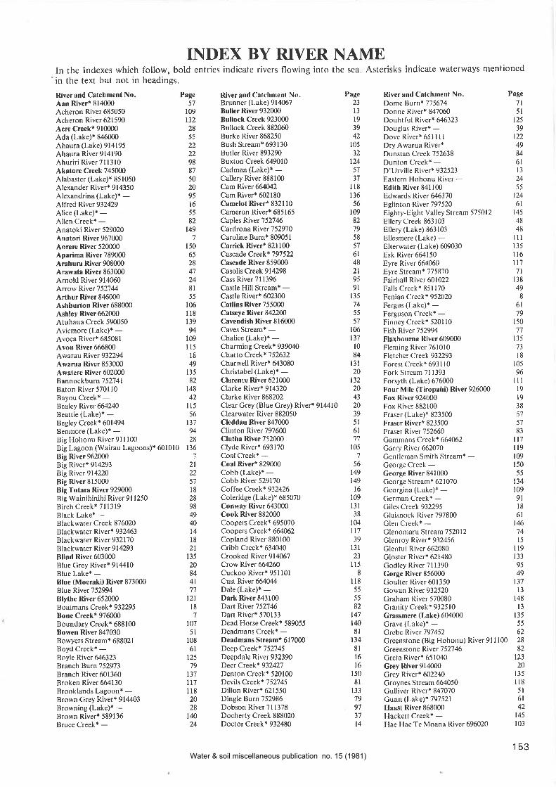
INDEX BY RIYER NAMEIn the Indexes which follow, bold entries indicate rivers flowing into the sea. Asterisks indicate waterways mentioned
in the text but not in headings,
River and Catchment No.Aan Riveri 814000Acheron River 685050
Acheron River 621590
Acre Creeki 910000Ada (Lake)* 8¿ló000
Ahaura (Lake) 914195Ahaura River 914190Ahuriri RiverTll3l0Akatore Creek 745000
Alabaster (Lake){ 85 1050
Alexander River* 914350Alexandrina (Lake)* -Alfred River 932429Alice (Lake)* -Allen Creek* -Anatoki River 529020Anatori River 967000Aorere River 520000Aparima River 789000Arahur¡ River 908000Arawata River 863000Arnold River 914060Arrow River 752744Arthur River 846000Ashburton River 688000Ashley River 662000Atuhaua Creek 59(Ð50Aviemore (Lake)* -Avoca RiverÈ 68508 IAvon River 666800Awarau River 932294Awarua River 853000Awatere River 602000Bannockburn 752741Baton River 5701 l0Bayou Creek* -Bealey River 664240Beattie (Lake)r -Begley Creek* 601494Benmore (Lake)* -Big Hohonu River 9l I100Big Lagoon (Wairau Lagoons)* 601010
Big River 962000Big River* 914293Big River 914220Big River 815000Big Totara River 929000Big Wainihinihi River 9l1250Birch Creek+ 7l l319Black Lake* -Blackwater Creek87ffi20Blackwater River* 932463Blackwater River 932170Blackwater River 9 I 4293
Blind River 603000Blue Grey Rivert 91M10Blue Lake* -Blue (Moeraki) River 873000Blue River 75294Blythe River 652000Boatmans Creek* 932295Bone Creek* 976000Boundary Creek* 688100Bowen River 847030Bowyers Stream* 68802.1
Boyd Creek* -Boyle River 646323Branch Burn 752973Branch River 601360Broken River óó4130Brooklands Lagoon* -Brown Crey River* 9144O3
Browning (Lake)* -Brown River* 589136Bruce Creek* -
River and Calchment N(). PagcBrunner (Lake) 914067 23
Buller River 932000 13
Bullock Creek 923000 l9Bullock Creek 882060 39Burke River 868250 42Bush Stream* 693130 105
Butler River 893290 32
Buxton Creek 649010 124Cadman (Laks¡* - 57
CalleryRiver 888100 37
Cam River 664û12 I l8Cam Riverr 602180 136
Camelot River* 832110 56Cameron River* 685165 109
Caples River 752746 82
Cardrona River 752970 79Caroline Burn* 809051 58
Carrick River* 821 100 5'lCascadeCreek* 797522 6lCascade River 859000 48Casolis Creek 914298 2lCass River 71 1396 95
Castle Hill Stream* - 9lCastle River* 602300 135
Catlins River 755000 74Catseye River 842200 55
Cavendish River 816O00 57
Caves Stream* - 106
Chalice (Lake)+ - 137
Charming Creek* 939040 l0ChaïoCreek+752632 84Charwell River+ 643080 l3lChristabel (Lake)+ - 20Clarence River 621000 132Clarke Riverr 914320 20Clarke River 868202 43
Clear Grey (Blue Grey) River* 914410 20Clearwater River 882050 39Cleddau River 847000 5lClinton River 797600 6lClutha River7520(Ð 77
Clyde River* 693170 105
Coal Creek+ - 7
Coal River* 829000 56Cobb (Lake)+ - 149Cobb River 529170 149CoffeeCreek+ 932426 16
Coleridge (Lake)* ó85070 109
Conway River 643000 l3lCook River 882000 38
Coopers Creek* ó95070 104
Coopers Creek* 664062 ll7Copland River 880100 39Cribb Creek* 634O40 l3lCrooked River9l40ó7 23
Crow River ó64260 I 15
Cuckoo River+ 951 l0l IÇ¡5t ftivs¡ f64044 I l8Dale (Lake)* - 55
Dark River 843100 55
Dart River 752746 82Dart River* 570133 147
Dead Horse Creek* 589055 140
Deadmans Creek* - 81
Deadmans Streamt 617000 134
Deep Creek+ 752745 8lDeepdale River 932390 lóDeer Creek* 93242'l 16
Denton Creek* 520100 150
Devils Creek+ 752745 8lDillon River* 621550 133
Dingle Burn 752986 79Dobson River 7 I 1378 97
Docherty Creek 888020 3'lDoctor Creek+ 932480 14
River and Calchmenl No. Page
Dome Burn* 775674 7lDonne River+ 8470ó0 5lDoubtiul River* 646323 125
Douglas River* - 39
DoveRiverr65llll 122
Dry Awarua River* - 49
Dunstan Creek 752638 84
Dunton Creekt - 6lD'Urville River+ 932523 13
Eastern Hohonu River - 24
Edilh River 841100 55
Edwards Rìver 646370 124
Eglinton River 797520 6lEighty-Eight Valley Stream 575012 145
Ellery Creek 863103 48
Ellery (t-ake) 863103 48
Ellesmere (Lake) - ll I
Elterwater (Lake) 609030 135
Esk River664l50 I IóEyre River 664060 ll7Eyre Stream+ 775870 7lFairhall River 601022 138
Falls Creek * 85 I 170 49
Fenian Creek+ 952020 8
Fergus (Lake)* - 6lFerguson Creek* - 79
Finney Creek* 5201 l0 150
Fish River 752994 77
Flaxbou¡ne River609000 135
Fleming River 761010 73
Fletcher Creek 932293 18
Forest Creekt ó931 l0 105
Fork Stream 71 1393 96
Forsyth (Lake) 676000 I I I
Four Mile (Tiropahi) River 926{Ð0 19
Fox River924000 19
Fox River 882100 38
Fraser (Lake)+ 823500 57
Fraser River* 823500 57
Fraser River 752660 83
Cammans Creek+ 664M2 ll7Carry River 662070 I 19
Gentleman Smith Stream* - 109
Ceorge Creek - 150
George River 841000 55
George Stream* 621070 134
Georgina (Lake)* - 109
German Creek+ - 9lGiles Creek 932295 18
Claisnock River 797800 6lClen Creek+ - 146
Glenomaru Stream 752012 '14
Glenroy River* 932456 15
Glentui River 662080 I 19
Closter Rivert 621480 133
Godley River 711390 95
Gorge River 856000 49
Goulter River 601350 137
Gowan River 932520 13
Graham River 570080 148
Granity Creek* 932510 13
Grassmere (Lake) 604000 135
Grave (Lake)+ - 55
Grel¡e River 797452 62
Greenstone (Big Hohonu) River 9l I100 28
Greenstone River"152746 82
Greta River+ 651040 123
Grey River 914000 20
Crey River* 602240 135
Groynes Stream 664050 I 18
Culliver RiverÌ 847070 5lGunn (Lake)* 797521 6lHsasl River 868000 42
Hackett Creek* - 145
Hae Hae Te Moana River 696020 103
153
Page57
109
t3228
55
229887
502095
l655
82
1497
150
65
284'l2481
55
l0óll8139
94109
I l5l849
t3582
t4842
ll556
t3'79428
136
7
2l11
57
l828984940t4l82t
135
2084
4t7't
121l87
107
5l108
6tt2579
137
ll7ll82028
r4024
Water & soil miscellaneous publication no. 15 (1981)

River and Catchment No.
Hakapoua (Lake)* 8l 5001
Hakataramea River 7l I140Haldane Estuary* 768000Hall River 875100H¡lswell River 678000Hamilton Burn 789600Hamilton River* 601450Hanmer River 64ó200Hankinson (Lake) -Hankinson River 797900Hapuka River 865000Hapuku River 629000Harold Creek* -Harper River 685081fl¡¡¡ison River 847020Haupiri (Lake)* 914195Haupiri River 914195Hauroko Burn* 8@053Hauroko (Lake) 809050Havelock River* 693180Hawden River 664200Hawea (Lake)* 752980Hawea River 752980Hawkins River 680030Hayes (Lake)+ -Heaphy River 959000Heathcole Rive¡ 6664{0Hedgehope Stream 786126Hemphill River 943161Heringa Stream 589170Hermitage SwampÈ -Heron (Lake) 685167Herrick Creeki -Herring (Seymour) Stream* ó21430Hewson River695l10Hidden Burn* 786960Hidden Falls Creek+ 851060Hidden Lake* -Hikimutu Lagoon+ 895000Hilda (Lake)* -Hindley Creek* 864010Hinds River ó91000Hochstetter (Lake) 914150Hodder River* 602210Hog Swamp Creek 603010Hokitika River 906000Hollyford River 851000Hooker River 7l1388Hook River 707000Hopeless Creek* 932635Hope River* 932530Hope River 858000Hope River 646320Hopkins River 711370Hororata River 680040Hossack River* 621560Houhou Creek" 907000Howard Rivert 932560Humbug Stream* 634030Hunter River 752985Hurunui River 651000Huxley River* 711379Ianthe Creek 89706O
Ianthe (Lake)* 897060Ida Burn 752636Ilam Stream* 666800Inangahua River 932290Innes (Lake)* 814010Invincible Creek+ -Irene River 837200Isis River+ 602160Isolation Creek* 612030
Jackson River 863 100
Jacobs (Aparimr) River 789000J¡cobs (Makawhio) River 878000Jed River 649000Joe River* 863430John O'Groats River 848000Johnstones Water Racer -Jollie Brook* 651 170
154
River and Calchmenl No.Jollie River 7l 1385
Jordan Riveri 6O21 30
Juno Rivert -Kahutsra R¡ver 634000
Kaiapoi River 6ó4040
K¡ikorai Stream 740000Kaipo River 850000Kaituna River* 677020Kaituna River 590000Kaituna River 520010Kaiwara River* 651050Kaiwera Stream* -Kakahu River 696026K¡kanui River 717000Kakapotahi River 901 100
Kangaroo Lake* -Kaniere (Lake)+ 906015Kaniere River 906010Kapitea Creekr 910000Karame¡ River 951000Karangarua River 880000Katherine Creek* -Katrine (Lake)* 65 1230
Kawarau River 752740Kawhaka Creek* 908020Kekerengu Rive¡ ó16000Kiwi Burn 818000Kiwi (LakeX -Kiwi River* -Klondyke Irrigation Race* -Koau Branch* -Kohaihai Rive¡ 955000Kohe Creek* -Kokatahi River 906050Kowai River 664O70
Kowai Rive¡ 6ó1000Kowhai River 632000Kowhri (Xowai) River 661000Kye Burn 74364O
LadyLake9l&67Lady Lake Creek+ 914067La Fontaine Stream 897050Lake Stream 685160Lambert River* 897300Lamb Valley Creek* 932531Landing Creek* 932293Landsborough River 868200Larry (Awarau) River* 932294Lawrence River* 693171Leader River 64ó020Leatham fuver 601361Lee River 575021Lee Stream* 743 I 30Leithen Burn 752146Lewis River 646396Light River 843300Lillburn River* 662160Lindis River 752880Linton Creekt 634050Little Grey (Mawheraiti) River 914290Little Kaituna Stream* -Little Kowai Rivera 664071Little Kye Burn* 743il7Little (Okana) River* 6?6010Little (Whakapoh¡i) River 872000Little Wainihinihi River 9l1300Little Waitaha (Kakapotahi)
River 901100Little Wanganui Rive¡ 948000
River and Catchmenl No.McColl Creek 741000
MacDonalds Creekr 891200
Mccregor (Lake)r -MacKenzie Creek* 868206
McKenzie Riverr 845000
McKerrow (Lake)* -McMurray Creek+ 932292McRae Creekr -Maerewhenua River 7l 1040
Mahinapua Creek 905001
Mahinapua Lake 905001
Mahitshi River 877000Mailai Rive¡ 578000Makarewa River 786120
Makarora Rive¡752994M¡kawhio River 878000
Makerikeri River 662040M¡kikihi River 706000
Manak¡iaua Rive¡ 879000
Manapouri (Lake) 197 450Mandamus River* 651I l0Mangrrakau Stream 975000
Mangles River 932460
Manor Burn 752631Manuherikia River 752630Maori River* 869010Mapourika (Lake) 891210Mararoa River 797420Marchant (Lake)* -Maree (Loch)* -Marion Creek* -Martyr River 859120Maruia River 93220Maruwenua (Maerewhenua)
River 7l 1040Mason (t,ake)* 651 153
Mason River 64ó100Matakitaki River 932450
Mataora Lagoon (WairauLagoons)* 601010
Matau Branchi -Mataura Rive¡ 775000
Matheson (Lake)* 882054Mathias River 685130
Matiri River 932440Marukitu k i Riv er 7 52992Mawheraiti River 914290May Creek* 914400Medway River* 602080Mike River* 824500Mikonui River 903000Miles Drain* 680021Milford Lagoon* ó96010Mill Creek+ -Miller Stream+ 621050Mimihau Stream 775180Mirror Creek* -Moana Kotuku (Lake Brunner) 914067
Moeraki (Lake)* 873000Moeraki River 873000
Mokihinui River 943000Mokoreta River 775130
Monk (Lake)* -Monowai (Lake)+ 797171
Monowai River 797370
Moonlight Creek* 7 527 45
Moraine Creek* 851 120
Morley Stream* 797179
Morton (Lake)* -Motatapu River752992Motueka River 570000Motutrau River 657000Motupiko River 570160
Motupipi River* 531000
Mountain Camp Creek* 589054Mount lda Water Race* -Mt Peel Creek* 695100Moule¡e River 571000
Muddy Crcek 978000
Mueller River* 866200
Page
57
9973
4till65
117
r256l6t47
l3l32
109
502223
58
58
105
ll57979
ll08l
8
lll6'l
9139
49106
56133
160
665056
32
56
4'l106
23
t36135
294996
100
13
l349tu9'l
ll0133
2813
131
19t2l9'l32
3l84
ll517
578256
l3ó135
4865
Q124475084
t2l
Page
9',1
tl656
l3lll893
50lllt39150
t2387
104
943l24303028I
39
55
l2t8028
t3457
57
t25105
87
8
57
29ll'lt20l3l1209t23
u32
109
3ll3l843l8
105
127
t37145
9286
12555
ll980
l3l2l
149[79llll4l28
Pagc9233
95
43
55
49t8
l4'7993030,m
t406677
Nt20100
û62
t227
l48483
4233
625ó564949I5
99l2t126t5
Little Wanganui (Poeru¡) River 896000Long Burn* 820100Lottery River 64ól0lLud River* 581030Lumaluma Creek* 8222mLyell Creek* 932350Lyell Glacier Lake* -Lyndon (Lake)* 685054Lyvia River* -Macarthur (Lake)t -Macaulay River 7l1399
31
932
57
26tÆ
136
87'tl39
t08l578
2l20
1365630
ll0103a1
t34723023
4l4l
91)
57gg8l5065
55
78146tzlt46t49140
84104
148
7
47
5717
108
095657
95
Water & soil miscellaneous publication no. 15 (1981)
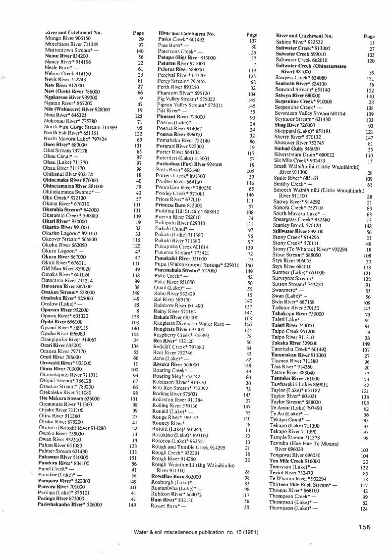
ìiver and Calchment No.Mungo River 906150Murchison River 7l1389Muttontown Stream* -N¡mu River 834200Nancy River.9l4196Neale Burn* -Nelson Creek 914150Nevis River 752743New Rive¡ 912000New (Oreti) River 786000Ngrkawau River 939000Ngatau River* 867200Nile (Waitakere) River 928000Nina River* 646323Nokomai River* 775780North-East Gorge Stream 7l1399North Esk River* ó51l5lNorth Mavora Lake* i97424Oaro Rive¡t 683000Ohai Stream 797178Ohau Canal* -Ohau (Lake) 7l 1370Ohau River 7l1370Ohikanui River 932120Ohinem¡ka Rive¡ 876000Ohinetrmatea Rive¡ 881000Ohinetamatea Swamp* -Oho C¡eekt 822100Okana River* 676010Okarahia St¡eam* 640000Okaramio Creek* 590080Okari River* 930000Okarito River 891000Okarito Lagoon* 891010Okeover Stream* 666800Okuku River 662050Okuru Lagoon+ -Okuru River 867000Okuti River* 67601 IOld Man River 859020Omaka River* 601024Omarama River 7l 1314Omoeroa Rive¡ 887000On¡kau Slreamt 528000Onekaka River* 525000Onslow (Lake)* -Oparara River 952000Opawa River* 601020Opihi River 696000Opouri River* 589139Opuha River 696080Orangipuku River 914067Orari River 695000Orauea River 797170O¡eti River 786000Orowaiti River* 933000Ot¡io River 703000Otamatapaio River 7l 13l IOtapiri Stream* 786128Otautau Stream* 789200Otekaieke River 711080Ote Makura Stream 636000Otematata River ?l1300Otiake River 7l I100Otira River 911360Otoko River 875200Otututu (Rough) River 914280Owaka River 755030Owen River 932510Pahau River 651080Palmer Stream 621490Pakaw¡u River 510000P¡ndora Rivert 834100Panel Creekr -Paradise (Lake)* -Parapara Rivert 522000Pareora River 701000Paringa (Lake)* 875101Paringa River 875000Pariwhakaoho Rivert 526000
Page Riverand Calchmenl No.29 Paske Creek* 60149397 Pass Burn* -l,l0 Patersons Creek* -56 Palupo (Big) River 81500022 Palurau River9710006l Pelorus River 58900023 Percival River+ Ø22018l Percy Stream+ 79745227 Perth River 8932506 Phantom River* 6951209 Pig Valley Stream* 575022
4'l Pigeon Valley Stream* 57501I19 Pitt River* -125 PleasantRiver7290007l Poerua (Lake)* --95 Poerua River 914067
122 Poerua Rive¡ 89600063 Pomahaka River752l4O13l PorarariRiver92200065 Porter River 66413497 Porerireri (Lake) 81300197 Potikohua (Fox) River 92400098 Potts River+ 69314Ol8 Potters Creek* 8913004 Poulter River 66416039 Pourakino River+ 789050ß Powley Creek* 57100157 Prices River* 677010
lll PrincessBurnSl3000l3l Pudding Hill Stream* 688012139 Puerua River 75201019 Puhipuhi River 62901033 Pukaki Canal+ -33 Pukaki (Lake) Zl 1380
I l5 Pukaki River 7t 1380120 Pukapuka Creek 60101447 Pukerau Stream* 77542147 PunakaikiRive¡921000
I I I Pupu (\'ry'aikoropupu) Springsr 52901 I49 Puremahaia Stream* 527000138 Pyke Creek* -99 Pyke River 85105038 Quail (Lake¡* -149 Rahu River932429
149 Rai River 58913085 Rainbow River 6014908 Rainy River 570164
138 Rakaia River685000103 Rangitata Diversion Water Race _lq Rangitata River 693000104 RaspberryCreek*]-52992U ReaRiver* 832120
lM RedcliffCreek* 79738065 Rees River 75274666 Rene (Lake)i -10 Riwaka River 569000
100 Roaring Creek* -99 Roaring Meg+ 7527426'l Robinson River{ 91437066 Rob Roy Srream* 75299298 Roding River 57502tl3l Ro.llesron River 9l138498 Rolling River 57013699 Ronald (Lake)* -27 Ronga River+ 58913?4l Rooney River+ -22 Roroiri (Lake)* 93262074 Rotokino (Lake)* 893t0014 Rotoroa (Lake)* 932521
l2l Rough and Tumble Creek 914295133 Rough Creek* 932291l5l Rough River 91428056 Rough Wainihinihi (Big Wainihinihi)4l River 9l t3l056 Rowaltan Bu¡n 802000149 Roxburgh (Lake)+ -103 Ruataniwha (Lake)* -4l Rubicon River* 664072 I4l Rum Rive¡* 832130149 Russet Burn+ -
River and Calchment No.Sabine Riverr 932522S¡ltwater CreekÈ 9l 3000S¡lwafe¡ Crcek 6Ð010Saltwater Creek 6ó2010S¡ltw¡te¡ Creek (Ohinetamrtea
Rlve¡) 881000Sawyers Creek* 634080Se¡forlh River* 824100Seaward Stream+ 651l4OSelwyn River 680000Serpenline Creek* 910000Serpentine Creekr -Seventeen Valley Stream 601014Seymour Streamr 621430Shag River 726000Sheppard (Lake)* 651 l8lSherry River+ 570132Shotover River 752745Sinbad Gully 846O20Silverstream D r ain* 68ffi22Six Mile Creek* 93253Small Wainihinihi (Litrle Wainihinihi)
River 91 1300Smite Riverr 6851ó4Smithy Creek* -Smooth Wainihinihi (Little Wainihinihi)
River 696020Tengawai River ó96050Ten Mile Crcek 916000Tennyson (Lake)r -Teviot River 75270Te Wharau RiveÈ 932294Thirteen Mile Bush Stream* -Thomas River* 868100Thompson Creek* -Thompson (Lake)r -Thompson (Laks)* -
River9tl300 28Snowy River* 914292 2lSonora Creekr 752710 83South Mavora Lake+ - 63Speargrass Creekt 932580 13Stanley Brook 570120 t48Sfillwater River 839100 56StonyCreek.9l4296 2lStonyCreek* 570tll 148Stony (Te Wharau) River* 932294 lgStourStream+ 688050 l0gStyx River 906055 30Styx River 664O10 I t8Sumner (Lake)* 651000 l2lSurveyors Streamr - 122Sutton Stream* 743250 9lSwanmere* - 55Swan (Lake)* - 56Swin River* 687168 109Tadmor River 570150 147Tahakopa River759000 73Taieri Lake* - 9lT¡ieri River743000 9lTaipo Creek 9512fi) ITaipo River 9l l3l0 28T¡k¡ka River 529000 t4gTanekaha Creek* ffi1492 l}1.T¡ramak¡u River9ll000 21Tasman River 711380 f}óTass Rivert 914360 20Tatare Rive¡ 888040 37Tautuku River 761000 ,t3
Tawharekiri Lakes 869011 42Taylor (Lake)* 651182 t}tTaylor Riverr 601021 l3gTaylorStream* 688020 l0gTeAnau (Lake)797490 62Te Au (Lake)t - 56Tekapo Canal* - 95Tekapo (Lake) 711390 95Tekapo River 71 1390 95Temple Stream 711378 98Temuka (Hae Hae Te Moana)
Page
13780
125
57
7
t39t256212
t04145
145
55
93
24243286
t9ll757
l9105
33
lt665
t46ill57
108
74t3t979697
t3972t9
150
t49425055
l6140t37t47108
r06104
78
56
&82
82148
49802078
145)1
147
55
r4058
l332
t32tl8))
Page
t3)1
r03t20
39t3t56
t22ll028
138
139
133
93
t2lt478l55
il0l5
28109
6l
103
10420
13285
l8ll7429962
t24
28
58
83
98l75ó
58
155Water & soil miscellaneous publication no. 15 (1981)
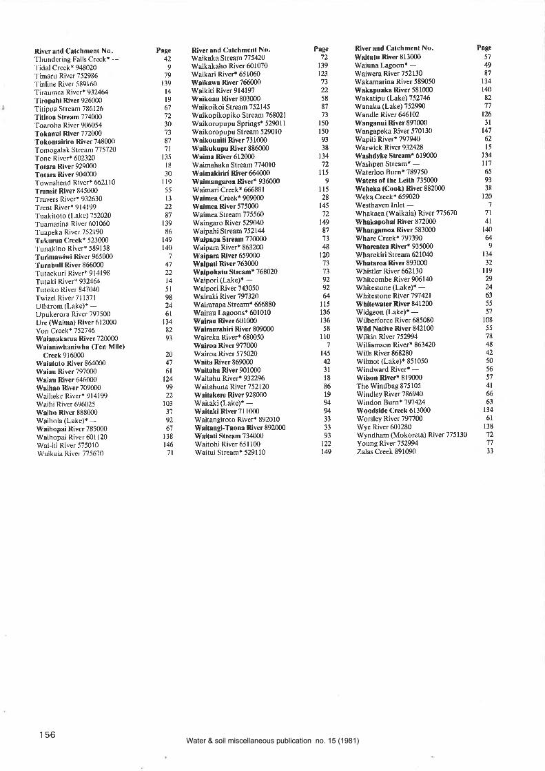
River and Catchmenl No.Thundering Falls Creek+ -Tidal Creek+ 948020Timaru River 752986
Tinline River 589160Tiraumea River* 932464
Tiropahi River 926000Titipua Stream 786126
Titiroa Slream 774000Toaroha River 906054Tokanui River 772000Tokomairiro River 748000
Tomogalak S¡ream 77 5720
Tone River* 602320
Tolara River 929000
Tota¡a River 904000
Townshend River* 6621 l0Transit River 845000
Travers River+ 932630
Trent River* 914199
Tuakitoto (Lake) 752020
Tuamarina River 601060
Tuapeka River 752190
Tukurua Creek* 523000
Tunakino River* 589138
Turimawiwi River 965000
Turnbull River 866000
Tutaekuri River* 914198
Tutaki River* 932464
Tutoko River 847(X0Twizel River 7l l37lUllstrom (Lake)+ -Upukerora River 797500
Ure (Waima) River 612000Yon Creek* 752746Waianakarua River 720000
Waianiwhaniwha (Ten Mile)Creek 916000
Wai¡folo River 864000
ìVaiau River 797000Waiau River 646000Waih¡o River 709000Waiheke River+ 914199Waihi River 696025Waiho River 888000Waihola (Lake)+ -Waihopai River 785000Waihopai River ó01120
Wai-iti River 575010Waikaia River 775670
River ¡nd Calchment No.tJVaikaka Stream 775420
Waikakaho River 601070
Waikari River'651060W¡iksw¡ River 766000
Waikiti River 914197\{¡ikoau River 803000Waikoikoi Stream 752145
Waikopikopiko Stream 768021
Waikoropupu Springsr 52901 I
Waikoropupu Stream 529010
Waikouaiii River 73 1000l{aikukupa River 886000Wsima River 612000Waimahaka Stream 7 7 40 l0Waimskiriri River 664000Waimangaroa River* 936000Waimari Creek* 66ó881
Wai¡ne¡ Creekt 909000lVaimea River 575000Waimea Stream 7755ó0
Waingaro River 529040Waipahi Stream752144Waipapa Slream 770000
Waipara River+ 8ó3200
Waipara River 659000Weipati River 763000
1{alpohatu Sf ¡esm* 768020
Waipori (Lake)+ -Waipori River 743050Wairaki River 797320Wairarapa Streamt 666880
Wairau Lagoonst 601010Wri¡¡u Rive¡ 601000Wair¡ur¡hiri River 809000Waireka Riverr 680050Ws¡roa River 977000Wairoa River 575020Waita River 869000W¡itah¡ Rive¡ 901000Waitahu River* 932296Waitahuna River 752120Waitaker€ River 928000Waitaki (Lake)+ -Waitaki River 7l1000Waitangiroto River* 892010
lVaitangi-Taona River 892000\Y¡itati Stream 73¿1000
Waitohi River 651 100rWaitui Stream+ 5291l0
River and Catchmcnt No. Page
lV¡itulu Rive¡ 813000 57rWaiuna Lagoon' - 49
Waiwera River 752130 81
Wakamarina River 589050 134
Wakapuaka River 581000 140
Wakatipu (Lake)752746 82
Wanaka (Lake) 752990 '17
Wandle River 646102 126
Wanganui River 897000 3lWangapeka River 570130 147
Wapiti Riverr 797940 62
Warwick Rive¡ 93?A28 15
Wrshdyke Streamt 619000 134
Washpen Stream* - ll7Waterloo Burnr 789750 65
W¡ters of the Leith 735000 93
lVehek¡ (Cook) River 882000 38
Weka Creek* 659020 120
Westhaven lnlet - 7
Whakaea (Waikaia) River 775670 7lWhakapohai River 872000 4lWhrngamoa River 583000 l4Olilhare Creek* 797390 U\Yhareatea River* 935000 9
Wharekiri Stream ó21040 134
What¡¡oa Rive¡ 893000 32
Whistler River 662130 I 19
Whitcombe River 90ó140 29
Whitestone (Lake)* - Urùy'hitestone Rliver79742l 63
Whitew¡ter Rive¡ 841200 55
Widgeon (Lake)r - 57
Wilberforce River 685080 108
lVild N¡tive River 842100 55
Wilkin River 75294 78
Williamson River* 8ó3420 48
Wills River 868280 42
Wilmot (Lake)* 851050 50Windward Riveri - 5ó
Wilson Riverr 819000 5'lThe Windbag 875105 4lWindley River 7869¿10 6Windon Btrni 797424 63
Woodside Creek ó13000 134
Worsley River 7977ü) 6lWye River 601280 138
Wyndham (Mokoreta) River 775130 '12
Young River 75294 77
Zalas Creek 891090 33
Prge42
9
79
139
t4t967
72
3073
87
7l135
t830
l1955
t3228'l
r3986
149140
7
47
22t45t98
246l
13482
93
2047
6t1249922
103
37
92
67
r38t467l
Page12
139
1237t2258
81
73
150
150
93
38
r3472
il59
lt528
145'r)
14987
7t48
12073
73
9292&
ll5136
r3658
lr07
t45423ll886l9949433
33
93
r22149
156Water & soil miscellaneous publication no. 15 (1981)
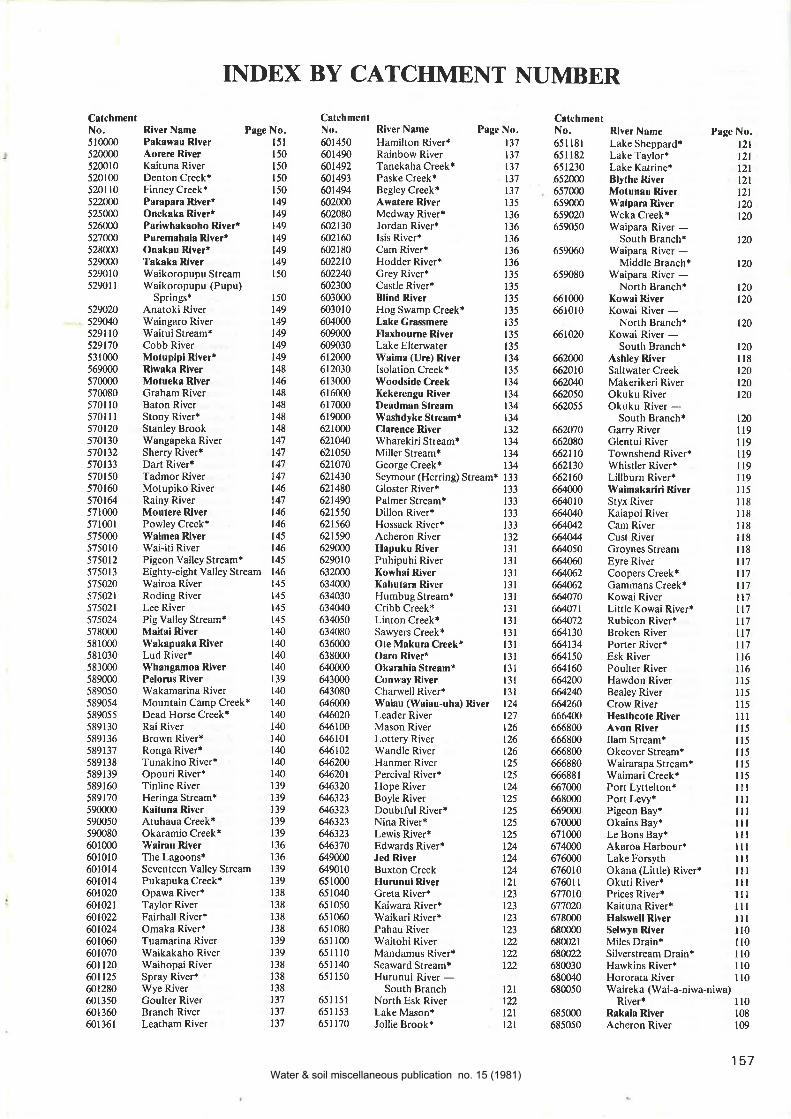
INDBX BY CATCHMENT NUMBER
C¡tchmentNo. River Name Page No.510000 Pakswau River I5l520000 Aorere River 150
520010 Kaituna River 150
520100 Denton Creek* 150
5201 l0 Finney Creek* 150
522000 ParaparaRiverr 149525000 Onekakr Riveri 149526000 Pariwhakaoho Rivert 149521000 PuremshaiaR¡ver* 149528000 Onrkau Rlver* 149529000 Takaka River 149529010 Waikoropupu Stream 150
52901I Waikoropupu(Pupu)150
r49t49149
149149
148
146148
148
148
148
t47147
147
147
t46t47IMIM145
t46r45t46145t45145r451Mtû140
t40139
140140140
vat40140140
t40t39139
139139
r39r36136
139
139
138
138
138
138
139
139
138
t38138
137
137137
CâtchmenlNo.ó0t 450601490ût492ffi1493û14946020m602080û2110ffi2160602180ñ22t0û2240û23006030006030r 06040006090006090306t2mlJ612030613000616000ó1700061900062100062tW6210s062107062t430621480621490621 550621s6062t59{)629(m629010632cn0634000634030634¡4J6340s0634080636000638000640000643000643080646000&&2064ó100&61016r',6t02g62N64620r646320646323s6323s6323&632364637064900064901065100065104065 1050
65 1060
65 I 08065il0065lll0ó51 140
651 ls0
651 l5l65n53651170
5290205290q5291 l05291705310005690005700005700805701 t05701 I I570120570t 30570t325'10113
570150570160s7Ùtg57 I 000571001
5750005750105750125750135750205't502157502157502457800058 1000
5810305830005890005890505890545890555891 30s89r 3658913758913858913958916058917059000059005059m8060100060101060101460t0t4601020601021ût022û1024601060601070ûtt20ûn2560t280601350ó0t3606013ól
Springs+AnatokiRiverWaingaro RiverWaitui Stream*Cobb RiverMotupipi RiverrRiwska Rive¡Motueka RiverGraham RiverBaton RiverStony River*Stanley BrookWangapeka RiverSherry River*Dart River+Tadmor RiverMotupiko RiverRainy RiverMoulere RiverPowley Creek*Waimea Rive¡Wai-iti RiverPigeon Valley StreamtEighty-eight Valley StreamWairoa RiverRoding RiverLee RiverPig Valley StreamtMaitai RiverWakapuaka RiverLud River*\Yhangamor RiverPelorus RiverWakamarina RiverMountain Camp Creek*Dead Horse Creek*Rai RiverBrown River*Ronga River*Tunakino RivertOpouri River*Tinline RiverHeringa Stream*Kaituna RiverAtuhaua Creek*Okaramio Creek*'Wairau Rive¡The Lagoons*Seventeen Valley StreamPukapuka Creek+Opawa River*Taylor RiverFairhall River*Omaka River+Tuamarina RiverWaikakaho RiverWaihopai RiverSpray River+Wye RiverCoulter RiverBranch RiverLeatham River
River N¡me Page No.Hamilton River* 137Rainbow River 137Tanekaha Creekt 137Paske Creek+ 137Begley Creekt 137Awatere River t35Medway River* 136Jordan Riverr 13ólsis River+ t36Cam River* 136Hodder Riverr 136Grey River* 135Castle River+ 135Blind River 135Hog Swamp Creek* 135L¡ke Grassmere I35Flaxbou¡ne River 135Lake Elterwater 135Waima (Ure) River 134lsolation Creek+ 135Woodside Creek 134Kekerengu River 134Deadman Stream 134Washdyke Stre¡mr 134Ch¡ence River 132Wharekiri Stream* 134Miller Stream* 134Ceorge Creek* 134Seymour (Herring) Stream* 133Gloster River* 133Palmer Streamr 133Dillon River+ 133Hossack Riverr 133Acheron River 132Hapuku River l3lPuhipuhi River l3lKowhai Rive¡ l3lKahuta¡a River l3lHumbug Stream* 13lCribb Creek* l3lLinton Creek* l3lSawyers Creek* l3lOte Makura Creekr 13lOaro River* l3lOkarahi¡ Stream" l3 IConway River 13 ICharwell River* 13 IWaiau (Waiau-uhs) River 124Leader River 127Mason River 126Lottery River 126Wandle River 126Hanmer River 125Percival River* 125Hope River 124Boyle River 125Doubtful Riverr 125Nina River* 125Lewis River* 125Edwards River+ 124Jed River 124Buxton Creek 124Hurunui Rive¡ 121Creta River* 123Kaiwara River* 123Waikari River* 123Pahau River 123Waitohi River 122Mandamus River* 122Seaward Streamt 122Hurunui River -South Branch l2lNorth Esk River 122Lake Mason* l2lJollie Brook* l2l
River NameLake SheppardtLake Taylor+Lake KatrinerBlylhe RiverMolunsu RiverWaipara RiverWeka Creek*Waipara River -South Branch+Waipara River -Middle Branch*Waipara River -North Branch*Kow¡i RiverKowai River -North BranchtKowai River -South Branch*Ashley RiverSaltwater CreekMakerikeri RiverOkuku RiverOkuku River -South Branch*Gany RiverGlentui RiverTownshend RiverrWhistler River*Lillburn River*lVaimak¡riri RiverStyx RiverKaiapoi RiverCam RiverCust RiverGroynes StreamEyre RiverCoopers Creek*Gammans Creek+Kowai RiverLittle Kowai River*Rubicon RiveriBroken RiverPorter River*Esk RiverPoulter RiverHawdon RiverBealey RiverCrow RiverHe¡lhcote RiverAvon RiverIlam Stream*Okeover Stream+Wairarapa Stream*Waimari Creek*Port LWtelton*Port Levy*Pigeon Bay+Okains Bay+Le Bons Bay*Akaroa HarbourrLake Fors¡h
Prge No.t2tl2lt2lt2tt2lt20120
120
t20
t20120
Okana (Little) RiverrOkuti RivertPrices River+Kaituna RiverrH¡lswell RiverSelwyn RiverMiles DraintSilverstream Drain*Hawkins River*Hororata RiverWaireka (Wai-a-niwa-niwa)
River+ I l0685m0 Rakaia River 108
685050 Acheron River 109
CalchmenlNo,651 l8l651182651230652m06s7Un659m0659020ó59050
6590ó0
ó59080
6ó100066r010
66t020
ffizcfÚffi20106É,20/06620506ñ,2055
66.2070
6620806r,2n06ó.2t3066.2t60ffi6ffit06Mffi26644446ffi506ffi6&M2ffi2ffi70ffi1t6ffi7266413066r'.t346641506&tffiffi200@2qffi26066ffi66680066ó800óó680066688066688 r
ó670006ó80006690006700006710006740[067600067601067601 I677ot067702067800068000068002168N2268003068o(Xo680050
t20
t20ll8120t20120
120lt9il9ll9ll9ll9l15il8ll8ll8ll8I l8ll7|7ll'lll7[7n7tt7l17ll6ll6ll5lr5ll5lllu5I l5n5lt5lt5ntntlilllllltullllullltlt¡llllllll0n0ll0ll0ll0
157Water & soil miscellaneous publication no. 15 (1981)
CatchmenlNo.68505468507068508068J08 l685081685 I 30ó85 l 60685t64685 165
685167685 168
ó88000ó880r0
688012688020688021688050688100691ût691010
691020
693000693 I l0693 I 30693r40693170693t7ró93 I 80ó95000695070695100ó95t l0695120ó9600069601069ffi20
69ffi2569û26696050696080699010701000701030
703000706000707000707021709000709030
7ú0/0
7l 10007l 1040
Ttt0/ó
7ttm7
71 10807llll07l I 140
7l 1300
7l l3l07l 131 I7n3147l l3l97ll3't07ttt70711370'nl37l7nt777tt)'18711379
158
Page No.109
lÚ108
109
109
108
109
109
109
109
109
106
107
108
108
108
108
107
106
106
106
104
r05r05105
105
105
l0s104
104
104
104
104
103
r03
103
103
IM104
104
CatchmenlNo.7l 13807 I 1380
7t t3807l 1385
7l 1388
7l 1389
71139071t39071 1390
71t391'tn394
7[39671t399711399?170007t70u
717lffi
?m00072ffi1290n0731000731020
734{n07350007M741000743000743050743t30743250't43ffi743&7745000748000748040
7520no7520t0752012752020752p30752t207521307521Æ752t447521457s2t67s2t9075z.7075263075263r't52632
75?Á36752637
752618752ffi75271075n40'152741
15n42752't437527M'Ì52745
75274575n45'152745
7527ß7527ú75n467527ß7527Æ752746752880752970
River N¡meLake PukakirPukaki RiverTasman RiverJollie RiverHooker RiverMurchison RiverLake Tekapo*Tekapo RiverGodley RiverFork StreamOutlet of Lake
AlexandrinarCass RiverMacaulay River
Page No.CstchmentNo,7529737529807529857s2986752986752990752927529927s2Ð2
752992
'152992
7s2992't52Ð475299,4752994't52994't529,4
7550007550307590007610007610107$m'tffi768000't68020'768921
7700007',tzffi774{n0'174010
?750n0't75t30
775 I 807',t54207't542t't755û7',156'70
7't5674775679
'175679
7't5720't't5780
775870785000786000786120786126'186126
78ó1287869407869ffi7890007890507892æ789ó007897507970f0797t701n178't97t79797320797370't97t7l7973807913m7974207n4217974247974247974507g',Ì4527974s2797490797sffi
Temuka (Hae Hae Te Moana)
River Name
Lake LyndontLake Coleridge+Wilberforce RiverHarper RiverAvoca River+Mathias RiverLake StreamSmite River+Cameron River'Lake HerontSwin Ríver*Ashburton RiverAshburton River -
North BranchPudding Hill StreamrTaylor StreamiBowyers Stream+Stour RivertBoundary Creek'Hinds RiverHinds River -North Branch*Hinds River -South Branch*Rr.rgitata RiverForest Creek*Bush Stream*Potts River*Clyde RiverrLawrence River'Havelock River*Orari RiverCoopers Creek+Mt Peel CreekiHewson RivertPhantom RiverrOpihi RiverMilford Lagoon+
North-east Gorge StreamKsk¡nui R¡verKakanui River -North Branch*Kakanui River -South Branch*Wai¡n¡karua RiverShag RiverPle¡s¡nf RiverWaikouaiti R¡ve¡Waikouaiti River -South BranchsWait¡ti Sfre¡mlValers of the LeithK¡ikorai St¡e¡mMcColl CreekT¡ieri RiverWaipori RiverLee Stream*Sutton Stream*Kye BurnLittle Kye Burn*Ak¡tore CreekTokom¡iriro RlverTokomairiro River -East BranchrCluth¡ Rive¡Puerua RiverGlenomaru RiverLake TuakitotoInchcluthaWaitahuna RiverWaiwera RiverPomahaka RiverWaipahi StreamWaikoikoi StreamLeithen BurnTuapeka RiverTeviot RiverManuherikia RiverManor BurnChatto Creek*Ida BurnManuherikia River -
East Branch*Dunstan CreekFraser RiverSonora Creek*Kawarau RiverBannockburnRoaring MegrNevis RiverArrow RiverShotover RiverDeep Creek*Devils Creek*Moonlight Creek*Lake WakatipuVon River*Creenstone RiverCaples RiverDart RiverRees RiverLindis RiverCardrona River
River Name Page No.
Branch Burnr 79
Hawea River 79
Hunter River 79
Timaru River 19
Dingle Burn 79
Lake Wanaka 77
Matukituki River 78
Motatapu River 78
Matuk¡tuki River -West Branchr 78
Matukituki River -East Branchr 78
Raspberry Creek* 78
Rob Roy Stream* ?8
Makarora River '17
BlueRiverill?Wilkin River 78
Young River '17
F'ish River 77
C¡tlins River '14
Owaka River 74
Tahakopa River 73
Tautuku Rive¡ '13
Fleming River 73
Waipatl River '13
Waik¡wa River '13
Haldane Estuaryr 73
Waipohatu Strcami 73
\VaikopikopikoSlre¡mr 73
lVaipapaStream 73
Tok¡nuiRiver 73
T¡tiror Stre0m 72
Waimah¡k¡ Stream 72
Mataur¡ River 7lMokoreta (Wyndham) River 72
Mimihau Stream 72
Waikaka Stream 72
Pukerau Stream+ 72rWaimea Stream 72
Waikaia (Whakaea) River 7lDome Burn* 7lWaikaia River -West Branch* 7lWaikaia River -
East Branch* 7lTomagalak Stream 7lNokomaiRiverilllEyre Stream+ 7lWaihopai River 67
Oreti River 6Makarewa River 66Hedgehope Stream 67
Titipuastream 67
Otapiri Streamr 67
Windley River 6Hidden Burn 6Ap¡rima (Jacobs) River 65
Pourakino River{ 65
Otautau River* 6Hamilton Burn* 65
Waterloo Burn* 65
lVaiau River 6lOrauea River ó5
Ohai Streamr 65
Morley Stream* 65
Wairaki River UMonowai River &Lake Monowair gRedcliff Creek* gìvVhare Creekr &Ma¡aroa River 62Whitestone River* 63
North Mavora Lake* 63
Windon Burn* 63
Lake Manapouri 62Crebe River 62
Percy Stream* 62
LakeTeAnau 62
Upukerora River ól
9696!}6g.t
9697
95
9595
96
95
95
95
9594
94
9493
93
93
93
93
93
93
93
929t929291
9l9t87
87
87
77
747487
87
86
87
86
87
87
86
8685
83
84
8484
83
84
8383
8082
808l8l8l8l8l81
8282828282828019
RiverWaihi RiverrKakahu RiverTengawai RiverOpuha RiverSaltwater (Ollpuha) Creek 103
Pa¡eora RiverPareora River -
South BranchtOtaio RiverMakikihi RiverHook RiverWainono Lagoonr\Yaihao RiverWaihao River -North Branch*Vy'aihao River -South Branch*Wait¡ki RiverMaerewhenua RiverMaerewhenua River -South Branch*Maerewhenua River -North Branch*Otekaieke RiverOtiake RiverHakataramea RiverOtematata (Otematakau)
RiverAhuriri RiverOtamatapaio RiverOmarama RiverBirch Creek+Lake OhaurOhau RiverHopkins RiverTwizel RiverTemple StreamDobson RiverHuxley Riverr
103
103
100
100
100
100
100
99
999499
99
99999999
Ð9899999891989'l98989797
Water & soil miscellaneous publication no. 15 (1981)
CatchmenlNo.797520'r9752t
797522797ffi7977ú7978t0797900't97940
797950802000803000809m08090508@05r809053I l 300081300081300181,1000
8l,ml0815000815001
8160008 l 8000819000820000820100821000821 100
8220n08221ffi8222ú823500823500824[n0Sz.I008245008280008290008300008320008321 l083212083213083,1000
8341008342æ8350008370008372æ839000839100841000841000841 100
8412008420008421008422ffi843000843 100
8433008450008460m84ffi208470008470208470308470/084706084'107084800085000085100085105085106085 I 120
85 I 170
853000
River Name
Eglinton RiverLake Gunn*Cascade Creek+Clinton RiverWorsley RiverGlaisnock RiverHankinson RiverWapiti River*Lake Thompson+Rowallan BurnWaikoau RiverlVairaurahiri RiverLake HaurokoCaroline BurntHauroko Burn+Wsitulu RiverPrincess BurnLake PoteriteriAan River*Lake Innes*Big (Palupo) RiverLake Hakapoua*Cavendish Rive¡Kiwi BurnWilson RiverLong SoundiLong BurntCunaris Sound*Carrick RiverEdwardson SoundOho Creek*Luma Luma Creek*Lake Fraser*Fraser River*Dusky SoundSeatorth Rive¡*Mike RiverrBreaksea SoundCoal River*Dagg SoundDoubtful SoundCamelot River*Rea Rive¡tRum River*Thompson SoundPandora River*Namu River*Nancy SoundCharles Sound+Irene RiverCaswell Sound+Stillwater RiverGeorge SoundtGeorge RiverEdith RiverWhilewate¡ RiverBligh Sound+lVild Natives RiverCatseye RiverSutherland Sound*Dark Rive¡Light RiverTransit RiverAlhur RiverSinbad GullyCleddau RiverHarrison RiverBowen RiverTutoko RiverDonne River*Gulliver River*John 0'Groats RiverKaipo RiverHollyford RiverPyke RiverHidden Falls CreekrMoraine Creek+Falls CreekiAwarua River
CatchmenlNo,856000858000859000859020859120863000863 100
8ó3 103
863200863420863430864000864101
8650008660008662ffi86700086720086800086810086820086820286820286825086828086900086901086901 I872000873000875000875 100
875 l0l875105875200876000876020877000878000879000880000880100881000
88200088205088205488206088210088600088700088800088802088804088810089100089101089109089120089t2t2892000892010893000893 100
893250893290895000896000
89700089705089706089706089730090r000901 100
903000904{n0
River NameGorge RiverHope RiverCascade RiverOld Man RiverMartyr RiverArawala RiverJackson RiverEllery CreekWaipara River+Williamson River*Joe RiverrWaiatolo RiverHindley Creek+Hapuka RiverTurnbull Rive¡Mueller RiverOkuru RiverNgatau River*Haast RiverThomas River*Landsborough RiverClarke RiverMackenzie CreekrBurke RiverWills RiverWaita RiverMaori River*Tawharekiri Lakes
CslchmenaNo.9050019050019060009060109060159060509060549060559ú14090615090700090800090802090900091000091 1000
9l l 100
9n250
9lt3l091 1360
9l 1384
9l20f09130009140009140609r4M79140679t40679tM79tM1914Ú,67
9141509141509141909t4t95914t959141969141979141989t41999t4t999r4220914280914290
9t42929t42939t42939t42959142969142989143209143509r43609143709t44009r44¡:9tMlo916000
921000922cn0923000924[n092ffi928(m929ffi9300m93200093212093217093229093229r932292932293932293932294
Paqe No.6l6l6l6lól6l6l626258
58
58
58
58
5857
57
57
57
57
57
57
57
5'l5'l5'7
57
5'7
57
57
57
57
57
57
56
56
56
5ó56565656565656
56
56
56
56
56
565655
55
5555
55
55
55
55
55
5555
55
55
5l505l5l5l5l5050
495050504949
Whakapohai (Little) Rive¡ 4l
River Name Page No.Mahinapua Creek 30Lake Mahinapua 30Hokltika River 29Kaniere River 30Lake Kaniere* 30Kokatahi River 29Toaroha River 30Styx River 30Whitcombe River 29Mungo River 29Houhou Creekr 28Arahurr River 28
Kawhaka Creekù 28
W¡imea Creek* 28Kapilea Creekr 28
Taramskau River 27
Creenstone (Big Hohonu)River 28
Big (Rough) WdnihinihiRiver 28
Taipo River 28Otira River 27Rolleston River 27New River 27SaltwaterCreek* 2'lGrey River 20Arnold River 24Lady Lake 23
Lady Lake Creek* 24Lake Brunner 23
Crooked River 23
Poerua River 24Orangipuku River 24Nelson Creek 23Lake Hochstetler 23
Ahaura River 22Haupiri River 23
Lake Haupiri 22Nancy River* 22Waikiti River+ 22Tutaekuri River* 22Waiheke Riverr 22Trent River+ 22Big River 22Rough (Otututu) River 22Mawheraiti (Little Grey)
Moeraki (Blue) RiverParinga RiverHall RiverLake Paringa+The WindbagOtoko RiverOhinemaka RiverBlackwater Creek*Mahilahi River
Page No.49
47474'7
424243
43
43
424l424242
4t4l41
41
4l4l40qq
39
3938
39393938
38
38
3'7
3'7
37
37
33
33
33
33
33
33
33
32
32
323232
4948
494947484848484'l47474'l47
323l3232
3l3l3l
3r3030
Makawhio (Jacobs) River qManakaiaua RiverKarrngarua RiverCopland RiverOhinetamatea River
(Saltwater Creek)Cook (Weheka) RiverClearwater RiverLake Matheson*Bullock CreekFox RiverWaikukupa RiverOmoeroa RiverWaiho RiverDocherty CreekTatare RiverCallery RiverOkarito RiverOkarito Lagoon*Zalas Creek*MacDonalds Creek*Lake MapourikaWailrngi-laona RiverWaitangiroto River*Whnta¡oa RiverLake Rotokino*Perth RiverButler RiverHikimutu LagoontPoerua (Little Wanganui)
River\ürnganui RiverLa Fontaine StreamIanthe CreekLake IanthetLambert RivertWaitaha RiverKakapotahi (Little Waitaha)
RiverMikonui RiverTotar¡ River
4039
River 2tSnowy River 2lBlackwater RiverBig River*Rough and Tumble Creek* 2lStony Creek*Casolis Creek*Clarke River* 20Alexander River* 20Tass River+ 20Robinson River* 20May Creek* 20Brown Crey River* 20Blue (Clear) Grey River 20Ten Mile (Waianiwhaniwha)
CreekPunakaiki RiverPorarari Rive¡ 19
Bullock Creek 19
Fox (Potikohua) River l9Tiropahi (Four Mile) River 19
lY¡itakerc (Nile) River 19
Totara (Big Totara) River l8Ok¡ri Riverr l9Buller River 13
Ohika-nui River l8Blackwater River l8Inangahua River 17
Rough Creek* 18
McMurray Creek* 18
Landing Creek{Fletcher Creek*Awarau (Larry) Creek* 18
2t2t
2l2r
20t9
t8l8
159Water & soil miscellaneous publication no. 15 (1981)
C¡tchmenlNo. River Name River N¡me
Cranity Creek*Gowan RiverLake Rotoroa*Sabine River*Durville RiverÈHope River+Lamb Valley Creek*Howard River*Speargrass CreekrLake RotoiriTravers RiverrHopeless Creek*0rowaili River*Whareatea River*Waimangaroa River*Ngakawau RiverCharming Creek*Mokihinui RiverHemphill River*Mokihinui River -South Branch*
River NsmeMokihinui River -North Branch{Little Wangrnui RiverTidal CreekrKa¡amea RiverCuckoo RiverrTaipo Creek+Oparara RiverFenian Creek*Xoh¡ihai Rive¡Heaphy RiverBig RiverTu¡im¡wiwi RiverAnafo¡i RiverP¡turau Rive¡Mangarakru Sl¡eamtBone CrcektWai¡o¡ RivertMuddy Creeki
93229493229593229s93229693235093239093242093242693U27932428932429932429912449324509324s39324569324o093243932499324ó49324809325t0
Te Wharau (Stony) Creek* | IBoatman's Creekr l8Ciles Creek* l8Waitahu River+ 18
Lyell Creek* 17
Deepdale River 16Maruia River 15
Coffee Creek* 16
Deer Creek* 16
Warwick River 15
Alfred River* 16
Rahu River 16
Matiri River 15
Matakitaki River 15
Six Mile Creekr l5Glenroy River* 15
Mangles River 14
Blackwater River* 14
Tutaki RiverÊ l4Tiraumea River* l4Doctor Creek* 14
Owen River 14
Page No.CalchmenlNo,93251093252093252193252291252393253093253t9325ffi93258093262093263093263593300093500093600093900093904094300094316t943170
Page No.t3t3l3t3t3t3t3t3t3t3l3l3999
999
9
9
CrtchmentNo.943 I 80
9480009480209sr000951 l0l9snm9520009520209550009590009620009650009('700097100097500097ffi9770f0978000
Page No,
999
II9I8
I8
7
7
7
7
7
7
77
P. D. H^SSELEERC, GOVERNMENT PRINTE& WELLINGTON, NEW ZEAI-AND-I9BI
Water & soil miscellaneous publication no. 15 (1981)
AGO PENINSULA
New Zealand Recreational River Survey
SOTJTH ISLANDRIVE,RS
Accompanies Water and Soil MiscellaneousPublication No. 15
by
G.D. & J.H. EGARRPublished by the National Water and Soil Conservation Organisation lorthe New Zealand Canoeing Association with the assistance of the N.Z. JetBoat Association, the Department ol Lands and Survey, the Ministryfor Recreation and Sport, and the Commission for the Environment,
r979
Scale 1:1,000,000Kilometres
20 0 20 40 60 80 100
RIVER CLASSIFICATIONThe categories below are a combination of scenicand recreational values. (Refer Vol I, Chapter 6 . 3).Category A rivers have been rated "Exceptional"for both their scenic and recreational values.
Category 4.......,.......
-Category B...........,...-Category C.,,.,..........
Category D
Cartography bythe Department of Lands & Survey, N.2.,
wlth Standard Parallels at 37oS and 45oS. under the authority of l.F.Stirling, Surveyor General.
ION 11979
Water & soil miscellaneous publication no. 15 (1981)
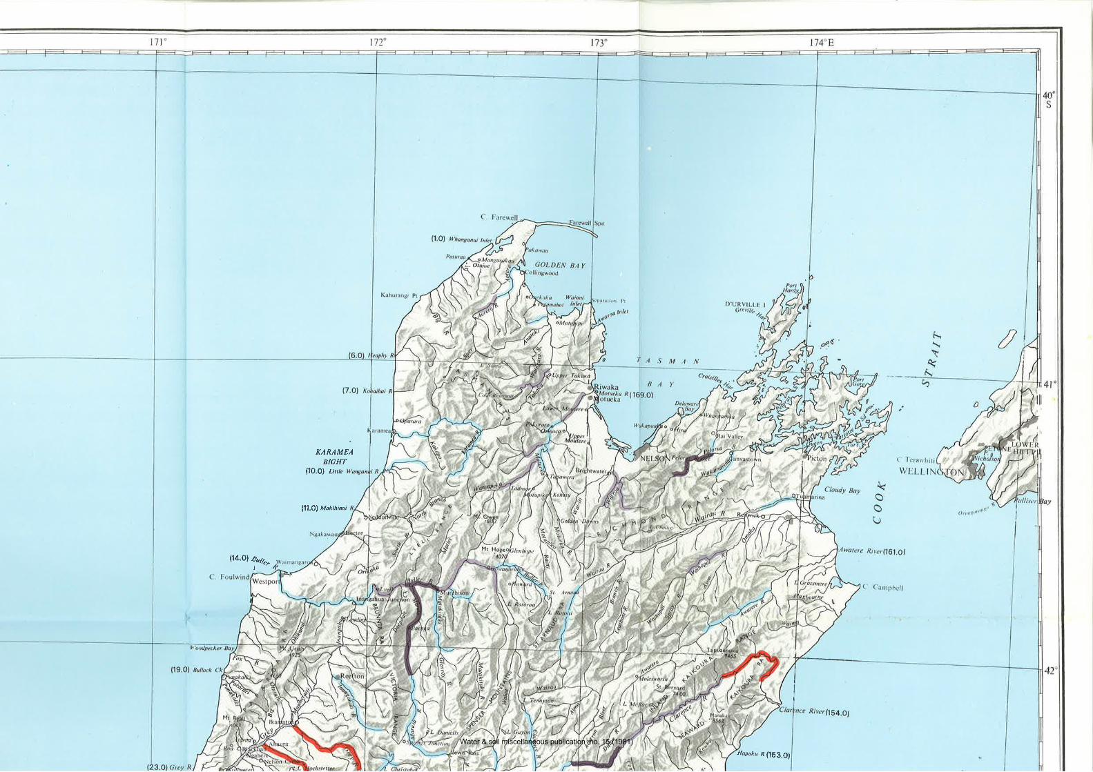
KARAMEABIGHT
(1O.Ol unte
l11.Ol Mok¡h¡nui
l14.Ol.quT
Hapuku R (lS3.O)
Water & soil miscellaneous publication no. 15 (1981)
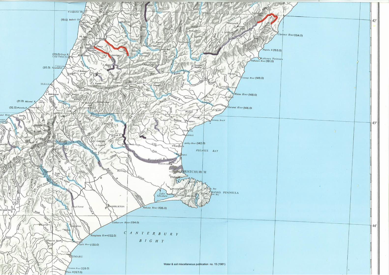
al
^,'9
¿
(25.o) n
(31.O1 ¡'1¡¡e¡,¡ p
l32.Ol wuitata n
L
Vshburton
AN7'ERBURYBIGHT
ni''er (l3O.0l
ao
t-.\
(-L
Poreora Riw (12B.Ol
Rl127.Ol
River(132.O1
Water & soil miscellaneous publication no. 15 (1981)
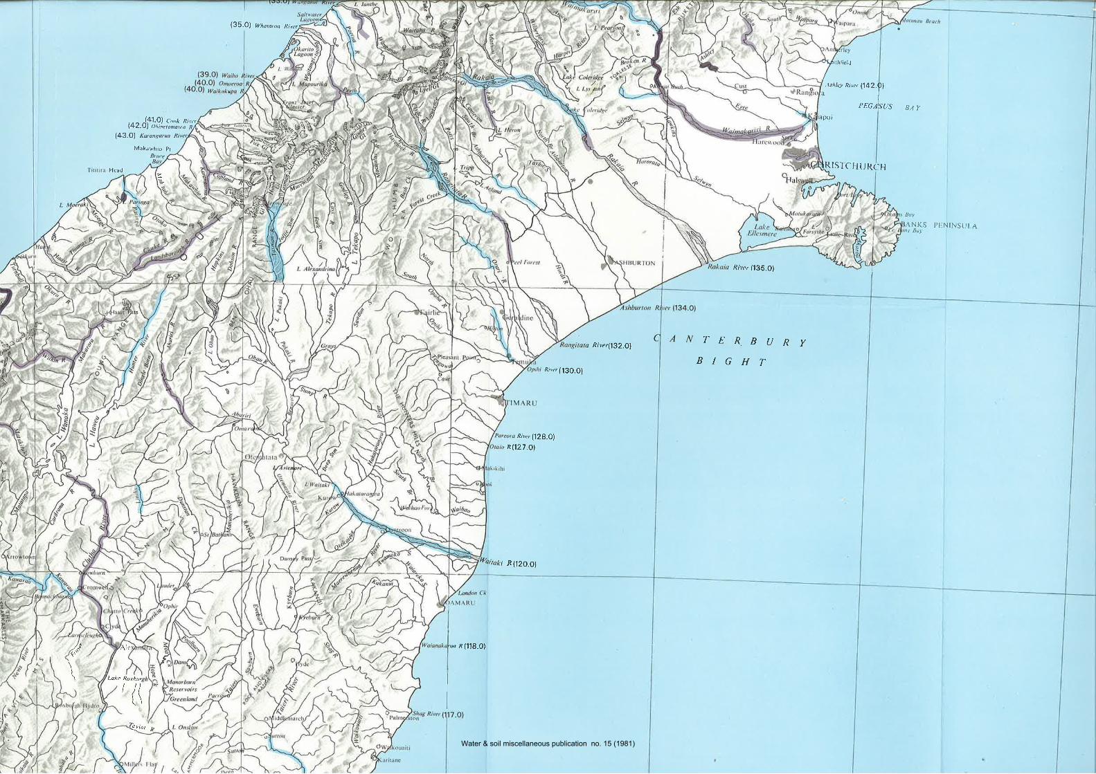
,.u.|o, Wha¡aroa River
7r'hrictd
r.lshlet R¡
Pot
LRISTC
t142.01
I
PEGAIS{JS
URCHH
BAY
@2.ófI!,)"Í:::,":";)l43.Ol Katangarua ni
Maktu,hio pr
Bt uce
l lcad
Boy
ANKns Bu¡
S PENINSULA
River(132.O1
¡Riler 1135.O)
7-ERBURYBIGHT
Rty¿, (l30.Ol
River ('l28.Ol
Rl127.Ol
i R(12O.O)
í.ù"?\te
Lake Rorbu¡
'øa R (118.0)
'(( I
evØt R
\
Water & soil miscellaneous publication no. 15 (1981)
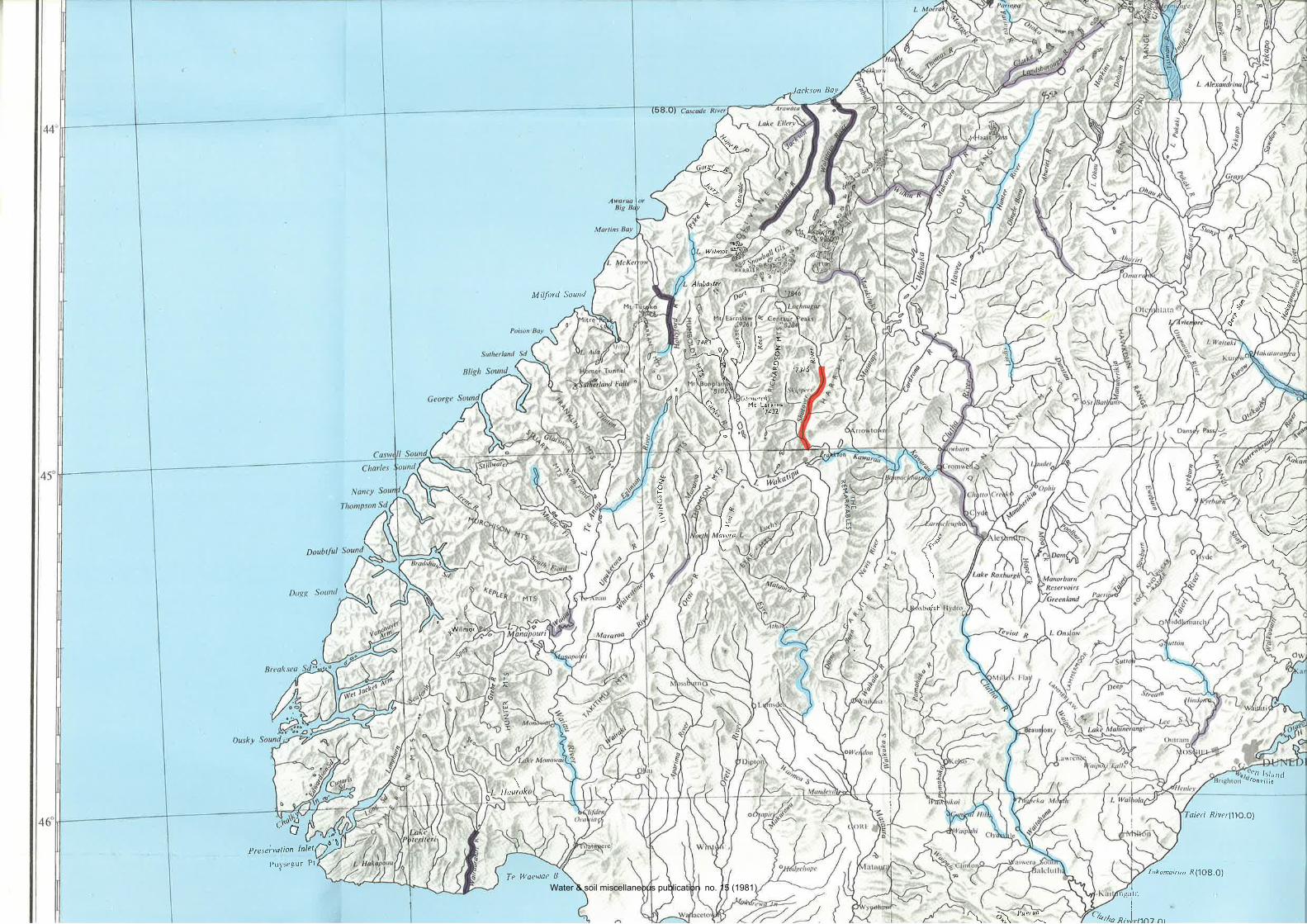
Jackson Ba.v
¿oo4)
zrà;-'\ ""\ l! E \o\ l.¿ z -,-"<//_l/ I B-
Alobaster
'3 \tY € 73s
A- \ \ '.'.îliî'
$'
/%sl__d.
t-/'\2\L
(a{Î
Wilmot @l
Mifoxl Sound
,.\ "{
r.-ñ(a/"\s"
7>-{tf
@-/q
l"ü" 4,"'
\\J,rrfgh
\
FE
Éf-
'c'll l>l;rnd¡onvi¡¡Ê
r¡,),t
(,t-d
Prescivorion t'i't¡7)
'aieri River(11O.Ol
Tokomairint R (1O8.O)
r rìgJ l:tII
I
Rivlrnr}1 ^l
/qtha
t\- 4\-_;/
PLr¡segur Pt
Te lVaewae B
Water & soil miscellaneous publication no. 15 (1981)
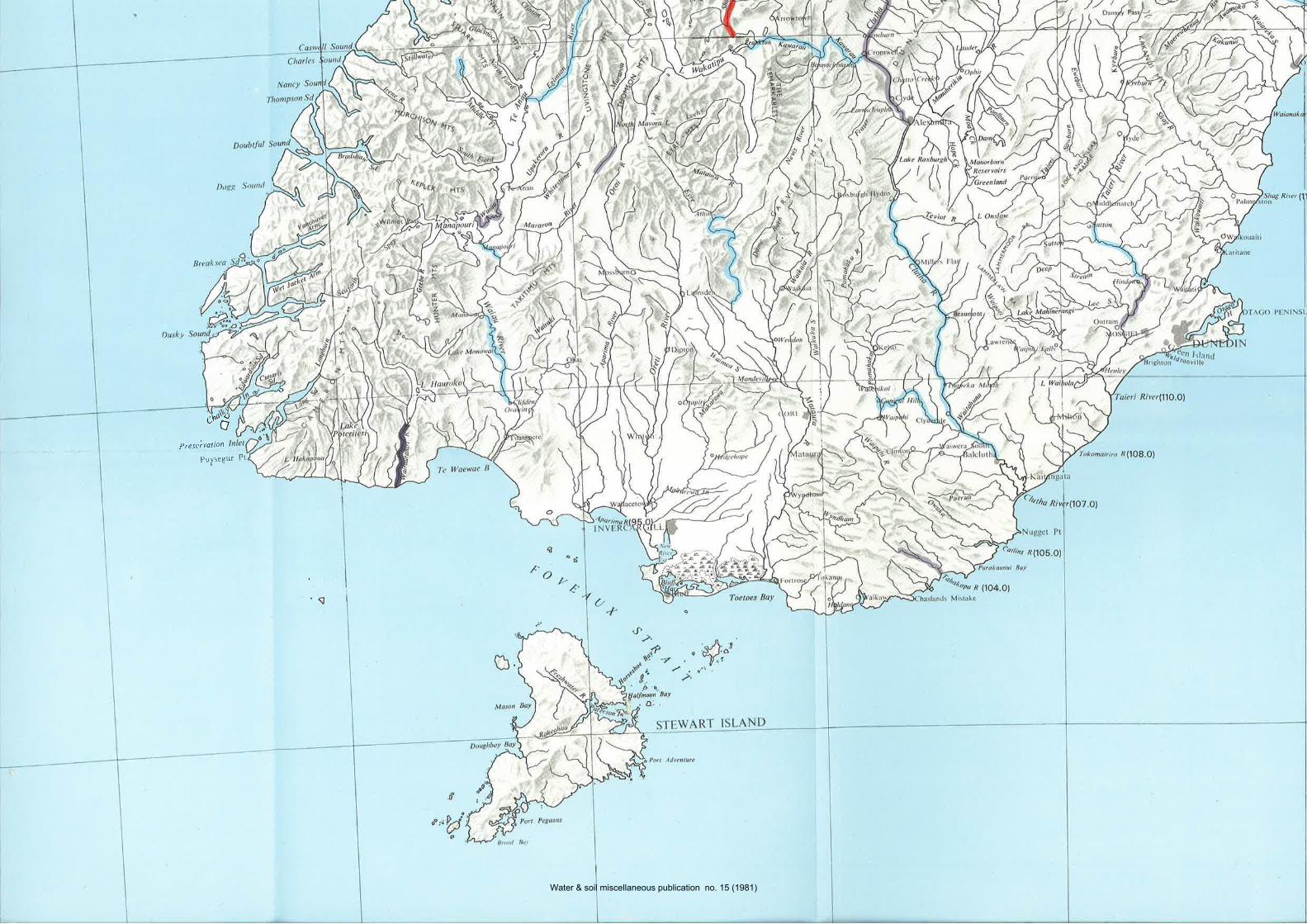
r*d
P reseivation
Puysegur Pl
L.
Water & soil miscellaneous publication no. 15 (1981)
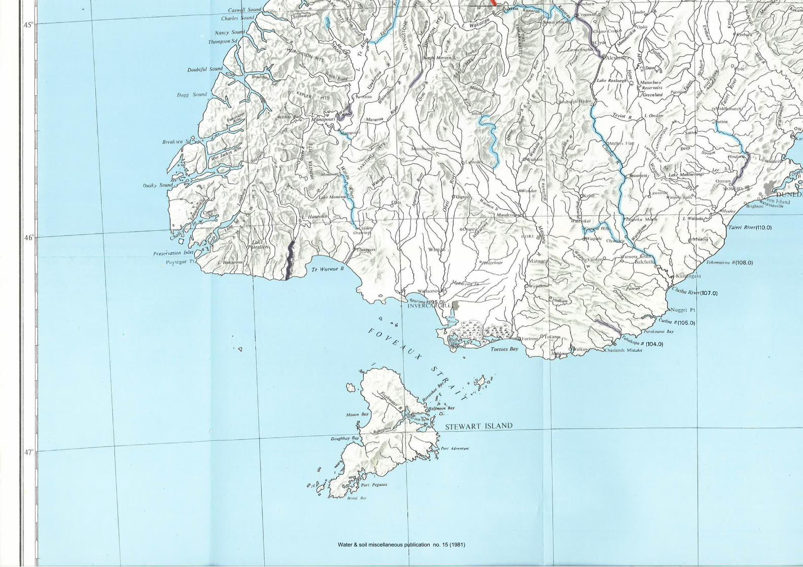
v
('r-o
Preseivotion Inlet
Puysegur Pt
Te lüaewoe B
coñ
îou¿
DoughboY laY
Pott Adven¡ure
'aieri RiverlllO.Ol
R¡
gget Pt
eørtìæ Rl,lO]c.Ol
Boy
1O7.0)
n (1o4.olMistake
Water & soil miscellaneous publication no. 15 (1981)