Embed Size (px)
Citation preview
Please ask for Julie Britton: Telephone (01362) 656343e-mail: [email protected]
AGENDANOTE: In the case of non-members, this agenda is for information only
Committee - PLANNING COMMITTEE
Date & Time - MONDAY, 4TH JUNE, 2018 AT 9.30 am
Venue - ANGLIA ROOM, THE CONFERENCE SUITE, ELIZABETH HOUSE, DEREHAM
Members of the Committee requiring further information, or with specific questions, are asked to raise these with the appropriate officer at least two working days before the meeting. If the information requested is
available, this will be provided, and reported to Committee.
NOTEWard Representatives wishing to speak on a particular application are asked to inform the Usher, Mrs M. Cunnington, well in advance and arrive at the meeting by 9.30am as the items on which
the public wish to speak will be taken first in order of the agenda.
IN THE EVENT OF DEFERRED ITEMS
APPEARING ON THE AGENDA, WARD
REPRESENTATIVES WILL BE NOTIFIED ACCORDINGLY IN
ADVANCE.
THE ORDER OF THE MEETING WILL VARY TO ALLOW FOR
PUBLIC SPEAKING AND WILL NOT FOLLOW THAT OF THIS
AGENDA
PERSONS ATTENDING THE MEETING ARE
REQUESTED TO TURN OFF MOBILE PHONES
VOTING:If the first vote is lost in considering an application, a new proposal will be requested (eg a
vote for approval, if lost, does not automatically mean “refused”). On a tied vote, the Chairman has a casting vote, if he/she wishes to use it. It is necessary for summary
reasons for approvals or refusals to be identified in each case.
Democratic ServicesElizabeth House, Walpole Loke,Dereham Norfolk, NR19 1EEDate: Thursday, 24 May 2018
Public Document Pack
BRECKLAND COUNCIL – PLANNING COMMITTEE
. PLANNING POLICY NOTE
THE STRENGTH OF PLANNING POLICY IN DETERMINING PLANNING APPLICATIONS
The Planning process is set up, IN THE PUBLIC INTEREST, to protect the public from the unacceptable planning activities of private individuals and development companies. Planning is primarily concerned to deal with issues of land use and the way they affect the environment.
The Council has a DUTY, through the Planning & Compulsory Purchase Act 2004, to prepare Local Development Documents (DPDs) to provide a statutory framework for planning decisions. The Development Plan for Breckland currently consists of a suite of documents. The primary document which sets out the overarching planning strategy for the District and the local planning policies is the Core Strategy and Development Control Policies document. This was adopted by Breckland Council on 17th December 2009 and is the local starting point in the determination of planning applications. Breckland Council has also adopted its Site Specific Policies and Proposals DPD, on 19th January 2012. The document allocates specific areas of land for development and revised settlement boundaries.
Breckland’s Plan contains the Council’s planning policies, which must be consistent with Government policy which is currently the National Planning Policy Framework (NPPF) and accompanying technical guidance.
The full public scrutiny of the Council’s proposals will give the Plan an exceptional weight when dealing with planning applications.
This shift towards a “Plan-led” planning system is a major feature of planning legislation. The Planning & Compulsory Purchase Act 2004, states that planning applications should be determined in accordance with the policies of the Plan, unless material considerations which are relevant to planning indicate otherwise.
The NPPF states that the purpose of the planning system is to achieve sustainable development. The core planning principles contained within the NPPF are summarised as:
To be genuinely plan led To drive and support sustainable economic development Seek high quality design Conserve and enhance the natural environment Encourage the effective use of land Conserve heritage assets
Unless there are special reasons to do otherwise, planning permissions “run with the land”, and are NOT personal licences.
The factors to be used in determining applications will relate to the effect on the “public at large” and will NOT be those that refer to private interests.
Personal circumstances of applicants “will rarely” be an influencing factor, and then, only when the planning issues are “finely balanced”.
THEREFORE we will:• acknowledge the strength of our policies,• be consistent in the application of our policy, and• if we need to adapt our policy, we should do it through the LDF process.
Decisions which are finely balanced, and which contradict policy will be recorded in detail, to explain and justify the decision, and the strength of the material planning reasons for doing so.
LOCAL COUNCILS
OCCASIONALLY, THERE ARE CONFLICTS WITH THE VIEWS OF THE PARISH OR TOWN COUNCIL. WHY IS THIS?
We ask local parish and town councils to recognise that comments received are taken into account. Where we disagree with those comments it will be because:
• Districts look to “wider” policies, and national, regional and county planning strategy. Other consultation responses may have affected our recommendation.• There is an honest difference of opinion.
GLOSSARY OF TERMS AND ABBREVIATIONS
AIM Arboricultural Impact Assessment: Report in relation to treesAMS Arboricultural Method Statement: How development can be carried out to protect trees.ANP Area Neighbourhood Plan.AOD Above Ordinance Datum: Height, in metres, above a fixed point. Used to assess matters of comparative heights in long distance views and flooding modelling.AQMA Air Quality Management AreaBCN Breach of Condition Notice: Formal enforcement action to secure compliance with a valid conditionBS British Standard as in 78233:2014: in respect of treesBuffer zone a 1500m buffer around areas supporting or capable of supporting nesting stone curlewsCEMP Construction Ecological Management PlanCHP Combined Heat and PowerCSH Code for Sustainable HomesCIL Community Infrastructure Levy: A national levy on development which will replace contributions under ‘Planning Obligations’ in the futureCLEUD Certificate of Lawful Existing Use or Development: Formal procedure to ascertain whether a development which does not have planning permission is immune from enforcement actionCLOPUD Certificate of Lawful Proposed Use or Development: Formal procedure to ascertain whether a development requires planning permissionConservation Area An area of special architectural or historic interest designated due to factors such as the layout of buildings, boundaries, characteristic materials, vistas and open spacesDPD Core Strategy and Development Control Policies Development Plan DocumentDM Development Management:the area of planning service that processes planning applications, planning appeals and enforcement workD & A Design and Access Statement: A Design and Access statement is submitted with a planning application and sets out the design principles that the applicant has adopted to make the proposal fit into its wider contextDph dwellings per hectareDV District ValuerEA Environment Agency: Lead government agency advising on flooding and pollution controlEHO Environmental Health OfficerEN Enforcement NoticeEIA Environmental Impact Assessment: formal environmental assessment of specific categories of development proposalsEPSL European Protected Species LicenceES Environmental Assessment under the Environmental Impact Assessment RegulationsETSU Energy Technology Support Unit: in relation to noiseEU Existing UseFlood Zone - defined by the Environment Agency to indicate level of risk in relation to floodingFRA Flood Risk AssessmentGCN Great Crested NewtsGI Green InfrastructureGPDO General Permitted Development Order: Document which sets out categoriesof permitted development (see ‘PD')HES Historic Environment ServiceHRA Habitats Regulations AssessmentHSE Health and Safety ExecutiveIDB Internal Drainage BoardIRZs Impact Risk AssessmentLAP Local Area of PlayLCA Landscape Character AssessmentLDF Local Development FrameworkLEMP Landscape Ecological Management PlanListed building An individual building or group of buildings which require a level of protection due to its architectural interest, historical interest, historical associations or group valueLNR Local Nature ReserveLocal Plan The current planning policy document
Local Service Centre Village defined as containing adequate services and facilities to meet the requirement of their existing residents.LPA Local Planning AuthorityLVIA Landscape and Visual Impact AssessmentMaterial Considerations Matters which are relevant in determining planning applicationsMUGA Multi use games areaNCC Norfolk County CouncilNCC Highways Responsible for offering advice on highways issues relating to planning applications as well as highways maintenance and improvementNERC Natural Environment & Rural Communities ActNet Density The density of a housing development excluding major distributor roads, primary schools, open spaces serving a wider area and significant landscape buffer stripsNPPF National Planning Policy Framework: This is Policy, hosted on a dedicated website, issued by the Secretary of State detailing national planning policy within existing legislationNPPG National Planning Practice GuidanceNWT Norfolk Wildlife TrustOAN Objectively Assessed Housing NeedPADHI Planning Advice for Development near Hazardous InstallationsPCN Planning Contravention Notice: Formal notice, which requires information to be provided in connection with an enforcement investigation. It does not in itself constitute enforcement actionPD Permitted development: works which can be undertaken without the need to submit a planning applicationPEA Preliminary Ecological AppraisalPINS Planning InspectoratePOS Public Open SpacePROW Public right of wayRamsar Site A wetland of international importanceRP Registered ProviderRPA Root Protection AreaSAC Special Area of Conservation: an SSSI additionally designated as a Special Area of Conservation under the European Community’s Habitats Directive 1992 in order to maintain or restore priority natural habitats and wild speciesSAP Standard Assessment Procedure: Energy calculationsSCI Statement of Community Involvement: The document and policies that indicate how the community will be engaged in the preparation of the new Local PlanSection 38 agreement - NCC Highways legal agreementS106 or Section 106: A legal agreement for the provision of facilities and/or infrastructure either directly by a developer or through a financial contribution, to meet the needs arising out of a development. Can also prevent certain mattersSettlement Boundary: identified in the proposals maps of the Breckland Core Strategy, land within which may be acceptable, in principle, for developmentSHMA Strategic Housing Market AssessmentSHLAA Strategic Housing Land Availability AssessmentSOS Secretary of StateSPA Special Protection Area: An SSSI additionally designated a Special Protection Area under the European Community’s Directive on the Conservation of Wild Birds 1979.SS Spatial StrategySSSI Site of Special Scientific InterestSuDS Sustainable Urban Drainage Systems: Providing urban drainage systems in a more environmentally sensitive way by systems designed to reduce the quantity of run-off, slow its velocity or provide for filtering, sedimentation and biological degradation of the waterSUE Sustainable Urban ExtensionSustainable Development. Sustainable development is the core principle underpinning planning. It is defined as “development that meets the needs of the present without compromising the ability of future generations to meet their own needs”TA Transport Assessment or Transport Statement – assessment of the traffic and transportation implications of a development proposalTEMPO – Tree Evaluation Method for Preservation Orders
TPO Tree Preservation Order – where a tree or trees are formally protected and prior consent is needed for pruning or fellingTPP Tree protection PlanTRICS Trip Rate Computer Services: Computerised database and trip rate analysis used to estimate traffic flows to and from a variety of land uses, to assess transportation implications of new development in southern EnglandUnilateral undertaking - a form of legal agreementUse Classes Order: Document which lists classes of use and permits certain changes between uses without the need for planning permission. Further definitions can be found in Annex 2 of the NPPFVA Viability AssessmentSuffixes to reference numbersA - Advertisement consentAG - Agricultural NotificationBT - TelecommunicationsCA - Conservation Area ConsentCM - County MattersCU - Change of useD - Reserved Matters (following outline approval)DEM - DemolitionDOC - Discharge of conditionsEU - Certificate of Lawfulness of Existing UseF - FullH - Hybrid - an application which includes elements of outline and full applicationsLB - Listed Building ConsentLU - Certificate of Lawfulness of Proposed UseNMA - Non material minor amendmentO - OutlineOB - Planning ObligationPNE - Prior approvalSCO - Scoping opinion - explainSCR - Screening opinion - explainSU - Statutory UndertakerTL - Extend Time Limit - where planning permissions have not been implemented in the required time period
Planning Committee4 June 2018
Page(s)herewith
1. MINUTES To FollowTo confirm the minutes of the meeting held on 8 May 2018.
2. APOLOGIES & SUBSTITUTES To receive apologies for absence.
3. DECLARATION OF INTEREST AND OF REPRESENTATIONS RECEIVED The duties to register, disclose and not to participate for the entire consideration of the matter, in respect of any matter in which a Member has a disclosable pecuniary interest are set out in Chapter 7 of the Localism Act 2011. Members are also required to withdraw from the meeting room as stated in the Standing Orders of this Council.
4. CHAIRMAN'S ANNOUNCEMENTS
5. REQUESTS TO DEFER APPLICATIONS INCLUDED IN THIS AGENDA To consider any requests from Ward Members, officers or applicants to defer an application included in this agenda, so as to save any unnecessary waiting by members of the public attending for such applications.
6. URGENT BUSINESS To note whether the Chairman proposes to accept any item as urgent business, pursuant to Section 100(B)(4)(b) of the Local Government Act 1972.
7. LOCAL PLAN UPDATE (STANDING ITEM) To receive an update.
8. DEFERRED APPLICATIONS 9 - 10To consider applications deferred at previous meetings including some, but not all, of those shown on the attached Schedule of Deferred Applications.
a) Dereham: Grange Farm, Etling Green: Reference: 3PL/2017/1281/F 11 - 24
This application was scheduled to be presented to the Planning Committee on 9th April 2018 but was deferred prior to the meeting to allow further investigation into the registered Common Land, land ownership and associated notification procedures.
b) Swaffham: Swans Nest Site, Land East of Brandon Road: Reference: 3PL/2017/1351/F
25 - 41
This application was scheduled to be presented to the Planning Committee on 9th April 2018 but was deferred prior to the meeting in order to address issues raised by the Lead Local Flood Authority (LLFA).
Planning Committee4 June 2018
Page(s)herewith
9. SCHEDULE OF PLANNING APPLICATIONS To consider the Schedule of Planning Applications:
a) Attleborough: Land south of New Road, West of Hargham Road: Reference: 3PL/2017/1171/O
42 - 56
b) Attleborough: Post Office, High Street: Reference: 3PL/2017/1515/F 57 - 68
c) Croxton: Norwich Road: Reference: 3PL/2017/1576/D 69 - 83
d) Dereham: Land south of Green Farm, Yaxham Road: Reference: 3PL/2017/1471/O
84 - 95
e) Great Ellingham: Misty Dawn, Deopham Road: Reference: 3PL/2018/0294/F
96 - 106
f) Hockering: Land west of Heath Road, Heath Road: Reference: 3PL/2017/1574/O
107 - 124
g) Mattishall: Land Adj at Daryll Farm Mill Road: Reference: 3PL/2018/0252/F
125 - 133
h) Narborough: Land to the west of Chalk Lane: Reference: 3PL/2015/1180/O
134 - 148
i) North Elmham: Land adjacent Caberfeidh, Pump Street: Reference: 3PL/2018/0040/F
149 - 157
j) North Elmham: Land north on Eastgate Street: Reference: 3PL/2018/0057/VAR
158 - 165
k) Roudham/Larling: Land opposite Barkers Farm, Watton Road: Reference: 3PL/2018/0359/O
166 - 176
l) Saham Toney: 112 Hills Road,Saham Hills: Reference: 3PL/2018/0226/F
177 - 184
m) Shipdham: The Cricket Players, Old Post Office Street: Reference: 3PL/2017/0864/F
185 - 203
n) Snetterton: Foulger Transport Ltd, Snetterton Circuit, Harling Road: Reference: 3PL/2018/0170/F
204 - 209
o) Stanfield: Church Lane: Reference: 3PL/2018/0191/O 210 - 219
Planning Committee4 June 2018
Page(s)herewith
p) Stow Bedon/Breckles: Pig Patch House, Cartlodge, Mere Road: Reference: 3PL/2018/0385/VAR
220 - 224
q) Swanton Morley: Land South-west of Rectory Road: Reference: 3OB/2018/0002/OB
225 - 227
r) Swanton Morley: Land off Rectory Road: Reference: 3PL/2017/1546/VAR C
228 - 236
s) Thetford: Anchor Place: Reference: 3PL/2018/0227/F 237 - 243
t) Whissonsett: Site to the rear of Queensforth, London Street: Reference: 3PL/2018/0235/F
244 - 252
10. FORMAL OBJECTION TO SERVING OF TPO 2018 NO.1 - SCARNING 253 - 257
Report of the Tree & Countryside Officer.
11. APPLICATIONS DETERMINED BY THE EXECUTIVE DIRECTOR OF PLACE
258 - 271
Report of the Executive Director of Place.
Members are requested to raise any questions at least two working days before the meeting to allow information to be provided to the Committee.
12. APPEALS SUMMARY 272 - 273For information.
BRECKLAND COUNCIL - PLANNING COMMITTEE – 04 June 2018: SCHEDULE OF DEFERRED APPLICATIONS
REFERENCE AND DETAILS OF APPLICATIONS MEETING FIRST REPORTED TO
RECOMMENDATION REASON FOR DEFERMENT
DATE EXPECTED TO RETURN TO COMMITTEE
3PL/2010/1361/F: DEREHAM: Land East of Yaxham Road, South of Dumpling Green: Erection of 255 dwellings with associated open space
01/09/2014 Approval For further information tbc
3PL/2016/1397/F: DEREHAM: Land at Greenfields Road: 285 dwellings comprising 6x5 bedroom houses, 87x4 bedroom houses, 113x3 bedroom houses, 73x2 bedroom houses, 4x2 bedroom bungalows and 2x1 bedroom bungalows together with associated access, pedestrian and cycle links, landscaping and open space: Applicant: Orbit Homes (2020) Ltd
08/05/2017
18/12/2017
Approval
Approval
Further information on Planning Policy DC11
The location of the MUGA
Tbc
tbc
3PL/2017/1267/O: CASTON: Land adjacent to Caston Primary School, The Street: Erection of five dwellings and car park for Caston Primary School
12/02/2018 Approval To enable further investigations to take place with the Environment Agency in relation to the impact that the floodplain compensation scheme would have on the drainage system as it operates at present and once this development has been implemented, if approved.
tbc
3PL/2017/1281/F: DEREHAM – Grange Farm, Etling Green: Residential development comprising demolition of existing barns and erection of twodwellings with annexe to plot 2 (converted outbuilding), conversion of timber framed barn todwelling and retention and refurbishment of listed farmhouse and convert outbuildings to formannexe to farmhouse
09/04/2018 Approval To allow for further consultation with the Town Council regarding land ownership and access arrangements
tbc
9
Agenda Item
8
BRECKLAND COUNCIL
DEVELOPMENT CONTROL COMMITTEE – 8 May 2018: SCHEDULE OF DEFERRED APPLICATIONS
REFERENCE AND DETAILS OF APPLICATIONS MEETING FIRST REPORTED TO
RECOMMENDATION REASON FOR DEFERMENT
DATE EXPECTED TO RETURN TO COMMITTEE
3PL/2017/1351/F: SWAFFHAM – Swans Nest Site, Land East of Brandon Road: Erection of 98 dwellings (Phase 3) at Swans Nest with access from Brandon Road
09/04/2018 Refusal The Local Lead Flood Authority was maintaining its objection but was willing to reconsider if identified issues were addressed
tbc
10
ITEM: RECOMMENDATION: APPROVALREF NO: 3PL/2017/1281/F CASE OFFICER Donna Smith
LOCATION: DEREHAM APPNTYPE: FullGrange Farm POLICY: Out Settlemnt BndryEtling Green, Dereham ALLOCATION: N
CONS AREA: N
APPLICANT: Ms Cathy Dixonc/o Agent
LB GRADE: Grade II
AGENT: Icon ConsultingHethel Engineering Centre ChapmanWay
TPO: N
PROPOSAL: Residential development comprising demolition of existing barns and erection of twodwellings with annexe to plot 2 (converted outbuilding), conversion of timber framed barn todwelling and retention and refurbishment of listed farmhouse and convert outbuildings to formannexe to farmhouse
DEFERRED REASON
1.0 History
1.1 The application was scheduled to be presented to committee in 9th April 2018 but it was deferred prior tothe meeting to allow further investigation into the registered Common Land, land ownership and associatednotification procedures.
1.2 Since the deferral, the applicant has amended the extent of the application site boundary to includeaccess to the site, sent the requisite notices to all parties with an interest in the land or associated ownershipto include the area requested for widening by the Highway Authority.
1.3 Following the above amendments, it was considered that the widening of the access necessary tofacilitate the development could be accommodated on highway land, rather than the registered CommonLand.
2.0 Consultations
2.1 Norfolk County Council Highways were consulted on the amendment and stated that given the difficulty insurfacing common land outside of the applicants control, no objections are raised to the revised proposal.
2.2 Dereham Town Council were consulted on the amendment and stated that the revised drawings relatingthe new access works are not taking place on the Common and consequently had no direct commentsrelating to the access works.
2.3 The Town Council is however concerned of the effect of the widening of the entrance will have on theCommon. The additional width of the entrance from the highway will lead to a gradual widening of the accesstrack across the common this gradual widening of the common will result in encroachment of the turf to the
BRECKLAND COUNCIL - PLANNING COMMITTEE - 4th June 2018
COMREPORT (ODB-Ocella One Click Agenda/Officer report) 11
Agenda Item 8a
detriment of wildlife, biodiversity and general amenity.
2.4 The Town Council also reiterated that Under the 1899 Commons Act there is a scheme of managementin place for the common, as such the responsibility for management under the scheme sits with BrecklandCouncil (the 1899 Act was not modified by the 1972 Local Government Act) article 4 of the Scheme ofManagement places a duty on Breckland Council to protect the Common from encroachment. In order toprotect the Common from encroachment as a result of the widening of the access from the highway andespecially to protect the common from development vehicles, Breckland Council should insist that bollardsare placed along the access track to the entrance of Grange Farm. Such a condition would protect thegeneral amenity of the common along with its biodiversity, the Common is a County Wildlife Site and is partof the Dereham Northern Green Corridor.
1.8 The Town Council therefore requested that If permission is granted; the inclusion of bollards, asdescribed above, be conditioned to be in place before development starts on site.
3.0 Assessment
3.1 Whilst we acknowledge the Town Council's request for the installation of bollards along the access of theCommon, NCC Highways have no comments or have expressed a view on the necessity for bollards, andthe agent considers the installation of bollards to be unnecessary. Should bollards be required, they wouldrequire planning permission.
3.2 On the basis of the above amendments, and the widening works being solely within the highway therecommendation of approval is unchanged by these amendments.
REASON FOR COMMITTEE CONSIDERATION
The application has been called in by a Local Councillor. The site is also located outside the definedsettlement boundary for Dereham, which conflicts with policies DC2 and CP14 of the adopted Core Strategyand Development Management Development Plan Document (2009).
KEY ISSUES
Presumption of favour of sustainable developmentCharacter and appearanceEcologyHeritage AssetsAccessibility and highway safetyConclusions
DESCRIPTION OF DEVELOPMENT
The applicant seeks full planning permission for the demolition of existing outbuildings, the erection of 2No.four bedroom single storey dwellings, conversion and refurbishment of an existing barn an refurbishment ofthe Grade II Listed farm house. The proposal also includes minor refurbishment/alterations to the "GigHouse", "The Dairy" and "The Stables." The total floor space for the proposed dwellings is 529sqm on a sitearea of 0.68ha.
A similar application for this site was recently refused under Ref: 3PL/2016/0770/F which proposed the
BRECKLAND COUNCIL - PLANNING COMMITTEE - 4th June 2018
COMREPORT (ODB-Ocella One Click Agenda/Officer report) 12
erection of three dwellings, conversion of barn to dwelling, and retention and refurbishment of Listed FarmHouse.
SITE AND LOCATION
The site is located outside the defined settlement boundary for Dereham close to the countryside settlementof Etling Green which is located to the north east of the proposed site. The site comprises of a Grade II ListedFarmhouse and other associated agricultural buildings, and sits within prodomiently rural surroundings to thewestern edge of Etling Green, with Dereham Cemetery located to the west. A linear form of residentialdwellings sits north of the site, with the B1147 located to the south.
EIA REQUIRED
No
RELEVANT SITE HISTORY
3PL/2016/0770/F - Residential development comprising demolition of existing barns and erection of threedwellings, conversion of barn to dwelling and retention and refurbishment of Listed Farm House - Refused -25-05-17.
POLICY CONSIDERATIONS
The following policies of the adopted Breckland Core Strategy and Development Control Policies and theadopted Site Specific Policies and Proposals Document, including the Proposals Maps, have been taken intoconsideration in the determination of this application. The provisions of the National Planning PolicyFramework and National Planning Policy Guidance have also been taken into account, where appropriate
CP.01 HousingCP.04 InfrastructureCP.06 Green InfrastructureCP.10 Natural EnvironmentCP.11 Protection and Enhancement of the LandscapeCP.13 AccessibilityCP.14 Sustainable Rural CommunitiesDC.01 Protection of AmenityDC.02 Principles of New HousingDC.12 Trees and LandscapeDC.13 Flood RiskDC.16 DesignDC.17 Historic EnvironmentDC.19 Parking ProvisionDC.20 Conversion of buildings in the countrysideNPPF National Planning Policy Framework
BRECKLAND COUNCIL - PLANNING COMMITTEE - 4th June 2018
COMREPORT (ODB-Ocella One Click Agenda/Officer report) 13
NPPG National Planning Practice GuidanceSS1 Spatial Strategy
OBLIGATIONS/CIL
Not Applicable
CONSULTATIONS
DEREHAM T CObject on the basis the site is outside the settlement boundary and not in keeping with the surrounding area.HISTORIC BUILDINGS CONSULTANTNo objection.HISTORIC ENVIRONMENT SERVICEIf planning permission is granted, we therefore request that this be subject to a programme of archaeologicalmitigatory work in accordance with National Planning Policy Framework para. 141.NORFOLK COUNTY COUNCIL HIGHWAYSNo objection subject to conditions.ECOLOGICAL AND BIODIVERSITY CONSULTANTIf you are minded to approve the application, we would recommend that you condition. A copy of the EPSlicence for great crested newts is presented to the local planning authority before works commence on site; 2of 2 A copy of the EPS licence for bats is presented to the local planning authority before works commenceon the existing buildings; That vegetation clearance works are subject to a timing constraint. Modelconditions from BS42020:2013 Biodiversity - Code of practice for planning and development are includedbelow these comments.TREE AND COUNTRYSIDE CONSULTANTRemoval of internal trees will have low landscape impact. Additional planting compensate for the loss.Considered the amendments to the access to have no impact on the root protection area of the treesacceptable.RAMBLERS ASSOCIATION: NORFOLK AREAObject to the application. We note that the Design and Access Statement speaks (1.1.0) describes DerehamRB32 (Shillings Lane), which runs to the north of the site, as a rural lane , yet the application proposes toplace a housing development adjacent to it, justifying this (2.0.0) on the alleged grounds that development tothe east of Dereham have, in reality, brought the sub-urban edge of the town to the application site boundary. It also acknowledges that The site lies outside the current settlement boundary of Dereham. There iscurrently a clear separation between housing development in the town and the self contained settlement thatis Etling Green. From the perspective of walkers and other users of RB32, it is important that this distinctionremains. We note that one of the plans indicates a 10.0m informal no development zone between thedevelopment site and RB32, though it is not clear just what this means, and we consider that a 10m nodevelopment zone is no guarantee that the ambience of the route will be unaffected. We therefore opposethe application.PUBLIC RIGHTS OF WAY OFFICERThe public right of way officer was satisfied that the development would not remove any hedges along
BRECKLAND COUNCIL - PLANNING COMMITTEE - 4th June 2018
COMREPORT (ODB-Ocella One Click Agenda/Officer report) 14
Shillings Lane. They removed their holding objection on this basis.CONTAMINATED LAND OFFICERI recommend approval providing the developmentproceeds in line with the application details and subject to the following conditions to alleviate environmentalconcernJOHN HALEI write as chair of Etling Green Residents' Association. I have once again been approached by residents ofEtling Green in order to express our joint concerns about the proposed development at Grange Farm. Theobjections remain very much the same as they have been for the two previous applications which wererejected. The primary concern is that, however modified from previous applications, this is still the creation ofsignificant new dwellings east of the cemetery and outside the current development area. Etling Green is aCounty Wildlife Site and all three levels of local government have recognised the hamlet with it's registeredcommon as an important rural environment the nature of which should be protected. In breaching the currentboundary for development ( the green space of the cemetery forming a natural end stop ) a dangerousprecedent may be created for further development around and beyond Etling Green. The residents'recognise that this modified plan is an improvement on the previous proposals with a smaller impact on theenvironment. It preserves the existing free movement of wildlife to the south of the buildings. The proposedgap between the new build on Plots 1 and 2 and Shillings Lane to the north is welcome, but likely to bedegraded and blocked by the development of the barn which lies close to Shillings Lane. Access to the site isnow proposed to be via the unadopted track, the west entrance to the north green. Parking spaces proposedare increased from 4 to 16 anticipating a definite increase in traffic onto and off Etling Green itself. Therefurbishment of the farmhouse is. of course, perfectly acceptable, but we fail to see a demonstrable need forthe addition of two new very large dwellings, still close to Shillings Lane and outside the current developmentline. The very real concern is that approval leads to a domino effect of further development, both on theGrange Farm site, and beyond, and the inevitable degradation of the rural nature of this valuableenvironment until it becomes a small oasis in a spreading suburb. This will do nothing to protect the commonitself or the plans for the green corridor to encircle Dereham, so important to the quality of life of all residentsand visitors as well as to bio-diversity.
REPRESENTATIONS
Eight letters of objection were received for the below reasons:
Sets precedent for further developmentIncrease in trafficChanges in levels of biodiversityDevelopment is not welcome outside the settlement boundaryEncroachment of development into the wildlife buffer.
ASSESSMENT NOTES
1.0 Previously refused application Ref: 3PL/2016/0770/F
1.1 The applicant has produced an amended scheme following refusal by members at committee on 8th May2017 of application Ref:3PL/2016/0770/F. The applicant has engaged in detailed discussions with officersfollowing this refusal, and it was agreed on the basis of these detailed discussions a new application could be
BRECKLAND COUNCIL - PLANNING COMMITTEE - 4th June 2018
COMREPORT (ODB-Ocella One Click Agenda/Officer report) 15
submitted to overcome the previous reasons for refusal.
These reasons were as follows:
1.2 The proposed development would introduce new residential development outside a settlementboundary, resulting in the intrusion of built development into the countryside to the detriment of thenatural environment and green infrastructure. As a result the proposed development is contrary topolicies SS1, CP6, CP10 and CP14 of the adopted Breckland Core Strategy and Development ControlPolicies DPD. Whilst the proposed development would secure the long term preservation and enhancementof listed buildings as required by the Listed Building and Conservation Areas Act (1990), the benefits tonationally important heritage assets would not outweigh the harm caused. The proposals would not formsustainable development and the proposals would be contrary to the policies contained within the NationalPlanning Policy Framework, (NPPF), in particular paragraphs 12, 14, 17 of the NPPF.
1.3 The proposed development by way of its form and materials would not be sympathetic with the site andsurrounding area and as a result would cause harm to the character and appearance surrounding area. Theproposals would therefore be contrary to the policy DC16 of the adopted Breckland Core Strategy andDevelopment Control Policies DPD and the policies contained within the National Planning PolicyFramework, (NPPF), in particular paragraphs 17 and 64 of the NPPF.
2.0 Material changes to the scheme since the previous refusal.
2.1 Since the previous refusal, the applicant has reduced the number of proposed new dwellings from 3No.to2No. and both of the new dwellings would be single-storey only and have been designed in the form ofconverted agricultural out-buildings to be more in keeping within the wider character of Etling Green.
2.2 The applicant has considered the context of the site and provided greater separation distances betweenthe built forms which by virtue would improve habitat retention and limit the disturbance to wildlife both withinthe Meadow to the south and within the site.
2.3 The new dwellings have been relocated away from Shillings Lane, aided by additional boundarylandscaping and the strengthening of notation relating to the retention of existing landscaping.
2.4 In terms of vehicular access, the applicant has removed the proposed driveway across the meadow andis proposing to use the existing Grange Farm access. This avoids any further impact on the meadow area.
3.0 Principle of sustainable development
3.1 The application site is located approximately 260m from edge of the defined settlement boundary forDereham. The proposal as a consequence conflicts with policies SS1, CP14 and DC2 of the adopted CoreStrategy and Development Control Policies Development Plan Document (2009).
3.2 Paragraph 49 of the NPPF states housing applications should be considered with the presumption infavour of sustainable development. Relevant policies for the supply of housing should not be considered up-to-date if the local planning authority cannot demonstrate a five-year supply of deliverable housing sites.
3.3 The presumption in favour of sustainable development is set out within paragraphs 7, 8 and 14 of theNational Planning Policy Framework (NPPF), which details that there are three dimensions to sustainabledevelopment, economic, social and environmental. These dimensions cannot be undertaken in isolation, asthey are mutually dependant.
BRECKLAND COUNCIL - PLANNING COMMITTEE - 4th June 2018
COMREPORT (ODB-Ocella One Click Agenda/Officer report) 16
3.4 The proposal conflicts with policy DC2 and CP14 as housing will only be permitted within the definedsettlement boundaries as defined by the policy maps (2012). Policy CP14 identifies that in villages notidentified for a specific level of growth in the settlement hierarchy, residential development will only bepermitted if there are suitable sites available inside the limits of a defined settlement boundary, involves there-use of a rural building or is the replacement of an existing dwelling. However, it is prudent to note thatpolicy CP14 does allow for the appropriate re use of existing rural buildings, for which the criteria is set outwithin policy DC20.
3.6 As a consequence of the above, the application shall be reviewed in accordance with development planpolicy and the principle of sustainable development identified within paragraphs 7 and 14 of the NPPF.
3.7 Dereham has been identified as a market town under policy SS1 and projected to experience significanthousing growth to enhance its position as the administration centre of Mid Norfolk.
3.8 The proposal would generate economic benefits by providing short term construction employment to localpeople, and provide more footfall to local shops and services within Dereham town centre. Whilst theproposal is only for two residential units and the conversion of the existing barn on site, the amplecontribution of housing in this area would provide a modest contribution to the overall housing land supplywithin the district. The proposal is also within close proximity to the service centre of Dereham and is withincycling distance of the local schools and Town Centre which is aided by the new cycleway which existsadjacent to the new cemetery access close to the site.
3.9 From an environmental perspective, the site is prodomiently flat and bound by mature trees andvegetation to its perimeter. The site is separated from the B1147 to the south via an existing meadow whichis also within the applicants ownership. The applicant has removed the access across the Meadow whichwas proposed under the previously refused scheme.
3.10 The proposal is considered to provide economic, social and environmental benefits and by virtue isconsidered to adhere to the three dimensions of sustainable development set out in paragraphs 7 and 14 ofthe NPPF.
4.0 Impact on character and appearance
4.1 The Farm House
4.2 Grange Farm House is a Grade II Listed Building with a number of agricultural out-buildings, the majorityof which are curtilage listed. The applicant has proposed to remove the 1960s extension to the farm house,and replace this with a single-storey extension in a contemporary style of which would be a sufficient sizeand subservient to the scale and mass of the existing farm house. The refurbishment will also include repairto the building which was caused by the introduction of the 1960s element.
4.3 Policy CP14 does allow for the sustainable re-use of appropriately located and constructed buildings inthe countryside for which the criteria is set out in policy DC20. In accordance with the parameters of policyDC20, the impact of the development on the character and appearance of the landscape and the quality ofdesign is acceptable. The barn is considered to be in a sustainable location, there is suitable access and thebuilding is capable of conversion.
4.4 It is considered that the refurbishment and extension to the barn, outbuildings and removal of the 1960'selement to the Grade II Listed Farmhouse would enhance the significance of the heritage assets within the
BRECKLAND COUNCIL - PLANNING COMMITTEE - 4th June 2018
COMREPORT (ODB-Ocella One Click Agenda/Officer report) 17
curtilage of the site. The design and layout of the two new single storey dwellings on site would appearsubservient and contribute to the long term preservation and enhancement of listed buildings as required bythe Listed Building and Conservation Areas Act (1990). The two new residential dwellings by virtue of theirreduced design and more in keeping appearance would, in relation to the Listed Building and its curtilageListed elements, retain and enhance the historical features and quality of the buildings in accordance with theparameters of policy DC20 of the Adopted Local Plan (2009).
4.5 The proposals for the farmhouse and buildings within its curtilage are considered acceptable in principlesubject to consideration against other policy requirements.
4.6 The retention and reuse of the barn in association with the removal of the 1960's extension to the GradeII Listed Farm House is considered to preserve and enhance the character and appearance of the farmhouse and buildings within its curtilage in accordance with the National Planning Policy Framework andparagraph 66 of the Planning (Listed Building and Conservation Areas) Act 1990.
4.7 Barn conversion
4.8 The previous proposal for the barn conversion was considered acceptable by officers. The existing barnbenefits from a brick plinth, profiled sheet and timber board cladding. The applicant proposes to retain theexisting footprint and height of the building, alongside the retention of the historic "buttress." The materialschosen for the external facades of the barn include structural timber cladding, glazed panels and a zinestanding-seam roof. A new cart style garage is proposed to sit adjacent to the barn, which is not consideredout of character when viewed within its rural surroundings.
4.9 The "Gig House"
4.10 The 'Gig House' is a single-storey domestic-scaled out-building close to the western side of the farmhouse. It is brick-built with a hipped roof and is currently in use as a general store.
4.11 The applicant has proposed to apply timber cladding to the elevations of the "Gig House" and a smallextension of 36 sqm. The proposal also includes the recladding of the existing "Dairy" building on site intimber clad.
4.12 The "Dairy"
4.13 The 'Dairy' is a single-storey domestic out-building. The door and window openings require newcomponents and the roof requires a refurbishment which the applicant has proposed to restore it to afunctioning use as garages for the proposed residential units.
4.14 The proposal is considered to adhere to the parameters of policies CP6, CP10 and CP14 of the adoptedBreckland Core Strategy and Development (2009).
4.15 Proposed Dwellings
4.16 The three dwellings proposed under the previously refused scheme were two storeys in height and of adesign which was not considered sympathetic when viewed within the context of the existing site andsurrounding area. As a result, these were considered to cause harm to the character and appearancesurrounding area. The proposal was also considered to be an intrusion of built development into thecountryside to the detriment of the natural environment and green infrastructure.
BRECKLAND COUNCIL - PLANNING COMMITTEE - 4th June 2018
COMREPORT (ODB-Ocella One Click Agenda/Officer report) 18
4.17 The applicant has reduced the scheme to 2No. dwellings which would be single storey in heightalongside the conversion of the existing barn. The dwellings would be of a "bungalow" style in nature, andwould be viewed and seen as subservient to the existing Grade II Listed Farmhouse.
4.18 The applicant has proposed to utilise similar materials to that proposed to the existing barn, includingstructural timber cladding and pantiles to mimic the style of the converted barn. The dwellings have also beenset back further from the northern and eastern boundary of the site, away from Shillings Lane.
4.19 It is considered the applicant has taken appropriate steps to overcome the previous reasons for refusal.The dwellings have been redesigned and reduced in scale to a design which would be similar to that ofagricultural outbuildings which considered appropriate within this rural location.
4.20 The redesign is considered sympathetic to the site and wider context by virtue of its reduced scale andsensitive and as a result, it is not considered to cause harm to the character and appearance of thesurrounding area. The proposal would therefore adhere to the parameters of policy DC16 of the adoptedBreckland Core Strategy and Development Control Policies DPD and the policies contained within theNational Planning Policy Framework, (NPPF), in particular paragraphs 17 and 64..
4.21 By virtue of the reduced scale of the dwellings, alongside their redesign and the elimination of theproposed access across the meadow to the south of the site, the visual impact of the proposal is consideredto be much reduced when viewed from the B147 to the south and Shillings Lane. As a consequence, theproposal is not considered to be an intrusion of built development into the open countryside and would not beviewed as a prominent feature within the landscape.
5.0 Impact on ecology
5.1 The ecology officer confirmed that the application was supported by an ecology report (Protected SpeciesSurvey; Wild Frontier Ecology; June 2016). The report provided a robust assessment. No objections areraised subject to conditions relation to the protection of great crested newts and bats.
7.0 Impact on trees
7.1 The proposed removal of internal trees has been considered by the tree officer who considers this willhave low landscape impact. Additional planting will be conditioned to any grant of consent to compensate forthe loss. The applicant rearranged the access point to be outside the root protection area of the trees whichthe tree officer considered acceptable.
5.0 Accessibility and highway safety
5.1 The highways officer considered the proposal and had no objections subject to appropriate conditions inrespect of access arrangements and parking and turning areas being completed prior to occupation of thedevelopment.
8.0 Conclusions
8.1 The proposal has presented a materially different scheme to that which was refused under application3PL/2016/0770/F in both scale, mass and design. The reduction in dwellings from three to two alongside thechange in palette of materials with better separation distances between dwellings is considered acceptable
BRECKLAND COUNCIL - PLANNING COMMITTEE - 4th June 2018
COMREPORT (ODB-Ocella One Click Agenda/Officer report) 19

and more in keeping with the surrounding rural locality.
8.2 Alongside a robust landscaping scheme and additional planting the proposed site would be well screenedfrom the B1147 to the south. The proposal has also relocated further away from Shillings Lane which iswelcomed and acknowledged.
8.3 A planning balancing exercise has taken place. The retention and reuse of the barn in association withthe removal of the 1960's extension to the Grade II Listed Farm House is considered to preserve andenhance the character and appearance of the farm house and buildings within its curtilage in accordancewith the National Planning Policy Framework and paragraph 66 of the Planning (Listed Building andConservation Areas) Act 1990.
8.4 The site is considered to be in a sustainable location, just outside the defined settlement boundary ofDereham. The proposal would provide economic and social benefits alongside the renovation of a Grade IIListed Building and associated out buildings, preserving its heritage.
8.5 The proposal is considered acceptable and recommended for approval on this basis.
RECOMMENDATION Planning Permission
CONDITIONS
1 Full Permission Time Limit (2 years)The development must be begun not later than the expiration of TWO YEARS beginningwith the date of this permission.Reason for condition:-As required by section 91 of the Town & Country Planning Act 1990 (as amended) and toensure the deliverability of the scheme to contribute to the five year housing land supply.
2 In accordance with submitted plans NEW 2017The development must be carried out in strict accordance with the application form, andapproved documents and drawings as set out in the table at the end of this notice.Reason for condition:-To ensure the satisfactory development of the site.
3 External materials to be approvedPrior to the commencement of any works above slab level precise details of the colour of theexternal materials shall be submitted to and approved in writing by the Local PlanningAuthority. Only such agreed materials shall be used in connection with this approval.Reason for condition:-To ensure the satisfactory appearance of the development, in accordance with Policy DC 1and DC 16 of the Adopted Core Strategy and Development Control Policies DevelopmentPlan Document 2009.This condition will require to be discharged
4 Precise details of surface water disposalPrior to the commencement of any works above slab level precise details of the means ofsurface water disposal shall be submitted to and approved in writing by the Local PlanningAuthority. Only such agreed system or works shall be used in connection with this approval.
BRECKLAND COUNCIL - PLANNING COMMITTEE - 4th June 2018
COMREPORT (ODB-Ocella One Click Agenda/Officer report) 20
Reason for condition:-The details are required to be submitted prior to the commencement of development tominimise the possibilities of flooding from the outset of the development.This condition is imposed in accordance with Policies DC 1 and DC 13 of the Adopted CoreStrategy and Development Control Policies Development Plan Document 2009This condition will require to be discharged
5 Precise details of foul water disposalPrior to the commencement of any works above slab level precise details of the means offoul water disposal shall be submitted to and approved in writing by the Local PlanningAuthority.Reason for condition:-The details are required to be submitted prior to the commencement of development tominimise the possibilities of flooding from the outset of the development.This condition is imposed in accordance with Policies DC 1 and DC 13 of the Adopted CoreStrategy and Development Control Policies Development Plan Document 2009This condition will require to be discharged
6 Archaeological conditionNo demolition shall take place within the site until the applicant, or their agents orsuccessors intitle, has secured the implementation of a programme of historic building recording whichhas beensubmitted by the applicant and approved in writing by the local planning authority. In thisinstance the programme of historic building recording will comprise a photographic survey ofthe farm buildings.
and also;A) No development shall take place until an archaeological written scheme of investigationhasbeen submitted to and approved by the local planning authority in writing. The scheme shallincludean assessment of significance and research questions; and 1) The programme andmethodology ofsite investigation and recording, 2) The programme for post investigation assessment, 3)Provision to be made for analysis of the site investigation and recording, 4) Provision to bemade for publication and dissemination of the analysis and records of the site investigation,5) Provision to be made for archive deposition of the analysis and records of the siteinvestigation and 6) Nomination of a competent person or persons/organization to undertakethe works set out within the written scheme of investigation.
and,B) No development shall take place other than in accordance with the written scheme ofinvestigation approved under condition (A).and,
C) The development shall not be occupied until the site investigation and post investigationassessment has been completed in accordance with the programme set out in thearchaeological written scheme of investigation approved under condition (A) and theprovision to be made for analysis, publication and dissemination of results and archive
BRECKLAND COUNCIL - PLANNING COMMITTEE - 4th June 2018
COMREPORT (ODB-Ocella One Click Agenda/Officer report) 21
deposition has been secured.
Reason for condition:-The details are required to be submitted prior to the commencement of the development toensure the potential archaeological interest of the site is investigated and protected from theoutset of the development, in accordance with Policy DC 17 of the Adopted Core Strategyand Development Control Policies Development Plan Document 2009.This condition will require to be discharged
7 Landscaping - details and implementationPrior to the occupation of the development hereby permitted a scheme of landscaping whichshall take account of any existing trees or hedges on the site, shall be submitted to andapproved in writing by the Local Planning Authority. The approved scheme shall be carriedout during the planting season November/March immediately following the commencementof the development, or within such longer period as may be agreed in writing with the LocalPlanning Authority. The details shall take account of the Council's leaflet "Tree pack"(Landscaping advice for applicants). Any trees or plants which within a period of 5 (five)years from the completion of the landscaping scheme die, are removed or become seriouslydamaged or diseased shall be replaced during the next planting season with others of thesame size and species unless the Local Planning Authority gives written consent to anyvariation.Reason for condition:-To ensure the satisfactory appearance of the development, in accordance with Policy DC 12of the Adopted Core Strategy and Development Control Policies Development PlanDocument 2009.This condition will require to be discharged
8 Hardlandscaping - details and completionPrior to the occupation of the development hereby permitted details of the hard landscapingshall be submitted to and approved in writing by the Local Planning Authority. Suchapproved works shall be completed in all respects before the occupation of the developmenthereby permitted and thereafter retained.Reason for condition:-To ensure the satisfactory appearance of the development, in accordance with Policy DC01and DC16 of the Adopted Core Strategy and Development Control Policies DevelopmentPlan Document 2009.This condition will require to be discharged
9 Existing access - widened or improvedPrior to the commencement of the use hereby permitted the vehicular access shall beupgraded widened to a minimum width of 4.8 metres for the first 10 metres as measuredback from the near channel edge of the adjacent carriageway. Arrangements shall bemade for surface water drainage to be intercepted and disposed of separately so that itdoes not discharge from or onto the highway carriageway.
Reason: In the interest of highway safety and traffic movement.10 Provision of parking and servicing - when shown
on planPrior to the first occupation of the development hereby permitted the proposed access
BRECKLAND COUNCIL - PLANNING COMMITTEE - 4th June 2018
COMREPORT (ODB-Ocella One Click Agenda/Officer report) 22
parking and turning areas shall be laid out, demarcated, levelled, surfaced and drained inaccordance with the approved plan and retained thereafter available for that specific use.
Reason: To ensure the permanent availability of the parking / manoeuvring area, inthe interests of highway safety.
11 Ecology NE LicenceWorks to the buildings shall not in any circumstances commence unless the local planningauthority has been provided with a licence issued by Natural England pursuant to Regulation53 of The Conservation of Habitats and Species Regulations 2010 authorising the specifiedactivity/development to go ahead.
Reason for condition:
to ensure any harm against any protected species is mitigated in accordance with policyCP10 of the Adopted Core Strategy and Development Control Policies Development PlanDocument 2009.
12 Nesting birds conditionNo removal, in full or in part, of hedgerows, trees or shrubs shall take place between 1stMarch and 31st August inclusive, unless a competent ecologist has undertaken a careful,detailed check of vegetation for active birds' nests immediately before the vegetation iscleared and provided written confirmation that no birds will be harmed and/or that there areappropriate measures in place to protect nesting bird interest on site. Any such writtenconfirmation should be submitted to the local planning authority. Cut vegetation is to beeither removed from site or chipped. Piles of brash are not to be stored on site as thisprovides potential nesting habitat for birds. If piles of brash are left on site during the mainbreeding bird season these will need to be inspected for active nests prior to removal.
Reason for condition:
to ensure any harm against any nesting birds is mitigated in accordance with policy CP10 ofthe Adopted Core Strategy and Development Control Policies Development Plan Document2009.
13 Contaminated Land - UnexpectedContaminationIn the event that contamination is found at any time when carrying out the approveddevelopment that was not previously identified it must be reported in writing immediately tothe Local Planning Authority. An investigation and risk assessment must be undertaken inaccordance with details to be agreed in writing with the Local Planning Authority. Whereremediation is necessary, a remediation scheme must be submitted to and approved inwriting by the Local Planning Authority. Following completion of measures identified in theapproved remediation scheme a verification report shall be submitted to and approved inwriting by the Local Planning Authority.Reason for condition:-To ensure that risks from land contamination to the future users of the land andneighbouring land are minimised, together with those to controlled waters, property andecological systems, and to ensure that the development can be carried out safely withoutunacceptable risks to workers, neighbours and other offsite receptors.This condition is imposed in accordance with CP9 of the Breckland Adopted Core Strategy.
BRECKLAND COUNCIL - PLANNING COMMITTEE - 4th June 2018
COMREPORT (ODB-Ocella One Click Agenda/Officer report) 23
This condition will require to be discharged15 Variation of approved plans
Any variation from the approved plans following commencement of the development,irrespective of the degree of variation, will constitute unauthorised development and may beliable to enforcement action.You or your agent or any person responsible for implementing this permission should informthe Development Control Section immediately of any proposed variation from the approvedplans and ask to be advised to the best method to resolve the matter. Most proposals forvariation to the approved plans will require the submission of a new application.
16 Inf 2The landowner will remain responsible for repairing any damage to the public right of waycaused during construction and for undertaking routine maintenance when required.Additionally, the public right of way must remain available for use by the public throughoutthe course of works and once the development is complete. If it is envisaged that publicaccess will be affected by works a temporary closure order should be applied for. Forfurther information regarding matters pertaining to Public Rights of Way please contact thePublic Rights of Way Team on 0344 800 8020.
17 Inf Shillings LaneShillings Lane Restricted Byway 32 is a historic lane with defined hedge/tree boundaries.These must be respected, not encroached into and remain in situ at al times both during theconstruction of the proposal and on completion of development.
BRECKLAND COUNCIL - PLANNING COMMITTEE - 4th June 2018
COMREPORT (ODB-Ocella One Click Agenda/Officer report) 24
ITEM: RECOMMENDATION: APPROVALREF NO: 3PL/2017/1351/F CASE OFFICER Debi Sherman
LOCATION: SWAFFHAM APPNTYPE: FullSwans Nest Site, Land East of POLICY: In Settlemnt BndryBrandon Road, Swaffham ALLOCATION: N
CONS AREA: N
APPLICANT: Abel Homes LtdNeaton Business Park Norwich Road
LB GRADE: N
AGENT: Abel Homes LtdNeaton Business Park Norwich Road
TPO: N
PROPOSAL: Erection of 97 dwellings (Phase 3) at Swans Nest with access from Brandon Road
DEFERRED REASON
The application was deferred prior to the committee meeting on 9 April 2018 in order to address issuesraised by the Lead Local Flood Authority (LLFA).
Amended information has been submitted to address those concerns and the issues are examined below.
DESCRIPTION OF DEVELOPMENT
The scheme has been reduced by one unit to 97no. dwellings to ensure that flood risk and surface watermatters can be adequately addressed. There has been no reduction in the level of affordable housingprovision associated with the site which remains at 26no. units.
CONSULTATIONS
LEAD LOCAL FLOOD AUTHORITY
Following the submission of the additional information we are able to remove our objection subject toconditions being attached to any consent if this application is approved. You should be aware that all theflooding expected on the site cannot be fully mitigated within the proposed drainage scheme and we highlightthat;
a) One house has been removed from the plans and replaced with an area for flood storage. This area needsto be maintained in perpetuity for flood prevention reasons. Further information is required in the condition toensure that this is constructed appropriately and properties immediately surrounding the area are adequatelyprotected.
b) The finished ground floor levels (FFL's) do not include the recommended 300mm freeboard above floodlevels for all properties. As specific flood levels are not supplied for some areas we have had to assume thatthe information implies the flooding depths are minor (and not the full than 150mm deep - for the bandlabelled <150) as the water remains within the modelled road area (assumed to be 100mm deep). Wesuggest that additional information is provided to clarify the road kerb heights, depths of flooding at particular
BRECKLAND COUNCIL - PLANNING COMMITTEE - 4th June 2018
COMREPORT (ODB-Ocella One Click Agenda/Officer report) 25
Agenda Item 8b
properties and that appropriate freeboard is applied to the most vulnerable entry point to the properties (aspreviously requested).
c) In addition we would recommend that the applicant liaise with Anglian Water to ensure that all options toinstall water treatment have been considered to raise the quality of the eventual discharge from the outfall inline with national guidance. Currently there is no treatment of water running off from the road areas which isnot in line with best practice guidance.
LETTERS OF REPRESENTATION
Two further letters of representation have been received, the majority of the issues have been raisedpreviously but the following matters are also raised:
- Concerned LLFA no longer objecting - own garden is a bog- Lack of children's play in the development- Plans do not show wider context development accurately- Further social housing is often to detriment of others- Promised no development after Phase 2 of Swans Nest
ASSESSMENT
The only reason for refusal related to surface water flooding issues. The applicant has provided furtherinformation to address the concerns of the LLFA and explain how the development would positively managelocal flood risk and mitigate the impacts of the development.
The applicant has provided additional flood water storage in the north western corner of the site. This hasresulted in the re-siting of 2no. affordable housing units to the south of the principle access road and removalof 1no. market housing unit. No reduction in the level of affordable housing would result as a consequence.
The development proposes 'on plot' SuDS with a surface water flow path across the site in a southerlydirection. The LLFA have queried whether new properties would be adequately protected during anyoverland flow flood events with a freeboard of at least 300mm above flood level. This has been confirmed tobe the case. Information has also been submitted to demonstrate that there would be adequate on sitestorage. It is anticipated that Anglian Water would adopt the surface water drainage scheme for this site, asit has for the other earlier phases of the Swans Nest site and the applicant has liaised with Anglian Water onthis basis.
In summary, amendments have been made to the scheme to address the concerns of the LLFA andadditional information has been submitted to demonstrate that the flood risks can be adequately mitigated.The Lead Local Flood Authority is satisfied that the development can now demonstrate that the there wouldbe adequate storage and disposal of surface water from the site and on this basis has removed its objectionsubject to a condition.
RECOMMENDATION
Having now considered the additional information submitted to address surface water flooding matters andthe removal of the objection of the LLFA the application has been assessed and weight applied to the otheraspects of the scheme as explored in the main report below. The proposal has been subject of a planningbalance exercise to assess the potential harm of the development in context of the overall benefits. It isconsidered having taken all matters into account referenced in this update report and the original report that
BRECKLAND COUNCIL - PLANNING COMMITTEE - 4th June 2018
COMREPORT (ODB-Ocella One Click Agenda/Officer report) 26
the development is considered acceptable and it is recommended that planning permission be grantedsubject to the signing of a S106 legal agreement relating to the following and conditions as set out at the endof the main report.
S106 -
- 26no. (27%) units of affordable housing- 256,168 pounds to NCC for education contribution- 35,489 pounds contribution to NHS primary care provision- 1,630 pounds to Norfolk Fire & Rescue for Fire Hydrants- 7,350 pounds to NCC for libraries- A LEAP- Wild flower meadow, management and maintenance of open space within the site- A contribution of 14,700 pounds (150.00 pounds per dwelling) towards public transport
Below is the original report for Members for information:-
REASON FOR COMMITTEE CONSIDERATION
The application constitutes a major development
KEY ISSUES
Principle of developmentAffordable HousingImpact on the areaAmenityHighwaysOpen SpaceFlood Risk/Drainage
DESCRIPTION OF DEVELOPMENT
The application seeks approval of a full application for the development comprising 98 dwellings on part ofthe overall site subject of the outline permission 3PL/2012/0576/O. The full application for which approval issought includes: access; appearance; landscaping; layout and scale.
The mix of dwellings encompasses a wide range of house types comprising: open market housing (total 72)to include
23no. x 2 bed dwellings34no. x 3 bed dwellings15no. x 4 dwellings;
Social housing (total 26) to include8no. x 1 bed dwellings16no. x 2 bed dwellings2no. x 3 bed dwellings.
BRECKLAND COUNCIL - PLANNING COMMITTEE - 4th June 2018
COMREPORT (ODB-Ocella One Click Agenda/Officer report) 27
Most of the development would be of two storeys, but a number of chalet bungalows and bungalows (22%)are also proposed.
Vehicular access to the site would be taken off Brandon Road via existing estate roads within Phase 1 of theoriginal development.
The scheme also proposes a LEAP and wildflower meadow in the south eastern corner of the site.
SITE AND LOCATION
The application site (3.88 ha in area) is located on the southern edge of Swaffham and is situated to the eastof Brandon Road. The site is currently agricultural land with a mature hedgerow running from east to westacross the middle of the site.
To the north and west of the site is existing residential development whilst planning permission has beengranted for a large residential scheme further to the south of the site. To the east of the site is mainlygrassland and open fields.
The adjacent site is subject of an outline application with a resolution to grant planning permission for afurther phase of residential development under reference no. 3PL/2016/0068/O for up to 175 dwellings andassociated open space.
The application site comprises part of the larger Swans Nest Site which was granted outline planningpermission for residential development for 250 dwellings in 2014 under planning reference 3PL/2012/0576/O.
EIA REQUIRED
No
RELEVANT SITE HISTORY
3PL/2012/0576/O - for outline planning permission for 250 dwellings - approved 2013 (including Section106).
3PL/2014/0359/D - Residential development of 82 dwellings (Phase 1) - approved 2014.
3PL/2016/0298/D - Erection of 70 dwellings (Phase 2) - approved 2016.
POLICY CONSIDERATIONS
The following policies of the adopted Breckland Core Strategy and Development Control Policies and theadopted Site Specific Policies and Proposals Document, including the Proposals Maps, have been taken intoconsideration in the determination of this application. The provisions of the National Planning PolicyFramework and National Planning Policy Guidance have also been taken into account, where appropriate
CP.01 HousingCP.04 Infrastructure
BRECKLAND COUNCIL - PLANNING COMMITTEE - 4th June 2018
COMREPORT (ODB-Ocella One Click Agenda/Officer report) 28
CP.05 Developer ObligationsCP.08 Natural ResourcesCP.10 Natural EnvironmentCP.11 Protection and Enhancement of the LandscapeCP.14 Sustainable Rural CommunitiesDC.01 Protection of AmenityDC.02 Principles of New HousingDC.04 Affordable Housing PrinciplesDC.11 Open SpaceDC.12 Trees and LandscapeDC.13 Flood RiskDC.16 DesignDC.19 Parking ProvisionNPPF National Planning Policy FrameworkNPPG National Planning Practice Guidance
OBLIGATIONS/CIL
A Section 106 agreement was completed in relation to outline planning permission 3PL/2012/0576/O whichrequired the provision of 27% affordable dwellings, three locally equipped areas for play, a sports field,parkland and meadowland, library contributions, public transport contributions, public rights of waycontributions and recreation contributions.
This site generates requirements for 256,168 GDP education contribution consisting of 104,796 GDP forearly education and 151,372 GDP for junior education.
Two fire hydrants are required at a cost of 1,630 GDP
A library contribution of 1630 GDP is also required.
The NHS require a contribution towards health services in the locality of 35,489 GDP.
The current application provides for 26 units of affordable housing (equivalent to 27%), a local equipped areafor play and open space for outdoor sports with a wild flower meadow generally in accordance with theSection 106 attached to the outline planning permission for the wider site.
CONSULTATIONS
SWAFFHAM TOWN COUNCILThe Town Council are largely satisfied with the explanation given in relation to the re-location of the openspace, the distance from existing properties, the design and density issues.ENVIRONMENT AGENCYNo objection.
BRECKLAND COUNCIL - PLANNING COMMITTEE - 4th June 2018
COMREPORT (ODB-Ocella One Click Agenda/Officer report) 29
ANGLIAN WATER SERVICEThe sewerage system at present has available capacity for these flows. If the developer wishes to connect toour sewerage network they should serve notice under Section 106 of the Water Industry Act 1991. We willthen advise them of the most suitable point of connection.NATURAL ENGLANDNatural England is of the opinion that there will not be significant recreational effects to the above sitesarising from proposed development at this time. Natural England consider that there is a risk that in futuresites within this radius may contribute to cumulative recreational impacts to Breckland SPA, in particular tothe forest elements of the SPA (Breckland Forest SSSI).
Natural England does not object to the proposed development but wants to reiterate to Breckland Council ofthe need to strategically review the cumulative recreational impacts of new residential developments whenwithin 7.5km of the Special Protected Area.CRIME REDUCTION & ARCHITECTURAL LIAISON OFFICERThe Crime Reduction and Architectural Liaison Officer informed the Design and Access Statement does notmake reference to any proposed crime prevention measures for the development. The Officer wouldencourage the preventative security measures and standards found with the ACPO Secure by Design (SBDNew Homes 2016) to be adopted for this development.
Abel Homes assured that Secured by Design principles have been applied in that 1.8m closed board fencingis being used for rear and side boundaries, all attenuation is underground and continuing from phases 1 and2 PAS 24 doors and windows are to be installed.
Plots 205 and 206 which are abutting the area of public open space, measures have been taken toimplement defensive barriers and planting to ensure that ball games to do adversely effect the occupants ofthese plots.NATIONAL AIR TRAFFIC SERVICESno safeguarding objection to the proposalNHS ENGLAND MIDLANDS & EAST (EAST)A developer contribution will be required to mitigate the impacts of this proposal. NHS England calculates thelevel of contribution required, in this instance to be 35,489 GDP. Payment should be made before thedevelopment commences. NHS England therefore requests that this sum be secured through a planningobligation linked to any grant of planning permission, in the form of a Section 106 planning obligation.NORFOLK COUNTY COUNCIL HIGHWAYSNo objections subject to conditions.
This phase of development requires the following financial contributions to be secured by a S106 Agreement,similar to previous approvals at Swans Nest as follows:A contribution of 14,700 GDP (150.00 GDP per dwelling) towards public transport.A Travel Plan, Travel Plan Bond of 49,000 GDP (500 GDP per dwelling) and a Travel Plan Monitoring Fee of2500 GDPOBLIGATIONS OFFICER, NORFOLK COUNTY COUNCILNo objections subject to the provision of required contributionsFLOOD & WATER MANAGEMENT TEAM
BRECKLAND COUNCIL - PLANNING COMMITTEE - 4th June 2018
COMREPORT (ODB-Ocella One Click Agenda/Officer report) 30

The Flood & Water Management Team advise due to the site being located above a Principal Aquifer andwithin a Source Protection Zone (SPZ) that the developer should address risks to controlled waters fromcontamination at the site. This is through the requirements of the National Planning Policy Framework andthe Environment Agency Guiding Principles for Land Contamination.
If the development proposes to use deep infiltration systems including boreholes and other structures that by-pass the soil layer the Flood & Water Management Team wish to be re-consulted.TREE AND COUNTRYSIDE CONSULTANTNo objections subject to conditions to ensure protection during construction.HOUSING ENABLING OFFICERS106 agreement related to the original permission 3PL/2012/0576/O mandates 27% affordable housingacross the site, with overage on the remaining 13% should the site achieve profit targets. The proposed26no affordable homes on a site of 98 will achieve the required percentage. The affordable housing mixproposed is acceptable and will meet identified need in the areaECONOMIC DEVELOPMENTNo objections, however from an economic perspective more housing requires more infrastructure which is acontinuous problem across the district.ECOLOGICAL AND BIODIVERSITY CONSULTANTMitigation requirements for a Construction Ecological Management PlanCONTAMINATED LAND OFFICERNo objections subject to conditionAIR QUALITY OFFICERNo objections on grounds of Local Air Quality ManagementHISTORIC ENVIRONMENT OFFICERNo objection subject to condition
CIVIL AVIATION AUTHORITY No Comments ReceivedENVIRONMENTAL PLANNING No Comments ReceivedPUBLIC RIGHTS OF WAY OFFICER No Comments Received
REPRESENTATIONS
Sixteen Letters of representation have been received which raise the following issues:
- lack of facilities infrastructure in Swaffham such as doctors and dentists- changes from the original outline layout- poor design and not cohesive with Phases 1 & 2- uplift in numbers from the original scheme- removal of public open space (POS) to build an additional 14 dwellings- ecological implications of scheme- lack of visitor parking- surface water drainage issues - the POS in Phase 1 often waterlogged- poor quality open spaces compared to other phases
BRECKLAND COUNCIL - PLANNING COMMITTEE - 4th June 2018
COMREPORT (ODB-Ocella One Click Agenda/Officer report) 31
- loss of privacy, loss of light, overshadowing and loss of view as a result of development- density excessive- wider highway impacts in Swaffham- not facilitating cycling as a mode of transport- disturbance in the area as a result of construction traffic- new housetypes not seen in other phases with a reduction in garaging- hedge and boundary issues require clarification on northern boundary- dwellings do not correspond with orientation of dwellings built in Phase 1- shingle driveways unwelcome, block paving in Phase 1- insufficient information in relation to boundary treatments
ASSESSMENT NOTES
Principle of development
The principle of residential development is established by the outline planning permission granted in 2014.The current application is submitted as a full application on the basis that the original outline permission istime expired but as Phase 1 and Phase 2 have been built out remains a material consideration.
The Section 106 attached to the outline planning permission secured affordable housing, open space, library,public transport, public rights of way and recreation contributions.
Assessment of the proposed development has taken into account local and national planning policy relatingto housing design, layout, residential amenity and protection of trees. Relevant NPPF, and Core StrategyPolicies DC1 (Amenity), DC2 (Housing), DC4 (Affordable housing), DC11 (Recreation), DC12 (Trees) andDC16 (Design).
There are no objections in principle to the development of this site for residential purposes on the basis that itcomplies with the overarching the outline permission in terms of obligations and general form ofdevelopment.
Affordable Housing
The level of affordable housing provision accords with the requirements of the S106 agreement at 27%. Noobjections are raised by the Strategic Housing Service are raised in respect of the level of affordable housingprovided, the mix and tenure.
Impact on surrounding area
The development of the site for housing would be in keeping with the established character of the area. Thedensity of development proposed (27 DPH net and 25 DPH gross) would be consistent with mostsurrounding development, as would the general pattern of development proposed. The suburban characterof the area would be maintained. This would be similar to the existing development to the east and southand would marry up with the earlier phases of development built out and under construction at present.
The proposed layout and design of the development is considered to be acceptable. It is considered that theinformal pattern of the development and the use of a variety of house types would help to offset any sense ofoverdevelopment. Houses would be arranged to create varied street scenes. House designs would becontemporary in form and materials. It is thought the design would fit in and would complement the built form
BRECKLAND COUNCIL - PLANNING COMMITTEE - 4th June 2018
COMREPORT (ODB-Ocella One Click Agenda/Officer report) 32
that surrounds it.
Issues have been raised regarding the development of the eastern most extremity of the site. Under theoutline permission for the whole development site this was identified as public open space. This scheme hasnow come forward with development in this area which is understood to have been necessary to facilitatesurface water drainage arrangements for the site. There are no objections in landscape and character termsas the site would abut the scheme for up to 175 dwellings which is subject to a resolution to grant (subject tocompletion of S106 agreement) to the south of the site. The amenity impacts are considered below.
Amenity
The scheme has been the subject of revisions to address some issues relating to potential impacts onadjacent existing residents on the western boundary of the site where it abuts the Phase 1 scheme. Ingeneral terms the most sensitive boundary to the north would be built at single storey only and overall wheretwo storeys are proposed it is considered that reasonable separation distances are achieved.
As referenced above concerns have been raised regarding the siting of dwellings on the eastern most part ofthe site. This has been assessed and it is considered that the siting and layout of the proposed dwellings aresuch that there would not be material adverse impacts on the living conditions of adjacent residentialoccupiers.
Highways
The provision of car parking is considered acceptable, with most market housing properties benefiting fromoff street parking and a garage. The affordable units would have off street parking with no garage provided.In terms of access, the proposed road layout and footpath/cycleway links would ensure that the developmenthas reasonable permeability to other phases of the wider development.
The Highway Authority has raised no objection to the proposed development and the proposal accords withCore Strategy Policy DC19.
Open Space
The development forms Phase 3 of a development originally granted for 250 dwellings. In building outPhases 1 & 2 open space was provided to accord with the requirements of children's play space and outdoorsports provision in accordance with the requirements of Policy DC11.
In considering children's play space Phase 1 and 2 collectively meet the requirement for play space,exceeding their requirements. Phase 3 meets its requirement of 0.16 hectares in the form LEAP and wildflower meadow.
In terms of outdoor sports provision a sports field was provided as part of Phase 2 of 1.13 hectares whichmeets the requirements of all three Phases of the overarching development site. The requirement overallwas for 0.94 hectares and this is exceeded.
On this basis, it is considered that the requirements of Policy DC 11 have been met in relation to thisscheme.
Surface Water Drainage
BRECKLAND COUNCIL - PLANNING COMMITTEE - 4th June 2018
COMREPORT (ODB-Ocella One Click Agenda/Officer report) 33
The scheme proposes to deal with surface water flooding by providing underground attenuation featuresunder the proposed LEAP and wild flower meadow and permeable surfacing.
The LLFA have raised objections to the proposed drainage strategy and raise concerns relating to thefollowing:
- Inadequate consideration for all sources of flooding, specifically the surface waterflood risk that effects a large proportion of the site, originating offsite.- The current proposal includes around new 20 dwellings at risk of surface waterflooding up to a depth of 600mm and would increase the risk off flooding elsewhere.- Inadequate drainage strategy which does not consider the storage of the additionalwater originating offsite or locating the drainage features where they would not beoverwhelmed by the surface water flow path originating offsite.- Lack of clarity on the discharge rate from the site which is dependent on approvalfrom Anglian Water.- National Planning Policy Framework (NPPF) and Planning Practice Guidance(PPG) has not been followed to show how the most vulnerable elements of thedevelopment have been placed in areas of lowest flood risk (surface water) on thesite
The applicant has provided additional information to seek to overcome these objections which is currentlyunder consideration by the LLFA. However at the time of writing this report, the objection from the LLFAmust be given due consideration and without confirmation that the concerns of the statutory consultee can beaddressed, it cannot be shown that adequate measures can be put in place to mitigate the risks of surfacewater flooding as a result of this development.
Conclusion
Policy DC2 of the Adopted Core Strategy Document relates to principles of new housing developmentadvising on appropriate mix and density. Policy DC16 is concerned with matters relating to design. Thedevelopment as proposed is considered to fall in accord with these policies and the overall layout and designof the proposed development is thought to be acceptable. The scheme would comply with the terms of theoutline permission granted in 2014, and positively reflects the current development within Phase 1 and 2 interms of design and layout.
However, the concerns relating to ability of the development proposal to adequately address and mitigatepotential flood risk issues as a result of surface water flooding are such that the application is recommendedfor refusal at this time.
RECOMMENDATION Planning Permission
CONDITIONS
1 Full Permission Time Limit (3 years)The development must be begun not later that the expiration of THREE YEARS beginningwith the date of this permission.Reason for Condition:
BRECKLAND COUNCIL - PLANNING COMMITTEE - 4th June 2018
COMREPORT (ODB-Ocella One Click Agenda/Officer report) 34
As required by section 91 of the Town and Country Planning Act 1990.2 In accordance with submitted
The development must be carried out in strict accordance with the application form, andapproved documents and drawings as set out in the schedule at the end of this decisionnotice.
Reason for condition:- To ensure the satisfactory development of the site.3 Prior approval of slab level
Prior to the commencement of the development precise details of the slab levels of thedwellings/building hereby approved shall be submitted to and approved in writing by theLocal Planning Authority,. Such levels as may be agreed shall be used in connection withthe development.Reason for condition:-The details are required to be submitted prior to the commencement of the development tosafeguard the interests of the amenities of neighbouring occupiers and to ensure thesatisfactory appearance of the development from its outset, in accordance with Policy DC 1and DC 16 of the Adopted Core Strategy and Development Control Policies DevelopmentPlan Document 2009.This condition will require to be discharged
4 flood risk & drainagePrior to commencement of development, in accordance with the submitted Flood RiskAssessment, Hydraulic Modelling Report and updated letters and calculations, revisedFRA / drainage strategy will be submitted to the LPA incorporating the following measureswhich shall be agreed with the Local Planning Authority. The approved scheme will beimplemented prior to the first occupation of the development. The revisions to the currentscheme shall address the following matters:I. Plans and summary tables are submitted to show that finished ground floor levelsarea. a minimum of 300mm above flood levels generated in the 1% annualprobability event (including an allowance for climate change) from theoverland surface water flow path, drainage scheme and proposed floodstorage basin. andb. a minimum of 150mm above all surrounding ground levels.II. Provide information to show how the overland surface water flood storage basin inthe north-west corner of the site will drain following a flood event. If infiltration isproposed, it should be shown that this feature can discharge from full to half volumewithin 24 hours in readiness for subsequent storm inflows.III. Provide information that appropriate freeboard has been provided to the overlandsurface water flood storage basin structure to protect those properties adjacent (inPhase 2 and 3) and downstream of it. This freeboard will include an additionalallowance if a drain down time within 24 hours (in II above) cannot be achieved.IV. Comment is provided from Anglian Water as to why water quality treatment cannotbe installed as part of the development prior to the final discharge to the surfacewater sewer in line with current good practice for the design of sustainable drainageschemes.
Reason for condition :-To prevent flooding in accordance with National Planning Policy Framework paragraph
BRECKLAND COUNCIL - PLANNING COMMITTEE - 4th June 2018
COMREPORT (ODB-Ocella One Click Agenda/Officer report) 35
103 and 109 by ensuring the satisfactory management of local sources of flooding surfacewater flow paths, storage and disposal of surface water from the site in a range of rainfallevents and ensuring the surface water drainage system operates as designed for thelifetime of the development.
5 Construction Ecological Management PlanNo development shall take place (including demolition ground works, vegetation clearance)until a construction environmental management plan (CEMP: Biodiversity) has beensubmitted to and approved in writing by the local planning authority. The CEMP: Biodiversityshall include the following:· Risk assessment of potentially damaging construction activities;· Identification of 'biodiversity protection zones';· Practical measures (both physical measures and sensitive working practices) to avoid orreduce impacts during construction;· The location and timing of sensitive works to avoid harm to biodiversity features;· The times during construction when specialist ecologists need to be present on site tooversee works;· Responsible persons and lines of communication;· The role and responsibilities on site of an ecological clerk of works (ECoW) or similarlycompetent person;· Use of protective fences, exclusion barriers and warning signs.· Specification, number and location of biodiversity enhancements such as bat boxes, nativeplanting, hedgerow enhancement.
The approved CEMP: Biodiversity shall be adhered to and implemented through theconstruction phases strictly in accordance with the approved details, unless agreed in writingby the local planning authority
Reason: In the interests of maintaining and enhancing biodiversity and ecological value ofthe site and surrounding area. In accordance with policies CP10, CP11, DC12, of the CoreStrategy and Development Management Policies DPD. The details are required to bedischarged prior to commencement in order to ensure that all necessary protection andprecautionary measures are undertaken throughout construction works on site.
6 External materials as approvedThe development hereby permitted shall be constructed using the materials specified on theplanning application form and / or submitted drawings.Reason for condition:-To enable the Local Planning Authority to ensure the satisfactory appearance of thedevelopment, as required by policies DC 1 & DC 16 of the Adopted Core Strategy andDevelopment Control Policies Development Plan Document 2009.
7 Landscaping - details and implementationPrior to the commencement of the development hereby permitted above slab level, ascheme of hard and soft landscaping which shall take account of any existing trees orhedges on the site, shall be submitted to and approved in writing by the Local PlanningAuthority. The approved scheme shall be carried out during the planting seasonNovember/March immediately following the commencement of the development, or withinsuch longer period as may be agreed in writing with the Local Planning Authority. The detailsshall take account of the Council's leaflet "Tree pack" (Landscaping advice for applicants).Any trees or plants which within a period of 5 (five) years from the completion of the
BRECKLAND COUNCIL - PLANNING COMMITTEE - 4th June 2018
COMREPORT (ODB-Ocella One Click Agenda/Officer report) 36
landscaping scheme die, are removed or become seriously damaged or diseased shall bereplaced during the next planting season with others of the same size and species unlessthe Local Planning Authority gives written consent to any variation.Reason for condition:-To ensure the satisfactory appearance of the development, in accordance with Policy DC 12of the Adopted Core Strategy and Development Control Policies Development PlanDocument 2009.This condition will require to be discharged
8 Boundary screening to be agreedPrior to the occupation of the development hereby approved above slab level, a scheme forthe provision of boundary screening, shall be submitted to the Local Planning Authority forapproval. Such scheme as may be agreed shall be completed prior to the occupation of thedevelopment which the screening adjoins to the satisfaction of the Local Planning Authority.Reason for condition:-To safeguard the interests of the amenities of neighbouring occupiers and to ensure thesatisfactory appearance of the development, in accordance with Policy DC 1 and DC 16 ofthe Adopted Core Strategy and Development Control Policies Development Plan Document2009.This condition will require to be discharged
9 In accordance with Arboricultural reportNo other operations shall commence on site in connection with the development until thetree protection works and any pre-emptive tree works required by the approved AIA or AMShave been carried out and all tree protection barriers are in place as indicated on the TPP.The protective fencing shall be retained in a good and effective condition for the duration ofthe construction of the development and shall not be moved or removed, temporarily orotherwise, until all site works have been completed and all equipment, machinery andsurplus materials removed from site, unless the prior written approval of the local planningauthority has been sought and obtained. Operations on site shall take place in completeaccordance with the approved details.Reason for condition:-The details are required prior to the commencement of development, in order to ensure thatexisting trees are protected throughout the construction of the development herebypermitted, in accordance with policy DC12 of the Adopted Core Strategy and DevelopmentControl Policies Development Control Document 2009.
10 no lighting other than as approvedNo external lighting shall be erected at the site unless a scheme of external lighting has firstbeen submitted to and approved in writing by the Local Planning Authority. Only externallighting approved pursuant to this condition shall be erected within the site and any lightingprovided within the highways, footpaths, areas of public open space within the site shall becompleted in accordance with the approved lighting scheme.
Reason for condition: - In in order to protect wildlife from light pollution and in the interests ofthe dark skies and character of the surrounding area. In accordance with policies CP10, DC1 and DC 16 of the Adopted Core Strategy and Development Control Policies DevelopmentPlan Document 2009.
11 Contaminated Land - SiteInvestigation/Remediation
BRECKLAND COUNCIL - PLANNING COMMITTEE - 4th June 2018
COMREPORT (ODB-Ocella One Click Agenda/Officer report) 37
Unless otherwise agreed in writing, the following details shall be submitted to and approvedin writing by the Local Planning Authority prior to the commencement of the developmenthereby approved:A. Site InvestigationA site investigation and risk assessment to determine the nature and extent of anycontamination on the site, whether or not it originates on the site. The investigation and riskassessment must be undertaken by competent persons and a written report of the findingsmust be produced. The report of the findings must include: (i) a survey of the extent, scaleand nature of contamination; (ii) an assessment of the potential risks to: human health,property (existing or proposed) including buildings, crops, livestock, pets, woodland andservice lines and pipes, adjoining land, groundwaters and surface waters, ecologicalsystems, archaeological sites and ancient monuments; (iii) an appraisal of remedial options,and proposal of the preferred option(s).B. Remediation SchemeA detailed remediation scheme to bring the site to a condition suitable for the intended useby removing unacceptable risks to human health, buildings and other property and thenatural and historical environment. The scheme must include all works to be undertaken,proposed remediation objectives and remediation criteria, timetable of works and sitemanagement procedures. The scheme must ensure that the site will not qualify ascontaminated land under Part 2A of the Environmental Protection Act 1990 in relation to theintended use of the land after remediation.C. Implementation of Approved Remediation SchemeThe approved remediation scheme must be carried out in accordance with its terms prior tothe commencement of development, unless otherwise agreed in writing by the LocalPlanning Authority. The Local Planning Authority must be given two weeks writtennotification of commencement of the remediation scheme works.Following completion of measures identified in the approved remediation scheme, averification report (referred to in PPS23 as a validation report) that demonstrates theeffectiveness of the remediation carried out must be submitted to and approved in writing bythe Local Planning Authority.The above must be conducted in accordance with DEFRA and the Environment Agency's'Model Procedures for the Management of Land Contamination, CLR 11'.Reason for condition:-To ensure that risks from land contamination to the future users of the land andneighbouring land are minimised, together with those to controlled waters, property andecological systems, and to ensure that the development can be carried out safely withoutunacceptable risks to workers, neighbours and other offsite receptors.INFORMATIVE:-Land contamination risk assessment is a step-by-step process. During the course of the riskassessment process set out in the above condition, it may become clear that no further workis necessary to address land contamination risks. Where this is the case the condition maybe discharged by the Council without all the steps specified being completed. In all caseswritten confirmation should be obtained from the Council confirming that the requirements ofthe condition have been met.This condition will require to be discharged
12 ContaminationIn the event that contamination is found at any time when carrying out the approveddevelopment that was not previously identified it must be reported in writing immediately tothe Local Planning Authority. An investigation and risk assessment must be undertaken in
BRECKLAND COUNCIL - PLANNING COMMITTEE - 4th June 2018
COMREPORT (ODB-Ocella One Click Agenda/Officer report) 38
accordance with details to be agreed in writing with the Local Planning Authority. Whereremediation is necessary, a remediation scheme must be submitted to and approved inwriting by the Local Planning Authority. Following completion of measures identified in theapproved remediation scheme a verification report shall be submitted to and approved inwriting by the Local Planning Authority.Reason for condition:-To ensure that risks from land contamination to the future users of the land andneighbouring land are minimised, together with those to controlled waters, property andecological systems, and to ensure that the development can be carried out safely withoutunacceptable risks to workers, neighbours and other offsite receptors.This condition is imposed in accordance with CP9 of the Breckland Adopted Core Strategy.
13 Archaeological conditionA) No development shall take place until an archaeological written scheme of investigationhas been submitted to and approved by the local planning authority in writing. The schemeshall include an assessment of significance and research questions; and 1) The programmeand methodology of site investigation and recording, 2) The programme for postinvestigation assessment, 3) Provision to be made for analysis of the site investigation andrecording, 4)Provision to be made for publication and dissemination of the analysis and records of thesite investigation, 5) Provision to be made for archive deposition of the analysis and recordsof the site investigation and 6) Nomination of a competent person or persons/organization toundertake the works set out within the written scheme of investigation.and,B) No development shall take place other than in accordance with the written scheme ofinvestigation approvedunder condition (A).and,C) The development shall not be occupied until the site investigation and post investigationassessment has been completed in accordance with the programme set out in thearchaeological written scheme of investigation approved under condition (A) and theprovision to be made for analysis, publication and dissemination of results and archivedeposition has been secured.
Reason for condition:-The details are required to be submitted prior to the commencement of the development toensure the potential archaeological interest of the site is investigated and protected from theoutset of the development, in accordance with Policy DC 17 of the Adopted Core Strategyand Development Control Policies Development Plan Document 2009.This condition will require to be discharged
14 Non-standard highways conditionNo works shall be carried out on roads, footways, foul and surface water sewers otherwisethan in accordance with the specifications of the Local Planning Authority in consultationwith the Highway Authority.
Reason for condition:To ensure satisfactory development of the site and a satisfactory standard of highwaydesign and construction.
BRECKLAND COUNCIL - PLANNING COMMITTEE - 4th June 2018
COMREPORT (ODB-Ocella One Click Agenda/Officer report) 39
15 Non-standard highways conditionBefore any dwelling is first occupied the road(s) and footway(s) shall be constructed tobinder course surfacing level from the dwelling to the adjoining County road in accordancewith the details to be approved in writing by the Local Planning Authority in consultation withthe Highway Authority.
Reason for condition:To ensure satisfactory development of the site and a satisfactory standard of highwaydesign and construction.
16 Non-standard highways conditionNo works shall commence on the site until such time as detailed plans of the roads,footways, foul and surface water drainage have been submitted to and approved in writingby the Local Planning Authority in consultation with the Highway Authority. All constructionworks shall be carried out in accordance with the approved plans.
Reason for condition:To ensure satisfactory development of the site and a satisfactory standard of highwaydesign and construction.
17 Construction Management PlanNo development shall be commenced except for site investigation, until a ConstructionMethod Statement has been submitted to, and approved in writing by, the local planningauthority. The approved statement shall be adhered to throughout the construction periodunless otherwise agreed in writing by the local planning authority. The Statement shallprovide for:
i. the parking of vehicles of site operatives and visitors;
ii. loading and unloading of plant and materials;
iii. storage of plant and materials used in constructing the development;
iv wheel washing facilities;
v. hours of construction works, and deliveries to and from the site;
vi. measures to prevent the emission of dust, dirt and material from the site and vehiclesentering and leaving the site.
Reason for condition: In the interests of residential amenity and highway safety. This isrequired prior to commencement of development in order that the appropriate measures canbe implemented to ensure there would be no significant impact on residential propertiesthroughout all construction works on site. In accordance with policy CP4 of the CoreStrategy and Development Control Policies DPD and the policies within the NPPF
18 Non-standard noteAny variation from the approved plans following commencement of the development,irrespective of the degree of variation, will constitute unauthorised development and may beliable to enforcement action.You or your agent or any person responsible for implementing this permission should inform
BRECKLAND COUNCIL - PLANNING COMMITTEE - 4th June 2018
COMREPORT (ODB-Ocella One Click Agenda/Officer report) 40

the Development Control Section immediately of any proposed variation from the approvedplans and ask to be advised to the best method to resolve the matter. Most proposals forvariation to the approved plans will require the submission of a new planning application.
BRECKLAND COUNCIL - PLANNING COMMITTEE - 4th June 2018
COMREPORT (ODB-Ocella One Click Agenda/Officer report) 41
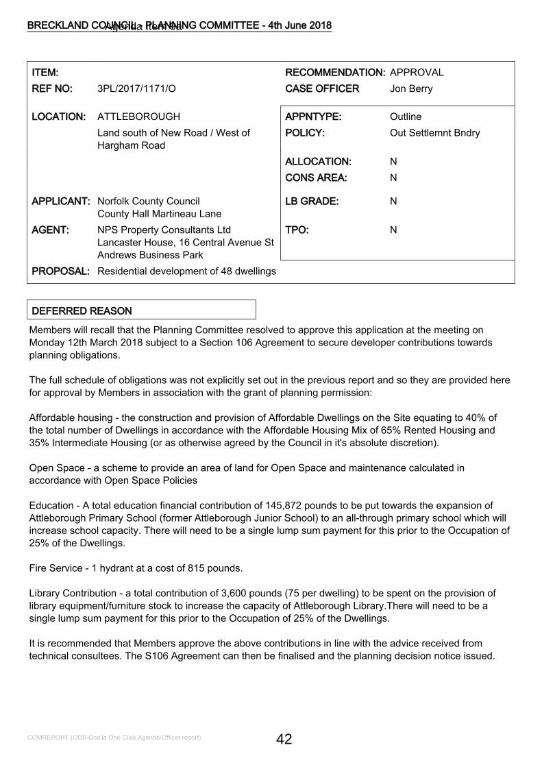
ITEM: RECOMMENDATION: APPROVALREF NO: 3PL/2017/1171/O CASE OFFICER Jon Berry
LOCATION: ATTLEBOROUGH APPNTYPE: OutlineLand south of New Road / West ofHargham Road
POLICY: Out Settlemnt Bndry
ALLOCATION: NCONS AREA: N
APPLICANT: Norfolk County CouncilCounty Hall Martineau Lane
LB GRADE: N
AGENT: NPS Property Consultants LtdLancaster House, 16 Central Avenue StAndrews Business Park
TPO: N
PROPOSAL: Residential development of 48 dwellings
DEFERRED REASON
Members will recall that the Planning Committee resolved to approve this application at the meeting onMonday 12th March 2018 subject to a Section 106 Agreement to secure developer contributions towardsplanning obligations.
The full schedule of obligations was not explicitly set out in the previous report and so they are provided herefor approval by Members in association with the grant of planning permission:
Affordable housing - the construction and provision of Affordable Dwellings on the Site equating to 40% ofthe total number of Dwellings in accordance with the Affordable Housing Mix of 65% Rented Housing and35% Intermediate Housing (or as otherwise agreed by the Council in it's absolute discretion).
Open Space - a scheme to provide an area of land for Open Space and maintenance calculated inaccordance with Open Space Policies
Education - A total education financial contribution of 145,872 pounds to be put towards the expansion ofAttleborough Primary School (former Attleborough Junior School) to an all-through primary school which willincrease school capacity. There will need to be a single lump sum payment for this prior to the Occupation of25% of the Dwellings.
Fire Service - 1 hydrant at a cost of 815 pounds.
Library Contribution - a total contribution of 3,600 pounds (75 per dwelling) to be spent on the provision oflibrary equipment/furniture stock to increase the capacity of Attleborough Library.There will need to be asingle lump sum payment for this prior to the Occupation of 25% of the Dwellings.
It is recommended that Members approve the above contributions in line with the advice received fromtechnical consultees. The S106 Agreement can then be finalised and the planning decision notice issued.
BRECKLAND COUNCIL - PLANNING COMMITTEE - 4th June 2018
COMREPORT (ODB-Ocella One Click Agenda/Officer report) 42
Agenda Item 9a
REASON FOR COMMITTEE CONSIDERATION
The proposal is classed as a major application.
KEY ISSUES
Principle of development/SustainabilityLandscape, character and appearance of the areaImpact on amenityAccess and highway impactOther Matters - Affordable Housing/Development Contributions, Historic & Natural Environment, Trees &Landscaping, Flood Risk, Environmental Health considerations, Contamination, Third Party Comments.
DESCRIPTION OF DEVELOPMENT
Outline planning consent is sought for a residential development with all matters except for access reserved.
An indicative plan has been submitted and this provides details of a scheme of up to 48 residential units. Theplans indicate two points of access to the development from Hargham Road. The plans outline that a mix ofdetached, semi-detached and terrace properties would be accommodated on the site. Under the indicativeplan each property would be served by an individual area of private amenity space and communal areas ofopen space would also be provided. Parking need would largely be met largely off-street.
SITE AND LOCATION
The application site extends to approximately 2.0 hectares and currently consists of rough grassland used forgrazing and agricultural purposes close to the settlement of Attleborough. The plot has two road frontages,with the wider frontage onto Hargham Road and a shorter frontage onto New Road. To the north of NewRoad is existing housing development within Attleborough. To the west of the site are a reservoir and theHaverscroft Industrial Estate. To the east of Hargham Road, on the opposite side of the road, are moreresidential dwellings and agricultural land. To the south of the site is largely open agricultural land. Somescreening exists on the boundaries in the form of roadside hedgerows and intermittent trees.
The site is to the south and east of the settlement boundary of Attleborough, a market town deemed suitablefor significant growth. The town has mainline rail connections and is in close proximity to the A11 transportcorridor between Cambridge, Thetford and Norwich. The settlement has a range of services and communityfacilities suitable to meet the day to day needs of local residents.
EIA REQUIRED
No
RELEVANT SITE HISTORY
No relevant site history
POLICY CONSIDERATIONS
BRECKLAND COUNCIL - PLANNING COMMITTEE - 4th June 2018
COMREPORT (ODB-Ocella One Click Agenda/Officer report) 43
The following policies of the adopted Breckland Core Strategy and Development Control Policies and theadopted Site Specific Policies and Proposals Document, including the Proposals Maps, have been taken intoconsideration in the determination of this application. The provisions of the National Planning PolicyFramework and National Planning Policy Guidance have also been taken into account, where appropriateCP.1 HousingCP.5 Developer ObligationsCP.10 Natural EnvironmentCP.11 Protection and Enhancement of the LandscapeCP.14 Sustainable Rural CommunitiesDC.01 Protection of AmenityDC.02 Principles of New HousingDC.04 Affordable Housing PrinciplesDC.11 Open SpaceDC.12 Trees and LandscapeDC 13 Flood RiskDC.16 DesignDC.17 Historic EnvironmentDC.19 Parking ProvisionSS1 Spatial StrategyNPPF National Planning Policy FrameworkNPPG National Planning Practice Guidance
OBLIGATIONS/CIL
The following S.106 contributions are requested if planning permission is granted;
Affordable HousingOpen Space
CONSULTATIONS
ATTLEBOROUGH TCRefuse, as concerns over drainage issues, density, close proximity to the Industrial premises and theapplication is outside of the settlement boundary.NORFOLK COUNTY COUNCIL HIGHWAYSThe applicant will need to demonstrate as part of their proposals that suitablevehicular access can be provided to this site and that appropriate pedestrian/cycle links can be made withlocal services. Alterations to the layout are needed to meet Highway concerns and to retain appropriatestandards. Whilst the majority of our earlier comments have been addressed we remain in discussion withthe applicant regarding the proposed footway improvements on Hargham Road.FLOOD & WATER MANAGEMENT TEAMAdditional information has been received for the above site, received on 15 November 2017. We havereviewed the application as submitted and wish to make the following comments.
The applicant has now submitted a revised FRA and Drainage Assessment (Create Consulting Engineers LtdRef: JJ/JEB/P15/832-01 Revision A) to support the drainage scheme for this planning application. This
BRECKLAND COUNCIL - PLANNING COMMITTEE - 4th June 2018
COMREPORT (ODB-Ocella One Click Agenda/Officer report) 44
addresses the issues we raised at the last consultation. We welcome that Sustainable Drainage Systems(SuDS) have been proposed in the development.TREE AND COUNTRYSIDE CONSULTANTAreas of the indicative layout are likely to require some change, particularly along the southern and westernboundaries to bring dwellings further away from trees. An implication assessment, method statements, treeprotection plan and programme of arboricultural site supervision will be required.HOUSING ENABLING OFFICERBased on a development of 48 dwellings, 19 affordable dwellings would be required, 12 for rent and 7 forintermediate housing. The affordable housing should be integrated into residential layouts to provide adistribution of affordable housing within the development site that will enhance community cohesion. A S.106Agreement will be required to secure the affordable housing contribution.ECOLOGICAL AND BIODIVERSITY CONSULTANTThe application is supported by a Preliminary Ecological Appraisal (The Ecology Consultancy, October2016). The appraisal is fit for purpose. It identifies that ecological constraints are largely restricted to thepresence of breeding birds and the likely presence of reptiles and hedgehogs. The report also identifies theneed for enhancements for biodiversity.ENVIRONMENTAL HEALTH OFFICERSNo objections if the scheme proceeds as submitted. Condition providing details of noise mitigation measuressuggested.ENVIRONMENT AGENCYThe site is not at high risk of contamination. We consider any infiltration (SuDS)greater than 2.0 m below ground level to be a deep system and these are generally not acceptable.ANGLIAN WATER SERVICEWe request a condition requiring compliance with the agreed drainage strategy. From the details submitted tosupport the planning application the proposed method of surface water management does not relate toAnglian Water operated assets. As such, we are unable to provide comments on the suitability of the surfacewater management.NORFOLK RIVERS INTERNAL DRAINAGE BOARDThe development will drain indirectly to the IDB maintained watercourse to the south of the railway,consequently the IDB has an interest in the surface water drainage strategy.
The IDB has no objection to the principle of the development, or to the proposed drainage strategy. Theconsent of the Board will be required for the surface water discharge, the Board will require payment of theSurface Water Development Charge based on the impermeable area drained. The Board ask that should thedevelopment receive outline consent that a suitable surface water drainage Condition is applied requiring afully detailed drainage strategy.HISTORIC ENVIRONMENT SERVICEWe will not be advising archaeological mitigation as a condition in this case.NATURAL ENGLANDNatural England has no comments to make.
OBLIGATIONS OFFICER, NORFOLK COUNTYCOUNCIL
No Comments Received
BRECKLAND COUNCIL - PLANNING COMMITTEE - 4th June 2018
COMREPORT (ODB-Ocella One Click Agenda/Officer report) 45
CRIME REDUCTION & ARCHITECTURAL LIAISONOFFICER
No Comments Received
CONTAMINATED LAND OFFICER No Comments Received
REPRESENTATIONS
The application was advertised in the local press, site notice displayed, and letters sent to neighbouringresidents. 3 representations were received raising the following comments:
- Yet more houses proposed on agricultural land.- No infrastructure to support this - existing roads too narrow, lack of school places, waiting lists for dentists,doctors who are over stretched now.- Attleborough is fast losing its identity and appeal.- Concern about the surface water drainage, will it be pumped to the reservoir or the ditch on Flowers Lane.This ditch is sometimes over-flowing, I hope steps are taken to prevent flooding of my property.- Surely the planning department has to realistically look at the amount of proposed development in this area,Attleborough cannot cope now. This is going to have a massive impact on Hargham Road and New Road.
ASSESSMENT NOTES
1. Principle of the Development/Introduction
1.1 The application site is located in close proximity to Attleborough, though just outside the settlementboundary and on agricultural land. The proposal is therefore contrary to local plan policies SS1, DC02 andCP14 which aims to restrict new development outside of settlement boundaries.
1.2 Attleborough is identified as a market town suitable for substantial growth as detailed within policy SS1 ofthe Core Strategy. In that respect there are planning consents in place for multiple residential unitdevelopments abutting the settlement and adjoining the A11.
1.3 The Council is in the process of preparing a new local plan and under the Preferred Options andSettlement Boundary document a Strategic Urban Extension of circa 4,000 dwellings is proposed to thesouth of the town. This would extend beyond, and wash over the application site.
1.4 It is accepted that the Council cannot demonstrate a 5 year supply of housing land. Relevant policies forthe supply of housing should not be considered up to date if the Local Planning Authority cannot demonstratea five-year supply of deliverable housing sites. Where relevant policies are out of date, NPPF paragraph 14advises that the presumption in favour of sustainable development, which should be seen as the goldenthread running through decision making, is engaged. This means granting permission unless specific policiesin the NPPF indicate that development should be restricted or any adverse impacts of doing so wouldsignificantly and demonstrably outweigh the benefits, when assessed against the policies in the NPPF takenas a whole.
1.5 This so called "tilted balance" however does not diminish the weight to be afforded to Policy CP14 inassessing whether the adverse impacts demonstrably outweigh the benefits and this consideration is amatter of planning judgement for the decision maker.
1.6 The provision of housing to meet local needs is identified as a key component of sustainable
BRECKLAND COUNCIL - PLANNING COMMITTEE - 4th June 2018
COMREPORT (ODB-Ocella One Click Agenda/Officer report) 46
development and in this respect the NPPF seeks to boost significantly the supply of housing. The NPPF alsoencourages the avoidance of isolated homes in the countryside and the location of development where thereis access to alternative modes of transport other than the private car.
1.7 As paragraph 8 of the NPPF outlines, there are three strands to sustainability; economic, social andenvironmental, each mutually dependent, and not assessed in isolation from each other.
1.8 Attleborough provides available access to other modes of transport and also offers a range of localservices and facilities. Hence the town has been deemed suitable for growth and there is no real concernabout the settlement being able to accommodate a development of 48 dwellings. The overarching spatialstrategy set out in the Core Strategy is to concentrate growth on the main district settlements, includingAttleborough.
2. Principle of the Development/Sustainability
2.1 As outlined above the planning balance in such schemes is tilted towards an approval unless anyadverse impacts significantly and demonstrably outweigh the benefits.
2.2 The economic contribution that this site could make to the local economy is not insignificant. Theconstruction and implementation, sale and fitting out would support and maintain local business. This shouldbe afforded appropriate weight in any planning balance.
2.3 Furthermore helping to meet the housing needs of the local population can be deemed sociallysustainable. It is noted that the Housing Enabling Officer supports the proposed scheme, and highlights arequirement, triggered by local policy, of 19 affordable units. A scheme providing a mix of housing size, typeand tenure, engendering social cohesion in housing provision, can be deemed socially sustainable.
2.4 Access to the town centre and the range of services - food stores, public transport links, schools andcommunity facilities is good. At a distance of circa 1.5km to the heart of the town, walking is an option forfuture residents. Minimum alterations to footpaths, currently an area of negotiation with NCC Highways,would ensure a safe and usable link. The town has the majority of goods and services for day to day livingand a new primary school will be within easy reach on London Road. The settlement is also served by amainline train service providing sustainable access to the range of facilities, including employmentopportunities, which larger settlements provide. Another factor for consideration is the appropriateness of thesettlement to contribute to housing supply and future local plan research which indicated the suitability ofland to the south of the town to meet the need.
2.5 However the site would result in the development of greenfield land, albeit adjacent to the settlement, andthe NPPF has as core planning principles a desire to encourage more effective use of previously developedland and the conservation and protection of the natural environment.
2.6 In this case the "in principle" policy conflict is outweighed by the local shortfall in housing supply and thesite characteristics which would comply with the national policy desire for sustainable development.
2.7 When a balancing exercise is undertaken it is concluded that the proposed development is a sustainableway to meet housing need. The proposed development would accord with the core planning principle inparagraph 17 of the National Planning Policy Framework which is to actively manage patterns of growth tomake the fullest possible use of public transport, walking and cycling. The proposal would also accord withparagraph 34 of the Framework in terms of ensuring the need to travel will be minimised and the use ofsustainable transport modes will be maximised.
BRECKLAND COUNCIL - PLANNING COMMITTEE - 4th June 2018
COMREPORT (ODB-Ocella One Click Agenda/Officer report) 47
2.8 Any adverse harm of this scheme would not significantly and demonstrably outweigh the positivebenefits. The proposed development is therefore deemed in compliance with adopted policies SS1, DC02and CP14 and relevant national guidance contained in the NPPF.
3. Landscape, Character and Appearance of the Area
3.1 Policy CP11 of the Core Strategy seeks to ensure that the landscape of the district will be protected forthe sake of its own intrinsic beauty and its benefit to the rural character.Development within the district is also expected to be of the highest design quality in terms of botharchitecture and landscape. It should have regard to good practice in urban design and fully consider thecontext within which it sits, embracing opportunities to enhance the character and appearance of an area.
3.2 Whilst the application site is currently in agricultural use, as detailed above, it is just outside thesettlement limit and its development would result in a natural expansion of the settlement, bearing in mind itssuitability for meeting housing need. The site is relatively flat and impact on the landscape would be minimal.The character to the north of the site is residential in nature, largely 1960's and 1970's housing schemes, andthere are more recent schemes, developed in the last few years, along New Road/London Road. None are ofa style, density or layout that would render what is proposed here contrary to any established pattern ofdevelopment. The proposed scheme would assimilate relatively seamlessly into the established character ofthe area.
3.3 The undoubted rural character of the site, and its southern boundaries, could to some extent bemaintained with the retention of the landscaped boundaries. Impacts on the landscape and character of thearea are deemed acceptable. The proposal complies with policy CP11.
3.4 The proposed density amounts to approximately 24 dwellings per hectare. Policy DC02 of the CoreStrategy aims for a density of 22-30 units per hectare at settlement edges. The density falls comfortably intothis range. Furthermore the indicative plans indicate each dwelling would be served by a reasonable level ofprivate amenity space and on-street parking. Communal parking courts are also indicated but a layout couldbe achieved which would not result in a car dominated streetscene. The layout is in compliance with DC02.
3.5 The indicative plan makes an ample allowance for communal amenity space and as such a play area forchildren. The scheme therefore complies with local plan policy DC08.
3.6 Design would be a matter reserved for detailed consideration later. At this stage there are no apparentreasons to restrict the details, massing, scale or ridge levels. There appears no reason why a two storeydevelopment would not be suitable. Any scheme should provide an appropriate mix of dwelling types andsizes and finishes drawn for the local palette of materials.
4. Impact on amenity
4.1 The site is stand-alone, retaining adequate separation distances to surrounding properties. Whilst there isexisting residential development on the southern boundary, no significant impact should result, and adequateseparation and screening is achievable. The scheme conforms to policy DC01. Whilst the site is close to anindustrial estate, located to the west, the Environmental Health section are content that no significant impactwould result and conditions are suggested to mitigate potential impacts.
5. Access and highway impact
BRECKLAND COUNCIL - PLANNING COMMITTEE - 4th June 2018
COMREPORT (ODB-Ocella One Click Agenda/Officer report) 48
5.1 There have been ongoing consultations between the applicant and Norfolk County Council HighwaysAuthority. The Highways Authority appears content that safe access could be achieved and that the majorityof earlier concerns have been addressed with the submission of an amended layout.
5.2 The issue of providing a footpath to the front of No.144-148 Hargham Road is being progressed towardsresolution and further information will be reported in the supplementary information to be presented at themeeting. The scheme is generally acceptable from a highway perspective subject to appropriate conditionsand therefore complies with policies DC19 and CP13.
6. Other Matters
- Flood Risk
6.1 The applicant has now submitted a revised FRA and Drainage Assessment (Create Consulting EngineersLtd Ref: JJ/JEB/P15-832/01 - Revision A) to support the drainage scheme for this planning application. Thisaddresses the issues raised at the initial consultation by the Flood Risk Officer at Norfolk County Council.Furthermore the Internal Drainage Board raises no objection to the proposal. The proposed development isconsidered acceptable from a flood risk perspective and the scheme should not increase flood risk off-site, aconcern raised in third party correspondence. Conditions agreeing the implementation of a drainage strategyare necessary to ensure accordance with policy DC13.
- Affordable Housing
6.2 The site area and number of dwellings proposed trigger the thresholds of the Council's affordablehousing policy as per DC04 of the Council s Adopted Core Strategy and Development Control PoliciesDevelopment Plan Document. The council's Housing Enabling Officer has been consulted and providedcomments.
6.3 This concludes that in this in this instance, based on a development of 48 dwellings, 19 affordabledwellings would be required, 12 for rent and 7 for intermediate housing. The affordable housing mix i.e., unittypes, layout etc. will need to be addressed in the reserved matters. Whilst at this stage it is difficult to agreethe type of affordable housing unit, ie 2 bed, 3 bed etc, it is suggested that, in order to best meet an identifiedhousing need a mix of 1 bed 2 person, 2 bed 4 person and 3 bed person units is provided with a focus on 1and 2 bed properties. This can be agreed by Section 106 Agreement should consent be granted by theCouncil. The proposal accords with policy DC04.
- Trees and Landscaping
6.4 Any layout should take into account the constraints (above and below ground) of the category A and Btrees. It does not appear that there should be any requirement for development within root protection areasor areas which could result in post development issues relating to proximity of trees to dwellings. Areas of theindicative layout are likely to require some change, particularly along the southern and western boundaries tobring dwellings further away from trees. An implication assessment, method statements, tree protection planand programme of arboricultural site supervision will be required to ensure compliance with policy DC12.
- Contamination
6.5 The proposed development does not raise any significant concerns in relation to potential contamination.Conditions agreeing investigation, remediation and unexpected contamination are deemed reasonable andnecessary. The scheme is in accordance with policy DC.09.
BRECKLAND COUNCIL - PLANNING COMMITTEE - 4th June 2018
COMREPORT (ODB-Ocella One Click Agenda/Officer report) 49
- Ecological Considerations
6.6 The application is supported by a Preliminary Ecological Appraisal (The Ecology Consultancy, October2016). The appraisal is fit for purpose. It identifies that ecological constraints are largely restricted to thepresence of breeding birds and the likely presence of reptiles and hedgehogs. Natural England raises noobjection to the scheme and no conditions are suggested. Norfolk County Council Ecologists suggest acondition agreeing;
- The timings of works for nesting birds.- Precautionary measures to mitigate any impact on reptiles during construction (Section 4.10 of the PEAreport)- That connectivity for hedgehogs is maintained between the gardens by installing wildlife-friendly fencing,with gaps or tunnels in the bottom panels/gravel boards to allow easy passage for small mammals tocontinue foraging in this area.- Enhancements for biodiversity are included in the design or otherwise included through condition.
The application can be conditioned accordingly and the scheme therefore accords with policy CP10.
- Archaeological Implications
6.7 The Historic Environment Officer at Norfolk County Council reports on archaeological trial trenchingconducted on this development site pre-application and are content to advise no further archaeological work.Therefore archaeological mitigation as a condition is not necessary in this case. The scheme accords withpolicy DC17.
- Water Supply
6.8 Anglian Water suggests compliance with the submitted drainage strategy and as detailed above this willbe agreed by condition.
- Third Party Representations
6.9 Comments have been raised through the Council's statutory consultations, some of which have beenaddressed within this report. The Town Council have concerns regarding the proposed density, but asdetailed above it is a reasonable requirement and in accordance with policy. Justification for developmentoutside the settlement boundary has been provided. The concern relating to adjoining industrial premisescan be mitigated by condition.
6.10 Some neighbours have also raised concern about further development within the town and theinfrastructures ability to support it. As detailed within the report, this is a higher order town, deemed suitablefor growth, and this scheme would make a reasonable contribution to meeting identifiable housing needwithin the district.
- S106 Contributions
6.11 Para. 204 of the NPPF makes clear that it is unlawful for a planning obligation to be taken into accountin a planning decision on a development if the obligation does not meet all of the following tests. These arethat the obligation is necessary to make the development acceptable in planning terms, is directly related tothe development, and is fairly and reasonably related in scale and kind to the development.
BRECKLAND COUNCIL - PLANNING COMMITTEE - 4th June 2018
COMREPORT (ODB-Ocella One Click Agenda/Officer report) 50
6.12 As detailed above the proposed scheme triggers affordable housing requirements and the schemeshould be tailored to take this into account. The details can be agreed by a Section 106 Agreement shouldconsent be granted and are considered to meet the tests.
6.13 The Obligations Officer at Norfolk County Council has been consulted though no response has beenreceived at the time of this report. Further information regarding contributions for education and healthcarewill be reported in the supplementary information to be presented at the meeting.
7. CONCLUSION
7.1 In light of the above appraisal the proposed development is considered an appropriate way to meet theneed for housing in the district. Whilst contrary to policy, the shortfall in available land to meet housing needtriggers a presumption in favour of sustainable development as per paragraph 14 of the NPPF. This schemehas been deemed a sustainable and suitable form of development, discussed in detail within the report. Thepositive attributes of the scheme outweigh any adverse impacts. It is therefore recommended that consent isgranted subject to conditions and a suitable Section 106 Agreement to agree developer contributions.
RECOMMENDATION Outline Planning Permission
CONDITIONS
1 Outline Time Limit (3 years)Application for Approval of Reserved Matters must be made not later than the expiration ofTHREE YEARS beginning with the date of this permission, and the development must bebegun within TWO YEARS of the FINAL APPROVAL OF THE RESERVED MATTERS or, inthe case of approval at different dates, the FINAL APPROVAL OF THE LAST SUCHMATTER to be approved.
Reason for condition:-As required by section 92 of the Town & Country Planning Act 1990.
2 Standard Outline ConditionNo development whatsoever shall take place until the plans and descriptions giving detailsof the reserved matters referred to above shall have been submitted to and approved by theLocal Planning Authority and these plans and descriptions shall provide details of theappearance, layout, scale, access and landscaping of the development.
Reason for condition:-The details are not included in the current submission.
3 In accordance with submitted plans NEW 2017The development must be carried out in strict accordance with the application form, andapproved documents and drawings as set out in the table at the end of this notice.
Reason for condition:-To ensure the satisfactory development of the site.
4 Non-standard drainage conditionPrior to commencement of development, in accordance with the submitted Flood Risk
BRECKLAND COUNCIL - PLANNING COMMITTEE - 4th June 2018
COMREPORT (ODB-Ocella One Click Agenda/Officer report) 51
Assessment (Create Consulting Engineers Ltd Ref: JJ/JEB/P15A/832/01 - Revision A),detailed designs of a surface water drainage scheme incorporating the following measuresshall be submitted to and agreed with the Local Planning Authority in consultation with theLead Local Flood Authority. The approved scheme will be implemented prior to the firstoccupation of the development. The scheme shall address the following matters:I. Dimensioned plans and drawings of all aspects of the surface water drainagesystem.II. Further geotechnical investigation should be undertaken to determine whethermaterial on site has infiltration potential. This information should be representativeof on-site conditions. If material is found to have infiltration potential, detailedinfiltration testing should be undertaken in line with BRE 365 at the depths andlocations of the proposed SuDS structuresIII. If the use of infiltration is not possible, provision of surface water attenuationstorage, sized and designed to accommodate the volume of water generated in allrainfall events up to and including the critical storm duration for the 1 in 100 yearreturn period, including allowances for climate change, flood event. A minimumstorage volume will be provided in line with the submitted FRA. Considerationshould be given to the area of ponding in the north eastern portion of the site asshown on the Environment Agency Risk of Flooding from Surface Water maps, andto how this will be avoided or accommodated as part of the proposed surface waterdrainage systemIV. Detailed designs, modelling calculations and plans of the of the drainageconveyance network in the:1 in 30 year critical rainfall event to show no above ground flooding on any partof the site.1 in 100 year critical rainfall plus climate change event to show, if any, thedepth, volume and storage location of any above ground flooding from thedrainage network ensuring that flooding does not occur in any part of a buildingor any utility plant susceptible to water (e.g. pumping station or electricitysubstation) within the development.V. Finished ground floor levels of properties are a minimum of 300mm above expectedflood levels of all sources of flooding.VI. Management of exceedance rates in line with the submitted documentation(paragraph 4.7 of the submitted FRA).VII. A maintenance and management plan for the existing ordinary watercourses (andany structures such as culverts), sewers and surface water management systemswithin and adjacent to the proposed development should be submitted, andapproved in writing, by the Local Planning Authority to ensure that during theconstruction phase of the development flood risk is not increased onsite orelsewhere.
Reason for condition: In order to ensure safe an adequate drainage arrangements for thedevelopment.
5 Contaminated Land - UnexpectedContaminationIn the event that contamination is found at any time when carrying out the approveddevelopment that was not previously identified it must be reported in writing immediately tothe Local Planning Authority. An investigation and risk assessment must be undertaken inaccordance with details to be agreed in writing with the Local Planning Authority. Where
BRECKLAND COUNCIL - PLANNING COMMITTEE - 4th June 2018
COMREPORT (ODB-Ocella One Click Agenda/Officer report) 52
remediation is necessary, a remediation scheme must be submitted to and approved inwriting by the Local Planning Authority. Following completion of measures identified in theapproved remediation scheme a verification report shall be submitted to and approved inwriting by the Local Planning Authority.
Reason for condition:-To ensure that risks from land contamination to the future users of the land andneighbouring land are minimised, together with those to controlled waters, property andecological systems, and to ensure that the development can be carried out safely withoutunacceptable risks to workers, neighbours and other offsite receptors.This condition is imposed in accordance with CP9 of the Breckland Adopted Core Strategy.This condition will require to be discharged
6 Contaminated Land - SiteInvestigation/RemediationUnless otherwise agreed in writing, the following details shall be submitted to and approvedin writing by the Local Planning Authority prior to the commencement of the developmenthereby approved:A. Site InvestigationA site investigation and risk assessment to determine the nature and extent of anycontamination on the site, whether or not it originates on the site. The investigation and riskassessment must be undertaken by competent persons and a written report of the findingsmust be produced. The report of the findings must include: (i) a survey of the extent, scaleand nature of contamination; (ii) an assessment of the potential risks to: human health,property (existing or proposed) including buildings, crops, livestock, pets, woodland andservice lines and pipes, adjoining land, groundwaters and surface waters, ecologicalsystems, archaeological sites and ancient monuments; (iii) an appraisal of remedial options,and proposal of the preferred option(s).B. Remediation SchemeA detailed remediation scheme to bring the site to a condition suitable for the intended useby removing unacceptable risks to human health, buildings and other property and thenatural and historical environment. The scheme must include all works to be undertaken,proposed remediation objectives and remediation criteria, timetable of works and sitemanagement procedures. The scheme must ensure that the site will not qualify ascontaminated land under Part 2A of the Environmental Protection Act 1990 in relation to theintended use of the land after remediation.C. Implementation of Approved Remediation SchemeThe approved remediation scheme must be carried out in accordance with its terms prior tothe commencement of development, unless otherwise agreed in writing by the LocalPlanning Authority. The Local Planning Authority must be given two weeks writtennotification of commencement of the remediation scheme works.Following completion of measures identified in the approved remediation scheme, averification report (referred to in PPS23 as a validation report) that demonstrates theeffectiveness of the remediation carried out must be submitted to and approved in writing bythe Local Planning Authority.The above must be conducted in accordance with DEFRA and the Environment Agency's'Model Procedures for the Management of Land Contamination, CLR 11'.
Reason for condition:-To ensure that risks from land contamination to the future users of the land and
BRECKLAND COUNCIL - PLANNING COMMITTEE - 4th June 2018
COMREPORT (ODB-Ocella One Click Agenda/Officer report) 53
neighbouring land are minimised, together with those to controlled waters, property andecological systems, and to ensure that the development can be carried out safely withoutunacceptable risks to workers, neighbours and other offsite receptors.
INFORMATIVE:-Land contamination risk assessment is a step-by-step process. During the course of the riskassessment process set out in the above condition, it may become clear that no further workis necessary to address land contamination risks. Where this is the case the condition maybe discharged by the Council without all the steps specified being completed. In all caseswritten confirmation should be obtained from the Council confirming that the requirements ofthe condition have been met.This condition will require to be discharged
7 Construction Method StatementNo development shall take place, including any works of demolition, until a ConstructionMethod Statement has been submitted to, and approved in writing by, the local planningauthority. The approved Statement shall be adhered to throughout the construction period.The Statement shall provide for:i. the parking of vehicles of site operatives and visitorsii. loading and unloading of plant and materialsiii. storage of plant and materials used in constructing the developmentiv. the erection and maintenance of security hoarding including decorative displaysand facilities for public viewing, where appropriatev. wheel washing facilitiesvi. measures to control the emission of dust and dirt during constructionvii. detailed proposals for the removal of asbestos from existing buildings to bedemolishedviii. a scheme for recycling/disposing of waste resulting from demolition and constructionworks
Reason for condition:The details are required prior to the commencement of the development in the interests ofthe amenity of the area and to ensure a safe development from the outset of thedevelopment.This condition will require to be discharged
8 Landscaping scheme to be submitted - hard andsoftNo development shall take place on site until full details of both hard and soft landscapeworks have been submitted to and approved in writing by the Local Planning Authority andthese works shall be carried out as approved. These details shall include:-hard surfacing materials;-means of enclosure;-proposed finished levels or contours;-minor artefacts and structures (e.g. furniture, play equipment, refuse or other storage units,signs, lighting etc,)
Soft landscaping shall include:-Planting plans;-Written specifications ( including cultivation and other operations associated with plant and
BRECKLAND COUNCIL - PLANNING COMMITTEE - 4th June 2018
COMREPORT (ODB-Ocella One Click Agenda/Officer report) 54
grass establishment);-Schedules of planting, noting species, plant sizes and proposed numbers/densities whereappropriate;-Implementation programme
Reason for condition:-In the interests of the satisfactory appearance of the development in accordance with policyDC12 of the Adopted Core Strategy and Development Control Policies Development PlanDocument 2009.This condition will require to be discharged
9 Non-standard conditionNo removal, in full or in part, of hedgerows, trees or shrubs shall take place between 1stMarch and 31st August inclusive, unless a competent ecologist has undertaken a careful,detailed check of vegetation for active birds' nests immediately before the vegetation iscleared and provided written confirmation that no birds will be harmed and/or that there areappropriate measures in place to protect nesting bird interest on site. Any such writtenconfirmation should be submitted to the local planning authority.
Reason for condition: In the interests of mitigating potential impacts on nesting birds duringbreeding.
10 Non-standard conditionPrior to the commencement of the development hereby approved, the recommendations andenhancements set out in the Preliminary Ecological Appraisal by The Ecology Consultancy,October 2016 , and submitted in support of this application, shall be carried out in strictaccordance with the report and the development shall proceed in accordance with therecommendations.
Reason for condition:- In order to conserve and enhance biodiversity.11 Boundary treatment/screening to be agreed
Prior to the occupation of the development hereby permitted a plan indicating the positions,design, materials and type of boundary treatment/screening to be erected shall be submittedto and approved in writing by the Local Planning Authority. The boundarytreatment/screening shall be completed before the buildings are first occupied. Developmentshall be carried out in its entirety in accordance with the approved details.
Reason for condition:-In the interests of the satisfactory appearance of the development in accordance with policyDC 16 of the Adopted Core Strategy and Development Control Policies Development PlanDocument 2009.This condition will require to be discharged
12 Non-standard conditionPrior to commencement of the development a scheme for protecting the proposed housingdevelopment from noise from the adjoining industrial estate shall be submitted and approvedin writing by the Local Planning Authority. The scheme shall include protection to amenityandgarden area and should not rely on the requirement to close windows. All works which formpart of the scheme shall be completed before any part of the housing development is
BRECKLAND COUNCIL - PLANNING COMMITTEE - 4th June 2018
COMREPORT (ODB-Ocella One Click Agenda/Officer report) 55
occupied.
Reason for condition:-In the interest of the amenities of future occupants
13 Tree Protection Plan - Ground Protection MatsA Tree Protection Plan, including detailed specifications for the provision of GroundProtection Mats, shall be submitted to and approved in writing by the Local PlanningAuthority where access is required within the Root Protection Areas of trees to be retained(RPA). Unless otherwise agreed, the RPA shall be taken to be a circle of radius 12 x thestem diameter measured at 1.5m. Ground Protection Mats should be in situ and remain inplace throughout the demolition and/or construction phase(s) of the development.
Reason for condition:-To protect the rooting area of trees during development.This condition will require to be discharged
14 Note non standard re: S106This permission is subject to a legal agreement requiring details of affordable housing anddelivery of open space provision.
BRECKLAND COUNCIL - PLANNING COMMITTEE - 4th June 2018
COMREPORT (ODB-Ocella One Click Agenda/Officer report) 56
ITEM: RECOMMENDATION: APPROVALREF NO: 3PL/2017/1515/F CASE OFFICER Donna Smith
LOCATION: ATTLEBOROUGH APPNTYPE: FullAttleborough Post Office,High Street POLICY: In Settlemnt BndryAttleborough ALLOCATION: N
CONS AREA: Y
APPLICANT: The Amari Group18 Eaton Street Eaton
LB GRADE: N
AGENT: Architectural Design and Plann73 Yarmouth Road Thorpe St Andrew
TPO: N
PROPOSAL: Demolition of existing/disused single storey sorting office building to rear of existing streetfacing post office building.Construction of new residential development to include 5 no. 2 bedroom apartments and 5no. 1 bedroom apartments, with both private and communalamenity areas
KEY ISSUES
Principle of sustainable developmentImpact on the Conservation AreaImpact on amenityTreesHistoric EnvironmentAccessibilityConclusions
DESCRIPTION OF DEVELOPMENT
The proposal seeks planning permission for the demolition of an existing single storey sorting office buildingto rear of existing post office building fronting High Street and the construction of a new three storeyresidential development to include 5 x 2 bedroom apartments and 5 x.1 bedroom apartments, with bothprivate and communal amenity areas on a site area of 0.10ha.
SITE AND LOCATION
The site is located within Attleborough Town Centre on the junction of High Street and London Road.Attleborough is the third largest town in the District serving as a service centre and a focus for retail andemployment. Surrounding uses are retail and commercial and include a mix of Sainsbury's Super Market tothe west, Ming's Chinese Takeaway to the south and a variety of retail outlets, inclusive of Dogs Trust andRy's Bar and Grill to the east. The site is located within a designated Conservation Area.
BRECKLAND COUNCIL - PLANNING COMMITTEE - 4th June 2018
COMREPORT (ODB-Ocella One Click Agenda/Officer report) 57
Agenda Item 9b
EIA REQUIRED
No.
RELEVANT SITE HISTORY
3PL/2016/0782/F Withdrawn - Residential development of 10 flats and demolition of sorting office 23-09-16.
3PL/2017/0004/F - Refused - Residential development of 10 flats 03-05-17
POLICY CONSIDERATIONS
The following policies of the adopted Breckland Core Strategy and Development Control Policies and theadopted Site Specific Policies and Proposals Document, including the Proposals Maps, have been taken intoconsideration in the determination of this application. The provisions of the National Planning PolicyFramework and National Planning Policy Guidance have also been taken into account, where appropriate
CP.07 Town CentresCP.09 Pollution and WasteCP.11 Protection and Enhancement of the LandscapeCP.13 AccessibilityDC.01 Protection of AmenityDC.09 Proposals for Town Centre UsesDC.12 Trees and LandscapeDC.16 DesignDC.17 Historic EnvironmentDC.19 Parking ProvisionLBC Planning(Listed Building & Conservation Areas) Act 1990NPPF National Planning Policy FrameworkNPPG National Planning Practice GuidanceSS1 Spatial Strategy
OBLIGATIONS/CIL
Not applicable
CONSULTATIONS
ATTLEBOROUGH TCObject to the proposal on the basis a proposal without car parking is unacceptable, considered the proposalto be overdevelopment and had concerns regarding the access and delivery management of the site.HISTORIC BUILDINGS CONSULTANT
BRECKLAND COUNCIL - PLANNING COMMITTEE - 4th June 2018
COMREPORT (ODB-Ocella One Click Agenda/Officer report) 58
It is confirmed that the amended elevational proposals under Revision C are as per on-going discussionswith the applicants agent, therefore, no further comment on design. The proposed palette of materials for theexternal envelope will either need to be fully specified or subject to conditional approval.NORFOLK COUNTY COUNCIL HIGHWAYSThe proposal has been amended to provide 6 No 2-bedroom flats, 4 No 1- bedroom flats. The proposalincludes no on-site car parking provision but given the Town Centre location, together the site's proximity to arange of essential services and public transport provision, I would not wish to raise a highway objection inthis respect alone in particular as 25 secure cycle parking spaces have been included . If your Authority isminded to grant approval please include the following conditions:- SHC 09 variation Prior to thecommencement of the development hereby approved the access located at the north eastern extremity ofthe site shall be suitably and permanently closed. Reason: In the interests of highway safety. SHC 24 Prior tothe first occupation of the development hereby permitted the proposed cycle parking area shown on Drawing017/35/0001 Rev B shall be provided in accordance with the approved plan and retained thereafter availablefor that specific use. Reason: To ensure the permanent availability of the cycle parking area, in the interestsof highway safety. SHC 28 Development shall not commence until a scheme detailing provision for on siteparking for construction workers and for the delivery and storage of construction materials for the duration ofthe construction period has been submitted to and approved in writing by the Local Planning Authority. Thescheme shall be implemented throughout the construction period. Reason: To ensure adequate off-streetparking during construction in the interests of highway safety.CONTAMINATED LAND OFFICERNo objection subject to conditions.TREE AND COUNTRYSIDE CONSULTANTI have concerns over the proximity of the tree which is subject to TPO to the proposed dwellings. As a HorseChestnut there are the obvious problems with seasonal nuisance, falling conkers, leaves, shading as well asapprehension from future occupants is likely to result in justifiable requests for harmful heavy pruning orremoval of the tree which would be difficult for the council to refuse.HOUSING ENABLING OFFICERConfirmed that the proposal did not trigger policy DC4. Requested condition be applied to restrict thefloorspace to below 1,000sqm.ANGLIAN WATER SERVICENo objection.FLOOD & WATER MANAGEMENT TEAMOfficers have screened this application and it falls below our current threshold for providing detailedcomment. This is because the proposal is for less than 100 dwellings or 2 ha in size and is not within asurface water flow path as defined by Environment Agency mapping.ENVIRONMENTAL HEALTH OFFICERSI have looked at this application and, based on the information provided to me at this time and should like tomake the following comments: This site is fronted by commercial units/ post office with an electricitysubstation to the right (looking at the site from the High Street) and the car park / petrol station, Sainsburys'supermarket to the left and the telephone exchange to the rear. It should also be noted that there is astandby generator at the telephone exchange which cuts in when there is a power outage at the site whichhas a large air intake and exhaust both of which could cause disturbance to the proposed residential flatsThere is significant traffic passing the site from the Sainsburys car park and the access drive into thetelephone exchange site to the rear, which passes down and shares the access down the side of theproposal site. This application does not have any supporting information relating to noise impacts to the site
BRECKLAND COUNCIL - PLANNING COMMITTEE - 4th June 2018
COMREPORT (ODB-Ocella One Click Agenda/Officer report) 59
however in a previous application a noise impact assessment was provided which advised that mitigationmeasures to limit the impact of noise were required to protect the proposed flats. With the correctassessment and specification noise levels within the flats can be reduced to acceptable levels however noisewill be audible above normal criteria with windows open or within the external amenity areas, simply due tothe activities and vehicle movements that occur in this urban setting. The BT emergency standby generatorwas investigated by a noise consultant and found to operate rarely / tested a couple of times a year. In thisregard whilst noise might impact the flats from this source this appears to be very infrequent. A 1.8m tallacoustic fence was suggested in the past to border the external amenity areas and shield the ground floorflats from the electricity substation which I consider would be a reasonable mitigation measure to protect theamenity area. If committee is minded to approve the application I would recommend the following conditions:1) Prior to commencement of the development a scheme for protecting the proposed residential developmentfrom noise from traffic accessing the adjacent commercial sites shall be submitted and approved in writing bythe Local Planning Authority. The scheme shall include protection to amenity and garden areas and shouldnot rely on the requirement to close windows. All works which form part of the scheme shall be completedbefore any part of the residential development is occupied. Reason for condition:- In the interest of theamenities of future occupants 2) All construction and demolition works to be carried out in accordance withthe guidance provided in Breckland Council Information leaflet, 'Construction and demolition works -Guidance for contractors and developers' .
PRINCIPAL PLANNER MINERAL & WASTE POLICY No Comments Received
REPRESENTATIONS
Four letters of objection were received raising the main points of objection:
No parkingInconsistent plansImplications regarding refuse collectionIssues surrounding access and delivery.
ASSESSMENT NOTES
1.0Principle of sustainable development
1.1The presumption in favour of sustainable development is set out in paragraphs 7 and 14 of the NationalPlanning Policy Framework (NPPF). Paragraph 7 states there are three dimensions to sustainabledevelopment, economic, social and environmental which cannot be undertaken in isolation. Paragraph 137 ofthe National Planning Policy Framework states that local authorities should look for opportunities for newdevelopment within Conservation Areas to enhance or better reveal their significance. Proposals thatpreserve those elements of the setting that make a positive contribution to or better reveal the significance ofthe asset should be treated favourably.
1.2Policy SS1 of the Adopted Core Strategy and Development Control Policies Development Plan Document(2009) defines Attleborough as a Market Town for substantial growth. Attleborough is intended to be a majorfocus for employment and residential growth and has the potential for further expansion. Furthermore, PolicyDC9 reiterates development proposals within the defined town centres will be supported where theyrepresent the best opportunity to bring forward sites identified for redevelopment and improve the town
BRECKLAND COUNCIL - PLANNING COMMITTEE - 4th June 2018
COMREPORT (ODB-Ocella One Click Agenda/Officer report) 60
centre environment.
1.3It is also prudent to give weight to policy DC2 which reiterates that the design and layout of new housingproposals should optimise the density of the development to a level which is acceptable for the locality. Allresidential proposals will secure an appropriate mix of dwelling size, type and tenure in order to meet theneeds of Breckland's citizens and create sustainable communities.
1.4 The site lies within the Attleborough Settlement Boundary and as such the principle of development is inaccordance with Policy DC02 of the Breckland adopted Core Strategy and the National Planning PolicyFramework (NPPF).
1.5The development proposes the construction of 5 no. 2 bedroom apartments and 5 no. 1 bedroomapartments, with both private and communal amenity areas. The proposal is car free and located within thedefined town centre of Attleborough, consequently, residents would have adequate access to public transportand opportunities for walking and cycling to local amenities and shops.
1.6 The proposal is considered to be in a sustainable location with good accessibility to public transport andinfrastructure to support walking and cycling. It is noted the Parish Council objected to the scheme on thebasis that no car parking is proposed. However, given the sites location within the town centre, with adequateaccess to public transport, walking and cycling, this is considered acceptable.
2.0 Impact on character and appearance
2.1 The proposal is three storey split level residential building with a mono pitched roof and associatedbalconies to the east and west elevations. Materials include composite roof panels to the roof, facingbrickwork to match the post office building alongside timber deck panels to the terrace, vertically hungWestern Red Cedar walls and low level engineering brick work plinth to match the adjacent Post OfficeBuilding.
2.2 The application site is located within the town centre and settlement boundary with an existing officebuilding on site which is proposed to be demolished. To the south of the site is Attleborough Post Office,which is a three storey brick building and considered a prominent feature within the wider context of theConservation Area. The existing building on site is a single storey attractive structure, currently used as thePost Office Sorting Office.
2.3 The proposal has materially changed from previous application 3PL/2017/0004/F in both size, scale anddesign. The design of the proposal has changed significantly over its lifetime. The applicant has workedpositively and proactively to create uniformity in design within the surrounding Conservation Area, to ensurethe proposal, when viewed in context with the existing post office building, would appear subservient. TheConservation Area benefits from pitched roofs, uniform window fenestration and linear street frontage. Thebuildings within the Conservation Area also benefit from a similar scale and massing, generating a positiveaesthetic and uniformity in design, which this revised proposal would respect.
2.4 Any decisions relating to listed buildings and their settings and conservation areas must address thestatutory considerations of the Planning (Listed Building and Conservation Areas) Act 1990 as well assatisfying the relevant policies within the National Planning Policy Framework and the Development Plan.
2.5 The applicant has stated within their supporting design and access statement at point 3.4 that the sortingoffice has no intrinsic merit to the street scene or to the historic, social or community value of the main postoffice building. The site is located within a Conservation Area, therefore is given significant protection in
BRECKLAND COUNCIL - PLANNING COMMITTEE - 4th June 2018
COMREPORT (ODB-Ocella One Click Agenda/Officer report) 61
terms of its historic merit.
2.6 The overall design of the proposal, has been amended to appear subservient and uniform when viewedwithin the context of the adjacent Post Office Building. It is considered, the redevelopment of this site wouldeliminate an eyesore from the town centre, generating an appropriate use within the town centre, close toamenities and services. The proposal is not considered to be inappropriate and unsympathetically designedform of development and, by consequence is considered to meet the parameters of policy 131 of the NPPFand local plan policy DC17.
3.0 Impact on amenity
3.1 The proposal by virtue of its scale and mass would appear subservient and would be in keeping with theestablished urban grain of Attleborough Town Centre and the Conservation Area to which it partially sitswithin. Furthermore, it is considered when viewed within the context of the surrounding street scene, themono pitched roof, scale and materials chosen would reduce any domineering or overshadowing presence. Itis considered the proposal would preserve the visual appearance of the Conservation Area and gives dueregard to the parameters of policy DC1 of the Adopted Local Plan (2009).
3.2 The Environmental Health Officer was consulted on the application and had no objections to the proposalsubject to conditions in respect of noise management for the apartments inclusive of detail and specificationof noise levels within the apartments. In addition, a 1.8m close boarded fence would be required to theamenity areas for the apartments to ensure there are no negative amenity implications, this would besecured via a boundary treatment condition. On this basis, the application is considered to have given dueregard to the parameters of policy DC1.
4.0 Impact on trees
4.1 The Tree Officer considered the proposal and stated that the supplied tree protection drawing did notappear to be based on the information contained within the supplied report. The RPA radius has beenidentified as 8.5m, the supplied TPP shows an fence line positioned 3.5 metres from the tree with no groundprotection. Regardless of the tree protection measures proposed, the tree officer did express concerns overthe proximity of the tree which is subject to TPO to the proposed dwellings.
4.2 Policy DC12 states that any development that would result in the loss of or the deterioration in the qualityor protected trees and hedgerows will not normally be permitted. In exceptional circumstances where thebenefit of the development is considered to outweigh the benefit of preserving natural features, developmentwill be permitted. In this instance it is considered the benefits of the proposal, in respect of regenerating adisused site, the contribution to the overall housing land supply within the district and providing an activefrontage to a current eyesore within the town centre would outweigh the negatives and potential loss of theprotected tree. The proposal is considered to accord with policy DC12.
5.0 Affordable Housing
5.1 The Housing Enabling Officer reviewed the application and highlighted that he proposal would not triggerpolicy DC04 and affordable housing provision was not required.
6.0 Heritage Assets
6.1 The Historic Buildings Officer has reviewed the proposal and considered that the partial demolition of thebuilding within the Conservation Area was considered acceptable. The applicant has worked positively and
BRECKLAND COUNCIL - PLANNING COMMITTEE - 4th June 2018
COMREPORT (ODB-Ocella One Click Agenda/Officer report) 62
proactively with the Historic Buildings Officer and the Local Authority to design an acceptable scheme whichwould appear subservient to the adjacent Post Office Building, Telephone Exchange and Sainsbury's PFSwhich are amongst the tallest structures within the town with the Post Office building being tallest of thethree.
6.2 The proposed block of flats would be sited to the immediate north west of the post office, fronting theSainsbury s car park, facing south west and would be visually prominent from theremainder of the public realm within the conservation area. The Historic Building Officer initially consideredthat the overall scale of the proposal should be reduced, ideally so that the overall height of the proposedblock is comparable to that of the rear wall plate of the post office.
6.3 The Conservation Area benefits from pitched roofs, uniform window fenestration and linear streetfrontage. The applicant has amended the design of the proposal following discussion with the HistoricBuildings Officer who considers the final design as shown on drawings 0170/C and 0171/C as acceptable,subject to a condition in respect of materials samples and details.
6.4 By virtue, it is considered the proposal would preserve the established urban grain of the surroundingconservation area and would not appear obtrusive when seen within the context of other buildings within theConservation Area, which benefit from a similar scale and massing and design. On the basis of the amendeddesign, it is considered that the proposal would not displace emphasis away from the adjacent Post Officebuilding, of which is an established and prominent feature and building within the Conservation Area.
6.5 The applicant has fully considered the location of the proposal which sits partially within the establishedAttleborough Conservation Area, and given due regard to the parameters of policy DC16 and DC17 of theAdopted Core Strategy and Development Control Policies Development Plan Document (2009).
7.0 Accessibility
7.1 The proposal includes no on-site car parking provision but given the Town Centre location, together thesite's proximity to a range of essential services and public transport provision, the Highways Officer did wouldnot wish to raise a highway objection in this respect alone in particular as 25 secure cycle parking spaceswere proposed. Highways had no objection to the proposal subject to appropriate conditions.
8.0 Other matters
8.1 The Environmental Health Officer reviewed the proposal and stated that should the application berecommended approval, this should be subject to appropriate conditions surrounding noise management,and demolition in accordance with the Breckland Council Information Leaflet - Construction and demolitionworks - Guidance for contractors and developers.
8.2 The Parish Council were consulted on the proposal and objected to the proposal on the basis there is nocar parking proposed, over development of the site and out of context. Norfolk County Council Highways hadno objection to the proposal on the basis of no car parking and the applicant has worked closely with theHistoric Buildings Officer and officers to produce an in keeping and complimentary design which issubservient to that of the adjacent post office building, and more in keeping preserving the character andappearance of the Conservation Area in accordance with policies DC16 and DC17 of the Adopted Local Plan(2009).
8.0 Conclusions
BRECKLAND COUNCIL - PLANNING COMMITTEE - 4th June 2018
COMREPORT (ODB-Ocella One Click Agenda/Officer report) 63
8.1 It is considered that following the material changes in design and layout of the proposal the erection ofthe proposal would adhere to the parameters of paragraph 64 of the National Planning Policy Frameworkand DC1, DC16 and DC17 of the adopted Core Strategy and Development control Policies DevelopmentPlan Document (2009).
8.2 The proposal is considered to preserve the characteristics of the Conservation Area and would notappear obtrusive within the context of the surrounding built form. By consequence, the proposal isconsidered to adhere to the criteria as set out in paragraph 131 of the NPPF and the parameters of policiesDC16 and DC17 of the adopted local plan.
8.3 The applicant has worked positively and proactively with the Local Authority to produce a design which ismaterially different and of a lesser scale and mass than that of the design and layout from previous proposal3PL/2017/0004/F which was consequently refused.
8.4 In light of this assessment, the proposal is considered to be located in a sustainable location and,following amendments to the overall scale, mass and design of the proposal, is considered to have given dueregard to policies DC1, DC16 and DC17 of the Adopted Local Plan (2009).The application is recommendedfor approval subject to conditions.
RECOMMENDATION Planning Permission
CONDITIONS
1 Full Permission Time Limit (2 years)The development must be begun not later than the expiration of TWO YEARS beginningwith the date of this permission.Reason for condition:-As required by section 91 of the Town & Country Planning Act 1990 (as amended) and toensure the deliverability of the scheme to contribute to the five year housing land supply.
2 In accordance with submitted plans NEW 2017The development must be carried out in strict accordance with the application form, andapproved documents and drawings as set out in the table at the end of this notice.Reason for condition:-To ensure the satisfactory development of the site.
3 External materials and samples to be approvedPrior to the commencement of any works above slab level details and samples of all externalmaterials to be used shall be submitted to and approved in writing by the Local PlanningAuthority, and this condition shall apply notwithstanding any indication as to these matterswhich have been given in the current application. Only such agreed materials shall be usedin connection with this approval.Reason for condition:-To ensure the satisfactory appearance of the development, in accordance with Policy DC 1,DC 16 and DC 17 of the Adopted Core Strategy and Development Control PoliciesDevelopment Plan Document 2009.This condition will require to be discharged
4 Landscaping - details and implementation
BRECKLAND COUNCIL - PLANNING COMMITTEE - 4th June 2018
COMREPORT (ODB-Ocella One Click Agenda/Officer report) 64
Prior to the occupation of the development hereby permitted a scheme of landscaping whichshall take account of any existing trees or hedges on the site, shall be submitted to andapproved in writing by the Local Planning Authority. The approved scheme shall be carriedout during the planting season November/March immediately following the commencementof the development, or within such longer period as may be agreed in writing with the LocalPlanning Authority. The details shall take account of the Council's leaflet "Tree pack"(Landscaping advice for applicants). Any trees or plants which within a period of 5 (five)years from the completion of the landscaping scheme die, are removed or become seriouslydamaged or diseased shall be replaced during the next planting season with others of thesame size and species unless the Local Planning Authority gives written consent to anyvariation.Reason for condition:-To ensure the satisfactory appearance of the development, in accordance with Policy DC 12of the Adopted Core Strategy and Development Control Policies Development PlanDocument 2009.This condition will require to be discharged
5 Hardlandscaping - details and completionPrior to the occupation of the development hereby permitted details of the hard landscapingshall be submitted to and approved in writing by the Local Planning Authority. Suchapproved works shall be completed in all respects before the occupation of the developmenthereby permitted and thereafter retained.Reason for condition:-To ensure the satisfactory appearance of the development, in accordance with Policy DC01and DC16 of the Adopted Core Strategy and Development Control Policies DevelopmentPlan Document 2009.This condition will require to be discharged
6 Contaminated Land - UnexpectedContaminationIn the event that contamination is found at any time when carrying out the approveddevelopment that was not previously identified it must be reported in writing immediately tothe Local Planning Authority. An investigation and risk assessment must be undertaken inaccordance with details to be agreed in writing with the Local Planning Authority. Whereremediation is necessary, a remediation scheme must be submitted to and approved inwriting by the Local Planning Authority. Following completion of measures identified in theapproved remediation scheme a verification report shall be submitted to and approved inwriting by the Local Planning Authority.Reason for condition:-To ensure that risks from land contamination to the future users of the land andneighbouring land are minimised, together with those to controlled waters, property andecological systems, and to ensure that the development can be carried out safely withoutunacceptable risks to workers, neighbours and other offsite receptors.This condition is imposed in accordance with CP9 of the Breckland Adopted Core Strategy.This condition will require to be discharged
7 Contaminated Land - SiteInvestigation/RemediationUnless otherwise agreed in writing, the following details shall be submitted to and approvedin writing by the Local Planning Authority prior to the commencement of the development
BRECKLAND COUNCIL - PLANNING COMMITTEE - 4th June 2018
COMREPORT (ODB-Ocella One Click Agenda/Officer report) 65
hereby approved:A. Site InvestigationA site investigation and risk assessment to determine the nature and extent of anycontamination on the site, whether or not it originates on the site. The investigation and riskassessment must be undertaken by competent persons and a written report of the findingsmust be produced. The report of the findings must include: (i) a survey of the extent, scaleand nature of contamination; (ii) an assessment of the potential risks to: human health,property (existing or proposed) including buildings, crops, livestock, pets, woodland andservice lines and pipes, adjoining land, groundwaters and surface waters, ecologicalsystems, archaeological sites and ancient monuments; (iii) an appraisal of remedial options,and proposal of the preferred option(s).B. Remediation SchemeA detailed remediation scheme to bring the site to a condition suitable for the intended useby removing unacceptable risks to human health, buildings and other property and thenatural and historical environment. The scheme must include all works to be undertaken,proposed remediation objectives and remediation criteria, timetable of works and sitemanagement procedures. The scheme must ensure that the site will not qualify ascontaminated land under Part 2A of the Environmental Protection Act 1990 in relation to theintended use of the land after remediation.C. Implementation of Approved Remediation SchemeThe approved remediation scheme must be carried out in accordance with its terms prior tothe commencement of development, unless otherwise agreed in writing by the LocalPlanning Authority. The Local Planning Authority must be given two weeks writtennotification of commencement of the remediation scheme works.Following completion of measures identified in the approved remediation scheme, averification report (referred to in PPS23 as a validation report) that demonstrates theeffectiveness of the remediation carried out must be submitted to and approved in writing bythe Local Planning Authority.The above must be conducted in accordance with DEFRA and the Environment Agency's'Model Procedures for the Management of Land Contamination, CLR 11'.Reason for condition:-To ensure that risks from land contamination to the future users of the land andneighbouring land are minimised, together with those to controlled waters, property andecological systems, and to ensure that the development can be carried out safely withoutunacceptable risks to workers, neighbours and other offsite receptors.INFORMATIVE:-Land contamination risk assessment is a step-by-step process. During the course of the riskassessment process set out in the above condition, it may become clear that no further workis necessary to address land contamination risks. Where this is the case the condition maybe discharged by the Council without all the steps specified being completed. In all caseswritten confirmation should be obtained from the Council confirming that the requirements ofthe condition have been met.This condition will require to be discharged
8 Existing access - closurePrior to the commencement of the development hereby approved the access located at thenorth eastern extremity of the site shall be suitably and permanently closed.
Reason for condition: In the interests of highway safety.
BRECKLAND COUNCIL - PLANNING COMMITTEE - 4th June 2018
COMREPORT (ODB-Ocella One Click Agenda/Officer report) 66
9 Provision of parking and servicing - when shownon planPrior to the first occupation of the development hereby permitted the proposed cycle parkingarea shown on Drawing 017/35/0001 Rev B shall be provided in accordance with theapproved plan and retained thereafter available for that specific use.
Reason for condition: To ensure the permanent availability of the cycle parking area, in theinterests of highway safety.
10 Construction traffic (parking)Development shall not commence until a scheme detailing provision for on site parking forconstruction workers and for the delivery and storage of construction materials for theduration of the construction period has been submitted to and approved in writing by theLocal Planning Authority. The scheme shall be implemented throughout the constructionperiod.
Reason for condition: To ensure adequate off-street parking during construction in theinterests of highway safety.This condition will require to be discharged
11 Noise ManagementPrior to commencement of the development a scheme for protecting the proposedresidential development from noise from traffic accessing the adjacent commercial sitesshall be submitted and approved in writing by the Local Planning Authority. The schemeshall include protection to amenity and garden areas and should not rely on the requirementto close windows. All works which form part of the scheme shall be completed before anypart of the residential development isoccupied.
Reason for condition:-In the interest of the amenities of future occupants in accordance with policy DC1 of theAdopted Local Plan (2009).
12 Boundary treatment/screening to be agreedPrior to the occupation of the development hereby permitted a plan indicating the positions,design, materials and type of boundary treatment/screening to be erected inclusive of the1.8m close boarded fence to boarder the external amenity areas shall be submitted to andapproved in writing by the Local Planning Authority. The boundary treatment/screening shallbe completed before the apartments are first occupied]. Development shall be carried out inits entirety in accordance with the approved details.
Reason for condition:-In the interests of the satisfactory appearance of the development in accordance with policyDC 16 of the Adopted Core Strategy and Development Control Policies Development PlanDocument 2009.This condition will require to be discharged
16 Demolition noteAll construction and demolition works to be carried out in accordance with the guidanceprovided in Breckland Council Information leaflet, 'Construction and demolition works -
BRECKLAND COUNCIL - PLANNING COMMITTEE - 4th June 2018
COMREPORT (ODB-Ocella One Click Agenda/Officer report) 67

Guidance for contractors and developers.'
BRECKLAND COUNCIL - PLANNING COMMITTEE - 4th June 2018
COMREPORT (ODB-Ocella One Click Agenda/Officer report) 68
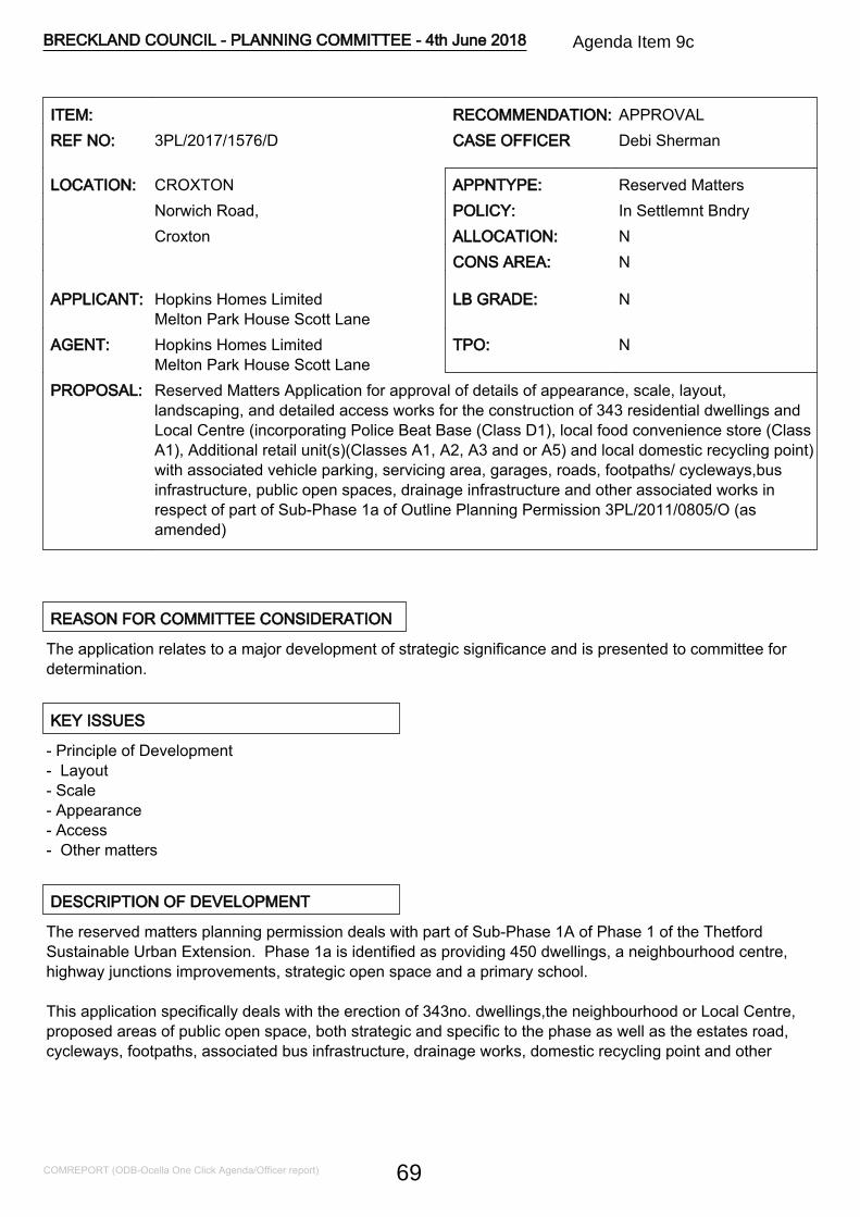
ITEM: RECOMMENDATION: APPROVALREF NO: 3PL/2017/1576/D CASE OFFICER Debi Sherman
LOCATION: CROXTON APPNTYPE: Reserved MattersNorwich Road, POLICY: In Settlemnt BndryCroxton ALLOCATION: N
CONS AREA: N
APPLICANT: Hopkins Homes LimitedMelton Park House Scott Lane
LB GRADE: N
AGENT: Hopkins Homes LimitedMelton Park House Scott Lane
TPO: N
PROPOSAL: Reserved Matters Application for approval of details of appearance, scale, layout,landscaping, and detailed access works for the construction of 343 residential dwellings andLocal Centre (incorporating Police Beat Base (Class D1), local food convenience store (ClassA1), Additional retail unit(s)(Classes A1, A2, A3 and or A5) and local domestic recycling point)with associated vehicle parking, servicing area, garages, roads, footpaths/ cycleways,businfrastructure, public open spaces, drainage infrastructure and other associated works inrespect of part of Sub-Phase 1a of Outline Planning Permission 3PL/2011/0805/O (asamended)
REASON FOR COMMITTEE CONSIDERATION
The application relates to a major development of strategic significance and is presented to committee fordetermination.
KEY ISSUES
- Principle of Development- Layout- Scale- Appearance- Access- Other matters
DESCRIPTION OF DEVELOPMENT
The reserved matters planning permission deals with part of Sub-Phase 1A of Phase 1 of the ThetfordSustainable Urban Extension. Phase 1a is identified as providing 450 dwellings, a neighbourhood centre,highway junctions improvements, strategic open space and a primary school.
This application specifically deals with the erection of 343no. dwellings,the neighbourhood or Local Centre,proposed areas of public open space, both strategic and specific to the phase as well as the estates road,cycleways, footpaths, associated bus infrastructure, drainage works, domestic recycling point and other
BRECKLAND COUNCIL - PLANNING COMMITTEE - 4th June 2018
COMREPORT (ODB-Ocella One Click Agenda/Officer report) 69
Agenda Item 9c
associated infrastructure necessary to bring forward this part of Phase 1a.
A Design Brief was required to be submitted concurrently with the reserved matters application. The Briefgoes beyond the extent of this reserved matters application and deals with Phase 1a in its entirety.Nevertheless, it is relevant to the consideration of this application.
In terms of the scope of this particular reserved matters application the proposal deals with all reservedmatters relating to the part of Phase 1a as set out in the description of development assessing the layout,scale, appearance, landscape and the detailed access works that were not considered strategically at outlinestage.
Residential
Consent is sought for 343no. residential dwellings. The dwelling mix is set out below:
Market Housing Affordable Housing
one bed flat 18no. one bed flat 12no.two bed flat 16no. two bed flat niltwo bed house 33no two bed house 23no.three bed house 146no. three bed house 14no.four bed house 75no. four bed house 2nofive bed house 4no. five bed house nil
TOTAL - 292no 51no
The area subject of this application was defined as the Red House Character Area in the Design and AccessStatement (addendum) approved under the outline permission. The overriding character is one of asuburban style of development consisting of a broad range of residential building types including detached,semi detached and terraced homes. There are also blocks of flats provided to accommodate one and twobedroom properties as smaller housing units have been identified as being sought via the housing needssurvey assessment work. There would be several apartment blocks but the dominant typology of built formwould be of a two or three storey domestic scale relating well to the key characteristics of Thetford.
Heights are identified as follows:
Two storey buildings - 7.2 - 9.5 mTwo and half storey buildings - 9.5 - 11.3 mThree storey buildings - 11.2 - 12 m
The S106 agreement signed in connection with the outline permission states that 15% of the first 500 newhomes within the SUE will be affordable housing. The number of new affordable homes proposed within thispart of Sub-phase 1a is 51 dwellings as set out above. The tenure will be split 31no. for rent and 20no. forintermediate housing.
Vehicular Access
The development would be accessed from the A1075. The principle access or Main Street Corridor would betaken from the new road junction across the A1075 'Primary Road' and would provide the main linkages intothe other parts of Phase 1a in a northerly and easterly direction. The Main Street would be at a width of 6m.
BRECKLAND COUNCIL - PLANNING COMMITTEE - 4th June 2018
COMREPORT (ODB-Ocella One Click Agenda/Officer report) 70
Secondary Streets at 4.8m in width would feed off into the development to the shared space Tertiary Streets(4m in width) which would provide another level of access to the residential development.
Bus Links
The Main Street and Secondary Streets would provide the bus route linkages down into the approvedAlternative Bus Link Corridor at Joe Blunt's Lane. This application would only provide the requiredconnections but not the Bus Link Corridor itself which is captured under a requirement of the outline planningpermission.
Pedestrian and cycle links
The Main Street and Secondary Streets would incorporate 2 m and 1.5 m wide (respectively) footpaths tofacilitate pedestrian access. The Tertiary Streets would facilitate shared space to private dwellings. Therewas a Pedestrian Route Parameter Plan was which approved as part of the outline consent and the detailedlayout has close regard to the approved principle pedestrian routes approved at that stage. A more detailedpedestrian route plan has also been provided demarcating a more detailed level of pedestrian routes throughthe development. The principle pedestrian routes would also provide the primary cycle links provided ontothe A1075 with direct access into Thetford.
Public Open Space, Green Infrastructure and Drainage features
Full landscaping details have been provided as part of the reserved matters application with a LandscapeFramework Plan identifying the main types of open space and green infrastructure on site. Thisdemonstrates the locations of bio swales, green corridors, semi-natural open space, parks and amenitygreen spaces, hedges and ornamental tree planting.
In accordance with the approved Public Open Space and Green Infrastructure Parameter Plan one of theareas of semi-natural open space would be provided in the form of the Strategic Open Space, includingsurface water detention areas, along the southern boundary of the site linking into the existing greeninfrastructure network surrounding Joe Blunt's Lane. Further to this there would be a central area of publicopen space facilitating preservation of a number of mature trees within the site. This, together with greencorridors and mature trees on the western boundaries that are adjacent to the railway line to the west formthe principle elements of the green infrastructure on site. There would also be a central drainage feature andLEAP within a semi natural setting to the south of the Main Street and an area of open space around theNeighbourhood Centre fronting onto the Primary Road (A1075).
Local Neighbourhood Centre
The proposed Local Centre would provide a facility agreed at outline stage for Phase 1 of the SUEdevelopment. It is shown as a two storey building with flats at first floor and a mixture of retail, professionalservices, restaurant and/or takeaways uses and 'beat base' or neighbourhood policing facility provided. TheLocal Centre would be located off the Main Street and would be visible from the Primary Road and as suchwould serve the development itself as well as providing a facility for passers by. It would have associatedparking and servicing facilities and would be readily accessible by all modes of transport.
SITE AND LOCATION
The application site comprises an area of agricultural land on the northern edge of Thetford. The site is
BRECKLAND COUNCIL - PLANNING COMMITTEE - 4th June 2018
COMREPORT (ODB-Ocella One Click Agenda/Officer report) 71
currently used for arable purposes.
The site is bounded in all directions by mature trees; to the south there is a substantial planting belt thatdelineates the agricultural land to the north from the built up edge of Thetford and Joe Blunt's Lane.
The site is currently punctuated by a field hedge which contains a number of mature trees. To the west ofthe site is the railway line also bounded by a mature hedgerow. To the east lies the A1075 Norwich Road. Inthe south eastern corner of the site is a residential care home known as the Red House. Further to the southeast of the site on the other side of Norwich Road lies a retail superstore with junction opposite the RedHouse and entrance to Joe Blunt's Lane.
EIA REQUIRED
The outline application 3PL/2011/0805 was accompanied by an Environmental Statement and considered inlight of the Environmental Impact Assessment (EIA) Regulations 2011. This reserved matters submission isconsidered to fall within the scope of the updated EIA Regulations 2017. This reserved matters submissionfollows the principles set by the outline permission and therefore a further Environmental Statement has notbeen requested.
RELEVANT SITE HISTORY
3PL/2011/0805/O - CROXTON & KILVERSTONE Land North of Thetford - Comprehensive mixed use urbanextension (up to 5000 dwellings, 22.5ha of employment land, local centres, 3 primary schools, greeninfrastructure, playing fields, other amenity areas & means of access) - Approved - 27-11-15.
POLICY CONSIDERATIONS
The following policies of the adopted Breckland Core Strategy and Development Control Policies and theadopted Site Specific Policies and Proposals Document, including the Proposals Maps, have been taken intoconsideration in the determination of this application. The provisions of the National Planning PolicyFramework and National Planning Policy Guidance have also been taken into account, where appropriate
CP.01 HousingCP.04 InfrastructureCP.05 Developer ObligationsCP.08 Natural ResourcesCP.09 Pollution and WasteCP.10 Natural EnvironmentCP.11 Protection and Enhancement of the LandscapeCP.12 EnergyCP.13 AccessibilityDC.01 Protection of AmenityDC.02 Principles of New HousingDC.04 Affordable Housing PrinciplesDC.11 Open Space
BRECKLAND COUNCIL - PLANNING COMMITTEE - 4th June 2018
COMREPORT (ODB-Ocella One Click Agenda/Officer report) 72

DC.12 Trees and LandscapeDC.13 Flood RiskDC.14 Energy EfficiencyDC.15 Renewable EnergyDC.16 DesignDC.19 Parking ProvisionNP Neighbourhood PlanNPPF National Planning Policy FrameworkNPPG National Planning Practice GuidanceSS1 Spatial StrategyTH20 Thetford Urban Extension Strategic Design PrinciplesTH21 Locally Distinctive Features of the LandscapeTH25 Walking and Cycling
OBLIGATIONS/CIL
The S106 obligations for this development are set out within a S106 legal agreement approved as part of3PL/2011/0805/O.
CONSULTATIONS
THETFORD T CThe design layout has omitted to address the connectivity with the major supermarket directly opposite thesite and this needs to be addressed. It is unclear how the various needs of the residents are to be providedand financed in particular:cemetery,doctors,dentist,allotments and community hub.NORFOLK COUNTY COUNCIL HIGHWAYSRevisions required to various aspects of the layout to make the scheme acceptable.FLOOD & WATER MANAGEMENT TEAMThe applicant has submitted revised details for this site with revised highways proposals, as well as revisedpedestrian measures and increased number of affordable housing. However the changes made to theproposal in this re-submission do not affect the drainage strategy for this site, which remains the same. Noobjections are raised to the proposed drainage strategy for this site.HISTORIC BUILDINGS CONSULTANTNo objection on the basis that the proposed development will not impact on any above ground heritageassets.TREE AND COUNTRYSIDE CONSULTANTA tree survey, implication assessment, tree protection plan and method statement is required.HOUSING ENABLING OFFICERThe proposals now appear to meet, or fall insignificantly short of, the space standards required. No furthercomments on this issueECONOMIC DEVELOPMENT
BRECKLAND COUNCIL - PLANNING COMMITTEE - 4th June 2018
COMREPORT (ODB-Ocella One Click Agenda/Officer report) 73
The delivery of Sub-Phase 1a of the proposed KingsFleet sustainable Urban Extension will make animportant contribution to the Economic Development of Greater Thetford, providing local housing supportingexpansion of economic activity in Thetford and the wider A11 economic corridor. Sufficient availability ofhousing is an important factor considered by businesses and industrial developers considering making aninvestment in the area and this is an important first step in this key housing development.KIRSTY MALLETT, LAND MANAGEMENT OFFICERIf the applicants wish to request the Council to consider whether or not they wish to be the nominated bodyfor the Public Open Space they should make contact with Facilities Management to discuss. However, BDCare not a drainage authority and Facilities Management would not want to be responsible for the drainageinfrastructure or an open space that includes any drainage features such as storage lagoons, ponds,underground storage tanks/pipes or soakaways.ECOLOGICAL AND BIODIVERSITY CONSULTANTThe application relates to a sub-phase of a site which was subject to an Environmental Statement (WardelllArmstrong; June 2011) submitted at the time of the Outline Planning Permission (3PL/2011/0805/O).Legislation, best practice and planning policies have been amended since the ecology surveys were carriedout and the ecology chapter of the Environmental Statement was produced. The Environment Statementneeds to therefore be updated at this stage.ENVIRONMENTAL HEALTH OFFICERSCondition 40 of 3PL/2011/0805/O states Prior to the commencement of each phase or sub-phase, or suchlonger period as may be agreed, a detailed scheme of measures to mitigate the impact of traffic noise fromthe A11 trunk road, railway line or noise from the proposed employment development on noise sensitivedevelopment such as residential properties, shall be submitted to and agreed in writing by the Local PlanningAuthority. The agreed measures shall be implemented and carried out in full prior to the first occupation ofthe noise sensitive development concerned. Reason for condition In the interests of the amenities of futureoccupants. Although there is some information regarding expected noise levels for the whole developmentsubmitted at the outline stage I was unable to find a detailed scheme as described in the above conditionsubmitted with this application. I am particularly concerned to see the detailed scheme in relation to theproposed properties adjacent to the existing railway line. Condition 13 also refers to the submission of aConstruction Method Statement which is required prior to development. The Environmental Protection Teamwould like to be consulted on this when it is submitted in order to ensure that suitable mitigation measureswith respect to noise, dust etc are in place to protect existing residential properties adjacent to the site.CONTAMINATED LAND OFFICERRecommend that the same conditions are imposed on the reserved matters application as on the outlineplanning permission.AIR QUALITY OFFICERFor a development of this size an Air Quality Assessment will be required to assess the impact of thedevelopment, in particular traffic related emissions of NO2 and Particulate Matter along the roads serving thetown centreHIGHWAYS ENGLANDNo objectionENVIRONMENT AGENCYWe have reviewed the information as submitted and wish to make the following comments. Surface WaterManagement We previously commented on the outline application at this site (ref 3PL/2011/0805/O) andrecommended surface water flood risk conditions (EA letter dated 28th August 2012 ref AC/2011/115178/02).We are no longer a statutory consultee for surface water flood risk. We recommend that you consult the Lead
BRECKLAND COUNCIL - PLANNING COMMITTEE - 4th June 2018
COMREPORT (ODB-Ocella One Click Agenda/Officer report) 74
Local Flood Authority for their comments regarding surface water management at this site. Groundwater andContaminated Land The site is underlain by a Principal Chalk Aquifer, within the Water Framework Directive(WFD) Cam and Ely Ouse Chalk groundwater body. Principal aquifers are geological strata that exhibit highpermeability and provide a high level of water storage. They support water supply and river base flow on astrategic scale. The site is located within a Source Protection Zone (SPZ), namely SPZ2 and 3. The RiverThet and pond/drains are located approximately at 350m and 80m, respectively to the south east of the site.Therefore, we consider the site to have high sensitivity with respect to controlled waters. Due to theenvironmental sensitivity of this site we recommended groundwater and contaminated land conditions in ourresponse (letter dated 28th August 2012 ref AC/2011/115178/02) to the outline application 3PL/2011/0805/O.The information provided as part of this outline application does not discharge these conditions and thereforeour previously recommended groundwater and contaminated land conditions remain pertinent.HISTORIC ENGLANDNo commentRAMBLERS ASSOCIATION: NORFOLK AREANo commentNATURAL ENGLANDThe proposed application is unlikely to have significantly different impacts on the natural environment thanthe original proposal. Should the proposal be amended in a way which significantly affects its impact on thenatural environment then, in accordance with Section 4 of the Natural Environment and Rural CommunitiesAct 2006, Natural England should be consulted again.R S P BWhilst we have no objection to this proposal in principle, we would like to draw your attention to the section106 agreement that forms part of the outline permission (ref: 3PL/2011/0805/O). This requires the provisionof ecological mitigation land both on-site and off-site, plus the provision of ecological management plans forthese sites, with the offsite plan requiring approval in writing from the Council, in consultation with RSPB andNatural England.CRIME REDUCTION & ARCHITECTURAL LIAISON OFFICERDesign and Access Statement makes reference Secured by Design and to some proposed crime preventionmeasures for the development. Specifically:- The 2m high fencing surrounding the allotments- Car parking to be overlooked by related homes- Mews parking- Cycle parking for homes- Secure cycle parking for apartments- 1.8m physical boundaries between private gardens- 1.8m rear garden gates & capable of secure locking- Paneled or closed board fencing- Back to back gardens where possible with fencing at 2m with a closed board construction
LEAP -Provisions should be made so that this area can be secured at night. This will reduce the amount of criminaldamage, anti-social behaviour and graffiti which occurs after dark. Recommend that this area has 1.2m hooptopped fencing. Consideration should be given for an area designated for older children such as a TeenShelter so that improper use of the play area is discouraged. This area will need to be subject to goodsurveillance but sited so that local residents will not suffer from possible noise pollution.
Attenuation Area -
BRECKLAND COUNCIL - PLANNING COMMITTEE - 4th June 2018
COMREPORT (ODB-Ocella One Click Agenda/Officer report) 75
To address issues of anti-social behaviour recommend -1. A suitable barrier, such as a metal railing or welded mesh is installed around the perimeter of the basin, ata height of 1.2 metres.2. The low level defensive planting is added to the external side of the barrier and that it is maintained to aheight of 1 metre to allow for good surveillance.3. Appropriate signage (for warnings and rule setting) to be erected on metal signposts which have beencemented into the ground to prevent leverage, at intervals around the basins perimeter.
Lighting -To work in harmony with high levels of natural surveillance, a carefully designed lighting plan to cover allvulnerable areas should be in place. This will help to deter and reveal potential offenders and a uniformspread of white light to British Standard BS5489-1:2013.is advisable. It is equally important that luminariesare used that have suitable photometry serving to reduce light spill and direct light only to where it isrequired. White light aids witness identification by providing better colour rendition. This practice does notnecessarily mean more lamps or greater energy use but the efficient use of light directed to where it isrequired.
Neighbourhood Centre -It is recognised that some commercial developments or mixed use (domestic and commercial) may be eitherphased; developed when the market allows or speculative; the developer provides the infrastructure. Neitherof the above circumstances will necessarily preclude achievement of SBD Certification provided there is acontinuous dialog with Norfolk Constabulary ALO Team.The centre itself should be designed to incorporate the Physical security elements of the Secured by DesignCommercial Award.
With regards to Page 7 of the Section 106 Agreement 27.11.2015 Police Contributions means the Index-Linked sum of 175,000 pounds to be used by the Council for: (i) Extension of the existing Thetford PoliceStation (for an enlarged briefing room and storage facilities); (ii) Costs for two vehicles, uniforms andequipment and (iii) Cost of 2 PCSOs for an on-site presence at the Site The Norfolk Constabulary PolicingModel, as you are no doubt aware, has significantly changed since this agreement was made.HISTORIC ENVIRONMENT SERVICEThe proposed development site will affect the remains of a 19th century lime kiln which is shown on historicOrdnance Survey maps and which was observed during archaeological field survey in 2010. The kiln is aheritage asset with both archaeological and historic interest. The proposed development will result incomplete loss of significance of the heritage asset through its destruction and it is worthy of archaeologicalexcavation and recording prior to its removal. The site has been subject to a programme of archaeologicalevaluation comprising fieldwalking, metal detecting, geophysical survey and trial trenching. These phases ofarchaeological fieldwork did not identify any additional heritage assets at the current site that required furtherarchaeological work. The requirement for archaeological mitigatory work at the site is covered underCondition 34 of the outline permission 3PL/2011/0805/O and further conditions are not therefore required onthe present reserved matters. However, we do wish to highlight to the applicant that the requirement for thearchaeological mitigatory work is still outstanding for this part of the site. With regard to the area covered bythis reserved matters application the archaeological mitigation will comprise the excavation and recording ofthe lime kiln structure.
CROXTON P C No Comments ReceivedSPORT ENGLAND No Comments ReceivedBRETTENHAM/KILVERSTONE P C No Comments Received
BRECKLAND COUNCIL - PLANNING COMMITTEE - 4th June 2018
COMREPORT (ODB-Ocella One Click Agenda/Officer report) 76

FOREST HEATH DISTRICT COUNCIL No Comments ReceivedST. EDMUNDSBURY DIST. COUNCIL No Comments ReceivedSUFFOLK COUNTY COUNCIL No Comments ReceivedKINGS LYNN & WEST NORFOLK B C No Comments ReceivedOBLIGATIONS OFFICER, NORFOLK COUNTYCOUNCIL
No Comments Received
ENVIRONMENTAL PLANNING No Comments ReceivedENVIRONMENTAL SERVICES OFFICER No Comments ReceivedCOMMUNITY DEVELOPMENT OFFICER No Comments ReceivedANGLIAN WATER SERVICE No Comments ReceivedNORFOLK RIVERS INTERNAL DRAINAGE BOARD No Comments ReceivedHEALTH & SAFETY EXECUTIVE No Comments ReceivedNATIONAL GRID No Comments ReceivedH M INSPECTOR OF RAILWAYS OFFICE OF RAILREGULATION
No Comments Received
NORFOLK WILDLIFE TRUST No Comments ReceivedNATIONAL PLANNING CASEWORK UNIT No Comments ReceivedKILVERSTONE/BRETTENHAM P C No Comments Received
REPRESENTATIONS
The application was advertised in the EDP and site notices erected. A number of letters from four separateobjectors received raising issues relating to -
- Outline planning permission 3PL/2011/0805/O Condition 5,7,11, 29,42,46,49 have not been fullyaddressed.- The site boundary on application 3PL/2011/0805/O does not match recent application 3PL/2017/1576/D- Increase damage to trees during construction phase. Concerns over proposed bus route during Phase 1Aof this development.- Issues with Footpath/cycleway as connectivity between Phase 1A to local supermarket is limited. - Furtherconcern with footpath/cycleway into town.- Concerns about usability of the Travel Plan- Scheme does not accord with the outline application- Concerns about utilities provision and bus route within Joe Blunt's Lane
ASSESSMENT NOTES
1.0 Principle of Development
1.1 The site comes forward following the outline approval as set out in the Planning History Section above.The principle of development has therefore been established. The outline permission was subject of anumber strategic design parameter plans which establish the 'rules' for the development going forward.There are twelve in all, they are set out below -
BRECKLAND COUNCIL - PLANNING COMMITTEE - 4th June 2018
COMREPORT (ODB-Ocella One Click Agenda/Officer report) 77
-Application Site Location Plan- Site Boundary Plan- Land Use (Built Development and Ancillary Uses) Parameter Plan- Access and Movement Hierarchy Parameter Plan- Pedestrian Routes Parameter Plan- Cycle Routes Parameter Plan- Open Space and Landscape Parameter Plan- Building and Infrastructure Heights Parameter Plan- Density Parameter Plan- Phasing Parameter Plan- Development Zones Parameter Plan- Means of Access Drawings
1.2 Further to this Condition 3 of the outline consent required that development of the SUE come forward inan ascending numerical order as set out in the Phasing Parameter Plan. This site is a part of Phase 1awhich in turn is part of Phase 1 of the SUE development and comes forward having close regard to theapproved parameter plans and in accordance with the phasing requirements of the outline planningpermission. On this basis, there are no objections in principle to the development of this site.
1.3 Adopted Core Strategy Policies as listed in the Section above are relevant to the consideration of thisreserved matters application. On the basis that the principle of development has been approved policies ofparticular relevance are considered to centre on the Development Control policies. Further to this theThetford Area Action Plan 2012 and in particular Policy TH 20, TH 21 and TH25 are of particular relevance tothe consideration of this reserved matters application. TH20 deals with the design principles of the ThetfordUrban Extension and considers impacts of landscape and setting as well as townscape. Policy TH21references Locally Distinctive Features.Similarly, Policy TH25 refers to cycling and walking and emphasisesthe need for developments within the SUE to be permeable to all modes of transport. These policies werefully taken account of at outline stage in the consideration of the approved design parameter plans whichform the basis of this reserved matters application
2.0 Reserved Matters - Layout
2.1 Condition 5 of the outline permission (3PL/2011/0805/O) required the submission of Design Brief toaccompany reserved matters applications for each Phase or Sub-Phase. A Design Brief has been preparedfor this application, which as set out in the Description of Development Section above goes beyond thisproposal and relates to the whole Sub Phase but is entirely relevant to the consideration of this application.Officers are satisfied that TH20 and TH25 have been taken account of in the drawing up of the Design Brief.
2.2 Matters relating to layout 'trickle down' from the approved design parameter plans and are captured inthe detailed reserved matters proposal and evidenced in the Design Brief. Issues relating to the form of thedevelopment, the nature of the development provided for within the development, strategic infrastructureprovision, relationships between uses and zoning of development down to matters such as character areaswere set out and approved at outline stage. The current application interprets those 'rules' and sets out tocreate a development which seeks to emulate the principles. The density of the development accords withthe requirements of the outline with low to medium densities, again reflective of the suburban character ofthis phase of development.
2.3 It is considered that the proposed layout successfully interprets the over-arching requirements of thedesign parameter plans by setting out a layout that creates a sense of 'place' that reflects the Red HouseCharacter Area by providing a well structured development that is reflective of the wider established
BRECKLAND COUNCIL - PLANNING COMMITTEE - 4th June 2018
COMREPORT (ODB-Ocella One Click Agenda/Officer report) 78
character of the locale and that incorporates the associated green infrastructure and strategic drainagefeatures sensitively and appropriately. Further the strategic pedestrian routes, cycleway ways andneighbourhood centre are assimilated into this predominantly residential phase logically to create a high levelof legibility and permeability. The detailed layout has departed to a minor degree from the Contextual Planfor Phase 1 in so far as an adjustment to the location of the Neighbourhood Centre and public Open Spacebut the changes are not significant and are considered logical to allow for visibility of the NeighbourhoodCentre beyond that of the new development itself and to provide a focal point for the development in the formof the attenuation feature and LEAP in front of the proposed crescent of town houses.
2.4 The application provides for 51no.affordable housing units across the site located principally in fourlocations, this is considered appropriate in urban design terms by providing a variety of house types andtenures across the site in a manageable form that assimilates appropriately into the development. Theinternal layouts of the affordable units have been revised to ensure that overall internal space standards aremet, this has been recognised by the Strategic Housing Service.
2.5 The provision of strategic green infrastructure has been considered across the whole of the SUEdevelopment in light of bringing forward the wider development. It is acknowledged that under Policy DC 11requirements for areas for outdoor sports would not come forward as part of this sub-phase but there isscope for significant provision under later phases which would be controlled under the outline approval andthe approved phasing strategy. The scheme provides for a LEAP to be provided on site which does not meetthe full requirement for children's play space but again other provision would come forward on a strategicbasis. Further, there is ample scope within the semi natural open space and parks and amenity green spaceprovided on site to facilitate informal play opportunities on site.
2.6 The layout has been designed to take account of Secure by Design principles and ensure that there aregood levels of natural surveillance of both public open space and of private communal areas such as parkingcourts. The Architectural Liaison Officer has commented on the layout and made observations regardingthese issues acknowledging that efforts have been made in this regard. Comments have been maderegarding security of play space and the attenuation features. It is appropriate to provide an enclosure forchildren's play space and this would be incorporated. Issues relating to fencing of the attenuation featuresare not considered conducive to good place making particularly on the basis that there would be good naturalsurveillance and would be located in an area where there would be regular use that would act as a deterrentto anti-social behaviour. The issues raised in relation to fencing and lighting are either captured under thereserved matters details or are the requirements of conditions of the outline and can be captured accordingly.
2.7 On the basis of the issues explored above, no objections are raised to the proposed layout of thedevelopment.
3.0 Reserved Matters - Scale
3.1 The scale of the development was again identified and set out at outline stage with the option ofdevelopment up to four storeys in height.. The scheme proposed is mainly two storeys in height but thereare various elements at two and half storeys and three storeys which provide variety and create visualinterest with a number of focal buildings at strategic locations within the development . This strategy isconsidered to be well conceived and marry in with the layout, particularly in relation to features such theproposed crescents of properties looking out on areas of open space and at various vistas and junctionsthroughout the scheme.
4.0 Reserved Matters - Appearance
BRECKLAND COUNCIL - PLANNING COMMITTEE - 4th June 2018
COMREPORT (ODB-Ocella One Click Agenda/Officer report) 79
4.1 The appearance of the development again conforms to the requirements of the Red House CharacterArea with traditionally styled properties that are generally reflective of the type of development seen in thewider vicinity. The architectural detailing and palette of materials are considered appropriate in their contextand the proposed use of traditional red brick, render and where appropriate weatherboarding would provide aquality of environment that is appropriate in this setting.
4.2 The Neighbourhood Centre building is relatively low key in its appearance, it is shown set away from thePrimary Road A1075 frontage (Norwich Road) with its principal elevations inward looking into thedevelopment site. It is acknowledged that this could reduce its visibility to passers by but on balance, itsappearance is appropriate in its context and with suitable advertising treatments could still have anappropriate presence in the wider locality.
5.0 Reserved Matters - Landscaping
5.1 The outline planning permission required under Condition 9 that details of hard and soft landscapingdetails are provided as part of the reserved matters application. A Landscape Framework Plan has beenprovided with a series of Planting Plans and landscaping details that demonstrate how the developmentwould come forward in an appropriate, well integrated manner, protecting and enhancing the naturallandscape features of the site. This is considered to be achieved with pocket parks and a variety of forms ofopen space with differing functions. Structural landscaping elements such as on street tree planting andGreen Corridors represent positive features that seek to enhance the quality of the development in urbandesign terms.
5.2 The Tree Officer has queried issues in relation to the tree protection measures associated with this partof the development. Conditions 7 & 8 of the outline permission deal with these issues and requireinformation to be submitted prior to the commencement of development of any phase or sub-phase. It isacknowledged that the existing principle landscape features of the site would be protected as part of thisdevelopment and as such it is not considered that the scheme would cause demonstrable harm or affect theirretention.
6.0 Reserved Matters - Access
6.1 Strategic access routes were approved under the outline permission but all other means of access withinthis part of Sub-Phase 1a are for determination under this reserved matters application. This includes theMain Street, Secondary Streets and Tertiary Streets that provide all levels of vehicular access to thedevelopment. It also incorporates the new junction (10b) across the A1075 which would facilitate access toother parts of Phase 1a are for consideration under this application.
6.2 The strategic pedestrian linkages provided through the scheme have close regard to the approvedparameter plans and no objections are raised on this basis. Concerns have been expressed regarding thelevel of non-motorised connections but it is considered that the layout facilitates a good level of permeabilityfor pedestrian and cycle users that allow for movement within the development and to the wider area viaconnections to the south via Joe Blunt's Lane and for future connections to other parts of the SUE whenconstructed. The Town Council has raised a concern that the development does not facilitate a pedestrianroute through to the adjacent retail superstore. The scheme shows a footpath to be provided along theA1075 down towards the existing footpath in front of the Red House, this would facilitate a connection to theexisting footpath network adjacent to the superstore. There is no new pedestrian crossing proposed at thispoint but a defined pedestrian connection would be facilitated once the western section of Phase 1 comesforward.
BRECKLAND COUNCIL - PLANNING COMMITTEE - 4th June 2018
COMREPORT (ODB-Ocella One Click Agenda/Officer report) 80
6.3 Parking provision is also a matter for consideration at this stage. The parking provision is generallyshown as 'on plot' parking with garaging and additional spaces for properties. There are areas of communalparking but this kept to a minimum to facilitate the most appropriate overall layout. Parking provision meetsthe requirements of DC19 in terms of levels of provision.
6.4 Issues relating to access, parking, pedestrian and cycle ways have been the subject of discussion withthe Highway Authority. At the time of writing this report further revised plans have been submitted to addressthe concerns of the Highway Authority. The response will be reported on the Members Update.
7.0 Other matters
7.1 Issues have been raised by the Council's Asset management Team regarding the on going managementand maintenance of the areas of public open space. These matters are dealt with under the existing S106legal agreement and are not for consideration under this reserved matters application.
7.2 Matters in relation to ecological issues are captured under the requirement of Condition 43 of the outlinepermission. At the time of the outline application the Environmental Statement fully considered ecologicalimpacts. It is considered that the requirements of this condition are sufficient to address the need forupdated information prior to the commencement of the development.
7.3 Air Quality was considered at the time of the outline planning permission as part of the EnvironmentalStatement and it was concluded that the impacts would be negligible on existing and proposed receptors. Itis not considered that there has been a material change in circumstances since that time and it is notconsidered appropriate to impose conditions at this point.
7.4 Environmental Health Officers have identified potential conflicts with the railway line and new occupantsof the development. Condition 40 of the outline permission requires that prior to on-site commencementnoise mitigation measures need to be submitted and approved to address disturbance from this noisesource, details cannot be required at this stage. Similarly, there is no requirement for additionalcontaminated land surveys (Conditions 36-38) or archaeological information as the conditions (Conditions 34& 35) imposed at outline require the information to be submitted and agreed prior to the commencement ofdevelopment.
7.5 An issues has been raised by the Architectural Liaison Officer regarding the appropriateness of providingthe beat base as part of the Local Neighbourhood Centre. This has not been confirmed at this time by thePolice Authority and as it remains a requirement of the outline planning permission it is consideredappropriate it is retained as part of the scheme until such time as there is confirmation it is no longerrequired.
8.0 Conclusions
8.1 Taking into account the matters set out above, and the overall planning balance of the scheme in contextof the outline permission granted and general conformity with the requirements of the approved designparameter plans, the development has been considered and weight applied in the planning balance exerciseto asses the potential harm of development when considered in context of the overall benefits. It isconcluded that the adverse impacts of the proposed development would not demonstrably outweigh itsbenefits and the proposal would represent a well conceived sustainable development, as defined in theNPPF, and would not conflict with the objectives of development plan policies. For these reasons, the site isconsidered to be suitable for residential development.
BRECKLAND COUNCIL - PLANNING COMMITTEE - 4th June 2018
COMREPORT (ODB-Ocella One Click Agenda/Officer report) 81
RECOMMENDATION
The application has been the subject of re-consultation which at the time of the committee is still on going.On this basis, it is recommended that powers be delegated to The Executive Director of Place to approvethe application, subject to:
-the response of the Highway Authority,- the conditions listed in the report; and- that no new material matters are received as a result of the consultation process.
RECOMMENDATION Approval of Reserved Matters
CONDITIONS
1 Reserved Matters - time limitThis approval is granted following the grant of Outline Planning Permission Reference3PL/2011/0805/O Dated 27 November 2015.The development hereby permitted shall bebegun either before the expiration of FIVE YEARS from the date of the Outline PlanningPermission, or before the expiration of TWO YEARS from the date of the last of the reservedmatters to be approved, whichever is the later.The development shall comply with all the conditions attached to the outline permissionunless varied by this approval of reserved matters.Reason for condition:-For the avoidance of doubt and to ensure that the development accords with conditionsattached to the outline planning permission for the proposal, including time limits specifiedfor commencement, resulting in appropriate development of the site.
2 In accordance with submitted plans NEW 2017The development must be carried out in strict accordance with the application form, andapproved documents and drawings as set out in the table at the end of this notice.Reason for condition:-To ensure the satisfactory development of the site.
3 External materials as approvedThe development hereby permitted shall be constructed using the materials specified on theapproved Materials Schedule.Reason for condition:-To enable the Local Planning Authority to ensure the satisfactory appearance of thedevelopment, as required by policies DC 1 & DC 16 of the Adopted Core Strategy andDevelopment Control Policies Development Plan Document 2009.
4 Boundary treatment/screening to be agreedPrior to the occupation of any part of the development hereby permitted a plan indicating thepositions, design, materials and type of boundary treatment/screening to be erected shall besubmitted to and approved in writing by the Local Planning Authority. The boundarytreatment/screening shall be completed before the dwellings to which they relate are firstoccupied or in the case of public areas in accordance with a timetable to be agreed in writingwith the Local Planning Authority. Development shall be carried out in its entirety inaccordance with the approved details.Reason for condition:-
BRECKLAND COUNCIL - PLANNING COMMITTEE - 4th June 2018
COMREPORT (ODB-Ocella One Click Agenda/Officer report) 82

In the interests of the satisfactory appearance of the development in accordance with policyDC 16 of the Adopted Core Strategy and Development Control Policies Development PlanDocument 2009.This condition will require to be discharged
BRECKLAND COUNCIL - PLANNING COMMITTEE - 4th June 2018
COMREPORT (ODB-Ocella One Click Agenda/Officer report) 83
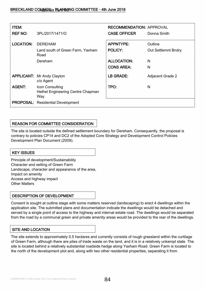
ITEM: RECOMMENDATION: APPROVALREF NO: 3PL/2017/1471/O CASE OFFICER Donna Smith
LOCATION: DEREHAM APPNTYPE: OutlineLand south of Green Farm, YaxhamRoad
POLICY: Out Settlemnt Bndry
Dereham ALLOCATION: NCONS AREA: N
APPLICANT: Mr Andy Claytonc/o Agent
LB GRADE: Adjacent Grade 2
AGENT: Icon ConsultingHethel Engineering Centre ChapmanWay
TPO: N
PROPOSAL: Residential Development
REASON FOR COMMITTEE CONSIDERATION
The site is located outside the defined settlement boundary for Dereham. Consequently, the proposal iscontrary to policies CP14 and DC2 of the Adopted Core Strategy and Development Control PoliciesDevelopment Plan Document (2009).
KEY ISSUES
Principle of development/SustainabilityCharacter and setting of Green FarmLandscape, character and appearance of the area,Impact on amenityAccess and highway impactOther Matters
DESCRIPTION OF DEVELOPMENT
Consent is sought at outline stage with some matters reserved (landscaping) to erect 4 dwellings within theapplication site. The submitted plans and documentation indicate the dwellings would be detached andserved by a single point of access to the highway and internal estate road. The dwellings would be separatedfrom the road by a communal green and private amenity areas would be provided to the rear of the dwellings.
SITE AND LOCATION
The site extends to approximately 0.5 hectares and currently consists of rough grassland within the curtilageof Green Farm, although there are piles of trade waste on the land, and it is in a relatively unkempt state. Thesite is located behind a relatively substantial roadside hedge along Yaxham Road. Green Farm is located tothe north of the development plot and, along with two other residential properties, separating it from
BRECKLAND COUNCIL - PLANNING COMMITTEE - 4th June 2018
COMREPORT (ODB-Ocella One Click Agenda/Officer report) 84
Agenda Item 9d
Dumpling Green.
Green Farm sited directly adjacent to the site is a Grade II listed farmhouse. The southern boundary of thesite consists of a hedgerow. The immediate area contains residential development, with a linear row ofdetached dwellings, mainly bungalows, on the western side of Yaxham Road. There are also residentialdwellings on the northern side of Dumpling Green.
The site is located close to the designated settlement boundary of Dereham, on the southern side of thetown. The settlement limit includes the properties referred to above on Yaxham Road and to the north ofDumpling Green. Dereham is a historic market town, with a substantial conservation area, deemed suitablein the Local Plan for growth. The Landscape Character Assessment settlement fringe study shows that themajority of the land surrounding the town has moderate to high sensitivity to change. The landscapecharacter assessment includes this site within the Northall Green character area which has a moderate tohigh sensitivity to change. Yaxham Road is served by a lit footpath which provides pedestrian access to thetown centre and its range of transport, retail, employment and service facilities.
EIA REQUIRED
No
RELEVANT SITE HISTORY
No relevant site history
POLICY CONSIDERATIONS
The following policies of the adopted Breckland Core Strategy and Development Control Policies and theadopted Site Specific Policies and Proposals Document, including the Proposals Maps, have been taken intoconsideration in the determination of this application. The provisions of the National Planning PolicyFramework and National Planning Policy Guidance have also been taken into account, where appropriate
CP.01 HousingCP.04 InfrastructureCP.10 Natural EnvironmentCP.11 Protection and Enhancement of the LandscapeCP.13 AccessibilityCP.14 Sustainable Rural CommunitiesDC.01 Protection of AmenityDC.02 Principles of New HousingDC.12 Trees and LandscapeDC.16 DesignDC.17 Historic EnvironmentDC.19 Parking ProvisionNPPF National Planning Policy FrameworkNPPG National Planning Practice Guidance
BRECKLAND COUNCIL - PLANNING COMMITTEE - 4th June 2018
COMREPORT (ODB-Ocella One Click Agenda/Officer report) 85
SS1 Spatial Strategy
OBLIGATIONS/CIL
Not Applicable
CONSULTATIONS
NORFOLK COUNTY COUNCIL HIGHWAYSNo objection subject to conditions.CONTAMINATED LAND OFFICERNo objection subject to conditions.ECOLOGICAL AND BIODIVERSITY CONSULTANTWe have no objections to the amended plans/ documents for Land south of Green Farm, Yaxham RoadDereham (planning ref: 3PL/2017/1471/O).TREE AND COUNTRYSIDE CONSULTANTMy only comment/alteration would be to move the proposed access point a few metres north so that it isoutside the root protection area of all retained trees, thus obviating the requirement for no-dig constructionwhich has the potential to be problematic.DEREHAM T CNo objection.HISTORIC BUILDINGS CONSULTANTSubject to conditional approval of external materials, I can confirm that the proposed dwelling types are inaccordance with discussion/s held with the applicants agent. Consequently, no further comment and/orobjection on the understanding that the proposed design types are adhered to and form the basis of anyformal approval for planning permission.HISTORIC ENVIRONMENT SERVICEBased on currently available information the amended details will not have any significant impact on thehistoric environment and we do not wish to make any recommendations for archaeological work.
REPRESENTATIONS
The application was advertised in the local press and letters sent to neighbouring residents. Eight letters ofrepresentation were received in respect of the following;
- There are no plans as to how the building will be set out.- Schools, doctors etc. are over-stretched- Concern about road safety and this development leading to issues of highway safety.- The site is outside the settlement boundary and would set a precedent for other similar inappropriateschemes.- This proposal could lead to further creeping ribbon development.- If this scheme was approved the speed limit of the road should be dropped to 30mph.
BRECKLAND COUNCIL - PLANNING COMMITTEE - 4th June 2018
COMREPORT (ODB-Ocella One Click Agenda/Officer report) 86
- Concern about loss of the hedge and the fact this would make the development highly visible.- There should be no parking of vehicles on the gravel frontages of houses on Yaxham Road.- Concern the town is being urbanised without the necessary infrastructure.- We suggest any approval should only be for bungalows.- Concern about the loss of the hedgerows.- The proposed development would place dwellings approximately 100m beyond the edge of the currentsettlement area and could encourage 'ribbon development' applications along the eastern side of YaxhamRoad.- Years of neglect and dumping materials do not constitute a 'brownfield' site.- The proposed development could lead to a proliferation of new development on open green space.
ASSESSMENT NOTES
1.0 Principle of the Development/Sustainability
1.1 The application site is located in close proximity to Dereham, separated from the settlement boundaryfrom Yaxham Road and Green Farm/Dumpling Green.
1.2 It is accepted that the council cannot demonstrate a 5 year supply of housing land. Relevant policies forthe supply of housing should not be considered up to date if the Local Planning Authority cannot demonstratea five-year supply of deliverable housing sites as stated in paragraph 49 of the NPPF. Where relevantpolicies are out of date, NPPF paragraph 14 advises that the presumption in favour of sustainabledevelopment, which should be seen as the golden thread running through decision making, is engaged. Thismeans granting permission unless specific policies in the NPPF indicate that development should berestricted or any adverse impacts of doing so would significantly and demonstrably outweigh the benefits,when assessed against the policies in the NPPF taken as a whole.
1.3 This so called "tilted balance" however does not diminish the weight to be afforded to Policy CP14 inassessing whether the adverse impacts demonstrably outweigh the benefits and this consideration is amatter of planning judgement for the decision maker.
1.4 The provision of housing to meet local needs is identified as a key component of sustainabledevelopment and in this respect the NPPF seeks to boost significantly the supply of housing. The NPPF alsoencourages the avoidance of isolated homes in the countryside and the location of development where thereis access to alternative modes of transport other than the private car.
1.5 As paragraph 8 of the NPPF outlines, there are three strands to sustainability; economic, social andenvironmental, each mutually dependent, and not assessed in isolation from each other. In respect of thisscheme the development of 4 dwellings would have economic benefits relating to the associated, albeitlimited, economic activity involved in their construction and delivery. Furthermore the delivery of housing tomeet local needs would also bring social benefits in meeting the needs of local residents.
1.6 Yaxham Road, and this development site, are linked to the town centre, bus links, employment facilities,goods and services by the footpath network of the town. On the single issue of sustainable transport, the fullrange of transport options is open to future residents in there need to avail of the services of the town. Publictransport links exist to access those further afield. Whilst the town centre is located a reasonable distance forwalking (circa 1.5km) it is not inaccessible. Employment sites and perishable/household goods stores aremuch closer.
BRECKLAND COUNCIL - PLANNING COMMITTEE - 4th June 2018
COMREPORT (ODB-Ocella One Click Agenda/Officer report) 87
1.7 The proposal will result in the development of a greenfield site. It is noted to be largely within the curtilageof a dwelling and part developed for storage of trade waste. The site is nonetheless greenfield and itsdevelopment would result in the loss of land of ecological and environmental value. However this would belimited in its impact and when considered as a whole the development of residential dwellings on thesouthern side of the town can be deemed environmentally sustainable.
1.8 Furthermore the development of a site adjoining the settlement boundary can, and has been, considereda suitable way to address any local housing shortfall. Notwithstanding windfall and brownfield sites thegrowth of towns generally involves the expansion of the settlement boundary.
1.9 In this case the "in principle" policy conflict is outweighed by the local shortfall in housing supply and thesite characteristics which would comply with the national policy desire for sustainable development.
1.10 Any adverse harm of this scheme would not significantly and demonstrably outweigh the positivebenefits. The proposed development is therefore deemed in compliance with adopted policies SS1, DC02 &CP14 which restricts development outside of settlement boundaries and relevant national guidancecontained in the NPPF.
2.0 Character and Setting of Green Farm
2.1 Under the Planning (Listed Buildings and Conservation Areas) Act 1990 as amended, at sections 16(2),66(1) and 72(1) a council should have special regard to the desirability of preserving the building or its settingor any features of special architectural or historic interest which it possesses. This requirement is reiteratedat Policy DC.17 of the adopted Local Plan.
2.2 The NPPF at paragraph 132 states that when considering the impact of a proposed development on thesignificance of a designated heritage asset, great weight should be given to the assets conservation.Paragraph 133 requires Local Planning Authorities to refuse applications which cause substantial harm to aheritage asset unless the harm is outweighed by the positive benefits of the scheme, or there aredemonstrable public benefits.
2.3 As detailed above Green Farm located to the north is a Grade II Listed farmhouse. The Historic BuildingOfficer has reviewed the scheme and stated he has no objections to the proposal subject to a condition beingapplied in respect of materials.
3.0 Landscape, Character and Appearance of the Area
3.1 Policy CP11 of the Core Strategy seeks to ensure that the landscape of the District will be protected forthe sake of its own intrinsic beauty and its benefit to the rural character.Development within the district is also expected to be of the highest design quality in terms of botharchitecture and landscape. It should have regard to good practice in urban design and fully consider thecontext within which it sits, embracing opportunities to enhance the character and appearance of an area.
3.2 Whilst located on the edge of the town the site forms part of the rural hinterland of Dereham. The northand western sides are characterised by long established residential developments, the southern and easternsides of the site consist of swathes of arable farmland. The landscape character assessment includes thearea within the Northall Green character area which has a moderate to high sensitivity to change. Howeverthis site is largely within the curtilage of a developed, farmyard with strong screening boundaries. Ifdeveloped the southern boundary hedge and the roadside hedge, to the extent sight splays would allow,
BRECKLAND COUNCIL - PLANNING COMMITTEE - 4th June 2018
COMREPORT (ODB-Ocella One Click Agenda/Officer report) 88
would facilitate a soft boundary to the settlement edge. Further planting on the western boundary could beagreed by condition. The strong hedge lined field structure, prevalent to the south and east of the town wouldbe maintained. The development of the site would have minimal impact on the character and appearance ofthe area.
3.3 The application is in outline stage with some matters reserved (landscaping). A number of commentswithin third party correspondence suggest that only bungalows would be appropriate at this location. It is thecase that on Yaxham Road, bungalows are the dominant style of dwelling. The western side of the road isalmost exclusively bungalow units and the eastern side of Yaxham Road, to the north of Dumpling Greenalso consists largely of bungalow properties. Dwellings on Dumpling Green are also predominantlybungalow/single storey units. Detailed discussions have taken place with the applicant who has amended thescheme to four bungalows to be more in keeping with the surrounding area in accordance with policy DC16of the Adopted Local Plan (2009).
3.4 Notwithstanding potential impacts on Green Farm, discussed above, The NPPF highlights in paragraph56 that "The Government attaches great importance to the design of the built environment. Good design is akey aspect of sustainable development, is indivisible from good planning, and should contribute positively tomaking places better for people."
3.5 Paragraph 64 further states that "Permission should be refused for development of poor design that failsto take the opportunities available for improving the character and quality of an area and the way itfunctions." Development within the District is further expected to be of the highest design quality in terms ofboth architecture and landscape. It should have regard to good practice in urban design and fully considerthe context within which it sits. It should embrace opportunities to enhance the character and appearance ofan area and contribute to creating a sense of local distinctiveness. However Paragraph 60 of the NPPFfurther states that councils should not impose architectural styles through unsubstantiated requirements toconform to certain development forms or styles.
3.6 The importance of the character and form, height, scale, massing and layout amongst other key designconsiderations are also set out in policy DC16 of the Core Strategy. It is considered the bungalows would notappear out of place and would be in keeping with the bungalows located on the opposite side of YaxhamRoad; they are set well back on the plot, and form their own setting entering the town.
3.7 Concern is also raised that the proposed development will lead to ribbon development along YaxhamRoad. This is a modest addition to the settlement close to its boundary. Whilst ribbon development canreinforce a built up appearance to roads and stifle and frustrate backland development often hampering theexpansion of settlements it is not considered that this would be the case in this instance. This is a smalladdition to the edge of the town, largely within an established curtilage, and ribbon development can moreeffectively cause concern in rural locations and villages. It is not considered that this proposal would result inribbon development or lead to the concerns as detailed within this paragraph.
3.8 In terms of layout, there is a single point of access with an internal road serving the individual propertiesand a communal green to the front. This layout is acceptable and creates dwellings set back from the roadsimilar to the bungalows on the western side of Yaxham Road. Suitable levels of private amenity space areproposed and the scheme is in conformity with policy DC16.
4.0 Impact on amenity
4.1 Policy DC01 states that for all new development consideration will need to be given to the impact uponamenity. Development will not be permitted where there are unacceptable effects on the amenities of the
BRECKLAND COUNCIL - PLANNING COMMITTEE - 4th June 2018
COMREPORT (ODB-Ocella One Click Agenda/Officer report) 89
area or the residential amenity of neighbouring occupants, or future occupants of the development site.Adequate separation distance has been retained to all residential properties, with potential impact onlyrelating to Green Farm and the two adjoining dwellings, including Willow House, on Dumpling Green. Withexisting screening in place, and the potential to augment this with further planting, agreeable by condition, itis not considered the proposed development, would give rise to excessive overlooking. Further, over-dominance, loss of outlook or overshadowing would not result with the development of this scheme inrelation to adjoining residents.
4.2 As previously alluded to, the proposed scheme provides adequate private amenity space for futureoccupiers and each dwelling would have suitable levels of amenity. The scheme therefore complies with theaims and objectives of local plan policy DC01.
5.0 Access and highway impact
5.1 Norfolk County Council Highways has been consulted in relation to the proposed development and haveno objections to the proposal subject to appropriate conditions.
6.0 Other Matters
6.1 The Contaminated Land Officer is content that any concerns could be addressed with conditions relatingto a site investigation, remediation and unexpected contamination conditions. The scheme therefore accordswith CP09.
6.2 An Ecological Survey has been submitted in support of the application (Wild Frontier Ecology November2017). Furthermore the Ecological and Biodiversity section at Norfolk County Council has providedcomments. The comments advise that the removal of trade waste piles to carry out the proposeddevelopment it will be necessary to obtain a European Protected Species (EPS) licence.
6.3 Suitable habitat is available on the site for birds in the form of woody vegetation. Vegetation clearanceshould be carried out outside of the nesting season. There is also suitable habitat available on site for reptilesincluding the rubble and waste piles on the site. Precautionary methods of working should be followed asrecommended in the Mitigation Section of the ecology report (Wild Frontier Ecology; November 2017) toavoid killing/ injuring reptiles.
6.4 Conditions relating to the EPS licence, vegetation clearance, and mitigation/ enhancements detailed inthe report are suggested. The application could be conditioned accordingly. The scheme complies withCP.10.
6.5 With the exception of the roadside hedge/trees the site would have no significant impact on othervegetation along the boundaries. Boundary screening retention and further planting could be agreed bycondition. The proposal is in compliance with policy DC.12.
6.6 Pertinent issues relating to the development have been raised by third party representations, which havebeen addressed within this report. Technical advice in relation to highway safety has been provided byNorfolk County Council which addresses neighbour concerns about impacts on the road network fromadditional traffic.
6.7 Concern is expressed that the proposal could set a precedent and lead to further greenfield developmentand that dumping of waste does not render a site brownfield. As discussed above this site has been judgedas a greenfield site, a development contrary to adopted policy, but for the reasons discussed justified and
BRECKLAND COUNCIL - PLANNING COMMITTEE - 4th June 2018
COMREPORT (ODB-Ocella One Click Agenda/Officer report) 90
amounting to an appropriate small expansion of the existing settlement. The scheme is deemed asustainable development; any demonstrable harm is outweighed by its benefits. Other similar developmentswould have to be judged on their own particularly merits having regard to the Local Plan, national guidanceand any other material considerations.
6.8 The Historic Environment Service were consulted on the application and concluded that the developmentwill not have any significant impact on the historic environment and did not wish to make anyrecommendations for archaeological work.
6.9 The Historic Buildings Officer was consulted on the application and concluded that subject to conditionalapproval of external materials, the proposed dwelling types are in accordance with discussion/s held with theapplicants agent. Consequently, no further comment and/orobjection on the understanding that the proposed design types are adhered to and form the basis of anyformal approval for planning permission.
7.0 Conclusion
7.1 In terms of the overall planning balance it is considered that the proposed development is sustainable innature and benefits from the tilted balance in the NPPF which directs councils to approve such schemesunless the benefits are significantly and demonstrably outweighed by any adverse impacts. It isrecommended that consent is granted subject to conditions.
RECOMMENDATION Outline Planning Permission
CONDITIONS
1 Outline Time Limit (2 years)Application for Approval of Reserved Matters must be made not later than the expiration ofTWO YEARS beginning with the date of this permission, and the development must bebegun within ONE YEAR of the FINAL APPROVAL OF THE RESERVED MATTERS or, inthe case of approval at different dates, the FINAL APPROVAL OF THE LAST SUCHMATTER to be approved.Reason for condition:-As required by section 92 of the Town & Country Planning Act 1990.
2 Standard Outline ConditionNo development whatsoever shall take place until the plans and descriptions giving detailsof the reserved matters referred to above shall have been submitted to and approved by theLocal Planning Authority and these plans and descriptions shall provide details of theappearance, layout, scale and landscaping of the development.Reason for condition:-The details are not included in the current submission.
3 External materials and samples to be approvedPrior to the commencement of any works above slab level details and samples of all externalmaterials to be used shall be submitted to and approved in writing by the Local PlanningAuthority, and this condition shall apply notwithstanding any indication as to these matterswhich have been given in the current application. Only such agreed materials shall be usedin connection with this approval.
BRECKLAND COUNCIL - PLANNING COMMITTEE - 4th June 2018
COMREPORT (ODB-Ocella One Click Agenda/Officer report) 91
Reason for condition:-To ensure the satisfactory appearance of the development, in accordance with Policy DC 1and DC 16 of the Adopted Core Strategy and Development Control Policies DevelopmentPlan Document 2009.This condition will require to be discharged
4 Boundary screening to be agreedPrior to the occupation of the development hereby approved, a scheme for the provision ofboundary screening, shall be submitted to the Local Planning Authority for approval. Suchscheme as may be agreed shall be completed prior to the occupation of the developmentwhich the screening adjoins to the satisfaction of the Local Planning Authority.Reason for condition:-To safeguard the interests of the amenities of neighbouring occupiers and to ensure thesatisfactory appearance of the development, in accordance with Policy DC 1 and DC 16 ofthe Adopted Core Strategy and Development Control Policies Development Plan Document2009.This condition will require to be discharged
5 NE LicenceWorks shall not in any circumstances commence unless the local planning authority hasbeen provided with a licence issued by Natural England pursuant to Regulation 53 of TheConservation of Habitats and Species Regulations 2010 authorising the specifiedactivity/development to go ahead.
Reason for condition:- To ensure that adequate provision is made for protected speciesduring the development.
6 Accordance with ecological assessmentPrior to the commencement of the development hereby approved the recommendations andenhancements set out in the approved Ecological Appraisal by Wild Frontier Ecology datedNovember 2017, namely;
- Mitigation measures shall be carried out to mitigate for potential ecological impacts on thesite as outlined in paragraph 7.4 of the ecology report (Wild Frontier Ecology; November2017).Enhancement measures shall be undertaken at the site as outlined in Section 8 of theecology report (Wild Frontier Ecology; November 2017).
The development shall be carried out in strict accordance with the report and thedevelopment shall proceed in accordance with the recommendations.
Reason for condition:- In order to conserve and enhance biodiversity.7 Trees and hedges
No removal, in full or in part, of hedgerows, trees or shrubs shall take place between 1stMarch and 31st August inclusive, unless a competent ecologist has undertaken a careful,detailed check of vegetation for active birds' nests immediately before the vegetation iscleared and provided written confirmation that no birds will be harmed and/or that there areappropriate measures in place to protect nesting bird interest on site. Any such writtenconfirmation should be submitted to the local planning authority.
BRECKLAND COUNCIL - PLANNING COMMITTEE - 4th June 2018
COMREPORT (ODB-Ocella One Click Agenda/Officer report) 92
Reason for condition:- To ensure that adequate provision is made for protected speciesduring the development.This condition will require to be discharged
8 Provision of visibility splay on approved planPrior to the first occupation of the development hereby permitted a visibility splay shall beprovided in full accordance with the details indicated on the approved plan. The splayshall thereafter be maintained at all times free from any obstruction exceeding 0.225metres above the level of the adjacent highway carriageway.
Reason: In the interests of highway safety.9 Highway improvements-offsite A
Notwithstanding the details indicated on the submitted drawings no works shall commenceon site above slab level unless otherwise agreed in writing until a detailed scheme for theoff-site highway improvement works as indicated on drawing number 2407 01/01 RevJanuary 2018 have been submitted to and approved in writing by the Local PlanningAuthority.
Reason: To ensure that the highway improvement works are designed to an appropriatestandard in the interest of highway safety and to protect the environment of the localhighway corridor.This condition will require to be discharged
10 Highway improvements off-site BPrior to the first occupation of the development hereby permitted the off-site highwayimprovement works referred to in Condition 9 shall be completed to the writtensatisfaction of the Local Planning Authority.
Reason: To ensure that the highway network is adequate to cater for the developmentproposed.
11 Traffic regulation ordersNo works shall commence on the site until the Traffic Regulation Order for extension ofthe existing 30mph speed limit has been promoted by the Highway Authority.
Reason for condition:-In the interests of highway safety.This condition will require to be discharged
12 Contaminated Land - SiteInvestigation/RemediationUnless otherwise agreed in writing, the following details shall be submitted to and approvedin writing by the Local Planning Authority prior to the commencement of the developmenthereby approved:A. Site InvestigationA site investigation and risk assessment to determine the nature and extent of anycontamination on the site, whether or not it originates on the site. The investigation and riskassessment must be undertaken by competent persons and a written report of the findingsmust be produced. The report of the findings must include: (i) a survey of the extent, scaleand nature of contamination; (ii) an assessment of the potential risks to: human health,
BRECKLAND COUNCIL - PLANNING COMMITTEE - 4th June 2018
COMREPORT (ODB-Ocella One Click Agenda/Officer report) 93
property (existing or proposed) including buildings, crops, livestock, pets, woodland andservice lines and pipes, adjoining land, groundwaters and surface waters, ecologicalsystems, archaeological sites and ancient monuments; (iii) an appraisal of remedial options,and proposal of the preferred option(s).B. Remediation SchemeA detailed remediation scheme to bring the site to a condition suitable for the intended useby removing unacceptable risks to human health, buildings and other property and thenatural and historical environment. The scheme must include all works to be undertaken,proposed remediation objectives and remediation criteria, timetable of works and sitemanagement procedures. The scheme must ensure that the site will not qualify ascontaminated land under Part 2A of the Environmental Protection Act 1990 in relation to theintended use of the land after remediation.C. Implementation of Approved Remediation SchemeThe approved remediation scheme must be carried out in accordance with its terms prior tothe commencement of development, unless otherwise agreed in writing by the LocalPlanning Authority. The Local Planning Authority must be given two weeks writtennotification of commencement of the remediation scheme works.Following completion of measures identified in the approved remediation scheme, averification report (referred to in PPS23 as a validation report) that demonstrates theeffectiveness of the remediation carried out must be submitted to and approved in writing bythe Local Planning Authority.The above must be conducted in accordance with DEFRA and the Environment Agency's'Model Procedures for the Management of Land Contamination, CLR 11'.Reason for condition:-To ensure that risks from land contamination to the future users of the land andneighbouring land are minimised, together with those to controlled waters, property andecological systems, and to ensure that the development can be carried out safely withoutunacceptable risks to workers, neighbours and other offsite receptors.INFORMATIVE:-Land contamination risk assessment is a step-by-step process. During the course of the riskassessment process set out in the above condition, it may become clear that no further workis necessary to address land contamination risks. Where this is the case the condition maybe discharged by the Council without all the steps specified being completed. In all caseswritten confirmation should be obtained from the Council confirming that the requirements ofthe condition have been met.This condition will require to be discharged
13 Contaminated Land - UnexpectedContaminationIn the event that contamination is found at any time when carrying out the approveddevelopment that was not previously identified it must be reported in writing immediately tothe Local Planning Authority. An investigation and risk assessment must be undertaken inaccordance with details to be agreed in writing with the Local Planning Authority. Whereremediation is necessary, a remediation scheme must be submitted to and approved inwriting by the Local Planning Authority. Following completion of measures identified in theapproved remediation scheme a verification report shall be submitted to and approved inwriting by the Local Planning Authority.Reason for condition:-To ensure that risks from land contamination to the future users of the land andneighbouring land are minimised, together with those to controlled waters, property and
BRECKLAND COUNCIL - PLANNING COMMITTEE - 4th June 2018
COMREPORT (ODB-Ocella One Click Agenda/Officer report) 94

ecological systems, and to ensure that the development can be carried out safely withoutunacceptable risks to workers, neighbours and other offsite receptors.This condition is imposed in accordance with CP9 of the Breckland Adopted Core Strategy.This condition will require to be discharged
14 No dig construction - TreesThe proposed layout is reliant on the construction of no-dig construction of the access. Inorder to ensure that tree roots are adequately protected it is essential that a stable structureis provided which will distribute loads, reduce pressure at ground level whilst promoting themigration of water and nutrients.
It will be necessary to provide details of the product to be used including the sub base, infillmaterial and surface material. Specifications must be based on existing ground conditionsand soil information (CBR) details of which should be provided. Loading information shouldbe included specifying assumed maximum gross vehicle weight and assumed maximumaxle load. No development shall take place in pursuance of this permission until details ofthe no-dig construction as well as of an auditable system of arboricultural site supervisionand inspection for the duration of the no dig construction works associated with the siteentrance have been submitted to and approved in writing with the Local Planning Authority.
Reason for condition: to ensure roots of trees are adequately protected in accordance withpolicy DC12 of the Adopted Core Strategy and Development Control Policies DevelopmentPlan Document (2009).
BRECKLAND COUNCIL - PLANNING COMMITTEE - 4th June 2018
COMREPORT (ODB-Ocella One Click Agenda/Officer report) 95
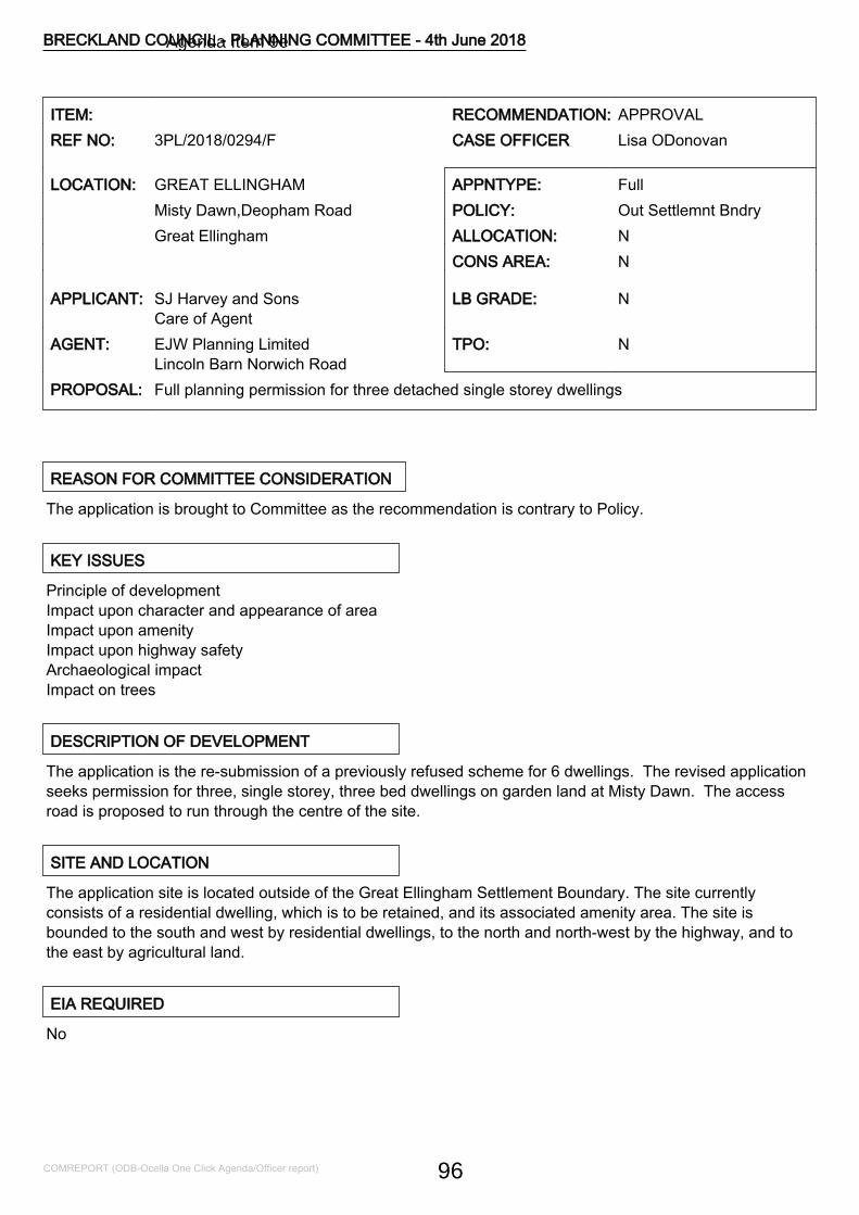
ITEM: RECOMMENDATION: APPROVALREF NO: 3PL/2018/0294/F CASE OFFICER Lisa ODonovan
LOCATION: GREAT ELLINGHAM APPNTYPE: FullMisty Dawn,Deopham Road POLICY: Out Settlemnt BndryGreat Ellingham ALLOCATION: N
CONS AREA: N
APPLICANT: SJ Harvey and SonsCare of Agent
LB GRADE: N
AGENT: EJW Planning LimitedLincoln Barn Norwich Road
TPO: N
PROPOSAL: Full planning permission for three detached single storey dwellings
REASON FOR COMMITTEE CONSIDERATION
The application is brought to Committee as the recommendation is contrary to Policy.
KEY ISSUES
Principle of developmentImpact upon character and appearance of areaImpact upon amenityImpact upon highway safetyArchaeological impactImpact on trees
DESCRIPTION OF DEVELOPMENT
The application is the re-submission of a previously refused scheme for 6 dwellings. The revised applicationseeks permission for three, single storey, three bed dwellings on garden land at Misty Dawn. The accessroad is proposed to run through the centre of the site.
SITE AND LOCATION
The application site is located outside of the Great Ellingham Settlement Boundary. The site currentlyconsists of a residential dwelling, which is to be retained, and its associated amenity area. The site isbounded to the south and west by residential dwellings, to the north and north-west by the highway, and tothe east by agricultural land.
EIA REQUIRED
No
BRECKLAND COUNCIL - PLANNING COMMITTEE - 4th June 2018
COMREPORT (ODB-Ocella One Click Agenda/Officer report) 96
Agenda Item 9e

RELEVANT SITE HISTORY
3PL/2017/0185/F - Erection of 6 detached bungalows with garages and a new private access road - Refusedand dismissed at appeal
POLICY CONSIDERATIONS
The following policies of the adopted Breckland Core Strategy and Development Control Policies and theadopted Site Specific Policies and Proposals Document, including the Proposals Maps, have been taken intoconsideration in the determination of this application. The provisions of the National Planning PolicyFramework and National Planning Policy Guidance have also been taken into account, where appropriate
CP.04 InfrastructureCP.14 Sustainable Rural CommunitiesDC.01 Protection of AmenityDC.02 Principles of New HousingDC.12 Trees and LandscapeDC.16 DesignDC.19 Parking ProvisionNPPF National Planning Policy FrameworkNPPG National Planning Practice GuidanceSS1 Spatial Strategy
OBLIGATIONS/CIL
Not Applicable
CONSULTATIONS
GREAT ELLINGHAM P CThe parish council object to this application on the grounds that it is outside of the settlement boundary,overdevelopment of the site and the unsuitability of the access road. Should permission be granted, in viewof Great Ellingham s dark sky status, Councillors request that a lighting clause is included in any permissiongranted. National Planning Policy Framework Clause 125 and Norfolk County Council s EnvironmentalLighting Zones Policy both recognise the importance of preserving dark landscapes and dark skies. In orderto minimise light pollution, we recommend that any outdoor lights associated with this application should be:1) fully shielded (enclosed in full cut-off flat glass fitments) 2) directed downwards (mounted horizontally tothe ground and not tilted upwards) 3) switched on only when needed (no dusk to dawn lamps) 4) white lightlow-energy lamps (LED, metal halide or fluorescent) and not orange or pink sodium sourcesNORFOLK COUNTY COUNCIL HIGHWAYSNo objection subject to conditions.CONTAMINATED LAND OFFICER
BRECKLAND COUNCIL - PLANNING COMMITTEE - 4th June 2018
COMREPORT (ODB-Ocella One Click Agenda/Officer report) 97
No objection subject to conditions.TREE AND COUNTRYSIDE CONSULTANTGiven that ownership of the trees adjacent to plot 2 has been established, I can confirm that I am happy withthe revised proposal to remove the trees shown on the basis that the small trees are either transplanted orreplaced with standard trees of the same species elsewhere within the site.
Please condition:
Operations on site shall take place in complete accordance with the revised Arboricultural ImpactAssessment (AIA), Tree Protection Plan (TPP) and Arboricultural Method Statement (AMS) submitted byGreenleaf, dated May 2018.ENVIRONMENTAL HEALTH OFFICERSThere are no objections or comments on the grounds of Environmental Protection, providing thedevelopment proceeds in line with the application details.HISTORIC ENVIRONMENT SERVICEOur comments remain largely unchanged from those we made in relation to previous applications for thissite. The proposed development site lies in close proximity to the medieval parish church and to the south ofBury Hall, a probable medieval manorial site. An inhumation cemetery of Roman date lies approximately125m to the west. There is a growing body of evidence for settlement of Anglo-Saxon date adjacent thenorthern margins of Great Ellingham. Consequently there is potential that heritage assets with archaeologicalinterest (buried archaeological remains of Roman, Anglo-Saxon and/or medieval date) will be present at thesite and that their significance will be adversely affected by the proposed development. If planningpermission is granted, we therefore ask that this be subject to a programme of archaeological work inaccordance with National Planning Policy Framework paragraph 141. In this case the programme ofarchaeological mitigatory work will commence with informative trial trenching to determine the scope andextent of any further mitigatory work that may be required (e.g. an archaeological excavation or monitoring ofgroundworks during construction). A brief for the archaeological work can be obtained from Norfolk CountyCouncil Environment Service historic environment strategy and advice team . We suggest that the followingconditions are imposed:-
REPRESENTATIONS
Site notice erected: 29-03-2018Consultations issued:21-03-2018Re-consultations issued: 23-04-2018
4 representations received raising issues/concerns in respect of: the site being outside of the settlementboundary; loss of privacy; loss of views, Inspector's previous decision. These issues are addressed in theassessment below.
ASSESSMENT NOTES
1.0 The proposal was amended during the course of the application process in order to reduce the schemefurther from four to three dwellings. This was the subject of a re-consultation.
BRECKLAND COUNCIL - PLANNING COMMITTEE - 4th June 2018
COMREPORT (ODB-Ocella One Click Agenda/Officer report) 98
1.1 The site lies outside of the Great Ellingham Settlement Boundary. For this reason the proposal conflictsin principle with Policies DC02 and CP14 of the Core Strategy and Development Control PoliciesDevelopment Plan Document, (2009), which seek to focus new housing within defined SettlementBoundaries. However, paragraph 49 of states that housing applications should be granted permission in thecontext of the presumption in favour of sustainable development.
1.2 The NPPF identifies three dimensions of sustainable development:
- Economic, in terms of building a strong economy and in particular by ensuring that sufficient land is of theright type and is available in the right places.- Social, by supporting, strong and healthy communities by providing the supply of housing required to meetfuture need in a high quality environment with accessible local services and- Environmental, through the protection and enhancement of the natural, built and historic environment.
1.3 Paragraph 8 of the NPPF also stresses that these roles should not be undertaken in isolation becausethey are mutually dependent; therefore a balanced assessment against these three roles is required.
1.4 In terms of the economic and social criteria, the proposal would provide four new dwellings and wouldtherefore make a positive, albeit small, contribution to the housing supply. The proposal would provide limitedshort-term economic benefits through labour and supply chain demand required during construction.However, given the small scale nature of the development these benefits are not considered to be significantand not definitive in this instance.
1.5 The social role of sustainable development seeks to ensure, amongst other matters, the creation of ahigh quality built environment with accessible local services. Great Ellingham is identified as a Local ServiceCentre Village and has a number of facilities to meet the day to day requirements of its residents, whichinclude a primary school, shop, post office, community hall and public house, and are all accessible from theproposed development via existing footpath provisions. The nearest town that offers services that has thepotential to meet all everyday needs, including shopping and employment is Attleborough which is locatedapproximately three miles away from the site.
1.6 In terms of public transport, a bus stop is located a short distance from the site along Attleborough Roadto the west, which is served by the 6A/X6 bus service to Norwich (checked 26-04-2018), which appears to bea regular service, this goes in favour of the development as it is likely that future occupiers will beencouraged to use public transport given its accessibility.
2.0 Impact upon character and appearance of area
2.1 The environmental role of sustainable development seeks to, in part, contribute to protecting andenhancing the natural, built and historic environment. Consideration of a development's impact on thecharacter and appearance of the area within which it is situated is, therefore, integral to the environmentaldimension of sustainable design, as is its design.
2.2 Policy DC16 requires all new development to achieve the highest standard of design. As part of this, alldesign proposals must preserve or enhance the existing character of an area. Consideration will also begiven to the density of buildings in a particular area and the landscape/townscape effect of any increaseddensity.
2.3 Environmentally, although outside the Settlement Boundary, the site is in a semi-rural location. Thereare other residential uses immediately to the south-west and a recent approval for 3 dwellings to the north of
BRECKLAND COUNCIL - PLANNING COMMITTEE - 4th June 2018
COMREPORT (ODB-Ocella One Click Agenda/Officer report) 99
the site.. Whilst this will result in some loss of character, the harm would be limited given the followingfactors:
- the visual containment of the site by existing development and established/proposed boundary hedging;- generous proportions of the site will maintain a spacious character;- given the existing garden use, the proposal would not intrude into the open countryside and the proximity ofother existing development means that the development would not be isolated; and,- the reduced scheme proposal reduces the material harm to the character and appearance of the area as itlessens ythe hard edge of development to the north-east boundary.
2.4 The combination of all of these environmental factors together and not in isolation result in the proposalsatisfying the environmental role of sustainable development.
2.5 In terms of the overall design, the scheme is considered acceptable. Three single storey dwelling areproposed. Plots 1 and 3 are identical with plot 2 being marginally different to one of the end elevations. Thesingle storey nature of development is reflective of the host dwelling, Misty Dawn and the reduced dwellingnumbers and layout relates as a spacious form of development, which again is considered reflective of thisarea of Great Ellingham, which forms the gateway to the more rural setting to the north of Deopham Road.Materials are indicated as clay pantiles with red brick and flint panelling, however preciuse details will beconditioned to ensure their acceptability. In light of these factors, the proposal is considered to accord withPolicy DC16.
2.6 The previous appeal decision is noted however, the final scheme is considered to be significantly andsufficiently reduced in order to address the harm identified. The main issues were: the suburban appearanceof a rural settlement edge (particulalrly north-eastern boundary) due to the density of development (6dwellings) the and the impact of the proposed development on nearby trees. However, as detailed within myreport, these issues are considered to have been addressed by way of a reduction in density/dwellingnumbers and also the layout, which avoids the root protection areas of nearby trees and provides betterdistances between the dwellings and trees on the boundaries.
3.0 Impact on amenity
3.1 Policy DC1 seeks to protect residential amenity and that all new development must have regard toamenity considerations and states that development will not be permitted where there are unacceptableeffects on the amenity of neighbouring residents and future occupants.
3.2 The single storey, modest nature of development (dwellings measure 5.8m to the rodge) alongside thespacious layout, generous separation distances to boundries and the orientation of the site will ensure thatthe development will not result in overshadowing or a dominant form of development to the neighbouringoccupiers and the internal layouts proposed will ensure that overlooking will not be significant. The proposalalso provides each plot with a good degree of private amenity space. In light of the above, the application isconsidered to have due regard to Policy DC1.
3.3 In terms of the issues raised in respect of loss of views, this is not a material planning consideration.
4.0 Impact on highway safety
4.1 Policy CP4 of the Core strategy seeks to ensure that all access and safety concerns are resolved in newdevelopments. Policy DC19 requires sufficient Parking for all new development. The application provides,access, parking and turning for all of the dwelling. Following amendments, the Highway Authority considers
BRECKLAND COUNCIL - PLANNING COMMITTEE - 4th June 2018
COMREPORT (ODB-Ocella One Click Agenda/Officer report) 100
that the submission is acceptable subject to conditions. The application is considered to accord with PoliciesCP4 and DC19.
5.0 Archaeological impact
5.1 Policy DC17 seeks to protect sites of archaeological interest. The Historic Environemnt Service wereconsulted and advised that the proposed development site lies in close proximity to the medieval parishchurch and to the south of Bury Hall, a probable medieval manorial site. An inhumation cemetery of Romandate lies approximately 125m to the west.
5.2 There is a growing body of evidence for settlement of Anglo-Saxon date adjacent the northern marginsof Great Ellingham.
5.3 Consequently there is potential that heritage assets with archaeological interest (buried archaeologicalremains of Roman, Anglo-Saxon and/or medieval date) will be present at the site and that their significancewill be adversely affected by the proposed development.
5.4 They subsequently advised that if planning permission is granted, that this be subject to a programmeof archaeological work in accordance with National Planning Policy Framework paragraph 141. This workcan be adequatey required via condition, which will be attached to any forthcoming approval.
6.0 Impact on trees
6.1 Policy DC12 seeks to preserve the District's trees, hedgerows and other natural features and secureappropriate landscaping schemes to mitigate the impact of, and complement, new development. None of thetrees are the subject of a Tree Preservation Order. Concerns were raised by the Tree and CountrysideOfficer in respect of Plot 2, and the proximity of the trees along the north-east boundary. During the courseof the application process it was agreed that these trees would be removed and re-planted within the site inorder to protect their loss as a result of the occupation of the proposed dwelling. This solution has beenaccepted by the Tree and Countryside Officer and the proposal is considered to have due regard to PolicyDC12.
7.0 Conclusion
7.1 In terms of the overall planning balance of the scheme whilst the proposed development would belocated just outside of the settlement boundary, as the Council does not currently have a 5year land supplyparagraph 49 of the Framework establishes that the relevant policies for the supply of housing should not beconsidered to be up to date. Paragraph 14 of the Framework states that in these cases permission should begranted unless the adverse impacts would significantly and demonstrably outweigh the benefits, whenassessed against the Framework taken as a whole. In terms of the overall planning balance of the scheme,the application site is considered to meet the test of sustainability as defined within paragraph 7 of the NPPFand the proposed dwellings on balance are not considered to significantly impact on the character andappearance of the area or the amenity of the existing and future residents and no other material factors havearisen that would preclude development as a result of the consultation process, the application is thereforerecommended for approval.
7.2 In terms of the previous Inspector's decision, it should be noted that he did not deem the siteunsustainable and refused the application on the basis that it formed a hard/urban settlement edge. It isconsidered that the reduction in housing numbers from 6 to 3 reduces this impact, alongside adequateboundary screening, the proposal is considered to address these concerns and the balance is tipped toward
BRECKLAND COUNCIL - PLANNING COMMITTEE - 4th June 2018
COMREPORT (ODB-Ocella One Click Agenda/Officer report) 101
approval given the lack of 5 year housing supply and the sustainable location.
RECOMMENDATION Planning Permission
CONDITIONS
1 Full Permission Time Limit (2 years)The development must be begun not later than the expiration of TWO YEARS beginningwith the date of this permission.Reason for condition:-As required by section 91 of the Town & Country Planning Act 1990 (as amended) and toensure the deliverability of the scheme to contribute to the five year housing land supply.
2 In accordance with submitted plans NEW 2017The development must be carried out in strict accordance with the application form, andapproved documents and drawings as set out in the table at the end of this notice.Reason for condition:-To ensure the satisfactory development of the site.
3 External wall and roof materials to be agreedNo development beyond slab level shall take place until precise details, (including sampleswhere required), of the materials used in the construction of the external walls and roof(s) ofthe development hereby permitted have been submitted to and approved in writing by theLocal Planning Authority. This condition shall apply notwithstanding any indication as tothese matters that have been given in the current application. The materials to be used inthe development shall be in accordance with the approved details.Reason for condition:-To enable the Local Planning Authority to control the colour, tone, texture and appearance ofthe materials used to ensure the satisfactory appearance of the development, as required byPolicy DC 1 and DC 16 of the Adopted Core Strategy and Development Control PoliciesDevelopment Plan Document 2009.This condition will require to be discharged
4 Provision of visibility splay on approved planPrior to the first occupation of the development hereby permitted visibility splays shall beprovided in full accordance with the details indicated on the approved plan. The splays shallthereafter be maintained at all times free from any obstruction exceeding 0.6 metres abovethe level of the adjacent highway carriageway.Reason for condition:-In the interests of highway safety.
5 New access - construction over vergePrior to the first occupation of the development hereby permitted the vehicular access shallbe provided and thereafter retained at the position shown on the approved plan inaccordance with the highway specification Dwg. No. TRAD 1. Arrangements shall be madefor surface water drainage to be intercepted and disposed of separately so that it does notdischarge from or onto the highway carriageway.Reason for condition:-To ensure satisfactory access into the site and avoid carriage of extraneous material ofsurface water from or onto the highway.
BRECKLAND COUNCIL - PLANNING COMMITTEE - 4th June 2018
COMREPORT (ODB-Ocella One Click Agenda/Officer report) 102

6 Provision of parking and servicing - when shownon planPrior to the first occupation of the development hereby permitted the proposed access,parking and turning area shall be laid out, demarcated, levelled, surfaced and drained inaccordance with the approved plan and retained thereafter available for that specific use.Reason for condition:-To ensure the permanent availability of the parking / manoeuvring area, in the interests ofhighway safety.
7 Highway improvements-offsite ANotwithstanding the details indicated on the submitted drawings no works shall commenceon site above slab level until a detailed scheme for the off-site highway improvement worksas indicated on drawing number TL-3998-18-1C have been submitted to and approved inwriting by the Local Planning Authority. Such works shall include, but not be limited to, thewidening of Deopham Road to 4.8m and the provision of a footway from the site toAttleborough RoadReason for condition:-To ensure that the highway improvement works are designed to an appropriate standard inthe interest of highway safety and to protect the environment of the local highway corridor.This condition will require to be discharged
8 Highway improvements off-site BPrior to the first occupation of the development hereby permitted the off-site highwayimprovement works referred to in Part A of this condition shall be completed to the writtensatisfaction of the Local Planning Authority.Reason for condition:-To ensure that the highway network is adequate to cater for the development proposed.
9 Contaminated Land - SiteInvestigation/RemediationUnless otherwise agreed in writing, the following details shall be submitted to and approvedin writing by the Local Planning Authority prior to the commencement of the developmenthereby approved:A. Site InvestigationA site investigation and risk assessment to determine the nature and extent of anycontamination on the site, whether or not it originates on the site. The investigation and riskassessment must be undertaken by competent persons and a written report of the findingsmust be produced. The report of the findings must include: (i) a survey of the extent, scaleand nature of contamination; (ii) an assessment of the potential risks to: human health,property (existing or proposed) including buildings, crops, livestock, pets, woodland andservice lines and pipes, adjoining land, groundwaters and surface waters, ecologicalsystems, archaeological sites and ancient monuments; (iii) an appraisal of remedial options,and proposal of the preferred option(s).B. Remediation SchemeA detailed remediation scheme to bring the site to a condition suitable for the intended useby removing unacceptable risks to human health, buildings and other property and thenatural and historical environment. The scheme must include all works to be undertaken,proposed remediation objectives and remediation criteria, timetable of works and sitemanagement procedures. The scheme must ensure that the site will not qualify ascontaminated land under Part 2A of the Environmental Protection Act 1990 in relation to the
BRECKLAND COUNCIL - PLANNING COMMITTEE - 4th June 2018
COMREPORT (ODB-Ocella One Click Agenda/Officer report) 103
intended use of the land after remediation.C. Implementation of Approved Remediation SchemeThe approved remediation scheme must be carried out in accordance with its terms prior tothe commencement of development, unless otherwise agreed in writing by the LocalPlanning Authority. The Local Planning Authority must be given two weeks writtennotification of commencement of the remediation scheme works.Following completion of measures identified in the approved remediation scheme, averification report (referred to in PPS23 as a validation report) that demonstrates theeffectiveness of the remediation carried out must be submitted to and approved in writing bythe Local Planning Authority.The above must be conducted in accordance with DEFRA and the Environment Agency's'Model Procedures for the Management of Land Contamination, CLR 11'.Reason for condition:-To ensure that risks from land contamination to the future users of the land andneighbouring land are minimised, together with those to controlled waters, property andecological systems, and to ensure that the development can be carried out safely withoutunacceptable risks to workers, neighbours and other offsite receptors.INFORMATIVE:-Land contamination risk assessment is a step-by-step process. During the course of the riskassessment process set out in the above condition, it may become clear that no further workis necessary to address land contamination risks. Where this is the case the condition maybe discharged by the Council without all the steps specified being completed. In all caseswritten confirmation should be obtained from the Council confirming that the requirements ofthe condition have been met.This condition will require to be discharged
10 Contaminated Land - UnexpectedContaminationIn the event that contamination is found at any time when carrying out the approveddevelopment that was not previously identified it must be reported in writing immediately tothe Local Planning Authority. An investigation and risk assessment must be undertaken inaccordance with details to be agreed in writing with the Local Planning Authority. Whereremediation is necessary, a remediation scheme must be submitted to and approved inwriting by the Local Planning Authority. Following completion of measures identified in theapproved remediation scheme a verification report shall be submitted to and approved inwriting by the Local Planning Authority.Reason for condition:-To ensure that risks from land contamination to the future users of the land andneighbouring land are minimised, together with those to controlled waters, property andecological systems, and to ensure that the development can be carried out safely withoutunacceptable risks to workers, neighbours and other offsite receptors.This condition is imposed in accordance with CP9 of the Breckland Adopted Core Strategy.This condition will require to be discharged
11 Archaeological work to be agreedNo development shall take place until:A) an archaeological written scheme of investigation has been submitted to and approved bythe local planning authority in writing. The scheme shall include an assessment ofsignificance andresearch questions; and 1) The programme and methodology of site investigation and
BRECKLAND COUNCIL - PLANNING COMMITTEE - 4th June 2018
COMREPORT (ODB-Ocella One Click Agenda/Officer report) 104
recording, 2) The programme for post investigation assessment, 3) Provision to be made foranalysis of the site investigation and recording, 4) Provision to be made for publication anddissemination of the analysis and records of the site investigation, 5) Provision to be madefor archive deposition of the analysis and records of the site investigation and 6) Nominationof a competent person or persons/organization to undertake the works set out within thewritten scheme of investigation.and,B) No development shall take place other than in accordance with the written scheme ofinvestigation approved under part (A).and,C) The development shall not be occupied until the site investigation and post investigationassessment has been completed in accordance with the programme set out in thearchaeological written scheme of investigation approved under part (A) and the provision tobe made for analysis, publication and dissemination of results and archive deposition hasbeen secured.Reason for condition:-To ensure the potential archaeological interest of the site is investigated in accordance withpolicy DC 17 of the Adopted Core Strategy and Development Control Policies DevelopmentPlan Document 2009.This condition will require to be discharged
12 Boundary treatment/screening to be agreedPrior to the occupation of the development hereby permitted a plan indicating the positions,design, materials and type of boundary treatment/screening to be erected shall be submittedto and approved in writing by the Local Planning Authority. The boundarytreatment/screening shall be completed before the building(s) are first occupied.Development shall be carried out in its entirety in accordance with the approved details.Reason for condition:-In the interests of the satisfactory appearance of the development in accordance with policyDC 16 of the Adopted Core Strategy and Development Control Policies Development PlanDocument 2009.This condition will require to be discharged
13 Tree ProtectionOperations on site shall take place in complete accordance with the revised ArboriculturalImpact Assessment (AIA), Tree Protection Plan (TPP) and Arboricultural Method Statement(AMS) submitted by Greenleaf, dated May 2018.. No other operations shall commence onsite in connection with the development until the tree protection works and any pre-emptivetree works required by the approved AIA or AMS have been carried out and all treeprotection barriers are in place as indicated on the TPP. The protective fencing shall beretained in a good and effective condition for the duration of the construction of thedevelopment and shall not be moved or removed, temporarily or otherwise, until all siteworks have been completed and all equipment, machinery and surplus materials removedfrom site, unless the prior written approval of the local planning authority has been soughtand obtained.Reason for condition:-In order to safeguard the protection of trees from the outset of the development, inaccordance with Policy DC 12 of the Adopted Core Strategy and Development ControlPolicies Development Plan Document 2009.
14 Replacement trees
BRECKLAND COUNCIL - PLANNING COMMITTEE - 4th June 2018
COMREPORT (ODB-Ocella One Click Agenda/Officer report) 105
Prior to the first occupation of the dwellings hereby approved, the trees proposed forremoval alongside Plot 2 shall be either transplanted or replaced with standard trees of thesame species in a suitable position within the site and details submitted to and agreed by theLocal Planning Authority.Reason for condition:-In order to properly mitigate the loss of trees to allow for development, in accordance withPolicy DC 12 of the Adopted Core Strategy and Development Control Policies DevelopmentPlan Document 2009.
15 Lighting PollutionFull details of all external lighting provision which shall be designed to prevent light pollutionof the night sky and the surrounding area shall be submitted to and approved in writing bythe Local Planning Authority prior to the occupation of the development. Only that lightingwhich has been so agreed shall be erected or installed.Reason for condition:-To ensure the satisfactory development of the site and to avoid excessive light pollutionhaving regard to paragraph 125 of the NPPF and Great Ellingham's 'Dark Sky' status.This condition will require to be discharged
19 Variation of approved plansAny variation from the approved plans following commencement of the development,irrespective of the degree of variation, will constitute unauthorised development and may beliable to enforcement action.You or your agent or any person responsible for implementing this permission should informthe Development Control Section immediately of any proposed variation from the approvedplans and ask to be advised to the best method to resolve the matter. Most proposals forvariation to the approved plans will require the submission of a new application.
BRECKLAND COUNCIL - PLANNING COMMITTEE - 4th June 2018
COMREPORT (ODB-Ocella One Click Agenda/Officer report) 106
ITEM: RECOMMENDATION: APPROVALREF NO: 3PL/2017/1574/O CASE OFFICER Jon Berry
LOCATION: HOCKERING APPNTYPE: OutlineLand west of Heath Road,Heath Road POLICY: Out Settlemnt BndryHockering ALLOCATION: N
CONS AREA: N
APPLICANT: Mr & Mrs MonkC/o agent
LB GRADE: N
AGENT: Locus Planning LtdDBH 17A Diss Business Hub
TPO: Y
PROPOSAL: Application for outline planning permission for the development of up to 28 dwellings withassociated works including vehicular and pedestrian access, pedestrian links, infrastructureand landscaping
REASON FOR COMMITTEE CONSIDERATION
The proposal involves a major development outside of a settlement boundary.
KEY ISSUES
Principle of development/sustainabilityLandscape, character and appearance of the areaDesign and layoutAccess and highway impactImpact on amenityOther matters - ecology, flood risk, archaeology, contamination and representations.
DESCRIPTION OF DEVELOPMENT
Consent is sought at outline stage to construct 28 dwellings with associated ancillary works within the site.An indicative plan has been submitted demonstrating a potential layout. A single point of access would beprovided onto Heath Road. The plans illustrate a mix of detached, semi-detached and terrace dwellings, andsuggest some would be served by garages with other properties served by parking courts. A central estateroad, roughly T shaped, would serve the development. Under this plan a row of dwellings would front HeathRoad with a cul-de-sac arrangement further into the site.
SITE AND LOCATION
The site extends to approximately 1.6 hectares of agriculture land. The plot is irregularly shaped, playingfields exist to the north and the site skirts around the southern and eastern boundaries of the playing fields.Boundaries are relatively well screened by existing trees and hedgerows. The site fronts the highway on itssouth-eastern flank and there are residential properties to the south west and on the opposite side of the
BRECKLAND COUNCIL - PLANNING COMMITTEE - 4th June 2018
COMREPORT (ODB-Ocella One Click Agenda/Officer report) 107
Agenda Item 9f
road, predominantly red brick post-war developments. There is another row of dwellings to the north of thesite, divorced form the settlement by the site.
The site lies outside the designated settlement boundary of Hockering, though it does adjoin the settlementboundary. Hockering is designated in the Local Plan as a rural village. Local services do exist however,including a primary school, church/village hall, shop/post office public house and there are some localbusinesses. Breckland Council is in the process of preparing a new Local Plan, which has recently beenthrough Examination in Public. The emerging Local Plan designates Hockering as a Local Service Centre,suitable for housing growth. The site, as detailed in the planning history, has been the subject of previousapplications for residential development.
A footway is provided on the western side of Heath Road that connects the proposal site to the services andfacilities within Hockering. The town of Dereham is located approximately 5 miles to the west and the city ofNorwich is approximately 6 miles to the east. There is a local bus service serving these nearby settlements.The A47 passes just to the south of the settlement providing easy access to the country's motorway network.A Public Right of Way (PROW), Hockering FP9, passes within the site on the western flank. The HockeringWood SSSI is located to the north west of the site.
EIA REQUIRED
No
RELEVANT SITE HISTORY
3PL/2017/1534/F - Construction of 8 residential dwellings. Approved - 15th February 2018.3PL/2017/0887/D - Reserved Matters application for 18 dwellings - Undetermined.3PL/2017/0600/O - Outline permission for 8 dwellings. Approved - 2nd August 2017.3PL/2014/0945/O - Outline approval for 18 dwellings. Approved - 24th July 2015.
POLICY CONSIDERATIONS
The following policies of the adopted Breckland Core Strategy and Development Control Policies and theadopted Site Specific Policies and Proposals Document, including the Proposals Maps, have been taken intoconsideration in the determination of this application. The provisions of the National Planning PolicyFramework and National Planning Policy Guidance have also been taken into account, where appropriateCP.1 HousingCP.10 Natural EnvironmentCP.05 Developer ContributionsCP.06 Green InfrastructureCP.11 Protection and Enhancement of the LandscapeCP.14 Sustainable Rural CommunitiesDC.01 Protection of AmenityDC.02 Principles of New HousingDC.04 Affordable Housing PrinciplesDC.11 Open SpaceDC.12 Trees and LandscapeDC.13 Flood RiskDC.16 DesignDC.17 Historic Environment
BRECKLAND COUNCIL - PLANNING COMMITTEE - 4th June 2018
COMREPORT (ODB-Ocella One Click Agenda/Officer report) 108
DC.19 Parking ProvisionSS1 Spatial StrategyNPPF National Planning Policy FrameworkNPPG National Planning Practice Guidance
OBLIGATIONS/CIL
The following requirements would need to be secured by a suitable legal agreement;
- Open space contribution- Affordable housing (in conjunction with the Housing Enabling Officer's advice)- Education contributions as per NCC advice- Library service provision- Green Infrastructure- Public Rights Of Upgrades
CONSULTATIONS
HOCKERING P CThe Parish voted unanimously to oppose this application as this is one development too many for the villagewhich has now almost fulfilled its quota of houses up to 2036 of 68 houses. There are concerns over accesswith this proposal and the increase in traffic using Heath Road. The area, which backs onto Lily Avenue, isprone to major flooding as local residents can testify. The parish is concerned about the environmentalissues with all these developments in Hockering. The devastation caused by the current developments hasyet to be fully realised but the village would like to retain some element of its rural nature and feels that it hasfulfilled its obligation to provide low-cost housing in the area. Yet more low-cost housing will not provide theproper mix in the village.ENVIRONMENT AGENCYNo objections to the proposal. The site is located above a Principal Aquifer and within Source ProtectionZone (SPZ) 3. However, this proposal is not considered to be High Risk. The water environment is potentiallyvulnerable and there is an increased potential for pollution from inappropriately located and/or designedinfiltration (SuDS). Any infiltration (SuDS) greater than 2.0 m below ground level is considered to be a deepsystem and generally not acceptable. If the use of deep bore soakaways is proposed the Agency should bere-consulted.ANGLIAN WATER SERVICEThe foul drainage from this development is in the catchment of Hockney Water Recycling Centre that willhave available capacity for these flows. The sewerage system at present has available capacity for theseflows.HISTORIC ENVIRONMENT SERVICEArchaeological mitigation has previously been recommended for this site (3PL/2017/0887/D) but thatprevious condition is not required for this new application. The archaeological mitigation has been started inthe northern part of 3PL/2017/0887/D and has not produced evidence of enough archaeological activity tojustify continued investigations within the present application area (3PL/2017/1574/O).RAMBLERS ASSOCIATION: NORFOLK AREAThe confirmation in the Design and Access Statement that the proposal would not prejudice the use of the
BRECKLAND COUNCIL - PLANNING COMMITTEE - 4th June 2018
COMREPORT (ODB-Ocella One Click Agenda/Officer report) 109
existing public footpath to the south-western boundary of the proposal site is welcomed. No objection.NATURAL ENGLANDNo objection to the scheme subject to suitable mitigation which ensures that the Hockering Wood Site ofSpecial Scientific Interest (SSSI) has been accounted for and does not lead to adverse effects on protectedspecies, particularly bats.CRIME REDUCTION & ARCHITECTURAL LIAISON OFFICERClarification is required on whether the existing public right of way footpath is being re-routed through thedevelopment. Unobserved parking areas (as suggested for plots 1-4, 8 bays) were a design feature of thelast century and still provide a legacy and burden on the Constabulary. To work in harmony with high levelsof natural surveillance, a carefully designed lighting plan to cover all vulnerable areas should be in place. Thehomes themselves should be designed to incorporate the Part Two Physical Security elements of theSecured by Design Award detailed in the guide. The correct security measures need to be out in place toensure the construction of the development does not negatively impact on the neighbourhood. Officers wouldbe pleased to work with the agent or developer to ensure that the proposed development incorporates all ofthe required elements.PUBLIC RIGHTS OF WAY OFFICERA Public Right of Way, known as Hockering footpath 1, is aligned along the western boundary of the site.Detailed plans are required of the layout and proposed boundary structures to ensure the full legal extent ofthis Public Footpath remains open and accessible for the duration of the development and subsequentoccupation.NORFOLK COUNTY COUNCIL HIGHWAYSNegotiations have taken place between the Highways Officer and the transport consultants acting on behalfof the Applicant throughout the course of the planning application. Agreement has been reached regardingthe road safety measures to be implemented and final comments will be reported at the meeting.OBLIGATIONS OFFICER, NORFOLK COUNTY COUNCILThe requirements below would need to be addressed in order to make the development acceptable insustainable terms through the delivery of necessary infrastructure. The funding of this infrastructure would bethrough Planning obligations / condition.
EducationThere is spare capacity at Primary and High school levels but there is no local childcare in the EarlyEducation sector, therefore County Children's Services will be seeking developer contributions in line withcosts set out within this correspondence.
The contributions will be used to fund the following project:Identified projects- Early Education- Nursery place accommodation for new Early Years provision.
Library ProvisionA development of 28 dwellings would place increased pressure on the existing library service particularly inrelation to library stock, such as books and information technology. This stock is required to increase thecapacity of the library. It has been calculated that a development of this scale would require a totalcontribution of 2,100 pounds (75 per dwelling). This will go towards library stock and equipment for mobileservice.
Fire Service
BRECKLAND COUNCIL - PLANNING COMMITTEE - 4th June 2018
COMREPORT (ODB-Ocella One Click Agenda/Officer report) 110
1 fire hydrant required.
Green InfrastructureA maintenance/mitigation contribution or commuted sum for new and existing GI features may be required inaddition to the County response in order to comply with local policy.
Hockering FP1Hockering FP1 runs adjacent to the south western boundary of the site. The connection from thedevelopment to this existing Public Right of Way is supported. However due to the increased footfall thisdevelopment will generate, contributions will likely be required to upgrade the surfacing of this footpath.Improved signage to this footpath is required within the adjacent estate to the south and on Heath Road. Dueto the proximity and connectivity of this site to Hockering Wood SSSI, the local planning authority may wishto consider mitigation or a contribution towards mitigation, appropriate to the scale of development.FLOOD & WATER MANAGEMENT TEAMOfficers have screened this application and it falls below the current threshold for providing detailedcomment. This is because the proposal is for less than 100 dwellings or 2 ha in size and is not within asurface water flow path as defined by Environment Agency mapping.TREE AND COUNTRYSIDE CONSULTANTNo objection in principle although minor adjustments will be required in order to create more distancebetween dwellings and trees.HOUSING ENABLING OFFICERThe site area and number of dwellings proposed trigger the thresholds of the Council s affordable housingpolicy as per policy DC4.
At present a 40% provision is required on sites capable of accommodating 5 or more dwellings and/or0.17ha. This is then further split into 65% being made available for rent and 35% for shared ownership,shared equity or any other intermediate product that meets the intermediate definition within NPPF, meets anidentified need in the District and is agreed by the Council. However, NPPG states that affordable housingshould not be sought on developments of fewer than 11 units with a combined floorspace of less than1000sqm. In this instance 11 units would be required, 7 for rent and 4 for intermediate housing.
The affordable housing mix will need to be addressed in the reserved matters application. It is recommendedthat, in order to best meet an identified housing need, mainly smaller units are provided.KIRSTY MALLETTThe Council has transferred the adjacent play area to the south west of this planned development to theParish Council. The applicants should ensure that the development land is not subject to any restrictivecovenants in favour of the Council and should contact Facilities Management if there are any restrictionswhich they need to request to be removed.ECOLOGICAL AND BIODIVERSITY CONSULTANTThe following conditions are recommended:- If any arboricultural works on trees are proposed then a further bat survey and inspection will be requiredprior to any works taking place.- A pre-construction badger check needs to be undertaken prior to works commencing on site.- Vegetation clearance needs to be subject to a timing constraint.- An Ecological Management Plan (EMP) needs to be submitted to, and approved in writing by the LPA priorto commencement of development.- A Construction Environmental Management Plan (CEMP) needs to be submitted to and approved in writing
BRECKLAND COUNCIL - PLANNING COMMITTEE - 4th June 2018
COMREPORT (ODB-Ocella One Click Agenda/Officer report) 111
by the local planning authority.ENVIRONMENTAL HEALTH OFFICERSThe proposed houses will be on the boundary with the existing football/recreational area. These recreationalareas do generate noise when in use and this will be audible in the gardens and houses.
The proposed Western houses will be close to the flood lit area of the fenced hard court. There could benoise and light pollution affecting the proposed houses and prior agreement with the owners of therecreational site is recommended as changes to the old lighting may be required.CONTAMINATED LAND OFFICERIt is recommended that a land contamination assessment is secured by condition.AIR QUALITY OFFICERNo objections on the grounds of Local Air Quality Management.CPRE NORFOLKThe site is outside the settlement boundary and therefore the proposal is contrary to policy. The village hasalmost met its plan designations for housing. The proposal will take further development into the countrysidethan existing approvals. Although Breckland does not currently have a five-year supply for land for housing,the negative impacts of this scheme outweigh this consideration, especially as the development lies outsidethe settlement boundary. There is case law which supports giving determining weight to existing policieswhich restrict development.
NORFOLK RIVERS INTERNAL DRAINAGE BOARD No Comments ReceivedNATIONAL GRID No Comments ReceivedNORFOLK WILDLIFE TRUST No Comments ReceivedCOMMUNITY DEVELOPMENT OFFICER No Comments ReceivedENVIRONMENTAL PLANNING No Comments ReceivedENVIRONMENTAL SERVICES OFFICER No Comments ReceivedOPEN SPACES SOCIETY No Comments Received
REPRESENTATIONS
The application was advertised in the local press, site notice displayed at the site and letters sent toneighbouring residents. No representations were received.
ASSESSMENT NOTES
ASSESSMENT NOTES
1.1 Principle of the Development/Introduction
1.1 As outlined above there is a recent planning history relating to the site, including extant permissions.Application 3PL/2014/0945/O agreed the principle and granted consent for 18 dwellings on an albeit reducedsite. Recent outline and full permissions have agreed the development of the front, narrower section of thesite along Heath Road, for 8 dwellings.
BRECKLAND COUNCIL - PLANNING COMMITTEE - 4th June 2018
COMREPORT (ODB-Ocella One Click Agenda/Officer report) 112
1.2 This application proposes developing the entire single plot of land for 28 dwellings, the application for 18dwellings had retained the most northern boundary of dwellings in line with the adjoining houses in LilyAvenue.
1.3 The site is outside the designated settlement boundary. For this reason, the proposal conflicts, inprinciple, with Policies SS01, DC02 and CP14 of the adopted Core Strategy and Development ControlPolicies Development Plan Document, (2009), which seek to focus new housing within defined SettlementBoundaries. The application should therefore be refused, unless material considerations indicate otherwise inaccordance with Section 70(2) of the Town and County Planning Act, 1990.
1.4 Paragraph 49 of the NPPF, states that where an authority does not have an up-to-date five year housingland supply the relevant local policies specifically for the supply of housing, as referred to above, should notbe considered up-to-date. Housing applications should be considered in the context of the presumption infavour of sustainable development , which should be seen as the golden thread running through decisionmaking, is engaged. This means granting permission unless specific policies in the NPPF indicate thatdevelopment should be restricted or any adverse impacts of doing so would significantly and demonstrablyoutweigh the benefits, when assessed against the policies in the NPPF taken as a whole.
1.5 There is therefore a policy swing towards granting consent, often referred to as the tilted balance. As theCampaign to Protect Rural England consultation response states this does not diminish the weight of policieswhich restrict the location of housing. However the decision maker must undertake a balancing exercise toestablish if the adverse impacts significantly and demonstrably outweigh the benefits of granting consent.
1.6 The provision of housing to meet local needs is identified as a key component of sustainabledevelopment and in this respect the NPPF seeks to boost significantly the supply of housing. The NPPF alsoencourages the location of rural housing where there is access to alternative modes of transport other thanthe private car and where it will enhance or maintain the vitality of rural communities.
1.7 As paragraph 8 of the NPPF outlines, there are three strands to sustainability; economic, social andenvironmental, each mutually dependent, and not assessed in isolation from each other.
2.0 Principle of the Development/Sustainability
2.1 As outlined above the planning balance in such proposals is tilted towards an approval unless anyadverse impacts significantly and demonstrably outweigh the benefits.
2.2 The application site has a number of positive attributes which weigh in favour of granting consent. Firstlythe general principle of development for housing has been previously agreed. Whilst the site area wouldincrease, in some ways this would result in a more logical development of the entire plot of land and providenew defendable boundaries to the settlement from existing vegetation.
2.3 Whilst consultee comments allude to the proposed housing allocation for the village until 2036 (68dwellings) having been nearly met (43 completions and commitments), this includes the 18 unit scheme andthus this proposal would result in a net increase in 10 units. In any case the overarching aim of the NPPF isto boost significantly the supply of housing and this is particularly true in authority areas with anacknowledged under-supply. This site would provide defendable boundaries and would infill between LilyAvenue and the houses further along Heath Road.
2.4 The council's emerging local plan designates Hockering as a local service centre. This is in recognition of
BRECKLAND COUNCIL - PLANNING COMMITTEE - 4th June 2018
COMREPORT (ODB-Ocella One Click Agenda/Officer report) 113
local service qualities as alluded to above. Therefore unlike other rural villages, which in some cases aredevoid of any services, the village has some services and local facilities. This includes local employmentopportunities.
2.5 Furthermore relatively good transport links exist to other higher order settlements. The NPPF advises thatdevelopments generating significant amounts of traffic should be located where the need to travel will beminimised and the use of sustainable transport modes can be maximised, and where there is access to highquality public transport facilities, recognising that this will differ between rural and more urban areas. It isconsidered that sustainable transport options, although moderate, do exist providing links to higher ordersettlements including the city of Norwich. The adjacent A47 also provides good transport links to othersettlements.
2.6 The NPPF also seeks, at Paragraph 55, to locate rural housing where it will enhance and maintain thevitality of rural settlements. The NPPF also encourages the avoidance of isolated homes in the countryside.This scheme would help maintain the local services that exist in the village. Reasonable alternative transportmodes exist to avail of, and bolster, services in neighbouring settlements. Furthermore this scheme, adjacentto the village settlement boundary, will avoid isolated homes in the countryside, in the provision of ruralhousing.
2.7 The scheme will provide 40% affordable housing in line with adopted policy. The social benefits ofproviding choice in the local housing market must carry appropriate weight. There are moderate economicbenefits in the short term economic activity which would be generated during the construction/disposal phaseof development. Longer term economic benefits would be engendered for the village and further afield withthe creation of new households.
2.8 It is therefore considered that the site and specific characteristics of Hockering deem it potentially suitablefor such a development and this must carry significant weight. Officers have identified additional sustainabilityattributes which render Hockering more suitable than other similar village settlements, for more than nominalgrowth. Ultimately each site will involve a similar balancing exercise and the exercising of planningjudgement.
2.9 The site will result in the development of a currently greenfield site, and this goes against one of the coreplanning aims of the NPPF which is to recycle and make the best use of previously developed land. Conflictwith local spatial policies and the desire to protect the landscape of the district must also be affordedappropriate weight in any planning balance.
2.10 In relation to such a planning balance it is considered that in this case the significant benefits of thedevelopment outweigh any demonstrable harm. Subject to finding relative favour on other materialconsiderations, the general principle of the development can be accepted.
3.0 Landscape, Character and Appearance of the Area
3.1 Policy CP11 of the Core Strategy seeks to ensure that the landscape of the district will be protected forthe sake of its own intrinsic beauty and its benefit to the rural character.Development within the district is also expected to be of the highest design quality in terms of botharchitecture and landscape. It should have regard to good practice in urban design and fully consider thecontext within which it sits, embracing opportunities to enhance the character and appearance of an area.
3.2 Whilst the village is typically rural the front of the site will infill between existing housing. It is acceptedthat the site area for development will increase, though as stated above defendable boundaries will be
BRECKLAND COUNCIL - PLANNING COMMITTEE - 4th June 2018
COMREPORT (ODB-Ocella One Click Agenda/Officer report) 114
retainable. The Breckland Landscape Character Assessment shows that the entire village is situated withinthe Landscape Character Area 'River Tud '. Hockering Wood, situated to the north west of the settlement, isan ancient woodland and a designated SSSI.
3.3 Whilst the inevitable impacts and change in character incumbent of such development on greenfield sitesmust be acknowledged, the site is located on the edge of the settlement and any new development will betempered in this context. The site is relatively low set and any effects will therefore be localised in impact.Boundary screening and the augmentation of boundaries with additional planting will further alleviate impact.The backdrop of a hedgerow to the south of the playing fields and the hedge along the road, and vegetationon the opposite side of Heath Road, would help maintain the generally rural character of the road. Theproposal is in general compliance with Policy CP11.
3.4 As detailed above impact on the landscape is one, albeit critical, consideration in an overall planningbalance. The moderate impacts on the landscape in this case are outweighed by the significant benefits ofthe scheme, identified above.
4.0 Design and Layout
4.1 Design and layout would be a matter reserved for detailed consideration later. At this stage there are noapparent reasons to restrict the details, massing, scale or ridge levels. There appears no reason why a twostorey development would not be suitable. Any scheme should provide an appropriate mix of dwelling typesand sizes and finishes drawn for the local palette of materials. Future control over this will be controlled underany reserved matters application. Norfolk Constabulary has raised discussion on the detailed design of thelayout and suggests Secured by Design improvements. The future involvement of the constabulary, assuggested, when the detailed design on any approved scheme is tied down, is deemed necessary. Theapplicant is advised to accept the invitation if consent is granted. On the limited information at this stage thescheme is not considered to conflict with DC.16.
4.2 The indicative plan submitted in support of the application suggests the site could accommodate 28dwellings whilst providing suitable levels of private amenity space, parking and the incumbent ancillaryrequirements such as adequate access and turning facilities. Whilst plots to the front along Heath Roadwould be more constrained, they would still provide suitable levels of accommodation for future residents.The majority of plots would be relatively spacious and a suitable mix of unit sizes appears feasible. PolicyDC.02 of the Core Strategy aims for a density of 22-30 units per hectare at settlement edges. 28 units on asite of this size would result in a dph of 17.5, which is reasonable and commensurate with existing estatedevelopments nearby. The layout is in compliance with DC.02.
4.3 Policy DC.11 of the Local Plan requires in certain circumstances the provision of appropriate outdooramenity space. For developments of 25 dwellings or more, or on sitesof 0.8ha or more, open space should be provided on site with priority given to children's play space.
The Applicant has been informed of this requirement and has confirmed in writing acceptance of a planningcondition to secure an area of outdoor play space, comprising a Local Area of Play (LAP) covering aminimum of 100 square metres, to meet the requirements set out under Policy DC.11. This will be shown onthe detailed layout for the reserved matters application and is likely to replace the central area of landscapingshown on the indicative plan.
5.0 Residential Amenity
5.1 As detailed above the scheme appears capable of providing suitably for 28 units. There are no obvious
BRECKLAND COUNCIL - PLANNING COMMITTEE - 4th June 2018
COMREPORT (ODB-Ocella One Click Agenda/Officer report) 115
on-site amenity problems. Furthermore the site could be suitably developed to avoid impact on existingresidents of any particularly intrusive nature. The Environmental Health section has raised the issue ofpotential impacts on neighbour amenity from the adjoining playing fields. Whilst the potential for noisedisturbance should not be down played, any impacts would be sporadic and balanced with the positiveattributes of the scheme could only be afforded limited weight. Reasonable areas of private amenity spacecould be provided for each occupant of the new dwellings. The scheme conforms to policy DC.01.
6.0 Access and highway impact
6.1 There have been ongoing consultations between the applicant and Norfolk County Council HighwaysAuthority. Following the most recent discussions in May a revised illustrative layout has been receivedaccounting for amendments requested by the Highways Officers. The following changes have been made:
- Main site access moved further north to ensure traffic calming feature remains unaffected.- Main site access shown as a Type 6 Road.- Main site access shown as a drop kerb to Norfolk County Council specification for a type 6 road.- Vertical deflections removed and horizontal feature added to slow down traffic.- Illustrative layout plan updated to include off site works to existing footway links, comprising the instalmentof additional pedestrian crossing points on Heath Road and replacement of existing cycle/ pedestrian barriersto Norfolk County Council specification.
The final comments of the Highway Authority and the recommended conditions will be reported to Membersof the Planning Committee on the supplementary information to be presented at the meeting.
7.0 Other Matters
S106
7.1 As detailed above the response from Norfolk County Council suggests contributions under Section 106 ofthe Town and Country Planning Act 1990. Any contributions requested must meet the tests in that they arenecessary to make the development acceptable in planning terms, are directly related to the developmentand fair and reasonably relate in scale and kind to the proposed development. The request for educationcontributions, in this case early years nursery provision, is a common enough expense generated by a newdevelopment and meets the tests. The contributions towards a fire hydrant and library facilities are alsodeemed appropriate.
7.2 Contributions towards Green Infrastructure and upgrades of the Public Right of Way (Footpath FP1) assuggested seems reasonable in light of the development of a currently greenfield site in a rural village. Use ofFP1 will increase and the supporting statement alludes to connectivity between the footpath and thedevelopment, which is a logical enhancement of the scheme. The legal integrity and unimpeded access tothe footpath, raised in a number of consultee responses, should be at the forefront of any reserved mattersapplication. Such matters would be addressed under a Reserved Matters application but the generalprinciple of the requirements is considered acceptable. On-site play space is another matter for considerationshould the principle of this scheme be agreed at outline stage.
7.3 The site area and number of dwellings proposed trigger the thresholds of the Council's affordablehousing policy as per DC.04 of the Council s Adopted Core Strategy and Development Control PoliciesDevelopment Plan Document. The council's Housing Enabling Officer has been consulted and providedcomments. At present a 40% provision is required on sites capable of accommodating 5 or more dwellingsand/or 0.17ha. This is then further split into 65% being made available for rent and 35% for shared
BRECKLAND COUNCIL - PLANNING COMMITTEE - 4th June 2018
COMREPORT (ODB-Ocella One Click Agenda/Officer report) 116
ownership, shared equity or any other intermediate product that meets the intermediate definition withinNPPF, meets an identified need in the District and is agreed by the Council.
7.4 This concludes that in this instance, based on a development of 28 dwellings, 11 affordable dwellingswould be required, 7 for rent and 4 for intermediate housing. The affordable housing mix will need to beaddressed in the reserved matters. This can be agreed by Section 106 Agreement should consent begranted by the council. The proposal accords with policy DC.04.
Flood Risk
7.5 The Parish Council has raised concern in relation to an existing flooding risk in the general area and thatthis is something the development will exacerbate. However technical advice received in relation to thismatter (Flood Risk Officer, Anglian Water) and consideration of the submitted Flood Risk Assessment andDrainage Strategy (Evans Rivers and Coastal, December 2017) suggests the scheme would not raise anyadditional risk of flooding. The site is in an area of the least risk of flooding (Floodzone 1) and is not within asurface water flowpath. There is no substantive evidence of significant flooding in the area. In light of thetechnical advice received, officers conclude that the use of modern surface water drainage systems in anarea of limited flood risk should ensure that the site itself will not be susceptible to flooding or increase therisk elsewhere. Appropriate conditions are deemed appropriate in this case to ensure accordance with policyDC.13.
Ecological Implications
7.6 The application is supported by a Preliminary Ecological Appraisal (Eco-check Consultancy, November2017). The appraisal is fit for purpose. It identifies that ecological constraints are largely restricted to thepresence of breeding birds and the likely presence of bats which could use existing trees for roosting and thesite for foraging. Natural England raises no objection to the scheme subject to mitigation. Norfolk CountyCouncil Ecologists suggest conditions agreeing;
- If any arboricultural works on trees are proposed then a further bat survey and inspection will be requiredprior to any works taking place.- A pre-construction badger check needs to be undertaken prior to works commencing on site.- Vegetation clearance needs to be subject to a timing constraint. A model condition is included below inthese comments.- An Ecological Management Plan (EMP) needs to be submitted to, and approved in writing by the LPA priorto commencement of development. A model condition is included below in these comments.- A Construction Environmental Management Plan (CEMP) needs to be submitted to and approved in writingby the local planning authority.
The application can be conditioned accordingly and the scheme therefore accords with policy CP.10.
Archaeological Implications
7.7 The Historic Environment Officer at Norfolk County Council reports on archaeological trial trenchingconducted on this development site under previous consents reporting no significant evidence ofarchaeological activity and is therefore content to advise no further archaeological work. Thereforearchaeological mitigation as a condition is not necessary in this case. The scheme therefore accords withpolicy DC.17.
Trees and Landscaping
BRECKLAND COUNCIL - PLANNING COMMITTEE - 4th June 2018
COMREPORT (ODB-Ocella One Click Agenda/Officer report) 117

7.8 A Tree Survey and tree protection statement has been submitted in support of the application. Areas ofthe indicative layout are likely to require some change, to bring dwellings further away from trees. Anamended implication assessment, method statements and tree protection plan will be required to ensurecompliance with policy DC.12 and a development which takes full account of trees and hedging, neededretained in place to ensure a soft edge to this development. Future planting plans can also be agreed by anappropriate condition
Contamination
7.9 The proposed development does not raise any significant concerns in relation to potential contamination.Conditions agreeing investigation, remediation and unexpected contamination are deemed reasonable andnecessary. The scheme is in accordance with policy DC.09.
Facilities Management
7.10 The Facilities Management section have highlighted that the Council has transferred the adjacent playarea to the south west of this planned development, to the Parish Council. The applicants should ensure thatthe development land is not subject to any restrictive covenants in favour of the Council and should contactFacilities Management if there are any restrictions which they need to request to be removed.
Representations
7.11 The council has raised a concern about the provision of low cost housing within Hockering. Theanalysis undertaken with regards to the scheme must be mindful of adopted policy, national guidance in theNPPF and case law developments. All point towards a need to boost the local supply of housing, of all typesand tenures, including a policy compliant affordable housing element. When all material considerations areweighed up, this scheme is considered an appropriate way to help meet the local housing shortfall whichcurrently exists and should include the appropriate mix.
8.0 CONCLUSION
8.1 In light of the above appraisal the proposed development is considered an appropriate way to meet theneed for housing in the district. Whilst contrary to policy, the shortfall in available land to meet housing needtriggers a presumption in favour of sustainable development as per paragraph 14 of the NPPF. This schemehas been deemed a sustainable and suitable form of development, discussed in detail within the report. Thepositive attributes of the scheme outweigh any adverse impacts. It is therefore recommended that consent isgranted subject to conditions and a suitable Section 106 Agreement to agree developer contributions.
RECOMMENDATION Outline Planning Permission
CONDITIONS
1 Outline Time Limit (3 years)Application for Approval of Reserved Matters must be made not later than the expiration ofTHREE YEARS beginning with the date of this permission, and the development must bebegun within TWO YEARS of the FINAL APPROVAL OF THE RESERVED MATTERS or, inthe case of approval at different dates, the FINAL APPROVAL OF THE LAST SUCH
BRECKLAND COUNCIL - PLANNING COMMITTEE - 4th June 2018
COMREPORT (ODB-Ocella One Click Agenda/Officer report) 118
MATTER to be approved.Reason for condition:-As required by section 92 of the Town & Country Planning Act 1990.
2 Standard Outline ConditionNo development whatsoever shall take place until the plans and descriptions giving detailsof the reserved matters referred to above shall have been submitted to and approved by theLocal Planning Authority and these plans and descriptions shall provide details of theappearance, layout, scale, access and landscaping of the development.Reason for condition:-The details are not included in the current submission.
3 Precise details of foul water disposalPrior to the commencement of any works above slab level precise details of the means offoul water disposal shall be submitted to and approved in writing by the Local PlanningAuthority.Reason for condition:-The details are required to be submitted prior to the commencement of development tominimise the possibilities of flooding from the outset of the development.This condition is imposed in accordance with Policies DC 1 and DC 13 of the Adopted CoreStrategy and Development Control Policies Development Plan Document 2009This condition will require to be discharged
4 Precise details of surface water disposalPrior to the commencement of any works above slab level precise details of the means ofsurface water disposal shall be submitted to and approved in writing by the Local PlanningAuthority. Only such agreed system or works shall be used in connection with this approval.Reason for condition:-The details are required to be submitted prior to the commencement of development tominimise the possibilities of flooding from the outset of the development.This condition is imposed in accordance with Policies DC 1 and DC 13 of the Adopted CoreStrategy and Development Control Policies Development Plan Document 2009This condition will require to be discharged
5 Soft landscaping scheme to be submittedNo development shall take place on site until full details of landscaping, which shall take intoaccount any existing trees or hedges on the site, shall be submitted to and approved inwriting by the Local Planning Authority.These details should include:-Planting plans;-Written specifications ( including cultivation and other operations associated with plant andgrass establishment);-Schedules of planting, noting species, plant sizes and proposed numbers/densities whereappropriate;-Implementation programmeThe details shall also take account of the Council's leaflet 'Tree pack' (Landscaping advicefor applicants) which is available for down load on the Council's website.Reason for condition:-In the interests of the satisfactory appearance of the development in accordance policyDC12 of the Adopted Core Strategy and Development Control Policies Development PlanDocument 2009.
BRECKLAND COUNCIL - PLANNING COMMITTEE - 4th June 2018
COMREPORT (ODB-Ocella One Click Agenda/Officer report) 119
This condition will require to be discharged6 Contaminated Land - Site
Investigation/RemediationUnless otherwise agreed in writing, the following details shall be submitted to and approvedin writing by the Local Planning Authority prior to the commencement of the developmenthereby approved:A. Site InvestigationA site investigation and risk assessment to determine the nature and extent of anycontamination on the site, whether or not it originates on the site. The investigation and riskassessment must be undertaken by competent persons and a written report of the findingsmust be produced. The report of the findings must include: (i) a survey of the extent, scaleand nature of contamination; (ii) an assessment of the potential risks to: human health,property (existing or proposed) including buildings, crops, livestock, pets, woodland andservice lines and pipes, adjoining land, groundwaters and surface waters, ecologicalsystems, archaeological sites and ancient monuments; (iii) an appraisal of remedial options,and proposal of the preferred option(s).B. Remediation SchemeA detailed remediation scheme to bring the site to a condition suitable for the intended useby removing unacceptable risks to human health, buildings and other property and thenatural and historical environment. The scheme must include all works to be undertaken,proposed remediation objectives and remediation criteria, timetable of works and sitemanagement procedures. The scheme must ensure that the site will not qualify ascontaminated land under Part 2A of the Environmental Protection Act 1990 in relation to theintended use of the land after remediation.C. Implementation of Approved Remediation SchemeThe approved remediation scheme must be carried out in accordance with its terms prior tothe commencement of development, unless otherwise agreed in writing by the LocalPlanning Authority. The Local Planning Authority must be given two weeks writtennotification of commencement of the remediation scheme works.Following completion of measures identified in the approved remediation scheme, averification report (referred to in PPS23 as a validation report) that demonstrates theeffectiveness of the remediation carried out must be submitted to and approved in writing bythe Local Planning Authority.The above must be conducted in accordance with DEFRA and the Environment Agency's'Model Procedures for the Management of Land Contamination, CLR 11'.Reason for condition:-To ensure that risks from land contamination to the future users of the land andneighbouring land are minimised, together with those to controlled waters, property andecological systems, and to ensure that the development can be carried out safely withoutunacceptable risks to workers, neighbours and other offsite receptors.INFORMATIVE:-Land contamination risk assessment is a step-by-step process. During the course of the riskassessment process set out in the above condition, it may become clear that no further workis necessary to address land contamination risks. Where this is the case the condition maybe discharged by the Council without all the steps specified being completed. In all caseswritten confirmation should be obtained from the Council confirming that the requirements ofthe condition have been met.This condition will require to be discharged
BRECKLAND COUNCIL - PLANNING COMMITTEE - 4th June 2018
COMREPORT (ODB-Ocella One Click Agenda/Officer report) 120
7 Contaminated Land - UnexpectedContaminationIn the event that contamination is found at any time when carrying out the approveddevelopment that was not previously identified it must be reported in writing immediately tothe Local Planning Authority. An investigation and risk assessment must be undertaken inaccordance with details to be agreed in writing with the Local Planning Authority. Whereremediation is necessary, a remediation scheme must be submitted to and approved inwriting by the Local Planning Authority. Following completion of measures identified in theapproved remediation scheme a verification report shall be submitted to and approved inwriting by the Local Planning Authority.Reason for condition:-To ensure that risks from land contamination to the future users of the land andneighbouring land are minimised, together with those to controlled waters, property andecological systems, and to ensure that the development can be carried out safely withoutunacceptable risks to workers, neighbours and other offsite receptors.This condition is imposed in accordance with CP9 of the Breckland Adopted Core Strategy.This condition will require to be discharged
8 Landscaping scheme to be submitted - hard andsoftNo development shall take place on site until full details of both hard and soft landscapeworks have been submitted to and approved in writing by the Local Planning Authority andthese works shall be carried out as approved. These details shall include:-hard surfacing materials;-means of enclosure;-proposed finished levels or contours;-minor artefacts and structures (e.g. furniture, play equipment, refuse or other storage units,signs, lighting etc,)Soft landscaping shall include:-Planting plans;-Written specifications ( including cultivation and other operations associated with plant andgrass establishment);-Schedules of planting, noting species, plant sizes and proposed numbers/densities whereappropriate;-Implementation programmeReason for condition:-In the interests of the satisfactory appearance of the development in accordance with policyDC12 of the Adopted Core Strategy and Development Control Policies Development PlanDocument 2009.This condition will require to be discharged
9 non standard conditionNotwithstanding the submitted plans the layout plan to be submitted for the detailedreserved matters application shall include the provision of 1 Local Area of Play (LAP) with aminimum activity zone of 100 square metres.
Reason for condition:-
To provide sufficient outdoor playing space in accordance with policy DC16 of the AdoptedCore Strategy and Development Control Policies Development Plan Document 2009.
BRECKLAND COUNCIL - PLANNING COMMITTEE - 4th June 2018
COMREPORT (ODB-Ocella One Click Agenda/Officer report) 121
10 Boundary treatment/screening to be agreedPrior to the occupation of the development hereby permitted a plan indicating the positions,design, materials and type of boundary treatment/screening to be erected shall be submittedto and approved in writing by the Local Planning Authority. The boundarytreatment/screening shall be completed before first occupation of the development.Development shall be carried out in its entirety in accordance with the approved details.Reason for condition:-In the interests of the satisfactory appearance of the development in accordance with policyDC 16 of the Adopted Core Strategy and Development Control Policies Development PlanDocument 2009.This condition will require to be discharged
11 Construction Method StatementNo development shall take place, including any works of demolition, until a ConstructionMethod Statement has been submitted to, and approved in writing by, the local planningauthority. The approved Statement shall be adhered to throughout the construction period.The Statement shall provide for:i. the parking of vehicles of site operatives and visitorsii. loading and unloading of plant and materialsiii. storage of plant and materials used in constructing the developmentiv. the erection and maintenance of security hoarding including decorative displaysand facilities for public viewing, where appropriatev. wheel washing facilitiesvi. measures to control the emission of dust and dirt during constructionvii. detailed proposals for the removal of asbestos from existing buildings to bedemolishedviii. a scheme for recycling/disposing of waste resulting from demolition and constructionworksReason for condition:The details are required prior to the commencement of the development in the interests ofthe amenity of the area and to ensure a safe development from the outset of thedevelopment.This condition will require to be discharged
12 Full details of external lightingPrior to the occupation of the development hereby permitted details of the external lighting tothe site shall be agreed in writing with the Local Planning Authority, and only lighting soagreed shall be installed on the site. Such lighting shall be kept to a minimum for thepurposes of security and site safety, and shall prevent upward and outward light radiation.Reason for condition:-In the interests of amenity.This condition will require to be discharged
13 Non-standard conditionAn ecological management plan (EMP) shall be submitted to, and approved in writing by theLPA prior to commencement of development. The content of the EMP shall include thefollowing.3a) Description and evaluation of features to be managed,b) Ecological constraints on site that might influence management
BRECKLAND COUNCIL - PLANNING COMMITTEE - 4th June 2018
COMREPORT (ODB-Ocella One Click Agenda/Officer report) 122
c) Aims and objectives of managementd) Appropriate management options for achieving aims and objectives including mitigationdetailed in the Preliminary Ecological Appraisal submitted with the application namelythat for- Farmland bird- Hockering Wood (SSSI)- Protection of the ditch- Protection and enhancement of bat feeding and commuting corridors,- Protection and enhancement of hedgerows and trees- Sensitive lighting strategy· No. of bat boxes· No. of nest boxes for birdse) Prescriptions for management actionsf) Preparation of a work schedule (including an annual work plan capable of being rolledforward over a five-year period)g) Details of the body or organisation responsible for implementation of the planh) On-going monitoring and remedial measuresThe EMP shall also include details of the legal and funding mechanisms by which the long-termimplementation of the plan will be secured by the developer. The plan shall also set out(wherethe results of monitoring show that conservation aims and objectives of the EMP are notbeingmet) how remedial action will be identified, agreed and implemented so the development stilldelivers the fully function biodiversity objectives of the originally approved scheme.
Reason for Condition:-To ensure that appropriate regard is had to ecological characteristics at the site.
14 Non-standard conditionNo development shall take place (including demolition ground works, vegetation clearance)until a construction environmental management plan (CEMP: Biodiversity) has beensubmitted toand approved in writing by the local planning authority. The CEMP: Biodiversity shall includethefollowing:· Risk assessment of potentially damaging construction activities;· Identification of 'biodiversity protection zones';· Practical measures (both physical measures and sensitive working practices) to avoid orreduce impacts during construction;· The location and timing of sensitive works to avoid harm to biodiversity features;· The times during construction when specialist ecologists need to be present on site tooversee works;· Responsible persons and lines of communication;· The role and responsibilities on site of an ecological clerk of works (ECoW) or similarlycompetent person;· Use of protective fences, exclusion barriers and warning signs.The approved CEMP: Biodiversity shall be adhered to and implemented through theconstructionphases strictly in accordance with the approved details, unless agreed in writing by the local
BRECKLAND COUNCIL - PLANNING COMMITTEE - 4th June 2018
COMREPORT (ODB-Ocella One Click Agenda/Officer report) 123
planning authority.
Reason for Condition:-To ensure that appropriate regard is had to ecological characteristics at the site.
15 Non-standard conditionNo removal, in full or in part, of hedgerows, trees or shrubs shall take place between 1stMarch and 31st August inclusive, unless a competent ecologist has undertaken a careful,detailed check of vegetation for active birds' nests immediately before the vegetation iscleared and provided written confirmation that no birds will be harmed and/or that there areappropriate measures in place to protect nesting bird interest on site. Any such writtenconfirmation should be submitted to the local planning authority.
Reason for Condition:-To ensure that appropriate regard is had to ecological characteristics at the site.
16 Non-standard landscaping conditionAn updated arboricultural impact assessment and tree protection plan should be providedbased on final layout ad submitted to the council for agreement prior to the commencementof development. The development shall proceed in accordance with the agreed details.
Reason for Condition:-To ensure existing landscaping features of the site are retained in the interests ofmaintaining the rural character of the area..
18 Note non standard re: S106This permission is subject to a legal agreement requiring
BRECKLAND COUNCIL - PLANNING COMMITTEE - 4th June 2018
COMREPORT (ODB-Ocella One Click Agenda/Officer report) 124
ITEM: RECOMMENDATION: APPROVALREF NO: 3PL/2018/0252/F CASE OFFICER Natalie Levett
LOCATION: MATTISHALL APPNTYPE: FullLand Adj at Daryll Farm Mill Road POLICY: Out Settlemnt BndryMattishall ALLOCATION: N
CONS AREA: N
APPLICANT: Mr P WhitmanDaryll Farm Mill Road
LB GRADE: N
AGENT: Jonathan W Burton12 Park Road Dereham
TPO: N
PROPOSAL: Proposed dwelling and garage
REASON FOR COMMITEE CONSIDERAT
This application is referred to Committee as it is recommended for approval in conflict with the DevelopmentPlan.
KEY ISSUES
- Principle of Development- Design and Impact on the Character and Appearance of the Area- Amenity Impact- Highway Impact
DESCRIPTION OF DEVELOPMENT
Full planning permission is sought for the erection of one detached dwelling and associated garage. A newaccess onto Mill Road is also proposed.
Planning permission has previously been granted under 3PL/2015/0034/F for a four-bed Code 6 of the Codefor Sustainable Homes (now withdrawn by Government). That permission has not been implemented and thepermission has now lapsed.
SITE AND LOCATION
The application site is located approximately 800 metres to the north of the main body of the village ofMattishall and the Settlement Boundary. It forms part of an area of sporadic development in the countrysidewhich extends in a generally linear form along Mill Road. The surrounding area has a rural character.
The site currently forms part of Darryl Farm, a detached house set in grounds of around five acres. The sitecomprises a small parcel of open land sandwiched between the existing house at Darryl Farm and theneighbouring property, Ambleside House. The site is bounded in part by established trees and hedges.
BRECKLAND COUNCIL - PLANNING COMMITTEE - 4th June 2018
COMREPORT (ODB-Ocella One Click Agenda/Officer report) 125
Agenda Item 9g
EIA REQUIRED
Not required.
RELEVANT SITE HISTORY
- 3PL/2015/0034/F: Erection of 4 bed house (code 6 -sustainability) & parking for 2 cars - approved atPlanning Committee 26/05/2015
POLICY CONSIDERATIONS
The following policies of the adopted Breckland Core Strategy and Development Control Policies and theadopted Site Specific Policies and Proposals Document, including the Proposals Maps, have been taken intoconsideration in the determination of this application. The provisions of the National Planning PolicyFramework and National Planning Policy Guidance have also been taken into account, where appropriate
CP.01 HousingCP.09 Pollution and WasteCP.10 Natural EnvironmentCP.11 Protection and Enhancement of the LandscapeCP.12 EnergyCP.13 AccessibilityCP.14 Sustainable Rural CommunitiesDC.01 Protection of AmenityDC.02 Principles of New HousingDC.12 Trees and LandscapeDC.16 DesignDC.19 Parking ProvisionNP Neighbourhood PlanNPPF National Planning Policy FrameworkNPPG National Planning Practice GuidanceSS1 Spatial Strategy
OBLIGATIONS/CIL
Not Applicable.
CONSULTATIONS
MATTISHALL P CThe Parish Council had supported the previous application on this site. However, since then the MattishallNeighbourhood Plan has been adopted. The PC believes that the following MNP policies apply to this
BRECKLAND COUNCIL - PLANNING COMMITTEE - 4th June 2018
COMREPORT (ODB-Ocella One Click Agenda/Officer report) 126
application - ENV2, ENV5, ENV6, HOU2, HOU4, HOU5, HOU6 and TRA1. This application complies with allof these policies except TRA1. However, even though this application does not meet the sustainabletransport criterion there currently appear to be no other acceptable locations within the village that do. ThePC feels that this non-compliance is outweighed by the adoption of a sustainable heat source and provisionof its own sewage treatment plant. The PC supports this application.NORFOLK COUNTY COUNCIL HIGHWAYSRequires further information, otherwise object on highway safety grounds (this will be updated at Committee).CONTAMINATED LAND OFFICERNo objection, subject to conditions and informative.
REPRESENTATIONS
A Site Notice was displayed on 19th March 2018, advertised in the EDP and nine neighbours were directlyconsulted. Six representations were received; all supporting the application with the following additionalcomments:
- A very easy living space to look after an elderly parent in their declining years;- It fits very comfortably into the surrounding space;- A good design;- Enhance the natural rural visage of Mill Road.
ASSESSMENT NOTES
1.0 Principle of Development
1.1 This application seeks full planning permission for the construction of a dwelling and garage.
1.2 Application 3PL/2015/0034/F was approved at committee on 26th May 2015, although that proposal wason the basis that it met the requirements of Paragraph 55 of the NPPF being of an "exceptional quality orinnovative nature of the design of the dwelling". It was considered that, due to the design and submissionthat the proposal met those requirements. No construction has taken place and, due to timescales, thatpermission cannot now be implemented, therefore, this holds little weight.
1.3 However, this application is not for a Paragraph 55 application; it is for a smaller property of a differentshape but on a larger "red line" site area. An email was submitted with the submission stating that theapplicant proposes a Passive House. A Passive House, on its own, does not constitute a paragraph 55application because any type of property can be designed to be a Passive House. As a result, thisapplication is to be determined on the basis of a new dwelling in the countryside.
1.4 The site is located outside of any Settlement Boundary. For this reason, the proposal conflicts, inprinciple, with Policies DC2 and CP14 of the Core Strategy and Development Control Policies DevelopmentPlan (2009), which seek to focus new housing within defined Settlement Boundaries. However, paragraph 49of the NPPF states that where an authority does not have an up-to-date five year housing land supply, therelevant local policies for the supply of housing, as referred to above, should not be considered up-to-dateand that housing applications should be considered in the context of the presumption in favour of sustainabledevelopment.
BRECKLAND COUNCIL - PLANNING COMMITTEE - 4th June 2018
COMREPORT (ODB-Ocella One Click Agenda/Officer report) 127
1.5 The Statement of Five Year Housing Land Supply as at 31st March 2017 was published in July 2017 andreported to 31st July 2017's Planning Committe. This outlined that the District does not benefit from having afive year supply of housing land (it can only demonstrate a 4.6 years housing land supply) and the NPPFmakes provision, in principle, for Local Planning Authorities to positively consider sites that are not withindefined Settlement Boundaries. This must be balanced against other policy requirements and aims includingsecuring sustainable development, protecting the countryside, and good design.
1.6 The NPPF constitutes guidance for local planning authorities and decision-takers and is a materialconsideration in the determination of planning applications to achieve sustainable development. TheGovernment outlines three dimensions to sustainable development: economic, social and environmental(paragraph 7). These dimensions give rise to the need for the planning system to perform a number of roles:
- an economic role - contributing to building a strong, responsive and competitive economy, by ensuring thatsufficient land of the right type is available in the right places and at the right time to support growth andinnovation; and by identifying and coordinating development requirements, including the provision ofinfrastructure;
- a social role - supporting strong, vibrant and healthy communities, by providing the supply of housingrequired to meet the needs of present and future generations; and by creating a high quality builtenvironment, with accessible local services that reflect the community's needs and support its health, socialand cultural well-being; and
- an environmental role - contributing to protecting and enhancing our natural, built and historic environment;and, as part of this, helping to improve biodiversity, use natural resources prudently, minimise waste andpollution, and mitigate and adapt to climate change including moving to a low carbon economy.
1.7 Paragraph 8 states that these roles should not be undertaken in isolation, because they are mutuallydependent and that the planning system should play an active role in guiding development to sustainablesolutions. A balanced assessment against these roles is, therefore, required.
1.8 In terms of the economic and social criteria, the proposal would provide for one new dwelling and would,therefore, make a positive, albeit very small, contribution to the housing supply. The proposal would havelimited short-term economic benefits through labour and supply chain demand required during construction,and longer-term economic benefits through the additional household spend within the wider area that wouldbe generated by the provision of four dwellings.
1.9 The social role of sustainable development seeks to ensure, amongst other matters, the creation of ahigh quality built environment with accessible local services. Mattishall is classified as Local Service Centrethrough Policy SS1 (Spatial Strategy) of the adopted Core Strategy and Development Control PoliciesDevelopment Plan Document. Local Service Centres are defined as having adequate services and facilitiesto meet the day-to-day requirements of their existing residents. Mattishall has a primary school, post office,two shops, a butchers and pharmacy as well as a village hall, and a tea room. There are also frequent busservices to Norwich and Swanton Morley, Dereham and Easton College.
1.10 The application site is approximately 7.1miles (11.43km) from Dereham, a Market Town. WhilstDereham is not within walking distance and the route is not safe for pedestrians, an adequate bus service isavailable.
2.0 Design and Impact on the Character and Appearance of the Surrounding Area
BRECKLAND COUNCIL - PLANNING COMMITTEE - 4th June 2018
COMREPORT (ODB-Ocella One Click Agenda/Officer report) 128
2.1 The environmental role of sustainable development seeks to, in part, contribute to protecting andenhancing the natural, built and historic environment. Consideration of a development's impact on thecharacter and appearance of the area within which it is situated is, therefore, integral to the environmentaldimension of sustainable design, as is its design.
2.2 Policy DC16 requires all new development to achieve the highest standard of design, which is echoed inthe NPPF and the Mattishall Neighbourhood Plan. As part of this, all design proposals must preserve orenhance the existing character of an area. Consideration will also be given to the density of buildings in aparticular area and the landscape/townscape effect of any increased density.
2.3 In terms of the effect of the proposal on the character and appearance of the area, it is noted that the siteis secluded in nature, being located between existing dwellings and largely screened by a fence. The housewould be set back on the plot in landscaped grounds, and would not intrude visually into the surroundingopen landscape. The design is considered acceptable, and being designed to Passive House standard wouldensure that it has efficient energy provision.
2.4 The proposal would also reflect and continue the existing pattern of sporadic development along this partof Mill Road, which is characterised by detached houses of a variety of styles set in large plots. As such it isconsidered that the proposal would be consistent with the established character and appearance of the area.
2.5 As a result, it is considered that the development is acceptable having regard to Policies CP11 andDC16 together with the NPPF and Policies HOU2, HOU4, HOU5, HOU6, and ENV5 of the MattishallNeighbourhood Plan.
3.0 Amenity Impact
3.1 Policy DC1 seeks to protect residential amenity and that all new development must have regard toamenity considerations and states that development will not be permitted where there are unacceptableeffects on the amenity of neighbouring residents and future occupants.
3.2 The site is part of a larger area owned by the applicant, which includes properties to the north of theapplication site. Mill Road and open fields lie to the east a residential property is situated to the south andopen agricultural land to the west. No windows are proposed that would overlook the neighbouringproperties. It is considered that the separation distances are acceptable and would not be detrimental to theexisting dwellings. There are no objections from neighbours.
3.3 As a result, it is considered that the proposal complies with Policy DC1 and Policy ENV6 of the MattishallNeighbourhood Plan.
4.0 Highways Impact
4.1 The NPPF requires new developments to provide safe and suitable access to the site for all people.
4.2 Policy CP13 seeks to ensure that all access and safety concerns are resolved in new developments.Policy DC19 sets out the car parking requirements and Policy HOU7 of the Mattishall Neighbourhood Planrequires "in-curtilage parking or off-road parking" for all new developments. Policy TRA1 of the MattishallNeighbourhood Plan requires safe and sustainable transport.
4.3 The Highways Authority advised that, at the time, during the previous approved application,
BRECKLAND COUNCIL - PLANNING COMMITTEE - 4th June 2018
COMREPORT (ODB-Ocella One Click Agenda/Officer report) 129
3PL/2015/0034/F, it was established that the applicant could not achieve the visibility indicated in the currentsubmission. A revised drawing under that previous application was submitted detailing a splay of 2.4m x35m to the south and 2.4m x 61m to the north. The Highway Authority accepted this taking into account thetraffic speed in this location. A revised plan was requested, but at the time of writing, no plan has beenreceived.
4.4 Given that it is the same applicant, owning the same land, there is the realistic ability for the HighwayAuthority's objection to be overcome and, subject to receipt of the revised plan in accordance with the above,the Highway Authority would not object, subject to conditions.
4.5 If the plan is not received and/or is not acceptable, the Highway Authority would object on highwaysafety grounds. Members will be updated at Committee on this situation.
5.0 Ecological Impact
5.1 Policy CP10 seeks to protect the District's natural environment. Policy CP11 seeks to protect andenhance the District's landscape.
5.2 The previous application concluded that, in the absence of an ecological survey, concerns have beenraised about the impact of the proposal on wildlife. However, with the exception of existing native trees andboundary hedges, the site, which forms part of the domestic grounds of Darryll Farm, is considered to be oflimited ecological value. It is proposed generally to retain existing boundary hedging and trees. At its closestpoint, the site is located approximately 48 metres to the west of the Rosie Curston's Meadow SSSI. However,given the scale and nature of the proposal no adverse effects are anticipated. Much of the site would bemaintained as meadow grassland and drainage would be subject to rainwater harvesting and a smallpackage treatment plant. Natural England raised no objection to the previous application.
5.3 As a result, it is considered, in this instance, that the proposal would comply with Policies CP10 andCP11.
6.0 Other Matters
6.1 Policy CP9 seeks to ensure that development minimises any unavoidable polluting effects and thedevelopment's design should actively seek to minimise or mitigate against all forms of pollution.
6.2 The Contaminated Land Officer has raised no objections, subject to conditions and an informative.
6.3 As a result, subject to conditions, the proposal would comply with Policy CP9.
7.0 Planning Balance and Conclusion
7.1 In terms of the overall planning balance of the scheme, paragraph 14 of the Framework states thatwhere relevant policies are out of date, permission should be granted unless the adverse impacts of doing sowould significantly and demonstrably outweigh the benefits.
7.2 The proposal is for the construction of one dwelling on residential land. Whilst the size of the site iscapable of siting a dwelling and associated amenity, garaging and parking space, the principle of a dwellingin such a location does not comply with planning policies and the NPPF that seek to restrict developmentwithin the open countryside and be sited in sustainable locations.
BRECKLAND COUNCIL - PLANNING COMMITTEE - 4th June 2018
COMREPORT (ODB-Ocella One Click Agenda/Officer report) 130
7.3 However, given that the Council cannot demonstrate a five-year housing land supply, the proposal is tobe considered in the context of the NPPF; this, together with the fact that the dwelling is to be a PassiveHouse, tips the balance and conditional approval is recommended provided that the revised plan illustratingthe required visibility splays is submitted.
RECOMMENDATION Planning Permission
CONDITIONS
1 Full Permission Time Limit (2 years)The development must be begun not later than the expiration of TWO YEARS beginningwith the date of this permission.Reason for condition:-As required by section 91 of the Town & Country Planning Act 1990 (as amended) and toensure the deliverability of the scheme to contribute to the five year housing land supply.
2 In accordance with submitted plans NEW 2017The development must be carried out in strict accordance with the application form, andapproved documents and drawings as set out in the table at the end of this notice.Reason for condition:-To ensure the satisfactory development of the site.
3 Prior approval of slab levelPrior to the commencement of the development hereby permitted, precise details of the slablevels of the dwelling hereby approved shall be submitted to and approved in writing by theLocal Planning Authority. Such levels as agreed shall be used in connection with thedevelopment.Reason for condition:-In the interests of the satisfactory appearance of the development.This condition is imposed in accordance with Policy DC1 of the Breckland Adopted CoreStrategy. This information is required prior to the commencement of the developmentbecause it concerns the initial phase of development and is critical to the acceptablility of thedevelopment.This condition will require to be discharged
4 Precise details of foul water disposalPrior to the commencement of development hereby permitted, precise details of the meansof foul water disposal shall be submitted to and approved in writing by the Local PlanningAuthority. The agreed scheme shall be implemented in full prior to the first occupation of thedwelling.Reason for condition:-To minimise the possibilities of flooding.This condition is imposed in accordance with Policies DC1 and DC13 of the BrecklandAdopted Core Strategy.This condition will require to be discharged
5 Precise details of surface water disposalPrior to the commencement of development hereby permitted, precise details of the meansof surface water disposal shall be submitted to and approved in writing by the Local Planning
BRECKLAND COUNCIL - PLANNING COMMITTEE - 4th June 2018
COMREPORT (ODB-Ocella One Click Agenda/Officer report) 131
Authority. Only such agreed system or works shall be used in connection with this approval.Reason for condition:-The details are required to be submitted prior to the commencement of development tominimise the possibilities of flooding from the outset of the development.This condition is imposed in accordance with Policies DC 1 and DC 13 of the Adopted CoreStrategy and Development Control Policies Development Plan Document 2009This condition will require to be discharged
6 External materials and samples to be approvedPrior to the commencement of work on the external structure of the dwelling, full details of allexternal materials to be used shall be submitted to and approved in writing by the LocalPlanning Authority, and this condition shall apply notwithstanding any indication as to thesematters which have been given in the current application. Only such agreed materials shallbe used in connection with this approval.Reason for condition:-In the interests of a satisfactory appearance of the development.This condition is imposed in accordance with Policies DC1 and DC16 of the BrecklandAdopted Core Strategy.This condition will require to be discharged
7 Passive House AccreditationPrior to the first occupation of the Passive House hereby permitted, details of the fullaccreditation shall be submitted to and approved in writing by the Local Planning Authority.Reason for condition:-Approval is granted on an exceptional basis due to the sustainable credentials of thedwelling as supported by Paragraph 55 of the NPPF; the absence of which would notcomply with policies DC2 and CP14 of the adopted Breckland Core Strategy andDevelopment Control Policies Development Plan Document (2009) nor the sustainabilitycriteria of the NPPF for new dwellings in the countryside.
8 Landscaping - details and implementationBefore the first ocupation of the dwelling hereby permitted, a scheme of landscaping whichshall take account of any existing trees or hedges on the site, shall be submitted to andapproved in writing by the Local Planning Authority. The approved scheme shall be carriedout during the planting season November/March immediately following the first occupation ofthe development, or within such longer period as may be agreed in writing with the LocalPlanning Authority. The details shall take account of the Council's leaflet "Tree pack"(Landscaping advice for applicants). Any trees or plants which within a period of 5 (five)years from the completion of the landscaping scheme die, are removed or become seriouslydamaged or diseased shall be replaced during the next planting season with others of thesame size and species unless the Local Planning Authority gives written consent to anyvariation.Reason for condition:-In the interests of visual amenity and to ensure a satisfactory form of development.This condition is imposed in accordance with Policy DC12 of the Breckland Adopted CoreStrategy.This condition will require to be discharged
9 Highway conditions to be confirmedHighway Conditions to be recommended upon receipt of a satisfactory revised plan
BRECKLAND COUNCIL - PLANNING COMMITTEE - 4th June 2018
COMREPORT (ODB-Ocella One Click Agenda/Officer report) 132
illustrating the required visibility splays.13 Variation of approved plans
Any variation from the approved plans following commencement of the development,irrespective of the degree of variation, will constitute unauthorised development and may beliable to enforcement action.
You or your agent or any person responsible for implementing this permission should informthe Development Control Section immediately of any proposed variation from the approvedplans and ask to be advised to the best method to resolve the matter. Most proposals forvariation to the approved plans will require the submission of a new planning application.
BRECKLAND COUNCIL - PLANNING COMMITTEE - 4th June 2018
COMREPORT (ODB-Ocella One Click Agenda/Officer report) 133
ITEM: RECOMMENDATION: APPROVALREF NO: 3PL/2015/1180/O CASE OFFICER Debi Sherman
LOCATION: NARBOROUGH APPNTYPE: OutlineLand to the west of Chalk Lane POLICY: Out Settlemnt Bndry
ALLOCATION: NCONS AREA: N
APPLICANT: Blubird Land & Planning Ltd16 Mere Close Saham Toney
LB GRADE: N
AGENT: Blubird Land & Planning Ltd16 Mere Close Saham Toney
TPO: N
PROPOSAL: Erection of up to 40 dwellings
REASON FOR COMMITTEE CONSIDERATION
The application represents a major development and is outside the defined settlement of the village andtherefore requires to be determined by the Planning Committee in accordance with the Council's delegatedauthority.
KEY ISSUES
Principle of developmentImpact upon the character and appearance of the areaHighway Safety and Traffic ImplicationsFlood risk and drainageAffordable Housing and S106 ContributionsEcology and nature conservation considerationsAmenity considerations
DESCRIPTION OF DEVELOPMENT
The application seeks outline planning permission for up to 40no. dwellings with associated open space. Allmatters are reserved. Access, layout and scale with appearance and landscaping would be for futureconsideration. However, the submitted indicative plan shows access off the development site to the northand off Chalk Lane itself.
The indicative layout provides a layout that demonstrates how 40no. dwellings could be accommodated onsite with a LEAP provided and other areas of public open space.
SITE AND LOCATION
The application site consists of a 1.91 hectare parcel of agricultural land on the southern outskirts ofNarborough. The site lies to the south of the existing development site for 55no. dwellings that is being
BRECKLAND COUNCIL - PLANNING COMMITTEE - 4th June 2018
COMREPORT (ODB-Ocella One Click Agenda/Officer report) 134
Agenda Item 9h
developed by Persimmon Homes. A disused railway lies to the west of the site incorporating the NarboroughEmbankment SSSI. The remainder of the agricultural field to the south. The eastern boundary isdemarcated by a mature hedgerow and Chalk Lane.
EIA REQUIRED
No
RELEVANT SITE HISTORY
To north of application site -
3PL/2012/1093O - Outline application for 55no dwellings - Approved 12.02.143PL/2015/0926/D - Reserved matters application for erection of 55 dwellings - Approved 19.02.16
POLICY CONSIDERATIONS
The following policies of the adopted Breckland Core Strategy and Development Control Policies and theadopted Site Specific Policies and Proposals Document, including the Proposals Maps, have been taken intoconsideration in the determination of this application. The provisions of the National Planning PolicyFramework and National Planning Policy Guidance have also been taken into account, where appropriate
CP.01 HousingCP.09 Pollution and WasteCP.10 Natural EnvironmentCP.14 Sustainable Rural CommunitiesDC.01 Protection of AmenityDC.02 Principles of New HousingDC.04 Affordable Housing PrinciplesDC.11 Open SpaceDC.12 Trees and LandscapeDC.13 Flood RiskDC.14 Energy EfficiencyDC.16 DesignNPPF With particular regard to Paragraphs 9, 47, 52 and With particular regard to
paragraph 55.
OBLIGATIONS/CIL
S106 contributions would be required for:-
- 46, 576 Early years education (outline so on formula basis)- 116,440 pounds for Primary education (outline so on formula basis)- 1no fire hydrant at 815 pounds- 3,000 pounds to NCC for libraries
BRECKLAND COUNCIL - PLANNING COMMITTEE - 4th June 2018
COMREPORT (ODB-Ocella One Click Agenda/Officer report) 135
- 9,500 pounds to NCC for Green Infrastructure Network- 22.5% affordable housing
CONSULTATIONS
ASSET MANAGEMENTThe development includes the provision of open space which might or might not involve a LAP and LEAP. Ifit is intended to offer the open space to Breckland, Facilities Management would wish to be consulted on thedetails of the proposed open spaces at the appropriate time. BDC will usually only consider adopting areas oflow maintenance when provided with a perimeter knee rail fence to restrict vehicular access and it is possiblethat BDC would not be prepared to adopt the open spaces proposed. Consequently the S106 Agreementshould provide an opportunity for the Council to decline to take on the open space if it chooses and for thedeveloper to make other arrangements for the management of these areas, through the Town Council or amanagement company etcECOLOGICAL AND BIODIVERSITY CONSULTANTThe Ecological Report (Wild Frontier Ecology, 2015) sufficiently assesses the application site. The proposedretail development is unlikely to have an adverse effect upon protected sites or species provided theMitigation and Best Practice Measures (Section 7 of the report) are adhered to throughout the development.In addition the following recommendations made by the Norfolk Wildlife Trust (letter dated 21st December2015) should be incorporated into the development: New signage should be erected at the NarboroughRailway Embankment SSSI to ensure that dogs are kept under control and clean-up rules are adhered to.Interpretive material should be provided to all new residents in order to ensure that the policy to keep dogsunder control and strict clean-up rules are adhered to. Should any protected species be encounteredthroughout the construction process, all activities must immediately cease and the advice of a suitablyqualified ecologist should be sought. In line with the National Planning Policy Framework (NPPF) in aiming toachieve sustainable development and the obligations on public bodies to conserve and enhance biodiversityas required by the Natural Environment and Rural Communities (NERC) Act 2006, it is advised that therecommendations made in Section 7.3 of the report are adopted throughout site activities and construction.NARBOROUGH P CNo objections.ENVIRONMENT AGENCYNo objection to this application. Please consult the IDB on the submitted Drainage Strategy. The site islocated above a Principal Aquifer. However, we do not consider this proposal to be High Risk.ANGLIAN WATER SERVICEThe foul drainage from this development is in the catchment of Narborough Water Recycling Centre that willhave available capacity for these flows. The sewerage system at present has available capacity for theseflows.NATURAL ENGLANDNatural England has no comments to make on this application.NORFOLK WILDLIFE TRUSTThis report states that Narborough Railway Embankment SSSI is within 270 m of the development andrecognises that residents of the new development are likely to visit this site, which is a nature reserve,managed by Norfolk Wildlife Trust. The report also notes that the reserve has a policy to keep dogs undercontrol with strict clean-up rules. It goes on to make the assessment that the small increase in visitors will not
BRECKLAND COUNCIL - PLANNING COMMITTEE - 4th June 2018
COMREPORT (ODB-Ocella One Click Agenda/Officer report) 136
affect the integrity of the SSSI.
As a result it is our view that if the application is approved this should be on condition that interpretationalmaterials are provided to new residents, along with erection of enhanced signage at a the entrance to theSSSI that seeks to explain the ecological value and sensitivity of the SSSI. In our view this will not only helpprotect the valuable chalk flora of the SSSI but also give new residents a better knowledge of the wildlifeinterest of the area, where they will be living.NORFOLK COUNTY COUNCIL HIGHWAYSFollowing the submission of revised proposal to demonstrate how access can be provided onto to ChalkLane with associated technical appraisal providing for the widening of Chalk Lane, no objections are raisedsubject to conditions relating to:-
- visibility splays- a construction management plan- off site highways improvements- a Traffic Regulation Order for an extension of the 30mph speed limit on Chalk LaneOBLIGATIONS OFFICER, NORFOLK COUNTY COUNCILContributions requested for the following -
- 46,576 GDP for Early years education- 116,440 GDP for Primary education- 1no fire hydrant at 815 GDP- 3,000 GDP to NCC for libraries- 9,500 GDP to NCC for Green Infrastructure NetworkFLOOD & WATER MANAGEMENT TEAMOfficers have screened this application and it falls below our current threshold for providing detailedcomment.TREE AND COUNTRYSIDE CONSULTANTThe central part of the site is free from trees. Dwellings have been positioned away from trees on the easternboundary to allow sufficient space. Removal of low value trees only, with planting specified to compensate.SUDS to be moved away from T20 as specified in tree report. No objection subject to conditions relating tothe development according with the approved Arboricultural Impact Assessment (AIA), Tree Protection Plan(TPP) and Arboricultural Method Statement (AMS).HOUSING ENABLING OFFICERThe application has been subject to viability testing with District Valuer. It is important to demonstrate thatthe assessment is carried out using the most robust methods to maximise affordable housing provision onsite. The affordable housing mix will need to be determined at reserved matters.CRIME REDUCTION & ARCHITECTURAL LIAISON OFFICERGood quality pre-application discussion enables better coordination between public and private resourcesand improved outcomes for the community. This is of course merely an indicative layout at this outline stageand lacks the real detail to comment fully. The proposed layout does show rear access foot paths in twoareas. Firstly, behind plots 25 to 30, which makes those plots and plots 17 to 20 vulnerable to break ins, 85%of burglaries occur from the rear. Secondly, the same can be said to 31 to 39.
HISTORIC ENVIRONMENT SERVICE No Comments Received
BRECKLAND COUNCIL - PLANNING COMMITTEE - 4th June 2018
COMREPORT (ODB-Ocella One Click Agenda/Officer report) 137
CONTAMINATED LAND OFFICER No Comments ReceivedNORFOLK RIVERS INTERNAL DRAINAGE BOARD No Comments Received
REPRESENTATIONS
Two letters of representation have been received raising the following issues:-
- Concerns on how the scheme relates to the development approved under 3PL/2012/1093/O- Concerned that scheme that refers to adjacent development that does not have permission
ASSESSMENT NOTES
1. Principle of development
1.1 For decision making purposes, as required by Section 38(6) of the Planning & Compulsory Purchase Act2004, the Development Plan comprises the Adopted Core Strategy and Development Control PoliciesDevelopment Plan Document, together with the Site Specific Allocations DPD. Material considerations inrespect of national planning policy are the NPPF and the more recently published National Planning PolicyGuidance.
1.2 In relation to settlement boundaries, the objectives of Policy CP14 include focussing development insustainable locations with access to key services and protecting the form and character of settlements.These objectives are consistent with the NPPF's key aims and so in this respect Policy CP14 can be affordedsome weight in accordance with paragraph 215. The site is located outside the settlement boundary ofNarborough in an area of open countryside (as defined by policies SS1, DC02, CP01 and CP14 of the CoreStrategy and Development Control Policies Development Plan Document 2009), where development isheavily restricted.
1.3 Planning law requires that planning applications are determined in accordance with the developmentplan unless material considerations indicate otherwise. It is necessary to consider therefore whether in thiscase any such material considerations, including national planning policy, would justify a departure frompolicy.
1.4 Paragraphs 47 and 49 of the National Planning Policy Framework (NPPF) clearly state that where anauthority does not have an up to date five year housing land supply, the relevant local policies for the supplyof housing as referred to above should not be considered up-to-date and that housing applications should beconsidered in the context of the presumption in favour of sustainable development. Furthermore, it is notedthat recent case law has identified that those development plan policies that would in effect restrict the supplyof housing including those identified above can only be given limited weight.
1.5 The NPPF defines sustainable development in broad terms by reference to economic, social andenvironmental considerations and indicates that planning should seek gains in relation to each element. Theprovision of housing to meet local needs is identified as a key component of sustainable development and inthis respect the NPPF seeks to boost significantly the supply of housing. The conservation of the naturalenvironment is also central to the NPPF, including protecting valued landscapes and minimising effects onbiodiversity. In order to promote sustainable development in rural areas, the NPPF indicates that housingshould be located where it will enhance or maintain the vitality of local communities.
BRECKLAND COUNCIL - PLANNING COMMITTEE - 4th June 2018
COMREPORT (ODB-Ocella One Click Agenda/Officer report) 138
1.6 Narborough is a defined as a Service Centre village in both the adopted Core Strategy and in theemerging Local Plan it contains adequate services and facilities to meet the day-to-day requirements of itsresidents. Narborough has a primary school, post office, community centre, restaurant and doctor's surgery.There is a regular bus service and is located on the X1 route between Peterborough and Lowestoft. Thereare a range of businesses and employment opportunities within the village. In these terms, the applicationsite is considered to be a sustainable location for new development.
1.7 Although outside the defined settlement limit, the proposed development would adjoin the existingPersimmon Homes development site that in turn adjoins the existing the settlement boundary and main builtup area of the village to the north. The proposal would therefore be closely related to the built form of thesettlement and would not result in an isolated development in the countryside. The residential use wouldalso be compatible with the general residential character of the area north, and being bounded by the maturehedgerow on both the eastern and western boundaries the proposal would not conflict with local policieswhich seek to avoid intrusive development in rural landscapes.
1.8 It is noted that the new households would provide economic support for existing shops and facilities andcontribute to the vitality of the local community and a range of transport options would be available to them.The construction of the development would have some short-term economic benefits. The developmentwould thus be consistent with the NPPF principles that housing should be located where it will maintain orenhance the vitality of existing communities, minimise the need to travel and support economic growth.
1.9 The provision of up to 40 dwellings would provide a significant contribution towards providing housing,particularly in light of the significant current shortfall in the provision of housing land in the District and hastherefore been given significant weight in favour of the proposal.
1.10 Although the application site is not an allocated site for development in the adopted Core Strategy ithas been put forward as a preferred allocation in the emerging Local Plan and has not been subject toobjections.
1.11 In terms of availability and delivery, Paragraph 47 of the NPPF requires new sites for housingdevelopment to be deliverable, which is defined as being available now, suitable in terms of location and beachievable in respect of housing being developed on the site within the next five years. Although theapplication is in outline form, there is nothing to suggest that there are any technical constraints which wouldprevent the development coming forward in the short term. Indeed it is noted that a detailed indicative layouthas been included within the submission. To encourage the early delivery of the proposed housing, a twoyear time limit for the submission of reserved matters is recommended, with a further year to start work.
1.12 Having regard to the above, it is concluded that the proposal would represent sustainable development,as defined in the NPPF and would not conflict with the objectives of development plan policies and would besuitable for residential development.
2. Character and impact on surrounding area and landscape
2.1 Policy CP11 of the Core Strategy seeks to ensure that the landscape of the District will be protected forthe sake of its own intrinsic beauty and its benefit to the rural character. Development within the District isalso expected to be of the highest design quality in terms of both architecture and landscape. It should haveregard to good practice in urban design and fully consider the context within which it sits. It should embraceopportunities to enhance the character and appearance of an area and contribute to creating a sense of localdistinctiveness.
BRECKLAND COUNCIL - PLANNING COMMITTEE - 4th June 2018
COMREPORT (ODB-Ocella One Click Agenda/Officer report) 139
2.2 The proposed development would extend the built up area of the village to the south and the appearanceof the site would change from open farmland to a built up housing area. However, the scheme would belargely contained visually by the adjacent built development to the north and the existing boundary hedging /trees to the east and west.
2.3 The proposal would transform and erode the open aspect of the neighbouring dwellings immediately tothe north of the site. However, it is noted this effect would be localised and could be mitigated to someextent by sensitive development layout proposals with appropriate separation distances, landscaped areasand additional planting. The proposed residential development would also be consistent with the residentialcharacter of the area to the north of the site.
2.4 As the application is outline with all matters reserved, detailed matters of access, layout and design arenot open for consideration. Nevertheless, it is considered that the submitted indicative framework plan,together with the design analysis and concepts outlined in the Design & Access Statement, demonstratesatisfactorily that development of the scale proposed could be accommodated on the site without causingsignificant harm to the character and appearance of the surrounding landscape and townscape.
2.5 The overall density proposed of 21 dwellings per hectare would not be dis-similar to the adjacent site tothe north of 20 dwellings per hectare and the indicative layout proposed is considered to be well-conceivedwith well defined streets and a series of integrated open spaces. Policy DC11 requires the minimumprovision of a LEAP which is identified on the indicative layout. The density of the development is such thatthe overall requirements of DC11 could be met on site with children's playspace being identified as thepriority. The open spaces would also provide good opportunities to enhance connections with the adjacentdevelopment to the north. In this context it is considered that the proposal would not appear out of place norcause harm to the surrounding village setting. Issues raised by the Architectural Liaison Officer would beprincipally be dealt with at reserved matters stage and are not considered to go to the heart of developingthis site.
2.6 Issues relating to impacts on existing landscaping can be addressed via conditions and by following therecommendations set out in the applicant's tree report. No objections have been raised by the Tree Officersubject to appropriate conditions in this regard.
2.7 It is considered therefore, that the proposal would be compatible with the established pattern andcharacter of surrounding development and would be a logical addition to the existing built up area, effectivelyrounding off this part of the village. The application proposal would not conflict therefore with Core StrategyPolicies CP11, DC02 or DC16, nor with the guidance in paragraphs 58 and 109 of the NPPF.
3. Highway Safety and Traffic Implications
3.1 Paragraph 32 of the NPPF states that all developments that generate significant amounts of movementshould be supported by a Transport Statement or Transport Assessment. Planning decisions should takeaccount of whether:
- the opportunities for sustainable transport modes have been taken up depending on the nature andlocation of the site, to reduce the need for major transport infrastructure;
- safe and suitable access to the site can be achieved for all people; and
BRECKLAND COUNCIL - PLANNING COMMITTEE - 4th June 2018
COMREPORT (ODB-Ocella One Click Agenda/Officer report) 140
- improvements can be undertaken within the transport network that cost effectively limit the significantimpacts of the development.
- Development should only be prevented or refused on transport grounds where the residual cumulativeimpacts of development are severe.
3.2 Outline permission is sought for the provision of up to 40 dwellings. Access is a reserved matter butfollowing negotiations with the Highways Authority and the submission of revised plans it has beenestablished that appropriate vehicular access can be facilitated into the site from Chalk Lane.
3.3 The indicative layout identifies linkages through to the north but this would be an issue to be resolved atthe reserved matters stage. Nonetheless, footpath linkages northwards along Chalk Lane would facilitateappropriate access into the village. Additional information has been submitted which addresses concerns ofthe Highway Authority including details to provide a scheme of works including carriageway widening to 6malong Chalk Lane, footway improvements on both sides of Chalk Lane to enable safe access between thesite and local services, improved crossing facilities across Chalk Lane and strengthening of the gateway intothe village. Similarly, it has been agreed that a Traffic Regulation Order will be promoted to extend theexisting 30mph speed limit to beyond the southern boundary of the site.
3.4 The Highways Authority have reviewed the proposal and submission documents and have subsequentlyraised no objections to the application, to a scheme for off-site highway works and their undertaking inaccordance with an agreement with the Highways Authority under Section 278 of the Highways Act.
3.5 Having regard to the revised evidence submitted the comments of the Highways Authority it isconsidered that the proposed access arrangements would be acceptable and the application is considered toaccord with paragraph 32 of the NPPF, which states that, 'development should only be refused on transportgrounds, where the residual cumulative impacts of development are severe'.
4. Flood risk and drainage
4.1 Paragraph 103 of the NPPF stipulates that when determining planning applications, local planningauthorities should ensure flood risk is not increased elsewhere and only consider development appropriate inareas at risk of flooding where, informed by a site-specific flood risk assessment following the sequential test.and if required the Exception Test. In this case the site is in Flood Zone 1 and is not in a known area offlooding. The LLFA have not identified site specific issues and have stated that it is below its threshold forconsideration on that basis. The Environment Agency have not raised objections.
4.2 Anglian Water have confirmed that there is capacity in the foul water network and have not raisedobjections on that basis.
5. Affordable Housing and S106 Contributions
5.1 Core Strategy Policy DC04 requires that to meet District housing needs the Council will require 40% ofthe total number of housing units to be provided and maintained as affordable housing within all newresidential development on sites which the Local Planning Authority determines has a capacity for five ormore dwellings; or comprises an area of 0.17 ha or more.
5.2 The applicants have submitted a Viability Appraisal which concludes that, taking into account the
BRECKLAND COUNCIL - PLANNING COMMITTEE - 4th June 2018
COMREPORT (ODB-Ocella One Click Agenda/Officer report) 141
abnormal costs of remediating and developing the site and significant Section 106 and Section 278obligations the delivery of 40% affordable housing would render the scheme unviable. On this basis theapplication does not accord with the full requirements of Core Strategy Policy DC04.
5.3 However, the Viability Appraisal has been independently reviewed by the District Valuer (DVS PropertySpecialists) and following discussions they agree that a scheme delivering 22.5% affordable housing isconsidered to be viable. The applicants have agreed to provide 22.5% affordable housing, and are willing toenter into a S106 Legal Agreement to secure its provision. The Strategic Housing Service have soughtassurances that the most robust methodologies have been used to come to the agreed level of affordablehousing and it is considered in this instance there is no evidence to depart from the advice of the DistrictValuer.
5.4 It is noted that paragraph 205 of the NPPF requires that local planning authorities should take account ofchanges in market conditions over time and wherever appropriate, be sufficiently flexible to prevent planneddevelopment being stalled.
5.5 Footnote 11 to paragraph 47 of the NPPF states that to be considered deliverable, sites should beavailable now, offer a suitable location for development now, and be achievable with a realistic prospect thathousing will be delivered on the site within five years and in particular that development of the site is viable.Whilst the application is considered to accord with this aspect of the NPPF, Members will need to take a viewas to whether or not a reduction in the level of affordable housing on site is acceptable, having regard to theacknowledged lack of housing land supply.
5.6 In terms of other S106 contributions these are set out in the earlier section of this report and have notbeen the subject of objection by the applicant. The would come forward as part of the package ofcontributions for this development.
6. Ecology and nature conservation considerations
6.1 Both Core Strategy policy CP10 and the NPPF require that development should contribute to a net gainin biodiversity with an emphasis on improving ecological networks and linkages where possible.Furthermore, in order to accord with Section 40 of the 2006 Natural Environment & Rural Communities,(NERC), Act, paragraph 118 of the 2012 National Planning Policy Framework, (NPPF) and policies CP06,CP08, CP10 and CP11 and of the 2012 Breckland Adopted Core Strategy & Development Control PoliciesDevelopment Plan, all of which promote the conservation and enhancement of biodiversity throughsustainable development, the applicant must do more to ensure that the scheme constitutes sustainabledevelopment and that the existing natural features are conserved in a way that guarantees their long-termsviability.
6.2 The site sits to the east of the Narbrough Railway Embankment SSSI (270m from the development).Following comments from Norfolk Wildlife Trust and the Council's Ecologists it is recommended thatmeasures to set out in the applicant's Ecological Report should be followed to protect the adjacent SSSIincluding information about the value of the designated site.
6.3 The Council's Ecologists have agreed with the proposed mitigation and biodiversity enhancementmeasures, and recommended conditions to secure these. Further, S106 contributions which would besecured to improve and enhance the local green infrastructure network would assist in mitigating the impactsof the development on its surroundings.
BRECKLAND COUNCIL - PLANNING COMMITTEE - 4th June 2018
COMREPORT (ODB-Ocella One Click Agenda/Officer report) 142
7. Amenity considerations
7.1 The proposed development would be located to the south of the recently constructed development site.It is considered, given the density, and likely height and scale of the dwellings that in principle the proposalswould provide for an acceptable form residential environment and it is noted that the provision of adequateprivate amenity space and levels of outlook and daylight for each dwelling and its future occupants would besecured through the detailed design of the proposed development within reserved matters applications andits assessment against the above policies.
7.2 Additional traffic movements would result in some additional disturbance to existing residents on theapproach roads to the application site. However, given the existing situation and the likely volume, speedand distribution of such traffic, it is not considered that such disturbance would cause significant harm to theamenity of nearby residents.
7.3 On this basis, it is considered that the proposal would not result in unacceptable effects on the amenitiesof local residents. Consequently the proposal would not conflict with Core Strategy Policy DC01 or with theguidance set out in paragraph 17 of the NPPF.
8. Conclusion
8.1 Although outside the Settlement Boundary, the proposal would be well related to the built form andexisting village and would not result in an unacceptable intrusion into the countryside. Local services andfacilities would be readily accessible and could expect to derive support from new residents. Further the siteis identified as a preferred allocation in the emerging Local Plan and has not been the subject of objections.
8.2 The development has been considered and weight applied in the planning balance exercise to assesthe potential harm of development when considered in context of the overall benefits. Taking all of thesematters into account, it is concluded that the adverse impacts of the proposed development would notdemonstrably outweigh its benefits and the proposal would represent sustainable development, as defined inthe NPPF, and would not conflict with the objectives of development plan policies. For these reasons, it isconsidered that a departure from Core Strategy Policy CP14 is justified in this case. In principle, the site isconsidered to be suitable for residential development.
RECOMMENDATION
The application is recommended for approval, subject to conditions, the completion of a S106 LegalAgreement with contributions as set out in this report.
Delegated authority is requested for the application to be refused by the Council's Planning Manager, if thelegal formalities in respect of the Section 106 are not completed within three months of any resolution toapprove by members, or that the Planning Manager has the authority to agree another more appropriate timescale for the completion of any such agreement.
RECOMMENDATION Outline Planning Permission
CONDITIONS
BRECKLAND COUNCIL - PLANNING COMMITTEE - 4th June 2018
COMREPORT (ODB-Ocella One Click Agenda/Officer report) 143
1 Outline Time Limit (2 years)Application for Approval of Reserved Matters must be made not later than the expiration ofTWO YEARS beginning with the date of this permission, and the development must bebegun within ONE YEAR of the FINAL APPROVAL OF THE RESERVED MATTERS or, inthe case of approval at different dates, the FINAL APPROVAL OF THE LAST SUCHMATTER to be approved.Reason for condition:-As required by section 92 of the Town & Country Planning Act 1990.
2 Standard Outline ConditionNo development whatsoever shall take place until the plans and descriptions giving detailsof the reserved matters referred to above shall have been submitted to and approved by theLocal Planning Authority and these plans and descriptions shall provide details of theaccess, appearance, layout, scale and landscaping of the development.Reason for condition:-The details are not included in the current submission.
3 Standard outline landscaping conditionNo development whatsoever shall take place until the plans and descriptions giving detailsof the reserved matters referred to above shall have been submitted to and approved by theLocal Planning Authority and these plans and descriptions shall provide for a landscapingand tree planting scheme, which shall take account of any existing trees or hedges on thesite. The landscaping and tree planting shall be carried out in accordance with the schemeas approved during the planting season of the November/March immediately following thecommencement of the development, or within such longer period as may be agreed inwriting, with the Local Planning Authority, and in accordance with the Council's leaflet "Treepack" (Landscaping advice for applicants).Any trees or plants which within a period of 5 (five) years from the completion of thelandscaping scheme die, are removed or become seriously damaged or diseased shall bereplaced during the next planting season with others of the same size and species unlessthe Local Planning Authority gives written consent to any variation.Reason for condition:-The details are not included in the current submission.This condition will require to be discharged
4 Contaminated Land - UnexpectedContaminationIn the event that contamination is found at any time when carrying out the approveddevelopment that was not previously identified it must be reported in writing immediately tothe Local Planning Authority. An investigation and risk assessment must be undertaken inaccordance with details to be agreed in writing with the Local Planning Authority. Whereremediation is necessary, a remediation scheme must be submitted to and approved inwriting by the Local Planning Authority. Following completion of measures identified in theapproved remediation scheme a verification report shall be submitted to and approved inwriting by the Local Planning Authority.Reason for condition:-To ensure that risks from land contamination to the future users of the land andneighbouring land are minimised, together with those to controlled waters, property andecological systems, and to ensure that the development can be carried out safely withoutunacceptable risks to workers, neighbours and other offsite receptors.
BRECKLAND COUNCIL - PLANNING COMMITTEE - 4th June 2018
COMREPORT (ODB-Ocella One Click Agenda/Officer report) 144
This condition is imposed in accordance with CP9 of the Breckland Adopted Core Strategy.This condition will require to be discharged
5 Precise details of surface water disposalDevelopment shall not begin until a scheme for surface water disposal including details of itsfuture maintenance and timing/phasing arrangements has been submitted to and approvedin writing by the local planning authority. Infiltration systems shall only be used where it canbe demonstrated that they will not pose a risk to groundwater quality. The scheme shall beimplemented as approved.Reason for condition:To protect and prevent the pollution of controlled waters (particularly principal aquifer andEU water framework directive drinking water protected area) in line with National PlanningPolicy Framework (NPPF; paragraphs 109, 121), EU Water Framework Directive, AnglianRiver Basin Management Plan and Environment Agency Groundwater Protection(GP3:2008) position statements P4-1 to P4-12 inclusive. The water environment ispotentially vulnerable and there is an increased potential for pollution from inappropriatelylocated and/or designed infiltration sustainable drainage systems (Suds) such assoakaways, unsealed porous pavement systems or infiltration basins.This condition will require to be discharged
6 HighwaysNo development shall commence until details of the proposed arrangements for futuremanagement and maintenance of the proposed streets within the development have beensubmitted to and approved in writing by the Local Planning Authority in consultation with theHighway Authority. (The streets shall thereafter be maintained in accordance with theapproved management and maintenance details until such time as an agreement has beenentered into under Section 38 of the Highways Act 1980 or a Private Management andMaintenance Company has been established).
Reason:To ensure satisfactory development of the site and to ensure estate roads are managed andmaintained thereafter to a suitable and safe standard.
7 highwaysNo works shall commence on the site until such time as detailed plans of the roads,footways, foul and surface water drainage have been submitted to and approved in writingby the Local Planning Authority in consultation with the Highway Authority. All constructionworks shall be carried out in accordance with the approved plans.
Reason:To ensure satisfactory development of the site and a satisfactory standard of highwaydesign and construction
8 highwaysNo works shall be carried out on roads, footways, foul and surface water sewers otherwisethan in accordance with the specifications of the Local Planning Authority in consultationwith the Highway Authority.
Reason:To ensure satisfactory development of the site and to ensure estate roads are constructed toa standard suitable for adoption as public highway.
BRECKLAND COUNCIL - PLANNING COMMITTEE - 4th June 2018
COMREPORT (ODB-Ocella One Click Agenda/Officer report) 145
9 highwaysBefore any dwelling is first occupied the road(s) and footway(s) shall be constructed tobinder course surfacing level from the dwelling to the adjoining County road in accordancewith the details to be approved in writing by the Local Planning Authority in consultation withthe Highway Authority.
Reason:To ensure satisfactory development of the site.
10 highwaysPrior to the commencement of the use hereby permitted a visibility splay measuring 2.4m x120m shall be provided to each side of the access where it meets the highway and suchsplays shall thereafter be maintained at all times free from any obstruction exceeding 0.225metres above the level of the adjacent highway carriageway.
Reason:In the interests of highway safety.
11 highwaysPrior to the commencement of any works on site a Construction Traffic Management Plan, toincorporate details of on-site parking for construction workers, access arrangements fordelivery vehicles and temporary wheel washing facilities for the duration of the constructionperiod shall be submitted to and approved in writing with the Local Planning Authority inconsultation with Norfolk County Council Highway Authority. For the duration of theconstruction period all traffic associated with the construction of the development will complywith the Construction Traffic Management Plan and unless otherwise approved in writingwith the Local Planning Authority in consultation with the Highway Authority
Reason:In the interests of maintaining highway efficiency and safety
12 highwaysNotwithstanding the details indicated on the submitted drawings no works shall commenceon site unless otherwise agreed in writing until a detailed scheme for the off-site highwayimprovement works as indicated on drawing number 5830-C-101-01-P3 have beensubmitted to and approved in writing by the Local Planning Authority in consultation with theHighway Authority.
Reason:To ensure that the highway improvement works are designed to an appropriate standard inthe interest of highway safety and to protect the environment of the local highway corridor.
13 Non-standard highways conditionPrior to the first occupation of the development hereby permitted the off-site highwayimprovement works referred to in Condition 12 shall be completed to the written satisfactionof the Local Planning Authority in consultation with the Highway Authority.
Reason:To ensure that the highway network is adequate to cater for the development proposed.
14 Non-standard highways condition
BRECKLAND COUNCIL - PLANNING COMMITTEE - 4th June 2018
COMREPORT (ODB-Ocella One Click Agenda/Officer report) 146
No works shall commence on the site until the Traffic Regulation Order for the extension ofthe existing 30mph speed limit on Chalk Lane has been promoted by the Highway Authority.
Reason:In the interests of highway safety.
15 Fencing protection for existing treesPrior to the commencement of any work on the site, all trees to be retained shall beprotected by the erection of Tree Protection Fencing which accords with the specification setout in the attached documents. This fencing shall be retained throughout the period of thedevelopment and at all times when works (as defined below) are being carried out on thesite. For the purposes of this condition "work" shall include the storage of plant, materials,site huts or the use of any machinery either for preparatory site work or construction itself."Trees" shall refer to all trees both on and adjacent to the site.Protective fencing shall be constructed and maintained in accordance with Practice Note:Construction and Maintenance of Tree Protection Fencing (see enclosed tree pack attachedto this permission).Reason for condition:-In the interests of the amenities of the area.This condition is imposed in accordance with Policy DC12 of the Breckland Adopted CoreStrategy.This condition will require to be discharged
16 External materials and samples to be approvedPrior to the commencement of work on site, details and samples of all external materials tobe used shall be submitted to and approved in writing by the Local Planning Authority, andthis condition shall apply notwithstanding any indication as to these matters which havebeen given in the current application. Only such agreed materials shall be used inconnection with this approval.Reason for condition:-In the interests of a satisfactory appearance of the development.This condition is imposed in accordance with Policies DC1 and DC16 of the BrecklandAdopted Core Strategy.This condition will require to be discharged
17 Trees/hedges to be retainedOperations on site shall take place in complete accordance with the approved ArboriculturalImpact Assessment (AIA), Tree Protection Plan (TPP) and Arboricultural Method Statement(AMS) No other operations shall commence on site in connection with the developmentuntil the tree protection works and any pre-emptive tree works required by the approved AIAor AMS have been carried out and all tree protection barriers are in place as indicated on theTPP. The protective fencing shall be retained in a good and effective condition for theduration of the construction of the development and shall not be moved or removed,temporarily or otherwise, until all site works have been completed and all equipment,machinery and surplus materials removed from site, unless the prior written approval of thelocal planning authority has been sought and obtained.
Reason for condition:-To ensure a satisfactory appearance to the development in the interest of the visual amenityof the area.
BRECKLAND COUNCIL - PLANNING COMMITTEE - 4th June 2018
COMREPORT (ODB-Ocella One Click Agenda/Officer report) 147
18 Boundary screening to be agreedBefore the commencement of work on site, a scheme for the provision of boundaryscreening, shall be submitted to the Local Planning Authority for approval. Such scheme asmay be agreed shall be carried out in its entirety prior to the first occupation of the dwellingswhich the screening adjoins to the satisfaction of the Local Planning Authority.Reason for condition:-In the interests of the satisfactory appearance of the development and for the protection ofneighbouring amenity.This condition is imposed in accordance with Policies DC1 and DC16 of the BrecklandAdopted Core Strategy.This condition will require to be discharged
19 Foul drainage to main sewerFoul drainage from the proposed development shall be discharged to the main sewer.Reason for condition:-To prevent the pollution of the water environment.
20 biodiversity enhancementsPrior to the first occupation of any dwelling hereby approved, a detailed scheme ofbiodiversity enhancements, including details of when they should be implemented, should besubmitted to and approved in writing by the Local Planning Authority. The contents of theagreed scheme shall have regard to the recommendations of the Ecological Report (wildFrontier Ecology 2015) and shall be adhered to throughout the development of the site.Reason for condition:- In the interests of improving biodiversity within the locality. Thiscondition is imposed in accordance with the requirements of Policy CP10 of the AdoptedBreckland Core Strategy.This condition will require to be discharged
24 Variation of approved plansAny variation from the approved plans following commencement of the development,irrespective of the degree of variation, will constitute unauthorised development and may beliable to enforcement action.You or your agent or any person responsible for implementing this permission should informthe Development Control Section immediately of any proposed variation from the approvedplans and ask to be advised to the best method to resolve the matter. Most proposals forvariation to the approved plans will require the submission of a new planning application.
BRECKLAND COUNCIL - PLANNING COMMITTEE - 4th June 2018
COMREPORT (ODB-Ocella One Click Agenda/Officer report) 148

ITEM: RECOMMENDATION: APPROVALREF NO: 3PL/2018/0040/F CASE OFFICER Lisa ODonovan
LOCATION: NORTH ELMHAM APPNTYPE: FullLand adjacent Caberfeidh POLICY: Out Settlemnt BndryPump Street ALLOCATION: NNORTH ELMHAM CONS AREA: Y
APPLICANT: Mr Ron BodimeadeCaberfeidh, Pump Street North Elmham
LB GRADE: N
AGENT: Sketcher Partnership LtdFirst House Quebec Street
TPO: N
PROPOSAL: New bungalow with attached garage
REASON FOR COMMITTEE CONSIDERATION
The application is brought to the Planning Committee as the recommendation is contrary to Policy.
KEY ISSUES
Principle of developmentImpact on the character and appearance of the areaImpact on amenityImpact on the conservation areaHighway impactImpact on trees
DESCRIPTION OF DEVELOPMENT
The application proposes the erection of a single dwelling and garage on land between Caberfeidh and thedevelopment site (four dwellings) to the north. The dwelling proposed is single storey and will be positionedfacing Pump Street. The dwelling proposed will comprise of three bedrooms.
SITE AND LOCATION
The site currently forms garden land for the dwelling known as Caberfeidh. This dwelling is a single storeydwelling constructed using red brick and clay pantiles. To the north of the site is a development site, recentgranted approval for dwellings.
EIA REQUIRED
No
BRECKLAND COUNCIL - PLANNING COMMITTEE - 4th June 2018
COMREPORT (ODB-Ocella One Click Agenda/Officer report) 149
Agenda Item 9i
RELEVANT SITE HISTORY
Adjacent site
3DC/2017/0026/DOC - Discharge of conditions 3, 4, 10, 12, 13 & 14 on 3PL/2015/0783/F
3PL/2015/0783/F - Construction of 4 dwellings with garaging - Permission
3PL/2015/0220/F - Proposed 6no. residential dwellings with associated access road, garaging and amenityspace - Withdrawn
POLICY CONSIDERATIONS
The following policies of the adopted Breckland Core Strategy and Development Control Policies and theadopted Site Specific Policies and Proposals Document, including the Proposals Maps, have been taken intoconsideration in the determination of this application. The provisions of the National Planning PolicyFramework and National Planning Policy Guidance have also been taken into account, where appropriate
CP.04 InfrastructureCP.14 Sustainable Rural CommunitiesDC.01 Protection of AmenityDC.02 Principles of New HousingDC.12 Trees and LandscapeDC.16 DesignDC.17 Historic EnvironmentDC.19 Parking ProvisionLBC Planning(Listed Building & Conservation Areas) Act 1990NPPF National Planning Policy FrameworkNPPG National Planning Practice GuidanceSS1 Spatial Strategy
OBLIGATIONS/CIL
Not Applicable
CONSULTATIONS
NORTH ELMHAM P CThe members of the Parish Council support this application but with the condition that the new propertyremains ancillary to the existing property. We understand that the applicant is agreeable to this condition andit is the intention for it to be occupied by his daughter.NORFOLK COUNTY COUNCIL HIGHWAYS
BRECKLAND COUNCIL - PLANNING COMMITTEE - 4th June 2018
COMREPORT (ODB-Ocella One Click Agenda/Officer report) 150
No objection subject to conditions.CONTAMINATED LAND OFFICERNo objection subject to conditions.HISTORIC BUILDINGS CONSULTANTNo objection or comment on the proposed revised design.TREE AND COUNTRYSIDE CONSULTANTNo objection subject to condition.
REPRESENTATIONS
Site notice erected: 24-01-2018Consultations issued: 18-01-2018
No representations received.
ASSESSMENT NOTES
Assessment
1.0 Sustainable Development
1.1 The site is located outside the Settlement Boundary in an area of open countryside (as defined bypolicies SS1, DC2, CP1, and CP14 of the Core Strategy and Development Control Policies DevelopmentPlan Document 2009), where development is heavily restricted.
1.2 Paragraphs 47 and 49 of the National Planning Policy Framework (NPPF) state that where an authoritydoes not have an up to date five year housing land supply, the relevant local policies for the supply ofhousing as referred to above should not be considered up-to-date and that housing applications should beconsidered in the context of the presumption in favour of sustainable development.
2.4 The Government defines sustainable development as having three dimensions. These dimensions giverise to the need for the planning system to perform a number of roles:
- economic, in terms of building a strong economy and in particular by ensuring that sufficient land of the righttype is available in the right places;
- social, by supporting, strong vibrant and healthy communities by providing the supply of housing required tomeet future need in a high quality environment with accessible local services, and;
- environmental, through the protection and enhancement of the natural, built and historic environment.
2.5 Paragraph 8 of the NPPF stresses that these roles should not be undertaken in isolation because theyare mutually dependent; therefore a balanced assessment against these three dimensions is required.
2.6 In terms of economic and social sustainability, North Elmham is identified as a Service Centre and
BRECKLAND COUNCIL - PLANNING COMMITTEE - 4th June 2018
COMREPORT (ODB-Ocella One Click Agenda/Officer report) 151
contains adequate services and facilities to meet the day to day requirements of existing residents, and anynew residents are likely to further support the economy of the existing service centre facilities. North Elmhamcontains a number of services and facilities including a: post office; car body shop; doctors surgery;residential care home; garage; visitor centre; hotel; two public houses; church; primary school; children'snursery; fish and chip shop; cricket club; and recreation areas.
2.7 Dereham is approximately 6 miles to the west of the application site. In terms of public transport NorthElmham is served by a regular bus service that runs six days a week (the number 21 - Fakenham - NorthElmham - Beetley - Gressenhall). The site is approximately 0.5 miles, by footpath, of the nearest bus stops.The bus service linking the site to Dereham's local amenities would provide an alternative to the car,consistent with the social and environmental dimensions to sustainable development. These considerationsweigh in favour of the proposal.
2.8 Paragraph 55 of the NPPF states housing should be located where it will enhance and maintain thevitality of existing rural communities and help sustain facilities in the surrounding settlements. The site is ona public transport route with bus stops in close proximity to Pump Street. The NPPF states that localplanning authorities should avoid new isolated homes in the countryside. The proposed dwellings wouldform part of the existing settlement and would not be isolated when considered in this context.
2.9 Paragraph 47 of the NPPF requires new sites for housing development to be deliverable, which isdefined as being available now, suitable in terms of location, and be achievable in respect of housing beingdeveloped on the site within the next five years. To ensure the deliverability of the development a planningcondition would require a reduced permission time period.
Impact on the character and appearance of the area
2.1 The environmental role of sustainable development seeks to, in part, contribute to protecting andenhancing the natural, built and historic environment. Consideration of a development's impact on thecharacter and appearance of the area within which it is situated is, therefore, integral to the environmentaldimension of sustainable design, as is its design.
2.2 Policy DC16 requires all new development to achieve the highest standard of design. As part of this, alldesign proposals must preserve or enhance the existing character of an area. Consideration will also begiven to the density of buildings in a particular area and the landscape/townscape effect of any increaseddensity.
2.3 Environmentally, although outside the Settlement Boundary, the site is in a semi-rural location within agroup of existing and under construction development. There are other residential uses immediately to thesouth of the site with dwellings under construction to the north. The site is not considered an important gapwithin the street scene. The proposal would consolidate the existing pattern of development and given thesite's current use as garden and the development to the north would not extend the existing development intoan undeveloped area. Whilst this will result in some loss of character, the harm would be limited given thefollowing factors:
- the visual containment of the site by existing development;- the proposal would not intrude into the open countryside and would not be isolated; and,- the proposal would not cause material harm to the character and appearance of the area given the scale ofthe dwelling proposed in the context of existing and proposed development adjacent.- the dwelling may appear close to the boundaries however when viewed in the context of the varied mix ofdevelopment in the nearby area, including tighter development to the south, it is considered that a refusal on
BRECKLAND COUNCIL - PLANNING COMMITTEE - 4th June 2018
COMREPORT (ODB-Ocella One Click Agenda/Officer report) 152
this basis alone could not be justified.
2.4 The design of the dwelling proposed is also considered appropriate and in keeping with the existingdwelling to the south and plot 1 of the development to the north. The form and scale is modest, again inkeeping with the form and scale of the dwellings in the immediate locality. In light of these factors, theproposal is considered to accord with Policy DC16.
2.5 The Parish Council's comments in respect of conditioning the dwelling as ancillary accommodation wasconsidered however the principle of a dwelling is considered acceptable in this location, therefore to restrictits occupancy would be considered unreasonable.
3.0 Impact on amenity
3.1 Policy DC1 seeks to protect residential amenity and that all new development must have regard toamenity considerations and states that development will not be permitted where there are unacceptableeffects on the amenity of neighbouring residents and future occupants.
3.2 The application proposes a modest single storey dwelling. The scale of the dwelling proposed,orientation of the plot, internal layout and proposed boundary treatment of a 1.8m high closeboarded fencewill ensure that the level of amenity enjoyed by existing and future neighbouring occupiers will not be affectedto a material degree, particulalrly in respect of loss of light, overlooking, over-dominance and increased noiseand disturbance. It is also noted that the proposal will leave the host property and the proposed new dwellingwilth an adequate amount of private amenity space. In light of these factors, the proposal is considered toaccord with Policy DC1.
4.0 Impact on the conservation area
4.1 Any decisions relating to conservation areas must address the statutory considerations of the Planning(Listed Buildings and Conservation Areas) Act 1990, in particular sections 72, as well as satisfying therelevant policies within the National Planning Policy Framework and the development plan. National policystates that when considering the impact of a proposed development on the significance of a designatedheritage asset, great weight should be given to the asset's conservation. Core Strategy Policy DC17 seeksto ensure that new development preserves and enhances the character, appearance and setting ofconservation areas and listed buildings.
4.2 The North Elmham Conservation Area includes the historic core of the village and historic parklandbeyond and is characterised by an intricate pattern of development, with narrow streets lined by traditionalbrick and flint cottages, with large houses outside of the main village section.
4.3 The dwelling will be situated between other development and due to its design and scale will blend inwith the existing pattern of development. Accordingly, it is considered that the scheme would preserve thecharacter and appearance of the Conservation Area, and the proposal is acceptable in these terms havingregard to the requirements of the Section 72 of the Planning (Listed Buildings & Conservation Areas) Act1990.
4.4 The Historic Buildings Officer has raised no objection to the scheme.
5.0 Highway impact
5.1 Policy CP4 of the Core strategy seeks to ensure that all access and safety concerns are resolved in new
BRECKLAND COUNCIL - PLANNING COMMITTEE - 4th June 2018
COMREPORT (ODB-Ocella One Click Agenda/Officer report) 153
developments. Policy DC19 requires sufficient Parking for all new development. Following amendments tothe scheme which relate to the access width and the omission of the detached garage, the Highway Authorityconsiders that there are no objections on this basis subject to conditions securing the accesses, parking andturning area shown for both to the host dwelling and the proposed dwelling. These conditions will beimposed on any subsequent permission issued.
6.0 Impact on nearby trees
6.1 Policy DC12 seeks to preserve the District's trees, hedgerows and other natural features and secureappropriate landscaping schemes to mitigate the impact of, and complement, new development.
6.2 The application was accompanied by an Arboricultural Implications Assessment which was passed tothe Tree and countryside Officer for comment. It was noted that whilst the site and trees fall within the NorthElmham Conservation Area, the trees shown to be removed are not considered to make a significantcontribution to this designation and would not be suitable for protection. As a result, the proposal isconsidered to have due regard to Policy DC12.
7.0 Conclusion
7.1 In terms of the overall planning balance of the scheme whilst the proposed development would belocated just outside of the settlement boundary. As the Council does not currently have a 5year land supplyparagraph 49 of the Framework establishes that the relevant policies for the supply of housing should not beconsidered to be up to date. Paragraph 14 of the Framework states that in these cases permission should begranted unless the adverse impacts would significantly and demonstrably outweigh the benefits, whenassessed against the Framework taken as a whole. In terms of the overall planning balance of the scheme,the application site is considered to meet the test of sustainability as defined within paragraph 7 of the NPPFand the proposed dwelling on balance is not considered to significantly impact on the character andappearance of the area or the amenity of the existing and future residents, the application is thereforerecommended for approval.
RECOMMENDATION Planning Permission
CONDITIONS
1 Full Permission Time Limit (2 years)The development must be begun not later than the expiration of TWO YEARS beginningwith the date of this permission.Reason for condition:-As required by section 91 of the Town & Country Planning Act 1990 (as amended) and toensure the deliverability of the scheme to contribute to the five year housing land supply.
2 In accordance with submitted plans NEW 2017The development must be carried out in strict accordance with the application form, andapproved documents and drawings as set out in the table at the end of this notice.Reason for condition:-To ensure the satisfactory development of the site.
3 External wall and roof materials to be agreedNo development beyond slab level shall take place until precise details, (including samples
BRECKLAND COUNCIL - PLANNING COMMITTEE - 4th June 2018
COMREPORT (ODB-Ocella One Click Agenda/Officer report) 154
where required), of the materials used in the construction of the external walls and roof(s) ofthe development hereby permitted have been submitted to and approved in writing by theLocal Planning Authority. This condition shall apply notwithstanding any indication as tothese matters that have been given in the current application. The materials to be used inthe development shall be in accordance with the approved details.Reason for condition:-To enable the Local Planning Authority to control the colour, tone, texture and appearance ofthe materials used to ensure the satisfactory appearance of the development, as required byPolicy DC 1 and DC 16 of the Adopted Core Strategy and Development Control PoliciesDevelopment Plan Document 2009.This condition will require to be discharged
4 New access - construction over vergePrior to the commencement of the development hereby permitted the new vehicular accessto the existing property Caberfeidh shall be provided and thereafter retained at the positionshown on the approved plan drawing number 10101/1Rev A in accordance with the highwayspecification Dwg. No. TRAD 2 attached. Arrangements shall be made for surface waterdrainage to be intercepted and disposed of separately so that it does not discharge from oronto the highway carriageway.Reason for condition:-To ensure satisfactory access into the site and avoid carriage of extraneous material ofsurface water from or onto the highway.
5 Provision of parking and servicing - when shownon planCaberfeidh
Prior to the commencement of the development hereby permitted the proposed access,parking and turning area shall be laid out, demarcated, levelled, surfaced and drained inaccordance with the approved plan and retained thereafter available for that specific use.Reason for condition:-To ensure the permanent availability of the parking / manoeuvring area, in the interests ofhighway safety.
6 Provision of parking and servicing - when shownon planApplication Site
Prior to the first occupation of the development hereby permitted the proposed parking andturning area shall be laid out, demarcated, levelled, surfaced and drained in accordance withthe approved plan and retained thereafter available for that specific use.Reason for condition:-To ensure the permanent availability of the parking / manoeuvring area, in the interests ofhighway safety.
7 Tree protectionOperations on site shall take place in complete accordance with the approved ArboriculturalImpact Assessment (AIA), Tree Protection Plan (TPP) and Arboricultural Method Statement(AMS) supplied by Norfolk Trees. No other operations shall commence on site in connectionwith the development until the tree protection works and any pre-emptive tree worksrequired by the approved AIA or AMS have been carried out and all tree protection barriers
BRECKLAND COUNCIL - PLANNING COMMITTEE - 4th June 2018
COMREPORT (ODB-Ocella One Click Agenda/Officer report) 155
are in place as indicated on the TPP. The protective fencing shall be retained in a good andeffective condition for the duration of the construction of the development and shall not bemoved or removed, temporarily or otherwise, until all site works have been completed andall equipment, machinery and surplus materials removed from site, unless the prior writtenapproval of the Local Planning Authority has been sought and obtained.Reason for condition:-In order to safeguard the protection of trees from the outset of the development, inaccordance with Policy DC 12 of the Adopted Core Strategy and Development ControlPolicies Development Plan Document 2009.
8 Contamination 1Prior to commencement of development, a scheme shall be submitted to, and approved inwriting by the Local Planning Authority detailing how potential contamination in the areaadjacent to the former garage will be inspected. If visual or olfactory evidence ofcontamination are present, a scheme detailing how this suspected contamination shall bedealt with shall be submitted to, and approved by the Local Planning Authority. Followingthis, only when evidence is provided to the Local Authority confirming this suspectedcontamination is no longer a risk can the development commence.Reason for condition:The details are required prior to commencement in order to ensure that risks from landcontamination to the future users of the land and neighbouring land are minimised, togetherwith those to controlled waters, property and ecological systems, and to ensure that thedevelopment can be carried out safely without unacceptable risks to workers, neighboursand other offsite receptors.
9 Contamination 2Prior to first occupation, a scheme shall be submitted to and approved in writing by the LocalPlanning Authority, verifying that any imported or reused topsoil, has been certified assuitable for residential use.Reason for condition:To ensure that risks from land contamination to the future users of the land andneighbouring land are minimised, together with those to controlled waters, property andecological systems, and to ensure that the development can be carried out safely withoutunacceptable risks to workers, neighbours and other offsite receptors.
10 Unexpected ContaminationIn the event that contamination is found at any time when carrying out the approveddevelopment that was not previously identified it must be reported in writing immediately tothe Local Planning Authority. An investigation and risk assessment must be undertaken inaccordance with details to be agreed in writing with the Local Planning Authority. Whereremediation is necessary, a remediation scheme must be submitted to and approved inwriting by the Local Planning Authority. Following completion of measures identified in theapproved remediation scheme a verification report shall be submitted to and approved inwriting by the Local Planning Authority.Reason for condition:-To ensure that risks from land contamination to the future users of the land andneighbouring land are minimised, together with those to controlled waters, property andecological systems, and to ensure that the development can be carried out safely withoutunacceptable risks to workers, neighbours and other offsite receptors.This condition is imposed in accordance with CP 9 of the Adopted Core Strategy andDevelopment Control Policies Development Plan Document 2009 and Planning Policy
BRECKLAND COUNCIL - PLANNING COMMITTEE - 4th June 2018
COMREPORT (ODB-Ocella One Click Agenda/Officer report) 156
Statement No 23.12 Variation of approved plans
Any variation from the approved plans following commencement of the development,irrespective of the degree of variation, will constitute unauthorised development and may beliable to enforcement action.You or your agent or any person responsible for implementing this permission should informthe Development Control Section immediately of any proposed variation from the approvedplans and ask to be advised to the best method to resolve the matter. Most proposals forvariation to the approved plans will require the submission of a new application.
BRECKLAND COUNCIL - PLANNING COMMITTEE - 4th June 2018
COMREPORT (ODB-Ocella One Click Agenda/Officer report) 157
ITEM: RECOMMENDATION: APPROVALREF NO: 3PL/2018/0057/VAR CASE OFFICER Donna Smith
LOCATION: NORTH ELMHAM APPNTYPE: Variation of Cond'sland north on Eastgate Street POLICY: Out Settlemnt BndryNorth Elmham ALLOCATION: N
CONS AREA: Y
APPLICANT: Garrod New Homes Limited15 Shepherds Business Park NorwichRoad
LB GRADE: Adjacent Grade 2
AGENT: Michael P CoeAcanthus House 5 Mitre Tavern Yard
TPO: N
PROPOSAL: Material amendments to application Ref: 3PL/2017/0673/VAR to include alterations to thelayout of dwelling plots 2, 3 and 4, amendments to the approved materials and design ofunits 3, 4 and 5 and minor alterations to Dwelling Type C (plots 4, 3,6 and 7) inclusive ofrevised porch detailing, additional windows and minor roof extensions.
REASON FOR COMMITTEE CONSIDERATION
The application has been referred to committee as it is a major application in accordance with the Council'sscheme of delegation.
KEY ISSUES
Principle of the developmentAcceptability of proposed amendments
DESCRIPTION OF DEVELOPMENT
The application has been submitted under Section 73 of the Town and Country Planning Act 1990 (asamended) for the variation of planning approval Ref: 3PL/2017/0673/VAR.
The amendments proposed include amendments to conditions 2, 3 and 5 to include alterations to the layoutof dwelling plots 2, 3 and 4, amendments to the approved materials and design of units 3, 4 and 5 and minoralterations to Dwelling Type C (plots 4, 3,6 and 7) inclusive of revised porch detailing, additional windows andminor roof extensions.
The conditions to be varied are stated below:
Condition 2 states:The development must be carried out in strict accordance with the application form, and approveddocuments and drawings as set out in the table at the end of this notice.
BRECKLAND COUNCIL - PLANNING COMMITTEE - 4th June 2018
COMREPORT (ODB-Ocella One Click Agenda/Officer report) 158
Agenda Item 9j
Condition 3 states:Only the type and colour of the external walling materials as detailed in the "schedule of materials to bedeployed on the land to the north of Eastgate Street, North Elmham" shall be used in connection with thisapproval.
Condition 5 states:Only details of the type and colour of clay pantiles for the dwellings as detailed in this submission shall beused in connection with this approval.
SITE AND LOCATION
The site lies to the north of Eastgate Street within Elmham Conservation Area.
West of the site is a neighbouring semi detached residential dwelling. To the east are two pairs of semidetached dwellings, and to the north is an area of open land with a range of dispersed vegetation. To thesouth of the site are two Grade II Listed Buildings inclusive of Old Hall Farmhouse and Old Hall Farm Barn,which the 4No. affordable units front.
EIA REQUIRED
No
RELEVANT SITE HISTORY
3PL/2016/0848/F - New vehicular access and erection of 11 dwellings - approved with s106 agreement3PL/2015/0823/F- Erection of 10 dwellings at land north of Eastgate Street - Refused3PL/2017/0673/VAR- Variation of conditions 2,3,4,5,9,10 and 11 on 3PL/2016/0848/F - Approved
POLICY CONSIDERATIONS
The following policies of the adopted Breckland Core Strategy and Development Control Policies and theadopted Site Specific Policies and Proposals Document, including the Proposals Maps, have been taken intoconsideration in the determination of this application. The provisions of the National Planning PolicyFramework and National Planning Policy Guidance have also been taken into account, where appropriate
CP.01 HousingCP.10 Natural EnvironmentCP.11 Protection and Enhancement of the LandscapeCP.14 Sustainable Rural CommunitiesDC.01 Protection of AmenityDC.02 Principles of New HousingDC.04 Affordable Housing PrinciplesDC.16 DesignDC.17 Historic EnvironmentLBC Planning(Listed Building & Conservation Areas) Act 1990NPPF National Planning Policy Framework
BRECKLAND COUNCIL - PLANNING COMMITTEE - 4th June 2018
COMREPORT (ODB-Ocella One Click Agenda/Officer report) 159
NPPG National Planning Practice GuidanceSS1 Spatial Strategy
OBLIGATIONS/CIL
The original application was the subject of a S106 Agreement in relation to the provision of affordablehousing which remains in place. A S106 variation is not required as the signed S106 Agreement covers fors73 (Variation/removal of condition) applications.
CONSULTATIONS
NORTH ELMHAM P CThe members of the Parish Council would like to firmly request that street lighting be provided by theapplicants on this development.NORFOLK COUNTY COUNCIL HIGHWAYSIt would appear that all of the amendments relate to design issues and do not affected the accessarrangements. On that basis, subject to all original conditions being re-imposed this Authority would not wishto restrict the grant of permission.HISTORIC BUILDINGS CONSULTANTNo objection to the proposed variations.ECOLOGICAL AND BIODIVERSITY CONSULTANTThe proposed variations to pp 3PL/2017/0673/VAR are unlikely to further impact upon the ecology of the site.We have no objections to the variations.CRIME REDUCTION & ARCHITECTURAL LIAISON OFFICERNo objection. Comments remain the same to those provided under the previous proposal.NORFOLK RIVERS INTERNAL DRAINAGE BOARDIf the proposals include works to alter a watercourse (including culverting for access) within a MemberBoards IDD, consent is required under byelaw 4 (and Section 23 of the Land Drainage Act).
If the proposals include works within 9m of a Board adopted watercourse, consent is required under byelaw10.
If a surface water discharge is proposed to a watercourse within an IDD (either directly or indirectly), then theproposed development will require a land drainage consent in line with that Internal Drainage Boardsbyelaws (specifically byelaw 3).
If the applicant has proposed to manage surface water by infiltration, this should be supported by infiltrationtesting in line with BRE 365. If once this supporting documentation is submitted, a strategy wholly reliant oninfiltration does not prove viable, we would welcome a conversation with the applicant to assess anddetermine whether a positive surface water discharge is suitable at this location considering any constraintsdownstream.NORFOLK FIRE AND RESCUE SERVICENorfolk Fire and Rescue wished to add a condition in respect of a fire hydrant should the proposal berecommended approval.
BRECKLAND COUNCIL - PLANNING COMMITTEE - 4th June 2018
COMREPORT (ODB-Ocella One Click Agenda/Officer report) 160
HISTORIC ENVIRONMENT SERVICE No Comments Received
REPRESENTATIONS
No neighbour representations received.
ASSESSMENT NOTES
1.0 Principle of development
1.1 The sustainability and principle of the proposal has already been established and considered acceptableunder the original application Ref: 3PL/2015/1459/F and subsequent s73 variation of condition applicationRef:3PL/2017/0673/VAR.
2.0 Impacts of the proposed amendments
2.1 The applicant seeks amendments to House Type C (plots 3,6 and 7), which includes an extension to thecart shed and apex roof and additional window to the ground floor of each of the units. In addition, theapplicant is proposing to change the house type as approved for plot 4 from house type C to house type B,the design of which is as approved under application Ref: 3PL/2017/0673/VAR.
2.2 The applicant also seeks an amendment to the separation distances between plots 1 & 2 and plots 4 &5.Alongside minor amendments to the affordable units to include amended arch detailing and the choice ofmaterials to be used for the affordable plots.
2.3 Materials approved under condition 3 of application Ref: 3PL/2017/0673/VAR included Sandtoft Neo ClayPantile Tuscan, Wienerberger Cholesbury Dark Red Multi in a lime/cream mortar with infill cobble details tothe gable ends and black stained timber weather boarding detail to various infill panels, with timber paintfinish to the windows and doors. The applicant is proposing to make a small amendment to the materialsapproved, to include red/brown pantiles to the roofs and Borington Berry Multi Bricks with plinth for the walls.
2.4 Policy DC16 of the Adopted Core Strategy and Development Control Policies Development PlanDocument (2009) states all new development should achieve the highest standards of design and inassessing any proposed development consideration should be given to local character, connectivity,adaptability, diversity, crime prevention, form and character, density, height, massing and scale. Policy DC1states that for all new development consideration will need to be given to the impact upon amenity.
2.5 The site is located close to two Grade II Listed Buildings inclusive of Old Hall Farmhouse and Old HallFarm Bar. The Historic Building Officer was consulted on the proposed amendments has no objection tothese.
2.6 The increased separation distances between plots 1 & 2 and 4 & 5 is considered to improve the amenityand quality of life for future occupiers. The introduction of a new 900mm fence between boundaries also addsan element of privacy. The applicant is considered to have given further regard to the parameters of policiesDC1 and DC16 of the Adopted Local Plan (2009).
2.7 The change to the materials and house type as approved for plot 5 (type C) to house type B is
BRECKLAND COUNCIL - PLANNING COMMITTEE - 4th June 2018
COMREPORT (ODB-Ocella One Click Agenda/Officer report) 161
considered acceptable. The materials chosen are not considered to be out of character or that materiallydifferent from those approved under application Ref: 3PL/2017/0673/VAR.
2.8 The materials and amendments are considered acceptable in accordance with policies DC1, DC16 andDC17 of the adopted local plan and sections 66 and 72 of the Planning (Listed Buildings and ConservationAreas) Act 1990.
3.0 Other matters
3.1 Whilst the comments from the Police Architectural Liaison Officer, IDB and Norfolk Fire and RescueService are welcomed, this is a variation of condition application (s73) and the comments provided are notmaterially related to the amendments sought. These would have been more materially applicable at theoriginal full application stage.
4.0 Conclusions
4.1 The amendments to conditions 3 and 5 are considered acceptable in accordance with policies DC1,DC16 and DC17 of the Adopted Local Plan (2009) and sections 66 and 72 of the Planning (Listed Buildingsand Conservation Areas) Act 1990.
4.2 The application is recommended for approval on this basis.
RECOMMENDATION Planning Permission
CONDITIONS
1 Full Permission Time Limit (2 years)The development must be begun not later than the expiration of TWO YEARS beginningwith the date of the original permission (3PL/2016/0848/F) namely 31st March 2019.Reason for condition:-As required by section 91 of the Town & Country Planning Act 1990 (as amended) and toensure the deliverability of the scheme to contribute to the five year housing land supply.
2 In accordance with submitted plans NEW 2017The development must be carried out in strict accordance with the application form, andapproved documents and drawings as set out in the table at the end of this notice.Reason for condition:-To ensure the satisfactory development of the site.
3 Wall materialOnly the type and colour of the external walling materials as detailed on submitted andapproved drawing Ref: 034 A "Type C Open Market Dwellings" and Ref: 032 C AffordableHousing Units" and drawing Ref: 030 F Site Layout" shall be used in connection with thisapproval.Reason for condition:-To ensure the satisfactory development of the site in accordance with Policies DC1, DC16and DC17 of the adopted Breckland Core Strategy and Development Control PoliciesDevelopment Plan Document (DPD).
4 Brickwork and bond
BRECKLAND COUNCIL - PLANNING COMMITTEE - 4th June 2018
COMREPORT (ODB-Ocella One Click Agenda/Officer report) 162
Only the type, colour of external brickwork and bond as detailed in this submission shall beused in connection with this approval.Reason for condition:-To ensure the satisfactory development of the site in accordance with Policies DC1, DC16and DC17 of the adopted Breckland Core Strategy and Development Control PoliciesDevelopment Plan Document (DPD).
5 Roof of clay pantilesOnly details of the type and colour of clay pantiles for the dwellings as detailed in thissubmission shall be used in connection with this approval. For reference these details areincluded on drawings Ref: 034 A "Type C Open Market Dwellings" Ref: 032 C AffordableHousing Units" and drawing Ref: 030 F Site Layout."
Reason for condition:-In the interest of visual amenity.
6 New access - construction over vergePrior to the first occupation of the development hereby permitted the vehicular access shallbe provided and thereafter retained at the position shown on the approved plan drawingnumber 30 Rev C in accordance with the highway specification Dwg. No. TRAD 1 attachedfor the first 5m into the site as measured from the nearside carriageway edge.Arrangements shall be made for surface water drainage to be intercepted and disposed ofseparately so that it does not discharge from or onto the highway carriageway.Reason for condition:-To ensure satisfactory access into the site and avoid carriage of extraneous material ofsurface water from or onto the highway.
7 Provision of visibility splay on approved planPrior to the first occupation of the development hereby permitted visibility splays shall beprovided in full accordance with the details indicated on the approved plan. The splays shallthereafter be retained at all times free from any obstruction exceeding 0.6 metres above thelevel of the adjacent highway carriageway.Reason for condition:-In the interests of highway safety.
8 Provision of parking and servicing - when shownon planPrior to the first occupation of the development hereby permitted the proposed accessparking and turning areas shall be laid out, demarcated, levelled, surfaced and drained inaccordance with the approved plan and retained thereafter available for that specific use.Reason for condition:-To ensure the permanent availability of the parking / manoeuvring area, in the interests ofhighway safety.
9 Mitigation and biodiversity enhancementsThe works shall be carried out in strict accordance with the details and timetable containedin the "Discharge of Condition 9 for Eastgate Street, North Elmham", dated May 2017.Reason for condition:In the interests of biodiversity and in accordance with Policy CP10 of the Adopted CoreStrategy and Development Control Policies Document (2009) and with the duty of thecouncil described in paragraph 118 of the National Planning Policy Framework.
BRECKLAND COUNCIL - PLANNING COMMITTEE - 4th June 2018
COMREPORT (ODB-Ocella One Click Agenda/Officer report) 163
10 Surface water drainagePrior to the first occupation of the development hereby permitted the approved surface waterdrainage scheme shall be implemented in full and thereafter retained in accordance with theapproved surface water drainage strategy.Reason for condition:To ensure that appropriate surface water drainage in order to minimise the risk of flooding.This condition is imposed in accordance with Policies DC1 and DC13 of the BrecklandAdopted Core Strategy.
11 Archaeological conditionA) No development shall take place other than in accordance with the written scheme ofinvestigation hereby approved; and
B) The development shall not be occupied until the site investigation and post investigationassessment has been completed in accordance with the programme set out in thearchaeological written scheme of investigation hereby approved and the provision to bemade for analysis, publication and dissemination of results and archive deposition has beensecured.
Reason for condition:-To ensure the potential archaeological interest of the site is investigated and protected fromthe outset of the development, in accordance with Policy DC 17 of the Adopted CoreStrategy and Development Control Policies Development Plan Document 2009.This condition will require to be discharged
12 Contaminated Land - UnexpectedContaminationIn the event that contamination is found at any time when carrying out the approveddevelopment that was not previously identified it must be reported in writing immediately tothe Local Planning Authority. An investigation and risk assessment must be undertaken inaccordance with details to be agreed in writing with the Local Planning Authority. Whereremediation is necessary, a remediation scheme must be submitted to and approved inwriting by the Local Planning Authority. Following completion of measures identified in theapproved remediation scheme a verification report shall be submitted to and approved inwriting by the Local Planning Authority.Reason for condition:-To ensure that risks from land contamination to the future users of the land andneighbouring land are minimised, together with those to controlled waters, property andecological systems, and to ensure that the development can be carried out safely withoutunacceptable risks to workers, neighbours and other offsite receptors.This condition is imposed in accordance with CP9 of the Breckland Adopted Core Strategy.This condition will require to be discharged
13 Variation of approved plansAny variation from the approved plans following commencement of the development,irrespective of the degree of variation, will constitute unauthorised development and may beliable to enforcement action.
You or your agent or any person responsible for implementing this permission should informthe Development Control Section immediately of any proposed variation from the approved
BRECKLAND COUNCIL - PLANNING COMMITTEE - 4th June 2018
COMREPORT (ODB-Ocella One Click Agenda/Officer report) 164
plans and ask to be advised to the best method to resolve the matter. Most proposals forvariation to the approved plans will require the submission of a new planning application.
16 NOTE NCC Inf 2 When Vehicular access worksrequiredThis development involves work to the public highway that can only be carried out by NorfolkCounty Council as Highway Authority unless otherwise agreed in writing
It is an OFFENCE to carry out any works within the Public Highway, which includes a PublicRight of Way, without the permission of the Highway Authority. Please note that it is theapplicants' responsibility to ensure that, in addition to planning permission, any necessaryconsents or approvals under the Highways Act 1980 and the New Roads and Street WorksAct 1991 are also obtained from the County Council. Advice on this matter can be obtainedfrom the County Council's Highway Development Control Group. Please contact KayGordon tel: 01362656211.
If required, street furniture will need to be repositioned at the applicants own expense.
Public Utility apparatus may be affected by this proposal. Contact the appropriate utilityservice to reach agreement on any necessary alterations, which have to be carried out at theexpense of the developer.
BRECKLAND COUNCIL - PLANNING COMMITTEE - 4th June 2018
COMREPORT (ODB-Ocella One Click Agenda/Officer report) 165
ITEM: RECOMMENDATION: APPROVALREF NO: 3PL/2018/0359/O CASE OFFICER Lisa ODonovan
LOCATION: ROUDHAM/LARLING APPNTYPE: OutlineLand opposite Barkers FarmWattonRoad
POLICY: Out Settlemnt Bndry
Larling ALLOCATION: NCONS AREA: N
APPLICANT: Mr S Lewinc/o Agent
LB GRADE: N
AGENT: Roberts Molloy Architects & Co3 Church Lane Bressingham
TPO: N
PROPOSAL: Outline application for the erection of 2no. dwellings, shared cartlodge and new highwaysentrance
REASON FOR COMMITTEE CONSIDERATION
The application is brought to Committee as the recommendation is contrary to Policy.
KEY ISSUES
PrincipleImpact on character and appearance of the areaAmenity impactHighway safetyEcology ImplicationsImpact on trees
DESCRIPTION OF DEVELOPMENT
The application seeks outline approval for the erection of two dwellings, shared cartlodge a new access fromWatton Road. All matters are reserved apart from access. Notwithstanding this, an indicative layout hasbeen submitted which indicates a pair of semi-detached dwellings with the cartlodge situated to the front ofthe proposed dwellings, in the south-east corner and parking for 5 cars is shown opposite.
SITE AND LOCATION
The land is currently used as an ancillary paddock to Barkers Farm. There are open views of the land fromthe front elevation and boundary screening is provided to the northern boundary by established hedging andvegetation. A row of trees lines the south-eastern boundary. The land is surrounded by farm buildings,agricultural land with residential uses opposite.
BRECKLAND COUNCIL - PLANNING COMMITTEE - 4th June 2018
COMREPORT (ODB-Ocella One Click Agenda/Officer report) 166
Agenda Item 9k
EIA REQUIRED
No
RELEVANT SITE HISTORY
No relevant site history
POLICY CONSIDERATIONS
The following policies of the adopted Breckland Core Strategy and Development Control Policies and theadopted Site Specific Policies and Proposals Document, including the Proposals Maps, have been taken intoconsideration in the determination of this application. The provisions of the National Planning PolicyFramework and National Planning Policy Guidance have also been taken into account, where appropriate
CP.04 InfrastructureCP.10 Natural EnvironmentCP.14 Sustainable Rural CommunitiesDC.01 Protection of AmenityDC.02 Principles of New HousingDC.12 Trees and LandscapeDC.16 DesignDC.19 Parking ProvisionNPPF National Planning Policy FrameworkNPPG National Planning Practice GuidanceSS1 Spatial Strategy
OBLIGATIONS/CIL
Not Applicable
CONSULTATIONS
NORFOLK COUNTY COUNCIL HIGHWAYSThe site is located in a village with limited services and amenities and consequently any residents will have ahigh dependency on travelling by car. The applicant has, however, demonstrated that a satisfactory accesscan be formed within land which lies in their control. By providing the 2.4m parallel visibility splay visibility willalso be preserved from the adjacent farm access. The 2.4m x 120m visibility splay to the south east passesthrough the adjacent farm but I am happy that we can secured both the parallel and linear visibility splays bycondition. If your Authority is minded to grant approval details of parking and turning arrangements will berequired at the reserved matters stage with the Access conditions and informative note being imposed now.CONTAMINATED LAND OFFICERNo objection subject to condition.
BRECKLAND COUNCIL - PLANNING COMMITTEE - 4th June 2018
COMREPORT (ODB-Ocella One Click Agenda/Officer report) 167

ENVIRONMENTAL HEALTH OFFICERSNo objection subject to condition.ECOLOGICAL AND BIODIVERSITY CONSULTANTNo objection subject to condition.
ROUDHAM & LARLING P C No Comments Received
REPRESENTATIONS
Site notice erected: 12-04-2018Consultations issued: 10-04-2018
No representations received.
ASSESSMENT NOTES
1.0 The application site is located outside of any defined Settlement Boundary as designated by the adoptedCore Strategy and Development Control Policies Development Plan Document (2009). For this reason theproposal conflicts in principle with Policies DC2 and CP14 of the Core Strategy and Development ControlPolicies Development Plan Document which seeks to focus new housing within defined SettlementBoundaries. However, paragraph 49 of the National Planning Policy Framework (NPPF) states that where anauthority does not have an up to date five year housing land supply, the relevant local policies for the supplyof housing as referred to above should not be considered up-to-date and that housing applications should beconsidered in the context of the presumption in favour of sustainable development.
1.2 The Government defines sustainable development as having three broad roles:
- economic, in terms of building a strong economy and in particular by ensuring that sufficient land of the righttype is available in the right places- social, by supporting, strong vibrant and healthy communities by providing the supply of housing required tomeet future need in a high quality environment with accessible local services and- environmental, through the protection and enhancement of the natural, built and historic environment
1.3 Paragraph 8 of the NPPF also stresses that these roles should not be undertaken in isolation becausethey are mutually dependent; therefore a balanced assessment against these three roles is required.
1.4 In terms of the economic and social criteria, the proposal would provide two new dwellings and wouldtherefore make a minimal contribution to the housing supply shortfall. The proposal would also provide somelimited short-term economic benefits through labour and supply chain demand required during construction,and longer-term economic benefits through the additional household spend within the surrounding area thatwould be generated by the provision of a single dwelling.
1.5 The social role of sustainable development seeks to ensure, amongst other matters, the creation of ahigh quality built environment with accessible local services. Roudham/Larling is classified as a ruralsettlement through Policy SS1 (Spatial Strategy) of the adopted Core Strategy and Development ControlPolicies Development Plan Document. These villages contain limited services and facilities and the spatialstrategy states that these villages are not capable of supporting consequential growth as they rely on higher
BRECKLAND COUNCIL - PLANNING COMMITTEE - 4th June 2018
COMREPORT (ODB-Ocella One Click Agenda/Officer report) 168

order settlements for the majority of these services and facilities.
1.6 Roudham village contains no services, facilities or regular public transport options and therefore therewould be a high reliance on higher order settlements for everyday needs which would likely result in highercar dependency. The nearest service centre, East Harling, is approximately 3 miles away, which is primarilyaccessed from unlit, unpaved roads, Attleborough, the nearest Market Town is approximately 8 miles awayand is accessed via unlit, unpaved roads or via the main A11 which is unsafe for travel by any other meansthan by care, therefore increasing this need. Therefore the proposal is inconsistent with the social andenvironmental dimensions of sustainable development. This consideration weighs heavily against theproposal.
1.7 For these reasons highlighted above the proposal would not accord with the core planning principle inparagraph 17 of the National Planning Policy Framework which is to actively manage patterns of growth tomake the fullest possible use of public transport, walking and cycling. The proposal would also not accordwith paragraph 34 of the Framework in terms of ensuring the need to travel will be minimised and the use ofsustainable transport modes will be maximised. This consideration weighs against the proposal.
2.0 Impact on the character and appearance of the area
2.1 The environmental role of sustainable development seeks to, in part contribute to protecting andenhancing the natural, built and historic environment. Consideration of a development's impact on thecharacter and appearance of the area within which it is situated is, therefore, integral to the environmentaldimension of sustainable design, as is its design.
2.2 Policy DC16 requires all new development to achieve the highest standard of design. As part of this, alldesign proposals must preserve or enhance the existing character of an area. Consideration will also begiven to the density of buildings in a particular area and the landscape/townscape effect of any increaseddensity.
2.3 Environmentally, although outside the Settlement Boundary, the site is in a semi-rural location. Thereare other residential uses immediately to the west and a recent approval for 2 dwellings to the north of thesite and the dwellings will be seen against a backdrop of other buildings used as part of the wider farm useadjacent, therefore will not appear as a further encroachment. Whilst this will result in some loss ofcharacter, the harm would be limited given the following factors:
- the visual containment of the site by existing development and established boundary hedging;- generous proportions of the site will maintain a spacious character;- the proposal would not intrude into the open countryside and would not be isolated; and,- the proposal would not cause material harm to the character and appearance of the area.
2.4 The combination of all of these environmental factors together and not in isolation result in the proposalsatisfying the environmental role of sustainable development.
2.5 The application is in outline with layout, appearance and scale reserved, therefore design will bedetermined at a later date. Notwithstanding this, the indicative details provided indicate that a scheme canbe achieved which provides a spacious layout in line with the dwellings opposite.
3.0 Amenity impact
3.1 Policy DC1 seeks to protect residential amenity and that all new development must have regard to
BRECKLAND COUNCIL - PLANNING COMMITTEE - 4th June 2018
COMREPORT (ODB-Ocella One Click Agenda/Officer report) 169
amenity considerations and states that development will not be permitted where there are unacceptableeffects on the amenity of neighbouring residents and future occupants.
3.2 The application is in outline with all matters reserved except access, therefore amenity impact will beproperly assessed at the reserved matters stage, however, it is clear from the indicative drawing that twodwellings can be accommodated on the site without causing significant amenity impact and also providing agood amount of private amenity space for each dwelling. The application is therefore considered to have dueregard to Policy DC1.
4.0 Highway safety
4.1 Policy CP4 of the Core strategy seeks to ensure that all access and safety concerns are resolved in newdevelopments. Policy DC19 requires sufficient Parking for all new development. The Highway Authorityconsiders that the site is located in a village with limited services and amenities and consequently anyresidents will have a high dependency on travelling by car.
4.2 The applicant has,however, demonstrated that a satisfactory access can be formed within land whichlies in their control. By providing the 2.4m parallel visibility splay visibility will also be preserved from theadjacent farm access. The 2.4m x 120m visibility splay to the south east passes through the adjacent farmbut I am happy that we can secured both the parallel and linear visibility splays by condition. As a result,they recommended that if the Local Planning Authoirity are minided to recommend approval, details ofparking and turning arrangements will be required at the reserved matters stage with the conditions relatingto access and an informative note being imposed on the outline approval. These will be attached to anyforthcoming approval.
5.0 Ecological implications
5.1 Policy CP10 seeks the enhancement of biodiversity and geodiversity in the district. Proposals need toensure that the ecological network and protected species are not harmed or detrimentally impacted andmitigation measures are put in place where appropriate.
5.2 The application was supported by an Ecological Scoping Survey, this was passed to our Ecology Teamfor comment. They subsequently advised that they are confident in the results of the survey, however wouldlike to point out that the most recent Good Practice Guidance is Collins, J. (ed.) (2016) Bat Surveys forProfessional Ecologists: Good Practice Guidelines (3rd edn) and this guidance should be followed whenassessing trees for bat roost potential.
5.3 Three of the trees were assessed as category 3 trees (no bat interest) and these can be felled at anytime of the year, ideally outside of the maternity and hibernation periods (fell during September/ October).Trees need to be felled outside the bird nesting season.
5.4 A single tree was assessed as a category 1 tree (potential bat interest). A single rot hole was identifiedon the tree and this was inspected. No evidence of bats or roosting bats were found using an endoscope.The inspection verified the suitability of the tree for bats and therefore further surveys are necessary due toimpacts on the roost feature and potentially bats using it are predicted.
5.5 In light of these findings and following the imposition of conditions/notes, the application is considered tohave had due regard to Policy CP10.
6.0 Impact on trees
BRECKLAND COUNCIL - PLANNING COMMITTEE - 4th June 2018
COMREPORT (ODB-Ocella One Click Agenda/Officer report) 170
6.1 Policy DC12 seeks to preserve the District's trees, hedgerows and other natural features and secureappropriate landscaping schemes to mitigate the impact of, and complement, new development.
6.2 The application proposes the removal of the line of fruit trees along the driveway. The Council's Treeand Countryside Officer has commented and advised that if any tree removal is proposed, that somemitigation planting be undertaken. This can be adequately conditioned and the proposal is thereforeconsidered to have due regard to Policy DC12.
7.0 Planning Balance
7.1 The application does not accord with the adopted development plan as the site falls out any settlementboundary. However, the Council does not currently have a 5 year land supply as required by the NPPF andthis development would provide a small contribution towards Breckland's Housing supply. On this basis, theother key principle considerations for this proposal must be assessed and are whether the site is asustainable location for housing and the visual impact on the countryside.
7.2 The site is in close proximity to other dwellings and is in close proximity to an application site givenpermission for 2 dwellings at Planning Committee in April. The applicant has submitted indicativedevelopment plans which show how the site could be developed, and due to the proposed planting and farmbuildings to the south-east, views will be limited. On this basis, the development of the site would notnegatively impact the character and appearance of the countryside and therefore complies with Policy CP 11.
7.3 The site is not in a sustainable location with good access to services and facilities.. This is a negativeaspect of the proposal, and does not accord with policies SS01 and CP 14.
7.4 When applying the tilted balance required by paragraph 14 of the NPPF, the previously approved site tothe north weighed against the the small negative harm created by the site's location away from services andfacilities for two dwellings, is considered to be outweighed by the positive contribution towards housing in thedistrict and due to the aforementioned reasons the development will not cause significant harm to the streetscene or character and appearance of the countryside.
7.5 In accordance with paragraph 14 of the NPPF, no harm has been identified which would significantly anddemonstrably outweigh the benefits, and therefore the grant of Outline planning permission subject toconditions, is recommended.
RECOMMENDATION Outline Planning Permission
CONDITIONS
1 Outline Time Limit (3 years)Application for Approval of Reserved Matters must be made not later than the expiration ofTHREE YEARS beginning with the date of this permission, and the development must bebegun within TWO YEARS of the FINAL APPROVAL OF THE RESERVED MATTERS or, inthe case of approval at different dates, the FINAL APPROVAL OF THE LAST SUCHMATTER to be approved.Reason for condition:-As required by section 92 of the Town & Country Planning Act 1990.
BRECKLAND COUNCIL - PLANNING COMMITTEE - 4th June 2018
COMREPORT (ODB-Ocella One Click Agenda/Officer report) 171
2 Standard Outline ConditionNo development whatsoever shall take place until the plans and descriptions giving detailsof the reserved matters referred to above shall have been submitted to and approved by theLocal Planning Authority and these plans and descriptions shall provide details of theappearance, layout, scale and landscaping of the development.Reason for condition:-The details are not included in the current submission.
3 New access - construction over vergePrior to the first occupation of the development hereby permitted the vehicular access shallbe provided and thereafter retained at the position shown on the approved Block Plandrawing in accordance with the highway specification Dwg. No. TRAD 4 attached for the first5m into the site as measured from the nearside carriageway edge. Arrangements shall bemade for surface water drainage to be intercepted and disposed of separately so that it doesnot discharge from or onto the highway carriageway.Reason for condition:-To ensure satisfactory access into the site and avoid carriage of extraneous material ofsurface water from or onto the highway.
4 Surfacing details for parking areaThe reserved matters submission shall include details of the proposed surfacing for theparking areas.Reason for condition:The details are not included in the current submission and to ensure the satisfactoryappearance of the development, as required by Policy DC 1 and DC 16 of the Adopted CoreStrategy and Development Control Policies Development Plan Document 2009.
5 Private access road - widthNotwithstanding the submitted details the proposed private drive shall be maintained inperpetuity at a minimum width of 4.5 metres for a minimum length of 10 metres as measuredfrom the near edge of the highway carriageway.Reason for condition:-In the interest of highway safety and traffic movement.
6 Provision of visibility splay on approved planPrior to the first occupation of the development hereby permitted a visibility splay shall beprovided in full accordance with the details indicated on the approved plan. The splay shallthereafter be maintained at all times free from any obstruction exceeding 0.6 metres abovethe level of the adjacent highway carriageway. Additionally a 2.4 metre wide parallel visibilitysplay (as measured back from the near edge of the adjacent highway carriageway) shall beprovided across the whole of the site's roadside frontage . The parallel visibility splay shallthereafter be maintained at all times free from any obstruction exceeding 0.6 metres abovethe level of the adjacent highway carriageway.Reason for condition:-In the interests of highway safety.
7 Ecology 1No removal, in full or in part, of hedgerows, trees or shrubs shall take place between 1stMarch and 31st August inclusive, unless a competent ecologist has undertaken a careful,detailed check of vegetation for active birds' nests immediately before the vegetation iscleared and provided written confirmation that no birds will be harmed and/or that there are
BRECKLAND COUNCIL - PLANNING COMMITTEE - 4th June 2018
COMREPORT (ODB-Ocella One Click Agenda/Officer report) 172
appropriate measures in place to protect nesting bird interest on site. Any such writtenconfirmation should be submitted to the Local Planning Authority.Reason for condition:-To ensure the development is not detrimental to Protected Species and in order to protectthe wildlife value of the site in accordance with Policy CP10 of the Adopted Core Strategyand Development Control Polices Development Plan Document 2009 and the NationalPlanning Policy Framework.
8 Ecology 2Prior to the commencement of construction works on site, no works to tree 3 includingremoval, pruning or crown reduction shall take place unless a competent ecologist hasundertaken a careful, detailed check of the potential for bat roosts and provided writtenconfirmation that no bat roosts will be harmed and/or that there are appropriate measures inplace to protect bat interest on site. Written confirmation should be submitted to the LocalPlanning Authority.Reason for condition:-Details are required prior to commencement of work on site in order to ensure thedevelopment is not detrimental to Protected Species and in order to protect the wildlife valueof the site in accordance with Policy CP10 of the Adopted Core Strategy and DevelopmentControl Polices Development Plan Document 2009 and the National Planning PolicyFramework.
9 Ecology 3Given the nature and size of this development the following working practices will beadhered to:- No piles of loose sand or other granular materials into which could bury themselves shouldbe left around the site. All such materials should be delivered in bags and kept on pallets orhardstanding until required for use;- Should any waste be generated from the development, this should be placed straight intoskips or rubble sacks, or immediately removed and not left lying around the site;- No bonfires should be made or lit on site. DATA ERROR!!!
10 Lighting - ecologyAny site lighting schemes for the new development should be unobtrusive, hooded/shieldedand directional away from features that may be used by commuting/ foraging bats, such ashedgerows and mature trees. Further guidance on lighting is available on the BatConservation Trust website (Interim Guidance: Artificial lighting and wildlife -Recommendations to help minimise the impact of artificial lighting; 2014. Available at:http://www.bats.org.uk/pages/bats_and_lighting.html).Reason for condition:-To ensure the development is not detrimental to Protected Species and in order to protectthe wildlife value of the site in accordance with Policy CP10 of the Adopted Core Strategyand Development Control Polices Development Plan Document 2009 and the NationalPlanning Policy Framework.This condition will require to be discharged
11 Noise - EHOPrior to commencement of the development, a noise impact assessment should be carriedout and submitted to the Local Planning Authority in writing for approval. The assessmentmust include:a) Existing background noise levels
BRECKLAND COUNCIL - PLANNING COMMITTEE - 4th June 2018
COMREPORT (ODB-Ocella One Click Agenda/Officer report) 173
b) Details of the existing use of the adjacent farm buildings including any plant or machineryoperated on the adjacent farm.b) The noise levels generated by the activities, including seasonal activities, within the farmbuildings and adjacent farm.c) A scheme of mitigation to ensure that the proposed development is not adversely effectedby the existing noise climate. The scheme should include full details of all measures to beadopted and should demonstrate that the ambient noise levels within the proposed domesticproperties will not exceed the levels contained within BS8233 (7.7.2.) or the WHO guidanceon outside amenity areas. All works which form part of the scheme shall be agreed andcompleted before any part ofthe noise sensitive development is occupied.Reason for condition:-The details are required prior to the commencement of development to protect the amenitiesof the future residents from the outset of the development in accordance with Policy DC 1 ofthe Adopted Core Strategy and Development Control Policies Development Plan Document2009.
12 Precise details of foul water disposalPrior to the commencement of any development, a scheme for the provision,implementation, ownership and maintenance of the foul water drainage shall be submittedand agreed in writing with the Local Authority. The works/scheme shall be constructed andcompleted in accordance with the approved plans/specification at such time(s) as may bespecified in the approved scheme.Reason for condition:-The details are required to be submitted prior to the commencement of development tominimise the possibilities of flooding from the outset of the development.This condition is imposed in accordance with Policies DC 1 and DC 13 of the Adopted CoreStrategy and Development Control Policies Development Plan Document 2009.This condition will require to be discharged
13 Contaminated Land - SiteInvestigation/RemediationUnless otherwise agreed in writing, the following details shall be submitted to and approvedin writing by the Local Planning Authority prior to the commencement of the developmenthereby approved:A. Site InvestigationA site investigation and risk assessment to determine the nature and extent of anycontamination on the site, whether or not it originates on the site. The investigation and riskassessment must be undertaken by competent persons and a written report of the findingsmust be produced. The report of the findings must include: (i) a survey of the extent, scaleand nature of contamination; (ii) an assessment of the potential risks to: human health,property (existing or proposed) including buildings, crops, livestock, pets, woodland andservice lines and pipes, adjoining land, groundwaters and surface waters, ecologicalsystems, archaeological sites and ancient monuments; (iii) an appraisal of remedial options,and proposal of the preferred option(s).B. Remediation SchemeA detailed remediation scheme to bring the site to a condition suitable for the intended useby removing unacceptable risks to human health, buildings and other property and thenatural and historical environment. The scheme must include all works to be undertaken,proposed remediation objectives and remediation criteria, timetable of works and site
BRECKLAND COUNCIL - PLANNING COMMITTEE - 4th June 2018
COMREPORT (ODB-Ocella One Click Agenda/Officer report) 174

management procedures. The scheme must ensure that the site will not qualify ascontaminated land under Part 2A of the Environmental Protection Act 1990 in relation to theintended use of the land after remediation.C. Implementation of Approved Remediation SchemeThe approved remediation scheme must be carried out in accordance with its terms prior tothe commencement of development, unless otherwise agreed in writing by the LocalPlanning Authority. The Local Planning Authority must be given two weeks writtennotification of commencement of the remediation scheme works.Following completion of measures identified in the approved remediation scheme, averification report (referred to in PPS23 as a validation report) that demonstrates theeffectiveness of the remediation carried out must be submitted to and approved in writing bythe Local Planning Authority.The above must be conducted in accordance with DEFRA and the Environment Agency's'Model Procedures for the Management of Land Contamination, CLR 11'.Reason for condition:-To ensure that risks from land contamination to the future users of the land andneighbouring land are minimised, together with those to controlled waters, property andecological systems, and to ensure that the development can be carried out safely withoutunacceptable risks to workers, neighbours and other offsite receptors.INFORMATIVE:-Land contamination risk assessment is a step-by-step process. During the course of the riskassessment process set out in the above condition, it may become clear that no further workis necessary to address land contamination risks. Where this is the case the condition maybe discharged by the Council without all the steps specified being completed. In all caseswritten confirmation should be obtained from the Council confirming that the requirements ofthe condition have been met.This condition will require to be discharged
14 Contaminated Land - UnexpectedContaminationIn the event that contamination is found at any time when carrying out the approveddevelopment that was not previously identified it must be reported in writing immediately tothe Local Planning Authority. An investigation and risk assessment must be undertaken inaccordance with details to be agreed in writing with the Local Planning Authority. Whereremediation is necessary, a remediation scheme must be submitted to and approved inwriting by the Local Planning Authority. Following completion of measures identified in theapproved remediation scheme a verification report shall be submitted to and approved inwriting by the Local Planning Authority.Reason for condition:-To ensure that risks from land contamination to the future users of the land andneighbouring land are minimised, together with those to controlled waters, property andecological systems, and to ensure that the development can be carried out safely withoutunacceptable risks to workers, neighbours and other offsite receptors.This condition is imposed in accordance with CP9 of the Breckland Adopted Core Strategy.This condition will require to be discharged
15 Boundary treatment/screening to be agreedPrior to the occupation of the development hereby permitted a plan indicating the positions,design, materials and type of boundary treatment/screening to be erected shall be submittedto and approved in writing by the Local Planning Authority. The boundary
BRECKLAND COUNCIL - PLANNING COMMITTEE - 4th June 2018
COMREPORT (ODB-Ocella One Click Agenda/Officer report) 175
treatment/screening shall be completed before the building(s) are first occupied and shallinclude some mitigation planting to account for the loss of the fruit trees. Development shallbe carried out in its entirety in accordance with the approved details.Reason for condition:-In the interests of the satisfactory appearance of the development and in order to mitigateagainst the loss of the fruit trees to accommodate the development, in accordance withpolicies DC12 and DC16 of the Adopted Core Strategy and Development Control PoliciesDevelopment Plan Document 2009.This condition will require to be discharged
19 Variation of approved plansAny variation from the approved plans following commencement of the development,irrespective of the degree of variation, will constitute unauthorised development and may beliable to enforcement action.You or your agent or any person responsible for implementing this permission should informthe Development Control Section immediately of any proposed variation from the approvedplans and ask to be advised to the best method to resolve the matter. Most proposals forvariation to the approved plans will require the submission of a new application.
BRECKLAND COUNCIL - PLANNING COMMITTEE - 4th June 2018
COMREPORT (ODB-Ocella One Click Agenda/Officer report) 176
ITEM: RECOMMENDATION: APPROVALREF NO: 3PL/2018/0226/F CASE OFFICER Lisa ODonovan
LOCATION: SAHAM TONEY APPNTYPE: Full112 Hills Road,Saham Hills POLICY: Out Settlemnt BndrySaham Toney ALLOCATION: N
CONS AREA: N
APPLICANT: Mr Mark GarnerThe Paddocks Chequers Lane
LB GRADE: N
AGENT: Studio 35 Architecture Ltd5 Granary Close Freethorpe
TPO: N
PROPOSAL: Erection of two dwellings with detached carport/garaging with associated drive and turningarea
REASON FOR COMMITTEE CONSIDERATION
The application is brought to Planning Committee as the recommendation is contrary to Policy.
KEY ISSUES
PrincipleImpact on character and appearance of the areaImpact on amenityHighway safetyImpact on treesEcological impact
DESCRIPTION OF DEVELOPMENT
The application proposes an amendment to an existing approved plot (plot 2) and the erection of a new oneand half storey dwelling and garage (plot 4) on land to the rear of 112 Hills Road.
SITE AND LOCATION
The site comprises a driveway, which leads off Hills Road. This leads to the development site to the rear,where one of the approved dwellings has been erected. The site appears as a building site with variousmaterials and a temporary, static caravan on site.
EIA REQUIRED
No
BRECKLAND COUNCIL - PLANNING COMMITTEE - 4th June 2018
COMREPORT (ODB-Ocella One Click Agenda/Officer report) 177
Agenda Item 9l
RELEVANT SITE HISTORY
3PL/2017/1509/VAR - Variation of conditions 2 & 3 on 3PL/2016/0899/VAR (Demolish workshop &outbuildings & erect 3no. dwellings with associated parking & amenity space) - Permission
3PL/2016/0899/VAR - Demolish workshop& outbuildings & erect 3no. dwellings with associated parking &amenity space (revised scheme) - Permission
3NM/2016/00012/NMA - Amendment to 3PL/2015/0198/F with respects to materials used on Plot 3 -Permission
3PL/2015/0198/F - Demolish workshop & outbuildings & erect 3no. dwellings with associated parking &amenity space - Permission
POLICY CONSIDERATIONS
The following policies of the adopted Breckland Core Strategy and Development Control Policies and theadopted Site Specific Policies and Proposals Document, including the Proposals Maps, have been taken intoconsideration in the determination of this application. The provisions of the National Planning PolicyFramework and National Planning Policy Guidance have also been taken into account, where appropriate
CP.04 InfrastructureCP.10 Natural EnvironmentCP.14 Sustainable Rural CommunitiesDC.01 Protection of AmenityDC.02 Principles of New HousingDC.12 Trees and LandscapeDC.16 DesignDC.19 Parking ProvisionNPPF National Planning Policy FrameworkNPPG National Planning Practice GuidanceSS1 Spatial Strategy
OBLIGATIONS/CIL
Not Applicable
CONSULTATIONS
SAHAM TONEY P CSaham Toney Parish Council objects to this application as part of the property and part of the car port isoutside the settlement boundary.ENVIRONMENTAL HEALTH OFFICERS
BRECKLAND COUNCIL - PLANNING COMMITTEE - 4th June 2018
COMREPORT (ODB-Ocella One Click Agenda/Officer report) 178
There are no objections or comments on the grounds of Environmental Protection, providing thedevelopment proceeds in line with the application details.CONTAMINATED LAND OFFICERNo objection subject to conditions.ECOLOGICAL AND BIODIVERSITY CONSULTANTNo objection subject to conditions/informatives.NORFOLK COUNTY COUNCIL HIGHWAYSNo objection subject to conditions.TREE AND COUNTRYSIDE CONSULTANTNo objection subject to condition.
REPRESENTATIONS
Site notice erected: 20-03-2018Consultations issued: 09-03-2018
No representations received.
ASSESSMENT NOTES
1.0 Principle
1.1 The site has the benefit of permission for the erection of three dwellings in this location. The applicationseeks permission for a further plot and the amendment to Plot 2 of the original scheme. On this basis, theprinciple of development here is therefore accepted.
2.0 Impact on character and appearance of the area
2.1 Policy DC16 requires all new development to achieve the highest standard of design. As part of this, alldesign proposals must preserve or enhance the existing character of an area. Consideration will also begiven to the density of buildings in a particular area and the landscape/townscape effect of any increaseddensity.
2.2 The dwellings proposed are one and half storey, similar to those already erected and are proposed to beconstructed using a mix of red brick and flint walls with a pantile roof. The layout proposed is such that thedwellings are well positioned with a good degree of deparation between all plots, therefore resulting in aspacious layout. In light of these factors, the proposal is considered to accord with Policy DC16.
3.0 Impact on amenity
3.1 Policy DC1 seeks to protect residential amenity and that all new development must have regard toamenity considerations and states that development will not be permitted where there are unacceptableeffects on the amenity of neighbouring residents and future occupants.
BRECKLAND COUNCIL - PLANNING COMMITTEE - 4th June 2018
COMREPORT (ODB-Ocella One Click Agenda/Officer report) 179
3.2 The dwellings have been positioned within the site so that a good degree of separation exists btween allplots, in addition, the internal layouts have been designed to reduce the number of habitable rooms at firstfloor. In addition, the proposal provides each plot with a good amount of private amenity space. Thesefactors, alongside the orientation of the plots will ensure that the level of amenity received by all futureoccuoiers are unlikely to be affected to a significant degree, particulalrly in respect of overlooking, loss oflight, over-dominance and noise and disturbance.
4.0 Highway safety
4.1 Policy CP4 of the Core strategy seeks to ensure that all access and safety concerns are resolved in newdevelopments. Policy DC19 requires sufficient Parking for all new development. The Highway Authorityconsiders that the addition of a single dwelling is unlikely to generate significant traffic movements and thescheme provides sufficient parking and turning. As a result, no objection is raised subject to conditions whichwill be attached to any forthcoming approval.
5.0 Impact on trees
5.1 Policy DC12 seeks to preserve the District's trees, hedgerows and other natural features and secureappropriate landscaping schemes to mitigate the impact of, and complement, new development. None of thetrees are subject to a protection order however there are trees in close proximity to the development site, asa result an Arboricultural Impact Assessment was provided. The Tree and Countrysoide Officer has raisedno objection to the proposal in terms of the impact to nearby trees subject to works taking place inaccordance with the details contained within the AIA, this will be added as a condition to any forthcomingapproval.
6.0 Ecological Impact
6.1 Policy CP10 seeks the enhancement of biodiversity and geodiversity in the district. Proposals need toensure that the ecological network and protected species are not harmed or detrimentally impacted andmitigation measures are put in place where appropriate.
6.2 The application was accompanied by a Preliminary Ecological Appraisal which was sent to the EcologyTeam for comment. They advised that the report highlights the site is of low ecological value. The reportidentified hedgehogs, a Species of Principal Importance, could be found foraging/ commuting across the site.
6.3 Although there is an absence of suitable nesting vegetation within the site, common species such asblackbirds will occasionally build their nest in man-made features. As such care should be taken whenmoving pallets and other stored materials which have been sitting undisturbed for a while within the site. Ifany active nests are found, they must be retained in situ until young birds have fledged and the nest is nolonger in use. No attempt should be made to move the nest.It was also recommended that some enhancement for ecology is conditioned, in line with the NPPF (Para118). The applicant is required to provide enhancements outlined in section 4.3 of the Preliminary EcologicalAppraisal report (Parker Planning Services; April 2018) including planting native species hedgerows insteadof using fencing and provision of nest boxes for house sparrows and swift integrated into the new dwellingson the site.
6.4 Subject to conditions and informatives relating to Great Crested Newts and bats and also nesting birds,the application is considered to have due regard to Policy CP10.
7.0 Planning Balance
BRECKLAND COUNCIL - PLANNING COMMITTEE - 4th June 2018
COMREPORT (ODB-Ocella One Click Agenda/Officer report) 180
7.1 In terms of the overall planning balance of the scheme whilst the proposed development would belocated just outside of the settlement boundary, as the Council does not currently have a 5year land supplyparagraph 49 of the Framework establishes that the relevant policies for the supply of housing should not beconsidered to be up to date. Paragraph 14 of the Framework states that in these cases permission should begranted unless the adverse impacts would significantly and demonstrably outweigh the benefits, whenassessed against the Framework taken as a whole. In terms of the overall planning balance of the scheme,the application site is considered to meet the test of sustainability as defined within paragraph 7 of the NPPFand the proposed dwelling on balance is not considered to significantly impact on the character andappearance of the area or the amenity of the existing and future residents and no other material factors havearisen that would preclude development as a result of the consultation process, the application is thereforerecommended for approval.
RECOMMENDATION Planning Permission
CONDITIONS
1 Full Permission Time Limit (2 years)The development must be begun not later than the expiration of TWO YEARS beginningwith the date of this permission.Reason for condition:-As required by section 91 of the Town & Country Planning Act 1990 (as amended) and toensure the deliverability of the scheme to contribute to the five year housing land supply.
2 In accordance with submitted plans NEW 2017The development must be carried out in strict accordance with the application form, andapproved documents and drawings as set out in the table at the end of this notice.Reason for condition:-To ensure the satisfactory development of the site.
3 External materials as approvedThe development hereby permitted shall be constructed using the materials specified on theplanning application form and / or submitted drawings.Reason for condition:-To enable the Local Planning Authority to ensure the satisfactory appearance of thedevelopment, as required by policies DC 1 & DC 16 of the Adopted Core Strategy andDevelopment Control Policies Development Plan Document 2009.
4 Boundary treatment/screening to be agreedPrior to the occupation of the development hereby permitted a plan indicating the positions,design, materials and type of boundary treatment/screening to be erected shall be submittedto and approved in writing by the Local Planning Authority. The boundarytreatment/screening shall be completed or DATA ERROR!!!This condition will require to be discharged
5 Existing access - widened or improvedPrior to the first occupation of the development hereby permitted the vehicular access shallbe upgraded / widened to a minimum width of 4.5 metres in accordance with the NorfolkCounty Council residential access construction specification Trad 5 for the first 5 metres asmeasured back from the near channel edge of the adjacent carriageway. Arrangements
BRECKLAND COUNCIL - PLANNING COMMITTEE - 4th June 2018
COMREPORT (ODB-Ocella One Click Agenda/Officer report) 181
shall be made for surface water drainage to be intercepted and disposed of separately sothat it does not discharge from or onto the highway carriageway.Reason for condition:-In the interest of highway safety and traffic movement.
6 Provision of parking and servicing - when shownon planPrior to the first occupation of the development hereby permitted the proposed accessparking and turning area shall be laid out, demarcated, levelled, surfaced and drained inaccordance with the approved plan and retained thereafter available for that specific use.Reason for condition:-To ensure the permanent availability of the parking / manoeuvring area, in the interests ofhighway safety.
7 Tree protectionOperations on site shall take place in complete accordance with the approved ArboriculturalImpact Assessment (AIA), Tree Protection Plan (TPP) and Arboricultural Method Statement(AMS) supplied by A.T Coombes dated April 2018 This is to include arboriculturalsupervision and aftercare as detailed in section 7 and appendix 6. No other operations shallcommence on site in connection with the development until the tree protection works andany pre-emptive tree works required by the approved AIA or AMS have been carried out andall tree protection barriers are in place as indicated on the TPP. The protective fencing shallbe retained in a good and effective condition for the duration of the construction of thedevelopment and shall not be moved or removed, temporarily or otherwise, until all siteworks have been completed and all equipment, machinery and surplus materials removedfrom site, unless the prior written approval of the localplanning authority has been sought and obtained.Reason for condition:-In order to safeguard the protection of trees from the outset of the development, inaccordance with Policy DC 12 of the Adopted Core Strategy and Development ControlPolicies Development Plan Document 2009.
8 Ecology enhancementsPrior to the first occupation of the dwellings hereby approved, the enhancements outlined insection 4.3 of the Preliminary Ecological Appraisal report (Parker Planning Services; April2018) shall be installed/incorporated, including planting native species hedgerows instead ofusing fencing and provision of nest boxes for house sparrows and swift integrated into thenew dwellings on the site, and details evidencing this submitted to and approved by theLocal Planning Authority.Reason for condition:-To ensure the development is not detrimental to Protected Species and in order to protectthe wildlife value of the site in accordance with Policy CP10 of the Adopted Core Strategyand Development Control Polices Development Plan Document 2009 and the NationalPlanning Policy Framework.
9 Contaminated Land - SiteInvestigation/RemediationUnless otherwise agreed in writing, the following details shall be submitted to and approvedin writing by the Local Planning Authority prior to the commencement of the developmenthereby approved:A. Site Investigation
BRECKLAND COUNCIL - PLANNING COMMITTEE - 4th June 2018
COMREPORT (ODB-Ocella One Click Agenda/Officer report) 182
A site investigation and risk assessment to determine the nature and extent of anycontamination on the site, whether or not it originates on the site. The investigation and riskassessment must be undertaken by competent persons and a written report of the findingsmust be produced. The report of the findings must include: (i) a survey of the extent, scaleand nature of contamination; (ii) an assessment of the potential risks to: human health,property (existing or proposed) including buildings, crops, livestock, pets, woodland andservice lines and pipes, adjoining land, groundwaters and surface waters, ecologicalsystems, archaeological sites and ancient monuments; (iii) an appraisal of remedial options,and proposal of the preferred option(s).B. Remediation SchemeA detailed remediation scheme to bring the site to a condition suitable for the intended useby removing unacceptable risks to human health, buildings and other property and thenatural and historical environment. The scheme must include all works to be undertaken,proposed remediation objectives and remediation criteria, timetable of works and sitemanagement procedures. The scheme must ensure that the site will not qualify ascontaminated land under Part 2A of the Environmental Protection Act 1990 in relation to theintended use of the land after remediation.C. Implementation of Approved Remediation SchemeThe approved remediation scheme must be carried out in accordance with its terms prior tothe commencement of development, unless otherwise agreed in writing by the LocalPlanning Authority. The Local Planning Authority must be given two weeks writtennotification of commencement of the remediation scheme works.Following completion of measures identified in the approved remediation scheme, averification report (referred to in PPS23 as a validation report) that demonstrates theeffectiveness of the remediation carried out must be submitted to and approved in writing bythe Local Planning Authority.The above must be conducted in accordance with DEFRA and the Environment Agency's'Model Procedures for the Management of Land Contamination, CLR 11'.Reason for condition:-To ensure that risks from land contamination to the future users of the land andneighbouring land are minimised, together with those to controlled waters, property andecological systems, and to ensure that the development can be carried out safely withoutunacceptable risks to workers, neighbours and other offsite receptors.INFORMATIVE:-Land contamination risk assessment is a step-by-step process. During the course of the riskassessment process set out in the above condition, it may become clear that no further workis necessary to address land contamination risks. Where this is the case the condition maybe discharged by the Council without all the steps specified being completed. In all caseswritten confirmation should be obtained from the Council confirming that the requirements ofthe condition have been met.This condition will require to be discharged
10 Contaminated Land - UnexpectedContaminationIn the event that contamination is found at any time when carrying out the approveddevelopment that was not previously identified it must be reported in writing immediately tothe Local Planning Authority. An investigation and risk assessment must be undertaken inaccordance with details to be agreed in writing with the Local Planning Authority. Whereremediation is necessary, a remediation scheme must be submitted to and approved inwriting by the Local Planning Authority. Following completion of measures identified in the
BRECKLAND COUNCIL - PLANNING COMMITTEE - 4th June 2018
COMREPORT (ODB-Ocella One Click Agenda/Officer report) 183
approved remediation scheme a verification report shall be submitted to and approved inwriting by the Local Planning Authority.Reason for condition:-To ensure that risks from land contamination to the future users of the land andneighbouring land are minimised, together with those to controlled waters, property andecological systems, and to ensure that the development can be carried out safely withoutunacceptable risks to workers, neighbours and other offsite receptors.This condition is imposed in accordance with CP9 of the Breckland Adopted Core Strategy.This condition will require to be discharged
15 Variation of approved plansAny variation from the approved plans following commencement of the development,irrespective of the degree of variation, will constitute unauthorised development and may beliable to enforcement action.You or your agent or any person responsible for implementing this permission should informthe Development Control Section immediately of any proposed variation from the approvedplans and ask to be advised to the best method to resolve the matter. Most proposals forvariation to the approved plans will require the submission of a new application.
BRECKLAND COUNCIL - PLANNING COMMITTEE - 4th June 2018
COMREPORT (ODB-Ocella One Click Agenda/Officer report) 184
ITEM: RECOMMENDATION: APPROVALREF NO: 3PL/2017/0864/F CASE OFFICER Jon Berry
LOCATION: SHIPDHAM APPNTYPE: FullThe Cricket Players POLICY: Part In Set BndryOld Post Office Street, Shipdham ALLOCATION: N
CONS AREA: N
APPLICANT: T & P Developmentsc/o DFAL 35 Whiffler Road
LB GRADE: N
AGENT: DFALArkitech House 35 Whiffler RoadNorwich
TPO: N
PROPOSAL: Residential Development for 23 no. dwellings and associated car parking and garages
REASON FOR COMMITTEE CONSIDERATION
The proposal is for a major development partly in the settlement boundary.
KEY ISSUES
Principle of development/SustainabilityLandscape, character and appearance of the areaDesignAccess and highway impactImpact on amenityOther Matters - S106, Affordable Housing, Ecology, Archaeology and Contamination.
DESCRIPTION OF DEVELOPMENT
Consent is sought to construct 23 dwellings within the application site. Access would be onto Old Post OfficeStreet. A central estate road, roughly T shaped, would serve the development. 2 dwellings would front OldPost Office Street with a cul-de-sac arrangement further into the site. Parking would be provided by privategaraging and driveways.
A mix of dwelling types would be provided to include detached, semi-detached and a short run of terrace.
House Type A (x4) - Two storey detached dwelling (3 bedroom), GIA 104 m2, with a gabled roof and finishedin brick with a pantile roof.
House Type B (x3) - Two storey detached, 4 bedroom dwelling, GIA 150 m2, with a pantiled gabled roof. Thehouse would be finished in brick with a rendered front gable feature.
House Type C (x1) Single storey bungalow (2 bedroom), GIA 92 m2, finished in brick with a pantiled gable
BRECKLAND COUNCIL - PLANNING COMMITTEE - 4th June 2018
COMREPORT (ODB-Ocella One Click Agenda/Officer report) 185
Agenda Item 9m
roof.
House Type D (x4) - Two storey semi-detached dwellings (3 bedroom), GIA 87 m2, finished in brick with apantile roof.
House Type E (x1) Detached two storey dwelling, GIA 150 m2, brick and pantile finish with two storeyrendered, front gable feature (4 bedroom).
House Type F (x1) Two storey detached, 4 bedroom, finished in brick and pantile with front projecting gable,gabled roof with a GIA of 186 m2.
House Type G (x5) Two bedroom, two storey semi-detached & 3 unit terrace with a pantiled gable roof andbrickwork finish.
House Types H & J (x4) - Semi-detached, House Type H with rendered gable, pair of two storey gableddwellings (2 and 3 bedrooms GIA 68m2 and 92m2).
Each site would be served by individual areas of private amenity space and garages, single storey structuresof 1, 2 and 3 block units.
The application is supported by various documents including a Design and Access Statement; Flood RiskAssessment, Archaeology Report, Economic Statement, Land Contamination Assessment, Tree Survey, aFinancial Viability Report and an Ecology Report.
SITE AND LOCATION
The site extends to approximately 1 hectare and is a former nursery site on the edge of the village ofShipdham. The site is at the southern end of the village, on Old Post Office Street, and is bounded to thenorth and east by existing housing. There are open fields to the south and west. The plot is no longer in useand contains an abandoned nursery building and associated areas of grass previously used for planting. Asingle point of access provides entry/egress to Old Post Office Street.
The site straddles the settlement boundary of Shipdham, with approximately half of it outside the settlementboundary. The village includes a number of listed buildings and has an extensive conservation area.
Shipdham is designated in the Local Plan as a Local Service Centre village. The spatial vision for suchcentres is around service protection although Shipdham has been deemed suitable for housing growth.Shipdham is identified as a Local Service Centre village as it meets the criteria by having the followingservices:
Thomas Bullock Primary SchoolShop and Post OfficeVillage Hall; Golden Dog Public House; Doctors Surgery; King's Cafe, Bullock Park PavilionRegular service to Dereham, Norwich and WattonFrom NNDR Data (2008) there are 69 registered businesses in Shipdham, across 14 classifications.
Breckland Council is in the process of preparing a new Local Plan, which has recently been the subject of anExamination in Public. The emerging Local Plan retains Shipdham as a Local Service Centre, is suitable forhousing growth of about 10% over the plan period until 2036. The site, as detailed in the planning history,
BRECKLAND COUNCIL - PLANNING COMMITTEE - 4th June 2018
COMREPORT (ODB-Ocella One Click Agenda/Officer report) 186
has been the subject of previous applications for residential development, and an extant permission exists foroutline consent for 23 dwellings (3PL/2015/1267/O).
EIA REQUIRED
No
RELEVANT SITE HISTORY
3PL/2015/1267/O - The Cricket Players, Old Post Office Street - Residential development for 23no. dwellings- Approved May 2017.
3PL/2014/1073/O - 14 dwellings on part of the site within the development boundary - Refused March 2015.
3PL/2011/0292/O - Development of 30 dwellings - Refused June 2011.
POLICY CONSIDERATIONS
The following policies of the adopted Breckland Core Strategy and Development Control Policies and theadopted Site Specific Policies and Proposals Document, including the Proposals Maps, have been taken intoconsideration in the determination of this application. The provisions of the National Planning PolicyFramework and National Planning Policy Guidance have also been taken into account, where appropriate
CP.01 HousingCP.05 Developer ObligationsCP.06 Green InfrastructureCP.10 Natural EnvironmentCP.11 Protection and Enhancement of the LandscapeCP.13 AccessibilityCP.14 Sustainable Rural CommunitiesDC.01 Protection of AmenityDC.02 Principles of New HousingDC.04 Affordable Housing PrinciplesDC.11 Open SpaceDC.12 Trees and LandscapeDC.13 Flood RiskDC.14 Energy EfficiencyDC.15 Renewable EnergyDC.16 DesignDC.19 Parking ProvisionNPPF With particular regard to paras 8,14,47,49, 59 & 63.NPPG National Planning Practice GuidanceSS1 Spatial Strategy
BRECKLAND COUNCIL - PLANNING COMMITTEE - 4th June 2018
COMREPORT (ODB-Ocella One Click Agenda/Officer report) 187
OBLIGATIONS/CIL
The following requirements would need to be secured by a suitable legal agreement;
- Affordable housing provision (following independent appraisal findings)- Open space provision- Education contributions as per NCC advice- Library service provision- Green infrastructure- Fire hydrants
CONSULTATIONS
SHIPDHAM P CAs with the outline application still object to the development. The reasons being;
Outside village boundary.Safety concerns of traffic on Watton Road.Inadequate infrastructure schools/surgery.Inadequate drainage, potential flooding.Density of development.Further comments added:- serious concerns about the poor visibility and bad road layout particularly forlarger vehicles.NORFOLK COUNTY COUNCIL HIGHWAYSShould permission be granted the developer will need to enter into a S278 Agreement with the HighwayAuthority under which full details of the works will be agreed. The layout has been amended to achieve amore suitable level of parking provision and highway improvements on what was originally submitted.CONTAMINATED LAND OFFICERThe location and end use of this application is almost identical to 3PL/2015/1267/O. The same contaminatedland report has been submitted for both applications.ENVIRONMENT AGENCYNo objections to the proposal. The site is located above a Principal Aquifer and within Source ProtectionZone (SPZ) 3. However, this proposal is not considered to be High Risk. The water environment is potentiallyvulnerable and there is an increased potential for pollution from inappropriately located and/or designedinfiltration (SuDS). Any infiltration (SuDS) greater than 2.0 m below ground level would be considered to be adeep system and is generally not acceptable. If the use of deep bore soakaways is proposed, the Agencyshould be re-consulted.ANGLIAN WATER SERVICEThe foul drainage from this development is in the catchment of Shipdham Carbrooks Water Recycling Centrethat will have available capacity for these flows. The sewerage system at present has available capacity forthese flows. From the details submitted to support the planning application the proposed method of surfacewater management does not relate to Anglian Water operated assets. As such, no comments are providedon the suitability of the surface water management.HISTORIC ENVIRONMENT SERVICE
BRECKLAND COUNCIL - PLANNING COMMITTEE - 4th June 2018
COMREPORT (ODB-Ocella One Click Agenda/Officer report) 188
The above mentioned application site has been the subject of two phases of predetermination archaeologicalevaluation by trial trenching. The evaluation trenching has identified two areas worthy of furtherarchaeological investigation by excavation. Evidence of probable occupation dating to the medieval periodwas found close to the Old Post Office Street frontage and evidence of Roman activity was found in thenorthwest part of the site. If planning permission is granted this should be subject to a conditionedprogramme of archaeological work in accordance with National Planning Policy Framework paragraph 141.CRIME REDUCTION & ARCHITECTURAL LIAISON OFFICERThe Design and Access Statement does not make reference to any proposed crime prevention measures forthe development. The preventative security measures and standards found with the ACPO Secure by Design(SBD New Homes 2016) should be adopted for this development, as the principles and products used haveproven track record in reducing crime.
The application details a well laid out site, which does not have any alleyways, is not permeable and has aprimary vehicular access point. This layout is very encouraging as greater permeability is linked to increasedcrime. A no through route gives residents a feeling of ownership and encourages a feeling of community. Theorientation of these plots is ideal as it allows for good surveillance of the pubic open space; however the rearparking facilities raises concerns with crime prevention. It is recommended that the design is altered for plots7 & 13 to incorporate parking at / near to the front of the properties.OBLIGATIONS OFFICER, NORFOLK COUNTY COUNCILThe requirements below would need to be addressed in order to make the development acceptable insustainable terms through the delivery of necessary infrastructure. The funding of this infrastructure would bethrough Planning obligations/conditions.
Education
There is still spare capacity at Early Education, High school and 6th Form levels, but Thomas Bullock CEPrimary Academy will have no spare capacity. Norfolk County Council will therefore seek Educationcontributions.
The contributions will be used to fund the following project:Thomas Bullock CE Primary Academy contribute towards new class space to increase capacity of school(Project A).
Fire Service
1 fire hydrant.
Library Provision
It has been calculated that a development of this scale would require a total contribution of 1,725 pounds (75per dwelling). This contribution will be spent on library stock and equipment for mobile service.
Green Infrastructure
The Local Planning Authority advises that a maintenance/mitigation contribution or commuted sum for newand existing GI features may be required in addition to the County response in order to comply with localpolicy.HOUSING ENABLING OFFICER
BRECKLAND COUNCIL - PLANNING COMMITTEE - 4th June 2018
COMREPORT (ODB-Ocella One Click Agenda/Officer report) 189
A viability study has been submitted with the above application. This study is required to be independentlytested to confirm the percentage of affordable housing which can be achieved within this development.ECOLOGICAL AND BIODIVERSITY CONSULTANTThe Ecological and Biodiversity Consultant recommends that sections 10 and 11 of the aforementionedreport are conditioned as part of the decision. This will require native planting of recommended species to beincorporated into the plans. In addition I recommend that at least 5 swift boxes / tiles are incorporated into thenew properties.ENVIRONMENTAL HEALTH OFFICERSNo objections providing the development proceeds in line with the application details and subject to therecommended condition to control the operation of the proposed sewage pumping station.CLLR LYNDA TURNERThe previous concern about the pumping station has been addressed andsupports this application as it complies with the local plan.TREE AND COUNTRYSIDE CONSULTANTThe site contains only category C trees which should not be seen as a constraint upon development.Retained trees will require protection during construction through condition.HISTORIC BUILDINGS CONSULTANTNo objection.
NORFOLK RIVERS INTERNAL DRAINAGE BOARD No Comments Received
REPRESENTATIONS
The application was advertised in the local press, and letters sent to neighbouring residents. 35representations were received and objections have been raised on the following grounds:
- Concern about potential impacts on highway safety.- Excessive volume of dwellings in a historic village.- Lack of local services to cater for this development.- Concern about impact on neighbouring amenity, overlooking.- The estate development will change the character of the area.- Density will be harmful to the village entrance.- The number of dwellings should be reduced by half.- No need for further housing in the village.- Concern about flooding of existing and proposed housing.- Concern about congestion on local roads which are busy enough.- The site is outside the settlement boundary.- Concern this is the first phase of future developments.- Concern about access to existing properties and the increased risk of accidents.- Overdevelopment and outside village boundary.- Impact on existing amenity, noise, loss of views, traffic.- No affordable housing has been proposed.
ASSESSMENT NOTES
BRECKLAND COUNCIL - PLANNING COMMITTEE - 4th June 2018
COMREPORT (ODB-Ocella One Click Agenda/Officer report) 190
1.1 Principle of the Development/Introduction
1.1 As detailed in the planning history an extant permission exists for an outline consent to develop this sitefor 23 dwellings. Therefore much of the general principle has been agreed. A full application has beensubmitted in this case as opposed to a reserved matters follow up to the outline.
1.2 Half the site is within the settlement boundary and would therefore find favourable consideration on thegeneral principle. Whilst the other half of the application site is outside the settlement boundary, the outlineconsent reiterated the local position in relation to the national policy requirement of maintaining a five yearsupply of housing sites. In the absence of such a supply, the many favourable attributes of the site/settlementcoupled with the existing permission provides a clear policy slant towards granting consent.
1.3 The provision of housing to meet local needs is identified as a key component of sustainabledevelopment and in this respect the NPPF seeks to boost significantly the supply of housing. The NPPF alsoencourages the location of rural housing where there is access to alternative modes of transport other thanthe private car and where it will enhance or maintain the vitality of rural communities. The site meets theserequirements and therefore the principle of housing is appropriate.
2.0 Principle of the Development/Sustainability
2.1 The application site has a number of positive attributes which weigh in favour of granting consent. Firstlythe general principle of development for housing has been previously agreed.
2.2 The council's emerging local plan designates Shipdham as a local service centre. This is in recognition oflocal service qualities as alluded to above. Therefore unlike other rural villages, which in some cases aredevoid of any services, the village has some services and local facilities. This includes local employmentopportunities.
2.3 Furthermore relatively good transport links exist to other higher order settlements. The NPPF advises thatdevelopments generating significant amounts of traffic should be located where the need to travel will beminimised and the use of sustainable transport modes can be maximised, and where there is access to highquality public transport facilities, recognising that this will differ between rural and more urban areas. It isconsidered that sustainable transport options, although moderate, do exist providing links to higher ordersettlements.
2.4 The NPPF also seeks, at Paragraph 55, to locate rural housing where it will enhance and maintain thevitality of rural settlements. The NPPF also encourages the avoidance of isolated homes in the countryside.This scheme would help maintain the local services that exist in the village including a number of localbusinesses. Reasonable alternative transport modes exist and services in neighbouring settlements wouldbenefit. Furthermore this scheme, adjacent to the village settlement boundary, will avoid isolated homes inthe countryside, in the provision of rural housing.
2.7 There are moderate economic benefits in the short term economic activity which would be generatedduring the construction/disposal phase of development. When considered in conjunction with other approveddevelopments the overall contribution to the local economy would not be inconsequential. Longer termeconomic benefits would be engendered for the village and further afield with the creation of newhouseholds.
2.8 It is therefore considered that the site and specific characteristics of Shipdham deem it potentially suitablefor such a development and this must carry significant weight.
BRECKLAND COUNCIL - PLANNING COMMITTEE - 4th June 2018
COMREPORT (ODB-Ocella One Click Agenda/Officer report) 191
2.9 The site will result in the development of a currently greenfield site, and this offends one of the coreplanning aims of the NPPF which is to recycle and make the best use of previously developed land. Conflictwith local spatial policies and the desire to protect the landscape of the district must also be affordedappropriate weight in any planning balance.
2.10 In relation to such a planning balance it is considered that in this case the significant benefits of thedevelopment outweigh any demonstrable harm. Subject to finding relative favour on other materialconsiderations, the general principle of the development can be accepted.
3.0 Landscape, Character and Appearance of the Area
3.1 Policy CP11 of the Core Strategy seeks to ensure that the landscape of the district will be protected forthe sake of its own intrinsic beauty and its benefit to the rural character.Development within the district is also expected to be of the highest design quality in terms of botharchitecture and landscape. It should have regard to good practice in urban design and fully consider thecontext within which it sits, embracing opportunities to enhance the character and appearance of an area.
3.2 The site is within the Central Breckland Plateau as identified in the 2007 Landscape CharacterAssessment (LCA). Key sensitivities include open skylines and long views from the elevated road network.There is a desire to conserve woodlands and historic hedgelines. Settlement edge development shouldpreserve historic settings and take into account the open elevated landscape and associated views.
3.3 As detailed within the outline application the development of the site will be seen in the context of existingdevelopment on Old Post Office Street and built form would not extend excessively into the surroundinglandscape, half the site being within the settlement boundary. The proposed finishes and development styles,two storey/single storey detached/semi-detached, would be commensurate with the existing pattern ofdevelopment.
3.4 Whilst a density of 23 dph is considered higher than adjoining development, Policy DC.02 of the CoreStrategy aims for a density of 22-30 units per hectare at settlement edges. Furthermore the supply of housingshould be optimised on appropriate sites for development. The proposed density and impact on the characterof the area is considered acceptable. The site would not appear overdeveloped or cramped and eachproperty is served by a suitable level of private amenity space. The site would be seen within the context ofexisting development and whilst the inevitable change in character will have some impact the low set natureof the site will ensure impact would be localised. Any moderate impact on the character of the area isoutweighed by the significant and demonstrable benefits of the development.
4.0 Design and Layout
4.1 The NPPF highlights in paragraph 56 that "The Government attaches great importance to the design ofthe built environment. Good design is a key aspect of sustainable development, is indivisible from goodplanning, and should contribute positively to making places better for people."
4.2 Paragraph 64 further states that "Permission should be refused for development of poor design that failsto take the opportunities available for improving the character and quality of an area and the way itfunctions". It should embrace opportunities to enhance the character and appearance of an area andcontribute to creating a sense of local distinctiveness.
4.3 The importance of the character and form, height, scale, massing and layout amongst other key design
BRECKLAND COUNCIL - PLANNING COMMITTEE - 4th June 2018
COMREPORT (ODB-Ocella One Click Agenda/Officer report) 192

considerations are also set out in policy DC16 of the Core Strategy. This states that all design proposalsmust preserve or enhance the existing character of an area. Particular regard should be given to reinforcinglocally distinctive patterns of development, landscape and culture and complementing existing buildings.
4.4 As would be expected at this site, the proposed materials palette references red brick and pantileelements in the finishes. This is in keeping with the predominant materials finish in the immediate area.Furthermore the general mix of two storey/single storey detached/semi-detached is in general keeping withthe character of the immediate area and wider village. A sufficient mix is included to offer some variety. Theoverall scale and massing is also generally in keeping with the local character.
4.5 The indicative plan submitted in support of the application suggests the site could accommodate 28dwellings whilst providing suitable levels of private amenity space, parking and the incumbent ancillaryrequirements such as adequate access and turning facilities. Plots 1 & 2 would front Old Post Office Streetand this would provide continuity in the street frontage. The estate layout retains a relatively spacious feelwith dwellings fronting on to roads and an areas of open space is provided, a valuable element of all smallhousing developments. The space is useable and accessible for all residents. Garden areas are spaciousand suitably private.
4.6 As individually designed dwellings, the houses will be a modernised version of typical red brick familyhomes. As detailed the mix in styles will provide some level of variety, but the use of good quality materials,something that can be secured by condition, will ensure a development that would assimilate relativelyseamlessly into the existing housing stock of the village providing a new chapter in the spatial developmentof Shipdham. The design and layout raises no significant issues and is general compliance with policy DC.02and DC.16.
5.0 Residential Amenity
5.1 The proposed development would provide a relatively spacious development served by appropriatelevels of both public and private amenity space for future residents. Whilst some concern has been raisedabout potential impacts on existing residents, adjoining properties are served by spacious rear gardens andthis ensures that the proposed development would not appear unneighbourly or result in excessive losses ofoutlook from existing houses or rear amenity areas. Whilst there will be an increase in noise form the generalcomings and goings from the new development, this should not detract significantly from the overall pleasantvillage feel which is a positive selling point of most village settlements.
5.2 The scheme includes a sewage pumping station which can often be a source of nuisance forneighbouring residents. On this issue the Environmental Health section are content that there would be nosignificant impacts, and a suitable condition agreeing details of the system and measures to control noiseand smells is deemed necessary.
5.3 It is noted that house types B and H include first floor windows in the flank elevations to serve bedrooms.Whilst care should be taken to avoid future issues of overlooking, the windows adjoin private drivewaysserving the dwellings and although there is the potential for material overlooking of adjoining plots any impactwould not be, on balance, to an unacceptable level. The proposed development is in generally compliancewith local plan policy DC.01.
6.0 Access and highway impact
6.1 There have been ongoing consultations between the applicant and Norfolk County Council HighwaysAuthority. A scheme of highway improvements was agreed at outline stage and these have once again been
BRECKLAND COUNCIL - PLANNING COMMITTEE - 4th June 2018
COMREPORT (ODB-Ocella One Click Agenda/Officer report) 193
submitted. Highways had requested amendments to the original layout, largely to ensure more appropriateparking provision, which has been provided through amended plans. Whilst some third party representationshave raised concern about potential issues of highway safety, there is no substantive evidence to suggestthis would be the case. The final advice of the Highway Authority and any additional conditions will bereported on the supplementary information to be reported to the Planning Committee at the meeting.
7.0 Other Matters
S106
7.1 As detailed above the response from Norfolk County Council suggests contributions under Section 106 ofthe Town and Country Planning Act 1990. Any contributions requested must meet the tests in that they arenecessary to make the development acceptable in planning terms, are directly related to the developmentand fair and reasonably relate in scale and kind to the proposed development. The request for educationcontributions, in this case at the Thomas Bullock CE Primary Academy, is a common enough expensegenerated by a new development and meets the tests. The contributions towards a fire hydrant and libraryfacilities are also deemed appropriate. On-site public amenity space is provided in accordance with policyDC.11 and can be secured in perpetuity through the legal agreement.
7.2 Contributions towards Green Infrastructure seems reasonable in light of the development of a currentlygreenfield site in a rural village.
Affordable Housing
7.3 Para 173 of the NPPF requires that scheme contributions must not burden a development to the point ofrendering the scheme unviable in that there would not be a willing landowner or willing developer to bringforward the proposal.
7.4 The applicant has submitted a viability appraisal of the development. The council has had the findingsindependently appraised by DVS Property Specialists. It has been agreed that a scheme which provides 2affordable units would be viable. The applicant has submitted amended plans to achieve this and it isconsidered that both units should be in shared ownership/shared equity as a tenure split may not be asattractive to a Registered Provider. This is to be secured via a Section 106 Agreement.
Flood Risk
7.9 The applicant has provided a Flood Risk Assessment which has been considered by the Lead LocalFlooding Authority. The Flood Risk Officer objected to the initial submission but in response the Applicant hasprovided in May 2018 a SuDS & Surface Water Drainage Maintenance & Management Plan to address theconcerns. This has been shared with the Lead Local Flood Authority and the final comments andrecommended conditions will be reported on the supplementary information to be presented to the PlanningCommittee at the meeting.
Ecological Implications
7.10 A Protected Habitat and Species Survey has been submitted in support of this application (AnglianEcology, June 2015). This concludes that there are minimal ecological constraints despite the field/grasslandnature of the site. NCC Ecologists advise that should the council be minded to approve this developmentthey recommend that sections 10 and 11 of the aforementioned report are conditioned as part of thedecision. This will require native planting of recommended species to be incorporated into the plans. In
BRECKLAND COUNCIL - PLANNING COMMITTEE - 4th June 2018
COMREPORT (ODB-Ocella One Click Agenda/Officer report) 194
addition it is recommend that at least 5 swift boxes / tiles are incorporated into the new properties. Theapplication can be conditioned accordingly and will accord with policy CP.10.
Trees and Countryside Consultant
7.11 The site contains only category 3 trees which can be protected by condition during construction toensure compliance with policy DC.12. Hard and soft landscaping can be agreed by condition.
Historic Environment
7.12 Whilst the village contains a conservation area and a number of listed buildings, this proposal wouldhave no material impact on their special setting. The scheme therefore accords with policy DC.17. Evidenceof probable occupation dating to the medieval period was found close to the Old Post Office Street frontageand evidence of Roman activity was found in the northwest part of the site. A condition requiring aprogramme of archaeological work in accordance with National Planning Policy Framework paragraph 141 isdeemed necessary.
Contamination
7.13 The proposed development does not raise any significant concerns in relation to potentialcontamination. Conditions regarding ground gas, remediation and unexpected contamination are deemedreasonable and necessary. The scheme is in accordance with policy DC.09.
Environment Agency
7.14 The Environment Agency raises no objection to the proposed development.
Norfolk Constabulary
7.15 The constabulary's Liaison Officer in relation to designing out crime advises that the layout is relativelysuitable, avoiding alleyways and other characteristics which can encourage crime and or result in an unsafelayout. The general layout is considered acceptable.
Third Party Representations
7.16 It is considered the majority of third party representations have been addressed as part of theassessment undertaken above.
7.17 Whilst the level of services available in the village has been raised as a deficiency of the development,the village is a Local Service Centre and has been deemed appropriate for housing growth. The amount ofdevelopment strikes a reasonable balance in optimising the site and retaining the village character ofShipdham. The historic character of the village would be retained, and the Historic Environment Service iscontent with what is proposed.
8.0 CONCLUSION
8.1 In light of the above appraisal the proposed development is considered an appropriate way to meet theneed for housing in the district. This scheme has been deemed a sustainable and suitable form ofdevelopment, discussed in detail within the report. The positive attributes of the scheme outweigh anyadverse impacts and the general principle has been agreed under an outline application. It is therefore
BRECKLAND COUNCIL - PLANNING COMMITTEE - 4th June 2018
COMREPORT (ODB-Ocella One Click Agenda/Officer report) 195
recommended that consent is granted subject to conditions and following the execution of a suitable Section106 Agreement to agree developer contributions as detailed above.
RECOMMENDATION Planning Permission
CONDITIONS
1 Full Permission Time Limit (3 years)The development must be begun not later that the expiration of THREE YEARS beginningwith the date of this permission.Reason for Condition:As required by section 91 of the Town and Country Planning Act 1990.
2 In accordance with submitted plans NEW 2017The development must be carried out in strict accordance with the application form, andapproved documents and drawings as set out in the table at the end of this notice.Reason for condition:-To ensure the satisfactory development of the site.
3 External materials and samples to be approvedPrior to the commencement of any works above slab level details and samples of all externalmaterials to be used shall be submitted to and approved in writing by the Local PlanningAuthority, and this condition shall apply notwithstanding any indication as to these matterswhich have been given in the current application. Only such agreed materials shall be usedin connection with this approval.Reason for condition:-To ensure the satisfactory appearance of the development, in accordance with Policy DC 1and DC 16 of the Adopted Core Strategy and Development Control Policies DevelopmentPlan Document 2009.This condition will require to be discharged
4 Archaeological conditionA) No development shall take place until an archaeological written scheme of investigationhas been submitted to and approved by the local planning authority in writing. The schemeshall include an assessment of significance and research questions; and 1) The programmeand methodology of site investigation and recording, 2) The programme for postinvestigation assessment, 3) Provision to be made for analysis of the site investigation andrecording, 4) Provision to be made for publication and dissemination of the analysis andrecords of the site investigation, 5) Provision to be made for archive deposition of theanalysis and records of the site investigation and 6) Nomination of a competent person orpersons/organization to undertake the works set out within the written scheme ofinvestigation.
and,
B) No development shall take place other than in accordance with the written scheme ofinvestigation approved under condition (A).
and,
BRECKLAND COUNCIL - PLANNING COMMITTEE - 4th June 2018
COMREPORT (ODB-Ocella One Click Agenda/Officer report) 196
C) The development shall not be occupied until the site investigation and post investigationassessment has been completed in accordance with the programme set out in thearchaeological written scheme of investigation approved under condition (A) and theprovision to be made for analysis, publication and dissemination of results and archivedeposition has been secured.
Reason for condition:-
To ensure that regard is had to potential archaeological artefacts that may be present on thesite.This condition will require to be discharged
5 Boundary screening to be agreedPrior to the occupation of the development hereby approved, a scheme for the provision ofboundary screening, shall be submitted to the Local Planning Authority for approval. Suchscheme as may be agreed shall be completed prior to the occupation of the developmentwhich the screening adjoins to the satisfaction of the Local Planning Authority.Reason for condition:-To safeguard the interests of the amenities of neighbouring occupiers and to ensure thesatisfactory appearance of the development, in accordance with Policy DC 1 and DC 16 ofthe Adopted Core Strategy and Development Control Policies Development Plan Document2009.This condition will require to be discharged
6 Landscaping - details and implementationPrior to the occupation of the development hereby permitted a scheme of landscaping whichshall take account of any existing trees or hedges on the site, shall be submitted to andapproved in writing by the Local Planning Authority. The approved scheme shall be carriedout during the planting season November/March immediately following the commencementof the development, or within such longer period as may be agreed in writing with the LocalPlanning Authority. The details shall take account of the Council's leaflet "Tree pack"(Landscaping advice for applicants). Any trees or plants which within a period of 5 (five)years from the completion of the landscaping scheme die, are removed or become seriouslydamaged or diseased shall be replaced during the next planting season with others of thesame size and species unless the Local Planning Authority gives written consent to anyvariation.Reason for condition:-To ensure the satisfactory appearance of the development, in accordance with Policy DC 12of the Adopted Core Strategy and Development Control Policies Development PlanDocument 2009.This condition will require to be discharged
7 Trees/hedges to be retainedOperations on site shall take place in complete accordance with the approved ArboriculturalImpact Assessment (AIA), Tree Protection Plan (TPP) and Arboricultural Method Statement(AMS) supplied by R Thackray. No other operations shall commence on site in connectionwith the development until the tree protection works and any pre-emptive tree worksrequired by the approved AIA or AMS have been carried out and all tree protection barriersare in place as indicated on the TPP. The protective fencing shall be retained in a good and
BRECKLAND COUNCIL - PLANNING COMMITTEE - 4th June 2018
COMREPORT (ODB-Ocella One Click Agenda/Officer report) 197
effective condition for the duration of the construction of the development and shall not bemoved or removed, temporarily or otherwise, until all site works have been completed andall equipment, machinery and surplus materials removed from site, unless the prior writtenapproval of the local planning authority has been sought and obtained.
Reason for condition:-To ensure a satisfactory appearance to the development in the interest of the visual amenityof the area.
8 Full details of external lightingPrior to the occupation of the development hereby permitted details of the external lighting tothe site shall be agreed in writing with the Local Planning Authority, and only lighting soagreed shall be installed on the site. Such lighting shall be kept to a minimum for thepurposes of security and site safety, and shall prevent upward and outward light radiation.Reason for condition:-In the interests of amenity.This condition will require to be discharged
9 Precise details of surface water disposalPrior to the commencement of any works above slab level precise details of the means ofsurface water disposal shall be submitted to and approved in writing by the Local PlanningAuthority. Only such agreed system or works shall be used in connection with this approval.Reason for condition:-The details are required to be submitted prior to the commencement of development tominimise the possibilities of flooding from the outset of the development.This condition is imposed in accordance with Policies DC 1 and DC 13 of the Adopted CoreStrategy and Development Control Policies Development Plan Document 2009This condition will require to be discharged
10 Precise details of foul water disposalPrior to the commencement of any works above slab level precise details of the means offoul water disposal shall be submitted to and approved in writing by the Local PlanningAuthority.Reason for condition:-The details are required to be submitted prior to the commencement of development tominimise the possibilities of flooding from the outset of the development.This condition is imposed in accordance with Policies DC 1 and DC 13 of the Adopted CoreStrategy and Development Control Policies Development Plan Document 2009This condition will require to be discharged
11 Non-standard conditionPrior to commencement of the development full details for the proposed sewage pumpingstation and a scheme for the protection of the proposed and existing residential propertiesfrom noise and odour shall be submitted, and approved in writing by the Local PlanningAuthority.
The information submitted shall include;Specification of systemNoise levels of pumps/plant and predicted noise levels at theboundary of nearest noise sensitive premises
BRECKLAND COUNCIL - PLANNING COMMITTEE - 4th June 2018
COMREPORT (ODB-Ocella One Click Agenda/Officer report) 198
Odour abatement measuresMaintenance arrangementsEmergency arrangements in case of failure
All works which form part of the scheme shall be completed before any part of thedevelopment is occupied.
Reason for condition:-In the interest of the amenities of existing and future occupants.
12 Ground Gas conditionThe development shall include ground gas protection measures, or a site investigation maybe undertaken to provide site specific assessment which would need to be acted onaccordingly. The Local Planning Authority shall approve the proposals in either case beforeworks on the site commence. The scheme shall be constructed and completed inaccordance with the approved specification at such times as may be specified in theapproved scheme.Reason for condition:-To ensure a safe development.This condition will require to be discharged
13 Contaminated Land - SiteInvestigation/RemediationUnless otherwise agreed in writing, the following details shall be submitted to and approvedin writing by the Local Planning Authority prior to the commencement of the developmenthereby approved:
A. Remediation Scheme
A detailed remediation scheme to bring the site to a condition suitable for the intended usebyremoving unacceptable risks to human health, buildings and other property and the naturalandhistorical environment. The scheme must include all works to be undertaken, proposedremediation objectives and remediation criteria, timetable of works and site managementprocedures. The scheme must ensure that the site will not qualify as contaminated landunderPart 2A of the Environmental Protection Act 1990 in relation to the intended use of the landafter remediation.
B. Implementation of Approved Remediation Scheme
The approved remediation scheme must be carried out in accordance with its terms prior tothe commencement of development, unless otherwise agreed in writing by the LocalPlanning Authority. The Local Planning Authority must be given two weeks writtennotification of commencement of the remediation scheme works.
Following completion of measures identified in the approved remediation scheme, averification report (referred to in PPS23 as a validation report) that demonstrates theeffectiveness of the remediation carried out must be submitted to and approved in writing by
BRECKLAND COUNCIL - PLANNING COMMITTEE - 4th June 2018
COMREPORT (ODB-Ocella One Click Agenda/Officer report) 199
the Local Planning Authority.
The above must be conducted in accordance with DEFRA and the Environment Agency's'Model Procedures for the Management of Land Contamination, CLR 11'.
Reason for condition:-
To ensure that risks from land contamination to the future users of the land andneighbouring land are minimised, together with those to controlled waters, property andecological systems, and to ensure that the development can be carried out safely withoutunacceptable risks to workers, neighbours and other offsite receptors.This condition will require to be discharged
14 Contaminated Land - UnexpectedContaminationIn the event that contamination is found at any time when carrying out the approveddevelopment that was not previously identified it must be reported in writing immediately tothe Local Planning Authority. An investigation and risk assessment must be undertaken inaccordance with details to be agreed in writing with the Local Planning Authority. Whereremediation is necessary, a remediation scheme must be submitted to and approved inwriting by the Local Planning Authority. Following completion of measures identified in theapproved remediation scheme a verification report shall be submitted to and approved inwriting by the Local Planning Authority.Reason for condition:-To ensure that risks from land contamination to the future users of the land andneighbouring land are minimised, together with those to controlled waters, property andecological systems, and to ensure that the development can be carried out safely withoutunacceptable risks to workers, neighbours and other offsite receptors.This condition is imposed in accordance with CP9 of the Breckland Adopted Core Strategy.This condition will require to be discharged
16 Construction Method StatementNo development shall take place, including any works of demolition, until a ConstructionMethod Statement has been submitted to, and approved in writing by, the local planningauthority. The approved Statement shall be adhered to throughout the construction period.The Statement shall provide for:i. the parking of vehicles of site operatives and visitorsii. loading and unloading of plant and materialsiii. storage of plant and materials used in constructing the developmentiv. the erection and maintenance of security hoarding including decorative displaysand facilities for public viewing, where appropriatev. wheel washing facilitiesvi. measures to control the emission of dust and dirt during constructionvii. detailed proposals for the removal of asbestos from existing buildings to bedemolishedviii. a scheme for recycling/disposing of waste resulting from demolition and constructionworksReason for condition:The details are required prior to the commencement of the development in the interests ofthe amenity of the area and to ensure a safe development from the outset of the
BRECKLAND COUNCIL - PLANNING COMMITTEE - 4th June 2018
COMREPORT (ODB-Ocella One Click Agenda/Officer report) 200
development.This condition will require to be discharged
17 Standard estate road conditionsNo works shall commence on the site until such time as detailed plans of the roads,footways, cycleways, foul and surface water drainage have been submitted to and approvedin writing by the Local Planning Authority in consultation with the Highway Authority. Allconstruction works shall be carried out in accordance with the approved plans.Reason for condition:-To ensure satisfactory development of the site and a satisfactory standard of highwaydesign and construction.This condition will require to be discharged
18 Standard estate road conditionNo works shall be carried out on roads, footways, cycleways, foul and surface water sewersotherwise than in accordance with the specifications of the Local Planning Authority inconsultation with the Highway Authority.Reason for condition:-To ensure satisfactory development of the site and to ensure estate roads are constructed toa standard suitable for adoption as public highway.
19 Road SurfacingBefore any dwelling / industrial unit is first occupied the road(s), footway(s) and cycleway(s)shall be constructed to binder course surfacing level from the dwelling / industrial unit to theadjoining County road in accordance with the details to be approved in writing by the LocalPlanning Authority in consultation with the Highway Authority.Reason for condition:To ensure satisfactory development of the site.
20 Highway improvements-offsite ANotwithstanding the details indicated on the submitted drawings no works shall commenceon site until a detailed scheme for the off-site highway improvement works as indicated onthe approved plans have been submitted to and approved in writing by the Local PlanningAuthority in consultation with the Highway Authority.Reason for condition:-To ensure that the highway improvement works are designed to an appropriate standard inthe interest of highway safety and to protect the environment of the local highway corridor.This condition will require to be discharged
21 Highway improvements off-site BPrior to the first occupation of the development hereby permitted (or Prior to thecommencement of the use hereby permitted) the off-site highway improvement worksreferred to in part A of this condition shall be completed to the written satisfaction of theLocal Planning Authority in consultation with the Highway Authority.Reason for condition:-To ensure that the highway network is adequate to cater for the development proposed.
22 Construction traffic management and routing/exceptional weaPrior to the commencement of any works a Construction Traffic Management Plan andAccess Route which shall incorporate adequate provision for addressing any abnormal wear
BRECKLAND COUNCIL - PLANNING COMMITTEE - 4th June 2018
COMREPORT (ODB-Ocella One Click Agenda/Officer report) 201
and tear to the highway shall be submitted to and approved in writing with the LocalPlanning Authority in consultation with Norfolk County Council Highway Authority togetherwith proposals to control and manage construction traffic using the 'Construction TrafficAccess Route' and to ensure no other local roads are used by construction traffic.Reason for condition:-In the interests of maintaining highway efficiency and safety.This condition will require to be discharged
23 Construction traffic management and routing/exceptional weaFor the duration of the construction period all traffic associated with the construction of thedevelopment will comply with the Construction Traffic Management Plan and use only theConstruction Traffic Access Route and no other local roads unless approved in writing withthe Local Planning Authority in consultation with the Highway Authority.Reason for condition:-In the interests of maintaining highway efficiency and safety.This condition will require to be discharged
24 Traffic regulation ordersNo works shall commence on the site until the Traffic Regulation Order for theimplementation of a 20mph zone on Old Post Office Street and Watton Road Service hasbeen promoted by the Highway Authority.Reason for condition:-In the interests of highway safety.This condition will require to be discharged
25 non standard condition4) No development shall take place until full details (in the form of scaled plans and/orwritten specifications) shall be submitted to and approved in writing by the Local PlanningAuthority to illustrate the following:i) Visibility splays (2.4m x33m).ii) Access arrangements.iii) Parking provision in accordance with the adopted standard.iv) Turning areas.
Reason for condition:-In the interests of highway safety.
26 non standard conditionThe proposed development will proceed in accordance with the findings andrecommendations of sections 10 and 11 of the submitted Protected Habitat and SpeciesSurvey (Anglian Ecology, June 2015). This will require native planting of recommendedspecies to be incorporated into the plan and at least 5 swift boxes / tiles shall beincorporated into the new properties.
Reason for condition:-
In the interests of ensuring that consideration is given to the ecology of the site and thatmitigation measures are incorporated into the layout.
27 Note non standard re: S106
BRECKLAND COUNCIL - PLANNING COMMITTEE - 4th June 2018
COMREPORT (ODB-Ocella One Click Agenda/Officer report) 202

This permission is subject to a legal agreement requiring
BRECKLAND COUNCIL - PLANNING COMMITTEE - 4th June 2018
COMREPORT (ODB-Ocella One Click Agenda/Officer report) 203
ITEM: RECOMMENDATION: APPROVALREF NO: 3PL/2018/0170/F CASE OFFICER Donna Smith
LOCATION: SNETTERTON APPNTYPE: FullFoulger Transport Ltd SnettertonCircuit,Harling Road
POLICY: Out Settlemnt Bndry
Snetterton ALLOCATION: NCONS AREA: N
APPLICANT: Mr Barry GermanyFoulger Transport Ltd The Circuit
LB GRADE: N
AGENT: Steve Medler Ltd40 Bradenham Road Shipdham
TPO: N
PROPOSAL: New loading canopy
REASON FOR COMMITTEE CONSIDERATION
The application is referred to Committee as the scheme is a major application due to the floor size of the newcanopy.
KEY ISSUES
Principle of sustainable developmentCharacter and appearanceAccessibilityConclusions
DESCRIPTION OF DEVELOPMENT
The applicant seeks full planning permission for the erection of a new loading canopy. The existing floorspace of the adjacent canopy extends to 2,750sqm. The addition of the extension would provide anadditional 1,100sqm totalling 3,850sqm. The area to which the proposal relates is an existing area ofhardstanding. The materials proposed for the extension to the existing loading canopy would involve the re-use of the main access doors (MAD's) from North West elevation of the existing building and positioned onthe new north west elevation of the proposed extension. The wall materials and design would mimic that ofthe existing building and would comprise of metal profile cladding colour morland green.
SITE AND LOCATION
The site is located to the south of the A11 London Road and east of Heath Road, Snetterton. The siteextends to 2.10 hectares with existing storage and distribution uses on site. Surrounding uses arecommercial and industrial inclusive of Johnston's Logistics and FedEx. The site is relatively flat in nature, andthe proposed access to the development would remain as existing.
BRECKLAND COUNCIL - PLANNING COMMITTEE - 4th June 2018
COMREPORT (ODB-Ocella One Click Agenda/Officer report) 204
Agenda Item 9n
EIA REQUIRED
No.
RELEVANT SITE HISTORY
No relevant site history
POLICY CONSIDERATIONS
The following policies of the adopted Breckland Core Strategy and Development Control Policies and theadopted Site Specific Policies and Proposals Document, including the Proposals Maps, have been taken intoconsideration in the determination of this application. The provisions of the National Planning PolicyFramework and National Planning Policy Guidance have also been taken into account, where appropriate
CP.03 EmploymentCP.04 InfrastructureCP.09 Pollution and WasteCP.10 Natural EnvironmentCP.11 Protection and Enhancement of the LandscapeCP.13 AccessibilityCP.14 Sustainable Rural CommunitiesDC.01 Protection of AmenityDC.06 General Employment AreasDC.07 Employment Development Outside of General Employment AreaDC.16 DesignNPPF National Planning Policy FrameworkNPPG National Planning Practice GuidanceSS1 Spatial Strategy
OBLIGATIONS/CIL
Not Applicable
CONSULTATIONS
NORFOLK COUNTY COUNCIL HIGHWAYSThey are advised that the canopy is required to provide an undercover loading area which will not , in anyother way, affect the existing loading and manoeuvring area. On the basis of the submitted information thisAuthority would not wish to restrict the grant of permission.ENVIRONMENTAL HEALTH OFFICERSNo objections or comments on the grounds of Environmental Protection, providing the development
BRECKLAND COUNCIL - PLANNING COMMITTEE - 4th June 2018
COMREPORT (ODB-Ocella One Click Agenda/Officer report) 205
proceeds in line with the application details.CONTAMINATED LAND OFFICERNo objection subject to conditions.ECONOMIC DEVELOPMENTGiven the available information it appears the canopy will make loading easier during inclement weatherconditions thus assisting the business in smooth and efficient logistics movements.ENVIRONMENT AGENCYNo formal comment to make on this application.NATIONAL GRIDDue to the presence of Cadent and/or National Grid apparatus in proximity to the specified area, thecontractor should contact Plant Protection before any works are carried out to ensure the apparatus is notaffected by any of the proposed works.
HEALTH & SAFETY EXECUTIVE No Comments ReceivedSNETTERTON P C No Comments Received
REPRESENTATIONS
None
ASSESSMENT NOTES
1.0 Principle of sustainable development
1.1 The principle of sustainable development is set out in paragraphs 7 and 14 of the National PlanningPolicy Framework. Paragraph 7 states there are three dimensions to sustainable development, economic,social and environmental. Paragraph 8 reiterates these dimensions cannot be undertaken in isolation as theyare mutually dependant.
1.2 The proposal is for the construction of an open fronted canopy to allow loading oflorries in the dry and not taking up valuable space within the existing warehouse. Paragraph 20 of theNational Planning Policy Framework states to help achieve economic growth, local planning authoritiesshould plan proactively to meet the development needs of business and support an economy fit for the 21stcentury.
1.3 Furthermore, paragraph 31 of the NPPF states that local authorities should work with transport providersto develop strategies for the provision of viable infrastructure necessary to support sustainable development.
1.4 In accordance with policy CP11 of the Adopted Core Strategy and Development Control PoliciesDevelopment Plan Document (2009) the Council expects all new development within the District to be of thehighest quality in terms of both architecture and landscape, and fully consider the context within which it sits.
1.5 The proposal sits within an existing commercial area and would facilitate the ability of the existingbusiness to operate more efficiently. The Yard area will not be affected as the HGVs will park in the sameposition for loading but now undercover. It is considered the canopy would aid the current operation of the
BRECKLAND COUNCIL - PLANNING COMMITTEE - 4th June 2018
COMREPORT (ODB-Ocella One Click Agenda/Officer report) 206
business and by consequence, would be considered an appropriate addition.
1.6 Policy DC7 of the Adopted Local Plan (2009) states proposals for employment uses outside the identifiedGeneral Employment Areas and allocated sites will only be permitted where there are particular reasons forthe development not being located on an established or allocated employment site, including the expansionof an existing business and the development of the site would not adversely affect the type and volume oftraffic generated. The proposal is considered to meet the parameters of policy DC7 in size and kind.
1.6 The development is considered sustainable in principle in accordance with paragraphs 7 and 14 of theNPPF.
2.0 Character and appearance
2.1 The area to which the proposal relates is an existing area of hardstanding. The materials proposed forthe extension to the existing loading canopy would involve the re-use of the main access doors (MAD's) fromNorth West elevation of the existing building and positioned on the new north west elevation of the proposedextension. The wall materials and design would mimic that of the existing building and would comprise ofmetal profile cladding colour morland green.
2.2 In accordance with policy DC16 of the Adopted Local Plan (2009) states all design proposals mustpreserve or enhance the existing character of the area and development must be designed so it can beadapted to meet changing social, economic or technological conditions. In this regard, the proposal isneeded to facilitate the easy loading of existing HGV's on site which is considered to meet the adaptabilityelement of policy DC16. The scale, mass, height and density of the proposal is considered to be subservientto that of the existing building to which it would adjoin.
2.3 The proposal is considered to meet the parameters of policy DC16 of the Adopted Local Plan (2009).
3.0 Impact on amenity
3.1 The site is located in a predomiently commercial and business location, with limited residential propertiesin close proximity. In accordance with policy DC1 of the Adopted Local Plan (2009) all new developmentmust give consideration to the impact upon amenity. Development will not be permitted where there would beunacceptable impacts on the amenities of the area.
3.2 On the basis of the submitted plans it is considered the proposal would have limited impacts onsurrounding amenity. The environmental health officer was consulted on the proposal and concluded thatthey had no objections or comments on the grounds of Environmental Protection, providing the developmentproceeds in line with the application details.
3.3 The proposal is considered to adhere to the paramaters of policy DC1.
4.0 Accessibility
4.1 Norfolk County Council Highways were consulted on the proposal and concluded that the canopy isrequired to provide an undercover loading area which will not, in any other way, affect the existing loadingand manoeuvring area. On the basis of the submitted information they did not wish to restrict the grant ofpermission.
5.0 Other matters
BRECKLAND COUNCIL - PLANNING COMMITTEE - 4th June 2018
COMREPORT (ODB-Ocella One Click Agenda/Officer report) 207
5.1 The contaminated land officer was consulted on the application and had no objections subject toappropriate conditions.
5.2 The Health and Safety Executive was consulted on the application and highlighted that the proposeddevelopment site which you have identified currently lies within the consultation distance (CD) of at least onemajor hazard site and/or major accident hazard pipeline; HSE needs to be consulted on any developmentson this site. National Grid were consulted but provided to comments.
5.3 The Environment Agency was consulted on the proposal and had no objections or comments other thanguidance in respect of the site being located above a Principle Aquifer.
5.4 Economic Development were consulted and concluded that the proposal would make loading easierduring inclement weather conditions thus assisting the business in smooth and efficient logistics movements,providing no objection.
6.0 Conclusions
6.1 In terms of the overall planning balance the proposal is considered to be a sustainable form ofdevelopment in accordance with paragraphs 7 and 14 of the NPPF, and would contribute to the overallefficiency of the existing business on site.
6.2 The proposal adheres to the parameters of policies DC1, DC7 and DC16 of the Adopted Local Plan,alongside paragraphs 20 and 31 of the National Planning Policy Framework.
RECOMMENDATION Planning Permission
CONDITIONS
1 Full Permission Time Limit (3 years)The development must be begun not later that the expiration of THREE YEARS beginningwith the date of this permission.Reason for Condition:As required by section 91 of the Town and Country Planning Act 1990.
2 In accordance with submitted plans NEW 2017The development must be carried out in strict accordance with the application form, andapproved documents and drawings as set out in the table at the end of this notice.Reason for condition:-To ensure the satisfactory development of the site.
3 Contaminated Land - UnexpectedContaminationIn the event that contamination is found at any time when carrying out the approveddevelopment that was not previously identified it must be reported in writing immediately tothe Local Planning Authority. An investigation and risk assessment must be undertaken inaccordance with details to be agreed in writing with the Local Planning Authority. Whereremediation is necessary, a remediation scheme must be submitted to and approved inwriting by the Local Planning Authority. Following completion of measures identified in the
BRECKLAND COUNCIL - PLANNING COMMITTEE - 4th June 2018
COMREPORT (ODB-Ocella One Click Agenda/Officer report) 208
approved remediation scheme a verification report shall be submitted to and approved inwriting by the Local Planning Authority.Reason for condition:-To ensure that risks from land contamination to the future users of the land andneighbouring land are minimised, together with those to controlled waters, property andecological systems, and to ensure that the development can be carried out safely withoutunacceptable risks to workers, neighbours and other offsite receptors.This condition is imposed in accordance with CP9 of the Breckland Adopted Core Strategy.This condition will require to be discharged
BRECKLAND COUNCIL - PLANNING COMMITTEE - 4th June 2018
COMREPORT (ODB-Ocella One Click Agenda/Officer report) 209
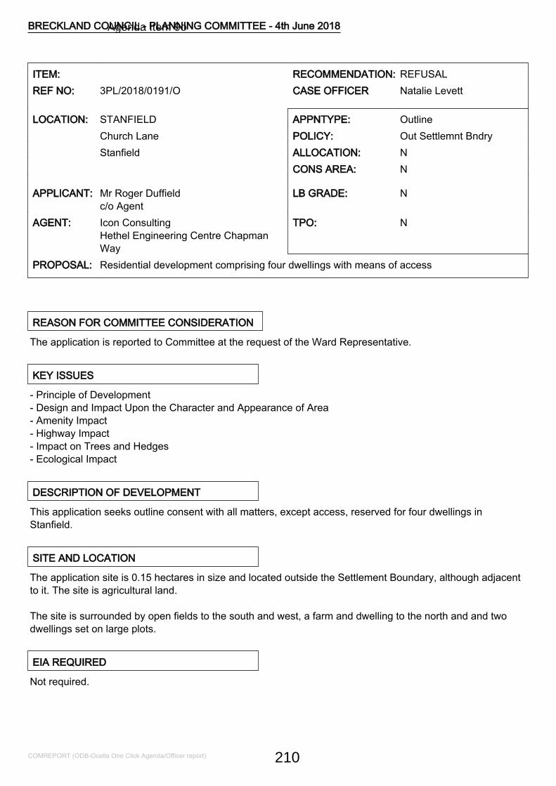
ITEM: RECOMMENDATION: REFUSALREF NO: 3PL/2018/0191/O CASE OFFICER Natalie Levett
LOCATION: STANFIELD APPNTYPE: OutlineChurch Lane POLICY: Out Settlemnt BndryStanfield ALLOCATION: N
CONS AREA: N
APPLICANT: Mr Roger Duffieldc/o Agent
LB GRADE: N
AGENT: Icon ConsultingHethel Engineering Centre ChapmanWay
TPO: N
PROPOSAL: Residential development comprising four dwellings with means of access
REASON FOR COMMITTEE CONSIDERATION
The application is reported to Committee at the request of the Ward Representative.
KEY ISSUES
- Principle of Development- Design and Impact Upon the Character and Appearance of Area- Amenity Impact- Highway Impact- Impact on Trees and Hedges- Ecological Impact
DESCRIPTION OF DEVELOPMENT
This application seeks outline consent with all matters, except access, reserved for four dwellings inStanfield.
SITE AND LOCATION
The application site is 0.15 hectares in size and located outside the Settlement Boundary, although adjacentto it. The site is agricultural land.
The site is surrounded by open fields to the south and west, a farm and dwelling to the north and and twodwellings set on large plots.
EIA REQUIRED
Not required.
BRECKLAND COUNCIL - PLANNING COMMITTEE - 4th June 2018
COMREPORT (ODB-Ocella One Click Agenda/Officer report) 210
Agenda Item 9o
RELEVANT SITE HISTORY
No site history.
POLICY CONSIDERATIONS
The following policies of the adopted Breckland Core Strategy and Development Control Policies and theadopted Site Specific Policies and Proposals Document, including the Proposals Maps, have been taken intoconsideration in the determination of this application. The provisions of the National Planning PolicyFramework and National Planning Policy Guidance have also been taken into account, where appropriate
CP.01 HousingCP.04 InfrastructureCP.09 Pollution and WasteCP.10 Natural EnvironmentCP.11 Protection and Enhancement of the LandscapeCP.13 AccessibilityCP.14 Sustainable Rural CommunitiesDC.01 Protection of AmenityDC.02 Principles of New HousingDC.04 Affordable Housing PrinciplesDC.12 Trees and LandscapeDC.16 DesignDC.19 Parking ProvisionNPPF National Planning Policy FrameworkNPPG National Planning Practice GuidanceSS1 Spatial Strategy
OBLIGATIONS/CIL
The application submission states that the four dwellings would have a GIA of up to 1,000sqm thus theaffordable housing trigger would not be met. A condition could be imposed to this effect and would beassessed at the Reserved Matters stage.
CONSULTATIONS
STANFIELD P CFour out of the five Parish Councillors voted in favour of the application. The fifth Parish Councillor abstainedas it was his application.NORFOLK COUNTY COUNCIL HIGHWAYSRecommends refusal on highway safety grounds.
BRECKLAND COUNCIL - PLANNING COMMITTEE - 4th June 2018
COMREPORT (ODB-Ocella One Click Agenda/Officer report) 211
CONTAMINATED LAND OFFICERNo objection, subject to conditions.ECOLOGICAL AND BIODIVERSITY CONSULTANTAn updated Preliminary Ecological Appraisal report with the results of the eDNA surveys and population sizeclass assessments (if required) needs to be submitted to the LPA prior to the planning application beingdetermined.TREE AND COUNTRYSIDE CONSULTANTRecommends conditions.
REPRESENTATIONS
A Site Notice was displayed on 19th March 2018, advertised in the EDP and seven neighbours were directlynotified. Four representations have been received objecting to the proposal on the following grounds:
- Stanfield does not have essential services and facilities;- Church Lane is a single track road of poor condition; the road also houses resident's parked cars due tolimited parking for some current residents. Therefore the addition of vehicular movement during, and postdevelopment of up to 8 cars, along this stretch would increase the pressures to its sustainability;- The application suggests development already taking place in the area. These in fact consistof an application which was turned down due to be being outside of the village envelope and a rebuild on the site of a former dwelling that was demolished;- Concerns around the viability of the ecologically reports;- Pond 3 which is made reference to in the application is used frequently throughout the yearby the applicant as a discharge pit as part of his waste disposal business, it should therefore benoted that this isn't a 'pond'. The proximity of this would also be close to the rear of the proposeddevelopment and therefore additional surveys around land contamination may need to beconsidered;- The application states that the development will be served by mains drainage but there is no mainsdrainage in the area - each property would require its own septic tank or a shared septic tanksystem;- The development would involve change of use from agricultural to residential use;- There is no bus service that serves the village;- Planning permission has been repeatedly refused for 'Greenacre' (opposite Greenacre Farm, WhissonsettRoad) which is also outside the village envelope and also with agricultural usage;- only one bus per week runs on Saturday morning from the village to Dereham, returning in the afternoon;- Loss of amenity and privacy;- Setting a precedent for the remaining agricultural land;- There are no service buses coming through the village. The Wednesday bus to Norwich and the Friday busto Dereham pick up on the B1145 opposite the Barn Restaurant, no good if you have shopping to carry.There us also a small community bus to Fakenham on Thursday with limited space and is for the over 65sand people with disabilities which comes via New Rd the goes along the Whissonsett bookable on a weeklybasis;- Stanfield is a small settlement without pavements or street lighting;- The nearest GPS are Litcham and Elmham;- There is 1 Infant/Junior school at Brisley as Mileham closed quite recently and Whissonsett a few years
BRECKLAND COUNCIL - PLANNING COMMITTEE - 4th June 2018
COMREPORT (ODB-Ocella One Click Agenda/Officer report) 212
ago.
ASSESSMENT NOTES
1.0 Principle of Development
1.1 This application seeks outline consent with all matters reserved for the erection of four dwellings outsideany settlement boundary, although adjacent to Stanfield Settlement Boundary. The proposal states that twoof the four dwellings would be "smaller cottages for market rent". However, this cannot be conditioned andthus is to be considered as four market dwellings.
1.2 The proposal would involve the loss of agricultural land, although no justification has been put forwarddemonstrating why the agricultural land is no longer viable.
1.3 The site is located outside of any Settlement Boundary. For this reason, the proposal conflicts, inprinciple, with Policies DC2 and CP14 of the Core Strategy and Development Control Policies DevelopmentPlan (2009), which seek to focus new housing within defined Settlement Boundaries. However, paragraph 49of the NPPF states that where an authority does not have an up-to-date five year housing land supply, therelevant local policies for the supply of housing, as referred to above, should not be considered up-to-dateand that housing applications should be considered in the context of the presumption in favour of sustainabledevelopment.
1.4 The Statement of Five Year Housing Land Supply as at 31st March 2017 was published in July 2017 andreported to 31st July 2017's Planning Committe. This outlined that the District does not benefit from having afive year supply of housing land (it can only demonstrate a 4.6 years housing land supply) and the NPPFmakes provision, in principle, for Local Planning Authorities to positively consider sites that are not withindefined Settlement Boundaries. This must be balanced against other policy requirements and aims includingsecuring sustainable development, protecting the countryside, and good design.
1.5 The NPPF constitutes guidance for local planning authorities and decision-takers and is a materialconsideration in the determination of planning applications to achieve sustainable development. TheGovernment outlines three dimensions to sustainable development: economic, social and environmental(paragraph 7). These dimensions give rise to the need for the planning system to perform a number of roles:
- an economic role - contributing to building a strong, responsive and competitive economy, by ensuring thatsufficient land of the right type is available in the right places and at the right time to support growth andinnovation; and by identifying and coordinating development requirements, including the provision ofinfrastructure;
- a social role - supporting strong, vibrant and healthy communities, by providing the supply of housingrequired to meet the needs of present and future generations; and by creating a high quality builtenvironment, with accessible local services that reflect the community's needs and support its health, socialand cultural well-being; and
- an environmental role - contributing to protecting and enhancing our natural, built and historic environment;and, as part of this, helping to improve biodiversity, use natural resources prudently, minimise waste andpollution, and mitigate and adapt to climate change including moving to a low carbon economy.
1.6 Paragraph 8 states that these roles should not be undertaken in isolation, because they are mutually
BRECKLAND COUNCIL - PLANNING COMMITTEE - 4th June 2018
COMREPORT (ODB-Ocella One Click Agenda/Officer report) 213
dependent and that the planning system should play an active role in guiding development to sustainablesolutions. A balanced assessment against these roles is, therefore, required.
1.7 In terms of the economic and social criteria, the proposal would provide for four new dwellings and would,therefore, make a positive, albeit very small, contribution to the housing supply. The proposal would havelimited short-term economic benefits through labour and supply chain demand required during construction,and longer-term economic benefits through the additional household spend within the wider area that wouldbe generated by the provision of four dwellings. However, given the small scale nature of the development,these benefits are not considered to be a significant and definitive overriding matter in this instance.
1.8 The social role of sustainable development seeks to ensure, amongst other matters, the creation of ahigh quality built environment with accessible local services. Stanfield is classified as a rural settlementthrough Policy SS1 (Spatial Strategy) of the adopted Core Strategy and Development Control PoliciesDevelopment Plan Document. Rural Settlements have few or no local services. Stanfield has no services orfacilities to meet the day-to-day requirement of their existing residents, although it has a church.
1.9 The application site is approximately 6.5miles (10.46km) from Dereham, a Market Town, and 7.5miles(12.1km) from Fakenham, a higher order settlement in the adjacent Local Authority. The nearest LocalService Centre of North Elmham is located 4.5miles (7.24km) away. Mileham, another rural settlement,located 3.2miles (5.15km) from the site has a convenience store. These are not considered to be walkingdistance and the route is not safe for pedestrians.
1.10 There would be a high reliance on Local Service Centres and higher order settlements for everydayneeds, which would result in higher car dependency, than if an area had any services. For these reasons,occupants of the dwellings would rely on the use of the private car to gain access to local facilities. Thiswould not accord with the core planning principle in Paragraph 17 of the National Planning PolicyFramework, which is to actively manage patterns of growth to make the fullest possible use of publictransport, walking and cycling. The proposal would not accord with Paragraph 34 of the NPPF in terms ofensuring the need to travel will be minimised and the use of sustainable transport modes will be maximised.
1.11 The site is not in a sustainable location and is remote, it is therefore, considered that it would not benefitthe community or meet the above objectives. On this basis, the proposal does not comply with the social andeconomic dimensions of sustainable development. The proposal is contrary to Policies SS1, CP14 and DC2of the adopted Breckland Council Core Strategy and Development Control Policies Development PlanDocument and there are no material considerations that would outweigh this harm. As a result, the proposeddevelopment is not considered sustainable and would be contrary to paragraphs 12, 13, 14, 17, 34 and theNPPF.
2.0 Design and Impact on the Character and Appearance of the Surrounding Area
2.1 The environmental role of sustainable development seeks to, in part, contribute to protecting andenhancing the natural, built and historic environment. Consideration of a development's impact on thecharacter and appearance of the area within which it is situated is, therefore, integral to the environmentaldimension of sustainable design, as is its design.
2.2 Policy DC16 requires all new development to achieve the highest standard of design. As part of this, alldesign proposals must preserve or enhance the existing character of an area. Consideration will also begiven to the density of buildings in a particular area and the landscape/townscape effect of any increaseddensity.
BRECKLAND COUNCIL - PLANNING COMMITTEE - 4th June 2018
COMREPORT (ODB-Ocella One Click Agenda/Officer report) 214
2.3 Whilst the design is reserved, the site is of a sufficient size to accommodate four dwellings andassociated works. However, the environmental role of sustainable development seeks to, in part, contributeto protecting and enhancing the natural, built and historic environment. Consideration of a development'simpact on the character and appearance of the area within which it is situated is, therefore, integral to theenvironmental dimension of sustainable development, as is design.
2.4 The application site is located outside the Settlement Boundary and is currently agricultural land and thesite forms part of a wider agricultural field, where no boundaries exist, although a boundary existsdemarcating the end of the Settlement Boundary and a hedge fronting Church Lane; part of which is to beremoved to allow for the access.
2.5 The proposal has not been put forward to be considered as an exception, as detailed in paragraph 55 ofthe NPPF and would be difficult to do so at the outline stage with all matters reserved.
2.6 It is considered that the development of the site would result in encroachment of development into thecountryside that would detract from its intrinsic open character and the proposal would be contrary to PoliciesCP11 and CP14 of the Breckland Core Strategy and the NPPF.
2.7 In the context of the above, the proposal would be contrary to policies SS1, DC2, CP11, and CP14 of theCore Strategy and the NPPF (in particular 56, 57, 61) as the site is not considered to be in a sustainablelocation and does not comply with the social, economic and environmental dimensions of sustainabledevelopment. This consideration alongside the policy objection weigh significantly against the proposal.
3.0 Amenity Impact
3.1 Policy DC1 seeks to protect residential amenity and that all new development must have regard toamenity considerations and states that development will not be permitted where there are unacceptableeffects on the amenity of neighbouring residents and future occupants.
3.2 The site is adjacent to the Settlement Boundary and a dwelling is situated to the north and another to theeast of the site. Given the indicative plan submitted, it is possible that the proposal could be designed to notcause overlooking/loss of privacy but this would need to be assessed at the Reserved Matters stage.
3.3 As a result, the proposal has the ability to comply with Policy DC1.
4.0 Highways Impact
4.1 The NPPF requires new developments to provide safe and suitable access to the site for all people.
4.2 Policy CP4 seeks to ensure that all access and safety concerns are resolved in new developments.Policy DC19 sets out the car parking requirements.
4.3 The Highways Authority advised that, the site is located at the western end of C231 Church Lane, closeto its junction with C229 New Road. New Road links into B1145 Stanfield Road and it is therefore fair toassume that the majority of vehicular traffic associated with the site will travel along this route to access thewider highway network.
4.4 A development of four dwellings would be likely to generate around 24 vehicular movements per daytogether with those associated with delivery vehicles and other visitors.
BRECKLAND COUNCIL - PLANNING COMMITTEE - 4th June 2018
COMREPORT (ODB-Ocella One Click Agenda/Officer report) 215
4.5 Other than where it runs through the centre of the village, Church Lane is only suitable for single filetraffic having a carriageway width of around 3.6m adjacent to the site.
4.6 New Road, for the majority of its length, is also of single track width having an average carriageway widthof approximately 3.7m with no formal passing provision. The passing areas which do exist have been causedby the verges being overrun where two vehicles attempt to pass. This has resulted in the carriageway edgebecoming eroded and extraneous material being carried out into the highway causing a potential skid hazard.
4.7 Guidance in the CLG and DfT publication Manual for Streets advises that a surfaced width of at least4.8m is necessary for a large vehicle and a car to pass safely whilst a minimum of 4.1m is required for twocars to pass each other with care. Below 4m the carriageway is considered too narrow for cars to pass eachother in free flow. Both New Road and Church Lane fall below these minimum standards.
4.8 The absence of a satisfactory carriageway width is all the more concerning in places where forwardvisibility is restricted by the alignment of the road and where drivers consequently have insufficient warning ofoncoming vehicles/horses/pedestrians/cyclists and, as a result, there is the potential for collision andpersonal injury accident.
4.9 It is accepted that traffic from the development could access the wider road network by travellingeastwards through the village and joining B1145 Stanfield Road via C231 Back Lane. The latter of which hasan average carriageway width of between 4.1 and 4.5m between Stanfield Road and Church Lane. However,to do so would involve negotiating the eastern section of Church Lane which returns to single track width, isof a steep alignment and is bounded to either side by banks and hedges precluding any possibility ofvehicles being able to pass.
4.10 The existence of this part of the network in its current form is a matter of fact and, therefore, it isaccepted some degree of vehicle conflict already occurs.
4.11 However, the increase in vehicle movements likely to be generated by the proposed development willalso increase the potential collision and person injury accident to the detriment of highway safety.
4.12 The site is located in a village which lacks shops, schools, public transport provision and other servicesand amenities which residents would require to meet their everyday needs. In this respect the site isconsidered to be poorly located in terms of accessibility.
4.13 Advice in the National Planning Policy Framework supports the need for "safe and suitableaccess ... for all people". It also encourages the importance of being able to make everyday journeys withoutreliance on a motor car.
4.14 Sustainable transport policies are also provided at a local level through Norfolk's 3rd local transport planConnecting Norfolk - Norfolk's Transport Plan for 2026 . Policy 5 of this document states "New developmentshould be well located and connected to existing facilities so as to minimise the need to travel and reducereliance on the private car or the need for new infrastructure".
4.15 In the light of the site's rural location, and lack of alternative access modes, it is considered that theproposal is likely to be principally car dependent and therefore conflicts with the aims of sustainabledevelopment as represented in the NPPF and local Policy 5 of Connecting Norfolk - Norfolk's Transport Planfor 2026.
4.16 The applicant's agent provided a response to the Highway Authority's representation. However, the
BRECKLAND COUNCIL - PLANNING COMMITTEE - 4th June 2018
COMREPORT (ODB-Ocella One Click Agenda/Officer report) 216
Highway Authority advised that this did not change their view.
4.17 As a result, the proposal is recommended for refusal on highway safety and transport sustainability.
5.0 Impact on Trees and Hedges
5.1 Policy DC12 seeks to protect the District's trees and hedges.
5.2 The Tree and Countryside Consultant has raised no objection, subject to conditions.
5.3 As a result, the proposal has the ability to comply with Policy DC12.
6.0 Ecological Impact
6.1 Policy CP10 seeks to protect the District's natural environment. Policy CP11 seeks to protect andenhance the District's landscape.
6.2 The ecologist advised that an updated Preliminary Ecological Appraisal report (Wild Frontier Ecology;April 2018) has been submitted in support of this application. The great crested newt impact potential of theproposal is still unclear owing to the lack of robust presence/absence information for the pond next to the siteand the pond to the north across Church Lane. Standard great crested newt surveys to determine populationsize will be needed for any ponds that are positive for great crested newt.
6.3 As a result, an updated Preliminary Ecological Appraisal report with the results of the eDNA surveys andpopulation size class assessments (if required) needs to be submitted to the LPA prior to the planningapplication being determined.
6.4 The extant government circular on planning and biodiversity (Circular 06/2005) makes it explicit that "thepresence or absence of protected species, and the extent to which they could be affected by a proposeddevelopment, should be established before planning permission is granted, since otherwise all materialconsiderations might not have been considered in making the decision".
6.5 As a result, insufficient information has been submitted to demonstrate that Policies CP10 and CP11 andthe NPPF can be complied with.
7.0 Contaminated Land
7.1 Policy CP9 seeks to ensure that development minimises any unavoidable polluting effects and thedevelopment's design should actively seek to minimise or mitigate against all forms of pollution.
7.2 Given the information provided and the comments made in the representations to the application,advising that human waste is deposited on the land, the Contaminated Land Officer has recommendedconditions to include a site investigation.
7.3 As a result, subject to conditions, the proposal has the ability to comply with Policy CP9.
8.0 Other Matters
8.1 The applicant's agent has confirmed that the foul drainage would be disposed of by a septic tanks, not toa foul drainage system.
BRECKLAND COUNCIL - PLANNING COMMITTEE - 4th June 2018
COMREPORT (ODB-Ocella One Click Agenda/Officer report) 217
9.0 Planning Balance and Conclusion
9.1 In terms of the overall Planning balance of the scheme, paragraph 14 of the Framework states that whererelevant policies are out of date, permission should be granted unless the adverse impacts of doing so wouldsignificantly and demonstrably outweigh the benefits.
9.2 The proposal is for the construction of four dwellings on agricultural land, for which no justification hasbeen provided. Whilst the size of the site is capable of siting four dwellings and associated amenity andparking space, the principle of a dwelling in such a location does not comply with planning policies and theNPPF that seek to restrict development within the open countryside and be sited in sustainable locations.The site, being located outside of the settlement boundary, together with the inaccessibility of the proposeddevelopment to local shops and facilities by means other than the car, would render the developmentunsustainable and the proposal would not accord with the social and economic dimensions of sustainabledevelopment as set out in the NPPF. This harm would significantly and demonstrably outweigh the verylimited benefits of the proposal. The proposal, therefore, fails to constitute sustainable development and iscontrary to the policies contained within the Core Strategy and the NPPF. In addition, the proposal wouldcreate conditions detrimental to highway safety, which is considered unacceptable.
RECOMMENDATION Refusal of Outline Planning Permission
REASON(S) FOR REFUSAL
1 Unsustainable DevelopmentThe proposal would introduce new residential development in an unsustainable locationremote from local service centre provision conflicting with the aims of sustainabledevelopment, the need to minimise travel, and the ability to encourage walking, cycling, useof public transport and reduce the reliance on the private car as represented in national andlocal policy. Given the nature and size of the development for four dwellings, this site isunlikely to contribute significantly to the delivery of housing and a five year housing landsupply. There are no material considerations that would outweigh this harm. As a result, theproposal does not accord with Policies SS1, CP11, CP14 and DC2 of the adopted BrecklandCouncil Core Strategy and Development Control Policies Development Plan Document(2009), contrary to paragraphs 12, 13, 14, 17, 34 and 55 of the NPPF and Policy 5 ofNorfolk's 3rd Local Transport Plan, entitled Connecting Norfolk.
2 Detrimental impact on the character andappearance of areaThe development of the site, which is primarily surrounded by agricultural land, and theresultant significant change in the nature and appearance of the land to support theresidential development, would result in an encroachment and unwarranted intrusion into therural landscape to the detriment of the character and visual amenities of the area. Theproposal would, therefore, fail to adequately respect the character and appearance of theexisting rural location and as a result the proposed development would cause significantdemonstrable harm to the character and appearance of the countryside, contrary to PoliciesCP11, CP14 and DC16 of the adopted Breckland Core Strategy and Development ControlPolicies Document (2009) and paragraphs 14, 17 and 56-68 of the National Planning PolicyFramework.
BRECKLAND COUNCIL - PLANNING COMMITTEE - 4th June 2018
COMREPORT (ODB-Ocella One Click Agenda/Officer report) 218
3 Highway SafetyThe unclassified road serving the site is considered to be inadequate to serve thedevelopment proposed, by reason of its poor alignment restricted width lack of passingprovision and restricted visibility. The proposal, if permitted, would be likely to give rise toconditions detrimental to highway safety as well as having regard to paragraph 32 of theNPPF.
4 Insufficient info - ecologyThe site has the potential to support protected species but insufficient ecological informationhas been submitted. As a result, insufficient information has been submitted to demonstratethat the site would be suitable for development. As a result, the proposal fails to comply withPolicy CP10 of the Breckland Core Strategy Development Control Policies DevelopmentPlan Document (2009), the National Planning Policy Framework (in particular 109 and 118)and Circular 06/2005 on Planning and Biodiversity.
BRECKLAND COUNCIL - PLANNING COMMITTEE - 4th June 2018
COMREPORT (ODB-Ocella One Click Agenda/Officer report) 219
ITEM: RECOMMENDATION: APPROVALREF NO: 3PL/2018/0385/VAR CASE OFFICER Lisa ODonovan
LOCATION: STOW BEDON/BRECKLES APPNTYPE: Variation of Cond'sPig Patch House Cartlodge,Mere Road POLICY: Out Settlemnt BndryStow Bedon ALLOCATION: N
CONS AREA: N
APPLICANT: Mr Ian McIntoshc/o Agent cowen consulting
LB GRADE: N
AGENT: Cowen ConsultingChiara Mere Road Stow Bedon
TPO: N
PROPOSAL: Variation of condition 2 on pp 3PL/2015/0461/F - 2 storey dwelling & detached cartlodge -temporary use of cartlodge to dwelling during construction works
REASON FOR COMMITTEE CONSIDERATION
The application is brought to Planning Committee as the Agent is a Councillor.
KEY ISSUES
Acceptability regarding the variation of condition 2 of permission 3PL/2015/0461/F
DESCRIPTION OF DEVELOPMENT
The application seeks to vary condition 2 of permission 3PL/2015/0461/F, which relates to the approvedplans.
The variation of the condition will relate to the cartlodge building which has been constructed. It will allow theapplicant to live in this building whilst he constructs the main dwellinghouse. The cartlodge will revert back tothe approved design once the dwelling is finished.
SITE AND LOCATION
The application site is located on the southern side of Mere Road on the western fringe of the village of StowBedon. The site abuts the Settlement Boundary to the east. The site is bounded on the eastern side by asmall orchard with dwellings located further to the east. Immediately to the west is an open field. Oppositethe site is an existing dwelling. A mature woodland abuts the rear southern boundary of the site.
EIA REQUIRED
No
BRECKLAND COUNCIL - PLANNING COMMITTEE - 4th June 2018
COMREPORT (ODB-Ocella One Click Agenda/Officer report) 220
Agenda Item 9p
RELEVANT SITE HISTORY
3PL/2015/0461/F - Construction of a 2 storey dwelling, ancillary external works & detached Cart Lodge &integral store - Permission
POLICY CONSIDERATIONS
The following policies of the adopted Breckland Core Strategy and Development Control Policies and theadopted Site Specific Policies and Proposals Document, including the Proposals Maps, have been taken intoconsideration in the determination of this application. The provisions of the National Planning PolicyFramework and National Planning Policy Guidance have also been taken into account, where appropriate
CP.11 Protection and Enhancement of the LandscapeCP.14 Sustainable Rural CommunitiesDC.01 Protection of AmenityDC.02 Principles of New HousingDC.12 Trees and LandscapeDC.16 DesignNPPF With particular regard to paras.7, 8, 11, 14, 55, 56, 58, 109NPPG National Planning Practice Guidance
OBLIGATIONS/CIL
Not applicable
CONSULTATIONS
NORFOLK COUNTY COUNCIL HIGHWAYSWhilst I would not have any objections to the applicant temporarily residing in the cart shed, whilst thedwelling is being constructed, I would require the visibility to be provided at this stage rather than when thenew dwelling is occupied. If you are minded to grant approval please impose all previous conditions togetherwith the following. SHC 20 Prior to the first occupation of the development hereby permitted a visibility splaymeasuring 2.4 x 43 metres shall be provided to each side of the access where it meets the highway and suchsplays shall thereafter be maintained at all times free from any obstruction exceeding 0.6 metres above thelevel of the adjacent highway carriageway. Reason: In the interests of highway safety.ECOLOGICAL AND BIODIVERSITY CONSULTANTWe have no objection to the variation of condition 2 on pp 3PL/2015/0461/F.TREE AND COUNTRYSIDE CONSULTANTNo commentsENVIRONMENTAL HEALTH OFFICERSThere are no objections or comments on the grounds of Environmental Protection, providing thedevelopment proceeds in line with the application details.
BRECKLAND COUNCIL - PLANNING COMMITTEE - 4th June 2018
COMREPORT (ODB-Ocella One Click Agenda/Officer report) 221
NATURAL ENGLANDNatural England currently has no comment to make on the variation of condition 2 pursuant to planningapplication 3PL/2015/0461/F. Should the proposal be amended in a way which significantly affects its impacton the natural environment then, in accordance with Section 4 of the Natural Environment and RuralCommunities Act 2006, Natural England should be consulted again. Before sending us any furtherconsultations regarding this development, please assess whether the changes proposed will materially affectany of the advice we have previously offered. If they are unlikely to do so, please do not re-consult us.
STOW BEDON & BRECKLES P C No Comments ReceivedPRINCIPAL PLANNER MINERAL & WASTE POLICY No Comments ReceivedNORFOLK WILDLIFE TRUST No Comments Received
REPRESENTATIONS
Site notice erected: 20-04-2018Consultations issued: 12-04-2018
No representations received.
ASSESSMENT NOTES
In deciding an application under section 73, the Council may only consider the question of the conditionssubject to which planning permission should be granted. A complete re-consideration of the proposal cannotbe undertaken.
The proposal involves a temporary change of use of the cartlodge associated with the new dwellingproposed on the site to enable the applicant to live in it whilst the dwelling is being constructed. Minimalexternal/internal changes are proposed to allow this and the building will revert back to this approved useonce the building work is complete. On this basis, and on the basis that the building essentially will remainas constructed, therefore limiting any further impact on the character and appearance of the area andneighbour amenity, the application is recommended for approval.
RECOMMENDATION Planning Permission
CONDITIONS
1 Material AmendmentThis permission seeks a material amendment to planning permission 3PL/2015/0461/F. Thedevelopment must commence in accordance with the time scale and conditions set out inthe original permission unless varied by this permission.Reason for condition:-To comply with section 92 of the Town & Country Planning Act 1999 (as amended).
2 In accordance with submitted plans NEW 2017The development must be carried out in strict accordance with the application form, andapproved documents and drawings as set out in the table at the end of this notice.
BRECKLAND COUNCIL - PLANNING COMMITTEE - 4th June 2018
COMREPORT (ODB-Ocella One Click Agenda/Officer report) 222
Reason for condition:-To ensure the satisfactory development of the site.
3 All external plant to be screenedNo mechanical plant, duct work, tanks, satellite or radio antennae or other structures shallbe located on the roof other than those shown on the drawings hereby approved, all externalplant hereby approved shall be adequately screened. Precise details of the screening shallbe submitted to and approved in writing by the Local Planning Authority, prior to thecommencement of the development.Reason for condition:-In the interests of the satisfactory appearance of the development.
4 No P.D. for extensions, roof alterations, porchesNotwithstanding the provisions of the Town and Country Planning (General PermittedDevelopment) (England) 2015 (or any Order revoking and re-enacting that Order) (with orwithout modification) no extensions, roof alterations or porches as defined within Classes A,B, C and D of Part 1 of Schedule 2 of that Order shall be carried out on the land unless anappropriate planning application is first submitted to and approved by the Local PlanningAuthority.Reasons for condition:-a) To ensure the orderly development of the site.b) In the interests of the satisfactory appearance of the development.This condition is imposed in accordance with Policy DC1 of the Breckland Adopted CoreStrategy.
5 Trees/hedges to be retainedThe existing trees/hedges along the site's Mere Road frontage shall be retained other thanpruning required. Should any die or be removed without the written consent of the LocalPlanning Authority, they shall be replaced during the next planting season with a tree(s) orhedging of a species, size and in the same location to the satisfaction and written agreementof the Local Planning Authority.Reason for condition:-In the interests of the satisfactory appearance of the development.
6 New access - construction over vergePrior to the first occupation of the development hereby permitted the vehicular access shallbe provided and thereafter retained at the position shown on the approved plan inaccordance with highway specification (Dwg No. TRAD5 attached. Arrangement shall bemade for surface water drainage to be intercepted and disposed of separately so that it doesnot discharge from or onto the highway carriageway.Reason for condition:-The details are required prior to the occupation of the development to ensure satisfactoryaccess into the site and avoid carriage of extraneous material of surface water from or ontothe highway.This condition will require to be discharged
7 Provision of visibility splays - conditionedPrior to the first occupation of the development hereby permitted a visibility splay measuring2.4m X 43m metres shall be provided to each side of the access where it meets the highwayand such splays shall thereafter be maintained at all times free from any obstructionexceeding 0.6 metres above the level of the adjacent highway carriageway.
BRECKLAND COUNCIL - PLANNING COMMITTEE - 4th June 2018
COMREPORT (ODB-Ocella One Click Agenda/Officer report) 223
Reason for condition:-The details are required prior to the occupation of the development in the interest of highwaysafety.This condition will require to be discharged
8 EcologyThe development shall be carried out in strict accordance with the mitigation measurescontained at pages 29 - 32 of the approved Ecology Report (Eco-Check April 2014).Reason for condition:-In order to ensure that appropriate measures are taken to protect wildlife and promotebiodiversity. These details are required prior to the commencement of development toensure that existing features of ecological value are protected from the outset of thedevelopment.
9 Work to take place as per 3DC/2016/0127/DOCWork on site shall take place in accordance with the approved details agreed via3DC/2016/0127/DOC.Reason for condition:-In order to ensure the satisfactory development of the site.
10 Cartlodge to be reinstatedPrior to the first occupation of the dwelling approved, the cartlodge shall be re-instated to itsapproved use and its appearance and layout reinstated to those previously approved.Reason for condition:-In order to define the permission and to ensure the satisfactory development of the site.
13 Variation of approved plansAny variation from the approved plans following commencement of the development,irrespective of the degree of variation, will constitute unauthorised development and may beliable to enforcement action.You or your agent or any person responsible for implementing this permission should informthe Development Control Section immediately of any proposed variation from the approvedplans and ask to be advised to the best method to resolve the matter. Most proposals forvariation to the approved plans will require the submission of a new application.
BRECKLAND COUNCIL - PLANNING COMMITTEE - 4th June 2018
COMREPORT (ODB-Ocella One Click Agenda/Officer report) 224
ITEM: RECOMMENDATION: AllowedREF NO: 3OB/2018/0002/OB CASE OFFICER Fiona Hunter
LOCATION: SWANTON MORLEY APPNTYPE: Planning ObligationLand South-west of Rectory Road POLICY: In Settlemnt BndrySwanton Morley ALLOCATION: N
CONS AREA: N
APPLICANT: Hopkins Homes LimitedMelton Park House Scott Lane
LB GRADE: N
AGENT: Hopkins Homes LimitedMelton Park House Scott Lane
TPO: N
PROPOSAL: Increase in areas to be transfered to the nominated body in lieu of Norfolk County CouncilHighways
REASON FOR COMMITTEE CONSIDERATION
The application seeks changes to a S106 for a major application which was approved by the planningcommittee.
KEY ISSUES
Acceptability of amending the S106 to increase the area of land to be used as public open space and thentransferred and maintained to the nominated body.
DESCRIPTION OF DEVELOPMENT
Deed of Variation to the S106 dated 20/01/2015 for 3PL/2014/0083/F: "Erection of 52 residential dwellingswith associated open space".
The variation is to increase the land to be used for public open space by 264sqm by including an grassedarea of land to the south of the existing open space. This is currently grassed landscaping space which wasintended to be adopted and maintained by Norfolk County Council, instead, this will become formal publicopen space to be maintained by the "nominated body" as per the S106 definition.
SITE AND LOCATION
The site is located to the south western perimeter of Swanton Morley, to the south of Rectory Road extendingto 2.4ha. The Grade I Listed All Saints Church is located to the east of Rectory Road with further residentialdwellings located to the southern perimeter of the site.
The site was once an agricultural field, but has now been developed with 52 houses following theimplementation of planning application Ref: 3PL/2014/0083/F, with a large area of open space being situatedin the centre of the development.
BRECKLAND COUNCIL - PLANNING COMMITTEE - 4th June 2018
COMREPORT (ODB-Ocella One Click Agenda/Officer report) 225
Agenda Item 9q
EIA REQUIRED
No.
RELEVANT SITE HISTORY
3DC/2015/0014/DOC DOC - COMPLETE 27-02-17Discharge of conditions 3-20 on 3PL/2014/0083/F
3PL/2014/0083/F Permission 22-01-15Erection of 52 residential dwellings with associated open space
3PL/2017/1546/VARVariation of condition 12 on pp 3PL/2014/0083/F - amended drainage details
3SR/2013/0019/SCR EIA not required 10-12-13Proposed residential development
POLICY CONSIDERATIONS
The following policies of the adopted Breckland Core Strategy and Development Control Policies and theadopted Site Specific Policies and Proposals Document, including the Proposals Maps, have been taken intoconsideration in the determination of this application. The provisions of the National Planning PolicyFramework and National Planning Policy Guidance have also been taken into account, where appropriate
DC.11 Open Space
OBLIGATIONS/CIL
S106 agreed under application Ref: 3PL/2014/0083/F.
CONSULTATIONS
SWANTON MORLEY PCFollowing receipt of amended plans, the Parish Council has no objections to the application.NORFOLK COUNTY COUNCIL HIGHWAYSNo objection to the principle of the application.
Recommend the drainage proposals are amended and the drainage plan updated to reflect as built.FACILITIES MANAGEMENTNo comment.
BRECKLAND COUNCIL - PLANNING COMMITTEE - 4th June 2018
COMREPORT (ODB-Ocella One Click Agenda/Officer report) 226
REPRESENTATIONS
None.
ASSESSMENT NOTES
1.0 Principle of the Amendment
1.1 The Deed of Variation would result in the area of formal open space to be owned and maintained by the"nominated body" to be increased by 264sqm. The additional land is directly to the south of the existing openspace, and comprises two detached pieces of grassed landscaping areas including one separated by thenew road in front of plots 8, 9 and 10. The approved plans shows these areas are lined by bollards whichwould prevent verge parking.
1.2 There are no physical changes proposed, and therefore, the amendment would not result in a visualchange to the development.
1.3 The increase in land allocated for public open space is in accordance with the principles of Policy DC 11.
1.4 The S106 sets out that the "nominated body" who will be responsible for the open space is to be oneparty to be selected by the Council, and can be: The Council; or the Parish Council; or a managementcompany; or any other body the Council may elect. At the current time, the nominated body has not beenchosen.
1.5 The Parish Council following receipt of revised plans have not objected to the application.
1.6 No harm has been identified which would result from the amendment if approved.
2.0 Content of Deed of Variation
2.1 The Deed of Variation would include the following changes to the S106 dated 20/01/2015 for3PL/2014/0083/F:
- The area of open space increased on the "Open Space Plan" under the First Schedule; and- The description of the "Open Space Land" amended to reflect the increase in area.
3.0 Conclusion
3.1 It is recommended that the Deed of Variation is allowed.
RECOMMENDATION Allowed
CONDITIONS
BRECKLAND COUNCIL - PLANNING COMMITTEE - 4th June 2018
COMREPORT (ODB-Ocella One Click Agenda/Officer report) 227
ITEM: RECOMMENDATION: APPROVALREF NO: 3PL/2017/1546/VAR CASE OFFICER Fiona Hunter
LOCATION: SWANTON MORLEY APPNTYPE: Variation of Cond'sLand off Rectory Road POLICY: Part In Set BndrySwanton Morley ALLOCATION: N
CONS AREA: N
APPLICANT: Hopkins Homes LimitedMelton Park House Scott Lane
LB GRADE: N
AGENT: Mr Chris SmithMelton Park House Scott Lane
TPO: N
PROPOSAL: Variation of condition 12 on pp 3PL/2014/0083/F - amended drainage details
REASON FOR COMMITTEE CONSIDERATION
The application is variation to a major planning application.
KEY ISSUES
Acceptability of the amendment of planning condition 12 (surface and foul water drainage).
DESCRIPTION OF DEVELOPMENT
The applicant seeks planning permission for a minor material amendment to the approved surface and fouldrainage details submitted and approved under application Ref: 3DC/2015/0014/DOC to include a FrenchDrain which was designed in consultation with Norfolk County Council Highways, in order to provide asuitable mechanism to prevent excess surface water run off from the public open space from running ontothe cycle/footpath.
SITE AND LOCATION
The site is located on the south west edge of Swanton Morley, to the south of Rectory Road extending to2.4ha. The Grade I Listed All Saints Church is located to the east of Rectory Road with further residentialdwellings located to the southern perimeter of the site.
The site was once an agricultural field, but has now been developed following the implementation of planningapplication Ref: 3PL/2014/0083/F, with a large area of public open space being situated in the heart of thedevelopment. The proposed French Drain, is located to the eastern edge of the Public Open Space adjacentto the footpath lining the development to Rectory Road.
EIA REQUIRED
No.
BRECKLAND COUNCIL - PLANNING COMMITTEE - 4th June 2018
COMREPORT (ODB-Ocella One Click Agenda/Officer report) 228
Agenda Item 9r
RELEVANT SITE HISTORY
3DC/2015/0014/DOC DOC - COMPLETE 27-02-17Discharge of conditions 3-20 on 3PL/2014/0083/F
3OB/2018/0002/OBIncrease in areas to be transfered to Swanton Morley Parish Council in lieu of Norfolk County CouncilHighways
3PL/2014/0083/F Permission 22-01-15Erection of 52 residential dwellings with associated open space
3SR/2013/0019/SCR EIA not required 10-12-13Proposed residential development
POLICY CONSIDERATIONS
The following policies of the adopted Breckland Core Strategy and Development Control Policies and theadopted Site Specific Policies and Proposals Document, including the Proposals Maps, have been taken intoconsideration in the determination of this application. The provisions of the National Planning PolicyFramework and National Planning Policy Guidance have also been taken into account, where appropriate
CP.04 InfrastructureCP.11 Protection and Enhancement of the LandscapeDC.01 Protection of AmenityDC.13 Flood RiskDC.16 DesignNPPF National Planning Policy Framework
OBLIGATIONS/CIL
S106 agreed under application Ref: 3PL/2014/0083/F.
CONSULTATIONS
SWANTON MORLEY PCFollowing receipt of revised plans, no objection raised.ENVIRONMENT AGENCYNo comments.FLOOD & WATER MANAGEMENT TEAMOfficers have screened this application and it falls below our current threshold for providing detailedcomment. This is because the proposal is for less than 100 dwellings or 2 ha in size and is not within a
BRECKLAND COUNCIL - PLANNING COMMITTEE - 4th June 2018
COMREPORT (ODB-Ocella One Click Agenda/Officer report) 229
surface water flow path as defined by Environment Agency mapping.
Standard guidance drainage should be considered.NORFOLK COUNTY COUNCIL HIGHWAYSNo objection.
NORFOLK RIVERS INTERNAL DRAINAGE BOARD No Comments ReceivedANGLIAN WATER SERVICE No Comments Received
REPRESENTATIONS
None.
ASSESSMENT NOTES
1.0 Principle of the amendment
1.1 This application seeks approval of two changes to the previously approved drainage scheme viaapplication reference: 3DC/2015/0014/DOC, which is the addition of two French Drains and a gully. It isconsidered that the addition of the French Drain infrastructure would be a minor amendment, given the scaleof approved development and drainage being a original condition of the planning permission (ref:3PL/2014/0083/F).
1.2 The French Drains are a trench soakaway systems. They do not have any direct, piped connections tothe below ground soakaways therefore there would be limited visual impact or disturbance to existingresidents during construction. The French Drains proposed are considered necessary following consultationwith Norfolk County Council Highways, in order to prevent excess surface water run off from the public openspace from unduly running onto the cycle/footpath.
1.3 The French Drain infiltration trench will be filled with clean aggregates and covered with turf, so they arenot distinguishable from the grassed open space. Maintenance works will include cutting the turf/grass andvery occasional cleaning/sorting of the aggregates.
1.4 The applicant has provided a cross section drawing showing the dimensions of the drain. The drainwould be 600mm deep and 450mm wide. The infill would consist of a 40mm single sized aggregate at thebottom with a 300m permeable membrane lining the trench. On top of this is a further 40mm single sizedaggregate topped by soil and turf. The proposal and would not create a conflict with the other previouslyapproved drainage features under application Ref: 3DC/2015/0014/DOC.
1.5 Following amendments to the French Drain design, the Parish Council have raised no objection to theapplication. Highways have also not objected to the proposal, and the proposal falls below the LLFAthreshold to provide comment.
2.0 Conclusions
2.1 The French Drain was designed in consultation with NCC Highways and they provide a suitable, low-key
BRECKLAND COUNCIL - PLANNING COMMITTEE - 4th June 2018
COMREPORT (ODB-Ocella One Click Agenda/Officer report) 230
mechanism to prevent excess surface water run-off from the public open space from unduly running onto thecycle/footpath in accordance with Policy DC 13.
2.2 The French Drain is considered to be low maintenance and have a very limited visual impact given theground level grass surface treatment. The application is recommended approval on this basis.
RECOMMENDATION Planning Permission
CONDITIONS
1 In accordance with submittedThe development must be carried out in strict accordance with the application form, andapproved documents and drawings as set out below:
Arboricultural Constraints Report, by JBA Consultancy Services Ltd, Dated September 2013'Materials Plan' Dwg No. 060 dated 01/2014.'External Works Layout' Dwg No. 002 Rev B, dated 01/2014'Proposed Planning Layout' Dwg No. 003 Rev B, dated 01/2014'Site Location Plan' Dwg No. 001, dated 01/2014'Housetype 2067 Floor Plans', Dwg No. 004, dated 01/2014'Housetype 2067 Elevations', Dwg No. 005, dated 01/2014'Housetype 1460 Floor Plans', Dwg No. 006, dated 01/2014'Housetype 1460 Elevations', Dwg No. 007, dated 01/2014'Housetype 1639 Floor Plans', Dwg No. 008, dated 01/2014'Housetype 1639 Elevations' (Sheet 1), Dwg No. 009, dated 01/2014'Housetype 1639 Elevations' (Sheet 2), Dwg No. 010, dated 01/2014'Housetype 1460 Floor Plans', Dwg No. 011, dated 01/2014'Housetype 1460 Elevations', Dwg No. 012, dated 01/2014'Housetype 1762 Floor Plans', Dwg No. 013, dated 01/2014'Housetype 1762 Elevations', Dwg No. 014, dated 01/2014'Housetype 1639 Floor Plans', Dwg No. 015, dated 01/2014'Housetype 1639 Elevations' (Sheet 1), Dwg No. 016, dated 01/2014'Housetype 1639 Elevations' (Sheet 2), Dwg No. 017, dated 01/2014'Housetype 1762 Floor Plans', Dwg No. 018, dated 01/2014'Housetype 1762 Elevations', Dwg No. 019, dated 01/2014'Housetype 1268 Floor Plans', Dwg No. 020, dated 01/2014'Housetype 1268 Elevations' (Sheet 1), Dwg No. 021, dated 01/2014'Housetype 1268 Elevations' (Sheet 2), Dwg No. 022, dated 01/2014'Housetype 892 Floor Plans', Dwg No. 023, dated 01/2014'Housetype 892 Elevations', Dwg No. 024, dated 01/2014'Housetype 1050 & 1200 Floor Plans', Dwg No. 025, dated 01/2014'Housetype 1050 & 1200 Elevations' (Sheet 1), Dwg No. 026, dated 01/2014'Housetype 1050 & 1200 Elevations' (Sheet 2), Dwg No. 027, dated 01/2014'Housetype 1460 Floor Plan', Dwg No. 028, dated 01/2014'Housetype 1460 Elevations', Dwg No. 029, dated 01/2014'Housetype 1762 Floor Plans', Dwg No. 030, dated 01/2014'Housetype 1762 Elevations', Dwg No. 031, dated 01/2014'Housetype 1050 & 1200 Floor Plans', Dwg No. 032, dated 01/2014
BRECKLAND COUNCIL - PLANNING COMMITTEE - 4th June 2018
COMREPORT (ODB-Ocella One Click Agenda/Officer report) 231
'Housetype 1050 & 1200 Elevations' (Sheet 1) Dwg No. 033, dated 01/2014'Housetype 1050 & 1200 Elevations' (Sheet 2) Dwg No. 034, dated 01/2014'Housetype 1050 & 1200 Floor Plans', Dwg No. 035, dated 01/2014'Housetype 1050 & 1200 Elevations' (Sheet 1), Dwg No. 036, dated 01/2014'Housetype 1050 & 1200 Elevations' (Sheet 2), Dwg No. 037, dated 01/2014'Housetype 1050 & 1200 Floor Plans', Dwg No. 038, dated 01/2014'Housetype 1050 Elevations', Dwg No. 039, dated 01/2014'Housetype 1355 Floor Plans', Dwg No. 040, dated 01/2014'Housetype 1355 Elevations', Dwg No. 041, dated 01/2014'Housetype 946 Floor Plans', Dwg No. 042, dated 01/2014'Housetype 946 Elevations', Dwg No. 043, dated 01/2014'Housetype 852 Floor Plans & Elevations', Dwg No. 044, dated 01/2014'Housetype 599 Floor Plans & Elevations', Dwg No. 045, dated 01/2014'Housetype 861 Floor Plans', Dwg No. 046, dated 01/2014'Housetype 861 Elevations', Dwg No. 047, dated 01/2014'Housetype 599 & 861 Floor Plans', Dwg No. 048, dated 01/2014'Housetype 599 & 861 Elevations', Dwg No. 049, dated 01/2014'Housetype 1027 Floor Plans & Elevations', Dwg No. 050, dated 01/2014'Single Garage Floor Plan & Elevations', Dwg No. 051, dated 01/2014'Single Garage Floor Plan & Elevations', Dwg No. 052, dated 01/2014'Twin Garage Floor Plan & Elevations', Dwg No. 053, dated 01/2014'Double Garage Floor Plan & Elevations', Dwg No. 054, dated 01/2014'Double Garage Floor Plan & Elevations', Dwg No. 055, dated 01/2014'Double and Single Garage', Dwg No. 056, dated 01/2014'Triple Garage', Dwg No. 056, dated 01/2014
Reason for condition:-To ensure the satisfactory development of the site.
2 Harkers laneThe development shall be carried out in accordance with the details approved underapplication Ref: 3DC/2015/0014/DOC which required Harker's Lane to be upgraded to atype 1 surface and completed to the written satisfaction of the Local Planning Authority inconsultation with the Highway Authority.
Reason for condition:-To ensure that the village facilities are accessible from the site, resulting in a sustainableform of development.This condition will require to be discharged
3 Management and Maintenance of proposedstreetsThe management and maintenance of the proposed streets within the development shall becarried out in accordance with the details hereby approved under application Ref:3DC/2015/0014/DOC. The streets shall thereafter be maintained in accordance with theapproved management and maintenance details until such time as an agreement has beenentered into under Section 38 of the Highways Act 1980 or a Private Management andMaintenance Company has been established.
Reason for condition:-
BRECKLAND COUNCIL - PLANNING COMMITTEE - 4th June 2018
COMREPORT (ODB-Ocella One Click Agenda/Officer report) 232
To ensure satisfactory development of the site and to ensure estate roads are managed andmaintained thereafter to a suitable and safe standard.This condition will require to be discharged
4 Details of roads and footwaysThe development shall be carried out in accordance with the detailed plans of the roads,footways, cycleways, foul and surface water drainage agreed under application Ref:3DC/2015/0014/DOC, as amended by drawings number IP13_906_09_025 Rev B andIP13_906_09/005 Rev L.
All construction works shall be carried out in accordance with the approved plans.
Reason for condition:-To ensure satisfactory development of the site and a satisfactory standard of highwaydesign and construction.This condition will require to be discharged
5 Roads and footways to binder courseNo works shall be carried out on roads, footways, cycleways, foul and surface water sewersotherwise than in accordance with the specifications of the Local Planning Authority inconsultation with the Highway Authority.
Reason for condition:-To ensure satisfactory development of the site and to ensure estate roads are constructed toa standard suitable for adoption as public highwayThis condition will require to be discharged
6 Road(s), footway(s) and cycleway(s) to spec.The development shall be carried out in accordance with the approved details in respect ofroad(s), footway(s) and cycleway(s) approved under application Ref: 3DC/2015/0014/DOC.The road(s), footway(s) and cycleway(s) shall be constructed to binder course surfacinglevel from the dwelling unit to the adjoining County road in accordance with the approveddetail.
Reason for condition:-To ensure satisfactory development of the site.This condition will require to be discharged
7 Visibility splayPrior to the first occupation of the development hereby permitted a visibility splay measuring2.4m x 59m shall be provided to each side of the junction where it meets Rectory Road andsuch splays shall thereafter be maintained at all times free from any obstruction exceeding0.225 metres above the level of the adjacent highway carriageway.Reason for the Condition:-In the interests of highway safetyThis condition will require to be discharged
8 On site parking scheme for construction periodThe development shall be carried out in accordance with the approved scheme underapplication Ref: 3DC/2015/0014/DOC for on site parking for construction workers for the
BRECKLAND COUNCIL - PLANNING COMMITTEE - 4th June 2018
COMREPORT (ODB-Ocella One Click Agenda/Officer report) 233
duration of the construction period. The scheme shall be implemented throughout theconstruction period.
Reason for condition:-To ensure adequate off-street parking during construction in the interests of highway safety.This condition will require to be discharged
9 Scheme for the off-site footway works alongRectory Road andThe development shall be carried out in accordance with the approved off-site footwayworks along Rectory Road and Town Street in accordance with drawing SWA/2-003RevBapproved under application Ref: Ref: 3DC/2015/0014/DOC.
Reason for condition:-To ensure that the highway improvement works are designed to an appropriate standard inthe interest of highway safety and to protect the environment of the local highway corridor.This condition will require to be discharged
10 Completing off-site highway worksThe off-site highway improvement works referred to in Condition 9 shall be completed inaccordance with the details approved under application Ref: 3DC/2015/0014/DOC, to thewritten satisfaction of the Local Planning Authority in consultation with the HighwayAuthority.
Reason for the Condition:-To ensure that the highway network is adequate to cater for the development proposed.This condition will require to be discharged
11 SUDS, Surface Water and Foul Water Schemesto be submittedThe development shall be carried out in strict accordance with the approved surface waterdrainage strategy approved under application reference 3DC/2015/0014/DOC, as shown onapproved drawings Ref: 13-906-09-005 Engineering layout sheet 2 of 4 and drawing Ref:P13_906_09/038 Section 38 layout and drawing Ref: IP13_096_09_025, and as amendedby drawings Ref: IP13_906_09_025 Rev B and IP13_906_09/005 Rev L.
The above approved drainage works will be completed and made available for use inperpetuity within 4 months of this decision notice.
Reason for condition:-To ensure the development is carried out in accordance with the approved details inaccordance with policy CP4 of the Adopted Core Strategy and Development Control PoliciesDevelopment Plan Document (2009).This condition will require to be discharged
12 Details of biodiversity and Ecology MeasuresThe development shall be carried out in accordance with the approved details of theenhancement of the biodiversity of the site agreed under application Ref:3DC/2015/0014/DOC.
BRECKLAND COUNCIL - PLANNING COMMITTEE - 4th June 2018
COMREPORT (ODB-Ocella One Click Agenda/Officer report) 234
Reason for condition:-In order to provide opportunities to incorporate features into the design which are beneficialto wildlife, such as the incorporation of roosting opportunities for bats or the installation ofbird nest boxes. In accordance with Policy CP10 of the Core Strategy and Paragraph 118 ofthe National Planning Policy Framework.This condition will require to be discharged
13 Further ecology work as recommended byPhase 1 SurveyThe development hereby approved shall be carried out in accordance with therecommendations of the Phase 1 Ecology and Habitat Assessment report submitted with theapplication and the further detailed surveys as approved under application Ref:3DC/2015/0014/DOC. The recommendations in relation to these reports shall be followedthroughout the development process and completed prior to the first occupation of thedevelopment, unless otherwise agreed in writing with the Local Planning Authority.
Reason for condition:-In the interests of protected species and ecology.This condition will require to be discharged
14 Renewable EnergyThe development shall be carried out in accordance with the approved decentralisedrenewable and/or low carbon energy sources scheme to generate at least 10% of thepredicted energy requirement of the development approved under application reference3DC/2015/0014/DOC.
The approved scheme shall be implemented in full prior to the first occupation of thedevelopment hereby approved.
Reason for condition:-In order to ensure an appropriate standard of sustainable construction.This condition will require to be discharged
15 Boundary screening to be agreedThe development shall be carried out in accordance with the approved boundary screening,agreed under application Ref: 3DC/2015/0014/DOC. The scheme shall be carried out in itsentirety prior to the first occupation of the dwellings which the screening adjoins.
Reason for condition:-In the interests of the satisfactory appearance of the development and for the protection ofneighbouring amenity.This condition is imposed in accordance with Policies DC1 and DC16 of the BrecklandAdopted Core Strategy.This condition will require to be discharged
16 Construction management planThe development shall be carried out in accordance with the construction management planas approved under application Ref: 3DC/2015/0014/DOC. The approved plan/statementshall be adhered to throughout the construction period.
BRECKLAND COUNCIL - PLANNING COMMITTEE - 4th June 2018
COMREPORT (ODB-Ocella One Click Agenda/Officer report) 235
Reason for condition:-In the interests of neighbour amenity, pedestrian and highway safety.This condition will require to be discharged
17 Landscaping - details and implementationThe development shall be carried out in accordance with the approved landscaping schemeas agreed under application Ref: 3DC/2015/0014/DOC. Any trees or plants which within aperiod of five years from the completion of the landscaping scheme die, are removed orbecome seriously damaged or diseased shall be replaced during the next planting seasonwith others of the same size and species unless the Local Planning Authority gives writtenconsent to any variation.
Reason for condition:-In the interests of visual amenity and to ensure a satisfactory form of development.This condition is imposed in accordance with Policy DC12 of the Breckland Adopted CoreStrategy.This condition will require to be discharged
18 Contaminated Land - UnexpectedContaminationIn the event that contamination is found at any time when carrying out the approveddevelopment that was not previously identified it must be reported in writing immediately tothe Local Planning Authority. An investigation and risk assessment must be undertaken inaccordance with details to be agreed in writing with the Local Planning Authority. Whereremediation is necessary, a remediation scheme must be submitted to and approved inwriting by the Local Planning Authority. Following completion of measures identified in theapproved remediation scheme a verification report shall be submitted to and approved inwriting by the Local Planning Authority.
Reason for condition:-To ensure that risks from land contamination to the future users of the land andneighbouring land are minimised, together with those to controlled waters, property andecological systems, and to ensure that the development can be carried out safely withoutunacceptable risks to workers, neighbours and other offsite receptors.This condition is imposed in accordance with CP9 of the Breckland Adopted Core Strategy.This condition will require to be discharged
20 Variation of approved plansNOTES:Any variation from the approved plans following commencement of the development,irrespective of the degree of variation, will constitute unauthorised development and may beliable to enforcement action.You or your agent or any person responsible for implementing this permission should informthe Development Control Section immediately of any proposed variation from the approvedplans and ask to be advised to the best method to resolve the matter. Most proposals forvariation to the approved plans will require the submission of a new planning application.
BRECKLAND COUNCIL - PLANNING COMMITTEE - 4th June 2018
COMREPORT (ODB-Ocella One Click Agenda/Officer report) 236
ITEM: RECOMMENDATION: APPROVALREF NO: 3PL/2018/0227/F CASE OFFICER Donna Smith
LOCATION: THETFORD APPNTYPE: FullAnchor Place POLICY: In Settlemnt BndryThetford ALLOCATION: N
CONS AREA: Y
APPLICANT: Breckland District CouncilElizabeth House Walpole Loke
LB GRADE: Grade II
AGENT: LSI ArchitectsThe Old Drill Hall 23a Cattle MarketStreet
TPO: N
PROPOSAL: Amalgamation of Units 1, 2, 3 and part of Unit 4 and addition of use Class D2 (gymnasium) toapproved use Class A3, A4, A5 to, change to hours of operation; installation of compressors;and other minor external alterations
KEY ISSUES
Principle of sustainable developmentCharacter and appearanceAmenityAccessibilityConclusions
DESCRIPTION OF DEVELOPMENT
The applicant seeks full planning permission for the amalgamation of existing ground floor retail units 1,2,3and part of unit 4 of the existing Anchor Place retail development in Thetford Town Centre. The applicationproposes the change of use to Use Class D2 ( gymnasium) , from existing Use Classes A3, A4 and A5. Thesite extends to 0.70 ha.
The existing Gross Internal Floor space for units 1,2,3 and part of unit 4 equates to 450sqm, the proposaldoes not wish to increase the internal floor space as part of the proposal. The applicant also seeks approvalfor the installation of compressors and other minor external alterations.
The applicant is proposing operating hours for the use of this unit of 24 hours Monday to Sunday, inclusive ofbank holidays.
SITE AND LOCATION
The site sits to the north of Little Ouse River and east of Bridge Street, and is located within the defined TownCentre for Thetford in a Flood Zone 2. Site surroundings are prodomiently retail and commercial, alongside a
BRECKLAND COUNCIL - PLANNING COMMITTEE - 4th June 2018
COMREPORT (ODB-Ocella One Click Agenda/Officer report) 237
Agenda Item 9s
ribbon of Listed Buildings to the south and north west, these include 3 & 5, Old Bury Road (Grade II), FrickleyVilla (Grade II) and 17 Bridge Street (Grade II). The surrounding area also benefits from above the shopliving. The site also falls within the Conservation Area.
The site as existing currently consists of:
- 62 bedroom hotel- 3 screen cinema- 5 units available for retail/restaurant/cafe uses- associated plant & machinery.
EIA REQUIRED
No.
RELEVANT SITE HISTORY
3PL/2012/0790/F- Demolition and redevelopment for mixed use of hotel, cinema and retail (A1), hot food(A5), restaurant (A3) and drinking (A4) - Approved - 01-11-2013.
POLICY CONSIDERATIONS
The following policies of the adopted Breckland Core Strategy and Development Control Policies and theadopted Site Specific Policies and Proposals Document, including the Proposals Maps, have been taken intoconsideration in the determination of this application. The provisions of the National Planning PolicyFramework and National Planning Policy Guidance have also been taken into account, where appropriate
CP.04 InfrastructureCP.07 Town CentresCP.09 Pollution and WasteCP.11 Protection and Enhancement of the LandscapeCP.13 AccessibilityDC.16 DesignDC.17 Historic EnvironmentNPPF National Planning Policy FrameworkNPPG National Planning Practice GuidanceSS1 Spatial StrategyTH16 Development in Flood ZonesTH18 Sustainable Construction Standards for Non-Residential Development
OBLIGATIONS/CIL
Not Applicable
BRECKLAND COUNCIL - PLANNING COMMITTEE - 4th June 2018
COMREPORT (ODB-Ocella One Click Agenda/Officer report) 238
CONSULTATIONS
THETFORD T CTTC have significant objections to this application as follows: 1. Incursion into unit 4 compromises thepotential for future let of unit 4 2.The application is in opposition to the vision of a visitor attraction supportingthe cinema complex. 3 .A change to Class D is against the BDC emerging plan policy. 4. Primary frontage isnot being optimised for a visitor economy. 5. 24/7 Operation is inappropriate below a hotel.NORFOLK COUNTY COUNCIL HIGHWAYSGiven the existing permitted uses, the Town Centre location and the proximity of public transport and publiccar parking, this Authority would not wish to restrict the grant of permission.ENVIRONMENTAL HEALTH OFFICERSRecommend approval subject to conditions.HISTORIC BUILDINGS CONSULTANTNo objection in broad terms, although It is suggested that we need to know what is actually proposed via'vinyl applied graphic manifestation' as annotated on the proposed elevations.
ECONOMIC DEVELOPMENT No Comments Received
REPRESENTATIONS
10 letters of objection were received the main points of objection being
- A gym use would not enhance the area- Already an over provision of gyms within the town centre- Loss of ground floor retail units- No parking provision to support the proposal- Limited numbers of staff employed.
ASSESSMENT NOTES
1.0 Principle of sustainable development
1.1 The presumption in favour of sustainable development is set out in paragraphs 7 and 14 of the NationalPlanning Policy Framework. Paragraph 7 states that there are three dimensions to sustainable development,economic, social and environmental. Paragraph 8 reiterates that these dimensions cannot be undertaken inisolation, as they are mutually dependant.
1.2 Paragraph 17 reiterates that planning should be a creative exercise in finding ways to enhance andimprove places in which people live their lives. Alongside proactively driving and supporting sustainableeconomic development to deliver business, infrastructure and thriving local places.
1.3 Policy CP7 of the Adopted Core Strategy and Development Control Policies Development PlanDocument (2009) states that support will be given to maintaining and enhancing the vitality and viability ofThetford in accordance with the areas identified role within the spatial strategy.
BRECKLAND COUNCIL - PLANNING COMMITTEE - 4th June 2018
COMREPORT (ODB-Ocella One Click Agenda/Officer report) 239
1.4 Policy DC9 of the Adopted Core Strategy and Development Control Policies Development PlanDocument (2009) states that development proposals in the defined town centres will be supported wherethey represent the best opportunity to bring forward sites identified for redevelopment and improve the towncentre environment.
1.5 Thetford has been identified as a key centre for development in accordance with policy SS1 of theAdopted Local Plan (2009). The area has been identified as a focus for growth within Breckland as theprinciple retail, service and employment centre in the south of the district. Total food and non food retailingfloor space is expected to expand by approximately 9,400 sqm over the plan period in connection with thetown centre regeneration.
1.6 Paragraph 23 of the NPPF states planning authorities should plan positively for the future to encourageeconomic activity. Anchor Place consists of a Travelodge hotel, three screen cinema and Grand Centralrestaurant. The applicant has identified within their supporting design and access statement that the existingground floor retail units have been marketed for two years, however there has been no up take to date. Inlight of the changing market conditions alongside interest from gym users, the applicant has secured a clientto meet a local need. The applicant seeks to address this local need by amalgamating the existing groundfloor retail uses into one unit for a use class D2 development.
1.7 The site is located within the defined town centre for Thetford. The building on a whole was consideredacceptable under application Ref: 3PL/2012/0790/F, which was supported on the basis it was considered tobe in a sustainable location, alongside conforming with the National Planning Policy Framework, AdoptedLocal Plan (2009) and associated policies within the Thetford Area Action Plan (specifically policy TH2).
1.8 The principle area to assess under this associated scheme is the additional use class proposed to thealready acceptable use classes of A3, A4 and A5, alongside the amenity implications and amalgamation ofthe units and associated change in external appearance of the scheme.
2.0 Character and appearance
2.1 The design changes to the frontage facade are not considered to be that materially different from theexisting shop front elevation as approved under application Ref: 3PL/2012/0790/F. External alterationsproposed include a new aluminium framed double glazed shop front and principal entrance door with a vinylapplied graphic manifestation in dark grey. It is considered that the proposed changes would haveappropriate regard to the character and appearance of the area as well as the Conservation Area havingregard to Policy DC16 and DC17 as well as having regard to section 72 of the Planning ( Listed Building andConservation Areas ) Act 1990.
2.2 The applicant also proposes to utilise the existing louvre panels in place to facilitate the proposedinfrastructure for an intake and extract vents, alongside the addition of 3No. floor mounted air conditioningcompressors, which require associated acoustic enclosures from an amenity perspective.
2.3 Paragraph 56 of the NPPF states that good design is a key aspect of sustainable development, isindivisible from good planning and should contribute positively to making places better for people. PolicyDC16 of the Adopted Local Plan (2009) states all new development should achieve the highest standards ofdesign.
2.4 The amendments to the facade front in respect of window fenestration supported by a new aluminiumshop front are considered acceptable. The colour palette proposed is not considered materially different tothe overall design currently approved. The existing building appears modern in appearance, and the
BRECKLAND COUNCIL - PLANNING COMMITTEE - 4th June 2018
COMREPORT (ODB-Ocella One Click Agenda/Officer report) 240
proposed alterations to the shop front would not appear out of context or disconnected from the rest of thebuilding. The retention of the full height and length glazing will retain the element of natural surveillance forthe scheme which is welcomed.
2.5 The external alterations in relation to the shop front are considered to have given due regard to policiesDC16 and DC17 and would have an acceptable appearance within the street scene as well as still preservingthe character and appearance of the Conservation Area.
3.0 Amenity
3.1 Policy DC1 states for all new development, consideration will be given to the impact upon amenity, and inthis regard, the impact of the proposal on guests staying in the hotel to the upper floors. The proposalinvolves both internal and external alterations to the existing Anchor Place development, and is notgenerating any additional floor space than that which was already approved for the four individual units. Froman amenity perspective, the proposal is not considered to give rise to any implications such as overlooking,privacy loss, dominance or overshadowing or directly impact the quality of the landscape.
3.2 The proposal does include the addition of 3No. air conditioning units to the rear of the development. Theapplicant has provided the maintenance and engineering details of the units, alongside an associated noiseaddendum to support their retention in this location.
3.3 The noise and maintenance addendum to support the proposal states anticipated noise levels had beentaken from an existing similar facility elsewhere, and readings were made during a busy period. It wasconcluded that the current structural building was adequate to control airborne noise transfer, alongsidesuitable mitigation strategies and management which have been recommended.
3.4 The Environmental Health Officer was consulted on the proposal and concluded that they had noobjections to the proposal subject to the development being carried out in accordance with the submitteddetails.
3.5 Consequently, from an amenity perspective, and in accordance with policy DC1 the air conditioning unitsto the rear external of the development are considered acceptable.
4.0 Accessibility
4.1 Highways were consulted on the application and considered that given the existing permitted uses, theTown Centre location, and the proximity of public transport and public car parking, they did not wish to restrictthe grant of planning permission.
5.0 Conclusions
5.1 Whilst it is appreciated the retail units to the ground floor of the 'Anchor Place' development, wereapproved on the basis they would support the cinema and hotel uses, the applicant has stated these unitshave been marketed for two years with no update, and has identified a need for the proposal within the towncentre.
5.2 The amalgamation of the units to generate a D2 Gym use would not only generate an active frontage atground floor level, but contribute to the overall vitality and viability of the town centre on a whole whichparagraph 23 of the National Planning Policy Framework promotes.
BRECKLAND COUNCIL - PLANNING COMMITTEE - 4th June 2018
COMREPORT (ODB-Ocella One Click Agenda/Officer report) 241
5.3 The scheme for Anchor Place approved under application Ref: 3PL/2012/0790/F detailed stringentoperating hours for the hotel, cinema and ground floor retail units. Conditions have been applied to thisconsent in respect of operating hours in relation to the D2 gym use only. Should the proposal revert to theA3, A4 and A5 use, the noise levels and hours of operation will be as previously stated in conditions 17, 25,24 and specifically conditions 39, 40 and 41 of application Ref: 3PL/2012/0790/F which detail the specifichours for the A1, A3, A4 and A5 uses.
5.4 In terms of the overall planning balance of the scheme the application is recommended approval subjectto conditions.
RECOMMENDATION Planning Permission
CONDITIONS
1 Full Permission Time Limit (3 years)The development must be begun not later that the expiration of THREE YEARS beginningwith the date of this permission.Reason for Condition:As required by section 91 of the Town and Country Planning Act 1990.
2 In accordance with submitted plans NEW 2017The development must be carried out in strict accordance with the application form, andapproved documents and drawings as set out in the table at the end of this notice.Reason for condition:-To ensure the satisfactory development of the site.
3 Late night opening hoursThe use of the premises for the D2 Gym use only shall be operated on a 24 hour basisMonday to Sunday. Should the ground floor unit revert to the uses as permitted underapplication Ref: 3PL/2012/0790/F (A3, A4 or A5) these shall only operate between thefollowing times:
07:00-24:00 Monday to Sunday inclusively.
Reason for condition:-In the interests of the amenities of the occupants of hotel guests and the nearby dwellings inaccordance with Policy DC01 of the Council's Adopted Core Strategy
4 In accordance with approved detailThe development shall be carried out in accordance with the application details particularlythe noise / member control measures specified in the documents below:
· Snap fitness Thetford Hotel Break-in noise Memorandum Ref 18/0016/M1 dated20/4/18· Cole Jarman Noise Impact Assessment report Ref 18/0016/R1 dated 29/3/18· Snap Fitness Management Plan - Member Control & Security.
Reason for condition: In the interests of neighbouring residents and hotel guests inaccordance with Policy DC01 of the Council's Adopted Core Strategy.
BRECKLAND COUNCIL - PLANNING COMMITTEE - 4th June 2018
COMREPORT (ODB-Ocella One Click Agenda/Officer report) 242

BRECKLAND COUNCIL - PLANNING COMMITTEE - 4th June 2018
COMREPORT (ODB-Ocella One Click Agenda/Officer report) 243
ITEM: RECOMMENDATION: APPROVALREF NO: 3PL/2018/0235/F CASE OFFICER Natalie Levett
LOCATION: WHISSONSETT APPNTYPE: FullSite to the rear of Queensforth,LondonStreet
POLICY: Part In Set Bndry
Whissonsett ALLOCATION: NCONS AREA: N
APPLICANT: Mr J Coxc/o Agents
LB GRADE: N
AGENT: Anglia Design LLP11 Charing Cross Norwich
TPO: N
PROPOSAL: Proposed residential development consisting of 2No. one-and-a-half storey dwellings withassociated garages, parking, amenity space and associated works, following the demolition ofexisting outbuildings (re-submission)
REASON FOR COMMITTEE CONSIDERATION
The application is to be considered by Planning Committee because the application site is partially outside ofthe Settlement Boundary and the proposal is recommended for approval.
KEY ISSUES
Principle of DevelopmentDesign and Impact upon the Character and Appearance of the AreaAmenity ImpactHighway SafetyImpact upon TreesContaminated Land
DESCRIPTION OF DEVELOPMENT
The application seeks full planning permission for the development of 2no. three bedroomed dwellings withassociated garages, parking and amenity space. The proposed dwellings would be one-and-a-half storey inheight and constructed of brick and clay interlocking tiles with stained timber windows and doors (materialsyet to be finalised).
8no. car parking spaces are proposed.
Access would be achieved through the demolition of an existing outbuilding that fronts London Street.
The application is a resubmission of application 3PL/2017/1210/F, which was refused on 22nd November2017 and this application seeks to address the reasons for refusal, including an amended scheme for
BRECKLAND COUNCIL - PLANNING COMMITTEE - 4th June 2018
COMREPORT (ODB-Ocella One Click Agenda/Officer report) 244
Agenda Item 9t
highway access visibility.
SITE AND LOCATION
The application site is roughly rectangular in shape and forms the rear garden space of the propertyQueensforth. It is situated to the west of London Street. The site contains a number of trees. Residential usescan be found to the east of the application site; with mainly open space to all other sides.
The application site is partly within the Settlement Boundary of Whissonsett. Whissonsett is small village witha village hall and post office. The nearest larger settlement that would provide services and facilities forresidents is Fakenham, approximately 6 miles to the north.
EIA REQUIRED
Not required.
RELEVANT SITE HISTORY
3PL/2017/1210/F Refusal 22-11-17Proposed residential development consisting of 2No. one and a half storey dwellings with associatedgarages, parking and amenity space.
POLICY CONSIDERATIONS
The following policies of the adopted Breckland Core Strategy and Development Control Policies and theadopted Site Specific Policies and Proposals Document, including the Proposals Maps, have been taken intoconsideration in the determination of this application. The provisions of the National Planning PolicyFramework and National Planning Policy Guidance have also been taken into account, where appropriate
CP.01 HousingCP.04 InfrastructureCP.09 Pollution and WasteCP.10 Natural EnvironmentCP.11 Protection and Enhancement of the LandscapeCP.13 AccessibilityCP.14 Sustainable Rural CommunitiesDC.01 Protection of AmenityDC.02 Principles of New HousingDC.12 Trees and LandscapeDC.16 DesignDC.17 Historic EnvironmentDC.19 Parking ProvisionNPPF National Planning Policy Framework
BRECKLAND COUNCIL - PLANNING COMMITTEE - 4th June 2018
COMREPORT (ODB-Ocella One Click Agenda/Officer report) 245
NPPG National Planning Practice GuidanceSS1 Spatial Strategy
OBLIGATIONS/CIL
Not applicable.
CONSULTATIONS
WHISSONSETT P CNo comments to make.NORFOLK COUNTY COUNCIL HIGHWAYSThe proposed visibility splay to the south would not only secure visibility from the proposed new access butwould also secure, and improve, visibility from the playing field/village hall overflow parking area which wouldbe of benefit to highway safety for all users of London Street. The 2.4m parallel visibility splay to the north ofthe access will result in the provision of visibility for Holme Dayle which is currently blind owing to thepresence of the building which is to be demolished. On balance the benefit to highway safety by theimprovement of visibility to the south, and the provision of visibility for the property immediately to the north,outweighs concerns regarding the shortfall in visibility to the north. No objections subject to conditions.CONTAMINATED LAND OFFICERNo objections, subject to conditions.TREE AND COUNTRYSIDE CONSULTANTNo objections subject to conditions relating to works taking place in accordance with the approvedArboricultural Impact Assessment (AIA), Tree Protection Plan (TPP) and Arboricultural Method Statement(AMS).
REPRESENTATIONS
A Site Notice was displayed on 5th April 2018, advertised in the local press and seven neighbours weredirectly notified. No representations were received.
ASSESSMENT NOTES
1.0 Principle of Development
1.1 The application site lies partly within the Settlement Boundary for Whissonsett (the proposed dwellingsare within the Settlement Boundary and the gardens are outside of the Settlement Boundary) and, as such,the general principle of residential development can be considered acceptable in accordance with PoliciesDC2 and CP14 of the Breckland Core Strategy and the aims of the NPPF.
2.0 Design and Impact upon the Character and Appearance of the Area
2.1 Policy DC16 sets out that all design proposals must preserve or enhance the existing character of an
BRECKLAND COUNCIL - PLANNING COMMITTEE - 4th June 2018
COMREPORT (ODB-Ocella One Click Agenda/Officer report) 246
area. Particular regard should be given to reinforcing locally distinctive patterns of development, landscapeand culture and complimenting existing buildings.
2.2 The proposal includes the demolition of the existing outbuilding to accommodate access to the proposeddwellings. It is understood this building dates from the 1790s. It is considered the outbuilding's appearanceand heritage value contributes to the character of this part of the village, and its loss would be regrettable.However, the advice of the Historic Buildings Advisor was sought on the previous application3PL/2017/1210/F and it was confirmed that the outbuildings in question are not of sufficient merit to warrantconsideration as non designated heritage assets.
2.3 The proposed dwellings would be set back from London Street. Whilst most buildings line London Street,there are also many that are set back with some positioned to the rear of other buildings. The proposed sitingis therefore considered reasonable. The traditional materials proposed are considered acceptable, but furtherinformation (that could be secured through a condition) would be required to ensure that good quality, naturalmaterials that compliment the surrounding buildings would be used. The scale of the proposed dwellings isreflective of the area.
2.4 Whilst the loss of the outbuilding would be regrettable, it is not of sufficient significance for planningpermission to be refused on this basis. Otherwise, the proposal is in accordance with policy DC16.
3.0 Amenity Impact
3.1 The separation distance between the proposed dwellings and existing dwellings is such thatunacceptable harm would not occur in terms of overlooking and overshadowing of habitable rooms. Giventhe nature of the windows proposed at first floor level of the proposed dwellings (roof lights), it is notconsidered that these would give rise to unacceptable impacts in terms of privacy.
3.2 The proposed dwellings would be developed within the existing garden of Queensforth. The proposeddevelopment would, however, allow for generous outdoor amenity space for both Queensforth and theproposed dwellings. New hedge planting is proposed to demarcate Queensforth's private garden space.
3.3 It is considered the proposal is consistent with Policy DC1.
4.0 Highway safety
4.1 The Highway Authority notes that since the last application was refused the applicant has acquired landto the south of Queensforth to provide visibility in the approaching traffic direction. The splay would not onlysecure visibility from the proposed new access but would also secure, and improve, visibility from the playingfield/village hall overflow parking area which would be of benefit to highway safety for all users of LondonStreet.
4.2 Further, the 2.4m parallel visibility splay to the north of the access will result in the provision of visibilityfor Holme Dayle, which is currently blind owing to the presence of the building which is to be demolished.
4.3 On balance, the Highway Authority considers the benefit to highway safety by the improvement ofvisibility to the south, and the provision of visibility for the property immediately to the north, outweighsconcerns regarding the shortfall in visibility to the north of the proposed access if measured to the nearsidecarriageway edge.
4.4 The Highway Authority does not object, subject to conditions relating to provision and maintenance of the
BRECKLAND COUNCIL - PLANNING COMMITTEE - 4th June 2018
COMREPORT (ODB-Ocella One Click Agenda/Officer report) 247
driveway, visibility splays and parking areas.
5.0 Impact upon Trees
5.1 The application site has a number of existing trees. The application is supported by an ArboriculturalImpact Assessment, Tree Protection Plan and Arboricultural Method Statement.
5.2 The Tree and Countryside Consultant has considered the proposals and has no objections, subject theworks being carried out in complete accordance with the approved Arboricultural Impact Assessment, TreeProtection Plan and Arboricultural Method Statement.
5.3 Accordingly, the proposal is considered to be in accordance with Policy DC12.
6.0 Contaminated Land
6.1 The application is supported by a Pre-determination contamination questionnaire and initial riskassessment. The Contaminated Land Officer has raised no objection on the basis the development proceedsin line with the application details and subject to a condition and informative note to alleviate environmentalconcerns. As a result, the proposal would comply with Policy DC9.
7.0 Planning Balance and Conclusion
7.1 In terms of the overall Planning balance of the scheme, the proposed dwellings would, in principle,represent an acceptable form of development. The proposal would also make a small contribution to thedistrict's housing supply given the lack of a five-year housing land supply. Overall, the proposal is consideredacceptable with regards to all other relevant matters; conditional approval is, therefore, recommended.
RECOMMENDATION Planning Permission
CONDITIONS
1 Full Permission Time Limit (2 years)The development must be begun not later than the expiration of TWO YEARS beginningwith the date of this permission.Reason for condition:As required by section 91 of the Town & Country Planning Act 1990 (as amended) and toensure the deliverability of the scheme to contribute to the five year housing land supply.
2 In accordance with submitted plans NEW 2017The development must be carried out in strict accordance with the application form, andapproved documents and drawings as set out in the table at the end of this notice.Reason for condition:To ensure the satisfactory development of the site.
3 Non-standard landscaping conditionOperations on site shall take place in complete accordance with the approved ArboriculturalImpact Assessment (AIA), Tree Protection Plan (TPP) and Arboricultural Method Statement(AMS) supplied by Oakfield, reference OAS/18-032-AR01. No other operations shallcommence on site in connection with the development until the tree protection works and
BRECKLAND COUNCIL - PLANNING COMMITTEE - 4th June 2018
COMREPORT (ODB-Ocella One Click Agenda/Officer report) 248
any pre-emptive tree works required by the approved AIA or AMS have been carried out andall tree protection barriers are in place as indicated on the TPP. The protective fencing shallbe retained in a good and effective condition for the duration of the construction of thedevelopment and shall not be moved or removed, temporarily or otherwise, until all siteworks have been completed and all equipment, machinery and surplus materials removedfrom site.Reason for condition:To ensure the satisfactory protection of trees, in accordance with Policy DC12 of theAdopted Core Strategy and Development Control Policies Development Plan Document2009.
4 External materials to be approvedPrior to the commencement of any works above slab level, precise details of the colour andtype of the external materials shall be submitted to and approved in writing by the LocalPlanning Authority. Only such agreed materials shall be used in connection with thisapproval.Reason for condition:To ensure the satisfactory appearance of the development, in accordance with Policy DC 1and DC 16 of the Adopted Core Strategy and Development Control Policies DevelopmentPlan Document 2009.This condition will require to be discharged
5 Fencing/walls - details and implementationPrior to the commencement of any works above slab level, precise details of the boundarytreatment shall be submitted to and approved in writing by the Local Planning Authority.Such scheme as may be agreed shall be completed prior to the occupation of thedevelopment hereby permitted and thereafter retained as approved.Reason for condition:To safeguard the interests of the amenities of neighbouring occupiers and to ensure thesatisfactory appearance of the development, in accordance with Policy DC 1 and DC 16 ofthe Adopted Core Strategy and Development Control Policies Development Plan Document2009.This condition will require to be discharged
6 Turning space to be providedPrior to the first occupation of the development hereby permitted, sufficient space shall beprovided within the site to enable vehicles to turn and re-enter the highway in forward gear.Any area so provided shall be retained and made available permanently for that purpose tothe satisfaction of the Local Planning Authority in consultation with the Highway Authority.Reason for condition:-In the interests of highway safety.
7 Visibility splaysPrior to the first occupation of the development hereby permitted, a 2.4 metre wide parallelvisibility splay (as measured back from the near edge of the adjacent highway carriageway)shall be provided across the whole of the site's roadside frontage (and additionally along theflank frontage of the adjacent property as outlined in blue on the submitted details). Theparallel visibility splay shall thereafter be retained at all times free from any obstructionexceeding 0.6 metres above the level of the adjacent highway carriageway.Reason for condition:In the interests of highway safety.
BRECKLAND COUNCIL - PLANNING COMMITTEE - 4th June 2018
COMREPORT (ODB-Ocella One Click Agenda/Officer report) 249
8 Private access road - widthNotwithstanding the submitted details, the proposed private drive shall be retained inperpetuity at a minimum width of 4.5 metres for a minimum length of 10 metres as measuredfrom the near edge of the highway carriageway. Additionally the first 5 meters as measuredfrom the roadside edge shall be surfaced in a bound material to be submitted to and agreedin writing with the Local Planning Authority. Arrangements shall be made for surface waterdrainage to be intercepted and disposed of separately so that it does not discharge from oronto the highway carriageway.Reason for condition:In the interest of highway safety and to ensure satisfactory access into the site and avoidcarriage of extraneous material or surface water from or onto the highway.
9 Provision of parking and servicing - when shownon planPrior to the first occupation of the development hereby permitted, the proposed accessparking and turning area shall be laid out, demarcated, levelled, surfaced and drained inaccordance with the approved plan and retained thereafter available for that specific use.Reason for condition:To ensure the permanent availability of the parking / manoeuvring area, inthe interests of highway safety.
10 No additional windows at first floorNotwithstanding the provisions of Class A & C of Part 1 of Schedule 2 of the Town andCountry Planning (General Permitted Development) (England) Order 2015 (or any Orderrevoking and re-enacting that Order)(with or without modification), there shall be noadditional windows or other openings constructed at first floor level or above or enlargementor alteration of windows / openings hereby approved.Reason for condition:-To help safeguard the privacy and amenity of the occupiers of adjacent properties inaccordance with Policy DC1 of the Adopted Core Strategy and Development ControlPolicies Development Plan Document 2009.
11 No alterations to roofNotwithstanding the provisions of Class A of Part 1 of Schedule 2 of the Town and CountryPlanning (General Permitted Development) (England) Order 2015 (or any Order revokingand re-enacting that Order)(with or without modification), there shall be no alterations to theroof without the prior written permission of the Local Planning Authority.Reason for condition:-To help safeguard the privacy and amenity of the occupiers of adjacent properties inaccordance with Policy DC1 of the Adopted Core Strategy and Development ControlPolicies Development Plan Document 2009.
12 No PD for fences, walls etcNotwithstanding the provisions of the Town and Country Planning (General PermittedDevelopment) (England) Order 2015 (or any Order revoking and re-enacting that Order)(with or without modification), no fences, gates, walls or other means of enclosure as definedwithin Class A of Part 2 of Schedule 2 of that Order shall be carried out on land adjacent tothe highway other than the wall hereby permitted.Reason for condition:-In the interests of the satisfactory appearance of the development and in accordance withPolicy DC1 of the Adopted Core Strategy and Development Control Policies Development
BRECKLAND COUNCIL - PLANNING COMMITTEE - 4th June 2018
COMREPORT (ODB-Ocella One Click Agenda/Officer report) 250
Plan Document 2009.13 No PD for extensions or roof alterations.
Notwithstanding the provisions of the Town and Country Planning (General PermittedDevelopment) (England) Order 2015 (or any Order revoking and re-enacting that Order)(with or without modification), no further garages, extensions or roof alterations as definedwithin Classes A, B, C, D and E of Part 1 of Schedule 2 of that Order shall be carried out onthe land.Reason for condition:-In the interests of the satisfactory appearance of the development and/or the amenities ofadjoining residents in accordance with Policy DC1 of the Adopted Core Strategy andDevelopment Control Policies Development Plan Document 2009.
14 No PD rights for garages and ancillary buildingsNotwithstanding the provisions of the Town and Country Planning (General PermittedDevelopment) (England) Order 2015 (or any Order revoking and re-enacting that Order)(with or without modification), express permission will be required in respect of any garage,car port or similar structure for garaging of a motor vehicle or free standing ancillary building,as defined within Classes E of Part 1 of Schedule 2 of that Order. Express permission shallhave been granted only when an appropriate planning application is first submitted to andapproved by the Local Planning Authority.Reason for condition:-In the interests of the satisfactory appearance of the development and the amenities ofadjoining residents in accordance with Policy DC1 of the Adopted Core Strategy andDevelopment Control Policies Development Plan Document 2009.
15 No alterations to garageNotwithstanding the provisions of the Town and Country Planning (General PermittedDevelopment) (England) Order 2015 (or any Order revoking and re-enacting that Order)(withor without modification), express permission will be required for the alteration of the garageshereby permitted to any other form of accommodation. Express permission shall have beengranted only when an appropriate planning application is first submitted to and approved bythe Local Planning Authority.Reason for condition:-In the interests of the satisfactory appearance of the development and to ensure adequateoff street parking provision in accordance with Policies DC1 & DC16 of the Adopted CoreStrategy and Development Control Policies Development Plan Document 2009.
16 Contaminated Land - UnexpectedContaminationIn the event that contamination is found at any time when carrying out the approveddevelopment that was not previously identified it must be reported in writing immediately tothe Local Planning Authority. An investigation and risk assessment must be undertaken inaccordance with details to be agreed in writing with the Local Planning Authority. Whereremediation is necessary, a remediation scheme must be submitted to and approved inwriting by the Local Planning Authority. Following completion of measures identified in theapproved remediation scheme a verification report shall be submitted to and approved inwriting by the Local Planning Authority.Reason for condition:-To ensure that risks from land contamination to the future users of the land andneighbouring land are minimised, together with those to controlled waters, property and
BRECKLAND COUNCIL - PLANNING COMMITTEE - 4th June 2018
COMREPORT (ODB-Ocella One Click Agenda/Officer report) 251
ecological systems, and to ensure that the development can be carried out safely withoutunacceptable risks to workers, neighbours and other offsite receptors.This condition is imposed in accordance with CP9 of the Breckland Adopted Core Strategy.This condition will require to be discharged
20 Variation of approved plansAny variation from the approved plans following commencement of the development,irrespective of the degree of variation, will constitute unauthorised development and may beliable to enforcement action.
You or your agent or any person responsible for implementing this permission should informthe Development Control Section immediately of any proposed variation from the approvedplans and ask to be advised to the best method to resolve the matter. Most proposals forvariation to the approved plans will require the submission of a new application.
BRECKLAND COUNCIL - PLANNING COMMITTEE - 4th June 2018
COMREPORT (ODB-Ocella One Click Agenda/Officer report) 252
COMREPORT (ODB-Ocella One Click Agenda/Officer report)
BRECKLAND COUNCIL - PLANNING COMMITTEE – 4th June 2018
RECOMMENDATION: Confirm Order Modified
REF NO: TPO 2018 no.1 CASE OFFICER Hugh Coggles
LOCATION:1 Churchill Cottages, Scarning
APPLICANT:Mr Nicholson
PROPOSAL:Allow TPO to lapse
APPNTYPE: N/APOLICY:ALLOCATION: NCONSAREA: YLB GRADE: NTPO: Y
1. REASON FOR COMMITTEE CONSIDERATION
1.1 Formal Objection to serving of TPO 2018 no.1
2. KEY ISSUES
2.1 Concerns over safety.2.2 Worried and anxious nieghbours2.3 Applicant wishes to pollard (top) trees rather than remove them.
3. SITE AND LOCATION
3.1 Rear Garden of 1 Churchill Cottages
4. EIA REQUIRED
4.1 No
5. RELEVANT SITE HISTORY
5.1 Section 211 notice received 16th January 2015 by previous owners of 1 Churchill Cottage to fell the Horse Chestnut and reduce the Ash to a height of 14m.
5.2 Site visit undertaken by Hugh Coggles on 16th January 2015 during which some defects were identified including weak unions on Horse Chestnut and Ash
5.3 Letter of no objection sent on 3rd February sent.5.4 23rd November 2017 a section 211 notice received by new owner (Mr Nicholson) to “pollard” both trees
at the first big branch unions. 5.5 15th December site visit undertaken by Hugh Coggles. During the visit it was observed that the previous
owners had chosen to reduce both trees to a height of approximately 18m rather than fell the Horse Chestnut and reduce the Ash to 14m.
5.6 3rd January 2018 Tree Preservation 2018 no.1 was served on both trees.
253
Agenda Item 10
COMREPORT (ODB-Ocella One Click Agenda/Officer report)
6. POLICYCONSIDERATIONS
6.1 The following policies of the adopted Breckland Core Strategy and Development Control Policies and the adopted Site Specific Policies and Proposals Document, including the Proposals Maps, have been taken into consideration in the determination of this application. The provisions of the National Planning Policy Framework and National Planning Policy Guidance have also been taken into account, where appropriate.
254
COMREPORT (ODB-Ocella One Click Agenda/Officer report)
7. CONSULTATIONS
Scarning Parish Council - No comments received
Ward Representative - No comments received
8. ASSESSMENT
8.1 It is recognised that the previous owners had been given consent to remove the Horse Chestnut and significantly reduce the Ash in 2015. It should be noted that the council, under the Town and Country Planning act cannot approve 211 notices with conditions, we can only issue a letter of no objection or prevent the work by serving a TPO. In 2015 defects were noted including weak unions which would mean that branch failures were likely in the trees current condition. At this time it was considered that a TPO should not be served. The owners at the time chose to undertake a lower level of pruning leaving both trees at a height of approximately 18m and reducing the canopy spread by approximately 2m. The work was undertaken to a high standard, maintaining the trees landscape value and significantly reducing the likelihood of failure which was associated with the trees whilst supporting a full canopy.
8.2 A Tree Evaluation Method for Preservation Orders (TEMPO) assessment was undertaken which gave the trees a score of between 13-15 (there is minor discrepancy due to the high level of Ash Die Back in the district which makes estimating life expectancy difficult) which means that the trees merit the TPO. The TEMPO system is a recognisable and defensible system which gives the trees, group of trees or woodland a score based on a set criteria including condition, visibility, longevity and any threat to the tree. The trees are considered to be a significant landscape feature with a good remaining life span. It is considered expedient in the interests of the amenity of the locale to promote the retention of the trees by the imposition of a TPO.
8.3 The owners proposal to reduce the trees height to the first major branch would effectively leave single stems with no landscape or arboricultural value. This type of work would leave the trees susceptible to decay and would in all likelihood result in excessive sprouting which are both unsightly and hazardous. In addition topping of trees weakens the tree making it more vulnerable to pathogens which cause rot and disease. Topping is considered to be poor practice and should, in most instances be avoided.
8.4 The trees are clearly visible from a number of public places including Dereham Road, Church Farm Lane and the public footpath which runs along the rear of Church Hill Cottages. The trees are considered to be an important landscape feature within the Scarning Conservation Area.
9. CONCLUSION
9.1 Confirming the order will allow the long term retention of trees. The Local Planning Authority would like to make it clear that the Tree Preservation Order is intended to maintain the amenity afforded to the public by trees and recognises that reasonable pruning, with consent is often necessary to achieve long term sustainability of trees. The TPO should therefore be seen as a requirement for consultation rather than a blanket prohibition.
9.2 The order does not prevent the owners from using a contractor of their choice. It does enable the Council to have some control over the work which is undertaken and the powers to condition that work is completed to a high standard and in accordance with current best practice.
10. RECOMMENDATION
10.1 Confirm the order.
255
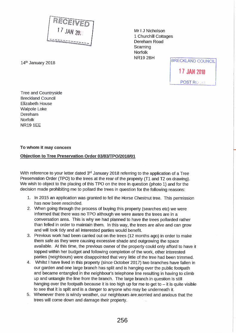
256
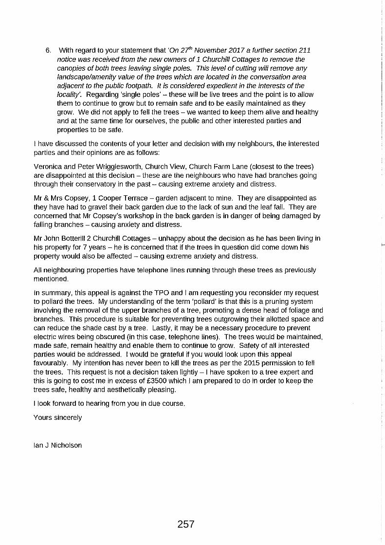
257
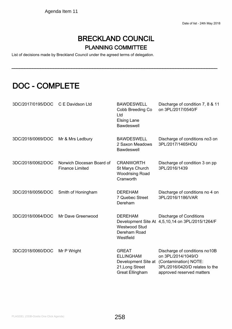
Date of list - 24th May 2018
List of decisions made by Breckland Council under the agreed terms of delegation. _______________________________________________________________________________
BRECKLAND COUNCILPLANNING COMMITTEE
DOC - COMPLETE
3DC/2017/0195/DOC C E Davidson Ltd BAWDESWELLCobb Breeding CoLtdElsing LaneBawdeswell
Discharge of condition 7, 8 & 11on 3PL/2017/0540/F
3DC/2018/0069/DOC Mr & Mrs Ledbury BAWDESWELL2 Saxon MeadowsBawdeswell
Discharge of conditions no3 on3PL/2017/1465HOU
3DC/2018/0062/DOC Norwich Diocesan Board ofFinance Limited
CRANWORTHSt Marys ChurchWoodrising RoadCranworth
Discharge of condition 3 on pp3PL/2016/1439
3DC/2018/0056/DOC Smith of Honingham DEREHAM7 Quebec StreetDereham
Discharge of conditions no 4 on3PL/2016/1186/VAR
3DC/2018/0064/DOC Mr Dave Greenwood DEREHAMDevelopment Site AtWestwood StudDereham RoadWestfield
Discharge of Conditions4,5,10,14 on 3PL/2015/1264/F
3DC/2018/0060/DOC Mr P Wright GREATELLINGHAMDevelopment Site at21,Long StreetGreat Ellingham
Discharge of conditions no10Bon 3PL/2014/1049/O(Contamination) NOTE:3PL/2016/0420/D relates to theapproved reserved matters
PLAGDEL (ODB-Ocella One Click Agenda) 258
Agenda Item 11
3DC/2018/0071/DOC Mrs Vanessa Hales HARLINGNew Dawn,WestHarling RoadHarling
Discharge of Conditions no4 on3PL/2015/0494/F
3DC/2018/0065/DOC Mr M Monk HOCKERINGDevelopmentSite,Heath RoadHockering
Discharge of Conditions3,4,5,6,14 on 3PL/2015/1113/F
3DC/2018/0055/DOC Barconn Ltd MILEHAMFormer RedRoofs,The StreetMileham
Discharge of conditions no 4 &5 on 3PL/2017/0430/F
3DC/2017/0186/DOC Black Lion Hotel Ltd. NEWTON BY C.ACREGeorge and DragonPublic House, Roadfrom Swaffham toWeasenham AllSaints, Newton byCastle Acre
Discharge of Conditions 3, 4 &5 on 3PL/2017/1610/VAR
3DC/2018/0067/DOC Mr & Mrs R Gamble SHIPDHAMLand to Rear of 27Market StreetShipdham
Discharge of Conditions 3 on3PL/2017/1533/F
3DC/2018/0061/DOC K C Edwards (Builders) Ltd SOUTH LOPHAMWillow Brae,TheStreetSouth Lopham
Discharge of conditions No3,4,7 on 3PL/2016/0500/F
3DC/2018/0012/DOC Abel Homes Ltd SWAFFHAMSwans Nest Site,Land East ofBrandon RoadSwaffham
Discharge of condition 17 on pp3PL/2012/0576/O
3DC/2018/0075/DOC New Era Fuels Ltd SWAFFHAMLand at Turbine WaySwaffham
Discharge of Conditions 5,6,7,on 3PL/2018/0068/VAR
3DC/2018/0070/DOC Eprojem Property InvestmentMa
THETFORD6A Keats CloseThetford
Discharge of Conditions 5 and 7APP/F2605/W/17/3177777(3PL/2017/0401/F)
PLAGDEL (ODB-Ocella One Click Agenda) 259
3DC/2017/0208/DOC Abel Homes Ltd WATTONLand off TownGreen RoadWatton
Discharge of conditions 14 & 20on 3PL/2015/1191/O
3DC/2018/0085/DOC Rev RH Elphick & Mrs PJElphick
WEASENHAM ALLSAINTS1 Barn CottageDodma RoadWeasenham
Discharge of Condition 4 on3PL/2013/0635/F
DOC-Discharge PART
3DC/2017/0218/DOC Norfolk Homes Ltd ATTLEBOROUGHCarvers LaneAttleborough
Discharge of conditions 4, 7, 8,9, 10, 12, 13, 21 and 23 on pp3PL/2014/1264/F
No Prior Approval
3PN/2018/0012/PNE Mrs C Thelwell ATTLEBOROUGH18 Constable CloseAttleborough
Single Storey Rear Extension
3PN/2018/0011/UC Mr David Johnson DEREHAMSpotlights, TheatreStreetDereham
Change of use to one dwelling(permitted development)
3PN/2018/0016/PNE Mrs Dianne Whymark KENNINGHALLMill View BanhamRoadKenninghall
Single Storey Flat RoofExtension
3PN/2018/0014/PNE Mr Dean Fry THETFORD61 Norwich RoadThetford
Proposed single storey rearextension
Permission
PLAGDEL (ODB-Ocella One Click Agenda) 260
3PL/2018/0287/CU Breckland Dog Training ASHILLTheHollies,SwaffhamRoadAshill
Change of use of section ofbarn and adjacent paddockfrom agricultural use to a dogtraining facility and a parkingarea
3PL/2018/0304/HOU Mr & Mrs Townsend ASHILLPollywiggle CottageHale RoadAshill
Proposed extension to rear andside of property incorporatingnew garage
3NM/2018/0027/NMA Mr Simon Hazelby ATTLEBOROUGHLand Adjacent toThe Mulberry TreeStation Road,Attleborough
Amendment to3PL/2017/1538/D in respect ofchange from painted timbersash windows to cream UPVCsash windows windows
3PL/2018/0163/HOU Mr Chris Webster ATTLEBOROUGHCorner Farm WestCarr RoadAttleborough
Re-Construction of northernbarn to front elevation
3PL/2018/0164/LB Mr Chris Webster ATTLEBOROUGHCorner Farm WestCarr RoadAttleborough
Re-Construction of northernbarn to front elevation
3PL/2018/0349/F SLA Prperty Company Ltd.. ATTLEBOROUGHBrecklandLodge,London RoadAttleborough
Reinstatement of Restaurant,Sanitary Facilities, Receptionand office.
3PL/2018/0380/D Mr Anthony Gaskin ATTLEBOROUGHFernleighLondon Road
Details of proposed 3 BedroomBungalow agreed at Outlineunder planning permission3PL/2017/0983/O
3PL/2018/0392/HOU Mr Vincent Albani ATTLEBOROUGHDairy Farm HouseWest Carr RoadAttleborough
Erection of a Three Bay CartLodge
3PL/2018/0223/HOU Mr Mark Birleson BANHAMCider Barn HeathRoadBanham
Single Storey Extension to therear corner of the propertiesknown as Cider Barn
PLAGDEL (ODB-Ocella One Click Agenda) 261
3PL/2018/0322/VAR Mr P Lawton BANHAM5 Grammar SchoolYard Church LaneBanham
Variation of condition 2 and 5on 3PL/2017/0458/F
3PL/2018/0330/LB Mr P Lawton BANHAM5 Grammar SchoolYardChurch Lane,Banham
Variation of condition 2 and 5on 3PL/2017/0458/F
3PL/2018/0343/HOU Mr & Mrs Nick Armstrong BANHAMHome Farm,ChurchHillBanham
New timber boarded summerhouse to rear garden area.
3PL/2018/0358/HOU Miss C Dickenson BANHAMBluebell Barn,LongLaneBanham
Demolition of outbuilding anderection of cart lodge(retrospective)
3PL/2018/0393/HOU Mr Dan Jermany BEETLEY23 Beech RoadBeetley
Proposed Rear Extension toBungalow
3PL/2018/0112/F Mr & Mrs CG Sanders BESTHORPEUnit 31 RookeryBusiness Park,SilverStreetBesthorpe
Change of use from B8 to SuiGeneris to a luxury caninecreche/dog day care centre andexternal exercise area enclosedby fence
3PL/2018/0316/VAR Oakley Coach Builders BESTHORPEBesthorpe TradingEstate NorwichRoadBesthorpe
Variation of condition 16 on pp3PL/2017/0688/F - pre-commencement contaminationcondition works already started
3PL/2018/0371/HOU Ms Hilary Holden BLO' NORTONTara Well,Clay HallLaneBlo Norton
Demolition of existing westlean-to extension and erectionof replacement extension tosame location. Roofextensions/re-roofing to eastand north extension elements.Installation of insulated rendersystem & replacement windows& doors.
PLAGDEL (ODB-Ocella One Click Agenda) 262
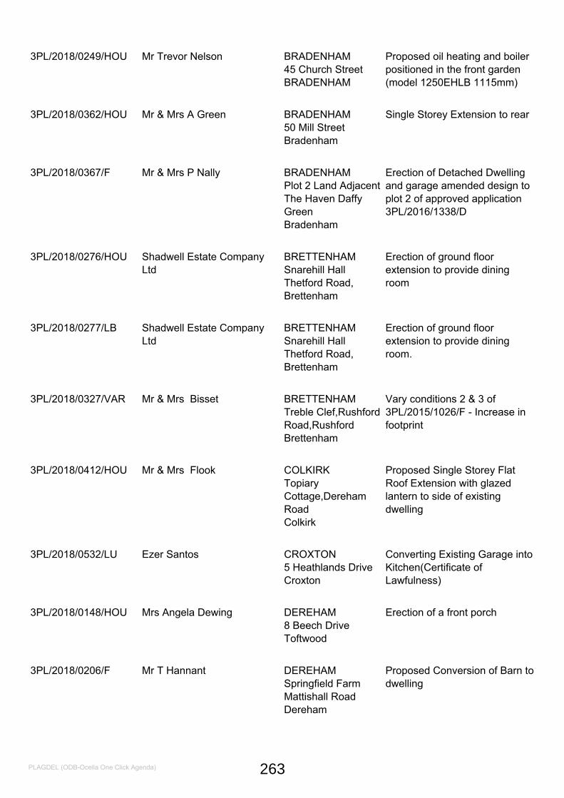
3PL/2018/0249/HOU Mr Trevor Nelson BRADENHAM45 Church StreetBRADENHAM
Proposed oil heating and boilerpositioned in the front garden(model 1250EHLB 1115mm)
3PL/2018/0362/HOU Mr & Mrs A Green BRADENHAM50 Mill StreetBradenham
Single Storey Extension to rear
3PL/2018/0367/F Mr & Mrs P Nally BRADENHAMPlot 2 Land AdjacentThe Haven DaffyGreenBradenham
Erection of Detached Dwellingand garage amended design toplot 2 of approved application3PL/2016/1338/D
3PL/2018/0276/HOU Shadwell Estate CompanyLtd
BRETTENHAMSnarehill HallThetford Road,Brettenham
Erection of ground floorextension to provide diningroom
3PL/2018/0277/LB Shadwell Estate CompanyLtd
BRETTENHAMSnarehill HallThetford Road,Brettenham
Erection of ground floorextension to provide diningroom.
3PL/2018/0327/VAR Mr & Mrs Bisset BRETTENHAMTreble Clef,RushfordRoad,RushfordBrettenham
Vary conditions 2 & 3 of3PL/2015/1026/F - Increase infootprint
3PL/2018/0412/HOU Mr & Mrs Flook COLKIRKTopiaryCottage,DerehamRoadColkirk
Proposed Single Storey FlatRoof Extension with glazedlantern to side of existingdwelling
3PL/2018/0532/LU Ezer Santos CROXTON5 Heathlands DriveCroxton
Converting Existing Garage intoKitchen(Certificate ofLawfulness)
3PL/2018/0148/HOU Mrs Angela Dewing DEREHAM8 Beech DriveToftwood
Erection of a front porch
3PL/2018/0206/F Mr T Hannant DEREHAMSpringfield FarmMattishall RoadDereham
Proposed Conversion of Barn todwelling
PLAGDEL (ODB-Ocella One Click Agenda) 263
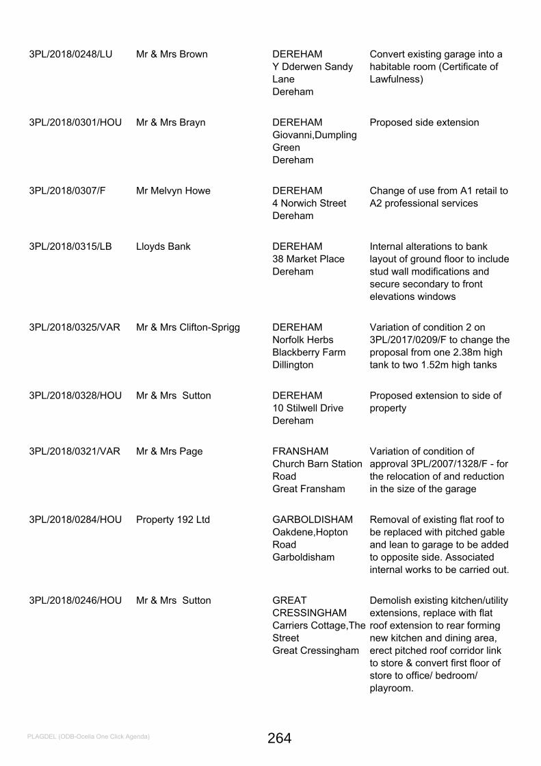
3PL/2018/0248/LU Mr & Mrs Brown DEREHAMY Dderwen SandyLaneDereham
Convert existing garage into ahabitable room (Certificate ofLawfulness)
3PL/2018/0301/HOU Mr & Mrs Brayn DEREHAMGiovanni,DumplingGreenDereham
Proposed side extension
3PL/2018/0307/F Mr Melvyn Howe DEREHAM4 Norwich StreetDereham
Change of use from A1 retail toA2 professional services
3PL/2018/0315/LB Lloyds Bank DEREHAM38 Market PlaceDereham
Internal alterations to banklayout of ground floor to includestud wall modifications andsecure secondary to frontelevations windows
3PL/2018/0325/VAR Mr & Mrs Clifton-Sprigg DEREHAMNorfolk HerbsBlackberry FarmDillington
Variation of condition 2 on3PL/2017/0209/F to change theproposal from one 2.38m hightank to two 1.52m high tanks
3PL/2018/0328/HOU Mr & Mrs Sutton DEREHAM10 Stilwell DriveDereham
Proposed extension to side ofproperty
3PL/2018/0321/VAR Mr & Mrs Page FRANSHAMChurch Barn StationRoadGreat Fransham
Variation of condition ofapproval 3PL/2007/1328/F - forthe relocation of and reductionin the size of the garage
3PL/2018/0284/HOU Property 192 Ltd GARBOLDISHAMOakdene,HoptonRoadGarboldisham
Removal of existing flat roof tobe replaced with pitched gableand lean to garage to be addedto opposite side. Associatedinternal works to be carried out.
3PL/2018/0246/HOU Mr & Mrs Sutton GREATCRESSINGHAMCarriers Cottage,TheStreetGreat Cressingham
Demolish existing kitchen/utilityextensions, replace with flatroof extension to rear formingnew kitchen and dining area,erect pitched roof corridor linkto store & convert first floor ofstore to office/ bedroom/playroom.
PLAGDEL (ODB-Ocella One Click Agenda) 264
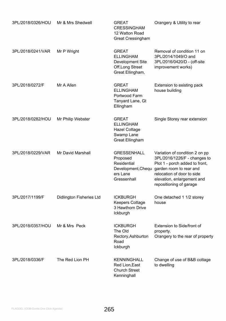
3PL/2018/0326/HOU Mr & Mrs Shedwell GREATCRESSINGHAM12 Watton RoadGreat Cressingham
Orangery & Utility to rear
3PL/2018/0241/VAR Mr P Wright GREATELLINGHAMDevelopment SiteOff,Long StreetGreat Ellingham,
Removal of condition 11 on3PL/2014/1049/O and3PL/2016/0420/D - (off-siteimprovement works)
3PL/2018/0272/F Mr A Allen GREATELLINGHAMPortwood FarmTanyard Lane, GtEllingham
Extension to existing packhouse building
3PL/2018/0282/HOU Mr Philip Webster GREATELLINGHAMHazel CottageSwamp LaneGreat Ellingham
Single Storey rear extension
3PL/2018/0229/VAR Mr David Marshall GRESSENHALLProposedResidentialDevelopment,Chequers LaneGressenhall
Variation of condition 2 on pp3PL/2016/1226/F - changes toPlot 1 - porch added to front,garden room to rear andrelocation of door to sideelevation, enlargement andrepositioning of garage
3PL/2017/1199/F Didlington Fisheries Ltd ICKBURGHKeepers Cottage3 Hawthorn DriveIckburgh
One detached 1 1/2 storeyhouse
3PL/2018/0357/HOU Mr & Mrs Peck ICKBURGHThe OldRectory,AshburtonRoadIckburgh
Extension to Side/front ofproperty.Orangery to the rear of property
3PL/2018/0336/F The Red Lion PH KENNINGHALLRed Lion,EastChurch StreetKenninghall
Change of use of B&B cottageto dwelling
PLAGDEL (ODB-Ocella One Click Agenda) 265
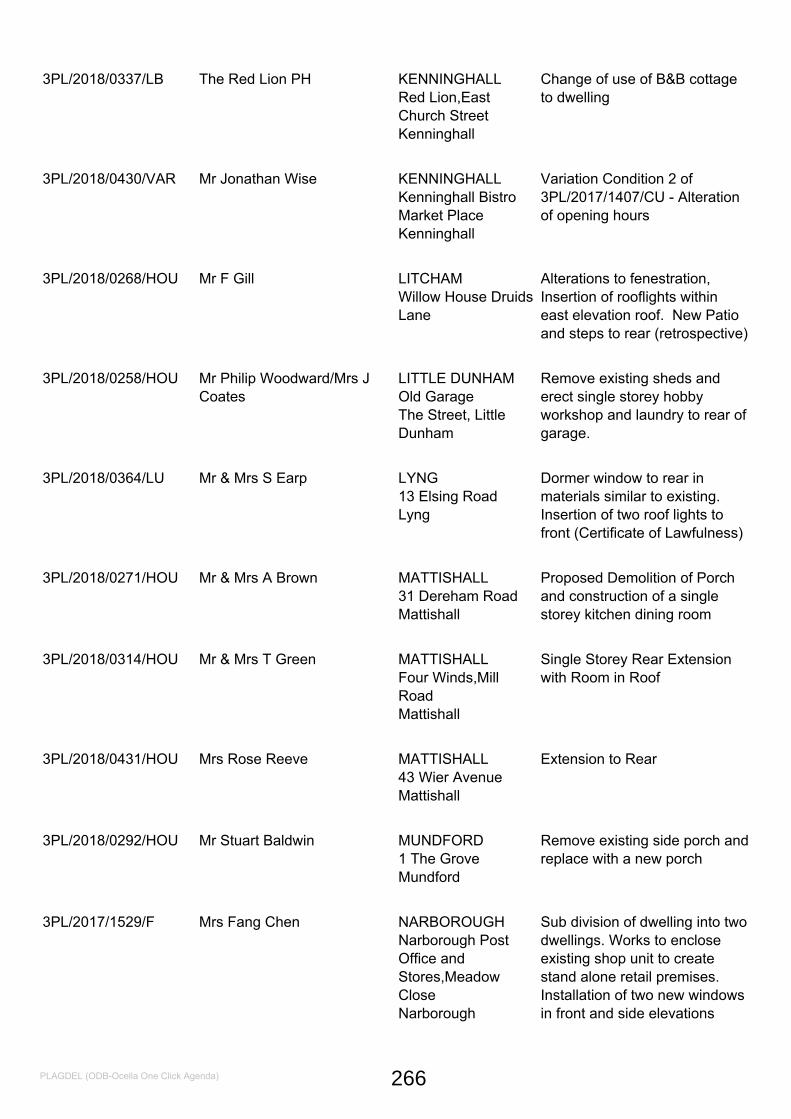
3PL/2018/0337/LB The Red Lion PH KENNINGHALLRed Lion,EastChurch StreetKenninghall
Change of use of B&B cottageto dwelling
3PL/2018/0430/VAR Mr Jonathan Wise KENNINGHALLKenninghall BistroMarket PlaceKenninghall
Variation Condition 2 of3PL/2017/1407/CU - Alterationof opening hours
3PL/2018/0268/HOU Mr F Gill LITCHAMWillow House DruidsLane
Alterations to fenestration,Insertion of rooflights withineast elevation roof. New Patioand steps to rear (retrospective)
3PL/2018/0258/HOU Mr Philip Woodward/Mrs JCoates
LITTLE DUNHAMOld GarageThe Street, LittleDunham
Remove existing sheds anderect single storey hobbyworkshop and laundry to rear ofgarage.
3PL/2018/0364/LU Mr & Mrs S Earp LYNG13 Elsing RoadLyng
Dormer window to rear inmaterials similar to existing.Insertion of two roof lights tofront (Certificate of Lawfulness)
3PL/2018/0271/HOU Mr & Mrs A Brown MATTISHALL31 Dereham RoadMattishall
Proposed Demolition of Porchand construction of a singlestorey kitchen dining room
3PL/2018/0314/HOU Mr & Mrs T Green MATTISHALLFour Winds,MillRoadMattishall
Single Storey Rear Extensionwith Room in Roof
3PL/2018/0431/HOU Mrs Rose Reeve MATTISHALL43 Wier AvenueMattishall
Extension to Rear
3PL/2018/0292/HOU Mr Stuart Baldwin MUNDFORD1 The GroveMundford
Remove existing side porch andreplace with a new porch
3PL/2017/1529/F Mrs Fang Chen NARBOROUGHNarborough PostOffice andStores,MeadowCloseNarborough
Sub division of dwelling into twodwellings. Works to encloseexisting shop unit to createstand alone retail premises.Installation of two new windowsin front and side elevations
PLAGDEL (ODB-Ocella One Click Agenda) 266
3NM/2018/0015/NMA Norfolk Holdings Limited NORTHTUDDENHAMThe Lodge PublicHouse,Main RoadNorth Tuddenham
Amendment to approved pp3PL/2017/0928/F Extension ofpublic house to create villageshop & erection of 5 dwellingswith parking (change of brickwork to dwellings)
3PL/2018/0300/VAR Mr & Mrs Colin Jack OLD BUCKENHAMWhitehandsFarm,StacksfordOld Buckenham
Variation of condition 2 to3PL/2016/0376/F - to includeparking of a vehicle
3PL/2017/1476/HOU Mr Stephen Thurston QUIDENHAMChartesworth HouseBanham RoadQuidenham
Erection of new single storeytimber framed lean-to extensionto existing garage. To be clad inblack feather edge board tomatch garage and used forstorage.
3PL/2018/0335/D Mr Stephen Baker ROCKLANDSThe CoachHouse,LowLane,Rockland AllSaintsRockland
Reserved matters applicationfor a dwelling following previousoutline approval3PL/2016/1119/O.
3PL/2018/0295/HOU Mrs Heidi Ashford SCARNING7 Norman CloseScarning
Proposed porch
3PL/2018/0346/HOU Mr & Mrs Geoff Hearn SCARNINGClear View,ChurchFarm LaneScarning
Rear extension to replaceexisting conservatory
3PL/2018/0253/HOU Mr Roy Gutteridge SCOULTONLilac & LaughterCottage NorwichRoadScoulton
Remove two greenhouses andstore and erection of woodenworkshop/studio on newhardstanding
3PL/2018/0352/HOU Mr David Ellis SHIPDHAM3- MewsCourt,Larwood WayShipdham
First floor front extension overexisting porch and single storeyrear extension
PLAGDEL (ODB-Ocella One Click Agenda) 267
3PL/2017/1109/LU Mr John Moore SPORLERose Cottage24 The StreetSporle
Cover front of garage withFeather Boarding (certificate oflawfulness)
3PL/2018/0269/F Mr Jermy Mason t/aSporleFarms
SPORLELittle Palgrave Hall
Proposed new Agriculturalbuilding to store grain harvestedfrom adjacent fields
3PL/2017/0218/F Mr Aiden Brennan SWAFFHAMUnits 3 & 4 ValleyFarmNorth PickenhamRoad Swaffham
Conversion of Barn into 2 units& cart shed & store (renewal ofapproval)
3PL/2017/1170/F Mr David Moore SWAFFHAM78, The OaklandsSwaffham
Erection of 2 storey dwellingand detached garage
3PL/2017/1607/F Mr Matthew Green SWAFFHAMSite to the rear of theTrain Shed,StationStreetSwaffham
Retrospective change of use ofthe land for the siting of 23 self-storage cabins/containers andthe siting of a further 12cabins/containers all for non-hazardous domestic storage
3PL/2018/0345/HOU Mr Walker SWAFFHAM4 Spinners LaneSwaffham
Proposed extensions to rearand side of property
3PL/2018/0375/HOU S D Atkins SWAFFHAM8 Norwich RoadSwaffham
Single Storey Extension
3PL/2018/0014/D Wensum Valley Homes Ltd SWANTONMORLEYNew HouseGooseberry HillSwanton Morley
Erection of 9 dwellings
3NM/2018/0025/NMA Mr Robert Howes-Ward THETFORDSchool Lane SurgerySchool LaneThetford
Amendment to3PL/2016/0017/F - internallayout changes
PLAGDEL (ODB-Ocella One Click Agenda) 268
3NM/2018/0035/NMA Rouf Homes Ltd THETFORDLand Off KimmsBelt/London RoadThetford
Variation to3PL/2017/0970/VAR - tochange block paving in parkingbays and undercroft to porousasphalt solution
3PL/2018/0281/HOU Mr & Mrs Ainger THETFORD35 Churchill Road
Conversion of attached garageto create one additionalbedroom
3PL/2018/0373/HOU Mr Ryan Tucker THETFORD61 Norwich RoadThetford
Proposed front and sideextension and garage
3PL/2018/0437/LU Mr & Mrs A Bloom THETFORD17 Buttercup CloseThetford
Single Storey Extension to RearCertificate of Lawfulness
3PL/2018/0265/HOU Mr Roy Brooklyn THOMPSONNovus CottageMill Road,Thompson
Two bay oak framed cart lodge
3NM/2018/0028/NMA Mr Thomas Bennett WATTONThe Birches3 Portal Avenue,Watton
Amendment to3PL/2015/1497/F in respect ofgarage element of scheme tohabitable room
3PL/2018/0169/LU Mr David Bush WATTON26 Shire Horse WayWatton
Erection of a white upvcconservatory to be positioned atthe rear of the property(certificate of lawfulness)
3PL/2018/0334/HOU Mr Janes WATTON223 Lovell GardensWatton
Proposed Extension to rear ofproperty
3PL/2018/0319/F Mr Christopher McCarthy WEASENHAM ALLSAINTS101 Church LaneWeasenham AllSaints
Erect Single StoreyConservatory to Existingdwelling change use ofAgricultural land to garden
3PL/2018/0341/D Mr & Mrs R Geddes-Green WEETINGLand to the rear of 6Cromwell RoadWeeting
Proposed dwelling and car port
PLAGDEL (ODB-Ocella One Click Agenda) 269
3PL/2018/0384/LU Mrs Ruth Stamp WEETING34 Castle CloseWeeting
Create new opening at groundfloor side elevation (Certificateof Lawfulness)
Prior Approval Refusal
3PN/2018/0017/UC Mr R Richards OLD BUCKENHAMBarn at RoughlandsFarm Grove RoadOld Buckenham
Change of use of agriculturalbuilding to dwelling (permitteddevelopment)
Refusal
3PL/2018/0355/F Mr Jonathan Sim ATTLEBOROUGHLand Adjoining 15Mill LaneAttleborough
Detached two and a half storeydwelling with room in loft withexisting garage facility and 4car parking spaces
3PL/2018/0225/O R Diaper COLKIRKSolWhissonsett RoadColkirk
Subdivision of plot for proposednew dwelling
3PL/2017/1599/F Tarn Developments Ltd MATTISHALLRayners Farm,88Dereham RoadMattishall
Erection of two dwellings withgarages
3PL/2018/0107/VAR Persimmon Homes EastMidlands
NARBOROUGHSkippers MeadowLand at Chalk LaneNarborough
Variation of condition 2 on pp3PL/2015/0926/D - removesmall section of landscapebuffer on northern boundary ofplot 65
3PL/2018/0237/D Jadelink Uk Ltd SAHAM TONEYDevelopmentSite,Richmond RoadSaham Toney
Reserved matters applicationfor a detached dwelling andgarage following previousoutline approval3PL/2016/0284/O
PLAGDEL (ODB-Ocella One Click Agenda) 270
3PL/2018/0278/F Mr & Mrs Tim Abel SCARNINGPennymeadowNurseryPodmore Lane,Scarning
Residential Development ( twodetached bungalows )
3PL/2018/0142/F Mr Stewart Barber SWANTONMORLEYMerryfield39 GreengateSwanton Morley
Erection of two detacheddwellings with integral garages
PLAGDEL (ODB-Ocella One Click Agenda) 271
APPEALS SUMMARY- JUNE
3PL/2017/0969/F
Land off Fen Road, adjoining Innishowen, Fen Road, Old Buckenham, Norfolk NR17 1NP ( New dwelling and double cart lodge)
DISMISSED
Whilst the Inspector accepted that there would be a social benefit as a result of providing a new dwelling and that economically, there would also be a benefit to local businesses and the workforce that would construct the building. The Inspector also acknowledged that the provision would make a small contribution to the Council’s housing shortfall. He concluded that the development would fail to contribute towards protecting and enhancing the natural environment and would fail to make the fullest possible use of sustainable transport modes. Thus, as the three dimensions of sustainable development should not be taken in isolation, he found that the adverse impacts of the development would significantly and demonstrably outweigh its benefits. The appeal was accordingly dismissed.
3PL/2017/1121/F
Land adjacent The Vines, The Street, Great Cressingham, IP25 6NL (Erection of detached dwelling and garage)
DISMISSED
The Inspector noted that Great Gressingham provides very few services for day to day living and occupants of the dwelling would need to travel to either Swaffham or Watton, both of which are some distance away, to access facilities and amenities such as shops, schools and transport links. Given the distance from these services it is highly likely that such trips would be undertaken by private car. This would be contrary to a core planning principle of the Framework which seeks to actively manage patterns of growth to make the fullest possible use of public transport, walking and cycling. The Inspector concluded that the proposal would not represent a sustainable form of development. The proposal would conflict with Policies SS1, DC2 and CP14 of the Core Strategy and Framework which seek amongst other things, to focus new development to sustainable locations. The appeal was accordingly dismissed.
3PL/2017/0587/6
6 Dodds Lane, Attelborough (Erection of 1 three bedroom dwelling with associate parking and turning)
ALLOWED
The main issue of consideration was the impact on highway safety. The Inspector noted the access has clearly been in use for a very long time and there was no evidence regarding any collisions for the last 19 years. Therefore, although it is substandard in terms of visibility,
272
Agenda Item 12
Dodds Lane nevertheless appears to successfully serve the existing three properties. The small increase in six daily vehicle movements resulting from one additional dwelling ,would not therefore, be detrimental to highway safety and is unlikely to translate into large numbers of vehicles waiting on Dodds Road to enter Dodds Lane. The Inspector concluded that the intensified use of Dodds Lane would not be detrimental to highway safety. A safe and suitable access could be provided to the development which would not conflict with paragraph 32 of the National Planning Policy Framework.
3PL/2016/1499/0
Land North of Norwich Road, Yaxham, (Erection of 25 dwellings with new access point and associated landscaping, open space and car parking)
ALLOWED
The Inspector considered the main issues were whether the adverse impacts of the proposal, having particular regard to the character and appearance of the area, would significantly and demonstrably outweigh its benefits. While it is inevitable that environmental harm would arise from a development within the countryside, the proposal would been seen against the backdrop of existing development on Norwich Road and St Peter’s Close. Moreover, at a density of some 19 dwellings per hectare it would be in keeping with the low density housing in the area and the illustrative plans show large areas of the site undeveloped, allowing the opportunity for open spaces and planting which would minimise its impact on the landscape. Whilst the Inspector concluded that there would be some moderate harm to the character and appearance of the area. As such, the development would be in conflict with Policy CP11 of Core Strategy, Policy Hou 6 of the Yaxham Neighbourhood Plan and the Framework which seek, amongst other things, to ensure that development proposals do not adversely impact on the essentially rural character and appearance of the area and seeks to protect the landscape of the District for its own sake. Balanced against this is the contribution to the supply of housing of up to 25 new homes with 40% of those affordable, which would also be delivered in the short term, to which he gave significant weight.
Taking every thing into account including all other material considerations, he concluded that the adverse impacts of granting planning permission would not significantly and demonstrably outweigh the benefits of the proposed development when assessed against the policies in the Framework as a whole.
273


