Embed Size (px)
Citation preview
PUB.
(ENROUTE)SAILING DIRECTIONS
★
★
2021
155
EAST COAST OF RUSSIA
Prepared and published by theNATIONAL GEOSPATIAL-INTELLIGENCE AGENCY
Springfield, Virginia
© COPYRIGHT 2021 BY THE UNITED STATES GOVERNMENTNO COPYRIGHT CLAIMED UNDER TITLE 17 U.S.C.
FIFTEENTH EDITION
For sale by the Superintendent of Documents, U.S. Government Printing Office
Internet: http://bookstore.gpo.gov Phone: toll free (866) 512-1800; DC area (202) 512-1800Fax: (202) 512-2250 Mail Stop: SSOP, Washington, DC 20402-0001
II
Pub. 155
Preface
0.0 Pub. 155, Sailing Directions (Enroute) East Coast of Russia,Fifteenth Edition, 2021 is issued for use in conjunction withPub. 120, Sailing Directions (Planning Guide) Pacific Oceanand Southeast Asia. The companion volumes are Pubs. 153,154, 157, 158, and 159.0.0 Digital Charts 24 and 27 provide electronic chart coveragefor the area covered by this publication. 0.0 This publication has been corrected to 7 August 2021, in-cluding Notice to Mariners No. 32 of 2021. Subsequent up-dates have corrected this publication to 7 May 2022, includingNotice to Mariners No. 19 of 2022.
Explanatory Remarks
0.0 Sailing Directions are published by the National Geospatial-Intelligence Agency (NGA) under the authority of Departmentof Defense Directive 5105.60, dated 29 July 2009, and pursu-ant to the authority contained in U. S. Code Title 10, Chapter22, Section 451 and Title 44, Section 1336. Sailing Directions,covering the harbors, coasts, and waters of the world, provideinformation that cannot be shown graphically on nauticalcharts and is not readily available elsewhere.0.0 Sailing Directions (Enroute) include detailed coastal andport approach information which supplements the largest scalechart produced by the National Geospatial-IntelligenceAgency. This publication is divided into geographic areascalled “Sectors.”0.0 Bearings.—Bearings are true, and are expressed in degreesfrom 000° (north) to 360°, measured clockwise. Generalbearings are expressed by the initial letters of the points of thecompass (e.g. N, NNE, NE, etc.). Adjective and adverbendings have been discarded. Wherever precise bearings areintended, degrees are used.0.0 Charts.—Reference to charts made throughout thispublication refer to both the paper chart and the DigitalNautical Chart (DNC). 0.0 Corrective Information.—Users should refer corrections,additions, and comments to NGA’s Maritime Operations Deskor the Maritime Safety Office, as follows:
0.0 New editions of Sailing Directions are corrected through thedate of publication shown above. Important information toamend material in the publication is available is updated asneeded and available as a downloadable corrected publicationfrom the NGA Maritime Domain web site.
0.0 Courses.—Courses are true, and are expressed in the samemanner as bearings. The directives “steer” and “make good” acourse mean, without exception, to proceed from a point oforigin along a track having the identical meridional angle asthe designated course. Vessels following the directives mustallow for every influence tending to cause deviation from suchtrack, and navigate so that the designated course iscontinuously being made good.0.0 Currents.—Current directions are the true directions towardwhich currents set.0.0 Distances.—Distances are expressed in nautical miles of 1minute of latitude. Distances of less than 1 mile are expressedin meters, or tenths of miles.0.0 Geographic Names.—Geographic names are generallythose used by the nation having sovereignty. Names in paren-theses following another name are alternate names that mayappear on some charts. In general, alternate names are quotedonly in the principal description of the place. Diacritical marks,such as accents, cedillas, and circumflexes, which are related tospecific letters in certain foreign languages, are not used in theinterest of typographical simplicity.0.0 Geographic names or their spellings do not necessarily re-flect recognition of the political status of an area by the UnitedStates Government.0.0 Heights.—Heights are referred to the plane of referenceused for that purpose on the charts and are expressed in meters.0.0 Internet Links.—This publication provides Internet links toweb sites concerned with maritime navigational safety, includ-
NGA Maritime—Contact Information
Maritime Operations Desk
Toll free 1-800-362-6289
Commercial 571-557-5455
DSN 547-5455
E-mail [email protected]
Maritime Safety Office
DNC web site https://dnc.nga.mil
Maritime Domain web site
https://msi.nga.mil
E-mail [email protected]
Maritime Quality Feedback System (MQFS)
https://marhelp.nga.mil
Mailing address Maritime Safety OfficeNational Geospatial-Intelligence AgencyMail Stop N64-SFH7500 Geoint DriveSpringfield VA 22150-7500
NGA Maritime Safety Office Web Site
https://msi.nga.mil
NGA Maritime—Contact Information
III
Pub. 155
ing but not limited to, Federal government sites, foreign Hy-drographic Offices, and foreign public/private port facilities.NGA makes no claims, promises, or guarantees concerning theaccuracy, completeness, or adequacy of the contents of theseweb sites and expressly disclaims any liability for errors andomissions in the contents of these web sites.0.0 International Ship and Port Facility Security (ISPS)Code.—The ISPS Code is a comprehensive set of measures toenhance the security of ships and port facilities developed inresponse to the perceived threats to ships and port facilities inthe wake of the 9/11 attacks in the United States. Informationon the ISPS Code can be found at the International MaritimeOrganization web site:
0.0 Lights and Fog Signals.—Lights and fog signals are notdescribed, and light sectors are not usually defined. The LightLists should be consulted for complete information.0.0 National Ocean Claims.—Information on national oceanclaims and maritime boundary disputes, which have been com-piled from the best available sources, is provided solely in theinterest of the navigational safety of shipping and in no wayconstitutes legal recognition by the United States. These non-recognized claims and requirements may include, but are notlimited to:
1. A requirement by a state for advance permission ornotification for innocent passage of warships in the territorialsea.
2. Straight baseline, internal waters, or historic watersclaims.
3. The establishment of a security zone, where a stateclaims to control activity beyond its territorial sea for securi-ty reasons unrelated to that state’s police powers in its terri-tory, including its territorial sea.
0.0 Radio Navigational Aids.—Radio navigational aids and ra-dio weather services are not described in detail. PublicationNo. 117 Radio Navigational Aids and NOAA Publication, Se-lected Worldwide Marine Weather Broadcasts, should be con-sulted.0.0 Soundings.—Soundings are referred to the datum of thecharts and are expressed in meters.
Telephone and Facsimile Numbers.—Within thispublication, the international telephone and facsimile numbersprovided as contact information contain the minimum digitsnecessary to dial. Please note that these contact numbers do notinclude additional digits or special characters, such as (0) or (+),which may be required when dialing. The necessity of suchdigits and characters depend upon numerous factors andconditions, such as the user’s geolocation and service provider.
Mariners are advised to consult their communicationsequipment and service provider manuals for guidance. 0.0 Time.—Time is normally expressed as local time unlessspecifically designated as Universal Coordinated Time (UTC). 0.0 Time Zone.—The Time Zone description(s), as well as in-formation concerning the use of Daylight Savings Time, are in-cluded. The World Time Zone Chart is available on the Inter-net at the web site given below.
0.0 U.S. Maritime Advisory System.—The U.S. MaritimeAdvisory System is a streamlined inter-agency approach toidentifying and promulgating maritime security threats. Thesystem replaces Special Warnings to Mariners (StateDepartment), MARAD Advisories (Maritime Administration),and Marine Safety Information Bulletins (U.S. Coast Guard)and consists of the following items:
1. U.S. Maritime Alert—Provides basic information(location, incident, type, date/time) on reported maritimesecurity threats to U.S. maritime industry interests. U.S.Maritime alerts do not contain policy or recommendationsfor specific courses of information.
2. U.S. Maritime Advisory—Provides more detailedinformation, when appropriate, through a “whole-of-gov-ernment” response to an identified maritime threat.
0.0 Winds.—Wind directions are the true directions from whichwinds blow.
Reference List
0.0 The principal sources examined in the preparation of thispublication were:0.0 British Hydrographic Department Sailing Directions.0.0 Canadian Hydrographic Service Sailing Directions.0.0 Various port handbooks.0.0 Reports from United States naval and merchant vessels andvarious shipping companies.0.0 Other U.S. Government publications, reports, and docu-ments.0.0 Charts, light lists, tide and current tables, and other docu-ments in possession of the Agency.
International Maritime Organization Home Page
http://www.imo.org
Standard Time Zone of the World Chart
https://www.cia.gov/maps/world-regional
Maritime Administration (MARAD)—U.S. Maritime Advisory System
https://www.marad.dot.gov/environment-and-safety/office-of-security/msci
Date of Change: 7 May 2022
Notice to Mariners: 19/2022
Sector Paragraphs
Sector 1 Paragraphs 1.25, 1.37, and 1.40
IV
Pub. 155
Sector 3 Paragraph 3.21
Sector 5 Paragraph 5.6
Sector 6 Paragraphs 6.12 and 6.22
Sector 7 Paragraphs 7.11, 7.18, 7.47, and 7.48
Sector 8 Paragraphs 8.6, 8.8, 8.15, 8.18, 8.19, 8.28, 8.42, 8.52, and 8.53
Sector 9 Paragraphs 9.36, 9.37, 9.42, 9.43, 9.54, and 9.64
Date of Change: 19 February 2022
Notice to Mariners: 8/2022
Sector Paragraphs
Sector 9 Paragraphs 9.17, 9.45, and 9.59
Date of Change: 6 November 2021
Notice to Mariners: 45/2021
Sector Paragraphs
Sector 1 Paragraphs 1.25, 1.32, and 1.37
Sector 3 Paragraph 3.20
Sector 4 Paragraph 4.6
Sector 6 Paragraph 6.12
Sector 7 Paragraphs 7.6, 7.33, 7.47, and 7.48
Sector 8 Paragraphs 8.8, 8.35, 8.42, 8.52, and 8.53
Sector 9 Paragraphs 9.8, 9.35, 9.36, 9.37, 9.53, 9.58, 9.63, and 9.65
Date of Change: 7 May 2022
Notice to Mariners: 19/2022
Sector Paragraphs
V
Pub. 155
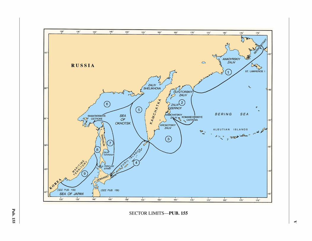
0.0SECTOR LIMITS—PUB. 155
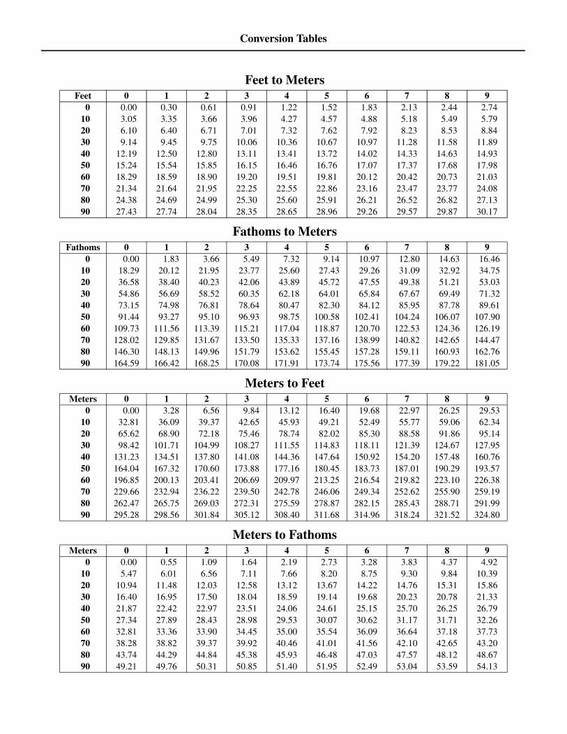
Conversion Tables
Feet to MetersFeet 0 1 2 3 4 5 6 7 8 9 0 0.00 0.30 0.61 0.91 1.22 1.52 1.83 2.13 2.44 2.74 10 3.05 3.35 3.66 3.96 4.27 4.57 4.88 5.18 5.49 5.79 20 6.10 6.40 6.71 7.01 7.32 7.62 7.92 8.23 8.53 8.84 30 9.14 9.45 9.75 10.06 10.36 10.67 10.97 11.28 11.58 11.89 40 12.19 12.50 12.80 13.11 13.41 13.72 14.02 14.33 14.63 14.93 50 15.24 15.54 15.85 16.15 16.46 16.76 17.07 17.37 17.68 17.98 60 18.29 18.59 18.90 19.20 19.51 19.81 20.12 20.42 20.73 21.03 70 21.34 21.64 21.95 22.25 22.55 22.86 23.16 23.47 23.77 24.08 80 24.38 24.69 24.99 25.30 25.60 25.91 26.21 26.52 26.82 27.13 90 27.43 27.74 28.04 28.35 28.65 28.96 29.26 29.57 29.87 30.17
Fathoms to MetersFathoms 0 1 2 3 4 5 6 7 8 9
0 0.00 1.83 3.66 5.49 7.32 9.14 10.97 12.80 14.63 16.46 10 18.29 20.12 21.95 23.77 25.60 27.43 29.26 31.09 32.92 34.75 20 36.58 38.40 40.23 42.06 43.89 45.72 47.55 49.38 51.21 53.03 30 54.86 56.69 58.52 60.35 62.18 64.01 65.84 67.67 69.49 71.32 40 73.15 74.98 76.81 78.64 80.47 82.30 84.12 85.95 87.78 89.61 50 91.44 93.27 95.10 96.93 98.75 100.58 102.41 104.24 106.07 107.90 60 109.73 111.56 113.39 115.21 117.04 118.87 120.70 122.53 124.36 126.19 70 128.02 129.85 131.67 133.50 135.33 137.16 138.99 140.82 142.65 144.47 80 146.30 148.13 149.96 151.79 153.62 155.45 157.28 159.11 160.93 162.76 90 164.59 166.42 168.25 170.08 171.91 173.74 175.56 177.39 179.22 181.05
Meters to FeetMeters 0 1 2 3 4 5 6 7 8 9
0 0.00 3.28 6.56 9.84 13.12 16.40 19.68 22.97 26.25 29.53 10 32.81 36.09 39.37 42.65 45.93 49.21 52.49 55.77 59.06 62.34 20 65.62 68.90 72.18 75.46 78.74 82.02 85.30 88.58 91.86 95.14 30 98.42 101.71 104.99 108.27 111.55 114.83 118.11 121.39 124.67 127.95 40 131.23 134.51 137.80 141.08 144.36 147.64 150.92 154.20 157.48 160.76 50 164.04 167.32 170.60 173.88 177.16 180.45 183.73 187.01 190.29 193.57 60 196.85 200.13 203.41 206.69 209.97 213.25 216.54 219.82 223.10 226.38 70 229.66 232.94 236.22 239.50 242.78 246.06 249.34 252.62 255.90 259.19 80 262.47 265.75 269.03 272.31 275.59 278.87 282.15 285.43 288.71 291.99 90 295.28 298.56 301.84 305.12 308.40 311.68 314.96 318.24 321.52 324.80
Meters to FathomsMeters 0 1 2 3 4 5 6 7 8 9
0 0.00 0.55 1.09 1.64 2.19 2.73 3.28 3.83 4.37 4.92 10 5.47 6.01 6.56 7.11 7.66 8.20 8.75 9.30 9.84 10.39 20 10.94 11.48 12.03 12.58 13.12 13.67 14.22 14.76 15.31 15.86 30 16.40 16.95 17.50 18.04 18.59 19.14 19.68 20.23 20.78 21.33 40 21.87 22.42 22.97 23.51 24.06 24.61 25.15 25.70 26.25 26.79 50 27.34 27.89 28.43 28.98 29.53 30.07 30.62 31.17 31.71 32.26 60 32.81 33.36 33.90 34.45 35.00 35.54 36.09 36.64 37.18 37.73 70 38.28 38.82 39.37 39.92 40.46 41.01 41.56 42.10 42.65 43.20 80 43.74 44.29 44.84 45.38 45.93 46.48 47.03 47.57 48.12 48.67 90 49.21 49.76 50.31 50.85 51.40 51.95 52.49 53.04 53.59 54.13
VII
Pub. 155
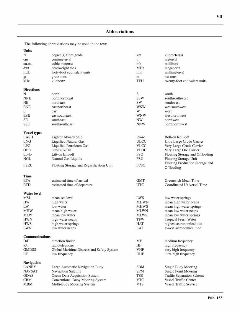
Abbreviations
The following abbreviations may be used in the text:
Units°C degree(s) Centigrade km kilometer(s)cm centimeter(s) m meter(s)cu.m. cubic meter(s) mb millibarsdwt deadweight tons MHz megahertzFEU forty-foot equivalent units mm millimeter(s)gt gross tons nt net tonskHz kilohertz TEU twenty-foot equivalent units
DirectionsN north S southNNE northnortheast SSW southsouthwestNE northeast SW southwestENE eastnortheast WSW westsouthwestE east W westESE eastsoutheast WNW westnorthwestSE southeast NW northwestSSE southsoutheast NNW northnorthwest
Vessel typesLASH Lighter Aboard Ship Ro-ro Roll-on Roll-offLNG Liquified Natural Gas ULCC Ultra Large Crude CarrierLPG Liquified Petroleum Gas VLCC Very Large Crude CarrierOBO Ore/Bulk/Oil VLOC Very Large Ore CarrierLo-lo Lift-on Lift-off FSO Floating Storage and Offloading NGL Natural Gas Liquids FSU Floating Storage Unit
FSRU Floating Storage and Regasification Unit FPSOFloating Production Storage and Offloading
TimeETA estimated time of arrival GMT Greenwich Mean TimeETD estimated time of departure UTC Coordinated Universal Time
Water levelMSL mean sea level LWS low water springsHW high water MHWN mean high water neapsLW low water MHWS mean high water springsMHW mean high water MLWN mean low water neapsMLW mean low water MLWS mean low water springsHWN high water neaps TFW Tropical Fresh WaterHWS high water springs HAT highest astronomical tideLWN low water neaps LAT lowest astronomical tide
CommunicationsD/F direction finder MF medium frequencyR/T radiotelephone HF high frequencyGMDSS Global Maritime Distress and Safety System VHF very high frequencyLF low frequency UHF ultra high frequency
NavigationLANBY Large Automatic Navigation Buoy SBM Single Buoy MooringNAVSAT Navigation Satellite SPM Single Point MooringODAS Ocean Data Acquisition System TSS Traffic Separation SchemeCBM Conventional Buoy Mooring System VTC Vessel Traffic CenterMBM Multi-Buoy Mooring System VTS Vessel Traffic Service
VIII Pub. 155
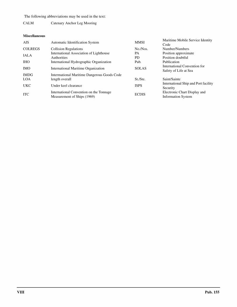
CALM Catenary Anchor Leg Mooring
Miscellaneous
AIS Automatic Identification System MMSIMaritime Mobile Service Identity Code
COLREGS Collision Regulations No./Nos. Number/Numbers
IALAInternational Association of LighthouseAuthorities
PAPD
Position approximatePosition doubtful
IHO International Hydrographic Organization Pub. Publication
IMO International Maritime Organization SOLASInternational Convention for Safety of Life at Sea
IMDG Intermational Maritime Dangerous Goods CodeLOA length overall St./Ste. Saint/Sainte
UKC Under keel clearance ISPSInternational Ship and Port facility Security
ITCInternational Convention on the Tonnage Measurement of Ships (1969)
ECDISElectronic Chart Display and Information System
The following abbreviations may be used in the text:
Pub. 183 IX
Contents
Preface. . . . . . . . . . . . . . . . . . . . . . . . . . . . . . . . . . . . . . . . . . . . . . . . . . . . . . . . . . . . . . . . . . . . . . . . . . . . . . . . . . . . . . . . . . . . . . . . . IIChartlet—Sector Limits . . . . . . . . . . . . . . . . . . . . . . . . . . . . . . . . . . . . . . . . . . . . . . . . . . . . . . . . . . . . . . . . . . . . . . . . . . . . . . . . . . VConversion Tables. . . . . . . . . . . . . . . . . . . . . . . . . . . . . . . . . . . . . . . . . . . . . . . . . . . . . . . . . . . . . . . . . . . . . . . . . . . . . . . . . . . . . . . VIAbbreviations . . . . . . . . . . . . . . . . . . . . . . . . . . . . . . . . . . . . . . . . . . . . . . . . . . . . . . . . . . . . . . . . . . . . . . . . . . . . . . . . . . . . . . . . . VII
Sector 1
Sector 1—East Coast of Russia—Mys Dezhneva to Mys Olyutorskiy . . . . . . . . . . . . . . . . . . . . . . . . . . . . . . . . . . . . . . . . . . . . . . . 1
Sector 2
Sector 2—Olyutorskiy Zaliv and the East Coast of Kamchatka—Mys Olyutorskiy to Poluostrov Kamchatskiy . . . . . . . . . . . . . 19
Sector 3
Sector 3—East Coast of Kamchatka—Kamchatskiy Zaliv to Mys Lopatka . . . . . . . . . . . . . . . . . . . . . . . . . . . . . . . . . . . . . . . . . . 39
Sector 4
Sector 4—The Kuril Islands . . . . . . . . . . . . . . . . . . . . . . . . . . . . . . . . . . . . . . . . . . . . . . . . . . . . . . . . . . . . . . . . . . . . . . . . . . . . . . 55
Sector 5
Sector 5—West Coast of Kamchatka—Mys Lopatka to Mys Utkolokskiy . . . . . . . . . . . . . . . . . . . . . . . . . . . . . . . . . . . . . . . . . . 77
Sector 6
Sector 6—North and Northwest sides of the Sea of Okhotsk—Zaliv Shelikhova to Sakhalinskiy Zaliv . . . . . . . . . . . . . . . . . . . . 91
Sector 7
Sector 7—Sakhalinskiy Zaliv—Mys Aleksandra to Mys Kril’on . . . . . . . . . . . . . . . . . . . . . . . . . . . . . . . . . . . . . . . . . . . . . . . . . 117
Sector 8
Sector 8—Tatar Strait and the West Coast of Sakhalin . . . . . . . . . . . . . . . . . . . . . . . . . . . . . . . . . . . . . . . . . . . . . . . . . . . . . . . . . 143
Sector 9
Sector 9—East Coast of Russia—Mys Peschanyy to Korea . . . . . . . . . . . . . . . . . . . . . . . . . . . . . . . . . . . . . . . . . . . . . . . . . . . . . 175
Glossaries . . . . . . . . . . . . . . . . . . . . . . . . . . . . . . . . . . . . . . . . . . . . . . . . . . . . . . . . . . . . . . . . . . . . . . . . . . . . . . . . . . . . . . . . . . . . 217
Index--Gazetteer . . . . . . . . . . . . . . . . . . . . . . . . . . . . . . . . . . . . . . . . . . . . . . . . . . . . . . . . . . . . . . . . . . . . . . . . . . . . . . . . . . . . . . . 221
1
Pub. 155
1. Sector 1—East Coast of Russia—Mys Dezhneva to Mys Olyutorskiy
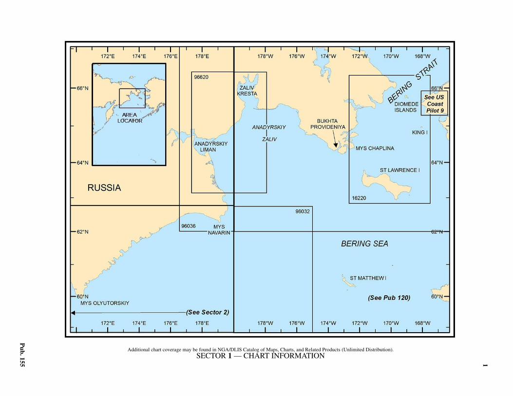
1.0Additional chart coverage may be found in NGA/DLIS Catalog of Maps, Charts, and Related Products (Unlimited Distribution).1.0SECTOR 1 — CHART INFORMATION
3
Pub. 155
SECTOR 1
EAST COAST OF RUSSIA—MYS DEZHNEVA TO MYS OLYUTORSKIY
1.0 Plan.—The coast described in this sector comprises the Wside of the Bering Strait, Anadyrskiy Zaliv (Gulf of Anadyr),and the N shore of the Bering Sea to Mys Olyutorskiy(59°55'N., 170°21'E.). The arrangement of the sector is from Eto W.
General Remarks
1.1 Russian regulations for the protection and hunting ofmarine mammals must be observed by vessels navigating in thewaters described by this sector.1.1 Ice.—Anadyrskiy Zaliv is normally covered by solid ice bythe latter half of November and begins to clear in May. This iceis occasionally penetrable by powerful icebreakers.1.1 Ice first appears in Anadyrskiy Liman in September or thebeginning of October, and the bay is said to be frozen solid lat-er in October. The ice frequently remains until the middle ofJuly. Vessels are said to normally call from July until the mid-dle of October.1.1 According to a Russian source, sludge ice appears in ZalivKresta at the end of September and the bay is solidly frozen bymid-November. Occasionally, the ice is broken up and carriedout of the bay. The period of breakup is generally June, butdrifting ice sometimes remains until mid-July.1.1 The Bering Strait is generally free of ice by the first week ofJuly, sometimes earlier, and the strait and the area immediatelyN usually remain free of ice until October.1.1 Zaliv Lavrentiya usually begins to freeze over during thefirst week in October. Toward the middle of the month, bywhich time N winds generally prevail, the ice is thick along theshores, but does not block the entrance channel. By the end ofOctober, the inlet is usually covered with solid ice. The ice usu-ally begins to break up in June.1.1 A vessel intending to stay for a long period in Zaliv Lavren-tiya may be held up by drift ice, which sets through the BeringStrait and is driven into the entrance of the inlet where it packs,and may close it for a considerable period.
Mys Dezhneva to Zaliv Lavrentiya
1.2 Mys Dezhneva (66°05'N., 169°38'W.) is the E ex-tremity of the mountainous peninsula at the NE end of Russia.This peninsula, which appears as an island when seen from theoffing, is in general steep-to, with depths of 20m close off-shore, but with rocks close to the cliffs. The coasts of the pen-insula consist mainly of dark-colored cliffs rising in jaggedterraces steeply from the sea. On the W side of the peninsulathe mountains slope gently toward the mainland and merge intoa low hummocky tundra-covered isthmus. The summits of themountains are generally covered by dense fog and clouds.1.2 Mys Uelen (Mys Uellen) is situated about 5 miles NNW ofMys Dezhneva. Some above-water rocks are located near MysUelen. A sunken rock is located about 2 miles ESE of the cape.1.2 Mys Peek (Mys Peyek), about 5 miles SSW of Mys Dezhne-
va, is lofty, bold, and rugged. Mys Peek is visible from the S inclear weather at 30 to 35 miles. Pamyatnik Dezhneva Light isshown from a square tower about 0.7 miles N of Mys Peek. Ashort distance N of Mys Peek is a small stretch of coast wherelanding is possible, and in this vicinity is the settlement ofNaukan, situated at a considerable elevation on a mountainslope.1.2 Bering Strait, about 45 miles in width between Mys Dezhne-va and Cape Prince of Wales, has general depths of 38 to 55m.In winter, N winds prevail; in summer, S winds prevail, butchanges in direction and strength are more frequent. Summerfog is frequent. Unless there is an unusually late spring, thestrait is free of ice by July.
1.3 The Diomede Islands (65°46'N., 169°00'W.), consist-ing of two steep-to islands in the middle of the Bering Strait, riseabruptly from the sea with nearly vertical sides. Their summitsappear as broken tableland. Ostrov Ratmanova (Big DiomedeIsland) (65°48'N., 169°05'W.), the W and larger of the two, isfringed on its W side by above-water rocks. Little Diomede Is-land, about 2.5 miles SE of Ostrov Ratmanova, has a sandspitextending from about the middle of the W side of the island, andfrom the outer end of this spit a reef extends an unknown dis-tance toward the S extremity of Ostrov Ratmanova.1.3 The boundary between Russia and the United States passesbetween the two islands. The passage between the islands, Wof the above-mentioned reef, is reported to have a depth ofabout 35m and to be clear of dangers, but it should not be at-tempted by a large vessel.1.3 At the SW end of Ostrov Ratmanova is the settlement ofNunarbuk, close off which are depths of 20 to 26m, sandy bot-tom. Farther offshore the bottom is stone, poor holding ground.The settlement of Ignaluk is situated close to the sand spit onthe W side of Little Diomede Island.1.3 Fairway Rock (65°37'N., 168°45'W.), about 7.5 miles SE ofLittle Diomede Island, is a high and steep rock with a flat top.It is steep-to and there are no off-lying dangers.1.3 Anchorage.—Anchorage can be obtained close S of thesand spit on the W side of Little Diomede Island, but the hold-ing ground is poor, consisting of rocks. A vessel proceeding tothis anchorage from the S or E can follow the S and W coastsof the island, keeping in depths greater than 26m until the set-tlement of Ignaluk is sighted.1.3 Anchorage can also be obtained off the N side of Ostrov Rat-manova.1.3 Caution.—Three dangerous wrecks, depths unknown, lieclose off the W and SW coasts of Ostrov Ratmanova (Big Dio-mede Island). Two dangerous wrecks, depths unknown, lie be-tween Ostrov Ratmanova (Big Diomede Island) and LittleDiomede Island. All can be best seen on the chart. 1.3 Three submerged buoys lie between Mys Dezhneva and Os-trov Ratmanova (Big Diomede Island) at depths of 29m, 16m,and 29m, from W to E; all are best seen on the chart. Addition-al submerged buoys, also best seen on the chart, with depths of
4 Sector 1. East Coast of Russia—Mys Dezhneva to Mys Olyutorskiy
Pub. 155
16m, are found across the strait between Little Diomede islandand Cape Prince of Wales.
1.4 The coast slopes down from Mys Peek to a low sandybeach near Dezhneva, a deserted trading post about 6 milesWNW. The coast between Mys Peek and Mys Litke, about 22miles SW, is generally steep-to, with depths of 10m about 1mile offshore.
Mys Litke may be easily identified by a sharp-peaked moun-tain rising above it. 1.4 Mys Nunyamo (65°36'N., 170°40'W.) lies about 13.5 milesSSW of Mys Litke. The coast for about 9 miles S of Mys Litkebecomes lower with several bold points. Black cliffs which risesteeply from the sea extend 4 to 5 miles NE of Mys Nunyamo.1.4 Anchorage.—Anchorage can be taken, during N winds,abreast the deserted Dezhneva trading post, in 9 to 10m, goodholding ground, 1 mile offshore, or, in 5m, 0.25 mile offshore.
Zaliv Lavrentiya
1.5 Zaliv Lavrentiya is entered between Mys Nunyamoand Mys Kriguygun, 12.5 miles SW. The NE side has the ap-pearance of a desert waste and is similar to the SW side, exceptthat the cliffs are higher and the hills, though not high, arenearer to the shore. The soil is damp and has high concentra-tions of clay, and in places is covered with moss and grass. Peatis found in the depressions and on the hillsides. The lowground consists of large tracts tundra.1.5 High steep sharp-peaked mountains, apparently of a rangethat extends across the Asiatic mainland, approach the head ofthe bay and extend around the inner part of the bay, but thenmerge into a series of low rounded hills. Gora Vkhodnaya(Tyrtova) (Tuirtof) (65°42'N., 171°04'W.), 500m high and themost conspicuous mountain, is located on the NE side, about10.5 miles NW of Mys Nunyamo.1.5 The entrance has depths of 12.8 to 14.6m in the fairway. Thebay has general depths of 24 to 62m. The inner third of the bayshould not be used without local knowledge. There are severalshoals with depths less then 2m reported west of 171°11`W. 1.5 Mys Nunyamo, the NE entrance point, is easily identified bya conspicuous round-topped mountain, 360m high, near it. Alight is shown from the point. The W side of the mountainslopes gradually to a wide ravine, down which flows a verysmall and very rapid mountain stream. A steep mountain,430m high, is located near the coast, 2.2 miles NE of the cape.
1.6 Mys Kriguygun (Cape Novosilski) (Cape Krigugon)(65°28'N., 171°02'W.), the SW entrance point, is a lofty andvery steep headland formed by a mountain with several re-markable peaks, the highest of which attains an elevation of
443m. A light is shown at the point. Because of its height, thecape appears as an island when seen from the S. Yandagai, alarge village, is situated on the cape.1.6 From Mys Nunyamo to Mys Pinakul, about 5 miles WNW,the shore is level and consists of low cliffs, inland of which theground is tundra and gradually rises to low, rounded hills from0.5 mile to 2 miles inland.1.6 Ostrov Litke, with its E extremity about 1 mile W of MysPinakul, is a sand and shingle islet about 0.7 mile in length inan E-W direction. The islet is difficult to make out in the offingbecause it has an almost level surface and is only about 1.8mhigh. Its highest part is covered with moss and there is a fresh-water pond on the islet. A bank, with depths of less than 5m,joins the islet to Mys Pinakul. A reef, with depths of 5.5m, ex-tends W from the W extremity of the islet. The extremity ofthis reef is steep-to, with a depth of 35m close off it. A light isshown from Ostrov Litke.
1.7 Inner part of Zaliv Lavrentiya.—Mys Pavlova proj-ects from the NE shore about 8.5 miles WNW of Mys Pinakuf,while Mys Indreniusa projects from the SW shore 2.25 milesWNW of Mys Pavlova. Only vessels with local knowledgeshould navigate in that part of the inlet above Mys Pavlova andMys Indreniusa.1.7 In the inner part are two islets, Ostrov Benneta and OstrovBalka. Ostrov Benneta, the S islet, is surrounded by reefs, withdepths of less than 7.3m, which extend as far as 0.5 mile fromit, and there is reported to be a submerged spit extending Sfrom this islet. A 4.9m shoal is reported to lie about 1.3 milesSE of this islet, and a depth of 9.1m has been obtained close Nof this danger.1.7 Tides—Currents.—The tidal rise in Zaliv Lavrentiya doesnot exceed 0.3m, but heavy gales may raise or lower the waterlevel by as much as 1.1m.1.7 The tidal currents are reported to be strong. The Russian ves-sel Yakut dragged both anchors in Gavan’ Litke because of thepressure of ice on her cables during the ebb current. Eddies areformed in Gavan’ Litke.1.7 Anchorage.—Gavan’ Litke, formed by Ostrov Litke and thebight on the N side of Mys Pinakul, affords good anchorage, indepths of 20 to 29m, mud. However, this harbor is said to onlybe safe at the end of August and during the month of Septem-ber. At other times vessels should keep steam up in readiness tosail in case masses of drifting ice from the Bering Strait threat-en to jam the entrance of Zaliv Lavrentiya. Vessels shouldavoid anchoring with the W extremity of Ostrov Litke bearingless than 180°, as the depths there increase rapidly to 50 to55m.1.7 Bukhta Strelok, entered N of Mys Pavlova, affords good an-chorage over a bottom of sand, good holding ground. It has
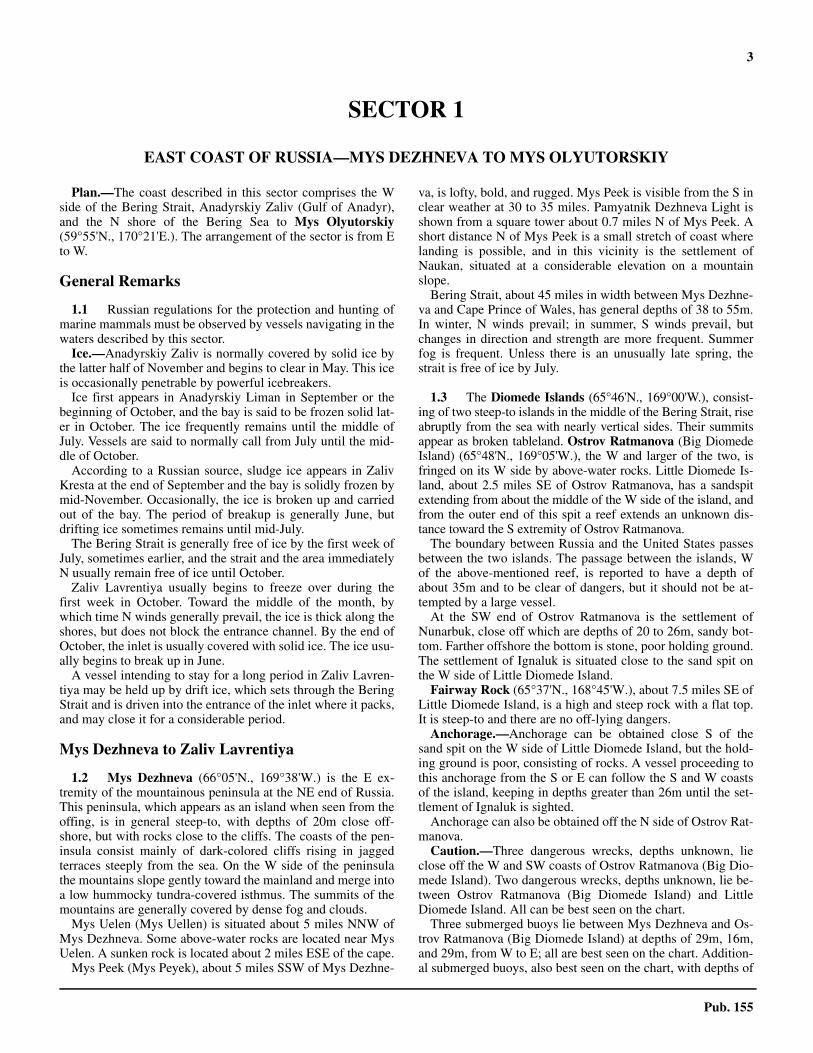
Bering Strait from SSW
Sector 1. East Coast of Russia—Mys Dezhneva to Mys Olyutorskiy 5
Pub. 155
depths of 3.7 to 7.3m close to the shore.1.7 Good anchorage can be obtained, in depths of 22 to 29m, inthat part of Zaliv Lavrentiya above Mys Pavlova.1.7 Directions.—The W extremity of Ostrov Litke, in line bear-ing 327° with Gora Vkhodnaya, leads into Zaliv Lavrentiya ina least depth of 12.8m, but caution should be exercised, as thisrange line passes close SW of a 7.1m shoal in the middle of theentrance.
Zaliv Lavrentiya to Proliv Senyavina
1.8 The coast from Mys Kriguygun to Mys Lyugren(65°30'N., 171°40'W.), a high steep point 15.5 miles W of MysKriguygun, is low and rises gently to flat-topped mountains.This stretch is steep-to and clear of dangers.1.8 Mechigmenskiy Guba has an entrance less than 0.2 mile inwidth between the extremities of two very low spits. The Espit, which is almost awash, extends about 10 miles W fromMys Lyugren. The W spit extends about 5 miles NE from theW shore. The entrance can only be identified when bearingabout 340°. On other bearings the entrance can be made outonly from aloft in clear weather. The village of Mechigmen,consisting of a few huts and situated on the W spit about 1.5miles SSW of the entrance, is a convenient mark for identify-ing the entrance. The village of Raupelyan is situated on the Espit, about 2.5 miles E of the entrance.1.8 The least depth in the approach is 5.8m near the E spit. Theentrance has depths of 18.3 to 24m, but inside the depths de-crease. Both spits are steep-to. Within the inlet E of Raupelyan, achannel 0.75 mile wide, with a depth of 9.1m, runs in the direc-tion of the E spit. Northward the depths suddenly decrease to5.5m. Mechigmenskaya Guba, other than a small part inside itsentrance, has not been surveyed.1.8 Winds—Weather.—West winds accompany dangeroussqualls at times.1.8 Tides—Currents.—The outgoing tidal current, which at-tains a velocity of 4 to 6 knots in the entrance, sets on to the Wspit and then follows the coast S for several miles. Vesselsshould exercise caution in entering.1.8 Anchorage.—Good anchorage can be obtained anywhereoutside the entrance. Inside the inlet, anchorage can be ob-tained, in 5 to 9m, mud and sand, but the holding ground wasreported to be poor and there are many shoals. Anchorage in-side the inlet is only recommended in an emergency and thenonly for vessels with a draft of less than 3m.1.8 The coast from Mechigmenskaya Guba to Mys Ngeegchan(64°55'N., 172°25'W.) is in general low and backed by moun-tains which approach the coast only at Mys Khalyuskina(65°16'N., 172°11'W.), which rises to a conspicuous round hill.The coast N of Mys Khalyuskina consists of sloping tundra,with cliffs in some places and low ground in others.
1.9 Mys Nygligan (Mys Nygchigen) (65°04'N.,172°06'W.), when seen from about 15 miles N or NE, appearsas an island. It is bluff and rugged. A light is shown on the is-land.1.9 Between Mys Nygligan and Mys Ngeegchan, about 12 milesSW, as well as off these two points, the depths decrease gradu-ally offshore. About 10 miles off Mys Nygligan the depths de-crease suddenly to about 9.1. As foul ground may extend off
this cape, it should not be approached too closely.1.9 The bay between Mys Nygligan and Mys Kriguygum 36miles NE is known as Mechigmenski Zaliv.
Proliv Senyavina and Proliv Chechekuyum
1.10 Between Mys Ngeegchan and Mys Mertensa(64°32'N., 172°25'W.), about 23 miles S, the coast recedes toform a bight, a large part of which is occupied by two islands.The passage around Ostrov Arakamchechen, the N and largerisland, is known as Proliv Senyavina, while the passage be-tween Ostrov Yttygran, the smaller island and the S shore ofthe bight is known as Proliv Chechekuyum. Proliv Senyavina isnot difficult to navigate because of its great depth and the ab-sence of dangers. The bottom in this passage is mud, while E ofthe bight it is fine sand. A bottom of rocks and shells distin-guishes the shallower depths. Proliv Chechekuyum should notbe used without local knowledge. The chart indicates that thefairway is deep.1.10 Along the shores of the bight are high granite mountains,which, except for their peaks and steep cliffs, are covered bytundra. The valleys are covered with grass, flowers, and mush-rooms. Aspen and birch are found on the shores.1.10 Ice.—The final disappearance of ice in Proliv Senyavina andin the sea nearby is prolonged almost until the new ice forms,because of the heavy accumulation of ice during the eight coldmonths and the prevailing E and SE winds in the summer.
1.11 Northwest side of Proliv Senyavina.—Mys Ngeegc-han, the N entrance point of the N entrance to Proliv Senyavi-na, rises steeply to Gora Chernaya (Black Summit), 283mhigh. A conspicuous hill is located about 5 miles NW of thecape.1.11 From Mys Ngeegchan to about 8 miles SW, the coast con-sists of low tundra extending from 1 to 2 miles inland. In thevicinity of Ozero Kheyguyn the tundra stretches a considerabledistance inland and the mountains become higher as they re-cede W. Mys Kaskonok, about 10.5 miles SW of Mys Ngeegc-han, is the S extremity of a low sandy spit. From about 2 milesNE of Mys Kaskonok to a position close to that cape the coastis cliffy and rises steeply to high mountains, among which is aconspicuous summit about 579m high, about 1.5 miles N of thecape. Another conspicuous peak is located about 6 miles NE ofthe cape.1.11 A river flows into Ozero Kheyguyn, a shallow lake, and theninto Proliv Senyavina between two sand spits about 2.5 milesW of Mys Ngeegchan. Yakrakinot, a native village, lies on thisspit near the river mouth. The mouth of the river is about 90mwide, has a depth 3.7m, mud bottom, and forms a good harborfor small craft. Anchorage may be taken by small craft closeinshore. The current is strong in the river mouth, but is not feltalong the coast. The W spit is separated from the mainland by anarrow, shallow passage. A bay, entered between the SW endof the W spit and the mainland N, offers shelter to small craft,in depths of 3.7 to 4.6m, in the entrance SW of the spit.1.11 Bukhta Penkigney (Bukhta Penkigngen) is entered betweenMys Kaskonok and Mys Irankhi, about 3.5 miles S. The fairwayto the inner part of the inlet is deep. The main entrance is S ofOstrov Achinkinkan, a low flat islet about 0.5 mile S of MysKaskonok. A reef extends 0.2 mile SW from the islet. Ostrov
6 Sector 1. East Coast of Russia—Mys Dezhneva to Mys Olyutorskiy
Pub. 155
Merokinkan, about 1.2 miles NW of Ostrov Achinkinkan and ofsimilar aspect, is a low, flat, and rocky islet.1.11 Bukhta Penkigney is bordered by high mountains, which inmost places lie close to the shores. On the SW side inside theentrance the mountains rise precipitously from the sea. One ofthese has a remarkable red slope. In some places tundra ex-tends a short distance inland. At the head of Bukhta Penkigneythe mountains recede inland and a shallow stream flowsthrough extensive wet tundra into the inlet. The shores are forthe most part bluff, but several spits extend from them.1.11 A high round peninsula, about 6 miles NW of Mys Irankhi,extends N from the S side of the inlet. Bukhta Alera, enteredSE of this peninsula, is open to the E. This small inlet hasdepths of 11 to 26m, but the bottom is rocky and the bay is oflittle importance.1.11 On the NW side of Bukhta Penkigney, 7 miles W of MysKaskonok, there is a bay entered between a low sandy head-land and a steep headland about 2 miles further SSW. A reef,with a depth of 2.7m, extends about 0.6 mile NE from the S en-trance point.1.11 Tides—Currents.—In Bukhta Alera, the spring range is0.2m and the mean range is 0.2m.1.11 Anchorage.—The small bay just mentioned has depths of12 to 28m, mud, sand, and shells, and affords fairly shelteredanchorage. A vessel has anchored in 28m here.1.11 Anchorage with good shelter can be obtained, in depths of11 to 22m, mud, sand, and in places, stones, from 1 to 1.5miles off the head of Bukhta Penkigney.
1.12 Mys Kygynin (64°45'N., 172°05'W.), the E point ofOstrov Arakamchechen, is a low cape, very similar to MysNygchigen, about 19 miles N.1.12 From a great distance, a small hill in the vicinity of this capeappears as an islet. From a distance of about 14 miles, this hillmerges with the mountains and only a continuous line of coast,about 25m, is then seen. Mys Kygynin should be given a wideberth, as the 10m curve lies as far as 1.8 miles off it and thecoast on either side.1.12 The W two-thirds of Ostrov Arakamchechen consists ofmountains with flat summits, the highest of which, GoraAthos, 576m high, is located about 9.5 miles W of Mys Kygy-nin. These mountains slope down rather steeply on their Esides to the remainder of the island, which consists of smoothtundra and numerous lakes. The coasts of the island are slightlyindented in places, the only harbors being Gavan’ Glazenapa,at the SW end of the island, and Gavan’ Ratmanova, at the Nend of the island.
1.13 North and W sides of Ostrov Arakamchechen.—The greater part of the N coast of the island is low and sloping,with only two or three cliffs. Mys Kuguvan, the N extremity ofthe island, lies 9 miles NW of Mys Kygynin and rises perpen-dicularly to Gora Kruglaya, a conspicuous rounded mountain,320m high.1.13 Kosa Akhmatingu is a spit of land extending about 1 mileWSW from a position on the coast about 1 mile SW of MysKuguan.1.13 Gavan Ratmanova (64°49'N., 172°28'W.) is entered be-tween the SW extremity of Kosa Akhmatingu and Mys Nay-akuk, about 1 mile WSW. A shoal, with a depth of 2.4m, lies
0.3 mile WSW of the SW extremity of Kosa Akhmatingu. An-other spit extends from the S side of Gavan Ratmanova, about0.7 mile SW of the NE entrance point. The coast within the twospits is bordered by a shallow sandbank extending 0.1 to 0.2mile offshore.1.13 Anchorage.—Anchorage can be obtained, in depths of 7 to11m, close SW of the NE entrance point in an area about 0.2mile wide. Vessels can enter the harbor by passing about 0.1mile off the NE entrance point and can secure alongside KosaAkhmatingu, close off which are depths of 4m, increasing rap-idly offshore.1.13 From Mys Nayakuk to Mys Taylek, about 8.5 miles SSW,the coast is rocky and rises gently to the mountains in the mid-dle of the island. For the first 3 miles, the coast forms a slightindentation, where sheltered anchorage can be obtained, indepths of 12.8 to 14.6m, mud and sand, about 0.2 to 0.3 mileoffshore. Winds from the SW through W to NW raise a consid-erable sea here, but the swell is not dangerous.1.13 Ostrov Kynkay, about 2 miles WSW of Mys Taylek, is asmall, rocky, steep, and almost barren islet, with a fairly flatsummit.
1.14 South side of Ostrov Arakamchechen.—Mys My-ergyn (64°41'N., 172°36'W.), about 1.5 miles ESE of MysTaylek, is the SW extremity of a low spit. This spit extends in aSW direction from the low ground on the E side of GoraMenyngay, a conspicuous mountain, 340m high, located about1.2 miles NNW of the point.1.14 Gavan Glazenapa (64°41'N., 172°37'W.) is a harbor formedby a bight in the coast between Mys Yarga and Mys Taylek, theSW extremity of a steep-to spit extending about 0.3 mile WSWfrom the SW side of Ostrov Arakamchechen. A shoal, with aleast depth of 11m, is located about 1 mile SSW of this point. Atthe head of the harbor the land rises steeply to the summit of Go-ra Menyngay. Westward of this mountain are two 91m hills,which, with the mountain, form excellent landmarks for the har-bor.1.14 This harbor is protected from the NW through N to NEwinds, but considerable swell sets in during winds from otherdirections. Mys Yarga is so low that it affords little protectionfrom E winds. The harbor, however, affords good shelter fromice and is easy to enter. The shores are steep-to, and the spit onthe E side has sufficient depths close off it for vessels to makefast alongside. The best anchorage is reported to be in 33m,blue clay, good holding ground, with Mys Yarga bearing about170°.1.14 Banka Bruks (Brooke Bank) (64°37'N., 171°58'W.), an off-lying danger on which are several rocks that uncover at LW, ex-tends about 1.5 miles W from a position about 9 miles SSE ofMys Kygynin. Depths of 11m have been obtained about 1.5miles N and 3 miles S of the E end of this bank.
1.15 Ostrov Nuneangan (64°38'N., 172°20'W.), about 3miles E of Ostrov Yttygran, is a good landmark in the S ap-proach to Proliv Senyavina. The islet is small, bluff on allsides, and has a summit covered with verdure. The NE and SWsides of the islet should not be approached, as reefs extend off-shore from those sides. A bank, with depths of less than 9.1m,and on which are said to be many reefs, extends from OstrovNuneangan to the E side of Ostrov Yttygran.

Sector 1. East Coast of Russia—Mys Dezhneva to Mys Olyutorskiy 7
Pub. 155
1.15 Anchorage near this coast should be avoided when ice is be-ing driven S by the wind as it sets directly onto it.1.15 The E coast of Ostrov Yttygran, from Mys Amago Mel'got(64°36'N., 172°27'W.) to Mys Novok, 1.5 miles N, and then toMys Konovak, 2 miles NW, consists of low cliffs rising in plac-es to high bluffs. Two conspicuous hills, about 151m and 230mhigh, are located about 1 mile and 2 miles W, respectively, ofMys Novok. A conspicuous mountain, 346m high, is locatedabout 1 mile SW of the same cape.1.15 Bukhta Stygrak, with its E entrance point about 3 miles W ofMys Konovak, is bordered W by a steep black cliff about 1.5miles farther WNW. The bight is reported to have depths of 18to 22m, but it is exposed and the holding ground is poor. Wettundra extends from the lake at the head to the S side of the is-land.1.15 The coast from the W entrance point of Bukhta Stygrak toMys Am'yak, 2.5 miles SSW, is steep and high, without bluffs,and rises to a hill composed entirely of gray and white marble.1.15 Mys Engelyukak (64°35'N., 172°31'W.), the SE extremity ofOstrov Yttygran, can be identified by a low hill with a roundedsummit. Between the above point and Mys Yuvakhtakhat, about0.7 mile W, there is reported to be anchorage in the bight, in14.6m, stones over mud. Bukhta Tugak, an open bay immediate-ly W of the bight, has a high hill with a steep slope near its head.Two mountains, one 587m high and the other 529m high, lienear the center of the island, about 2 miles NNW and 2.7 milesNW, respectively, of Mys Yuvakhtakhat.1.15 Mys Am'yak, the SW extremity of Ostrov Yttygran, is the ter-mination of a low spit extending about 0.2 mile S. A shallow bankextends a short distance W from the spit. Bukhta Tyvlikak is en-tered between Mys Am'yak and a point about 1.5 miles SE.
1.16 South side of Proliv Chehekuyum.—Mys Mertensa(64°32'N., 172°25'W.), lying about 4.8 miles SSW of OstrovNuneangan, is a high and bluff point rising to a conspicuousmountain with three peaks, about 305m high. The S shore ofProliv Chechekuyum consists of high reddish cliffs for the first2 miles W of Mys Mertensa, then it slopes evenly to Mys Piv-attsigo, the extremity of a spit, about 2.1m high, extending NEfrom the coast. A fairly sheltered bay lies on the E side of thisspit. The bay has depths of 18.3 to 42m, the bottom beingshells and stones over mud. Within Mys Pivattsigo the land ris-es to a mountain, about 762m high, from which a range extendsSE toward Mys Chaplina.
1.17 West side of Proliv Senyavina.—Mys Kuvylokuok(64°39'N., 172°50'W.), lying almost 4 miles NW of Mys Piv-attsigo, is a fairly high and bluff point. A reef extends 0.2 mileNE of the point.1.17 Bukhta Kalelen is entered between Mys Kuvylokuok andMys Kunuk, about 2 miles NNW. A fairly high and bluff pointsimilar to Mys Kuvylokuok is located about 2 miles WNW ofthis point. On the W side of this inner point is a bay, W ofwhich the mountains recede inland and the coast is formed bylow tundra. The N shore of the inlet rises to mountains, 397 to503m high. At the head of the inlet is a lake, fed by numerousmountain streams, and from which a shallow stream flowsthrough a sandy neck of land into the inlet.1.17 Anchorage.—Fairly sheltered anchorage can be obtained inthe small bight entered W of Mys Kuvylokuok. The depths are
considerable close offshore.1.17 Anchorage can be obtained anywhere in Bukhta Kalelenwithin the point located about 2 miles WNW of Mys Kuvylo-kuok. The bottom is mud throughout. There is also anchorage,excellent shelter, in depths of about 33m, W of the third pointon the S side of the inlet. Anchorage can also be obtained, indepths of 7 to 9m, near some cliffs on the S side of the head ofthe inlet.1.17 Bukhta Rumilet, a deep inlet, is entered S of Mys Kuvylo-kuok. The inlet is landlocked by mountains about 610m high,which prevent the sun’s rays from entering. Ice usually extendssome distance offshore.1.17 The coast from Mys Kunuk to Mys Irankhi (64°47'N.,172°45'W.), about 6 miles NNE, is partly steep and partly slop-ing, but mountainous throughout. Settlements are situated nearthe streams flowing down the slopes along this coast. Shoal wa-ter, with depths of 2.7 to 6.4m, extend as far as 0.7 mile E fromthe coast in places. Some rocks that uncover at LW are locatedclose offshore about 0.5 mile NE of Mys Kunuk.
Proliv Senyavina and Proliv Chechekuyum toAnadyrskiy Zaliv (Gulf of Anadyr)
1.18 Mys Chaplina (64°24'N., 172°14'W.) is the extremityof a low sand and gravel spit extending about 5 miles E fromthe general line of the coast. On this spit is a freshwater lake;near its extremity is the village of Oumwaidjik. The mountainsalong this coast are some distance inland of Mys Chaplina, butapproach the coast near Mys Mertensa, about 9 miles NNW. 1.18 Tides—Currents.—A current setting E at a velocity of 2knots may be experienced on the S side of the spit.1.18 Aspect.—A conspicuous mountain, 415m high, is locatedabout 6 miles WNW of Mys Chaplina. 1.18 A light is shown on Mys Chaplina. A radio beacon transmitsfrom the lighthouse.1.18 Approaching Mys Chaplina from the SW, the sloping cliffsome distance W of the cape is first sighted, then the inshorepart of the spit, which is about 9.1 to 12.2m high and slopesdown gradually to seaward, and finally the buildings of the vil-lage which appear as a fleet of fishing boats until the whole spitis visible.1.18 A shoal patch, with a depth of 11m surrounded by depths of28 to 29m, is located about 8.5 miles SSW of the cape. Thedepths decrease rapidly from about 28m to depths of 18.3m ata distance of 1.2 miles, and to 16.5m less than 1 mile from thespit. A depth of 14.6m lies about 3.5 miles E of the spit.1.18 Anchorage.—Anchorage can be obtained, in 12 to 18m,hard sand and shells, about 0.5 to 1 mile off the N or S side ofthe spit, depending on the wind. Closer to the spit the bottom isfine sand. Anchorage has been obtained, in a depth of 14.6m,0.2 mile offshore. During a swell from any direction the shoreis marked by breakers.
1.19 Bukhta Tkachen (Zaliv Tkachen) is entered betweenMys Sivol'kut (Mys Pravyy Vkhodnoi) (64°22'N., 172°36'W.)and Mys Ploskiy, about 8 miles SW. The SW side of the inletrises to sharply-peaked mountains and the shores of the inletare formed by dark precipitous bare rocks. Numerous settle-ments are situated around the inlet.1.19 Mys Skobeleva, about 4.5 miles WNW of Mys Sivol'kut, ris-
8 Sector 1. East Coast of Russia—Mys Dezhneva to Mys Olyutorskiy
Pub. 155
es to a sharp conical peak, Gora Kakitaruk. Mys Cherkassko-go, about 5 miles N of Mys Ploskiy, is low. A bank, with adepth of 5.2m at its outer end, extends 0.8 mile E of Mys Cher-kasskogo. A bank, with depths of 6.4 to 7.3m, extends about1.5 miles W from Mys Skobeleva.1.19 A vessel entering the inlet should pass 1.5 miles E of MysCherkasskogo, then alter course to pass 0.5 mile off the W sideof the inlet abreast Mys Skobeleva.1.19 Several spits extend from the shore near the head of the bayalongside which whalers secure. Because of its great depths theinlet is unsuitable as an anchorage. The N half of the inlet issheltered from all winds, and is an excellent refuge. It also hasthe advantage of easy entrance, and the suitability for vessels tosecure close inshore. A 4.1m patch lies about 0.8 mile SE ofMys Vyazemskogo, the SE extremity of a spit extending fromthe N shore of the inner part of the inlet.1.19 Although Bukhta Tkachen is easily accessible, BukhtaSlavyanka is a more convenient harbor, especially during theautumn.1.19 Zaliv Kuguan is formed between Mys Ploskiy and MysNizmenny, about 3 miles SW. Zaliv Kuguan has not been sur-veyed. Local reports state that a narrow channel, with depths ofabout 1.5m at the head of the bay, leads to a broad deep lagoon, onthe shores of which there are many settlements. A light is shownfrom each of the capes at the entrance to Zaliv Kuguan.1.19 Mys Chukotskiy (64°14'N., 173°05'W.), lying 4.5 milesWSW of Mys Nizmenny, is a black cape rising to a pointedridge. At its extremity is a hill with a rounded summit, on the Send of which are several high pointed rocks. The cape is easilydistinguished from the E or W, but from the S it merges withthe coast. Several drying rocks lie off the SE side of the cape.Kivak Light is shown on the coast 3.2 miles ENE of Mys Chu-kotskiy.
Anadyrskiy Zaliv (Gulf Of Anadyr)
1.20 Anadyrskiy Zaliv is entered between Mys Chukotskiyand Mys Voyennykh Topografov (Mys Faddeya) (Cape Thadde-us), about 215 miles WSW, and extends as far as 200 miles N.The principal bays in this gulf are Bukhta Provideniya, on the Eside close within the entrance, Zaliv Kresta, at the head of thegulf, and Anadyrskiy Liman, at the NW end of the gulf.1.20 The shores of the gulf are fairly high, except for most of theW shore below Anadyrskiy Liman. This stretch is free fromsnow in the summer and is covered with grass and in placeswith scrub. Many of the hills along the shores of the gulf ap-pear to be formed of coal from a distance, but are composed ofdark gray stone.1.20 Tenedos Shoal (64°16'N., 178°00'W.), with a depth of 2.4m,the existence of which is doubtful, is charted in the middle ofthe gulf, about 125 miles W of the E entrance point.
Bukhta Provideniya (Providence Bay)
1.21 From Mys Chukotski to Mys Lysaya Golova, about 7miles WNW, the coast is low. The low land extends inland toOzero Avan forming a cleft in the mountains which is notice-able from the S.1.21 Bukhta Provideniya, entered between Mys Lysaya Golova(64°17'N., 173°22'W.) and Mys Lesovskogo, about 5.5 miles
WNW, is hemmed in on all sides by rugged mountains over610m high. The shores of the inlet consist of precipitous cliffs,and are marked by landslides, which usually terminate in spitsprojecting into the water. Many swift mountain torrents flowinto the inlet. The only vegetation is lichen and moss. BukhtaKomsomol’skaya (Bukhta Emma), about midway along the Eside of the inlet, is the only important harbor in the inlet.1.21 An approach channel (027°-207°) extends up to about 12miles seaward of the entrance to Bukhta Provideniya and maybest be seen on the chart. Vessels should keep outside Russianterritorial waters until reaching the channel.1.21 Mys Lesovskogo Light, on the W side of the entrance, oper-ates throughout the year, but other lights in the inlet operate on-ly from late July to early December.1.21 Ice.—The following are the general conditions at BukhtaProvideniya:
1. October and November—Period of ice formation.2. November and December—Formation of solid ice
(the type ordinarily unnavigable, but occasionally penetrableby powerful icebreakers).
3. April and May—Period of break up.4. June—Clearing.
1.21 Caution.—A local magnetic anomaly, believed to be causedby the magnetic character of the mountains, has been reportedin the vicinity of Bukhta Provideniya. However, a U.S. govern-ment research vessel observed no magnetic anomalies in Sep-tember, 1987.
1.22 Mys Lysaya Golova, the E entrance point of BukhtaProvideniya, is bluff, high, and can be easily identified from itspeculiar shape which somewhat resembles a man’s head. The Eslope of the point is fairly gentle, but the S and W slopes areprecipitous. The slopes are covered with reddish-brown tundra,and the cliffs, especially those on the W side, are of a bright-yellowish color. Avan’, a fairly large settlement, is situated onthe E side of Mys Lysaya. Four small buildings stand at this lo-cation. The N building has a green roof and the S building iswhite. This location appears as a coastal station. A light isshown from a framework tower on the E slope of Mys LysayaGolova.1.22 Caution.—Vessels entering Bukhta Provideniya must becareful not to mistake the low land E of Mys Lysaya Golova forthe entrance.
1.23 Mys Lesovskogo (64°20'N., 173°33'W.), the W en-trance point of Port Provideniya, appears from seaward as ablack detached islet standing out prominently against the dis-tant high land of the coast. Rocks fringe the cape. A detachedabove-water rock lies off its S side.1.23 Lesovskogo Light is situated 0.8 mile WNW of the S ex-tremity of Mys Lesovskogo. A radio beacon transmits 135mESE of the light.1.23 Severnyy Light is shown 0.9 mile NE of Mys Lesovskogo.Kamen Severnyy, a rock, lies 0.1 mile S of the light.1.23 Zapadnyy Light is shown 4.2 miles NE of Mys Lesovskogo.
1.24 Bukhta Slavyanka (Reyd Plover) (64°22'N.,173°21'W.) is a roadstead on the E side of Bukhta Provideniya;it is entered N of Mys Gaydamak, the N extremity of a spitwhich forms the W and S sides of the roadstead. Several settle-
Sector 1. East Coast of Russia—Mys Dezhneva to Mys Olyutorskiy 9
Pub. 155
ments and small lakes are situated on the spit. However, thesesettlements have been burned or abandoned and only ruins arevisible. A light is situated on the spit of Mys Gaydamak.
During the summer, large masses of snow remain in the ra-vines and on the shores. Shoaling extends into Bukhta Provid-eniya from the N to the W from the spit of Mys Gaydamak.Discolored water has been observed upon departure from theport. The roadstead has general depths of 29 to 40m and is pro-tected. The holding ground is a composite of slate, and a vesselmay drag anchor during heavy N gales.1.24 Tides—Currents.—The mean tidal range at BukhtaSlavyanka is 0.7m and the spring tidal range is 0.9m.1.24 Bukhta Komsomol’skaya (Bukhta Emma), about 4.5 miles NEof Bukhta Slavyanka, is entered between Mys Puzino (64°25'N.,173°14'W.) and Mys Likhacheva, about 0.7 mile N, but the en-trance fairway is narrowed to a width of 0.5 mile by the sandbanks extending from both entrance points. Atop Mys Puzino,the S point of the entrance to Bukhta Komsomol’skaya, are twowhite, one story buildings with a marine radar unit mounted on acupola on the larger building. The shores of the harbor are low,but lofty mountains extend around Bukhta Komsomol’skaya, ex-cept on the S side of the harbor. A small river discharges on the Sside of the harbor.
1.24 The depth in the center of the entrance is 30m and there aredepths of 20 to 30m in the fairway up to 1.5 miles within theentrance. The bottom in depths greater than 20m is mud.1.24 Urelyk is a village on the S shore of Bukhta Komsomol’skaya.There are several small jetties for the use of local craft.1.24 Mys Snaryadnyy protrudes from the SE shore of BukhtaKomsomol’skaya, 2 miles E of Mys Puzino. A rocky bank,with a depth of 5m, lies near the extremity of a rock and shin-gle shelf extending 0.5 mile N of Mys Snaryadnyy, where it ismarked by a lighted buoy.
1.25 Provideniya (64°25'N., 173°14'W.) (World Port In-dex No. 62640), on the NW shore of Bukhta Komsomol’skaya,is a refueling and provisioning port for vessels traveling theNorthern Sea Route. It is the only deep-water port in the NEpart of Siberia. Customs control facilities are available and theport is open to foreign vessels. The port is only open duringpart of the year from approximately mid-May through earlyJanuary. 1.25 Ice.—Navigation into Bukhta Komsomol’skaya is normallypossible without the assistance of an icebreaker from mid-Juneto the end of November. In the period up to 20 July and after 20November, ice information should be obtained from the harborauthorities before proceeding into the bay. Winter navigation isnormally possible with the assistance of an icebreaker. 1.25 Icebreaker assistance should be requested no later than 48hours before arrival. 1.25 Tides—Currents.—The tidal range in the port is 2.5m.1.25 Depths—Limitations.—The approach fairway throughBukhta Provideniya to Bukhta Komsomol’skaya is straight andvery deep. The limitation on the size of vessels berthed is im-posed by the dimensions of the berths rather than by the fair-ways leading to them. All berths are quayside berthing exceptfor Berth No. 5, which is an oil pier with stern-to berthing atthe pier head. Details of the berths are provided in the table ti-tled Provideniya—Berth Information.
1.25 Aspect.—Range lights lead through Bukhta Provideniya tothe entrance to Bukhta Komsomol’skaya. These lights are situ-ated 230m E of Mys Likhacheva. A second set of range lightsis situated on the E shore of Bukhta Komsomol’skaya, 1.75miles ENE of Mys Likacheva, and lead into the bay. A third setof range lights leads through the N part of the bay.1.25 Pilotage.—Pilotage is compulsory for all vessels over 500 gtexcept Russian naval vessels, hydrographic vessels, and FES-COE icebreakers. Pilots are available 24 hours, although pilot-age to some berths is available only during daylight hours and issubject to favorable weather. 1.25 The pilot boards abeam Slavyanka Light (64°22'08'N,173°21'32''W) or at a position within Bukhta Slavyanka to beadvised if the weather conditions are bad. 1.25 Requests for pilotage must be made 72 hours to 48 hours
Provideniya—Berth Information
Berth Length Depth Remarks
No. 1 147m 10.2m Coal.
No. 2 118m 10.0m General cargo.
No. 3 140m 7.5m General cargo.
No. 4 26m 3.5m Ship repair.
No. 6 60m 3.5m Passengers.
No. 5 16m 7.5m Chemical products.
Bukhta Emma, Bukhta Provideniya, Bukhta Komsomols’kaya—Range Light
10 Sector 1. East Coast of Russia—Mys Dezhneva to Mys Olyutorskiy
Pub. 155
prior to arrival at the pilot boarding position. This requestshould be sent to the Rosmorport Anadyr Branch via facsimileor by telephone to the Provideniya Department Head or by fac-simile or e-mail to the Port Captain. Vessels departing the portshould request pilots no later than 2 hours before departure tothe Port Captain or from the Provideniya Department Head. 1.25 Regulations.—The use of tugs is compulsory for all vesselsgreater than 500 gt.
1.25 An area in which anchoring, fishing, trawling, navigating witha trailing anchor, and underwater operations are prohibited ex-tends across the entrance to Bukhta Komsomol’skaya.1.25 Signals.—Storm signals and signals relating to ship movementsare shown from a mast at the office of the Port Director near Prov-ideniya Quay and are broadcast on VHF channel 16.1.25 Contact Information.—See the table titled Provideniya—Contact Information.
1.25 Anchorage.—Bukhta Komsomol’skaya affords the bestshelter in Bukhta Provideniya. On the SE side of the bay, be-tween positions about 0.6 mile SSE and 1.6 miles ENE, respec-tively, from Mys Likhacheva, there is a line of 12 numberedanchor berths, in depths of 12 to 26m, mud. See the table titledProvideniya—Anchorage Berths for further details. 1.25 A large turning area off Provideniya lies NW of the num-bered anchorage berths, An anchorage area designated fortankers lies in the NE part of the bay.1.25 Quarantine anchorage and anchorage for loading and dis-charging dangerous cargo are located in Bukhta Slavyanka.1.25 The anchorages in Bukhta Komsomol’skaya and BukhtaSlavyanka are not sheltered from the N winds. During stronggales the wind direction changes frequently, causing vessels toyaw and drag anchor.
1.25 Caution.—There are dangerous wrecks, marked by lightedbuoys, close E of the Offshore Wharf, close S of the PetroleumWharf, and 0.2 mile ENE of the No. 5 Pier.1.25 The shore between Cape Yakum (64°25'N., 174°00'W.) andCape Chukotskij (64°15'N., 173°07'W.) is indented with deepand narrow valleys, curving NNE-SSW parallel with Provid-eniya Bay, and in poor visibility any of these valleys could bemistaken for the entrance into Provideniya Bay.
Bukhta Provideniya to Zaliv Kresta
1.26 Mys Stoletiya (64°19'N., 173°39'W.), 3 miles WSWof Mys Lesovskogo, is blackish, with a crest of pointed rocks,and rises steeply from its base to a flat summit. A detachedrock close off the cape appears as an elongated cone when seen
Port of Provideniya
Provideniya—Contact Information
Provideniya Department Head
Call sign Radio 6
VHF VHF channel 6
Telephone78-42735-22044
78-924-669-2483 (mobile 24 hours)
Port Captain
Call sign Prichal 21
VHF VHF channel 16
Telephone 78-42735-22525
Facsimile 78-42735-22525
E-mail [email protected]
Rosmorport Anadyr Branch
Facsimile 78-42722-24116
Provideniya—Anchorage Berths
Berths Draft Remarks
1-3 Greater than 8m Icebreakers and all vessels
4-8 6 to 8m —
9-12 Less than 6m —
Sector 1. East Coast of Russia—Mys Dezhneva to Mys Olyutorskiy 11
Pub. 155
from the E or W, but from the S it merges with the land. A bea-con consisting of a truncated pyramidal structure is situated onMys Stoletiya.1.26 Mys Yakun, about 11 miles farther NW, is a rugged cape ris-ing to a height of 315m and may be identified by a pyramidalrock on its summit. Mys Zelenyy, about 11.5 miles NW of MysYakun, rises almost vertically to a great height and has a veryconspicuous red stripe extending from its base to its summit.1.26 The coast from Mys Zelenyy to Mys Shpanberga, about 13miles NW, is rugged in its greater part. Mys Shpanberga is highand appears as a high cliff with a rounded summit when seenfrom the S and as a rounded hill with gently sloping sides whenseen from the W.1.26 Guba Bezymennaya (64°45'N., 174°50'W.) is entered be-tween Mys Shpanberga and Mys Gal'gan, about 11 milesWNW. The latter cape rises precipitously to an elevation of475m. From the S, a sloping headland is seen extending fromthe E side of the cape, but from the W the cape appears as asharp jagged ridge. Close off its E side is a detached pillarrock.
1.27 Mys Achchen (64°46'N., 175°26'W.), about 9 milesW of Mys Gal'gan, is a cliffy cape rising to a flat summit,220m high. Bukhta (Guba) Preobrazheniya, entered about 2miles N of Mys Achchen, is bordered by low shores, and hasdepths of 18.3m, with a bottom of fine sand.1.27 From the N entrance point of Bukhta Preobrazheniya to MysEnmelen, about 11 miles NW, the coast is high, precipitous,and wall-like. Mys Enmelen rises close inland to Gora Enmel-en, 670m high.1.27 Mys Beringa (65°00'N., 175°54'W.), a rugged cape lyingabout 4 miles NNW of Mys Enmelen and rising to an elevationof 420m, is conspicuous, as it is the W termination of the coast-al cliffs, which are almost continuous from Mys Chukhotskiy.The coast N of Mys Beringa becomes lower.1.27 Between Mys Beringa and Mys Chirikova, about 16 miles N,a bay is formed, the S part of which is sometimes known asWhaler Bay. The S part of this coast rises to low hills coveredwith tundra, and the N part is shelving and consists of lowbluffs.1.27 Mys Chirikova rises to a sharp conspicuous peak. About 4miles farther N is a cliffy headland, 145m high. From thisheadland a narrow spit, on which is a walrus rookery, extendsNW forming Bukhta Ruddera.1.27 For about 25 miles WNW of Bukhta Ruddera the coast ismountainous, the mountains being higher than those on the NEside of Anadyrskiy Zaliv. Some are pointed, others are flat-topped, and all are irregularly scattered. Many brooks andstreams flow through the deep ravines.
1.28 Ostrov Kosa Meechkyn (Kosa Meechkin) (65°28'N.,178°00'W.) is a narrow sandy spit, extending WSW and W forabout 40 miles. The W end extends into the entrance of ZalivKresta. The spit is covered with grass only in places where thedwellings exist. The remainder is composed of heaps of stones.The mainland shore N of the spit consists of low, reddish cliffs,N of which barren tundra extends to the foot of the mountains,about 7 to 10 miles inland. A narrow, shallow passage sepa-rates the spit from the mainland.1.28 The whole of the N side of Ostrov Kosa Meechkyn is conve-
nient for landing, except during winds from the NW to NE.Water has been obtained from the spit.1.28 Caution.—Several 8.2 to 8.7m patches are located as far as12 miles SE of the E end of the spit.
Zaliv Kresta
1.29 Zaliv Kresta (Holy Cross Bay) is entered between theW extremity of Ostrov Kosa Meechkyn (65°28'N., 178°00'W.)and a point about 12.5 miles WNW. The cliffs forming theshores of Zaliv Kresta consist of broken rocks. Dry tundra ex-ists at various distances from the shore.1.29 Gora Serdtse Kamen (65°37'N., 178°17'W.), which is lo-cally called Gora Linlingai, lies about 14 miles NE of the Wextremity of Kosa Meechkyn and is an offshoot of the rangeextending NE.1.29 Gora Matatchingai, 2,798m high, located near the head ofZaliv Kresta, about 60 miles N of the E entrance point, risesabove the surrounding heights, and is conspicuous because ofits somber, rugged slopes. It is a good landmark for enteringthe gulf.1.29 Ice.—At the end of September, sludge ice appears in ZalivKresta and by late November the gulf is frozen solid. Occa-sionally the ice is broken up and carried out of the gulf. InJune, final break-up usually occurs, but drifting ice floes some-times remain until mid-July.1.29 Tides—Currents.—The MHW interval at Bukhta En-gaugyn is 8 hours 36 minutes. The mean range of the tide is 2mand the spring range is 2.6m.1.29 The tidal currents follow the shore of Zaliv Kresta, with theflood current setting N and the ebb current S. The latter currentis stronger and flows for a longer period than the former. In themiddle of the gulf the tidal currents are weak, but in all the nar-row channels they are strong. Off the E entrance point the floodcurrent sets NW at a maximum velocity of 1.5 knots.1.29 Caution.—A shoal, with a depth of 5.8m, lies about 2.5miles W of the W extremity of Ostrov Kosa Meechkyn. Ashoal has also been reported about 1 mile to 1.5 miles SW ofthe same point. This shoal is not marked by breakers, but tiderips may be seen. Another shoal, position doubtful, was alsoreported about 2.5 miles SW of the point.Vessels entering thegulf should avoid the shoals by giving the W end of Ostrov Ko-sa Meechkyn a berth of at least 4 miles.
1.30 East side of Zaliv Kresta.—The E part of ZalivKresta consists of cliffs 4 to 20m high, but in places there arelow beaches. There are no high hills near this coast, except Go-ra Serdtse Kamen, but smooth tundra rises gently in some plac-es to low hills. In many places there are pools and small lakesof rain or snow water.1.30 Anchorage.—Kamangaut Anchorage, NE of the W extremi-ty of Ostrov Kosa Meechkyn, offers good anchorage exposedto the N and NW, in depths of 9 to 18m, mud. The best berth isin 18m, sand and mud, with the W extremity bearing 236°, dis-tant 1 mile. Vessels entering the anchorage should give the Wextremity of Ostrov Kosa Meechkyn a berth of at least 4 miles,and not alter course to the anchorage until the W extremitybears more than 135°.1.30 Mys Kangynin (Mys Konergino) (65°54'N., 178°53'W.) isthe NW extremity of a moderately broad and elevated spit cov-
12 Sector 1. East Coast of Russia—Mys Dezhneva to Mys Olyutorskiy
Pub. 155
ered with dry tundra. The best anchorage in the bay N of MysKangynin is in depths of 9 to 14.6m, mud, 0.3 to 0.5 mile NNEof the point.1.30 Bukhta Kangynin (Guba Kangynin) is entered N of MysErulya, the N extremity of a low sandy spit, about 8 miles N ofMys Kangynin. The E shore of the bay is similar to the shore S,but its W side is mountainous. Because of its shallowness androcky bottom the bay is not recommended.
1.31 West side of Zaliv Kresta.—The S part of the coaston the W side of Zaliv Kresta to within about 10 miles ofBukhta Engaugyn is similar to the E side, being low for itsgreater part. Level tundra extends a great distance W and lowflat-topped hills stand out in two or three places. In the N partof this coast, the mountains approach fairly close to the shore,forming high cliffs in places.1.31 Anchorage.—Good anchorage was reported obtainableclose to and N of the W entrance point of Zaliv Kresta, onwhich is the village of Uel’Kal (Velkal).1.31 Bukhta Engaungyn (66°08'N., 179°45'W.), in the NW cor-ner of Zaliv Kresta, is protected S by a spit extending about 2miles W from a 152m cliff, which rises to a moderately pointedhill on the E side of the bay. A small islet lies about 0.5 mileNW of the W extremity of the spit. The entrance to the bay, inwhich there is a shoal with a depth of about 0.3m, lies betweenthe spit and the islet. A shoal, with a depth of 1.2m, is locatedin the middle of the bay, about 1.5 miles NE of the islet. Thebay provides an excellent harbor, the only one in Zaliv Kresta.The bottom is mud.1.31 Temporary anchorage can be obtained off the entrance ofBukhta Engaungyn, exposed to S and SE winds, in 12.8 to18m, mud. There is reported to be good anchorage shelteredfrom all winds in the bay.
1.32 North side of Zaliv Kresta.—The N shore of ZalivKresta, with high mountains projecting in three forbiddingpromontories, contrasts with the E and W shores. A channel isentered between Mys Razdel’nyy (66°10'N., 178°52'W.), the Sextremity of the E promontory, and Mys Kamennyy, about 9miles W, the SE extremity of the W promontory. This channel isthen divided into Bukhta Eguekinot and Bukhta Etelkuyym bythe central promontory which terminates S in a rocky headland.The channel does not provide secure anchorage due to tide rips;strong winds cause a considerable sea.1.32 Bukhta Eguekinot, the NE of the two bays, has a large de-pression, covered with tundra at its head. Anchorage can be ob-tained, in depths of 18 to 27m, about 0.5 mile off the W shore,but strong winds from the N or S raise some sea and swell.Shallow water extends as far as 0.2 mile off the E shore. Thebottom is mud, and in places it is shell and rock.1.32 The town of Egvekinot lies on the W shore of Bukhta Eg-uekinot. Egvekinot has two berths. Berth No. 1 is 167m long,with a depth of 8.3m, and handles passengers, containers, andtankers. Berth No. 2 is 173m long, with a depth of 8.3m, andhandles coal and general cargo.1.32 Bukhta Etelkuyym, the W of the two bays, offers anchorage,sheltered from all winds near its head, in a depth of about 24m.Bukhta Kruzhenshtern is formed by a spit extending about 0.6mile ENE from the SE end of Bukta Etelkuyym. This smallbay affords anchorage, in 14.6 to 26m, mud. Vessels can also
secure to the N side of the spit, which has considerable depthsclose inshore. The village of Utvuren-Vuk is situated on the Nside of Bukhta Etelkuyym.
Zaliv Kresta to Anadyrskiy Liman
1.33 From the mountains near the head of Zaliv Kresta,three ridges spread out over a broad plain stretching to RekaAnadyr'. These ridges are almost parallel to each other, the firstbeing about 14 miles from the coast and the other two beingfrom 5 to 8 miles farther inland. The land between the firstridge and the coast consists of tundra. The first of these ridgesis high in its W part, but becomes lower and changes to a lineof low hills near Zaliv Kresta. The other two ridges are low inthe W and central parts, but become higher near Zaliv Kresta.1.33 Mys Povorotnyy (65°08'N., 179°40'W.) is a dark bluffpoint. The coast from Mys Povorotnyy to the root of KosaRusskaya Koshka, about 50 miles SW, has a reddish color, issteep-to, and rises steeply from the sea, but is not marked byany definite landmarks. Many settlements are situated alongthis stretch.
Anadyrskiy Liman (Anadyr Bay)
1.34 Anadyrskiy Liman, the estuary of Reka Anadyr’, isentered between the SW extremity of Kosa Russkaya Koshka(64°34'N., 178°32'E.) and Mys Geka, about 11 miles SW. KosaRusskaya Koshka, extending about 11 miles SW from themainland, is a sandy spit about 1.2m high. Mys Geka is the Nextremity of a low sandspit, known locally as Strelka Spit.1.34 Anadyrskiy Liman is reported to be a summer naval base,and one of the chief stops on the Northern Sea Route. Theshores are devoid of trees and contain several villages. The wa-ter in the bay and the approach is muddy and only slightlysalty.1.34 Ice.—Ice first appears in Anadyrskiy Liman in September orat the beginning of October. Later in October the estuary is saidto freeze solid. Ice frequently remains until mid-July. The nor-mal navigation season is reported to extend from July to mid-October.1.34 Tides—Currents.—The HW interval at the mouth of RekaAnadry' is 10 hours 57 minutes. The spring range is about 1.5mand the neap range is about 1.2m.1.34 The directions and velocities of the tidal currents and othercurrents in Anadyrskiy Liman vary greatly from place to place.In the entrance the flood current sets W and the ebb E. InBukhta Klinkovstrema the tidal currents attain a velocity of 3.3knots. In the narrows between Mys Aleksandra and Mys Ob-servatsii the currents attain a velocity of 4.5 knots. The ebbcurrent commences at least 1 hour before HW. The flood cur-rent lasts for about 5 hours and the ebb for 7 hours 30 minutes.Close W of Mys Aleksandra the velocity of the ebb current is4.5 knots, but during strong NW winds the velocity may in-crease to as much as 6 knots. East of Mys Geka, a current setsNNE at times.1.34 Depths—Limitations.—A shoal, position doubtful, some-times marked by breakers, was reported about 14 miles ESE ofthe NE entrance point of the bay.1.34 Sparse soundings seem to indicate that the 10m curve isabout 6.5 miles SE of the SW half of Kosa Russkaya Koshka,
Sector 1. East Coast of Russia—Mys Dezhneva to Mys Olyutorskiy 13
Pub. 155
and about 6 miles E of Mys Geka.1.34 The channel through the bay N of Banka Rayd (Mel Raid)has a least charted depth of 9.6m in the fairway for about 14miles, then a least charted depth of 5.9m to the mouth of RekaAnadyr’.1.34 Aspect.—Gora Sokolova Vtoraya, two mountains 2 milesapart and with rounded summits, lie about 18 miles NE of MysVasiliya, the W extremity of Kosa Russkaya Koshka. Being atthe E end of the N shore of Anadyrskiy Liman, these mountainsform a good landmark to a vessel approaching this bay.1.34 Gora Primetnaya, 259m high, about 14 miles NW of MysVasiliya, is a conspicuous black conical hill. Gora Ioanna,966m high, about 4 miles N of Gora Primetnaya, is the highestsummit of the mountain range extending W from Gora Sokolo-va Vtoraya. This range terminates in Gora Marii, 381m high,located close to the shore, about 8 miles WSW of Gora Primet-naya.1.34 Gora Dionisiya (64°35'N., 177°16'E.) and a hill, 384m high,close NE, on the W side of the bay, are the only ones of similarelevation in the vicinity. They form an excellent landmark forthe inner part of the bay.1.34 Pilotage.—Pilotage is compulsory. The pilot station is situatedabout 8 miles WNW of the S extremity of Kosa Russkaya Koshkaoff the W entrance point of Bukhta Klinkovstrema.
1.35 North side of the fairway.—A light is shown fromthe extremity of Kosa Russkaya Koshka. A beacon consistingof a framework pyramid, 12m high, stands on the SE side ofKosa Russkaya Koshka, about 2 miles NE of its extremity.1.35 A white beacon, surmounted by two cones, points together,11m high, stands about 5 miles NW of Mys Vasiliya, at theroot of Kosa Nikolaya, a low sandy spit. A lighted buoy ismoored about 2.3 miles SW of the W extremity of the sandspit.1.35 Kosa Salomatova is located about 5 miles W of Kosa Nikolaya.A light is shown from the extremity of Kosa Salomatova; a lightedbuoy is moored about 2.5 miles SW of the light.1.35 Ostrov Alyumka (64°41'N., 177°37'E.), a small and low is-let, resembles a sarcophagus. The islet is a good mark for mak-ing the entrance to Reka Anadyr’. The water in the river abovethe islet is fresh. A reef, on which the sea breaks, extends 0.3mile SSE from the islet.1.35 Mys Observatsii, about 5 miles NNW of Ostrov Alyumka,terminates S in a steep, reddish bluff, which is conspicuousfrom the S.
1.36 South side of the fairway.—Mys Geka (64°26'N.,178°14'E.), locally called Strelka Spit, the SE entrance point ofAnadyrskiy Liman, has shoal water extending off it on allsides. The 5m curve lies 0.7 mile N and 1.5 miles E of thepoint. A village is situated on the point.1.36 The S part of Anadyrskiy Liman, between Mys Geka andMys Dionisiya, about 22 miles NW, is shallow, and local boatscannot approach the shore closer than 0.1 mile. Banka Rayd(Mel Raid), an extension of this shallow area, approaches the Nshore of the bay as close as 2 miles. It has depths of less than5.5m. Kamen’ Rayd, a reef with a least depth of 1.2m in the Wpart of Banka Rayd, is marked by breakers, except at HW.1.36 Seams of coal are exposed by the landslides in the vicinity ofMys Dionisiya.1.36 Mys Aleksandra (64°44'N., 177°32'E.), the S entrance point
of Reka Anadyr’, is the N extremity of a spit consisting of allu-vial rubble, which lies on the E side of the mouth of Reka Ka-zachka. A spit that covers at HW extends off Mys Aleksandra,and shoal water with depths of less than 3.7m extends as far as0.4 mile E from the point.1.36 Caution.—Caution should be exercised in navigating the ar-ea off Mys Aleksandra, as depths of 1 to 2m less than chartedmay exist.1.36 Due to insufficient information concerning relocation andmaintenance, many navigational aids within Anadyrskiy Li-man and its approaches are not shown on the chart.
1.37 Anadyr (64°44'N., 177°30'E.), situated in the vicinityof Mys Aleksandra is a trans-shipment base for cargo boundfor inland ports, with coal mining and fishing being the prima-ry functions of port residents. The port is only open during thesummer season (July through September). Vessels will needicebreaker assistance at the beginning and end of the open sea-son. .
1.37 Tides—Currents.—There are strong tidal currents in theharbor. Maximum speed during LW can reach 7.5 knots andeven as high as 8 knots during periods of onshore winds. Moredetailed tidal information can be obtained from the Port Con-trol Inspection (call sign: Radio-5) on VHF channel 19.1.37 During stormy weather Port Control Inspection transmitsAnadyr Hydrographical Meteorological Observatory weatherforecasts and gale warnings for Anadyr Firth twice daily at0800 and 2000.
1.37 Depths—Limitations.—Ten berths with a total length of1,000m are available in the estuary, with all but Berth No. 10located on the right side. Explosive or inflammable cargo isworked from vessels in the lighterage for delivery upriver. Theport can handle large and heavy lift cargo, with cargo lengthsof up to 12m. For detailed information regarding most of theberths see the table titled Anadyr—Berthing Information.1.37 Pilotage.—Pilotage is compulsory; pilots will board lessthan 1 mile from Mys Nikolay (64°38'08''N., 178°14'33''E).The following procedures should also be followed:
1. Requests for pilots should be made through the ship’sagents or by e-mail or facsimile 72 hours and 48 hours priorto ETA at the pilot station.
2. Final confirmation of the pilotage request should bemade via VHF no later than 2 hours in advance of arrival.
Anadyr Home Page
http://www.morport.chucotnet.ru
Anadyr—Berthing Information
Berth Length Depth Remarks
No. 11 140m 5.0m Fertilizer, mineral ore, and steel
No. 12 250m 7.5m Fertilizer, mineral ore, and steel
No. 13 70m 7.0m Aggregates, sand, slag steel, and fishing vessels
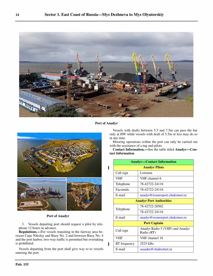
14 Sector 1. East Coast of Russia—Mys Dezhneva to Mys Olyutorskiy
Pub. 155
3. Vessels departing port should request a pilot by tele-phone 12 hours in advance.
1.37 Regulations.—For vessels transiting in the fairway area be-tween Cape Nikolay and Buoy No. 2 and between Buoy No. 4and the port harbor, two-way traffic is permitted but overtakingis prohibited.
1.37 Vessels departing from the port shall give way to to vesselsentering the port.
1.37 Vessels with drafts between 5.5 and 7.5m can pass the baronly at HW while vessels with draft of 5.5m or less may do soat any time. 1.37 Mooring operations within the port can only be carried outwith the assistance of a tug and pilots. 1.37 Contact Information.—See the table titled Anadyr—Con-tact Information.
Port of Anadyr
Port of Anadyr
Anadyr—Contact Information
Anadyr Pilots
Call sign Lotsman
VHF VHF channel 6
Telephone 78-42722-24116
Facsimile 78-42722-24116
E-mail [email protected]
Anadyr Port Authorities
Telephone78-42722-20562
78-42722-24116
E-mail [email protected]
Port Captain
Call sign Anadyr Radio 5 (VHF) and Anadyr Radio (RT)
VHF VHF channel 16
RT frequency 2525 kHz
E-mail [email protected]
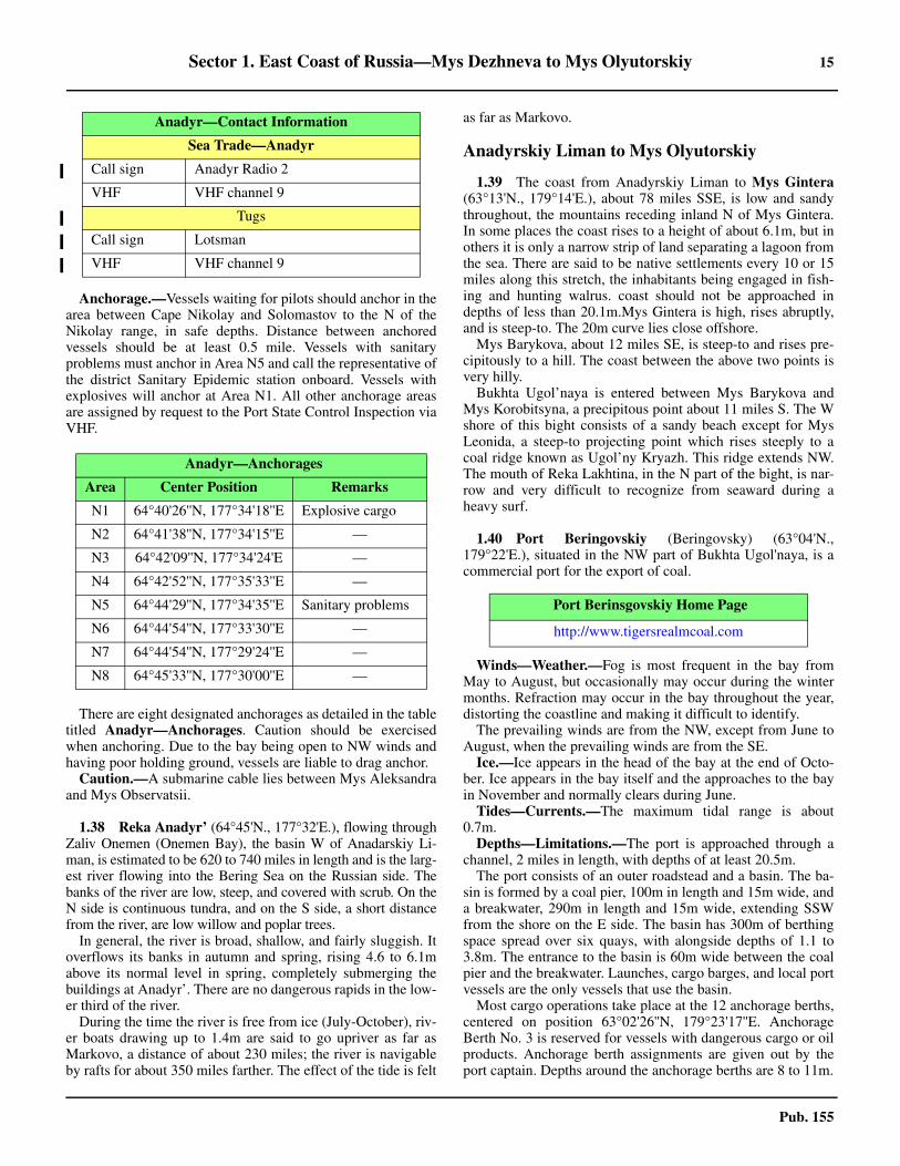
Sector 1. East Coast of Russia—Mys Dezhneva to Mys Olyutorskiy 15
Pub. 155
1.37 Anchorage.—Vessels waiting for pilots should anchor in thearea between Cape Nikolay and Solomastov to the N of theNikolay range, in safe depths. Distance between anchoredvessels should be at least 0.5 mile. Vessels with sanitaryproblems must anchor in Area N5 and call the representative ofthe district Sanitary Epidemic station onboard. Vessels withexplosives will anchor at Area N1. All other anchorage areasare assigned by request to the Port State Control Inspection viaVHF.
1.37 There are eight designated anchorages as detailed in the tabletitled Anadyr—Anchorages. Caution should be exercisedwhen anchoring. Due to the bay being open to NW winds andhaving poor holding ground, vessels are liable to drag anchor.1.37 Caution.—A submarine cable lies between Mys Aleksandraand Mys Observatsii.
1.38 Reka Anadyr’ (64°45'N., 177°32'E.), flowing throughZaliv Onemen (Onemen Bay), the basin W of Anadarskiy Li-man, is estimated to be 620 to 740 miles in length and is the larg-est river flowing into the Bering Sea on the Russian side. Thebanks of the river are low, steep, and covered with scrub. On theN side is continuous tundra, and on the S side, a short distancefrom the river, are low willow and poplar trees.
In general, the river is broad, shallow, and fairly sluggish. Itoverflows its banks in autumn and spring, rising 4.6 to 6.1mabove its normal level in spring, completely submerging thebuildings at Anadyr’. There are no dangerous rapids in the low-er third of the river.
During the time the river is free from ice (July-October), riv-er boats drawing up to 1.4m are said to go upriver as far asMarkovo, a distance of about 230 miles; the river is navigableby rafts for about 350 miles farther. The effect of the tide is felt
as far as Markovo.
Anadyrskiy Liman to Mys Olyutorskiy
1.39 The coast from Anadyrskiy Liman to Mys Gintera(63°13'N., 179°14'E.), about 78 miles SSE, is low and sandythroughout, the mountains receding inland N of Mys Gintera.In some places the coast rises to a height of about 6.1m, but inothers it is only a narrow strip of land separating a lagoon fromthe sea. There are said to be native settlements every 10 or 15miles along this stretch, the inhabitants being engaged in fish-ing and hunting walrus. coast should not be approached indepths of less than 20.1m.Mys Gintera is high, rises abruptly,and is steep-to. The 20m curve lies close offshore.1.39 Mys Barykova, about 12 miles SE, is steep-to and rises pre-cipitously to a hill. The coast between the above two points isvery hilly.1.39 Bukhta Ugol’naya is entered between Mys Barykova andMys Korobitsyna, a precipitous point about 11 miles S. The Wshore of this bight consists of a sandy beach except for MysLeonida, a steep-to projecting point which rises steeply to acoal ridge known as Ugol’ny Kryazh. This ridge extends NW.The mouth of Reka Lakhtina, in the N part of the bight, is nar-row and very difficult to recognize from seaward during aheavy surf.
1.40 Port Beringovskiy (Beringovsky) (63°04'N.,179°22'E.), situated in the NW part of Bukhta Ugol'naya, is acommercial port for the export of coal.
1.40 Winds—Weather.—Fog is most frequent in the bay fromMay to August, but occasionally may occur during the wintermonths. Refraction may occur in the bay throughout the year,distorting the coastline and making it difficult to identify.1.40 The prevailing winds are from the NW, except from June toAugust, when the prevailing winds are from the SE.1.40 Ice.—Ice appears in the head of the bay at the end of Octo-ber. Ice appears in the bay itself and the approaches to the bayin November and normally clears during June.1.40 Tides—Currents.—The maximum tidal range is about0.7m.1.40 Depths—Limitations.—The port is approached through achannel, 2 miles in length, with depths of at least 20.5m.1.40 The port consists of an outer roadstead and a basin. The ba-sin is formed by a coal pier, 100m in length and 15m wide, anda breakwater, 290m in length and 15m wide, extending SSWfrom the shore on the E side. The basin has 300m of berthingspace spread over six quays, with alongside depths of 1.1 to3.8m. The entrance to the basin is 60m wide between the coalpier and the breakwater. Launches, cargo barges, and local portvessels are the only vessels that use the basin. 1.40 Most cargo operations take place at the 12 anchorage berths,centered on position 63°02'26''N, 179°23'17''E. AnchorageBerth No. 3 is reserved for vessels with dangerous cargo or oilproducts. Anchorage berth assignments are given out by theport captain. Depths around the anchorage berths are 8 to 11m.
Sea Trade—Anadyr
Call sign Anadyr Radio 2
VHF VHF channel 9
Tugs
Call sign Lotsman
VHF VHF channel 9
1.37Anadyr—Anchorages
Area Center Position Remarks
N1 64°40'26''N, 177°34'18''E Explosive cargo
N2 64°41'38''N, 177°34'15''E —
N3 64°42'09''N, 177°34'24'E —
N4 64°42'52''N, 177°35'33''E —
N5 64°44'29''N, 177°34'35''E Sanitary problems
N6 64°44'54''N, 177°33'30''E —
N7 64°44'54''N, 177°29'24''E —
N8 64°45'33''N, 177°30'00''E —
Anadyr—Contact Information
Port Berinsgovskiy Home Page
http://www.tigersrealmcoal.com
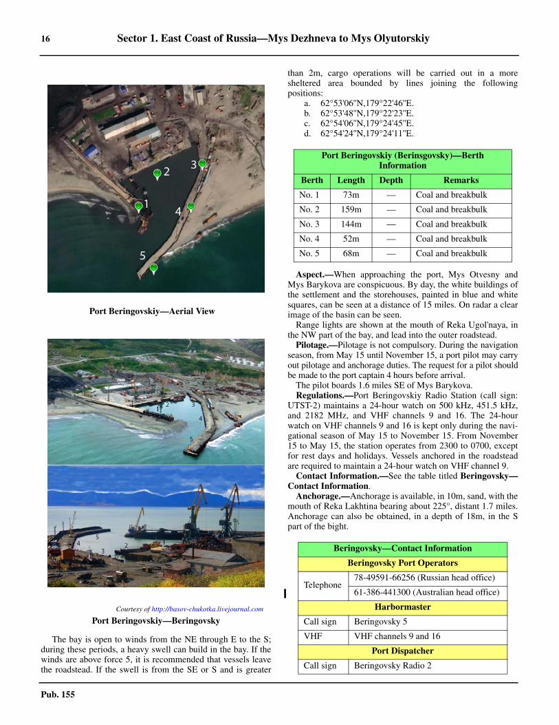
16 Sector 1. East Coast of Russia—Mys Dezhneva to Mys Olyutorskiy
Pub. 155
1.40 The bay is open to winds from the NE through E to the S;during these periods, a heavy swell can build in the bay. If thewinds are above force 5, it is recommended that vessels leavethe roadstead. If the swell is from the SE or S and is greater
than 2m, cargo operations will be carried out in a moresheltered area bounded by lines joining the followingpositions:
a. 62°53'06''N,179°22'46''E.b. 62°53'48''N,179°22'23''E.c. 62°54'06''N,179°24'45''E.d. 62°54'24''N,179°24'11''E.
1.40 Aspect.—When approaching the port, Mys Otvesny andMys Barykova are conspicuous. By day, the white buildings ofthe settlement and the storehouses, painted in blue and whitesquares, can be seen at a distance of 15 miles. On radar a clearimage of the basin can be seen.1.40 Range lights are shown at the mouth of Reka Ugol'naya, inthe NW part of the bay, and lead into the outer roadstead.1.40 Pilotage.—Pilotage is not compulsory. During the navigationseason, from May 15 until November 15, a port pilot may carryout pilotage and anchorage duties. The request for a pilot shouldbe made to the port captain 4 hours before arrival.1.40 The pilot boards 1.6 miles SE of Mys Barykova.1.40 Regulations.—Port Beringovskiy Radio Station (call sign:UTST-2) maintains a 24-hour watch on 500 kHz, 451.5 kHz,and 2182 MHz, and VHF channels 9 and 16. The 24-hourwatch on VHF channels 9 and 16 is kept only during the navi-gational season of May 15 to November 15. From November15 to May 15, the station operates from 2300 to 0700, exceptfor rest days and holidays. Vessels anchored in the roadsteadare required to maintain a 24-hour watch on VHF channel 9. 1.40 Contact Information.—See the table titled Beringovsky—Contact Information.1.40 Anchorage.—Anchorage is available, in 10m, sand, with themouth of Reka Lakhtina bearing about 225°, distant 1.7 miles.Anchorage can also be obtained, in a depth of 18m, in the Spart of the bight.
Port Beringovskiy—Aerial View
Courtesy of http://basov-chukotka.livejournal.com
Port Beringovskiy—Beringovsky
Port Beringovskiy (Berinsgovsky)—Berth Information
Berth Length Depth Remarks
No. 1 73m — Coal and breakbulk
No. 2 159m — Coal and breakbulk
No. 3 144m — Coal and breakbulk
No. 4 52m — Coal and breakbulk
No. 5 68m — Coal and breakbulk
Beringovsky—Contact Information
Beringovsky Port Operators
Telephone78-49591-66256 (Russian head office)
61-386-441300 (Australian head office)
Harbormaster
Call sign Beringovsky 5
VHF VHF channels 9 and 16
Port Dispatcher
Call sign Beringovsky Radio 2
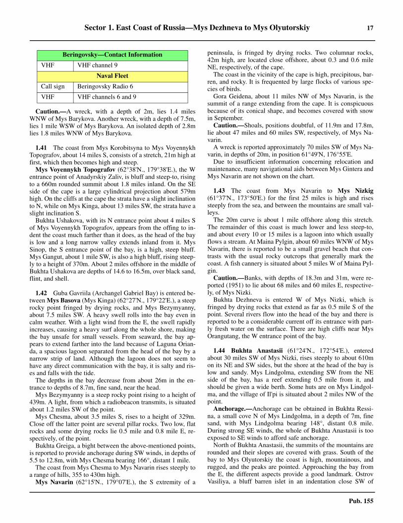
Sector 1. East Coast of Russia—Mys Dezhneva to Mys Olyutorskiy 17
Pub. 155
1.40 Caution.—A wreck, with a depth of 2m, lies 1.4 milesWNW of Mys Barykova. Another wreck, with a depth of 7.5m,lies 1 mile WSW of Mys Barykova. An isolated depth of 2.8mlies 1.8 miles WNW of Mys Barykova.
1.41 The coast from Mys Korobitsyna to Mys VoyennykhTopografov, about 14 miles S, consists of a stretch, 21m high atfirst, which then becomes high and steep.1.41 Mys Voyennykh Topografov (62°38'N., 179°38'E.), the Wentrance point of Anadyrskiy Zaliv, is bluff and steep-to, risingto a 660m rounded summit about 1.8 miles inland. On the SEside of the cape is a large cylindrical projection about 579mhigh. On the cliffs at the cape the strata have a slight inclinationto N, while on Mys Kinga, about 13 miles SW, the strata have aslight inclination S.1.41 Bukhta Ushakova, with its N entrance point about 4 miles Sof Mys Voyennykh Topografov, appears from the offing to in-dent the coast much farther than it does, as the head of the bayis low and a long narrow valley extends inland from it. MysSinop, the S entrance point of the bay, is a high, steep bluff.Mys Gangut, about 1 mile SW, is also a high bluff, rising steep-ly to a height of 370m. About 2 miles offshore in the middle ofBukhta Ushakova are depths of 14.6 to 16.5m, over black sand,flint, and shell.
1.42 Guba Gavriila (Archangel Gabriel Bay) is entered be-tween Mys Basova (Mys Kinga) (62°27'N., 179°22'E.), a steeprocky point fringed by drying rocks, and Mys Bezymyanny,about 7.5 miles SW. A heavy swell rolls into the bay even incalm weather. With a light wind from the E, the swell rapidlyincreases, causing a heavy surf along the whole shore, makingthe bay unsafe for small vessels. From seaward, the bay ap-pears to extend farther into the land because of Laguna Orian-da, a spacious lagoon separated from the head of the bay by anarrow strip of land. Although the lagoon does not seem tohave any direct communication with the bay, it is salty and ris-es and falls with the tide.1.42 The depths in the bay decrease from about 26m in the en-trance to depths of 8.7m, fine sand, near the head.1.42 Mys Bezymyanny is a steep rocky point rising to a height of439m. A light, from which a radiobeacon transmits, is situatedabout 1.2 miles SW of the point.1.42 Mys Chesma, about 3.5 miles S, rises to a height of 329m.Close off the latter point are several pillar rocks. Two low, flatrocks and some drying rocks lie 0.5 mile and 0.8 mile E, re-spectively, of the point.1.42 Bukhta Greiga, a bight between the above-mentioned points,is reported to provide anchorage during SW winds, in depths of5.5 to 12.8m, with Mys Chesma bearing 166°, distant 1 mile.1.42 The coast from Mys Chesma to Mys Navarin rises steeply toa range of hills, 355 to 430m high.1.42 Mys Navarin (62°15'N., 179°07'E.), the S extremity of a
peninsula, is fringed by drying rocks. Two columnar rocks,42m high, are located close offshore, about 0.3 and 0.6 mileNE, respectively, of the cape. 1.42 The coast in the vicinity of the cape is high, precipitous, bar-ren, and rocky. It is frequented by large flocks of various spe-cies of birds. 1.42 Gora Geidena, about 11 miles NW of Mys Navarin, is thesummit of a range extending from the cape. It is conspicuousbecause of its conical shape, and becomes covered with snowin September.1.42 Caution.—Shoals, positions doubtful, of 11.9m and 17.8m,lie about 47 miles and 60 miles SW, respectively, of Mys Na-varin.1.42 A wreck is reported approximately 70 miles SW of Mys Na-varin, in depths of 20m, in position 61°49'N, 176°55'E. 1.42 Due to insufficient information concerning relocation andmaintenance, many navigational aids between Mys Gintera andMys Navarin are not shown on the chart.
1.43 The coast from Mys Navarin to Mys Nizkig(61°37'N., 173°50'E.) for the first 25 miles is high and risessteeply from the sea, and between the mountains are small val-leys.1.43 The 20m curve is about 1 mile offshore along this stretch.The remainder of this coast is much lower and less steep-to,and about every 10 or 15 miles is a lagoon into which usuallyflows a stream. At Maina Pylgin, about 60 miles WNW of MysNavarin, there is reported to be a small gravel beach that con-trasts with the usual rocky outcrops that generally mark thecoast. A fish cannery is situated about 5 miles W of Maina Pyl-gin.1.43 Caution.—Banks, with depths of 18.3m and 31m, were re-ported (1951) to lie about 68 miles and 60 miles E, respective-ly, of Mys Nizki.1.43 Bukhta Dezhneva is entered W of Mys Nizki, which isfringed by drying rocks that extend as far as 0.5 mile S of thepoint. Several rivers flow into the head of the bay and there isreported to be a considerable current off its entrance with part-ly fresh water on the surface. There are high cliffs near MysOrangutang, the W entrance point of the bay.
1.44 Bukhta Anastasii (61°24'N., 172°54'E.), enteredabout 30 miles SW of Mys Nizki, rises steeply to about 610mon its NE and SW sides, but the shore at the head of the bay islow and sandy. Mys Lindgolma, extending SW from the NEside of the bay, has a reef extending 0.5 mile from it, andshould be given a wide berth. Some huts are on Mys Lindgol-ma, and the village of Il'pi is situated about 2 miles NW of thepoint. 1.44 Anchorage.—Anchorage can be obtained in Bukhta Ressi-na, a small cove N of Mys Lindgolma, in a depth of 7m, finesand, with Mys Lindgolma bearing 148°, distant 0.8 mile.During strong SE winds, the whole of Bukhta Anastasii is tooexposed to SE winds to afford safe anchorage.1.44 North of Bukhta Anastasii, the summits of the mountains arerounded and their slopes are covered with grass. South of thebay to Mys Olyutorskiy the coast is high, mountainous, andrugged, and the peaks are pointed. Approaching the bay fromthe E, the different aspects provide a good landmark. OstrovVasiliya, a bluff barren islet in an indentation close SW of
VHF VHF channel 9
Naval Fleet
Call sign Beringovsky Radio 6
VHF VHF channels 6 and 9
Beringovsky—Contact Information
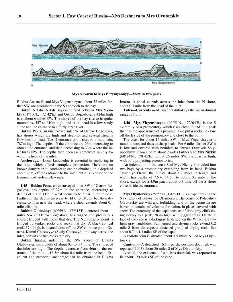
18 Sector 1. East Coast of Russia—Mys Dezhneva to Mys Olyutorskiy
Pub. 155
Bukhta Anastasii, and Mys Vitgenshteyna, about 32 miles far-ther SW, are prominent in the S approach to the bay.1.44 Bukhta Natalii (Natali Bay) is entered between Mys Vyso-kiy (61°10'N., 172°42'E.) and Ostrov Bogoslova, a 424m highislet about 6 miles SW. The shores of the bay rise to irregularmountains, 457 to 610m high, and at its head is a low sandyslope and the entrance to a fairly large river.
Bukhta Pavla, an unsurveyed inlet W of Ostrov Bogoslova,has shores which are high and steep-to, and several streamsflow into its head. The N entrance point rises to a mountain,787m high. The depths off the entrance are 26m, increasing to46m at the entrance, and then decreasing to 33m where the in-let turns NW. The depths then decrease somewhat rapidly to-ward the head of the inlet. 1.44 Anchorage.—Local knowledge is essential in anchoring inthe inlet, which affords complete protection. There are noknown dangers in it. Anchorage can be obtained, in a depth ofabout 26m, off the entrance to the inlet, but it is exposed to thefrequent and violent SE winds.
1.45 Bukhta Petra, an unsurveyed inlet SW of Ostrov Bo-goslova, has depths of 27m in the entrance, decreasing todepths of 9.1 to 11m in what seems to be a bar in the middle.Farther in the depths increase to 14.6 to 18.3m, but then de-crease to 11m near the head, where a shoal extends about 0.1mile offshore. 1.45 Bukhta Glubokaya (60°59'N., 172°15'E.), entered about 11miles SW of Ostrov Bogoslava, has rugged and precipitousshores, fringed with rocks that dry. The NE entrance point isfringed by sunken rocks and rocks that dry. A black conicalrock, 37m high, is located close off the SW entrance point. Os-trova Kamni Chasovyye (Skaly Chasovye), midway across theinlet, consists of two rocks that dry.1.45 Bukhta Imatra, indenting the SW shore of BukhtaGlubokaya, has a width of about 0.3 to 0.4 mile. The shores ofthe inlet are high. The depths decrease from 46m in the en-trance of the inlet to 16.5m about 0.4 mile from the head. Ex-cellent and protected anchorage can be obtained in Bukhta
Imatra. A shoal extends across the inlet from the N shore,about 0.3 mile from the head of the inlet.1.45 Tides—Currents.—At Bukhta Glubokaya the mean diurnalrange is 1.3m.
1.46 Mys Vitgenshteyna (60°51'N., 172°04'E.) is the Sextremity of a promontory which rises close inland to a peakthat has the appearance of a pyramid. Two pillar rocks lie closeoff the E side of the promontory and close to the point.1.46 The coast for about 15 miles SW of Mys Vitgenshteyna ismountainous and rises to sharp peaks. For 6 miles farther SW itis low and covered with boulders to abreast Ostrovok Shly-upochnyy. From a point about 2 miles farther S to Mys Nizkiy(60°24'N., 170°45'E.), about 26 miles SW, the coast is high,with bold projecting promontories.1.46 An indentation in the coast S of Mys Nizkiy is divided intotwo bays by a promontory extending from its head. BukhtaTyulen’ye Ozero, the S bay, about 1.2 miles in length andwidth, has depths of 7.6 to 14.6m to within 0.2 mile of theshore, except for a 4.9m patch about 0.3 mile off the S shoreclose inside the entrance.
1.46 Mys Olyutorskiy (59°55'N., 170°21'E.) is a cape forming theS extremity of Poluostrov Olyutorskiy. The coasts of PoluostrovOlyutorskiy are wild and forbidding, and on the peninsula arebarren mountains of volcanic formation, in places covered withsnow. The extremity of the cape consists of dark gray cliffs ris-ing steeply to a peak, 783m high, with jagged crags. On the Eface of the cape is a dark-gray landslide; on the W face are twolight gray landslides. Submerged and drying rocks extend 0.2mile S from the cape; a detached group of drying rocks liesabout 0.7 to 1.3 miles SE of the cape.1.46 A radiobeacon is situated about 7.5 miles NE of Mys Olyu-torskiy.1.46 Caution.—A detached 16.5m patch, position doubtful, wasreported (1943) about 36 miles S of Mys Olyutorskiy.1.46 A shoal, the existence of which is doubtful, was reported tolie about 120 miles SE of the cape.
Mys Navarin to Mys Bezymyannyy—View in two parts
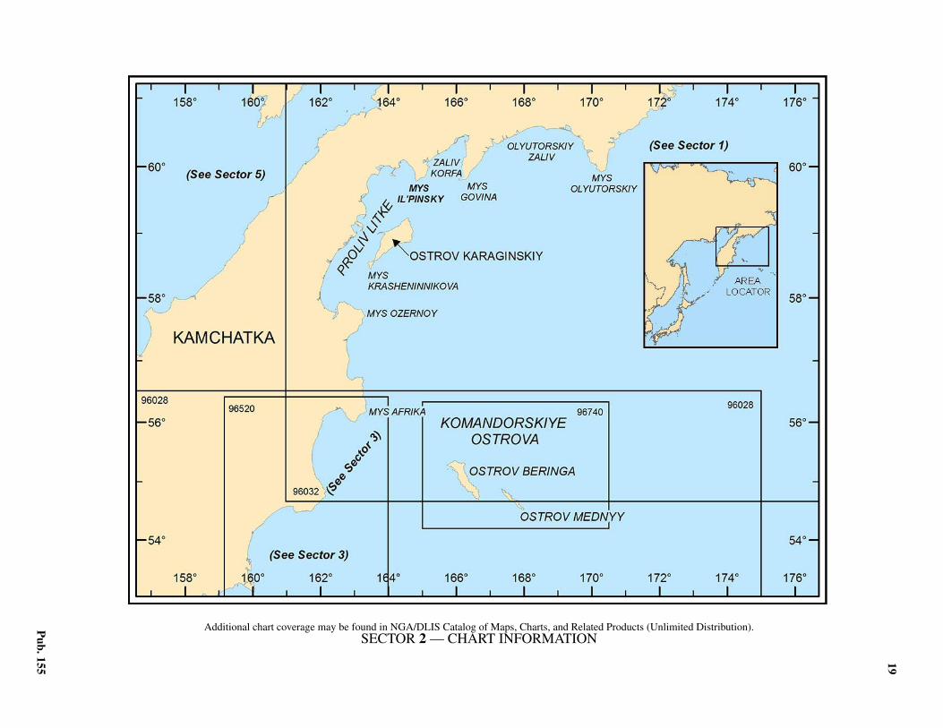
19
Pub. 155
2. Sector 2—Olyutorskiy Zaliv and the East Coast of Kamchatka—Mys Olyutorskiy to Poluostrov Kamchatskiy
2.0Additional chart coverage may be found in NGA/DLIS Catalog of Maps, Charts, and Related Products (Unlimited Distribution).2.0SECTOR 2 — CHART INFORMATION
21
Pub. 155
SECTOR 2
OLYUTORSKIY ZALIV AND THE EAST COAST OF KAMCHATKA—MYS OLYUTORSKIY TO POLUOSTROV KAMCHATSKIY
2.0 Plan.—The coast described in this sector comprises the Wshore of the Bering Sea, Komandorskiye Ostrova, and the Ecoast of Kamchatka from Mys Olyutorskiy to Poluostrov Kam-chatskiy. The arrangement of the sector is from NE to SW.
General Remarks
2.1 Winds—Weather.—In the summer, the predominantwinds are from a S direction and in winter, from a N direction.Wind speeds are greatest in winter, when gales are frequent.Fog occurs during the summer and is said to be most frequentin June.2.1 The prevailing winds in Komandorskiye Ostrova from May toSeptember are from the SE, S, and SW, and are usually accom-panied by fog and rain. During this season, winds from the Wthrough N to NNE bring clear weather, but winds from the NEand E bring cloudy weather and haze. In the remaining months,W and NW winds prevail. Typhoons may be encountered duringthe fall, as their path crosses these islands. Calms are rare and ofshort duration, and are most likely to occur in the early summerthan in fall when any wind is stronger and of longer duration.2.1 The climate of these islands is not severe, the temperatureaveraging 5°C during the summer, and -2°C during the winter.In the winter, during winds from the NE, heavy snow stormsoccur frequently. The snow remains on the islands, especiallyin the narrow mountain clefts, until about the end of July or thebeginning of August. The late disappearance of the snow is dueto its great mass and to the fogs, which are numerous and thickduring the summer.2.1 Ice.—No significant amount of ice is formed in Zaliv Ozer-noy. Drift ice from the N usually appears in February andMarch and finally disappears with the effects of offshore windsand the sea.2.1 Slush ice appears in Ukinskaya Guba during the latter part ofNovember. During December and January, one solid mass offast ice extends as far as 20 to 25 miles offshore. The earliestrecorded first appearance of ice was November 14, the latestJanuary 8. The earliest final disappearance was March 15, andthe latest was June 22.2.1 Slush ice in Proliv Litke ordinarily appears in early November.From December to mid-June the passage is solidly packed withheavy hummocky floating ice. In an extremely severe winter fastice covers the entire passage through February and March. Thepassage is clear of ice by early July or sooner.2.1 Ice begins to form in Zaliv Korfa in mid-December, but canform as early as late November during severe weather. There isdrift ice in the bay until April, though it is sometimes carriedout of the bay by the wind. The bay is clear of ice at the begin-ning of May, but in severe weather the bay may not be clear ofice until early June.2.1 The rivers and lagoons of Olyutorskiy Zaliv begin to freezein the latter half of October. Early in November slush ice ap-pears in the bays and fast ice fringes the shore. Beginning late
in December the bay gradually begins to fill with drift ice com-ing from the N along the W shore of the Bering Sea. The icefirst appears as small floes, mainly in the W part of the bay.From March, when N winds are not so strong and often changeto S breezes, the ice becomes much more tightly packed, al-though between Mys Olyutorskiy and Mys Kreshchenyy Og-nem it generally leaves a shore lead from 1 to 3 miles in width.Strong S winds will drive the ice onshore, but as soon as thesewinds cease, the ice again recedes from the shore. In the NWpart of the bay, from Mys Kreshchenyy Ognem to Bukhta Yu-zhnaya Glubokaya, the ice is much more tightly packed, andonshore winds usually force it into hummocks. The E part ofthe bay becomes clear of ice much earlier than the W part,where it usually remains until the middle of June. 2.1 The sea around Komandorskiye Ostrova is free from iceduring the entire year, but drift ice is brought to the islandsfrom the E shore of Kamchatka during the prevailing W andNW winds.2.1 Tides—Currents.—Between Mys Afrika, Mys Kamchatskiy,and Mys Kronotskiy the flow of the constant Kamchatka Currentis 40 to 50 miles wide, and in a general SSW direction, with avelocity of 0.6 knot. East of the Kamchatka Current, approxi-mately between 56°N and 57°N, and E from 165°E to 169°E,there is a constant current that flows in a general S direction andhas a velocity of about 0.4 knot.2.1 The currents in the S part of Proliv Litke set WNW and ESEon the flood and ebb tides, respectively, attaining a velocity notexceeding 1.5 knots. They are stronger near Mys Krashenin-nikova.
2.1 In Guba Lozhnykh Vestey, the tidal currents are hardly per-ceptible, but outside the bay they set N and S, attaining theirgreatest velocity in the vicinity of Mys Semenova.2.1 Off Mys Ploskiy, the flood current sets SW at a velocity of 1to 1.5 knots and the ebb current sets NE at the same velocity.2.1 The currents in the vicinity of Komandorskiye Ostrova havenot been fully investigated. According to reports, a constantcurrent sets NE between Ostrov Beringa and Ostrov Mednyy.A weak current was observed setting N along the W side of Os-trov Beringa.2.1 The tidal currents in the vicinity of Komandorskiye Ostrovaare very weak, the flood current setting W and the ebb currentsetting E.
Olyutorskiy Zaliv
2.2 Olyutorskiy Zaliv, entered W of Mys Olyutorskiy(59°55'N., 170°21'E.), has not been thoroughly surveyed. TheS half of the E side of the bay is high and steep, but the N halfis low. The N side of the bay is generally low, except near MysKrasnyy and Mys Kreshchenyy Ognem, where mountains ap-proach the shore. The W side of the bay is steep and mountain-ous.
22 Sector 2. East Coast of Kamchatka—Mys Olyutorskiy to Poluostrov Kamchatskiy
Pub. 155
2.3 East and N sides of Olyutorskiy Zaliv.—From MysOlyutorskiy to a low beach at the mouth of a small stream, about3 miles NW, the coast consists of gray cliffs gradually decreas-ing in height. From this stream to the S entrance point of ZalivAnana, about 3 miles W, the coast consists of yellowish-graycliffs, increasing in height. A light, from which a radiobeacontransmits, stands 4 miles NW of Mys Olyutorskiy.2.3 Zaliv Anana has not been thoroughly surveyed. The SE en-trance point slopes gently to the sea, the cliffs being steeper onits N side. The upper part of it is covered with vegetation, and agrayish hill rises on it. Mys Anana, the NW entrance point, isbluff and rises to a mountain, 768m high, with the sheer cliffsup to its summit being dark gray and veined with red, brown,black, and yellow stripes. A drying reef extends 0.3 mile WSWfrom Mys Anana. About 1 mile N of the S entrance point is asmall projection faced by gray-green cliffs, off which is a clus-ter of drying rocks. Northward of this projection the coast be-comes higher, and the slopes of a mountain, 629m high,located about 2 miles NE of this projection, form high dark-gray cliffs. For a distance of about 4 miles ESE from MysAnana the shore is cliffy, except for a narrow valley locatedmidway along it.2.3 From Mys Anana the coast trends 3.5 miles NNW to themouth of a river, the mountains approaching the coast for thefirst 2.5 miles. A ledge of rocks, about 1.5 miles NNW of MysAnana, is marked by breakers. From the mouth of the river toMys Seryy, about 3.5 miles NNW, the coast consists of grayand yellow cliffs gradually increasing in height, and the moun-tains gradually approaching the coast. Near the shore is a lineof low hills.
2.4 Mys Seryy (60°09'N., 169°55'E.) rises to a mountainand is a high bare-topped bluff faced by cliffs that are lightgray and have a yellow tinge. A mountain, with gray cliffs anda conical summit, 747m high, is located S of the point and isseparated from the point by a deep gorge in which there is awaterfall.2.4 Zaliv Lagunnyy, a bight N of Mys Seryy, has not been exam-ined, but depths of 12 to 16m, sand, are reported to be 1 to 2miles offshore. Local fishermen report that the depths abreast thecannery increase regularly from 8.2m, about 0.2 mile offshore,to 10.1m, about 0.5 mile offshore, and to 14.2m, about 1 mileoffshore.2.4 From Mys Seryy to the mouth of Reka Kavacha, a riverabout 3 miles N, the shore is cliffy for the first 1.5 miles, thenthe hills recede inland and the shore becomes low. Reka Kava-cha flows into Zaliv Lagunnyy through a lagoon, which is sep-arated from the bight by the two narrow spits of land parallel tothe coast. The tide is prevalent in the lagoon, and the ebb tidalcurrent attains a velocity of 6 to 6.5 knots.
Mys Lagunnyy, the NW entrance point of Zaliv Lagunnyy, isa flat-topped rounded cape with steep gray cliffs, 61m high,and is covered with grass and moss. Vessels should give thecape a berth of at least 1 mile. The shore consists of cliffs for adistance of 1 mile E of the cape, but then the hills recede inlandand the shore is rocky.2.4 From Mys Lagunnyy to Reka Anichklanvayam, the coast ris-es in dark cliffs, with lighter patches, from 80 to 100m high.Close N of this river is a flat-topped bluff point. For about 3miles N from this point the coast consists of gray cliffs, 20 to
30m high, but then for about 6.5 miles N to the mouth of RekaApuka, the coast is low and sandy. In this vicinity the moun-tains are about 4 to 4.5 miles inland, are rounded, and slopegently.
2.5 Reka Apuka (60°27'N., 169°35'E.) flows into the seathrough a lagoon which is separated from the sea by a sand andshingle spit. The valley through which Reka Apuka flowstrends NE and is open, forming a good mark for this locality.Apuka is a village situated on the high ground on the W side ofthe entrance, and in this vicinity are a radio station, weatherstation, and an electric power plant.2.5 Anchorage.—Anchorage can be taken, in depths of 9 to10m, sand, from 1 to 1.2 miles off the entrance to Reka Apuka.The holding ground is good.2.5 Shoal water extends offshore, and the depths shoal rapidlyinside the 10m curve, between the fishing station and the fishcannery, situated 1.5 and 2.5 miles SE, respectively, of the en-trance. Anchorage can be obtained here, in depths of 9 to 10m,sand, from 1.5 to 2 miles offshore.
2.6 Mys Krasnyy, about 2 miles W of the entrance to Re-ka Apuka, is a point formed by the slopes of a flat-topped hill.It is faced with low cliffs, those on the S side being yellow andlight gray, with some dark patches about 0.1 mile E of thepoint, and those on the W side being gray with yellow patches,one of which appears as a wide horizontal band.2.6 The coast for about 4 miles NW from Mys Krasnyy is cliffyand forms two bights. A valley with a stream is at the head ofeach bight. The point separating the bights is formed of blackcliffs.2.6 Reka Pakhacha forms two lagoons connected by a narrowchannel and separated from the sea by low sand and shinglespits. The river empties into the sea from the E lagoon. Thewhole delta is fronted by a bar with a least depth of 2.1m. Thevillage of Pakhacha is situated on the W spit and there are fish-ing stations on the cay and E spit.2.6 Anchorage.—Vessels can anchor SW of the W river mouth,in a depth of 10m, exercising caution, as the depths shoal veryrapidly. Vessels can also anchor, in a depth of 9.1m, sand,about 0.8 mile offshore abreast the fishing station (60°34'N.,169°04'E.).2.6 The coast, from the mouth of Reka Pakhacha to about 3miles ENE of Mys Kreshchenyy Ognem, is sandy and steep-to,and has depths of 11m, sand, about 1 mile offshore. The coastto Mys Kreshchenyy Ognem is high, bold, and rises close in-land to mountains, the cliffs of which are marked by red, yel-low, and dark colored patches.
2.7 Mys Kreshchenyy Ognem (60°33'N., 168°42'E.) isfaced with red cliffs, about 20m high. The S end of the penin-sula is high and is marked by irregular red and yellow crags.From the E or W, the peninsula appears as an island, because itis joined to the mainland by low swampy land, on which aresome ponds. Reefs marked by breakers during the slightestswell lie close off the point, and a rock was reported in 1933 tolie about 1 mile S of the point. A beacon, 4.9m high, stands onthe S cliff of Mys Kreshchenyy Ognem.2.7 The coast from Mys Kreshchenyy Ognem to Mys Zheltyy,about 2.5 miles WNW, is high and bold, consisting of black
Sector 2. East Coast of Kamchatka—Mys Olyutorskiy to Poluostrov Kamchatskiy 23
Pub. 155
and red cliffs. The steep cliffs on the S side of Mys Zheltyy area subdued yellow with large red patches. The W side of MysZheltyy, as far as its extremity is of a bright yellow color, mak-ing the point very conspicuous from the W.2.7 A sloping dark green mountain, about 366m high, rises at thehead of the bight between Mys Zheltyy and Mys Groznyy,about 2.3 miles NW. On either side of the mountain is a valleywith a stream. A fishing station is situated on the low beachnear the mouth of the W stream. Off this fishing station thedepths are irregular, there being depths of 10m about 1.2 milesoffshore, and depths of 11m about 0.4 mile offshore.2.7 Mys Groznyy, rising to a mountain 463m high, is a dark rug-ged cape faced by sheer cliffs, the extremity of the cliff beinglight gray. A black pyramidal rock, conspicuous from the W orE, lies close to the cape. From the S the cape appears as a steepdark-gray wall, but from the SW the cliffs are black, and theformation of the strata is clearly seen.2.7 The coast from close N of Mys Groznyy to about 4 miles Wis low. 2.7 Anchorage.—Anchorage can be obtained, in a depth of9.1m, sand, about 1 mile off a fishing station situated midwayalong this coast.2.7 From Reka Impuka Yuzhnaya to a fishing station about 9miles W, the coast consists of low grass-covered terraces withyellow-gray cliffs about 20m high, broken by deep gullies andstreams. Anchorage can be taken, in a depth of 9m, sand, about1 mile off this fishing station, which is situated on a low sandybeach extending to the mouth of Reka Yemet.2.7 The coast from Reka Yemet to Bukhta Somneniya, about 7miles SW, is formed by 30 to 40m cliffs rising to some hills cov-ered with grass and bush. About 2.5 miles SW of Reka Yemet isa conspicuous valley, through which runs a stream. The shore issteep in this vicinity and the cliffs are gray with yellow stripes.2.7 Caution.—A dangerous wreck lies 7 miles ESE of MysKreshchenyy Ognem.
2.8 Northwest and W sides of Olyutorskiy Zaliv.—Bukhta Somneniya (60°31'N., 167°47'E.), an inlet surroundedby mountains, has high and steep E and W shores, but the headof the inlet is low and sandy. A rocky ledge extends about 0.4mile E from the SW entrance point, and a patch of drying rocksextends a short distance off the NE entrance point. A detachedreef, which partly dries and on which are two above-waterrocks, extends about 0.4 mile ENE from a position 1.2 miles Eof the SW entrance point. The sea constantly breaks on thisdanger. The vicinity of this danger and the passage between itand the NE entrance point have not been examined.2.8 About 1 mile off the entrance to Bukhta Somneniya aredepths of 12.8m, which decrease gradually in the fairway to thehead of the inlet. Depths in the outer portion range from 5.8 to9.1m. Both shores of the inlet are fringed with rocks, and a3.3m patch lies about 0.4 mile off the E shore 1.3 miles NNEof the SW entrance point. The bottom of the inlet consists ofsand and pebbles.2.8 Anchorage.—In summer small vessels can anchor in the in-let sheltered from all but SE winds. The strong N squalls thatoccur in the autumn render the anchorage difficult.2.8 A vessel entering the inlet should steer midway between theSW entrance point and the detached reef in the entrance.2.8 The coast between Bukhta Somneniya and Bukhta Lavrova,
about 20 miles WSW, is high and steep, and indented in fourplaces. There are depths of at least 20m about 2 miles off thissteep-to coast, the bottom being rock, sand, and shells.2.8 The next indentation, about 10 miles WSW of Bukhta Som-neniya, has a NE entrance point consisting of a steep cliff with alarge waterfall, N of which is a sharp peaked mountain with anyellow-red cliff reaching almost to its summit. Abreast the fish-ing station there are depths of 11.9m and 15.9m, about 0.5 and0.8 mile, respectively, offshore.2.8 The third indentation, close WNW of the second, has notbeen surveyed. The entrance points, as well as the E and Wshores, are bold and high. At the head of the bight is a low, san-dy spit separating the bight from a lagoon. This lagoon is re-ported to extend about 7 miles in a NW direction, and to havedepths of 2.4 to 3.4m in its entrance, 20.1 to 29m in its middlepart, and 5.9 to 8.2m near its shores.
2.9 Bukhta Lavrova (60°19'N., 167°08'E.) is surroundedby mountains about 1,000m high, and narrows to about 0.4mile at its head, where it divides into two arms. Bukhta Vesto-vaya, the W arm, extends about 1.5 miles W, and Bukhta Osto-vaya, the E arm, extends about the same distance E.2.9 The SW entrance point is a low sand and shingle point ex-tending SE from a small terrace about 30m high. On this ter-race is a white pyramidal slatted beacon, about 4.3m high. Aradiobeacon transmits from this entrance point. A dark coloredmountain, about 610m high rises near the point. A reef, onwhich are some rocks above-water, fringes the point and ex-tends as far as 0.2 mile S and SE from it. On the W side of theinlet are three mountains, separated by narrow valleys througheach of which flows a stream. Except at the mouths of thesestreams, the shore consists of high cliffs fringed by sunken anddrying rocks.2.9 The NE entrance point is formed by the high bluff slope ofthe mountain forming the SE end of the range running alongthe E side of the inlet. A rocky shoal, partly above water andmarked by breakers, is located about 1.4 miles W of the NE en-trance point. Off the shoal are depths of 11 to 15m. The pas-sage between this danger and the point has not been examined.About halfway along the E side of the inlet is a mountain witha conical peak, about 1,006m high. Several waterfalls run overthe cliffs on the E side, and it is fringed by sunken and above-water rocks.2.9 Between the entrance points of Bukhta Lavrova there aredepths of 11.9 to 14.9m, gradually decreasing to depths of 4mon a bar, about 1 mile from the head. The depths increase againN of this bar to as much as 31m in a pool between the spits atits head. The bottom is rock and shingle near the shore andsand toward the middle of the inlet.2.9 Bukhta Vestovaya, the W arm, is entered N of a low, sandyspit extending about 0.3 mile in a N direction. The arm is about0.1 mile wide in the entrance, and widens inside to about 0.2 to0.3 mile. On each side of this arm are high mountains. Streamsand waterfalls flow down the cliffs. During the autumn, whenstrong NW winds occur, strong squalls sometimes come downthis arm. Bukhta Vestovaya is usually free of ice by the end ofJune.2.9 In the middle of the entrance to Bukhta Vestovaya are depthsof 12.8m, but near the S entrance point are depths of 8.5m. Forabout 0.5 mile inside the entrance the depths increase to 16.5 to
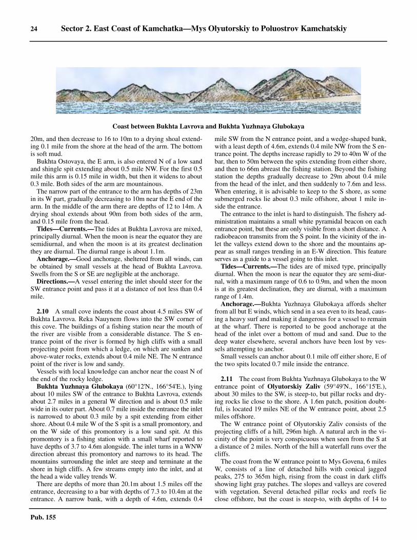
24 Sector 2. East Coast of Kamchatka—Mys Olyutorskiy to Poluostrov Kamchatskiy
Pub. 155
20m, and then decrease to 16 to 10m to a drying shoal extend-ing 0.1 mile from the shore at the head of the arm. The bottomis soft mud.
Bukhta Ostovaya, the E arm, is also entered N of a low sandand shingle spit extending about 0.5 mile NW. For the first 0.5mile this arm is 0.15 mile in width, but then it widens to about0.3 mile. Both sides of the arm are mountainous.2.9 The narrow part of the entrance to the arm has depths of 23min its W part, gradually decreasing to 10m near the E end of thearm. In the middle of the arm there are depths of 12 to 14m. Adrying shoal extends about 90m from both sides of the arm,and 0.15 mile from the head.2.9 Tides—Currents.—The tides at Bukhta Lavrova are mixed,principally diurnal. When the moon is near the equator they aresemidiurnal, and when the moon is at its greatest declinationthey are diurnal. The diurnal range is about 1.1m.2.9 Anchorage.—Good anchorage, sheltered from all winds, canbe obtained by small vessels at the head of Bukhta Lavrova.Swells from the S or SE are negligible at the anchorage.2.9 Directions.—A vessel entering the inlet should steer for theSW entrance point and pass it at a distance of not less than 0.4mile.
2.10 A small cove indents the coast about 4.5 miles SW ofBukhta Lavrova. Reka Nauynem flows into the SW corner ofthis cove. The buildings of a fishing station near the mouth ofthe river are visible from a considerable distance. The S en-trance point of the river is formed by high cliffs with a smallprojecting point from which a ledge, on which are sunken andabove-water rocks, extends about 0.4 mile NE. The N entrancepoint of the river is low and sandy. 2.10 Vessels with local knowledge can anchor near the coast N ofthe end of the rocky ledge.
Bukhta Yuzhnaya Glubokaya (60°12'N., 166°54'E.), lyingabout 10 miles SW of the entrance to Bukhta Lavrova, extendsabout 2.7 miles in a general W direction and is about 0.5 milewide in its outer part. About 0.7 mile inside the entrance the inletis narrowed to about 0.3 mile by a spit extending from eithershore. About 0.4 mile W of the S spit is a small promontory, andon the W side of this promontory is a low sand spit. At thispromontory is a fishing station with a small wharf reported tohave depths of 3.7 to 4.6m alongside. The inlet turns in a WNWdirection abreast this promontory and narrows to its head. Themountains surrounding the inlet are steep and terminate at theshore in high cliffs. A few streams empty into the inlet, and atthe head a wide valley trends W.2.10 There are depths of more than 20.1m about 1.5 miles off theentrance, decreasing to a bar with depths of 7.3 to 10.4m at theentrance. A narrow bank, with a depth of 4.6m, extends 0.4
mile SW from the N entrance point, and a wedge-shaped bank,with a least depth of 4.6m, extends 0.4 mile NW from the S en-trance point. The depths increase rapidly to 29 to 40m W of thebar, then to 50m between the spits extending from either shore,and then to 66m abreast the fishing station. Beyond the fishingstation the depths gradually decrease to 29m about 0.4 milefrom the head of the inlet, and then suddenly to 7.6m and less.When entering, it is advisable to keep to the S shore, as somesubmerged rocks lie about 0.3 mile offshore, about 1 mile in-side the entrance.2.10 The entrance to the inlet is hard to distinguish. The fishery ad-ministration maintains a small white pyramidal beacon on eachentrance point, but these are only visible from a short distance. Aradiobeacon transmits from the S point. In the vicinity of the in-let the valleys extend down to the shore and the mountains ap-pear as small ranges trending in an E-W direction. This featureserves as a guide to a vessel going to this inlet.2.10 Tides—Currents.—The tides are of mixed type, principallydiurnal. When the moon is near the equator they are semi-diur-nal, with a maximum range of 0.6 to 0.9m, and when the moonis at its greatest declination, they are diurnal, with a maximumrange of 1.4m.2.10 Anchorage.—Bukhta Yuzhnaya Glubokaya affords shelterfrom all but E winds, which send in a sea even to its head, caus-ing a heavy surf and making it dangerous for a vessel to remainat the wharf. There is reported to be good anchorage at thehead of the inlet over a bottom of mud and sand. Due to thedeep water elsewhere, several anchors have been lost by ves-sels attempting to anchor.2.10 Small vessels can anchor about 0.1 mile off either shore, E ofthe two spits located 0.7 mile inside the entrance.
2.11 The coast from Bukhta Yuzhnaya Glubokaya to the Wentrance point of Olyutorskiy Zaliv (59°49'N., 166°15'E.),about 30 miles to the SW, is steep-to, but pillar rocks and dry-ing rocks lie close to the shore. A 1.6m patch, position doubt-ful, is located 19 miles NE of the W entrance point, about 2.5miles offshore.2.11 The W entrance point of Olyutorskiy Zaliv consists of theprojecting cliffs of a hill, 296m high. A natural arch in the vi-cinity of the point is very conspicuous when seen from the S ata distance of 2 miles. North of the hill a waterfall runs over thecliffs.2.11 The coast from the W entrance point to Mys Govena, 6 milesW, consists of a line of detached hills with conical jaggedpeaks, 275 to 365m high, rising from the coast in dark cliffsshowing light gray patches. The slopes and valleys are coveredwith vegetation. Several detached pillar rocks and reefs lieclose offshore, but the coast is steep-to, with depths of 14 to
Coast between Bukhta Lavrova and Bukhta Yuzhnaya Glubokaya
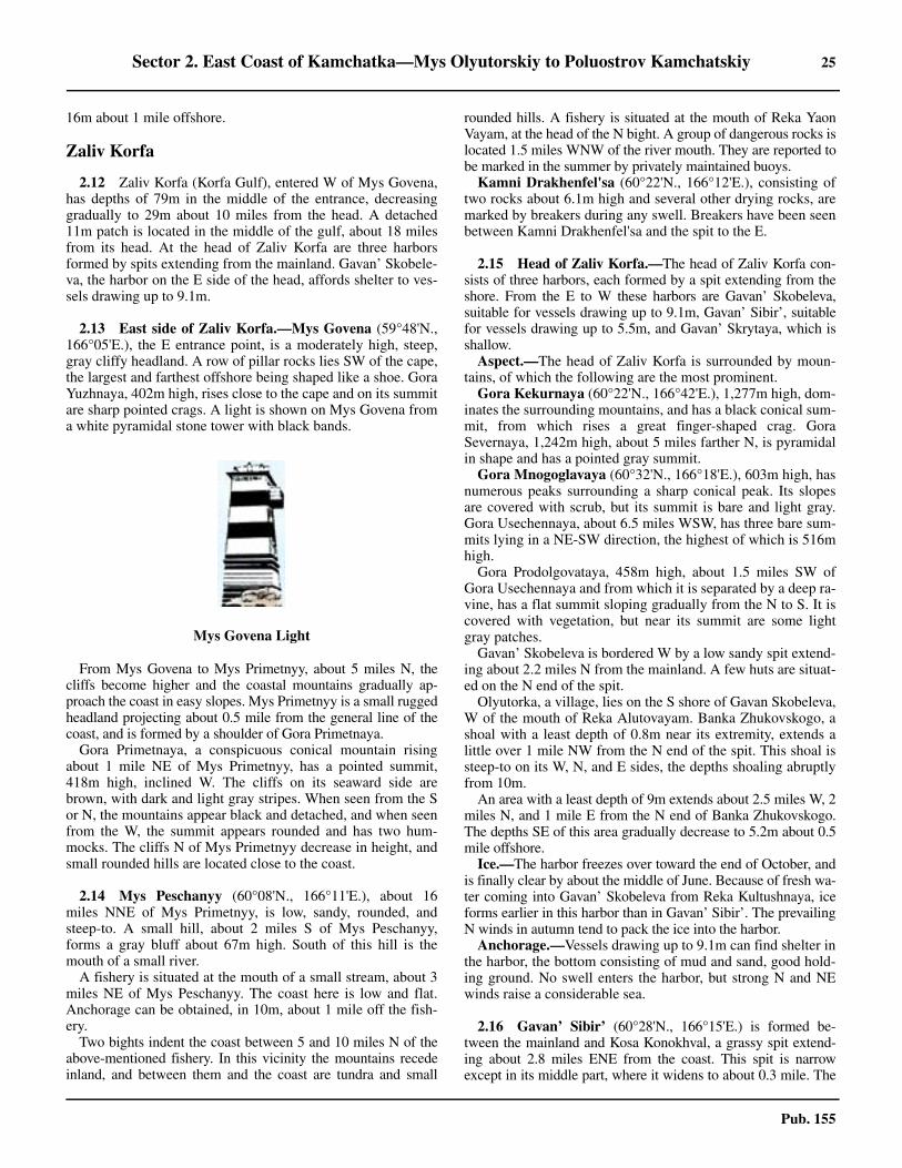
Sector 2. East Coast of Kamchatka—Mys Olyutorskiy to Poluostrov Kamchatskiy 25
Pub. 155
16m about 1 mile offshore.
Zaliv Korfa
2.12 Zaliv Korfa (Korfa Gulf), entered W of Mys Govena,has depths of 79m in the middle of the entrance, decreasinggradually to 29m about 10 miles from the head. A detached11m patch is located in the middle of the gulf, about 18 milesfrom its head. At the head of Zaliv Korfa are three harborsformed by spits extending from the mainland. Gavan’ Skobele-va, the harbor on the E side of the head, affords shelter to ves-sels drawing up to 9.1m.
2.13 East side of Zaliv Korfa.—Mys Govena (59°48'N.,166°05'E.), the E entrance point, is a moderately high, steep,gray cliffy headland. A row of pillar rocks lies SW of the cape,the largest and farthest offshore being shaped like a shoe. GoraYuzhnaya, 402m high, rises close to the cape and on its summitare sharp pointed crags. A light is shown on Mys Govena froma white pyramidal stone tower with black bands.
2.13 From Mys Govena to Mys Primetnyy, about 5 miles N, thecliffs become higher and the coastal mountains gradually ap-proach the coast in easy slopes. Mys Primetnyy is a small ruggedheadland projecting about 0.5 mile from the general line of thecoast, and is formed by a shoulder of Gora Primetnaya.2.13 Gora Primetnaya, a conspicuous conical mountain risingabout 1 mile NE of Mys Primetnyy, has a pointed summit,418m high, inclined W. The cliffs on its seaward side arebrown, with dark and light gray stripes. When seen from the Sor N, the mountains appear black and detached, and when seenfrom the W, the summit appears rounded and has two hum-mocks. The cliffs N of Mys Primetnyy decrease in height, andsmall rounded hills are located close to the coast.
2.14 Mys Peschanyy (60°08'N., 166°11'E.), about 16miles NNE of Mys Primetnyy, is low, sandy, rounded, andsteep-to. A small hill, about 2 miles S of Mys Peschanyy,forms a gray bluff about 67m high. South of this hill is themouth of a small river.2.14 A fishery is situated at the mouth of a small stream, about 3miles NE of Mys Peschanyy. The coast here is low and flat.Anchorage can be obtained, in 10m, about 1 mile off the fish-ery.2.14 Two bights indent the coast between 5 and 10 miles N of theabove-mentioned fishery. In this vicinity the mountains recedeinland, and between them and the coast are tundra and small
rounded hills. A fishery is situated at the mouth of Reka YaonVayam, at the head of the N bight. A group of dangerous rocks islocated 1.5 miles WNW of the river mouth. They are reported tobe marked in the summer by privately maintained buoys.2.14 Kamni Drakhenfel'sa (60°22'N., 166°12'E.), consisting oftwo rocks about 6.1m high and several other drying rocks, aremarked by breakers during any swell. Breakers have been seenbetween Kamni Drakhenfel'sa and the spit to the E.
2.15 Head of Zaliv Korfa.—The head of Zaliv Korfa con-sists of three harbors, each formed by a spit extending from theshore. From the E to W these harbors are Gavan’ Skobeleva,suitable for vessels drawing up to 9.1m, Gavan’ Sibir’, suitablefor vessels drawing up to 5.5m, and Gavan’ Skrytaya, which isshallow.2.15 Aspect.—The head of Zaliv Korfa is surrounded by moun-tains, of which the following are the most prominent.2.15 Gora Kekurnaya (60°22'N., 166°42'E.), 1,277m high, dom-inates the surrounding mountains, and has a black conical sum-mit, from which rises a great finger-shaped crag. GoraSevernaya, 1,242m high, about 5 miles farther N, is pyramidalin shape and has a pointed gray summit.2.15 Gora Mnogoglavaya (60°32'N., 166°18'E.), 603m high, hasnumerous peaks surrounding a sharp conical peak. Its slopesare covered with scrub, but its summit is bare and light gray.Gora Usechennaya, about 6.5 miles WSW, has three bare sum-mits lying in a NE-SW direction, the highest of which is 516mhigh.2.15 Gora Prodolgovataya, 458m high, about 1.5 miles SW ofGora Usechennaya and from which it is separated by a deep ra-vine, has a flat summit sloping gradually from the N to S. It iscovered with vegetation, but near its summit are some lightgray patches.2.15 Gavan’ Skobeleva is bordered W by a low sandy spit extend-ing about 2.2 miles N from the mainland. A few huts are situat-ed on the N end of the spit.
Olyutorka, a village, lies on the S shore of Gavan Skobeleva,W of the mouth of Reka Alutovayam. Banka Zhukovskogo, ashoal with a least depth of 0.8m near its extremity, extends alittle over 1 mile NW from the N end of the spit. This shoal issteep-to on its W, N, and E sides, the depths shoaling abruptlyfrom 10m.2.15 An area with a least depth of 9m extends about 2.5 miles W, 2miles N, and 1 mile E from the N end of Banka Zhukovskogo.The depths SE of this area gradually decrease to 5.2m about 0.5mile offshore.2.15 Ice.—The harbor freezes over toward the end of October, andis finally clear by about the middle of June. Because of fresh wa-ter coming into Gavan’ Skobeleva from Reka Kultushnaya, iceforms earlier in this harbor than in Gavan’ Sibir’. The prevailingN winds in autumn tend to pack the ice into the harbor.2.15 Anchorage.—Vessels drawing up to 9.1m can find shelter inthe harbor, the bottom consisting of mud and sand, good hold-ing ground. No swell enters the harbor, but strong N and NEwinds raise a considerable sea.
2.16 Gavan’ Sibir’ (60°28'N., 166°15'E.) is formed be-tween the mainland and Kosa Konokhval, a grassy spit extend-ing about 2.8 miles ENE from the coast. This spit is narrowexcept in its middle part, where it widens to about 0.3 mile. The
Mys Govena Light
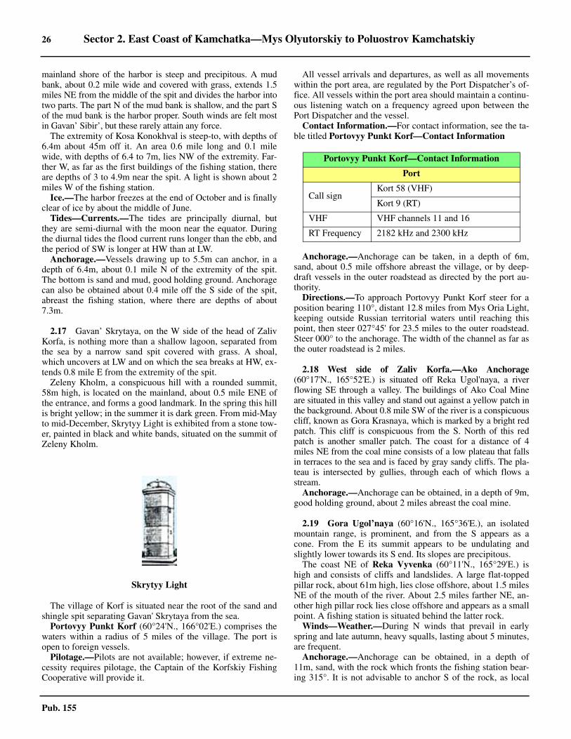
26 Sector 2. East Coast of Kamchatka—Mys Olyutorskiy to Poluostrov Kamchatskiy
Pub. 155
mainland shore of the harbor is steep and precipitous. A mudbank, about 0.2 mile wide and covered with grass, extends 1.5miles NE from the middle of the spit and divides the harbor intotwo parts. The part N of the mud bank is shallow, and the part Sof the mud bank is the harbor proper. South winds are felt mostin Gavan’ Sibir’, but these rarely attain any force.2.16 The extremity of Kosa Konokhval is steep-to, with depths of6.4m about 45m off it. An area 0.6 mile long and 0.1 milewide, with depths of 6.4 to 7m, lies NW of the extremity. Far-ther W, as far as the first buildings of the fishing station, thereare depths of 3 to 4.9m near the spit. A light is shown about 2miles W of the fishing station.2.16 Ice.—The harbor freezes at the end of October and is finallyclear of ice by about the middle of June.2.16 Tides—Currents.—The tides are principally diurnal, butthey are semi-diurnal with the moon near the equator. Duringthe diurnal tides the flood current runs longer than the ebb, andthe period of SW is longer at HW than at LW.2.16 Anchorage.—Vessels drawing up to 5.5m can anchor, in adepth of 6.4m, about 0.1 mile N of the extremity of the spit.The bottom is sand and mud, good holding ground. Anchoragecan also be obtained about 0.4 mile off the S side of the spit,abreast the fishing station, where there are depths of about7.3m.
2.17 Gavan’ Skrytaya, on the W side of the head of ZalivKorfa, is nothing more than a shallow lagoon, separated fromthe sea by a narrow sand spit covered with grass. A shoal,which uncovers at LW and on which the sea breaks at HW, ex-tends 0.8 mile E from the extremity of the spit.2.17 Zeleny Kholm, a conspicuous hill with a rounded summit,58m high, is located on the mainland, about 0.5 mile ENE ofthe entrance, and forms a good landmark. In the spring this hillis bright yellow; in the summer it is dark green. From mid-Mayto mid-December, Skrytyy Light is exhibited from a stone tow-er, painted in black and white bands, situated on the summit ofZeleny Kholm.
2.17 The village of Korf is situated near the root of the sand andshingle spit separating Gavan' Skrytaya from the sea. 2.17 Portovyy Punkt Korf (60°24'N., 166°02'E.) comprises thewaters within a radius of 5 miles of the village. The port isopen to foreign vessels.2.17 Pilotage.—Pilots are not available; however, if extreme ne-cessity requires pilotage, the Captain of the Korfskiy FishingCooperative will provide it.
2.17 All vessel arrivals and departures, as well as all movementswithin the port area, are regulated by the Port Dispatcher’s of-fice. All vessels within the port area should maintain a continu-ous listening watch on a frequency agreed upon between thePort Dispatcher and the vessel. 2.17 Contact Information.—For contact information, see the ta-ble titled Portovyy Punkt Korf—Contact Information
2.17 Anchorage.—Anchorage can be taken, in a depth of 6m,sand, about 0.5 mile offshore abreast the village, or by deep-draft vessels in the outer roadstead as directed by the port au-thority.2.17 Directions.—To approach Portovyy Punkt Korf steer for aposition bearing 110°, distant 12.8 miles from Mys Oria Light,keeping outside Russian territorial waters until reaching thispoint, then steer 027°45' for 23.5 miles to the outer roadstead.Steer 000° to the anchorage. The width of the channel as far asthe outer roadstead is 2 miles.
2.18 West side of Zaliv Korfa.—Ako Anchorage(60°17'N., 165°52'E.) is situated off Reka Ugol'naya, a riverflowing SE through a valley. The buildings of Ako Coal Mineare situated in this valley and stand out against a yellow patch inthe background. About 0.8 mile SW of the river is a conspicuouscliff, known as Gora Krasnaya, which is marked by a bright redpatch. This cliff is conspicuous from the S. North of this redpatch is another smaller patch. The coast for a distance of 4miles NE from the coal mine consists of a low plateau that fallsin terraces to the sea and is faced by gray sandy cliffs. The pla-teau is intersected by gullies, through each of which flows astream.2.18 Anchorage.—Anchorage can be obtained, in a depth of 9m,good holding ground, about 2 miles abreast the coal mine.
2.19 Gora Ugol’naya (60°16'N., 165°36'E.), an isolatedmountain range, is prominent, and from the S appears as acone. From the E its summit appears to be undulating andslightly lower towards its S end. Its slopes are precipitous.2.19 The coast NE of Reka Vyvenka (60°11'N., 165°29'E.) ishigh and consists of cliffs and landslides. A large flat-toppedpillar rock, about 61m high, lies close offshore, about 1.5 milesNE of the mouth of the river. About 2.5 miles farther NE, an-other high pillar rock lies close offshore and appears as a smallpoint. A fishing station is situated behind the latter rock. 2.19 Winds—Weather.—During N winds that prevail in earlyspring and late autumn, heavy squalls, lasting about 5 minutes,are frequent.2.19 Anchorage.—Anchorage can be obtained, in a depth of11m, sand, with the rock which fronts the fishing station bear-ing 315°. It is not advisable to anchor S of the rock, as local
Skrytyy Light
Portovyy Punkt Korf—Contact Information
Port
Call signKort 58 (VHF)
Kort 9 (RT)
VHF VHF channels 11 and 16
RT Frequency 2182 kHz and 2300 kHz
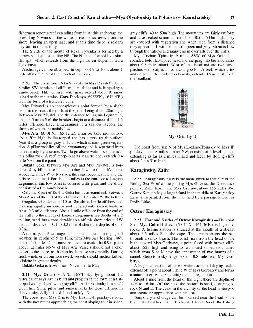
Sector 2. East Coast of Kamchatka—Mys Olyutorskiy to Poluostrov Kamchatskiy 27
Pub. 155
fishermen report a reef extending from it. At this anchorage theprevailing N winds in the winter drive the ice away from theshore, leaving an open lane, and at this time there is seldomany surf in this vicinity. 2.19 The S side of the mouth of Reka Vyvenka is formed by anarrow sand spit extending NE. The N side is formed by a sim-ilar spit, which extends from the high barren slopes of GoraUgol’naya. 2.19 Anchorage can be obtained, in depths of 9 to 10m, about 1mile offshore abreast the mouth of the river.
2.20 The coast from Reka Vyvenka to Mys Priyatel’, about8 miles SW, consists of cliffs and landslides and is fringed by asandy beach. Hills covered with grass extend about 10 milesinland to the mountains. Gora Ploskaya (60°22'N., 165°14'E.)is in the form of a truncated cone.
Mys Priyatel’is an inconspicuous point formed by a slightbend in the coast, the cliffs at the point being about 20m high.Between Mys Priyatel’ and the entrance to Laguna Legunmun,about 3.5 miles SW, the breakers begin at a distance of 1 to 1.5miles offshore. Laguna Legunmun is a shallow lagoon, theshores of which are mainly low.
Mys Ara (60°01'N., 165°12'E.), a narrow bold promontory,about 20m high, is flat-topped and has a very rough surface.Near it is a group of gray hills, on which is dark green vegeta-tion. A pillar rock lies off the promontory and is separated fromits extremity by a ravine. Two large above-water rocks lie nearthis pillar rock. A reef, steep-to at its seaward end, extends 0.4mile NE from the point.2.20 Bukhta Geka, between Mys Ara and Mys Priyatel', is bor-dered S by hills close inland sloping down to the cliffy shore.About 1.5 miles W of Mys Ara the coast becomes low and thehills recede inland. For about 4 miles to the entrance to LagunaLegunmun, this low coast is covered with grass and the shoreconsists of a flat sandy beach.2.20 Only the S part of Bukhta Geka has been examined. BetweenMys Ara and the end of the cliffs about 1.5 miles W, the bottomis irregular, with depths of 10 to 12m about 1 mile offshore, de-creasing rapidly inshore. A reef covered with kelp extends asfar as 0.3 mile offshore. About 1 mile offshore from the end ofthe cliffs to the mouth of Laguna Legunmun are depths of 8.2to 10m, sand, but a considerable area off this shore dries at LWand at a distance of 0.1 to 0.2 mile offshore are depths of only0.3m.2.20 Anchorage.—Anchorage can be obtained during goodweather, in depths of 9 to 10m, with Mys Ara bearing 146°,distant 1.5 miles. Care must be taken to avoid the 0.9m patchabout 1.2 miles NNW of Mys Ara. Vessels should not anchorcloser to the shore, as the depths decrease very rapidly. Duringfresh winds or an onshore swell, vessels should anchor fartheroffshore in greater depths.2.20 Bukhta Geka is frozen from November to May.
2.21 Mys Oria (59°59'N., 165°14'E.), lying about 1.2miles SE of Mys Ara, is bluff and projects in the form of a flat-topped wedge, faced with gray cliffs. At its extremity is a smallgreen hill. Some pillar and sunken rocks lie close offshore inthis vicinity. A light is exhibited on Mys Oria.2.21 The coast from Mys Oria to Mys Lozhno-Il’pinskiy is bold,with the mountains approaching the coast sloping to it in sheer,
gray cliffs, 40 to 50m high. The mountains are fairly uniformand have peaked summits from about 305 to 503m high. Theyare covered with vegetation and when seen from a distancethey appear dark with patches of green and gray. Streams flowthrough the valleys and many end in overfalls over the cliffs.2.21 Mys Lozhno-Il'pinskiy, 9 miles SSW of Mys Oria, is arounded bold flat-topped headland merging into the mountainsabout 0.5 mile inland. West of this headland are two largepatches with stripes of contrasting color. A reef, which driesand on which the sea breaks heavily, extends 0.5 mile SE fromthe headland.
2.21 The coast from just N of Mys Lozhno-Il'pinskiy to Mys Il’pinskiy, about 8 miles further SW, consists of a level plateauextending as far as 2 miles inland and faced by sloping cliffsabout 20 to 31m high.
Karaginskiy Zaliv
2.22 Karaginskiy Zaliv is the name given to that part of theBering Sea W of a line joining Mys Govena, the E entrancepoint of Zaliv Korfa, and Mys Ozernoy, about 155 miles SW.Ostrov Karaginskiy, a large island in the middle of KaraginskiyZaliv, is separated from the mainland by a passage known asProliv Litke.
Ostrov Karaginskiy
2.23 East and S sides of Ostrov Karaginskiy.—The coastS of Mys Golenishcheva (59°14'N., 164°36'E.) is high androcky. A fishing station is situated at the mouth of a streamabout 3.5 miles S of the cape. The stream enters the seathrough a sandy beach. The coast rises from the head of thebight toward Mys Gorbatyy, a point faced with brown cliffsabout 152m high and rising to two round-topped mountains,which from S or N have the appearance of two humps of acamel. Steep-to rocky ledges extend 0.8 mile from Mys Gor-batyy.2.23 A ledge, consisting of above-water rocks and drying rocks,extends off a point about 1 mile W of Mys Gorbatyy and formsa natural breakwater sheltering the fishing station.2.23 About 1 mile from the head of the bight there are depths of14.6 to 16.5m. Off the head the bottom is sand, changing torock N and E. The coast in the vicinity of the head is steep-toand should be approached with caution.2.23 Temporary anchorage can be obtained near the head of thebight. The best berth is in depths of 18 to 21.9m off the fishing
Mys Oria Light
28 Sector 2. East Coast of Kamchatka—Mys Olyutorskiy to Poluostrov Kamchatskiy
Pub. 155
station, but nearer the W shore, where there are reported to beno dangers.
2.24 The coast from Mys Gorbatyy to Mys Nizkiy(59°02'N., 164°44'E.), the E extremity of the island, consists ofsteep, brown or grayish-brown cliffs, broken here and there bya stream flowing through a narrow valley and having a sandybeach at its mouth. Rocks and reefs lie up to 0.8 mile off thecoast. Mys Nizkiy is formed by moderately high gray cliffs,and about 0.8 mile N of it is a similar point.2.24 From Mys Nizkiy to Mys Kekurnyy, about 8.5 miles S,mountain spurs, 152 to 213m high and covered with trees, ap-proach the coast and form moderately high grayish-browncliffs, interspersed in places by small extents of sandstonecliffs. In the vicinity of Mys Kekurnyy these spurs increase inheight, attaining an elevation of 506m about 2.5 miles WSW ofthe cape.2.24 Mys Kekurnyy (58°54'N., 164°42'E.), a brown headland, isconspicuous when seen in profile because of its height and itsserrated slope. Several pillar rocks lie offshore in the vicinityof this cape.2.24 From Mys Kekurnyy to Mys Rovnyy, about 4 miles SW, thecoast consists of continuous steep cliffs except for a small sandycove about 1 mile SW of the former point. Rocks and reefsfringe the coast about 1 mile off of which there are depths of 11to 14.6m. Mys Rovnyy is formed by a gradual slope edged withlow cliffs. A reef that dries at LW extends 0.2 mile S from thepoint.
2.25 The coast from Mys Rovnyy to Mys Prome-zhutochnyy (58°48'N., 164°11'E.) is formed by small rockypoints separated by small sandy coves, into each of which flowsa stream. Mountain spurs, 198 to 396m high, reach almost to thecoast and form a line of moderately-high crumbling brown cliffs.Rocks, reefs, and shoals, with depths of 11m or less, lie up to 1.7miles from this part of the coast.2.25 Ostrovok Ptichiy (58°52'N., 164°30'E.), separated from thecoast by a passage about 0.1 mile wide, is flat-topped and cov-ered with grass. A great number of birds nest on the islet.Around the islet are rocks and reefs that fill the passage be-tween it and the coast. The islet is difficult to make out fromthe offing, as it is about the same height as the cliffs on theneighboring coast.2.25 At Mys Yuzhnyy (58°38'N., 163°46'E.), a prominent moun-tain rises sheer from the point. This mountain is the S peak ofthe mountain range which rises from the coast in huge brownor light gray slopes and cliffs to elevations of over 731m. Be-tween Mys Yuzhnyy and the isthmus, about 6 miles SW, thecoastal hills do not exceed a height of 244m and the coast con-sists of low, brown sandstone cliffs. From the isthmus to MysKrasheninnikova the coast consists of low sandstone cliffs,broken by low rocky points, and has a very uniform appear-ance.
2.26 Mys Krasheninnikova (58°27'N., 163°29'E.), the Sextremity of Ostrov Karaginskiy, is formed by cliffs, which donot exceed 31m in height, and generally are of rock formation,but with some sandstone. A remarkable pillar rock of the sameheight as the cliffs is located immediately off the cape. 2.26 From the pillar rock off Mys Krasheninnikova a reef extends
SSE for about 2.5 miles and is marked by breakers near its ex-tremity. A continuous belt of kelp extends for 4 miles fartherSSE and then continues in isolated patches in a S direction forabout 6 miles. This vicinity has not been fully examined, butthe kelp appears to grow on a sunken rocky ledge about 2 mileswide. A Russian vessel crossed the ledge 1.5 to 2 miles fromthe cape and found a least depth of 6.4m. The swell does notbreak on the ledge because of the kelp, and it is probable thatmany sunken dangers exist on it. It appears that the ledge doesnot extend beyond the limits of the kelp.2.26 An isolated sunken rock, position doubtful, was reported(1913) to lie about 12 miles SE of Mys Krasheninnikova, and asunken rock, position approximate, on which the sea breaks inany swell, was reported (1938) to lie about 19 miles ESE of thecape.
2.27 West and N sides of Ostrov Karaginskiy.—FromMys Golenishcheva to Mys Ploskiy, about 8 miles SW, thecoast consists of brownish-yellow cliffs up to 61m high. Smallstreams flow through gullies into the sea. A flat tableland ex-tends from the steep cliffs of Mys Ploskiy to the foothills of themain range.2.27 About 3 miles SW of Mys Ploskiy, a small river flowsthrough a wide valley. Close E of the river the coast rises andforms an unbroken wall about 45 to 61m high. The hills closeto the coast are about 259m high and are part of the spurs of themain mountain range.2.27 From the small river to the base of the spit forming the Nside of Guba Lozhnykh Vestey, the coast consists of sandycliffs, which are at first high, but gradually become lower, withan occasional cliff projecting seaward. The land inland of thiscoast rises gently to the main mountain range.2.27 The low spit to Mys Semenova (58°59'N., 163°41'E.) isformed of sand dunes and is overgrown with grass. Mys Se-menova and the N side of the spit for 2.5 miles NE are steep-to,with depths of 37m close to the shore.2.27 Guba Lozhnykh Vestey is entered between Mys Semenovaand a blunt point about 6 miles SSE, on which there are somebuildings. Northward of the blunt point the coast rises in low,yellow, sandy cliffs, becoming covered with grass farther Nand losing height toward the head of the bay, where there is alow sandy beach. The E half of the spit forming the N side ofthe bay contains a lagoon, which is connected to the head ofthe bay by a channel. The lagoon has depths of 3m in its E part,and its shores are flooded to a great extent at HW. LozhnykhVestey, a village, is situated close S of the lagoon entrance.2.27 No detailed survey of the bay has been made, but it is believedto be clear of dangers. The bay has depths of 9 to 18.3m in itsgreater part. Toward the E side the depths shoal regularly, and ata distance of 0.8 mile offshore, they are 4.5 to 5.5m. On the Nside of the bay the depths are also regular off the inner half of thespit, being 4.5 to 5.5m at a distance of 0.2 mile offshore. Off theouter half of the spit are comparatively greater depths, and thespit becomes more steep-to as the extremity is approached, withdepths of 18.3 to 28m off that point. Caution is necessary in ap-proaching the spit in thick weather, as it is steep-to and sound-ings give no indication of its proximity.2.27 Tides—Currents.—At Guba Loznykh Vestey, the MHW in-terval is 7 hours 30 minutes. The spring range is 1.8m, whilethe neap range is 0.9m.
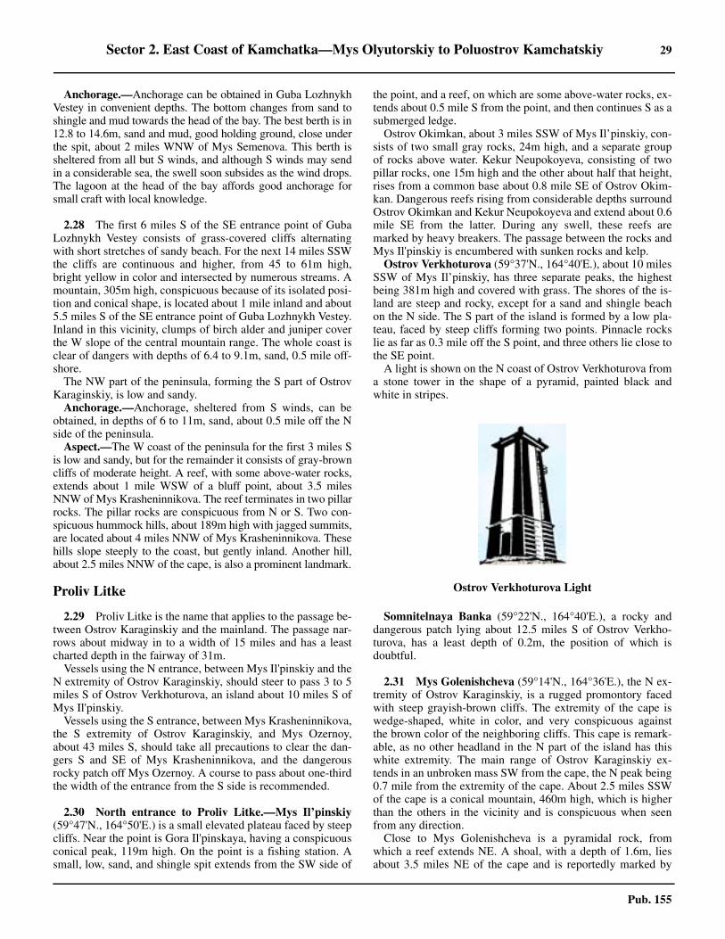
Sector 2. East Coast of Kamchatka—Mys Olyutorskiy to Poluostrov Kamchatskiy 29
Pub. 155
2.27 Anchorage.—Anchorage can be obtained in Guba LozhnykhVestey in convenient depths. The bottom changes from sand toshingle and mud towards the head of the bay. The best berth is in12.8 to 14.6m, sand and mud, good holding ground, close underthe spit, about 2 miles WNW of Mys Semenova. This berth issheltered from all but S winds, and although S winds may sendin a considerable sea, the swell soon subsides as the wind drops.The lagoon at the head of the bay affords good anchorage forsmall craft with local knowledge.
2.28 The first 6 miles S of the SE entrance point of GubaLozhnykh Vestey consists of grass-covered cliffs alternatingwith short stretches of sandy beach. For the next 14 miles SSWthe cliffs are continuous and higher, from 45 to 61m high,bright yellow in color and intersected by numerous streams. Amountain, 305m high, conspicuous because of its isolated posi-tion and conical shape, is located about 1 mile inland and about5.5 miles S of the SE entrance point of Guba Lozhnykh Vestey.Inland in this vicinity, clumps of birch alder and juniper coverthe W slope of the central mountain range. The whole coast isclear of dangers with depths of 6.4 to 9.1m, sand, 0.5 mile off-shore.2.28 The NW part of the peninsula, forming the S part of OstrovKaraginskiy, is low and sandy. 2.28 Anchorage.—Anchorage, sheltered from S winds, can beobtained, in depths of 6 to 11m, sand, about 0.5 mile off the Nside of the peninsula.2.28 Aspect.—The W coast of the peninsula for the first 3 miles Sis low and sandy, but for the remainder it consists of gray-browncliffs of moderate height. A reef, with some above-water rocks,extends about 1 mile WSW of a bluff point, about 3.5 milesNNW of Mys Krasheninnikova. The reef terminates in two pillarrocks. The pillar rocks are conspicuous from N or S. Two con-spicuous hummock hills, about 189m high with jagged summits,are located about 4 miles NNW of Mys Krasheninnikova. Thesehills slope steeply to the coast, but gently inland. Another hill,about 2.5 miles NNW of the cape, is also a prominent landmark.
Proliv Litke
2.29 Proliv Litke is the name that applies to the passage be-tween Ostrov Karaginskiy and the mainland. The passage nar-rows about midway in to a width of 15 miles and has a leastcharted depth in the fairway of 31m.2.29 Vessels using the N entrance, between Mys Il'pinskiy and theN extremity of Ostrov Karaginskiy, should steer to pass 3 to 5miles S of Ostrov Verkhoturova, an island about 10 miles S ofMys Il'pinskiy.2.29 Vessels using the S entrance, between Mys Krasheninnikova,the S extremity of Ostrov Karaginskiy, and Mys Ozernoy,about 43 miles S, should take all precautions to clear the dan-gers S and SE of Mys Krasheninnikova, and the dangerousrocky patch off Mys Ozernoy. A course to pass about one-thirdthe width of the entrance from the S side is recommended.
2.30 North entrance to Proliv Litke.—Mys Il’pinskiy(59°47'N., 164°50'E.) is a small elevated plateau faced by steepcliffs. Near the point is Gora Il'pinskaya, having a conspicuousconical peak, 119m high. On the point is a fishing station. Asmall, low, sand, and shingle spit extends from the SW side of
the point, and a reef, on which are some above-water rocks, ex-tends about 0.5 mile S from the point, and then continues S as asubmerged ledge.2.30 Ostrov Okimkan, about 3 miles SSW of Mys Il’pinskiy, con-sists of two small gray rocks, 24m high, and a separate groupof rocks above water. Kekur Neupokoyeva, consisting of twopillar rocks, one 15m high and the other about half that height,rises from a common base about 0.8 mile SE of Ostrov Okim-kan. Dangerous reefs rising from considerable depths surroundOstrov Okimkan and Kekur Neupokoyeva and extend about 0.6mile SE from the latter. During any swell, these reefs aremarked by heavy breakers. The passage between the rocks andMys Il'pinskiy is encumbered with sunken rocks and kelp.2.30 Ostrov Verkhoturova (59°37'N., 164°40'E.), about 10 milesSSW of Mys Il’pinskiy, has three separate peaks, the highestbeing 381m high and covered with grass. The shores of the is-land are steep and rocky, except for a sand and shingle beachon the N side. The S part of the island is formed by a low pla-teau, faced by steep cliffs forming two points. Pinnacle rockslie as far as 0.3 mile off the S point, and three others lie close tothe SE point.2.30 A light is shown on the N coast of Ostrov Verkhoturova froma stone tower in the shape of a pyramid, painted black andwhite in stripes.
2.30 Somnitelnaya Banka (59°22'N., 164°40'E.), a rocky anddangerous patch lying about 12.5 miles S of Ostrov Verkho-turova, has a least depth of 0.2m, the position of which isdoubtful.
2.31 Mys Golenishcheva (59°14'N., 164°36'E.), the N ex-tremity of Ostrov Karaginskiy, is a rugged promontory facedwith steep grayish-brown cliffs. The extremity of the cape iswedge-shaped, white in color, and very conspicuous againstthe brown color of the neighboring cliffs. This cape is remark-able, as no other headland in the N part of the island has thiswhite extremity. The main range of Ostrov Karaginskiy ex-tends in an unbroken mass SW from the cape, the N peak being0.7 mile from the extremity of the cape. About 2.5 miles SSWof the cape is a conical mountain, 460m high, which is higherthan the others in the vicinity and is conspicuous when seenfrom any direction.2.31 Close to Mys Golenishcheva is a pyramidal rock, fromwhich a reef extends NE. A shoal, with a depth of 1.6m, liesabout 3.5 miles NE of the cape and is reportedly marked by
Ostrov Verkhoturova Light
30 Sector 2. East Coast of Kamchatka—Mys Olyutorskiy to Poluostrov Kamchatskiy
Pub. 155
breakers.Recommended channels.—The recommended channel
leads between Ostrov Verkhoturova and Somnitelnaya Banka.A vessel proceeding through this channel should steer to pass 3to 5 miles S of Ostrov Verkhoturova in depths of more than37m, over a bottom of pebbles and coarse sand.2.31 In the channel between Ostrov Verkhoturova and OstrovOkimkan and Kekur Neupokoyeva to the N, the depths are veryirregular over a rocky bottom. In the approach from the E, thedepths shoal rapidly. In this passage the depths are more than16.5m.2.31 The channel between Ostrov Okimkan and Kekur Neupokoyevaon the S and Mys Il'pinskiy on the N is encumbered with sunkenrocks and kelp, through which is a narrow fairway with a leastdepth of 5.5m. This channel is very dangerous and should not beattempted.2.31 The channel between Mys Golenishcheva and SomnitelnayaBanka has a depth of 12.2m. A 1.6m patch, marked by break-ers, lies about 3.5 miles NE of Mys Golenishcheva.
2.32 West (mainland) side of Proliv Litke.—Zaliv Anapkais entered between Mys Il'pinskiy (59°47'N., 164°50'E.) andMys Il'pyr, the SE extremity of Poluostrov Il'pyr, about 19 milesWNW. The E side of the bay is formed by low cliffs, inland fromwhich the land rises to mountains. The S part of Poluostrov Il'pyris high, its coast consisting of steep cliffs. It is connected to themainland by a low sand and shingle isthmus. From the offing thepeninsula appears as an island.2.32 Zaliv Uala is entered between the SW extremity of PoluostrovIl'pyr and Mys Shilkan (Ostrov Shilka), about 11.5 miles W.Rocky patches, some of which dry, are located as far as 2 milesW of Poluostrov Il'pyr. Ostrov Shilka is a small islet connectedat LW to the mainland W by a narrow strip of sand. The shorefor about 4.5 miles NNE of Ostrov Shilka is cliffy, but then itslopes down to a low sand and shingle spit separating the shal-low lagoon at the head of the bay from the sea. From the en-trance to the lagoon, the N shore of the bay rises again andconsists of sandy cliffs to Poluostrov Il'pyr.
2.33 Kichiginskiy Zaliv (59°52'N., 163°33'E.), enteredbetween Mys Shilkan and the mouth of Reka Kichiga, about 9miles WSW, is a shallow bay.2.33 Reka Kichiga extends 0.8 mile N to Reka Belaya, forming alagoon within the mouth which is separated from the sea by asandy spit on each side of the entrance. The current flows outof the entrance at a velocity of 5 to 6 knots, being little affectedby the flood tidal current. The entrance is very narrow and suit-able only for boats with local knowledge.2.33 Two prominent mountains, Gora Trekhvershinnaya, withthree peaks, and Gora Naklonnaya, with steep sides, are locat-ed about 5 and 10 miles W, respectively, of the mouth of RekaKichiga.2.33 The coast for about 4 miles SSW of the mouth of Reka Kich-iga is low and then consists of low sandy cliffs to Mys Pak-klan (59°38'N., 163°25'E.).2.33 Anchorage.—Anchorage can be taken, in depths of 10 to13m, mud and sand, about 1 mile off the low stretch of coast Wof the mouth of Reka Kichiga. A vessel proceeding to this an-chorage should approach it with Gora Trekhvershinnaya bear-ing 270°. A rocky patch, with a depth of 1.8m, lies about 5
miles E of Mys Pakklan.
2.34 Zaliv Tuumlyat (59°28'N., 163°22'E.) is a bight en-tered between low and dark Mys Pakklan, and a point about 15miles S. The shore SW of Mys Pakklan to Laguna Tymlat con-sists of sandy cliffs, then a narrow sand and shingle spit sepa-rates the lagoon from the sea. The S shore of the bight isformed by low cliffs. Close to the S shore of the bight are smallhills, and farther inland are mountains covered with bushes andtrees. Reka Tymlat, its entrance in the SW corner of Zaliv Tu-umlyat, should be used only with local knowledge. A verysmall islet lies close offshore, about 2 miles SE of the mouth ofReka Tymlat.2.34 Laguna Tymlat is entered about 1 mile N of the mouth of Re-ka Tymlat. The lagoon entrance is narrow and visible onlywhen close to it. Local fishermen report depths of 1.8 to 2.1min this channel, and the same or greater depths inside the la-goon.2.34 Anchorage.—Anchorage can be obtained, in 15m, shingle,with the mouth of Reka Tymlet bearing 247°, distant 2.3 miles,and 1.2 miles off the spit. The spit is hard to make out at a dis-tance greater than 2 to 2.5 miles, and the mouth of the river ishardly noticeable. The holding ground is poor, and it is not ad-visable to anchor in shallow depths or closer inshore.2.34 Vessels should approach the above anchorage with GoraDvukhvershinnaya (59°34'N., 162°59'E.), conical-shaped andtwin peaked, bearing about 292°. During any swell the wholearea off the entrance to both the lagoon and the river is markedby breakers. The fishing stations are reported to be lighted atnight.
2.35 Bukhta Ossora is entered between Mys Ossorskaya(59°13'N., 163°16'E.), the extremity of a low, sand and shinglespit, and Mys Lozhno-Kuzmishcheva, about 5 miles S. The bayaffords anchorage, in depths of 11 to 20m, sand and shingle,sheltered from winds from any direction. The S side of the bayis steep and fairly low, with some straggling hills and moun-tains covered with bush and trees inland. Primetnyy Kholm,436m high and conspicuous, is located about 5 miles WNW ofMys Lozhno-Kuzmishcheva. The W shore of the bay is fringedby a low sand and shingle beach; the hills recede inland and in-crease in height. From Reka Ossora to the sand and shinglespit, the shore is low and sandy for the first 0.5 mile, then risesin low cliffs. A fishery, the buildings of which are conspicuousfrom a distance of about 8 miles, is situated at the head of thebay.2.35 A 4m depth lies about 1.5 miles SSE of Mys Ossorskaya. A4.7m depth lies 1.7 miles ENE of Mys Lozhno-Kuzmishcheva.The inner side of the spit, and the N and S sides of the bay,have depths of 10m about 0.5 mile offshore. The bottom of thebay consists of coarse sand and shingle.2.35 A stranded wreck, which is conspicuous throughout BukhtaOssara, lies on the NW side of the spit, almost 1 mile N of theS extremity.
2.36 Ossora Port (59°15'N., 163°04'E.) is situated on theW shore of Bukhta Ossora. There are two piers at the settle-ment. One pier, 20m long and 15m wide, is used for cargo op-erations; it can only be approached at HW. The second pier,28m long and 15m wide, has a depth of 1.5m alongside at LW.
Sector 2. East Coast of Kamchatka—Mys Olyutorskiy to Poluostrov Kamchatskiy 31
Pub. 155
The pier is used for fish products.2.36 Anchorage.—Sheltered anchorage can be obtained in Bukh-ta Ossora, on the NW side of Kosa Ossorskaya 0.5 mile off-shore, in 12 to 13m. This anchorage is sheltered from the E andSE.2.36 Another anchorage berth lying 0.5 mile offshore of the set-tlement, in depths of 12 to 15m, coarse sand and shingle bot-tom, is sheltered from the prevailing autumn NW and NEwinds.
Bukhta Karaga
2.37 Bukhta Karaga is entered SW of Mys PeschanayaKosa (59°02'N., 163°10'E.), the extremity of a low, sand andshingle spit, covered with vegetation, extending SSW and Wfrom Mys Kuzmishcheva. The latter point is the SE extremityof the elevated peninsula separating Bukhta Karaga fromBukhta Ossora. 2.37 The coast between Mys Kuzmishcheva and Mys LozhnoKuzmishcheva, about 5 miles N, is cliffy. A sand and shinglespit, covered with vegetation, extends NNW from Mys Vkhod-noy, the S entrance point of the bay. The conspicuous hull of avessel is situated on the N side of the entrance, on the S side ofthe N entrance spit.2.37 The bay is surrounded by hills, with rounded summits, slopinggently to the shores, which are mostly marshy. Mys Starshiny isthe extremity of a low sand and shingle spit, covered with juni-per, extending NW and parallel to the NE shore of the bay. Afishing station is situated on this spit.2.37 A bank, with depths of less than 5m, extends NNE from MysVkhodnoy. A depth of 1.9m lies at the outer end of the abovebank, in the middle of the entrance to the bay. A depth of 5mlies about 1 mile SE of the above depth. There are depths of 11to 12.8m about 0.3 mile off the N side of the extremity of the Nspit to abreast its elbow.2.37 Tides—Currents.—The MHW interval at Bukhta Karaga is3 hours 49 minutes.2.37 Anchorage.—Bukhta Karaga affords completely shelteredanchorage. The best anchorage is in depths 11 to 12.8m, mud,about 0.2 to 0.3 mile off the N side of the N spit. Another berthis in 10m, mud, about 0.5 mile offshore, abreast the fishery onthe spit of which Mys Starshiny is the extremity.2.37 Directions.—Vessels entering Bukhta Karaga should ap-proach with the SW extremity of the N entrance spit bearing337°, and steer to pass this point at a distance of 0.2 to 0.3 mileoff. There is a least depth of 7.3m on this course. The channelis only 0.15 mile wide at its narrowest point.
Bukhta Karaga to Ukinskaya Guba
2.38 The coast for 2.5 miles SW of Mys Vkhodnoy(58°59'N., 163°04'E.) consists of yellowish-brown sandstonecliffs, about 30 to 46m high, backed by hummocky hills cov-ered with bush and small trees. For the next 6 miles SW thecoast is low and sandy.2.38 Reka Makarova and Reka Kayum have a common entrancebetween two narrow sandy spits. The outflow of these two riv-ers causes discoloration for some distance from the commonentrance.2.38 A cliffy headland lies about 1.5 miles S of the above-men-
tioned entrance. A sandy bank, with several groups of rocks,some above-water, extends over 0.8 mile E of the headland.The coast for 3 miles SW of the above bank is fringed by shortreefs and drying rocks. A vessel, with a draft of 5m, reportedtouching bottom about 3 miles E of this cliffy headland. Thecoast from the headland to the mouth of Reka Dranka, about6.5 miles SW, rises in low brown cliffs and is approached bystraggling, hummocky hills.2.38 Reka Dranka flows NE and parallel to the coast for its last 7miles, and is separated from the sea on this reach by a sand andshingle spit. A building, about 7 miles W of the mouth of theriver, is conspicuous from the offing.2.38 Reka Pankara forms a large lagoon before it flows into thesea between two spits. The entrance (58°35'N., 162°21'E.) canbe identified by the yellowish-brown cliffs, 30 to 46m high, ex-tending 3 miles N from the entrance. The outgoing current inthe entrance and in the channel inside attains a velocity of 3.5to 4 knots.2.38 The best anchorage off Reka Pankara is in a depth of 9m,about 0.6 mile offshore, midway between the entrance and thefishing station about 0.3 mile N. The bottom is shingle, poorholding ground.2.38 The spit separating the lagoon of Reka Pankara from the seais low and sandy. The coast S of this spit for 6.5 miles consistsof light yellow sandy cliffs, 31 to 46m high in the center, andgradually becoming lower toward each end. A narrow sand andshingle spit separating the lagoon of Reka Rusakova from thesea extends from the cliffs to the mouth of Reka Rusakova,about 10.5 miles SSW. The entrance to the river lies betweentwo narrow spits. Sandbanks, marked by breakers, extend sea-ward from the extremity of each spit.2.38 Anchorage.—Anchorage can be obtained, in depths of 9 to10m, sand and shingle, about 0.8 mile offshore, abreast the fishcannery about 5 miles N of the mouth of Reka Rusakova.2.38 From 0.5 mile S of the entrance to Reka Rusakova, a line ofreddish-brown cliffs extends about 9 miles SSW, varying in el-evation from 31 to 46m, being low toward either end. Thecliffs, in some places, rise sheer from the coast, and in othersare fronted by a narrow beach of sand, shingle, and gravel.About 7 miles SSW from the mouth of the river, these cliffs areinterrupted by a small lake located close inland and not con-nected to the sea. The coast is low and sandy from the cliffs tothe entrance of Reka Khalyulya, about 6 miles S.
Ukinskaya Guba
2.39 Ukinskaya Guba is a bay entered between Reka Khal-yulya and Mys Severo-Zapadnyy (57°56'N., 162°34'E.). Thedepths decrease regularly to 6m about 0.5 mile off the W and Sshores, except in the vicinity of the mouth of Reka Uka.2.39 Two mountains, over 1,000m high, forming the E spurs ofthe range trending parallel to the coast some distance inland,are located about 10 miles W of the mouth of Reka Khalyulya.The S mountain has a pointed summit. The N mountain has asomewhat jagged crest extending in a NNE-SSW direction.These two mountains, which are joined by a spur, are conspicu-ous and are good marks for identifying the mouth of RekaKhalyulya.
The coast from Reka Khalyulya to the mouth of Reka Uka(57°50'N., 162°08'E.) is a uniform stretch of sand and shingle
32 Sector 2. East Coast of Kamchatka—Mys Olyutorskiy to Poluostrov Kamchatskiy
Pub. 155
beach backed by very gently rising slopes, which are coveredby grass near the coast and by bushes farther inland, and whichextend a great distance inland to a mountain ridge. The bottomalong this stretch is sandy. Reka Uka can be identified by thesandy cliff beginning about 2 miles E of it.2.39 Uka, a village situated on the W bank of Reka Uka nearlyabreast the entrance, is one of the largest settlements in this vi-cinity. The banks along the lower reaches of the river are low,sandy, and marshy. 2.39 Tides—Currents.—In the mouth of the river the velocity ofthe tidal currents attain a rate of as much as 4 knots.2.39 Anchorage.—Anchorage can be obtained, in depths of 8 to9m, about 1 to 1.2 miles off the mouth of Reka Uka. It is notadvisable to anchor closer, as depths of 6m extend about 1 mileseaward of the mouth of the river.
2.40 The coast for 2 miles ESE of Reka Uka is low andsandy, and then for the next 4 miles consists of a sandy cliff,about 46 to 61m high, fringed by a narrow beach of shingle andgravel. The last 5 miles to the mouth of Reka Malan-Vayam islow and sandy.2.40 The E shore of Ukinskaya Guba is formed by the W side ofPoluostrov Nachikinskiy. In the middle of this peninsula is Go-ra Nachikinskaya, an extinct volcano, which is easily distin-guishable from the surrounding peaks by the dark color of itssteep sides and by its jagged summit. This mountain is sur-rounded by numerous others, almost as high, most of whichhave pointed summits and inaccessible sides.
Mys Severo-Zapadnyy (57°56'N., 162°34'E.) is a roundedshingle point, inshore of which is a lagoon. The point is steep-to, with depths of less than 11m extending 1 mile NW. Thecoast SSW of the point is low and sandy, but small, rounded,rocky points extend offshore in places.2.40 Ostrov Mandzhur (57°50'N., 162°27'E.), about 7 milesSSW of Mys Severo-Zapadnyy, is covered with grass and itsmiddle part is covered with trees. On the middle of the islet is asloping hill, 88m high. The coasts of the islet are almost every-where bold. A beacon, consisting of a wooden pyramidal struc-ture, about 6m high, its seaward side faced by white slats,stands near the edge of the cliff at the NW extremity of the is-let. The beacon is clearly visible from seaward.2.40 Anchorage.—The best anchorage off Ostrov Mandzhur is ina depth of 7m, sand and mud, 0.5 mile SW of the spit, locatedon the N part of the SW side of the island. A vessel should nev-er attempt to anchor farther E as the depths decrease rapidly inthat direction.
Ukinskaya Guba to Zaliv Ozernoy
2.41 Mys Nachikinskiy (57°57'N., 162°42'E.) is a capeformed by a small plateau descending from the mountains. It isedged with low cliffs, and its N point is small and sharp. A reefextends nearly 0.2 mile off the cape. It is steep-to off its ex-tremity, with depths of 20 to 28m, sand, about 0.5 mile off thecape.2.41 Mys Nizkiy (57°49'N., 163°12'E.), lying 18 miles ESE ofMys Nachikinskiy, is a low rounded point, fringed by a broadsand and shingle beach strewn with large rocks and backed bya moderately low brown cliff. A reef, extending about 2 milesN of the cape, has a group of drying rocks near its extremity,
which is steep-to. The cape should be given a berth of at least3.5 miles.2.41 Mys Ozernoy (57°43'N., 163°19'E.), the S entrance point ofthe S entrance to Proliv Litke, is a low, narrow point extending Eand is distinguished by a small sand hill on its point. Anothersand hill, about the same height, is located a little farther inlandand is separated from the former sand hill by a gap. A detachedrange of mountains, with five conspicuous peaks of very peculiarcolumnar appearance, rises about 5 miles W of Mys Ozernoyand extends NNE toward Mys Nizkiy. A light is shown fromMys Ozernoy; a radiobeacon transmits from the light.2.41 Mys Ozernoy should be given a wide berth, as a reef extends1.5 miles off it.2.41 Caution.—A sunken rock, the exact position of which is un-known, lies about 10 miles NE of Mys Ozernoy. When in thisvicinity, vessels should proceed with caution.
Zaliv Ozernoy
2.42 Zaliv Ozernoy, between Mys Ozernoy and Mys Stol-bovoy (56°41'N., 163°17'E.), 63 miles S, affords no protectionfrom NE winds, but shelter can be obtained in its SW end duringwinds from between the S and E. Gora Dvoynaya, about 8 milesSSW of Mys Ozernoy, and the mountains in the vicinity of MysStolbovoy, form good marks and are visible in clear weatherfrom any part of the bay.2.42 Mys Dvoynoy, about 9 miles SSW of Mys Ozernoy, is the Eof two small blunt points 1 mile apart. The yellow cliffs ap-proach the cape somewhat closer than the W point. Reefs, ex-tending about 1 mile SE of these points, consist mainly ofsubmerged rocks marked by breakers. Gora Dvoynaya, about 2miles N of the cape, is higher than the surrounding mountainsand is very conspicuous, especially from the S or N, appearingas a twin-peaked mountain with steep, somewhat roundedslopes.2.42 Mys Yuzhnyy, about 7 miles farther SSW, is a point formedby brown cliffs of moderate height. Seen in profile it appears asa level, raised plateau, rather low near the extremity of thecape. A large reef, consisting almost entirely of drying rocks,but with some sunken rocks near its extremity, extends 1.3miles from the cape and the coast for some distance N.
2.43 The entrance to Reka Ozernaya (57°21'N.,162°47'E.), lying about 13 miles SW of Mys Yuzhnyy, forms alarge lagoon enclosed by a low, sand and shingle spit, beforeflowing into Zaliv Ozernoy. The S and W shores of this lagoonare low and covered with grass and small bushes, but its Nshore is formed by a cliff at the foot of some hills rising to aheight of 101m. The mouth of the river is located between theN end of the spit and this cliff, and can be identified by the factthat the coast consists of light yellow sandy cliffs just N of it,and is low S of it. The mouth of the river is fronted by a bar,which can be distinguished by the sea breaking on it. The cur-rent of the river is strong, and at times attains a velocity of 4knots.2.43 The coast for about 5.5 miles S of Reka Ozernaya is flat andsandy, and then to Mys Tupoy (57°01'N., 162°51'E.), whichconsists of cliffs, 46 to 61m high, becoming gradually higher S.An off-lying danger, consisting of a sunken rock, positiondoubtful, was reported (1921) to be about 8 miles NE of Mys
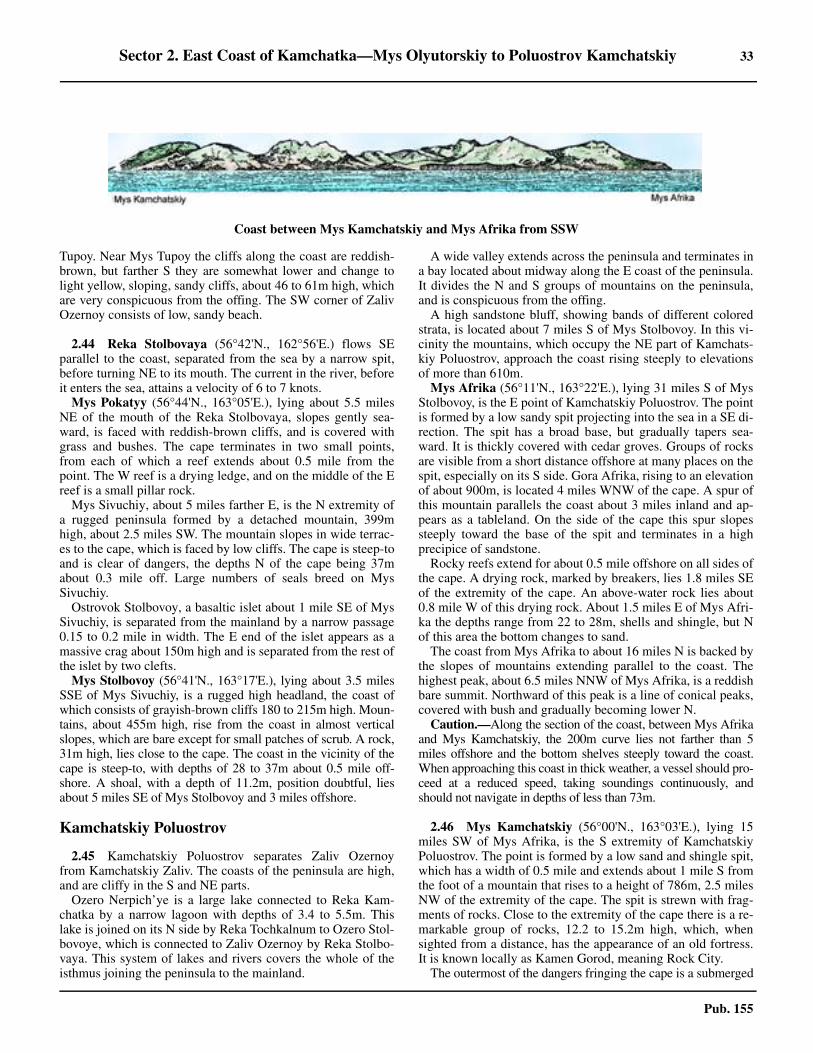
Sector 2. East Coast of Kamchatka—Mys Olyutorskiy to Poluostrov Kamchatskiy 33
Pub. 155
Tupoy. Near Mys Tupoy the cliffs along the coast are reddish-brown, but farther S they are somewhat lower and change tolight yellow, sloping, sandy cliffs, about 46 to 61m high, whichare very conspicuous from the offing. The SW corner of ZalivOzernoy consists of low, sandy beach.
2.44 Reka Stolbovaya (56°42'N., 162°56'E.) flows SEparallel to the coast, separated from the sea by a narrow spit,before turning NE to its mouth. The current in the river, beforeit enters the sea, attains a velocity of 6 to 7 knots.2.44 Mys Pokatyy (56°44'N., 163°05'E.), lying about 5.5 milesNE of the mouth of the Reka Stolbovaya, slopes gently sea-ward, is faced with reddish-brown cliffs, and is covered withgrass and bushes. The cape terminates in two small points,from each of which a reef extends about 0.5 mile from thepoint. The W reef is a drying ledge, and on the middle of the Ereef is a small pillar rock.2.44 Mys Sivuchiy, about 5 miles farther E, is the N extremity ofa rugged peninsula formed by a detached mountain, 399mhigh, about 2.5 miles SW. The mountain slopes in wide terrac-es to the cape, which is faced by low cliffs. The cape is steep-toand is clear of dangers, the depths N of the cape being 37mabout 0.3 mile off. Large numbers of seals breed on MysSivuchiy.2.44 Ostrovok Stolbovoy, a basaltic islet about 1 mile SE of MysSivuchiy, is separated from the mainland by a narrow passage0.15 to 0.2 mile in width. The E end of the islet appears as amassive crag about 150m high and is separated from the rest ofthe islet by two clefts.2.44 Mys Stolbovoy (56°41'N., 163°17'E.), lying about 3.5 milesSSE of Mys Sivuchiy, is a rugged high headland, the coast ofwhich consists of grayish-brown cliffs 180 to 215m high. Moun-tains, about 455m high, rise from the coast in almost verticalslopes, which are bare except for small patches of scrub. A rock,31m high, lies close to the cape. The coast in the vicinity of thecape is steep-to, with depths of 28 to 37m about 0.5 mile off-shore. A shoal, with a depth of 11.2m, position doubtful, liesabout 5 miles SE of Mys Stolbovoy and 3 miles offshore.
Kamchatskiy Poluostrov
2.45 Kamchatskiy Poluostrov separates Zaliv Ozernoyfrom Kamchatskiy Zaliv. The coasts of the peninsula are high,and are cliffy in the S and NE parts.2.45 Ozero Nerpich’ye is a large lake connected to Reka Kam-chatka by a narrow lagoon with depths of 3.4 to 5.5m. Thislake is joined on its N side by Reka Tochkalnum to Ozero Stol-bovoye, which is connected to Zaliv Ozernoy by Reka Stolbo-vaya. This system of lakes and rivers covers the whole of theisthmus joining the peninsula to the mainland.
2.45 A wide valley extends across the peninsula and terminates ina bay located about midway along the E coast of the peninsula.It divides the N and S groups of mountains on the peninsula,and is conspicuous from the offing.2.45 A high sandstone bluff, showing bands of different coloredstrata, is located about 7 miles S of Mys Stolbovoy. In this vi-cinity the mountains, which occupy the NE part of Kamchats-kiy Poluostrov, approach the coast rising steeply to elevationsof more than 610m.2.45 Mys Afrika (56°11'N., 163°22'E.), lying 31 miles S of MysStolbovoy, is the E point of Kamchatskiy Poluostrov. The pointis formed by a low sandy spit projecting into the sea in a SE di-rection. The spit has a broad base, but gradually tapers sea-ward. It is thickly covered with cedar groves. Groups of rocksare visible from a short distance offshore at many places on thespit, especially on its S side. Gora Afrika, rising to an elevationof about 900m, is located 4 miles WNW of the cape. A spur ofthis mountain parallels the coast about 3 miles inland and ap-pears as a tableland. On the side of the cape this spur slopessteeply toward the base of the spit and terminates in a highprecipice of sandstone. 2.45 Rocky reefs extend for about 0.5 mile offshore on all sides ofthe cape. A drying rock, marked by breakers, lies 1.8 miles SEof the extremity of the cape. An above-water rock lies about0.8 mile W of this drying rock. About 1.5 miles E of Mys Afri-ka the depths range from 22 to 28m, shells and shingle, but Nof this area the bottom changes to sand.2.45 The coast from Mys Afrika to about 16 miles N is backed bythe slopes of mountains extending parallel to the coast. Thehighest peak, about 6.5 miles NNW of Mys Afrika, is a reddishbare summit. Northward of this peak is a line of conical peaks,covered with bush and gradually becoming lower N.2.45 Caution.—Along the section of the coast, between Mys Afrikaand Mys Kamchatskiy, the 200m curve lies not farther than 5miles offshore and the bottom shelves steeply toward the coast.When approaching this coast in thick weather, a vessel should pro-ceed at a reduced speed, taking soundings continuously, andshould not navigate in depths of less than 73m.
2.46 Mys Kamchatskiy (56°00'N., 163°03'E.), lying 15miles SW of Mys Afrika, is the S extremity of KamchatskiyPoluostrov. The point is formed by a low sand and shingle spit,which has a width of 0.5 mile and extends about 1 mile S fromthe foot of a mountain that rises to a height of 786m, 2.5 milesNW of the extremity of the cape. The spit is strewn with frag-ments of rocks. Close to the extremity of the cape there is a re-markable group of rocks, 12.2 to 15.2m high, which, whensighted from a distance, has the appearance of an old fortress.It is known locally as Kamen Gorod, meaning Rock City.2.46 The outermost of the dangers fringing the cape is a submerged
Coast between Mys Kamchatskiy and Mys Afrika from SSW
34 Sector 2. East Coast of Kamchatka—Mys Olyutorskiy to Poluostrov Kamchatskiy
Pub. 155
rock located 2.5 miles SW of the extremity of the cape. Thisrock is clearly marked by breakers in the usual swell, but has on-ly blind rollers when the swell is slight. An above-water pinnaclerock lies about 2.5 miles W of the extremity of the cape.2.46 Within an area extending about 5 miles S from the S coast ofPoluostrov Kamchatskiy, the depths are extremely uneven, andthere is much kelp, easily identified by its greenish-brown col-or. A vessel should give this coast a berth of at least 5 miles,keeping in depths of more than 45m.
Sopka Shivelyuch (56°40'N., 161°30'E.), an extinct volcano,about 70 miles NW of Mys Kamchatskiy, is the highest peak ofan isolated mountain group. Due to its great elevation it is visiblefrom all parts of Zaliv Ozernoy, from the E side of PoluostrovKamchatskiy, and from the N half of Kamchatskiy Zaliv. Fromseaward it appears as a small snow-capped peak.
Komandorskiye Ostrova (Komandorski Islands)
2.47 Komandorskiye Ostrova, consisting of Ostrov Berin-ga and Ostrov Mednyy (Copper Island), are located about 100miles ESE of Mys Afrika, and 190 miles from Attu, the nearestof the Aleutian Islands. The islands belong to Russia, the gov-ernor normally residing at Nikol’ skoye, a settlement on the Wside of Ostrov Beringa.2.47 The islands are of volcanic origin, consisting of basalt andsyenite rocks, and were caused by the same forces that pro-duced the Aleutian chain. There are no active volcanoes on theislands, but the activity of the Aleutian volcanoes are felt onthe islands.2.47 Komandorskiye Ostrova are very high, being visible in clearweather from 40 to 50 miles. In general, the depths a few milesoff the islands are considerable.2.47 The islands have long been famous for the fur trade. Sealbreeding grounds, which are government game preserves, aresituated on both islands.2.47 Caution.—The islands are covered in fog for a large part of thenavigation season. When anchoring, vessels should take into ac-count the fact that earthquakes, which occur frequently at Koman-dorskiye Ostrova, are sometimes accompanied by seismic waves.Vessels navigating in the vicinity of Komandorskiye Ostrovashould always keep clear of kelp. None of the bays afford com-pletely sheltered anchorage, and frequently the wind shifts sud-denly. During storms or fresh winds, vessels at anchor in any ofthe bays are advised to proceed to sea.2.47 In order not to frighten any of the seals on KomandorskiyeOstrova, vessels passing these islands should not navigate tooclose to the shores, should not shoot any guns when in this vi-cinity, and should not shine their searchlights on the shores.
Ostrov Beringa
2.48 Ostrov Beringa (55°00'N., 166°15'E.) is mountain-ous in its central and SE parts. The NW part of the island is ofa different character. The hills are flatter and form a series ofplateaus sloping down to the coast in terraces. 2.48 Gora Shtellera (54°53'N., 166°24'E.), the highest mountainin the island, is located about 15 miles NW of the SE extremityof the island, and has a crater-shaped summit. Northward ofthis mountain is the conspicuous valley known as DolinaPolovinnaya, which appears to divide the island in two and is
especially remarkable from the NE.2.48 Stolovye Kholmyy, two very peculiar flat-topped hills, arelocated about 9 miles E of Mys Severozapadnyy, the NW ex-tremity of the island. The N hill is 143m high, and the S hill is137m high. The highest hill in the N part of the island is 188mhigh, about 2.5 miles E of Stolovye Kholmyy.2.48 The surface of the island, except in its high S part, consists oftundra. In places are large tracts of meadow land covered withcoarse grass.2.48 Dangerous and unsurveyed reefs with detached rocks fringethe island.
2.49 North coast of Ostrov Beringa.—The N coast of Os-trov Beringa is very uniform and moderately high. From the E,the formation of the tableland on the N side of the island givesthe appearance of a whole series of fortifications. Reefs, onwhich are some above-water rocks, extend as far as 2 miles off-shore.2.49 Mys Severovostochny (55°18'N., 166°17'E.), the NE ex-tremity of the island, is a low, narrow headland. Mys Tonki, aslender point, lies about 2.7 miles NW. The entire shore ofBukhta Sarannaya, the bight between Mys Tonki and MysYushina, 11 miles W, is fringed by sunken rocks and should beapproached with great caution.2.49 Mys Yushina (55°22'N., 165°57'E.), the N extremity of theisland, is a low point from which a reef is reported to extend 2miles in a N direction. Sivuchy Kamen’ (Ostrov Sivuchiy) (SeaLion), 3 to 4.6m high, of remarkable shape, lies on this reef,close NNW of the point. This rock is connected to the point bya row of low rocks. At a distance, these rocks are not visibleand Sivuchy Kamen’ appears detached. 2.49 A patch of kelp lies 0.8 mile W of Sivuchy Kamen’.2.49 Anchorage.—Anchorage with shelter from S winds can beobtained between Sivuchy Kamen’ and a reef marked by kelp0.5 mile E. The best berth is in a depth of 18m, sand and shells,with Mys Severozapadny bearing 241°, a prominent red store-house (the only building of its kind in the vicinity) bearing192°, and Mys Tonki bearing 104°. Anchorage may also betaken, in depths of 14.6 to 16.5m, with Sivuchy Kamen’ bear-ing 250°, and the red storehouse bearing 202°.2.49 Caution.—Vessels are prohibited from passing any closerthan 2 miles from Mys Yushina.
2.50 Mys Severo-Zapadnyy (55°17'N., 165°44'E.), 8 milesWSW of Mys Yushina, is hilly and is the NW extremity of theisland. A white pyramid beacon, 5m high, stands at an elevationof 26m on the point. The point is fringed to a considerable dis-tance by a reef, and some drying rocks, not always marked bybreakers, lie off this reef about 1.5 miles W to WSW of thepoint.2.50 A shoal, with a depth of 29m, was reported (1946) to lieabout 18 miles NW of Mys Severozapadny. Depths of 29m(position approximate), 12.8m (reported in 1964), and 40m lie23 miles NW, 30 miles NW, and 11.5 miles SW, respectively,of Mys Severozapadny.
2.51 Southwest coast of Ostrov Beringa.—Mys Zabiyaka(55°15'N., 165°53'E.) is a 55m high headland. It is darker andhigher than the coast in the vicinity. It appears as a small islandwhen viewed from the S. A shoal, with a least depth of 2.5m,
Sector 2. East Coast of Kamchatka—Mys Olyutorskiy to Poluostrov Kamchatskiy 35
Pub. 155
lies with its N end 1 mile WSW of the point and extends as anarrow ridge 0.8 mile S. There are depths of over 18.3maround it.2.51 Kamen Ari, about 4 miles SW of Mys Zabiyaka, consists oftwo rocks, the N being pointed and about 46m high, and the Sbeing perfectly flat and about 2.1m high.2.51 Ostrov Toporkov, about 5 miles E of Kamen Ari, is a flat is-let, difficult to distinguish from seaward as it blends with thehigher land of the coast. A drying reef extends as far as 0.1mile from the islet. The S and SW sides of this reef are steep-to. The best landing place is at the N end of the island. Puffinsbreed on the island in great numbers.2.51 Kamen’ Polovinchatyy, about 1.5 miles W of the N end ofOstrov Toporkov, is a rock, awash, and marked by breakers inordinary weather. A 6.4m patch lies about 0.2 mile N of therock.
2.52 Mys Vkhodnoi Rif (55°11'N., 165°58'E.), a peninsu-la 18m high near its extremity, is fringed with rocks extending0.3 mile offshore on its W and SW sides. Foul ground extendsas far as 0.7 mile W to SW from the peninsula. Banka Yakut, ashoal with a least depth of 5.5m, lies 0.6 mile N of the extremi-ty of the peninsula. In the channel between Mys Vkhodnoi Rifand Ostrov Toporkov the depths are uneven, varying between12.8 and 29m in the middle of the channel.2.52 Nikol’skiy Reyd is entered N of Mys Vkhodnoi Rif. In theapproach from the S or SW, the flat-topped Stolovye Kholmyyare conspicuous, and often are visible above the low fog. Incase Stolovye Kholmyy cannot be seen in thick weather, it isadvisable first to pick up Sivuchy Kamen’ and then proceed in.The passage leading N of Sivuchy Kamen’ and OstrovToporkov is not recommended. Vessels should pass about 0.3mile S of Ostrov Toporkov, then alter course NE to the anchor-age.2.52 Ice.—In some years slush and young ice occur from Novem-ber to February. Occasionally there are large quantities of driftice from the E coast of Kamchatka after W and NW winds.2.52 Tides—Currents.—Tides at Nikol’skiy Reyd are of themixed type, with diurnal tides predominating. The tidal rangevaries between 0.3 and 1.3m.2.52 Anchorage.—A large vessel should anchor, in 20.1m, sand,on the line joining the N extremity of Ostrov Toporkov and theradio towers at Nikol’skoye, and with the extremity of MysVkhodnoi Rif bearing 145°.2.52 Winds from the SW through WNW send a heavy swell intothe anchorage. There is a ground swell, even in ordinaryweather. The anchorage, due to the poor holding ground, isdangerous, especially in autumn, when W winds are more fre-quent than in summer, and are fresh and prone to producingsqualls for long periods. This anchorage is the best in the is-land. Vessels should be ready to put to sea on short notice,since, sudden shifts of wind are frequent, especially in autumn.Southeast winds veer to the S and SW; NE winds back to the Nand NW. Several sealing vessels have been driven ashore.
2.53 Nikol’skoye (55°12'N., 165°59'E.) (World Port IndexNo. 62630), on the SE side of the roadstead, is the residence ofthe governor of Komandorskiye Ostrova, and the administra-tive center of the islands.2.53 The coast from Nikol’skiy Reyd to the SE extremity of Os-
trov Beringa is cliffy and high. It is steep-to except for somereefs extending offshore at Mys Poludennyy, Mys Kazarmen-nyy, and Mys Shepitanski.2.53 Mys Orekhovski (55°03'N., 166°04'E.) appears from the Nas a labyrinth of small caves and grottoes.2.53 Bukhta Gladovskaya (54°55'N., 166°16'E.), a small bay ly-ing 12.5 miles SSE of Mys Orekhovski, has a depth of 46m,sand and shells. Mys Ostrovnoy, about 6 miles farther SE, froma distance appears as two flat islets which merge into one as thepoint is approached, and are connected to the coast by a lowisthmus. A drying rock lies 1 mile S of the point.2.53 Mys Monati (54°42'N., 166°40'E.), the SE extremity of theisland, is high and cliffy, but terminates in a gentle slope. Inclear weather, the cape may be seen for 30 miles. A prominentrock, shaped like a tower, is located NW of the cape. The capeis fringed by a reef and shoal water extends about 1 mile W and3 miles SE from it. In good weather, all the rocks on this reefcan be seen. It is nearly always marked by breakers.
2.54 Northwest coast of Ostrov Beringa.—An almostcontinuous reef, extending 0.7 to 2 miles offshore, stretchesalong this coast. Vessels should keep at least 3 miles off thecoast.2.54 Mys Nepropusk (54°45'N., 166°42'E.), 3.5 miles N of MysMonati, is a conspicuous cliff. The coast for about 10 miles Nof Mys Monati consists of steep cliffs.2.54 Mys Komandor (54°57'N., 166°31'E.), about 12.5 miles Nof Mys Nepropusk, is formed by a solitary hill rising straightfrom the coast.2.54 Bukhta Polovina (54°57'N., 166°29'E.), in which there is ashelving beach, is entered W of Mys Komandor. A smallstream flows into the head of the bay.2.54 Mys Buyan, 10 miles NNW of Bukhta Polovina, is promi-nent. A 15m shoal, position approximate, lies 19.5 miles E ofMys Buyan.
2.55 Staraya Gavan’ (55°12'N., 166°14'E.), a break in thecoastal reef lying about 10 miles NNW of Mys Buyan, extendsW to the shore of a bight and has a width of 0.25 mile. The reefon the N side consists of a mass of rocks, partly submerged andpartly above-water and marked by breakers. For a distance ex-ceeding 1 mile N of this harbor, reefs extend from the shoreand break up the sea and swell during N winds. Local reportsstate that even during strong NE winds the force of the sea isspent on the outer rocks, and the water in the channel and har-bor is comparatively smooth. The reef on the S side of the har-bor is a continuous group of rocks, 0.5 to 1m high. Severalsubmerged rocks extend farther E from this reef and aremarked by breakers.2.55 The depths in the approach to the harbor decrease regularly.At a distance of 3 miles offshore the depths are 46m, shells.The depths in mid-channel decrease from 14.6 to 9.1m, thebottom in the N part being rocky, and in the S part being sandy.2.55 The harbor is exposed to all E winds and has not been wellsurveyed.2.55 Anchorage.—Anchorage for large vessels can be taken, in28m, rock and sand, on the line joining the outer breakers oneither side. Only small vessels with local knowledge can enterthe harbor and obtain anchorage in depths of 3.7 to 9m, sand.2.55 Approaching from the N, vessels will notice two gaps in the
36 Sector 2. East Coast of Kamchatka—Mys Olyutorskiy to Poluostrov Kamchatskiy
Pub. 155
mountains S of Mys Severovostochnyy. Through the first gap isseen Stolovye Kholmyy. The second gap indicates Staraya Ga-van’, which should be approached on a W course, continuouslysounding. Entering the harbor presents no particular difficulties,the entrance being defined by the breakers on either side.
Ostrov Mednyy
2.56 Ostrov Mendyy consists of a narrow mountainousridge rising steeply from the sea. Short spurs extend from theridge and terminate in bluff headlands. 2.56 Gora Gavanskaya (54°49'N., 167°30'E.), on the E side ofGavan Preobrazhenskaya, is a conical mountain covered withsnow throughout the year. It rises to a height of 587m, is thehighest point of the island, and forms an excellent landmark.2.56 Rocks lie close offshore all around Ostrov Mendyy. Thereare no good anchorages. In almost all the bays, temporary an-chorage can be taken, in depths of 46 to 55m.2.56 Gavan’ Preobrazhenskaya, a small cove, lies W of Gora Ga-vanskaya. A number of rocks and a pillar rock extend about 0.2mile NE of the W entrance point, slightly protecting the harborfrom N. Preobrazhenskaya, at the head of the harbor, is the on-ly permanent settlement on the island.2.56 Mys Sulkovskogo (54°52'N., 167°22'E.), the NW extremityof the island, is a rocky point from which a reef extends nearly3 miles NW. The point should be given a wide berth. On themiddle of the reef are Bobrovye Kamni (Sea Otter Rocks), twolarge jagged conspicuous rocks named because of their shape.2.56 Kitolovnaya Banka (54°59'N., 167°07'E.), with a leastdepth of 3m, is located 11 miles NW of Mys Sulkovskogo.Some reports state it lies 1 mile NW, and other more recent re-ports state that it lies 1 mile SW of its charted position. Theshoal is marked by breakers during heavy seas or swell. Tiderips have been observed in the passage between the shoal andOstrov Mendyy. These were more noticeable some distance Wof the charted position of the shoal. A depth of 15m lies ap-proximately 10 miles NW of Kitolovnaya Banka.
2.57 Northeast coast of Ostrov Mednyy.—Between MysPeschanyy (54°50'N., 167°28'E.), a high conspicuous pointabout 4 miles SE of Mys Sulkovskogo, and Mys SivuchiyKamen, about 3 miles further SE, the coast recedes about 1.5miles to form a bay. Two detached above-water rocks lie offMys Peschanyy. Sivuchiy Kamen is two above-water rocks ly-ing off Mys Sivuchiy Kamen.2.57 Bukhta Peschanaya, in the NW part of the aforementionedbay, extends 0.8 mile W from its entrance and has a width ofabout 0.5 mile. The depths decrease gradually from 29m in theentrance to 11m about 0.2 mile from the head, then decreaserapidly. The bottom is sand. 2.57 Anchorage.—Anchorage is recommended for small vesselsat the head of Bukhta Peschanaya. Although a continuousswell enters the anchorage even during N winds, from which itis protected by a high hill, this anchorage is preferable to thatwhich lies off Gavan’ Preobrazhenskaya. 2.57 Anchorage for large vessels can be obtained, in 35m, gray sand,abreast a cleft in a vertical cliff, with Mys Peschanyy bearing336°, Mys Sivuchiy Kamen bearing 112°, and the detached pillarrock off the entrance to Gavan’ Preobrazhenskaya bearing 176°and in line with a church in the village. The holding ground is poor
and the anchorage is insecure with N winds.
2.58 Bukhta Korabelnaya, a bight entered N of Mys Kora-belny (54°42'N., 167°44'E.), affords anchorage during Wwinds. Mys Korabelny terminates in a nearly vertical cliff, 15to 24m high, from which a reef extends 0.5 mile NNE. A set-tlement comprising several huts is situated between sand dunesat the head of the bight. 2.58 Anchorage.—Anchorage can be taken, except during onshorewinds, in a depth of 22m, coarse sand, with Mys Korabelnybearing 100°, and the middle of the settlement bearing 185°.Landing is very difficult on account of the almost incessant swelland a shoal which extends some distance offshore from the set-tlement.
2.59 Mys Cherny (Black Point) (54°41'N., 167°50'E.), themost salient point on the NE side of Ostrov Mendyy, lies about4.5 miles SE of Mys Korabelny, is composed of dark-coloredbluffs, and is very high.2.59 Bukhta Glinka, 4 miles SSE of Mys Cherny, has a summersettlement situated on the hillside at its head, and a woodenhouse, painted red, is situated directly below the settlement.Nearly behind the settlement is a large light-colored water-course. Reefs extend from both entrance points.2.59 In the entrance to Bukhta Glinka are depths of 37 to 55m,shoaling to 22m close inside the entrance. 2.59 Anchorage.—Anchorage can be taken at the entrance, withthe settlement bearing 230°, Mys Cherny bearing 327°, and MysGlinka, the S entrance point, in line with Mys Yugovostochny.During W winds, moderate gusts come down the hills, but thereis neither sea nor swell at the anchorage. During E winds, an-chorage is impossible and landing difficult.2.59 The SE end of the island is formed by a large isolated hillwith steep cliffs on all sides, joined to the main part of the is-land by a narrow isthmus. A dangerous reef extends about 3miles SE from the SE end of the island, between Mys Yugovo-stochny and Mys Yuzhny, about 2 miles SSW. Several conicaldetached rocks lie near the coast on this reef.
2.60 Southwest coast of Ostrov Mednyy.—The SW coastof the island is especially steep-to. The NW half of this coast isvery steep-to and may be approached closely with safety. Thecoast is fringed by pillar rocks, some of which are prominentfrom offshore.2.60 Mys Palata (54°34'N., 167°50'E.), about 152m high, fringedwith reefs and rocks, is the most prominent headland on thispart of the coast, lying 6 miles WNW of Mys Yuzhny. It is per-pendicular on its S side and is said to resemble a large housewith a steep peaked roof. 2.60 Anchorage.—Anchorage can be obtained, in a depth of22m, rock, about 0.7 mile offshore, off the seal rookeries S ofMys Palata.
2.61 Mys Vodopadski (54°39'N., 167°40'E.) lies 7 milesNW of Mys Palata and derives its name from a waterfall near-by. Korabelnyy Stolb, about 2 miles NW, is a very conspicuouspillar rock, 31m high, joined to the mainland and lying amonga group of rocks off a conspicuous bluff headland. Korabel-noye Lezhbishche is a rookery along this stretch of coast,which consists of nearly perpendicular bluffs, between the pro-
Sector 2. East Coast of Kamchatka—Mys Olyutorskiy to Poluostrov Kamchatskiy 37
Pub. 155
jections of which are small coves affording shelter to the sealswhen breeding.2.61 Sivuchiy Kamen’ (Sea Lion Rock) (54°50'N., 167°22'E.),
about 15 miles NW of Mys Vodopadski and 1 mile S of MysSulkovskogo, the NW extremity of the island, is a very con-spicuous pillar rock.
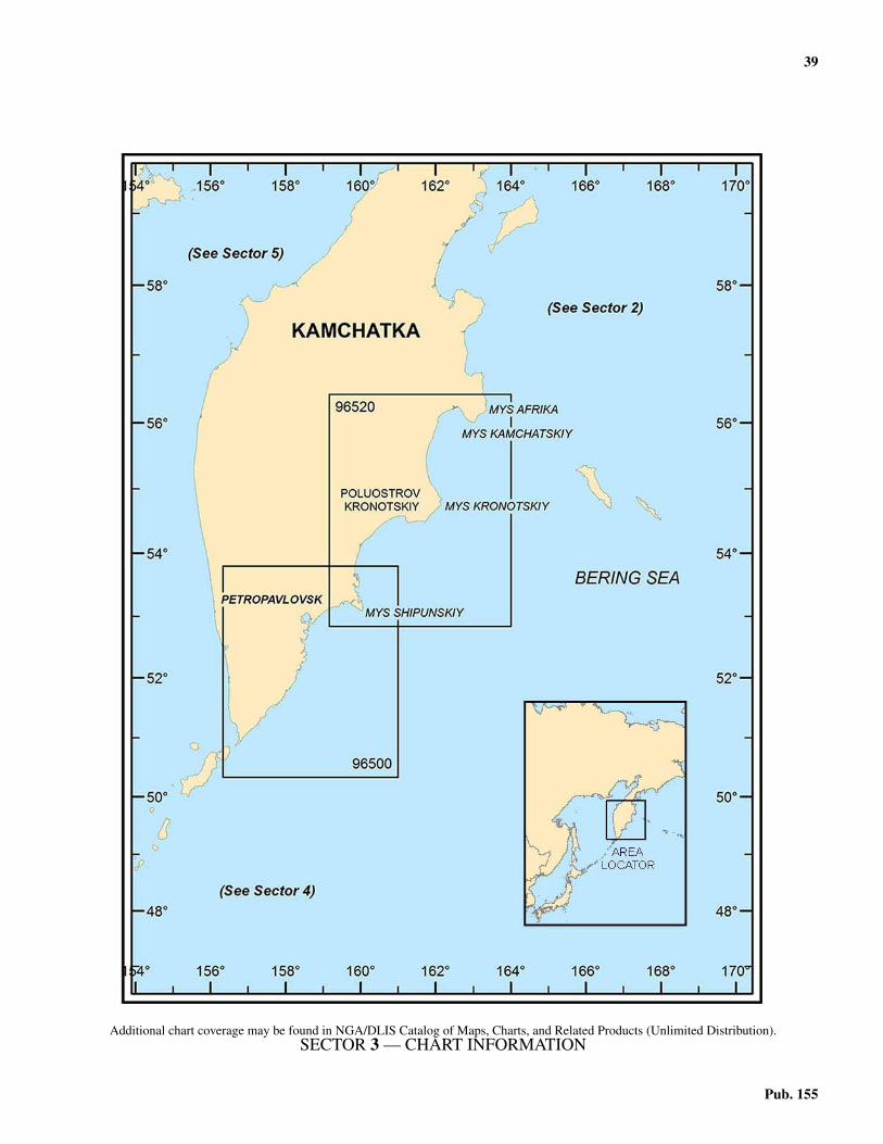
39
Pub. 155
3. Sector 3—East Coast of Kamchatka—Kamchatskiy Zaliv to Mys Lopatka
3.0Additional chart coverage may be found in NGA/DLIS Catalog of Maps, Charts, and Related Products (Unlimited Distribution).3.0SECTOR 3 — CHART INFORMATION
41
Pub. 155
SECTOR 3
EAST COAST OF KAMCHATKA—KAMCHATSKIY ZALIV TO MYS LOPATKA
3.0 Plan.—The coast described in this sector comprises the Ecoast of Kamchatka from Poluostrov Kamchatskiy to MysLopatka, including Pervyy Kuril’skiy Proliv (Kuril Strait). Thearrangement of the sector is from N to S.
General Remarks
3.1 Winds—Weather.—In Kamchatskiy Zaliv, windsfrom the SW quadrant prevail in summer and are accompaniedby clear weather. Northeast winds bring foul weather. Gales aremost frequent between October and March. In winter the windsare predominantly between the NW and NE, and when fromthe latter direction are frequently accompanied by blizzards.3.1 The presence, during clear weather, of a light misty cloudenveloping the summit of the volcano of Shivelyuch is consid-ered locally as a sign of approaching E, and particularly NEwinds.3.1 It appears that off the E side of the peninsula the colder,deeper water comes, or is forced, to the surface, a phenomenonascribed to the effect of tidal currents, causing fog to formquickly over the sea. In calms, or with gentle onshore breezes,a dense protracted fog blankets the coast.3.1 Ice.—Kamchatskiy Zaliv generally does not freeze com-pletely, however by the end of December or early January, it ismore or less filled with loose floes. In February the gulf is sol-idly packed with hummocky ice. During the month of March,the gulf ordinarily is free from ice, but beginning in April anduntil the middle of May, the gulf is packed with heavy massesof hummocky ice carried in from the N part of the Bering Sea.It should be noted that the part of the coast between the Osyp’Lakhtak and Mys Kamchatskiy is often free of ice, while theremaining part of the gulf is solidly packed with ice. The earli-est recorded appearance of ice is November 15; the latest isJanuary 16.3.1 Drift ice is usually adrift in Kronotskiy Zaliv in the winter.The average number of days with ice is 152. The earliest re-corded appearance of ice is December 6, the latest recorded ap-pearance of ice is January 5.3.1 Drift ice generally moves SW in March in the open sea offMys Mayachnyy and the sea is free of ice early in April. Navi-gation may be seriously impeded during winter and spring inthe open sea off Mys Mayachnyy, but icebreakers can generallykeep a passage open.3.1 Tides—Currents.—Between Mys Kamchatskiy, Mys Kro-notskiy, and Mys Shipunskiy, the stream of the constant Kam-chatka current is 40 to 50 miles wide, and flowing in a generalSSW direction, has a velocity of 0.6 knot.3.1 Between Mys Shipunskiy, the entrance to the AvachinskayaGuba, and Mys Lopatka the main stream of the Kamchatkacurrent flows in a general SSW direction and has a velocity of0.7 to 0.9 knot.3.1 South of Mys Shipunskiy, a narrow branch of the main Kam-chatka current flows in the direction of Mys Nalycheva, with avelocity of 0.5 knot then flows S, then SW and joins the main
stream of the Kamchatka current.3.1 Tides in Kamchatskiy Zaliv are of a mixed type, the diurnaltype prevailing. When the moon is close to the equator the tidesare semi-diurnal, and when the moon has its maximum N or Sdeclination the tides are diurnal. Semi-diurnal tides have asmaller range and somewhat higher LW. 3.1 The tidal currents here ordinarily have a velocity of 1 to 2knots. At the head of the gulf the currents may reach a velocityof 3 to 4 knots, the flood current setting W and the ebb currentsetting E. Overfalls caused by conflicting currents may be ob-served inside the gulf.3.1 The tidal wave approaches the S coast of Poluostrov Kamchats-kiy from the ESE and divides; one branch flows N along the Ecoast of the peninsula, causing a N flood current, while the otherbranch flows NW along the SE coast of the peninsula into Kam-chatskiy Zaliv, where, upon reaching its N shore, the currentchanges its direction to the W and flows parallel to the N shore ofKamchatskiy Zaliv. During the ebb, the directions of the tidal cur-rents are reversed. The tidal currents here barely exceed a rate of 1to 1.5 knots, reaching the higher limit only in the vicinities ofcapes projecting into the sea. Notwithstanding the relative weak-ness of these tidal currents, eddies have been observed, especiallyoff Mys Kamchatskiy, and overfalls of conflicting currents, thoughgradually weakening seaward, extend for a distance of 10 to 15miles offshore.3.1 The tidal currents off the coasts of Poluostrov Kronotskiy at-tain a rate of 1.5 to 2 knots and cause eddies and overfalls thatextend seaward off the headlands for a considerable distance.3.1 Tidal currents in the vicinity of Mys Shipunskiy attain a rateof 1.5 to 2 knots at springs and 1 knot at neaps. The tidal waveadvancing from the ocean divides at Mys Shipunskiy; onebranch setting N and the other NW along the coast. The twobranches of the ebb currents meet about 10 miles SW of MysShipunskiy and form eddies and also a very confused short seawhen the wind is fresh.3.1 The tidal current between Mys Zhupanova and Mys Shi-punskiy parallel the coast and attain a rate of 1 to 2 knots. Theflood current sets N and the ebb current sets S. In the open sea,the flood current sets NE and the ebb current sets SW.3.1 Caution.—Abnormal magnetic variation has been observedbetween 53°35'N and 55°10'N. Although the disturbance atMys Chazhma has been reported to be 9°30'W of the normalvariation, it was found negligible at a distance of 3 miles fromthe coast and was not perceptible at a distance greater than 10miles offshore.3.1 Near the coasts of Poluostrov Kronotskiy the deflection ofthe compass needle may reach 15° to 20° at a distance of 1 to1.5 miles offshore, but is not perceptible at a distance of 5miles offshore.3.1 The area of abnormal variation, which lies in the greater partof Kronotskiy Zaliv, is appreciable within a distance of 3 milesof the coast, but is not perceptible at a distance greater than 10miles offshore.3.1 An area of magnetic disturbance, in which a variation of 1°
42 Sector 3. East Coast of Kamchatka—Kamchatskiy Zaliv to Mys Lopatka
Pub. 155
less than the normal has been observed, is centered in 55°30'N,163°40'E, extending over a radius of about 10 miles.
Kamchatskiy Zaliv
3.2 Kamchatskiy Zaliv, entered S of Mys Kamchatskiy(56°00'N., 163°03'E.) and N of Mys Kronotskiy, about 80miles SSW, has generally low shores, and the coastal mountainranges are at a considerable distance inland.3.2 Sopka Klyuchevskaya (56°04'N., 160°38'E.), an active vol-cano located 93 miles NW of Mys Kamchatskiy, is located inthe center of a large group of high mountains and is the highestmountain in Kamchatka.3.2 For about 5 miles W of Mys Kamchatskiy, mountains withelevations of over 609m are located within 1.5 miles of thecoast, and front the sea with steep precipices and bluffs,fringed at their base with a narrow sand and gravel beach that isthickly studded with fragments of rock.3.2 Osyp’ Lakhtak, about 13 miles NW of Mys Kamchatskiy, isa very remarkable scar caused by a landslide. It rises from thesea to the top of the shore cliffs at a slope of 30°, and being yel-low in color, stands out very conspicuously against the back-ground of the generally darker color of the coast. From theoffing it appears as a large triangular patch with its base restingon the sea.3.2 Anchorage.—Anchorage in the bight close N of Osyp’Lakhtak affords some shelter from SE winds to a small vesselanchored close inshore.3.2 Caution.—In the vicinity of Osyp’ Lakhtak, particularly Sof it, the depths are extremely irregular. The bottom has numer-ous very deep holes and crevices close inshore. An anchor,with a full length of chain, was lost near a position where adepth of 9.1m was obtained by the lead; therefore, when an-choring here, back out the anchor until it takes hold and thenecessary scope of chain is out.
3.3 Ust-Kamchatsk (56°13'N., 162°29'.), a town situatedon the right bank of Reka Kamchatka, where it makes a sharpbend before flowing into the sea. The entrance channel to RekaKamchatka, the largest river in Kamchatka, leads between twobroad sandy shoals extending off the extremities of the twospits that form the mouth of the river. 3.3 The town is visible for about 8 miles and the masts of acoastal radio station located about 3 miles WSW of the townare also visible for a range of approximately 8 miles. 3.3 A radiobeacon transmits from Ust-Kamchatsk, with a bea-con standing on the framework of a former light, 28m inheight, on the E side of the entrance to Reka Kamchatka. 3.3 Tides—Currents.—The MHW interval at the mouth of Re-ka Kamchatka is about 4 hours. The spring rise is 1.8m, whilethe neap rise is 0.9m.3.3 Depths—Limitations.—Two terminals are situated in theport town. A fishing berth has a length of 140m while the gen-eral cargo berth has a length of 213m. 3.3 Anchorage.—The whole of the low and sandy coast on ei-ther side of the mouth of the Reka Kamchatka is steep-to and,except for the shoals at the mouth of the river, is clear of dan-gers.3.3 Anchorage can be obtained 0.5 to 0.8 mile offshore, either Wof the mouth of the river, in a depth of 11 to 12.8m, sand, or E of
the mouth of the river, in a depth of 14.6 to 20.1m, sand. Duringcalm weather, a long swell often sets in without warning andsoon becomes heavy. The surf is particularly heavy abreast theanchorage, and it is not advisable to anchor closer than 0.5 mileoffshore. The tidal currents flow parallel to the coast and have atendency to keep a ship broadside to the swell.3.3 In thick weather a vessel should steer directly for the mouthof Reka Kamchatka, anchor when a depth of 29m is reached,and wait until the vessel’s position can be ascertained.3.3 Caution.—Near the canneries, long lines of nets are laid outextending up to 0.5 mile offshore. The outer ends of the netsare marked by small floats.
3.4 Mys Kryugera (56°01'N., 162°05'E.) is the E extrem-ity of a small, rounded, and defined peninsula rising to a twinpeaked, hummocky hill, 128m high. The point consists of con-tinuous reddish-brown cliffs, about 100m high. The cape isfringed with reefs, usually marked by breakers, which extendbetween 1 mile NE and 1.5 miles SE from the cape.
Bukhta Kryugera (56°01'N., 162°03'E.) is entered betweenMys Kryugera and a small cape marked with a pillar rock closeoffshore, about 3.5 miles N of Mys Kryugera. The whole shoreof this bay is formed by continuous reddish-brown cliffs, 122to 152m high, sloping down to a narrow sand and shinglebeach that skirts the shore of the bay. In the S corner of the bay,close to Mys Kryugera, there is a large canning factory. 3.4 Only the S half of the bay has been surveyed and the depthshere are irregular. The bottom is mostly rocky, with isolatedpatches of sand and shingle. An isolated pillar rock lies about1.2 miles NW of Mys Kryugera and about 0.3 mile offshore.The entire water area for 0.6 mile offshore should be regardedas dangerous due to submerged rocks and shoal patches. Out-side this distance the depths increase to 18.3 to 20.1m about 2miles offshore. A 4.5m depth and an obstruction lie 2.5 and 3miles NE, respectively, of Mys Kryugera.3.4 Tides—Currents.—The tides here are of a mixed type, withthe diurnal prevailing. The MHW interval is 3 hours 20 min-utes. The spring rise is 1.3m.3.4 Anchorage.—Bukhta Kryugera is sheltered from windsfrom the S through W to NNE. Furthermore, the reef that ex-tends off Mys Kryugera serves as a breakwater. The anchoragein Bukhta Kryugera, though partly sheltered, is in a depth of13m and is the only sheltered anchorage in Kamchatskiy Zaliv.3.4 Two beacons, in line bearing 190°, near the canning factory,lead to the anchorage. During the navigation season these aidsare marked by small buoys displaying flags.
3.5 Mys Krasnyy (55°56'N., 162°01'E.), about 6 milesSSW of Mys Kryugera, is the bluff extremity of a small solitaryhill located near the coast, and is about 171m high. This cape isnot very conspicuous but can be identified by its red color withwhite horizontal bands in the upper strata. A small valley, with asand beach and small stream at its mouth, lies immediately N ofthe cape. Rocks, marked by breakers, lie up to 0.8 mile from thecape. From the rocks, a shoal, with a depth of 9.6m over its outerend, extends 1.3 miles NE. A detached shoal, with a depth of2.6m, lies 3.2 miles ENE of the cape.3.5 Mys Shuberta, about 14 miles SW of Mys Krasnyy, is aslightly projecting headland consisting of reddish-brown cliffsabout 61m high. The low coast S of the cape makes the cape
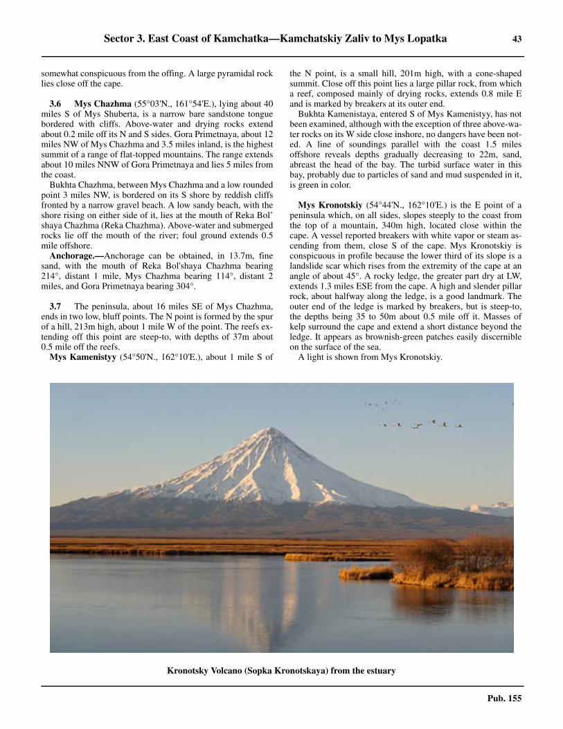
Sector 3. East Coast of Kamchatka—Kamchatskiy Zaliv to Mys Lopatka 43
Pub. 155
somewhat conspicuous from the offing. A large pyramidal rocklies close off the cape.
3.6 Mys Chazhma (55°03'N., 161°54'E.), lying about 40miles S of Mys Shuberta, is a narrow bare sandstone tonguebordered with cliffs. Above-water and drying rocks extendabout 0.2 mile off its N and S sides. Gora Primetnaya, about 12miles NW of Mys Chazhma and 3.5 miles inland, is the highestsummit of a range of flat-topped mountains. The range extendsabout 10 miles NNW of Gora Primetnaya and lies 5 miles fromthe coast.3.6 Bukhta Chazhma, between Mys Chazhma and a low roundedpoint 3 miles NW, is bordered on its S shore by reddish cliffsfronted by a narrow gravel beach. A low sandy beach, with theshore rising on either side of it, lies at the mouth of Reka Bol’shaya Chazhma (Reka Chazhma). Above-water and submergedrocks lie off the mouth of the river; foul ground extends 0.5mile offshore.3.6 Anchorage.—Anchorage can be obtained, in 13.7m, finesand, with the mouth of Reka Bol'shaya Chazhma bearing214°, distant 1 mile, Mys Chazhma bearing 114°, distant 2miles, and Gora Primetnaya bearing 304°.
3.7 The peninsula, about 16 miles SE of Mys Chazhma,ends in two low, bluff points. The N point is formed by the spurof a hill, 213m high, about 1 mile W of the point. The reefs ex-tending off this point are steep-to, with depths of 37m about0.5 mile off the reefs.3.7 Mys Kamenistyy (54°50'N., 162°10'E.), about 1 mile S of
the N point, is a small hill, 201m high, with a cone-shapedsummit. Close off this point lies a large pillar rock, from whicha reef, composed mainly of drying rocks, extends 0.8 mile Eand is marked by breakers at its outer end.3.7 Bukhta Kamenistaya, entered S of Mys Kamenistyy, has notbeen examined, although with the exception of three above-wa-ter rocks on its W side close inshore, no dangers have been not-ed. A line of soundings parallel with the coast 1.5 milesoffshore reveals depths gradually decreasing to 22m, sand,abreast the head of the bay. The turbid surface water in thisbay, probably due to particles of sand and mud suspended in it,is green in color.
3.7 Mys Kronotskiy (54°44'N., 162°10'E.) is the E point of apeninsula which, on all sides, slopes steeply to the coast fromthe top of a mountain, 340m high, located close within thecape. A vessel reported breakers with white vapor or steam as-cending from them, close S of the cape. Mys Kronotskiy isconspicuous in profile because the lower third of its slope is alandslide scar which rises from the extremity of the cape at anangle of about 45°. A rocky ledge, the greater part dry at LW,extends 1.3 miles ESE from the cape. A high and slender pillarrock, about halfway along the ledge, is a good landmark. Theouter end of the ledge is marked by breakers, but is steep-to,the depths being 35 to 50m about 0.5 mile off it. Masses ofkelp surround the cape and extend a short distance beyond theledge. It appears as brownish-green patches easily discernibleon the surface of the sea.3.7 A light is shown from Mys Kronotskiy.
Kronotsky Volcano (Sopka Kronotskaya) from the estuary
44 Sector 3. East Coast of Kamchatka—Kamchatskiy Zaliv to Mys Lopatka
Pub. 155
Poluostrov Kronotskiy
3.8 Poluostrov Kronotskiy, separating Kamchatskiy Zalivfrom Kronotskiy Zaliv, is formed by the E and NE spurs of SopkaKronotskaya, but its S part is an elevated tableland terminating onits seaward side in sheer cliff. A vessel approaching the coast ofthe peninsula in thick weather should sound continuously and ex-ercise due caution off Poluostrov Kronotskiy, as there are depthsof 101 to 128m which decrease rapidly.3.8 Numerous rocks and reefs exist along the coast of the penin-sula, but they do not extend offshore beyond 2 miles.3.8 Sopka Kronotskaya, about 56 miles W of Mys Kronotskiy, isan isolated cone-shaped extinct volcano and serves as a re-markable landmark from considerable distances. It is clearlydiscernible from the S part of Kamchatskiy Zaliv, from the E ofPoluostrov Kronotskiy, and the entire volcano is visible fromKronotskiy Zaliv.3.8 The rocky ledge, about 2.5 miles SW of Mys Kronotskiy, ismarked by many pillar rocks. Sivuchiy Kamen, meaning SealRock, about halfway along the ledge, is conspicuous due to itssize.
Kamen’ Kub, about 14 miles SW of Mys Kronotskiy, is avery conspicuous solitary rocky islet rising sheerly from thewater. From the offing it appears as a cube, with its flat topcovered with grass. Its almost vertical sides, covered with birdguano, render it conspicuous from seaward. There are rocks 0.5mile SSW and 1 mile ESE of the islet.3.8 Mys Kozlova (54°29'N., 161°43'E.), the SE extremity ofPoluostrov Kronotskiy, is 46m high, steep, and sharply definedwhen sighted from the NE and SW. A reef, which is steep-toand composed of a chain-like formation of rocks and pillarrocks, extends 1 mile S from the cape and terminates in a re-markable pillar rock, inclined seaward, which stands on a highrock base, often almost covered by seals. This 21m pillar rockis known as Kamen’ Kozlova.
Kronotskiy Zaliv
3.9 Kronotskiy Zaliv is entered between Mys Kozlova(54°29'N., 161°43'E.) and Mys Shipunskiy, about 112 milesSW. The shore of the gulf is high in its N and S parts, but be-tween these high sections it is either low or formed by compar-atively low cliffs. 3.9 Bukhta Morzhovaya, in the S part of the gulf, is the only bayaffording completely sheltered anchorage. Kronotskiy Zalivhas not been adequately surveyed and should be navigated withdue caution.3.9 Several conspicuous mountains lie comparatively near thecoast and form excellent landmarks discernible on a clear dayfrom considerable distances.3.9 Sopka Karymskaya (Sopka Berezovaya) (54°03'N.,159°28'E.), an active volcano, has a rounded summit of brown-ish-gray color easily identified by the smoke rising from itscrater.3.9 Gora Shirokaya (53°52'N., 159°33'E.) has a broad slopeparalleling the coast.3.9 Sopka Zhupanova (53°35'N., 159°09'E.), an isolated activevolcano, is particularly conspicuous from the E and NE.
3.10 The coast from Mys Kozlova to Mys Ol'ga, about 14
miles W, fronts the sea with a solid wall of uniform browncliffs, backed by a gently sloping tableland. Two groups ofrocks along this coast form good landmarks. Kamen' Morskoy,a conspicuous pillar rock, 37m high, with a white top showingup clearly against the background of brown cliffs, is the domi-nant feature of the group of rocks about 5.5 miles W of MysKozlova. The other group, about 4 miles E of Mys Ol’ga, in-cludes a high, brown, pillar rock, with a rounded top.3.10 Mys Ol’ga, a small peninsula, 46m high, can be identified by aconspicuous sharply-pointed conical hill that rises a short dis-tance N of the cape. There are several large pillar rocks close offthe cape. A steep-to reef extends 0.5 mile S from the cape.3.10 Bukhta Storozh (54°34'N., 161°10'E.), located about 7miles NW of Mys Ol’ga, affords no protection from the SEswell that comes in around the E shore of the bay. The E side ofthe bay is fringed by reefs and rocks, paralleling it about 1 mileoff, and marked by a continuous line of breakers. 3.10 Temporary anchorage may be obtained in the corner ofBukhta Storozh, in 7.8m, sand, 0.8 mile from either shore.When approaching this anchorage, a vessel should favor the Nshore of the bay, which is clear of dangers. Care should be tak-en to avoid a detached 2.6m shoal lying 6.2 miles NW of MysOl’ga, about 1.5 miles SSW of the anchorage.3.10 Caution.—Reported observations made in Bukhta Storozhindicated the deflection of the compass needle to be about 5°.
3.11 The coast for 7 miles NE and 16 miles SW of themouth of the Reka Kronotskaya (54°31'N., 160°45'E.) is lowand sandy. The mouth of the river is difficult to distinguishfrom the offing. An oval-shaped hill, 229m high, and a fairlyconspicuous hill, 311m high, located 7.5 miles and 10.5 milesNNE, respectively, of the mouth of the river, in line bearing016°, lead to a position about 1.2 miles E of the mouth of RekaKronotskaya.3.11 Anchorage.—Anchorage may be obtained, in 12.8m, 0.5mile offshore, with the peak of Sopka Kronotskaya bearing338°, and the mouth of Reka Kronotskaya bearing 008°.
3.12 Reka Semlyachik (54°06'N., 159°55'E.), entered 36miles SW of the mouth of Reka Kronotskaya, flows through awide valley and reaches the coast as a river of considerablesize. Before discharging into the sea the river flows S, beingseparated from the sea by a narrow sand and gravel spit. Themouth of the river is not easily discernible from the offing, butit can be identified by a low, sandy coast N of it and coastalcliffs immediately S of it. The village of Krasnyy Partizan liesnear the mouth; Barmotina village is situated 3 miles N of it.3.12 Mys Zhupanova (53°40'N., 159°55'E.) is the NW extremityof a peninsula, the head of which is formed by three hills risingfrom a single mass of high land extending 0.5 mile SE to MysYuzhnyy. The peninsula is connected to the mainland by a lowsand and gravel isthmus. The central hill is 55m high, and MysYuzhnyy is 100m high. From the offing, the peninsula appearsas a wedge-shaped islet, with its thin edge toward the land.Having a dark color, this wedge is fairly conspicuous againstthe lighter background.3.12 A detached rocky shoal, with a least depth of 2.4m, lies 0.7mile NNW of Mys Zhupanova. The shoal is steep-to, withdepths of 11m around it.
Anchorage.—Mys Zhupanova Anchorage, the bight W of
Sector 3. East Coast of Kamchatka—Kamchatskiy Zaliv to Mys Lopatka 45
Pub. 155
Mys Zhupanova, has low and sandy shores, covered with pum-ice in places. Large ships can obtain anchorage, in a depth of10m, mud and sand, with Mys Zhupanova bearing 100°. Theberth is sheltered from the SE through SW to NW. Small ves-sels can anchor closer inshore in depths of 4m with the capebearing 080°. Stranded wrecks lie about 1.2 miles W and 2.5miles NW of the cape.3.12 The low coast S of Mys Yuzhnyy is fronted offshore by a barrierconsisting of detached groups of above-water and submergedrocks extending about 4 miles SSE from Mys Yuzhnyy, and paral-lel to the coast. The N end of the barrier is an isolated submergedrock about 0.8 mile E of Mys Yuzhnyy and marked by breakers.About 1 mile SE of Mys Yuzhnyy is a group of six pillar rocks dis-posed in two small clusters. The next member of the barrier, about2.5 miles SSE of Mys Yuzhnyy, consists of Skala Ekspeditsii, around-topped grass-covered rock, 93m high. A short reef extendsNE, and a submerged rock lies about 0.5 mile SE of Skala Eks-peditsii. A pillar rock, 13m high, lies about 0.5 mile S, and a sub-merged rock, marked by breakers, lies about 2 miles SSE,respectively, of Skala Ekspeditsii.
3.13 Mys Kron'ye (Mys Krone) (53°28'N., 159°57'E.) is arounded rugged headland lying about 12 miles S of Mys Zhu-panova. A rocky mountain within its extremity rises to a heightof 472m, and sloping steeply, particularly on its S and E sides,fronts the sea with steep, brown cliffs. For 6 miles N of MysKron'ye, the mountains rise close to the coast from sheerbrown cliffs of moderate height. A reef extends S and SE about0.6 mile from the headland. The central part of the reef consistsof drying rocks, but its outer part is a submerged ledge, whichis marked by breakers when the swell is considerable. Its ex-tremity is steep-to. This headland can be identified by a con-spicuous pillar rock, 30m high, about 0.1 mile NE of the cape.3.13 Bukhta Kalygir, entered S of Mys Kron'ye, has precipitousgrayish-brown cliffs of medium height on its W shore, backedby mountains. Northward of the cliffs is the mouth of a broadvalley with Ozero Kalygirskoye, a salt water lake, separatedfrom the bay by a narrow, long, and low sandy spit coveredwith grass and bushes. The entrance to the lake is at the NE endof the spit near which lies the small village of Kalygir.3.13 Mys Sredniy (53°23'N., 159°56'E.), the S entrance point ofBukhta Kalygir, lies 5.5 miles S of Mys Kron’ye and is a highrugged headland with precipitous gray cliffs. It is fringed withabove-water rocks close inshore. An isolated submerged rock,marked by breakers, lies 0.3 mile N of the headland. A con-spicuous detached pillar rock lies 0.1 mile N of the rocky point,about 1 mile NW of Mys Sredniy.3.13 The NW part of Bukhta Kalygir, where the depths 0.2 mileoffshore do not exceed 12.8m, is the most shallow. The depthsincrease S and E toward Mys Kronye, with the bottom beingsand.3.13 It is reported that there is anchorage, in 11.9m, sand andshell, about 0.3 mile off the middle part of the cliffy shore W ofMys Kron’ye, and also farther W, 0.3 mile off the cliffs nearestto the low-lying shore, in 7m. The anchorage should be ap-proached from the SE with caution, taking soundings continu-ally.3.13 Bukhta Bol’shaya Medvezhka is entered between Mys Sred-niy and Mys Argali, 3 miles further SE. The SW part of itsshore is a spit ridged with accumulations of sand and gravel
and backed by a lake which lies in a spacious valley. Except forthis low section, the shore of the bay is hilly and covered withforest. A group of above-water rocks, extending no more than0.2 mile offshore, is located about 1.5 miles S of Mys Sredniy.The depths in the entrance are 27 to 37m.3.13 Anchorage.—Anchorage, sheltered from SE to S throughNW winds, can be obtained, in a depth of about 21m with MysArgali, the S entrance point, bearing 110°.
3.14 Mys Argali (53°20'N., 159°58'E.) is the N point of asmall mountainous peninsula that forms the SE shore of Bukh-ta Bol'shaya Medvezhka. The coast on the seaward side of thepeninsula consists of high rocky gray cliffs rising over 440m.About 1.3 miles SSE of Mys Argali, a rock, 2.4m high, lies 0.2mile offshore.3.14 Bukhta Morzhovaya (53°16'N., 159°58'E.) is entered be-tween Mys Argali and Ostrov Morzhovyy, about 4.5 milesSSE. The island rises to a height of 192m and has grayishcliffs, which on its S side are higher and steeper, and which de-scend to the NE end of the island in a series of gently slopingterraces. On its seaward side, the island is steep-to, with depthsof 56m about 0.2 mile off this side of the island. Ostrov Mor-zhovyy is separated by a narrow obstructed passage from apoint on the mainland which rises to a flat-topped steep-sidedhill, 125m high.3.14 Bukhta Morzhovaya is divided into two parts by a rockyheadland, nearly 91m high, about 3.5 miles WSW of OstrovMorzhovyy. The N part is wide and exposed. The S part, acomparatively long and narrow arm with a sand and shinglebeach at its head, is completely sheltered from the winds andsea. The shores of the entire bay are formed by steep slopes ofmountains that surround the bay and rise to heights rangingfrom 457 to over 610m.3.14 The depths at the entrance to the bay are 55m, sand, decreas-ing to 11m, sand, about 0.6 mile off the head of the N part ofthe bay. Depths of 27.5 to 29.5m, sticky mud, prevail over theN half of the S arm, decreasing very gradually to 18.3m, about0.3 mile offshore at its head.3.14 Anchorage.—Anchorage, sheltered from winds and sea, isobtained, in 18 to 21.9m, near the head of the S arm of BukhtaMorzhovaya. Sticky mud provides excellent holding ground.3.14 Caution.—During thick or foggy weather, which is very fre-quent in summer, it is most difficult to make out the entrance toBukhta Morzhovaya in a calm or with gentle onshore breezes.With moderate SE or NE winds the fog may clear up periodi-cally on the lee side of the land. Therefore, with a SE wind avessel should steer toward Ostrov Morzhovyy, and with a NEwind, Mys Argali. A mid-channel course in the bay and in theS arm of the bay is recommended. In clear weather, the en-trance is easily identified by Ostrov Morzhovyy. Ordinarily aSE wind spreads a fog over the whole N part of the bay, butleaves the S part fairly clear. With NE winds accompanied byrain, fog spreads over the entire bay, the fog being much denseraround the mountain tops and considerably thinner closer tothe shoreline.
3.15 Mys Shteyna (53°09'N., 160°04'E.), a high cliffypoint 8 miles S of Ostrov Morzhovyy, is the N limit of an ele-vated plateau. This plateau, extending about 3 miles S, formsthe SE extremity of Poluostrov Shipunskiy. The extremity of
46 Sector 3. East Coast of Kamchatka—Kamchatskiy Zaliv to Mys Lopatka
Pub. 155
the peninsula, 269m high, is flat-topped, with high sheer browncliffs.3.15 Mys Shipunskiy (53°06'N., 160°02'E.) is the E of two smallprojections on the SE extremity of the above-mentioned pla-teau. A mountain, about 5 miles NW of Mys Shipunskiy, has asharp, jagged summit rising to a height of 981m, and makes aconspicuous landmark when sighted from either the E or W.3.15 A palisade-like formation of pillar rocks extends 0.8 mileESE from Mys Shipunskiy and terminates in a large pillarrock, about 13m high, which is in line with the rest of therocks, but is separated by about 90m from the rest of the row. Adangerous line of rocks, both above-water and submerged, ex-tends from the W projection in a SSW direction for about 1.3miles to a submerged rock marked by breakers. Then it chang-es its direction and extends ESE for about 0.8 mile, terminatingin a rocky islet, 3.7m high, located about 1.3 miles SSW ofMys Shipunskiy. This rocky islet is the outermost danger offMys Shipunskiy. Both these lines of rocks are visible 10 to 12miles in clear weather, and form a good landmark. These rocksare practically steep-to, with depths of 50 to 55m less than 0.5mile S of the outermost rocky islet and depths of 91m at a dis-tance of 0.8 mile E of the E rock.3.15 A light with a transmitting radiobeacon is situated on MysShipunskiy.3.15 Caution.—Very dense fogs are prevalent in the vicinity ofMys Shipunskiy. A vessel approaching Mys Shipunskiy inthick weather should sound continuously and should navigatein depths of not less than 110m. With smooth water on an ebbtide, the eddies will give a warning of a proximity to the cape.The bottom shelves more steeply off the E side than off the S,and particularly the SW side of the cape. The bottom is mainlyshingle, changing to sand N of the cape, and to rock as the capeis approached.3.15 Depths of less than 50m have been reported to lie in an areaabout 6 miles E of Mys Shipunskiy.
Mys Shipunskiy to Avachinskaya Guba
3.16 Sopka Kozelskaya (53°13'N., 158°53'E.), an extinctvolcano, conical and sloping gently to the coast, is an excellentlandmark only 10 miles inland. The white stripes of snow onits black slopes can be seen through the haze when the peaksare obscured.3.16 Sopka Avachinskaya, an active volcano, lies about 2.5 milesNW and forms one mountainous mass with Sopka Kozelskaya,the valley between being of no great depth. There is never anysnow near its summit due to internal heat.3.16 Sopka Koryakskaya, an extinct volcano, 6 miles NW of Sop-ka Avachinskaya, has a well-shaped conical summit making ita very conspicuous landmark particularly from AvachinskayaGuba.3.16 The coast between Mys Shipunskiy and Mys Vkhodnoy, 12miles SE, is elevated and bluff, and indented in places by smallsandy bays between rocky headlands.3.16 Bukhta Bechevinskaya (53°13'N., 159°45'E.) is entered be-tween Mys Vkhodnoy and Mys Lovushek, about 1.3 miles far-ther NW. About 2 miles within the entrance of the bay ashingle spit extends from either side toward its middle, divid-ing the bay into nearly two equal parts. Depths in the bay de-crease from 12m on the N side of the entrance to 2.1m in the
fairway of the channel between the spits, which is less than90m wide. The depths increase again to over 50m in the innerpart of the bay.3.16 The S side of Mys Lovushek (53°13'N., 159°43'E.) termi-nates in two small projections. It is fringed with rocks and reefsextending about 0.3 mile S and SW. Grayish-yellow cliffs im-mediately NW of Mys Lovushek, changing to brown cliffs far-ther NW, form an excellent landmark, as there is no other placein the vicinity with similar coloring. The bay should not be ap-proached from the SW.3.16 Tides—Currents.—The MHW interval in Bukhta Beche-vinskaya is 3 hours 6 minutes. Springs rise 1.4m, while neaps rise1.2m. The tidal currents in the bay are almost imperceptible, ex-cept in the passage between the spits where, with the spring tides,the currents attain a velocity of 6 to 7 knots.3.16 Anchorage.—Anchorage, protected from all directions ex-cept SW, can be taken in the SW half of Bukhta Bechevinska-ya, with local knowledge, in depths of 5 to 11m, sand. A goodposition is in 9.6m, sand, with the two projections of Mys Lo-vushek in line bearing 256°, and the SE entrance point bearing175°.
3.17 Ostrov Krasheninnikova (53°13'N., 159°33'E.), aprecipitous island lying 6 miles W of Mys Lovushek, is fringedby rocks and a detached above-water rock lies 0.5 mile SSW ofit. The mouth of Reka Vakhil’, about 3.5 miles NE of the S endof Ostrov Krasheninnikova, was marked by a fishing stationnearby. A rock, which dries and only breaks when there is atleast a moderate swell, lies about 1.5 miles SSW of the mouthof Reka Vakhil’.3.17 Anchorage.—Anchorage can be obtained by vessels with lo-cal knowledge, in a depth of 21.9m, fine sand and shells, about2.7 miles E of the N extremity of Ostrov Krasheninnikova and0.5 mile E of the previously-described drying rock.3.17 The anchorage should be approached from the S with a lowoval-shaped hill 0.5 mile E of the mouth of Reka Vakhil' bear-ing 020°, which leads to the anchorage. Anchor when the N ex-tremity of Ostrov Krasheninnikova bears 270° or MysLovushek bears 098°.
3.18 Mys Nalycheva (53°09'N., 159°24'E.), lying about 7miles SW of Ostrov Krasheninnikova, is a high and cliffy capewith dark-colored precipices. A mountain with a rounded sum-mit rising to a height of 593m is located close inland, slopinggradually on its N side. Mys Nalycheva, when seen from theSE, is conspicuous against the background of a yellowish lowcoast. From the SW, because of the lake lying W of it, the capeappears as an island. A rocky reef extends about 0.3 mile S ofthe cape.
From Mys Nalycheva to the mouth of Reka Khalaktyrka(Reka Kalakhtyrka) (52°58'N., 158°50'E.) the coast is uniform-ly low and sandy. It is steep-to and clear of dangers. RekaPolovinnaya enters the sea 8.2 miles NE of Reka Khalaktyrka.Along this stretch the muddy water from the mouth of RekaMutnaya (53°04'N., 159°00'E.) gives a dull yellow color to thesea for several miles seaward. Abreast the mouth of Reka Kha-laktyrka and about 0.8 mile offshore lies a rock-islet, which be-ing covered with guano, has a white color. A reef, on which thesea breaks and on which is an above-water rock, lies betweenthe islet and the coast.
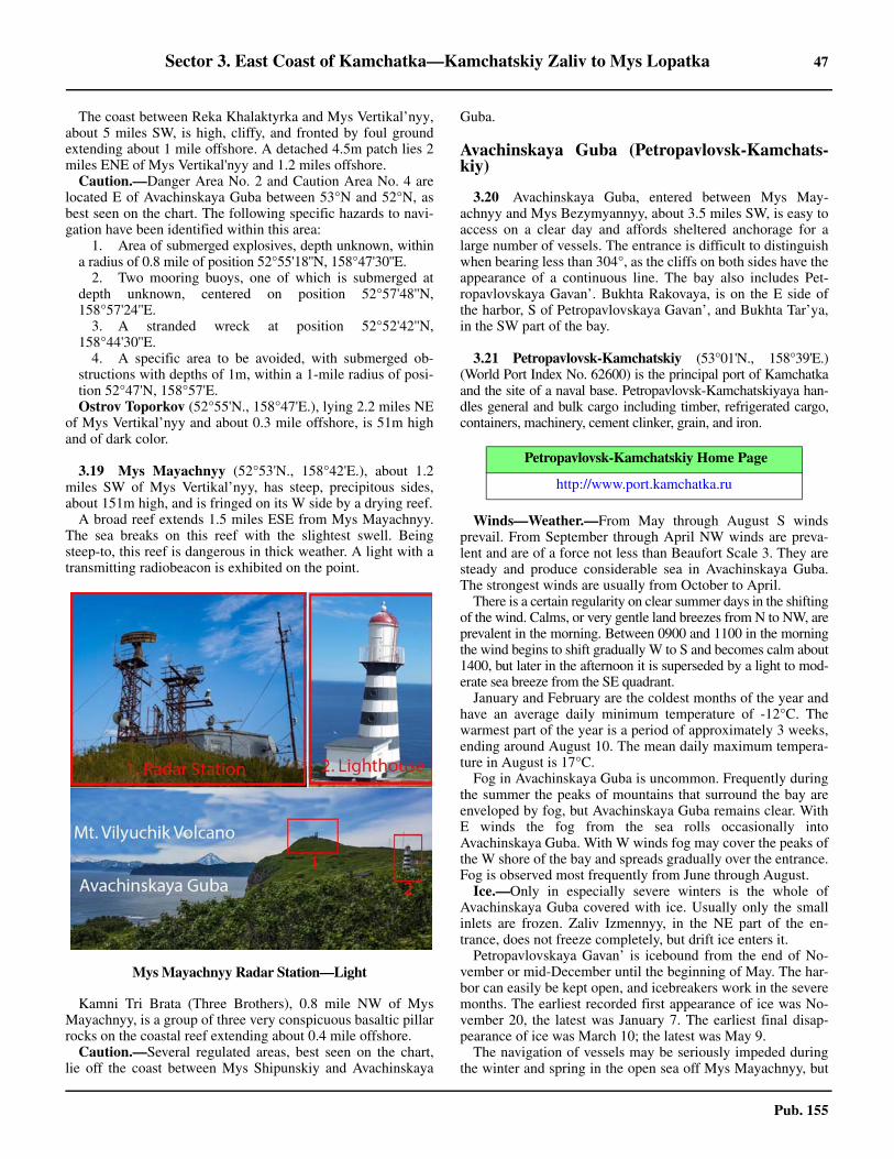
Sector 3. East Coast of Kamchatka—Kamchatskiy Zaliv to Mys Lopatka 47
Pub. 155
3.18 The coast between Reka Khalaktyrka and Mys Vertikal’nyy,about 5 miles SW, is high, cliffy, and fronted by foul groundextending about 1 mile offshore. A detached 4.5m patch lies 2miles ENE of Mys Vertikal'nyy and 1.2 miles offshore.3.18 Caution.—Danger Area No. 2 and Caution Area No. 4 arelocated E of Avachinskaya Guba between 53°N and 52°N, asbest seen on the chart. The following specific hazards to navi-gation have been identified within this area:
1. Area of submerged explosives, depth unknown, withina radius of 0.8 mile of position 52°55'18''N, 158°47'30''E.
2. Two mooring buoys, one of which is submerged atdepth unknown, centered on position 52°57'48''N,158°57'24''E.
3. A stranded wreck at position 52°52'42''N,158°44'30''E.
4. A specific area to be avoided, with submerged ob-structions with depths of 1m, within a 1-mile radius of posi-tion 52°47'N, 158°57'E.
3.18 Ostrov Toporkov (52°55'N., 158°47'E.), lying 2.2 miles NEof Mys Vertikal’nyy and about 0.3 mile offshore, is 51m highand of dark color.
3.19 Mys Mayachnyy (52°53'N., 158°42'E.), about 1.2miles SW of Mys Vertikal’nyy, has steep, precipitous sides,about 151m high, and is fringed on its W side by a drying reef.3.19 A broad reef extends 1.5 miles ESE from Mys Mayachnyy.The sea breaks on this reef with the slightest swell. Beingsteep-to, this reef is dangerous in thick weather. A light with atransmitting radiobeacon is exhibited on the point.
3.19 Kamni Tri Brata (Three Brothers), 0.8 mile NW of MysMayachnyy, is a group of three very conspicuous basaltic pillarrocks on the coastal reef extending about 0.4 mile offshore.3.19 Caution.—Several regulated areas, best seen on the chart,lie off the coast between Mys Shipunskiy and Avachinskaya
Guba.
Avachinskaya Guba (Petropavlovsk-Kamchats-kiy)
3.20 Avachinskaya Guba, entered between Mys May-achnyy and Mys Bezymyannyy, about 3.5 miles SW, is easy toaccess on a clear day and affords sheltered anchorage for alarge number of vessels. The entrance is difficult to distinguishwhen bearing less than 304°, as the cliffs on both sides have theappearance of a continuous line. The bay also includes Pet-ropavlovskaya Gavan’. Bukhta Rakovaya, is on the E side ofthe harbor, S of Petropavlovskaya Gavan’, and Bukhta Tar’ya,in the SW part of the bay.
3.21 Petropavlovsk-Kamchatskiy (53°01'N., 158°39'E.)(World Port Index No. 62600) is the principal port of Kamchatkaand the site of a naval base. Petropavlovsk-Kamchatskiyaya han-dles general and bulk cargo including timber, refrigerated cargo,containers, machinery, cement clinker, grain, and iron.
3.21 Winds—Weather.—From May through August S windsprevail. From September through April NW winds are preva-lent and are of a force not less than Beaufort Scale 3. They aresteady and produce considerable sea in Avachinskaya Guba.The strongest winds are usually from October to April.3.21 There is a certain regularity on clear summer days in the shiftingof the wind. Calms, or very gentle land breezes from N to NW, areprevalent in the morning. Between 0900 and 1100 in the morningthe wind begins to shift gradually W to S and becomes calm about1400, but later in the afternoon it is superseded by a light to mod-erate sea breeze from the SE quadrant.3.21 January and February are the coldest months of the year andhave an average daily minimum temperature of -12°C. Thewarmest part of the year is a period of approximately 3 weeks,ending around August 10. The mean daily maximum tempera-ture in August is 17°C.3.21 Fog in Avachinskaya Guba is uncommon. Frequently duringthe summer the peaks of mountains that surround the bay areenveloped by fog, but Avachinskaya Guba remains clear. WithE winds the fog from the sea rolls occasionally intoAvachinskaya Guba. With W winds fog may cover the peaks ofthe W shore of the bay and spreads gradually over the entrance.Fog is observed most frequently from June through August.3.21 Ice.—Only in especially severe winters is the whole ofAvachinskaya Guba covered with ice. Usually only the smallinlets are frozen. Zaliv Izmennyy, in the NE part of the en-trance, does not freeze completely, but drift ice enters it.3.21 Petropavlovskaya Gavan’ is icebound from the end of No-vember or mid-December until the beginning of May. The har-bor can easily be kept open, and icebreakers work in the severemonths. The earliest recorded first appearance of ice was No-vember 20, the latest was January 7. The earliest final disap-pearance of ice was March 10; the latest was May 9.3.21 The navigation of vessels may be seriously impeded duringthe winter and spring in the open sea off Mys Mayachnyy, but
Mys Mayachnyy Radar Station—Light
Petropavlovsk-Kamchatskiy Home Page
http://www.port.kamchatka.ru
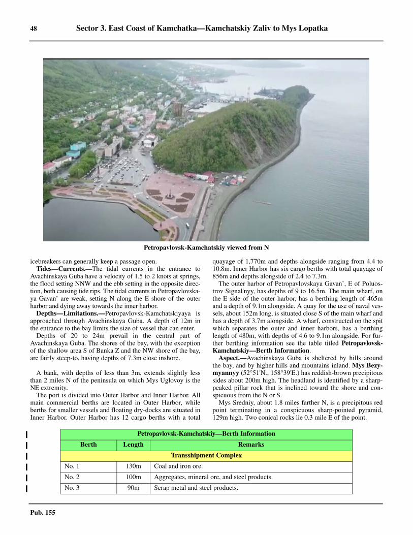
48 Sector 3. East Coast of Kamchatka—Kamchatskiy Zaliv to Mys Lopatka
Pub. 155
icebreakers can generally keep a passage open.3.21 Tides—Currents.—The tidal currents in the entrance toAvachinskaya Guba have a velocity of 1.5 to 2 knots at springs,the flood setting NNW and the ebb setting in the opposite direc-tion, both causing tide rips. The tidal currents in Petropavlovska-ya Gavan’ are weak, setting N along the E shore of the outerharbor and dying away towards the inner harbor.
Depths—Limitations.—Petropavlovsk-Kamchatskiyaya isapproached through Avachinskaya Guba. A depth of 12m inthe entrance to the bay limits the size of vessel that can enter.3.21 Depths of 20 to 24m prevail in the central part ofAvachinskaya Guba. The shores of the bay, with the exceptionof the shallow area S of Banka Z and the NW shore of the bay,are fairly steep-to, having depths of 7.3m close inshore.
3.21 A bank, with depths of less than 3m, extends slightly lessthan 2 miles N of the peninsula on which Mys Uglovoy is theNE extremity. 3.21 The port is divided into Outer Harbor and Inner Harbor. Allmain commercial berths are located in Outer Harbor, whileberths for smaller vessels and floating dry-docks are situated inInner Harbor. Outer Harbor has 12 cargo berths with a total
quayage of 1,770m and depths alongside ranging from 4.4 to10.8m. Inner Harbor has six cargo berths with total quayage of856m and depths alongside of 2.4 to 7.3m. 3.21 The outer harbor of Petropavlovskaya Gavan’, E of Poluos-trov Signal'nyy, has depths of 9 to 16.5m. The main wharf, onthe E side of the outer harbor, has a berthing length of 465mand a depth of 9.1m alongside. A quay for the use of naval ves-sels, about 152m long, is situated close S of the main wharf andhas a depth of 3.7m alongside. A wharf, constructed on the spitwhich separates the outer and inner harbors, has a berthinglength of 480m, with depths of 4.6 to 9.1m alongside. For fur-ther berthing information see the table titled Petropavlovsk-Kamchatskiy—Berth Information. 3.21 Aspect.—Avachinskaya Guba is sheltered by hills aroundthe bay, and by higher hills and mountains inland. Mys Bezy-myannyy (52°51'N., 158°39'E.) has reddish-brown precipitoussides about 200m high. The headland is identified by a sharp-peaked pillar rock that is inclined toward the shore and con-spicuous from the N or S. 3.21 Mys Sredniy, about 1.8 miles farther N, is a precipitous redpoint terminating in a conspicuous sharp-pointed pyramid,129m high. Two conical rocks lie 0.3 mile E of the point.
Petropavlovsk-Kamchatskiy viewed from N
Petropavlovsk-Kamchatskiy—Berth Information
Berth Length Remarks
Transshipment Complex
No. 1 130m Coal and iron ore.
No. 2 100m Aggregates, mineral ore, and steel products.
No. 3 90m Scrap metal and steel products.
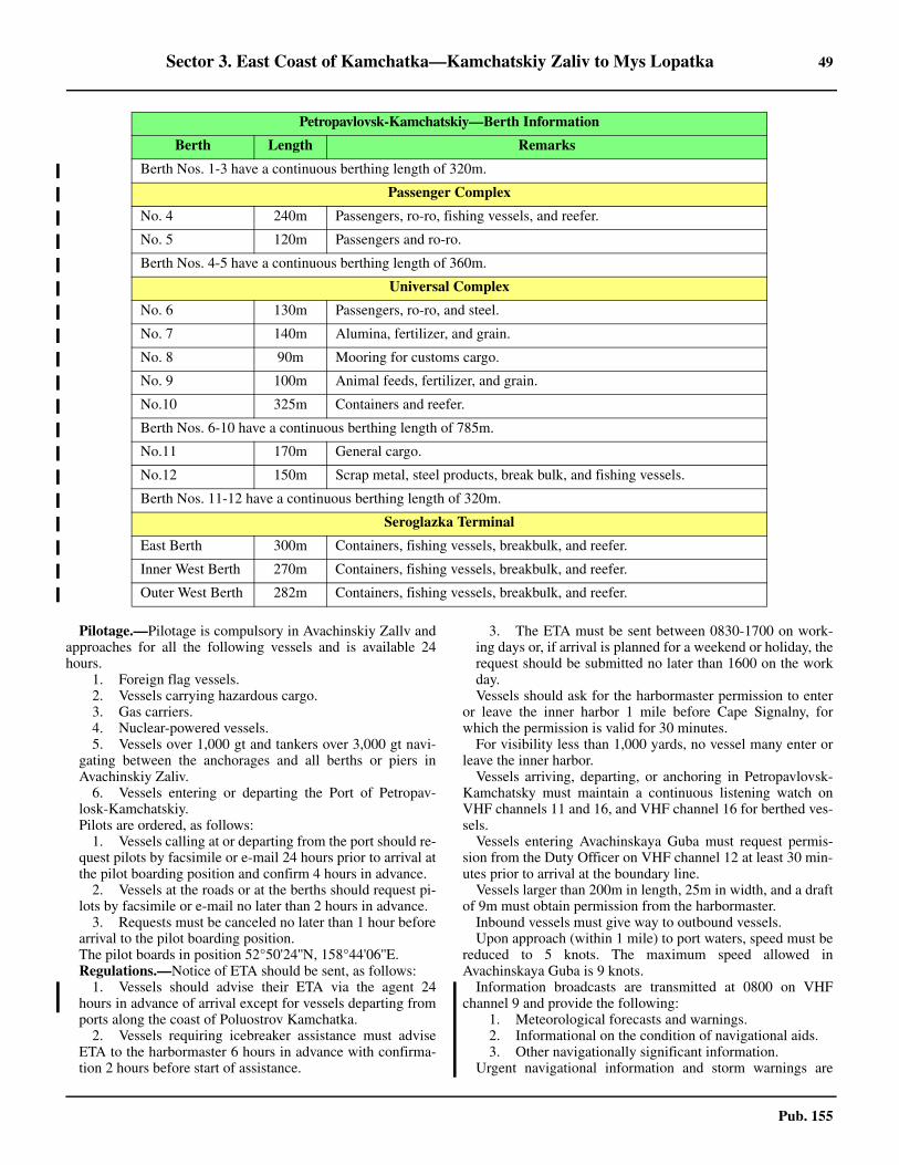
Sector 3. East Coast of Kamchatka—Kamchatskiy Zaliv to Mys Lopatka 49
Pub. 155
3.21 Pilotage.—Pilotage is compulsory in Avachinskiy Zallv andapproaches for all the following vessels and is available 24hours.
1. Foreign flag vessels.2. Vessels carrying hazardous cargo.3. Gas carriers.4. Nuclear-powered vessels.5. Vessels over 1,000 gt and tankers over 3,000 gt navi-
gating between the anchorages and all berths or piers inAvachinskiy Zaliv.
6. Vessels entering or departing the Port of Petropav-losk-Kamchatskiy.
3.21 Pilots are ordered, as follows:1. Vessels calling at or departing from the port should re-
quest pilots by facsimile or e-mail 24 hours prior to arrival atthe pilot boarding position and confirm 4 hours in advance.
2. Vessels at the roads or at the berths should request pi-lots by facsimile or e-mail no later than 2 hours in advance.
3. Requests must be canceled no later than 1 hour beforearrival to the pilot boarding position.
3.21 The pilot boards in position 52°50'24''N, 158°44'06''E.3.21 Regulations.—Notice of ETA should be sent, as follows:
1. Vessels should advise their ETA via the agent 24hours in advance of arrival except for vessels departing fromports along the coast of Poluostrov Kamchatka.
2. Vessels requiring icebreaker assistance must adviseETA to the harbormaster 6 hours in advance with confirma-tion 2 hours before start of assistance.
3. The ETA must be sent between 0830-1700 on work-ing days or, if arrival is planned for a weekend or holiday, therequest should be submitted no later than 1600 on the workday.
3.21 Vessels should ask for the harbormaster permission to enteror leave the inner harbor 1 mile before Cape Signalny, forwhich the permission is valid for 30 minutes.3.21 For visibility less than 1,000 yards, no vessel many enter orleave the inner harbor. 3.21 Vessels arriving, departing, or anchoring in Petropavlovsk-Kamchatsky must maintain a continuous listening watch onVHF channels 11 and 16, and VHF channel 16 for berthed ves-sels.3.21 Vessels entering Avachinskaya Guba must request permis-sion from the Duty Officer on VHF channel 12 at least 30 min-utes prior to arrival at the boundary line. 3.21 Vessels larger than 200m in length, 25m in width, and a draftof 9m must obtain permission from the harbormaster. 3.21 Inbound vessels must give way to outbound vessels. 3.21 Upon approach (within 1 mile) to port waters, speed must bereduced to 5 knots. The maximum speed allowed inAvachinskaya Guba is 9 knots. 3.21 Information broadcasts are transmitted at 0800 on VHFchannel 9 and provide the following:
1. Meteorological forecasts and warnings.2. Informational on the condition of navigational aids.3. Other navigationally significant information.
3.21 Urgent navigational information and storm warnings are
Berth Nos. 1-3 have a continuous berthing length of 320m.
Passenger Complex
No. 4 240m Passengers, ro-ro, fishing vessels, and reefer.
No. 5 120m Passengers and ro-ro.
Berth Nos. 4-5 have a continuous berthing length of 360m.
Universal Complex
No. 6 130m Passengers, ro-ro, and steel.
No. 7 140m Alumina, fertilizer, and grain.
No. 8 90m Mooring for customs cargo.
No. 9 100m Animal feeds, fertilizer, and grain.
No.10 325m Containers and reefer.
Berth Nos. 6-10 have a continuous berthing length of 785m.
No.11 170m General cargo.
No.12 150m Scrap metal, steel products, break bulk, and fishing vessels.
Berth Nos. 11-12 have a continuous berthing length of 320m.
Seroglazka Terminal
East Berth 300m Containers, fishing vessels, breakbulk, and reefer.
Inner West Berth 270m Containers, fishing vessels, breakbulk, and reefer.
Outer West Berth 282m Containers, fishing vessels, breakbulk, and reefer.
Petropavlovsk-Kamchatskiy—Berth Information
Berth Length Remarks
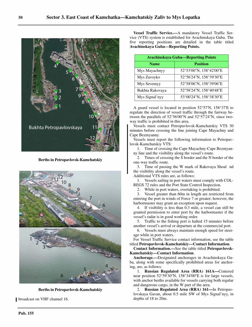
50 Sector 3. East Coast of Kamchatka—Kamchatskiy Zaliv to Mys Lopatka
Pub. 155
broadcast on VHF channel 16.
3.21 Vessel Traffic Service.—A mandatory Vessel Traffic Ser-vice (VTS) system is established for Avachinskaya Guba. Thefive reporting positions are detailed in the table titledAvachinskaya Guba—Reporting Points.
3.21 A guard vessel is located in position 52°57'N, 158°37'E toregulate the direction of vessel traffic through the fairway be-tween the parallels of 52°56'00''N and 52°57'24''N, since two-way traffic is prohibited in this area. 3.21 Vessels must contact Petropavlovsk-Kamchatskiy VTS 30minutes before crossing the line joining Cape Mayachny andCape Bezmyanny. 3.21 Vessels must report the following information to Petropav-lovsk-Kamchatskiy VTS:
1. Time of crossing the Cape Mayachny-Cape Bezmyan-ny line and the visibility along the vessel’s route.
2. Times of crossing the S border and the N border of theone-way traffic route.
3. Time of passing the W mark of Rakovaya Shoal ndthe visibility along the vessel’s route.
3.21 Additional VTS rules are, as follows: 1. Vessels sailing in port waters must comply with COL-
REGS 72 rules and the Port State Control Inspection.2. While in port waters, overtaking is prohibited.3. Vessel greater than 60m in length are restricted from
entering the port in winds of Force 7 or greater; however, theharbormaster may grant an exception upon request.
4. If visibility is less than 0.3 mile, a vessel can still begranted permission to enter port by the harbormaster if thevessel’s radar is in good working order.
5. Traffic to the fishing port is halted 15 minutes beforeanother vessel’s arrival or departure at the commercial port.
6. Vessels must always maintain enough speed for steer-age while in port waters.
3.21 For Vessel Traffic Service contact information, see the tabletitled Petropavlovsk-Kamchatskiy—Contact Information.3.21 Contact Information.—See the table titled Petropavlovsk-Kamchatskiy—Contact Information. 3.21 Anchorage.—Designated anchorages in Avachinskaya Gu-ba, along with some specifically prohibited areas for anchor-ing, are, as follows:
1. Russian Regulated Area (RRA) 161A—Centerednear position 52°59'30''N, 158°34'00''E is for large vessels,with anchor berths available for vessels carrying both regularand dangerous cargo, in the W part of the area.
2. Russian Regulated Area (RRA) 161—In Petropav-lovskaya Gavan, about 0.5 mile SW of Mys Signal’nyy, indepths of 18 to 20m.
Berths in Petropavlovsk-Kamchatskiy
Berths in Petropavlovsk-Kamchatskiy
Avachinskaya Guba—Reporting Points
Name Position
Mys Mayachnyy 52°53'00''N, 158°42'00''E
Mys Zavoyko 52°56'24''N, 158°39'30''E
Mys Sevemyy 52°58'06''N, 158°39'06''E
Bukhta Rakovaya 52°58'24''N, 158°40'48''E
Mys Signal’nyy 53°00'24''N, 158°38'30''E
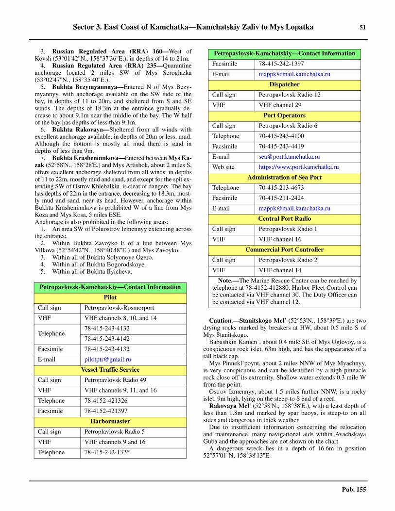
Sector 3. East Coast of Kamchatka—Kamchatskiy Zaliv to Mys Lopatka 51
Pub. 155
3. Russian Regulated Area (RRA) 160—West ofKovsh (53°01'42''N., 158°37'36''E.), in depths of 14 to 21m.
4. Russian Regulated Area (RRA) 235—Quarantineanchorage located 2 miles SW of Mys Seroglazka(53°02'47''N., 158°35'40''E.).
5. Bukhta Bezymyannaya—Entered N of Mys Bezy-myannyy, with anchorage available on the SW side of thebay, in depths of 11 to 20m, and sheltered from S and SEwinds. The depths of 18.3m at the entrance gradually de-crease to about 9.1m near the middle of the bay. The W halfof the bay has depths of less than 9.1m.
6. Bukhta Rakovaya—Sheltered from all winds withexcellent anchorage available, in depths of 20m or less, mud.Although the bottom is mostly all mud there is sand indepths of less than 9m.
7. Bukhta Krasheninnkova—Entered between Mys Ka-zak (52°58'N., 158°28'E.) and Mys Artishok, about 2 miles S,offers excellent anchorage sheltered from all winds, in depthsof 11 to 22m, mostly mud and sand, and except for the spit ex-tending SW of Ostrov Khlebalkin, is clear of dangers. The bayhas depths of 22m in the entrance, decreasing to 18.3m, most-ly mud and sand, near its head. However, anchorage withinBukhta Krasheninnkova is prohibited W of a line from MysKoza and Mys Kosa, 5 miles ESE.
3.21 Anchorage is also prohibited in the following areas:1. An area SW of Poluostrov Izmennyy extending across
the entrance.2. Within Bukhta Zavoyko E of a line between Mys
Vilkova (52°54'42''N., 158°40'48''E.) and Mys Zavoyko.3. Within all of Bukhta Solyonoye Ozero. 4. Within all of Bukhta Bogorodskoye. 5. Within all of Bukhta Ilyicheva.
3.21 Caution.—Stanitskogo Mel’ (52°53'N., 158°39'E.) are twodrying rocks marked by breakers at HW, about 0.5 mile S ofMys Stanitskogo.3.21 Babushkin Kamen’, about 0.4 mile SE of Mys Uglovoy, is aconspicuous rock islet, 63m high, and has the appearance of atall black cap.3.21 Mys Pinnekl’poynt, about 2 miles NNW of Mys Myachnyy,is very conspicuous and can be identified by a high pinnaclerock close off its extremity. Shallow water extends 0.3 mile Wfrom the point.3.21 Ostrov Izmennyy, about 1.5 miles farther NNW, is a rockyislet, 9m high, lying on the steep-to S end of a reef. 3.21 Rakovaya Mel' (52°58'N., 158°38'E.), with a least depth ofless than 1.8m and marked by spar buoys, is steep-to on allsides and dangerous in thick weather.3.21 Due to insufficient information concerning the relocationand maintenance, many navigational aids within AvachskayaGuba and the approaches are not shown on the chart.3.21 A dangerous wreck lies in a depth of 16.6m in position52°57'01''N, 158°38'13''E.
Petropavlovsk-Kamchatskiy—Contact Information
Pilot
Call sign Petropavlovsk-Rosmorport
VHF VHF channels 8, 10, and 14
Telephone78-415-243-4132
78-415-243-4142
Facsimile 78-415-243-4132
E-mail [email protected]
Vessel Traffic Service
Call sign Petropavlovsk Radio 49
VHF VHF channels 9, 11, and 16
Telephone 78-4152-421326
Facsimile 78-4152-421397
Harbormaster
Call sign Petroplavlovsk Radio 5
VHF VHF channels 9 and 16
Telephone 78-415-242-1326
Facsimile 78-415-242-1397
E-mail [email protected]
Dispatcher
Call sign Petropavlovsk Radio 12
VHF VHF channel 29
Port Operators
Call sign Petropavlovsk Radio 6
Telephone 70-415-243-4100
Facsimile 70-415-243-4419
E-mail [email protected]
Web site https://www.port.kamchatka.ru
Administration of Sea Port
Telephone 70-415-213-4673
Facsimile 70-415-211-2424
E-mail [email protected]
Central Port Radio
Call sign Petropavlovsk Radio 1
VHF VHF channel 16
Commercial Port Controller
Call sign Petropavlovsk Radio 2
VHF VHF channel 14
Note.—The Marine Rescue Center can be reached bytelephone at 78-4152-412880. Harbor Fleet Control canbe contacted via VHF channel 30. The Duty Officer canbe contacted via VHF channel 12.
Petropavlovsk-Kamchatskiy—Contact Information
52 Sector 3. East Coast of Kamchatka—Kamchatskiy Zaliv to Mys Lopatka
Pub. 155
3.21 A stranded wreck lies in position 52°58'40''N, 150°45'13''E.
Avachinskaya Guba to Mys Lopatka
3.22 Ostrov Starichkov (52°47'N., 158°37'E.), about 4.5miles SSW of Mys Bezymyannyy, is fringed by above and be-low-water rocks, and has cliffy shores which rise in its SWpart. Kekur Chasovoy, a conspicuous, slender, pillar rock,slightly inclined toward the land, lies less than 0.3 mile NNWof the island. Kekur Karaul’nyy, a high pyramid-shaped pillarrock, also conspicuous, lies close off the N end of the island. Asunken rock is reported to lie 0.5 mile E of the island, while a2.7m patch lies 1 mile N of the island. 3.22 Vulcan Vilyuchik (Sopka Vilyuchinskaya) (52°42'N.,158°17'E.), a conspicuous, conical, extinct volcano is an excel-lent landmark, distinctly visible on a clear day long before theland comes into sight. Sopka Mutnovskaya (Sopka Povorot-naya), about 15 miles farther S, constantly emits steam andsmoke from a crater on its N side, which is not visible fromseaward.3.22 Mys Opasnyy (52°41'N., 158°36'E.), formed by moderatelyhigh cliffs, predominantly red, has reefs extending about 0.6mile seaward from it. 3.22 Bukhta Sarannaya, entered N of Mys Opasnyy, has high andcliffy N and S shores. The W shore of the bay is a low sandybeach, except for a high bluff near the middle. Depths in thebay decrease from 37m in the entrance to 11m about 0.5 milefrom the W shore, which together with the N shore, is fringedby rocks.
3.23 Bukhta Zhirovaya is entered S of Mys Otvesnyy(52°37'N., 158°33'E.), a promontory formed by high precipitousgray cliffs. Mys Otvesnyy is steep-to and clear of dangers. Bukh-ta Zhirovaya is divided into two arms by a slender rocky spit ex-tending from the W side of the bay in an ESE direction andterminating in Mys Razdel'nyy. The NW arm is Bukhta Vily-uchinskaya and the SW arm is Bukhta Zhirovaya.3.23 Bukhta Vilyuchinskaya is entered between Mys Razdel’nyyand a small promontory about 1.2 miles ENE, which is identi-fied by a group of four pillar rocks located 0.3 mile S of its ex-tremity. The NE shore of the bay is backed by a continuousmountain range over 610m high. The SW shore of the bay isbacked by high land, being about 142m high in the vicinity ofMys Razdel’nyy, and rising to about 758m abreast the head ofthe bay.3.23 Tides—Currents.—The MHW interval in Bukhta Vily-uchinskaya is approximately 4 hours. The spring tides are diur-nal with a rise of 1.8m. The neap tides are semi-diurnal, with anoticeable diurnal inequality and rises from 0.6 to 1.2m.3.23 Anchorage.—Bukhta Vilyuchinskaya affords good anchor-age to vessels with local knowledge, in depths of 7 to 22m.Depths of 22m, sand, just outside the entrance of the bay de-crease sharply to 15m, sand, immediately inside the entrance,then decrease gradually to about 7.3m, sand, near the middle ofthe bay. Depths increase again to 14.6 to 18m in the inner halfof the bay.
3.24 Bukhta Yuzhnaya Zhirovaya is entered between MysRazdel’nyy and Mys Krutoy (52°34'N., 158°31'E.), a roundedcape formed by gray cliffs rising sheerly from the sea and
backed by coastal elevations of 610m close inland. The cape issteep-to and clear of dangers.3.24 Anchorage.—Anchorage can be taken, in depths of 14.6 to16.5m, about 0.8 mile off the low sandy shore at the head ofBukhta Yuzhnaya Zhirovaya, but it is open E.3.24 Bukhta Akhomten (52°26'N., 158°30'E.) is protected bymountains over 610m rising close inland on its N and S sides.The shores are steep-to, and with a few exceptions depths of10m are found about 0.1 mile offshore. Depths of 22 to 29m,mostly sand, or sand and mud, prevail throughout the greaterpart of Bukhta Akhomten. The head is marshy and low. 3.24 Pilotage.—Vessels must pick up a pilot at Bukhta Akhomtenbefore proceeding through the danger area in the approach toAvachinskaya Guba. A small Coast Guard station is at BukhtaAkhomten.3.24 Anchorage.—Anchorage can be taken, in a depth of 16m,sand, good holding ground, about 0.8 mile from the head ofBukhta Akhomten, sheltered from all but E and NW winds,which cause a heavy swell. In the spring, when NE winds pre-vail, the bay may be obstructed by ice, but is said to be neverclosed for more than 3 to 5 days at a time.3.24 Bukhta Tikhirka, immediately N of Bukhta Akhomten, hascliffy N and S shores. The W shore is low sandy beach backedby low land. There are depths of 18.3 to 22m in the entrance,decreasing uniformly toward the head. The depth is about 11min the middle part. 3.24 Winds—Weather.—Frequently in calms, and particularlyso with gentle NE winds, Bukhta Tikhirka is filled with a verydense fog.3.24 Anchorage.—Anchorage can be taken by small vessels, in 5to 7m, sand, from 0.1 to 0.15 mile from the head of the bay.The bay is clear of dangers, but exposed to sea and swell.
3.25 Mys Piramidnyy (52°23'N., 158°35'E.) is a precipi-tous cape identified by a conspicuous pyramid-shaped rock ly-ing close to the shore. Close seaward of this rock is a smallsharp-pointed rock surrounded by some scattered rocks. MysPovorotnyy, about 3.5 miles farther S, is prominent from the S,rising to a height of 870m.3.25 Mys Polosatyy lies about 4 miles farther SSW and is veryhigh, and composed of brown cliffs marked with white obliquestripes. The E side of the point is steep-to.3.25 From Mys Polosatyy to Bukhta Mutnaya, 4.5 miles SW, thecolor of the bluffs is chiefly gray, with occasional brown andred patches. The shores of Bukhta Berezovaya, which indentsthis part of the coast, consist of sand and gravel. BetweenBukhta Mutnaya and Mys Asacha, 4 miles SSW, the coast isrocky and rises to elevations over 600m.3.25 Kamen’ Sivuchiy (52°11'N., 158°26'E.) is a barren, rockyislet, about 24m high, lying close offshore.3.25 The S shore of Bukhta Mutnaya is bluff and slopes down tothe mouth of Reka Mutnaya, which flows through a broad, lowvalley into the head of the bay. The coast rises sharply N of themouth of the river.
3.26 Mys Asacha (52°08'N., 158°23'E.) lies 8.5 milesSSW of Mys Polosatyy. Mys Asacha is high and rocky, withreddish-brown cliffs. A reef extends 0.8 mile SSE from it.3.26 Bukhta Asacha is entered between Mys Asacha and Mys Si-amo (Mys Kruglyy), about 4 miles SSW. Mys Asacha, high,
Sector 3. East Coast of Kamchatka—Kamchatskiy Zaliv to Mys Lopatka 53
Pub. 155
rocky, and composed of reddish-brown cliffs, has a reef ex-tending 0.7 mile SSE from it. Shelter from strong NE windscan be obtained for small vessels, with local knowledge, off theN side of the bay, in a depth of 13m, with Mys Asacha bearing085°. 3.26 Mys Siamo is fringed by above and below-water rocks, and areef extends about 1 mile E of the point. A pillar rock, 14mhigh, lies on this reef about 0.6 mile offshore. A light is shownfrom Mys Siama. 3.26 The NE and SW shores of Bukhta Asacha are cliffy, but theNW shore is a sandy beach backed by gentle slopes of hillockscovered with trees and bushes. The depths decrease very grad-ually toward the head of the bay and are about 14.6m at a dis-tance of 1 mile off the NW shore of the bay. A detached dryingrock, ordinarily marked by breakers, lies about 0.8 mile E ofthe mouth of Reka Asacha, which discharges into the head ofthe bay. This bay affords in its N recess some shelter from NEwinds.3.26 Mys Piratkov (51°58'N., 158°17'E.) is a roundish capeformed by precipitous high cliffs with numerous brooks flow-ing through its steep, narrow fissures. The vertical cliffs arebare, but on those that slope there is a low growth of vegeta-tion. A detached rock, which dries, lies about 0.8 mile NE ofthe cape.3.26 Sopka Khodutka (52°02'N., 157°43'E.), a cone-shaped vol-cano 23 miles W of Mys Siama, is very conspicuous from sea-ward.
3.27 Mys Krestovvy (51°49'N., 158°06'E.), 12 miles SWof Mys Piratkov, terminates in a sharp hill which, being partlyred and partly white, is prominent and a good landmark.
Bukhta Khodutka is an open roadstead lying between MysKrestovvy and Mys Kuzachin, about 6.5 miles SW. The greaterpart of its shore consists of low, sandy beach. The mouth of Re-ka Bol’shaya Khodhutka is at the N end of the beach. An areamarked by breakers has been observed about 1.5 miles ESE ofthe mouth of the river.3.27 Mys Kuzachin (51°43'N., 158°00'E.), 7 miles SW of MysKrestovyy, is 306m high and rises to a tableland. It is markedby a small valley with a sandy beach nearby. About 1.5 milesSSW of the cape and close offshore lies a pinnacle rock, 27mhigh.3.27 Mys Khodzhelayka (51°38'N., 157°55'E.), 6.5 miles SW ofMys Kuzachin, has a reef extending about 0.8 mile S from it.3.27 Mys Zheltyy (51°33'N., 157°46'E.), located 7 miles SW ofMys Khodzhelayka, is so named because of the yellow color ofits bluffs, which rise to a height of 207m. A detached reef,which uncovers 2m, lies about 0.8 mile SSE of the cape. Foulground and drying rocks extend about 0.6 mile S of the pointlocated 1 mile WSW of Mys Zheltyy.3.27 Ostrov Utashud, about 4 miles SW of Mys Zheltyy, consistsof three pointed rocky elevations, with the SW elevation being214m high. The island forms an excellent landmark, the darkcolor of the rocks and bluffs on its seaward side standing outagainst the background of the coast. The island has the appear-ance of three islets from a distance. A submerged reef, identi-fied by thickly-growing kelp, extends about 0.5 mile NW fromthe N extremity of the island.
3.28 Bukhta Vestnik (51°26'N., 157°36'E.) is a wide and
exposed roadstead between Mys Zheltyy and Mys Inkanyush,about 16 miles SW. The entire shore of this roadstead, exceptfor a short distance near its S end, is a long continuous sandybeach backed by low land. The shore is clear of dangers andcomparatively steep-to.3.28 Tides—Currents.—The MHW interval in Bukhta Vestnik is3 hours 19 minutes. The spring rise is about 1.5m and the neaprise is about 1.2m.3.28 Aspect.—Sopka Zheltovskaya (51°34'N., 157°19'E.) is avery conspicuous volcano in clear weather, and can be identi-fied by its summit consisting of three peaks. It lies about 17miles W of Mys Zheltyy.3.28 Sopka Il'inskaya, a conspicuous volcano about 7 miles SWof Sopka Zheltovskaya, is a well-shaped cone, marked by abroken crater at its summit.3.28 Anchorage.—Vessels can anchor 0.2 to 0.3 mile off the Wshore of Ostrov Utashud, in a depth of about 13m, with shelterfrom the SSE through E to NE. The reef extending from the Nend of the island renders effective protection from a NE swell.3.28 Bukhta Vestnik, in the area NE of Ostrov Utashud, offers noprotection from E or S winds and NE winds cause a swell, butwith winds from between the N and W it is a quiet anchorage.There are general depths of 13 to 25m in this area, shoalinggradually shoreward. 3.28 Anchorage can be taken with local knowledge, in 15m, sand,about 0.7 mile WSW of the point which lies about 1 mileWSW of Mys Zheltyy. 3.28 Caution.—Foul ground extends up to 0.4 mile off the shoreNW of the above-mentioned point. A dangerous wreck lies lessthan 3 miles WSW of Mys Zheltyy.
3.29 Sopka Kambal’naya (51°18'N., 156°53'E.), thesouthernmost of the volcanoes of Kamchatka, lies 22 milesWSW of Mys Inkanyush. It has a steep slope near the summitand a gentle slope nearer its foot. On a clear day this volcanomakes a good landmark from seaward. Sopka Shirokaya, an-other volcano, rises about 6 miles WNW of Sopka Kambal’naya.3.29 Kamen’ Gavryushkin (51°14'N., 157°18'E.), 9.5 miles SWof Mys Inkanyush, is a conspicuous dark rock, 15m high. Itsdark color in contrast to the lighter shades of the coast, and adeep fissure in the rock visible from seaward make it an excel-lent landmark. An above-water rock and several submergedrocks lie midway between Kamen’ Gavryushkin and the coast.3.29 Mys Trekhpolosnyy, about 3.5 miles SW of Kamen' Gavry-ushkin, is composed of brown, rocky bluffs marked with threeoblique white stripes. A dangerous shoal, about 2 miles inlength, lies about 2 miles ESE of Mys Trekhpolosnyy.
3.30 Mys Tri Sestry (51°07'N., 157°03'E.), 8.5 miles SWof Mys Trekhpolosnyy, is the SE extremity of a rather precipi-tous headland. Kamni Tri Sestry, close off Mys Tri Sestry, con-sists of a group of three rocks, one of which dries, and over twoof which the sea breaks. Bukhta Tri Sestry, a sandy cove en-tered between two cliffy points due W of Kamni Tri Sestry, canbe identified by two bare patches in the form of a “W.”3.30 The coast from Mys Tri Sestry to a small brown rocky islet 7miles SW consists of yellowish-gray moderately-high cliffs,which alternate in places with short stretches of sandy beaches,where rivulets discharge into the sea. The brown rocky islet
54 Sector 3. East Coast of Kamchatka—Kamchatskiy Zaliv to Mys Lopatka
Pub. 155
stands out against the grayish-brown color of the coast, and is agood landmark when approaching the coast in thick weather, asare two rocky islets about 4.5 miles farther SW.3.30 Mys Lopatka (50°52'N., 156°40'E.), the S point of Kam-chatka, is the extremity of a tongue of sand hills, 46 to 61mhigh, and about 10 miles long. A narrow sand and shinglebeach fringes the cape. Reefs, covered with seaweed, extend0.5 mile S and 1 mile E of the cape. The cape should be passedat least 2 miles S, at which distance a vessel will be clear of theseaweed. A light is shown from the point.3.30 Rif Lopatka, with depths of less than 11m and a least depthof 1.8m, extends 9 miles NW from a position 1.5 miles W ofMys Lopatka.
Pervyy Kuril’skiy Proliv (Kuril Strait)
3.31 Pervyy Kuril’skiy Proliv (50°50'N., 156°35'E.) sepa-rates Mys Lopatka, the S extremity of Kamchatka from OstrovShumshu, the NE island of the Kuril Islands. The strait, knownto the Japanese as Shimushu Kaikyo, has a width in its narrow-est part of about 6 miles. The navigable channel, about 3 mileswide between the 10m curves, extends in a NNW-SSE direc-tion between Rif Lopatka and Ostrov Shumshu.3.31 Winds—Weather.—The strait is reported to be often partlyor completely foggy.3.31 Ice.—The strait is open to navigation throughout the year.Drift ice may be encountered from January to May, particularlyin March and April.3.31 Tides—Currents.—In Pervyy Kuril’skiy Proliv the flood
current sets NNW and the ebb in an opposite direction. A ve-locity of 4 knots may be experienced at neaps. Tide rips occurall over the strait, particularly off the points and along the reefs,and patches of broken water are frequently caused by the ac-tion of winds and currents.3.31 Caution.—Navigation of Pervyy Kuril’skiy Proliv presentsno difficulties, day or night, in clear weather. In case of poorvisibility, which is frequent, vessels should use caution andsound continuously.3.31 Approaching from the E, a slight drift S should be expected.The coast should be approached cautiously until the vessel’sposition has been determined, then Mys Lopatka should berounded at a distance of about 2 miles. The fog is usually lessdense in the vicinity of the cape. With poor visibility, thebrown rocky islet 12 miles NE of the cape stands out againstthe grayish-brown color of the coast and is a good landmark, asare the two rocky islets about 4.5 miles SW of the islet.
3.31 Approaching from the W, in thick weather, a vessel’s posi-tion should be accurately determined. If the land cannot beidentified, the NW coast of Ostrov Shumshu should be ap-proached, off which anchorage can be obtained.3.31 The recommended course through the strait is NNW at a dis-tance of 3.5 miles off Mys Lopatka.3.31 The channel between Rif Lopatka and Mys Lopatka shouldnot be attempted.3.31 For the recommended route through the Kuril Islands is viaChetvertyy Kuril’skiy Proliv (Onekotan Kaikyo), see paragraph4.15.
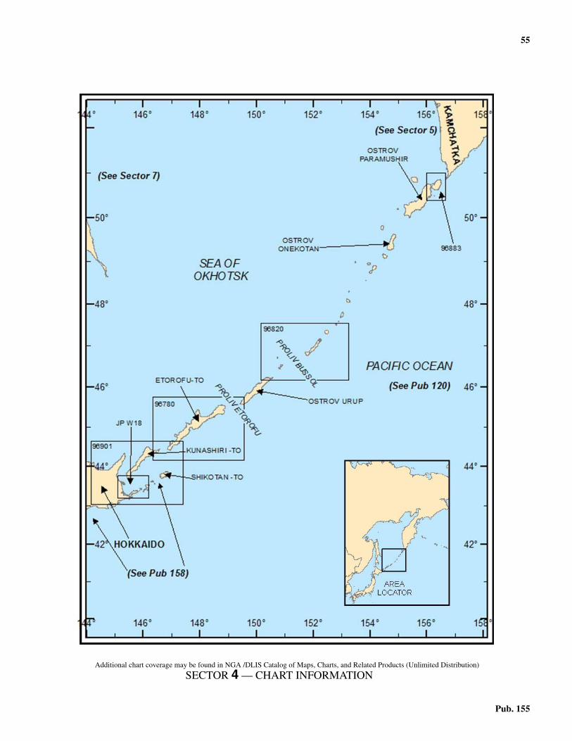
55
Pub. 155
4. Sector 4—The Kuril Islands
4.0Additional chart coverage may be found in NGA /DLIS Catalog of Maps, Charts, and Related Products (Unlimited Distribution)
SECTOR 4 — CHART INFORMATION
57
Pub. 155
SECTOR 4
THE KURIL ISLANDS
4.0 Plan.—This sector describes the islands and straits of theKuril Islands. The arrangement of the sector is from NE to SW.
General Remarks
4.1 Winds—Weather.—At Ostrov Onekotan, NW windslast from September to May or June. In July and August, muchlighter SE winds are prevalent, with the probability of fog.4.1 The mountains of Ostrov Onekotan act as a barrier, and withSW winds there may be a dense fog along the Pacific coast, whilethe opposite coast is clear. For similar reasons, vessels usuallykeep to the NW of the islands when navigating in the vicinity ofthe NE Kuril Islands in summer. Near Ostrov Shumshu strongNW or SE winds are frequent in autumn and winter.4.1 At Reyd Tyatinskiy, from November to March, the period ofNW winds, the weather is mostly part fair. Between March andJune the predominant winds are E, and in summer they are SEwith frequent haze or fog.4.1 The Kuril Islands are subject to the two monsoon seasons.The winter monsoon generally brings NW or W winds, espe-cially predominant from November to February. The summermonsoon produces SE or E winds from June to September. Inall seasons, the winds are variable, strong winds being morefrequent in winter than in summer.4.1 Navigation in the vicinity of the Kuril Islands is generallymade dangerous by prevailing thick weather, principally result-ing from fog and snow and by the proximity of ice. Wintergales are also frequent. The fogs, occurring mostly in summer,may be dense and moist, amounting almost to rain, with ac-companying cloudy skies, or there may be banks of fog extend-ing to heights less than 24m with a cloudless sky above. Thedry fogs usually extend to a considerable height and in calmweather may lift about 24 to 30m above the sea, leaving it per-fectly clear below. When the islands are enveloped in fog, thehigher summits may often be seen when the lower land is com-pletely obscured.4.1 In depths of less than 28m, the presence of thick kelp, whichgrows in masses throughout the islands, may indicate the pres-ence of land. Within 3 miles to the leeward of the islands, sul-fur fumes may be detected. 4.1 Fog is less frequent on the leeward side of the islands. Warn-ing signals are sometimes made by horn or bell from the shoresnear the anchorages. The horns have been audible at a distanceof about 1.5 miles.4.1 Fog is relatively thick and frequent NE of Ostrov Simushir,as compared to the area SW. The thick fogs accompany Ewinds after the latter part of May, becoming almost continuousduring the SE winds of July and August. Their number greatlydiminishes with the beginning of NW winds in September. Af-ter winds and rain, when the weather is changing, the occur-rence of fog frequently decreases for a few days.4.1 Ice.—Drift ice in the Sea of Okhotsk usually approaches theKuril Islands with winds between the N and W, or NE and NW,and leaves with winds between the S and SW, or S and SE.
This condition is more or less reversed on the Pacific Oceancoasts of the chain, where the drift ice arrives with winds be-tween the E and S and is carried away by those from the NW toSW. It is reported that field ice in the Sea of Okhotsk, the E ex-tremity of which has been described as sludge and broken ice,may be encountered approximately 50 to 60 miles W of theKuril Islands during the months of January, February, March,and April.4.1 The drift ice is generally most prevalent on the NW side and inthe SW part of the Kuril Islands. There is comparatively little be-tween Ostrov Urup and Kamchatka, in which area Pervyy Ku-ril'skiy Proliv and Chetvertyy Kuril'skiy Proliv are reported to befree of ice during the entire winter. The N ocean current of the ESea of Okhotsk, running in a counterclockwise direction alongthe NW coasts of the islands, may drive ice from this NE region.There is also less fast ice in the NE part of the chain. Some ice israfted and piled along the W coast of that area, but except for Os-trov Shumshu and Ostrov Paramushir, it is formed principally bysmall floes scattered in places.4.1 At Shibetoro Misaki, on the NW side of Ostrov Iturup (Etoro-fu To), drift ice may be set onto the coast by winds from betweenthe N and W in late January, gradually forming fast ice whichmay extend miles offshore. In the vicinity of Shana, on the samecoast, with NW or W winds, fast ice forming in mid-Januarymay fill the bays by the end of that month, and floes brought bywind and current from the N and NW parts of the Sea of Ok-hotsk have been reported to arrive after the early part of Febru-ary. This latter ice, which is cleared off by the middle of May,occasionally may occupy the coasts and straits over a consider-able area, including Ostrov Kunashir (Kunashiri Shima), OstrovIturup (Etorofu To), and Shikotan To. The floes, 4 to 9m thick,with much of their bulk consisting of snow, pass through the var-ious straits and melt in the Pacific Ocean.4.1 Drift ice arriving in the Kuril Islands area during April andMay appears to be liberated from the fast ice on the E coast ofSakhalin Island N of 50°N, thaws by March, and is later carriedS by wind and current toward the N coasts of Hokkaido. Thefloes are then carried NE by the current flowing along the NWside of the Kuril Islands and continue to the coasts of OstrovIturup, Ostrov Urup, and Ostrov Simushir. Part of this ice passesthrough Proliv Yekateriny (Kunashiri Suido), Proliv Friza (Eto-rofu Kaikyo), and Proliv Urup, reaching the SE side of the chain,after which it is carried away by the S drift of the Oyashio. It isnot encountered after the middle of May.4.1 It is reported that generally field ice does not create hazardsto navigation in the Kuril Islands, but that during and after Jan-uary, vessels should exercise caution because of drift ice. Inwinter, with the exception of certain areas and times, the is-lands are not considered to be icebound for navigational pur-poses. Ice-free anchorages have been reported throughout thechain. Data regarding these and other descriptions of ice in lo-cal areas are given in this sector.4.1 Tides—Currents.—The Kuril Islands are influenced insummer by an extension of the warm Tsushima Current, a
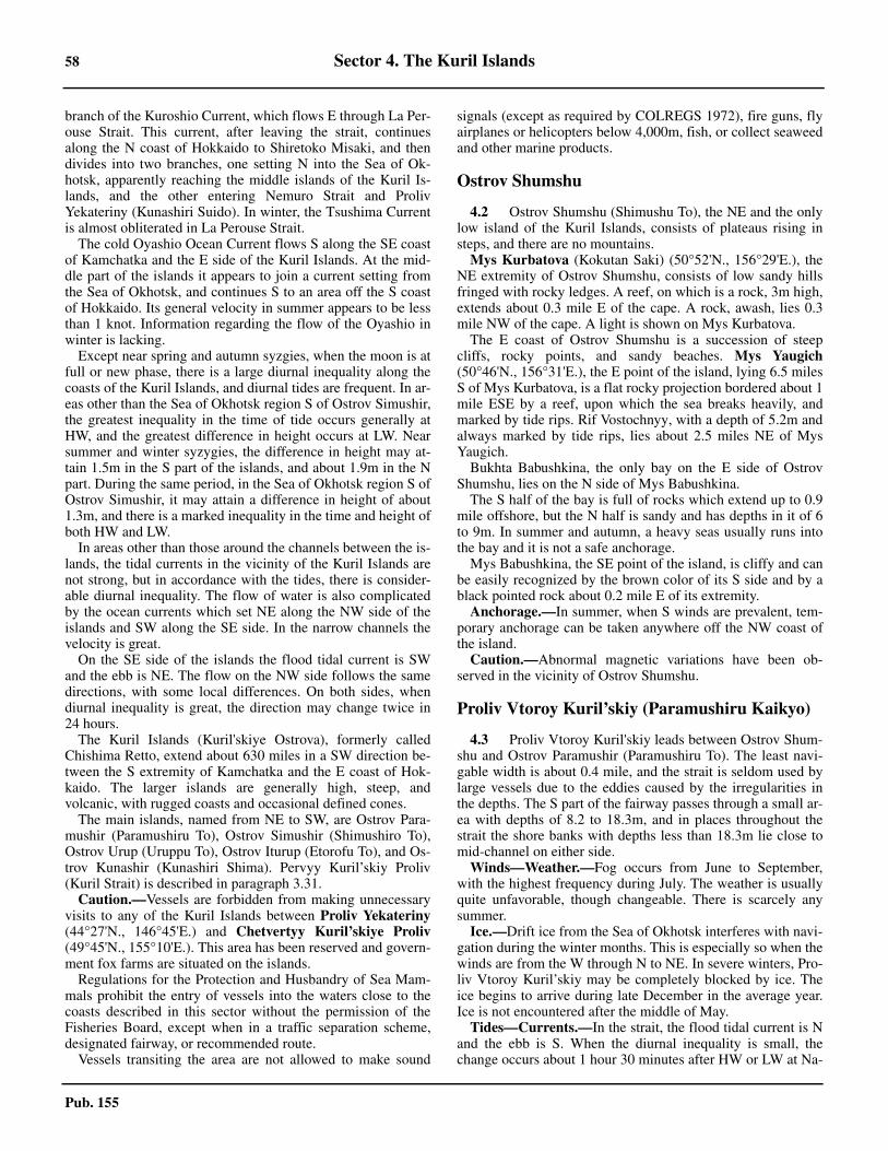
58 Sector 4. The Kuril Islands
Pub. 155
branch of the Kuroshio Current, which flows E through La Per-ouse Strait. This current, after leaving the strait, continuesalong the N coast of Hokkaido to Shiretoko Misaki, and thendivides into two branches, one setting N into the Sea of Ok-hotsk, apparently reaching the middle islands of the Kuril Is-lands, and the other entering Nemuro Strait and ProlivYekateriny (Kunashiri Suido). In winter, the Tsushima Currentis almost obliterated in La Perouse Strait.4.1 The cold Oyashio Ocean Current flows S along the SE coastof Kamchatka and the E side of the Kuril Islands. At the mid-dle part of the islands it appears to join a current setting fromthe Sea of Okhotsk, and continues S to an area off the S coastof Hokkaido. Its general velocity in summer appears to be lessthan 1 knot. Information regarding the flow of the Oyashio inwinter is lacking.4.1 Except near spring and autumn syzgies, when the moon is atfull or new phase, there is a large diurnal inequality along thecoasts of the Kuril Islands, and diurnal tides are frequent. In ar-eas other than the Sea of Okhotsk region S of Ostrov Simushir,the greatest inequality in the time of tide occurs generally atHW, and the greatest difference in height occurs at LW. Nearsummer and winter syzygies, the difference in height may at-tain 1.5m in the S part of the islands, and about 1.9m in the Npart. During the same period, in the Sea of Okhotsk region S ofOstrov Simushir, it may attain a difference in height of about1.3m, and there is a marked inequality in the time and height ofboth HW and LW.4.1 In areas other than those around the channels between the is-lands, the tidal currents in the vicinity of the Kuril Islands arenot strong, but in accordance with the tides, there is consider-able diurnal inequality. The flow of water is also complicatedby the ocean currents which set NE along the NW side of theislands and SW along the SE side. In the narrow channels thevelocity is great.4.1 On the SE side of the islands the flood tidal current is SWand the ebb is NE. The flow on the NW side follows the samedirections, with some local differences. On both sides, whendiurnal inequality is great, the direction may change twice in24 hours.4.1 The Kuril Islands (Kuril'skiye Ostrova), formerly calledChishima Retto, extend about 630 miles in a SW direction be-tween the S extremity of Kamchatka and the E coast of Hok-kaido. The larger islands are generally high, steep, andvolcanic, with rugged coasts and occasional defined cones.4.1 The main islands, named from NE to SW, are Ostrov Para-mushir (Paramushiru To), Ostrov Simushir (Shimushiro To),Ostrov Urup (Uruppu To), Ostrov Iturup (Etorofu To), and Os-trov Kunashir (Kunashiri Shima). Pervyy Kuril’skiy Proliv(Kuril Strait) is described in paragraph 3.31.4.1 Caution.—Vessels are forbidden from making unnecessaryvisits to any of the Kuril Islands between Proliv Yekateriny(44°27'N., 146°45'E.) and Chetvertyy Kuril’skiye Proliv(49°45'N., 155°10'E.). This area has been reserved and govern-ment fox farms are situated on the islands.4.1 Regulations for the Protection and Husbandry of Sea Mam-mals prohibit the entry of vessels into the waters close to thecoasts described in this sector without the permission of theFisheries Board, except when in a traffic separation scheme,designated fairway, or recommended route.4.1 Vessels transiting the area are not allowed to make sound
signals (except as required by COLREGS 1972), fire guns, flyairplanes or helicopters below 4,000m, fish, or collect seaweedand other marine products.
Ostrov Shumshu
4.2 Ostrov Shumshu (Shimushu To), the NE and the onlylow island of the Kuril Islands, consists of plateaus rising insteps, and there are no mountains.4.2 Mys Kurbatova (Kokutan Saki) (50°52'N., 156°29'E.), theNE extremity of Ostrov Shumshu, consists of low sandy hillsfringed with rocky ledges. A reef, on which is a rock, 3m high,extends about 0.3 mile E of the cape. A rock, awash, lies 0.3mile NW of the cape. A light is shown on Mys Kurbatova. 4.2 The E coast of Ostrov Shumshu is a succession of steepcliffs, rocky points, and sandy beaches. Mys Yaugich(50°46'N., 156°31'E.), the E point of the island, lying 6.5 milesS of Mys Kurbatova, is a flat rocky projection bordered about 1mile ESE by a reef, upon which the sea breaks heavily, andmarked by tide rips. Rif Vostochnyy, with a depth of 5.2m andalways marked by tide rips, lies about 2.5 miles NE of MysYaugich.4.2 Bukhta Babushkina, the only bay on the E side of OstrovShumshu, lies on the N side of Mys Babushkina.4.2 The S half of the bay is full of rocks which extend up to 0.9mile offshore, but the N half is sandy and has depths in it of 6to 9m. In summer and autumn, a heavy seas usually runs intothe bay and it is not a safe anchorage.4.2 Mys Babushkina, the SE point of the island, is cliffy and canbe easily recognized by the brown color of its S side and by ablack pointed rock about 0.2 mile E of its extremity.4.2 Anchorage.—In summer, when S winds are prevalent, tem-porary anchorage can be taken anywhere off the NW coast ofthe island.4.2 Caution.—Abnormal magnetic variations have been ob-served in the vicinity of Ostrov Shumshu.
Proliv Vtoroy Kuril’skiy (Paramushiru Kaikyo)
4.3 Proliv Vtoroy Kuril'skiy leads between Ostrov Shum-shu and Ostrov Paramushir (Paramushiru To). The least navi-gable width is about 0.4 mile, and the strait is seldom used bylarge vessels due to the eddies caused by the irregularities inthe depths. The S part of the fairway passes through a small ar-ea with depths of 8.2 to 18.3m, and in places throughout thestrait the shore banks with depths less than 18.3m lie close tomid-channel on either side.4.3 Winds—Weather.—Fog occurs from June to September,with the highest frequency during July. The weather is usuallyquite unfavorable, though changeable. There is scarcely anysummer.4.3 Ice.—Drift ice from the Sea of Okhotsk interferes with navi-gation during the winter months. This is especially so when thewinds are from the W through N to NE. In severe winters, Pro-liv Vtoroy Kuril’skiy may be completely blocked by ice. Theice begins to arrive during late December in the average year.Ice is not encountered after the middle of May.4.3 Tides—Currents.—In the strait, the flood tidal current is Nand the ebb is S. When the diurnal inequality is small, thechange occurs about 1 hour 30 minutes after HW or LW at Na-
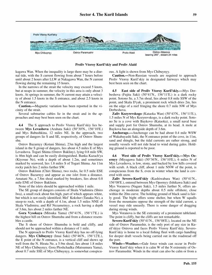
Sector 4. The Kuril Islands 59
Pub. 155
kagawa Wan. When the inequality is large there may be a diur-nal tide, with the S current flowing from about 7 hours beforeuntil about 2 hours after LLW at Nakagawa Wan, the N currentflowing during the remaining 15 hours.4.3 In the narrows of the strait the velocity may exceed 5 knots,but at neaps in summer, the velocity in this area is only about 3knots. At springs in summer, the N current may attain a veloci-ty of about 1.5 knots in the S entrance, and about 2.5 knots inthe N entrance.4.3 Caution.—Magnetic variation has been reported in the vi-cinity of the strait.4.3 Several submarine cables lie in the strait and in the ap-proaches and may best been seen on the chart.
4.4 The S approach to Proliv Vtoroy Kuril’skiy lies be-tween Mys Levashova (Arahata Saki) (50°30'N., 156°10'E.)and Mys Babushkina, 12 miles NE. In the approach, twogroups of dangers lie S and SE, respectively, of Ostrov Shum-shu.4.4 Ostrov Bazarnyy (Kotani Shima), 23m high and the largestisland in the S group of dangers, lies about 4.5 miles E of MysLevashova. Togari Shima (Ostrov Bakliny), lying 0.8 mile SW,is 46m high and can be easily distinguished. Banka Kazach'ya(Kiyosue Ne), with a depth of about 1.2m, and sometimesmarked by seaweed, lies 1.8 miles S of Togari Shima. An 11mrocky patch lies 2 miles farther SW. 4.4 Ostrov Baklinin (Chiri Shima), two rocks, lie 0.5 mile ESEof Ostrov Bazarnyy and appear as one islet from a distance.Amatani Ne, a 7.8m shoal marked by breakers, lies about 0.8mile ENE of Ostrov Baklinin.4.4 None of the islets should be approached within 1 mile.4.4 The SE group of dangers consists of Skala Vladimira (ShiroIwa), a small rock about 6m high, part of which appears white,but which is not easily identified; Mel’ Koksher (Tanaka Ne), asteep-to rock, with a depth of 4.1m, about 1.5 miles NNE ofSkala Vladimira; and Rif Nezametnyy, a rock having a depthof 3.6m, lies about 2 miles farther NE.4.4 Gora Vysokaya (Mitsuka Yama) (50°41'N., 156°17'E.) isthe highest hill on Ostrov Shumshu and from a distance resem-bles a castle.4.4 The S shore of Ostrov Shumshu is bold and cliffy, andshould not be approached within a distance of 1 mile.4.4 The N approach to Proliv Vtoroy Kuril'skiy has no off-lyingdangers. Mys Chibuynyy (Imai Saki) (50°46'N., 156°12'E.),the E point of the N entrance, is a vertical cliff and shows upwell from the N. Hirata Ne, a 5.9m shoal, lies about 1.8 milesNE of Mys Chibuynyy. Gora Ploshchadka (Matsumura Yama),about 0.7 mile SSE of Mys Chibuynyy, is somewhat conspicu-
ous. A light is shown from Mys Chibuynyy. 4.4 Caution.—Non-Russian vessels are required to approachProliv Vtoroy Kuril’skiy in designated fairways which maybest been seen on the chart.
4.5 East side of Proliv Vtoroy Kuril’skiy.—Mys Der-beshova (Fujita Saki) (50°41'N., 156°11'E.) is a dark rockypoint. Sotono Se, a 3.7m shoal, lies about 0.8 mile SSW of thepoint, and Skala D'yak, a prominent rock which dries 2m, lieson the edge of a reef fringing the shore 0.7 mile NW of MysDerbeshova.4.5 Zaliv Kozyrevskogo (Kataoka Wan) (50°43'N., 156°11'E.),1.5 miles N of Mys Kozyrevskogo, is a dark rocky point. Soto-no Se is a cove with Baykovo (Kataoka), a small naval baseand supply port for Ostrov Shumshu, at its head. A mole atBaykova has an alongside depth of 3.6m.4.5 Anchorage.—Anchorage can be had about 0.4 mile WSWof Wakabayashi Saki, the N entrance point of the cove, in 11m,sand and shingle, but the tidal currents are rather strong, andusually vessels will not ride head to wind during gales. Hold-ing ground is reported to be poor.
4.6 West side of Proliv Vtoroy Kuril'skiy.—Mys Oz-ernyy (Miyagawa Saki) (50°36'N., 156°10'E.), 6 miles N ofMys Levashova, is low, stony, and backed by low hills coveredwith scrub. A black cliff, about 1 mile NNW of the point, isconspicuous from the S, even in winter when the land is cov-ered with snow.4.6 Zaliv Severo-Kuril'skiy (Kashiwabara Wan) (50°41'N.,156°08'E.), entered between Mys Opornyy (Ishikawa Saki) andMys Voranova (Nagare Saki), 1.5 miles further N, offers an-chorage in moderate depths about 0.5 mile offshore, closewithin the 20m curve. The holding ground of black sand is fair-ly good. The bight offers some shelter, but when W squallsfrom the mountains oppose the strength of the tidal current, avessel may ride uneasily. There is some danger of draggingduring strong winds.4.6 Mys Voranova is the SE extremity of a prominent tableland.The point is cliffy, but the cliffs are not remarkable.4.6 Severo-Kuril'skiy (50°41'N., 156°08'E.), located on the NEside of Ostrov Paramushir, is the only port of any size in Ku-ril’skiye Ostrova and faces Proliv Vtoroy Kuril’skiy. Severo-Kuril’skiy is home to a local fishing fleet with cargo handlingfor deeper draft vessels being carried out in the roadstead offthe port. 4.6 Winds—Weather.—Gale force winds can occur in ProlivVtoroy Kuril’skiy when it is calm W of the N extremity of Os-trov Paramushir. Winds in the strait can also be calm or from a
Proliv Vtoroy Kuril’skiy and Proliv Alaid
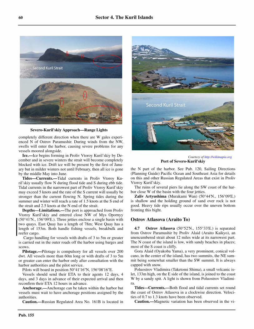
60 Sector 4. The Kuril Islands
Pub. 155
completely different direction when there are W gales experi-enced N of Ostrov Paramushir. During winds from the NW,swells will enter the harbor, causing severe problems for anyvessels moored alongside. 4.6 Ice.—Ice begins forming in Proliv Vtoroy Kuril’skiy by De-cember and in severe winters the strait will become completelyblocked with ice. Drift ice will be present by the first of Janu-ary but in milder winters not until February, then all ice is goneby the middle May into June. 4.6 Tides—Currents.—Tidal currents in Proliv Vtoroy Ku-ril’skiy usually flow N during flood tide and S during ebb tide.Tidal currents in the narrowest part of Proliv Vtoroy Kuril’skiymay exceed 5 knots and the rate of the S current will usually bestronger than the current flowing N. Spring tides during thesummer and winter will reach a rate of 1.5 knots at the S end ofthe strait and 2.5 knots at the N end of the strait. 4.6 Depths—Limitations.—The port is approached from ProlivVtoroy Kuril’skiy and entered close NW of Mys Opornyy(50°41'N., 156°09'E.). Three jetties enclose a single basin withtwo quays. East Quay has a length of 78m; West Quay has alength of 153m. Both handle fishing vessels, breakbulk andreefer cargo. 4.6 Cargo handling for vessels with drafts of 3 to 5m or greateris carried out in the outer roads off the harbor using barges andscows. 4.6 Pilotage.—Pilotage is compulsory for all vessels over 200dwt. All vessels more than 60m long or with drafts of 3 to 5mor greater can enter the harbor only after consultation with theharbor authorities and the pilot service. 4.6 Pilots will board in position 50°41'16''N, 156°08'16''E. 4.6 Vessels should send their ETA to their agents 12 days, 4days, and 3 days in advance of their expected arrival and thenreconfirm their ETA 12 hours in advance. 4.6 Anchorage.—Anchorage can be taken within the harbor butvessels must wait to have anchorage positions assigned by theauthorities. 4.6 Caution.—Russian Regulated Area No. 161B is located in
the N part of the harbor. See Pub. 120, Sailing Directions(Planning Guide) Pacific Ocean and Southeast Asia for detailson this and other Russian Regulated Areas that exist in ProlivVtoroy Kuril’skiy. 4.6 The ruins of several piers lie along the SW coast of the har-bor close W of the basin with the four jetties. 4.6 Zaliv Artyushima (Murakami Wan) (50°44'N., 156°09'E.)is shallow and the holding ground of sand over rock is notgood. Heavy tide rips usually occur over the uneven bottomfronting this bight.
Ostrov Atlasova (Araito To)
4.7 Ostrov Atlasova (50°52'N., 155°33'E.) is separatedfrom Ostrov Paramushir by Proliv Alaid (Araito Kaikyo), anunencumbered strait about 12 miles wide at its narrowest part.The N coast of the island is low, with sandy beaches in places;most of the S coast is cliffy.4.7 Gora Alaid (Oyakoba Yama), a very prominent, conical vol-cano, in the center of the island, has two summits, the NE sum-mit being somewhat smaller than the SW summit. It is alwayscapped with snow.4.7 Poluostrov Vladimira (Taketomi Shima), a small volcanic is-let, 133m high, on the E side of the island, is joined to the coastW by a sandy spit. A light is shown from Poluostrov Vladimi-ra.4.7 Tides—Currents.—Both flood and tidal currents set roundthe coast of Ostrov Atlasova in a clockwise direction. Veloci-ties of 0.7 to 1.3 knots have been observed.4.7 Caution.—Magnetic variation has been observed in the vi-
Severo-Kuril'skiy Approach—Range Lights
Courtesy of http://wikimapia.org
Port of Severo-Kuril'skiy
Sector 4. The Kuril Islands 61
Pub. 155
cinity of Ostrov Atlasova.
Ostrov Paramushir
4.8 Ostrov Paramushir, the largest island in the N part ofthe Kuril Islands, has a string of mountain ranges surmountedby conspicuous peaks. The coasts of the island are largelycliffy and rock-strewn. Foul bottom extends about 2 miles offthe SE side in places. Off the NW side, which is especiallybold and rugged, there are no dangers at a distance greater than1 mile.4.8 Winds—Weather.—Ostrov Paramushir has strong W windsfrom the end of October through April. In July and August, Ewinds are most prevalent, but in Bukhta Shelikhova, on theNW coast, there is the likelihood of ESE winds between Apriland July, and of NW winds in August and September.4.8 Caution.—In summer, large fishing nets, buoyed andmarked, but sometimes unlighted at night, may be encounteredextending as far as 4 miles offshore, in the vicinity of OstrovParamushir and Ostrov Shumshu. Motor drifters, with nets asmuch as 3 miles in length, may be encountered farther off-shore.4.8 Abnormal magnetic variation has been observed in the vicin-ity of the island.4.8 The Russian authorities have stated that navigation is prohib-ited within the coastal waters along the S and W coasts of Os-trov Paramushir between Mys Ozernyy and Mys Neproy-dennyy (50°17'N., 155°12'E.).
4.9 Southeast side of Ostrov Paramushir.—Mys Rifo-vyy (Tomari Saki) (50°29'N., 156°08'E.) is a gravelly point ly-ing 2 miles SW of Mys Levashova. Rif Izmony (Tomari Se), arock with a depth of less than 1.8m, lies about 1 mile SE of thepoint. Ostrov Chaykina (Kamone Shima), about 1.5 miles SWof Mys Rifovyy, is a group of rocky islets. The NE and highestislet is 15m high. The islets should not be approached tooclosely as there are sunken rocks in the area.4.9 Mys Uglevoy (Mamiya Saki) (50°24'N., 156°01'E.), 6.5miles SW of Mys Rifovyy, is fronted by foul ground extendingabout 0.5 mile E. Several above-water rocks lie on this foulground, the E being Skala Opasnaya (Matsutake Iwa), shapedlike a mushroom and conspicuous from the S. Ostrov Chernyy(Hira Iwa), a black rock, lies about 0.6 miles offshore, and 2.2miles N of Mys Uglevoy.
Zaliv Puyshariya (Asahi Wan), between Mys Rifovyy andMys Uglevoy, affords anchorage with some shelter from SEswells in 18m, about 0.8 mile W of Ostrov Chaykina. The bayis not safe during S or E winds. A rock, formerly Mukai Ne,with a depth of 5.5m, and marked by breakers, lies 1.2 milesoffshore, about 1.5 miles SSE of Mys Uglevoy.4.9 Bukhta Rifovaya, a small bay on the W side of Mys Rifovyy,affords temporary anchorage sheltered from all winds exceptthose from between the S and W, to small vessels. Localknowledge is required and care is necessary to avoid a rock,with a depth of 1.8m, lying 0.4 mile offshore, 0.6 mile W ofMys Rifovyy.4.9 A recommended berth is situated in a depth of 16m, sand,0.5 mile E of the NE islet of Rif Izmony, having regard to thedangers (Tomari Se) lying 0.4 mile NE of this berth. The berthis not suitable with a wind or swell from the S.
4.9 Landing is possible only at HW, in Bukhta Rifovaya, whichhas a beach of shingle fringed with rocks on which the seabreaks.
4.10 Mys Kokina (Tatsukami Saki) (50°11'N., 155°48'E.),about 16 miles SW of Mys Uglevoy, is a narrow prominenttongue of land, 26m high, fringed with a rocky ledge coveredwith seaweed and marked by breakers. Ostrov Bazarnyy, along, flat, detached rock, lies about 1.8 miles E of the point.Foul ground extends 1.3 miles off the coast between Mys Koki-na and Maru Hana, about 1.7 miles WSW.4.10 Tides—Currents.—The tidal currents appear to meet in thevicinity of Mys Kokina. The flood tidal current NE of the pointsets to the N or E, and the ebb in an opposite direction, themaximum velocity being around 1 knot. The flood tidal currentSW of the point sets SW and the ebb NE.
Bukhta Okeanskaya (Suribachi Wan) (50°11'N.,155°44'E.), a small fishing harbor, has a rocky bottom and itsentrance is encumbered by ledges and thick growths of kelp.Some fishing and canning stations, with prominent chimneysand two radio masts, are situated on the E shore of the bay.4.10 Yaokuri Saki (50°11'N., 155°39'E.), prominent and cliffy, isbacked by a hill with a red summit. A reef, parts of which un-cover and is always marked by breakers, extends about 0.8mile SSW of the point.4.10 Zaliv Tukharka (Otomae Wan), close W of Yaokuri Saki, af-fords protection from the SW through N to NE winds. The Epart of the bay is somewhat protected by the reef extendingSSW from Yaokuri Saki. Parts of this reef are above-water andit is always marked by breakers.4.10 Anchorage.—Anchorage, good holding ground, fine sand,is available between the 10m and 20m curves. Approach to theanchorage should be made with Otomae Yama, the hill on theE side of the mouth of the river at the head of the bay, bearing000°, and then anchoring in a depth of 12.8m. 4.10 Anchorage can also be obtained, in about 20m, with the hillbacking Yaokuri Saki bearing 030°, distant about 1.5 miles.
4.11 Okino Shima (Ostrov Dym) (50°09'N., 155°34'E.) isconspicuous. Rocks, sometimes marked by breakers, withdepths of 5m or less, lie 0.5 mile SW and 0.3 mile E of the is-let.4.11 Mys Vasil’yeva (50°00'N., 155°23'E.), lying 11 miles SSWof Ostrov Dym, is the S extremity of Ostrov Paramushir. It liesat the S end of a low, marshy cape, fringed with foul ground.Chidoriga Iwa, consisting of three rock heads which dry 1.5mand are marked by breakers, lies about 1.5 miles ESE of MysVasil’yeva, and is the outermost danger on this side of thepoint. Rakko Iwa, a rock, lies near the extremity of a rockyreef, covered with seaweed and extending about 0.6 mile SWof Mys Vasil’yeva. A light is shown from Mys Vasil’yeva. 4.11 Tides—Currents.—Near Mys Vasil’yeva the flood tidalcurrent is W, with a velocity that may attain more than 3 knots.The ebb tidal current sets E with a velocity of about 1 knot, al-though the ebb current is usually neutralized by an opposingcurrent, and frequently there is a continuous W current.4.11 Anchorage.—Zaliv Vasil’yeva (Musashi Wan), entered Wof Mys Vasil’yeva, affords protection from N and E winds.Good anchorage can be taken about 1 mile W of the town ofKharitonovka (Raishi), on the E side of the bay, in depths of
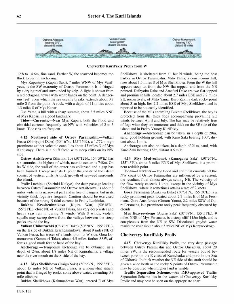
62 Sector 4. The Kuril Islands
Pub. 155
12.8 to 14.6m, fine sand. Farther W, the seaweed becomes toothick to permit anchoring.4.11 Mys Kapustnyy (Kapari Saki), 7 miles WNW of Mys Vasil’yeva, is the SW extremity of Ostrov Paramushir. It is fringedby a drying reef and surrounded by kelp. A light is shown froma red octagonal tower with white bands on the point. A danger-ous reef, upon which the sea usually breaks, extends about 0.7mile S from the point. A rock, with a depth of 11m, lies about1.3 miles S of Mys Kapari.4.11 Ose Yama, a hill with a sharp summit, about 3.5 miles NNEof Mys Kapari, is a good landmark.4.11 Tides—Currents.—Near Mys Kapari, both the flood andebb tidal currents frequently set NW with velocities of 2 to 3knots. Tide rips are frequent.
4.12 Northwest side of Ostrov Paramushir.—VulkanFussa (Shiriyajiri Dake) (50°16'N., 155°15'E.), a 1,772m highprominent extinct volcanic cone, lies about 13 miles N of MysKapustnyy. There is a bluff faced with steep cliffs on its NWside.4.12 Ostrov Antsiferova (Shirinki To) (50°12'N., 154°59'E.) hassix summits, the highest of which, near its center, is 748m. Onits W side, the wall of the crater has collapsed and a gap hasbeen formed. Except near its E point the coasts of the islandconsist of vertical cliffs. A thick growth of seaweed surroundsthe island.4.12 Proliv Luzhinka (Shirinki Kaikyo), the deep passage leadingbetween Ostrov Paramushir and Ostrov Antsiferova, is about 8miles wide in its narrowest part and is free of dangers, but in itsvicinity thick fogs are frequent. Caution should be exercisedbecause of the strong N tidal currents in Proliv Luzhinka.4.12 Bukhta Krasheninnikova (Kujira Wan) (50°18'N.,155°21'E.), close NE of Vulkan Fussa, has very deep water andheavy seas run in during N winds. With S winds, violentsqualls may sweep down from the valleys between the steeppeaks around the bay.4.12 Vulkan Chikurachki (Chikura Dake) (50°20'N., 155°27'E.),on the E side of Bukhta Krasheninnikova, about 9 miles NE ofVulkan Fussa, has traces of a landslip on its W side. Gora Lo-monosova (Kammuri Take), about 4.5 miles farther SSW, af-fords a good mark for the head of the bay.4.12 Anchorage.—Temporary anchorage can be obtained, in adepth of 24m, about 1.8 miles NE of Kujirahama, a villagenear the river mouth on the S side of the bay.
4.13 Mys Shelikhova (Daigo Saki) (50°23'N., 155°35'E.),about 15 miles NE of Vulkan Fussa, is a somewhat salientpoint that is fringed by rocks, some above-water, extending 0.3mile offshore.4.13 Bukhta Shelikhova (Kakumabetsu Wan), entered E of Mys
Shelikhova, is sheltered from all but N winds, being the bestharbor in Ostrov Paramushir. Mito Yama, a conspicuous hill,rises about 1.5 miles S of Mys Shelikhova. From the W the hillappears steep-to, from the NW flat-topped, and from the NEpointed. Daibyobu Dake and Amefuri Dake are two flat-toppedand prominent hills located about 2.7 miles ESE and 2.2 milesSE, respectively, of Mito Yama. Kuro Zaki, a dark rocky pointabout 31m high, lies 2.2 miles ESE of Mys Shelikhova and isreported to be not easily identified.4.13 Because of the hills encircling Bukhta Shelikhova, the bay isprotected from the thick fogs accompanying prevailing SEwinds between April and July. The bay may be relatively freeof fogs when they are numerous and thick on the SE side of theisland and in Proliv Vtoroy Kuril’skiy.4.13 Anchorage.—Anchorage can be taken, in a depth of 20m,sand, good holding ground, with Kuro Saki bearing 100°, dis-tant about 1 mile. 4.13 Anchorage can also be taken, in a depth of 21m, sand, withKuro Zaki bearing 158°, distant 0.6 mile.
4.14 Mys Medvezhonok (Kamogawa Saki) (50°26'N.,155°43'E.), about 6 miles ENE of Mys Shelikova, is a promi-nent reddish point.4.14 Tides—Currents.—The flood and ebb tidal currents off theNW coast of Ostrov Paramushir are influenced by a current,the resultant flow almost always setting NE. The velocity ofthe flow rarely exceeds 1 knot, except in the vicinity of MysShelikhova, where it sometimes attains a rate of 2 knots.4.14 Gora Fersmana (Arakawa Dake) (50°31'N., 155°30'E.) is arocky prominent peak located about 2.7 miles E of Mys Fers-mana. Gora Antsiferova (Omaru Yama), 2.2 miles SSW of Go-ra Fersmana, is a prominent rocky peak frequently obscured byclouds.4.14 Mys Kozyrevskogo (Araise Saki) (50°39'N., 155°51'E.), 9miles NNE of Mys Fersmana, is a steep cliff 115m high, and isconspicuous from the NE or SW. Discolored grayish watermarks the river mouth about 5 miles NE of Mys Kozyrevskogo.
Chetvertyy Kuril’skiy Proliv
4.15 Chetvertyy Kuril’skiy Proliv, the very deep passagebetween Ostrov Paramushir and Ostrov Onekotan, about 29miles SW, is the recommended route for vessels bound be-tween ports on the E coast of Kamchatka and ports in the Seaof Okhotsk. In thick weather the NE side of the strait should begiven a wide berth as the rocky S points of Ostrov Paramushirmay be obscured when higher land is visible.4.15 Traffic Separation Scheme.—An IMO-approved TrafficSeparation Scheme lies in the waters of Chetvertyy Kuril’skyProliv and may best be seen on the appropriate chart.
Chetvertyy Kuril’skiy Proliv from W
Sector 4. The Kuril Islands 63
Pub. 155
4.15 Tides—Currents.—In Chetvertyy Kuril’skiy Proliv, theflood tidal current sets WNW and the ebb flows in an oppositedirection. The velocity of the tidal currents may exceed 2knots.
4.16 Ostrov Makanrushi (Makanru To) (49°47'N.,154°26'E.), a volcanic island, lies on the SW side of Chetver-tyy Kuril’skiy Proliv. The NE and S shores of the island consistof gravel beaches with low hills rising close inland. The othercoastal sections of the island consist of high cliffs with a steepand narrow beach at their foot.4.16 Tides—Currents.—Off the W and N sides of OstrovMakanrushi, the flood tidal current flows N and the ebb flowsS or E. Off the E side of the island, the flood is S and ebb is N.The velocity seldom exceeds 1 knot.4.16 Anchorage.—Anchorage is available off the coves on theSE and W sides of the island, in depths of less than 37m, about0.8 mile offshore.4.16 Caution.—Abnormal magnetic variation has been observedin Chetvertyy Kuril'skiy Proliv and in the vicinity of OstrovMakanrushi.4.16 Skala Avos’ (Kamen’ Avos) (Hokake Iwa), about 13 milesWSW of the summit of Ostrov Makanrushi, is a bare gray tri-angular rock, 35m high, resembling a vessel under sail. Foursmall rocks lie close E and NE of it. A reef, covered with sea-weed, extends about 0.5 mile NE of Kamen Avos’. A rock,which dries 0.6m, lies at the end of the reef.4.16 The group is steep-to and is frequented by birds and sea li-ons.
Islands and Passages between Chetvertyy Kuril’ skiy Proliv and Proliv Kruzenshterna
4.17 Ostrov Onekotan (Onnekotan To) (49°25'N.,154°45'E.) has bold and cliffy coasts. There is a great amountof vegetation, but no tall trees. The 10m curve lies up to 1.5miles off the salient points of the island.4.17 Gora Krenitsyna (Kuroishi Yama) (49°21'N., 154°42'E.),the highest mountain in the S part of the island, is a conspicu-ous volcanic cone rising from the center of a lake. 4.17 Vulkan Nemo (Nemo Yama) (49°34'N., 154°49'E.), thehighest mountain in the N part of the island, is an active volca-no, emitting smoke from its SE side.4.17 Mys Kimberley (Kimpei Masaki) (49°38'N., 154°49'E.), theNW point of the island, is fringed with a kelp-covered reef ex-tending about 0.3 mile NW.4.17 Mys Ivan-Malyy (Kinto Zaki), the NE point of the island,lies 4 miles ESE of Mys Kimberly, and has a conspicuous, de-tached rock, close E of it.4.17 Bukhta Vlakiston (Kuroishi Wan), the open roadstead nearthe middle of the E side of the island, offers anchorage duringW winds, in depths of 18.3 to 28m, sand bottom. Westerlysqualls sometimes descend the valley at the head of the bay andcan be avoided by anchoring in the N part of the roadstead.Mys Mussel’ is the S entrance point of Bukhta Vlakiston.4.17 Gora Shestakova (Yencho Zan) (49°29'N., 154°44'E.), around-topped mountain, appears sharp from the SW.4.17 Anchorage.—Bukhta Nemo (Nemo Wan), on the N end ofthe W side of Ostrov Onekotan, close S of Mys Kimberley, of-fers good anchorage, protected from the swell which accompa-
nies the SE wind of summer, in depths of 18.3 to 27m, goodholding ground of sand.4.17 Good holding ground, can be taken in a depth of 29m, withVulkan Nemo bearing 167° and Mys Kimberley bearing 038°.In Bukhta Nemo the tidal current sets SW during the flood tideand NE on the ebb, the maximum velocity being not more than0.8 knot. These tidal currents are believed to be the countercur-rent of those farther out.
4.18 Proliv Krenitsyna (Harumukotan Kaikyo), the chan-nel between Ostrov Onekotan and Ostrov Kharimkotan (Haru-mukotan To), has a width of 7.5 miles between the 10m curvesextending from the NE and SW shores.4.18 Tides—Currents.—In Proliv Krenitsyna, the flood tidalcurrent sets NW and the ebb SE, but they are influenced byocean currents. The NW current is stronger, especially in sum-mer, and is accompanied by tide rips and eddies. Velocities of2.5 knots in the middle of the strait, and of 4 knots on its SWside, have been experienced.
Ostrov Kharimkotan (Harumukotan To) (49°07'N.,154°31'E.) has its summit, Vulkan Severgina (HarumukotanDake), in the form of a double truncated dome which appearsbell-shaped from a distance.4.18 A hill, 488m high, and a domed-shaped mountain, 713mhigh, are located 1 mile NNW and 1 mile NNE, respectively, ofthe volcano. A plateau of deep purple lava is located close tothe NE coast in this vicinity. The NW part of the island consistsof low sand hills, with several small ponds and a lake.4.18 Tides—Currents.—Heavy tide rips are formed off the S ex-tremity of the island; a NW current with a rate of 6 knots hasbeen experienced.4.18 Anchorage.—Anchorage can be taken in the bight E of theN extremity of the island, sheltered from S winds, by vesselswith local knowledge, in poor holding ground.4.18 Caution.—The shape and heights of Ostrov Kharimkotanwere reported to have changed considerably because of thegreat volcanic eruption on it. Caution should be used in the vi-cinity of the island, and when approaching the anchorage, as itis probable that changes have occurred in the surroundingdepths.
4.19 Proliv Severgina, about 16 miles wide at its narrowestpart, leads between Ostrov Kharimkotan and the N sides of OstrovShiashkotan (Shasukotan To) and Ostrov Ekarma (Yekaruma To).4.19 Tides—Currents.—In Proliv Severgina, the flood tidal cur-rent sets WNW and the ebb sets ESE. Observations made insummer indicate that in mid-channel the N current seldom ex-ceeds a velocity of 2 knots, but the strength increases towardthe coasts on either side and may attain 5 or 6 knots off OstrovKharimkotan and Ostrov Shiashkotan. Tide rips occur nearboth of these islands.
Ostrov Shiashkotan (Shasukotan To) (48°51'N., 154°10'E.)consists of two mountainous parts connected by a narrow isth-mus about 90 to 152m high. The island has rugged coastsfringed with rocky ledges and seaweed in most sections.4.19 The summit of the island rises in the NE part. Kuro Dake,about 1 mile N of the summit, is a dark flat-topped mountain,steep on all sides. Close SW of Kuro Dake, nearly in the mid-dle of the NE part of the island, is a sharp brown peak.4.19 The summit of the SW part of the island, about 1 mile NNE
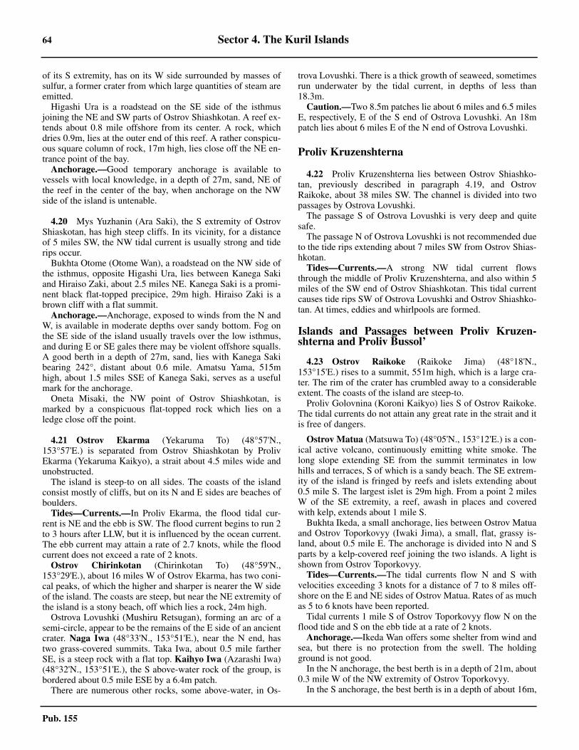
64 Sector 4. The Kuril Islands
Pub. 155
of its S extremity, has on its W side surrounded by masses ofsulfur, a former crater from which large quantities of steam areemitted.4.19 Higashi Ura is a roadstead on the SE side of the isthmusjoining the NE and SW parts of Ostrov Shiashkotan. A reef ex-tends about 0.8 mile offshore from its center. A rock, whichdries 0.9m, lies at the outer end of this reef. A rather conspicu-ous square column of rock, 17m high, lies close off the NE en-trance point of the bay. 4.19 Anchorage.—Good temporary anchorage is available tovessels with local knowledge, in a depth of 27m, sand, NE ofthe reef in the center of the bay, when anchorage on the NWside of the island is untenable.
4.20 Mys Yuzhanin (Ara Saki), the S extremity of OstrovShiaskotan, has high steep cliffs. In its vicinity, for a distanceof 5 miles SW, the NW tidal current is usually strong and tiderips occur.4.20 Bukhta Otome (Otome Wan), a roadstead on the NW side ofthe isthmus, opposite Higashi Ura, lies between Kanega Sakiand Hiraiso Zaki, about 2.5 miles NE. Kanega Saki is a promi-nent black flat-topped precipice, 29m high. Hiraiso Zaki is abrown cliff with a flat summit.4.20 Anchorage.—Anchorage, exposed to winds from the N andW, is available in moderate depths over sandy bottom. Fog onthe SE side of the island usually travels over the low isthmus,and during E or SE gales there may be violent offshore squalls.A good berth in a depth of 27m, sand, lies with Kanega Sakibearing 242°, distant about 0.6 mile. Amatsu Yama, 515mhigh, about 1.5 miles SSE of Kanega Saki, serves as a usefulmark for the anchorage.4.20 Oneta Misaki, the NW point of Ostrov Shiashkotan, ismarked by a conspicuous flat-topped rock which lies on aledge close off the point.
4.21 Ostrov Ekarma (Yekaruma To) (48°57'N.,153°57'E.) is separated from Ostrov Shiashkotan by ProlivEkarma (Yekaruma Kaikyo), a strait about 4.5 miles wide andunobstructed.4.21 The island is steep-to on all sides. The coasts of the islandconsist mostly of cliffs, but on its N and E sides are beaches ofboulders.4.21 Tides—Currents.—In Proliv Ekarma, the flood tidal cur-rent is NE and the ebb is SW. The flood current begins to run 2to 3 hours after LLW, but it is influenced by the ocean current.The ebb current may attain a rate of 2.7 knots, while the floodcurrent does not exceed a rate of 2 knots.
Ostrov Chirinkotan (Chirinkotan To) (48°59'N.,153°29'E.), about 16 miles W of Ostrov Ekarma, has two coni-cal peaks, of which the higher and sharper is nearer the W sideof the island. The coasts are steep, but near the NE extremity ofthe island is a stony beach, off which lies a rock, 24m high.4.21 Ostrova Lovushki (Mushiru Retsugan), forming an arc of asemi-circle, appear to be the remains of the E side of an ancientcrater. Naga Iwa (48°33'N., 153°51'E.), near the N end, hastwo grass-covered summits. Taka Iwa, about 0.5 mile fartherSE, is a steep rock with a flat top. Kaihyo Iwa (Azarashi Iwa)(48°32'N., 153°51'E.), the S above-water rock of the group, isbordered about 0.5 mile ESE by a 6.4m patch.4.21 There are numerous other rocks, some above-water, in Os-
trova Lovushki. There is a thick growth of seaweed, sometimesrun underwater by the tidal current, in depths of less than18.3m.4.21 Caution.—Two 8.5m patches lie about 6 miles and 6.5 milesE, respectively, E of the S end of Ostrova Lovushki. An 18mpatch lies about 6 miles E of the N end of Ostrova Lovushki.
Proliv Kruzenshterna
4.22 Proliv Kruzenshterna lies between Ostrov Shiashko-tan, previously described in paragraph 4.19, and OstrovRaikoke, about 38 miles SW. The channel is divided into twopassages by Ostrova Lovushki.4.22 The passage S of Ostrova Lovushki is very deep and quitesafe.4.22 The passage N of Ostrova Lovushki is not recommended dueto the tide rips extending about 7 miles SW from Ostrov Shias-hkotan.4.22 Tides—Currents.—A strong NW tidal current flowsthrough the middle of Proliv Kruzenshterna, and also within 5miles of the SW end of Ostrov Shiashkotan. This tidal currentcauses tide rips SW of Ostrova Lovushki and Ostrov Shiashko-tan. At times, eddies and whirlpools are formed.
Islands and Passages between Proliv Kruzen-shterna and Proliv Bussol’
4.23 Ostrov Raikoke (Raikoke Jima) (48°18'N.,153°15'E.) rises to a summit, 551m high, which is a large cra-ter. The rim of the crater has crumbled away to a considerableextent. The coasts of the island are steep-to.4.23 Proliv Golovnina (Koroni Kaikyo) lies S of Ostrov Raikoke.The tidal currents do not attain any great rate in the strait and itis free of dangers.
4.23 Ostrov Matua (Matsuwa To) (48°05'N., 153°12'E.) is a con-ical active volcano, continuously emitting white smoke. Thelong slope extending SE from the summit terminates in lowhills and terraces, S of which is a sandy beach. The SE extrem-ity of the island is fringed by reefs and islets extending about0.5 mile S. The largest islet is 29m high. From a point 2 milesW of the SE extremity, a reef, awash in places and coveredwith kelp, extends about 1 mile S.4.23 Bukhta Ikeda, a small anchorage, lies between Ostrov Matuaand Ostrov Toporkovyy (Iwaki Jima), a small, flat, grassy is-land, about 0.5 mile E. The anchorage is divided into N and Sparts by a kelp-covered reef joining the two islands. A light isshown from Ostrov Toporkovyy. 4.23 Tides—Currents.—The tidal currents flow N and S withvelocities exceeding 3 knots for a distance of 7 to 8 miles off-shore on the E and NE sides of Ostrov Matua. Rates of as muchas 5 to 6 knots have been reported.4.23 Tidal currents 1 mile S of Ostrov Toporkovyy flow N on theflood tide and S on the ebb tide at a rate of 2 knots.4.23 Anchorage.—Ikeda Wan offers some shelter from wind andsea, but there is no protection from the swell. The holdingground is not good.4.23 In the N anchorage, the best berth is in a depth of 21m, about0.3 mile W of the NW extremity of Ostrov Toporkovyy.4.23 In the S anchorage, the best berth is in a depth of about 16m,
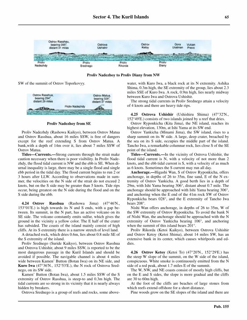
Sector 4. The Kuril Islands 65
Pub. 155
SW of the summit of Ostrov Toporkovyy.
4.23 Proliv Nadezhdy (Rashowa Kaikyo), between Ostrov Matuaand Ostrov Rasshua, about 16 miles SSW, is free of dangersexcept for the reef extending S from Ostrov Matua. Abank,with a depth of 14m over it, lies about 7 miles SSW ofOstrov Matua. 4.23 Tides—Currents.—Strong currents through the strait makecaution necessary when there is poor visibility. In Proliv Nade-zhdy, the flood tidal current is NW and the ebb is SE. When di-urnal inequality is large, there may be a single flood and singleebb period in the tidal day. The flood current begins to run 2 or3 hours after LLW. According to observations made in sum-mer, the velocities on the N side of the strait do not exceed 2knots, but on the S side may be greater than 5 knots. Tide ripsoccur, being greatest on the N side during the flood and on theS side during the ebb.
4.24 Ostrov Rasshua (Rashowa Jima) (47°46'N.,153°01'E.) is high towards its N and S ends, with a gap be-tween. Its summit, in the N part, has an active volcano on itsSE side. The volcano constantly emits sulfur, which gives theground in the vicinity a yellow color. The E half of the craterhas subsided. The coasts of the island mainly consist of highcliffs. At its S extremity there is a narrow stretch of level land.4.24 A detached rock, which dries 0.6m, lies about 0.8 mile SE ofthe S extremity of the island.4.24 Proliv Srednego (Suride Kaikyo), between Ostrov Rasshuaand Ostrova Ushishir, about 9 miles SSW, is reported to be themost dangerous passage in the Kuril Islands and should beavoided if possible. The navigable channel is about 4 mileswide between Kamen’ Button (Botan Iwa) on its NE side, andKuro Iwa (47°36'N., 152°53'E.), the N rock of Ostrova Sred-nego, on its SW side.4.24 Kamen’ Button (Botan Iwa), about 1.5 miles SSW of the Sextremity of Ostrov Rasshua, is steep-to and 0.3m high. Thetidal currents are so strong in its vicinity that it is nearly alwayshidden by breakers.4.24 Ostrova Srednego is a group of reefs and rocks, some above-
water, with Kuro Iwa, a black rock at its N extremity. AshikaShima, 0.3m high, the SE extremity of the group, lies about 2.3miles SSE of Kuro Iwa. A rock, 0.9m high, lies nearly midwaybetween Kuro Iwa and Ostrova Ushishir.4.24 The strong tidal currents in Proliv Srednego attain a velocityof 4 knots and there are heavy tide rips.
4.25 Ostrova Ushishir (Ushishiru Shima) (47°32'N.,152°49'E.) consists of two islands joined by a reef that dries.4.25 Ostrov Ryponkicha (Kita Jima), the NE island, reaches itshighest elevation, 130m, at Ishi Yama at its SW end.4.25 Ostrov Yankicha (Minami Jima), the SW island, rises to asharp summit on its W side. A large, deep crater, breached bythe sea on its S side, occupies the middle part of the island.Tancho Iwa, a remarkable columnar rock, lies close S of the SEpoint of the island.4.25 Tides—Currents.—In the vicinity of Ostrova Ushishir, theflood tidal current is N, with a velocity of not more than 2knots, and the ebb tidal current is S, with a velocity of as muchas 6 knots. Sometimes the S current may run all day.4.25 Anchorage.—Higashi Wan, S of Ostrov Ryponkicha, offersanchorage, in depths of 26 to 35m, fine sand, E of the N ex-tremity of Ostrov Yankicha. A good berth lies in a depth of29m, with Ishi Yama bearing 306°, distant about 0.7 mile. Theanchorage should be approached with Ishi Yama bearing 306°,and anchoring when the E end of the 41m rock SW of OstrovRyponkicha bears 028°, and the E extremity of Tancho Iwabears 208°.4.25 Nishi Wan offers anchorage, in depths of 26 to 35m, W ofthe SW extremity of Ostrov Ryponkicha. To avoid the bank Nof Nishi Wan, the anchorage should be approached with the Nextremity of Ostrov Yankicha bearing 106°, and anchoringwhen the summit of this island bears 201°.4.25 Proliv Rikorda (Ketoi Kaikyo), between Ostrova Ushishirand Ostrov Ketoy (Ketoi Shima), about 14 miles SW, has anextensive bank in its center, which causes whirlpools and ed-dies.
4.26 Ostrov Ketoy (Ketoi To) (47°20'N., 152°29'E.) hasthe steep W slope of the summit, on the W side of the island,conspicuous. White smoke is continuously emitted from the Nside of a red peak, about 1.7 miles E of the summit.4.26 The W, NW, and NE coasts consist of mostly high cliffs, buton the E and S sides, the slope is more gradual and the cliffsare 30 to 60m high.4.26 At the foot of the cliffs are beaches of large stones fromwhich reefs extend offshore for a short distance.4.26 Pine woods grow on the SE slopes of the island and there are
Proliv Nadezhoy to Proliv Diany from NW
Proliv Nadezhoy from SE
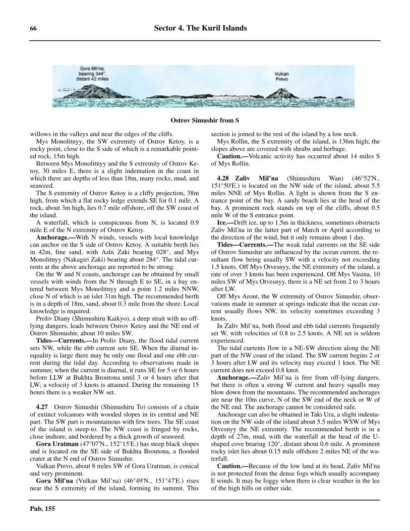
66 Sector 4. The Kuril Islands
Pub. 155
willows in the valleys and near the edges of the cliffs.4.26 Mys Monolitnyy, the SW extremity of Ostrov Ketoy, is arocky point, close to the S side of which is a remarkable point-ed rock, 15m high.4.26 Between Mys Monolitnyy and the S extremity of Ostrov Ke-toy, 30 miles E, there is a slight indentation in the coast inwhich there are depths of less than 18m, many rocks, mud, andseaweed.4.26 The S extremity of Ostrov Ketoy is a cliffy projection, 38mhigh, from which a flat rocky ledge extends SE for 0.1 mile. Arock, about 3m high, lies 0.7 mile offshore, off the SW coast ofthe island.4.26 A waterfall, which is conspicuous from N, is located 0.9mile E of the N extremity of Ostrov Ketoy.4.26 Anchorage.—With N winds, vessels with local knowledgecan anchor on the S side of Ostrov Ketoy. A suitable berth liesin 42m, fine sand, with Ashi Zaki bearing 028°, and MysMonolitnyy (Nakagiri Zaki) bearing about 284°. The tidal cur-rents at the above anchorage are reported to be strong.4.26 On the W and N coasts, anchorage can be obtained by smallvessels with winds from the N through E to SE, in a bay en-tered between Mys Monolitnyy and a point 1.2 miles NNW,close N of which is an islet 31m high. The recommended berthis in a depth of 18m, sand, about 0.3 mile from the shore. Localknowledge is required.4.26 Proliv Diany (Shimushiru Kaikyo), a deep strait with no off-lying dangers, leads between Ostrov Ketoy and the NE end ofOstrov Shimushir, about 10 miles SW.4.26 Tides—Currents.—In Proliv Diany, the flood tidal currentsets NW, while the ebb current sets SE. When the diurnal in-equality is large there may be only one flood and one ebb cur-rent during the tidal day. According to observations made insummer, when the current is diurnal, it runs SE for 5 or 6 hoursbefore LLW at Bukhta Broutona until 3 or 4 hours after thatLW; a velocity of 3 knots is attained. During the remaining 15hours there is a weaker NW set.
4.27 Ostrov Simushir (Shimushiru To) consists of a chainof extinct volcanoes with wooded slopes in its central and NEpart. The SW part is mountainous with few trees. The SE coastof the island is steep-to. The NW coast is fringed by rocks,close inshore, and bordered by a thick growth of seaweed.4.27 Gora Uratman (47°07'N., 152°15'E.) has steep black slopesand is located on the SE side of Bukhta Broutona, a floodedcrater at the N end of Ostrov Simushir.4.27 Vulkan Prevo, about 8 miles SW of Gora Uratman, is conicaland very prominent.4.27 Gora Mil'na (Vulkan Mil’na) (46°49'N., 151°47'E.) risesnear the S extremity of the island, forming its summit. This
section is joined to the rest of the island by a low neck.4.27 Mys Rollin, the S extremity of the island, is 136m high; theslopes above are covered with shrubs and herbage.4.27 Caution.—Volcanic activity has occurred about 14 miles Sof Mys Rollin.
4.28 Zaliv Mil’na (Shimushiru Wan) (46°52'N.,151°50'E.) is located on the NW side of the island, about 5.5miles NNE of Mys Rollin. A light is shown from the S en-trance point of the bay. A sandy beach lies at the head of thebay. A prominent rock stands on top of the cliffs, about 0.5mile W of the S entrance point.4.28 Ice.—Drift ice, up to 1.5m in thickness, sometimes obstructsZaliv Mil'na in the latter part of March or April according tothe direction of the wind, but it only remains about 1 day.4.28 Tides—Currents.—The weak tidal currents on the SE sideof Ostrov Simushir are influenced by the ocean current, the re-sultant flow being usually SW with a velocity not exceeding1.5 knots. Off Mys Otvesnyy, the NE extremity of the island, arate of over 3 knots has been experienced. Off Mys Vasina, 10miles SW of Mys Otvesnyy, there is a NE set from 2 to 3 hoursafter LW.4.28 Off Mys Aront, the W extremity of Ostrov Simushir, obser-vations made in summer at springs indicate that the ocean cur-rent usually flows NW, its velocity sometimes exceeding 3knots.4.28 In Zaliv Mil’na, both flood and ebb tidal currents frequentlyset W, with velocities of 0.8 to 2.5 knots. A NE set is seldomexperienced.4.28 The tidal currents flow in a NE-SW direction along the NEpart of the NW coast of the island. The SW current begins 2 or3 hours after LW and its velocity may exceed 1 knot. The NEcurrent does not exceed 0.8 knot.4.28 Anchorage.—Zaliv Mil’na is free from off-lying dangers,but there is often a strong W current and heavy squalls mayblow down from the mountains. The recommended anchoragesare near the 10m curve, N of the SW end of the neck or W ofthe NE end. The anchorage cannot be considered safe.4.28 Anchorage can also be obtained in Taki Ura, a slight indenta-tion on the NW side of the island about 5.5 miles WSW of MysOtvesnyy the NE extremity. The recommended berth is in adepth of 27m, mud, with the waterfall at the head of the U-shaped cove bearing 120°, distant about 0.6 mile. A prominentrocky islet lies about 0.15 mile offshore 2 miles NE of the wa-terfall.4.28 Caution.—Because of the low land at its head, Zaliv Mil'nais not protected from the dense fogs which usually accompanyE winds. It may be foggy when there is clear weather in the leeof the high hills on either side.
Ostrov Simushir from S

Sector 4. The Kuril Islands 67
Pub. 155
Proliv Bussol’ and Proliv Urup
4.29 Proliv Bussol’ (46°40'N., 151°51'E.) and Proliv Uruplead between the SW end of Ostrov Simushir and the NE endof Ostrov Urup, about 56 miles SW. The straits are separatedby three small islands, consisting of Ostrova Chernyye Brat’ya,Ostrov Chirpoy, and Ostrov Broutona. Ostrova ChernyyeBrat’ya consists of Ostrov Chirpoy, the NE island, and OstrovBrat Chirpoyev, the SW island.4.29 An IMO-adopted Traffic Separation Scheme lies in the wa-ters of Proliv Bussol and may be best seen on the appropriatechart.4.29 Tides—Currents.—The flood tidal current between OstrovSimushir and Ostrov Urup sets N, and the ebb sets S, attainingvelocities of up to 3 knots. The tidal currents are influenced bythe ocean currents, and the resultant flows are irregular.4.29 In Proliv Snou, between Ostrov Chirpoy and Ostrov BratChirpoyev, the flood tidal current sets NW, and the ebb SE,with velocities of up to 3 knots. The flood tidal current begins 2or 3 hours after LW. Eddies are sometimes formed in the E en-trance of the strait.4.29 Proliv Bussol, about 36 miles wide, leads between OstrovBroutona and Ostrov Chirpoy, to the W, and Ostrov Shimushir,to the E. This is the widest channel in the Kuril Islands. Thechannel is unobstructed, but caution is necessary due to the un-certainty of the tidal currents, especially with E winds, whichsend in dense fog usually extending across the strait.4.29 Ostrova Chernyye Brat’ya (Chirirhoi To) appear from the SEas three cones of different heights. The islands, being small, aresubject to fogs. The greatest frequency is between May and Ju-ly, during SE winds.4.29 A considerable amount of driftwood may be found on thecoasts of the islands, especially on sandy beaches.
4.30 Ostrov Chirpoy (Kita Jima) (46°32'N., 150°53'E.) issurmounted by three peaks aligned in a N-S direction. The Npeak, Vulkan Chernogo (Okuzure Yama), the summit of the is-land, has perpendicular cliffs caused by landslips on the NWside of its crater. White smoke is continually emitted from themiddle peak. The S and lowest peak sometimes emits a fewcolumns of steam.4.30 Bukhta Peschanaya is formed on its NE side by a narrowpeninsula, 166m high, which is joined to the NE end of OstrovChirpoy by a low, sandy isthmus. Heavy squalls sometimes de-scend from the mountains. In summer, a S swell rolls in andbreaks heavily.4.30 The S coast of Ostrov Chirpoy, between its W extremity anda point 3.2 miles E, consists of rocks of porous lava and is of adark brown color.4.30 The SE extremity of the island is cliffy, 31m high, and is ahabitat for numerous sea birds whose cries can sometimes beheard for a distance of 0.5 mile. Close S of the point is an islet,3m high, on which sea lions can usually be seen.4.30 A semi-circular cove on the S side of the point has a pebblebeach backed by high land. The ruins of a building associatedwith some disused sulfur mines stand on the shore.4.30 Ostrov Brat Chirpoyev (Minami Jima), separated from Os-trov Chirpoy by Proliv Snou, a deep passage, rises to a conicalsummit near its W side. Mys Semenova (46°27'N., 150°51'E.)is the SE extremity of Ostrov Brat Chirpoyev. The headland is
33m high, and from it the land slopes gently upward. In sum-mer, it is usually enveloped in fog. Rakko Jima, a steep, conicalislet, lies close NE of the island. A reef, with some above-waterrocks, extends about 0.3 mile E of this islet, and a rock, whichdries 0.9m, lies about 0.5 mile SE of the islet. Skala Lev, arock, lying close inshore, W of the summit of Ostrov Brat Chir-poyev, resembles a lion lying down, near which tide rips andeddies occur.
4.31 Ostrov Broutona (Buroton To) (46°43'N.,150°45'E.), about 11 miles NNW of Ostrov Chirpoy, is adome-shaped island, fringed with cliffs about 274m high. Itscoasts consist of beaches of large stones. A rock, 28m high, thehighest of several, some of which are submerged, lies close offthe NW coast of Ostrov Broutona and is frequented by largeflocks of sea bird. Tidal currents in the vicinity of the island areweak, and the resultant set is mainly NNE with a maximum ve-locity of around 2 knots.
Proliv Urup (Minami Uruppu Suido), about 15 miles wide,leads between Ostrov Brat Chirpoyev and the NE extremity ofOstrov Urup. The strait is free of dangers, except for the tiderips off Mys Kastrikum. The tidal currents are strong, and infoggy weather the passage should not be attempted unless thevessel’s position is certain, as the low NE point of Ostrov Urupand the islets off it, may be obscured while the high land W isvisible.4.31 Caution.—Volcanic activity has been reported about 55miles ENE of Mys Kastrikum. Mys Kastrikum. No further in-formation is available.4.31 Magnetic disturbance is reported to exist within a radius of 8miles from Ostrov Broutona.
Ostrov Urup
4.32 Ostrov Urup is generally extremely rugged on theNW side of the range of mountains running lengthwise throughit. On its SE side, there is a gradual slope to the coast. Peaksover 1,219m high rise in the N, middle, and S parts of the is-land. The summit of Ostrov Urup, in the S part, has several oth-er peaks of nearly equal elevation around it.4.32 The coasts of Ostrov Urup are generally cliffy, with littlesandy beach; level land is found only near its SW extremity.The island is fringed with kelp, especially towards its SW end,where it covers the sea for stretches of 5 or 6 miles, and pres-ents the appearance of reefs.4.32 On the NW shore of Ostrov Urup there are no dangers morethan 1 mile offshore.4.32 There are no safe anchorages and the best temporary onesare situated off the NW side of the island.
Ostrov Broutona from W
68 Sector 4. The Kuril Islands
Pub. 155
4.32 Winds—Weather.—Ostrov Urup has prevailing S windsfrom May to July, with frequent calms. By September, Wwinds predominate, but later in autumn the direction is vari-able. At Reyd Otkrytyy, on the NW coast, locally strong SEwinds occur from May to July. At Zaliv Natalii (TsuriganeWan), on the same coast, the winds are very strong in summer.4.32 Near Ostrov Urup, fogs occur most frequently from May toSeptember, being particularly numerous between June and Au-gust. On the SE side of the island, fogs are generally expectedwith S winds. In June and July, the fogs are relatively low andpeaks on the island may appear, but in August and September itmay be possible to make out the coast while the upper slopesare enveloped in fog.4.32 Tides—Currents.—The tidal current on the SE side of Os-trov Urup is SW on the flood tide and NE on the ebb tide, withvelocities of less than 1 knot.4.32 The tidal currents on the NW side of the island, with the ex-ceptions of the straits on either end, have a general SW or Wflow on the rising tide, and a NE or E flow on the falling tide.A velocity of about 1.5 knots is attained.4.32 The tidal currents on either side of the island are greatly af-fected by the winds and the ocean currents.
4.33 Southeast side of Ostrov Urup.—The SE coast ofOstrov Urup consists almost entirely of high cliffs, with afringe of large boulders and rocky reefs extending 1 mile off-shore in places.4.33 Caution.—The kelp grows thicker on this side of the islandthan on the NW side and it is not safe to navigate close inshore.In summer, high seas run all along the coast and there are nei-ther secure anchorages nor safe landing places.
4.33 Mys Kastrikum (Karasunoo Misaki) (46°14'N., 150°35'E.),a cliff about 31m high, is the extremity of a flat tongue of landthat forms the NE point of Ostrov Urup. A light and radiobea-con are situated on the cape. About 0.5 mile SW of the cape, aconspicuous sandy hillock, 42m high, affords a good markfrom seaward. Four islets, joined by reefs and above-waterrocks, extend about 1.7 miles ENE from Mys Kastrikum. Abank, with depths of less than 18m and having tide rips aboveit, extends about 1.5 miles E and 1.2 miles N of the outer islet.Thick beds of kelp are found in the vicinity of the cape, and thetidal currents are strong.4.33 Banka Dvukhmetrovaya (Kombu Se), a 2.9m patch, markedby a thick growth of kelp, lies about 5 miles SW of Mys Kastri-kum, and about 1.5 miles offshore.4.33 Kaimen Zan (46°08'N., 150°17'E.) has three summits and isconspicuous from SE.
4.34 Mys Khiva (Hiyori Zaki) (46°04'N., 150°19'E.), 15miles SW of Mys Kastrikum, has cliffs 38m high and is con-spicuous from a distance. An islet, 36m high, lies close off its Sside. A steep-to patch, with a depth of 4.1m, lies about 1 mileSE of Mys Khiva.4.34 Mys Temnyy (Ana Zaki), about 9 miles farther SW, is a sa-lient rocky point, 51m high. A large cave on the S side of itsextremity shows up from the SW. Togari Iwa, a detached point-ed rock, is conspicuous about 1.2 miles S of Mys Temnyy.4.34 Mys Razmytyy (Chuo Zaki) (45°50'N., 150°02'E.), 10 milesSW of Mys Temnyy, has a flat islet, 30m high, close off it.
4.34 Mys Etolina (Garan Zaki), about 5 miles farther WSW, is aprominent high point with cliffs formed of columnar rocks.The point is surmounted by two hills, the S of which is 127mhigh and can be identified when the mountains are obscured byfog, except when it is covered by snow.4.34 Anchorage.—In good weather, temporary anchorage can betaken by vessels with local knowledge in the bay NE of MysEtolina. The best berth is in 22m, sand, good holding ground,with Mys Etolina bearing 237°, distant about 1.5 miles. Vesselsat anchorage here may roll heavily at times.4.34 Mys Kuzinoty (Kushino Misaki) (45°34'N., 149°32'E.), 21miles SW of Mys Etolina, is a high point, which appears fromthe SW to have a serrated crest. A conspicuous 40m rock liesclose off its extremity.
4.35 Northwest side of Ostrov Urup.—Mys Van-der-Lind (Nobunotsu Misaki) is the cliffy extremity of a plateau,about 101m high, forming the SW extremity of Ostrov Urup. Abank, with depths of 18.3m and less, over which the strong tid-al currents raise dangerous tide rips, extends about 2 miles SWof the cape. Near the middle of this bank, about 0.7 mile off-shore, is a rock on which the sea usually breaks.4.35 A light is shown, and a radiobeacon transmits, from a struc-ture on Mys Van-der-Lind.4.35 Satano Iwa (Totano Iwa), a small islet, lies about 1.2 miles Nof Mys Van-der-Lind. About 1 mile NE of this islet is UchinoIwa, consisting of two small rocks.4.35 Zaliv Shchukina (Futagojima Hakuchi) (45°38'N.,149°27'E.), between Uchino Iwa and Ostrov Krab (Futago Ji-ma), a flat-topped islet about 2.8 miles NNE, offers temporaryanchorage for small vessels from all but W winds. A goodberth lies in a depth of 18m, good holding ground, about 0.7mile S of Ostrov Krab. The tidal currents are strong and vesselssometime roll heavily. This anchorage can be considered safeduring the summer.4.35 Tides—Currents.—The tidal current sets NE in the area 1to 2 miles SW of Ostrov Krab from 2 to 3 hours after LW until2 or 3 hours after HW. At other times the current sets S. Themaximum velocity is 1 knot.4.35 Mys Tetyayeva (Taka Saki), about 1.5 miles NE of OstrovKrab, is a prominent headland, 156m high, and faced with aconspicuous, brown cliff on its S side.4.35 Between Mys Tetyaeva and Mys Sevryuga, another highpoint 8 miles NE, the coast consists mostly of high cliffsfringed with boulders. It is backed by hills and in it are themouths of several streams. The cliffs for 3 miles NE of MysTetyaeva are light gray and prominent. In the vicinity of MysSevryuga, the cliffs are red.4.35 A remarkable waterfall breaks over cliffs, 285m high, about3.2 miles NE of Mys Sevryuga.
4.36 Reyd Otkrytyy (Reid Otkhpytiy) (45°52'N.,149°46'E.), fringed with kelp and rocky shoals off beaches ofgravel and stone, has depths of 18.3m about 0.7 mile offshore.Tokotan Kawa, a river with a small lake upstream, flows intothe roadstead. A conspicuous sandy cliff, about 0.6 mile NE ofthe river mouth, affords a mark to vessels entering the road-stead. Gora Rudakova (Daiba Yama), with a prominent rockycliff on its N side, rises about 1 mile NE of the cliff.4.36 Tides—Currents.—The flood tidal current sets SW be-
Sector 4. The Kuril Islands 69
Pub. 155
tween 1 and 3 miles offshore of Reyd Otkrytyy, and the ebbNE. The SW current is of longer duration than the NE currentand attains a velocity of 1.5 knots. The NE current runs for 1hour or so after HW, with a velocity not exceeding 1 knot.4.36 Anchorage.—The recommended anchorage is in a depth of20m, fine sand, with the mouth of Tokotan Kawa bearing 122°,distant about 0.8 mile. Caution must be exercised as a rockyshelf, with depths of less than 5.5m, extends about 0.4 mileNNW of the mouth of the river. This anchorage is usually safein summer, but the tidal currents are strong and the bottomslopes steeply.
4.37 Vulkan Tri Sestry (Iwo Yama) (45°56'N., 149°55'E.)has three peaks, the N peak being sharp and conspicuous. MaraYama, a conical mountain, about 1.5 miles SW, can sometimesbe identified when the mountains NE are obscured by fog.
Gora Kolokol (Uruppo Fuji) (46°02'N., 150°04'E.), thehighest mountain N of Reyd Otkrytyy, is conical and promi-nent.4.37 Zaliv Natalli (Tsurigane Wan) is entered between Staten Mi-saki (46°06'N., 150°05'E.) and Mys Yakor’ (Nobu Misaki), asteep headland, about 6 miles NE. In general, the bay is ex-ceedingly deep, with mountains rising close to its shores.4.37 Aspect.—Gora Nepristupnaya (Gyuto Zan), with a conspic-uous rock summit, rises about 1.5 miles SSW of Staten Misaki,and Aka Yama, reddish in color, is conspicuous about 2 miles Sof the same headland. Gora Antipina (Tsurigane Yama), withtwo pointed summits, rises about 2.5 miles E of Mys Yakor’,the upper part of its W slope being formed by nearly perpen-dicular cliffs.4.37 Anchorage.—Zaliv Natalli offers good anchorage, exceptduring NW winds, in a depth of about 18m, fine sand, goodholding ground, near the head of the bay. At greater distancesoffshore the depths increase rapidly and caution must be exer-cised, as the 200m curve lies between 1 and 2 miles off thehead of the bay.
4.38 Bukhta Novokuril'skaya (Mishima Wan) (46°13'N.,150°20'E.) offers anchorage to small vessels with local knowl-edge, in 21m, sand, with the conspicuous pointed rock, 20mhigh, close inshore on the E side of the bay, bearing 105°, dis-tant about 0.5 mile.4.38 Kamome Jima, a flat, rocky islet, 5.5m high, lies about 0.5mile offshore, 3 miles E of the E entrance point of Bukhta No-vokuril’skaya.4.38 Daisanto Zan (46°11'N., 150°23'E.) has three summits in aN-S direction.
Proliv Friza (Etorofu Kaikyo)
4.39 Proliv Friza, a deep unobstructed strait, leads betweenthe SW extremity of Ostrov Urup and the NE end of OstrovIturup (Etorofu Jima), about 22 miles W. A bank, with depthsof 18.3m and less, over which the tidal currents raise danger-ous tide rips, extends about 2 miles SW of the SW extremity ofOstrov Urup. Near the middle of this bank is a rock over whichthe sea usually breaks. There are no dangers on the W side ofthe strait.4.39 Winds—Weather.—The prevailing wind is NW during thewinter. The mean wind velocity is 13 to 18 knots.
4.39 Ice.—In Proliv Friza, the drift ice generally appears at theend of February and is not found after the middle of May.4.39 Tides—Currents.—Though complete observations are notyet available, it appears that in Proliv Friza the flood tidal cur-rent is N and the ebb is S, the change occurring from 1 to 2hours after HW or LW. However, the set through the strait isextremely irregular, because of the influence of the warm andcold ocean currents which flow near its N and S entrances, re-spectively.4.39 In summer, about 13 miles E of Mys Il’ya Muromets (Rakki-betsu Misaki), the S current exceeds 2 knots in velocity, chang-ing to a N current about 2 hours after LW. About 3 miles off thecoast of Ostrov Iturup, there appears to be a constant S current,which may attain a velocity of 4.5 knots off Mys Il’ya Murom-ets. Several miles off Ostrov Urup there appears to be a con-stant N current, and a velocity of 4.8 knots has beenexperienced.
Ostrov Iturup (Etorofu To) (Etorofu Jima)
4.40 Ostrov Iturup, the largest and most important island ofthe Kuril Islands, is mountainous and rugged. The coasts of theisland are mainly steep-to with no dangers outside of 1 mileoffshore.4.40 Winds—Weather.—Ostrov Iturup has strong NW winds,accompanied by heavy seas, from late October until the end ofApril. In summer, SE winds prevail. At Kuril’sk (Shana), onthe NW coast, NW to W winds are predominant from Novem-ber to March. The winds are variable the remainder of the year,with E to SE winds predominating from June to September.The average wind velocity is highest (18 knots) in December,and lowest (8 knots) in July. Extreme velocities of over 70knots have occurred in the winter months.4.40 Kuril'sk has a mean annual temperature of 4.4°C. Extrememaximum readings of 30.6°C have been made in July and Au-gust, and readings as low as -24.4°C have occurred in Februaryand March. Subfreezing temperatures have been read in allmonths except August.4.40 At Kuril’sk, snow falls on an average of 144 days. It may beexpected daily in December and January, and in both Februaryand March, the average is about 25 days. The falls are light anddry, and the annual precipitation of rain is only 15.5cm.4.40 The NW side of Ostrov Iturup is the most clear of fog, and atKuril'sk there is an average of 46 days with fog annually, ofwhich 42 days are from April to August, 12 days being in themonth of July. The most frequent fogs are found on the SEcoast of the island from June to August, with very few cleardays.
Ice.—On the NW side of Ostrov Iturup there is drift ice fromJanuary on. These floes freeze together and form ice floeswhich drift about, influenced by the winds and currents. Floescarried S become stranded on the shores of the bays, and freezetogether forming a mass of ice, which by February may extendseveral miles offshore, with a thickness of about 3m. This icebreaks up in April and finally disappears in May.4.40 On the SE side of the island, the bays do not freeze over, andare seldom obstructed by drift ice.4.40 Tides—Currents.—A warm ocean current flows NEthrough the sea of Okhotsk off the NW side of Ostrov Iturup.Off the SE side of the island, a cold current flows mainly SW.
70 Sector 4. The Kuril Islands
Pub. 155
The velocities do not exceed 1 knot.4.40 On the SE side of Ostrov Iturup the flood tidal current has ageneral SW set. The ebb current is NE, but because of the in-fluence of the SW ocean current the flow in the flood directionis longer in duration and somewhat greater in velocity. Veloci-ties of more than 2 knots may be attained W of Mys Urumpet(Urombetsu Misaki), near the SW end of the island. VelocitiesE of the same point are less than 1 knot and the directions areirregular.4.40 On the NW side of Ostrov Iturup, SW of Mys Przheval’ sko-go (Notoro Misaki), the flood tidal current follows the coast-line, flowing SW or into the bays, and the ebb current takes anopposite direction. The velocities seldom exceed 1 knot, exceptoff Mys Bol’shoy Nos (Poronotsu Bana), where they may begreater than 2 knots. In areas other than that near Proliv Yekat-eriny (Kunashiri Suido), the flow is influenced by the oceancurrent which sets NE, the velocity in that direction beingsomewhat greater. Off Mys Przheval’skogo the flood current isNE and the ebb is SW, the change occurring about 1 hour afterHW or LW. Maximum velocities of 2 knots during the floodand about 1.5 knots during the ebb are attained.4.40 Between Mys Przheval’skogo and Kuril’skiy Zaliv (ShanaWan) the flood current sets E or towards the coast, and in theopposite direction during the ebb, the velocities not exceeding0.5 knot. Near the N extremity of Poluostrov Chirip (ChirippuSanto) it appears that in summer the resultant current is alwaysW, and during the flood current a velocity of 1.5 knots may beexperienced. Between Poluostrov Chirip and Mys Friza (Shi-betoro Misaki) the flood current is usually SW and the ebb NE,but both are irregular. The velocities seldom exceed 1 knot, ex-cept in the vicinity of Mys Friza, where a velocity of 2 knotsmay be attained.
4.41 Southeast side of Ostrov Iturup.—Mys Il’ya Mur-omets (Rakkibetsu Misaki) (45°30'N., 148°54'E.), the extremi-ty of Ostrov Iturup, has vertical cliffs in its vicinity. A largeconspicuous waterfall at the cape plunges into the sea from aheight of 140m.4.41 Bukhta Medvezh’ya (Moyoro Wan), close S of Mys Il'yaMuromets, offers shelter from winds between the SSW andNNW. Strong tidal currents and the abruptly shelving bottomof sand make precautions against dragging necessary. Heavyswells are frequently encountered, particularly with E winds.4.41 Ice.—It is reported that this bay is rarely blocked by drift ice.4.41 Tides—Currents.—The flood tide sets NE while the ebbtide sets SE. Either current may attain a velocity of 3 knots.4.41 Aspect.—Gora Medvezh’ya (Moyoro Dake) (45°23'N.,148°51'E.), with a pointed summit, is one of several peaks S ofthe bay. Io Dake, the W peak, constantly emits white smoke.The mountains are colored yellow in places by sulfur.4.41 The chimneys of the sulfur refinery at Medvezh’e (Moyoro),in the SW part of the bay, are conspicuous. A conspicuous ca-ble railway extends S of the town to a spur of the mountains.4.41 Anchorage.—To avoid W squalls from the valley, the rec-ommended anchorage is NE of Medvezh’e, in a depth of about17m, sand, with the point E of the town bearing 175°, distantabout 0.5 mile.
4.42 Mys Sevorsi (Seoroshi Misaki) (45°19'N., 148°45'E.)is a high, cliffy, and steep-to point. A flat-topped hill rises to an
elevation of 567m, 1 mile to the NW.4.42 Mys Razdel'nyy (Toshiruri Misaki) (45°15'N., 148°30'E.), alow, flat point lying 12 miles WSW of Mys Sevorsi, has a chainof small rocks extending 0.8 mile S. The rocks show up wellfrom the NE or SW. Gora Golets (Rucharu Yama), a flat round-ed mountain about 6.5 miles W of the point, is conspicuousfrom the S.4.42 Mys Yevgeniya (Otochishi Misaki), a cliffy point, about 11miles WSW of Mys Razdel'nyy, is 145m high, has no trees,and appears as an island from a distance. Mys Isoya (Isoya Mi-saki), about 5 miles farther SW, is surmounted by a conspicu-ous, rocky hill, 76m high, which appears as a large solitarybuilding from a distance S.4.42 Vulkan Teben’kova (Odamoe Yama) (45°02'N., 147°55'E.)is the summit of, and lies at the E end of, a conspicuous moun-tain range. Tsurarippu Yama, about 2 miles WSW, has a jaggedsummit, which sometimes emits white smoke; there are con-spicuous red cliffs on its S and E sides.
Zaliv Kasatka (Hitokappu Wan) is entered E of Mys Bu-revestnik (Uembetsu Saki) (44°55'N., 147°40'E.), a pointfringed by a rocky shoal, covered with seaweed and extendingabout 0.4 mile offshore. Mys Burevestnik is backed by a levelplateau, about 15m high, extending 7.5 miles SW, and extend-ing to the foothills of Gora Burevestnik, a peak rising about 9miles WSW of the point. 4.42 Winds—Weather.—In Zaliv Kasatka, N winds prevail fromSeptember to April, and S winds for the remainder of the year.In February and March, occasional SE gales raise heavy seas inthe bay. During E and SW winds, the sea may be choppy.4.42 Between the middle of December and the middle of March,the snowfall may be as much as 0.9m. April is generally clear,and in May, the rainy month, the precipitation is very light.Fogs are numerous from the latter part of May until the middleof July.4.42 Ice.—Zaliv Kasatka is seldom icebound. Drift ice may occa-sionally enter the bay during April, especially during strong Swinds.4.42 Aspect.—A light is shown from Mys Burevestnik. A light isshown, also at Toshimoye, in the NE part of the bay.4.42 Anchorage.—Adequate shelter can be had, depending onthe direction of the wind, off the town of Kasatka (Toshimoye)in the NE part of the bay, in a depth 10m, sand, about 0.6 mileoffshore. Anchorage may also be taken off the town of Bu-revestnik (Uembetsu), in the SW part of the bay, in a depth of12m, sand, about 0.3 mile offshore.4.42 The holding ground is not good in these anchorages andthere is danger of dragging, especially during strong S winds.The mountains on either side of the bay offer shelter from SWor NE winds.
4.43 Mys Urumpet (Urumombetsu Saki) (44°35'N.,147°15'E.), about 26 miles SW of Mys Burevestnik, is a head-land formed by cliffs, 196m high, which terminate a mountainridge. Ostrov Odinokiy (Tori Shima), a group of five rocks, thehighest of which is 51m, lies about 0.7 mile ENE of the pointand is conspicuous from a distance.4.43 Mys Burunnyy (Busso Saki), about 2.5 miles SW of MysUrumpet, is a treeless point with a rocky islet lying close off it.A waterfall, on a cliff about 1 mile W of the point, is conspicu-ous.
Sector 4. The Kuril Islands 71
Pub. 155
4.43 Vulkan Berutarube (Berutarube Yama) (44°28'N.,146°56'E.), on the SW end of Ostrov Iturup, is conspicuousfrom a distance and joined by low land on its NE side to the re-mainder of the island. Mys Rikorda (Shikaragarishi Saki), a Sspur of Vulkan Berutarube, is a high cliff of a faded red color,with a saddle-backed summit.4.43 Tides—Currents.—In the vicinity of Mys Rikorda, theflood tidal current follows the coast in a SW direction, and theebb is NE, with velocities exceeding 3 or 4 knots being at-tained. Tide rips occur when the currents are at strength.
4.44 Northwest side of Ostrov Iturup.—Mys Gnevnyy(Berutarube Saki) (44°27'N., 146°52'E.), about 3 miles W ofVulkan Berutarube, is the steep-to W end of Ostrov Iturup.4.44 Zaliv Dozornyy (Tannemoe Wan), a bight about 6 miles NEof Mys Gnevnyy, offers anchorage to vessels with local knowl-edge, but is exposed to considerable swell. Vessels at anchorswing to the strong tidal currents. Winds from the NE throughE to SW blow across the low land at the head of the bay froman E direction due to the configuration of the land. A subma-rine telegraph cable is laid from the head of the bay.4.44 Zaliv L’vinaya Past’ (Moekeshi Wan) (44°37'N.,147°00'E.), formed by a crater breached by the sea, should beavoided. During gales from all directions except the N, violentwinds sweep down from the hills encircling the inlet.
Zaliv Dobroye Nachalo (Naibo Wan) (44°43'N., 147°08'E.)offers the best anchorage on the NW side of Ostrov Iturup. Thebay is entered between Mys Kabara (Kabara Misaki), the E en-trance point of Zaliv L'vinaya Past', and a peninsula about 10miles NW, on which stands Gora Atsonupuri (Atosa Nobori),an isolated volcano. Gora Atsonupuri has a conspicuous graylandslip on its NW slope. The N half of the head of the bay is asandy beach, through the middle of which flows the riverTikhaya (Onnenaibo Betsu).4.44 Heavy fogs frequently enter the bay through the valleys oneither side of the range of hills in the S part of the head of thebay.4.44 Anchorage.—The recommended anchorage for vessels withlocal knowledge is in 10 to 20m, fine sand, between 0.4 mileand 1 mile W of the mouth of the Tikhaya.4.44 Odesskiy Zaliv (Utasutsu Wan), E of the peninsula of GoraAtsonupuri, is exposed N. Small vessels, with local knowledge,can anchor off the towns at the NE and SW end of the sandybeach at the head of the bay.4.44 Caution.—A detached reef, with a least depth of 11.4m, liesabout 3.5 miles W of the mouth of the Tikhaya.
4.45 Gora Stokap (Hitokappu Yama) (44°50'N.,147°21'E.), a volcano with a dome-shaped summit, has a con-spicuous landslip on its W side. A mountain range extendsabout 6 miles ENE from this volcano, then descends abruptly,terminating in low terraces.4.45 Bukhta Zolotaya (Furebetsu Byochi), a small cove, is en-tered between Hatcho Shima (45°04'N., 147°32'E.), a con-spicuous black islet, and the S side of two drying rocks, about240m N.4.45 Mys Przheval’skogo (Notoro Misaki) (45°06'N.,147°30'E.), 59m high, is the dark flat-topped extremity of apeninsula, about 3 miles long. A conspicuous rock lies closeoff the W end of the point. A drying rocky ledge extends about
0.1 mile NW of the rock. Mys Ksana (Sango Saki), the N ex-tremity of the peninsula, lying 0.6 mile NE of Mys Przhe-val’skogo, has an above-water rock, 5m high, near theextremity of a reef extending about 0.2 mile N of the point. Therock shows up well from E and W. Tide rips are often formedENE of Mys Ksana.4.45 Anchorage.—Large vessels anchor near the 20m curve,which is about 0.3 mile W and 0.4 mile NW of Hatcho Shima,and about 0.4 mile off the shore SE of Mys Przheval’skogo.
4.46 Zaliv Kuybyshevskiy (Rubetsu Wan) (45°06'N.,147°40'E.) does not afford safe anchorage. The bay is open toonshore winds and also to the winds that traverse across the is-land through the valley at its head. The holding ground of finesand over rock is not good.4.46 Winds—Weather.—In Zaliv Kuybyshevskiy, NW windsprevail in winter, and those between E and S predominate inspring and summer. A SE gale in summer is nearly always fol-lowed by a NW wind. The worst season of the year is autumnwith E gales.4.46 Fogs begin to develop in the latter part of March and continueuntil September, being most numerous in June and July.4.46 Ice.—The bay may be obstructed by drift ice, which enterswith winds between W and N, and is driven out by winds frombetween E and S, between the middle of January and the end ofMay. The floes are often heavy, and have been observed to pileup to a thickness of about 3m.4.46 Aspect.—Gora Pereval'naya (Nobori Yama) (45°09'N.,147°49'E.) has a flat summit, and is the summit of the highland on the E side of the bay.4.46 Riuyenshiri, a 59m hill, backs a small point, about 0.5 mileSW of the mouth of the river at Kuybyshevka (Rubetsu)(45°06'N., 147°42'E.).4.46 Anchorage.—In good weather, a vessel, with local knowl-edge, can anchor, in 11m, off the town of Kuybyshevka, withRiuyenshiri bearing 173°, distant about 0.6 mile.
4.47 Kuril’skiy Zaliv (Shana Wan) (45°14'N., 147°51'E.)lies on the W side of the inner end of Poluostrov Chirip (Chir-uppu Hanto), the large mountainous peninsula projecting Nfrom the middle part of Ostrov Iturup. The peninsula has twosummits. Kita Chirippu Zan, the N summit, is somewhat flat-topped. Minami Chirippu Zan, the S summit, has a pointedsummit. Between these two summits is the crater of a dormantvolcano, which has precipitous sides, either dark red or brown,and is conspicuous.4.47 Winds—Weather.—See general description of winds,weather, and fog for Ostrov Iturup in paragraph 4.40.4.47 Ice.—Along the shores of Kuril’skiy Zaliv, thin ice formsusually in the latter part of January. At about the middle ofFebruary, drift ice is carried into the bay by W or NW windsand often cements into solid fields. Winds from between the Eand S drive the ice out of the bay; it generally disappears by thelatter part of April.4.47 Aspect.—A meteorological observatory, at which storm sig-nals are shown, is situated close N of the river mouth at Ku-ril’sk (Shana). A conspicuous temple is situated on the SWbank of the river, about 0.2 mile SE of the river mouth. Aprominent radio mast surmounts a 23m hill, about 0.3 mile E ofthe temple.
72 Sector 4. The Kuril Islands
Pub. 155
4.47 Anchorage.—Anchorage can be taken in the NE corner ofthe bay, about one mile W of the mouth of the Reka Kurilka,depths 15 to 18m, sand. Local knowledge is required. Anchor-age is not considered safe during strong N gales since heavysea will enter the bay. 4.47 Additionally there are eight designated anchorages as listedbelow:
1. No. 1—45°01'48''N, 147°51'42''E.2. No. 2—45°14'24''N, 147°51'42''E.3. No. 3—45°15'18''N, 147°52'12''E.4. No. 4—45°15'18''N, 147°51'54''E.5. No. 5—45°15'06''N, 147°51'30''E.6. No. 6—45°14'48''N, 147°51'30''E.7. No. 7—45°14'24''N, 147°51'00''E.8. No. 8—45°15'30''N, 147°51'06''E.
4.47 Caution.—An area of foul ground lies within 600m of thecoastline between position 45°15'13''N. 147°52'50''E and posi-tion 45°15'40''N, 147°52'20''E.
4.48 Nayoka Wan, entered S of Ikabanotsu Saki(45°16'N., 147°52'E.), is not safe with winds from between theSW and NW, as the bottom consists of sand over rock. Ice con-ditions are similar to those in Kuril’skiy Zaliv. 4.48 Anchorage.—Anchorage can be taken by vessels with localknowledge, in a depth of 16m, with Ikabanotsu Saki bearing322°, distant about 0.5 mile.4.48 Two rivers enter the sea about 4.5 miles and 6.5 miles N, re-spectively, of Mys Ikabanotsu. The water in the latter river ismuddy and of a bluish-green color, and can be distinguishedfrom the sea water for about 1 mile offshore. Parachirippu Iwa,a conspicuous, square rock, 61m high, lies close inshore, about1.5 miles NNE of the N river mouth.
4.49 Mys Breskens (O Misaki) (45°26'N., 147°56'E.), theN extremity of Poluostrov Chirip, is steep-to and flat-topped. Itonly shows up from the E or W. A radiobeacon is situated onthe cape.4.49 Tides—Currents.—About 1.5 miles off the coast betweenMys Breskens and Mys Shpora (Onneshireyeto Bana), about 2miles SE, the current always sets NW, with velocities of 0.5 to1.5 knots.4.49 Bukhta Konservnaya (Shamambe Byochi), entered S of MysKonservnyy (Kukidono Saki) (45°20'N., 148°01'E.), has com-paratively steep shores. On its W side are the cliffy densely-wooded slopes of Minami Chirippu Zan, by which it is shel-tered from NW winds. Pon Nobori, a conspicuous hill, about2.3 miles S of Mys Konservnyy, is a good landmark.4.49 Ice.—In Bukhta Konservnaya and Reyd Udobnyy (BettobuByochi), fast ice may be expected to form in the early part ofJanuary, and to remain until the beginning of May. Drift icemay obstruct these anchorages from the middle of Februaryuntil the latter part of April.4.49 Anchorage.—The recommended anchorage is in a depth ofabout 27m, sand, with Mys Konservnyy bearing 354°, distant alittle more than 0.4 mile.
4.50 Reyd Udobnyy (Bettobu Byochi), a roadstead at theS end of the E side of Poluostrov Chirip, lies on the E side ofIju Bana (45°17'N., 148°02'E.), a small promontory. Foulground extends about 0.4 mile off the W side of the roadstead.
The shore bank on the S side extends about 0.3 mile offshore.4.50 Tides—Currents.—In Reyd Udobnyy the currents flowroughly E and W; the E current having its maximum rate from 2to 3 hours before HW, and the W current from 2 to 3 hours be-fore LW. The E currents following the LLW and the succeedingW currents are the stronger and attain rates of 1 knot.4.50 Aspect.—Parasan Yama, about 6 miles S of Iju Bana, is aridge running E and W, with a large columnar rock on it, con-spicuous from a distance. Fuyuni Nobori, a mountain with aflat thickly-wooded summit, rises about 7 miles ESE of Iju Ba-na.4.50 Anchorage.—Reyd Udobnyy has a bottom of sand, goodholding ground, and there is little swell. Local vessels usuallyanchor, in a depth of 20m, with the summit of Iju Bana bearing272°, distant about 0.9m. During the fishing season, cautionshould be exercised because of nets.
4.51 Shusu San (45°13'N., 148°15'E.) is a hill rising in theS part of a range of hills traversing Ostrov Iturup in a SSE-NNW direction. Conspicuous white cliffs, about 91m high,fringe the coast at the N end of these hills. Particularly goodshelter is afforded N of the white cliffs.4.51 A plain, covered by coarse grass and shrubs, occupies thenarrowest part of Ostrov Iturup, E of the above-mentionedrange of hills. In summer, during SE winds, thick fog may ar-rive over this plain from the Pacific Ocean, occasionally cover-ing the sea area in its vicinity.4.51 Gora Sibetoro (Shibetoro Dake) (45°24'N., 148°35'E.) isnot discernible because of other mountains in its vicinity. Aprominent mountain, with a conspicuous sharp peak, 647mhigh, rises about 2.5 miles SW of Gora Sibetoro. A peak, sur-mounted by a triangular, sharp-point rock, prominent from theN, rises about 1 mile N of Gora Sibetoro. About 1 mile fartherNW, a mountain with two sharp summits also serves as a goodmark.4.51 Soi Sho (45°28'N., 148°32'E.), a detached rock with a depthof 2.3m, lies about 0.8 mile offshore. Another rock with thesame depth lies about 0.6 mile SW of Soi Sho.
4.52 Bukhta Slavnaya (Shibetoro Byochi) is entered be-tween Ostrov Shlem (Daikoku Shima) (45°29'N., 148°35'E.)and Mys Friza (Shibetori Misaki), about 4 miles NE. OstrovShlem lies about 230m offshore. Its N side, whitened by guano,is conspicuous. Mys Friza is a black, rocky cliff, which is con-spicuous from the SW or NE. A large pointed rock, 11m high,lies about 0.4 mile NE of the cape.4.52 Hatcho Iwa, a rock 0.6m high, lies about 0.8 mile ENE ofOstrov Shlem. Benten Shima, a cliffy islet, about 1.5 milesENE of Ostrov Shlem, has a small but conspicuous shrine onits grassy summit. A reef, with a least depth of 0.5m, extendsabout 0.3 mile NW from the islet. A rocky spit, with severaldrying rocks near its extremity, extends about 0.5 mile WSWof a point lying 1 mile SW of Mys Friza.4.52 Winds—Weather.—Light E winds may be experienced inBukhta Medvezh’ya, simultaneously with violent offshoresqualls being experienced in Bukhta Slavnaya.4.52 Tides—Currents.—In the vicinity of Mys Friza, the tidalcurrents are irregular and the bottom is uneven.4.52 Anchorage.—The anchorage in the S part of the roadstead isin a depth of about 24m, fine sand, with Hatcho Iwa bearing
Sector 4. The Kuril Islands 73
Pub. 155
197°, distant 0.3 mile. Anchorage can also be taken, in depthsof 12.8 to 20.1m, fine sand, between Benten Shima and the ex-tremity of the rocky spit about 1.2 miles NE.4.52 The anchorage is fairly safe during the SE winds of summer,but with NW winds vessels should leave the anchorage,\ orseek shelter in Bukhta Medvezh’ya.
4.53 The coast from Mys Friza to Mys Koritskiy (Kamoi-wakka Misaki), about 4 miles E, is rugged and nearly steep-towith the 20m curve about 0.3 mile offshore.4.53 The summit of Gora Kamuy (Kamoi Dake) (45°31'N.,148°48'E.), a large flat-topped mountain, has a range curvingNW from it and terminating in cliffs about 3 miles E of MysFriza. Close S of the above-mentioned cliffs are two promi-nent, pointed peaks, which are frequently visible when GoraKamuy is enveloped in cloud or fog. The precipitous coast be-tween Mys Koritskiy and Meekushi Misaki (Miyekushi Bana),about 3.5 miles E, has a conspicuous 76m waterfall near itsmiddle part.
Proliv Yekateriny (Kunashiri Suido)
4.54 Proliv Yekateriny, a deep strait, leads between theSE end of Ostrov Iturup and Mys Lovtsova (Atoiya Misaki)(44°27'N., 146°35'E.), the NE extremity of Ostrov Kunashir(Kunashiri Shima). The strait is about 12 miles wide in mid-channel and clear of dangers with the exception of the foulground extending NE of Mys Lovtsova.4.54 Ice.—The strait is generally clear of drift ice by the end ofApril, but may become ice-free as early as February. Ice mayremain until the early part of May. There is usually less ice onthe E side of the strait.4.54 Tides—Currents.—In Proliv Yekateriny, the flood tidal cur-rent is S and the ebb is N. The change occurs at nearly HW andLW. The tidal currents do not attain any great rate and aresomewhat irregular.4.54 During the summer, a strong S current in mid-channel op-poses the N ebb current, and except near the coast, there is a re-sultant S set which may attain a velocity of 5 knots. Strongeddies sometimes extend from the side of the strait.4.54 Caution.—A Traffic Separation Scheme is located in thestrait.
Ostrov Kunashir
4.55 Ostrov Kunashir, the SW island of the Kuril Islands,is mountainous. Gora Tyatya (44°21'N., 146°15'E.), in the NEpart of the island, is the summit of Ostrov Kunashir. VulkanMendeleyeva (Shimanobori Yama) (43°59'N., 145°44'E.), anextinct volcano, is conspicuous in the SW part of the island.The SW half of the island is partly surrounded by the E coastof Hokkaido and the Habomai Islands (Suisho Shoto), forwhich reason Ostrov Kunashir is sometimes mistaken for partof the Hokkaido mainland when seen from S.4.55 Winds—Weather.—On the coasts of Ostrov Kunashir, thestrongest winds are from the NW. From early September to thelatter part of April, NW winds prevail, and after Novemberthey are usually accompanied by snow, making the area mostdangerous to mariners.4.55 Snowfall usually occurs from the early part of November to
the middle of May. From January to March, the coasts of Os-trov Kunashir may be icebound, interrupting communicationby boat.4.55 On all sides of Ostrov Kunashir fog may be experienced, butit occurs with much greater frequency on the SE coast. Theseason lasts from early May to late August, the heaviest fogsdeveloping during June and July, and the frequency and densitydepending entirely upon the wind direction. With NW winds,the fogs are dissipated and clear weather results, but S windscause thick weather. Fogs do not usually occur with W winds,which are rare during summer, and they are somewhat thinduring E and N winds.4.55 Tides—Currents.—Off the N half of the SE coast of OstrovKunashir, about 2 to 3 miles offshore, the flood tidal current isW and the ebb is E, the change occurring at the times of HWand LW. The flood current is influenced by an ocean currentwhich sets in the same direction, thereby flowing somewhatlonger and with greater velocity than the ebb. In general, the Wcurrent increases its rate with the longitude. Off Mys YuzhnoKuril’skiy (O Saki), the maximum velocities of the W and Ecurrents, respectively, are 0.8 knot and less than 0.5 knot. At adistance of 4 to 5 miles off Zaliv Spokoynyy (Shiranuka Wan),the flood current is about 2 knots and the ebb about 1 knot.4.55 Along the NW coast of the island, the flood current is SWand the ebb flows NE, but neither current attains any great rate.Because of the influence of a S ocean current, the set in this ar-ea is almost always SW, and when the flood current is atstrength, the velocity may be as much as 2 knots.4.55 Off the N coast of the island, at a distance of about 2 miles,there is almost always an E set, a velocity of 1 knot being at-tained at flood strength. In the vicinity of Mys Dokuchayeva(Rurui Misaki) an E set of 1.8 knots has been experienced.
4.56 Southeast side of Ostrov Kunashir.—Mys Lovtso-va(Atoiya Misaki) (44°27'N., 146°35'E.), a low tongue of land,is the NE extremity of Ostrov Kunashir. Inari Yama, a promi-nent, isolated hill, rises to an elevation of 151m, about 1.2 milesSW of the point. A light is shown from Mys Lovtsova and a ra-diobeacon transmits from this structure. Ostrov Benten (BentenJima), a steep, rocky islet, with a sharp, grassy summit, 49mhigh, is conspicuous about 0.2 mile NE of the extremity of MysLovtsova. A drying reef extends 0.7 mile NE of Ostrov Bentento Skala Morzhovaya (Tokkari Iwa), a double-peaked rock thatdries 1.5m. A reef, with a depth of less than 2m, extends about 1mile NNE of Skala Morzhovaya. A bank, with depths of 14.6 to18m, extends about 1.3 miles farther N. With a light swell, thebank and reef are marked by breakers.4.56 Anchorage.—Anchorage can be taken on the E side of MysLovtsova, about 0.5 mile offshore, in depths of 12.8 to 14.6m,sand, good holding ground, with Inari Yama bearing 340°, dis-tant about 0.9 mile.4.56 The section of coast to a distance of 2 miles SSW of MysLovtsova consists of low sandy beach. The E coast of the pen-insula, to Mys Spokonyy (Akaishi Hana), consists of cliffs andprecipitous bluffs gradually increasing in height toward MysSpokonyy. Jigoku Yama, 253m high, about 1 mile NNE of MysSpokonyy, is the summit of the peninsula, and is conspicuousfrom the S. This section is characterized by foul weather and isconsidered to be the most dangerous area on the SE coast ofOstrov Kunashir.
74 Sector 4. The Kuril Islands
Pub. 155
4.57 Zaliv Spokonyy (Akaishi Hana), entered W of MysSpokonyy, is sheltered E and W by mountains on either side. Areef, near the middle of the roadstead, dries 1.5m at its W end,and except when the sea is smooth, it is usually marked bybreakers.4.57 Ice.—Drift ice enters Zaliv Spokonyy with winds betweenSE and S. Winds from the NE or SW drive the ice out of thebay.4.57 Anchorage.—During the NW winds of winter, good anchor-age is obtainable, in a depth of 22m, sand, with Mys Mysovoy(Okappuno Misaki) (44°16'N., 146°18'E.) in line bearing 233°with Rausu Dake, a rounded summit about 1 mile S of VulkanMendeleyeva (Shimanobori Yama), and with Mys Spokonyybearing 098°.
4.58 Gora Tyatya (Chacha Dake) (44°21'N., 146°15'E.) isconspicuous from all directions with favorable weather condi-tions, and though usually enveloped in clouds of fog, it is morefrequently visible than Gora Rurui, about 8 miles NW. MaruYama, a solitary peak with a rounded summit rising from thegap between the above-mentioned peaks, is conspicuous fromthe NE or SW, and often can be made out when the higherpeaks are obscured.4.58 Reyd Tyatinskiy (Chinomiji Hakuchi) (44°16'N.,146°11'E.), a small roadstead, has a generally rocky bottomand is not recommended in bad weather. In summer, small ves-sels, with local knowledge, can usually take temporary anchor-age.4.58 The shore of the bay is of black sand, backed by a narrowstrip of grass. Except at the head of the bay, it is fringed withrocks and reefs, some of which dry. A bank, with depths of lessthan 5.5m, extends from it for up to 0.4 mile.4.58 Ice.—There is fast ice at Reyd Tyatinskiy from January tothe latter part of April; drift ice, accompanying E and N winds,is usually found until the early part of May.
4.59 Mys Rogacheva (Ruyobetsu Misaki) (44°11'N.,146°03'E.) is a cliffy headland with a rounded summit morethan 137m high. Ostrov Rogacheva (Ara Shima), a steep-tograssy islet, 56m high, about 0.3 mile SE of Mys Rogacheva, isthe only islet off the SE coast of Ostrov Kunashir. The cape,with its off-lying islet, forms one of the most conspicuous land-marks on the SE coast of Ostrov Kunashir.
Mys Yuzhno-Kuril’skiy (O Saki) (44°01'N., 145°53'E.), 12miles SW of Mys Rogacheva, is a low, treeless point, and the Eend of a small peninsula, which appears as an island from adistance. A radiobeacon is situated on the cape. A low whitesandy beach extending about 3 miles N of the point has a con-spicuous columnar rock, 31m high, at its N end. The reefsalong this stretch are usually marked by breakers.4.59 Bukhta Yuzhno-Kuril’skaya (Furukamappu Wan), enteredSW of Mys Yuzhno-Kuril’skiy, has low land extending from itshead across Ostrov Kunashir, but hills rise steeply to elevationsof about 50m on either side of the bay. A rock, with a depth of5m and seldom marked by breakers except with a S wind, liesabout 1 mile WSW of Mys Yuzhno-Kuril’skiy.
4.60 Yuzhno-Kuril’skiy (Furukamappu) (44°01'N.,145°51'E.) lies on the NE shore of the bay. An offshore pipe-line facility, marked by two buoys, extended about 1.2 miles
offshore in the vicinity of Seseki. There are 8 piers in the portwith 7 of them used for general service. Pier No. 1 also accom-modates passenger vessels, and Pier No. 8 is used by the Rus-sian Federation Ministry of Defense. Depths alongside are thedeepest at Pier No. 1 with 8m depths. All the other piers are forvery small vessels with depths between 1 and 2.9m. 4.60 A remarkable black pointed rock, 5.5m high, lies 0.2 mile offthe head of the bay, 2 miles W of Mys Yuzhno-Kuril’skiy.4.60 Anchorage.—Bukhta Yuzhno-Kuril’skaya offers comparative-ly safe anchorage from all winds, except those between the S andSE. With strong NW winds, squalls descend from the mountains.The bay does not freeze over in winter, but drift ice may obstruct itin April and May. There is reported to be good holding ground ofsand in depths of about 9m in the middle of the bay.4.60 Anchorage may be taken, in a depth of 10m, fine sand, withthe black pointed rock bearing 346°, distant 0.8 mile, havingregard to a detached shoal, with a depth of 4.3m, lying 0.4 mileSE of the rock. This berth, though safe from winds from the Wto NW, was found to be unsuitable with a swell from the SE.4.60 In addition to the anchorage areas described above, therehave been twelve additional anchorages designated as de-scribed below:
a. 44°01'00.0''N, 145°51'06.0''E.—No. 1.b. 44°01'07.8''N, 145°50'03.6''E.—No. 2.c. 44°00'36.0''N, 145°50'18.6''E.—No. 3.d. 44°00'20.4''N, 145°50'07.2''E.—No. 4.e. 44°00'15.6''N, 145°51'08.4''E.—No. 5.f. 44°10'10.2''N, 145°49'35.4''E.—No. 7.g. 44°00'10.2''N, 145°50'56.4''E.—No. 8.h. 44°00'10.2''N, 145°51'48.6''E.—No. 9.i. 43°59'10.2''N, 145°49'36.0''E.—No. 11.j. 43°59'07.2''N, 145°50'54.6''E.—No. 12.k. 43°59'10.2''N, 145°51'57.0''E.—No. 13.l. 44°00'14.4''N, 145°49'10.8''E.—No. 15.
4.60 Mys Mechnikova (43°56'N., 145°47'E.) located about 4miles S of Bukhta Yuzhno-Kuril’skaya is a steep headlandfringed by a reef. 4.60 Caution.—A dangerous wreck, partially submerged is locat-ed 13.6 miles SSE of Mys Mechnikova.
4.61 Vulkan Golovnina (Tomari Yama) (43°50'N.,145°30'E.), a dormant volcano in the form of an almost perfectcone, can be made out from a distance when visibility is good.4.61 Anchorage.—Temporary anchorage can be taken, in 12.8m,sand, with Vulkan Golovnina bearing 264°, and Vulkan Men-deleyeva bearing 023°. Temporary anchorage can also be ob-tained, in 24m, about 1 mile E of Mys Mechnikova (RausuZaki), with Vulkan Mendeleyeva bearing 310°, and Mys Yuzh-no Kuril'skiy bearing 032°.
4.62 Mys Veslovskiy (Keramui Saki) (43°39'N.,145°33'E.) is the extremity of the low sand spit, covered withgrass, forming the S end of Ostrov Kunashir. The lighthouseand buildings in the vicinity sometimes resemble a ship from adistance. Rif Burun (Keramoi Sendan), a bank defined by the10m curve, extends about 12 miles SE of the point. For a dis-tance of about 9 miles offshore the depths on this bank are lessthan 5.5m in places. There is a least depth on the bank of 4.5m.Heavy seas are sometimes raised on the bank.4.62 A bank, with depths of 18m and less, joins the S end of Os-
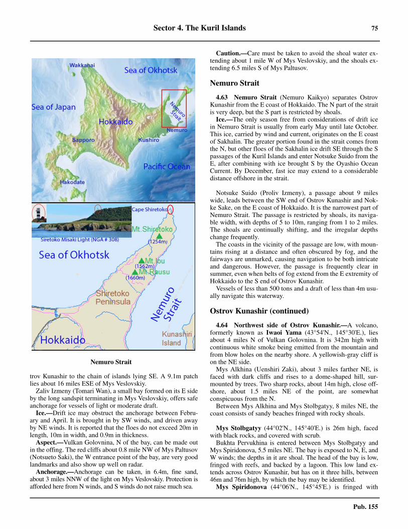
Sector 4. The Kuril Islands 75
Pub. 155
trov Kunashir to the chain of islands lying SE. A 9.1m patchlies about 16 miles ESE of Mys Veslovskiy.4.62 Zaliv Izmeny (Tomari Wan), a small bay formed on its E sideby the long sandspit terminating in Mys Veslovskiy, offers safeanchorage for vessels of light or moderate draft.4.62 Ice.—Drift ice may obstruct the anchorage between Febru-ary and April. It is brought in by SW winds, and driven awayby NE winds. It is reported that the floes do not exceed 20m inlength, 10m in width, and 0.9m in thickness.4.62 Aspect.—Vulkan Golovnina, N of the bay, can be made outin the offing. The red cliffs about 0.8 mile NW of Mys Paltusov(Notsueto Saki), the W entrance point of the bay, are very goodlandmarks and also show up well on radar.4.62 Anchorage.—Anchorage can be taken, in 6.4m, fine sand,about 3 miles NNW of the light on Mys Veslovskiy. Protection isafforded here from N winds, and S winds do not raise much sea.
4.62 Caution.—Care must be taken to avoid the shoal water ex-tending about 1 mile W of Mys Veslovskiy, and the shoals ex-tending 6.5 miles S of Mys Paltusov.
Nemuro Strait
4.63 Nemuro Strait (Nemuro Kaikyo) separates OstrovKunashir from the E coast of Hokkaido. The N part of the straitis very deep, but the S part is restricted by shoals.4.63 Ice.—The only season free from considerations of drift icein Nemuro Strait is usually from early May until late October.This ice, carried by wind and current, originates on the E coastof Sakhalin. The greater portion found in the strait comes fromthe N, but other floes of the Sakhalin ice drift SE through the Spassages of the Kuril Islands and enter Notsuke Suido from theE, after combining with ice brought S by the Oyashio OceanCurrent. By December, fast ice may extend to a considerabledistance offshore in the strait.
4.63 Notsuke Suido (Proliv Izmeny), a passage about 9 mileswide, leads between the SW end of Ostrov Kunashir and Nok-ke Sake, on the E coast of Hokkaido. It is the narrowest part ofNemuro Strait. The passage is restricted by shoals, its naviga-ble width, with depths of 5 to 10m, ranging from 1 to 2 miles.The shoals are continually shifting, and the irregular depthschange frequently.4.63 The coasts in the vicinity of the passage are low, with moun-tains rising at a distance and often obscured by fog, and thefairways are unmarked, causing navigation to be both intricateand dangerous. However, the passage is frequently clear insummer, even when belts of fog extend from the E extremity ofHokkaido to the S end of Ostrov Kunashir.4.63 Vessels of less than 500 tons and a draft of less than 4m usu-ally navigate this waterway.
Ostrov Kunashir (continued)
4.64 Northwest side of Ostrov Kunashir.—A volcano,formerly known as Iwaoi Yama (43°54'N., 145°30'E.), liesabout 4 miles N of Vulkan Golovnina. It is 342m high withcontinuous white smoke being emitted from the mountain andfrom blow holes on the nearby shore. A yellowish-gray cliff ison the NE side.4.64 Mys Alkhina (Uenshiri Zaki), about 3 miles farther NE, isfaced with dark cliffs and rises to a dome-shaped hill, sur-mounted by trees. Two sharp rocks, about 14m high, close off-shore, about 1.5 miles NE of the point, are somewhatconspicuous from the N.4.64 Between Mys Alkhina and Mys Stolbgatyy, 8 miles NE, thecoast consists of sandy beaches fringed with rocky shoals.
4.64 Mys Stolbgatyy (44°02'N., 145°40'E.) is 26m high, facedwith black rocks, and covered with scrub.4.64 Bukhta Pervukhina is entered between Mys Stolbgatyy andMys Spiridonova, 5.5 miles NE. The bay is exposed to N, E, andW winds; the depths in it are shoal. The head of the bay is low,fringed with reefs, and backed by a lagoon. This low land ex-tends across Ostrov Kunashir, but has on it three hills, between46m and 76m high, by which the bay may be identified.4.64 Mys Spiridonova (44°06'N., 145°45'E.) is fringed with
Nemuro Strait
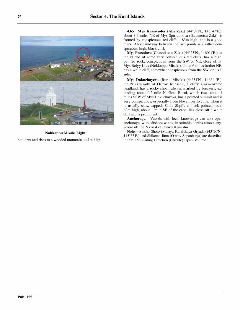
76 Sector 4. The Kuril Islands
Pub. 155
boulders and rises to a wooded mountain, 441m high.
4.65 Mys Krasiyiotes (Aka Zaki) (44°09'N., 145°47'E.),about 3.5 miles NE of Mys Spiridonova (Ikabanotsu Zaki), isfronted by conspicuous red cliffs, 183m high, and is a goodmark. About midway between the two points is a rather con-spicuous, high, black cliff.4.65 Mys Prasolova (Chashikotsu Zaki) (44°23'N., 146°01'E.), atthe N end of some very conspicuous red cliffs, has a high,pointed rock, conspicuous from the SW or NE, close off it.Mys Belyy Utes (Nokkappu Misaki), about 6 miles farther NE,has a white cliff, somewhat conspicuous from the SW, on its Sside.
4.65 Mys Dokuchayeva (Rurui Misaki) (44°31'N., 146°11'E.),the N extremity of Ostrov Kunashir, a cliffy grass-coveredheadland, has a rocky shoal, always marked by breakers, ex-tending about 0.2 mile N. Gora Rurui, which rises about 4miles SSW of Mys Dokuchayeva, has a pointed summit and isvery conspicuous, especially from November to June, when itis usually snow-capped. Skala Shpil', a black pointed rock,62m high, about 1 mile SE of the cape, lies close off a whitecliff and is prominent.4.65 Anchorage.—Vessels with local knowledge can take openanchorage, with offshore winds, in suitable depths almost any-where off the N coast of Ostrov Kunashir.4.65 Note.—Suisho Shoto (Malaya Kuril'skaya Gryada) (43°26'N.,145°55'E.) and Shikotan Jima (Ostrov Shpanberga) are describedin Pub. 158, Sailing Direction (Enroute) Japan, Volume 1.
Nokkappu Misaki Light
77
Pub. 155
5. Sector 5—West Coast of Kamchatka—Mys Lopatka to Mys Utkolokskiy
5.0Additional chart coverage may be found in NGA/DLIS Catalog of Maps, Charts, and Related Products (Unlimited Distribution).SECTOR 5 — CHART INFORMATION
79
Pub. 155
SECTOR 5
WEST COAST OF KAMCHATKA—MYS LOPATKA TO MYS UTKOLOKSKIY
5.0 Plan.—The coasts described in this sector comprise the Eside of the Sea of Okhotsk, which consists of the W coast ofKamchatka, and Zaliv Shelikhova, including PenzhinskayaGuba and Gizhiginskaya Guba. The arrangement of the sectoris from S to N.
General Remarks
5.1 Winds—Weather.—The climate of Zaliv Shelikhovais severe. The warmest month of the year is August, with amean monthly temperature of 11°C. Frost begins to occur earlyin September and rivers are frozen from the middle of Octoberto the end of May. January and February, with a mean monthlytemperature of -24°C, are the coldest months.5.1 Fog occurs in all seasons of the year, but mainly in springand summer. It is infrequent in the autumn and rare in the win-ter. It is mainly associated with winds from between the SE andSW.5.1 Strong NE winds prevail in winter from October to the endof April. During the winter, winds backing to the W are accom-panied by clear, cold days, but those winds from between theNE and NNE are accompanied by blizzards. In May, the winddrops and alternates with calm days. In summer, the prevailingwinds are SW in the S part of the gulf and S in the N part of thegulf. The strongest winds occur towards the end of Septemberand in October and November.5.1 In winter, the winds are mainly offshore, and in summermainly onshore, on the W coast of Kamchatka. The wintermonsoon is only defined from December to March, when thewinds are predominantly E or NE. The winds of the summermonsoon, W to SW, are most predominant in June and July.5.1 Between May and the first part of August, heavy fog alongthe coast from Mys Lopatka to Mys Utkolokskiy is frequent,though it rarely occurs after the end of August. Easterly windsoften clear the coast from fog, which may still persist at sea.5.1 Ice.—The central part of Zaliv Shelikhova does not freeze.Fast ice begins to form along the shores in November and, in-creasing its width steadily, merges into ice fields, with a maxi-mum thickness of 1.5m, extending 25 to 35 miles seaward bythe middle of April. In average years, drift ice appears in De-cember and all ice clears in early July. Strong NE winds duringthe spring and summer can help to clear the bay.5.1 In the open sea off Rechka Kikchik, fast ice and drift ice usu-ally appear in December and clear in April.5.1 At Mys Khayryuzova fast ice begins to form in most years inNovember, some years not forming at all. Drift ice appears inNovember and the sea is covered with ice up to 0.6m thick inDecember. The ice begins to break up in April and finallyclears in May.5.1 On the W coast of Kamchatka, ice begins to form by themiddle or end of November, and eventually attains a thicknessof 0.9 to 1.2m, fringing the coast to a distance of 20 to 30 milesoffshore in the N part. The ice begins to break up around theend of April, and is carried away by the S current toward the
Kuril Islands, in the vicinity of which this ice, already broken,remains through May and part of June, but is seldom presentafter the end of June. 5.1 Tides—Currents.—In Zaliv Shelikova, the tides are diurnalat springs, but otherwise are semi-diurnal and irregular. Thetidal range is 7.9m at the entrance and increases gradually toabout 11.3m at the head of the gulf. 5.1 The current sets NE and divides at Mys Taygonos, with theW branch flowing counterclockwise along the shores of Gizhi-ginskaya Guba. The rate is not more than 0.2 to 0.5 knot.5.1 Tidal currents generally set parallel to the shores and there ishardly any lateral drift, but the currents are strong and form ed-dies and countercurrents. In the S part of the gulf, the rate is 2.7to 3 knots, and less on the E shore. In The Gorlo, tidal currentsattain a rate of 4.7 to 5 knots, less on the E side, and 6 to 7knots in the vicinity of the islands near The Gorlo. In the N partof the gulf, velocities may reach 3 to 3.5 knots.5.1 There is practically no period of slack water at the turn of thecurrents.
Mys Lopatka to Mys Utkolokskiy
5.2 Mys Lopatka (50°52'N., 156°40'E.), the S point ofKamchatka, is described in paragraph 3.30. The coast fromMys Lopatka to Mys Utkolokskiy, about 425 miles N, isbacked by a broad belt of tundra extending to the W slope ofSredinnyy Khrebet, the central mountain range that trendsmore or less parallel to the coast from 60 to 70 miles inland.5.2 Since the coast in those regions where the coast is low lacksdistinctive features, a number of beacons surmounted by vari-ous topmarks have been erected to facilitate navigation. Thesebeacons are not maintained and some of them may be partly ortotally destroyed.5.2 The best time of the year for navigation in these waters is themonth of April and the first half of May. Navigation in clearweather presents no difficulties. The peaks of mountains,which are discernible from considerable distances, form goodlandmarks and the distance offshore may be checked by sound-ings.5.2 Anchorage.—This coast affords no sheltered anchorages forvessels other than small craft with local knowledge, which canfind protection in the mouths of the rivers.5.2 Caution.—Vessels should exercise great care in approachingthis coast. An area of caution, designated Area 24, extends ap-proximately 45 miles offshore of this coastline and covers adistance of more than 350 miles in a N-S direction. Caution isadvised due to inadequate surveys and the existence of unchart-ed dangers in this area. The limits of this area are best seen onthe chart. 5.2 In fog, vessels approaching the low section of coast betweenReka Ozernaya (51°30'N., 156°30'E.) and Mys Khayryuzova(57°05'N., 156°32'E.) should anchor, in depths of 12.8 to14.6m, and wait for the fog to clear. Due to the irregularity ofthe bottom off the coast between Mys Lopatka and Reka Ozer-
80 Sector 5. West Coast of Kamchatka—Mys Lopatka to Mys Utkolokskiy
Pub. 155
naya, especially in the S part, vessels should not approach thiscoast unless they are certain of their positions.5.2 Vessels should exercise great care in approaching this coastduring the fishing season, which lasts from May to August orSeptember, a period through which a considerable number offishing vessels remain anchored along this coast, in depths of11 to 14.6m, at a distance of 1 to 1.5 miles offshore. These ves-sels neither carry anchor lights nor sound fog signals.5.2 Fishing nets, the outer ends of which are usually marked bysmall buoys or floats displaying small red flags, extend up to 3miles offshore abreast fisheries, which are numerous along thiscoast. It is inadvisable to approach this coast after dark or in fog.5.2 Rivers and rivulets, which are numerous along this coast,rarely flow directly into the sea, being obstructed by the strip ofgravel thrown up by the heavy surf. They flow inside this grav-el strip, sometimes for several miles, until they find an outlet tothe sea. The entrances into the rivers are usually fronted bysand bars, often nearly dry. The entrances and the bars are sub-ject to frequent shifts.
5.3 The coast between Mys Lopatka and Mys Kambal’nyy, about 14 miles N, is low and sandy. A ledge, covered withkelp, about 5 miles NNE of Mys Lopatka, extends 1 mile off-shore.5.3 Mys Kambal’nyy (51°06'N., 156°42'E.) is the SW extremi-ty of a peninsular projection, backed by the slope of Gora Mos-hkovskaya, 503m high. Two detached hills are located N and Sof Gora Moshkovskaya. The S hill rises to a height of 174mnear the extremity of the cape. All three elevations are cone-shaped and conspicuous from the W.5.3 Ostrov Kambal’nyy, a barren islet, 37m high, lies about 0.3mile SW of Mys Kambal’nyy. Reefs, marked by kelp, extendabout 0.5 mile NW and SE of the islet. The SW side is reportedto be steep-to.5.3 Tides—Currents.—Tidal currents in the vicinity of MysKambal’nyy attain a velocity of 2 to 2.5 knots at springs and 1to 1.5 knots at neaps. The flood current sets N and NNE andthe ebb sets S and SSW.5.3 Zaliv Kambal’nyy is entered between Mys Kambal’nyy andMys Sivuchiy, about 13 miles NNW. The latter point is a bluntmountainous cape rising steeply from the sea. Two pillar rocks,the seaward one the larger but lower of the two, lie a short dis-tance off the extremity of the cape. Reka Kambal’naya dis-charges between two gravel spits about 4 miles N of MysKambal’nyy. The buildings of a fishery stand on the beachabout 0.8 mile S of the river mouth.5.3 The approximate HW interval at Zaliv Kambal’nyy is about6 hours. The spring rise is about 2.1m, while the neap rise is0.9 to 1.5m.5.3 Caution.—A 9m patch lies about 6.5 miles NW of MysSivuchiy.
5.4 Sopka Kambal’naya (Gora Kambal’naya) (51°18'N.,156°53'E.), the southernmost of the volcanoes of Kamchatka,is conspicuous on all bearings and appears cone-shaped fromthe S. Sopka Shirokaya is located about 6 miles WNW of Sop-ka Kambal’naya.5.4 Reka Ozernaya (51°30'N., 156°30'E.) flows through a nar-row valley and discharges into the sea through a basin includedbetween two curved spits. An obelisk and a part of a mast,
marking the graves of the crew of the wrecked Japanese cruiserNiitaka, are situated on a hill, 37m high, a short distance N ofthe mouth of the river, and form a good landmark. A light isshown at the mouth of Reka Ozernaya. 5.4 Reka Yavina, nearly 10 miles farther N, may be identified bytwo posts situated close S of the river mouth, which is frontedby a shallow bar.
5.5 Reka Golygina (51°55'N., 156°29'E.) enters the seaafter turning N within a narrow strip of land ending in a flat.Reka Opala enters the sea about 3 miles N, but for about thelast 10 miles flows S and is separated from the sea by a fairlywide sand and gravel spit, from the extremity of which a flatextends S. The settlement of Opala is situated on the spit about2 miles N of the mouth of Reka Opala.5.5 Tides—Currents.—The MHW interval in the vicinity ofReka Opala and Reka Golygina is 6 hours 50 minutes. Thespring rise is about 1.8m, while the neap rise is about 0.9m.5.5 Reka Bol’shaya, the largest river on the W side of Kamchat-ka, approaches the coast in a general SW direction, then flowsSSE for about 10 miles, separated from the sea by a narrow spitof sand and gravel. A drying flat lies at the extremity of thespit. The entrance (52°33'N., 156°18'E.) of Reka Bol’shaya ismarked by two range beacons on the mainland abreast the en-trance. The entrance can also be identified by a steep sand hill-ock, with three summits, located near the shorelineimmediately N of the entrance. This hillock is fairly conspicu-ous against the background of clouds or mist that occasionallyobscure the inland elevations. A light is shown close N of theentrance.5.5 Small vessels up to 500 gt with a draft of not more than 3.5mcan enter, but local knowledge is necessary. 5.5 Tides—Currents.—The MHW interval at the mouth of Re-ka Bol’shaya is 7 hours 50 minutes. The spring rise, which isdiurnal, is 3m, and the neap rise, which is semidiurnal, is 0.9 to1.2m. The flood current in the entrance attains a velocity of 3to 3.5 knots; the ebb current, a velocity of 4 to 5 knots.5.5 Pilotage.—Pilotage is compulsory for vessels entering the riv-er with a draft of over 2m. Request for pilots should be made tothe port authority. Vessels approaching the port should maintaina continuous listening watch on an agreed frequency. To assistvessels, the port radio station will transmit, on request, RDFbearings on 418 kHz. In conditions of reduced visibility thecoast radar station on request, will provide radar pilotage.5.5 Anchorage.—Anchorage can be obtained, in a depth of 9m,fine sand, good holding ground, about 1.2 miles offshoreabreast the river entrance.
5.6 Oktyabr‘skiy (52°40'N., 156°15'E.) is a small portsituated on the narrow spit of sand W of Ozero Bol’shoye, 7miles N of the entrance to Reka Bol’shaya.
Ice.—The port is usually icebound between the first part ofNovember through mid-April. 5.6 Tides—Currents.—Tidal currents in the entrance to OzeroBol’shoye can reach velocities of 3 to 3.5 knots at flood andrange between 4 and 5 knots during ebb tide.
Depths—Limitations.—A quay is suitable for berthing ves-sels up to 60m in length, 500 gt, and with a maximum draft of3.5m.5.6 Pilotage.—Pilotage is not available.
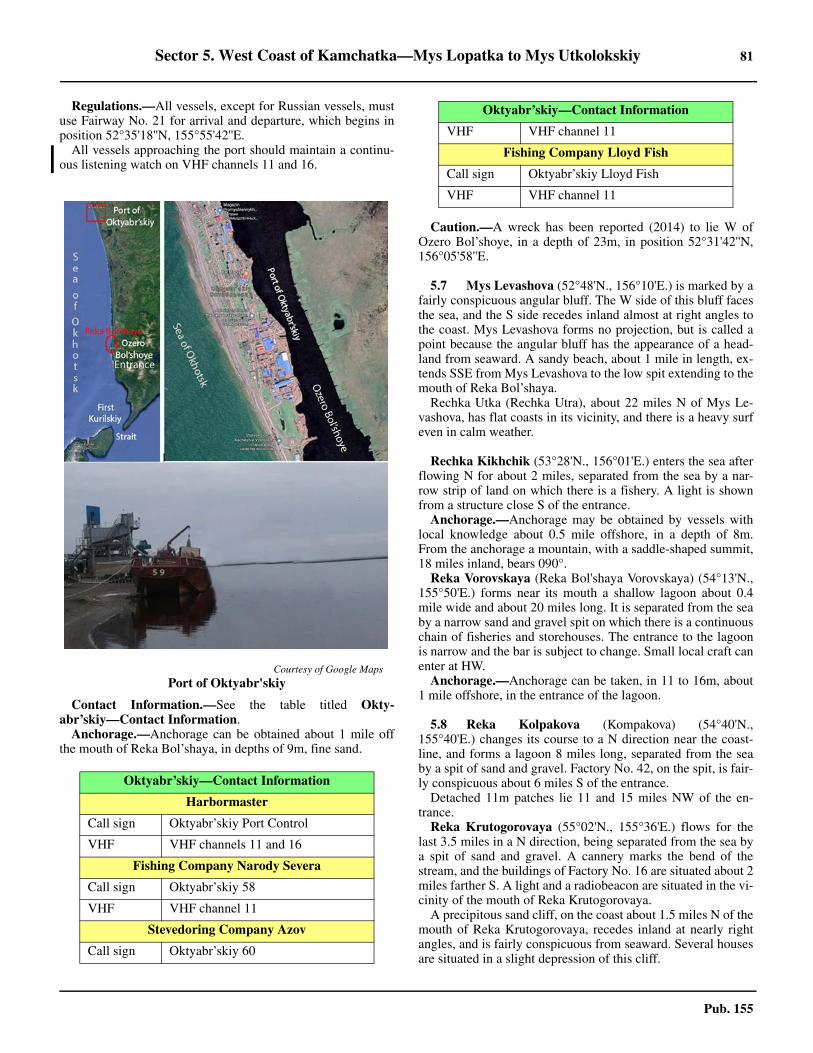
Sector 5. West Coast of Kamchatka—Mys Lopatka to Mys Utkolokskiy 81
Pub. 155
5.6 Regulations.—All vessels, except for Russian vessels, mustuse Fairway No. 21 for arrival and departure, which begins inposition 52°35'18''N, 155°55'42''E. 5.6 All vessels approaching the port should maintain a continu-ous listening watch on VHF channels 11 and 16.
5.6 Contact Information.—See the table titled Okty-abr’skiy—Contact Information. 5.6 Anchorage.—Anchorage can be obtained about 1 mile offthe mouth of Reka Bol’shaya, in depths of 9m, fine sand.
5.6 Caution.—A wreck has been reported (2014) to lie W ofOzero Bol’shoye, in a depth of 23m, in position 52°31'42''N,156°05'58''E.
5.7 Mys Levashova (52°48'N., 156°10'E.) is marked by afairly conspicuous angular bluff. The W side of this bluff facesthe sea, and the S side recedes inland almost at right angles tothe coast. Mys Levashova forms no projection, but is called apoint because the angular bluff has the appearance of a head-land from seaward. A sandy beach, about 1 mile in length, ex-tends SSE from Mys Levashova to the low spit extending to themouth of Reka Bol’shaya.5.7 Rechka Utka (Rechka Utra), about 22 miles N of Mys Le-vashova, has flat coasts in its vicinity, and there is a heavy surfeven in calm weather.
Rechka Kikhchik (53°28'N., 156°01'E.) enters the sea afterflowing N for about 2 miles, separated from the sea by a nar-row strip of land on which there is a fishery. A light is shownfrom a structure close S of the entrance.5.7 Anchorage.—Anchorage may be obtained by vessels withlocal knowledge about 0.5 mile offshore, in a depth of 8m.From the anchorage a mountain, with a saddle-shaped summit,18 miles inland, bears 090°.5.7 Reka Vorovskaya (Reka Bol'shaya Vorovskaya) (54°13'N.,155°50'E.) forms near its mouth a shallow lagoon about 0.4mile wide and about 20 miles long. It is separated from the seaby a narrow sand and gravel spit on which there is a continuouschain of fisheries and storehouses. The entrance to the lagoonis narrow and the bar is subject to change. Small local craft canenter at HW. 5.7 Anchorage.—Anchorage can be taken, in 11 to 16m, about1 mile offshore, in the entrance of the lagoon.
5.8 Reka Kolpakova (Kompakova) (54°40'N.,155°40'E.) changes its course to a N direction near the coast-line, and forms a lagoon 8 miles long, separated from the seaby a spit of sand and gravel. Factory No. 42, on the spit, is fair-ly conspicuous about 6 miles S of the entrance.5.8 Detached 11m patches lie 11 and 15 miles NW of the en-trance.5.8 Reka Krutogorovaya (55°02'N., 155°36'E.) flows for thelast 3.5 miles in a N direction, being separated from the sea bya spit of sand and gravel. A cannery marks the bend of thestream, and the buildings of Factory No. 16 are situated about 2miles farther S. A light and a radiobeacon are situated in the vi-cinity of the mouth of Reka Krutogorovaya.5.8 A precipitous sand cliff, on the coast about 1.5 miles N of themouth of Reka Krutogorovaya, recedes inland at nearly rightangles, and is fairly conspicuous from seaward. Several housesare situated in a slight depression of this cliff.
Courtesy of Google Maps
Port of Oktyabr'skiy
Oktyabr’skiy—Contact Information
Harbormaster
Call sign Oktyabr’skiy Port Control
VHF VHF channels 11 and 16
Fishing Company Narody Severa
Call sign Oktyabr’skiy 58
VHF VHF channel 11
Stevedoring Company Azov
Call sign Oktyabr’skiy 60
VHF VHF channel 11
Fishing Company Lloyd Fish
Call sign Oktyabr’skiy Lloyd Fish
VHF VHF channel 11
Oktyabr’skiy—Contact Information
82 Sector 5. West Coast of Kamchatka—Mys Lopatka to Mys Utkolokskiy
Pub. 155
5.8 Anchorage.—Anchorage can be taken, in a depth of 10m,about 1.5 miles offshore, with the chimney of Factory No. 16bearing 089°.5.8 The coast between the mouth of Reka Krutogorovaya andthat of Reka Oblukovina, about 13 miles N, is fronted with alow slender islet of sand and gravel, separated from the coastby a rather narrow channel. The entrances at the N and S endsof the islet are inconspicuous.
5.9 Reka Icha (55°42'N., 155°39'E.) enters the sea afterflowing 6 miles N inside a 22 mile long narrow strip of sandand gravel. A fishery of considerable size, about 2.5 miles S ofthe N end of a lagoon, is situated in the vicinity of a coastalsandy precipice that recedes sharply inland.5.9 Gora Sopochnaya (56°02'N., 156°01'E.), a detached cone-shaped mountain, is a conspicuous landmark about 12 milesESE of the mouth of Reka Sopochnaya. Beacons have been es-tablished near a fish cannery, about 2 miles S of the mouth ofReka Sopochnaya.5.9 The coast from Reka Sopochnaya to Reka Moroshechnaya,about 45 miles NNE, is low and backed by a chain of moun-tains parallel to the coast and about 7 miles inland. Gora Mo-roshechnaya (56°48'N., 156°18'E.), the highest of the above-mentioned chain, has a conical peak and is a good landmark. Itis 442m high and lies 5 miles E of the mouth of the Reka Mo-roshechnaya.5.9 A bank extends from the mouth of Reka Moroshechnaya, thedepths 2 miles offshore being only 5.9 to 6.4m.
5.10 Mys Khayryuzova (Mys Khariuzov) (57°05'N.,156°32'E.), the cliffy extremity of a peninsula, has a reef, dryin parts, extending about 1 mile NNE of it. Gora Konus, a con-spicuous cone-shaped mountain, rises about 16 miles E of thecape.5.10 Ostrovok Ptichiy, an islet about 4.5 miles NNE of MysKhayryuzova, rises to a height of 104m near its central part.Above and below-water rocks extend 0.5 mile N and 1 mile Sof the islet. The channel between the islet and the cape has notbeen surveyed and unknown dangers are likely to exist in it. 5.10 A detached rock lies about 5 miles NW of Ostrovok Ptichiy.5.10 The area E of Mys Khayryuzova and Ostrovok Ptichiy isshoal, and vessels should not proceed S of the parallel of the Nend of Ostrovok Ptichiy.5.10 Anchorage.—Anchorage may be obtained 1.5 miles NNWof Mys Khayryuzova, in a depth of 11m.5.10 Caution.—A 3m patch, position approximate, was reported(1956) to lie about 26 miles W of Mys Khayryuzova. A 7.3mpatch, existence doubtful, lies about 24 miles W of the samecape. A depth of 9.1m was reported (1963) to lie 56°57'N;154°32'E; an approximate position 66 miles WSW of MysKhayryuzova.5.10 A submarine cable lands 8 miles ENE of Mys Khayryuzova.
5.11 Poluostrov Utkolokskiy, a mountainous promontory,rises from the low land at its inner end to elevations of over518m at its seaward end. Mys Yuzhnyy (57°44'N., 156°47'E.)and Mys Utkolokskiy, respectively, are its SW and NE extrem-ities.5.11 Mys Yuzhnyy is steep and rocky, decreasing in height to-wards its extremity. A reef, which dries at LW, extends about 2
miles S of the cape. A chain of rocks, above and below-water,extends about 1.7 miles S of the cape.5.11 Anchorage.—The bight SE of Mys Yuzhnyy is the only an-chorage on the W coast of Kamchatka offering protection fromthe W winds and the heavy swell. The anchorage is protectedby the cape and the chain of rocks extending S from it. Anchor-age can be taken, with local knowledge, in 10m, about 2 milesE of the extremity of the reef.
5.12 Mys Zubchatyy, about 6 miles NE of Mys Yuzhnyy, isa steep-to peninsular projection, and rises sheerly from the seato a 384m high jagged summit.5.12 Mys Utkolokskiy (57°54'N., 157°04'E.), conspicuous andeasily identified, rises vertically to a sugarloaf elevation, 381mhigh, backed by another similar type elevation, 438m high,close SW. A drying reef extends about 0.5 mile NE of the cape.A pillar rock, in the middle of the reef, is conspicuous.5.12 Tides—Currents.—The flood currents, flowing into ZalivShelikhova from the Sea of Okhotsk, attain a velocity of 3 to3.5 knots at springs off Poluostrov Utkolokskiy, causing tiderips and eddies, particularly off the projecting capes.5.12 The tidal currents force the cold water at the bottom to rise tothe surface. This cold water may reduce the surface temperatureto as much as 8°C below the normal air temperature in the vicin-ity, causing the fog prevailing through May, June, and July. Fogis rare beginning in the first half of August, and with strong W orSW winds, fog does not occur here.
Zaliv Shelikhova (Penzhinskiy Zaliv)
5.13 Zaliv Shelikhova, forming the NE end of the Sea ofOkhotsk, is entered between Mys Utkolokskiy and MysTolstoy, about 96 miles NW. Penzhinskaya Guba and Gizhi-ginskaya Guba occupy the NE and N parts, respectively, ofZaliv Shelikhova.5.13 Navigation in the spacious Zaliv Shelikhova presents no dif-ficulties on a clear day and the shores of the gulf afford numer-ous landmarks. In foggy weather, which prevails here duringthe spring and summer, vessels approaching the shore shouldbe guided by continual soundings. Vessels favoring the W sideof the entrance should navigate in depths of not less than 100m,which are 3 to 4 miles E of Ostrova Yamskiye. It has been ob-served that when dense fog envelops Ostrova Yamskiye, thefog is lighter N of this group of islands.5.13 Tides—Currents.—The tidal currents, which attain at Os-trova Yamskiye a velocity of up to 5 knots, should be taken intoaccount. The phase of the tide and the direction of the currentshould be determined on the basis of the HW interval at ZalivUdacha, the bight close N of Mys Tolstoy.5.13 Vessels favoring the E side of the entrance should navigate indepths not less than 55m. The tidal currents here flow along thecoast.
5.14 East side of Zaliv Shelikhova.—Bukhta Kavachalies between Mys Utkolokskiy and Mys Omgon (58°01'N.,157°41'E.). An above-water rock, position doubtful, lies about8 miles E of Mys Utkolokskiy. A drying ledge, in the S part ofthe bay, extends in an ENE direction for over 2.2 miles, andabout 0.7 mile offshore. Foul ground extends about 1 mile Wof Mys Promezhutochnyy, on the E side of the bay.
Sector 5. West Coast of Kamchatka—Mys Lopatka to Mys Utkolokskiy 83
Pub. 155
5.14 Mys Omgon, the NW extremity of a rocky peninsula, hastwo similar mountains near its extremity. The seaward andhigher of the two mountains rises to a height of 354m. On theseaward side of this mountain is a pointed, 122m high hill, witha pillar rock under its foot. From a distance, Mys Omgon hasthe appearance of an islet with two peaks.5.14 Foul ground extends about 0.3 mile N and W of MysOmgon. A cliffy islet, about 4 miles SSW of Mys Omgon, liesabout 0.8 mile offshore, connected with the coast by a dryingreef and surrounded by scattered rocks.5.14 Mys Babushkina, about 2 miles E of Mys Omgon, is formedby a huge pointed cliff, which is steep on all sides. From a dis-tance, the cape is conspicuous on E and W bearings and has theappearance of a detached pointed rock lying a short distanceoffshore. From the N, it is inconspicuous.5.14 Tides—Currents.—The flood current flows in a NE andENE direction, and the ebb in a reverse direction, in the vicini-ty of Mys Omgon, attaining a velocity of 2 to 2.5 knots.5.14 Fogs, due to colder water coming to the surface, are frequentoff Mys Omgon, especially in May, June, and July.
Caution.—Banka Mineola, with a least depth of 5.5m, ischarted about 6.5 miles NE of Mys Babushkina. The position isapproximate.5.14 A detached patch, with a least depth of 2.6m, lies about 10miles NE of Mys Babushkina.
5.15 Reka Tigil’ (58°02'N., 158°13'E.), which is over 260miles long, enters the sea 14 miles E of Mys Babushkina. Dry-ing shoals extend 1 mile from both sides of the entrance. Ves-sels wishing to enter must obtain a pilot.5.15 Mys Kamyatyan (Mys Kamatan) (58°18'N., 158°44'E.), 34miles NE of Mys Babushkina, is a slight projection formed bytwo hills, the SW hill about 259m high, and the NE hill about207m high. The cape is rendered somewhat conspicuous by thelight color of its precipices facing the sea.5.15 Reka Voyampolka (Vayam-Palka) (58°31'N., 159°10'E.)enters the sea 19 miles NE of Mys Kamyatyan and is renderedconspicuous by the elevated N bank, which terminates in ahigh cape marked by landslides, and contrasts sharply with theS bank of the river. A small settlement is situated on the Sbank, near the mouth of the river.5.15 Anchorage.—Anchorage can be taken, with local knowl-edge, in a depth of 9m, about 2.5 miles W of the mouth of RekaVoyampolka. Care should be taken to avoid the 3.7m shoal,about 1.5 miles NW of the river entrance.
5.16 Gora Urginskaya (58°44'N., 159°36'E.), a flat-topped mountain, 223m high, lying 18 miles NE of RekaVoyampolka, dominates other elevations in the vicinity, and,having the appearance of a trapezoid from seaward, forms anexcellent landmark from the offing.5.16 Mys Kakhtaninskiy (Mys Kokhtaninskiy), about 7.5 milesfarther N, rises to a height of 225m close inland. OstrovokChayachiy, a white islet, covered with guano, lies about 0.8mile W of the headland. A drying reef extends from the islet tothe headland, and a drying reef fringes the W side of the islet.5.16 Mys Pyatibratskiy, about 10 miles farther NNE, rises steeplyto Gora Pyatibratskaya, 482m high. Reka Palana, about 6 milesNNE of the cape, can be recognized by the buildings of a fishcannery, conspicuous from seaward, near the river mouth.
5.16 Mys Kinkil’skiy (Mys Kinkil’skoy) (59°20'N., 160°12'E.),16 miles NE of Reka Palana, is slanted on its seaward side andits flat top is backed by a plateau receding inland. A short dry-ing reef extends NW from the cape, and a similar reef extends ashort distance offshore for about 1 mile E of the cape.5.16 Mys Pensepel, a low blunt cape, about 18 miles NE of MysKinkil’skiy, is the seaward termination of the valley throughwhich Reka Lesnaya (Reka Lesnoye) flows. Reka Lesnayaforms a marshy delta covered with small shrub and scrub trees.The river enters the sea about 9.5 miles SSW of Mys Pense-pel’, flowing SSW for the last 6 miles, separated from the seaby a narrow strip of sand and shingle.5.16 Mys Ostrovskoy (59°43'N., 161°02'E.) is a steep roundedcape formed by the seaward termination of a coastal elevation,308m high. The W slope of this elevation projects slightly fromthe coast. A drying rock lies about 5 miles SW of the point andabout 1.3 miles offshore.5.16 A chain of mountains, extending 43 miles NE of Mys Ostro-vnoy, has no conspicuous summits except a cone-shaped peak,564m high, near the N end of the chain. A precipitous rectan-gular cape, about 24 miles NE of Mys Ostrovnoy, forms theonly fairly conspicuous projection along this coast. A ledge,which dries, extends about 1.8 miles N from the NE end of thecape.
5.17 Mys Bozhedomova (60°18'N., 161°53'E.), 44 milesNE of Mys Ostrovnoy, is a cliffy brown cape, conspicuouslymarked by numerous white patches. A finger-like pillar rocklies near the extremity of the cape. Rocks, which dry, extendabout 1 mile SSW of the pillar rock.5.17 Ostrovok Yengalycheva, a barren islet about 1.7 miles SW ofMys Bozhedomova, is steep on all sides, rising sheerly fromthe sea at HW, but at LW a foreshore of sand and shingle fring-es it on all sides. Above and below-water rocks extend about0.5 mile SSW of the islet, and a drying reef extends about 0.3mile NNE. Navigation between Mys Bozhedomova and the is-let is not recommended unless the extremities of both reefs areclearly visible.5.17 Bukhta Podkagernaya, a very shallow bight E of Mys Bozhe-domova, dries at LWS. 5.17 Tides—Currents.—The MHW interval at Bukhta Podka-gernaya is about 3 hours 15 minutes. The spring tide is diurnaland the spring tidal range is up to 6.7m. The neap tide is semi-diurnal and has a range of about 3.3m. Generally, the tides hereare irregular.5.17 Anchorage.—Anchorage, with local knowledge, can be tak-en in the roadstead S of Bukhta Podkagernaya, in 6.5m, fairlygood holding ground of sand and shingle, S of the parallel ofOstrovok Yengalycheva, and with Mys Bozhedomova bearingN.
Penzhinskaya Guba
5.18 Penzhinskaya Guba, entered between Mys Bozhedo-mova and Mys Taygonos, about 54 miles WNW, has no shel-tered anchorages, despite its considerable size and appreciablyindented shores. The shores of the gulf are generally high andbluff. The Gorlo, the narrowest part, separates the gulf into twoparts.5.18 Caution.—Despite swift currents, Penzhinskaya Guba pres-
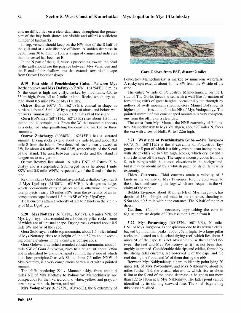
84 Sector 5. West Coast of Kamchatka—Mys Lopatka to Mys Utkolokskiy
Pub. 155
ents no difficulties on a clear day, since throughout the greaterpart of the bay both shores are visible and afford a sufficientnumber of landmarks.5.18 In fog, vessels should keep on the NW side of the S half ofthe gulf and at a safe distance offshore. A sudden decrease indepth from 30 to 35m to 10m is a sign of danger and indicatesthat the vessel has been set E.5.18 In the N part of the gulf, vessels proceeding toward the headof the gulf should use the passage between Mys Valizhgen andthe E end of the shallow area that extends toward this capefrom Ostrov Dobrzhanskogo.
5.19 East side of Penzhinskaya Guba.—Between MysBozhedomova and Mys Dal'niy (60°26'N., 161°54'E.), 8 milesN, the coast is high and cliffy, backed by mountains, 450 to550m high, from 1.5 to 2 miles inland. Rocks, which dry, ex-tend about 0.5 mile NW of Mys Dal'niy.5.19 Ostrov Konus (60°34'N., 162°08'E.), conical in shape, isbordered about 0.5 mile W by a group of above and below-wa-ter rocks; similar group lies about 1.5 miles N of the island.5.19 Gora Bol’shaya (60°31'N., 162°23'E.) rises about 1.5 milesinland and is conspicuous. From the W, the mountain appearsas a detached ridge paralleling the coast and marked by threesummits.5.19 Ostrov Zubchatyy (60°48'N., 162°45'E.) has a serratedsummit. Drying rocks extend about 0.7 mile N, and about 0.3mile S from the island. Two detached rocks, nearly awash atLW, lie about 4.8 miles W and SSW, respectively, of the S endof the island. The area between these rocks and the island isdangerous to navigation.5.19 Ostrov Rovnyy lies about 16 miles ENE of Ostrov Zub-chatyy and is steep-sided. Submerged rocks lie about 1 mileSSW and 0.8 mile WNW, respectively, of the S end of the is-land.5.19 Rekinninskaya Guba (Rekinskaya Guba), a shallow bay, lies Sof Mys Ugol’nyy (61°00'N., 163°30'E.). A dangerous ledge,which occasionally dries in places and is otherwise indiscern-ible, projects nearly 1.8 miles SSW from the extremity of an in-conspicuous cape located 1.5 miles SE of Mys Ugol’nyy. 5.19 Tidal currents attain a velocity of 2.5 to 3 knots in the vicini-ty of Mys Ugol'nyy.
5.20 Mys Nottatey (61°07'N., 163°37'E.), 8 miles NNE ofMys Ugol’nyy, is surrounded on all sides by pillar rocks, someof which are of unusual shape. Drying rocks extend about 0.5mile SW and W of the cape.5.20 Gora Stolovaya, a table-top mountain, about 1.5 miles inlandof Mys Nottatey, rises to a height of about 579m and, exceed-ing other elevations in the vicinity, is conspicuous.5.20 Gora Golova, a detached rounded coastal mountain, about 1mile SW of Gora Stolovaya, rises to a height of about 396mand is identified by a knoll-shaped summit, the S side of whichis a sheer precipice.Ostrovok Skala, about 7.5 miles NNW ofMys Nottatey, is a very conspicuous barren islet with a pointedsummit.5.20 The cliffs bordering Zaliv Mamechinskiy, from about 4miles NE of Mys Nottatey to Poluostrov Mamechinskiy, areconspicuous for their varied colors, white, yellow, and gray, al-ternating with black, brown, and red.5.20 Mys Vodopadnyy (61°25'N., 163°46'E.), the S extremity of
Poluostrov Mamechinskiy, is marked by numerous waterfalls.A rocky spit extends about 1 mile SW from the W side of thecape.5.20 The entire W side of Poluostrov Mamechinskiy, on the Eside of The Gorlo, faces the sea with a wall-like formation offorbidding cliffs of great heights, occasionally cut through bygulleys of swift mountain streams. Gora Mamet Bol’shoy, itshighest point, rises about 6 miles NE of Mys Vodopadnyy. Thepointed summit of this cone-shaped mountain is very conspicu-ous from the offing on a clear day.5.20 The coast from Mys Mamet, the NNE extremity of Poluos-trov Mamechinskiy to Mys Valizhgen, about 27 miles N, facesthe sea with a row of bluffs 91 to 122m high.
5.21 West side of Penzhinskaya Guba.—Mys Taygonos(60°34'N., 160°11'E.) is the S extremity of Poluostrov Tay-gonos, the S part of which is a fairly even plateau facing the seawith sheer cliffs 76 to 91m high. Rocks, which dry, extend ashort distance off the cape. The cape is inconspicuous from theS, as it merges with the coastal elevations in the background,but it may be identified by a whitish patch on its cliffs near itsextremity.5.21 Tides—Currents.—Tidal currents attain a velocity of 3knots in the vicinity of Mys Taygonos, forcing cold water tothe surface, and causing the fogs which are frequent in the vi-cinity of the cape.5.21 Bukhta Taygonos, about 10 miles NE of Mys Taygonos, hasdepths of 13m, shingle and mud, in the entrance, shoaling to5.5m about 0.5 mile within the entrance. The N half of the inletdries.5.21 Caution.—Caution is necessary approaching the cape infog, as there are depths of 70m less than 1 mile from it.
5.22 Mys Povorotnyy (60°43'N., 160°46'E.), 20 milesENE of Mys Taygonos, is conspicuous due to its reddish cliffs,backed by mountain peaks, about 762m high. Two large pillarrocks are located on a detached drying reef, which lies about 3miles SE of the cape. It is not advisable to use the channel be-tween the reef and Mys Povorotnyy, as it has not been thor-oughly examined. Considerable tide rips and eddies, formed bythe strong tidal currents, are observed E of the cape and thereef during the flood, and W of them during the ebb.5.22 Between Mys Nablyudeniy, a hard to identify point lying 20miles NE of Mys Povorotnyy, and Mys Naklonnyy, about 36miles further NE, the coastal elevations, which rise to about610m at the S end of the coast, decrease in height to not morethan 122 to 183m near Mys Naklonnyy. The latter point can beidentified by its slanting seaward face. The small bays alongthis coast are silted.
Gora Golova from ESE, distant 2 miles
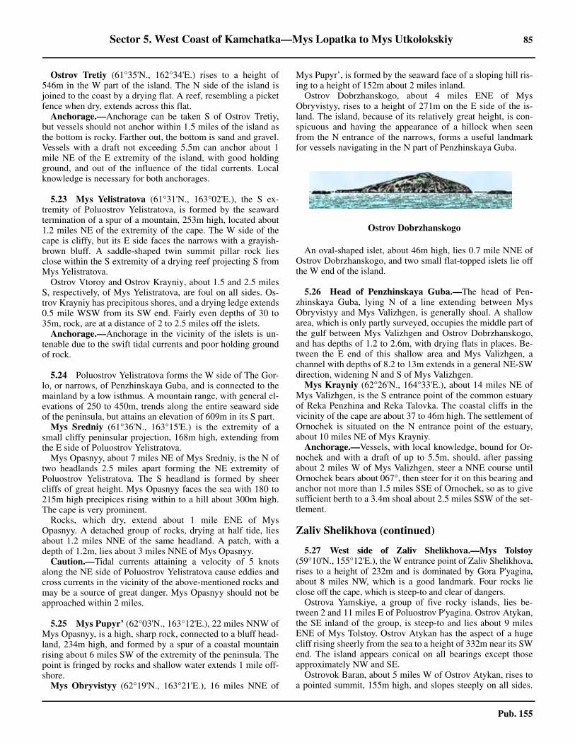
Sector 5. West Coast of Kamchatka—Mys Lopatka to Mys Utkolokskiy 85
Pub. 155
5.22 Ostrov Tretiy (61°35'N., 162°34'E.) rises to a height of546m in the W part of the island. The N side of the island isjoined to the coast by a drying flat. A reef, resembling a picketfence when dry, extends across this flat.5.22 Anchorage.—Anchorage can be taken S of Ostrov Tretiy,but vessels should not anchor within 1.5 miles of the island asthe bottom is rocky. Farther out, the bottom is sand and gravel.Vessels with a draft not exceeding 5.5m can anchor about 1mile NE of the E extremity of the island, with good holdingground, and out of the influence of the tidal currents. Localknowledge is necessary for both anchorages.
5.23 Mys Yelistratova (61°31'N., 163°02'E.), the S ex-tremity of Poluostrov Yelistratova, is formed by the seawardtermination of a spur of a mountain, 253m high, located about1.2 miles NE of the extremity of the cape. The W side of thecape is cliffy, but its E side faces the narrows with a grayish-brown bluff. A saddle-shaped twin summit pillar rock liesclose within the S extremity of a drying reef projecting S fromMys Yelistratova.5.23 Ostrov Vtoroy and Ostrov Krayniy, about 1.5 and 2.5 milesS, respectively, of Mys Yelistratova, are foul on all sides. Os-trov Krayniy has precipitous shores, and a drying ledge extends0.5 mile WSW from its SW end. Fairly even depths of 30 to35m, rock, are at a distance of 2 to 2.5 miles off the islets. 5.23 Anchorage.—Anchorage in the vicinity of the islets is un-tenable due to the swift tidal currents and poor holding groundof rock.
5.24 Poluostrov Yelistratova forms the W side of The Gor-lo, or narrows, of Penzhinskaya Guba, and is connected to themainland by a low isthmus. A mountain range, with general el-evations of 250 to 450m, trends along the entire seaward sideof the peninsula, but attains an elevation of 609m in its S part.
Mys Sredniy (61°36'N., 163°15'E.) is the extremity of asmall cliffy peninsular projection, 168m high, extending fromthe E side of Poluostrov Yelistratova.5.24 Mys Opasnyy, about 7 miles NE of Mys Sredniy, is the N oftwo headlands 2.5 miles apart forming the NE extremity ofPoluostrov Yelistratova. The S headland is formed by sheercliffs of great height. Mys Opasnyy faces the sea with 180 to215m high precipices rising within to a hill about 300m high.The cape is very prominent.5.24 Rocks, which dry, extend about 1 mile ENE of MysOpasnyy. A detached group of rocks, drying at half tide, liesabout 1.2 miles NNE of the same headland. A patch, with adepth of 1.2m, lies about 3 miles NNE of Mys Opasnyy.5.24 Caution.—Tidal currents attaining a velocity of 5 knotsalong the NE side of Poluostrov Yelistratova cause eddies andcross currents in the vicinity of the above-mentioned rocks andmay be a source of great danger. Mys Opasnyy should not beapproached within 2 miles.
5.25 Mys Pupyr’ (62°03'N., 163°12'E.), 22 miles NNW ofMys Opasnyy, is a high, sharp rock, connected to a bluff head-land, 234m high, and formed by a spur of a coastal mountainrising about 6 miles SW of the extremity of the peninsula. Thepoint is fringed by rocks and shallow water extends 1 mile off-shore.5.25 Mys Obryvistyy (62°19'N., 163°21'E.), 16 miles NNE of
Mys Pupyr’, is formed by the seaward face of a sloping hill ris-ing to a height of 152m about 2 miles inland.5.25 Ostrov Dobrzhanskogo, about 4 miles ENE of MysObryvistyy, rises to a height of 271m on the E side of the is-land. The island, because of its relatively great height, is con-spicuous and having the appearance of a hillock when seenfrom the N entrance of the narrows, forms a useful landmarkfor vessels navigating in the N part of Penzhinskaya Guba.
5.25 An oval-shaped islet, about 46m high, lies 0.7 mile NNE ofOstrov Dobrzhanskogo, and two small flat-topped islets lie offthe W end of the island.
5.26 Head of Penzhinskaya Guba.—The head of Pen-zhinskaya Guba, lying N of a line extending between MysObryvistyy and Mys Valizhgen, is generally shoal. A shallowarea, which is only partly surveyed, occupies the middle part ofthe gulf between Mys Valizhgen and Ostrov Dobrzhanskogo,and has depths of 1.2 to 2.6m, with drying flats in places. Be-tween the E end of this shallow area and Mys Valizhgen, achannel with depths of 8.2 to 13m extends in a general NE-SWdirection, widening N and S of Mys Valizhgen.5.26 Mys Krayniy (62°26'N., 164°33'E.), about 14 miles NE ofMys Valizhgen, is the S entrance point of the common estuaryof Reka Penzhina and Reka Talovka. The coastal cliffs in thevicinity of the cape are about 37 to 46m high. The settlement ofOrnochek is situated on the N entrance point of the estuary,about 10 miles NE of Mys Krayniy.5.26 Anchorage.—Vessels, with local knowledge, bound for Or-nochek and with a draft of up to 5.5m, should, after passingabout 2 miles W of Mys Valizhgen, steer a NNE course untilOrnochek bears about 067°, then steer for it on this bearing andanchor not more than 1.5 miles SSE of Ornochek, so as to givesufficient berth to a 3.4m shoal about 2.5 miles SSW of the set-tlement.
Zaliv Shelikhova (continued)
5.27 West side of Zaliv Shelikhova.—Mys Tolstoy(59°10'N., 155°12'E.), the W entrance point of Zaliv Shelikhova,rises to a height of 232m and is dominated by Gora P'yagina,about 8 miles NW, which is a good landmark. Four rocks lieclose off the cape, which is steep-to and clear of dangers.5.27 Ostrova Yamskiye, a group of five rocky islands, lies be-tween 2 and 11 miles E of Poluostrov P'yagina. Ostrov Atykan,the SE inland of the group, is steep-to and lies about 9 milesENE of Mys Tolstoy. Ostrov Atykan has the aspect of a hugecliff rising sheerly from the sea to a height of 332m near its SWend. The island appears conical on all bearings except thoseapproximately NW and SE.5.27 Ostrovok Baran, about 5 miles W of Ostrov Atykan, rises toa pointed summit, 155m high, and slopes steeply on all sides.
Ostrov Dobrzhanskogo
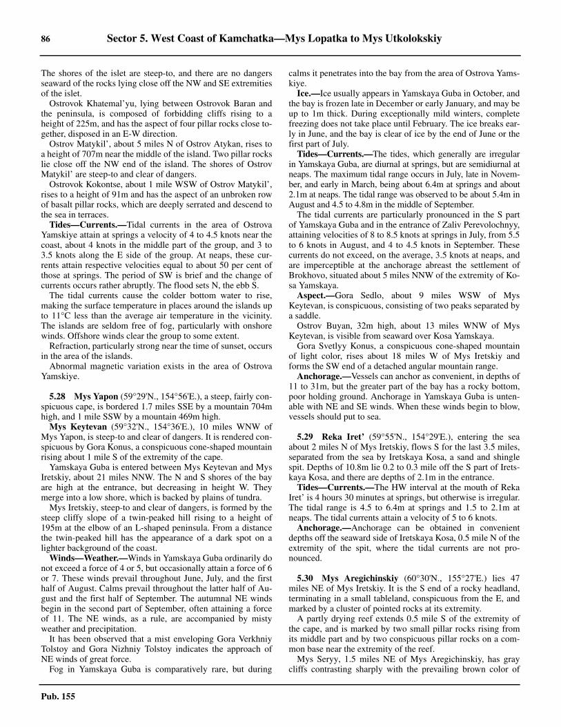
86 Sector 5. West Coast of Kamchatka—Mys Lopatka to Mys Utkolokskiy
Pub. 155
The shores of the islet are steep-to, and there are no dangersseaward of the rocks lying close off the NW and SE extremitiesof the islet.5.27 Ostrovok Khatemal’yu, lying between Ostrovok Baran andthe peninsula, is composed of forbidding cliffs rising to aheight of 225m, and has the aspect of four pillar rocks close to-gether, disposed in an E-W direction.5.27 Ostrov Matykil’, about 5 miles N of Ostrov Atykan, rises toa height of 707m near the middle of the island. Two pillar rockslie close off the NW end of the island. The shores of OstrovMatykil’ are steep-to and clear of dangers.5.27 Ostrovok Kokontse, about 1 mile WSW of Ostrov Matykil’,rises to a height of 91m and has the aspect of an unbroken rowof basalt pillar rocks, which are deeply serrated and descend tothe sea in terraces.5.27 Tides—Currents.—Tidal currents in the area of OstrovaYamskiye attain at springs a velocity of 4 to 4.5 knots near thecoast, about 4 knots in the middle part of the group, and 3 to3.5 knots along the E side of the group. At neaps, these cur-rents attain respective velocities equal to about 50 per cent ofthose at springs. The period of SW is brief and the change ofcurrents occurs rather abruptly. The flood sets N, the ebb S.5.27 The tidal currents cause the colder bottom water to rise,making the surface temperature in places around the islands upto 11°C less than the average air temperature in the vicinity.The islands are seldom free of fog, particularly with onshorewinds. Offshore winds clear the group to some extent.5.27 Refraction, particularly strong near the time of sunset, occursin the area of the islands. 5.27 Abnormal magnetic variation exists in the area of OstrovaYamskiye.
5.28 Mys Yapon (59°29'N., 154°56'E.), a steep, fairly con-spicuous cape, is bordered 1.7 miles SSE by a mountain 704mhigh, and 1 mile SSW by a mountain 469m high.5.28 Mys Keytevan (59°32'N., 154°36'E.), 10 miles WNW ofMys Yapon, is steep-to and clear of dangers. It is rendered con-spicuous by Gora Konus, a conspicuous cone-shaped mountainrising about 1 mile S of the extremity of the cape.
Yamskaya Guba is entered between Mys Keytevan and MysIretskiy, about 21 miles NNW. The N and S shores of the bayare high at the entrance, but decreasing in height W. Theymerge into a low shore, which is backed by plains of tundra.5.28 Mys Iretskiy, steep-to and clear of dangers, is formed by thesteep cliffy slope of a twin-peaked hill rising to a height of195m at the elbow of an L-shaped peninsula. From a distancethe twin-peaked hill has the appearance of a dark spot on alighter background of the coast.5.28 Winds—Weather.—Winds in Yamskaya Guba ordinarily donot exceed a force of 4 or 5, but occasionally attain a force of 6or 7. These winds prevail throughout June, July, and the firsthalf of August. Calms prevail throughout the latter half of Au-gust and the first half of September. The autumnal NE windsbegin in the second part of September, often attaining a forceof 11. The NE winds, as a rule, are accompanied by mistyweather and precipitation.5.28 It has been observed that a mist enveloping Gora VerkhniyTolstoy and Gora Nizhniy Tolstoy indicates the approach ofNE winds of great force.5.28 Fog in Yamskaya Guba is comparatively rare, but during
calms it penetrates into the bay from the area of Ostrova Yams-kiye.5.28 Ice.—Ice usually appears in Yamskaya Guba in October, andthe bay is frozen late in December or early January, and may beup to 1m thick. During exceptionally mild winters, completefreezing does not take place until February. The ice breaks ear-ly in June, and the bay is clear of ice by the end of June or thefirst part of July.5.28 Tides—Currents.—The tides, which generally are irregularin Yamskaya Guba, are diurnal at springs, but are semidiurnal atneaps. The maximum tidal range occurs in July, late in Novem-ber, and early in March, being about 6.4m at springs and about2.1m at neaps. The tidal range was observed to be about 5.4m inAugust and 4.5 to 4.8m in the middle of September.5.28 The tidal currents are particularly pronounced in the S partof Yamskaya Guba and in the entrance of Zaliv Perevolochnyy,attaining velocities of 8 to 8.5 knots at springs in July, from 5.5to 6 knots in August, and 4 to 4.5 knots in September. Thesecurrents do not exceed, on the average, 3.5 knots at neaps, andare imperceptible at the anchorage abreast the settlement ofBrokhovo, situated about 5 miles NNW of the extremity of Ko-sa Yamskaya.5.28 Aspect.—Gora Sedlo, about 9 miles WSW of MysKeytevan, is conspicuous, consisting of two peaks separated bya saddle.5.28 Ostrov Buyan, 32m high, about 13 miles WNW of MysKeytevan, is visible from seaward over Kosa Yamskaya.5.28 Gora Svetlyy Konus, a conspicuous cone-shaped mountainof light color, rises about 18 miles W of Mys Iretskiy andforms the SW end of a detached angular mountain range.5.28 Anchorage.—Vessels can anchor as convenient, in depths of11 to 31m, but the greater part of the bay has a rocky bottom,poor holding ground. Anchorage in Yamskaya Guba is unten-able with NE and SE winds. When these winds begin to blow,vessels should put to sea.
5.29 Reka Iret’ (59°55'N., 154°29'E.), entering the seaabout 2 miles N of Mys Iretskiy, flows S for the last 3.5 miles,separated from the sea by Iretskaya Kosa, a sand and shinglespit. Depths of 10.8m lie 0.2 to 0.3 mile off the S part of Irets-kaya Kosa, and there are depths of 2.1m in the entrance.5.29 Tides—Currents.—The HW interval at the mouth of RekaIret’ is 4 hours 30 minutes at springs, but otherwise is irregular.The tidal range is 4.5 to 6.4m at springs and 1.5 to 2.1m atneaps. The tidal currents attain a velocity of 5 to 6 knots.5.29 Anchorage.—Anchorage can be obtained in convenientdepths off the seaward side of Iretskaya Kosa, 0.5 mile N of theextremity of the spit, where the tidal currents are not pro-nounced.
5.30 Mys Aregichinskiy (60°30'N., 155°27'E.) lies 47miles NE of Mys Iretskiy. It is the S end of a rocky headland,terminating in a small tableland, conspicuous from the E, andmarked by a cluster of pointed rocks at its extremity.5.30 A partly drying reef extends 0.5 mile S of the extremity ofthe cape, and is marked by two small pillar rocks rising fromits middle part and by two conspicuous pillar rocks on a com-mon base near the extremity of the reef.5.30 Mys Seryy, 1.5 miles NE of Mys Aregichinskiy, has graycliffs contrasting sharply with the prevailing brown color of
Sector 5. West Coast of Kamchatka—Mys Lopatka to Mys Utkolokskiy 87
Pub. 155
this coast, and gives to Mys Seryy the appearance of a conspic-uous light-colored patch discernible from the offing.5.30 Bukhta Yemlinskaya, the bight W of Mys Aregichinskiy, hashigh and precipitous shores, and depths of 12.8 to 22m. 5.30 Anchorage.—Anchorage, sheltered from NE winds, can beobtained in a position a short distance off the N shore of thebight. Vessels approaching this anchorage should proceed withdue precautions and should sound continually.
Gizhiginskaya Guba
5.31 Gizhiginskaya Guba, entered between MysAregichinskiy and Mys Taygonos, about 140 miles E, has ele-vated and rocky shores, with few off-lying dangers. The bayhas no completely protected anchorages.5.31 Winds—Weather.—During the summer, S winds prevail.North winds are frequent and attain their maximum forceduring the autumn and the first part of the winter. Storms arecommon during the second half of September, October, andNovember. Fresh NW winds, interrupted by NE blizzards, pre-vail from December until the end of March. The season of gen-tle winds and calms lasts from the middle of April to the end ofMay.
5.31 The mean annual temperature in this vicinity varies between-7° and -5°C. Only five months of the year have a mean tem-perature above the freezing point. Frost begins to occur by themiddle of September, and the month of October has a meanmonthly temperature below freezing.5.31 During the navigational season, dense fog occurs frequentlyin the SE part of the bay. The foggiest months are May andJune. During July, the fog often envelops only the elevatedparts of the coast, leaving the coastline clear. During Augustfog is rare, being rather an exception in the N and W parts ofthe bay.5.31 During fog in the N part of the bay, vessels should makelandfall W of Mys Varkhalamskiy (61°39'N., 159°34'E.), andthen wait off this point until the weather clears.5.31 Tides—Currents.—Generally the tides in GizhiginskayaGuba are irregular. At springs, the tidal range, which is 6.7m atthe entrance into the bay, increases to 7.9m at the head of thebay. At neaps, the tidal ranges are marked by inequities of up to1.5m, the greater range being 2.7 to 3.3m.5.31 The flood current sets N along the shores of the gulf and theebb current sets S. At springs, the tidal current in the vicinity ofMys Taygonos attain a velocity of 2 to 2.5 knots, and moderateto 1.5 knots or less along the W shore of the bay. At the head ofthe bay the tidal currents are weak and irregular.
5.31 The constant current that sets along the Sea of Okhotsk in acounterclockwise direction flows in Gizhiginskaya Guba ac-celerating or retarding the tidal currents.
5.32 West and N sides of Gizhiginskaya Guba.—MysOstrovnoy (60°42'N., 155°54'E.) is the S extremity of a rocky,elevated peninsula, which has the appearance of an islandwhen seen from along the coast. An islet, with a jagged sum-mit, 15m high, lies 0.5 mile S of the cape. Above-water andsubmerged rocks extend 0.5 mile S of the islet.5.32 Zaliv Ostrovnoy, immediately W of the above peninsula,dries out to about 1.5 miles from its head.5.32 Tumanskiy Reyd, a totally exposed roadstead, is entered N ofMys Dyryavyy, a cliffy point about 14 miles N of Mys Ostrovnoy.Reka Tumany discharges immediately N of the point. A low sandybeach extends about 3 miles N of the river mouth to a small de-tached cliff, the N entrance point of the roadstead.5.32 A drying reef, marked by an above-water rock near its ex-tremity, extends S from the N entrance point of TumanskiyReyd. Two above-water rocks lie on the outer end of a dryingreef extending SE from Mys Dyryavyy.5.32 Tumannoye (Tumanskoye) settlement is situated near themouth of Reka Tumana.5.32 The bottom of the roadstead shelves gradually toward theshore, and depths of 7.3 to 9.1m, sand and shingle, have beenobtained at a distance of 0.3 to 0.4 mile offshore. 5.32 Anchorage.—Vessels anchor in adequate depths abreast themidsection of the sandy beach, where the tidal currents areweaker. The holding ground is fairly good, although, localknowledge is necessary.
5.33 Mys Viliginskiy (61°13'N., 156°40'E.), 38 miles NEof Mys Ostrovnoy, is the extremity of flat-topped peninsularprojections, 91 to 122m high. A pillar rock, connected to thecape by a low isthmus, has from a distance the appearance of adetached rock. The cape is clear of dangers.5.33 Mys Nadezhdy (61°30'N., 156°43'E.), about 18 miles far-ther N, is the E extremity of a small, rectangular peninsula withgray cliffs, about 91m high. A reef lies 0.4 mile NE of thepoint. A mountain, rising to a height of 829m, about 6.5 milesNNE of the peninsula, dominates other elevations nearby andis conspicuous.
Zaliv Pestraya Dresva, on the N side of Mys Nadezhdy, hasdepths of 11m within a confined area in the middle of the en-trance, decreasing to depths of 5.5m about 0.4 mile off the Nand W shores of the bight.5.33 Tides—Currents.—The MHW interval at Zaliv PestrayaDresva is approximately 5 hours 30 minutes. The tidal range atsprings is 7m and is diurnal, but at neaps it is semidiurnal andis 2.4m and 3m.5.33 Anchorage.—Small vessels can obtain anchorage shelteredfrom N and NE winds off the N shore, or sheltered from S andSE winds in the SW part of the bight.
5.34 Mys Gorka (61°41'N., 157°42'E.) is formed by thespur of a mountain, 568m high. A hill, 247m high, about 1.5miles N of the cape's extremity, serves with the mountain tomake the cape easily identified. A small rocky islet lies close Sof the cape.5.34 The coast between Mys Gorka and Mys Varkhalamskiy,about 64 miles E, is precipitous, jagged, and bordered by rocks,and should not, in general, be approached closer than 2 miles,except at Nayakhanskiy Reyd. Above-water and drying rocksextend to about 1.7 mile SW of Mys Opasnyy (61°47'N.,
5.30Mys Aregichinskiy
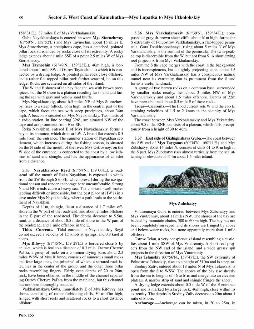
88 Sector 5. West Coast of Kamchatka—Mys Lopatka to Mys Utkolokskiy
Pub. 155
158°31'E.), 32 miles E of Mys Varkhalamskiy.5.34 Guba Nayakhanskaya is entered between Mys Storozhevoy(61°50'N., 158°52'E.) and Mys Taynochin, about 15 miles E.Mys Storozhevoy, a precipitous cape, has a detached, pointedpillar rock surrounded by rocks close off its extremity. A rockyledge extends about 1 mile SSE of a point 2.5 miles W of MysStorozhevoy.5.34 Mys Taynochin (61°49'N., 159°23'E.), 46m high, is bor-dered about 1 mile SW of Ostrov Taynochin, to which it is con-nected by a drying ledge. A pointed pillar rock close offshore,and a rather flat-topped pillar rock farther seaward, lie on thisledge. Rocks are scattered on all sides of the island.5.34 The W and E shores of the bay face the sea with brown prec-ipices, but the N shore is a plateau receding far inland and fac-ing the sea with gray and yellow sand bluffs.5.34 Mys Nayakhanskiy, about 6.5 miles NE of Mys Storozhev-oy, rises to a steep hillock, 65m high, in the central part of thecape, which faces the sea with steep precipices, about 34mhigh. A beacon is situated on Mys Nayakhanskiy. Two masts ofa radio station, in line bearing 326°, are situated NW of thecape and are prominent from E or SE.5.34 Reka Nayakhan, entered E of Mys Nayakhanskiy, forms abay at its entrance, which dries at LW. A broad flat extends 0.5mile from the entrance. The summer station of Nayakhan set-tlement, which increases during the fishing season, is situatedon the N side of the mouth of the river. Mys Ostrovnoy, on theW side of the entrance, is connected to the coast by a low isth-mus of sand and shingle, and has the appearance of an isletfrom a distance.
5.35 Nayakhanskiy Reyd (61°54'N., 159°00'E.), a road-stead off the mouth of Reka Nayakhan, is exposed to windsfrom the SW through S to SE, which prevail during the naviga-tional season and render anchorage here uncomfortable. StrongN and NE winds cause a heavy sea. The constant swell makeslanding difficult or impossible, but the best place at HW is in acave under Mys Nayakhanskiy, where a path leads to the settle-ment of Nayakhan. 5.35 Depths of 11m, shingle, lie at a distance of 1.7 miles off-shore in the W part of the roadstead, and about 2 miles offshorein the E part of the roadstead. The depths decrease to 5.5m,sand, at a distance of about 0.5 mile offshore in the W part ofthe roadstead, and 1 mile offshore in the E.5.35 Tides—Currents.—Tidal currents in Nayakhanskiy Reyddo not exceed a velocity of 1.5 knots at springs, and 0.8 knot atneaps.5.35 Mys Rifovyy (61°45'N., 159°29'E.) is bordered close S byan islet, which is foul to a distance of 0.3 mile. Ostrov ChetyrePal'sta, a group of rocks on a common drying base, about 2.5miles WSW of Mys Rifovyy, consists of numerous small rocksand four large ones, the principal of which, a serrated rock is-let, lies in the center of the group, and the other three pillarrocks resembling fingers. Fairly even depths of 20 to 26m,rock, have been obtained in the middle of the channel separat-ing Ostrov Chetyre Pal’sta from the mainland, but this channelhas not been thoroughly sounded.5.35 Varkhalamskaya Guba, immediately E of Mys Rifovyy, hasshores consisting of rather forbidding cliffs, 30 to 45m high,fringed with short reefs and scattered rocks to a short distanceoffshore.
5.36 Mys Varkhalamskiy (61°39'N., 159°34'E.), com-posed of grayish-brown sheer cliffs, about 61m high, forms theS extremity of Poluostrov Varkhalamskiy, a flat-topped penin-sula. Gora Dvukhsopochnaya, rising about 5 miles N of MysVarkhalamskiy, is the summit of the peninsula. The twin-peak-ed top is discernible from the W, but not from S. A short dryingreef projects S from Mys Varkhalamskiy.5.36 From the S the cape merges with the coast in the backgroundand is inconspicuous, but a slightly projecting cape, about 1.5miles NW of Mys Varkhalamskiy, has a conspicuous naturaltunnel near its extremity that is prominent from the S andforms a useful landmark.5.36 A group of two barren rocks on a common base, surroundedby smaller rocks nearby, lies about 3 miles NW of MysVarkhalamskiy and about 1.5 miles offshore. Depths of 22mhave been obtained about 0.5 mile E of these rocks.5.36 Tides—Currents.—The flood current sets W and the ebb E,attaining velocities of 1.5 to 2 knots in the vicinity of MysVarkhalamskiy.5.36 The coast between Mys Varkhalamskiy and Mys Yekateriny,about 9.5 miles ENE, consists of a plateau, which falls precipi-tously from a height of 30 to 46m.
5.37 East side of Gizhiginskaya Guba.—The coast betweenthe SW end of Mys Taygonos (60°34'N., 160°11'E.) and MysZubchatyy, about 14 miles N, consists of cliffs 61 to 91m high inthe S part. Mys Zubchatyy rises almost vertically from the sea, at-taining an elevation of 414m about 1.5 miles inland.
5.37 Vnutrennaya Guba is entered between Mys Zubchatyy andMys Vnutrenniy, about 11 miles NW. The shores of the bay arebacked by mountain chains, 500 to 600m high. The bay has notbeen completely surveyed, and its shores are fringed by aboveand below-water rocks, but none apparently more than 1 mileoffshore.5.37 Ostrov Telan, a very conspicuous island resembling a castle,lies about 1 mile SSW of Mys Vnutrenniy. A short reef proj-ects from the NW end of the island, and a wide grassy spitprojects in the direction of Mys Vnutrenniy.5.37 Mys Telanskiy (60°56'N., 159°47'E.), the SW extremity ofPoluostrov Telanskiy, rises to a height of 510m and is steep-to.5.37 Sredniy Zaliv, entered about 18 miles N of Mys Telanskiy, isopen from the S to WSW. The shores of the bay rise sheerlyfrom the sea to heights of 46 to 61m and merge into an elevatedplateau. A narrow strip of sand and shingle fringes the shore.5.37 A drying ledge extends about 0.5 mile W of the E entrancepoint and is marked by a large rock, 46m high, close within itsextremity. The depths in Sredniy Zaliv decrease to 20m about 1mile offshore.5.37 Anchorage.—Anchorage can be taken, in 20 to 25m, in
Mys Zubchatyy
Sector 5. West Coast of Kamchatka—Mys Lopatka to Mys Utkolokskiy 89
Pub. 155
Sredniy Zaliv. The bottom is mud, or mud and sand, except inthe vicinity of the ledge where it is rocky. Small vessels anchoron the N side of the ledge, which gives some protection fromthe sea.
Ostrova Khalpili consists of two principal islets and severalsmaller islets and rocks, lying off the W side of the flat-toppedpeninsula, which forms the N side of Sredniy Zaliv. The S of theprincipal islets, about 0.5 mile off the SW end of the peninsula,has steep slopes rising to a sharp-peaked summit, 61m high. Apartly drying reef connects the islet to the mainland. The N prin-cipal islet, about 2 miles N of the S islet, has a detached group ofdrying rocks a short distance off its S side.5.37 The inlet, 5 miles farther NE, is about 2.5 miles wide at itsentrance. Rocks lie nearly 0.5 mile off either entrance point.The entire inner half of the inlet dries and is encumbered withrocks.
5.38 Ostrovok Morskaya Matuga (61°23'N., 159°55'E.),a precipitous flat-topped islet, has the same elevation as thecliffs of the point about 0.5 mile E. The islet is connected to themainland by a drying reef, marked with rocks and pillar rocks,two of which lie close to the islet. The islet appears to be steep-to on its W side.5.38 Ostrovok Glinyanyy, about 5 miles farther NE, has the shapeof an irregular cone, and is clearly visible only when a vessel isnear the coast.5.38 Between Ostrovok Glinyanyy and Mys Matugin, about 16miles NNE, the coast consists of cliffs, 46 to 61m high, thegreater part backed by a level plateau extending for severalmiles inland to the foot of a mountain range.5.38 Caution.—Kamen’ Opasnyy, a dangerous submerged rock,occasionally awash, lies about 7 miles SW of Mys Matugin andabout 4 miles offshore. The area in the vicinity of this rock hasnot been surveyed.
5.39 Mys Matugin (61°41'N., 160°15'E.), a precipitouscape, has the appearance of a sheer seaward termination of aslightly projecting tableland.5.39 Ostrov Rechnaya Matuga, a flat-topped islet with precipitousshores and about 61m high, lies with its W end about 1 mileSW of Mys Matugin. A grotto in the W part of the islet is con-spicuous from the N and S. The islet is fringed by a partly dry-ing reef. A detached rocky patch lies about 0.3 mile WSW ofthe W end of the islet. A drying reef, on which are two largecube-shaped rocks, connects the islet to Mys Matugin.5.39 Bukhta Matuga, the bight S of Mys Matugin, shoals gradual-ly to depths of 5.5m about 0.5 mile offshore. A detached dryingrocky patch lies 0.4 mile off the mouth of Rechka Matuga, atthe head of the bight.5.39 Anchorage.—Anchorage, with local knowledge, can be tak-en in Bukhta Matuga, in 6 to 11m, sheltered from winds of theNE and SE quadrants. Partial protection from NW winds andfrom the sea can be taken in that part of the bight close SE ofthe channel separating Ostrov Rechnaya Matuga from themainland.
5.40 Head of Gizhiginskaya Guba.—The head of Gizhi-ginskaya Guba is entered between Mys Matugin and MysYekateriny, about 10 miles W.5.40 Winds—Weather.—During the period of good weather
throughout the area of Gizhiginskaya Guba, regular breezesprevail in the head of the gulf. The offshore breeze, which at-tains its greatest force about sunrise, languishes between 0800and 0900 to a calm and then is superseded by an onshorebreeze. This onshore breeze increases in force until 1600 or1700, but subsides gradually to a calm and is superseded 2hours after sunset by an offshore breeze throughout the night.5.40 South winds bring fog into the head of the gulf from the vi-cinity of Mys Taygonos. Particularly dense and protracted fogprevails here during the spring and the first part of the summer.Fog is rare in the latter part of the summer, and, as a rule, doesnot occur in the fall. Winds from N, E, and W clear the head ofthe gulf from fog.5.40 Ice.—The river freezes in the middle of October and the entirehead of the gulf is covered with ice by the end of November. Theice begins to break in the first part of June, and, as a rule, thehead of the gulf is free of ice by the end of the month.5.40 Tides—Currents.—At the head of the gulf the MHW inter-val is about 2 hours 43 minutes at springs. At neaps, the HWinterval is irregular and may vary by 1 hour 30 minutes. Thetide is diurnal at springs, the tidal range being 7.9m. The floodlasts about 10 hours, and the ebb, about 14 hours. At neaps, thetide is semidiurnal and the tidal range is about 3m.5.40 The flood current flows in a general NNE direction, and theebb current in a SSW direction, attaining velocities of 2 to 2.5knots along the W shore, but only 1 to 1.5 knots along the Eshore.5.40 Depths—Limitations.—Inside the entrance, the depths de-crease gradually and uniformly. Generally, the W side is some-what deeper. The bottom is rock in the S section of the head ofthe gulf, shingle in the middle section, and either sand, or sandand mud, in the N section.
Aspect.—Mys Yekateriny, a flat-topped precipitous cape, isconspicuous on bearings between ENE and NNE, but blendswith the coast on other bearings. A large pillar rock, discern-ible from SW and NE, is located near the extremity of MysYekateriny and is connected to the cape by a short, rather lowcliffy isthmus. A short drying ledge projects seaward from thepillar rock.5.40 The NW shore of the head of the gulf is precipitous, from 30to 61m high, and fringed by numerous rocks. The shore adja-cent to Reka Gizhiga, at the head of the gulf, is low and con-sists of a sandy beach backed by marshes extending inland.5.40 The shore between Mys Matugin and Mys Chaybukha, about8 miles NNE, is a wall-like bluff, 76m high, fringed by rocks.Mys Chaybukha, conspicuous and rising to a height of 95m, ismarked by three pillar rocks near its extremity.5.40 Mys Mayachnyy, about 6.5 miles N of Mys Chaybukha, ris-es to a height of 49m near its extremity. 5.40 Anchorage.—Sheltered anchorage, in depths of not lessthan 7.3m, can be obtained about 2 miles N of OstrovRechnaya Matuga, with Mys Matugin bearing 138° and MysChaybukha 036°. The bottom here is rock, poor holdingground, and it should be borne in mind that from this positionthe bottom shelves N and E. 5.40 Anchorage off the W shore can be obtained about 6 mileswithin the entrance, in a depth of 7.3m, with Mys Chaybukhabearing 088° and the W end of Ostrov Rechnaya Matuga bearing155°. This anchorage has a better holding ground, but the tidalcurrents here are stronger and it is exposed to the swell.
91
Pub. 155
6. Sector 6—North and Northwest sides of the Sea of Okhotsk—Zaliv Shelikhova to Sakhalinskiy Zaliv
6.0Additional chart coverage may be found in NGA/DLIS Catalog of Maps, Charts, and Related Products (Unlimited Distribution).6.0SECTOR 6 — CHART INFORMATION

93
Pub. 155
SECTOR 6
NORTH AND NORTHWEST SIDES OF THE SEA OF OKHOTSK—ZALIV SHELIKHOVA TO SAKHALINSKIY ZALIV
6.0 Plan.—The coasts described in this sector comprise the Nand NW sides of the Sea of Okhotsk from Mys Tolstoy to MysAleksandra, including Shantarskiye Ostrova. The arrangementof the sector is from E to W, then from NE to SW.
General Remarks
6.1 Winds—Weather.—On the N shore of the Sea of Ok-hotsk, gentle winds and calms prevailing throughout April andMay and gentle SE winds during June and July are occasional-ly interrupted by strong winds from the NE through E to SE,but rarely last for longer than two successive days. Between themiddle of August and middle of September, SW winds becomeprevalent and may attain Force 3 or 4. 6.1 The latter half of September, October, and November is a pe-riod of protracted storms from the NE, SE, or NW, which areseparated by short-lived calms. Fresh winter winds, N and NWbeing prevalent, prevail throughout December, January, andFebruary, gradually losing their force toward March.6.1 In Shantarskiye Ostrova, from April to the middle of July, isa period of calms and light airs. From the last part of July toSeptember, SW to W dry winds of moderate force prevail andbring clear weather, the month of August being the best monthof the navigational season. In September W winds change toNW winter winds and increase in force toward the end of themonth. The last part of September, October, and November is aperiod of NE storms alternating with fresh NW winds.6.1 Winds from the SE, as a rule, are accompanied by fog, andwinds from the NNE to E are accompanied by mist and foulweather. Winds from the SSW to SW tend to disperse fog inthe W part of this coast, and in the E part when the wind is ofsufficient strength. Winds from the N through W to WSW areaccompanied by clear weather.6.1 On the NW coast of the Sea of Okhotsk, fog is frequent fromthe beginning of spring to midsummer. Fog is continuous insummer, and in the vicinity of Ostrov Suyatoy Iony(56°24'N., 143°23'E.). The N coast is often marked by fog, ex-cept with winds from the W sector. Vessels approaching thiscoast in fog should take all precautions upon obtaining a depthof 92m or less, or when within 3 miles of the coast in the Epart.6.1 During May, June, and July, 80 per cent of the days of themonth experience fog at the E part of the N shore of the Sea ofOkhotsk, about 50 per cent of the month is foggy at the midpart, and from 20 to 25 per cent of the month experiences fogat the W part of this coast. During this period, clear weather,which is usually accompanied by gentle offshore winds, israther occasional and short-lived, often being confined to anoffshore lane 15 to 20 miles in width. The number of clear daysincreases markedly toward the fall.6.1 The season of fog in the vicinity of Shantarskiye Ostrovalasts from early spring to the midsummer, the frequency anddensity of fog being dependent on the amount of ice brought
here from the N and NW coasts of the Sea of Okhotsk. In July,when SW to W dry winds begin to prevail, the number of dayswith fog decreases markedly.6.1 The coast between Mys Tolstoy and Mys Alevina is fringedby a cold belt of water, 15 to 25 miles wide, in which the sur-face temperature in the summer is around 2°C, with colderpatches near Mys Tolstoy. Farther seaward the temperature atthe surface rises sharply to 12°C at the end of the summer.6.1 Between Mys Alevina and Mys Duga, the temperature is ap-proximately 6°C, rising N and S of the area. ApproachingTauyskaya Guba from the S, a vessel will pass through a belt ofcold water.6.1 West of Mys Duga, the cold belt becomes narrower and thechange of temperature less marked; it ceases to exist S of Ok-hotskiy Reyd.6.1 Ice.—Ice renders navigation impossible from the end of Octo-ber or November until July. The N coast is usually free of ice inJuly, but can be reached in May and June passing through driftice.6.1 In the vicinity of Shantarskiye Ostrova the first ice is formedin the latter part of October or early November, and usually bythe first half of December, solid ice extends into the sea as faras the eye can see. In the spring the ice begins to break up bythe end of May or early June, but the drift ice, the amount ofwhich may vary from year to year, remains around the islands,impeding navigation until the latter half of June, more oftenuntil July, and occasionally as late as August. Ordinarily, theice does not interfere with navigation beginning the last part inJuly, but in some years the islands remain inaccessible through-out the navigational season.6.1 Zaliv Akademii usually clears of ice by the middle of June,but in some years ice may remain in the approaches to the bayafter this time. Zaliv Akademii may be temporarily packedwith ice, rendering navigation impracticable, in unfavorableyears, especially after strong NE winds. These conditions mayprevail until as late as mid-August.6.1 Tides—Currents.—The tidal wave advances toward Shan-tarskiye Ostrova from the ENE, increasing the HW intervalsand retarding the SW, as one proceeds W and SW through theislands. The tidal currents range from 2 knots at the NE end ofthe group to 8 knots in the narrows of the strait between OstrovMalyy Shantar and Ostrov Belichiy.6.1 A constant current, which sets W along the N shore of the Seaof Okhotsk and attains a velocity of 0.8 knot E of Tauyskaya Gu-ba, gradually loses its velocity and is imperceptible off the Wpart of this coast.6.1 The flood current sets W, and being combined with the con-stant current, attains a velocity of 1.5 to 2 knots at springs. Theebb current sets E, and being abated by the constant current, ishardly perceptible or occasionally reversed.6.1 The N coast of the Sea of Okhotsk is generally elevated andsteep-to, except for some low sections in the W part and thosein the N part of Tauyskaya Guba. A range of mountains ex-
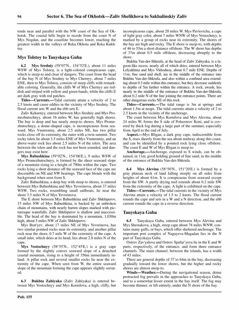
94 Sector 6. The Sea of Okhotsk—Zaliv Shelikhova to Sakhalinskiy Zaliv
Pub. 155
tends near and parallel with the NW coast of the Sea of Ok-hotsk. The coastal hills begin to recede from the coast N ofMys Nogdan, and the coastline becomes lower, reaching thegreatest width in the valleys of Reka Okhota and Reka Kukh-tuy.
Mys Tolstoy to Tauyskaya Guba
6.2 Mys Sredniy (59°07'N., 154°52'E.), about 11 milesWSW of Mys Tolstoy, is a light-colored conspicuous cape,which is steep-to and clear of dangers. The coast from the headof the bay N of Mys Sredniy to Mys Chernyy, about 7 milesENE, then to Mys Tolstoy, consists of steep cliffs with remark-able coloring. Generally, the cliffs W of Mys Chernyy are red-dish and striped with yellow and green bands, while the cliffs Eare dark gray with red patches.6.2 Tides—Currents.—Tidal currents attain a velocity of 2 to2.5 knots and cause eddies in the vicinity of Mys Sredniy. Theflood current sets W and the ebb sets E.6.2 Zaliv Kekurnyy, entered between Mys Sredniy and Mys Pro-mezhutochnyy, about 16 miles W, has generally high shores.The bay is deep and has nearly steep-to shores. Mys Prome-zhutochnyy, a dome-shaped cape, is inconspicuous from sea-ward. Mys Vnutrenniy, about 2.5 miles NE, has two pillarrocks close off its extremity, the outer with a twin summit. Tworocky islets lie about 3.5 miles ENE of Mys Vnutrenniy, and anabove-water rock lies about 2.5 miles N of the islets. The areabetween the islets and the rock has not been sounded, and dan-gers may exist here.6.2 Mys Babushkina (59°02'N., 154°06'E.), 9 miles WSW ofMys Promezhutochnyy, is formed by the sheer seaward slopeof a mountain rising to a height of 790m within the cape. Tworocks lying a short distance off the seaward face of the cape arediscernible on NE and NW bearings. The cape blends with thebackground when seen from S.6.2 Zaliv Babushkina, a deep bay with steep-to shores, is enteredbetween Mys Babushkina and Mys Yevreinova, about 37 milesWSW. Two rocks, resembling small sailboats, lie near theshore 3.5 miles N of Mys Yevreinova.6.2 The E shore between Mys Babushkina and Zaliv Shkhiperov,15 miles NW of Mys Babushkina, is backed by an unbrokenchain of mountains, with nearly barren slopes marked with pic-turesque waterfalls. Zaliv Shkhiperov is shallow and inaccessi-ble. The head of the bay is dominated by a mountain, 1,030mhigh, about 5 miles NW of Zaliv Shkhiperov.6.2 Mys Brat'yev, about 17 miles NE of Mys Yevreinova, hastwo similar pointed rocks near its extremity, and another pillarrock near the shore, 0.7 mile W of the extremity of the cape. Asmall inlet, which dries at its head, lies about 2.8 miles N of thecape.6.2 Mys Vostochnyy (58°55'N., 152°45'E.) is a gray capeformed by the slightly convex seaward slope of a detachedcoastal mountain, rising to a height of 356m immediately in-land. A pillar rock and several smaller rocks lie near the ex-tremity of the cape. When seen from W, the entire seawardslope of the mountain forming the cape appears slightly serrat-ed.
6.3 Bukhta Zabiyaka (Zaliv Zabiyaka) is entered be-tween Mys Vostochnyy and Mys Kornilova, a high, cliffy, but
inconspicuous cape, about 20 miles W. Mys Pavlovicha, a capeof light gray color, about 7 miles WNW of Mys Vostochnyy, ismarked by a group of rocks near its extremity. The shores ofthe bay are high and rocky. The E shore is steep-to, with depthsof 46 to 55m a short distance offshore. The W shore has depthsof 37m about 0.5 mile offshore, decreasing abruptly to theshore.6.3 Bukhta Van-der-Shkrufa, at the head of Zaliv Zabiyaka, is a la-goon-like recess, nearly all of which dries, entered between MysLelyakhina and Mys Vkhodnoy, about 0.7 mile ENE. Depths of11m, fine sand and shell, are in the middle of the entrance intoBukhta Van-der-Shkrufa, and also within a confined area extend-ing about 0.3 mile within this entrance, but they decrease suddenlyto depths of 5m farther within the entrance. A rock, awash, liesnearly in the middle of the entrance of Bukhta Van-der-Shkrufa,about 0.2 mile N of the line joining the entrance points. There areother dangerous rocks NE of this rock.6.3 Tides—Currents.—The tidal range is 3m at springs andabout 1.5m at neaps. The tidal currents attain a velocity of 2 to2.5 knots in the vicinity of the anchorage.6.3 The coast between Mys Kornilova and Mys Alevina, about24 miles W, forms the S side of Poluostrov Koni, and is cov-ered by thick fog during a large part of the summer, especiallyfrom April to the end of July.6.3 Aspect.—Mys Bligan, a dark gray cape, indiscernible fromthe S, rises sheerly from the sea about midway along this coast,and can be identified by a pointed rock lying close offshore.The coast E and W of Mys Bligan is steep-to.6.3 Anchorage.—Anchorage, exposed to S winds, can be ob-tained, in 11m, good holding ground of fine sand, in the middleof the entrance of Bukhta Van-der-Shkrufa.
6.4 Mys Alevina (58°50'N., 151°20'E.) is formed by agray plateau neck of land falling steeply on all sides fromheights of about 61m. It is conspicuous from seaward exceptfrom the SW. A partly drying reef extends about 0.2 mile SWfrom the extremity of the cape. A light is exhibited on the cape.6.4 Tides—Currents.—The tidal currents in the vicinity of MysAlevina attain a velocity of 1.5 to 2 knots. The flood currentrounds the cape and sets in a W and a N direction, and the ebbcurrent rounds the cape in a reverse direction.
Tauyskaya Guba
6.5 Tauyskaya Guba, entered between Mys Alevina andMys Shestakova, a high, steep cape about 78 miles WNW, con-tains many gulfs, or bays, which offer sheltered anchorage. Theimportant port complex of Nagayeva-Magadan lies in the Npart of Tauyskaya Guba.6.5 Ostrov Zav'yalova and Ostrov Spafar’yeva lie in the E and Wparts, respectively, of the entrance, and form three entrancechannels. The main channel, between the islands, has a widthof 43 miles.6.5 There are general depths of 37 to 64m in the bay, decreasinggradually toward the lower shores, but the higher and rockyshores are almost steep-to.6.5 Winds—Weather.—During the navigational season, denseprotracted fog prevails in the approaches to Tauyskaya Guba,and to a somewhat lesser extent in the bay itself. The fog maybecome thinner, or lift entirely, under the N shore of the bay.
Sector 6. The Sea of Okhotsk—Zaliv Shelikhova to Sakhalinskiy Zaliv 95
Pub. 155
6.5 The cold water area in the approach to Tauyskaya Guba isabout 35 to 40 miles wide. The N border of this area is somewhataffected by the tidal currents, but on the whole it appears settledalong a line extending between the middle points of OstrovZav’yalova and Ostrov Spafar’yeva. From early June to the endof September, when the normal temperature of surface water inthe Sea of Okhotsk is about 12°C, the temperature of the surfacewater near Mys Alevina is about 4.4°C, and about 6.7°C in thevicinity of Ostrov Spafar’yeva.6.5 The temperature rises markedly within the entrance ofTauyskaya Guba, the rise being the most abrupt in the E en-trance channel.6.5 Ice.—Ice begins to form by the middle of October. In winterthe shores of the bay are fringed with ice extending 15 to 20miles offshore. The ice begins to break up during the first halfof May, and the bay is clear of ice generally by the middle ofJune.6.5 Drift ice is found in the channels separating Ostrov Zav’yalo-va and Ostrov Spafar'yeva from the mainland in December toJune. Fast ice forming in the channel between Ostrov Zav’ yalo-va and the mainland is broken up by the currents. ProlivLikhacheva, separating Ostrov Spafar'yeva from the mainland,ordinarily does not freeze.6.5 Tides—Currents.—The tides in Tauyskaya Guba are semi-diurnal. The tidal rise is about 4.5m at springs. The tidal risesat neaps are marked with inequality being 1.8 to 2.1m and 0.6to 0.9m, respectively.6.5 The tidal currents attain maximum velocities of 4.5 to 5 knotsat springs and 2 to 2.5 knots at neaps in Proliv Likhacheva, be-tween Ostrov Spafar'yeva and the mainland. These currents losetheir velocity gradually within the bay and, being affected by theconfiguration of the shore, are irregular. The flood current entersthe bay from the SE, setting generally E in the E half of the bay,and setting W in the W half of the bay.6.5 The flood tidal current sets N and the ebb S in the channelbetween Ostrov Zav’yalova and the mainland, attaining a ve-locity of 1 to 1.5 knots in the S half of the channel, but increas-ing to 1.5 to 2 knots in the N end of the channel.6.5 Caution.—The approach and entrance into Tauyskaya Gubapresents no difficulties in clear weather, but in thick fog it isvery difficult. Vessels approaching the bay in fog should at-tempt to make the E end of Ostrov Spafar'yeva, as the twopointed summits of the island may be readily identified duringthe temporary and partial clearances, which occur more fre-quently here than in the vicinity of Ostrov Zav'yalova. The tid-al currents must always be taken into consideration.6.5 When approaching from the S, soundings should be takenfrequently until it is certain that Ostrov Spafar'yeva has beenpassed.6.5 It has been reported that a local magnetic anomaly exists inthe vicinity of the entrance channels.
6.6 Ostrov Zav’yalova (59°05'N., 150°36'E.) lies in theE side of the entrance. Its summit rises to a height of 1,029m inthe N part of the island. A ridge of mountains, 457 to 610mhigh, extends from this summit to a peak, 856m high, in the Spart of the island.6.6 Mys Yuzhnyy, the SW point of the island, is steep-to andconsists of a gray steep cliff with a natural rocky platform at itsbase. The shores of the island rise sheerly from the sea, and are
steep-to, with depths of 20 to 25m a short distance offshore. Ashort submerged gravel spit, marked by a beacon, extends Nfrom Mys Severnyy, the N extremity of the island.6.6 Ostrov Spafar’yeva (59°12'N., 149°03'E.) lies at the W side ofthe entrance. It consists of two detached groups of mountains,forming the NE and SW parts, respectively, of the island, andconnected to each other by an isthmus. Gora Komandora Berin-ga, a conspicuous cone-shaped mountain, 579m high, is thesummit of the island, and lies on the W side of the NE part of theisland. The peak of this mountain is often clearly visible abovethe low-lying fog and forms a good landmark from the offing.6.6 Gora Lysaya (Gora Lis’ya), the summit of the SW part of theisland, rises to a height of 366m, about 3 miles SW of GoraKomandora Beringa. Mys Kaktina, the S extremity of the is-land, rises to an elevation of 299m. A light is exhibited on the Eside of Ostrov Sparfar’yeva. A radiobeacon transmits from thelight.6.6 Anchorage.—Bukhta Beringa, the bight NW of the low isth-mus of Ostrov Spafar’yeva, has depths of 22m in the central part,decreasing gradually to 11m about 0.2 mile from the isthmus.Sheltered anchorage can be obtained in convenient depths, ex-cellent holding ground of mud and sand, in Bukhta Beringa.6.6 Temporary anchorage during winds from the SW and SEquadrants can be obtained, in depths of 18 to 37m, fine sand,off the head of the indentation about 2 miles WSW of Mys Ry-abokon, the NW extremity of the island.6.6 During W winds, anchorage can be obtained, in 26m, finesand, about 0.3 mile off the E side of the isthmus of the island.This anchorage is exposed to the prevailing summer winds andswell.
6.7 East part of Tauyskaya Guba.—Mys Taran(59°07'N., 151°06'E.), the NW extremity of Poluostrov Koni,lies 19 miles NNW of Mys Alevina. It is the extremity of asloping, tapering ridge projecting NW from a mountain back-ing the cape. The point is marked by a light.6.7 A submerged spit, having a width of 1.5 miles under thecape, extends in a general N direction for nearly 1.5 miles fromMys Taran. Near the inner end of this submerged spit thedepths are about 4m and increase gradually to 20m at the outerend. Depths of 30 to 40m are found on either side of the spit.6.7 The channel between Ostrov Zav'yalova and PoluostrovKoni is deep and free of dangers, but should not be used duringfog, as the fairly even depths do not indicate dangerous prox-imity to the land.6.7 Zaliv Odyan is entered between Mys Skalistyy, located about11 miles ENE of Mys Taran, and Mys Beringa, about 12 milesfarther NE. A detached 11.2m patch, surrounded by depths of 31to 35m, lies about 0.4 mile NNW of Mys Skalistyy.6.7 Zaliv Odyan is sheltered from all winds except those fromthe W. The shores of the bay are high at the entrance and de-crease in height toward the head of the bay, which is low andsandy. 6.7 Ostrovok Umara, an islet about 11 miles E of Mys Skalistyy,is separated from the S shore by a narrow and shallow channel.6.7 Mys Beringa is a precipitous cape rising to a height of 424m.Gora Beringa rises to an elevation of 1,062m about 3 milesENE of the cape.6.7 Winds—Weather.—In Zaliv Odyan, fog is not as frequentand dense as elsewhere in Tauyskaya Guba.

96 Sector 6. The Sea of Okhotsk—Zaliv Shelikhova to Sakhalinskiy Zaliv
Pub. 155
6.7 Ice.—Zaliv Odyan is icebound throughout the winter, and asa rule, ice remains in this bay for a longer time than in otherparts of Tauyskaya Guba.6.7 Tides—Currents.—The tidal currents attain a velocity of 1to 1.5 knots at the entrance, but diminish gradually and are im-perceptible at the head of the bay.6.7 Depths—Limitations.—There are depths of 29 to 32m half-way within the bay, shoaling gradually to 9.1 to 11m about 0.7mile from the head.6.7 Anchorage.—Bukhta Melkovodnaya, forming the head ofZaliv Odyan, affords anchorage, good holding ground, in 11m,mud, in its outer part. This anchorage is sheltered from the pre-vailing S and E summer winds. Farther in the bottom is sandand rock. Local knowledge is necessary.6.7 Zaliv Rechnoy is entered between Mys Skala, a high cliffycape, about 2 miles NNW of Mys Beringa, and Mys Rechnoy,about 4.5 miles farther N. The shore of the bight is cliffy andprecipitous in places, and several streams flow into it. Thereare depths of 26 to 29m, shingle or mud, in the bight up to adistance of 0.5 mile offshore. Anchorage, sheltered from Ewinds, can be obtained in Zaliv Rechnoy.
6.8 Mys Kharbiz (59°31'N., 151°31'E.), 8.5 miles NW ofMys Rechnoy, is formed by a high, steep, cliffy slope of a de-tached coastal elevation, rising to a height of 502m. The light-colored bands of strata forming the cape and a low section of thecoast immediately N of it render the cape conspicuous.6.8 Mys Khodil, an elevated cape about 8 miles WNW of MysKharbiz, lies on the W side of the mouth of Reka Ola. A spitextends 0.5 mile SE of Mys Khodil. Gora Ambarushka-Tass,about 3 miles NW of Mys Khodil, has a knoll resembling theroof of a shed on its summit. Dve Skaly, a barren pillar rockcomprising three parts, 15 to 18m high, stands on the shoreabout 1 mile W of the elevated part of Mys Khodil. A beacon issituated on Mys Khodil. 6.8 The shore extending about 6 miles E of Mys Khodil consistsof low islets, or spits, separating an extensive lagoon from thesea. Koshka Itygran, a low spit, extends about 1.3 miles NWfrom the SE corner of the lagoon.6.8 Ol’skiy Reyd, the roadstead extending from the coast betweenMys Khodil and the base of Koshka Itygran, has depths decreas-ing uniformly from 11m at a distance of 1.5 miles offshore, to5m about 0.7 mile offshore. A drying shoal extends about 1 mileS from the E entrance to the lagoon.6.8 Winds—Weather.—The warmest month is July with a meantemperature of 14°C. Night frosts begin to occur in September.Reka Ola freezes early in November. The temperature in Decem-ber is occasionally -4°C. The snow begins to melt by the middleof April.6.8 Anchorage.—Anchorage can be taken 1.5 miles offshore, indepths of 10 to 11m. The anchorage is not secure, being opento S winds, which prevail in summer, and the tidal currents setalong the N shore of the roadstead and tend to place vesselsbroadside to the swell, which is not heavy due to the protectionof Poluostrov Koni.
6.9 Poluostrov Staritskogo, with Mys Sredniy (59°26'N.,150°45'E.) at its S extremity, is a mountainous peninsula, risingto a height of 707m. The S side of the peninsula from MysOl'skiy, its SE extremity, to Mys Chirikova, about 13 miles
WNW, is high, cliffy, and clear of dangers. A light, from whicha radiobeacon transmits, stands on the point at position59°29.1N, 150°30.1E.6.9 Anchorage.—Anchorage can be taken NE of Mys Ol'skiy inQuarantine Anchorage No. 14 in position 59°30'N, 151°00'E. 6.9 Mys Vostochnyy, about 2.5 miles NNE of Mys Ol’skiy, hasthree pillar rocks in a line extending 0.8 mile ESE. Three isletslie close together about 2 mile ENE of the point. A reef extends0.4 mile from the islets.6.9 A finger pier, called Veselaya Pier, extends about 215m SSEfrom the N entrance point of the bight N of Mys Vostochnyy.There are depths of 7 to 7.6m alongside the outer end of thepier.
6.10 West part of Tauyskaya Guba.—Mys Shestakova(59°14'N., 148°55'E.), the W entrance point of Tauyskaya Guba,is a high, cliffy cape, forming the S extremity of Poluostrov An-tamlan, a small elevated peninsula about 457m high, which is theSE part of Poluostrov Khmitevskogo. A pillar rock near the ex-tremity of Mys Shestakova is fairly conspicuous from S. Thereare three high rocks close off the point.6.10 Ostrov Talan, about 6 miles NE of Mys Shestakova, rises to aheight of 183m and has cliffy shores.6.10 Zaliv Motykleyskiy is entered between Mys Stanyukovicha(59°23'N., 148°59'E.) and Mys Onatsevicha, about 9 miles NE.The shores of the bay are high at the entrance, but decrease inheight toward the head. A drying reef extends 0.5 mile NNWof Mys Stanyukovicha, and depths of less than 5.5m extend 0.6mile off the N side of the cape. Mys Onatsevicha is fringedwith five rocks, above-water, extending 1 mile E.6.10 Anchorage.—Anchorage can be taken with local knowledgein Zaliv Motykleyskiy, sheltered from all but E winds, indepths of 8 to 16m.
6.11 Amakhtonskiy Zaliv is entered between Mys Amakh-tonskiy (59°31'N., 149°13'E.), the NE extremity of PoluostrovOnatsevicha, and the mouth of Reka Arman’, about 30 milesENE. A reef extends about 0.7 mile from the N side of Poluos-trov Onatsevicha. Ostrovok Shelikan, an islet 122m high, liesabout 5 miles NW of Mys Amakhtonskiy. Tidal currents attainvelocities of 2 to 2.5 knots in Amakhtonskiy Zaliv.6.11 Gora Arman Zapadnyy (Gora Arman Vestovyy) (59°49'N.,149°55'E.) is a conspicuous sharp-peaked mountain. Gora Ar-man Glavnyy (Gora Arman Ostovyy), about 15.5 miles ESE ofGora Arman Zapadnyy, has a cone-shaped summit. On a clearday these mountains form useful landmarks from the offing.6.11 Ostrov Nedorazumeniya (59°35'N., 150°24'E.), an islandwith its upper part encircled by a number of detached summitsalong the shores, has the same height and color as that of thecoast in the vicinity, and has the aspect of a peninsula from sea-ward.6.11 A hill, 271m high, about 0.5 mile N of the S extremity of theisland, and another hill, rising to a height of 277m about 0.5mile farther N and forming the summit of the island, dominatethe other elevations of the island. Depths of less than 5.5m ex-tend as far as 0.4 mile off the NW side of the island.6.11 Anchorage.—Anchorage, sheltered from the prevailing SEwind and from swell, can be obtained, in depths of 9 to 11m NWof Ostrov Nedorazumeniya. Local knowledge is necessary.Landing on the island is only practicable on the NE part, where
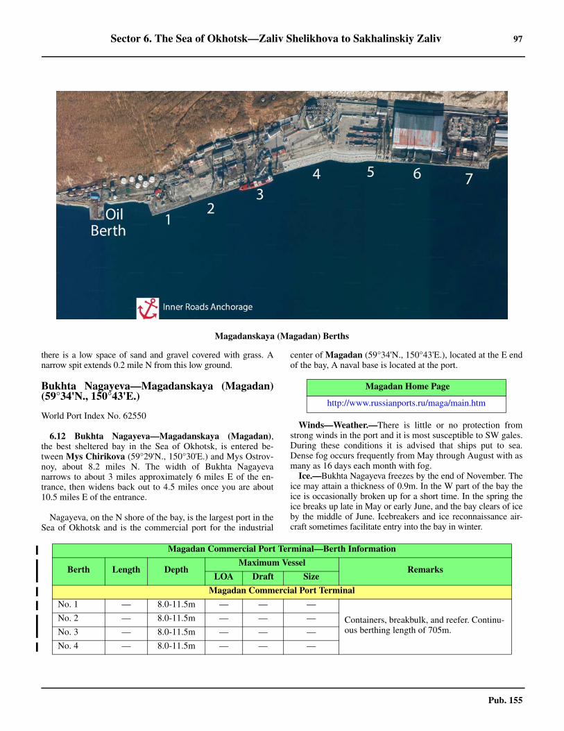
Sector 6. The Sea of Okhotsk—Zaliv Shelikhova to Sakhalinskiy Zaliv 97
Pub. 155
there is a low space of sand and gravel covered with grass. Anarrow spit extends 0.2 mile N from this low ground.
Bukhta Nagayeva—Magadanskaya (Magadan)(59°34'N., 150°43'E.)
World Port Index No. 62550
6.12 Bukhta Nagayeva—Magadanskaya (Magadan),the best sheltered bay in the Sea of Okhotsk, is entered be-tween Mys Chirikova (59°29'N., 150°30'E.) and Mys Ostrov-noy, about 8.2 miles N. The width of Bukhta Nagayevanarrows to about 3 miles approximately 6 miles E of the en-trance, then widens back out to 4.5 miles once you are about10.5 miles E of the entrance.
Nagayeva, on the N shore of the bay, is the largest port in theSea of Okhotsk and is the commercial port for the industrial
center of Magadan (59°34'N., 150°43'E.), located at the E endof the bay, A naval base is located at the port.
6.12 Winds—Weather.—There is little or no protection fromstrong winds in the port and it is most susceptible to SW gales.During these conditions it is advised that ships put to sea.Dense fog occurs frequently from May through August with asmany as 16 days each month with fog. 6.12 Ice.—Bukhta Nagayeva freezes by the end of November. Theice may attain a thickness of 0.9m. In the W part of the bay theice is occasionally broken up for a short time. In the spring theice breaks up late in May or early June, and the bay clears of iceby the middle of June. Icebreakers and ice reconnaissance air-craft sometimes facilitate entry into the bay in winter.
Magadanskaya (Magadan) Berths
Magadan Home Page
http://www.russianports.ru/maga/main.htm
Magadan Commercial Port Terminal—Berth Information
Berth Length DepthMaximum Vessel
RemarksLOA Draft Size
Magadan Commercial Port Terminal
No. 1 — 8.0-11.5m — — —
Containers, breakbulk, and reefer. Continu-ous berthing length of 705m.
No. 2 — 8.0-11.5m — — —
No. 3 — 8.0-11.5m — — —
No. 4 — 8.0-11.5m — — —
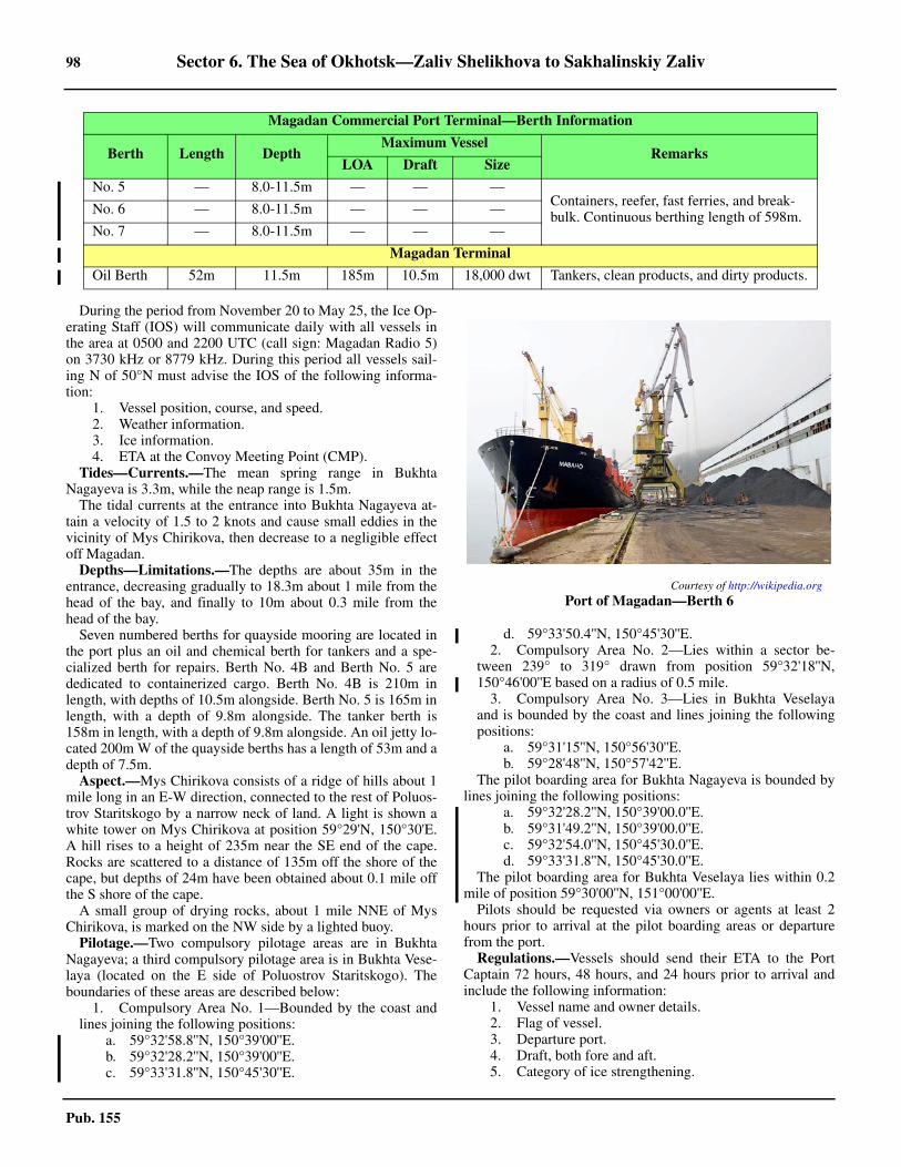
98 Sector 6. The Sea of Okhotsk—Zaliv Shelikhova to Sakhalinskiy Zaliv
Pub. 155
6.12 During the period from November 20 to May 25, the Ice Op-erating Staff (IOS) will communicate daily with all vessels inthe area at 0500 and 2200 UTC (call sign: Magadan Radio 5)on 3730 kHz or 8779 kHz. During this period all vessels sail-ing N of 50°N must advise the IOS of the following informa-tion:
1. Vessel position, course, and speed.2. Weather information.3. Ice information.4. ETA at the Convoy Meeting Point (CMP).
6.12 Tides—Currents.—The mean spring range in BukhtaNagayeva is 3.3m, while the neap range is 1.5m.6.12 The tidal currents at the entrance into Bukhta Nagayeva at-tain a velocity of 1.5 to 2 knots and cause small eddies in thevicinity of Mys Chirikova, then decrease to a negligible effectoff Magadan. 6.12 Depths—Limitations.—The depths are about 35m in theentrance, decreasing gradually to 18.3m about 1 mile from thehead of the bay, and finally to 10m about 0.3 mile from thehead of the bay.6.12 Seven numbered berths for quayside mooring are located inthe port plus an oil and chemical berth for tankers and a spe-cialized berth for repairs. Berth No. 4B and Berth No. 5 arededicated to containerized cargo. Berth No. 4B is 210m inlength, with depths of 10.5m alongside. Berth No. 5 is 165m inlength, with a depth of 9.8m alongside. The tanker berth is158m in length, with a depth of 9.8m alongside. An oil jetty lo-cated 200m W of the quayside berths has a length of 53m and adepth of 7.5m. 6.12 Aspect.—Mys Chirikova consists of a ridge of hills about 1mile long in an E-W direction, connected to the rest of Poluos-trov Staritskogo by a narrow neck of land. A light is shown awhite tower on Mys Chirikova at position 59°29'N, 150°30'E.A hill rises to a height of 235m near the SE end of the cape.Rocks are scattered to a distance of 135m off the shore of thecape, but depths of 24m have been obtained about 0.1 mile offthe S shore of the cape.6.12 A small group of drying rocks, about 1 mile NNE of MysChirikova, is marked on the NW side by a lighted buoy.6.12 Pilotage.—Two compulsory pilotage areas are in BukhtaNagayeva; a third compulsory pilotage area is in Bukhta Vese-laya (located on the E side of Poluostrov Staritskogo). Theboundaries of these areas are described below:
1. Compulsory Area No. 1—Bounded by the coast andlines joining the following positions:
a. 59°32'58.8''N, 150°39'00''E.b. 59°32'28.2''N, 150°39'00''E.c. 59°33'31.8''N, 150°45'30''E.
d. 59°33'50.4''N, 150°45'30''E.2. Compulsory Area No. 2—Lies within a sector be-
tween 239° to 319° drawn from position 59°32'18''N,150°46'00''E based on a radius of 0.5 mile.
3. Compulsory Area No. 3—Lies in Bukhta Veselayaand is bounded by the coast and lines joining the followingpositions:
a. 59°31'15''N, 150°56'30''E.b. 59°28'48''N, 150°57'42''E.
6.12 The pilot boarding area for Bukhta Nagayeva is bounded bylines joining the following positions:
a. 59°32'28.2''N, 150°39'00.0''E.b. 59°31'49.2''N, 150°39'00.0''E.c. 59°32'54.0''N, 150°45'30.0''E.d. 59°33'31.8''N, 150°45'30.0''E.
6.12 The pilot boarding area for Bukhta Veselaya lies within 0.2mile of position 59°30'00''N, 151°00'00''E. 6.12 Pilots should be requested via owners or agents at least 2hours prior to arrival at the pilot boarding areas or departurefrom the port. 6.12 Regulations.—Vessels should send their ETA to the PortCaptain 72 hours, 48 hours, and 24 hours prior to arrival andinclude the following information:
1. Vessel name and owner details.2. Flag of vessel.3. Departure port.4. Draft, both fore and aft.5. Category of ice strengthening.
No. 5 — 8.0-11.5m — — —Containers, reefer, fast ferries, and break-bulk. Continuous berthing length of 598m.No. 6 — 8.0-11.5m — — —
No. 7 — 8.0-11.5m — — —
Magadan Terminal
Oil Berth 52m 11.5m 185m 10.5m 18,000 dwt Tankers, clean products, and dirty products.
Magadan Commercial Port Terminal—Berth Information
Berth Length DepthMaximum Vessel
RemarksLOA Draft Size
Courtesy of http://wikipedia.org
Port of Magadan—Berth 6
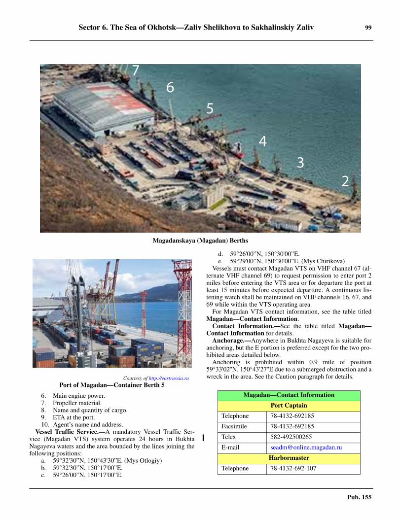
Sector 6. The Sea of Okhotsk—Zaliv Shelikhova to Sakhalinskiy Zaliv 99
Pub. 155
6. Main engine power.7. Propeller material.8. Name and quantity of cargo.9. ETA at the port.10. Agent’s name and address.
6.12 Vessel Traffic Service.—A mandatory Vessel Traffic Ser-vice (Magadan VTS) system operates 24 hours in BukhtaNagayeva waters and the area bounded by the lines joining thefollowing positions:
a. 59°32'30”N, 150°43'30”E. (Mys Otlogiy)b. 59°32'30”N, 150°17'00”E.c. 59°26'00”N, 150°17'00”E.
d. 59°26'00”N, 150°30'00”E.e. 59°29'00”N, 150°30'00”E. (Mys Chirikova)
6.12 Vessels must contact Magadan VTS on VHF channel 67 (al-ternate VHF channel 69) to request permission to enter port 2miles before entering the VTS area or for departure the port atleast 15 minutes before expected departure. A continuous lis-tening watch shall be maintained on VHF channels 16, 67, and69 while within the VTS operating area. 6.12 For Magadan VTS contact information, see the table titledMagadan—Contact Information. 6.12 Contact Information.—See the table titled Magadan—Contact Information for details. 6.12 Anchorage.—Anywhere in Bukhta Nagayeva is suitable foranchoring, but the E portion is preferred except for the two pro-hibited areas detailed below.6.12 Anchoring is prohibited within 0.9 mile of position59°33'02''N, 150°43'27''E due to a submerged obstruction and awreck in the area. See the Caution paragraph for details.
Magadanskaya (Magadan) Berths
Courtesy of http://eastrussia.ru
Port of Magadan—Container Berth 5
Magadan—Contact Information
Port Captain
Telephone 78-4132-692185
Facsimile 78-4132-692185
Telex 582-492500265
E-mail [email protected]
Harbormaster
Telephone 78-4132-692-107
100 Sector 6. The Sea of Okhotsk—Zaliv Shelikhova to Sakhalinskiy Zaliv
Pub. 155
6.12 The Quarantine Anchorage berth (No. 13), for use by foreignvessels, is located at the entrance to Bukhta Nagayeva in posi-tion 59°32'N, 150°30'E. 6.12 Anchorage Area No. 14 has been established in position59°30'00''N, 151°00'00''E. 6.12 Permission from the State Port Director must be obtained be-fore anchoring within the port limits of Magadan. 6.12 Anchoring is prohibited in Russian Regulated Area No. 69Vand Russian Regulated Area No. 70, as follows:
1. Area No. 69V—bounded by lines joining the follow-ing positions:
a. 59°31'41''N, 150°44'37''E.b. 59°32'21''N, 150°44'37''E.c. 59°32'21''N, 150°46'06''E.d. 59°32'17''N, 150°46'15''E.
2. Area No. 70—bounded by lines joining the followingpositions:
a. 59°33'36''N, 150°42'24''E.b. 59°33'36''N, 150°43'12''E.
c. 59°33'24''N, 150°43'12''E.d. 59°33'24''N, 150°42'24''E.
6.12 Caution.—Approach and entry into Bukhta Nagayeva pres-ents no difficulty during clear weather, either by day or night.Mys Chirikova can be often identified through a fog of averagedensity, and the N shore of Tauyskaya Guba is often discerniblewhen the fog is light. When heavy fog envelops the entire Tauys-kaya Guba, it is better not to approach Poluostrov Staritskogobut to steer for a position W of Ostrov Nedorazumeniya, and an-chor upon obtaining depths of 28m until the fog clears.6.12 Magnetic anomalies have been observed at the N shore ofTauyskaya Guba, from Ostrov Nedorazumeniya to the mouthof the Ola River, and also in the area of Ostrov Zavylov and theW shore of the Koni Peninsula. The magnetic declination var-ies from 17° to 10° and from 11° to 5 °. 6.12 Care should be taken to avoid any vessels inside a DeviationCalibration Area close NNW of the approach track, This cali-bration area, designated Russian Regulated Area No. 142A, isbounded by lines joining the following positions:
a. 59°33'30''N, 150°23'00''E.b. 59°31'00''N, 150°21'00''E.c. 59°31'48''N, 150°18'00''E.d. 59°33'18''N, 150°20'00''E.
6.12 A wreck, with a depth of 0.6m, is located in position59°33'49''N, 150°45'19''E. 6.12 An underwater obstruction, with a depth of 4.1m, locatedabout 900m NW of the front light for the Bukhta Nagayevalighted range. 6.12 Underwater obstructions with depths of 15.6m and 9.4m arelocated 100m S and 80m W of the SW end of Berth No. 1, re-spectively.
Tauyskaya Guba to Okhotskiy Reyd
6.13 Bukhta Shestakova is entered between Mys Shestako-va (59°14'N., 148°55'E.) and Mys Gavantsa, an elevated cliffycape rising vertically from the sea about 4.5 miles W. There aredepths of 24m in the middle of the bay, and depths of 5.5 to 7.3mabout 0.5 mile off the head of the bay. The bottom is sand. Ashort reef extends from the shore W of the mouth of a stream atthe head of the bay.6.13 Anchorage.—Anchorage in suitable depths can be taken inany part of Bukhta Shestakova. During winds from the Ethrough N to W, anchorage in the bay is calm. The bay affordssome shelter under the W and E shores during winds from be-tween the SW and W, or SE to E, respectively. 6.13 A wreck lies in a depth of 20m approximately 5 miles NW ofOstrov Spafar’yeva Light.
6.14 Mys Dal’niy (59°14'N., 148°27'E.), lying 10 miles Wof Mys Gavantsa, is high and rocky. A sandy spit extends 0.8mile W from the point. A rock, lying close offshore, is 3 milesN of Mys Dal’niy.6.14 Zaliv Shel’tinga is entered between Mys Dal'niy and MysMoskvitina, about 20 miles W. The shores of Zaliv Shel’tingaare high and rocky, except for a sandy beach skirting the NWend of the bay. The high sections of the shore are steep-to, andthe bay is clear of dangers. The bottom shelves toward the NWend of the bay; depths of 11 to 13m, sand, lie about 0.7 mile offthe sandy beach.
GMDSS Controller
Telephone 78-4132-297-375
Operations Manager
Call sign Magadan Radio 2
VHF VHF channels 14 and 16
Telephone 78-4132-692-361
Port State Control
Call sign Magadan Radio 5
VHF VHF channels 9 and 16
Telephone 78-4132-692-337
Facsimile 78-4132-607-705
Ice Operations
Call sign Magadan Radio 5
RT Frequency 3730 kHz and 8779 kHz
Pilot
Call sign Magadan Radio 3
VHF VHF channels 16 and 69
Telephone 78-4132-508-8207 (24 hours)
Facsimile 78-4132-630-956
E-mail [email protected]
VTS
VHF VHF channels 16, 67, and 69
Telephone78-4132-630508 (weekdays be-tween 0830 and 1830)
78-4132-607375 (24 hours)
Facsimile 78-4132-607375
E-mail [email protected]
Magadan—Contact Information
Sector 6. The Sea of Okhotsk—Zaliv Shelikhova to Sakhalinskiy Zaliv 101
Pub. 155
6.14 Anchorage.—Anchorage, sheltered from SW winds, can betaken off the beach in the NW part of the bay. Anchorage insuitable depths can be taken almost anywhere in Zaliv Shel’tinga, but the best anchorage during SE winds is in the bight Nof the spit extending W from Mys Dal’niy.6.14 Mys Moskvitina, high and cliffy, is the S extremity of Poluos-trov Onara. Gora Onara, 1,042m high, lies about 2.5 miles N ofMys Moskvitina. It is very steep on its S and E slopes, and the ver-tical white stripes on its sides are very conspicuous.6.14 Bukhta Luzhina, W of Poluostrov Onara, has high and rockyshores and has not been surveyed.
6.15 Mys Rzhavyy (59°24'N., 146°41'E.), lying 28 milesWNW of the W entrance point of Bukhta Luzhina, is a cliffy,steep-to cape with a red color, which stands out against thebrown color of the adjacent coasts on either side and is visiblefrom a great distance on a clear day. Gora Ploskaya, 1,373mhigh and lying about 8 miles E of Mys Rzhavyy, dominates thecoast between the cape and Bukhta Luzhina.6.15 Zaliv Ushki is entered between Mys Rzhavyy and Mys Yela-gina, 15 miles SW. The shores of the bay are high and cliffy.The head of the bay is formed by a low shore of sand and shin-gle, about 4.5 miles in width. Depths of about 26m in the Npart of the bay decrease gradually to the shores. 6.15 Anchorage.—Anchorage can be taken, in 11 to 13m, sand,but with rocks and shells in places.
6.16 Poluostrov Kamenistyy (59°16'N., 146°20'E.), a nar-row peninsula about 15m high, with a flat grassy top, juts outdirectly E for about 0.5 mile from the coast, 3.5 miles N ofMys Yelagina. The narrow peninsula has low but steep shores,and rocks are scattered on all sides of the peninsula a short dis-tance offshore.6.16 Bukhta Kulku, a rounded recess about 1.7 miles wide at theentrance, lies on the N side of Poluostrov Kamenistyy. RechkaKulku, a shallow rivulet, discharges at the head of the recess.There are depths of 9m about 0.5 mile off the head of the re-cess, decreasing rapidly to the shore.6.16 Tides—Currents.—The MHW interval in Bukhta Kulku is9 hours 30 minutes. Tides are semidiurnal, the tidal rise beingup to 2.7m at springs.6.16 Anchorage.—The best anchorage is in a depth of about 12m,poor holding ground, rock, with the E extremity of PoluostrovKameinstyy bearing 142°, the mouth of Rechka Kulku bearing255°, and Gora Lisaya bearing 293°. The best landing is close Nof the river mouth, where there are no rocks.6.16 Caution.—Vessels approaching Bukhta Kulku from the Sshould give Poluostrov Kamenistyy a berth of a least 0.5 mile.
6.17 Poluostrov Lisyanskogo, a mountainous peninsula,has high, steep, and generally steep-to shores. Gora Ushki(59°22'N., 146°11'E.), the summit of the peninsula, rises to twopointed peaks. Gora Lisaya, 530m high, about 4 miles SSE ofGora Ushki, can be identified by a round barren summit ofgray color, and forms a good landmark. 6.17 Mys Duga, the S extremity of the peninsula, terminates in ablunt cape, with Mys Duga Vostochnaya and Mys Duga Zapad-naya as the E and W extremities, respectively, of the cape. Bothextremities are fringed by reefs and rocks extending 0.8 mileoffshore. A light, 34m in height, at an elevation of 82m, is
shown on Mys Duga Vostochnaya.6.17 Mys Ushakova, about 8 miles NW of Mys Duga Zapadnaya,is fringed by foul ground extending about 1.2 miles W. 6.17 Eirineiskiy Light (59°14.6'N., 145°49.7'E.) is shown from a8m tower, at an elevation of 41m, on Mys Ushakova.6.17 Caution.—Abnormal magnetic variations exist within an ar-ea extending 35 miles WSW from Poluostrov Lisyanskogo,and within a circular area with a radius of 30 miles and the cen-ter located about 62 miles SSW of the extremity of PoluostrovLisyanskogo.
6.18 Guba Yeyrineyskaya is entered between MysShil'kan (59°22'N., 145°47'E.) and Mys Yeyrineyskiy, 38mhigh, about 4 miles SSE. Mys Shil'kan has high dark-gray cliffsand is formed by the SE slope of a mountain rising to a heightof 463m within the cape.6.18 Gora Trekhsopochnaya, rising to a height of 841m about 3.5miles NNW of Mys Shil'kan, and Gora Ushki, previously de-scribed in paragraph 6.17, form good landmarks from the off-ing. The E and W shores of the gulf are high. 6.18 Mys Kekurnyy (59°24'N., 145°52'E.), a cliffy cape about 3miles NE of Mys Shil'kan and rising to about 475m 1 mile in-land, divides the head of the gulf into two recesses. There aredepths of about 24m, sand, halfway up the gulf. A bank, withdepths of 7.3m, extends about 0.8 mile from the heads of the Eand W recesses, and 0.2 to 0.4 mile from the shores of the gulfelsewhere.6.18 Anchorage.—Anchorage, sheltered from all but SW winds,can be obtained in suitable depths, fine sand, within the E re-cess of Guba Yeyrineyskaya.
6.19 Mys Gereya (59°24'N., 145°41'E.), a high cliffy capeabout 3.5 miles NW of Mys Shil'kan, is identified by a conspic-uous pointed pillar rock nearby. The cape is steep-to and clearof dangers.6.19 The coast between Mys Kekurnyy and Mys Gadikan, 10.5miles W, consists of dark-gray cliffs. A landslide of gray colormarks the coast about 3.5 miles E of Mys Gadikan.6.19 Mys Gadikan (59°24'N., 145°19'E.) consists of dark, steepcliffs, and is formed by the seaward slope of a hill, 183m high,about 2.5 miles ENE of the cape. The coastal elevations form aridge extending in a NW direction from the indentation about 2miles N of the cape, and recede far inland, backing a low sec-tion of the coast.6.19 Gora Shil’ki, about 6 miles NE of Mys Gadikan, has twinpeaks, 1,739m and 1,510m high, respectively. Gora Verblyud,1,235m high, is located 2 miles SE of Gora Shil'ki.6.19 A reef projects 0.5 mile SE from the extremity of Mys Ga-dikan. The vicinity of the cape has not been surveyed but it isappears that the cape is the W limit of that part of the N shoreof the Sea of Okhotsk which is steep-to.6.19 A shoal, position doubtful, with a least depth of 3.2m, ischarted about 9 miles WSW of Mys Gadikan.6.19 The lagoon of Reka Inya extends 11 miles W and 3 miles Efrom its E entrance (59°23'N., 144°52'E.). The lagoon is sepa-rated from the sea by two low, sand and shingle spits projectingfrom each end of the lagoon, and two islets which lie betweenthe extremities of the spits and form three entrance channels in-to the lagoon. The N shore of the lagoon consists of marshyland extending about 3 miles inland.
102 Sector 6. The Sea of Okhotsk—Zaliv Shelikhova to Sakhalinskiy Zaliv
Pub. 155
6.19 Inya, a small village, lies on the left bank of Reka Inya.6.19 Gora Derevannay, a mountain rising to a height of 440m,about 9 miles NW of the E entrance of the lagoon and about 5miles inland, can be identified by a knob on its elongated sum-mit.6.19 Anchorage.—Anchorage abreast the lagoon can be ob-tained, in depths of 9 to 11m, about 1 mile offshore. The an-chorage is totally exposed to the sea and to S winds, whichprevail in summer.
6.20 Reka Ul’beya, a small, shallow river discharges about2 miles W of the W end of the lagoon of Reka Inya and forms asmall lagoon.6.20 Between Reka Ul'beya and Mys Marekan, about 31 miles W,the low coast of sand and shingle is backed by grassy marsh-land marked with numerous lakes.6.20 Caution.—A submarine cable extends SW from a position 7miles W of Reka Ul’beya and follows the coast 470 miles toPetrovskaya Kosa.
6.21 Gora Vetrennyy Kamushek has a treeless summit re-sembling a gigantic cap about 6.5 miles WNW of the mouth ofReka Ul'beya. Two bare pointed summits, about 667m and628m high, rise about 4 miles and 5 miles E, respectively, ofGora Vetrennyy Kamushek.6.21 Gora Volnistaya (59°33'N., 143°56'E.), a conspicuousmountain, can be identified by its wavy slopes. It is 1,939mhigh.6.21 Mys Marekan (59°19'N., 143°27'E.) is formed by the sea-ward termination of a mountainous range, and rises to a height ofabout 454m. From the E and W the mountain range appears tohave a fairly uniform height, but from the S, Gora Sosok, risingto its summit on the W side of the range, is conspicuous. A lightis shown from Mys Marekan.
Okhotskiy Reyd (59°22'N., 143°12'E.)
World Port Index No. 62540
6.22 Okhotskiy Reyd is the roadstead at the entrance to Re-ka Kukhtuy, and consists of the area between the coast and aline joining Mys Marekan and the mouth of Reka Okhota,about 12 miles W. There is always a swell in the roadstead, anda very heavy sea is raised by storms from seaward.6.22 Reka Kukhtuy is entered between Tungusskaya Kosa andOkhotskaya Kosa, and between two coastal shoals projecting Sfrom each of the spits. The position of the channel and its depthchange, but the depth on the bar remains unchanged. The en-trance channel has an average width of about 90m and usuallyis discernible by the comparatively calm water between almostcontinual breakers on either side. Fishing stakes may beencountered within 1.5 miles of the channel entrance.6.22 The port of Okhotsk (Rybnyy) (59°22'N., 143°12'E.), main-ly used by fishing vessels, is situated about 1.5 miles up RekaKukhtuy, on that part of the S bank formed by the base of Tun-gusskaya Kosa. A light is exhibited here. 6.22 Winds—Weather.—Gentle winds and calms prevail from theend of April to the end of May or early June, when S or SEwinds begin to prevail. During June and July, SE winds attain aforce not exceeding 3. Storms are rare and short-lived. During
August and the first half of September, SW winds prevail and in-crease in force toward autumn. Fresh winds and storms prevailthrough the second half of September, October, and November.Winter winds from the N and NW of moderate force prevailfrom December to March, toward the end of which these windsgradually subside in force and become gentle.6.22 April, May, and early June is the season of dense protractedfog, often enveloping the sea and the coast for several days at atime. The fog decreases in density and frequency toward au-tumn.6.22 Ice.—Ice begins to form in mid-November in the vicinity ofthe port, with the port officially closing from mid-December tomid-March, with some ice remaining until June if the winterhas been severe. During the winter, young ice forms on thecoast and usually there is floating ice in the approaches beforethe end of December, and in severe winters by mid-December.Navigation is possible throughout the winter with icebreakerassistance, but no icebreaker is usually assigned for the portwhich is formally closed for navigation from December 15th toMay 15th. However, some ice may remain in the roadstead un-til early June after a severe winter. During June, blocks of icemay be seen off the roadstead; these have drifted from Pen-zhinskiy Zaliv, nearly 400 miles E, and are later driven towardthe SW shore of the Sea of Okhotsk.6.22 When the rivers break up, the rate of the streams combines tofloat the ice up to 10 miles clear of the coast, leaving a lane forsafe navigation. The ice in the harbor of Okhotsk reaches amaximum thickness of about 1.8m.6.22 Tides—Currents.—The MHW interval at the mouth of Re-ka Kukhtuy is 10 hours 13 minutes. The tide is semidiurnal, thetidal rise being 3.3m at springs and about 1.5m at neaps.6.22 The flood current sets along the shore in an ENE direction,and the ebb current in a reverse direction, attaining velocitiesof 1.5 to 2 knots. In the narrows of the entrance into RekaKukhtuy the flood and the ebb currents are swift and attain re-spective velocities of 6 and 7 knots at springs.6.22 Depths—Limitations.—Depths of 9.1m lie, on the average,a distance of 1.7 to 1.5 miles offshore in Okotskiy Reyd.Depths of 3.6m lie a distance of 0.5 to 0.8 miles offshore.6.22 The entrance of Reka Kukhtuy is accessible at HW to vesselswith a draft not exceeding 4m. The bar at the middle of the en-trance channel has depths of 0.2 to 1.8m (1975), but they aresubject to frequent change. Inside the entrance the fairwayleads from the bar at the entrance to Reka Kukhtuy, 0.9 mileENE, with depths of 2 to 4.6m (1975) and then NE for 0.7mile, with depths of 1.8 to 3.6m (1975) to the quays.6.22 Twelve quays along the S bank of the Reka Kukhtuy haveberthing lengths of 10 to 99m and depths alongside of 0.5 to2m at LW. 6.22 Aspect.—Gora Sosok, previously described in paragraph6.21, about 6 miles E of the mouth of Reka Kukhtuy, is a usefullandmark for vessels approaching from the E.6.22 Gora Ostraya and Gora Ploskaya form useful landmarks forvessels approaching from the S. Gora Ostraya (59°15'N.,142°10'E.), about 32 miles WSW of the mouth of Reka Kukh-tuy, can be identified by its sharp cone-shaped summit. GoraPloskaya, about 17 miles N of Gora Ostraya, has a flat summitand is visible for 50 miles on a clear day.6.22 Pilotage.—Pilotage is compulsory for all vessels and isavailable 24 hours.
Sector 6. The Sea of Okhotsk—Zaliv Shelikhova to Sakhalinskiy Zaliv 103
Pub. 155
6.22 Pilots should be requested through the harbormaster 72hours, 48 hours, and 4 hours prior to arrival. 6.22 Pilots board in position 59°19'18.6''N, 143°08'55.8''E. Forpilot contact information, see table titled Okhotsk—ContactInformation.6.22 Regulations.—Vessels should maintain a continuous listeningwatch on VHF channel 11. 6.22 Vessel Traffic Service.—A Ship Traffic Management Sys-tem (STCMS) covering the port area and its approaches isbounded by lines joining the following positions:
a. 59°21.7'N, 143°14.3'E.b. 59°16.5'N, 143°14.2'E.c. 59°16.5'N, 143°01.8'E.d. 59°18.2'N, 143°01.8'E.
6.22 Vessel heading to and departing from the port shall requestpermission from the STCMS for entry/exit on VHF channel11. 6.22 Vessels underway in the port and its approaches shall pro-vide the STCMS with the following information on VHF chan-nel 11:
1. Berthing/unberthing.2. Commencement and termination of the vessel’s
movement.3. Pilot embarkation/disembarkation.
6.22 The following information shall be provided when enteringthe inner harbor:
1. Vessel’s draft.2. ETA to the berth or anchorage position.
6.22 The STCMS can be contacted (call sign: Okhotsk 32) onVHF channels 10 and 11). 6.22 Contact Information.—See the table titled Okhotsk—Contact Information
6.22 Anchorage.—Anchorage can be taken in suitable depths inany part of the roadstead. A vessel should anchor as closely aspossible to the entrance of Reka Kukhtuy in depths of 7m, finesand, with the entrance to the river bearing 335° distant 1.25miles, the church situated 1 mile ENE of the river entrancebearing 024°, and a small hill near the extremity of MysMarekan bearing 086°. 6.22 During strong offshore winds, anchorage should be takenabout 0.75 mile farther seaward, in depths of 11m, with the riv-er entrance bearing 335°. 6.22 A quarantine anchorage lies 5 miles ESE of the river en-trance. 6.22 During gales from seaward, all these anchorages are unsafe. 6.22 Caution.—Vessels approaching Okhotskiy Reyd in fogshould proceed with caution upon obtaining depths of 30m,and should anchor upon obtaining depths of 18.3m and wait
until the fog clears. June and July are the best months of thenavigational season.6.22 The approach to Okhotskiy Reyd presents no difficulties inclear weather.6.22 Entrance to Reka Kukhtuy is difficult and should not be at-tempted if the swell is heavy and cause breakers across the en-tire entrance channel.6.22 During the summer, fishing nets may extend up to 1 mile Sfrom Tumgusskaya Kosa.
Okhotskiy Reyd to Poluostrov Longdar Negotni
6.23 Reka Okhota (59°20'N., 143°02'E.) discharges about4 miles WSW of Reka Kukhtuy.6.23 The coast between Reka Kukhtuy and Reka Ul’ya, about 50miles SW, is low and bordered by a beach of sand and gravel.Rechka Urak flows through a small valley about midway alongthe stretch. Reka Ul’ya forms a shallow lagoon at its mouth.6.23 Mys Nogdan (58°41'N., 141°41'E.), a conspicuous capeabout 12 miles SSW of Reka Ul’ya, is steep-to and risesabruptly to 213m from the low coast on either side. The hills Nof the cape begin to recede inland and the beach of sand andgravel becomes wider. A detached pillar lies near the coastabout 2.7 miles SSW of the cape.6.23 Mys Nizkiy, about 15 miles SW of Mys Nogdan, is a lowrounded cape projecting about 0.5 mile seaward. A ledge, part-ly covered at HW, extends 0.5 mile SE of the cape. Mys Plos-kiy, about 4 miles WSW of Mys Nizkiy, is a flat-topped sectionof coast, of medium height, and discernible only by vesselsnavigating close to the shore.6.23 The coast between Mys Nizkiy and Mys Khanyangda, about47 miles SSW, consists of a beach of sand and gravel, of vari-able width, and covered with driftwood. A continuous line ofhills backs the beach.6.23 Mys Khanyangda (57°51'N., 140°30'E.) is formed by theseaward slopes of a mountain rising to a height of 423m nearthe shoreline. A mountain range, trending 3 to 4 miles inland,gives Mys Khanyangda the appearance of a comparatively lowcape from the offing. A pillar rock lies near the coastline ashort distance S of the cape and equals in height the precipicesof the cape.6.23 Mys Enkan, about 8 miles SW of Mys Khanyangda, is bor-dered S and NW by short reefs. A detached mountain, 323mhigh, about 1.5 miles N of the cape, has a hill, 213m high, onits S slope, which terminates in precipices 75 to 90m high onits seaward face.
6.24 Mys Odzhan (57°29'N., 139°47'E.), a conspicuouscape lying about 22 miles SW of Mys Enkan, is steep-to, clearof dangers, and faces the sea with precipices of great height.The cape is formed by the seaward slope of a rounded coastalmountain, about 1 mile N of its extremity.6.24 Ostrovok Nansikan, a cliffy islet about 2.5 miles SE of MysOdzhan, rises to a 137m summit. A large, pointed pillar rock,connected with the islet by a low isthmus, lies at the NW endof the islet. The shores of the islet are steep-to, and depths of26m, rocky bottom, lie close offshore.6.24 Tides—Currents.—Tidal currents attain a velocity of 1 to1.5 knots in the channel separating Ostrovok Nansikan fromthe mainland. The flood current sets in a SW direction and the
Okhotsk—Contact Information
Harbormaster/Port State Control
Call sign Okhotsk 32
VHF VHF channel 11
Pilots
Call sign Lotsman-Okhotsk
VHF VHF channels 11 and 13
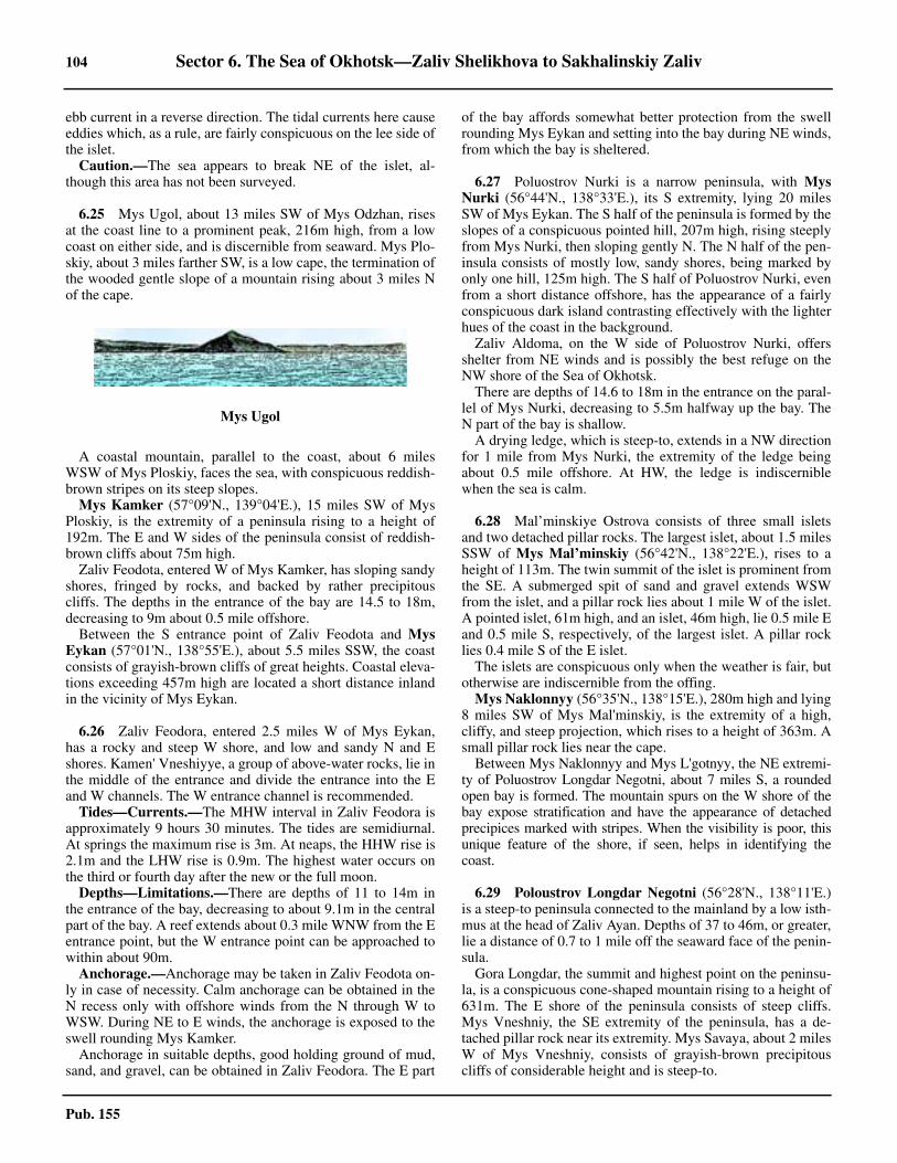
104 Sector 6. The Sea of Okhotsk—Zaliv Shelikhova to Sakhalinskiy Zaliv
Pub. 155
ebb current in a reverse direction. The tidal currents here causeeddies which, as a rule, are fairly conspicuous on the lee side ofthe islet.6.24 Caution.—The sea appears to break NE of the islet, al-though this area has not been surveyed.
6.25 Mys Ugol, about 13 miles SW of Mys Odzhan, risesat the coast line to a prominent peak, 216m high, from a lowcoast on either side, and is discernible from seaward. Mys Plo-skiy, about 3 miles farther SW, is a low cape, the termination ofthe wooded gentle slope of a mountain rising about 3 miles Nof the cape.
6.25 A coastal mountain, parallel to the coast, about 6 milesWSW of Mys Ploskiy, faces the sea, with conspicuous reddish-brown stripes on its steep slopes.6.25 Mys Kamker (57°09'N., 139°04'E.), 15 miles SW of MysPloskiy, is the extremity of a peninsula rising to a height of192m. The E and W sides of the peninsula consist of reddish-brown cliffs about 75m high.6.25 Zaliv Feodota, entered W of Mys Kamker, has sloping sandyshores, fringed by rocks, and backed by rather precipitouscliffs. The depths in the entrance of the bay are 14.5 to 18m,decreasing to 9m about 0.5 mile offshore. 6.25 Between the S entrance point of Zaliv Feodota and MysEykan (57°01'N., 138°55'E.), about 5.5 miles SSW, the coastconsists of grayish-brown cliffs of great heights. Coastal eleva-tions exceeding 457m high are located a short distance inlandin the vicinity of Mys Eykan.
6.26 Zaliv Feodora, entered 2.5 miles W of Mys Eykan,has a rocky and steep W shore, and low and sandy N and Eshores. Kamen' Vneshiyye, a group of above-water rocks, lie inthe middle of the entrance and divide the entrance into the Eand W channels. The W entrance channel is recommended.6.26 Tides—Currents.—The MHW interval in Zaliv Feodora isapproximately 9 hours 30 minutes. The tides are semidiurnal.At springs the maximum rise is 3m. At neaps, the HHW rise is2.1m and the LHW rise is 0.9m. The highest water occurs onthe third or fourth day after the new or the full moon.6.26 Depths—Limitations.—There are depths of 11 to 14m inthe entrance of the bay, decreasing to about 9.1m in the centralpart of the bay. A reef extends about 0.3 mile WNW from the Eentrance point, but the W entrance point can be approached towithin about 90m.6.26 Anchorage.—Anchorage may be taken in Zaliv Feodota on-ly in case of necessity. Calm anchorage can be obtained in theN recess only with offshore winds from the N through W toWSW. During NE to E winds, the anchorage is exposed to theswell rounding Mys Kamker.6.26 Anchorage in suitable depths, good holding ground of mud,sand, and gravel, can be obtained in Zaliv Feodora. The E part
of the bay affords somewhat better protection from the swellrounding Mys Eykan and setting into the bay during NE winds,from which the bay is sheltered.
6.27 Poluostrov Nurki is a narrow peninsula, with MysNurki (56°44'N., 138°33'E.), its S extremity, lying 20 milesSW of Mys Eykan. The S half of the peninsula is formed by theslopes of a conspicuous pointed hill, 207m high, rising steeplyfrom Mys Nurki, then sloping gently N. The N half of the pen-insula consists of mostly low, sandy shores, being marked byonly one hill, 125m high. The S half of Poluostrov Nurki, evenfrom a short distance offshore, has the appearance of a fairlyconspicuous dark island contrasting effectively with the lighterhues of the coast in the background.6.27 Zaliv Aldoma, on the W side of Poluostrov Nurki, offersshelter from NE winds and is possibly the best refuge on theNW shore of the Sea of Okhotsk.6.27 There are depths of 14.6 to 18m in the entrance on the paral-lel of Mys Nurki, decreasing to 5.5m halfway up the bay. TheN part of the bay is shallow.6.27 A drying ledge, which is steep-to, extends in a NW directionfor 1 mile from Mys Nurki, the extremity of the ledge beingabout 0.5 mile offshore. At HW, the ledge is indiscerniblewhen the sea is calm.
6.28 Mal’minskiye Ostrova consists of three small isletsand two detached pillar rocks. The largest islet, about 1.5 milesSSW of Mys Mal’minskiy (56°42'N., 138°22'E.), rises to aheight of 113m. The twin summit of the islet is prominent fromthe SE. A submerged spit of sand and gravel extends WSWfrom the islet, and a pillar rock lies about 1 mile W of the islet.A pointed islet, 61m high, and an islet, 46m high, lie 0.5 mile Eand 0.5 mile S, respectively, of the largest islet. A pillar rocklies 0.4 mile S of the E islet.6.28 The islets are conspicuous only when the weather is fair, butotherwise are indiscernible from the offing.6.28 Mys Naklonnyy (56°35'N., 138°15'E.), 280m high and lying8 miles SW of Mys Mal'minskiy, is the extremity of a high,cliffy, and steep projection, which rises to a height of 363m. Asmall pillar rock lies near the cape.6.28 Between Mys Naklonnyy and Mys L'gotnyy, the NE extremi-ty of Poluostrov Longdar Negotni, about 7 miles S, a roundedopen bay is formed. The mountain spurs on the W shore of thebay expose stratification and have the appearance of detachedprecipices marked with stripes. When the visibility is poor, thisunique feature of the shore, if seen, helps in identifying thecoast.
6.29 Poloustrov Longdar Negotni (56°28'N., 138°11'E.)is a steep-to peninsula connected to the mainland by a low isth-mus at the head of Zaliv Ayan. Depths of 37 to 46m, or greater,lie a distance of 0.7 to 1 mile off the seaward face of the penin-sula.6.29 Gora Longdar, the summit and highest point on the peninsu-la, is a conspicuous cone-shaped mountain rising to a height of631m. The E shore of the peninsula consists of steep cliffs.Mys Vneshniy, the SE extremity of the peninsula, has a de-tached pillar rock near its extremity. Mys Savaya, about 2 milesW of Mys Vneshniy, consists of grayish-brown precipitouscliffs of considerable height and is steep-to.
Mys Ugol
Sector 6. The Sea of Okhotsk—Zaliv Shelikhova to Sakhalinskiy Zaliv 105
Pub. 155
6.29 Tides—Currents.—In the vicinity of Poluostrov LongdarNegotni the tidal currents attain a velocity of 1.5 to 2 knots atsprings, the flood current setting in a SW direction and the ebbcurrent in a reverse direction. Eddies, clearly discernible froma distance of 5 miles offshore, are formed abreast that part ofthe coast between Mys L’gotnyy and Mys Vneshniy. Winds op-posing the tidal currents cause a confused sea in the vicinity ofthese capes.
6.30 Ostrov Iony (56°24'N., 143°23'E.), about 172 miles Eof Poluostrov Longdar Negotni, is a barren rock, 165m high.Generally, the shores of the island consist of precipitous cliffsrising sheerly from the sea to heights of 30 to 45m high. Fromthe offing Ostrov Iony has the appearance of a haystack.6.30 A group of four rocks, 9 to 12m high, lies about 0.5 mileNNW of the island. Other detached rocks lie off the island atabout the same distance. Several detached rocks lie 0.1 to 0.2mile off the S side of the island.6.30 A detached above-water rock, existence doubtful, is reportedto lie about 9.5 miles SSE of the island.6.30 A depth of 27.4m is reported to lie about 15 miles SSW ofthe island.6.30 A depth of 15.1m lies about 48 miles SE of the island. Adepth of 11.9m lies 28.5 miles NNW of the island. A depth of12.8m was reported (1970) to lie 20 miles S of the island.6.30 Winds—Weather.—The currents impinging on the steeprise of the island from the sea bottom force the colder bottomwater to the surface of the sea causing, in the vicinity of the is-land, a protracted dense fog enveloping the island for the great-er part of the navigational season. Although the fog becomessomewhat less dense in the latter part of the summer, it is onlywhen the NW autumnal winds begin to prevail that the numberof days with fog decreases markedly.6.30 Tides—Currents.—Ostrov Iony lies in the region of the weakconstant counterclockwise current, setting here in a general S toSW direction. This current is overborne by the tidal currents,which attain a velocity of 1.5 to 2 knots at springs. The floodcurrent sets in a W direction, and the ebb current in an E or ESEdirection.6.30 Numerous eddies, small whirlpools, and tide rips, more pro-nounced close to the shore, extend as far as 10 to 15 miles off-shore on the W, N, and E sides of the island, but much fartheron the S side.6.30 Caution.—Ostrov Iony should be given a wide berth, as theisland is ordinarily enveloped in dense fog during the naviga-tion season. Depths of 183m will indicate a position 8 to 20miles offshore, depending on the direction of the approach. Allprecautions should be taken upon obtaining a depth of 92m.The increasing number and intensity of eddies, as well as asudden increase in the number of seabirds, will indicate thatthe vessel is close to the island when the sea is calm. Usuallythe roar of thousands of sea lions on the rookeries of the islandbecomes audible at a distance of 1 to 1.5 miles offshore.
Poluostrov Longdar Negotni to Udskaya Guba
6.31 Zaliv Ayan (56°27'N., 138°09'E.), on the S side ofPoluostrov Longdar Negotni, is entered between Mys Savaya,previously described in paragraph 6.29, and Mys Zheltyy,marked with reddish-yellow precipices about 1.3 miles NW.
There is a small settlement, but no commerce, in Zaliv Ayan.The bay is the most sheltered anchorage on the NW shore ofthe Sea of Okhotsk.6.31 A large pillar rock lies near the shore a short distance N ofMys Savaya. Ostrovok Chayachiy, a cliffy islet, about 0.7 mileNNW of Mys Savaya, is connected to a rocky headland, 90mE, by a drying ledge.6.31 Banka Lorga Angra, a partly drying steep-to rocky shoal, ex-tends to about 0.3 mile E and SE of Mys Zheltyy. The seabreaks over the shoal at HW.6.31 Winds—Weather.—The period of calms and light airs ex-tends through the spring and early summer. Winds increase inforce gradually toward the latter part of the summer and attaintheir maximum force late in the autumn, but lessen graduallytoward the spring.6.31 From May to August, SE winds, alternating with somewhatstronger NE winds, prevail. From October to February, NW toN winds prevail. The latter part of September, October, andNovember is the period of protracted NE or SE storms. Suddensqualls emerge occasionally from the valleys at the head of thebay during either NW or NE winds.6.31 Northeasterly winds are accompanied with poor visibilityand bad weather. South to SSE winds bring fog. Winds fromthe S through W to NW are accompanied by clear weather.6.31 Precipitation in Zaliv Ayan and its vicinity is much greaterthan elsewhere in the Sea of Okhotsk. Nearly 90 per cent of thetotal precipitation per year is recorded during summer and au-tumn, the maximum being during August and September.6.31 The highest temperature on record for 11 years of observa-tion is 30°C and the lowest is -36.1°C.6.31 May, June, and July is the period of the most fog. The num-ber of days with fog decreases considerably by the first half ofAugust and is rare in the latter part of this month. Fog is an ex-ception during the offshore winds prevailing here through theautumn and winter.6.31 Ice.—The head of the bay freezes at the end of November,and the ice spreads rapidly over the whole bay, attaining a max-imum thickness of 0.8m. By the end of March, the coast isfringed with ice to a distance of 25 to 30 miles.6.31 In this vicinity the ice begins to break in April and, as a rule,moves SW along the coast, but masses of broken ice arebrought here from the N coast of the Sea of Okhotsk and re-main along this coast to the end of June or the middle of July.The average date for the complete freezing is 29 November;the average date of the breaking of the ice in the spring is 11April.6.31 Tides—Currents.—The MHW interval in Zaliv Ayan is 12hours 39 minutes. The tides are semidiurnal. At springs, themaximum tidal rise is 2.9m. At neaps, the HHW rise is 2.3mand the LHW rise is 0.2m. The highest water occurs on the sec-ond or third day after the new or the full moon.6.31 The tidal currents are more pronounced along the E shore ofthe bay, attaining a velocity of 1.5 knots in the vicinity of MysSavaya, but decreasing to 1 knot about halfway along the Eshore, and are imperceptible near the head of the bay.6.31 Depths—Limitations.—There are depths of 25 to 30m inthe middle of the entrance to Zaliv Ayan, shoaling gradually toabout 14.6m, sand, between Ostrovok Chayachiy and BankaLorga Angra, then to depths of 5.5m about 0.3 mile from thehead of the bay.
106 Sector 6. The Sea of Okhotsk—Zaliv Shelikhova to Sakhalinskiy Zaliv
Pub. 155
6.31 Aspect.—Gora Longdar, the summit of Poluostrov LongdarNegotni, and Gora Uyskaya, about 10 miles WSW of Mys Zh-eltyy, form excellent landmarks discernible in clear weatherfrom 35 to 50 miles. Gora Uyskaya, about 2 miles inland, hastwo pointed summits, 1 mile apart. It has the appearance of asingle cone-shaped mountain on NW bearings.6.31 Anchorage.—Anchorage can be taken, in 7.3 to 11m, sandand gravel, N of Ostrovok Chayachiy, and WSW of a sandystrip separating a small lake from the bay. Small vessels cananchor, in about 7 to 9m, sand and mud, about 0.5 mile fromthe head of the bay. Zaliv Ayan is sheltered from NE winds, buteven with NE winds a considerable swell enters. During strongS winds, the anchorage in the bay become untenable.6.31 Caution.—The approach to Zaliv Ayan presents no difficul-ties in clear weather. Vessels approaching the bay in fog wouldhave a somewhat better chance of identifying the coast S ofPoluostrov Longdar Negotni, where short periods of clearweather occur more often than N of this peninsula.
6.32 Mys Musikan (56°14'N., 137°50'E.), with a veryhigh coast, has rocks, which dry about 3m, extending about 0.2mile offshore. Mys Lantarskiy, about 7 miles farther SSW, maybe identified by a detached conical rock, about 31m high, lying1.2 miles N of the point and close offshore.6.32 Mys Borisova (55°57'N., 137°23'E.), lying 17 miles SW ofMys Lantarskiy, is the extremity of a promontory which risesto a height of 546m. A small islet, about 1.7 miles N of thecape, may help to identify the cape when coming from the N.6.32 Zaliv Borisova, the bay W of Mys Borisova, has steep-toshores except near its head. Depths of 26 to 37m are in the en-trance and also in the greater part of the bay, but decrease rathersuddenly to depths of 9.1 to 11m near the head, and mergeabruptly into the shoal water extending from the mouth of therivulet at the head of the bay.6.32 Anchorage.—Anchorage can be taken in Zaliv Borisova, indepths of 11 to 15m, sand and mud, good holding ground,about 0.5 mile from the head of the bay, with Mys Borisovabearing 123°. This anchorage is sheltered from NE winds. Al-though considerably abated, a heavy swell sets into the bayeven during NE winds. During fresh offshore winds, and par-ticularly during NW winds, this anchorage is exposed to sud-den strong gusts of wind from the valley of the rivulet.
6.33 Mys Otlichitel'nyy (55°47'N., 137°02'E.), 15 milesSW of Mys Borisova, is steep-to. A very high rock, connectedto the cape, rises to half the height of the cliffs and is conspicu-ous on NE and SW bearings, but is not discernible on the back-ground of the bluffs of the peninsula. Close to the point themountains are 900m high.6.33 Mys Ukoy (55°38'N., 136°46'E.), 13 miles SW of Mys Otli-chitel’nyy, steep-to and consisting of high and prominentrocks, is a narrow tongue-shaped cape jutting out from the Sside of an elevated peninsula. A mountain, rising to a height of536m near the base of Mys Ukoy, has on its S side a serratedridge sloping toward the extremity of the cape.6.33 Four detached pillar rocks are located 4 to 6 miles NNE ofMys Ukoy. The outer and largest rock is about 0.3 mile off-shore and is steep-to.6.33 Zaliv Ukoy, immediately W of Mys Ukoy, has depths of 12.8to 14.6m on the parallel of Mys Ukoy, decreasing to 9m to-
wards the head of the bay. Steep-to shoals border the head ofthe bay. 6.33 Anchorage.—Anchorage can be taken, in 9 to 10m, sandand gravel, with Mys Ukoy bearing 115°, distant 1.7 miles.This anchorage is sheltered from NE winds, but is exposed tostrong gusts of wind occurring during offshore winds.6.33 Mys Eskan, about 10 miles SW of Mys Ukoy, is high, steep,and prominent from the SW. A mountain, about midway be-tween Mys Ukoy and Mys Eskan, rises to an elevation of1,583m and is the highest point on the NW coast of the Sea ofOkhotsk.
Udskaya Guba
6.34 Udskaya Guba lies W of Shantarskiye Ostrova, and isentered between Mys Madzhalinda, 23 miles SW of Mys Es-kan, and Mys Mal Dugandzha, about 40 miles SSE. The bayhas shores covered with trees, chiefly fir.6.34 Winds—Weather.—Calms and light airs, occasionally in-terrupted by fresh NE or E winds, prevail in Udskaya Gubathrough May and June. Southwesterly winds, gradually in-creasing in force and also occasionally interrupted by fresh NEwinds, become prevalent during the first half of July and lastuntil August. This is the best part of the navigational seasonand all winds, except those from NE, attain moderate force.Between the middle of August and early October, SW winds,which gradually increase in force, are frequently interrupted byfresh W to NW winds.6.34 Northeast winds become more frequent in September and at-tain storm force. October and November in Udskaya Guba isthe season of stormy weather. Northwesterly gales, which maybe steady for a week or longer at a time, alternate with NEstorms, being separated from each other by short-lived calms.Northwesterly winds prevail through the winter, but graduallylose their force and frequency by March or April, the beginningof the period of calms and light airs.6.34 Northeast winds are accompanied by poor visibility, badweather, and cause very heavy swells in the bay. It has been no-ticed that a light mist obscuring the horizon and small patchesof fog covering the higher mountain peaks during periods ofnormal, or slightly higher barometric pressure indicate the ap-proach of NE gales, which begin as soon as the barometricpressure begins to fall.6.34 The season of fog in Udskaya Guba lasts throughout thespring and the first half of the summer. Beginning in the firsthalf of July, fog in the bay is not quite as frequent and protract-ed.6.34 Ice.—The rivers discharging into Udskaya Guba freeze inthe latter half of October. Early in November the first shore iceappears, which gradually grows in thickness and seaward ex-panse, attaining its greatest development in the month ofMarch and remaining in this state until the middle or the latterpart of May. Usually the ice begins to break up during the latterpart of May and is gradually carried out of the bay by the tidalcurrents. Often the bay is clear of ice by the middle of July, butafter particularly severe winters the bay is icebound and re-mains inaccessible throughout the navigational season. In fa-vorable years the bay may clear of ice in June.6.34 Tides—Currents.—The MHW interval at the head of Udska-ya Guba is 3 hours 29 minutes. The tides are semi-diurnal. At
Sector 6. The Sea of Okhotsk—Zaliv Shelikhova to Sakhalinskiy Zaliv 107
Pub. 155
springs, the tidal rise varies from 6.1 to 7.3m. At neaps, theHHW rise is 4.2m and the LHW rise is about 1.5m. The highestwater occurs on the third or fourth day following the new or thefull moon.6.34 The tidal wave advances into Udskaya Guba through the N en-trance between the mainland and the W side of Ostrov Feklisto-va, and also through the S entrance between the mainland andthe S side of this island. In the N entrance into the bay the floodcurrent sets in a SW direction and attains a velocity of 2.5 to 3knots at springs, while in the S entrance the flood current sets ina W direction and attains a velocity of 4 to 5 knots at springs.These two flood currents meet in the area between Ostrov Med-vezhiy and Mys Tyl’skiy, about 20 miles farther W, and cause anextensive whirlpool in a counterclockwise direction, resultingfrom the flow of the flood current in a W direction N of OstrovMedvezhiy, but in an E direction and a N direction, respectively,S and E of this island.6.34 The ebb currents have somewhat greater velocities and dura-tions than those of the flood currents. The velocities of the tidalcurrents at springs are about twice as great as those at neaps.
6.35 Northwest side of Udskaya Guba.—MysMadzhalinda (55°17'N., 136°07'E.) is steep-to, clear of dan-gers, and rises steeply to an elevation of 558m. A low, sandybeach lies at the mouth of a rivulet, about 1.5 miles W of MysMadzhalinda.6.35 A conspicuous flat wooded plateau extends about 3 milesSW from the low sandy beach. The plateau ascends slightly in-land and faces the sea with grayish-brown cliffs, 45 to 60mhigh.6.35 Mys Nosorog (55°10'N., 135°51'E.), 10 miles SW of MysMadzhalinda, can be recognized by a conspicuous hump on itsseaward side, which is conspicuous on NE and SW bearings.6.35 Severo-Vostochnaya Gavan’, a small bay 1.5 miles W ofMys Nosorog, offers shelter from offshore winds. Mys Pesh-chernyy, a small cliffy cape, identified by a grotto near its base,lies about 0.6 mile WSW of Mys Nosorog. A conspicuouswhite cliff, 2 miles S of the bay, forms a good landmark whenapproaching from the SW. It is conspicuous against the darkbrown of the coast on either side.6.35 Anchorage.—Anchorage can be obtained, in a depth of24m, gravel, about 0.7 mile WSW of Mys Peshchernyy, orelsewhere in the bay according to the draft.
6.36 Mys Manorskiy (55°07'N., 135°42'E.), 4 miles SW ofMys Nosorog, is the termination of a mountain spur approachingthe sea from the W, and is conspicuous by its height rising to anelevation of 570m. A short reef projects S from the extremity ofthe cape, and similar reefs project seaward in places from thepeninsular projection formed by the seaward end of the moun-tain spur.6.36 Mys Antykan, about 23 miles SW of Mys Manorskiy, con-sists of a small detached hill, sloping steeply seaward.
6.37 Head of Udskaya Guba.—The head of Udskaya Gu-ba, between Mys Antykan and Mys Tyl'skiy, about 19 milesSE, is generally low and consists mostly of accumulations ofsand and shingle. Mys Chumikan, about 9.5 miles SSE of MysAntykan, lies on the E side of the mouth of Reka Uda. The set-tlement of Chumikan is situated principally on the W side of
Mys Chumikan. The head of the bay is fringed by a dryingcoastal flat extending as far as 4 miles off the mouth of RekaUda.6.37 Mys Tyl'skiy (54°40'N., 135°38'E.) is the NW extremity ofa conspicuous precipitous cape, with its seaward face 2.5 mileslong in an WNW-ESE direction and rising to a height of 217mnear the E extremity of the cape.6.37 A drying reef borders the seaward face of the cape for 0.5mile seaward. There are depths of 7.3m, shingle or occasional-ly sand, about 1.3 miles N of the cape, decreasing abruptly Wof the cape. A light is shown from a 22m tower, at position54°39.8'N, 135°38.0E, on Mys Tyl’skiy. The light is shownfrom late July to late October. 6.37 Tides—Currents.—Tidal currents attain a velocity of 2.5 to3 knots at the anchorage.6.37 Anchorage.—Vessels with cargo should anchor at a distanceof not less than 8 or 9 miles from the coast. The best anchorageoff the mouth of Reka Uda is about 9 miles offshore, in 7m,poor holding ground of rock, covered with a thin layer of sandand gravel, with Mys Antykan bearing 282°, the settlement ofChumikan bearing 217°, and Mys Tyl’skiy bearing 149°.6.37 Caution.—Northeasterly winds, which occur here intermit-tently during any time of the year, occur up to 2 days at a time,and are particularly strong in the autumn. These winds are ac-companied by foul weather and poor visibility during whichnavigation in the bay is dangerous. These winds also causeheavy sea and swell, rendering the anchorage unsafe. Often alight ENE breeze precedes the NE winds, which begin as soonas the barometric pressure begins to fall. Vessels anchored inthe W part of Udskaya Guba at this time should seek shelter onthe lee side of Ostrov Medvezhiy.
6.38 South side of Udskaya Guba.—Mys Al’skiy(54°35'N., 136°05'E.), the E entrance point of Toromskaya Gu-ba, is formed by a detached thickly wooded hill, rising to aheight of 244m from a low shore of sand and shingle. Dryingrocks fringe the extremity of the point on all sides.6.38 Mys Medvezhiy Odeyalo, about 5 miles ENE of Mys Al’skiy, is precipitous, and formed by a detached gently slopingthickly-wooded hill rising to a height of 244m near the coast-line.6.38 Ostrov Medvezhiy, a thickly-wooded island, lies with itsNW end about 5 miles NNE of Mys Medvezhiy Odeyalo. Theisland rises to a height of 229m in its NW part and to 204mnear its E end, which is connected to the rest of the island by aprecipitous neck of land about 90m high.6.38 The N shore of the island is almost steep-to and is free ofdangers, with the exception of a few rocks lying close offshore.Rocks extend about 0.5 mile off the W side of the island. Thereare fairly even depths of 8.2 to 10m off the W half of the S sideof the island. The E end of the island is fringed with generallyshallow water on all sides and scattered detached shoals inplaces.6.38 The channel separating Ostrov Medvezhiy from the mainlandhas an intricate fairway with least depths of 5.5m in its E part,and should not be attempted without local knowledge.6.38 The coast S of the island, between Mys Medvezhiy Odeyaloand Mys Klin, about 7 miles ESE, is fringed by shallow water,and depths of 1.8 to 3.6m lie 0.5 mile offshore.6.38 Tides—Currents.—Tidal currents in the vicinity of Ostrov
108 Sector 6. The Sea of Okhotsk—Zaliv Shelikhova to Sakhalinskiy Zaliv
Pub. 155
Medvezhiy attain a velocity of 3 to 4 knots, the flood currentsetting around the island in a counterclockwise direction, andthe ebb current, in a reverse direction.6.38 Anchorage.—Anchorage may be obtained between the Eend of Ostrov Medvezhiy and the mainland E, in depths of 5.5to 14.6m, over an uneven bottom with good holding ground.The anchorage is protected from NE gales, but is not safe laterin the year than the middle of September. Local knowledge isnecessary.6.38 Ostrova Sivuch’i Kamni consists of two detached groups ofbarren islets and rocks. The NW group (54°49'N., 136°17'E.),about 7 miles N of the NW extremity of Ostrov Medvezhiy,consists of a cone-shaped islet, 232m high. A group of lowabove-water rocks lies about 1.5 miles WNW of the islet.6.38 The SE group consists of an islet about 2.5 miles SE of thecone-shaped islet. This islet is 0.5 mile long and 171m high. Alarge pillar rock, rising sheerly from the sea to a height of 79m,lies 0.7 mile SW of this islet.6.38 The islets and rocks of Ostrova Sivuch’i Kamni are fringedby short drying reefs, and the channel between the two groupshas not been surveyed.6.38 Caution.—Tidal currents N and S of Sivuch’i Kamni set Wwith the flood current and E with the ebb at a rate of 4 to 5knots.
6.39 Mys Mal Dugandzha (54°41'N., 136°39'E.), the Sentrance point of Udskaya Guba, rises to a height of 229m, issteep-to, and consists of dark slate conspicuously marked bybands of light-colored strata. Excellent anchorage can be taken,in depths of 9 to 16m, SW of Mys Mal Dugandzha during Swinds.6.39 Mys Klin (54°35'N., 136°23'E.), 10 miles SW of Mys MalDugandzha, is formed by the N spur of a mountain rising to aheight of 518m, about 2.5 miles S of the cape. A conspicuoustriangular white patch marks the NW part of the cape.
6.40 Zaliv Lyutsun, entered between Mys Mal Dugandzhaand Mys Bol Dugandzha, about 7 miles ESE, has thicklywooded shores, is high at the entrance points, decreases inheight within the entrance, and merges into low sandy shores atthe head of the bay.6.40 Depths of 12.8 to 18.3m, rocky bottom, are in the entrance,decreasing to 5.5m, mostly shingle, in the middle of the bay,then shoaling to the head of the bay, which dries for about 0.4mile.6.40 Tides—Currents.—The MHW interval in Zaliv Lyutsun isapproximately 3 hours. The tides are semidiurnal. At springs,the maximum tidal rise is 6.1m. At neaps, the HHW rise is 3mand the LHW rise is 1.8m.6.40 Near the entrance into the bay the tidal currents attain a ve-locity of 3.5 to 4 knots at springs, and 2 to 3 knots at neaps, de-creasing gradually within the entrance. The flood currentsweeps the shores in a counterclockwise direction, and the ebbcurrent, in a reverse direction.6.40 Anchorage.—Anchorage, sheltered from winds of the SEand SW quadrants, can be taken in suitable depths, but duringS winds the bay is exposed to occasional strong squalls fromthe valley at its head. Anchorage during NE winds is dangerousdue to the heavy swell which is raised. The tidal currents tendto place an anchored vessel broadside.
6.41 Mys Bol Dugandzha (54°38'N., 136°50'E.), 7 milesESE of Mys Mal Dugandzha, rises to a pointed peak, 250mhigh, near its extremity. The peak falls steeply seaward, andcontrasting with the round hills in the vicinity, is often visiblewhen the coast below is obscured by fog.6.41 The peninsula, of which Mys Bol Dugandzha is the NE ex-tremity, rises to a conspicuous pointed peak 488m high about 5miles SSW of the cape. The cape is steep-to, except for a smallgroup of drying rocks, close under its cliffs.
Shantarskiye Ostrova
6.42 Shantarskiye Ostrova consists of four large islands,five small islands, and three islets. The large islands have ahilly, rather than a mountainous aspect due to the fairly gentleslopes of the mountains. The mountain slopes are covered withthick forest, and the valleys are covered with luxuriant grass.The small islands, also high, have steep cliffy shores and, as arule, are covered with shrub. The rocky islets have pointedsummits and are barren.6.42 Depths between the islands are generally 20 to 45m. Naviga-tion is dangerous due to the strong and irregular currents,sometimes attaining velocities of 5 to 7 knots. Steep rocksfringe the smaller islands and the headlands of the larger is-lands, and there are also other detached rocks.6.42 Ostrov Sakharnaya Golova (54°58'N., 136°30'E.) has acone-shaped hill, 302m near the E end of the island. The Wpart is formed by a flat-topped elevation rising steeply from thesea to a height of 183m, and is connected to the E part of the is-land by a somewhat lower isthmus. The island is considered tobe steep-to, though only sparse soundings have been taken inthe vicinity.
6.43 Ostrov Feklistova lies with Mys Belyy (55°06'N.,137°09'E.) at its NE extremity. Mys Belyy rises to a height of354m near its extremity, and faces the sea with nearly verticalgrayish-white cliffs. A white rock, about 4.5 miles SSW ofMys Belyy, is a very prominent landmark. Mys Krasnyy, about11 miles SSW of Mys Belyy, consists of red cliffs and is con-spicuous; the point is fringed by above-water rocks connectedto its extremity by a short reef.6.43 Mys Pokatyy, about 7.5 miles W of Mys Belyy, is formed bya rounded hill, about 274m high, sloping to the sea. The cape isfringed by rocks, which cover at HW. A wide river valley ap-proaches the sea from the S, midway between the capes.6.43 The coast from Mys Pokatyy to Mys Zapadnyy, about 13miles SW, is steep-to and clear of dangers except for a reef pro-jecting 0.3 mile seaward from the face of Mys Zapadnyy. Acape, about 2.5 miles S of Mys Zapadnyy, has a reef extending0.5 mile S from it, and terminating about 0.3 mile offshore. Adetached drying rock, marked by breakers during the upperhalf of the tide, lies near the extremity of the reef.6.43 Tides—Currents.—The flood tidal currents set W, then SW,respectively, on the N and W coasts of Ostrov Feklistova, at-taining velocities of about 4 knots at springs. The ebb currentsset in the reverse direction.6.43 The tidal currents attain a velocity of 4.5 to 5 knots in the vi-cinity of Mys Vkhodnoy (54°53'N., 136°44'E.). The flood cur-rent that sets in a SW direction along the W side of OstrovFeklistova meets the flood current that sets in a W direction
Sector 6. The Sea of Okhotsk—Zaliv Shelikhova to Sakhalinskiy Zaliv 109
Pub. 155
along the S side of the island, causing tide rips and fairly con-spicuous eddies, which are not as pronounced and are locatedcloser to the shore during the ebb.
6.44 Guba Lebyazh’ya, a bay indenting the S side of Os-trov Feklistova, is entered E of Mys Arka (54°54'N.,136°47'E.), located about 1 mile NE of Mys Vkhodnoy. Ostro-vok Arka, an islet about 0.1 mile E of Mys Arka, has a naturaltunnel through it and is connected to the cape by a dryingledge. A rocky patch, steep-to on its E side, extends 0.2 mileESE of Ostrovok Arka.6.44 Tides—Currents.—Tides in Guba Lebyazh’ya are semi-di-urnal, the MHW interval being 3 hours 8 minutes. The tidalrise is up to 6.1m at springs and about 4.6m at neaps.6.44 Depths—Limitations.—Depths in the entrance to Guba Leb-yazh'ya, between the drying reef extending ESE from OstrovokArka and Ostrov Sukhotina, are 11 to 24m, but immediately with-in is a ridge, which stretches nearly across the bay, with depths of7 to 11m and shoaling rapidly to the W at the entrance to BukhtaEngel'ma. Depths N of this ridge increase to 10 to 16m; the bot-tom throughout is ooze. 6.44 Aspect.—Ostrov Sukhotina, a conspicuous thickly-woodedisland rising to a height of 256m in its S end, lies about 5 milesE of Mys Arka. The cliffs of the islet are dark in color.6.44 Anchorage.—Guba Lebyazh'ya is sheltered from N windsand affords the best anchorage in the W part of ShantarskiyeOstrova. The bay has three bights at its head, Reyd Yengel’ma,Bukhta Soboleva, and Bukhta Rosseta, named from W to E.Bukhta Yengel'ma is reported to afford the best protection.
6.45 Reyd Yengel'ma, entered between Mys Arka and MysKrasnyy, about 2.5 miles NNE, has cliffy shores and a narrowsand and shingle beach at its head. Ostrovok Shilova lies about1 mile N of Mys Arka. A detached rock lies a short distance offthe NE end of the islet.6.45 Depths in the entrance to Bukhta Engel'ma are about 5 to11m. Banka Gaykovskogo, with a least depth of 1.6m, liesclose inside the entrance. A channel, in which there is a leastdepth of 3.8m, leads along the N side of this shoal. 6.45 A shoal, with a least depth of 2.7m in its central part, lies inthe middle of Banka Gaykovskogo, close within the entrance.The shoal has a width of about 0.5 mile.
6.45 The channel between the N side of the shoal and the N shore,about 0.5 mile N, has prevailing depths of 6.4 to 8.2m, and isthe recommended entrance into the inner part of the bight.6.45 The N shore of the bight is comparatively steep-to, but thehead of the bight and that part of the W shore N of OstrovokShilova are fringed by shallow water with depths of 1.8m ex-tending 0.3 mile offshore. Depths of less than 5.5m extendabout 0.3 mile N of Ostrovok Shilova.6.45 Anchorage.—Vessels with a suitable draft can obtain an-chorage, in a depth of about 7.3m, good holding ground ofsand, or sand and mud, about 0.6 mile N of the NE end of Os-trovok Shilova, with this point in range with Ostrovok Arka.This anchorage is partly sheltered from swell by Banka Gayko-vskogo, the tidal currents being imperceptible.6.45 Caution.—During strong NW or strong NE winds this an-chorage is exposed to occasional strong gusts of wind blowingdown the hills.
6.46 Bukhta Soboleva (54°56'N., 136°49'E.), the bight Eof Mys Krasnyy, is exposed to violent gusts of wind from theriver valley at the head of the bight during NW winds.6.46 The depths at the entrance into the bight are about 10m, de-creasing gradually to 5.5m, mud, about 0.5 mile off the head.Both entrance points are clear of dangers.6.46 Bukhta Rosseta (54°56'N., 136°54'E.), the bight formingthe NE end of Guba Lebyazh'ya, is open to SW winds and is al-so exposed to rather violent squalls from the valley at the headof the bight during NE winds, which occur here occasionallyall year round. There are depths of 11 to 13m in the middle ofthe entrance, decreasing to depths of 5.5m about 0.5 mile with-in the entrance.6.46 The coast from Guba Lebyazh'ya to the SE end of OstrovFeklistova consists of sheer grayish-brown cliffs backed bycoastal hills rising to heights of 241m. This coast is steep-toand clear of dangers.
Severnyy Proliv, the strait between Ostrov Feklistova andOstrov Bol’shoy Shantar, is deep and clear of off-lying dan-gers. Navigation through the strait on a clear day presents nodifficulties; however, in case of fog, the fairly even depths anduniform rocky bottom furnish no guidance.6.46 Tides—Currents.—Tidal currents attain a velocity of 3.5 to4 knots in the N half, and a velocity of 2.5 to 4.5 knots in the Shalf of the strait; the flood current setting in a SSW direction,and the ebb current in a reverse direction.
Ostrov Bol'shoy Shantar (55°00'N., 137°46'E.), the largestof Shantarskiye Ostrova, is hilly with the greatest elevationsextending along the E side as an irregular mass of rounded andwooded summits. The shores are generally cliffy, sometimesprecipitous, and bordered close offshore by numerous dangers,especially in the N part.
6.47 West side of Ostrov Bol'shoy Shantar.—Mys Seve-ro-Zapadnyy (55°11'N., 137°33'E.), the NW extremity of Os-trov Bol'shoy Shantar, is a steep, cliffy cape of distinctive redcolor. The cape is steep-to and clear of dangers. 6.47 Tides—Currents.—Swift tidal currents in the vicinity of thecape cause pronounced eddies and numerous tide rips, which,even during moderate winds, are present in the vicinity of thecape.6.47 From Mys Severo-Zapadnyy the high cliffs decrease inheight toward Mys Gorbatyy, about 13 miles SSW. Mys Gor-batyy is rendered conspicuous by its convex slope. A pillarrock lies off the cape, and a similar rock lies about a mile N ofthe cape.6.47 Mys Raduzhnyy (54°45'N., 137°13'E.), a rugged cape lying16 miles SSW of Mys Gorbatyy, is the SW extremity of OstrovBol'shoy Shantar. The cape is clear of dangers and almoststeep-to.6.47 Ostrov Utichiy comprises two islets and a pillar rock, locatedon a common rocky base. The SW and larger islet, about 4.5miles SSW of Mys Raduzhnyy, rises to a height of 183m in itsN part. The smaller islet, about 0.5 mile NE of the larger islet,rises to a height of 106m. The pillar rock lies about 0.5 milefarther NE.6.47 Tides—Currents.—Tidal currents, which cause pronouncedwhirlpools in the vicinity of Ostrov Utichiy, attain a velocity of4 to 4.5 knots. The flood current sets in a WNW direction, andthe ebb current in a reverse direction.
110 Sector 6. The Sea of Okhotsk—Zaliv Shelikhova to Sakhalinskiy Zaliv
Pub. 155
6.48 Ostrov Ptichiy (54°36'N., 137°05'E.), about 5.5 milesSW of Ostrov Utichiy, has the aspect of a smooth rounded hill,with its summit, 290m high, in the S part of the island. The is-land has high, cliffy shores, and the S side of the island isfringed by rocks.6.48 The channel separating it from the mainland W is 6 mileswide and has depths of 22 to 24m in the fairway. It is free fromdangers. Landing can be effected on a sandy beach on the NWside of the island.6.48 Tides—Currents.—Tidal currents attain a velocity of 4 to4.5 knots in the vicinity of the island at springs.
6.49 North side of Ostrov Bol'shoy Shantar.—The coastfrom Mys Severo-Zapadnyy to Mys Severnyy (55°12'N.,137°40'E.), about 4 miles ENE, changes in color from red tograyish-brown. Mys Severnyy, the N extremity of the island, ismarked by a group of small pillar rocks and drying rocks scat-tered to 0.4 mile off its extremity. Considerable eddies causedby the tidal currents extend far seaward.6.49 A light from which a radiobeacon transmits, is located onMys Severnyy. The light is shown from 1 June to 1 December.A fog signal sounds 117m NW of the light.6.49 Tides—Currents.—Tidal currents off this coast attain a ve-locity of 2.5 to 3 knots; the flood current sets WNW, with theebb current setting in a reverse direction.
6.50 Mys Bokovikova, about 11 miles ESE of MysSevernyy, is conspicuous, and fringed by pillar rocks and islets.One of the islets, known as Kamen' Lev, or Lion, due to itsshape, lies on the E side of the cape. The seaward sides of theseislets are steep-to.6.50 A beach of sand and shingle extends about 5 miles SE from aposition about 3.5 miles SSE of Mys Bokovikova. OzeroBol’shoye, a lake with brackish water of red tint, lies on the in-ner side of the beach. Vessels with local knowledge and a draftof 3m enter the lake at HW via a shallow channel.
6.50 Mys Severo-Vostochnyy (55°02'N., 138°15'E.), a ratherflat-topped cape, consists of forbidding cliffs, which rise sheer-ly from the sea to heights over 300m on its N and S sides, butforms a slanting slope at its extremity.6.50 The dark-brown color of the cliffs on the N and NE sides ofthe cape contrasts effectively with the gray and white colors ofthe cliffs on the E and S sides of the cape.6.50 A reef projects about 0.3 mile N of the extremity of the cape.6.50 Ostrov Prokof'yeva lies with its SW extremity 2 miles ENEof Mys Severo-Vostochnyy. The shores of the island are highand cliffy. The mountains attain their greatest elevations in theE and NE parts of the island, where they rise to heights exceed-ing 762m near the shoreline and face the sea with sheer graycliffs resembling the ruins of a huge castle.6.50 The shores of the island are steep-to and clear of dangers. Ablunt spit of shingle projects S from the SW end of the island.The spit is steep-to. There is a hollow with a stream flowingthrough it on the NE end of the island.6.50 Tides—Currents.—Tidal currents in this locality have arate of 2 to 2.5 knots, the flood current setting W and the ebb E.Tidal currents set NW with the flood, and SE with the ebb, at-taining a velocity of 3 to 3.5 knots, in the channel separatingOstrov Prokof’yeva from Ostrov Bol’shoy Shantar.
6.51 East and S sides of Ostrov Bol’shoy Shantar.—Asmall rocky headland, about 9 miles SW of Mys Severo-Vo-stochnyy, can be identified by a pillar rock, the only one in thisvicinity, located a short distance off its extremity. A detachedhill, with steep slopes, rises to a height of 259m within the head-land.6.51 Mys Kusova (54°47'N., 138°01'E.), the E point of a bluntrounded point, faces the sea with a steep-to, somewhat serratedslope. A reef, which dries about 4.9m, extends about 0.3 milefrom the coast, 2.5 miles N of Mys Kusova, and short reefsproject from the coast 2.3 miles and 4 miles SW, respectively,of Mys Kusova.6.51 Ostrov Kusova, with its W end about 7.5 miles ESE of MysKusova, rises to a height of 644m and forms an excellent land-mark. The shores of the island are high and cliffy. The island issteep-to.6.51 Mys Filippa, the S extremity of Ostrov Bol'shoy Shantar, 13miles SW of Mys Kusova, slopes steeply to the sea from aheight of 183m. At the base of the cliffs is an accumulation ofrocks and crags fringed by drying rocks.6.51 Tides—Currents.—The tidal currents along the E coast ofOstrov Bol'shoy Shantar attain a velocity of 3 to 3.5 knots inthe vicinity of Mys Kusova, but a velocity of 4.5 to 5 knots inthe vicinity of Mys Filippa. The flood and the ebb currents setin a SW and NE direction, respectively.
6.52 Guba Yakshina, the bay indenting the SW side of Os-trov Bol’shoy Shantar, is entered between Mys Filippa andMys Raduzhnyy, about 18 miles WNW.6.52 Mys Olay, the extremity of a small, elevated, thickly woodedprojection, about 8 miles NNW of Mys Filippa, separates tworiver valleys. Mys Olay is fringed by drying rocks, and a de-tached drying rock lies about 0.3 mile SSW of its extremity.6.52 Mys Anaur, about 2.5 miles NW of Mys Olay, faces the baywith high, steep cliffs. A detached hill, 302m high, lies near itsextremity. A partly drying reef extends 0.4 mile W of MysAnaur.6.52 Mys Topaznyy, on the W shore of the bay, about 6.5 milesNE of Mys Raduzhnyy, is rendered conspicuous by a small,cliffy islet, with a rounded summit, close off its extremity.6.52 A bank, which dries, extends a considerable distance fromthe mouth of Reka Yakshina at the head of the bay.6.52 Ice.—Guba Yakshina is frozen by December in averageyears. The ice breaks up in late May or early June, and finallydisappears in July. The ice may reach a thickness of 3.8m.6.52 Tides—Currents.—The MHW interval in Guba Yakshina isabout 3 hours, the tidal rise being up to 4.9m at springs. Theflood tidal current flows counterclockwise around Guba Yak-shina, and the ebb in the opposite direction. The tidal currentsattain a velocity of 3.5 to 4 knots near the entrance, but do notexceed 2 knots in the innermost part of the bay.
6.53 Severo-Vostochnyy Proliv, the strait between OstrovBol’shoy Shantar and Ostrov Malyy Shantar, should only beused by vessels with local knowledge. 6.53 Kamni Diomida, consisting of two detached serrated rocks,about 9.1m high, close together, and with several smaller rocksnearby, divides Severo-Vostochnyy Proliv into two passages.The fairway of both passages is deep, but a depth of 11m lies0.1 mile N of a drying reef extending 1 mile NNE from Mys
Sector 6. The Sea of Okhotsk—Zaliv Shelikhova to Sakhalinskiy Zaliv 111
Pub. 155
Uspeniya, the N point of Ostrov Malyy Shantar. The N side ofKamni Diomida appears to be steep-to. A vessel passing 0.5mile N of the rocks observed no dangers.6.53 Tides—Currents.—The tidal currents in Severo-Vo-stochnyy Proliv are swift, the flood current setting W and theebb current, E. The flood current setting SW along the E sideof Ostrov Bol’shoy Shantar combines with the flood currentsetting W from the Sea of Okhotsk and sets through the strait ina W direction, attaining a velocity of 7 to 7.5 knots, decreasingto 4.5 and 4 knots after passing the narrows.6.53 Caution.—In misty weather the strait should not be attempt-ed unless the extremity of Mys Filippa and Kamni Diomida arevisible at the same time.
6.54 Ostrov Belichiy, an elevated, thickly wooded island,has generally high and cliffy shores, except for the narrow partof the island, which is low and sandy on both sides. A mountainrising to a height of 580m in the NE part of the island, and amountain rising to a height of 311m in the SW part of the island,slope steeply toward the narrow part of the island.6.54 Mys Severnyy (54°30'N., 137°55'E.), the N extremity of Os-trov Belichiy, is a vertical cliff, 183m high. A short drying reefextends NE from a pillar rock at the base of the cliff.6.54 The coast between Mys Severnyy and Mys Vysokiy, about2.5 miles SSW, has the aspect of a high wall. A short reef, dry-ing in parts, extends E from Mys Vysokiy.6.54 Ostrovok Severnyy, about 1 mile E of Mys Vysokiy, rises toa height of 108m, and has steep, cliffy shores on all sides. Thechannel between Mys Vysokiy and the islet has depths of 31min the fairway and is clear of dangers.6.54 Caution.—A dangerous wreck is located about 1 mileWNW of Mys Severnyy, in a depth of 3.2m.
6.54 Mys Krutoy (54°23'N., 137°49'E.), a sheer bluff, rises fromthe sea to a great height. A short reef extends E from its ex-tremity. Ostrovok Sredniy, an islet about 0.7 mile SSE of MysKrutoy, rises to a height of 94m. Partly drying reefs extendfrom the NE and SW ends of the islet. There are depths of18.3m in the fairway separating Ostrovok Sredniy from OstrovBelichiy.6.54 Ostrovok Yuzhnyy (54°20'N., 137°47'E.), about 1 mileSSW of Ostrovok Sredniy, is a wooded islet, rising to a 137mhill in its S half. The N half of the islet is a flat-topped eleva-tion, 125m high. A short reef, marked by two above-waterrocks near its extremity, extends from the NE side of the islet.The remainder of the island is clear of dangers. The fairway be-tween Ostrovok Yuzhnyy and Ostrov Belichiy has depths ofabout 33m.6.54 Tides—Currents.—The flood current sets in generally Sand W directions along the E coast of Ostrov Belichiy. The ebbcurrent sets in the reverse directions. The currents attain veloc-ities of 4 to 5 knots inside the islets, and 3.5 to 4 knots outside.The currents cause eddies and tide rips.
6.55 Mys Obryvistyy (54°29'N., 137°50'E.), the NW pointof Ostrov Belichiy, is a precipitous, steep-to cape, rising to aheight of 305m in its vicinity. The entire W coast of Ostrov Be-lichiy is generally steep-to, with fairly even depths of 18.3 to25m about 0.8 mile offshore.
Ostrov Malyy Shantar consists of hills with smooth and thick-
ly-wooded slopes. The island rises to a 286m summit in the mid-dle part. The W side of the island has generally precipitousshores. Generally, the depths on the W side of Mys Uspeniya areuneven and this side of the cape should be avoided.6.55 Mys Uspeniya (54°34'N., 137°38'E.), the N extremity of Os-trov Malyy Shantar, is the extremity of a peninsula which hasgenerally low shores, except for a steep hill rising near its ex-tremity. A reef, drying in parts, extends about 1 mile NNE fromMys Uspeniya to a fairly conspicuous pillar rock near the ex-tremity. A depth of 11m lies about 0.1 mile N of the extremityof the reef.6.55 Between Mys Uspeniya and Mys Severo-Vostochnyy, about4.5 miles SSE, short reefs extend up to 0.5 mile seaward fromthe projecting capes. Mys Severo-Vostochnyy is formed by thesteep cliffy slope of a coastal elevation, and a reef extends 0.4mile SE from its extremity.6.55 A depth of 14.6m lies about 2 miles N of Mys Gaykovskogo,the SE extremity of Ostrov Malyy Shantar.
6.56 Mys Gaykovskogo (54°23'N., 137°39'E.), on the Wside of the narrows, is the extremity of a narrow elevated penin-sula. The cape is marked by a group of pointed rocks; a partly-drying reef extends about 0.3 mile SE from its extremity. A part-ly drying reef extends about 0.2 mile E of the peninsula.6.56 A detached pointed steep-to above-water rock, about 1 mileESE of Mys Gaykovskogo, divides the narrows of the strait in-to an E and W channel. A reef, which projects about 0.2 mileW from the SW shore of Ostrov Belichiy, lies with its outer ex-tremity about 0.4 mile E of the detached rock. The E and Wchannels have depths of 29m and 31m, respectively, in the fair-ways.6.56 Bukhta Abrek, on the S side of Ostrov Malyy Shantar, is en-tered between Mys Gaykovskogo and Mys Yengel’ma, about 2miles W. The latter cape consists of high, reddish-brown, steepcliffs, backed by slopes rising to heights of 185m. A pillar rocklies at the extremity of Mys Yengel'ma, and a high pillar rock liesclose offshore, about 0.5 mile WNW of this cape.6.56 Mys Vnutrenniy lies about 0.8 mile NE of Mys Yengel’ma,and marks the W entrance point of a recess extending NW,which dries in its inner half. The bay is surrounded by hills ex-cept at the low head of the recess.6.56 The depths in the middle of the entrance to Bukhta Abrek are26m, decreasing to depths of 14.6m extending E of Mys Vnu-trenniy. The shores of this part of the bay are steep-to, the 10mcurve being 0.1 to 0.2 mile offshore.6.56 There are depths of about 5.5m at the entrance to the recess,and at a distance of 0.1 mile from the head of the bay E of therecess.6.56 The S coast of Ostrov Malyy Shantar, from Bukhta Abrek toMys Yugozapadnyy, its SW extremity, consists of steep gray-ish-brown cliffs.6.56 Tides—Currents.—The MHW interval in Bukhta Abrek is3 hours 25 minutes. The tides are semidiurnal. At springs, themaximum rise is 4.9m. At neaps, the HHW rise is 3.9m and theLHW rise is 1.8m. The highest water occurs on the third orfourth day following the new or the full moon.6.56 The tidal currents, which are swift outside the bay, decreasewithin the bay to a velocity of 1 to 1.5 knots in the vicinity ofthe anchorage and are imperceptible at the head of the bay. Theflood current sets in a SW direction and the ebb current in a NE
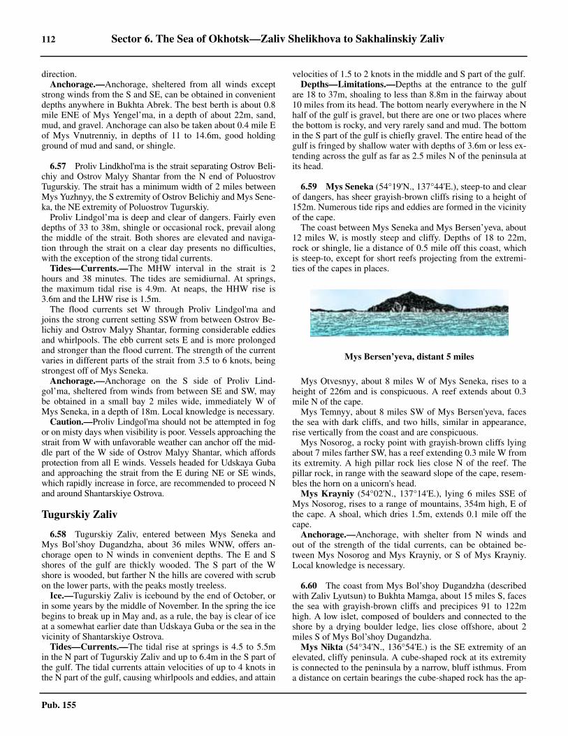
112 Sector 6. The Sea of Okhotsk—Zaliv Shelikhova to Sakhalinskiy Zaliv
Pub. 155
direction.6.56 Anchorage.—Anchorage, sheltered from all winds exceptstrong winds from the S and SE, can be obtained in convenientdepths anywhere in Bukhta Abrek. The best berth is about 0.8mile ENE of Mys Yengel’ma, in a depth of about 22m, sand,mud, and gravel. Anchorage can also be taken about 0.4 mile Eof Mys Vnutrenniy, in depths of 11 to 14.6m, good holdingground of mud and sand, or shingle.
6.57 Proliv Lindkhol'ma is the strait separating Ostrov Beli-chiy and Ostrov Malyy Shantar from the N end of PoluostrovTugurskiy. The strait has a minimum width of 2 miles betweenMys Yuzhnyy, the S extremity of Ostrov Belichiy and Mys Sene-ka, the NE extremity of Poluostrov Tugurskiy.6.57 Proliv Lindgol’ma is deep and clear of dangers. Fairly evendepths of 33 to 38m, shingle or occasional rock, prevail alongthe middle of the strait. Both shores are elevated and naviga-tion through the strait on a clear day presents no difficulties,with the exception of the strong tidal currents.6.57 Tides—Currents.—The MHW interval in the strait is 2hours and 38 minutes. The tides are semidiurnal. At springs,the maximum tidal rise is 4.9m. At neaps, the HHW rise is3.6m and the LHW rise is 1.5m.6.57 The flood currents set W through Proliv Lindgol'ma andjoins the strong current setting SSW from between Ostrov Be-lichiy and Ostrov Malyy Shantar, forming considerable eddiesand whirlpools. The ebb current sets E and is more prolongedand stronger than the flood current. The strength of the currentvaries in different parts of the strait from 3.5 to 6 knots, beingstrongest off of Mys Seneka.6.57 Anchorage.—Anchorage on the S side of Proliv Lind-gol’ma, sheltered from winds from between SE and SW, maybe obtained in a small bay 2 miles wide, immediately W ofMys Seneka, in a depth of 18m. Local knowledge is necessary.6.57 Caution.—Proliv Lindgol'ma should not be attempted in fogor on misty days when visibility is poor. Vessels approaching thestrait from W with unfavorable weather can anchor off the mid-dle part of the W side of Ostrov Malyy Shantar, which affordsprotection from all E winds. Vessels headed for Udskaya Gubaand approaching the strait from the E during NE or SE winds,which rapidly increase in force, are recommended to proceed Nand around Shantarskiye Ostrova.
Tugurskiy Zaliv
6.58 Tugurskiy Zaliv, entered between Mys Seneka andMys Bol’shoy Dugandzha, about 36 miles WNW, offers an-chorage open to N winds in convenient depths. The E and Sshores of the gulf are thickly wooded. The S part of the Wshore is wooded, but farther N the hills are covered with scrubon the lower parts, with the peaks mostly treeless.6.58 Ice.—Tugurskiy Zaliv is icebound by the end of October, orin some years by the middle of November. In the spring the icebegins to break up in May and, as a rule, the bay is clear of iceat a somewhat earlier date than Udskaya Guba or the sea in thevicinity of Shantarskiye Ostrova.6.58 Tides—Currents.—The tidal rise at springs is 4.5 to 5.5min the N part of Tugurskiy Zaliv and up to 6.4m in the S part ofthe gulf. The tidal currents attain velocities of up to 4 knots inthe N part of the gulf, causing whirlpools and eddies, and attain
velocities of 1.5 to 2 knots in the middle and S part of the gulf.6.58 Depths—Limitations.—Depths at the entrance to the gulfare 18 to 37m, shoaling to less than 8.8m in the fairway about10 miles from its head. The bottom nearly everywhere in the Nhalf of the gulf is gravel, but there are one or two places wherethe bottom is rocky, and very rarely sand and mud. The bottomin the S part of the gulf is chiefly gravel. The entire head of thegulf is fringed by shallow water with depths of 3.6m or less ex-tending across the gulf as far as 2.5 miles N of the peninsula atits head.
6.59 Mys Seneka (54°19'N., 137°44'E.), steep-to and clearof dangers, has sheer grayish-brown cliffs rising to a height of152m. Numerous tide rips and eddies are formed in the vicinityof the cape.6.59 The coast between Mys Seneka and Mys Bersen’yeva, about12 miles W, is mostly steep and cliffy. Depths of 18 to 22m,rock or shingle, lie a distance of 0.5 mile off this coast, whichis steep-to, except for short reefs projecting from the extremi-ties of the capes in places.
6.59 Mys Otvesnyy, about 8 miles W of Mys Seneka, rises to aheight of 226m and is conspicuous. A reef extends about 0.3mile N of the cape.6.59 Mys Temnyy, about 8 miles SW of Mys Bersen'yeva, facesthe sea with dark cliffs, and two hills, similar in appearance,rise vertically from the coast and are conspicuous.6.59 Mys Nosorog, a rocky point with grayish-brown cliffs lyingabout 7 miles farther SW, has a reef extending 0.3 mile W fromits extremity. A high pillar rock lies close N of the reef. Thepillar rock, in range with the seaward slope of the cape, resem-bles the horn on a unicorn's head.6.59 Mys Krayniy (54°02'N., 137°14'E.), lying 6 miles SSE ofMys Nosorog, rises to a range of mountains, 354m high, E ofthe cape. A shoal, which dries 1.5m, extends 0.1 mile off thecape.6.59 Anchorage.—Anchorage, with shelter from N winds andout of the strength of the tidal currents, can be obtained be-tween Mys Nosorog and Mys Krayniy, or S of Mys Krayniy.Local knowledge is necessary.
6.60 The coast from Mys Bol’shoy Dugandzha (describedwith Zaliv Lyutsun) to Bukhta Mamga, about 15 miles S, facesthe sea with grayish-brown cliffs and precipices 91 to 122mhigh. A low islet, composed of boulders and connected to theshore by a drying boulder ledge, lies close offshore, about 2miles S of Mys Bol’shoy Dugandzha.
Mys Nikta (54°34'N., 136°54'E.) is the SE extremity of anelevated, cliffy peninsula. A cube-shaped rock at its extremityis connected to the peninsula by a narrow, bluff isthmus. Froma distance on certain bearings the cube-shaped rock has the ap-
Mys Bersen’yeva, distant 5 miles
Sector 6. The Sea of Okhotsk—Zaliv Shelikhova to Sakhalinskiy Zaliv 113
Pub. 155
pearance of an islet lying a short distance off the extremity ofthe cape, but on the background of the coast this rock is indis-cernible.6.60 A very conspicuous pillar rock, about 9 miles S of Mys Nikta,lies 0.5 mile off a rocky peninsula, which rises to a height of423m in its middle part. A drying ledge connects the pillar rockto the coast. The pillar rock is a good landmark in the approachto Bukhta Mamga.6.60 Bukhta Mamga (54°23'N., 136°47'E.) is entered between acape lying 2 miles SW of the conspicuous pillar rock and the Nextremity of a cape, about 2 miles farther S. The recess in the Npart of Bukhta Mamga dries and is encumbered with rocks.6.60 There are depths of 5.5m in the entrance to the bay, shoalingrapidly W. About 0.5 mile outside the entrance there are depthsof 9.1 to 11m.6.60 A blunt, elevated cape, with a seaward face about 2 miles inlength, is located with its NE point about 6 miles S of BukhtaMamga. A reef, with a fairly large, pointed pillar rock at its ex-tremity, extends about 0.5 mile E from the NE extremity of thiscape.6.60 Anchorage.—Anchorage, protected from W winds, can betaken, in a depth of 10m, sand and gravel, about 1 mile SE ofthe N entrance point of Bukhta Mamga.
6.61 Mys Bol’shoy Largangda (54°08'N., 136°48'E.), ahigh slightly projecting cape, is backed by a coastal elevation,659m high. Mys Malyy Largangda, about 4 miles farther S, isthe NE extremity of a blunt rectangular projection, and is ren-dered conspicuous by three large detached rocks at the foot ofthe elevation backing the cape.6.61 The head of Tugurskiy Zaliv consists of a peninsula withhigh shores, which rises to heights of 250 to 280m about 1.5miles inland. The shores are low and sandy near the mouths ofthe rivers on each side of the peninsula.
Zaliv Akademii
6.62 Zaliv Akademii is entered between Mys Seneka andMys Vrangelya (54°17'N., 138°40'E.), about 33 miles E. ZalivAkademii consists of the outer part, with Zaliv Konstantina, arounded shallow bay on its W side, and Zaliv Nikolaya, enteredon the E side, and Ul'banskiy Zaliv, which forms the inner partof the bay.6.62 Mys Seneka was previously described with Tugurskiy Zalivin paragraph 6.59. An extensive whirlpool exists about 7 milesSE of Mys Seneka.6.62 Poluostrov Vrangelya, on the E side of Zaliv Akademii, termi-nates in Mys Mukhtelya and Mys Vrangelya, respectively, its Nand W extremities, separated from each other by a narrow inlet.The peninsula is formed by the spurs of Gora Mukhtelya, a con-spicuous mountain with a pointed summit, about 3 miles SSE ofMys Mukhtelya. Depths of 28 to 37m lie a distance of 0.5 mileoffshore on all sides of Poluostrov Vrangelya, which is steep-toand clear of dangers.6.62 Tides—Currents.—Tidal currents attain a velocity of 2 to 3knots in the vicinity of the peninsula and form eddies and tiderips discernible from seaward.
6.63 Mys Mukhtelya (54°18'N., 138°43'E.) faces the seawith white cliffs of moderate height. A conspicuous cape,
about 1.5 miles WSW of Mys Mukhtelya and N of the narrowinlet, has a steep, smoothly polished face slanting into the sea.6.63 Mys Vrangelya, the E entrance point of Zaliv Akademii, liesabout 3 miles WSW of Mys Mukhtelya, and is a spur of GoraMukhtelya. The light gray color near the extremity of MysVrangelya renders it conspicuous on the darker background ofthe coast.6.63 The W shore between Mys Seneka and Zaliv Konstantina,about 17 miles SW, is high and rocky. There are no dangers anddeep water lies close to the shore.6.63 The E shore between Mys Vrangelya and Mys Lamsdorfa,about 14 miles S, is high and cliffy in its N part, partly cliffyand precipitous in its middle part, and decreasing in heightmarkedly. There are reddish-brown cliffs, about 30m high nearMys Lamsdorfa. This coast is free of dangers, except for a reefextending a short distance from the coast 5.5 miles N of MysLamsdorfa.
Zaliv Konstantina
6.64 Zaliv Konstantina lies on the W side of Zaliv Aka-demii. The bay, entered between Mys Ingakan (54°05'N.,137°28'E.) and Mys Borikagan, about 3 miles SSW, has lowshores, and the greater part of the bay dries. The bay offers ex-cellent protection to vessels not exceeding 5.5m in draft.6.64 Mys Ingakan is the S extremity of a narrow peninsula. A hill,sloping steeply seaward, rises to a height of 213m about 0.5mile NE of Mys Ingakan, and is conspicuous from seaward. Anarrow sandy spit, about 3 to 6.1m high, extends 1.8 milesWSW from Mys Ingakan.6.64 Mys Borikagan rises steeply to a fairly conspicuous, round,thickly wooded hill, 137m high. A narrow, sandy spit, about 3to 6.1m high, extends 1.5 miles NNW from a position about1.5 miles W of Mys Borikagan.6.64 Tides—Currents.—The MHW interval in Zaliv Konstanti-na is 2 hours 55 minutes. The tides are semidiurnal. At springs,the maximum tidal rise is 3.6m. At neaps, the HHW rise is 3m,while the LHW rise is 1.5m. The tidal currents at the entranceinto the bay attain a maximum velocity of 2 to 2.5 knots atsprings, but are less within the entrance. The flood current setsin a NE direction, while the ebb current sets in a SSW direc-tion.6.64 Depths—Limitations.—Depths of less than 5.5m extend asfar as 0.6 mile seaward of the N spit. A drying patch and a 5.5mdepth lie about 0.4 mile SSE and 0.4 mile SSW, respectively, ofthe extremity of the N spit. The drying patch and the extremityof the N spit are comparatively steep-to. Depths of less than5.5m extend about 0.8 mile seaward of the S spit. 6.64 The fairway between the two spits has a width of 0.5 mile,with depths of 7.3 to 9.1m between the detached depth off theextremity of the N spit and the shoal water extending off the Sspit.6.64 A confined area, with depths of 6.4 to 7.3m and fringed bydrying flats, lies between lines extending about 1 mile NNW ofthe extremity of the N spit, and a point about 0.6 mile WSW ofthe spit, respectively.6.64 Anchorage.—Anchorage can be taken, in a depth of about8m, sand and mud, W of the SW end of the spit on the N sideof the entrance to the bay, with Mys Borikagan bearing 150°and the SW end of the N spit bearing 090°.
114 Sector 6. The Sea of Okhotsk—Zaliv Shelikhova to Sakhalinskiy Zaliv
Pub. 155
6.64 Small vessels can obtain anchorage, in depths of 6.1 to 6.3m,sand and mud, about 0.3 mile NNW of the extremity of the Nspit.6.64 Directions.—When entering Zaliv Konstantina, a vesselshould pass Mys Borikagan at a distance of 0.7 mile and thensteer NW between the two spits.
Ul’banskiy Zaliv
6.65 Ul’banskiy Zaliv, forming the head of Zaliv Aka-demii, is entered between Mys Ukurunru (53°58'N.,137°51'E.) and Mys Tukurgu, about 27 miles E. Ul'banskiyZaliv has generally high and rocky shores, except for its head,which is formed by a shoal recess. The bay is exposed to NEwinds, and does not offer any safe anchorage.6.65 Mys Ukurunru, the NE extremity of a narrow elevated pro-jection, faces the sea with grayish-brown sheer cliffs. A point-ed peak, 357m high, and Gora Glavnaya, a conspicuousmountain, 826m high, rise about 1.7 miles and 3 miles SW, re-spectively, of the extremity of the cape. Gora Glavnaya domi-nates conspicuously all nearby summits and forms an excellentlandmark.6.65 A barren pillar rock lies a short distance E of the extremity ofthe cape. There are depths of 24 to 27m, rock, about 0.5 mileoff the cape, which has no off-lying dangers. Eddies and tiderips form off the point.6.65 Mys Zarzhetskogo, on the W side of the bay, about 15 milesSW of Mys Ukurunru, is rendered fairly conspicuous on thebackground of the low sandy shore of a bight immediately S ofthe cape. 6.65 Kosa Betti, a narrow spit of sand and shingle extending fromthe shore about 7 miles farther SSW, separates the bay properfrom the shoal recess at its head.6.65 Mys Obryvistyy, a fairly conspicuous cape on the E side ofthe bay, about 14 miles SSW of Mys Gaurovitsa (53°55'N.,138°21'E.), is bordered NE by a low, sandy stretch, 2.5 miles inlength and marked at its S end by an abrupt rise in height to91m near the extremity of Mys Obryvistyy.6.65 A hill, 174m high, lies close to the shore, about 22 milesWSW of Mys Obryvistyy. The low sandy shore at the head ofthe bay extends W of the hill.6.65 Ice.—Ice usually disappears in middle or late June, but in un-favorable years, especially at the entrance to the bay, ice mayrender navigation impracticable before the middle of August.6.65 Tides—Currents.—The tides in Zaliv Ul'banskiy aresemidiurnal. At springs, the maximum tidal rise is 4.9m in theN part of the bay and 5.4m in the S part. At neaps, the HHWrise is about 3m and the LHW rise is about 1.8m.6.65 The tidal currents attain a velocity of 1.5 to 2 knots in the Nhalf, and 1 to 1.5 knots in the S half of the bay. The flood cur-rent sets in a general SW direction, and the ebb current in a re-verse direction.
Zaliv Nikolaya
6.66 Zaliv Nikolaya, entered between Mys Lamsdorfa(54°03'N., 138°40'E.) and Mys Tukurgu, about 5 miles SSW,offers sheltered anchorage for large vessels, but with poorholding ground.6.66 Mys Lamsdorfa, high and wooded, is almost steep-to on its
W side, but depths of 5.5m lie about 0.5 mile S of the cape.6.66 Mys Tukurgu (54°00'N., 138°35'E.) rises to a height of183m close within the cape, and a reef extends 0.3 mile fromthe extremity of the cape having a depth of less than 2m. A de-tached patch, with a least depth of 6.8m and surrounded bydepths of about 13m, lies 1.5 miles ENE of Mys Tukurgu.6.66 Mys Grotte lies 2.2 miles S of Mys Tukurgu, the N point ofPoluostrov Tokhareu. A sandy islet lies on a sand bank extend-ing 1.3 miles SSE from Mys Grotte. Kosa Nerpich’ya, a sandyspit, lies with its S extremity 8.5 miles S of the islet.6.66 Mys Nablyudeniy, a cliffy cape, about 14 miles SSW of theextremity of Kosa Nerpich’ya, rises to a hill, 183m high, withinthe cape. A yellow bluff, of moderate height, lies about 6.5miles NNE of Mys Nablyudeniy. The shores N and S of thebluff are low and consist of sand and shingle.6.66 Mys Nizkiy, about 9 miles S of Mys Lamsdorfa, is low andinconspicuous. Gora Chernaya, about 3 miles SE of Mys Niz-kiy, is prominent due to its twin peaks and dark color, and isusually visible to a vessel off the entrance to the bay.
6.67 Mys Primetnyy (53°35'N., 138°31'E.), about 21miles SSW of Mys Nizkiy, is a conspicuously high cape, con-trasting with the long stretch of the low, sandy, interveningshore. The head of the bay, SW of Mys Primetnyy, is fringedby drying flats.6.67 Winds—Weather.—Southeast winds prevail here during thesummer, but alternating SW and NE winds prevail during thelate summer and autumn. Blizzards begin to occur as early asthe first part of October.6.67 Zaliv Nikolaya is sheltered from fog, which occurs ratherrarely within the bay.6.67 Ice.—Ordinarily Zaliv Nikolaya is icebound by early No-vember. The ice begins to break in May, and the bay is clear ofice by the middle of June.6.67 Tides—Currents.—The MHW interval in Zaliv Nikolaya is4 hours 50 minutes. The tides are semidiurnal. At springs, themaximum tidal rise is 5.4m. At neaps, the HHW rise is 3m,while the LHW rise is 2.4m. 6.67 Tidal currents in the entrance to the gulf set NNW and SSE,attaining a rate of 4 knots. Inside the gulf they have rates of 1 to2.5 knots.6.67 Depths—Limitations.—The depths in the middle of the en-trance to Zaliv Nikolaya are 13 to 14.5m. A channel, with pre-vailing depths of 13 to 14.5m, extends along the inlet for nearly23 miles within the entrance. As a rule, this channel favors theE side of the inlet, except immediately within the entrance,where depths of 10m extend 3 miles SW from the entrance ofthe drying lagoon, which extends N of the bay. An 8.2m depthlies 2 miles S of Mys Lamsdorfa.6.67 The E side of the recess N of Mys Nizkiy is comparativelysteep-to, with depths of 7.3m about 0.5 mile offshore.6.67 Shoal water with depths of less than 10m, extends up to 1mile offshore between Mys Tukurgu and the sand islet, about3.5 miles SSE. A drying flat, its seaward side steep-to, extends0.5 mile E and SE of the islet.6.67 A 1.8m patch, about 1.7 miles SSE of the islet, is borderedby depths of less than 10m extending about 1 mile E, whichnarrows the channel to a width of 1.5 miles for a reach of 1.5miles immediately N of Mys Nizkiy, which is steep-to.6.67 The E side of the bay, for about 13 miles S of Mys Nizkiy, is
Sector 6. The Sea of Okhotsk—Zaliv Shelikhova to Sakhalinskiy Zaliv 115
Pub. 155
comparatively steep-to, with the 10m curve about 0.3 to 0.5mile offshore.6.67 On the W side of the bay the 10m curve lies about 0.5 mileoffshore for a distance of 6 miles N of the extremity of KosaNerpich’ya, then the 10m curve lies about 1 mile E of the ex-tremity of Kosa Nerpich’ya, and extends to 3 miles offshore inthe vicinity of the sand bluff, about 7.5 miles SW.6.67 A detached 3.6m shoal, position doubtful, lies 4 miles ESEof the sand bluff.6.67 Anchorage.—The bottom throughout Zaliv Nikolaya isshingle and the holding ground is not good. Vessels are advisednot to anchor in the vicinity of Mys Grotte because of shoalwater and uneven depths. It is also somewhat exposed here.The best anchorage is in depths of 9 to 14m, S and SE of KosaNerpich’ya. Local knowledge is necessary.6.67 Caution.—During foggy weather a vessel headed for ZalivNikolaya should make a landfall somewhere between MysVrangelya and Mys Lamsdorfa. The fog, as a rule, is consider-ably less along this section of the coast.
Ostrov Men’shikova and Zaliv Aleksandry
6.68 Ostrov Men’shikova (54°35'N., 139°15'E.) is a bar-ren steep-to island, with depths of 50m close offshore. The is-land rises to its summit in the SW part of the island. Close offthe NE end of the island are three pillar rocks. The N rock lieson a rocky above-water base.6.68 Tides—Currents.—Tidal currents in the vicinity of Ostrov
Men'shikova form numerous eddies, especially noticeable onthe leeward side of the island. The flood current sets W and theebb E at a velocity of 2 and 2.5 knots, respectively.6.68 Caution.—Ostrov Men’shikova has been reported to lie 4miles SSW of its charted position.
6.69 Zaliv Aleksandry (54°10'N., 139°10'E.), a totallyopen bight, is entered between Mys Mukhtelya, previously de-scribed in paragraph 6.63, and Mys Aleksandra, about 36 milesE.
6.69 Gora Bernardinskiy (54°08'N., 139°15'E.), about 2 milesinland and midway along the bight, is conical and forms a goodlandmark.6.69 The W half of the bight is steep-to, with depths of 15 to 18mabout 0.7 mile offshore, and has a low shore of sand and shin-gle contrasting with the elevated shore of the E half. A denseforest, skirted by a strip of grassy land on its seaward side,backs the W half of the bight. Ozero Mukhtelya is separatedfrom the sea by a sand and shingle spit. It is a triangular shapedlake.6.69 The E half of the bight faces the sea with high precipices,backed by mountains. The slopes of the mountains are coveredwith shrub, and with forest further inland. This shore, exceptfor some scattered rocks close offshore, is steep-to.6.69 Mys Aleksandra (54°17'N., 139°48'E.), the E entrance pointof Zaliv Aleksandry, is also the W entrance point of Sakhalins-kiy Zaliv and is described in paragraph 7.3.
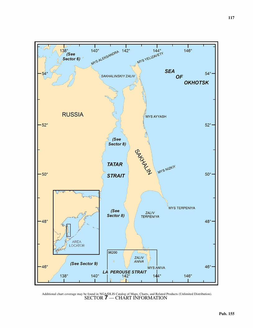
117
Pub. 155
7. Sector 7—Sakhalinskiy Zaliv—Mys Aleksandra to Mys Kril’on
7.0Additional chart coverage may be found in NGA/DLIS Catalog of Maps, Charts, and Related Products (Unlimited Distribution).SECTOR 7 — CHART INFORMATION
119
Pub. 155
SECTOR 7
SAKHALINSKIY ZALIV—MYS ALEKSANDRA TO MYS KRIL’ON
7.0 Plan.—This sector describes the E and W shores of Sakha-linskiy Zaliv, including the Amur River valley and its N ap-proaches, and then the N, E, and SE coasts of Sakhalin. Thegeneral sequence is SE from Mys Aleksandra to the Amur Riv-er, then NE along the E shore from Mys Tamlevo to Mys Yeli-zavety, and finally S to Mys Kril’on at the S end of Sakhalin.
General Remarks
7.1 Winds—Weather.—Off the NW coast of Sakhalinduring July, August, and September, the prevailing winds arefrom the SW, and N winds are rare. Extremely good weather isprevalent in August. Around the middle of September, N windsbegin to predominate. By the beginning of October, the goodweather is at an end. Winter lasts from October to March andthe prevailing wind during this period is a cold northwesterly,which brings snow, although it occasionally comes from theNE.7.1 Winds from the SSW through SE to E tend to bring thick fogand rain. Winds from the N, through W to SW tend to bringclear weather.7.1 The S and N winds alternate off the E side of Sakhalin fromApril until the end of September, but from October until Maythe N winds are prevalent. The period of good weather prevailsthrough the latter part of July and the first half of August. Themonths of June, July, August, and September are humid, andprecipitation is heavy. The temperature is always relativelylow, because of the effect of the cold currents.7.1 The climate of Zaliv Terpeniya is severe, and snow remainson the ground in places until the end of June. Rains are pro-tracted and fog is frequent. The S and SW winds, which prevailthroughout the summer, cause a heavy swell, making commu-nication with the shore difficult.7.1 In winter, winds are predominantly from the NE and NWwith considerable amounts of snow and sleet.7.1 During the summer, SW and NE winds, occasionally inter-rupted by breezes from various directions, are prevalent. TheNE winds are accompanied by dense fog, rains, and heavyswell, but with SW winds the weather is generally fair and thesea is calm. Periodically fair weather, accompanied by lightairs and a very calm sea, lasts for several days. In the spring,during the period of melting snow, the freshets of the riverscause considerable flooding.7.1 The temperature begins to fall in September, and except for anoccasional snowfall, good weather generally prevails. During thewinter, which begins in October, NW winds alternate with NNEwinds and a considerable amount of snow falls.7.1 Ice.—Ice appears in the latter part of October or early No-vember, and its presence considerably interferes with naviga-tion and loading operations. By the middle of November, floesof ice carried in and out by the tidal currents prevent entering.7.1 The outflow from the Amur River passes along the W coastof Sakhalin in a N direction, drives the ice from the shore, andkeeps the E part of Sakhalinskiy Zaliv free from ice, except
during strong N or NW winds, when this channel may beclosed. During exceptionally unfavorable years, the W part ofSakhalinskiy Zaliv may be inaccessible to vessels during thewhole navigational season of June through November.7.1 The Amur River is usually ice-bound from the middle of No-vember until the middle of May. It occasionally remains frozenuntil the end of May or early June, but ordinarily it is open tonavigation from the middle of May.7.1 In December fast ice begins to form along the shore on theNE side of Zaliv Terpeniya, and there are some ice floes drift-ing about in the vicinity of the mouth of the Poronay. These icefloes freeze together and develop an icefield, which by Januaryis 0.9m thick. In March, the ice begins to break up, leaving afringe of fast ice along the shore of the gulf. The amount ofdrift ice varies from year to year. At times, the N side of thegulf is packed with drift ice to a distance of 20 miles offshore.Occasionally the gulf may be clear of ice as early as May, butnavigation is not safe until June. The gulf is clear of ice by themiddle of June.7.1 Caution.—Care should be taken by vessels navigating with-in the above-mentioned areas, especially during periods of lim-ited visibility and at night.7.1 The distances to which sea ice can be seen at night vary con-siderably with the visibility, phase and altitude of the moon,weather, size of drift ice, and the height of eye of the observer.The approximate visible distances under most conditions are asfollows:
1. About 5 miles, or 7 miles for large ice floes, with themoon ahead in clear weather.
2. One to 2 miles with the moon astern in clear weather.3. Up to about 100m on a dark night.4. From 50 to 100m during a snowstorm.
7.1 Note.—Radar generally becomes unreliable during periodsof moderate to heavy snow.7.1 In the W part of the Sea of Okhotsk, along the E side ofSakhalin, ice begins to form in late November and to melt inmid-June. About the middle of March, fast ice will spread sol-idly over an area extending 20 to 30 miles offshore. The lesssolid ice extends as far as the middle of the Sea of Okhotsk.Winter navigation, N of the 49th parallel, is restricted to ice-breakers.7.1 During April and May, drift ice is sighted frequently. Unsta-ble ice which spreads almost to the center of the sea, turns todrift ice and moves S, following the prevailing wind and oceancurrent, leaving the solid ice along the coastline. It has been re-ported that during May, ice 6.1 to 9.1m high forms close to theshore. Large growlers, in crushed ice groups, can be expectedduring this time, where safe navigation is available in the sea-son. North of 50°N, the ice thickens with the latitude, up to0.9m.7.1 In Zaliv Aniva ice first appears in November, but in BukhtaLososey the NW recess of the gulf, the ice appears late in Oc-tober. Korsakov is ice-bound from January to the middle ofMarch and is completely free of ice in April. Considerable
120 Sector 7. Sakhalinskiy Zaliv—Mys Aleksandra to Mys Kril’on
Pub. 155
parts of Zaliv Aniva are covered with fast ice, but leads occurbetween the fast ice and the ice fields in the middle part of thegulf. The ice along the W shore of the gulf is the thickest,reaching 0.8m. With continuous E winds during April andMay, drift ice enters from the E and accumulates along the Wshore of the gulf, then drifts S toward Mys Kril'on. Fast icenever forms in the vicinity of Mys Kril'on, but the winter windsfrom the NE quadrant may bring considerable accumulationsof drift ice to the vicinity of the cape. Zaliv Aniva becomes freeof ice in May.
Sakhalinskiy Zaliv
7.2 Sakhalinskiy Zaliv, the N entrance to Amurskiy Li-man, is described beginning in paragraph 8.37 and is enteredbetween Mys Aleksandra and Mys Marii, about 89 miles E.7.2 Winds—Weather.—Fog is most frequent in SakhalinskiyZaliv from June through August, and the number of days withfog during this period constitutes 60 to 70 per cent of the total forthe year. From June to about August 20, fog is comparativelylight and affords a range of visibility of approximately 1 mile.After this date, however, and until the middle of September, fogis very dense, reducing the visibility to 90m or less.7.2 During August in the vicinity of Mys Tamlevo, fog has con-tinued for 5 days without lifting.7.2 Tides—Currents.—The cold SE current on the W side ofthe gulf has a rate not exceeding 1 to 1.5 knots, but it is in-creased by the tidal current on the flood and decreased on theebb. The warm N current on the E side of the gulf flows at arate of 2 to 2.5 knots, increasing with the ebb tidal current anddecreasing on the flood.
Sakhalinskiy Zaliv—West Shore
7.3 Mys Aleksandra (54°17'N., 139°47'E.), the W en-trance point of Sakhalinskiy Zaliv, is the NE extremity of arugged peninsula about 610m high, the seaward slopes ofwhich are covered by stunted trees. The E side of the peninsulaconsists of a line of precipitous brown cliffs and contrasts con-siderably with the N part which is lower and gray.7.3 Kekur Aleksandra, a high pinnacle rock, is located close offthe extremity of Mys Aleksandra and is conspicuous from theNW and SE.7.3 Ostrov Reyneke, located about 3 miles N of Mys Aleksandrawith a clear channel between, is about 2 miles long E-W andforms a hump higher at the E end. A small stream dischargeson the W side of the island and landing here is not difficult insmall sheltered bays during S winds. The island is steep-to onall sides and there are depths of 30 to 35m close offshore.7.3 The channel between Mys Aleksandra and Ostrov Reynekeis free from dangers.7.3 Caution.—A local magnetic anomaly is reported in an areathat extends approximately 8 miles NW of Ostrov Reyneke andLitke, 4 miles NW of Mys Litke.
7.3 Mys Mofeta, a conspicuous projection extending about 1mile from the coast 6 miles SSE of Mys Aleksandra, faces thesea on all sides with steep brown cliffs of considerable height.A large sharp rock lies at the NE extremity of the point and ris-es nearly vertically from the sea with some low land between.
Gora Mofeta, a broad-topped mountain resembling a wide cu-pola, rises above the surrounding terrain about 3 miles S ofMys Mofeta, and is easily identified from a considerable dis-tance.7.3 Mys Promezhutochnyy lies about 11 miles SE of Mys Mofeta.Kekur Villi, a prominent pillar rock, lies close off the point.7.3 Mys Kupriyanova lies about 3.5 miles SE of Mys Prome-zhutochnyy. This point slopes steeply from a mountain whichis over 300m high.7.3 Mys Litke (53°56'N., 140°22'E.), lying 21 miles SE of MysMofeta and composed of gray cliffs backed by high land, is alarge rounded point lying near the middle of the W shore ofSakhalinskiy Zaliv. The E extremity of the point slopes moregradually to the sea and is surrounded by numerous above andbelow-water rocks lying close offshore.7.3 Ostrov Kovrizhka, an islet consisting of numerous boulders,lies about 0.3 mile E of Mys Litke and is connected to the pointby a drying reef. A light is shown from Mys Litke.7.3 Caution.—Vessels in this vicinity should not approach thecoast within a depth of 9m.7.3 A submarine cable extends seaward from the coast in the vi-cinity of the root of Petrovskaya Kosa and may best be seen onthe chart.
7.3 The coast from Mys Litke gradually decreases in height untilS of Mys Perovskogo, the shore becomes a sand and shinglebeach with grass and dunes in places. It extends finally intoPetrovskaya Kosa, a narrow sandy spit about 7 miles long withits SE extremity (53°27'N., 141°07'E.) marked close within bya fishing station.7.3 Zaliv Schast’ya, entered between the SE extremity of Petro-vskaya Kosa and the NW end of Ostrov Chkalov, a low, nar-row, sand and shingle island about 0.5 mile SE, is a shallowand shoal encumbered bay lying within the above off-lying fea-tures and the mainland about 4 miles to the S. The entrancechannel, with a least depth of 2.1m, is divided in the approach-es by a long narrow shoal about 0.5 mile offshore with depthsof 0.6 to 1.2m. Within the entrance the waters of the bay re-quire local knowledge.7.3 Anchorage.—It is reported that small local vessels with adraft not exceeding 30m can obtain anchorage in Zaliv Schast’ya, but the holding ground, consisting of sand, or sand andshingle.
North Approach to the Amur River
7.4 Farvater Nevel’skogo, the N channel to the mouth ofthe Amur River, leads from Sakhalinskiy Zaliv to a positionabout 4 miles E of the SE end of Ostrov Baydukov (53°18'N.,141°29'E.), and then SSW and SW through Amurskiy Limanto Mys Chagdbakh, the N entrance point of the Amur River.Having a total length of about 35 miles, the fairway, which ismarked by lighted buoys, begins at North Bar NE of OstrovBaydukov and carries a least depth of about 4.3m, subject toseasonal changes and dredging priorities. 7.4 The navigational season for Farvater Nevel’skogo generallybegins about the first of June and ends about the middle of Octo-ber, the channel buoys being lifted and relocated each year. Be-cause of the severity of the winter, it is usually necessary toresurvey the fairway and therefore local knowledge is required.
Sector 7. Sakhalinskiy Zaliv—Mys Aleksandra to Mys Kril’on 121
Pub. 155
7.4 Winds—Weather.—Fresh NE winds considerably increasethe depths in Farvater Nevels’kogo, while strong S winds havethe opposite effect. Depths decrease quickly at the beginning ofthe ebb.7.4 Fogs are most frequent in July and August and often of longduration, periods of up to five continuous days having been re-ported. Usually there is fog during this season for 6 hours daily,from 0400 to 1000.7.4 Ice.—It commences to freeze in this area in October and theice is of sufficient thickness in December for sleds to cross toSakhalin. Navigation through Farvater Nevel'skogo shouldcease as soon as small quantities of ice appear as the floes willgenerally force a vessel onto the nearest sandbank, where thevessel will probably remain for the winter.7.4 Tides—Currents.—The tidal rise on North Bar ranges from0.6 to 1.5m depending on the diurnal effects involved. Thetropical tides are characterized by a short duration of HW,while the LW, which may have small variations in level, lastsup to 12 hours at times. Tidal signals are shown from a stationon the SE end of Ostrov Baydukov.7.4 The tidal currents usually set N through North Road duringthe rising tide at a considerable rate, which at times may ex-ceed 4 knots. The current on the falling tide is toward the S, butat a maximum rate of only 1.5 knots.7.4 Aspect.—Gora Men’shikova, a conspicuous saddle-shapedhill, rises close within Mys Men’shikova about 1 mile S of Os-trov Baydukov. Gora Negda, a helmet-shaped hill with a baresummit, lies about 3 miles SW of Gora Men’shikova and whenseen from a considerable distance to the N appears along withthe latter as two separate islands.7.4 An outer approach lighted buoy is moored about 10 miles Nof the W end of Ostrov Baydukov.7.4 Mys Men’shikova Light is mounted on a round stone tower.19m high, painted white and black, but is extinguished. 7.4 Gora Alekseyeva, a three peaked mountain, rises about 9miles SSW of Gora Men’shikova and is very prominent fromNorth Road.7.4 Pilotage.—Pilotage is compulsory. Vessels entering theAmur River estuary from the N can obtain a pilot from the sta-tion at the SE end of Ostrov Baydukov, providing the propernotice is given. Pilots board in the vicinity of the approachbuoy.7.4 Anchorage.—Vessels can obtain anchorage 5 miles N of theSE extremity of Ostrov Baydukov, but this anchorage is onlysheltered from W winds, and the tidal currents are very strong.Vessels using this anchorage should take care to avoid the bankextending NE from Ostrov Baydukov.7.4 Caution.—Danger Area No. 1, the limits of which are bestseen on the chart, lies about 10 miles NE of Ostrov Baydukovand is dangerous due to mines.7.4 Danger Area No. 4, the limits of which are best seen on thechart, lies NE of Ostrov Chkalov; this area is a former minedarea which has been swept and is now considered safe for sur-face vessels only.7.4 Anchoring and trawling are prohibited in the above dangerareas.
The Amur River
7.5 The Amur River, having a total length of 3,000 miles,
is the eleventh longest river in the world and the fourth longestin Siberia. From its mouth between Mys Chagdbakh(52°59'N., 141°08'E.) and Mys Pronge, about 8 miles SSE, theriver is navigable for approximately 550 miles to the city ofKhabarovsk and has least known channel depths of 6.9m to Ni-kolayevsk-na-Amure-na-Amure, then 6.7m for 20 miles to Ma-go, then 5.2m for 290 miles to Komsomol’sk, and finally 3.7mto Khabarovsk.7.5 The Amur River has three periods of rising water which af-fect its general level and influences the depths on the outerbars. The first rise which is early spring is caused by ice shiftsof short duration and is usually less than 0.9m. The second rise,which is caused by the melting of snow, occurs in late springand may reach 3m. However, after this period the river beginsto fall, usually reaching its lowest level in late July. The thirdrise occurs in autumn, and when caused by heavy rains, mayreach 4.5m or higher, occasionally causing considerable flood-ing.7.5 Caution.—Salmon traps, extending from the shore to thefairway, may be encountered in the approaches to the river.
Nikolayevsk-na-Amure (53°08'N., 140°44'E.)
World Port Index No. 60820
7.6 The port of Nikolayevsk-na-Amure, situated on the Nbank of the Amur River, about 23 miles within its entrance,consists of a harbor basin protected by an island mole on itsSW side and a small point of land known as Mys Kuegda, E ofthe entrance.
The port is open only during the summer months which areapproximately 5.5 months long; the exact start and end of theseason are announced by the Chief Manager of the port. Themain cargo handled at the port includes timber, minerals, con-struction materials, coal, and containers.
The port is primarily used in the transshipment of cargotransferred from shallow draft vessels which have come downthe Amur River from the inland ports of Komsomol’sk andKharbarovsk. During the summer, the harbor is frequented byfishing vessels working the Amur River estuary and a consider-able amount of fish is prepared for export.7.6 Winds—Weather.—The prevailing winds are E or NE; thiswill cause fog and wave heights of up to 1.4m in the roads.During periods of S winds, the roads are sheltered by the highbanks on the S side of the Amur River. Off the mouth of theAmur River, W winds sometimes attain great force, increasingthe strength of the ebb tidal currents and at times bringing largequantities of drift ice from the upper reaches.7.6 Ice.—The Amur River is usually icebound from the middleof November to the middle of May, the ice thickness averaging0.9m. The navigation season is limited by the channels inAmurskiy Liman, the river usually being clear beforehand.7.6 Tides—Currents.—The mean tidal range at Nikolakevsk is1.5m. The tides are diurnal with a short duration of HW and along period of LW. The river level is seasonal, being higher inthe spring and fall and lower in mid-summer.7.6 Depths—Limitations.—A marked dredged channel leadsfrom the outer roads across a shoal lying on the N bank of theriver leading to the harbor. Depths within this channel aremaintained at 4 to 6.9m, with the width of the 4m depth being
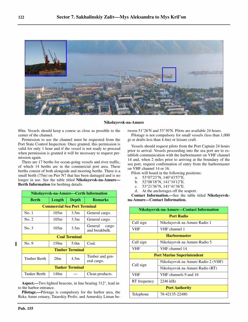
122 Sector 7. Sakhalinskiy Zaliv—Mys Aleksandra to Mys Kril’on
Pub. 155
80m. Vessels should keep a course as close as possible to thecenter of the channel.7.6 Permission to use the channel must be requested from thePort State Control Inspection. Once granted, this permission isvalid for only 1 hour and if the vessel is not ready to proceedwhen permission is granted it will be necessary to request per-mission again. 7.6 There are 17 berths for ocean-going vessels and river traffic,of which 14 berths are in the commercial port area. Theseberths consist of both alongside and mooring berths. There is asmall berth (75m) on Pier N7 that has been damaged and is nolonger in use. See the table titled Nikolayevsk-na-Amure—Berth Information for berthing details.
7.6 Aspect.—Two lighted beacons, in line bearing 312°, lead in-to the harbor entrance.7.6 Pilotage.—Pilotage is compulsory for the harbor area, theReka Amur estuary, Tatarskiy Proliv, and Amurskiy Liman be-
tween 51°26'N and 53°30'N. Pilots are available 24 hours. 7.6 Pilotage is not compulsory for small vessels (less than 1,000gt or drafts less than 4.4m) or leisure craft.
7.6 Vessels should request pilots from the Port Captain 24 hoursprior to arrival. Vessels proceeding into the sea port are to es-tablish communication with the harbormaster on VHF channel14 and, when 2 miles prior to arriving at the boundary of thesea port, request confirmation of entry from the harbormasteron VHF channel 14 or 16. 7.6 Pilots will board in the following positions:
a. 53°07'23''N, 140°43'57''E.b. 52°08'18''N, 141°34'12''E.c. 53°21'36''N, 141°41'36''E.d. At the anchorages off the seaport.
7.6 Contact Information.—See the table titled Nikolayevsk-na-Amure—Contact Information.
Nikolayevsk-na-Amure
Nikolayevsk-na-Amure—Certh Information
Berth Length Depth Remarks
Commercial Sea Port Terminal
No. 1 105m 3.5m General cargo.
No. 2 105m 3.5m General cargo.
No. 3 105m 3.5m General cargoand breakbulk.
Coal Terminal
No. 9 158m 5.0m Coal.
Timber Terminal
Timber Berth 28m 4.5m Timber and gen-eral cargo.
Tanker Terminal
Tanker Berth 148m — Clean products.
Nikolayevsk-na-Amure—Contact Information
Port Radio
Call sign Nikolayevsk na Amure Radio 1
VHF VHF channel 1
Harbormaster
Call sign Nikolayevsk na Amure-Radio 5
VHF VHF channel 14
Port Marine Superintendent
Call signNikolayevsk na Amure Radio 2 (VHF)
Nikolayevsk na Amure Radio (RT)
VHF VHF channels 9 and 16
RT frequency 2246 kHz
Port Authority
Telephone 78-42135-22480

Sector 7. Sakhalinskiy Zaliv—Mys Aleksandra to Mys Kril’on 123
Pub. 155
7.6 Anchorage.—Anchoring in the port area is permitted, butonly with permission from the Port Duty Officer, who will in-form the Port State Controller when such permission is grant-ed. Anchoring is also possible in the outer roads, situatedopposite the entrance to the harbor. Depths in the outer roadsrange from 8.6 to 29m in the W, sand and mud. 7.6 The Russian vessel and quarantine anchorage is bounded bylines joining the following positions:
a. 53°07'00''N, 140°41'48''E.b. 53°07'12''N, 140°43'48''E.c. 53°06'48''N, 140°43'48''E.d. 53°06'48''N, 140°41'48''E.
7.6 The tanker anchorage is bounded by lines joining the follow-ing positions:
a. 53°07'12''N, 140°44'00''E.b. 53°07'12''N, 140°45'00''E.c. 53°06'48''N, 140°45'00''E.d. 53°06'48''N, 140°44'00''E.
7.6 During strong winds from the W, anchoring in the roads isnot recommended. 7.6 Caution.—The charts in the channel area should be usedwith caution and be considered as a guide only. The channelsduring the navigational season may be marked by buoys, light-ed buoys, and beacons. Refer to the appropriate chart and ap-plicable notice to mariners.7.6 An underwater obstruction and a sunken barge are located680m and 560m WSW of Mys Kuegda, respectively.
7.7 Mago (53°15'N., 140°13'E.), situated on the N side ofthe Pal’vo Channel, about 20 miles above Nikolayevsk-na-Amure, is a town which is the center of the lumber industry forthe surrounding region. The port consists of six loading berths,
four on the S bank and two on the N bank. The chief exportsare logs and wood pulp.7.7 Depths—Limitations.—There are depths of 6.7 to 23m in thechannel between Nikolayevsk-na-Amure and Mago, but becauseof numerous shoal areas and the shifting nature of the channel,navigation can be difficult. There is reported to be a depth of3.4m in the channel leading to these berths. This channel isclosed to navigation between October and May. Night naviga-tion is permitted, except during periods of low visibility; densefog is most likely during August and September.7.7 Six berths are available; four are situated on the S bank andtwo on the N bank of the river. Depths of 4 to 6.1m can befound alongside the berths. The maximum size vessels handledat this port are 114m in length and 6,996 dwt in size. 7.7 Aspect.—Seven pairs of range beacons mark the channel be-tween Nikolayevsk-na-Amure and Mago, and white and redbuoys mark the entrance of Pal’vo Channel, where it branchesoff from the Amur River. This part of the river is suitable fordaylight navigation only.7.7 Pilotage.—Pilotage is compulsory for Mago. For pilotboarding ground and regulations pertaining to navigation, seeNikolayevsk-na-Amure in paragraph 7.6.7.7 Anchorage.—Vessels awaiting clearance or berth can takeanchorage in the Amur River, in depths of 7 to 10m, mud,about 2 miles E of its junction with Pal’vo Channel.7.7 Caution.—It was reported (2012) the port has been closed toall vessels due to siltation of the berths.
7.8 Komsomol’sk (50°33'N., 136°58'E.) is situated on theW bank of the Amur River, about 318 miles above Nikola-yevsk-na-Amure. The port of Komsomol'sk primarily accom-modates river boat and timber traffic, although it has beenreached by some oceangoing vessels. The river’s controllingdepth is about 5.2m during most of the navigational season,with somewhat more in the spring and fall. A quay, with alength of 185m, handles coal and breakbulk. A turning basin,with a radius of 156m, lies NE of the village of Komsomolsk.A breakwater extends from the S side of the harbor entrance tothe basin. For information on pilotage, ice, tides, and seasonalconditions, see Nikolayevsk-na-Amure and the Amur River, inparagraph 7.6 and paragraph 7.5, respectively.
7.8 Khabarovsk (48°30'N., 135°10'E.) is situated on the E bankof the Amur River, about 210 miles above Komsomol’sk. The
Facsimile 78-42135-22480
Nikolayevsk-na-Amure Terminals
Nikolayevsk-na-Amure—Contact Information
Komsomol’sk—Amur River
124 Sector 7. Sakhalinskiy Zaliv—Mys Aleksandra to Mys Kril’on
Pub. 155
port of Khabarovsk is generally considered to be the river’scenter of navigation for ocean vessels. The controlling depthfrom Komsomol’sk is about 3.7m and vessels up to 110m inlength, drawing less than this depth, are reported to havereached Khabarovsk. There is about 1,675m of wharfage at theport, with depths of 2 to 3.7m alongside. For information on pi-lotage, ice, tides, and seasonal conditions, see Nikolayevsk-na-Amure and the Amur River, in paragraph 7.6 and paragraph7.5, respectively.7.8 Above Khabarovsk the river is shoal and can only be navi-gated by boats. The limiting depth is about 1m in July witheven less at very low river stage, but small river steamers withlocal knowledge can reach Sretensk, about 600 miles aboveKhabarovsk.
Sakhalinskiy Zaliv—East Side
7.9 Mys Tamlevo (53°22'N., 141°46'E.), a low, sandy,and inconspicuous cape forming the NE entrance point ofAmurskiy Liman, is bordered by Banka Zotova, a large dryingflat about 1.5 miles wide. There are temporary shacks on thisshoal during summer, which are used by the local fisherman,and a boat channel lies between the bank and Sakhalin. OstrovBanka Zotova, on which stands a beacon, lies on the W end ofBanka Zotova and is very low. An islet, with a fish factory onit, is located at the E end of the bank, about 3.7 miles ENE ofOstrov Banka Zotova. 7.9 Banka Severnaya, which extends NW from Banka Zotova,lies up to 11 miles off the coast and has irregular depths of lessthan 1.8m. The SW side of this shoal is generally steep-to andmust be approached with caution in foggy weather.7.9 Sakhalinskiy Farvater, the N entrance channel to the TatarStrait, leads SE along the SW side of Banka Severnaya indepths of 7 to 9m. The channel is 87 miles long and leads fromthe Sea of Okhotsk between shallow and extensive shoals inAmurskiy Liman to the Tatar Strait.7.9 Caution.—The direction of the fairway is constantly changingand vessels using the channel should sound continuously. A dan-gerous wreck lies close NE of the entrance channel limits, indepths of less than 20m, in position 53°26'N, 141°34'E.
7.10 The coast which lies NE of Mys Tamlevo consists oflow sandy beach lacking distinctive features and backed bygentle slopes of fairly distant hills thickly covered with woods.This entire section of the coast between Mys Tamlevo and MysChauno, about 20 miles NE, is comparatively densely populat-ed and studded with small settlements and well equipped fish-eries.
7.10 Zaliv Baykal, an extensive but shallow bay, is entered be-tween Mys Chauno (53°33'N., 142°15'E.) and Mys Vkhod-noy, 11 miles NE. Mys Vkhodnoy (53°40'N., 142°29'E.), onthe NW coast of Sakhalin, is the E entrance point of ZalivBaykal, which is divided in its outer part by Ostrov Ush, a lowand sandy island. Western Channel, leading into the bay be-tween the W end of Ostrov Ush and the mainland, has a leastcharted depth 3.4m, but being unmarked and of a shifting na-ture, it can only be used with local knowledge and considerablecaution. Eastern Channel is described with the Port ofMoskal’vo.
Moskal’vo (53°34'N., 142°30'E.)
World Port Index No. 61060
7.11 The port of Moskal’vo, situated on the NW coast ofSakhalin in Zaliv Baykal, about 2 miles SE of the E extremityof Ostrov Ush, is the only port in the N part of Sakhalin suit-able for ocean-going vessels. Moskal’vo is primarily engagedin the export of oil piped in from the Okha Oil Fields, but alsocan handle supplies and equipment for the drilling rigs in thearea.
7.11 Winds—Weather.—The best months are June, July, andAugust when winds are not severe and fog is minimal. In au-tumn NW winds often reach hurricane force and are dangerousfor vessels alongside the wharves. 7.11 Ice.—Ice appears in the latter part of October or early No-vember and almost immediately interferes with navigation andloading operations. By the middle of November ice floes arebeing carried in and out by the tidal currents and generally pre-vent approach to the port. Navigation usually ceases by lateOctober and the port remains closed until early June. 7.11 Tides—Currents.—The mean tidal rise at Moskal’vo is1.4m, but can reach a maximum of 2.2m. The tidal currents canattain a velocity of 3.4 knots at irregular times through a diur-nal cycle. 7.11 Depths—Limitations.—The preferred approach is throughthe E entrance, marked by buoys, with a least depth of 7m onthe outer alignment of the beacon range line. Local knowledgeis necessary for navigating through the W channel where leastdepths of 3.4m occur over the bar. The bar is unmarked andprone to shifting. 7.11 Morskoy Terminal Nabil is situated nearly 2 miles E of theentrance to Proliv Aslanbekova and handles bulk and generalcargo. There is a concrete pier with a total length of 330m witha charted depths of 7m alongside.A tanker berth, located 230mNE of the main quay, is 80m in length with a charted depth of6.4m. The oil berth is connected to the coast by a trestle bridge,150m in length. In has been reported (2014) that the oil berthand trestle had been destroyed. 7.11 Large vessels unable to enter the harbor have taken anchor-age at the designated area approximately 0.3 mile S of lightedbuoy No. 1 and loaded from barges, however, the area is unten-able in strong NW winds. 7.11 Aspect.—Moskal’vo Lighted Buoy is moored in 11m, about3.7 miles WNW of Mys Vkhodnoy. It has been reported to beradar conspicuous. The channel to Mys Skoblikova is markedby buoys. 7.11 Pilotage.—Pilotage is compulsory and vessels will beberthed both day and night if visibility is good enough. The pi-lot boarding position is in the vicinity of Moskal’vo LightedBuoy No. 1 (53°40'42''N, 142°22'48''E). The pilot service canbe contacted (call sign: Lotsman) on VHF channels 6 or 16. 7.11 Regulations.—Vessels should send their ETA to the PortMarine Superintendent 24 hours before expected arrival atMoskal’vo Lighted Buoy No. 1, then confirm ETA and request
Moskal’vo Home Page
http://www.shelflot.com
Sector 7. Sakhalinskiy Zaliv—Mys Aleksandra to Mys Kril’on 125
Pub. 155
pilotage at least 4 hours prior arrival at the pilot boarding posi-tion. 7.11 Contact Information.—See the table titled Moskal’vo—Contact Information.
7.11 Anchorage.—Anchorage can be obtained in Zaliv Baykal inRussian Regulated Area No. 357, bounded by lines joining thefollowing positions:
a. 53°32'57''N, 142°28'50''E.b. 53°33'28''N, 142°28'34''E.c. 53°33'25''N, 142°28'20''E.d. 53°34'07''N, 142°28'15''E.e. 53°34'09''N, 142°28'26''E.f. 53°33'00''N, 142°29'04''E.
7.11 Temporary anchorage can be taken, in a depth of 9m, 0.3mile S of Moskal’vo Lighted Buoy, or 0.25 mile N of the samebuoy, in a depth of 13m, sand.
7.12 Mys Priglubyy (53°41'N., 142°36'E.), the N entrancepoint of Zaliv Pomr’, is the S extremity of a low sandy spit-likeprojection of the coast which is about 10 miles long and sepa-rates Zaliv Pomr’ from Sakhalinskiy Zaliv. Zaliv Pomr, a fairlyextensive but shoal bay is entered by a narrow channel withdepths of 4 to 13m, commencing about 4 miles W of Mys Pri-glubyy; because of extensive shoaling and the intricate natureof this channel, local knowledge is necessary.7.12 The coast about 11 miles N of Mys Priglubyy becomes moremountainous and rocky and is generally more steep-to. 7.12 Gora Espenberga (54°09'N., 142°29'E.), the most conspicu-ous mountain near the shores of Sakhalinskiy Zaliv, rises to aheight of 520m and appears somewhat peaked from the SW.7.12 Mys Marii (54°19'N., 142°16'E.), the NW extremity ofSakhalin and the E entrance point of Sakhalinskiy Zaliv, ismarked by a light and is the outer end of a mountainous penin-sula which slopes down to the coast in a series of steep preci-pices separated by broad terraces running parallel to the shore.The cape is fringed with drying reefs that extend up to 0.5 mileoffshore.7.12 Gora Gresa, 280m high, lies 1.2 miles SE of Mys Marii andslopes down to the coast in a series of precipices separated bybroad terraces. This characteristic prevents any confusion be-tween Mys Marii and other headlands.7.12 Tides—Currents.—Tidal currents in the vicinity of MysMarii attain a rate of 3 to 3.5 knots. The E current is strongerand of longer duration than the W current.7.12 Caution.—Heavy seas are raised in the vicinity of Mys Ma-rii during strong N and W winds.7.12 Underwater obstructions are located 980m and 1,000m ESEof Mys Marii, with depths 1.9m and 6.7m, respectively.
Sakhalin—North Coast
7.13 Severnyy Zaliv, entered between Mys Marii and MysYelizavety, about 17 miles ENE, comprises the entire N coastof Sakhalin and provides shelter from strong S winds occasion-ally felt here in the summer. A low, sandy beach in the centerof the bay rises to higher land at each of its entrance points.Two lakes back the sandy beach. The entrance to Zaliv Kuegdalies 6.7 miles SSW of Mys Yelzavety.7.13 Ice.—Small ice floes generally remain until the end of Juneor early July, but in a particularly severe year the bay may bepacked with ice even in late August. Strong N winds bringheavy amounts of ice into the bay during the season and ves-sels within should be prepared to leave before they are drivenashore.7.13 Anchorage.—Anchorage can be taken off the entrance toZaliv Kuegda, in 9 to 10m, sand and mud, good holdingground, about 0.5 mile offshore. Anchorage can be taken else-where in the bight, but not within 0.7 mile of the shore.
Sakhalin—East Coast
7.14 Mys Yelizavety (54°25'N., 142°42'E.), the N point ofSakhalin and the E entrance point of Severnyy Zaliv, is the ex-tremity of a conspicuous and steep mountainous promontorywhich slopes somewhat in its N part, but with precipitous cliffson its E and W shores. A light is shown from Mys Yelizavety. 7.14 Winds—Weather.—Mys Yelizavety lies on a divisional lineof two areas of perceptibly different temperatures of water andair. The warmer and colder areas appear to extend respectivelyW and E from the cape and it has been noted that when denseprotracted fog completely envelopes the point, it is often clearnot farther than 2 or 3 miles to the W.7.14 The S and N winds alternate off the E side of Sakhalin fromApril until the end of September, but from October until Maythe N winds are prevalent.7.14 Tides—Currents.—In the vicinity of Mys Yelizavety a con-stant current, consisting principally of comparatively warmwaters of the Amur River, sets E at about 1.5 knots. This cur-rent is generally increased to 3 knots by the ebb and overcomeby the flood.
7.15 Mys Levenshterna (54°05'N., 143°00'E.) about 23miles SSE of Mys Yelizavety, is a rounded rugged point withsloping gray cliffs along its shoreline. The coast between MysYelizavety and Mys Levenshterna is high and craggy with nu-merous breaking rocks just offshore, but with generally deepwater about 0.5 mile seaward, necessitating caution in fog, es-pecially near Mys Levenshterna, where there are depths of 36monly 90m from danger.7.15 Gora Tri Brata, a conspicuous mountain group composed ofthree peaks disposed in a N-S direction, lies with its highest el-evation, 708m at the N end of the group, about 5 miles W ofMys Levenshterna.7.15 The coast from Mys Levenshterna trends SW for about 9miles gradually becoming less elevated and giving way to yel-low sandy bluffs decreasing in height markedly towards the en-trance of Zaliv Tropto. Farther to the S the shore is low andsandy, backed by sand hills, and indented by several lagoonsoccasionally used by boats. There are some fishing stations
Moskal’vo—Contact Information
Port Control
Call sign Moskal’vo Shel’f
VHF VHF channels 16 and 67
Port State Control Inspector
Call sign Moskal’vo 93
VHF VHF channels 13 and 16
126 Sector 7. Sakhalinskiy Zaliv—Mys Aleksandra to Mys Kril’on
Pub. 155
along this stretch of the coast which are usually situated nearthe mouths of the inlets.
7.16 Okha (53°34'N., 143°03'E.) (World Port Index No.60860) which is served by Reyd Urkt, is situated on the shoresof Zaliv Urkt on the E coast of Sakhalin. The buildings andtanks of the oil company are situated on the spit on the N sideof the entrance to Zaliv Urkt and are connected to the oil fieldsat Okha by pipelines. Three submerged pipelines extend about0.7 mile offshore into the roadstead and are marked at theirseaward ends by mooring buoys.7.16 Anchorage.—Anchorage may be taken with local knowl-edge off Reyd Urkt, in a depth of 22m, sand, with the S oil tankbearing 260°, distant 1.4 miles. A signal station is situated onthe S end of the N spit to communicate with vessels in theroadstead.7.16 Tidal currents at the anchorage are weak.7.16 Anchorage is prohibited E of the town in the vicinity of theoil berths. The limits of the prohibited anchorage area aremarked by two sets of range beacons situated on the N spit inline bearing 259° and 291°, respectively.7.16 Caution.—A submarine cable extends seaward from a pointon the coast about 5 miles S of Okha and may best be seen onthe chart.7.16 Gora Sakharnaya Golova, a conspicuous conical peak locatedabout 3 miles SSW of the entrance to Zaliv Urkt, is about 96mhigh and forms a good mark in the approach to Okha.7.16 The coast to the S of Reyd Urkt remains uniform and is gen-erally backed by sand cliffs or dunes. Several lagoons with boatchannels are joined to the sea by an occasional inlet cutthrough this part of the coast; the largest, Zaliv Pil’tun, extendsabout 30 miles within the beach spit to the town of Pil’tun.
7.17 Pil’tun (52°51'N., 143°18'E.), a small settlement situ-ated close within the coastal spit, marks the inlet to Zaliv Pil'tunand also Reyd Pil’tun, an open roadstead to seaward where ves-sels occasionally take anchorage, in fair holding ground, about 3or 4 miles seaward of a barrel buoy situated 1.5 miles offshore.The inlet, with depths of 2.4 to 2.7m over the bar, is used duringthe navigational season by boats proceeding to the fishing sta-tions within; the light tower and settlement buildings nearly inline with the inlet are conspicuous from offshore. A radiobeaconis situated in the vicinity of the light.
The coast to the S of Pil’tun is low, unindented, and com-posed of sand and shingle. It trends S and then SSW for about32 miles to Mys Ayyash (52°20'N., 143°12'E.) at the entranceto Zaliv Chayvo, and is generally backed by salt lakes and dry-ing lagoons.
Gora Vaya, 357m high and located about 16 miles NW ofMys Ayyash, is fairly conspicuous and makes a good landmarkon clear days.
Caution.—An area prohibited to anchoring, bottom fishing,dredging, or navigating with a slack anchor chain lies centeredapproximately 10 miles NE of Pil’tun Light. This area, restrict-ed due to submarine pipelines, is designated Area No. 239.Pil’tunskiy leading beacons stand 12.9 miles NNE of MysAyyash and indicate the direction of the submarine pipeline.
7.18 Vityaz Marine Terminal (52°42'N., 143°33'E.)(World Port Index No. 60870) is located approximately 12
miles SE of Pil’tun and uses export tankers for delivery of oilfrom the Piltun-Astoskhoye Field. The terminal operates onlyduring the ice-free season which generally runs from May 20through December 20. 7.18 Tides—Currents.—The mean tidal range is 1.2m, with tidalcurrents being the predominate influence. The average springtidal current is 1.75 knots, with the set and drift following themost prolonged wind direction at the time.
Depths—Limitations.—The terminal consists of the Float-ing Storage and Offloading (FSO) tanker Okha, 157,823 dwt,274m in length, with a draft of 16m; it is moored to a SingleAnchor Leg Mooring (SALM) buoy, in depths of 30m at LW. Asoft mooring assembly, 57m in length, connects the FSO tankerwith the SALM buoy. Tankers must be at least 20,000 dwt, butnot larger than 200,000 dwt in size to be accommodated at theterminal.
Pilotage.—Pilotage is compulsory,; the Mooring Masterserves as the pilot. The pilot boarding area is located 3.5 milesE of the terminal in position 52°41'34.2''N, 143°39'03.6''E. 7.18 Regulations.—The initial Notice of ETA should be sent 7days prior to arrival, followed by confirmations 72 hours, 48hours, 24 hours, and 12 hours in advance. Any significantchange in the ETA should be sent at any time. The Notice ofETA will need to contain up to 27 items of information hisshould be coordinated with the terminal at time of initial con-tact. 7.18 Tankers may be required to disconnect and proceed to a safeanchorage when sea heights exceed 3.5m, wind velocity ex-ceeds Force 8, or if the currents in the area exceed 3 knots.Transfer operations will cease when sea heights exceed 3.5m. 7.18 Contact Information.—For contact information, see the ta-ble titled Vityaz Marine Terminal—Contact Information.
7.18 Anchorage.—The designated anchorage area lies within 4miles of the pilot boarding position. 7.18 Caution.—A rock formation, with a height of 6.7m, in ap-proximate position 52°31'N, 143°40'E should be given a wideclearance. 7.18 A shoal area, with a depth of 7.4m, is located in position52°41'04''N, 143°26'31''E. 7.18 Another shoal area, with a depth of 15.4m, is located in posi-tion 52°40'25''N, 143°29'00''E.
7.19 Zaliv Chayvo (52°23'N., 143°10'E.)is connected tothe sea by Proliv Kleye, a channel nearly 0.5 mile in width, butobstructed by a bar with a maximum depth of 2.1m. Within thebay the depths are generally shallow and numerous islands en-cumber the whole area. The settlement of Chayvo, with a fish-ing station and a small pier, is situated on the N spit just withinthe entrance.
Vityaz Marine Terminal—Contact Information
Terminal
Call sign Molikpaq Radio
VHF VHF channels 6, 11, and 16
RT frequency 2182 kHz
Telex 582-427-320-450 (INMARSAT C)
Sector 7. Sakhalinskiy Zaliv—Mys Aleksandra to Mys Kril’on 127
Pub. 155
7.19 It was reported that a radiobeacon was situated in the vicinityof the entrance to Zaliv Chayvo.7.19 Anchorage.—Vessels with local knowledge can obtain an-chorage off the entrance to Zaliv Chayvo, in about 14m, goodholding ground. The bay freezes in the latter part of Decemberand is generally clear late in May.7.19 Anchorage Area No. 202 has been established NNE of MysAyyash and is bounded by lines joining the following posi-tions:
a. 52°29'12''N, 143°19'42''E.b. 52°31'18''N, 143°19'42''E.c. 52°31'18''N, 143°25'36''E.d. 52°29'12''N, 143°25'36''E.
7.19 Caution.—Vessels approaching Reyd Chayvo should takecare to avoid a 3.6m shoal, the position of which is doubtful,charted about 10 miles SE of Mys Ayyash.7.19 Drilling platform BERKUT has been placed in position52°27'53''N, 143°38'58''E and is marked by a light equippedwith racon. Vessels are prohibited to navigate within 540m ofthis platform. 7.19 Drilling platform ORLAN has been placed in position52°24'42''N, 143°23'36''E and is marked by red and whitelights, visible all around.
7.20 Zaliv Nyyskiy (51°58'N., 143°11'E.), 22 miles S ofZaliv Chayvo, is entered between Mys Komarova and MysAge via Proliv Anuchina, the channel of which is obstructed bya bar with a depth of about 3.3m. The bay has general depths of2.7 to 6.4m with the main channel running along the W side ofKosa Plastum, the S spit, for about 3 miles to the pier at Nyyvo.From Nyyvo, the channel continues to Reka Tym, which entersZaliv Nyyskiy at its SW end.7.20 Navigation over the bar is assisted by the Plastunskiy Lead-ing Beacons whose placement are adjusted to reflect the alter-ations in the bottom topography. These placement adjustmentsare broadcast through coastal warnings.7.20 Nyyvo radiobeacon (51°57'N., 143°08'E.) transmits from themainland coast on the W side of Zaliv Nyyskiy.7.20 Reka Tym, the largest river in Sakhalin, lies with its mouth atthe S end of Zaliv Nyyskiy and has depths of 4.6 to 5.5m forabout 9 miles.7.20 The port of Nogliki, about 4 miles up Reka Tym, is buoyedduring the navigational season. Vessels having drafts of up to4m may be taken out with the aid of local pilots.7.20 Gora Butakova, 335m high, is conspicuous in the approachto Zaliv Nyyskiy, and from the E is seen rising abruptly N ofthe entrance.7.20 Tides—Currents.—Tidal currents in the entrance to ZalivNyyskiy have rates of 3 to 3.5 knots, the ebb being slightlystronger and more prolonged.7.20 Anchorage.—Anchorage may be obtained off the entranceto Zaliv Nyyskiy, in a depth of 13m. The holding ground hereis good. Local knowledge is necessary.7.20 Caution.—A dangerous wreck submerged to only a depth of0.4m is located 1.2 miles SSE of Mys Age. Another dangerouswreck submerged to a depth of 20m lies 3.4 miles NE of MysAge.
7.21 Zaliv Nabil’skiy (51°44'N., 143°19'E.), entered 14.5miles SSE of Zaliv Nyyskiy, is a shallow lagoon into which
several rivers flow. It is entered via Proliv Aslanbekova, a nar-row channel between two spits. Although there are depths ofup to 7m in the channel, a bar at the entrance with a least depthof 0.9m controls the bay.7.21 A conspicuous oil tank stands on the W shore of the en-trance. An oil company settlement with several buildings and asmall pier is situated nearby.7.21 Anchorage.—Good anchorage, from May to August, can betaken in Reyd Nabil’skiy, in depths of 11 to 18m, sand. Localknowledge is necessary. Cargo is handled by lighters duringthe summer months, but after August the seas usually becometoo rough for operations.
7.22 The coast to the S of Zaliv Nabil’skiy becomes lessindented and is backed, with the exception of Zaliv Lun’skiy,by wooded and sloping mountains about 8 miles inland. Sever-al rivers enter the sea along this shore and generally small set-tlements are situated near their mouths.7.22 Caution.—A submarine pipeline is being constructed in thearea bounded by the following positions, with a completiondate expected by the end of 2013:
a. 51°26'12''N, 143°27'06''E.b. 51°27'36''N, 143°50'48''E.c. 51°31'24''N, 143°48'48''E.d. 51°31'36''N, 143°50'36''E.e. 51°23'42''N, 143°54'54''E.f. 51°23'30''N, 143°53'06''E.g. 51°26'30''N, 143°51'18''E.h. 51°25'12''N, 143°27'24''E.
7.22 A submerged manifold, placed in a depth of 76m, is locatedin position 51°27'07''N, 143°51'53''E. An area in which activi-ties such as stopping, anchoring, or performing any kind of un-derwater operations are prohibited has been established withina 3-mile radius of the manifold, then extending to the coastlinenear position 51°25'N, 143°27'E.
7.23 Mys Delil’-de-lya-Kroyera (50°48'N., 143°41'E.),the N point of a coastal mountainous prominence which risesto 744m near its center, is a slightly projecting point which isnot easily discernible from the entire prominence until fairlyclose in. The shore along this section of the coast from thepoint to Mys Ratmanova, about 9 miles to the S, is strewn withabove and below-water rocks, which in some cases lie up to 1mile offshore.7.23 Mys Ratmanova, the S end of the above prominence, is alsoindiscernible from a distance, but when close in it can be seenas a slight projection with several off-lying rocks. Vessels pro-ceeding along this section of the coast in fog should not navi-gate in depths of less than 27m.7.23 South of Mys Ratmanova the coast is backed by mountain-ous spurs which parallel the shore at 3 to 4 miles and are cov-ered with thick forest. Sloping toward the sea they terminate ingrayish-yellow precipitous bluffs skirted on their seaward sideby a low beach of variable width. Several rivers enter the seaalong this part of the coast, but they can only be entered byboats.7.23 Pogranichnoye (50°23'N., 143°47'E.), an offshore oil-load-ing terminal situated in the Okhotskoye More, is a subport ofKorsakov (see paragraph 7.47). 7.23 Anchorage.—Anchorage may be taken ESE of Pogranich-
128 Sector 7. Sakhalinskiy Zaliv—Mys Aleksandra to Mys Kril’on
Pub. 155
noye in anchorage Area No. 203 (50°22'30"N., 143°49'30"E.),in depths of approximately 30m.
7.24 Mys Nizkiy (50°01'N., 144°00'E.), a rounded projec-tion which is low and sandy, is located near the S extremity of along sandy and ill-defined coast. A sandy shoal extends 0.5mile SE from the cape and is usually marked by conspicuousbreakers.7.24 Ennai Gawa (Matsumura) flows E from a considerable dis-tance inland and discharges into the sea about 2 miles SSW ofMys Nizkiy. It is a fairly wide river, but its mouth is shallowand impassable. Fishing villages are situated along the shoreup to 4 miles S of the river entrance and a canning factory issituated near the town of Asase, about 2 miles to the S.7.24 Regulations.—Two restricted areas lie in the vicinity of MysNizkiy. Area No. 363 lies close by the cape; Area No. 238,which serves as a roadstead oil-loading area, lies 17.6 milesNNW of this promontory. Anchoring, dragging anchor, fishingwith bottom gear, trawling, dredging, and the use of explosivesare prohibited in these areas. 7.24 Anchorage.—Vessels with local knowledge can take an-chorage about 1 mile SE of the entrance of the Ennai Gawa, ina depth of 10m, good holding ground, and about 1 mile off-shore near the Asase canning factory.7.24 Caution.—Caution is necessary in the approach as a 5.4mdetached shoal, the position of which is doubtful, lies about 0.5mile S of the anchorage.
7.25 Gora Fureto, a conspicuous black mountain, rises toan elevation of 1,040m about 24 miles WSW of Mys Nizkiyand Rymnik. A sharp pointed peak rises to a height of 1,020mabout 8 miles ESE of Gora Fureto.7.25 The coast for 5 miles S of Mys Nizkiy consists of steep yel-lowish-brown cliffs, then becomes a sandy beach until Mys Fu-natomari.7.25 Mys Funatomari (49°45'N., 144°08'E.), the seaward face ofwhich is low and sandy, lies about 18 miles SSE of Mys Niz-kiy, but is not easily identified. A black rock, 1m high, lies 0.7mile S of the point. Coastal elevations of about 335m generallyback the point, but a more conspicuous mountain of about460m rises 4 miles to the SSW.7.25 From approximately 2 miles S of Mys Funatomari the shorerises vertically from the sea in a conspicuous wall-like formationof light-brown cliffs which extends for about 6 miles beforeagain dropping to a low sandy and swampy coastal region.
7.26 Mys Bellinsgauzena (49°30'N., 144°15'E.), 15 milesSSE of Mys Funatomari, is the most prominent feature on thispart of the coast. It is precipitous on its E side, but has a tree-less plateau near its S extremity. An oddly shaped black rock,discernible near the outer end of the cape from a distance ofabout 4 miles, appears from a distance like the entrance to acave. A light is shown from the point.7.26 The vertical cliffs on the SE side of Mys Bellinsgauzena andthose extending for about 3 miles to the S of the cape are veryconspicuous and can be seen for a considerable distance.7.26 Winds—Weather.—There is comparatively little fog alongthis stretch of coast before the middle of June, but thick fog isfrequent through the latter part of June and until September.Fog is more frequent with N or S winds, but after the middle of
September there are continuous W winds and fog occurs rarely.7.26 Tides—Currents.—The cold current from the NW part ofthe Sea of Okhotsk flows S along the E side of Sakhalin, ap-proaching the coast closest in the vicinity of Mys Bellinsgauze-na and apparently receding in a SE direction S of the cape. Theflow of this current is often affected by the wind and may attaina velocity of 2.2 knots.
7.27 Mys Popova (49°03'N., 144°24'E.), a low point at theS end of the coastal range on the E side of Sakhalin lying about27.5 miles S of Mys Bellinsgauzena, is backed by a treelessplateau which lies at the foot of the sloping mountains. A 351mpeak rises 7 miles NNW of the point and is conspicuous. 7.27 Poluostrov Terpeniya, a long slender peninsula extending 29miles SSE of Mys Popova, is joined to Sakhalin by a narrowsandy neck of land which is nearly severed by a small lagoon.The peninsula rises to a height of 206m near its center, with aflat wooded summit, but a sharp and conspicuous peak of156m lies 1.7 miles SE. The latter peak is usually more readilyidentified than the former, especially when seen from the W.Several freshwater lakes are reported to exist within PolustrovTerpeniya. One of the largest lakes is located just W of MysPovorotnyy, the NE extremity of the peninsula.7.27 Mys Povorotnyy (48°51'N., 144°42'E.) is 35m high, steep,and thickly wooded. It is also fringed with rocks over whichthe sea usually breaks.7.27 Skala Ronku (48°56'N., 144°36'E.), a detached sharp coni-cal rock 17m high, lies close offshore, 6 miles NW of Mys Po-vorotnyy. It is prominent and is the only good landmark in thevicinity.7.27 Skala Shiro, a prominent white rock, 11m high, lies on theedge of the coastal reef, 1.7 miles NW of Skala Ronku.7.27 A rock, with a least depth of 4.9m, lies 3.5 miles NW of Ska-la Shiro and 1.3 miles offshore. Another rock, with a depth of7.3m, lies 1.8 miles farther NW and 1 mile offshore.
7.28 Mys Yoman (48°46'N., 144°42'E.) is 35m high, steep,and covered with shrubs. It is fringed with rocks over whichthe sea usually breaks.7.28 When viewed from the N in thick weather, both Mys Yomanand Mys Povorotnyy may easily be mistaken for Mys Terpeni-ya, which they closely resemble.7.28 Mys Terpeniya (48°38'N., 144°45'E.), the S extremity ofPoluostrov Terpeniya, consists of a steep cliff rising at the endof a barren plateau with a height of about 34m. Although con-spicuous from close in, the point is difficult to distinguish fromthe offing as the coast for about 10 miles to the N is low withoccasional hills, most of which can confuse the observer as tothe actual extremity. Skala Utinaya, a detached rocky islet, liesclose E of the point and is conspicuous from the N and S. Alight is shown on the NE extremity of Mys Terpeniya; a ra-diobeacon is situated at the light.7.28 Caution.—Shoal ground extends about 11.5 miles SSWfrom Mys Terpeniya. A shoal, having a depth of 11.6m, lies 15miles SSW of the same point. Ships are advised to give thepoint a wide berth.7.28 An IMO-adopted Area to be Avoided has been establishedextending SE from Mys Terpeniya on Sakhalin. Vessels greaterthan 1,000 gt carrying oil or hazardous cargo should avoidtransiting the area bounded by a line passing through Mys
Sector 7. Sakhalinskiy Zaliv—Mys Aleksandra to Mys Kril’on 129
Pub. 155
Davydov (48°48'N., 144°42'E.) and joining the following posi-tions:
a. 21.8 miles bearing 100° from Terpeniya Light.b. 40.5 miles bearing 126° from Terpeniya Light.c. 41.6 miles bearing 146.7° from Terpeniya Light.d. 20.2 miles bearing 208.5° from Terpeniya Light.e. 12.0 miles bearing 307.5° from Terpeniya Light, then
extending due E to the coast.
7.29 Ostrov Tyuleniy, a flat barren islet, 16m high, liesabout 10 miles SSW of Mys Terpeniya and has a flagstaff andseveral small buildings on its NW side. Reef surrounds the isletin all directions and up to 1.5 miles to the NE where Kamen'Sivuchiy, a large rock, is located.7.29 In addition to the reefs surrounding Ostrov Tyuleniy, a shoalarea with a least known depth of 3.2m lies about 6 miles SSWof Mys Terpeniya. An obstruction lies NE of this area and sev-eral reefs are located between the shoal and Mys Georgiya tothe N. A channel, with a least depth of 9.1m and available withlocal knowledge, lies between Kamen' Sivuchiy and the 3.2mshoal.7.29 Caution.—A restricted area, the limits of which are shownon the chart, surrounds Mys Terpeniya and extends up to 40miles SE of the point. This area should be avoided by vesselsover 1,000 gt carrying oil or hazardous cargoes in the interestof conservation of unique wildlife as well as inadequate sur-veys.
Zaliv Terpeniya
7.30 Zaliv Terpeniya extends to the N and lies betweenMys Terpeniya and Mys Soymonova, about 72 miles WSW.The gulf is open to the S; the bottom is partly rock and mud.7.30 Winds—Weather.—Fog usually does not occur in ZalivTerpeniya after September, but is very frequent in May, June,and July.7.30 Ice.—The N shore of Zaliv Terpeniya experiences severeweather and fast ice begins to form in December. By Januarythe ice is 0.9m thick and may extend up to 20 miles offshore.Break up begins in March, but drifting floes make navigationdifficult until early June.7.30 Caution.—Along the coasts of Zaliv Terpeniya fishing netsmay extend seaward up to 10 miles. Approach to the anchoragesand harbors should be made via the designated fairways.
7.31 Mys Georgiya (Entomo Misaki) (48°38'N.,144°40'E.), the SW extremity of Poluostrov Terpeniya, liesabout 3 miles W of Mys Terpeniya but is lower and surroundedwith rocks. The point is difficult to identify from a distance, butthere is a prominent red cliff about 0.5 mile to the E which canbe seen from the S. When viewed from the W, Mys Terpeniyacan be seen rising above Mys Georgiya.
7.31 Mys Obshirnyy (Harato Misaki), about 4 miles NNW ofMys Georgiya, projects from the coast with a height of 16mbefore rising to a hill close to the N. 7.31 The W side of Poluostrov Terpeniya appears from the offingmuch as the E side, with the higher elevations near its center. Aconspicuous red cliff can be seen closer in, about 5 miles N ofMys Obshirnyy, but generally the coast is sloping and rocky.
7.32 Mys Pyata (Chiga) (49°02'N., 144°20'E.), located onthe E side of Zaliv Terpeniya at the end of Poluostrov Terpeni-ya, is the SW end of a wooded plateau and is conspicuous fromthe NW. The coast to the NW is sloping and rocky, but be-comes a sheer cliff, rising from the sea for approximately 3miles along the shore, commencing about 9 miles from thepoint. The land W of the cliffs gradually becomes lower andwooded with smooth sandy beaches. A reef, with a least depthof 3.6m, extends 1 mile SSE from the point.7.32 Anchorage.—Vessels with local knowledge can take an-chorage, in 9 to 13m, sand and rock, in the coastal bights on ei-ther side of Mys Pyata.7.32 Ozero Nevskoye, a large brackish lake on the N shore ofZaliv Terpeniya, is entered through a long shallow channelabout 5 miles W of the village of Promyslovaya. Although onlysmall boats can enter the channel, the lake is a source of freshwater during the spring and after heavy rains.
7.33 Poronaysk (49°13'N., 143°08'E.) (World Port IndexNo. 60880), is a lighterage port in the roadstead at the mouth ofthe Reka Poronay, formerly known as Shikuka in the NW partof Zaliv Terpeniya. Poronaysk is considered to be the best porton the E coast of Sakhalin with main exports of timber, fishand skins. Poronay roadstead incorporates the designated tim-ber-loading waters of Vladimorovo, Ozernoye, and Komrvo.The Vladimorovo area lies in position 49°16'N, 143°59'E. TheOzernoye roadstead lies 1.9 miles NNW of Cape Nizkiy. TheKomrvo timber-loading location lies at the mouth of the KongaRiver. Mandatory regulations for the port of Poronaysk applyto each of the timber-loading locations. 7.33 Ice.—Poronay roadstead is generally closed by ice from lateDecember until early April, with considerable amounts of driftice up to the middle of June. When proceeding to the road-stead, the lowlands near Ozero Nevskoye at the head of the baycontrast sharply with the mountains NW of the port and assistin the approach to the anchorage. 7.33 Tides—Currents.—The mean tidal rise at the port rangesfrom 0.2 to 0.3m. 7.33 Depths—Limitations.—The port lies on the W bank of theriver and is entered over a shallow bar. The roadstead acceptsvessels up to a draft of 6m, while the limitation is a 2m draftwithin the inner part of the harbor. It is best to check with theharbormaster for the latest details about draft limitations in theport. Piers and quays are reported also to lie farther up the river.The Cargo Quay has a length of 400m and handles general car-go. 7.33 Aspect.—Gora Betsukowashi, the highest mountain nearthis part of the coast rises to a height of 621m about 15 milesSW of Poronaysk and, with its three-peaked summit, is fairlyconspicuous. 7.33 A light is shown from the W side of the mouth of Reka Poro-nay. 7.33 Two conspicuous masts stand about 2.5 miles SW of the riv-er mouth.7.33 Range lights, in line bearing 307°45', situated on the W sideof the river entrance, lead over the bar to the harbor.7.33 Pilotage.—No pilots are available. 7.33 Radar pilotage is provided upon request for entry and depar-ture in conditions of low or limited visibilities. This service isavailable to vessels navigating within 24 miles of the coast ra-
130 Sector 7. Sakhalinskiy Zaliv—Mys Aleksandra to Mys Kril’on
Pub. 155
dio station (BRLS). 7.33 Regulations.—Upon arrival at the river entrance, vesselsshould establish contact with the Port Director using VHF orradio. 7.33 All vessel movement within the harbor or lighterage area iscontrolled by the Port Dispatcher and Port Director. 7.33 Vessels enter and leave the sea port along fairway No. 1.When crossing the bar of Reka Poronay, navigators must takeinto account the presence of a steep sea on the bar, making sureall hatches, doors, and portholes are secured. Overtaking ofvessels is not permitted when crossing the bar of Reka Poro-nay. 7.33 Foreign vessels enter the outer roadstead of the sea portalong Fairway No. 2. 7.33 Speed within the harbor is limited to 6 knots. 7.33 Towing of vessels is prohibited in the harbor when waveheights exceed 1.5m. 7.33 Contact Information.—The port contact information is giv-en in the table titled Poronaysk—Contact Information.
7.33 Signals.—Navigational and hydrometeorological informa-tion is transmitted to vessels in the harbor area on VHF channel16 upon vessel request and on deterioration in the weather con-ditions. Vessels at a berth or at anchorage are immediately noti-fied of any storm warnings on VHF channel 16. Vessels areexpected to acknowledge receipt of any such storm warnings. 7.33 Anchorage.—There are three designated anchorages, as fol-lows:
1. Area No. 1—centered on position 49°12'42''N,143°08'42''E.
2. Area No. 2—centered on position 49°12'18''N,143°07'12''E.
3. Quarantine Anchorage—centered on position
49°12'06''N, 143°07'12''E.7.33 Anchorage elsewhere is prohibited except, with the permis-sion of the harbor authorities, in an emergency.7.33 Caution.—Depths over the bar are continuously changingand no attempt should be made to cross it without local knowl-edge.7.33 Three dangerous wrecks, partially submerged, are located100m, 160m, and 260m N, NNE, and NE of Reka PoronayskLight, respectively. Three other dangerous wrecks, also partial-ly submerged, are located 320m NNE of Reka PoronayskLight.
7.34 The coast W of Poronaysk continues low for about 10miles, but is backed by higher land a few miles inland. GoraVozvrashceniye (Skikuka), the highest peak in the vicinity, ris-es to a height of 1,332m about 22 miles WNW of Poronaysk,but is not often clearly visible.7.34 Mys Polyakova, 9 miles SW of Poronaysk, is a rocky point atthe mouth of Reka Gastello. There is a prominent red cliff nearthe river entrance.7.34 Mys Goryanskiy (48°58'N., 142°59'E.) is a wooded pointwith a steep cliff close S of it, located about 8 miles S of MysPolyakova. A light is shown from the point.
Sakhalin—Southeast Coast
7.35 Mys Soymonova (48°56'N., 142°59'E.), a low sandycape, is the W entrance point of Zaliv Terpeniya and the E pro-jection of land immediately S of Poronaysk. Mys Soymonovalies about 2.5 miles S of Mys Goryanskiy, with a conspicuoushill, 129m high, located between. This hill, because of itsrounded nature and higher land, is often mistaken for Mys Soy-monova and is most prominent when viewed from the SE. Thevillage of Novoye, with several fishing stations, lies about 2miles S of Mys Nituy.7.35 Gora Druzheskaya, a very conspicuous sharp-peaked moun-tain, rises about 9 mile WSW of Mys Soymonova and is thehighest summit in this area.
7.35 Makarov (48°38'N., 142°47'E.) is situated on the SE coast ofSakhalin about 20 miles SSW of Mys Soymonova. The port, for-merly known as Shiritori, is an open roadstead serviced by bargeand tug facilities. The town, which is generally situated on the Sside of Reka Makarova, can be identified by the position of GoraMakarova, a 710m, prominent, sharp, black peak about 3 milesNW. A 101m factory chimney on the N bank of the mouth of theriver is also a good mark when closer in.7.35 Depths—Limitations.—Vessels are required to approachMakarov in the designated danger-free fairway, oriented290°30'-110°30', which may best be seen on the chart. Thefairway is 1 mile wide.7.35 Anchorage.—Anchorage, reported to be a poor holdingground of rock, may be taken, in 11 to 13m, SW of the rivermouth. Vessels should not attempt to enter until their positionshave been closely determined and verified by all availablemeans.7.35 Caution.—Caution is necessary by vessels anchored in theroadstead after sunset, as the land breezes are funneled throughthe valley of Reka Makarov and emerge as a very strong off-shore wind lasting up to 6 hours.
Poronaysk—Contact Information
Port Authority
Telephone 78-42431-41064
Facsimile 78-42431-50164
Port Controller
Call sign Poronaysk Radio 1
VHF VHF channels 9 and 16
Central Port Radio Station
Call sign UPR
VHF VHF channel 3
Port Dispatcher and Port Director
Call signPoronaysk Radio 3 (RT)
Poronaysk Radio 5 (VHF)
VHF VHF channels 9, 14, and 16
RT Frequency 2182 kHz and 2720 kHz
Port Dispatcher (Fish Factory)
Call sign Poronaysk Radio 33
VHF VHF channel 11
Sector 7. Sakhalinskiy Zaliv—Mys Aleksandra to Mys Kril’on 131
Pub. 155
7.36 The coast to the S of Makarov is generally sandy andof uniform depth until 11 miles to the SSW it becomes highand cliffy with huge piled up boulders at Mys Klokova (Hi-gashi Horonaibo Misaki). The shore is backed closely by amountainous interior along its entire length, gradually decreas-ing on the approach to Mys Dal'rimplya, about 19 miles fromMakarov.7.36 Gora Klokova, with a height of 865m, rises about 1.5 milesW of Mys Klokova and is a good mark from offshore, beingthe highest peak in the vicinity. This mountain and the onesnearby are covered with stunted pine trees, but from a distanceappear barren.
7.37 Reyd Vostochnyy (48°17'N., 142°38'E.), previouslyknown as Motodomari, is an open roadstead served by a smallharbor. There are two gaps in the coastal reef off the town. TheN and larger, with a width of about 0.2 mile, is the most usedand leads to a small craft harbor within. 7.37 Aspect.—Gora Vostochnyy, 275m high, is located about 0.8mile SW of the town and having a blunt summit rising abovethe lower hills, makes a good mark in the approach to the port.7.37 Anchorage.—Anchorage with good holding ground can betaken about 1.3 miles E of the N entrance to Vostochnyy, in15m, sand. Storm signals are shown at the town. The anchor-age is untenable in strong E winds.7.37 This anchorage port should not be confused with the port ofVostochnyy (42°44'N., 133°03'E.), which is described in para-graph 9.36.7.37 Caution.—A submerged well lies 16 miles offshore, E ofReyd Vostochnyy, in position 48°15'N, 143°04'E.
7.38 The coast extending S from Vostochnyy is generallyprecipitous with shoal patches lying up to 1 mile offshore.About 10 miles S of Vostochnyy, the land backing the coastcommences to rise rapidly, culminating in Gora Zhdanko (Tos-so Yama), a steep mountain peak with a height of 682m. MysTikhiy (Chikaporo), a near vertical coastal cliff about 3 milesSSE of the above peak, is easily identified from seaward by itslight yellow color. A white rock, 29m high, lies about 0.5 mileSW of the cliff.7.38 Reyd Vzmar’ye (Shiraura) (47°52'N., 142°32'E.), situatedclose S of Mys Mulovskogo, is an open roadstead served by asmall boat harbor. The approaches to the harbor are encum-bered with reefs and shoals, but a channel, marked by a conicalbuoy, leads in from about 0.5 mile SW of the small boat harbor. 7.38 Anchorage.—Anchorage can be taken by small local vesselsbetween the shoals about 1 mile offshore, in a depth of 11m,sand, in poor holding ground.
7.39 The coast to the S of Mys Mulovskogo is mostlysmooth and sandy, generally sloping upward to the mountainsabout 5 miles inland. Reka Otasamu, a wide mountain river,enters the sea about 13 miles SSE of Mys Mulovskogo and isaccessible to boats at half tide. The village of Firsovo is situat-ed close N of the river entrance and has a post office.7.39 Gora Otasamu, which rises to 924m about 8 miles W of themouth of Reka Otasamu, is conspicuous from offshore becauseof its height and symmetrical shape.7.39 Reyd Starodubskoye (47°25'N., 142°50'E.) consists of anopen roadstead served by a small craft harbor protected by two
breakwaters. The harbor is approached through an opening inthe coastal reef, the navigation of which requires local knowl-edge. Vessels approaching the roadstead from the E can identi-fy the approximate position of the port by the lowlands to theNW and the mountainous headlands to the SE. 7.39 Tides—Currents.—Tidal currents seldom exceed 0.5 knot.The roadstead is frozen in December. The ice begins to breakup in April and the roadstead is entirely clear by June.7.39 Anchorage.—Anchorage can be taken about 1 mile off thetown, in a depth of 11m, sand, with fairly good holding, but itis available only in good weather or with offshore winds. Therest of the time it is rendered useless by heavy swell.
7.40 Mys Senyavina (Ochibu Misaki) (47°21'N.,142°56'E.), a grass-covered headland, 50m high, extendsslightly from the coast about 6 miles SE of Starodubskoye. Thecoast for about 6 miles NW and 7 miles SE of the point is veryfoul and should not be approached, even by boats, except withlocal knowledge.7.40 A mountainous ridge rises from about 3 miles WSW of MysSenyavina and extends S along the coast for about 30 miles,culminating near its S end in two high peaks, the northern ofwhich, known as Gora Shinosusuya, being 1,048m high is veryconspicuous.7.40 Mys Gimau (Higashi Konotoro Misaki), located about 14miles SSE of Mys Senyavina, consists of steep cliffs dropping inmost places nearly vertically to the sea. To the S of the point, theshore becomes more sloping with sandy beach in this vicinity,but the land backing the coast is rugged and mountainous withsome on the highest elevations directly W of Mys Gimau.
7.41 Mys Tunaycha (Tonnai Misaki) (46°52'N.,143°09'E.), lying 17 miles SSE of Mys Gimau, is a conspicu-ous red cliffy cape which rises from the surrounding lowlands.It has a wooded summit that is more often clearly seen whenthe higher hills in the vicinity are obscured. The entire cape isfringed with reefs, parts of which dry, and shoals extend out-ward for about 0.8 mile from the shore especially in the NE di-rection. Ozero Tunaycha, one of the largest fresh water lakeson Sakhalin, is located within the shore S of Mys Tunaychaand is entered by a narrow channel, dry in parts, located imme-diately E of the cape. Although the water is generally brackishduring the dry season, with the onset of heavy rains when thereis a constant outward flow, the lake is nearly fresh. Ozero Iz-menchivoye, a smaller lake, is located W of the cape and isconnected to the sea by a narrow channel with a depth of 0.3m.7.41 Zaliv Mordvinova (Tonnai Hakuchi), a bight in the coast be-tween Mys Tunaycha and Mys Svobodynyy, about 12 miles E,is one of the best anchorages in the SE part of Sakhalin. The Eside of the roadstead is mostly sandy, but it is fringed by rocks.The S shore of the roadstead is a sandy beach. There are sever-al fishing villages, but they are inhabited only during the sea-son. A radiobeacon is situated 4 miles SE of Mys Tunaycha.7.41 Several conspicuous red cliffs rise about 0.3 mile SE of MysTunaycha and make a good mark when approaching this part ofthe coast. There is also a conspicuous chimney which stands Nof the village of Okhotskoye (Tonnai), situated about 1 mile Sof the cape.7.41 Anchorage.—The best anchorage is situated about 1 mile Eof Mys Tunaycha, in a depth of 13m, mud and sand. There is a
132 Sector 7. Sakhalinskiy Zaliv—Mys Aleksandra to Mys Kril’on
Pub. 155
small harbor for boats at Okhotskoye, which is entered about0.6 mile SSE of the cape.
7.42 Mys Svobodnyy (Airo Misaki) (46°51'N.,143°26'E.), a steep, cliffy, and densely-wooded cape, is promi-nent to vessels approaching from the E. The point is surround-ed by submerged rocks, covered with seaweed, which extendout for about 0.3 mile in the N and W directions. A conspicu-ous red landslide scar marks the NW side of the cape and a redhill, which forms a good mark from the E part of Zaliv Mordvi-nova, rises about 1.2 miles S of the cape. A light is shown onMys Svobodnyy.7.42 Tides—Currents.—Tidal currents in the anchorage set SEon the flood and N on the ebb, both at a rate of 0.3 knot.7.42 Anchorage.—Good anchorage may be obtained 1.7 milesSW of Mys Svobodnyy and 0.6 mile offshore in a depth of10m, fine sand. There are depths of 9 to 18m in the roadstead,shoaling gradually to 5m about 0.3 mile from the E shore, and0.6 mile from the S shore. Fishing nets may be found in this vi-cinity.7.42 Caution.—Vessels should not approach within 1 mile ofMys Svobodnyy.
7.43 The coast to the S of Mys Svobodnyy is only slightlyindented and consists of steep cliffs with numerous rocks closeoffshore. A densely-wooded mountain range, the peaks ofwhich are usually covered with snow as late as May, parallelsthe coast close inland.7.43 Mys Zheleznyy (Oyakuchi Misaki), a slight projection of thecoast about 9 miles SSE of Mys Svobodnyy, is thickly woodedand provides shelter for summer anchorage.7.43 Gora Ayrup (Airo), rising to a height of 505m, is locatedabout 1.7 miles W of Mys Zheleznyy. An unnamed peak, par-ticularly conspicuous from the N, but not easily identified fromthe S, has a sharp triangular summit rising to a height of 490mabout 0.5 mile SE of Gora Ayrup.7.43 Mys Velikan, a slightly pointed projection of the coast about5.5 miles S of Mys Zheleznyy, can be identified by a hill risingabout 0.6 mile WSW of the point and a precipitous cliff with aflat summit about 0.5 mile NW. To the S of the point, the coastbecomes more rocky with numerous drying patches up to 0.5mile offshore and although the terrain backing the shore is stillhigh, it becomes more rolling with deeper valleys between thepeaks.7.43 Mys Levenorna (46°24'N., 143°36'E.), the E point of Poluos-trov Tonin-Anivskiy, lies about 15.5 miles S of Mys Velikan. It isalso the SE extremity of a steep rocky promontory which is con-spicuous from the N and S because of its sheer and vertical ap-pearance at the seaward end. The point is backed by hills about192m high before the terrain rises to the coastal chain. 7.43 Gora Mayachnaya, a conspicuous conical peak, rises to aheight of 425m about 5 miles NW of Mys Levenorna andforms a good mark for vessels approaching Reyd Menaputsy,which provides a sheltered anchorage in W winds, lying W andwithin the point. 7.43 Ozero Ptich’ye, located within a narrow neck of land at thehead of Reyd Menaputsy, is entered by a small and shallowchannel which can be navigated by boats after heavy rains.7.43 Tides—Currents.—Tidal currents off Mys Levenorna setENE on the flood current at 0.5 knot and S on the ebb current
at 0.8 knot.7.43 Caution.—An area within which anchoring, fishing, and un-derwater explosions are prohibited, extends 15 miles NE ofMys Levenorna and may best be seen on the chart.
7.44 Mys Yevstafiya (46°18'N., 143°34'E.), located about 5miles SW of Mys Levenorna, is a precipitous cliffy promontory,50m high, covered with grass and connected to the mainland bya low isthmus. The point is inconspicuous except from a shortdistance offshore. The cape is surrounded by foul ground, muchof which uncovers, and a rock with a height of 4.6m lies closeoff the E extremity. Reyd Yevstafiya, located in a bight SW ofthe cape, affords anchorage in W winds, but great care must betaken to avoid the shoal ground in its N part.7.44 Mys Aniva (46°01'N., 143°25'E.), the S extremity of Poluos-trov Tonin Anivskiy and the E entrance point of Zaliv Aniva, lies17 miles SSW of Mys Yevstafiya. It is a conspicuous taperingheadland, the extremity of which consists of steep bare cliffs andjagged summits. Close N of the cape is a saddle-backed depres-sion, the S end of which is formed by a red hill. About 1 milefarther N is a prominent conical peak, 408m high.7.44 Skala Gojo, a white rock close S of Mys Aniva and fromwhich Mys Aniva Light is shown, is 14m high, with somesmaller rocks close S of it. The rock shows up well from the Wor E. Herds of walruses frequent these rocks and the noise oftheir roaring can be heard from a distance of 2 to 3 miles. A ra-diobeacon is situated at the light.7.44 Gora Sakharnaya, a sharp tree-covered peak attaining aheight of 667m, rises about 4 miles N of Mys Aniva and is thehighest and most prominent mountain on Poluostrov Tonin-Anivskiy. Another peak, lower but sharper, is located close S ofGora Sakharnaya and when viewed from this direction some-times appears more prominent.7.44 Caution.—An explosives dumping ground area, the limits ofwhich are shown on the chart, lies about 33 miles E of MysAniva.7.44 An IMO-adopted Traffic Separation Scheme is situated S ofMys Aniva and may best be seen on the chart.
Zaliv Aniva
7.45 The E shore of Zaliv Aniva, which in the vicinity ofMys Aniva is high and steep with numerous landslide scars,gradually loses the steepness of its seaward slope as it trends Nfor about 14 miles to Yuzhnoye. Mys Slyuda, a black rockyheadland with waterfalls on each side, is located about 5 milesN of Mys Aniva and can be seen for some distance.7.45 Vessel Traffic Service.—A mandatory Vessel Traffic Ser-vice (VTS) system operates 24 hours in the N portion of ZalivAniva, including the waters around Korsakov and Prigorod-noye and their approaches. The operational zone of the VTS isbounded by lines joining the following positions:
a. 46°37'30”N, 142°26'00”E.b. 46°25'00”N, 142°30'00”E.c. 46°25'00”N, 143°04'00”E.d. 46°35'42”N, 143°04'00”E.
7.45 See the chartlet titled Zaliv Aniva—VTS Zone for VTS ar-ea display and pilot pickup points for different vessels.7.45 This system regulates traffic, establishes the order of naviga-tion, and determines the sequence of entering and leaving. It also
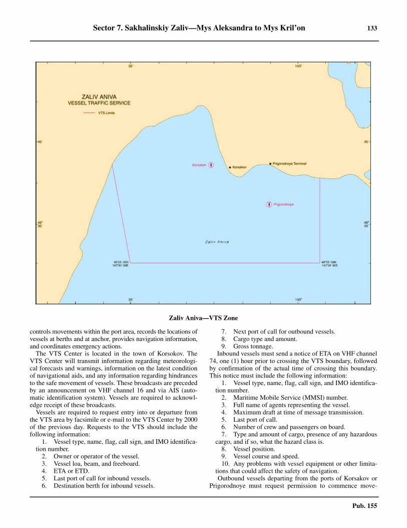
Sector 7. Sakhalinskiy Zaliv—Mys Aleksandra to Mys Kril’on 133
Pub. 155
controls movements within the port area, records the locations ofvessels at berths and at anchor, provides navigation information,and coordinates emergency actions. 7.45 The VTS Center is located in the town of Korsokov. TheVTS Center will transmit information regarding meteorologi-cal forecasts and warnings, information on the latest conditionof navigational aids, and any information regarding hindrancesto the safe movement of vessels. These broadcasts are precededby an announcement on VHF channel 16 and via AIS (auto-matic identification system). Vessels are required to acknowl-edge receipt of these broadcasts. 7.45 Vessels are required to request entry into or departure fromthe VTS area by facsimile or e-mail to the VTS Center by 2000of the previous day. Requests to the VTS should include thefollowing information:
1. Vessel type, name, flag, call sign, and IMO identifica-tion number.
2. Owner or operator of the vessel.3. Vessel loa, beam, and freeboard.4. ETA or ETD.5. Last port of call for inbound vessels.6. Destination berth for inbound vessels.
7. Next port of call for outbound vessels.8. Cargo type and amount.9. Gross tonnage.
7.45 Inbound vessels must send a notice of ETA on VHF channel74, one (1) hour prior to crossing the VTS boundary, followedby confirmation of the actual time of crossing this boundary.This notice must include the following information:
1. Vessel type, name, flag, call sign, and IMO identifica-tion number.
2. Maritime Mobile Service (MMSI) number.3. Full name of agents representing the vessel.4. Maximum draft at time of message transmission.5. Last port of call.6. Number of crew and passengers on board.7. Type and amount of cargo, presence of any hazardous
cargo, and if so, what the hazard class is.8. Vessel position.9. Vessel course and speed.10. Any problems with vessel equipment or other limita-
tions that could affect the safety of navigation.7.45 Outbound vessels departing from the ports of Korsakov orPrigorodnoye must request permission to commence move-
Zaliv Aniva—VTS Zone
134 Sector 7. Sakhalinskiy Zaliv—Mys Aleksandra to Mys Kril’on
Pub. 155
ment from the VTS Center and report the following informa-tion:
1. Vessel name and flag.2. Full name of agents representing the vessel.3. Maximum draft at time of message transmission.4. Permission number assigned by Port State Control.5. Type and amount of cargo.6. Surname of pilot.
7.45 Outbound vessels departing from Korsakov or Prigorodnoyemust request permission to discontinue their radio watch onVHF channel 74 when leaving the VTS area. 7.45 Outbound vessels departing from other ports or passingthrough the VTS area must contact the VTS Center on VHFchannel 74 when crossing the VTS limit and report the follow-ing information:
1. Vessel type, name, and flag.2. Position at time of crossing VTS limit.3. Destination port or station.4. All other information requested by the VTS.
7.45 Whenever a pilot is embarked or disembarked, the VTS Cen-ter must be notified. 7.45 All movement is prohibited in the VTS operational zone forvessels unable to maintain the required radio watch (see Sig-nals), or if visibility is less than 0.5 mile, or if the vessel’s radaris inoperable.7.45 The overtaking of vessels while in the VTS operational zoneis prohibited.7.45 While underway in the VTS area, the ship’s main enginesmust be ready to respond to any order and the anchors must bein a condition to be let go immediately at any time. 7.45 If visibility becomes 2 miles or less, pilotage of the vessel ismandatory, using VTS recommendations.7.45 Any vessel intending to weigh anchor or depart a berth in-side the VTS operational zone must request permission fromthe VTS Center at least 15 minutes prior to commencing theoperation. The center will confirm the intended time or advisea new time for movement to which the vessel must adhere.This permission is valid for only 15 minutes. 7.45 Vessels participating in AIS (automatic identification sys-tem) are exempt from having to include their position in any re-ports to the VTS Center. Otherwise, reports will be made indegrees of latitude and longitude or in the following format:
1. Vessel position relative to Korsakovskiy Light or oth-er aid to navigation or landmark requested by the VTS Cen-ter.
2. Bearing from navigational aid expressed in degrees(three digits).
3. Break sign (e.g. backslash symbol).4. Distance from referenced aid or landmark expressed
in nautical miles and tenths of nautical mile.7.45 Vessels that have experienced a spillage of petroleum or oth-er types of pollutants must immediately take steps to containthe spill and notify the VTS Center. 7.45 Vessels involved in a collision, allision, or grounding mustimmediately notify the VTS Center, including information oninjured persons, vessel damage, and the amount and type ofspillage, if any. 7.45 Vessels discovering any evidence of pollution of the marineenvironment, abnormalities in the operation or positioning ofnavigation aids, or any other items that would present a hazard
to safe navigation should notify the VTS Center immediately. 7.45 Vessels in the VTS area not responding to calls from theVTS Center will be considered as being in distress and stepsmay be taken to provide assistance without the coordination ofthe master or ship’s crew; the associated costs will be the re-sponsibility of the vessel’s owners. 7.45 Vessels in the area surrounding the Korsakov Ozersky Ter-minal (46°36'36''N, 143°07'48''E.) must keep a continuous lis-tening watch on VHF channels 11 and 16. 7.45 Contact Information.—Communication with the VTS Cen-ter and a continuous listening watch is maintained on VHFchannel 74, with VHF channel 67 used as backup, and VHFchannel. For contact information, see the table titled ZalivAniva—Contact Information.
7.46 Gora Tonobori (46°13'N., 143°27'E.), a conspicuousdouble-peaked mountain rising to a height of 536m, is locatedabout 1 mile inland and is a good landmark from all directions.About 2.5 miles SW of the mountain is a remarkable outcropof pure white marble that resembles an islet. From the N it hasbeen mistaken for a ship, but from W it appears conical.7.46 The coast to the N of Yuzhnoye, although still rugged, isconsiderably lower than the area to the S and is indented by themouths of several shallow rivers. The shore for about 11 milesto the N, to the vicinity of Mys Moshiri, is bordered by numer-ous rocks and islets some of which reach heights of 37m.7.46 Ozero Busse (46°31'N., 143°18'E.), the S of a group of lakeslocated in the NE part of Zaliv Aniva, is entered by a narrowshifting channel available only to small craft with local knowl-edge. The entrance can be identified by a conspicuous whiterock resembling a house, which is located on the N side, andalso by cable towers on either side of the opening.7.46 The shore separating the lakes from Zaliv Aniva is low andtree-lined, with sandy beaches and offshore banks continuinguntil in the vicinity of Mys Chibisanskiy, where the higher landresumes. Reyd Chibisanskiy, an indentation of the coast about1 mile E of the latter point, provides anchorage to small vesselswith local knowledge. 7.46 At the head of the roadstead there is a small harbor protected
Zaliv Aniva—Contact Information
Senior Duty Officer and Duty Operator
Call sign Aniva Trafik
VHF
VHF channel 74 (working)
VHF channel 16 (call and safety)
VHF channel 67 (reserve)
Telephone
78-42435-44440 (Senior Duty Officer)
78-91474-27507 (Duty Operator)
78-42435-44443 (VTS Center)
Facsimile 78-42435-44440
E-mail [email protected]
Note.—The Senior Duty Officer and Duty Operatornumbers are operational 24 hours, while the VTSnumber is manned only between 0830 and 1730.
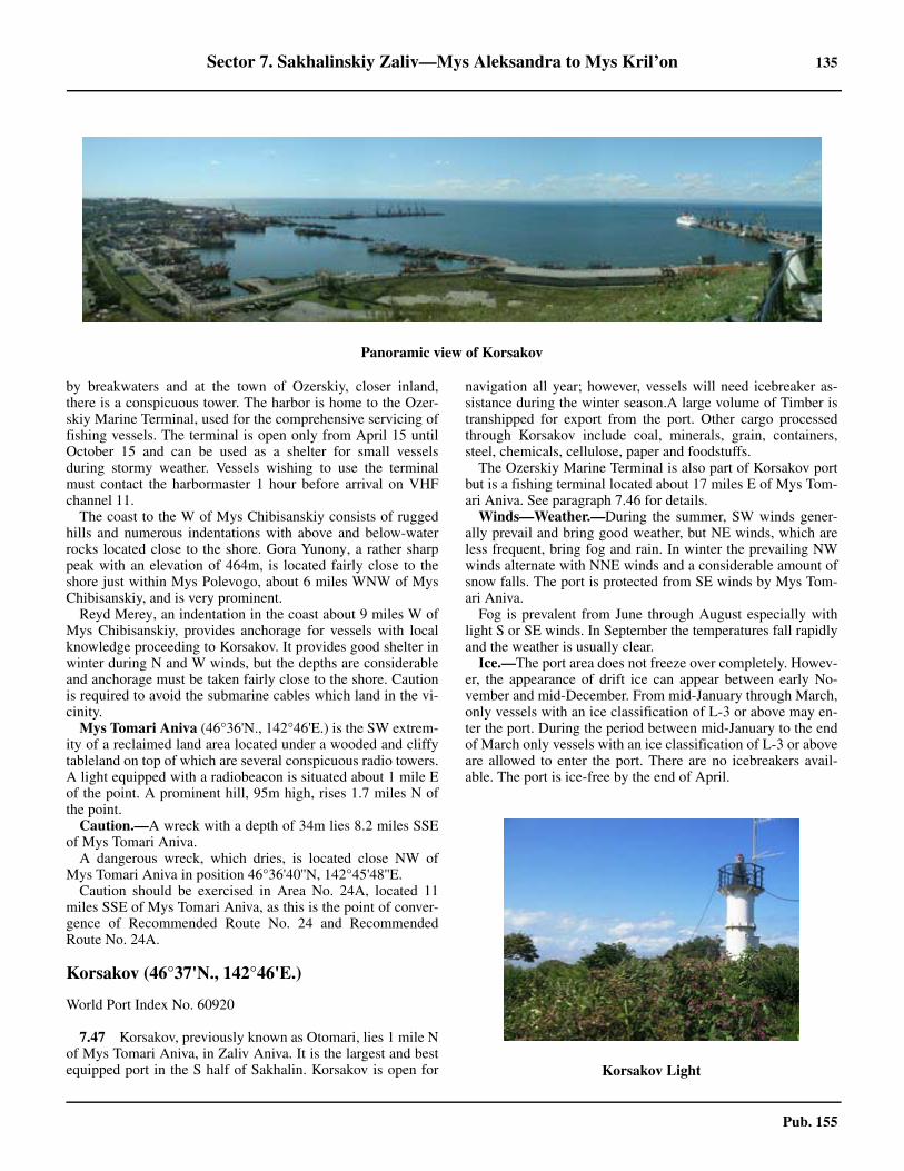
Sector 7. Sakhalinskiy Zaliv—Mys Aleksandra to Mys Kril’on 135
Pub. 155
by breakwaters and at the town of Ozerskiy, closer inland,there is a conspicuous tower. The harbor is home to the Ozer-skiy Marine Terminal, used for the comprehensive servicing offishing vessels. The terminal is open only from April 15 untilOctober 15 and can be used as a shelter for small vesselsduring stormy weather. Vessels wishing to use the terminalmust contact the harbormaster 1 hour before arrival on VHFchannel 11. 7.46 The coast to the W of Mys Chibisanskiy consists of ruggedhills and numerous indentations with above and below-waterrocks located close to the shore. Gora Yunony, a rather sharppeak with an elevation of 464m, is located fairly close to theshore just within Mys Polevogo, about 6 miles WNW of MysChibisanskiy, and is very prominent. 7.46 Reyd Merey, an indentation in the coast about 9 miles W ofMys Chibisanskiy, provides anchorage for vessels with localknowledge proceeding to Korsakov. It provides good shelter inwinter during N and W winds, but the depths are considerableand anchorage must be taken fairly close to the shore. Cautionis required to avoid the submarine cables which land in the vi-cinity.7.46 Mys Tomari Aniva (46°36'N., 142°46'E.) is the SW extrem-ity of a reclaimed land area located under a wooded and cliffytableland on top of which are several conspicuous radio towers.A light equipped with a radiobeacon is situated about 1 mile Eof the point. A prominent hill, 95m high, rises 1.7 miles N ofthe point. 7.46 Caution.—A wreck with a depth of 34m lies 8.2 miles SSEof Mys Tomari Aniva. 7.46 A dangerous wreck, which dries, is located close NW ofMys Tomari Aniva in position 46°36'40''N, 142°45'48''E. 7.46 Caution should be exercised in Area No. 24A, located 11miles SSE of Mys Tomari Aniva, as this is the point of conver-gence of Recommended Route No. 24 and RecommendedRoute No. 24A.
Korsakov (46°37'N., 142°46'E.)
World Port Index No. 60920
7.47 Korsakov, previously known as Otomari, lies 1 mile Nof Mys Tomari Aniva, in Zaliv Aniva. It is the largest and bestequipped port in the S half of Sakhalin. Korsakov is open for
navigation all year; however, vessels will need icebreaker as-sistance during the winter season.A large volume of Timber istranshipped for export from the port. Other cargo processedthrough Korsakov include coal, minerals, grain, containers,steel, chemicals, cellulose, paper and foodstuffs.
The Ozerskiy Marine Terminal is also part of Korsakov portbut is a fishing terminal located about 17 miles E of Mys Tom-ari Aniva. See paragraph 7.46 for details. 7.47 Winds—Weather.—During the summer, SW winds gener-ally prevail and bring good weather, but NE winds, which areless frequent, bring fog and rain. In winter the prevailing NWwinds alternate with NNE winds and a considerable amount ofsnow falls. The port is protected from SE winds by Mys Tom-ari Aniva.7.47 Fog is prevalent from June through August especially withlight S or SE winds. In September the temperatures fall rapidlyand the weather is usually clear.7.47 Ice.—The port area does not freeze over completely. Howev-er, the appearance of drift ice can appear between early No-vember and mid-December. From mid-January through March,only vessels with an ice classification of L-3 or above may en-ter the port. During the period between mid-January to the endof March only vessels with an ice classification of L-3 or aboveare allowed to enter the port. There are no icebreakers avail-able. The port is ice-free by the end of April.
Panoramic view of Korsakov
Korsakov Light
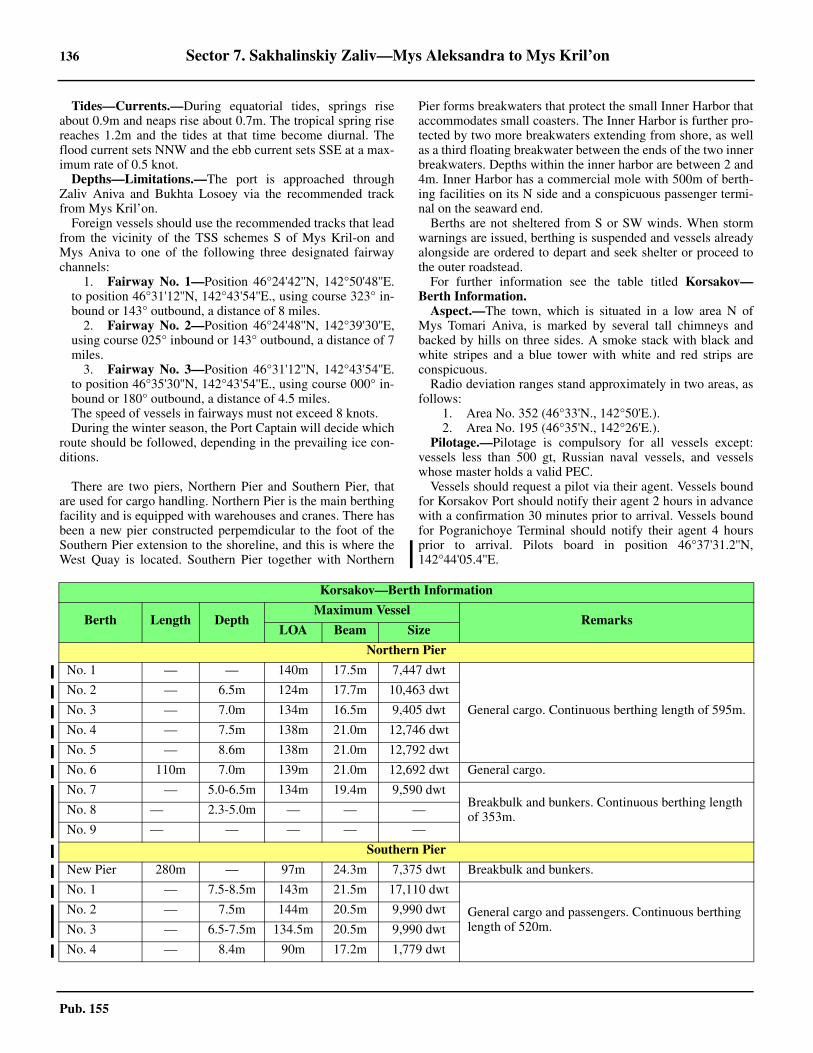
136 Sector 7. Sakhalinskiy Zaliv—Mys Aleksandra to Mys Kril’on
Pub. 155
7.47 Tides—Currents.—During equatorial tides, springs riseabout 0.9m and neaps rise about 0.7m. The tropical spring risereaches 1.2m and the tides at that time become diurnal. Theflood current sets NNW and the ebb current sets SSE at a max-imum rate of 0.5 knot.7.47 Depths—Limitations.—The port is approached throughZaliv Aniva and Bukhta Losoey via the recommended trackfrom Mys Kril’on. 7.47 Foreign vessels should use the recommended tracks that leadfrom the vicinity of the TSS schemes S of Mys Kril-on andMys Aniva to one of the following three designated fairwaychannels:
1. Fairway No. 1—Position 46°24'42''N, 142°50'48''E.to position 46°31'12''N, 142°43'54''E., using course 323° in-bound or 143° outbound, a distance of 8 miles.
2. Fairway No. 2—Position 46°24'48''N, 142°39'30''E,using course 025° inbound or 143° outbound, a distance of 7miles.
3. Fairway No. 3—Position 46°31'12''N, 142°43'54''E.to position 46°35'30''N, 142°43'54''E., using course 000° in-bound or 180° outbound, a distance of 4.5 miles.
7.47 The speed of vessels in fairways must not exceed 8 knots. 7.47 During the winter season, the Port Captain will decide whichroute should be followed, depending in the prevailing ice con-ditions.
7.47 There are two piers, Northern Pier and Southern Pier, thatare used for cargo handling. Northern Pier is the main berthingfacility and is equipped with warehouses and cranes. There hasbeen a new pier constructed perpemdicular to the foot of theSouthern Pier extension to the shoreline, and this is where theWest Quay is located. Southern Pier together with Northern
Pier forms breakwaters that protect the small Inner Harbor thataccommodates small coasters. The Inner Harbor is further pro-tected by two more breakwaters extending from shore, as wellas a third floating breakwater between the ends of the two innerbreakwaters. Depths within the inner harbor are between 2 and4m. Inner Harbor has a commercial mole with 500m of berth-ing facilities on its N side and a conspicuous passenger termi-nal on the seaward end. 7.47 Berths are not sheltered from S or SW winds. When stormwarnings are issued, berthing is suspended and vessels alreadyalongside are ordered to depart and seek shelter or proceed tothe outer roadstead. 7.47 For further information see the table titled Korsakov—Berth Information.7.47 Aspect.—The town, which is situated in a low area N ofMys Tomari Aniva, is marked by several tall chimneys andbacked by hills on three sides. A smoke stack with black andwhite stripes and a blue tower with white and red strips areconspicuous.7.47 Radio deviation ranges stand approximately in two areas, asfollows:
1. Area No. 352 (46°33'N., 142°50'E.).2. Area No. 195 (46°35'N., 142°26'E.).
7.47 Pilotage.—Pilotage is compulsory for all vessels except:vessels less than 500 gt, Russian naval vessels, and vesselswhose master holds a valid PEC.7.47 Vessels should request a pilot via their agent. Vessels boundfor Korsakov Port should notify their agent 2 hours in advancewith a confirmation 30 minutes prior to arrival. Vessels boundfor Pogranichoye Terminal should notify their agent 4 hoursprior to arrival. Pilots board in position 46°37'31.2''N,142°44'05.4''E.
Korsakov—Berth Information
Berth Length DepthMaximum Vessel
RemarksLOA Beam Size
Northern Pier
No. 1 — — 140m 17.5m 7,447 dwt
General cargo. Continuous berthing length of 595m.
No. 2 — 6.5m 124m 17.7m 10,463 dwt
No. 3 — 7.0m 134m 16.5m 9,405 dwt
No. 4 — 7.5m 138m 21.0m 12,746 dwt
No. 5 — 8.6m 138m 21.0m 12,792 dwt
No. 6 110m 7.0m 139m 21.0m 12,692 dwt General cargo.
No. 7 — 5.0-6.5m 134m 19.4m 9,590 dwtBreakbulk and bunkers. Continuous berthing length of 353m.No. 8 — 2.3-5.0m — — —
No. 9 — — — — —
Southern Pier
New Pier 280m — 97m 24.3m 7,375 dwt Breakbulk and bunkers.
No. 1 — 7.5-8.5m 143m 21.5m 17,110 dwt
General cargo and passengers. Continuous berthing length of 520m.
No. 2 — 7.5m 144m 20.5m 9,990 dwt
No. 3 — 6.5-7.5m 134.5m 20.5m 9,990 dwt
No. 4 — 8.4m 90m 17.2m 1,779 dwt
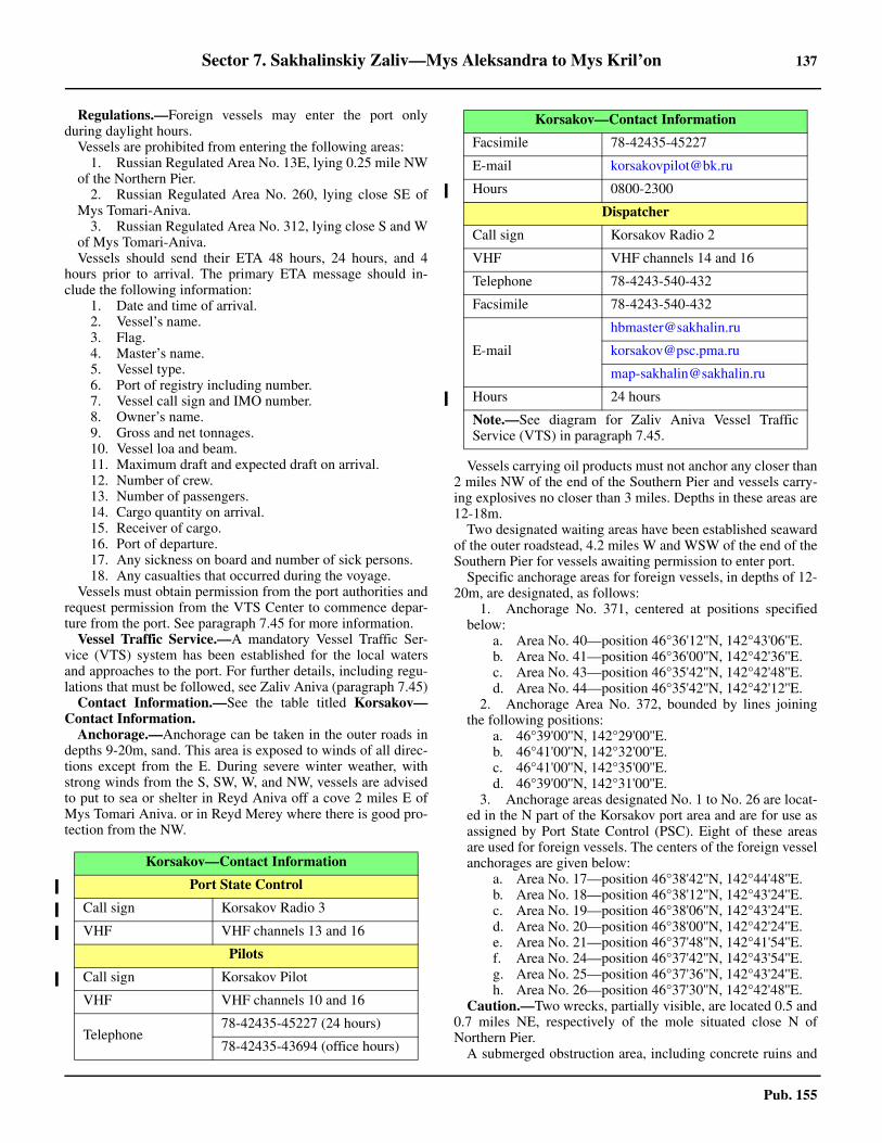
Sector 7. Sakhalinskiy Zaliv—Mys Aleksandra to Mys Kril’on 137
Pub. 155
7.47 Regulations.—Foreign vessels may enter the port onlyduring daylight hours. 7.47 Vessels are prohibited from entering the following areas:
1. Russian Regulated Area No. 13E, lying 0.25 mile NWof the Northern Pier.
2. Russian Regulated Area No. 260, lying close SE ofMys Tomari-Aniva.
3. Russian Regulated Area No. 312, lying close S and Wof Mys Tomari-Aniva.
7.47 Vessels should send their ETA 48 hours, 24 hours, and 4hours prior to arrival. The primary ETA message should in-clude the following information:
1. Date and time of arrival.2. Vessel’s name.3. Flag.4. Master’s name.5. Vessel type.6. Port of registry including number.7. Vessel call sign and IMO number.8. Owner’s name.9. Gross and net tonnages.10. Vessel loa and beam.11. Maximum draft and expected draft on arrival.12. Number of crew.13. Number of passengers.14. Cargo quantity on arrival.15. Receiver of cargo.16. Port of departure.17. Any sickness on board and number of sick persons.18. Any casualties that occurred during the voyage.
7.47 Vessels must obtain permission from the port authorities andrequest permission from the VTS Center to commence depar-ture from the port. See paragraph 7.45 for more information.7.47 Vessel Traffic Service.—A mandatory Vessel Traffic Ser-vice (VTS) system has been established for the local watersand approaches to the port. For further details, including regu-lations that must be followed, see Zaliv Aniva (paragraph 7.45)7.47 Contact Information.—See the table titled Korsakov—Contact Information. 7.47 Anchorage.—Anchorage can be taken in the outer roads indepths 9-20m, sand. This area is exposed to winds of all direc-tions except from the E. During severe winter weather, withstrong winds from the S, SW, W, and NW, vessels are advisedto put to sea or shelter in Reyd Aniva off a cove 2 miles E ofMys Tomari Aniva. or in Reyd Merey where there is good pro-tection from the NW.
7.47 Vessels carrying oil products must not anchor any closer than2 miles NW of the end of the Southern Pier and vessels carry-ing explosives no closer than 3 miles. Depths in these areas are12-18m. 7.47 Two designated waiting areas have been established seawardof the outer roadstead, 4.2 miles W and WSW of the end of theSouthern Pier for vessels awaiting permission to enter port. 7.47 Specific anchorage areas for foreign vessels, in depths of 12-20m, are designated, as follows:
1. Anchorage No. 371, centered at positions specifiedbelow:
a. Area No. 40—position 46°36'12''N, 142°43'06''E.b. Area No. 41—position 46°36'00''N, 142°42'36''E.c. Area No. 43—position 46°35'42''N, 142°42'48''E.d. Area No. 44—position 46°35'42''N, 142°42'12''E.
2. Anchorage Area No. 372, bounded by lines joiningthe following positions:
a. 46°39'00''N, 142°29'00''E.b. 46°41'00''N, 142°32'00''E.c. 46°41'00''N, 142°35'00''E.d. 46°39'00''N, 142°31'00''E.
3. Anchorage areas designated No. 1 to No. 26 are locat-ed in the N part of the Korsakov port area and are for use asassigned by Port State Control (PSC). Eight of these areasare used for foreign vessels. The centers of the foreign vesselanchorages are given below:
a. Area No. 17—position 46°38'42''N, 142°44'48''E.b. Area No. 18—position 46°38'12''N, 142°43'24''E.c. Area No. 19—position 46°38'06''N, 142°43'24''E.d. Area No. 20—position 46°38'00''N, 142°42'24''E. e. Area No. 21—position 46°37'48''N, 142°41'54''E.f. Area No. 24—position 46°37'42''N, 142°43'54''E.g. Area No. 25—position 46°37'36''N, 142°43'24''E.h. Area No. 26—position 46°37'30''N, 142°42'48''E.
7.47 Caution.—Two wrecks, partially visible, are located 0.5 and0.7 miles NE, respectively of the mole situated close N ofNorthern Pier. 7.47 A submerged obstruction area, including concrete ruins and
Korsakov—Contact Information
Port State Control
Call sign Korsakov Radio 3
VHF VHF channels 13 and 16
Pilots
Call sign Korsakov Pilot
VHF VHF channels 10 and 16
Telephone78-42435-45227 (24 hours)
78-42435-43694 (office hours)
Facsimile 78-42435-45227
E-mail [email protected]
Hours 0800-2300
Dispatcher
Call sign Korsakov Radio 2
VHF VHF channels 14 and 16
Telephone 78-4243-540-432
Facsimile 78-4243-540-432
Hours 24 hours
Note.—See diagram for Zaliv Aniva Vessel TrafficService (VTS) in paragraph 7.45.
Korsakov—Contact Information
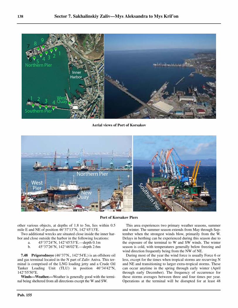
138 Sector 7. Sakhalinskiy Zaliv—Mys Aleksandra to Mys Kril’on
Pub. 155
other various objects, at depths of 1.8 to 5m, lies within 0.5mile E and NE of position 46°37'13''N, 142°45'13'E. 7.47 Two additional wrecks are situated close inside the inner har-bor and close outside the harbor in the following locations:
a. 45°37'24''N, 142°45'53''E.—depth 0.1mb. 45°37'26''N, 142°46'02''E.—depth 2.6m
7.48 Prigorodnoye (46°37'N., 142°54'E.) is an offshore oiland gas terminal located in the N part of Zaliv Aniva. This ter-minal is comprised of the LNG loading jetty and a Crude OilTanker Loading Unit (TLU) in position 46°34'42''N,142°55'50''E.
Winds—Weather.—Weather is generally good with the termi-nal being sheltered from all directions except the W and SW.
This area experiences two primary weather seasons, summerand winter. The summer season extends from May through Sep-tember when the strongest winds blow, primarily from the W.Delays in berthing can be experienced during this season due tothe exposure of the terminal to W and SW winds. The winterseason is cold, with temperatures generally below freezing andwind direction frequently being from the NW of NE. 7.48 During most of the year the wind force is usually Force 6 orless, except for the times when tropical storms are recurving Nand NE and transitioning to larger extra-tropical storms. Thesecan occur anytime in the spring through early winter (Aprilthrough early December). The frequency of occurrence forthese storms averages between three and four times per year.Operations at the terminal will be disrupted for at least 48
Aerial views of Port of Korsakov
Port of Korsakov Piers
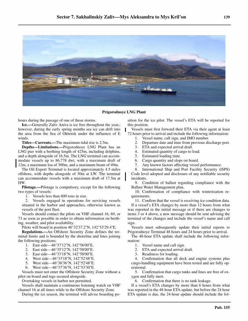
Sector 7. Sakhalinskiy Zaliv—Mys Aleksandra to Mys Kril’on 139
Pub. 155
hours during the passage of one of these storms. Ice.—Generally Zaliv Aniva is ice free throughout the year,;
however, during the early spring months sea ice can drift intothe area from the Sea of Okhotsk under the influence of Ewinds.
Tides—Currents.—The maximum tidal rise is 2.5m. Depths—Limitations.—Prigorodnoye LNG Plant has an
LNG pier with a berthing length of 425m, including dolphins,and a depth alongside of 16.5m. The LNG terminal can accom-modate vessels up to 86,778 dwt, with a maximum draft of12m, a maximum loa of 300m, and a maximum beam of 49m.
The Oil Export Terminal is located approximately 4.5 milesoffshore, with depths alongside of 30m at LW. The terminalcan accommodate vessels with a maximum draft of 17.5m atHW. 7.48 Pilotage.—Pilotage is compulsory, except for the followingtwo types of vessels:
1. Vessels less than 600 tons in size.2. Vessels engaged in operations for servicing vessels
situated in the harbor and approaches, otherwise known asvessels of the port fleet.
7.48 Vessels should contact the pilots on VHF channel 16, 69, or73 as soon as possible in order to obtain information on berth-ing, weather, and pilot availability.7.48 Pilots will board in position 46°32'37.2''N, 142°53'29.4''E. 7.48 Regulations.—An Offshore Security Zone defines the ter-minal limits and is bounded by the shoreline and lines joiningthe following positions:
1. East side—46°37'12''N, 142°56'00''E.2. East side—46°35'12''N, 142°58'00''E.3. East side—46°33'18''N, 142°58'00''E.4. West side—46°33'18''N, 142°52'48''E.5. West side—46°36'36''N, 142°52'48''E.6. West side—46°37'36''N, 142°53'30''E.
7.48 Vessels must not enter the Offshore Security Zone without apilot on board and tugs secured alongside. 7.48 Overtaking vessels in harbor not permitted. 7.48 Vessels shall maintain a continuous listening watch on VHFchannel 16 at all times while in the Offshore Security Zone. 7.48 During the ice season, the terminal will advise boarding po-
sition for the ice pilot. The vessel’s ETA will be reported forthis position. 7.48 Vessels must first forward their ETA via their agent at least72 hours prior to arrival and include the following information:
1. Vessel name, call sign, and IMO number.2. Departure date and time from previous discharge port.3. ETA and expected arrival draft.4. Estimated quantity of cargo to load.5. Estimated loading time.6. Cargo quantity and slops on board.7. Any known factors affecting vessel performance.8. International Ship and Port Facility Security (ISPS)
Code level adopted and disclosure of any notifiable securityincidents.
9. Condition of ballast regarding compliance with theBallast Water Management plan.
10. Confirmation of compliance with winterization re-quirements.
11. Confirm that the vessel is receiving ice condition data.7.48 If a vessel’s ETA changes by more than 12 hours from whatwas reported in the initial message or if there are changes toitems 3 or 4 above, a new message should be sent advising theterminal of the changes and include the vessel’s name and callsign.7.48 Vessels must subsequently update their initial reports toPrigorodnoye Terminal 48 hours and 24 hours prior to arrival. 7.48 The 48-hour ETA update shall include the following infor-mation:
1. Vessel name and call sign.2. ETA and expected arrival draft.3. Readiness for loading.4. Confirmation that all deck and engine systems plus
cargo-handling equipment have been tested and are fully op-erational.
5. Confirmation that cargo tanks and lines are free of ox-ygen and fully inert.
6. Confirmation that there is no tank leakage.7.48 If a vessel’s ETA changes by more than 6 hours from whatwas reported in the 48-hour ETA update, but before the 24 hourETA update is due, the 24-hour update should include the fol-
Prigorodnoye LNG Plant
140 Sector 7. Sakhalinskiy Zaliv—Mys Aleksandra to Mys Kril’on
Pub. 155
lowing information: 1. Vessel name and call sign.2. Confirmation of ETA.3. Send pratique message via agent.
7.48 If a vessel’s ETA changes by more than 2 hours from whatwas reported in the 24-hour ETA update, before sending the 6-hour update, a new message should be sent advising the termi-nal of the changes and include the vessel’s name and call sign.7.48 The 6-hour update shall include the following information:
1. Vessel name and call sign.2. Confirmation of ETA.3. Confirmation that all overboard discharge valves are
closed.7.48 Upon departure from the terminal, vessels need to report thefollowing information:
1. Vessel name and call sign.2. Outstanding port log items (if any).3. ETA at discharge port.
7.48 Contact with the terminal via VHF channel 69 should bemade as soon as within range. 7.48 Vessel Traffic Service.—A mandatory Vessel Traffic Ser-vice (VTS) system has been established for the local watersand approaches to the port. For further details, including regu-lations that must be followed, see Zaliv Aniva (paragraph 7.45)7.48 Contact Information.—See the table titled Prigorod-noye—Contact Information.
7.48 Anchorage.—There are four areas designated for vesselsthat are neither gas carriers nor tankers. These areas are cen-tered at the following points, with depths between 28 and 42m,fine sand, mud and gravel:
a. 46°34'01''N, 142°51'15''E.b. 46°33'02''N, 142°51'15''E.c. 46°32'00''N, 142°56'24''E.d. 46°32'00''N, 142°57'46''E.
7.48 For gas and oil carriers the following anchorages are avail-able:
1. Anchorage No. 1 (Area No. 170), for gas carriers, isbounded lines joining by the following positions:
a. 46°34'30''N, 142°50'30''E.
b. 46°34'30''N, 142°52'00''E.c. 46°32'30''N, 142°52'00''E.d. 46°32'30''N, 142°52'30''E.
2. Anchorage No. 2 (Area No. 170A), for oil carriers, isbounded by lines joining the following positions:
a. 46°32'30''N, 142°55'42''E.b. 46°32'30''N, 142°58'30''E.c. 46°31'30''N, 142°58'30''E.d. 46°31'30''N, 142°55'42''E.
7.48 Vessels anchor by direction of the VTS Operations Center(see paragraph 7.45).7.48 Outside of the VTS Operational Zone, anchorage can be tak-en in Reyd Chibisanskiy (46°36'11''N., 143°07'57''E.), in 7m,sand. Local knowledge is required, however, because of the ne-cessity of having to anchor so close to the shore for shelterfrom high winds from the W veering to the E.7.48 Caution.—A wreck lies about 6 miles SSW of the crude oiltanker-loading unit (TLU) in a depth of 34m.
7.49 Bukhta Lososey (46°20'N., 142°50'E.), the bay at theNW corner of Zaliv Aniva, is divided on its N shore by an ex-tensive marshy plain which is bordered on each side by moun-tainous terrain. The range on the W side is prominent andculminates in a 726m sharp, conspicuous peak, known as GoraBobrik, rising about 16 miles NNW of the head of the bay. Re-ka Aniva, with a shallow shifting bar at its mouth, enters thebay on its W side about 11 miles NW of Mys Tomari Aniva. 7.49 Anchorage.—Anchorage can be taken off the river mouth,with shelter from NW and W winds, by vessels with localknowledge. The bottom is sand and mud.7.49 Caution.—A stranded wreck lies in Bukhta Lososey, about3 miles NE of Mys Tomari Aniva.
7.50 The W shore of Zaliv Aniva, from Reka Aniva to Re-ka Taranay, about 5.5 miles SSW, is generally low and sandy.Lighted beacons, in range bearing 349°48', mark the entranceto Reka Taranay. Farther to the S, the coast becomes higher andsteeper with numerous sand and shingle beaches interspersedbetween the hills. Gora Taranay, rising to an elevation of 520mabout 6.5 miles W of the mouth of the river of the same name,appears from the S prominent and pointed; from the E, it ap-pears flat-topped, with a very conspicuous left shoulder. 7.50 Krillovo (Uryu) (46°27'N., 142°21'E.), a small fishing vil-lage at the mouth of a river with the same name, lies in a valleyS of a group of hills closely bordering the coast. Gagyu San,the highest peak in the vicinity, rises to a height of 503m about11 miles SW of Krillovo and is conspicuous because of itssteep N and E sides. A deviation range, No. 195A, stands NEof the village in position 46°35'N, 142°27E.
7.51 Mys Benochi (46°07'N., 142°13'E.), a flat-toppedrounded projection on which stand some trees, lies about 1.5miles S of the village of Khvostovo and is fairly prominentfrom the N and the S. For about 10 miles N of the point, thecoast consists of a succession of yellow cliffs, 15 to 131m high,with numerous rocks along the shore. To the S of the point, forabout 5 miles, the shoreline is foul with reefs and shoals to aseaward distance of almost 1.5 miles.7.51 Mys Anastasii (46°01'N., 142°11'E.), a flat, grassy projec-tion fringed with rocky ledges, lies about 5.7 miles SSW of
Prigorodnoye—Contact Information
Pilots (Marine Base)
VHF VHF channels 16, 69, and 73
Telephone78-4242-664-008
78-962-153-2033 (mobile)
Terminal Dispatcher
Call sign Prigorodnoye Control
VHF VHF channels 16, 69, and 73
Telephone 78-4242-664-001
Tugs
VHF VHF channels 16, 69, and 73
Note.—See diagram for Zaliv Aniva Vessel Traffic Service (VTS) in paragraph 7.45.
Sector 7. Sakhalinskiy Zaliv—Mys Aleksandra to Mys Kril’on 141
Pub. 155
Mys Benochi. Kamen Tishiya, consisting of a group of threerocks, 5 to 29m high, is located about 0.2 mile SE of the pointand is connected to the coast by a drying reef. It is very con-spicuous when seen from the NE or SW.7.51 Atlasovo, a small harbor protected by breakwaters, is situat-ed close SW of Mys Anastasii. There is a village and facilitiesfor docking fishing boats here.
7.51 Mys Kril’on (45°53'N., 142°05'E.), the S extremity ofSakhalin and the W entrance point of Zaliv Aniva, lies 9 milesSW of Mys Anastasii. It is a small peninsula connected to themainland by a low isthmus. When first sighted by vessels ap-proaching from the E or W, it appears as an islet, steep on its Wside, but sloping gradually on its S and E sides. Steep-to reefsextend up to 0.5 mile S of the cape. Caution is necessary inthick weather.7.51 Tide rips extend 1 mile S and 0.5 mile SE of the cape andmay extend further off the cape during strong winds.7.51 A light stands on Mys Kril’on but the light has been extin-guished. 7.51 Caution.—A former mine danger area, within which it isdangerous to anchor, fish, or carry out any underwater opera-tions, lies about 20 miles NE of Mys Kril’on and may best beseen on the chart.
La Perouse Strait
7.52 La Perouse Strait (45°43'N., 142°00'E.), with awidth of approximately 23 miles, separates Mys Kril’on, the Sextremity of Sakhalin, from Soya Misaki, the N extremity ofHokkaido and joins Tatar Strait and the Sea of Japan with theSea of Okhotsk.
7.52 A light is shown from Soya Misaki; a radiobeacon and a ra-dar beacon are situated at the light.7.52 Although easily navigated in good weather, the strait can bevery difficult during periods of poor visibility and the utmostcaution is recommended.7.52 Skala Kamen’ Opasnosti (45°48'N., 142°14'E.), a low iso-lated rock located close N of the center line of La PerouseStrait, constitutes the main danger to vessels transiting this ar-ea. Numerous obstructions and dangers surround the rock to adistance of 2 miles from its shores and it should be given awide berth. A light is shown on Skala Kamen’ Opasnosti; a ra-diobeacon is situated at the light.7.52 A Traffic Separation Scheme, which may best be seen on thechart, is situated in the strait. The scheme has been establishedby the Russian government and is not IMO-adopted.7.52 Winds—Weather.—From June to August, fogs develop fre-quently in the strait. In general, they are densest on the N side, es-pecially in the vicinity of Mys Kril’on, but there is a gradualdecrease in density to the E of this point. The fogs are primarily lo-calized, seldom spreading over large areas for long periods, andgenerally being set about by the direction of the winds.7.52 Tides—Currents.—The tidal currents are so involved in LaPerouse Strait that considerable caution is necessary, especiallyin fog. The main current in summer is generally to the E, but inwinter and spring little is known about the flow. The E and Wtidal flows strengthen and weaken the main current and offMys Kril’on have occasionally overcome it to produce a NWflow on the W side of the point and a SW flow on the E side.The resultant currents are considerably affected by the windand at times tide rips and overfalls are formed.7.52 Caution.—Depths between Mys Kril’on and Skala Kamen’Opasnosti may differ from those charted.
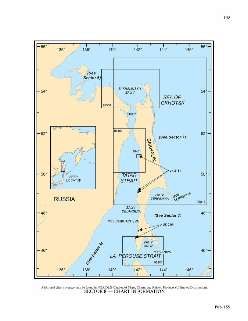
143
Pub. 155
8. Sector 8—Tatar Strait and the West Coast of Sakhalin
8.0Additional chart coverage may be found in NGA/DLIS Catalog of Maps, Charts, and Related Products (Unlimited Distribution).8.0SECTOR 8 — CHART INFORMATION
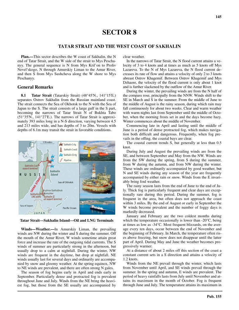
145
Pub. 155
SECTOR 8
TATAR STRAIT AND THE WEST COAST OF SAKHALIN
8.0 Plan.—This sector describes the W coast of Sakhalin, the Nend of Tatar Strait, and the W side of the strait to Mys Pescha-nyy. The general sequence is N from Mys Kril’on to ProlivNevel’skogo, N through Amurskiy Liman to the Amur River,and then S from Mys Sushcheva along the W shore to MysPeschanyy.
General Remarks
8.1 Tatar Strait (Tatarskiy Strait) (48°45'N., 141°15'E.)separates Ostrov Sakhalin from the Russian mainland coast.The strait connects the Sea of Okhotsk to the N with the Sea ofJapan to the S. The strait consists of a large gulf in the S part,becoming the narrows of Tatar Strait N of Bukhta Tabo(51°35'N., 141°27'E.). The narrows of Tatar Strait is approxi-mately 393 miles long in a N-S direction, varying between 4.5and 213 miles wide, and has depths of 3 to 20m. Vessels withdepths of 6.1m may transit the strait in favorable conditions.
Winds—Weather.—In Amurskiy Liman, the prevailingwinds are NW during the winter and S during the summer. Offthe mouth of the Amur River, W winds sometime attain greatforce and increase the rate of the outgoing tidal currents. The Swinds of summer are particularly strong in the afternoon, butusually drop to a calm at nightfall. During the winter, NWwinds are frequent in the daytime, but drop at nightfall. NEwinds usually last for several days and ordinarily are accompa-nied by snow and gloomy weather. At the spring equinox, NWto NE winds are prevalent, and there are often strong N gales.8.1 The season of fog begins early in April and ends early inSeptember. Particularly dense and protracted fog is prevalentthroughout June and July. Winds from the NE bring the heavi-est fog, but those from the SE usually are accompanied by
clear weather.8.1 In the narrows of Tatar Strait, the N flood current attains a ve-locity of 3 to 4 knots and at times as much as 5 knots off MysLazareva. To the N of Mys Lazareva, the N flood current de-creases its rate of flow and attains a velocity of only 2 to 3 knotsabreast Ostrov Khagemif. Between Ostrov Khagemif and MysDzhaore, the velocity of the flood current is only about 1 knotand is further slackened by the outflow of the Amur River.8.1 During the winter, the prevailing winds are from the N half ofthe compass rose, principally from the NNW. Winds shift to theSE in March and S in the summer. From the middle of June tothe middle of August is the rainy season, during which rain mayfall continuously for about two weeks. Clear and warm weatherwith warm nights last from September until the middle of Octo-ber, when the morning frosts set in and the days become hazy.Winter commences about the middle of November.8.1 Commencing late in April and lasting until the middle ofJune is a period of dense protracted fog, which makes naviga-tion both difficult and dangerous. Frequently, when fog pre-vails in the offing, the coastal bays are clear.8.1 The coastal current trends S, but generally at less than 0.5knot.8.1 During July and August the prevailing winds are from theSE, and between September and May from the NW. Winds arefrom the SW during the spring, from S during the summer,from W during the autumn, and from NW during the winter.These winds are ordinarily accompanied by good weather, butN and SE winds during any season of the year are frequentlyaccompanied by either rain or snow. Winds from the E invari-ably bring foul weather.8.1 The rainy season lasts from the end of June to the end of Ju-ly. Thick fog is particularly frequent and clear days are excep-tionally rare during this period. During the summer, fog isfrequent in the area, but often does not approach the coastwithin 3 miles. By the end of August or early in September theW winds become prevalent and the number of foggy days ismarkedly decreased.8.1 January and February are the two coldest months duringwhich the temperature occasionally is lower than -20°C, beingat times as low as -34°C. Most frequent blizzards, on the aver-age every ten days, occur between the end of November andthe beginning of February. In March, the temperature often ris-es above freezing, but snow does not disappear until the latterpart of April. During May and June the weather becomes pro-gressively warmer.8.1 At a distance of about 2 miles off this section of the coast aconstant current sets in a S direction and attains a velocity of1.2 knots.8.1 Winds from the NE prevail through the winter, which lastsfrom November until April, and SE winds prevail through thesummer. In the spring and autumn, E winds are prevalent. Theperiod of heavy rainfalls lasts from July until November and at-tains its maximum in the month of October. Fog is frequentthrough June and July. The temperature attains its maximum in
Tatar Strait—Sakhalin Island—Oil and LNG Terminals
146 Sector 8. Tatar Strait and the West Coast of Sakhalin
Pub. 155
August and its minimum in January, but generally does not fallbelow -9°C.8.1 A constant current flowing in a S direction parallels thiscoast, and at a distance of about 2.5 miles offshore attains a ve-locity of 1.2 knots. At about 20 miles offshore a NNE currentof 0.5 knot has been observed in autumn and winter.8.1 Amurskiy Liman is icebound ordinarily from the middle ofNovember until the end of May. In most years the mouth of theAmur River is clear of ice by May, however, occasionally itclears as late as June. Drift ice from the Sea of Okhotsk may bepresent in the gulf even after June. Ordinarily, the ice breaks upin the N part of the gulf about a month earlier than it does inthe S part, partly because the water discharged by the AmurRiver is comparatively warm, and partly because the S part ofthe gulf is narrow. It should be borne in mind, however, thatstrong N winds tend to pack the N approach with drift ice fromthe Sea of Okhotsk.8.1 Although Amurskiy Liman is completely frozen over duringthe winter, cracks occur in the ice owing to the tidal currents. Inthe navigable channels the ice is about 0.9m thick. Over thebars it is about 1.5m thick.8.1 Ice begins to form in Zaliv Chikhacheva early in November,and the bay is completely frozen by the middle of December.The movements of drift ice are mainly dependent on the wind,and after or during NE winds the outer part and approaches tothe bay may also be filled with ice. Breakup begins early inApril, and usually the bay is entirely free from the middle ofMay. The ice here attains a maximum thickness of 0.9 to 1.2m.8.1 Sludge ordinarily appears in the last week of November, andthe roadsteads are completely icebound late in December. Theice field, which attains a maximum thickness of 1.3m, usuallyextends for at least 15 miles seaward. During calm weather, nomovement of ice is apparent, but strong offshore winds, orwinds along the coast, cause large cracks in the ice field, por-tions of which break off and are carried out to sea. Winds fromthe W tend to pack drift ice against the coast and often producehummocks. Ordinarily, the ice begins to break up in the firsthalf of March and the area is clear late in April.8.1 Because of prevailing NW winds in winter, the state of theice in the center of the strait is generally open and unpredict-able. On the continental side this ice is more stable, extendingas a field S to about 48°N. The ice is generally firmest fromlate January to the middle of February, and most abundant be-tween the middle of February and the middle of March. Unhin-dered merchant shipping is generally possible from the middleof May to the beginning of November.8.1 Bukhta Izyl’met’yeva is often frozen over in the middle ofwinter. The largest quantities of drift ice ordinarily accumulatebetween December and March. Occasionally, drift ice appearsin Bukhta Izyl’met’yeva in the latter part of November.8.1 It has been reported that in the winter drift ice occasionallyreaches the shores of this bight, but seldom in sufficient quanti-ty to obstruct navigation.8.1 The field ice, which between the end of January and the endof March is about 0.4m thick, usually does not remain close toshore for longer than a day or two. Occasionally, drift icebrought here from the N combines with the field ice and tem-porarily completely blocks the harbors on this section of thecoast.8.1 Tatar Strait is entered between Mys Kril’on (45°53'N.,
142°05'E.) and Mys Belkina, about 185 miles W. At the N end,Proliv Nevel’skogo and Amurskiy Liman connect it to Sakha-linskiy Zaliv, the Sea of Okhotsk, and the Amur River (seeparagraph 7.5).8.1 Pilotage.—Pilotage is compulsory for all vessels navigatingProliv Tatarskiy. Pilots board vessels entering Proliv Tatarskiyfrom N in the vicinity of position 53°21'23.4''N, 141°41'27.6''Eand from the S in the vicinity of position 51°40'34.2''N,141°20'05.4''E.8.1 Caution.—Due to an earthquake which struck Sakhalin Is-land in 2007, authorities caution mariners that actual depthsand dangers may differ from those charted. 8.1 Several restricted or dangerous areas lie within the watersdescribed in this sector and may best be seen on the chart.
Mys Kril’on to Nevel’sk
8.2 Mys Kril’on (45°53'N., 142°05'E.), the S extremityof Sakhalin, is a small peninsula connected to the mainland bya low isthmus and has been fully described in paragraph 7.51.To the N of the cape the coast consists of sandy beach which isfringed by foul ground to a distance of nearly 1 mile offshore.Within are numerous hills reaching to heights of about 305m,which are broken by Reka Hishitoma, about 8 miles NNW ofMys Kril’on, before rising again to the main coastal chain. MysUno, located about 2 miles NNW of Reka Hishitoma, is a highcliffy and round-topped point that is connected to the mainlandby an isthmus. Close NW of the point is a large rock about 28mhigh, and about 0.5 mile to the SW is a dangerous submergedrock with a depth of about 1.2m.8.2 Mys Kuznetsova (46°03'N., 141°56'E.), a red flat cliffy pro-jection covered with coarse grass, has a perpendicular rock onits outer end which is very conspicuous from the N or S. Alight is shown from Mys Kuznetsova.8.2 Anchorage.—Reyd Kusnetsova, N and within the point, hasa red cliff near its head and provides anchorage off the town, inabout 12m, rock, with Mys Kuznetsova bearing 180° to 202°.There are some guano-covered rocks near the S shore about 0.3mile NE of the point.
8.3 Gora Inaho, with a conical summit, rises to a height of457m about 4 miles E of Mys Kuznetsova and is the highestpeak in the vicinity. Another peak, conspicuous because of itssharp conical appearance, rises to a height of 242m about 1mile E of Mys Uno, and from a few miles offshore may appearhigher than Gora Inaho.8.3 Mys Vineis (46°07'N., 141°55'E.), a precipitous rocky flat-topped promontory, 77m high, is connected to the mainland bya narrow isthmus, and when viewed from a distance has the ap-pearance of being a detached island.8.3 Gora Kruglaya, an isolated dome-shaped hill, 255m high, islocated about 1.5 miles SE of Mys Vineis and is very promi-nent from a distance because of its symmetrical shape and thedark color of the trees that cover it.8.3 The coast to the N of Mys Vineis consists of sandy beachesfringed with rocks and is backed a short distance inland bysteep grassy hills. A light (Pereput’ye) is shown on the coastabout 15 miles N of Mys Kuznetsova in the vicinity of the vil-lage of Towada.8.3 Gora Tokushi rises to a height of 444m about 7 miles NE of
Sector 8. Tatar Strait and the West Coast of Sakhalin 147
Pub. 155
Mys Vineis and is conspicuous because of its height and coni-cal appearance. Several other peaks to the N and S of thismountain, and only slightly lower, form a chain about 5 mileslong and about the same distance inland.
8.4 Mys Minami Nayoshi (46°26'N., 141°51'E.), about 24miles N of Mys Kuznetsova, appears from the W as an irregularcape, but from the N or S it looks pointed and is prominent.From the vicinity of Mys Kuznetsova, it may be mistaken forMys Lopatina almost 10 miles farther N. Reka Minami Nayoshi(Chkalova), just S of the point, is blocked by a bar too shallowfor vessels to cross, but there is a small craft basin at the villagewhich is situated on the S side of the river mouth.
8.4 Mys Lopatina (46°36'N., 141°49'E.), a flat treeless tablelandlying about 10 miles N of Mys Minami Nayoshi, is the W pointof the S part of Sakhalin and when viewed from the N or S isvery conspicuous. The village of Lopatina (Kenushi) is situatedon the summit of this promontory. Foul ground extends about0.3 mile W and 0.5 mile N of the cape, and a bank with a depthof 16m, near which overfalls occur, lies about 1.2 miles to the W.A light is shown from Mys Lopatina.8.4 Mys Bozeanobcha lies about 3 miles S of Mys Lopatina andis very similar in appearance. Between these two capes is asmall bay into the middle of which Reka Shiinai discharges.This is the largest river on the W coast of the S half of Sakha-lin, but there is a bar across the mouth that can only be crossedby small craft at high water.
8.5 Ostrov Moneron (46°15'N., 141°14'E.), the onlylarge island off the W coast of Sakhalin, lies about 30 milesWNW of Mys Kuznetsova and is rugged and mountainous withcliffy coasts. Gora Staritskogo, the summit of the island, risesto a height of 439m near its center and is conical at its peak. Alight is shown on Mys Hinode, the E point of the island; a ra-diobeacon transmits from the lighthouse.8.5 Rocky ledges, on which numerous rocks lie, extend up to 1mile from most of the points of the island. Kamen’ Oki, with asubmerged reef close S, is a black bare rock, 2m high, whichlies about 1.2 miles NNE of the E extremity of OstrovMoneron.8.5 Anchorage.—The best anchorage is in Bukhta Iso, at the Send of Ostrov Moneron, over fine sand, in depths of 18 to 27m.This anchorage is exposed to S winds and lies within the pro-hibited area above.8.5 Caution.—Depths of 18m and 25m have been reported to lieabout 5 and 7.5 miles NNW, respectively, of the island.8.5 The waters within 2 miles of the coast of Ostrov Moneronare restricted to navigation and should not be entered withoutthe permission of the local authorities.8.5 Submarine cables extend NE and SSE from the E side of theisland and may best be seen on the chart.8.5 An obstruction (purse seine gear) lies about 16 miles WSWof Ostrov Moneron.8.5 An explosives dumping area, the limits of which are shownon the chart, lies about 42 miles WNW of Ostrov Moneron.
Nevel’sk (46°40'N., 141°52'E.)
World Port Index No. 60930
8.6 The fishing port of Nevel’sk, a small harbor previous-ly known as Honto, is situated about 5 miles NNE of MysLopatina and has been dredged between the shore and a dryingreef, known as Rif Naga, to form an open basin suitable formedium-sized vessels. Nevel’sk is the only port on the coast ofSakhalin which is not icebound in winter. It is usually ice-freeduring the entire year.8.6 Winds—Weather.—The prevailing wind from March toOctober is from the E, while from October to February the pre-vailing wind is from the N to NE. Storms are frequent in thewinter, with particularly heavy storms coming from the N andNW. Storms from the SW, W, and NW raise seas which makethe anchorage dangerous. The period of heavy rainfalls lastsfrom July until November and attains its maximum precipita-tion in the month of October.8.6 Fog, which is thickest during the night and morning, is mostfrequent in June or July. Duration varies from a few hours to 2weeks.8.6 The temperature attains its maximum in August and its mini-mum in January. The climate of Nevel’sk is comparativelymild.8.6 Ice.—Ice persists from January to the middle of March. Driftice from the N may be encountered and can form hummocksalong the shore.8.6 Tides—Currents.—Seaward of the harbor entrance, thecurrent sets S to SE at a rate of 0.5 to 1.3 knots, and with Nwinds may increase to 2 knots.8.6 The ebb current sets S and the flood current sets N, both at arate of 0.3 knot. The tidal rise is less than 0.3m.8.6 Depths—Limitations.—A depth of 5.6m lies on the rangeline close inside the entrance; vessels having a draft of morethan 5.8m may not enter without the permission of the harbor-master. 8.6 The berthing facilities are protected by the N breakwater, sit-uated on the S end of Rif Naga, and the S breakwater, extend-ing from the N end of a reef about 0.3 mile to the S. There areseven wharves, oriented N to S along the E side of a roadsteadformed between the mainland and Rif Naga, approximately200m offshore. Depths alongside the wharves range from 5 to6.5m. Vessels with drafts greater than 6.5m will be loaded orunloaded in the roadstead. 8.6 Fishery Port Harbor lies close E of Wharf No. 1. YushnyyKovsh (South Basin) is entered between Wharves No. 3 andNo. 4. Severnyy Kovsh (North Basin) is entered through a nar-row channel located close N of the signal station and has beenbuilt on reclaimed land approximately 1 mile N of the SouthBasin. 8.6 The N breakwater (46°40'N, 141°51'E) is reported (2014) asbeing ruined, with numerous areas of submerged obstructionsand concrete masses along the former 0.75 mile length. It is ex-pected that this breakwater will be rebuilt but the time frame tohave it repaired is unknown.
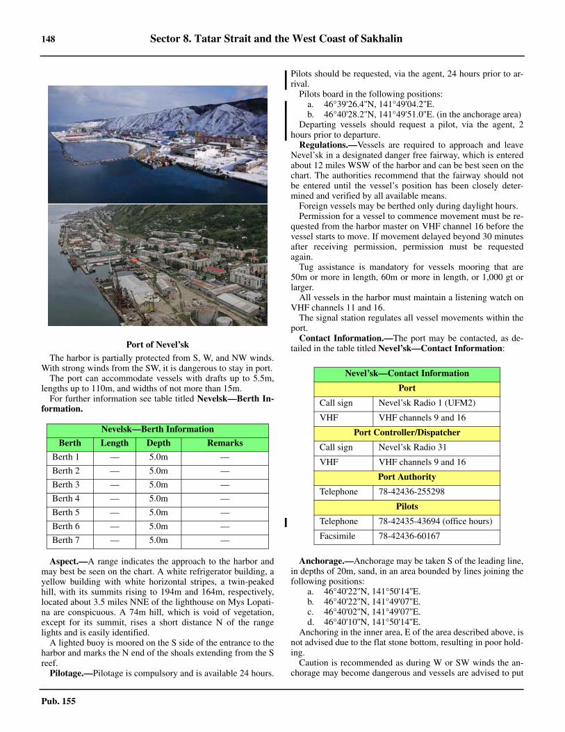
148 Sector 8. Tatar Strait and the West Coast of Sakhalin
Pub. 155
8.6 The harbor is partially protected from S, W, and NW winds.With strong winds from the SW, it is dangerous to stay in port.8.6 The port can accommodate vessels with drafts up to 5.5m,lengths up to 110m, and widths of not more than 15m. 8.6 For further information see table titled Nevelsk—Berth In-formation.
8.6 Aspect.—A range indicates the approach to the harbor andmay best be seen on the chart. A white refrigerator building, ayellow building with white horizontal stripes, a twin-peakedhill, with its summits rising to 194m and 164m, respectively,located about 3.5 miles NNE of the lighthouse on Mys Lopati-na are conspicuous. A 74m hill, which is void of vegetation,except for its summit, rises a short distance N of the rangelights and is easily identified.8.6 A lighted buoy is moored on the S side of the entrance to theharbor and marks the N end of the shoals extending from the Sreef.8.6 Pilotage.—Pilotage is compulsory and is available 24 hours.
Pilots should be requested, via the agent, 24 hours prior to ar-rival. 8.6 Pilots board in the following positions:
a. 46°39'26.4''N, 141°49'04.2''E. b. 46°40'28.2''N, 141°49'51.0''E. (in the anchorage area)
8.6 Departing vessels should request a pilot, via the agent, 2hours prior to departure. 8.6 Regulations.—Vessels are required to approach and leaveNevel’sk in a designated danger free fairway, which is enteredabout 12 miles WSW of the harbor and can be best seen on thechart. The authorities recommend that the fairway should notbe entered until the vessel’s position has been closely deter-mined and verified by all available means.8.6 Foreign vessels may be berthed only during daylight hours. 8.6 Permission for a vessel to commence movement must be re-quested from the harbor master on VHF channel 16 before thevessel starts to move. If movement delayed beyond 30 minutesafter receiving permission, permission must be requestedagain. 8.6 Tug assistance is mandatory for vessels mooring that are50m or more in length, 60m or more in length, or 1,000 gt orlarger. 8.6 All vessels in the harbor must maintain a listening watch onVHF channels 11 and 16. 8.6 The signal station regulates all vessel movements within theport. 8.6 Contact Information.—The port may be contacted, as de-tailed in the table titled Nevel’sk—Contact Information:
8.6 Anchorage.—Anchorage may be taken S of the leading line,in depths of 20m, sand, in an area bounded by lines joining thefollowing positions:
a. 46°40'22''N, 141°50'14''E.b. 46°40'22''N, 141°49'07''E.c. 46°40'02''N, 141°49'07''E.d. 46°40'10''N, 141°50'14''E.
8.6 Anchoring in the inner area, E of the area described above, isnot advised due to the flat stone bottom, resulting in poor hold-ing. 8.6 Caution is recommended as during W or SW winds the an-chorage may become dangerous and vessels are advised to put
Port of Nevel’sk
Nevelsk—Berth Information
Berth Length Depth Remarks
Berth 1 — 5.0m —
Berth 2 — 5.0m —
Berth 3 — 5.0m —
Berth 4 — 5.0m —
Berth 5 — 5.0m —
Berth 6 — 5.0m —
Berth 7 — 5.0m —
Nevel’sk—Contact Information
Port
Call sign Nevel’sk Radio 1 (UFM2)
VHF VHF channels 9 and 16
Port Controller/Dispatcher
Call sign Nevel’sk Radio 31
VHF VHF channels 9 and 16
Port Authority
Telephone 78-42436-255298
Pilots
Telephone 78-42435-43694 (office hours)
Facsimile 78-42436-60167
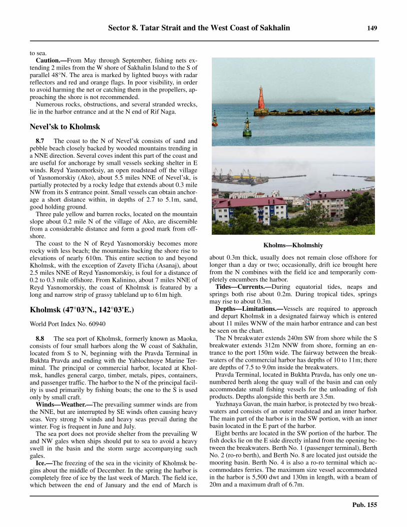
Sector 8. Tatar Strait and the West Coast of Sakhalin 149
Pub. 155
to sea. 8.6 Caution.—From May through September, fishing nets ex-tending 2 miles from the W shore of Sakhalin Island to the S ofparallel 48°N. The area is marked by lighted buoys with radarreflectors and red and orange flags. In poor visibility, in orderto avoid harming the net or catching them in the propellers, ap-proaching the shore is not recommended. 8.6 Numerous rocks, obstructions, and several stranded wrecks,lie in the harbor entrance and at the N end of Rif Naga.
Nevel’sk to Kholmsk
8.7 The coast to the N of Nevel’sk consists of sand andpebble beach closely backed by wooded mountains trending ina NNE direction. Several coves indent this part of the coast andare useful for anchorage by small vessels seeking shelter in Ewinds. Reyd Yasnomorksiy, an open roadstead off the villageof Yasnomorskiy (Ako), about 5.5 miles NNE of Nevel’sk, ispartially protected by a rocky ledge that extends about 0.3 mileNW from its S entrance point. Small vessels can obtain anchor-age a short distance within, in depths of 2.7 to 5.1m, sand,good holding ground.8.7 Three pale yellow and barren rocks, located on the mountainslope about 0.2 mile N of the village of Ako, are discerniblefrom a considerable distance and form a good mark from off-shore.8.7 The coast to the N of Reyd Yasnomorskiy becomes morerocky with less beach; the mountains backing the shore rise toelevations of nearly 610m. This entire section to and beyondKholmsk, with the exception of Zavety Il'icha (Asanaj), about2.5 miles NNE of Reyd Yasnomorskiy, is foul for a distance of0.2 to 0.3 mile offshore. From Kalinino, about 7 miles NNE ofReyd Yasnomorskiy, the coast of Kholmsk is featured by along and narrow strip of grassy tableland up to 61m high.
Kholmsk (47°03'N., 142°03'E.)
World Port Index No. 60940
8.8 The sea port of Kholmsk, formerly known as Maoka,consists of four small harbors along the W coast of Sakhalin,located from S to N, beginning with the Pravda Terminal inBukhta Pravda and ending with the Yablochnoye Marine Ter-minal. The principal or commercial harbor, located at Khol-msk, handles general cargo, timber, metals, pipes, containers,and passenger traffic. The harbor to the N of the principal facil-ity is used primarily by fishing boats; the one to the S is usedonly by small craft.8.8 Winds—Weather.—The prevailing summer winds are fromthe NNE, but are interrupted by SE winds often causing heavyseas. Very strong N winds and heavy seas prevail during thewinter. Fog is frequent in June and July.8.8 The sea port does not provide shelter from the prevailing Wand NW gales when ships should put to sea to avoid a heavyswell in the basin and the storm surge accompanying suchgales.8.8 Ice.—The freezing of the sea in the vicinity of Kholmsk be-gins about the middle of December. In the spring the harbor iscompletely free of ice by the last week of March. The field ice,which between the end of January and the end of March is
about 0.3m thick, usually does not remain close offshore forlonger than a day or two; occasionally, drift ice brought herefrom the N combines with the field ice and temporarily com-pletely encumbers the harbor.8.8 Tides—Currents.—During equatorial tides, neaps andsprings both rise about 0.2m. During tropical tides, springsmay rise to about 0.3m.8.8 Depths—Limitations.—Vessels are required to approachand depart Kholmsk in a designated fairway which is enteredabout 11 miles WNW of the main harbor entrance and can bestbe seen on the chart.8.8 The N breakwater extends 240m SW from shore while the Sbreakwater extends 312m NNW from shore, forming an en-trance to the port 150m wide. The fairway between the break-waters of the commercial harbor has depths of 10 to 11m; thereare depths of 7.5 to 9.0m inside the breakwaters. 8.8 Pravda Terminal, located in Bukhta Pravda, has only one un-numbered berth along the quay wall of the basin and can onlyaccommodate small fishing vessels for the unloading of fishproducts. Depths alongside this berth are 3.5m.
Yuzhnaya Gavan, the main harbor, is protected by two break-waters and consists of an outer roadstead and an inner harbor.The main part of the harbor is in the SW portion, with an innerbasin located in the E part of the harbor. 8.8 Eight berths are located in the SW portion of the harbor. Thefish docks lie on the E side directly inland from the opening be-tween the breakwaters. Berth No. 1 (passenger terminal), BerthNo. 2 (ro-ro berth), and Berth No. 8 are located just outside themooring basin. Berth No. 4 is also a ro-ro terminal which ac-commodates ferries. The maximum size vessel accommodatedin the harbor is 5,500 dwt and 130m in length, with a beam of20m and a maximum draft of 6.7m.
Kholms—Kholmshiy
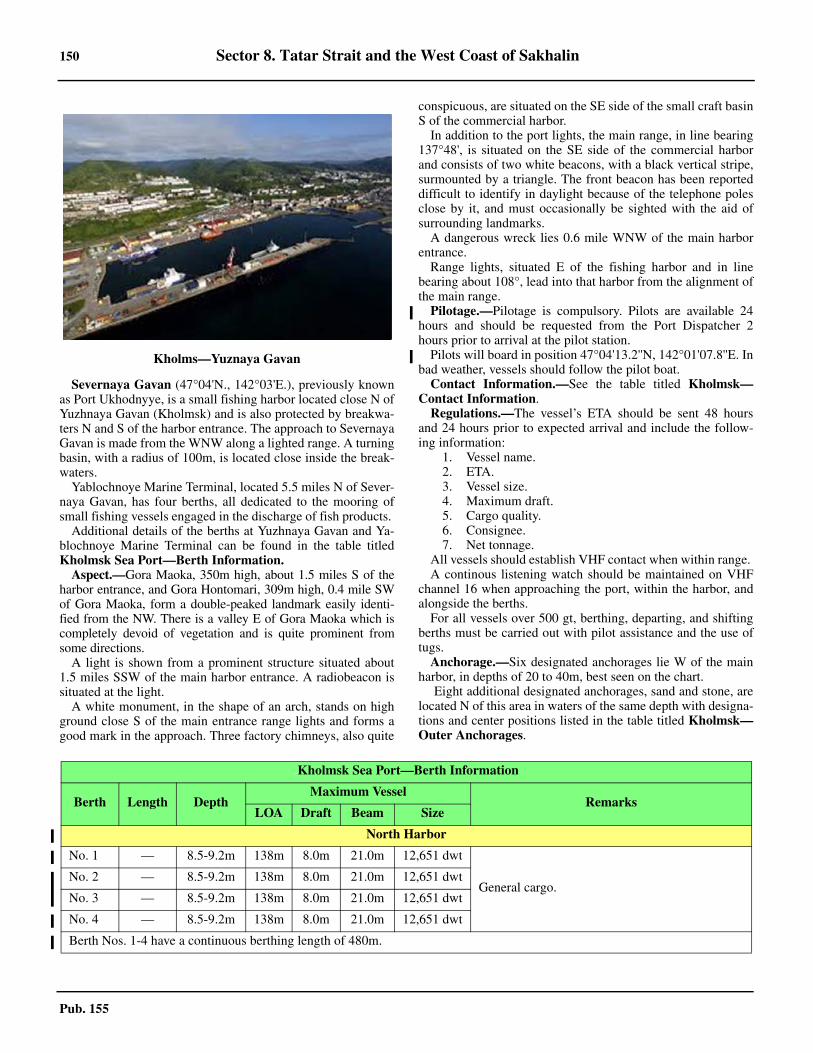
150 Sector 8. Tatar Strait and the West Coast of Sakhalin
Pub. 155
8.8 Severnaya Gavan (47°04'N., 142°03'E.), previously knownas Port Ukhodnyye, is a small fishing harbor located close N ofYuzhnaya Gavan (Kholmsk) and is also protected by breakwa-ters N and S of the harbor entrance. The approach to SevernayaGavan is made from the WNW along a lighted range. A turningbasin, with a radius of 100m, is located close inside the break-waters. 8.8 Yablochnoye Marine Terminal, located 5.5 miles N of Sever-naya Gavan, has four berths, all dedicated to the mooring ofsmall fishing vessels engaged in the discharge of fish products. 8.8 Additional details of the berths at Yuzhnaya Gavan and Ya-blochnoye Marine Terminal can be found in the table titledKholmsk Sea Port—Berth Information. 8.8 Aspect.—Gora Maoka, 350m high, about 1.5 miles S of theharbor entrance, and Gora Hontomari, 309m high, 0.4 mile SWof Gora Maoka, form a double-peaked landmark easily identi-fied from the NW. There is a valley E of Gora Maoka which iscompletely devoid of vegetation and is quite prominent fromsome directions.8.8 A light is shown from a prominent structure situated about1.5 miles SSW of the main harbor entrance. A radiobeacon issituated at the light.8.8 A white monument, in the shape of an arch, stands on highground close S of the main entrance range lights and forms agood mark in the approach. Three factory chimneys, also quite
conspicuous, are situated on the SE side of the small craft basinS of the commercial harbor.8.8 In addition to the port lights, the main range, in line bearing137°48', is situated on the SE side of the commercial harborand consists of two white beacons, with a black vertical stripe,surmounted by a triangle. The front beacon has been reporteddifficult to identify in daylight because of the telephone polesclose by it, and must occasionally be sighted with the aid ofsurrounding landmarks.8.8 A dangerous wreck lies 0.6 mile WNW of the main harborentrance.8.8 Range lights, situated E of the fishing harbor and in linebearing about 108°, lead into that harbor from the alignment ofthe main range.8.8 Pilotage.—Pilotage is compulsory. Pilots are available 24hours and should be requested from the Port Dispatcher 2hours prior to arrival at the pilot station. 8.8 Pilots will board in position 47°04'13.2''N, 142°01'07.8''E. Inbad weather, vessels should follow the pilot boat. 8.8 Contact Information.—See the table titled Kholmsk—Contact Information. 8.8 Regulations.—The vessel’s ETA should be sent 48 hoursand 24 hours prior to expected arrival and include the follow-ing information:
1. Vessel name. 2. ETA. 3. Vessel size. 4. Maximum draft.5. Cargo quality.6. Consignee.7. Net tonnage.
8.8 All vessels should establish VHF contact when within range. 8.8 A continous listening watch should be maintained on VHFchannel 16 when approaching the port, within the harbor, andalongside the berths. 8.8 For all vessels over 500 gt, berthing, departing, and shiftingberths must be carried out with pilot assistance and the use oftugs. 8.8 Anchorage.—Six designated anchorages lie W of the mainharbor, in depths of 20 to 40m, best seen on the chart. 8.8 Eight additional designated anchorages, sand and stone, arelocated N of this area in waters of the same depth with designa-tions and center positions listed in the table titled Kholmsk—Outer Anchorages.
Kholms—Yuznaya Gavan
8.8Kholmsk Sea Port—Berth Information
Berth Length DepthMaximum Vessel
RemarksLOA Draft Beam Size
North Harbor
No. 1 — 8.5-9.2m 138m 8.0m 21.0m 12,651 dwt
General cargo. No. 2 — 8.5-9.2m 138m 8.0m 21.0m 12,651 dwt
No. 3 — 8.5-9.2m 138m 8.0m 21.0m 12,651 dwt
No. 4 — 8.5-9.2m 138m 8.0m 21.0m 12,651 dwt
Berth Nos. 1-4 have a continuous berthing length of 480m.
Sector 8. Tatar Strait and the West Coast of Sakhalin 151
Pub. 155
8.8 Anchorage Area No. 1 and Anchorage Area No. 10 are in-tended for small vessels of less than 1,000 gt. Anchorage AreaNo. 6 is designated for vessels with hazardous cargo. Anchor-age Area No. 12 and Anchorage Area No. 14 are intended forvessels greater than 5,000 gt, floating drill rigs, and for vesselscarrying out ship-to-ship bunkering operations. 8.8 Anchoring, fishing, dredging, trawling, navigating with atrailing anchor, and underwater explosions are prohibited with-in a circular area, 0.6 mile in diameter, centered about 1.2miles NW of the main harbor entrance.8.8 Caution.—Vessels approaching the harbor should strictly
hold to the range line as the alignment passes close NE of ashoal ground on the SW side.
8.8 Fishing nets sometimes lie in the approaches to the port andextend up to 0.8 mile seaward; the outer ends are marked bywooden buoys with red flags, some of which are lighted.8.8 Rocky shoals exist inside the main harbor; some of theseshoals may be marked by lighted buoys.
Kholmsk To Reyd Uglegorsk
8.9 The coast to the N of Kholmsk continues with a longnarrow strip of grassy tableland to the vicinity of Mys Tokotan,about 8 miles from the port. Numerous fish nets are laid up to adistance of 1.8 miles offshore along this part of the coast; theouter ends are marked only by small wooden buoys with bits ofcloth and caution is advised.8.9 Bukhta Khorotomari is a small bay formed by a break in thecoastal reef about 3.2 miles N of Kholmsk. A river dischargesinto the bay and the railroad bridge, which crosses the mouth,is prominent.8.9 Reyd Yablochnyy (Randomari Hakychi) is an open road-stead situated abreast a slight indentation formed by a gap inthe coastal reef immediately S of Mys Tukotan. Vessels can
No. 5 — 8.5-9.1m 117m 8.0m 19.6m 9,598 dwt
General cargo. No. 6 — 8.5-9.1m 117m 8.0m 19.6m 9,598 dwt
No. 7 — 8.5-9.1m 117m 8.0m 19.6m 9,598 dwt
No. 8 — 8.5-9.1m 117m 8.0m 19.6m 9,598 dwt
Berth Nos. 5-8 have a continuous berthing length of 495m.
South Harbor
03 78m 4.4m 127m 3.9m 19.8m 3,030 dwt Ferries and ro-ro.
04 114m 6.9m 127m 6.4m 19.8m 3,030 dwt Ferries and ro-ro.
06 150m 5.7m 134m 5.4m 19.6m 9,200 dwt General cargo. Continuous berthing length of 308m.07 158m 5.9m 134m 6.1m 6.1m 9,200 dwt
8.8Kholmsk Sea Port—Berth Information
Berth Length DepthMaximum Vessel
RemarksLOA Draft Beam Size
Kholmsk—Contact Information
Port Authority
Telephone 78-42433-41033
Facsimile 78-42433-50332
Port Control
Call sign Kholmsk Port Control
VHF VHF channels 3, 14, and 16
Port Director/Dispatcher
Call sign Kholmsk Radio 2
VHF VHF channel 9
E-mail [email protected]
Harbormaster
Telephone 78-42433-41033
Pilots
Telephone 78-42435-43694
Facsimile
78-42433-62976
78-42433-66507
78-42435-43396
E-mail [email protected]
8.8Kholmsk—Outer Anchorages
Area Center Position
7 47°04'24''N, 142°01'56''E
8 47°04'41''N, 142°02'00''E
9 47°04'34''N, 142°01'36''E
10 47°05'00''N, 142°02'21''E
11 47°04'58''N, 142°01'48''E
12 47°04'50''N, 142°01'28''E
13 47°05'12''N, 142°01'48''E
14 47°05'13''N, 142°01'24''E
152 Sector 8. Tatar Strait and the West Coast of Sakhalin
Pub. 155
take anchorage in the roadstead, in a depth of 15m, fine sand,about 0.5 mile offshore. There is a small craft basin on the Sshore of the roadstead.8.9 To the N of Mys Tukotan the coast, which gradually changesto sandy beaches, trends in a NNW direction and is backed bycoastal dunes and grassy moors fronting dense forest farther in-land. The mountain ranges here recede farther from the coast,leaving low hills between.8.9 Caution.—A spoil area, the limits of which are shown onthe chart, lies about 14 miles W of Reyd Yablochnyy.
8.10 Mys Slepikovskogo (47°18'N., 141°57'E.), a sandyprojection of the coast lying about 9 miles NNW of Mys Tuko-tan, is low, but still prominent because of its light-coloreddunes. The light on the point can usually be easily identifiedand a triangular beacon about 25m high, situated at the mouthof Reka Kostroma, about 1 mile to the NNE, is also conspicu-ous.8.10 The coast to the N of Mys Slepikovskogo trends more to theNNE, but remains low and sandy until, at Nitasu (Jintasu),about 4 miles from the cape, the aspect suddenly becomes en-tirely different. Here the mountain ranges slope right to theshore forming, for a distance of about 1.5 miles, a line of con-spicuous red cliffs which are easily identified from the offing.From Nitasu, the shore is foul with drying reefs and rocks ex-tending out for several hundred meters and approach requireslocal knowledge.8.10 Reyd Chekhov (Noda Hakuchi) (47°26'N., 141°59'E.), situ-ated off the head of a small shallow open bay, the roadstead ofChekhov is only available to small vessels with local knowl-edge. 8.10 Gora Hachiko, the summit of Mys Notasamu, a promontoryabout 1 mile NNW of Chekhov, is a black perpendicular cliff,122m high, which is very conspicuous. From the S at a dis-tance it shows a double-domed summit and appears first as anisland. A light is shown from the S side of the entrance to RekaChekhov.8.10 Anchorage.—Anchorage can be taken about 0.5 mile W ofthe town of Chekhov and just outside the entrance to the baydescribed above, in about 12m, fine sand. The holding groundis not safe in W winds. Foul ground extends up to 0.2 mile offeach entrance point of the bay. A small boat harbor is situatedjust within the entrance on the S side.
8.11 Mys Yablonovyy (Mys Yablokobyts) (Usu Misaki)(47°37'N., 141°58'E.), a black rounded cliff 41m high, risesabout 1.5 miles inland to Gora Yablonovyy, a sharp tree-cov-ered peak with an elevation of 442m. The cape is fairly promi-nent except from the W, but it can be identified from thisdirection by a waterfall on it. There is a large conspicuoushouse situated about 2 miles S of Mys Yablonovyy; a promi-nent chimney stands about 1 mile NE of the cape.8.11 Between Reyd Chekhov and Mys Yablonovyy, about 11miles S, the coastal hills trend close inland. The shore isfringed by reefs and foul ground, but there are sandy beachessituated in a few places where landing could be effected.Depths off this part of the coast generally decrease to the N andthere are several off-lying banks.8.11 Gora Shpanberg (Tomon), a conspicuous wooded mountainrising about 10 miles ESE of Mys Yablonovyy, has two peaks;
the S and highest is slightly conical and attains a height of1,029m. From the SW, Gora Shpanberg appears ridged andprecipitous, but from the NW it is rounded and sloping, gener-ally towering above everything in its vicinity.8.11 Gora Otasamu, a sharp and conspicuous peak rising to 924mabout 17 miles E of Mys Yablonovyy, is a good mark from theNW and SW. Thickly covered with trees, the summit usuallyappears darker than the surrounding mountains, but will be ob-scured when in line with Gora Shpanberg.8.11 Caution.—The depths NW of Mys Yablonovyy becomevery irregular, with off-lying banks of 14 to 18m lying up to 5miles offshore. Vessels navigating in this area in thick weathershould exercise caution.
8.12 Reyd Tomari (Tomarioru Hakuchi) (47°46'N.,142°03'E.), an open roadstead, is abreast a small bay at thehead of which is the town of the same name. There is no pro-tection from any but offshore winds, and the anchorage is un-safe with any other. The position of the roadstead may beidentified by Gora Matsudake, 440m high, lying about 2.5miles SE of the town and when to the S, by Mys Reichiruska,the S entrance point of the bay.8.12 Ice.—Ice up to 0.9m thick may block the approaches be-tween February and April.8.12 Anchorage.—Anchorage can be taken by vessels about 1mile WNW of Tomari, in depths of 14.5 to 18m, sand. Smallvessels can take anchorage about 0.5 mile offshore, abreast thetown, in a depth of 9m, fine sand.8.12 There is a basin with a depth of about 1.8m situated withinthe entrance to Reka Tomari, on the N side of the town. 8.12 The coast between Tomari and Mys Staromayachnyy (ChiraiMisaki), a precipitous 104m high point about 4.5 miles NNE,is mostly sandy and fringed by reef. From the latter point toIl’inskiy, about 9 miles NE, the coast consists of steep redcliffs, about 15m high, which form the seaward end of a lowdensely wooded plateau.8.12 Reka Il’inskiy flows into a bight on the coast known as ZalivDelanglya (Bukhta Il’inskiy), a bay easily identified from theSW by the position of Gora Sasa (Sasa Yama), a 284m highrounded three-peaked hill located about 3 miles inland.8.12 Reyd Il’inskiy (47°59'N., 142°12'E.), an open roadstead, issituated off the mouth of Reka Il'inskiy in the E part of ZalivDelanglya. There is a small boat harbor at Il'inskiy.8.12 Anchorage.—Anchorage may be taken in good weatherabout 0.8 mile W of the town, in 11 to 12m, sand, good holdingground. The anchorage is untenable in bad weather or strongW winds.
8.13 The coast above Il’inskiy is sandy except at Mys Le-ont’yeva, a precipitous cape about 9 miles to the N, which isfairly easy to identify. Inland there is a grassy tableland whichgradually rises to thickly wooded hills, most of which are goodlandmarks for vessels fairly close in. About 1.5 miles N of MysLeont’yeva the shore becomes very foul, continuing so forabout 2.5 miles farther N. Kamen Ebisu, a small rock about1.5m high, lies in the middle of the foul area and about 0.2 mileoffshore.
Mys Shternberga (48°15'N., 142°09'E.), a slightly project-ing point, 44m high, lies about 7 miles N of Mys Leont’yeva.When viewed from the N or S it can be fairly easily identified,
Sector 8. Tatar Strait and the West Coast of Sakhalin 153
Pub. 155
but from the W it is difficult to distinguish.8.13 Caution.—A rocky 8.8m shoal lies about 2.5 miles offshoreW of Mys Shternberga. Depths of less than 18.3m extend fromthis danger SE to the shore.
8.14 Gora Rukushi, rising about 10 miles ENE of MysShternberga, has several peaks, the highest being 281m with acone-shaped appearance from the W. Gora Krasnogorsk (Chin-nai), rising about 17 miles NE of Mys Shternberga, attains aheight of 761m with a rounded summit.8.14 The coast for about 4 miles N of Mys Shternberga is hilly,with occasional reddish-brown cliffs. Farther to the N the shoreagain becomes sandy and extends away from the mountainsleaving a lowland area in which Ozero Aynskoye has beenformed. This brackish lake is separated from the sea by a longrange of sandy hillocks and has its only opening through a nar-row channel commencing at Krasnogorsk (Chinnai), about 3miles SSE of its S extremity. The shore N of Ozero Aynskoyecontinues low and sandy with some small lakes within, butabout 12 miles NNW of the S entrance of the lake the land be-gins to rise again.8.14 Gora Ebisu, rising to a height of 619m 12 miles ENE of theN extremity of Ozero Aynskoye, is a round-topped mountainwhich is rendered conspicuous by a bare patch on its W sidevisible from well offshore in clear weather.
8.15 Krasnogorsk (48°25'N., 142°05'E.), a subsidiary portof Shakhtersk (see paragraph 8.19), is a small lighterage portservicing ocean-going vessels at the roads for handling timberproducts, scrap metal, and solid bulk cargo. Although the portroadstead remains open all year, the rivers freeze over in the win-ter, which makes cargo operation impossible from mid-Octoberthrough May. 8.15 Depths—Limitations.—The roadstead accepts vessels withdrafts as deep as 15m and an loa of up to 200m, while the innerharbor can only accommodate vessels with a draft no morethan 2.6m. There are two berths for handling general cargo andtimber products. Berth No. 1 has a length of 279m and a alongsidedepth of 2.5m. Berth No. 2 has a length of 205m and an alongsidedepth of 2.5m. 8.15 Pilotage.—There is no pilotage service in the port; howeverif pilotage becomes necessary, the port captain will act as thepilot. 8.15 Regulations.—Vessels must report their ETA to the StateDirector Inspectorate not less than 2 hours prior to arrival andalso confirm maximum draft. 8.15 Any vessels inbound to the inner harbor must give the right-of-way to vessels exiting those same waters. 8.15 Towing is allowed but only for tow lengths not to exceed30m. 8.15 All vessel movement in each of the harbors is controlled bythe harbor masters for each harbor. 8.15 Signals.—Navigational and hydrometeorological informa-tion is transmitted to vessels in the harbor area on VHF channel14 at 0830 and 1830 (0530 and 1730) in the winter. Vessels at aberth or at anchorage are immediately notified of any stormwarnings on VHF channel 16. Vessels are expected to ac-knowledge receipt of any such storm warnings. 8.15 Contact Information.—See table titled Krasnogorsk—
Contact Information.
8.15 Anchorage.—Four designated anchorages centered are situ-ated at the following positions:
1. Anchorage No. 1—48°24'48''N, 142°03'48''E.2. Anchorage No. 2—48°24'24''N, 142°03'42''E.3. Anchorage No. 3—48°24'06''N, 142°03'54''E.4. Anchorage No. 4—48°24'06''N, 142°04'18''E.
8.16 Mys Staritskogo (48°40'N., 141°53'E.), a steep cliff,44m high, lies at the end of a ridge of mountains which reachesthe coast about 18 miles NNW of Krasnogorsk. From the S ithas the appearance of being a precipitous promontory andmarks the N end of the extensive sandy beach extending fromthe vicinity of Mys Shternberga, about 27 miles SSE. To theNE of the point is a great mass of mountains which are general-ly similar in appearance, the lower parts being densely coveredwith trees and the summits sparse. Great boulders lie piled upall over these mountains and their towering side by side presenta spectacular view.8.16 The coast to the N of Mys Staritskogo is rocky with severaldrying patches close offshore. Mys Stukambis, about 4 milesfrom Mys Staritskogo, is a steep cliff about 97m high, whichbeing the highest point on this section of the coast is quite con-spicuous. There is a small waterfall on the S side of this point,which can be easily seen from that direction.
8.17 Mys Lamanon (48°47'N., 141°51'E.), about 2.3 milesN of Mys Stukambis, is a low but steep rocky cliff, 42m high,with a cave at its base. It is the W extremity of the mountainouspromontory to the E and it can be identified easily from the SWand NW. A light is shown on Mys Lamanon and a radiobeacontransmits from the lighthouse.8.17 Gora Krasnova, rising about 13 miles ESE of Mys Lamanon,attains a height of 1,094m and is the highest mountain in thevicinity. Its summit lies in an E-W direction and slopes gentlyto the W. The summit is shaped like a horse’s back and can beseen from the S at a distance of 35 miles.8.17 Gora Orlova (Ushiro), about 5.5 miles WNW of Gora Kras-nova, rises to a height of 868m and has a conical summit whichis very prominent. Gora Ichara, about 8 miles W of Gora Kras-nova and nearly as high, rises to 1,023m with a shoulder to theNE. The summit is somewhat rounded from the NW but it ap-pears sharp when seen from the SW.
Krasnogorsk—Contact Information
Port
Call sign
Krasnogorsk Radio 1 (State Director Inspectorate)
Krasnogorsk Radio 2 (Port Marine Superintendent)
VHF VHF channels 14 and 16
RT frequency 2182 kHz and 2720 kHz
Telephone 78-42496-21835
Facsimile 78-42496-21835
154 Sector 8. Tatar Strait and the West Coast of Sakhalin
Pub. 155
8.17 The coast from Mys Lamanon trends to the NE and becomesrocky and foul. Rif Inava, about 4 miles NNE of the point, is adangerous rocky reef extending about 1.3 miles W from MysOrlova. There is a depth of 8.2m off the W edge of the reef, butthe N and S sides are steep-to with depths of 4.1m and less.8.17 Gora Izel’met’yeva, 685m high, lies 6.2 miles ENE of MysOrlova. Its W slope is gentle, but from the SW it appears point-ed and is very prominent.8.17 Bukhta Izyl’met’yeva, located between Mys Orlova and MysIzyl’met’yeva, about 5 miles NNE, is sheltered from all windsexcept those from N through W and is considered one of thebest anchorages on the SW coast of Sakhalin. Vessels approachthe anchorage with Gora Izel’met’yeva ahead bearing 087° andanchor when Mys Izyl’met’yeva bears 019°, in a depth ofabout 16m, good holding ground.8.17 Mys Izyl’met’yeva (48°55'N., 141°58'E.), a precipitouscape 38m high, rises gradually to a low flat hill thickly coveredwith trees. When seen from the SW it is quite prominent butfrom the W it blends into the coast. A rocky spit extends about0.8 mile NW from the cape.8.17 Zaliv Shebunyy, the indentation to the N and within MysIzyl’met’yeva, provides anchorage for small vessels with localknowledge. The bottom is in places rock and the holdingground is not good, making the anchorage dangerous in any Wwinds. To the N of the bay the coast is foul and rocky, except atSobolevo (Tennai), where there is an opening in the coastalreef accessible to boats.
Reyd Uglegorsk (49°05'N., 142°02'E.)
World Port Index No. 60980
8.18 Uglegorsk Terminal, previously known as Esutoru, is asubsidiary port of Shakhtersk (paragraph 8.19). The terminal isan open roadstead situated on the S side of the mouth of RekaUglegorka. The port is a lighterage port, open all year, handlingimports of mineral oil and rice, as well as exports of fish, timber,wood pulp, and coal. 8.18 Winds—Weather.—From November through March thestrong N winds prevail for 20 to 28 days in each month, render-ing loading operations impossible.8.18 From April until September, the S wind prevails for about 10days in each month, but the sea is generally calm.8.18 During the winter there are about 10 days a month of rain orsnow.8.18 During the winter SE and NE winds are accompanied by fogordinarily extending for about 5 miles offshore. It has been re-ported that the height of the fog is 15 to 30m and does not in-terfere with the identification of the mountain landmarks.Vessels are advised not to approach Reyd Uglegorsk in thickweather, but to anchor temporarily in the offing until the foghas lifted.8.18 Ice.—Usually Reyd Uglegorsk, except for an area close tothe mouth of the Uglegorka, is icebound to a distance of about1 mile offshore between the middle of December and the endof March, but as the ice does not exceed 0.3m in thickness,navigation is not closed; however, vessels entering the portduring this time are required to have icebreaker assistance.Winds from the SW cause the ice to disperse.8.18 Tides—Currents.—Spring tides rise about 0.8m and neap
tides rise about 0.6m. The flood current sets N at a rate of 0.5to 0.8 knot and the ebb current sets S at a similar rate.8.18 Depths—Limitations.—The port consists of an outer road-stead and a N and S inner harbor. 8.18 The outer roadstead has seven designated anchorages, indepths of 12 to 18m, for loading and unloading by lighters. Theinner harbors are enclosed; the N harbor lies 1 mile S of the en-trance to the Reyd Uglegorsk and the S harbor is situated 2.2miles S of the river mouth. 8.18 Lighters work larger vessels offshore in the outer roadstead.The maximum vessel size handled in the inner harbors is 60min length, 12m in width, and a draft of 3m. Vessels larger thanthis are handled in the outer roads. 8.18 For further information see the table titled Uglegorsk—Berth Information.
8.18 Aspect.—In addition to the conspicuous peaks E of Mys La-manon, which are still visible off Uglegorsk on a clear day, theN end of the range of hills about 0.9 mile S of the mouth of Re-ka Uglegorka appears as the extremity of a conspicuous capewhen seen from the offing. From closer in, a steel bridge cross-ing the canal about 0.6 mile SE of the mouth of Reka Uglegor-ka can easily be identified; a school building E of the lightedbasin is also conspicuous.8.18 A short jetty extends WSW from the N side of the river en-trance. A broken jetty extends about 0.4 mile W and then about230m SW from the S side of the river entrance.8.18 A range, in line bearing about 159°, indicates the approachto the roadstead and may best be seen on the chart.8.18 A light is shown from a structure standing about 0.5 mileNNE of the commercial basin; a radiobeacon is situated at thelight.8.18 Three radio towers, equipped with obstruction lights, are sit-uated about 0.5 mile S of the town and in clear weather form agood mark in the approach.8.18 Pilotage.—Pilots are not available.
Uglegorsk—Berth Information
Berth Length Depth Remarks
Severnyy Kovsh (North Basin)
No. 1 160m 1.9m Coal.
No. 2 160m 1.9m Coal.
No. 3 160m 1.9m Coal.
No. 4 50m 1.9m General cargo.
No. 5 50m 1.9m General cargo.
No. 6 80m 1.9m General cargo.
No. 7 62m 1.9m General cargo.
Yuzhnyy Kovsh (South Basin)
No. 1 210m 2.4m General cargo.
No. 2 210m 2.4m General cargo.
No. 3 210m 2.4m General cargo.
No. 4 210m 2.4m General cargo.
No. 5 66m 2.4m General cargo.
No. 6 — 2.4m General cargo.
Sector 8. Tatar Strait and the West Coast of Sakhalin 155
Pub. 155
8.18 Regulations.—Vessels should send an ETA to the port 24hours before arrival to the port. Vessels should request permis-sion to enter the port, including the outer roadstead, from theMarine Superintendent. Weather information is broadcast dailyat 1900 on VHF channel 9. 8.18 Vessels are required to approach and leave Uglegorsk Termi-nal in a designated danger free fairway which can best be seenon the chart. The fairway is entered about 12 miles WNW ofthe roadstead. The authorities recommend that the fairwayshould not be entered until the vessel's position has been close-ly determined and verified by all available means.8.18 Any vessels inbound to the inner harbor must give the right-of-way to vessels exiting those same waters. 8.18 Towing is allowed but only for tow lengths not to exceed30m. 8.18 All vessel movement in each of the harbors is controlled bythe harbor masters for each harbor. 8.18 Signals.—Navigational and hydrometeorological informa-tion is transmitted to vessels in the harbor area on VHF channel16 upon vessel request and on deterioration in the weather con-ditions. Vessels at a berth or at anchorage are immediately noti-fied of any storm warnings on VHF channel 16. Vessels areexpected to acknowledge receipt of any such storm warnings. 8.18 Weather information is transmitted on VHF channel 9 dailyat 1900. 8.18 Contact Information.—See the table titled Uglegorsk—Contact Information.
8.18 Anchorage.—Seven designated anchorages centered are lo-cated at the following positions:
1. Anchorage No. 1—49°05'38''N, 142°00'36''E.2. Anchorage No. 2—49°05'18''N, 142°00'50''E.3. Anchorage No. 3—49°05'12''N, 142°00'17''E.4. Anchorage No. 4—49°04'55''N, 142°00'00''E.5. Anchorage No. 5—49°04'48''N, 142°00'30''E.6. Anchorage No. 7—49°05'39''N, 142°00'07''E.7. Anchorage No. 8—49°05'19''N, 141°59'31''E.
8.18 Caution.—A submarine cable extends seaward from a pointon the coast about 0.7 miles S of the commercial basin.8.18 A restricted area, the limits of which are shown on the chart,lies in the vicinity of the submarine cable and extends up toabout 5 miles offshore. Anchoring, trawling, dredging, con-ducting submarine explosions, or sailing with a slack anchor orchain are prohibited within the area.8.18 A ruined mole is in vicinity of the S harbor (49°03'24''N,142°01'35''E.), with four stranded wrecks close by, depths un-known; several submerged obstructions and a rock, all atdepths of less than 4m, also are located close by. 8.18 Another stranded wreck, depth unknown, is located farther Nalong the coast close off Mys Chekhova at 49°04'40''N,142°01'52''E.
Shakhtersk
8.19 Shakhtersk (Portovyy Punkt Shakhtersk) (49°10'N.,142°04'E.) is situated at the head of Zaliv Gavrilova, betweenMys Gavrilova and Mys Nizmennyy, about 6 miles N of Ugle-gorsk.
The waters of the sea port comprise a roadstead, an innerharbor, and three maritime terminals, as follow:
1. Boshnyakovo (paragraph 8.22), situated S of themouth of Reka Avgustovka.
2. Uglegorsk (paragraph 8.18), situated S of Reka Ugle-gorka.
3. Krasnogorsk (paragraph 8.15), situated in the area ofthe mouths of Reka Krasnogorka and Reka Aynskaya.Shakhtersk itself is an outer roads lighterage area and an in-
ner roads harbor for small craft. 8.19 Ice.—The port is reported to be open all year but is usuallysurrounded by ice from January through the middle of March.During this time the use of icebreakers is required for entry andexit. 8.19 Depths—Limitations.—There is a least depth of 10m in theapproach to the anchorage, but numerous shoal patches lie inZaliv Gavrilova and must be avoided. Depths of less than 5.5mextend up to 1.5 miles N of Mys Gavrilova and constitute thegreatest danger in the approach to the port. A 7.6m shoal andan 8.8m shoal lie in the middle of Zaliv Gavrilova, about 0.7mile and 1.2 miles NNW, respectively, of the entrance to thebasin.8.19 The principal cargo handled at the port is coal. For cargo-handling operations in the lighterage area in the outer roads,the vessels own cargo-handling gear is used. The inner roadscontain two berths. Coal Berth has a length of 150m. InnerBerth has a length of 175m. 8.19 Aspect.—Mys Gavrilova, a low bluff about 39m high, is lo-cated about 1.2 miles SW of Shakhtersk and is conspicuouswhen seen from the N or S. Mys Gavrilova Light is shown
Uglegorsk—Contact Information
Port Control
Telephone78-42432-21701
78-42432-21762
Facsimile78-42432-21701
78-42432-21762
Port Radio
Call sign Uglegorsk Radio
VHF VHF channel 16
Marine Superintendent
Call sign Uglegorsk Radio 1 (RT)
Uglegorsk Radio 3 (VHF)
VHF VHF channels 9 and 16
RT frequency 2729 kHz
State Director/Inspector
Call sign Uglegorsk Radio 2 (RT)
Uglegorsk Radio 5 (VHF)
VHF VHF channel 14
RT frequency 2720 kHz
Port Fleet
Call sign Uglegorsk Radio 7
VHF VHF channel 6
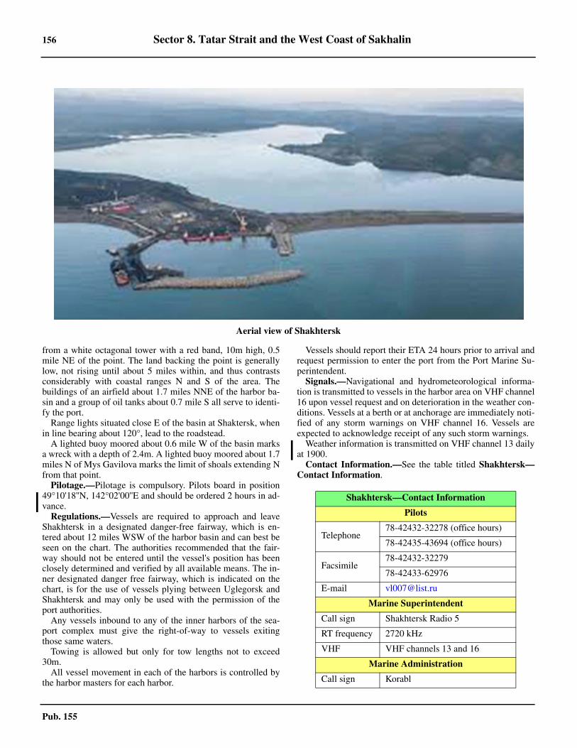
156 Sector 8. Tatar Strait and the West Coast of Sakhalin
Pub. 155
from a white octagonal tower with a red band, 10m high, 0.5mile NE of the point. The land backing the point is generallylow, not rising until about 5 miles within, and thus contrastsconsiderably with coastal ranges N and S of the area. Thebuildings of an airfield about 1.7 miles NNE of the harbor ba-sin and a group of oil tanks about 0.7 mile S all serve to identi-fy the port.8.19 Range lights situated close E of the basin at Shaktersk, whenin line bearing about 120°, lead to the roadstead.8.19 A lighted buoy moored about 0.6 mile W of the basin marksa wreck with a depth of 2.4m. A lighted buoy moored about 1.7miles N of Mys Gavilova marks the limit of shoals extending Nfrom that point.8.19 Pilotage.—Pilotage is compulsory. Pilots board in position49°10'18''N, 142°02'00''E and should be ordered 2 hours in ad-vance. 8.19 Regulations.—Vessels are required to approach and leaveShakhtersk in a designated danger-free fairway, which is en-tered about 12 miles WSW of the harbor basin and can best beseen on the chart. The authorities recommended that the fair-way should not be entered until the vessel's position has beenclosely determined and verified by all available means. The in-ner designated danger free fairway, which is indicated on thechart, is for the use of vessels plying between Uglegorsk andShakhtersk and may only be used with the permission of theport authorities.8.19 Any vessels inbound to any of the inner harbors of the sea-port complex must give the right-of-way to vessels exitingthose same waters. 8.19 Towing is allowed but only for tow lengths not to exceed30m. 8.19 All vessel movement in each of the harbors is controlled bythe harbor masters for each harbor.
8.19 Vessels should report their ETA 24 hours prior to arrival andrequest permission to enter the port from the Port Marine Su-perintendent. 8.19 Signals.—Navigational and hydrometeorological informa-tion is transmitted to vessels in the harbor area on VHF channel16 upon vessel request and on deterioration in the weather con-ditions. Vessels at a berth or at anchorage are immediately noti-fied of any storm warnings on VHF channel 16. Vessels areexpected to acknowledge receipt of any such storm warnings. 8.19 Weather information is transmitted on VHF channel 13 dailyat 1900. 8.19 Contact Information.—See the table titled Shakhtersk—Contact Information.
Aerial view of Shakhtersk
Shakhtersk—Contact Information
Pilots
Telephone78-42432-32278 (office hours)
78-42435-43694 (office hours)
Facsimile78-42432-32279
78-42433-62976
E-mail [email protected]
Marine Superintendent
Call sign Shakhtersk Radio 5
RT frequency 2720 kHz
VHF VHF channels 13 and 16
Marine Administration
Call sign Korabl
Sector 8. Tatar Strait and the West Coast of Sakhalin 157
Pub. 155
8.19 Anchorage.—Four designated anchorages are located at thefollowing positions:
1. Anchorage No. 1—49°11'00''N, 142°01'18''E.2. Anchorage No. 2—49°10'37''N, 142°02'30''E.3. Anchorage No. 3—49°10'20''N, 142°02'30''E.4. Anchorage No. 4—49°10'00''N, 142°02'00''E.
8.19 Caution.—A stranded wreck lies about 1.5 miles WSW ofthe breakwater. The roadstead is exposed to W winds.
Shakhtersk to Reyd Aleksandrovskiy
8.20 Mys Nizmenyy (49°11'N., 142°04'E.), a low and gen-erally flat cape, lies about 1.7 miles N of Shakhtersk. It is the Sentrance point of Zaliv Lesovskogo, an indentation in the coastwhich provides anchorage for small vessels in good weather.The bottom is in many places rock and caution is necessary.Alight is shown from a white octagonal masonry tower on thepoint.8.20 Mys Tikhonovicha, the N entrance point of Bukhta Lesovsk-ogo, 3.5 miles N of Mys Nizmenyy, is dark in color and fallsvertically to the sea, but is thickly wooded. Gora Sergiyevska-ya, rising to a height of 461m about 1.5 miles NE of the abovepoint, appears sharp-peaked from the N. There is a pointed hill,375m high, a little over 0.5 mile NW of Gora Sergiyevskaya.8.20 Mys Baranova (Toriga Saki) (49°21'N., 142°04'E.), 8.7miles N of Mys Nizmenyy, is a steep, black, treeless point,57m high, and is very prominent from the S.8.20 Mys Zhukovskogo (Nayoshi Saki) (49°26'N., 142°06'E.),4.5 miles N of Mys Baranova, is a steep bluff, 94m high, and isthe S entrance point of Reyd Lesogorsk.
8.21 Reyd Zhukovskogo (Nayoshi Byochi) (49°27'N.,142°08'E.) (World Port Index No. 60990), formerly known asNayoshi, is a bight in the coast between Mys Zhukovskogo andMys Furutsu, about 3.5 miles NNE. The roadstead is exposedto all winds from the W and during such times landing and car-go handling are difficult or impossible. The port is closed fromNovember to March.8.21 Reka Lesogorsk, the mouth of which is conspicuous, is lo-cated at the head of the roadstead, but is generally too shallowfor boats. Gora Zhukovskogo (Nayoshi Taki), with a flat top,rises to a height of 549m about 2.5 miles SE of the river mouthand is quite prominent. Gora Matsue (Matsue Yama), rising to553m about 2 miles ESE of Mys Furutsu, is the highest peak inthe group of mountains immediately NE of Reyd Zhukovskogoand forms a good mark in the approach.8.21 Gora Akahage, lying 1.5 miles SSW of Gora Matsue, is abare reddish-brown hill, 207m high, appearing isolated, with aprominent red cliff on its S side.8.21 Anchorage.—The best anchorage is 0.8 mile offshore, withthe mouth of Reka Lesogorsk in line with Gora Akahage, bear-ing about 113°, in a depth of 13m, mud, with good holdingground. At other places the bottom is sand over rock, poorholding ground. Vessels proceeding to the anchorage mustavoid the shoal N of the anchorage, where depths of 4.6m,rock, extend up to 0.8 mile offshore.
8.21 The coast extending N from Mys Furutsu consists mostly ofnarrow sandy beach occasionally marked by broken cliffsformed by the mountains sloping down to the coast. A densely-wooded mountain range, about 5 to 8 miles inland, trends Nfrom abreast Mys Furutsu gradually approaching the sea untilat Mys Balkina, about 28 miles to the N, it is only 1 mile fromthe coast.
8.22 Boshnyakova (49°39'N., 142°09'E.), located approxi-mately 2.6 miles S of Mys Baklanova, is a subsidiary port ofShakhtersk (paragraph 8.19). Boshnyakova is a small commer-cial port from which coal and timber is exported and general cargois handled. It is also been designated a marine terminal. 8.22 Depths—Limitations.—The roadstead accepts vessels withdrafts only up to 2m. Controlling depths in the harbor entrancevary between 1.3m and 2.4m. The port consists of an outerroadstead in which vessels discharge and transship cargo vialighters to the shore through an inner harbor protected bymoles. 8.22 For further information see the table titled Boshnyakova—Berth Information.
8.22 Aspect.—Boshnyakovo Light (49°38'19''N, 142°09'12''E.),is mounted on an 8-sided concrete tower with red bands, 17min height. 8.22 An administration building, three stories high and light grayin color, stands in the port. A black chimney, 40m high, formspart of the building. 8.22 Pilotage.—Pilotage is compulsory. 8.22 Regulations.—Any vessels inbound to the inner harbor mustgive the right-of-way to vessels exiting those same waters. 8.22 Towing is allowed but only for tow lengths not to exceed30m. 8.22 All vessel movement in each of the harbors is controlled bythe harbor masters for each harbor. 8.22 Signals.—Navigational and hydrometeorological informa-tion is transmitted to vessels in the harbor area on VHF channel16 upon vessel request and on deterioration in the weather con-ditions. Vessels at a berth or at anchorage are immediately noti-fied of any storm warnings on VHF channel 16. Vessels areexpected to acknowledge receipt of any such storm warnings. 8.22 Contact Information.—The port can be contacted via VHFchannel 16 then switching to VHF channel 9 for working withcall sign of Boshnyakovo Radio1. 8.22 Anchorage.—Six designated anchorages are located be-tween 0.7 and 1.6 miles W and NW of Boshnyakovo Light, asfollows:
1. Anchorage No. 1—49°38'56''N, 142°08'10''E.2. Anchorage No. 2—49°38'18''N, 142°08'10''E.3. Anchorage No. 3—49°38'45''N, 142°07'30''E.4. Anchorage No. 4—49°38'15''N, 142°07'30''E.
VHF VHF channel 9
Shakhtersk—Contact Information
Boshnyakova—Berth Information
Berth Length Depth Remarks
Boshnyakovo Terminal
Middle Berth 90m — Coal.
North Berth 100m — Coal.
South Berth 170m — Coal.
158 Sector 8. Tatar Strait and the West Coast of Sakhalin
Pub. 155
5. Anchorage No. 5—49°38'50''N, 142°07'00''E.6. Anchorage No. 6—49°38'10''N, 142°07'00''E.
8.22 Mys Polevogo (Kitasoya Misaki) (49°46'N., 142°10'E.), asteep black point located about 18 miles N of Mys Furutsu, isabout 67m high and, with a chain of rocks extending N fromthe cape, forms a natural breakwater which produces a refugefor boats in strong S winds. 8.22 Gora Rusa (Gora Soya) (Soya Take), about 4.5 miles ESE ofMys Polevogo, is a sharp prominent peak 1,011m high and isthe highest mountain in the above range.
8.23 Mys Belkina (Tisine Misaki) (49°57'N., 142°08'E.), asteep black rocky point, 48m high, and lying about 11 miles Nof Mys Polevogo, is topped by a flat treeless plateau and isconspicuous from a distance. The point is the center of a moun-tainous mass which is the N extremity of the inland range thathas reached the sea in this vicinity. 8.23 Mys Vozdvisheniya (Chikunai Misaki), the S end of the abovepromontory, lies about 4.5 miles S of Mys Balkina and is a steepbrown rocky cliff, with a conspicuous isolated black rock locatedclose W of it. This rock is very conspicuous when viewed fromthe N or S. Mys Korsakova, the N end of this area, lies about 4.5miles N of Mys Belkina and is the rocky extremity of a small flatand treeless peninsula which is connected to the mainland by alow isthmus.8.23 Gora Orkunay (Yokunai Yama), a conspicuous peak, 996mhigh, rises about 4 miles E of Mys Vozdvisheniya and is espe-cially prominent from the W. An isolated sharp peak, about834m high, is located about 2.5 miles to the S.8.23 Gora Vozdvisheniya, a double-peaked mountain, rises to aheight of 862m about 3.5 miles ESE of Mys Balkina. There is alower, but similar double-peak about 1 mile to the SW, and sev-eral smaller peaks to the NW.8.23 The coast to the N of Mys Korsakova is lower than to the S,but with a succession of rounded hills behind a steep and bluffshore. Skaly Volnolom, two small islets located about 0.8 mileN of Mys Korsakov, are white in color, which usually enablesthem to be seen at night. No attempt should be made to passbetween these islets and the mainland as the area is shoal androcky.
8.24 Mys Kitousi (50°13'N., 142°10'E.), a small pointwith a few rocks off it, has some cliffs on its N side. Within thepoint, about 1.7 miles to the SE, the land rises to a remarkable,barren and steep conical peak about 828m high. Known as Go-ra Kitousi, the sharp peak forms an excellent landmark in clearweather.8.24 Mys Mosiya, a prominent bluff located about 5 miles NNWof Mys Kitousi, is covered at its top by shrubs and has, on theouter face, the conspicuous entrance to a cave. From the SW,the point shows three peaks in line, rendering it easy to identi-fy.8.24 Ostrov Ptichiy, a saddle-shaped barren islet, 45m high, liesclose offshore, about 1.2 miles SSE of Mys Mosiya and formsan excellent landmark for identifying this part of the coastwhen Gora Kitousi is hidden by clouds.8.24 Bukhta Kazakevicha, lying on the N side of Mys Mosiya, isbordered by precipitous cliffs leading to steep hills all aroundthe bay. The shores are shelving and encumbered with rocks,above and below-water; it is inadvisable for vessels to ap-
proach the shore within 1 mile except with local knowledge.8.24 Bukhta Mosiya, forming the S part of Bukhta Kazakevicha,is sheltered from SW.8.24 Anchorage.—Anchorage has been obtained, in a depth of18m, 0.9 mile from the village of Komsomol'skoe, with MysMosiya bearing 180°.8.24 Komsomol’skoe village lies 2 miles NNE of Mys Mosiya onboth banks of Reka Nanay.8.24 Gora Torubaru, 686m high, is located about 6 miles NNE ofMys Mosiya, and being cone-shaped and devoid of vegetationwhile the other mountains in this vicinity are densely wooded,is prominent from the offing. Another mountain, 624m high,rises sharply about 2 miles NNW of Gora Torubaru and, whenviewed from the S, has a rounded summit, but from the Wshows as a pointed peak which in foggy weather can be easilymistaken for Gora Kitousi.8.24 Depths of 14.5m lie about 6 miles NW and 4 miles NNW ofMys Mosiya.8.24 Caution.—An explosive dumping area 2 miles in diameter,the limits of which are shown on the chart, lies about 30 milesW of Mys Mosiya.
8.25 Mys Furugel’ma (50°31'N., 142°03'E.), a longrounded point 13.5 miles NNW of Mys Mosiya, consists ofsteep cliffs fringed by rocks, above and below-water. In addi-tion to these rocks, numerous reefs extend up to 0.5 mile offthe point and are generally steep-to on the seaward edge.8.25 Kamen Martynova, or Martin Rock, located close off MysKruglyy, about 2 miles SSE of Mys Furugel’ma, forms a con-spicuous mark as it is surmounted by a white pyramidal frame-work beacon easily identified by vessels a few miles offshore.8.25 Gora Lysukha, located about 3 miles E of Mys Furugel’ma,rises to a height of 701m and when viewed from the W is veryconspicuous with the appearance of a truncated cone.8.25 Reyd Agnevo (50°34'N., 142°03'E.) (World Port Index No.61010), an open roadstead, is situated off the mouth of RekaAgnevo, about 3 miles N of Mys Furugel’ma, and providesprotection from only E winds. Reyd Agnevo affords anchorageto moderate-sized vessels off the mouth of the river abreast asandy beach, in 9 to 11m. The bottom is rock covered with athin layer of sand and silt. Local knowledge is necessary. Thereis a 135m pier situated about 0.2 mile S of the river mouth.8.25 Mys Rogatyy, about 13 miles N of Mys Furugel’ma, is highand steep and can be identified by the houses in Oktyabr'skiy,on its S side, which are fairly prominent.
8.26 Mys Khodzhi (50°49'N., 142°05'E.), lying 5 miles Nof Mys Rogatyy, is a steep barren headland about 137m high.From N and S it appears long and flat. A very steep cliff formsits W side. The point is prominent from SW from a distance of15 miles. The cape is fringed by rocks, above and below-water,and Rif Khodzi, with numerous rocky heads, lies about 0.5mile to the NW. Depths of less than 5.5m lie up to 0.5 mile tothe NW. Depths of less than 5.5m lie up to 0.5 mile W of MysKhodzhi. The shoal is steep-to on its S and NW sides and ismarked by a lighted buoy on its W side. Vessels should not ap-proach within 1 mile of Mys Khodzai.8.26 Reyd Makar’yevskiy (Due) (50°50'N., 142°05'E.), a sub-sidiary port of Aleksandrovsk-Sakhalinskiy, is situated on theN side of Mys Khodzhi and is protected from SW winds by Rif
Sector 8. Tatar Strait and the West Coast of Sakhalin 159
Pub. 155
Khodzhi. The shore consists of sharp pointed hillocks, backedabout 2 miles within by the intermediate coastal range. Theroadstead can be identified by Mys Khodzhi and the termina-tion of the above range at Mys Zhonkiyer, a cone-shaped pointabout 4.5 miles to the NNE. 8.26 The village of Due, situated about 1 mile NE of MysKhodzhi, is a timber and coaling center. A ruined pier, 210mlong, extends from the shore opposite the village; a strandedwreck lies close W of the ruins. Another wreck, with depths ofless than 10m over it, lies 0.4 mile WNW of the mouth of theDue River. Vessels are loaded and discharged by lighters at theroadstead. 8.26 The roadstead, with depths of 8 to 18m, should be ap-proached and departed by transiting the danger-free fairway asindicated in the directions for Reyd Aleksandrovskiy. The au-thorities recommend that the fairway should not be entered un-til the vessel's position has been closely determined andverified by all available means.8.26 Anchorage.—Anchorage by large vessels can be taken atthe E end of the above fairway, about 1.5 miles N of MysKhodzhi, in a depth of 11m, mud. Farther in the bottom be-comes rocky and within the 10m curve it is in many placesstrewn with boulders. Vessels should be ready to weigh anchoron short notice if winds increase from the NW. 8.26 Vessels with drafts of 5 to 6m anchoring closer in shouldtake caution to avoid a dangerous wreck sunk about 0.4 mile Wof the pier head. Small vessels can anchor opposite the pier atDue, with Mys Khodzhi bearing between 195° and 200°, in adepth of 6.5m. Anchoring in depths of less than 5.5m is notrecommended.
8.27 Mys Zhonkiyer (50°53'N., 142°06'E.), a prominentheadland, 177m high, lying about 4.2 miles NNE of MysKhodzhi, slopes down on its W side to a cone-shaped hill nearits seaward extremity. The N side of this headland is steep andcliffy, with numerous boulders piled in various stages. It is bor-dered by a rocky reef extending about 0.3 mile offshore in a Nand NE direction, which terminates in Kamen’ Burun, two dry-ing rocks marked by breakers at high water. 8.27 Skaly Tri Brata, three similar and conical rocks, lie on theabove reef about 0.2 mile NNE of Mys Zhonkiyer. A lightedbeacon is shown on the N rock forming a conspicuous land-mark. A lighted buoy marks the N limit of the above reef.8.27 A light is shown from a structure on the headland. A ra-diobeacon is situated at the structure.
Aleksandrovsk–Sakhalinskiy (Alexandsrovsk-Sakhalinskiy) (50°54'N., 142°08'E.)
World Port Index No. 61040
8.28 Reyd Alexandrovskiy, the roadstead for the city ofAleksandrovsk-Sakhalinskiy, is situated on the NE side of MysZhonkiyer and the S part of Zaliv Aleksandrovskiy. The road-stead is open to all winds except from the E and S, and is notconsidered to be a good place for sheltering in stormy weather.The port handles general cargo, bulk and timber cargo, ore con-centrates and packaged goods. 8.28 Winds—Weather.—During July and August,the prevailingwinds are from the SE; between September and May they are
from the NW. Winds from the SW during the spring, S duringthe summer, W during the autumn, and NW during the winterare ordinarily accompanied by fine weather, but N and SEwinds during any season of the year are frequently accompanyby either rain or snow. Winds from the E invariably bring foulweather.8.28 January and February are the two coldest months, duringwhich the temperature occasionally is lower than -15°C, beingat times as low as -40°C. August is the warmest month of theyear, with the temperature rising to 30°C, but during thick fog-gy weather, and also at night, it is generally cool.8.28 During the summer fog is frequent in the area, but often doesnot approach the coast within 3 miles.8.28 The most frequent blizzards, on the average every ten days,occur between the end of November and the beginning of Feb-ruary. The average fall of snow is about 0.6m, but heavy drift-ing is a problem.8.28 Ice.—The port is usually closed by ice between Novemberand April; however the harbor master will determine the actualdate of closing and opening based on the appearance of fastice. 8.28 Sludge ordinarily appears in the last week of November, andthe roadstead is completely icebound late in December. The icefield, which attains a maximum thickness of 1.4m, usually ex-tends for at least 15 miles seaward. Strong offshore windscause large cracks in the ice field, portions of which break offand are carried out to sea. West winds tend to pack drift iceagainst the coast and often produce hummocks.8.28 Ordinarily, the ice begins to break up in the first half ofMarch and the roadstead is clear late in April.8.28 Tides—Currents.—The tides at Reyd Aleksandrovskiy aresemidiurnal. The mean spring range is 1.9m and the mean neaprange is about 0.8m. The highest rise usually does not exceed2.4m.8.28 Tidal currents set N on the flood tide, at a rate of 1 to 2 knots,and S with the ebb tide, at a rate of 0.7 to 1 knot. The flood cur-rent usually runs longer than the ebb current.8.28 Depths—Limitations.—The port is comprised of the road-stead for cargo to be loaded and discharged by lighters and theInner Basin, which is used by small vessels involved in the ser-vicing and provisioning of the vessels in the roadstead. 8.28 The Inner Basin can accommodate vessels up to 40m inlength and with a maximum draft of 2m. The roadstead will ac-cept vessels up to 50,000 gt, where cargo is loaded and dis-charged by lighters. 8.28 Depths in the approaches are deep, with 20m lying about 2miles offshore in the vicinity of the port. The least depth in theapproach to the anchorage area is 9.1m, but a 6.4m shoal liesabout 0.8 mile N of the anchorage and should be avoided, espe-cially in periods of swell. 8.28 Information on the actual depths of the waters and at theberths of the sea port, and also on the maximum permissibledraft of vessels in the waters and at the berths of the sea port isbrought to the attention of mariners by the harbor master of thesea port annually and when these change. 8.28 Aspect.—In addition to Mys Zhonkiyer and the light struc-ture on it, Skaly Tri Brata serve as an excellent mark in the fi-nal approach to the port. The distinction of the higher land S ofMys Zhonkiyer with the lower, more densely-wooded land tothe NE, is also prominent and useful.
160 Sector 8. Tatar Strait and the West Coast of Sakhalin
Pub. 155
8.28 Pilotage.—No pilots available for this port, but see Regula-tions. 8.28 Regulations.—Although no pilotage services are availableat this port, the following procedures must be followed by ves-sels arriving and departing, which is allowed only during day-light hours.
1. The Port Marine Superintendent must be contacted 1hour prior to arrival on VHF channel 14; the message shouldinclude the following:
a. Precise time of approach.b. Purpose of visit. c. Request for permission to anchor.
2. A continuous listening watch should be maintained onVHF channels 14 and 16.
3. When departing, vessels should request permissionfrom the State Director Inspectorate (IGN) 24 hours prior todeparture.
8.28 Other regulations for the port are, as follows: 1. Vessels operating within the Inner Basin of the sea
port must proceed at bare steerageway.2. The Inner Basin cannot be entered if the wave heights
exceed 1.5m.3. One-way vessel traffic operates in all sea port waters.4. Towing is prohibited in all the port waters if wave
heights exceed 1.5m.8.28 Signals.—Navigational and hydrometeorological informa-tion is transmitted to vessels present in the sea port on VHFchannels 14 and 16, daily at 1700. 8.28 Urgent navigational information and storm warnings aretransmitted for vessels situated at sea port berths immediatelyon VHF channels 14 and 16. 8.28 Contact Information.—The port contact information is giv-en in the table titled Aleksandrovsk–Sakhalinskiy—ContactInformation.
8.28 Anchorage.—Vessels can take anchorage between 0.9 mileNNE and 1.1 miles N of Mys Zhonkiyer, in depths of 11 to14m, sand and stones, poor holding ground. 8.28 Small vessels can anchor 0.5 mile NNW of the entrance tothe basin, in 8m, sand, where secure anchorage may be foundduring the strong S winds of summer.8.28 Five designated anchorage positions are located, as follows:
1. No. 1—50°54'36''N, 142°06'45''E.2. No. 2—50°54'41''N, 142°07'05''E.3. No. 3—50°54'47''N, 142°07'36''E.4. No. 4—50°54'55''N, 142°06'49''E.5. No. 5 (Quarantine)—50°54'59''N, 142°07'16''E.
8.28 Caution.—Caution should be exercised by large vessels soas not to approach the lighted buoy N of Mys Zhonkiyer within0.5 mile, where depths of less than 6m lie. 8.28 Vessels should be cautious with regards to the local magneticanomaly in this area.
Reyd Aleksandrovskiy to Proliv Nevel’skogo
8.29 Zaliv Aleksandrovskiy, an indentation in the coast be-tween Mys Zhonkiyer and Mys Tangi, about 20 miles NNE, isfringed along its shores by numerous rocks. Although thedepths off the shore bank deepen fairly rapidly, the bottom ismostly rock, providing poor holding ground; during NW andW winds anchorage is dangerous.8.29 Polovinka, a fishing village with a prominent pier, is situatedabout 3 miles NE of Mys Zhonkiyer. The anchorage is 1 mileW of the pier, in 11m, fair holding ground. 8.29 Mgachi (51°04'N., 142°16'E.), a town about 3 miles fartherNE, has a coal pier, 170m in length.8.29 Pilotage.—No pilots available for Mgachi.8.29 Regulations.—Vessels should contact the Port Marine Su-perintendent at Aleksandrovsk-Sakhalinskiy 1 hour prior to ar-rival on VHF channel 14, giving a precise time of approach, thepurpose of the visit, and a request for permission to enter or an-chor at Mgachi.8.29 Vessels should maintain a continuous listening watch onVHF channels 14 and 16.
Aleksandrovsk–Sakhalinskiy Contact Information
Port Authority
Telephone 78-42434-71224
Facsimile 78-42434-43024
Port Radio
Call sign
Alexandrovsk–Sakhalinskiy Radio 1 (VHF)
Alexandrovsk–Sakhalinskiy Radio (RT)
RT frequency 2182 kHz
VHF VHF channel 1
Marine Superintendent
Call sign
Alexandrovsk–Sakhalinskiy Radio 2 (VHF)
Alexandrovsk–Sakhalinskiy Radio (RT)
RT frequency 2720 kHz
VHF VHF channels 14 and 16
Note.—Only operational during the navigation season (15 April-15 October) from 0800-1800.
State Director Inspector (IGN)
Call sign Alexandrovsk–Sakhalinskiy Radio 5
VHF VHF channels 9 and 16
Note.—Only operational during the navigation season (15 April-15 October) from 0800-1800.
Mgachi–Sakhalinskiy Contact Information
Port
Call signMgachi-Radio 1 (VHF)
Mgachi-Radio 2 (RT)
VHF VHF channel 14
Aleksandrovsk–Sakhalinskiy Contact Information
Sector 8. Tatar Strait and the West Coast of Sakhalin 161
Pub. 155
8.29 When departing Mgachi, vessels must request permissionfrom the State Director Inspectorate (IGN) at Aleksandrovsk-Sakhalinskiy, one day prior to departure.8.29 Contact Information.—See the table titled Aleksan-drovsk–Sakhalinskiy—Contact Information in paragraph8.28 for contact details. 8.29 For the port of Mgachi contact information, see the tabletitled Mgachi–Sakhalinskiy Contact Information.8.29 Several other towns with small piers are situated to the N ofMgachi, but are available only to small craft.8.29 Caution.—A buoy moored about 0.5 mile SW of the pierhead marks a 4.6m shoal.
8.30 Mys Tangi (Mys Gangi) (51°14'N., 142°11'E.) is aprominent point lying about 9 miles NNW of Mgachi. A smallstream lies N of the point. Tangi (Gangi) town is situated on thesandy beach S of the river mouth. There are two piers, each45m long, at Tangi.
Mys Khoe (Mys Khoy) (51°16'N., 142°10'E.), located near-ly 3 miles NNW of Mys Tangi, is fairly high, densely wooded,and prominent. A rock, 7m high, lies about 0.5 mile NW of thepoint and there are numerous sunken rocks in the vicinity. Ves-sels with local knowledge can take anchorage, protected fromSE winds, off the town of Khoe, about 2 miles NNW of thepoint, where there is a barge pier.8.30 Mys Uandi, a moderately high rocky cape, lies about 10miles NNW of Mys Khoe and about 2 miles NNW of MysBoshnyak. The latter point can easily be identified by Kamen'Boshnyak, a white pillar rock about 12m high and 0.3 mile off-shore. Numerous sunken rocks surround these points and sev-eral areas of shoaling have been reported up to 5 miles W and Sof this section of the coast. A shoal patch, having a depth of4.5m, is charted about 1.5 miles SW of Mys Uandi.8.30 The coast to the N of Mys Uandi gradually descends untilmerging into sandy beach in the vicinity of Mys Voronina, theS entrance point of Zaliv Viakhtu, about 13 miles to the NW.The mountains E of Mys Uandi continue N while the coasttrends more NW with the intervening land becoming lower andmore swampy as the distance between the shore and the coastalrange increases.8.30 Between Zaliv Viakhtu and Mys Tyk, about 12 miles NW,the coast is bordered with dunes generally lacking distinctivefeatures, except in a position about 5 miles NW of the bay,where there are several sand hills marked by landslide scarshaving conspicuous reddish-brown patches. See paragraph8.36 for a description of the coast N of Mys Tyk.
Tatar Strait—North Part—Proliv Nevel’skogo—Amurskiy Liman
8.31 The N part of Tatar Strait, generally considered to bethat area lying N of 51°40'N, connects the waters of the S partof the strait with Sakhalinskiy Zaliv and consists mainly ofProliv Nevel’skogo in the S and Sakhalinskiy Farvater, leadingthrough Amurskiy Liman, in the N.8.31 Proliv Nevel'skogo is generally considered to be those waters
S of Mys Lazareva (52°14'N., 141°32'E.). The waters N ofMys Lazareva connecting with Sakhalinskiy Zaliv are knownas Amurskiy Liman.8.31 Proliv Nevel’skogo and Amurskiy Liman are encumberedwith shoals which dry or nearly dry and which are formed by thedischarge of the Amur River. In the vicinity of Mys Lazareva,Proliv Nevel’skogo is reduced to a width of about 4 miles.8.31 Southern Channel, branching off from Sakhalinskiy Farvaterat approximately 52°31'N, 141°26'E, leads along the W shoreand forms the S approach to the Amur River (see paragraph7.5).8.31 Winds—Weather.—The primary obstacle to navigationduring the navigational season is fog. As a rule fog occurs earlyin April, becoming particularly thick and continuous in Juneand July, but ceasing about the beginning of September. ProlivNevel’skogo suffers from dense fog with SE winds, whileAmurskiy Liman is more affected by NE winds. Generally, onearea is clear while the other is fogbound.8.31 Ice.—Because of the confining limits of the N part of TatarStrait, ice is a particular problem. Generally this section of thestrait commences to freeze in November and is closed to navi-gation by heavy ice from December to about the middle ofApril. Drift ice is still a problem in May and usually navigationcannot be resumed until June.8.31 Depths—Limitations.—The least known controlling depththrough the main channel of the northern part of Tatar Strait is3.7m. The depths vary considerably with the seasons as thetides combine with the flow of the Amur River (see paragraph7.5) to produce considerable rises, and drafts to 6.1m havebeen reported taken through at favorable times.8.31 Southern Channel has a least charted depth of 2.7m and ves-sels with drafts greater than 3.6m usually must use FarvaterNevel’skogo (see paragraph 7.4), the N approach to the AmurRiver.8.31 During the navigational season, the channels in the narrowpart of Tatar Strait are marked by lighted buoys. The buoys arelifted each fall and replaced in the spring after the channel hasbeen resurveyed, and are not necessarily at or near their origi-nal positions.8.31 Vessels using the N part of Tatar Strait should exercise ex-treme caution because the charts are from old and imperfectsurveys. The buoys are generally shifted each season, and thedepths and channels are changed somewhat by the severity ofthe winters.8.31 Two piers make up the port of Lazareva. The main pier hasan alongside depth of 2.4m at LW. The oil pier has alongsidedepths of 4.3-7.0m.8.31 Pilotage.—Pilotage is compulsory for the N part of TatarStrait and for the Amur River. Vessels requiring a pilot shouldnotify the pilot station at Aleksandrovsk-Sakhalinskiy at least 5days in advance. Pilots will board at Reyd Aleksandrovskiy orat the pilot vessel cruising in the vicinity of 51°44'N, 141°22'E.Pilots may also board and disembark in the vicinity of the No.4 Lighted Buoy (51°55'N., 141°26'E.).8.31 Caution.—Because of the low and inconspicuous land andthe considerable shoaling off Mys Tyk, on the E side of the en-trance to Proliv Nevel’skogo, it is much safer, especially inpoor visibility, to approach position 51°41'N, 141°22'E fromthe SW instead of the SE.8.31 There are also several restricted and prohibited areas SW of
RT frequency 2720 kHz
Mgachi–Sakhalinskiy Contact Information
162 Sector 8. Tatar Strait and the West Coast of Sakhalin
Pub. 155
Mys Tyk which are permanently or temporarily dangerous tonavigation and on which up to date information should be ob-tained before passing in or near.
Proliv Nevel’skogo—West Shore
8.32 Mys Sushcheva (51°41'N., 141°07'E.), the SW en-trance point of Proliv Nevel’skogo, is the middle point of a three-point headland about 1.5 miles wide; it is steep and bold. The en-tire promontory, of which Mys Yuzhnyy and Mys Severnyy arethe SW and NE extremities, respectively, is heavily wooded, butthe central part can be easily identified because it is covered withguano and appears white. The entire headland is backed by asteep hill, 274m high, the E slope of which terminates on its sea-ward side in a precipice conspicuous from the S.8.32 The coast NE of Mys Sushcheva is generally high and cliffy,with numerous points intervening. A considerable amount ofshoaling lies offshore, especially in the N part, but vessels withlocal knowledge could find anchorage, secure from W winds,in Bukhta Sushcheva N of Mys Severnyy.
8.33 Mys Nevel’skogo (51°57'N., 141°26'E.), the NE ex-tremity of a large prominent headland, lies nearly 3 miles NNEof Mys Yekateriny, its S and higher extremity. This entirepromontory consists of steep rugged cliffs, up to 40m high andreddish-colored in the vicinity of Mys Yekateriny. The prom-ontory gradually becomes lower in height about half way toMys Nevel’skogo.8.33 Gora Shapka Nevel’skogo, a round-topped peak rising to aheight of 275m about 3 miles WNW of Mys Nevel’skogo, isconspicuous from the S and E. A meteorological station hasbeen reported on Mys Yekateriny.8.33 Bukhta Nevel’skogo, a large indentation in the W shore ofProliv Nevel’skogo, is shoal throughout its entire length, with theE edge of these banks being generally steep-to. Banka Nevel’sk-ogo, with depths of less than 0.6m, lies in the SE part of the bay,abreast of the channel, and can be dangerous, especially whenthe tidal flow, which attains a velocity of 3 to 4 knots, sets downon it. Mys Murav’yeva, the N entrance point of Bukhta Nev-el’skogo, is a moderately high point projecting SE with steepwhite slopes. Ostrov Popova, a flat rocky islet covered withgrass, lies about 2 miles SW of the point.
8.34 Mys Lazareva (52°14'N., 141°32'E.), the NE extrem-ity of a small peninsula extending N from the mainland, liesabout 5 miles N of Mys Murav’yeva and has a small detachedhill on it from which the land gradually rises in a saddlebackformation to a conspicuous 154m multi-peaked hill about 0.5mile SW. The SE shore of the peninsula is steep and rocky; thetown of Lazarev is situated about 1 mile within. Mys LazareveLight is shown from the 20 May to 20 November. A radiobea-con transmits from the light. 8.34 Mys Sredniy, about 2 miles SSE of Mys Lazareva, is the Eextremity of the hilly headland of which Mys Lazareva andMys Murav’yeva form the N and S extremities. A vehicular un-derwater tunnel, approached by a short stone causeway at eachend, is reported to extend between Mys Sredniy and MysPogobi, about 3 miles ENE. 8.34 Caution.—Anchorage is prohibited between Mys Lazareva
and Mys Sredniy, and E to Sakhalin, due to the presence of nu-merous cables, pipelines, and underwater facilities.
Lazarev (52°14'N., 141°31'E.)
World Port Index No. 61045
8.35 Lazarev, situated on the N side of the peninsula ofMys Lazareva, is a lighterage port with vessels being servicedby barges and small craft from two anchorages outside the har-bor to six berths within the area encompassed on its W and Nside by a breakwater extending out to, and slightly beyond Os-trov Ogbi. The piers within are sheltered from all winds exceptthose from the NE, and the harbor serves as the main seaportfor the Amurskiy Liman area and the ferry crossing point toPogibi on Sakhalin Island.8.35 Winds—Weather.—Winds are predominantly W or NWfrom October to March, and SE to E from May to August.Gales occasionally occur in October and November during theonset of winter and may last for several days.8.35 As a rule, fog occurs early in April, becoming particularlythick and continuous during June and July, but then ceasingabout the beginning of September. Winds from the NE general-ly bring heavy fog, although it probably will occur in any Ewind.8.35 Ice.—The port of Lazarev and the nearby strait begin tofreeze in November and are closed to normal navigation byheavy ice from December to about the middle of April. Driftice is still heavy in May and usually safe navigation cannot beresumed until June.8.35 Tides—Currents.—The normal spring rise is 2.2m; atneaps it is 1.6m. The Amur River affects the depths in Amur-skiy Liman during its flood stages and such information mustbe obtained from the local officials.8.35 Flood currents set to the N and ebbs to the S. Maximum cur-rent rate usually does not exceed 4 knots.8.35 Depths—Limitations.—The least depth in the channel ap-proaching Lazarev is 5.8m. The harbor, although originallydredged to 6m, is subject to siltation.8.35 The oil pier is the first pier encountered upon entry into theharbor area and has depths of 4.3m to 7m alongside. Farther Wthe main pier has a depth of 2.4m at LW. 8.35 Vessels up to 120m in length, 14m in width, and a with max-imum draft of 6.5m have been handled at the port. 8.35 Cargo vessels normally load and discharge into barges at ananchorage outside the harbor.8.35 Pilotage.—Pilotage is compulsory for all foreign vessels. Pi-lots should be requested at least 2 hours prior to arrival.8.35 Regulations.—Vessels should report to the Senior Port Cap-tain, on VHF channel 14 or via their agents, the following in-formation:
1. Vessel’s IMO number.2. Name and address of agents.3. Status of vessel’s navigation equipment.
8.35 For tankers, the following information should also be report-ed to the Senior Port Captain:
1. Amount of ballast on board.2. Any presence of non-degassed cargo tanks.
8.35 Contact Information.—See the table titled Lazarev—Con-
Sector 8. Tatar Strait and the West Coast of Sakhalin 163
Pub. 155
tact Information.
8.35 Anchorage.—Anchorage for awaiting cargo operations isavailable off Lazarev at the discretion of the pilot. Two speci-fied anchorage areas for working cargo have their center posi-tions at the following points:
a. 52°14'30''N, 141°31'21''E.b. 52°14'48''N, 141°31'30''E.
8.35 A vessels is considered “arrived” at the port when enteringone of these two anchorages.8.35 Caution.—Lighted buoys mark the channel through ProlivNevel’skogo. The buoys are removed each fall and replaced inthe spring when the channel is clear. Because the channel islikely to shift somewhat during the winter, the buoys may notbe laid in their previous positions.8.35 A stranded wreck, Panamanian registered MANGO I, is con-spicuous, lying on her side off Mys Lazareva, a short distanceE of the harbor entrance.
Proliv Nevel’skogo—East Shore
8.36 Mys Tyk (51°45'N., 141°41'E.), the E entrance pointof Proliv Nevel’skogo, is low, sandy, and inconspicuous. Shoal-ing, with depths of less than 1.8m, extends over 10 milesWNW of the point and vessels are cautioned against attempt-ing to approach this part of the coast.8.36 To the N of Mys Tyk the shore is indented by Zaliv Tyk, abay encumbered by numerous shoals, the N point of which isMys Lakh. The shore here remains low, but has become moremarshy with numerous salt lakes and creeks and is bordered bya large drying sand bank.8.36 Mys Uangi, about 21 miles N of Mys Tyk, is a sandy projec-tion with some fairly precipitous sandy hills in the vicinity. It isbacked by marshy tundra and fringed by shoal water for about 2miles to the WNW.8.36 Mys Pogobi (52°13'N., 141°39'E.), a low sandy cape, can beidentified at a distance by several buildings close inshore and aconspicuous landslide scar about 1 mile to the SE. Severaldark-colored oil tanks are situated near the cape and a watchtower stands about 0.5 mile NE.
Amurskiy Liman—West Shore
8.37 Mys Tkhadgou (52°15'N., 141°21'E.), a low woodedpoint backed by several high hills, lies 7 miles WNW of MysLazareva and can be easily identified by a conspicuous landslipbetween it and Mys Ukhtomskogo, about 0.7 mile to the NW.
When viewed from the NNE, Gora Ukhtomskogo, a prominent506m high conical peak nearly 4 miles inland, appears to backthe above scar.8.37 Ostrova Chomy, two islands, are located about 2 miles offthe mouth of Reka Chomy in the SW part of Amurskiy Liman.The E island, Ostrov Bol'shoye Chomy, is cliffy on its SE sideand conspicuous from that direction. Both lie on the edge of adrying mud flat; the shore within is low and marshy with hills ashort distance inland.8.37 Ostrova Khagemif (52°28'N., 141°22'E.), a group of eightdensely-wooded islets centered about 15 miles NW of MysLazareva, attain a maximum elevation of 85m near the centerof Ostrov Pilyamif, the largest islet. The latter island and Os-trov Chastye, about 2 miles N, form a good mark from most di-rections, but the rest of the islets are low and not easily seenfrom a distance.8.37 Mys Uarke (52°31'N., 141°13'E.), with a flat-topped hill onit, lies W of the N group of Ostrova Khagemif and is moreprominent from the NE than from the SE. The coast N of thepoint is low and in places marshy with the land rising slowlyabout 3 miles within.
8.38 Mys Dzhaore (52°40'N., 141°17'E.), the E extremityof a high and precipitous ridge extending ESE from Gora Dz-haore, is thickly wooded and can be identified by a clear cutthrough the trees near its seaward extremity. The semaphoretower is prominent and can be identified from a considerabledistance.8.38 Standard Russian tidal signals are shown from the signalmast on Mys Dzhaore. The signal station is also equipped withradio and connected to Mys Pronge and Nikolayevsk-na-Amure by telephone.8.38 Gora Dzhaore, 383m high, rises with its summit about 5miles WNW of Mys Dzhaore. Gora Markram, a twin-peaked1,027m high mountain located about 17 miles NW of Mys Dz-haore, can clearly be seen in good weather, when N of its lineof bearing with Gora Dzhaore.8.38 Anchorage.—Vessels with local knowledge can take an-chorage, protected from W and S winds, in a depth of 5m, ashort distance N of Mys Dzhaore.8.38 The coast to the N of Mys Dhzaore is a succession of lowpoints in a general indentation to the W. Southern Channel fol-lows the trend of the coast fairly closely and carries its leastdepths in this vicinity.8.38 Ostrov Uyuzyut, a small rocky islet about 16m high, lies onthe coastal bank on the W side of the channel about 3 milesSW of Mys Pronge. This islet is covered with birch trees andhas several buildings on the S side.
8.39 Mys Pronge (52°52'N., 141°15'E.), the NE extremityof a low peninsula projecting from the coast, is the S entrancepoint of the Amur River and lies 12.5 miles N of Mys Dzhaore.The town of Alekseyevka, with several white buildings, is situ-ated on the E side of the peninsula. 8.39 Standard Russian tidal signals are shown from a mast nearthe extremity of Mys Pronge. The signal station is alsoequipped with telephone and is connected with Mys Dzhaoreand Nikolayevsk-na-Amure. A radio station at Mys Pronge hasbeen reported to be transmitting tidal information every houron 2250 kHz. Msy Prong Light is shown from a red octagonal
Lazarev—Contact Information
Pilots and Port
Call signLazarev Radio 1 (VHF channel 16)
Lazarev Radio 17 (VHF channel 14)
Telephone78-42135-43144
78-42135-43145
Facsimile78-42135-43144
78-42135-43145
164 Sector 8. Tatar Strait and the West Coast of Sakhalin
Pub. 155
stone tower. The light is shown from 25 May to 15 November. 8.39 Caution.—The fairway channels in this area are subject tosiltation and there may be less water than charted. Informationon the Amur River can be found beginning in paragraph 7.5.
Amurskiy Liman—East Shore
8.40 The coast N of Mys Pogobi (52°13'N., 141°39'E.) con-tinues low and marshy with numerous sand hills and salt lakesforming open tundra for about 10 miles to the E. Extensiveshoaling lies off this part of the estuary, forcing the fairway ofSakhalinsky Farvater to run nearly up the center of Amurskiy Li-man until approaching its N end. There are numerous sandypoints and spits, with small fishing villages between, situatedalong this sector of the coast. Local knowledge would be re-quired to make any approach to the shore.8.40 Mys Khalezova (53°10'N., 141°50'E.), low and sandy, is no-table only in the fact that N from here the shore becomes rela-tively steep-to, with the main fairway approaching within 1mile of the coast. Several settlements and numerous fishing vil-lages lie N of the point.8.40 Mys Tamlevo (53°22'N., 141°46'E.) lies about 13 milesWNW of Mys Khalezova and is described along with the Ecoast of Sakhalinskiy Zaliv in paragraph 7.9.
Tatar Strait—Mys Sushcheva to ZalivChikhacheva
8.41 Mys Sushcheva (51°41'N., 141°07'E.), previously de-scribed as the SW entrance point to the N part of Tatar Strait inparagraph 8.32, is also the N entrance point of Bukhta Tabo, anindentation in the coast extending about 15 miles SW to MysKastri. Protected on the N side by Gora Vorob’yeva and severalother hills, the latter bay provides some protection from theNW winds in winter and occasionally provides anchorage forvessels with local knowledge.8.41 Mys Kastri (Davydova), the N entrance point of ZalivChikhacheva, is rock-fringed and steep, being backed closelyby Gora Kastri, a 257m rounded and wooded summit markedby a beacon. The NW side of the hill slopes gradually down-ward and flattens out about 1 mile inland.8.41 A twin-peaked mountain rises to a height of 365m about 2miles N of Mys Kastri and forms a good mark from the E.
De Kastri (Zaliv Chikhacheva) (51°28'N., 140°47'E.)
World Port Index No. 60810
8.42 Zaliv Chikhacheva, entered between Mys Kastri andMys Kloster-Kamp (Orlova), about 4 miles to the S, serves asthe anchorage area for the port of De Kastri, situated in BukhtaSomon at the W end of the bay. Formerly a military station, theharbor is primarily engaged in the export of timber and petro-leum products and is a first port of entry only for vessels whichhave been granted prior permission to enter. 8.42 Winds—Weather.—The NW winds, which are prevalentduring the winter, are accompanied by almost continuous fogand rather high humidity. A considerable amount of rain fallsduring the summer, but the fog becomes less frequent after the
beginning of September. During the navigational season, ordi-narily from early May until late in November, October is themonth with the finest weather.8.42 Ice.—Ice begins to form in Zaliv Chikhacheva early in No-vember, and the bay is completely frozen by the middle of De-cember. The ice begins to break up early in April, and usuallythe bay is entirely free of ice by the third week in May. The icehere attains a maximum thickness of about 1.2m.8.42 The movement of the drift ice is mainly dependent on thewind; after or during NE winds the outer part of the bay may befilled with drift ice. 8.42 The offshore facilities are designed for oil and gas export inicy conditions. 8.42 Tides—Currents.—The tides in Zaliv Chikhacheva aresemidiurnal and are fairly regular, with diurnal inequalitieshardly perceptible. The spring rise is nearly 2.3m and the neaprise is about 1.8m. The mean sea level is about 1.2m above thechart datum. The flood and the ebb current set in a NE and aSW direction, respectively; the ebb current attains velocities of2 to 4 knots within the bay.8.42 Depths—Limitations.—The approach channel to the port isapproximately 1,100m long and 50m in width, with a maxi-mum draft allowed at HW of 7.5m. 8.42 Tankers up to 110,000 dwt, 247m in length and with a beamof 42m, load Sakhalin crude from the single point mooring(SPM) located in position 51°28'20''N, 140°51'13''E.8.42 A jetty for loading timber and general cargo at De Kastri islocated about 600m S of Mys Spaseniya. This jetty is 280mlong and has berths for two vessels on its W side, with depthsof 8 to 10m alongside. This jetty can accommodate vessels upto 12,032 dwt, with a maximum loa of 150m, a maximum draftof 7.1m, and a maximum beam of 25m. The channel leading tothe pier has a reported depth of 6.7m.8.42 Aspect.—In addition to Mys Kastri and Gora Kastri, previ-ously described in paragraph 8.41, the most useful mark in theapproach to the bay is Gora Arbat, a conspicuous bare-toppedsummit rising to a height of 547m, about 5 miles W of MysKloster-Kamp (Mys Orlova).8.42 Mys Kloster-Kamp, the E extremity of an L-shaped peninsu-la, is joined to the mainland by a low narrow isthmus not visi-ble from a few miles off. A light is shown from a tower with adwelling at Mys Kloster-Kamp. A radiobeacon is situated atthe light. The top of the light structure on the point is often vis-ible in fog when the land below is completely enveloped, andunder these conditions vessels can approach to within a fewmiles of the coast until the entrance of the bay can be identi-fied.8.42 Seal Rock, a white pinnacle, 9m high, which from the offingappears as a sail, is located about 0.3 mile E of Mys Kloster-Kamp and forms a good mark in clear weather.8.42 Within the bay, Ostrov Bazal’tovyy, Ostrov Observatoriyaand Ostrov Ustrichnyy form good marks for vessels approach-ing the anchorage.8.42 Range lights, situated on the shore W of De Kastri, lead intothe bay between Banka Vostok an Mys Rikova.8.42 Two lighted beacons situated on or near Mys Mongal in theW part of the bay lead to the loading anchorage WNW of Os-trov Ustrichnyy. A group of tanks is situated NW of the samepoint; several other structures are situated in the vicinity. 8.42 Pilotage.—Pilotage is compulsory for all vessels entering
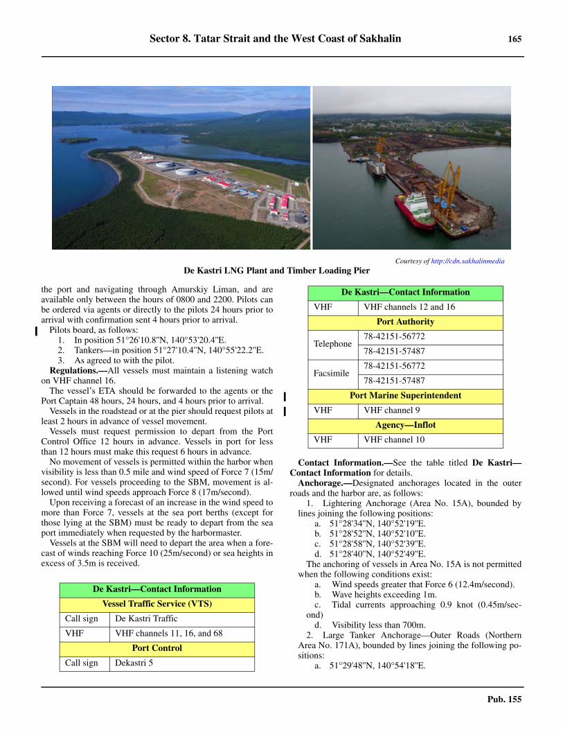
Sector 8. Tatar Strait and the West Coast of Sakhalin 165
Pub. 155
the port and navigating through Amurskiy Liman, and areavailable only between the hours of 0800 and 2200. Pilots canbe ordered via agents or directly to the pilots 24 hours prior toarrival with confirmation sent 4 hours prior to arrival. 8.42 Pilots board, as follows:
1. In position 51°26'10.8''N, 140°53'20.4''E.2. Tankers—in position 51°27'10.4''N, 140°55'22.2''E.3. As agreed to with the pilot.
8.42 Regulations.—All vessels must maintain a listening watchon VHF channel 16. 8.42 The vessel’s ETA should be forwarded to the agents or thePort Captain 48 hours, 24 hours, and 4 hours prior to arrival. 8.42 Vessels in the roadstead or at the pier should request pilots atleast 2 hours in advance of vessel movement.8.42 Vessels must request permission to depart from the PortControl Office 12 hours in advance. Vessels in port for lessthan 12 hours must make this request 6 hours in advance. 8.42 No movement of vessels is permitted within the harbor whenvisibility is less than 0.5 mile and wind speed of Force 7 (15m/second). For vessels proceeding to the SBM, movement is al-lowed until wind speeds approach Force 8 (17m/second). 8.42 Upon receiving a forecast of an increase in the wind speed tomore than Force 7, vessels at the sea port berths (except forthose lying at the SBM) must be ready to depart from the seaport immediately when requested by the harbormaster. 8.42 Vessels at the SBM will need to depart the area when a fore-cast of winds reaching Force 10 (25m/second) or sea heights inexcess of 3.5m is received.
8.42 Contact Information.—See the table titled De Kastri—Contact Information for details. 8.42 Anchorage.—Designated anchorages located in the outerroads and the harbor are, as follows:
1. Lightering Anchorage (Area No. 15A), bounded bylines joining the following positions:
a. 51°28'34''N, 140°52'19''E.b. 51°28'52''N, 140°52'10''E.c. 51°28'58''N, 140°52'39''E.d. 51°28'40''N, 140°52'49''E.
The anchoring of vessels in Area No. 15A is not permittedwhen the following conditions exist:
a. Wind speeds greater that Force 6 (12.4m/second).b. Wave heights exceeding 1m.c. Tidal currents approaching 0.9 knot (0.45m/sec-
ond)d. Visibility less than 700m.
2. Large Tanker Anchorage—Outer Roads (NorthernArea No. 171A), bounded by lines joining the following po-sitions:
a. 51°29'48''N, 140°54'18''E.
Courtesy of http://cdn.sakhalinmedia
De Kastri LNG Plant and Timber Loading Pier
De Kastri—Contact Information
Vessel Traffic Service (VTS)
Call sign De Kastri Traffic
VHF VHF channels 11, 16, and 68
Port Control
Call sign Dekastri 5
VHF VHF channels 12 and 16
Port Authority
Telephone78-42151-56772
78-42151-57487
Facsimile78-42151-56772
78-42151-57487
Port Marine Superintendent
VHF VHF channel 9
Agency—Inflot
VHF VHF channel 10
De Kastri—Contact Information
166 Sector 8. Tatar Strait and the West Coast of Sakhalin
Pub. 155
b. 51°29'48''N, 140°55'00''E.c. 51°29'00''N, 140°55'00''E.d. 51°29'00''N, 140°54'18''E.
Bunkering permitted at this anchorage unless wind speedsexceed Force 5 (10m/second).
3. Large Tanker Anchorage—Outer Roads (SouthernArea No. 171B), bounded by lines joining the following po-sitions:
a. 51°26'56''N, 140°54'18''E.b. 51°26'56''N, 140°55'00''E.c. 51°26'32''N, 140°55'00''E.d. 51°26'32''N, 140°54'18''E.
Bunkering permitted at this anchorage unless wind speedsexceed Force 5 (10m/second).
4. Dry Cargo and Quarantine Anchorage—Inner Roads(Area No. 174), bounded by lines joining the following posi-tions:
a. 51°26'32''N, 140°48'12''E.b. 51°26'32''N, 140°49'24''E.c. 51°25'53''N, 140°49'24''E.d. 51°25'53''N, 140°48'12''E.
8.42 Caution.—A submarine pipeline extends 1.3 miles SE fromshore from a position about 2 miles WSW of Mys Davydova.In order to protect the pipeline, Restricted Area No. 69A hasbeen established; the area is bounded by lines joining the fol-lowing positions:
a. 51°29'27''N, 140°50'19''E.b. 51°29'06''N, 140°50'29''E.c. 51°28'44''N, 140°51'07''E.d. 51°28'34''N, 140°52'19''E.e. 51°28'52''N, 140°52'10''E.f. 51°28'58''N, 140°52'39''E.g. 51°29'10''N, 140°51'37''E.
8.42 Banka Vostok, a rocky shoal with a depth of less than 0.2m,lies in the middle of the entrance to Zaliv Chikhacheva and isthe primary danger in the approach. It is marked on its E sideby a buoy and on its N, W, and S sides by spar buoys moored0.1 to 0.3 mile from the edge of the reef.8.42 Mys Rikova, about 1.2 miles NW of Mys Kloster-Kamp,slopes at its NW extremity and extends another 0.2 mile NW asa submerged reef. A buoy moored about 0.3 mile NW of thepoint marks the outer end of the danger.8.42 Ostrov Ustrichnyy, about 1 mile WNW of Mys Rikova, isbordered by a reef which extends about 0.4 mile N of the islandand is marked at its N extremity by two buoys.8.42 Ostrov Observatoriya, about 1.5 mile NW of Ostrov Us-trichnyy, is surrounded by a reef and marked by a buoy on itsSW side.8.42 Banka Skala, with a depth of less than 1.8m, lies about 0.7mile W of the W extremity of Ostrov Observatoriya and ismarked on its S side by a lighted buoy.8.42 The buoys in Zaliv Chikhacheva are removed each winterand replaced in the spring. Their positions, even during thenavigational season, should not be entirely relied upon.
Tatar Strait—Zaliv Chikhacheva to SovetskayaGavan
8.43 Mys Sobornyy (51°22'N., 140°51'E.), a steep cliffypoint conspicuous from the offing and lying about 3.5 miles S
of Mys Kloster-Kamp, can be identified by a pillar rock whichresembles a tower and dominates the surrounding cliffs. Awhite triangular pyramidal-shaped beacon, surmounted by apole, stands on the point. When viewed from N or S, the pointappears as an islet.8.43 The coast trends SW from Mys Sobornyy, turning W at MysNakatova and forming an open bay between the latter and MysOpasnosti, about 6 miles SSW. The shore is generally high andcliffy and bordered by numerous above and below-water rocks.Vessels should not proceed into depths of less than 9.1m, espe-cially along the N shore.8.43 Bukha Mosolova, entered between Mys Opasnosti and apoint about 2.5 miles SW, has high steep shores except at itshead, where the broad mouth of Reka Duy enters. The N en-trance point can be identified by Ostrova Dugu, two small butconspicuous islets, which lie on a dangerous sunken ledge ex-tending about 1 mile to the SSE. Ostrov Konstantina, the N is-let, is 61m high and has a white pyramidal framework beaconon its E side.8.43 Kamen’ Kleopatri, a very conspicuous pillar rock, 25m high,lies in a position about 2.2 miles WSW of Mys Opasnosti andabout 0.1 mile offshore. Another small rock lies nearby.8.43 Anchorage.—Vessels can take anchorage in Bukhta Mosolo-va, with protection from NW winds, SE of Kamen Cleopatra andabout 0.8 mile N of the S entrance point, in depths of 9 to 11m,fine sand and good holding ground. Reka Duy, with a bar at itsmouth having a depth of about 0.9m, can be ascended by boatsfor about 2.5 miles at HW.8.43 Gora Svetlaya, about 4 miles SW of Mys Opasnosti, rises toa height of 309m and is thickly wooded with pine trees, thegreen color of which, in contrast to the dark background of thesurrounding peaks, renders this mountain easy to identify.8.43 Bukhta Krestovaya, a narrow and shoal inlet 1 mile in length,is entered between steep cliffs about 8 miles S of Bukhta Mo-solova. There are some sunken rocks off the S entrance point andthe inner portion of the bay is foul, but boats can enter at HWand find good shelter from all winds and the sea.8.43 Anchorage can also be taken by vessels, in a depth of 20m,about 0.8 mile off the entrance to the inlet. Anchorage shouldnot be attempted in strong E winds.
8.44 Mys To (51°02'N., 140°41'E.), a rounded point about5 miles S of Bukhta Krestovaya, slopes seaward between thecoastal cliffs N and S. It is marked with a red patch on its sea-ward face, and a wide waterfall on the S side renders it con-spicuous from that direction. 8.44 Mys Khoy, located about 5 miles SSW of Mys To, is a steepround cliff with a ledge extending off Mys Sivuchiy, its NE ex-tremity. Two conspicuous pillar rocks, the inner one being 35mhigh and the outer only 3m high, lie on the above ledge and aidin the identification of the cape.8.44 Gora Khoy, rising to a height of 564m about 7 miles W ofMys Khoy, forms a good mark, especially from the S, when itappears conical. Another peak, 430m high, rises about 2.5miles NW of Mys Khoy and is also conspicuous.8.44 Anchorage.—Vessels with local knowledge can take an-chorage protected from W winds in the S part of the bight be-tween Mys To and Mys Khoy.
8.45 Mys Solov’yeva (50°50'N., 140°32'E.), located about
Sector 8. Tatar Strait and the West Coast of Sakhalin 167
Pub. 155
9.5 miles SSW of Mys Khoy, is the termination of the steepseaward slope of a twin-peaked 550m mountain located closeto the W. About 1 mile to the S of Mys Solov’yeva is a conspic-uous cliffy point with a sharp black summit, 83m high. Severallarge black rocks lie off these points and several more lie closeoff the coast about 4 miles SW.8.45 Gora Stolovaya, rising to a height of 916m about 7 milesWNW of Mys Solov’yeva, is the N and highest end of a longridge trending about 5 miles to the S. It is the highest peak inthe coastal range and a good mark in clear weather.8.45 Bukhta Sizimin (50°43'N., 140°27'E.), a small open bightabout 1 mile across, is situated between Mys Nitusi, a flat-topped cliffy point to the N, and a lower rock-strewn point tothe S. Reka Sizimin empties at the head of the bay and can beentered by boats at HW. A conspicuous hill, with white streaksdiscernible in clear weather from about 7 miles offshore, is lo-cated close S of the river entrance.8.45 The Timber Quay handles breakbulk cargo and extends 93mfrom the shore.8.45 Anchorage.—Anchorage can be taken during good weatherin the outer part of Bukhta Sizimin, with depths of 11 to 14m,fair holding ground, about 0.7 mile E of the head of the bay. 8.45 The anchorage should be cleared on any sign of increasing Ewinds.
8.46 The coast to the S of Bukhta Sizimin continues as rug-ged and rocky, with isolated cliffs. A long bight is formed be-tween Mys Murashko and Mys Mednyy, about 10 miles furtherS. The SW shore of this bight is bordered by numerous sunkenrocks. The coast is backed by many mountains most of whichare about 7 miles inland.8.46 Mys Ivanova (50°20'N., 140°32'E.), a high point coveredwith trees, is precipitous on its E extremity. From N or S thepoint appears triangular. There are two below-water rocksclose off the point.8.46 Gora Topazovaya, an isolated conical peak rising to a heightof 677m about 5 miles WNW of Mys Ivanova, forms the mostconspicuous landmark in this vicinity and is useful from off-shore in identifying the area.
8.47 Mys Syurkum (50°06'N., 140°42'E.), 97m high andlying about 16 miles SSE of Mys Ivanova, is the NE extremityof an elevated peninsula extending 7 miles E from the coast-line. From its center it gradually slopes seaward and from N orS appears as four hills, which when seen from a distance havethe appearance of an island with four summits. The point maybe identified by a pinnacle rock, 9m high, lying about 90m offits N extremity. A light is shown on Mys Syurkum. 8.47 Reyd Syurkum and Bukhta Starka, situated on the N side ofthe above peninsula about 6 miles WNW of Mys Syurkum, arethe roadstead and bay area for the coastal town of Syurkum. 8.47 Anchorage.—Anchorage may be obtained in Reyd Syur-kum, which is open N and E, a distance of 1 mile W of MysSyurkum to 1.5 miles N of the entrance to Bukhta Starka. Theholding ground is poor, consisting of rock and shingle, and lo-cal knowledge is necessary. Vessels should not anchor abreastof the entrance to Bukhta Starka.8.47 Bukhta Starka, a triangular brackish lagoon, is separatedfrom the sea by a sandspit which has a length of 3.5 miles and awidth of 90m. The entrance channel, about 90m wide between
the W extremity of the above sandspit and the mainland, isfronted by a bar with a maximum depth of 2.7m, but withdepths of 3.7m to 5.5m inside.8.47 Caution.—An explosives dumping area is situated 24 milesNE of Mys Syurkum. Navigation is restricted for certain ves-sels between Mys Ivanova and Mys Syurkum. Numerous dan-ger and restricted areas also exist S of Mys Syurkum.8.47 Reyd Aukan, a small bight in the coast about 17 miles SW ofMys Syurkum, provides good temporary anchorage during off-shore winds. There are heights of over 500m within 2 miles Nand 3 miles S of the anchorage area and considerable protec-tion is also afforded from NE and SSE winds. The land is lowin the vicinity of the mouth of Reka Aukan, at the head of theroadstead, but elsewhere the shores are precipitous.
8.48 Mys Bychiy (49°48'N., 140°32'E.), about 7.5 milesSE of Mys Aukan, is the NE extremity of a high and broadheadland. The point is bold, precipitous, and steep-to. The landin the vicinity of the cape is thickly wooded and the shore onthe N side consists of numerous cliffs rising steeply from thesea. There are depths of 36m close offshore. 8.48 Skala Sangach, a very conspicuous square white rock about33m high, is located 4 miles WNW of Mys Bychiy and forms agood landmark from the NE.8.48 Mys Boena, located about 11 miles S of Mys Bychiy, is con-spicuous. It is formed by the seaward slope of a fairly high hillwhich appears white because of numerous birch trees. The sur-rounding hills are rugged and intersected by narrow ravines, butalong the coast are many sheer cliffs of red color. About 6 miles Nof the point the coast becomes very precipitous, and with themountains being close to the shore, makes a sheer descent to thesea producing a strikingly conspicuous appearance.8.48 Bukhta Chumy-Dua, formed between Mys Boena and MysYuma, about 5 miles SSE, is a small cove indented in the coastclose SW of a red granite projection. 8.48 Anchorage.—Vessels with local knowledge can take an-chorage protected from all but SE winds, near the head of thecove, in depths of 11 to 13m.8.48 The coast between Mys Yuma and Mys Datta, about 12miles SSW, is bold and generally steep-to except at Mys Nam-shuka, where depths of 8.6m extend nearly 1 mile offshore.Several waterfalls empty into the sea along this stretch of thecoast, most originating in the numerous ravines of the coastalrange.8.48 Caution.—Two unlit mooring buoys are charted 20 milesESE of Mys Bychiy.8.48 A marine farm located between Mys Aukun and Mys Bychlyis bounded by the lines joining the following positions:
a. 49°51'42''N, 140°24'24''E.b. 49°52'30''N, 140°28'24''E.c. 49°49'36''N, 140°30'48''E.d. 49°48'36''N, 140°26'54''E.
8.49 Mys Datta (49°18'N., 140°26'E.), a precipitous head-land, the slopes of which are thickly covered with grass, jutssharply to the SE and forms a conspicuous landmark. Farther in-land the terrain becomes more wooded and the coastal chain at-tains a maximum height of 451m in a conspicuous roundedsummit about 6 miles WNW of the point. 8.49 A light shown on Mys Datta stands on a round metal tower
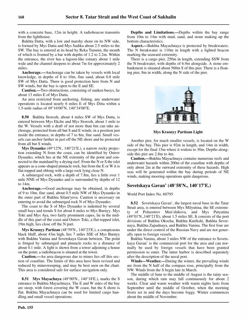
168 Sector 8. Tatar Strait and the West Coast of Sakhalin
Pub. 155
with a concrete base, 12m in height. A radiobeacon transmitsfrom the lighthouse.8.49 Bukhta Datta, with a low and marshy shore on its NW side,is formed by Mys Datta and Mys Sadika about 2.5 miles to theSW. The bay is entered at its head by Reka Tumnin, the mouthof which is fronted by a bar with depths of 1.2 to 2.2m. Withinthe entrance, the river has a lagoon-like estuary about 1 milewide and the channel deepens to about 7m for approximately 2miles.8.49 Anchorage.—Anchorage can be taken by vessels with localknowledge, in depths of 8 to 10m, fine sand, about 0.8 mileSW of Mys Datta. There is good protection here from N andSW winds, but the bay is open to the E and SE.8.49 Caution.—Two obstructions, consisting of sunken buoys, lieabout 13 miles E of Mys Datta.8.49 An area restricted from anchoring, fishing, any underwateroperations is located nearly 6 miles E of Mys Ditta within a1.5-mile radius of 49°16'00''N, 140°34'00''E.
8.50 Bukhta Storozh, about 4 miles SW of Mys Datta, isentered between Mys Ekche and Mys Storozh, about 1 mile tothe W. Vessels with a draft of not more than 6m can take an-chorage, protected from all but S and E winds, in a position justinside the entrance, in depths of 7 to 8m, fine sand. Small ves-sels can anchor farther in just off the NE shore and be protectedfrom all but S winds.8.50 Mys Dyuanko (49°12'N., 140°21'E.), a narrow rocky projec-tion extending N from the coast, can be identified by OstrovDyuanko, which lies at the NE extremity of the point and con-nected to the mainland by a drying reef. From the N or S the isletappears as a cone-shaped pinnacle rock, but from the E or W it isflat-topped and oblong with a large rock lying close N.8.50 A submerged rock, with a depth of 7.8m, lies a little over 1mile NNE of Mys Dyuanko and is surrounded by depths of 12to 14m.8.50 Anchorage.—Good anchorage may be obtained, in depthsof 9 to 10m, fine sand, about 0.5 mile NW of Mys Dyuanko inthe outer part of Bukhta Silant'yeva. Caution is necessary onentering to avoid the submerged rock N of Mys Dyuanko.8.50 The coast to the S of Mys Dyuanko is indented by severalsmall bays and trends S for about 6 miles to Mys Burnyy. MysToki and Mys Aya, two fairly prominent capes, lie in the mid-dle of this part of the coast and Ostrov Toki, a flat-topped islet,19m high, lies close off the N part.
8.50 Mys Krasnyy Partizan (48°59'N., 140°23'E.), a conspicuousblack bluff, about 43m high, lies 7 miles SSE of Mys Burnyywith Bukhta Vanina and Sovetskaya Gavan between. The pointis fringed by submerged and pinnacle rocks to a distance ofabout 0.1 mile. A light is shown from a tower adjoining a houseon the point; a radiobeacon is situated at the tower. 8.50 Caution.—An area dangerous due to mines lies off this sec-tion of coastline. The limits of this area have been revised andreduced by minesweeping, and may be best seen on the chart.This area is considered safe for surface navigation only.
8.51 Mys Mayachnya (49°00'N., 140°18'E.), marks the Sentrance to Bukhta Mayachnaya. The E and W sides of the bayare steep, with forest covering the W coast, but the S shore isflat. Bukhta Mayachnaya can be used for limited cargo han-dling and small vessel operations.
8.51 Depths and Limitations.—Depths within the bay rangefrom 10m to 14m with mud, sand, and stone making up thebottom characteristics. 8.51 Aspect.—Bukhta Mayachnaya is protected by breakwaters.The N breakwater is 110m in length with a lighted beaconmarking the seaward extremity. 8.51 There is a cargo pier, 250m in length, extending SSW fromthe N breakwater, with depths of 6.9m alongside. A stone em-bankment is situated about 560m S of this pier. There is a float-ing pier, 8m in width, along the N side of the pier.
8.51 Another pier, for much smaller vessels, is located on the Wside of the bay. This pier is 92m in length, and 14m in width,except for the final 15m where it widens to 30m. Depths along-side this pier are 2.8m to 4m. 8.51 Caution.—Bukhta Mayachnaya contains numerous reefs andunderwater hazards within 200m of the coastline with depths ofonly about 2m at the outward extremity of these hazards. Highseas will be generated within the bay during periods of NEwinds, making mooring operations quite dangerous.
Sovetskaya Gavan’ (48°58'N., 140°17'E.)
World Port Index No. 60795
8.52 Sovetskaya Gavan’, the largest naval base in the TatarStrait area, is entered between Mys Milyutina, the SE extremi-ty of Poluostrov Men’shikova, and Mys Putyatina(49°01'N.,140°21'E), about 1.5 miles SE. It consists of the portdivisions of Bukhta Okocha, Bukhta Kurikshi, Bukhta Sever-naya, Bukhta Zapadnaya, and Bukhta Vanina. The first four areunder the direct control of the Russian Navy and are not gener-ally open to foreign vessels.8.52 Bukhta Vanina, about 3 miles NW of the entrance to Sovets-kaya Gavan’ is the commercial port for the area and can nor-mally be used by foreign vessels that have been grantedpermission to enter. The latter harbor is described separatelyafter the description of the naval port.8.52 Winds—Weather.—During the winter, the prevailing windsare from the N half of the compass rose, principally from theNW. Winds from the S begin late in March.8.52 The middle of June to the middle of August is the rainy sea-son, during which rain may fall continuously for about 2weeks. Clear and warm weather with warm nights lasts fromSeptember until the middle of October, when the morningfrosts set in and the days become foggy. Winter commencesabout the middle of November.
Mys Krasnyy Partizan Light
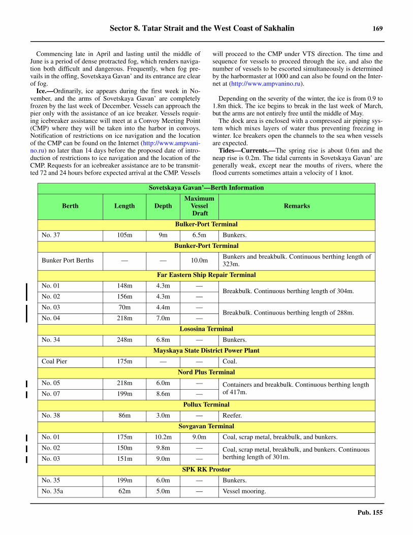
Sector 8. Tatar Strait and the West Coast of Sakhalin 169
Pub. 155
8.52 Commencing late in April and lasting until the middle ofJune is a period of dense protracted fog, which renders naviga-tion both difficult and dangerous. Frequently, when fog pre-vails in the offing, Sovetskaya Gavan’ and its entrance are clearof fog.8.52 Ice.—Ordinarily, ice appears during the first week in No-vember, and the arms of Sovetskaya Gavan’ are completelyfrozen by the last week of December. Vessels can approach thepier only with the assistance of an ice breaker. Vessels requir-ing icebreaker assistance will meet at a Convoy Meeting Point(CMP) where they will be taken into the harbor in convoys.Notification of restrictions on ice navigation and the locationof the CMP can be found on the Internet (http://www.ampvani-no.ru) no later than 14 days before the proposed date of intro-duction of restrictions to ice navigation and the location of theCMP. Requests for an icebreaker assistance are to be transmit-ted 72 and 24 hours before expected arrival at the CMP. Vessels
will proceed to the CMP under VTS direction. The time andsequence for vessels to proceed through the ice, and also thenumber of vessels to be escorted simultaneously is determinedby the harbormaster at 1000 and can also be found on the Inter-net at (http://www.ampvanino.ru).
8.52 Depending on the severity of the winter, the ice is from 0.9 to1.8m thick. The ice begins to break in the last week of March,but the arms are not entirely free until the middle of May.8.52 The dock area is enclosed with a compressed air piping sys-tem which mixes layers of water thus preventing freezing inwinter. Ice breakers open the channels to the sea when vesselsare expected.8.52 Tides—Currents.—The spring rise is about 0.6m and theneap rise is 0.2m. The tidal currents in Sovetskaya Gavan’ aregenerally weak, except near the mouths of rivers, where theflood currents sometimes attain a velocity of 1 knot.
Sovetskaya Gavan’—Berth Information
Berth Length DepthMaximum
Vessel Draft
Remarks
Bulker-Port Terminal
No. 37 105m 9m 6.5m Bunkers.
Bunker-Port Terminal
Bunker Port Berths — — 10.0m Bunkers and breakbulk. Continuous berthing length of323m.
Far Eastern Ship Repair Terminal
No. 01 148m 4.3m —Breakbulk. Continuous berthing length of 304m.
No. 02 156m 4.3m —
No. 03 70m 4.4m —Breakbulk. Continuous berthing length of 288m.
No. 04 218m 7.0m —
Lososina Terminal
No. 34 248m 6.8m — Bunkers.
Mayskaya State District Power Plant
Coal Pier 175m — — Coal.
Nord Plus Terminal
No. 05 218m 6.0m — Containers and breakbulk. Continuous berthing length of 417m.No. 07 199m 8.6m —
Pollux Terminal
No. 38 86m 3.0m — Reefer.
Sovgavan Terminal
No. 01 175m 10.2m 9.0m Coal, scrap metal, breakbulk, and bunkers.
No. 02 150m 9.8m — Coal, scrap metal, breakbulk, and bunkers. Continuous berthing length of 301m.No. 03 151m 9.0m —
SPK RK Prostor
No. 35 199m 6.0m — Bunkers.
No. 35a 62m 5.0m — Vessel mooring.
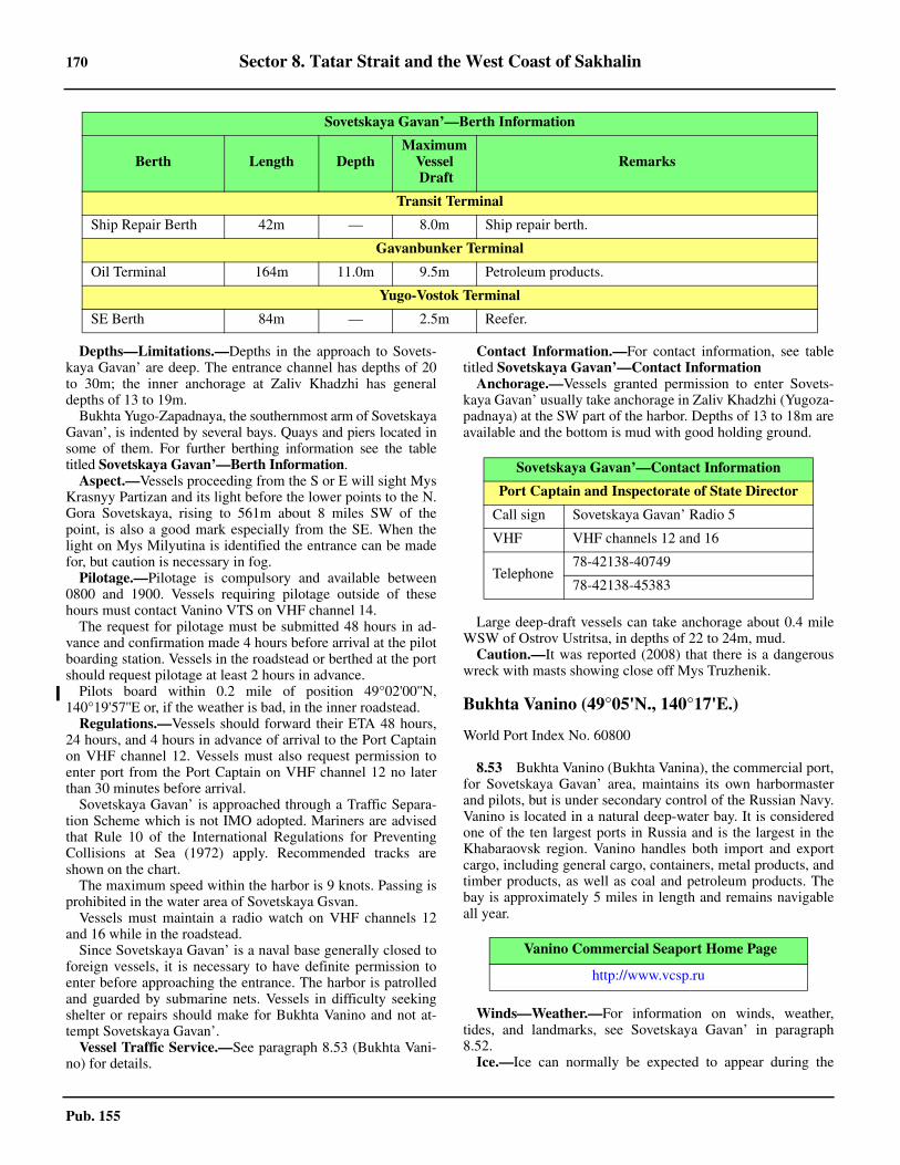
170 Sector 8. Tatar Strait and the West Coast of Sakhalin
Pub. 155
8.52 Depths—Limitations.—Depths in the approach to Sovets-kaya Gavan’ are deep. The entrance channel has depths of 20to 30m; the inner anchorage at Zaliv Khadzhi has generaldepths of 13 to 19m. 8.52 Bukhta Yugo-Zapadnaya, the southernmost arm of SovetskayaGavan’, is indented by several bays. Quays and piers located insome of them. For further berthing information see the tabletitled Sovetskaya Gavan’—Berth Information.8.52 Aspect.—Vessels proceeding from the S or E will sight MysKrasnyy Partizan and its light before the lower points to the N.Gora Sovetskaya, rising to 561m about 8 miles SW of thepoint, is also a good mark especially from the SE. When thelight on Mys Milyutina is identified the entrance can be madefor, but caution is necessary in fog.8.52 Pilotage.—Pilotage is compulsory and available between0800 and 1900. Vessels requiring pilotage outside of thesehours must contact Vanino VTS on VHF channel 14.8.52 The request for pilotage must be submitted 48 hours in ad-vance and confirmation made 4 hours before arrival at the pilotboarding station. Vessels in the roadstead or berthed at the portshould request pilotage at least 2 hours in advance. 8.52 Pilots board within 0.2 mile of position 49°02'00''N,140°19'57''E or, if the weather is bad, in the inner roadstead. 8.52 Regulations.—Vessels should forward their ETA 48 hours,24 hours, and 4 hours in advance of arrival to the Port Captainon VHF channel 12. Vessels must also request permission toenter port from the Port Captain on VHF channel 12 no laterthan 30 minutes before arrival. 8.52 Sovetskaya Gavan’ is approached through a Traffic Separa-tion Scheme which is not IMO adopted. Mariners are advisedthat Rule 10 of the International Regulations for PreventingCollisions at Sea (1972) apply. Recommended tracks areshown on the chart. 8.52 The maximum speed within the harbor is 9 knots. Passing isprohibited in the water area of Sovetskaya Gsvan.8.52 Vessels must maintain a radio watch on VHF channels 12and 16 while in the roadstead. 8.52 Since Sovetskaya Gavan’ is a naval base generally closed toforeign vessels, it is necessary to have definite permission toenter before approaching the entrance. The harbor is patrolledand guarded by submarine nets. Vessels in difficulty seekingshelter or repairs should make for Bukhta Vanino and not at-tempt Sovetskaya Gavan’. 8.52 Vessel Traffic Service.—See paragraph 8.53 (Bukhta Vani-no) for details.
8.52 Contact Information.—For contact information, see tabletitled Sovetskaya Gavan’—Contact Information 8.52 Anchorage.—Vessels granted permission to enter Sovets-kaya Gavan’ usually take anchorage in Zaliv Khadzhi (Yugoza-padnaya) at the SW part of the harbor. Depths of 13 to 18m areavailable and the bottom is mud with good holding ground.
8.52 Large deep-draft vessels can take anchorage about 0.4 mileWSW of Ostrov Ustritsa, in depths of 22 to 24m, mud.8.52 Caution.—It was reported (2008) that there is a dangerouswreck with masts showing close off Mys Truzhenik.
Bukhta Vanino (49°05'N., 140°17'E.)
World Port Index No. 60800
8.53 Bukhta Vanino (Bukhta Vanina), the commercial port,for Sovetskaya Gavan’ area, maintains its own harbormasterand pilots, but is under secondary control of the Russian Navy.Vanino is located in a natural deep-water bay. It is consideredone of the ten largest ports in Russia and is the largest in theKhabaraovsk region. Vanino handles both import and exportcargo, including general cargo, containers, metal products, andtimber products, as well as coal and petroleum products. Thebay is approximately 5 miles in length and remains navigableall year.
8.53 Winds—Weather.—For information on winds, weather,tides, and landmarks, see Sovetskaya Gavan’ in paragraph8.52.8.53 Ice.—Ice can normally be expected to appear during the
Transit Terminal
Ship Repair Berth 42m — 8.0m Ship repair berth.
Gavanbunker Terminal
Oil Terminal 164m 11.0m 9.5m Petroleum products.
Yugo-Vostok Terminal
SE Berth 84m — 2.5m Reefer.
Sovetskaya Gavan’—Berth Information
Berth Length DepthMaximum
Vessel Draft
Remarks
Sovetskaya Gavan’—Contact Information
Port Captain and Inspectorate of State Director
Call sign Sovetskaya Gavan’ Radio 5
VHF VHF channels 12 and 16
Telephone78-42138-40749
78-42138-45383
Vanino Commercial Seaport Home Page
http://www.vcsp.ru
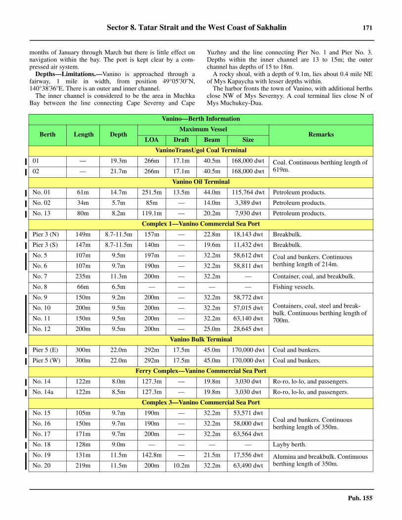
Sector 8. Tatar Strait and the West Coast of Sakhalin 171
Pub. 155
months of January through March but there is little effect onnavigation within the bay. The port is kept clear by a com-pressed air system. 8.53 Depths—Limitations.—Vanino is approached through afairway, 1 mile in width, from position 49°05'30''N,140°38'36''E. There is an outer and inner channel. 8.53 The inner channel is considered to be the area in MuchkaBay between the line connecting Cape Severny and Cape
Yuzhny and the line connecting Pier No. 1 and Pier No. 3.Depths within the inner channel are 13 to 15m; the outerchannel has depths of 15 to 18m. 8.53 A rocky shoal, with a depth of 9.1m, lies about 0.4 mile NEof Mys Kapaycha with lesser depths within. 8.53 The harbor fronts the town of Vanino, with additional berthsclose NW of Mys Severnyy. A coal terminal lies close N ofMys Muchukey-Dua.
Vanino—Berth Information
Berth Length DepthMaximum Vessel
RemarksLOA Draft Beam Size
VaninoTransUgol Coal Terminal
01 — 19.3m 266m 17.1m 40.5m 168,000 dwt Coal. Continuous berthing length of 619m.02 — 21.7m 266m 17.1m 40.5m 168,000 dwt
Vanino Oil Terminal
No. 01 61m 14.7m 251.5m 13.5m 44.0m 115,764 dwt Petroleum products.
No. 02 34m 5.7m 85m — 14.0m 3,389 dwt Petroleum products.
No. 13 80m 8.2m 119.1m — 20.2m 7,930 dwt Petroleum products.
Complex 1—Vanino Commercial Sea Port
Pier 3 (N) 149m 8.7-11.5m 157m — 22.8m 18,143 dwt Breakbulk.
Pier 3 (S) 147m 8.7-11.5m 140m — 19.6m 11,432 dwt Breakbulk.
No. 5 107m 9.5m 197m — 32.2m 58,612 dwt Coal and bunkers. Continuous berthing length of 214m.No. 6 107m 9.7m 190m — 32.2m 58,811 dwt
No. 7 235m 11.3m 200m — 32.2m — Container, coal, and breakbulk.
No. 8 66m 6.5m — — — — Fishing vessels.
No. 9 150m 9.2m 200m — 32.2m 58,772 dwtContainers, coal, steel and break-bulk. Continuous berthing length of 700m.
No. 10 200m 9.5m 200m — 32.2m 57,015 dwt
No. 11 150m 9.5m 200m — 32.2m 63,140 dwt
No. 12 200m 9.5m 200m — 25.0m 28,645 dwt
Vanino Bulk Terminal
Pier 5 (E) 300m 22.0m 292m 17.5m 45.0m 170,000 dwt Coal and bunkers.
Pier 5 (W) 300m 22.0m 292m 17.5m 45.0m 170,000 dwt Coal and bunkers.
Ferry Complex—Vanino Commercial Sea Port
No. 14 122m 8.0m 127.3m — 19.8m 3,030 dwt Ro-ro, lo-lo, and passengers.
No. 14a 122m 8.5m 127.3m — 19.8m 3,030 dwt Ro-ro, lo-lo, and passengers.
Complex 3—Vanino Commercial Sea Port
No. 15 105m 9.7m 190m — 32.2m 53,571 dwtCoal and bunkers. Continuous berthing length of 350m.No. 16 150m 9.7m 190m — 32.2m 58,000 dwt
No. 17 171m 9.7m 200m — 32.2m 63,564 dwt
No. 18 128m 9.0m — — — — Layby berth.
No. 19 131m 11.5m 142.8m — 21.5m 17,556 dwt Alumina and breakbulk. Continuous berthing length of 350m.No. 20 219m 11.5m 200m 10.2m 32.2m 63,490 dwt
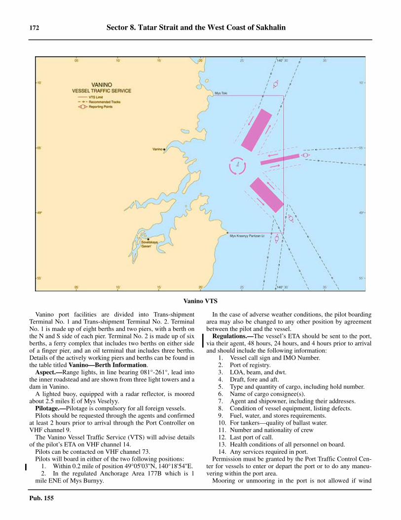
172 Sector 8. Tatar Strait and the West Coast of Sakhalin
Pub. 155
8.53 Vanino port facilities are divided into Trans-shipmentTerminal No. 1 and Trans-shipment Terminal No. 2. TerminalNo. 1 is made up of eight berths and two piers, with a berth onthe N and S side of each pier. Terminal No. 2 is made up of sixberths, a ferry complex that includes two berths on either sideof a finger pier, and an oil terminal that includes three berths.Details of the actively working piers and berths can be found inthe table titled Vanino—Berth Information.8.53 Aspect.—Range lights, in line bearing 081°-261°, lead intothe inner roadstead and are shown from three light towers and adam in Vanino. 8.53 A lighted buoy, equipped with a radar reflector, is mooredabout 2.5 miles E of Mys Veselyy.8.53 Pilotage.—Pilotage is compulsory for all foreign vessels. 8.53 Pilots should be requested through the agents and confirmedat least 2 hours prior to arrival through the Port Controller onVHF channel 9. 8.53 The Vanino Vessel Traffic Service (VTS) will advise detailsof the pilot’s ETA on VHF channel 14. 8.53 Pilots can be contacted on VHF channel 73. 8.53 Pilots will board in either of the two following positions:
1. Within 0.2 mile of position 49°05'03''N, 140°18'54''E. 2. In the regulated Anchorage Area 177B which is 1
mile ENE of Mys Burnyy.
8.53 In the case of adverse weather conditions, the pilot boardingarea may also be changed to any other position by agreementbetween the pilot and the vessel. 8.53 Regulations.—The vessel’s ETA should be sent to the port,via their agent, 48 hours, 24 hours, and 4 hours prior to arrivaland should include the following information:
1. Vessel call sign and IMO Number.2. Port of registry.3. LOA, beam, and dwt.4. Draft, fore and aft.5. Type and quantity of cargo, including hold number.6. Name of cargo consignee(s).7. Agent and shipowner, including their addresses.8. Condition of vessel equipment, listing defects.9. Fuel, water, and stores requirements.10. For tankers—quality of ballast water.11. Number and nationality of crew12. Last port of call.13. Health conditions of all personnel on board.14. Any services required in port.
8.53 Permission must be granted by the Port Traffic Control Cen-ter for vessels to enter or depart the port or to do any maneu-vering within the port area. 8.53 Mooring or unmooring in the port is not allowed if wind
Vanino VTS
Sector 8. Tatar Strait and the West Coast of Sakhalin 173
Pub. 155
speeds exceed Force 6. 8.53 Towing of any large capacity vessels is not allowed if windspeeds exceed Force 5. 8.53 Vessel Traffic Service.—A Vessel Traffic Service (VTS) inoperation for the waters of Vanino port, and the waters offSovetskaya Gavan’ Port, between a N limit along the parallelof Mys Toki (49°09'00.0''N, 140°21'42.0''E.), and a S limit ofthe parallel of Mys Krasnyy Partizan Light (48°58'34.0''N,140°23'10.0''E.), both W of 140°30'E. 8.53 Participation in the VTS is compulsory for all vessels. ForVTS contact information, see the table titled Vanino—Con-tact Information.8.53 All vessels entering and leaving the ports of Vanino andSovetskaya Gavan' and those vessels using the TSS for transitpassage and crossing the boundaries of the VTS area must estab-lish communication with Vanino Traffic on VHF channel 14when approaching the reporting points (see graphic titled Vani-no VTS), providing the following information:
1. Name and type of vessel.2. IMO number.3. Length overall.4. Maximum draft.5. Nationality.6. Port of departure.7. Type and quantity of cargo (if available).
8.53 If a vessel has not established contact with the VTS beforereaching the VTS limits, entry into the VTS area is prohibited. 8.53 Vessels within the VTS must maintain a continuous listeningwatch on VHF channels 14 and 16. 8.53 Vessels departing Zaliv Sovetskaya Gavan and the port ofVanino must send a departure report to Vanino Traffic on VHFchannel 14 at least 30 minutes before departing the berth or an-chorage. 8.53 Vessels must again report to Vanino Traffic when getting un-derway and include:
1. Time of getting underway.2. Departure berth or anchorage.
8.53 A final report must be sent to Vanino Traffic on VHF chan-nel 14 when leaving the VTS area, stating the vessel’s nameand port of destination. 8.53 Contact Information.—See the table titled Vanino—Con-tact Information. 8.53 Anchorage.—Seven designated anchorages are located N ofthe range line leading into the inner harbor; seven designatedanchorages are located S of the range line. All anchorages havedepths of 13 to 15m, sand. The center positions of these an-chorages are listed in the table titled Vanino—Anchorages.8.53 Vessels will be assigned an anchorage position from the PortTraffic Control Center on VHF channel 14. 8.53 Caution.—A wreck, with depth of 60m, is located 11.2miles E of Mys Toki.
8.53 There are numerous restricted and danger areas in the ap-proach to Bukhta Vanino. Vessels should consult Pub. 120,Sailing Directions (Planning Guide) North Pacific Ocean andSoutheast Asia before proceeding into this area.
Sovetskaya Gavan’ to Mys Peschanny
8.54 The coast to the S of Mys Krasnyy Partizan is steepand mountainous with numerous rocks bordering the shore.Mys Kekurnyy, conspicuous and located about 3.5 miles SSWof the above point, is formed by the steep seaward slope to Go-ra Kekurnaya rising close W of the cape. About 1 mile SW ofMys Kekurnyy the coast becomes steep-to and nearly inacces-sible with high cliffs that are closely backed by mountains, at-taining heights of 500m or more.
8.54 Caution.—Several prohibited and dangerous areas exist be-tween Mys Krasnyy Partizan and Mys Peschanyy. Vessels nav-igating near this area should consult Pub. 120, SailingDirections (Planning Guide) Pacific Ocean and Southeast Asiafor details.
Vanino—Contact Information
Port Control
Call sign Vanino Radio 2
VHF VHF channels 9 and 16
Hours 24 hours
Port Authority
Call sign Vanino Radio 6
VHF VHF channels 1, 16, and 27
Telephone 78-42137-77799
Facsimile 78-42137-77575
E-mail [email protected]
Web site https://www.vcsp.ru
Hours 24 hours
VTS
Call sign Vanino Traffic
VHF VHF channels 11, 14, 16, and 68
Telephone 78-42137-77594
Facsimile 78-42137-77594
E-mail [email protected]
Hours 24 hours
Vanino—Anchorages
Area Position Remarks
North of the Range Line
1 49°05'21''N, 140°17'18''E Anchorage only allowed for a short time.
3 49°05'18''N, 140°17'33''E Anchorage only allowed for a short time.
174 Sector 8. Tatar Strait and the West Coast of Sakhalin
Pub. 155
8.55 Mys Mapatsa (48°49'N., 140°15'E.), located about12 miles SW of Mys Krasnyy Partizan, is a sloping projectionmarked with a fishing station near its extremity. The coast oneither side of the point is sheer and steep-to, and Gora Okhro-vaya, a 192m hill about 2 miles to the SSW, terminates at itsseaward slope in a precipitous landslide.8.55 Mys Gydzhu, a cliffy point about 5 miles SSW of MysMapatsa, has several rocks close off which lie a steep-to shoalextending about 1 mile to the E. The coast between this pointand Bukhta Innokentiya, about 8 miles S, presents a wall-likeformation of steep cliffs backed by numerous coastal hills andmountains farther inland.
8.56 Bukhta Innokentiya (48°36'N., 140°11'E.), a smallcove, has a depth of about 7.9m in its center. 8.56 Anchorage.—Local vessels find good anchorage, in a depthof about 7m, with shelter from all W winds in the NE part ofBukhta Innokentiya. The N entrance point of this bay givesadded protection.8.56 The cove is protected from all but E winds. Entrance is diffi-cult due to off-lying prohibited areas. A light is shown from theS entrance point of the bay.8.56 Caution.—A local magnetic anomaly is located in the vicinityof the coast between Bukhta Innokentiya and Mys Mapatsa.8.56 It was reported (2008) that there is a stranded vessel at thehead of Bukhta Innokenitiya,
8.57 Gora Puchi, a conspicuous craggy peak with a height
of 597m, rises about 4.5 miles WNW of the entrance of BukhtaInnokentiya and from offshore has the appearance of a triangu-lar cliff.8.57 Bukhta Andreya (48°33'N., 140°11'E.), lying 3 miles S ofBukhta Innokentiya, is bordered on its N side by conspicuousterraced land and, on its S side just above Mys Travyanoy, by asheer cliff. The bay has depths of 13m at its entrance and 9m atits center. The bay shoals rapidly in its W part terminating in asandy beach which is interrupted on its SW side by the mouthof Reka Koppi. The settlement of Koppi, with a large fishingstation, is situated on the S shore of the river entrance and isquite conspicuous.8.57 Anchorage.—Small vessels with local knowledge can takeanchorage protected from all W winds, in a depth of 7.3m,sand and shingle, about 0.5 mile E of the mouth of Reka Koppi.The bar of the river ordinarily has about 1.8m and can usuallybe crossed by boats. Strong E winds cause the bar to shift andreduce in depth and caution is recommended.
8.57 The coast from Bukhta Andreya to Mys Peschanyy, de-scribed in paragraph 9.2, about 6 miles to the S, is steep andcliffy with several large rocks close offshore, but about 1 mileinland the land flattens out to a plain for about 2 miles beforerising again.8.57 Caution.—It was reported (2008) that there is a strandedvessel on the right side of Reka Koppi, about 600m inland ofthe river mouth. Another stranded vessel was reported to lieabout 0.5 mile S of the mouth of the Reka Koppi.
5 49°05'19''N, 140°18'31''E —
7 49°05'14''N, 140°19'16''E —
9 49°05'11''N, 140°19'42''E —
11 49°05'27''N, 140°19'33''E —
13 49°05'24''N, 140°19'59''E —
South of the Range Line
2 49°04'53''N, 140°17'54''E —
4 49°04'51''N, 140°18'19''E —
6 49°04'44''N, 140°19'02''E —
6A 49°04'35''N, 140°19'27''E —
8 49°04'28''N, 140°18'55''E —
10 49°04'39''N, 140°19'56''E Tankers, dangerous cargo, and infectious diseases.
12 49°04'22''N, 140°19'47''E Tankers, dangerous cargo, and infectious diseases.
Vanino—Anchorages
Area Position Remarks
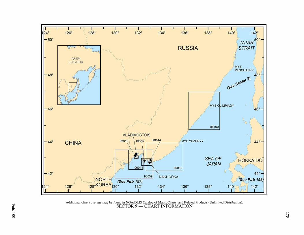
175
Pub. 155
9. Sector 9—East Coast of Russia—Mys Peschanyy to Korea
9.0Additional chart coverage may be found in NGA/DLIS Catalog of Maps, Charts, and Related Products (Unlimited Distribution).9.0SECTOR 9 — CHART INFORMATION
177
Pub. 155
SECTOR 9
EAST COAST OF RUSSIA—MYS PESCHANYY TO KOREA
9.0 Plan.—This sector describes the E coast of Russia in se-quence SW from Mys Peschanyy, in the SW part of the TatarStrait, to the N border of Korea.
General Remarks
9.1 Winds—Weather.—During the winter the prevailingwinds are from the N half of the compass rose, principallyfrom the NW. Winds from the S begin late in March. From themiddle of June to the middle of August is the rainy season,during which rain may fall continuously for about two weeks.Clear and warm weather with warm nights lasts from Septem-ber until the middle of October, when the morning frosts set inand the days become foggy. Winter commences about the mid-dle of November.9.1 Commencing late in April and lasting until the middle ofJune is a period of dense protracted fog, which renders naviga-tion both difficult and dangerous. Frequently, when fog pre-vails in the offing, the shoreline is clear.9.1 The general set of the current is S or SW at 0.2 to 0.5 knot.9.1 Winds from the S and SW prevail during the summer. April,May, and September are months of variable winds, and Octo-ber is a month of light breezes. Fresh N and NW winds arecommon during the winter, but calms are rare.9.1 The season of fog begins in March and lasts until September.Fog is particularly frequent from May to August, occasionallyreducing the visibility to about 0.1 mile.9.1 Winds from the NW prevail from November to the end ofJanuary and are accompanied by high barometric pressure andlow humidity. Winds from the SE, at times interrupted by vari-able winds or calms, prevail during the summer and are accom-panied by high humidity.9.1 Snow falls intermittently between September and May, cov-ering the ground with a layer of precipitation 0.3 to 0.6m indepth.9.1 The season of fog commences in the latter part of March andlasts until the middle of July. The fog is thickest at night andfrequently clears during the day.9.1 The general set of the current is SW at 0.2 to 0.8 knot.9.1 Winds from the N prevail from the beginning of Septemberto the end of March, and SE winds prevail for the balance ofthe year. The mean annual velocity, as well as the mean month-ly velocity of the wind is, on the average, about 2.5 knot.Winds with a velocity of 20 knots or greater are, on the aver-age, about 1 day a month. Typhoons do not reach the Vladivo-stok area, but in the autumn, when they occur in the Sea ofJapan, their W semicircle winds are felt in Vladivostok, chang-ing from E through N to NW.9.1 The season of fog lasts from April to July, the last being thefoggiest month of the year, with an average of 15 days of densefog and 8 days of light fog. There is a total of about 50 days ofdense fog with drizzle, and 25 days of light fog on the hills. Al-though, almost constant at night in these months, the fog usual-ly disperses between 1000 and 1600.
9.1 The months between October and March have an average ofabout 2 days of fog each month.9.1 The general set of the current is SW to S to SE at 0.2 to 0.8knot.9.1 Considerable amounts of drift ice may be encountered N ofMys 'Zolotoy between the months of January and April, andnavigation is generally restricted to reinforced vessels.9.1 In late December drift ice appears, generally increasing untilMarch with fields up to 30 miles offshore. Fairly heavy ice maybe encountered close inshore and within the coves along thecoast from January to mid-April.9.1 Between the months of January and March, inclusive, driftice may be encountered up to 10 miles offshore. Unfavorablewind conditions may occasionally jam ice into the bays, but Nwinds quickly break it up and navigation is unrestricted evenby non-ice strengthened vessels.9.1 That part of Zaliv Ussuriyskiy N of Vladivostok begins tofreeze toward the end of December, and by the middle of Janu-ary is covered by solid ice 0.6 to 0.8m thick. To the S of Vladi-vostok the ice is frequently broken up by the action of the windand sea and undergoes continual change. During severe win-ters, ice up to 0.1m thick may extend across the entrance of thebay between Ostrov Askol’d and Arkhipelag Yevgenii, but ice-breakers keep the shipping lanes open between Nakhodka andVladivostok.9.1 Caution.—Several dangerous, restricted, or Russian regulat-ed areas lie in the waters described within this sector, the limitsof which may best be seen on the chart.
Mys Peschanyy to Mys Belkina
9.2 Mys Peschanyy (48°27'N., 140°11'E.), the E extremi-ty of a low, broad sandspit, projects from the coast betweentwo steep cliffs. Two small lakes lie within the sand spit. Alight is shown from a tower on the point and a radiobeacon issituated at the tower. 9.2 Gora Petra, a conspicuous table-topped mountain 379mhigh, rises about 2 miles W of the point and forms a good markfrom the offing. A 613m mountain rises about 3 miles W ofGora Petra.9.2 Mys Uspeniya, the steep-sloped seaward termination of amountainous spur, is located about 9 miles SW of Mys Peschanyyand is backed about 2.5 miles to the W by the conspicuous sharp-peaked summit of Gora Dubovaya, rising to a height of 472m.High trees give the point a dome-shaped appearance.9.2 About 3 miles N of Mys Uspeniya and 1 mile inland is asharp-pointed triangular cliff, 371m high, which forms an ex-cellent mark from seaward, especially from the N and S.9.2 The coast to the SW of Mys Uspeniya is low-lying withbeaches of sand and pebbles. The mountains range inland forsome distance from the coast and attain elevations of 800 to900m. At Mys Icha, about 8 miles SW of Mys Uspeniya, themountains again rise near the coast and the shore becomesmore foul with numerous above and below-water rocks.
178 Sector 9. East Coast of Russia—Mys Peschanyy to Korea
Pub. 155
9.2 Bukhta Adzhimi, a small, shallow, open bight about 10 milesSW of Mys Icha, is entered between Mys Vstrechnyy, a lowpoint marked by a white triangular beacon, and a point 0.7 mileNNE. Numerous rocks lie up to 0.2 mile off the entrancepoints, and rocks with depths of about 4.3m lie in the fairway.Only small vessels can enter and obtain shelter from W winds.
9.3 Mys Krestovozdvizhenskiy (47°58'N., 139°32'E.), adensely-wooded point lying about 29 miles SW of Mys Us-peniya, is the termination of a narrow moderately-high ridgeextending in an E direction with numerous fringing rocks. Alight is shown from a framework tower on the point. A frame-work beacon, 13m high, stands about 0.2 mile WSW of thepoint.9.3 Gora Krestovozdvizhenskiy, an isolated hill, is conspicuous,213m high, and rises about 1 mile W of the point.9.3 Bukhta Grossevichi, on the N side of Mys Krestovozdvizhens-kiy, is a small bight completely exposed to the E. Anchorage maybe obtained by large vessels with the beacon on Mys Krestovozd-vizhenskiy bearing 225°, distant 1 mile, in a depth of 10m, or clos-er in with the same beacon bearing 215°, about 0.5 mile from thepoint, in depths of 9 to 10m. 9.3 Gora Dzhari, 116m high, dark, wooded and round, is locatedon the shore of the bay about 1 mile NNW of Mys Krestovozd-vizhenskiy and forms a good mark for entering. A rocky spitmarked in the navigational season at its outer end by a red sparbuoy, extends about 0.7 mile offshore, approximately 1.5 milesNE of the same point. Caution is necessary in thick weather asGora Krestovozdvizhenskiy is reported to be easily mistakenfor Gora Dzhari.9.3 The coast, which extends SW from Mys Krestovozdvizhens-kiy, is generally low and sandy with some rocks close offshore.The hills backing the shore are fairly low and sloping and thereare no good anchorages for vessels from here to Mys Zolotoy.Several shallow rivers enter the sea along this part of the coast,but most are accessible only by small craft.9.3 Bukhta Nel'ma, a small bay located about 24 miles SW ofMys Krestovozdvizhenskiy, is formed by two high steep en-trance points with sandy shelving shore between. RekaNel’ma, with its mouth in the NW part of the bay, is fronted bya bar with a depth of 1.8m. Inside the river widens and increas-es its depth to about 3.7m. It can be ascended for about 1 mileby vessels able to cross the bar. 9.3 Mys Ptichiy, a cliffy point about 8 miles SSW of BukhtaNel’ma, is bordered by numerous rocks and shoals. Gora Ska-listaya, an isolated mountain, 508m high, rises close within acoastal precipice 1 mile SW of Mys Ptichiy and forms a goodmark from the offing.9.3 Reka Luda, which is entered about 4 miles SSW of MysPtichiy, is a shallow river fronted by a bar with a depth of 0.6m.Depths of 5.5m and less extend up to 0.3 mile offshore in thevicinity of the entrance, gradually shelving seaward. 9.3 Anchorage.—Anchorage can be taken in the bay by smallvessels with local knowledge, in a depth of 7m, sand, about 0.4mile SW of the N entrance point. Vessels approaching this an-chorage should give the W side of the bay a prudent berth.9.3 Vessels with local knowledge can take anchorage off the en-trance in good weather, about 0.5 mile S of Mys Luda, indepths of 11 to 13m, sand. 9.3 The coast to the S of Reka Luda becomes higher and more
rocky altering to the SW at Mys Tumannyy, a steep prominentcape about 3.5 miles from the river. From the latter point toMys Zolotoy, about 6 miles to the SW, the coast is formed bythe steep SE side of an elevated ridge which reaches its summitat Gora Olen’ya, a 502m conspicuous peak, rising about 3.5miles N of Mys Zolotoy.
9.4 Mys Zolotoy (47°19'N., 139°00'E.), a conspicuoushigh steep cliff, is the E extremity of an elevated peninsula pro-jecting about 2 miles SE from the general trend of the coast.Mys Syufren, sheer and higher than Mys Zolotoy, is the S ex-tremity of the above peninsula and is bordered by reefs androcks extending up to 0.5 mile offshore between the two points.A light is shown from a tower on Mys Zolotoy; a radiobeaconis situated at the light.9.4 The entire cape can be identified by the termination of thecliffs W of Mys Syufren, the light structure on Mys Zolotoy,and the proximity of Gora Olen’ya, about 3.5 miles to the N.
9.4 Bukhta Syufren, an open bight on the W side of Mys Syu-fren, is penetrated at its head by Reka Ademi, a narrow shallowriver with several huts near its mouth. The W shore of the bayis sloping and wooded, while the E shore is bluff and rocky.Depths of 7.3m and less extend up to 0.4 mile off the W shore,but only 0.1 mile off the E part of the N shore. A 9m shoal liesabout 1.7 miles SW of the river mouth.9.4 Anchorage.—Anchorage, protected from NW through NEwinds, can be taken in Bukhta Syufren about 0.5 mile S of themouth of Reka Ademi, in depths of 9 to 11m, sand. The an-chorage should be vacated on any indication of increasing S orE winds.9.4 Reka Samarga, a swift river which discharges about 8 milesSW of Bukhta Syufren, has a depth of about 1.8m over the con-stantly shifting outer bar and is used frequently for rafting tim-ber to the lumber mills at Nazarovka. There is a strong streamfrom the river which attains a rate of 6 knots. The roadstead offthe entrance is completely open and its use is dependent on theweather. The slightest swell causes the river bar to break heavi-ly, interrupting operations and causing discomfort at the an-chorage.
9.5 Mys Gladkiy (47°09'N., 138°43'E.), a low point withsome huts on it, is located about 16 miles SW of Mys Zolotoyand contains the mouth of Reka Yedinka. The land backing thispart of the coast is mountainous, rising to 813m about 6 miles Wof the point. Another prominent peak, with a height of 686m, ris-es about 1.5 miles E of the above-mentioned mountain and thetwo together form a good mark from offshore.9.5 The coast to the SW of Mys Gladkiy is low and swampywith sandy spits paralleling the shore and forming shallowbays within. Reka Toropygina, a narrow stream dischargingabout 16 miles SSW of Mys Gladkiy, is entered between twohigh bluffs forming the outer points of a slight coastal indenta-tion. The mouth of the river is low and sandy with a coastal barof about 0.9m fronting the entrance, but with depths of 5.5mabout 0.3 mile offshore.9.5 Anchorage.—Anchorage can be taken by vessels, duringoffshore winds, about 0.6 mile off the entrance of Reka Toro-pygina, in depths of 12 to 13m, sand and stone. The anchorageis not safe in any winds from the E.
Sector 9. East Coast of Russia—Mys Peschanyy to Korea 179
Pub. 155
9.6 Mys Gilyak, the S point of a line of steep cliffs ex-tending 4 miles from Reka Toropygina, is bordered by rock andstone. Numerous rivers and streams enter the sea to the S of thepoint and occasionally a fishing village is situated at themouth.9.6 About 7 miles SSW of Mys Gilyak, in the coastal cliff, is acave which is very prominent from seaward, as is a cairn ofstones on a nearby hill resembling a pedestal from a distance.9.6 Bukhta Plitnyak, a cove located about 12 miles SSW of MysGilyak and 9 miles N of Mys Sosunova, has shores which arelow and marshy, with a sandy beach at it head where Reka Plit-nyak discharges. A reef extends about 90m off Mys Plitnyak,the N entrance point, and the mouth of the river at the head ofthe cove is obstructed by a bar with a depth of 0.3m.9.6 Anchorage.—Anchorage can be taken in good weather byvessels with local knowledge about 0.2 mile SE of Mys Plit-nyak, in a depth of 13m, sand. Caution is necessary as thedepths shoal rapidly inshore of the anchorage.9.6 The coast to the S of Bukhta Plitnyak becomes almost imme-diately steep and cliffy with the mountains close within theshore. Gora Kants, rising to 597m about 3 miles SSW of thetown of the same name, has a sharp summit and is conspicuousfrom seaward. It is the N peak in the range extending from MysSosunova.9.6 Mys Baklaniy, high and precipitous, is located about 6 milesS of Bukhta Plitnyak and is bordered by numerous rocks. GoraBaturina, 464m high, rises about 2 miles WSW of the point andhas a somewhat rounded summit.
9.7 Mys Sosunova (46°32'N., 138°21'E.), a hilly andbluff cape lying about 3.8 miles S of Mys Baklaniy, extends atits NE end into a narrow wedge of moderate height. A light isexhibited on Mys Sosunova; a radiobeacon transmits from thelighthouse.9.7 Caution.—Two dangerous underwater obstructions, depthsunknown, are located 400 and 460m W of Mys Sosunova.
9.8 Reka Svetlaya discharges through a rocky outlet about0.1 mile wide, which is obstructed by a bar with depths of lessthan 1.8m. The settlement of Svetlaya, with buildings on bothbanks of river just within the entrance, can be identified by theradio towers in its N part. A small port area fronting the settle-ment of Svetlaya has been designated to be Sector No. 4 ofMorskoy Port Ol’ga. Ol’ga Port is located further S along thecoast (see paragraph 9.22).
Two sets of range beacons situated within the river lead overthe bar and between the entrance spits to the channel within. 9.8 A reef extends 0.2 mile E from the point. Vessels should givethe reef a berth of at least 0.3 mile.9.8 Svetlaya Reka Terminal has one berth (Svetlaya Berth). Theberth mainly handles timber, is 250m in length, and can acco-modate vessels with a draft of 4.8m.9.8 Regulations.—All vessels awaiting entry into the port areamust wait in one of the two anchorage area described below.Entry into the port area is only allowed during daylight hours,plus all other restrictions described for entering or departingReka Svetlaya. 9.8 Vessels are not permitted to enter or depart Reka Svetlayawhenever the following conditions exist:
1. Wind speeds of Force 4 and greater.
2. Wave heights of 1m or more on the shoal at the RekaSvetlaya bar.
3. Whenever the speed of the currents within Reka Svet-laya exceed 2 knots.
4. Visibility is less than 600m.9.8 Anchorage.—Anchorage, with protection from NE or SWwinds, can be obtained by small vessels on either side of thepreviously-described reef or, in depths of 11 to 15m, NE of themouth of the river in Russian Regulated Area No. 350, which isbounded lines joining the following positions:
a. 46°32'51''N, 138°20'53''E.b. 46°32'51''N, 138°21'09''E.c. 46°32'34''N, 138°21'09''E.d. 46°32'34''N, 138°20'53''E.
9.8 Anchorage is also available in Russian Regulated Area No.353 in an area bounded by lines joining the following posi-tions:
a. 46°31'02''N, 138°20'15''E.b. 46°31'02''N, 138°22'12''E.c. 46°29'45''N, 138°21'12''E.d. 46°29'45''N, 138°19'15''E.
9.9 Gora Veselaya, 478m high, and Gora Ploskaya, 523mhigh, both fairly conspicuous, are located about 3 miles and 7miles WSW, respectively, of Mys Sosunova. A high unnamedpeak of 950m rises about 11 miles WSW of the same point andis a good mark in clear weather.9.9 The coast from Mys Sosunova to Mys Olimpiady, about 20miles SSW, is high and rocky with numerous hills closelybacking the shore. Gora Karpaty, 849m high, with a bare con-spicuous summit, rises about 9 miles NW of Mys Olimpiadyand is the best landmark along this section of the coast. Awhite wooden beacon, 13m high, stands on the NE extremityof Mys Olimpiady. 9.9 Anchorage.—Anchorage, sheltered from S and W winds,can be taken about 1 mile N of Mys Olimpiady, in depths of 11to 12m, sand. Caution is necessary as a 4.6m rocky shoal, theposition of which is doubtful, lies about 1 mile N of the an-chorage.
9.10 Mys Maksimova, a rounded rock-fringed point, is lo-cated 13 miles SW of Mys Olimpiady. Reka Kkhutsin dis-charges to the sea about 2 miles N of Mys Maksimova. It isfronted by a bar with depths of 0.9 to 1.2m, but the bar shiftsafter heavy rains that sometime inundate the low surroundingarea.9.10 Anchorage.—Anchorage, tenable only during W winds, canbe taken off the mouth of Reka Kkhutsin, clear of and SW ofthe coastal reef which lies in this area. The town of Kkhutsinlies about 2 miles W of the entrance to the S branch of the riv-er, but boats usually can only cross the bar when the sea iscalm.9.10 The coast to the SW of Mys Maksimova again becomescliffy and precipitous with the mountains rising close inland.Reefs and rocks with beds of kelp border the shore nearly toMys Belkina, 18 miles SW, and there are no good anchoragesin the vicinity.9.10 Gora Grebenchataya, rising to 381m about 7 miles SW ofMys Maksimova, is located only 0.5 mile inland and is quiteconspicuous. Gora Tri Brata, located about 4 miles WSW of
180 Sector 9. East Coast of Russia—Mys Peschanyy to Korea
Pub. 155
Gora Grebenchataya, rises to a height of 742m and shows threepeaks of almost equal elevation when viewed from the S.
Mys Belkina to Zaliv Ol’gi
9.11 Mys Belkina (45°49'N., 137°41'E.), considered to bethe SW entrance point of the Tatar Strait, is a high cliffy capeprominent to the NE and is closely backed by high land. Thecape is an excellent landmark because it is the N termination ofa long line of cliffs extending about 10 miles to the SW. A lightis shown from Mys Belkina and a radiobeacon transmits fromthe lighthouse.9.11 Reka Amgu, discharging through a low sandy strip about 1mile NNW of Mys Belkina, is fronted by a bar with a depth of0.3m and can be entered only by boats with local knowledge. 9.11 Anchorage.—Anchorage, sheltered from winds from NWthrough N to S, can be taken about 0.8 mile NE of the rivermouth, in depths of 7 to 10m, sand. The town of Amgu lies onthe N side of the entrance to the river.9.11 The coast to the SW of Mys Belkina presents an almost con-tinuous line of cliffs backed by high land close within. Theshore is bordered by reef and rocks which lie up to 0.5 mileseaward in places and generally preclude landing or anchoringfor the next 30 miles.9.11 Mys Arka, a conspicuous cliffy point about 3 miles SW ofMys Belkina, is the seaward end of a mountainous spur whichterminates in an arch-shaped erosion that forms a good markfrom offshore.9.11 Mys Aleksandra, a slightly projecting point about 13 milesSW of Mys Belkina, lies immediately S of a low river valleywhich is quite discernible from seaward because of the cliffycoasts to the NE and SW.9.11 Gora Tumannaya, which rises to 801m about 4 miles W ofMys Aleksandra, is located only 1.5 miles inland and forms agood mark from offshore.9.11 Mys Bol’sheva, a cape located about 12 miles SW of MysAleksandra, is formed by a slight projection comprising threeseparate hills. On a clear day the mouth of Reka Kolumbe,which discharges about 2 miles N of the cape, can be identifiedby a fairly conspicuous dark pillar rock which lies in a position0.5 mile NE of the river entrance and resembles a monument. 9.11 Anchorage.—The town of Kolumbe, situated on the N andhigher bank of the river, has several warehouses, and vesselswith local knowledge can anchor E of the entrance in goodweather.
9.12 Bukhta Takema (45°27'N., 137°12'E.), a bight in thecoast located between Mys Dal'niy to the NE and Mys Vidnyyto the SW, is completely exposed to the SE and is useful onlyin calms or moderate offshore winds. Reka Kema, which dis-charges at the head of the bay, flows through a wide valley andinto a delta before entering the sea. It is navigable only bysmall craft.9.12 Anchorage.—Anchorage can be obtained 1 mile SE of themouth of Reka Kema, in a depth of 7m.9.12 Mys Shantsa (Mys Mayachnyy) (45°23'N., 137°09'E.), aconspicuously elevated cape lying about 6 miles SW of BukhtaTakema, is covered with vegetation near its summit and fromthe offing has the appearance of a fairly high plateau with aprecipice on the seaward end. The cape is the seaward termina-
tion of a coastal range which rises to Gora Uzlovaya, a moun-tain having an elevation of 909m, about 8 miles to the WNW.A light is exhibited on Mys Shantsa.9.12 The coast to the SW of Mys Shantsa consists of broken lowcliffs backed by numerous hills between which several streamsand rivers flow to the sea. The shore is fringed by rocks whichlie in some places nearly 0.5 mile seaward of the cliffs, but inthe lower areas there is an occasional fishing settlement whichcan be approached by boats on calm days.
9.13 Mys Nadezhdy, about 11 miles SW of Mys Shantsa,is a slightly projecting cape which is relatively inconspicuous,but a line of cliffs about 2 miles farther SW can more easily beidentified from seaward.9.13 Gora Tygrovaya, rising to 818m, and Gora Ostraya, rising to787m, are two fairly conspicuous peaks which are locatedabout 5 miles W and 5 miles NNE, respectively, of Mys Nade-zhdy.9.13 Bukhta Tavayza, a small bight which slightly indents thecoast about 9 miles SW of Mys Nadezhdy, is entered betweenMys Tavayza, high and cliffy, and another cliffy point about1.5 miles NNE. Both entrance points, and a blunt projectionbetween, are fringed with rocks to about 135m offshore, butthe beach in the vicinity of Tavayza, in the S part of the bight,is clear and sandy. A beacon stands on Mys Tavayza.9.13 Anchorage.—Anchorage during calms or moderate offshorewinds can be taken for a short period of time, in a depth ofabout 12m, sand, about 0.5 mile ESE of the shore near the mid-dle of the bight.9.13 Caution.—Magnetic variation of 9°W to 12°W was reported(1971) along a line extending from Bukhta Tavayza to a posi-tion about 1.8 miles N of Mys Yegorova. The line lies up to 3.5miles offshore.
9.14 Mys Mosolova (45°06'N., 136°46'E.), a cliffy cape ofconsiderable height, lies about 23 miles SW of Mys Shantsa. Itis formed by the seaward termination of a series of terraces onthe E slope of Gora Abrek, a ridged mountain rising to a heightof 626m a little over 1 mile W of the cape. Mys Mosolova andGora Abrek are very conspicuous and can be discerned from aconsiderable distance offshore.9.14 Bukhta Terney (Bukhta Serebryanka), a small oval and shal-low bay, about 6 miles SW of Mys Mosolova, is entered betweentwo cliffy and precipitous capes, namely Mys Pervenets to theNE and Mys Strashnyy to the SW. The entrance, which is about0.5 mile wide, has a bar with depths of less than 1.5m which canonly be crossed during good weather by boats with local knowl-edge. A light is exhibited on Mys Strashnyy.9.14 Anchorage.—Anchorage during calms or moderate offshorewinds can be taken, in depths of 9 to 10m, 0.3 mile ESE of theriver mouth. There is no shelter here from NE winds whichcause a very heavy sea.
9.15 Gora Stolovaya, a conspicuous peak rising to a heightof 952m, lies about 8 miles N of Mys Strashnyy; it makes agood mark when approaching Bukhta Terney from the S.9.15 A slatted white rectangular beacon, 13m high, is erected onthe NE extremity of Mys Pervenets.9.15 The coast from Mys Strashnyy to Mys Severnyy, about 6miles SW, is cliffy and fissured and consists mostly of boulders
Sector 9. East Coast of Russia—Mys Peschanyy to Korea 181
Pub. 155
and shingle at the shoreline. Gora Sakharnaya Golova, a sharppeaked mountain resembling a pointed cone, rises to 743mabout 5 miles WSW of Mys Strashnyy and forms an excellentmark from seaward.9.15 Bukhta Koumbe, a shallow oval-shaped bight, indents thecoast between Mys Severnyy and Mys Blagodatnyy, a boldcliffy point about 1.5 miles SSW. Depths in the entrance are 18to 20m, decreasing very gradually to the W shore, which isclear of dangers and steep-to. A dangerous reef, detached andawash, lies up to 0.5 mile SSE of Mys Severnyy and must beavoided by vessels entering the bay. This shoal is steep-to onits seaward side and the sea breaks on it during a swell, butduring calms and at HW this danger may be indiscernible.9.15 Anchorage.—Anchorage during calms or moderate offshorewinds can be taken, in 16 to 18m, sand, in Bukhta Koumbemidway between Mys Blagodatnyy and the detached reef offMys Severnyy.9.15 Gora Verolyud, rising to 1,160m about 8 miles WNW ofMys Blagodatnyy, has a conspicuous saddle-shaped summit,and being one of the highest mountains on this part of the coastmakes a good mark in clear weather from a considerable dis-tance offshore.
9.16 Mys Yegorova (44°47'N., 136°27'E.), a precipitouscape, 75m high, is the SE extremity of a rugged peninsulawhich extends about 3 miles seaward from the main coast. Theouter limits of the cape are surrounded by rocks and its shoresare generally cliffy. A light is shown from Mys Yegorova; a ra-diobeacon transmits from the lighthouse.9.16 Zaliv Rynda, entered between Mys Yegorova and MysYakubovskogo, about 5 miles SW, is divided by Mys Astasheva,a cliffy promontory, into two bays, Bukhta Dzhigit and BukhtaPlastun. A light is shown from Mys Yakubovskogo.
9.16 The shores of Bukhta Dzhigit are bluff, rocky, and nearlysteep-to, except at its head where Reka Yevdukhz dischargesthrough a broad marshy valley into an area of sandbanks andbars. The bay affords good shelter, except from SE winds, andvessels may obtain anchorage, in 11m, sand, about 0.6 milefrom its head off either the E or W shore, depending on theweather. Klyuchi, a fishing town of considerable size, is situat-ed on the S branch of Reka Yevdukhz.9.16 Anchorage.—Three designated anchorages for general an-chorage and quarantine, in depths of 6.2 to 26m, sand, are lo-cated within Zaliv Rynda and Bukhta Dzhigit, as follows:
1. Russian Regulated Area No. 174B—bounded by linesjoining the following positions:
a. 44°45.07'N, 136°21.0'E.b. 44°46.00'N, 136°21.5'E.c. 44°46.00'N, 136°21.3'E.d. 44°46.07'N, 136°21.0'E.
2. Russian Regulated Area No. 174C—bounded by linesjoining the following positions:
a. 44°46.0'N, 136°21.5'E.b. 44°46.9'N, 136°21.8'E.c. 44°47.2'N, 136°22.5'E.d. 44°46.0'N, 136°22.3'E.
3. Russian Regulated Area No. 174D—bounded by linesjoining the following positions:
a. 44°46.25'N, 136°23.80'E.
b. 44°47.20'N, 136°22.51'E.c. 44°47.46'N, 136°33.30'E.d. 44°46.57'N, 136°24.50'E.
9.17 Bukhta Plastun (44°45'N., 136°19'E.), the shores ofwhich are high and rocky, affords good shelter, except from theE, to vessels with local knowledge. The entrance to the bay isprominent, as on each side are pinnacle rocks, high and isolat-ed, one off the N entrance point being very conspicuous.9.17 The small port of Plastun, located on the SW bank of BukhtaPlastun, has two berths for handling timber products. 9.17 Two designated anchorage areas, in depths of 17m, sand, arelocated with their center positions, as follows:
a. 44°44'42''N, 136°19'30''E.b. 44°44'18''N, 136°19'30''E.
9.17 Gora Sredniy Plastun, a conspicuous conical peak, rises to550m about 5 miles NW of Mys Yakubovskogo and forms agood mark for making Zaliv Rynda.9.17 The coast to the SW of Mys Yakubovskogo is formed by arow of high cliffs which extend for about 5 miles before endingin a prominent red precipice, the summit of which is marked bya conspicuous crevice. Farther to the S, the elevations dropmarkedly to low cliffy formations at Mys Rassypnoy, the N en-trance point of Bukhta Ozera, a small bay with a narrow en-trance requiring local knowledge. Kekur Naklonnyy, a pillarrock located close to the coast about 2 miles S of Mys Rassyp-noy, forms a good mark for vessels in the vicinity. Several oth-er rocks lie close offshore E of Mys Yelagina.
9.18 Mys Groznyy (44°32'N., 136°11'E.), formed by theseaward end of a coastal mountainous spur, terminates at thecape in a barren precipitous cliff rising steeply from the sea. Acomb-shaped ridge of cliffs midway along the seaward slope ofthe cape forms a good mark conspicuous from NE and SW.9.18 The coast to the SW of Mys Groznyy is much higher thanthat immediately to the N and generally consists of rows ofsparsely covered cliffs, continuous until Mys Signal’nyy, the Nentrance point of Zaliv Oprichnik.9.18 Zaliv Oprichnik, about 9 miles WSW of Mys Groznyy, is en-tered between Mys Signal’nyy, from which a light is shown,and Mys Rifovyy, about 1.5 miles WSW. Both entrance pointsare high and rugged, but the shores of the bay are low-lying,and covered with grass, except the N side which is elevated andwooded.9.18 Anchorage.—Anchorage during calms or SW winds may betaken off the town of Kamenka by small vessels with localknowledge, in depths of 9 to 11m, sand, about 0.3 mile W ofMys Signal'nyy. The depths in the bay are fairly steep-to, therebeing about 3.7m close to the N shore. Small craft can moor atthe town.9.18 Mys Brinra (44°20'N., 135°50'E.) a cliffy cape locatedabout 10 miles SW of Mys Signal’nyy, is formed by the NE ex-tremity of Gora Brinera and terminates in a conspicuous twin-peaked cliff which appears from a distance as a sharp pointedisland. To the N of the cape, and about 135m offshore, are twocolumnar rocks, 6 to 9m high, known locally as Dva Pal'tsa,meaning Two Finger Rocks. They are conspicuous from theSE, but from N the dark background of the cliffs prevents themfrom being easily identified. A light is shown from Mys Bri-nera.
182 Sector 9. East Coast of Russia—Mys Peschanyy to Korea
Pub. 155
9.19 Bukhta Rudnaya (Bukhta Tetyukhe) (44°21'N.,135°50'E.), entered between Mys Brinera and a blunt pointabout 1.5 miles to the N, is completely exposed to the E, but of-fers protection from offshore winds. The depths at the entranceare about 18m, but the bottom shelves rapidly toward theshores. There are depths of 7 to 8m in the central part of thebay. 9.19 The small port of Rudnaya Pristan, situated on the N shore ofBukhta Rudnaya, serves the mining industry in the area. Awooden barge pier, with depths of 2 to 4m at its head, is situat-ed on the N side of Bukhta Radnaya. The pier is not easily vis-ible, but does have a flagstaff and a horseshoe-shaped house onit. 9.19 An oil terminal extends SE from the northernmost part of thebay. The oil jetty has a length of 33m.9.19 A harbor has been created on the N end of Mys Brinera.Larger vessels moor in the mouth of the harbor, with smallervessels utilizing the rest of the harbor. 9.19 Anchorage.—Anchorage can be taken during calms or off-shore winds in the middle of the entrance to Bukhta Rudnaya,in a depth of 17m, sand, with Mys Brinera bearing 198°, dis-tant 0.5 mile. Local knowledge is necessary. Vessels anchoringin this bay should have engines on standby and should not an-chor within a line joining the entrance points of the bay. Thereis no shelter from the E winds which are prevalent from Aprilto October, and during winter NE winds may bring snowstormsand untenable conditions to the anchorage.9.19 The coast from Mys Brinera trends SSW for about 5 miles toa high cliffy unnamed cape which has bare red rocks in places.The coast then trends SW about 9 miles, with precipitous cliffsand rocky shores, to Bukhta Zerkal'naya, a fairly large bightcompletely open to the E. The N and S entrance points of thebight are formed by high capes generally bordered by reefs androcks, but the head of the bay is low and sandy, being intersect-ed by Reka Lafule, a shallow river used for rafting timber.9.19 Good anchorage, protected from offshore winds, is reportedto be available in Bukhta Zerkal’naya, in depths of 13 to 15m,sand, about 0.5 mile SE of the mouth of Reka Lafule.9.19 Two designated anchorage areas, in depths of 17m, sand, arelocated with their center positions, as follows:
a. 44°21'12''N, 135°50'24''E.b. 44°21'30''N, 135°50'42''E.
9.19 Caution.—A dangerous wreck lies in the entrance to thebay, in depths of 15m, in position 44°21'31''N, 135°50'49''E.
9.20 Mys Yuzhnyy (44°02'N., 135°38'E.) is the SE ex-tremity of a 1.5 mile long peninsula which terminates in twosteep, barren, and yellow cliffs of similar height. From the N,the point appears as two points. It forms an excellent landmarkespecially from the N and E, but from the S may not be identi-fiable until fairly close in. A light is shown from Mys Yuzhnyy.9.20 Banka Yuzhnaya, a circular shoal about 0.5 mile in diameterand having a least depth of 2.4m, lies about 0.7 mile S of MysYuzhnyy. The seaward edge of the shoal is steep-to and a shortdistance off there are depths of 20m.9.20 The coast from Mys Yuzhnyy trends WSW and then S forabout 9 miles to Mys Balyuzek. The mountains along this partof the coast recede inland and the hills located close to theshore attain only moderate heights. Numerous small valleysfissure the shore where they terminate in sandy beaches sepa-
rated from one another by cliffy areas.9.20 Mys Balyuzek, the S extremity of Poluostrov Balyuzeka, is asmooth undulated peninsula connected to the mainland by alow isthmus, the central part of which is nearly cut by a lagoon.The E side of the peninsula, which attains a height of 106m, isbordered by rocks and foul ground up to 0.5 mile offshore. Alight is shown from a tower on Mys Balyuzk.
9.21 Zaliv Vladimira (43°54'N., 135°31'E.), the entranceof which lies between Mys Balyuzek and Mys Vatovskogo,about 1.2 miles to the S, indents the coast in a protected kid-ney-shaped formation which provides excellent anchoragesheltered from nearly all winds. The gulf is divided into twomain bays, namely Bukhta Severnaya in the N, and Bukhta Yu-zhnaya in the S, the two being separated on the W side by acliffy knob-headed projection known as Poluostrov Ru-danovskogo. When the gulf is approached from ENE, a con-spicuous cone-shaped peak, 470m high, can be seen risingbetween the entrance points and over the latter peninsula.
Bukhta Yuzhnaya, entered between the W side of Mys Va-tovskogo and Poluostrov Rudanovskogo, has general depths of16 to 22m within, but the entrance channel, marked by buoys,is narrowed to 0.2 mile by a shoal with depths of less than 5.5mon the E side.
Anchorage.—Anchorage protected from S and E winds,which prevail in summer, can be taken, in 13 to 18m, sand, offthe E shore of the bay.
Caution.—The offshore area, charted about 3 miles E of thecoast between Banka Yuzhnaya and Mys Nizmenyy is a for-merly mined area which has been swept and is considered safefor surface navigation.9.21 Two marine farms are located in Zaliv Vladimira; theyshould be avoided and are bounded by lines joining the follow-ing positions:
1. The NW part of Zaliv Vladimira: a. 43°56'13''N, 135°27'39''E.b. 43°56'08''N, 135°28'10''E.c. 43°55'06''N, 135°28'43''E.d. 43°54'40''N, 135°27'58''E.e. 43°54'58''N, 135°27'44''E.
2. The S part of Zaliv Vladimira: a. 43°54'35''N, 135°28'59''E.b. 43°54'52''N, 135°28'40''E.c. 43°54'32''N, 135°28'04''E.d. 43°54'08''N, 135°28'23''E.
9.21 Another marine farm located in Bukhta Severnaya should al-so be avoided and is bounded by lines joining the following po-sitions:
a. 42°56'00''N, 131°24'58''E.b. 42°56'29''N, 131°24'29''E.c. 42°56'29''N, 131°24'36''E.d. 42°56'26''N, 131°25'03''E.e. 42°56'14''N, 131°25'12''E.f. 42°56'07''N, 131°25'12''E.g. 42°56'00''N, 131°24'58''E.
9.22 Bukhta Severnaya, formed by the N recess of the gulf,is entered between the W side of Mys Balyuzek and PoluostrovRudanovskogo and has general depths of 16 to 27m. VeselyyYar, situated on the N shore at the head of the bay, is a small
Sector 9. East Coast of Russia—Mys Peschanyy to Korea 183
Pub. 155
village in which is situated a chemical plant, reported to belighted at night, and serving as a conspicuous mark on the darkshores of the bay.9.22 Anchorage.—Anchorage, protected from NE and NWwinds which attain strength in the winter, can be taken off theN shore of Bukhta Severnaya, in depths of 16 to 22m, sand.There is a pier at Veselyy Yar, although cargo is handled at theanchorage. Broken ice may be encountered between the middleof December through the end of February.9.22 Two designated anchorage areas, as follows:
1. Bukhta Severnaya Anchorage—bounded by linesjoining the following positions:
a. 43°56.7'N, 135°28.3'E.b. 43°56.7'N, 135°29.0'E.c. 43°56.0'N, 135°29.8'E.d. 43°55.8'N, 135°29.2'E.
2. Bukhta Yuzhnaya Anchorage—bounded by lines join-ing the following positions:
a. 43°52.7'N, 135°28.7'E.b. 43°52.7'N, 135°29.2'E.c. 43°53.2'N, 135°30.0'E.d. 43°53.4'N, 135°29.6'E.
9.22 Caution.—Zaliv Vladimira has been reported to be a navalarea closed to foreign vessels and no attempt should be made toenter the bay without permission from the proper authorities.9.22 An ammunition dumping area, the limits of which are shownon the chart, lies about 16 miles E of Mys Sobora.
9.22 The coast to the S of Mys Vatovskogo is composed of a con-spicuous wall-like formation of gray, barren cliffs of consider-able height. Mys Chetyrekh Skal, four large columnar rocks,with several smaller ones between them, extends 325m fromthe coastline, about 4 miles S of Mys Vatovskogo, and formsan excellent landmark from N or S.9.22 Mys Sobora, the extremity of a small promontory about 9miles SSW of Mys Vatovskogo, can be identified by a red cliffwhich from a distance appears as a cathedral. A light is shownfrom Mys Sobora. Mys Skalistyy, about 4 miles SW of MysSobora, is 253m high and precipitous. 9.22 Mys Shkota (43°41'N., 135°18'E.) is located about 4 milesSW of Mys Skalistyy.9.22 Ostrov Chikhacheva lies about 0.4 mile S of Mys Shkota andrises to a height of 117m. A reef extends about 0.3 mile N fromthe islet. A light is shown from a tower with a dwelling on theS side of the islet.
9.23 Ol’ga Port (43°44'N., 135°17'E.), a small lumberport, is situated at the head of Zaliv Ol’gi (43°43'N,135°15'E.). Zaliv Ol’gi lies between Ostrov Chikhacheva onthe E side and Mys Manevskogo about 4 miles to the SW. TheW side of the bay consists of hills up to 300m high, coveredwith trees and bushes. The E side of the bay consists of a highpeninsula with steep shores. 9.23 The area is important for the mining of copper, zinc, manga-nese, and lead.9.23 Winds—Weather.—Winds from the NW prevail from No-vember through the end of January and are accompanied byhigh barometric pressure and low humidity. Winds from theSE, at times interrupted by variable winds or calms, prevailduring the summer and are accompanied by high humidity.
Snow falls intermittently between September and May, cover-ing the ground with a layer 0.3 to 0.6m deep.9.23 The season of fog commences in the latter part of March andlasts until the middle of July. The fog is thickest at night andfrequently clears during the day.9.23 Ice.—The N part of the bay, except off the mouth of RekaAvvakuma, is frozen from December to February. The S part ofthe bay is only occasionally covered with a thin layer of ice.Gavan’ Tikhaya Pristan’ is frozen from the middle of Novem-ber until the middle of April, an average period of 160 days,the ice being 0.6m thick.9.23 Tides—Currents.—The mean tidal range at Ol’ga is about0.6m. The tidal currents are imperceptible, except in the innerchannel where they occasionally are swift and treacherous. Theebb current causes an eddy off Mys Sakena.9.23 Depths—Limitations.—Depths in the entrance to ZalivOl’gi are deep, with the exception of Banka Petrova which hasonly 1.5m, and lies about 0.6 mile E of Mys Mramornyy. Thisbank, which is marked by a lighted buoy, breaks occasionally.This buoy is reportedly removed in the winter and can not berelied upon. 9.23 The upper part of the bay has general depths of 11 to 20m,but is shoal on its W side off the mouth of Reka Avvakuma.9.23 The channel connecting Zaliv Ol'gi with Gavan’ TikhayaPristan’ has a reported depth of 7.5m. Within the inner harborthere are general depths of 6.5 to 10m, but the E section isshoal with less than 1.8m.9.23 Ol’ga port facilities consist of two terminals, as follows:
1. Olgales Terminal has one berth, designated as No. 1.The berth is 100m in length and handles timber.
2. Rosmorport Terminal has two berths, designated No.2 and No. 3. Both are 94m in length and primarily handletimber.
9.23 Aspect.—In addition to the light on Ostrov Chikhacheva, theisland itself forms an excellent mark. Gora Sakena, the SWpeak of a lofty peninsula extending to the NE, rises to a heightof 575m about 1.5 miles N of Ostrov Chikhacheva and forms agood landmark in clear weather.9.23 Ostrov Bezymyannyy, 11m high, lies on the W side of thefairway about 1 mile NNW of Banka Petrova and is steep-to onits E side. 9.23 Kamni Dra Brata, two rocks above-water, lie at the head ofthe bay and are conspicuous.9.23 The coast N of Mys Manevskogo is cliffy with large marblecuts at Mys Mramornyy, 1.5 miles to the N. This stretch ofshore is very conspicuous when approaching from the E. Ves-sels approaching from the S will also sight Chernyy Vodopad,meaning “black waterfall,” a black vertical stripe in the cliffSW of Mys Manevskogo that appears from a distance as a cas-cade.9.23 Regulations.—Zaliv Ol’gi is a port of entry only for vesselsgranted prior permission to enter. No pilots are reported available.Vessels are required to board a local official in the vicinity of theentrance to the bay. This official may act as a pilot.9.23 Anchorage.—The best anchorage available for vessels al-lowed to enter is near the head of Zaliv Ol’gi, in a depth of20m, mud, with Mys Sakena bearing about 163° and MysChudinova bearing 057°. Although, strong NW and W squallsdevelop above the valley of Reka Avvakuma during the au-tumn, the height of the E shore takes the strength out of them,
184 Sector 9. East Coast of Russia—Mys Peschanyy to Korea
Pub. 155
so that vessels can ride securely at this anchorage.9.23 Caution.—It has been reported that silting takes place annu-ally from the discharge of Reka Avvakuma in the NW corner ofthe bay.
Zaliv Ol’gi to Zaliv Nakhodka
9.24 The coast from Mys Manevskogo, the W entrancepoint of Zaliv Ol’gi, trends generally SSW for about 8 miles toMys Nizmennyy, with Bukhta Tamokhedza and MysKekurnyy, a gray cliffy point, between. Numerous rocks liescattered along this part of the shore, which is generally high,and the elevations increase to the S from the only low land atthe head of Bukhta Tamokhedza.9.24 Gora Piramidal’naya, a pyramid-shaped mountain rising to627m about 3 miles W of the head of Bukhta Tamokhedza, ismost conspicuous when viewed from the E and forms a goodmark for vessels approaching Zaliv Ol'gi from that direction.9.24 Mys Nizmennyy (43°30'N., 135°09'E.), the SE extremity ofa blunt peninsula, is formed by a nearly level lowland areawhich terminates in a precipitous face about 49m high. Beingthe only stretch of lowland along this part of coast, the cape isconspicuous because of the mountains rising on either side andcan usually be identified in clear weather from a considerabledistance offshore. A light is shown from Mys Nizmennyy and aradiobeacon transmits from the lighthouse.9.24 Although Mys Nizmennyy is generally steep-to, a shoalpatch, with depths of 3m and less, extends about 0.6 mile off-shore 1 mile WSW of the point.9.24 Gora Rassypnaya, the highest mountain in this vicinity, risesto a height of 710m about 4 miles W of Mys Nizmennyy and 2miles inland. The S slope of the mountain descends directly tothe coast and the summit, which is marked with white patches,forms a useful mark from offshore.9.24 Caution.—An ammunition dumping area, the limits ofwhich are shown on the chart, lies about 15 miles E of MysNizmennyy.
9.25 Bukhta Yevstafiya, a small bay located about 7 milesSW of Mys Nizmennyy, is entered between Mys Kudrina, afairly low cape forming the E entrance point, and Mys Nakh-val’nogo, a cliffy headland about 1.5 miles SW. Depths in theentrance average about 22m, gradually decreasing to 7m about0.2 mile from the W shore, but the N part of the bay is foulwith rocks and should be avoided.9.25 Anchorage.—Anchorage, sheltered from offshore winds,can be taken by small vessels in the W part of Bukhta Yestafi-ya, in depths of 7 to 9m, sand. Vessels should put to sea on anyindication of E winds, which can drive a heavy sea directly intothe bay.9.25 The coast from Mys Nakhval’nogo trends SW with numer-ous conspicuous cliffs along the shore and many mountainswithin. In clear weather the entire area is dominated by theconspicuous double peak of Gora Lysaya rising to 784m about9 miles W of Mys Nakhval’nogo.9.25 Skala Piramidal’naya, a conspicuous series of pyramid-shaped cliffs, light-red in color, rise to a height of 329m about2.5 miles SW of Mys Nakhval’nogo and are the highest cliffsalong this stretch of the coast.9.25 Skala Ostraya, a cliff with a pointed summit and a yellow
pillar rock near its base, is located about 2 miles SW of SkalaPiramidal’naya, but is only conspicuous from the SE.9.25 Bol'shaya Osyp’, a conspicuous light-colored landslide scar,98m high, and the only one of its kind on this coast, is locatedabout 7 miles SW of Mys Nakhval’nogo and forms an excel-lent mark for vessels running close offshore.9.25 Skala Pestraya, located about 2 miles SW of Bol’shaya Os-yp’, is striped and conspicuous because of a large patch W of itthat has the appearance of being whitewashed.9.25 Bukhta Moryak-Rybolov (Bukhta Pfusang), lying about 10miles SW of Mys Nakhval’nogo, is a small bay entered be-tween two elevated capes.9.25 The surrounding land is high and barren with the exceptionof the low marshy land at the mouth of Reka Petropavlovka(Reka Tatunga).9.25 Anchorage.—Temporary anchorage can be taken duringcalms or offshore winds, in depths of 7 to 9m, about 0.3 mile Sof the mouth of the river.
9.26 Mys Dal’niy (43°18'N., 134°47'E.), the extremity of adark conical headland, is the termination of a mountain rangewhich reaches a height of 480m nearly 3 miles to the NNW. Ahigh pointed rock, the shape of which resembles a shark’s fin,lies close S of the cape and is conspicuous from the E. Anotherrock, with a depth of less than 2m, lies 2.3 miles NNE of MysDal’niy and about 0.5 mile offshore. A light is shown fromMys Dal’niy.9.26 Mys Gorbatyy, a rugged cliffy cape located about 3 miles Wof Mys Dal’niy, is the N entrance point of Bukhta Milogradov-ka and can be identified by a light-colored arch-shaped vein ofstratum near its base which resembles a cave.9.26 Bukhta Milogradovka, an open bight entered between MysGorbatyy and Mys Milogradovo, can easily be identified by thethree colored vertical stripes on the seaward face of the lattercape. The two outer stripes are narrow, yellow, and high. Themiddle stripe is broad, white, and lower than the other two.9.26 Reka Milogradovo, discharging at the head of the bay, has anarrow entrance with a sharp bend and depths of less than 0.6mon the bar. Within the entrance there is a fresh water lagoon,but the river is difficult of access, even for boats, due to numer-ous rocks and strong currents.
9.27 Mys Krasnaya Skala (43°14'N., 134°36'E.), a con-spicuous bluff with red and yellow cliffs, rises almost precipi-tously from the beach to a height of 388m. The summitconsists of a near vertical notch which can be plainly seen fromeither the NE or SW.9.27 The coast from Mys Krasnaya Skala trends NW for 1 mileand then SW again, forming a small bight which can be identi-fied by Peschannaya Osyp’, a very conspicuous landslide scarnear its W end. The continuation of the coast extending SW,backed by a coastal range attaining heights of 579m about 2.5miles inland, and with a considerable amount of vegetation onthe slopes, produces a green hue.9.27 Bukhta Chernoruch’ye (Bukhta Taukhu), a cove indentingthe coast about 8 miles SW of Mys Krasnaya Skala, is enteredbetween Mys Zavalishina, the N entrance point, and Mys Khi-trovo, about 1 mile SW. The shores are steep and rocky in theouter part of the cove, but near its head there is a sandy beachforming the seaward edge of a valley which is conspicuous
Sector 9. East Coast of Russia—Mys Peschanyy to Korea 185
Pub. 155
from the WSW. A heavy surf is usually present along theshores of this cove and landing is very difficult.9.27 Gora Ostraya, a sharp-pointed conspicuous peak, rises to aheight of 357m about 2.5 miles NE of Mys Khitrovo and formsa good mark on this part of the coast. 9.27 Anchorage.—Local vessels anchor in Bukhta Cher-noruch’ye during offshore winds, in a depth of 9m, about 0.5mile off Mys Khitrovo.
9.28 Bukhta Valentina, a small bay located about 14 milesSW of Mys Krasnaya Skala, is entered between Mys Orlova, aprecipitous double cliff of red granite, and Mys Silina, about1.5 miles SW. From the S the bay can be identified by therounded summit of Gora Golova rising to 844m about 3 milesNW of Mys Orlova.9.28 Anchorage.—Since Bukhta Valentina is completely open tothe SW; it is only available for anchorage in calms or offshorewinds and should only be used as a temporary anchorage. Thebest berth is in a depth of 9 to 11m about 0.3 mile N of Mys Si-lina. There is a large fishing station at Valentin near the head ofthe bay, but no supplies are available.9.28 The coast from Mys Silina trends NW for about 1 mile andthen SW again to Mys Krasnyy and Bukhta Kit. The shore ofthis indentation is generally hilly with numerous rocks lying ashort distance off, the exception being Bukhta Kit, which islower and somewhat sandy.
9.29 Ostrov Opasnyy (43°02'N., 134°12'E.), located about0.5 mile off Mys Kit with foul ground between, is a rocky isletabout 0.3 mile across. A reef surrounds the islet except on itsSE side and it is difficult of access.9.29 The coast from Mys Kit continues SW and is cliffy with theelevations rising to 531m at a conspicuous coastal peak about2.5 miles WSW of Mys Tumannyy. Farther SW the precipitouscoast is marked by numerous yellow landslide scars and largerocks lying close offshore; only a short stretch of coast imme-diately N of Mys Stolbovoy, about 14 miles SW of Mys Kit, islow and sloping.9.29 Mys Olarovskogo (42°52'N., 133°55'E.), a group of cliffyprecipitous capes with pointed summits, is the S extremity of acurved peninsula extending about 2 miles SW from the coast.Large fragments of rocks fringe these capes on all sides andclose approach is not recommended.9.29 Caution.—An disused ammunition dumping area, the limitsof which are shown on the chart, lies about 12 miles SE of MysOlarovskogo.
9.30 Bukhta Sokolovskaya, entered between MysOvsyankina, the W extremity of Mys Olarovskogo and OstrovPetrova, about 4 miles to the W, is fairly deep but totally ex-posed to the S. The NW and N shores of the bay are hilly, butthe E shore is high and sheer with numerous rocks and fissures.There is a large fishing station at Sokolovka. 9.30 Bukhta Preobrazheniye (42°53'N., 133°55'E.), a narrow in-let entered about 1.5 miles N of Mys Ovsyankina, is about 0.2mile wide at its entrance, but shoal water reduces the navigablewidth to 45m between the 10m curves. 9.30 Ostrov Orekhova, a rocky islet 61m high, is located about0.2 mile off the entrance to Bukhta Preobrazheniye and can beidentified by the light structure on it. The channel between Os-
trov Orekhova and the mainland E has a least depth of 4.3m inthe fairway. The channel is about 0.2 mile wide, but is nar-rowed by reefs extending 100m from each side.9.30 Aspect.—A mountain, 969m high, about 6.5 miles NW ofMys Ovsyankina, is the highest peak in this area and provides agood mark from the S.9.30 The coast from Bukhta Sokolovskaya trends SW with inter-mittent cliffs and numerous rocks close offshore. Ostrov Petro-va, 102m high, and Ostrov Beltsova, smaller and lower, about0.5 mile NE, lie close off the mainland about 4 miles W of MysOlarovskogo and are connected to the shore by reef. The coastis backed by a mountainous ridge extending nearly N and S,terminating in a broad peninsula the seaward extremity ofwhich is Mys Ostrovnoy. 9.30 Anchorage.—Good anchorage can be taken near the head ofBukhta Sokolovskaya, in depths of 10 to 15m, sand and mud.The best anchorage is with the E extremity of Ostrov Orekhovain line with Mys Ovsyankina, bearing 166°, in depths of 10 to12m.9.30 Anchorage can also be taken by small vessels about 0.2 milewithin Bukhta Preobrazheniye, where there are depths of 9 to11m, soft mud. The entrance is reported to be marked by light-ed buoys.
9.31 Mys Ostrovnoy (42°48'N., 133°43'E.), the S extremi-ty of a broad and hilly peninsula, terminates in two cliffy capeswith a small cove between. Two small islets, locally known asOstrovok Zamok, lie close together a short distance off the SWextremity of Mys Ostrovnoy and form a good mark from theSE. A light is shown from Mys Ostrovnoy. 9.31 Traffic Separation Scheme.—An IMO-adopted TrafficSeparation Scheme lies off Mys Ostrovnoy. It is for the use ofvessels approaching Zaliv Nakhodka and can best be seen onthe chart.9.31 Caution.—Foreign flag ships are restricted in use of the in-shore traffic zones.
9.32 Bukhta Kiyevka, a large open bay totally exposed tothe S, is entered between Mys Ostrovnoy and Mys Sutkovogo,a rocky precipitous cape located about 5 miles WNW. The Wshore is steep and rugged, but the NE side is sandy and slopingwith several barren islets located close off and bordered byrocks.9.32 Banka Sudzukhe, a detached shoal with a least depth of6.9m, lies in a position about 2 miles NW of the SW extremityof Mys Ostrovnoy and constitutes the primary danger to ves-sels entering near the E shore.9.32 Reka Kiyevka, divided into two branches at the head ofBukhta Kiveyka, has its W and wider entrance about 1 mile NEof Mys Sutkovogo and contains depths of 0.9 to 3.7m across itsmouth. Two islets, lying close together, are located close E ofthe W entrance point of the river, which is 27m high. 9.32 Anchorage.—Small vessels with local knowledge can takeanchorage in calms or offshore winds about 0.3 mile SE of theriver mouth, in depths of 9 to 11m, sand and mud. There areseveral fishing stations on the shores of the bay.9.32 Bukhta Melkovodnaya, a small bay entered between MysSutkovogo and Mys Razgradskogo, a rocky cape about 1.2miles SW, is divided at its entrance by Ostrov Khalerbe, asmall islet. A reef extending from the N side of Ostrov Khaler-
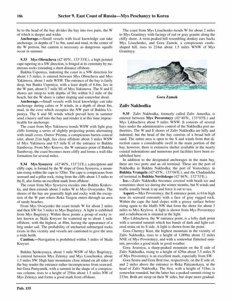
186 Sector 9. East Coast of Russia—Mys Peschanyy to Korea
Pub. 155
be to the head of the bay divides the bay into two parts, the Wof which is deeper and wider. 9.32 Anchorage.—Small vessels with local knowledge can takeanchorage, in depths of 7 to 9m, sand and mud, in the center ofthe W portion, but caution is necessary as dangerous squallsoccur in summer.
9.33 Mys Obrucheva (42°49'N., 133°33'E.), a high pointedcape tapering in a SW direction, is fringed at its extremity by nu-merous rocks extending a short distance offshore.9.33 Bukhta Uspeniya, indenting the coast in a NW direction forabout 1.5 miles, is entered between Mys Obrucheva and MysYakimova, about 1 mile WSW. The entrance of the bay is fairlydeep, but Banka Uspeniya, with a least depth of 6.8m, lies inthe W part, about 0.7 mile SE of Mys Yakimova. The N and Eshores are steep-to with depths of 9m within 0.2 mile of thebeach, but the W shore is rather sloping and somewhat shoal.9.33 Anchorage.—Small vessels with local knowledge can takeanchorage during calms or N winds, in a depth of about 8m,mud, in the cove which occupies the NW part of Bukhta Us-peniya. The S and SE winds which prevail here in summersend a heavy surf into the bay and render it at this time imprac-ticable for anchorage.9.33 The coast from Mys Yakimova trends WSW with light graycliffs forming a series of slightly projecting points alternatingwith small coves. Ostrov Prizma, a conspicuous barren conicalislet, about 21m high, lies close offshore about 3 miles WSWof Mys Yakimova and 0.5 mile E of the entrance to BukhtaSambovay. From Mys Korevo, the W entrance point of BukhtaSambovay, the coast becomes more cliffy and forms a wall-likeformation for several miles.
9.34 Mys Sysoyeva (42°46'N., 133°21'E.), a precipitous andcliffy cape, is formed by the W slope of Gora Sysoyeva, a moun-tain rising within the cape to 320m. The cape is conspicuous fromseaward and a pillar rock, rising from the cliffs about 1.5 miles tothe E, also forms an excellent mark from offshore.9.34 The coast from Mys Sysoyeva recedes into Bukhta Krakov-ka, and then extends about 3 miles W to Mys Ovseyenko. Theshores of the bay are generally high and rocky with the excep-tion of the W part where Reka Yazgou enters through an areaof sandy beaches.9.34 From Mys Ovseyenko the coast trends W for about 2 milesand then SW for 3 miles to Mys Bugristyy. A light is exhibitedfrom Mys Bugristyy. Within these points a group of rocky is-lets known as Skala Kreyser lie scattered up to about 1 mileoffshore, with the highest, at 40m, having the appearance of abrig under sail. The probability of uncharted submerged rocksexists in this vicinity and vessels are cautioned to give the areaa wide berth.9.34 Caution.—Navigation is prohibited within 3 miles of SkalaKreyser.
9.34 Bukhta Spokoynaya, about 1 mile WSW of Mys Bugristyy,is entered between Mys Zelenyy and Mys Lisuchenko, about1.5 miles SW. High bare mountains close inland on all sides ofthe bay render the entrance rather inconspicuous from seaward,but Gora Pamyatnik, with a summit in the shape of a conspicu-ous column, rises to a height of 258m about 1.5 miles NW ofMys Zelenyy and forms a good mark from offshore.
9.34 The coast from Mys Lisuchenko trends W for about 2 milesto Mys Granitnyy with facings of red or gray granite along thecliffy shore. A twin-peaked hill resembling donkey ears backsMys Lisuchenko, and Gora Zamok, a conspicuous castle-shaped hill, rises to 224m about 1.5 miles WNW of MysGranitnyy.
Zaliv Nakhodka
9.35 Zaliv Nakhodka, formerly called Zaliv Amerika, isentered between Mys Povorotnyy (42°40'N., 133°03'E.) andMys Likhacheva about 9 miles WNW. It consists of severalbays under the administrative control of the Nakhodka port au-thorities. The W and E shores of Zaliv Nakhodka are hilly andindented, but the head of the bay consists of a broad belt ofsand. The entire area is open to the S and winds from that di-rection cause a considerable swell in the main portion of thebay, however, there is extensive shelter available in the nearlycoastal indentations and numerous port facilities have been es-tablished here.9.35 In addition to the designated anchorages in the main bay,there are two ports and an oil terminal. These are the port ofNakhodka in Bukhta Nakhodka; the port of Vostochnyy inBukhta Vrangela (42°45'N., 133°04'E.); and the Chadaudzhaoil terminal in Bukhta Novitskogo (42°46'N., 132°53'E.).9.35 Ice.—Zaliv Nakhodka becomes covered with brash ice andsometimes sheet ice during the winter months, but N winds andtraffic usually break it up and force it out to sea.9.35 Aspect.—Mys Povorotnyy, the E entrance point, is 61m highnear its seaward extremity with a face of gray rugged rock.Within the cape the land slopes with a grassy surface beforerising again to the bluffs NW that form the shore for about 3miles to Mys Krylova. A light is shown from Mys Povorotnyyand a radiobeacon is situated at the light.9.35 Mys Likhacheva, the W entrance point, is a lofty dark pointwith a serrated summit which has bands of dark and light-col-ored strata on its S side. A light is shown from the point.9.35 Gora Chernyy Kust, the highest mountain in the vicinity ofZaliv Nakhodka, rises to a height of 1,009m about 12 milesNNE of Mys Povorotnyy, and with a somewhat flattened sum-mit, provides a good mark in good weather.9.35 Gora Arseniya, a sharp-peaked mountain on the E side ofZaliv Nakhodka, rising to a height of 429m about 7.5 miles Nof Mys Povorotnyy is an excellent mark, especially from SW.9.35 Gora Sestra and Gora Brat rise, respectively, on the E side of,and 2 miles above the entrance to Reka Patizanskaya, at thehead of Zaliv Nakhodka. The first, with a height of 318m, issomewhat rounded, but the latter has a peaked summit rising to233m. Both are steep on their W sides, but slope more gradual-
Gora Zamok
Sector 9. East Coast of Russia—Mys Peschanyy to Korea 187
Pub. 155
ly to the E. Being readily distinguished from the other hills inthe area, these two summits are good marks when entering thebay.9.35 Gora Popova, which is prominent, rises to a height of 160mabout 1 mile NE of Mys Likhacheva, on the W side of ZalivNakhodka. The slopes of this hill are covered with brush and aradio mast stands about 0.3 mile NE.9.35 There is a conspicuous white building situated on Mys Kry-lova on the E side of the bay.9.35 Pilotage.—Pilotage is compulsory for all vessels and avail-able 24 hours. See Pilotage in paragraph 9.35 for more infor-mation. 9.35 Regulations.—An IMO-adopted Traffic Separation Schemelies in the approaches to Zaliv Nakhodka and may best be seenon the chart. All vessels are required to use the Traffic Separa-tion Scheme.9.35 A two-way traffic route is in effect in Lane Nos. 1, 2, and 7.Vessels must keep to the right of the traffic separation zone.One-way traffic is in effect in Lane Nos. 3, 5, and 6; the direc-tion of the movement is determined by the Vessel Traffic Con-trol Center (VTCC). 9.35 Lighted Buoy No. 2 is moored at the intersection of FairwaysNo. 2, 3, and 7. Vessels should leave Lighted Buoy No. 2(42°46'N., 133°01'E.) or its location, to port; the buoy may bewithdrawn for the winter season. 9.35 Speed is restricted, as follows.
1. Vessels with a length of less than 50m—12 knots.2. Length of 50 to 150m—10 knots.3. Length more than 150m—8 knots.
9.35 Passing of vessels in traffic lanes is prohibited. Vessels trav-eling outside the traffic lanes when entering a lane must yieldto the vessel already in the lane. The navigation rules apply tovessels in crossing lanes and on crossing courses outside thetraffic lanes, unless the Vessel Traffic Control Center (VTCC)states otherwise. Vessels must keep constant radio watch whileunderway on a VHF radio channel indicated by the VTCC, andwhile at anchor on VHF channel 16. If a vessel’s VHF fails, thevessel must leave the traffic lane and anchor, taking measuresto communicate with the VTCC. The following serve as sig-nals:
1. In day time—Flag R (Romeo).2. At night—Light signal R (.-.).
Vessel Traffic Service.—A Vessel Traffic Control Center(VTCC) operates in Zaliv Nakhodka. This is a radar controlcenter, operating at all times, which monitors all vessels under-
way or at anchor in the area. The VTCC operates an IMO-ap-proved Vessel Traffic Service (VTS) that provides aninformation service, a traffic organization service, and a navi-gational assistance service. The VTS in Zaliv Nakhodka is anintegrated part of Zaliv Petra Velikogo VTS and comprisesSector 2 of that VTS. (See paragraph 9.42)
9.35 The VTS operates 24 hours N of a line from Mys Likhache-va (42°44'06''N, 132°51'00''E.) extending ESE to Mys Povorot-nyy (42°40'28''N., 133°02'16''E.), and includes the harbors ofNakhodka and Vostochnyy. 9.35 Participation in the VTS is mandatory for the following ves-sels:
1. All vessels greater than 20m in length.2. All foreign vessels.3. All vessels carrying dangerous cargo.4. All oil tankers.5. All vessels carrying 12 or more passengers.
9.35 For VTS contact information, see table titled Zaliv Nakhod-ka—Contact Information.
9.35 All vessels required to participate in the VTS Area of Con-trol must contact Nakhodka Traffic on VHF channel 13, givingthe information listed in the accompanying table titled ZalivNakhodka—Required VTS Entry/Departure Report Infor-mation, as follows:
1. Entering vessels—Upon entering the VTS Area ofControl.
2. Departing vessels—Not less than 15 minutes beforedeparting the berth or anchorage.
9.35 All vessels underway within the VTS area of control shouldmaintain a continuous listening watch on VHF channel 13. 9.35 All vessels at anchor within the VTS area of control shouldmaintain a continuous listening watch on VHF channel 16.
Zaliv Nakhodka—Contact Information
VTS
Call sign Nakhodka Traffic
VHF VHF channels 13 and 16
Telephone 78-4236-661373
Facsimile 78-4236-661366
E-mail [email protected]
Zaliv Nakhodka—Required VTS Entry/Departure Report Information
Item Type Description Entry Report
Departure Report
A Ship Vessel name, call sign, or ship station identity and flag. X X
C
Position
A 4-digit group giving latitude in degrees and minutessuffixed with N (north) or S (south) and a 5-digit groupgiving longitude in degrees and minutes suffixed withE (east) or W (west). X1
DTrue bearing (first 3 digits) and distance (state dis-tance) in nautical miles from a clearly identified land-mark (state landmark).
188 Sector 9. East Coast of Russia—Mys Peschanyy to Korea
Pub. 155
9.35 All vessels within the VTS area of control that wish to ceasemonitoring VHF or to change the VHF channel being usedmust first obtain permission from the VTS. 9.35 Contact Information.—for contact information, see tabletitled Zaliv Nakhodka—Contact Information9.35 Anchorage.—Anchorage can be obtained in several placesdesignated in Zaliv Nakhodka as described below:
1. Anchorage No. 1—Centered on position 42°49'19''N,132°55'31''E. Intended for Russian dry cargo vessels.
2. Anchorage No. 2—Centered on position 42°49'21''N,132°57'22''E. Intended for Russian dry cargo vessels.
3. Anchorage No. 3—Centered on position 42°48'13''N,132°57'31''E. Intended for foreign dry cargo vessels, andused for quarantine procedures.
4. Anchorage No. 4—Centered on position 42°47'25''N,132°55'33''E. Intended for Russian tankers, and used forquarantine procedures.
5. Anchorage No. 5—Centered on position 42°46'34''N,132°57'28''E. Intended for foreign dry cargo vessels, andused for quarantine procedures.
6. Anchorage No. 6—Centered on position 42°47'15''N,132°58'58''E. Intended for foreign dry cargo vessels, andused for quarantine procedures.
7. Anchorage No. 7—Centered on position 42°46'47''N,133°00'50''E. Intended for Russian dry cargo vessels.
8. Anchorage No. 8—Centered on position 42°46'04''N,133°01'59''E. Intended for Russian dry cargo vessels.
9. Anchorage No. 9—Centered on position 42°45'07''N,133°00'53''E. Intended for foreign dry cargo vessels, andused for quarantine procedures.
10. Anchorage No. 10—Centered on position42°45'43''N, 132°55'36''E. Intended for foreign tankers, andused for quarantine procedures. Caution needs to be taken toavoid a dangerous wreck centered on position 42°45'13''N,
132°55'28''E., with a depth of 20m.11. Large Vessel Anchorage—Centered on position
42°45'43''N, 132°57'55''E. 12. Tankers—Centered on position 42°44'46''N,
133°00'10''E. 9.35 Russian Regulated Area No 282 is designated a small craftanchorage and has two mooring buoys within its limits. 9.35 It is reported that in the N anchorages holding is very poorand dragging occurs, even in strong offshore winds and withfreshets from Reka Partizanskaya. Two anchors are recom-mended in the N areas after the middle of October. 9.35 Caution.—Measured distances are indicated on the chartand marked by several beacons in the vicinity of Mys Povorot-nyy.9.35 Several restricted areas lie in the approach to Zaliv Nakhod-ka and can best be seen on the chart.9.35 A wreck lies in Anchorage Area No. 10(308) in position42°45'12''N, 132°55'24''E. 9.35 Three dangerous submerged obstructions lie close N of MysKrylova in the following positions:
a. 42°43'10''N, 133°00'24''E.b. 42°43'14''N, 133°00'28''E.c. 42°43'06''N, 133°00'38''E.
9.35 The primary danger in Zaliv Nakhodka is Banka Kreyserwhich lies with a least depth of 3.1m, about 4.5 miles NNW ofMys Krylova. The bank is marked by lighted buoys. Vesselsproceeding into the bay are cautioned to avoid passing within0.5 mile of its position.9.35 Anchorage and fishing (trawling) are prohibited in severalareas in the approach to Zaliv Nakhodka. Vessels should takecare not to anchor in or proceed through these areas with an-chors or any other gear in the water. Numerous fishing vesselsare reported to work the areas off Zaliv Nakhodka and cautionis necessary especially in reduced visibility.
E True course A 3-digit group. X
F Vessel speed in knots and tenths of knots A 3-digit group. X
I Destination and ETA
Specify destination port name and give ETA using a 6-digit group giving day of month (first 2 digits), hoursand minutes (last 4 digits). If time zone used is notUTC, then specify time zone used.
X
O Maximum present static draft in meters A 4-digit group giving meters and centimeters. X
P Cargo on boardIdentify cargo including brief details of any dangerouscargoes as well as any harmful substances and gasesthat could endanger persons or the environment.
X
T Vessel’s representative and/or owner
Details of name and particulars of ships representativeand/or owner for provision of information. X
W Vessel size and type Details of length, breadth, tonnage, and type of vessel. X
X Miscellaneous Port Clearance Number. X
X1 Either format may be used.
Zaliv Nakhodka—Required VTS Entry/Departure Report Information
Item Type Description Entry Report
Departure Report
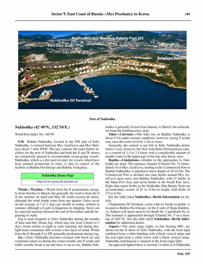
Sector 9. East Coast of Russia—Mys Peschanyy to Korea 189
Pub. 155
Nakhodka (42°49'N., 132°54'E.)
World Port Index No. 60730
9.36 Bukhta Nakhodka, located in the NW part of ZalivNakhodka, is entered between Mys Astaf'yeva and Mys Shef-nera about 1 mile NNW. The bay contains the main harbor fa-cilities for the port of Nakhodka and both the E and W shoresare extensively quayed to accommodate ocean-going vessels.Nakhodka, which is a first port of entry for vessels which havebeen granted permission to enter, is also in control of thefacilties at Bukhta Novitskogo and Bukhta Vrangelya.
9.36 Winds—Weather.—Winds from the N predominate strong-ly from October to March, but generally the wind is from the Sin the summer. In April and May SE winds exceed all others,although the wind might come from any quarter. Gales occuron the average of 3 to 5 days per month in winter, seldom insummer, although a S gale is dangerous to shipping. Snow canbe expected anytime between the end of November and the be-ginning of April.9.36 Fog is most frequent in Zaliv Nakhodka during the monthsof June and July. Dense fog, which may last from 2 hours to 3days, forms mostly at night or early morning, but during day-light hours sometimes lifts to form a low layer of cloud. Windsfrom the E through S to SW generally predominate during fog.9.36 Ice.—Zaliv Nakhodka becomes covered with brash ice andsometimes sheet ice during the winter months, but N winds andtraffic usually break it up and force it out to sea. Bukhta Nak-
hodka is generally frozen from January to March, but icebreak-ers keep the berthing areas clear.9.36 Tides—Currents.—The tidal rise in Bukhta Nakhodka isabout 0.7m under normal conditions; however, strong S windsmay raise the water level by 1.2m or more.9.36 Generally, the current is not felt in Zaliv Nakhodka belowOstrov Lisiy, however, the flow from Reka Partizanskaya caus-es a current of 1.5 to 3.5 knots with a considerable amount ofmuddy water in the upper part of the bay after heavy rains.9.36 Depths—Limitations.—Depths in the approaches to Nak-hodka are deep. The entrance channel (Channel No. 5) imme-diately N of Mys Astaf'yeva, leading to the Commercial Port inBukhta Nakhodka, is reported to have depths of 10 to13m. TheCommercial Port is divided into nine berths around Mys As-taf'yeva upon entry into Bukhta Nakhodka, with 21 berths inthe Main Port Area and seven berths in the South Port Area.Eight ship repair berths in the Nakhodka Ship Repair Yard canaccommodate vessels of 81 to 215m in length, with drafts of2.5 to 6.5m. 9.36 See the table titled Nakhodka—Berth Information for de-tails. 9.36 Chadaudzha Oil Terminal, a jetty with six berths available, islocated in Bukhta Novitskogo, on the E side of Skala Bakhire-va. Tankers will moor stern-to for Berth No. 5 and Berth No. 6.The terminal is approached through Channel No. 5 on a bear-ing of 269°18'. See the table titled Nakhodka—Berth Infor-mation for additional details. 9.36 Aspect.—The main range lights, in line bearing 000°, areshown on the N shore of Zaliv Nakhodka, with the front lightexhibited from a white building with a black vertical stripe andthe rear light from a white tower with a black vertical stripe.Nakhodka radiobeacon is situated at the front range light.9.36 An approach lighted buoy is moored 12 miles S of Nakhodka
Port of Nakhodka
Nakhodka Home Page
http://www.portcall.marinet.ru
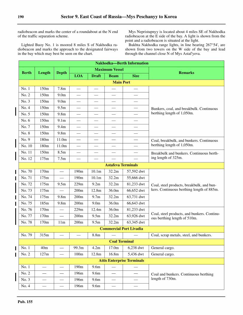
190 Sector 9. East Coast of Russia—Mys Peschanyy to Korea
Pub. 155
radiobeacon and marks the center of a roundabout at the N endof the traffic separation scheme.
9.36 Lighted Buoy No. 1 is moored 8 miles S of Nakhodka ra-diobeacon and marks the approach to the designated fairwaysin the bay which may best be seen on the chart.
9.36 Mys Nepristupnyy is located about 4 miles SE of Nakhodkaradiobeacon at the E side of the bay. A light is shown from thepoint and a radiobeacon is situated at the light.9.36 Bukhta Nakhodka range lights, in line bearing 267°54', areshown from two towers on the W side of the bay and leadthrough the channel close N of Mys Astaf'yeva.
Nakhodka—Berth Information
Berth Length Depth Maximum Vessel
RemarksLOA Draft Beam Size
Main Port
No. 1 150m 7.8m — — — —
Bunkers, coal, and breakbulk. Continuous berthing length of 1,050m.
No. 2 150m 9.0m — — — —
No. 3 150m 9.0m — — — —
No. 4 150m 9.5m — — — —
No. 5 150m 9.8m — — — —
No. 6 150m 9.1m — — — —
No. 7 150m 9.4m — — — —
No. 8 150m 9.8m — — — —
No. 9 180m 11.0m — — — — Coal, breakbulk, and bunkers. Continuous berthing length of 1,050m.No. 10 180m 11.0m — — — —
No. 11 150m 8.5m — — — — Breakbulk and bunkers. Continuous berth-ing length of 325m.No. 12 175m 7.5m — — — —
Astafeva Terminals
No. 70 170m — 190m 10.1m 32.2m 57,592 dwt
Coal, steel products, breakbulk, and bun-kers. Continuous berthing length of 885m.
No. 71 175m — 190m 10.1m 32.2m 55,666 dwt
No. 72 175m 9.5m 229m 9.2m 32.2m 81,233 dwt
No. 73 175m — 200m 12.8m 36.0m 66,652 dwt
No. 74 175m 9.8m 200m 9.7m 32.2m 63,731 dwt
No. 75 185m 9.8m 200m 9.0m 36.0m 66,643 dwt
No. 76 170m — 229m 12.4m 36.0m 81,233 dwtCoal, steel products, and bunkers. Continu-ous berthing length of 510m.No. 77 170m — 200m 9.5m 32.2m 63,926 dwt
No. 78 170m 11m 200m 9.5m 32.2m 63,345 dwt
Commercial Port Livadia
No. 79 315m — — 8.8m — — Coal, scrap metals, steel, and bunkers.
Coal Terminal
No. 1 40m — 99.3m 4.2m 17.0m 6,238 dwt General cargo.
No. 2 127m — 100m 12.8m 16.8m 5,436 dwt General cargo.
Attis Enterprise Terminals
No. 1 — — 190m 9.6m — —
Coal and bunkers. Continuous berthing length of 730m.
No. 2 — — 196m 9.6m — —
No. 3 — — 196m 9.6m — —
No. 4 — — 196m 9.6m — —
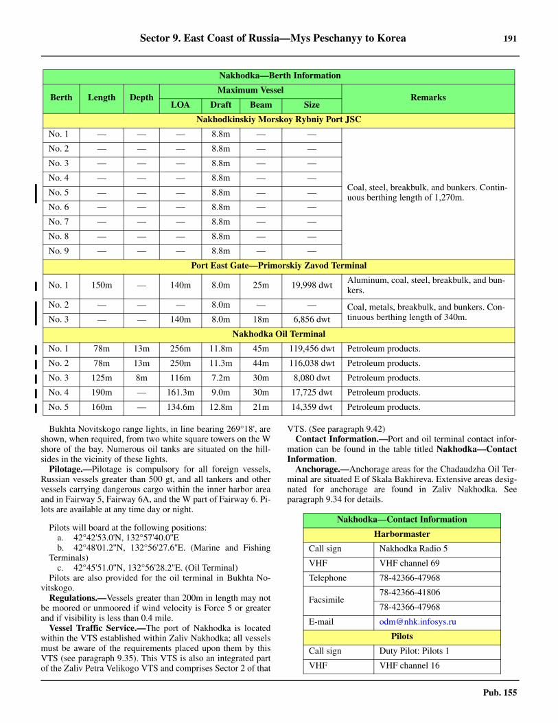
Sector 9. East Coast of Russia—Mys Peschanyy to Korea 191
Pub. 155
9.36 Bukhta Novitskogo range lights, in line bearing 269°18', areshown, when required, from two white square towers on the Wshore of the bay. Numerous oil tanks are situated on the hill-sides in the vicinity of these lights.9.36 Pilotage.—Pilotage is compulsory for all foreign vessels,Russian vessels greater than 500 gt, and all tankers and othervessels carrying dangerous cargo within the inner harbor areaand in Fairway 5, Fairway 6A, and the W part of Fairway 6. Pi-lots are available at any time day or night.
9.36 Pilots will board at the following positions: a. 42°42'53.0'N, 132°57'40.0''E b. 42°48'01.2''N, 132°56'27.6''E. (Marine and Fishing
Terminals) c. 42°45'51.0''N, 132°56'28.2''E. (Oil Terminal)
9.36 Pilots are also provided for the oil terminal in Bukhta No-vitskogo. 9.36 Regulations.—Vessels greater than 200m in length may notbe moored or unmoored if wind velocity is Force 5 or greaterand if visibility is less than 0.4 mile. 9.36 Vessel Traffic Service.—The port of Nakhodka is locatedwithin the VTS established within Zaliv Nakhodka; all vesselsmust be aware of the requirements placed upon them by thisVTS (see paragraph 9.35). This VTS is also an integrated partof the Zaliv Petra Velikogo VTS and comprises Sector 2 of that
VTS. (See paragraph 9.42) 9.36 Contact Information.—Port and oil terminal contact infor-mation can be found in the table titled Nakhodka—ContactInformation. 9.36 Anchorage.—Anchorage areas for the Chadaudzha Oil Ter-minal are situated E of Skala Bakhireva. Extensive areas desig-nated for anchorage are found in Zaliv Nakhodka. Seeparagraph 9.34 for details.
Nakhodkinskiy Morskoy Rybniy Port JSC
No. 1 — — — 8.8m — —
Coal, steel, breakbulk, and bunkers. Contin-uous berthing length of 1,270m.
No. 2 — — — 8.8m — —
No. 3 — — — 8.8m — —
No. 4 — — — 8.8m — —
No. 5 — — — 8.8m — —
No. 6 — — — 8.8m — —
No. 7 — — — 8.8m — —
No. 8 — — — 8.8m — —
No. 9 — — — 8.8m — —
Port East Gate—Primorskiy Zavod Terminal
No. 1 150m — 140m 8.0m 25m 19,998 dwt Aluminum, coal, steel, breakbulk, and bun-kers.
No. 2 — — — 8.0m — — Coal, metals, breakbulk, and bunkers. Con-tinuous berthing length of 340m.No. 3 — — 140m 8.0m 18m 6,856 dwt
Nakhodka Oil Terminal
No. 1 78m 13m 256m 11.8m 45m 119,456 dwt Petroleum products.
No. 2 78m 13m 250m 11.3m 44m 116,038 dwt Petroleum products.
No. 3 125m 8m 116m 7.2m 30m 8,080 dwt Petroleum products.
No. 4 190m — 161.3m 9.0m 30m 17,725 dwt Petroleum products.
No. 5 160m — 134.6m 12.8m 21m 14,359 dwt Petroleum products.
Nakhodka—Berth Information
Berth Length Depth Maximum Vessel
RemarksLOA Draft Beam Size
Nakhodka—Contact Information
Harbormaster
Call sign Nakhodka Radio 5
VHF VHF channel 69
Telephone 78-42366-47968
Facsimile78-42366-41806
78-42366-47968
E-mail [email protected]
Pilots
Call sign Duty Pilot: Pilots 1
VHF VHF channel 16
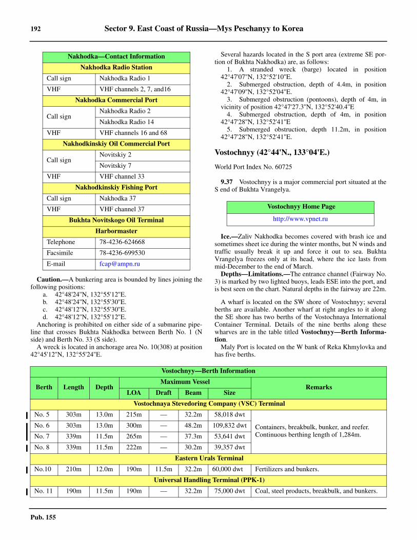
192 Sector 9. East Coast of Russia—Mys Peschanyy to Korea
Pub. 155
9.36 Caution.—A bunkering area is bounded by lines joining thefollowing positions:
a. 42°48'24''N, 132°55'12''E.b. 42°48'24''N, 132°55'30''E.c. 42°48'12''N, 132°55'30''E.d. 42°48'12''N, 132°55'12''E.
9.36 Anchoring is prohibited on either side of a submarine pipe-line that crosses Bukhta Nakhodka between Berth No. 1 (Nside) and Berth No. 33 (S side). 9.36 A wreck is located in anchorage area No. 10(308) at position42°45'12''N, 132°55'24''E.
9.36 Several hazards located in the S port area (extreme SE por-tion of Bukhta Nakhodka) are, as follows:
1. A stranded wreck (barge) located in position42°47'07''N, 132°52'10''E.
2. Submerged obstruction, depth of 4.4m, in position42°47'09''N, 132°52'04''E.
3. Submerged obstruction (pontoons), depth of 4m, invicinity of position 42°47'27.3''N, 132°52'40.4''E
4. Submerged obstruction, depth of 4m, in position42°47'28''N, 132°52'41''E
5. Submerged obstruction, depth 11.2m, in position42°47'28''N, 132°52'41''E.
Vostochnyy (42°44'N., 133°04'E.)
World Port Index No. 60725
9.37 Vostochnyy is a major commercial port situated at theS end of Bukhta Vrangelya.
9.37 Ice.—Zaliv Nakhodka becomes covered with brash ice andsometimes sheet ice during the winter months, but N winds andtraffic usually break it up and force it out to sea. BukhtaVrangelya freezes only at its head, where the ice lasts frommid-December to the end of March.9.37 Depths—Limitations.—The entrance channel (Fairway No.3) is marked by two lighted buoys, leads ESE into the port, andis best seen on the chart. Natural depths in the fairway are 22m.
9.37 A wharf is located on the SW shore of Vostochnyy; severalberths are available. Another wharf at right angles to it alongthe SE shore has two berths of the Vostochnaya InternationalContainer Terminal. Details of the nine berths along thesewharves are in the table titled Vostochnyy—Berth Informa-tion. 9.37 Maly Port is located on the W bank of Reka Khmylovka andhas five berths.
Nakhodka Radio Station
Call sign Nakhodka Radio 1
VHF VHF channels 2, 7, and16
Nakhodka Commercial Port
Call signNakhodka Radio 2
Nakhodka Radio 14
VHF VHF channels 16 and 68
Nakhodkinskiy Oil Commercial Port
Call signNovitskiy 2
Novitskiy 7
VHF VHF channel 33
Nakhodkinskiy Fishing Port
Call sign Nakhodka 37
VHF VHF channel 37
Bukhta Novitskogo Oil Terminal
Harbormaster
Telephone 78-4236-624668
Facsimile 78-4236-699530
E-mail [email protected]
Nakhodka—Contact Information
Vostochnyy Home Page
http://www.vpnet.ru
Vostochnyy—Berth Information
Berth Length Depth Maximum Vessel
RemarksLOA Draft Beam Size
Vostochnaya Stevedoring Company (VSC) Terminal
No. 5 303m 13.0m 215m — 32.2m 58,018 dwt
Containers, breakbulk, bunker, and reefer. Continuous berthing length of 1,284m.
No. 6 303m 13.0m 300m — 48.2m 109,832 dwt
No. 7 339m 11.5m 265m — 37.3m 53,641 dwt
No. 8 339m 11.5m 222m — 30.2m 39,357 dwt
Eastern Urals Terminal
No.10 210m 12.0m 190m 11.5m 32.2m 60,000 dwt Fertilizers and bunkers.
Universal Handling Terminal (PPK-1)
No. 11 190m 11.5m 190m — 32.2m 75,000 dwt Coal, steel products, breakbulk, and bunkers.
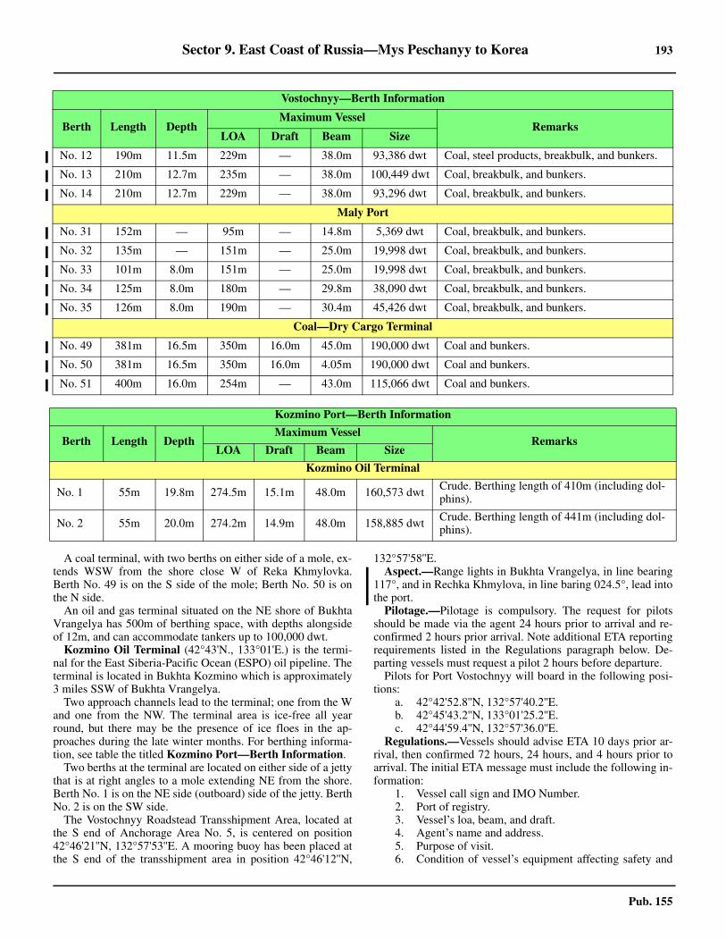
Sector 9. East Coast of Russia—Mys Peschanyy to Korea 193
Pub. 155
9.37 A coal terminal, with two berths on either side of a mole, ex-tends WSW from the shore close W of Reka Khmylovka.Berth No. 49 is on the S side of the mole; Berth No. 50 is onthe N side. 9.37 An oil and gas terminal situated on the NE shore of BukhtaVrangelya has 500m of berthing space, with depths alongsideof 12m, and can accommodate tankers up to 100,000 dwt. 9.37 Kozmino Oil Terminal (42°43'N., 133°01'E.) is the termi-nal for the East Siberia-Pacific Ocean (ESPO) oil pipeline. Theterminal is located in Bukhta Kozmino which is approximately3 miles SSW of Bukhta Vrangelya. 9.37 Two approach channels lead to the terminal; one from the Wand one from the NW. The terminal area is ice-free all yearround, but there may be the presence of ice floes in the ap-proaches during the late winter months. For berthing informa-tion, see table the titled Kozmino Port—Berth Information.9.37 Two berths at the terminal are located on either side of a jettythat is at right angles to a mole extending NE from the shore.Berth No. 1 is on the NE side (outboard) side of the jetty. BerthNo. 2 is on the SW side. 9.37 The Vostochnyy Roadstead Transshipment Area, located atthe S end of Anchorage Area No. 5, is centered on position42°46'21''N, 132°57'53''E. A mooring buoy has been placed atthe S end of the transshipment area in position 42°46'12''N,
132°57'58''E. 9.37 Aspect.—Range lights in Bukhta Vrangelya, in line bearing117°, and in Rechka Khmylova, in line baring 024.5°, lead intothe port. 9.37 Pilotage.—Pilotage is compulsory. The request for pilotsshould be made via the agent 24 hours prior to arrival and re-confirmed 2 hours prior arrival. Note additional ETA reportingrequirements listed in the Regulations paragraph below. De-parting vessels must request a pilot 2 hours before departure. 9.37 Pilots for Port Vostochnyy will board in the following posi-tions:
a. 42°42'52.8''N, 132°57'40.2''E.b. 42°45'43.2''N, 133°01'25.2''E.c. 42°44'59.4''N, 132°57'36.0''E.
9.37 Regulations.—Vessels should advise ETA 10 days prior ar-rival, then confirmed 72 hours, 24 hours, and 4 hours prior toarrival. The initial ETA message must include the following in-formation:
1. Vessel call sign and IMO Number.2. Port of registry.3. Vessel’s loa, beam, and draft.4. Agent’s name and address.5. Purpose of visit.6. Condition of vessel’s equipment affecting safety and
No. 12 190m 11.5m 229m — 38.0m 93,386 dwt Coal, steel products, breakbulk, and bunkers.
No. 13 210m 12.7m 235m — 38.0m 100,449 dwt Coal, breakbulk, and bunkers.
No. 14 210m 12.7m 229m — 38.0m 93,296 dwt Coal, breakbulk, and bunkers.
Maly Port
No. 31 152m — 95m — 14.8m 5,369 dwt Coal, breakbulk, and bunkers.
No. 32 135m — 151m — 25.0m 19,998 dwt Coal, breakbulk, and bunkers.
No. 33 101m 8.0m 151m — 25.0m 19,998 dwt Coal, breakbulk, and bunkers.
No. 34 125m 8.0m 180m — 29.8m 38,090 dwt Coal, breakbulk, and bunkers.
No. 35 126m 8.0m 190m — 30.4m 45,426 dwt Coal, breakbulk, and bunkers.
Coal—Dry Cargo Terminal
No. 49 381m 16.5m 350m 16.0m 45.0m 190,000 dwt Coal and bunkers.
No. 50 381m 16.5m 350m 16.0m 4.05m 190,000 dwt Coal and bunkers.
No. 51 400m 16.0m 254m — 43.0m 115,066 dwt Coal and bunkers.
Kozmino Port—Berth Information
Berth Length DepthMaximum Vessel
RemarksLOA Draft Beam Size
Kozmino Oil Terminal
No. 1 55m 19.8m 274.5m 15.1m 48.0m 160,573 dwt Crude. Berthing length of 410m (including dol-phins).
No. 2 55m 20.0m 274.2m 14.9m 48.0m 158,885 dwt Crude. Berthing length of 441m (including dol-phins).
Vostochnyy—Berth Information
Berth Length Depth Maximum Vessel
RemarksLOA Draft Beam Size
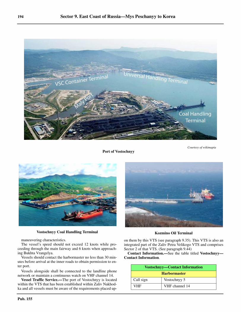
194 Sector 9. East Coast of Russia—Mys Peschanyy to Korea
Pub. 155
maneuvering characteristics.9.37 The vessel’s speed should not exceed 12 knots while pro-ceeding through the main fairway and 6 knots when approach-ing Bukhta Vrangelya. 9.37 Vessels should contact the harbormaster no less than 30 min-utes before arrival at the inner roads to obtain permission to en-ter port. 9.37 Vessels alongside shall be connected to the landline phonenetwork or maintain a continuous watch on VHF channel 14. 9.37 Vessel Traffic Service.—The port of Vostochnyy is locatedwithin the VTS that has been established within Zaliv Nakhod-ka and all vessels must be aware of the requirements placed up-
on them by this VTS (see paragraph 9.35). This VTS is also anintegrated part of the Zaliv Petra Velikogo VTS and comprisesSector 2 of that VTS. (See paragraph 9.44) 9.37 Contact Information.—See the table titled Vostochnyy—Contact Information.
Courtesy of wikimapia
Port of Vostochnyy
Vostochnyy Coal Handling Terminal Kozmino Oil Terminal
Vostochnyy—Contact Information
Harbormaster
Call sign Vostochnyy 5
VHF VHF channel 14
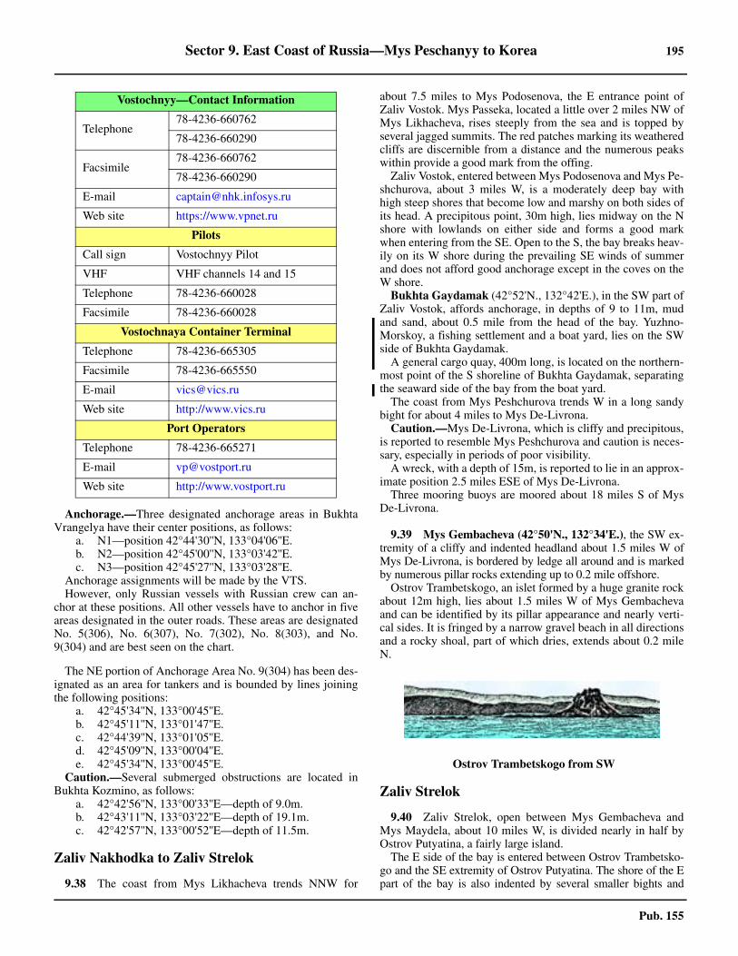
Sector 9. East Coast of Russia—Mys Peschanyy to Korea 195
Pub. 155
9.37 Anchorage.—Three designated anchorage areas in BukhtaVrangelya have their center positions, as follows:
a. N1—position 42°44'30''N, 133°04'06''E.b. N2—position 42°45'00''N, 133°03'42''E.c. N3—position 42°45'27''N, 133°03'28''E.
9.37 Anchorage assignments will be made by the VTS. 9.37 However, only Russian vessels with Russian crew can an-chor at these positions. All other vessels have to anchor in fiveareas designated in the outer roads. These areas are designatedNo. 5(306), No. 6(307), No. 7(302), No. 8(303), and No.9(304) and are best seen on the chart.
9.37 The NE portion of Anchorage Area No. 9(304) has been des-ignated as an area for tankers and is bounded by lines joiningthe following positions:
a. 42°45'34''N, 133°00'45''E.b. 42°45'11''N, 133°01'47''E.c. 42°44'39''N, 133°01'05''E.d. 42°45'09''N, 133°00'04''E.e. 42°45'34''N, 133°00'45''E.
9.37 Caution.—Several submerged obstructions are located inBukhta Kozmino, as follows:
a. 42°42'56''N, 133°00'33''E—depth of 9.0m.b. 42°43'11''N, 133°03'22''E—depth of 19.1m.c. 42°42'57''N, 133°00'52''E—depth of 11.5m.
Zaliv Nakhodka to Zaliv Strelok
9.38 The coast from Mys Likhacheva trends NNW for
about 7.5 miles to Mys Podosenova, the E entrance point ofZaliv Vostok. Mys Passeka, located a little over 2 miles NW ofMys Likhacheva, rises steeply from the sea and is topped byseveral jagged summits. The red patches marking its weatheredcliffs are discernible from a distance and the numerous peakswithin provide a good mark from the offing.9.38 Zaliv Vostok, entered between Mys Podosenova and Mys Pe-shchurova, about 3 miles W, is a moderately deep bay withhigh steep shores that become low and marshy on both sides ofits head. A precipitous point, 30m high, lies midway on the Nshore with lowlands on either side and forms a good markwhen entering from the SE. Open to the S, the bay breaks heav-ily on its W shore during the prevailing SE winds of summerand does not afford good anchorage except in the coves on theW shore.9.38 Bukhta Gaydamak (42°52'N., 132°42'E.), in the SW part ofZaliv Vostok, affords anchorage, in depths of 9 to 11m, mudand sand, about 0.5 mile from the head of the bay. Yuzhno-Morskoy, a fishing settlement and a boat yard, lies on the SWside of Bukhta Gaydamak. 9.38 A general cargo quay, 400m long, is located on the northern-most point of the S shoreline of Bukhta Gaydamak, separatingthe seaward side of the bay from the boat yard. 9.38 The coast from Mys Peshchurova trends W in a long sandybight for about 4 miles to Mys De-Livrona. 9.38 Caution.—Mys De-Livrona, which is cliffy and precipitous,is reported to resemble Mys Peshchurova and caution is neces-sary, especially in periods of poor visibility.9.38 A wreck, with a depth of 15m, is reported to lie in an approx-imate position 2.5 miles ESE of Mys De-Livrona.9.38 Three mooring buoys are moored about 18 miles S of MysDe-Livrona.
9.39 Mys Gembacheva (42°50'N., 132°34'E.), the SW ex-tremity of a cliffy and indented headland about 1.5 miles W ofMys De-Livrona, is bordered by ledge all around and is markedby numerous pillar rocks extending up to 0.2 mile offshore.9.39 Ostrov Trambetskogo, an islet formed by a huge granite rockabout 12m high, lies about 1.5 miles W of Mys Gembachevaand can be identified by its pillar appearance and nearly verti-cal sides. It is fringed by a narrow gravel beach in all directionsand a rocky shoal, part of which dries, extends about 0.2 mileN.
Zaliv Strelok
9.40 Zaliv Strelok, open between Mys Gembacheva andMys Maydela, about 10 miles W, is divided nearly in half byOstrov Putyatina, a fairly large island.9.40 The E side of the bay is entered between Ostrov Trambetsko-go and the SE extremity of Ostrov Putyatina. The shore of the Epart of the bay is also indented by several smaller bights and
Telephone78-4236-660762
78-4236-660290
Facsimile78-4236-660762
78-4236-660290
E-mail [email protected]
Web site https://www.vpnet.ru
Pilots
Call sign Vostochnyy Pilot
VHF VHF channels 14 and 15
Telephone 78-4236-660028
Facsimile 78-4236-660028
Vostochnaya Container Terminal
Telephone 78-4236-665305
Facsimile 78-4236-665550
E-mail [email protected]
Web site http://www.vics.ru
Port Operators
Telephone 78-4236-665271
E-mail [email protected]
Web site http://www.vostport.ru
Vostochnyy—Contact Information
9.39Ostrov Trambetskogo from SW
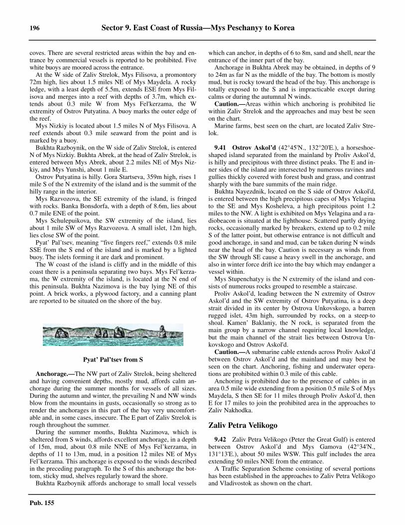
196 Sector 9. East Coast of Russia—Mys Peschanyy to Korea
Pub. 155
coves. There are several restricted areas within the bay and en-trance by commercial vessels is reported to be prohibited. Fivewhite buoys are moored across the entrance.9.40 At the W side of Zaliv Strelok, Mys Filisova, a promontory72m high, lies about 1.5 miles NE of Mys Maydela. A rockyledge, with a least depth of 5.5m, extends ESE from Mys Fil-isova and merges into a reef with depths of 3.7m, which ex-tends about 0.3 mile W from Mys Fel'kerzama, the Wextremity of Ostrov Putyatina. A buoy marks the outer edge ofthe reef.9.40 Mys Nizkiy is located about 1.5 miles N of Mys Filisova. Areef extends about 0.3 mile seaward from the point and ismarked by a buoy. 9.40 Bukhta Razboynik, on the W side of Zaliv Strelok, is enteredN of Mys Nizkiy. Bukhta Abrek, at the head of Zaliv Strelok, isentered between Mys Abrek, about 2.2 miles NE of Mys Niz-kiy, and Mys Yunshi, about 1 mile E.9.40 Ostrov Putyatina is hilly. Gora Startseva, 359m high, rises 1mile S of the N extremity of the island and is the summit of thehilly range in the interior.9.40 Mys Razvozova, the SE extremity of the island, is fringedwith rocks. Banka Bonsdorfa, with a depth of 8.6m, lies about0.7 mile ENE of the point. 9.40 Mys Schulepuikova, the SW extremity of the island, liesabout 1 mile SW of Mys Razvozova. A small islet, 12m high,lies close SW of the point. 9.40 Pyat’ Pal’tsev, meaning “five fingers reef,” extends 0.8 mileSSE from the S end of the island and is marked by a lightedbuoy. The islets forming it are dark and prominent.9.40 The W coast of the island is cliffy and in the middle of thiscoast there is a peninsula separating two bays. Mys Fel’kerza-ma, the W extremity of the island, is located at the N end ofthis peninsula. Bukhta Nazimova is the bay lying NE of thispoint. A brick works, a plywood factory, and a canning plantare reported to be situated on the shore of the bay.
9.40 Anchorage.—The NW part of Zaliv Strelok, being shelteredand having convenient depths, mostly mud, affords calm an-chorage during the summer months for vessels of all sizes.During the autumn and winter, the prevailing N and NW windsblow from the mountains in gusts, occasionally so strong as torender the anchorages in this part of the bay very uncomfort-able and, in some cases, insecure. The E part of Zaliv Strelok isrough throughout the summer.9.40 During the summer months, Bukhta Nazimova, which issheltered from S winds, affords excellent anchorage, in a depthof 15m, mud, about 0.8 mile NNE of Mys Fel’kerzama, indepths of 11 to 13m, mud, in a position 12 miles NE of MysFel’kerzama. This anchorage is exposed to the winds describedin the preceding paragraph. To the S of this anchorage the bot-tom, sticky mud, shelves regularly toward the shore.9.40 Bukhta Razboynik affords anchorage to small local vessels
which can anchor, in depths of 6 to 8m, sand and shell, near theentrance of the inner part of the bay.9.40 Anchorage in Bukhta Abrek may be obtained, in depths of 9to 24m as far N as the middle of the bay. The bottom is mostlymud, but is rocky toward the head of the bay. This anchorage istotally exposed to the S and is impracticable except duringcalms or during the autumnal N winds. 9.40 Caution.—Areas within which anchoring is prohibited liewithin Zaliv Strelok and the approaches and may best be seenon the chart.9.40 Marine farms, best seen on the chart, are located Zaliv Stre-lok.
9.41 Ostrov Askol’d (42°45'N., 132°20'E.), a horseshoe-shaped island separated from the mainland by Proliv Askol’d,is hilly and precipitous with three distinct peaks. The E and in-ner sides of the island are intersected by numerous ravines andgullies thickly covered with forest bush and grass, and contrastsharply with the bare summits of the main ridge.9.41 Bukhta Nayezdnik, located on the S side of Ostrov Askol'd,is entered between the high precipitous capes of Mys Yelaginato the SE and Mys Kosheleva, a high precipitous point 1.2miles to the NW. A light is exhibited on Mys Yelagina and a ra-diobeacon is situated at the lighthouse. Scattered partly dryingrocks, occasionally marked by breakers, extend up to 0.2 mileS of the latter point, but otherwise entrance is not difficult andgood anchorage, in sand and mud, can be taken during N windsnear the head of the bay. Caution is necessary as winds fromthe SW through SE cause a heavy swell in the anchorage, andalso in winter force drift ice into the bay which may endanger avessel within.9.41 Mys Stupenchatyy is the N extremity of the island and con-sists of numerous rocks grouped to resemble a staircase. 9.41 Proliv Askol’d, leading between the N extremity of OstrovAskol’d and the SW extremity of Ostrov Putyatina, is a deepstrait divided in its center by Ostrova Unkovskogo, a barrenrugged islet, 43m high, surrounded by rocks, on a steep-toshoal. Kamen’ Baklaniy, the N rock, is separated from themain group by a narrow channel requiring local knowledge,but the main channel of the strait lies between Ostrova Un-kovskogo and Ostrov Askol'd.9.41 Caution.—A submarine cable extends across Proliv Askol’dbetween Ostrov Askol’d and the mainland and may best beseen on the chart. Anchoring, fishing and underwater opera-tions are prohibited within 0.3 mile of this cable.9.41 Anchoring is prohibited due to the presence of cables in anarea 0.5 mile wide extending from a position 0.5 mile S of MysMaydela, S then SE for 11 miles through Proliv Askol’d, thenE for 17 miles to join the prohibited area in the approaches toZaliv Nakhodka.
Zaliv Petra Velikogo
9.42 Zaliv Petra Velikogo (Peter the Great Gulf) is enteredbetween Ostrov Askol’d and Mys Gamova (42°34'N.,131°13'E.), about 50 miles WSW. This gulf includes the areaextending 50 miles NNE from the entrance.9.42 A Traffic Separation Scheme consisting of several portionshas been established in the approaches to Zaliv Petra Velikogoand Vladivostok as shown on the chart.
Pyat’ Pal’tsev from S
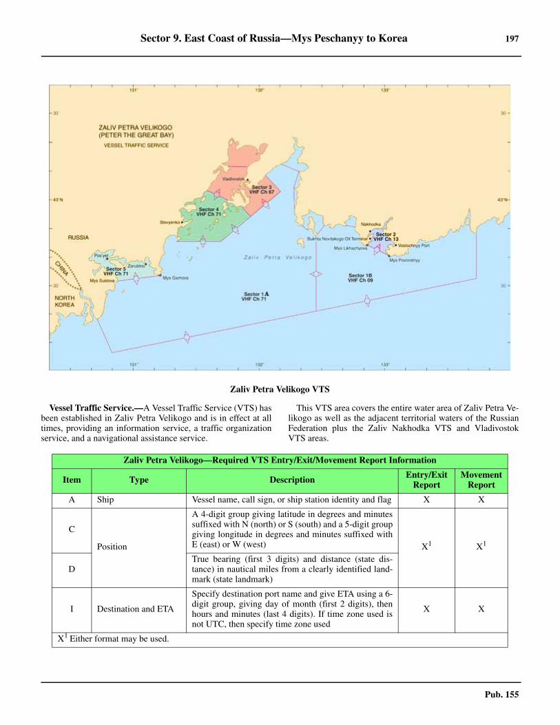
Sector 9. East Coast of Russia—Mys Peschanyy to Korea 197
Pub. 155
9.42 Vessel Traffic Service.—A Vessel Traffic Service (VTS) hasbeen established in Zaliv Petra Velikogo and is in effect at alltimes, providing an information service, a traffic organizationservice, and a navigational assistance service.
9.42 This VTS area covers the entire water area of Zaliv Petra Ve-likogo as well as the adjacent territorial waters of the RussianFederation plus the Zaliv Nakhodka VTS and VladivostokVTS areas.
Zaliv Petra Velikogo VTS
Zaliv Petra Velikogo—Required VTS Entry/Exit/Movement Report Information
Item Type Description Entry/Exit Report
Movement Report
A Ship Vessel name, call sign, or ship station identity and flag X X
C
Position
A 4-digit group giving latitude in degrees and minutessuffixed with N (north) or S (south) and a 5-digit groupgiving longitude in degrees and minutes suffixed withE (east) or W (west) X1 X1
DTrue bearing (first 3 digits) and distance (state dis-tance) in nautical miles from a clearly identified land-mark (state landmark)
I Destination and ETA
Specify destination port name and give ETA using a 6-digit group, giving day of month (first 2 digits), thenhours and minutes (last 4 digits). If time zone used isnot UTC, then specify time zone used
X X
X1 Either format may be used.
198 Sector 9. East Coast of Russia—Mys Peschanyy to Korea
Pub. 155
9.42 The VTS is comprised of the following six sectors: 1. Sector 1A (Vladivostok Traffic—VHF channel
71).—Includes the area within the territorial sea border ofthe Russian Federation and the boundaries of Sector 1B,Sector 3, Sector 4, and Sector 5.
2. Sector 1B (Nakhodka Traffic—VHF channel 9).—Includes the area within the territorial sea border of the Rus-sian Federation and the boundaries of Sector 1A and Sector2.
Note.—Sector 1 is divided between Sector 1A and Sector1B along the meridian of 132°28'E.
3. Sector 2 (Nakhodka Traffic—VHF channel 13).—Includes the waters of Zaliv Nakhodka N of a line from MysLikhacheva (42°44'00.0''N, 132°51'00.0''E.) extending ESEto Mys Povorotnyy (42°40'26.4''N., 133°02'34.2''E.).
4. Sector 3 (Vladivostok Traffic—VHF channel 67).—Includes the harbor waters of Vladivostok port along with itsapproaches.
5. Sector 4 (Vladivostok Traffic—VHF channel 71).—Includes the waters of Slavyanka port along with its ap-proaches.
6. Sector 5 (Vladivostok Traffic—VHF channel 71).—Includes the waters of Zaliv Pos’yeta N of a line from MysSuslova (42°30'55.2''N., 130°51'49.2''E.) to Mys Gamova(42°33'25.8''N., 131°13'10.6''E.).
9.42 See the chartlet titled Zaliv Petra Velikogo VTS for a de-tailed display of the sector boundaries of the VTS.9.42 The following vessels must participate in the VTS:
1. All vessels longer than 20m in length.2. All foreign vessels.3. All vessels carrying dangerous cargo.4. All oil tankers.5. All vessels carrying 12 or more passengers.
9.42 Vessels should report, as follows:1. Entering and Departing Vessels:
a. Contact Vladivostok Traffic on VHF channel 71 up-on crossing the territorial sea border of the Russian Feder-ation arriving from or departing to Sector 1A.
b. Contact Nakhodka Traffic on VHF channel 9 uponcrossing the territorial sea border of the Russian Federa-tion arriving from or departing to Sector 1B.2. Movement Reports—Made whenever vessel is cross-
ing any Sector boundary or when ceasing or restarting move-ment, using the following VHF channels:
a. VHF channels 9 and 71—upon crossing the bound-ary between Sector 1A and Sector 1B.
b. VHF channels 9 and 13—upon crossing the bound-ary between Sector 1B and Sector 2.
c. VHF channels 67 and 71—upon crossing theboundary between Sector 1A and Sector 3.
d. VHF channel 71—upon crossing the boundary be-tween Sector 3 and Sector 4.
e. VHF channel 71—upon crossing the boundary be-tween Sector 1A, Sector 4, and Sector 5.
9.42 All vessels must contact either Vladivostok Traffic or Nak-hodka Traffic, giving the information listed in the accompany-ing table titled Zaliv Petra Velikogo—Required VTS Entry/Exit/Movement Report Information, as follows: 9.42 Incident Reports are to be made to the VTS of the Sector inwhich the incident is occurring, using the VHF channel appro-
priate for that sector as identified earlier. An incident is when-ever a vessel is involved in a collision, running aground, orcommitting or detecting sea pollution. 9.42 All vessels must report any event that may be a threat to thesafety of navigation plus any other information requested bythe VTS. These reports are to be made to the VTS of the Sectorin which the event is occurring or from which a request ismade. 9.42 Vessels should maintain a continuous listening watch on theVHF channel assigned to the Sector in which they are located. 9.42 Onboard AIS equipment should be in operation at all timeswhen vessel is within any one of the VTS sectors.9.42 See paragraph 9.35 and paragraph 9.54 for further details.
9.43 Poluostrov Murav’yev-Amurskiy (43°10'N.,132°00'E.) and Arkhipelag Yevgenii, a chain of islands and is-lets extending 18 miles SW of the peninsula, divide the gulf in-to two parts.9.43 The bay W of the peninsula is Amurskiy Zaliv and that E ofit is Ussuriyskiy Zaliv. The harbor of Vladivostok is located atthe SW end of the peninsula.9.43 Caution.—A large portion of Zaliv Petra Velikogo is prohib-ited to navigation or anchorage; there are numerous exerciseand regulated areas in the N parts of the gulf that are under thedirect control of the naval authorities at Vladivostok.9.43 The islands in the chain extending SE have coastlines withnumerous marine farms. During the fishing season, numerousfishing craft towing nets may be encountered in the approachesto the gulf.
Ussuriyskiy Zaliv
9.44 Mys Sysoyeva (42°51'N., 132°19'E.), located about1.2 miles W of Mys Maydela, the W entrance point of ZalivStrelok, marked by a light; is the E entrance point of Ussuriys-kiy Zaliv. It is a precipitous headland formed at the seawardend of a narrow elevated peninsula. When approached from theSW during periods of low fog, but with a clear sky, the sum-mits of Ostrov Askol’d and Mys Sysoyeva will often stand out,with even the guano-covered rocks off Mys Pal’chatyy beingseen at times. A light is shown from Mys Sysoyeva. 9.44 Gora Bol’shoy Iosif, rising to a height of 536m about 7 milesNNE of Mys Sysoyeva, is also a good mark when the air isclear.9.44 The coast from Mys Sysoyeva trends NW across a bight for1.8 miles to Mys Veselkina, a precipitous cape with a largegranite rock known as Kekur Shitau, located about 0.1 mile offits shore. From the latter point the coast trends N with numer-ous fringing rocks and several indenting coves, Bukhta Bezy-myannaya being the largest with a N shore of gray cliffs.9.44 Caution.—Marine farms have been established along thecoastline of Ussuriyskiy Zaliv.
9.44 Mys Kom-Pikho-Sakho, located about 4.5 miles NNW ofMys Sysoyeva, is the S extremity of a narrow peninsula pro-jecting from the coast in a general SW direction and is devoidof vegetation. The point consists principally of sand and clay,the pink color of which contrasts sharply with the gray cliffs ofthe main coastline. 9.44 Kamen’ Priglubyy, two groups of rocks located on a reef ly-
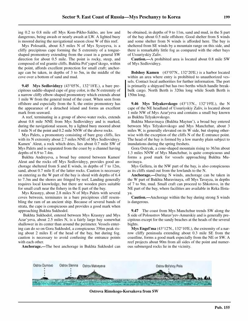
Sector 9. East Coast of Russia—Mys Peschanyy to Korea 199
Pub. 155
ing 0.2 to 0.8 mile off Mys Kom-Pikho-Sakho, are low anddangerous, being awash or nearly awash at LW. A lighted buoyis moored during the navigational season close W of this reef.9.44 Mys Polosatik, about 8.5 miles N of Mys Sysoyeva, is acliffy precipitous cape forming the S extremity of a tongue-shaped promontory extending from the coast in a general SWdirection for about 0.5 mile. The point is rocky, steep, andcomposed of red granite cliffs. Bukhta Pol’yapol’skogo, withinthe point, affords excellent protection for small craft; anchor-age can be taken, in depths of 3 to 5m, in the middle of thecove over a bottom of sand and mud.
9.45 Mys Sedlovidnyy (43°05'N., 132°18'E.), a bare pre-cipitous saddle-shaped cape of gray color, is the N extremity ofa narrow cliffy elbow-shaped promontory which extends about1 mile W from the general trend of the coast. When seen fromoffshore and especially from the S, the entire promontory hasthe appearance of a detached island and forms an excellentmark from seaward.9.45 A reef, terminating in a group of above-water rocks, extendsabout 0.8 mile NNE from Mys Sedlovidnyy and is marked,during the navigational season, by a lighted buoy moored about1 mile N of the point and 0.2 mile NNW of the above rocks.9.45 Mys Palets, a promontory consisting of bare gray cliffs, lieswith its N extremity about 2.7 miles NNE of Mys Sedlovidnyy.Kamen’ Aleut, a rock which dries, lies about 0.7 mile SW ofMys Palets and is separated from the coast by a channel havingdepths of 6.9 to 7.4m.9.45 Bukhta Andreyeva, a broad bay entered between Kamen'Aleut and the rocks off Mys Sedlovidnyy, provides good an-chorage sheltered from S and E winds, in depths of 7 to 12m,sand, about 0.7 mile E of the latter rocks. Caution is necessaryon entering as the W part of the bay is shoal with depths of 6.4to 7.3m and the shores are fringed by reef. Landing generallyrequires local knowledge, but there are wooden piers suitablefor small craft near the fishery in the E part of the bay.9.45 Mys Krasnyy, about 2.8 miles N of Mys Palets with severalcoves between, terminates in a bare precipitous cliff resem-bling the ram of an ancient ship. Because of several bands ofstrata, the cape is conspicuous and provides a good mark whenapproaching Bukhta Sukhodol.9.45 Bukhta Sukhodol, entered between Mys Krasnyy and MysAzar’yeva, about 2.5 miles N, is a fairly large bay somewhatshallower in its center than around the perimeter. Vessels enter-ing can do so on Gora Sukhodol, a conspicuous 356m peak ris-ing about 2 miles E of the head of the bay, but during fog.caution is necessary to avoid confusing the entrance pointswith each other.9.45 Anchorage.—The best anchorage in Bukhta Sukhodol can
be obtained, in depths of 9 to 11m, sand and mud, in the S partof the bay about 0.5 mile offshore. Good shelter from S windsand some shelter from N winds is afforded here. The bay issheltered from SE winds by a mountain range on this side, andthere is remarkably little fog as compared with the other baysof Ussuriyskiy Zaliv. 9.45 Caution.—A prohibited area is located about 0.8 mile SWof Mys Sedlovidnyy.
Bolshoy Kamen (43°07'N., 132°20'E.) is a harbor locatedwithin an area where entry is prohibited to unauthorized ves-sels. Contact local authorities for further information. The portis primarily a shipyard but has two berths which handle break-bulk cargo. North Berth is 320m long while South Berth is150m long.
9.46 Mys Telyakovskogo (43°13'N., 132°19'E.), the Ncape of the NE headland of Ussuriyskiy Zaliv, is located about1 mile NW of Mys Azar'yeva and contains a small bay knownas Bukhta Telyakovskogo.9.46 Bukhta Muravinaya (Bukhta Maytun’), a broad bay enteredbetween Mys Telyakovskogo and Mys Manchzhur, about 3miles W, is generally elevated on its W side, but sloping other-wise with the exception of the cliffs N of the E entrance point.The head of the bay is formed by a low marshy plain subject toinundations during the spring freshets.9.46 Gora Ostryak, a cone-shaped mountain rising to 363m about1.3 miles NNW of Mys Manchzhur, is quite conspicuous andforms a good mark for vessels approaching Bukhta Mu-ravinaya. 9.46 Mys Gellera, in the NW part of the bay, is also conspicuousas its cliffs stand out from the lowlands to the N.9.46 Anchorage.—During N winds, anchorage can be taken inthe W part of Bukhta Muravinaya, off Mys Tavayza, in depthsof 7 to 9m, mud. Small craft can proceed to Shkotovo, in theNE part of the bay, where facilities are available in Reka Ilista-ya. 9.46 Caution.—Anchorage within the bay during strong S windsis dangerous.
9.47 The coast from Mys Manchzhur trends SW along theS side of Poloustrov Murav'yev-Amurskiy and is generally pre-cipitous except for the sandy beaches at the heads of the severalbights. 9.47 Mys Engel'ma (43°12'N., 132°10'E.), the extremity of a nar-row cliffy peninsula extending about 0.3 mile SE from thecoastline, forms a good mark especially from the NE or SW. Areef projects about 90m from all sides of the point and numer-ous submerged rocks lie in the vicinity.
Ostrova Rimskogo-Korsakova from SW
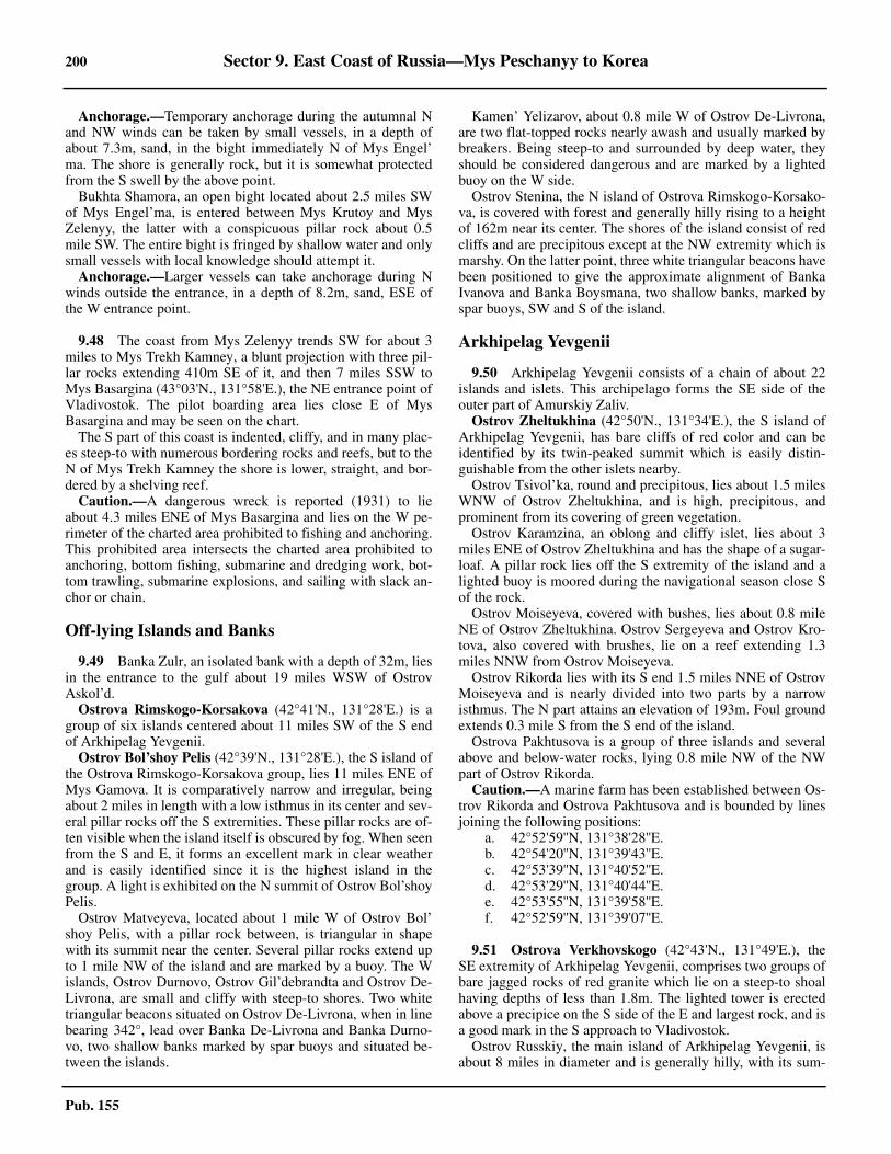
200 Sector 9. East Coast of Russia—Mys Peschanyy to Korea
Pub. 155
9.47 Anchorage.—Temporary anchorage during the autumnal Nand NW winds can be taken by small vessels, in a depth ofabout 7.3m, sand, in the bight immediately N of Mys Engel’ma. The shore is generally rock, but it is somewhat protectedfrom the S swell by the above point.9.47 Bukhta Shamora, an open bight located about 2.5 miles SWof Mys Engel’ma, is entered between Mys Krutoy and MysZelenyy, the latter with a conspicuous pillar rock about 0.5mile SW. The entire bight is fringed by shallow water and onlysmall vessels with local knowledge should attempt it. 9.47 Anchorage.—Larger vessels can take anchorage during Nwinds outside the entrance, in a depth of 8.2m, sand, ESE ofthe W entrance point.
9.48 The coast from Mys Zelenyy trends SW for about 3miles to Mys Trekh Kamney, a blunt projection with three pil-lar rocks extending 410m SE of it, and then 7 miles SSW toMys Basargina (43°03'N., 131°58'E.), the NE entrance point ofVladivostok. The pilot boarding area lies close E of MysBasargina and may be seen on the chart.9.48 The S part of this coast is indented, cliffy, and in many plac-es steep-to with numerous bordering rocks and reefs, but to theN of Mys Trekh Kamney the shore is lower, straight, and bor-dered by a shelving reef.9.48 Caution.—A dangerous wreck is reported (1931) to lieabout 4.3 miles ENE of Mys Basargina and lies on the W pe-rimeter of the charted area prohibited to fishing and anchoring.This prohibited area intersects the charted area prohibited toanchoring, bottom fishing, submarine and dredging work, bot-tom trawling, submarine explosions, and sailing with slack an-chor or chain.
Off-lying Islands and Banks
9.49 Banka Zulr, an isolated bank with a depth of 32m, liesin the entrance to the gulf about 19 miles WSW of OstrovAskol’d.9.49 Ostrova Rimskogo-Korsakova (42°41'N., 131°28'E.) is agroup of six islands centered about 11 miles SW of the S endof Arkhipelag Yevgenii.9.49 Ostrov Bol’shoy Pelis (42°39'N., 131°28'E.), the S island ofthe Ostrova Rimskogo-Korsakova group, lies 11 miles ENE ofMys Gamova. It is comparatively narrow and irregular, beingabout 2 miles in length with a low isthmus in its center and sev-eral pillar rocks off the S extremities. These pillar rocks are of-ten visible when the island itself is obscured by fog. When seenfrom the S and E, it forms an excellent mark in clear weatherand is easily identified since it is the highest island in thegroup. A light is exhibited on the N summit of Ostrov Bol’shoyPelis.9.49 Ostrov Matveyeva, located about 1 mile W of Ostrov Bol’shoy Pelis, with a pillar rock between, is triangular in shapewith its summit near the center. Several pillar rocks extend upto 1 mile NW of the island and are marked by a buoy. The Wislands, Ostrov Durnovo, Ostrov Gil’debrandta and Ostrov De-Livrona, are small and cliffy with steep-to shores. Two whitetriangular beacons situated on Ostrov De-Livrona, when in linebearing 342°, lead over Banka De-Livrona and Banka Durno-vo, two shallow banks marked by spar buoys and situated be-tween the islands.
9.49 Kamen’ Yelizarov, about 0.8 mile W of Ostrov De-Livrona,are two flat-topped rocks nearly awash and usually marked bybreakers. Being steep-to and surrounded by deep water, theyshould be considered dangerous and are marked by a lightedbuoy on the W side.9.49 Ostrov Stenina, the N island of Ostrova Rimskogo-Korsako-va, is covered with forest and generally hilly rising to a heightof 162m near its center. The shores of the island consist of redcliffs and are precipitous except at the NW extremity which ismarshy. On the latter point, three white triangular beacons havebeen positioned to give the approximate alignment of BankaIvanova and Banka Boysmana, two shallow banks, marked byspar buoys, SW and S of the island.
Arkhipelag Yevgenii
9.50 Arkhipelag Yevgenii consists of a chain of about 22islands and islets. This archipelago forms the SE side of theouter part of Amurskiy Zaliv.9.50 Ostrov Zheltukhina (42°50'N., 131°34'E.), the S island ofArkhipelag Yevgenii, has bare cliffs of red color and can beidentified by its twin-peaked summit which is easily distin-guishable from the other islets nearby. 9.50 Ostrov Tsivol’ka, round and precipitous, lies about 1.5 milesWNW of Ostrov Zheltukhina, and is high, precipitous, andprominent from its covering of green vegetation. 9.50 Ostrov Karamzina, an oblong and cliffy islet, lies about 3miles ENE of Ostrov Zheltukhina and has the shape of a sugar-loaf. A pillar rock lies off the S extremity of the island and alighted buoy is moored during the navigational season close Sof the rock. 9.50 Ostrov Moiseyeva, covered with bushes, lies about 0.8 mileNE of Ostrov Zheltukhina. Ostrov Sergeyeva and Ostrov Kro-tova, also covered with brushes, lie on a reef extending 1.3miles NNW from Ostrov Moiseyeva.9.50 Ostrov Rikorda lies with its S end 1.5 miles NNE of OstrovMoiseyeva and is nearly divided into two parts by a narrowisthmus. The N part attains an elevation of 193m. Foul groundextends 0.3 mile S from the S end of the island. 9.50 Ostrova Pakhtusova is a group of three islands and severalabove and below-water rocks, lying 0.8 mile NW of the NWpart of Ostrov Rikorda.9.50 Caution.—A marine farm has been established between Os-trov Rikorda and Ostrova Pakhtusova and is bounded by linesjoining the following positions:
a. 42°52'59''N, 131°38'28''E.b. 42°54'20''N, 131°39'43''E.c. 42°53'39''N, 131°40'52''E.d. 42°53'29''N, 131°40'44''E.e. 42°53'55''N, 131°39'58''E.f. 42°52'59''N, 131°39'07''E.
9.51 Ostrova Verkhovskogo (42°43'N., 131°49'E.), theSE extremity of Arkhipelag Yevgenii, comprises two groups ofbare jagged rocks of red granite which lie on a steep-to shoalhaving depths of less than 1.8m. The lighted tower is erectedabove a precipice on the S side of the E and largest rock, and isa good mark in the S approach to Vladivostok.9.51 Ostrov Russkiy, the main island of Arkhipelag Yevgenii, isabout 8 miles in diameter and is generally hilly, with its sum-
Sector 9. East Coast of Russia—Mys Peschanyy to Korea 201
Pub. 155
mit, Gora Russkiy, rising to 293m in the N part. The S part ofthe island, which rises to two equally high peaks of 280m, isgenerally precipitous along the S and E shores with numerousindentations and projections.9.51 Caution.—Ostrov Russkiy is reported to be under the con-trol of the Russian Navy and forms a good part of the navalbase at Vladivostok. Numerous prohibited anchorage and navi-gation areas exist in the vicinity of the island and vessels areadvised not to approach the area without permission.
9.52 Ostrov Shkota, a triangular island connected to the Send of Ostrov Russkiy by a causeway, is precipitous and bor-dered by rocks and reef. Bukhta Novyy Dzhigit, located be-tween the above island and Mys Tobizina, about 1 mile E, isblocked on its W side by Kamni Sivuch’i, a group of above andbelow-water rocks, but can be entered on the E side in depthsof about 27m. Vessels with local knowledge can proceed intothe coves where there are depths of 9 to 11m in the middle.9.52 Ostrov Lavrova and Ostrov Yengel’ma lie on a shallow bankand are connected to the SW coast of Ostrov Russkiy by acauseway located about 1.5 miles NW of the Ostrov Shkota.9.52 Proliv Starka, with a least depth of 4m, separates Mys Rogo-zina, the W extremity of Ostrov Russkiy, from the NE end ofOstrov Popova. Marked by a lighted buoy on its S side and abarrel buoy on its N side, this strait is frequently used by smallcraft rounding the island.
9.52 Bukhta Novik (43°03'N., 131°50'E.), a long inlet entered be-tween Mys Larionova and Mys Staritskogo, at the NW extremityof Ostrov Russkiy, consists of a fairly wide and deep outer partand a long narrow inner section. The entrance, with rocky spitson each side, is marked by several spar buoys. Ostrov Ushi, abarren islet off the W entrance point, is conspicuous. 9.52 A short channel connects the outer part of Bukhta Novik toBukhta Bezymyannaya (43°04'N., 131°51'E.) to the N. Thischannel is named the Torpedo Boat Canal and is approximately300m in length and 25m wide, with depths of 4.6 to 6.6m. Alight is shown from each side of the N entrance. 9.52 Anchorage.—Anchorage can be taken nearly anywhere inthe outer part of Bukhta Novik, but the inner part is suitable on-ly for small craft and special moorings. The entire bay is underthe control of the naval facility at Vladivostok and is closed tonon-military vessels.9.52 Caution.—A submarine cable has been laid between BukhtaNovik and Gavin Semenovskaya. For further information, seethe Caution section in paragraph 9.53.9.52 It has been reported (2014) small vessels should observe aspeed limit of 8 knots when in transit through the Torpedo BoatCanal between Bukhta Bezymyannaya and the outer part ofBukhta Novik.
9.53 Ostrov Popova, close SW of Ostrov Russkiy, is hilly,covered with grass, and thickly wooded in places. Gora Popo-va, on the NW side of the island, attains an elevation of 179m.Mys Likandera, the S extremity of the island, is a lofty narrowpeninsula. 9.53 Ostrov Kozlova lies 2 miles WNW of Mys Likandera. Os-trov Dva Brata, an islet with three summits, lies about 1 mileNW of Ostrov Kozlova and a shoal, with a depth of 8.2m, liesmidway between.9.53 Ostrov Naumova, Ostrov Malyy, 43m high, and OstrovKlykova, 60m high, lie on a shoal which extends 1.5 miles SEfrom the SE side of Ostrov Popova. A lighted buoy is mooredat the seaward end of the shoal.9.53 Ostrov Reyneke lies close S of Mys Likandera and has asummit which attains an elevation of 162m. A rock, with adepth of 2.5m, lies close off the S coast of the island, and an is-let lies close off the NE point of the island.
Vladivostok (43°07'N., 131°54'E.)
World Port Index No. 60610
9.54 Vladivostok is the major port of the Russian Far East.Primary exports include steel, timber, and bulk and bagged car-go; imports include grain, cellulose, and coal. Other generalcargo is also handled at the port, as well as containers and com-mercial fishing. Vladivostok is also home to the Russian NavalPacific Fleet. 9.54 Proliv Bosfor Vostochnyy, leading between the S extremityof Poluostrov Murav'yev-Amurskiy and the NE side of OstrovRusskiy, forms the two entrances to Vladivostok Harbor, withthe main approach from the E between Mys Karazina and MysBasargina. The primary facilities are situated in Bukhta Zolo-toy Rog, a horn-shaped bay located in the NE part of the har-bor, and are protected by the surrounding hills from nearly allwinds.9.54 There are a number of piers and a levee in Bukhta Uliss,which is entered between Mys Artura (43°04'N., 131°55'E.)and Mys Ostryy, 0.8 mile NW.
9.54 Winds—Weather.—Winds from the N prevail from the be-ginning of September to the end of March, and SE winds pre-vail for the balance of the year. The mean annual velocity, aswell as the mean monthly velocities, of the wind is, on the av-erage, about 4 knots. Winds with a velocity of 32 knots orgreater predominate about 1 day a month.9.54 The mean annual temperature for Vladivostok is 4.4°C. Thecoldest month is January which has a mean daily temperatureof -13.9°C. The warmest month is August with a mean dailytemperature of 20.6°C. A minimum temperature of -30.0°Cwas recorded in the month of January.9.54 Restricted visibility of less than 0.25 mile, due to fog, hasbeen reported (2009). 9.54 Ice.—Proliv Bosfor Vostochnyy begins to freeze in January,first in its NW part. The ice, advancing gradually, ordinarilyreaches Ostrov Skrypleva by the middle of this month. The
Ostrova Verkhovskogo
Vladivostok Home Page
http://www.vmtp.ru
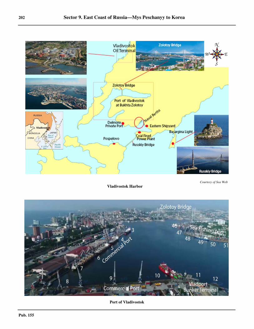
202 Sector 9. East Coast of Russia—Mys Peschanyy to Korea
Pub. 155
Courtesy of Sea Web
Vladivostok Harbor
Port of Vladivostok
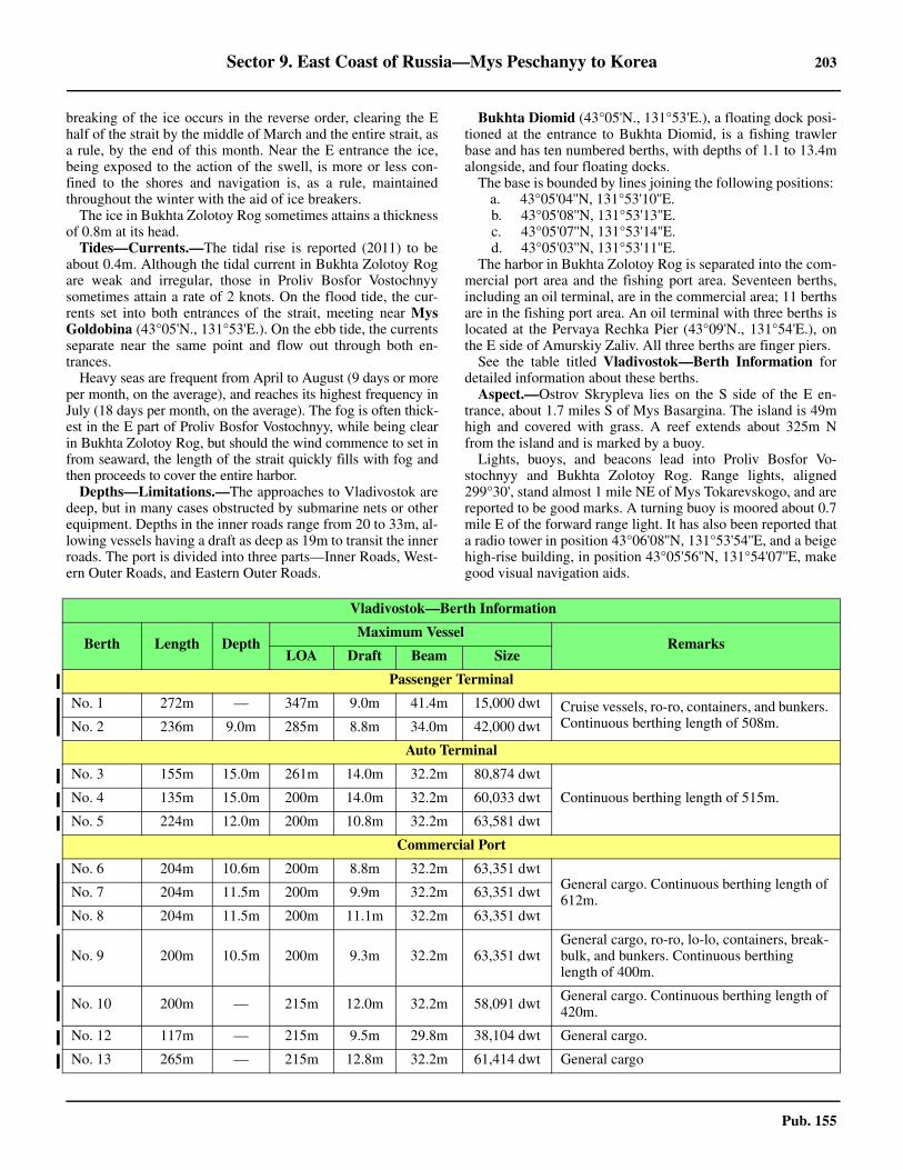
Sector 9. East Coast of Russia—Mys Peschanyy to Korea 203
Pub. 155
breaking of the ice occurs in the reverse order, clearing the Ehalf of the strait by the middle of March and the entire strait, asa rule, by the end of this month. Near the E entrance the ice,being exposed to the action of the swell, is more or less con-fined to the shores and navigation is, as a rule, maintainedthroughout the winter with the aid of ice breakers.9.54 The ice in Bukhta Zolotoy Rog sometimes attains a thicknessof 0.8m at its head.9.54 Tides—Currents.—The tidal rise is reported (2011) to beabout 0.4m. Although the tidal current in Bukhta Zolotoy Rogare weak and irregular, those in Proliv Bosfor Vostochnyysometimes attain a rate of 2 knots. On the flood tide, the cur-rents set into both entrances of the strait, meeting near MysGoldobina (43°05'N., 131°53'E.). On the ebb tide, the currentsseparate near the same point and flow out through both en-trances. 9.54 Heavy seas are frequent from April to August (9 days or moreper month, on the average), and reaches its highest frequency inJuly (18 days per month, on the average). The fog is often thick-est in the E part of Proliv Bosfor Vostochnyy, while being clearin Bukhta Zolotoy Rog, but should the wind commence to set infrom seaward, the length of the strait quickly fills with fog andthen proceeds to cover the entire harbor.9.54 Depths—Limitations.—The approaches to Vladivostok aredeep, but in many cases obstructed by submarine nets or otherequipment. Depths in the inner roads range from 20 to 33m, al-lowing vessels having a draft as deep as 19m to transit the innerroads. The port is divided into three parts—Inner Roads, West-ern Outer Roads, and Eastern Outer Roads.
9.54 Bukhta Diomid (43°05'N., 131°53'E.), a floating dock posi-tioned at the entrance to Bukhta Diomid, is a fishing trawlerbase and has ten numbered berths, with depths of 1.1 to 13.4malongside, and four floating docks. 9.54 The base is bounded by lines joining the following positions:
a. 43°05'04''N, 131°53'10''E.b. 43°05'08''N, 131°53'13''E.c. 43°05'07''N, 131°53'14''E.d. 43°05'03''N, 131°53'11''E.
9.54 The harbor in Bukhta Zolotoy Rog is separated into the com-mercial port area and the fishing port area. Seventeen berths,including an oil terminal, are in the commercial area; 11 berthsare in the fishing port area. An oil terminal with three berths islocated at the Pervaya Rechka Pier (43°09'N., 131°54'E.), onthe E side of Amurskiy Zaliv. All three berths are finger piers.9.54 See the table titled Vladivostok—Berth Information fordetailed information about these berths.9.54 Aspect.—Ostrov Skrypleva lies on the S side of the E en-trance, about 1.7 miles S of Mys Basargina. The island is 49mhigh and covered with grass. A reef extends about 325m Nfrom the island and is marked by a buoy. 9.54 Lights, buoys, and beacons lead into Proliv Bosfor Vo-stochnyy and Bukhta Zolotoy Rog. Range lights, aligned299°30', stand almost 1 mile NE of Mys Tokarevskogo, and arereported to be good marks. A turning buoy is moored about 0.7mile E of the forward range light. It has also been reported thata radio tower in position 43°06'08''N, 131°53'54''E, and a beigehigh-rise building, in position 43°05'56''N, 131°54'07''E, makegood visual navigation aids.
Vladivostok—Berth Information
Berth Length Depth Maximum Vessel
RemarksLOA Draft Beam Size
Passenger Terminal
No. 1 272m — 347m 9.0m 41.4m 15,000 dwt Cruise vessels, ro-ro, containers, and bunkers. Continuous berthing length of 508m.No. 2 236m 9.0m 285m 8.8m 34.0m 42,000 dwt
Auto Terminal
No. 3 155m 15.0m 261m 14.0m 32.2m 80,874 dwt
Continuous berthing length of 515m.No. 4 135m 15.0m 200m 14.0m 32.2m 60,033 dwt
No. 5 224m 12.0m 200m 10.8m 32.2m 63,581 dwt
Commercial Port
No. 6 204m 10.6m 200m 8.8m 32.2m 63,351 dwtGeneral cargo. Continuous berthing length of 612m. No. 7 204m 11.5m 200m 9.9m 32.2m 63,351 dwt
No. 8 204m 11.5m 200m 11.1m 32.2m 63,351 dwt
No. 9 200m 10.5m 200m 9.3m 32.2m 63,351 dwtGeneral cargo, ro-ro, lo-lo, containers, break-bulk, and bunkers. Continuous berthing length of 400m.
No. 10 200m — 215m 12.0m 32.2m 58,091 dwt General cargo. Continuous berthing length of 420m.
No. 12 117m — 215m 9.5m 29.8m 38,104 dwt General cargo.
No. 13 265m — 215m 12.8m 32.2m 61,414 dwt General cargo
204 Sector 9. East Coast of Russia—Mys Peschanyy to Korea
Pub. 155
9.54 Bukhta Zolotoy Rog is surrounded on three sides by highhills with dense urban structures, allowing for many visualaids, with little to no ice during the winter months. Within theharbor are numerous beacons and buoys.9.54 Pilotage.—Pilotage is compulsory for foreign vessels. Pilots
must be requested through the vessel’s agent 24 hours prior toarrival and then confirmed again 4 hours prior to arrival. Noticeof ETA and any changes should also be reported to the VTS onVHF channel 67 (see paragraph titled Vessel Traffic Servicebelow). Pilots will monitor VHF channels 16 and 67.
Vladport Bunker Terminal
No. 11 60m 9.2m 150m 9.1m 20.4m 20,000 dwt Petroleum products.
Vladivostok Container Terminal
No. 14 210m — 262m 12.8m 37.3m 51,602 dwtContainers, breakbulk, and bunkers. Continu-ous berthing length of 740m.No. 15 210m 13.0m 294.1m 12.8m 40.0m 68,240 dwt
No. 16 320m 13.0m 294.1m 12.8m 32.2m 63,439 dwt
FEMSTA Terminal
No. 44 284m 8.3m — — — 8,870 dwt Metals, steel, breakbulk, and bunkers.
Vladivostok Sea Fishing Port
No. 45 150m — 176m 10.0m — 31,764 dwt General cargo.
No. 46 194m — 200m 10.6m — 61,496 dwt General cargo.
No. 47 185m 9.7m 148.5m 7.8m — 11,579 dwt General cargo.
No. 48 242m — 172m 12.8m — 16,552 dwt General cargo.
No. 49 269m — 215m 12.8m — 46,513 dwt General cargo.
No. 50 342m — 238m 10.0m 32.2m 61,496 dwt General cargo.
No. 51 100m — 160m 9.3m 25.0m 17,725 dwt General cargo.
No. 52 176m 9.6m 172m 9.5m 25.0m 17,733 dwt General cargo.
No. 53 176m — 268.8m 11.3m 35.2m 52,788 dwt General cargo.
Vladivostok Oil Terminal—Pervaya Rechka Tanker Pier
No. 1 31m 8.3m 161m 8.0m 23.0m 17,725 dwt Petroleum products.
No. 2 74m 9.9m 183m 9.5m 32.2m 50,760 dwt Petroleum products.
No. 3 110m 8.0m 123m 7.7m 18.8m 10,463 dwt Petroleum products.
Goldobin Bay
DiomidCommer-cial Port
180m — 180m 8.7m 30.0m 37,816 dwt General cargo.
JSC Turnif—Fishing Vessels Berth
Fish Berth 290m — 180m 8.4m 30.0m 34,930 dwt Ro-ro, lo-lo, containers, fishing vessels, reef-
er, and bunkers.
Sollers Transhipment Terminal
Sollers Berth 140m — 164m 8.4m 23.2m 13,950 dwt Ro-ro, lo-lo, breakbulk, and bunkers.
Dalzavod Terminal
Freight Handling Berth
260m 11.5m 176m — 27.9m 23,685 dwt General cargo.
Vladivostok—Berth Information
Berth Length Depth Maximum Vessel
RemarksLOA Draft Beam Size
Sector 9. East Coast of Russia—Mys Peschanyy to Korea 205
Pub. 155
9.54 Foreign vessels embark a pilot in an area designated as 175-A, centered on position 43°02'54''N, 131°59'36''E, or at anyone of the following positions:
a. 43°04'12''N, 131°46'30''E.b. 43°04'40''N, 131°48'00''E.c. 43°07'30''N, 131°47'00''E.d. 43°02'22''N, 131°57'47''E.
9.54 Russian vessels embark a pilot in an area designated as 175-B, bounded by lines joining the following positions:
a. 43°04'02''N, 131°58'24''E.b. 43°04'12''N, 131°58'24''E.c. 43°04'12''N, 132°00'24''E.d. 43°03'44''N, 132°00'24''E. e. 43°04'12''N, 131°46'30''E.f. 43°04'40''N, 131°48'00''E.g. 43°07'30''N, 131°47'00''E.h. 43°02'22''N, 131°57'47''E.
9.54 During the ice season, pilot boarding will be in position43°07'00''N, 131°46'06''E. 9.54 At any time of the year the pilot boarding area can bechanged as agreed upon by the pilot, depending on the actualprevailing environmental conditions. 9.54 Pilotage is also compulsory for mooring, shifting berths, andany movement along the quays that is needed.9.54 The use of tugs is compulsory for all operations which re-quire a pilot; four tugs available. Tugs will normally join the
vessel near the Fairway Buoy. 9.54 Regulations.—Vladivostok is approached through the trafficseparation scheme (TSS) that has been established in Zaliv Pe-tra Velikogo. The scheme may be seen on the chart. The ap-proach position for the port from the SW is 41°39'N, 131°36'E.From this position, vessels proceed NE within the separationscheme, until reaching Ussuriyskiy Zaliv at the E end of ProlivBosfor Vostochnyy. The strait, Proliv Bosfor Vostochnyy(43°04'17''N, 131°50'24''E), leads between the N end of Polu-ostrov Sapernyy (43°03'N., 131°54'.) and the S end of Poluos-trov Murav’yev Amerskiy to the harbor entrance. Fairwayshave been established at each end of Proliv Bosfor Vostochnyyand in the S part Bukhta Zolotoy Rog.9.54 The Vladivostok TSS has not been adopted by IMO, but mari-ners are advised to comply with Rule 10 of the InternationalRegulations for Preventing Collision at Sea (1972).9.54 Passage through the W approaches into Proliv Bosfor Vo-stochnyy is prohibited and passage SE of Ostrov Skrypleva(43°01'44''N., 131°57'11''E.) is prohibited.
9.54 A speed restriction of 9 knots is in effect from the time ofcrossing the harbor entrance until the second turning buoy intothe actual port area, where the speed restriction becomes 6knots. Passage through Bukhta Zoltoy Rog is often made morenarrow than indicated on the chart by numerous vessels med-moored along either side of the bay.
Vladivostok—Required VTS Entry/Movement/Departure Report Information
Item Type Description Entry Report
Movement Report
Departure Report
A Ship Vessel name, call sign, or ship station identityand flag X X X
C
Position
A 4-digit group giving latitude in degrees andminutes suffixed with N (north) or S (south) anda 5-digit group giving longitude in degrees andminutes suffixed with E (east) or W (west) X1 X1
DTrue bearing (first 3 digits) and distance (statedistance) in nautical miles from a clearly identi-fied landmark (state landmark)
E True course A 3-digit group
F Vessel speed in knotsand tenths of knots A 3-digit group
I Destination and ETA
Specify destination port name and give ETA us-ing a 6-digit group giving day of month (first 2digits), then hours and minutes (last 4 digits). Iftime zone used is not UTC, then specify timezone used
X X
O Maximum presentstatic draft in meters A 4-digit group giving meters and centimeters X
P Cargo on board
Identify cargo including brief details of any dan-gerous cargoes as well as any harmful substanc-es and gases that could endanger persons or theenvironment
X
206 Sector 9. East Coast of Russia—Mys Peschanyy to Korea
Pub. 155
9.54 Vessel Traffic Service.—A Vessel Traffic Service (VTS) hasbeen established to control all vessel movement in and aroundthe harbor area and approaches. The VTS operates 24 hours aday and provides an information service, a traffic organizationservice, and a navigational assistance service. The VladivostokVTS is an integrated part of Zaliv Petra Velikogo VTS andcomprises Sector 3 (Vladivostok) and Sector 4 (Slavyanka) ofthat VTS. (See the Vessel Traffic Service section within para-graph 9.41 for further details) 9.54 Participation in the VTS is mandatory for the following ves-sels:
1. All vessels greater than 20m in length.2. All foreign vessels.3. All vessels carrying dangerous cargo.4. All oil tankers.5. All vessels carrying 12 or more passengers.
9.54 All vessels required to participate in the VTS Area of Con-trol must report to Vladivostok Traffic. For Vladivostok Trafficcontact information see the table titled Vladivostok—ContactInformation.9.54 These reports must provide the information listed in the tabletitled Vladivostok—Required VTS Entry/Movement/De-parture Report Information and are given, as follows:
1. Entering vessels—Upon passing the following re-porting points (RP):
a. RP1—42°46'12''N, 131°34'00''E.b. RP2—42°55'48''N, 132°46'08''E.c. RP3—42°50'00''N, 131°47'24''E.
2. Movement Reports—Made to Vladivostok Trafficon VHF channel 71 whenever vessel crosses the boundarybetween Sector 3 (Vladivostok) and Sector 4 (Slavyanka).
3. Departing vessels—Made to Vladivostok Traffic onVHF channel 71 not less than 15 minutes before departingthe berth or anchorage.
9.54 All vessels underway should maintain a continuous listeningwatch on VHF channel 67 when in Sector 3 and on VHF chan-nel 71 when in Sector 4.
9.54 All vessels within the VTS area of control that wish to ceasemonitoring VHF or to change the VHF channel being usedmust first obtain permission from the VTS. 9.54 See the chartlet titled Vladivostok VTS for detailed displayof the TSS, VTS, and Reporting Points (RP).9.54 Contact Information.—See the table titled VladivostokPort—Contact Information. 9.54 Anchorage.—Vessels must have permission to anchor grant-ed by the VTS. Several designated anchorage areas exist, both
T Vessel’s representativeand/or owner
Details of name and particulars of ship’s repre-sentative and/or owner for provision of informa-tion
X
W Vessel size and type Details of length, breadth, tonnage and type ofvessel X
X Miscellaneous Port Clearance Number X
X1 Either format may be used.
Vladivostok—Required VTS Entry/Movement/Departure Report Information
Item Type Description Entry Report
Movement Report
Departure Report
Vladivostok—Contact Information
Harbormaster
Telephone 78-4232-302893
Facsimile 78-4232-220621
Port Control
Call sign Vladivostok Port Control
VHF VHF channels 12 and 67
Telephone78-4232-302813
78-4232-495767
Facsimile 78-4232-221513
Port Authority
Telephone78-4232-495222
78-4232-224074
Facsimile 78-4232-222364
E-mail [email protected]
Web site https://vmtp.ru
Chief Controller’s Office
Call sign Vladivostok Radio 2
VHF VHF channels 14 and 16
Telephone78-4232-221893
78-4232-495143
Facsimile 78-4232-495353
Vessel Traffic Service
Call sign Vladivostok Traffic
VHF VHF channels 16 and 67 (Sector 3) and 71 (Sector 4)
Telephone 78-4232-498400
Facsimile 78-4232-498438
E-mail [email protected]
Note.—All services are available 24 hours.
Vladivostok—Contact Information
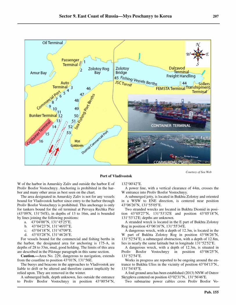
Sector 9. East Coast of Russia—Mys Peschanyy to Korea 207
Pub. 155
W of the harbor in Amurskiy Zaliv and outside the harbor E ofProliv Bosfor Vostochnyy. Anchoring is prohibited in the har-bor and many other areas as best seen on the chart. 9.54 The area designated in Amurskiy Zaliv is not for any vesselsbound for Vladivostok harbor since entry to the harbor throughProliv Bosfor Vostochnyy is prohibited. This anchorage is onlyfor tankers bound for the oil terminal at Pervaya Rechka Pier(43°09'N, 131°54'E), in depths of 13 to 16m, and is boundedby lines joining the following positions:
a. 43°04'00''N, 131°45'25''E.b. 43°04'23''N, 131°46'07''E.c. 43°04'18''N, 131°47'09''E.d. 43°03'28''N, 131°46'26''E.
9.54 For vessels bound for the commercial and fishing berths inthe harbor, the designated area for anchoring is 175-A, indepths of 28 to 33m, mud, good holding. The limits of this areaare described in the Pilotage paragraph in this same section. 9.54 Caution.—Area No. 229, dangerous to navigation, extendsfrom the coastline to position 43°01'N, 131°56E. 9.54 The buoys and beacons in the approaches to Vladivostok areliable to drift or be altered and therefore cannot implicitly berelied upon. They are removed in the winter.9.54 A submerged hulk, depth unknown, lies outside the entranceto Proliv Bosfor Vostochnyy in position 43°00'54''N,
132°00'42''E. 9.54 A power line, with a vertical clearance of 44m, crosses theW entrance into Proliv Bosfor Vostochnyy.9.54 A submerged jetty, is located in Bukhta Zolotoy and orientedin a WSW to ENE direction, is centered near position43°06'26''N, 131°55'05''E. 9.54 Two stranded wrecks are located in Bukhta Diomid in posi-tion 43°05'27''N, 131°53'32'E and position 43°05'18''N,131°53'12'E; depths are unknown. 9.54 A stranded wreck is located in the E part of Bukhta ZolotoyRog in position 43°06'16''N, 131°55'34'E. 9.54 A dangerous wreck, with a depth of 12.3m, is located in theW part of Bukhta Zolotoy Rog in position 43°06'26''N,131°52'54''E; a submerged obstruction, with a depth of 12.8m,lies in nearly the same latitude but in longitude 131°52'52''E. 9.54 A dangerous wreck, with a depth of 12.3m, is situated inProliv Bosfor Vostochnyy in position 43°06'25''N,131°52'54''E.9.54 Works in progress are reported to be ongoing around the en-trance to Bukhta Uliss in the vicinity of position 43°04'13''N.,131°54'45''E. 9.54 A foul ground area has been established (2013) NNW of OstrovSkrypleva centered on position 43°02'31''N., 131°56'46''E. 9.54 Two submarine power cables cross Proliv Bosfor Vo-
Courtesy of Sea Web
Port of Vladivostok
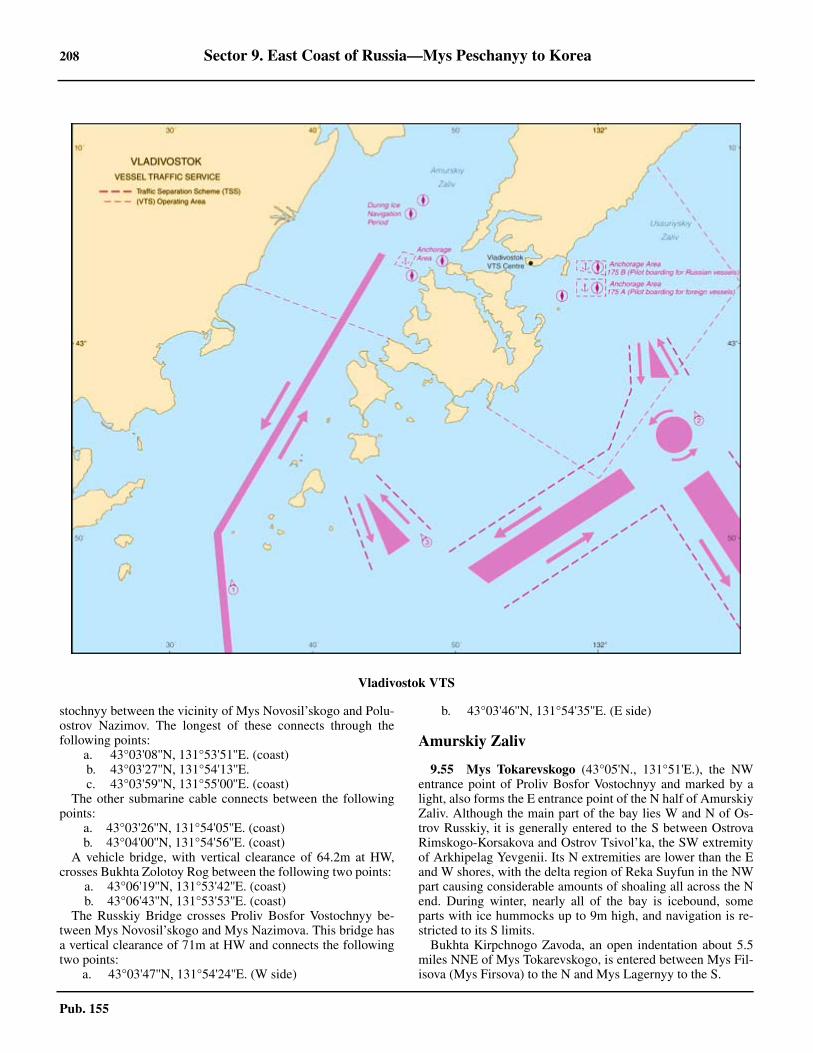
208 Sector 9. East Coast of Russia—Mys Peschanyy to Korea
Pub. 155
stochnyy between the vicinity of Mys Novosil’skogo and Polu-ostrov Nazimov. The longest of these connects through thefollowing points:
a. 43°03'08''N, 131°53'51''E. (coast)b. 43°03'27''N, 131°54'13''E.c. 43°03'59''N, 131°55'00''E. (coast)
9.54 The other submarine cable connects between the followingpoints:
a. 43°03'26''N, 131°54'05''E. (coast)b. 43°04'00''N, 131°54'56''E. (coast)
9.54 A vehicle bridge, with vertical clearance of 64.2m at HW,crosses Bukhta Zolotoy Rog between the following two points:
a. 43°06'19''N, 131°53'42''E. (coast)b. 43°06'43''N, 131°53'53''E. (coast)
9.54 The Russkiy Bridge crosses Proliv Bosfor Vostochnyy be-tween Mys Novosil’skogo and Mys Nazimova. This bridge hasa vertical clearance of 71m at HW and connects the followingtwo points:
a. 43°03'47''N, 131°54'24''E. (W side)
b. 43°03'46''N, 131°54'35''E. (E side)
Amurskiy Zaliv
9.55 Mys Tokarevskogo (43°05'N., 131°51'E.), the NWentrance point of Proliv Bosfor Vostochnyy and marked by alight, also forms the E entrance point of the N half of AmurskiyZaliv. Although the main part of the bay lies W and N of Os-trov Russkiy, it is generally entered to the S between OstrovaRimskogo-Korsakova and Ostrov Tsivol’ka, the SW extremityof Arkhipelag Yevgenii. Its N extremities are lower than the Eand W shores, with the delta region of Reka Suyfun in the NWpart causing considerable amounts of shoaling all across the Nend. During winter, nearly all of the bay is icebound, someparts with ice hummocks up to 9m high, and navigation is re-stricted to its S limits.9.55 Bukhta Kirpchnogo Zavoda, an open indentation about 5.5miles NNE of Mys Tokarevskogo, is entered between Mys Fil-isova (Mys Firsova) to the N and Mys Lagernyy to the S.
Vladivostok VTS
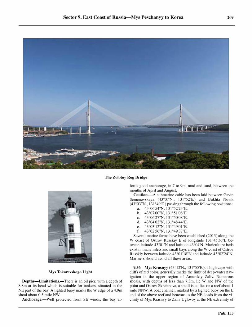
Sector 9. East Coast of Russia—Mys Peschanyy to Korea 209
Pub. 155
9.55 Depths—Limitations.—There is an oil pier, with a depth of8.8m at its head which is suitable for tankers, situated in theNE part of the bay. A lighted buoy marks the W edge of a 4.9mshoal about 0.5 mile NW.9.55 Anchorage.—Well protected from SE winds, the bay af-
fords good anchorage, in 7 to 9m, mud and sand, between themonths of April and August. 9.55 Caution.—A submarine cable has been laid between GavinSemenovskaya (43°07'N., 131°52'E.) and Bukhta Novik(43°03”N., 131°49'E.) passing through the following positions:
a. 43°06'54''N, 131°52'23''E.b. 43°07'00''N, 131°51'08''E.c. 43°06'27''N, 131°50'08''E.d. 43°04'02''N, 131°48'44''E.e. 43°03'12''N, 131°49'01''E.f. 43°02'56''N, 131°49'37''E.
9.55 Several marine farms have been established (2013) along theW coast of Ostrov Russkiy E of longitude 131°45'36''E be-tween latitude 43°01'N and latitude 43°04'N. Mariculture bedsexist in many inlets and small bays along the W coast of OstrovRusskiy between latitude 43°01'18''N and latitude 43°02'24''N.Mariners should avoid all these areas.
9.56 Mys Krasnyy (43°12'N., 131°55'E.), a high cape withcliffs of red color, generally marks the limit of deep-water nav-igation in the upper region of Amurskiy Zaliv. Numerousshoals, with depths of less than 7.3m, lie W and NW of thepoint and Ostrov Skrebtsova, a small islet, lies on a reef about 1mile NNW. A boat channel, marked by a lighted buoy on the Eend of the above reef and beacons to the NE, leads from the vi-cinity of Mys Krasnyy to Zaliv Uglovoy at the NE extremity of
The Zolotoy Rog Bridge
Mys Tokarevskogo Light
210 Sector 9. East Coast of Russia—Mys Peschanyy to Korea
Pub. 155
the gulf. Poluostrov Erdmana (43°15'N., 131°59'E.), a raised penin-
sula which separates Zaliv Uglovoy from the main portion ofthe head of Amurskiy Zaliv, is marked at Mys Tikhiy(43°15'N., 131°58'E.), its S extremity, by some low red cliffs.To the NW of the peninsula the head of the gulf, which is gen-erally low and somewhat marshy, rounds to the W for about 6miles before again rising to the higher shores on the E side ofthe entrance to Reka Suyfun.9.56 A bridge, approximately 2.5 miles in length with a 6m verti-cal clearance at HW, extends SSW from Mys Tikhiy to a pointalong the coast at position 43°13'31''N, 131°57'53''E. 9.56 Mys Rechnoy (43°18'N., 131°50'E.), a precipitous point ris-ing to a height of 75m a short distance within, forms the E en-trance point of Reka Suyfun and is a good mark from the S.Ostrov Rechnoy, a barren precipitous islet, 21m high, liesabout 1 mile SSE of the point and is connected to it by a shal-low spit. The principal channel of Reka Suyfun, with a depth0.9m, is marked by buoys and beacons and leads from SW ofOstrov Rechnoy to Razdol'noye about 17 miles upstream. It isfrozen solid from November to April.
9.57 Poluostrov Peschanyy (43°10'N., 131°47'E.), a trian-gular peninsula connected to the mainland by a narrow strip ofland, terminates with its E extremity, Mys Peschanyy, about 3miles off the W shore of Amurskiy Zaliv. The greater portionof the N part of the peninsula is wooded and trees grow on itssummit. The summit of the peninsula, about 1 mile NW of MysPeschanyy, rises to a height of 179m in the form of a sharp-peaked hill that is conspicuous in clear weather for up to 25miles.9.57 Mys Nizmennyy, a low point of land not easily discernibleagainst the high shore NW, is located about 2.5 miles NW ofMys Ogranovicha, the S extremity of Poluostrov Peschanyy,and forms between it and the peninsula the entrance to BukhtaMelkovodnaya, a fairly large inlet which nearly dries at LW. 9.57 Gora Stolovaya, an elongated table hill, rises near the shoreabout 2 miles SSW of Mys Nizmenyy and with its steep Sslope forms a good mark from the SE.
9.58 Polustrov Lomonosova (43°00'N., 131°35'E.), asomewhat triangular peninsula which is precipitous on most ofits W side, lies with its SE extremity, Mys Lomonosova, about1.5 miles off the general trend of the coast in this area.9.58 Bukhta Sedimi, entered between Mys Turek, the SW extrem-ity of Polustrov Lomonosova, and Mys Kupriyanova, about 3miles to the S, is almost completely open to the SE and pro-vides a clear approach from seaward. The shores of the bay arelow and sandy with Reka Sedimi entering in the NW corner,but the coastal range beyond rises quickly to heights of 610mor more and provides good shelter from N winds. 9.58 Bukhta Narva (43°00'N., 131°31'E.), a small bay close Wof Polustrov Lomonosova, is entered between Mys Turek andMys Brinera (42°58'58''N, 131°29'44''E). Bukhta Narva hasdepths of 15m, with shoaling towards the head, where there is alow shore of marshy grasses. 9.58 Bukhta Geka is located close S of Mys Brinera with a shorelineof low scrub with some trees and houses along the S shore.9.58 A small pier, with about 3m at its head, is situated 1.5 milesWNW of Mys Turek.
9.58 Anchorage.—Anchorage can be taken in Bukta Narva,when winds are blowing offshore, in depths of 13m, sand. An-chorage is also available in Bukta Geka during periods of off-shore winds, in depths of 9m, off a sandy beach. 9.58 Caution.—A dangerous wreck is charted close S of the pier.Ostrov Krolichiy, lying on the coastal reef about 0.2 mile off-shore, is covered with bushes.9.58 A marine farm located E of Ostrov Antipenko should beavoided and is bounded by lines joining the following posi-tions:
a. 42°59'03''N, 131°29'54''E.b. 42°59'03''N, 131°30'59''E.c. 42°58'22''N, 131°30'59''E.d. 42°58'18''N, 131°30'26''E.e. 42°59'03''N, 131°29'52''E.
9.58 A group of five submerged mooring buoys which needs to beavoided lies E of Bukta Geka and is centered on position42°58'56''N, 131°31'08''E. 9.58 Poluostrov Yankovskogo (42°57'N., 131°31'E.), the E ex-tremity of which is Mys Kupriyanova, is a broad, hilly, andwooded peninsula bordered on the N by a shallow lagoon andconnected to the mainland by a strip of low marshy land. The Sshore is generally precipitous with several islands close off, thelargest being Ostrov Gerasimova, steep and cliffy, and separat-ed from the mainland by a narrow channel with numerousrocks in it.9.58 Caution.—An underwater obstruction lies about 2.8 milesSE of Mys Kupriyanova.
9.58 Mys Bryusa (42°53'N., 131°28'E.), the NE extremity of anarrow hilly peninsula known as Poluostrov Bryusa, is a pre-cipitous point faced in many places with sheer cliffs and co-lumnar formations. The point is marked by a light; a racon islocated at the light. A reef, which breaks in SE gales, extendsabout 0.5 mile NE of the point and numerous rocks, above andbelow-water, lie scattered along the S shore.
9.59 Slavyanka (42°52'N., 131°23'E.), a small port locatedat the head of Bukhta Slavyanka, handles scrap metal, generalcargo, vehicles, oil products, and logs. Bukhta Slavyanka is theinner part of Zaliv Slavyanskiy. Zaliv Slavyanskiy, a protectedbay located on the W shore of Amurskiy Zaliv, is entered be-tween Mys Bryusa and the S end of Ostrov Gerasimova, about1.5 miles to the N. The entrance channel, with depths of at least19m, is further restricted to 0.5 mile in width by the shoalswhich lie off the entrance points and caution is required.9.59 Bukhta Slavyanka, is formed by Mys Mal’tseva, a high pre-cipitous point about 3 miles WNW of Mys Bryusa, and a spit-like point about 1.5 miles NE. The shores of the inner bay arelower and more sandy than the outer bay, but the land rises rap-idly to Gora Yankovskogo, a conspicuous 452m peak locatedabout 2.7 miles to the NW.9.59 Ice.—The port is reported to be open all year, but ice appearsby mid-December and completely encloses the port from Janu-ary through mid-March. Broken ice remains in the S part of thebay until mid-April. 9.59 Depths—Limitations.—The port consists of an outer har-bor with seven numbered anchorages, having depths of 14 to18m, for lighterage operations and an inner harbor with twopiers, For berthing information see table titled Slavyanka—
Sector 9. East Coast of Russia—Mys Peschanyy to Korea 211
Pub. 155
Berth Information. 9.59 Pilotage.—Pilotage is compulsory throughout ZalivSlavyanskiy. Pilotage is available only during daylight hours ingood visibility for large tonnage vessels and vessels with draftsmore than 7m. Pilots are available during working days from0800 until 2400 and by special request on other days. 9.59 Pilots are requested 2 hours before arrival from the port dis-patcher (Slavyanskiy SRZ) on VHF channel 30. Vessels shouldalso request permission to enter, depart, or move about the portfrom the port dispatcher (Slavyanskiy SRZ) on VHF channel12. 9.59 Pilots will board in position 42°53'31.2''N, 131°26'04.2''E. 9.59 Regulations.—Foreign vessels bound for Zaliv Slavyanskiyshould send a message when passing the following positions:
1. Latitude 41°00'N when approaching from the S.2. Longitude 131°00'E when approaching from the W.3. Longitude 134°00'E when approaching from the E.
9.59 These messages should include the following information:1. Vessel name and nationality.2. Vessel type and call sign.3. Time of approach to the pilot boarding area and when
the pilot embarks.4. Maximum length and width, plus height of freeboard.5. Vessel draft.6. Condition of main engine and steering gear.7. Number of crew members and passengers.8. Previous port of call.
9.59 Permission must be requested via VHF channel 12 from thePort Dispatcher (Slavyanskiy SRZ) before entering port, moor-ing, or shifting berths. 9.59 Contact Information.—See table titled Slavyanka—Con-tact Information.9.59 Vessel Traffic Service.—A Vessel Traffic Service (VTS) hasbeen established under the control of Vladivostok for the har-bor waters of Slavyanka and approaches. This VTS is also anintegrated part of the Zaliv Petra Velikogo VTS and comprisesSector 4 of that VTS. See paragraph 9.42 and paragraph 9.54for further details. 9.59 Anchorage.—Anchorage, which is the best on the W side ofZaliv Amurskiy, may be obtained in Guba Tulamu, a small coveat the SW extremity of the outer bay, in depths of 7 to 16m, mud,where it is sheltered from S and W winds. With E and SE winds,a heavy sea enters Zaliv Slavyanskiy and it is advisable to an-chor in the SW part of the bay. Caution is necessary, to avoid theprohibited anchorage area in the entrance.9.59 The quarantine anchorage is located in position 42°53'24''N,
131°25'18''E. 9.59 Caution.—Extensive marine farms lie at the head of the bay.
9.60 Ostrov Sibiryakova (42°48'N., 131°26'E.), the S is-land of a group extending up to 5.5 miles S of Poluostrov Bry-usa, consists of itself and Ostrov Antipenko along withnumerous islets and rocks, all separated from the mainland bya marked channel with a depth of about 10m. Kekur Kolonna, awhite pillar rock, lies on a reef W of the two main islands andforms the S end of a chain of rocks extending about 0.5 mile tothe N, where a spar buoy serves to mark the S side of the chan-nel between Ostrov Antipenko and Poluostrov Bryusa.9.60 Caution.—A marine farm located E of Ostrov Sibiryakovashould be avoided and is bounded by lines joining the follow-ing positions:
a. 42°49'07''N, 131°30'10''E.b. 42°47'28''N, 131°28'50''E.c. 42°48'10''N, 131°27'26''E.d. 42°48'29''N, 131°27'42''E.e. 42°49'07''N, 131°27'04''E.
9.60 Another marine farm located E of Ostrov Antipenko (closeN of Ostrov Sibiryakova) should be avoided and is bounded bylines joining the following positions:
a. 42°49'26''N, 131°26'54''E.b. 42°50'02''N, 131°27'59''E.c. 42°50'36''N, 131°26'59''E.d. 42°51'22''N, 131°28'26''E.e. 42°50'00''N, 131°30'52''E.f. 42°49'16''N, 131°30'11''E.g. 42°49'26''N, 131°26'54''E.
Slavyanka—Contact Information
Pilots
Call sign Pilots 1
VHF VHF channel 6
Harbormaster
Telephone 78-4233-14440
Port Dispatcher
Call signSlavyanka Radio 13
Dock 1
VHF VHF channels 12 and 30
Slavyanka—Berth Information
Berth Length DepthMaximum Vessel
Remarks LOA Draft Beam Size
Slavyanka — — — 9.0m — —Petroleum products. Continuous berthing length of 300m.Vostok Bunker
(Berth 2) — 7.2m 200m 7.5m 40m 50,000 dwt
212 Sector 9. East Coast of Russia—Mys Peschanyy to Korea
Pub. 155
9.60 Bukhta Mandzhur, entered between the S extremity ofOstrov Sibiryakova and Kamni Baklan, close E of the Eextremity of Poluostrov Klerka, about 2.7 miles WSW, is anopen bay with generally sandy shores, except at its N endwhere cliffy precipices rise at Mys Chirok. Being exposed to Sand SE winds, the bay offers no good anchorage duringsummer, except for small craft, and only fair anchorage inwinter when vessels can anchor off the N shore.
9.61 Poluostrov Klerka (42°46'N., 131°22'E.), a narrowhilly peninsula devoid of trees, but marked by patches ofcultivated land, is connected to the mainland by a low marshyisthmus and terminates at its seaward end in two separate points. 9.61 Mys Klerka, the S point, is high, bare, and precipitous. It ismarked by caves showing as dark patches against the yellowcoast. A light is shown from Mys Klerka. Extensive shoaling,known as Mel’ Griden’, extends SE of the peninsula, and withdepths of less than 3m and a least depth of 0.6m, is markednear its outer extremity by a lighted buoy. Nearly any swellfrom the SE will break on this ledge and, due to its being steep-to on all sides, caution is required in thick weather.9.61 Ostrov Klerka, a small precipitous island thickly coveredwith shrubs, lies about 0.8 mile WSW of Mys Klerka and isconnected to the peninsula to the N by a rocky ledge. BukhtaKlerka, a cove, lies between the above spit and the peninsula tothe E and can be entered by small craft with local knowledge.9.61 Bukhta Boysmana, a completely open bay entered betweenOstrov Klerka and Mys Krasnyy Utes, a fairly conspicuouscliff about 4 miles W, has generally sandy shores across itshead, but rises to a steep coastline in its W part. A bank, onwhich there are some below-water rocks, extends 0.5 mile Efrom Mys Krasnyy Utes.9.61 Anchorage.—Good anchorage during the autumnal NEwinds can be taken in the E half of the bay, off the W side of Os-trov Klerka, in depths of 9 to 10m, sand and mud, but caution isnecessary to avoid the ledge extending N of the island.
9.62 The coast from Mys Krasnyy Utes trends S for approx-imately 3 miles to Mys L’va and is generally elevated, except fora few river valleys at the N and S ends. The latter cape risessomewhat more precipitously and is marked by a nearby rockwhich, when seen from seaward, resembles a sitting lion.9.62 Gora Grebenchataya, about 3 miles WSW of Mys KrasnyyUtes, rises to an elevation of 395m and with its jagged summitis one of the most striking features along this part of the coast.9.62 Mys Sosnovyy, about 1.2 miles SSW of Mys L’va, is a fairlyprecipitous cape made conspicuous by Kekury Baklan'i, agroup of conspicuous granite rocks about 31m high, which ex-tend 0.3 mile E from a point about 0.4 mile NE of Mys Sos-novyy.9.62 The coast from Mys Sosnovyy trends generally to the S forabout 7 miles to Mys Gamova, the W entrance point of ZalivPetra Velikogo, and becomes heavily indented with numerouscoves having for the most part high precipitous shores fringedwith narrow sandy beaches. Several islets and dangers lie offthis section of coast and caution is required.9.62 Banka Bonsdorfa, comprising several detached shoals with aleast depth of 0.9m, lies about 2 miles S of Mys Sosnovvy andup to 0.8 mile offshore. Because this danger is steep-to andprobably only breaks in a SE swell, great caution is required
when navigating in the vicinity.9.62 Ostrova Astaf’yeva is comprised of two groups of pointedred granite islets which lie about 0.5 mile and 0.8 mile NE, re-spectively, of Mys Astaf’yeva. Reefs, marked by breakers, ex-tend NE from the NE islet and WNW from the SW islet.Because these islets and reefs are steep-to, they must be con-sidered dangerous during fog.9.62 Ostrov Makisimova, a round-topped islet with a grassy sum-mit, lies about 0.5 mile NE of Mys Telyakovskogo and 2.5miles NNE of Mys Gamova. A reef extends about 0.3 mile NEfrom the islet and terminates in a pinnacle rock with a leastdepth of 1.5m. The W side of the islet is steep-to.9.62 Mys Gamova (42°33'N., 131°14'E.), a precipitous flat-topped projection, forms the SE extremity of Poluostrov Gam-ova. A light is shown from a tower with a dwelling on the pointand a radiobeacon transmits from the lighthouse. 9.62 The peninsula backing the point is high and rugged, beingmarked by Gora Tumannaya, a conspicuous sharp-peakedmountain, topped by a beacon and rising to a height of 562m,about 2 miles NW of Mys Gamova. A pillar rock, conspicuousfrom the E and NE, is located on the E side of the cape and infoggy weather can be seen, as a rule, before the rest of theshore.
Zaliv Pos’yeta
9.63 Zaliv Pos’yeta (Posiette Bay) is entered between MysGamova and Mys Suslova, about 16 miles W.9.63 Winds—Weather.—The prevailing wind in the gulf is fromthe SE in summer and mostly from the NW in autumn and win-ter. In spring, the winds are variable, but are frequently freshfrom the N and W; these winds are more violent in ZalivPos’yeta than in any part of Zaliv Petra Velikogo.9.63 Fog is more frequent in spring and summer, being most re-strictive during June and July. Frequently the whole gulf willbe suddenly enveloped in fog. A cloud with ragged edges ap-pearing on Gora Tumannaya NW of Mys Gamova is said to bea sign of an approaching SE wind and accompanying fog. Asthe cloud accumulates and descends, the fog rapidly envelopsZaliv Pos'yeta.9.63 Ice.—The outer part of Zaliv Pos’yeta is open all winter andReyd Pallada usually so, but in exceptional circumstances thelatter has a thin coating of ice which breaks up with the E wind.The inner bays begin to freeze about the beginning of Decem-ber. The ice is thawed toward the end of March.9.63 The earliest recorded appearance of drift-ice off Mys Gamo-va is January 19, and the latest February 18. The earliest finaldisappearance is March 3, and the latest March 29. The aver-age number of days with ice off the point is 72.9.63 Depths—Limitations.— The port of Pos’yet lies on the SEedge of Pos’yet. The port handles primarily coal and bunkersand consists of three berths, each 146m in length, with a con-tinuous berthing length of 439m and an alongside depth of9.7m. Each berth can accommodate vessels with a maximumloa of 175m and a maximum draft of 9m.9.63 Vessel Traffic Service.—A Vessel Traffic Service (VTS) hasbeen established for the waters of Zaliv Pos’yeta N of a linefrom Mys Suslova (42°30'54''N., 130°51'53''E.) to Mys Gamo-va (42°33'23''N., 131°13'04''E.). This VTS is an integrated partof the Zaliv Petra Velikogo VTS and comprises Sector 5 of that
Sector 9. East Coast of Russia—Mys Peschanyy to Korea 213
Pub. 155
VTS. (See paragraph 9.41.) 9.63 Anchorage.—Eighteen designated anchorages lie centeredon position 42°33'30''N, 130°49'48''E. 9.63 Caution.—The buoys and beacons in Zaliv Pos'yeta are notalways in position and are removed during winter.9.63 Marine farms have been established in the NW part of ZalivPos’yeta as best seen on the chart. Two new marine farms areestablished in E part of Zaliv Pos’yeta off Gora Tumannayaand off the SE coast of Poluostrov Krabbe, as follows:
1. Off Gora Tumannaya—bounded by the coast andlines joining the following positions:
a. 42°33'35''N, 131°11'09''E.b. 42°33'16''N, 131°11'02''E.c. 42°33'30''N, 131°10'16''E.d. 42°33'03''N, 131°09'14''E.e. 42°32'35''N, 131°09'14''E.f. 42°32'35''N, 131°11'23''E.g. 42°33'15''N, 131°12'55''E.
2. Off the SE coast of Poluostrov Krabbe—bounded bythe coast and lines joining the following positions:
a. 42°35'48''N, 130°52'13''E.b. 42°35'35''N, 130°52'12''E.c. 42°35'28''N, 130°53'35''E.d. 42°35'56''N, 130°53'38''E.
9.64 The coast of Zaliv Pos’yeta trends NNW from MysGamova, maintaining a rocky precipitous character to BukhtaTroitsy, about 6 miles within. Numerous coves and a small bayknown as Bukhta Vityaz’ indent this section of the coast, butdo not provide good shelter and generally offer only poor hold-ing ground.9.64 Bukhta Troitsy, entered between Mys Stenina on the E andMys Slychkovo, about 0.9 mile to the W, forms a natural har-bor sheltered from all winds except from the S.9.64 Zarubino (42°38'N., 131°05'E.) (World Port Index No.60582) lies within the W basin of Bukhta Troitsy (Trinity Bay).It is a small harbor that is open to shipping all year without ice-breaker assistance. Ice begins to appear at the end of Novemberwith some steady formation by mid-December, but remainsthin enough to be easily broken by tugs. 9.64 Depths—Limitations.—Entry into Bukhta Troitsy is wideand deep, passing between Mys Stenina (42°37'N, 131°08'E)and Mys Slychkova. The width of the opening between thesetwo capes is only 0.9 mile. 9.64 A wharf along the shore, with a total length of 650m, hasfour designated berths. For berthing information see table titledZarubino—Berth Information. The port authority should beconsulted for the latest information. 9.64 Aspect.—Mys Slychkovo, backed by a conspicuous pillar-shaped peninsula known as Poluostrov Zarubina, is connectedto the mainland by a low isthmus and forms a basin on the Wside of the bay that can be used by small craft from the anchor-age.
9.64 Ostrovok Brauzera, an oblong islet of shingle and gravel, lieson a reef connected to the NE shore of the peninsula and effec-tively blocks the S part of the basin.9.64 Bukhta Troitsy is entered along a recommended route fromthe SSE, as shown on the chart. Once in the bay, entry to Zarubi-no is achieved by passing N then E of Ostrovok Brauzera. 9.64 Pilotage.—Pilotage is compulsory and is available 24 hours.Vessels should advise ETA 10 days, 48 hours, 24 hours, and 4hours prior to arrival. 9.64 The pilot boarding areas are, as follows: BA NP 286(6),2022 edition
1. 42°38'42.0''N, 131°06'49.2''E. (Russian vessels only)2. 42°37'42.0''N, 131°07'06.0''E. (Foreign vessels only)3. 42°39'23.4''N, 131°06'45.0''E. (Vessels over 1,000 gt)4. 42°37'13.2''N, 131°03'40'.2'E. (Vessels over 1,000 gt)5. 42°34'48.0''N, 131°06'03.6''E.
9.64 The vessel’s ETA should be sent via the agent 10 days beforeexpected arrival and then reconfirmed 48 hours, 24 hours, and4 hours before arrival. 9.64 Port State Control Inspectorate (PSC) and the Coastguardshould be contacted by the vessel on VHF channel 16 whenvessel is 2 miles from port. 9.64 Regulations.—The following regulations apply in the har-bor:
1. When visibility is less than 200m, arrival and depar-ture at the port are prohibited; pilotage and mooring are al-lowed only upon approval from the harbor authority.
2. The harbormaster should be informed in writing ofany defects to the vessel.
3. Vessels more than 50m loa must proceed at their min-imum speed while navigating through the inner roads.
4. Overtaking is prohibited in the inner roads.5. Permission must be granted by Port State Control In-
spectorate (PSC) to leave the port. A Notice of ETD shouldby advised to the PSC at least 6 hours prior to departure. Per-mission granted is valid for only 24 hours; if departure notachieved, permission must be requested again.
9.64 Vessel Traffic Service.—A Vessel Traffic Service (VTS) hasbeen established for the waters of Zaliv Pos’yeta N of a linefrom Mys Suslova (42°30'54''N., 130°51'53''E.) to Mys Gamo-va (42°33'23''N., 131°13'04''E.). This VTS is an integrated partof the Zaliv Petra Velikogo VTS and comprises Sector 5 of thatVTS. (See paragraph 9.42) 9.64 Contact Information.—See the table titled Zarubino—Contact Information.
Zarubino—Berth Information
Berth Length Remarks
No. 1 156m General cargo.
No. 2 156m General cargo.
No. 3 156m General cargo, ro-ro and passengers.
No. 4 156m General cargo.
Zarubino—Contact Information
Duty Officer
Call sign Zarubino 1
VHF VHF channel 9
Zarubino—Berth Information
Berth Length Remarks
214 Sector 9. East Coast of Russia—Mys Peschanyy to Korea
Pub. 155
9.64 Anchorage.—Bukhta Troitsy is one of the best anchoragesin Zaliv Pos’yeta. Depths in the central portion of the bay areas deep as 20m. There are two designated areas for anchorage,both of which require the assistance of a pilot, as follows:
1. District N1 (for Russian vessels arriving fromabroad)—Area bounded by lines joining the following posi-tions:
a. 42°39'00''N, 131°06'24''E.b. 42°39'00''N, 131°07'12''E.c. 42°38'24''N, 131°07'12''E.d. 42°38'24''N, 131°06'24''E.
2. District N2 (for all foreign vessels)—Area boundedby lines joining the following positions:
a. 42°38'00''N, 131°06'42''E.b. 42°38'00''N, 131°07'24''E.c. 42°37'24''N, 131°06'42''E.d. 42°37'24''N, 131°07'24''E.
9.64 There is also an anchorage designated (N3) for quarantinestay with a radius of 400m from position 42°39'18''N,131°06'42''E.9.64 Although anchorage is available in Gavan Silach, it can onlyused in case of emergency.
9.65 Poluostrov Krabbe (42°38'N., 130°52'E.), the S ex-tremity of which is Mys Degera, is located at the head of ZalivPos’yeta and because of its rugged nature is conspicuous fromthe offing. A hill located about 0.4 mile N of Mys Degera risesto a height of 161m and provides a good mark for aiding in theidentification of the point.9.65 Reyd Pallada, a spacious roadstead open to the SE, is enteredbetween Mys Degera and Mys Shelyagina, a conspicuous andelevated cape about 4 miles SW. The NE shore of the roadsteadis steep-to and hilly, but the W side is low and marshy withdepths of less than 9m up to 1 mile offshore.9.65 Kosa Churkhado, a narrow sandy spit covered with grass, ex-tends about 2.2 miles NNE from the mainland, on the NW sideof Reyd Pallada, and rises at its NE extremity, Mys Nazimova,to a conspicuous gray cliff 27m high.9.65 Banka Klykova, a detached steep-to rocky shoal with a leastdepth of 1.8m, lies in the entrance to Reyd Pallada, about 1.5
miles S of Mys Degera. Two beacons about 0.3 mile W of MysDegera, when in line bearing 003°, indicate the central part ofthis bank.9.65 A lighted buoy is moored during the navigational season onthe S side of Banka Klykova, but it should not be depended on.9.65 Gora Tigrovaya, a cone-shaped mountain, rises to a height of830m about 14 miles NW of the N extremity of PoluostrovKrabbe, and forms an excellent mark during clear weather inthe approach to Zaliv Pos'yeta.9.65 The summit of Gora Tigrovaya, in line bearing about 318°with the E extremity of the cliffs of Mys Nazimova, leads intoZaliv Pos’yeta, clear of Banka Klykova.9.65 The strait leading from Reyd Pallada to the inner bays ofZaliv Pos’yeta is formed between Mys Nazimova and Mys As-taf'yeva, the W extremity of Poluostrov Krabbe, about 0.5 mileto the E. Ostrov Cherkavskogo, a bare islet about 15m high, di-vides the strait into two channels. The W channel, about 135mwide, with depths of 11 to 14m, is recommended. Caution isnecessary, however, to avoid a reef, with a least depth of 1.5m,that extends to Mys Nazimova by passing close off the steep-toW side of Ostrov Cherkavskogo. Tidal currents in the narrowsattain a rate of up to 2 knots.9.65 Bukhta Ekspeditsii and Bukhta Novgorodskaya, the W and Ebays of the inner part of Zaliv Pos’yeta, are formed by an in-dented peninsula, known as Poluostrov Novgorodskiy, whichextends about 3 miles WSW of the mainland N of PoluostrovKrabbe. Both bays are heavily encumbered with shoals havingdepths of 4m and less, and they are generally only suitable forsmall craft. Pos’yet, however, at the SW end of PoluostrovNovgorodskiy, can be reached in the channel N of OstrovCherkavskogo in depths of 8 to 18m.
9.66 Pos’yet (42°39'N., 130°48'E.) (World Port Index No.60540), situated at the head of the bight on the E side of MysRyazanova, the SE extremity of Novgorodskiy, is available forcoasters.9.66 Tides—Currents.—The tidal range at MHWS is 0.7m. 9.66 Ice.—The port is open year round. However, light ice condi-tions are present from the end of December through February;during this time only vessels of Ice Class 3 (according to theRussian register) may enter the port. Ice usually clears by theend of April. 9.66 Depth—Limitations.—The port is approached directlyfrom Zaliv Pos’yeta through Bukhta Reyd Pallada along a NWcourse, as shown on the chart. The approach channel is 100mwide, with depths to 25m. There are three berths in the harbor,with depths alongside of 9.5m, capable of accommodating ves-sels with drafts up to 9m. For berthing information, see the ta-ble titled Pos’yet—Berth Information. 9.66 Pilotage.—Pilotage is compulsory and available 24 hours.Pilots can be contacted on VHF channels 12 and 16. Pilotsboard in position 42°36'00''N, 130°49'48''E. 9.66 Regulations.—The port of Pos’yet is located within Sector 5of the Zaliv Petra Velikogo Vessel Traffic Service (VTS). Seeparagraph 9.41 for more details. 9.66 Vessel must advise the port of ETA at least 48 hours in ad-vance and then reconfirm the ETA 24 and 12 hours prior to ar-rival, with final confirmation within 4 hours of arrival. TheETA message must contain the following information:
1. Vessel’s name.
Port Authority
Telephone 78-4233-150262
Facsimile78-4232-964660
78-4233-150234
E-mail [email protected]
Web site https://www.seaport-troitsa.ru
Port State Control Inspectorate
Call sign Troitsy 33
VHF VHF channels 9 and 16
Coastguard
Call sign Lebed 42
VHF VHF channel 16
Zarubino—Contact Information
Sector 9. East Coast of Russia—Mys Peschanyy to Korea 215
Pub. 155
2. Vessel’s flag.3. Vessel’s call sign.4. IMO identification number.5. Home port.6. Vessel’s loa, beam, and height of hull.7. Purpose of visit.8. Charterer’s and agent’s name, address, and contact de-
tails. 9.66 Vessels less than 5,000 gt in size may enter and depart theport at any time, while vessels larger than 5,000 gt may only doso if the navigation aids are in good working order and theweather is good. Leaving or entering port is prohibited in visi-bility less than 0.5 mile. 9.66 One-way traffic has been established between Cape Nazimo-va and Ostrov Cherkavskogo, with inbound vessels having pri-ority of passage. 9.66 Tugs are available and are required for mooring operations,movement of vessels in port waters, and passage through thefairway narrows. Tugs are ordered through the agents and thenumber of tugs required will be determined by agreement be-tween the master and the pilot. 9.66 Vessel Traffic Service.—Pos’yet is covered by the Zaliv Pe-tra Velikogo Vessel Traffic Service (paragraph 9.42).9.66 Contact Information.—See table titled Pos’yeta—Contactinformation.
9.66 Anchorage.—Eighteen designated anchorage berths andtheir positions are listed below:
1. Anchorage No. 1—42°32'30''N, 130°59'09''E.2. Anchorage No. 2—42°32'30''N, 131°00'30''E.3. Anchorage No. 3—42°32'30''N, 131°01'51''E.4. Anchorage No. 4—42°32'30''N, 131°03'12''E.5. Anchorage No. 5—42°32'30''N, 131°04'33''E.6. Anchorage No. 6—42°32'30''N, 131°05'54''E.7. Anchorage No. 7—42°33'30''N, 130°59'09''E.
8. Anchorage No. 8—42°33'30''N, 131°00'30''E.9. Anchorage No. 9—42°33'30''N, 131°01'51''E.10. Anchorage No. 10—42°33'30''N, 131°03'12''E.11. Anchorage No. 11—42°33'30''N, 131°04'33''E.12. Anchorage No. 12—42°33'30''N, 131°05'54''E.13. Anchorage No. 13—42°34'30''N, 130°59'09''E.14. Anchorage No. 14—42°34'30''N, 131°00'30''E.15. Anchorage No. 15—42°34'30''N, 131°01'51''E.16. Anchorage No. 16—42°34'30''N, 131°03'12''E.17. Anchorage No. 17—42°34'30''N, 131°04'33''E.18. Anchorage No. 18—42°34'30''N, 131°05'54''E.
9.66 Anchoring is prohibited in the fairway between Cape Nazi-mova and Ostrov Cherkavskogo. 9.66 Mys Suslova (42°31'N., 130°52'E.), the W entrance point ofZaliv Pos’yeta, is the S extremity of a peninsula, 261m high,which is connected to the mainland by a low, marshy isthmus. TheN shore is a sandy beach which fringes the S side of the isthmus.
Zaliv Pos’yeta to the Tumen River
9.67 Ostrov Furugel’ma (42°28'N., 130°55'E.), a hillyand conspicuous island with precipitous reddish-gray shores,lies about 4 miles SE of Mys Suslova. A beacon, 3.3m high,and consisting of a white quadrilateral iron framework pyra-mid, is situated on a hill about 0.3 mile S of the NE end of theisland.9.67 A rock, which dries 0.3m, lies about 0.3 mile SW of the SWextremity of the island.9.67 Two pinnacle rocks, with a least depth of 6.4m, and a groupof rocks 2m high, lie about 0.4 mile W and 1.2 miles WNW, re-spectively, of the NW extremity of the island.9.67 Kekur Gel’mersena, a steep-to pillar rock about 9.1m inheight, lies 0.5 mile NNE of the NE extremity of Ostrov Furu-gel’ma, and when seen through fog has the appearance of a be-calmed junk under sail. Several other rocks, some submergedor awash, lie up to 1 mile N and E of the same point and cau-tion is required.9.67 It has been reported that there is an almost constant S currentin the vicinity of Ostrov Furugel'ma. Eddies exist almost con-stantly in an area extending up to 3 miles S and SE of the is-land.
9.68 Mys Butakova (42°28'N., 130°50'E.), a roundedcliffy cape backed by Gora Butakova, a somewhat conical hillabout 308m high, lies 3.5 miles SW of Mys Suslova and is theE entrance point of Bukhta Sivuch’ya. It is fringed by numer-ous rocks and a reef.
Pos’yeta—Contact Information
Port Authority
Call sign Primorye Traffic
VHF VHF channels 16 and 68
Telephone 78-423-249-1051
Facsimile 78-423-249-1052
Pilots
VHF VHF channels 12 and 16
Pos’yet—Berth Information
Berth Length DepthMaximum Vessel
Remarks LOA Draft Beam Size
No. 1 147m 9.7m 175m 9.0m 28m 40,000 dwtCoal, breakbulk, and bunkers. Con-tinuous berthing length of 439m.No. 2 146m 9.7m 175m 9.0m 28m 40,000 dwt
No. 3 146m 9.7m 175m 9.0m 28m 40,000 dwt
216 Sector 9. East Coast of Russia—Mys Peschanyy to Korea
Pub. 155
9.68 Ostrov Very, an islet with a grassy summit, lies in theentrance to Bukhta Sivuch'ya in a position about 0.7 mileWSW of Mys Butakova and 0.3 mile offshore. KamniButakova, a group of rocks having the appearance of an isletwhen seen from the S and E, lies about 0.4 mile SSW of OstrovVery and is surrounded by steep-to reefs.9.68 Vessels can enter Bukhta Sivuch’ya by passing betweenKamni Butakova and Fal'shivyy Ostrovok, a rounded cliff atthe end of a spit, about 1 mile W. The entrance is narrowed toabout 0.5 mile by the reefs in the vicinity and the anchorage isonly comfortable in calm weather. There are depths of 18 to24m in the fairway, shoaling to about 12m, 0.3 mile from thehead of the bay. The head of the bay is formed by marshy land
with numerous small lagoons backed by Ozero Tal'mi, aninland lake.9.68 The coast trends S from Fal’shivyy Ostrovok for about 11miles to the mouth of the Tumen River and consists of lowmarshy land with several lagoons immediately within.9.68 Gora Golubinyy Utes, a sharp-peaked detached hill coveredwith grass and shrub, rises to a height of 182m about 3 milesSSW of Fal’shivvy Ostrovok and, being surrounded by lowland, is conspicuous.9.68 The Tumen River (42°18'N., 130°41'E,.), in its lower reaches,forms the border between Russia and North Korea.The TumenRiver and the coast of Korea to the S are described in Pub. 157,Sailing Directions (Enroute) Coasts of Korea and China.
Pub. 155
Glossaries 217
Glossaries
Russian
RUSSIAN English
Bbakan ................................................................... large buoybanka ............................................................................shoalbar.................................................................................... barbashnya........................................................................ towerbasseyn .........................................................................basinbelyy, belaya, beloye ................................................... whitebereg .......................... coast, shore, beach, bank of a streamberegovoy, beregovaya, beregovoye............. littoral, coastalbochka ........................................barrel buoy, mooring buoyboloto............................................................. swamp, marshbol'shoy, bol'shaya, bol'shoye................................ large, bigbuek ...................................................... small boat or a floatbukhta ............................................................................. bayburun......................................................................... breakerburuny......................................................................breakersbuy................................................................................ buoy
Cchernyy, chernaya, chernoye ........................................black
Ddel'ta ............................................................................. deltaderevnya .................................................................... villagederevo ............................................................................. treedok................................................................................ dockdolgota................................................................... longitudedolina...........................................................................valleydom..............................................................................housedoroga............................................................................ roaddyuny...........................................................................dunes
Eelling.........................................................................slipway
Ffarvater ....................................................... fairway, channelfiord ...............................................................................fiordfort .................................................................................. fort
Ggavan'..........................................................................harborgora.................................................................mountain, hillgorod .....................................................................city, towngranitsa .................................................................. boundarygreben' ................................................................ crest, ridgeguba ............................................................ arm, recess, bayguriy ............................................................................. cairn
Kkamen' .................................................................rock, stonekamennyy ............................................................... masonrykammi...............................................................rocks, stoneskanal .............................................................. canal, channelkanava........................................................................... ditchkekur....................................................................pillar, rockkholm......................................................................... hillock
khram .........................................................................templekoleno............................................ bend, reach of a channelkosa .................................................................................spitkran ..............................................................................cranekrest.............................................................................. crosskungas .................................................... flat-bottomed craftkurgan..........................................................artificial hillock
Llaguna.........................................................................lagoonled.....................................................................................iceles ................................................................................ forestliman ................................................................ estuary, firthlotsman.......................................................................... pilotlug ........................................................................... meadow
Mmachta ...........................................................................mastmalyy, malaya, maloye....................................... small, littlemayak...................................................................lighthousemel'............................................................................... shoalmeridian ................................................................. meridianmilya ............................................................................. milemol ............................................................................... molemore ................................................................................ seamorskaya kapusta...........................................................kelpmorskoy, morskaya, morskoye............... most seaward (adj)most............................................................................ bridgemys...................................................................... cape, point
Nnadstroyka ......................................................superstructurenadvodnyy, nadvodnaya, nadvodnoye .............. above waternizhniy, nizhnyaya, nizhneye ...................................... lowernizkiy, nizkaya, nizkoye..................................................lownos ............................................................ cape, promontorynovyy, novaya, novoye...................................................new
Ooblast' ........................................................ district, provinceobryv ......................................................................precipiceogon'............................................................ light (also: fire)okean ........................................................................... oceanopasnot' ......................................................................dangerostrov........................................................................... islandostrova....................................................................... islandsostrovok.......................................................................... isletosushka............................................................. drying patchosyp' ....................................................................... landslideotlichitel'nyy...................................................distinguishingotliv .................................................................................ebbotmel'................................................................ coastal shoalozero............................................................................... lake
Pperekat................................................................ shifting bar
RUSSIAN English
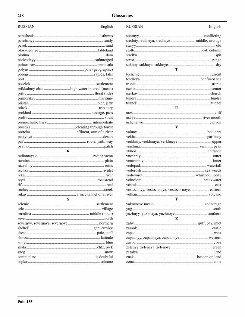
Pub. 155
218 Glossaries
peresheek..................................................................isthmuspeschanyy ....................................................................sandypesok .............................................................................sandploskogor'ye ...........................................................tablelandplotina............................................................................ dampodvodnyy...........................................................submergedpoluostrov..............................................................peninsulapolyus .......................................................pole (geographic)porogi .................................................................rapids, fallsport .................................................................................portposelok .................................................................settlementprikladnoy chas ..........................high water interval (mean)priliv ................................................................... flood (tide)primorskiy ..............................................................maritimepristan' ................................................................... pier, jettypritok .......................................................................tributaryprokhod ...........................................................passage, passproliv ............................................................................ straitpromezhutochnyy ............................................. intermediateproseka .............................................clearing through forestprotoka.............................................. effluent, arm of a riverpustynya ......................................................................desertput' .............................................................. route, path, waypyatno ...........................................................................patch
Rradiomayak........................................................radiobeaconravnina.......................................................................... plainrazvaliny ....................................................................... ruinsrechka .........................................................................rivuletreka ................................................................................riverreyd........................................................................ roadsteadrif .................................................................................... reefruchey ...........................................................................creekrukav................................................. arm, channel of a river
Sselenie...................................................................settlementselo ............................................................................ villageseredina ......................................................... middle (noun)sever..............................................................................northsevernyy, severnaya, severnoye ...............................northernshchel' ................................................................ gap, creviceshest...................................................................... pole, staffshirota ....................................................................... latitudesiniy ............................................................................... blueskala.......................................................................cliff, rocksneg...............................................................................snowsomnitel'no .......................................................... is doubtfulsopka ........................................................................volcano
RUSSIAN English
spornyy................................................................ conflictingsredniy, srednaya, sredneye......................... middle, averagestaryy............................................................................... oldstolb..................................................................post, columnstrelka..............................................................................spitstvor..............................................................................rangesukhoy, sukhaya, sukhoye............................................... dry
Ttechenie ..................................................................... currenttolcheya ............................................................ confused seatropik ........................................................................... tropictsentr............................................................................centertserkov' .......................................................................churchtundra ......................................................................... tundratunnel' ......................................................................... tunnel
Uutes ................................................................................. cliffust'ye .................................................................. river mouthushchel'ye.................................................................. canyon
Vvaluny......................................................................bouldersvekha ..................................................................... spar buoyverkhniy, verkhnaya, verkhneye ................................. uppervershina ........................................................... summit, peakvkhod....................................................................... entrancevneshniy ....................................................................... outervnutrenniy .................................................................... innervodopad.................................................................. waterfallvodorosli .............................................................. sea weedsvodovorot .................................................... whirlpool, eddyvolnolom .............................................................breakwatervostok ............................................................................. eastvostochnyy, vostochnaya, vostoch-noye ................... easternvulkan.......................................................................volcano
Yyakornoye mesto .................................................. anchorageyug................................................................................southyuzhnyy, yuzhnaya, yuzhnoye ................................southern
Zzaliv............................................................... gulf, bay, inletzamok.......................................................................... castlezapad ............................................................................. westzapadnyy, zapadnaya, zapadnoye............................. westernzavod' ............................................................................ covezelenyy, zelenaya, zelenoye .........................................greenzemlya ............................................................................landznak .............................................................. beacon on landzona ............................................................................... zone
RUSSIAN English
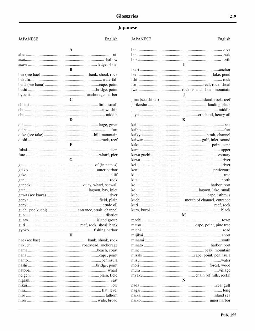
Pub. 155
Glossaries 219
Japanese
JAPANESE English
Aabura ................................................................................. oilasai............................................................................shallowasase .................................................................. ledge, shoal
Bbae (see hae) ..............................................bank, shoal, rockbakufu..................................................................... waterfallbana (see hana) ....................................................cape, pointbashi .................................................................bridge, pointbyochi ...................................................... anchorage, harbor
Cchiiasi ................................................................. little, smallcho ..........................................................................townshipchu ............................................................................. middle
Ddai ....................................................................... large, greatdaiba ............................................................................... fortdake (see take) ................................................hill, mountaindashi ...................................................................... rock, reef
Ffukai...............................................................................deepfuto ......................................................................wharf, pier
Gga .....................................................................of (in names)gaiko ..................................................................outer harborgake ................................................................................cliffgan ................................................................................. rockganpeki ................................................ quay, wharf, seawallgata ............................................................lagoon, bay, inletgawa (see kawa) ............................................................rivergenya ................................................................... field, plaingenyu ...................................................................... crude oilguchi (see kuchi) ............................ entrance, strait, channelgun............................................................................. districtgunto................................................................. island groupguri ....................................................reef, rock, shoal, bankgyoko..............................................................fishing harbor
Hhae (see bae) ............................................. bank, shoak, rockhakuchi ............................................... roadstead, anchoragehama ..................................................................beach, coasthana .....................................................................cape, pointhanto......................................................................peninsulahashi .................................................................bridge, pointhatoba ..........................................................................wharfheigen ..................................................................plain, fieldhigashi ............................................................................ easthikui................................................................................ lowhira......................................................................... flat, levelhiro ............................................................................ fathomhiroi ................................................................... wide, broad
ho................................................................................... coveho...................................................................................peakhoku.............................................................................. north
Iikari ............................................................................anchorike......................................................................... lake, pondishi................................................................................. rockiso................................................................reef, rock, shoaliwa.......................................... rock, island, shoal, mountain
Jjima (see shima) .........................................island, rock, reefjorikusho ......................................................... landing placeju ............................................................................... middlejuyu ........................................................crude oil, heavy oil
Kkai.................................................................................... seakaiho................................................................................fortkaikyo............................................................. strait, channelkaiwan ....................................................... gulf, inlet, soundkaku.....................................................................point, capekami............................................................................. upperkawa guchi ................................................................ estuarykawa .............................................................................. riverkei.................................................................................. riverken........................................................................ prefectureki .................................................................................... treekita................................................................................ northko........................................................................harbor, portko............................................................ lagoon, lake, smallkubi .................................................................cape, isthmuskuchi..........................................mouth of channel, entrancekuri ........................................................................ reef, rockkuro, kuroi....................................................................black
Mmachi.............................................................................townmatsu ................................................... cape, point, pine treemichi ............................................................................. roadmijikai .......................................................................... shortminami .........................................................................southminato ................................................................harbor, portmine..............................................................peak, mountainmisaki.................................................cape, point, peninsulamizu..............................................................................watermori ...................................................................forest, woodmura ...........................................................................villagemyaku.................................................. chain (of hills, reefs)
Nnada ......................................................................... sea, gulfnagai .............................................................................. longnaikai.................................................................... inland seanaiko..................................................................inner harbor
JAPANESE English
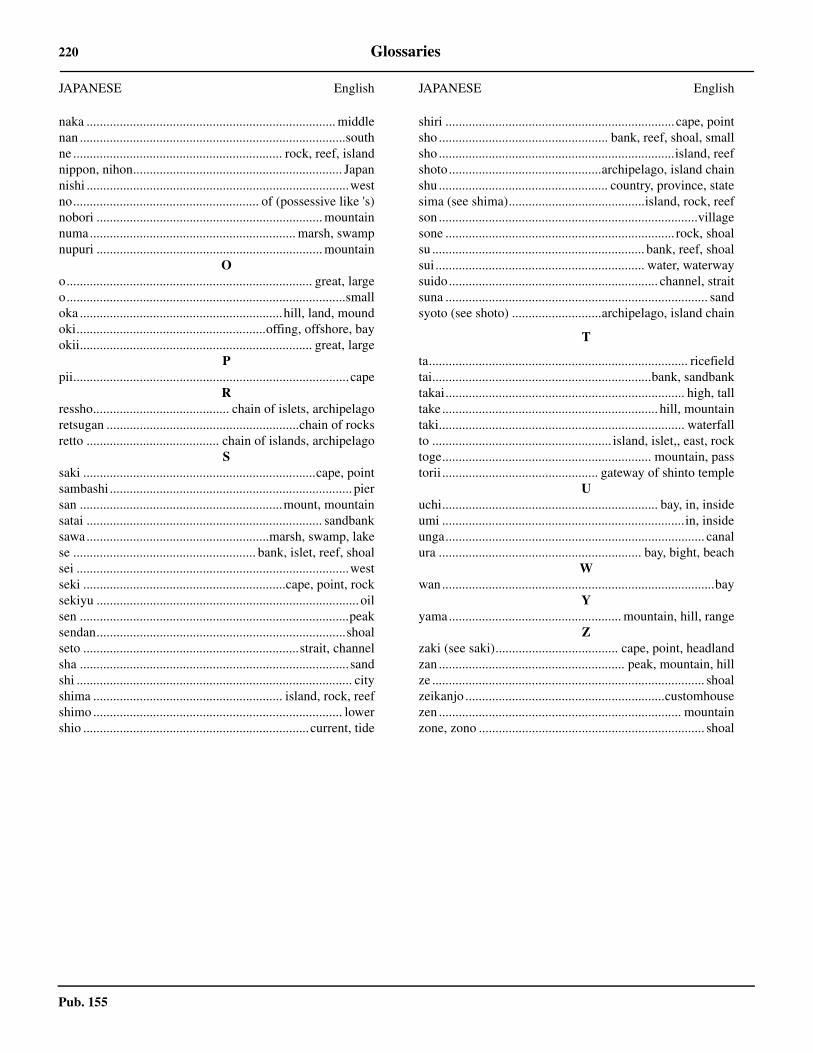
Pub. 155
220 Glossaries
naka ........................................................................... middlenan ................................................................................southne ............................................................... rock, reef, islandnippon, nihon............................................................... Japannishi ...............................................................................westno........................................................ of (possessive like 's)nobori .................................................................... mountainnuma.............................................................. marsh, swampnupuri .................................................................... mountain
Oo.......................................................................... great, largeo....................................................................................smalloka .............................................................hill, land, moundoki.........................................................offing, offshore, bayokii...................................................................... great, large
Ppii...................................................................................cape
Rressho......................................... chain of islets, archipelagoretsugan ..........................................................chain of rocksretto ........................................ chain of islands, archipelago
Ssaki ......................................................................cape, pointsambashi ......................................................................... piersan .............................................................mount, mountainsatai ....................................................................... sandbanksawa.......................................................marsh, swamp, lakese ....................................................... bank, islet, reef, shoalsei ..................................................................................westseki .............................................................cape, point, rocksekiyu ............................................................................... oilsen .................................................................................peaksendan...........................................................................shoalseto .................................................................strait, channelsha .................................................................................sandshi ................................................................................... cityshima ......................................................... island, rock, reefshimo ........................................................................... lowershio ....................................................................current, tide
JAPANESE English
shiri ..................................................................... cape, pointsho ................................................... bank, reef, shoal, smallsho .......................................................................island, reefshoto..............................................archipelago, island chainshu ................................................... country, province, statesima (see shima).........................................island, rock, reefson ..............................................................................villagesone ..................................................................... rock, shoalsu ................................................................ bank, reef, shoalsui............................................................... water, waterwaysuido............................................................... channel, straitsuna ............................................................................... sandsyoto (see shoto) ...........................archipelago, island chain
T
ta.............................................................................. ricefieldtai..................................................................bank, sandbanktakai........................................................................ high, talltake ................................................................. hill, mountaintaki.......................................................................... waterfallto ...................................................... island, islet,, east, rocktoge............................................................... mountain, passtorii ............................................... gateway of shinto temple
Uuchi................................................................. bay, in, insideumi .........................................................................in, insideunga.............................................................................. canalura ............................................................. bay, bight, beach
Wwan..................................................................................bay
Yyama.................................................... mountain, hill, range
Zzaki (see saki)..................................... cape, point, headlandzan ........................................................ peak, mountain, hillze .................................................................................. shoalzeikanjo ............................................................customhousezen ......................................................................... mountainzone, zono .................................................................... shoal
JAPANESE English
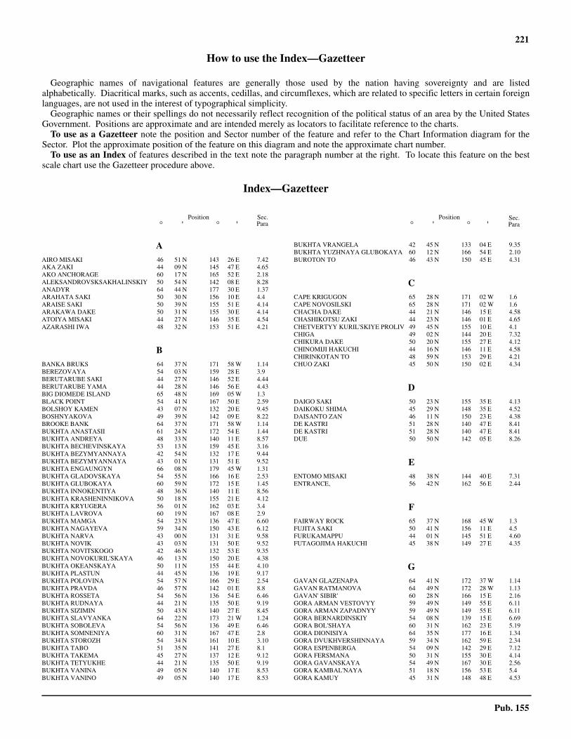
221
Pub. 155
How to use the Index—Gazetteer
Geographic names of navigational features are generally those used by the nation having sovereignty and are listedalphabetically. Diacritical marks, such as accents, cedillas, and circumflexes, which are related to specific letters in certain foreignlanguages, are not used in the interest of typographical simplicity.
Geographic names or their spellings do not necessarily reflect recognition of the political status of an area by the United StatesGovernment. Positions are approximate and are intended merely as locators to facilitate reference to the charts.
To use as a Gazetteer note the position and Sector number of the feature and refer to the Chart Information diagram for theSector. Plot the approximate position of the feature on this diagram and note the approximate chart number.
To use as an Index of features described in the text note the paragraph number at the right. To locate this feature on the bestscale chart use the Gazetteer procedure above.
Index—Gazetteer
Position° ' ° '
Position° ' ° '
Sec.Para
Sec.Para
AAIRO MISAKI 46 51 N 143 26 E 7.42AKA ZAKI 44 09 N 145 47 E 4.65AKO ANCHORAGE 60 17 N 165 52 E 2.18ALEKSANDROVSKSAKHALINSKIY 50 54 N 142 08 E 8.28ANADYR 64 44 N 177 30 E 1.37ARAHATA SAKI 50 30 N 156 10 E 4.4ARAISE SAKI 50 39 N 155 51 E 4.14ARAKAWA DAKE 50 31 N 155 30 E 4.14ATOIYA MISAKI 44 27 N 146 35 E 4.54AZARASHI IWA 48 32 N 153 51 E 4.21
BBANKA BRUKS 64 37 N 171 58 W 1.14BEREZOVAYA 54 03 N 159 28 E 3.9BERUTARUBE SAKI 44 27 N 146 52 E 4.44BERUTARUBE YAMA 44 28 N 146 56 E 4.43BIG DIOMEDE ISLAND 65 48 N 169 05 W 1.3BLACK POINT 54 41 N 167 50 E 2.59BOLSHOY KAMEN 43 07 N 132 20 E 9.45BOSHNYAKOVA 49 39 N 142 09 E 8.22BROOKE BANK 64 37 N 171 58 W 1.14BUKHTA ANASTASII 61 24 N 172 54 E 1.44BUKHTA ANDREYA 48 33 N 140 11 E 8.57BUKHTA BECHEVINSKAYA 53 13 N 159 45 E 3.16BUKHTA BEZYMYANNAYA 42 54 N 132 17 E 9.44BUKHTA BEZYMYANNAYA 43 01 N 131 51 E 9.52BUKHTA ENGAUNGYN 66 08 N 179 45 W 1.31BUKHTA GLADOVSKAYA 54 55 N 166 16 E 2.53BUKHTA GLUBOKAYA 60 59 N 172 15 E 1.45BUKHTA INNOKENTIYA 48 36 N 140 11 E 8.56BUKHTA KRASHENINNIKOVA 50 18 N 155 21 E 4.12BUKHTA KRYUGERA 56 01 N 162 03 E 3.4BUKHTA LAVROVA 60 19 N 167 08 E 2.9BUKHTA MAMGA 54 23 N 136 47 E 6.60BUKHTA NAGAYEVA 59 34 N 150 43 E 6.12BUKHTA NARVA 43 00 N 131 31 E 9.58BUKHTA NOVIK 43 03 N 131 50 E 9.52BUKHTA NOVITSKOGO 42 46 N 132 53 E 9.35BUKHTA NOVOKURIL'SKAYA 46 13 N 150 20 E 4.38BUKHTA OKEANSKAYA 50 11 N 155 44 E 4.10BUKHTA PLASTUN 44 45 N 136 19 E 9.17BUKHTA POLOVINA 54 57 N 166 29 E 2.54BUKHTA PRAVDA 46 57 N 142 01 E 8.8BUKHTA ROSSETA 54 56 N 136 54 E 6.46BUKHTA RUDNAYA 44 21 N 135 50 E 9.19BUKHTA SIZIMIN 50 43 N 140 27 E 8.45BUKHTA SLAVYANKA 64 22 N 173 21 W 1.24BUKHTA SOBOLEVA 54 56 N 136 49 E 6.46BUKHTA SOMNENIYA 60 31 N 167 47 E 2.8BUKHTA STOROZH 54 34 N 161 10 E 3.10BUKHTA TABO 51 35 N 141 27 E 8.1BUKHTA TAKEMA 45 27 N 137 12 E 9.12BUKHTA TETYUKHE 44 21 N 135 50 E 9.19BUKHTA VANINA 49 05 N 140 17 E 8.53BUKHTA VANINO 49 05 N 140 17 E 8.53
BUKHTA VRANGELA 42 45 N 133 04 E 9.35BUKHTA YUZHNAYA GLUBOKAYA 60 12 N 166 54 E 2.10BUROTON TO 46 43 N 150 45 E 4.31
CCAPE KRIGUGON 65 28 N 171 02 W 1.6CAPE NOVOSILSKI 65 28 N 171 02 W 1.6CHACHA DAKE 44 21 N 146 15 E 4.58CHASHIKOTSU ZAKI 44 23 N 146 01 E 4.65CHETVERTYY KURIL'SKIYE PROLIV 49 45 N 155 10 E 4.1CHIGA 49 02 N 144 20 E 7.32CHIKURA DAKE 50 20 N 155 27 E 4.12CHINOMIJI HAKUCHI 44 16 N 146 11 E 4.58CHIRINKOTAN TO 48 59 N 153 29 E 4.21CHUO ZAKI 45 50 N 150 02 E 4.34
DDAIGO SAKI 50 23 N 155 35 E 4.13DAIKOKU SHIMA 45 29 N 148 35 E 4.52DAISANTO ZAN 46 11 N 150 23 E 4.38DE KASTRI 51 28 N 140 47 E 8.41DE KASTRI 51 28 N 140 47 E 8.41DUE 50 50 N 142 05 E 8.26
EENTOMO MISAKI 48 38 N 144 40 E 7.31ENTRANCE, 56 42 N 162 56 E 2.44
FFAIRWAY ROCK 65 37 N 168 45 W 1.3FUJITA SAKI 50 41 N 156 11 E 4.5FURUKAMAPPU 44 01 N 145 51 E 4.60FUTAGOJIMA HAKUCHI 45 38 N 149 27 E 4.35
GGAVAN GLAZENAPA 64 41 N 172 37 W 1.14GAVAN RATMANOVA 64 49 N 172 28 W 1.13GAVAN' SIBIR' 60 28 N 166 15 E 2.16GORA ARMAN VESTOVYY 59 49 N 149 55 E 6.11GORA ARMAN ZAPADNYY 59 49 N 149 55 E 6.11GORA BERNARDINSKIY 54 08 N 139 15 E 6.69GORA BOL'SHAYA 60 31 N 162 23 E 5.19GORA DIONISIYA 64 35 N 177 16 E 1.34GORA DVUKHVERSHINNAYA 59 34 N 162 59 E 2.34GORA ESPENBERGA 54 09 N 142 29 E 7.12GORA FERSMANA 50 31 N 155 30 E 4.14GORA GAVANSKAYA 54 49 N 167 30 E 2.56GORA KAMBAL'NAYA 51 18 N 156 53 E 5.4GORA KAMUY 45 31 N 148 48 E 4.53
222 Index—Gazetteer
Pub. 155
GORA KEKURNAYA 60 22 N 166 42 E 2.15GORA KOLOKOL 46 02 N 150 04 E 4.37GORA KRENITSYNA 49 21 N 154 42 E 4.17GORA MEDVEZH'YA 45 23 N 148 51 E 4.41GORA MIL'NA 46 49 N 151 47 E 4.27GORA MNOGOGLAVAYA 60 32 N 166 18 E 2.15GORA MOROSHECHNAYA 56 48 N 156 18 E 5.9GORA OSTRAYA 59 15 N 142 10 E 6.22GORA PEREVAL'NAYA 45 09 N 147 49 E 4.46GORA PLOSKAYA 60 22 N 165 14 E 2.20GORA SERDTSE KAMEN 65 37 N 178 17 W 1.29GORA SHESTAKOVA 49 29 N 154 44 E 4.17GORA SHIROKAYA 53 52 N 159 33 E 3.9GORA SHTELLERA 54 53 N 166 24 E 2.48GORA SIBETORO 45 24 N 148 35 E 4.51GORA SOPOCHNAYA 56 02 N 156 01 E 5.9GORA STOKAP 44 50 N 147 21 E 4.45GORA TONOBORI 46 13 N 143 27 E 7.46GORA TYATYA 44 21 N 146 15 E 4.58GORA UGOL'NAYA 60 16 N 165 36 E 2.19GORA URATMAN 47 07 N 152 15 E 4.27GORA URGINSKAYA 58 44 N 159 36 E 5.16GORA USHKI 59 22 N 146 11 E 6.17GORA VKHODNAYA 65 42 N 171 04 W 1.5GORA VOLNISTAYA 59 33 N 143 56 E 6.21GORA VYSOKAYA 50 41 N 156 17 E 4.4GUBA BEZYMENNAYA 64 45 N 174 50 W 1.26
HHARUMUKOTAN TO 49 07 N 154 31 E 4.18HATCHO SHIMA 45 04 N 147 32 E 4.45HITOKAPPU YAMA 44 50 N 147 21 E 4.45HIYORI ZAKI 46 04 N 150 19 E 4.34
IIJU BANA 45 17 N 148 02 E 4.50IKABANOTSU SAKI 45 16 N 147 52 E 4.48IMAI SAKI 50 46 N 156 12 E 4.4IWAOI YAMA 43 54 N 145 30 E 4.64IWO YAMA 45 56 N 149 55 E 4.37
KKAIHYO IWA 48 32 N 153 51 E 4.21KAIMEN ZAN 46 08 N 150 17 E 4.33KAMEN' GAVRYUSHKIN 51 14 N 157 18 E 3.29KAMEN' SIVUCHIY 52 11 N 158 26 E 3.25KAMNI DRAKHENFEL'SA 60 22 N 166 12 E 2.14KAMOGAWA SAKI 50 26 N 155 43 E 4.14KAMOI DAKE 45 31 N 148 48 E 4.53KARASUNOO MISAKI 46 14 N 150 35 E 4.33KASHIWABARA WAN 50 41 N 156 08 E 4.6,
5.6, 6.12, 7.6, 7.8, 8.1, 8.6, 8.8
KATAOKA WAN 50 43 N 156 11 E 4.5KERAMUI SAKI 43 39 N 145 33 E 4.62KETOI TO 47 20 N 152 29 E 4.26KHABAROVSK 48 30 N 135 10 E 7.8KHOLMSK 47 03 N 142 03 E 8.8KHOY 51 16 N 142 10 E 8.30KIMPEI MASAKI 49 38 N 154 49 E 4.17KINGA 62 27 N 179 22 E 1.42KINKIL'SKOY 59 20 N 160 12 E 5.16KITA JIMA 46 32 N 150 53 E 4.30KITASOYA MISAKI 49 46 N 142 10 E 8.22KITOLOVNAYA BANKA 54 59 N 167 07 E 2.56KOKUTAN SAKI 50 52 N 156 29 E 4.2KOMPAKOVA 54 40 N 155 40 E 5.8KOMSOMOL'SK 50 33 N 136 58 E 7.8KORSAKOV 46 37 N 142 46 E 7.47KOSA MEECHKIN 65 28 N 178 00 W 1.28KOSA RUSSKAYA KOSHKA 64 34 N 178 32 E 1.34KOZMINO BAY OIL TERMINAL 42 43 N 133 01 E 9.37
KRASNOGORSK 48 25 N 142 05 E 8.15KRILLOVO 46 27 N 142 21 E 7.50KRONE 53 28 N 159 57 E 3.13KUJIRA WAN 50 18 N 155 21 E 4.12KUKIDONO SAKI 45 20 N 148 01 E 4.49KURIL'SKIY ZALIV 45 14 N 147 51 E 4.47KURO IWA 47 36 N 152 53 E 4.24KUROISHI YAMA 49 21 N 154 42 E 4.17KUSHINO MISAKI 45 34 N 149 32 E 4.34KUYBYSHEVKA 45 06 N 147 42 E 4.46
LLA PEROUSE STRAIT 45 43 N 142 00 E 7.52LAZAREV 52 14 N 141 31 E 8.35
MMAGADAN 59 32 N 150 46 E 6.12MAGO 53 15 N 140 13 E 7.7MAKANRU TO 49 47 N 154 26 E 4.16MAKAROV 48 38 N 142 47 E 7.35MAMIYA SAKI 50 24 N 156 01 E 4.9MATSUWA TO 48 05 N 153 12 E 4.23MISHIMA WAN 46 13 N 150 20 E 4.38MITSUKA YAMA 50 41 N 156 17 E 4.4MIYAGAWA SAKI 50 36 N 156 10 E 4.6MOEKESHI WAN 44 37 N 147 00 E 4.44MOSKAL'VO 53 34 N 142 30 E 7.11MOYORO DAKE 45 23 N 148 51 E 4.41MURAKAMI WAN 50 44 N 156 09 E 4.6MYS ACHCHEN 64 46 N 175 26 W 1.27MYS AFRIKA 56 11 N 163 22 E 2.45MYS AL'SKIY 54 35 N 136 05 E 6.38MYS ALEKSANDRA 54 17 N 139 47 E 7.3MYS ALEKSANDRA 64 44 N 177 32 E 1.36MYS ALEVINA 58 50 N 151 20 E 6.4MYS AMAGO MEL'GOT 64 36 N 172 27 W 1.15MYS AMAKHTONSKIY 59 31 N 149 13 E 6.11MYS ANASTASII 46 01 N 142 11 E 7.51MYS ANIVA 46 01 N 143 25 E 7.44MYS ARA 60 01 N 165 12 E 2.20MYS AREGICHINSKIY 60 30 N 155 27 E 5.30MYS ARGALI 53 20 N 159 58 E 3.14MYS ARKA 54 54 N 136 47 E 6.44MYS ARTURA 43 04 N 131 55 E 9.54MYS ASACHA 52 08 N 158 23 E 3.26MYS AYYASH 52 20 N 143 12 E 7.17MYS BABUSHKINA 59 02 N 154 06 E 6.2MYS BARANOVA 49 21 N 142 04 E 8.20MYS BASOVA 62 27 N 179 22 E 1.42MYS BELKINA 45 49 N 137 41 E 9.11MYS BELKINA 49 57 N 142 08 E 8.23MYS BELLINSGAUZENA 49 30 N 144 15 E 7.26MYS BELYY 55 06 N 137 09 E 6.43MYS BENOCHI 46 07 N 142 13 E 7.51MYS BERINGA 65 00 N 175 54 W 1.27MYS BOL DUGANDZHA 54 38 N 136 50 E 6.41MYS BOL'SHOY LARGANGDA 54 08 N 136 48 E 6.61MYS BORISOVA 55 57 N 137 23 E 6.32MYS BOZHEDOMOVA 60 18 N 161 53 E 5.17MYS BRESKENS 45 26 N 147 56 E 4.49MYS BRINERA 42 59 N 131 30 E 9.58MYS BRINERA 44 20 N 135 50 E 9.18MYS BRYUSA 42 53 N 131 28 E 9.58MYS BUREVESTNIK 44 55 N 147 40 E 4.42MYS BUTAKOVA 42 28 N 130 50 E 9.68MYS BYCHIY 49 48 N 140 32 E 8.48MYS CHAGDBAKH 52 59 N 141 08 E 7.5MYS CHAPLINA 64 24 N 172 14 W 1.18MYS CHAUNO 53 33 N 142 15 E 7.10MYS CHAZHMA 55 03 N 161 54 E 3.6MYS CHERNY 54 41 N 167 50 E 2.59MYS CHIBUYNYY 50 46 N 156 12 E 4.4MYS CHIRIKOVA 59 29 N 150 30 E 6.12MYS CHUKOTSKIY 64 14 N 173 05 W 1.19MYS DAL'NIY 43 18 N 134 47 E 9.26MYS DAL'NIY 59 14 N 148 27 E 6.14MYS DAL'NIY 60 26 N 161 54 E 5.19MYS DATTA 49 18 N 140 26 E 8.49
Index—Gazetteer 223
Pub. 155
MYS DELIL'-DE-LYA-KROYERA 50 48 N 143 41 E 7.23MYS DERBESHOVA 50 41 N 156 11 E 4.5MYS DEZHNEVA 66 05 N 169 38 W 1.2MYS DOKUCHAYEVA 44 31 N 146 11 E 4.65MYS DYUANKO 49 12 N 140 21 E 8.50MYS DZHAORE 52 40 N 141 17 E 8.38MYS ENGEL'MA 43 12 N 132 10 E 9.47MYS ENGELYUKAK 64 35 N 172 31 W 1.15MYS EYKAN 57 01 N 138 55 E 6.25MYS FUNATOMARI 49 45 N 144 08 E 7.25MYS FURUGEL'MA 50 31 N 142 03 E 8.25MYS GADIKAN 59 24 N 145 19 E 6.19MYS GAMOVA 42 33 N 131 14 E 9.62MYS GAMOVA 42 34 N 131 13 E 9.42MYS GAUROVITSA 53 55 N 138 21 E 6.65MYS GAYKOVSKOGO 54 23 N 137 39 E 6.56MYS GEKA 64 26 N 178 14 E 1.36MYS GEMBACHEVA 42 50 N 132 34 E 9.39MYS GEORGIYA 48 38 N 144 40 E 7.31MYS GEREYA 59 24 N 145 41 E 6.19MYS GINTERA 63 13 N 179 14 E 1.39MYS GNEVNYY 44 27 N 146 52 E 4.44MYS GOLDOBINA 43 05 N 131 53 E 9.54MYS GOLENISHCHEVA 59 14 N 164 36 E 2.31MYS GORKA 61 41 N 157 42 E 5.34MYS GORYANSKIY 48 58 N 142 59 E 7.34MYS GOVENA 59 48 N 166 05 E 2.13MYS GROZNYY 44 32 N 136 11 E 9.18MYS IL'PINSKIY 59 47 N 164 50 E 2.30MYS IL'YA MUROMETS 45 30 N 148 54 E 4.41MYS INGAKAN 54 05 N 137 28 E 6.64MYS IRANKHI 64 47 N 172 45 W 1.17MYS IVANOVA 50 20 N 140 32 E 8.46MYS IZYL'MET'YEVA 48 55 N 141 58 E 8.17MYS KAMATAN 58 18 N 158 44 E 5.15MYS KAMBAL'NYY 51 06 N 156 42 E 5.3MYS KAMCHATSKIY 56 00 N 163 03 E 2.46MYS KAMENISTYY 54 50 N 162 10 E 3.7MYS KAMKER 57 09 N 139 04 E 6.25MYS KAMYATYAN 58 18 N 158 44 E 5.15MYS KANGYNIN 65 54 N 178 53 W 1.30MYS KASTRIKUM 46 14 N 150 35 E 4.33MYS KEKURNYY 58 54 N 164 42 E 2.24MYS KEKURNYY 59 24 N 145 52 E 6.18MYS KEYTEVAN 59 32 N 154 36 E 5.28MYS KHALEZOVA 53 10 N 141 50 E 8.40MYS KHALYUSTKINA 65 16 N 172 11 W 1.8MYS KHANYANGDA 57 51 N 140 30 E 6.23MYS KHARBIZ 59 31 N 151 31 E 6.8MYS KHARIUZOV 57 05 N 156 32 E 5.10MYS KHAYRYUZOVA 57 05 N 156 32 E 5.10MYS KHIVA 46 04 N 150 19 E 4.34MYS KHODZHELAYKA 51 38 N 157 55 E 3.27MYS KHODZHI 50 49 N 142 05 E 8.26MYS KHOE 51 16 N 142 10 E 8.30MYS KIMBERLEY 49 38 N 154 49 E 4.17MYS KINKIL'SKIY 59 20 N 160 12 E 5.16MYS KITOUSI 50 13 N 142 10 E 8.24MYS KLIN 54 35 N 136 23 E 6.39MYS KOKINA 50 11 N 155 48 E 4.10MYS KOMANDOR 54 57 N 166 31 E 2.54MYS KONERGINO 65 54 N 178 53 W 1.30MYS KONSERVNYY 45 20 N 148 01 E 4.49MYS KORABELNY 54 42 N 167 44 E 2.58MYS KOZLOVA 54 29 N 161 43 E 3.8MYS KOZYREVSKOGO 50 39 N 155 51 E 4.14MYS KRASHENINNIKOVA 58 27 N 163 29 E 2.26MYS KRASIYIOTES 44 09 N 145 47 E 4.65MYS KRASNAYA SKALA 43 14 N 134 36 E 9.27MYS KRASNYY 43 12 N 131 55 E 9.56MYS KRASNYY PARTIZAN 48 59 N 140 23 E 8.50MYS KRAYNIY 54 02 N 137 14 E 6.59MYS KRAYNIY 62 26 N 164 33 E 5.26MYS KRESHCHENYY OGNEM 60 33 N 168 42 E 2.7MYS KRESTOVOZDVIZHENSKIY 47 58 N 139 32 E 9.3MYS KRESTOVVY 51 49 N 158 06 E 3.27MYS KRIGUYGUN 65 28 N 171 02 W 1.6MYS KRIL'ON 45 53 N 142 05 E 7.51MYS KRON'YE 53 28 N 159 57 E 3.13MYS KRONOTSKIY 54 44 N 162 10 E 3.7MYS KRUTOY 52 34 N 158 31 E 3.24MYS KRUTOY 54 23 N 137 49 E 6.54
MYS KRYUGERA 56 01 N 162 05 E 3.4MYS KURBATOVA 50 52 N 156 29 E 4.2MYS KUSOVA 54 47 N 138 01 E 6.51MYS KUVYLOKUOK 64 39 N 172 50 W 1.17MYS KUZACHIN 51 43 N 158 00 E 3.27MYS KUZINOTY 45 34 N 149 32 E 4.34MYS KUZNETSOVA 46 03 N 141 56 E 8.2MYS KYGYNIN 64 45 N 172 05 W 1.12MYS LAMANON 48 47 N 141 51 E 8.17MYS LAMSDORFA 54 03 N 138 40 E 6.66MYS LAZAREVA 52 14 N 141 32 E 8.34MYS LESOVSKOGO 64 20 N 173 33 W 1.23MYS LEVASHOVA 50 30 N 156 10 E 4.4MYS LEVASHOVA 52 48 N 156 10 E 5.7MYS LEVENORNA 46 24 N 143 36 E 7.43MYS LEVENSHTERNA 54 05 N 143 00 E 7.15MYS LITKE 53 56 N 140 22 E 7.3MYS LOPATINA 46 36 N 141 49 E 8.4MYS LOPATKA 50 52 N 156 40 E 3.30MYS LOVTSOVA 44 27 N 146 35 E 4.54MYS LOVUSHEK 53 13 N 159 43 E 3.16MYS LYSAYA GOLOVA 64 17 N 173 22 W 1.21MYS LYUGREN 65 30 N 171 40 W 1.8MYS MADZHALINDA 55 17 N 136 07 E 6.35MYS MAL DUGANDZHA 54 41 N 136 39 E 6.39MYS MAL'MINSKIY 56 42 N 138 22 E 6.28MYS MANORSKIY 55 07 N 135 42 E 6.36MYS MAPATSA 48 49 N 140 15 E 8.55MYS MAREKAN 59 19 N 143 27 E 6.21MYS MARII 54 19 N 142 16 E 7.12MYS MATUGIN 61 41 N 160 15 E 5.39MYS MAYACHNYA 49 18 N 140 26 E 8.51MYS MAYACHNYY 45 23 N 137 09 E 9.12MYS MAYACHNYY 52 53 N 158 42 E 3.19MYS MEDVEZHONOK 50 26 N 155 43 E 4.14MYS MERTENSA 64 32 N 172 25 W 1.10MYS MINAMI NAYOSHI 46 26 N 141 51 E 8.4MYS MONATI 54 42 N 166 40 E 2.53MYS MOSOLOVA 45 06 N 136 46 E 9.14MYS MUKHTELYA 54 18 N 138 43 E 6.63MYS MUSIKAN 56 14 N 137 50 E 6.32MYS MYSOVOY 44 16 N 146 18 E 4.57MYS NACHIKINSKIY 57 57 N 162 42 E 2.41MYS NADEZHDY 61 30 N 156 43 E 5.33MYS NAKLONNYY 56 35 N 138 15 E 6.28MYS NALYCHEVA 53 09 N 159 24 E 3.18MYS NAVARIN 62 15 N 179 07 E 1.42MYS NEEGCHAN 64 55 N 172 25 W 1.8MYS NEPROPUSK 54 45 N 166 42 E 2.54MYS NEPROYDENNYY 50 17 N 155 12 E 4.8MYS NEVEL'SKOGO 51 57 N 141 26 E 8.33MYS NIKTA 54 34 N 136 54 E 6.60MYS NIZKIG 61 37 N 173 50 E 1.43MYS NIZKIY 50 01 N 144 00 E 7.24MYS NIZKIY 57 49 N 163 12 E 2.41MYS NIZKIY 59 02 N 164 44 E 2.24MYS NIZKIY 60 24 N 170 45 E 1.46MYS NIZMENNYY 43 30 N 135 09 E 9.24MYS NIZMENYY 49 11 N 142 04 E 8.20MYS NOGDAN 58 41 N 141 41 E 6.23MYS NOSOROG 55 10 N 135 51 E 6.35MYS NOTTATEY 61 07 N 163 37 E 5.20MYS NUNYAMO 65 36 N 170 40 W 1.4MYS NURKI 56 44 N 138 33 E 6.27MYS NYGCHIGEN 65 04 N 172 06 W 1.9MYS NYGLIGAN 65 04 N 172 06 W 1.9MYS OBRUCHEVA 42 49 N 133 33 E 9.33MYS OBRYVISTYY 54 29 N 137 50 E 6.55MYS OBRYVISTYY 62 19 N 163 21 E 5.25MYS ODZHAN 57 29 N 139 47 E 6.24MYS OLAROVSKOGO 42 52 N 133 55 E 9.29MYS OLYUTORSKIY 59 55 N 170 21 E 1.46MYS OMGON 58 01 N 157 41 E 5.14MYS OPASNYY 52 41 N 158 36 E 3.22MYS OPASNYY 61 47 N 158 31 E 5.34MYS OPORNYY 50 44 N 156 09 E 4.6MYS OREKHOVSKI 55 03 N 166 04 E 2.53MYS ORIA 59 59 N 165 14 E 2.21MYS OSSORSKAYA 59 13 N 163 16 E 2.35MYS OSTROVNOY 42 48 N 133 43 E 9.31MYS OSTROVNOY 60 42 N 155 54 E 5.32MYS OSTROVSKOY 59 43 N 161 02 E 5.16
224 Index—Gazetteer
Pub. 155
MYS OTLICHITEL'NYY 55 47 N 137 02 E 6.33MYS OTVESNYY 52 37 N 158 33 E 3.23MYS OZERNOY 57 43 N 163 19 E 2.41MYS OZERNYY 50 36 N 156 10 E 4.6MYS PAKKLAN 59 38 N 163 25 E 2.33MYS PALATA 54 34 N 167 50 E 2.60MYS PESCHANAYA KOSA 59 02 N 163 10 E 2.37MYS PESCHANYY 48 27 N 140 11 E 9.2MYS PESCHANYY 54 50 N 167 28 E 2.57MYS PESCHANYY 60 08 N 166 11 E 2.14MYS PIRAMIDNYY 52 23 N 158 35 E 3.25MYS PIRATKOV 51 58 N 158 17 E 3.26MYS POGOBI 52 13 N 141 39 E 8.36MYS POKATYY 56 44 N 163 05 E 2.44MYS POLEVOGO 49 46 N 142 10 E 8.22MYS POPOVA 49 03 N 144 24 E 7.27MYS POVOROTNYY 42 40 N 133 03 E 9.35MYS POVOROTNYY 48 51 N 144 42 E 7.27MYS POVOROTNYY 60 43 N 160 46 E 5.22MYS POVOROTNYY 65 08 N 179 40 W 1.33MYS PRASOLOVA 44 23 N 146 01 E 4.65MYS PRAVYY VKHODNOI 64 22 N 172 36 W 1.19MYS PRIGLUBYY 53 41 N 142 36 E 7.12MYS PROMEZHUTOCHNYY 58 48 N 164 11 E 2.25MYS PRONGE 52 52 N 141 15 E 8.39MYS PRZHEVAL'SKOGO 45 06 N 147 30 E 4.45MYS PUPYR' 62 03 N 163 12 E 5.25MYS PUZINO 64 25 N 173 14 W 1.24MYS PYATA 49 02 N 144 20 E 7.32MYS RADUZHNYY 54 45 N 137 13 E 6.47MYS RAZDEL'NYY 45 15 N 148 30 E 4.42MYS RAZDELNY 66 10 N 178 52 W 1.32MYS RAZMYTYY 45 50 N 150 02 E 4.34MYS RECHNOY 43 18 N 131 50 E 9.56MYS RIFOVYY 50 29 N 156 08 E 4.9MYS RIFOVYY 61 45 N 159 29 E 5.35MYS ROGACHEVA 44 11 N 146 03 E 4.59MYS RZHAVYY 59 24 N 146 41 E 6.15MYS SEDLOVIDNYY 43 05 N 132 18 E 9.45MYS SEMENOVA 46 27 N 150 51 E 4.30MYS SEMENOVA 58 59 N 163 41 E 2.27MYS SENEKA 54 19 N 137 44 E 6.59MYS SENYAVINA 47 21 N 142 56 E 7.40MYS SERYY 60 09 N 169 55 E 2.4MYS SEVERNYY 54 30 N 137 55 E 6.54MYS SEVERNYY 55 12 N 137 40 E 6.49MYS SEVEROVOSTOCHNY 55 18 N 166 17 E 2.49MYS SEVERO-VOSTOCHNYY 55 02 N 138 15 E 6.50MYS SEVERO-ZAPADNYY 55 11 N 137 33 E 6.47MYS SEVERO-ZAPADNYY 55 17 N 165 44 E 2.50MYS SEVERO-ZAPADNYY 57 56 N 162 34 E 2.40MYS SEVORSI 45 19 N 148 45 E 4.42MYS SHANTSA 45 23 N 137 09 E 9.12MYS SHELIKHOVA 50 23 N 155 35 E 4.13MYS SHESTAKOVA 59 14 N 148 55 E 6.10MYS SHIL'KAN 59 22 N 145 47 E 6.18MYS SHIPUNSKIY 53 06 N 160 02 E 3.15MYS SHKOTA 43 41 N 135 18 E 9.22MYS SHTERNBERGA 48 15 N 142 09 E 8.13MYS SHTEYNA 53 09 N 160 04 E 3.15MYS SIVOL'KUT 64 22 N 172 36 W 1.19MYS SLEPIKOVSKOGO 47 18 N 141 57 E 8.10MYS SOBORNYY 51 22 N 140 51 E 8.43MYS SOLOV'YEVA 50 50 N 140 32 E 8.45MYS SOSUNOVA 46 32 N 138 21 E 9.7MYS SOYMONOVA 48 56 N 142 59 E 7.35MYS SPIRIDONOVA 44 06 N 145 45 E 4.64MYS SREDNIY 53 23 N 159 56 E 3.13MYS SREDNIY 59 07 N 154 52 E 6.2MYS SREDNIY 59 26 N 150 45 E 6.9MYS SREDNIY 61 36 N 163 15 E 5.24MYS STANYUKOVICHA 59 23 N 148 59 E 6.10MYS STARITSKOGO 48 40 N 141 53 E 8.16MYS STOLBGATYY 44 02 N 145 40 E 4.64MYS STOLBOVOY 56 41 N 163 17 E 2.44MYS STOLETIYA 64 19 N 173 39 W 1.26MYS STOROZHEVOY 61 50 N 158 52 E 5.34MYS SULKOVSKOGO 54 52 N 167 22 E 2.56MYS SUSHCHEVA 51 41 N 141 07 E 8.32MYS SUSLOVA 42 31 N 130 52 E 9.66MYS SVOBODNYY 46 51 N 143 26 E 7.42MYS SYSOYEVA 42 46 N 133 21 E 9.34
MYS SYSOYEVA 42 51 N 132 19 E 9.44MYS SYURKUM 50 06 N 140 42 E 8.47MYS TAMLEVO 53 22 N 141 46 E 7.9MYS TARAN 59 07 N 151 06 E 6.7MYS TAYGONOS 60 34 N 160 11 E 5.21MYS TAYNOCHIN 61 49 N 159 23 E 5.34MYS TELANSKIY 60 56 N 159 47 E 5.37MYS TELYAKOVSKOGO 43 13 N 132 19 E 9.46MYS TERPENIYA 48 38 N 144 45 E 7.28MYS TIKHIY 43 15 N 131 58 E 9.56MYS TKHADGOU 52 15 N 141 21 E 8.37MYS TO 51 02 N 140 41 E 8.44MYS TOKAREVSKOGO 43 05 N 131 51 E 9.55MYS TOMARI ANIVA 46 36 N 142 46 E 7.46MYS TRI SESTRY 51 07 N 157 03 E 3.30MYS TRUZHENIK 48 59 N 140 22 E 8.52MYS TUKURGU 54 00 N 138 35 E 6.66MYS TUNAYCHA 46 52 N 143 09 E 7.41MYS TUPOY 57 01 N 162 51 E 2.43MYS TYK 51 45 N 141 41 E 8.36MYS TYL'SKIY 54 40 N 135 38 E 6.37MYS UARKE 52 31 N 141 13 E 8.37MYS UGLEVOY 50 24 N 156 01 E 4.9MYS UGOL'NYY 61 00 N 163 30 E 5.19MYS UKOY 55 38 N 136 46 E 6.33MYS UKURUNRU 53 58 N 137 51 E 6.65MYS URUMPET 44 35 N 147 15 E 4.43MYS USPENIYA 54 34 N 137 38 E 6.55MYS UTKOLOKSKIY 57 54 N 157 04 E 5.12MYS VARKHALAMSKIY 61 39 N 159 34 E 5.36MYS VASIL'YEVA 50 00 N 155 23 E 4.11MYS VESLOVSKIY 43 39 N 145 33 E 4.62MYS VILIGINSKIY 61 13 N 156 40 E 5.33MYS VINEIS 46 07 N 141 55 E 8.3MYS VITGENSHTEYNA 60 51 N 172 04 E 1.46MYS VKHODNOI RIF 55 11 N 165 58 E 2.52MYS VKHODNOY 53 40 N 142 29 E 7.10MYS VKHODNOY 54 53 N 136 44 E 6.43MYS VKHODNOY 58 59 N 163 04 E 2.38MYS VODOPADNYY 61 25 N 163 46 E 5.20MYS VODOPADSKI 54 39 N 167 40 E 2.61MYS VOSTOCHNYY 58 55 N 152 45 E 6.2MYS VOYENNYKH TOPOGRAFOV 62 38 N 179 38 E 1.41MYS VRANGELYA 54 17 N 138 40 E 6.62MYS VYSOKIY 61 10 N 172 42 E 1.44MYS YABLONOVYY 47 37 N 141 58 E 8.11MYS YAPON 59 29 N 154 56 E 5.28MYS YAUGICH 50 46 N 156 31 E 4.2MYS YEGOROVA 44 47 N 136 27 E 9.16MYS YELISTRATOVA 61 31 N 163 02 E 5.23MYS YELIZAVETY 54 25 N 142 42 E 7.14MYS YEVSTAFIYA 46 18 N 143 34 E 7.44MYS YOMAN 48 46 N 144 42 E 7.28MYS YUSHINA 55 22 N 165 57 E 2.49MYS YUZHNO-KURIL'SKIY 44 01 N 145 53 E 4.59MYS YUZHNYY 44 02 N 135 38 E 9.20MYS YUZHNYY 57 44 N 156 47 E 5.11MYS YUZHNYY 58 38 N 163 46 E 2.25MYS ZABIYAKA 55 15 N 165 53 E 2.51MYS ZHELTYY 51 33 N 157 46 E 3.27MYS ZHONKIYER 50 53 N 142 06 E 8.27MYS ZHUKOVSKOGO 49 26 N 142 06 E 8.20MYS ZHUPANOVA 53 40 N 159 55 E 3.12MYS ZOLOTOY 47 19 N 139 00 E 9.4
NNAGA IWA 48 33 N 153 51 E 4.21NAIBO WAN 44 43 N 147 08 E 4.44NAKHODKA 42 49 N 132 54 E 9.36NAYAKHANSKIY REYD 61 54 N 159 00 E 5.35NAYOSHI BYOCHI 49 27 N 142 08 E 8.21NAYOSHI SAKI 49 26 N 142 06 E 8.20NEMO YAMA 49 34 N 154 49 E 4.17NEVEL’SK 46 40 N 141 52 E 8.6NIKOL'SKOYE 55 12 N 165 59 E 2.53NIKOLAYEVSK-NA-AMURE 53 08 N 140 44 E 7.6NOBORI YAMA 45 09 N 147 49 E 4.46NODA HAKUCHI 47 26 N 141 59 E 8.10NOTORO MISAKI 45 06 N 147 30 E 4.45NYYVO RADIOBEACON 51 57 N 143 08 E 7.20
Index—Gazetteer 225
Pub. 155
OO MISAKI 45 26 N 147 56 E 4.49O SAKI 44 01 N 145 53 E 4.59OCHIBU MISAKI 47 21 N 142 56 E 7.40ODAMOE YAMA 45 02 N 147 55 E 4.42OKAPPUNO MISAKI 44 16 N 146 18 E 4.57OKHA 53 34 N 143 03 E 7.16OKHOTSK 59 22 N 143 12 E 6.22OKHOTSKIY REYD 59 22 N 143 12 E 6.22OKINO SHIMA 50 09 N 155 34 E 4.11OKTYABR’SKIY 52 40 N 156 15 E 5.6OL’GA PORT 43 44 N 135 17 E 9.23OLYUTORSKIY ZALIV 59 49 N 166 15 E 2.11ONNEKOTAN TO 49 25 N 154 45 E 4.17OSTROV ALYUMKA 64 41 N 177 37 E 1.35OSTROV ANTSIFEROVA 50 12 N 154 59 E 4.12OSTROV ASKOL'D 42 45 N 132 20 E 9.41OSTROV ATLASOVA 50 52 N 155 33 E 4.7OSTROV BAYDUKOV 53 18 N 141 29 E 7.4OSTROV BERINGA 55 00 N 166 15 E 2.48OSTROV BOL'SHOY PELIS, 42 39 N 131 28 E 9.49OSTROV BOL'SHOY SHANTAR 55 00 N 137 46 E 6.46OSTROV BROUTONA 46 43 N 150 45 E 4.31OSTROV CHIRINKOTAN 48 59 N 153 29 E 4.21OSTROV CHIRPOY 46 32 N 150 53 E 4.30OSTROV DYM 50 09 N 155 34 E 4.11OSTROV EKARMA 48 57 N 153 57 E 4.21OSTROV FURUGEL'MA 42 28 N 130 55 E 9.67OSTROV IONY 56 24 N 143 23 E 6.30OSTROV KETOY 47 20 N 152 29 E 4.26OSTROV KHARIMKOTAN 49 07 N 154 31 E 4.18OSTROV KONUS 60 34 N 162 08 E 5.19OSTROV KOSA MEECHKYN 65 28 N 178 00 W 1.28OSTROV KRASHENINNIKOVA 53 13 N 159 33 E 3.17OSTROV MAKANRUSHI 49 47 N 154 26 E 4.16OSTROV MANDZHUR 57 50 N 162 27 E 2.40OSTROV MATUA 48 05 N 153 12 E 4.23OSTROV MEN'SHIKOVA 54 35 N 139 15 E 6.68OSTROV MONERON 46 15 N 141 14 E 8.5OSTROV NEDORAZUMENIYA 59 35 N 150 24 E 6.11OSTROV NUNEANGAN 64 38 N 172 20 W 1.15OSTROV ONEKOTAN 49 25 N 154 45 E 4.17OSTROV OPASNYY 43 02 N 134 12 E 9.29OSTROV PTICHIY 54 36 N 137 05 E 6.48OSTROV RAIKOKE 48 18 N 153 15 E 4.23OSTROV RASSHUA 47 46 N 153 01 E 4.24OSTROV RATMANOVA 65 48 N 169 05 W 1.3OSTROV SAKHARNAYA GOLOVA 54 58 N 136 30 E 6.42OSTROV SHIASHKOTAN 48 51 N 154 10 E 4.19OSTROV SHLEM 45 29 N 148 35 E 4.52OSTROV SIBIRYAKOVA 42 48 N 131 26 E 9.60OSTROV SPAFAR'YEVA 59 12 N 149 03 E 6.6OSTROV STARICHKOV 52 47 N 158 37 E 3.22OSTROV SUYATOY IONY 56 24 N 143 23 E 6.1OSTROV TOPORKOV 52 55 N 158 47 E 3.18OSTROV TRETIY 61 35 N 162 34 E 5.22OSTROV VERKHOTUROVA 59 37 N 164 40 E 2.30OSTROV ZAV'YALOVA 59 05 N 150 36 E 6.6OSTROV ZHELTUKHINA 42 50 N 131 34 E 9.50OSTROV ZUBCHATYY 60 48 N 162 45 E 5.19OSTROVA KHAGEMIF 52 28 N 141 22 E 8.37OSTROVA RIMSKOGO-KORSAKOVA 42 41 N 131 28 E 9.49OSTROVA USHISHIR 47 32 N 152 49 E 4.25OSTROVA VERKHOVSKOGO 42 43 N 131 49 E 9.51OSTROVOK MORSKAYA MATUGA 61 23 N 159 55 E 5.38OSTROVOK PTICHIY 58 52 N 164 30 E 2.25OSTROVOK YUZHNYY 54 20 N 137 47 E 6.54OZERO BUSSE 46 31 N 143 18 E 7.46
PPERVYY KURIL'SKIY PROLIV 50 50 N 156 35 E 3.31PETROPAVLOVSK-KAMCHATSKIY 53 01 N 158 39 E 3.21PIL'TUN 52 51 N 143 18 E 7.17POGRANICHNOYE 50 23 N 143 47 E 7.23POLOUSTROV LONGDAR NEGOTNI 56 28 N 138 11 E 6.29POLU. MURAV’YEV-AMURSKIY 43 10 N 132 00 E 9.43POLUOSTROV ERDMANA 43 15 N 131 59 E 9.56POLUOSTROV KAMENISTYY 59 16 N 146 20 E 6.16POLUOSTROV KLERKA 42 46 N 131 22 E 9.61
POLUOSTROV PESCHANYY 43 10 N 131 47 E 9.57POLUOSTROV SAPERNYY 43 03 N 131 54 E 9.54POLUOSTROV YANKOVSKOGO 42 57 N 131 31 E 9.58POLUSTROV LOMONOSOVA 43 00 N 131 35 E 9.58PORONAYSK 49 13 N 143 08 E 7.33PORT OF VOSTOCHNYY 42 44 N 133 03 E 7.37PORTOVYY PUNKT KORF 60 24 N 166 02 E 2.17POS'YET 42 39 N 130 48 E 9.66PRIGORODNOYE 46 37 N 142 54 E 7.48PROLIV BUSSOL' 46 40 N 151 51 E 4.29PROLIV YEKATERINY 44 27 N 146 45 E 4.1PROVIDENIYA 64 23 N 173 18 W 1.25
RRAIKOKE JIMA 48 18 N 153 15 E 4.23RAKKIBETSU MISAKI 45 30 N 148 54 E 4.41RAKOVAYA MEL' 52 58 N 158 38 E 3.21RASHOWA JIMA 47 46 N 153 01 E 4.24RECHKA KIKHCHIK 53 28 N 156 01 E 5.7REID OTKHPYTIY 45 52 N 149 46 E 4.36REKA ANADYR' 64 45 N 177 32 E 1.38REKA APUKA 60 27 N 169 35 E 2.5REKA BOL'SHAYA VOROVSKAYA 54 13 N 155 50 E 5.7REKA GOLYGINA 51 55 N 156 29 E 5.5REKA ICHA 55 42 N 155 39 E 5.9REKA IRET' 59 55 N 154 29 E 5.29REKA KALAKHTYRKA 52 58 N 158 50 E 3.18REKA KHALAKTYRKA 52 58 N 158 50 E 3.18REKA KOLPAKOVA 54 40 N 155 40 E 5.8REKA KRONOTSKAYA 54 31 N 160 45 E 3.11REKA KRUTOGOROVAYA 55 02 N 155 36 E 5.8REKA MUTNAYA 53 04 N 159 00 E 3.18REKA OKHOTA 59 20 N 143 02 E 6.23REKA OZERNAYA 51 30 N 156 30 E 5.4REKA OZERNAYA 57 21 N 162 47 E 2.43REKA SEMLYACHIK 54 06 N 159 55 E 3.12REKA STOLBOVAYA 56 42 N 162 56 E 2.44REKA TIGIL' 58 02 N 158 13 E 5.15REKA UKA 57 50 N 162 08 E 2.39REKA VOROVSKAYA 54 13 N 155 50 E 5.7REKA VOYAMPOLKA 58 31 N 159 10 E 5.15REKA VYVENKA 60 11 N 165 29 E 2.19REYD AGNEVO 50 34 N 142 03 E 8.25REYD CHEKHOV 47 26 N 141 59 E 8.10REYD IL'INSKIY 47 59 N 142 12 E 8.12REYD MAKAR'YEVSKIY 50 50 N 142 05 E 8.26REYD OTKRYTYY 45 52 N 149 46 E 4.36REYD PLOVER 64 22 N 173 21 W 1.24REYD STARODUBSKOYE 47 25 N 142 50 E 7.39REYD TOMARI 47 46 N 142 03 E 8.12REYD TYATINSKIY 44 16 N 146 11 E 4.58REYD VOSTOCHNYY 48 17 N 142 38 E 7.37REYD VZMAR'YE 47 52 N 142 32 E 7.38REYD ZHUKOVSKOGO 49 27 N 142 08 E 8.21RUBETSU 45 06 N 147 42 E 4.46RUBETSU WAN 45 06 N 147 40 E 4.46RURUI MISAKI 44 31 N 146 11 E 4.65RUYOBETSU MISAKI 44 11 N 146 03 E 4.59
SSEA LION ROCK 54 50 N 167 22 E 2.61SEOROSHI MISAKI 45 19 N 148 45 E 4.42SEVERNAYA GAVAN 47 04 N 142 03 E 8.8SEVERO-KURIL’SKIY 50 41 N 156 08 E 4.6,
5.6, 6.12, 7.6, 7.8, 8.1, 8.6, 8.8
SHAKHTERSK 49 10 N 142 04 E 8.19SHANA WAN 45 14 N 147 51 E 4.47SHASUKOTAN TO 48 51 N 154 10 E 4.19SHIBETORO DAKE 45 24 N 148 35 E 4.51SHIMANOBORI YAMA 43 59 N 145 44 E 4.55SHIMUSHIRU WAN 46 52 N 151 50 E 4.28SHIRAURA 47 52 N 142 32 E 7.38SHIRINKI TO 50 12 N 154 59 E 4.12
226 Index—Gazetteer
Pub. 155
SHIRIYAJIRI DAKE 50 16 N 155 15 E 4.12SHUSU SAN 45 13 N 148 15 E 4.51SIVUCHIY KAMEN' 54 50 N 167 22 E 2.61SKALA KAMEN' OPASNOSTI 45 48 N 142 14 E 7.52SKALA RONKU 48 56 N 144 36 E 7.27SLAVYANKA 42 52 N 131 23 E 9.59SOI SHO 45 28 N 148 32 E 4.51SOMNITELNAYA BANKA 59 22 N 164 40 E 2.30SOPKA KAMBAL'NAYA 51 18 N 156 53 E 3.29SOPKA KARYMSKAYA 54 03 N 159 28 E 3.9SOPKA KHODUTKA 52 02 N 157 43 E 3.26SOPKA KLYUCHEVSKAYA 56 04 N 160 38 E 3.2SOPKA KOZELSKAYA 53 13 N 158 53 E 3.16SOPKA SHIVELYUCH 56 40 N 161 30 E 2.46SOPKA VILYUCHINSKAYA 52 42 N 158 17 E 3.22SOPKA ZHELTOVSKAYA 51 34 N 157 19 E 3.28SOPKA ZHUPANOVA 53 35 N 159 09 E 3.9SOVETSKAYA GAVAN' 48 58 N 140 17 E 8.52STANITSKOGO MEL' 52 53 N 158 39 E 3.21STARAYA GAVAN' 55 12 N 166 14 E 2.55STATEN MISAKI 46 06 N 150 05 E 4.37SURIBACHI WAN 50 11 N 155 44 E 4.10
TTATAR STRAIT 48 45 N 141 15 E 8.1TATARSKIY STRAIT 48 45 N 141 15 E 8.1TATSUKAMI SAKI 50 11 N 155 48 E 4.10TENEDOS SHOAL 64 16 N 178 00 W 1.20TISINE MISAKI 49 57 N 142 08 E 8.23TOMARI SAKI 50 29 N 156 08 E 4.9TOMARI YAMA 43 50 N 145 30 E 4.61TOMARIORU HAKUCHI 47 46 N 142 03 E 8.12TONNAI MISAKI 46 52 N 143 09 E 7.41TORIGA SAKI 49 21 N 142 04 E 8.20TORPEDO BOAT CANAL 43 03 N 131 51 E 9.52TOSHIRURI MISAKI 45 15 N 148 30 E 4.42TUIRTOF 65 42 N 171 04 W 1.5TUMEN RIVER 42 18 N 130 41 E 9.68TYRTOVA 65 42 N 171 04 W 1.5
UUEMBETSU SAKI 44 55 N 147 40 E 4.42UGLEGORSK TERMINAL 49 05 N 142 02 E 8.18URUMOMBETSU SAKI 44 35 N 147 15 E 4.43URUPPO FUJI 46 02 N 150 04 E 4.37URYU 46 27 N 142 21 E 7.50USHISHIRU SHIMA 47 32 N 152 49 E 4.25UST-KAMCHATSK 56 13 N 162 29 E 3.3
USU MISAKI 47 37 N 141 58 E 8.11
VVANINO 49 05 N 140 17 E 8.52VAYAM-PALKA 58 31 N 159 10 E 5.15VITYAZ MARINE TERMINAL 52 42 N 143 33 E 7.18VLADIVOSTOK 43 07 N 131 54 E 9.54VOSTOCHNYY 42 44 N 133 04 E 9.37VULCAN VILYUCHIK 52 42 N 158 17 E 3.22VULKAN BERUTARUBE 44 28 N 146 56 E 4.43VULKAN CHIKURACHKI 50 20 N 155 27 E 4.12VULKAN FUSSA 50 16 N 155 15 E 4.12VULKAN GOLOVNINA 43 50 N 145 30 E 4.61VULKAN MENDELEYEVA 43 59 N 145 44 E 4.55VULKAN MIL'NA 46 49 N 151 47 E 4.27VULKAN NEMO 49 34 N 154 49 E 4.17VULKAN TEBEN'KOVA 45 02 N 147 55 E 4.42VULKAN TRI SESTRY 45 56 N 149 55 E 4.37
YYABLOKOBYTS 47 37 N 141 58 E 8.11YAOKURI SAKI 50 11 N 155 39 E 4.10YEKARUMA TO 48 57 N 153 57 E 4.21YENCHO ZAN 49 29 N 154 44 E 4.17YUZHNO-KURIL'SKIY 44 01 N 145 51 E 4.60
ZZALIV ALEKSANDRY 54 10 N 139 10 E 6.69ZALIV ARTYUSHIMA 50 44 N 156 09 E 4.6ZALIV AYAN 56 27 N 138 09 E 6.31ZALIV CHAYVO 52 23 N 143 10 E 7.19ZALIV CHIKHACHEVA 51 28 N 140 47 E 8.42ZALIV DOBROYE NACHALO 44 43 N 147 08 E 4.44ZALIV KOZYREVSKOGO 50 43 N 156 11 E 4.5ZALIV KUYBYSHEVSKIY 45 06 N 147 40 E 4.46ZALIV L'VINAYA PAST' 44 37 N 147 00 E 4.44ZALIV MIL'NA 46 52 N 151 50 E 4.28ZALIV NABIL'SKIY 51 44 N 143 19 E 7.21ZALIV NYYSKIY 51 58 N 143 11 E 7.20ZALIV OL'GI 43 43 N 135 15 E 9.23ZALIV OL’GI 43 43 N 135 15 E 9.23ZALIV SEVERO-KURIL'SKIY 50 41 N 156 08 E 4.6ZALIV SHCHUKINA 45 38 N 149 27 E 4.35ZALIV VLADIMIRA 43 54 N 135 31 E 9.21ZARUBINO 42 38 N 131 05 E 9.64


