Embed Size (px)
Citation preview
Delft University of Technology
Privatisation of the Production of Public Space
Leclercq, Els
DOI10.7480/abe.2018.5Publication date2018Document VersionFinal published versionCitation (APA)Leclercq, E. (2018). Privatisation of the Production of Public Space. A+BE | Architecture and the BuiltEnvironment. https://doi.org/10.7480/abe.2018.5
Important noteTo cite this publication, please use the final published version (if applicable).Please check the document version above.
CopyrightOther than for strictly personal use, it is not permitted to download, forward or distribute the text or part of it, without the consentof the author(s) and/or copyright holder(s), unless the work is under an open content license such as Creative Commons.
Takedown policyPlease contact us and provide details if you believe this document breaches copyrights.We will remove access to the work immediately and investigate your claim.
This work is downloaded from Delft University of Technology.For technical reasons the number of authors shown on this cover page is limited to a maximum of 10.
Privatisation of the Production of Public Space
Els Leclercq
052018

Privatisation of the Production of Public Space
Els LeclercqDelft University of Technology, Faculty of Architecture and the Built Environment, Departments of Urbanism and Management in the Built Environment
TOC
abe.tudelft.nl
Design: Sirene Ontwerpers, Rotterdam Photos by Els Leclercq (except where otherwise noted)
ISBN 978-94-6366-060-0ISSN 2212-3202
© 2018 Els Leclercq
All rights reserved. No part of the material protected by this copyright notice may be reproduced or utilized in any form or by any means, electronic or mechanical, including photocopying, recording or by any information storage and retrieval system, without written permission from the author.
Unless otherwise specified, all the photographs in this thesis were taken by the author. For the use of illustrations effort has been made to ask permission for the legal owners as far as possible. We apologize for those cases in which we did not succeed. These legal owners are kindly requested to contact the publisher.
TOC
Privatisation of the Production of Public Space
Dissertation
for the purpose of obtaining the degree of doctorat Delft University of Technology
by the authority of the Rector Magnificus, prof.dr.ir. T.H.J.J. van der Hagen,Chair of the Board for Doctorates
to be defended publicly onThursday 5 April 2018 at 15:00 o’clock
by
Elisabeth Maria LECLERCQMaster of Science Architecture, Urbanism and Building Sciences
born in Tilburg, the Netherlands
TOC
This dissertation has been approved by the promotors.
Composition of the doctoral committee:
Rector Magnificus chairpersonProf.dr. E.M. van Bueren Delft University of Technology, promotorProf.dr. W.A.J. Vanstiphout Delft University of Technology, promotor
Independent members:
Prof.dr. C.S. de Magalhães University College LondonProf.dr. M. Loopmans KU LeuvenProf.dr.ir. M.H. Hermans Delft University of TechnologyProf.Dr.-Ing. C.M. Hein Delft University of TechnologyDr. R. van Melik Radboud University Nijmegen
Dr. D. Pojani (University of Queensland) contributed significantly to the preperation of this thesis.
TOC
Preface
The reasons for embarking on a PhD trajectory are by now, in all honesty, a mystery to me, but why I set out to research the topic of privatisation is still crystal clear:
The rise of the multi-millionaire clientsFor many years I worked as an urban designer on various projects from small scale housing developments to large scale regeneration and research projects, both in London and other places in the United Kingdom, mostly up north, first for a large practice and later for our own company, Studio Aitken. I saw my clients slowly change from being small developers, council and housing corporations to being the mostly foreign, multi-millionaires who were gradually buying up London. Besides issues surrounding corporate investment companies owning public assets, this shift turned out to also have consequences for the design of public space; the territory of the urban designer. An example that made this compellingly clear was the redesign of Camden Lock Market. An Israeli billionaire managed to gradually acquire all of Camden’s markets during a ten-year period, before he embarked on redevelopment. Our studio was asked to consider the public spaces, which were now of course privately owned. Suddenly we found ourselves in a position different to that of working for a public client body, we had to align with commercial laws rather than the public’s interest. For the promotion of which, we had to turn to the local council as partner in crime rather than the client. Perhaps needless to say this project did not end well for us or the public interest. On the other side of the spectrum, we noticed the simultaneous growing influence of local residents and other interest groups in claiming rights to space in the vacuum left by a retreating Council. Although meant well, these claims on space seemed in some cases to not do justice to the wider publics interests either but just to advantage this group of people.
We often pondered how to react to these different actors in the development process as a designer, no longer knowing how to position ourselves in our roles as urbanists.
The frustrating participatory process.An issue that continued to be a frustrating element in designing parts of cities was the participation element that formed a compulsory part of the planning process; often not satisfactory for the design team, the client or the public. A ‘tick the box exercise’ for both private developers as well as local authorities that usually concerned a walk-in event staged in a community centre where proposals were explained and
TOC
on which feedback could be given. At one event, where the audience predominantly consisted of white elderly men raving against any change whatsoever, a mother with a buggy and bags full of shopping entered, took one look at the plans and expressed her gratitude for building on the barren land and the formalising of a pedestrian link from her neighbourhood to the train station, “No woman dares to walk there at the moment”. But also no woman other than this young mother came to the event to voice her opinion and so the Council as the client was stuck with 400 feedback forms opposing the scheme. Two things I learnt during 15 years of such events: this form of participation was used in most cases as a form of obstruction by a small group of people. It was obvious that, a) the participation process should be more inclusive in an easy and straightforward way and b) I often thought we, as designers, actually know little of how users perceive and experience space.
Love for LiverpoolIn 2001, I visited Liverpool for the first time for a project to audit, re-categorise and redesign all of the City Centre streets. It turned out the first of many projects in the years to come and garnered my colleague Linda and myself, the dubious title of ‘Liverpool Queens’ in the office. It was 2001, the Holiday Inn on the Albert dock had just opened, the Liverpool One area was still an urban wasteland, if you ordered a tea it came automatically with milk; globalisation and gentrification had yet to arrive in Liverpool. But amidst forests growing out of neglected architecturally magnificent maritime warehouses, the first subtle signs of regeneration were visible. I considered Liverpool to be a fascinating city; it had produced this stunning urban landscape, the Beatles, the first steam train and had the most friendly and proud people. Its fall had been significant though and left devastation but the Liverpudlians seemed determined to bring their city back to life and did not shy away from employing novel measures in order to do so.
These issues that puzzled me professionally morphed into the topic of my research; the growing role of private actors in the urban development process and how that affects the public spaces that are dear to us all.
Secondly, the lack of analysis and research on the impact of social media and smart phone technology surprised me, it seemed an opportunity to enrich both research methods and participation simultaneously, and provided the grounds for the Color your Space project, an app to create a more inclusive participation project while also potentially acting as a tool for gathering user data.
TOC
Acknowledgements
It would not have been possible to write this dissertation without the many friendly people who nudged me into the right direction and eventually to the finish line. I am pleased I can thank some of them here.
First of all I want to express my gratitude to my promotor prof. Wouter Vanstiphout who without any hesitance excepted my request for doing a PhD within his Chair Design as Politics. Thanks for all the hugely interesting talks about universal matters. I also would like to thank Dr. Dorina Pojani, my daily supervisor, for always gently guiding me back on track when I went on a little detour subjectwise and for structuring the thesis in such a way it forms a coherent story. But moreover for our fun and interesting Skype sessions in which I sat in front the screen with sleepy eyes because I had just woken up and she with tired eyes from working too hard all day. I’m missing those already. And then of course my deepest gratitude to Prof Ellen van Bueren who stepped in, while Wouter temporarily stepped out. Although she had to deal with a nearly complete piece of work, her critical insights, suggestions and reassuring words were still invaluable.
Secondly I want to thank all the Liverpudlians I interviewed for their time and willingness to share their knowledge and in-sights on the different cases so generously. These interviews have been immensely helpful to gain in-depth knowledge into the complex realities of the urban regeneration projects. In particular, I like to mention Erika Rushton, who would win the award for being my most innovative and future forward looking client by a milestone. It was a joy to meet again albeit on a completely different matter. And I would like to pay special attention to Hazel Tilley; her warmth, passion, spirit and her stories, and not to forget her delicious cake were inspirational.
Then there are the general Liverpudlians who although they refused to fill in an on-line questionnaire, they made up for that by being very welcoming to engage in personal chats. Liverpool is a great city to do case study analysis because of its friendly people, urban athmosphere, great bars and interesting pub quizzes as Susan was happy to find out.
Big thanks to my colleagues at Urbanism and of course especially to Wouter’s girls, Nurul, Rachel, Azadeh and Mike (although he doesn’t exactly fit the title of the whatsapp group) for the endless chats, encouragements and sharing of experiences.
Without Soraya’s enthusiasm to help building the website ‘Color your Space’, “because she wanted to learn this new software anyway”, this on-line tool would not have materialised. She was also quite keen to help me with the distribution of the flyers, and
TOC

so was Susan, which made one of my many field trips to Liverpool into a very pleasant one. Thank you both for this. Staying on the topic of software applications, I also want to thank my after-school nanny Lisanne, who was besides babysitting my children also studying econometrics. Her help with Excel and SQL (“programming for dummies”) has been invaluable.
And a big warm thanks to Neil who dutifully edited the entire manuscript and wondered why somebody would put commas at such bizarre locations.
I also owe special thanks to my friend Sofie who has gone through the same phd experience a few years ago but apparently has not forgotten how long the list with ‘last few things to do at the very last moment’ is and helped me therefore enormously by giving the research a solid academic base.
I would like to thank all my friends, old and new, who are, although in various places in the world, very dear to me and whom I’ve neglected at least in the last six months, but with whom I hope to catch up with in the very near future (even if some are about to move to the other side of world…)
Many thanks to Alijd and Susan, my paranymphs, who would be entitled to this dubious honour on the promise they would read the draft, which they dutifully did.
And last but not least a little word for my family. Linda, my borrowed family, who is the most positive person I’ve ever met with a rock-solid trust in human beings (who have needless to say sometimes disappointed her) but who also is the greatest believer in my skills. Thank you for all your positiveness, encouragement and love. And I thank of course my family for their love and support, including my boys who have started to respond to my answer “No, not now, I’m….” with: “Working, always working” - before I could finish my sentence. Maybe, there might be some improvement in future work adventures, who knows. And to Koen who might be even happier than me that this project comes to an end.
TOC
9 Contents
Contents
List of Tables 14
List of Figures 15
Summary 17
Samenvatting 25
1 Introduction 35
1.1 Setting the scene 35
1.2 Research questions 40
1.3 Scientific and societal relevance 42
1.4 Scope of the research 44
1.5 Structure of the thesis 47
2 Theoretical Background: The Public vs. the Private Sphere 49
2.1 Definition and History of 'Publicness' and 'Privateness' 49
2.2 The Decline of the Public Sphere and the Takeover of the Private Sphere 54
2.3 The Relationship between Public Sphere and Public Space 58
2.4 Towards a new definition of Publicness in Space 60
2.5 Reflections 63
TOC
10 Privatisation of the Production of Public Space
3 Analytical Framework 67
3.1 Governance Perspective 68
3.1.1 Ownership & control in process and product 71
3.1.2 Accessibility: openness and inclusiveness 78
3.1.3 Consequences of privatisation in public space 80
3.1.4 Reflections 83
3.1.5 Towards an operational framework 84
3.2 Users’ Perspective 85
3.2.1 The position of the user in the expression of the city plan: how the user experiences, perceives and adds meaning to space 87
3.2.2 How users actively reproduce space: forming a public, renegotiation, reproduction and appropriation 90
3.2.3 Reflections 95
3.2.4 Towards an operational framework 96
3.3 Designer’s Perspective 96
3.3.1 Visual assessment of urban design qualities 100
3.3.2 Reflections 114
3.3.3 Towards an operational framework 115
4 Research approach & methods 119
4.1 Case study research 119
4.2 Selecting three cases in Liverpool (UK) 122
4.3 Research methods, data collection and processing 126
4.4 Data presentation and visualisation 137
4.5 Limitations of the methods and quality of the data 138
TOC
11 Contents
5 Short introduction to Liverpool and the Case Studies 143
5.1 Liverpool and its urban renaissance 143
5.2 Case study 1: Liverpool One 150
5.3 Case study 2: Ropewalks 158
5.4 Case study 3: Toxteth’s Granby4Streets 166
6 Findings and Analysis: Privatisation and Publicness in Liverpool 175
6.1 Governance Perspective 175
6.1.1 Stakeholder relations, trust and decision-making power 176
6.1.2 Funding streams 186
6.1.3 Maintenance and management regimes 188
6.1.4 Sense of security and social control 191
6.1.5 Sustainable urban regeneration 194
6.1.6 Perception of publicness 198
6.1.7 Conclusions 200
6.2 Users’ Perspective 202
6.2.1 Publicness 206
6.2.2 Maintenance 209
6.2.3 Safety and surveillance 210
6.2.4 Active engagement: forming a public 214
6.2.5 Reproduction, renegotiation, and appropriation 217
6.2.6 Conclusions 221
6.3 Designer’s Perspective 223
6.3.1 Imageability 225
6.3.2 Enclosure 232
6.3.3 Human scale 234
6.3.4 Transparency 237
TOC
12 Privatisation of the Production of Public Space
6.3.5 Complexity 239
6.3.6 Coherence 245
6.3.7 Legibility 247
6.3.8 Linkage 250
6.3.9 Tidiness 251
6.3.10 Safety and security 255
6.3.11 Appropriation 257
6.3.12 Conclusions 261
7 Discussion: Process, Product and Perception 265
7.1 Publicness and privateness in public space production 265
7.2 Publicness and Privateness (or the consequences of privatisation) in space itself 273
7.3 Perception of Publicness and Privateness 280
8 Conclusions 285
8.1 Answering the research questions 286
8.2 Theoretical contributions of this thesis 303
8.3 Methodological reflections & contributions of this thesis 305
8.3.1 Reflections on the analytical framework of the three perspectives 305
8.3.2 Reflections on the case study research and the selection of cases 306
8.3.3 Reflections on data collection techniques 307
8.4 Recommendations for practitioners 312
8.5 Recommendations for further research 319
8.6 Epilogue 322
TOC
13 Contents
References 325
Appendix A List of References for Case Studies 333
Appendix B List of Interviews 337
Appendix C Questionnaire User Survey 339
Appendix D Audit Maps 341
Appendix E Visual Assessment - collected data 365
Curriculum Vitae 381
List of publications 383
TOC
14 Privatisation of the Production of Public Space
List of Tables
3.1 Analytical Framework Governance 85
3.2 Analytical Framework Users 96
3.3 Analytical Framework Designer 116
4.1 Structure of the research approach 120
4.2 Personal information of the respondents per case (based on questionnaire) and for the City of Liverpool (based on census data) 133
5.1 Overview of Governmental Institutions during ‘Urban Renaissance’ period 146
6.1 Right to public expression 208
6.2 Results Quantitative Analysis (table above) and Qualitative Analysis (table below) 225
6.3 Height to Width Ratio 232
List of Tables
TOC
15 List of Figures
List of Figures
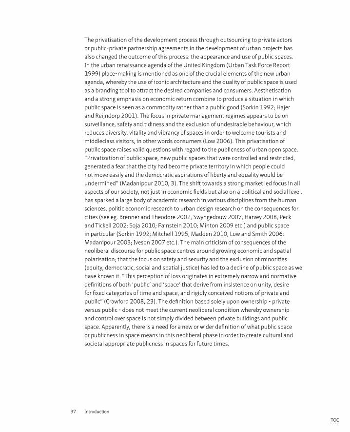
1.1 Privatisation of public space can take many forms; from shift in ownership to temporary forms of appropriation 38
1.2 Structure of the thesis 46
2.1 Models of representing the degree of publicness (© Langstraat & Van Melik 2013) 62
3.1 Analytical Framework 68
4.1 Timeline of development phase - three cases 126
4.2 Flyer User Survey 132
5.1 Location of cases in Liverpool (base map ©
Google maps) 150
5.2 Timeline Liverpool ONE 152
5.3 Fact Sheet Liverpool ONE 154
5.4 Timeline Ropewalks 162
5.5 Fact Sheet Ropewalks 164
5.6 Timeline Granby4Streets 168
5.7 Fact Sheet Granby4Streets 170
5.8 New residential area to the north of Granby4Streets (cul-de-sac lay-out) 172
6.1 Audit Map Ownership 184
6.2 Overall impression of the respondents: “How do you like this space?” 204
6.3 Overall rating - ‘How do you like this space?’ 205
6.4 Publicness - ‘Who do you think paid for this space?’ 207
6.5 Maintenance - ‘Do you think this area is clean?’ 210
6.6 Safety - ‘Do you think the area is safe?’ 211
6.7 Presence of Control Mechanisms - ‘Do you feel watched?’ 213
6.8 Presence of private - parochial - public sphere in the three cases 215
6.9 Public expression in (public) Paradise and Church Street: buskers (1+2), artist (3), bible telling (4) 220
6.10 Urban Design Qualities Assessment - Detailed Survey Areas 224
6.11 Design Sheet Imageability 228
6.12 Audit Map Streetscape 230
6.13 Design Sheet Enclosure 233
6.14 Design Sheet Human Scale 236
6.15 Design Sheet Transparency 238
6.16 Design Sheet Complexity 240
6.17 Audit Map Activity 242
6.18 Design Sheet Coherence 244
6.19 Design Sheet Legibility 246
6.20 Audit Map Accessibility 248
6.21 Design Sheet Linkage 251
6.22 Design Sheet Tidiness 252
6.23 Audit Map Safety & Security 254
6.24 Design Sheet Safety & Security 256
6.25 Design Sheet Appropriation 258
6.26 Audit Map Appropriation 260
7.1 Publicness in the production of the three cases 272
List of Figures
TOC

16 Privatisation of the Production of Public Space
TOC
17 Summary
Summary
From the 1960s to the 1970s, a large number of Western inner cities went through a phase of severe deprivation due to both a relocation of manufacturing jobs that in turn led to a depopulation, a lack of investment and high unemployment and to suburbanisation made possible by the car. From the 1990’s, urban regeneration strategies were introduced to tackle this inner city deprivation. In the United Kingdom, this ‘urban renaissance’ took place within the new economic and political paradigm of neoliberalism which placed a strong emphasis on market forces as the driver of urban regeneration (see national policy document Urban Task Force 1999). The shift to this economic system led to changes in both the process of urban development and its product, the space itself. Local governments endorsed the new economic reality - which included a greater role for private and corporate actors in the development and management of cities - in order to be able to participate in the global inter-urban competition. As a result of declining public budgets and encouraged by national guidance, public authorities began to outsource tasks and responsibilities that had previously been regarded as a governmental concern to private actors and newly developed private public partnerships (urban regeneration vehicles in planning policy terminology). Public authorities themselves also adopted business-like styles of organisation in which productivity, effectivity and efficiency were regarded as the main conditions for serving the public’s financial interest, though other public values such as cultural heritage, equality and democracy were often regarded as of secondary concern. This privatisation of development in urban areas did not just affect the process but also the outcome; the appearance and use of public spaces. Within the urban renaissance agenda, a strong emphasis was put on the aesthetisation of space in order to attract the desired businesses, investors and people with a high disposable income. The objective in private management regimes appears to be on reducing risk by putting a strong focus on surveillance, safety, tidiness and the exclusion of undesirable behaviour, all of which reduces the diversity, vitality and vibrancy of spaces in order to welcome tourists and middle-class visitors, in other words consumers (Low 2006). This privatisation of public space raises valid questions with regard to the publicness of urban open space and a number of authors recognise a ‘decline’ of public space or have even declared ‘the end of public space’ as we have known it (Sorkin 1992; Mitchell 1995; Low and Smith 2006; Madanipour 2003; Iveson 2007 etc.). Other authors argue that we do not experience the death of public space but a change in its form, function and appearance that reflects contemporary economic, societal and cultural narratives (see eg Madden 2010; Carmona et al. 2008, Carmona 2015; De Magalhães and Freire Tigo 2017). To be able to incorporate these societal shifts, a revised (and wider) definition is needed to describe and analyse publicness in the production of space (Kohn 2004; De Magalhães
TOC
18 Privatisation of the Production of Public Space
2010; Varna and Tiesdell 2010; Németh and Smith 2011; Langstraat and Van Melik 2013; Varna 2016).
The premises for this research are based on the above discussion on the different roles that privatisation plays in the production of space, within this shift towards greater involvement of a variety of private partners in the development process and the possible decline in the degree of publicness in both process and space. The apparent need for a wider definition of public space to include current political, economic and societal changes, the relation between the public sphere and public space, the degree of publicness in both the process and space itself, the perception of the user and the role of the urban designer are hereby taken as starting points and lead to the following research question:
Does privatisation lead to a decline of publicness in the production of space and space itself, and how does urban design play a role in this?
Public sphere and public space – a very short overview from academic literatureThe public sphere is a normative established notion whose definition is susceptible to change over time depending on the economic, social and cultural context. The rules and norms regarding public behaviour in public space are under the scrutiny of public debate and depend on consensus (Habermas 1989; Boomkens 1998). The public sphere in Greek ancient times and in the Western bourgeois 18th century constituted the gathering of individuals who engaged in discussions of common matters through speech and action (Arendt 1958; Habermas 1989; Sennett 1977). Other scholars however, suggest that this is too simple a representation of complex reality; there is not one single public but a multitude of publics, often with conflicting interests (Fraser 1960; Iveson 2007; Varna and Tiesdell 2010). It is within the overlapping and exchange of multiple and simultaneous daily experiences of these publics, that the essence of publicness lies (Crawford 2008; Hajer and Reijndorp 2001). Due to these multiple publics, there will always be conflicting interests and claims over space; public space is a political, social and cultural project which is negotiated, struggled over throughout history and reproduced (Lefebvre 1991; Mitchell 1995; Langstraat and Van Melik 2013). Public space is a potential geographical setting in which a public sphere (or spheres) can materialise and therefore, has a democratic function in addition to other functions such as a social or symbolic dimension, where different groups of people can meet each other. Thus, the essence of public space lies in the exchange of cultural, social and political experiences for a variety of multiple publics. In order to be able to fulfil this role, public space must be accessible and inclusive to all (Madanipour 2010), although bearing in mind that a space can never be completely accessible and hence inclusive of everybody at the same time (Low and Smith 2006).
TOC
19 Summary
Publicness of process and product in three Liverpool cases An analytical and methodological framework was set up in order to provide answers to the research question. A distinction was made in the analytical framework between three perspectives, those of governance, the user and the designer, which provides the lens through which social relations between the actors, their motivations and the perceived outcome in space are analysed in-depth. Three cases within the city of Liverpool were selected that differed in their managerial approach to urban regeneration but were built over a similar period of time, therefore within a similar political, economic and geographical setting. A multi-faceted method of data collection techniques comprised policy document reviews, interviews, user survey, observations and a visual assessment. The three cases were then presented and are summarised below:
Liverpool ONE; a retail led inner city development project where the Council sold the land on a 250 year lease to a private developer who designed, implemented and manages the 16 ha urban quarter. The first of this kind of inner city privatisation at this scale in the United Kingdom.
Ropewalks: a public-private partnership (with a mix of stakeholders) implemented a masterplan for a mixed-use neighbourhood that was envisioned to be the creative quarter. The publicly funded public space works were successfully deployed to attract private investment to the private buildings.
Granby4Streets: started as a top down, publicly led masterplanning exercise of neighbourhood renewal which became a co-operation between a variety of private local initiatives supported by the Council. The first urban Community Land Trust in the UK
Discussion and ConclusionsGovernance perspective: publicness in the development processThe findings from the case study analysis – organised as they were in three different ways, namely privately led, public-private partnership and publicly organised turned community led- demonstrated that both the privately and publicly top down coordinated processes lacked publicness; both in ownership of (which is related to who initiates, who has decision-making power and how the actors are organised within the process) and accessibility to (related to openness and inclusiveness for a variety of different actors to the process, including the minority voice) the process. The public-private partnership and the community led cooperative regeneration approaches that consisted of a variety of public and private actors (both corporate and non-for-profit) however, comprised a larger degree of publicness and trust between the various actors. These findings lead to the conclusion that in these three cases, a multi-stakeholder process in which both public and private actors work collaboratively and have decision-making power leads to a greater
TOC
20 Privatisation of the Production of Public Space
degree of publicness in the development process. Both the publicly and the privately (corporate) led projects researched were found to be non inclusive as the ownership of the process (including proposing initiatives, the degree of decision making power and the provision of funding) lay in the hands of a single actor and the accessibility to the process for other (public or private) actors was limited.
Therefore based on the findings of the three cases, the degree of publicness in the development process benefits from a collaborative multi-stakeholder process in which both public and private partners have decision-making powers where a high degree of trust leads to a greater degree of publicness in urban development.
Users’ perspective: experience and engagement in public spaceThe consequences often attributed to privatised spaces in academic literature – exclusion, homogenised, commodified and themed space with a strong focus on cleanliness and safety – have all been found (to a greater or lesser extent) in the privatised space. Despite, or maybe indeed because of, these consequences, the privatised space was perceived as ‘very good’ by the large majority of the respondents, more so than in the two public spaces although they were also perceived as quality urban spaces. The privatised space was also rated as being very ‘safe’ and ‘clean’ but there was no relation found between the feeling of safety and the presence of surveillance or control measures; a majority of the users did not feel watched by CCTV cameras, security guards or police (and still felt safe).
With regard to the perception of publicness, more than half of the respondents stated that they perceived the (in fact) private space as public space. Although these users regarded the space as public, they simultaneously thought that they were not allowed to exercise certain basis public rights (such as using a skateboard, being political, making music or handing out flyers). They sensed that there were limitations put on their public behaviour and they adapted their behaviour according to the nature and characteristics of the spatial surrounds. This sense was correct as these individual interventions (also called forms of appropriation) are prohibited under the corporate rules. In the public areas, a high percentage of the users also regarded the spaces as public but here they did think, also correctly, that they were allowed to exercise these rights. Apparently, the privatised space delivered different signals to the respondents on appreciated (or tolerated) behaviour than public spaces did.
Following from this conclusion, the range of new terminology that in recent years has been deployed to help address the hybridisation of public/private such as semi-private or semi-public or Privately Owned Public Space (POPS - a new terminology in the UK, of which an example is the new King’s Cross development), does not therefore contribute towards the clarification of the concept as the ownership and control mechanisms at
TOC
21 Summary
work are sensed by users differently to the legal ownership structures the terminology refers to, this strengthens the need for a new criteria to describe publicness of space.
The case of Liverpool One demonstrates that a privatised process apparently does not necessarily lead to a private space, at least not from the point of view of its users and producers, and was perceived by institutional actors and the users interviewed as a successful urban quarter. Also the outcome of the visual assessment came to this conclusion. Two remarks can be made on the basis of this conclusion however: firstly, the space producers acknowledge that the privatised space is not truly public in a democratic or civic sense but they still perceive the area as public largely based on its physical accessibility and social and entertainment value. On the other hand, those users interviewed claimed the privatised space to be public but were only subconsciously aware that the appearance and the design of the space act to restrict their behaviour. Hence, although a privatised space can be aesthetically beautiful and socially pleasant, a degree of publicness is compromised in privatised space because users are restricted in the ways they can appropriate space.
Designer perspective on designing publicnessThe visual assessment that was carried out to analyse eleven urban qualities through a combination of quantitative and qualitative assessment tools (based on Ewing and Clemente 2013), demonstrates that only the urban qualities ‘safety’, ‘tidiness’ and ‘appropriation’ were decisive in the definition of publicness in space. The privatised area rated well for visual signs of surveillance methods (CCTV, presence of security guards) when compared to the public areas that appeared to be less endowed with such measures. The same outcome was found for the quality of tidiness. There were however, very few visual signs of appropriation found in the privatised area, thus in the area where control mechanisms (‘safety’ and ‘tidiness’) were visually omnipresent, no evidence was found of individual interventions. In the public spaces, the findings show the opposite: less evidence of control mechanisms but abundant evidence of individual input in the public space, in particular in the case of Granby4Streets.
In addition to the analysis of the cases themselves, their relation to their surrounding contexts has also been assessed. The privatised space can be described as physically well integrated into its surrounds; the transition to the city centre and to the tourist attraction of the Albert Dock is smoothly designed. The connections to the Ropewalks and a social housing estate are however, very poorly designed; the boundaries are formed by buildings with blank, inactive facades with marginal uses (e.g. car parking). These poorly designed zones could be described as the liminal spaces – transitional zones – referred to as potential spaces where the new public sphere emerges according to Crawford (2008) and Hajer and Reijndorp (2001). No signs were found within these transitional zones however, of a potentially emerging new public sphere (or overlapping
TOC
22 Privatisation of the Production of Public Space
multitude of spheres). The function of these liminal spaces is better described as forming a barrier (or creating severance) between the ‘over-managed’ areas. Therefore, the transitional zones enhance and enlarge the differences between the over and under-managed spaces rather than facilitate new spheres. Although the experience of publicness in space is thought to occur at the boundary between friction and freedom, this analogy can apparently not be directly translated to the spatial context. The theoretical argument that the ‘real’ public sphere is found in the transitional zones between over and under-managed areas, the ‘liminal’ spaces, has not been confirmed within the case studies in this research. It can therefore be concluded that in order to enhance the ‘continuous urban topography’, these edges should not be designed as ‘left-over’ space creating severance but rather as transitional zones that provide linkage.
RecommendationsBased on the data from interviews, user surveys and visual assessment that has been collected and analysed, it can be concluded that the degree of publicness of the privatised space is compromised by the ‘corporate rules’ (including control mechanisms) that might be in place to limit individual user appropriation. Apparently the presence of control mechanisms, the maintenance regime and the opportunity to use space according to one’s own daily needs, distinctively says something about the degree of publicness in space. The latter component, appropriation, offers an interesting opportunity for describing and defining a wider notion of publicness (control mechanisms are used by both public and private stakeholders in charge of space maintenance and the user survey demonstrated that a majority of the respondents were not aware of these mechanisms). Appropriation is defined as: The way individuals renegotiate and reproduce space to take ownership and suit the space to meet their own needs. Appropriation is characterised by spontaneity and temporality.
It is therefore recommended to include appropriation within the definition of publicness, in addition to ownership and control, and accessibility.
A second recommendation concerns the public authority that still holds the ultimate power within urban development. In the current planning system, the public authority is in charge of validating and approving planning applications. Hence, publicness in the development process could be safeguarded by a change in the current legislation for the use of statutory powers within the planning process. In other words, private actors (including non-for-profit organisations such as community groups) could be forced to create a more inclusive and public development process. Firstly, the planning system could be adapted to include judgments on applications using criteria such as ownership of, and accessibility to, the process and not just on the quality of
TOC
23 Summary
the proposal; aspects such as who was involved, who had decision-making power, how high were the levels of trust etc., could also function as decisive criteria. If the planning application fails to score on these criteria, it could be refused. Secondly, in terms of product and in addition to current aspects such as quality, sustainability, building regulations etc., an application could be reviewed on the level of opportunity that is created within the proposal for appropriation by its future users. This research concluded that the degree of publicness is related to the degree of appropriation: how individual people can make use of space to meet their daily needs. Therefore the current planning system can be adapted to include (non-negotiable) criteria on appropriation to safeguard the degree of publicness in space.
A third recommendation relates to the urban designer that might enhance the degree of publicness in space in (at least) two ways. Firstly, allowing for a larger flexibility in the spatial outcome by designing in opportunities for citizens to appropriate space. Inspiration for new urban design methods on appropriation could for instance be drawn from design literature on 'urban acupunture', 'place-making' and 'big data'. The visual image that the designer composes is hereby seen as a starting point, the base of future interventions and not as the ultimate illustration of the designer’s own projected reality. Secondly, the designer should pay special attention to the design of the edges of urban quarters in order to create ‘soft’ transitional zones rather than severe barriers. In this way, design might both enhance the publicness within the different urban areas while also treating the city as a totality rather than a sea of physically segregated ‘archipelago islands’. Both statements assign a degree of ethics to the profession of urban design; the urban designer bears (co) responsibility for the creation of an inclusive public space rather than merely focusing on problem solving, functionality or providing aesthetic pleasure (which are of course also important components that must be met).
EpilogueSo does privatisation result in the decline of publicness in the production of public space? It cannot be said from this research that privatisation of the production is detrimental in all its aspects. Urban development and city life turn out to be complicated matters that are difficult to capture as a straightforward yes/no or good/bad equation. The research demonstrated however, that publicness within a development process was least present within the organisational structure of a single client, in both private and publicly led processes. Apparently, publicness within the development process benefits from multiple private and public actors working collaboratively. Involvement of private actors do not necessarily lead to a private process that lacks inclusiveness and vice versa, a publicly led process does not always lead to a public or inclusive process.
TOC
24 Privatisation of the Production of Public Space
Looking at space itself, it was concluded that the main consequences often attributed to privatised space were all found to be present. The outcomes of all three perspectives that were analysed – governance, users and designer – however, confirmed that the privatised space studied did function as a social space but could not be defined as a truly public space because it lacked opportunities for appropriation (from protest to busking). Following the newly introduced and widened definition of publicness – ownership, accessibility and appropriation – and in determining the degree of publicness, the privatised space scores poorly on ownership (because it is privately controlled), reasonably well on accessibility (because the area is accessible 24 hours per day to the majority of people) and also poorly on the scale of appropriation. Therefore in the case studied, the degree of publicness is compromised in the privately controlled space. In the two public cases, the degree of publicness was found not to be compromised but as public authorities use control mechanisms in other than public areas than the cases studied, publicness might very well be limited because of a lesser degree of appropriation.
A degree of appropriation provides opportunities for citizens to actively engage with others in space and to reproduce the space. This individual engagement through speech and action rather than passive consumerism forms the essence of the public sphere as Arendt (1958) noted.
TOC
25 Samenvatting
Samenvatting
Stadscentra kampten vanaf de jaren 1960-70 met verloedering als gevolg van in de eerste plaats het vertrek van bedrijven, hoge werkloosheid en een gebrek aan investeringen en in de tweede plaats het vertrek van mensen door voortgaande suburbanisatie. Vanaf de jaren ‘90 werden stedelijke vernieuwingsprogramma’s opgezet om de verloedering in de stadscentra tegen te gaan. In het Verenigd Koningrijk vond deze ‘urban renaissance’ plaats binnen een nieuw economisch en politiek paradigma, het neoliberalisme, dat een sterke nadruk legde op marktwerking als de drijvende kracht van stedelijke vernieuwing. Deze verandering in het economische systeem leidde ook tot veranderende organisatiestructuren in het bouwproces. Lokale overheden omarmden de nieuwe economische realiteit, waarin competitie tussen steden onderling centraal stond en waarbij in het ontwikkelen van stedelijke projecten een grote rol was weggelegd voor private actoren. Als gevolg van slinkende lokale budgetten zagen overheden zich genoodzaakt om bepaalde taken en verantwoordelijkheden aan private partijen of nieuw opgezette publiek-private samenwerkingsverbanden over te laten. Lokale overheden zelf namen organisatievormen en jargon uit het bedrijfsleven over. Zo vormden ‘productiviteit’, ‘efficiëntie’ en ‘effectiviteit’ nieuwe kaders voor beleidsvorming en uitvoering, waarbij eerder hoog aangeslagen waarden zoals cultureel erfgoed, gelijkheid en democratische beginselen van ondergeschikt belang raakten. De zogenoemde privatisering van de stedelijke vernieuwing heeft dus zowel gevolgen voor het proces als het resultaat: het uiterlijk en gebruik van openbare ruimte. In de ‘urban renaissance’ agenda was het van groot belang om met een kwalitatief goede vormgeving, dus met esthetiek, (buitenlandse) investeerders en bewoners en gebruikers met een ruim besteedbaar inkomen aan te trekken. Het beoogde doel van private partijen die verantwoordelijk zijn voor het onderhoud van openbare ruimten is er met name op gericht om een risicovrije omgeving te creëren waar toeristen en andere consumenten zich welkom voelen. Zij streven naar een veilige en schone omgeving en tolereren geen ordeverstorend gedrag. Deze maatregelen reduceren echter ook de diversiteit, vitaliteit en levendigheid in de openbare ruimte (Low 2006).
De privatisering van de openbare ruimte roept terecht vragen op over het publieke karakter dat de ruimte nog heeft. Een aantal academici ziet een ‘neergang’ van de publieke ruimte en sommigen verklaren zelfs dat ‘het einde’ van de publieke ruimte in zicht is, of in ieder geval van de publieke ruimte zoals we die kenden (Sorkin 1992; Mitchell 1995; Low en Smith 2006; Madanipour 2003; Iveson 2007 etc.). Andere academici tonen zich positiever en beargumenteren dat we niet getuige zijn van het einde van de publieke ruimte maar dat zij verandert in vorm, functie en uiterlijk.
TOC
26 Privatisation of the Production of Public Space
De ruimte reflecteert de huidige veranderingen op economisch, cultureel en sociaal gebied (see eg Madden 2010; Carmona et al. 2008, Carmona 2015; De Magalhães en Freire Tigo 2017). Om de huidige publieke ruimte beter te kunnen definiëren en analyseren dient de beperkte definitie van publieke ruimte zoals we die nu hanteren, herzien en verruimd te worden (Kohn 2004; De Magalhães 2010; Varna en Tiesdell, 2010; Németh en Smith, 2011; Langstraat en Van Melik 2013; Varna 2016).
De probleemstelling voor dit onderzoek komt voort uit bovenstaande discussie over de gevolgen van privatisering in de ontwikkeling van de publieke ruimte. Het aantal private actoren in het bouwproces groeit waardoor de verhoudingen tussen publiek en privaat veranderen. Hierdoor wordt mogelijk het publieke karakter in zowel het proces als de ruimte aangetast. Het ogenschijnlijk belang voor een bredere definitie om de huidige politieke, economische en culturele trends te kunnen vatten, de relatie tussen de publieke sfeer en publieke ruimte, de mate van het publieke karakter in het proces en de ruimte zelf en de perceptie van de gebruiker op privatisering en de rol van de ontwerper hierin, vormen de basis voor het onderzoek en hebben tot de volgende onderzoeksvraag geleid:
Leidt privatisering tot een vermindering van het publieke karakter in de ontwikkeling van de publieke ruimte en de ruimte zelf, en wat is hierin de rol van de ontwerper?
Publieke sfeer en publieke ruimte – een kort overzicht van de academische literatuurDe publieke sfeer is een normatieve notie; de definitie is onderhevig aan veranderingen in de tijd en de economische, sociale en culturele context. De normen en waarden van publiek gedrag worden onderworpen aan het publieke debat en zijn afhankelijk van het vinden van consensus. (Habermas 1989; Boomkens 1998). De publieke sfeer zoals die bestond in het oude Griekenland en bij de bourgeois burgerij in Westerse cafés, werd gekenmerkt door individuen die actief met elkaar in discussie gingen over gemeenschappelijke zaken (Arendt 1958; Habermas 1989; Sennett 1977). Andere academici stellen dat dit een te simpele voorstelling van een complexe realiteit is; er is nooit sprake van één publiek, maar van meerdere publieke groepen die conflicterende belangen nastreven (Fraser 1960; Iveson 2007; Varna and Tiesdell 2010). De kern van een publiek zit hem juist in de uitwisseling van dagelijkse ervaringen in de overlappende sferen tussen de verschillende publieken (Crawford 2008; Hajer and Reijndorp 2001). Door de aanwezigheid van deze meerdere conflicterende publieke sferen, zal de publieke ruimte altijd gevormd worden door strijd waardoor de ruimte opnieuw gemaakt wordt. (Lefebvre 1991; Mitchell 1995; Langstraat en Van Melik 2013). De publieke ruimte kan een geografische context vormen voor de publieke sfeer, waardoor de publieke ruimte een democratische functie vervult, terwijl zij daarnaast ook een sociale of symbolische dimensie kan hebben. De kern van de publieke ruimte
TOC
27 Samenvatting
is de uitwisseling van culturele, politieke en sociale ervaringen door verschillende publieken. Om deze essentiële functie te kunnen vervullen, dient de publieke ruimte voor iedereen toegankelijk en dus inclusief te zijn (Madanipour 2010). Alhoewel we hierbij in gedachte moeten houden dat een ruimte nooit voor iedereen op hetzelfde moment toegankelijk kan zijn (Low en Smith 2006).
Het publieke karakter in het proces en het product in de studiegebieden in Liverpool.Om de onderzoeksvraag te kunnen beantwoorden zijn een analytisch kader, gebaseerd op relevante academische literatuur, en een methodologisch kader opgesteld. In het analytisch kader worden drie perspectieven belicht; ‘governance’ (de actoren die de ruimte scheppen), ‘gebruikers’ en ‘ontwerper’. Aan de hand van deze drie perspectieven wordt een grondige analyse gedaan naar sociale relaties tussen de verschillende actoren, hun beweegredenen en de percepties en ervaringen in de verschillende publieke ruimten. Er wordt gebruik gemaakt van ‘case study onderzoek’ om een dergelijke analyse te kunnen doen. Hiervoor zijn drie studiegebieden in de stad Liverpool in aanmerking gekomen omdat deze drie gebieden verschillende organisatievormen kennen ten aanzien van publieke/private actoren en daarbij zijn deze locaties in dezelfde tijd zijn ontwikkeld. De politieke, economische en geografische context zijn hierdoor gelijkwaardig. Verschillende bronnen hebben data opgeleverd (beleidsdocumenten analyse, interviews, gebruikersonderzoek, observaties en een ontwerpanalyse van de gebieden). Deze data zijn onderzocht en vergeleken op basis van de verschillende perspectieven die door het analytisch kader vormgegeven worden.
De drie onderzoeksgebieden kort beschreven:
Liverpool ONE; is een gemengd binnenstedelijk ontwikkelingsproject dat voornamelijk bestaat uit winkels en entertainment functies. De lokale overheid heeft de grond verhuurd aan een private ontwikkelaar (het contract heeft een looptijd van 250 jaar), die het gebied van 42 hectare ontwierp, ontwikkelde en waarvoor hij nu zorg draagt voor het onderhoud. Het is het eerste voorbeeld van een dergelijk grootschalige vorm van binnenstedelijke privatisering in het Verenigd Koninkrijk
Ropewalks: een publiek-private samenwerking lag aan de basis van het ontwerp van een flexibel masterplan en vervolgens ook aan de ontwikkeling van vernieuwingen in de openbare ruimte. Deze ingrepen vormden de start van een integrale ontwikkeling die tot een creatieve wijk zou leiden. De ingrepen in de openbare ruimte werden gefinancierd met publiek geld; met dit geld werden particuliere investeerders aangetrokken voor de renovatie en herbestemming van de gebouwen.
TOC
28 Privatisation of the Production of Public Space
Granby4Streets: is begonnen als een door de overheid geleid top-down herontwikkelingsproject dat als doel wijkvernieuwing had. Na opheffing van publieke fondsen, namen bewoners het initiatief en organiseerden zichzelf in een Community Land Trust om zo de renovatie van hun woningen te bewerkstelligen en via privaat geld te bekostigen. De eerste stedelijke Community Land Trust in het Verenigd Koninkrijk
Discussie en ConclusiesGovernance perspectief : ‘publicness’ in het bouwprocesDe analyse van de casestudies wijst uit dat zowel de private als publieke top-down gecoördineerde processen een geringe mate van ‘publiek karakter’ bezaten, zowel op het vlak van controle en beslissingsbevoegdheid (‘eigenaarschap’) als toegankelijkheid van het proces. De publiek-private samenwerking en de door bewoners geïnitieerde coöperatieve benadering bestaande uit een verscheidenheid aan publieke en private actoren (zowel corporate als non-profit) werd echter gekenmerkt door een grotere mate van ‘publiek karakter’ en door het vertrouwen tussen de verschillende actoren. Deze bevindingen uit de drie casussen in Liverpool leiden tot de conclusie dat een multi-stakeholderproces waarin zowel publieke als private actoren samenwerken en beslissingsbevoegdheid hebben, leidt tot een grote mate van ‘publicness’ (of publiek karakter) in het bouwproces. Zowel in de door de lokale overheid als de door de private ontwikkelaar geleide top-down projecten bleek er een gebrek aan inclusiviteit omdat maar weinig actoren effectief inspraak hebben gehad in het proces (geen mogelijkheden tot het indienen van alternatieve voorstellen, geen beslissingsbevoegdheid). De besluitvormingsprocedure lag volledig in handen van één actor, waardoor de toegankelijkheid tot het proces zeer beperkt was voor andere (publieke of private) actoren.
Op basis van de bevindingen van de drie casussen kunnen we daarom concluderen dat de mate van ‘publicness’ in het bouwproces baat heeft bij een proces waarin een verscheidenheid van zowel publieke als private partners gezamenlijk beslissingsbevoegdheid hebben en waarbij er een groot vertrouwen is tussen de verschillende partijen.
Gebruikersperspectief : ervaringen in en gebruik van de publieke ruimteDe gevolgen van privatisering die in de academische literatuur beschreven zijn - uitsluiting, homogeniteit, commodificatie en een nadruk op georganiseerde evenementen, waarbij een sterke focus ligt op ‘schoon’ en ‘veilig’ - komen allemaal (in meer of mindere mate) in de geprivatiseerde ruimte die geanalyseerd is terug. Maar ondanks deze gevolgen, of misschien juist vanwege, werd de geprivatiseerde ruimte door de overgrote meerderheid van de geïnterviewde gebruikers als 'zeer goed' ervaren. Dit is een hoger percentage dan in de twee openbare ruimten, hoewel deze ook werden
TOC
29 Samenvatting
gezien als kwalitatieve stedelijke ruimten. De geprivatiseerde ruimte werd daarnaast ook als zeer 'veilig' en 'schoon' beoordeeld. Er is geen relatie gevonden tussen het gevoel van veiligheid en de aanwezigheid van bewakings- of controlemaatregelen; een meerderheid van de gebruikers voelde zich niet gesurveilleerd, noch door CCTV-camera's, bewakers of politie, maar desondanks toch zeer veilig.
Verder kwam uit de analyse dat meer dan de helft van de geïnterviewde gebruikers de (in feite private) ruimte als openbare ruimte beschouwden, publiek dus. Hoewel deze gebruikers de ruimte als publiek ervaren, dachten ze tegelijkertijd dat ze bepaald gedrag dat kenmerkend is voor het publieke domein (zoals het gebruik van een skateboard, zich politiek manifesteren, flyers uitdelen of culturele uitingen zoals muziek maken) niet zou worden getolereerd. Gebruikers bleken er zich van bewust dat er grenzen zijn gesteld aan hun publiek gedrag en passen hun gedrag hierop aan. Deze ‘corporate rules’ zijn niet gecommuniceerd zoals bijvoorbeeld via borden maar kennelijk geeft het uiterlijk en de inrichting van de ruimtelijke omgeving deze signalen wel af. De gebruikers hebben dit echter juist aangevoeld; deze individuele interventies (ook wel vormen van toe-eigening genoemd) zijn volgens ‘corporate rules’ gelimiteerd. In de twee andere, publieke, ruimten beschouwde een hoog percentage van de gebruikers de ruimten ook als publiek, maar hier dachten ze, wederom terecht, dat ze hun publieke rechten wel mochten uitoefenen. Blijkbaar geeft het uiterlijk of de mate waarin de geprivatiseerde ruimte onderhouden wordt dusdanig signalen af aan gebruikers dat zij hun gedrag hierop aanpassen.
Deze bevindingen leiden onder andere tot de conclusie dat de reeks van nieuwe termen die de afgelopen jaren is ingezet om de hybridisering van publiek / privaat, zoals semi-privaat of semi-openbaar of Privately Owned Public Space (POPS), te duiden, niet bijdraagt aan de verduidelijking van het concept publieke ruimte. Het blijkt dat de eigendomssituatie en controlemechanismen door gebruikers anders wordt geïnterpreteerd dan de feitelijke juridische eigendomsstructuren waarnaar de terminologie verwijst. Deze uitkomst versterkt de behoefte aan nieuwe criteria voor het beschrijven van de publieke ruimte.
De casus Liverpool One toont aan dat een geprivatiseerd proces niet noodzakelijkerwijs tot een private ruimte leidt, althans niet vanuit de perceptie van de geïnterviewde gebruikers en actoren. Liverpool One werd, vanuit de drie perspectieven waaraan het publieke karakter wordt gemeten, beschouwd als een voorbeeld van hoogwaardige kwalitatieve ruimte. Twee opmerkingen dienen hieraan toegevoegd te worden. Ten eerste, de geïnterviewde bouwactoren erkenden dat de geprivatiseerde ruimte niet echt publiek is in democratische zin. Zij beschouwden het gebied als openbare ruimte vanwege de fysiek toegankelijkheid en omdat het als een plek beschouwd kan worden waar sociale interactie plaatsvindt; er vinden activiteiten plaats en mensen kunnen
TOC
30 Privatisation of the Production of Public Space
elkaar ontmoeten. De geïnterviewde gebruikers beweerden ook dat de geprivatiseerde ruimte openbaar is, maar zij zijn zich er niet van bewust dat ze zelf hun gedrag aanpassen, waarschijnlijk door het uiterlijk en het ontwerp van de ruimte. Vandaar dat, hoewel een geprivatiseerde ruimte esthetisch mooi en sociaal aangenaam kan zijn, het publieke karakter toch in het geding komt omdat burgers beperkt worden in de politieke en culturele uitingen die zij kunnen doen in de ruimte.
Het perspectief van de ontwerper op de publieke ruimteDe drie verschillende gebieden zijn visueel beoordeeld aan de hand van elf stedelijke kwaliteiten (die afgeleid zijn van een combinatie van kwantitatieve en kwalitatieve beoordelingsmethoden uit het werk van Ewing en Clemente 2013). De analyse toont aan dat alleen de stedelijke kwaliteiten 'veiligheid', 'netheid' en 'toe-eigening' doorslaggevend zijn in de definitie van het publieke karakter van de openbare ruimte. Het geprivatiseerde gebied scoorde hoog op het criterium ‘aanwezigheid van surveillancemethoden’ (CCTV, aanwezigheid van beveiligingsmedewerkers) in vergelijking met de openbare ruimten die hier minder in voorzien waren. Hetzelfde resultaat werd gevonden voor de kwaliteit van netheid. Voor het criterium ‘toe-eigening’ werd het omgekeerde vastgesteld; in het geprivatiseerde gebied werden nauwelijks visuele bewijzen gevonden van individuele interventies, terwijl beide publieke ruimten (met name in Granby4Streets) veel uitingen van toe-eigening van de openbare ruimte kennen.
Naast de analyse van de casussen zelf, is ook de relatie tussen het onderzoeksgebied en de bredere context beoordeeld. De geprivatiseerde ruimte kan worden beschouwd als goed geïntegreerd in de omgeving, tenminste aan twee zijden: zowel de overgangszones tussen zowel het stadscentrum als wel de toeristische attractie van het Albert Dock met Liverpool One vormen een vloeiende overgang. De verbindingen met de Ropewalks en een sociale woonwijk ten zuiden van Liverpool One zijn echter ontworpen als een barrière; de grenzen worden gevormd door gebouwen met blinde gevels en er is nauwelijks activiteit op de begane grond - hoogstens functies met marginaal gebruik (bijv. een parkeergarage). Deze slecht ontworpen transitiezones kunnen worden omschreven als de liminale ruimten - overgangszones - die door Crawford (2008) en Hajer en Reijndorp (2001) aangehaald worden. Dit zijn ruimten waar zich potentieel een nieuwe publieke sfeer zich zou kunnen manifesteren. In het onderzoek naar de transitiezones zijn echter geen aanwijzingen gevonden van een opkomende nieuwe publieke sfeer. De functie van deze liminale ruimten kan beter worden omschreven als het bewust creëren van een scheiding tussen verschillende gebieden. Deze overgangszones bevorderen juist de verschillen tussen de ‘over and undermanaged’ gebieden in plaats van dat zij nieuwe sferen mogelijk maken. Hoewel de ervaring van het publieke karakter wordt verondersteld plaats te vinden op de grens van wrijving en vrijheid, kan deze analogie blijkbaar niet direct worden vertaald
TOC
31 Samenvatting
naar de ruimtelijke context. Het theoretische argument dat de 'echte' publieke sfeer wordt bevorderd in deze overgangszones, de 'liminale' plekken, is niet bevestigd in de onderzochte casussen. Er kan daarom worden geconcludeerd dat de randen van ontwikkelingsgebieden moeten worden beschouwd als overgangszones die een vloeiende transitie mogelijk maken en niet als 'overgebleven' of ‘genegeerde’ ruimten die barrièrevorming in de hand werken, waardoor een 'continuous urban topography' gecreëerd kan worden.
AanbevelingenOp basis van de geanalyseerde gegevens uit interviews, gebruikersonderzoeken en visuele beoordeling, kan worden geconcludeerd dat het publieke karakter wordt aangetast door aanwezige ‘corporate rules’, die de mate van toe-eigening van de ruimte door gebruikers beperken. Blijkbaar zegt de aanwezigheid van controlemechanismen, de omvang van het onderhoud en de mogelijkheid om als gebruiker de ruimte toe te eigenen iets over het publieke karakter van ruimte. Deze laatste component, toe-eigening, biedt een interessant perspectief om de publieke ruimte in bredere zin te definiëren (controlemechanismen worden gebruikt door zowel publieke als private actoren en de gebruikersanalyse toont aan dat een meerderheid van de geïnterviewde gebruikers zich de aanwezigheid van deze controlemechanismen niet realiseerde). Met toe-eigening wordt bedoeld: De manier waarop burgers de ruimte reproduceren door deze zich toe te eigenen voor hun eigen dagelijkse culturele of politieke interventies. Deze interventies hebben een tijdelijk en spontaan karakter.
Daarom wordt aanbevolen om naast eigendomsstructuur en toegankelijkheid de notie van toe-eigening toe te voegen aan de definitie van de publieke ruimte.
Een tweede aanbeveling is gericht aan de overheid, die nog steeds de uiteindelijke zeggenschap heeft over stedelijke ontwikkelingen. De overheid is in het huidige planningssysteem belast met de goedkeuring van bouwaanvragen. Door een verandering in het dit systeem kunnen publieke waarden een uitgangspunt vormen bij de beoordeling van bouwaanvragen. In de eerste plaats kunnen criteria die betrekking hebben op een open en inclusief proces toegevoegd worden aan de huidige criteria; zo kan het publieke karakter van het proces verhoogd worden. Ten tweede zou een aanvraag beoordeeld kunnen worden op de mogelijkheden die in het ontwerp voorzien zijn voor toe-eigening door gebruikers, naast de huidige aspecten zoals materialisatie, duurzaamheid, bouweisen enz. waarop huidige bouwaanvragen worden beoordeeld.
Een derde aanbeveling is voor de stedenbouwkundige die het publieke karakter van de openbare ruimte op (minstens) twee manieren zou kunnen vergroten. In de eerste plaats zou een ontwerp een bepaalde mate van flexibiliteit moeten hebben
TOC
32 Privatisation of the Production of Public Space
zodat de ruimte de gebruikers de mogelijkheid biedt om zich deze toe te eigenen. Studie naar nieuwe stedenbouwkundige methodes en technieken zou voor inspiratie de ontwerpliteratuur omtrent ‘urban acupunture’, ‘place-making’ en ‘big data’ als startpunt kunnen nemen om zo methodes voor een grotere mate van toe-eigening op te kunnen stellen. Het visuele beeld dat een ontwerper voor ogen heeft zou hierbij een startpunt moeten zijn voor gebruikers om de ruimte te kunnen reproduceren en niet het definitieve eindbeeld.
Ten tweede zou de ontwerper speciale aandacht moeten besteden aan de randen van een projectplangebied. Aanbevolen wordt om 'zachte' overgangszones te creëren tussen de verschillende delen van de stad in plaats van rigide barrières. Op deze manier kan een ontwerp het publieke karakter van de stadsdelen onderling bevorderen, waarbij de stad als een geheel wordt gezien en niet als een zee met fysiek gescheiden ‘eilanden’.
Beide aanbevelingen delen een ethische rol toe aan de ontwerper; de ontwerper heeft een zekere mate van (mede) verantwoordelijkheid. Ook al werkt de ontwerper voor een private klant, er is voor haar een rol weggelegd in het creëren van een publieke karakter in de openbare ruimte, naast uiteraard het maken van een plek die esthetisch en functioneel is.
EpiloogLeidt privatisering tot een vermindering van het publieke karakter in de productie van de openbare ruimte? Uit dit onderzoek kan niet worden afgeleid dat de privatisering van de productie in al zijn aspecten slecht uitpakt voor het publieke karakter. Stedelijke ontwikkeling en het leven in de stad blijven complexe materie en moeilijk te vatten in een eenvoudig ‘ja of nee’ of ‘goed of slecht’. Het onderzoek toont echter aan dat een bouwproces baat heeft bij een samenwerking tussen meerdere private en publieke actoren. Betrokkenheid van private actoren leidt niet noodzakelijkerwijs tot een privaat proces zonder inclusiviteit en omgekeerd leidt een door de overheid geleid proces niet altijd tot een open of inclusief proces.
Gekeken naar de ruimte zelf, kan worden geconcludeerd dat de meest prominente gevolgen die vaak worden toegeschreven aan privatisering allemaal aanwezig bleken te zijn in de onderzochte geprivatiseerde ruimte. Uit de interviews kwam echter ook naar voren dat deze ruimte ook als een sociale ruimte functioneerde. Maar omdat de mogelijkheden voor toe-eigening hier ontbraken, kan de ruimte toch niet als volledig publieke worden beschouwd. Als de nieuwe definitie om de mate van het publieke karakter te beschrijven, die naar aanleiding van de resultaten uit dit onderzoek geponeerd is, wordt toegepast op de geprivatiseerde ruimte dan kunnen
TOC
33 Samenvatting
we concluderen dat deze ruimte slecht scoort op het element ‘eigenaarschap’ (in eigendom van een private partij), redelijk goed scoort op toegankelijkheid (het gebied is 24 uur per dag toegankelijk voor de meeste mensen) en slecht scoort op het element ‘toe-eigening’. De mate van ‘publicness’ is dus minder in de geprivatiseerde ruimte, terwijl dat in de twee onderzochte publieke gebieden niet het geval is. In hoeverre dit voor bepaalde gebieden in de stad te betreuren is, is een onderwerp voor het publieke debat.
TOC
34 Privatisation of the Production of Public Space
TOC
35 Introduction
1 Introduction
§ 1.1 Setting the scene
From the 1960-70’s a large number of Western inner cities went through a phase of severe deprivation when manufacturing jobs relocated to other countries and wealthier people moved out to leafy suburban areas. Inner cities continued to deteriorate due to depopulation, high unemployment figures and lack of public and private investment. Liverpool, the focus of this research project, was hit particularly badly when the shipping activities on which the city’s wealth and grandeur was built for centuries, gradually moved elsewhere. However in the last three decades, a revival of Western inner cities and with that, of their public spaces has been recognised and coined the ‘Urban Renaissance’ in UK policies (Urban Task Force 1999). This Urban Renaissance took place in a new economic and political paradigm, neoliberalism, which put strong emphasis on market forces as the driver of economic growth. This shift led towards the incorporation of new neoliberal economic policies, centred around financial deregulation, privatisation and a more flexible labour market to stimulate the growth of finance, service and creative industries (Brenner and Theodore 2002). Contrary to the manufacturing industry the new industries were predominantly located within the inner cities. Local administrations began to target specific, attractive parts of the city in which urban renewal projects were developed, from the late 1990’s onwards, in order to attract and accommodate these new industries into their cities. This was a diversion from previous policies much more centred around city-wide visioning (in which the city was seen as a whole) towards a vision based on a series of project-led urban development projects (De Waal 2013, 133). The line of strategic thinking was that creating attractive, specifically designed areas at commercially strategic locations would attract (international) businesses and the professional class with a high disposable income, both hugely beneficial to the regeneration process of deprived inner cities. Cities began to compete with each other to attract these new finance and service related businesses and this rivalry fuelled the marketing machine to highlight the differences between cities. Concepts such as the creative city, the competitive city, the sustainable city were created to brand the image of the city, whereby marketing tools replaced the proper names of politics (Swyngedouw 2007). The implementation of ‘high quality’ public space was therefore seen as a catalyst to kick start the change necessary for the urban renaissance to become a reality, whereby the quality of public
TOC
36 Privatisation of the Production of Public Space
space was used as a branding tool to advertise the new development and therefore the city. Hence, public space in this way started to be seen as a commodity to engage in the interurban competition.
The shift to this economic system led to changes in both the process of urban development and in the product, the space itself. Local governments endorsed the new economic reality - which included an enlarged role for private and corporate actors in the developing and managing of cities - in order to be able to participate in the global interurban competition. As a result of declining public budgets and encouraged by national guidance, public authorities began to outsource tasks and responsibilities, that had previously been regarded of governmental concern, to private actors and newly developed private public partnerships (urban regeneration vehicles in planning policy terminology) (see eg. Carmona et al.2008; De Magalhães and Freire Trigo, 2017). Public authorities themselves also adopted business like styles of organisation in which control and efficiency were regarded as the main conditions for serving the financial public interest, other public values such as cultural heritage, equality and democracy were often regarded as of secondary concern (see eg. Juddt 2010).
The withdrawal of the public authorities from the territory of tasks and responsibilities previously assigned to the state did not only facilitate the corporate sector but local residents, NGO’s and interest groups also found opportunities in the arisen vacuum. Within this research, corporate for-profit as well as not-for-profit entities (such as local residents and interest groups) are seen as private actors. While the corporate sector naturally has commercial gain as its ultimate goal and local residents or groups are usually not commercially driven, they might still strive for community or personal goals that might contradict with a wider public interest. Thus, local urban governmental structures have morphed into a multi-layered, multi-stakeholder urban regime that directly negotiates with (international) businesses to “maximise the attractiveness of the local site as a lure for capitalist development” (Harvey 1989) in order to compete in the interurban struggle for success. This renewed relationship between state and civil society actors could not only indicate a transformation of the organisation of government as we have known it, but could also potentially be a virtue for the democratic process in that it might provide a possible wider public access to participation, creating a more level playing field (Franke et al. 2015). However at the same time, market driven actors overrule the principles of democracy in order to portray a strong sense of individualism capitalising on the current neoliberal state of economic affairs. A number of questions arise from this new state of urban affairs. Can new organisational forms combine both their individual interests as well as that of the wider general public? How public and democratic is the development process within this array of new stakeholders? Can private actors be trusted with the execution (or care) of our public values?
TOC
37 Introduction
The privatisation of the development process through outsourcing to private actors or public-private partnership agreements in the development of urban projects has also changed the outcome of this process: the appearance and use of public spaces. In the urban renaissance agenda of the United Kingdom (Urban Task Force Report 1999) place-making is mentioned as one of the crucial elements of the new urban agenda, whereby the use of iconic architecture and the quality of public space is used as a branding tool to attract the desired companies and consumers. Aesthetisation and a strong emphasis on economic return combine to produce a situation in which public space is seen as a commodity rather than a public good (Sorkin 1992; Hajer and Reijndorp 2001). The focus in private management regimes appears to be on surveillance, safety and tidiness and the exclusion of undesirable behaviour, which reduces diversity, vitality and vibrancy of spaces in order to welcome tourists and middleclass visitors, in other words consumers (Low 2006). This privatisation of public space raises valid questions with regard to the publicness of urban open space. “Privatization of public space, new public spaces that were controlled and restricted, generated a fear that the city had become private territory in which people could not move easily and the democratic aspirations of liberty and equality would be undermined” (Madanipour 2010, 3). The shift towards a strong market led focus in all aspects of our society, not just in economic fields but also on a political and social level, has sparked a large body of academic research in various disciplines from the human sciences, politic economic research to urban design research on the consequences for cities (see eg. Brenner and Theodore 2002; Swyngedouw 2007; Harvey 2008; Peck and Tickell 2002; Soja 2010; Fainstein 2010; Minton 2009 etc.) and public space in particular (Sorkin 1992; Mitchell 1995; Madden 2010; Low and Smith 2006; Madanipour 2003; Iveson 2007 etc.). The main criticism of consequences of the neoliberal discourse for public space centres around growing economic and spatial polarisation; that the focus on safety and security and the exclusion of minorities (equity, democratic, social and spatial justice) has led to a decline of public space as we have known it. “This perception of loss originates in extremely narrow and normative definitions of both ‘public’ and ‘space’ that derive from insistence on unity, desire for fixed categories of time and space, and rigidly conceived notions of private and public” (Crawford 2008, 23). The definition based solely upon ownership - private versus public - does not meet the current neoliberal condition whereby ownership and control over space is not simply divided between private buildings and public space. Apparently, there is a need for a new or wider definition of what public space or publicness in space means in this neoliberal phase in order to create cultural and societal appropriate publicness in spaces for future times.
TOC
38 Privatisation of the Production of Public Space
1 Koopgoot, Rotterdam 2 King’s Cross development, London 3 Meent, Rotterdam
4 Mc Donald’s, Meent, Rotterdam 5 Allotment site, Amsterdam 6 Nomadic Community Park, London
7 Cultural expression, Rotterdam 8 ‘Picnic’, Rotterdam 9 ‘Geveltuin’, Rotterdam
FIGURE 1.1 Privatisation of public space can take many forms; from shift in ownership to temporary forms of appropriation
Thus in the academic discourse, a lack of a working definition of public space is recognised but how do users – the citizens who use public space – regard this debate on privatisation and the decline of public space? Although these matters are extensively debated within the academic discourse, it is not known if the users of these spaces share this perception of a decline of public space. Some scholars state that the privatised management style of increased control and surveillance has altered the perception and experience of public space (Low 2006; Minton 2009). However in an analysis of everyday practices in the North East of England, there was little
TOC

39 Introduction
evidence found that users were particularly concerned about privatisation of space (Pugalis 2009). Extensive research on how users experience and perceive the current privatisation of public space appears to be absent. The privatisation of public goods has not been limited to space. From the end of the ‘90’s other public goods such as water, infrastructure, postal services and health provision, have been all subjected to investigation for possible private take-overs, which provoked serious public opposition and in the case of the NHS, did not lead to privatisation of the public health services. In recent years there have been newspaper articles in local and national papers with regard to on-going privatisation of urban development processes and of public space but a public outcry or heated public debate has been limited to a small group of people (see for instance various articles in the Guardian).
Treating urban public space as a commodity, as stated earlier, has shifted the role of design and the designer towards creating a high quality space that is visually attractive for its users (Sorkin 1992; Van Melik et al. 2007). What this quality of space precisely entails is prescribed in numerous design guides that have been produced throughout the cities in the UK, following on from nationally produced documents such as ‘Towards an Urban Renaissance’ (Urban Task Force 1999) and ‘The Urban Design Compendium’ (Llewelyn-Davies 2000). These design documents have given designers specific guidance on how to design attractive public spaces. Being national advisory documents and hence recommended for use throughout all of the country’s cities, fears have arisen that an overall use of the tool kit provided within these documents would lead to generic cities, devoid of all its local characteristics. Besides a focus on the quality of space, there has also been an increased interest in creating social spaces, hereby building on the academic discourse that emerged from the 1960’s as a new line of thinking within urban planning that centres around the influence of space on social behaviour and interaction between humans (Jacobs 1960; Lynch 1960; Gans 1968; Whyte 1980; Gehl 2011; Loopmans et al. 2011). Although creating high quality and social spaces would be in the interest of all urban citizens, this focus of design was also criticised. “By using the public realm as both an economic-value generator and a means of increasing consumption, the new design is undermining the public interest, and thereby the desirable ‘public’ realm qualities” (Madanipour 2010, 43). This sort of critique raises the question of whether the role of the urban designer within the shift towards greater privatisation, is to mainly accommodate aesthetic pleasure and social interaction in public spaces in order to serve maximum commercial return for the corporate client as well as a maximum of uninterrupted and pleasurable consumer experiences for the user, and hence serve commercial gain instead of the wider public interest. And are these public spaces then devoid of political or cultural content and hence ‘fake’?
TOC
40 Privatisation of the Production of Public Space
§ 1.2 Research questions
The premises for this research are based on the above discussion on the different roles that privatisation can play in the production of space, within the described shift towards a greater involvement of a variety of private partners in the development process and the possible decline in the degree of publicness in both process and space. The apparent need for a wider definition of public space to include current political, economic and societal change, the relation between the public sphere and public space, the degree of publicness in both the process and space itself, the perception of the user and the role of the urban designer are hereby taken as starting points.
If “private interests take over public space in countless ways” (Low and Smith 2006, 83), does this takeover have an impact on the publicness of space? “The full impact of increased private-sector involvement in public space is still unclear (…) It is not a question of whether the private parties do or do not influence the design and management of public space, but rather to what extent” (Van Melik et al. 2007, 33).
The main concern of this research project will therefore be: what is the impact of privatisation in the production of public space and in space itself, seen from the perspective of the institutional actors (‘governance’), the user and the designer. The perception of the decline of the public sphere and public space and the relation between the two is acknowledged, however a more inquisitive approach arguing that we are not facing the end of public space but that the rules of the definition of public space have shifted is hereby taken as a starting point. What these new rules are that form the definition of publicness in space will be one of questions focused on in this research.
The problem definition described above leads to the following meta question:
Does privatisation lead to a decline of publicness in the production of space and space itself, and how does urban design play a role in this?
With the following sub questions:
1 How can the definition of publicness of space be widened to reflect and enhance the current public sphere?
TOC
41 Introduction
2 Does privatisation lead to a decline in the publicness within the process, seen from a governance perspective?
– Why do public bodies decide to a shift from public to private ownership and/or control? Which stakeholders are involved, who can participate, how are they organised and what decision-making power do they have?
– Which form of governance delivers publicness in the process? And which criteria can assess the degree of publicness within the process?
– Which form of governance produces the most valued urban space in the perception of the actors who produce it?
3 How do users experience the privatisation of public space?
– How can they actively engage with and within privatised space?
– Do the (perceived to be) negative consequences affect the publicness of space?
4 How are privatised areas designed differently to public spaces?
– Can a designer influence publicness in a public space design?
– Does a public or private client makes a difference for the opportunities a designer has in achieving publicness?
– Who is the designer ultimately responsible to in the design of public space: client or public?
5 How do space producers and consumers perceive privatisation and the implications thereof?
6 What is a suitable methodological approach to analyse the perspectives of the user and the designer?
The concept of privatisation refers firstly to the greater involvement of private actors in the development process. Private actors are hereby seen both as corporate actors, with a commercial return as main objective and as non-for-profit actors, such as citizens or interest groups which have an individual or community benefit as goal. Both groups of actors do, in most cases, not act in the interest of the general public. Secondly, privatisation refers to the takeover of space by commercial or private interests (such as shifts in ownership and maintenance regimes) but growing number of for instance festivals in parks, outdoor dining or communal allotment gardens can also be seen as forms of privatisation of space. It is not said that these activities do not benefit some people to some degree, but they do limit the use of a space for other purposes and users at certain times and are therefore regarded as forms of privatisation. At this point in the discussion it is not suggested that all these forms of privatisation are by definition bad or undesirable. The research will hopefully shine more light on these issues.
TOC
42 Privatisation of the Production of Public Space
§ 1.3 Scientific and societal relevance
1. Academic contributionThe amount of research undertaken and literature written on the city, urban issues and public space reflects both its relevance and its complexity. The pronounced death of public space in the 1990’s, “somewhat paradoxically marked the beginning of an extended debate on the topic of public space itself” (Bodnar 2015, 2091). Commercialisation, privatisation and securatisation have been often regarded to be the main trends to bring about this decline in public space (Davis 1992; Sorkin 1992; Bodnar 2015; Barnett 2015). The jury is however still out on whether public space is indeed disappearing (and if so is this lamentable?) or is it reinventing itself through new meanings, functions and values? This research aims to contribute to this debate about public space and more in particular to the consequences of privatisation for public space. The study aims to contribute firstly towards the academic debate on privatisation in the urban development process and how this affects this process and public interests, building on the works of, amongst others, De Magalhães and Carmona (2009), Klijn and Koppejan (2015),Reynaers (2014), and McAllistor and Taylor (2015). Secondly, the research aims to add to the on-going debate on public space, its relevance in current times, its relation to the public sphere and its functioning as a political space (drawing on Arendt 1958; Sennett 1977; Habermas 1989; Low and Smith 2006; Boomkens 1998, 2008; Madanipour 2003, 2010). Thirdly a discourse has emerged that takes a more pragmatic and positive approach to current status of public space and urges for “a more balanced view that recognises the multiple complex types, roles and audiences for public spaces in cities today” (Carmona 2015). A number of attempts to arrive at such a wider concept for publicness in space have been offered in recent years, to which this research aims to provide an additional contribution (Kohn 2004; De Magalhães 2010; Varna and Tiesdell 2010; Németh and Smith 2011; Langstraat and Van Melik 2013; Varna 2016; De Magalhães and Freire Trigo 2017). In the fourth place, the research has the aim to enrich the academic discourse with a contribution on the perception of the user on the public/private debate. There is little evidence found in current academic literature of research done into the perception of the user on the privatisation of space. Hereby it is noted that public debate is susceptible to the changes in the economic, political and cultural climate and therefore represents the public opinion on the active and passive engagement within a certain timeframe. Through analysing users’ experiences and possibilities of active engagement in both private and public spaces, this research hopes to contribute to this gap in the academic discourse. Fifthly, this thesis is embedded within the Urbanism department of the faculty of Architecture and the Built Environment (Delft) and the main author of the thesis has a background in urbanism and practised as a designer
TOC
43 Introduction
for over 15 years. The research therefore puts an emphasis on the position of urban planning and design within the public/private debate. The outcome of the research aims to contribute towards defining and positioning the role of the designer and the contributions that design can make to the publicness in space. Although there are numerous scholarly contributions on how to design ‘social’ spaces (see eg. Jacobs 1961; Whyte 1980; Gehl 2011, 2013; Loopmans et al. 2011), there has been little guidance found within the current urban design literature on how to design ‘public’ spaces (and on how to deal with privately controlled ‘public’ spaces). This research aims to begin to contribute to this gap in the current knowledge.
2. Societal contribution
The study aims to contribute to a greater clarification of the implications of privatisation in the production of space for the city and its citizens. Privatisation of the public sphere and space is currently a topic of much debate, demonstrated by the recurring headlines in newspapers (see e.g.The Guardian, NRC Handelsblad, Volkskrant) and debates in public arenas. Issues concerning direct privatisation of space, such as the growth of Privately Owned Public Spaces (POPS) in, for instance, the new King’s Cross development in London1 or the public outcry concerning the installation of ‘hidden’ cameras in advertising boards on train stations in the Netherlands2, are debated. Other issues highlight the public/private debate at a higher scale, the scale of the city. For instance, the pressure that the exponential growth of tourists takes on the inner cities’ public spaces and its residents in many Western cities3 or the large scale investment in the property market by (foreign) investment companies that eventually pushes local residents out of cities due to surging house prices4 (see eg. Sassen 2014). But also smaller issues at the scale of the street or the local neighbourhood such as the prohibition to draw with chalk on pavements which led to a minor outcry in the Netherlands as many children turned to be violating the law on a daily basis5 or to what extent outdoor dining areas are allowed to take over public pavements. This research hopes to also add to the awareness and understanding of the importance of publicness in urban spaces and hopes to fuel a more informed public debate on this subject.
1 The Guardian 24.07.2017
2 Algemeen Dagblad 04.09.2017
3 de Volkskrant 02.08.2017
4 The Guardian 31.01.2014
5 de Volkskrant, 04.04.2017
TOC
44 Privatisation of the Production of Public Space
§ 1.4 Scope of the research
1. Academic focusThe thesis must be read as a contribution to the debate on urban space, set within the tradition of urban design theory. This is a wide field of research in itself with close ties to social geography, political science, planning and public administration theory, and overlap with these fields, hence a multi-disciplinary approach, is actively sought to gain in-depth insights from multiple angles which will enrich the outcome and debate of the research. A note must be made that in-depth discussions on any other topics on eg. legal or economic domains are outside the scope of this study.
2. Geographical focus The research within this thesis focuses on cities rather than the periphery or rural areas, and within the urban landscape on public spaces in the inner city areas for the following reasons. Within the neoliberal ideology that fosters the current globalisation phase, the economic opportunities seem to be predominantly in urban areas, therefore cities will continue to appeal to both a high and low skilled workforce, and will therefore continue to grow rapidly (United Nations 2014). Therefore, the urban landscape in general, and public space in particular, continues to be the arena in which social struggle, claims over space and democratic challenges are renegotiated. Privatisation of process and product is often perceived to undermine the role and function of public space as a space of everyday conflict. It is noted that conclusions derived from the research undertaken in this thesis on inner city neighbourhoods cannot be automatically generalised to explain certain processes in the entire urban landscape or rural areas.
The United Kingdom offers interesting insights into the private-public divide because it embraced wholeheartedly the neoliberal policies early on. The far reaching consequences of the shift in economic and urban policies since the 1980’s - where under the conservative government of Prime Minister Thatcher (in office from 1979 – 1990) the private industry was attributed a large involvement in urban development projects, previously the remit of the public sector - is noticeable in all aspects of urban life but also in the urban form. Local authorities in the United Kingdom ceded, much earlier and more profoundly than for example in the Netherlands, part of their executive and decision-making powers to private developers, by embarking on the route of complete privatisation or public-private partnerships. The Conservatives in the Thatcher period fully embraced the mantra of the neoliberal ideology of privatisation, deregulation and flexibilisation. In the years following on from the Thatcher period,
TOC
45 Introduction
New Labour6 continued, on the one hand with the active involvement of the private sector (reflected in their national guidance and policies), but on the other hand pledged it would regenerate deprived neighbourhoods throughout the country where interest of private investment was low or even non-existent, preferably also with private partners.
Liverpool, the United Kingdom’s seventh largest city7, was selected as the single city for case study research for reasons further explained in chapter 4 Methodology. Once an architecturally grand city with a diverse cultural offer based on its flourishing maritime legacy, the fall from grace was severe. Enormous unemployment, deprivation, problematic housing stock, racial issues and a local authority that did not seem equipped to turn the city around towards more prosperity, led to the riots of 1981. Towards the end of the 20th century the urban renaissance started to gain momentum in Liverpool, under new Liberal Democrat leadership. By this time Liverpool was lagging behind cities such as Manchester and Leeds, and hence embarked on a swift urban renewal trajectory, following different routes at once.
Three case studies within the city of Liverpool have been selected as objects of analysis for reasons discussed in the chapter 4 Methodology. This is of course a limited scope, a comparative study to similar cases in other English cities or even European cities would have enriched the study. Nevertheless, the methods used to conduct this research are tested and validated within this project and have the potential to be applied in a more extensive way in a next phase. A short presentation of the cases (see for a more detailed overview chapter 5):
1 Liverpool ONE; a retail led inner city development project, whereby the Council sold the land on a 250 year lease to a private developer who designed, implemented and manages the 16 ha urban quarter. The first of this kind of inner city privatisation at this scale.
2 Ropewalks: aa public-private partnership with a mix of stakeholder implemented masterplan elements for a mixed-use neighbourhood that was envisioned to be the creative quarter. The publicly funded public space works were successfully deployed to attract private investment to the private buildings.
6 A name attributed to the British Labour Party in the period 1997 – 2010 under leadership of Tony Blair and Gordon Brown. The term New Labour was used on a manifesto and was meant to rebrand the Labour Party as a reformed and modern political player. The political philosophy of New Labour was influenced by Anthony Giddens’ notion of the ‘Third Way’ (1998), which attempts to bridge capitalism and socialism.
7 http://www.citymayors.com/gratis/uk_topcities.html
TOC
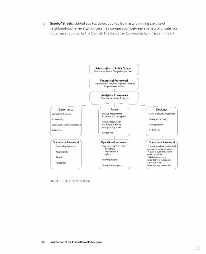
46 Privatisation of the Production of Public Space
3 Granby4Streets: started as a top down, publicly led masterplanning exercise of neighbourhood renewal which became a co-operation between a variety of private local initiatives supported by the Council. The first urban Community Land Trust in the UK.
Privatisation of Public SpaceGovernance, Users, Design Perspectives
Governance
Analytical FrameworkGovernance, Users, Designer
Users Designer
Operational frameworkExperience & Perception - publicness - maintenance - safety
Forming a public
Renegotiating space
Operational framework• 5 quantatively & qualitatively measured urban qualities• 4 qualitatively measured urban qualities• Safety and security (qualitatively measured)• Appropriation (qualitatively measured)
Passive engagement:Experience & perception
Active engagement:Forming a public & renegotiating space
Reflections
Ownership & Control
Accessibility
Consequences of privatisation
Reflections
Perceptual urban qualities
Safety and security
Appropriation
Reflections
Ownership & Control
Accessibility
Result
Perception
Theoretical FrameworkOn publicness, the public sphere, space &
its perceived decline
Operational framework
FIGURE 1.2 Structure of the thesis
TOC
47 Introduction
§ 1.5 Structure of the thesis
In Chapter 2 the public sphere and the relationship between the public sphere and public space as well as the perceived decline of both sphere and space will be discussed, drawing on academic literature of the relevant topics. In light of the shift towards more active involvement and engagement of private actors in the production of space, a rethink of the definition of the publicness in space and the role space plays has to be an integral part of the literature study. In Chapter 3 the theoretical framework will address the academic literature related to the three perspectives on which the analysis will rely - governance, users and designer - to build up an analytical framework for this research. Each section will discuss a different perspective and will end with an operationalisation of the analytical framework in a table. Chapter 4 gives a short review of the main planning policies of the Urban Renaissance, a (limited) historic overview of Liverpool, and introduces the three case studies; Liverpool One, Ropewalks and Granby4Streets. Chapter 5 explains the multi-dimensional methodology that is used to analyse the three case studies according to the analytical framework. Chapter 6 discusses, in line with the build up of the analytical framework, the findings per perspective. Chapter 7 draws on the findings from chapter 6 and relates these findings with the theory discussed in Chapter 2 and 3. In Chapter 8 generic conclusions from the analysis are drawn which answer the main research question and its sub questions, followed by a discussion of the methods used in the analysis and recommendations for practitioners and further research.
TOC
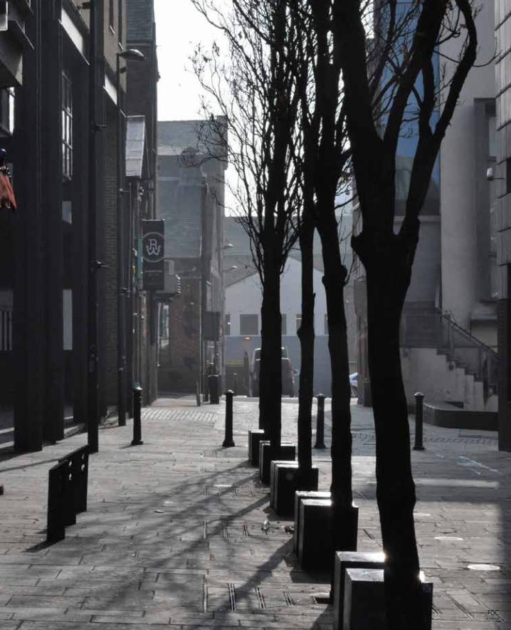
48 Privatisation of the Production of Public Space
TOC
49 Theoretical Background: The Public vs. the Private Sphere
2 Theoretical Background: The Public vs. the Private Sphere
The discussion of issues related to public and private space is underpinned by theories on the traditional meaning of ‘public and private sphere’, its ‘perceived decline in the contemporary era’ and its ‘relationship with public space’. While urban designers have certainly contributed to the theorisation of these notions, the debate has been led by philosophers and sociologists such as Hannah Arendt, Jurgen Habermas and Richard Sennett. The first chapter discusses how the public sphere is conceptualised throughout history, predominantly using the work of Arendt (1958), Habermas (1989) and Sennett (1977) as well as the perceived decline of the public sphere in current times and ultimately demonstrates a need for a widening of the notion of publicness. It is hereby noted that the notion of ‘public realm’ will be not be used because “the term ‘public realm’ bridges public space and sphere: among development actors it is often used as a synonym for public space and for social scientists as a synonym for public sphere” (Varna and Tiesdell 2010, 576-577). In this research both the position of academic authors as well as actors active in the development process are taken into account, as such the confusing term ‘public realm’ will not be referred to.8
§ 2.1 Definition and History of 'Publicness' and 'Privateness'
The idea of the public sphere as an arena of political deliberation and participation - and therefore fundamental to democratic governance - has a long and distinguished history. The imagery of the Athenian agora as the physical space wherein that democratic ideal might be attained has a powerful hold on political imagination
8 The term public is used as an adjective to signify three related but not identical meanings. In the first place it relates to everything that is ‘done, perceived, or exists in open view’ (Oxford dictionary 2000), everything that appears in the public can be seen and heard by everybody and has the widest possible publicity (Arendt, 1958, 52). Secondly, public relates to a state of being open or accessible to all. Public matters are matters that are ‘concerning or available to the people as a whole’ (Oxford dictionary 2000). Thirdly, the term public refers to anything to do with the state, the system of organising societal affairs. (see Frug 1999) From the 16th century the word ‘public’ started to refer to the state that had developed under absolutism into an entity having an objective existence over against the person of the ruler. “Public referred to the state” (Habermas 1989, 11).
TOC
50 Privatisation of the Production of Public Space
(Harvey, in Low and Smith 2006, 17). The description of the public sphere described by Arendt (1958,1959), Habermas (1989) and Sennett (1977) have in common that “they all relate the public sphere to different specific localities or parts of urban space, but address the public sphere first and foremost as a specific series of cultural and political practices (…) The public sphere is a specific, value-loaded series of practices, institutions, media and localities that define the quality of urban life and culture” (Boomkens 2008, 14). The public sphere is a defined political and cultural notion and is spatially embedded within a certain (urban) context. “The public sphere is not an objective localized space, but a norm formulated to describe the human conditions of freedom [to be able to come together in a public]” (Boomkens 1998, 52). If the public sphere is foremost being defined by cultural and political practices, then it should also be subject to cultural and political changes in the then ruling norms. In other words the public sphere is flexible and adaptable to societal changes although “the ancient Greek polis and agora, often and reasonably heralded as significant prototypes of the public sphere and public space, respectively, are rather different from today’s public space. The agora was not defined against the ubiquity of private capitalized space but vis-à-vis far more collective uses of space” (Low and Smith 2006, 4). The notion of the public sphere takes other forms under the influence of cultural and political shifts. The trend towards more individualism, consumerism and privatisation plays a central role in the current debate on a usable definition of the public sphere which, according to some scholars, has led to the ‘end of the public sphere’ (Arendt 1958; Habermas 1989; Sennett 1977). Hence, by trying to define the words ‘public’ and ‘public sphere’ we immediately run into the first difficulty in defining publicness that the meaning of public sphere and also public space, as a physical setting in which a public sphere can occur, is appropriated to cultural, political and social values within a certain period of time. “The usage of the words ‘public’ and ‘public sphere’ betrays a multiplicity of concurrent meanings. Their origins go back to various historical phases, and when applied synchronically to the conditions of a bourgeois society that is industrially advanced and constituted as a social-welfare state, they fuse into a clouded amalgam” (Habermas 1968, 1). These, in essence normative definitions, are shaped and reshaped by the political, economic and cultural reality of the time one lives in and change accordingly. Different definitions of ‘the public’ are rooted in political orientations and normative visions of democracy (Staeheli and Mitchell 2007, 792).
A second difficulty in identifying a useful definition on publicness in relation to space, is the apparent lack of regard for the spatial aspects of the public sphere in the work written by philosophers, political theorists and sociologists. The public sphere is seen as a condition for how a democratic society should ideally function and is thereby rarely embedded into a tangible spatial context. At the more practical side of space; urban designers, architects, social geographers and planners, do discuss the production of public space in spatial terms; often in relation to political, economic and cultural
TOC
51 Theoretical Background: The Public vs. the Private Sphere
processes but from a spatially embedded context (Low and Smith 2006; Boomkens 1998, 2008). “These public space and public sphere literatures can certainly overlap but more often than not they occupy quite separate domains” (Low and Smith 2006, 5). “Academic discourse that overarches these common themes of sphere and space tends to describe the publicness of space but rarely fully conceptualizes it, neither does it offer tools to analyse it” (Varna and Tiesdell 2010, 578). However, successful contributions to the latter have been made in recent years, which will be discussed further on.
Thirdly, according to a number of scholars, conditions are too simplified when one discusses public sphere and public space as if they were single entities. Young (1990) and Iveson (2007) speak in this context of ‘multiple publics’, indicating a series of separate yet overlapping public realms (Varna and Tiesdell 2010, 578), or ‘counterpublics’ (Fraser 1960). This notion of an inclusive, universal, rational arena where individuals harmoniously deliberate over their common interests is challenged by Fraser (1960) who argues that the public sphere of the Greek agora and the coffee houses of the bourgeois public were contested by exclusion as women and slaves were not allowed to participate. She also states that one can never speak of the public sphere as there are a host of competing ‘counterpublics’ present, existing simultaneously with the liberal public sphere addressed by Habermas (and Arendt), including women’s publics and working class publics. The relations between these competing counterpublics and the bourgeois public sphere were always conflicting. “The public sphere was always constituted by conflict” (Fraser 1960, 61).
Fourth, the public sphere is seen by most scholars as the opposite of the private sphere. Habermas (1989) remarks that the notion of the public is intrinsically connected to the notion of the private. “The meaning of public (space) today is very much bound up with the contrast between public and private space. It is impossible to conceive of public space today outside the social generalization of private space and its full development as a product of modern capitalist society” (Low and Smith 2006, 4). However the boundaries of what is defined, or for that matter experienced, as public or private are becoming more and more blurred (Kohn 2004). There are many hybrid forms of public and private whereby the public sphere is expressed in the private domain such as the reading of a newspaper in one’s bedroom or public merits that are publicly accessible and therefore experienced to be public; such as public transportation, the Internet, but are de facto privately managed and controlled. Iveson (2007) argues that public and private do not easily correspond to urban places such as street versus home, or park versus shopping mall. These places are private in one sense but public in another (p. 9).
In ancient Greek times the public sphere was strictly divided from the private sphere. The private sphere, the area of the household, was the realm of necessity. Here the
TOC
52 Privatisation of the Production of Public Space
women, children and slaves were occupied with the activities necessary to fulfill one’s needs. Their lives were ruled by production of food (work) and reproduction of life (labour), the activities to stay alive, both seen as a necessity (Arendt 1958). The public sphere on the contrary, was the sphere of freedom, of politics, the domain where a free man could gain public standing and even immortality by leaving his individual mark on common matters through speech and action. Only if one had mastered the necessities of life - owning property and being freed from labour and work - and by overcoming the innate urge of all living creatures for their own survival, then men are free to enter the public sphere and, according to Aristotle, a man then has a chance to have a good (as in heroic) life (Arendt 1958, 30-31). The relationship between the private and the public sphere depended fully on the condition that one could only enter the public sphere if a man mastered the necessities of life, which freed him from concerns in relation to work and labour. Hence, women and slaves could never enjoy the freedom of public life, “not only because they were somebody else’s property but because their life was ‘laborious’, devoted to bodily functions” (Arendt 1958 ,72)
The public sphere for the Greek was first of all their guarantee against a futility of individual life; men entered the public sphere because they wanted to be part of something that would exceed their personal and private earthy life (Arendt 1958, 55-56). The private realm could be charming but never glorious. When things are kept within the private realm, they have no appearance; there is no public who can debate and discuss these matters, hence these do not have public value. The public sphere, according to Arendt, is a space where individuals could excel, because others were witness of their actions; “the public realm was reserved for individuality” (Arendt 1958, 41). The meaning of public life lies in the fact that an individual man is being seen and being heard by others, and these others see and hear from different perspectives. In order to pay a contribution to the public sphere, to the common life, one must share his ideas and make them known to others. The “action is based on the essential plurality of people in a political space and oriented towards the cultivation of the good life and the construction of freedom” (De Cauter and Dehaene 2008, 87)
Although Arendt (1958) does not specifically address the spatial conditions for the public sphere, reference is made to the house a man must own as the spatial context for the private sphere and to the agora - the Greek market place - as the place where the public sphere was conducted. She uses reference to space in a conceptual and not in a specific way. Access to the agora was strictly limited to free citizens, men who were unburdened with the necessities of life; woman and slaves were excluded (Fraser 1960; Low and Smith 2006). She acknowledged the association of the public sphere with the polis, but not as much with the physical spaces of the city given that to her, the polis is synonymous with the people: “The polis, properly speaking, is not the city-state in it physical location: it is the organization of the people as it arises out of acting
TOC
53 Theoretical Background: The Public vs. the Private Sphere
and speaking together, and its time-space lies between people living together for this purpose, no matter where they happen to be” (Arendt 1958, 198).
The Roman res publica resembled the public and private spheres of the ancient Greeks, but after the collapse of the Roman Empire this division was diluted. In the Middle Ages there was, according to Habermas (1968), no truly public sphere as was previously known in the Greek and Roman times, although reminiscent of the res publica can be found back in laws produced throughout the Middle Ages. European culture was, up to the 18th century, a ‘representational’ culture, where the elite formed by the gentry and landlords represented themselves to their audience (subjects) and hereby insuring their power by overwhelming their subordinates in their public presentation. A public sphere formed by a group of free men actively discussing commons affairs did not exist in this feudal system of passive dependency. During the process of industrialisation and the rise of the commodity market, economic activities moved outside the sphere of the private single household into the sphere of ‘social labour’. Modern economics was not longer oriented towards the necessities needed for the survival of the conjugal family unit, but towards creating wealth in the commodity market. This created a double meaning of the word private: in the first place it still referred to the household, albeit it a smaller version than the extended family centred around production in ancient times. Secondly, it related to civil society, the sphere of commodity exchange and social labour (Habermas 1992, 30). Since the 16th century however, the notion of ‘public’ referred to the state being a representative of its citizens, the public authority (Habermas 1992, 11) and not to the public as a gathering of private individuals discussing common affairs.
Although this new process of economic reproduction was predominantly a private affair, it happened within a state controlled setting: the commodity market expanded under public direction and supervision (Habermas 1989). The state as a public authority interfering in economic regulations which, though largely private, were also relevant to the public at large and gradually gave rise to the need of a new arena where matters of common concern could be freely discussed. This new arena, coined by Habermas as the ‘bourgeois public sphere’, consisted of a group of private individuals that, while coming together as a public, debated commonly interesting affairs while being informed of worldly concerns by the rise of critical newspapers (accelerated by a growing rate of literacy). The bourgeois public sphere discussed and contested the control of the state authority and hereby positioned itself as a critical body in the field between state (public sphere) and society (private sphere). But it did so in such a way that it itself, remained a part of the private sphere (Habermas 1989). Habermas (1989) links this bourgeois public sphere to the coffee house as the physical setting in which this sphere could flourish. Sennett (1977) states that the coffeehouses of the 17th and beginning of the 18th century functioned as meeting places where information
TOC
54 Privatisation of the Production of Public Space
was shared and opinions formed between men of different social standing and without knowing each other (p.81-82). Personal information and feelings were not revealed and background, accent and appearance were not to be noticed in order to allow for free interaction between strangers on general topics of common interest, without reservations related to social rank.
Arendt and Habermas both argue that in ancient Greece, and with the rise of bourgeois influence during the 18th century, a public sphere emerged in which individuals gathered to discuss common affairs. However, the public spheres in both eras differed: in Greek times the public functioned also as the state given that the gathered public negotiated the laws and rules for the polis, a form of direct democracy. Whereas in the 18th century, the bourgeois public sphere sat between the private (family unit plus society) and the public (the state authority) contesting the control over the public sphere by public authority (Habermas 1989). However for both periods, the public sphere concerns a neutral space where individuals surpass their own identity and private goals, to rationally discuss common affairs with individuals they are not privately related to. “This ‘public’ behavior is a matter, first, of action at a distance of the self, from its immediate history, circumstances, and needs; second this action involves the experiencing of diversity” (Sennett 1977, 87). The public sphere, in which one debates common issues stands hereby directly opposite the private sphere, the sphere of the personal issues.
§ 2.2 The Decline of the Public Sphere and the Takeover of the Private Sphere
From the latter half of the 18th century however, these public and private spheres began to blur due to a variety of changes, which led (or might be still leading) to the decline of the public sphere (Arendt 1958; Habermas 1989; Sennett 1977). A number of these changes will be discussed including the rise of society and the emergence of the social welfare state and the rise of an intimate and individual sphere (individualism), fed and nurtured by the growth of mass media (including the digital technological revolution of recent decades).
Both Habermas and Arendt state that the notion of ‘society’, as something in between the private and the public spheres, has not only blurred the distinction between the private and public spheres but has also changed, almost beyond recognition the meaning of the two terms and their significance for the life of the individual and the citizen (Arendt 1958, 38). As a result of the rise of large enterprises dominating the
TOC
55 Theoretical Background: The Public vs. the Private Sphere
markets, the state authority saw the need to create rules to protect the interests of private individuals and corporations alike, resulting in an intertwining of public and private spheres. On the other hand, these large enterprises developed slowly into social institutions themselves, becoming the extension of the private family unit. In the earlier notion of a family, the individual was linked to another person - as was the slave to his master and the peasant to his landlord - however in a large firm, the employee is not linked to an individual but to an institution. And with this “the dominant organizational type of social labor became a social structure neutral to the separation of private and public spheres” (Habermas 1989, 153). A social sphere is neither private nor public.
Arendt (1958) saw society as “a collective of families economically organized into the facsimile of one super-human family” (p. 29), society was therefore part of the private sphere or formed a neutral sphere which was neither private nor public. According to Arendt, society is to be seen as one large household - into which individual family units have been absorbed - that is, as a whole, only concerned with the activities of necessity; labour and work. In society these necessities, which previously belonged to the private sphere, were permitted to appear in public. Hence society can never constitute a public sphere because it does not provide the setting in which man could give his time and attention to things greater than himself, according to the Greek meaning of the public sphere. According to Arendt, as the main concerns of society relate to the production of labour and work, society can never therefore provide the right conditions for individuals to gain freedom, and with that wellbeing (eudemonia), “Man does not exist in the social sphere as a true human being but only as a specimen of the animal species. The emergence of society has changed its estimate of this whole sphere but has hardly transformed its nature. The monolithic character of every type of society, its conformism which allows for only one interest and one opinion, is ultimately rooted in the one-ness of man kind” (Arendt 1958, 46).
Sennett (1977) argues that there are two physical changes that signalled the disintegration of the public sphere that began in the latter half of the 18th century: the pedestrian boulevard and the department store. Both in their own way, led to the emergence of a passive, voyeuristic public, for whom it was not custom any more to address strangers but to keep silent while in public. Walking in the streets as a social activity became fashionable as “people took in the pleasure of observing and being observed in a milieu of strangers” (Sennet 1977, 84). The establishment of department stores and boulevards signalled the rise of the modern city and were representative of the new physical settings in which a shift towards a more passive public behaviour based on observation and a kind of voyeurism challenged the speech patterns of the
TOC
56 Privatisation of the Production of Public Space
early 18th century coffeehouses and which ultimately led to a decline of this form of active public behaviour. Encounters with strangers do still occur in this setting but are limited to greetings or short conservations. Sitting in a coffeehouse does provide after all, a better physical environment for heated discussion than strolling the streets. This tendency went hand in hand with the growing interest in a public man’s personality and sentiments. This ultimately destroyed the public element in the notion of the public sphere, because the public did not trust itself in its judgment of the acts of a public speaker and thought itself only capable of judging his intentions and his sentiments. From an active participatory public, it became passive (Sennett 1977, 261).
The emergence of the department store attempted, by mystifying the product through its carefully assembled shop window dressing, to lure a flaneuristic public into the store to purchase products they did not strictly need. The creation of a consumer market for an ever-growing amount of products forms one of the ground rules of industrial capitalism. Secondly, the department store fundamentally changed the interaction between seller and buyer. Rather than conducting a public negotiation over the price of a product, which was common practice at markets, the products had a fixed price that, in turn, rendered public conversation superfluous (Sennett 1977, 147-148).
The basis of industrial capitalism, the requiring of a market for its products and the potential that the industrial revolution offered to produce products for the masses, eventually led to an enormous growth in consumerism and leisure. Both of which are in essence apolitical and hence not public. “As a result [of capitalism] values commonly associated with democracy – notions of equality, of the importance of collective deliberation and compromise, of the existence of a public interest not reducible to personal economic concerns – are of secondary concern, or no concern at all, to consumers” (Frug 1999, 172).
Arendt still refers to the presence of a public sphere in the contemporary social welfare state where people participate passively rather than actively through speech and action, albeit in a significantly reduced form and importance due to the emergence of the social sphere: “Society is that curious, somewhat hybrid realm between the political and the private in which, since the beginning of the modern age, most men have spent the greater part of their lives. For each time we leave the protective four walls of our private homes and cross over the threshold into the public world, we enter first, not the political realm of equality, but the social sphere” (Arendt 1959, 51). However, De Cauter (2004) is less optimistic and states that consumerism (fuelled by mass production) and privatisation has not only led to a social sphere where we do not encounter the ‘other’ anymore (let alone formulate our common norms and rules
TOC
57 Theoretical Background: The Public vs. the Private Sphere
through action and speech) but to a ‘capsulated society’. People spend their lives in capsules – homes, workplaces, shopping malls – and travel in similar enclosed capsules (the car) through networks from one capsule to the other, hereby denying themselves the possibility of surprises, unexpected moments or events. The capsulated society is by definition an utterly controlled environment, where any possible risk has, as far as possible, been designed out. Frug (1999) regards this controlled capsulated society as a form of privatisation: “[public] life is simultaneously eroded by nongovernmental forces that collectively might be called the trend toward privatization: the withdrawal into family life, condominiums, office complexes, and shopping malls, as well as into the cars that allow people to travel in seclusion” (p. 139).
Habermas (1989) argues that ultimately, the rise of the commercial oriented mass media at the expense of critical journalism can be regarded as the reason (or one of the reasons) that brought an end to the bourgeois public life that flourished in the 18th century. “With the rise of the mass media in the mid-19th century, private interests and commercial concerns have invaded public opinion, limiting the access of alternative voices and controlling allowable discourses. In place of the ‘public’ sphere’, a fictitious and ‘universal’ public has been constructed. (…) the resulting competition among private interests for state regulation and control distorted the supposed neutrality of public reasoning in its deliberative weighing of social problems, while a constructed public opinion weakened any critical force to the public sphere. Perhaps this was an inevitable process, reducing irreversibly the contemporary ‘public sphere’ to an arena where private interests compete and consumer choices are displayed, as well as to a space where public debate and critical reasoning no longer take place” (Boyer 1994, 417).
Habermas blamed the mingling of private interests in the form of advertisements in newspapers for influencing society and depriving them of a critical unbiased source of information, essential for creating a public sphere. “The world fashioned by the mass media is a public sphere in appearance only. By the same token the integrity of the private sphere which they promise to their consumers is also an illusion” (Habermas 1989, 171). The media became a tool for private companies to feed the feelings and sentiments of people’s consumer need, which turned an active into a passive public. At the same time, the media also became a political instrument for state and political forces. Naturally both aspects resulted in a ‘polluted’, and hence no longer public, arena in which the individual and intimate sphere was fed rather than the public. Habermas (1989) was highly critical of modern consumerist trends, the social welfare state and neoliberal capitalism as well as the role mass media played in turning the political system from a participatory democracy into a representative one; again, an active versus passive state of citizens.
TOC
58 Privatisation of the Production of Public Space
More contemporary academics have criticized the negative role Habermas attributed towards mass media in light of the new forms of communication brought forward by the technical revolution of recent decades, which could potentially facilitate opportunities for a new public sphere and a more active and participatory public (see Thompson 1995). [The public life that] “previously happened in specific urban localities, from squares and parks to cafes, shopping centres and museums, has gradually moved to new, non-spatial environments, this all due to the growing influence of all kinds of new technologies and media” (Boomkens 2008). Also De Waal (2013) concludes that although the networks established on social media tend to be formed between like-minded people or formed around a certain theme, they can intensify urban public life. However, this does not necessarily mean that social (mass) media fosters public life although there is potential for this to happen, it merely stimulates the growth and intensification of parochial spheres9 – people who come together in a public that do not know each other privately but share common interests or have similar backgrounds (De Waal 2013).
§ 2.3 The Relationship between Public Sphere and Public Space
The previous paragraph showed that the public sphere, being a normative established notion, is susceptible to adjustments of its definition through time, depending on economic, social and cultural changes. Public space is a possible, but not exclusive physical setting, in which a public sphere could flourish. A public sphere always has a geographical component but it can also emerge in spaces that are not legally speaking public. “The quintessence of the public sphere is the embodiment of practices of freedom, confrontation, experiment and identity construction, these elements need a bodily presence not a certain physical setting per se” (Boomkens 2008, 18). If the public sphere is declining and private interests are gaining importance in the public sphere, creating a blurring of the two spheres as discussed above, how does this impact on the publicness of space?
9 The parochial domain is “a realm characterised by a sense of commonality among certain groups of people” (Lofland 1999). There is a growing tendency to what Lofland refers to as “the parochialisation of the public domain”, where groups with common interests occupy a realm, which generally is not problematic as long as the group is tolerant towards the presence of non-members.
TOC
59 Theoretical Background: The Public vs. the Private Sphere
Traditionally, at least in the Western tradition, the notion of ‘public space’ has been interpreted as space open to people as a whole and/or being controlled by the state on their behalf (Madanipour 2010, 8). The relation between state, accessibility and publicness of space is also reflected in the definition of public space offered by Kohn (2004): “The definition of public space based on ownership, accessibility and intersubjectivity reflects the widely shared intuition that public space usually refers to a space owned by the government, accessible to everyone without restriction, and/or fosters communication and interaction” (p. 11) and by Low and Smith (2006): “public space is traditionally differentiated from private space in terms of rules of access, the source and nature of control over entry to a space, individual and collective behavior sanctioned in specific spaces, and rules of use” (p. 4).
A number of scholars see public space as a network of physical sites in the urban landscape that, besides having a physical aspect, also contain social and symbolic dimensions (Iveson 2007, 18; Madanipour 2010, 30; Carmona et al. 2008, 40). It is in this social space that an exchange between different social groups is possible and also actually occurs. It is the sphere where we encounter the proverbial ‘other’ and where we must relate to ‘other’ behaviour, other ideas and other preferences (Hajer and Reijndorp 2001, 11-12; Sennett 1977). Public space as a stage for public address, as a place ‘to see and be seen’, as a space that functions as a social but also as a political space where, in the sense of Arendt and Habermas, private individuals can formulate a common opinion based on the views and thoughts of others.
Academic literature is divided on the state of our publicness, particularly when the publicness of space is concerned. A number of academics from both the human studies related fields (sociology, political theory, philosophy) as well as the fields related to the design of space (urban designers, (landscape) architects, planners) have a more pessimistic view on the current state of publicness and have raised concerns about the loss or decline of the public sphere and even proclaim ‘the end’ of public space (Sennett 1977; Harvey 1989; Sorkin 1992; Mitchell 1995; Davis 1992; Minton 2009 etc.). Places become either ‘ageographic’, they could be inserted equally in an open field or in the heart of town, or they become overly themed to provide people the illusion of a meaningful space. This suggests a strong focus on creating ‘safe and secure’ places by inserting technological measures and specific urban policies. (Sorkin 1992; De Cauter 2004) “The urban field is no longer the domain of a civic openness, as the traditional city was, but the territory of a middle-class culture, characterized by increasing mobility, mass consumption and mass recreation (Hajer and Reijndorp 2001, 28).
“Privatisation of public space, new public spaces that were controlled and restricted, generated a fear that the city had become private territory in which people could not move easily and the democratic aspirations of liberty and equality would be undermined”
TOC
60 Privatisation of the Production of Public Space
(Madanipour 2010, 3). Democracy though depends, to a large extent, on the availability of physical urban space, even in these digital times using virtual space (Parkinson 2012). These pessimistic views on the publicness of space are predominantly based on the notion of a lack openness and inclusiveness of contemporary public spaces, referring to what Carmona et al. (2008) calls an “idealised notion of public realm as an open and inclusive stage for social interaction, political action and cultural exchange” (p.43) as public space was viewed in previous times. A generic feeling of loss of a unitary public sphere and space are based on a false notion as this did not exist as such; public space was never open to all. In reality, public space has never been “as diverse, dense, classless, or democratic as is now imagined” (Loukaitou-Sideris and Banerjee 1998, 182). Besides the nuances in the inclusiveness and accessibility of public space in the ancient Greece (where women and slaves were not seen as citizens) and the bourgeois times of Habermas (where one could not speak of one public but of multiple publics including counterpublics (Fraser 1990)) there are other authors who have voiced a more positive opinion of the publicness of space and see a revival of public space albeit with an emphasis not on civicness and democracy but strongly on commerce, sociability and entertainment (Madden 2010). Others suggest that there is a growing variety of different spaces that contribute to the emergence of new forms of a public sphere (Carmona et al. 2003; Hajer and Reijndorp, 2001). At the basis of the more optimistic authors, lies a multi-layered concept of the definition of publicness. However, as Varna and Tiesdall (2010) note, “a weakness of the academic public space discourse, is the tendency to describe loss of publicness without rigorously defining the concept and without providing tools for in-depth analysis across its multiple dimensions, making it difficult to compare different ‘public’ spaces” (p. 576). Clearly a straightforward definition for public sphere and public space is not that easily determined. In order to be able to answer the question of whether privatisation leads to a decline of publicness in space, we must firstly define what we mean by privatisation of space and we must also define what we mean by the publicness of space. This literature review on the positions of academic scholars regarding the public and the private sphere, its relation to public space and the perceived decline of space, should contribute to the understanding of the consequences of privatisation of space.
§ 2.4 Towards a new definition of Publicness in Space
The transformation in the provision, nature and maintenance of public space, as addressed earlier, is not a simple straightforward privatisation of public space, but instead a varied and complex set of new arrangements whereby “roles, rights and responsibilities in public space governance are redistributed to a range of social actors
TOC
61 Theoretical Background: The Public vs. the Private Sphere
beyond the state” (De Malgalhães 2010, 559). These new arrangements have resulted in an increased blurring of the boundary between public and private, which Kohn (2004, 11) called the ‘hybridization’ of public and private space. This opaque notion of ‘public’ and ‘private’ demands a wider and multifaceted definition of the concept of publicness. Particularly today, when privatisation is taking over certain aspects of our public values in sphere and space, we must more than ever be able to critically analyse the shift from public to private with regard its merits, weaknesses and threats.
The conventional wisdom is that management practices in privately owned spaces are more exclusionary and less transparent and accountable than those in publicly owned space (...) This mono-dimensional view on publicness, and an interpretation along ownership lines only, is too narrow a definition to describe contemporary spaces (Németh and Schmidt 2011, 6; Varna and Tiesdell 2010, 575). A more multi-faceted and comprehensive definition is therefore needed and this must “involve multiple, interrelated definitions, in order to avoid the tendency to create a list of desirable features or to reduce the concept to a single continuum” (Németh and Schmidt 2011, 9).
Not only do we need a wider concept of public space to be able to define it in a more comprehensive way, we also need this wider concept to be able to analyse the current state of the publicness in space in a quantitative and qualitative way. “Given how dependent on the particular circumstances of each set of arrangements the outcome of this process is likely to be, we need an analytical framework that allows us to understand how each of them might impact on the main attributes that define publicness” (De Malgalhães 2010, 567). “Such a model must also be empirically quantifiable lest it dissolve into a set of anecdotes or personal observations” (Németh and Smith 2011, 9).
In the last decade a number of scholars have offered multi-faceted concepts of public space. Kohn (2004) proposes a definition of public space based on three criteria: ownership, accessibility and intersubjectivity. With the notion of intersubjectivity she refers to the ability of space to foster communication and interaction (Kohn 2004, 11). Akkar (in Madanipour 2010, 21-50) based his analytical framework to review the publicness of the redevelopment of a bus station in Newcastle on the work of Benn and Gaus (1983) who define public space along the criteria of access, actor and interest, taking into account the physical accessibility and the degree of activities that can take place. “Access is divided into access to spaces, activities, information and resources. A place is public, therefore, if it is controlled by public authorities, concerns people as a whole, is open or available to them, and is used or shred by all the members of society. This interpretation appears to draw on an analysis of social relations as exchange among strangers, rather than a set of emotional and meaningful ties. The symbolic dimensions of public spaces are as significant as their functional
TOC
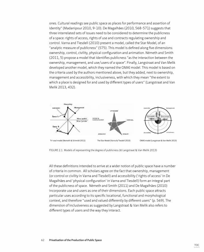
62 Privatisation of the Production of Public Space
ones. Cultural readings see public space as places for performance and assertion of identity” (Madanipour 2010, 9-10). De Magalhães (2010, 568-571) suggests that three interrelated sets of issues need to be considered to determine the publicness of a space: rights of access, rights of use and contracts regulating ownership and control. Varna and Tiesdell (2010) present a model, called the Star Model, of an “analytic measure of publicness” (575). This model is defined along five dimensions: ownership, control, civility, physical configuration and animation. Németh and Smith (2011, 5) propose a model that identifies publicness “as the interaction between the ownership, management, and use/users of a space”. Finally, Langstraat and Van Melik developed another model, which they named the OMAI model. This model is based on the criteria used by the authors mentioned above, but they added, next to ownership, management and accessibility, inclusiveness, with which they mean “the extent to which a place is designed for and used by different types of users” (Langstraat and Van Melik 2013, 432).
Tri-axal model (Nemeth & Schmidt 2011) The Star Model (Varna & Tiesdell 2010) OMAI model (Langstraat & Van Melik 2013)
FIGURE 2.1 Models of representing the degree of publicness (© Langstraat & Van Melik 2013)
All these definitions intended to arrive at a wider notion of public space have a number of criteria in common. All scholars agree on the fact that ownership, management (or control or civility in Varna and Tiesdell) and accessibility (‘rights of access’ in De Magalhães and ‘physical configuration’ in Varna and Tiesdell) form an integral part of the publicness of space. Németh and Smith (2011) and De Magalhães (2010) incorporate use and users as one of their dimensions. Each public space attracts particular uses according to its specific locational, functional and morphological context, and therefore “used and valued differently by different users” (p. 569). The dimension of inclusiveness as suggested by Langstraat & Van Melik also refers to different types of users and the way they interact.
TOC
63 Theoretical Background: The Public vs. the Private Sphere
Inter-subjectivity, active encouragement of interactions between people to make them actors instead of spectators, is closely linked to the criteria of ‘animation’ in the Star Model, which involves “the degree to which the design of the place supports and meets human needs” (Varna and Tiesdell 2010, 585).
All the models, except for the Star model, analyse the practical level of the produced space in a quantitative way based on partly quantitative (how many litter bins?) and partly subjective and empirical data (is the place well taken care off?). The Star Model also seeks to be used in a normative and perceptual manner, based on the perceptions of publicness held by individuals or social groups (Varna and Tiesdell 2010, 588). “A user-intercept survey would provide valuable information not only about the users of the spaces themselves, but also about how these users interpret and value publicly accessible spaces” (Németh and Schmidt 2011, 21). Users might perceive publicness in space in a different way to how the space was intentionally produced and as a result, use spaces according to their idea of what a space is. Users might also not be aware of what publicness of a particular space constitutes in terms of legal rights, physical setting, uses etc. in a particular space.
§ 2.5 Reflections
The decline of the public sphere impacted on the use and appearance of public space (and vice versa), in which consumerism played already a role in the 18th century (Sennett 1977). Around that time people began to prefer passive experiences rather than active engagement through speech and action while encountering others in public space (Sennett 1977, Arendt 1958). This shift from active to passive engagement apparently plays a significant role in the degree of publicness in both sphere and space. Recent tendencies of privatisation of public space have fuelled an academic debate on ownership, accessibility and the role and function of public space; for whom is public space? A new and wider notion of publicness is hereby required according to a number of scholars (Kohn 2004; De Magalhães 2010; Varna and Tiesdell 2010; Németh and Smith 2011; Langstraat and Van Melik 2013 ). In all the definitions/models discussed there is a strong emphasis on the analysis of the product; the public space itself, but less on the production of that space, on the process of how that space came into being and importantly, in which political and geographical context. In each public space there will be different stakes and interests at play negotiated for by a range of different stakeholders. The degree of publicness (or inclusiveness and openness) of the process of the production of space will also determine, to a certain extent, the publicness of
TOC
64 Privatisation of the Production of Public Space
the outcome produced; the space itself. Neal (2010) distinguishes between three perspectives on public space: the legal-economic perspective (who owns the space and pays for it?), the socio-spatial perspectives which is concerned with questions related to the space itself (what does it look like, who uses it and why?) and thirdly, the political perspective, linked to the role public space plays in the formation of a democracy and public sphere. The political perspective, regarding the role of the public sphere in a political context, has been addressed in its academic, abstract and theoretical ways in this chapter. The more practical and pragmatic side in which both public and private actors administer laws, policies and rules that apply to the production and control of space for all or certain spaces is discussed in the next chapter, concerning both legal-economic and political perspectives. In addition the socio-spatial perspective will also be discussed in the second paragraph from the users’ point of view as well as the urban designer’s point of view.
TOC

65 Theoretical Background: The Public vs. the Private Sphere
TOC
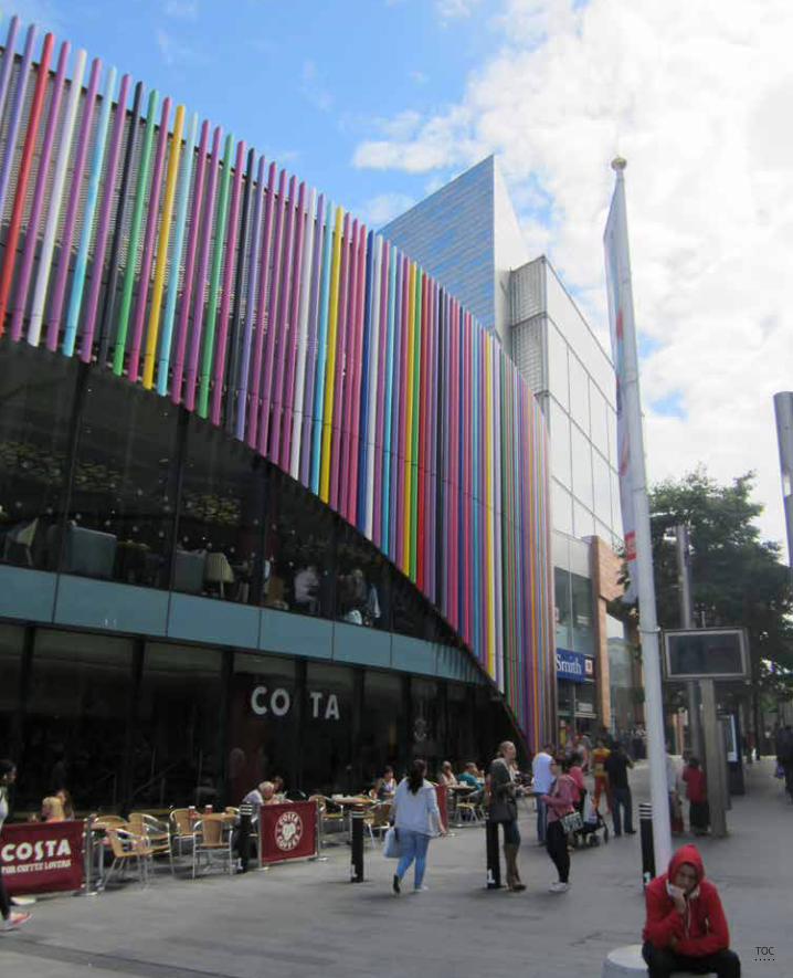
66 Privatisation of the Production of Public Space
TOC
67 Analytical Framework
3 Analytical Framework
In the following paragraphs the notion of a multi-layered definition of public space as discussed in the previous chapter will be used to build an analytical framework to contain the different perspectives of governance, designer and users (in other words people who produce space and people who use and reproduce it). Firstly, with the help of the analytical framework the research questions will be answered, and secondly it will help to determine which of the elements form essential rules in the wider definition of publicness in space.
The main concern in the debate about the decline of publicness of space might not be the shift in ownership or management per se, but the consequences thereof, which could possibly lead to reduced inclusiveness or decreased accessibility (Langstraat and Van Melik 2013, 435). Therefore, both shifts in ownership and control of the product and process themselves, as well as the consequences of these shifts, are taken into account within the analytical framework. A further distinction is made between the process – in which urban development takes shape through a complex multi actor process, broadly going through the phases of visioning, design, implementation and maintenance – and the product. The product being the result of this process that then itself forms the start of a renegotiation and reproduction process, but which can be analysed as a moment in time. Within the recent academic attempts to achieve a wider definition of public space discussed in the last paragraph of the previous chapter, this distinction between process or production of space and product or space itself in relation to the degree of publicness, is not always apparent.
Thirdly, there is a distinction to be made between the facts (in both product and process) and the perception of this process and product by the various different actors in the production and consumption of space. Both the facts as well as the perceptions are taken into account in order to come to a holistic analytical framework.
This framework will be built up in the following paragraphs based on the governance, users and design perspectives in order be able to analyse the three different case studies on the main question ‘what are the (perceived) consequences of privatisation for the notion of publicness within space? Does privatisation undermine this publicness of space?’
TOC
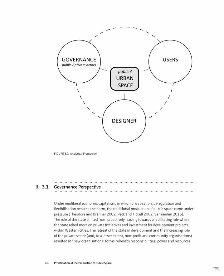
68 Privatisation of the Production of Public Space
GOVERNANCEpublic / private actors
USERS
DESIGNER
public?URBAN SPACE
ANALYTICAL FRAMEWORK
FIGURE 3.1 Analytical Framework
§ 3.1 Governance Perspective
Under neoliberal economic capitalism, in which privatisation, deregulation and flexibilisation became the norm, the traditional production of public space came under pressure (Theodore and Brenner 2002; Peck and Tickell 2002; Vermeulen 2015). The role of the state shifted from proactively leading towards a facilitating role where the state relied more on private initiatives and investment for development projects within Western cities. The retreat of the state in development and the increasing role of the private sector (and, to a lesser extent, non-profit and community organisations) resulted in “new organisational forms, whereby responsibilities, power and resources
TOC

69 Analytical Framework
have been distributed within and beyond government structures” (Carmona et al.2008, 66). The state’s leadership and control in urban projects diminished through decentralisation (where tasks and responsibilities were delegated to local authorities) and through outsourcing to private and semi-public entities; a shift from government to governance. Governance relates to “the processes of interaction and decision-making among the actors involved in a collective problem that lead to the creation, reinforcement, or reproduction of social norms and institutions” (Hufty 2011). It is “understood in terms of a territorially based relationship between politico-administrative institutions, societal processes and cultural adherences” (Hajer 2003, 182). Thus, governance brings together local authorities with public and private partners (from investors to private security, emergency services (the police, fire and related services), key lobbyists and public interest groups (eg residents’ association’s)), as well as the general public themselves (Madanipour 2003, 54). And governance refers hereby “to the more cooperative processes of governing, policymaking, and decisionmaking, so different from the old hierarchical model in which state authorities exerted sovereign control over the groups and citizens that make up civil society” (Mayntz 2003 in Van Bueren and Ten Heuvelhof, 2005).
This shift in governance not only results in new practices of collaboration in the design, implementation and maintenance of urban space but also in the interference of private (both corporate and non-corporate) actors in the making of policy and guidance (Hajer 2003). In this research with governance is meant the variety of different stakeholders that are actively engaged in the production of space.
The outsourcing of tasks and responsibilities previously attributed to the state is one of the characteristics of ‘New Public Management’,10 which was introduced in the UK in the 1980’s to improve the efficiency of public authorities by introducing more business-like management styles. In addition to decentralisation and outsourcing of the implementation of policies, corporate vocabulary was introduced to run public services more effectively, such as ‘cost-effective’, ‘value for money’, ‘targets’, ‘benchmarks’ etc. and the citizen was seen as a ‘customer’ or ‘client’. Financial criteria therefore became dominant in assessing and implementing public services and policies as cultural and societal values (heritage, equality etc.) became of secondary concern.11 This new public management regime, faced with severe cut backs in public
10 The term New Public Management (NPM) is introduced by Christopher Hood in 1991. The basic principles of NPM are according to him: management, performance standards, output controls, decentralisation, competi-tion, private sector management, cost reduction.
11 It is believed that NPM will gradually phase out as digital technology takes over many of the public administra-tive tasks. Digital Era Governance will replace NPM in digitally advanced societies (Dunleavy etal. 2006)
TOC
70 Privatisation of the Production of Public Space
budgets, became interested in innovative ways to solve urban issues. Not only did they embark on ways to privatise and outsource the implementation of urban policies, municipalities also incorporated urban social movements into their “innovative comprehensive urban revitalization programs”, which “dramatically reconfigured the relations between movements and local states” (Mayer 2013, 7). Former protest movements therefore became part of the ‘system’ by being made responsible for the implementation of certain policies, from “protest to program” (Mayer 2013).
Within this era of New Public Management, a number of trends in the production of public space can be distinguished within urban development in post-industrial cities. Akkar Ercan (in Madanipour 2010, p. 48-49) describes four main trends in recent public space production:
– “increasing involvement of the private sector in the provision, management and control of public spaces.
– increasing restrictions on the social accessibility of public spaces through surveillance and other strict control measures in order to improve their security and ‘good’ or ‘sanitized’ images.
– the tendency of public spaces to promote gentrification, social exclusion and stratification.
– a new urban form that significantly favours private interest rather than community needs”.
These trends firstly acknowledge a shift from public ownership, control and funding towards mixed forms or towards completely private entreprises along with a growing emphasis on safety and tidiness of spaces. Secondly, the accessibility (or the openness or inclusiveness) of both the production of space and the space itself is declining, or perceived to be declining as discussed in academic discourse (see previous Chapter). Both notions are discussed and reviewed as potential elements of the analytical framework. Questions that this part of the analytical part of the framework has to answer are:
– Why do public bodies decide to shift from public to private ownership and/or control? Which stakeholders are involved, how are they organised and what decision-making power do they have?
– Which form of governance delivers publicness in the process? And which criteria can assess the degree of publicness within the process?
– Which form of governance produces the most valued urban space in the perception of the actors who produce it?
TOC
71 Analytical Framework
§ 3.1.1 Ownership & control in process and product
During the 20th century, up to the 1980’s, the urban design and planning process used to be, in most development cases, a predominantly hierarchically structured process that followed a more or less linear form of organisation. A local authority translated their vision into a plan with statuary status, the urban designer created a design for the public spaces and a public authority or private developer, hired an architect to design the buildings for the areas that were earmarked for development (Loopmans et al. 2011, 46-47). New (parts of) towns were developed in this top down way, eg Milton Keynes in the UK or Almere or the Bijlmer in the Netherlands. From the 1980’s onwards, a new political paradigm led to a retreating public authority and the introduction of a market led development approach. Global developments such as migration, digital technological revolution, climate change, population demographic changes, and growing urbanisation led to highly complex issues for which specialised expertise turned out to be vital (Loopmans et al. 2011; Sassen 1991). In this highly complex environment, with an organisational shift from government to governance, development projects have transformed towards complex multi-actor processes in a professionally specialised environment, with an often multi-actor client body consisting of public, semi-public and private bodies. “Decision making has become more complex during the past decades. There is a growing variety of relevant actors and definitions of problems and solutions” (Teisman 2000, 952). The shift from government to urban governance regime - from a leading role to facilitating role or from a typically top down towards a more bottom up approach - involves the formation of new coalitions between public bodies, private organisations and (organised) citizens and civil society, lobby groups etc. into a participatory process with the aim to build a consensus. Power, risk and responsibilities are shared in this world of the ‘network society’ (Castells 1996).
Privatisation, outsourcing of tasks and responsibilities to private corporations, or collaboration within public–private partnerships were seen as a solution to this increased complexity in the urban matters and as an efficient use of public funds (Vermeulen 2015; Swyngedouw et al.2002). These structures may all include a form of private actor influence, hence be seen as a form of privatisation, however they differ in the relationship they have with the public authority. “Privatisation refers to any action that transfers some or all of the ownership and/or control of state-owned enterprises to the private sector” (Zahra et al. 2000, 511 in Reynaers 2014, 42). The spatial element of this form of privatisation, whereby property titles change from public to private hands and hence the space literally changes ownership, will be discussed at a later stage in more detail. Firstly the changes related to the shift towards governance within the development process, in which space is visioned, designed, implemented and managed, will be discussed.
TOC
72 Privatisation of the Production of Public Space
A second form of privatisation, is a construction in which tasks and responsibilities are outsourced by public authorities and comprises the use of external actors for a temporary and singular principal-agent relation in which the public partner still defines what, how and by whom something must be done (Klijn and Teisman 2000; Reynaers 2014). A third form of new organisational structures where private actors are involved in collaboration with public actors, are the so-called public-private partnerships. “Partnerships are semi-autonomous organisational vehicles through which governmental, private, voluntary and community sector actors engage in the process of debating, deliberating and delivering public policy at the regional and local level” (Sulivan and Skelcher 2002 in Skelcher et al. 2005). In the United Kingdom, faced with the problems of a housing shortage and neglected and declining inner city areas, a research report commissioned by the national government stated that “the urban renaissance will only happen if the market is able to make it happen” (Urban Task Force 1999, 276). Therefore collaboration with private actors was widely sought in the urban development projects. Public-private partnerships were to function relatively independently and were to involve the private sector in the delivery of urban areas as the private sector “is assumed to be better and more efficient at managing (infrastructure construction), financing, maintenance and operation (for example they tend to be inclined to be more pro-active in the use of new technologies, new ideas or new ways of doing things)” (Klijn and Koppenjan 2015). “Because (such partnerships) operate at arm’s lengths to centres of elected political authority they can be constituted in ways that offer greater flexibility in decision-processes, accountability arrangements, and resource acquisition and management than is normally available to statutory bodies” (Skelcher et al. 2005). Both public and private partners bring their expertise and resources, there is also an explicit organisational form where risks, responsibilities, costs and profits are shared (Kort and Klijn 2011, 2013).12 These partnerships may also be the product of voluntary, self-organising or temporary alliances between stakeholders to achieve particular aims. The private component in public-private partnerships (PPPs) is therefore not necessarily a corporate (for profit) entity, but can also be a NGO or a form of civil societal group (eg a residents’ association).
12 A much used form of public-private partnership construction in the UK is the Urban Regeneration Company (URC) which is regulated by a nationally developed set of guidelines eg an URC should have a senior-level board and dedicated executive team. Also URC’s should have an agreed-upon life span of 10-15 years (Kort & Klijn, 2011). Within the three case studies analysed in this research there are no URC’s instated, therefore the precise guidelines are not discussed in this thesis
TOC
73 Analytical Framework
Skelcher and others (2005) identify three different discourses that compete within the overall partnership meta-discourse: managerial, consociational (‘power-sharing’) and participatory discourses.13 These discourses link broadly with the set of stakeholder interactions that McAllister and Taylor (2015a) distinguish in organisational structures of partnerships: coordination, cooperation and collaboration (p. 87). The managerial discourse flourishes on coordination of the partnership by managers in a pre-agreed format and is perceived to be a “dominant market-oriented managerialist political economy” (Skelcher et al. 2005, 579). The consociational discourse “provides for a coalition between varieties of social groups in an elite decision-making structure” (Skelcher et al. 2005, 579) in which the different groups cooperate to realise mutual goals. Cooperation here refers to “interactions where stakeholders remain fairly independent while working towards goals that happen to be complementary” (McAllister and Taylor 2015a, 87). In a participatory or collaborative discourse “the operational rules or behavoural norms need to be jointly contested and created endogenously as part of the partnership” (McAllister and Taylor 2015a, 87). “The participatory discourse is couched in terms of value of inclusivity, reinforced by a notion that partnership implies equality of standing and power between the actors involved” (Skelcher et al. 2005, 579-580). Creating partnerships that follow one of the described discourses or use elements of these discourses, forms a key element in the various ways (privatisation, outsourcing, collaboration) in which the shift from government to governance takes place.
It is often argued that involving private actors will enhance (cost) effectiveness and efficiency within the development process, however concerns have been raised regarding the safeguarding of public values (Reynaers 2014) and democratic legitimacy in the way these partnerships are linked to the traditional, democratically elected, representative governmental bodies or in other ways connected to principles of democratic legitimacy (Kort and Klijn 2013). Reynaers (2014) identifies five public values in her research into specific public-private partnerships, namely accountability, transparency, responsiveness, responsibility and quality. However, she acknowledges that “the search for an all-encompassing definition [of public values] is futile, we must determine which concept of public values is in use in each particular study”. Reasons for this ambiguity are that although notions of efficiency and productivity
13 Skelcher and others follow here Hajer’s (1995) definition: discourse comprises the “ideas, concepts and categories that are produced, reproduced and transformed to give meaning to physical and social phenomenon and relations” (p.44 in Skelcher et al. 2005 p.577). The policy-making institutions are hereby seen as sites of political struggle (Skelcher et al. 2005)
TOC
74 Privatisation of the Production of Public Space
are often associated with the notion of the private and notions such as solidarity and accountability with the notion of the public, scholars argue that this distinction cannot always be made (Van der Wal and Huberts 2007, in Reynaers 2014). Private actors might also operate in the interest of the wider public, and vice versa; public bodies are not always transparent and accountable.
These concerns regarding public values and the democratic legitimacy raise valid questions in the debate over privatisation in the development process. In public administration theory, an economic approach can be identified in which the state is responsible for the production of public goods and a normative approach in which the state serves the public interest (Pesch 2008). If public goods are outsourced towards private actors (both profit and non-for-profit organisations), is the role of public authorities then solely serving the public interest? And do private actors make other choices in the prioritarisation of public welfare issues than those democratically elected governmental bodies would make in the realisation of their vision of urban regeneration? Fundamental questions about the nature of power, authority, legitimacy and accountability can be raised in the formation and functioning of public-private partnerships (Skelcher et al. 2005, McAllister and Taylor 2015b). Who can participate in the process and why? With what mandate or contract? Who initiates, decides, controls and who is responsible?
The changing thinking about urban regeneration within the described neoliberal era is also reflected in the management of public space. By public space management is meant “the set of processes and practices that attempt to ensure that public space can fulfil all its legitimate roles, whilst managing the interactions between, and impacts of, those multiple functions in a way that is acceptable to users” (Carmona et al. 2008, 66). As seen in the design and implementation phase of urban projects, also in the management of space one can notice “an increasing emphasis on cost effectiveness, competition among providers and on consumer’s choice has underpinned a retreat of government from direct service provision, the transfer of public management responsibilities to private and community stakeholders, and increasingly complex trade-off between service quality and public control” (Carmona et al. 2008, 70). “Two types of private involvement are increasingly frequent. First, Business Improvement Districts (BIDs) often manage commercially oriented areas and the public spaces associated with them. Second, charitable organisations often participate in the management of parks and other public spaces” (Murray 2010, 185). Community involvement characterises this second type, often on a voluntary basis funded by donations rather than an imposed levy, which is the case in a BID.
TOC
75 Analytical Framework
BIDs, which can be defined as: “publicly regulated organisations that control a geographically bounded area financed by fees paid by property owners within the area” (Kohn 2004, 82), are by now very common in the United States and beginning to also become the norm in commercially interesting areas in the UK (De Magalhães and Carmona, 2009). Their services usually include security operations, rubbish collection and maintenance, landscaping and small improvements, marketing and promotional of the area and dealings with individuals – from providing information to escorting youth or homeless people out the area. Partly privatised, partly decentralized BIDs are, according to a report by the London School of Economics, “highly effective and consistent with the spirit of the age in Britain” (Minton 2009, 43). Also Murray (2010, 188) states in his research that: “BIDs have undoubtedly affected downtown life in positive ways. Several scholars have found BIDs reduce crime in their environs without simply shifting it to nearby neighborhoods, increase property values and residential populations, provide a longer-term perspective on an area than local government, and help to build social capital and many argue that BIDs are innovative and entrepreneurial in solving problems”. However there has also been critique: “As ‘partnerships’ between the state and private capital that are often oriented toward consumption, gentrification, and the maintenance of a ‘pro-business’ streetscape and neighborhood culture, they typify the post-1970s ‘urban renaissance’ that supposedly has characterized many American cities” (Madden 2010, 196 – hyphens in original text). Other scholars also lament on the commodification and homogenisation of space, the exclusion of certain groups or individuals and the focus on surveillance and control (see eg. Kohn 2004, Carmona et al. 2008). Although BIDs could be considered as an efficient instrument to bring more power to local people, their main focus lies on creating the environment best suited for consumption and commerce rather than civicness and the wider community interests. “Private owners and developers want their spaces to be apolitical. They separate users from unnecessary social or political distractions, and put users into the mood consistent with their purposes” – to consume (Loukaitou-Sideris and Banerjee 1998, 291).
Community groups or NGO’s can vary from informally and loosely organised, ad hoc events to formally structured organisations with budgets and annual reviews to safeguard accountability. They can either receive funding from public budgets, through private donations, by voluntary in kind contributions, or from a combination of all three. The Friends of the Highline (New York), a voluntary organisation which receives the majority of its budget from public grants and private donations, is an example of a highly structured organisation that is fully responsible for the management and maintenance of the Highline. They employ 208 people and have 214 volunteers working for them and their assets were, according to their tax form of 2015, $98 million, of which two thirds was earned through investments in publicly traded securities (http://www.thehighline.org/about). Examples of a loosely organised
TOC
76 Privatisation of the Production of Public Space
community involvement are for instance the litter picking event that was organised by the Ropewalks Residents Association in Liverpool to help maintain the area and the Dream Street project in which residents transformed their local streets to social spaces for a number of months, an initiative that began in Ghent but found its way to many neighbourhoods in Belgium and the Netherlands.
Although this form of privatisation of management tasks is less commercially and more community driven, the critique applied to the BIDs is also partly applicable to these privatised ways of organising public space management. A certain community group does often not represent all members of the public who use the space, therefore individuals or groups might be, or be perceived to be, excluded from a certain space if that specific community group pursues its own aims. Research into the diversity on the Highline demonstrated for instance that an overwhelmingly high percentage of the users of the Highline are, in comparison to both the surrounding neighbourhoods and other public parks in New York, of white ethnicity (Reichl 2016). Question rises if the management policies in place with regard to staging events, the offer of food and drinks and maintenance regimes are geared towards predominantly welcoming a specific ethnic group. Another example is the surge of allotment gardens in parks, but probably favoured by just a small group of people of a community. If space is taken by allotments, families cannot use that space for a picnic or children cannot play football. In all cases of privatisation, there are important questions that need to be addressed in terms of safeguarding the wider public interest, the public values of all citizens. How can private initiatives and investments be allowed and enhanced while protecting this wider public interest? And what happens to the areas that do not have such private input into their maintenance and management? Secondly, the shift from public to private also blurs the distinction in funding streams of formerly publicly funded projects, “when the city grants decision-making powers to private citizens who then raise money to run what was formerly publicly-funded” (Low 2006, 45), of which the High Line is an example.
As mentioned above, a shift from public to private can be noticed not only in design, implementation and management (‘the process of production’), but also in geographical terms: the legal transfer of property rights. The most direct form of privatisation is the selling of public land to private entities. In the last three decades and widely recognised as the neoliberal tradition, the selling of public assets to private investors has seen a surge in Western societies, not only within the urban landscape, but also in other areas such as health care, the military, infrastructure and transportation (Harvey 1989; Brenner and Theodore 2002; Peck and Tickell 2002; Minton 2009). Immediate financial gain for the treasury and reducing the cost of administration are the main arguments for public authorities to trade land. Cultural, historic and social values are hereby of underlying concern (Minton 2006; Jolles
TOC
77 Analytical Framework
201414). Low (2006) argues that “during the last 20 years, privatisation of urban public space has accelerated through the closing redesign, and policing of public parks and plazas (…), and the transfer of public air rights for the buildings of corporate plazas ostensibly open to the public“(Low and Smith 2006, 82). Although her observations relate to the city of New York, a shift towards private ownership and control of previously publicly owned and maintained space can be seen in all Western cities (Minton 2006; Swyngedouw et al. 2002). This privatisation process has, amongst other discussed results, led to a more varied spectrum than simply private and public owned spaces. Marcuse (2005, 778) considers there to be a number of variations based on the function and use of a space, resulting in varying degree of publicness.15
Privatisation can also take the form of the expansion of commercial activities within public space and therefore the reduction of, and access to, public functions. Although commercial activities have always formed a part of public space, the agora for example held commercial activities as well as functioning as a political space, commercial interests have taken a much more dominant role in contemporary urban space (Sorkin 1992). The space itself becomes the décor in which commercial interests take centre stage, carefully designed and managed to lure a buying public into a purchase. A widespread example is for instance the removal of public benches at the request of coffee bars thus forcing people to pay to sit outside with consequent social effects for local residents and in particular youngster and elderly.16
Individual expressions within the urban landscape, such as placing planters and other green facilities, decoration of facades and also the art of graffiti, all contribute to enhance the specific character and sphere of individual cities. This so called appropriation, which is indeed a form of privatisation albeit at an individual level, is further discussed in the next paragraph section regarding the users’ perspective.
14 At the conference ‘Public Values in the Built Environment’ (TUDelft, 13.02.2014) Allard Jolles, Director at the Department of Real Estate explicitly stated in his presentation about the State’s real estate portfolio that, in his opinion, financial return was the tax payer’s highest concern, more than heritage or cultural values.
15 The six types he describes are: public ownership/public function/public use (eg street, square); public owner-ship/public function/administrative use; public ownership/public function/private use (eg terrace of a café); private ownership/public function/public use (eg airport, internet); private ownership/private function/public use (café, shop); private ownership/private function/private use (eg home, club)
16 In Rotterdam McDonald’s paid for outdoor seating on a public pavement adjacent to one of their eateries. The seats have the same style as public furniture at other places in the city except they have the M emblem on them. Although the seats can be used by anyone, they portray an ambiguous message: are they part of the public space or of McDonalds. They are used as the latter.
TOC
78 Privatisation of the Production of Public Space
§ 3.1.2 Accessibility: openness and inclusiveness
The degree of publicness of space depends (notwithstanding ownership as discussed) upon control and funding of the space itself, the process of its production as well as the accessibility to the process - who takes part in the production of the space - and to space itself, the product. The different ways in which public and private actors can be included in (or are excluded from) the development process have been discussed above. The accessibility to the space itself, the activities within in and the information regarding it - elements that can be controlled by both public and private bodies - impact hugely on the publicness of space. “The essential quality of public space is its accessibility: the more open and unconditional the access, the more public it becomes. This openness should include physical as well as social accessibility – access to the place itself and to the activities within it” (Madanipour 2010, 127). The physical access concerns the actual openness of a space; how many entrances, how are the boundaries designed, are there gates etc. Social access refers, notwithstanding the activities within a space and the opportunities it offers for public gatherings, to how welcoming people perceive a space to be influenced by the way it is designed and maintained (Benn and Gaus 1983). “Without being accessible, a place cannot become public. If public open spaces are conceived as enclosed particular places with fixed identities, their flexibility and inclusiveness will be undermined, and so will their accessibility (…) In the controversies about privatization of public space, it is the access to public spaces that has been limited, narrowing the range of social groups who can use these spaces, and making these spaces accessible only to a smaller group of people, often judged by their ability to pay” (Madanipour 2010, 8). The exclusion on the basis of ability to pay, was already pointed out by Charles Moore (1965) who stated that the best example of public space in America was Disneyland, leading to his conclusion that one has to pay for public space. Fifty years later, commercialisation and commodification of space has become much more common in publicly accessible spaces. Some theme parks have taken preferential treatment over financial means a step further by introducing fast lane tickets with which children can jump the queues for an attraction by paying extra on top of their regular ticket, thereby learning that whoever has more money deserves better.17
17 https://www.walibi.nl/nl/fast-lane#/
TOC
79 Analytical Framework
Accessibility to public space is also impeded by the growing demand for control in order to create a feeling of safety and security, which naturally provides for a good commercial environment. Surveillance methods used to achieve a larger degree of control include both technological and physical, such as private security guards, CCTV systems and regulations (Sorkin 1992; Minton, 2009), resulting in a “militarisation of urban space” (Davis 1992). Secondly, soft controls “that use a range of symbolic restrictions that passively discourage undesirable activities, or make others impossible through removing opportunities, are also put in place to discourage certain groups to enter by feeling unwelcome” (Loukaitou-Sideris and Banerjee 1998, 183-5). Policies to restrict behaviour in certain places affect social activities in the public realm. Prohibitions such as ‘no ball games’, ‘no smoking’, ‘no skateboarding’ are presented as measures to limit certain risks to individuals, but effectively exclude groups of people from public space and therefore “raises concerns about personal freedom versus personal and collective responsibilities” (Carmona et al. 2008, 56). In 1998, the Labour party introduced a policy, the Anti Social Behaviour Order (ASBO), which was designed to address anti-social behaviour such as vandalism, begging, drunken behaviour, littering etc. This is an example whereby the public authority uses a policy to regulate and limit the freedom of individuals in public space (mostly young people) by criminalising non-criminal behaviour. As young people or more likely to be the subject of an ASBO, these orders are stigmatizing and alienating young people, preventing them from meeting friends in public space (Minton 2009, 153-155). The existing ASBO was superseded by a new regulation, the Anti-social Behaviour, Crime18 and Policing Act of 2014. Similar to the much-derided ASBO’s, Public Space Protection Orders (PSPOs), made legally possible under the same Anti-social Behaviour Act of 2014, allow for broad powers to criminalise behaviour that is not normally criminal. But where ASBOs were directed at individuals, PSPOs are geographically defined, making predefined activities within a mapped area prosecutable (Garrett 2015, Guardian19). In such a controlled and exclusive context it seems difficult to sustain the inclusiveness and openness to provide a spatial environment in which public life can thrive.
18 http://www.legislation.gov.uk/ukpga/2014/12/contents/enacted
19 Garrett, B. (2015). PSPOs: the new control orders threatening our public spaces. The Guardian 09.09.2015
TOC
80 Privatisation of the Production of Public Space
§ 3.1.3 Consequences of privatisation in public space
Global economic changes have caused urban public space to be recognised as a valuable commercial commodity, where global and local businesses in partnership with city governments have re-ordered the historic functions of public space through the production of new forms of public space that bring together those in society who can afford to consume. “As cities increasingly compete for investment at a national and international level, they need to create environments that are seen as safe, attractive and which offer a range of amenities and facilities that their (increasingly white-collar) workers, and the tourists that they hope to attract, expect” (Madanipour 2003, 224) The use of space as a commodity to attract both users (consumers) and investment in an (inter)national competitive market has resulted in positive outcomes of the current urban renaissance:
– “good looking environment attracts inward investment;
– creating new job opportunities;
– bringing economic vitality back to declining parts of the city centre;
– boosting civic pride” (Madanipour 2010, 49)
However, the validation of space as a commodity has also led to a number of negative consequences, such as the appearance of some spaces as rather unimaginative and bland spaces; spaces are beginning to look similar world-wide. A foreign investor searching for new development opportunities in the city of London rather liked the clean and corporate look of Stratford International: their potential buyers would feel at home in this bland and corporate environment; as soon as they step off a plane, it looks familiar and therefore unthreatening and comforting.20 In the increasing role as a global commodity, urban space becomes more homogeneous in both its outlook, its function and the public it attracts (see also Sorkin 1992; Carmona et al. 2003). Carmona et al. (2003) suggests that the rise of a growing tendency of privately managed and controlled spaces have on the one hand led to an under-management of public space resulting in neglected, lost, invaded, exclusionary, segregated, domestic, third, and virtual spaces. On the other hand, the production of contemporary space is criticised as being over-managed, resulting in privatised, consumption-oriented, homogenised, invented, and scary spaces. Looking at the city as a whole the question arises, what happens at the other side of the boundary of the over-managed
20 Comment given by a Chinese investor in the spring of 2013 while taking a tour around possible investment possibilities in London. Sites with more local characteristics were not seen as investment potential.
TOC
81 Analytical Framework
private area? Chances are that the adjacent area is part of another BID or is publicly managed to a high standard, but in the worst case scenario it becomes ‘left over space’, a clear example of Carmona’s ‘under-managed’ scenario. An urban landscape made up of an archipelago of different BIDs or in other way privately managed areas will be the result, with neglected zones in between (Carmona et al. 2003, 2008; Hajer and Reijndorp, 2001).
Besides a polarisation based on spatial characteristics, a divide in use of the spaces within the city occurs. Users increasingly “use space a la carte, frequenting those exact events, festivals, schools and shops that conform to their identity and avoiding other places” (Hajer and Reijndorp 2001, 84). This way of using space, which is accommodated by the arrival and spread of the car and further fuelled by the rise of social media and digital technology, gives people the opportunity to live a life in the controlled (and hence perceived safe) atmosphere of capsules (De Cauter 2004). In the ideal capsulated city people travelling from capsule to capsule encounter only other people of their choice, unexpected events or meeting ‘the other’ controlled/ruled out. The capsulated configuration is strongly related to a surveillance and controlled society (De Cauter 2004). This breakdown in social and spatial linkages reflects a decline in the degree of publicness of space and with that a deterioration of the city as a whole (Madanipour 2010, 238).
This homogenisation has been further fuelled by the surge of guideline documents that have been produced in the wake of the urban renaissance, prescribing generic design solutions for particular places. On one hand these encourage much needed aspiration but also reduce creativity in finding specific context related solutions (see Towards an Urban Renaissance, A Better Place to Live, Designing out crime etc). The opposite of this generic city, designed such that it could be anywhere, is the themed city. Certain parts of cities have been specifically designed, often relying on historic references, to create controlled spaces where people are entertained in a regulated way (Boyer in Sorkin 1992, 181-204; De Cauter 2004). “The theme park presents its happy regulated vision of pleasure as a substitute for the democratic public realm, and it does so appealingly by stripping out troubled urbanity of its sting, of the poor, of crime, of dirt, of work” (Sorkin 1992, xv).
As already mentioned, another aspect of privatisation is the stronger focus on surveillance and control, which also has the potential to restrict certain behaviour or accessibility to certain places for certain individuals or groups of people. “Regulation is often focused around anti-social behaviour and the general maintenacnce problems associated with increasingly heavily used public spaces” (Carmona and De Magalhães 2006). Besides placing limitations on accessibility, this leads to a homogenised public with ‘standardised’ behaviour, just as the emphasis on the commercial interests in
TOC
82 Privatisation of the Production of Public Space
space does. The focus in these commercially interesting parts of the city is on the efforts to secure the public space on behalf of particular forms of public sociability – read leisure and shopping – through the exclusion of particular people who are conceptualised as a threat to those forms of sociability (Iveson 2007, 148). In this way, the governance of urban populations has turned into a territorial separation of the ´community´ from ´anti-social´, establishing disconnected ´circuits of inclusion´ and ´circuits of ´exclusion´ in contemporary cities (Rose 2000). Those in the circuits of inclusion, move through an archipelago of perceived safe spaces which are secured for the ´community´ against ´anti-social´. The anti-social on the other hand, are banished to peripheral spaces, or have their movements restricted through the imposition of ´good behaviour contracts´ and incarceration (Iveson 2007, 150). Discovering new experiences or meeting ‘the other’ becomes difficult if certain people or behaviour is excluded from certain spaces and only consumer behaviour is allowed and encouraged.
The number of issues that have been raised in the academic discourse regarding the perceived decline of publicness in space, in particular regarding issues of ownership, control and accessibility, can be seen as serious concerns that have implications on the future of public space as traditionally seen as democratic and open. However, a number of scholars have voiced more optimistic views on the decline of publicness in recent years. “Although much of the literature points to a homogenisation in the experience of public space, to its physical decline, and to trends in privatisation, commercialisation and exclusion, it is also true to say that much of the literature comes from a narrow academic perspective, and critiques of certain types of public space, whilst not necessarily recognising the sheer diversity of space types that constitute contemporary cities” (Carmona et al. 2008, 60). Other authors also argue that the reported decline in public space is much exaggerated (Loukaitou-Sideris and Banerjee 1998). They argue that public space was never inclusive, democratic and open to all members of the public, as many commentators would lead us to believe, and that the perception of public space as such is an idealised notion. (Hajer and Reijndorp 2001, 15) Already the map made by Nolli in 1748, shows the public and private spaces in the city of Rome not defined along the legal lines of ownership, but according to accessibility and perception of people. It shows, in addition to the publicly owned streets and squares, a large number of privately owned spaces that were perceived and used as if they were public. This perception was based on the level of accessibility and the function and use of the spaces.
TOC
83 Analytical Framework
§ 3.1.4 Reflections
The fact that space is privately owned and/or maintained does not necessarily determine the quality and the usability of the space; in other words space might still be able to foster a degree of publicness despite being privately owned/managed. “Contemporary public spaces still contain important aspects of urban life, and although many of these primarily commercial public spaces lack wider civic functions, we should remember that commercial space has always been part of public space. The core of city life – exchanges of goods, information, and ideas – still has a strong grounding in space (…) the design, accessibility, and the quality of such urban space can and ought to be criticised, but its existence must be recognized” (Lees 1994, 448-9). Carmona et al. (2008) concluded in his research on management regimes of public space that, “although still a legitimate cause for concern, the extensive of private involvement to the management of public space does not automatically lead to high levels of intolerance and control and to a irreconcilable shift in the balance of power in public space. Instead it confirmed that the characteristics that make public space ‘public’ are typically robust” (p.205). The quintessential character of public space is determined, according to Hajer and Reijndorp (2001, 85), by those who occupy it. However they do acknowledge that the “urban field is no longer the domain of a civic openness, as the traditional city was, but the territory of a middle class culture characterized by increasing mobility, mass consumption and mass recreation” (Hajer and Reijndorp 2001, 28). Madden suggests on the basis of his analysis of Bryant Park “not that public space is coming to an end but that the public itself is being decoupled from discourses of democratization, citizenship, and self-development and connected ever more firmly to consumption, commerce, and social surveillance. If such places do not herald the end of public space, they do represent ‘publicity [publicness] without democracy’” (Madden 2010, 187-188). The lack of democracy and political reference is not surprising as the main interest for private owners lies in the protection of their commercial values and hence they prefer their spaces yo be apolitical. “They separate users from unnecessary social or political distractions, and put users into the mood consistent with their purposes” in other words to consume (Loukaitou-Sideris and Banerjee 1998, 291). Madden (2010) argues that this process should not be seen as privatisation of public space but as the transformation of the urban public itself (p. 202). Public space, and the public itself, is a political, social, and cultural project that is negotiated and struggled over throughout history (Lefevbre 1991; Calhoen 1998; Mitchell 1995). Carmona et al. (2008) suggests that the discussion over what makes public space public should be wider than just ownership: “It is important to reframe debates to reflect how people actually use spaces, and the fact that to members of the public, ownership and appearance do not define the value of the space, rather the opportunities it provides for shared use and activity. Accept a broader notion of
TOC
84 Privatisation of the Production of Public Space
public space and opportunities for association and exchange have increased” (p. 58). Bearing in mind no space is ever open to all citizens equally at the same time and that publicness also depends on cultural, political and economic norms and values of its specific geographical area; its socio-spatial context. No space will ever meet the demands of all people in equal measures. Openness and inclusiveness, two main elements one considers a ‘good’ public space must have, are viewed subjectively, as different users of public space might have different ideals of openness and inclusiveness depending on cultural background, gender, age etc.
§ 3.1.5 Towards an operational framework
A shift from government to governance, as discussed above, leads to more involvement by private actors, both corporate and non-corporate, in the development process. In the last 30 years there has been a shift from a hierarchical and linear, top down process in which the roles and responsibilities of the actors were known and predictable, to a complex multi-actor (and sometimes bottom up) process that can be noted as characteristic for the current development process. This complex multi-actor process could potentially be more open to a wider range of private (both corporate but also civil society and residents) and (semi-) public actors and hence be more inclusive. Questions with regard to democratic legitimacy, accountability and responsibility do arise when the public authority is no longer the initiating, leading and paying actor in the development process. The rules dictated by ownership, control and accessibility do determine the level of publicness (both in the process as well as how the public values are translated through the process in the product) in space. Within the analysis, these rules of publicness will be assessed and will include the valued outcome by actors who produce spaces and their perception of the publicness of the process and product.
The theoretical academic findings discussed in this chapter are operationalised into the following analytical framework, which is based on ‘rules’ (ownership, control, accessibility, valued outcome and perception), ‘relevant questions’ and ‘themes’.
TOC
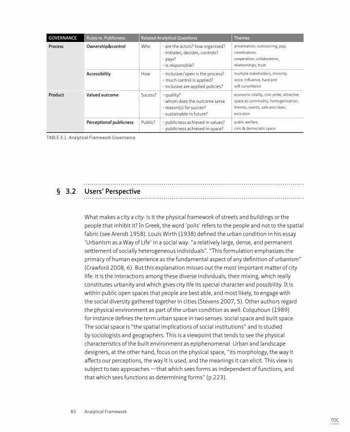
85 Analytical Framework
GOVERNANCE Rules re. Publicness Related Analytical Questions Themes
Process Ownership&control Who - are the actors? how organised?- initiates, decides, controls?- pays?- is responsible?
privatisation, outsourcing, ppp,
coordination,
cooperation, collaboration,
relationships, trust
Accessibility How - inclusive/open is the process?- much control is applied? - inclusive are applied policies?
multiple stakeholders, minority
voice, influence, hard and
soft surveillance
Product Valued outcome Sucess? - quality?- whom does the outcome serve- reason(s) for succes?- sustainable in future?
economic vitality, civic pride, attractive
space as commodity, homogenisation,
themes, events, safe and clean,
exclusion
Perceptionof publicness Public? - publicness achieved in values?- publicness achieved in space?
public welfare,
civic & democratic space
TABLE 3.1 Analytical Framework Governance
§ 3.2 Users’ Perspective
What makes a city a city: is it the physical framework of streets and buildings or the people that inhibit it? In Greek, the word ‘polis’ refers to the people and not to the spatial fabric (see Arendt 1958). Louis Wirth (1938) defined the urban condition in his essay ‘Urbanism as a Way of Life’ in a social way: “a relatively large, dense, and permanent settlement of socially heterogeneous individuals”. “This formulation emphasizes the primacy of human experience as the fundamental aspect of any definition of urbanism” (Crawford 2008, 6). But this explanation misses out the most important matter of city life: it is the interactions among these diverse individuals, their mixing, which really constitutes urbanity and which gives city life its special character and possibility. It is within public open spaces that people are best able, and most likely, to engage with the social diversity gathered together in cities (Stevens 2007, 5). Other authors regard the physical environment as part of the urban condition as well: Colquhoun (1989) for instance defines the term urban space in two senses: social space and built space. The social space is “the spatial implications of social institutions” and is studied by sociologists and geographers. This is a viewpoint that tends to see the physical characteristics of the built environment as epiphenomenal. Urban and landscape designers, at the other hand, focus on the physical space, “its morphology, the way it affects our perceptions, the way it is used, and the meanings it can elicit. This view is subject to two approaches —that which sees forms as independent of functions, and that which sees functions as determining forms” (p.223).
TOC
86 Privatisation of the Production of Public Space
The French philosopher and sociologist Henri Lefebvre, contributed to the positioning of the human being as the fundamental ingredient of urban life in (at least) three different ways. He argued in numerous works on the notion of everyday life as the basis for fundamental improvements to everyday existence. “Trivial everyday activities constitutes the basis of all social experience and the true realm of political contestation” (Crawford 2008, 7). In his work ‘Le droit à la ville’ Lefebvre (1968) debated the fundamental question of who owns the city or in other words who has a right to the urban spaces within the city. In a number of writings he analysed the relationship between space and its production. He argued that all forms of social experiences are constituted in and through space: “social space is a social product, the space thus produced also serves as a tool of thought and of action (...) in addition to being a means of production it is also a means of control, and hence of domination, of power” (Lefebvre 1991, 26). He suggests that space is an active agent in the struggle of social interactions and not, contrary to how urban designers and geographers often see space, a passive décor in which social negotiation takes place regardless of the spatial context (Vermeulen 2015, 38). The view that space is a social construction based on production and reproduction of values and attributed meanings, changed the research perspective from space itself, to its processes. To support his view Lefebvre introduced a trialectical concept of social space consisting of three elements: ‘conceived space’ (l’espace conçu), ‘perceived space’ (l’espace perçu) and 'lived space' (l’espace vécu), which together represent the different relational moments of social production of space (Lefebvre 1991; Elden 2004). The ‘perceived space’ refers to the physical space and the social actions of everyday life that constitute this space, including the production and the reproduction of social practices (Elden 2004). The ‘conceived space’ refers to the ‘representations of space’, it conceptualises and expresses the modes of productions, their power-relations and the hierarchy of the social order in plans, signs, codes and discourse. The conceived space is constructed by planners and designers and only exists in an abstract form. Lefebvre states that this is the dominant space in any society (1991, 38-39). The ‘lived space’ refers to space as ‘directly lived through its associated images and symbols, and hence the space of ‘inhabitants’ and ‘users’ (….). "This is the dominated (and hence passively experienced) space, which the imagination seeks to change and appropriate. It overlays physical space, making symbolic use of its objects" (Lefebvre 1991, 39). In the lived space, meaning is attributed to both the conceived and the perceived space; it encompasses the social and spatial imaginary of that particular time.
Lefebvre (1991) argues that every society produces its own space, which consists not of one singular space but of “an unlimited multiplicity or uncountable set of social spaces” (p. 86). Simply applying an urban design scheme or model would not provide social space in itself without producing and reproducing social relations. The triad model of space argues that space is presented as social space through
TOC
87 Analytical Framework
the three elements of the triad: ‘conceived’, ‘perceived’ and ‘lived’ space. Space and social relations are thus interlinked. Users and their everyday activities form the basis of social experience and hence play an important role in the production and reproduction of spatial practices. If every society produces its own space, as Lefebvre argues, do users experience privatised space differently to public space? This is the main research question addressed in this theoretical paragraph in which the user, and how she experiences urban space, will take a central position, with particular regard to privatisation related issues and the matter of publicness in space. There is little evidence found in current academic literature of research done into the perception of the user on the privatisation of space. The perception of the user on space and the meaning that is subsequently attributed to space by using symbolism, already touched upon in both the perceived and the lived space of Lefebvre’s triad, will therefore be analysed in this research. By this is meant a visual apprehension, a passive attitude towards the perception and experience of the built environment as well as towards other users. Secondly, the more active way in which users interact with the spatial context and with other users, thereby reproducing and renegotiating space, will also be assessed. How does the interaction of people (known and unknown to each other) play a role in the shaping of urban life and to what extent can users appropriate the public space for individual or collective purposes? Both these passive and active roles play an important part in public life: “Public space is a space for human and social interaction, a rich spatial instrument to see and to be seen, to participate and to withdraw, and to be the actor and the spectator in the theatre of social interactions” (Pallasmaa 2009, 125).
§ 3.2.1 The position of the user in the expression of the city plan: how the user experiences, perceives and adds meaning to space
When people use the public spaces of a city they presumably do so because they enjoy being in these spaces, these spaces are associated with a pleasurable experience (Lofland 1999, 77). Lofland (1999) detects two different kinds of pleasure; aesthetic and interactional pleasure. Aesthetic pleasure refers to “the experience of enjoyment occasioned by certain (mostly) visual qualities of the built environment” (p. 78), including the visual excitement of watching a crowd spectacle while interactional pleasure derives from human interaction (p. 86-88). The aesthetic pleasure, or the passive visual appreciation in which users perceive and experience both the spatial context as well as other users and how these users attribute meaning to space, is discussed in the following paragraph.
TOC
88 Privatisation of the Production of Public Space
Experience is based on how current perceptions are reflected or linked within one’s memory: “Experience is a matter of tradition, both in the collective as in the individual life. It exists not so much of individual facts that are locked in memory, but of streams of unconscious data which merge within the mind” (Benjamin 1992, 88 in Boomkens 1998, 196, translated from Dutch). For Benjamin, experience exists of those emotions and perceptions that recollected, constitute a “meaningful narrative that seeks in its own imperfect way to assume the dimension of a social and psychological totality. History or the past is always seen through the eyes in the present” (Parker 2004, 18-19).
At the end of the 18th century, the pleasure in spontaneous encounters in the coffeehouses between people of various classes and standing, in which the active engagement through spoken words created the public (or a public as Fraser (1960) states), shifted towards the pleasure of “observing and being observed in a milieu of strangers” (Sennett 1977, 84). From an active participant, man became a passive spectator who enjoyed mingling within a mixed crowd but is no active player through action and speech anymore. “Public behavior was a matter of observation, of passive participation, of a certain kind of voyeurism” (Sennett 1977, 27). The migration of large groups of different people to the city at the end of the 19th century created a truly urban metropolitan society with a variety of cultural and political minority groups. This urban milieu formed a rich and interesting environment for the observer to experience the new meaning of urban life in relative anonymity. Benjamin coined this observer a ‘flaneur’ in his ‘Passages’ (Parker 2004). The flaneur is more than merely a voyeur watching a spectacle, it resembles a “werewolf restlessly roaming the social wilderness” (Benjamin 1999, 416-418 in Parker 2004, 18). A man who strolls the streets of the city seeking the true experience of the modern metropolis - “the profane truths of a temporal-spatial universe that has been trampled into the dust by a humanity made dull and inattentive to the hidden wonders of the metropolis” (Parker 2004, 18). Within the public domain of the modern metropolis the flaneur developed a modern way of experiencing the overwhelming offer of stimuli the modern city represents (Boomkens, 1998, 110). The streetscape offered spectacle to passers-by through which they experienced the city and its users without actively engaging with others.
The modern movement however changed the perception of the city from “a traditional sense of pictorial enclosure” to “an open and expansive panorama” (Boyer 1994, 40-41). This shift could be attributed to new perspectives in urban experiences, made possible by the growth of novel modes of transport; train and car. The focus on incorporating the car in daily life pushed the pedestrian from the street into his car and as a result, the user experienced the urban spaces of the city in a radically different way. The modern city plan was centred around mono-functional zones connected by motorways, whereby the residential zone was envisaged as high rise towers placed in a vast field that provided hygiene, air and light but lacked in its lay-out, spaces
TOC
89 Analytical Framework
where experiencing or meeting ‘the other’ was possible. This city layout provided little theatrical scenes of city life, which the traditional city had in abundance, resulting in boredom while experiencing the modern city. People felt alienated and lost in the public space of nihilistic forms and crystalline structures (Boyer 1994). Reference to traditions, symbolism and history were seen as an unnecessary burden for the modern user. Experience and meaning were communicated through forms that followed primarily the requirements of functionality and hygiene. Modernist architects were progressive and sought to erase the existing environment, with its symbolism and meaning, in order to provide human kind with a totally new offer. “Yet, the urban spaces of the modern city more often than not seem to project a sense of isolation, separateness and solitude. They do not promote experiences of belonging and togetherness; we remain as separate individuals in these spaces instead of becoming members of a collectively and historically rooted collective body” (Pallasmaa 2009, 125). In the 1970’s, as a strong reaction against modernist principles, a number of scholars again placed the human being (and its need for visual complexity, meaningful experience and interaction with other people) as central themes in the research of, and design for, the city (Lynch 1960; Jacobs 1961; Alexander 1965; Gans 1968).
Within the urban renaissance of the last 30 years, the role of public space as a space for leisure and consumerism has gained importance. “The use of space a la carte and the selective consumption of places, varied according to lifestyle, has fundamentally altered the meaning and the nature of the public space. Moreover, the insatiable appetite for new experiences among an ever-larger public leads to a totally different experience of places, whereby meanings are predetermined whatsoever” (Hajer and Reijndorp 2001, 112). Cultural programmes, food markets, events etc. are staged in the urban space of the contemporary city to continuously provide for the public through the art of stimulation of urban experiences. This planned programming of entertainment contributes to safe and controlled public spaces, often dominated by a parochial sphere (a large population of like minded people) as a result of the type of cultural programme or event. Public space seems to respond to two trends: “the ‘ecology of fear’ (Davis 1992) and the ‘ecology of fantasy’” (Crawford 2008), or a focus on security and on themed public space, both trends leading towards greater control over public space (Van Melik et al. 2007, 25-26). Any risks, and therefore also pleasant surprises and moments of unexpectedness, are limited in these controlled environments. Urban experiences in these public spaces are orchestrated with a clear motive in mind, which in the current capitalist market is usually profit-oriented.
The agora functioned in historic Athens as a democratic public space in which the public sphere was shaped through speech and action (see Arendt 1958). A similar active engagement is attributed in the 18th century to the public coffee houses (Habermas 1989). During the 19th century this active attitude shifted towards a
TOC
90 Privatisation of the Production of Public Space
more passive ‘flaneurism’; people-watching as a form of engagement (Parker 2004; Sennett 1977). In the modernist take on the modern metropolis, few opportunities were provided for active nor passive engagement given that the design principles based on zoning and oriented towards the car, pushed pedestrians from the streets to appropriately designated areas. Since the 1970’s, a more ‘social’ approach to the design of cities led to a refocusing on human needs in our experiencing the city. Within the last 30 years the emphasis on ‘experience’ has taken a new turn; the commercial market has discovered the potential of providing ‘an urban adventure’. Experiencing urbanity again gained importance, but in a controlled and profit-oriented way.
§ 3.2.2 How users actively reproduce space: forming a public, renegotiation, reproduction and appropriation
Active engagement of users in space refers to the notion that users do not only use space as a physical setting in which their activities are set, but that these activities in turn change the space itself. In this section the academic discourse on the way people interact in space, using space as a ‘social space’ as well as reproduce and renegotiate the terms within this space, will be reviewed. The description ‘social space’ captures the act of meeting, or space in which “exchange between different social groups is possible” (Hajer and Reijndorp 2001, 11) “Wherever people happen to meet – by chance or as passers-by – or converge in the act of meetings – whether accidentally or deliberately for gatherings or appointments – we can use the term social space” (Hertzberger 2009, 96). Research into the use of plazas in New York demonstrated that the best used plazas were the ones chosen as a meeting place. At the well used spaces there was a significantly higher proportion of people in groups compared to less well used spaces, where there were relatively more individuals. However, the best-used spaces also attract more individuals in absolute numbers (Whyte 1980). Whyte’s conclusion was that people, both in groups and individuals, apparently prefer sociable, lively places (p. 17). It appears that what attracts people most to a space, is the presence of other people (Whyte 1980, 19). It was also found that the preconditions for a well used plaza were related to the amount of a variety of seating and sittable spaces (Whyte 1980, 24-39), as well as to the relationship with sunshine, water and trees. Trees in particular provide a satisfying enclosure under which people feel protected (Whyte 1980, 46). Thirdly, it was found that the provision of food – café’s, stalls, trucks, restaurants - contributes to the sociability and hence, the usability of a plaza. Jane Jacobs (1961) describes similar results from her analysis of the streets of New York. She also found in her observations that people enjoy activity and the presence of other people on the street. Gehl (2011) sees the prerequisites of
TOC
91 Analytical Framework
the quality of a public space as the number of people using this space. The more people using a space, and the longer they use it, the more quality is attributed to this space. Quality of a space is hence directly related to users, use and activities. In the variety of forms of contact – from close friendships to informal acknowledgement of the other; to hear, see and be amongst others – the last form appears to be insignificant, “yet they are valuable both as independent contact forms and as prerequisites for other, more complex interactions” (Gehl 2011, 15). In this interaction between human beings, the meeting of the ‘stranger’ (either in the sense of a person unknown or as an outsider) is particularly characteristic for city life (Lofland 1999; Sennett 1977). “The public sphere is the sphere where we encounter the proverbial ‘other’ and where we must relate to ‘other’ behaviour, other ideas and other preferences. This means it is a domain of surprise and reflection” (Hajer and Reijndorp 2001, 12). In the previous section, the experience of seeing and hearing the proverbial other has been addressed as a passive, not to be regarded as unimportant, but nevertheless observant way of perceiving other users. However, do people engage within public space beyond relationships in the realm of family, friends or professional relationships, in an active process of encountering? Three spheres that present themselves in public space can be distinguished: the private, the parochial and the public sphere. “The private realm [or sphere] relates to world of the household and friend and kin networks; the parochial realm is the world of the neighbourhood, workplace, or acquaintance networks; and the public realm is the world of strangers and the ‘street’” (Lofland 1999 10). These spheres are social and present themselves in space but are not necessarily rooted within a particular space, these spheres are not physical territories (Lofland 1999, 11). An overlap, or the presence of more than one sphere in a certain space is thus possible and even likely. Soenen (2006) researched interactions between people in different (semi)-public places and found that the three relational spheres as described by Lofland could be all seen simultaneously within these spaces. She concluded that the combination of these three spheres is essential to balance the daily encounters between familiarity and anonymity. In her case study of the tram, the public sphere appears to provide room for small exchanges between strangers and the possibility of avoiding a possible encounter while simultaneously acknowledging the other’s existence. These encounters led to both moments of (small) conflict but also to forms of collectivity (Soenen 2006, 74-76, translated into English). Experiencing the presence of other people, in a physical setting where all three relational spheres are represented, provides according to Soenen (2006) the essence of city life. Both the parochial and the public sphere differ in character but both fulfil important roles in the urban field; within the parochial sphere urban citizens are part of relative homogenous groups and can therefore form collectives, whereas in the public sphere they are unknown to each other and hence have to search for a position towards the other (De Waal 2013, 17).
TOC
92 Privatisation of the Production of Public Space
A number of scholars have expressed concern in the last few decades, over the rise of parochial spheres at the cost of the publicness of space and influenced by individualism, privatisation and the rise of digital technology (Sorkin 1992). As addressed earlier this concern might be based on an overly idyllic presentation of the public sphere of either the Greek agora or the public coffee houses in the 18th century (Arendt 1958; Habermas 1989; Sennett 1977). City life in all times has consisted of a multiplicity of publics – a presentation of one united public does not do justice to the complexity and richness of city life, nor to groups of users excluded from the public sphere reserved for the bourgeois man but who, however, formed their own publics, so called ‘counter-publics’ (Fraser 1960). Public spaces that are held up as the only true form of public sphere have been to a certain, or even a large, extent populated with parochial spheres and not just a public sphere (Hajer and Reijndorp 2001, 85). The reason people experience certain public places as pleasant, is because they are actually populated by a relatively homogenous group of people, without the position of this group leading to exclusion and repression (Hajer and Reijndorp 2001, 88-89). “So perhaps it is not parochialisation that hinders the development of the public sphere, but in fact the overwrought idea of the public space as a neutral meeting place for all social groups regardless of class, ethnicity or lifestyle” (Hajer and Reijndorp 2001, 85). The success of a public space lies thus not so much in the shared use of space with others or in the exchange amongst strangers, but rather “in the opportunities that urban proximity offers for a ‘shift’ of perspective; through the experience of otherness one’s own casual view of reality gets some competition from other views and lifestyles” (Hajer and Reijndorp 2001,89). In the public sphere, as theorised by Arendt and Habermas, the exchange or meeting in itself is not central in the definition of the public sphere but rather, the aim to discuss matters concerning all - to exceed an individuals private matters to reach a common goal - defines the publicness of space. The public sphere is a space of democracy based on unity and equality of rights for all its members. Soenen (2006) remarks that the public sphere, seen from a politically democratic point of view, will always be a space of conflict in which groups and individuals are held in a continuous struggle over space, rather than the theoretical smooth path Arendt suggests. Besides, space viewed solely in its democratic role neglects the everyday life of urban residents who might engage more in relations than conflict, for instance avoidance or restrained helpfulness (Lofland 1999). Soenen concludes from her analysis that the casual daily encounters and ‘small talk’ between strangers are essential elements of public life. The essence of public space lies not so much in a single, all-inclusive public space but in the overlapping and exchange of multiple and simultaneous daily experiences (Crawford 2008). In other words the social aspect is an important element in the definition of publicness of space, for some scholars even more valued than its democratic or civic function.
TOC
93 Analytical Framework
The interaction between users in different relational spheres in a variety of physical settings forms part of lived experience (perception) and with that, of city life. In participating in certain activities within space, users appropriate and renegotiate this space for their own purposes and hereby reproduce and change this space. This reproduction and renegotiation of urban space can be seen a continuous process of complex power relations within the notion of the perceived space (Lefebvre 1991). The top down planning control, exercised to produce the conceived space, is never completely hegemonic, there is always an element of resistance present within the perceived space that could overturn the current status quo (Lefebvre 1991). “The continually changing nature of public space and the rights people have to act in certain ways have increasingly been seen to produce various levels of resistance, from graffiti art to street riots” (McCann 1999, 168). This appropriation of public space for private initiatives, sometimes illegal and unwanted, sometimes permitted and cherished, are important elements that provide not only an opportunity of resistance against ruling powers but it also adds to the experience and identity of city space and life. From his observations of Naples and Moscow, Benjamin notes that in these cities with its street culture and collective behaviour of private goods bursting everywhere from the houses (with particular reference to the washing outside to dry between the building) resembles more peasant societies than the polished bourgeois cities where the “separations between private and public space are so neat and distinct” (Parker 2004, 17). In notes of his observations of Marseilles, Benjamin also “draws attention to how urban topography is overwritten with languages of class domination and resistance” in the form of socialist graffiti (Parker 2004, 17). Although these forms of individual private interventions within public space cannot be seen as a recent phenomenon, there is a growth of, and interest in, these types of privately executed interventions that are reshaping urban spaces (Iveson 2013, 941). They vary from graffiti, urban farming, dream streets to flash mobs and political protests such as the Occupy movement. A retreating government that transfers tasks and responsibilities to private parties including local residents, and the growing use of social media provide opportunities for these urban practices, referred to with a range of terms such as ‘urban interventions’, ‘guerilla urbanism’, ‘pop-up-city’, ‘DIY urbanism’. What these urban practices have in common is that their core concept departs from the notion of everyday urbanism and puts the user in a position to shape and create its own space (Crawford 2008; De Certeau 1984; Lefebvre 1991). Douglas (2014) identifies four categories within everyday urbanism in cities: (1) “variety of practices perceived as being vandalism, trespassing and other activities linked to petty crime and disorder”; (2) “unauthorized interventions as instances of concept art, personal expression and communication or popular sub-culture”; (3) activities ranging from street art to festivals, radical activism and protest sometimes with explicitly stated wider political goals and often inherent critical transformative power”; (4) DIY urbanism, which “refers to creative practices aimed at ‘improving’ the local built environment without permission in ways analogous
TOC
94 Privatisation of the Production of Public Space
to formal efforts” (p. 8-11). These forms of resistance explore, and potentially reveal, the alternative cities within the existing city, occupying urban spaces and injecting them with new functions and meanings; rediscovering the ‘Right to the City’ (Hou (2010) in Iveson (2013, 943). The notion ‘Right to the City’ was first coined by Henri Lefebvre (1968), and later further defined as “a moral claim founded on the principles of justice, of ethics, of morality, of virtue, of the good. ‘Right’ is not meant as a legal claim enforceable through a judicial process today. Rather, it is multiple rights that are incorporated here: not just one, not just a right to public space (…) but the right to a totality, a complexity, in which each of the parts is part of a single whole to which the right is demanded” (Marcuse 2009, 192-193). Lefebvre saw this right as a demand which challenges the perceived conditions of who should have the benefit of the city, who has access to it and what kind of city it should be (Mayer 2009). The notion of ‘Right to the City’ has become the slogan of a number of urban social movements, such as Reclaim the Streets, who advocate a collective right to the city and resistance against large corporate global actors. UN Habitat also acknowledges the importance of putting vulnerable urban residents at the centre of city development rather than large corporate investors, as stated in the World Charter for the Human Right to the City (2004). The rise of DIY urbanism and movements such as ‘Reclaim the Streets’, “can be seen as both a reaction to and product of the structures and processes that define the contemporary city” (Douglas 2014, 10). The shift from government to governance has opened up opportunities for these innovative and bottom up urban processes that can be seen as an integral part of the neoliberalism ideology (Mayer 2013).
Hajer and Reijndorp (2001) refer to the importance of adding meaning to urban space through the reproduction of space: “Citizens create meaningful public space by expressing their attitudes asserting their claims and using it for their own purposes” (p. 89). The possibility to appropriate or claim ownership of public space is seen as a valuable element in the production of public space. Small interventions, such as a street performance or a wrongly parked car on a pedestrian crossing that may be introduced into a person’s journey through urban space, can shift habits or vary practices in a user’s daily routine (Simpson 2011). The questions raised by this include who has the right to exercise these urban inventions in a certain urban space? How much democratic and public value accompany these urban inventions? Besides the question of if these inventions are lawful or not, these private urban interventions can in some instances not be counted as beneficial to the public as a whole or serving the common good. If a group of local residents appropriate part of a park for say allotment gardens (which could be regarded of course as a noble cause) but predominantly serves just one particular group of local residents, then this could hardly been seen as serving the common interest. Secondly, this particular area in public space is now populated by a specific group of people, creating a parochial or even private sphere, and therefore less likely to be open to others. Naturally, “no space is ever equally accessible to all
TOC
95 Analytical Framework
members of the public and no space will ever meet the demands of all users, as some of these are bound to be conflictive” (Langstraat and Van Melik 2013, 445). However, who protects the overall public values in this appropriation and reproduction of space, similar to the comments made earlier with regard to the perspective of governance, is an important notion in relation to the users of space.
§ 3.2.3 Reflections
In summary, the experience of publicness in space occurs at the boundary between friction and freedom. On the one hand there is always the tension of a confrontation with the unfamiliar; on the other, the liberation of the experience of a different perspective. Our public sphere experiences are in fact related to the entering the parochial spheres of ‘others’ (Hajer and Reijndorp 2001, 116). Passive perception as well as active engagement is hereby regarded as fundamental elements of the experience of space. The interaction between users in different relational spheres in a variety of physical settings forms part of the lived experience and with that of city life. In participating in certain activities within space, users appropriate and renegotiate this space for their own purposes and hereby reproduce and change this space (Lefebvre 1991). These prerequisites for the possibilities for passive perception or active engagement in and with space are captured within a set of certain norms, (legal) rules and values that safeguard the freedom necessary for people to use space as a public. This freedom necessitates a certain responsibility: “the ability to carry out the activities that one desires, to use a place as one wishes but with recognition that a public space is a shared space” (Carr et al.1992, 152). The question of management, and of what is appropriated and what is not, is therefore a matter of local judgment and negotiation.
Following on from the paragraph above, it can be concluded that publicness of space is related to how people perceive the quality and openness of a certain space and whether they have the freedom to use, reproduce and renegotiate space within a certain normative perception of reasonable and accepted behaviour. It is therefore “important to understand all the uses of the city, however unconvential, because the openness and publicness of urban space gain their meaning through the breadth of users and the varieties of actions that are pursued there” (Stevens 2007, 2).
TOC
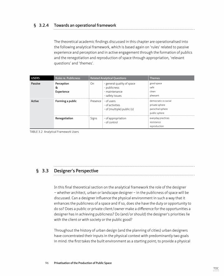
96 Privatisation of the Production of Public Space
§ 3.2.4 Towards an operational framework
The theoretical academic findings discussed in this chapter are operationalised into the following analytical framework, which is based again on ‘rules’ related to passive experience and perception and in active engagement through the formation of publics and the renegotiation and reproduction of space through appropriation, ‘relevant questions’ and ‘themes’.
USERS Rules re. Publicness Related Analytical Questions Themes
Passive Perception&Experience
On - general quality of space- publicness- maintenance- safety issues
good space
safe
clean
pleasant
Active Forming a public Presence - of users - of activities - of (multiple) public (s)
democratic vs social
private sphere
parochial sphere
public sphere
Renegotiation Signs - of appropriation - of control
everyday practices
resistance
reproduction
TABLE 3.2 Analytical Framework Users
§ 3.3 Designer’s Perspective
In this final theoretical section on the analytical framework the role of the designer – whether architect, urban or landscape designer – in the publicness of space will be discussed. Can a designer influence the physical environment in such a way that it enhances the publicness of a space and if so, does she have the duty or opportunity to do so? Does a public or private client/owner make a difference for the opportunities a designer has in achieving publicness? Do (and/or should) the designer’s priorities lie with the client or with society or the public good?
Throughout the history of urban design (and the planning of cities) urban designers have concentrated their inputs in the physical context with predominantly two goals in mind: the first takes the built environment as a starting point; to provide a physical
TOC
97 Analytical Framework
setting in which human activities can take place - living working, shopping etc. The second goal is to provide a physical setting for human social interaction. Depending on the ruling normative views on society these two goals fluctuated in attention and focus throughout the planning history and accordingly created the city. “The city is the collective expression of architecture and it carries in the weaving and unraveling of its fabric the memory traces of earlier architectural forms, city plans, and public monuments” (Boyer1994, 31).
Urbanists and architects have long thought that the physical conditions can influence social interactions within public space, a condition which consequently then provides the setting for the formation of a public sphere and political participation (Amin 2008). City planning as we know it today, whereby designers draw a plan for an expansion of the city on a drawing board, has its origins in the Renaissance. Even prior to Roman and Greek times, space was designed in an organic way as the need arose by residents or administrators and was shaped in a direct city-building process (Gehl 2011, 39). During the Renaissance, the city was seen as an artwork, shaped and perceived as a whole, based on appearance and visual aspects as criteria for good architecture and urban design (Gehl 2011, 41).
In the early 19th century the concept of society with the state representing the collectivity of residents was a new concept (Arendt 1958). Besides finding forms to express this collectivity in customs and culture, “government also needed to outline what the collective form of the city might be and how it supported the well-being of its citizenry” (Boyer 1994, 34). Architecture and city planning were used to demonstrate “exemplary deeds, national unity, and industrial glory” (Boyer 1994, 34) by erecting triumphal monuments and a carefully designed continuum of space and time in sequences of squares, parks and boulevards.
The rise of the city beautiful movement (United States) and the garden city movement in the United Kingdom, marked a new era in which spatial solutions which were seen as an answer to social problems and not just a beautification exercise through the creation of monumental spaces and equally grand buildings. The lay-outs for the first public parks in the 18th century demonstrate the belief that with the provision of high quality public space, social standards, general wellbeing and morality would improve. Both Joseph Paxton in his design for Sefton Park (Liverpool UK) and Frederic Olmstedt with Riverside (Illinois US) hoped that with the experience of a visit to a public park, lower class groups of different backgrounds would mingle and subsequently the individual cultural identities would blur, ultimately resulting in the homogenised citizen (Frug 1999; Kostof 1992; Davis 1992).
TOC
98 Privatisation of the Production of Public Space
In the modernist movement, from the 1930’s onwards, the functional aspects of how people could most efficiently live were the main driver for the planning of cities (human existence controlled as in an industrial factory). The main objective was to organise people’s daily routines in the most functional way, whereby sun, light and clustering of uses into dedicated zones were the parameters of good design rather than aesthetics or the deliberate provision of social gathering places. The modern metropolis as envisaged by the modern movement changed the perception of the city from “a traditional sense of pictorial enclosure” to “an open and expansive panorama” (Boyer 1994, 40-41) made possible by the new modes of transport, train and car. Le Corbusier argued that the modern city could be rearranged according to the modern standards of efficiency, functionality and optimality, as a direct result of the technological advancements in movement and building construction. The elevated highway and the elevators enabled the provision of residential apartments in tower blocks grounded in a vast public space. These vast, green spaces became “a privatized view from one’s room, and the higher one lived the more spectacular the panoramic view (…) The traditional street, being killed by the motorway, reappeared as an internalized private space. (…) The stately urban square, that quiet oasis in the traditional city acting as a theatrical stage set for monumental architectural views, became transformed in the modern city into ramps, stairways, and elevators, points of exchange between public and private space. The fabric of the city was rearranged in a structured and utopian whole: disorder was replaced by functional order, diversity by serial repetition, and surprise by uniform expectancy” (Boyer 1994, 46). “The architects of the modern movement approached cities in a rather coherent and comprehensive way. These designers saw their space as an integrated one, in its various scales and with its physical and social dimensions. They designed buildings, and objects inside them and landscapes around them, hoping, rather optimistically, that shaping space would lead to the creation of a better society” (Madanipour 2010, 28)
In the 1960’s, critical voices lamented on these functionally designed neighbourhoods, suggesting that these places were not designed to reflect the human scale nor in such a way that social interaction between people was made possible, resulting in bleak places lacking local character and identity. These critics defended the inherent qualities of mixed-use neighbourhoods and street activity as the context for social interaction (Lynch 1960; Jacobs 1961; Alexander 1965). Since then a great number of sociologists, anthropologists and architects have valued social aspects highly in defining quality public space. Gans (1968) found himself particularly critical of the idea that “the physical environment played a major role in people’s lives and that reshaping of this environment was the most urgent priority for social action to achieve the good life” (p.1-2). He differentiated the man-made environment into two kinds of environments: there is the potential environment, which is the proposed plan by the designer, which can only be turned into an effective environment by the social system and culture
TOC
99 Analytical Framework
of people who are willing to use it (Gans 1968, 6). The idea that one could steer these social interactions solely through physical improvements and design became unfashionable: spatial determinism, where the designer determines what is best for the users, lost its popularity.
In the urban renaissance of the last 30 years we have seen a clear resurgence in the importance of having high quality urban space expressed in (local) policy agendas. However, this renewed focus on a quality urban space is not necessarily aimed at creating democratic and civic spaces but to design visually and functionally beautiful spaces that attract a consumer class. Within this period, a focus on form and aesthetic values can be noticed but primarily for leisure and consumer purposes. Boyer (1994) coined this type of city the City of Spectacle, which “utilises simultaneous stage settings, juxtaposing multiple perspectives based on historic reconstructions and references lifted out of their context into new compositions. Previously industrial areas are redeveloped and rebranded as buzzing new urban areas, based on historic vernacular, where new meeting places opened around retail and leisure activities. And not surprisingly we shall find that the City of Spectacle, the city reduced to the play of pure imagery has developed intimate tie-ins with the logic of consumption and the selling of leisure-time lifestyles” (p. 51). The City of Spectacle creates a certain atmosphere or ambience by providing animation to stimulate consumerism and leisure. Public spaces increasingly serve as venues for the arts, culture, festivals, farmers markets and concerts; events and entertainment that are organised from the top down as a way to sustain and serve a consumer public. This ‘themed’ public space has a tendency towards greater control and predictability of activities in space based on creating a sense of safety (Van Melik et al. 2007). Also Sorkin (1992) describes the contemporary city as a theme park, it is a city of simulations based on historic reference with an emphasis on surveillance and control. “It presents its ‘happy regulated vision of pleasure’ as a substitute for the democratic public realm, and it does so appealingly by stripping troubled urbanity of its sting, of the presence of the poor, of crime, of dirt, of work” (Sorkin 1992, xv)
There can be little doubt that spatial design interventions can contribute towards the aesthetic quality of urban space, but can they also influence social interaction? Gehl (2011) argues that physical factors can indeed “influence activities to a varying degree and in many different ways. Although the physical framework does not have a direct influence on the quality, content, and intensity of social contacts, architects and planners can affect the possibilities for meeting, seeing, and hearing people – possibilities that both take on a quality of their own and become important as background and starting point for other forms of contact” (p. 9,13). A number of designers have contributed to the discussion on what a quality space entails and which criteria these design interventions should follow. However a high quality space does not
TOC
100 Privatisation of the Production of Public Space
necessarily means a public space. Spaces that are for instance, privately maintained and have restricted accessibility can be valued as aesthetically and functionally of high quality but this does not mean they have a high degree of publicness. Can a designer provide for a physical setting that fosters, in addition to sociability and aesthetic values, publicness? This question leads to two other important issues. Firstly, what are the design elements that can enhance publicness? Secondly, what is the position of designers within the design process in order to be able to make contributions to publicness in space. Even if they would have the design tools, so if they would be capable to do so, are they also in the position to do so? Who is their client?
§ 3.3.1 Visual assessment of urban design qualities
In an attempt to list design criteria that influence the publicness of space, the criteria of the wider definition of publicness as discussed in the first and second sections of this chapter - ownership/control, accessibility, passive and active engagement of users - the analytical framework of urban design qualities proposed by Ewing and Clemente in their handbook ‘Measuring Urban Design’ (2013) is used as a starting point. There are many more models or lists of criteria for qualitative urban design available (see eg Urban Design Compendium, Project for Public Spaces), which are usually based on literature and good urban practice. Ewing and Clemente also based their urban design qualities on an extensive literature review, but have tried to quantify these design qualities and have translated the outcome into an easily manageable analysis tool. For these three reasons - its foundation on extensive literature, made quantifiable and translation into an usable tool - their handbook has been used as the starting point to arrive at an analytical framework to research the publicness in space from a designer’s point of view.
In their handbook, Ewing and Clemente (2013) describe the tool they created to measure urban design qualities whereby they translated “subjective definitions into operational definitions that capture the essence of each quality and can be measured reliably across raters, including those without training in urban design” (p.2).
TOC
101 Analytical Framework
The key qualities of the urban environment were identified based on a review of classic urban design literature21, which initially provide 51 qualities (which were subsequently reduced to eight) based upon the importance assigned to them in the literature: imageability, enclosure, human scale, transparency, complexity, coherence, legibility, and linkage. A ninth quality, tidiness, was added at a later stage when a review of the video clips used indicated it was potentially important (Ewing et al. 2006). Of these nine qualities the first five were “successfully measured in a manner that passed tests of validity and reliability” (p.4) and could therefore be used as operational definitions rather than individual perceptions. Ewing and Clemente defined the physical features that attribute towards each of these five qualities, resulting in a tool (in the form of a checklist) to measure the walkability of a space. In their opinion walkability is the key indicator of the quality of an urban space.
“This instrument has several strengths. First, it is grounded conceptually in constructs from architecture, urban design, and planning. Second, it has been carefully tested and validated. Third, it comes with detailed instructions for assessing the five urban design qualities. For these reasons, the instrument offers researchers a 'gold standard' for the systematic measurement of urban design. A test in New York City showed that the instrument can be implemented in large-scale studies relating the built environment to social, psychological, and health outcomes” (Ewing & Clemente 2013, 3).
This tool, designed for measuring the quality of urban design based on the walkability of a space, can also - possibly in an adapted format - be used as a framework to analyse the relationship between urban design measures and the publicness of space. In order to be able to determine this possibility, the nine terms Ewing and Clementine selected to describe the qualities of space, already based on an extensive literature review, are reviewed again against relevant academic discourse. This time the aspect of publicness is focused upon to see whether this literature sheds any light on the applicability of these qualities to describe publicness of space in urban design criteria. The notion of publicness is hereby based on the wider definition described in the two previous paragraphs (ownership/control, accessibility, passive and active engagement of users).
21 List of literature Ewing and Clemente used: City Planning according to Artistic Principles, Camillo Sitte, 1889 (complete English translation 1986), The Image of the City, Kevin Lynch, 1960, The Concise Townscape, Gordon Cullen, 1961, The Death and Life of Great American Cities, Jane Jacobs, 1961, A Pattern Language: Towns, Buildings, Construction, Christopher Alexander, Sara Ishikawa, and Murray Silverstein, 1977, Fundamentals of Urban Design, Richard Hedman, 1984, Finding Lost Space: Theories of Urban Design, Roger Trancik, 1986, Life between Buildings: Using Public Space, Jan Gehl, 1987, City: Rediscovering the Center, William Whyte, 1988, Town Planning in Practice, Raymond Unwin, 1909, History and Precedent in Environmental Design, Amos Rapoport, 1990, Great Streets, Allan Jacobs, 1993, Trees in Urban Design, Henry Arnold, 1993
TOC
102 Privatisation of the Production of Public Space
Secondly, Ewing and Clemente’s visual assessment tool will be adapted towards the outcome of the literature review on publicness. This adapted analytical framework will then be tested in the three case studies in Liverpool.
Can a perceptual quality related to the publicness of space be detected as a specific, unique quality, or do the nine perceptual qualities (or some of the nine) described by Ewing and Clemente have elements of publicness to them? To determine this, these qualities will be briefly explained and cross referenced with the definition of publicness to determine whether or not this assessment can be used as a base to measure the urban design qualities of publicness.
– Is publicness an urban quality or how does it relate to urban quality?
– How can publicness be enhanced in spatial design?
ImageabilityThe first urban quality Ewing and Clemente describe is imageability which refers to ‘a sense of place’, the character and identity of space that creates a lasting impression. “Imageability is the quality of a place that gives it a high probability of evoking a strong image in any given observer” (Lynch 1960, 9). It makes an urban place distinct, recognisable, remarkable and memorable, based on a structure and a pattern of high continuity (Lynch 1960; Ewing and Clementine 2013). A place has a high imageability when specific physical elements and their arrangement capture attention, evoke feelings and create a lasting impression. It is likely not one element in isolation that makes a street imageable but rather the combination of many elements.
“Imageability is influenced by many other urban design qualities — enclosure, human scale, transparency, complexity, coherence, legibility, and linkage — and is in some sense the net effect of these qualities” (Ewing and Clemente 2013, 6). “There are also other influences on imageability, such as the social meaning of an area, its function, its history, or even its name” (Lynch 1960, 46). Lynch further states that an imageable landscape is visible, coherent and clear (p. 91). “To heighten the imageability of the urban environment is to facilitate its visual identification and structuring. The elements – the paths, edges, landmarks, nodes and districts – are the building blocks in the process of making firm, differentiated structures at the urban scale” (Lynch 1960, 95) and therefore each have a different influence on the imageability of a space. Whyte (1980) describes what he refers to as ‘triangulation’ as one of the principal factors that contribute to spatial peformance and that intrinsically contributes to the imageability of a space. By triangulation he means the “process by which some external stimulus provides a linkage between people and prompts strangers to talk to each other as
TOC
103 Analytical Framework
though they were not” (Whyte 1980, 94). This stimulus can be a physical object, such as a work of art or a fountain but also a view line or a street entertainer. The character and identity of a place as well as the degree to which spatial elements contribute towards social interaction could potentially be an urban quality that is related to publicness.
EnclosureThe second urban quality is enclosure, which “refers to the degree to which streets and other public spaces are visually defined by buildings, walls, trees, and other vertical elements. Spaces where the height of vertical elements is proportionally related to the width of the space between them have a room-like quality” (Ewing and Clemente 2013, 6). In his detailed survey on the use of the plazas of New York, Whyte (1980) concludes that people tend to prefer well-defined spaces. Trees play an important role in the definition and enclosure of space to the satisfaction of the people who use the space because they feel “cuddled and protected” (Whyte 1980, 47).
The modern movement sought to open up the city and free it from overcrowding and congestion by proposing zoned areas where for example within residential areas high buildings sit freely in their surroundings to replace the cramped streets. Critics stated that the projects realised along the vision of the open paradigm of the modern movement “fell victim to inhuman scale and megalomaniacal ambitions” (Fishman in Banerjee and Loukaitou-Sideris 2011, 32). A well-defined and enclosed space provides the setting and scale that people feel comfortable in (Jacobs 1961, Alexander 1961, Cullen 1961, Mumford 1961). The ‘enclosure paradigm’, in contrast to the openness envisaged by the modern movement, was already given form by the critique of Camilo Sitte (1889) on the design of the ring road in Vienna in his book ‘City Planning according to artistic Principles’ (Fishman in Banerjee and Loukaitou-Sideris 2011, 36). His, along with Ebenezer Howard’s concept for the garden city, found followers in the 20th century from the Townscape movement and later in the works of the New Urbanism and Rob Krier (1979).
This need for clear definition of urban spaces was also echoed in the national design guidance in the United Kingdom: “open space should be designed positively, with clear definition and enclosure. There should be no ambiguity or lack of clarity otherwise a space feels a ‘left over’ space. This can be done by giving each outdoor space a clear function, character and shape, and clarifying boundaries through the positioning of adjacent buildings, walls, fences, trees and hedges” (Llewelyn-Davies 2000, 87). Although enclosure and definition of a space can be established by visual termination of a number of spatial elements including fountains, art and trees, the position and height of buildings in relation to the width of the open space should however play a
TOC
104 Privatisation of the Production of Public Space
dominant role. There are different views though on what the right ratio is between building height and the width of a space, varying from 1:1, to as high as 3:2 or as low as 1:6 (Ewing and Clemente 2013, 7; Duany Plater-Zyberk 1997). In the Urban Design Compendium (2000) ratios are attributed to certain types of spaces; mews, streets and squares and this compendium states that “it is the interaction between buildings and the public domain that determines the relationship between inside and outside, built and open, public and private, individual and community” (p. 88-89). As stated enclosure is of importance but the function, meaning and context of a space also determines the quality and positive experience of a space and in some cases, a high degree of openness could also lead to this quality and positive experience and therefore potentially also measures the degree of publicness.
The building frontages that enclose a space should, according to Llewelyn-Davies (2000, 89-90), be made active, adding interest, life and vitality to the public realm. This means the use of frequent doors and windows (no blank walls at ground floor level), building set backs and providing the opportunity for activities to spill out onto the space, hereby blurring the boundary between public and private space. Also Gehl (2011) mentions that a flowing, gentle transition, ‘a soft edge’, should be made between the various categories of spaces, although it is important that these transitions are indicated physically. In other words, the spaces have to be clearly defined. “Flexible boundaries in the form of transitional zones that are neither completely private nor completely public, will often be able to function as connecting links, making it easier, both physically and physiologically, for residents and activities to move back and forth between private and public spaces” (Gehl 2011, 113).
Regarding the position of buildings, “enclosure is formed by lining the street or plaza with unbroken fronts of roughly equal height. The buildings become the ‘walls’ of the outdoor room” (Ewing and Clemente 2013, 7). Limiting the amount of access points in order to create a greater sense of enclosure causes ambiguity with the element of accessibility and therefore publicness of space. Also, the lack of escape routes leads to a perception of fear and causes avoidance of a particular space (Loopmans et al. 2011, 20). On the one hand spatial elements create the feeling of enclosure within a space, however they also provide hiding spaces for potential attackers. Spaces with a minimal amount of escape routes and a high degree of potential hiding places will not be perceived as safe and therefore will not be used (Loopmans, et al. 2011, 21). A balance between an accessible space with high visibility and an enclosed space has to be achieved in order to ensure a degree of publicness.
TOC
105 Analytical Framework
Human scale The third urban quality described by Ewing and Clemente (2013) is the human scale, which refers to “a size, texture, and articulation of physical elements that match the size and proportions of humans and, equally important, correspond to the speed at which humans walk. Building details, pavement texture, street trees, and street furniture are all physical elements contributing to human scale” (p. 9). In the neighbourhoods that were developed on the principles of the modern movement, the human scale was of minor concern seeing the height of the buildings and the vastness of the open space in between those buildings with no defined shape or purpose. The human being was perceived as a small element in a rather large machine and buildings and their surrounds were designed accordingly, which resulted amongst other things, in an alienating environment due to the loss of human scale.
Similar to the enclosure of a space, the physical elements such as buildings, space width, trees and other public space elements play a role in the definition of human scale. And because “a person walking down a street sees practically nothing but the ground floor of buildings, the pavement, and what is going on in the street itself” (Gehl 2011, 63) it is essential that design for the human scale concentrates on floor space detailing and ornamentation as well as fenestration of the ground floor facades of adjacent buildings. “The design of buildings in relation to relevant human dimensions is crucial – how much can be reached on foot from a given point, and how much it is possible to see and experience’”(Gehl,2011, 83). However, sight is not the only sense on which experiences are based, other senses (touch, sound and smell) also play an important role in the formulation of experience of space. “A knowledge of the senses is a necessary prerequisite in the understanding of human perception of spatial conditions and dimensions” (Gehl 2011, 63)
Transparency The fourth quality is transparency that refers to “the degree to which people can see or perceive what lies beyond the edge of a street or other public space and, more specifically, the degree to which people can see or perceive human activity beyond the edge of a street or other public space. Physical elements that influence transparency include walls, windows, doors, fences, landscaping, and openings into midblock spaces” (Ewing and Clemente 2013, 11-12). Lynch (1960) refers to clarity, or what he calls the ‘legibility’ of the cityscape, as ease with which a city or parts of a city can be easily grasped by the user (p.2-3). Legibility will be addressed as its own urban quality at a later stage, but is clearly closely linked with transparency and for that matter, also with complexity and coherence. In his analysis of the use of plazas in New York, Whyte (1980) found that the relationship between the plaza and the adjacent street is a
TOC
106 Privatisation of the Production of Public Space
critical design factor. A transparent and visible connection between street and space contributes to the usability of the space.
It is not immediately necessary to actually see what is behind a wall, although the use of transparent glass is recommended when privacy allows for it, doors and windows can imply the presence of others and provide an expectancy of activities (Llewelyn-Davies 2000; Ewing and Clemente 2013). Llewelyn-Davies (2000) suggest four elements to enlarge transparency:
– “the more windows and doors onto the public realm the better
– using transparent glass where appropriate
– enlivening edges with balconies, bay windows, porches
– considering level changes between the ground level and pavement“(p. 90)
Complexity The next urban quality discussed by Ewing and Clemente is complexity, which refers to “the visual richness of a place. The complexity of a place depends on the variety of the physical environment, specifically, the numbers and kinds of buildings, architectural diversity and ornamentation, landscape elements, street furniture, signage, and human activity” (Ewing and Clemente 2013, 13). So, the complexity of a street scene can be attributed to a variety of physical elements including the texture, shape, materials, colours, species (in case the of trees), height and use of light of those elements. Complexity is related to multiple uses, choice and diversity of activities at one time and over time and many physical elements (materials, shapes, heights etc.) (Rapoport 1990, 267). Human beings process the information input through their senses from certain levels of sources based on context, cultural adaptation levels etc. which constitutes complexity. Levels of complexity seem to be necessary for human well-being: people need changing and complex environments (Rapoport 1990, 262). When the senses are deprived of input, the human mind gets bored and space is perceived as dull and lacking interest and inspiration. Too much complexity though leads to over-exposure of information; too much stimulation is difficult for human beings to mentally process. These spaces will leave the user with a perception of chaos and overcrowding, for some more than others. Examples of very complex spaces are for instance Times Square in New York or Piccadilly Circus in London, where a combination of a large visual offer of movement, light, active uses at ground floor, cross roads, cars and human beings create high levels of complexity. Lynch (1960) advocates a coherent image of a city whereby continuity, clarity and simplicity provide the user with a legible city form, but also recognises that complexity “furnishes a great delight: the contrast and specialization of individual character”, with “an increasing attention to detail and to uniqueness of character “ (p. 109).
TOC
107 Analytical Framework
“There are two ways of achieving complexity: through ambiguity (as in multiplicity of meanings) and hence using allusive and open-ended design; or through the use of varied and rich environments that unfold and reveal themselves and thus have an element of surprisingness, unexpectedness, mystery, and so forth. (…) The same environmental elements can have very different meanings, moreover, although associations and meanings were shared and predictable in the past, they are highly idiosyncratic today, unpredictable, and consequently difficult for designers to manipulate. As a result designers, at least currently, can far more easily manipulate the perceptual elements (complexity) than the associational ones (ambiguity). (…) Complexity is perceptual, multisensory, and is related to the number and organization of elements; ambiguity is associational, may be nonsensory, and is related to the meanings attached to elements and their relationships’” (Rapoport 1990, 263)
Signage, according to Cullen (1961), is seen as “the most characteristic, and, potentially, the most valuable, contribution of the twentieth century to urban scenery” (p.151) Venturi, Scott Brown and Izenour (1972) analyse the use of symbols and symbolism throughout history but particularly in the signage used on the Las Vegas Strip. They find that the use of symbols and signage as a way to communicate the function of the building is of much greater importance on a streetscape like the Strip, than for instance in a Medieval street or High streets, where the buildings themselves form the focal point of communication. On The Strip the “form of the buildings are visible but remain secondary to the signs in visual impact and symbolic content” (Venturi et al. 1972, 116). Communication through the sign has become more important than through the architecture of the buildings. This shift is partly caused by the growth in use of the automobile and the accompanying increased speed with which people move along in streets. The use of the car as the most important means of movement has not only changed the dimensions and outlook of the streetscape but also the size, amount and information of the signage alongside it. In this there is a conflict between the signage more suited to for the pedestrian and the signage required to be seen from a car. “The automobile city and the pedestrian city have quite different sizes and dimensions” (Gehl 2011, 71).
The dysfunctional relationship between form and function in the approach to architecture and urban design by the Modernists was criticised for its lack of complexity which was subsequently ‘solved’ by a strong emphasis on the meaning communicated through the use of symbols (see Venturi et al. 1972). According to Hillier (1999) the problem was not the form-function relation per se, but the “specific formulation that provided the foundation of architecture as social engineering” (p.291). With his Space Syntax Group, Hillier developed analysis methods based on the navigability of space.
TOC
108 Privatisation of the Production of Public Space
The use of computer software programmes makes the relation between form and function comprehensible, eg. with regard to pedestrian mobility patterns, traffic flows, the relation of spatial lay-outs and crime etc.. These programmes translate data into visually representative illustrations. These analysis methods are useful in analysing existing situations but can also provide simulations for future proposals.
Complexity can also be achieved by the integration of a variety of different uses and users in a certain space: “Integration of land uses, housing types, activities, transportation modes, and people creates diversity, and that in turn adds to complexity" (Gehl 2011). Jane Jacobs (1961), also advocates mix-use neighbourhoods where a mixture of commercial, residential, and civic uses in close proximity to one another create a rich and diverse space. The Urban Design Compendium (2000) suggests that “the best public spaces often have nodes of activity, complemented by quiet zones for rest and people-watching” (p. 99). When designing both the active and quiet zones within spaces, attention must be paid to visibility, solar orientation, facilities for stopping and lingering, the creation of a ‘stage set’ for entertainment and building-in versatility (different age or cultural groups will use space differently) (UDC 2000, 99). This also relates to the notion of triangulation as addressed by Whyte (1980), the process whereby external stimulus (eg. sunset or a piece of art) provides a link between people and prompts them to talk even if they are unrelated. These elements will add to the complexity and therefore, to the usability of a space for social interaction.
The expert panel that reviewed the visual evidence gathered by the research team of Ewing and Clemente related complexity to the layering at the edge of streets, to the diversity of building ages and to social settings uses over the course of a day. They also marked “the loss of complexity as design becomes more controlled and predictable (as in modern developments under unified ownership)” (Ewing and Clemente 2013, 16).
Coherence The sixth perceptual quality, coherence, refers to a sense of visual order. The degree of coherence is influenced by consistency and complementarity in the scale, character, and arrangement of buildings, landscaping, street furniture, paving materials, and other physical elements (Ewing and Clemente 2013, 16).
While often presented as opposites, coherence and complexity represent distinct perceptual dimensions. Visual preference surveys demonstrate that viewers do not appreciate large doses of unstructured information. People prefer complexity, but not the unstructured complexity of the commercial strip. Scenes with high complexity and low coherence tend to be least liked, causing Herzog, Kaplan, and Kaplan (1982)
TOC
109 Analytical Framework
to conclude that “high complexity urban areas must also be highly coherent” (p.59) Generalizing across many surveys, Kaplan and Kaplan (1989) value scenes of low complexity and high coherence as ‘boring’, scenes of high complexity and low coherence as ‘messy’, but scenes of high complexity and high coherence as ‘rich and organized’ (p. 54). Coherence implies continuity of design and thematic ordering rather than mindless repetition or blandness (Ewing and Clemente 2013, 17). Without diversity, a coherent design becomes monotonous and therefore lacks the capability of providing an interesting and stimulating environment for the user. “The vividness and coherence of the environmental image was singled out as being crucial condition for the enjoyment and use of the city” (Lynch 1960, 118)
Coherence is also strongly related to the meaning of space; can people make sense of the layers of information presented to them in a space. In their analysis of the Strip In Las Vegas, Venturi et al. (1972) state that the Strip “by day reads as chaos if you perceive only its forms and exclude its symbolic content. The Forum, like the Strip, was a landscape with layers of meaning evident in the location of roads and buildings (…). Formally the Forum was an awful mess: symbolically it was a rich mix” (p.117). Or in other words: buildings and the spaces in between buildings should represent their symbolic meaning.
LegibilityThe next urban quality is legibility, which refers to the ease with which the spatial structure of a place can be understood and navigated as a whole. “The legibility of a place is improved by a street or pedestrian network that provides travelers with a sense of orientation and relative location and by physical elements that serve as reference points – also refers to how accessible a space is and feels” (Ewing and Clemente 2013, 18). Legibility refers to the “ease with parts [of the city] can be recognized and organized into a coherent pattern” (Lynch 1960, 2-3). The city is made up of a five distinct elements – paths, edges, districts, nodes and landmarks – which ‘must be patterned together to provide a satisfying form” (Lynch 1960, 83) and together form the physical setting on which users base their way-finding and hence, how they perceive their environment. In assessing publicness in the designed environment, edges play an important role in the way that they form the boundaries between certain districts, areas, and neighbourhoods of the city. They can, on one hand, be barriers, restricting openness and permeability between different areas, thereby creating a fragmented cityscape that neither contributes towards legibility nor inclusiveness. “The disruptive power of an edge must be reckoned with” (Lynch 1960, 64). On the other hand, edges can be designed in such a way that they form a uniting seam, creating a smooth transition from one district into the next.
TOC
110 Privatisation of the Production of Public Space
Therefore an edge can be critically regarded as a ‘lost space’ due to under-management and neglect (Carmona et al. 2008) or positively seen as the in-between spaces, where a new public domain can develop in spaces that have the character of liminal spaces, the zones in a city where the boundaries of different homogenous islands overlap and where, therefore, interaction between can take place (Hajer and Reijndorp 2001).
Whereas the quality of coherence as previously discussed, refers to buildings, landscaping, street furniture, paving materials, and other physical elements that make an individual street appear orderly, legibility refers to an orderly pattern of streets, plazas, and other large-scale elements that make a city easily understood and navigated (Ewing and Clemente 2013, 18). Creating order in the hierarchy of spaces, in the street network and by adding vistas and focal point such as landmarks and other unique “pointers for mental mapping, one makes the city space identifiable and therefore easier to navigate” (Lynch 1960, 78). Even in times where smartphones render way-finding easy and straightforward, a legible and easy to navigate spatial network contributes towards people’s positive perception of a city.
Linkage The last urban quality that Ewing and Clemente (2013, 20) describe is linkage, which refers to physical and visual connections from building to street, building to building, space to space, or from one side of the street to the other, all of which tend to unify disparate elements. Tree lines, building projections, and marked crossings all create linkages. Linkage is closely associated with the concept of connectivity, as both are concerned with the ease of movement in an area and depend on the relationships, between paths and nodes (Ewing and Clemente, 2013, 20-21. Linkage, or connections, are seen by many urban designers as an important urban quality. Lynch (1960) even describes the paths that form the channels along which people move through the city, as “the most predominant elements in their image for many people” (p. 47). Linkage provide interaction between the different parts of a city. A connected movement system makes urban life possible (Llewelyn-Davies 2000, 69).
TidinessA ninth quality, tidiness, was added later to the original eight and refers to “the condition and cleanliness of a place. A place that is untidy has visible signs of decay and disorder; it is in obvious need of cleaning and repair. A place that is tidy is well maintained and shows little sign of wear and tear” (Ewing et al. 2006, 226). Although tidiness is not addressed in the subsequent publication of 2013, it is added for the purpose of this research because ‘tidiness’ or ‘cleanliness’, and hence maintenance regimes have a prominent role in the debate with regard to privatisation, as discussed
TOC
111 Analytical Framework
at length in section 3.1. The ‘tidiness’ naturally refers to issues such as litter collection but also to the often perceived ‘messy’ presence of for instance homesless people or street artists, hence to the accessibility to space.
The physical features that ultimately define the urban qualities often relate to more than one quality. For instance landmarks can relate to imageability but can also be attributed to enclosure, legibility or realted to the human scale.
Of the nine perceptual qualities discussed by Ewing and Clemente, their research team successfully measured the first five such that they passed validity and reliability tests. The tests consisted of filming a number of street scenes throughout America, which were subsequently analysed in terms of their urban qualities. The qualities of coherence, legibility, linkage and tidiness did not pass the tests and were therefore eliminated from their model.
The challenge of Ewing and Clemente’s research (2013) in creating a tool to measure urban design qualities, was to move from highly subjective definitions to operational definitions that capture the essence of each quality and could be measured reliably across analysists. The aim of Ewing and Clemente’s handbook was to create a set of valuables that could be measured reliably by a different audience, even those not trained in urbanism. Qualities such as ‘sense of comfort’, ‘sense of safety’, and ‘level of interest’, which reflect how an individual reacts to a place, how a person assesses the conditions at a certain time at a certain space, given his or her own attitudes and preferences are subjective, personal perceptions, and can, therefore, not be assessed objectively by outsiders. These qualities therefore, can not be relied upon according to Ewing and Clemente as perceptual qualities (Ewing and Clemente 2013, 2).
In the discussion over user perceptions of space in the previous theoretical paragraph, it became clear that individual user perception of exactly the notions of (perceived) safety, state of maintenance and comfort and the possibilities of active and passive engagement matter a great deal in assessing the publicness of space and have therefore been thoroughly discussed in the previous two paragraphs. Moreover in a design process, an urban or a landscape designer translates his or her vision into an implementable design that users will then renegotiate to suit their own activities and attribute individual meaning to space. The degree to which users are allowed to reproduce or take ownership of space says something about the publicness of a space as well as the nine perceptual qualities discussed above. Therefore, the physical interventions that show elements of this reproduction should be listed in a visual analysis framework with the purpose of analysing publicness. Hence the adapted analysis tool must feature a qualititative, as well as a quantitative, assessment to capture both objective perceptual qualities as visually noticeable subjective perceptions.
TOC
112 Privatisation of the Production of Public Space
Safety & Visual signs of reproductionIn the 1960’s and 70’s, criminologists and urbanists began to research the relationship between spatial context and criminal behaviour. Rather than focusing on the human processes and social circumstances that could potentially lead to criminal behaviour, analysis of the spatial context in which criminal behaviour took place led to valuable insights that contributed to an increased role of the designer in her position towards crime. Physical elements can, along with psychological factors and an individual’s state of mind contribute to the actual safety as well as to the feeling of safety. Three physical factors are hereby of importance: routes of escape, presence of potential hiding places and lighting. People tend to avoid spaces that lack escape routes or that are obscured by high walls or plants (Loopmans et al. 2012, 20). Legibility and clear sight lines are also important because these enhance the possibilities for people to overview the potential danger within a physical setting. In 1961 Jane Jacobs wrote that from her analysis of her own neighbourhood, it became apparent that in a busy street people provide natural surveillance through their ‘eyes on the street’. The more eyes, including those of strangers, the more people would feel safe and also the more potential criminals would be ‘seen’ and would not be provided with ideal circumstances to commit a crime. Oscar Newman (1972) suggested that in addition to Jacobs’ natural surveillance, control of access could contribute towards minimising crime. By creating an enforced - and therefore a clear divide - between private and public space, by placing fences, locks etc. potential offenders would be deterred by the extra hurdles. Contrary to Jacobs he suggests that only people who have an interest in a certain space count as potential natural surveillance, strangers are by definition potential intruders. This alternate view on the position of ‘strangers’ on the streets has spatial implications. Whereas Jacobs’ vision would naturally lead to an interconnected street system with a maximum of opportunities for people to access and activate public space, Newman’s thoughts lead to a street system based on closed off neighbourhoods with a minimum of access points. This latter spatial set up lends itself more to privatised or ‘gated’ communities with a strong focus on creating boundaries between the private and public zones, creating ‘defensible’ rather than sociable spaces. Research by Hillier and Shu (2000) shows that both arguments hold: the safest space was the one with minimum access and actively overlooked.
The idea that design offers possibilities to reduce to criminal behaviour has influenced the national policy guidance in the last decades, including policy documents, such as ‘Designing out Crime’ (DETR, 2001) and Safer Places (OPDM, 2004) and other measures such as ‘Secured by Design’, a certificate which is handed out by the police for new housing developments in the UK. The main goal of these documents is not solely to prevent crime, but to create safe and sustainable neighbourhoods. Guidance is based on both the fortification elements proposed by Newman, but also on the natural surveillance advocated by Jacobs. A strong focus lies on the involvement and territorial
TOC
113 Analytical Framework
awareness of the community, based on the thought that if people feel they belong they will take ownership not only of their private house, but also of the wider environment. This notion of taking ownership is both based on the findings of Newman (1972) and of Wilson and Kelling (1982) who argued that spaces with signs of neglect encourage vandalism and criminal behaviour – subsequently framed as ‘the broken window theory’. Research has however demonstrated that ‘defensible spaces’ do not create safer areas (Hillier and Shu1999). Cul-de-sac neighbourhoods and gated communities, defensible spaces per se, are not by definition safer than less privatised spaces and secluded areas. These defensible spaces provide a false feeling of safety.
Design guidance and tools for ‘designing out crime’ often also have an element of designing out ‘the undesirables’, the city’s marginal people, including homeless, youth, mentally ill (term used by Whyte 1980). As discussed earlier, (semi) private maintenance regimes tend to favour corporate interests above public rights of access, arguing that the commercial interests are impeded when the masses with spending power avoid these areas due to the presence of ‘undesirables’. This application of different rules for certain areas is also reflected in national and local public guidance, as discussed earlier for instance through the use of ASBOs and PSPOs. In addition to policy guidance (discussed in 3.1), design tools are also effectively used to bar undesirables from certain spaces. In an article for The Guardian Alex Andreou (2015) describes how, at a time he found himself homeless, he discovered that the city of London had became more hostile towards homeless people. “From ubiquitous protrusions on window ledges to bus-shelter seats that pivot forward, from water sprinklers and loud music to hard tubular rests, from metal park benches with solid dividers to forests of pointed cement bollards under bridges, urban spaces are aggressively rejecting soft, human bodies”. Another example of the use of design approaches ro exclude certain behabiour is for instance the use of cobbled paving to prevent skateboarders from using that particular area (see Woolley et al. 2011). This ‘defensive’, ‘hostile’ or ‘disciplinary’ architecture, as it is often referred to, provides a clear message to all people that homeless or undesirables are labelled as outsiders, they are not members of the public and hence are prohibited from access to or repose in certain spaces that would be normally accessible to all members of the public. However, “by making the city less accepting of the human frame, we make it less welcoming to all humans. By making our environment more hostile, we become more hostile within it. Making our urban environment hostile breeds hardness and isolation. It makes life a little uglier for all of us” 22
22 Andreou, A. (2015) Anti-homeless spikes: ‘Sleeping rough opened my eyes to the city’s barbed cruelty’. 18.02.2015
TOC
114 Privatisation of the Production of Public Space
According to the research done by William Whyte (1980) on the plazas of New York, ‘undesirables’ usually attend places that are neglected and therefore not attractive to the general public. Only in these spaces might they repose undisturbed. The best way to handle the problem of undesirables, according to Whyte, is not to elaborate defensive measurements to make a space less attractive, but to do quite the opposite: make it attractive to everyone else and able to tolerate people with less desirous activities. An active place usually turns out to be self-policing (pp. 61 – 63), in line with the natural surveillance thoughts of Jacobs (1961).
§ 3.3.2 Reflections
Following on from Ewing and Clemente’s descriptions of the perceptual qualities in the sections above, design can have an influence on, or contribute towards, all of the elements that define publicness - accessibility, passive and active use, inclusiveness and perception - except perhaps ownership, which in essence is a legal matter. As ownership might be a given for the designer within the development process, maintenance regimes and control mechanisms over space can however be considered during the design process and incorporated within the produced outcome. The positioning of lighting, seating, bins and use of robust materials for instance, can contribute towards fewer maintenance requirements. Taking the nine discussed urban perceptual qualities into account, spatial insertions and design can enhance accessibility, activities and influence the amount of users who are willing to use a space. Ewing and Clemente used these perceptual qualities as the base for an urban design measuring tool, geared towards the measuring of walkability of a space. With another review of the urban design literature, this time focusing on the themes of public and private, it was tested if it is also possible to use the tool as an analytical framework to analyse the degree of publicness in the design of space. It was found that the perceptual qualities also describe, to a large degree, the publicness of space. However, Ewing and Clemente’s analysis tool will be adapted to include the physical elements that contribute towards safety (or the perceived feeling of safety), to exclusion of certain individuals or groups, and to elements visual in space that demonstrate reproduction of space or individual intervention in, or appropriation of, space. The degree to which users are allowed to reproduce or take ownership of space says something about the publicness of a space as well as the nine perceptual qualities discussed above. Therefore, the physical interventions that show elements of this reproduction should be listed in a visual analysis framework with the purpose of analysing publicness.
TOC
115 Analytical Framework
§ 3.3.3 Towards an operational framework
In conclusion, the perceptual qualities and the accompanying visual analysis framework of Ewing and Clemente are deemed valuable for this particular research into the publicness of space. Firstly as it is a tested and validated measuring tool, secondly as it is found to be potentially suitable (in an adapted format) to measuring publicness, and thirdly as it reflects the multiplicity and simultaneity of a city and of city life. The perceptual qualities do not primarily address the aesthetics and outlook of a space and its buildings, but also focuses on the psychical elements that contribute towards the functionality of space, although appearance does naturally also play a role in people’s perception on space, albeit a subjective one.
The analytical framework adapted to the designer’s point of view will include both quantitative as well as qualitative aspects of the physical elements. In addition to the five qualities that were quantified by Ewing and Clemente (2013), four qualities were added that were originally also part of their model but for which they did not find statistical evidence in the quantification process, but are still usual in a qualitative analysis. To these nine qualities listed by Ewing & Clemente (2013) two additional qualities, ‘safety’ and ‘appropriation’ were added to the qualitative part of the analytical framework as well, based on the above analysis of academic literature with regard to publicness.
TOC
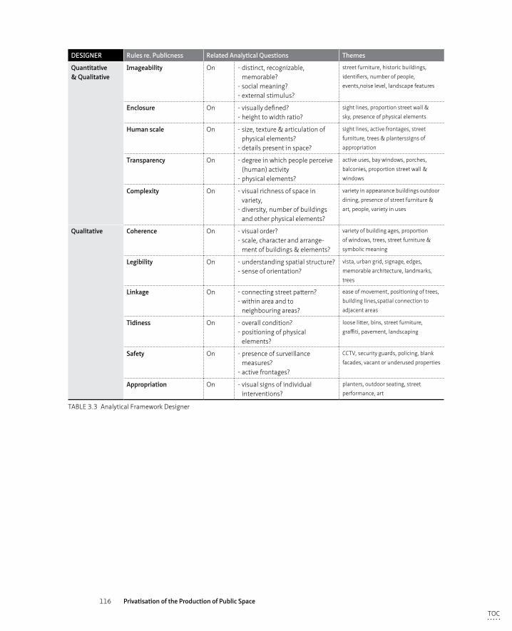
116 Privatisation of the Production of Public Space
DESIGNER Rules re. Publicness Related Analytical Questions Themes
Quantitative & Qualitative
Imageability On - distinct, recognizable, memorable?
- social meaning?- external stimulus?
street furniture, historic buildings,
identifiers, number of people,
events,noise level, landscape features
Enclosure On - visually defined?- height to width ratio?
sight lines, proportion street wall &
sky, presence of physical elements
Human scale On - size, texture & articulation of physical elements?
- details present in space?
sight lines, active frontages, street
furniture, trees & planterssigns of
appropriation
Transparency On - degree in which people perceive (human) activity
- physical elements?
active uses, bay windows, porches,
balconies, proportion street wall &
windows
Complexity On - visual richness of space in variety,
- diversity, number of buildings and other physical elements?
variety in appearance buildings outdoor
dining, presence of street furniture &
art, people, variety in uses
Qualitative Coherence On - visual order?- scale, character and arrange-
ment of buildings & elements?
variety of building ages, proportion
of windows, trees, street furniture &
symbolic meaning
Legibility On - understanding spatial structure?- sense of orientation?
vista, urban grid, signage, edges,
memorable architecture, l andmarks,
trees
Linkage On - connecting street pattern?- within area and to
neighbouring areas?
ease of movement, positioning of trees,
building lines,spatial connection to
adjacent areas
Tidiness On - overall condition?- positioning of physical
elements?
loose litter, bins, street furniture,
graffiti, pavement, landscaping
Safety On - presence of surveillance measures?
- active frontages?
CCTV, security guards, policing, blank
facades, vacant or underused properties
Appropriation On - visual signs of individual interventions?
planters, outdoor seating, street
performance, art
TABLE 3.3 Analytical Framework Designer
TOC

117 Analytical Framework
TOC
118 Privatisation of the Production of Public Space
TOC
119 Research approach & methods
4 Research approach & methods
In this research the methodological path began with a thorough literature review, carefully posed research questions and the development of an analytical framework through which the cases were studied in a systematic manner. The analytical framework of the governance, users’ and designer’s perspectives introduced in the previous chapter provides thorough lenses through which the posed research questions can be answered, with the use of the collected, analysed and compared data of the selected cases.
Taking the concerns regarding case study research into account, three cases have been selected in the city of Liverpool (UK): Liverpool One, Ropewalks and Granby4Streets. They vary in their managerial approach and degree of privatisation, but share a very similar policy context, and can therefore be categorised as a single case study research with multiple (three) embedded cases (Stake 2009).
This chapter discusses the research approach and methods and comprises the justification of the choice of case study research, data collection techniques, data analysis techniques and the presentation methods of the data.
§ 4.1 Case study research
The objective of this research is to analyse the impact of privatisation on urban public spaces from three different perspectives. Given the complex nature of urban development due to its multiple stakeholders and economic, political and societal impacts and the aim of the research to analyse precisely these issues on the subject of privatisation, case study research was found to be a suitable methodology for this particular research.
Qualitative case study research is a commonly used research approach in urban studies and urban design to understand “complex social phenomena”, as it is a useful strategy to gather contemporary insights within a real-life situation (Yin 2009, 4) and “[…] therefore suitable for exploring the situations and problems of city centre regeneration, encompassing the multiple dimensions of environmental, economic and social factors” (Madanipour 2010, 72). At a general level, case study research is “a strategy whereby
TOC
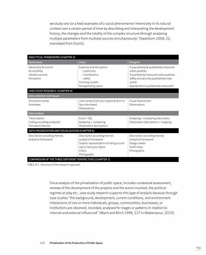
120 Privatisation of the Production of Public Space
we study one (or a few) examples of a social phenomenon intensively in its natural context over a certain period of time by describing and interpreting the development history, the changes and the totality of the complex structure through analysing multiple parameters from multiple sources simultaneously” (Swanborn 2008, 22, translated from Dutch).
ANALYTICAL FRAMEWORK (CHAPTER 3)
Governance Users Designer
Ownership & Control Accessibility Valued outcome Perception
Experience & Perception – publicness – maintenance – safety Forming a publicRenegotiating space
5 quantatively & qualitatively measured urban qualities4 qualitatively measured urban qualitiesSafety and security (qualitatively mea-sured) Appropriation (qualitatively measured)
CASE STUDY RESEARCH (CHAPTER 4)
Data collection techniques
Document review Interviews
User survey (Color your Space & face-to-face interviews) Observations
Visual Assessment Observations
Data analysis
TranscriptionCoding according analytical framework themes
Excel + SQLAnalysing + comparingObservation descriptions
Analysing + comparing data sheetsObservation descriptions + mapping
DATA PRESENTATION AND VISUALISATION (CHAPTER 6)
Description according themes analytical framework
Description according themes analytical frameworkGraphic representation of rating accord-ing to Color your Space ChartsPhotographs
Description according themes analytical frameworkDesign sheetsAudit mapsPhotographs
COMPARISON OF THE THREE DIFFERENT PERSPECTIVES (CHAPTER 7)
TABLE 4.1 Structure of the research approach
Since analysis of the privatisation of public space, includes contextual assessment, reviews of the development of the projects and the actors involved, the political regimes at play etc., case study research supports this type of analysis because through case studies “the background, development, current conditions, and environment interactions of one or more individuals, groups, communities, businesses, or institutions are observed, recorded, analysed for stages or patterns in relation to internal and external influenced” (Mach and Birch 1998, 117 in Madanipour, 2010).
TOC

121 Research approach & methods
Consequently, the analysis of cases is a well-tailored research approach for understanding complex patterns such as processes of decision making, shifting power-relations, changing behaviour in and subjective perceptions of public space. Reason for this is that case study research principally relies on mixing different research methods and different types of data and evidence in parallel ways (triangulation), until saturation is achieved (Yin 2009; Stake 2009; Madanipour 2010). Finally, case study research helps to study situations “when the boundaries between phenomenon and context are not clearly evident” (Yin 2009, 18). This is especially true for the privatisation of public space, as demonstrated in the analytical chapter (chapter 3).
However, a few points of concern of this methodology can be raised. Often case study research is said to limit scientific generalisation, predictability, rigor and validity. (Swanborn 2008; Yin 2009; Denzin and Lincoln 2003). In addition, case study research in urban design often fails to make explicit the political dimensions of urban renewal processes. Especially the socio-economic and political assumptions underlying selection and analysis, are not always seen from a political economy perspective. This is especially true with respect to the fluid power-relations that influence, alter and frame the urban renewal process and the final outcome (the built space, including privatisation)(Cuthbert, 2011). These concerns are considered in three ways. Firstly, one could succeed in isolating the social phenomenon from its context and may find it therefore difficult to abstract the relevant characteristics of this context (Swanborn 2008). Secondly, case study research is often mentioned to be potentially unpredictable, due to its dynamic context (Swanborn 2008, 44-45). However, predictability is not the key objective of this research, but to gain in-depth understanding of public/private controversies in the production of inner city space which can be theoretically applied in other cases. Thirdly, in terms of rigor and validity, the credibility of the outcome largely depends on the research methods chosen. To improve reliability of the case study research various research methods and multiple sources of evidence (triangulation) were used in order to cross-verify empirical findings on the same social phenomenon, against theoretical propositions and analytical lenses. This is done until saturation was achieved (convergence to the same findings - corroboration) (Yin 2009). A final remark applies to the ‘false boundary’ between qualitative and quantitative case study research. Case study research is often related to qualitative research, however according to Yin (2003) quantitative and qualitative data are not competing types of research but can attribute both as types of data (33). Case study research can be either qualitative or qualitative or a combination of both (Yin 2003; Swanborn 2008).
TOC
122 Privatisation of the Production of Public Space
In summary, the present research can be categorised as one case study research with (three) multiple cases embedded within the same political, socio-economic and geographical context at the scale of the city, but with very specific local characteristics at neighbourhood level. The three selected cases provide enough material for an in-depth, empirical research trajectory in which the research questions were critically assessed on the basis of the analytical framework. Each case study has been subject of a thorough literature review and has been researched using the analytical framework through which the cases were studied in a systematic manner. The criteria and arguments for selection are detailed below.
§ 4.2 Selecting three cases in Liverpool (UK)
The United Kingdom is particularly interesting for studying the public/private debate, because it embraced earlier and more profoundly than other Western countries the involvement of the private sector in urban regeneration projects. The Urban Renaissance of the UK’s (inner) cities contributed a large role of the developing and managing of the complex urban projects to private stakeholders through a variety of different managerial approaches. Including private-public arrangements.
Within the United Kingdom a number of urban development projects in a number of cities were identified as potentially suitable cases at an early stage of the research (by the author), based upon literature review and professional experience (long list). The long list has been discussed by different stakeholders and evaluated against a series of general principles and list of selection criteria, specifically developed for the purposes of this research.
To be able to answer the research questions, the cases had to differ in their managerial approach and each to consist of a different number and composition of public and private stakeholders. The preference was to select cases within a single city, firstly for the pragmatic reasons of saving time and funds. Secondly, and more importantly, by selecting urban projects within one single city, these projects would be developed within the same local policy and geographical context, which limits the amount of context related variables.
The disadvantage of selecting cases in a single city is that the found data could be specific to that city’s particular context and would therefore not provide generic insights and limits the scope of generalisation. The analysis of cases in similar urban
TOC
123 Research approach & methods
contexts provides the chance of drawing specific lessons on a number of variables through qualitative research. Contrary case study research benefits from a more detailed analysis of various typologies of the public/private debate in the production of public space which contributes to making the variation in path-dependent trajectories explicit. “The only way of increasing the number of cases to some substantial level would mean sacrificing the in-depth and contextual nature of the insights inherent in using case study method in the first place” (Yin 2013, 325). Therefore gaining in-depth insights into the cases and their context has been chosen over scope: it was anticipated that the cases within one single city would provide ample insights in the relations between the variables. Within the United Kingdom, Liverpool is exemplary in demonstrating various types of managerial approaches that include a variety of public and private actors, at different spatial scales. This made the city a suitable case study for selecting three different cases that demonstrate how within a similar political context and timeframe diverging typologies of privatisation were embraced as preferred managerial approaches. Most notably Liverpool City Council transferred one third of its city centre on a long lease to a private developer to develop and consequently maintain the area, effectively privatising this city centre space. When completed in 2008 this project was regarded to be “one of Europe’s biggest city centre mixed use developments” (Parker and Garnell, 2006). From the 1980’s onwards the public authority and private developers did invest in traditional mixed-use developments but also in culture-led urban renewal, thriving on the vivid Liverpool arts scene (Boland, 2010), culminating in its selection as a Cultural Capital of Europe in 2008. At a similar time, relatively large parts of the city were designated as World Heritage (UNESCO site). These ambitious objectives and projects, happening in a similar time-frame make Liverpool in this political, economic and cultural setting an interesting case.
As an urban designer, the main author coordinated over five renewal projects including GranbyToxteth Masterplan, in Liverpool within the period 2000-2004. Her professional expertise directly influences the selection of the cases as the research benefits from this profound tacit knowledge.
Selection criteria for three casesLiverpool has been subject to a large series of urban renewal and development projects over the last decades and provided therefore an ideal case study to analyse the different managerial approaches and the role and consquences of privatisation in these over a period of 20 years. The potential cases in Liverpool (long list) were evaluated and selected based upon these criteria:
TOC
124 Privatisation of the Production of Public Space
– Variety of public and private stakeholders in different managerial compositions in development process: privately led, public – private partnership, publicly led and community led
– Complexity of the process: characterised by complex interactions between a variety of stakeholders
– Similar time-frame: similar period of development which means within the same political, policy and economic context (between 1995 and 2015)
– Urban context: focus in the present study is on privatisation of public space in an urban context, so suburban and peripheral or rural developments are not to be included.
– Representation of an ‘urban renaissance’ project: the project needs to meet the characteristics of an urban development and renewal project as defined within the national Urban Task Force report (1999)
– Programme of mixed-use development: an integration of a variety of uses (at least retail, business, residential and preferably leisure) leads to a wider variety in users
– Spatial scale: urban quarter (rather than city) urban development is in general geared towards individual projects rather than the city as a whole as discussed in the introduction) or projects on street or square level. These are regarded as potentially lacking in managerial complexity and variety of stakeholders.
– Presence of a masterplan: as an indication of a communicated vision, approved by Liverpool Council
As a result of these selection criteria, three case studies of the long list have been selected after consultation with public and private actors in the city of Liverpool: Liverpool One, Ropewalks and Granby4Streets. Initially, additional development projects were considered, to draw more valid conclusions. However, the three case studies finally selected were considered to provide a good sample with regard to the main objective (a variety of managerial approaches – privately, publicly or community led and public-private partnership).
Case 1: Liverpool One In the city of Liverpool a relatively large mixed-use inner city project (42acre) – Liverpool One – was developed and completed in 2008 whereby the council transferred the land (a third of the city centre) on a long term lease to a private developer, leaving development, control and maintenance in private hands. This was the first project of this scale of privatisation of inner cities in the UK (or even Western Europe) and was therefore found to be a suitable case for this particular research (Parker and Garnell 2006). The project ‘Liverpool One’ scored well on all of the selection criteria although the degree of mixed-use is debatable. The area comprises some residential use on the upper floors but the predominant use within the development is retail and leisure (Littlefield 2009).
TOC
125 Research approach & methods
Within a similar time-frame two other urban development projects took place with each a different managerial approach to Liverpool One, while also scoring well on the majority of the selection criteria.
Case 2 Ropewalks The Ropewalks is a mixed-use urban neighbourhood of a similar scale located adjacent to Liverpool One. It is an area with a large historic legacy of maritime warehouses, of which a great number were vacant up to the 1990’s. Liverpool Council saw the potential value of the area and embarked on an urban development project led by a public-private partnership (Couch and Dennemann 2000). The development process began at a similar time as Liverpool One, but followed a much more organic and ad hoc development trajectory. The area scored well on all of the mentioned selection criteria.
Case 3: Granby4Streets The third case, Granby4Streets lies a little out of the city centre and is a predominantly residential area that struggled with social and physical deprivation since the 1970’s, which resulted in severe dereliction. Classified as an urban renewal area, the public authorities tried to revive the neighbourhood through a number of measures for decades. The end of the public funding regime in 2010 provided an opportunity for community led initiatives to emerge in this area. Therefore the area attributes to the desired variety of managerial approaches.
However a few remarks with regard to the other selection criteria are in place. Firstly, Granby4Streets once used to have a thriving local shopping parade, and hence a degree of mixed-use, however most of the shops were closed at the time of the research. During the research period the area was slowly being redeveloped after being derelict for years, and the local shopping parade showed signs of revival too. Therefore, and with its future potential in mind, the area can be qualified as having a degree of mixed-use.
Secondly, a number of urban design plans have been drawn up for this area throughout the last three decades by a variety of public, private and community actors. These plans have each a different objective and (legal) status. However, the only plan adopted plan by Liverpool Council is the GranbyToxteth Masterplan (2003). This masterplan contains a large urban area comprising a number of urban neighbourhoods with each its own physical characteristics, socio-economic statistical profiles and local stakeholders. Within this wider masterplan the area of Granby4Streets was selected as case because it met all the selection criteria. This area has a smaller size than the other two selected case study areas but boosts a similar complexity of the process, represents an urban renewal area and is set in an urban context.
TOC
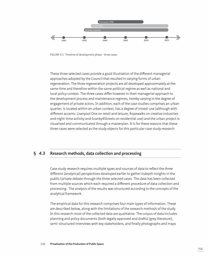
126 Privatisation of the Production of Public Space
1990 1995 2000 2005 2010 2015
- perhaps we'll �nd that privately produced space works better in terms of design and is better liked by users- perhaps we'll �nd that privately produced space is steril and only attracts a certain type of user- perhaps we'll �nd that each type of space works well for its class of users (it will not be the same user group in all three)
ropewalksliverpool ONE
granby toxteth
FIGURE 4.1 Timeline of development phase - three cases
These three selected cases provide a good illustration of the different managerial approaches adopted by the Council that resulted in varying forms of urban regeneration. The three regeneration projects are all developed approximately at the same time and therefore within the same political regime as well as national and local policy context. The three cases differ however in their managerial approach to the development process and maintenance regimes, hereby varying in the degree of engagement of private actors. In addition, each of the case studies comprises an urban quarter, is located within an urban context, has a degree of mixed-use (although with different accents: Liverpool One on retail and leisure, Ropewalks on creative industries and night-time activity and Granby4Streets on residential use) and the urban project is visualised and communicated through a masterplan. It is for these reasons that these three cases were selected as the study objects for this particular case study research.
§ 4.3 Research methods, data collection and processing
Case study research requires multiple types and sources of data to reflect the three different (analytical) perspectives developed earlier to gather indepth insights in the public/private debate through the three selected cases. The data has been collected from multiple sources which each required a different procedure of data collection and processing. The analysis of the results was structured according to the concepts of the analytical framework.
The empirical data for this research comprises four main types of information. These are described below, along with the limitations of the research methods of the study. In this research most of the collected data are qualitative. The corpus of data includes planning and policy documents (both legally approved and drafts) (grey literature), semi-structured interviews with key stakeholders, and finally photographs and maps
TOC
127 Research approach & methods
documenting direct observations made during field work on site. These qualitative data were complemented by quantitative measurements collected through a user survey (online questionnaire) amongst users in the areas and the results of an in-depth visual assessment of the quality of public of public space by the researcher (who has 18 years of expertise in urban design). The numeric results that have been gathered from these types of data (presented in tables) have also been interpreted in a qualitative manner.
Literature review A large part of the research comprises a literature review. The research has begun with a literature review which comprised academic literature from various disciplinary fields; urban design, human geography, philosophy, sociology and urban management. Key authors in each of the fields have been studied, whom have been selected through the snowballing technique. Presentations of the literature review has been presented at conferences. Methodological and practical issues largely draw from the traditions of case study research in urban studies and urban design. A review of policy and planning documents, newspaper census data shaped the context of the development process of the three case studies.
The development process of the three cases have been reconstructed through archival and online desktop research. Missing information was obtained via involved stakeholders. Written and visual material reviewed included firstly national and local policy documents that shaped the context of the development process of the three case studies. Secondly, vision documents, design plans and council’s decision notes related to the case studies were analysed. The material was obtained from Liverpool City Council, Liverpool Archive, Registered Social Landlords, and design companies involved in the three case studies. Thirdly geographical (census) data on Liverpool was used for putting the cases in context by documenting the general socio-economic, demographic and housing situation for the inhabitants. These census data were obtained through the Office for National Statistics and the Liverpool Ward Census data (online available). Fourthly, newspaper clippings from local and national newspapers were obtained through internet archives (see Appendix A for a list of documents). They informed the identification of key events in the development process and the main actors involved, but also informed the analysis of possible controversies or changing regimes with regard to the cases.
The nation and local policy documents have been reviewed, plans and proposals have been analysed and newspaper clippings read. The data has been summarised according to the themes in the analytical framework.
TOC
128 Privatisation of the Production of Public Space
Semi-structured interviews“Interviews are useful for investigating complex behaviours, opinions and emotions and for investigating a diversity of experiences”. (Longhurst 2010, 113). Interviews are also well suited for exploring a new domain or field. In case study research, this method is relatively quick and effective in gaining a general insight of who is doing what and why. Especially the partially structured yet informal questioning of experts involved in urban development processes, provide additional information on the procedural and often scarcely documented dimensions of urban renewal (Bogner et al. 2005).
For the present study, 21 semi-structured interviews with local actors who were directly involved in either one, two or all of the three case studies were conducted (see Appendix B for a list of actors interviewed). The majority of the people interviewed were still involved in urban regeneration in Liverpool, although sometimes in a different professional position. A few interviewees became only recently involved in the urban regeneration processes and could therefore offer a fresh view. The interviews were guided by a crafted list of questions based on the analytical framework discussed in chapter 3. Interviewees were asked questions on the process of visioning, production and maintenance regimes, the roles, access and influence of the various stakeholders (including users) in the process and if they thought the implemented space could be seen as a successful contribution to the regeneration process of Liverpool and if the places were perceived to be public in their opinion.
The identification and selection of the interviews was based upon the first explorative stages of the review of policy and planning documents, including newspaper clippings. Once the interviews started, hidden potential interviewees were identified through a classic snowball sample strategy (Atkinson and Flint 2001).
In identifying and selecting the interviewees, an effort was made to include council employees working on the particular projects, the designers and (private + public) developers involved, and for each case one or more protest voices that raised concerns against the proposed developments.
Most of the interviews were conducted in English between June 2014 and May 2016 in person. All interviews were recorded, transcribed and coded according to the themes based on the interview questions: development process (stakeholders, funding, local participation, management), relationships and trust, perception of publicness, spatial context, success of the project. After the initial coding exercise, a refinement of the topics was required to address the specific themes addressed in the analytical framework: stakeholder relations, trust and decision-making power, funding streams, maintenance and management, security and control, sustainable urban regeneration and the perception on publicness.
TOC
129 Research approach & methods
User survey– app-based questionnaire ‘Color your space’A user survey has been conducted in order to answer questions related to privatisation from the perspective of the people who use the actual spaces during the research period at particular moments. The overall aim of this was to analyse if users perceive private space differently to public space. The data collected contain the self-reported opinions and experiences of 206 respondents, 37 for Granby4Streets, 74 for Ropewalks and 95 for Liverpool One.
To gain insight into the user-perspective, the author developed a user survey based on an online questionnaire through a designed web-based application ‘Colour your space’ for collecting data on self-reported user’s perceptions. Collecting large amount of empirical data on how users perceive certain urban spaces contributes to the academic notion of what the quality of urban space entails. Currently an urban design analysis method does not exist to gather such data in a relatively easy manner and would be highly beneficial to the debate on what the essence of qualitative urban space is from a users’ point of view (Leclercq, 2015).
Variables, questions and questionnaireThe questionnaire comprised five topics with 15 questions in total and lasted 5-10 minutes on average. The questionnaire was initially envisioned to be just an on-line tool. The questions have thoroughly discussed with both a sociologist, given the nature of the survey, and a web-designer, who advised on on-line usability. The concentration curve of the on-line respondent and the amount of data required has to carefully balanced. The survey questions have been kept in simple wording such as ‘clean’ and ‘safe’ (as to that a variety of people with different educational backgrounds could understand them without further explanation). The question with regard to a user’s perception of publicness was after careful deliberation formulated through asking people who paid for the space rather than referring directly to ownership or maintenance, because it was anticipated that a direct question would trigger the ‘I don’t know response’, whereas the slightly opaquer notion of payment might both cover ownership and maintenance in people’s minds.
The question ‘can you ride your bike here?’ (related to the degree of publicness) has been added because a local cycle route runs through the privatised area. Although cycling on pavements and pedestrianised streets is in general prohibited by law, in the case of Liverpool One on some of the pedestrianised streets the ability to cycle was part of the Public Realm Agreement. It was thought to be an interesting to analyse if this was known or experienced by the users in this particular space. The other two areas consists of a road network on which cycling is allowed.
TOC
130 Privatisation of the Production of Public Space
The variables measuring five different topics further included the following:
– Their general impression of the space,
– Their perception of publicness of the space, and their appreciation of possibilities to exercise public rights
– Their opinion on the maintenance of the space
– Their perception on the safety of the space and the presence of control mechanisms
– Personal information (socio-demographic profile) and visit-related information of that particular space (purpose and frequency)
Firstly, people were asked to give an overall rating (1 to 5) for the general impression of the space within the area. This generic question was then further detailed into three sub categories, all related to the overall topic of the public and private divide:
Secondly, questions were asked with regard to a user’s perception of publicness which was formulated through asking people who paid for the space rather than referring directly to ownership or maintenance. To inquire further about the possibilities that people saw at hand for exercising their public rights, the following questions were asked:
– Can you take pictures here?
– Can you ride your scooter, bike or skateboard here?
– Can you play music, make a speech or speak loudly here? (in other words ‘be political’)?
The third topic concerned the maintenance which was addressed by the question: ‘Do you think the place is clean?’ and the fourth topic regarding safety by: ‘Do you feel safe here’ and additionally ‘Do you feel you are being watched?’
The last and final set of questions inquired about socio-demographic variables related to the respondent (sex, age, level of education and household situation) and the reason and frequency of their visit, in order to identify the profile of users’ and assess significant correlations between their self-reported perceptions of public space .(see appendix. C for the complete questionnaire)
Online ‘Color your Space’& face-to-face questionnaireTo carry out this user survey a website tool, named Color your Space, was designed and tested to see if new technology can provide simple and straightforward ways to extract empirical data on the use and the perception of urban space from a large group of people.
TOC
131 Research approach & methods
Research shows that with an app, a wider variety of interest groups - such as younger people or ethnic minority groups who take less interest in, or have less understanding of the planning process - could be offered the opportunity to participate in a quicker and easier manner than current methods allow. It is suggested that a digital tool could act as an additional method for consultation rather than replace the current participation process. Besides reaching a wider variety of people, a digital tool also collects different sets of data than other methods; users rate the spaces while they use them, offering impressions as they arise and therefore providing perceptions of urban space at different times of the day under different circumstances. This self-selection by the respondent can be seen as a strength of the tool but also as a shortcoming of the methodology as the data is not collected in a structured manner (Leclercq 2015).
The set up of the mobile app is such that content can be relatively easily adapted to reflect the specific conditions of each case study or project. The objective of ‘Color your Space’ has been to develop a smartphone application that might be able to fulfil the goals of inclusiveness, empowerment and data collection:
– Enhanced inclusiveness: Promoting more inclusive ways of participation in urban development projects
– Empowerment: Data generated could form the basis for collective community action. Enabling the creation of a platform of ‘loose’ ideas is particularly important as an intermediate between top down planning and bottom up initiatives; local residents can communicate their common interests in a more coherent way.
– Data collection: Collecting large amount of empirical data on how users perceive certain urban spaces
Testing the questionnaire and appAfter testing the app on workability (can people find, download and use the application, do they use the app for the intended objectives and is the interface user-friendly) two pilot projects, Tiendplein in Rotterdam and Mekelpark in Delft, the app was used as a survey method to analyse the perception of users on the particular topic of this research: the perception of the user on the publicness of three neighbourhoods in Liverpool.
TOC
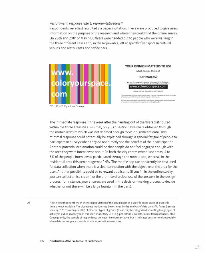
132 Privatisation of the Production of Public Space
Recruitment, response rate & representativeness23 Respondents were first recruited via paper invitation. Flyers were produced to give users information on the purpose of the research and where they could find the online survey. On 28th and 29th of May, 900 flyers were handed out to people who were walking in the three different cases and, in the Ropewalks, left at specific flyer spots in cultural venues and restaurants and coffee bars.
FIGURE 4.2 Flyer User Survey
The immediate response in the week after the handing out of the flyers distributed within the three areas was minimal, only 13 questionnaires were obtained through the mobile website which was not deemed enough to yield significant data. This minimal response could potentially be explained through a general fatigue of people to participate in surveys when they do not directly see the benefits of their participation. Another potential explanation could be that people do not feel engaged enough with the area they were interviewed about. In both the city centre mixed-use areas, 4 to 5% of the people interviewed participated through the mobile app, whereas in the residential area this percentage was 14%. The mobile app can apparently be best used for data collection when there is a clear connection with the objective or the area for the user. Another possibility could be to reward applicants (if you fill in the online survey, you can collect an ice cream) or the promise of a clear use of the answers in the design process (for instance, your answers are used in the decision-making process to decide whether or not there will be a large fountain in the park).
23 Please note that numbers on the total population of the actual users of a specific pubic space at a specific time, are not available. The closest estimation may be retrieved by the analysis of data on traffic fluxes (remote sensing/GPS/counting on site) of different types of groups (these may be categorised according to age, type of activity in public space, type of transport mode they use -e.g. pedestrians, cyclists, public transport users, etc.). Consequently, the sample of respondents can never be representative, but it indicates certain trends especially when data convergence towards similar observations over time.
TOC
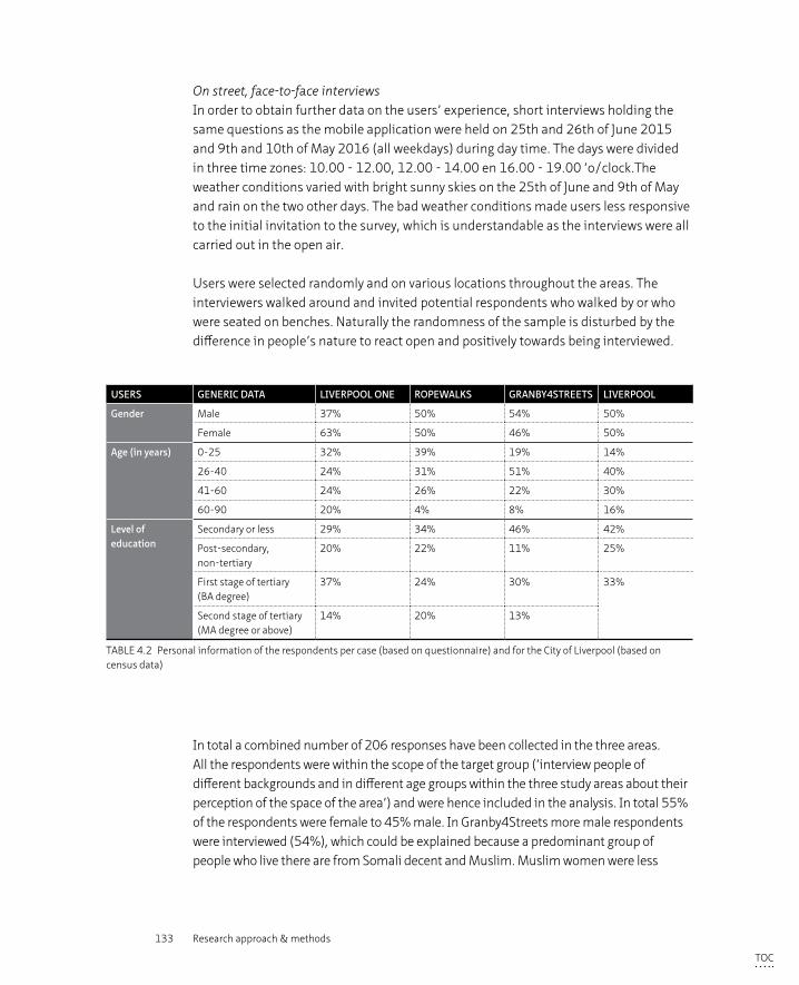
133 Research approach & methods
On street, face-to-face interviews In order to obtain further data on the users’ experience, short interviews holding the same questions as the mobile application were held on 25th and 26th of June 2015 and 9th and 10th of May 2016 (all weekdays) during day time. The days were divided in three time zones: 10.00 - 12.00, 12.00 - 14.00 en 16.00 - 19.00 ‘o/clock.The weather conditions varied with bright sunny skies on the 25th of June and 9th of May and rain on the two other days. The bad weather conditions made users less responsive to the initial invitation to the survey, which is understandable as the interviews were all carried out in the open air.
Users were selected randomly and on various locations throughout the areas. The interviewers walked around and invited potential respondents who walked by or who were seated on benches. Naturally the randomness of the sample is disturbed by the difference in people’s nature to react open and positively towards being interviewed.
USERS GENERIC DATA LIVERPOOL ONE ROPEWALKS GRANBY4STREETS LIVERPOOL
Gender Male 37% 50% 54% 50%
Female 63% 50% 46% 50%
Age (in years) 0-25 32% 39% 19% 14%
26-40 24% 31% 51% 40%
41-60 24% 26% 22% 30%
60-90 20% 4% 8% 16%
Level of education
Secondary or less 29% 34% 46% 42%
Post-secondary, non-tertiary
20% 22% 11% 25%
First stage of tertiary (BA degree)
37% 24% 30% 33%
Second stage of tertiary (MA degree or above)
14% 20% 13%
TABLE 4.2 Personal information of the respondents per case (based on questionnaire) and for the City of Liverpool (based on census data)
In total a combined number of 206 responses have been collected in the three areas. All the respondents were within the scope of the target group (‘interview people of different backgrounds and in different age groups within the three study areas about their perception of the space of the area’) and were hence included in the analysis. In total 55% of the respondents were female to 45% male. In Granby4Streets more male respondents were interviewed (54%), which could be explained because a predominant group of people who live there are from Somali decent and Muslim. Muslim women were less
TOC
134 Privatisation of the Production of Public Space
inclined to participate in the interview (although recorded by a female). In Liverpool One 63% of the interviewees were female, which could be explained by the fact it is a shopping area and women tend to be more likely to go shopping. (see table 4.2)
All age groups are represented in all three cases, although the highest age group (60-90 years) were underrepresented in Granby4Streets and the Ropewalks and the age group of 26-40 comprised half the respondents in Granby4Streets and can thus be regarded as overrepresented. Also, there were relatively more respondents in the lowest age group than Liverpool’s average percentage. Looking at the level of education it can be noticed that in all three cases a third (Liverpool One) or more than a third (other two cases) only received secondary education or less, which is in line with the numbers for Liverpool as a whole. In summary, the group of respondents form fairly varied sample looking at the themes of ‘gender’, ‘age’ and ‘level of education’, with the caveats mentioned above taken into account24.
Data processing & visualisatonThe data collected by the user survey (both the online as well as the in-person surveys) were filed online. Therefore, the website Color your Space represents the full data set, the rating of the area (‘do you like this space’) is here visually presented by a coloured pin (red being ‘poor’, dark green being ‘very good’). (See www.coloryourspace.com and figure 6.2). The full data set has been exported to Excel and cleaned of all ‘false’ data (eg. tests done by the researcher and the web designer). Due to the relational nature of the questions asked and the limited quantity of the data, analysis with Excel using pivot tables and the programme ‘Structured Query Language’25 were found to provide sufficient results that responded to the questions addressed in the analytical framework.
Observations in the field: on site visitsThe behaviour of users, the visual appearance of the spaces and the changes that occurred were also assessed from a designers’ perspective, in an informal yet more objective way during on-site visits. Here, the research combines field observations and the visual assessment of public space by using the (adapted) tool of Ewing and Clemente (2006).
24 http://liverpool.gov.uk/council/key-statistics-and-data/data/population/ http://liverpool.gov.uk/media/9906/qualifications.pdf
25 Structured Query Language (SQL) is a standard computer language for relational database management and data manipulation. SQL is used to query, insert, update and modify data.( https://www.techopedia.com/defini-tion/1245/structured-query-language-sql)
TOC
135 Research approach & methods
Six field trips were undertaken over the course of 6 years. Informal observations have been made by the researcher and were recorded by series of photographs and marked on OS maps. The informal observations have been described in words and consequently coded according to the themes of the analytical frameworks. The many photographs taken on the various field trips have been categorised according to eleven themes of the ‘designer’ analytical framework: (imageability, enclosure, human scale, transparency, complexity, coherence, legibility, linkage, tidiness, safety and appropriation).
Visual assessment tool – quality of public spaceA visual assessment to determine if the degree of publicness can be measured through analysing urban design qualities was carried out based upon a tool designed and validated by Ewing and Clemente (2006, 2013) with the purpose of conducting post-hoc assessments of urban sites.
There are many models or lists of criteria that attempt to capture the versatility of urbanity, some based on literature other on design practices. However, this particular work of Ewing and Clemente has been selected for this research because it is based on an extensive literature review, it has been made quantifiable and the results have been translated into a practical assessment tool. The tool consisted originally of nine elements: (1) imageability, (2) enclosure, (3) human scale, (4) transparency, (5) complexity, (6) coherence, (7) legibility, (8) linkage and (9) tidiness of which only the first five passed their test of validity and reliability. Ewing and Clemente developed this tool to measure the walkability of urban areas, which is, in their eyes, the equivalent of sum of the urban qualities. A similar assumption but then with regard to measuring publicness is taken as a starting point for the analysis in this research. However, two qualities were added to the adapted tool this particular research into publicness, namely ‘safety and surveillance’ and ‘appropriation’. These qualities are based on the academic literature that has been carried out (see chapter 3.3)
The urban design assessment of the three case studies has been carried out in person by the researcher during the site visit on 28-29 May 2015 and double checked during the site visit on 9-11 May, 2016. In each case, a selection of streetscapes was evaluated by the author of the present study, drawing on her professional skills as a design expert.
The visual assessment has been based on the following four steps, based on Ewing and Clemente’s tool (2006, 2013):
TOC
136 Privatisation of the Production of Public Space
a. Urban Design AuditA general urban design assessment was carried out to provide a basic analysis of the three case study areas. This analysis consisted of: streetscape, ownership, activity, accessibility, morphological transformation, safety and security, appropriation and symbolic meaning. The outcome of the analysis, presented by a series of maps and photographs, has also been used to support and illustrate findings in the paragraphs concerning the ‘governance’ and ‘users’ perspectives as well as the paragraph on the designer’s point of view. The urban design audit was carried out by the author of this thesis, an urban design expert, during the site visit in May and June 2015. (see Appendix D for series of audit maps.)
b. Qualitative Measurements of Urban Design QualitiesThe Urban Design Tool of Ewing and Clemente is based on an expert panel rating a variety of different urban scenes according to the nine urban design qualities noted above. The same qualitative rating was carried out for the case study areas in Liverpool. The assessment tool recommends using study areas of approximately 100m. This requirement was followed in this assessment. Therefore, the following study areas were chosen per case study area. Liverpool One: part of Paradise Street and part of South John Street; Ropewalks: part of Bold Street and part of Wood Street; Granby 4 Streets: part of Cairns Street and part of Granby Street. In addition the qualitative part of the assessment has also been varied out for the totality of the three case study areas. The analysis has been undertaken during the site visit in May 2015 and the outcome checked during the site visit in May 2016. The ratings have been done by the author of the thesis.
c. Quantitative Measurements of Urban Design QualitiesA further quantitative assessment is carried out for the first five perceptual qualities noted above that passed the statistical tests of reliability and validity. The same study areas were used as were for the qualitative assessment. The quantitative assessment has not been carried out for the total areas, because the tool by Ewing and Clemente (2013) has not been designed to be able to incorporate urban neighbourhoods; the tool is, as explained before, based on street sections of approximately 100m. The analysis has been undertaken during the site visit in May 2015 and the outcome checked during the site visit in May 2016. The data is gathered in the checklists provided in the field manual which also provides the statistical multiplier that came out of the research done by Ewing et al (2006). A final score provides a quantitative measurement for the five urban design qualities analysed.
TOC
137 Research approach & methods
d. Including ‘Safety and Security’ and ‘Appropriation’The physical elements related to the specific topics of ‘Safety and Security’ and ‘Appropriation’ are added to the qualitative urban assessment tool to further enrich the assessment on publicness. Both these topics play an important role in understanding publicness as discussed within the analytical framework in Chapter 3.3 .
The data of the visual assessment has been collected on datasheets and OS maps and by photographs. The quantitative assessment has been recorded in the assessment tool provided by Ewing and Clemente (2006, 2013). The qualitative assessment has been translated and valued in a rating system 1-5, with 1 being ‘poor’ or ‘none’ and 5 representing ‘very good’ or ‘many’. For instance the measure ‘Presence of trees’ is validated with a ‘1’ if there are no trees at all or with a ‘2’ with there are a few small trees and with a ‘5’ if there are many mature trees present.
The quantitative part of the assessment consisted of the counting of certain criteria (e.g ‘how many buildings with identifiers are present within the study area?’). These figures were eventually interpreted per urban quality between the three cases in an essentially qualitative way.
These data sheets of the three cases (see Appendix E) have been analysed and compared on each theme of the analytical framework.
§ 4.4 Data presentation and visualisation
In Chapter 6 the findings and analyses are presented according to the three perspectives, governance, users, and designer and respond to the rules, questions and themes described in the analytical frameworks. The findings are presented by text, photographs (taken on site visits), screenshots of the visualisation of Color your Space and charts (users perspective), design sheets (series of photographs to illustrate an urban quality) and audit maps (designer’s perspective). For clarity purposes the audit maps of the three areas are collectively presented on a single page which makes comparison straightforward but the graphics small. Therefore the audit maps are presented in full in Appendix D.
TOC
138 Privatisation of the Production of Public Space
§ 4.5 Limitations of the methods and quality of the data
Section 4.1 discussed the pitfalls of the case study methodology and how they have been countered. Here we focus on the limitations of the methods and its impact on the quality of the data.
Validity, reliability and generalisation“Validity and generalization continue to be challenging aspects in designing and conducting case study evaluations” (Yin, 2013). However, the as with quantitative research, “quality for qualitative research can be assessed in terms of validity, reliability and generalizability” (Leung, 2015). Yin (2009) distinguishes between three different forms of validity:
– “Construct validity: identifying correct operational measures for the concepts being studied
– Internal validity: seek to establish a causal relationship, whereby certain conditions are believed to lead to other conditions, as distinguished from spurious relationships
– External validity: defining the domain to which a study’s findings can be generalized” (p. 40)
The validity in this research has been safeguarded by the carefully drafted set of operational measures (operationalised by the analytical framework tables) and the use of multiple sources of evidence which are interpreted through a “multidimensional analysis” (Leung 2015) (from three different perspectives and multiple angles within these perspectives). Validity can be strengthened by: “address rival explanations (be aware of other possible explanations of the found outcomes), data source and theory/perspective triangulation and the use of logic models (stipulate a complex chain of events over an extended period of time)” (Yin 2013). These three points are taken into account with the case study research.
“The essence of reliability for qualitative research lies with consistency” (Leung 2015). As with the notion of validity researchers can enhance the reliability of their research by making sure they make use of comprehensive data, verify their source and compare data constantly (a form of triangulation) (Leung 2015). This case study research uses a comprehensive data set from multiple sources that is compared on the basis of a rigorous analytical framework which is thoroughly followed in all three cases.
TOC
139 Research approach & methods
Based on theoretical considerations, the cases have been selected on contrasting variables (a variety in managerial approach) which could be expected to lead to contrasting results which in Yin’s words is called a ‘theoretical replication’ rather than a ‘literal replication’ (Swansbroek 2008, 100-101). Although the cases are located within a single city, the socio-economic and demographic realities and geographical context differ at the scale of the urban quarter. The main aim of the research is to understand the mechanisms that are at play by comparing the three different cases using the same analytical framework, while accepting that the cases are context dependent. Concerns with regard to the possibility of drawing generic conclusion on the interpreted outcomes (are the drawn conclusions also applicable to other, not researched, cases?) are legitimate in case study research in general but also in this study as the study comprises three cases with each its own specific characteristics and just one city. Yin (2013) regards generalisation still valuable and refers in this context to analytical generalisation by which he means: “the extraction of a more abstract level of ideas from a set of case study findings – ideas that nevertheless can pertain to newer situations other than the cases in the original case study” (p.325). The objective of this research is indeed not to demonstrate the validity of an argument on statistical evidence, but to “create and expand rich theoretical frameworks that should be useful in analysing similar cases” (Niederkofler 1991 in Swansbroek 2008, 67).
InterviewsThe selection of the stakeholders has been carefully balanced between public, private and community or local actors but also between propagandists and protest voices to counteract the fact that interviewees’ responses could potentially be biased or inaccurate. In both the Ropewalks and Granby4Streets the variety of stakeholders is warranted. In Liverpool One the protest voice could not be included despite efforts made. The main protest was led Peter Tierney, owner of the collection of alternative shops called Quiggins which who served with a Compulsory Purchase Order. In the search to track him down, it turned out that Tierney was “found guilty of attacking an anti-fascist demonstrator during a St George’s Day clash”26 and stood as National Front candidate for Liverpools local elections in 2012. After lack of response on an initial email, the invitation to an interview was not further pursued. The MP of Crosby who opposed the demolition of Quiggins and offered a petition to keep the building and its use to the House of Commons did not reply to several invitations either. Hence although attempts were made to include interviews with the minority voice, these attempts failed and the minority voice is not represented at great depth through interviews.
26 Liverpool Echo.(2010). BNP activist and former Liverpool Quiggins shop owner Peter Tierney found guilty of assaulting protestor. 18.06.2010
TOC
140 Privatisation of the Production of Public Space
User surveyThe users interviewed for the user survey were all interviewed within the case study area about that particular space and not about the other two case study areas. It was conceived that users might not know the other areas well enough to have an opinion about them. Because users can only be at one place at the time, they can only formulate an ‘objective’ judgment on the space they are in at that particular time. Also users might not know let alone have visited the other case study areas. It was decided therefore to only ask users about the area they were in at that particular moment, and not to let them compare the three case studies.
Although the selection of users has been random, it has to be taken into account that the respondents interviewed were the ones who were present at the location at that time and willing to be interviewed. It has to be said however that of the people who were approached to take part not one refused to do so, even if they did not know the subject of the survey. Therefore it can be assumed that the sample is fairly representative. Potential reasons why the online tool ‘Color your Space’ did not generate the anticipated (or hoped for) response have been given above, but for the respondents who did take part in the online survey it can safely assumed they felt either engaged with the subject or with the area. The data collected with the online tool can therefore not be judged to be a highly representative sample of all users.
The Granby4Streets area still had a large number of vacant properties in the first year of the interview rounds, 2015, and hence few people populated the streets of the area. The second year of the interview rounds, 2016, the situation improved significantly because approximately half the vacant buildings were brought back to life. Still the survey sample of the users in Granby turned out to be lower than in the other two areas.
Visual assessment The overall aim for the Urban Design Tool was to develop operational definitions and measurement protocols for key urban design qualities of streetscapes (Ewing et al. 2006, 224). The first five of these urban design qualities could be successfully quantified by Ewing and Clemente (2013) through statistical analyses by measuring physical elements in the built environment. The measurements were done by an expert panel consisting of 10 urban design and planning experts who rated 48 different urban scenes on video clippings in terms of the selected nine urban design qualities. After statistical analysis of the results using a model based on inter-class correlation coefficients it became apparent that four of the nine urban qualities could not be defined operationally (Ewing et al. 2006). The qualities that could pass the tests of validity and reliability were operationalised into a workable field manual incorporating
TOC
141 Research approach & methods
the physical elements on which the inter-related reliability of the research was based (Ewing et al. 2006, Ewing and Clemente 2013).
This manual has been used as a tool to analyse if the urban design qualities, which Ewing and Clemente could positively link to walkability, could also be related to the publicness of space. The checklist in the field manual has been used to analyse two study areas within each of the three case studies. A study area is ‘an urban street of approximately 300 feet or the size of a small city block’ (Ewing et al. 2006).
The quantitative measuring tool makes use of multipliers to give more or less weight to the criteria used. The qualitative ratings however have been all treated with equal importance. For example, in the rating of the quality ‘tidiness’, the criteria of the ‘condition of the pavement’ has been given similar significance to for instance ‘the condition of the overall landscaping’. In the quantitative model this significance has been built into the model through the use of multipliers. In the written discussion on the outcome of the analysis the qualitative ratings are therefore put into its context by comparing the results of the three case study areas and the two detailed survey sections per case study area by elaborating on the explanation of the outcome rather than in great detail on the rating itself.
The visual assessment was undertaken by one single researcher with significant professional experience (the author of the thesis) who has tried to be as objective as possible, but might raise concerns with regard to validity of the collected qualitative data, because a professional, but subjective, judgment was made in order to value the criteria of each urban quality. This subjectivity is an intrinsic component of qualitative research: “qualitative research handles nonnumerical information and their phenomenological interpretation, which inextricably tie in with human senses and subjectivity” (Leung 2015). This concern regarding subjectivity is of less concern with the quantitative part of the data collection, because this was solely based on counting specific items. And however “human emotions and perspectives from both subjects and researchers are considered essential and inevitable” (Leung 2015), the qualitative assessment would have benefitted by a repetition of the assessment by a number of additional experts.
TOC
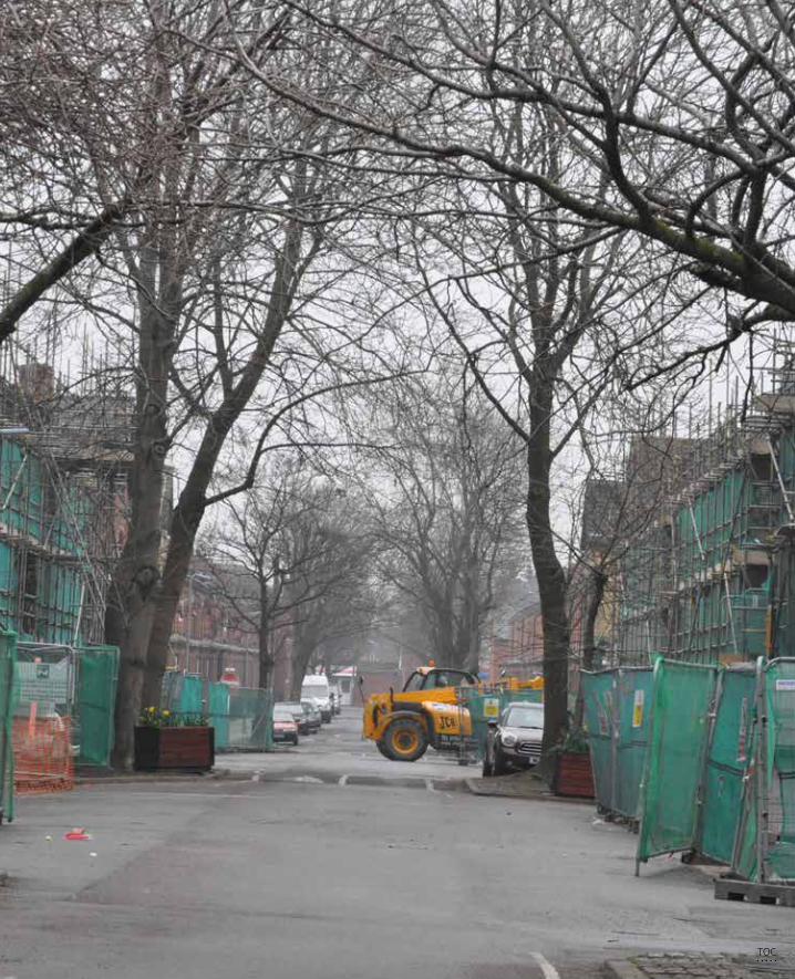
142 Privatisation of the Production of Public Space
TOC
143 Short introduction to Liverpool and the Case Studies
5 Short introduction to Liverpool and the Case Studies
§ 5.1 Liverpool and its urban renaissance
UK planning 1997 – 2010: urban renaissance and urban renewalWhen Labour came back into power in 1997 after years of Conservative leadership, Prime minister Tony Blair was determined to narrow the gap between deprived and non-deprived neighbourhoods, believing that the competitiveness brought by globalisation would provide economic opportunities for all people. A key concept in the implementation of his political agenda was the role of effective communities and voluntary organisations in working partnerships with an enabling government. (Hall 2003, Lupton et al. 2013). The Labour Government developed three separate spatial policy agendas:
– a network of Regional Development Agencies promoting the competitiveness of English regions
– reversing the decline of England’s inner cities through initiatives to attract employment and residents back to the inner cities. The approach for these policies was drawn up in the Task Force Report (2000)
– tackling the problem of social exclusion and deprivation at the neighbourhood level through initiatives to stimulate economic development, build strong communities and deliver improved public services. In 2001, the National Strategy for Neighbourhood Renewal was published. (Lupton et al.2013, 267)
TOC
144 Privatisation of the Production of Public Space
The Task Force Report ‘Towards an Urban Renaissance’ commissioned by the central government in 200027, proposes a revival strategy for England’s inner cities, which had suffered from declining populations, neglect and a general disinterest. “The report sets out commitment to urban communities and establishes a vision for our towns and cities in which an image of failure and decline is replaced by one of opportunity and sustainable growth” (UTF 2000, 25).28 The general aim was, after decades of suburbanisation, to pay particular attention to towards the declining inner cities. These were after all “the place which stimulated new ideas, transacted knowledge and formed first and foremost a meeting place for people” (UTF 2000, 26). As such, emphasis was placed on the creation of areas with an identifiable character, a ‘sense of place’, rather than creating ‘generic’, ‘soulless’, ‘could-be-anywhere’ places. Public-private partnerships were seen as new forms of governance that would empower the private sector, local institutions and organisations in such a way as to enable this renaissance in collaboration with the public sector. This area based focus for solving urban issues is described by the notion of ‘urban regeneration’ which can be defined as: “comprehensive and integrated vision and action which leads to the resolution of urban problems and which seeks to bring aout a lasting improvement in the economic, physical, social and environmental condition of an area that has been subject to change” (Roberts and Sykes 2000, 17).
27 This report was commissioned by John Prescott, Deputy Prime Minister, in order to “find out what has caused urban decline in England and to recommend practical solutions to turn our cities, towns and urban neighbour-hoods into places where people actively want to live, work and play” (1999, preface). To this end he appointed Lord Richard Rogers, architect, to assemble a team whose members were chosen for their expertise in an urban renaissance..
28 In other countries, similar strategies and guidelines for revitalisation of Western cities were published. For example, in Belgium the federal government commissioned a similar study that resulted in the publication of ‘het Witboek Groot Stedenbeleid’ (Boudry, 2003). In the US The New Urbanism movement wrote a handbook of guidelines on how to design a qualitative urban quarter. In the Netherlands, with a long tradition of regulation and planning laws, a number of political guidance documents as well as professional books emerged throughout the years.
TOC
145 Short introduction to Liverpool and the Case Studies
Prime minister Tony Blair declared in 1997 that no one should be seriously disadvantaged by where they live. In order to tackle the problems of the most deprived neighbourhoods in the UK, the government proposed a National Strategy for Neighbourhood Renewal with an accompanying funding regime (the Neighbourhood Renewal Fund) controlling a budget of £500 million a year. In 2003 however, the Housing Market Renewal Fund replaced this original programme. The national government introduced Local Strategic Partnerships (LSPs) that would be responsible for the implementation of the Neighbourhood Renewal action programmes. These LSP’s were intented to provide more community involvement in the regeneration of their own neighbourhood via a form of co-governance based on power-sharing (Johnson and Osborne, 2003).
Although often criticised for its lack of impact, “Labour’s neighbourhood renewal policies achieved a great deal. They reversed a trend of increasing disparities between areas, both in opportunities and outcomes. 90 per cent of social housing was brought to a ‘decent’ standard. Rates of crime, litter and vandalism fell and differences between deprived and other areas (‘gaps’) narrowed. New childcare and health centres, schools and community buildings were built in the most deprived areas; neighbourhood policing and community warden schemes were introduced” (Lupton et al. 2013). Local governments and LSP’s intention of implementing urban renewal in co-governance with the local community has however struggled to materialise, a top down coordinated approach proved often more effective in terms of keeping control (Johnson and Osborne 2003).
TOC
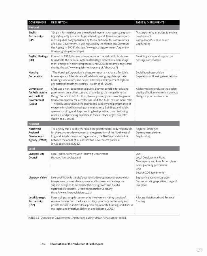
146 Privatisation of the Production of Public Space
GOVERNMENT DESCRIPTION TASKS & INSTRUMENTS
National
English Partnerships (EP)
“English Partnerships was the national regeneration agency, support-ing high quality sustainable growth in England. It was a non-depart-mental public body sponsored by the Department for Communities and Local Government. It was replaced by the Homes and Communi-ties Agency in 2008”. (https://www.gov.uk/government/organisa-tions/english-partnerships)
Masterplanning exercises to enable developmentCompulsory Purchase powerGap funding
English Heritage(EH)
Formed in 1983, the executive non-departmental public body was tasked with the national system of heritage protection and manage-ment a range of historic properties. Since 2003 it became a registered charity. (http://www.english-heritage.org.uk/about-us/)
Providing advice and support on heritage conservation
Housing Corporation
“The Housing Corporation is the government’s national affordable homes agency. It funds new affordable housing, regulates private housing associations, and helps to develop and implement regional and national housing strategies” (Nadin et al., 2008).
Social housing provisionRegulation of Housing Associations
Commission for Architecture and the Built Environment (CABE)
CABE was a non-departmental public body responsible for advising government on architecture and urban design. It merged into the Design Council in 2011. https://www.gov.uk/government/organisa-tions/commission-for-architecture-and-the-built-environment-cabe“The body seeks to raise the aspirations, capacity and performance of everyone involved in creating and maintaining buildings and public space across England, by promoting best-practice, commissioning research, and providing expertise in the country’s largest projects” (Nadin et al., 2008).
Advisory role to evaluate the design quality of built environment projects Design support and services
Regional
Northwest Regional Development Agency (NWDA)
The agency was a publicly funded non-governmental body responsible for the economic development and regeneration of the Northwest of England. As a business-led organisation, the NWDA provided a link between the needs of businesses and Government policies. It was abolished in 2012.
Regional Strategies Development partner Gap funding
Local
Liverpool City Council
Local Public Authority with Planning Department(https://liverpool.gov.uk)
UDP Local Development PlansMasterplans and Area Action plans Grant planning permission CPO Section 106 agreements
Liverpool Vision Liverpool Vision is the city’s economic development company which integrates economic development and business and enterprise support designed to accelerate the city’s growth and build a sustainable economy. Urban Regeneration Company (http://www.liverpoolvision.co.uk)
Supporting economic growth Communicating a positive image of Liverpool
Local Strategic Partnership(LSP)
Partnerships set up for community involvement – they consist of representatives from the local statutory, voluntary, community and private sectors to address local problems, allocate funding, and discuss strategies and initiatives (Johnson and Osborne, 2003)
Allocate Neighbourhood Renewal funding
TABLE 5.1 Overview of Governmental Institutions during ‘Urban Renaissance’ period
TOC
147 Short introduction to Liverpool and the Case Studies
Liverpool: a very brief historyLiverpool has its origins as a settlement in the 12th century but started to grow significantly from the 16th century onwards as the city capitalised on its strategic position as a port city on the river Mersey and the associated shipping trade. Liverpool was known for its international trade in salt, cotton and other raw materials, but also for its slave trade that delivered vast profits until the trade’s abolishment in 1807. In the early 19th century, 40% of the world’s trade passed through Liverpool´s docks and Liverpool grew to be an influential international economic hub. The city continued to expand in territory and population until the Great Depression of the 1930’s. Its population peaked in 1931 with 856.000 inhabitants (Lees 2013, 175).
The importance as a world city was manifested in the splendour of the grand architectural buildings erected in the 18th and 19th century, such as the Three Graces on the harbour front and the magnificent mansions in the city centre and along Princes Avenue. The early development of the modern city’s characteristic urban infrastructure reflected Liverpool’s fortune and investments in innovative urban solutions; in 1830 the city became the proud host of the world’s first intercity train link with Manchester and had the world’s first integrated sewerage system (Sykes et al. 2013). The legacy of this era is reflected in the UNESCO World Heritage status (Sykes et al. 2013). Through the centuries, migrants from all over the world also found a new home in Liverpool, in particular a large number of Irish who fled Ireland due to the Great Famine (1845-1849).
During the Second World War Liverpool was, still operating as a strategic port, heavily bombed, killing a large number of people and demolishing many buildings. After the war Liverpool began a rapid decline. “There were two principal underlying causes: increasingly unfavorable external economic conditions, compounded by major self-inflicted public policy mistakes” (Sykes et al. 2013, 9). The latter half of the 20th century saw a continuation of this decline in industrial activities in this part of the world that, in turn saw a reduction of port activities, in prosperity and jobs and resulted in migration flows out of the city. Spatial policies instigated to tackle these issues were centred around comprehensive area clearance, redevelopment of inner city neighbourhoods and relocation of the city centre population towards suburban areas, therefore fuelling the migration out of the city centre even further. Unemployment rates rose sharply, especially within the working class ethnic minorities. “Between 1974 and 1981, unemployment rose in Liverpool by 120 per cent and in Granby ward it even went up by 350 per cent” (Lees 2013, 163). Not surprisingly it was here, in Granby/Toxteth, that the discontent over the lack of job opportunities for the younger (predominantly) black population gave rise to serious protests in 1981.
TOC
148 Privatisation of the Production of Public Space
These riots, and the lack of an adequate response from national or local authorities, paved the way for the election of a militant labour government (1983) who promised far-reaching urban regeneration policies. These policies were again partly based on inner city slum clearance and the replacement of low rise terraced houses by homes with a front and back garden, further de-densifying and de-populating the city centre. Margaret Thatcher’s minister for the Environment, Michael Heseltine was appointed as a special advisor to Merseyside and championed private-sector investment to alleviate Liverpool from its socio-economic problems. After the defeat of militant Labour in 1986 new Labour leadership sought to repair the damage done by the previous administration. Its approach to regeneration relied on both a governance of partnership agreements with the private, voluntary and community sectors as well as heavy public funding (from national HMRI to European Objective One funding). The Liberal Democrat administration that was elected in 1998 continued the emphasis on a governance of partnerships and “were proactive in promoting partnership working, civic boosterism and entrepreneurism” (Cocks 2013 in Sykes et al. 2013, 13). In 1999, Liverpool Vision was established, the UK’s first Urban Regeneration Company, with the main aim to “accelerate the city’s growth and build a sustainable economy” by bringing together public and private partners (www.liverpoolvision.co.uk). It commissioned the delivery of a ‘Strategic Development Framework’ to analyse where potential regeneration opportunities were within the city centre (Liverpool Vision, 2000). Besides the focus on attracting more private investment into the city, Liverpool Council embraced its cultural and multi-ethnic past which resulted in a successful bid to become European Capital of Culture in 2008 (Boland 2010).
By 2001 the population of Liverpool was as low as 430.000 (Sykes et al. 2013) but has grown again in the last decade to 478,600 in 2015 and is projected to grow to around 530.000 people by 2040 (https://liverpool.gov.uk/council/key-statistics-and-data/data/population/).
Despite the growth of employment figures seen in recent years, Liverpool still scores high on the deprivation index, although it dropped 3 places and now ranks 4th, rather than first as was the case in 2004, 2007 and 2010. Liverpool also has a larger proportion of neighbourhoods in the highest deprivation percentiles than other Core Cities (Index of Multiple Deprivation 2015). Hence although Liverpool shows a “seemingly steady and significant reduction in the extent of deprivation, relative to England” (IMD 2015, 5), it still has some progress to make.
Although being brief, this short overview on the history of Liverpool demonstrates the presence of the different historical layers that the city contains. The steep decline after the Second World War, from being an affluent, booming, ethnically and architecturally rich city in the 18th and early 19th century, to a deprived, empty and depressed urban
TOC
149 Short introduction to Liverpool and the Case Studies
entity was severe. Towards the end of the 20th century however, the city started to search for ways out of this deprivation and jumped, belatedly in comparison to other cities such as Manchester, on the urban renaissance wagon. Liverpool did this with great enthusiasm, following different paths to recovery at the same time. Within the era from the end of the 1990’s up to 2015, these various different ways in which Liverpool City shaped its urban renaissance led to a number of different urban development projects, each with a varying degree of engagement of private actors within the development process. This makes the city of Liverpool an interesting city to study the consequences of privatisation for city space, the topic of this particular research. Three of these regeneration projects have been chosen within this research as case studies; Liverpool One, the Ropewalks and Granby4Streets. They all have in common that they were developed approximately at around the same time and therefore within the same political regime and policy context. The three cases differ however in their managerial approach to the development process and maintenance regimes and in the degree of privatisation. The three case studies will be shortly introduced in the following section, in the next chapter they will be thoroughly analysed through the perspectives of governance, users and designer.
TOC
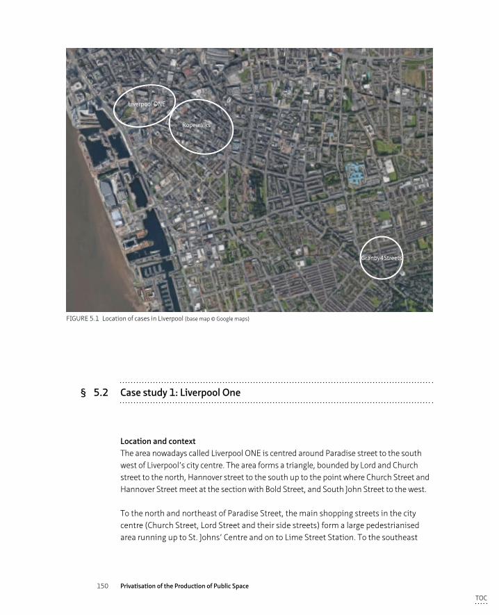
150 Privatisation of the Production of Public Space
Liverpool ONE
Ropewalks
Granby4Streets
FIGURE 5.1 Location of cases in Liverpool (base map © Google maps)
§ 5.2 Case study 1: Liverpool One
Location and contextThe area nowadays called Liverpool ONE is centred around Paradise street to the south west of Liverpool’s city centre. The area forms a triangle, bounded by Lord and Church street to the north, Hannover street to the south up to the point where Church Street and Hannover Street meet at the section with Bold Street, and South John Street to the west.
To the north and northeast of Paradise Street, the main shopping streets in the city centre (Church Street, Lord Street and their side streets) form a large pedestrianised area running up to St. Johns’ Centre and on to Lime Street Station. To the southeast
TOC
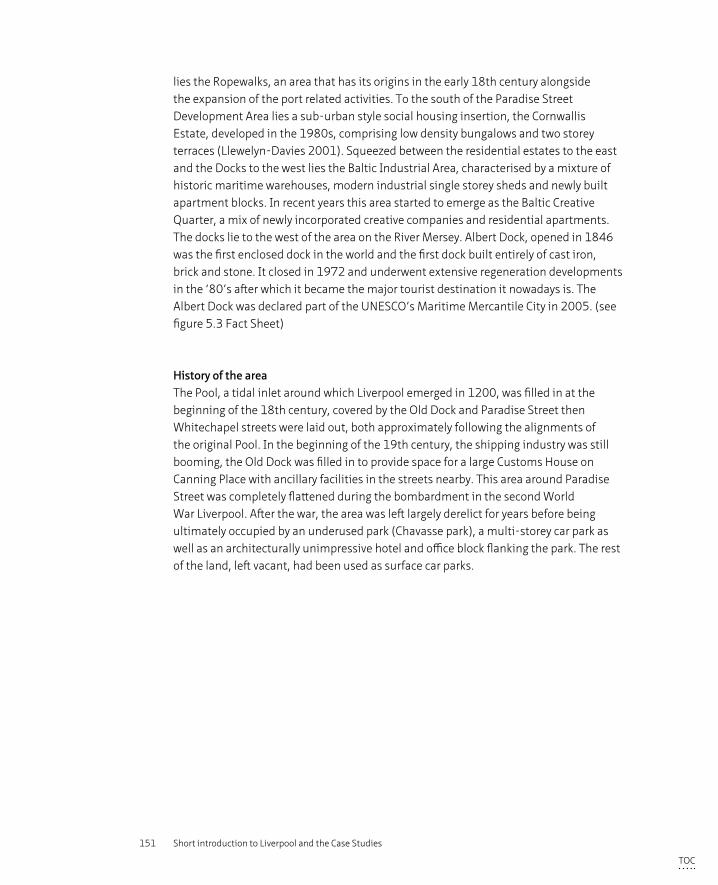
151 Short introduction to Liverpool and the Case Studies
lies the Ropewalks, an area that has its origins in the early 18th century alongside the expansion of the port related activities. To the south of the Paradise Street Development Area lies a sub-urban style social housing insertion, the Cornwallis Estate, developed in the 1980s, comprising low density bungalows and two storey terraces (Llewelyn-Davies 2001). Squeezed between the residential estates to the east and the Docks to the west lies the Baltic Industrial Area, characterised by a mixture of historic maritime warehouses, modern industrial single storey sheds and newly built apartment blocks. In recent years this area started to emerge as the Baltic Creative Quarter, a mix of newly incorporated creative companies and residential apartments. The docks lie to the west of the area on the River Mersey. Albert Dock, opened in 1846 was the first enclosed dock in the world and the first dock built entirely of cast iron, brick and stone. It closed in 1972 and underwent extensive regeneration developments in the ‘80’s after which it became the major tourist destination it nowadays is. The Albert Dock was declared part of the UNESCO’s Maritime Mercantile City in 2005. (see figure 5.3 Fact Sheet)
History of the areaThe Pool, a tidal inlet around which Liverpool emerged in 1200, was filled in at the beginning of the 18th century, covered by the Old Dock and Paradise Street then Whitechapel streets were laid out, both approximately following the alignments of the original Pool. In the beginning of the 19th century, the shipping industry was still booming, the Old Dock was filled in to provide space for a large Customs House on Canning Place with ancillary facilities in the streets nearby. This area around Paradise Street was completely flattened during the bombardment in the second World War Liverpool. After the war, the area was left largely derelict for years before being ultimately occupied by an underused park (Chavasse park), a multi-storey car park as well as an architecturally unimpressive hotel and office block flanking the park. The rest of the land, left vacant, had been used as surface car parks.
TOC
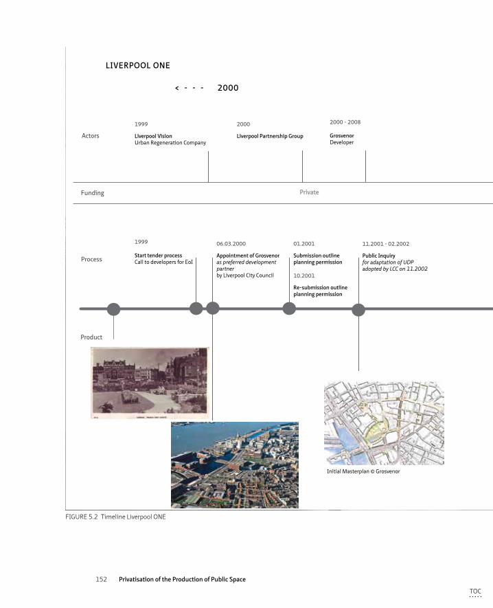
152 Privatisation of the Production of Public Space
Actors
Product
2000 2010< - - - - - - >
LIVERPOOL ONE
Funding
2000 - 2008
GrosvenorDeveloper
Private
1999
Liverpool VisionUrban Regeneration Company
2000
Liverpool Partnership Group
01.2001
Submission outline planning permission
1999
Start tender processCall to developers for EoI
10.2001
Re-submission outline planning permission
11.2001 - 02.2002
Public Inquiryfor adaptation of UDPadopted by LCC on 11.2002
11. 2004
Start building works
06.03.2000
Appointment of Grosvenor as preferred developmentpartnerby Liverpool City Council
12. 2002
Planning Permission grantedon resubmitted outline application
12. 2002
Development Agreementbetween Grosvenor and LCCincluding S106 agreement 11.2003 - 01.2004
Public Inquiryon scheme and CPO’s issuedDeputy Prime Ministergranted permission
11. 2005
Rebranding of Paradise Street development into Livepool ONE
05. 2008
Phase ONE opens
05. 2008
Phase TWO opensincluding Chavasse Park
2008
Livepool Capital of Culture
12. 2004
Financial AgreementGrosvenor, investors, bank
2000 - 2004/8
Design and Planning TeamBDP, Drivers Jonas, legal teams, architects, engineers, marketing, others
2004 - 2009
Building Construction TeamBalfour Beatty, Laing O’Rourke, Kier, Mansell
2004 - ongoing
Grosvenor Liverpool ONE fundGrosvenor, Aberdeen Property Investors, Hermes, Liverpol Victoria,Maroon Capital, Redevco roperties UK, Liverpool City Council
Initial Masterplan © Grosvenor
Overview Liverpool One © Grosvenor
Logo
Entrance to Liverpool One(St. Peter’s Lane) off Church st.
FIGURE 5.2 Timeline Liverpool ONE
TOC
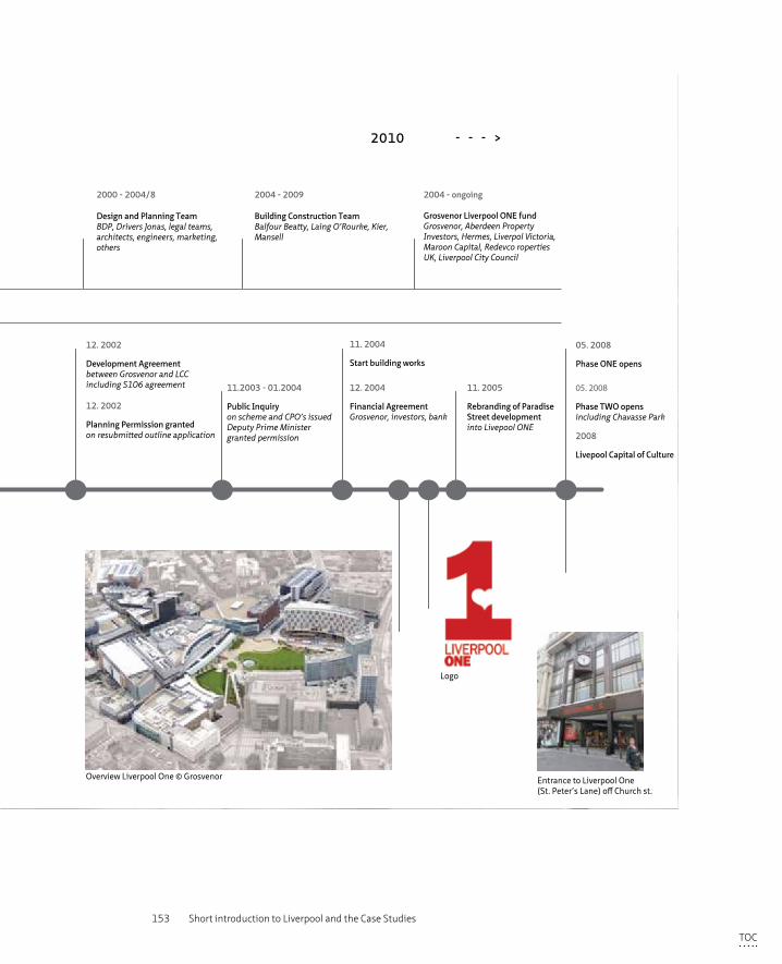
153 Short introduction to Liverpool and the Case Studies
Actors
Product
2000 2010< - - - - - - >
LIVERPOOL ONE
Funding
2000 - 2008
GrosvenorDeveloper
Private
1999
Liverpool VisionUrban Regeneration Company
2000
Liverpool Partnership Group
01.2001
Submission outline planning permission
1999
Start tender processCall to developers for EoI
10.2001
Re-submission outline planning permission
11.2001 - 02.2002
Public Inquiryfor adaptation of UDPadopted by LCC on 11.2002
11. 2004
Start building works
06.03.2000
Appointment of Grosvenor as preferred developmentpartnerby Liverpool City Council
12. 2002
Planning Permission grantedon resubmitted outline application
12. 2002
Development Agreementbetween Grosvenor and LCCincluding S106 agreement 11.2003 - 01.2004
Public Inquiryon scheme and CPO’s issuedDeputy Prime Ministergranted permission
11. 2005
Rebranding of Paradise Street development into Livepool ONE
05. 2008
Phase ONE opens
05. 2008
Phase TWO opensincluding Chavasse Park
2008
Livepool Capital of Culture
12. 2004
Financial AgreementGrosvenor, investors, bank
2000 - 2004/8
Design and Planning TeamBDP, Drivers Jonas, legal teams, architects, engineers, marketing, others
2004 - 2009
Building Construction TeamBalfour Beatty, Laing O’Rourke, Kier, Mansell
2004 - ongoing
Grosvenor Liverpool ONE fundGrosvenor, Aberdeen Property Investors, Hermes, Liverpol Victoria,Maroon Capital, Redevco roperties UK, Liverpool City Council
Initial Masterplan © Grosvenor
Overview Liverpool One © Grosvenor
Logo
Entrance to Liverpool One(St. Peter’s Lane) off Church st.
FIGURE 5.2 Timeline Liverpool ONE
TOC
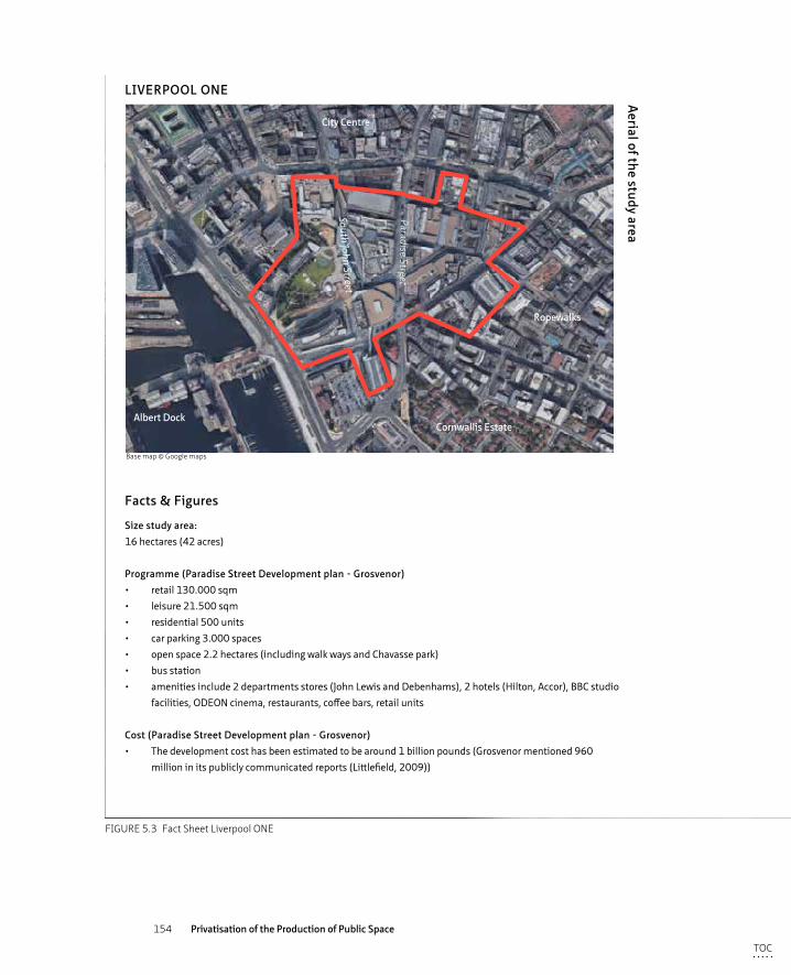
154 Privatisation of the Production of Public Space
Size study area:16 hectares (42 acres)
Programme (Paradise Street Development plan - Grosvenor)• retail 130.000 sqm• leisure 21.500 sqm• residential 500 units • car parking 3.000 spaces• open space 2.2 hectares (including walk ways and Chavasse park)• bus station• amenities include 2 departments stores (John Lewis and Debenhams), 2 hotels (Hilton, Accor), BBC studio
facilities, ODEON cinema, restaurants, coffee bars, retail units
Cost (Paradise Street Development plan - Grosvenor)• The development cost has been estimated to be around 1 billion pounds (Grosvenor mentioned 960
million in its publicly communicated reports (Littlefield, 2009))
Facts & Figures
Morphological transformation
1908 2001 2015
TRANSFORMATION liverpool ONE
Impression of the area
1908 2001 2015
TRANSFORMATION liverpool ONE
1908 2001 2015
TRANSFORMATION liverpool ONE
1908
2001
2015
Aerial of the study area
LIVERPOOL ONE
Paradise Street
South John Street
City Centre
Ropewalks
Albert DockCornwallis Estate
Base map © Google maps
FIGURE 5.3 Fact Sheet Liverpool ONE
TOC
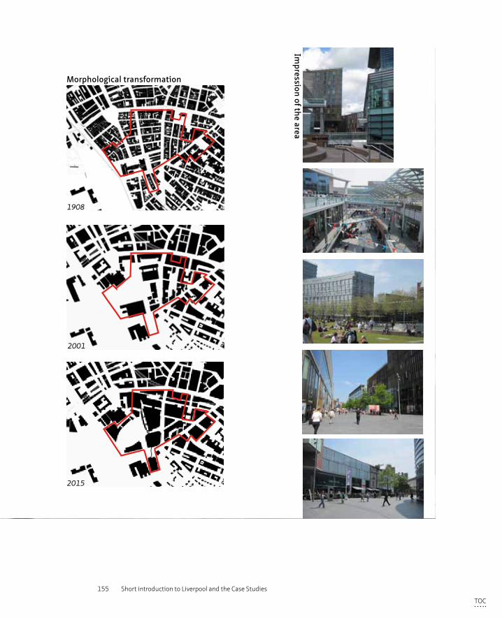
155 Short introduction to Liverpool and the Case Studies
Size study area:16 hectares (42 acres)
Programme (Paradise Street Development plan - Grosvenor)• retail 130.000 sqm• leisure 21.500 sqm• residential 500 units • car parking 3.000 spaces• open space 2.2 hectares (including walk ways and Chavasse park)• bus station• amenities include 2 departments stores (John Lewis and Debenhams), 2 hotels (Hilton, Accor), BBC studio
facilities, ODEON cinema, restaurants, coffee bars, retail units
Cost (Paradise Street Development plan - Grosvenor)• The development cost has been estimated to be around 1 billion pounds (Grosvenor mentioned 960
million in its publicly communicated reports (Littlefield, 2009))
Facts & Figures
Morphological transformation
1908 2001 2015
TRANSFORMATION liverpool ONE
Impression of the area
1908 2001 2015
TRANSFORMATION liverpool ONE
1908 2001 2015
TRANSFORMATION liverpool ONE
1908
2001
2015
Aerial of the study area
LIVERPOOL ONE
Paradise Street
South John Street
City Centre
Ropewalks
Albert DockCornwallis Estate
Base map © Google maps
FIGURE 5.3 Fact Sheet Liverpool ONE
TOC
156 Privatisation of the Production of Public Space
Vision/ambitionWhen the Albert Dock redevelopment opened in 1988, the area started to attract businesses and tourists, and hence Liverpool City Council shifted its focus to the precincts between the City Centre and the Docks, around Paradise Street and Chavasse Park. These areas were underused, felt unsafe and therefore acted to sever the city centre from the waterfront, designated as a Conservation area in 1976. In 1999, Liverpool City Council issued a Planning Framework in which it stated that a retail development programme, mainly centred around the provision of retail, was sought for the Paradise Street Development area. The objective of the framework was twofold, firstly to link the centre back to its conservation area at the waterfront and secondly to expand Liverpool´s shopping district and regain the city’s status as the pre-eminent regional retail destination (Littlefield 2009, 27-29).
Design – developmentIn 1999 Liverpool City Council launched a developer competition for a retail led redesign for the Paradise Street Area, resulting in the appointment of project developer Grosvenor to design and build their proposed scheme. Although details of the plan changed throughout the process, the main vision of connecting the project area both with the original grid of the existing historic shopping streets and with the waterfront, as described in the winning masterplan, remained a firm goal of the plan. The proposed scheme intended to create ‘shopping and leisure streets’ with an urban feel rather than a monolithic shopping mall offer. In order to achieve the urban character the Council and Grosvenor required, it was proposed to divide the area in 34 different plots, ranging in size and scale. Twenty six different architects were invited to design the buildings within the scope written by masterplanners BDP. The construction works started in 2004 and were finished by October 2008, the year Liverpool became European Capital of Culture.
Stakeholders and consultationThe development of the scheme was led by Grosvenor in cooperation with the Council who were - being the legal planning authority - obliged to assess the outline and detailed planning applications. Liverpool Council appointed a dedicated advisor to the planning team, who worked closely with Grosvenor’s team in order to make the scheme as compliant with the Council’s wishes as possible so to avoid difficulties throughout the planning process.
Besides consultation with legally entitled agencies, such as English Heritage and CABE, small local groups were also consulted and “helped consolidate the form of the emerging masterplan at a series of workshops held between September and December 2000” (Littlefield 2009, 88). In a 4-day public exhibition event
TOC
157 Short introduction to Liverpool and the Case Studies
in May 2001, a large scale model was presented to the general public. Through the statutory planning process, including two public inquiries, it was possible to make comments and objections to the scheme or parts of the scheme. Between January 2001 and September 2002 the City Council received 67 formal responses, which shows a lack of significant objection to the planning application particularly as it concerned a development proposal of a significant scale and complexity (Littlefield 2009, 88). One explanation of the lack of objection, other than that the local population were in favour of the scheme, is that there were not many people living in this area nor in the immediate surroundings, and in general people reacted therefore positively towards change for this particular area as the site itself had been largely derelict and vacant for such a long period of time.
Management and MaintenanceLiverpool ONE is owned by Grosvenor Liverpool ONE Fund which consists of six investors including Grosvenor who have a 26% stake. Liverpool Council also has a stake of 5%. (so private:public = 95:5) Grosvenor Liverpool Fund then employ Grosvenor Fund Management to manage the fund, the asset and the property. A separate company Liverpool One Management company ltd. has been set up to manage the 42 acres of Liverpool ONE area. This company is effectively charged with ensuring that the 42 acres of public realm, the buildings and all the tenants are managed to a high standard and currently employs 150 people to this effect, 100 of which are on the ground within the estate concerned with cleaning, safety and security. The ‘blue coats’ are tasked with cleaning and the ‘red coats’ with security and safety.
The original roads within the project boundary were turned into pedestrian streets, prohibited for vehicular traffic. The roads’ status does not fall within the category of adopted roads any longer but under the maintenance and control of Liverpool One Ltd, which was controversial at the time. Issues such as public right of way and the standard of management that must be achieved were agreed with the Council and described in the Public Realm Agreements, which were subject to planning permission. In the original Agreemant allowance was made for the tram line that was proposed to run through Paradise Street but this plan was abolished in 2006 by National Government. There is also an allowance made for bicycles to use Paradise Street as a through route, because it is part of an established local bicycle connection.
TOC
158 Privatisation of the Production of Public Space
§ 5.3 Case study 2: Ropewalks
Location and contextThe Ropewalks area is located to the south of Liverpool’s City Centre, bounded by Hanover Street to the northwest, Renshaw Street to the northeast, Roscoe Street to the southeast and Lydia Ann Street/Pitt Street to its southwest. The area includes Bold Street, a historic shopping street with independent shops and ethnic restaurants, and Liverpool’s China Town. The area’s urban character is derived from its long narrow streets running parallel to each other in a tight urban form and are densely developed with grand merchant’s houses and maritime warehouses, of which 102 are listed.
The area is adjacent to the city centre, as well as Liverpool ONE, the new retail district to the north, the university quarter of Liverpool University to the east, the Cathedral and surrounds to the south and the pre-dominantly residential area of Liverpool 1 to the west. (see figure 5.5 Fact Sheet)
Duke street and its immediate surrounds were designated a Conservation Area in 1988. The area’s international importance capitalised on its Maritime Heritage being listing one of the six sites of Liverpool as Liverpool Maritime Mercantile World by UNESCO in 2005. Part of the Liverpool Council’s regeneration strategy in the 1990’s was to focus on opportunities for attracting creative industries to the Ropewalks area in order to establish a ‘creative quarter’. However, it is now known as the clubbing district that is flourishing in its own right despite this not being the intended use.
History of the areaThe name Ropewalks derives from the historic craft of ropemaking that formed an important activity in this area throughout Liverpool’s maritime years. The construction of the first wet dock at the location of the Pool in 1715 marked the start of a rapid expansion of the commercial port related activities in Liverpool and buildings containing shipping related industries were erected around the dock. The land was owned by the City Corporation, who did not have a detailed overall plan for the area but created a street lay-out based on old access roads. Building plots were developed in a speculative way where restrictions only applied to height and façade appearance. The area quickly filled up and by 1785, the current street pattern was established, turning the area into a dense urban quarter with a clear hierarchy of streets (the long parallel streets being of the highest order)(Stonehouse 2002). ‘With the decline of the port related industries and the process of suburbanization, the warehouses began to be abandoned and the area fell to decay. In the 1990’s the appearance of the quarter and
TOC
159 Short introduction to Liverpool and the Case Studies
the confidence of its future were at an all-time low (SPG 2005, 17). By 1995 however, some signs of economic recovery were showing around Duke and Bold Street and adjacent streets, with ground floor vacancy rates falling (Fowles 1997, 71 in Couch and Dennemann 2000). These signs marked a turning point that was capitalised upon by urban pioneer Urban Splash, who opened Liverpool Palace, a complex of retail units, offices and a bar, in 1991. These signs did also not go by unnoticed by the Council who embarked on initial regeneration initiatives. Liverpool City Council saw the potential of this area with its tight urban grain, fine warehouses and close proximity to the city centre for a mixed-use creative industries quarter, where people associated with such industries could live and work. (Couch and Dennemann, 2000).
Regeneration projectThe main focus was on the economic revival of the area by creating a high quality spatial context that would attract private investment, new workers and new residents and the City Council promoted the area as a ‘creative quarter’ in its official documents (Couch and Denneman, 2000). In order to generate interest while providing legal protection to its cultural heritage, Liverpool Council designated Duke Street area as a Conservation Area in order to protect the most derelict warehouses from demolition and subsequently sold many of its properties to a private developer, Charterhouse Estates, in the hope private investment would kick start the area’s economic revival. European Objective One money was secured for both infrastructural works and the creation of employment.
Liverpool City Council in collaboration with English Partnerships, the nation wide agency for regeneration, commissioned the Duke Street/Bold Street Regeneration Strategy in 1994. Following this document they then commissioned Thompson & Partners (London based architects) to facilitate a Planning Weekend in 1997 to consult the key stakeholders and local community (Couch and Denneman, 2000). The outcomes of the weekend were subsequently translated into an integrated action and implementation plan by BDP architects (Manchester based company specialised in masterplanning and architecture). This regeneration framework concentrated around three themes:
– Business support and employment initiatives which would ensure that the economic revival would also include local residents
– Extensive public realm programme to substantially upgrade the quality of the public space
– Development projects including reconversion of exiting warehouses but also guidance on new build
TOC
160 Privatisation of the Production of Public Space
In 1998 The Ropewalks Partnership was set up as the regeneration vehicle to implement the Integrated Action Plan. This partnership consisted of public, private and community partners, whereby Liverpool Council, as the planning authority, was ultimately responsible for the partnership’s management and resources. However because the funding for the project came from the European Union, Brussels was financially accountable. The funding package (Objective One) was entitled to be used for capital infrastructure and training and development programmes.
£12 million of public funds were invested in the public space works, which included provision of new pocket parks, street improvements and repaving as well as implementation of new pedestrian links, all to encourage the private sector to invest in the area. “The completed scheme has created a coherent high quality network of streets and public spaces with a strong local identity. They have also helped to stimulate inward investment with numerous private conversion and new build residential and commercial developments bringing activity to a previously neglected part of the City. The local population has increased from some 100 - 200 people to several thousand and the area is now a thriving creative quarter in the city” (CABE 2011). In 1998 BDP was appointed by the Ropewalks Partnership to provide a Public Realm Handbook, a design guide to further detail the public space works. Together with an appointed contractor, Banner Holdings (previously Henry Boot Management company), they managed the implementation of the works. The public space works were completed in 2004.
The opening of the Foundation for Art and Creative Technology centre (FACT) in 2003 marked the end of the first implementation phase of the masterplan and accompanying budgets. The Council continued to provide planning guidance on how to maintain the area’s inherit quality over coming decades with the provision of a Supplementary Development Document specifically targeted at the Ropewalks Area and in conjunction with the Urban Development Plan that was due for adoption in 2002. Liverpool Council appointed design consultants BDP in conjunction with Jones Lang Lasalle to provide the necessary guidance on how:
1 the quality of urban design should be warranted in future projects;2 historic assets can be protected;3 to draw attention to development opportunities in the area.
The completion of the public space works in 2004 marked the end of the implementation of the Integrated Action Plan. It was not however the end of the regeneration of the Ropewalks area. In the 15 years that followed, incremental renovation of derelict warehouses continued, organic redevelopment of vacant sites
TOC
161 Short introduction to Liverpool and the Case Studies
took place and most notably, the number of new apartment blocks and therefore residents, grew. After the initial skirmishes between the residents (who bought into the vision of the ‘creative quarter’ that subsequently morphed into a night time economy as a result of increasing landvalues) and the bar owners and users, a better understanding was reached through physical improvements to the interiors of the bars. These changes were negotiated through the newly created Ropewalks Residents Association, who promoted the residents’ interests. The Integrated Action Plan still forms the base upon which new proposals are envisioned and designed. Most recently a large new development at Wolstenholme Square for housing 431 studio and 1-bed flats, commercial and leisure facilities and the Cream nightclub was granted planning permission.
Management and MaintenanceLiverpool City Council is responsible for the maintenance of the public realm apart from the upkeep of Concert Square, for which the Council paid developer Urban Splash a yearly fee of £10.000. Urban Splash also received a large sum from the bar owners who conduct their business off the square, though the Council ended the bar owners’ contract in 2015. Liverpool Council had outsourced its maintenance tasks to a private company until 2016 when they also ended this contract and took the maintenance responsibilities back into a newly installed public vehicle.
TOC
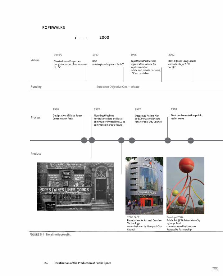
162 Privatisation of the Production of Public Space
European Objective One + private
1988
Designation of Duke Street Conservation Area
1997
Planning Weekendkey stakeholders and local community invited by LCC to comment on area’s future
1997
Integrated Action Planby BDP masterplannersfor Liverpool City Council
1998
Start implementation public realm works
2003
Opening FACT buildingmarked the end of the public realm works
2002
Supplementary Development Documentin conjunction with UDPby BDP & Jones Lange Lasalle
2005
World Heritage SiteDuke Street and surrounds part of Liverpool Maritime Mercentaile Worldby UNESCO
1990’S
Charterhouse Propertiesbought number of warehouses of LCC
1997
BDPmasterplanning team for LCC
1998
RopeWalks Partnershipregeneration vehicle for implementationpublic and private partners, LCC accountable
2002
BDP & Jones Lang Lasalleconsultants for SPDfor LCC
+/- 2005
Ropewalks ResidentsAssociation
2011
Community Interest Companysocial enterprise5 working groups within Ropewalks
2015
Elliot GroupDeveloperWolstenholme Square
public + private funds
2015
One Wolstenholme SquareDevelopmentby Elliot Group
Penelope 2004Public Art @ Wolstenholme Sqby Jorge Pardocommissioned by Liverpool Ropewalks Partnership
2003 FACTFoundation for Art and Creative Technologycommissioned by Liverpool City Council
Concert Square
Black Colquitt St.
Rebranding the Ropewalks
Visual impression One Wolstenholme Square
Actors
Product
2010< - - - - - - >
ROPEWALKS
Funding
2000
FIGURE 5.4 Timeline Ropewalks
TOC
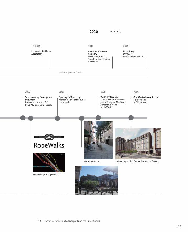
163 Short introduction to Liverpool and the Case Studies
European Objective One + private
1988
Designation of Duke Street Conservation Area
1997
Planning Weekendkey stakeholders and local community invited by LCC to comment on area’s future
1997
Integrated Action Planby BDP masterplannersfor Liverpool City Council
1998
Start implementation public realm works
2003
Opening FACT buildingmarked the end of the public realm works
2002
Supplementary Development Documentin conjunction with UDPby BDP & Jones Lange Lasalle
2005
World Heritage SiteDuke Street and surrounds part of Liverpool Maritime Mercentaile Worldby UNESCO
1990’S
Charterhouse Propertiesbought number of warehouses of LCC
1997
BDPmasterplanning team for LCC
1998
RopeWalks Partnershipregeneration vehicle for implementationpublic and private partners, LCC accountable
2002
BDP & Jones Lang Lasalleconsultants for SPDfor LCC
+/- 2005
Ropewalks ResidentsAssociation
2011
Community Interest Companysocial enterprise5 working groups within Ropewalks
2015
Elliot GroupDeveloperWolstenholme Square
public + private funds
2015
One Wolstenholme SquareDevelopmentby Elliot Group
Penelope 2004Public Art @ Wolstenholme Sqby Jorge Pardocommissioned by Liverpool Ropewalks Partnership
2003 FACTFoundation for Art and Creative Technologycommissioned by Liverpool City Council
Concert Square
Black Colquitt St.
Rebranding the Ropewalks
Visual impression One Wolstenholme Square
Actors
Product
2010< - - - - - - >
ROPEWALKS
Funding
2000
FIGURE 5.4 Timeline Ropewalks
TOC
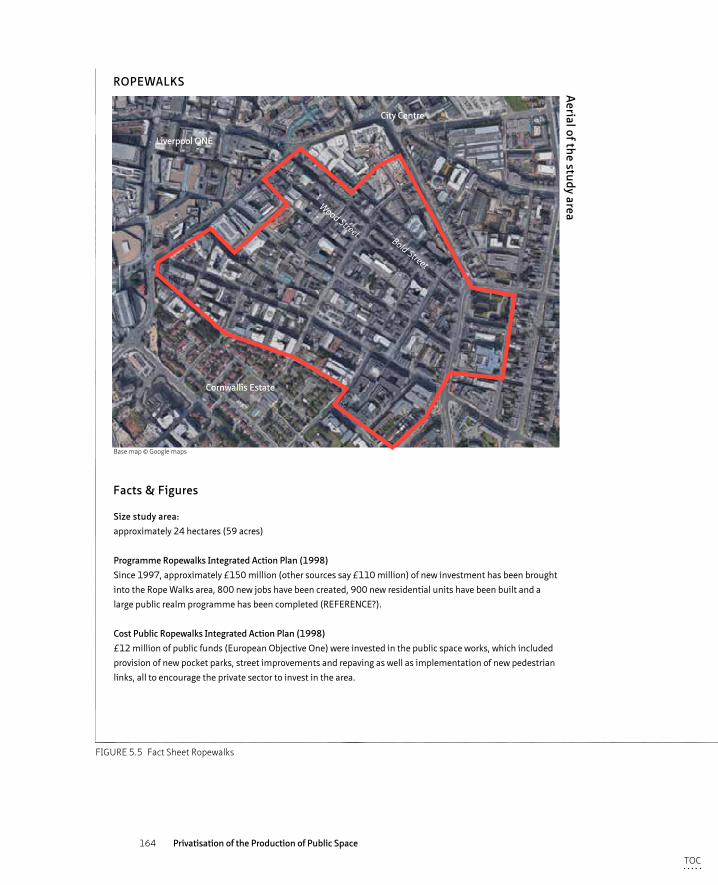
164 Privatisation of the Production of Public Space
Size study area:approximately 24 hectares (59 acres)
Programme Ropewalks Integrated Action Plan (1998)Since 1997, approximately £150 million (other sources say £110 million) of new investment has been brought into the Rope Walks area, 800 new jobs have been created, 900 new residential units have been built and a large public realm programme has been completed (REFERENCE?).
Cost Public Ropewalks Integrated Action Plan (1998)£12 million of public funds (European Objective One) were invested in the public space works, which included provision of new pocket parks, street improvements and repaving as well as implementation of new pedestrian links, all to encourage the private sector to invest in the area.
Facts & Figures
Morphological transformation
Impression of the area
1908
2001
2015
Aerial of the study area
ROPEWALKS
1908
TRANSFORMATION ropewalks
2001 2015
1908
TRANSFORMATION ropewalks
2001 2015
1908
TRANSFORMATION ropewalks
2001 2015
Cornwallis Estate
Liverpool ONE
City Centre
Bold Street
Wood Street
Base map © Google maps
FIGURE 5.5 Fact Sheet Ropewalks
TOC
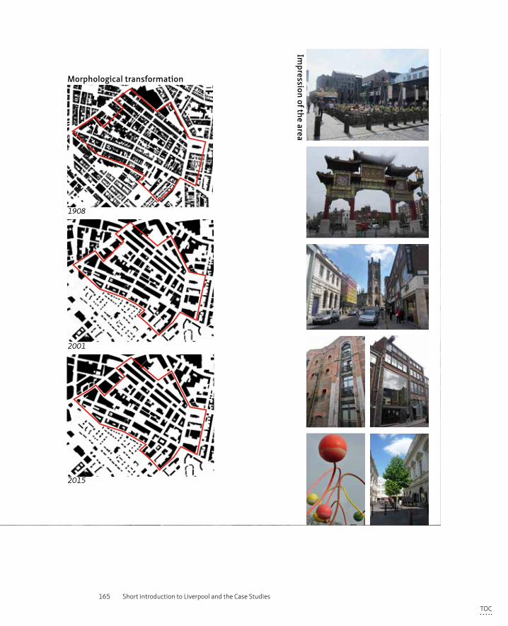
165 Short introduction to Liverpool and the Case Studies
Size study area:approximately 24 hectares (59 acres)
Programme Ropewalks Integrated Action Plan (1998)Since 1997, approximately £150 million (other sources say £110 million) of new investment has been brought into the Rope Walks area, 800 new jobs have been created, 900 new residential units have been built and a large public realm programme has been completed (REFERENCE?).
Cost Public Ropewalks Integrated Action Plan (1998)£12 million of public funds (European Objective One) were invested in the public space works, which included provision of new pocket parks, street improvements and repaving as well as implementation of new pedestrian links, all to encourage the private sector to invest in the area.
Facts & Figures
Morphological transformation
Impression of the area1908
2001
2015
Aerial of the study area
ROPEWALKS
1908
TRANSFORMATION ropewalks
2001 2015
1908
TRANSFORMATION ropewalks
2001 2015
1908
TRANSFORMATION ropewalks
2001 2015
Cornwallis Estate
Liverpool ONE
City Centre
Bold Street
Wood Street
Base map © Google maps
FIGURE 5.5 Fact Sheet Ropewalks
TOC
166 Privatisation of the Production of Public Space
§ 5.4 Case study 3: Toxteth’s Granby4Streets
Location and contextThe area of Toxteth in which the Granby4Streets area (also referred to as Granby Triangle) is located, is situated to the south of the city centre. Granby4Streets include Ducie Street, Cairns Street, Jermyn Street, Beaconsfields Street and Granby Street. The triangular shaped area is bound to the west by the main boulevard, Princes Avenue, connecting the centre to Princes Park. A public park funded by Richard Yates, a local landowner and councilor, who appointed Joseph Paxton to design a landscaped area for limited public use in 1842. Kingsley Road forms the boundary to the east and Seaport Street/Arundel Close to the north. (see figure 5.7 Fact Sheet)
These four streets retain their fine Victorian streetscape of narrow streets lined with trees and two to three storey Victorian terraces. Historically all of the area of Granby was laid out in a similar way with a housing type hugely popular with residents and that has been renovated in more affluent parts of the British cities throughout the centuries. However, the City Council’s vision for providing social and economic revival through physical regeneration saw the demolition of the Victorian houses in the northern part of Granby and their replacement by cul-de-sac developments that created a suburban feel rather than a thriving urban quarter.
The last four remaining Victorian streets were destined the same faith, which was met with fierce resistance by local residents, which lasted for 30 years. Due to this local activism, the end of the public funding regimes in 2010 and a changing governmental attitude towards wholesale clearance, Granby4Streets is now being renovated by a series of locally led initiatives.
History of the areaThroughout the maritime era and as a result of its shipping related activities, Liverpool was an economically successful city that, again partly due to the slave trade, saw a large influx of African people (amongst other ethnic groups). Granby/Toxteth was an affluent and thriving neighbourhood originally inhabited by a mixed multi-ethnic community, including a large group of Somalis (Uduku and Ben-Towvim, 1997). After the Second World War, the area started to transform as former seaman moved in and wealthier people moved out towards suburban areas, changing the demographic make-up of Granby. From the 1970’s, the relocation of the maritime oriented jobs left large parts of Liverpool’s city centre, including Granby, in a downward spiral due to high unemployment rates, poverty, and physical degeneration of the neighbourhoods.
TOC
167 Short introduction to Liverpool and the Case Studies
In 1981 the lack of social, economic and physical improvements combined with racial tensions came to a clash between Granby’s young (and predominantly black) people and the police.
Physical transformation and redevelopment of Granby was subsequently called upon and parts of the neighborhood were demolished and rebuilt with a new, albeit suburban low density and low quality, offer. Having seen these renewal programmes during which locals residents were rehoused and hence local community networks destroyed, some of the residents were reluctant to move out of their Victorian houses and demanded other forms of development, based upon retention rather than demolition of existing housing stock.
Design – developmentFrom the 1970’s, efforts have been made to reverse the economic and physical decline of the Toxteth area through a focus on physical regeneration to improve the quality of the houses and the environment, by creating jobs to reduce the unemployment rate and by providing education opportunities (SNAP programme of 1969). These have been met unfortunately, without much success – the area deteriorated further, ultimately resulting in the riots of 1981. Lord Michael Heseltine secured, having seen the poverty and decline of the neighbourhoods such as Granby Toxteth, a national funding injection into the northern cities. The Labour government that came into power in 1997 built upon these funding packages and installed new regimes such as the Neighbourhood Renewal Fund and the Housing Market Renewal Initiative to alleviate the most deprived areas. For Toxteth and in particular the Granby4Streets area this allocation of funds formed the start of a 30 year long regeneration process in which many reports, plans and ideas were formulated, many meetings and participation events were held and many partnerships, groups and organisations were formed. A number of private developers also came and went and much public money was spent on meetings and reports. Unfortunately none of those efforts led to any progress in the field; the area looked even more blighted after more years of neglect.
TOC
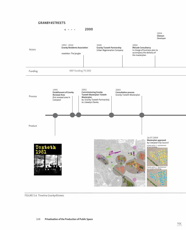
168 Privatisation of the Production of Public Space
HMRI - Pathfinder - Newheartlands 2003 - 2010NRF funding 75.000 privately funded initiatives
Granby option 1 - refurbishment of most buildings
2000 Granby Toxteth PartnershipUrban Regeneration Company
1993 - 2010Granby Residents Association
newletter: The Jangler
2007-2010Granby Community PartnershipCommunication vehicle between Council and ResidentsComprises: Council officials, Granby Residents Ass., Lovell, Ward Councillor
2011The Plus Dane GroupLiverpool Mutual HomesSteve BikoRegistered Social Landlords
2004GleesonDeveloper
2007LovellDeveloper
2012Leader 1DeveloperBudget of 25.6 million to referbush 149 homes and build 50 new ones
2011 - ongoingGranby Community Land TrustLocal development vehicleChair: Erika Rusthon
2004INclude Consultancyin charge of business plan to accompany the delivery of the masterplan
2007-2009Street planting & painting initiativeby local residents
HMRI - Pathfinder - Newheartlands 2003 - 2010NRF funding 75.000 Private
Granby Workshop
1995Establisment of Granby Renewal Areafirst renewal area in Liverpool
2003Consultation processGranby Toxteth Masterplan
2015Turner PrizeAssemble + Granby Workshop
2002Commissioning Granby Toxteth Masterplan Toxteth Masterplanby: Granby Toxteth Partnershipto: Llewelyn Davies
2007Street Planting Intitiativewith support from Include and grants from North West in BloomAward for Oustanding Achievement
13.11.2007 & 16.07.2008Community Consultationorganised by Granby Community Partnershipon Lovell’s redevelopment proposals
2009Street Painting InitiativePartnership between Plus Dane, SCNMT and GRAInitiative by GRA, Plus Dane funded proposal
2014Cairns Street InitiativesCommunity Land TrustProposals prepared by Assemble,paid for by Social Investor
16.07.2004Masterplan approvedby Liverpool City Council
Granby option 2 - refurbishment of a number of buildings
Actors
Product
2010< - - - - - - >
GRANBY4STREETS
Funding
2000
FIGURE 5.6 Timeline Granby4Streets
TOC
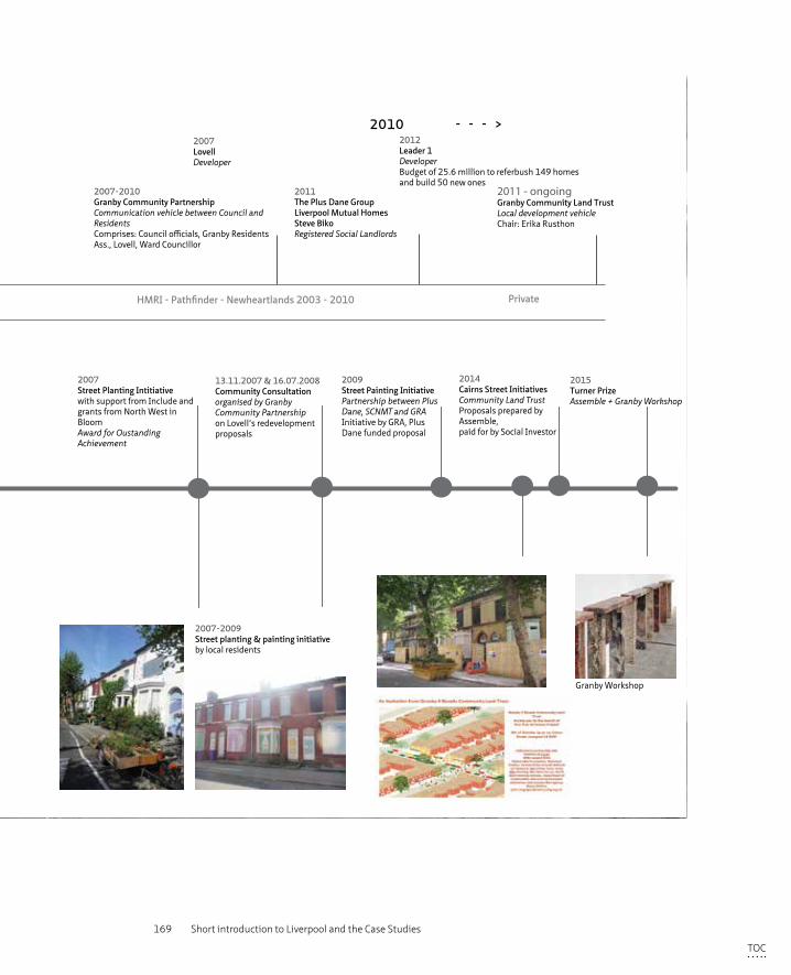
169 Short introduction to Liverpool and the Case Studies
HMRI - Pathfinder - Newheartlands 2003 - 2010NRF funding 75.000 privately funded initiatives
Granby option 1 - refurbishment of most buildings
2000 Granby Toxteth PartnershipUrban Regeneration Company
1993 - 2010Granby Residents Association
newletter: The Jangler
2007-2010Granby Community PartnershipCommunication vehicle between Council and ResidentsComprises: Council officials, Granby Residents Ass., Lovell, Ward Councillor
2011The Plus Dane GroupLiverpool Mutual HomesSteve BikoRegistered Social Landlords
2004GleesonDeveloper
2007LovellDeveloper
2012Leader 1DeveloperBudget of 25.6 million to referbush 149 homes and build 50 new ones
2011 - ongoingGranby Community Land TrustLocal development vehicleChair: Erika Rusthon
2004INclude Consultancyin charge of business plan to accompany the delivery of the masterplan
2007-2009Street planting & painting initiativeby local residents
HMRI - Pathfinder - Newheartlands 2003 - 2010NRF funding 75.000 Private
Granby Workshop
1995Establisment of Granby Renewal Areafirst renewal area in Liverpool
2003Consultation processGranby Toxteth Masterplan
2015Turner PrizeAssemble + Granby Workshop
2002Commissioning Granby Toxteth Masterplan Toxteth Masterplanby: Granby Toxteth Partnershipto: Llewelyn Davies
2007Street Planting Intitiativewith support from Include and grants from North West in BloomAward for Oustanding Achievement
13.11.2007 & 16.07.2008Community Consultationorganised by Granby Community Partnershipon Lovell’s redevelopment proposals
2009Street Painting InitiativePartnership between Plus Dane, SCNMT and GRAInitiative by GRA, Plus Dane funded proposal
2014Cairns Street InitiativesCommunity Land TrustProposals prepared by Assemble,paid for by Social Investor
16.07.2004Masterplan approvedby Liverpool City Council
Granby option 2 - refurbishment of a number of buildings
Actors
Product
2010< - - - - - - >
GRANBY4STREETS
Funding
2000
FIGURE 5.6 Timeline Granby4Streets
TOC
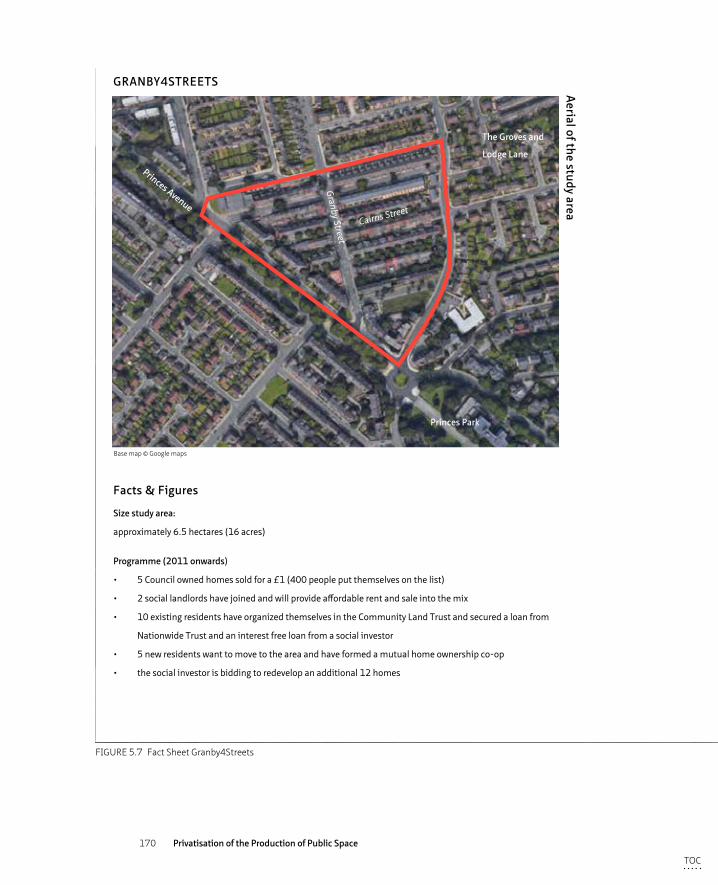
170 Privatisation of the Production of Public Space
Facts & Figures
Morphological transformation
Impression of the area
1908
2001
2015
Aerial of the study area
GRANBY4STREETS
Size study area:
approximately 6.5 hectares (16 acres)
Programme (2011 onwards)
• 5 Council owned homes sold for a £1 (400 people put themselves on the list)
• 2 social landlords have joined and will provide affordable rent and sale into the mix
• 10 existing residents have organized themselves in the Community Land Trust and secured a loan from
Nationwide Trust and an interest free loan from a social investor
• 5 new residents want to move to the area and have formed a mutual home ownership co-op
• the social investor is bidding to redevelop an additional 12 homes
1908 2001 2015
TRANSFORMATION granby 4 streets
1908 2001 2015
TRANSFORMATION granby 4 streets
1908 2001 2015
TRANSFORMATION granby 4 streets
Cairns Street
Granby Street
Princes Park
Princes Avenue
The Groves and
Lodge Lane
Base map © Google maps
FIGURE 5.7 Fact Sheet Granby4Streets
TOC
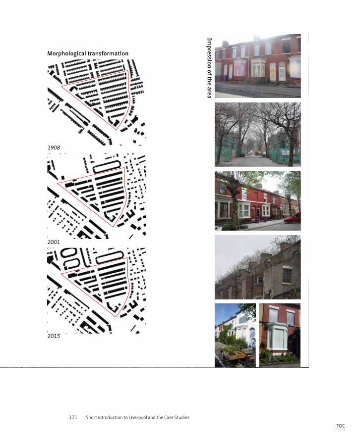
171 Short introduction to Liverpool and the Case Studies
Facts & Figures
Morphological transformation
Impression of the area1908
2001
2015
Aerial of the study area
GRANBY4STREETS
Size study area:
approximately 6.5 hectares (16 acres)
Programme (2011 onwards)
• 5 Council owned homes sold for a £1 (400 people put themselves on the list)
• 2 social landlords have joined and will provide affordable rent and sale into the mix
• 10 existing residents have organized themselves in the Community Land Trust and secured a loan from
Nationwide Trust and an interest free loan from a social investor
• 5 new residents want to move to the area and have formed a mutual home ownership co-op
• the social investor is bidding to redevelop an additional 12 homes
1908 2001 2015
TRANSFORMATION granby 4 streets
1908 2001 2015
TRANSFORMATION granby 4 streets
1908 2001 2015
TRANSFORMATION granby 4 streets
Cairns Street
Granby Street
Princes Park
Princes Avenue
The Groves and
Lodge Lane
Base map © Google maps
FIGURE 5.7 Fact Sheet Granby4Streets
TOC
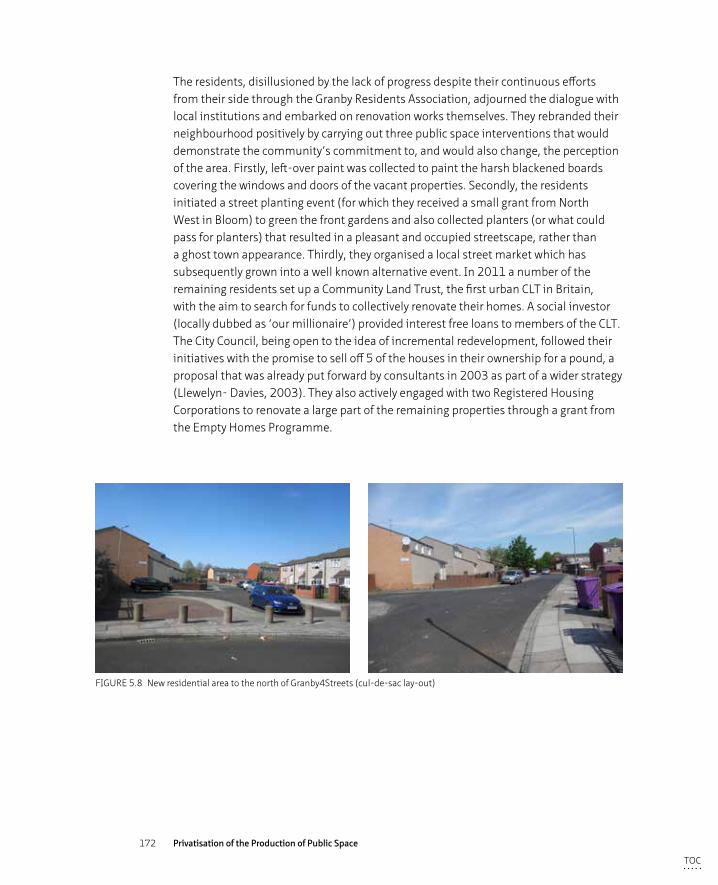
172 Privatisation of the Production of Public Space
The residents, disillusioned by the lack of progress despite their continuous efforts from their side through the Granby Residents Association, adjourned the dialogue with local institutions and embarked on renovation works themselves. They rebranded their neighbourhood positively by carrying out three public space interventions that would demonstrate the community’s commitment to, and would also change, the perception of the area. Firstly, left-over paint was collected to paint the harsh blackened boards covering the windows and doors of the vacant properties. Secondly, the residents initiated a street planting event (for which they received a small grant from North West in Bloom) to green the front gardens and also collected planters (or what could pass for planters) that resulted in a pleasant and occupied streetscape, rather than a ghost town appearance. Thirdly, they organised a local street market which has subsequently grown into a well known alternative event. In 2011 a number of the remaining residents set up a Community Land Trust, the first urban CLT in Britain, with the aim to search for funds to collectively renovate their homes. A social investor (locally dubbed as ‘our millionaire’) provided interest free loans to members of the CLT. The City Council, being open to the idea of incremental redevelopment, followed their initiatives with the promise to sell off 5 of the houses in their ownership for a pound, a proposal that was already put forward by consultants in 2003 as part of a wider strategy (Llewelyn- Davies, 2003). They also actively engaged with two Registered Housing Corporations to renovate a large part of the remaining properties through a grant from the Empty Homes Programme.
FIGURE 5.8 New residential area to the north of Granby4Streets (cul-de-sac lay-out)
TOC
173 Short introduction to Liverpool and the Case Studies
Management and MaintenanceLiverpool City Council has the responsibility for the maintenance of the public spaces of the Granby4Streets area, but let its residents down for many years. Residents took their fate in their own hands, organised a small grant from North West in Bloom and planted their front gardens and those of their vacant neighbouring properties. They then decided to organise a street market that has become a popular destination not only for local residents but also from people of other parts of Liverpool.
TOC
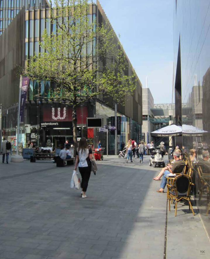
174 Privatisation of the Production of Public Space
TOC
175 Findings and Analysis: Privatisation and Publicness in Liverpool
6 Findings and Analysis: Privatisation and Publicness in Liverpool
In this section the analysis of the data will be described following the analytical frameworks on Governance, Users and Designer as discussed in Chapter 3. The Methodology used for each perspective is discussed in Chapter 4.
§ 6.1 Governance Perspective
This first paragraph analyses the perspective of governmental and other key (private) stakeholders who were instrumental to the production of the three different case studies. The analysis is based on a review of relevant policy documents and a variety of plans and vision documents for the three case study areas. In addition, a series of 21 interviews were held with actors included in the production of one, two or even all three case studies (see overview of interviewees Appendix B). The rules, questions and themes on which both the questions of the interviews and the structure of the discussion in this paragraph are based, are identified in the analytical framework. The rules cover both the normative, and perceptual side of this perspective and hence centre around ownership, control and funding (in all phases of the regeneration process, from design to implementation and maintenance), accessibility (as in open and inclusive) to both product and process as well as the interviewee perceptions of the level of publicness achieved and the sustainability or success of the urban regeneration trajectory. The rules will be outlined in the following paragraphs based on the questions and themes operationalised in the analytical framework, from 6.1.1 to 6.1.6:
– The role of public and private partners in the development process; relations, trust, conflict and decision-making power.
– Funding streams
– Maintenance and management regimes
– Providing a sense of security and social control
– Valued urban space?
– Perception of publicness
TOC
176 Privatisation of the Production of Public Space
§ 6.1.1 Stakeholder relations, trust and decision-making power
In 1998 the Liberal Democratic City Council, freshly voted in after years of militant Labour, acknowledged that the inner city was in desperate need of investment and in particular, lacked a substantial retail offer. The area around Paradise Street and Chavasse Park, severely bombed during the war and laying largely vacant ever since, was an ideal location for a development project of significant retail stature. Liverpool City Council issued a Planning Framework (1999) to this end in which it stated that a development programme was sought for the Paradise Street Development area, which was mainly centred around the provision of retail. The objectives of the development project were twofold. Firstly, the development had to link the centre back to its waterfront, where the restored Albert Dock had begun to function as a tourist attraction after its redevelopment ending in 1984. Secondly, the project had to “expand Liverpool´s shopping district and regain the city’s status as the pre-eminent regional retail destination” (Littlefield 2009, 27). The Council was the initial driver behind this ambition and sought a private development partner who could deliver this vision. Project developer Grosvenor won the international competition organised by Liverpool Council to determine the best partner because they did not suggest an enclosed shopping mall (as the other competitors did) but proposed to create ‘an urban quarter’ with a network of pedestrianised streets aligned with different sized lots for which they intended to invite a range of different architects to design the buildings. Throughout the visioning and design stages, the Council worked closely with Grosvenor’s team to ensure the scheme’s success. The newly elected Liverpool City Council was desperate for a successful project in order to regain trust in local government, not only for the people of Liverpool but also nationwide. Hence, there was pressure on the local council to make this development happen to boost their own ability to deliver such a scheme, to provide Liverpool with an economic success thereby creating jobs and investment as well as putting Liverpool back on the (inter) national map. Grosvenor at the other hand, required the Council’s support in planning terms to drive forward the scheme they had invested so much in. “There was almost an even status between them in vested interests” (James Millington, landscape designer BDP). Despite this, the Council’s advisor on urban design and architecture remarked that Grosvenor was very persistent on certain occasions and would push the Council’s arguments aside. In addition to this specially dedicated advisor on design and architecture, the Council created a working group of officers with project related skills – urban design, highway engineering, landscape, planning, led by Peter Jones, to negotiate with the Grosvenor team led by Rod Holmes. Weekly design meetings were held to discuss design issues, often with specialists invited for the occasion to critically review plans and proposals. The Council had chosen to sell off its land to a private stakeholder (or a consortium of private partners) because they did not believe Liverpool Council could raise the necessary funds or that they had the necessary skills to complete such an extensive scheme within a short period of time.
TOC
177 Findings and Analysis: Privatisation and Publicness in Liverpool
Throughout the masterplanning process, there were a number of stakeholder engagement meetings where ‘official’ stakeholders, such as Merseytravel, CABE, English Heritage etc., were invited and consulted as well as future and existing retailers and the neighbouring Bluecoat art centre. The relationship between Bluecoat and Grosvenor was friendly but not constructive: although Liverpool ONE encloses the Bluecoat on three sides and was in the process of building an extension at the same time that Liverpool One was being designed, Grosvenor did not include the Bluecoat in their design ideas or suggest a possible collaboration for the provision of art in the area. Minimal inclusion of stakeholders not legally obliged or technically necessary for the development process is typical corporate practice, where efficiency and effectiveness are the drivers. “These things are part of the Council’s choice to hand the land over to a company like Grosvenor. They regard a development project as a military operation and remove all noise for a smooth as possible process. The function of public values is discredited within these processes” (Hans van der Heijden, architect Bluecoat extension).
The only real protest against the Liverpool One scheme came from a local indoor market called Quiggins that housed a range of independent, alternative stalls. They fought against their eviction with a protest march, several articles and events as well as a petition to Parliament, which was supported by the Labour MP of Crosby Claire Curtis-Thomas. Despite these efforts, Deputy Prime Minister John Prescott approved the whole package of Compulsory Purchase Orders (CPO’s) put forward by the Council in 2004, stating that the comprehensiveness of the scheme had to prevail. The overall aim was to provide a sufficient retail offer to compete with other cities in the neoliberally driven interurban competition (Swyngedouw et al. 2002). The Council only owned one third of the land within the Liverpool One boundary and had to acquire the other two thirds before they could sell on to Grosvenor. A number of the parcels of land had to therefore be acquired through a CPO process, which came at a huge risk and cost. “Local and national authority would not take the risk to let the complete scheme implode by exempting Quiggins” (Trevor Skempton, advisor to the Council on urbanism and architecture).
The local residents and future users of Liverpool One could voice their appreciation or concerns regarding the proposed development scheme through the consultation process held by the project developer, Grosvenor. However, there was no consultation or debate on the fundamental question concerning the privatisation of one third of the city centre and the consequences thereof. A critical response to the large private component within the scheme and fears of losing a true public space came from journalists and academics (see eg. Minton 2006, 2009) but not from politicians who did not regard this form of privatisation as a fundamental breach of public rights or values. Public protest against the principle of privatisation was minimal. Public right
TOC
178 Privatisation of the Production of Public Space
of way and full accessibility through the development was safeguarded however, via a series of statuary documents including the planning permissions and the public realm agreements agreed between Grosvenor and Liverpool City Council. The loss of public values, such as the right to demonstrate, distribute flyers, and busk, were not part of these agreements and were apparently deemed of lesser importance than the economic regeneration of the city centre.
In summary, a scheme for the Paradise Street Development Area (later rebranded as Liverpool One) was designed and implemented in a top down manner by the private developer Grosvenor who bought the land on a 250 year lease from the Council. Although the initiative for the project originated from the Council, the design and implementation phase was orchestrated by Grosvenor who predominantly directed the contents of the scheme as well as stakeholder accessibility to the process. The Council and the developer worked in a collaborative process in which Grosvenor had the ultimate decision-making power. The Council clearly had no trust in their own capabilities to design and implement such a large and important scheme for the city, but placed this trust in its private partner. Other stakeholders had limited access to the process; there was communication and consultation with a large number of other stakeholders without actively engaging them in the decision-making. Grosvenor took a coordination role with not much room for collaboration or cooperation. The outsourcing of tasks and responsibilities to one private (corporate) partner can be seen as a complete form of privatisation, in which even the legal rights over the land changed hands.
The regeneration process of the Ropewalks29 began before the brief for the Paradise Street Development Area (PDSA, which later became Liverpool One) was defined. The original Ropewalks site boundary included most of PSDA, however the Liverpool One area was later taken out of the Ropewalks scheme and given its own status with Hanover Street as the dividing boundary between the two masterplanning areas. In a number of ways, the Ropewalks regeneration project was a novelty in regeneration terms. Firstly, a regeneration vehicle consisting of public and private bodies as well as representatives of the local community was set up to design and implement the regeneration strategies. This was one of the first of its kind in the UK. Secondly, it was the first project in the UK
29 This area was not called ‘Ropewalks’ at the time, but was referred to as the Duke Street/Bold Street Area for which an Integrated Action plan was developed in 1998 by BDP. As part of the rebranding of the area the name ‘Ropewalks’ was initiated which refers to its past of ropemaking. An icon, a knot of a string of ropes, completed the branding.
TOC
179 Findings and Analysis: Privatisation and Publicness in Liverpool
to receive its funding through the European Objective One fund. Thirdly, “in political terms it was quite an extraordinary process because we set the expectation of quality really high. At this at a time where Liverpool had no expectation at all: it was a very poor city, it was a city desperate for anybody to come and invest and at that time nobody came to invest in the city without a grant” (Beatrice Fraenkel, Chair Ropewalks Partnership, Urban Design Champion, Councillor 1986 - present). Within the public-private partnership, the public bodies were responsible for the implementation of the Objective One funded projects proposed in the Integrated Action Plan (1997). The individual private owners were to renovate their properties (a number of which were also indicated in the Integrated Action Plan), including a large number of derelict warehouses. The idea behind the partnership was that if the public bodies who invested in public space works were to alleviate the physical degradation and poor appearance of the area, perceived to be the principal barrier for investment, private investment would follow suite. Following this line of thinking, the City Council sold over 300 publicly owned buildings to the private developer Charterhouse Estates in the 1980’s, with the intention that they renovate the properties in such a way to promote to the creative quarter idea. Charterhouse went bankrupt during the property recession of the 1990’s and many of the buildings changed hands as a result. One of the beneficiaries was Max Stone of Frensons, who bought a number of properties but whose unfortunate philosophy was “to sit on his buildings until they gained in value rather than actively pursue renovation” (Iona Horsburgh, Executive Director Fact). Another developer, Urban Splash (an early pioneer in the Ropewalks area) managed to renovate a number of buildings into offices and loft living spaces, including the Tea Factory, with the help of public grants. The integral approach of public and private bodies working collectively towards the regeneration of an area puts a great deal of trust in the private partners in the area to ‘play ball’ and as such, active partners were essential. In the early regeneration phase, the roles of public and private partners were divided along physical lines of public space and private buildings that resulted in a large amount of public money being spent on the appearance of the public spaces. The Council did hereby not interfere by stabilising rents and rates, so in the management of assets, within the Ropewalks area. This resulted in market mechanisms driving the rents up, forcing creative businesses out. Cafes and clubs were able to pay these higher rents and rates and so the Ropewalks became known for its successful nightclubbing scene.
In the Ropewalks area, the City Council proactively engaged local stakeholders in the regeneration process, although in the 1980’s, the area was rundown and neglected so not that many active stakeholders were found. In contrast to Liverpool One where the Council handed management of the process over to a single private partner, at the Ropewalks the Council took the lead and worked collaboratively with a number of private developers (such as Charterhouse, Frensons, Cruden and Urban Splash) organised as a partnership to promote private investment in the area.
TOC
180 Privatisation of the Production of Public Space
In 1997 the Council organised a planning weekend in which the neighbourhood’s future was discussed with a wide variety of stakeholders and the results were included in the Integration Action Document produced later that year. In the Ropewalks, there was little sign of grass-roots community action within the development and implementation of the Integration Plan (1998-2002). This changed with the building of apartment blocks and the arrival of residents who clashed with the growing success of the nightclubbing scene. Local residents complained of the noise, drug and alcohol related issues that came with the success of the nightclubbing scene and also the loss of independent shops and creative businesses, such as the closure of MelloMello in 2014 due to rising business rates. The City Council sought active engagement with the residents and supported the establishment of the Ropewalks Residents Association (RRA) that gradually gained momentum, solving issues related to noise and disturbance from the pubs and clubs. The RRA was consulted by the Council on new renovation proposals, such as the recent Wolstenholme Square development, and felt genuinely listened to and part of a constructive dialogue. There is a perception that issues raised by residents are taken into account by the Council although the Wolstenholme Square development caused friction with local people because (in its current setting at least) it includes the closure of two of Liverpool’s creative institutions, The Kazimier and Cream. Although Cream will be rehoused within the basement of the new development, local people actively resisted the loss of this creative hub in its historic, raw urban setting. Conflicts and power struggles between various active actors have dominated and still dominate the development process of the Ropewalks.
The Council started the Ropewalks masterplanning phase with a weekend in which actors, both corporate and NGO’s, were actively sought to participate in the development process. The Council set up a public-private partnership in order to channel both public and private funding streams into the regeneration of the area. The Ropewalks Partnership constructed the public space works as proposed in the Integrated Action plan within its proposed time frame as well as some of the privately driven projects. A number of private initiatives however, failed to materialise in the initial phase. The City Council continued its public-private partnership approach throughout the decade following the implementation of the initial works but organised the structure in a bottom-up rather than the original more top-down organisation of the Ropewalks Partnership. In 2011, Liverpool Vision set up a Community Interest Company (CIC) in which representatives of local businesses, local government, civil groups and residents could discuss the specific, urgent matters of the Ropewalks. The initial stakeholder meetings attempted to be inclusive with hundreds of people attending but which unfortunately ended in fights between the bar-owners and the residents. After this unproductive process, five smaller workgroups were organised
TOC
181 Findings and Analysis: Privatisation and Publicness in Liverpool
with the aim of dealing with five specific areas and their issues. The regeneration of the area developed (and still develops) organically and erratically, loosely based on the principles of the masterplan rather than strictly planned and carefully orchestrated as the development of Liverpool One was. In the early phase of the regeneration of the Ropewalks, the number of different stakeholders that simultaneously undertook multiple projects in different parts of the Ropewalks area caused some friction and conflict amongst local residents and businesses. This put a strain on the relationships and levels of trust between at the one hand these local stakeholders and at the other hand the Council who was seen the conflict solving authority. In order to both restore levels of trust and solve emerging issues, the Council therefore supported, facilitated and in some cases initiated, new, local bottom-up organisations such as the Residents Association and the CIC’s in which private and public actors work collaboratively around certain specific issues. This enhanced the level of trust between the local stakeholders.
Contrary to the collaborative approach the City Council applied to the regeneration of Ropewalks, the Council opted for a publicly led, top-down approach for the regeneration of Granby4Streets through the Market Housing Renewal Initiative. In 1994 and after the redevelopment of the northern part of Granby, the City Council and the three main housing associations active in the area, notified the remaining residents in the southern part (the Granby4Streets area or Granby Triangle) about the proposed demolition of their homes and development of new houses. The residents organised themselves into the Granby Residents Association (GRA) to prevent the local council from evicting them from their homes and demolishing their neighbourhood. The GRA produced a vision document, ‘The 3 streets Project’ in which the demand for sustainable owner-occupation and private renting for 140 properties in the Granby4Streets was laid out. It suggested that a combination of selective demolition, new build and refurbishment of the remaining properties with a mixed tenure provision was the best option. The Granby /Toxteth Masterplan30, which included the Granby4Streets area, came to the same conclusion and developed three possible scenarios for the area, which recommended the mixed option of retaining structurally viable buildings as well as new build infill projects in places where buildings could not be retained. Retaining the general morphology based upon the Victorian street pattern
30 The Granby Toxteth Masterplan comprised a detailed audit and regeneration framework for Granby/Toxteth and was carried out on behalf of the Granby Toxteth Partnership, a quasi local government organization including local stakeholders, which formed part of the South Central Liverpool Cluster Partnership, set up in xxx to xxxxx. The masterplan was conducted in 2002/2003 and included extensive consultation with key stakeholders in-cluding the GRA and local residents through a public consultation event. Funding for the masterplan came from the Neighbourhood Renewal Fund.
TOC
182 Privatisation of the Production of Public Space
intact was an essential element to keep the historic urban character and density. The Masterplan was approved by Liverpool City Council in 2004 and followed by a development brief issued by the Housing Market Renewal Initiative for substantial refurbishment (Council Decision notes 01.06.2004). Despite the work undertaken in the visioning phase and in documents, reports, and working groups, no physical improvements were made in the years following this decision, much to the despair of the local community. The local residents involved in the process thus far, stepped out and refused further dialogue with the Council. They took the physical improvements of the area in their own hands and upgraded the public spaces by painting the boarded up homes and planting front gardens. Whereas within both the Liverpool One and the Ropewalks regeneration processes a degree of trust existed between the public, private and community interest groups, in the Granby4Streets process the opposite was observed. There is an enormous lack of trust in the Council’s conduct and intent that can be partly explained by looking at the recent history of political tension. Granby/Toxteth exists in Liverpool as a racialised space. Although the area’s links with the black community are relatively recent - historically Granby was an area of mixed ethnicity- the powerful imagery of the racial ‘other’ and a string of negative events that ultimately resulted in the 1981 riots have served to reinforce perceptions of the area and its community (Uduku and Ben-Tovim 1998, 17). There was a general perception with local residents that the Council did not respect them or their ideas. The Councils objective as they saw it, was to demolish the houses in the area because of the high land values resulting from the area’s proximity to the city centre and to Princes Park. There has been a degree of caution in what the Council’s motives for the area were, including suspicions centred around social dispersion as a punishment for the riots. “I don’t think people are wicked but rather without any vision. As soon as you enter the world of bureaucracy you are dealing with incompetency and a lack of information” (Hazel Tilley, board member GRA and CLT). According to Linda Aitken, project leader of the Granby/Toxteth Masterplan, the reason the Council rejected the proposals for refurbishment were: “Simple lack of vision, the absence of an understanding of the area’s inherent qualities, and a reluctance to meaningfully engage with the local people ‘blinded’ the Council to the inherent qualities and potential for the area based on a refurbishment led masterplan”.
TOC
183 Findings and Analysis: Privatisation and Publicness in Liverpool
With the end of the HMRI funding in 2010 and the failure of the latest Council orchestrated project, the Council became more flexible in their approach and allowed a piecemeal development by a variety of public (housing corporations) and private initiatives. Residents united themselves again within a Community Land Trust31, the first in Britain for an urban area, which gave them the necessary status to be able to apply for loans. They were granted 10 houses to refurbish by Liverpool Council and the CLT was given an interest free loan by a social investor.
Relations between the Council and the local residents have improved since they embarked on a cooperative road rather than a top-down Council coordinated approach. The Council took a more reflective stand in recent years, supported initiatives when they appeared and also supported the CLT with their bids for funding, “we obviously respect their independence but we are happy to sit on board in an advisory role”. (Anthony Mousdale, Empty Homes Manager, LCC). The Council has attended meetings of the Granby Stakeholders Group in which members of the CLT, Council and potential developers gather to monitor general progress in the area. Members of the CLT had expected however, a more collaborative role for Council, in particular in relation to funding. “The Council is saying that they are working in partnership with us, but we haven’t seen a penny from them. There is a total and utter lack of trust when it comes to giving us money. Because we are Liverpool 8: we are thieves, blacks and prostitutes. It is about power. If they gave us money they would lose control over it” (Hazel Tilley, board member GRA and CLT). Clearly there were different perceptions of roles, tasks and distribution of responsibilities by the different stakeholders.
31 Community Land Trust is “a form of community-led housing, set up and run by ordinary people to develop and manage homes as well as other assets. CLTs act as long-term stewards of housing, ensuring that it remains gen-uinely affordable, based on what people actually earn in their area, not just for now but for every future occupier” (http://www.communitylandtrusts.org.uk)
TOC
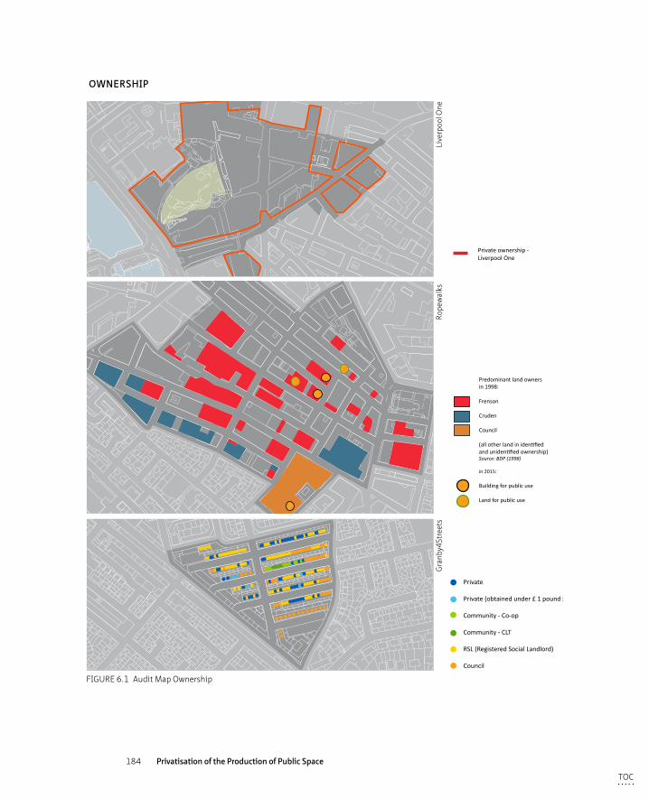
184 Privatisation of the Production of Public Space
uses
KEY
Private
Private (obtained under £ 1 pound scheme)
Community - Co-op
Community - CLT
RSL (Registered Social Landlord)
Council
Private ownership - Liverpool One
Predominant land ownersin 1998:
Frenson
Cruden
Council
(all other land in identified and unidentified ownership)Source: BDP (1998)
in 2015:
Building for public use
Land for public use
OWNERSHIP
Gra
nby4
Stre
ets
Rope
wal
ksLi
verp
ool O
ne
FIGURE 6.1 Audit Map Ownership
TOC
185 Findings and Analysis: Privatisation and Publicness in Liverpool
Thus from having began as a top-down, publicly led and funded regeneration scheme, Granby4Streets became community led (endorsed by the City Council and two main housing corporations) and went through a more organic approach where individual private money is used to redevelop properties. Residents, the Council and other (semi) public institutions had a conflictuous relationship for over 30 years, a struggle that was finally resolved because the Council gave up its dominant position of coordinating to establish a much more productive cooperation in which different actors work in a cooperative way towards communal goals in order to regenerate the area. Cooperation is not operationalised in a partnership with contractual status but functions more organically and ad hoc. The eventual delivery of the regeneration process can be credited to the efforts of the RSL’s who undertook the largest amount of renovation work as well as to the engaged residents who never stopped fighting for their vision. “They are very cultured and knowledgeable about what they do. They have a very long view on what they have been through and how the see their area. I find them as one of the wisest community groups I’ve ever come across” (Ronny Hughes, Director Sense of Place). Without them the area would most certainly not have developed as it has.
The three different organisational models described in chapter 3.1 – coordination, collaboration and cooperation (McAllister and Taylor 2015) - are each present in one of the case studies; the development process in Liverpool One is top down process coordinated by a private actor, the public private partnership approach in the Ropewalks is an example of a collaboration between both public and private stakeholders and Granby4Streets was initially coordinated by one public actor but turned into a cooperative process with a variety of public and private actors working individually towards a common goal.
TOC
186 Privatisation of the Production of Public Space
§ 6.1.2 Funding streams
Originally the Liverpool One project had an estimated budget of £650 million that was put together with a £255 million equity package by six investors known as the Grosvenor Liverpool Fund32 (of which Grosvenor had a 20% stake), the remaining £400 million came from bank loans. Rising land values and spiralling construction costs led to an estimated budget overrun of £150,000. Together with the buildings that were financed by Grosvenor itself (the Hilton hotel worth £60 million and the One Park West complex worth £80 million), the total cost of the development was nearly £1 billion pounds. The local Council contributed in kind to the regeneration project through the collaborative attitude they took in delivering the scheme on time though being the planning authority, this is something that they are obliged to do in any case. Liverpool Council had a vested interest in completing Liverpool One on time before the opening of the Cultural Capital festivities in 2008. They also had a 5% stake in the scheme as development partner. The fact that the project was not funded through public money made it easier for the Council to defend the project to the local public because there was a negative sentiment that the Council concentrated its investments in the city centre rather than on the residential neighbourhoods. “Liverpool ONE was not a publicly funded development, but private sector funded, we [the Council] made money on it, we didn’t spend money on it and the reception by people in the city has been very positive as a result.” (Steven Munby, councillor)
In the Ropewalks, the public space works were initiated by the Council who obtained £12 million of public funding for the implementation of these works through European Objective One funds. Private companies that owned the buildings (of which 192 are protected through listed status plus being located in a conservation area) could also apply for public grants to help renovate their properties. The £12 million of public funds were invested in the public space works which included the provision of new pocket parks, street improvements and repaving as well as the implementation of pedestrian links to provide the private sector comfort required to encourage their investment in the area. The completed scheme has created a coherent network of high quality streets.
32 The Grosvenor Liverpool Fund financed (part of) the Liverpool Development and ‘own’ Liverpool One. Partners are: Grosvenor, Aberdeen Property Investors (on behalf of a private Middle Eastern Client), Hermes (on behalf of Britel Fund Trsutees and Possfund Custodian Trustees), Liverpool Victoria, Maroon Capital and Redevco Prop-erties UK. The banks that provided the loans were: Barclays, Eurohypo, HSBC, Royal Bank of Scotland. (Littlefield 2009, 246)
TOC
187 Findings and Analysis: Privatisation and Publicness in Liverpool
In 1995, the City Council declared part of Granby/Toxteth as a Renewal Area for a period of 10 years, which was twice extended until 2015. This status entitled the area to Neighbourhood Renewal Funding (NRF) that was subsequently followed by the Housing Market Renewal Initiative (NMRF). Liverpool Council envisaged a wholesale solution for the area that required single ownership of all the properties. The Council acquired 140 properties within Granby4Streets using the NRF. They also used the public funds to set up regeneration vehicles and commissioned consultants to come with proposals. “All the money earmarked to this area from the NRF has gone to bureaucracy. The Council spent thousands and thousands on this area as long as it was spent in an office” (Hazel Tilley, board member GRA & CLT). In 2010 the conservative national government ended the funding regime and regeneration processes ground to a halt as a result. This turned out to be a positive for Granby4Streets as the Council, deprived of its funding stream, began to be more open-minded to solutions other than an overall redevelopment scheme implemented by one developer. Since then a number of small-scale initiatives have come forward, funded by a mixture of public (Heritage Lottery Grants, Empty Homes Grant) and private money from local individuals (co-operative, house for a pound scheme) as well as a private investor. A millionaire from Jersey took an interest in the area and invested in the refurbishment of 26 dwellings, 12 new family homes and 5 apartments on Ducie Street and Kingsley Road. He also lent the CLT half a million pounds interest free, to renovate the 10 properties they were gifted from the Council. For the remaining cost the CLT obtained a grant from the Nationwide bank. Thus, what started as a publicly funded and led, top down project that yielded few results in the physical and social environment of Granby, morphed into a community led project consisting of a multitude of initiatives funded by a variety of private and public sources.
The three cases clearly vary in the way that they were funded: from almost completely privately funded in Liverpool One, to a mix of public money (used for a public space upgrade, amongst other things) and private money (for the renovation and refurbishment of private property) in the Ropewalks to Granby4Streets that began to be publicly funded but ultimately became a combination of public and privately funded initiatives.
TOC
188 Privatisation of the Production of Public Space
§ 6.1.3 Maintenance and management regimes
The conservative national government of 1979 – 1997, guided by their neoliberal beliefs in the workings of a competitive market, introduced a compulsory competitive tendering process (CCT) that forced local authorities to tender for many of their services (including refuse collection and grounds maintenance) on the open market (Local Government, Planning and Land Act, 1980&1988). In 1997 under Labour, the CCT system was changed to a Best Value system in which value to customers prevailed over competing cost. Since the beginning of 2016, the public realm management and maintenance in Liverpool is again owned by Liverpool City Council, who set up a separate entity - the Liverpool Waste Management and Related Services (LATco) - to overview and implement the waste and street cleaning regimes. This company replaced a previous joint venture between the Council and private company Amey (called Enterprise Liverpool Limited (ELL)) that was awarded this contract in 2013 and which due to run until 2022. In the summer of 2013, Amey employees went on strike over a pay rise and fear of job losses. The Council meanwhile, were unsatisfied with the inflexibility of the contract they had agreed with Amey as well as the services provided and decided to end the contract with the private company. The consequences of the compulsory tendering process - since the 1990’s, it was common practice for Local Councils to outsource many of their services to private companies - have not always proven to be more cost-effective and efficient or to deliver the best value for citizens and also often tend to offer Councils little flexibility. They have therefore started to become less popular. According to Kenny Brew, streetscape manager: “Local Councils started to realise that private companies have to make a profit for their investors, for that money we can have cleaner streets. So we took back the contract now since eight weeks and you can already see the difference in the way the streetscapes look. It looks a lot cleaner, we have more control in what service we want at a certain time. We are not tied to a contract.” (Kenny Brew, streetscape manager LCC)
Besides the maintenance regime provided by LATco, there is a City Centre Business Improvement District (BID), which provides extra services on top of those provided by the Council for the City Centre. Its main aim is “to promote the city centre as a safe, clean, attractive and vibrant destination and to host events that will help generate footfall” (www.liverpoolbidcompany.com). The BID is not strictly a privately run operation as the Council, Merseyside police and Mersey travel also have a seat on the operating board of the City Centre BID.
Liverpool One does not fall under the City Centre BID. It has its own management vehicle (Liverpool One Management Company ltd.) that is charged with ensuring that within the 42 acres (17 hectares) of public space, all the buildings and all the
TOC
189 Findings and Analysis: Privatisation and Publicness in Liverpool
tenants are managed to a high standard that “will deliver good returns in terms of the number of people that coming to visit Liverpool One, spending money in the retail units and hence makes the retailers profitable and hence pay us a good rent in return” (interview Chris Bliss, director Liverpool One). Liverpool One is owned and paid for by the Grosvenor Liverpool Fund that consists of six investors, of which Grosvenor property company is one. Liverpool One has 3,500 employees, including the ‘red and blue coats’ who are in charge of safety and cleaning respectively. Already within the design phase, the management and maintenance of the public realm formed an integral part of the decision-making process. “My role in the design process was to ensure that we were designing buildings and designing public realm that people wanted to use and we were able to manage” (Chris Bliss, director Liverpool One). The public space maintenance standards were formalised in an agreement with the Council that formed part of the planning application procedures. The Council therefore, technically has a say in the management and maintenance regimes of Liverpool One if they would fail to meet the standards as described in the contract. Liverpool One has good relationships with both Liverpool Council and the City Centre BID of which the director of Liverpool One is a non-executive director. The main aim of Liverpool ONE is to apply the same standard of maintenance to the city centre streets that apply to the Liverpool One area, not the other way around.
With the exception of Concert square, the maintenance regime for the Ropewalks and Granby4Streets is in the hands of the Council and hence of LATco. The maintenance contract of the public space that constitutes the square was, as part of the masterplan, privately given out to a company called Urban Splash, who sublet it to two businesses that both operate a club on the Square. Urban Splash received a yearly fee from the Council to maintain the square but outsourced the maintenance for a fraction of the money they received. The Council has therefore ended this contract and now leases the square (which almost completely consists of a private seating area) directly to the two clubs who pay a fee to the Council for its use.
Most interviewees agree that the maintenance of the Ropewalks could be much better than the current status. When the masterplanning programme was implemented, the board and the partnership were dissolved and, although maintenance was built into the plan, the moment the Council took over the maintenance, deterioration started to be noticeable. The bespoke cobbles used for the street surfacing were not replaced and holes were filled with tarmac. “We spent our money on the best quality to get the best results but you can’t leave things on their own unfortunately” (Beatrice Fraenkel, Chair Ropewalks Partnership & Urban Design Champion Liverpool, Councillor). For a number of years the Council had outsourced the maintenance of the Ropewalks to a
TOC
190 Privatisation of the Production of Public Space
private company, Amey, which was also not perceived by interveiwed users to do theur job properly. Users voiced a lack of maintenance, particularly noticeable in the amount of litter on the streets and squares as well as the replacement of the cobbles with tarmac. In order to address these issues, the Council has recently decided to terminate the contract with the private partner so as to halt the outsourcing of these tasks to a corporate actor and take them back into public hands.
Liverpool Council has also began to include residents in the conversation about the maintenance of their neighbourhoods. In the Ropewalks there is direct contact between the streetscape manager and the Ropewalks Residents Association to discuss issues concerning maintenance. In 2014, the residents showed a willingness to take responsibility by joining a litter picking day event organised by the Residents Organisation in collaboration with Amey, the private company that was responsible for the maintenance at that time.
In Granby4Streets the residents do not feel that the relationship with the Local Council is as co-productive as in the Ropewalks. Maintenance of the streets is lacking, cracks in pavements are not repaired and broken lightbulbs in street lights are not replaced. “At some point the rubbish stopped being collected, because, as it turned out, they thought nobody lived here anymore” (Hazel Tilley, member Granby Residents Association, member Community Land Trust). For 30 years this area was sparsely inhabited and investments in the streetscape and maintenance were kept to the bare minimum. Now the area is slowly being built up again, public space management and maintenance is also expected to be addressed in a more comprehesive way by the Council.
In summary, the privately owned and maintained area of Liverpool One is considered to be managed and maintained to a higher standard than the surrounding streets in the city centre, including the Ropewalks and Granby 4 Streets. This is partly because Liverpool One controls the rental leases in the area comprehensively and the retailers in Liverpool One are prepared to pay high rents but naturally expect high levels of service in return. Granby 4 streets, being a residential area outside the city centre core, has a more infrequent maintenance regime than the inner city commercial streets.
TOC
191 Findings and Analysis: Privatisation and Publicness in Liverpool
§ 6.1.4 Sense of security and social control
Liverpool City Council works in collaboration with the Merseyside police to reduce crime. The Council operates 266 CCTV cameras throughout the city centre, excluding the Liverpool One area that operates its own cameras and shares the information with the appropriate agencies as necessary (providing it does not breach data protection laws).
Liverpudlians perceive their city to be safe according to a bi-annual perception survey undertaken by the Council. Outside of Liverpool, the city has a long history of being perceived as unsafe and even dangerous, based on the high levels of deprivation and the 1981 riots. The facts tell a different story: in the national statics report of the safest cities in the UK, Liverpool came second with only Newcastle being a safer place (www.statisticsauthority.gov.uk). Of the 13,580 reported crimes in Liverpool City Centre between August 2015 and July 2016, 29% were related to public order and anti-social behavior incidents (https://www.police.uk/merseyside/E9/crime/stats/data)
In addition to cameras, Liverpool Council have environmental enforcement officers walking the streets in charge of regulation and law enforcement, although the number of officers and the hours worked have been significantly reduced over the years. They do walk the streets of the Ropewalks area but not the other two case study areas. In Granby4Streets there is police control, related to drug dealing issues in the past and in Liverpool One there are private security guards in operation, ‘the red coats’. The red coats are not referred to as security guards but as customer service; “we don’t want to talk about safety or security because it is not an unsafe place. So we talk about custom service” (Chris Bliss, director Liverpool One)
Through its Citysafe Partnership33, Liverpool Council develops policies to prevent and reduce anti-social behaviour, including developing responses under the Crime and Anti-Social Behaviour Act 2014. It has ordered a number of Anti Social Behaviour Orders (ASBO’s), including for the dispersal of youth gangs in the city centre and Public Space Protection Orders (PSPO’s). None of the ASBO’s or PSPO’s were ordered within any of the three case studies, although incidents of anti social behavior have been
33 The Citysafe Partnership works together to prevent and reduce crime and disorder and improve community cohesion through maximising resources and using targeted thematic groups. Citysafe is Liverpool’s statutory Community Safety Partnership and is made up of a number of agencies: Liverpool City Council, Merseyside Police, Merseyside Fire and Rescue Service, National Probation Service Merseyside, Merseyside Community Rehabilitation Company, Liverpool’s Clinical Commissioning Group, registered providers, the Universities, Local businesses and representatives of the voluntary sector.
TOC
192 Privatisation of the Production of Public Space
reported in all three areas (www.statisticsauthority.gov.uk). In the Ropewalks these incidents are by and large alcohol or drug related. When the private cameras or guards of Liverpool One pick up on serious anti-social behaviour or crime, these incidents are reported to the police to be dealt with.
The official count of homeless people in Liverpool is 15, but that figure is known to be too low. Liverpool Council’s policy is that no one has to sleep more than one night on the streets. The amount of people seen begging on the streets in the City Centre and the Ropewalks has grown although these people are not necessarily homeless but might be seizing upon the opportunity provided by the increasing visitor numbers walking the streets of the centre, especially those from outside town. “There is a bit of street drinking and rough sleeping and begging issue in the Ropewalks because of certain institutions that are local (the Sisters of Mercy have a presence here). My personal view is that they belong to the Ropewalks – they have been here a long time. It is down to us to manage some of the undesirable effects. They are part of the Ropewalks” (Peter Schriewersmann, Chair Ropewalks Residents Association). Homeless people and beggars roaming within the boundaries of Liverpool ONE are not tolerated and are escorted out to a hostel or a drop-in centre. “We don’t simply shift the problem outside that 42 acres. That is just wrong on all sorts of different levels” (Chris Bliss, director Liverpool One). Buskers and street artists are allowed in Liverpool One but only if they are pre-selected by the company and they are restricted in time and location. The Council condones busking and artists and, in principal, regards them as an enrichment of the street scene but they do also acknowledge potential issues concerning noise and hindrance to shops. In 2012 Liverpool Council introduced a busking policy placing restrictions on the right to perform music and art in the public spaces within the city as a response to the complaints they received from local shopkeepers. This policy was met with fierce protest from the Keep Streets Alive campaign that was subsequently backed by the Musician’s Union. The City Council put their apparent controversial policy on hold and engaged with the BID, Keeps Streets Alive organisation, the Musician’s Union and the buskers themselves on a collaborative approach to reaching a comprise. This resulted in the production of the Best Practice Guide for Busking (2014), which advocates a dialogue between buskers and other users rather than repressive actions. Street performers are abundant in the public city streets: during a site visit in 2015, two buskers, two street artists and a bible story teller were seen on the public (Council owned and maintained) stretch of Paradise Street compared to none in the Liverpool One owned part.
In the Ropewalks no restrictions regarding street performance are in place and homeless people, buskers, beggars and street artists can be found throughout the area, in particular on Bold Street where the flow of people is most intense. In Granby4Streets
TOC
193 Findings and Analysis: Privatisation and Publicness in Liverpool
people can be seen walking the streets again now most of the renovation work is done and the houses are repopulated. During the last 25 years the public spaces were devoid of people and resembled a ghost town. The area was known for its enormous problems with drug related crime but seems to have turned a corner.
Besides the strong emphasis on cleanliness and safety, Liverpool One also focuses on ‘placemaking’, a series of organised and staged events to draw people in and, perhaps more importantly, keep people coming back. The placemaking is based around three types of events: 1. The mainstream events that coincide with the traditional retail calendar (Christmas, Easter, summer etc.) 2. Enlivenment activities are organised events that cause surprise, rumour and talk “So we have ‘tickle the ivory’s’ where we put 5 piano’s out in the street and we schedule for professional musicians to come and play at certain days and certain times, but if you walk by and want to play we love you to do so. The atmosphere that that creates is very different and other things we might do is, sponsor a piece of artwork, a graphic trail, something around sports. Little bit of fun and spread to word” (Chris Bliss, director Liverpool One). 3. Retail based events within particular stores. The people visiting Liverpool One are, to a large extent, from out of town (see market research Liverpool One Ltd.) and for them a visit to Liverpool One is (part of) a day out. When it first opened, Liverpool One just provided a shopping experience but five years onwards Liverpool One realised that they have to offer more than that. “They have to offer a day out, so they put more emphasis on the events. The cultural bit has come back on the agenda just for pragmatic reasons. To be competitive it has to be a bit more than just shops.” (Brian Briggs, Director Bluecoat Art Centre)
The Ropewalks, particularly around Concert Square, is predominantly known for its night-time drinking culture. However, the Concert Street Interest Group is taking a lead from Bold Street, which is slowly transforming from an independent shopping street to a collection of ethnic food provisions. Liverpool Council invited the owners of the clubs on Concert Square to widen their scope to also include a daytime food provision hoping that this would begin to change the area’s character. Events such as food and music festivals also form part of this by the Council’s appreciated transformation.
In Granby4Streets, in an attempt to rebrand their area with a positive vibe, residents initiated a street market to celebrate the rich cultural mix of the area. Although this event has not been formalised within the Council’s regulations, for the last five years it has run with huge success every first Saturday of the summer months, and has become popular locally and even citywide.
TOC
194 Privatisation of the Production of Public Space
In summary, in the privatised space the presence of undesired users or behaviour is controlled through the use of ‘hard’ mechanisms (CCTV and security guards). Attempts have been made however, to attract the desired users through a range of corporately orchestrated events. In the two public spaces, space producers take a less controlling approach to guide users and their behaviour. There are no Public Space Protection Orders in these two particular areas to limit users’ behaviour.
§ 6.1.5 Sustainable urban regeneration
Following the vision?In all three cases, a masterplan formed the basis of the development trajectory. In Liverpool One the original vision had been translated into a plan, detailed thoroughly throughout the process and executed meticulously. The quality of detailing and materialisation are maintained to a high standard and the area looks tidy and well taken care off. The scheme works spatially in the sense that it reconnects the city centre with the waterfront, that it respects the historic street pattern and continues the existing shopping streets, Paradise Street and St John’s Street. The Liverpool One project and its masterplanners BDP, won many awards including a gold medal at the International Council of Shopping Centres Awards in 2010, A Civic Trust Award (2010), was nominated for the Stirling Prize in 2009 and was named ‘an example of good design’ by the Royal Institute of British Architects in 2009. Without exception, the interviewees hailed the scheme as very successful in regeneration terms, the kind of success Liverpool has not had a great deal of. The involvement of the designers within the creation of the spatial lay-out was substantial; not only did they detail the landscape plans for the area, they also produced the development briefs for the majority of the buildings plots. They therefore had a large influence on the totality of the visual appearance, although they had to work towards the vision and the ambition of their private client. “For me the biggest success in Liverpool One was that the quality was maintained, Grosvenor never watered down on the quality of the materials. They even brought two landscape guys from Germany to oversee the installation from a crime perspective, they were constantly reviewing our drawings, our concpets, our details, and also what the contractor was doing” (James Millington, landscape architect BDP). Grosvenor kept control on all the details of the design and implementation and hence on the degree of publicness in the product, the influence on creating a degree of publicness was therefore limited for the designer.
TOC
195 Findings and Analysis: Privatisation and Publicness in Liverpool
The masterplan for the Ropewalks was a more flexible framework based on a series of small pocket parks and alleyways creating more permeability through the narrow, parallel and historic ‘rope’ streets. The public space works envisaged in the masterplan were carried out as part of the development process, as was the development of the cultural venue FACT. For other regeneration projects, the Council was very much dependent on the market to respond to the opportunities created by the masterplan. As a result, the Ropewalks area has experienced incremental growth and change over the last 10 years and will probably continue to do so in the years to come. The masterplan elicited much praise for its public space works, however the maintenance of the spaces has been heavily criticised. CABE used the Ropewalks as an example of good urban redevelopment and stated: “The Rope Walks project has introduced coherent, pedestrian-friendly streetscapes and attractive urban squares to this quarter of Liverpool city centre” (http://webarchive.nationalarchives.gov.uk). The designers provided detailed landscape plans for the newly created pocket parks and the connecting alley ways. Through this intervention they enlarged the accessibility, and therefore the publicness, to the area. Although the area has not grown into the creative quarter that was envisaged: it has however retained its character and is gradually morphing from the night clubbing hub into a more balanced, mixed use area. “We know what we have in the Ropewalks, it settled down to something. Is it exactly what to vision wanted it to be? Maybe not exactly, but is it still independent? Yes. Is it still cool? Yes. Is it still edgy? Absolutely. And it is reinventing itself. For us it is a case now of taking some of these edges and deciding which ones to keep edge and which ones to polish.” (Peter Schriewersmann, Chair Ropewalks Residents Association).
In Granby4Streets the Council did not implement the masterplan (based on retention of the structurally sound houses and the Victorian street grid) envisaged by the Granby/Toxteth Partnership and endorsed by the public through the public consultation process in 2003, although the plan was well received by local stakeholders: “The consultants have produced a well considered piece of work with a schedule of sound pragmatic principles. So often these things look good but have little grounding in reality. This appears to be the exception” (English Heritage, Liverpool Echo 2003). Although the masterplan was adopted by the City Council in 2004, their preferred strategy was still to opt for complete demolition and rebuild, until 2010 when the Neighbourhood Renewal Funding programme ended. Hence, while the designers acknowledged the wishes of the local residents (and got temporarily fired from the project by the Council’s Housing Department because of this position), Liverpool Council decided otherwise. The designers’ influence on the process (and therefore the product) can therefore be regarded as limited, as was the local residents’ input.
TOC
196 Privatisation of the Production of Public Space
The current regeneration of the area, which is nearing completion at the time of writing, does not therefore represent the realisation of the Council’s vision but rather, that of the local residents and housing corporations. The Council does however co-operate with the current stakeholders including the Community Land Trust, housing corporations and private investors. While publicly initiated public realm improvements have not yet happened, the Council realises that the space lacks maintenance and is in need of street works. The local residents have taken pride in their community and can claim victory, after being in a power struggle with local council for nearly 30 years.
Social – economic regeneration? In conjunction with the European Cultural Capital status in 2008, Liverpool One is perceived to have been an important driver of the success of Liverpool’s regeneration. “It is a huge success for Liverpool as a whole. Yes it is not public but I think that is a small price to pay for this huge success not just for the city but also the wider region. Grosvenor has proven to be 100% committed to the project and has not done any concessions on the quality of materials, architecture and management” (Gery Proctor, Chair Engage).
The development and the current leisure and retail offer have boosted the economic value of the wider region as well as employment figures34 and also contributed to the growth of visitor numbers from out of town, Liverpool now ranks “5th of most visited destination for overseas visitors also shows the continued appeal of the city as a global destination” (www.liverpoollep.org, 2016, www.visitbritain.org, 2016). Liverpool One ltd (consisting of Grosvenor Liverpool Fund and Broadgate Estates) notes on its website that “Our ground-breaking management partnership has been fundamental to the delivery and promotion of the Liverpool One brand, putting placemaking at the heart of its strategy, increasing visitor numbers and boosting retail turnover. This success can be measured by the figures, with the development attracting over 28 million visitors in the last year” (www.broadgatesestate.co.uk). The redevelopment brought jobs, tourists, businesses and people back to the city.
After the opening of Liverpool One, the Ropewalks saw a decline in the number of independent shops on Bold Street but is now reinventing itself with the provision of ethnic restaurants and niche cocktail bars. Although the artist scene has been largely
34 “Long term trends show that from 2009 to 2016, there has been a 55.9% growth in the economic value of the visitor economy – this is equivalent to an average growth of 8% per year. Over the same period there has been a 47% increase in the number of day visitors, with the value of tourism rising from 1.9m in 2009 to 2.9m in 2016” https://www.liverpoollep.org/news/tourism-figures-continue-grow/
TOC
197 Findings and Analysis: Privatisation and Publicness in Liverpool
forced out of the area due to rising rents, many small companies can still be found within the Ropewalks. The arrival of FACT, the first publicly funded public building for 60 years in the area, has also been an important economic driver for the Ropewalks. The training and economic initiative scheme that was developed as part of the Integrated Area Plan also created 800 new jobs (Moss 2013) in the Ropewalks area. Private investment for the conversion of warehouse buildings into apartment blocks as well as new builds, brought more than 900 new homes to the area and around 430 more will be developed as part of the Wolstenholme Square scheme.
In Granby4Streets, all public buildings (library, post office, police station) have been closed due to a lack of local residents and cut-backs on funding. The once flourishing retail parade on Granby street also collapsed due to a lack of footfall and the rise of the supermarkets, leaving most of these buildings empty today. The regeneration process has so far brought many new homes and hence new people, which might lead to the return of more local uses.
Resilient regeneration? Liverpool One spends a large amount of money on public space maintenance and management and on animation to draw visitors to the area. This has been deemed a success as “the footfall rose to over 28 million for the first time” (Grosvenor Annual report, 2015, 51)35. The general feeling amongst the interviewees is that Liverpool One needs to spend even more on these elements in the future to prevent it from looking tired. Some of the buildings might stand the test of time but most of them are not considered as magnificent as many of the historic Liverpool architectural gems. The mix of uses is not differentiated enough to create either a true urban quarter or the flexibility to adapt incrementally over time if needed.
In the Ropewalks, the masterplan from 1999 still provides guidance as to where and how current and future projects have to be developed. This incremental growth is largely the result of the patchwork of different ownerships within the area. Liverpool Council is dependent on the commitment of a variety of different private partners to deliver this regeneration project whereas with Liverpool One, the private owner could control all phases of the process. The urban grid and the maritime warehouses within it have proven to be a robust and flexible framework that can accommodate a range of uses over a long period of time. Liverpool One still has to prove itself in this respect.
35 http://www.grosvenor.com/downloads/annual-report-archive/grosvenor-annual-review-2015/
TOC
198 Privatisation of the Production of Public Space
Similar to the Ropewalks, Granby4Streets has just adapted Victorian style houses to modern needs whilst keeping the urban setting largely intact and following the original vision of the local residents organisation.
In summary, the privatised, newly built area is based on a detailed masterplan, which has been valued as a successful city centre extension. The limited mix and form of the buildings and uses as well as the rigidity of the masterplan and its execution does however, not allow for much flexibility over time, raising concerns about the extent of its resilience. The masterplans for the Ropewalks and Granby4Streets were fundamentally designed with flexibility of implementation and future opportunities in mind. In both areas, the designs have built upon the existing spatial context. In the Ropewalks, the outcome of the regeneration process has not been valued to the same extent as for Liverpool One, but this process is still underway and the area is gradually moving towards being a truly mixed use urban quarter.
§ 6.1.6 Perception of publicness
Most of the interviewees regarded Liverpool ONE as a public space in the sense that it is accessible to the general public during the day and night; there are no gates and no shutters (save for two retail outlets). In that respect it differs from a traditional indoor shopping mall with its doors and set opening hours. The city centre street pattern continues seamlessly into Liverpool ONE, just a row of bollards bearing the Liverpool ONE logo mark the boundary. Hence in spatial terms, the area feels a part of the city centre. This was precisely as Rod Holmes of Grosvenor envisaged Liverpool ONE to be: as a new urban quarter integrally linked to the city centre.
Although many interviewees agree that it is a public space because of its accessibility, it is not seen as a true urban infill project. The emphasis lies too strongly on the commercial aspect as the retail and leisure offer makes up the most significant part of the programme. This commercial programme, in combination with the strong focus on cleanliness and safety as well as the organised events (staged music performances and exhibitions), creates the feeling of a ‘theme park’ or ‘fake’. It feels sanitised and controlled during the day and is deserted at night, particularly as compared to the neighbouring Ropewalks and Cavern Quarter where there is a much more mixed offer (of residential, cultural functions, leisure and retail) providing a more balanced and true urban character. “If you go there at 10 o’clock at night, it’s security guards and dead, it is designed deliberately so there is no risk of activity no risk of noise.
TOC
199 Findings and Analysis: Privatisation and Publicness in Liverpool
It was eally weird to walk through this area which was so dead and quiet whereas in a real city it would be more lively and animated” (Iona Horsburgh, Executive Director Fact).
This sanitised and exclusionary character is a result of the private regulations applied and, for many interviewees, is accepted as the price that the city pays for Liverpool ONE’s positive contribution to the recent success of the city in regeneration terms. They agree that although one does not want the whole city to be privatised, it is acceptable to have a relatively small area where other regulations are in place. “They have the power to take people out. You don’t see any graffiti, no rough sleepers, no skateboarders. It has become sanitized. But so what, you don’t have to go far to find the ‘real’ Liverpool, whatever that is” (Bryan Biggs, Director Bluecoat Art Centre).
The Ropewalks adjacent to Liverpool One was perceived by all interviewees as a truly public space although parts of it are dominated by the nightclubbing scene, which attracts a rather parochial sphere that could potentially lead to the exclusion of other people. A public space survey of the Ropewalks undertaken by Engage (City Centre Residents Association) did not map Concert Square (the night clubbing hub) as it was perceived to be completely taken over by the surrounding clubs and therefore considered to be private. A number of the interviewees stated that the Ropewalks might benefit from a private maintenance approach as the general feeling is that the public spaces are not maintained to appropriate standards and a private or joint public-private regime would improve the situation. Apparently, these interviewees did not know that the maintenance was already outsourced to a private company. They automatically linked poor maintenance to public management failure. The Council did acknowledge the poor results from the private company it hired to maintain the Ropewalks, has subsequently ended its contract and taken the maintenance regime back into its own (public) hands.
Granby4Streets is perceived to be utterly neglected by the local council, both in physical as well as in community terms. The local council believed in a wholesale approach for the area and is thought to have deliberately let the area decline in order to sell the valuable land to a project developer who would then demolish and rebuild. There is a general mistrust in the public authorities; they have not represented the local public’s ideas and neglected the public space.
TOC
200 Privatisation of the Production of Public Space
§ 6.1.7 Conclusions
– In various ways, all three case study areas have proven to be representative examples of the Urban Renaissance agenda put forward by the Labour government in 1999 that envisaged how the English inner city centres could be revitalised. Firstly, the masterplanning vision for both Liverpool One and the Ropewalks was to drive regeneration forward within the notion of interurban competition; delivering bespoke and high quality urban quarters that would attract investment, consumers and residents with high disposable incomes back to Liverpool. Both areas, again in different ways, succeeded in this ambition. Granby4Streets can be seen as an example of the Urban Renewal strategies also advocated by Labour to alleviate poverty and for which public funding was made available.
– Secondly, the development processes in all three case study areas included the involvement of a variety of public and private actors, to a greater or lesser degree, in order to make implementation possible. The development process of Liverpool One can be regarded as a direct form of privatisation whereby legal rights changed hands and the decision-making power ultimately lay with the private actor. The Ropewalks is a clear example of a collaborative public-private partnership approach whereby decision-making power, with regard to the public spaces, stayed in public hands while corporate and private actors drove the regeneration of the individual private buildings and plots forward. Throughout the years following the implementation of the public space works, local residents and businesses started to be formally involved in the continuation of the redevelopment of the Ropewalks through community interest groups and the Ropewalks Residents Association, which increased the publicness of the ongoing process.
– In the first phase of the regeneration process in Granby4Streets, the Local Council kept all decision-making power firmly in their own hands and envisaged the strong involvement of a private developer in a wholesale clearance and new build process. Due to strong protest from local residents, the lack of a private partner who could make a new build scheme financially viable, and the end of the funding regimes, new local private actors co-operated to regenerate the area through a variety of small projects.
TOC
201 Findings and Analysis: Privatisation and Publicness in Liverpool
– Both the private and the public top down hierarchically coordinated development processes were not found to be inclusive; they lacked accessibility for minority stakeholders. The most accessible and hence public processes, according to the rules of ownership and accessibility to the process, were the multi-stakeholder processes that involved a variety of different public and private partners. These multi-stakeholders included were the public-private partnership in the Ropewalks and the co-operation model in Granby4Streets.
– As demonstrated by the Ropewalks a privatised maintenance regime does not necessarily provide a high quality result, that is a highly clean and well-maintained area. Although the privatised area that is also privately managed and maintained is perceived to be very tidy and well kept, the Ropewalks (also privately maintained due to the outsourcing of these tasks to a private company) was perceived as poorly maintained. Notably, the Council agreed and have subsequently ended the contract with the private partner and taken the maintenance responsibilities ‘in house’ again.
– All three spaces were seen as public, including the privatised space, because of the good accessibility for the wider public without restrictions. The privatised space was not however, perceived to fulfill a civic or democratic role in its open spaces. This loss of publicness is acknowledged but is deemed of minor concern in relation to the success of Liverpool One in terms of visitors, jobs and the improved perception of the city of Liverpool.
– Trust between the different stakeholders was high in the privatised and public-private partnership case, but very low in the publicly led development process. Even in the current model, in which individual actors work co-operatively towards common goals, local residents’ trust in the public authorities remains low.
– The involvement of the designers’ responsibility of the high quality space of Liverpool One can be regarded as large (where designers were involved in detailing landscape and architectural guidance for buildings), however they had to follow the ambition and demands of the private client. In the Ropewalks the urban designers contributed to the degree of publicness of the area by inserting a series of new parks and pedestrian connections. In Granby4Streets the influence of the masterplanners was limited at the time of the Council’s approval of the plan. However eventually renovation occurred along the proposals described within this plan.
TOC
202 Privatisation of the Production of Public Space
§ 6.2 Users’ Perspective
The following discussion on the user perspective of publicness in space is structured in accordance with the analytical framework described in Chapter 3.2 and further explained in the Methodology section. The user survey was concentrated on the passive perception and experience of the urban spaces in the three case studies as well as on the active engagement with, and in, space. The users’ experience will be addressed via their appreciation of:
– 6.2.1 Publicness
– 6.2.1 Maintenance
– 6.2.3 Safety, control and surveillance
And their engagement will then be discussed in:
– 6.2.4 Active engagement: private, parochial and public sphere
– 6.2.5 Reproduction and renegotiation: signs of appropriation
A user survey was carried out in order to be able to answer questions related to privatisation and publicness from the perspective of the people who actually use the spaces within the three case study areas. The overall aim here was to analyse if users perceive private space differently from public space. Firstly, people were asked to give an overall rating (1 to 5) for the totality of the space within the area. This generic question was then further detailed into three sub-categories, all related to the overall topic of the public and private divide:
– Do people perceive a space as public or private and do they perceive the opportunities to exercise their public rights/values accordingly?
– Do people perceive the area to be clean?
– Do people perceive the area to be safe? (see Appendix. C for Questionnaire)
The survey was conducted by a website based tool ‘Color your Space’, specifically designed for promoting the inclusion of a great variety of users via short interviews.
In total there were 206 responses to the questionnaires – 95 for Liverpool One, 74 for the Ropewalks and 37 for Granby4Streets. During the first round of interviews in June 2015, the renovations works of the majority of the houses in Cairns and Jermyn Streets (Granby4Streets) were underway but not completed. The absence of residents naturally had an impact on the amount of people on the streets and hence, on the number of
TOC
203 Findings and Analysis: Privatisation and Publicness in Liverpool
interviews that could be recorded. In the following year (May 2016), the renovation works in these two streets were completed and the area was much more lively, not only with local residents but also with pedestrians passing through. The larger presence of people on the streets led to more success in recording interviews.
Of the 206 responses, 13 were obtained through the mobile web application (www.coloryourspace.com) after distributing flyers through which people were notified of the survey, and the remaining 193 through short interviews. All the respondents included in the analysis were within the scope of the target group (‘interview people of different backgrounds and in different age groups within the three study areas about their perception of the space of the area’). A summary of the findings of the generic questions of the user survey related to respondents’ backgrounds, reasons for visiting the specific areas and overall rating is provided here (see for more information table 4.2):
– In total 55% of the respondents were female and 45% male.
– All age groups were represented: 32% of the interviewees were between 0 – 25 years, 32% between 26 – 40, 24% between 41-60 and 12% between 60-90 years old.
– In the case of Granby4Streets, 80% of respondents stated that they visited the area ‘very often’, which is not surprising being a residential area, although only 59% of the respondents stated that the reason for their current visit was that they lived nearby. Other reasons were ‘meeting people’ (22%) and ‘business/work’ (11%). In the Ropewalks a similarly high percentage of the respondents visited the area every week or more, but the main reason for their visit was ‘business/work’ (47%) followed by ‘other reasons than indicated’ (23%). In Liverpool One, 48% of the respondents visited the area ‘every week or more’ and 8% ‘often’ (once a month). A relatively large percentage answered that they had visited the area for the first time (16%) or visited ‘sometimes’ (1 to 6 times per year) (27%). 44% of the people interviewed were there for shopping purposes, 23% responded that they were there for work, either within the area or on their way to work. 24% of the interviewees answered that they were there for other reasons, one that was mentioned numerous times was ‘to relax’. None of the respondents visited Liverpool One with the main aim of having a drink or a meal.
Overall perception on the study areasIn the question regarding the overall rating for the area, nearly half the respondents rated the privatised area of Liverpool One as ‘very good’ and another 41% as ‘good’. No one rated the space as ‘very poor’ and only a small percentage as ‘poor’ (2%). Also, the response to the question of if the space could be improved was in line with the perceived quality of the area: 43% stated the area did not need to be improved at all. 54% answered that it could be improved and most interviewees recommended the
TOC
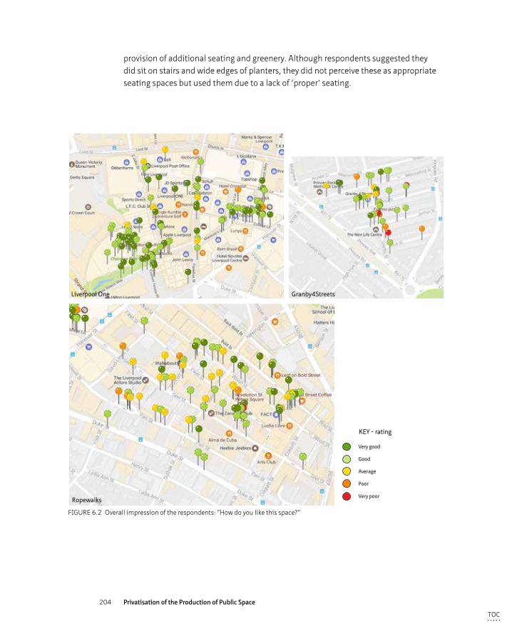
204 Privatisation of the Production of Public Space
provision of additional seating and greenery. Although respondents suggested they did sit on stairs and wide edges of planters, they did not perceive these as appropriate seating spaces but used them due to a lack of ‘proper’ seating.
Ropewalks
Liverpool One Granby4Streets
Very good
Good
Average
Poor
Very poor
KEY - rating
FIGURE 6.2 Overall impression of the respondents: “How do you like this space?”
TOC
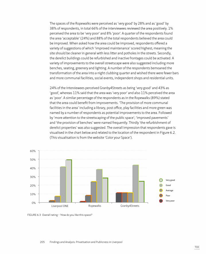
205 Findings and Analysis: Privatisation and Publicness in Liverpool
The spaces of the Ropewalks were perceived as ‘very good’ by 28% and as ‘good’ by 38% of respondents, in total 66% of the interviewees reviewed the area positively. 1% perceived the area to be ‘very poor’ and 8% ‘poor’. A quarter of the respondents found the area ‘acceptable’ (24%) and 88% of the total respondents believed the area could be improved. When asked how the area could be improved, respondents offered a variety of suggestions of which ‘improved maintenance’ scored highest; meaning the site should be cleaner in general with less litter and potholes in the streets. Secondly, the derelict buildings could be refurbished and inactive frontages could be activated. A variety of improvements to the overall streetscape were also suggested including more benches, seating, greenery and lighting. A number of the respondents bemoaned the transformation of the area into a night clubbing quarter and wished there were fewer bars and more communal facilities, social events, independent shops and residential units.
24% of the interviewees perceived Granby4Streets as being ‘very good’ and 43% as ‘good’, whereas 11% said that the area was ‘very poor’ and also 11% perceived the area as ‘poor’. A similar percentage of the respondents as in the Ropewalks (89%) stated that the area could benefit from improvements. ‘The provision of more communal facilities in the area’ including a library, post office, play facilities and more green was named by a number of respondents as potential improvements to the area. Followed by ‘more attention to the streetscaping of the public space’; ‘improved pavements’ and ‘the provision of benches’ were named frequently. Thirdly ‘the refurbishment of derelict properties’ was also suggested. The overall impression that respondents gave is visualised in the chart below and related to the location of the respondent in Figure 6.2. (This visualisation is from the website ‘Color your Space’).
0%
10%
20%
30%
40%
50%
60%
Liverpool ONE Ropewalks Granby4Streets
Very good
Good
Average
Poor
Very poor
FIGURE 6.3 Overall rating - ‘How do you like this space?’
TOC
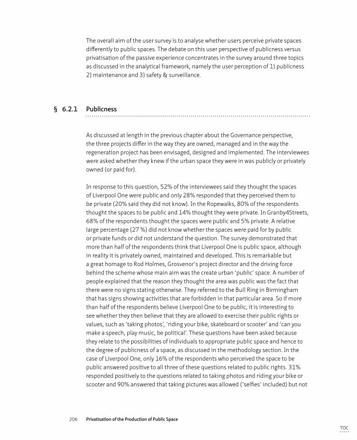
206 Privatisation of the Production of Public Space
The overall aim of the user survey is to analyse whether users perceive private spaces differently to public spaces. The debate on this user perspective of publicness versus privatisation of the passive experience concentrates in the survey around three topics as discussed in the analytical framework, namely the user perception of 1) publicness 2) maintenance and 3) safety & surveillance.
§ 6.2.1 Publicness
As discussed at length in the previous chapter about the Governance perspective, the three projects differ in the way they are owned, managed and in the way the regeneration project has been envisaged, designed and implemented. The interviewees were asked whether they knew if the urban space they were in was publicly or privately owned (or paid for).
In response to this question, 52% of the interviewees said they thought the spaces of Liverpool One were public and only 28% responded that they perceived them to be private (20% said they did not know). In the Ropewalks, 80% of the respondents thought the spaces to be public and 14% thought they were private. In Granby4Streets, 68% of the respondents thought the spaces were public and 5% private. A relative large percentage (27 %) did not know whether the spaces were paid for by public or private funds or did not understand the question. The survey demonstrated that more than half of the respondents think that Liverpool One is public space, although in reality it is privately owned, maintained and developed. This is remarkable but a great homage to Rod Holmes, Grosvenor’s project director and the driving force behind the scheme whose main aim was the create urban ‘public’ space. A number of people explained that the reason they thought the area was public was the fact that there were no signs stating otherwise. They referred to the Bull Ring in Birmingham that has signs showing activities that are forbidden in that particular area. So if more than half of the respondents believe Liverpool One to be public, it is interesting to see whether they then believe that they are allowed to exercise their public rights or values, such as ‘taking photos’, ‘riding your bike, skateboard or scooter’ and ‘can you make a speech, play music, be political’. These questions have been asked because they relate to the possibilities of individuals to appropriate public space and hence to the degree of publicness of a space, as discussed in the methodology section. In the case of Liverpool One, only 16% of the respondents who perceived the space to be public answered positive to all three of these questions related to public rights. 31% responded positively to the questions related to taking photos and riding your bike or scooter and 90% answered that taking pictures was allowed (‘selfies’ included) but not
TOC
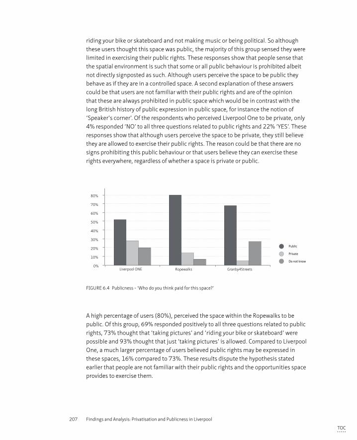
207 Findings and Analysis: Privatisation and Publicness in Liverpool
riding your bike or skateboard and not making music or being political. So although these users thought this space was public, the majority of this group sensed they were limited in exercising their public rights. These responses show that people sense that the spatial environment is such that some or all public behaviour is prohibited albeit not directly signposted as such. Although users perceive the space to be public they behave as if they are in a controlled space. A second explanation of these answers could be that users are not familiar with their public rights and are of the opinion that these are always prohibited in public space which would be in contrast with the long British history of public expression in public space, for instance the notion of ‘Speaker’s corner’. Of the respondents who perceived Liverpool One to be private, only 4% responded ‘NO’ to all three questions related to public rights and 22% ‘YES’. These responses show that although users perceive the space to be private, they still believe they are allowed to exercise their public rights. The reason could be that there are no signs prohibiting this public behaviour or that users believe they can exercise these rights everywhere, regardless of whether a space is private or public.
0%
10%
20%
30%
40%
50%
60%
70%
80%
90%
Liverpool ONE Ropewalks Granby4Streets
Public
Private
Do not know
FIGURE 6.4 Publicness - ‘Who do you think paid for this space?’
A high percentage of users (80%), perceived the space within the Ropewalks to be public. Of this group, 69% responded positively to all three questions related to public rights, 73% thought that ‘taking pictures’ and ‘riding your bike or skateboard’ were possible and 93% thought that just ‘taking pictures’ is allowed. Compared to Liverpool One, a much larger percentage of users believed public rights may be expressed in these spaces, 16% compared to 73%. These results dispute the hypothesis stated earlier that people are not familiar with their public rights and the opportunities space provides to exercise them.
TOC
208 Privatisation of the Production of Public Space
Of the 14% of respondents that perceived the Ropewalks to be private space, half of them answered ‘YES’ to all three questions related to public rights. Apparently they do not understand the possible consequences of privatisation or find that these consequences were not apparent within this particular spatial context (or that the spatial context did not make these consequences apparent). Whereas the questions asked concerning publicness seemed perfectly legitimate to the interviewees in Liverpool One, within the Ropewalks, interviewees thought them to be rather odd and demanded an explanation as to why they were asked. In the residential area of the Granby4Streets these questions seemed even more peculiar, also to the interviewers themselves. Apparently the more publicly organised the area is, the more self-evident public expression is.
LIVERPOOL ONE ROPEWALKS GRANBY4STREETS
public private public private public private
Yes to 3 public values
16% 22% 69% 50% 76% 100%
Yes to 2 public values
31% 73% 100%
Yes to 1 public values
90% 93% 100%
TABLE 6.1 Right to public expression
In Granby4Streets, 68% of the respondents answered that they perceived the space to be public, 76% of which believed all three criteria used to determine publicness were allowed. 100% of these responded positively to two criteria out of three, indicating that the respondents thought that they could exercise their public rights in the public spatial context. Only 2 respondents (5%) stated that they perceived the area to be private, but despite having this perception, both replied positively to all three questions related to public rights. Hence, they either do not understand the possible consequences of privatisation or they did not think the appearance and the use of the spatial context provided a cause for limitations on certain behaviour in this particular area.
The above results demonstrate that the privatised area was seen as public by more than half of the users, although the respondents seemed aware of the presence of certain means of control that might limit their public behaviour. A higher percentage of respondents stated that the two public areas were seen as public space, but here respondents believed they were able to exercise their public rights.
TOC
209 Findings and Analysis: Privatisation and Publicness in Liverpool
§ 6.2.2 Maintenance
The second criteria in the discussion of user perspectives of publicness is the perception of the tidiness of an area. Along with safety, the issue of tidiness is often raised in connection to privatisation because the provision of ‘clean and safe’ forms in many areas one of the reasons to privatise or outsource the maintenance tasks to private companies in the first place as they are perceived to deliver these qualities more efficient and cost-effective than public services.
Liverpool One, which is kept meticulously clean by a group of staff members (‘the blue coats’) throughout the day, is perceived to be very well maintained; 82% of the respondents answer ‘Yes’ to the question of if they think the space is clean and only 2% responded ‘No’. The remaining 16% thought the tidiness of the area is ‘Acceptable’.
In the Ropewalks there is a more negative perception of tidiness in the area: 33% of interviewees responded that they found the area ‘unclean’, 24% found the area ‘acceptable’ and 15% ‘clean’. At the time of the survey, the Council had outsourced its responsibilities for maintenance and management of the Ropewalks to a private company, Amey (see section 6.1). Although the maintenance and management regime of the Ropewalks was in private hands, the area was still perceived by a third of the interviewed users as not being clean. Apparently the fact that a private company is responsible for the maintenance is no guarantee of a well maintained area. The Council has consequently terminated the contract with the private company and created a Council led maintenance company to take over the maintenance regime.
The respondents in Granby4Streets were more positive about the state of tidiness of their space; 41% stated that they thought the area was clean, 38% found it to be acceptable and 22% responded that they found the area unclean. The maintenance and management regime for Granby4Streets is in hands of Liverpool Council. The fact that until 2015 the area consisted of vacant and derelict properties and hence few people were using the public space perhaps provided few litterers. Now most dwellings are again occupied and more people use the space (clearly noticeable during the site visit in May 2016), the level of tidiness might deteriorate if the Council neglects its tasks and responsibilities. The area might also change for the better as even more people take pride in their community and feel a collective responsibility for the public spaces.
TOC
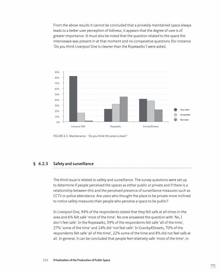
210 Privatisation of the Production of Public Space
From the above results it cannot be concluded that a privately maintained space always leads to a better user perception of tidiness, it appears that the degree of care is of greater importance. It must also be noted that the question related to the space the interviewee was present in at that moment and no comparative questions (for instance ‘Do you think Liverpool One is cleaner than the Ropewalks’) were asked.
0%
10%
20%
30%
40%
50%
60%
70%
80%
90%
Liverpool ONE Ropewalks Granby4Streets
Very clean
Acceptable
Not clean
FIGURE 6.5 Maintenance - ‘Do you think this area is clean?’
§ 6.2.3 Safety and surveillance
The third issue is related to safety and surveillance. The survey questions were set up to determine if people perceived the spaces as either public or private and if there is a relationship between this and the perceived presence of surveillance measures such as CCTV or police attendance. Are users who thought the place to be private more inclined to notice safety measures than people who perceive a space to be public?
In Liverpool One, 94% of the respondents stated that they felt safe at all times in the area and 6% felt safe ‘most of the time’. No one answered the question with ‘No, I don’t feel safe’. In the Ropewalks, 59% of the respondents felt safe ‘all of the time’, 27% ‘some of the time’ and 14% did ‘not feel safe’. In Granby4Streets, 70% of the respondents felt safe ‘all of the time’, 22% some of the time and 8% did not feel safe at all. In general, it can be concluded that people feel relatively safe ‘most of the time’, in
TOC
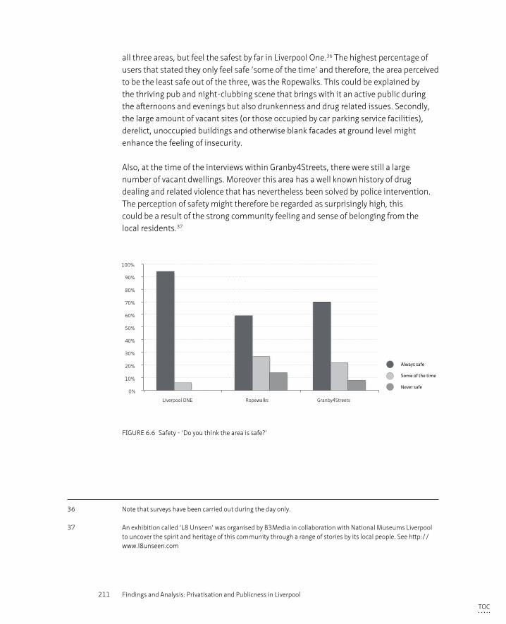
211 Findings and Analysis: Privatisation and Publicness in Liverpool
all three areas, but feel the safest by far in Liverpool One.36 The highest percentage of users that stated they only feel safe ‘some of the time’ and therefore, the area perceived to be the least safe out of the three, was the Ropewalks. This could be explained by the thriving pub and night-clubbing scene that brings with it an active public during the afternoons and evenings but also drunkenness and drug related issues. Secondly, the large amount of vacant sites (or those occupied by car parking service facilities), derelict, unoccupied buildings and otherwise blank facades at ground level might enhance the feeling of insecurity.
Also, at the time of the interviews within Granby4Streets, there were still a large number of vacant dwellings. Moreover this area has a well known history of drug dealing and related violence that has nevertheless been solved by police intervention. The perception of safety might therefore be regarded as surprisingly high, this could be a result of the strong community feeling and sense of belonging from the local residents.37
0%
10%
20%
30%
40%
50%
60%
70%
80%
90%
100%
Liverpool ONE Ropewalks Granby4Streets
Always safe
Some of the time
Never safe
FIGURE 6.6 Safety - ‘Do you think the area is safe?’
36 Note that surveys have been carried out during the day only.
37 An exhibition called ‘L8 Unseen’ was organised by B3Media in collaboration with National Museums Liverpool to uncover the spirit and heritage of this community through a range of stories by its local people. See http://www.l8unseen.com
TOC
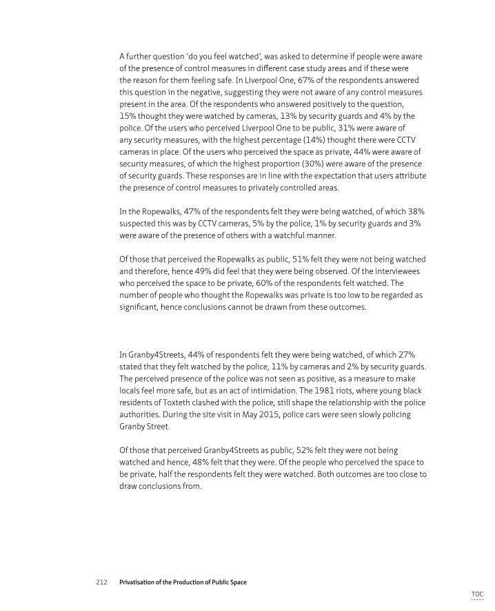
212 Privatisation of the Production of Public Space
A further question ‘do you feel watched’, was asked to determine if people were aware of the presence of control measures in different case study areas and if these were the reason for them feeling safe. In Liverpool One, 67% of the respondents answered this question in the negative, suggesting they were not aware of any control measures present in the area. Of the respondents who answered positively to the question, 15% thought they were watched by cameras, 13% by security guards and 4% by the police. Of the users who perceived Liverpool One to be public, 31% were aware of any security measures, with the highest percentage (14%) thought there were CCTV cameras in place. Of the users who perceived the space as private, 44% were aware of security measures, of which the highest proportion (30%) were aware of the presence of security guards. These responses are in line with the expectation that users attribute the presence of control measures to privately controlled areas.
In the Ropewalks, 47% of the respondents felt they were being watched, of which 38% suspected this was by CCTV cameras, 5% by the police, 1% by security guards and 3% were aware of the presence of others with a watchful manner.
Of those that perceived the Ropewalks as public, 51% felt they were not being watched and therefore, hence 49% did feel that they were being observed. Of the interviewees who perceived the space to be private, 60% of the respondents felt watched. The number of people who thought the Ropewalks was private is too low to be regarded as significant, hence conclusions cannot be drawn from these outcomes.
In Granby4Streets, 44% of respondents felt they were being watched, of which 27% stated that they felt watched by the police, 11% by cameras and 2% by security guards. The perceived presence of the police was not seen as positive, as a measure to make locals feel more safe, but as an act of intimidation. The 1981 riots, where young black residents of Toxteth clashed with the police, still shape the relationship with the police authorities. During the site visit in May 2015, police cars were seen slowly policing Granby Street.
Of those that perceived Granby4Streets as public, 52% felt they were not being watched and hence, 48% felt that they were. Of the people who perceived the space to be private, half the respondents felt they were watched. Both outcomes are too close to draw conclusions from.
TOC
213 Findings and Analysis: Privatisation and Publicness in Liverpool
On a number of occasions when interviewees answered that they felt watched by control measures, the interviewers probed further whether they felt safe because of these measures. All of these respondents answered they did not. People felt safe because of the presence of other people and not because of CCTV cameras or the presence of police or security guards.
The privatised area was perceived by its users to be the safest area of the three though there is no direct relationship found between this high perception of safety and the presence of surveillance measures. Of the people who perceived the area as private however, a higher percentage responded that they were aware of the presence of surveillance measures.
0%
10%
20%
30%
40%
50%
60%
70%
80%
Liverpool ONE Ropewalks Granby4Streets
No
Yes, by police
Yes, by security guards
Yes, by cameras
Yes, by others
FIGURE 6.7 Presence of Control Mechanisms - ‘Do you feel watched?’
When respondents made inquires with the regard to the purpose of the research, they received an explanation of aims of the research and the reason behind the questions. In Liverpool One interviewees often admitted that they had never thought about the matter of public or private with respect to urban spaces. The question related to the feeling of being watched was particularly met with the response they had not really thought about it and certainly did not experience the spaces to be in essence different to other inner-city spaces. Users were rather shocked when they learned that the area was privately owned and maintained, that is had complete CCTV coverage, staged buskers; these were all matters they were not familiar with. The question arises whether people should be made more aware of these matters as they are apparently not as educated about the public/private debate and its consequences as they could be.
TOC
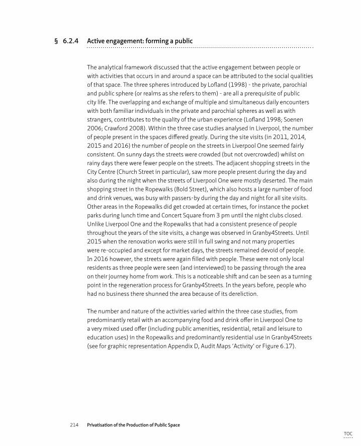
214 Privatisation of the Production of Public Space
§ 6.2.4 Active engagement: forming a public
The analytical framework discussed that the active engagement between people or with activities that occurs in and around a space can be attributed to the social qualities of that space. The three spheres introduced by Lofland (1998) - the private, parochial and public sphere (or realms as she refers to them) - are all a prerequisite of public city life. The overlapping and exchange of multiple and simultaneous daily encounters with both familiar individuals in the private and parochial spheres as well as with strangers, contributes to the quality of the urban experience (Lofland 1998; Soenen 2006; Crawford 2008). Within the three case studies analysed in Liverpool, the number of people present in the spaces differed greatly. During the site visits (in 2011, 2014, 2015 and 2016) the number of people on the streets in Liverpool One seemed fairly consistent. On sunny days the streets were crowded (but not overcrowded) whilst on rainy days there were fewer people on the streets. The adjacent shopping streets in the City Centre (Church Street in particular), saw more people present during the day and also during the night when the streets of Liverpool One were mostly deserted. The main shopping street in the Ropewalks (Bold Street), which also hosts a large number of food and drink venues, was busy with passers-by during the day and night for all site visits. Other areas in the Ropewalks did get crowded at certain times, for instance the pocket parks during lunch time and Concert Square from 3 pm until the night clubs closed. Unlike Liverpool One and the Ropewalks that had a consistent presence of people throughout the years of the site visits, a change was observed in Granby4Streets. Until 2015 when the renovation works were still in full swing and not many properties were re-occupied and except for market days, the streets remained devoid of people. In 2016 however, the streets were again filled with people. These were not only local residents as three people were seen (and interviewed) to be passing through the area on their journey home from work. This is a noticeable shift and can be seen as a turning point in the regeneration process for Granby4Streets. In the years before, people who had no business there shunned the area because of its dereliction.
The number and nature of the activities varied within the three case studies, from predominantly retail with an accompanying food and drink offer in Liverpool One to a very mixed used offer (including public amenities, residential, retail and leisure to education uses) in the Ropewalks and predominantly residential use in Granby4Streets (see for graphic representation Appendix D, Audit Maps ‘Activity’ or Figure 6.17).
TOC
215 Findings and Analysis: Privatisation and Publicness in Liverpool
1 Liverpool One - private 2 Liverpool One - parochial/public 3 Liverpool One - parochial/public
4 Ropewalks - private 5 Ropewalks - private/parochial 6 Ropewalks - parochial/public
7 Granby - private 8 Granby - private/parochial 9 Granby - private/parochial/public
FIGURE 6.8 Presence of private - parochial - public sphere in the three cases
The outcome of the user survey clearly shows that nearly all those interviewed rated the overall quality of spaces in Liverpool ONE very highly. The interviewees formed a diverse group with regard to age and education level, nearly half of them visited the area regularly and for 44%, the main reason for being there was for shopping purposes, work or to relax. The relationships between individuals and groups present in Liverpool One can be characterised as a public sphere because they go beyond the realm of family, friends and acquaintances (although there are always overlap between private and public spheres as people shop or relax with family or friends). At certain times
TOC

216 Privatisation of the Production of Public Space
parochial spheres dominate certain areas of Liverpool One, particularly in Chavasse park where during the site visits, gatherings such as a group of school children were having lunch and a group of mothers were advocating their right to breastfeed in public (with permission of the Liverpool One ltd.). Liverpool One clearly does function as a social space where people can meet others and can engage in daily encounters. “I do think Liverpool One is seen as a public space. The grass at the top is very well used in the summer. Young people go there to socialise” (Erika Rushton, Plus Dane Group, Chair of CLT). This engagement is actively sought through the many organised events, through the provision of table tennis tables, shows and tournaments for example. However, the democratic role of public space cannot be fulfilled because the highly controlled spatial environment limits possibilities for people to spontaneously engage in a political or cultural way, eg. flyering, street performances etc. “The space is public I guess because the public can use it but you never see something interesting in the public realm. It is always commercial stuff that is happening. So I can’t say it is very public, it is not very civic” (Bryan Briggs, Director Bluecoat Art Centre). The user survey clearly shows that users are well aware of the restrictions that Liverpool One puts on their behaviour, although these restrictions are not advertised or signposted as such.
In the Ropewalks, the introduction of the six pocket parks and new pedestrian linkages provided new public spaces where people can sit, relax and meet each other. In the Ropewalks, nearly 50% of the users interviewed were there for business purposes and during lunch hour these pocket parks were filled with people having lunch. During the evening though, the spaces were filled by a different crowd; people who were going out. During the day these spaces felt occupied by a true public sphere and although most of the people were there for business reasons, they did seem to have a wide variety of occupations (which the spread of the businesses in the area also demonstrates). “Each of the squares was designed to create a different type of space, we built in distinct environments in which different people feel happy and want to stay. In that way you are creating spaces that have value in terms of well being” (Beatrice Fraenkel, Chair Ropewalks Partnership, Urban Design Champion, Councillor 1986 - present) During the night however, the crowds can be better characterised as belonging to a private sphere (groups of friends hanging out) or as parochial; the streets and squares constitute a public that has a common aim, something that binds them together, namely the act of going out. This might not always be perceived as an inclusive open sphere to other users. In general the Ropewalks can be described as constituting overlapping spheres which provide plenty of opportunities for the “exchange of multiple and simultaneous daily experiences” (Crawford 2008) as well as politically or culturally motivated engagement. Users regard the spaces within the Ropewalks as truly public space in which most of the users know they can are exercise their public rights such as performing, speaking in public or distributing flyers. The Ropewalks can be seen as a social and democratic space in the sense that daily encounters with others
TOC
217 Findings and Analysis: Privatisation and Publicness in Liverpool
do occur, overlapping multitude of the three different spheres are present and political or cultural engagement is possible.
In Granby4Streets the locally organised street market at first generated a predominantly private or parochial sphere consisting of local residents and their friends or family. Over time the market gained city-wide popularity and started attracting interest from people living outside Granby and who had no previous affiliation with the area. During market times, the area now shows signs of a public sphere overlapping with the private and the parochial spheres, contributing to an urban character. In Granby4Streets, users not only know that they can exercise public rights in the spaces, they have done so with a clear political intent. The local residents use the public space to engage with others and publicly demonstrate a different view with regard to opportunities for their neighbourhood. With this shift in daily experiences, they managed to change the perception of their neighbourhood on a city and nationwide scale.
In all three case study areas (both private and public), all three spheres of public, parochial and private, were found to be present. All three spaces can be characterised as a social space, a space where you can meet others and engage in daily encounters. Unlike the two public areas, the privatised space cannot be described as a democratic or civic space because the control mechanisms in place restrict individual spontaneous, cultural or political interventions.
§ 6.2.5 Reproduction, renegotiation, and appropriation
As discussed in the previous paragraph, the public realm agreements between Liverpool One and Liverpool Council guarantee public right of way and full accessibility within, and through, Liverpool One. Public values such as the right to demonstrate, flyer, ride your skateboard or scooter or act in a street performance formed no part of these agreements. The results of the user survey demonstrated clearly that users in Liverpool One do believe the area to be public but that they are not allowed to exercise these public rights and are therefore limited in their possibilities to informally renegotiate the space for their individual needs or purposes. Formally they can voice their opinion through a market survey that is carried out by Liverpool One ltd. on a yearly basis to analyse, amongst other things, their users’ wishes and demands. Their responses inform the marketing and event strategy of the following year. The corporate strategy to utterly control user behaviour impedes spontaneous user behaviour. Street performances, buskers, distribution of (religious) flyers and filming are prohibited not via signage within the area, but by the verbal and physical intervention of the security
TOC
218 Privatisation of the Production of Public Space
guards.38 It is not that the area is devoid of activities, on the contrary, entertaining the public is one of the key corporate policies to draw people in, as explained in the previous paragraph. All of these though are top down organised events or are events for which permission is given. For instance, on the 25th of June a gathering of breastfeeding mothers, organised by the Council, took place in Chavasse Park for which permission was asked and given by Liverpool One Ltd. No sign of spontaneous or ad hoc user intervention was noticed.
The cultural centre located within, but not forming part of Liverpool One, The Bluecoat, has tried to add a cultural layer to the area through several informal actions. “We have done one art project. The weekend that they opened L1 we commissioned an artist to do a 2-day event in which he printed black balloons with the words ‘bored of shopping’ and he went around Liverpool ONE as a balloon seller but giving them away. We just did that, he wasn’t stopped. Next day he did the same thing in the Bluecoat garden with ‘bored of culture’. It is an interesting question: is this all consumption?” (Bryan Biggs, Director Bluecoat Art Centre)
The Bluecoat also participated in another piece of art whereby an artist started cutting off her clothes within the spaces of Liverpool One. This time the artist was stopped by security guards because they thought she ran the risk of self-harm and they could not condone such behaviour. They used a health and safety excuse to stop an individual’s intervention on their grounds. Such an argument is difficult to refute (one cannot argue against taking responsibility for health and safety issues). Congregations of youths, skateboarders or other undesired behaviour is not tolerated in Liverpool One. A man filming another man talking, while sitting on one of the benches within the area were both told to stop and to leave the Liverpool One boundary, because they did not have permission for the film shoot (seen at a site visit on 9th of May 2016). Such behaviour might impose upon the smoothness of the shopping experience of customers.
Paradise Street, one of the two main shopping arteries consists of a ‘public’ part (owned and maintained by Liverpool Council) and a ‘private’ part, owned and managed by Liverpool One ltd. In order to establish if the public of Liverpool might be interested in expressing themselves publicly or actively renegotiating space, the public part of Paradise Street and the connecting shopping street (Church Street) is studied in terms of individual interventions. Plenty of evidence was found of a very active public engagement in the public part: right on the boundary between public and the private
38 The research team experienced this themselves when distributing the flyers for the user survey. While the research-ers took post on the border of the area, they were asked to leave the Liverpool One grounds. Permissions and cooper-ation for the flyering was sought by the research in advance, but this request was declined by Liverpool One ltd.
TOC
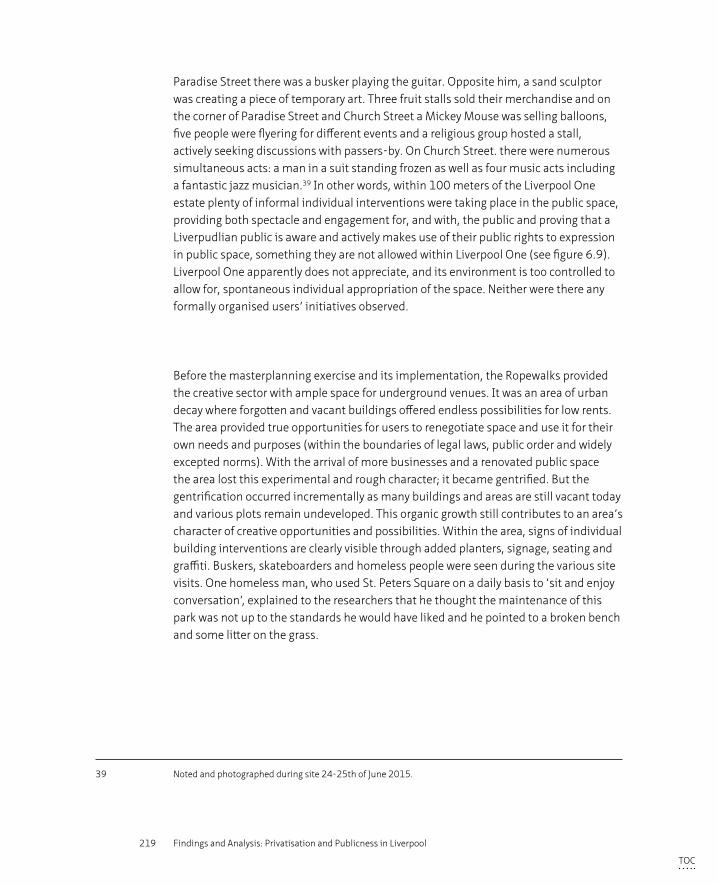
219 Findings and Analysis: Privatisation and Publicness in Liverpool
Paradise Street there was a busker playing the guitar. Opposite him, a sand sculptor was creating a piece of temporary art. Three fruit stalls sold their merchandise and on the corner of Paradise Street and Church Street a Mickey Mouse was selling balloons, five people were flyering for different events and a religious group hosted a stall, actively seeking discussions with passers-by. On Church Street. there were numerous simultaneous acts: a man in a suit standing frozen as well as four music acts including a fantastic jazz musician.39 In other words, within 100 meters of the Liverpool One estate plenty of informal individual interventions were taking place in the public space, providing both spectacle and engagement for, and with, the public and proving that a Liverpudlian public is aware and actively makes use of their public rights to expression in public space, something they are not allowed within Liverpool One (see figure 6.9). Liverpool One apparently does not appreciate, and its environment is too controlled to allow for, spontaneous individual appropriation of the space. Neither were there any formally organised users’ initiatives observed.
Before the masterplanning exercise and its implementation, the Ropewalks provided the creative sector with ample space for underground venues. It was an area of urban decay where forgotten and vacant buildings offered endless possibilities for low rents. The area provided true opportunities for users to renegotiate space and use it for their own needs and purposes (within the boundaries of legal laws, public order and widely excepted norms). With the arrival of more businesses and a renovated public space the area lost this experimental and rough character; it became gentrified. But the gentrification occurred incrementally as many buildings and areas are still vacant today and various plots remain undeveloped. This organic growth still contributes to an area’s character of creative opportunities and possibilities. Within the area, signs of individual building interventions are clearly visible through added planters, signage, seating and graffiti. Buskers, skateboarders and homeless people were seen during the various site visits. One homeless man, who used St. Peters Square on a daily basis to ‘sit and enjoy conversation’, explained to the researchers that he thought the maintenance of this park was not up to the standards he would have liked and he pointed to a broken bench and some litter on the grass.
39 Noted and photographed during site 24-25th of June 2015.
TOC
220 Privatisation of the Production of Public Space
1 2
3 4
FIGURE 6.9 Public expression in (public) Paradise and Church Street: buskers (1+2), artist (3), bible telling (4)
Formally organised interest groups (such as the Ropewalks Residents Association) as well as the Community Interest Companies and informal grass root organisations (such as Bombed Out Church group) operate in the area, often supported by Liverpool Council. The area, with its incremental and multi stakeholder organised piece-meal development strategy, offers opportunities for users to renegotiate the urban space toward their own (temporary) needs, within the legal frameworks and accepted codes of conduct.
TOC
221 Findings and Analysis: Privatisation and Publicness in Liverpool
The remaining residents of Granby4Streets regenerated their local streets after they felt let down by the Council for not involving them in the design process. After stepping out of this process, they renegotiated the terms of ownership, maintenance and control of the public space through three actions. Firstly, they painted the boards on the vacant properties, which were stained black by the Council, in bright, pastel colours. Secondly, the residents initiated a street planting event, for which they received a small grant from North West in Bloom, greening all front gardens including those of the unoccupied houses. They also planted flowers and plants in self-made planters (old car tires, carts, chest of drawers etc.) and put some picnic benches and seats on the pavement to create a far more attractive area that would enhance usability and sociability. Thirdly, they organised a local street market with food, goods and entertainment. This has subsequently grown into a well known alternative event in Liverpool that has contributed to city wide recognition of their local issues. The remaining residents of Granby4Streets created a new possible future for their area out of the ghost town appearance with the use of greenery, painted boards and a street market. They renegotiated the urban space in such a positive and effective way that refurbishment of the vacant properties was finally seen by investors and the municipality as a potentially successful regeneration strategy. In 2011 the residents united again, this time in a Community Land Trust (the first urban CLT in Britain) with the aim of securing funds to collectively renovate ten homes.
In Granby4Streets local residents were able to make formal alliances to negotiate the future of their area. This happened first with Liverpool Council and later with investors, Registered Social Housing (RSL) providers and local developers within their wider community. Individual interventions, such as the greening, painting and the organisation of the street market, contributed to the urban character and public sphere of the area and with that, to a shift in the everyday life of its residents. The interventions also brought their case to city and national attention, gaining sympathy for their vision for the neighbourhood regeneration that incorporated refurbishment of the vacant properties rather than wholesale clearance.
§ 6.2.6 Conclusions
Based on the outcome of the user survey and the observations during the site visits, which formed the basis of the analysis from the perspective of the user, the following conclusions can be drawn. These conclusions are primarily based on the results concerning the user perspective, overall conclusions linking the results to the wider theoretical and analytical framework will be drawn in Chapter 8.
TOC
222 Privatisation of the Production of Public Space
– The methodology chapter explained that the sample of the interviewees differs per area, i.e. it is not the same user group in each study area. From the overall rating responses for each area, the research concludes that each type of space works well for its particular group of users. Respondents appeared to appreciate the spaces they use, be they private or public spaces. The private space had the best overall rating that could be, but not solely, attributed to the high overall perception of tidiness, safety and general visual appearance and atmosphere.
– An interesting outcome of the survey with regard to the degree of publicness experienced within the area, is that respondents do not perceive the privatised space as being private although they do feel that they cannot exercise their public values (right of speech, use of scooters etc). Whereas the majority of users do perceive the publicly owned areas as being public and it is in these areas that the majority of the respondents are also aware of their rights to public expression. A few reasons could explain this discrepancy that users perceive in the private space. Users are potentially not familiar with the notion of privatisation and therefore assume all urban space to be public. However, it became clear from the interviews that this was not the case as people often referred to shopping malls or other privatised areas such as the Bull Ring in Birmingham. In these spaces, the ownership and rules of appropriate behaviour are clearly communicated to users through the use of signage. This signage is absent in Liverpool One (although the area is well endowed with branding; the ‘1’ logo appears frequently on furniture and banners) and therefore some users likely perceive the area to be public.
– The question remains, why respondents who perceive the area as public space do not believe they are entitled to exercise their rights to publicly express themselves. As explained earlier, one possible explanation could be,that Liverpudlians lack familiarity with this concept altogether. The analysis of active user behaviour in the adjacent, public, city centre streets (see section 6.2.5) however, demonstrates that this is not the case: there were many of these individual interventions witnessed in these public streets suggesting that Liverpudlians are familiar with these rights and make frequent use of them when not prohibited (as is the case in the privatised area of Liverpool One). The interviewed users in Liverpool One do sense that their behaviour is controlled even though they think the area is public. This perception could be based on the spatial environment or on the lack of any individual intervention on display.
– Respondents do feel most safe in the privatised area that is heavily controlled by CCTV cameras and security guards, but a high percentage of the respondents however, do not feel watched. Apparently, there is little relationship between the perception of safety and the presence of surveillance measures. The feeling of safety might be derived from the presence of other people or by the large amount of active uses at the ground floor level. Human behaviour is controlled in Liverpool One with undesirable people (eg
TOC
223 Findings and Analysis: Privatisation and Publicness in Liverpool
homeless people, groups of hooded youth) and undesirable behaviour (busking, filming, flyering etc.) actively restricted. The users therefore experience such an area without any friction or uncomfortable encounters that might erode their perception of safety.
– From the outcome of the user survey it can also be concluded that privatisation or outsourcing of the management and maintenance of an area does not necessarily equate to a higher perception of maintenance quality. The interviewed users responded negatively with regard to their perception of tidiness in the Ropewalks that was privately maintained at the time. The privately owned and maintained area scored highest on the question related to maintenance; a large majority of the users stated that the area was very clean, followed by the publicly owned and maintained Granby4Streets. This outcome could be explained through the varying expectations of the different user groups: in the neglected area of Granby4Streets, with an abundance of vacant properties, users might not have high expectations of the public spaces. Whereas users might expect the opposite in inner city shopping areas. Secondly, the research demonstrates that quality and commitment of the maintenance regime might matter more than who actually undertakes the maintenance.
– In all three areas, an overlapping of the three different spheres – public, parochial and private – were observed at certain moments. All three areas can be regarded as social spaces though only the public spaces also constituted truly democratic spaces in the sense that political or cultural expression was tolerated. It must be noted though, that a public sit-in of breastfeeding mothers took place in the privatised spaces however, consent was given for this by Liverpool One ltd. The expression of individual interventions or appropriation of space to suit one’s needs was observed in both public spaces but not in the privatised space. The appropriation of space can therefore be regarded as an important component in defining the degree of publicness in space.
§ 6.3 Designer’s Perspective
The following discussion on visual aspects is structured in accordance with the analytical framework discussed in 3.3 and further explained in the Methodology section in chapter 4. The urban qualities described by Ewing and Clemente (2013) have been used as the starting point for the analytical framework. The visual analysis includes both a qualitative and a quantitative assessment. The qualitative analysis incorporates the totality of the case study areas as well as two street sections in more detail (approximately 100 m long per case study area). The tool presented by Ewing and Clemente (2006, 2013) is used for the quantitative assessment but is therefore only applicable to the detailed streets and for
TOC
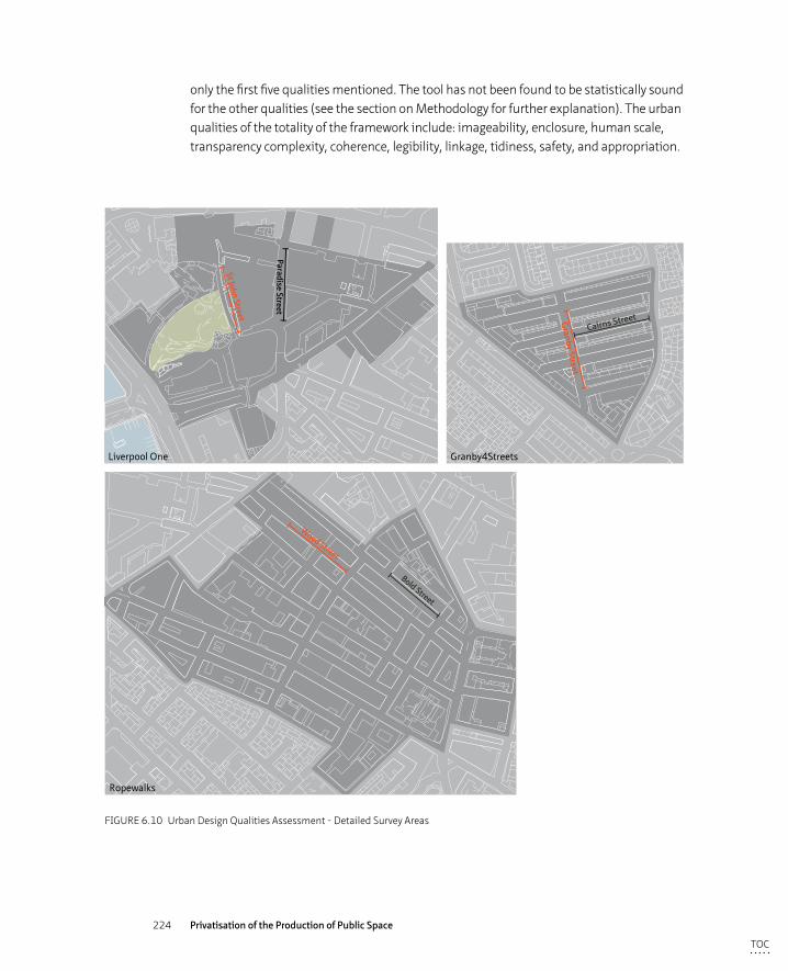
224 Privatisation of the Production of Public Space
only the first five qualities mentioned. The tool has not been found to be statistically sound for the other qualities (see the section on Methodology for further explanation). The urban qualities of the totality of the framework include: imageability, enclosure, human scale, transparency complexity, coherence, legibility, linkage, tidiness, safety, and appropriation.
Paradise Street
St John Street
Bold Street
Wood Street
Granby Street
Cairns Street
Ropewalks
Liverpool One Granby4Streets
FIGURE 6.10 Urban Design Qualities Assessment - Detailed Survey Areas
TOC
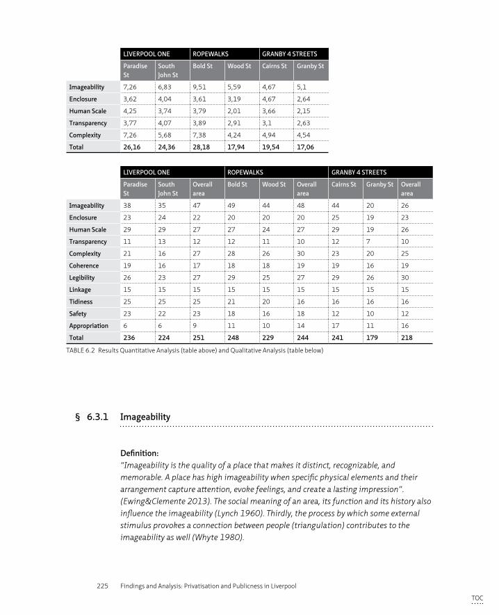
225 Findings and Analysis: Privatisation and Publicness in Liverpool
LIVERPOOL ONE ROPEWALKS GRANBY 4 STREETS
Paradise St
South John St
Bold St Wood St Cairns St Granby St
Imageability 7,26 6,83 9,51 5,59 4,67 5,1
Enclosure 3,62 4,04 3,61 3,19 4,67 2,64
Human Scale 4,25 3,74 3,79 2,01 3,66 2,15
Transparency 3,77 4,07 3,89 2,91 3,1 2,63
Complexity 7,26 5,68 7,38 4,24 4,94 4,54
Total 26,16 24,36 28,18 17,94 19,54 17,06
LIVERPOOL ONE ROPEWALKS GRANBY 4 STREETS
Paradise St
South John St
Overall area
Bold St Wood St Overall area
Cairns St Granby St Overall area
Imageability 38 35 47 49 44 48 44 20 26
Enclosure 23 24 22 20 20 20 25 19 23
Human Scale 29 29 27 27 24 27 29 19 26
Transparency 11 13 12 12 11 10 12 7 10
Complexity 21 16 27 28 26 30 23 20 25
Coherence 19 16 17 18 18 19 19 16 19
Legibility 26 23 27 29 25 27 29 26 30
Linkage 15 15 15 15 15 15 15 15 15
Tidiness 25 25 25 21 20 16 16 16 16
Safety 23 22 23 18 16 18 12 10 12
Appropriation 6 6 9 11 10 14 17 11 16
Total 236 224 251 248 229 244 241 179 218
TABLE 6.2 Results Quantitative Analysis (table above) and Qualitative Analysis (table below)
§ 6.3.1 Imageability
Definition:“Imageability is the quality of a place that makes it distinct, recognizable, and memorable. A place has high imageability when specific physical elements and their arrangement capture attention, evoke feelings, and create a lasting impression”. (Ewing&Clemente 2013). The social meaning of an area, its function and its history also influence the imageability (Lynch 1960). Thirdly, the process by which some external stimulus provokes a connection between people (triangulation) contributes to the imageability as well (Whyte 1980).
TOC
226 Privatisation of the Production of Public Space
When looking at the three different case study areas in their totality, the qualitative ratings show similar results for imageability (47 for Liverpool One and Granby4Streets and 48 for the Ropewalks, see table 6.2). The total rating represents the cumulative results of a series of criteria and although the total rating shows similar results, these individual ratings vary for the three case studies and their makeup differs greatly.
The original vision for Liverpool One was to create a new urban quarter and an addition to the existing city centre with a focus on providing a significant and up-market retail offer. The total scheme was designed and implemented between 2000 and 2008; the buildings are therefore all recently built within a short time span. All buildings contain either retail, leisure or a café/restaurant at ground floor with identifiable logos reflecting the in-house brands that likely contributed positively to the rating for imageability. To achieve the urban character to which both the Council and Grosvenor aspired, the area was divided into 34 different plots of varying size and 26 different architects were invited to design the buildings within the strict scope written by masterplanners BDP. This variety of architectural hands contributed to a ‘commercial frivolity’ (Hatherley 2010, p. 341), in other words not the boring sameness one is so familiar with in outdoor shopping malls. These architectural expressions ranged from a non-descript corporate style (albeit nicely executed) eg. the Hilton Hotel by Aedas and the large shopping units on South John Street by BDP, to stronger the architectural expressions of the ‘Bling bling’ building by CZWG and the kiosks by FAT. Overall, Liverpool One scores high marks for creating a distinct, memorable and recognisable urban area.
The area as a whole scores low on the presence of, or reference to, historic buildings and elements. There are three historic building facades noted: the façade of the historic building on the corner of Paradise Street and Hanover Street, the Bluecoat building (although technically not part of the Liverpool One scheme and not owned by Liverpool One) and the building on the corner of Peter’s lane/ School lane. A viewing point into the archeological finds of the historic Pool provides reference to Liverpool’s maritime past. A newly built water feature was based on the tidal measurements of William Hutchinson, a previous harbor-master, and symbolises Liverpool’s historic connection with shipping activity. Despite being recognisable as a distinct quarter, the lack of building variety and representation of different architectural periods as well as the slightly forced references to Liverpool’s past, lend the area a somewhat monotonous appearance.
The connections between publicly (Council) and privately (Liverpool One) owned city-centre streets provide the seamless pedestrian access demanded by the Council in its development brief; lines of bollards branded with the Liverpool One logo demarcate the boundaries between Liverpool One and its surrounds. Liverpool One scores highly
TOC
227 Findings and Analysis: Privatisation and Publicness in Liverpool
on the presence of coherent street furniture and surfacing, which is maintained and managed to a high standard. Throughout the area the street furniture is of the same design ‘family’ and bears the ‘1’ logo. In addition to these branding measures, a large number of banners throughout the area also contribute to the creation of an identifiable area, distinct from the surrounding quarters.
The social meaning of the area, how the area is perceived through its current use and historic layering, is based on retail and leisure as there is little presence of, or reference to, its past. The dominant commercial values can be read through active uses at ground floor displaying identifiable logos on shop frontages and by the focus on high standards of maintenance applied throughout the area. The regeneration of the area added a new (positively perceived) layer to the history of the site after being severely bombed during the war and laying bare for decades. The presence of ‘external stimulus’ even if provided in the form of top down orchestrated events has the potential to encourage triangulation; the opportunity for creating links between people unknown to each other (Whyte, 1980). (see figure 6.11 Desgin Sheet ‘Imageability’)
Within the detailed survey, and although the street sections were chosen as representative of the area, the two analysed streets scored lower on imageability than the area as a whole (see table 6.2). This can be explained by the minimal amount of outdoor dining facilities within these detailed survey areas, whereas other parts of Liverpool One are well endowed with these facilities. This is also the case for the presence of historic references as the few that have been noted are outside the study remit of the detailed survey. Events take place throughout Liverpool One, but are concentrated within Chavasse Park and so the total area’s rating was higher than for the detailed study (see also Figure 6.12 Audit Map ‘Streetscape’)
The Ropewalks’ high scores for imageability (see table 6.2) can be contributed to its historic setting of long, narrow streets lined with maritime warehouses (averaging 4 to 5 storeys) that combine to create a tight urban fabric. The historic quality is recognised and protected by the area’s legal status as a Conservation Area, applied to the majority of the Ropewalks area in 1999, as well as the listing of 192 warehouses. The large variety of (small) offices, shops and café/restaurants provides identifiable signage at the ground floor of the streets within the Ropewalks and, although not every building bears a sign such as Liverpool One, this contributes to the high score for imageability. The Ropewalks also scored highly for the criteria of having non-rectangular shaped buildings, this can be mainly attributed to the irregular shape of the facades more commonly found in 18th and 19th century architectural styles. The variety of warehouse renovations, many of which add modern architectural elements and extensions to the existing historic buildings, also contributes to the high score for imageability.
TOC
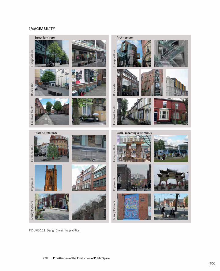
228 Privatisation of the Production of Public Space
Street furniture
Historic reference
Architecture
Social meaning & stimulus
Gra
nby4
Stre
ets
Rope
wal
ksLi
verp
ool O
ne
Gra
nby4
Stre
ets
Rope
wal
ksLi
verp
ool O
ne
Gra
nby4
Stre
ets
Rope
wal
ksLi
verp
ool O
ne
Gra
nby4
Stre
ets
Rope
wal
ksLi
verp
ool O
ne
IMAGEABILITY
FIGURE 6.11 Design Sheet Imageability
TOC
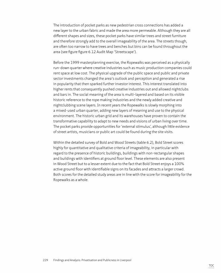
229 Findings and Analysis: Privatisation and Publicness in Liverpool
The introduction of pocket parks as new pedestrian cross connections has added a new layer to the urban fabric and made the area more permeable. Although they are all different shapes and sizes, these pocket parks have similar trees and street furniture and therefore strongly add to the overall imageability of the area. The streets though, are often too narrow to have trees and benches but bins can be found throughout the area (see figure figure 6.12 Audit Map ‘Streetscape’).
Before the 1999 masterplanning exercise, the Ropewalks was perceived as a physically run-down quarter where creative industries such as music production companies could rent space at low cost. The physical upgrade of the public space and public and private sector investments changed the area’s outlook and perception and generated a rise in popularity that then sparked further investor interest. This interest translated into higher rents that consequently pushed creative industries out and allowed nightclubs and bars in. The social meaning of the area is multi-layered and based on its visible historic reference to the rope making industries and the newly added creative and nightclubbing scene layers. In recent years the Ropewalks is slowly morphing into a mixed-used urban quarter, adding new layers of meaning and use to the physical environment. The historic urban grid and its warehouses have proven to contain the transformative capability to adapt to new needs and visions of urban living over time. The pocket parks provide opportunities for ‘external stimulus’, although little evidence of street artists, musicians or public art could be found during the site visits.
Within the detailed survey of Bold and Wood Streets (table 6.2), Bold Street scores highly for quantitative and qualitative criteria of imageability, in particular with regard to the presence of historic buildings, buildings with non-rectangular shapes and buildings with identifiers at ground floor level. These elements are also present in Wood Street but to a lesser extent due to the fact that Bold Street enjoys a 100% active ground floor with identifiable signs on its facades and attracts a larger crowd. Both scores for the detailed study areas are in line with the score for imageability for the Ropewalks as a whole.
TOC
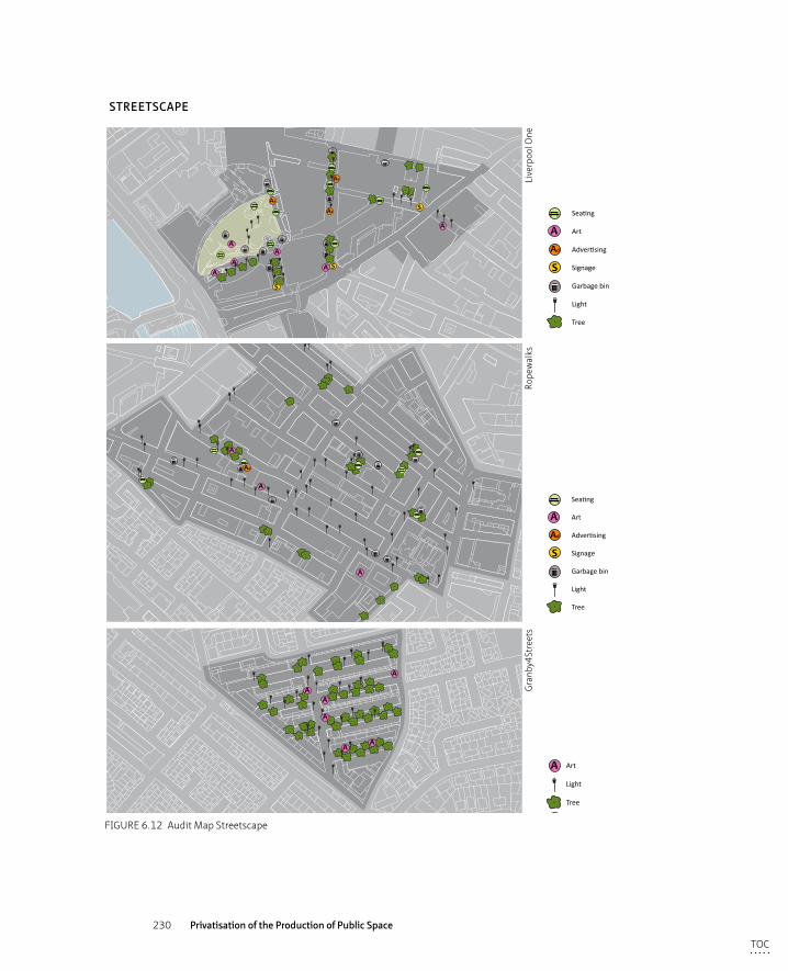
230 Privatisation of the Production of Public Space
AA
AA
Ad
Ad
S
SA
S
Ad
A
A
Ad
A
A
AA
A
A
AA
A Art
Light
Tree
Graffiti
Street market
Private green (in public domain)
Informal seating
A
Ad
S
Seating
Art
Advertising
Signage
Garbage bin
Light
Tree
CCTV
Security guard
Blank facade
Bollards
A
Ad
S
Uint
Seating
Art
Advertising
Signage
Garbage bin
Light
Tree
Graffiti
Private seating
Informal green
Rubbish
CCTV
Blank facade
Gate
Vacant site
STREETSCAPE
Gra
nby4
Stre
ets
Rope
wal
ksLi
verp
ool O
ne
FIGURE 6.12 Audit Map Streetscape
TOC

231 Findings and Analysis: Privatisation and Publicness in Liverpool
The Granby4Streets neighbourhood also scores highly for imageability due to its historic setting as the Granby area historically consisted of a tight urban grid of Victorian terraces. “The terraces are simple, but elegant compositions with the application of fairly typical Victorian detailing” (Llewelyn Davies 2001, 35). While urban renewal processes are known for strategies based on wholesale demolition, replacement with cul-de-sac suburban offers and dispersement of local communities (which has been the case in other parts of the Granby/Toxteth area), these four streets have been spared this eventuality due to resistance by a local residents’ group. Imageability scores are high because of the presence of the historic urban grid and the strong social meaning and spirit of the local community, represented visually through the greening of the public space and the wall paintings. The open invitation to the monthly street market on a blind wall at the corner of Cairns and Granby Streets demonstrates that ‘triangulation’ is welcomed by the local community (see figure 6.12 Audit Map ‘Streetscape’).
The detailed survey shows a higher score for Cairns Street than for Granby Street in the qualitative assessment (table 6.2). This can be explained by the lack of active use of former retail units - in 2015, Granby Street still had a large number of boarded up shop windows - whereas Cairns Street is again being transformed into a fully occupied residential street through renovation of properties vacant for 30 years. In the quantitative assessment however, the scores are reversed and Granby Street scores higher (with 5.1 compared to 4.67). This can be explained by Granby Street’s five buildings with ‘identifiers’ and because some buildings have non-rectangular shapes. Although the qualitative assessment has taken these criteria into account, the weighting was equal whereas multipliers have been used in the quantitative assessment to give each criteria its own weight.
Overall it can be stated that all three areas (so both private and public) score more or less similarly for imageability. The detailed surveys all have a lower score than the overall areas (except for one case) which suggests that it is more appropriate to assess imageability at a neighbourhood scale rather than at street level because the detailed elements that make up imageability (such as public art and historic references) and might contribute strongly to the identity and imageability of a specific area, might not necessarily be present within the detailed survey areas.
TOC
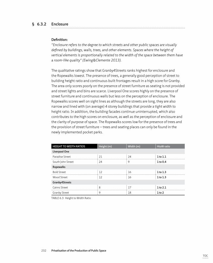
232 Privatisation of the Production of Public Space
§ 6.3.2 Enclosure
Definition:“Enclosure refers to the degree to which streets and other public spaces are visually defined by buildings, walls, trees, and other elements. Spaces where the height of vertical elements is proportionally related to the width of the space between them have a room-like quality” (Ewing&Clemente 2013).
The qualitative ratings show that Granby4Streets ranks highest for enclosure and the Ropewalks lowest. The presence of trees, a generally good perception of street to building height ratio and continuous built frontages result in a high score for Granby. The area only scores poorly on the presence of street furniture as seating is not provided and street lights and bins are scarce. Liverpool One scores highly on the presence of street furniture and continuous walls but less on the perception of enclosure. The Ropewalks scores well on sight lines as although the streets are long, they are also narrow and lined with (on average) 4 storey buildings that provide a tight width to height ratio. In addition, the building facades continue uninterrupted, which also contributes to the high scores on enclosure, as well as the perception of enclosure and the clarity of purpose of space. The Ropewalks scores low for the presence of trees and the provision of street furniture – trees and seating places can only be found in the newly implemented pocket parks.
HEIGHT TO WIDTH RATIOS Height (m) Width (m) HtoW ratio
Liverpool One
Paradise Street 21 24 1 to 1.1
South John Street 24 9 1 to 0.4
Ropewalks
Bold Street 12 16 1 to 1.3
Wood Street 12 16 1 to 1.3
Granby4Streets
Cairns Street 8 17 1 to 2.1
Granby Street 9 18 1 to 2
TABLE 6.3 Height to Width Ratio
TOC
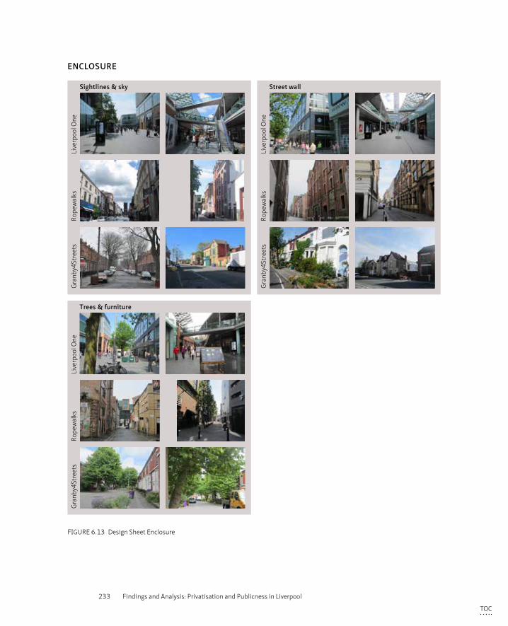
233 Findings and Analysis: Privatisation and Publicness in Liverpool
Sightlines & sky
Trees & furniture
Street wall
Gra
nby4
Stre
ets
Rope
wal
ksLi
verp
ool O
ne
Gra
nby4
Stre
ets
Rope
wal
ksLi
verp
ool O
ne
Gra
nby4
Stre
ets
Rope
wal
ksLi
verp
ool O
neENCLOSURE
FIGURE 6.13 Design Sheet Enclosure
TOC
234 Privatisation of the Production of Public Space
In the detailed survey of two streets per study area, South John Street achieves the highest score in the quantitative and also a high score in the qualitative assessments (see table 6.2). This high score is firstly a result of the width to height ratio (1:0.4) that provides a high level of enclosure which is further heightened by the presence of elevated footpaths at the first floor level that connect retail frontages on both sides of the street. The sight lines of South John Street are terminated on one side by John Lewis and towards Lord Street by a set of ascending stairs, both of which contribute to a perception of enclosure. The representation of this high score appears in a qualitative interpretation as too enclosed and hence negative. Bold Street and Paradise Street have the second highest ratings in the quantitative assessment, whereas Cairns Street scores best in the qualitative analysis of enclosure. This can be explained by the inclusion of criteria on the presence of trees and the perception on the overall enclosure. Paradise Street has been designed to accommodate the tramline that was supposed to be implemented as part of a major public transport project but was cancelled in 2006. As a result, Paradise Street reads as rather wide although the space-to-height ratio 1:1 (see table 6.3), similar to the Ropewalks which is deemed an acceptable ratio (Llewelyn-Davies 2000; Gehl 1999; Duany-Plater 1997). Both Granby Streets with a ratio of 1:2 do also fall within this category, however the ratio for South John Street, 1:0.4 falls outside the definition of a good width to height ratio.
Cairns Street (in Granby4Streets) scores very well in all the qualitative criteria that define enclosure, except in the category of the presence of street furniture. The quantitative score is low, which can be explained through the relatively high proportion of visible sky (see figure 6.13 Design Sheet ‘Enclosure’).
§ 6.3.3 Human scale
Definition:“Human scale refers to size, texture, and articulation of physical elements that match the size and proportions of humans and, equally important, correspond to the speed at which humans walk. Building details, pavement texture, street trees, and street furniture are all physical elements contributing to human scale” (Ewing&Clemente 2013).
Comparing the scores for human scale in the three case study areas sees the three areas with similar ratings, although again, the scores for the individual criteria vary greatly. The ratings for Liverpool One and Ropewalks both show high scores for the criteria of active windows, amount of details at eye level and the amount of pedestrians during the day, but score low for the presence of signs of individual interventions
TOC
235 Findings and Analysis: Privatisation and Publicness in Liverpool
(appropriation) i.e. local people taking ownership of their surrounds. Granby4Streets area demonstrates the opposite; low scores for active windows (as there are still a large number of windows boarded up at the time of the assessment), pedestrians and street furniture but high scores for signs of individual interventions.
Looking at the street sections in detail, the scores for the four sections (Paradise Street, South John Street, Bold Street and Cairns Street) are consistently high for both the qualitative as well as the quantitative assessment of human scale. They all have a high rating for the perception of enclosure and the presence of details at eye level. The first three streets have a high score for the presence of active windows and pedestrians during daytime but score lower on the levels of appropriation. Cairns Street does have a high rating for this criteria as the local residents have transformed the public space by adding plants and paintworks. Granby has a very low rating in both assessments which can be explained by the lack of active windows and doors (a large number of the shop frontages on Granby Street are boarded up even if in (infrequent) use), few details at eye level, long view lines, fewer signs of residents or users taking ownership of the space, and less trees and greenery. The difference in rating between Bold Street and Wood Street can be explained through the fewer active windows and pedestrians on the street and the presence of much longer view lines providing less of a perception of enclosure (see table 6.2 and figure 6.14 Design Sheet ‘Human Scale’).
TOC
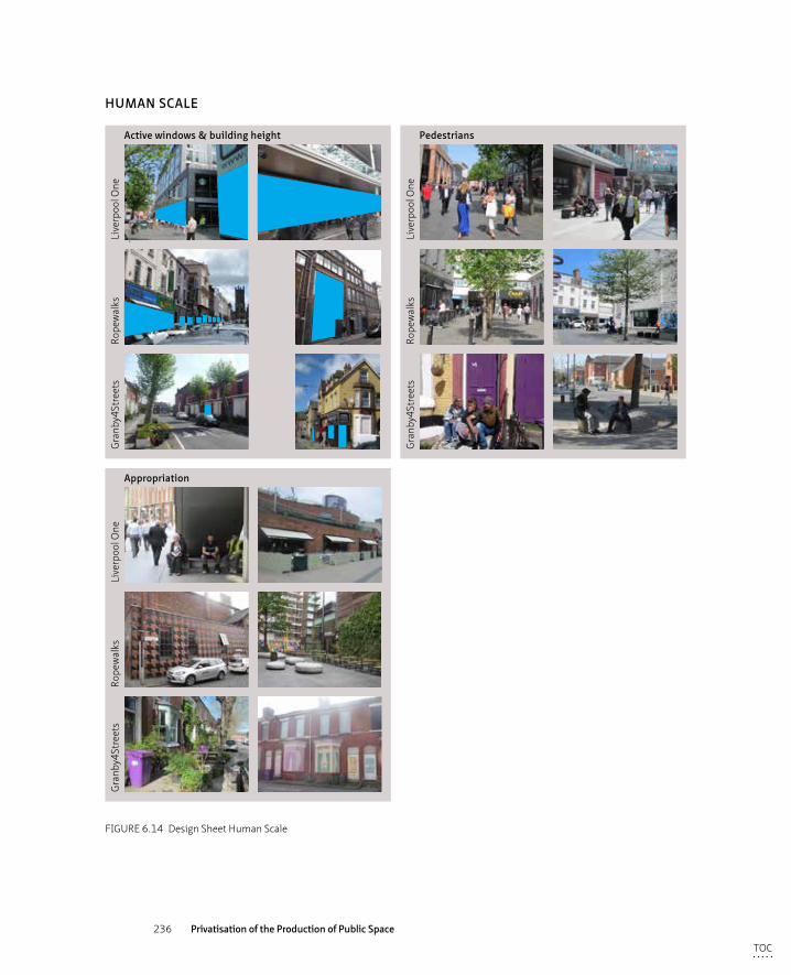
236 Privatisation of the Production of Public Space
Active windows & building height
Appropriation
Pedestrians
Gra
nby4
Stre
ets
Rope
wal
ksLi
verp
ool O
ne
Gra
nby4
Stre
ets
Rope
wal
ksLi
verp
ool O
ne
Gra
nby4
Stre
ets
Rope
wal
ksLi
verp
ool O
neHUMAN SCALE
FIGURE 6.14 Design Sheet Human Scale
TOC
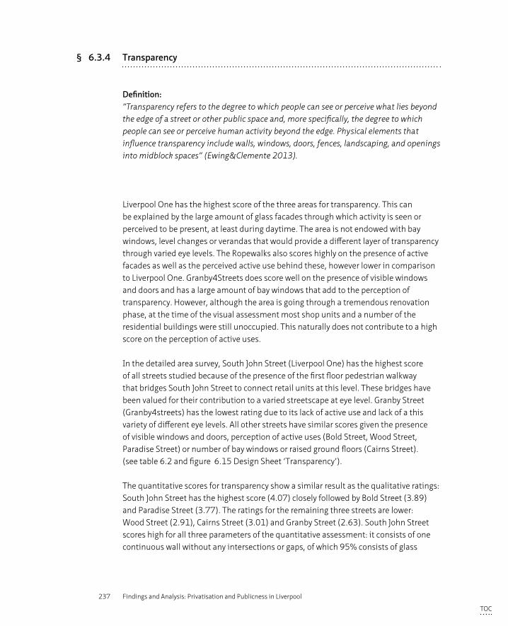
237 Findings and Analysis: Privatisation and Publicness in Liverpool
§ 6.3.4 Transparency
Definition:“Transparency refers to the degree to which people can see or perceive what lies beyond the edge of a street or other public space and, more specifically, the degree to which people can see or perceive human activity beyond the edge. Physical elements that influence transparency include walls, windows, doors, fences, landscaping, and openings into midblock spaces” (Ewing&Clemente 2013).
Liverpool One has the highest score of the three areas for transparency. This can be explained by the large amount of glass facades through which activity is seen or perceived to be present, at least during daytime. The area is not endowed with bay windows, level changes or verandas that would provide a different layer of transparency through varied eye levels. The Ropewalks also scores highly on the presence of active facades as well as the perceived active use behind these, however lower in comparison to Liverpool One. Granby4Streets does score well on the presence of visible windows and doors and has a large amount of bay windows that add to the perception of transparency. However, although the area is going through a tremendous renovation phase, at the time of the visual assessment most shop units and a number of the residential buildings were still unoccupied. This naturally does not contribute to a high score on the perception of active uses.
In the detailed area survey, South John Street (Liverpool One) has the highest score of all streets studied because of the presence of the first floor pedestrian walkway that bridges South John Street to connect retail units at this level. These bridges have been valued for their contribution to a varied streetscape at eye level. Granby Street (Granby4streets) has the lowest rating due to its lack of active use and lack of a this variety of different eye levels. All other streets have similar scores given the presence of visible windows and doors, perception of active uses (Bold Street, Wood Street, Paradise Street) or number of bay windows or raised ground floors (Cairns Street). (see table 6.2 and figure 6.15 Design Sheet ‘Transparency’).
The quantitative scores for transparency show a similar result as the qualitative ratings: South John Street has the highest score (4.07) closely followed by Bold Street (3.89) and Paradise Street (3.77). The ratings for the remaining three streets are lower: Wood Street (2.91), Cairns Street (3.01) and Granby Street (2.63). South John Street scores high for all three parameters of the quantitative assessment: it consists of one continuous wall without any intersections or gaps, of which 95% consists of glass
TOC
238 Privatisation of the Production of Public Space
facades. The whole stretch of buildings comprises active shop outlets. Paradise Street, within the same development area, scores lower on the criteria of a continuous wall as Paradise Street interconnects with College Lane. The retail outlets are larger on Paradise Street than on South John Street, resulting in proportionally less active uses. Both streets in Granby4Streets score low on active use and proportion of windows to building but high for the criteria of a continuous street wall. The surveyed part of Bold Street, like South John Street, consists of a continuous street wall and scores 100% on active uses. Unlike South John Street though, the buildings are made of brick and have a lower proportion of windows. In Wood Street, a low percentage of the buildings, at least along the surveyed stretch of the street, consists of visible windows. A number of frontages are covered by shutters and were therefore discounted as windows although there might have been windows behind the shutters. Despite the low percentage of windows, the number of active uses counted was high at 75% (see table 6.2 and figure 6.15 Design Sheet ‘Transparency’).
Windows & doors Active use
Gra
nby4
Stre
ets
Rope
wal
ksLi
verp
ool O
ne
Gra
nby4
Stre
ets
Rope
wal
ksLi
verp
ool O
ne
TRANSPARENCY
FIGURE 6.15 Design Sheet Transparency
TOC
239 Findings and Analysis: Privatisation and Publicness in Liverpool
§ 6.3.5 Complexity
Definition:“Complexity refers to the visual richness of a place. The complexity of a place depends on the variety of the physical environment, specifically the numbers and kinds of buildings, architectural diversity and ornamentation, landscape elements, street furniture, signage, and human activity” (Ewing&Clemente 2013).
As discussed in the description of imageability, Grosvenor took great effort in creating a diverse and architecturally rich urban quarter by dividing the area in 34 different plots, each with a specific architect selected through a limited design competition. This process resulted in a large variety of textures, colours and expression in the architectural facades and this is reflected in the high scores for these criteria. The shape of the buildings however - mostly box sized and of similar height - nor the use - retail and leisure with a small element of residential - vary to a great extent. Liverpool One also scores highly for the presence of pedestrians and outdoor dining facilities, but poorly for the presence of public art, buskers and street artists. After a vetting process, musicians are allowed at specific locations. These orchestrated forms of entertainment are classified as ‘events’ and not regarded as street artists in this assessment as they lack spontaneity and the performer’s own initiative. Street furniture is organised in a well-ordered manner to minimise clutter and a chaotic streetscape. Overall the area scores well with regard to complexity and, although it is a thoroughly well orchestrated complexity, provides a stimulating environment for the senses.
The Ropewalks has the highest score for complexity (30 as compared to 27 for Liverpool One and 25 for Granby4Streets), largely based on the variety of textures, colours, shapes, and uses of the buildings. The area contains a mix of modern developments (built in the last 15 years) and historic buildings (of which 192 are listed for cultural value) that contribute towards a positive rating for complexity. The area scores reasonably well for the presence of pedestrians, outdoor dining facilities, presence and organisation of street furniture and the presence of art and artists. Overall the mix of uses, buildings, design of the public space, and signs of historic layers provide a stimulating environment. (see table 6.2)
TOC
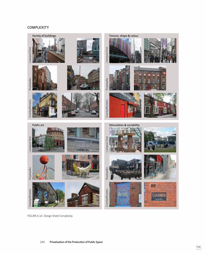
240 Privatisation of the Production of Public Space
Variety of buildings
Public art
Texture, shape & colour
Stimulation & sociability
Gra
nby4
Stre
ets
Rope
wal
ksLi
verp
ool O
ne
Gra
nby4
Stre
ets
Rope
wal
ksLi
verp
ool O
ne
Gra
nby4
Stre
ets
Rope
wal
ksLi
verp
ool O
ne
Gra
nby4
Stre
ets
Rope
wal
ksLi
verp
ool O
ne
COMPLEXITY
FIGURE 6.16 Design Sheet Complexity
TOC
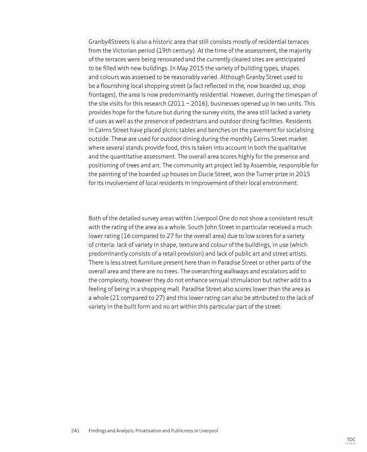
241 Findings and Analysis: Privatisation and Publicness in Liverpool
Granby4Streets is also a historic area that still consists mostly of residential terraces from the Victorian period (19th century). At the time of the assessment, the majority of the terraces were being renovated and the currently cleared sites are anticipated to be filled with new buildings. In May 2015 the variety of building types, shapes and colours was assessed to be reasonably varied. Although Granby Street used to be a flourishing local shopping street (a fact reflected in the, now boarded up, shop frontages), the area is now predominantly residential. However, during the timespan of the site visits for this research (2011 – 2016), businesses opened up in two units. This provides hope for the future but during the survey visits, the area still lacked a variety of uses as well as the presence of pedestrians and outdoor dining facilities. Residents in Cairns Street have placed picnic tables and benches on the pavement for socialising outside. These are used for outdoor dining during the monthly Cairns Street market where several stands provide food, this is taken into account in both the qualitative and the quantitative assessment. The overall area scores highly for the presence and positioning of trees and art. The community art project led by Assemble, responsible for the painting of the boarded up houses on Ducie Street, won the Turner prize in 2015 for its involvement of local residents in improvement of their local environment.
Both of the detailed survey areas within Liverpool One do not show a consistent result with the rating of the area as a whole. South John Street in particular received a much lower rating (16 compared to 27 for the overall area) due to low scores for a variety of criteria: lack of variety in shape, texture and colour of the buildings, in use (which predominantly consists of a retail provision) and lack of public art and street artists. There is less street furniture present here than in Paradise Street or other parts of the overall area and there are no trees. The overarching walkways and escalators add to the complexity, however they do not enhance sensual stimulation but rather add to a feeling of being in a shopping mall. Paradise Street also scores lower than the area as a whole (21 compared to 27) and this lower rating can also be attributed to the lack of variety in the built form and no art within this particular part of the street.
TOC
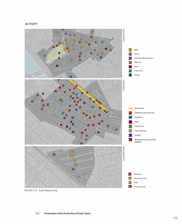
242 Privatisation of the Production of Public Space
uses
S
S
S
S
S
S
S
S
S
S
SS
S
SS
SS
S
C
P
P
PO
O
O
H
O
L
HC
C
P
P
P
P
CH
P
C
C
C
C C
S
C
C
P
S S
SC
SC
P
Restaurant
Community centre
Retail
Place of worship
Green open space
S
H
PC
O
LRetail
Leisure
Coffeebar/cafe/restaurant
Office use
Hotel
Cultural use
Parking
Residential
H
P
CC
Retail street
Coffeebar/cafe/restaurant
Education
Hotel
Cultural use
Community use
Parking
Residential (new apartmentbuilding)
ACTIVITY
Gra
nby4
Stre
ets
Rope
wal
ksLi
verp
ool O
ne
FIGURE 6.17 Audit Map Activity
TOC
243 Findings and Analysis: Privatisation and Publicness in Liverpool
The two detailed survey areas in the Ropewalks also score lower than the overall area (28 and 26 as compared to 30) but are much more in line with eachother than the ratings of Liverpool One. The two selected streets have a lower score on the presence and organisation of street furniture, trees, art and artists, which can be explained by the narrowness of the streets. Furniture, trees and art can be found throughout the area in the newly developed pocket parks. In Granby4Streets the rating for the individual streets is also more in line with the rating for the overall area (23 and 20 as compared to 24). The lower score for Granby Street can be explained by the lack of trees (whereas the streets perpendicular to Granby Street are richly endowed), outdoor dining and art. These elements contribute to a perceived lack of stimulation as compared to Cairns Street and the area as a whole.
The outcome of the quantitative assessment deviates from the qualitative assessment and show Paradise Street and Bold Street as the highest scoring streets (7.26 resp. 7.38), followed by South John Street (5.68), which in the qualitative assessment received the lowest rating. The remaining three study areas have a similar rating for complexity: Cairns Street 4.94, Granby Street 4.54 and Wood Street, the lowest in the rankings with 4.24. This can be explained by the fact that the quantitative scoring sheet heavily weights the number of pedestrians present in the study area. In Paradise Street, Bold Street and South John Street a large number of pedestrians were counted while in the other streets there were few. (see table 6.2, figure 6.16 Design Sheet ‘Complexity’ and figure 6.17 Audit Map ‘Activity’).
TOC
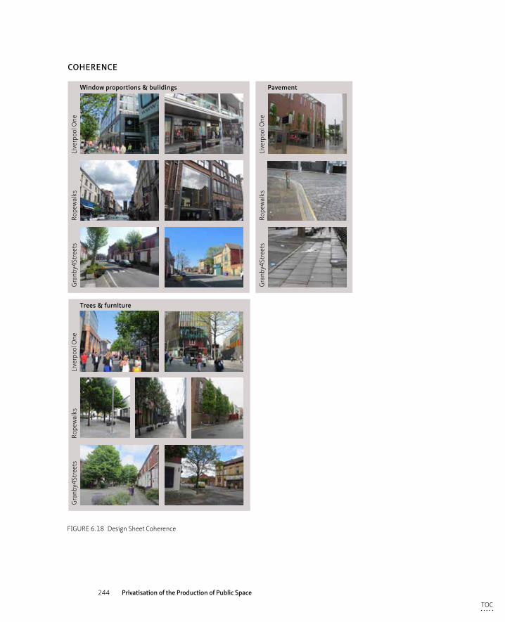
244 Privatisation of the Production of Public Space
Window proportions & buildings
Trees & furniture
Pavement
Gra
nby4
Stre
ets
Rope
wal
ksLi
verp
ool O
ne
Gra
nby4
Stre
ets
Rope
wal
ksLi
verp
ool O
ne
Gra
nby4
Stre
ets
Rope
wal
ksLi
verp
ool O
neCOHERENCE
FIGURE 6.18 Design Sheet Coherence
TOC
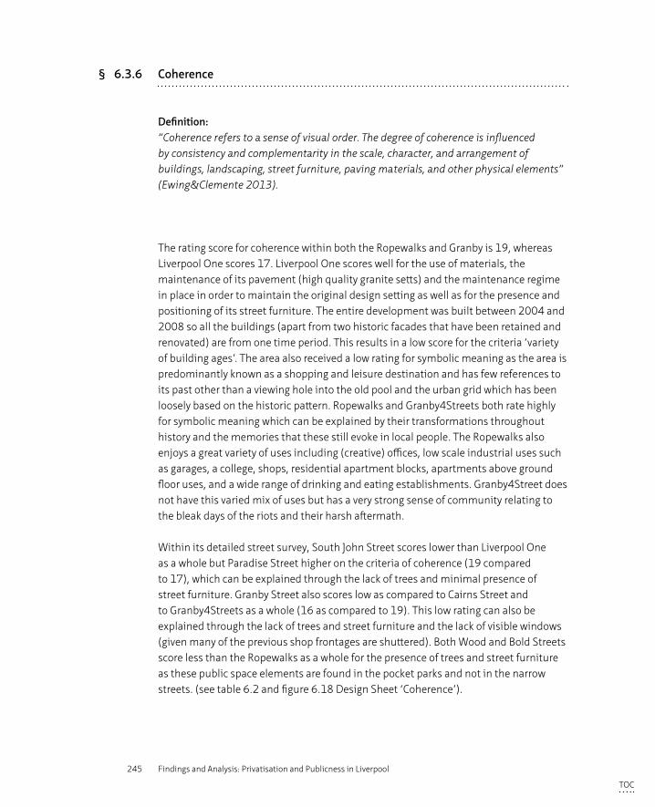
245 Findings and Analysis: Privatisation and Publicness in Liverpool
§ 6.3.6 Coherence
Definition:“Coherence refers to a sense of visual order. The degree of coherence is influenced by consistency and complementarity in the scale, character, and arrangement of buildings, landscaping, street furniture, paving materials, and other physical elements” (Ewing&Clemente 2013).
The rating score for coherence within both the Ropewalks and Granby is 19, whereas Liverpool One scores 17. Liverpool One scores well for the use of materials, the maintenance of its pavement (high quality granite setts) and the maintenance regime in place in order to maintain the original design setting as well as for the presence and positioning of its street furniture. The entire development was built between 2004 and 2008 so all the buildings (apart from two historic facades that have been retained and renovated) are from one time period. This results in a low score for the criteria ‘variety of building ages’. The area also received a low rating for symbolic meaning as the area is predominantly known as a shopping and leisure destination and has few references to its past other than a viewing hole into the old pool and the urban grid which has been loosely based on the historic pattern. Ropewalks and Granby4Streets both rate highly for symbolic meaning which can be explained by their transformations throughout history and the memories that these still evoke in local people. The Ropewalks also enjoys a great variety of uses including (creative) offices, low scale industrial uses such as garages, a college, shops, residential apartment blocks, apartments above ground floor uses, and a wide range of drinking and eating establishments. Granby4Street does not have this varied mix of uses but has a very strong sense of community relating to the bleak days of the riots and their harsh aftermath.
Within its detailed street survey, South John Street scores lower than Liverpool One as a whole but Paradise Street higher on the criteria of coherence (19 compared to 17), which can be explained through the lack of trees and minimal presence of street furniture. Granby Street also scores low as compared to Cairns Street and to Granby4Streets as a whole (16 as compared to 19). This low rating can also be explained through the lack of trees and street furniture and the lack of visible windows (given many of the previous shop frontages are shuttered). Both Wood and Bold Streets score less than the Ropewalks as a whole for the presence of trees and street furniture as these public space elements are found in the pocket parks and not in the narrow streets. (see table 6.2 and figure 6.18 Design Sheet ‘Coherence’).
TOC
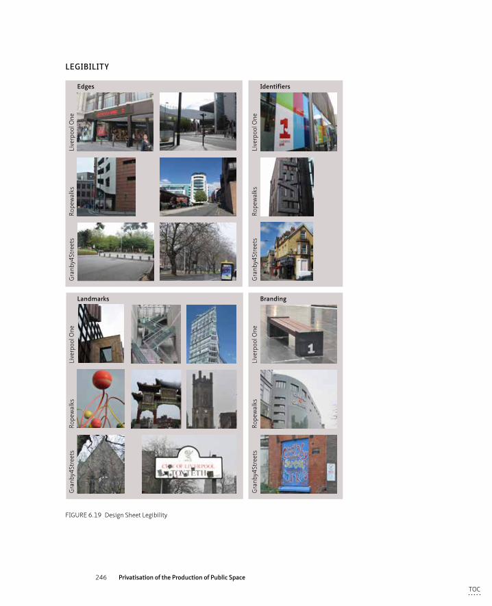
246 Privatisation of the Production of Public Space
Edges
Landmarks
Identifiers
Gra
nby4
Stre
ets
Rope
wal
ksLi
verp
ool O
ne
Gra
nby4
Stre
ets
Rope
wal
ksLi
verp
ool O
ne
Gra
nby4
Stre
ets
Rope
wal
ksLi
verp
ool O
neLEGIBILITY
Branding
Gra
nby4
Stre
ets
Rope
wal
ksLi
verp
ool O
ne
FIGURE 6.19 Design Sheet Legibility
TOC
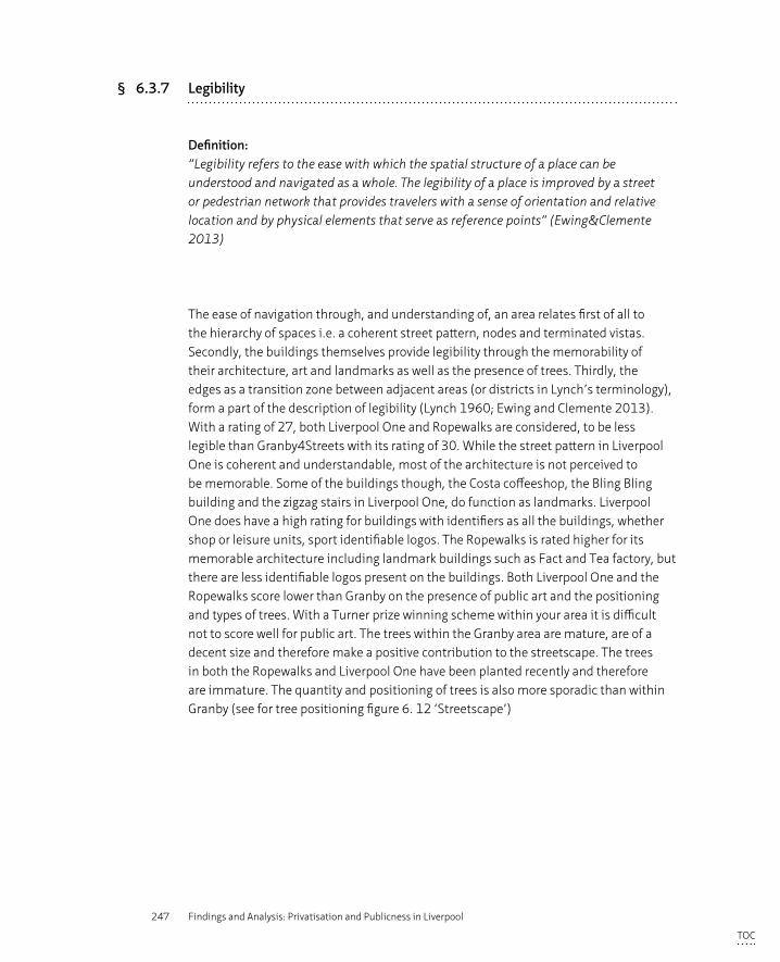
247 Findings and Analysis: Privatisation and Publicness in Liverpool
§ 6.3.7 Legibility
Definition:“Legibility refers to the ease with which the spatial structure of a place can be understood and navigated as a whole. The legibility of a place is improved by a street or pedestrian network that provides travelers with a sense of orientation and relative location and by physical elements that serve as reference points” (Ewing&Clemente 2013)
The ease of navigation through, and understanding of, an area relates first of all to the hierarchy of spaces i.e. a coherent street pattern, nodes and terminated vistas. Secondly, the buildings themselves provide legibility through the memorability of their architecture, art and landmarks as well as the presence of trees. Thirdly, the edges as a transition zone between adjacent areas (or districts in Lynch’s terminology), form a part of the description of legibility (Lynch 1960; Ewing and Clemente 2013). With a rating of 27, both Liverpool One and Ropewalks are considered, to be less legible than Granby4Streets with its rating of 30. While the street pattern in Liverpool One is coherent and understandable, most of the architecture is not perceived to be memorable. Some of the buildings though, the Costa coffeeshop, the Bling Bling building and the zigzag stairs in Liverpool One, do function as landmarks. Liverpool One does have a high rating for buildings with identifiers as all the buildings, whether shop or leisure units, sport identifiable logos. The Ropewalks is rated higher for its memorable architecture including landmark buildings such as Fact and Tea factory, but there are less identifiable logos present on the buildings. Both Liverpool One and the Ropewalks score lower than Granby on the presence of public art and the positioning and types of trees. With a Turner prize winning scheme within your area it is difficult not to score well for public art. The trees within the Granby area are mature, are of a decent size and therefore make a positive contribution to the streetscape. The trees in both the Ropewalks and Liverpool One have been planted recently and therefore are immature. The quantity and positioning of trees is also more sporadic than within Granby (see for tree positioning figure 6. 12 ‘Streetscape’)
TOC
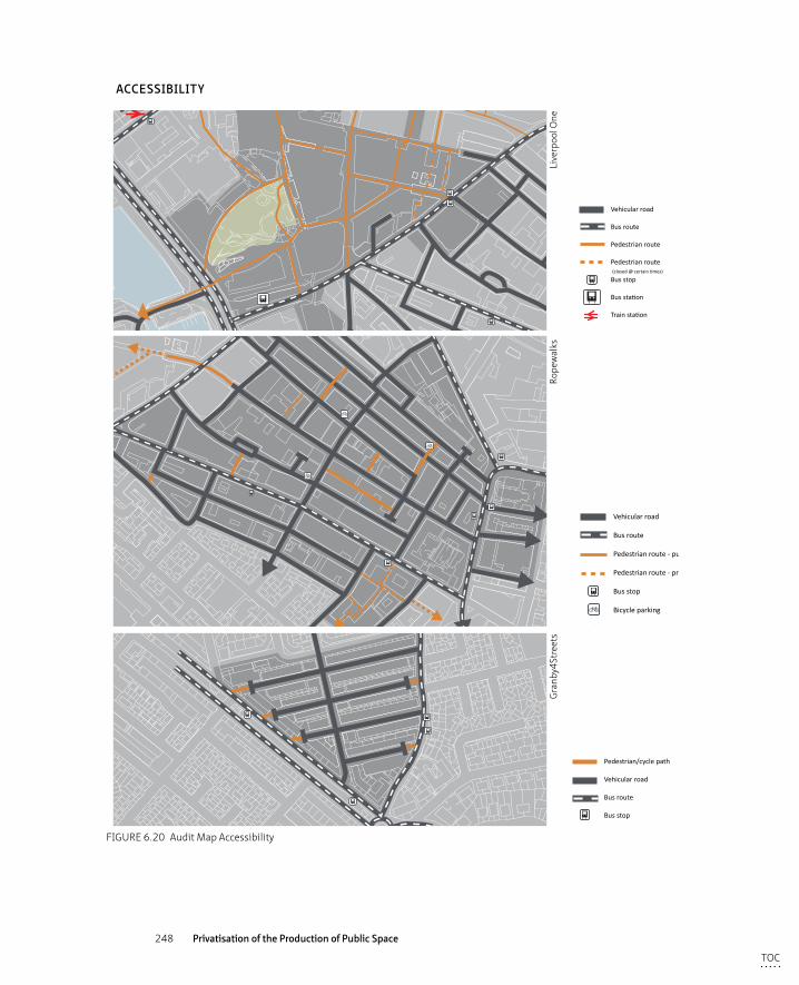
248 Privatisation of the Production of Public Space
uses
Pedestrian/cycle path
Vehicular road
Bus route
Bus stop
Vehicular road
Bus route
Pedestrian route
Pedestrian route (closed @ certain times)
Bus stop
Bus station
Train station
Vehicular road
Bus route
Pedestrian route - public
Pedestrian route - private
Bus stop
Bicycle parking
Train station
ACCESSIBILITY
Gra
nby4
Stre
ets
Rope
wal
ksLi
verp
ool O
ne
FIGURE 6.20 Audit Map Accessibility
TOC
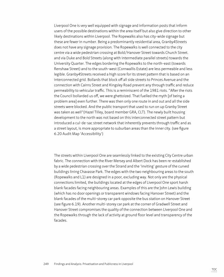
249 Findings and Analysis: Privatisation and Publicness in Liverpool
Liverpool One is very well equipped with signage and information posts that inform users of the possible destinations within the area itself but also give direction to other likely destinations within Liverpool. The Ropewalks also has city-wide signage but these are fewer in number. Being a predominantly residential area, Granby4Streets does not have any signage provision. The Ropewalks is well connected to the city centre via a wide pedestrian crossing at Bold/Hanover Street towards Church Street. and via Duke and Bold Streets (along with intermediate parallel streets) towards the University Quarter. The edges bordering the Ropewalks to the north-east (towards Renshaw Street) and to the south-west (Cornwallis Estate) are less permeable and less legible. Granby4Streets received a high score for its street pattern that is based on an interconnected grid. Bollards that block off all side streets to Princes Avenue and the connection with Cairns Street and Kingsley Road prevent any through traffic and reduce permeability to vehicular traffic. This is a reminiscent of the 1981 riots. “After the riots the Council bollarded us off, we were ghettoized. That fuelled the myth [of being a problem area] even further. There was then only one route in and out and all the side streets were blocked. And the public transport that used to run on up Granby Street was taken as well”(Hazel Tilley, board member GRA, CLT). The newly built housing development to the north was not based on this interconnected street pattern but introduced a cul-de-sac street network that inherently prevents through traffic and as a street layout, is more appropriate to suburban areas than the inner city. (see figure 6.20 Audit Map ‘Accessibility’)
The streets within Liverpool One are seamlessly linked to the existing City Centre urban fabric. The connection with the River Mersey and Albert Dock has been re-established by a wide pedestrian crossing over the Strand and the ‘inviting’ gesture of the curved buildings lining Chavasse Park. The edges with the two neighbouring areas to the south (Ropewalks and L1) are designed in a poor, excluding way. Not only are the physical connections limited, the buildings located at the edges of Liverpool One sport harsh blank facades facing neighbouring areas. Examples of this are the John Lewis building (which has no door openings or transparent windows facing Hanover Street) and the blank facades of the multi-storey car park opposite the bus station on Hanover Street (see figure 6.19). Another multi-storey car park at the corner of Gradwell Street and Hanover Street compromises the quality of the connection between Liverpool One and the Ropewalks through the lack of activity at ground floor level and transparency of the facades.
TOC
250 Privatisation of the Production of Public Space
The detailed sections of Cairns Street and Bold Street have the highest scores (29 and 28 respectively) as compared with the other sections. Bold Street scores well for the presence of buildings with identifiable logos but poorly for the presence of public art and trees, whereas Cairns Street’s ratings were the opposite of this. The ratings of the lowest scoring sections, South John Street (23) and Wood Street (24), can be attributed to a very low rating for memorable architecture within South John Street and a lack of identifiers and terminated sight lines for Wood Street. Both sections score low on the presence of public art and trees. (see table 6.2, figure 6.19 Design Sheet ‘Legibility’ and figure 6.20 Audit Map ‘Accessibility’).
§ 6.3.8 Linkage
Definition:“Linkage refers to physical and visual connections from building to street, building to building, space to space, or one side of the street to the other which tend to unify disparate elements. Tree lines, building projections, marked crossings all create linkage. Linkage can occur longitudinally along a street or laterally across a street” (Ewing&Clemente 2013).
The three qualitative elements that define linkage – street connections outside and within an area as well as easy pedestrian movement – have all been rated with a high score for each area. Liverpool One and the Ropewalks score slightly lower as a whole due to poorly designed inter-connections. Liverpool One is a pedestrianised zone and hence easy movement of pedestrians is a given but within the other two areas, pedestrian movement is provided with pavements and although cars have access, pedestrians are perceived to have priority. In the previous section on legibility, some edges of both Liverpool One and Ropewalks were criticised for having disruptive edges preventing a seamless continuation. These disruption is caused by the design of the facades and the lack of activity within the buildings. However, there are numerous street connections (focusing here on pedestrian connections) from the study areas to neighbouring zones. (see table 6.2, figure 6.21 Design Sheet ‘Linkage’ and figure 6.20 Audit Map ‘Accessibility’)
TOC
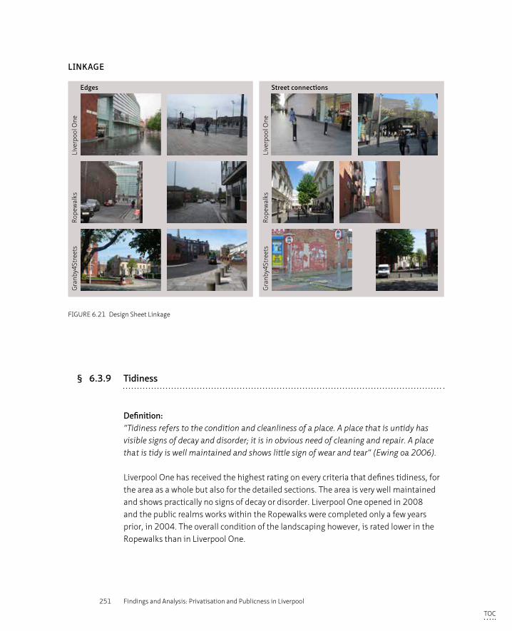
251 Findings and Analysis: Privatisation and Publicness in Liverpool
Edges Street connections
Gra
nby4
Stre
ets
Rope
wal
ksLi
verp
ool O
ne
Gra
nby4
Stre
ets
Rope
wal
ksLi
verp
ool O
ne
LINKAGE
FIGURE 6.21 Design Sheet Linkage
§ 6.3.9 Tidiness
Definition:“Tidiness refers to the condition and cleanliness of a place. A place that is untidy has visible signs of decay and disorder; it is in obvious need of cleaning and repair. A place that is tidy is well maintained and shows little sign of wear and tear” (Ewing oa 2006).
Liverpool One has received the highest rating on every criteria that defines tidiness, for the area as a whole but also for the detailed sections. The area is very well maintained and shows practically no signs of decay or disorder. Liverpool One opened in 2008 and the public realms works within the Ropewalks were completed only a few years prior, in 2004. The overall condition of the landscaping however, is rated lower in the Ropewalks than in Liverpool One.
TOC
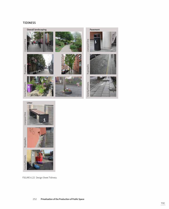
252 Privatisation of the Production of Public Space
Overall landscaping Pavement
Gra
nby4
Stre
ets
Rope
wal
ksLi
verp
ool O
ne
Gra
nby4
Stre
ets
Rope
wal
ksLi
verp
ool O
ne
TIDINESS
Litter
Gra
nby4
Stre
ets
Rope
wal
ksLi
verp
ool O
ne
FIGURE 6.22 Design Sheet Tidiness
TOC
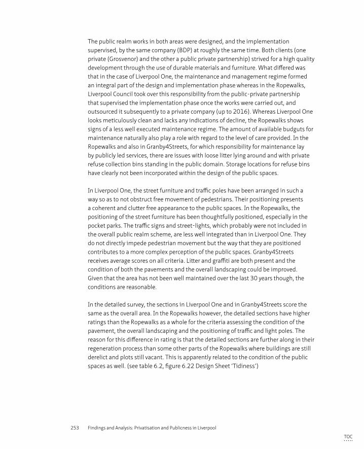
253 Findings and Analysis: Privatisation and Publicness in Liverpool
The public realm works in both areas were designed, and the implementation supervised, by the same company (BDP) at roughly the same time. Both clients (one private (Grosvenor) and the other a public private partnership) strived for a high quality development through the use of durable materials and furniture. What differed was that in the case of Liverpool One, the maintenance and management regime formed an integral part of the design and implementation phase whereas in the Ropewalks, Liverpool Council took over this responsibility from the public-private partnership that supervised the implementation phase once the works were carried out, and outsourced it subsequently to a private company (up to 2016). Whereas Liverpool One looks meticulously clean and lacks any indications of decline, the Ropewalks shows signs of a less well executed maintenance regime. The amount of available budguts for maintenance naturally also play a role with regard to the level of care provided. In the Ropewalks and also in Granby4Streets, for which responsibility for maintenance lay by publicly led services, there are issues with loose litter lying around and with private refuse collection bins standing in the public domain. Storage locations for refuse bins have clearly not been incorporated within the design of the public spaces.
In Liverpool One, the street furniture and traffic poles have been arranged in such a way so as to not obstruct free movement of pedestrians. Their positioning presents a coherent and clutter free appearance to the public spaces. In the Ropewalks, the positioning of the street furniture has been thoughtfully positioned, especially in the pocket parks. The traffic signs and street-lights, which probably were not included in the overall public realm scheme, are less well integrated than in Liverpool One. They do not directly impede pedestrian movement but the way that they are positioned contributes to a more complex perception of the public spaces. Granby4Streets receives average scores on all criteria. Litter and graffiti are both present and the condition of both the pavements and the overall landscaping could be improved. Given that the area has not been well maintained over the last 30 years though, the conditions are reasonable.
In the detailed survey, the sections in Liverpool One and in Granby4Streets score the same as the overall area. In the Ropewalks however, the detailed sections have higher ratings than the Ropewalks as a whole for the criteria assessing the condition of the pavement, the overall landscaping and the positioning of traffic and light poles. The reason for this difference in rating is that the detailed sections are further along in their regeneration process than some other parts of the Ropewalks where buildings are still derelict and plots still vacant. This is apparently related to the condition of the public spaces as well. (see table 6.2, figure 6.22 Design Sheet ‘Tidiness’)
TOC
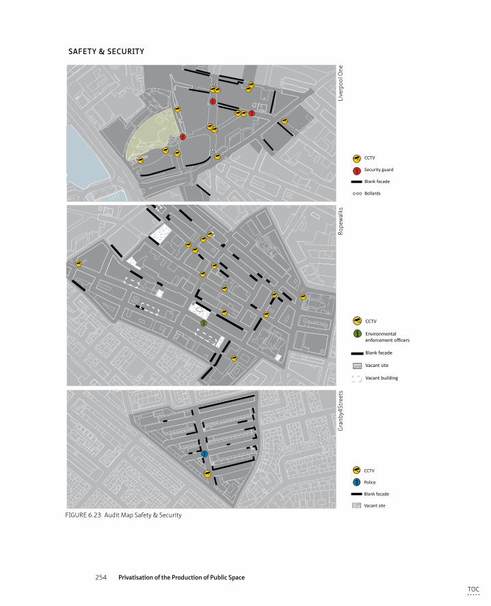
254 Privatisation of the Production of Public Space
CCTV
Police
Blank facade
Vacant site
CCTV
Security guard
Blank facade
Bollards
CCTV
Environmental enforcement officers
Blank facade
Vacant site
Vacant building
SAFETY & SECURITY
Gra
nby4
Stre
ets
Rope
wal
ksLi
verp
ool O
ne
FIGURE 6.23 Audit Map Safety & Security
TOC
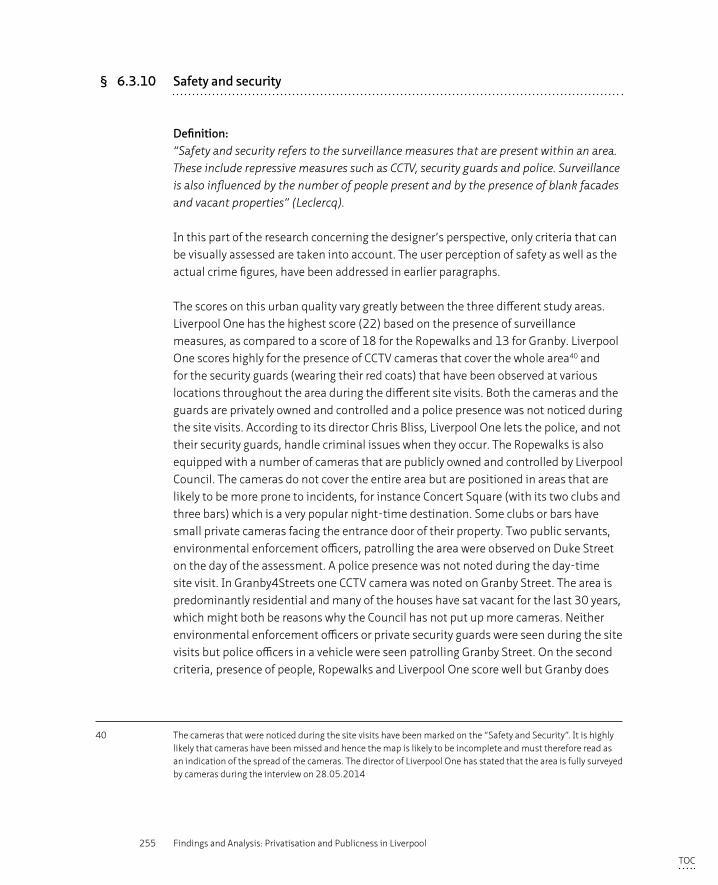
255 Findings and Analysis: Privatisation and Publicness in Liverpool
§ 6.3.10 Safety and security
Definition:“Safety and security refers to the surveillance measures that are present within an area. These include repressive measures such as CCTV, security guards and police. Surveillance is also influenced by the number of people present and by the presence of blank facades and vacant properties” (Leclercq).
In this part of the research concerning the designer’s perspective, only criteria that can be visually assessed are taken into account. The user perception of safety as well as the actual crime figures, have been addressed in earlier paragraphs.
The scores on this urban quality vary greatly between the three different study areas. Liverpool One has the highest score (22) based on the presence of surveillance measures, as compared to a score of 18 for the Ropewalks and 13 for Granby. Liverpool One scores highly for the presence of CCTV cameras that cover the whole area40 and for the security guards (wearing their red coats) that have been observed at various locations throughout the area during the different site visits. Both the cameras and the guards are privately owned and controlled and a police presence was not noticed during the site visits. According to its director Chris Bliss, Liverpool One lets the police, and not their security guards, handle criminal issues when they occur. The Ropewalks is also equipped with a number of cameras that are publicly owned and controlled by Liverpool Council. The cameras do not cover the entire area but are positioned in areas that are likely to be more prone to incidents, for instance Concert Square (with its two clubs and three bars) which is a very popular night-time destination. Some clubs or bars have small private cameras facing the entrance door of their property. Two public servants, environmental enforcement officers, patrolling the area were observed on Duke Street on the day of the assessment. A police presence was not noted during the day-time site visit. In Granby4Streets one CCTV camera was noted on Granby Street. The area is predominantly residential and many of the houses have sat vacant for the last 30 years, which might both be reasons why the Council has not put up more cameras. Neither environmental enforcement officers or private security guards were seen during the site visits but police officers in a vehicle were seen patrolling Granby Street. On the second criteria, presence of people, Ropewalks and Liverpool One score well but Granby does
40 The cameras that were noticed during the site visits have been marked on the “Safety and Security”. It is highly likely that cameras have been missed and hence the map is likely to be incomplete and must therefore read as an indication of the spread of the cameras. The director of Liverpool One has stated that the area is fully surveyed by cameras during the interview on 28.05.2014
TOC
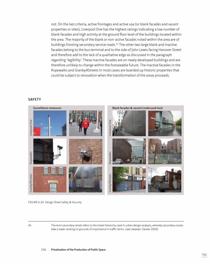
256 Privatisation of the Production of Public Space
not. On the last criteria, active frontages and active use (or blank facades and vacant properties or sites), Liverpool One has the highest ratings indicating a low number of blank facades and high activity at the ground floor level of the buildings located within the area. The majority of the blank or non-active facades noted within the area are of buildings fronting secondary service roads.41 The other two large blank and inactive facades belong to the bus terminal and to the side of John Lewis facing Hanover Street and therefore add to the lack of a qualitative edge as discussed in the paragraph regarding ‘legibility’. These inactive facades are on newly developed buildings and are therefore unlikely to change within the foreseeable future. The inactive facades in the Ropewalks and Granby4Streets in most cases are boarded up historic properties that could be subject to renovation when the transformation of the areas proceeds.
Surveillance measures Blank facades & vacant/underused land
Gra
nby4
Stre
ets
Rope
wal
ksLi
verp
ool O
ne
Gra
nby4
Stre
ets
Rope
wal
ksLi
verp
ool O
ne
SAFETY
FIGURE 6.24 Design Sheet Safety & Security
41 The term secondary street refers to the street hierarchy used in urban design analysis, whereby secondary routes take a lower ranking on grounds of importance in traffic terms. (see Llewelyn-Davies 2000)
TOC
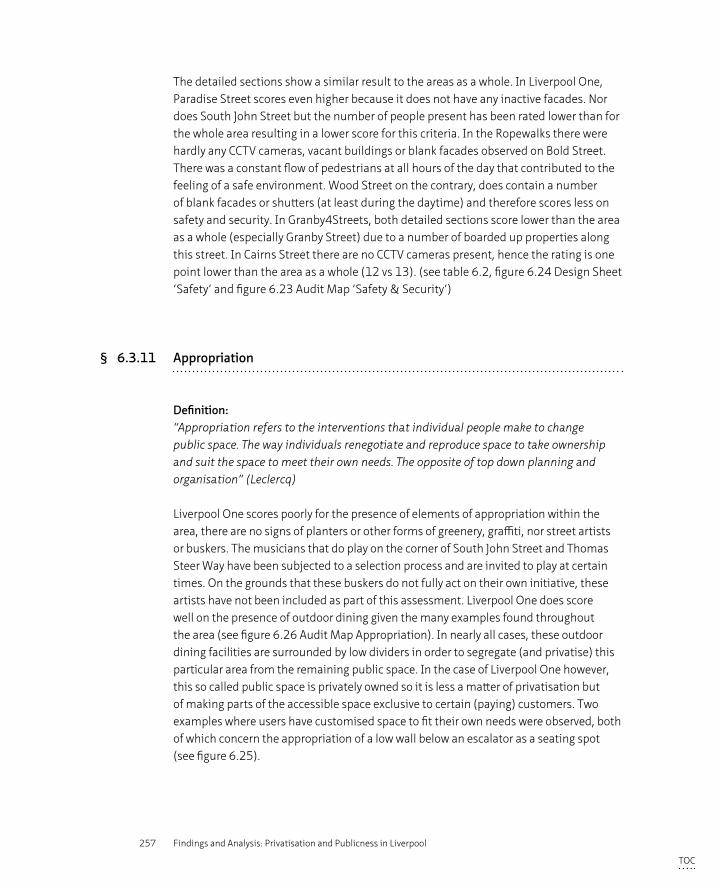
257 Findings and Analysis: Privatisation and Publicness in Liverpool
The detailed sections show a similar result to the areas as a whole. In Liverpool One, Paradise Street scores even higher because it does not have any inactive facades. Nor does South John Street but the number of people present has been rated lower than for the whole area resulting in a lower score for this criteria. In the Ropewalks there were hardly any CCTV cameras, vacant buildings or blank facades observed on Bold Street. There was a constant flow of pedestrians at all hours of the day that contributed to the feeling of a safe environment. Wood Street on the contrary, does contain a number of blank facades or shutters (at least during the daytime) and therefore scores less on safety and security. In Granby4Streets, both detailed sections score lower than the area as a whole (especially Granby Street) due to a number of boarded up properties along this street. In Cairns Street there are no CCTV cameras present, hence the rating is one point lower than the area as a whole (12 vs 13). (see table 6.2, figure 6.24 Design Sheet ‘Safety’ and figure 6.23 Audit Map ‘Safety & Security’)
§ 6.3.11 Appropriation
Definition:“Appropriation refers to the interventions that individual people make to change public space. The way individuals renegotiate and reproduce space to take ownership and suit the space to meet their own needs. The opposite of top down planning and organisation” (Leclercq)
Liverpool One scores poorly for the presence of elements of appropriation within the area, there are no signs of planters or other forms of greenery, graffiti, nor street artists or buskers. The musicians that do play on the corner of South John Street and Thomas Steer Way have been subjected to a selection process and are invited to play at certain times. On the grounds that these buskers do not fully act on their own initiative, these artists have not been included as part of this assessment. Liverpool One does score well on the presence of outdoor dining given the many examples found throughout the area (see figure 6.26 Audit Map Appropriation). In nearly all cases, these outdoor dining facilities are surrounded by low dividers in order to segregate (and privatise) this particular area from the remaining public space. In the case of Liverpool One however, this so called public space is privately owned so it is less a matter of privatisation but of making parts of the accessible space exclusive to certain (paying) customers. Two examples where users have customised space to fit their own needs were observed, both of which concern the appropriation of a low wall below an escalator as a seating spot (see figure 6.25).
TOC
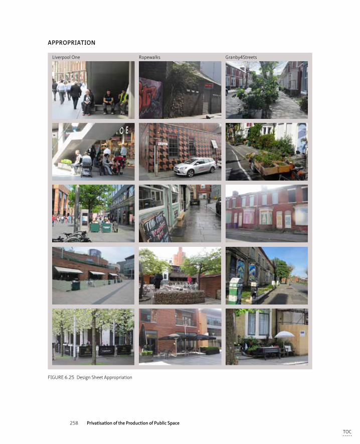
258 Privatisation of the Production of Public Space
APPROPRIATION
Liverpool One Ropewalks Granby4Streets
FIGURE 6.25 Design Sheet Appropriation
TOC
259 Findings and Analysis: Privatisation and Publicness in Liverpool
Within the Ropewalks there are many more signs of users or residents taking ownership of the public space. Signs of greening in the form of planters and hanging baskets as well as examples of graffiti are visible at various locations, for example on Wood Street (see figure 6.25). St. Luke’s church, bombed out during WWII, has been left to naturalise with help of local initiatives and now provides a green respite in the urban setting. A proposal to cover the church with a steel net and turn it into a large aviary has not materialised42 but from 2007 to 2014 a local agency called Urban Strawberry Lunch maintained the grounds and organised cultural events. The church is now closed for reconstruction works while the Council decides on what to do with it in the future.43 In the Ropewalks there are a number of outdoor seating areas, some of which are taking up space that was previously ordinary public space, i.e. on St Peter’s and Concert Squares, other dining areas are within private estates, i.e. within East Village or within the perimeter of the building block (see the example in Colquitt Street - figure 6.25).
Granby4Streets exhibits a large number of individual interventions in the public space including the greening of the streets via the planting of front gardens (including those of the vacant properties) a variety of left-over pieces of furniture that function as planters, painting the previously black, council installed boards on vacant properties in more lively colours and the organisation of a monthly street market. There is no outdoor dining seating in the area and there are no benches provided either. The local residents use a number of objects (low walls, bollards) as seating spaces and gather around them. Residents in Cairns Street have put a picnic table and benches on the pavement to provide seating opportunities. Granby4Streets is a close-knit community as well as a predominantly residential neighbourhood and is therefore likely to provide more opportunities for individual interventions than more mixed urban (and possibly more anonymous) environments.
42 Proposal ‘Masterplan Granby Toxteth, 2003’
43 See for more information www.bombedoutchurch.com
TOC
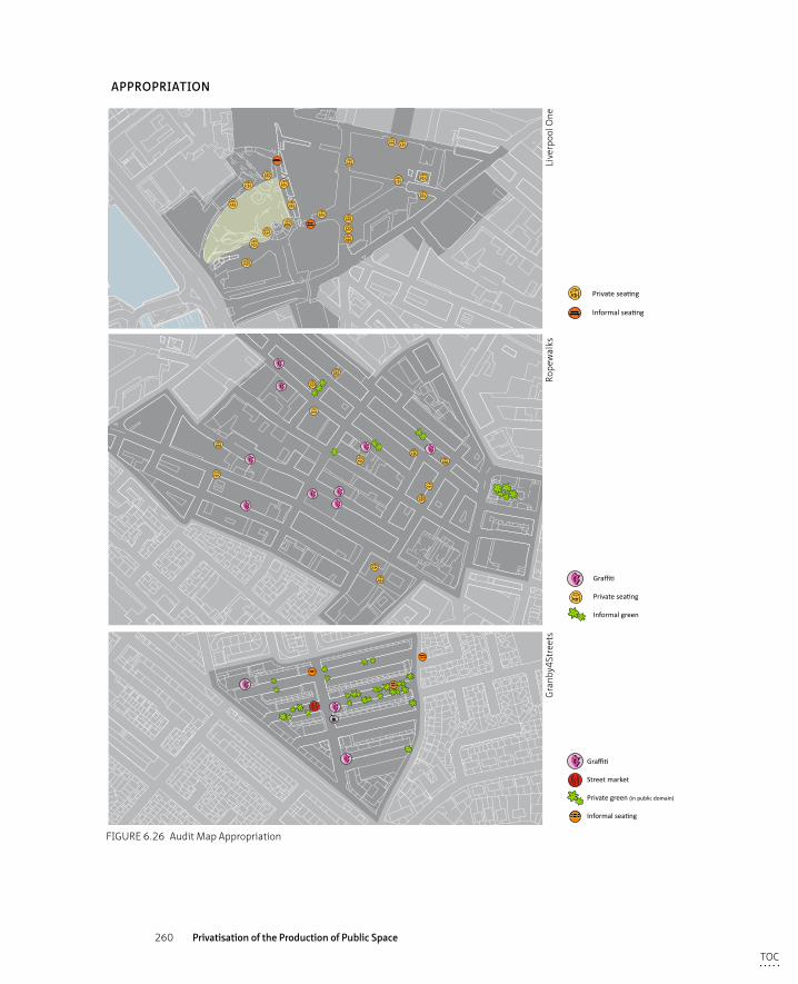
260 Privatisation of the Production of Public Space
A Art
Light
Tree
Graffiti
Street market
Private green (in public domain)
Informal seating
Private seating
Informal seating
A
Ad
S
Uint
Seating
Art
Advertising
Signage
Garbage bin
Light
Tree
Graffiti
Private seating
Informal green
Rubbish
CCTV
Blank facade
Gate
Vacant site
APPROPRIATION
Gra
nby4
Stre
ets
Rope
wal
ksLi
verp
ool O
ne
FIGURE 6.26 Audit Map Appropriation
TOC
261 Findings and Analysis: Privatisation and Publicness in Liverpool
The detailed survey sections all attract lower ratings than the areas as a whole except for Cairns Street that, being the heart of the community resistance against the Council demolition plans, produced a great number of individual interventions. The two sections in Liverpool One have a lower rating because the majority of the outdoor eating spots are around Chavasse park and at the bottom part of Paradise Street towards Hanover Street. The two signs of appropriation, the use of low walls as benches, are also outside these sections. The lower ratings in the detailed survey areas for the Ropewalks are based on the minimal presence of graffiti, local art and street artists noticed during the assessment in these particular sections. In Granby4Streets, Granby Street scores lower than both Cairns Street and the area as a whole (11 vs 17 and 16) because of the lack of individual interventions in this former shopping street. The appropriation of the public space plays a far more significant role in the residential side streets. (see table 6.2, figure 6.25 Design Sheet ‘Appropriation’ and figure 6.26 Audit Map ‘Appropriation’)
§ 6.3.12 Conclusions
Based on the qualitative and quantitative assessment, the following conclusions can be drawn. These conclusions are primarily based on the outcome of the visual assessment whereas overall conclusions linking the results to the wider theoretical and analytical framework will be drawn in Chapter 8.
– The privatised space has the highest total score for the combination of urban qualities (249), followed by the area developed through a public-private partnership (243) and the public turned community led area (240). The scores in the privatised area differ most for the qualities of ‘tidiness’, ‘control measures’ and ‘appropriation’ compared to the public areas. The privatised area scores very well on ‘tidiness’ and ‘control measures’ but poorly on ‘appropriation. Whereas the other two public area score the opposite: well for the quality of ‘appropriation’ and lower than the privatised area on ‘tidiness’ and ‘control measures’. The results are not surprising as the privately controlled maintenance and management regime is strongly focused on keeping the area ‘clean’, ‘safe’ and free of any potential ‘friction’. A large number of measures have been introduced to do this, varying from the presence of cleaners throughout the area to the abundant use of CCTV cameras and surveillance guards to control unwanted user behaviour. In conclusion, the urban qualities ‘tidiness’ and ‘safety’ correlate positively with the privatised space and the quality ‘appropriation’ negatively.
TOC
262 Privatisation of the Production of Public Space
– The space produced by the public-private partnership scores best on the qualities of ‘imageability’ and ‘complexity’, which can be firstly explained by the mix of different historic layers that are visually present in the streetscape. The historic urban grid of narrow streets is lined with listed maritime warehouses to which a new layer of connecting pocket parks has been added. Both new modern buildings have risen on vacant plots while historic warehouses have been modernised, both of which add extra layers of meaning to the visual experience of complexity and imageability in the area. Secondly, the area is endowed with a rich mix of uses varying from car repair shops to (small) creative offices and shops, from residential functions to numerous bars and clubs.
– The space produced by the community led development scores best on ‘enclosure’, due to a well proportioned width to height ratio and the presence of mature trees. The area scores well on ‘legibility’ given the permeable Victorian urban grid and on ‘appropriation’, due to the visible greenery, painted boards, seating and local market organised on the initiative of local residents. The area scores poorly in relation to the other two areas, on the qualities of ‘safety’, ‘imageability’ and ‘complexity’.
– The privatised area, scoring well on the qualities of imageability, complexity and human scale, can therefore be described as having a high degree of urbanity. The privatised area functions on appearance as much as an urban quarter (if not more) than the two publicly owned and managed areas. Apparently, the degree of privatisation does not necessarily impact negatively on the urban quality of inner city areas.
– The Methodology section explains that all of the 11 urban qualities assessed in the visual analysis are perceived or acknowledged to be part of the overall description of publicness. The visual assessment demonstrates that only the urban qualities ‘tidiness’, ‘safety’, and ‘appropriation’ show significant differences between the private and the publicly owned and managed areas, and can therefore be used as elements of differentiation within the public and private debate in the visual appearance of urban quarters. These three qualities however, fall outside those proven to be quantitatively significant according to the methodology of Ewing and Clemente and hence it can be concluded that, at this stage, only a qualitative assessment of the qualities ‘tidiness’, ‘safety’, and ‘appropriation’ can provide decisive answers to the degree of publicness in (these three) inner city areas.
TOC

263 Findings and Analysis: Privatisation and Publicness in Liverpool
TOC
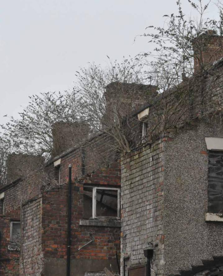
264 Privatisation of the Production of Public Space
TOC
265 Discussion: Process, Product and Perception
7 Discussion: Process, Product and Perception
In the analysis of the three cases from three different perspectives as discussed in the previous chapter, it becomes apparent that the degree of publicness as related to privatisation is important to both the process of producing space and the product. Following Lefebvre’s (1991) triangle of conceived, perceived and lived space, he states that through renegotiation, space is continuously susceptible to change. In other words, production and product influence each other. Previous attempts to determine new criteria for notions of publicness have not made explicit the distinction and connection between production and product (see chapter 2.4). In this chapter the main question of this research ‘Does privatisation lead to a decline of the publicness in the production of space and space itself?’ or in other words ‘Does privatisation produce private space rather than public?’ is discussed from the findings. The first section of this chapter deals with the process, the second with the product and the third with the perception of the space producers and consumers on the degree of publicness. By process is meant the production of space from initiative to design, through implementation and maintenance phases as well as the actors involved and the plan and proposals produced. By product is meant the outcome of this process, the space itself. The consequences often related to privatisation as discussed in Chapter 3, which also formed part of the analytical framework, are taken as the starting point for the discussion of the product. Thirdly, the analytical framework reflects on the perception of public versus private within the three case studies of both those producing (‘governance’) and those consuming (‘users’) the space. These perceptions are commented on from the particular perspective of the designer.
§ 7.1 Publicness and privateness in public space production
The three case studies differ in the ways that they are owned and managed as well as in the ways each regeneration project has been envisioned, designed and implemented. This is discussed at length in the previous chapter focusing on rules of publicness as described in the analytical framework ‘governance’ (see table 3.1): ownership (meaning who initiates a project, has decision making power and how are the actors organised within the process) and accessibility (openness and inclusiveness for a
TOC
266 Privatisation of the Production of Public Space
variety of different actors to the process, including minority voices). The three cases are subsequently reflected upon through the perceived valued outcome and publicness within the development process.
Ownership and accessibility to the processLiverpool One is privately owned, managed and paid for and the development process has been a top down led project by a private developer in collaboration with the Council as the legal planning authority. Grosvenor, the private developer, coordinated the development process hierarchically and decision-making power lay predominantly in their hands. Liverpool Council was under heavy scrutiny from both the wider public and national government to reverse the decline of Liverpool and deliver this ambitious scheme on time for 2008, the year Liverpool became European Cultural Capital.
The development process cannot be described as participatory or inclusive; future users, local actors and citizens were informed through presentations in which they were invited to comment, but in which they could not actively engage. Naturally, formal institutions to which the planning applicant is legally obliged (Mersey travel, English Partnerships, English Heritage etc.) were also consulted. The minority voice of a locally well-known collection of alternative shops - who protested heavily against the Compulsory Purchase Order that the Council put on their premises - was dismissed both by the private developer and by local and national government, hence the acquisition of the properties by the Council went ahead.
The role of the urban designer was influential as they not only designed and detailed the ‘public’ space landscapes but also produced detailed briefs to guide the architects responsible for each of the 34 plots. Their brief was dictated by the private client and it stated that the space was to be minimalistic and clutter free in order to provide ample space for events and pop ups stores. The maintenance regime was considered in the early stages of the design process and the use, management and maintenance of the space influenced the materialisation and design of the space. The urban and landscape design was implemented as envisioned early on in the project, and from the opening in 2008, the maintenance regime focused on keeping this exact design alive and undisturbed.
The process of Liverpool One can be characterised as a complete form of privatisation and not a form of public private partnership or outsourcing of public tasks to private entities, as is the case in the Ropewalks. The ownership of both the land and the design, implementation and maintenance processes are in hands of one private (corporate) actor and ownership of the process by a variety of different stakeholders was as limited. This corporate actor organised the process as typically hierarchical and top down
TOC
267 Discussion: Process, Product and Perception
over a short time span and did not allow time or funds for investigation of alternative routes nor inclusion of different stakeholders to maximise efficiency and minimise risk. However, even within a predominantly private process, the public authority sets the boundaries of to what degree a private process delivers a privatised space and to what extent public characteristics are incorporated. Liverpool One can be typically characterised as an example of where the involvement of large corporate developers often “increases efficiency and productivity in city building, it narrows the range of strategic actors and their considerations” (Madanipour 2003, 12).
Trust in public authority achievement was low after decades of economic and spatial decline of the city and the lack of an adequate response by the local authorities. Particularly the years of militant Labour left a scar due to their underinvestment in people, jobs and the spatial environment of the city centre as well as corrupt practices to pay for their policies (Sykes et al. 2013; Lees 2011). The Council appeared to have neither confidence, funds or the political clout to deliver this retail based city centre scheme, which the city desperately needed to be able to compete with surrounding city centres and out of town shopping malls (Healey & Baker, 1999 in Littlefield, 2009). The Council therefore turned to a private, corporate actor to make that investment, in line with the neo-liberal ideology advocated by New Labour at that time.
Contrary to the privatised process that shaped Liverpool One, the Ropewalks was envisioned and initiated by the public authority, after which the design and implementation were delivered through a public private-partnership. The public spaces in the Ropewalks were publicly owned and though their management had been initially outsourced to a private company, since spring 2016 they have been publicly managed again. This maintenance and management is now carried out by a newly established public company that operates at arms lengths from the Council. The development process of the regeneration project that started in the mid 1990’s was initiated by the public authority and further designed and implemented by a regeneration vehicle, Ropewalks Partnership, that comprised actors from both private and public bodies and which was led by Liverpool Council. Following the implementation of the initial plan in 2002, the Council replaced its relatively top down approach for a more bottom up one, involving multiple stakeholders in the decision-making process. Local businesses, groups and residents work together on local issues in a Community Interest Company. The Ropewalks Residents Association addressed a number of local resident concerns, in particular related to the noise and other nuisances that could be attributed to the clubbing scene, in a satisfying and effective manner for both residents and bar owners.
The works on the public spaces, funded through public grants (European Objective One), have been based on the idea that an attractive spatial context would attract private investment into the renovation of the buildings (often with public grants) as is
TOC
268 Privatisation of the Production of Public Space
advocated in the Urban Renaissance policies and strategies. All local actors were invited over a weekend to voice their ideas and concerns and this marked the start of the development process. However, the majority of these actors were not actively engaged for the rest of the design and implementation process duration.
The development process could be described as a collaborative process in which public and private – both corporate, civil society and residents – worked together and as such the inclusiveness of, and accessibility to, the process can be regarded as reasonable high. The masterplanner and designer (BDP) created a series of new pedestrian linkages and pocket parks that were landscaped to a high standard but subsequently poorly maintained. This collaborative partnership initially involved a larger commitment from the public authority after which private investment followed and is still present since the completion of the public space works in 2002. This has led to an organic and incremental growth of the area. The public authority’s trust in the eagerness of the private sector to invest in the area initially proved optimistic. Although the public space works were delivered on time, the majority of private actors awaited with re-conversion of the buildings, which eventually started to take place gradually.
The visioning process for the future of Granby4Streets was initially led by the public authority without active engagement of the local residents who subsequently rejected the top down exclusionary approach. With the vanishing of the public funding programmes in 2010, a vacuum was left in which private local initiatives could emerge. When the public funding regimes collapsed, the local authority had no option but to take a step back, and this opened up opportunities for local actors. The regeneration trajectory therefore morphed into a bottom up process with multiple stakeholders who worked on their own initiatives in cooperation rather than collaboration towards the common goal of the area’s regeneration. Although relations between the Council and local actors have improved since the public funding regimes collapsed, levels of trust from these local actors in the local institutions (both council and RSL’s) remain low. This is reminiscent of the earlier Council led renewal processes in which the local residents were not heard or included.
The initial process cannot be described as inclusive because, although the Council consulted local residents and interest groups and outsourced some of its tasks to other partners, these actors were not actively engaged within the process and did not hold any decision-making power; the local Council held ultimate decision-making power and was in charge of funding dispersal. The change in structure of the process – from hierarchically coordinated to co-operation of a variety of actors – did improve the accessibility to the overall process because a variety of different initiators were
TOC
269 Discussion: Process, Product and Perception
working towards complementary goals. The process however, cannot be regarded as a collaborative partnership but as a cooperation of loose actors working towards mutually beneficial aims (as explained by McAllistor and Taylor 2015, see 3.1.1).
The signs of protest, conflict and struggle during the regeneration processes of both Liverpool One and in Granby4Streets had different consequences in the continuation of the development processes. Because the protest voice was not actively engaged within the process in Liverpool One, dismissal of their considerations did not affect the organisational structure of the process. In the case of Granby4Streets the residents were officially represented by a local community organisation and, although their input was not seriously taken into account, were part of the organisational structure. When conflicts rose to an extent that the local organisation broke off their communication with the institutions that then led to a disruption of the organisational structure. The stakes of the Liverpool One project, for both public and private stakeholders, were deemed too high to risk delay or disruption by incorporating alternative views, whereas in Granby4Streets the lack of private interest and property value apparently did not generate a sense of urgency to drive the regeneration process forward with the public stakeholders. Hence the process could be stalled without much political or financial consequences for the public authority.
PublicnessThe public values described by Reynaers (2014) with regard to public/private partnerships - accountability, transparency, responsiveness, responsibility and quality- are partially met in the production of Liverpool One. Accountability and transparency to the wider public is not relevant in a completely privatised project to the same extent as in public-private partnerships because there is limited public money involved; accountability here is of concern to the corporate stakeholders not of the taxpayer. In the case of Liverpool One, council employees worked collaboratively with the private developer to safeguard the public values of access, the incorporation of the bus station and the quality of the architecture. The private developer took full responsibility for both financial and organisational aspects for all stages of the process, albeit in a top down hierarchical way, for which they were widely applauded for (see interviews). The democratic legitimacy addressed by Kort and Klijn (2013) is debatable in this particular case, because there has not been a public debate regarding the underlying concerns of the privatisation of a large part of the city centre. However, Liverpudlians were eager to see something happen to both the public image of their city and to the derelict precincts blighting the city centre. Trust in effective local government was low at that time and because there was only private money spent and no public money, the local citizens’ view of the projects was very positive. In urban regeneration networks “made up of property developers, architects and engineers, elected and appointed
TOC
270 Privatisation of the Production of Public Space
city officials, and large capitalist concerns which come together to develop economic activity by building (…) elected city governments are relatively weak player[s] in a larger system of power” (Parkinson 2012, 83). Thus, although the public authority sold its land (representing a public good) it was in their opinion done in the public interest; the city gained a new retail district and received money rather than spending it, but lost control over the area.
The process of the development of Liverpool One has been regarded as successful because it delivered a contest-winning scheme on time (before Liverpool became Cultural Capital in 2008) and provided jobs, shops, a new urban quarter and an improved image of the city of Liverpool. The project benefited from an inspirational and dedicated leader who appeared to genuinely want to contribute to the regeneration of the city centre in addition to the commercial gain of his company. This then, appears to fulfill all the four elements that are viewed as potentially positive outcomes of the current urban renaissance as stated in the analytical framework – creating an attractive environment, economic vitality, job opportunities, boosting civic pride (see 3.1.3 and Madanipour 2010). In addition to delivering a positive economic outcome for the city of Liverpool, this case also demonstrates that corporate companies can have public interests at heart and that a development process depends on the vision and dedication of the key players. The potential negative consequences will be discussed in the next section.
Similar to the Liverpool One case, the valued outcome of the Ropewalks’ regeneration process is measured by the delivered economic gains (rise of employment figures, of property values etc.) and not so much by the “conventional structure of procedural rules and norms to assure legitimacy, consent and accountability” (Skelcher at al. 2005, 590). The neoliberal focus on involving private actors in the development of our cities provides a certain flexibility to deliver established goals, “but at the cost of conventional notions of democratic performance” (Skelcher et al. 2005, 590). The Ropewalks Partnership was initiated and led by Liverpool Council, who were ultimately responsible and accountable for the delivery of the masterplan. Although the process (and its outcome) was perceived as an overall success (Cabe 2011)44, there was also critique of the public authority voiced in two ways. Firstly, the lack of control over rents (or the asset management of the area) has been lamented because it initially led to a decline of independent shops and an over-representation of the nightclub economy to the detriment of creative industries. Secondly, the maintenance of the area is regarded as insufficient, these concerns were not only voiced in interviews by those that produced
44 http://webarchive.nationalarchives.gov.uk/20120830034025/http://www.liverpool.gov.uk/news/details.aspx?id=210040
TOC
271 Discussion: Process, Product and Perception
the space but also by the users. As discussed in chapter 3.1, democratic legitimacy can be regarded as doubtful in public-private partnership projects as the decision-making power is often transferred to non-democratically elected bodies (Kort and Klijn 2013). During the initial phase of the implementation of the masterplan, the ultimate decision-making power within the Ropewalk Partnership lay with the public authority and hence there were no issues concerning the democratic legitimacy. In the following years, the Council transferred decision-making power to small, dedicated working groups of local businesses and residents involved in the issues and this might have led to failure in democratic terms. This research has however not been able to detect such a failure.
The regeneration of the Ropewalks is seen as successful although it has not become the creative quarter that was initially envisaged. It was the first inner city regeneration project that was fully funded through European public money and the Ropewalks Partnership set high levels of quality expectation, which was extraordinary at that moment of time for Liverpool. The project proved that private investors were eventually willing to invest in Liverpool again and demonstrated to the public authority that demands and aspirations could be stepped up; the city did not need to settle for the lowest common denominator.
By contrast, in Granby4Streets the public values were not safeguarded within the early stages of the development process and the Council responsible for the regeneration of the area did not deliver any spatial, social nor economic progress in Granby4Streets. Although the Liverpool Council used the available funding and spent it extensively on the process (on documents, reports, working groups etc.), they failed to create an inclusive process in which trust between the different stakeholders was present and without yielding any physical change within the area. It can therefore be argued that the local authority failed on all the public values of accountability, transparency, responsiveness, responsibility and quality (Reynaers 2014). The withdrawal of the funding created a vacuum in which small private initiatives could arise. The local authority, faced with changing times and perspectives, allowed for and then accommodated these initiatives.
TOC
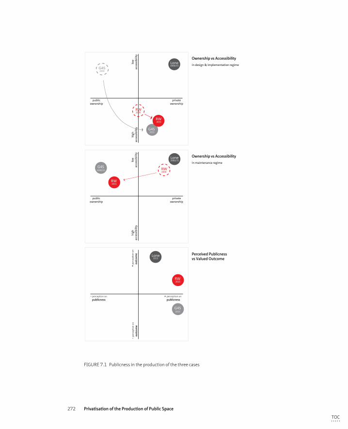
272 Privatisation of the Production of Public Space
publicownership
privateownership
high
acce
ssib
ility
low
acce
ssib
ility
G4SLone
RW
2015
2015
2000
2000/15
2000
G4S
RW
publicownership
privateownership
high
acce
ssib
ility
low
acce
ssib
ility
2000/15G4S
Lone2000/15
2015RW
RW2000
- perception on publicness
+ perception on publicness
- per
cept
ion
on
outc
ome
+ pe
rcep
tion
on
outc
ome
2015G4S
Lone2015
2015RW
Ownership vs Accessibility
in design & implementation regime
Ownership vs Accessibility
in maintenance regime
Perceived Publicnessvs Valued Outcome
FIGURE 7.1 Publicness in the production of the three cases
TOC
273 Discussion: Process, Product and Perception
After 30 years of struggle, the area was regenerated the way the local residents had always envisioned: based on the original street pattern and with renovation of the existing houses rather than demolition. However a number of the residents involved from the beginning of the process do not see the current outcome as a victory given the high price paid in terms of both money and struggle.
In summary, both the private and the public top down organised processes demonstrate a lack of publicness (as in ownership of and accessibility to the process) as both consisted of a limited number of stakeholders with decision-making power. The most public process analysed has been the multi-stakeholder processes – both the collaborative public-private partnership and the co-operative approach in community led process – in which a number of different public and private (both corporate and non corporate) actors were present. The degree of publicness is described through notions of ownership of and accessibility to the process.
§ 7.2 Publicness and Privateness (or the consequences of privatisation) in space itself
The consequences of privatisation that will ultimately lead to a decline in publicness of space according to the fears of a number of academic scholars have been discussed in the chapters on theoretical (chapter 2) and analytical framework (chapter 3). They refer to commodification, commercialisation and homogenisation of space, the strong emphasis on safety and maintenance, the emphasis on provision of entertainment, the use of themes to brand a certain place and limitations of accessibility. These consequences all relate to a degree of control over space, which might potentially lead to the exclusion of certain people and to limitations, or decline, of the degree of publicness of both space and sphere (see 3.1 and 3.2). Whether or not these consequences were found in the Liverpool case studies and hence if these fears are justified in these cases, will be discussed in this paragraph. This will ultimately discuss the degree of publicness in the three different spaces and the privatised space is hereby compared with the two public spaces. The following themes are critically revised and are viewed from the perspectives of space producers, consumers and the designer:
TOC
274 Privatisation of the Production of Public Space
– the exclusion of certain groups or individuals, variety of spheres, and the Right to the City concept
– the focus on themes and events
– clean and safe, homogenised and commodified spaces
Three questions lead the discussion in order to be able to answer the main question ‘Does privatisation lead to a decline of publicness in space itself?’:
– Were these (perceived to be negative) consequences present in the analysis findings?
– And if so, did they affect the publicness of space?
– How can users actively engage with and within privatised space?
Exclusion, different spheres and the Right to the CityExclusion of certain groups or individuals can occur in the first place through explicit (or so called hard) control methods, which are clearly noticeable and visible in space such as reduced spatial accessibility, surveillance methods or through the imposing of certain policies (eg ASBO or PSPO) in certain areas (see Loukaitou-Sideris and Banerjee, 1998 for hard and soft controls and 3.1). The sorts of control mechanisms put in place in the three analysed urban areas of Liverpool are: CCTV cameras and the omnipresent private security guards in Liverpool One, cameras at certain locations and the sporadic enforcement officers in the Ropewalks and the police patrolling in Granby4Streets. All three areas were spatially accessible for pedestrians both day and night and there were no legal restrictions such as ASBO’s placed on certain behaviours. The second manner through which exclusion occurs takes a more subtle form, in which unwritten rules or (spatial) design prevents certain activities, deemed inappropriate, from taking place or ‘undesired’ people from being present. In particular, homeless people, beggars and (groups of) young people are often targeted by these soft restrictions. Whereas in the publicly controlled spaces of the city centre of Liverpool, plenty of evidence of the presence of these individuals and groups was observed while in the privatised area there were none. The privatised area was actively patrolled and any ‘undesirables’ (Whyte 1980) were displaced. The area exudes a sense of parochialness or exclusion, enhanced by the design and control measures in place. Both the way the space is designed and the corporately imposed restrictions on certain activities, on user behaviour as well as the unwanted presence of certain individuals discourages alternative use and users and therefore contributes to the soft measures that enhance exclusion.
The exclusion of certain groups and individuals from public spaces can be seen as a denial of their right to the city, a denial of their citizenship and representation in the public sphere as discussed by Németh (2011). In the privatised space, this type of
TOC
275 Discussion: Process, Product and Perception
exclusion was also observed as no individuals or groups were seen appropriating space by changing it (temporarily) to meet their own everyday needs or to make a cultural or political statement. For instance, the positive contribution of street artists or balloon sellers has been widely researched and found to be of great significance due to their facilitation of “moments of contact between strangers and therefore producing a more convivial form of public space” (Tanenbaum 1995 in Simpson 2014, 423). The company in charge of the maintenance of the privatised space does acknowledge the benefits of this type of entertainment but regulates the nature of the acts, the performers themselves and the location in which they perform in such a way that the elements of “spontaneity and surprise in encountering performers not seen before or expected” are lost for the wider public (Harrison-Pepper 1990 in Simpson 2014 426).
In both the privatised and public areas, all three spheres described by Lofland (1999) - the public, parochial and the private sphere – have been found to be present. The overlapping of spheres and the encounters that follow from the simultaneous presence of these different spheres form an important ingredient of urbanity and everyday city life, although in essence conflictuous (Soenen 2006). As the privatised space is facilitating this multitude of overlapping spheres, it does function as an urban social space. However, when certain individuals and groups are denied access to this space through hard and soft control mechanisms, it denies them their right of every day existence in that particular area and, similarly, other people are denied the presence of these individuals and groups. They are discouraged or prohibited to use these spaces and are forced elsewhere, which fuels the archipelago-concept (Hajer and Reijndorp 2001) of different islands in the urban landscape with no connection to each other in terms of the spheres they host.
According to Hajer and Reijndorp (2001) the overlapping of spheres offers users a shift of perspective through the experience of ‘otherness’. In their view, in this exchange of views that enhance individual perceptions lies the success, and therefore the objective of public space. Arendt (1958) and Habermas (1989) argue a different view: the main aim of coming together as a public is to raise above the individual to reach common goal. The public sphere should be an arena for active engagement rather than passive experience is in their opinion the role of fulfill (in which public space could perform the geographical setting).
The third case of Granby4Streets, is a good example of the underlying concepts of the Right to the City; reclaiming the public spaces (see chapter 3.2). Granby’s local residents fiercely resisted the proposals designed for the area on the initiative of the public authority and in which they did not have any decision making power despite being formally associated through a residents group and having proposed alternative options themselves. Excluded from the development process and disillusioned with
TOC
276 Privatisation of the Production of Public Space
the lack of spatial change in the area they claimed the public spaces and appropriated them to suit their own needs. The right to ‘their’ space was not an obvious or generally accepted one and it took three decades of conflict and struggle against institutional powers to reach a point where their voice was heard and their initiatives implemented. As already mentioned in the analytical framework, as no space is ever equally accessible to all members of the public and no space will ever meet the demands of all users, there are bound to be conflicts and struggles over different contradictory claims. These conflicting relations are necessary ingredients of urban life: urbanity is conflict (Lefebvre 1968, 1991).
In the privatised space of Liverpool One, this conflict or struggle over space has been purposefully prevented by the hard and soft control mechanisms put in place. Individuals and groups of users with intentions to use the space in a way different to the desired consumer manner, are denied their claim on space and are therefore discounted as a legitimate part of the public and the public sphere. Therefore as a privatised space, Liverpool One cannot be considered as truly public given some individuals can clearly make no claim on the space in order to reproduce it and although public spheres do consist within the privatised space as discussed, certain publics are denied access. Hence in its democratic sense, comprehensive publicnes, cannot be reached and the area merely functions as a social space. As stated in Chapter 2, a social sphere is regarded as neither public nor private, but as a neutral sphere (Arendt, 1958). The lack of possibilities of user’s appropriation due to control mechanisms present within the area apparently reduces the degree of publicness. In addition, the remaining (consumer) public is also deprived of the opportunity to engage in a truly public sphere (or spheres). “In ideal, truly inclusive public spaces, powerful groups are forced to become aware of existing in equalities and deal with such difference rather than detaching themselves from reality” (Németh 2011, 314).
Organised events and themesAs part of the mechanisms to control the types of user that would maximise commercial value, the privatised area invests heavily in the provision of entertainment, as discussed in 6.1. The use of streets and squares as venues for events is nothing new, but what appears to be novel is the top down approach towards their organisation (Van Melik et al. 2007) and this top down organisation is clearly evident in Liverpool One. Some locally organised, even politically charged, events such as the breastfeeding session are condoned but only with corporate consent. Liverpool One can be regarded as a clear example of Boyer’s (1994) notion of the ‘City of Spectacle, reducing the city to an arena of pure imagery with close relations to “consumption and the selling of leisure-time lifestyles” (p. 51).As the maintenance regime of Liverpool One is geared towards keeping the area in the same state as that originally conceived by the designers on
TOC
277 Discussion: Process, Product and Perception
their drawing board, with the control mechanisms in place to reduce any unexpected behaviour, and the strong focus on controlled entertainment, the urban spaces of Liverpool One cannot reach their full potential as a perceived or lived space as described by Lefebvre (1991).
In the two public spaces spontaneous individual interventions, eg street musicians, artistic expressions as well as organised bottom up events, eg the Granby Street Market, have been observed, as well as a multitude of overlapping private, parochial and public spheres. Within the Ropewalks - dominated by the nightclubbing scene - a parochial sphere has been found to be dominant in certain areas after three pm in the afternoon. The public authority, faced with the negative side effects of the nightclubbing scene and encouraged by the success of the manipulation of the desired clientele by the orchestration of events in Liverpool One, encouraged local clubs and bars to diversify their offer by serving food or organising festivals. The public authority hereby draws lessons from the private sector, not necessarily for the pursuit of commercial gain but with the aim to stir the reputation of the area into a different direction, thereby mingling the spheres currently present. This provision of entertainment to leave visitors with an ‘experience’ is in line with a wider observed in cities throughout the Western world. Both public and private actors in a particular city compete with other cities in order to attract visitors through the ‘experience market’ (Hajer and Reijndorp 2001; Boyer 1994). This experience and event market is heavily promoted in Liverpool One by the corporate owner and introduced as a concept by the public authority in the Ropewalks.
Clean and safe, homogenised and commodified spacesIn the global competition between cities, public space is recognised as a valuable commercial commodity: environments that are clean, safe, attractive and offer a range of facilities and activities, attract visitors and citizens that can afford to consume (Madanipour 2003; Carmona et al. 2008). Large international companies and globalised cities in combination with nationally produced design guidelines and codes could however lead to a generic and homogenised space: ‘it could be anywhere’. The urban and landscape design of two of the three analysed case studies (Liverpool One and the Ropewalks) happened to be designed by the same internationally operating and award winning design firm. Both designs were produced shortly after one another, hence within the same political setting and following the same national and local urban design guidance. The two areas do not resemble each other nor can they be labeled as bland or standard. Both areas score extremely well in the visual assessment on the urban qualities of imageability and complexity. Thus, neither privatisation of the process (totally privatised or public private partnership) nor the involvement of a large (inter)national company necessarily produced visually homogenised spaces in
TOC
278 Privatisation of the Production of Public Space
these particular cases. The role and vision of the client, the local spatial context and the expertise of the designer all play an important role in the production of space.
The strong emphasis on providing a clean, safe and in other ways controlled environment is paramount within a privatised space (Carmona et al. 2008; Sorkin 1992). The reality of everyday life in the privatised space is erased and replaced by “a hyper-real environment, composed by the safe and appealing elements of the real thing, reproduced in miniature of exaggerated versions” (Loukaitou-Sideris and Banerjee 1998, 280). In Liverpool One the image of an urban quarter is successfully re-created as the high scores on imageability, complexity and human scale demonstrate. However the area also scores highly in the criteria of control and surveillance (urban qualities ‘safety’ and ‘tidiness’) and lacks any signs of appropriation. The area is designed and managed to attract a certain public and to discourage individuals that might complicate the shopping experience of the desired clientele. Thus, while the privatised space might not be visually homogeneous, it does function as a socially homogenised space.
As said earlier in the theoretical chapters, a shift in public policy and funding has been noticed whereby specific, more commercially relevant, areas are targeted rather than the city as a whole. Combined with declining public budgets and a larger involvement of the private sector in all its forms, a new hierarchy of spaces, related to their commercial valuable merit, dominates current city planning. This polarisation is further enforced by the outsourcing by local authorities of development and/or maintenance tasks and responsibilities to private actors; privately controlled areas tend to put a higher standard for safety and tidiness requirements than publicly managed neighbourhoods (Minton 2009; Carmona et al. 2008). This involvement of private actors and outsourcing of previously public tasks has contributed to spatial segregation of the city into ‘overmanaged’ and, as a consequence, ‘undermanaged’ areas (Carmona et al. 2008). This segregation ultimately leads to an “archipelago of homogenous and specialized islands and in-between spaces (…) these spaces often have the character of ‘liminal’ spaces: they are border crossings, places where the different worlds of the inhabitants of the urban field touch each other” (Hajer and Reijndorp 2001, 128).
As the ‘overmanaged’ areas exclude a number of individuals, groups of people and certain activities, these spaces cannot be said to have a complete degree of publicness because they lack elements of accessibility and the ability to host a public sphere in the sense of being political; they tend to have an overrepresentation of parochial spheres. The ‘true’ public sphere now often appears to develop in and around the liminal spaces, it is in these spaces, the transitions, the crossings and the connections and the in-between spaces, that we can imagine - at least theoretically - public sphere experiences such as confrontation with otherness, a change of perspective, an exchange (Hajer and Reijndorp 2001, 128-129). Crawford (2008) came to similar conclusions in her
TOC
279 Discussion: Process, Product and Perception
research into new public spaces in Los Angeles where signs of people creating new public space shaped by lived experience rather than built (or designed) space.
From the analysis done in this research, the privatised space can be described as a well integrated island in the urban landscape of Liverpool, or at least well integrated at the city centre boundary and towards the tourist hotspot of the Albert Dock. The connections between Liverpool One and the Ropewalks, Baltic Creative Quarter and the social housing estate to the south are however very poorly designed. The same can be said for the linkages between the Ropewalks and this deprived neighbourhood. These poorly designed zones could be described as the liminal spaces – transitional zones – referred to as potential spaces where the new public sphere emerges according to Crawford (2008) and Hajer and Reijndorp (2001). No signs were found within these transitional zones however, of a potentially emerging new public sphere (or overlapping multitude of spheres), on the contrary local residents complained about the windswept new bus station that appeared to be located at the edge of everything45. The function of these liminal spaces is better described as forming a barrier (or creating severance) between the ‘over-managed’ areas. Spatial segregation between Liverpool One and the L1 residential neighbourhood were observed and to a lesser extent with the Ropewalks. Therefore, the transitional zones enhance and enlarge the differences between the over and under-managed spaces rather than facilitate new spheres. Although the experience of publicness in space is thought to occur at the boundary between friction and freedom, this analogy can apparently not be directly translated to the spatial context. The theoretical argument that the ‘real’ public sphere is found in the transitional zones between over and under-managed areas, the ‘liminal’ spaces, has not been confirmed within the case studies in this research.
In summary, the consequences often attributed to privatised spaces in academic literature – exclusion, homogenised, commodified and themed space with a strong focus on cleanliness and safety – have all been found (to a greater or lesser extent) in the privatised space which compromises the degree of publicness of space. In the privatised area the everyday urban conflict or struggle between different users is purposefully minimised by the induced corporate rules. The area however, is not devoid of entertainment, on the contrary plenty of events are commissioned by the private owner and therefore could be said to be staged. In the two public areas these urban struggles were clearly noticeable, for instance the numerous graffiti pieces in the Ropewalks or the greening and painting exercise in Granby4Streets. All the three spheres – private, public and parochial – have been found present in the areas
45 Barrett, T. (2005). Halfway to Paradise? Liverpool Echo 08.05.2013
TOC
280 Privatisation of the Production of Public Space
themselves and no emerging public spheres could be detected in the border zones of these areas. These were, in a number of cases, designed as spaces of severance rather than linkage.
§ 7.3 Perception of Publicness and Privateness
The outcome of the privatised regeneration process is valued by the space producers interviewed, as enormously successful in commercial terms: the area generates jobs, boosts the retail provision, and with that the image of Liverpool, and attracts out of town visitors. Although all the aspects of critique of the effects of privatisation addressed in the analytical framework – homogenisation, themed space, focus on safe and clean, and the exclusion of certain individuals or behaviour – are all found to be applicable, this appears to be of minor concern to the space producers who have been interviewed. The economic advantages that the scheme brings to the city clearly outweigh the disadvantages and this is also reflected in the perception of the space producers on the publicness of the spaces in Liverpool One. They all regard the area as public space due to the fact it is publicly accessible at all times. The fact that the publicness is compromised because of the exclusion of ‘undesirables’ and the prevention of spontaneous individual behaviour, is acknowledged but not found to be critical. The general view is that it is perfectly acceptable to have certain areas in your city where other rules apply “as long as not the whole city is subjected to these corporate rules; a number of truly public spaces must always exist in the urban landscape” (several interviewees). This view of the city by public bodies as a patchwork of different areas is in itself not remarkable as they have, as discussed in earlier sections, gone through a transition towards a more market-oriented mode of governance and also apply such controlling mechanisms themselves (see the use of ASBO and PSPO and the construction of BIDs in which, at least in Liverpool, the Council is part of). Hereby the public authority shifts its priority in delivering space in the interest for all its citizens to commercially valuable space, which eventually results in a segregated and polarised city and in a capsulated society. Thus both the private and the public sector apply control mechanisms to the city, hence who owns and controls space apparently is of less concern to the degree of publicness than to what degree there are controlling mechanisms in place and how they affect user behaviour.
TOC
281 Discussion: Process, Product and Perception
Although interviewees regarded the privatised space as public space because of its accessibility during the day and night as wel as its uninterrupted connection to the rest of the city centre, some remarked that it cannot be declared a civic or democratic space because of the exclusion mechanisms in place. The space can be seen as public in a social sense but not as a democratic or political space. According to Parkinson (2008) however, not all spaces have to accommodate the same degree of publicness. Different use and activities require different stages and as long as this variety of different stages is maintained within a limited range, it does not matter that certain political activities (such as protests and marches) at the upper side of the public intervention spectrum are prohibited in some spaces. A variety in the degree of publicness is even beneficial according to Parkinson (2008) because it opens spaces up for a variety of purposes and publics, more concerned with everyday interventions.
The essence of public space is to provide a setting for “the overlapping of and exchange between different social realms” (Hajer and Reijndorp 2001, 113). In all three cases, including the privatised space of Liverpool One, the presence of the three spheres – private, parochial and public –were observed to coexist. However, it might not be necessary to host all forms of individual expression (including organised protests) as stated by Parkinson (2008), the ability to exercise forms of appropriation or everyday urbanism (Crawford 2008) do influence the degree of publicness in space as the findings of this research clearly demonstrate. In both the results of the user survey and the visual appearance analysis, the privatised space has low ratings for active user engagement and signs of renegotiation of space.
The results of the user survey demonstrate that interviewed users rate the privatised space as a high quality public space. More than half of the respondents regard the space as public, however they simultaneously think that they are not allowed to exercise certain basis public rights (such as using a skateboard, being political, making music or handing out flyers). They sense this correctly as these individual interventions are prohibited under the corporate rules. In the public areas, a high percentage of the users also regard the spaces as public but here they do think, also correctly, that they are allowed to exercise these rights. In the academic literature a “blurring of the public and the private” (Kohn 2004) has been used to describe current phenomena in the privatisation discourse. However, what the user survey results identify is not a blurring of the private and the public but an unconsciously re-adaptation of one’s behaviour. This appears not to be caused by the presence of hard controls measures because a large number of users responded negatively to the questions if they felt watched. Apparently the design and maintenance regime in place in the privatised areas made people intuitively sense their behaviour was restricted. The clutter free and carefully designed spaces of the privatised space of Liverpool One as well as the high standard of the maintenance regime contribute to the perceived feeling of a controlled urban area
TOC
282 Privatisation of the Production of Public Space
in which alternative use and users are not welcome as discussed at length in chapter 6. Although the privatised space appears as public space according to the interviewed users, they are aware of restrictions to their behaviour and therefore adapt their behaviour accordingly, a form of so called self-policing (Garrett, 2017)46.
In the public spaces of the Ropewalks and Granby4Streets the largest percentage of respondents also perceive the spaces as public spaces but do believe they could exercise their public rights. Respondents in the public areas reacted inquisitively about the reason behind the questions asked, in their eyes these questions were bordering on the ridiculous. In the privatised area on the contrary, these questions were perceived as perfectly reasonable. Apparently, the perception of the degree of publicness of space is related to the behaviour one perceives to be allowed or limited. In the privatised case study area, where there is a set of rules in place to control users’ behaviour as well as to maintain the area clean and safe, few signs of appropriation have been found. Whereas in the public areas, with less control mechanisms in place, plenty of signs of individual interventions were noticed. Apparently, the degree of publicness is enhanced when users perceive control mechanisms to be loose or absent. For example, the local residents in Granby who were tired of being stigmatised and their environment being neglected by public bodies, rebranded their area by communally organised interventions in the public space, demonstrating that they formed an active community, proud of their surrounds.
A large percentage of user respondents rated the privatised space as high quality space, a higher response than the two public spaces received. This view is supported by the visual analysis in which the privatised area scored highly for all the urban qualities except for that of ‘appropriation’ as well as by the space producers interviewed who also regarded the privatised space as a high quality urban space. Judging by these results, the private developer has clearly succeeded in creating a new urban quarter and an extension of the city centre, a task only executed by public overview in previous eras.
The urban character of the Ropewalks area is also highly regarded with most space producers interviewed agreeing that it has kept its slightly edgy and experimental character, although some parts are more gentrified. The findings of the user survey demonstrate similar results; the majority of the respondents rate the spaces in the Ropewalks as good, the overall critique by users relates to their perception of a lack of maintenance of the public spaces. A similar critique has been voiced in Granby4Streets where users perceive their area as ‘good’ but criticise the lack of public maintenance
46 Bradley J Garrett at The Knight’s Move lecture on 11.10.2017 at Stroom, The Hague
TOC
283 Discussion: Process, Product and Perception
however maintenance might improve in the coming years now that the area is fully inhabited again. The characteristics of privatisation - homogenisation, themed space, focus on safe, clean and entertainment – are clearly not perceived to be applicable to these two public areas. Both urban quarters are perceived to be truly public spaces that function as social but also as democratic spaces.
In summary, the privatised process has produced the most successful urban space as perceived by both space producers and consumers. These results clearly do not signal the perceived ‘end’ of public space as has been warned by a variety of academic scholars (Sennett 1977; Sorkin 1992; Mitchell 1995 etc.). Moreover, a majority of the users and the interviewed space producers perceive all three areas as public space, including the privately controlled space. A privatised process apparently does not necessarily lead to a private space, at least not from the perception of its users and producers. However, two remarks can be made on the basis of the above discussion: firstly, the space producers acknowledge that the privatised space is not truly public in a democratic or civic sense but still perceive the area as public largely based on its social and entertainment value, to which also Madden (2010) refers. The users on the contrary, claim the privatised space to be public but are only subconsciously aware that the appearance and the design of the space restricts their behaviour.
TOC
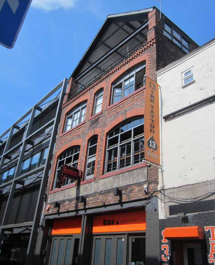
284 Privatisation of the Production of Public Space
TOC
285 Conclusions
8 Conclusions
This thesis began with a theoretical description of the notion of the public sphere, its perceived decline and how this public sphere relates to public space. The public sphere has been theorised following the notion of democracy; the public sphere is seen as a sphere in which individuals debate common issues (Arendt 1958; Habermas 1989). The public in this debate, is often positioned as the opposite of the private, whereby the private refers to individual interests and property; everything else is public. Public space is related to the public sphere in the sense that public space can function as a geographical setting that can host a public sphere. But not exclusively; the public sphere can also manifest itself in private space, third space or with the rapid growth of the information technology in virtual space, as discussed in Chapter 2. Democracy however will always need a certain geographical setting (Parkinson 2012).
Scholars have expressed concern at a perceived decline in both the public sphere (Arendt 1958; Habermas 1968; Sennett 1977) to the benefit of the private sphere. The private sphere that has taken a new leap in the recent era of neoliberal interurban competition in which privatisation, in its many appearances, has become a new norm (Sorkin 1992; Minton 2009). The new form and extent of privatisation challenges our current view on the notion of publicness in space. This allegation formed the premises of this research project.
The main research question of this research is:
Does privatisation lead to a decline of publicness in the production of space and space itself, and how does urban design play a role in this?
With the following sub questions:
1 How can the definition of publicness of space be widened to reflect and enhance the current public sphere?
2 Does privatisation lead to a decline in publicness within the process, seen from a governance perspective?
3 How do users experience the privatisation of public space?4 How are privatised areas designed differently to public spaces? 5 How do space producers and consumers perceive privatisation and the
implications thereof?6 What is a suitable methodological approach to analyse the perspectives of the user and
the designer?
TOC
286 Privatisation of the Production of Public Space
These questions were tested against three cases in Liverpool that all underwent a regeneration process at approximately the same time, hence within the same national and local political and economic regime and from three different perspectives – governance, users and designer. However, all three regeneration projects followed a different approach in terms of process management, stakeholder engagement and maintenance regimes. These processes and the outcome, the spaces themselves, have been analysed from three different perspectives: from the governance side (space producers), the users (space consumers) and from the designer’s point of view. The following sections answer the research questions and reflect on the theoretical and methodological contributions of this thesis and also provide recommendations to urban design researchers and practitioners. In section 8.1 the main research question and the first five sub-questions, in section 8.2 the theoretical contribution will be discussed infosar this has not been addressed by answering the research questions. In 8.3 will answer the last sub-question, relating to methodology and discuss the methodological contribution. Section 8.4 will address recommendations and 8.5 will conclude the thesis.
§ 8.1 Answering the research questions
Before the theoretical contribution of this research is discussed in 8.2, the posed research questions will be answered. First each of the subquestions will be adressed after which the main research question will be debated.
Sub-question 1: The widening of the definition of publicness: the introduction of appropriationAs discussed in chapter 2, the ‘hybridisation’ of the roles of public and private actors in the production of space demands a new, comprehensive definition that takes into account the complexity of current forms of ownership, control, accessibility and use. A number of academic scholars have taken up this challenge and suggested that, in addition to the generally accepted notions of ownership (in relation to legal property rights and control) and accessibility (to space itself), use and users (Németh and Schmidt 2011; De Magalhães 2010), inclusiveness (Langstraat and Van Melik 2013) civility and animation (Varna and Tiesdell 2010) are potentially usable criteria to widen the definition of publicness (see chapter 2.4 for a detailed discussion).
TOC
287 Conclusions
In the research done on the three differently organised and managed development processes in terms of the degree of publicness in Liverpool, a large number of potential criteria, or ‘rules’ as they have been called, have been analysed in order to determine which criteria could be considered for a wider, more comprehensive definition of publicness. These ‘rules’ were attributed to the three perspectives from which the research was carried out - governance, users and designer - and are as follows: ownership, accessibility, passive user participation (experience and perception), active user participation (forming a public and renegotiation) and the eleven urban qualities based on the partially adapted measuring tool of Ewing and Clemente (2013). Based on the analysed data from interviews, user surveys and the visual assessment, it can be concluded that the degree of publicness of the privatised space is compromised by the ‘corporate rules’, including control mechanisms, in place that prohibit or limit individual user appropriation. The data collected from the governance perspective demonstrated that the privatised space was perceived as public space because it was regarded as accessible to all, although limitations to public behaviour were acknowledged. The privatised space was perceived to fulfil a role as a social rather than civic or democratic space. The majority of the respondents to the user questionnaire stated that they acknowledged limitations to their public behaviour, although they were not aware of the control mechanisms present in the area. The visual assessment found that the most specific differences between private and public space were demonstrated through the aspects of ‘safety’, ‘tidiness‘ and ‘appropriation’. Apparently the presence of control mechanisms, the maintenance regime and the opportunity to use space according to one’s own daily needs contribute to the degree of publicness in space. Some remarks can be made by the use of the maintenance regime as a measure for the degree of publicness because the level of tidiness can be regarded as being a subjective concept, the perception differs from person to person, and the cases demonstrated that one privatised maintenance regime was regarded highly but the spaces within control of another private regime scored low. Hence ‘tidiness’ depends on a subjective notion and on the actual quality of the services and not necessarily if its delivery was done by a public or private company. The degee in which control mechanisms are present fails as a potential component in the wider definition of publicness too, because as discussed both public and private actors make use of these mechanisms. In addition, the data of the user survey demonstrated that a majority of the respondents were not aware of these mechanisms. The third component, appropriation, offers however an interesting opportunity for describing and defining a wider notion of publicness. Appropriation is defined as:
The way individuals renegotiate and reproduce space to take ownership and suit the space to meet their own needs. Appropriation is characterised by spontaneity and temporality.
TOC
288 Privatisation of the Production of Public Space
The degree of appropriation relates to the control mechanisms, or lack thereof, that are in place but also to the passive and active engagement of users in a particular space as well as to the physical setting that enhances or obstructs opportunities for appropriation as through the three analysed perspectives is demonstrated. Appropriation also relates to the criteria of ‘civility’ and ‘animation’ introduced by Varna and Tiesdell (2010) but more suitably reflects the degree of potential for active user engagement and is therefore found to describe the degree of publicness in a more profound way. By including the notion of appropriation the everyday urban activities and experiences take a prominent position in the definition of publicness.
The way in which appropriation can present itself is influenced by the rules and norms that are in operation at a certain time in a certain society. These regulations must be debated in the public sphere and will change over time, according to public consensus. An example of appropriation that has increased in recent years is the amount of private outdoor seating, following the growing appetite for local resident and visitor consumerism. Naturally this is a form of privatisation (as all forms of appropriation are in essence forms of privatisation) aimed at commercial rather than political or cultural gain but nevertheless a large number of citizens agree that the increased outdoor seating contributes to the quality of city life. Other forms of appropriation are not always appreciated by the wider public, graffiti for instance, which could be considered as having a political or cultural aim. Visual signs of appropriation however, do add to the specific characteristics of the spatial and social setting of the city. (see figure 6.25 for examples of appropriation in the cases)
An example that demonstrates the potential of this wider definition of publicness are the POPS (Privately Owned Public Space), which have rapidly increased in number in London47 (see eg. the recent King’s Cross development or Broadgate Circle near Liverpool Street Station) and of which Liverpool One is also an example. These urban spaces are in private ownership and while publicly accessible, appropriation rates are low due to the corporate rules in place. Another example is an exhibition in a museum, which is in public ownership, and is in most cases only accessible if you buy a ticket which limits the level of publicness.
Looking at the three case studies following the newly introduced widened definition of publicness – ownership & control, accessibility and appropriation – the privatised space scores, poorly on ownership (because it is privately controlled), reasonably well on accessibility (because the area is accessible 24 hours per day to the majority
47 Garrett, B. Be angry about the privatisation of public space. The Guardian 24.07.2017
TOC
289 Conclusions
of people) and also poorly on the scale of appropriation (due to ‘corporate rules’ spontaneous cultural or political outings are prohibited). Therefore, in the studied case the degree of publicness is compromised in the privately controlled space. In the two public cases the degree of publicness was found not to be compromised but as public authorities use control mechanisms as well in other than these cases public spaces, publicness might be also found to be limited in public spaces because of a lesser degree of appropriation.
Thus, based on the outcomes of this research the first sub-question ‘How can the definition of publicness of space be widened to reflect and enhance the current public sphere?’ can be answered with the suggestion to widen the definition of publicness in order to arrive at a “multi-faceted and comprehensive definition” (Németh and Schmidt, 2011) to include appropriation within the definition, in addition to the rules of ownership & control, and accessibility.
Sub-question 2: Governance perspective: publicness in the development processThe shift towards a market-driven mode of governance made the distinction between the understanding of the public and private tasks, roles and responsibilities more opaque. With this transition towards more involvement of private actors in the development process, the publicness or public values within the process – including accountability, transparency, democratic representation and legitimacy, and level of public trust - are at risk of being comprised of more business-like notions such as productivity, efficiency and effectiveness (Hague 2001; Pesh 2008; Kort and Klijn 2013; Reynaers 2014). At the same time as public authorities take on a business-like approach, and incorporating the needs and demands of the public interest is no longer solely the domain of the public authorities with many corporate institutions demonstrating a consciousness of public values in their strategies. Within the analytical framework used for this research, the ‘rules’ of publicness are described along lines of ownership (which is related to who initiates, who has decision-making power and how the actors are organised within the process) and accessibility (related to openness and inclusiveness for a variety of different actors to the process, including the minority voice). With the use of these ‘rules’, the degree of publicness can be described in the production of the three case study projects.
The findings from the case study analysis - organised as they were in different ways, namely privatised, public-private partnership and publicly organised turned community led – demonstrated that both the privately and publicly top down coordinated processes lacked in publicness (both in ownership of and accessibility to the process). However, the public-private partnership and the community led cooperative regeneration approach consisting of a variety of public and private actors
TOC
290 Privatisation of the Production of Public Space
comprised a larger degree of publicness and trust between the various actors. These findings lead to the conclusion that in these two cases a multi-stakeholder process in which both public and private actors are present and have decision-making power leads to a large degree of publicness in the development process. Both the publicly and the privately (corporate) led projects that were researched were found not to be inclusive because the ownership of the process (including proposing initiatives, the degree of decision making power and the provision of funding) lay in the hands of a single actor and the accessibility to the process for other (public or private) actors was limited.
A remark has to be made about the use of the notion of ‘private’ in this context. By private is referred to all actors that are not public, so both corporate (with predominantly commercial gain as its aim) and other private actors including NGO’s, interest groups and residents’ associations (with an individual or common community goal in mind). Although these not-for-profit actors do not have a commercial motive, they do act on personal or communal motives, and they therefore do not act on behalf of the overall public interest. The involvement of all actors other than the democratically chosen public bodies is therefore seen as a degree of privatisation. This is not to say that these actors should be banned from the development process, on the contrary, but that the public values within the process (and also in the product) should be safeguarded, similarly as with corporate actors.
During an interview one of the respondents remarked that “big is beautiful is over”, thereby referring to the large public led masterplanning exercises that were characteristic for Western planning in the period after WWII and hailed with renewed enthusiasm during the Urban Renaissance era. This statement could also refer to large corporate led development processes. A variety of small local initiatives, paid for by public and private funding and working co-operatively towards the overall aim of regeneration of an area, have a much larger degree of inclusion and buy-in from various stakeholders than a top down orchestrated process might, as both the cases of the Ropewalks and Granby4Streets have shown. As a result, the process becomes organisationally more complex and the outcome might lead to slower and more incremental growth than a project led by a detailed overall masterplan designed and implemented by one public or private actor (see eg Liverpool One). However, slow city growth (as seen in the Ropewalks and Granby) demonstrates a higher level of flexibility towards future changes and hence constitutes a more sustainable and resilient solution.
In all three cases the urban designer has been recruited and hired by the client, thus in Liverpool One by a private company, in the Ropewalks by a partnership of both public and private actors, in Granby4Streets firstly by the local authority and secondly by the Community Land Trust. The wishes and demands of the clients were in all
TOC
291 Conclusions
cases translated spatially by the urban designers involved, except for the publicly led GranbyToxteth Masterplan where the designers listened to both the local residents and their professional judgment and went against the client’s demands for wholesale clearance (and where subsequently sacked from the project and only reinstated by intervention of the Council’s project director). Apparently it is not a straightforward given that designers can translate publicness into spatial solutions if it is not the client’s priority.
A central theme that played an important role within the production of space and came to the fore on a recurrent basis in the case study analysis, was the degree (or lack) of trust that the various actors had in the other partners within the process. In the privatised case, all trust was put in the private sector to deliver the scheme on time and according to the proposals. In the Ropewalks there was some concern voiced with regard to the trustworthiness of some of the landowners in the area who would rather delay developing their properties until the values have risen. The least confidence however, was shown in the public authorities where little public trust was found in all three cases for different reasons. In Liverpool One, there was little confidence within the public authority or from the citizens that the Council could handle the organisation and implementation of such a large development scheme. In the Ropewalks, there was found to be little public trust in the maintenance regimes applied to the area. Last but not least, in Granby4Streets local citizens’ trust in the public authority broke down altogether after their voices had been ignored within the process over a long period of time. These findings are in line with previous research which found that “there is an emerging crisis if public confidence with regard to the institutional integrity and representativeness of public governance and representativeness of public governance” (OECD, 1996 in Hague, 2001). Indeed, claiming public trust in the credibility, leadership and responsiveness is one of the essential indicators of the degree of publicness (Hague 2001; Kort and Klijn 2013). Thus one of the central elements within the rule of ownership of the process in a development processes is the level of trust between the actors and particularly the level of trust in the public actors.
This research suggests the second sub-question, ‘Does privatisation lead to a decline in publicness within this process?’, be answered in the negative. Indeed, the opposite holds true based on the three cases studied, the degree of publicness in the development process benefits from a collaborative multi stakeholder process in which both public and private partners have decision-making powers where a high degree of trust leads to a greater degree of publicness in the urban development process at the scale of the urban project. Top down coordinated organisational structures, both public and private, were found to have a low degree of publicness in the analysed urban development projects. Question rises to what degree this conclusion depends on the specific characteristics of the context in which the case study research was undertaken. This is of course a question
TOC
292 Privatisation of the Production of Public Space
that relates to all the conclusions and will be dealt with in more depth in section 8.3, but for this conclusion in particular because the specific local political, socio-economic, demographic and geographical context complicate generalisation. The objective of the case study research was however to gain in-depth understanding of the underlying social relations in order to come to an analytical generalisation (Yin, 2009). It is believed that the research fulfilled this objective of expanding existing theories but that these in sights could potentially also be useful in analysing other similar cases, but this has to be tested.
The issue of scale has to be addressed too. This conclusion was reached on the basis of the analysed data of three urban regeneration projects; urban projects on the scale of the city, regional or even national level fell outside the scope of this research. It might well be that a more prominent role of the state would be beneficiary for such large scale projects.
Sub-question 3: Users’ perspective: passive and active engagement in public spaceMost respondents clearly appreciated the privatised area rating it ‘very good’ and also gave these areas the highest ratings for safety and for maintenance (as compared to the two public areas) all of which also contribute to the high overall rating for the area. In contrast, Liverpool One’s adjacent public area, the Ropewalks, was lamented for its poor public space maintenance, even though the public realm works were only finished a few years prior to Liverpool One. The Ropewalks was also perceived to be less safe than the privatised area, which might be due to its nighttime economy as well as the amount of vacant sites and buildings and hence the number of inactive facades. The third, also public, case study area was also appreciated by its users but currently being a predominantly residential area, it was difficult to compare the results with the other two mixed use inner city quarters. Thus, the interviewed users experienced the privatised area as very pleasant, clean and safe and gave a higher rating for this area than those respondents using the public areas. Users therefore, tend to experience a high degree of maintenance and management as positive.
It can also be concluded that the perception of safety is not necessarily related to surveillance methods being visually present within an area as only a small percentage of the users observed them in the privatised area. The high amount of CCTV cameras and guards patrolling the area clearly go unnoticed. The presence of people, the high degree of cleanliness and the clutter free landscape design (there are no low walls or bushes) could be alternative reasons for the high perception of safety.
The research of user perceptions of these spaces highlights that the meaning of private and public is not always clear to the interviewed respondents. The user survey has either found that there is a misunderstanding of the notion of public vis à vis the exercising of common public rights (such as handing out flyers, busking, using a
TOC
293 Conclusions
skateboard etc.), or that the design and appearance of the spatial environment is such that it contributes to restrained user behaviour. While those users interviewed were under the impression that the (privatised) area was in fact public space, they sensed that there were limitations put on their public behaviour. Users adapt their behaviour according to the nature and characteristics of the spatial surrounds. Apparently, privatised space delivers different signals to users on appreciated (or tolerated) behaviour than public spaces.
Following from this conclusion, the range of new terminology that in recent years has been deployed to help address the hybridisation of public/private such as semi-private or semi-public or Privately Owned Public Space (POPS) does not therefore contribute towards the clarification of the concept as ownership and control mechanisms at work are sensed by users differently to the legal ownership structures the terminology refers to. As stated in the previous section, these new connotations also do not contribute towards clarification in design, implementation and management phases. The positioning of the ‘public’ versus the ‘private’, based on the parameters of legal ownership, apparently does not provide enough clarity for the current complexity of the city. This conclusion supports the position with regard to the need for a wider definition of publicness as drawn in answering sub-question 1 and, based on the findings from the user survey, the degree of appropriation relates to the degree of publicness and hence contributes to a more comprehensive definition.
The users interviewed in the privatised space were absolutely right in their perception that they could not actively exercise their public rights through individual interventions in the privatised space. Certain individuals (for instance homeless people) and certain behaviour (such as street art or musicians or bible story telling) is not tolerated within the private boundaries of the estate and users are limited in the renegotiation and reproduction of the space. This aspect of active engagement as defined in the users’ section of the analytical framework was found to be minimal. The second aspect – the possibilities to form a public – have however been found to be present. All three spheres – private sphere of family and friends, parochial sphere of acquaintances and the public sphere of strangers – have been observed in all three (public and private) areas. All three areas apparently provide the spatial context for users to engage in a variety of overlapping spheres.
In summary, the third research question, ‘How do users perceive the privatisation of space’ can be answered by the following conclusions:
TOC
294 Privatisation of the Production of Public Space
– Respondents appreciated the high level of maintenance, management and care within the privatised area and therefore perceive the area of high spatial quality.
– The majority of the respondents considered the privatised space as public space, however they sensed they could not exercise their public rights, which potentially prevents them from doing so. Users adapt their behaviour according to the nature and characteristics of the spatial surrounds. The studied privatised space apparently delivers different signals through the appearance of its surrounds than the public spaces that were analysed.
– Users are prohibited from actively engaging in these individual interventions of everyday urban life in the priviatised space. The privatised space does therefore not function as a democratic space.
– All spheres – private, parochial and public – were present in all three areas. The privatised space apparently does function as a social space.
– Current terminology to indicate the blurring of private and public ownership and/or control of space does not provide a clear reference for users interviewed. Users do or do not reproduce or renegotiate space solely in relation to their knowledge regarding public or private ownership.
Sub-question 4: Designer perspective on designing publicness Of the visual assessment findings - from eleven urban qualities that together gave a workable analytical framework for visual characteristics of the urban quality of space - three were found to be decisive in the definition of publicness in space: safety, tidiness and appropriation. The privatised area rated well for visual signs of surveillance methods (CCTV, presence of security guards) when compared to the public areas that appeared to be less endowed with such measures. The same outcome was found for the quality of tidiness. There were however, very few visual signs of appropriation found in the privatised area, thus in the area where control mechanisms (‘safety’ and ‘tidiness’) were visually omnipresent, no evidence was found of individual interventions. In the public spaces, the findings show the opposite: less evidence of control mechanisms but abundant evidence of individual input in the public space, in particular in the case of Granby4Streets.
TOC
295 Conclusions
The other eight qualities demonstrated varied scores with regard to the visual appearance of either public or privateness in both the analysis of the areas in their totality as well as the individual street sections. Although these qualities undoubtedly relate to the urban quality of space they could therefore not, on the basis of this research, be decisively linked to the definition of publicness. It is hereby not implied that these eight urban qualities are not related to publicness, only that the method used could not qualify the degree of publicness on the basis of the results.
The masterplan of an urban layout produced by an urban designer is based on a client’s brief (in addition to an urban analysis of the study area and its context) in which the client, either public or private, states the parameters of the future proposal. A designer therefore must work within these parameters as well as the given legal and physical context. This research clearly demonstrates varying attitudes towards the design process from the actors in private, public and public-private partnership structures. Within the privatised project, design was used to micro manage the totality of the space in terms of lay-out and materialisation. Also, the control mechanisms such as the CCTV cameras were ‘designed into’ the overall scheme. Implementation of the overall landscape works occurred on the detailed plans and the area was subsequently managed and maintained to keep the landscaped area as originally intended. Both the publi-private partnership and the public turned co-operation led area, allowed for much more flexibility in the proposed designs which the development vision framework laid out but with room left for future interventions. The designer appears to have a larger role in the detailing of the design of a privatised space and an opportunity to realise a detailed vision as the corporate client demands the finished image to be retained throughout implementation and management phases. Whereas if a designer has to cater for potential reproduction activities of future users, her designs should be more flexible, adaptable and resilient over time.
The fourth research question, ‘How are privatised spaces designed differently to public spaces?’ can be answered by the following:
TOC
296 Privatisation of the Production of Public Space
– Based on the visual assessment, privatised spaces can have a high degree of urban quality as defined by the adapted model of Ewing and Clemente (2013).
– A designer can potentially enhance the degree of publicness in urban space by allowing for greater flexibility in, and opportunities for, the appropriation of space.
– Privately organised and managed areas demand more micro design and leave less space for users to be able to appropriate space.
Sub-question 5: How do space producers and consumers perceive privatisation and the implications hereof?The perception of the public/private debate and to what extent privatised space is different to truly public space is discussed at length in the previous chapter. Therefore a short summary and concluding section is deemed sufficient here.
Both those interviewed actors in charge of the initiation, design, implementation and management of the three different areas as well as the majority of the users interviewed, perceive all three spaces as public, including the privately controlled space. There was a difference noticed in the perception of publicness between the space producers (associated with the notion of ‘governance’ used in this research) and the space consumers (the users). The first group considered the privatised space as public space because of its accessibility but acknowledged the fact that that space is not truly public in the democratic or civic sense of the word. The reason for not being democratic or civic can be found in the ‘corporate rules’ in place that restricts user behaviour and prevents cultural or political appropriation. As discussed, these restrictive rules are not solely the domain of private actors charged with public space maintenance. Public authorities also use restrictive policies to ban undesirable behaviour or individuals. The second group, the users, perceived the space as public (because it is not signposted as privately owned land) but sensed restrictions of its behaviour which is based on the presence of soft rather than hard control mechanisms such as the design and appearance of the spatial context and the lack of any behaviour or activities usually associated with urban living (which have been found present in abundance in other parts of the city centre). These findings have been supported by the visual analysis in which the largest differences between privately and publicly controlled spaces were found on the criteria of ‘tidiness’, ‘safety and security’ and ‘appropriation’.
Both the space producers and consumers also perceive the privatised area to be of high quality, which is also supported by the visual analysis as all three areas, including the privatised area, were found to have high urban quality scores. The described consequences of privatisation were generally not perceived as negative; both producers
TOC
297 Conclusions
and users perceived the tidiness, safety and overall landscaping as pleasant, whereas users in the public areas criticised the lack of sufficient provision of these factors.
It can therefore be concluded that a privatised process does not necessarily produce a private or dissatisfactory space in the perception of its users and producers. However, the privatised space is not perceived as truly public either by neither users, producers or by the objective design assessment. The level of soft control mechanisms in place compromises the degree of publicness in privately as well as publicly controlled spaces.
The main research question: ‘Does privatisation lead to a decline in publicness in the production of space and space itself, and how does urban design play a role in this?’The following constitutes the answer to the main question of this research; insofar as this has not been done in the previous sections. The question consists of three components which will all be addressed. Urban development processes cannot be seen as independent of their political, economic and cultural contexts as there are always products of their time. The last 30 years have seen a shift in responsibilities of formerly governmental tasks to a variety of private actors and so the main conclusions must be read within this current zeitgeist. Besides the current economic and political context, the valued outcomes of urban projects are highly dependent on the stakeholders (whether public or private), their relationships and understanding of the process as the case studies have clearly demonstrated.
The first part of the question refers to the privatisation of the development process, which has been discussed at length above. In summary, privatisation is understood as the outsourcing of tasks and roles that were previously deemed the responsibility of public actors to private actors. These private actors could be either corporate (with commercial gain as the main aim) or not-for-profit actors (with individual or community interests at heart). With this notion of privatisation in mind, the research conclusion is that publicness in an area based urban development process is best served by a multi-stakeholder process of both public and private actors. Based on the analysed cases, the research demonstrates that processes coordinated by one (either public or private) actor do not contain a large degree of publicness; ownership of and accessibility to the process were limited for other stakeholders. The collaborative public-private partnership and the community led cooperative process, both consisting of a number of private and public actors, showed a much larger degree of publicness. Hence, the short answer to the question if privatisation undermines the publicness of the production of space is that it does not. On the contrary, the degree of publicness is higher if ownership and accessibility to the process are met by a variety of stakeholders, including private actors. Although a publicly led development process does not necessarily result in a high degree of publicness, the role of the democratically elected public authority is however, is still
TOC
298 Privatisation of the Production of Public Space
significant within urban development; in the current political system, the safeguarding of the public interest – the overall public good – still rests in their hands. This response to the first part of the research question is of course formulated on the basis of the analysis of the three cases in one single city following the analytical framework. However, within the discussed trends of a retreating government transferring tasks and responsibilities to other public or private actors and the growing complexity of the urban development process due to fact that current problems ask for highly advanced skills and specialised knowledge, the multi-stakeholder process including a variety of corporate and non-corporate and public stakeholders is likely to become the norm. Public policy, such as the ‘Localism Bill’48 in the United Kingdom or the Residents’ Initiative49 in Rotterdam( NL) provide examples where the initiatives and decision-making powers in urban projects are transferred to community groups or individuals. These new processes demand new organisational structures with regard to decision-making power, accountability and transparency and demand high levels of trust from all participating actors.
The second part of the question, with regard to space itself, relates to what public space essentially is; can it function merely as a politically neutral social space or does space also have to have a political dimension? In other words, is public space a democratic space? But, as is outlined in the theoretical chapter, scholars are divided on this matter. The results of this research on the social versus democratic debate are positioned within the academic discourse (see chapter 2). As discussed, the consequences typically associated with privatisation (commodification, commercialisation and homogenisation, strong emphasis on safety, maintenance, on the provision of entertainment and limitation of accessibility) have all been found to be present in the privatised space analysed, to a greater or lesser degree. Some of these have also been observed in the public spaces, eg the presence of CCTV cameras, but to a minor degree. The control mechanisms, which have been found to be the main reason for the majority of the consequences described, lead to a controlled and ‘sanitised’ environment as well as transforming people from being citizens to a consumer public. The control mechanisms in place actively discourage the exchange of daily experiences that are essentially political or cultural expressions in the public sphere, to the detriment of both the ‘undesirables’ who are excluded from certain urban spaces and to mainstream society, deprived of the experience of the ‘other’. Control mechanisms thus lead to
48 https://services.parliament.uk/bills/2010-11/localism.html
49 https://www.rotterdam.nl/loket/subsidie-bewonersinitiatief-gebieden/
TOC
299 Conclusions
the diminishing of opportunities for political or cultural encounters and hence limit democratic and hence public life. Renegotiation and reproduction of space through everyday lived experience is controlled and therefore limited in its appearance. Having said this, the research also demonstrates that a high percentage of users rated the privatised space as ‘very good’, simply stating that they perceived the privatised space as pleasant urban space. The majority of the respondents rated the tidiness, safety and visual appearance of the area highly. Whereas the overall (public) area of the Ropewalks has received a lower rating predominantly based on the perceived lack of maintenance. An argument in favour of the extensive use of control mechanisms could be that these are necessary to provide a spatial environment that is most preferred by its users, although this hardly says anything about privatisation per se because during the time of the assessments, the public area of the Ropewalks was also privately maintained. The findings within this research failed to relate the presence of safety measures (CCTV, guards, police) with the perception of safety as a high percentage of the interviewed users in both private and public areas were not aware of their presence.
The notions of social and spatial segregation, polarisation, capsulated society, the rise of an archipelago of islands as discussed in the previous chapter do, as a result of these exclusionary measures, lead to a shrinking habitat for excluded individuals and limit the democratic possibilities and opportunities for all citizens. Active user engagement becomes de-legitimised, while passive experience is encouraged through a variety of forms of entertainment. The publicness of space is constantly being negotiated through a dialectical relationship between these two opposing visions: one of active users that renegotiate public space for their daily activities and those who seek control over space to reduce all unexpected behaviour and possible disturbance to a bear minimum. This conflict over space is currently won by the actors who control space which ultimately leads, in spatial terms, to a patchwork of over and under managed areas in the urban landscape, each with their own ‘rules’ and ‘norms’. This patchwork or ‘archipelago of urban islands’ will not only be noticeable spatially through the physical context but also socially, as the patchwork enhances the parochialisation of spheres. The notion that overlapping zones in between the various urban islands could function as valuable in-between spaces that would host the ‘real’ public sphere is theoretically interesting. However, no evidence of such merits has been found in these liminal spaces and on the contrary, the zones in between the over-managed areas are undermanaged and designed to be barriers. These spaces form a hostile environment that provides no invitation to anyone to appropriate the space, they are designed as truly left-over spaces to create severance rather than overlap and inclusion. The notion of a ‘real’ public sphere, meeting the ‘other’ in these purposefully designed in-between zones justifies the very existence of over and undermanaged areas with their own rules and norms.
TOC
300 Privatisation of the Production of Public Space
Thus, the second part of the research question ‘Is privatisation associated with a decline in the publicness of space itself?’ has to be answered in the affirmative on the basis of this research on the number of control mechanisms in place (both hard and soft) that enlarge and enhance spatial and social segregation in the cityscape. The research demonstrates that the privatised area contains the most control measures, but control measures have also become more common in publicly managed areas. Both the researched public areas had a degree of control measures in place so it can therefore be concluded that it is not privatisation per se that diminishes the degree of publicness but rather the control measures over users and their behaviour that are put in place. These control mechanisms are used extensively by private actors controlling space but also to a degree by public actors, which refers back to the ‘blurring of the public and the private’ discussed earlier. Besides this direct relation between control mechanisms and the degree of publicness, there is also an underlying tendency of parochialisation of the previously public sphere, as described in the theoretical chapter as notions of ‘capsulated society’ (De Cauter 2004) and ‘archipelago of islands’ (Hajer and Reijndorp 2001). As discussed, the urban landscape demands various diverse urban spaces in which overlapping spheres can co-exist. Control mechanisms at play in privatised spaces, but also in some public managed spaces, undermine the right to everyday use of these urban spaces. Not all spaces are equally equipped to function as spaces of the ‘highest democratic order’ - spaces of protest - but all public spaces should offer the opportunity for appropriation to a certain degree. Appropriation is indeed viewed here as a form of privatisation but is related to the everyday existence of individual users who are often politically or culturally charged and are spontaneous and temporary. This might seem paradoxical; a large degree of publicness seems to lead to more privatisation but the public sphere as defined by Arendt (1958), consists of ‘free’ private individual encounters which collectively form the public sphere. Publicness apparently exists by virtue of individual private interventions and the degree of publicness diminishes if these forms of appropriation are being limited.
The extent and form to what appropriation is accepted or desired by the wider society should be a part of the public debate on societal rules and norms; offering the opportunity to appropriate facilitates this public debate as appropriation is, by its nature, political and cultural. In summary it can be concluded that the consequences often attributed to corporate privatisation are strongly linked to the presence of hard and soft control mechanisms. Thus privatisation of the product with commercial gain in mind leads to a diminished publicness in space, because maximising commercial value inherently means minimising risk factors, including criminal and other undesired behaviour. This research has found that control mechanisms are not always evident to users or visually noticeable and so do not form a decisive element for the definition of publicness. The way in which users could appropriate or renegotiate space for everyday existence (referred to as ‘appropriation’) however, has been found to be a
TOC
301 Conclusions
workable notion. Based on the findings of this research therefore, it is suggested to add appropriation within the definition of publicness, in addition to the widely accepted criteria of ‘ownership and control’ and ‘accessibility’.
The third part of the main research question relates to the role that urban design and the designer can play in the publicness of space. Building on the previous conclusions the answer to this third part of the main research question has to take into account the role of the designer within a multi-stakeholder process, how to create a design in which appropriation is invited to happen and how to avoid sharp edges between the different urban quarters in the city but create user friendly transitional zones in which public spheres might occur.
The role of the urban designer in a multi-stakeholder process is more diffuse than within a top down, coordinated development project with a single client (group), which the case of Liverpool One clearly demonstrates. A variety of stakeholders from different backgrounds often have different objectives and expectations of an urban development project, which demand different spatial solutions. Contradictionary objectives could lead to incompatible solutions. In addition, the complexity of current and future urban issues, such as energy transition, climate adaptation, digital technology, migration and mobility, all make different claims on space and demand innovative solutions which in turn require both highly specialised knowledge and an integral approach. In this complex field, the urban designer, as able to relate all specialised expertise to the spatial context, can provide consensus through acting as mediator between the client body wishes and the interests of the wider public.
The outcome of the analysis demonstrates that the privatised area has been designed, implemented and managed to maintain the visual image that was conceived in the very early stages of the design process and that image remained unchanged throughout the totality of the design process and current maintenance regime. This approach does not allow for much flexibility in the organisation and visual appearance of the area over the course of time. This process is contrary to the approach in the Ropewalks where a framework of urban spaces was developed allowing a large degree of flexibility for reproduction and renegotiation of space by local actors following changes in the spatial, economic and cultural contexts. The visual assessment demonstrated that signs of this reproduction were clearly visible throughout the area, similar to the other analysed publicly maintained space of Granby. It can therefore be concluded that in order to enhance the degree of publicness in urban space, the urban and landscape designer should allow for greater flexibility in the appropriation of space. This greater flexibility could be achieved in the following ways.
TOC
302 Privatisation of the Production of Public Space
Firstly, a design should be a starting point rather than the end visual image to which control and management is geared. The implemented design forms the spatial context for users to be able to appropriate the space for their daily needs and experiences, thereby facilitating the creation of overlapping multiple spheres within the city’s urban areas. In the privatised space, the visual image of the final detailed design forms the standard for management and maintenance, leaving little room for changes over time. On the other hand, if the implemented design is perceived as a base, users’ interventions are then welcomed and required in order to create a truly urban character.
Secondly, opportunities for appropriation should be ‘designed in’. Appropriation is understood here as being temporary and spontaneous interventions, which enrich the symbolic layers and meaning of city life. Although the possibilities for the designer to ‘design in’ forms of appropriation might be limited, due clients’ constraints for instance, a designer has the creativity and the knowledge of tools and guidance to inspire both a client and the future user. How a designer can do this and which ‘design rules’ invite more reproduction of space is advised to be the focus of new research.
The importance of a ‘continuous urban topography’ leads to the third way urban design can enhance the degree of publicness in the city. The physical edges of the different urban areas within the patchwork of neighbourhoods that make up a city should not be designed as hard edges, but as transitional zones. Whereby the transitional zones are not seen as the ‘left-over’ spaces for marginalised citizens who are excluded from other parts of the city. The privatised case study showed both an excellent example of how these edges can be treated as a positive link to one another as commercially interesting urban zones and how things should not be done: by providing blank inactive facades and marginal uses (e.g. multi-storey car parking) to other, less commercially interesting, urban neighbourhoods thereby creating severance rather than linkages. There were no signs found of either meeting the ‘other’ or creating a true public sphere in these rather hostile border areas.
Theoretically, an urban designer could also determine to design control mechanisms in a more ‘hidden’ or alternatively, a more ‘outspoken’ way so that users are either less or more aware of their presence. If we as a society, agree on the necessity of having these control mechanisms to be able to guarantee our public safety, why do we then hide them to such an extent that users are not aware of their presence. It can also be argued that given the fact these control mechanisms are a necessary piece of urban infrastructure, they therefore should be designed as such; proud to be visually present.
The findings of the research demonstrate however, that in both the private areas, where CCTV cameras were perfectly designed in line with the total landscaping and therefore hardly noticeable for the user, but where the security guards were on clear display, and
TOC
303 Conclusions
the public areas (where CCTV was clearly visible), the majority of the respondents were oblivious to their presence and stated they felt safe regardless of the presence of hard surveillance measures. Therefore, in the quest for publicness, it is more worthwhile to focus on appropriation as opposed to control mechanisms.
§ 8.2 Theoretical contributions of this thesis
The objective of the research as described in the introduction of this thesis was to make a contribution to the academic discourse on the public/private debate in a number of ways. The previous paragraph began addressing this contribution by answering the research questions, this paragraph however will make this contribution more explicit by relating it to the fives objectives described in the introduction (chapter 1.3).
Firstly, as discussed at length in answering subquestion 2 and the main research question both relating to the governance perspective, the research into the three cases with each a varying degree of private and public actor involvement demonstrated that privatisation of the regeneration process does not necessarily leads to a decline in the publicness (described according the ‘rules’ of ownership of and accessibility to the process). In the cases studied the organisational model was found to be a more decisive factor; both the publicly and privately top down coordinated models lacked in publicness, whereas in the collaborative public private partnership and the cooperative community led model the degree of publicness (in terms of taking initiative, having decision-making power and access to the process). These findings contribute to the existing discourse of urban management and process (see eg. Skelcher et al. 2005; Kort en Klijn 2011; Reynaers 2014; De Magalhães and Freire Trigo 2017), including the body of work on public space maintenance (see Carmona et al. 2008; De Magalhães and Carmona 2009; Nèmeth 2009).
Secondly, the research contributes to the on-going debate on public space, the perceived decline hereof and the democratic component of public space versus its social function (Arendt 1958; Sennett 1973; Habermas 1989; Low and Smith 2006; Mitchell 1995; Boomkens 1998, 2008; Madanipour 2003, 2010; Hajer and Reijndorp 2001; Madden 2010; Bodnar 2015). The conclusions drawn from this research on this perceived decline demonstrate that there the degree of publicness of space was indeed found to be limited. The degree to which individual users could appropriate the space to suit their own daily needs was found to be compromised in privatised areas. However the privatised area did function as a social space and was perceived to be pleasant and of high quality.
TOC
304 Privatisation of the Production of Public Space
Thirdly this research contributes profoundly to the recent discourse on the search for 'a multi-faceted and comprehensive definition' to which a number of authors have already made valuable contributions (see Kohn 2004; De Magalhães 2010; Varna and Tiesdell 2010; Németh and Smith 2011; Langstraat and Van Melik 2013; Varna 2016). Based on the outcomes of this research, in particular on the findings of the user survey and the visual assessment, it is suggested to widen the definition of publicness with the notion of ‘appropriation’, in addition to ‘ownership & control' and 'accessibility'. This definition is presented as a rather fluid notion on purpose; it can be used to analyse the degree of publicness in existing spaces along the three parameters but it can also be used to define the degree of publicness that a client (group) or the wider public desires for a certain space or area.
Fourthly, through the research filled some of the gap in the academic discourse that has been acknowledged to exist on the user perception of privatisation of space. Through the development of an on-line tool (Color your Space) and face-to-face interviews, more than 200 respondents shared their views on the particular spaces, which gave invaluable new insights in the perception of privatisation of space as discussed thoroughly in chapter 7 and by the response to subquestion 3, but in summary the majority of the respondents experienced the privatised space as very pleasant, safe and tidy, more so than their counterparts in the public areas. In addition, more than half of the respondents regarded the privatised space as public space, although they sensed there were limitations to their public behaviour. In the public spaces, the respondents did not sense such limitations to the same extent.
Fifthly, the research contributes to the clarity of the position of the urban designer within the privatisation of space, both towards her role in a privatised process as well as to the need for innovative design tools that can be deployed to create opportunities for citizens to appropriate urban space. This contribution has to be seen in light of both the long history of the discourse on social planning (Jacobs 1961; Gans 1968; Fainstein 2010; Soja 2010; Gehl 2011; Loopmans et al. 2011 etc.) as well as on the recent urban design literature of creating more flexible spaces in our cities that incorporate a larger degree of reproduction (Urhahn 2011; Ferguson 2014; Miazzo 2014; Lerner 2014; Casanova and Hernandez 2015).
TOC
305 Conclusions
§ 8.3 Methodological reflections & contributions of this thesis
§ 8.3.1 Reflections on the analytical framework of the three perspectives
The research objective began from the starting point of the designer, and from a practical perspective and not an academic question per se, which of course does not necessarily make the question less relevant or urgent. The urban designer is more and more confronted with corporate private clients who also take responsibility for the public space and not just the buildings, hence privatising space in order to meet their own, often commercially intended, demands. Whereas de designer has been educated to design spaces in the best interest of the client but more importantly also that of the wider public, in which public space can be seen as a public good. Corporate clients do not necessarily regard people as civic individuals but as potential consumers, a significant shift in perspective. Thus, the point of view of the actors who produce space as well as the people who use (or ‘consume’) space were added in addition to the designer’s point of view because these were regarded as being complementary on this specific topic of publicness. Hereby however stepping outside the comfort zone of the planning and design discourse into fields of urban management and urban sociology and geography. And crossing disciplinary boundaries is not without the risk of limiting the depth to which the different perspectives are expounded. However, the positive contribution of using these three perspectives is that this combination leads to new insights in the public/private debate. It can be concluded from the research done that these three perspectives indeed complement each other and reinforce the conclusions drawn from each of the perspectives. For instance, although the consequences attributed to privatisation of space were found in the analysed private area, this area was highly regarded as public space by both the actors who produced the space and the users who were interviewed and the area scored well on the urban qualities of the visual assessment. The three perspectives reinforced the conclusion that the privatised space can function well as a social space and as a high quality urban quarter and therefore may hold a certain degree of publicness.
TOC
306 Privatisation of the Production of Public Space
§ 8.3.2 Reflections on the case study research and the selection of cases
The present research has continued the tradition of case study research because of its merits to grasp complexity, but has complemented the research methods with more sound triangulation techniques as proven and tested in urban sociology and urban geography – two disciplines that hold a longer and more sound tradition in research methods and methodological reflections. The cases helped revealing the power relations at play and uncovered the extent of the consequences of privatisation.
The validity has been strengthened in this research in two ways. First, the cases have been selected on the basis of a list of content related criteria informed by the theoretical analytical framework. This selection has been demonstrated to have been a representative selection for the objective of this research, because this selection provided profound insight in four different managerial approaches each with its own degree of private stakeholder involvement. Secondly, validity has been improved through use of multiple sources that have been analysed using triangulation methods (e.g. the matter of appropriation has been analysed through the interviews, user-survey and visual assessment). When causal relations could be established they have been held against ‘rival explanations’ to investigate if other explanations could have caused the outcome.
Widening of the scope to include a range of other cases in different cities or even nations (as was the original intention of the author) would have made replication more profound and the results more robust, but also risks to lose the analytical power of ‘thick description’ to investigate complex and ambivalent processes such as privatisation of public space. With retrospect a more thorough analysis into the publicly controlled city centre streets (eg. Church Street) could have potentially been beneficial to gain a deeper understanding of the user behaviour in both public and private spaces.
Two remarks regarding the data collection techniques can be made. Firstly, the conclusion drawn from the user survey that the respondents were under the impression that the area was public but that they however felt limited in expressing public behaviour did not shine a clear light on the reasons why. The survey questions were not detailed enough to find these underlying causes. A more extensive user survey in scope with more detailed questions related user experiences and behaviour would enhance the gained insights even further. Secondly, the visual assessment showed a clear difference in the outcome of ‘safety’, ‘tidiness’ and ‘appropriation’ and hence it was concluded that these three urban qualities play a role in the degree of publicness, reinforced by the theoretical findings. For the other eight urban qualities, such a relationship could not be established, which however does not necessarily lead to the
TOC
307 Conclusions
conclusion that there is no correlation between these eight qualities and publicness. More assessments into other areas and by more experts would enhance the results.
§ 8.3.3 Reflections on data collection techniques
The present study used triangulation both for the type of data and the research methods adopted. The research’s objective was to gain an understanding of the social relations at play in privatised urban development processes and if the consequences (if there were any) would lead to a decline of the publicness of space. In order to meet this objective a number of data collection techniques were used, policy review, interviews, user survey, observations and a visual assessment. The contribution of this research method lies in the innovative approach of using more traditional data techniques (interviews, document review) with more creative design methods such as the on-line webtool and the visual assessment technique.
InterviewsThe interviews provided a well-balanced overview of political dimensions of urban renewal and underlying public/private power relations within the three cases and its context. The fact that the minority or protest voice was barely included in the selection of the interviews for Liverpool One, for reasons explained in the Methodology chapter, was met sufficiently by (council) documents, newspaper articles and responses by the other interviewees. Overall the interviews provided valuable insights and contributed highly to the research.
User SurveyThe user survey was drafted to be an on-line survey and was therefore kept limited in length. The responses provided useful and interesting answers to the questions related to publicness, general experience, safety and maintenance of the three areas.
In retrospect additional questions would have been relevant for the topic of a users’ perception on the public/private debate. Firstly, it would be interesting to differentiate between who owns the space and who is responsible for its maintenance. These two questions might cover the intention of the research questions better than who paid for the space. Although this question was well considered at the time of the initial set up of the survey questions, during the interviews in person it was noticed that the question caused sometimes doubt at the receiving end.
TOC
308 Privatisation of the Production of Public Space
Secondly, although the questions with regard to public behaviour covered a wide range of activities, additional questions differentiating between political and cultural related behaviour and at various levels of the democratic scale (e.g from being able to protest to eating your lunch while sitting outside) would have strengthened the conclusions of the research.
Thirdly the question in relation to cycling should, in retrospect, have been removed or altered. Although cycling is not allowed on pavements and pedestrianised areas, a local cycle route runs through the privatised space and hence cycling is allowed on these particular streets. However, no cyclists have been noticed during the site visits in Liverpool One, either there are not many cyclists in Liverpool or not many take this particular route. Hence, the respondents in the survey might have been more inclined to answer this question following a legal judgement whether one is allowed to cycle there or not.
Colour your SpaceUrban design qualities are often assessed by urban design experts/professionals. The app ‘Color your space’ lowers the threshold for non-experts to assess the urban qualities of public space, by assessing the quality through an on-line tool. Furthermore, using the app in an urban renewal context by various types of users, holds an innovative character for research methods generally deployed in urban design. It is not only suitable for assessing urban qualities by lay end-users, but provides paths forward for urban policy making, especially with regard to the inclusiveness of participation. Color your Space is designed as an on-site research method, based on the principle of self-recruitment and such a tool could be beneficiary to empowerment, inclusion of people who are unlikely to participate within the ‘formal’ planning process and for gathering data (smart city). A number of experiments into these new forms of participatory smart tools have been undertaken in recent years (see eg. Ertiö 2015 or Jones et al. 2015), but more are required. This tool Color your Space contributes to this experimental discourse.
The main objectives of the Color your Space website tool are to fulfil to goals of:
– Enhanced inclusiveness: Promoting more inclusive ways of participation in urban development projects
– Empowerment: Data generated could form the basis for collective community action. Enabling the creation of a platform of ‘loose’ ideas is particularly important as an intermediate between top down planning and bottom up initiatives; local residents can communicate their common interests in a more coherent way.
TOC
309 Conclusions
– Data collection: Collecting large amount of empirical data on how users perceive certain urban spaces contributes to the academic notion of what the quality of urban space entails. Currently an urban design analysis method does not exist to gather such data in a relatively easy manner and would be highly beneficial to the debate on what the essence of qualitative urban space is from a users’s point of view. (Leclercq, 2015).
The specially for this research developed mobile web application (or app) tool ‘Color your Space did not yield the number of responses that were anticipated, as explained in chapter 4. After the tool failed as a research tool in the case of Liverpool, the tool was used as a planning participation tool to enhance inclusiveness in a community led process organised to improve the physical situation around metro station Voorschoterlaan in Rotterdam in 2015. The objective for the user was made explicit, the respondent could put forward ideas for a small public space and the results of the survey would inform a proposal that would be presented to the Aldermen of Public Space. The tool was here used as a participation tool rather than a data collection technique as was the case in Liverpool. In addition to the mobile app there were 1600 ‘old-fashioned’ paper flyers distributed in the neighbourhood (mailbox and popular meeting points). Here the response through the online application was much higher than in Liverpool: 30% of the responses came via the app, which could be explained by the clear objective formulated in the survey questions. However the reason for this result could also be sought elsewhere, for instance a higher percentage of the population might be connected online or might except online questionnaires in the Netherlands than the UK. This however fell outside the scope of this research.
Thus, Color your Space could potentially become an additional public participation tool that city governments and planning and design consultants could adopt as a standard procedure e.g. by making it downloadable from their websites and using it in their urban development projects (Leclercq 2015). The tool is not meant to replace existing planning tools but can become an easily accessible method to include minorities such as children, youngsters, foreigners etc., into the planning process. In this way Color your Space can contribute to a more inclusive process. Potentially the tool could also be used as a data collection technique , to which this research made a first attempt, a clear objective or reward could potentially function as triggers that could convince people to participate in an on-line survey.
TOC
310 Privatisation of the Production of Public Space
Improving on the ‘Measuring Urban Design Qualities’ ToolThe tool Measuring Urban Design Qualities (Ewing and Clemente 2013) provides a quantitative assessment of urbanity by assessing five urban qualities (imageability, enclosure, human scale, transparency, complexity). Another four urban qualities were also included in the initial list of qualities describing urbanity – coherence, legibility, linkage and tidiness – but these qualities could not be significantly validated. The visual assessment in this research was based on an adapted version (see chapter 3 and 4) of the Urban Design Tool of Ewing and Clemente and consisted of:
– A quantitative assessment of two (sections of) streets in each case study area, using the tool provided by Ewing and Clemente (2006, 2013)
– A qualitative assessment of the same two (sections of) streets in each case study area, using the nine urban qualities described by Ewing and Clemente (2006, 2013) and two additional qualities – safety and appropriation – based on literature review.
– A qualitative assessment of the totality of each of the case study areas, using the same eleven urban qualities as described previously.
Quantative versus qualitativeBoth the quantitative and the qualitative assessments gave valuable information on the urban qualities. Because the quantitative test could only be done for five qualities, the qualitative assessment provided more insights in particular on the three distinctive qualities in the public/private debate.
The quantitative assessment has not provided the same results as the qualitative assessment on the individual streets (see chapter 6.3), only the street with the highest and lowest score have the same ranking in both surveys. In the quantitative assessment, the privatised spaces rank second and third whereas in the qualitative assessment they rank fourth and fifth. It has to be said that it is difficult to compare the quantitative and the qualitative data because the use of multipliers in the quantitative tool create an inner deliberation. However the fact that only five of the eight initial urban qualities passed the statistical tests demonstrates the overall difficulty of capturing urban quality in figures. Therefore, a qualitative assessment provides a different layer to the meaning of urban quality than the results of the quantitative assessment. A quantitative analysis on its own does not apparently do justice to the complexity of urban quality.
TOC
311 Conclusions
Measuring publicnessThe qualitative survey based on the eleven qualities gives a similar result in the ranking of the surveyed areas as the qualitative survey based on the five qualities, except for one of the privatised streets which has a higher ranking due to higher score for safety and tidiness. The largest differences between the privatised and public areas are demonstrated by the qualities of tidiness, safety and appropriation. This outcome is supported by the theoretical findings discussed in chapter 3. The deployment of certain mechanisms to exercise greater control over people and their behaviour, through for instance the use of public policies or corporate rules, CCTV cameras, security guards etc., have become a common feature in the contemporary urban context. As discussed the uses of these measures is paramount for private maintenance regimes, although public authorities make use of them as well. These control mechanisms limit accessibility and the opportunities to appropriation and hence impact on the publicness of space. As discussed the essence of space is the experience attributed to it and the possibilities it offers to renegotiate and reproduce it by its users. It can be said there is a relationship between control mechanisms and the opportunities to appropriate, which makes the outcome of the visual assessment not surprising. The larger focus of maintenance regimes on the (perception of) safety on space has also been reflected in the production of design guides such as for instance ‘Designing out Crime’ (DETR 2001), in which the issue of safety is translated into design tools. The privatisation of maintenance and management regimes (such as BIDs or outsourcing to community groups, see for detail chapter 3.1) resulted in a larger focus on the visual quality of space, which includes safety but also the tidiness or cleanliness of space. Thus, the fact that these three qualities are found to be decisive criteria within the visual assessment of the degree of publicness in space is supported by the theoretical theory (and vice versa), for the other criteria no such connection has been found.
Looking at the total scores for the overall area, the privatised space comes out highest in the ranking. It can be concluded that the area scores well on the presence of visual urban qualities and hence that the advanced qualitative tool can be used to analyse urbanity. However, it cannot be concluded that the totality of the score measures the degree of publicness effectively. The individual qualities have not been assigned with a multiplier to reflect the relevance of each criteria as is done with the quantitative tool. In order for the qualitative tool to be able to be used in measuring publicness in its totality, multipliers should at least be applied to the qualities of tidiness, safety and appropriation. The analysis of the findings (Chapter 6.3) is predominantly based on the assessment of the individual scores and not on the calculated total scores. Further research and experience with the tool is recommended in the exploration of extended possibilities of the tool for the assessment of publicness.
TOC
312 Privatisation of the Production of Public Space
Scale of the study area: 100m street versus an urban quarterThe outcomes of the qualitative surveys of the street sections differ to the outcome of the area as a whole. This can be explained by the fact that some indicaters assessed might not be present in the section of the street analysed but are present just outside this section in another part of the area, for instance the presence of public art. Or, some sections of streets might not be as representative for the urban quality attributed to the area as a whole. Perception of an urban quarter or attribution of symbolic meaning is often related to the quarter as a whole and not to a particular section of a street. It is therefore advised to widen the scope of the assessment to include the urban quarter as a defined area as well as the individual sections of the streets, on which the original tool by Ewing and Reid (2013) is based.
In summary the conclusions related to the visual assessment tool are threefold:
– The quantitative assessment led to different findings than the qualitative analysis, apparently a qualitative analysis adds another layer of meaning to the perceived urban qualities. Seemingly then, the model of Ewing and Clemente does not capture the versatility of urban quality.
– The criteria of ‘tidiness’, ‘safety and security’ and ‘appropriation’ are found to be most valuable in the criteria tested to analyse the degree of publicness in the visual appearance. These criteria have only been assessed qualitatively, further research is necessary to determine if these qualities could be quantified. This could be potentially done by another round of assessments by a much wider group of experts. These data could then potentially be quantified.
– The scale of the urban quarter is found to describe urban qualities in a more comprehensive manner than small study areas of approximately 100m., on which the tool of Ewing and Reid (2013) is based.
§ 8.4 Recommendations for practitioners
Who bears responsibility for publicness in space?The conclusion that a higher degree of publicness is reached through a collaborative multi-stakeholder process in which both public and private partners have decision-making powers has consequences for the roles of the public and private actors within the urban development process. A model in which both private and public
TOC

313 Conclusions
actors are held responsible for the degree of publicness in the production of space is recommended. A new organisational model built around a more collaborative or cooperative approach rather than a hierarchically coordinated line of organisation has to define the new tasks, roles and responsibilities of public and private (both corporate and non-for-profit) actors. Current governmental structures, operating systems and the way budgets are allocated do however have to change in order to make this new collaborative model possible. "Municipal land-use planning, housing association investment plans and budgeting mechanisms need to be completely re-organised if we want to enable and embed genuinely open self-organisation processes across our neighbourhoods (Beunderman 2010, 116).
Similarly new ways of safeguarding public values are crucial if the public authorities are delegating their traditional role of being solely responsible for public goods. The results of the case study research demonstrates that private partners (including corporate partners) can be willing to take responsibility for public values as one of the project developer’s objectives in Liverpool One was to create a truly urban quarter, in which quality, connecting streets to surrounding context and accessibility were key objectives. Thus in order to enhance the degree of publicness of the development process the relationships between the actors who produce the space have to be subject to a redefinition of tasks, roles and responsibilities, whereby safeguarding the interests of the wider public (the public good or values) might be shared among all the actors.
Five short comments can be made in relation to this new organisational model. A critical assessment of each individual stakeholder's aspirations is needed, because each actor might be inclined to predominantly serve its own objectives rather than the interests of the public or neighbourhood as a whole. Secondly, there is a need for local government to put trust into these new collaborative forms of urban regeneration as the case of Granby4Streets clearly demonstrates. Thirdly, although the publicness might be enhanced in collaborative processes as compared to more hierarchical models, there will be still citizens who do not take part within this process. Their voices must still be heard. Fourthly, although the private actors within a development process can make agreements on how to safeguard public values, such as transparency, accountability, incluseveniss, decision-making, the state, being democratically elected, should still play a role in safeguarding these public values and formulate and communicate long term ambitions and visions at a larger and more abstract scale. And fifthly, the scale of the urban project appears to be very suitable to these new collaborative approaches as the cases in this research demonstrate; a collaborative process at the scale of the city, the region and the nation where other often more complex and abstract issues are at play might need yet again other organisational structures.
TOC
314 Privatisation of the Production of Public Space
The role of public authorities in a multi-stakeholder processIn the current planning system, the public authority is in charge of validating and approving planning applications, thus still has the ultimate power in urban development. Hence, publicness in the development process could be safeguarded by a change in the current legislation for the use of statutory powers within the planning process. In other words, private actors could be forced to create a more inclusive and public development process. Currently a planning application is predominantly judged upon the quality of the proposal, so on the proposed outcome, and not on the process through which this proposal came into being (except for the obligatory public consultation).
Firstly, the planning system could be adapted to include judgments on applications using criteria such as ownership of (taking initiatives, having decion-making power), and accessibility to, the process and not just on the quality of the proposal; aspects such as who was involved, who had decision-making power, how high were the levels of trust etc. could also function as decisive criteria. If the planning application fails to score on these criteria, a planning application could be refused. New legal frameworks have to be created to give these collaborative partnerships judicial status in which the public values of accountability, transparency and democratic legitimately are organised in particular. Secondly in terms of product, in addition to current aspects such as quality, sustainability, building regulations etc., an application could be reviewed on the level of opportunity that is created within the proposal for appropriation by its future users. This research concluded that the degree of publicness is related to the degree of appropriation - how individual people can make use of space to meet their daily needs. Therefore the current planning system could be adapted to include (non negotiable) criteria on appropriation to safeguard the degree of publicness in the product, urban space. In this way urban space that will undergo a form of privatisation (either in ownership and/or maintenance) can still be forced by the public authority (and hence the wider public) to hold a degree of publicness
The role of the public authority within the production of space is to facilitate this new collaborative multi-stakeholder processes, safeguard the overall public interests, apply these statutory powers reformed with publicness in mind and maintain a level of trust of the wider public in the public authority’s performance. Although some tasks and responsibilities have shifted to other actors, the role of the public authority, being the democratically elected body, remains important for safeguarding public values and adapting them according to shifts in economic, political and societal climates. These recommendations to change the planning system do require a team of well equipped and well educated civic servants as well as visionary politicians who regard publicness in the production of space as important. This might be doubtful in the current political climate in the UK, where local governmental budgets are continuously being cut and more tasks outsourced to private companies.
TOC
315 Conclusions
Recommendations for the public authority can be summarised as follows:
– New organisational models for new collaborative processes with a number of private and public actors should be developed, in which ownership of and accessibility to the process as well as public values such as transparency and accountability could be regulated. As base for an exploration to such new organisational models might be found in various theories around self-organisation: for instance the model of ‘commons pool resources’ (Ostrom 2010) could be explored to see whether the eight principles she offers for governing the commons could potentially form a starting point for a model in which both private and public actors are collectively responsible for the production of space. Another model that explores the possibilities of selforganisation is for instance the model of ‘business ecosystems’ (Moore 1996, 2013) in which networks are used as a organisation model rather than a hierarchical structure and in which the creation of common values takes a central position. Another possible source for inspiration on new organisational models might be found in the academic discourse on the organisation structures within informal settlements (AlSayyad and Roy 2004; Brillembourg et al. 2005).
– Adaptation of the current planning system to include criteria on the degree of ownership of and accessibility to the development process in order to safeguard publicness in the development process.
– Adaptation of the current planning system to include (non negotiable ) criteria on the degree of ‘designing in’ opportunities for appropriation that guarantee a certain level of publicness in the product, urban space. In this way, urban space that will undergo a form of privatisation (either in ownership and/or control) can still be forced by the public authority (and hence the wider public) to hold a degree of publicness.
Recommendations for the urban designerThe role of design in enhancing the degree of publicness in space, as a result of the outcome of this research as discussed in in the conclusions, could be twofold: firstly to develop design tools for allowing appropriation in urban spaces and secondly, create ‘soft’ transition zones between the different urban quarter rather than barriers.
Designing in appropriationA larger flexibility in the spatial plan and outcome by designing in opportunities for citizens to appropriate space would allow for more social interaction and could therefore enrich public life. A number of recent schools of thought in urban design could form potential starting points for designers to elaborate on this notion of appropriation. One possible urban design discourse that aims for allowing this flexibility in the urban plan is ‘urban acupuncture’, first advocated by designers who
TOC
316 Privatisation of the Production of Public Space
participated in Barcelona’s renewal in the 1980’s such as De Solà-Morales and Busquets (Casanova and Hernández 2014), but later also by others including Lerner (2014). Casanova and Hernández (2014) define ‘public space acupuncture’ as “a set of urban strategies applied exclusively to public space based on independent and catalytic interventions that can be realized in a relative short period of time. These interventions are not only capable of creating a positive impact on their immediate surroundings, but even more importantly, they are also coordinated with the aim of activating the use of public space on a larger scale and of balancing, revitalizing or renewing urban life” (p. 10-11). Public space acupuncture could therefore provide potential design solutions to incorporate appropriation into space. These design solutions could consist of ‘material’ interventions (eg. placing new street furniture or allowing street vendors) or ‘immaterial’ (eg. artistic expressions or the organisation of an event) and can be temporary or permanent (Casanova and Hernández 2014; Lerner 2014; Ferguson 2014). These acupuncture measures add new layers of meaning and symbolism to the existing urban fabric and “reinforce existing social relations or generate new, more complex and profound ties among people” Casanova and Hernández 2014). Within urban acupuncture the visual image that the designer composes, is seen as a starting point, the base of future interventions and not as the ultimate illustration of the designers own projected reality.
A second line of thinking for possible design solutions for appropriation could potentially be found in the literature on ‘place-making’ or ‘sense of place’. These notions are a direct response to the characterisation of airports, shopping malls and petrol stations as ‘non-places’ by Augé (1995); places that are so generic in their appearance that they could be anywhere. The place-making movement based its concepts on the ideas of Jacobs (1961), Tuan (1977), Whyte (1980), and Gehl (2011) and the notion of ‘place-making’ was defined by the organisation Project for Public Spaces as follows: “Placemaking inspires people to collectively reimagine and reinvent public spaces as the heart of every community. Strengthening the connection between people and the places they share, placemaking refers to a collaborative process by which we can shape our public realm in order to maximize shared value. More than just promoting better urban design, placemaking facilitates creative patterns of use, paying particular attention to the physical, cultural, and social identities that define a place and support its ongoing evolution” (www.pps.org). This definition deliberately puts people, as the users of public space, at the heart of public space production, which is essential element in the search for how to design in publicness and possibilities of appropriation. The Project for Public Spaces developed a hand book with eleven design guides on how to turn public spaces into ‘vibrant community places’ (1999). Governmental bodies, both national and local authorities also started to adopt the principles of place-making into their strategies and often produced a design guide for future development (see eg. DETR (2001) Better place to live or The Urban Design Guide (2003) in Liverpool).
TOC
317 Conclusions
The notion of place-making has a strong reference to the critical reflection of Boyer’s (1994) ‘city of spectacle’, in which she criticises the excessive use of historic references to create new narratives for predominantly gentrification purposes. However she advocates the ‘city of collective memory’ in which we look in both directions: “forward to the city of hope and the future, and backward to the mire of decay and neglect. In the city of collective memory, we cannot stop to admire the spectacles of a city tableau yet ignore the bridges that link the high with the low life, that close the gap of indifference and distance” (p.475). Place-making and hence the designer, could fulfil a role in creating these collective memories.
Thirdly the various discourses on ‘big data’ collection, including smart cities, social media data collection, user flows, etc. will continue to expand as the technology to interpret these data advances even further as will the applications for practical implementation for planners, designers and other ‘city makers’ (see for instance Space Syntax (UCL) or Big, Open and Linked Data (Leiden/Delft/Erasmus). Through smart phone technology, users contribute to these data flows constantly, with information on where they are and what they experience. This potentially provides a wealth of new knowledge on how users perceive the city and on how hey use space (see for instance Nold’s ‘bio mapping’ in which he registers users’ emotions and reactions to the external world)50.
Hence, the city can be seen as a ‘dataset’ of valuable information. All this urban data will become even more widely available and so will be digital tools, (eg. 3-d modelling) to visualise your own street, park, neighbourhood or even the city. These possibilities offer opportunities for a wide variety of people to participate actively in the art of city making.
Designing transition rather than severanceSecondly, at the scale of the city the designer should pay special attention to the design of the edges of urban quarters in order to create ‘soft’ transitional zones rather than severe barriers. The design should not only focus on the visual appearance of this transition zone but also on the buildings facing it. Blank facades should be avoided and active uses at ground level are recommended to avoid the creation of dull left-over spaces. In this way, design might both enhance the publicness within the different urban areas while also treating the city as a totality rather than a sea of physically segregated ‘archipelago islands’.
50 http://www.biomapping.net
TOC
318 Privatisation of the Production of Public Space
Role of the designerThe role of the designer, already touched upon in the previous section, is to find a balance between “matters of common importance and creating freedom whenever possible” (Urhahn 2010, 18), within this collaborative network oriented approach, where the client is no longer a private or public client but could be comprised of a variety of different public, private and community actors with each their own aspirations and objectives. In the first place, the role of the urban designer consists of providing inspiration by imagining possible futures by deploying creative solutions and being able to communicate them. Secondly, the urban designer might have “to play the role of negotiator or even contractor, supervising active collaboration, whilst challenging and engaging various relevant parties” (Urhahn 2010, 18). In line with the shift from a linear process to a circular and multiple stakeholder process dealing with complex urban questions, including regeneration of existing areas, the role of the urban designer is transforming from merely tasked with the role of design to a complex combination of roles, including process facilitator, participation consultant and mediator between the different stakeholders.
A masterplanning or design exercise should consist of a flexible framework made up of concepts or strategies of possible spatial solutions that form the basis of communication with the different stakeholders, rather than a thoroughly detailed plan that leaves out the wisdom of other actors. The detailed masterplan for Liverpool One left little opportunity for alternative ideas during the time it was designed and developed nor for appropriation by its users in its current maintenance regime, contrary to the flexible frameworks of the Ropewalks and Granby4Streets. The concepts served in the latter plans as important elements within the development process and formed the base for decision-making rounds. The outcome of the process formed a series of concepts as solutions to certain issues on which agreement was found rather than a fixed visual image on how the area will look like. Concepts might therefore provide solutions to certain problems that can lead to a variety of different visual appearances. Thus, making use of concepts rather than fixed design solutions helps to guide a multiple client body towards making decisions. It is therefore recommended that designers compose a series of concepts in a flexible framework rather than a detailed masterplan.
The above discription of the role of an urban designer assigns a certain degree of ethics to the profession of urban design; the urban designer bears (co) responsibility for the creation of an inclusive public space rather than merely focusing on problem solving, functionality or providing aesthetic pleasure (which are of course also important components that must be met).
TOC
319 Conclusions
Recommendations for the urban designer can be summarised as follows:
– Designers should develop design tools in order to facilitate opportunities for appropriation. Additional research has to be done to what spatial elements exactly enhance appropriation (more benches at busy pedestrian through routes? Certain sounds or smells?)
– The urban designer has originally been tasked with the design of the public spaces in the built environment as opposed to the architect whose concern is the building itself. To a certain degree then, the urban designer can also be held responsible for the protection and enhancement of the public interest within the development process and public space. Acknowledgement of this facet of the role of the urban designer should be more known by practitioners and taught in design courses.
– This role as a process facilitator and translator of the ideas and wishes of a multiple client body will continue to grow with the privatisation of the development process, in which responsibilities formerly attributed to the public authority are taken over by a variety of corporate and other private actors. Within this multi stakeholder process, in which the local authority stays responsible for the safeguarding of the public interest and besides their role as designer, the urban designer can also operate as manager or mediator between the different actors within the process.
– In design schools and practices, emphasis has predominantly been on the product; the design of the space itself. Focus should be also applied to process; how to create satisfactory solutions for a complex urban environment, a varied multi actor client body and an actively engaged wider public.
§ 8.5 Recommendations for further research
1 Ensuring publicness in the process
One of the research conclusions towards a high degree of publicness within the process, was to have a collaborative multi-stakeholder process in which both public and private actors hold decision making powers. The mutual understanding between all acting partners will have to be agreed upon and recorded in a legal document. The research did not delve into the details of the legal and contractual side between the public bodies and the private entities, however it is recognised that this evidently forms
TOC
320 Privatisation of the Production of Public Space
an important issue to be dealt with. Further research is needed into the nature and form of the organisational model and its contracts to redefine roles and responsibilities. A new organisational structure that includes a multi-stakeholder process with a high degree of publicness could draw for instance inspiration from the common pool resources model (Ostrom 2010) which indicates, besides the classical definition of the division of goods into two types of goods - private (excludable and rivalrous) and public (nonexcludable and nonrivalrous) – a third good, the common good, because of its low excludability (the cost of exclusion is high) and high subtractability (for instance private terraces, appropriation in other ways). By following this line of thinking, of classifying public space as a common good, the collective is then responsible for its development and management (meaning the public and private actors within the multi stakeholder process). Another discourse that could potentially provide useful pointers for a new organisational model based on self organisation could be the business ecosystem model first posed by Moore (1996). A third possible opportunity for guidance on a new organisational model could potentially be found in the rich discourse on informal settlements (see eg AlSayyad and Roy 2004; Brillembourg et al. 2005; Hernandez et al. 2010). These are just three examples as to where one could draw inspiration from for redefining a multi-stakeholder development process in a more equal playing field to which the development process at the scale of urban area development is moving towards (Franke et al. 2015).
In summary, it is recommended to undertake further research into these (and other) discourses in order to formulate new parameters for collaborative or cooperative forms of urban processes.
2 Design methods for incorporating appropriation in urban design
Further research is recommended as how to further incorporate publicness in urban and landscape design. Which tools can be used to provide a spatial setting for appropriation? These tools can draw on the existing urban design literature (eg 'urban acupunture', 'place-making', and 'big data') and further elaborated with examples of good practice. In line with the earlier series of Design Guides, a design guide ‘Designing in Appropriation’ would be a good addition.
In addition, further research is recommended on how the role and responsibilities of an urban designer change within a multiple stakeholder process. From the analysed cases was concluded that in these three cases the role of the urban designer was largely dictated by the demands of the client. It would be interesting to undertake more research into the role of the designer in different urban design development processes and into the relationships with at the one hand the client and at the other hand the wider public.
TOC
321 Conclusions
3 Testing of the appropriateness of appropriation in defining publicness
The newly posed widening of the definition for publicness in space, by adding appropriation to the commonly accepted notions of ownership and control, and accessibility, requires of course further testing and developing if this definition holds ground in other urban contexts in other cities.
4 Further developing the visual assessment tool to analyse publicness in space.
Further research into, and experience with, the tool is recommended for the exploration of the tool’s extended possibilities for the assessment of publicness. Further analysis is recommended with the use of the visual assessment tool on a variety of public and private spaces in different cities to further develop the tool. It is also recommended to further research possibilities for evolving the in this research adapted Measuring Urban Design Tool into a tool that could potentially also measure the degree of publicness in space in a quantitative way, if possible.
5 Further developing research into user perspective and ‘Color your Space’
It is recommended to undertake further research to the passive and active engagement of users in public space, to which this research made a start. More practical experiments with the for this research developed tool Color your Space’ could be a starting point for further data collection on users’ experience. Although, in this particular case study research the tool failed to collect the anticipated response, that doesnot immediately exclude the tool as data collection technique all together. Looking at the advantages of an on-line tool (large amount of on the spot registered experiences, potentially a large sample group, potentially resources friendly), a second chance should be given, maybe using a different communication strategy to advertise its objective. In addition, the app has the potential to become a valuable alternative participation tool that could widen the scope of the planning process by including groups of people that are currently, for various reasons, unlikely to participate. This would make the planning process more inclusive.
6 Fuelling public debate
The research on the user perspective demonstrates that a majority of the respondents within the privatised space felt they had to adapt their behaviour within that particular space. A wide public debate is of great importance to discuss the consequences of privatisation of public space for urban life. Hence in addition to further academic
TOC
322 Privatisation of the Production of Public Space
research, the outcome of all this research has to be distributed in the public sphere to fuel a mature public debate. To what extent the degree of publicness must be safeguarded is to be determined through this public debate that is desperately required on this subject. A majority of the users interviewed, perceived the privatised space as pleasant, safe and clean; they actually enjoyed this risk free and severely controlled environment. Hence the public debate faces a dilemma between satisfying a majority of people and safeguarding the rights of minority groups (assuming it can agreed who they are) and therefore centres around these conflicts of interest.
§ 8.6 Epilogue
So does privatisation result in the decline of publicness in the production of public space? It cannot be said from this research that privatisation of the production is detrimental in all its aspects. Urban development and city life turn out to be complicated matters that are difficult to capture as a straightforward yes/no or good/bad equation. The research demonstrated however, that publicness within a development process was least present within the organisational structure of a single client, in both private and publicly led processes. Apparently, publicness within the development process benefits from multiple private and public actors working collaboratively. Involvement of private actors do not necessarily lead to a private process that lacks inclusiveness and vice versa, a publicly led process does not always lead to a public or inclusive process.
Looking at space itself, it was concluded that the main consequences often attributed to privatised space were all found to be present. The outcomes of all three perspectives that were analysed – governance, users and designer – however, confirmed that the privatised space studied did function as a social space but could not be defined as a truly public space because it lacked opportunities for appropriation (from protest to busking). Following the newly introduced and widened definition of publicness – ownership, accessibility and appropriation – and in determining the degree of publicness, the privatised space scores poorly on ownership (because it is privately controlled), reasonably well on accessibility (because the area is accessible 24 hours per day to the majority of people) and also poorly on the scale of appropriation. Therefore in the case studied, the degree of publicness is compromised in the privately controlled space. In the two public cases, the degree of publicness was not to be found compromised but as public authorities use control mechanisms in other than public areas than the cases studied, publicness might very well be limited because of a lesser degree of appropriation.
TOC

323 Conclusions
A degree of appropriation provides opportunities for citizens to actively engage with others in space and to reproduce the space. This individual engagement through speech and action rather than passive consumerism forms the essence of the public sphere as Arendt (1958) noted.
TOC
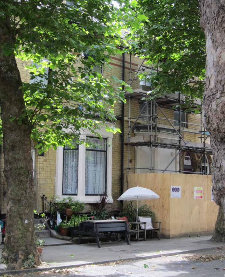
324 Privatisation of the Production of Public Space
TOC
325 References
References
Alexander, C. (1965). A city is not a tree. Architectural Forum. 122(1):58-62.AlSayyad, N., Roy, A. (ed.). (2004) Urban Informality: Transnational Perspectives from the Middle East, Latin
America and South Asia. Lanham: Lexington BooksAmin, A. (2008). Collective culture and urban public space. City 12(1):5-24Amin, A. & Thrift, N. (2002). Cities, Reimagining the Urban. Cambridge: Polity Press.Arendt, H. (1958). The Human Condition. Chicago: The University of Chicago Press.Arendt. H. (1959). Reflection on Little Rock. Dissent: 45-56 Atkinson, R., Flint, J. (2001). Accessing hidden and hard-to-reach populations: Snowball research strategies. So-
cial research update, 33(1): 1-4Augé, M. (1995). Non-Places, an introduction to supermodernity. New York: VersoBanerjee, T. (2001). The future of public space: beyond invented streets and reinvented places. Journal of the
American Planning Association. 67(1): 9-24Banerjee, T., Loukaitou-Sideris, A. (2011). Companion to Urban Design. London: RoutledgeBarnett, C. (2015). On the milieu of security: Situating the emergence of new spaces of public action. Dialogues
in Human Geography. 5(3): 257-270Benn, S. & Gaus, F. (1983). Public and private in social life. New York: St. Martin’s PressBeunderman, J. (2010). A Changing Collective Domain. in: The Spontaneous City (ed. Urhahn). Amsterdam: BIS
PublishersBodnar, J. (2015). Reclaiming public space. Urban Studies. 52(12): 2090-2104Bogner, A., Littig, B., Menz, W. (2005). Das Experteninterview: Theorie, Methode, Anwendung. Wiesbaden: VS
Verlag für Sozialwissenschaften.Boland, P. (2010). Capital of Culture—you must be having a laugh! Challenging the official rhetoric of Liverpool
as the 2008 European cultural capital. Social & Cultural Geography. 11(7): 627-645.Boomkens, R. (1998). Een drempelwereld. Moderne ervaring en stedelijke openbaarheid. Rotterdam: NAi UitgeversBoomkens, R. (2008). The Temporalities of the Public Sphere. In: Avermaete, T. et al. Oase#77 Into the Open.
Rotterdam: NAi Publishers: 10-31.Boyer. M.C. (1994) The City of Collective Memory, its historical imagery and architectural entertainments. MIT Press.Brenner, N. and Theodore, N. (2002). Cities and the Geographies of “Actually Existing Neoliberalism”. Antipode,
34: 349–379Brillembourg, A., Feireiss, K., Klumpner, H. (ed.). (2005) Informal City: Caracas Case, Munich. New York: Prestel
VerlagCalhoun, G. (1998). Community without Propinquity Revisited: Communications Technology and the Transfor-
mation of the Urban Public Sphere. Sociological Inquiry. 68(3): 373-397 Carmona, M., Heath,T., Oc, T., Tiesdell, S. (2003). Urban Spaces-Public Places: The Dimensions of Urban Design.
Oxford: Architectural Press Carmona, M.,De Magalhães, C. (2006). Public Space Management: Present and Potential. Journal of Environ-
mental Planning and Management. 49(1): 75-99Carmona, M., Magalhaes, C. de, Hammond, L. (2008). Public Space, the management dimension. New York:
RoutledgeCarmona, M. (2015). Re-theorising contemporary public space: a new narrative and a new normative. Journal of
Urbanism. 8(4):373-405Carr, S. Francis, M., Rivlin, L., Stone, A. (1992). Public Space. Cambridge: University PressCasanova, H., Hernandez, J. (2015). Public Space Acupuncture - Strategies and Interventions for Activating City
Life. Barcalona: Actar Castells, M. (1996). The rise of the network society. Oxford: Blackwell PublishersChase, J.L., Crawford, M., Kaliski, J. (2008). Everyday Urbanism. New York: The Monacelli PressColquhoun, A. (1989). Modernity and the classical tradition. Architectural Essays 1980-1987. Cambridge: MIT
press
TOC
326 Privatisation of the Production of Public Space
Couch, C., Denneman, A. (2000). Urban regeneration and sustainable development in Britain. Cities 17(12): 137-147
Crawford, M. (2008). The current state of Everyday Urbanism. In: Everyday Urbanism. Edited by Leighton Chase, J., Crawford, M., Kaliski, J., New York: The Monacelli Press
Crawford, M. (2016). Public Space and Private Life: Blurring the Boundaries. Lecture at conference ‘Constructing the Commons’ TUDelft
Cullen, G. (1961). Townscape. Reinhold Publishing CorporationCuthbert, A. (2011). Understanding cities: method in urban design. Taylor & FrancisDavis, M. (1992). Fortress Los Angeles: The Militarization of Urban Space. In: Sorkin, M. Variations on a Theme
Park. New York: Hill and WangDe Cauter, L. (2004). De capsulaire beschaving. Over de stad in een tijdperk van angst. Rotterdam: NAi Uitgevers.De Cauter, L. (2015). Metamoderniteit voor beginners – filosofische memo’s voor het neiuwe millennium. Nijme-
gen: VantiltDe Cauter, L., Dehaene, M. (2008). Heterotopia and the City. Public space in a postcivil society. Oxon: RoutledgeDe Certeau, M. (1984). The Practice of everyday Life. Steven Rendall (trans). Berkeley: University of California Press De Magalhães, C., Carmona, M. (2009). Dimensions and models of contemporary public space management in
England. Journal of Environmental Planning and Management. 52(1): 111-129De Magalhães, C. (2010). Public Space and the Contracting-out of Publicness: A Framework of Analysis. Journal
of Urban Design. 15(4): 559-774De Magalhães, C. Freire Trigo, S. (2017). Contracting out publicness: The private management of the urban
public realm and its implications. Progress in Planning. 115(1): 1-28Denzin, N., Lincoln, Y. (2003). Collecting and Interpreting Qualititaive Materials. Thousand Oaks: Sage Publica-
tions Inc.De Waal, M. (2013). De stad als interface – hoe nieuwe media de stad veranderen. Rotterdam: NAi uitgeversDTLR & CABE (2001) Better places to live: By Design – a companion guide to PPG3, London: Thomas TelfordDouglas, G. (2014). Do-it-Yourself Urban Design: The Social Practice of Informal ‘Improvement’ through Unau-
thorized Alteration. City & Community. 13:1 (5-24)DETR & CABE (2000). By design: urban design in the planning system: towards better practice. London: Thomas
TelfordDTLR & CABE (2001). Better places to live: By Design – a companion guide to PPG3. London: Thomas TelfordDuany, A., Davis, R. Plater-Zyberk, E. (1997). The Technique of Town Planning: Operating System of the New
Urbanism. Duany Plater-Zyberk & CompanyDunleavy, P. Margetts, H, Bastow, S. Tinkler, J. (2006). New Public Management Is Dead--Long Live Digital-Era
Governance. Journal of Public Administration Research and Theory. 16(3): 467–494Elden, S. (2004). Understanding Henri Lefebvre. London: ContinuumElliott, B. (2011). Benjamin for architects. Abingdon: RoutledgeErtiö, T-P. (2015). Participatory Apps for Urban Planning—Space for Improvement. Planning, Practice &
Research. 30(3): 303-321Ewing, R. & Clemente, O. (2013). Measuring Urban Design, Metrics for Livable Spaces. Washington: Islandpress Ewing, R., Handy, S., Brownson, R., Clemente, O., Winston, E. (2006). Identifying and Measuring Urban Design
Qualities Related to Walkability. Journal of Physical Activity and Health. 3(1): 223-240Fainstein. S. (2009). Spatial Justice and Planning. Justice Spatial – Spatial Justice. www.jssj.orgFainstein. S. (2010). The Just City. New York: Cornell University PressFerguson, F. (2014). Make_shift City - Renegotiating the Urban Commons. Berlin: JovisFranke, S., Niemans, J., Soeterbroek, F. (2015). Het nieuwe stadmaken – van gedreven prionieren naar gelijk
speelveld. Haarlem: Trancity & ValizFraser, N. (1990). Rethinking the Public Sphere: A Contribution to the Critique of Actually Existing Democracy,
Social Text. 25/26: 56-80Frug, G.E. (1999) Citymaking: Building Communities without Building Walls. Princeton University PressGans, H.J. (1968). People and Plans; Essays on Urban Problems and Solutions. New York: Basic Books, Inc.Gehl, J. (2011). Life between Buildings. Using Public Space. Washington: Island PressGehl, J. & Svarre, B. (2013). How to Study Public Life. Washington: Island PressHabermas, J. (1989). The Structural Transformation of the Public Sphere. UK: Polity Press Hague, M. (2001). The Diminishing Publicness of Public Service under the Current Mode of Governance. Public
Administration Review. 61(1): 65-82
TOC
327 References
Hajer, M. (1994). De Stad als publiek domein. Utrecht: Brouwer OffsetHajer, M. (2003). Policy without polity? Policy analysis and the institutional void. Policy Sciences. 36: 175-195Hajer, M., Reijndorp, A. (2001). In Search of New Public Domain. Rotterdam: NAi PublishersHall, S. (2003). The ‘Third Way’ Revisited: ‘New’ Labour, Spatial Policy and the National Strategy for Neighbour-
hood Renewal. Planning Practice & Research. 18(4): 265-277Harvey, D. (1989). From Managerialism to Entrepreneurialism: The Transformation in Urban Governance in
Late Capitalism. Geografiska Annaler. Series B, Human Geography. 71(1): 3-17Harvey, D. (2008). The Right to the City. New Left Review. 53: 23-40Hatherley, O. (2010). A Guide to the New Ruins of Great Britain. London: VersoHeijden, H. van der. (2008). The Bluecoat. Liverpool: Progressive Media Group.Heijden, H. van der. (2008). Whose Space is Public Space? Free thinking, Festival of Ideas, Liverpool (BBC Radio)Hernandez F., Kellet P. and Allen L.K. (ed.). (2010) Rethinking the Informal City, critical perspectives from Latin
America. Berghahn BookHertzberger, H. (2009). Collective Space, Social Use. In: Architectural Positions, Architecture, Modernity and the
Public Sphere. Edited by Avermaete, T. Havik, K. Teerds, H. Amsterdam: SUN publishers. p 93 – 100.Herzog,T., Kaplan, S., Kaplan, R. (1982). The prediction of preference for unfamiliar urban places. Population
and Environment 5(1): 43-59.Hillier B. (1999). Space is the Machine: A Configurational Theory of Architecture, Cambridge: Cambridge
University PressHillier, B. & Shu, S. (1999). Do burglars understand defensible space? New evidence on the relation between
crime and space. Planning in London. http://www.spacesyntax.orgHillier. B., Shu. S. (2000) Crime and urban layout: the need for evidence. In: Ballantyne, S., MacLaren, V., Pease,
K. (eds.) Secure foundations : key issues in crime prevention, crime reduction and community safety.(pp. 224-248). London UCL: Institute for Public Policy Research.
Howard, E. (1902). Garden Cities of To-morrow. London: Swan Sonnenschein & CoHufty, M. (2011) Investigating Policy Processes: The Governance Analytical Framework (GAF). In: Wiesmann,
U., Hurni, H., et al. eds. Research for Sustainable Development: Foundations, Experiences, and Perspectives.”. Bern: Geographica Bernensia: 403–424.
Iveson, K. (1998). Putting the public back into public space. Urban Policy and Research. 16(1): 21-33Iveson, K. (2007). Public and the City. Blackwall PublishingIveson, K. (2013). Cities within the City: Do-It-Yourself Urbanism and the Right to the City. International Journal
of Urban and Regional Research. 37(3): 941-956Jacobs, J. (1961). The Death and Life of Great American Cities. New York: Random House. Johnson, C., Osborne S. (2003). Local Strategic Partnerships, Neighbourhood Renewal, and the Limits to Co-gov-
ernance. Public Money & Management. 23(3): 147-154Jones, P., Layard, A. Speed, C. , Lorne, C. (2015). MapLocal: Use of Smartphones for Crowdsourced Planning.
Planning, Practice & Research. 30(3): 322-336Juddt. T. (2010). Ill Fares the land. London: Penguin GroupKaplan, S., Kaplan, R. (1989). The experience of nature: a psychological perspective. CambridgeKlijn, E.-H., Teisman, G. (2000). Governing public-private partnerships: Analyzing and managing the processes
and institutional characteristics of public-private partnerships. In S. Osborne (Ed.), Public private partner-ships: theory and practice in international perspective (pp. 84-102)
Klijn, E-H., Koppenjan, J. (2015). Governance networks in the public sector. Oxford: RoutledgeKohn, M. (2004). Brave New Neighborhoods, the privatization of public space. New York: Routledge Kort, M., Klijn. E-H. (2011). Public-Private Partnerships in Urban Regeneration Projects: Organizational Form or
Managerial Capacity. Public Administration Review. Vol. 71:4 (618-626) Kort, M., Klijn. E-H. (2013). Public-Private Partnerships in Urban Regeneration: Democratic Legitimicy and its
Relation with Performance and Trust. Local Government Studies. 39(1): 89-106 Kostof, S. (1992). The city assembled. London: Thames and Hudson Ltd.Krier, R. (1979). Urban Space. Random House IncorporatedLangstraat, F., Van Melik, R. (2013). Challenging the ‘End of Public Space’: A Comparative Analysis of Publicness
in British and Dutch Urban Spaces. Journal of Urban Design. 18(3): 429-448Leclercq, E., (2015). Color your Space - how digital media could improve the inclusiveness in the planning pro-
cess. Paper for Conference ‘Design, Social Media and Technology to Foster Civic Self-Organisation’. University of Hasselt
TOC
328 Privatisation of the Production of Public Space
Lees, A. (2013) Liverpool, the Hurricane Port. Edinburgh: Mainstream Publishing Company.Lees, L. H. (1994). Urban public space and imagined communities in the 1980s and 90s. Journal of Urban
History. 20(4):443–465.Lefebvre, H. (1968). Le droit à la ville. Paris: AnthroposLefebvre, H. (1991). The Production of Space. Oxford: Blackwell PublishingLerner, J. (2014). Urban Acupunture, Celebrating Pinpricks of Change that Enrich City Life. Washington: Island
PressLeung, L. (2015). Validity, reliability, and generalizability in qualitative research. Journal of of Family Medicine
and Primary Care. 4(3): 324-327Littlefield, D. 2009. Liverpool ONE, remaking a city centre. Chicester: John Wiley & Sons.Llewelyn-Davies. (2000). Urban Design Compendium. London: English PartnershipsLofland, L. (1999). The Public Realm: Exploring the City’s Quintessential Social Territory London: RoutledgeLonghurst, R. (2010). Semi-structured Interviews and Focus Groups Clifford. In: Clifford, N., French, S. Valen-
tine, G. Key methods in Geography. Los Angeles: Sage Publications.Loopmans, M., Leclercq, E., Newton, C. (2011). Plannen voor Mensen. Antwerpen: GarantLoukaitou-Sideris, A., Banerjee, T. (1998). Urban Design Downtown - Poetics and Politics of Form. University of
California PressLow, S. & Smith, N. (2006). The Politics of Public Space. New York: RoutledgeLow, S., (2006). The erosion of Public Space and the Public Realm: paranoia, surveillance and privatization in
New York City. City&Society. 18(1): 43-49Lupton, R., Fenton, A., Fitzgerald, A. (2013). Labour’s Record on Neighbourhood Renewal in England: Policy,
Spending and Outcomes 1997-2010. Social Policy in a Cold Climate Working Paper 6. (1-35) CASE. London School of Economics
Lynch, K. (1960). The Image of the City. Boston: MIT pressMadanipour, A. (2003). Public and Private Spaces of the City. London: Routledge.Madanipour, A. (2010). Whose Public Space? New York: RoutledgeMadden, D.J. (2010). Revisiting the end of Public Space: Assembling the Public in an Urban Park, City & Commu-
nity 9(2): 187- 207Marcuse, P. (2005). The 'threat of terrorism' and teh right to the city. Fordham Urban Law Journal. 32(4): 767-
785Marcuse, P. (2009). From critical urban theory to the right to the city. City: analysis of urban trends, culture,
theory, policy, action. 13(2-3): 185-197Mayer, M. (2009). The ‘Right to the City’ in the context of shifting mottos of urban social movements. City:
analysis of urban trends, culture, theory, policy, action. 13(2): 362-374Mayer, M. (2013). First world Urban Activism – Beyond austerity urbanism and creative city politics. City. 17(1):
5-19McAllister, R. & Taylor B. (2015a). Sustainability governance and transformation: Partnerships and sustainabili-
ty governance: progress, prospects and pitfalls. Current Opinion in Environmental Sustainability. 12: iv–viMcAllister, R. & Taylor B. (2015b). Partnerships for sustainability governance: a synthesis of key themes. Current
Opinion in Environmental Sustainability. 12: 86-90 McCann, E. (1999). Race, Protest, and public space: contextualizing Lefebvre in the US City. Antipode 31:2,
1999, pp. 163-184. Blackwell Publishers. Malden-USA, Oxford-UKMiazzo, F., Kee, T. (2014). We Own the City, Enabling community practice in architecture and urban planning.
Amersfoort: Wilco.Minton, A. (2006). What kind of world are we building? The privatization of public space. www.rics.org. Minton, A. (2009). Ground Control, fear and happiness in the twenty-first-century city. London: Penguin BooksMitchell, D. (1995). The end of public space? People’s park, definitions of the public, and democracy. Annals of
the association of American geographers, 85(1): 108-133.Moore, C. (1965). You have to pay for public life. In Selected Essays ed. Keim, K. (2001). Cambridge: MIT pressMoore, J. (1996). The Death of Competition: Leadership and strategy in the age of business ecosystems. New
York: HarperBusinessMoore, J. (2013). Shared Purpose: A thousand business ecosystems, a connected community, and the future.
California: Create Space Publishing PlatformMumford, L. (1961). The City in History - Its Origins, its Transformations, and its Prospects. New York: Hartcourt
TOC
329 References
Murray, M. (2010). Private management of Public Spaces: Non profit organisations and urban parks. Harvard Environmental Law Review. Vol. 34: 179 – 254
Nadin, V., Short, M., Smith, N., & Askew, J. (2008). Development and planning processes in England: Generalpaper for learning from English practices of area development. Delft/Bristol: Delft University of Technology& University of the West of EnglandNeal. Z. (2010). Seeking common ground: three perspectives on public space. Proceedings of the Institution of
Civil Engineers. udp900031.3dNeary, S.J., Symes, M.S. Brown, F.E. (1994). The urban experience – a people-environment perspective. London:
Chapman&HallNémeth, J. (2006). Conflict, Exclusion, Relocation: Skateboarding and Public Sphere. Journal of Urban Design.
11(3): 297-318Németh, J. (2009). Defining a Public: The Management of Privately Owned Public Space. Urban Studies. 46(11):
2463 - 2490Németh, J. (2012). Controlling the Commons: How Public is Public Space? Urban Affairs Review. 48(6): 811-835Németh, J., Schmidt, S. (2011). The privatization of public space: modeling and measuring publicness. Environ-
ment and Planning B: Planning and Design. 38: 5-2Newman, O. (1972). Defensible Space. New York: Macmillan.Newman, O. (1996). Creating Defensible Space. New York: HUD.Oenen, G. van. (2004). Het nieuwe veiligdom. De interpassieve transformatie van de publieke sfeer. In: Open
2004 (6). Rotterdam: NAi PublishersODPM (2004). Safer Places - The Planning System and Crime Prevention. London: Queens PrinterOstrom, E. (2010). Beyond Markets and States: Polycentric Governance of Complex Economic Systems. The
American Economic Review. 100(3): 641-672Pallasmaa, J. (2009). Inhabiting Space and Time – the Loss and Recovery of Public Space. In: Architectural
Positions, Architecture, Modernity and the Public Sphere. Edited by Avermaete, T. Havik, K. Teerds, H. Amsterdam: SUN publishers. p 125 – 133
Parker, C., Garnell, C. (2006). Regeneration and Retail in Liverpool: a new approach. Journal of Retail and Leisure Property. 5: 292-304.
Parker, S. (2004). Urban Theory and the Urban Experience. Abingdon: RoutledgeParkinson, J.R. (2012). Democracy and Public Space, The Physical Sites of Democratic Performance. Oxford:
University PressPeck, J., Tickell, A. (2002). Neoliberalizing Space. Antipode, 34: 380–404Pesch, U. (2008). The Publicness of Public Administration. Administration & Society. 40(2): 170-193Project for Public Spaces. (1999). How to turn a place around? A Handbook for Creating Successful Public Spaces.
New York: PPSPugalis, L. (2009). The Culture and economics of urban public space design: public and professional percep-
tions. Urban Design International. 14(4): 215-230Rapoport, A. (1990) History and Precedent in Environmental Design. New York: Plenum Press Reichl, A. (2016). The High Line and the ideal of democratic public space. Urban Geography, 37(6): 904-925Reynaers, A-M. (2014). Public values in Public-Private Partnerships. Public Administration Review. 74(1): 41-50Roberts, P., Sykes, H. (2000). Urban Regeneration, a handbook. London: Sage Publications Ltd.Rose, N. (2000). Government and control. British H-Journal of Criminology, 40(2): 321-39Sassen, S. (1991). The global city, New York, London, Tokyo. New Jersey: Princeton University Press Sassen, S., (2014). Expulsions: Brutality and Complexity in the global economy. Cambridge: Harvard University
PressSennett, R. (1977). The fall of Public Man. New York: Alfred A. Knopf Inc.Simpson, P. (2011). Street Performance and the City: Public Space, Sociality, and Intervening in the Everyday.
Space and Culture 14(4): 415-430Sitte, C. (1889). City Planning according to Artistic Principles. London: Phaidon PressSkelcher, C., Mathur, N., Smith, M. (2005). The public governance of Collaborative Spaces: Discourse, Design
and Democracy. Public Administration. 83(3): 573- 596Soenen, R. (2006). Het kleine ontmoeten - over het sociale karakter van de stad. Antwerpen: Garant uitgeversSoja, E. (2010). Seeking Spatial Justice. Minneapolis: University of Minnesota Press.Sorkin, M. (ed) (1992). Variations on a Theme Park. New York: Hill and Wang.
TOC
330 Privatisation of the Production of Public Space
Staeheli, L.A. & Mitchell, D. (2007). Locating the public in research and practice. Progress in Human Geography. 31(6): 792-811
Stake, R. E. (2008). Case studies. In Strategies of qualitative inquiry. (3rd ed: 119–149). Los Angeles: Sage Publications.
Stevens, Q. (2007). The Ludic City. Exploring the potential of public spaces. Abingdon: RoutledgeStonehouse, J. (2002). The streets of Liverpool. Liverpool LibrariesSwanborn, P. (2008). Case-study’s: wat, wanneer en hoe? (4th edition). Amsterdam: BoomonderwijsSwyngedouw, E. (2007). The post-political city. In: BAVO (ed). Urban Politics Now - Re-Imagining Democracy in
the Neoliberal City - reflect #06. Rotterdam: NAi Publishers Swyngedouw, E., Moulaert, F. and Rodriguez, A. (2002). Neoliberal Urbanization in Europe: Large–Scale Urban
Development Projects and the New Urban Policy. Antipode, 34: 542–577Sykes, O., Brown, J., Cocks, M., Shaw, D., Couch, C. (2013). A City Profile of Liverpool. Cities. http://dx.doi.
org/10.1016/j.cities.2013.03.013 (1-20)Tuan, Y-F. (1977). Space and Place: The Perspective of Experience. Minneapolis:University of Minnesota PressTeisman, G. (2000). Models for research into decision-making processes: on phases, streams and deci-
sion-making rounds. Public Administration. 78(4): 937 – 956Thompson. J. (1995). The Media and Modernity: A Social Theory of the Media. Stanford University Press.Uduko, O., Ben-Tovim, G. (1998). Social Infrastructure in Granby/Toxteth. Liverpool: University of Liverpool.United Nations, Department of Economic and Social Affairs – Population Division. (2014). World Urbanization
Prospect: The 2014 revision. (ST/ESA/SER.A/366)Urhahn, G. (2010). The Spontaneous City. Amsterdam: BIS PublishersVan Bueren, E., Ten Heuvelhof, E. (2005). Improving governance arrangements in support of sustainable cities.
Environment and Planning. 32: 47-66Van Melik, R., Aalst, I. van, Weesp, J. van. (2007) Fear and Fantasy in the Public Domain: the development of
secured and themed urban space. Journal of Urban Design, 12(1): 25-41Varna, G. (2016). Measuring Public Space: The Star Model. Oxford: Routledge.Varna, G., Tiesdell, S. (2010). Assessing the Publicness of Public Space: The Star Model of Publicness. Journal of
Urban Design. 15(4): 575-598Venturi, R., Scott Brown, D., Izenour, S. (1972). Learning from Las Vegas. Boston: MIT pressVermeulen, S. (2015). The roles of spatial visions and visioning in urban development projects. PhD dissertation
VUBWhyte, W., (1980). The Social Life of Small Urban Spaces. Washington: The Conservative FoundationWilson, J.Q., & Kelling, G.L. (1982). Broken windows: The police and neighborhood safety. The Atlantic,
249:29-38.Wirth, L. (1938). Urbanism as a Way of Life. The American Journal of Sociology. 44(1): 1-24 Yin, R. (2003). Applications of Case Study Research (2nd edition). Thousand Oaks, California: Sage Publications.Yin, R. (2009). Case Study Research: design and methods (4th edition). Thousand Oaks, California: Sage Publica-
tions.Yin, R. (2013). Validity and generalization in future case study evaluations. Evaluation. 19(3): 321-332Young, I. (1990). Justice and the politics of difference. Princeton, New Jersey: Princeton University Press.Woolley, H., Hazelwood, T., Simkins, I. (2011). Don’t skate here: exclusions of skateboardersWorld Urban Forum. (2004). World Charter on the Right to the City. www.righttothecityplatform.org.br
Newspaper articles
Andreou, A. (2015). Anti-homeless spikes: ‘Sleeping rough opened my eyes to the city’s barbed cruelty’. The Guardian 18.02.2015
Borromeo, L. (2015). These anti-homeless spikes are brutal. We need to get rid of them. The Guardian 23.07.2015
Carmona, M. (2013). Privatised public spaces can breathe new life into cities. The Conversation 18.12.2013Karf, A. (2014). It’s time to revive public ownership and the common good. The Guardian 04.07.2014Garrett, B. (2015). The privatisation of cities’ public spaces is escalating. It is time to take a stand. The Guardian
04.08.2015
TOC
331 References
Garrett, B. (2015). PSPOs: the new control orders threatening our public spaces. The Guardian 08.09.2015Garrett, B. (2017). Be angry about the privatisation of public space. The Guardian 24.07.2017Heathcote, E. (2015) Civic space in cities cedes to commercial interest. The Financial Times 26.05.2015Mark, L. (2016). Campaigners take to streets over privatisation of public space. the Architectsjournal
15.02.2016McGuirk, J. (2015). Urban commons have radical potential – it’s not just about community gardens The Guard-
ian 15.06.2015Minton, A. (2012). We are returning to an undemocratic model of land ownership. The Guardian 11.06.2012Shenker, J. (2017). Revealed: the insidious creep of pseudo-public space in London. The Guardian 24.07.2017Sayle, A. (2012). How all politicians have made a mess of my beloved Merseyside. The Guardian 01.01.2012Seymour, R., (2012). A Short history of Privatisation in the UK 1979 – 2012. The Guardian 29.03.2012Tittenbrun, J. (2013). The privatisation of public space. The Conversation 03.08.2013Vasagar, J. (2012). Public spaces in Britain’s cities fall into private hands. The Guardian 11.06.2012
TOC
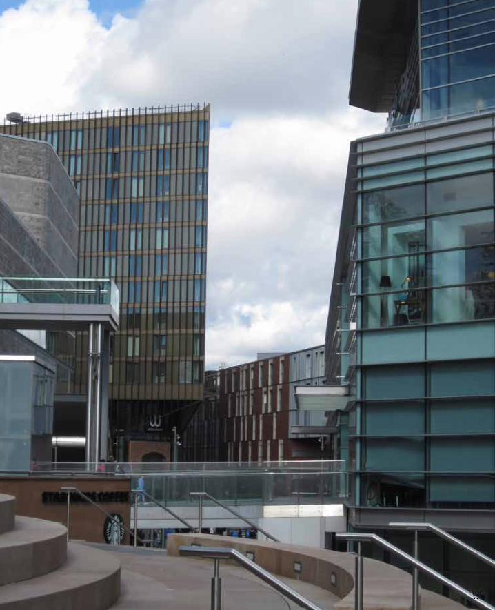
332 Privatisation of the Production of Public Space
TOC
333 List of References for Case Studies
Appendix A List of References for Case Studies
National policy documents
Urban Task Force (1999) Towards an urban renaissance. London: E & FN SponDETR & CABE. (2000). By design: urban design in the planning system: towards better practice. London: Thomas
TelfordDETR (2000). Urban White Paper: our towns and cities; the future. London: TSO DTLR & CABE (2001) Better places to live: By Design – a companion guide to PPG3, London: Thomas TelfordODPM (2004). Safer Places - The Planning System and Crime Prevention. London: Queens PrinterTowards a strong urban renaissance. (2006). London: E & FN SponHMRI Annual reports (2004-2009)
Liverpool local documents
Books/articlesBoland, P. (2010). ‘Capital of Culture—you must be having a laugh!’Challenging the official rhetoric of Liverpool
as the 2008 European cultural capital. Social & Cultural Geography, 11(7), 627-645Lees, A. (2011) Liverpool, the Hurricane Port. Edinburgh: Mainstream Publishing Company.Couch, C., Karecha, J., Nuissl, H., & Rink, D. (2005). Decline and sprawl: an evolving type of urban development–
observed in Liverpool and Leipzig. European Planning Studies, 13(1), 117-136.Sykes, O., Brown, J., Cocks, M., Shaw, D., Couch, C. (2013). A City Profile of Liverpool. Cities. http://dx.doi.
org/10.1016/j.cities.2013.03.013 (1-20)
Policy documents & plansStrategic Regeneration Framework, 2000, Liverpool Vision Unitary Development Plan, 2002, Liverpool City CouncilLiverpool Urban Design Guide, 2003, Liverpool City CouncilCity Centre Public Realm Strategy, 2004, Liverpool VisionRegeneration and Development in Liverpool City Centre, 2004, Liverpool City Council & Liverpool VisionLocal Development Framework, 2006, Liverpool City CouncilFive great years, 2008, Liverpool Land Development CompanyPeople, place & prosperity, 2008, Liverpool VisionMake no little plans, 2008, Liverpool VisionResidential Development Update: City Centre Living, 2008, Liverpool Vision
Liverpool One
Books/articlesHeurkens, E.W.T.M., & Louwaars, S.P. (2011). Public & private leadership in urban development. Real Estate
Research Quarterly. 10(2): 37-47.Littlefield, D. 2009. Liverpool ONE, remaking a city centre. Chicester: John Wiley & Sons.Parker, C., & Garnell, C. (2006). Regeneration and retail in Liverpool: A new approach. Journal of Retail and
Leisure Property. 5: 292-304.Peel, D., & Lloyd, G. (2008). Redeveloping paradise?: Scale does matter. Town & Country Planning. 77(9): 379-380.Taylor, D. (2009). Liverpool, regeneration of a city centre. BDP
TOC
334 Privatisation of the Production of Public Space
Policy documents & plansParadise Street Development Brief, 1999, Liverpool City CouncilPSDA Building Certificate, 2003, Liverpool City CouncilDetailed architectural drawings, 2002-2008, Various architectsParadise Street Development Area: Masterplan Report, 2001, Grosvenor Liverpool Paradise Street Development Area: Masterplan (Background), 2002, Grosvenor Liverpool Paradise Street Development Area: Planning Application, 2004.Grosvenor Council decision and meeting notes, 2004-2006, Liverpool City CouncilDesign Review Town Centre Retail, 2004, CABEPetition Quiggins, 2004, Curtis-Thomas, C. (MP Crosby))Grosvenor Annual Report, 2015, Grosvenor
Newspaper articlesBarrett, T. (2005) Halfway to Paradise? Liverpool Echo 08.05.2013Carter, H. (2008). Policing the retail republic. The Guardian. 28.05.2008Coligan. N. (2008). Grosvenor property site: It’s the Liverpool ONE they all want. Liverpool Echo 12.06.2008Hodgson, N. (2010). Liverpool One flies flag for UK with double international success. Liverpool Daily Post.
03.05.2010Hodgson. N. (2012) Liverpool One near full capacity after latest openings and expansions. The Liverpool Post
06.09.2012Houghton, A. (2010). Liverpool One expects more than 25m visitors this year. Liverpool Daily Post. 01.11.2010Hunt. H. (2011). Liverpool One is hailed as an example of good design by RIBA (Royal Institute of British Archi-
tects). Liverpool Echo 12.07.2011 Jones, C. (2011) Liverpool’s first piano festival opens at venues around Liverpool ONE, Liverpool Echo
01.07.2011Liverpool Daily Post. (2011). Liverpool One shopping development brings 70m visitors to city. Liverpool Daily
Post 29.06.2011Liverpool Daily Post. (2011). Liverpool visitor economy brings £2.8bn into city each year. Liverpool Daily Post
29.06.2011Liverpool Echo (2003) Quiggins’ unique role in city culture. Liverpool Echo 06.11.2003Liverpool Echo (2003). Moving Quiggins would be ‘suicidal’. Liverpool Echo. 07.11.2003Liverpool Echo (2005) Digging deep for a year of success. Liverpool Echo 28.04.2005Mayhew. S. (2004). Privatised paradise? The Guardian 25.05.2004McDonough, T. (2010). Liverpool One retailers see sales soar 24% in final quarter of 2009. Liverpool Daily Post.
16.04.2010McDonough, T. (2011). Liverpool One owner pays £19.1m for 11 units in Lord Street. Liverpool Daily Post
24.08.2011McDonough, T. (2012). Liverpool one of the safest places for business crime. The Liverpool Post. 18.01.2012.Shennan, P. (2012). How Liverpool One has dramatically changed our city. Liverpool Echo 16.06.2012Skempton, T. (2016). Liverpool’s city heart still beating loud and strong. In: Letters to the Editor, the Observer
28.02.2016Townsend, M. (2016). Will privatisation of UK cities rip out their hearts? In: The Observer, 20.02.2016Turner, A. (2011) Liverpool One winning shopping centre award at Las Vegas ceremony. Liverpool Daily Post.
26.05.2011 Wainwright, M. (2012) Liverpool One no longer feeds into fears around private estates. The Guardian.
11.06.2012Weston, A. (2012).The Big Interview: Chris Bliss on why Liverpool ONE is about more than shopping. The Liver-
pool Post 15.06.2012
TOC
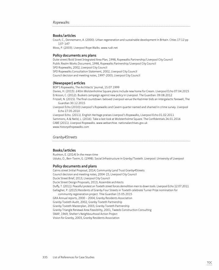
335 List of References for Case Studies
Ropewalks
Books/articlesCouch, C., Dennemann, A. (2000). Urban regeneration and sustainable development in Britain. Cities 17:12 pp
137-147Moss, P. (2003). Liverpool Rope Walks. www.rudi.net
Policy documents ans plansDuke street/Bold Street Integrated Area Plan, 1998, Ropewalks Partnership/Liverpool City CouncilPublic Realm Works Document, 1998, Ropewalks Partnership/Liverpool City CouncilSPD Ropewalks, 2002, Liverpool City CouncilSPD Ropewalks Consultation Statement, 2002, Liverpool City CouncilCouncil decision and meeting notes, 1997-2003, Liverpool City Council
(Newspaper) articlesBDP’S Ropewalks, The Architects’ Journal, 15.07.1999Davies, H. (2015). £40m Wolstenholme Square plans include new home for Cream. Liverpool Echo 07.04.2015Eriksson, C. (2012). Buskers campaign against new policy in Liverpool. The Guardian. 09.08.2012Frizzell, N. (2015). The final countdown: beloved Liverpool venue the Kazimier bids an intergalactic farewell, The
Guardian 30.12.2015Liverpool Echo (2010) Liverpool’s Ropewalks and Cavern quarter named and shamed in crime survey. Liverpool
Echo 17.05.2010Liverpool Echo. (2011). English Heritage praises Liverpool’s Ropewalks, Liverpool Echo 01.02.2011 Sammons, A.& Neild, L. (2016). Take a last look at Wolstenholme Square. The Confidentials 26.01.2016CABE (2011). Liverpool Ropewalks. www.webarchive. nationalarchives.gov.uk www.historyofropewalks.com
Granby4Streets
Books/articlesRushton, E. (2014) In the mean timeUduko, O., Ben-Tovim, G. (1998). Social Infrastructure in Granby/Toxteth. Liverpool: University of Liverpool
Policy documents and plansCairns street Initial Proposal, 2014, Community Land Trust Granby4StreetsCouncil decision and meeting notes, 2004-15, Liverpool City CouncilDucie Street Brief, 2013, Liverpool City CouncilDucie Street Design Proposals, 2013, Assemble architectsDuffy, T. (2011). Peaceful protest on Toxteth street forces demolition men to down tools. Liverpool Echo 12.07.2011Gallagher, P. (2015) Residents of Granby Four Streets in Toxteth celebrate Turner Prize nomination for
community regeneration project. Thie Guardian 15.05.2015GRA Annual reports, 2000 – 2004, Granby Residents AssociationGranby Toxteth Audit, 2002, Granby Toxteth PartnershipGranby Toxteth Masterplan, 2003, Granby Toxteth PartnershipGranby Triangle Renewal Area Feasibility, 2001, Tweeds Construction ConsultingSNAP, 1969, Shelter’s Neighbourhood Action ProjectVision for Granby, 2003, Granby Residents Association
TOC
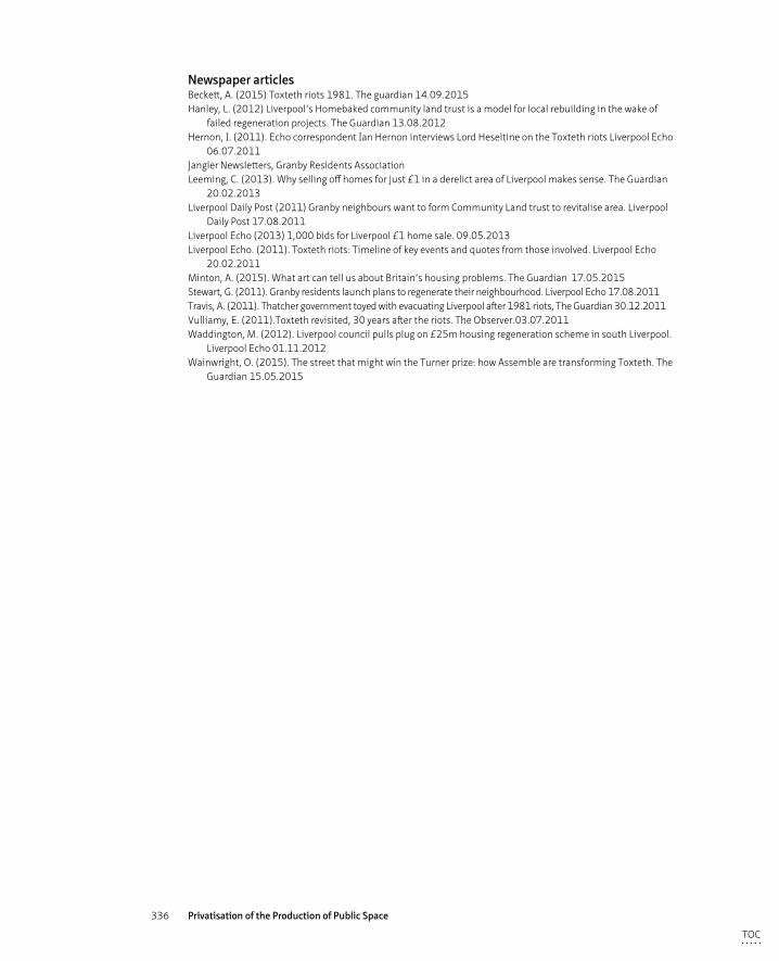
336 Privatisation of the Production of Public Space
Newspaper articlesBeckett, A. (2015) Toxteth riots 1981. The guardian 14.09.2015Hanley, L. (2012) Liverpool’s Homebaked community land trust is a model for local rebuilding in the wake of
failed regeneration projects. The Guardian 13.08.2012Hernon, I. (2011). Echo correspondent Ian Hernon interviews Lord Heseltine on the Toxteth riots Liverpool Echo
06.07.2011Jangler Newsletters, Granby Residents AssociationLeeming, C. (2013). Why selling off homes for just £1 in a derelict area of Liverpool makes sense. The Guardian
20.02.2013Liverpool Daily Post (2011) Granby neighbours want to form Community Land trust to revitalise area. Liverpool
Daily Post 17.08.2011Liverpool Echo (2013) 1,000 bids for Liverpool £1 home sale. 09.05.2013Liverpool Echo. (2011). Toxteth riots: Timeline of key events and quotes from those involved. Liverpool Echo
20.02.2011Minton, A. (2015). What art can tell us about Britain’s housing problems. The Guardian 17.05.2015Stewart, G. (2011). Granby residents launch plans to regenerate their neighbourhood. Liverpool Echo 17.08.2011Travis, A. (2011). Thatcher government toyed with evacuating Liverpool after 1981 riots, The Guardian 30.12.2011Vulliamy, E. (2011).Toxteth revisited, 30 years after the riots. The Observer.03.07.2011Waddington, M. (2012). Liverpool council pulls plug on £25m housing regeneration scheme in south Liverpool.
Liverpool Echo 01.11.2012Wainwright, O. (2015). The street that might win the Turner prize: how Assemble are transforming Toxteth. The
Guardian 15.05.2015
TOC
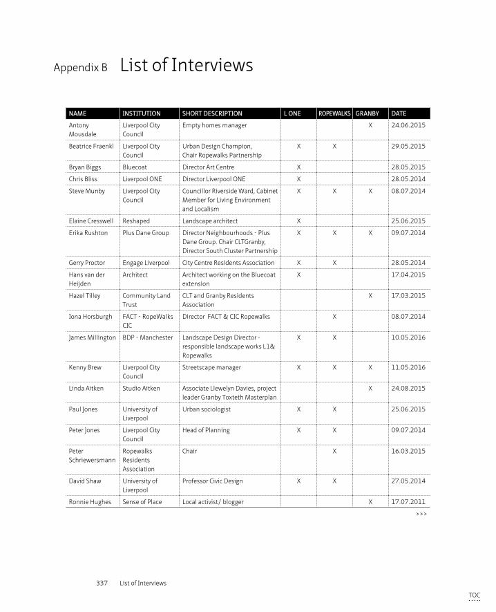
337 List of Interviews
Appendix B List of Interviews
NAME INSTITUTION SHORT DESCRIPTION L ONE ROPEWALKS GRANBY DATE
Antony Mousdale
Liverpool City Council
Empty homes manager X 24.06.2015
Beatrice Fraenkl Liverpool City Council
Urban Design Champion, Chair Ropewalks Partnership
X X 29.05.2015
Bryan Biggs Bluecoat Director Art Centre X 28.05.2015
Chris Bliss Liverpool ONE Director Liverpool ONE X 28.05.2014
Steve Munby Liverpool City Council
Councillor Riverside Ward, Cabinet Member for Living Environment and Localism
X X X 08.07.2014
Elaine Cresswell Reshaped Landscape architect X 25.06.2015
Erika Rushton Plus Dane Group Director Neighbourhoods - Plus Dane Group. Chair CLTGranby, Director South Cluster Partnership
X X X 09.07.2014
Gerry Proctor Engage Liverpool City Centre Residents Association X X 28.05.2014
Hans van der Heijden
Architect Architect working on the Bluecoat extension
X 17.04.2015
Hazel Tilley Community Land Trust
CLT and Granby Residents Association
X 17.03.2015
Iona Horsburgh FACT - RopeWalks CIC
Director FACT & CIC Ropewalks X 08.07.2014
James Millington BDP - Manchester Landscape Design Director - responsible landscape works L1& Ropewalks
X X 10.05.2016
Kenny Brew Liverpool City Council
Streetscape manager X X X 11.05.2016
Linda Aitken Studio Aitken Associate Llewelyn Davies, project leader Granby Toxteth Masterplan
X 24.08.2015
Paul Jones University of Liverpool
Urban sociologist X X 25.06.2015
Peter Jones Liverpool City Council
Head of Planning X X 09.07.2014
Peter Schriewersmann
Ropewalks Residents Association
Chair X 16.03.2015
David Shaw University of Liverpool
Professor Civic Design X X 27.05.2014
Ronnie Hughes Sense of Place Local activist/ blogger X 17.07.2011
>>>
TOC

338 Privatisation of the Production of Public Space
NAME INSTITUTION SHORT DESCRIPTION L ONE ROPEWALKS GRANBY DATE
Trevor Skempton Liverpool City Council
Urban Design consultant for LCC for Liverpool ONE 2003 - 2009
X 10.05.2016
Xanthe Hamilton Millionaire spokes person
Social investor investing in Granby X 29.05.2015
TOC
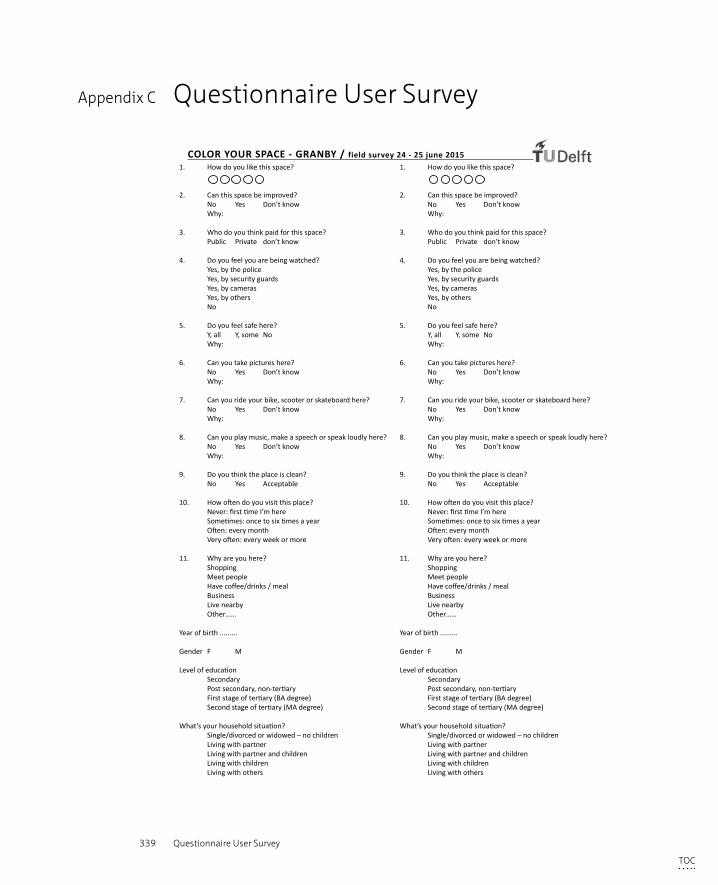
339 Questionnaire User Survey
Appendix C Questionnaire User Survey
1. How do you like this space?
2. Can this space be improved? No Yes Don’t know Why:
3. Who do you think paid for this space? Public Private don’t know
4. Do you feel you are being watched? Yes, by the police Yes, by security guards Yes, by cameras Yes, by others No
5. Do you feel safe here? Y, all Y, some No Why: 6. Can you take pictures here? No Yes Don’t know Why:
7. Can you ride your bike, scooter or skateboard here? No Yes Don’t know Why:
8. Can you play music, make a speech or speak loudly here? No Yes Don’t know Why:
9. Do you think the place is clean? No Yes Acceptable
10. How often do you visit this place? Never: first time I’m here Sometimes: once to six times a year Often: every month Very often: every week or more
11. Why are you here? Shopping Meet people Have coffee/drinks / meal Business Live nearby Other……
Year of birth .........
Gender F M
Level of education Secondary Post secondary, non-tertiary First stage of tertiary (BA degree) Second stage of tertiary (MA degree)
What’s your household situation? Single/divorced or widowed – no children Living with partner Living with partner and children Living with children Living with others
COLOR YOUR SPACE - GRANBY / field survey 24 - 25 june 20151. How do you like this space?
2. Can this space be improved? No Yes Don’t know Why:
3. Who do you think paid for this space? Public Private don’t know
4. Do you feel you are being watched? Yes, by the police Yes, by security guards Yes, by cameras Yes, by others No
5. Do you feel safe here? Y, all Y, some No Why: 6. Can you take pictures here? No Yes Don’t know Why:
7. Can you ride your bike, scooter or skateboard here? No Yes Don’t know Why:
8. Can you play music, make a speech or speak loudly here? No Yes Don’t know Why:
9. Do you think the place is clean? No Yes Acceptable
10. How often do you visit this place? Never: first time I’m here Sometimes: once to six times a year Often: every month Very often: every week or more
11. Why are you here? Shopping Meet people Have coffee/drinks / meal Business Live nearby Other……
Year of birth .........
Gender F M
Level of education Secondary Post secondary, non-tertiary First stage of tertiary (BA degree) Second stage of tertiary (MA degree)
What’s your household situation? Single/divorced or widowed – no children Living with partner Living with partner and children Living with children Living with others
www.coloryourspace.com
TOC

340 Privatisation of the Production of Public Space
TOC
341 Audit Maps
Appendix D Audit Maps
– Streetscape
– Appropriation
– Saftey & Security
– Transformation
– Accessibility
– Activity
– Ownership
– Symbolic Meaning
TOC
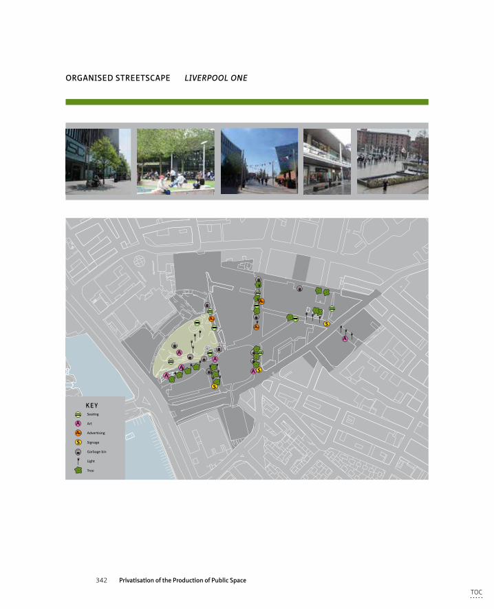
342 Privatisation of the Production of Public Space
AA
AA
Ad
Ad
S
SA
S
Ad
A
KEY
A
Ad
S
Seating
Art
Advertising
Signage
Garbage bin
Light
Tree
CCTV
Security guard
Blank facade
Bollards
ORGANISED STREETSCAPE LIVERPOOL ONE
TOC
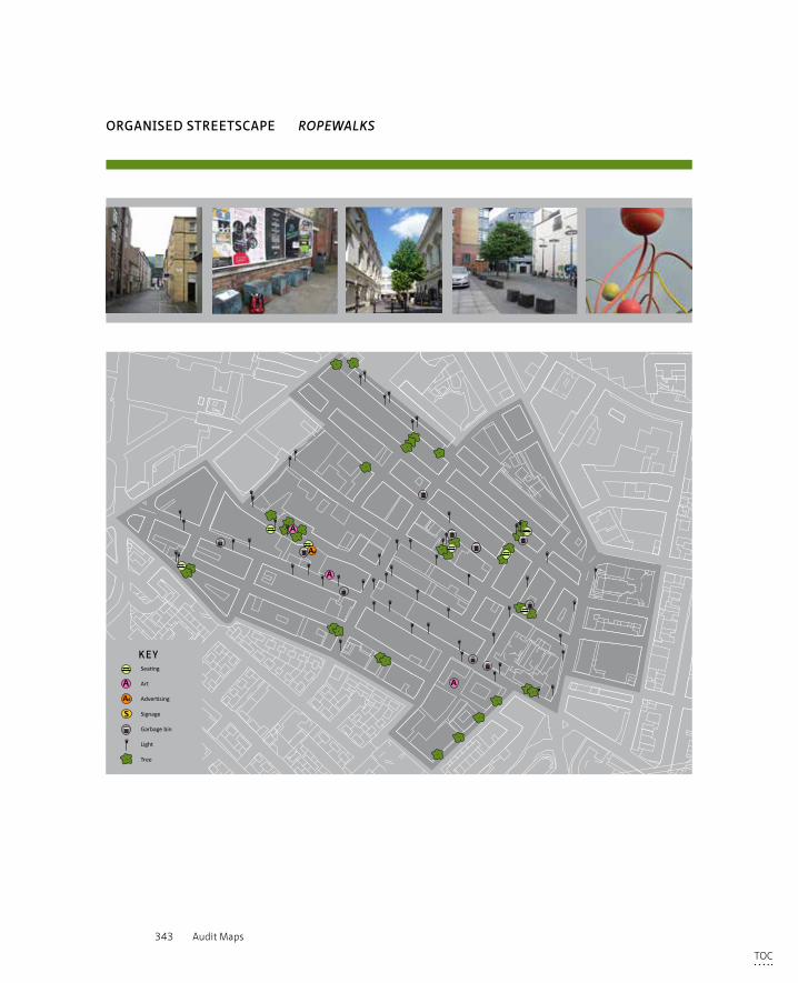
343 Audit Maps
A
Ad
A
A
KEY
A
Ad
S
Seating
Art
Advertising
Signage
Garbage bin
Light
Tree
Graffiti
Informal seating
Informal green
Rubbish
CCTV
Blank facade
Gate
Vacant site
ORGANISED STREETSCAPE ROPEWALKS
TOC
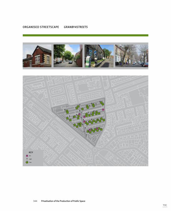
344 Privatisation of the Production of Public Space
ORGANISED STREETSCAPE GRANBY4STREETS
AA
A
A
AA
KEYA Art
Light
Tree
Graffiti
Street market
Private green (in public domain)
Informal seating
TOC
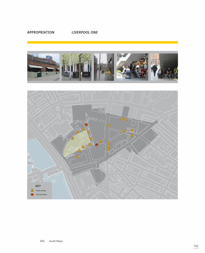
345 Audit Maps
KEYFormal seating
Private seating
Informal seating
APPROPRIATION LIVERPOOL ONE
TOC
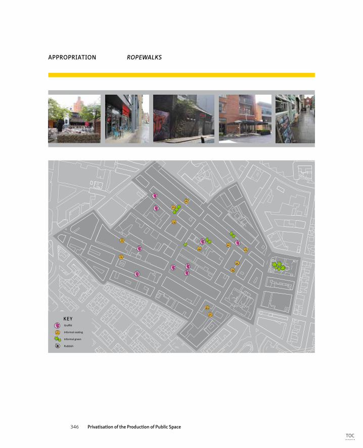
346 Privatisation of the Production of Public Space
KEY
A
Ad
S
Seating
Art
Advertising
Signage
Garbage bin
Light
Tree
Graffiti
Informal seating
Informal green
Rubbish
CCTV
Blank facade
Gate
Vacant site
APPROPRIATION ROPEWALKS
TOC
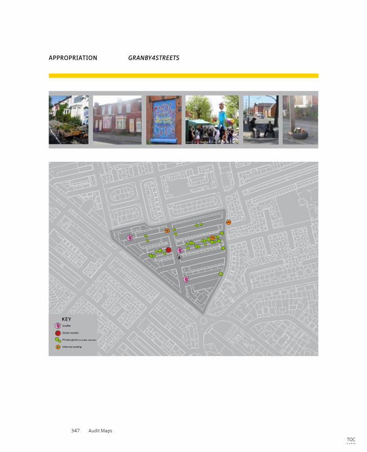
347 Audit Maps
APPROPRIATION GRANBY4STREETS
KEY
A Art
Light
Tree
Graffiti
Street market
Private green (in public domain)
Informal seating
source: granby4streets.co.uk
TOC
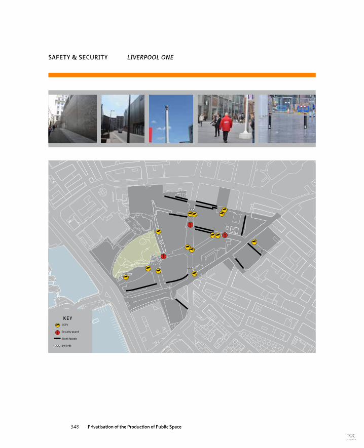
348 Privatisation of the Production of Public Space
KEYCCTV
Security guard
Blank facade
Bollards
SAFETY & SECURITY LIVERPOOL ONE
TOC
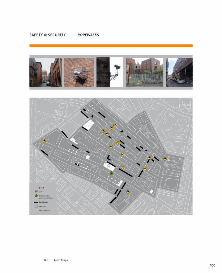
349 Audit Maps
KEYCCTV
Environmental enforcement officers
Blank facade
Vacant site
Vacant building
SAFETY & SECURITY ROPEWALKS
TOC
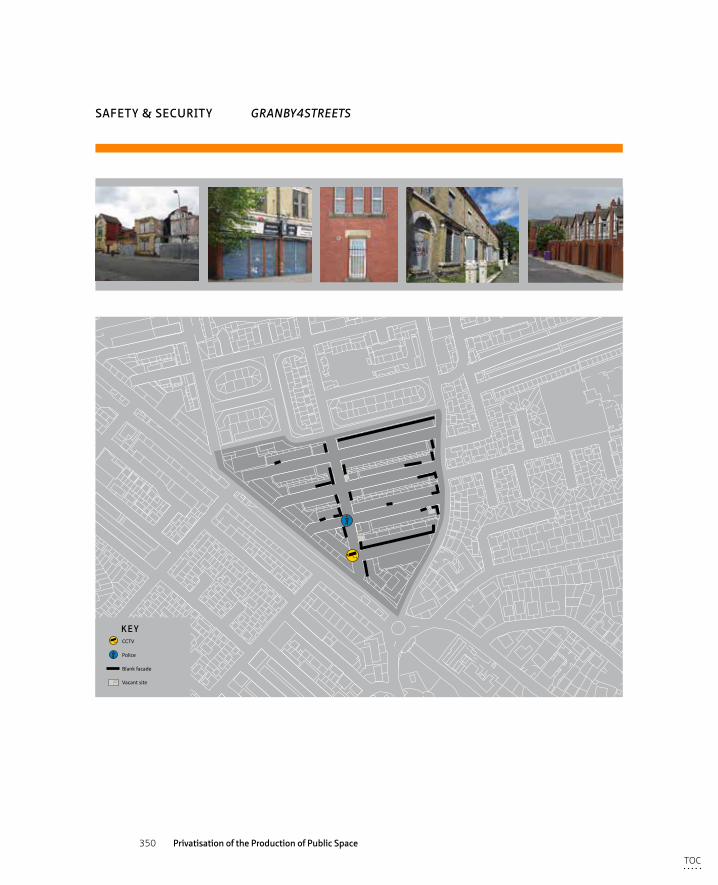
350 Privatisation of the Production of Public Space
SAFETY & SECURITY GRANBY4STREETS
KEYCCTV
Police
Blank facade
Vacant site
TOC
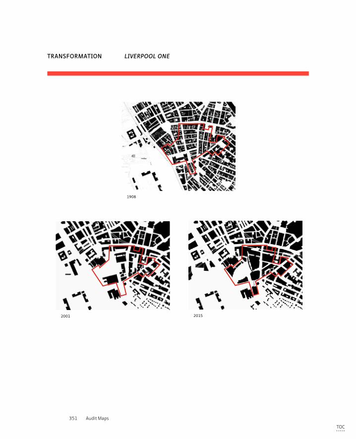
351 Audit Maps
TRANSFORMATION LIVERPOOL ONE
1908 2001 2015
1908 2001 20151908 2001 2015
TOC
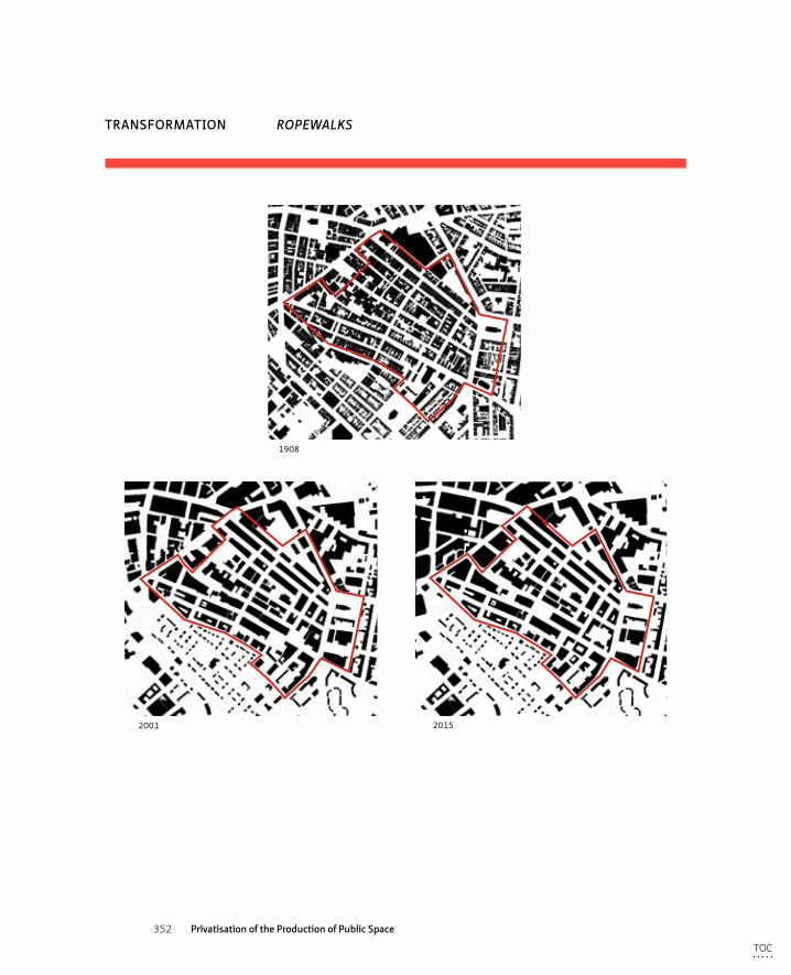
352 Privatisation of the Production of Public Space
TRANSFORMATION ROPEWALKS
1908 2001 2015
1908 2001 20151908 2001 2015
TOC
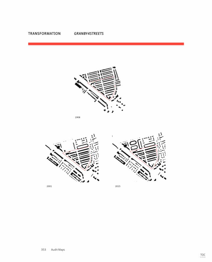
353 Audit Maps
TRANSFORMATION GRANBY4STREETS
1908 2001 2015
1908 2001 20151908 2001 2015
TOC
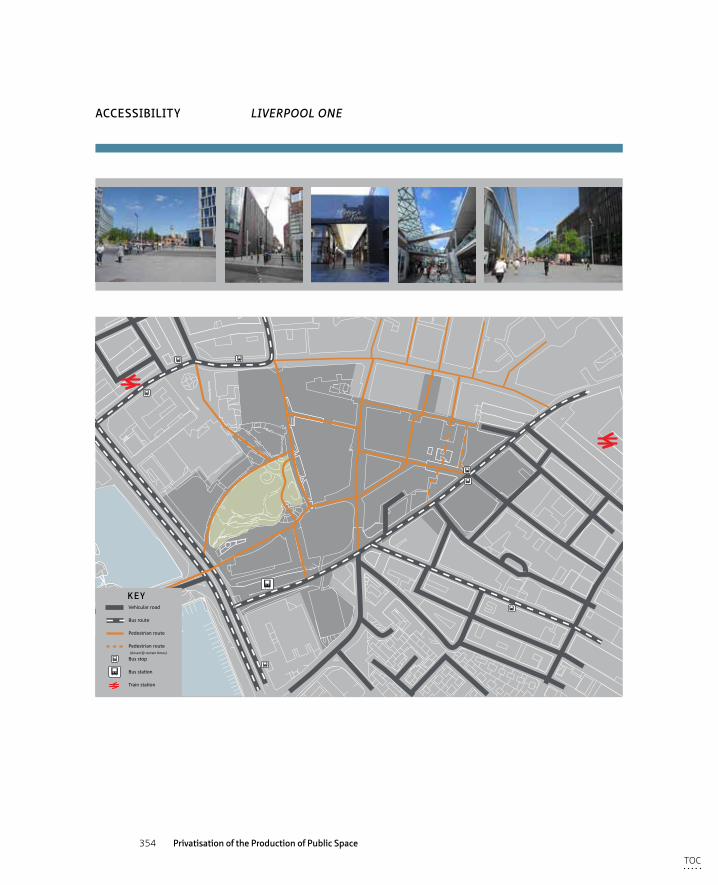
354 Privatisation of the Production of Public Space
uses
KEYVehicular road
Bus route
Pedestrian route
Pedestrian route (closed @ certain times)
Bus stop
Bus station
Train station
ACCESSIBILITY LIVERPOOL ONE
TOC
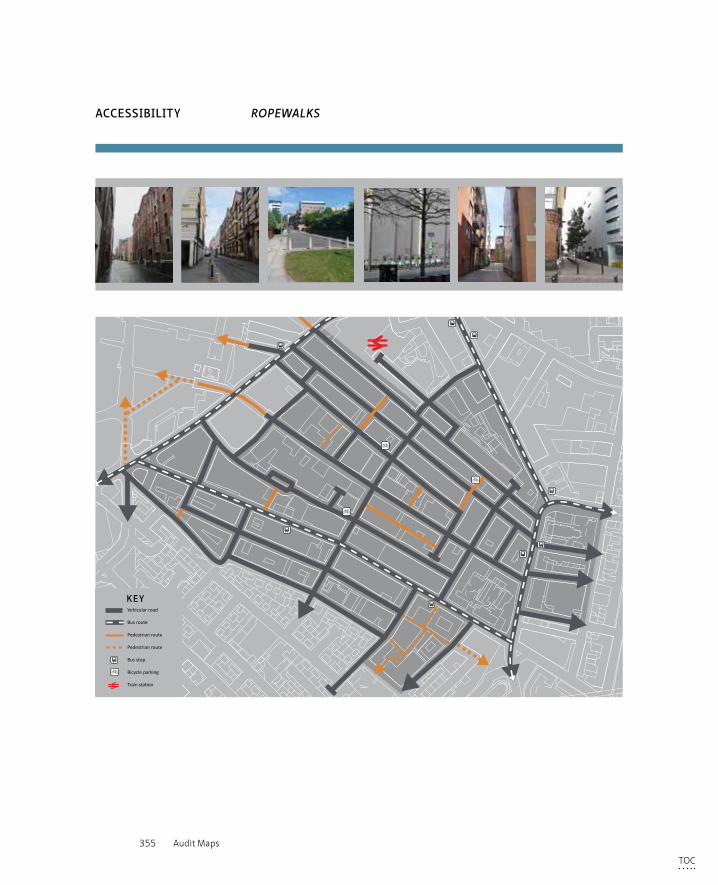
355 Audit Maps
KEYVehicular road
Bus route
Pedestrian route - public
Pedestrian route - private
Bus stop
Bicycle parking
Train station
ACCESSIBILITY ROPEWALKS
TOC
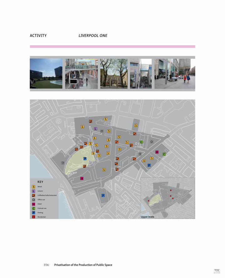
356 Privatisation of the Production of Public Space
uses
S
S
S
S
S
S
S
S
S
S
SS
S
SS
SS
S
C
P
P
PO
O
O
H
O
L
HC
KEY
S
H
PC
O
LRetail
Leisure
Coffeebar/cafe/restaurant
Office use
Hotel
Cultural use
Parking
Residential
ACTIVITY LIVERPOOL ONE
uses
Upper levels
TOC
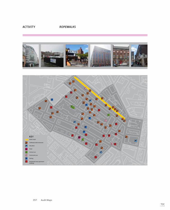
357 Audit Maps
C
P
P
P
P
CH
P
C
C
C
C C
KEY
H
P
CC
Retail street
Coffeebar/cafe/restaurant
Education
Hotel
Cultural use
Community use
Parking
Residential (new apartmentbuilding)
ACTIVITY ROPEWALKS
TOC
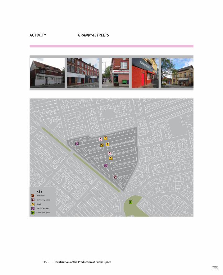
358 Privatisation of the Production of Public Space
ACTIVITY GRANBY4STREETS
S
C
C
P
S S
SC
KEY
SC
P
Restaurant
Community centre
Retail
Place of worship
Green open space
TOC
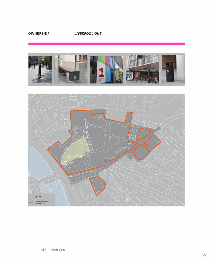
359 Audit Maps
uses
KEYPrivate ownership - Liverpool One
OWNERSHIP LIVERPOOL ONE
TOC
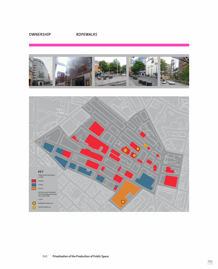
360 Privatisation of the Production of Public Space
KEYPredominant land ownersin 1998:
Frenson
Cruden
Council
(all other land in identified and unidentified ownership)Source: BDP (1998)
in 2015:
Building for public use
Land for public use
OWNERSHIP ROPEWALKS
TOC
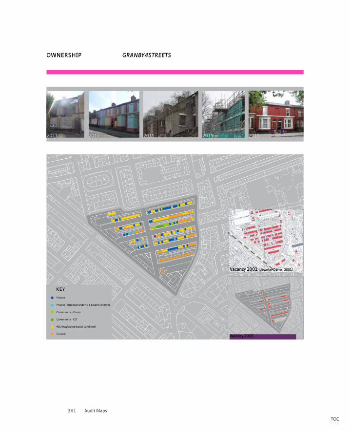
361 Audit Maps
OWNERSHIP GRANBY4STREETS
KEYKEY
Private
Private (obtained under £ 1 pound scheme)
Community - Co-op
Community - CLT
RSL (Registered Social Landlord)
Council
Vacancy 2001 (Llewelyn-Davies, 2001)
Vacancy 2015
2011 2011 2015 2015 2015
TOC
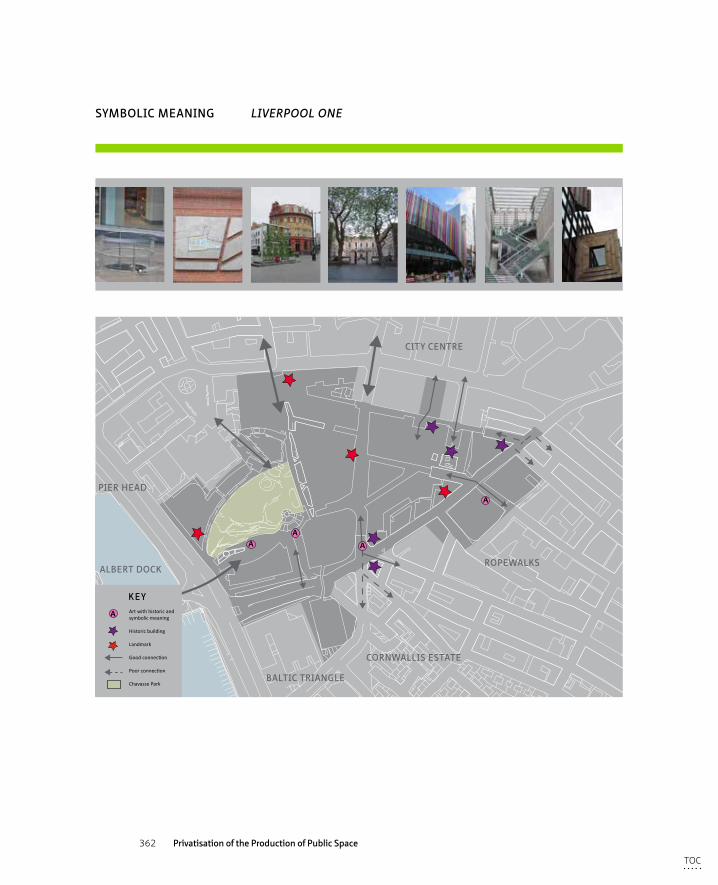
362 Privatisation of the Production of Public Space
uses
A
AA
A
KEY
A Art with historic and symbolic meaning
Historic building
Landmark
Good connection
Poor connection
Chavasse Park
SYMBOLIC MEANING LIVERPOOL ONE
ROPEWALKS
CORNWALLIS ESTATE
BALTIC TRIANGLE
ALBERT DOCK
PIER HEAD
CITY CENTRE
TOC
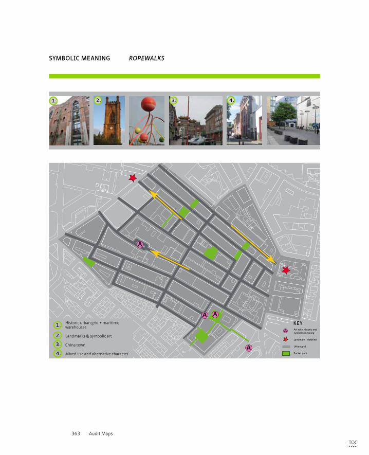
363 Audit Maps
A
A A
A
KEYA Art with historic and
symbolic meaning
Landmark - viewline
Urban grid
Pocket park
SYMBOLIC MEANING ROPEWALKS
Historic urban grid + maritime warehouses
Landmarks & symbolic art
China town
Mixed use and alternative character
1.
2.
3.
4.
1. 2. 3. 4.
TOC
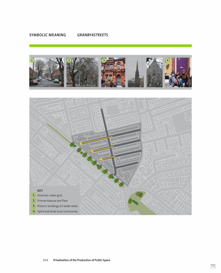
364 Privatisation of the Production of Public Space
SYMBOLIC MEANING GRANBY4STREETS
KEY
Victorian urban grid
Princes Avenue and Park
Historic buildings (in wider area)
Spirit and drive local community
1.
2.
3.
4.
1. 2. 3. 4.
TOC
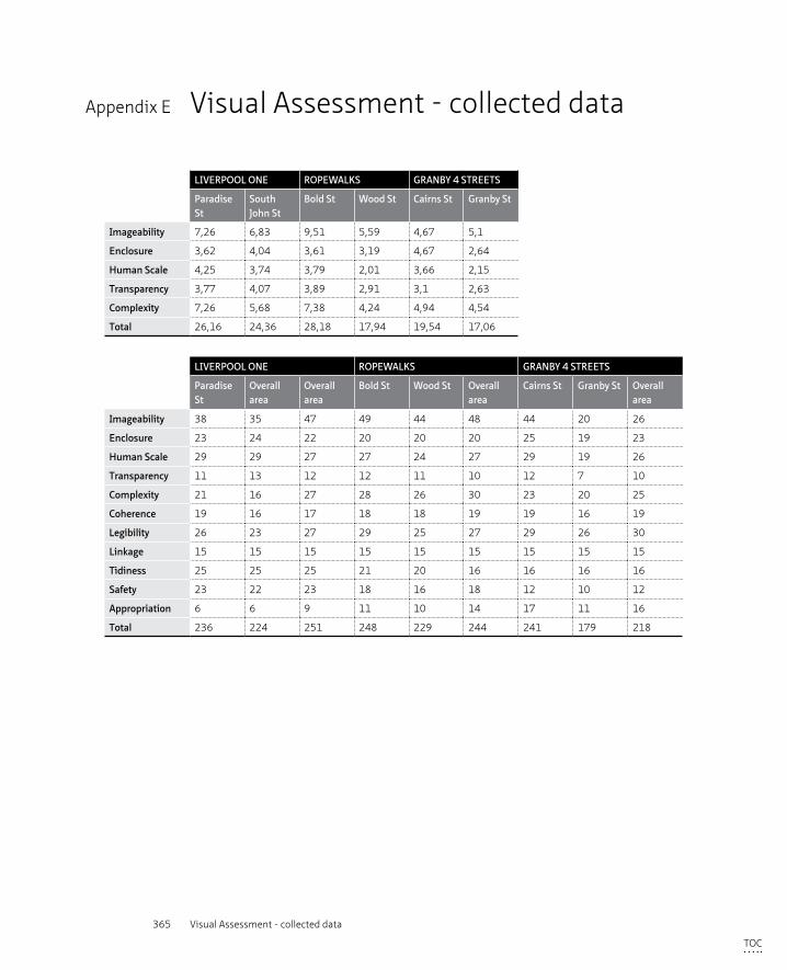
365 Visual Assessment - collected data
Appendix E Visual Assessment - collected data
LIVERPOOL ONE ROPEWALKS GRANBY 4 STREETS
Paradise St
South John St
Bold St Wood St Cairns St Granby St
Imageability 7,26 6,83 9,51 5,59 4,67 5,1
Enclosure 3,62 4,04 3,61 3,19 4,67 2,64
Human Scale 4,25 3,74 3,79 2,01 3,66 2,15
Transparency 3,77 4,07 3,89 2,91 3,1 2,63
Complexity 7,26 5,68 7,38 4,24 4,94 4,54
Total 26,16 24,36 28,18 17,94 19,54 17,06
LIVERPOOL ONE ROPEWALKS GRANBY 4 STREETS
Paradise St
Overall area
Overall area
Bold St Wood St Overall area
Cairns St Granby St Overall area
Imageability 38 35 47 49 44 48 44 20 26
Enclosure 23 24 22 20 20 20 25 19 23
Human Scale 29 29 27 27 24 27 29 19 26
Transparency 11 13 12 12 11 10 12 7 10
Complexity 21 16 27 28 26 30 23 20 25
Coherence 19 16 17 18 18 19 19 16 19
Legibility 26 23 27 29 25 27 29 26 30
Linkage 15 15 15 15 15 15 15 15 15
Tidiness 25 25 25 21 20 16 16 16 16
Safety 23 22 23 18 16 18 12 10 12
Appropriation 6 6 9 11 10 14 17 11 16
Total 236 224 251 248 229 244 241 179 218
TOC
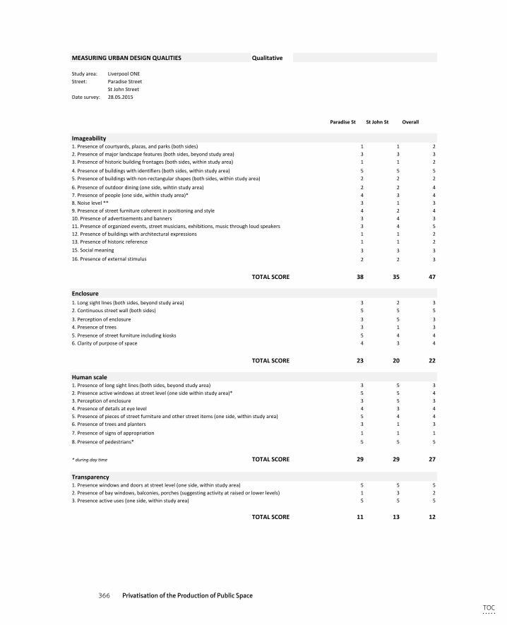
366 Privatisation of the Production of Public Space
MEASURINGURBANDESIGNQUALITIES Qualitative
Studyarea: LiverpoolONEStreet: ParadiseStreet
StJohnStreetDatesurvey: 28.05.2015
ParadiseSt StJohnSt Overall
Imageability1.Presenceofcourtyards,plazas,andparks(bothsides) 1 1 22.Presenceofmajorlandscapefeatures(bothsides,beyondstudyarea) 3 3 33.Presenceofhistoricbuildingfrontages(bothsides,withinstudyarea) 1 1 2
4.Presenceofbuildingswithidentifiers(bothsides,withinstudyarea) 5 5 55.Presenceofbuildingswithnon-rectangularshapes(bothsides,withinstudyarea) 2 2 2
6.Presenceofoutdoordining(oneside,wihtinstudyarea) 2 2 47.Presenceofpeople(oneside,withinstudyarea)* 4 3 48.Noiselevel** 3 1 39.Presenceofstreetfurniturecoherentinpositioningandstyle 4 2 410.Presenceofadvertisementsandbanners 3 4 311.Presenceoforganizedevents,streetmusicians,exhibitions,musicthroughloudspeakers 3 4 512.Presenceofbuildingswitharchitecturalexpressions 1 1 213.Presenceofhistoricreference 1 1 215.Socialmeaning 3 3 316.Presenceofexternalstimulus 2 2 3
TOTALSCORE 38 35 47
Enclosure1.Longsightlines(bothsides,beyondstudyarea) 3 2 32.Continuousstreetwall(bothsides) 5 5 5
3.Perceptionofenclosure 3 5 34.Presenceoftrees 3 1 35.Presenceofstreetfurnitureincludingkiosks 5 4 46.Clarityofpurposeofspace 4 3 4
TOTALSCORE 23 20 22
Humanscale1.Presenceoflongsightlines(bothsides,beyondstudyarea) 3 5 32.Presenceactivewindowsatstreetlevel(onesidewithinstudyarea)* 5 5 43.Perceptionofenclosure 3 5 34.Presenceofdetailsateyelevel 4 3 45.Presenceofpiecesofstreetfurnitureandotherstreetitems(oneside,withinstudyarea) 5 4 46.Presenceoftreesandplanters 3 1 3
7.Presenceofsignsofappropriation 1 1 1
8.Presenceofpedestrians* 5 5 5
*duringdaytime TOTALSCORE 29 29 27
Transparency1.Presencewindowsanddoorsatstreetlevel(oneside,withinstudyarea) 5 5 52.Presenceofbaywindows,balconies,porches(suggestingactivityatraisedorlowerlevels) 1 3 23.Presenceactiveuses(oneside,withinstudyarea) 5 5 5
TOTALSCORE 11 13 12
Complexity1.Varietyofbuildings(bothsides,beyondstudyarea) 3 2 4
2.Varietyoftexture,shape&colour 2 1 33.Varietyofuse 1 1 24.Presenceofoutdoordining(oneside,withinstudyarea) 2 2 45.Presenceofpedestrians 5 5 56.Presenceandorganisationofstreetfurnitureandtrees 4 3 47.Presenceofpublicart,streetartists 1 1 28.Perceptiononstimulation 3 1 3
TOC
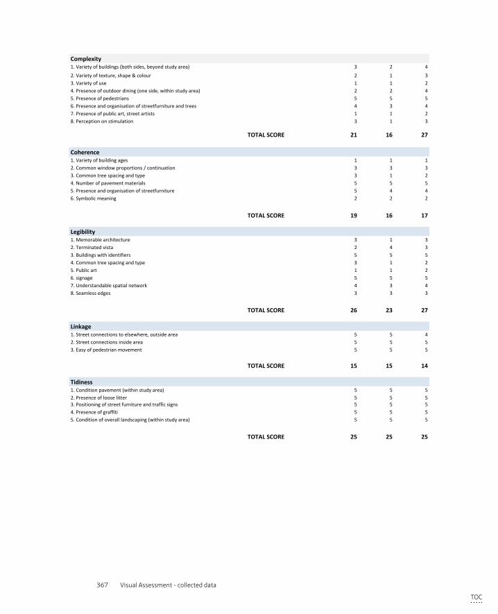
367 Visual Assessment - collected data
TOTALSCORE 21 16 27
Coherence1.Varietyofbuildingages 1 1 12.Commonwindowproportions/continuation 3 3 33.Commontreespacingandtype 3 1 24.Numberofpavementmaterials 5 5 55.Presenceandorganisationofstreetfurniture 5 4 46.Symbolicmeaning 2 2 2
TOTALSCORE 19 16 17
Legibility1.Memorablearchitecture 3 1 32.Terminatedvista 2 4 33.Buildingswithidentifiers 5 5 54.Commontreespacingandtype 3 1 25.Publicart 1 1 26.signage 5 5 57.Understandablespatialnetwork 4 3 48.Seamlessedges 3 3 3
TOTALSCORE 26 23 27
Linkage1.Streetconnectionstoelsewhere,outsidearea 5 5 42.Streetconnectionsinsidearea 5 5 53.Easyofpedestrianmovement 5 5 5
TOTALSCORE 15 15 14
Tidiness1.Conditionpavement(withinstudyarea) 5 5 52.Presenceoflooselitter 5 5 5
5.Presenceofstreetfurnitureincludingkiosks 5 4 46.Clarityofpurposeofspace 4 3 4
TOTALSCORE 23 20 22
Humanscale1.Presenceoflongsightlines(bothsides,beyondstudyarea) 3 5 32.Presenceactivewindowsatstreetlevel(onesidewithinstudyarea)* 5 5 43.Perceptionofenclosure 3 5 34.Presenceofdetailsateyelevel 4 3 45.Presenceofpiecesofstreetfurnitureandotherstreetitems(oneside,withinstudyarea) 5 4 46.Presenceoftreesandplanters 3 1 3
7.Presenceofsignsofappropriation 1 1 1
8.Presenceofpedestrians* 5 5 5
*duringdaytime TOTALSCORE 29 29 27
Transparency1.Presencewindowsanddoorsatstreetlevel(oneside,withinstudyarea) 5 5 52.Presenceofbaywindows,balconies,porches(suggestingactivityatraisedorlowerlevels) 1 3 23.Presenceactiveuses(oneside,withinstudyarea) 5 5 5
TOTALSCORE 11 13 12
Complexity1.Varietyofbuildings(bothsides,beyondstudyarea) 3 2 4
2.Varietyoftexture,shape&colour 2 1 33.Varietyofuse 1 1 24.Presenceofoutdoordining(oneside,withinstudyarea) 2 2 45.Presenceofpedestrians 5 5 56.Presenceandorganisationofstreetfurnitureandtrees 4 3 47.Presenceofpublicart,streetartists 1 1 28.Perceptiononstimulation 3 1 3
3.Positioningofstreetfurnitureandtrafficsigns 5 5 54.Presenceofgraffiti 5 5 55.Conditionofoveralllandscaping(withinstudyarea) 5 5 5
TOTALSCORE 25 25 25
Surveillance1.PresenceofCCTVcamera's(withinstudyarea) 5 5 52.Presenceofpeople 4 3 43.Presenceofsecurityguards(withinstudyarea) 3 3 34.Policepresence(withinstudyarea) 1 1 15.Numberofblankfacades(onesideofstudyarea) 5 5 46.Numberofbuildingsoccupied(onesideofstudyarea) 5 5 5
TOTALSCORE 23 22 22
Appropriation1.Planters/green(withinstudyarea) 1 1 12.Undesignatedseating(withinstudyarea) 1 1 23.Presenceofoutdoordining(oneside,wihtinstudyarea) 2 2 44.Presenceofgraffiti/localart(withinstudyarea) 1 1 15.Presenceofstreetartists,musiciansetc.)* 1 1 1
*onowninitiative,invited=event TOTALSCORE 6 6 9TOC
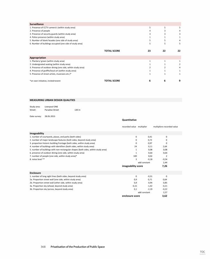
368 Privatisation of the Production of Public Space
3.Positioningofstreetfurnitureandtrafficsigns 5 5 54.Presenceofgraffiti 5 5 55.Conditionofoveralllandscaping(withinstudyarea) 5 5 5
TOTALSCORE 25 25 25
Surveillance1.PresenceofCCTVcamera's(withinstudyarea) 5 5 52.Presenceofpeople 4 3 43.Presenceofsecurityguards(withinstudyarea) 3 3 34.Policepresence(withinstudyarea) 1 1 15.Numberofblankfacades(onesideofstudyarea) 5 5 46.Numberofbuildingsoccupied(onesideofstudyarea) 5 5 5
TOTALSCORE 23 22 22
Appropriation1.Planters/green(withinstudyarea) 1 1 12.Undesignatedseating(withinstudyarea) 1 1 23.Presenceofoutdoordining(oneside,wihtinstudyarea) 2 2 44.Presenceofgraffiti/localart(withinstudyarea) 1 1 15.Presenceofstreetartists,musiciansetc.)* 1 1 1
*onowninitiative,invited=event TOTALSCORE 6 6 9
MEASURINGURBANDESIGNQUALITIES
Studyarea: LiverpoolONEStreet: ParadiseStreet 130m
Datesurvey: 28.05.2015
Quantitative
recordedvalue multiplier multiplierxrecordedvalue
Imageability1.numberofcourtyards,plazas,andparks(bothsides) 0 0,41 02.numberofmajorlandscapefeatures(bothsides,beyondstudyarea) 0 0,72 03.proportionhistoricbuildingfrontage(bothsides,withinstudyarea) 0 0,97 04.numberofbuildingswithidentifiers(bothsides,withinstudyarea) 24 0,11 2,645.numberofbuildingswithnon-rectangularshapes(bothsides,withinstudyarea) 1 0,08 0,086.presenceofoutdoordining(oneside,wihtinstudyarea) 1 0,64 0,647.numberofpeople(oneside,withinstudyarea)* 100 0,02 28.noiselevel** 3 -0,18 -0,54
addconstant 2,44
imageabilityscore 7,26
Enclosure1.numberoflongsightlines(bothsides,beyondstudyarea) 0 -0,31 02a.Proportionstreetwall(oneside,withinstudyarea) 0,9 0,71 0,642b.Proportionstreetwall(otherside,withinstudyarea) 0,9 0,94 0,853a.Proportionsky(ahead,beyondstudyarea) 0,15 -1,42 -0,213b.Proportionsky(across,beyondstudyarea) 0,1 -2,19 -0,22
addconstant 2,57
enclosurescore 3,62
Humanscale1.numberoflongsightlines(bothsides,beyondstudyarea) 0 -0,74 02.proportionwindowsatstreetlevel(onesidewithinstudyarea) 0,7 1,1 0,773.averagebuildingheight(oneside,withinstudyarea) 69 -0,003 -0,21
TOC

369 Visual Assessment - collected data
MEASURINGURBANDESIGNQUALITIES
Studyarea: LiverpoolONEStreet: ParadiseStreet 130m
Datesurvey: 28.05.2015
Quantitative
recordedvalue multiplier multiplierxrecordedvalue
Imageability1.numberofcourtyards,plazas,andparks(bothsides) 0 0,41 02.numberofmajorlandscapefeatures(bothsides,beyondstudyarea) 0 0,72 03.proportionhistoricbuildingfrontage(bothsides,withinstudyarea) 0 0,97 04.numberofbuildingswithidentifiers(bothsides,withinstudyarea) 24 0,11 2,645.numberofbuildingswithnon-rectangularshapes(bothsides,withinstudyarea) 1 0,08 0,086.presenceofoutdoordining(oneside,wihtinstudyarea) 1 0,64 0,647.numberofpeople(oneside,withinstudyarea)* 100 0,02 28.noiselevel** 3 -0,18 -0,54
addconstant 2,44
imageabilityscore 7,26
Enclosure1.numberoflongsightlines(bothsides,beyondstudyarea) 0 -0,31 02a.Proportionstreetwall(oneside,withinstudyarea) 0,9 0,71 0,642b.Proportionstreetwall(otherside,withinstudyarea) 0,9 0,94 0,853a.Proportionsky(ahead,beyondstudyarea) 0,15 -1,42 -0,213b.Proportionsky(across,beyondstudyarea) 0,1 -2,19 -0,22
addconstant 2,57
enclosurescore 3,62
Humanscale1.numberoflongsightlines(bothsides,beyondstudyarea) 0 -0,74 02.proportionwindowsatstreetlevel(onesidewithinstudyarea) 0,7 1,1 0,773.averagebuildingheight(oneside,withinstudyarea) 69 -0,003 -0,214.numberofsmallplanters(oneside,withinstudyarea) 0 0,05 0,005.numberofpiecesofstreetfurnitureandotherstreetitems(oneside,withinstudyarea) 27 0,04 1,08
addconstant 2,61
humanscalescore 4,25
Transparency1.proportionwindowsatstreetlevel(oneside,withinstudyarea) 0,85 1,22 1,042.proportionstreetwall(oneside,beyondstudyarea) 0,9 0,67 0,603.proportionactiveuses(oneside,withinstudyarea) 0,8 0,53 0,42
addconstant 1,71
transparencyscore 3,77
Complexity1.numberofbuildings(bothsides,beoyondstudyarea) 6 0,05 0,32a.numberofbasicbuildingcolours(bothsides,beyondstudyarea)*** 3 0,23 0,692b.numberofbasicaccentcolours(bothsides,beyondstudyarea)*** 2 0,12 0,243.presenceofoutdoordining(oneside,withinstudyarea) 1 0,42 0,424.numberofpublicart(bothsides,withinstudyarea) 0 0,29 05.numberofwalkingpedestrians(oneside,withinstudyarea)* 100 0,03 3
addconstant 2,61
complexityscore 7,26
MEASURINGURBANDESIGNQUALITIES
Studyarea: LiverpoolONEStreet: SouthJohnStreet 120m
Datesurvey: 28.05.2015
Quantitative
recordedvalue multiplier multiplierxrecordedvalue
Imageability1.numberofcourtyards,plazas,andparks(bothsides) 1 0,41 0,412.numberofmajorlandscapefeatures(bothsides,beyondstudyarea) 0 0,72 03.proportionhistoricbuildingfrontage(bothsides,withinstudyarea) 0 0,97 04.numberofbuildingswithidentifiers(bothsides,withinstudyarea) 22 0,11 2,425.numberofbuildingswithnon-rectangularshapes(bothsides,withinstudyarea) 0 0,08 06.presenceofoutdoordining(oneside,wihtinstudyarea) 2 0,64 1,287.numberofpeople(oneside,withinstudyarea)* 50 0,02 18.noiselevel** 4 -0,18 -0,72
addconstant 2,44
imageabilityscore 6,83
Enclosure1.numberoflongsightlines(bothsides,beyondstudyarea) 0 -0,31 02a.Proportionstreetwall(oneside,withinstudyarea) 1 0,71 0,712b.Proportionstreetwall(otherside,withinstudyarea) 1 0,94 0,943a.Proportionsky(ahead,beyondstudyarea) 0,05 -1,42 -0,0713b.Proportionsky(across,beyondstudyarea) 0,05 -2,19 -0,11
addconstant 2,57
enclosurescore 4,04
Humanscale1.numberoflongsightlines(bothsides,beyondstudyarea) 0 -0,74 02.proportionwindowsatstreetlevel(onesidewithinstudyarea) 0,95 1,1 1,053.averagebuildingheight(oneside,withinstudyarea) 79 -0,003 -0,24
TOC
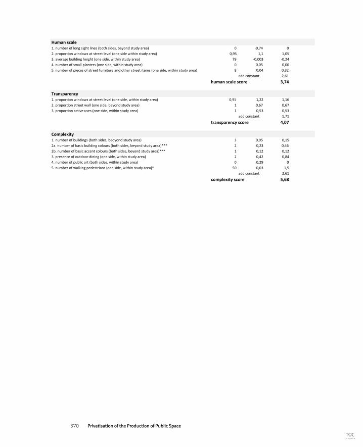
370 Privatisation of the Production of Public Space
MEASURINGURBANDESIGNQUALITIES
Studyarea: LiverpoolONEStreet: SouthJohnStreet 120m
Datesurvey: 28.05.2015
Quantitative
recordedvalue multiplier multiplierxrecordedvalue
Imageability1.numberofcourtyards,plazas,andparks(bothsides) 1 0,41 0,412.numberofmajorlandscapefeatures(bothsides,beyondstudyarea) 0 0,72 03.proportionhistoricbuildingfrontage(bothsides,withinstudyarea) 0 0,97 04.numberofbuildingswithidentifiers(bothsides,withinstudyarea) 22 0,11 2,425.numberofbuildingswithnon-rectangularshapes(bothsides,withinstudyarea) 0 0,08 06.presenceofoutdoordining(oneside,wihtinstudyarea) 2 0,64 1,287.numberofpeople(oneside,withinstudyarea)* 50 0,02 18.noiselevel** 4 -0,18 -0,72
addconstant 2,44
imageabilityscore 6,83
Enclosure1.numberoflongsightlines(bothsides,beyondstudyarea) 0 -0,31 02a.Proportionstreetwall(oneside,withinstudyarea) 1 0,71 0,712b.Proportionstreetwall(otherside,withinstudyarea) 1 0,94 0,943a.Proportionsky(ahead,beyondstudyarea) 0,05 -1,42 -0,0713b.Proportionsky(across,beyondstudyarea) 0,05 -2,19 -0,11
addconstant 2,57
enclosurescore 4,04
Humanscale1.numberoflongsightlines(bothsides,beyondstudyarea) 0 -0,74 02.proportionwindowsatstreetlevel(onesidewithinstudyarea) 0,95 1,1 1,053.averagebuildingheight(oneside,withinstudyarea) 79 -0,003 -0,244.numberofsmallplanters(oneside,withinstudyarea) 0 0,05 0,005.numberofpiecesofstreetfurnitureandotherstreetitems(oneside,withinstudyarea) 8 0,04 0,32
addconstant 2,61
humanscalescore 3,74
Transparency1.proportionwindowsatstreetlevel(oneside,withinstudyarea) 0,95 1,22 1,162.proportionstreetwall(oneside,beyondstudyarea) 1 0,67 0,673.proportionactiveuses(oneside,withinstudyarea) 1 0,53 0,53
addconstant 1,71
transparencyscore 4,07
Complexity1.numberofbuildings(bothsides,beoyondstudyarea) 3 0,05 0,152a.numberofbasicbuildingcolours(bothsides,beyondstudyarea)*** 2 0,23 0,462b.numberofbasicaccentcolours(bothsides,beyondstudyarea)*** 1 0,12 0,123.presenceofoutdoordining(oneside,withinstudyarea) 2 0,42 0,844.numberofpublicart(bothsides,withinstudyarea) 0 0,29 05.numberofwalkingpedestrians(oneside,withinstudyarea)* 50 0,03 1,5
addconstant 2,61
complexityscore 5,68
TOC
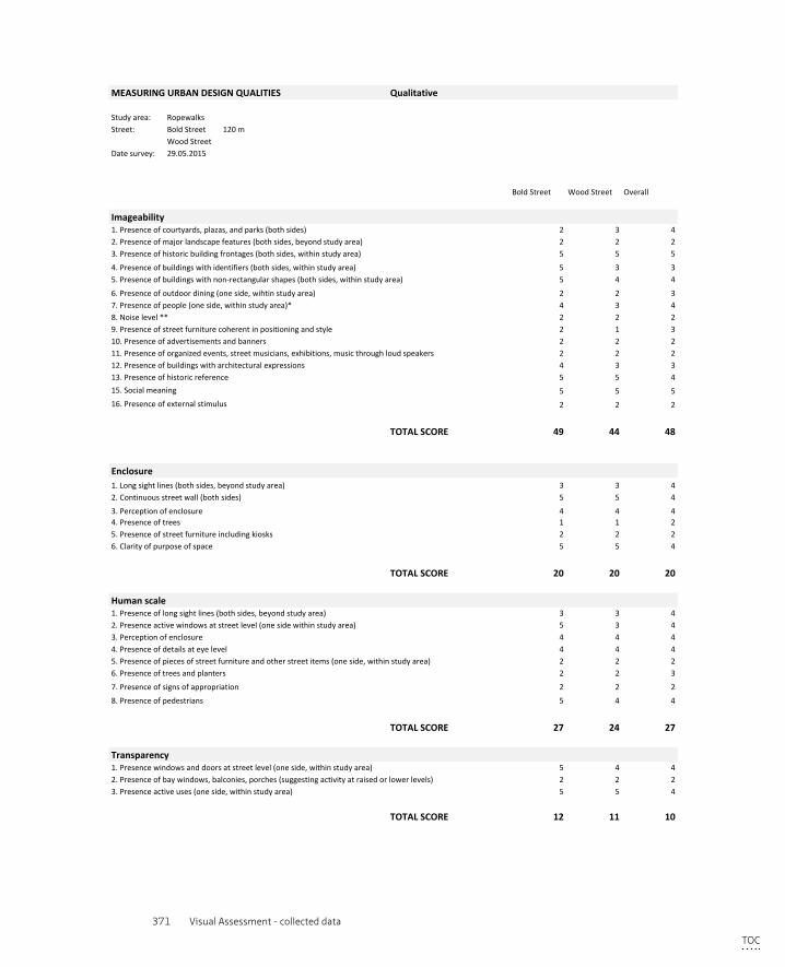
371 Visual Assessment - collected data
MEASURINGURBANDESIGNQUALITIES Qualitative
Studyarea: RopewalksStreet: BoldStreet 120m
WoodStreetDatesurvey: 29.05.2015
BoldStreet WoodStreet Overall
Imageability1.Presenceofcourtyards,plazas,andparks(bothsides) 2 3 42.Presenceofmajorlandscapefeatures(bothsides,beyondstudyarea) 2 2 23.Presenceofhistoricbuildingfrontages(bothsides,withinstudyarea) 5 5 5
4.Presenceofbuildingswithidentifiers(bothsides,withinstudyarea) 5 3 35.Presenceofbuildingswithnon-rectangularshapes(bothsides,withinstudyarea) 5 4 4
6.Presenceofoutdoordining(oneside,wihtinstudyarea) 2 2 37.Presenceofpeople(oneside,withinstudyarea)* 4 3 48.Noiselevel** 2 2 29.Presenceofstreetfurniturecoherentinpositioningandstyle 2 1 310.Presenceofadvertisementsandbanners 2 2 211.Presenceoforganizedevents,streetmusicians,exhibitions,musicthroughloudspeakers 2 2 212.Presenceofbuildingswitharchitecturalexpressions 4 3 313.Presenceofhistoricreference 5 5 415.Socialmeaning 5 5 516.Presenceofexternalstimulus 2 2 2
TOTALSCORE 49 44 48
Enclosure1.Longsightlines(bothsides,beyondstudyarea) 3 3 42.Continuousstreetwall(bothsides) 5 5 4
3.Perceptionofenclosure 4 4 44.Presenceoftrees 1 1 25.Presenceofstreetfurnitureincludingkiosks 2 2 26.Clarityofpurposeofspace 5 5 4
TOTALSCORE 20 20 20
Humanscale1.Presenceoflongsightlines(bothsides,beyondstudyarea) 3 3 42.Presenceactivewindowsatstreetlevel(onesidewithinstudyarea) 5 3 43.Perceptionofenclosure 4 4 44.Presenceofdetailsateyelevel 4 4 45.Presenceofpiecesofstreetfurnitureandotherstreetitems(oneside,withinstudyarea) 2 2 26.Presenceoftreesandplanters 2 2 3
7.Presenceofsignsofappropriation 2 2 2
8.Presenceofpedestrians 5 4 4
TOTALSCORE 27 24 27
Transparency1.Presencewindowsanddoorsatstreetlevel(oneside,withinstudyarea) 5 4 42.Presenceofbaywindows,balconies,porches(suggestingactivityatraisedorlowerlevels) 2 2 23.Presenceactiveuses(oneside,withinstudyarea) 5 5 4
TOTALSCORE 12 11 10
Complexity1.Varietyofbuildings(bothsides,beyondstudyarea) 5 5 5
2.Varietyoftexture,shape&colour 4 4 43.Varietyofuse 4 4 44.Presenceofoutdoordining(oneside,withinstudyarea) 2 2 35.Presenceofpedestrians 5 4 46.Presenceandorganisationofstreetfurnitureandtrees 2 2 37.Presenceofpublicart,streetartists 2 2 3
8.Perceptiononstimulation 4 3 4 TOC

372 Privatisation of the Production of Public Space
TOTALSCORE 28 26 30
Coherence1.Varietyofbuildingages 3 3 32.Commonwindowproportions/continuation 3 3 33.Commontreespacingandtype 1 1 24.Numberofpavementmaterials 4 4 35.Presenceandorganisationofstreetfurniture 2 2 36.Symbolicmeaning 5 5 5
TOTALSCORE 18 18 19
Legibility1.Memorablearchitecture 4 4 42.Terminatedvista 5 3 43.Buildingswithidentifiers 5 3 34.Commontreespacingandtype 1 1 25.Publicart 2 2 36.Signage 3 3 37.Understandablespatialnetwork 4 4 48.Seamlessedges 4 4 4
TOTALSCORE 28 24 27
Linkage1.Streetconnectionstoelsewhere,outsidearea 5 5 42.Streetconnectionsinsidearea 5 5 53.Easyofpedestrianmovement 5 5 5
TOTALSCORE 15 15 14
Tidiness1.Conditionpavement(withinstudyarea) 4 4 3
4.Presenceoftrees 1 1 25.Presenceofstreetfurnitureincludingkiosks 2 2 26.Clarityofpurposeofspace 5 5 4
TOTALSCORE 20 20 20
Humanscale1.Presenceoflongsightlines(bothsides,beyondstudyarea) 3 3 42.Presenceactivewindowsatstreetlevel(onesidewithinstudyarea) 5 3 43.Perceptionofenclosure 4 4 44.Presenceofdetailsateyelevel 4 4 45.Presenceofpiecesofstreetfurnitureandotherstreetitems(oneside,withinstudyarea) 2 2 26.Presenceoftreesandplanters 2 2 3
7.Presenceofsignsofappropriation 2 2 2
8.Presenceofpedestrians 5 4 4
TOTALSCORE 27 24 27
Transparency1.Presencewindowsanddoorsatstreetlevel(oneside,withinstudyarea) 5 4 42.Presenceofbaywindows,balconies,porches(suggestingactivityatraisedorlowerlevels) 2 2 23.Presenceactiveuses(oneside,withinstudyarea) 5 5 4
TOTALSCORE 12 11 10
Complexity1.Varietyofbuildings(bothsides,beyondstudyarea) 5 5 5
2.Varietyoftexture,shape&colour 4 4 43.Varietyofuse 4 4 44.Presenceofoutdoordining(oneside,withinstudyarea) 2 2 35.Presenceofpedestrians 5 4 46.Presenceandorganisationofstreetfurnitureandtrees 2 2 37.Presenceofpublicart,streetartists 2 2 3
8.Perceptiononstimulation 4 3 4
2.Presenceoflooselitter 4 3 33.Positioningofstreetfurnitureandtrafficsigns 5 5 44.Presenceofgraffiti 4 4 35.Conditionofoveralllandscaping(withinstudyarea) 4 4 3
TOTALSCORE 21 20 16
Surveillance1.PresenceofCCTVcamera's(withinstudyarea) 2 3 32.Presenceofpeople 4 3 43.Presenceofsecurityguards(withinstudyarea) 1 1 24.Policepresence(withinstudyarea) 1 1 15.Numberofblankfacades(onesideofstudyarea) 5 4 46.Numberofbuildingsoccupied(onesideofstudyarea) 5 4 4
TOTALSCORE 18 16 18
Appropriation1.Planters(withinstudyarea) 2 1 22.Undesignatedseating(withinstudyarea) 2 2 23.Presenceofoutdoordining(oneside,wihtinstudyarea) 2 2 34.Presenceofgraffiti(withinstudyarea) 3 3 45.Presenceofstreetartists,musiciansetc.)* 2 2 3
*onowninitiative,invited=event TOTALSCORE 11 10 14
TOC
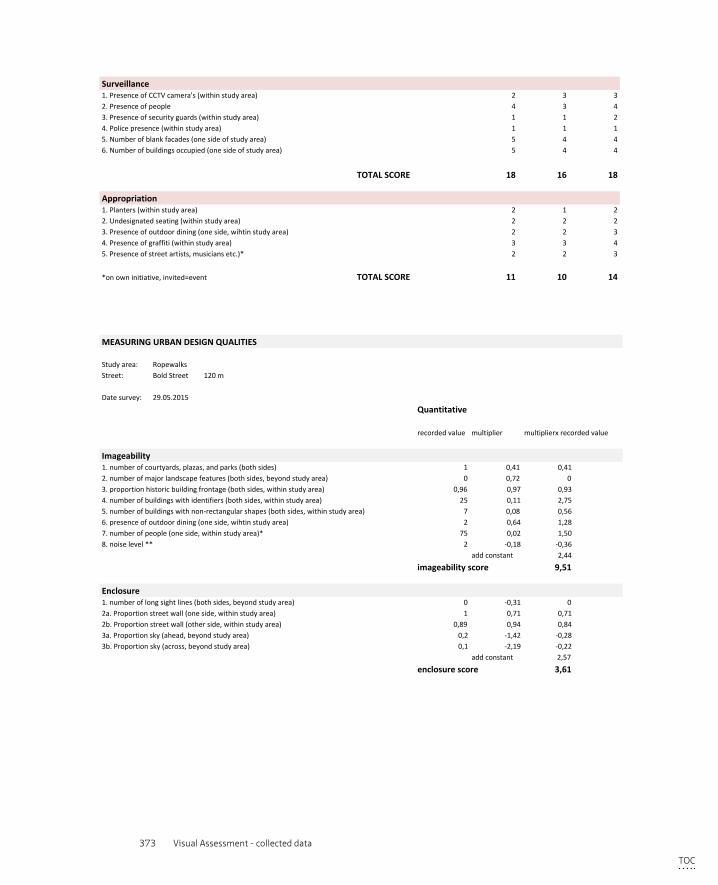
373 Visual Assessment - collected data
2.Presenceoflooselitter 4 3 33.Positioningofstreetfurnitureandtrafficsigns 5 5 44.Presenceofgraffiti 4 4 35.Conditionofoveralllandscaping(withinstudyarea) 4 4 3
TOTALSCORE 21 20 16
Surveillance1.PresenceofCCTVcamera's(withinstudyarea) 2 3 32.Presenceofpeople 4 3 43.Presenceofsecurityguards(withinstudyarea) 1 1 24.Policepresence(withinstudyarea) 1 1 15.Numberofblankfacades(onesideofstudyarea) 5 4 46.Numberofbuildingsoccupied(onesideofstudyarea) 5 4 4
TOTALSCORE 18 16 18
Appropriation1.Planters(withinstudyarea) 2 1 22.Undesignatedseating(withinstudyarea) 2 2 23.Presenceofoutdoordining(oneside,wihtinstudyarea) 2 2 34.Presenceofgraffiti(withinstudyarea) 3 3 45.Presenceofstreetartists,musiciansetc.)* 2 2 3
*onowninitiative,invited=event TOTALSCORE 11 10 14
MEASURINGURBANDESIGNQUALITIES
Studyarea: RopewalksStreet: BoldStreet 120m
Datesurvey: 29.05.2015
Quantitative
recordedvalue multiplier multiplierxrecordedvalue
Imageability1.numberofcourtyards,plazas,andparks(bothsides) 1 0,41 0,412.numberofmajorlandscapefeatures(bothsides,beyondstudyarea) 0 0,72 03.proportionhistoricbuildingfrontage(bothsides,withinstudyarea) 0,96 0,97 0,934.numberofbuildingswithidentifiers(bothsides,withinstudyarea) 25 0,11 2,755.numberofbuildingswithnon-rectangularshapes(bothsides,withinstudyarea) 7 0,08 0,566.presenceofoutdoordining(oneside,wihtinstudyarea) 2 0,64 1,287.numberofpeople(oneside,withinstudyarea)* 75 0,02 1,508.noiselevel** 2 -0,18 -0,36
addconstant 2,44
imageabilityscore 9,51
Enclosure1.numberoflongsightlines(bothsides,beyondstudyarea) 0 -0,31 02a.Proportionstreetwall(oneside,withinstudyarea) 1 0,71 0,712b.Proportionstreetwall(otherside,withinstudyarea) 0,89 0,94 0,843a.Proportionsky(ahead,beyondstudyarea) 0,2 -1,42 -0,283b.Proportionsky(across,beyondstudyarea) 0,1 -2,19 -0,22
addconstant 2,57
enclosurescore 3,61
Humanscale1.numberoflongsightlines(bothsides,beyondstudyarea) 0 -0,74 02.proportionwindowsatstreetlevel(onesidewithinstudyarea) 0,8 1,1 0,883.averagebuildingheight(oneside,withinstudyarea) 39 -0,003 -0,12
TOC
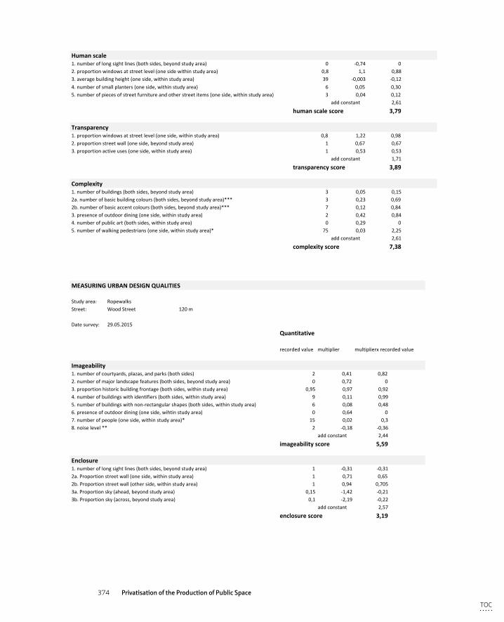
374 Privatisation of the Production of Public Space
MEASURINGURBANDESIGNQUALITIES
Studyarea: RopewalksStreet: BoldStreet 120m
Datesurvey: 29.05.2015
Quantitative
recordedvalue multiplier multiplierxrecordedvalue
Imageability1.numberofcourtyards,plazas,andparks(bothsides) 1 0,41 0,412.numberofmajorlandscapefeatures(bothsides,beyondstudyarea) 0 0,72 03.proportionhistoricbuildingfrontage(bothsides,withinstudyarea) 0,96 0,97 0,934.numberofbuildingswithidentifiers(bothsides,withinstudyarea) 25 0,11 2,755.numberofbuildingswithnon-rectangularshapes(bothsides,withinstudyarea) 7 0,08 0,566.presenceofoutdoordining(oneside,wihtinstudyarea) 2 0,64 1,287.numberofpeople(oneside,withinstudyarea)* 75 0,02 1,508.noiselevel** 2 -0,18 -0,36
addconstant 2,44
imageabilityscore 9,51
Enclosure1.numberoflongsightlines(bothsides,beyondstudyarea) 0 -0,31 02a.Proportionstreetwall(oneside,withinstudyarea) 1 0,71 0,712b.Proportionstreetwall(otherside,withinstudyarea) 0,89 0,94 0,843a.Proportionsky(ahead,beyondstudyarea) 0,2 -1,42 -0,283b.Proportionsky(across,beyondstudyarea) 0,1 -2,19 -0,22
addconstant 2,57
enclosurescore 3,61
Humanscale1.numberoflongsightlines(bothsides,beyondstudyarea) 0 -0,74 02.proportionwindowsatstreetlevel(onesidewithinstudyarea) 0,8 1,1 0,883.averagebuildingheight(oneside,withinstudyarea) 39 -0,003 -0,124.numberofsmallplanters(oneside,withinstudyarea) 6 0,05 0,305.numberofpiecesofstreetfurnitureandotherstreetitems(oneside,withinstudyarea) 3 0,04 0,12
addconstant 2,61
humanscalescore 3,79
Transparency1.proportionwindowsatstreetlevel(oneside,withinstudyarea) 0,8 1,22 0,982.proportionstreetwall(oneside,beyondstudyarea) 1 0,67 0,673.proportionactiveuses(oneside,withinstudyarea) 1 0,53 0,53
addconstant 1,71
transparencyscore 3,89
Complexity1.numberofbuildings(bothsides,beyondstudyarea) 3 0,05 0,152a.numberofbasicbuildingcolours(bothsides,beyondstudyarea)*** 3 0,23 0,692b.numberofbasicaccentcolours(bothsides,beyondstudyarea)*** 7 0,12 0,843.presenceofoutdoordining(oneside,withinstudyarea) 2 0,42 0,844.numberofpublicart(bothsides,withinstudyarea) 0 0,29 05.numberofwalkingpedestrians(oneside,withinstudyarea)* 75 0,03 2,25
addconstant 2,61
complexityscore 7,38
MEASURINGURBANDESIGNQUALITIES
Studyarea: RopewalksStreet: WoodStreet 120m
Datesurvey: 29.05.2015
Quantitative
recordedvalue multiplier multiplierxrecordedvalue
Imageability1.numberofcourtyards,plazas,andparks(bothsides) 2 0,41 0,822.numberofmajorlandscapefeatures(bothsides,beyondstudyarea) 0 0,72 03.proportionhistoricbuildingfrontage(bothsides,withinstudyarea) 0,95 0,97 0,924.numberofbuildingswithidentifiers(bothsides,withinstudyarea) 9 0,11 0,995.numberofbuildingswithnon-rectangularshapes(bothsides,withinstudyarea) 6 0,08 0,486.presenceofoutdoordining(oneside,wihtinstudyarea) 0 0,64 07.numberofpeople(oneside,withinstudyarea)* 15 0,02 0,38.noiselevel** 2 -0,18 -0,36
addconstant 2,44
imageabilityscore 5,59
Enclosure1.numberoflongsightlines(bothsides,beyondstudyarea) 1 -0,31 -0,312a.Proportionstreetwall(oneside,withinstudyarea) 1 0,71 0,652b.Proportionstreetwall(otherside,withinstudyarea) 1 0,94 0,7053a.Proportionsky(ahead,beyondstudyarea) 0,15 -1,42 -0,213b.Proportionsky(across,beyondstudyarea) 0,1 -2,19 -0,22
addconstant 2,57
enclosurescore 3,19
Humanscale1.numberoflongsightlines(bothsides,beyondstudyarea) 1 -0,74 -0,742.proportionwindowsatstreetlevel(onesidewithinstudyarea) 0,2 1,1 0,223.averagebuildingheight(oneside,withinstudyarea) 39 -0,003 -0,12
TOC
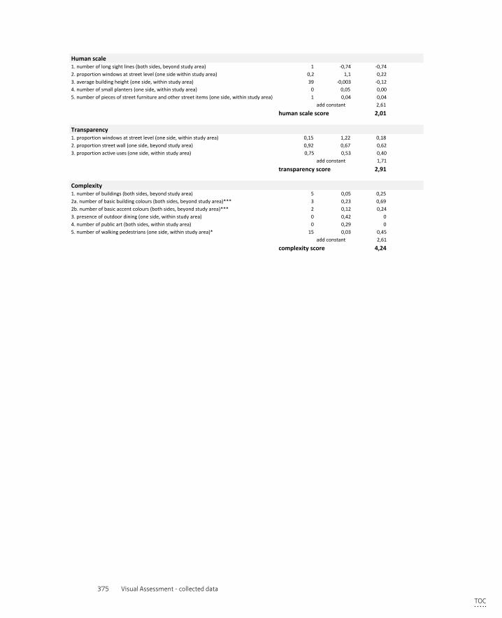
375 Visual Assessment - collected data
MEASURINGURBANDESIGNQUALITIES
Studyarea: RopewalksStreet: WoodStreet 120m
Datesurvey: 29.05.2015
Quantitative
recordedvalue multiplier multiplierxrecordedvalue
Imageability1.numberofcourtyards,plazas,andparks(bothsides) 2 0,41 0,822.numberofmajorlandscapefeatures(bothsides,beyondstudyarea) 0 0,72 03.proportionhistoricbuildingfrontage(bothsides,withinstudyarea) 0,95 0,97 0,924.numberofbuildingswithidentifiers(bothsides,withinstudyarea) 9 0,11 0,995.numberofbuildingswithnon-rectangularshapes(bothsides,withinstudyarea) 6 0,08 0,486.presenceofoutdoordining(oneside,wihtinstudyarea) 0 0,64 07.numberofpeople(oneside,withinstudyarea)* 15 0,02 0,38.noiselevel** 2 -0,18 -0,36
addconstant 2,44
imageabilityscore 5,59
Enclosure1.numberoflongsightlines(bothsides,beyondstudyarea) 1 -0,31 -0,312a.Proportionstreetwall(oneside,withinstudyarea) 1 0,71 0,652b.Proportionstreetwall(otherside,withinstudyarea) 1 0,94 0,7053a.Proportionsky(ahead,beyondstudyarea) 0,15 -1,42 -0,213b.Proportionsky(across,beyondstudyarea) 0,1 -2,19 -0,22
addconstant 2,57
enclosurescore 3,19
Humanscale1.numberoflongsightlines(bothsides,beyondstudyarea) 1 -0,74 -0,742.proportionwindowsatstreetlevel(onesidewithinstudyarea) 0,2 1,1 0,223.averagebuildingheight(oneside,withinstudyarea) 39 -0,003 -0,124.numberofsmallplanters(oneside,withinstudyarea) 0 0,05 0,005.numberofpiecesofstreetfurnitureandotherstreetitems(oneside,withinstudyarea) 1 0,04 0,04
addconstant 2,61
humanscalescore 2,01
Transparency1.proportionwindowsatstreetlevel(oneside,withinstudyarea) 0,15 1,22 0,182.proportionstreetwall(oneside,beyondstudyarea) 0,92 0,67 0,623.proportionactiveuses(oneside,withinstudyarea) 0,75 0,53 0,40
addconstant 1,71
transparencyscore 2,91
Complexity1.numberofbuildings(bothsides,beyondstudyarea) 5 0,05 0,252a.numberofbasicbuildingcolours(bothsides,beyondstudyarea)*** 3 0,23 0,692b.numberofbasicaccentcolours(bothsides,beyondstudyarea)*** 2 0,12 0,243.presenceofoutdoordining(oneside,withinstudyarea) 0 0,42 04.numberofpublicart(bothsides,withinstudyarea) 0 0,29 05.numberofwalkingpedestrians(oneside,withinstudyarea)* 15 0,03 0,45
addconstant 2,61
complexityscore 4,24
TOC
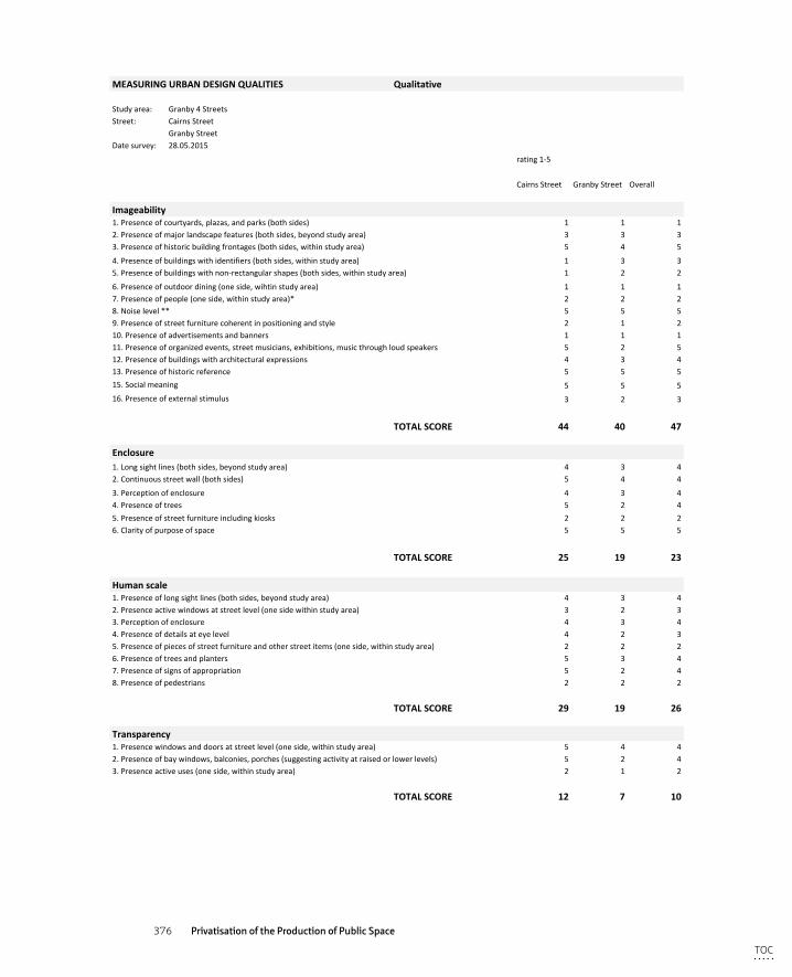
376 Privatisation of the Production of Public Space
MEASURINGURBANDESIGNQUALITIES Qualitative
Studyarea: Granby4StreetsStreet: CairnsStreet
GranbyStreetDatesurvey: 28.05.2015
rating1-5
CairnsStreet GranbyStreet Overall
Imageability1.Presenceofcourtyards,plazas,andparks(bothsides) 1 1 12.Presenceofmajorlandscapefeatures(bothsides,beyondstudyarea) 3 3 33.Presenceofhistoricbuildingfrontages(bothsides,withinstudyarea) 5 4 5
4.Presenceofbuildingswithidentifiers(bothsides,withinstudyarea) 1 3 35.Presenceofbuildingswithnon-rectangularshapes(bothsides,withinstudyarea) 1 2 2
6.Presenceofoutdoordining(oneside,wihtinstudyarea) 1 1 17.Presenceofpeople(oneside,withinstudyarea)* 2 2 28.Noiselevel** 5 5 59.Presenceofstreetfurniturecoherentinpositioningandstyle 2 1 210.Presenceofadvertisementsandbanners 1 1 111.Presenceoforganizedevents,streetmusicians,exhibitions,musicthroughloudspeakers 5 2 512.Presenceofbuildingswitharchitecturalexpressions 4 3 413.Presenceofhistoricreference 5 5 515.Socialmeaning 5 5 516.Presenceofexternalstimulus 3 2 3
TOTALSCORE 44 40 47
Enclosure1.Longsightlines(bothsides,beyondstudyarea) 4 3 42.Continuousstreetwall(bothsides) 5 4 4
3.Perceptionofenclosure 4 3 44.Presenceoftrees 5 2 45.Presenceofstreetfurnitureincludingkiosks 2 2 26.Clarityofpurposeofspace 5 5 5
TOTALSCORE 25 19 23
Humanscale1.Presenceoflongsightlines(bothsides,beyondstudyarea) 4 3 42.Presenceactivewindowsatstreetlevel(onesidewithinstudyarea) 3 2 33.Perceptionofenclosure 4 3 44.Presenceofdetailsateyelevel 4 2 35.Presenceofpiecesofstreetfurnitureandotherstreetitems(oneside,withinstudyarea) 2 2 26.Presenceoftreesandplanters 5 3 47.Presenceofsignsofappropriation 5 2 48.Presenceofpedestrians 2 2 2
TOTALSCORE 29 19 26
Transparency1.Presencewindowsanddoorsatstreetlevel(oneside,withinstudyarea) 5 4 42.Presenceofbaywindows,balconies,porches(suggestingactivityatraisedorlowerlevels) 5 2 43.Presenceactiveuses(oneside,withinstudyarea) 2 1 2
TOTALSCORE 12 7 10
Complexity1.Varietyofbuildings(bothsides,beyondstudyarea) 2 3 3
2.Varietyoftexture,shape&colour 3 2 33.Varietyofuse 2 4 24.Presenceofoutdoordining(oneside,withinstudyarea) 2 1 25.Presenceofpedestrians 2 2 26.Presenceandorganisationofstreetfurnitureandtrees 4 2 47.Presenceofpublicart,streetartists 4 3 5
8.Perceptiononstimulation 4 3 4
TOC
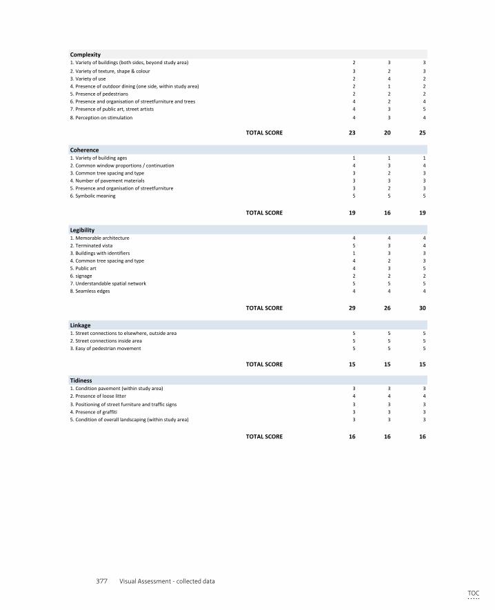
377 Visual Assessment - collected data
TOTALSCORE 23 20 25
Coherence1.Varietyofbuildingages 1 1 12.Commonwindowproportions/continuation 4 3 43.Commontreespacingandtype 3 2 34.Numberofpavementmaterials 3 3 35.Presenceandorganisationofstreetfurniture 3 2 36.Symbolicmeaning 5 5 5
TOTALSCORE 19 16 19
Legibility1.Memorablearchitecture 4 4 42.Terminatedvista 5 3 43.Buildingswithidentifiers 1 3 34.Commontreespacingandtype 4 2 35.Publicart 4 3 56.signage 2 2 27.Understandablespatialnetwork 5 5 58.Seamlessedges 4 4 4
TOTALSCORE 29 26 30
Linkage1.Streetconnectionstoelsewhere,outsidearea 5 5 52.Streetconnectionsinsidearea 5 5 53.Easyofpedestrianmovement 5 5 5
TOTALSCORE 15 15 15
Tidiness1.Conditionpavement(withinstudyarea) 3 3 32.Presenceoflooselitter 4 4 4
5.Presenceofstreetfurnitureincludingkiosks 2 2 26.Clarityofpurposeofspace 5 5 5
TOTALSCORE 25 19 23
Humanscale1.Presenceoflongsightlines(bothsides,beyondstudyarea) 4 3 42.Presenceactivewindowsatstreetlevel(onesidewithinstudyarea) 3 2 33.Perceptionofenclosure 4 3 44.Presenceofdetailsateyelevel 4 2 35.Presenceofpiecesofstreetfurnitureandotherstreetitems(oneside,withinstudyarea) 2 2 26.Presenceoftreesandplanters 5 3 47.Presenceofsignsofappropriation 5 2 48.Presenceofpedestrians 2 2 2
TOTALSCORE 29 19 26
Transparency1.Presencewindowsanddoorsatstreetlevel(oneside,withinstudyarea) 5 4 42.Presenceofbaywindows,balconies,porches(suggestingactivityatraisedorlowerlevels) 5 2 43.Presenceactiveuses(oneside,withinstudyarea) 2 1 2
TOTALSCORE 12 7 10
Complexity1.Varietyofbuildings(bothsides,beyondstudyarea) 2 3 3
2.Varietyoftexture,shape&colour 3 2 33.Varietyofuse 2 4 24.Presenceofoutdoordining(oneside,withinstudyarea) 2 1 25.Presenceofpedestrians 2 2 26.Presenceandorganisationofstreetfurnitureandtrees 4 2 47.Presenceofpublicart,streetartists 4 3 5
8.Perceptiononstimulation 4 3 4
3.Positioningofstreetfurnitureandtrafficsigns 3 3 34.Presenceofgraffiti 3 3 35.Conditionofoveralllandscaping(withinstudyarea) 3 3 3
TOTALSCORE 16 16 16
Surveillance1.PresenceofCCTVcamera's(withinstudyarea) 1 2 22.Presenceofpeople 2 2 23.Presenceofsecurityguards(withinstudyarea) 1 1 14.Policepresence(withinstudyarea) 2 2 25.Numberofblankfacades(onesideofstudyarea) 3 2 36.Numberofbuildingsoccupied(onesideofstudyarea) 3 1 3
TOTALSCORE 12 10 13
Appropriation1.Planters/green(withinstudyarea) 5 2 42.Undesignatedseating(withinstudyarea) 3 2 33.Presenceofoutdoordining(oneside,wihtinstudyarea) 1 1 14.Presenceofgraffiti'localart(withinstudyarea) 5 5 55.Presenceofstreetartists,musiciansetc.)* 3 1 3
*onowninitiative,invited=event TOTALSCORE 17 11 16TOC
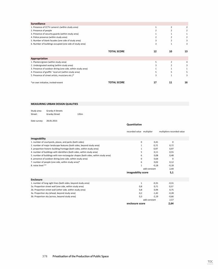
378 Privatisation of the Production of Public Space
3.Positioningofstreetfurnitureandtrafficsigns 3 3 34.Presenceofgraffiti 3 3 35.Conditionofoveralllandscaping(withinstudyarea) 3 3 3
TOTALSCORE 16 16 16
Surveillance1.PresenceofCCTVcamera's(withinstudyarea) 1 2 22.Presenceofpeople 2 2 23.Presenceofsecurityguards(withinstudyarea) 1 1 14.Policepresence(withinstudyarea) 2 2 25.Numberofblankfacades(onesideofstudyarea) 3 2 36.Numberofbuildingsoccupied(onesideofstudyarea) 3 1 3
TOTALSCORE 12 10 13
Appropriation1.Planters/green(withinstudyarea) 5 2 42.Undesignatedseating(withinstudyarea) 3 2 33.Presenceofoutdoordining(oneside,wihtinstudyarea) 1 1 14.Presenceofgraffiti'localart(withinstudyarea) 5 5 55.Presenceofstreetartists,musiciansetc.)* 3 1 3
*onowninitiative,invited=event TOTALSCORE 17 11 16
MEASURINGURBANDESIGNQUALITIES
Studyarea: Granby4StreetsStreet: GranbyStreet 135m
Datesurvey: 28.05.2015
Quantitative
recordedvalue multiplier multiplierxrecordedvalue
Imageability1.numberofcourtyards,plazas,andparks(bothsides) 0 0,41 02.numberofmajorlandscapefeatures(bothsides,beyondstudyarea) 1 0,72 0,723.proportionhistoricbuildingfrontage(bothsides,withinstudyarea) 1 0,97 0,974.numberofbuildingswithidentifiers(bothsides,withinstudyarea) 5 0,11 0,555.numberofbuildingswithnon-rectangularshapes(bothsides,withinstudyarea) 6 0,08 0,486.presenceofoutdoordining(oneside,wihtinstudyarea) 0 0,64 07.numberofpeople(oneside,withinstudyarea)* 6 0,02 0,128.noiselevel** 1 -0,18 -0,18
addconstant 2,44
imageabilityscore 5,1
Enclosure1.numberoflongsightlines(bothsides,beyondstudyarea) 1 -0,31 -0,312a.Proportionstreetwall(oneside,withinstudyarea) 0,8 0,71 0,572b.Proportionstreetwall(otherside,withinstudyarea) 0,8 0,94 0,753a.Proportionsky(ahead,beyondstudyarea) 0,2 -1,42 -0,283b.Proportionsky(across,beyondstudyarea) 0,3 -2,19 -0,66
addconstant 2,57
enclosurescore 2,64
Humanscale1.numberoflongsightlines(bothsides,beyondstudyarea) 1 -0,74 -0,742.proportionwindowsatstreetlevel(onesidewithinstudyarea) 0,1 1,1 0,113.averagebuildingheight(oneside,withinstudyarea) 30 -0,003 -0,09
TOC
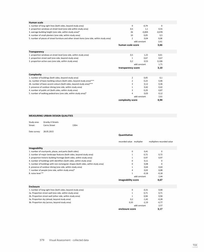
379 Visual Assessment - collected data
MEASURINGURBANDESIGNQUALITIES
Studyarea: Granby4StreetsStreet: CairnsStreet 130m
Datesurvey: 28.05.2015
Quantitative
recordedvalue multiplier multiplierxrecordedvalue
Imageability1.numberofcourtyards,plazas,andparks(bothsides) 0 0,41 02.numberofmajorlandscapefeatures(bothsides,beyondstudyarea) 1 0,72 0,723.proportionhistoricbuildingfrontage(bothsides,withinstudyarea) 1 0,97 0,974.numberofbuildingswithidentifiers(bothsides,withinstudyarea) 0 0,11 05.numberofbuildingswithnon-rectangularshapes(bothsides,withinstudyarea) 0 0,08 06.presenceofoutdoordining(oneside,wihtinstudyarea) 1 0,64 0,647.numberofpeople(oneside,withinstudyarea)* 4 0,02 0,088.noiselevel** 1 -0,18 -0,18
addconstant 2,44
imageabilityscore 4,67
Enclosure1.numberoflongsightlines(bothsides,beyondstudyarea) 0 -0,31 0,002a.Proportionstreetwall(oneside,withinstudyarea) 1 0,71 0,712b.Proportionstreetwall(otherside,withinstudyarea) 1 0,94 0,943a.Proportionsky(ahead,beyondstudyarea) 0,2 -1,42 -0,283b.Proportionsky(across,beyondstudyarea) 0,35 -2,19 -0,77
addconstant 2,57
enclosurescore 3,17
Humanscale1.numberoflongsightlines(bothsides,beyondstudyarea) 0 -0,74 02.proportionwindowsatstreetlevel(onesidewithinstudyarea) 0,5 1,1 0,553.averagebuildingheight(oneside,withinstudyarea)* 26 -0,003 -0,0784.numberofsmallplanters(oneside,withinstudyarea) 10 0,05 0,55.numberofpiecesofstreetfurnitureandotherstreetitems(oneside,withinstudyarea) 2 0,04 0,08
addconstant 2,61
humanscalescore 3,66
Transparency1.proportionwindowsatstreetlevel(oneside,withinstudyarea) 0,5 1,22 0,612.proportionstreetwall(oneside,beyondstudyarea) 1 0,67 0,673.proportionactiveuses(oneside,withinstudyarea) 0,2 0,53 0,106
addconstant 1,71
transparencyscore 3,10
Complexity1.numberofbuildings(bothsides,beyondstudyarea) 2 0,05 0,12a.numberofbasicbuildingcolours(bothsides,beyondstudyarea)*** 2 0,23 0,462b.numberofbasicaccentcolours(bothsides,beyondstudyarea)*** 3 0,12 0,363.presenceofoutdoordining(oneside,withinstudyarea) 1 0,42 0,424.numberofpublicart(bothsides,withinstudyarea) 3 0,29 0,875.numberofwalkingpedestrians(oneside,withinstudyarea)* 4 0,03 0,12
addconstant 2,61
complexityscore 4,94
MEASURINGURBANDESIGNQUALITIES
Studyarea: Granby4StreetsStreet: CairnsStreet 130m
Datesurvey: 28.05.2015
Quantitative
recordedvalue multiplier multiplierxrecordedvalue
Imageability1.numberofcourtyards,plazas,andparks(bothsides) 0 0,41 02.numberofmajorlandscapefeatures(bothsides,beyondstudyarea) 1 0,72 0,723.proportionhistoricbuildingfrontage(bothsides,withinstudyarea) 1 0,97 0,974.numberofbuildingswithidentifiers(bothsides,withinstudyarea) 0 0,11 05.numberofbuildingswithnon-rectangularshapes(bothsides,withinstudyarea) 0 0,08 06.presenceofoutdoordining(oneside,wihtinstudyarea) 1 0,64 0,647.numberofpeople(oneside,withinstudyarea)* 4 0,02 0,088.noiselevel** 1 -0,18 -0,18
addconstant 2,44
imageabilityscore 4,67
Enclosure1.numberoflongsightlines(bothsides,beyondstudyarea) 0 -0,31 0,002a.Proportionstreetwall(oneside,withinstudyarea) 1 0,71 0,712b.Proportionstreetwall(otherside,withinstudyarea) 1 0,94 0,943a.Proportionsky(ahead,beyondstudyarea) 0,2 -1,42 -0,283b.Proportionsky(across,beyondstudyarea) 0,35 -2,19 -0,77
addconstant 2,57
enclosurescore 3,17
Humanscale1.numberoflongsightlines(bothsides,beyondstudyarea) 0 -0,74 02.proportionwindowsatstreetlevel(onesidewithinstudyarea) 0,5 1,1 0,553.averagebuildingheight(oneside,withinstudyarea)* 26 -0,003 -0,078
TOC
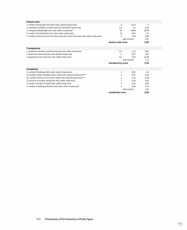
380 Privatisation of the Production of Public Space
MEASURINGURBANDESIGNQUALITIES
Studyarea: Granby4StreetsStreet: CairnsStreet 130m
Datesurvey: 28.05.2015
Quantitative
recordedvalue multiplier multiplierxrecordedvalue
Imageability1.numberofcourtyards,plazas,andparks(bothsides) 0 0,41 02.numberofmajorlandscapefeatures(bothsides,beyondstudyarea) 1 0,72 0,723.proportionhistoricbuildingfrontage(bothsides,withinstudyarea) 1 0,97 0,974.numberofbuildingswithidentifiers(bothsides,withinstudyarea) 0 0,11 05.numberofbuildingswithnon-rectangularshapes(bothsides,withinstudyarea) 0 0,08 06.presenceofoutdoordining(oneside,wihtinstudyarea) 1 0,64 0,647.numberofpeople(oneside,withinstudyarea)* 4 0,02 0,088.noiselevel** 1 -0,18 -0,18
addconstant 2,44
imageabilityscore 4,67
Enclosure1.numberoflongsightlines(bothsides,beyondstudyarea) 0 -0,31 0,002a.Proportionstreetwall(oneside,withinstudyarea) 1 0,71 0,712b.Proportionstreetwall(otherside,withinstudyarea) 1 0,94 0,943a.Proportionsky(ahead,beyondstudyarea) 0,2 -1,42 -0,283b.Proportionsky(across,beyondstudyarea) 0,35 -2,19 -0,77
addconstant 2,57
enclosurescore 3,17
Humanscale1.numberoflongsightlines(bothsides,beyondstudyarea) 0 -0,74 02.proportionwindowsatstreetlevel(onesidewithinstudyarea) 0,5 1,1 0,553.averagebuildingheight(oneside,withinstudyarea)* 26 -0,003 -0,0784.numberofsmallplanters(oneside,withinstudyarea) 10 0,05 0,55.numberofpiecesofstreetfurnitureandotherstreetitems(oneside,withinstudyarea) 2 0,04 0,08
addconstant 2,61
humanscalescore 3,66
Transparency1.proportionwindowsatstreetlevel(oneside,withinstudyarea) 0,5 1,22 0,612.proportionstreetwall(oneside,beyondstudyarea) 1 0,67 0,673.proportionactiveuses(oneside,withinstudyarea) 0,2 0,53 0,106
addconstant 1,71
transparencyscore 3,10
Complexity1.numberofbuildings(bothsides,beyondstudyarea) 2 0,05 0,12a.numberofbasicbuildingcolours(bothsides,beyondstudyarea)*** 2 0,23 0,462b.numberofbasicaccentcolours(bothsides,beyondstudyarea)*** 3 0,12 0,363.presenceofoutdoordining(oneside,withinstudyarea) 1 0,42 0,424.numberofpublicart(bothsides,withinstudyarea) 3 0,29 0,875.numberofwalkingpedestrians(oneside,withinstudyarea)* 4 0,03 0,12
addconstant 2,61
complexityscore 4,94
TOC
381 Curriculum Vitae
Curriculum Vitae
Els is an experienced urban designer and a published researcher. She is director of Studio Aitken, an urban design consultancy based in London and Rotterdam, which delivers a range of planning, design, and development projects for the public and private sectors in the U.K. and the Netherlands Her design expertise lies in delivering a range of planning, design and development projects for the public and private sectors including urban analysis, urban design and masterplanning, and project management. The characteristics of a site/area’s social, cultural and physical attributes are thoroughly appraised in conjunction with contextual economic realities and viability requirements, the findings of which then form the starting point of each project.
She holds a Master’s degree in Urbanism and a Bachelor’s degree in Architecture from Delft University of Technology. After working as an academic researcher at Cosmopolis at the VUB in Brussels, she joined the TU Delft’s Ph.D programme at the department of Urbanism. Her dissertation research focuses on the UK’s “urban renaissance” of the late 20th and early 21st centuries, in particular the issues related to the privatisation of public space, with three case studies in Liverpool, U.K. As part of her dissertation, she is developing a smartphone app called “Color your space,” which allow users to assess, rate, and record the quality of the public spaces that they frequent and participate in renegotiating the production of space (see www.coloryourspace.com)
TOC

382 Privatisation of the Production of Public Space
TOC
383 List of publications
List of publications
Books
Loopmans, M., Leclercq, E., Newton, C.(2011) Plannen voor mensen, handbook sociaal-ruimtelijke planning. Apeldoorn-Antwerpen: Garant publishers
By Design, better places to live (2001), design guide produced for DETR and CABE, by Llewelyn – Davies
Articles
Leclercq, E. (2017). Energietransitie vraagt om een organisatorische transformative. Column for AllianderDGO. https://www.allianderdgo.nl/blog/blog-energietransitie-vraagt-om-een-organisatorische-transformatie.html
Leclercq, E. (2016). Privatisering van de publieke ruimte: een schrikbeeld? Column for ‘Stadsleven’. https://www.stadsleven.nu/2016/10/13/privatisering-van-de-openbare-ruimte-een-publiek-probleem-col-umn-els-leclercq/
Leclercq, E., Van Doorn, A., Hermans, M. (2015). Publieke waarden in de gebouwde omgeving, De Architect, 4.48-51
Leclercq, E. (2015). Color your Space‘ - how digital media could improve the inclusiveness in the planning process’ conference presentation at ‘Design, Social Media and Technology to Foster Civic Self-Organisation’, Hasselt University
Leclercq, E. (2012) Ruimtelijke Rechtvaardigheid in een Nederlands jasje? AGORA Magazine voor sociaalruim-telijke vraagstukken, pag 12-14.
Leclercq, E., Zawawi, Z. (2010) Politics of (re)designing public space – a case study of the city centre of Mechel-en, conference presentation at Public Space and the challenges or urban transformation in Europe, SKuOR, Vienna
Casabella, N., Cassiers, T., Leclercq, E., Vermeulen, S. (2010). Het plan voor de internationale ontwikkeling van Brussel; een verhaal van up-scaling, by-passing en evacuatie van het stedelijk beleid, conference presenta-tion at Plandag 2010 ´Ruimtelijke Ordening in crisis´
Cassiers, T., Leclercq, E., (2009) . On good intentions and its dubieus consequences – analysing the urban vision in Ghent and Liege conference presentation at ´the new urban question´ International Forum on Urbanism, TU Delft
Loopmans, M., Leclercq, E., Newton, C., (2009). Sociale planning: het ruimtelijk determinisme voorbij. Sociale Planning. 28 (4). 3-8
Vandermotten, Chr., Leclercq, E., Cassiers, T., Wayens, B. (2009) L’économie bruxelloise. Brussels Studies.
Lectures
‘Architecture of Security’. (12.01.2018) Design as Politics Confrontation Lecture, TUDelft‘Privatisation of Public Space’ (07.11.2016) Department of City Maintenance, City of The Hague.“How to keep the public space public?” Privatization vs Citizen Engagement. Who decides whether a public
space can be privatized? (22.06.2016). Pakhuis de Zwijger, Amsterdam‘For the Common Good’ (22.04.2015) Critical reflection @ exhibition by et al. Gallery West, The Hague
TOC

384 Privatisation of the Production of Public Space
TOC


