Embed Size (px)
Citation preview

MINISTRY OF AGRICULTURE, LIVESTOCK AND IRRIGATION THE REPUBLIC OF THE UNION OF MYANMAR
PREPARATORY SURVEY ON
AGRICULTURE INCOME IMPROVEMENT PROJECT
IN THE REPUBLIC OF THE UNION OF
MYANMAR
FINAL REPORT
APRIL 2018
JAPAN INTERNATIONAL COOPERATION AGENCY (JICA) SANYU CONSULTANTS INC. (SCI)

Old MU Canal (OMC) Irrigation System
Area located on the left bank of Kindat Head Works. Construction of Left Main Canal: Old Main Cana was in 18th century and rehabilitated in 1997.
Main Canal: 76 km Total Canal Length: 318 km
Irrigable Area: 26,347 ha
Shwebo
Thapanzeik Dam
Ye-U Main Canal (YMC) Irrigation System
Area located on the right bank of Kabo Head Works. Construction of Ye-U Main Canal was in 1918.
Main Canal: 68 km Total Canal Length: 399 km
Irrigable Area: 46,550 ha
Kabo Weir
Right Main Canal (RMC) Irrigation System
Area located on the right bank of Kindat Head Works. Construction of Right Main Canal was in 1997.
Main Canal: 84 km Total Canal Length: 476 km
Irrigable Area: 43,347 ha
Shwebo Main Canal (SMC) Irrigation System
Area located on the left bank of Kabo Head Works. Construction of Shwebo Main Canal was in 1905
Main Canal: 44 km Total Canal Length: 620 km
Irrigable Area: 83,622 ha
Location Map of Preparatory Survey on Agricultural Income Improvement Project (AIIP) This map shows irrigation areas for the project identified based on the existing available data provided by Irrigation and Water Utilization Management Department (IWUMD). Areas surrounded by orange lines show the target irrigation areas of this project.
Legend
Irrigation Area
Main Road
Canal
River
Dam/Weir
Kyank Myaung Jetty
Shwebo
MU River
Ayeyarwady River
Kindat Diversion Dam
EXECUTIVE SUMMARY

Executive Summary
JICA 1 MOALI
PREFACE
0.1 Submission of Final Report: Submitted herewith is the final report prepared at the end of the surveys on ‘the Preparatory Survey on Agriculture Income Improvement Project (AIIP)’. A survey team organized by JICA headquarters commenced a series of field surveys for the Preparatory Survey from the beginning of September 2016, and this report presents major findings, project components, project cost, implementation arrangement, project evaluation, environmental and social consideration, and conclusion and recommendations.
1. RATIONALE OF THE SURVEY
1.1 Dependency on Farm-labor and the Affiliated Cost: Farming in Myanmar is characterized by labor-intensive agriculture and most farm households depend on farm labors. For example, a survey1 revealed that payment to the farm labors had shared as much as 45%, 49% and 26% for summer paddy, monsoon paddy and black gram respectively in the production costs excluding own household labor cost. Paddy is the staple food and most important crop in Myanmar while pulses earn the biggest share of export value in agricultural commodities; yet these major crops are heavily dependent on farm labors in the production.
1.2 Trend of Labor Movement from Rural Areas to Cities and Its Affect on Farming: With the current economic development, trend of labor movement from rural areas to urban areas or from agriculture sector to industry/construction sectors is accelerating. This trend, if continues, makes it difficult to secure farm casual labors as the farmers are to face acute shortage of farm labors. To cope with this situation, the current labor-intensive agriculture shall be transformed to modern capital-intensive agriculture with farm mechanization, introduction of quality seeds and well managed fertilizer/chemicals, introduction of improved post-harvest techniques, etc.
1.3 Necessity for Improvement in Production and Distribution Facilities: Further to above interventions, production infrastructure and also distribution network shall be improved and enhanced. Production infrastructure includes irrigation facilities, drainage facilities, and land consolidation works, and this improvement shall be accompanied with extension strengthening. Distribution network means farm-to-market roads including bridges, which stand as major bottleneck for the agriculture produces transportation, and thus the infrastructure should be improved. All these issues strongly suggest that the nowadays Myanmar needs to promote modernized intensive agriculture, and hence this Survey is conducted.
1.4 The Project Long-term Benefits and Impacts: In fact, the Project targets an area where the biggest irrigated agricultural land extends in this Country; namely, here in the Thapanzeik dam irrigable area. The Project will enhance a long time experienced irrigated agriculture whereby increasing the beneficiaries’ farm income, narrowing income gap between urban dwellers and rural population, or between agriculture sector workers and industry sector workers, and further contributing to the national balanced economic development as a spearheading project in the Country.
2. CHALLENGES & OPPORTUNITIES IN THE AGRICULTURE
2.1 The Major Crops and their Planting Sequences: The staple food in Myanmar is rice, which is
1 Source: Preparatory Survey for the Project for Rehabilitation of Irrigation Systems, August 2014. Note that the payment to the farm labors was estimated by aggregating such cost of; seeding & transplanting, fertilizer application, pesticide/ fungicide application, herbicide application, weeding, harvesting, transporting (farm to dry yard), and drying/ packing, which are in most cases undertaken by farm casual labors.

Executive Summary
MOALI 2 JICA
cultivated wherever during monsoon season. With irrigation summer paddy is also cultivated. After monsoon paddy has been harvested, farmers usually cultivate pulses, which require less farm input as compared with paddy. Pulses are grown under residual moisture, not irrigated. Then, there are many farmers who cultivate oil crops such as sesame, groundnut, sunflower, etc., some of which are irrigated. These are the most important and popular crops in Myanmar.
2.2 Paddy Track Record and Its Prospective: Paddy production of aggregated monsoon and summer started sharply increasing in the early 2000s, peaking in 2010 with a total amount of 32.6 million tons of production. However, after that it has dropped to a level of around 28 million tons of production. Sagaing region where the Project area is located produces approximately 13% of the whole national paddy, positioned at 3rd rank after Bago (17%) and Ayeyarwady (27%). In Myanmar, a typical person is assumed to consume about 160 kg of white milled rice per annum. Estimated available white rice per person as at 2013/14 is about 255 kg in the Country, indicating big surplus for export.
2.3 Goal-setting for Rice Export to World Market: A continuous increase trend of world rice export over years provides an opportunity to Myanmar of exporting rice to the world market. The export from Myanmar has increased recent years to the level over 1 million tons. However, the share of Myanmar export rice is still far below than those counterpart countries’ export volume. This comparison indicates there should be an opportunity for Myanmar to further export rice to the world market. In fact, National Export Strategy of Rice, 2015-2019, formulated by Ministry of Commerce, states in its Action Plan ‘export 4 million tons of rice, becoming the world’s fourth largest exporter of rice’.
2.4 Pulse and Bean Production in Different Land Settings: After monsoon paddy has been harvested, farmers cultivate pulses in many places by utilizing residual moisture. Pulse cultivated in large area in lower Myanmar is black gram while green gram becomes popular as going to mid and upper Myanmar including the Project area. As at year 2013/14, nation wide productions are 1.58 million ton, 1.45 million ton, 0.85 million ton, and 0.60 million ton for black gram, green gram, pigeon pea and chick pea respectively. The green gram produced in Sagaing region reached around the level of 270,000 - 280,000 tons as of 2013/14, sharing 19% of the national production. This share is the 3rd largest after Magway (26%) and Bago (24%).
2.5 Promising Destinations for Pulse Export: It can be known that India’s pulses import shares about 20% to maximum 30% of what is traded in the world pulse trade market since year 2001. Responding to the India’s demand, Myanmar has been exporting pulses to India. Though export quantity has fluctuated by year, there is a tendency of increasing over years especially in case of black gram, reaching about 500,000 ton per year. Though the green gram is exported more to other countries than India, still India imports green gram at the level of about 100,000 tons per year. From this examination, it can be said that the pulses produced in Myanmar have an opportunity of being exported more to India.
2.6 Oil Crops and Mode of Cultivation: Oil crops in Myanmar are ground nut, sesame, and sunflower, productions of which as of year 2013/14 are 1.50 million tons, 0.91 million tons, and 0.46 million tons respectively. Though these oil crops are cultivated mostly in upland fields, under rain-fed condition, nowadays there are irrigation areas where sesame is cultivated, including the Project area. A new farming came into practice recently, in which farmers cultivate sesame or green gram with irrigation during summer. This was firstly tried in Magway region in 2014/15 and also in the Thapanzeik dam irrigable area in the same year of 2014/15.

Executive Summary
JICA 3 MOALI
3. THE PROJECT AREA: THAPANZEIK DAM IRRIGABLE AREA
3.1 Natural and Administrative Aspects of the Project Area: The Project area, composed mainly of the Thapanzeik dam irrigable area and relevant agro-produces distribution network, is located in a vast paddy area along Mu River in Sagaing region. The irrigable area lies in approximately 120 km from north to south and 60 km from east to west. The elevation ranges approximately from 160 m at its northern upstream side to as low as 100 m at its most southern downstream part. Administratively, the main Project area irrigated by Thapanzeik dam extends over 10 townships of 4 districts such as Shwebo district, Kanbalu district, Monywa district and Sagaing district.
3.2 Alignment and Duties of Irrigation Facilities: The irrigable area is commanded by 4 main canals together with branch canals, extension canals and numerous number of distributary and minor canals. The current total irrigable area reaches as much as 493,887 acres (199,866 ha), of which Kabo Weir Left MC (so-called SMC) covers the largest share of 42%, followed by Kabo Weir Right MC (so-called Ye-U canal, 23%), further by Kindat Right MC (22%), and the remaining 13% by Left MC of Kindat diversion dam (so-called OMC). By intake facility, the Kindat diversion dam irrigates total 35% (22% by RMC and 13% by OMC) while the Kabo weir covers the remaining 65%.
3.3 The Farmland Holding Size and Beneficiary Farmers: To estimate the beneficiary population, an average farmland area was estimated based on a questionnaire survey conducted in September 2016 by the JICA team. It was known that a typical farmer household has 7.42 acre (3 ha) of paddy farmland (so-called Le in Myanmar), and therefore 66,562 households can be expected to be the beneficiary farmers. An average farm household has 4.53 family members, excluding children/members who reside outside the family. Therefore, the beneficiary population can be estimated by multiplying the typical number of family members to the beneficiary household number, thus about 300,000 beneficiary population.
3.4 Popular Crops and Cultivation Limitations: In the Project area, monsoon paddy and summer paddy are the most popular crop, and then chick pea, green gram, black gram or sesame are cultivated during inter season or instead of summer paddy. Farmers in the irrigable area are much interested in growing late varieties of monsoon paddy for earning more income (Shwebo Pawson) and/or for own consumption (Ayeyarmin). In this case they should give up winter crops after the late varieties if they plan to grow summer crops. Consequently, the area with 3-cropping as monsoon paddy – pulses – summer paddy (or alternative crop) is very limited.
3.5 Command Area and the Respective Cropping Patterns: Popular cropping pattern in the Thapanzeik irrigation system differs between the outer area commanded by RMC & OMC and the inner area under Ye-U & SMC in accordance with irrigation condition and soil condition. Within the inner area where soil condition is good for paddy cultivation with enough irrigation water, farmers are much interested in growing late varieties of monsoon paddy (e.g. Shwebo Pawsan), and in this case they should give up winter crops if they plan to grow summer crops. On the other hand, if they cultivate short maturity monsoon paddy, which is often seen in the middle and lower reaches of outer areas commanded by RMC and OMC, they can try 3-cropping as monsoon paddy – pulses – summer paddy.
3.6 Water Source and Cropping Area/Intensity Rate: The Thapanzeik dam irrigates monsoon paddy (MP) and summer paddy (SP) in principle, and in the recent years since 2014/15 the dam started irrigating green gram and sesame during summer season in addition to the conventional summer paddy. Monsoon paddy has been planted and irrigated over almost all the irrigable area during monsoon season at around 500,000 acre (about 200,000 ha) with cropping intensity of 98%. With regard to summer crop, the irrigated area has fluctuated widely depending on the irrigation water available in

Executive Summary
MOALI 4 JICA
the dam reservoir, ranging from 101,191 acre (2012/13) to as much as 369,385 acre (2010/11). The overall average area of the summer crop irrigated arrives at 285,426 acre (115,506 ha), equivalent to 58% of the irrigable area.
3.7 Household Survey on Yield of Major Crops: Household questionnaire survey asked 240 sampled households of their production and yield by crop/ variety, and plus 240 farm households were asked the yield only, totaling 480 sample households for the yield estimation. The yield of the most popular monsoon paddy, Shwebo Pawsan, marked 56 basket/ac (2.88 ton/ha), and that of Ayeyarmin is 55 basket/ac (2.86 ton/ha). IR747 and Shawe Saw Yin are cultivated mostly during summer, and thus the yields are higher than those of the former varieties as 77 baskets and 83 baskets. Yield of sesame is 5 basket/ac only (0.33 ton/ha) while that of green gram comes to 12 basket/ac (0.97 ton/ha).
3.8 Net Profit from Popular Crops: Net profit per unit area for Shwebo Pawsan is the highest among the 4 paddy varieties and among the 6 major crops cultivated in the Project area as 286,200 Kyats per acre, followed by another monsoon paddy, Ayeyarmin (282,800 Kyats/acre), further by the two summer paddy varieties of 230,700 Kyats/ac and 238,200 Kyats/ac for IR 747 and Shwe Sae Yin respectively. Here noted is that the net profit ratio for the Shwebo Pawsan is not high, rather the lowest among the 6 major crops as 56%. In fact, Ayeyarmin marks as high as 65% of its net profit ratio. As expected, net profit ratios of green gram and sesames are relatively higher than those of paddies as 62% for green gram and 68% for sesames.
3.9 Farmers Problems and Challenges: The household survey asked 240 sampled farmers of their problems/challenges. What comes first is the water shortage for irrigation (24%), followed by flood (15%), and further by bad/ poor transportation road (12%). In addition, lack of farm labors was ranked at 4th (7%), and also high price of farm labors at 7th (4%), totaling to 11%. It means that rehabilitation of irrigation system and also drainage improvement should also be given high priority. As is expected, improvement of rural road and farm-to-market road should be undertaken with high priority. To cope with labor shortage and high price of farm labors, farm mechanization should be promoted.
3.10 Extension Service Arrangement: DOA of MOALI is the responsible organization for providing agricultural extension services in the public sector, and it has branch offices at each of the local administration levels. In fact, all the regions/states, districts and also townships in principle have DOA offices. Of them, the township (TS) office, which is the lowest stair office, plays a practical role in the extension services at the field level contacting farmers directly. The TS area is divided into several units of extension area called as Extension Camp or Production Camp. There are 52 Extension Camps in total in the 9 TSs of the Project area, while only 39 of them cover irrigable area.
3.11 Type and Quality of Extension Services: According to the household questionnaire, the source of extension service ranked at 1st position is ‘technical instruction’, followed by ‘information materials’. The former reply was made by 40% of the respondents while the latter by 16 %. The extension staff make random visit to their clientele farmers, during which they give technical instruction and often distribute brochure/ pamphlet concerning their extension issues. There is one surprise that the farmers school and also demonstration plot are very few as the source of agricultural information, say only 7% and 3% respectively. This may be associated with a limited budget, and also the existing camps are established only just beside trunk roads not able to cover rural areas.
3.12 Type and Number of Agricultural Machinery: There are as many as 20,077 power tillers, 1,321 tractors, and total 908 combine harvesters in the relevant townships as of 2016, of which AMD owns 91 (7%) tractors and 58 (6%) combine harvesters. For the combine harvester, in fact nowadays, lots numbers of owners come to the Project area from outside and provide the harvesting service. The number of the harvester from outside is almost comparable to that available within the townships, namely 449 vs 459. As for machine coverage, the power tillers, tractors and combine harvesters cover

Executive Summary
JICA 5 MOALI
28%, 19% and 16% for the farmlands respectively.
3.13 Means of Product Transport: There is a union road running along north to south direction, i.e., Shwebo to Mandalay. In addition, roads running from west to east have been developed in recent years, e.g. connecting Zeegoon in Kanbalu TS to Kalaymyo (located western side of Chindwin river) via Kabo weir, Khin-U to Ye-u and further to Monywa, and Shwebo to Monywa. Then, once going into the paddy production area commanded by the Thapanzeik dam, we can find easily that the rural roads are very poorly developed. To ferry agriculture produces reaching as much as 1.5 million tons of paddy in near future, the roads existent in the Project area should be improved.
3.14 Roads Condition and the Responsible Agency: The roads and bridges in rural area are under the responsibility of the Department of Rural Road Development (DRRD). The total length of roads under DRRD reaches 3,123 km (1,952 miles) within the target townships. Shwebo, Tabayin, Wetlet, and Kin-U TSs have relatively better accessibility than the other townships. The types of roads are concrete, asphalt, metal/macadam, gravel/kanker, and earth. If the roads are divided into 2 categories, paved and unpaved, length of unpaved roads exceeds paved roads. Specifically, the length of road paved with concrete, asphalt, metal/macadam, or gravel/kanker shares 27 % of the total length, while unpaved earthen road occupies the rest, 73 %.
3.15 Number and Ratio of Bridge Distribution in the Project Area: Currently, there are a total of 754 bridges in the target townships. Bridge construction is relatively active in Tabayin and Shwebo TSs, while less is observed in Ayadaw and Budalin TSs, which may imply potential needs. Bridges are categorized into 4 types: concrete, wood, causeway, and box/pipe culvert. The common types are box/pipe culvert, wood and concrete with a total number of 271, 260 and 185, respectively, which are 36%, 34% and 25 % of the total number. Then, causeway is 31 bridges with 4 % likewise.
4. DIRECTION SETTING AND PROJECT COMPONENTS
4.1 Development Goal and Strategic Attempt: Agriculture development and relevant income increase in the Project area should comprise two major strategies including “increase in agricultural productivity” and “promotion of agribusiness”. The former will be achieved through enhancement of production infrastructure including irrigation facilities rehabilitation, land consolidation, and agricultural mechanization. Of course, extension service strengthening should be coupled with those interventions. Whereas, the latter, promotion of agribusiness, will be materialized through improvement of distribution and processing infrastructure. One of the project components will, therefore, be improvement of farm-to-market roads with rural bridges composed of rural roads under the DRRD and canal inspection roads under IWUMD, and seed production related industry.
4.2 Government Vision and Policies for Overall Development: The current government issued an economic policy in July 2016 starting with vision, followed by 4 objectives and further by 12 policies. Of them, policy No.5 and policy No.6 are very much relevant to the Project; namely, Policy No.5 states creation of employment opportunities for all citizens including those returning
from abroad, and giving greater priority in the short term to economic enterprises that create many job opportunities, and
Policy No.6 maintains the establishment of an economic model that balances agriculture and industry, and supports the holistic development of the agriculture, livestock and industrial sectors, so as to enable rounded development, food security, and increased exports.
4.3 Contribution of this Project in Overall Development: The Project upon implementation will very much contribute to the realization of above 2 policies. The Project, of course, creates direct job opportunities during the construction such as for skilled labors, unskilled labors, operators of

Executive Summary
MOALI 6 JICA
construction machineries, suppliers of construction materials, transporters, etc. Then, upon completion of the Project, such employment will be created as agriculture input related business, e.g., machinery, fertilizer, pesticides, and seed businesses, etc. and agriculture output related business, e.g. rice milling, seed packing and distribution business, sesame processing company, rice noodle company, etc.
4.4 Role of Quality Infrastructure in Agriculture Modernization and Economic Growth: There is a good example; Japan’s experience in agricultural modernization and rapid economic growth, in which infrastructure development especially irrigation development and land consolidation together with agricultural mechanization had facilitated population flow from rural to urban areas and led to industry sector’s growth with the robust agriculture as the foundation of the overall economic growth. In other words, development of industry sector had taken place supported by the food and work force from the robust rural society, which also realized the balanced growth between (agriculture-based) rural and (industry-oriented) urban areas. This example can also be applied to Myanmar as a lead-case by the Project to be implemented.
4.5 Identification of Components and Implementing Agents: Above discussions have identified all the necessary components for the agriculture development and income improvement in the Project area covering both improvement of production infrastructure and the facilitation/promotion of agri-businesses including the improvement of distribution networks, e.g. rural road and bridge improvement. Here, through the examinations, components for the Project have been selected, and thus the following summarize the components/sub-components with expected responsible departments to implement:
Table 4.1 Selected Project Components & Prospective Implementing Department No. Component Sub-component Department 1 Agriculture Development and
Extension Strengthening 1. Capacity building for DAO extension staff 2. Agriculture extension and marketing strengthening 3. Improvement of camp & TS offices 4. Establishment of seed center (PPP)
DOA
2 Agriculture Mechanization Strengthening
1. Maintenance workshop establishment 2. Agriculture machineries testing center (Mandalay) 3. Capacity building for AMD staff and operators
AMD
3 Land Consolidation 1. Farm road and tertiary canal construction 2. Land leveling and consolidation 3. Cadastral map update & registration of consolidated farmland
IWUMD AMD DALMS
4 Irrigation and Drainage Improvement
1. Irrigation and drainage rehabilitation 2. Water management and flood monitoring system 3. Procurement of maintenance machineries
IWUMD
5 Distribution Infrastructure Improvement
1. Rural road improvement 2. Rural bridge improvement 3. Canal inspection road improvement
DRRD DRRD IWUMD
Source: JICA Survey Team
5. PROJECT PLANNING AND DESIGNING
5.1 Agriculture Development and Extension Strengthening
5.1 Approaches for Yield Increment and Extension Strengthening: Concerning the objective of increasing farmers income with the Project, productivity improvement shall be pursued. With this, it is proposed to increase summer paddy area with the rehabilitation first (case 1), and further introduce water less consuming crops targeting 100% cropping intensity (case 2) in summer season. It is therefore planned, under case 2, to increase the planted area of paddy from the current 286,768 acre (116,049 ha) to 340,782 acre (137,908 ha), while 153,105 acre (61,959 ha) of the land under irrigation is served for pulses/ sesame. Through this approach, 100% monsoon paddy and also 100% summer cropping intensity can be achieved, and thus the increment is 2% and 42 % for monsoon and summer

Executive Summary
JICA 7 MOALI
season respectively.
Table 5.1 Land Use Plan in Lowland Irrigable Area [Summer Season] Season Item Crop Area Planted,
acre Area Planted,
ha Cropping Intensity Increment
Monsoon Current Paddy 485,897 196,633 98%
Plan Paddy 493,887 199,866 100% 2%
Summer
Current Paddy 286,768 116,049 58% Plan (case 1) Paddy 391,221 158,319 79% 21%
Plan (case 2) Paddy 340,782 137,908 69%
Pulses/ Sesame 153,105 61,959 31% Total 493,887 199,866 100% 42%
Source: JICA Survey Team
Through the strengthening of agriculture extension system, including an application of quality seeds and improvement of soil fertilization and plant protection, crop yield can be improved. In terms of the yield of paddy, for example, yields of four major varieties became available through a household questionnaire survey conducted by JICA team in 2016. Whereas, potential yields of major crops are suggested by DOA regional office from the minimum value to the maximum value. Thus, the mean value of those figures is selected as the reasonably expected yields after completion of the Project.
Table 5.2 Yield of Major Crops [Current and Potential]
No. Crop/Variety H.H. Survey DOA
Statistics Potential Yield
Increment
% Min
Ton/haMax
Ton/hamean
Share t/ha bsk t/ha bsk t/ha bsk Monsoon Paddy
1 Shwebo Pawsan 63% 2.88 56
4.62 89
3.10 4.13 3.62 70 25% 2 Ayeyarmin 37% 2.86 55 4.13 5.16 4.65 90 62%
Summer Paddy 3 Shwe Sae Yin 78% 3.96 77 4.13 5.16 4.65 90 17% 4 IR 747 22% 4.29 83 4.13 5.16 4.65 90 8%
Summer alternative crop 5 Sesame -- 0.33 5 0.88 15 0.61 0.91 0.76 13 130% 6 Green gram - 0.97 12 1.33 16 1.62 1.78 1.70 21 75%
Source: DOA regional office for the DOA statistics and potential yields, JICA household survey for the current yields with shares
5.2 Major Activities for Enhancement of Extension System: For agricultural extension system to be able to respond to the farmers’ needs, three major activities have been planned; namely, 1) capacity building for DOA extension staff and private sector; 2) agricultural extension strengthening (demo-activities) including marketing enhancement, and 3) improvement of camp and DOA offices concerned. Contents of the activities have been identified through a series of filed observation, interviews to extension staff and famers, etc. In addition, the DOA offices concerned will develop and manage a communication network system connecting with other DOA offices and extension camps. This system should be liked to the web-based SNS (Facebook) extension system available in the DOA HQs since 2016.
5.3 Establishment of Seed Centers and Distribution of Certified Seeds: There is a so-called distribution gap in disseminating certified seeds. To cope with this bottleneck issue, Seed Centers are to be established under the Project. There should be 3 types of seed centers to be established. The centers shall be located in Sai Naing Gyi of Wetlet TS as Type-A, Chipar Seed Farm of Shwebo TS as Type-B and Thelone village of Shwebo TS as Type-C. For Type-A, the Project will procure drying/processing/packaging plant and construct warehouse. For Type-B, the Project will procure processing plant, and for the Type-C, the Project is to procure seed cleaner only. The centers are to deal with the high value variety of Shwebo Pawsan (monsoon paddy) mainly.
Executive Summary
MOALI 8 JICA
5.2 Agriculture Mechanization Strengthening
5.4 Hard and Soft Aspects of Agriculture Mechanization: Agriculture mechanization strengthening aims at ensuring high productivity for agriculture supported by effective mechanized farming, and also coping with labor shortage which is becoming critical issue nowadays in Myanmar agriculture. This component has such sub-components as; 1) capacity building in agriculture mechanization, 2) maintenance workshop establishment (total five), and 3) establishment of agriculture machineries testing center (one in Mandalay), and.
5.5 The Capacity Building Component and Intended Groups: The capacity building component is to train officers, instructors to farmers, mechanics and operators to meet the mandates of AMD. The component of the capacity building will cover Land Consolidation, Maintenance Workshop, and Agricultural Machineries Testing Center. For Land Consolidation, the content of the training will be tractor operation, excavator operation, and measurement by auto level and the total station. As per Maintenance Workshop, the mechanics will be skilled on restoring engine and gearbox and repairing tractors, harvesters, and power tillers. Regarding Agricultural Machineries Testing Center, AMD should know how to test and evaluate 4-wheel tractor, establish Myanmar Testing Standard, and maintain the testing devices.
5.6 Arrangement for Provision, Sale and Repair of Farm Machinery: The function of AMD should change from selling the assembled machines manufactured and providing tractor services with operators to the services of maintenance & repair of large agricultural machines. With this concept, Shwebo Agriculture Mechanization Station (AMS) will have to function as a core workshop in the Project area at the level of complete overhauling and rebuilding of engines and transmissions like AMD Monywa Medium Workshop. In addition, four AMSs such as Kanbalu, Ye-U, Wetlet and Budalin should support the machine users at the maintenance level of spare parts replacement and simple repairs. With the collaboration of the dealers, spare parts for major models can also be sold at the AMD workshops.
5.7 Dealing with Unfit and Malfunction Machineries: AMD is now requested by farmers to inspect the performance and the safety of agricultural machineries imported, because some imported machines are not fulfilling their described specifications. Responding to this request, AMD will establish an agriculture machineries testing center in Mandalay. The applicants such as importers, distributers, dealers and manufactures should submit the machineries by the manufacturer’s model and be tested by the Center. AMD should disseminate the testing certified models and the testing results to AMD regional offices and AMSs, Myanmar Agricultural Development Bank and relevant associations/ organizations regarding agricultural mechanization.
5.3 Land Consolidation
5.8 Status and Impact of Land Consolidation: Land consolidation aims at ensuring high productivity for agriculture supported by effective mechanized farming and rationalized water management to meet future agricultural requirements. In Shwebo district, land consolidation has been implemented at a pace of around 50 to 600 acre per annum. The maximum consolidated area is 600 acre achieved in year 2015/16. With reference to this actual example, the target of the consolidation under the Project is set at 500 acre only at the first year, same 500 acre at the second year, and then increased to 1,500 acre for the 3rd year and further to 2,500 acre for the 4th year, totaling 5,000 acre. It may mean that the 1st and 2nd years are for experimental and learning period, with which the progress should be accelerated onwards.
5.9 Tale of Land Consolidation Works: There is an example experienced by an IFAD project
Executive Summary
JICA 9 MOALI
implemented in Nay Pyi Taw area. The project targeted land consolidation of total 10,000 acre, and its annual target was from 2,000 to 4,000 acres. The first year of implementation was 2015/16, and the achievement was only 351 acres (2% only against target 2,000 acres). Such low achievement was caused by a practice of many farmers who had already sown the seeds of black grams during the winter season, during which the land consolidation works were to be implemented. To smoothly implement land consolidation works, therefore, this Project proposes 3 measures such as: 1) establishment of working group composed of relevant government officers, 2) request basis implementation (first comes, first served basis), and 3) deployment of facilitators.
5.10 Implementation Modality and Task Designation: As for the construction modality, three departments under MOALI; namely, IWUMD, AMD and DALMS will carry out the works. IWUMD undertakes construction of farm roads and tertiary canals both for irrigation and drainage while AMD is in charge of land leveling and ridge making bisecting newly constructed rectangular plots. These 2 departments undertake the construction works, while DALMS is in charge of farmland registration, very often including updating of the existing parcel maps (cadastral map) with the farmer-tillers name. Note that private companies will not be engaged in this consolidation works since they do not have tractors used in the leveling works and therefore almost nothing experiences in land consolidation works.
5.11 Important Issues in Land Consolidation: In implementing land consolidation, two issues should be thoroughly explained to the farmers and thoroughly agreed upon prior to the commencement of the works. One is the voluntarily surrendering of a part of their farmland in order to avail of necessary land for the construction of new farm roads and also tertiary canals (usually 6 – 10 % of the original land). In addition, one farmer may have 2 – 3, or even more than 5 pieces of farm plots, and with the consolidation work all the farm plots owned by a farmer shall be collected at one place, and thus in essence there will be plot reallocation a lot among the concerned farmers. Almost all the concerned farmers should reallocate their farmland, by exchanging their plot with other colleague farmers nearby.
5.4 Irrigation and Drainage Improvement
5.12 Aim of Irrigation Improvement and Affiliated Works and Benefits: Irrigation improvement aims at ensuring the soundness of canals in the Thapanzeik dam irrigation system and increasing the safety of the irrigation facilities including major head work such as Kindat Diversion Dam and Kabo Weir. There are 3 major components for the irrigation system improvement. One is canal rehabilitation such as desilting of the canal bed, reshaping of the canal section and lining of canal. The second is canal structure rehabilitation, and the last is inspection path (maintenance road) rehabilitation. Also, for improving water management to reduce water loss in the irrigation systems, gate installation to all the outlets and construction of new check structures are introduced.
5.13 Importance of Drainage in Damage/Disaster Reduction: Improvement and strengthening of drainage function is as important as that of irrigation facilities. When it rains, paddy fields can hold rainwater for some period of time. Paddy can withstand submergence for some days. However, when paddy is at young stage, it can easily incur some damages by increased water level associated with rainfall and flooded water. In the Project area, there are some areas frequently inundated near Mu River in Shwebo township, along Ye-U main canal in Ye-U township and downstream area of Mode Soe Chone Branch Canal in Wallet township. Improvement of drainage is planned to prevent/reduce flood damage.

Executive Summary
MOALI 10 JICA
Table 5.3 Summary of the Project Components for Thapanzeik Irrigation Scheme Kindat Diversion Dam
1) Rehabilitation of the 6 nos of undersluice gate & the 10 nos of gate at head regulator, 2) Repair and maintenance of side drainage on dam 20,000 sq.ft, 3) Upgrade of emergency spillway 1LS, Dredging the sedimentation around head regulator of RMC in reservoir
Kabo Weir 1) Replacement of spillway gate to hydraulic over turn gate 1LS, 2) Rehabilitation of the 6 nos of undersluice gate & operation deck, 3) Rehabilitation of the 10 nos of gate at head regulator, 4) Protection of the bank at U/S of the weir, 5) Removing of sand bank at U/S right side of the weir, 6) Protection of reverbed at D/S of the weir, 7) Protection of right bank at D/S of the weir
Canal Irrigation System 1) Unsilting of canal bed & reshaping of canal section: Approx. 5.4 million cum, 2) Lining of canal: Approx. 380km, 3) Rehabilitation/ construction of the structures: Approx. 6,000 nos including minor repair
Improvement of drainage 1) excavation of drainage to increase the capacity and construction of bypass canal for Improvement of drainage, 2) rehabilitation/ construction of facility for reusing drainage water
Water management & Flood monitoring system 1) Rainfall gauge 8 sets, 2) Water level gauge 22 sets, 3) Discharge meter 14 sets, 4) data transmission & monitoring system 1 LS
Source: JICA Survey Team
5.14 Judgment on Supply Volume and Irrigation Duty: Full supply discharge and irrigation duty for each irrigation system were set several times, for example, discharge and irrigation duty of SMC was set in 1933 and have not been changed to date. The JICA Survey Team evaluated each irrigation duty, present discharge and potential irrigable area for summer paddy, lastly, the Survey Team proposes the irrigation duty as 929 ha/m3/s (65 acre/cusec) for monsoon paddy and 715 ha/m3/s (50 acre/cusec) for summer paddy. New full supply discharge of each main canal was calculated based on the irrigation duty, the irrigable area for monsoon paddy (whole irrigable area) and potential irrigable area for summer paddy.
Table 5.4 Design Discharge for the Canal in 4 Irrigation Systems Item Unit OMC RMC SMC YMC
Scrutinized Irrigable area ha 26,347 43,347 83,622 46,550 acre 65,105 107,115 206,638 115,029
Present Full Supply Discharge M3/s 28.3 52.0 79.3 49.6 cusec 1000 1835 2800 1750
Proposed design discharge M3/s 29.5 48.5 93.6 52.1 cusec 1,042 1,714 3,306 1,840
Increase rate from original design discharge 104% 93% 118% 105% Source: JICA Survey Team
5.15 Installation of Monitoring Instruments for Effective Operation: Considering future effective operation, a monitoring system for water management will be improved by introducing measurement devices such as water level gauge, discharge meter, rainfall gauge to be installed at some principal irrigation facilities such as Thapanzeik dam, Kindat Diversion Dam, Kabo Weir, intakes of the 4 main canals, bifurcations, and some large canals on a trial basis. In addition, introduction of the flood monitoring system should be included to ensure and increase the safety of Thapanzeik dam and Old Mu Canal against flood.
5.16 Arrangement for Efficient Maintenance of Facilities: To date, the maintenance of the national irrigation systems in the Country has been carried out only by the government, except for water course (on-farm ditches) where existent. However, considering the IWUMD maintenance office’s burden on O&M of irrigation system, joint management is recommended to enhance the irrigation performance upon the rehabilitation by the Project. In order to introduce fundamental restructuring of the actors for O&M of irrigation system, establishment of farmers’ organization is required as the new responsible entities, to which handing over of operation maintenance of some

Executive Summary
JICA 11 MOALI
irrigation facilities from the government should be made.
5.17 Required Maintenance Works and Machineries: Maintenance works is necessary for keeping the soundness of the irrigation systems in future. Major maintenance work by IWUMD will be periodical dredging of sedimentation in canals due to soil and sand discharged into the canals. Maintenance of inspection roads is also necessary, because no pavement is made. Therefore, the procurement of construction machineries is planned considering necessary maintenance works to facilitate maintenance works of irrigation canals, improvement of the drainage canals and so on.
Table 5.5 Proposed Equipment to be Procured for Maintenance Works
Sr. Construction Machineries Specification Qty Allocation to IWUMD Maintenance Branch
Shwebo Office Ye-U Office 1 Mini Hydraulic Excavator 7 ton 20 units 10 units 10 units 2 Hydraulic Excavator 20 ton 10 units 5 unit 5 unit 3 Long Armed Hydraulic Excavator 20 ton + long arm 2 units 1 unit 1 unit 4 Amphibious Hydraulic Excavator 20 ton + amphibious crawlers 1 units 1 units - 5 Track Dozer CL III T-4 or T-5 4 units 2 units 2 units 6 Motor Grader 120-150 HP 2 units 1 unit 1 unit 7 Roller Compacter 10-20 ton 2 units 1 unit 1 unit 8 Self-Loading Truck 40-50 ton 2 units 1 unit 1 unit 9 Water Bowser Truck 1600 gal (7.2 m3 or more) 2 units 1 unit 1 unit
10 Tipper Truck 6x4, 6-8 ton 10 units 5 units 5 units 11 Dredging boat 12" suction, more than 450 HP 1 units 1 units - Source: JICA Survey Team
5.5 Distribution Infrastructure Improvement
5.18 Principles and Steps of Road Improvement: The development direction in road improvement is oriented toward the strengthening of rural road network which works as farm-to-market roads, and connect them to existing union and regional roads. In addition, canal inspection roads of Thapanzeik dam irrigation system are to be improved, which are in fact connected to regional roads. The principle of upgrading existing rural roads is to improve step by step from earthen, kanker, metal/macadam up to asphalt pavement. That is, if the existing rural road is earthen road, then necessity of upgrading is justified, and this road is to be upgraded to metal/macadam road, for example.
5.19 Extent and Locations of Road Improvement: Total length of the rural roads to be upgraded to metal/ macadam type under DRRD reaches as much as 607 km which accounts for 92% of the total length of rural road improvement planned. On the other hand, total length of to-be-asphalt roads is 52 km, accounting for 8% of the total. Accumulated length of rural road to be upgraded in each township varies from 23 km of Ayadow township to 120 km of Taze township depending on the necessity of rural road especially from the view point of agricultural produce transportation. Though the existing cross section will be kept in principle, only the asphalt road planned will be extended by each 1 ft for shoulder portion for the both sides.
Table 5.6 Pavement Type and Road Length of Rural Road Planned (DRRD)
District Township Pavement Type and Road Length
Metal / Macadam Asphalt Total (mile) (km) (mile) (km) (mile) (km) %
Kanbalu Kanbalu 46.04 74.11 0.00 0.00 46.04 74.11 11%
Shwebo
Kin-U 29.95 48.21 9.30 14.97 39.25 63.18 10% Shwebo 62.04 99.83 4.25 6.84 66.29 106.67 16% Wetlet 43.25 69.63 0.00 0.00 43.25 69.63 11% Taze 72.20 116.23 2.50 4.02 74.70 120.25 18% Ye-U 29.05 46.76 3.25 5.23 32.30 51.99 8%
Tabayin 61.09 98.32 6.00 9.65 67.09 107.97 16%
Monywa Budalin 26.25 42.25 0.00 0.00 26.25 42.25 6% Ayadaw 7.50 12.07 7.00 11.27 14.50 23.34 4%
Executive Summary
MOALI 12 JICA
District Township Pavement Type and Road Length
Metal / Macadam Asphalt Total (mile) (km) (mile) (km) (mile) (km) %
Total 377.37 607.41 32.30 51.98 409.67 659.39 100%
92% 8% 100% Source: JICA Survey Team
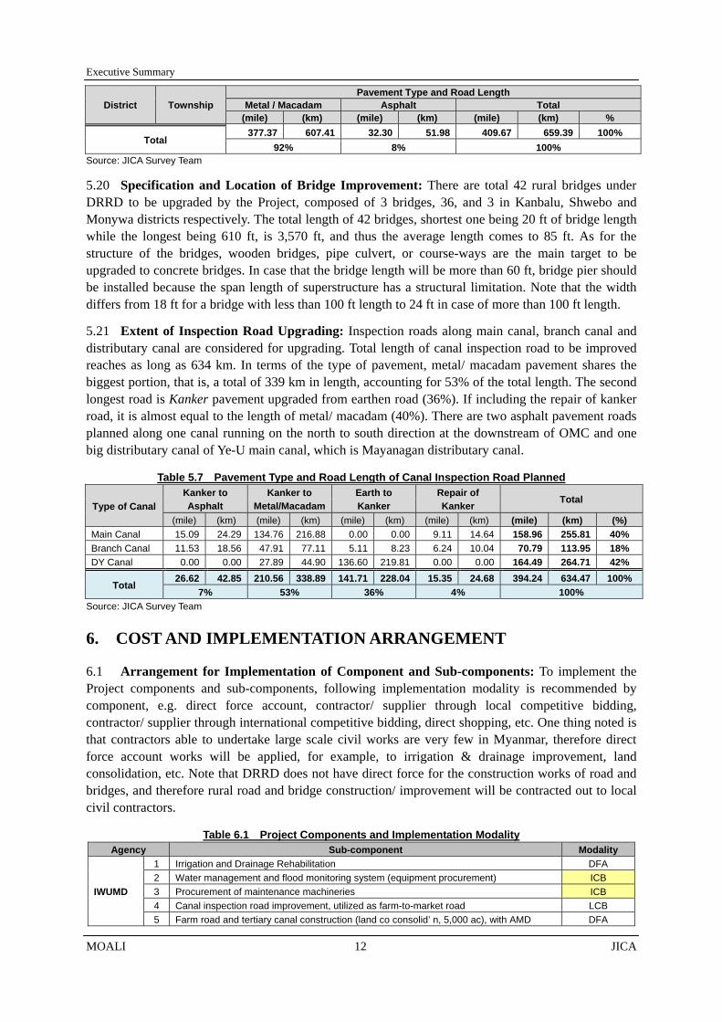
5.20 Specification and Location of Bridge Improvement: There are total 42 rural bridges under DRRD to be upgraded by the Project, composed of 3 bridges, 36, and 3 in Kanbalu, Shwebo and Monywa districts respectively. The total length of 42 bridges, shortest one being 20 ft of bridge length while the longest being 610 ft, is 3,570 ft, and thus the average length comes to 85 ft. As for the structure of the bridges, wooden bridges, pipe culvert, or course-ways are the main target to be upgraded to concrete bridges. In case that the bridge length will be more than 60 ft, bridge pier should be installed because the span length of superstructure has a structural limitation. Note that the width differs from 18 ft for a bridge with less than 100 ft length to 24 ft in case of more than 100 ft length.
5.21 Extent of Inspection Road Upgrading: Inspection roads along main canal, branch canal and distributary canal are considered for upgrading. Total length of canal inspection road to be improved reaches as long as 634 km. In terms of the type of pavement, metal/ macadam pavement shares the biggest portion, that is, a total of 339 km in length, accounting for 53% of the total length. The second longest road is Kanker pavement upgraded from earthen road (36%). If including the repair of kanker road, it is almost equal to the length of metal/ macadam (40%). There are two asphalt pavement roads planned along one canal running on the north to south direction at the downstream of OMC and one big distributary canal of Ye-U main canal, which is Mayanagan distributary canal.
Table 5.7 Pavement Type and Road Length of Canal Inspection Road Planned
Type of Canal Kanker to Asphalt
Kanker to Metal/Macadam
Earth to Kanker
Repair of Kanker Total
(mile) (km) (mile) (km) (mile) (km) (mile) (km) (mile) (km) (%) Main Canal 15.09 24.29 134.76 216.88 0.00 0.00 9.11 14.64 158.96 255.81 40% Branch Canal 11.53 18.56 47.91 77.11 5.11 8.23 6.24 10.04 70.79 113.95 18% DY Canal 0.00 0.00 27.89 44.90 136.60 219.81 0.00 0.00 164.49 264.71 42%
Total 26.62 42.85 210.56 338.89 141.71 228.04 15.35 24.68 394.24 634.47 100%
7% 53% 36% 4% 100% Source: JICA Survey Team
6. COST AND IMPLEMENTATION ARRANGEMENT
6.1 Arrangement for Implementation of Component and Sub-components: To implement the Project components and sub-components, following implementation modality is recommended by component, e.g. direct force account, contractor/ supplier through local competitive bidding, contractor/ supplier through international competitive bidding, direct shopping, etc. One thing noted is that contractors able to undertake large scale civil works are very few in Myanmar, therefore direct force account works will be applied, for example, to irrigation & drainage improvement, land consolidation, etc. Note that DRRD does not have direct force for the construction works of road and bridges, and therefore rural road and bridge construction/ improvement will be contracted out to local civil contractors.
Table 6.1 Project Components and Implementation Modality Agency Sub-component Modality
IWUMD
1 Irrigation and Drainage Rehabilitation DFA 2 Water management and flood monitoring system (equipment procurement) ICB 3 Procurement of maintenance machineries ICB 4 Canal inspection road improvement, utilized as farm-to-market road LCB 5 Farm road and tertiary canal construction (land co consolid’ n, 5,000 ac), with AMD DFA
Executive Summary
JICA 13 MOALI
Agency Sub-component Modality
DRRD 1 Rural road improvement LCB
2 Rural Bridge improvement LCB
AMD
1.1 Maintenance workshop (equipment procurement, 4 places) ICB
1.2 Maintenance workshop (building construction, 4 places) LCB
2.1 Agriculture Machineries Testing Centre (equipment procurement) ICB
2.2 Agriculture Machineries Testing Centre (building construction) LCB
3 Capacity building for AMD staff & operators DFA
4.1 Land leveling & consolidation (procurement of LC machineries, tractor, etc.) ICB
4.2 Land leveling & consolidation (LC construction), with IWUMD DFA
DOA
1 Capacity building for DOA extension staff (trainings, manuals, etc.) DFA
2 Agriculture extension and marketing strengthening (demo farms, logistics, etc.) DFA
3.1 Improvement of camp and TS offices (52 camps + 9 TSs) LCB
3.2 Improvement of cam & TS offices (procurement of office equipment.) LCB
4.1 Establishment of seed center (equipment procurement), PPP ICB
4.2 Establishment of seed center (building and storage construction), PPP LCB
DALMS 1 Cadastral map update & registration of consolidated farmland DFA
Source: JICA Survey Team, 2016
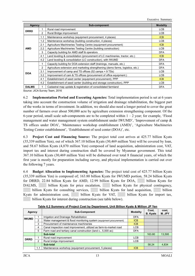
6.2 Implementation Period and Executing Agencies: Total implementation period is set at 6 years taking into account the construction volume of irrigation and drainage rehabilitation, the biggest part of the works in terms of investment. In addition, we should also need a longer period to cover the great number of farmers over about 500,000 acre by agriculture extension strengthening component. Of the 6-year period, small scale sub-components are to be completed within 1 – 2 year; for example, ‘Flood management and water management system establishment under IWUMD’, ‘Improvement of camp & TS offices under DOA’, ‘Maintenance workshop establishment (AMD)’, ‘Agriculture Machineries Testing Center establishment’, ‘Establishment of seed center (DOA)’, etc.
6.3 Project Cost and Financing Source: The project total cost arrives at 425.77 billion Kyats (35,339 million Yen), out of which 367.10 billion Kyats (30,469 million Yen) will be covered by loan, and 58.67 billion Kyats (4,870 million Yen) composed of land acquisition, administration cost, VAT, import tax and interest during construction shall be covered by Myanmar government. This total 367.10 billion Kyats (30,469 million Yen) will be disbursed over total 8 financial years, of which the first year is mostly for preparation including survey, and physical implementation is carried out over the following 7 years.
6.4 Budget Allocation to Implementing Agencies: The project total cost of 425.77 billion Kyats (35,339 million Yen) is composed of; 163.80 billion Kyats for IWUMD portion, 58.24 billion Kyats for DRRD, 22.84 billion Kyats for AMD, 12.99 billion Kyats for DOA, billion Kyats for DALMS, billion Kyats for price escalation, billion Kyats for physical contingency,
_ billion Kyats for consulting services, billion Kyats for land acquisition, billion Kyats for administration cost, billion Kyats for VAT, billion Kyats for import tax, _ billion Kyats for interest during construction (see table below).
Table 6.2 Summery of Project Cost by Department, Unit Billion Kyats & Million JP Yen
Agency Sub-Component Modality Cost,
B. Kyats cost,
M. JPY
IWUMD 1 Irrigation and Drainage Rehabilitation DFA 2 Water management & flood monitoring system (equipment procurement) ICB 3 Procurement of maintenance machineries ICB 4 Canal inspection road improvement, utilized as farm-to-market road LCB 5 Farm road and tertiary canal construction (land c., 5,000 ac) DFA
Sub-total 163.80 13,595
DRRD 1 Rural road improvement LCB 2 Rural bridge improvement LCB
Sub-total 58.24 4,834 1.1 Maintenance workshop (equipment procurement, 5 places) ICB

Executive Summary
MOALI 14 JICA
Agency Sub-Component Modality Cost, B. Kyats
cost, M. JPY
AMD
1.2 Maintenance workshop (building construction, 5 places) LCB 2.1 Agriculture Machineries Testing Centre (equipment procurement) ICB 2.2 Agriculture Machineries Testing Centre (building construction) LCB 3 Capacity building for AMD staff & operators DFA
4.1 Land leveling & consolidation (procurement of LC machineries) ICB 4.2 Land leveling and consolidation (LC construction), with IWUMD DFA
Sub-total 22.84 1,896
DOA 1 Capacity building for DOA extension staff (trainings, manuals, etc.) DFA 2 Agriculture extension strengthening (demo farms, logistics, etc.) DFA
3.1 Improvement of camp & TS offices (about 50 places) LCB 3.2 Improvement of camp & TS offices (procurement of office equipment) LCB 4.1 Establishment of seed center (equipment procurement), PPP ICB 4.2 Establishment of seed center (building and storage construction), PPP LCB
Sub-total 12.99 1,078 DALMS 1 Cadastral map update & registration of consolidated farmland DFA
a Above Total b Price Escalation c Physical contingency d Consultant fee (including Price Escalation & Contingency) I Total cost covered by loan (a+b+c+d) 367.10 30,469
1 Land Acquisition 2 Administration Cost 3 VAT 4 Import Tax 5 Interest during construction II Total cost of the portion not covered by loan
Grand Total (I+II) 425.77 35,339Exchange Rate: 0.083JPY/Kyat
6.5 Involved Departments and Respective Responsibilities: Since the Project is comprehensive in nature, it involves six departments of MOALI and MOC with different areas of responsibilities, namely, DOP, IWUMD, DOA, AMD, DALMS, and DRRD (former DRD, and now under MOC) and Minister’s office as well as Sagaing regional government office. To ensure the smooth implementation of the Project, setting up of Steering Committee (SC) at the central level, comprising of the total 8 offices mentioned before, and Project Management Unit (PMU) at the regional level, comprising of the counterpart executing arms of the central-level departments, are proposed as diagramed right:
6.6 Tasks to be Performed by the Steering Committee: With the foregoing, the SC is to facilitate smooth project implementation through appropriate deployment of construction machinery, timely material procurement and delivery, proper budget allocation, provision of necessary technical guidance, and control of budget expenditures. The SC has responsibility and authority on all activities such as planning, coordination between sections, management at the central level. Also, SC has the authority to supervise financial and accounting section as well in order to secure sufficient financial resources and appropriate payment for smooth project implementation. In addition, two working group will be established under the SC, namely;
Figure 6.1 Project Implementation Arrangement Source: JICA Survey Team

Executive Summary
JICA 15 MOALI
Accounting & Disbursement Management Group: Accounting & Disbursement Management Group takes responsibility of managing the accounting and disbursement status and internal procedure based on the report from field level. Accounting & Disbursement Management Group will be comprised of Deputy Director level of Accounting Division in respective departments.
Project Monitoring & Evaluation Group: The Project Status Report (PSR) will be compiled once in three months. In order to manage the project progress, especially submission of the PSR without delay, the Project Monitoring & Evaluation Group manages the internal procedure for submission of PSR. The Project Monitoring and Evaluation Group will be comprised of Assistant Director level from respective departments.
6.7 Working Groups and Other Actors: PMU will be located at Monywa, Sagaing Region, where most of the regional directors are assigned, except for Con (4) located in Shwebo, at least at the initial stage when local procurement takes place there. PMU will be shifted in a phased manner from Monywa to Shwebo during the physical implementation stage of the Project. PMU is chaired by the Director of Con (4), and the members will be comprised of regional Director level officials from Maintenance Division (Sagaing), DOA, AMD, DRRD, DALMS and General Administration Office (GAD). Within this PMU, three working groups should be established at the regional level, namely, 1) Accounting and disburse management group, 2) Project Monitoring Group, and 3) Land Consolidation Group as follows:
Accounting & Disbursement Management Group; Accounting & Disbursement Management Group takes responsibility of managing the accounting and disbursement status and internal procedure based on the activities at the field level, and reports to the central level Accounting & Disbursement Management Group. Accounting & Disbursement Management Group should be comprised of assistant director class and/or staff officer from the respective departments.
Project Monitoring Group; this working group monitors the project progress especially in compiling the Project Status Report (PSR) which should be submitted once in three months to JICA. It should be comprised of 10 members (2 members from IWUMD and 2 members each from AMD, DOA, DALMS and DRRD) from respective departments. Project Monitoring Group should be comprised of assistant director class and/or staff officer from the respective departments.
Land Consolidation Group; this working group deals with specific matters of Land Consolidation. This group will be comprised of IWUMD, AMD, DALMS, DOA and GAD and Farmland Administration Board (FAB), which is responsible for implementing Land Consolidation component. The members are in principle assistant director class and/or staff officer (Assistant Engineer) from respective departments.
6.8 JICA Procedures for Fund Management and Disbursement: With regard to fund management mechanism, JICA’s Transfer Procedure will be applied for disbursement for international procurement (e.g., consultant and construction/agricultural machinery) while JICA’s Advance Procedure will be applied for disbursement for local procurement (e.g., construction materials, payment to laborers), as in the case of the Irrigation Development Project in Western Bago Region. JICA’s Statement of Expenditure (SOE) Procedure would be applied to the Advance Procedure same as the said Western Bago project.
6.9 Budget Recipients and Evidence Requirement: It is recommended to open 2 D/A; one for DRRD portion and the other for the remaining departments such as IWUMD, DOA, AMD, DALMS. The disbursement procedure is conducted by each D/A. Submission of necessary expenditure reports and also disbursement request is therefore conducted respectively. In the advance procedure,

Executive Summary
MOALI 16 JICA
documents including evidence of payment such as receipts are required, and the SOE procedure exempts such documentation provided that the documents are audited annually. This means DRRD will be conducting disbursement procedure by itself, while other departments together will be conducting the procedure, separately from DRRD, in this Project.
6.10 Works to be done and Consultancy Arrangement: To carry out a loan project, consultants should be employed mainly for the 2 works such as; 1) detail design and also tender documents preparation, and 2) progress management including the supervision of construction works. Consultants will be composed of both international experts and national experts. There are five major components as; 1) irrigation and drainage improvement, 2) distribution infrastructure improvement, 3) agriculture mechanization strengthening, 4) land consolidation, and 5) agriculture development and extension strengthening. Of which, the last 2 components will not have consultants, but be proceeded by the government staff due to limited allocation of the consultancy fee.
7. PROJECT EVALUATION
7.1 Financial and Economic Justification of the Project: The EIRR and NPV calculated are presented below by major component as well as by major 3 or whole 5 components altogether. Regarding irrigation and drainage improvement including agriculture extension strengthening, the EIRR shows more than 15% opportunity cost ratio even with yield increase and area expansion only (19.5% in Base 0). If crop diversification is considered, the ratio increases to 24.6% (Base 1). NPV is estimated at 107,563 and 203,331 million Kyats, and further B/C ratios are calculated at 1.78 and 2.48 respectively for the cases (note that discount ratio of 12% was applied in calculating NPV and B/C ratio).
7.2 Return from the Project with Different Cropping Options: For land consolidation, it shows only 5.5% in Base 0 in consideration with the yield increase as well as farming cost reduction, but no change of cropping pattern. However, if shifting of the cropping pattern takes place, the EIRR increases up to 13.7% in Base 1 [from Monsoon Paddy (MP) –Summer Paddy (SP) to MP-SP-Green Gram (GG)], and up to 14.5% in Base 2 [from MP-SP to MP-Sesame-GG]. In fact, transformation of the cropping pattern seems challenging, and therefore this result implies that the component may not be viable in terms of economic efficiency. However, land consolidation project can be justified as a pilot project, in order to cope with future cost increase because of price escalation of farm casual labor wage.
7.3 Investment into Distribution Infrastructure and the Attributed Benefit: The benefit of distribution infrastructure improvement marks 17.9% of EIRR in Base 0 (summer crop is paddy only ) and 17.7% in Base 1 (part of summer crop is diversified from paddy to sesame/ green gram), which is large enough to ensure the economic validity. NPV at the cut-off discount ratio of 12% comes to 25,194 million Kyats with B/C ratio of 1.37 (Base 0), and 24,205 million Kyats with B/C ratio of 1.36 (Base 1). There is a justification that the investment into the distribution infrastructure improvement
Figure 6.2 Funds Flow Arrangements Source: JICA Survey Team

Executive Summary
JICA 17 MOALI
should be done as proposed.
7.4 Economic Validity and Overall Return: In order to investigate the economic validity of the Project overall, the EIRR for the major 3 components is calculated with aggregated benefits and costs for the said 3 major component. The result marks 18.9% EIRR with 130,802 million Kyats of NPV and 1.46 B/C ratio. Further, overall EIRR is also estimated by involving all the costs including agriculture mechanization components (Note that in this estimation, the benefits are counted only from the major 3 components as the other benefits are difficult to estimate). The overall return arrives at 16.5% and 20.2% respectively in Base0 and Base1 (summer crop diversification considered), indicating the Project is justified to invest.
Table 7.1 Economic Internal Rate of Return and Net Present Value Case IRR NPV*1 , million Kyats B/C*1
Irrigation & Drainage Improvement Base0 (only yield and area increase considered) 19.5% 107,563 1.78 Base1 (crop diversification of summer crop considered) 24.6% 203,331 2.48
Land Consolidation Base0 (2 crops per year) 5.5% -1,955 0.59 Base1 (3 crops per year) 13.7% 531 1.11 Base2 (3 crops per year, w/ summer crop diversification) 14.5% 789 1.17
Distribution Infrastructure Improvement Base0 (monsoon paddy + summer paddy) 17.9% 25,194 1.37 Base1 (monsoon paddy + SP plus diversification) 17.7% 24,205 1.36
Major Three Components Base0 (only yield and area increase considered) 18.9% 130,802 1.46
All Components (5 components) Base0 (only yield and area increase considered) 16.5% 98,450 1.26 Base1 (crop diversification of summer crop considered) 20.2% 196,586 1.67 Note: discount ratio of 12% was applied in calculating NPV and B/C ratio. Source: JICA Survey Team
7.5 Confirmation of With and Without Project Cases: With the assumptions of; 1) a typical person consumes 150 kg of rice per annum and 2) milling rate is set at 0.50 (50%), the Project area with the current condition has already supported 3.5 million population in terms of staple food supply. With-project, the Project area now supports 5.1 million population by the surplus rice produced. Looking into the balance between before-project and after-project, the increment is 1.6 million population. Thus, it is found that the Project area, even under present condition, plays a very important role in supplying staple food to the non-agricultural population, and this role will be further strengthened by the Project.
7.6 Farm Budget Analysis and Expected Project Benefit: A farm budget was analyzed by major component. A typical farmer at present, namely without project, earns a net income of 2.9 million Kyats. After the irrigation and drainage improvement coupled with agriculture extension strengthening have been implemented, the net income of ‘with- project’ would increase up to 4.3 million Kyat, or by 45.7% in Base 0, and increase up to 4.8 million Kyats or by 63.6% if we consider crop diversification (Base 1). In a target land consolidation area, net benefit per farmer household is calculated at 2.5 million Kyats without project. In Base 0, the estimated gross-profit-increase per household is by 5.6%, and the estimated cost-reduction per household is by 27.1%. In total, the estimated net-profit-increase is by 47.1%. Both results show great impact on the farmers’ income.
7.7 Value-addition and Its Beneficiaries: Added-values of the stakeholders can be separated by unit-added value (defined as net-income per kg) and handling volume per actor. Effect on handling of volume is expected from the enhancement of the production basis, such as, mainly, irrigation & drainage improvement and agriculture extension strengthening. On the other hand, effect on value chain rationalization is supposed to come from rationalizing market distribution system like road rehabilitation. Along the chain, the overall benefit of the Project is now estimated at 156,981 million Kyats. Of them, 93,385 million Kyats (60%) are on the farmers, while brokers, transporters, rice

Executive Summary
MOALI 18 JICA
millers are benefited by 32,638 million Kyats (21%), 2,027 million Kyats (1%), and 28,933 million Kyat (18%) respectively.
7.8 Job Creation by Project Implementation: Employments will be generated in each of the Project implementation stage. As for irrigation & drainage improvement, there will be 6 month-construction period in a year. Approximately 4,300 persons/day of employment opportunities are to be created to meet the construction demand. Likewise, the distribution infrastructure improvement is expected to generate additional employments of 1,800 persons/day or 3,000 persons/day for the construction period of 10 months and 6 months respectively.
7.9 Increment in Agricultural Production and Employment Opportunity: In relation to increased agricultural production with the Project, there will be a lot of employment opportunities for farm casual labors. If the current labor intensive agriculture is assumed to continue even in future, it is expected to generate new employments of 62,000 persons/day for the farm casual labors. Due to increments of the paddy production, rice millers also need additional manpower to handle the increased amount. Approximately 4,960 persons/day of employment are generated in this stage. As for the distribution of products, approximately 5,410 persons/day of employment will be expected to occur upon the Project completed.
8. ENVIRONMENT
8.1 Construction Works and Their Environmental Impacts: Out of the proposed components in the Project, three components, namely, “Land consolidation”, “Irrigation and drainage improvement” and “Distribution infrastructure improvement”, accompany a series of construction works. They may cause some negative impacts on surrounding environment, which should be avoided and, if occurs, minimized. Therefore, this environmental and social consideration in the Project should focus on the impacts by these three components mentioned above.
8.2 Land Consolidation Works and Related Issues: In case of “Land consolidation” some profits, namely, cost reduction for farming, production improvement by stable water supply, increase of land values and so on are expected. On the other hand, usually 6 - 10 % at maximum of farmland is decreased by the land consolidation works. The target sites have yet to be determined, since they will be fixed based on farmers’ application. Therefore, the actual land to be consolidated and the beneficiaries are unknown at this moment; however, the farmers in the Project area generally welcome the component since they understand that the profit can compensate the land loss. Even though the land consolidation works stops farming activity for one season, it is acceptable for the farmers.
8.3 Formalities for Land Consolidation Works: Prior to the land consolidation works, some procedures, such as set-up of Working Committee consisting of IWUMD, DALMS and AMD shall be taken. The committee will facilitate the farmers to participate in the land consolidation. The farmers are requested to fill the application form and bring the agreements with signatures of all the beneficiaries, and then the target areas will be determined. Cadastral maps of the target areas shall be updated and re-allocation plans are to be prepared. Those activities will be initiated from mid 2018 and completed till the mid 2019, covering 2,000 ha (5,000 acre) in total.
8.4 Issues Relation to Irrigation and Drainage Improvement Works: Concerning “Irrigation and Drainage Improvement”, it also would suspend farming for one season due to the construction works. However, the farmers welcome the component, considering that they can access to stable irrigation water with the Project completed. Apart from the issue, expected negative impacts of the component are air pollution, water pollution, noise/vibration and so on during the construction period, which are not very severe.

Executive Summary
JICA 19 MOALI
8.5 Soft and Hard Aspects of Infrastructure Improvement: As for “Distribution Infrastructure Improvement”, expected negative impacts are air pollution, water pollution, noise/vibration and so on during the construction period, which are in fact not very severe. Further, land acquisition is necessary since the road planned to be asphalt-paved shall be expanded by one feet on both sides due to the recent change in the standard design of DRRD. Therefore, a Resettlement Action Plan (RAP) was prepared in which the concerned landowners were identified and an agreement were made of submitting the land necessary for the expansion in exchange of compensation.
9. CONCLUSION AND RECOMMENDATIONS
9.1 Project Feasibility and Steps to be taken: Taking into account below, this Survey concludes that the Project to improve agriculture income of the beneficiaries by improving infrastructure such as irrigation, road, bridges together with strengthening of agriculture extension services and farm mechanization should be implemented as soon as possible. The GOM should therefore take immediate action toward availing of the funds, approximately 30 billion Yen (367 billion Kyats) for Japanese ODA loan. Appropriation from the Government coffer should also be made available, approximately total 4.9 billion Yen (59 billion Kyats), for the project management, taxes relevant, land acquisition, etc.
10 The Project, from the viewpoint of national development, gives an overall EIRR 16.5% - 20.2% for all the 5 components combined and also 18.9% for the major 3 components such as irrigation & drainage improvement with agriculture development and extension service strengthening, distribution infrastructure improvement (rural road and bridges improvement), and land consolidation. By major component, irrigation & drainage improvement with extension service strengthening gives 19.5 – 24.6 % return, land consolidation shows 5.5% - 14.5% return, and the distribution infrastructure improvement provides 17.7 – 17.9% return. All, excepting only the base case of land consolidation, show higher returns than the opportunity cost of capital, 12-15 %, applied in most of the development projects.
11 With the improvement/rehabilitation of irrigation and drainage facilities of Thapanzeik dam irrigation system, the past averaged 58% of summer paddy area will be enlarged to as much as 79%, and also the area of monsoon paddy will be increased from the current 98% to 100%. Further if a part of summer paddy area is diversified to other upland crops, e.g. sesame and green gram, the copping intensity of the summer crop will increase even up to 100% composed of 31% upland crop and 69% summer paddy. With this area increment and also yield increase by enhanced extension services, a typical farmer’s net income will increase from 3.0 to 4.3 million Kyats per annum in case of monsoon and summer paddies cultivated and from the same 3.0 to 4.9 million Kyats if sesame/ green gram cultivated instead of summer paddy. The increments are therefore 146% and 164 % respectively.
11.1 Recommendations and Undertakings of Project Proponents: In implementing the Project as planned and scheduled as well as to achieve the project objectives afore-mentioned, following measures shall be undertaken by the Project Owner, MOALI/MOC, which are the recommendations obtained through this Survey;
1) The consultants to be engaged in the Project will be availed from the end 2018 or the beginning of year 2019; namely spending year 2018 for the selection of the consultants under ICB. It means that the MOALI should seek a way of preparing for the bid documents for machineries and equipment to be procured under the Project. The machineries and equipment need to arrive at the sites within 2019 except for equipment of flood and water management which are to be installed at the 2nd last year. Therefore tender should be held by mid 2018 at the earliest case, e.g.

Executive Summary
MOALI 20 JICA
procurement of machineries engaged in land consolidation (first batch works to be implemented from December 2018 to May 2019), and at latest case by March 2019. MOALI may request JICA technical assistances to support the works afore-mentioned.
2) There are 5 implementing departments, i.e., DOA, IWUMD, AMD, DALMS, DRRD, and further DOP and the minister’s office are involved at the HQs level while GAD (general administration department) takes part in at the regional level. Therefore, coordination mechanism shall be well institutionalized both at the HQs level and at regional level, and further at the implementation level mainly in Shwebo. Steering Committee and Project Management Unit should be established at HQs level and the regional level well in advance of the project commencement. A project operation manual including project operation & management, accounting and disbursement management, reporting, etc. should be prepared, practically tested, and approved by the SC.
3) To execute daily management, there should be working committee groups under the SC and also under the PMU. There should be Accounting and Disbursement Management committee and Project Monitoring and Evaluation committee under the SC while those two committees plus Land Consolidation committee under the PMU. The committees for the SC should be composed of director/ assistant director class officers, and the committees under PMU by assistant directors. They shall work in coordinating the relevant departments and undertake the key tasks as indicated by the name of the committee. They are supposed to prepare necessary documents for accounting, disbursement, others including Project Status Report (PSR) to be submitted to the SC, PMU and JICA.
4) There would be 2 designated accounts (D/A) expected under the Project; one for DRRD and the other for DOA, IWUMD, AMD, DALMS. Each of the designated accounts should be allocated sole responsible officers, e.g. 2 officers for DRRD D/A and for the other joint D/A, one lead officer from IWUMD and 4 supportive staff, each of whom should come from each of the 4 departments of DOA, IWUMD, AMD and DALMS. They can be a member of Accounting and Disbursement Management Group to be established under the SC.
5) Taking into account the present low yields of paddy and sesame/ green gram, there could be a lot of potential of increasing the yield given appropriate agriculture extension services together with irrigation water. To enhance the extension services, there should be a technical assistance provided by an international institute or donor. DOA, aside from discharging the extension services on their own, should consider inviting a team of agricultural experts from international institutes. Note that the cost will be eligible from the loan disbursement.
6) Concerning potential technical assistance from JICA, there should be a strong need in 2 areas; 1) certified seed production and distribution, and 2) introduction of participatory irrigation management (PIM) to be conducted under irrigation management transfer (IMT). In fact, there is already an agreement between DOA and JICA in that JICA assists certified seed dissemination in Ayeyarwady region and also in Shwebo area by dispatching a team of experts from late 2017. This technical cooperation should be expected to link up with the extension strengthening component under the Project. In addition, IWUMD may request JICA to provide a technical cooperation which supports IWUMD to introduce IMT and PIM.
7) Irrigation and drainage improvement works will be carried out by IWUMD direct force except for, probably, minor canal rehabilitation. In this regard, IWUMD should prepare for enough number of construction machineries. According to the work volume expected, many heavy machineries are to be required; for example, during peak period there should be 20 track dozers, 39 hydraulic excavators, 55 dump tracks, 31 truck cranes, 18 water bowsers, 39 concrete mixers,

Executive Summary
JICA 21 MOALI
and so on. The construction machineries should be well maintained and in case of out-of-order repair should be made as early as possible. Note that maintenance and repair including spare part procurement will be eligible from the loan disbursement.
8) Water stop in the Thapanzeik dam irrigation system is very short, say from mid November to mid February. Though the construction could be carried out during this winter season and also during the following summer season upon consensus from the concerned farmers, longitudinal and cross sectional surveys for detail design purpose should only be done during the ordinal water stop period, which is only winter season. IWUMD should conduct those surveys during the winter season from December 2017 to February 2018; otherwise detail design could not be commenced from the end 2018 or from the early 2019 when the consultants are to come.
9) Irrigation Technology Center (ITC) of IWUMD in Mandalay shall be fully utilized for quality control such as the checking of concrete mortar strength, confirmation of design mixture of concrete and mortar, and the level of soil compaction, etc. for the works carried out by IWUMD direct force account. These test results shall be sent to the consultants for their approval before the commencement of relevant construction works. In case that testing equipment and tools are not enough, procurement or otherwise availing of existing equipment from relevant laboratories shall be arranged.
10) For the rural roads to be upgraded to asphalt, each one feet of the shoulder portion will be extended to both sides. This design change from the original existing section, from 3 ft width shoulder to 4 ft shoulder each, will require land acquisition of narrow strips both sides of the planned roads along total 9.9 km (6.2 miles) length, which are parts of asphalt to-be-upgraded 52 km (32 miles). The DRRD should be prepared for the compensation. As for the standard design by DRRD, longitudinal designing is not usually included but cross section only is prepared. However, the longitudinal section of asphalt road planned under the Project should undertake longitudinal designing, and therefore longitudinal and sectional surveys are to be required.
11) One of the AMD components is to establish agriculture machineries testing center to be in Mandalay. This is the first time facility to be available in Myanmar, and the test equipment will be sophisticated ones. Therefore, to operate and maintain the testing center, capacity building for the operators/ officers in charge is due important. The capacity building should be done not only at the delivery time/place of the equipment by the supplier but also at an international institute which has similar testing experiences. The AMD should consider dispatching the staff to such international institute, e.g. Institute of Agricultural Machinery, Japan.

i
CONTENTS
COMPOSITION OF THE REPORTS MAIN REPORT (English Version) APPENDIX (English Version)
LOCATION MAP OF THE SURVEY AREA CONTENTS LIST OF TABLES LIST OF FIGURES
CHAPTER 1 RATIONALE AND GOAL OF THE PROJECT .................................................. 1-1 1.1 Rationale of the Survey ........................................................................................................ 1-1 1.2 Purpose of and Outputs from the Survey ............................................................................. 1-2 1.3 Schedule of the Survey ........................................................................................................ 1-3 1.4 The Survey Area .................................................................................................................. 1-3 1.5 Implementation Arrangement of the Survey ........................................................................ 1-4
CHAPTER 2 CHALLENGES AND OPPORTUNITIES IN MYANMAR AGRICULTURE .. 2-1 2.1 Agriculture Production, Export and Distribution ................................................................. 2-1
2.1.1 Agriculture Production by Region and by Crop...................................................... 2-1 2.1.2 Export of Crops and Relevant Potential .................................................................. 2-5 2.1.3 Flow of Major Agricultural Products in Myanmar.................................................. 2-8
2.2 Issue Facing the Myanmar Agriculture .............................................................................. 2-10 2.2.1 Decline in Younger-Generations ........................................................................... 2-10 2.2.2 Migration from Rural to Urban Areas ................................................................... 2-11 2.2.3 Farm Casual Labor in Myanmar Agriculture ........................................................ 2-11 2.2.4 Agriculture Mechanization and Land Consolidation ............................................ 2-12
2.3 Agriculture Sector Development Policies and Plans in Myanmar ..................................... 2-14 2.3.1 Relevance in National Development Plan and New Economic Policy
(June 2016) ............................................................................................................ 2-14 2.3.2 Relevance in Agricultural Development Plan ....................................................... 2-16
2.4 Agriculture Development in Economic Development Path ............................................... 2-19 2.4.1 Role of the Agriculture in the Economic Development Path ................................ 2-19 2.4.2 Two-Polar Growth Development and Overall Economic Development ............... 2-20 2.4.3 Synergy Development by Agriculture and Industry Development ....................... 2-20
2.5 Donor Involvement in Relevant Sectors ............................................................................ 2-21
CHAPTER 3 THE PROJECT AREA ........................................................................................... 3-1 3.1 Salient Features of the Project Area ..................................................................................... 3-1
3.1.1 Spatial Settings and Positioning in Agriculture Context ......................................... 3-1 3.1.2 Area, Population and Beneficiaries ......................................................................... 3-2 3.1.3 Meteorology: Rainfall and Temperature ................................................................. 3-3 3.1.4 Hydrology: Rivers and Sources for Irrigation ......................................................... 3-5
3.2 Rural Society and Rural Economy ....................................................................................... 3-7 3.2.1 Economy and Rural Employment ........................................................................... 3-7 3.2.2 Village Profile ......................................................................................................... 3-8 3.2.3 Farmers’ and Non-farmers’ Asset and Debts ......................................................... 3-11
ii
3.2.4 Farmers’ and Non-farmers’ Income and Income Disparity ................................... 3-13 3.3 Agriculture in the Project Area .......................................................................................... 3-15
3.3.1 Agricultural Land Use and Soils ........................................................................... 3-15 3.3.2 Cropping Pattern ................................................................................................... 3-16 3.3.3 Crop Production in 9 Townships ........................................................................... 3-19 3.3.4 Irrigated Area by Thapanzeik Dam Irrigable Area ................................................ 3-24 3.3.5 Irrigated and Cultivated Areas by Satellite Image Analysis .................................. 3-25 3.3.6 Yield of Crops and Paddy Production in Thapanzeik Dam Irrigable Area ........... 3-28 3.3.7 Farmland and Farm Holdings................................................................................ 3-28 3.3.8 Issues Facing the Farmers ..................................................................................... 3-29 3.3.9 Soil Fertilization .................................................................................................... 3-30 3.3.10 Farm Economy per Production Area ..................................................................... 3-30 3.3.11 Seed Multiplication and Distribution System ....................................................... 3-32
3.4 Agriculture Extension System in the Project Area ............................................................. 3-39 3.4.1 Extension Services to Farmers .............................................................................. 3-39 3.4.2 DOA Extension System ........................................................................................ 3-40 3.4.3 Extension Activity ................................................................................................. 3-44 3.4.4 Training to Extension Workers .............................................................................. 3-45 3.4.5 Call Center and Web-based Extension .................................................................. 3-47 3.4.6 Other Important Players in Agricultural Extension ............................................... 3-47 3.4.7 Difficulties of Extension Workers ......................................................................... 3-48 3.4.8 Challenges in Extension Strengthening ................................................................. 3-48
3.5 Agricultural Mechanization and Land Consolidation in the Project Area ......................... 3-51 3.5.1 Agricultural Mechanization in the Project Area .................................................... 3-51 3.5.2 AMD’s Role and Activities in the Project Area .................................................... 3-52 3.5.3 Land Consolidation Carried Out in the Project Area ............................................ 3-56 3.5.4 Issues in Agricultural Mechanization and LC ....................................................... 3-57
3.6 Thapanzeik Dam Irrigation Scheme .................................................................................. 3-59 3.6.1 Irrigation System in the Project Area .................................................................... 3-59 3.6.2 Area Irrigated by Year and by Crop ...................................................................... 3-69 3.6.3 Operation and Maintenance .................................................................................. 3-70 3.6.4 Water Management and System Operation ........................................................... 3-73
3.7 Distribution Infrastructure: Road Network, Bridges and Jetty .......................................... 3-76 3.7.1 Road under DOR, Ministry of Construction ......................................................... 3-76 3.7.2 Roads under Department of Rural Development (DRD) ...................................... 3-78 3.7.3 Canal Maintenance Road under IWUMD ............................................................. 3-82 3.7.4 Kyauk Myaung Jetty ............................................................................................. 3-83
3.8 Agriculture Produce Distribution and Value Chain System ............................................... 3-85 3.8.1 Overall Distribution and Value Chain ................................................................... 3-85 3.8.2 Overview of Major Markets concerning Shwebo Area ......................................... 3-87 3.8.3 Paddy Distribution and Value Chain ..................................................................... 3-89 3.8.4 Pulses, Beans, and Oilseeds Distribution and Value Chain ................................... 3-91
CHAPTER 4 DIRECTION SETTINGS AND COMPONENTS IDENTIFIED .............. ……..4-1 4.1 Direction Settings ................................................................................................................ 4-1
4.1.1 Historical Implication over Agricultural Development ........................................... 4-1 4.1.2 Agricultural Development in Myanmar Context .................................................... 4-1

iii
4.1.3 Overall Direction Setting: ....................................................................................... 4-2 4.2 Relevancy to National Development Policy and Plans ........................................................ 4-2
4.2.1 Relevancy to Economic Policy of the Union of Myanmar (July 2016) .................. 4-2 4.2.2 Conformity to the 2nd Five Year Short Tem Plan..................................................... 4-3 4.2.3 Relevancy to Food Value Chain Road Map (2016-20) in Myanmar ....................... 4-4 4.2.4 Relevancy to Myanmar Industrial Development Vision ......................................... 4-5
4.3 Project Component Identification for the Project ................................................................ 4-6 4.3.1 Potential Components Identification along the Value Chain................................... 4-6 4.3.2 Component Examination for the Project ................................................................. 4-7 4.3.3 Components Selected and Relevant Departments ................................................. 4-10
CHAPTER 5 PROJECT PLANNING AND DESIGNING ......................................................... 5-1 5.1 Agriculture Development and Extension Strengthening ...................................................... 5-1
5.1.1 Direction of Agricultural Development in the Project Area .................................... 5-1 5.1.2 Agriculture Development ........................................................................................ 5-3 5.1.3 Agriculture Extension Strengthening ...................................................................... 5-6 5.1.4 Establishment of Seed Center ............................................................................... 5-14 5.1.5 Strengthening of DOA Seed Farms ....................................................................... 5-18
5.2 Agriculture Mechanization Strengthening ......................................................................... 5-20 5.2.1 Capacity Building in Agriculture Mechanization ................................................. 5-20 5.2.2 Maintenance Workshop Establishment ................................................................. 5-22 5.2.3 Agriculture Machineries Testing Center ............................................................... 5-24 5.2.4 Operation and Maintenance upon Project Completion ......................................... 5-27 5.2.5 Impact and Output Expected ................................................................................. 5-30
5.3 Land Consolidation ............................................................................................................ 5-31 5.3.1 Land Consolidation Target Setting ........................................................................ 5-31 5.3.2 Institutional Arrangement ..................................................................................... 5-32 5.3.3 Construction Arrangement (Direct Force Account) .............................................. 5-35 5.3.4 Implementation Procedure for Land Consolidation .............................................. 5-36 5.3.5 Establishing Farmer Organization ......................................................................... 5-39 5.3.6 Technical Aspect for Land Consolidation ............................................................. 5-41 5.3.7 Operation and Maintenance of Land Consolidation Area ..................................... 5-43 5.3.8 Land Consolidation Pilot Activities (Leik Chin Village) ...................................... 5-44
5.4 Irrigation and Drainage Improvement, and Flood Monitoring .......................................... 5-48 5.4.1 Present and Potential Irrigable Areas to Expand ................................................... 5-48 5.4.2 Rehabilitation of Irrigation Facilities .................................................................... 5-53 5.4.3 Strengthening of Drainage Function ..................................................................... 5-67 5.4.4 Flood Monitoring and Mitigation.......................................................................... 5-69 5.4.5 Water Management and System Operation ........................................................... 5-74 5.4.6 IMT and Water Users Association Establishment ................................................. 5-79 5.4.7 Operation and Maintenance of Irrigation Systems ................................................ 5-87 5.4.8 Procurement of Maintenance Machineries ............................................................ 5-90
5.5 Distribution Infrastructure Improvement and Upgrading .................................................. 5-91 5.5.1 Rural Road Improvement/ Upgrading (DRD) ....................................................... 5-91 5.5.2 Bridge Improvement/ Upgrading (DRD) .............................................................. 5-97 5.5.3 Canal Inspection Road Improvement/ Upgrading (IWUMD) ............................... 5-98
CHAPTER 6 PROJECT COST AND IMPLEMENTATION ARRANGEMENT .................... 6-1

iv
6.1 Project Components and Scoping for Yen Loan .................................................................. 6-1 6.1.1 Components Selected and Relevant Departments ................................................... 6-1 6.1.2 Eligible Scope for Yen Loan ................................................................................... 6-2
6.2 Implementation Modality by Component ............................................................................ 6-3 6.3 Implementation Schedule..................................................................................................... 6-6
6.3.1 Overall Implementation Schedule by Component .................................................. 6-6 6.3.2 Seasonal Implementation Schedule ......................................................................... 6-9
6.4 Cost Estimation and Disbursement .................................................................................... 6-10 6.4.1 Basis of Cost Estimation ....................................................................................... 6-10 6.4.2 Project Cost by Component and Total ................................................................... 6-11
6.5 Institutional Setup for Project Implementation and Monitoring ........................................ 6-14 6.5.1 Agencies Concerned and Implementation Capacities ........................................... 6-14 6.5.2 Responsible Implementation Body at Central Level............................................. 6-16 6.5.3 Responsible Implementation Body at Field Level ................................................ 6-19
6.6 Fund Flow .......................................................................................................................... 6-21 6.6.1 Fund Management Mechanism ............................................................................. 6-21 6.6.2 Advance and Transfer Procedures ......................................................................... 6-21
6.7 Consultancy Services and Possible JICA Technical Assistances ....................................... 6-23 6.7.1 Consultancy Services (Loan Consultants) ............................................................ 6-23 6.7.2 Technical Assistances from JICA ........................................................................ 6-26
6.8 Possibility of Incorporating Japanese Experiences/ Knowledge ....................................... 6-27 6.9 Areas to Share and Collaborate with JICA TCP / Donors ................................................. 6-28
CHAPTER 7 PROJECT EVALUATION ..................................................................................... 7-1 7.1 Conditions, Methodology and Evaluation Cases ................................................................. 7-1
7.1.1 Basic Condition and Assumptions .......................................................................... 7-1 7.1.2 Cases for Project Evaluation ................................................................................... 7-2
7.2 Economic Term of Project Cost and Benefit ........................................................................ 7-5 7.2.1 Economic Term of Project Cost .............................................................................. 7-5 7.2.2 Economic Term of Project Benefit .......................................................................... 7-6
7.3 Project Economic Evaluation ............................................................................................... 7-9 7.3.1 Economic Project Benefits ........................................................................................................ 7-9 7.3.2 Economic Internal Rate of Return (EIRR) and Net Present Value (NPV) ............ 7-11
7.4 Farm Budget Analysis ........................................................................................................ 7-12 7.4.1 Farm Budget Analysis in Irrigation & Drainage Improvement
(& Extension Services) ......................................................................................... 7-12 7.4.2 Farm Budget Analysis in Land Consolidation ...................................................... 7-13
7.5 Effect on Rice Supply to Urban and Industry Workers ...................................................... 7-14 7.6 Effect on Transport Cost Reduction by Distribution Infrastructure Improvement ............ 7-14 7.7 Effect on Food Value Chain Establishment ....................................................................... 7-15 7.8 Effect on Generating Employment .................................................................................... 7-16
7.8.1 Generating Employment in Respective Stages ................................................... 7-16 7.8.2 Ripple Effect on Employment in Others Sector ................................................. .7-17
7.9 Proposed Indicators for Project Operation and Effects ...................................................... 7-18 7.9.1 Agriculture Development and Extension Strengthening ..................................... 7-18 7.9.2 Agriculture Mechanization Strengthening ............................................................ 7-19 7.9.3 Land Consolidation ............................................................................................. 7-19

v
7.9.4 Irrigation and Drainage Improvement ................................................................. 7-20 7.9.5 Distribution Infrastructure Improvement ......................................................... ...7-20
7.10 Risk Identification and Management ................................................................................. 7-21
CHAPTER 8 ENVIRONMENTAL CONSIDERATION ............................................................. 8-1 8.1 Project Components ............................................................................................................. 8-1 8.2 Legislative and Institutional Framework of Environmental Consideration in Myanmar .... 8-4
8.2.1 Legislative and Institutional System for Environmental Impact Assessment in Myanmar ............................................................................................................. 8-4
8.2.2 Environmental Standards in Myanmar .................................................................... 8-8 8.2.3 JICA Policy for Involuntary Resettlement and Land Acquisition ........................... 8-9 8.2.4 Project Categorization by JICA in terms of Environmental and
Social Consideration ............................................................................................. 8-10 8.2.5 Gap Analysis ......................................................................................................... 8-10
8.3 Environmental and Social Considerations ......................................................................... 8-11 8.3.1 Current Environmental and Social Conditions...................................................... 8-12 8.3.2 Examination of Alternatives .................................................................................. 8-17 8.3.3 Scoping and the TOR for Environmental and Social Consideration ..................... 8-19 8.3.4 Results of Environmental and Social Examination ............................................... 8-27 8.3.5 Impact Evaluation of the Environmental and Social Examination ....................... 8-35
8.4 Mitigation Measures and Monitoring ................................................................................ 8-41 8.4.1 Mitigation Measures and Cost .............................................................................. 8-41 8.4.2 Monitoring Plan .................................................................................................... 8-44
8.5 Stakeholder Meeting .......................................................................................................... 8-50 8.6 Grievance Handling Mechanism ........................................................................................ 8-52
8.6.1 Grievance Handling Mechanism for “Land Consolidation” ................................. 8-52 8.6.2 Grievance Handling Mechanism for “Irrigation and Distribution Improvement” 8-53
8.7 Environmental Framework for the Land Consolidation .................................................... 8-54 8.8 Land Acquisition for the “Distribution of Infrastructure Improvement” ........................... 8-58
8.8.1 Necessity of Land Acquisition .............................................................................. 8-58 8.8.2 Legal Framework regarding Land Acquisition in Myanmar ................................. 8-58 8.8.3 Scope of Land Acquisition .................................................................................... 8-62 8.8.4 Compensation Measures ....................................................................................... 8-63 8.8.5 Grievance Redress Mechanism ............................................................................. 8-64 8.8.6 Implementation Structure ...................................................................................... 8-64 8.8.7 Implementation Schedule ...................................................................................... 8-65 8.8.8 Cost and Fund Source ........................................................................................... 8-65 8.8.9 Monitoring Structure ............................................................................................. 8-66 8.8.10 Stakeholder Meeting on the Land Acquisition ...................................................... 8-67
8.9 Environmental Check List for the Proposed Components ................................................. 8-69 8.10 Check List for Environmental Social Management System .............................................. 8-72
CHAPTER 9 GLOBAL ISSUES .................................................................................................... 9-1 9.1 Poverty Reduction ................................................................................................................ 9-1 9.2 Climate Change .................................................................................................................... 9-2
9.2.1 Climate Change Review and Future Simulation by UNEP ..................................... 9-2 9.2.2 Project Intervention in the Climate Change ............................................................ 9-5
9.3 Gender .................................................................................................................................. 9-5

vi
9.3.1 Current Gender Conditions in Myanmar ................................................................. 9-5 9.3.2 Gender Mainstreaming in the Proposed Components ............................................. 9-7
CHAPTER 10 CONCLUSION AND RECOMMENDATIONS ................................................. 10-1 10.1 Conclusion ......................................................................................................................... 10-1 10.2 Recommendations .............................................................................................................. 10-1
APPENDIXES:
I. IMPLEMENTATION ARRANGEMENT .....................................................................I-1 II. RURAL SOCIETY ......................................................................................................... II-1 III. AGRICULTURE .......................................................................................................... III-1 IV. AGRICULTURAL MECHANIZATION..................................................................... IV-1 V. IRRIGATION AND DRAINAGE, FLOOD MONITORING .................................... V-1 VI. ROAD, BRIDGE AND JETTY .................................................................................... VI-1 VII. DEPARTMENTS CONCERNED .............................................................................. VII-1 VIII. ENVIRONMENT .......................................................................................................VIII-1 IX. COST ESTIMATION ................................................................................................... IX-1 X. PROJECT EVALUATION ............................................................................................ X-1 XI. SATELLITE IMAGE ANALYSIS ............................................................................... XI-1 XII. TOR AND PERSON-MONTH FOR YEN LOAN PROJECT CONSULTANT .... XII-1 XIII. LAND CONSOLIDATION PILOT ACTIVITIES (LEIK CHIN VILLAGE) ......XIII-1

vii
ACRONYMS AND ABBREVIATIONS ADS Agriculture Development Strategy AEC ASEAN Economic Community AED Agricultural Extension Division AMD Agricultural Mechanization Department BS Breeder Seed BTMU Bank of Tokyo-Mitsubishi UFJ, Ltd. CARTC Central Agriculture Research and Training Centre CBM Central Bank of Myanmar CEC Crop Exchange Center CIF Cost, Insurance and Freight CS Certified Seed CSO Central Statistical Organization DA Designated Account (D/A) DACU Development Assistance Coordination Unit DALMS Department of Agricultural Land Management and Statistic (former SLRD) DAR Department of Agriculture Research DFA Direct Force Account DNP Defect Notification Period DOA Department of Agriculture DOP Department of Planning (former Department of Agricultural Planning) DOR Department of Road (under Ministry of Construction) DRD Department of Rural Development (under MOALI till July 2017, and moved to
MOC as DRRD) DRRD Department of Rural Road Development (former DRD, now under MOC) DWIR Directorate of Water Resources and Improvement of River System ECC Environmental Conservation Committee ECD Environmental Conservation Department ERIA Economic Research Institute for ASEAN and East Asia FAB Farmland Administration Body (composed of Village Administrator, DALMS, DOA) FAO Food and Agriculture Organization FESR Economic and Social Reform (2013-2015) FF Fact Finding (mission, JICA) FOB Free on Board FS Foundation Seed FY Financial Year (Fiscal Year) GAD General Administration Department (under Ministry of Home Affairs) GAFSP Global Agriculture and Food Security Program GOJ Government of Japan GOM Government of Myanmar HD Highway Department (under Ministry of Construction) HDI Human Development Index ICB International Competitive Bid ICM Integrated Crop Management IMWUD Irrigation and Management of Water Utilization Department (former ID) IMT Irrigation Management Transfer

viii
IRR Internal Rate of Return IRRI International Rice Research Institute IWT Inland Water Transport JICA Japan International Cooperation Agency LA Loan Agreement (L/A) LC Land Consolidation LCB Local Competitive Bid LIB Limited International Bidding LIFT Livelihoods & Food Security Trust Fund, UNOPS MADB Myanma Agricultural Development Bank MAFF Ministry of Agriculture, Forestry and Fisheries (in Japan) MEB Myanmar Economic Bank MFTB Myanma Foreign Trade Bank MICB Myanma Investment and Commercial Bank MOALI Ministry of Agriculture, Livestock and Irrigation MOC Ministry of Construction MONREC Ministry of Natural Resource and Environmental Conservation MOTC Ministry of Transport and Communication NCDP National Comprehensive Development Plan NGO Non-Government Organization NPK Nitrogen, Phosphate, Potassium NPT Nay Pyi Taw ODA Official Development Assistance OFID OPEC Funded International Development POA Project Operation Account (P/A) PIM Participatory Irrigation Management PPP Public Private Partnership PSR Project Status Report RS Registered Seed RRB Report Review Body SGA Seed Growers Association SLRD Settlement and Land Record Department (changed to DALMS) SOE Statement of Expenditure SMS Subject Matter Specialist SMS Short Message Service (through cell phone) SNS Social Networking System TA Technical Assistance TCP Technical Cooperation Project TS Township (the smallest administrative unit where government institutions are placed) TSL Two Step Loan UMFCCI Union of Myanmar Federation of Chambers of Commerce UNDP United Nations Development Programme VOC Vehicle Operation Cost WFP World Food Programme WUA Water Users Association YAU Yezin Agriculture University

ix
FARMLAND TERMS IN MYANMAR Le Paddy land or wet land which can be used as paddy land Yar Upland Kaing Farmlands which appear in the flood lands in Ayeyarwady River as the water recedes Kyun Farmlands which appear on the alluvial sandbars in Ayeyarwady River as the water
recedes
UNIT CONVERSION 1 basket Paddy 20.9 kg 1 basket Wheat 32.7 kg 1 basket Maize (seed) 24.9 kg 1 basket Sorghum 28.1 kg 1 basket Sesame 24.5 kg 1 basket Mustard 26.1 kg 1 basket Sunflower 14.5 kg 1 basket Groundnut 11.4 kg 1 basket Butter Bean 31.3 kg 1 basket Chickpea 31.3 kg 1 basket Pigeon Pea 32.7 kg 1 basket Black Gram 32.7 kg 1 basket Green Gram 32.7 kg 1 basket Soybean 32.7 kg 1 basket Cowpea 32.7 kg 1 basket Other Pulses 31.7 kg Rice (1) basket 16 pyi 75 pounds 34.0136 kilograms Rice (1) pyi 4.6875 pounds 2.1258 kilograms Rice (1) can 0.5859 pound Rice (1) kilogram 3.7636 cans 1 pyi 8 nohzibu 1 basket 16 pyi 1 viss 1.633 kg 1 viss 3.6 pounds 1 lb (pound) 0.453 592 kg 1 kilogram 2.205 pounds 1 ton (long ton) 2240 pounds 1 metric ton 1000 kilograms 2204.623 pounds 1 kg 0.6124 viss 1 pound (lb) 0.4536 kg 1 kg 2.2046 ponds 1 gallon 4.5461 litre 1 litre 0.2200 gallon 1 inch (in.) 2.54 cm 1 feet (ft.) 30.5 cm 1 meter 3.279 feets 1 kilometer 0.621 mile 1 mile 1.601 kilometer

x
1 acre (ac) 0.40468 ha 1 hectare (ha) 2.471 ac 1 square kilometer 0.386 sq.mile 1 sq.mile 2.5907 sq.km 1 ac-ft 1233.4 cum 1 cum 0.00081 ac-ft 1 cusec (cubic feet per second) 28.317 liters per second 1 liter per second 0.0353 cusec (cubic feet per second) 1 sud = 100 cu-ft 2.8317 cubic meter 1 Psi 0.0703 kg/sqcm 1 kg/sqcm 14.22 Psi (pound-force per square inch)
CURRENCY EQUIVALENTS (AS AT MARCH 2017) 1 US$ = 113.1 Japanese Yen (TTB) 1 Kyat = 0.0836 Yen 1 US$ = 1.353.2 Myanmar Kyats 1 lakh = 100,000 Kyats
MYANMAR FINANCIAL YEAR April 1 to March 31

xi
LIST OF TABLES Table 1.2.1 Request from the GOM and Scope of the Preparatory Survey ................................... 1-2 Table 1.3.1 Overall Survey Schedule and Farmland Consolidation .............................................. 1-3 Table 1.4.1 Summery of the Thapanzeik Dam Irrigable Area ....................................................... 1-3 Table 2.2.1 Major Agriculture Machineries Available in Myanmar as at March 2012 ............... 2-12 Table 2.2.2 Farmland Consolidation Work Implemented in Myanmar as at End March 2016 ... 2-13 Table 2.3.1 Key Results indicated in the Agricultural Development Plan (draft as of March 2017) ........................................................................................... 2-18 Table 2.5.1 Donors Activities in the Relevant Sector ................................................................ 2-22 Table 3.1.1 Current Irrigable Area and Beneficiaries in Thapanzeik Dam Irrigation Area ........... 3-2 Table 3.1.2 Current Irrigable Area and Share by Township .......................................................... 3-3 Table 3.2.1 Summary of the Village Profile in Household and Population ................................... 3-8 Table 3.2.2 Summary of the Village Profile in Farmers and Farmlands ....................................... 3-9 Table 3.2.3 Summary of the Villager’s Debt by Farmer and by Non-farmer Households .......... 3-12 Table 3.2.4 Income for Farm Household and Non-farm Household and by Type of HH Head .. 3-13 Table 3.2.5 Number of Household Members by Type of Household .......................................... 3-13 Table 3.2.6 Standard Interpretation of Gini Index ....................................................................... 3-14 Table 3.3.1 Land Use in the 9 Townships in 2016, Unit (ha) ...................................................... 3-15 Table 3.3.2 Major Type of Soil in the Project Area ..................................................................... 3-16 Table 3.3.3 Popular Cropping Patterns in the 9 Townships ......................................................... 3-17 Table 3.3.4 Popular Cropping Patterns in the Thapanzeik Irrigation System .............................. 3-18 Table 3.3.5 Crop Production in the 9 Townships (Average of 2010/11 – 2014/15) .................... 3-20 Table 3.3.6 Cropping Intensity for the 9 Townships ................................................................... 3-20 Table 3.3.7 Monsoon Paddy Varieties in the 9 Townships in 2014/15, Unit: ha ......................... 3-21 Table 3.3.8 Summer Paddy Varieties in the 9 Townships in 2014/15, Unit; ha ..................................................................................................................... 3-22 Table 3.3.9 Priority Crops in the 9 Townships ............................................................................ 3-23 Table 3.3.10 Irrigated Area for Monsoon and Summary for Thapanzeik Dam Irrigation Area, Unit; Acre ........................................................................................ 3-24 Table 3.3.11 Crop Acreage and a Comparison B/T Study and Agricultural Statistics .................. 3-25 Table 3.3.12 Yield by Crop and Variety in the Thapanzeik Irrigable Area, Unit: Basket and Ton/ha ........................................................................................... 3-28 Table 3.3.13 Farmland Holdings by Land Type (240 samples) ..................................................... 3-28 Table 3.3.14 Farmland Holdings by Land Type (240 samples) ..................................................... 3-29 Table 3.3.15 Gross Profit by Representative Crops per Unit Area (Acre, Ha) .............................. 3-31 Table 3.3.16 Cost of Inputs by Representative Crops per Unit Area (Acre, Ha) ........................... 3-31 Table 3.3.17 Costs of Input and Others by Category and by Representative Crop ....................... 3-32 Table 3.3.18 Net Profit and Net Profit Ratio by Representative Crop .......................................... 3-32 Table 3.3.19 DOA Seed Farms in and around the Project Area .................................................... 3-33 Table 3.3.20 Seed Production of DOA Farms in and around the Project Area in 2015/16 ........... 3-33 Table 3.3.21 CS Production of Seed Production in Shwebo District in 2015/16 .......................... 3-34 Table 3.3.22 CS Inspections .......................................................................................................... 3-35 Table 3.3.23 Seed Growers Associations in the 9 Townships (2016/17) ....................................... 3-35 Table 3.4.1 Number of Agricultural Extension Staff in the 9 TS DOAs (as of January 2017) .... 3-42 Table 3.4.2 Experience of DOA Staff by Grades ......................................................................... 3-42 Table 3.4.3 Number of Agricultural Extension Workers of the 9 TS DOAs and

xii
their Workloads ......................................................................................................... 3-43 Table 3.4.4 Annual Budget of the 9 TS DOAs of the Project Area (2011/12 – 2015/16), Unit Kyats ................................................................................................................. 3-43 Table 3.4.5 A Typical Annual Working Schedule of Extension Worker in the Project Area ....... 3-44 Table 3.4.6 No. of Participants from Shwebo Districts by CRTC Training (2013/14-2015/16)3-45 Table 3.4.7 Training to Extension Workers Organized by the Regional DOA (2011/12-2015/16) .................................................................................................................................. 3-46 Table 3.4.8 Difficulties of Extension Workers in the Project Area .............................................. 3-48 Table 3.5.1 Number of Agricultural Machineries in the Project Area as at 2016 ........................ 3-51 Table 3.5.2 Coverage Rate of Agricultural Mechanization in the Project Area........................... 3-51 Table 3.5.3 Summary of the Manpower and Machineries for the 4 AMSs ................................. 3-53 Table 3.5.4 Training conducted by AMD in the Project area ...................................................... 3-55 Table 3.5.5 Sites of Frontline Stations in the Project Area .......................................................... 3-55 Table 3.5.6 Implemented Land Consolidation in the Project Area by AMD ............................... 3-56 Table 3.5.7 Input Machineries for LC Works in Sagaing Region ................................................ 3-57 Table 3.6.1 Outline of Thapanzeik Dam Irrigation Scheme ........................................................ 3-59 Table 3.6.2 Data of Thapanzeik Dam .......................................................................................... 3-60 Table 3.6.3 Data of Kindat Diversion Dam (Head Work for OMC & RMC) .............................. 3-61 Table 3.6.4 Data of Kabo Weir (Head Work for SMC & YMC) ................................................. 3-63 Table 3.6.5 Irrigable Area by (4) Main Canals and Township ..................................................... 3-64 Table 3.6.6 Number of Canal and Total length of Canal (km) by category ................................. 3-64 Table 3.6.7 Number of Outlet and Average Irrigable Area of Outlet ........................................... 3-64 Table 3.6.8 Project Components of Ye-U Irrigation Rehabilitation and Modernization Project . 3-69 Table 3.6.9 Area Irrigated by Year and by Crop (2001_2016) .................................................... 3-70 Table 3.6.10 Number of the staff for Operation and Maintenance in Shwebo AD’s Office of Sagaing Region Maintenance office ..................................................................... 3-71 Table 3.6.11 Number of the staffs for Operation and Maintenance in Ye-U AD’s Office of Sagaing Regional Maintenance Office ................................................................. 3-72 Table 3.6.12 Maintenance Cost of last 6 years (2010-2016) for Thapanzeik Irrigation Scheme 3-73 Table 3.6.13 Rotation Rule of OMC Irrigation System ................................................................. 3-75 Table 3.6.14 Rotation Rule of RMC Irrigation System ................................................................. 3-75 Table 3.6.15 Rotation Rule of SMC Irrigation System ................................................................. 3-75 Table 3.6.16 Rotation Rule of YMC Irrigation System ................................................................. 3-75 Table 3.7.1 Summary of Union and Regional Roads in Shwebo District under the Department of Road .................................................................................. 3-76 Table 3.7.2 Summary of Investment Plan for Union Road in Shwebo District 2016/17, DOR .. 3-77 Table 3.7.3 Summary of Investment Plan for Regional Road in Shwebo District 2016/17, DOR ................................................................................ 3-77 Table 3.7.4 Summary of DRD Roads in Kanbalu, Shwebo, Monywa Districts (9 TSs) ............. 3-78 Table 3.7.5 Summary of DRD Bridges in Kanbalu, Shwebo, Monywa Districts (9 TSs) ........... 3-79 Table 3.7.6 Summary of DRD Staff in Kanbalu, Shwebo, Monywa Districts (9 TSs) ............... 3-80 Table 3.7.7 DRD Budget (Roads) Approved in the 9 TSs (Million Kyats) ................................. 3-81 Table 3.7.8 DRD Budget (Bridges) Approved in the 9 TSs (Million Kyats) .............................. 3-81 Table 3.7.9 DRD Budget Approved (Total) in the 9 TSs (Million Kyats) ................................... 3-81 Table 3.7.10 Length of Canal Maintenance Road (Miles) ............................................................ 3-82 Table 3.7.11 Cargoes Undertake by the Department and by Private at Kyauk Myaung Jetty ....... 3-84

xiii
Table 3.7.12 Estimation of the Share to be Exported to Northern Myanmar and to China via Jetty .......................................................................................................... 3-84 Table 3.8.1 Future Perspective of Supply Chain Centered by Sagaing Region........................... 3-86 Table 3.8.2 Table 3.8.2 Estimated Paddy Production and Consumption Balance (2011/2012) .. 3-87 Table 3.8.3 Rice exports by Destination, 1995-2012, Thousand tons ......................................... 3-88 Table 3.8.4 Number of Rice Mills in Townships of Shwebo District and Kanbalu TS ............... 3-90 Table 3.8.5 Estimated Total Milling Capacity in Paddy Inputs per Year by TS and Scale, Unit; Ton ................................................................................................................... 3-90 Table 3.8.6 Gap Analysis between Capacity and Production in the Project Area, Unit Ton of Paddy ................................................................................................... 3-91 Table 3.8.7 Destination for pulses, beans, and oilseeds .............................................................. 3-91 Table 4.2.1 Relevancies of Myanmar Industrial Development Vision and the Project ................. 4-5 Table 4.3.1 Potential Components for the Project and the Final Selection ................................... 4-8 Table 4.3.2 Selected Project Components & Prospective Implementing Department ................ 4-10 Table 5.1.1 Typical Agricultural Condition in the Project Area .................................................... 5-1 Table 5.1.2 Concept and Scope of Agriculture Development by Area .......................................... 5-4 Table 5.1.3 Land Use Plan in Lowland Irrigable Area [Summer Season] ..................................... 5-5 Table 5.1.4 Yield of Major Crops [Current and Potential] ............................................................ 5-6 Table 5.1.5 Priority Extension Subjects derived from the Field Survey ....................................... 5-6 Table 5.1.6 Priority Issues of Agriculture Extension in the Inner System and in the Outer System ............................................................................................................ 5-7 Table 5.1.7 Implications of the 3 Activities and their expected Effects on the New Approach .... 5-9 Table 5.1.8 Relevance between the Implications of the 3 Activities and the Challenges .............. 5-9 Table 5.1.9 Testing Results of Received Paddy Seed Samples at Upper Myanmar Seed Laboratory ........................................................................ 5-14 Table 5.1.10 Proposed Seed Centers by Type ................................................................................ 5-17 Table 5.1.11 Equipment Plan to Strengthening the Seed Farm ..................................................... 5-19 Table 5.2.1 Capacity Building for Mechanics, Operators and Instructors to Farmers ................ 5-21 Table 5.2.2 Farmers’ Own Agri- Machineries in Shwebo/ Kanbalu/ Monywa Districts ............. 5-22 Table 5.2.3 Equipment List for AMS Maintenance Workshops .................................................. 5-23 Table 5.2.4 Capacity Building for Key Persons for Agricultural Machineries Testing Center.... 5-26 Table 5.2.5 Equipment List of Agricultural Machineries Testing Center .................................... 5-26 Table 5.2.6 Financial Balance of AMSs in 2015/2016, MMK .................................................... 5-27 Table 5.2.7 Manpower for the 5 AMSs ....................................................................................... 5-28 Table 5.2.8 Expected Annual Balance of Maintenance Workshops ............................................ 5-28 Table 5.2.9 Number of staffs for Agricultural Machineries Testing Center ................................ 5-29 Table 5.2.10 Expected Annual Balance of Agricultural Machineries Testing Center ................... 5-29 Table 5.2.11 Financial Balance for Operation and Maintenance of Land Consolidation Equipment ................................................................................................................. 5-30 Table 5.2.12 Impact and Output on Agricultural Mechanization .................................................. 5-30 Table 5.3.1 Implemented Land Consolidation ............................................................................. 5-31 Table 5.3.2 Target Setting for Land Consolidation Work by Year ............................................... 5-32 Table 5.3.3 Equipment List of AMD Land Consolidation Works ............................................... 5-36 Table 5.3.4 Typical Implementation Procedure of Land Consolidation ...................................... 5-37 Table 5.3.5 Shapes and Areas of Standard Farm Land Lots ........................................................ 5-42 Table 5.3.6 Cost Comparison of Land Consolidation by Bulldozer and Tractor (per acre) ........ 5-43

xiv
Table 5.3.7 Activities for the Pilot Land Consolidation in Leik Chin Village ............................ 5-45 Table 5.4.1 Planned Irrigable Areas of 4 Main Canals ................................................................ 5-48 Table 5.4.2 Irrigation Depth at the 4 Main Canal Heads ............................................................. 5-50 Table 5.4.3 Irrigation Water Volume for Monsoon Paddy at the 4 Main Canal Heads ............... 5-50 Table 5.4.4 Irrigation Water Volume for Monsoon Paddy at Thapanzeik Dam ........................... 5-51 Table 5.4.5 Irrigation Depth at Thapanzeik Dam before & after Rehabilitation ......................... 5-51 Table 5.4.6 Irrigation Water Available for Summer Paddy at Thapanzeik Dam before and after Rehabilitation ................................................................................. 5-52 Table 5.4.7 Irrigation Water at Thapanzeik Dam Available for Summer Paddy before & after Rehabilitation .................................................................................... 5-52 Table 5.4.8 Expansion of Irrigable Area for Both Monsoon and Summer Paddy ....................... 5-53 Table 5.4.9 Summary of the Rehabilitation Components for Thapanzeik Irrigation Scheme ..... 5-53 Table 5.4.10 Concept and Level of Rehabilitation Plan for Kindat Diversion Dam ..................... 5-55 Table 5.4.11 Rehabilitation plan of the Undersluice Gates and the Head Regulator Gates of Kindat Diversion Dam.......................................................................................... 5-56 Table 5.4.12 Repair and Maintenance of Side Drainage on the Dam ............................................ 5-56 Table 5.4.13 Main Items for Upgrading the Emergency Spillway ................................................ 5-57 Table 5.4.14 List of Dredging Boats that IWUMD Owns ............................................................. 5-58 Table 5.4.15 Plan for Dredging of Sedimentation and Capacity of Dredging Boat ...................... 5-58 Table 5.4.16 Concept & Level of Rehabilitation Plan for Kabo Weir ........................................... 5-58 Table 5.4.17 Rehabilitation Plan of the Spillway Gates ................................................................ 5-60 Table 5.4.18 Rehabilitation Plan of the Undersluice Gates & Intake Gates of Kabo Weir ........... 5-60 Table 5.4.19 Main Items for Countermeasure against Flood and Sedimentation .......................... 5-62 Table 5.4.20 Concept & Level of Rehabilitation Plan of the Canal System ................................. 5-63 Table 5.4.21 Design Discharge and Irrigation Duty for the Canal in 4 Irrigation Systems ........... 5-64 Table 5.4.22 Proposed Canal Rehabilitation Works in 4 Irrigation System .................................. 5-66 Table 5.4.23 Proposed Works on Canal Structure in 4 Irrigation System ..................................... 5-67 Table 5.4.24 Proposed Drainage Excavation and Strengthening of Embankment ........................ 5-68 Table 5.4.25 Work Plan of Flood Mitigation by Drainage Channel near Hnamazayit .................. 5-69 Table 5.4.26 Location of Rainfall Observation ............................................................................. 5-70 Table 5.4.27 Location of Gated Type Spill-outs ............................................................................ 5-71 Table 5.4.28 Location of Overflow Type Spill-outs ...................................................................... 5-71 Table 5.4.29 Water Depth Observation ......................................................................................... 5-72 Table 5.4.30 Proposed Locations to Install Water level Gauges (Pressure Type).......................... 5-73 Table 5.4.31 Proposed Locations to Install Rain Gauges (Tipping Bucket Type) ......................... 5-74 Table 5.4.32 Proposed Locations to Install Water Level Gauges (Pressure Type) ...................... 5-77 Table 5.4.33 Engineering Staff under 4 Irrigation Systems ......................................................... 5-79 Table 5.4.34 Water Users Association and Water Users Group under the Government Management Canals ................................................................................................. 5-84 Table 5.4.35 Water Users Association and Water Users Group under WUA Management Canals ................................................................................................. 5-84 Table 5.4.36 Maintenance Cost for Thapanzeik Dam Irrigation Scheme (Unit: million Kyat) ..... 5-90 Table 5.4.37 Equipment List of IWUMD Maintenance Branch .................................................... 5-90 Table 5.5.1 Traffic Flow Volume of Track for Paddy Transportation out of the Project Area..... 5-92 Table 5.5.2 Policy in Upgrading Rural Road by Type of Road ................................................... 5-92 Table 5.5.3 Pavement Type and Road Length of Rural Road Planned (DRD) ............................ 5-95

xv
Table 5.5.4 Planned Design Conditions of Bridges attached to Rural Road ............................... 5-97 Table 5.5.5 Summary of Rural Bridges to be Improved (DRD) .................................................. 5-98 Table 5.5.6 Policy in Upgrading Canal Inspection Road by Type of Road ................................. 5-99 Table 5.5.7 Pavement Type and Road Length of Canal Inspection Road Planned .................... 5-100 Table 6.1.1 Project Components by Prospective Implementing Department ................................ 6-1 Table 6.1.2 Implementing Department by Sub-component/ Major Components .......................... 6-1 Table 6.1.3 Project Components and Project Cost Sharing between Donor and MOALI ............. 6-2 Table 6.2.1 Project Components and Implementation Modality ................................................... 6-3 Table 6.2.2 Information of Civil Contractors in Myanmar ............................................................ 6-5 Table 6.2.3 Machinery Owned by IWUMD (2015) ...................................................................... 6-6 Table 6.3.1 Implementation Schedule by Component/Sub- Component ...................................... 6-8 Table 6.3.2 Seasonal Implementation Schedule ............................................................................ 6-9 Table 6.4.1 Disbursement of the Project Cost, Unit Million JP Yen ........................................... 6-12 Table 6.4.2 Summery of Project Cost Department, Unit Billion Kyats & Million JP Yen .......... 6-13 Table 6.5.1 MOALI Major Departments: Responsibility, Budget (Capital) Staff, 2016-17 ............................................................................................ 6-14 Table 6.5.2 Major Donor-assisted Concessional Loan Projects for MOALI ............................... 6-15 Table 6.5.3 Executing Agencies at the Project site ...................................................................... 6-20 Table 6.5.4 MOALI Agencies in Shwebo: Absorptive Aspect .................................................... 6-20 Table 6.7.1 Consultant Person-Month Expected for Major Loan Assisted Components ............ 6-24 Table 6.7.2 Consultant Deployment ............................................................................................ 6-25 Table 6.7.3 Areas to Need Technical Assistances by JICA ......................................................... 6-26 Table 6.8.1 Possibility of Introducing Japanese Experiences/Knowledge .................................. 6-27 Table 6.9.1 Lessons Learnt and Forwarded to the Project ........................................................... 6-28 Table 7.1.1 Applied Operation and Maintenance Cost Percentage ............................................... 7-1 Table 7.1.2 Applied Conversion Factors ....................................................................................... 7-2 Table 7.1.3 Case for Irrigation & Drainage Improvement with Agriculture Extension Strengthening .............................................................................................................. 7-2 Table 7.1.4 Benefits of the Land Consolidation Project ................................................................ 7-3 Table 7.1.5 Cases for Land Consolidation ..................................................................................... 7-3 Table 7.1.6 Cases for Distribution Infrastructure Improvement .................................................... 7-4 Table 7.2.1 Financial and Economic Cost by main project components, million Kyat ................. 7-5 Table 7.2.2 Financial and Economic Cost of Irrigation and Drainage Improvement with Agriculture Development and Extension Strengthening, million Kyats .................... 7-6 Table 7.2.3 Financial and Economic Cost of Land Consolidation, million Kyats ........................ 7-6 Table 7.2.4 Financial and Economic Cost of Distribution Infrastructure Improvement, million Kyats .............................................................................................................. 7-6 Table 7.2.5 Economic Term of Farm-gate price and Net Profit Ratio (Current) ........................... 7-7 Table 7.2.6 Economic Terms of Farm-gate price and Net Profit Ratio (Base0) .......................... 7-7 Table 7.2.7 Economic Terms of Farm-gate price and Net Profit Ratio (Base1) ............................ 7-7 Table 7.2.8 Economic Terms of Net Benefit Calculation (Non-land Consolidation) .................... 7-8 Table 7.2.9 Economic Terms of Net Benefit Calculation (Land Consolidation) ........................... 7-8 Table 7.2.10 Basic Assumptions of Distribution Infrastructure Improvement ................................ 7-8 Table 7.2.11 Basic Conditions of Distribution Infrastructure Improvement ................................... 7-9 Table 7.3.1 Economic Project Benefits by Project Component and Base Cases ........................... 7-9 Table 7.3.2 Percentage of Benefit Generation of Irrigation & Drainage Improvement .............. 7-10

xvi
Table 7.3.3 Percentage of Benefit Generation of Land Consolidation ........................................ 7-10 Table 7.3.4 Percentage of Benefit Generation of Distribution Infrastructure Improvement ....... 7-11 Table 7.3.5 Economic Project Benefits by Year ........................................................................ 7-11 Table 7.3.6 Expected Opportunity Loss of due to the Project ..................................................... 7-11 Table 7.3.7 Economic Internal Rate of Return and Net Present Value ........................................ 7-12 Table 7.4.1 Farmer’s Budget with/without Extension-Services & Irrigation Rehabilitation ...... 7-13 Table 7.4.2 Farmer’s Budget with/without Land Consolidation ................................................. 7-13 Table 7.5.1 Present and Targeted Yield, Planted Area in the Project Area .................................. 7-14 Table 7.5.2 Production and Population Supported by the Project Area ....................................... 7-14 Table 7.6.1 Estimated Present and Target Unit Transport Cost of the Roads Benefited by the Project ............................................................................................................ 7-15 Table 7.7.1 Target Beneficiaries, Target Income, and Total Effect on Value Chain, Million Kyats ............................................................................................................ 7-16 Table 7.8.1 Expect Generating Employment by Project Implementation ................................... 7-17 Table 7.8.2 Ripple Effect on Employment to Other Sectors based on Input-Output Table in 2000-2001 ............................................................................. 7-18 Table 7.9.1 Proposed Operation and Effect Indicator of Agriculture Development and Extension Strengthening ........................................................................................... 7-18 Table 7.9.2 Proposed Operation and Effect Indicator of Agriculture Mechanization Strengthening ............................................................................................................ 7-19 Table 7.9.3 Proposed Operation and Effect Indicator of Land Consolidation ............................. 7-19 Table 7.9.4 Proposed Operation and Effect Indicator of Irrigation and Drainage Improvement ............................................................................................. 7-20 Table 7.9.5 Proposed Operation and Effect Indicator of Distribution Infrastructure Improvement ...................................................................................... 7-21 Table 7.10.1 Risk Management Framework .................................................................................. 7-21 Table 8.1.1 Proposed Project Components .................................................................................... 8-1 Table 8.1.2 Selection Schedule of the Farmland Consolidation Sites ........................................... 8-2 Table 8.2.1 Summary of Environmental Categorization and Necessary Documents .................... 8-6 Table 8.2.2 Roles and Responsibility by each Governmental Organization for EIA/IEE ............. 8-7 Table 8.2.3 Ambient Air Quality Tolerance Limits ....................................................................... 8-8 Table 8.2.4 Effluent limits of Site Run-off Wastewater (Construction Phase) .............................. 8-9 Table 8.2.5 Tolerable Noise Limits ............................................................................................... 8-9 Table 8.2.6 Gap Analysis between the Environment Guideline in Myanmar and JICA Guidelines ........................................................................................................ 8-10 Table 8.3.1 Current Irrigable Area and Share by Township ........................................................ 8-11 Table 8.3.2 Specifications of Protected Area in Myanmar .......................................................... 8-13 Table 8.3.3 Result of Air Quality Check ..................................................................................... 8-16 Table 8.3.4 Result of Water Quality Check ................................................................................. 8-17 Table 8.3.5 Result of Noise and Vibration ................................................................................... 8-17 Table 8.3.6 (1) Examination of Alternative for “Irrigation and Drainage Improvement” ................. 8-17 Table 8.3.6 (2) Examination of Alternative for “Irrigation and Drainage Improvement” ................. 8-18 Table 8.3.6 (3) Examination of Alternative for “Distribution Infrastructure Improvement” ............ 8-19 Table 8.3.7 (1) Scoping for “Land Consolidation” ........................................................................... 8-19 Table 8.3.7 (2) Scoping for “Irrigation and Drainage Improvement” ............................................... 8-21 Table 8.3.7 (3) Scoping for “Distribution Infrastructure Improvement” .......................................... 8-23

xvii
Table 8.3.8 (1) TOR for Environmental Examination for “Land Consolidation” ............................. 8-25 Table 8.3.8 (2) TOR for Environmental Examination for “Irrigation and Drainage Improvement” ................................................................. 8-26 Table 8.3.8 (3) TOR for Environmental Examination for “Distribution Infrastructure Improvement” ........................................................................................................... 8-26 Table 8.3.9 Comparison of Crop Yields before and after the Land Consolidation ...................... 8-29 Table 8.3.10 (1) Impact Evaluation for “Land Consolidation” ........................................................... 8-35 Table 8.3.10 (2) Impact Evaluation for “Irrigation and Drainage Improvement” ............................... 8-37 Table 8.3.10 (3) Impact Evaluation for “Distribution Infrastructure Improvement” .......................... 8-39 Table 8.4.1 (1) Mitigation Measures to/against the Negative Impacts for “Land Consolidation” ............................................................................................... 8-41 Table 8.4.1 (2) Mitigation Measures to/against the Negative Impacts for “Irrigation and Drainage ........................................................................................... 8-42 Table 8.4.1 (3) Mitigation Measures to/against the Negative Impacts for “Distribution Infrastructure Improvement” .............................................................. 8-43 Table 8.4.2 (1) Recommended Monitoring Plan for “Land Consolidation” ..................................... 8-45 Table 8.4.2 (2) Recommended Monitoring Plan for “Irrigation and Drainage Improvement” ......... 8-46 Table 8.4.2 (3) Recommended Monitoring Plan for “Distribution Infrastructure Improvement” .... 8-48 Table 8.5.1 Dates and Participants’ Number of the Stakeholder Meetings ................................. 8-50 Table 8.5.2 Summary of Responses for the Proposed Components at 12 Villages ..................... 8-51 Table 8.7.1 Selection Schedule of the Farmland Consolidation Sites ......................................... 8-54 Table 8.7.2 Basic Principles for the Land Consolidation Component ......................................... 8-55 Table 8.7.3 Working Committee Members and their Tasks......................................................... 8-56 Table 8.8.1 Gap Analysis between the Laws in Myanmar and JICA Guidelines for Land Acquisition................................................................................................................ 8-60 Table 8.8.2 Distance of the Target Roads to be Upgraded .......................................................... 8-62 Table 8.8.3 Project Affected Households (PAHs) and Farm/Residential Plots ........................... 8-62 Table 8.8.4 Affected Road Distances and Affected Areas ........................................................... 8-63 Table 8.8.5 Affected Structures and Trees ................................................................................... 8-63 Table 8.8.6 Entitlement Matrix .................................................................................................... 8-64 Table 8.8.7 Major Tasks of Organizations Concerned ................................................................. 8-64 Table 8.8.8 Schedule of Construction Works, Land Acquisition and Compensation Payment ... 8-65 Table 8.8.9 Yearly Constructions Schedules by Road ................................................................. 8-65 Table 8.8.10 Cost of Compensation .............................................................................................. 8-66 Table 8.8.11 Sample Format for Monitoring ................................................................................. 8-66 Table 8.8.12 Comparison between Actual Land Cultivators and Registered Ones ....................... 8-67 Table 8.8.13 Stakeholder Meeting Dates and PAPs Participant’ Number ..................................... 8-68 Table 8.9.1 Environmental Check List for the Proposed Project ................................................ 8-69 Table 8.9.2 Check List for Environmental Social Management System ..................................... 8-72 Table 9.1.1 Poverty Ration by Region and State in Myanmar (2005, 2010) ................................. 9-1 Table 9.1.2 Net Income Increase for Farmer Household by Realization of the Project ................ 9-2 Table 9.1.3 Net Income Increase for Farmer Household by Realization of the Project ................ 9-2 Table 9.2.1 Detailed Projected Climate Change Trends for 2001 to 2100 (UNEP) ...................... 9-4 Table 9.3.1 GII Values of Myanmar and other South-East Asian Countries ................................. 9-6 Table 9.3.2 Strategic Development Objective and Project Category ............................................ 9-7

xviii
LIST OF FIGURES: Figure 1.2.1 Relationship among Project Components, Purpose and Overall Goal ....................... 1-2 Figure 1.5.1 Working Structure of the Preparatory Survey ............................................................. 1-4 Figure 2.1.1 Trend of Paddy Production by Region/ State ............................................................. 2-1 Figure 2.1.2 Rice Production Share (2013/14)................................................................................ 2-1 Figure 2.1.3 Rice Available per Population (2013/14) .................................................................... 2-2 Figure 2.1.4 Summer Paddy Production by Region/State ............................................................... 2-2 Figure 2.1.5 Summer Paddy Production Share (2013/14) .............................................................. 2-2 Figure 2.1.6 Green Gram Production by Region/State ................................................................... 2-3 Figure 2.1.7 Green Gram Production Share by Region/State ......................................................... 2-3 Figure 2.1.8 Sesame Production by Region/State ........................................................................... 2-3 Figure 2.1.9 Sesame Production Share ........................................................................................... 2-3 Figure 2.1.10 Vegetable Sown Area by Region/State ....................................................................... 2-4 Figure 2.1.11 Selected Vegetable Production by Region/State ......................................................... 2-4 Figure 2.1.12 Long Term Trend of Milled Rice Export world and by Country ................................ 2-5 Figure 2.1.13 Rice Export from Myanmar ........................................................................................ 2-5 Figure 2.1.14 Comparison of Myanmar Export Rice and Thailand Export Rice (FOB price) ......... 2-7 Figure 2.1.15 Domestic Supply Demand Gap of Pulses in Myanmar .............................................. 2-7 Figure 2.1.16 Domestic Supply Demand Gap of Pulses in India ...................................................... 2-7 Figure 2.1.17 Long Term Tread of Pulses Export/Import ................................................................. 2-8 Figure 2.1.18 Export of Pulses/Black Gram from Myanmar ............................................................ 2-8 Figure 2.1.19 Export of Green Gram from Myanmar ....................................................................... 2-8 Figure 2.1.20 Rice Distribution in the Whole Country, Myanmar .................................................... 2-9 Figure 2.1.21 Pulses & Beans distribution in the Whole Myanmar .............................................. 2-10 Figure 2.2.1 Population Cohort in Sagaing Region (2014) ........................................................... 2-10 Figure 2.2.2 Share of Rural and Urban Population in A SEAN Countries ................................... 2-11 Figure 2.2.3 Expenditure Share in Major Crop Production; Shwebo Pawsan, Shawe Sae Yin, Gree Gram ...................................................................................... 2-12 Figure 2.2.4 Dissemination of Tractors and Hand Tractors per 1000 Farm HHs.......................... 2-13 Figure 2.3.1 Structure of Framework on Economic and Social Reform: FESR (2013-2015) ...... 2-14 Figure 2.3.2 Budget Allocation (Left: Existing, and Right: Proposed) ....................................... 2-18 Figure 2.4.1 A Development Vision based on Urban-Rural Synergy ........................................... 2-19 Figure 2.4.2 GDP Density of Myanmar, Thailand and Vietnam ................................................... 2-20 Figure 2.4.3 Relationship between Shwebo (Agricultural Sector) and Mandalay (Industrial Sector) ........................................................................... 2-21 Figure 3.1.1 Location of the Project Area ....................................................................................... 3-1 Figure 3.1.2 Rice Production Available per Population (2013/14) ................................................. 3-2 Figure 3.1.3 Monthly Rainfall Trend at 7 Stations (2001-2015) ..................................................... 3-4 Figure 3.1.4 Annual Rainfall at 7 Stations from 2001 to 2015 ....................................................... 3-4 Figure 3.1.5 May Rainfall at 7 Stations (2001-2016) ..................................................................... 3-4 Figure 3.1.6 Monthly Basis Max. Min. and Mean Temperatures (Average of 2001 to 2015) ........ 3-5 Figure 3.1.7 Project Area and Rivers .............................................................................................. 3-5 Figure 3.1.8 Annual Inflow to and Annual Rainfall at Thapazeik Dam ......................................... 3-6 Figure 3.1.9 Runoff Ratio at the Dam Site ...................................................................................... 3-6 Figure 3.2.1 GDP Structure for the Project Area (2014/15) ............................................................ 3-7 Figure 3.2.2 Usual Activity Status for 10 Years and Over for Shwebo District Population

xix
(Overall)...................................................................................................................... 3-7 Figure 3.2.3 Usual Activity Status for 10 Years and Over for Shwebo District Population by Sex ......................................................................................................................... 3-7 Figure 3.2.4 Location of Surveyed Villages .................................................................................... 3-8 Figure 3.2.5 Population Cohort for the 12 Villages ........................................................................ 3-9 Figure 3.2.6 Major Income Source by Villages ............................................................................ 3-10 Figure 3.2.7 Share of Farmer HH and Non-farmer HH ................................................................ 3-10 Figure 3.2.8 Non-farmers’ Income Source .................................................................................... 3-10 Figure 3.2.9 Labor Wages by Gender per Day: Left for Planting, Right for Harvesting .............. 3-11 Figure 3.2.10 Assets by Farmer HH and Non farmer HH............................................................... 3-11 Figure 3.2.11 Agriculture Assets by Male HH and Female HH ..................................................... 3-11 Figure 3.2.12 Source of the Loan; Left (farmer household) Right (non-farmer household) .......... 3-12 Figure 3.2.13 Reasons for the Loan; Left (farmer household) Right (non-farmer household) ....... 3-13 Figure 3.2.14 Source of the Income; Left (farmer household), Right (non-farmer household) ...... 3-14 Figure 3.2.15 Lorenz Curve for the 300 Sampled Households ....................................................... 3-14 Figure 3.3.1 Soil Map in the Project Area ..................................................................................... 3-15 Figure 3.3.2 Cropping Calendar in Irrigated Lowland (Le) .......................................................... 3-18 Figure 3.3.3 Cropping Calendar in Rain-fed Lowland (Le) .......................................................... 3-19 Figure 3.3.4 Cropping Calendar in Upland (Yar) .......................................................................... 3-19 Figure 3.3.5 % of Annual Harvested Area of Major-Crops .......................................................... 3-20 Figure 3.3.6 Paddy Harvested Area (ha) in the 9 Townships ........................................................ 3-21 Figure 3.3.7 Trend of Monsoon Paddy Harvested Area ................................................................ 3-22 Figure 3.3.8 Upland Crops Harvested Area (ha) in the 9 Townships ............................................ 3-23 Figure 3.3.9 Irrigated Area by Thapanzeik Dam ........................................................................... 3-24 Figure 3.3.10 Planted Areas of Crops (2015/16, in this year IWUMD intentionally irrigated summer crops) ............................................................................................ 3-26 Figure 3.3.11 Land Cover Type (Oct. 2015 – May 2016) ............................................................... 3-27 Figure 3.3.12 Farmers’ Problems/ Challenges (Total 424 Answers by 240 Sample Households) .. 3-30 Figure 3.3.13 Responses for Soil Fertilization by Farmers ............................................................. 3-30 Figure 3.3.14 Seed Multiplication and Distribution System ........................................................... 3-33 Figure 3.4.1 Frequency to Meet Extension Officers Last Year ..................................................... 3-39 Figure 3.4.2 Responses for Agricultural Information Source ....................................................... 3-39 Figure 3.4.3 Hierarchy of DOA Offices at HQs and Local Areas ................................................. 3-40 Figure 3.4.4 Organizational Structure of Township DOAs ........................................................... 3-41 Figure 3.5.1 Institution of AMD in the Project Area ..................................................................... 3-52 Figure 3.6.1 OMC Irrigation System ............................................................................................ 3-65 Figure 3.6.2 RMC Irrigation System ............................................................................................ 3-66 Figure 3.6.3 SMC Irrigation System ............................................................................................. 3-67 Figure 3.6.4 YMC Irrigation System ............................................................................................ 3-68 Figure 3.6.5 Typical Structure of AD’s Office .............................................................................. 3-71 Figure 3.6.6 Typical Structure of AD’s Office for Maintenance and operation ............................ 3-74 Figure 3.7.1 Roads under Department of Road ............................................................................. 3-76 Figure 3.7.2 Organizational Structure of District/Township .DRDs ............................................. 3-80 Figure 3.8.1 Overall Distribution Map of the Project Area ........................................................... 3-85 Figure 4.3.1 Issues projects Effects in View of Supply Chain (Shwebo)........................................ 4-7 Figure 5.1.1 Conceptual Cropping Pattern: Existing and Plans (Case 1 and Case 2) ..................... 5-3

xx
Figure 5.1.2 Image of Extension Approaches: Existing and Proposed Ones .................................. 5-8 Figure 5.1.3 Distribution Flow of Paddy Seeds in Shwebo District ............................................. 5-15 Figure 5.1.4 Proposed Scheme of Seed Center for Transaction of Paddy Certified Seeds ........... 5-17 Figure 5.2.1 Imported Units of Agricultural Machineries in Myanmar ...................................... 5-24 Figure 5.3.1 Implementation Flow of Land Consolidation Project............................................... 5-38 Figure 5.3.2 Reduction of Farmland by Construction of Agricultural Infrastructure ................... 5-39 Figure 5.3.3 Internal Organizational Set-up for the Farmer Organization .................................... 5-40 Figure 5.3.4 Relations among Field Lots, Field Blocks, and Farm Blocks .................................. 5-41 Figure 5.3.5 Example of Surface Soil Handling; Stockpile (left), Rotational Moving (right) ...... 5-42 Figure 5.3.6 Location Map of Pilot Land Consolidation .............................................................. 5-44 Figure 5.3.7 Current Farm Plot Shape .......................................................................................... 5-44 Figure 5.3.8 Potential Pilot Land Consolidation Area .................................................................. 5-45 Figure 5.3.9 Selected Pilot Land Consolidation Area ................................................................... 5-46 Figure 5.4.1 Flowchart of Potential Irrigable Area Analysis......................................................... 5-48 Figure 5.4.2 Precipitation of Shwebo (Upper) and Ye-U (Lower) ................................................ 5-49 Figure 5.4.3 Main Issues against the Food and Sedimentation at Kabo Weir ............................... 5-61 Figure 5.4.4 Monitoring System (data transmission) .................................................................... 5-73 Figure 5.4.5 Image of Water Delivery Monitoring with Comparable Explanatory Notes ............ 5-77 Figure 5.4.6 Plan for Joint Irrigation Management ....................................................................... 5-82 Figure 5.4.7 Image of Irrigation Management Transfer ................................................................ 5-83 Figure 5.4.8 Structure of WUA of Distributary Canal .................................................................. 5-86 Figure 5.5.1 Typical Cross Section of Asphalt Pavement (Rural Road) ....................................... 5-94 Figure 5.5.2 Typical Cross Section of Metal/Macadam (Rock) Pavement (Rural Road) ............. 5-94 Figure 5.5.3 Rehabilitation Plan of Rural Road (DRD) and Canal Inspection Road (IWUMD) .. 5-96 Figure 5.5.4 Single Span (less than 60 ft) and Multiple Span (more than 60 ft) Bridges ............. 5-98 Figure 5.5.5 Typical Cross Section of Asphalt Pavement (Canal Inspection Road) ..................... 5-99 Figure 5.5.6 Typical Cross Section of Metal/ Macadam Pavement (Canal Inspection Road) .... 5-100 Figure 5.5.7 Typical Cross Section of Kanker Pavement (Canal Inspection Road) ................... 5-100 Figure 5.5.8 Rehabilitation Plan of Canal Inspection Road ........................................................ 5-101 Figure 6.5.1 Budget and Staff for the MOALI’s Departments ...................................................... 6-14 Figure 6.5.2 Budget Expenditure by Ministries 2015-16 .............................................................. 6-15 Figure 6.5.3 Project Implementation Arrangement ....................................................................... 6-16 Figure 6.6.1 Funds Flow Arrangements ........................................................................................ 6-22 Figure 7.1.1 Basic Idea of Transportation Distance Identification ................................................. 7-4 Figure 7.6.1 Transport Cost of Low Value Commodities (Left) and High Value Commodities (Right) ................................................................................................ 7-15 Figure 8.1.1 Location of Canals to be Improved ............................................................................ 8-3 Figure 8.1.2 Location of Roads to be Improved ............................................................................. 8-4 Figure 8.2.1 Organization Chat of the Ministry of Natural Resources and Environmental Conservation ...................................................................................... 8-5 Figure 8.3.1 Monthly Rainfall Trend at 7 Stations (2001-2015) ................................................... 8-12 Figure 8.3.2 Monthly Basis Max. Min. and Mean Temperatures in Shwebo Average of 2001 to 2015 ......................................................................................................... 8-12 Figure 8.3.3 Protected Area in Myanmar and four Priority Areas ................................................ 8-14 Figure 8.3.4 Location of Surveyed Villages .................................................................................. 8-14 Figure 8.3.5 Major Income Source by Village .............................................................................. 8-15

xxi
Figure 8.3.6 Points for Water Sampling and Air Quality & Noise Measurement in the Target Area .................................................................................................................................. 8-16 Figure 8.3.7 Locations of Candidate Sites for Land Consolidation .............................................. 8-28 Figure 8.3.8 Answers to the question “Up to how many percentages reduction by Land Consolidation is acceptable?” ................................................................................... 8-28 Figure 8.3.9 Comparison of Net Incomes for Summer paddy, Green gram and Sesame .............. 8-32 Figure 8.6.1 Flow of Compliant Handling for “Land Consolidation” .......................................... 8-52 Figure 8.6.2 Flow of Compliant Handling for “Irrigation and Distribution Improvement” ......... 8-54 Figure 8.7.1 Proposed Organization Structure and Tasks ............................................................. 8-56 Figure 8.8.1 Typical Cross Section of Asphalt Pavement (Rural Road) ....................................... 8-58 Figure 8.8.2 Land to be Acquired by the Road Up-grading .......................................................... 8-58 Figure 8.8.3 Grievance Redress Mechanism ................................................................................. 8-64 Figure 9.1.1 Income Increase by Irrigation Improvement .............................................................. 9-1 Figure 9.1.2 Income Increase by Land Consolidation .................................................................... 9-1 Figure 9.2.1 Departure from the Mean Normal Monsoon Duration (144 days) over the period .... 9-3 Figure 9.2.2 Predicted Temperature Trend (Left) and Predicted Mean Rainfall (Right) ................ 9-4

MAIN REPORT

Myanmar Agriculture Income Improvement Project
JICA 1-1 MOALI
CHAPTER 1 RATIONALE AND GOAL OF THE PROJECT
Submitted herewith is the Final Report prepared for the ‘Preparatory Survey on ‘Agriculture Income Improvement Project (AIIP)’. A survey team organized by JICA headquarters commenced a series of field surveys for the Preparatory Survey from the beginning of September 2016, and this report presents all the major findings, identification of project components together with costs estimated, project evaluation, environmental and social examination, implementation arrangement and fund-flow mechanism, conclusion and recommendations for the target area, Thapanzeik dam irrigable area, and further prior arrangement towards the implementation, e.g. preparation of land consolidation.
1.1 Rationale of the Survey
Agriculture sector in Myanmar makes up 31.3%1 of GDP (2013/14), 19.8%2 of export (2013/14), and 61.2% of employed population (2011/12). Self-sufficiency rate of rice is well over 100% and its export volume reached as much as 1.7 million tons in fiscal year 2014/15, bringing in nearly US$ 645 million of forex (source: Ministry of Commerce). Myanmar is also a major export country of pulses among ASEAN members, mainly targeting India, and the cropping area has increased from 730,000 ha in 1988/89 to as much as 4.5 million hectare3 in 2013/14.
Meanwhile, farming in Myanmar is characterized by labor-intensive agriculture and most farm households depend on farm labors. For example, a survey4 revealed that payment to the farm labors had shared as much as 45%, 49% and 26% for summer paddy, monsoon paddy and black gram respectively in the production costs excluding own household labor cost. Paddy is the staple food and most important crop in Myanmar while pulses earn the biggest share of export value in agricultural commodities; yet these major crops are heavily dependent on farm labors in the production.
With the current economic development, the trend of labor movement from rural areas to urban areas or from agriculture sector to industry/construction sectors is accelerating. This trend, if continues, makes it difficult to secure farm casual labors as the farmers are to face acute shortage of farm labors. To cope with this situation, the current labor-intensive agriculture shall be transformed to modern capital-intensive agriculture with farm mechanization, introduction of quality seeds and well managed fertilizer/chemicals, introduction of improved post-harvest techniques, etc.
Further to above interventions, production infrastructure and also distribution network shall be improved. Production infrastructure includes irrigation facilities which can provide stable water for crops, farm roads which facilitate marketing, and farmland consolidation which can exploit maximum potential of agriculture mechanization. Advancing food distribution supported by food value chain improvement shall also be undertaken, with which delivery of affordable-priced foods to all the people who work in other industries and urban areas comes into sight.
Thus, all these issues strongly suggest that the nowadays Myanmar needs to promote modernized intensive agriculture, and hence this Survey is conducted. In fact, the Project targets an area where the biggest irrigated agricultural land extends in this country; namely, here in the Thapanzeik dam irrigable area. The Project will enhance a long time experienced irrigated agriculture whereby
1 Source: Ministry of National Planning and Economic Development. The 31.3% is made up of 25.6% of agriculture, 8.7% of Livestock & Fishery, and 0.4% of Forestry. 2 Source: Ministry of National Planning and Economic Development. This 19.8% is only for the share of crop product while share of crop product and livestock & fishery product makes up of as much as 31%. 3 Source: 2014 Myanmar Agriculture at a Glance, Source:Settlement and Land Records Department 4 Source: Preparatory Survey for the Project for Rehabilitation of Irrigation Systems, August 2014. Note that the payment to the farm labors was estimated by aggregating such cost of; seeding & transplanting, fertilizer application, pesticide/ fungicide application, herbicide application, weeding, harvesting, transporting (farm to dry yard), and drying/ packing, which are in most cases undertaken by farm casual labors.

Agriculture Income Improvement Project Myanmar
MOALI 1-2 JICA
increasing the beneficiaries’ farm income, narrowing income gap between urban dwellers and rural population, and further contributing to the national balanced economic development as a spearheading project in the Country.
1.2 Purpose of and Outputs from the Survey
The project purpose is “to improve agricultural income by improving agricultural production and rural and distribution infrastructure in Sagaing Region, thereby contributing to vitalization of rural economy and the balanced growth between rural and urban areas”. Towards this project purpose to realize, Table 1.2.1 shows necessary potential components proposed by a predecessor preparatory survey called ‘the Preparatory Survey on Intensive Agriculture Promotion Programme (PIAP)’, which was conducted in 2015 and early 2016, and accordingly the scope of this Preparatory Survey.
Further to the preliminary components and the Survey scope in Table 1.2.1, Figure 1.2.1 summarizes the measures that the Project should undertake composed mainly of 3 areas such as; 1) development of agricultural production infrastructure, 2) development of distribution infrastructure, and 3) promotion of agri-businesses. These 3 measures together with agricultural extension all lead to the achievement of the project purpose, and finally the project goals such as; 1) balanced growth between rural and urban areas, and 2) job creation in rural areas, this time in Sagaing area.
Table 1.2.1 Request from the GOM and Scope of the Preparatory Survey Preliminary Project Components Scope of the Preparatory Survey
1) Establishment of demonstration farm plots for agriculture extension strengthening
1) Review of the project purpose and the request from the GOM
2) Irrigation system improvement covering around 500,000 acres
2) Formulation of the project plan composed of potential components referring to the request
3) Land consolidation covering around 4,000 ha 3) Project cost estimation 4) Farm mechanization including strengthening of
Agricultural Mechanization Stations (AMS) 4) Formulation of implementation schedule by potential
project components 5) Introduction/ strengthening of flood monitoring
system, together with water management system 5) Implementation method (procurement and
construction method: direct-force or contract-out) 6) Farm road (rural )improvement covering 384km
and small scale bridge rehabilitation at five sites 6) Project evaluation in terms of IRR, farm budget,
direct indirect impacts, with performance indicators 7) Jetty improvement at one site located at Kyauk
Myaung (Shwebo township) 7) Proposal for the Project implementation
arrangement including fund flow 8) Market improvement at one site (Shwebo) 8) Proposal for operation and maintenance mechanism 9) A set of consulting services 9) Environmental and social consideration 10) Enhancement of agri-business Source: PIAP final report, JICA’s RFP, JICA Survey Team
Figure 1.2.1 Relationship among Project Components, Purpose and Overall Goal Source: JICA Survey Team
Job creation in rural areas
Project purpose
Measures
Balanced growth between rural and urban areas
Improvement of agricultural income
Overall Goal
Development of rural/ distribution infrastructure Farm road improvement Bridge improvement Jetty improvement
Development of agricultural production infrastructure Rehabilitation of irrigation system Land consolidation Farm mechanization
Promotion of agri-business Promotion of rice milling industry Promotion of agricultural processing
industry Promotion of horticulture in the
non-irrigation area

Myanmar Agriculture Income Improvement Project
JICA 1-3 MOALI
1.3 Schedule of the Survey
To attain the objective, this Survey is carried out in a step-wise manner divided into three: the stage 1 deals mainly with situation analysis, identification of project components, and formulation of preliminary project proposal, and the stage 2 undertakes finalization of the project proposal including FS level project design, project evaluation, environmental and social consideration, implementation arrangement, etc. Further, the stage 3 is to carry out prior arrangement towards smooth implementation of the project, e.g. beneficiaries consensus making on the land consolidation component. On the way, an interim report is produced by the end of 2016 and the draft final report No.1 by the end of March 2017, draft final report No.2 by end of March 2018, and the final report by the end of this whole survey.
Table 1.3.1 Overall Survey Schedule and Farmland Consolidation Month in 2016 - 2017 Aug Sep Oct Nov Dec Jan Feb Mar Apr May Remarks
Stage 1 Draft formulation of Project Components
Draft project proposal
Stage 2 Finalization of the Project Formulation
Final version of the project
Report ICR ITR DFR1
Month in 2017 - 2018 Jun Jul Aug Oct Nov Dec Jan Feb Mar April Remarks
Stage 3 Prior arrangement towards implementation
Preparation for implementation
Report DFR2 FR
Where; IC/R: Inception Report, ITR: Interim Report, DFR: Draft Final Report, FR: Final Report
1.4 The Survey Area
The Project area falls in Sagaing region where there is the biggest irrigation system in the Country, so-called Thapanzeik dam irrigation scheme. This irrigation system extends over huge farmland, total 491,687 acre (198,976 ha), and it is in fact composed of 4 irrigable areas commanded by 4 main canals as in the following table; namely,
Table 1.4.1 Summary of the Thapanzeik Dam Irrigable Area Main Canal Irrigable Area, acre Irrigable Area, ha Share, % Kindat Right Main Canal, 107,115 43,347 22 Kindat Left Main Canal (Old Mu Canal: OMC) 65,105 26,347 13 Kabo Right Main Canal (Ye-U canal) 115,029 46,550 23 Kabo Left Main Canal (Shwebo Main Canal: SMC) 206,638 83,622 42 Total 493,887 199,866 100 Source: Shwebo Maintenance Office (IMWUD), Ye-U Maintenance Office (IMWUD)
The first 2 main canals receive Mu river water for irrigation through Kindat diversion dam while the latter 2 main canals obtain the river water through Kabo weir. At an upstream area, about 10km, from the Kindat diversion dam, Thapanzeik dam is constructed, which stores rainy season surplus water in the Mu river, and discharges the stored water during dry season for irrigation purpose. The Thapanzeik dam thus commands all the irrigable area through 4 main canals together with the Kindat diversion dam and Kabo weir.
The major target area is therefore the irrigable area by the 4 main canals, water source of which is the Thapanzeik dam, and in addition surrounding areas shall also be included. Particularly, distribution infrastructure is to include rehabilitation/improvement of rural roads, which are managed by Department of Rural Road Development (DRRD) under Ministry of Construction. These roads are each other connected within the target area and also connected to so-called national/district roads managed by Department of Road (Ministry of Construction). Thus, the target area under the Project

Agriculture Income Improvement Project Myanmar
MOALI 1-4 JICA
extends over the irrigable area as far as distribution, value chain improvement and agri-business promotion are concerned.
1.5 Implementation Arrangement of the Survey
For the implementation of the Survey, JICA has organized a JICA Survey Team, which is composed mainly of members from SANYU Consultants Inc. The major executing organizations of the Project, whereby counterpart organizations of the Survey, are such departments under MOALI as Department of Planning (DOP), Irrigation and Water Utilization Management Department (IWUMD), Department of Agriculture (DOA), Agricultural Mechanization Department (AMD), and Department of Rural Road Development (DRRD) which is now under the Ministry of Construction. Since several departments are directly related, Department of Planning (DOP) of MOALI is in the position of overall coordination (see below figure).
Aside from the government offices under MOALI afore-mentioned, such organizations as Shwebo Township Development Committee, Directorate of Water Resources and Improvement of River System and Inland Water Transport, both of which area under Ministry of Transport and Communication, are to be contacted since if the project components are to include, e.g. market improvement in Shwebo and jetty improvement in Kyauk Myaung of Shwebo district. Further, the Team is to contact other government departments, farmers associations, and also private entities engaged in food/crop distribution and food value chain. Thus, when formulating the project components, not only production side but also distribution covering value chain are to be focused.
*: if Shwebo market improvement is undertaken, Shwebo CDC is the responsible. **: in case Kyauk Myaung jetty is improved as one of the components, these 2 organizations are to be responsible.
JICA Survey Team Counterparts
JICA Headquarters
JICA Myanmar Office
・ Ministry of Commerce ・ Ministry of Environmental Conservation
and Forestry ・ Treasury Dept. of Ministry of Finance ・ Dept. of Cooperatives ・ Myanmar Agricultural Development Bank ・ Associations such as:
- Myanmar Paddy Producers Association - Myanmar Rice Industry Federation - Myanmar Rice Millers Association - Myanmar Food Processors and
Exporters Association
Relevant Organizations
Ministry of Agriculture, Livestock, and Irrigation (MOALI)
- Department. of Planning (DOP) - Irrigation and Water Utilization
Management Dept. (IWUMD) - Dept. of Agriculture (DOA) - Agricultural Mechanization Dept. (AMD) - Dept. of Agricultural Land Mgt. and
Statistic (DALMS)
Ministry of Construction - Department of Rural Road Development
(DRRD)*1
Ministry of Transport and Communications (MOTC) **
- Directorate of Water Resources and Improvement of River System (DWIR)
- Inland Water Transport (IWT)
Responsible Agencies
Figure 1.5.1 Working Structure of the Preparatory Survey Note: *1/ The Department of Rural Development (DRD) had been under the MOALI till July 2017,
and now the division dealing with rural road and bridges shifted to the Ministry of Construction as a new department of Department of Rural Road Development (DRRD).
Source: JICA Survey Team
Shwebo Township Development Committee (Shwebo TDC) *

Myanmar Agriculture Income Improvement Project
JICA 2-1 MOALI
CHAPTER 2 CHALLENGES AND OPPORTUNITIES IN MYANMAR AGRICULTURE
This chapter examines the Myanmar agriculture sector as well as the Survey area from different aspects, highlighting the challenges and opportunities this Country is facing and also endorsed. At first, agriculture production and export potential are examined, followed by agriculture produce distribution in the Country, and issues that the Myanmar agriculture is facing. Further, relevant policies both at the national level and sector level are described and then finally the agriculture’s role in the context of national economic development.
2.1 Agriculture Production, Export and Distribution
2.1.1 Agriculture Production by Region and by Crop
The Survey area falls in Sagaing region, and in this sub-chapter agriculture production of Sagaing region is summarized as compared with those in other regions/states. The staple food here is rice, and it is cultivated wherever during monsoon season, and with irrigation summer paddy is also cultivated. After monsoon paddy is harvested, farmers usually cultivate pulses, of which green gram and chick pea are much cultivated in Sagaing region. Then, there are great numbers of farmers who cultivate oil crops such as sesame, groundnut, etc. in upland farms. In Sagaing region, as a recent trend there are famers who cultivate sesame and/or green gram under irrigation during summer season.
1) Paddy Production
Figure 2.1.1 shows the trend of paddy production (total production of monsoon and summer paddy); bottom part being that of Sagaing region and aggregated by other region/state. As is indicated, the production started sharply increasing in the early 2000s including Sagaing, peaking in 2010 with a total amount of 32.6 million tons of production. However, after that it has dropped to a level of around 28 million tons of production. This drop may have reflected what was inflated under the previous government, during which rice production was a must wherever possible. Figure 2.1.2 shows the share of paddy production by region as of 2013/14. From this pie chart, we see Sagaing region produces approximately 13% of the whole national paddy, positioned at 3rd rank after Bago (17%) and Ayeyarwady (27%).
With such paddy production, a possible consumption available per population is estimated in the Figure 2.1.3. The chart shows the milled rice availability per person in the Sagaing region compared with other regions/states by considering 20% loss as post harvest loss and 55% of the milling recovery rate. In Myanmar, a typical person is assumed to consume about 160 kg of white milled rice per annum. With this figure, obviously the Country is already in surplus of rice production, and so does
Figure 2.1.1 Trend of Paddy Production by Region/State Source: Myanmar Agriculture Statistics, CSO, MONP&ED
-
5,000
10,000
15,000
20,000
25,000
30,000
35,000
1985
/86
1986
/87
1987
/88
1988
/89
1989
/90
1990
/91
1991
/92
1992
/93
1993
/94
1994
/95
1995
/96
1996
/97
1997
/98
1998
/99
1999
/00
2000
/01
2001
/02
2002
/03
2003
/04
2004
/05
2005
/06
2006
/07
2007
/08
2008
/09
2009
/10
2010
/11
2011
/12
2012
/13
2013
/14
Prod
uctio
n of
Pad
dy(0
00to
n)
Nay Pyi TawAyeyarwadyShanYangonRakhineMonMandalayMagwayBagoTanintharyiChinKayinKayahKachinSagaing
Sagaing13%
Kachin2%Kayin3%
Bago17%
Magway6%Mandalay
4%Mon4%
Rakhine6%
Yangon7%
Shan8%
Ayeyarwady27%
Nay Pyi Taw1%
Chin0%
Tanintharyi1%
Kayah1%
Figure 2.1.2 Rice Production Share (2013/14) Source: Myanmar Agriculture Statistics, CSO, MONP&ED

Agriculture Income Improvement Project Myanmar
MOALI 2-2 JICA
the Sagaing region as ranked at 3rd position after Bago and Ayeyarwady. Estimated available white rice per person in Sagaing as at 2013/14 is calculated at about 321kg, indicating big surplus for export to other regions as well as to foreign countries.
Summer paddy is produced only with irrigation. Figure 2.1.4 illustrates the summer paddy production of Sagaing region at the bottom part together with those of other regions/states over years. In addition, Figure 2.1.5 shows the share of the summer paddy production amongst regions/states. Now, the total summer paddy production in the Country is around 5 million tons per annum as at year 2013/14, which shares about 18% of the whole production.
The major production area for the summer paddy is obviously Ayeyarwady region, sharing as much as 51%, approximately half; then followed by Sagaing (15%) and further by Bago (9%). As Sagaing shares the 2nd largest position in terms of summer paddy production while that of whole production is 3rd ranked, the irrigated paddy production in Sagaing region should be larger than that of Bago region. It implies that there is more irrigation equipped farm lands in Sagaing region than Bago region.
2) Pulses Production
After monsoon paddy has been harvested, farmers cultivate pulses in many places by utilizing residual moisture. Pulse cultivated in large area in lower Myanmar is black gram while green gram becomes popular as going to mid and upper Myanmar, including Sagaing region. Chick pea and pigeon pea are also joining the green gram in the mid and upper Myanmar. As at year 2013/14, nation wide productions are 1.58 million ton, 1.45 million ton, 0.85 million ton, and 0.60 million ton for black gram, green gram, pigeon pea and chick pea respectively. Therefore, the major ones are black gram and green gram in term of national production, and the latter is more produced than black gram in Sagaing region, which is further detailed below:
Figure 2.1.6 shows the trend of green gram production of Sagaing region at the bottom part together with those of other regions/ states. The production has increased over years reaching approximately 1.4 million tons per annum for the recent years. The green gram produced in Sagaing region reaches around the level of 270,000 - 280,000 tons per annum, sharing 19% of the national production. This
Kachin0%
Bago9%
Magway5%
Mandalay6%Mon
1%Shan2%
Kayin4%
Rakhine1%
Yangon6%
Sagaing15%
Ayeyarwady51%
Kayah0%
Tanintharyi0%
Chin0%
Figure 2.1.5 Summer Paddy Production Share (2013/14) Source: Myanmar Agriculture Statistics, CSO, MONP&ED
Figure 2.1.4 Summer Paddy Production by Region/State Source: Myanmar Agriculture Statistics, CSO, MONP&ED
-
1,000
2,000
3,000
4,000
5,000
6,000
7,000
1992/93
1993/94
1994/95
1995/96
1996/97
1997/98
1998/99
1999/00
2000/01
2001/02
2002/03
2003/04
2004/05
2005/06
2006/07
2007/08
2008/09
2009/10
2010/11
2011/12
2012/13
2013/14
Sum
mer
Pad
dy P
rodu
ctio
n, '0
00to
n
Sagaing KachinKayah KayinChin TanintharyiBago Magw ayMandalay MonRakhine YangonShan Ayeyarw ady
Figure 2.1.3 Rice Available per Population (2013/14) Source: Myanmar Agriculture Statistics, CSO, MONP&ED
321
166
231
280
93130
456
199
75
227 235
127
179
570
134
255
0
100
200
300
400
500
600
Sagain
g
Kachin
Kayah
Kayin
Chin
Tanintha
ryiBag
o
Magway
Mandala
yMon
Rakhine
Yango
nSha
n
Ayeya
rwad
y
Nay Pyi
TawUnion
Mill
ed R
ice
Pro
duct
ion
per H
ead,
Kg

Myanmar Agriculture Income Improvement Project
JICA 2-3 MOALI
Figure 2.1.6 Green Gram Production by Region/State Source: Myanmar Agriculture Statistics, CSO, MONP&ED
-
200
400
600
800
1,000
1,200
1,400
1,600
1972
/73
1982
/83
1987
/88
1988
/89
1989
/90
1990
/91
1991
/92
1992
/93
1993
/94
1994
/95
1995
/96
1996
/97
1997
/98
1998
/99
1999
/00
2000
/01
2001
/02
2002
/03
2003
/04
2004
/05
2005
/06
2006
/07
2007
/08
2008
/09
2009
/10
2010
/11
2011
/12
2012
/13
2013
/14
Prod
uctio
n of
Gre
en G
ram
(000
ton)
Sagaing KachinKayah KayinChin TanintharyiBago Magw ayMandalay MonRakhine YangonShan Ayeyarw adyNay Pyi Taw
Figure 2.1.8 Sesame Production by Region/State Source: Myanmar Agriculture Statistics, CSO, MONP&ED
-
100
200
300
400
500
600
700
800
900
1,000
1972
/73
1982
/83
1987
/88
1988
/89
1989
/90
1990
/91
1991
/92
1992
/93
1993
/94
1994
/95
1995
/96
1996
/97
1997
/98
1998
/99
1999
/00
2000
/01
2001
/02
2002
/03
2003
/04
2004
/05
2005
/06
2006
/07
2007
/08
2008
/09
2009
/10
2010
/11
2011
/12
2012
/13
2013
/14
Pro
duct
ion
of S
esam
e (0
00to
n)
Sagaing Kachin
Kayah Kayin
Chin Tanintharyi
Bago Magw ay
Mandalay Mon
Rakhine Yangon
Shan Ayeyarw ady
Nay Pyi Taw
Sagaing19%
Bago24%
Magway26%
Mandalay6%
Mon1%
Rakhine0%
Yangon12%
Shan0%
Ayeyarwady7%
Nay Pyi Taw3%
Tanintharyi0%
Kayin2%
Kachin0%
Chin0%
Kayah0%
Figure 2.1.7 Green Gram Production Share by Region/State Source: Myanmar Agriculture Statistics, CSO, MONP&ED
share is the 3rd largest after Magway (26%) and Bago (24%) as indicated in Figure 2.1.7.
The pulses including the green gram are not irrigated so far, and therefore they have to grow under residual moisture. However, a new farming came into practice recently, in which farmers cultivate green gram with irrigation during summer. This was tried in Magway region in 2014/15 and also in the Thapanzeik dam irrigable area of Sagaing region in the same year of 2014/15. To irrigate pulses, there is a challenge; i.e., very little field channels in the present farmlands, which would generate inundation problem. With this condition, irrigation for green gram is given only one time during the sowing period.
3) Oil Crop Production
Oil crops in Myanmar are ground nut, sesame, and sunflower, production of which as of year 2013/14 are 1.50 million tons, 0.91 million tons, and 0.46 million tons respectively. Ground nut is the most produced oil crop and sesame exported from Myanmar is very famous especially in Japanese markets. Though these oil crops are cultivated mostly in Yar, upland farms, under rain-fed condition, nowadays there are irrigation areas where sesame is cultivated, e.g. in Magway region and also in Thapanzeik dam irrigable area. Sesame production with irrigation was tried firstly in Magway in 2014/15 and in Thapanzeik dam irrigable area of Sagaing region in the same year 2014/15.
Figure 2.1.8 shows the long term trend of sesame production by region/state with that of Sagaing at the bottom. Since the beginning of 2000s, the production started increasing and during the last 5-6 years it is in a range of 0.8 to 0.9 million tons per annum. Magway is the biggest production area sharing as much as 43%, followed by Sagaing (29%) and by Mandalay (15%) as in the Figure 2.1.9. In fact, those regions of Magway, Sagaing and Mandalay are all located in the so-called Central Dry Zone (CDZ) where favorable environmental condition exists for the sesame production.
Figure 2.1.9 Sesame Production Share
Source: Myanmar Agriculture Statistics, CSO, MONP&ED
Sagaing29%
Kachin1%
Magway43%
Mon0%
Mandalay15%
Rakhine0%
Yangon0%
Shan1%Ayeyarwady
1%
Nay Pyi Taw2%
Chin0%
Kayin2%
Tanintharyi0%
Bago5%
Kayah1%

Agriculture Income Improvement Project Myanmar
MOALI 2-4 JICA
4) Vegetable Production
There are varieties of vegetables produced in Myanmar, and most of them are better produced in highlands, e.g. Shan plateau; though such vegetables as lettuce, mustard, water melon, bitter gourd, etc. can also be well produced in lowlands including Sagaing region. Figure 2.1.10 shows the vegetable sown area of Sagaing region with those of other regions. In fact, surprisingly, Sagaing region indicates the largest vegetable grown area followed by Ayeyarwady region, Bago region, Magway region, Mandalay region and then Shan South.
One may think the trend is somewhat different from what is generally felt, i.e., Shan South area must be the best and famous vegetable production area while the vegetable sown area in Shan South is not much comparable to those Sagaing, Ayeyarwady, Bago and Magway regions. This is because the farm land area in those regions including Sagaing region are much bigger than that of Shan South, and therefore the vegetable sown area also becomes large.
With this in mind, Figure 2.1.11 indicates the production of selected vegetables such as tomato, cabbage, cauliflower and mustard in basket per 1,000 acre farmland by region/state. With these figures, Shan South shows the outstanding vegetable production in terms of 1,000 acre farmland except mustard which can be grown in lowland. As for the vegetable production in Sagaing region per 1,000 acre, tomato comes to the 3rd highest rank while other vegetables are not outstanding in those unit-area productions.
Figure 2.1.10 Vegetable Sown Area by Region/State Source: Myanmar Agriculture Statistics, CSO, MONP&ED
0
50000
100000
150000
200000
250000
300000
Sagain
g
Nay P
yi Taw
Kachin
Kayah
Kayin
Chin
Tanintha
ryiBag
o
Magway
Manda
lay Mon
Rakhin
e
Yango
n
Shan
South
Shan
Nort
h
Shan
East
Ayeya
rwady
Sow
n A
rea
(All
vege
tabl
e), a
cre
Figure 2.1.11 Selected Vegetable Production by Region/State Source: Myanmar Agriculture Statistics, CSO, MONP&ED
0
20000
40000
60000
80000
100000
120000
Sagain
g
Nay P
yi Ta
w
Kachin
KayahKay
inChin
Tanin
tharyi
Bago
Magway
Manda
lay Mon
Rakhin
e
Yango
n
Shan S
outh
Shan N
orth
Shan E
ast
Ayeya
rwad
yTo
tal
Prod
uctio
n (T
omat
o), b
sk/1
000a
cre
0
20000
40000
60000
80000
100000
120000
Sagain
g
Nay P
yi Ta
w
Kachin
Kayah
Kayin
Chin
Tanin
tharyi
Bago
Magway
Manda
lay Mon
Rakhin
e
Yango
n
Shan S
outh
Shan N
orth
Shan E
ast
Ayeya
rwad
yTo
tal
Prod
uctio
n (C
abba
ge),
bsk/
1000
acre
0
10000
20000
30000
40000
50000
60000
Sagain
g
Nay P
yi Ta
w
Kachin
Kayah
Kayin
Chin
Tanin
tharyi
Bago
Magway
Manda
lay Mon
Rakhin
e
Yango
n
Shan S
outh
Shan N
orth
Shan E
ast
Ayeya
rwad
yTo
tal
Prod
uctio
n (C
aulif
low
er),
bsk/
1000
acre
0
10000
20000
30000
40000
50000
60000
Sagain
g
Nay P
yi Ta
w
Kachin
Kayah
Kayin
Chin
Tanin
tharyi
Bago
Magway
Manda
lay Mon
Rakhin
e
Yango
n
Shan S
outh
Shan N
orth
Shan E
ast
Ayeya
rwad
yTo
tal
Prod
uctio
n (M
usta
rd),
bsk/
1000
acre

Myanmar Agriculture Income Improvement Project
JICA 2-5 MOALI
2.1.2 Export of Crops and Relevant Potential
Myanmar is an agricultural country, and 29.8% of GDP is earned by agriculture, livestock, fishery, and forestry in the 2014/15 fiscal year1. Myanmar has been self-sufficient in the staple food, i.e., rice, and further in recent years rice is exported to a large extent. Pulses are produced after monsoon paddy in the lowlands as well as in upland farms with rainfall. Pulses have been exported to a large extent as well. Following discusses market demand for rice and pulses:
1) Rice
The biggest productions in irrigable area are no doubt paddy, and pulses as subsidiary crop. Since these agriculture commodities are already in surplus within Myanmar, further production should be of export oriented. Figure 2.1.12 summarizes the rice volume traded in the world (refer to the left Y-axis) and by major production countries such as Thailand, Vietnam, USA, India and also Myanmar (right Y-axis).
As is well illustrated, the traded amount has been continuously increasing, and reaching nearly about 40 million tons for the recent years. By county, Thailand comes first as the biggest rice export country, followed by Vietnam, then India in most of the years though there has been a huge fluctuation due to unstable rainfall in this country, and further followed by USA. Thailand in recent years exports approximately 10 million tons of milled rice to the world market, followed by Vietnam with about 8 million tons export (the export in 2013 by India was about 10.4 million tons, while in other years it is lower than 6 million tons).
The continuous increase trend in the world rice market over years shown in Figure 2.1.12 provides an opportunity to Myanmar of exporting rice to the world market. The export from Myanmar has increased in recent years to the level over 1 million tons and once reached about 1.8 million tons in year 2014/15 (see Figure 2.1.13). However as compared those in Figure 2.1.12, the
1 Myanmar Agriculture at a glance 2015, Ministry of National Planning and Economic Development
Figure 2.1.12 Long Term Trend of Milled Rice Export by World and by Country Source: FAOSTAT, http://faostat3.fao.org/home/index.html#DOWNLOAD, For the years from 1992 to 2014 of
Myanmar, Ministry of Commerce
0
5,000,000
10,000,000
15,000,000
20,000,000
25,000,000
30,000,000
35,000,000
40,000,000
45,000,000
1961
1963
1965
1967
1969
1971
1973
1975
1977
1979
1981
1983
1985
1987
1989
1991
1993
1995
1997
1999
2001
2003
2005
2007
2009
2011
2013
Expo
rt fo
r Wor
ld, M
T
0
2,000,000
4,000,000
6,000,000
8,000,000
10,000,000
12,000,000
Expo
rt by
Cou
ntry
, MT
World Thailand
Vietnam USA
India My anmar
0
200
400
600
800
1,000
1,200
1,400
1,600
1,800
2,000
1980
/81
1985
/86
1990
/91
1992
/93
1993
/94
1994
/95
1995
/96
1996
/97
1997
/98
1998
/99
1999
/00
2000
/01
2001
/02
2002
/03
2003
/04
2004
/05
2005
/06
2006
/07
2007
/08
2008
/09
2009
/10
2010
/11
2011
/12
2012
/13
2013
/14
2014
/15
2015
/16
Exp
ort Q
uant
ity, '
000M
T
Figure 2.1.13 Rice Export from Myanmar Source: Myanmar Agriculture Statistics, CSO, MAPCO (2014/15-)

Agriculture Income Improvement Project Myanmar
MOALI 2-6 JICA
share of Myanmar export rice is still far lower than counterpart countries’ export volume. This comparison indicates there should be an opportunity for Myanmar to further export rice to the world market.
At present, Myanmar rice is characterized as relatively low quality with low price, and rice export has increased year by year; around 74%2 went to West African countries including Ivory Coast, Guinea, Burkina Faso and Cameroon. However, in recent years, export to China has rapidly increased. According to Myanmar Rice Federation (MRF), around 60% of exported rice, 1.1 million tons out of 1.8 million tons, went to China in year 2014/15, whereas around 75% of the rice, 0.9 million tons out of 1.2 million tons, was exported to China in 2103/143.
China has been the rice exporting country; however, it is said that exported rice from China is mainly Japonica variety produced in northern parts of the county while imported rice is Indica variety which is mainly produced in the southern parts of China with decreasing trend4. Trade condition of Myanmar rice, imposed by Chinese traders, had been not fair for Myanmar side due mainly to poor quarantine condition of products. To improve the situation, a protocol was entered into between the General Administration of Quality Supervision, Inspection and Quarantine (AQSIQ) of China, and the MOALI of Myanmar5. With this arrangement, further export of rice to China would increase.
In fact, National Export Strategy of Rice, 2015-2019, formulated by Ministry of Commerce, states in its Action Plan that 1) to export 4 million tons of rice, becoming the world’s 4th largest exporter of rice, 2) to increase the number of markets annually importing US$ 5 million or more of Myanmar rice from 10 to 30, 3) to increase the percentage of milled rice (HS 100630) within total rice exports from 44 % in 2012 to 67 % ( i.e. reduce the broken rice – HS 100640), and 4) to increase the Myanmar traders exporting more than 100,000 tons of rice per year from 3 to 15. As stated in the strategy, Myanmar government intends to increase rice export by almost 3 folds from the present 1.2 – 1.4 million tons to 4 million tons per annum.
To export the rice to the world market, price should be a key factor in the competitiveness in addition to the quality. Figure 2.1.14 compares the Myanmar FOB price of rice to that of Thailand FOB rice price for the months of year 2009 to June 2015. It is shown that the price of Thailand rice had been around US$ 500 per ton up to late 2013, and then it has been dropping to below US$ 400 in late 2015 while that of Myanmar rice has been approximately US$ 330 per ton. It means that the Myanmar rice is cheaper than that of Thailand by about 20% to 30%, though the gap has been narrowed towards late 2015 due mainly to the drop of the Thailand rice.
The cheap price of Myanmar rice does not automatically have a competitive power against Thailand rice. The price difference comes not only from the production cost but also from the quality. In fact, as at now, the quality of Myanmar rice is not as good as that of Thailand. Therefore, Myanmar should try to improve the quality of rice in order to compete in the world export market of rice; or otherwise the export target countries remain very specific, e.g. West African countries whose purchasing power is not high, preferring cheaper rice.
2 During 2009 to 2012, average 74% of rice was export to West African countries, according to “Myanmar, Capitalizing on Rice Export Opportunities” February 28, 2014, The World Bank. 3 Myanmar Business Today, June 12, 2015. When the JICA study team visited MRF on June 9, 2015, the figure that MRF staff informed was 0.8 million tons out of 1.3 million tons in total. Even though the accurate number was unknown, it seems true that around 60% of exported rice goes to China in recent years. 4 Trend of Consumption and Production of Rice in China – A Sharp Increase of Japonica rice, July 2012, Japanese version, JC Institute. 5 The protocol on Plant Inspection and Quarantine Requirements for Exporting Rice from Myanmar to China. The JICA Team obtained a draft protocol, but a copy of the original is under request to the Ministry as of December 2016.

Myanmar Agriculture Income Improvement Project
JICA 2-7 MOALI
Provided that quality of Myanmar rice is improved, the Country would have enough competitive power in exporting the rice not only to less developed counties but also to the whole world market taking into account the incremental trend in the rice world market. In sum, it can be suggested that the paddy to be produced more in the Project area will not end up in just surplus but contribute to raising the farmers income by exporting the surplus. However, the recent trend in that Thailand rice price has been nearing to that of Myanmar should be closely monitored while Myanmar should try to improve the quality of rice.
2) Pulses, Beans, Oil Crops
Paddy, as aforementioned, is the major crop during rainy season, whereas green gram is the one cultivated during winter season in Sagaing region. In Myanmar, in fact, pulse production is not as traditional as paddy. Before 1980, production of pulses had been very little. In fact, pulse production in Myanmar was driven into flourish by a huge demand from the neighbor country, India. By the demand, Myanmar started producing huge amount of pulses, and the productions of black gram in lower Myanmar and green gram in mid-upper Myanmar have been skyrocketing reaching over 1.6 million ton and 1.4 million ton (see the afore-mentioned Figure 2.1.6 for the green gram) respectively for the whole county.
As per domestic market on pulses and beans, Figure 2.1.15 shows oversupply tend of pulses and beans since 1984, and its surplus has been exported to India where huge deficit is found (see Figure 2.1.16).
Figure 2.1.14 Comparison of Myanmar Export Rice and Thailand Export Rice (FOB price) Source: FAOSTAT, http://faostat3.fao.org/home/index.html#DOWNLOAD
0
100
200
300
400
500
600
700
800
900
1000
Jan
Mar May Jul
SepNov Ja
nMar May Ju
lSep
Nov Jan
Mar May Jul
SepNov Ja
nMar May Ju
lSep
Nov Jan
Mar May Jul
SepNov Ja
nMar May Ju
lSep
Nov Jan
Mar May
Ric
e FO
B P
rice,
$/T
on
-
10
20
30
40
50
60
70
80
90
100
Rat
io b
/t M
yanm
ar &
Tha
iland
Rice FOB of My anmarRice FOB of ThailandRatio
2009 2010 2011 2012 2013 2014 2015
Figure 2.1.15 Domestic Supply-Demand Gap of Pulses in Myanmar Source: FAOSTAT
Figure 2.1.16 Domestic Supply-Demand Gap of Pulses in India
Source: FAOSTAT

Agriculture Income Improvement Project Myanmar
MOALI 2-8 JICA
India has been reducing the share of primary sector’s contribution in the national GDP; no more than 30% since 1986/87 and no more than 20% since 2004/05. Corresponding to the reduction of the primary sector’s share in the national GDP, India started importing pulses from late 1980s. With this, the main market of pulses and beans produced in Myanmar is overseas. Especially, green gram and black gram are export-oriented commodity.
Figure 2.1.17 shows the world export and import trend of pulses, and India’s import for pulses. It can be known that India’s pulses import shares about 20% to maximum 30% of what is traded in the world pulse market since year 2001. Depending upon the weather condition (rainfall amount) in India, pulse production in the country has been very much fluctuating, and so has been the India’s import of pulses. In any case, though, India would continue importing huge amount of pulses, the 2nd staple food of the nation, taking into account the GDP trend wherein primary sector’s share has very much diminished.
Responding to the India’s demand, Myanmar has been exporting pulses to India. Figure 2.1.18 shows the black gram export while Figure 2.1.19 does the green gram, major pulse produced in Sagaing region, export to India and to other countries. Though export quantity has fluctuated by year, there is a tendency of increasing over years. Though the green gram is exported more to other countries than India, still India imports green gram by about 50,000 to 150,000 ton. In addition, pigeon pea and chick pea are also exported mainly to India. From this examination as well as from the India’s GDP position, it can be concluded that the pulses produced more in the Project areas will contribute to raising the farmers income by exporting to India as well as to the world markets showing still increasing trend.
2.1.3 Flow of Major Agricultural Products in Myanmar
Wholesale market surveys were conducted in June-July 2015 by a JICA team engaged in Preparatory Survey for Intensive Agriculture Promotion Program to identify the production sites, the main markets, and the export destinations by main crops (rice, pulses, oil crops, vegetables and fruits). Followings refer to the outcome from the surveys for rice and pulses (Figure 2.1.20, Figure 2.1.21):
Figure 2.1.18 Export of Pulses/Black Gram from Myanmar Source: Ministry of Commerce
Figure 2.1.19 Export of Green Gram from Myanmar Source: Ministry of Commerce
0
100,000
200,000
300,000
400,000
500,000
600,000
1994
/95
1995
/96
1996
/97
1997
/98
1998
/99
1999
/00
2000
/01
2001
/02
2002
/03
2003
/04
2004
/05
2005
/06
2006
/07
2007
/08
2008
/09
2009
/10
2010
/11
2011
/12
2012
/13
2013
/14
Exp
ort o
f Bla
ck G
ram
, MT
IndiaOther countries
0
100,000
200,000
300,000
400,000
500,000
600,000
1994
/95
1995
/96
1996
/97
1997
/98
1998
/99
1999
/00
2000
/01
2001
/02
2002
/03
2003
/04
2004
/05
2005
/06
2006
/07
2007
/08
2008
/09
2009
/10
2010
/11
2011
/12
2012
/13
2013
/14
Exp
ort o
f Gre
en G
ram
, MT
India
Other countries
Figure 2.1.17 Long Term Trend of Pulses Export/Import Source: FAOSTAT, http://faostat3.fao.org/home/index.html#DOWNLOAD
-
2,000,000
4,000,000
6,000,000
8,000,000
10,000,000
12,000,000
14,000,000
1961
1963
1965
1967
1969
1971
1973
1975
1977
1979
1981
1983
1985
1987
1989
1991
1993
1995
1997
1999
2001
2003
2005
2007
2009
2011
impo
rt/E
xpor
t, M
T
World ExportWorld ImportIndia Import
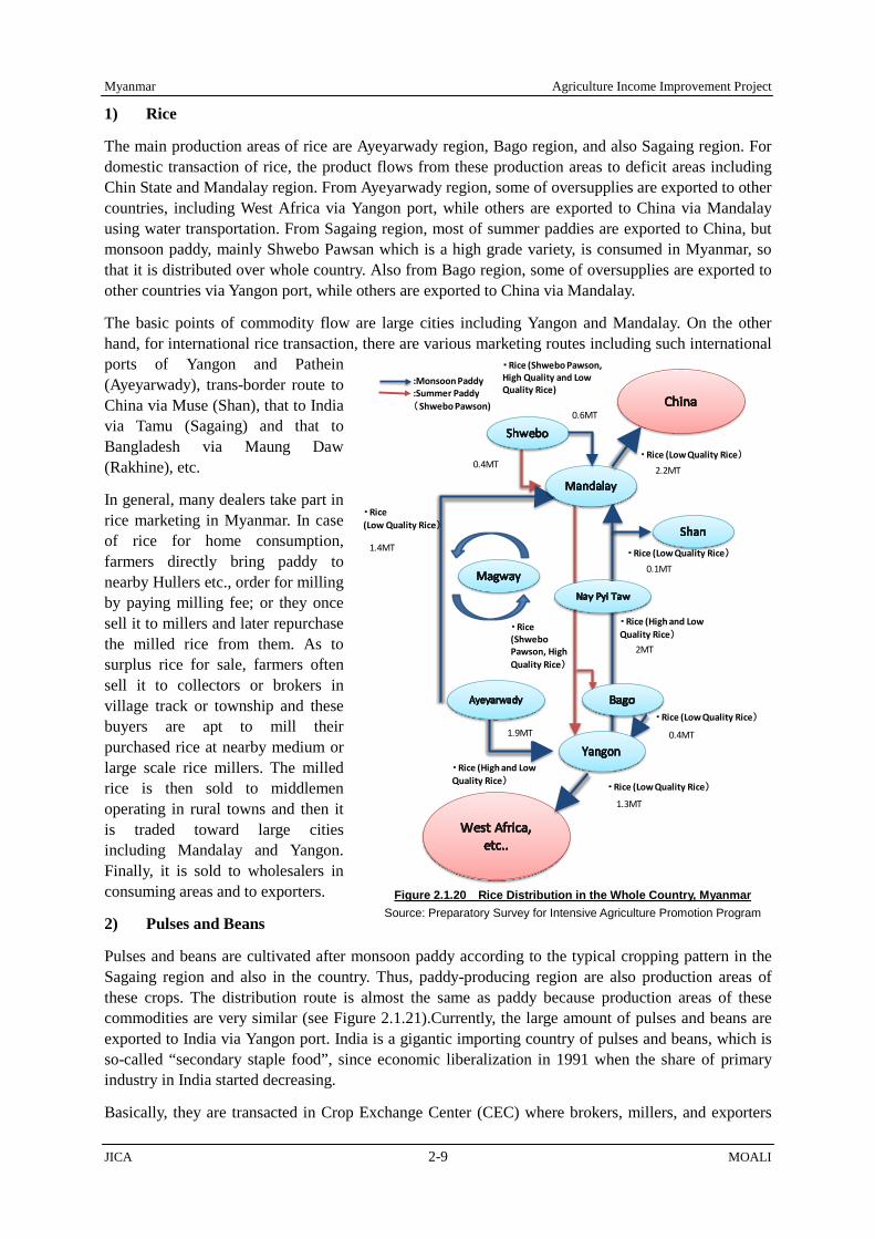
Myanmar Agriculture Income Improvement Project
JICA 2-9 MOALI
1) Rice
The main production areas of rice are Ayeyarwady region, Bago region, and also Sagaing region. For domestic transaction of rice, the product flows from these production areas to deficit areas including Chin State and Mandalay region. From Ayeyarwady region, some of oversupplies are exported to other countries, including West Africa via Yangon port, while others are exported to China via Mandalay using water transportation. From Sagaing region, most of summer paddies are exported to China, but monsoon paddy, mainly Shwebo Pawsan which is a high grade variety, is consumed in Myanmar, so that it is distributed over whole country. Also from Bago region, some of oversupplies are exported to other countries via Yangon port, while others are exported to China via Mandalay.
The basic points of commodity flow are large cities including Yangon and Mandalay. On the other hand, for international rice transaction, there are various marketing routes including such international ports of Yangon and Pathein (Ayeyarwady), trans-border route to China via Muse (Shan), that to India via Tamu (Sagaing) and that to Bangladesh via Maung Daw (Rakhine), etc.
In general, many dealers take part in rice marketing in Myanmar. In case of rice for home consumption, farmers directly bring paddy to nearby Hullers etc., order for milling by paying milling fee; or they once sell it to millers and later repurchase the milled rice from them. As to surplus rice for sale, farmers often sell it to collectors or brokers in village track or township and these buyers are apt to mill their purchased rice at nearby medium or large scale rice millers. The milled rice is then sold to middlemen operating in rural towns and then it is traded toward large cities including Mandalay and Yangon. Finally, it is sold to wholesalers in consuming areas and to exporters.
2) Pulses and Beans
Pulses and beans are cultivated after monsoon paddy according to the typical cropping pattern in the Sagaing region and also in the country. Thus, paddy-producing region are also production areas of these crops. The distribution route is almost the same as paddy because production areas of these commodities are very similar (see Figure 2.1.21).Currently, the large amount of pulses and beans are exported to India via Yangon port. India is a gigantic importing country of pulses and beans, which is so-called “secondary staple food”, since economic liberalization in 1991 when the share of primary industry in India started decreasing.
Basically, they are transacted in Crop Exchange Center (CEC) where brokers, millers, and exporters
Figure 2.1.20 Rice Distribution in the Whole Country, Myanmar Source: Preparatory Survey for Intensive Agriculture Promotion Program
・Rice (Low Quality Rice)
・Rice (High and Low Quality Rice)
・Rice (Low Quality Rice)
・Rice (Low Quality Rice)
・Rice (High and Low Quality Rice)
・Rice (ShweboPawson, High Quality Rice)
1.9MT
1.3MT
0.4MT
2MT
0.1MT
・Rice (Low Quality Rice)0.4MT
・Rice (Shwebo Pawson, High Quality and Low Quality Rice)
・Rice (Low Quality Rice)
:Monsoon Paddy:Summer Paddy(Shwebo Pawson)
1.4MT
0.6MT
2.2MT

Agriculture Income Improvement Project Myanmar
MOALI 2-10 JICA
come together to negotiate the prices of these commodities. The CEC is established in major cities including Mandalay, Monywa (Sagaing), Myingyan (Mandalay), Yangon and Magway. The broker, Miller and Traders Maha Kahtaintaw Association or the Chamber of Commerce operate the CEC to provide transaction place of oil seeds, pulses and beans, and cereals such as maize to its members including brokers, millers, traders, and exporters. Usually, transaction at the CEC is conducted by showing a small amount of sample. If the negotiation is successfully concluded, middleman in the production place (or seller) send the product to the buyers.
2.2 Issues Facing the Myanmar Agriculture
There are issues facing the Myanmar agriculture and need to be tackled, no exception for the Project area. In fact, there are general rules in the relationship between economic development and population change. For example, as a country develops, decline of population in younger generations occurs, leaving less number of working population. This situation necessitates transformation of labor-intensive agriculture into a capital-intensive agriculture including agriculture mechanization. Moreover, as a country develops, migration from rural area to urban area takes place, leaving less number of farmers or farm labors in rural areas.
2.2.1 Decline in Younger Generations
In Myanmar context, decline in younger population can already be seen. Latest census survey was conducted in 2014, and the population cohort of Sagaing region is illustrated in Figure 2.2.1. As shown in the figure, decline in the generations below age-14 can be seen, presenting dwindling population in younger generations. This trend, where the population of younger generations is smaller, was also observed in a household survey conducted in 2016 covering 240 households within the Thapanzeik dam irrigable area. The result indicated that the decline showed up already in ages even below 24 years old (see 3.2.2 Village Profile, 3.2 Rural Society and Rural Economy, Chapter 3).
In general, a society where high status is given to women can achieve high rate of adaption of
・Oil Crops(Sesami,Grandnuts)・Pulses and Beans
: Pulses and Beans: Oil Crops: Both Crops
・Oil Crops(Sesami,Grandnuts)・Pulses and Beans
1.2MT
1.4MT
0.9MT
・Pulses and Beans
1.4MT
・Oil Crops(Sesami,Grandnuts)・Pulses and Beans
・Pulses and Beans
・Oil Crops
・Pulses and Beans
・Pulses and Beans
0.5MT 0.5MT
0.4MT1.1MT
Figure 2.1.21 Pulses & Beans Distribution in the Whole Myanmar Source: Preparatory Survey for Intensive
Agriculture Promotion Program (JICA)
Figure 2.2.1 Population Cohort in Sagaing Region (2014) Source: Ministry of Immigration and Population (May 2015)

Myanmar Agriculture Income Improvement Project
JICA 2-11 MOALI
family planning, leading to decline of number of children in a family. This general rule may have well applied in Myanmar society, especially in Burmese society which is prevalent in the Project area. With this trend, the agriculture in the Project area, and also over the Country as a whole, will be facing workforce shortage in its future accrued from the decline of the number of young generations. This inevitably implies that capital based agriculture promotion accompanied with farm mechanization should be pursued.
2.2.2 Migration from Rural to Urban Areas
Figure 2.2.2 comparatively shows shares of the population who live in rural area and urban area over the past 30 years for ASEAN countries. There is an obvious tendency that as time passes by, or as those countries have been economically developed, the shares of urban population have increased. China shows the sharpest increase in the urban population, followed by Thailand especially after year 2000, and further followed by Lao PDR and Vietnam.
In fact, the increases of urban population of Myanmar and Cambodia are not as high as those of other countries. However, the share of urban population in Myanmar has already reached 33% in year 2013, meaning one out of every 3 persons now live in urban areas. The increase would further be accelerated as the Myanmar had opened the country just several years ago, year 2011. Over coming years, migration from rural areas to urban areas will continue in Myanmar, leaving less work-force in primary agriculture sector. This situation also upheld the needs of promoting capital-intensive agriculture accompanied with agriculture mechanization in Myanmar as well as in the Project area.
2.2.3 Farm Casual Labor in Myanmar Agriculture
Myanmar had long practiced a quasi seclusion policy, and even after having abandoned the policy, there had been a period during which economic activities were very dormant. During this period together with population increase, one may say that a large number of unemployed populations had emerged in rural areas and whereby they had to engage themselves in farm casual laboring. In fact, most of the farmers nowadays can be said a sort of farm manager, who employs farm casual labors in different sort of farm works starting from land preparation, sowing, weeding, and then harvesting, etc.
A household questionnaire survey was conducted in September to October 2016 under this Survey, covering 240 sampled farmer households. The survey asked the farmers of what kind of items and how much they have spent on the production of major crops. Figure 2.2.3 summarizes the share of the expenditures by such major crops as; Shwebo Paw san (representative monsoon paddy), Shawe Sae Yin (major summer paddy), and green gram (chief winter crop after the monsoon paddy).
In most of developing countries, farmers usually spend the largest share of the expenditure to the purchase of agriculture inputs, e.g. chemical fertilizer. This trend is the same as the survey result, however what comes second is the expenditure on farm labors. In general, payment to the farm labors shares about one-third of whole expenditure. This expenditure pattern provides a picture of typical
0
10
20
30
40
50
60
198019
8119
8219
8319
8419
8519
8619
8719
8819
8919
9019
9119
9219
9319
9419
9519
9619
9719
9819
9920
0020
0120
0220
0320
0420
0520
0620
0720
0820
0920
1020
1120
1220
13
Sha
re o
f Urb
an P
opul
atio
n, %
Myanmar CombodiaChina VietnumThailand Lao PDR
Figure 2.2.2 Share of Rural and Urban Population in ASEAN Countries Source: Data from database: World Development Indicators

Agriculture Income Improvement Project Myanmar
MOALI 2-12 JICA
Myanmar agriculture, very much dependent on farm casual labors.
The farm casual labors used to stay in rural areas since there were not much employment opportunities in the country other than in their rural areas. However, things have changed and nowadays construction and also service sectors have started thriving. With such opportunities, farm casual labors would accelerate the migration from agriculture sector to construction sector. This movement had already started and farmers interviewed by JICA team often claimed nowadays’ shortage of farm casual labors. In fact, over the last 5 years, high annual inflation ratio for the farm labor wage has taken place such as 12% for planting and 8% for harvesting. This situation will inevitably require capital-based intensive agriculture promotion more accompanied with farm mechanization.
2.2.4 Agriculture Mechanization and Land Consolidation
To cope with afore-mentioned shortage of working population and farm labors, farm mechanization is one of the musts. Table 2.2.1 summarizes the dissemination of major farm machineries in Myanmar as at February 2017 (Source: AMD). As shown below, there are total 27,645 tractors and 466,391 hand tractors, 80,071 threshers, 5,289 combine harvesters, and only 74 rice transplanters. Tractors are mostly used in Sagaing, Bago, Magway and Mandalay, followed by Yangon and Ayeyarwady region.
Hand tractors are currently over 460,000 available in Myanmar, and about one-fourth of them are utilized in Ayeyarwady region. Threshers are mostly used in Ayeyarwady region and Sagaing region which are huge paddy production area. On the other hand, combine harvesters are taking the place of threshers especially in lower Myanmar, which can thresh the paddy at the time of harvesting. A few rice transplanters are being commenced to be utilized in Bago region and Sagaing region.
Table 2.2.1 Major Agriculture Machineries Available in Myanmar as at February 2017 Region/ State Tractor Hand Tractor Thresher Combine Harvester Rice Transplanter Sagaing 5,594 52,080 9,589 628 10 Bago 4,397 71,457 6,121 852 18 Magway 4,010 18,509 1,801 111 7 Mandalay 3,710 23,085 3,228 211 5 Yangon 3,242 45,473 1,400 1,843 9 Ayeyarwady 1,938 120,640 46,091 1,186 7 Shan North 1,412 22,453 1,870 67 2 Shan South 873 22,505 1,091 8 2 Nay Pyi Taw 620 4,588 1,120 91 7 Mon 476 21,362 1,499 123 3 Kachin 431 19,195 1,324 20 - Shan East 315 12,276 2,514 1 - Kayah 233 5,860 400 18 2 Kayin 151 14,311 369 44 2 Rakhine 148 6,902 308 46 - Taninthayi 93 5,669 1,345 38 -
Figure 2.2.3 Expenditure Share in Major Crop Production; Shwebo Pawsan, Shawe Sae Yin, Green Gram Source: A HH Questionnaire Survey covering 240 HHs in Thapanzeik Dam Irrigable Area (2016)
Shwebo Pawsan Monsoon Paddy
Shawe Sae Yin Summer Paddy Green Gram

Myanmar Agriculture Income Improvement Project
JICA 2-13 MOALI
Region/ State Tractor Hand Tractor Thresher Combine Harvester Rice Transplanter Chin 2 26 1 2 - Total 27,645 466,391 80,071 5,289 74
Source: Agriculture Mechanization Department (February 2017), MOALI
Figure 2.2.4 shows number of tractors and hand tractors per 1000 farm households in major agricultural regions. As is clearly illustrated, tractor is very limited and even Yangon, where the highest number of tractors can be seen, has only 16 tractors per 1,000 farm households. This means only one out of every 60 farm households has just one tractor. Hand-tractors are more found in those regions; however still the dissemination is low. For example, there are about 221 hand tractors per 1000 households in Yangon region where the highest dissemination can be seen. Obviously this level of machinery dissemination is not enough to cope with labor shortage becoming acute in rural areas.
Farmland consolidation is very often accompanied with farm mechanization. In fact, to fully and effectively utilize farm machineries, rugged farmlands should be levelled and regularly shaped. Also, when equipped with irrigation canal, drainage canal and farm road, highly efficient farm management can be realized, leading to ideal agriculture production. Following table summarizes the farmland consolidation implemented till end March 2016 in Myanmar.
Table 2.2.2 Farmland Consolidation Work Implemented in Myanmar as at End March 2016 Region/State
1995- 2011
Implemented Acre Farm Area Share
2011-2012 2012-2013 2013-2014 2014-2015 2015-16 Total, acre acre % Sagaing 133 80 576 140 610 800 2,339 6,368,801 0.04 Mandalay 1,747 420 835 421 879 623 4,925 3,615,998 0.14 Magway 26 211 120 153 469 1,012 1,991 3,289,492 0.06 Nay Pyi Taw 1,427 4,221 3,236 540 322 9,746 Included in MDL - Bago 80 2,754 1,827 1,539 1,238 3,039 10,477 3,642,424 0.29 Ayeyarwaddy 222 277 358 208 2,934 6,567 10,566 5,698,807 0.19 Yangon 22,424 2,763 999 364 170 160 26,880 1,962,879 1.37 Shan 100 349 430 879 1,971,242 0.04 Kachin 558 802 553 1,913 817,369 0.23 Kayah 10 109 313 360 792 119,030 0.67 Kayin 150 117 1,054 1,576 2,897 227,696 1.27 Tanintharyi 100 100 260 460 649,940 0.07 Mon 100 140 105 400 860 1,605 1,741,195 0.09 Rakhine 100 100 100 739 40 1,079 1,207,717 0.09 Total 24,632 8,132 9,336 7,250 10,597 16,602 76,549 31,312,590 0.24
Source: Agriculture Mechanization Department (April 2016), MOAI
Farmland consolidation in Myanmar had started in mid 1990s as pilot basis. During the military government era, a total of 24,632 acre farmland had been consolidated. Then, under the previous government, an annual plan was formulated and according to the budget availability, land consolidation had been put into implementation. By end March 2016, a total of 76,549 acre farmland had been consolidated including the area implemented during the military government. Out of the
Figure 2.2.4 Dissemination of Tractors and Hand Tractors per 1000 Farm HHs Source: AMD (2017), and Myanmar Census of Agri. 2010 for Farm HHs.

Agriculture Income Improvement Project Myanmar
MOALI 2-14 JICA
consolidated area, Yangon region has secured the biggest area of land consolidation, 26,880 acre equivalent to about pone-third of the total area consolidated.
However, if compared with overall farm land, the consolidated area is still very minimal. There is a total farmland area of as much as 31,312,590 acre6 (12,525,000 ha) in Myanmar. The actually consolidated area of 76,549 acre shares only 0.24 % of the whole farmland area. In fact, unit implementation cost of land consolidation is not much, say about 500,000 – 1,500,000 Kyats per acre7; however due to the huge farmland area over the Country, total needy budget becomes a great huge amount. If 10% of the whole farmland is to receive consolidation work, the total required budget will be approximately 1.6 – 4.8 trillion Kyats (equivalent to about US$ 1.5 – 4.5 billion). There is a long way to implement land consolidation over certain percentage of the farmlands.
2.3 Agriculture Sector Development Policies and Plans in Myanmar
2.3.1 Relevance in National Development Plan and New Economic Policy (June 2016)
As per national development plans, Myanmar prepared the National Comprehensive Development Plan (NCDP) for 2011 to 2030. This plan presents national development vision, objectives and strategy toward the target year of 2030, graduating to middle income country. This plan is divided into 4 stages of 5-year each development plan. The first 5-year develop plan (2011-15) was already finished and at present the second stage 5-year plan (2016-2020) is on-going.
To prepare for the national develop plans, there is a framework and guidelines called Framework on Economic and Social Reform (FESR, 2013 – 2015), prepared at the end of year 2012 (see Figure 2.3.1). This FESR clearly shows the direction, strategies, and priority areas in preparing the national development plans, whereby we can know what areas are given priority by the Myanmar government. 6 This area does not include the farmland area of Chin state since no land consolidation has been done in Chin state. 7 Land consolidation cost varies depending upon the level of the work. In general, ID & AMD carry out land consolidation work at a unit cost of approximately 400,000 – 600,000 Kyats per acre. Whereas, donor implemented farmland consolidation usually entails higher unit construction cost; for example JICA spent 1.8 million Kyats per acre for a pilot project carried out in 2013 in Nay Pyi Taw area, and JIID (Japan Institute of Irrigation and Drainage) spent 2.6 million Kyats per acre for another pilot project carried out in Bago East in 2014.
“People-Centered Development”
Sustaining Agriculture Development towards Industrialization and All Round Development
Balanced and Proportionate Development among States and Regions Inclusive Growth for Entire Population
Ten (10) priority Areas I. Structural Reforms
1. Fiscal and Tax Reforms 2. Monetary and Financial Sector Reforms 3. Liberalization of Trade and Investment
II. Quick Wins 4. Private Sector Development 5. Health and Education 6. Food Security and Agricultural Growth 7. Governance and Transparency 8. Mobile Phone & Internet 9. Infrastructure
III. Sectoral and Institutional Reforms 10. Effective and Efficient Government
Figure 2.3.1 Structure of Framework on Economic and Social Reform: FESR (2013-2015) Source: Ministry of National Planning and Economic Development

Myanmar Agriculture Income Improvement Project
JICA 2-15 MOALI
As summarized in the figure, the FESR upholds agriculture development as one of the top strategies to realize the overall direction of ‘People-Centered Development’. Accordingly, one of the 10 priority areas identified in the FERS is ‘Food Security and Agriculture Growth’.
In fact, afore-mentioned NCDP and FESR were prepared and put into implementation by the previous government. The new government established in April 2016 has not abandoned the NCDP and FESR; however the current new government issued an economic policy in July 2016 starting with vision, followed by 4 objectives and further by 12 policies. The 12 policies are given of the following:
1) Expanding our financial resources through transparent and effective public financial management.
2) Improving the operations of state-owned enterprises, and privatizing those state-owned enterprises that have the potential to be reformed, while promoting and assisting small and medium enterprises as generators of employment and growth.
3) Fostering the human capital that will be needed for the emergence of a modern developed economy, and improving and expanding vocational education and training.
4) Prioritizing the rapid development of fundamental economic infrastructure such as electricity generation, roads and ports, and establishing a data lD card system, a digital government strategy, and an e-government system.
5) Creating employment opportunities for all citizens including those returning from abroad, and giving greater priority in the short term to economic enterprises that create many job opportunities.
6) Establishing an economic model that balances agriculture and industry, and supports the holistic development of the agriculture, livestock and industrial sectors, so as to enable rounded development, food security, and increased exports.
7) Asserting the right of individuals to freely pursue the economic opportunities they choose, so as to enable private sector growth in line with a market economy system; formulating specific policies to increase foreign investment; and strengthening property rights and the rule of law.
8) Achieving financial stability through a finance system that can support the sustainable long-term development of households, farmers and businesses.
9) Building environmentally sustainable cities, upgrading public services and utilities, expanding public spaces, and making greater efforts to protect and conserve our cultural heritage
10) Establishing a fair and efficient tax system in order to increase government revenues, and protecting individual rights and property rights through enacting laws and regulations.
11) Establishing technical systems and procedures to support intellectual property rights that can encourage innovation and the development of advanced technology.
12) Identifying the changing and developing business environment both in ASEAN and beyond, so as to enable our own businesses to situate themselves to take advantage of potential opportunities.
The economic policy puts an emphasis on employment creation as in above No.5 policy and also on the balanced economic development of agriculture and industry as in the No.6 policy. The Project upon implementation will contribute to the realization of these 2 policies. With respect to No.5 policy, the Project creates direct job opportunities during the construction, and then upon completion of the Project, such employment will be created as agriculture input related business and agriculture output related business, etc.
On the policy No.6, it is well known and as exampled in Japan that if agriculture is weak, competitive industry in the world market can hardly be promoted. The agriculture sector should be strong enough

Agriculture Income Improvement Project Myanmar
MOALI 2-16 JICA
able to provide modest (cheap) price of staple food commodity to the industry workers, keeping reasonable level of their Engel’s coefficient in their expenditure, and to facilitate labor immigration from rural areas to urban areas by a means of agriculture mechanization. The Project will contribute to providing industry workers’ staple food, rice, at modest price as well as promoting agriculture mechanization.
2.3.2 Relevance in Agricultural Development Plan
There is an agricultural development plan prepared under the afore-mentioned national development plan. This agricultural development plan is in the 2nd stage covering years from 2016 to 2020 in accordance with the national development plan. Then, new government came into power in April 2016, and started preparing and issuing new development policies in which agriculture sector is not exceptional.
The existing development plans prepared under the former government have not been explicitly abandoned but, for example, priorities in terms of sectors/sub-sectors with investment have been changed, or being changed. In this movement, an Agriculture Sector Policy and Thrust for the second 5-year plan was issued in October 2016 under the new government, and also a strategy called Agriculture Development Strategy (ADS) is under preparation as of March 2017.
1) Second 5-year Agricultural Development Plan: 2016 to 2020
In the original 5-year agricultural development plan (2016/17-2020/21), the vision and strategies are as follows: in order to achieve sustainable agriculture, 1) obtain most of the market share of regional and global market of special food and agro-based value added products, 2) promote food security of rural people, and 3) increase green growth production in conformity with sound environment, not negatively affecting natural environment.
With above, short-term objectives stated in the original plan were; 1) to develop agriculture productivity, 2) to promote productivity of rural agro-based small – medium enterprises, 3) to invite foreign investment into agriculture sector for technology, investment, market and job opportunities, 4) to obtain local and international access and to improve infrastructure and market information, 5) to develop agriculture theoretical research and applied research, and 6) to reduce transaction cost of value chain from farm to consumer. Toward these objectives to achieve, the Ministry under the previous government identified following 11 priority areas to be tackled:
1) To implement high yield and quality seeds production and distribution, 2) To utilize natural inputs for soil enrichment with systematic & synchronized application of
fertilizer, 3) To build up value added agro-products and agro-based industries, 4) To transform the conventional farming to mechanized farming, 5) To transform the rain-fed conventional farming to irrigated farming system, 6) To conduct research and develop advanced agricultural technologies, 7) To encourage the promotion of domestic and foreign investment, 8) To increase accuracy in agricultural statistics, 9) To develop sustainable market, 10) To review and evaluate the existing agricultural laws and regulations in line with current
economic situation, and 11) To promote the role of information and media.
Myanmar Agriculture Income Improvement Project
JICA 2-17 MOALI
Then, in October 2016, MOALI under the new government initiative has issued Agriculture Sector Policy and Thrust for Second Five Year Short Term Plan. Though the original 5-year development plan is not explicitly abandoned, what was issued in October 2016 is a policy, referred to as Agriculture Policy 2016. Therefor this new policy can/should override the current agriculture development plan, so that the new direction is now explicitly indicated.
The new policy aims at establishing, as vision, an inclusive, competitive, food and nutrition secured and sustainable agricultural system contributing to the socio-economic well - being of farmers and rural people and further development of the national economy. Under this vision, the mission is stated as to enable rural population and agribusiness enterprises earning profit from production and trade of diverse, safe and nutritious foods and agricultural products using innovative and sustainable production, processing, packaging, logistics and marketing technologies to meet the growing domestic and global demands. Further, MOALI in its policy presents 9 goals such as;
1) Improve food security, nutritional status of food and food safety of the people. 2) Enhance agricultural diversification programmes in compliance with the changing market and the
prevailing agro-climatic condition. 3) Satisfy specified quality and standard of agriculture, livestock and fishery products of the market. 4) Improve dissemination of markets and prices information. 5) Conduct sanitary and phytosanitary (SPS) measures, develop and adopt Good Agriculture
Practices - GAP, Good Animal Husbandry Practices - GAHP and Good Aquaculture Practices – GaqP.
6) Emerge crops, livestock, and fisheries producer groups and cooperative societies aiming at sustaining the development of agriculture sector.
7) Develop seed industry and highly performing pure animal breeds and fish species, and conserve native breeds/species.
8) Develop and enhance agro-based industries, small scale industries, traditional weaving, handicraft including 10 traditional artworks and crafts, vocational education, and rural infrastructure.
9) Improve and enhance research and extension service, and human resource programmes.
The agriculture development undertaken by the Project is relevant in many aspects of the above vision, mission, and goals as; 1) to increase yield and production by means of infrastructure improvement, e.g. irrigation rehabilitation, and agriculture extension strengthening, 2) to facilitate value chain improvement accompanied with rural (farm-to-market) roads and bridges upgrading/ improvement meant for agriculture commodities, 3) to facilitate farm mechanization together with land consolidation.
With respect to irrigation development, the new policy stated that necessary actions and measures will be undertaken to ensure that the entire irrigation system of each and every completed irrigation dams, cannels, water pumping station becomes fully operational in the Water Use and Management Policy, one of 10 policies. Here, rehabilitation and/or upgrading should be given priority rather than construction of new irrigation systems, in which this Project has been planned.
The Water Use and Management Policy, for the first time in Myanmar, mentioned that Water User Participatory Approach will be adopted in the water management system in order to maximize water use efficiency. In addition, the policy further referred to a water users group by saying that it is to establish Water User Groups in respective regions and states to ensure that irrigation water is effectively and efficiently utilized. In the Project, a participatory irrigation management by both IWUMD and farmer organization are to be piloted, which is very much in line with the policy.
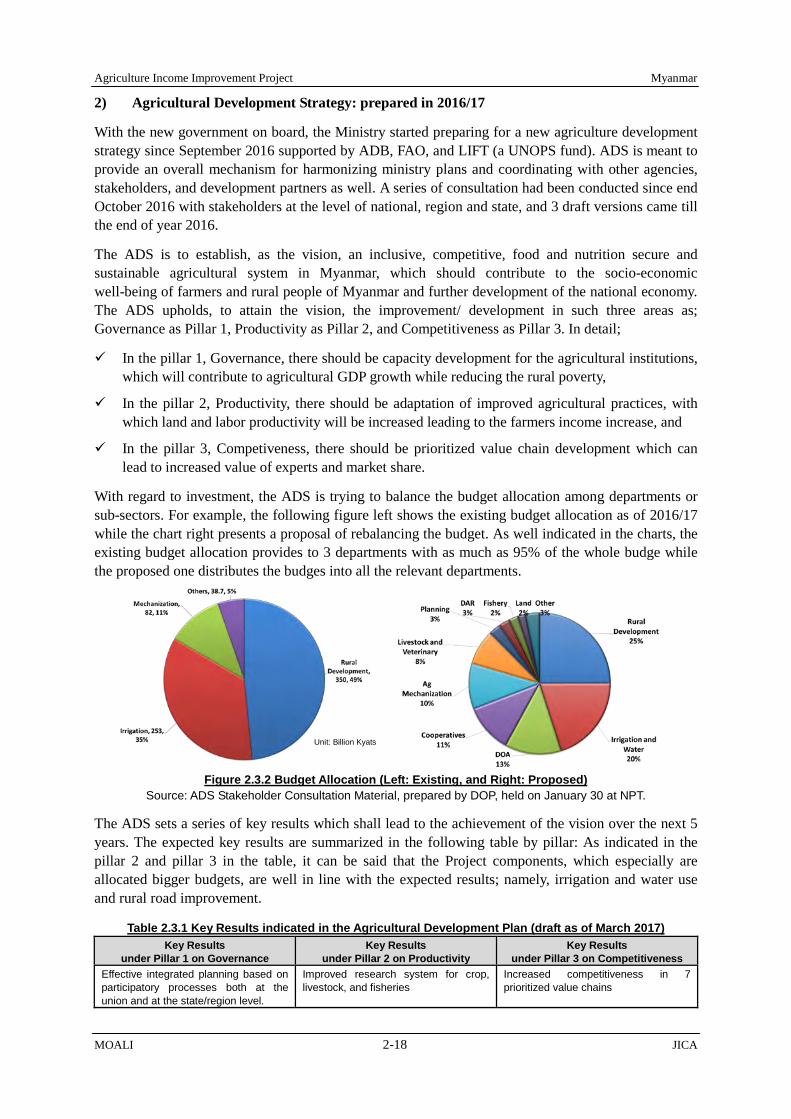
Agriculture Income Improvement Project Myanmar
MOALI 2-18 JICA
2) Agricultural Development Strategy: prepared in 2016/17
With the new government on board, the Ministry started preparing for a new agriculture development strategy since September 2016 supported by ADB, FAO, and LIFT (a UNOPS fund). ADS is meant to provide an overall mechanism for harmonizing ministry plans and coordinating with other agencies, stakeholders, and development partners as well. A series of consultation had been conducted since end October 2016 with stakeholders at the level of national, region and state, and 3 draft versions came till the end of year 2016.
The ADS is to establish, as the vision, an inclusive, competitive, food and nutrition secure and sustainable agricultural system in Myanmar, which should contribute to the socio-economic well-being of farmers and rural people of Myanmar and further development of the national economy. The ADS upholds, to attain the vision, the improvement/ development in such three areas as; Governance as Pillar 1, Productivity as Pillar 2, and Competitiveness as Pillar 3. In detail;
In the pillar 1, Governance, there should be capacity development for the agricultural institutions, which will contribute to agricultural GDP growth while reducing the rural poverty,
In the pillar 2, Productivity, there should be adaptation of improved agricultural practices, with which land and labor productivity will be increased leading to the farmers income increase, and
In the pillar 3, Competiveness, there should be prioritized value chain development which can lead to increased value of experts and market share.
With regard to investment, the ADS is trying to balance the budget allocation among departments or sub-sectors. For example, the following figure left shows the existing budget allocation as of 2016/17 while the chart right presents a proposal of rebalancing the budget. As well indicated in the charts, the existing budget allocation provides to 3 departments with as much as 95% of the whole budge while the proposed one distributes the budges into all the relevant departments.
Figure 2.3.2 Budget Allocation (Left: Existing, and Right: Proposed)
Source: ADS Stakeholder Consultation Material, prepared by DOP, held on January 30 at NPT.
The ADS sets a series of key results which shall lead to the achievement of the vision over the next 5 years. The expected key results are summarized in the following table by pillar: As indicated in the pillar 2 and pillar 3 in the table, it can be said that the Project components, which especially are allocated bigger budgets, are well in line with the expected results; namely, irrigation and water use and rural road improvement.
Table 2.3.1 Key Results indicated in the Agricultural Development Plan (draft as of March 2017) Key Results
under Pillar 1 on Governance Key Results
under Pillar 2 on Productivity Key Results
under Pillar 3 on Competitiveness Effective integrated planning based on participatory processes both at the union and at the state/region level.
Improved research system for crop, livestock, and fisheries
Increased competitiveness in 7 prioritized value chains
Unit: Billion Kyats
Myanmar Agriculture Income Improvement Project
JICA 2-19 MOALI
Key Results under Pillar 1 on Governance
Key Results under Pillar 2 on Productivity
Key Results under Pillar 3 on Competitiveness
Timely and Effective Monitoring and Evaluation processes
Transformed agricultural extension system delivering improved (crop, livestock, fisheries) products and technology for adoption and adaptation
Enhanced food quality and safety
Strengthened farmers’ land rights and enhanced capacity of institutions involved in agricultural land.
Irrigation and water use - More efficient and sustainable irrigation and water use systems
Expanded and improved rural road network integrated with national transport plants
Source: ADS Stakeholder Consultation Material, prepared by DOP, held on January 30 at NPT.
2.4 Agriculture Development in Economic Development Path
2.4.1 Role of the Agriculture in the Economic Development Path
Agriculture sector has a role as foundation of economic development in Myanmar as well as in other countries. There are four types of contribution which agriculture sector makes towards the economic development as described by Simon Kuznets. They are;
1) Product contribution: contribution of foodstuffs to feed the labor force of urban/industry sectors, 2) Factor contribution: labor contribution from agriculture sector to industry sector, 3) Market contribution: as a result of agricultural progress, market for industrial goods is extended
into rural areas, and; 4) Foreign exchange contribution: saving and earning of foreign currencies by exporting
agricultural produces.
In general, it is said that Myanmar has a high potential for labor-intensive manufacturing industry, and the labor source for the industry should be from rural areas. In this regard, it is necessary to establish productive agriculture with less farming labors. In addition, the agriculture productivity leads to making foodstuff price fixed. The price of foodstuff is very much related to labor cost in industrial sector, and thereby, determining international competitiveness of the industry as well. In other words, the productivity of staple crop is crucial for the economic growth in a country.
Therefore, the farm mechanization and land consolidation are kinds of the important faming activities to increase the farm productivity with less labor force. Surplus labor force will be provided from rural areas to industrial sector taking place in urban areas through afore-mentioned agriculture activities. Thus, the industrial growth will be increased based on labor supply expansion from the rural areas (see Figure 2.4.1 as presented in Myanmar Industrial Development Plan 2015 by Ministry of Economy, Trade and Industry, Japan).
Looking at expenditure structure in most of the developing countries, staple food tends to have high share in the total. If the staple food can be supplied at an affordable price to labors (consumers), the industry sector would keep the labor cost at modest or cheaper level. In other words, with
Figure 2.4.1 A Development Vision based on Urban-Rural Synergy Source: Myanmar Industrial Development Plan, Ministry of Economy, Trade and
Industry, 2015

Agriculture Income Improvement Project Myanmar
MOALI 2-20 JICA
self-sufficient of rice and supply of the rice at affordable price, it is expected to secure the labor force inexpensively and therefor can enhance the international competitiveness of Myanmar’s industry in the world market.
2.4.2 Two-Polar Growth Development and Overall Economic Development
According to an ERIA (Economic Research Institute for ASEAN and East Asia) analysis, considering the spatial development strategy of Myanmar, it is important to choose whether to be one-polar development or two-polar development (or otherwise many-polars)8. Figure 2.4.2 shows the type of economic growth; Thailand is a typical “one-polar” development country while Vietnam is “clearly “two-polar” development country. Myanmar is recommended to apply double polar type growth, i.e., Yangon-Mandalay development, because of population distribution, GDP distribution, etc. With the double polar strategy adopted as recommended, the GDP share by Yangon will decrease from 55.1% to 43.1% in 2030 while the same by Mandalay will increase to 19.1% from 10.8% in the same year according to the ERIA analysis.
From the view point of economic growth, the development investment in Mandalay and surrounding areas including Shwebo area, i.e., investment by the Project, could contribute to higher GDP growth for the whole country. Shwebo area thus plays an important role as a base for food supply to Mandalay and other areas. The Project in and around Shwebo area will contribute to the improvement of farm productivity through the agricultural mechanization and land consolidation. With this, food and surplus labor force will be supplied from agriculture sector in there to industrial sector in Mandalay upon project completion. This will significantly support the two-polar development strategy, leading to higher economic growth as a whole.
2.4.3 Synergy Development by Agriculture and Industry Development
Development by agriculture in rural area and industry development are two side of same coin, thus they are very closely related each other. In order to enable the mutually related to be developed, it is important to increase the productivity in agriculture sector. As mentioned above, a surplus labor force is expected to move from agriculture sector to industry sector through promotion of capital based intensive agriculture such as agriculture mechanization and others.
Figure 2.4.3 shows the relationship between Shwebo area and Mandalay for the sake of both agriculture and industrial development. Shwebo area contributes to supplying surplus labor force to Mandalay (industry sector) and feed the labor force at an affordable staple food price9. On the other hand, in agriculture sector, farmers’ income will be improved through farm productivity enhancement. It means that in turn the market for industrial products can also be expanded to the consumers who are working in agriculture/ rural sectors in and around Shwebo area with stronger purchasing power. 8 Toshihiro KUDO, Satoru KUMAGAI, So UMEZAKI (2013) P.43, ERIA Discussion Paper Series. 9 According to results of previous survey (JICA2015) “Preparatory Survey for Intensive Agriculture Promotion Program”), the Shwebo area covers about 3.7 million peoples of rice consumption. Upon project implementation, it will cover approximately 5.1 million people of rice consumption
Figure 2.4.2 GDP Density of Myanmar, Thailand and Vietnam Source: ERIA

Myanmar Agriculture Income Improvement Project
JICA 2-21 MOALI
Synergetic development between agriculture and industrial sector is very much key factor to enhance the economic development at the Project area and its surrounding areas.
2.5 Donor Involvement in Relevant Sectors
In the agriculture and rural development sector, there are donors who started projects implementation and are also undertaking project formulation. In the agriculture sector, major donors involved are the World Bank, ABD, IFAD, FAO, and India. Donor supported projects are summarized in the following table with the status; project preparation or already under implementation, and main topics related to this Survey are as follows:
1) The World Bank is to implement irrigation rehabilitation, and one of the target irrigation systems is North Yamar irrigation system in Sagaing region, which is not within the Project area prepared by this Survey. The PMU members of the WB funded project will be selected through recruitment. Current status is under job interview and PMU is to be established after January 2017. Regarding the irrigation rehabilitation, the procurement of consultants will be done within January 2017. After that, the detailed design will be started and construction will be started from latter half of 2017. There are three major components such as irrigation rehabilitation, agricultural extension and land consolidation. However, land consolidation is under consideration where or not to include as of December 2016 due to difficulties in organizing farmers and making consensus among them.
2) The ADB is implementing a TA for project preparation; it is called “Climate-Friendly Agribusiness Value Chains Sector Project”. The interim report (revised version) was issued in January, 2017. There are several components, i.e., improvement of paddy seed production (assistance to DOA seed farms), improvement of seed production and processing of pulses and beans, oil extraction, irrigation rehabilitation (tertiary canal level), farm road improvement and farm mechanization training, etc. Their target area is Central Dry Zone which includes Shwebo area and several components are targeted in the same area. It will be expected to make synergies with JICA funded project though it is necessary to make demarcation each other, e.g., for DOA seed farm supporting, farm road improvement, irrigation rehabilitation..
3) The ADB is also to implement irrigation rehabilitation project in the Central Dry Zone area. The project is to rehabilitate total 5 irrigation systems, and 2 shcemes have been identified as core project under sector approach. The 2 schemes and other potential sites are not duplicated with the one undertaken by this JICA survey. For the implementation of the project, ADB has selected a consultant team, which is organized by Mott MacDonald. As at December 2016, 2 schemes, namely Thaungmagyi and Natmauk, are under the detailed design.
4) IFAD is now implementing land consolidation, called land development, in Nay Pyi Taw area and the target coverage is as much as 10,000 acres. In fact, the land consolidation work is very much
Figure 2.4.3 Relationship between Shwebo (Agricultural Sector) and Mandalay (Industrial Sector)
Source: JICA Survey Team
Agriculture Income Improvement Project Myanmar
MOALI 2-22 JICA
behind schedule; namely, actual achievement was 315 acre only against the target of 2000-4000 acre for the year 2016, the first year of implementation. The reasons of behind the schedule is that farmers grow black gram in winter season, and the harvest time is between mid-February to middle of March, and the rainy season starts from June in Nay Pyi Taw area. It means that there is too short period of time for the land consolidation to implement unless the farmers give up the cultivation of green gram.
5) Indian government will implement procurement of agriculture machineries and construction of irrigation networks in such systems as Baidar (Bago East) and Khapaung (Bago East), covering total 35,000 acre. In fact, former military government used to concentrate on the construction of dam, leaving irrigation command areas undeveloped. With this situation, both governmens agreed to develop such irrigation command areas. The development work is scheduled to start in year 2017. In addition, the Indian loan is to procure farm machineries at a total budget of 50.19 + 55.77 million US$. Of which, in fact 55. 77 million US$ was originally meant for land consolidation; however they decided to reallocate this budget to purchase additional agriculture machineries by seeing difficulties of the land consolidation carried out by IFAD.
Table 2.5.1 Donors’ Activities in the Relevant Sector Donors Project and Contents Cost & Schedule
World Bank
Agricultural Development Support Project (udder design) Component and Cost: 1) Irrigation and Drainage Management (US$78.4 million); 2) Farm Advisory and Technical Services (US$17.2 million); (3) Project Coordination and Management (US$4.4 million); and 5) Contingent Emergency Response (US$0 million). Location: Male Nattaung system (Mandalay region), North Yamar system (Sagaing region), Sinthe system (Nay Pyi Taw region), and Swa system (East Bago region)
Total 100 MUS$ July 2015 to 30 July 2022 (7 years)
ADB Irrigated Agricultural Inclusive Development Project (under design) Component: Value Chain Development Composed of 1) improved seed supply, 2) extension of good agricultural practices, 3) agri-business support to post harvest, Cross-cutting Value Chain Development Support composed of 1) establishment and support to frontline centers, 2) support to improved input supply, 3) development of information system, 4) support to value chain development. Location: Central Dry Zone, and in irrigation component, 2 core projects have been identified as Chaungmagyi system (Mandalay region) and Natmauk system (Magway region), and total 5 irrigation systems are to be rehabilitated under sector approach.
50 MUS$ (Not fixed) 2017 to 2023 (7 years)
ADB Climate-Friendly Agribusiness Value Chains Sector Project (TA) Under Output 1 1.1 Infrastructure for Production and Certification of Rice Seed 1.2 Infrastructure for Seed Production and Processing of Pulses and Beans 1.3 Infrastructure for Oil Extraction, Food Safety and Quality 1.4 Infrastructure for Irrigation and Water Management and Farm Roads Under Output 2 2.1 Policies and Standards 2.2 Capacity Building 2.3 Green Financing Source: according to the Interim Report (October, 2016)
Project cost under estimation as of January 2017 (35 MUS$ - 90 MUS$ is expected).
IFAD Fostering Agricultural Revitalization in Myanmar (under implementation) Component and Cost: 1) Agricultural Infrastructure (11.8 MUS$), 2) Agricultural and Business Services (11.1 MU$), and 3) Project Coordination (2.7 MU$). The agricultural infrastructure component includes land development, e.g., land consolidation under a participatory approach. Location: Nay Pyi Taw region, the land development will be made over the first four years of implementation, and will cover 10,000 acres primarily in the upstream sections of three irrigation schemes (Paung Laung, Chaung Magyi, Madan).
Total 28 MUS$ (18.7 MUS$ for IFAD loan) 2015 - 2020
India Irrigation Development Project in Myanmar by Indian Loan (under implment’n) Procurement of Agriculture Machineries Procurement of 12 kind of agricultural machineries Procurement of 15 kinds of agricultural machineries (reallocated from originally land consolidation component) Construction of Irrigation Network Project Location: Construction of Baidar Irrigation system (Bago East) and Khapaung
Total 199 MUS$ 2015/16 – 2016/17 50.19 MUS$ 55.77 MUS$ 2015/16 – 2017/18 73.11 MUS$

Myanmar Agriculture Income Improvement Project
JICA 2-23 MOALI
Donors Project and Contents Cost & Schedule irrigation system (Bago East), covering total 35,000 acre Consultants Services
19.89 MUS$
Source: Project appraisal report, Aide Memoire, relevant documents of above project

Myanmar Agriculture Income Improvement Project
JICA 3-1 MOALI
CHAPTER 3 THE PROJECT AREA
The Project area extends over a vast irrigable area located in Kanbalu and Shwebo districts in Sagaing region. Concerning the Project area, the JICA survey team visited relevant government offices such as IWUMD, DOA and other delegations of the union government, and also local government. Further, the team conducted surveys to farmers, brokers, millers and traders to grasp current farming situation and commodity flow of agricultural products. In this chapter, the current condition of the Project area is discussed based on those interviews and surveys:
3.1 Salient Features of the Project Area
3.1.1 Spatial Settings and Positioning in Agriculture Context
The Project area, composed mainly of the Thapanzeik dam irrigable area and relevant agro-produces distribution network, is located in a vast paddy area along Mu river in Sagaing region. The irrigable area lies in north latitude from 23 degree 13 minutes to 22 degree 15 minutes and east longitude from 95 degree 48 minutes to 95 degree 12 minutes, approximately 120 km from north to south and 60 km from east to west. The elevation ranges approximately from 160 m at its northern upstream side to as low as 100 m at its most southern downstream part.
Administratively, the main Project area irrigated by Thapanzeik dam extends over total 10 townships of 4 districts such as Shwebo district, Kanbalu district, Monywa district and Sagaing district. Note that Kanbalu district was separated from Shwebo district just in 2016. Of them, most of the irrigable area lies in such 7 townships as; 6 townships of Shwebo district and one township of Kanbalu district. They are, as shown in the figure left, Khin-U, Shwebo, Wetlet, Taze, Ye-U and Tabayin, which are all under Shwebo district, and Kanbalu township of Kanbalu district.
There is a town, called Shwebo, once flourished in an early-mid 18th century dynasty area. In fact, surprisingly, Old Mu canal which is one of the main 4 canals of the irrigable area, was firstly constructed in 1701 with the purpose of providing Mu river’s water to the king’s palace. The Shwebo town is located at about 110 km north-west of Mandalay city, the second biggest city in Myanmar, and thus it is accessible by car with about 2 hours driving.
The Project area is still located within a poor rainfall area, so called Central Dry Zone (CDZ). The CDZ extends almost central part of Myanmar including Magway region, Mandalay region and southern part of Sagaing region where the Project area lies. As the name of dry zone suggests, there have been food shortages in this CDZ since long time ago. In the CDZ, the major farmlands are basically upland cultivating sesame and dry resistant pulses, e.g. pigeon pea; however the Project area
Figure 3.1.1 Location of the Project Area Source: JICA Survey Team
Shwebo
Mandalay
Mu River
Old Mu Canal (OMC)
Right Main canal
Shwebo MC
Ye-U MC

Agriculture Income Improvement Project Myanmar
MOALI 3-2 JICA
has been able to produce paddy with rainfall taking the lowland geographical advantage.
The Project area was further enhanced in terms of paddy production upon completion of the Thapanzeik dam in 2001. The dam realized summer paddy cultivation in addition to the long time practiced monsoon paddy. With this enhanced capacity of producing not only monsoon but also summer paddy, the Project area has become the central staple food production area in Upper Myanmar.
As shown in Figure 3.1.2, the rice production in Sagaing region converted as per population reaches more than 300 kg, 3rd ranked after Ayeyarwady and Bago regions1. The rice of Sagaing region is mainly produced from the Thapanzeik dam irrigation area; namely, the Project area. Thus, the Project area being the central paddy production area in Upper Myanmar provides the people’s staple food to the chronical food shortage CDZ area as well as to the urban dwellers of Mandalay city. Further, surplus rice is exported mainly to northern neighbor country, and also to as far as west African counties.
3.1.2 Area, Population and Beneficiaries
Thapanzeik dam irrigable area starts at Kindat diversion dam, coordination of which is 23 degree 13 minute 16 second N and 95 degree 21 minute 44 seconds E, and extends to as approximately 120 km as downstream along the Mu river running from north-north-west to south-south-east direction finally draining the Ayeyarwady river. The irrigable area is commanded by 4 main canals together with branch canals, extension canals and numerous number of distributary and minor canals. Table 3.1.1 summaries the irrigable area by the main canal together with estimated beneficiary farm household (FHH) number and population:
Table 3.1.1 Current Irrigable Area and Beneficiaries in Thapanzeik Dam Irrigation Area
Main Canal
Kindat Diversion Dam Kabo Weir
Total Right MC (RMC)
Left MC (Old Mu
Canal: OMC)
Right MC (Ye-U canal)
Left MC (Shwebo Main Canal: SMC)
Irrigable Area, acre 1/ 107,115 65,105 115,029 206,638 493,887 Irrigable Area, ha 43,347 26,347 46,550 83,622 199,866 Share, % 22 13 23 42 100 Average Farmland (acre) per FHH 2/ 7.42 Average Farmland (ha) per FHH 2/ 3.00 Estimated No. of Beneficiary FHHs 14,436 8,774 15,503 27,849 66,562 Estimated Beneficiary Population, 3/ 65,395 39,747 70,227 126,155 301,524
Source: 1/ Irrigation and Water Utilization Management (Maintenance Office, Shwebo and Ye-U), 2/ Household Questionnaire Survey conducted by JICA Survey Team covering 240 sample households in 12 villages in 2016, 3/ Family member is estimated at 4.53 according the Household Questionnaire Survey (note that this member does not include children who reside outside the family).
1 The chart shows the milled rice availability per person in the region/ state by considering 20% loss as post harvest loss and 55% of the milling recovery rate. In Myanmar, a typical person is assumed to consume about 160 kg of white milled rice per annum. With this figure, the rice production in Sagaing region has a capacity to support CDZ population and also capacity to export the surplus rice.
0
100
200
300
400
500
600
Mandala
y
Sagain
g
Magway
Kachin
Kayah
Kayin
Chin
Tanintha
ryiBag
oMon
Rakhine
Yango
nSha
n
Ayeya
rwad
y
Nay Pyi
TawUnion
Mill
ed R
ice
Pro
duct
ion
per H
ead,
Kg
Figure 3.1.2 Rice Production Available per Population (2013/14) Source: Myanmar Agriculture Statistics, CSO, MONP&ED

Myanmar Agriculture Income Improvement Project
JICA 3-3 MOALI
As shown in the above table, the current total irrigable area reaches as much as 493,887 acres (199,866 ha), of which Kabo Weir Left MC (so-called SMC) covers the largest share of 42%, followed by Kabo Weir Right MC (so-called Ye-U canal, 23%), further by Kindat Right MC (22%), and the remaining 13% by Left MC of Kindat diversion dam (so-called OMC). By intake facility, the Kindat diversion dam irrigates total 35 % (22% by RMC and 13% by OMC) while the Kabo weir covers the remaining 65%. Further dividing the irrigable area by Mu river, total 45% (22%+23%) lies in the western side while the remaining 55% in the eastern side.
No government office has data for farm household number or farmer population benefitted by the Thapanzeik dam irrigation scheme. Therefor, to estimate the beneficiary population, we refer to the average farmland area estimated based on a questionnaire survey conducted in September 2016 by the JICA team. Based on the 240 samples result, it was known that a typical farmer household has 7.42 acre (3 ha) of paddy farmland (so-called Le in Myanmar).
Dividing the irrigable area by the average farmland area of 7.42 acre, we can estimate the farm beneficiary household number, which arrives at 66,562 households. An average farm household has 4.53 family members according to the same survey result, excluding children/members who reside outside the family. Therefore, the beneficiary population can be estimated by multiplying the typical number of family members to the beneficiary household number, thus about 300,000 beneficiary population.
The Thapanzeik dam irrigable area extends over parts of 10 townships within 4 districts such as Kanbalu district, Shwebo, Sagaing and Ayadaw district (see table below). There are 6 beneficiary townships within Shwebo district, 2 in Ayadaw district and one each in Kanbalu and Sagaing districts as indicated in Table 3.1.2. The table depicts approximately 20% of the irrigable area lies each in Wetlet TS and Tabayin TS, followed by Shwebo TS (17%), Ye-U TS (12%), Taze TS (9%) and Kanbalu TS (7%). Such 3 townships as Sagaing, Ayadaw and Budalin have only a small irrigable area, e.g. 1 – 2 %. Therefor, following discussions concerning agriculture production mainly center on the 7 townships.
Table 3.1.2 Current Irrigable Area and Share by Township District Township Irrigable Area (Acre) Irrigable Area ( Ha) Share by TS (%)
Kanbalu Kanbalu 32,722 13,242 6.6
Shwebo Khin-U 55,239 22,354 11.2 Shwebo 84,196 34,072 17.0 Wetlet 95,567 38,674 19.3
Sagaing Sagaing 4,019 1,626 0.8
Shwebo Taze 43,242 17,499 8.8 Ye-U 58,522 23,683 11.8
Tabayin 98,006 39,661 19.8
Ayadaw Ayadaw 14,155 5,728 2.9 Budalin 8,219 3,326 1.7
Total 10 townships 493,887 199,866 100 Source: Irrigation and Water Utilization Management (Maintenance Office, Shwebo and Ye-U)
3.1.3 Meteorology: Rainfall and Temperature
Rainfall around the Project area is available at each of the township centers. Rain starts falling usually in April and continues till November, within which major rainy season is from May to October. Figure 3.1.3 shows monthly rainfall pattern averaged between 2001 and 2015, and the rainfall peaks in August and September with over 150 mm and even more than 200 mm in such stations of Kanbalu and Taze. These stations are located at northern parts of the Project area. There is a unique pattern in the monthly rainfall; the rain falls very much in May and once reduces towards July, beyond which the rain this time falls in a full range. This bi-nodal rainfall pattern is peculiar to that of Central Dry Zone.

Agriculture Income Improvement Project Myanmar
MOALI 3-4 JICA
Figure 3.1.4 indicates the trend of annual rainfall recorded at 7 township centers. As afore-mentioned, the Project area is located still within a part of the CDZ, and therefore the annual rainfall is not enough to support monsoon paddy. The average annual rainfall ranges between 800 mm and 1000 mm in most years with approximately 600 mm only for its dry spell year and 1200 mm for the wet year. Rainfall stations located in northern side show relatively bigger amount of rainfall, nearly 1600 mm in a year, while those located in southern parts show less amount of rainfall, sometimes only 400 mm per annum.
In the Central Dry Zone, it is well known that the rainfall is not stable by year and by location, and especially at the onset of the monsoon season. Figure 3.1.5 summarizes the rainfall only for May, which is the onset of monsoon season. As well seen, the May rainfall fluctuates in a wide range by year with some very dry spell years such as 2005 and 2012. In those years, very little rainfall had took place in May, and without irrigation system farmers had to do nothing but delayed the monsoon paddy cultivation.
Temperature in and around the Project area is available only at Shwebo and Kanbalu meteorological stations under Department of Meteorology and Hydrology (DMH). The monthly basis temperature was collected covering year 2001 to 2015 including maximum temperature, minimum temperature and mean temperature. Those temperatures averaged for the years of 2001 to 2015 are shown below including the temperatures recorded in Monywa2 town, the capital of Sagaing region.
2 The temperature for Monywa station is only for year 2013, which the temperatures in Shwebo and Kanbalu
0
50
100
150
200
250
Jan Feb Mar Apr May Jun Jul Aug Sep Oct Nov Dec
Mon
thly
Rai
nfal
l, m
m
Kanbalu
Khin-U
Shwebo
WetletTaze
Ye-U
Tabayin
Figure 3.1.3 Monthly Rainfall Trend at 7 Stations (2001-2015) Source; Irrigation and Water Utilization Management Dept.
0
200
400
600
800
1,000
1,200
1,400
1,600
1,800
2001 2002 2003 2004 2005 2006 2007 2008 2009 2010 2011 2012 2013 2014 2015
Annu
al R
ainf
all,
mm
Kanbalu
Khin-U
Shwebo
Wetlet
Taze
Ye-U
Tabayin
Average
Figure 3.1.4 Annual Rainfall at 7 Stations from 2001 to 2015 Source; Irrigation and Water Utilization Management Dept.
0
50
100
150
200
250
300
350
400
450
2001
2002
2003
2004
2005
2006
2007
2008
2009
2010
2011
2012
2013
2014
2015
2016
May
Rai
nfal
l, m
m
Kanbalu
Khin-U
Shwebo
WetletTaze
Ye-U
Tabayin
Figure 3.1.5 May Rainfall at 7 Stations (2001-2016) Source; Irrigation and Water Utilization Management Dept.

Myanmar Agriculture Income Improvement Project
JICA 3-5 MOALI
As is in most parts of Myanmar, the temperature peaks at just before the onset of rainy season, which is April. The maximum temperature in April reached as high as over 40 Celsius degree in Shwebo (42 Celsius degree) and Monywa (40 Celsius degree). As Kanbalu is located in northern side of the Project area, the April temperature is lower than those of Shwebo and Monywa, yet reaching 37.4 Celsius degree. As rain starts falling, the temperature also starts falling toward winter. The minimum temperature during winter season, from November to January/ February, falls down to almost 10 Celsius degree in Shwebo and Monywa and to just below 15 Celsius degree in Kanbalu.
3.1.4 Hydrology: Rivers and Source for Irrigation
Mu river is the source of irrigation for the Project area, which runs in between upper part of Ayeyarwady river and Chindowin river, the biggest tributary of Ayeyarwady river. The Mu river joins Ayeyarwady river about 50 km downstream from Mandalay city. On the Mu river, the construction of Thapanzeik dam was commenced in 1996/07 and completed in 2001/02. The catchment area of the Thapanzeik dam is 8,964 sq.km (3,460 sq.miles), and the discharges of the river are stored in the dam reservoir having capacity of about 3.6 billion cum (effective storage 3.4 billion cum).
Aside from the Mu river, there are number of streams and rivers, which flow into the Mu river. For example, there are one each river joining the Mu river in between the Thapanzeik dam and Kindat diversion dam. In addition, 3 rivers are identical which meet Mu river from its western side while approximately 10 rivers including stream also join the Mu river from eastern side (see Figure 3.1.7). There are village level small scale irrigation schemes constructed on those streams/ rivers other than Mu river. However the schemes are all small scale, and supplemental to the irrigation by Mu river.
were averaged based on the recorded from 2001 to 2015.
Figure 3.1.6 Monthly Basis Max. Min. and Mean Temperatures (Average of 2001 to 2015) Source: Department of Meteorology and Hydrology
0
5
10
15
20
25
30
35
40
45
Jan
Feb Mar AprMay Ju
n Jul
Aug Sep Oct NovDec
Tem
pera
ture
, C.D
egre
e
MaxMinMean
0
5
10
15
20
25
30
35
40
45
Jan
Feb Mar AprMay Ju
n Jul
Aug Sep Oct NovDec
Tem
pera
ture
, C.D
egre
e
MaxMinMean
0
5
10
15
20
25
30
35
40
45
Jan
Feb Mar AprMay Ju
n Jul
Aug Sep Oct NovDec
Tem
pera
ture
, C.D
egre
e
MaxMinMean
Shwebo Kanbalu Monywa
Figure 3.1.7 Project Area and Rivers Source: Google Map for the Base Map
Mu river
Thapanzeik dam
Ayeyarwady river
Chindowin river

Agriculture Income Improvement Project Myanmar
MOALI 3-6 JICA
Therefore, the main source of the irrigation for the Project area can be said to be sole Mu river. Inflow to the dam reservoir has been measured by IWUMD on a daily basis, and its annual inflow is shown in Figure 3.1.8 together with rainfall recorded at the dam site for a period of 2001 to 2015. As indicated in the chart, the inflow varies from year to year; in a wet year annual inflow to the dam reaches more than 9 billion cum e.g. year 2011 and year 2015 while in a dry year the inflow comes only less than 3 billion cum, more than one-third of the wet year. As average, the inflow arrives at 5.4 billion cum with the rainfall of 1,152 mm.
Figure 3.1.9 shows the runoff ratio, which is estimated as a ratio of river discharge at a point divided by whole expected flow of rainfall multiplied with catchment area extending from the point to upstream areas. In this case, the runoff ratio shows the comparison between inflow to the Thapanzeik dam reservoir and the rainfall in the catchment area. In fact, the runoff ratio indicated in the figure looks very high as compared with other typical examples, in which the ratio usually comes not more than 50%, say 20 to 40% only. This may the reason the rainfall was measured at the dam, which is the most southern part of the catchment area, close to the Central Dry Zone. It means rainfall in the mid and upper reaches of the catchment area may be bigger than that of the dam site, thus the actual runoff ratio may become smaller.
0
1,000
2,000
3,000
4,000
5,000
6,000
7,000
8,000
9,000
10,000
2001
2002
2003
2004
2005
2006
2007
2008
2009
2010
2011
2012
2013
2014
2015
Averag
e
Ann
ual I
nflo
w, M
CU
M
0
200
400
600
800
1,000
1,200
1,400
1,600
1,800
2,000
Ann
ual R
ainf
all,
mm
Inflow
Rainfall
Figure 3.1.8 Annual Inflow to and Annual Rainfall at Thapanzeik Dam Source: Irrigation and Water Utilization Management Department
0
10
20
30
40
50
60
70
80
90
100
2001
2002
2003
2004
2005
2006
2007
2008
2009
2010
2011
2012
2013
2014
2015
Averag
e
Ruo
ff R
atio
, %
Figure 3.1.9 Runoff Ratio at the Dam Site Source: IWUM Department

Myanmar Agriculture Income Improvement Project
JICA 3-7 MOALI
0
100,000
200,000
300,000
400,000
Govern
ment
Private
Employe
r
Own Acc
ount
Worker
Unpaid
Family
Work
er
Sough
t Work
Did not s
eek W
ork
Full Tim
e Stud
ent
House
hold
Worker
Pensio
ner
Ill, D
isable
dOthe
r
Popu
latio
n
Figure 3.2.2 Usual Activity Status for 10 Years and Over for Shwebo District Population (Overall) Source: National Census 2015
3.2 Rural Society and Rural Economy
3.2.1 Economy and Rural Employment
The Project area extends over 3 districts of Shwebo, Kanbalu and Monywa, of which most of the area falls in Shwebo district and a part of Kanbalu district. Shwebo district is composed of 6 townships, and in all the areas the chief industry is agriculture, especially paddy production. Figure 3.2.1 shows GDP in 2014/15 fiscal year for the 6 townships of Shwebo district and Kanbalu township of Kanbalu district. Agriculture sector shares as much as 39% of the GDP, showing the biggest share. Though data is not available, it is said that the agriculture sector engages more than half to almost two-thirds of the working population in this area. Then, industry sector comes at the second by 27% of the GDP, followed by trading sector with 21%.
Census 2015 has identified the Shwebo population of 10 years and over by usual activity status as shown in Figures 3.2.2 to 3.2.3. As overall trend, own account worker shares the largest population, majority of whom are engaged in agriculture, and then followed by unpaid family worker, and private full time student and household worker. By sex, own account worker shares the most, 37%, in case of male while household worker shares the most, 23%, for female case. For male, private (employee) comes second with 17% followed by full time student (15%). For female, unpaid family worker comes second with 19% and then on account worker follows with 18% share.
Figure 3.2.1 GDP Structure for the Project Area (2014/15) Source: Shwebo General Administration Office
2%
17%
5%
37%
11%
2%0%
15%
1%6% 1%3%
GovernmentPrivateEmployerOwn Account WorkerUnpaid Family WorkerSought WorkDid not seek WorkFull Time StudentHousehold WorkerPensionerIll, DisabledOtherMale
Figure 3.2.3 Usual Activity Status for 10 Years and Over for Shwebo District Population by Sex Source: National Census 2015
11%
2%
18%
19%2%
13%
23%
8%1%
0%
1% 2%
Female

Agriculture Income Improvement Project Myanmar
MOALI 3-8 JICA
3.2.2 Village Profile
JICA survey team together with counterpart personnel from IWUMD, DOA, DALMS had a series of stakeholder meetings at 12 villages scattered in the Thapanzeik dam irrigable area (for the location, refer to the Figure 3.2.4). During the meeting, project purpose, project components, benefits and beneficiaries’ roles were explained. Following the stakeholder meeting, village profile such as number of households, population, number of farmer households, number of no-farmer household, other industries, etc. was confirmed with the participants to the stakeholder meeting. Table 3.2.1 summarizes the profile of the 12 villages contacted:
Number of the households per village varies from 70 to as many as almost 700 with an average of 286 households, of which female headed household ranges from 9 to 170 households. The female headed households therefore shares from 4% to as much as 26% of the total household with an average of 16%. Number of family members arrives at 3.8 to 5.5 per typical household with an average of 4.54 persons. As is well known, Burmese people reside on so-called nucleolus household, therefore in most cases the family members are parents and the children.
Table 3.2.1 Summary of the Village Profile in Household and Population
No Village Name TS Name
No. of HH
No. of female headed
HH
% of female headed
HH
Male Population
Female Population
Total Population
HH members
1 Ywe Kyan Kanbalu 70 13 19 158 179 337 4.81 2 Pyin Taw Khin-U 408 42 10 765 894 1659 4.07 3 Let Pan Kyi Khin-U 250 10 4 540 644 1184 4.74 4 Late Chin Shwebo 697 170 24 1382 1660 3042 4.36 5 Htan Zin Shwebo 203 30 15 373 475 848 4.18 6 Ta Kaung Min Wetlet 215 20 9 390 436 826 3.84 7 In Daw Taze 446 92 21 939 1150 2089 4.68 8 Kone Tar Ye-U 280 10 4 664 791 1455 5.20 9 Hman Gyin Ye-U 193 NA NA 515 552 1067 5.53
10 Pauk Taw Tabayin 77 9 12 164 171 335 4.35 11 Na Go Bo Tabayin 382 100 26 838 778 1616 4.23 12 Mee Kyaung Ai Tabayin 215 25 12 532 596 1128 5.25 Total 3,436 521 155 7,260 8,326 15,586 - Average 286 47 16 605 694 1,299 4.54
Source: A household questionnaire survey conducted by JICA Team, 2016
Figure 3.2.5 shows the population cohort established based on randomly selected 300 sampled households1 questionnaire survey conducted in the same villages following the stakeholder meeting. There found a total of 1,623 people in the sampled 300 households, giving an average number of
1 Households were randomly selected in such a way that one in every 2-3 households across north-south or east-west direction for a village was picked up for the questionnaire survey.
Figure 3.2.4 Location of Surveyed Villages Source: JICA Survey Team

Myanmar Agriculture Income Improvement Project
JICA 3-9 MOALI
household members of 5.412. The population cohort surveyed is illustrated by age group, and surprisingly, peak population shows up in the age group 20-24 for female and 25-29 for male, below which fewer populations are presented.
The younger the age group is, the fewer the population is in case of under-20/25-year old group. It suggests a sharp decrease in terms of the number of children in the area. In fact, this trend, so-called bell-shape cohort can be seen in the national census conducted in 2015. It means fewer population in younger generation is already overall trend in Myanmar, and also migration from rural area to urban area has been taking place, looking for lucrative jobs. This trend, less population in young generations, implies that agricultural mechanization will be in due need in near future.
Table 3.2.2 shows the number of farmer households with its share against the total households in the village together with farmlands. Share of the farmer households ranges varies very much by village e.g. 44% as minimum to as much as 98%. Overall average of the farmer household percentage is 71%. The villages have both lowland (Le) where paddy is cultivated and also upland called Yar with the former being the major farmland, approximately 4 times as compared to the latter.
Average farmland area per farmer household varies widely, e.g. 2.43 acre for paddy area as minimum to 18.15 acre for the paddy as the maximum. The average sizes of the farmland arrive at 6.87 acre and 8.38 acre for paddy and total area respectively. There is a tendency in general that the more the farmer households are in the village, the fewer the average land holding is, and visa versa. An example is that the average landholding of Let Pan Kyi village is only 2.51 acre where 98% villagers are farmers while Htan Zin village’s average land holding is 15.76 acre with the farmers ratio of only 44%.
Table 3.2.2 Summary of the Village Profile in Farmers and Farmlands
No. Village Name No. of HH
No. of farmer
HH % of FHH Lowland,
acre Upland,
acre
Total farmland,
acre
Paddy area/
FHH, acre
Farmland/ FHH, acre
1 Ywe Kyan 70 48 69 267 31 298 5.56 6.20 2 Pyin Taw 408 285 70 1,542 0 1,542 5.41 5.41 3 Let Pan Kyi 250 245 98 595 20 615 2.43 2.51 4 Late Chin 697 400 57 2,101 9 2,110 5.25 5.28 5 Htan Zin 203 89 44 1,266 137 1,403 14.22 15.76 6 Ta Kaung Min 215 141 66 860 150 1,010 6.10 7.16 7 In Daw 446 431 97 2,030 388 2,418 4.71 5.61 8 Kone Tar 280 182 65 917 7 924 5.04 5.08 9 Hman Gyin 193 171 89 1,179 56 1,235 6.90 7.22 10 Pauk Taw 77 48 62 273 0 273 5.69 5.69 11 Na Go Bo 382 201 53 3,648 2,324 5,972 18.15 29.71 12 Mee Kyaung Ai 215 190 88 2,030 544 2,574 10.68 13.55 Total 3,436 2,431 - 16,708 3,666 20,374 - - Average 286 203 71 1,392 306 1,698 6.87 8.38
Source: A household questionnaire survey conducted by JICA Team, 2016
2 In this cohort establishment, children who are away from their houses were also counted. On the other hand, the population in the above table was only for the present population in the village. Therefore, the average household members asked during the stakeholder meeting were fewer than that of what was asked by the questionnaire survey; namely 4.54 vs 5.41.
Figure 3.2.5 Population Cohort for the 12 Villages Source: A household questionnaire survey conducted by
JICA Team

Agriculture Income Improvement Project Myanmar
MOALI 3-10 JICA
As indicated in the above table, in most of the villages the dominant households are engaged in farming. Figure 3.2.6 shows the villagers’’ major income source such as crop production, casual labor like farm labor work, livestock rearing, cottage industry, vendering, etc. In fact, the major income source is no doubt crop production, followed by casual labor and cottage industry though it depends on the village. As the average of the 12 villages, crop production shares as much as 71% of the income sources, and casual labor does 15% and cottage shares 5%. Cottage here means in most cases weaving, one of rural people’s traditional income source.
Figure 3.2.7 illustrates the ratio of farmer households and non-farmer households by village. As afore-mentioned, farmer households in most villages share the majority though it varies from village to village but as indicated by the average of 68%. From the other side, the remaining households (32%) are non-farmer households who have to make their livelihood from others than crop production. It is noted that 81% of the income for farmer households comes from agriculture while 65% of the non-farmer household income still dose from agriculture related activities, i.e. farm casual labor works.
By the definition, the major income source of farmer households must be cropping, and Figure 3.2.8 shows the major income sources of the non-farmer households. At glance is that in most of the cases their major income source is farm casual labor work offered by the same villagers who are the farmers or otherwise they work in neighbor villages. Note that there are only 2 % (5 households) of non-farmer households in Let Pan Kyi village, who all depend on remittance from their children. Aside from farm casual labor work, cottage industry can be seen in several villages, e.g. Htan Zin, Kone Tar, Hman Gyin, etc.
Non farmer households very much depend on farm casual labor as their income source. As often reported by farmers, there is an acute tendency of labor wage to be hiking. During the stakeholder meetings, the trend of farm casual labor wage was asked over the last 5 years, and the results are summarized below by gender (see Figure 3.2.9): the left shows the labor wage for plating while the right one indicates the wage for harvesting.
The male wage for planting used to be around 3,000 Kyats per day while that as of 2016 reaches
Figure 3.2.8 Non-farmers’ Income Source Source: A household questionnaire survey by JICA Team
Figure 3.2.7 Share of Farmer HH and Non-farmer HH Source: A household questionnaire survey by JICA Team
Figure 3.2.6 Major Income Source by Village Source: A household questionnaire survey by JICA Team

Myanmar Agriculture Income Improvement Project
JICA 3-11 MOALI
almost double, say 6,000 Kyats. This increase is equivalent to about 12% inflation per annum. Wage for female trans-planter is about 85% of that of male, and it has also increased almost double over the last 5 years. In the wage of harvesting (see right figure), difference is not much, about 95% for female wage against that of male, but the increase trend can be seen here too. The increase ratio over the 5 years is about 170%, equivalent to about 8% inflation per annum.
3.2.3 Farmers’ and Non-farmers’ Asset, and Debts
The questionnaire survey asked 240 farm household and 60 non-farmer household of their assets they have. Figure 3.2.10 illustrates the holdings of household asset by farmer and non-farmer households respectively. They have for example radio, TV set, electric light, tube well, bicycle, etc., and obviously assets owned by farmer households are more found than their counterpart non-farmer households. As an example, percentage of farmer households who own radio and TV set are more than double than those of non-farmer households.
One thing surprise is that there are already many motorcycles and mobile phones in nowadays rural villages. More than 80% of farmer households own motorcycle and around half of the non-farmer households also own it. For the mobile phone, about 90% of farmer households own the phone and even in non-farmer households, more than 60% of the households, say 2 in every 3 households, have the phone. With this, it can be said that nowadays mobility and communication in the Project area can be well kept.
For the farmer household surveyed (total 240 HHs), agricultural machineries and equipment they own were further asked. Figure 3.2.11 illustrates the percentage of those who own such machineries and equipment. As comparatively indicated,
0
1,000
2,000
3,000
4,000
5,000
6,000
2012 2013 2014 2015 2016
Labo
r W
age,
Kya
ts/d
ay
Male Labor
Female Labor
Figure 3.2.9 Labor Wages by Gender per Day: Left for Planting, Right for Harvesting Source: A household questionnaire survey conducted by JICA Team
Figure 3.2.11 Agriculture Assets by Male HH and Female HH Source: A household questionnaire survey conducted by JICA Team
Figure 3.2.10 Assets by Farmer HH and Non-farmer HH Source: A household questionnaire survey conducted by JICA Team
Agriculture Income Improvement Project Myanmar
MOALI 3-12 JICA
more male headed households own the machineries/ equipment than the female headed farmer households except tractor and drum seeder. About 30 % male headed farmer households own hand tractor while only 15% of the female headed farmer households have it. For engine pump, 27% of male households own it while only 9% for the female headed farmer households.
The questionnaire survey explored the debt situation for the 240 sampled farmer households and 60 sampled non-farmer households. Table 3.2.3 shows the households who are in debt as of 2016, and the year since when they are in debt with the average amount. The table indicates that, in the latest year 2016, 90% farmers are bin debt with an average amount of about 1 million Kyats while those non-farmer households who borrowed was only 62% with an average debt of 190,000 Kyats. Farmers can more access loan with their mortgage, which is their farmlands, and therefor the size of the debt for the farmers is big, approximately 5 times more that that of non-farmer households. The survey also found that most of the debts are of short term as suggested in the few numbers before 2016 (very few households who have not settled old loans borrowed before 2016).
Table 3.2.3 Summary of Villagers’ Debt by Farmer and by Non-farmer Households
Year Since* Farmer Household Non-farm Household No. of HHs % Av. Debt, Kyats No. of HHs % Av. Debt, Kyats
2010 1 0% 2,000,000 1 2% 1,500,000 2011 0 0% N.A 0 0% N.A 2012 0 0% N.A 0 0% N.A 2013 1 0% 1,500,000 0 0% N.A 2014 2 1% 1,750,000 1 2% 600,000 2015 1 0% 1,750,000 5 8% 270,000 2016 215 90% (92%)** 1,008,086 31 51% (62%) 190,484
No Debt 20 8% - 23 38% - Total 240 100% 61 100%
Note: */ ‘Year Since’ means the year the household had borrowed money and has not settled yet as of 2016. **/ Percentages in parentheses are the cumulated one. Source: A household questionnaire survey conducted by JICA Team, 2016
Figure 3.2.12 shows the source of their loan summarized by farmer households and non-farmer households. There is a clear difference; namely, farmers mostly borrowed the loan from the government while non-farmer households accessed their neighbor villagers being the first, and then government, relatives, lenders outside the village, etc. Since the non-farmer households do not have in most cases mortgage, they have to try sourcing the loan from different lenders.
Figure 3.2.13 further summarizes the reasons why they had to borrow the loan. As is expected, the first reason for the loan by the farmer households was for purchase of agri-inputs such as fertilizers, sharing as much as 71%. Other reasons for the farmer households are education, medical and purchase of agricultural machineries. In case of non-farmer households, what came first for the loan is to buy food, 53%, followed by medical (21%), by cottage material purchase (10%), by livestock purchase
Figure 3.2.12 Source of the Loan; Left (farmer household), Right (non-farmer household) Source: A household questionnaire survey conducted by JICA Team

Myanmar Agriculture Income Improvement Project
JICA 3-13 MOALI
(8%), etc. Loan to buy food may imply the depth of poverty situation for the non-farmer households.
3.2.4 Farmers’ and Non-farmers’ Income and Income Disparity
Household income was surveyed for the 240 farmer and 60 non-farmer households. As summarized below, non-farmer household income is lower than that of farmer household to about 60%. The net household incomes are 3.7 million Kyats and 2.2 million Kyats for farmer and non-farmer households respectively. The income was also examined by type of household, i.e. male headed and female headed household. As expected, the income of male headed household is higher than the female headed household by about 140% and 161 % for farmer and non-farmer household respectively.
The following Table 3.2.4 further summarizes the income per household member in the lower part. There is a tendency that the household member for farmer household is a little bigger than that of non-farm household (see Table 3.2.5), so that the gap per capita between the two category becomes smaller than those of per-household; e.g. 69% vs 60% for all the male and female headed households. Here there is one unique result that the income for female headed non-farm household per capita is higher than that of male headed counterpart, namely 614,538 Kyats against 548,629 Kyats. This is due to the smaller number of the household members in the female headed households:
Table 3.2.4 Income for Farm Household and Non-farm Household and by Type of HH Head Particulars Farmer Household Non-farmer HH Ratio Remarks Per Household Net Income, Kyats (agriculture) 3,000,896 (81%) From agriculture (240 HHs) Net Income, Kyats (non-agri) 699,882 (29%) 2,177,639 From non-agriculture
Total 3,700,778 2,177,639 60% Male Headed HH, Kyats 3,896,424 (140%) /1 2,337,160 (161%) /1 60% /1 against female headed Female Headed HH, Kyats 2,782,012 1,452,545 52% Per Capita
Net Income, Kyats 808,010 555,799 69% Male Headed HH, Kyats 813,728 (104%) /2 548,629 (89%)/ 2 67% /2 against female headed Female Headed HH, Kyats 779,575 614,538 79%
Source: A household questionnaire survey conducted by JICA Team, 2016
Table 3.2.5 Number of Household Members by Type of Household Particulars No. of HH members (FHH) No. of HH members (Non-FHH) Remarks Whole Households 4.53 3.92 Male Headed HH 4.79 4.26 Sample: 240 HH Female Headed HH 3.57 2.36 Sample: 60 HH
Source: A household questionnaire survey conducted by JICA Team, 2016
Figure 3.2.14 illustrates income structure per farmer (left) and per non-farmer (right) household. Paddy cropping occupies the largest share in total income (72%) on farmer household, followed by other cropping (e.g. green gram, sesame, chick pea) (9%), employment wage (5%), migrant work (4%), and so on. It is obvious that monsoon and summer paddy cropping are quite important for them.
Figure 3.2.13 Reasons for the Loan; Left (farmer household), Right (non-farmer household) Source: A household questionnaire survey conducted by JICA Team

Agriculture Income Improvement Project Myanmar
MOALI 3-14 JICA
On the other hand, about half of total income of non-farmer household is composed of farm labor (52%), followed by employment in cottage industry (18%), and running cottage / broker business (14%). Note that remittance explains only 4% of total income both farmer and non-farmer household, nevertheless, some households dependents largely on remittance, for example, those which householders are too old to work.
Figure 3.2.14 Source of the Income; Left (farmer household), Right (non-farmer household)
Source: A household questionnaire survey conducted by JICA Team
To measure the inequality for the income among the sampled households and by type of the household, Gini index is employed here. Gini index is understood by the geometry definition “area enclosed by the Lorenz curve and the diagonal”. If one takes the horizontal axis as the cumulative share of people from lower income and draw the cumulative share of income earned, then the curve becomes Lorenz curve, and the area between the curve and the straight line becomes Gini index. Figure 3.2.15 shows the Lorenz curves for the cumulative income of the total 300 sampled households composed of both farm and non-farm households, based on which Gini index was calculated.
The Gini index was calculated at 0.399, which may seem slightly big comparing to those examples of other rural areas where economic difference by individual household is not existent much (Refer to the table below). In addition, the Gini index was computed for the sampled households of famer and non-farmer separately. The former Gini index was 0.377 while the latter was 0.312. It means the income gag for the non-farmer households is smaller than that of famer household, and by mixing the two categories of households, the gap becomes the biggest, 0.399.
Table 3.2.6 Standard Interpretation of Gini Index Gini Index Standard Interpretation of Gini Index
Less than 0.1 There is an artificial background for leveling. 0.1 – 0.2 Though considerably equal, there is an anxiety to obstruct the effort to the improvement. 0.2 – 0.3 Usual distribution type that exists in general in society. 0.3 – 0.4 Though there are some differences, there is also a desirable respect in the improvement of economy
through competition. 0.4 – 0.5 The difference is serious. Over 0.5 The improvement is required except under special circumstances
Source: Wikipedia
Figure 3.2.15 Lorenz Curve for the 300 Sampled Households Source: A household questionnaire survey conducted by JICA Team
0.0 0.2 0.4 0.6 0.8 1.0
0.0
0.2
0.4
0.6
0.8
1.0
Cumulative Share of Income
Cumulative Share of People from the Lowest Income

Myanmar Agriculture Income Improvement Project
JICA 3-15 MOALI
3.3 Agriculture in the Project Area
3.3.1 Agricultural Land Use and Soils
The Project area falls mostly in the 6 townships of Shwebo district, Kanbalu township of Kanbalu district and Budalin and Ayadaw townships in Monywa district. The total acreage of the 9 townships is 1,418,595 ha (3,505,473 acre). Out of the total area, 820,693 ha or 57.9 % is categorized in farmland area in 2016. Of them, lowland (Le: mostly paddy field) and upland (Yar) occupy 347,064 ha (24.5 % of the total area) and 452,884 ha (31.9 % of the total area), respectively. The forest area accounts at 333,110 ha, 23.5 % of the total area. Relatively extensive forest area still remains in the north to the northwest area, i.e. Kanbalu, Taze and Ye-U in contrast to other townships (see Table 3.3.1).
Table 3.3.1 Land Use in the 9 Townships in 2016, Unit (ha)
No Town- ship
Farming Land Forest (reserve
d & common
)
Bushes &
Shrubs
Infertile Land
Other (house
s, roads, etc.)
Total Area
Le (low land)
Yar (up- land)
Kine/ Kyun
(shoal)
Or- chard
Fallow Land Total
1 Kanbalu 56,331 113,246 819 245 5,196 175,837 182,945 16,616 372 38,455 414,225
(%) (13.6) (27.3) (0.2) (0.1) (1.3) (42.4) (44.2) (4.0) (0.1) (9.3) (100.0)
2 Kin-U 37,650 45,299 229 35 90 83,303 7,124 1,008 1,008 11,368 103,811
(%) (36.3) (43.6) (0.2) (0.0) (0.1) (80.2) (6.9) (1.0) (1.0) (11.0) (100.0)
3 Shwebo 45,806 14,963 102 10 728 61,609 0 0 25 13,361 74,995
(%) (61.1) (20.0) (0.1) (0.0) (1.0) (82.2) (0.0) (0.0) (0.0) (17.8) (100.0)
4 Wetlet 59,848 41,309 1,218 4 48 102,427 9,663 135 0 21,050 133,275
(%) (44.9) (31.0) (0.9) (0.0) (0.0) (76.9) (7.3) (0.1) (0.0) (15.8) (100.0)
5 Taze 34,693 22,846 4,396 183 509 62,627 66,432 8,519 13,140 34,811 185,529
(%) (18.7) (12.3) (2.4) (0.1) (0.3) (33.8) (35.8) (4.6) (7.1) (18.8) (100.0)
6 Ye-U 33,611 10,603 557 97 501 45,369 63,480 17,997 2,921 14,715 144,482
(%) (23.3) (7.3) (0.4) (0.1) (0.3) (31.4) (43.9) (12.5) (2.0) (10.2) (100.0)
7 Tabayin 48,286 47,360 100 2,993 62 98,801 875 13,049 3,577 16,264 132,566
(%) (36.4) (35.7) (0.1) (2.3) (0.0) (74.5) (0.7) (9.8) (2.7) (12.3) (100.0)
8 Budalin 18,453 66,279 242 185 0 85,159 2,591 1,131 2 18,454 107,337
(%) (17.2) (61.7) (0.2) (0.2) (0.0) (79.3) (2.4) (1.1) (0.0) (17.2) (100.0)
9 Ayadaw 12,386 90,979 1,389 13 794 105,561 0 1,107 0 15,707 122,375
(%) (10.1) (74.3) (1.1) (0.0) (0.6) (86.3) (0.0) (0.9) (0.0) (12.8) (100.0) Total 347,064 452,884 9,052 3,765 7,928 820,693 333,110 59,562 21,045 184,185 1,418,595
(%) (24.5) (31.9) (0.6) (0.3) (0.6) (57.9) (23.5) (4.2) (1.5) (13.0) (100.0) Source: Department of Agricultural Land Management Statistics (DALMS), Shwebo District, DOA Budalin TS & DOA Ayadaw TS
Soil type of the Project area is largely divided into upland soils or forest soils, i.e. Red Brown Forest Soil, Yellow Brown Dry Forest and Indaing Soil and Light Forest Soil, and lowland soils, i.e. Dark Compact Soil and Meadow Soil, according to a soil map made by MOALI. The former soils dominate in the northern townships, i.e. Kanbalu, Khin-U, Taze and Ye-U, while the later soils dominate in the southern townships, i.e. Shwebo, Wetlet and Tabayin where alluvial terrain of Mu River widely expands (see Figure 3.3.1 and Table 3.3.2). As all soil types except Red Brown Forest Soil can be used for a stable farming without a massive soil remediation, various types of farming can be practiced not only in lowland area (Le) but also in upland area (Yar).
Since paddy rice has been cultivated over long Figure 3.3.1 Soil Map in the Project Area
Source: JICA Survey Team Processed (Soil Type and Soil Classification in Myanmar, MOALI 2016)

Agriculture Income Improvement Project Myanmar
MOALI 3-16 JICA
period, paddy soil is widely formed in lowland farmland (Le) of the Project area. According to Table 3.3.2, the upland soils are found on sandy texture side in contrast with the lowland soils which are found on clay texture side. Farmland soils in the Project area, however, become too muddy after rain while they become too hard after having dried in general. This represents a typical characteristic of mono-structure soil, which should be improved by supplying organic substance.
Table 3.3.2 Major Types of Soil in the Project Area Soil
Classification Topography Soil Depth
Soil Texture pH N P K Suitable Crops Location
(Township) Red Brown Forest Soil (Rhodic Ferralsol)
Mountain Medium Clay-loam, Sandy-loam
5.0-6.5 Fair Low Fair Forest trees Eastern Kanbalu and Eastern Kin-U
Yellow Brown Dry Forest and Indaing Soil (Orithic Cambisol)
Slope, Mountain
Medium Sandy-loam, Clay
6.5-7.5 Low Low Fair Forest trees, Orchard, Groundnuts, Sesame
Western Kanbalu, Western Kin-U, Taze and Eastern Ye-U
Light Forest Soil (Cinnamon Nitosol)
Slope, Mountain
Medium Sandy-loam, Clay
6.5-7.5 Low Low Fair Forest trees, Orchard, Groundnuts, Sesame
Western Ye-U, Western Tabayin and Budalin (canal irrigated area)
Dark Compact Soil (Vertisol)
Flat Thick Clay 7.5-8.5 Fair Low Fair Paddy, Cotton, Vegetables, Groundnuts, Sesame, Sunflower, Pulses
Northern Shwebo, Southern Wetlet, Eastern Tabayin and Ayadaw (canal irrigated area)
Meadow Soil (Gleysol)
Flat Thick Silty clay, Clay
6.0-8.0 Fair Low High Paddy, Vegetables, Pulses, Sesame, Maize, Cotton
Southern Shwebo and Northern Wetlet
Source: Soil Type and Soil Classification in Myanmar, MOALI 2016
Farmers widely use organic manure from ox/cow or buffalo dung for keeping the soil in good condition. However, the number of farmers who supply organic manure is said to become less especially in lowland areas (Le), where paddy is mainly grown. This is because of the decreased number of farmers to rear oxen in the paddy growing areas with the progress of mechanical plowing.
Many farmers in lowland area (Le) simply burn rice straw after harvesting monsoon paddy or plowing the straw in the soils after harvesting summer paddy. A mechanical harvesting that becomes popular among farmers promotes such practice, as rice straw through a combine-harvester cannot be used for animal feed. On the contrary, farmers who grow upland crops are conscious of how important soil conservation practices are. They apply, for example, crop rotation system, contour line ridging, manure application, etc.
It is interesting that the Thapanzeik irrigation system is largely divided into two parts based on the soil types. The upland soils dominate in the irrigable area of outer system, i.e. the area irrigated by OMC and RMC, whereas the lowland soils dominate in the area of inner system, i.e. the area irrigated by SMC and YMC (see Figure 3.3.1). It is generally understood that soil condition is more favorable for crop farming in the area of inner system due to nature of original soils, and the longer history of irrigated farming.
3.3.2 Cropping Pattern
Table 3.3.3 shows popular cropping patterns by different agricultural ecosystems in the 9 townships divided by irrigated lowland, rain-fed lowland and upland. The major farmland within the Project area is the irrigated lowland, in which monsoon paddy and summer paddy are the most popular crop, and then chick pea, green gram, black gram or sesame are cultivated during inter season or instead of summer paddy. If they cultivate short maturity monsoon paddy, other than Shwebo Pawsan or

Myanmar Agriculture Income Improvement Project
JICA 3-17 MOALI
Ayeyarmin, they can try 3-cropping as monsoon paddy – pulses – summer paddy.
Table 3.3.3 Popular Cropping Patterns in the 9 Townships
Township Agricultural Ecosystem Irrigated Lowland (Le) Rain-fed Lowland (Le) Upland (Yar)
Kanbalu Monsoon paddy - Summer paddy Monsoon paddy Pigeon pea & Maize (inter cropping) Monsoon paddy - Chick pea - Summer paddy
Monsoon paddy - Groundnuts (winter)
Pigeon pea & Groundnuts (inter cropping)
Monsoon paddy - Sesame (summer) Monsoon paddy - Sunflower (winter)
Maize & Groundnuts (inter cropping) - Sesame (winter)
Monsoon paddy - Green gram (winter) Groundnuts - Sesame (winter) Monsoon paddy - Groundnuts (winter) Sugarcane
Kin-U Monsoon paddy - Summer paddy Monsoon paddy Pigeon pea & Green gram (inter cropping)
Monsoon paddy - Green gram (winter or summer)
Pigeon pea & Groundnuts (inter cropping)
Monsoon paddy - Chick pea - Summer paddy
Sesame (monsoon)
Sesame (late monsoon/winter) Shwebo Monsoon paddy - Summer paddy Monsoon paddy Pigeon pea & Groundnuts (inter
cropping) + Sesame (winter) Monsoon paddy - Green gram (summer)
Monsoon paddy - Onion (winter/summer)
Pigeon pea & Green gram (inter cropping) + Sesame (winter)
Monsoon paddy - Sesame (summer) Pigeon pea & Green gram (inter cropping) + Groundnuts (winter)
Sugarcane = Green gram (monsoon), changing every year in crop rotation
Wetlet Monsoon paddy - Sesame (summer) Monsoon paddy Sesame (monsoon) Monsoon paddy - Summer paddy Pigeon pea & Groundnuts (inter
cropping) Monsoon paddy - Green gram (summer)
Chick pea (winter)
Taze Monsoon paddy - Summer paddy Monsoon paddy Green gram (monsoon) - Groundnuts Monsoon paddy - Chick pea - Summer paddy
Monsoon paddy - Black gram (winter)
Groundnuts - Sesame (winter)
Monsoon paddy - Chick pea (winter) Monsoon paddy - Chick pea (winter)
Pigeon pea & Groundnuts (inter cropping)
Monsoon paddy - Black gram (winter) Pigeon pea & Green gram (inter cropping)
Ye-U Monsoon paddy - Summer paddy Monsoon paddy Monsoon paddy Monsoon paddy - Black gram (winter) Monsoon paddy - Soybean
(winter) Monsoon paddy - Chick pea (winter)
Monsoon paddy - Chick pea (winter) Monsoon paddy - Black gram (winter)
Pigeon pea & Groundnuts (inter cropping)
Monsoon paddy Groundnuts (monsoon) - Groundnuts (winter)
Monsoon paddy - Green gram (summer)
Monsoon paddy - Sesame (summer) Tabayin Monsoon paddy - Summer paddy Monsoon paddy Pigeon pea & Groundnuts (inter
cropping) Monsoon paddy - Sesame (summer) Monsoon paddy - Groundnuts
(winter) Monsoon paddy - Groundnuts (winter)
Monsoon paddy - Green gram (summer)
Monsoon paddy - Chick pea (winter)
Monsoon paddy - Sesame (winter)
Monsoon paddy - Black gram (summer)
Budalin Monsoon paddy - Vegetables Sesame (monsoon) - Sunflower (winter)
Pigeon pea & Sesame (inter cropping)
Monsoon paddy Sesame (monsoon) - Sunflower & Chick peas (winter/inter cropping)
Cattle feed (monsoon) - Cattle feed (winter)
Monsoon paddy - Sunflower (winter) - Sesame (summer)
Sunflower (monsoon) - Sesame (winter)
Pulses/Beans (monsoon) - Oil crops (winter)
Ayadaw Monsoon paddy – Chick pea, Green gram or pulses (winter)
Monsoon paddy Pigeon pea & Groundnuts (inter cropping)
Monsoon paddy - Sesame (winter) Sesame (monsoon) Sesame (monsoon) Monsoon paddy - Chick pea (winter) - Sesame (summer)
Green gram (monsoon) - Groundnuts (winter)
Monsoon paddy - Chick pea (winter) – Summer paddy
Pigeon pea & Cotton (inter cropping)
Note: The upper cropping pattern is more popular within the same township and the same agricultural ecosystem Source: Interviews to DOA offices in respective townships
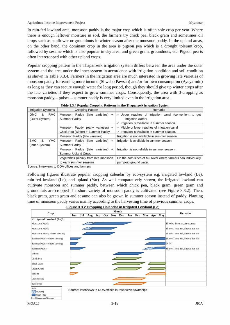
Agriculture Income Improvement Project Myanmar
MOALI 3-18 JICA
In rain-fed lowland area, monsoon paddy is the major crop which is often sole crop per year. Where there is enough leftover moisture in soil, the farmers try chick pea, black gram and sometimes oil crops such as sunflower or groundnuts in winter season after the monsoon paddy. In the upland areas, on the other hand, the dominant crop in the area is pigeon pea which is a drought tolerant crop, followed by sesame which is also popular in dry area, and green gram, groundnuts, etc. Pigeon pea is often intercropped with other upland crops.
Popular cropping pattern in the Thapanzeik irrigation system differs between the area under the outer system and the area under the inner system in accordance with irrigation condition and soil condition as shown in Table 3.3.4. Farmers in the irrigation area are much interested in growing late varieties of monsoon paddy for earning more income (Shwebo Pawsan) and/or for own consumption (Ayeyarmin) as long as they can secure enough water for long period, though they should give up winter crops after the late varieties if they expect to grow summer crops. Consequently, the area with 3-cropping as monsoon paddy – pulses – summer paddy is very limited even in the irrigation area.
Table 3.3.4 Popular Cropping Patterns in the Thapanzeik Irrigation System Irrigation Systems Cropping Pattern Remarks OMC & RMC (Outer System)
Monsoon Paddy (late varieties) + Summer Paddy
Upper reaches of irrigation canal (convenient to get irrigation water).
Irrigation is available in summer season. Monsoon Paddy (early varieties) + Chick Pea (winter) + Summer Paddy
Middle or lower reaches of irrigation canal Irrigation is available in summer season.
Monsoon Paddy (late varieties) Irrigation is not available in summer season. SMC & YMC (Inner System)
Monsoon Paddy (late varieties) + Summer Paddy
Irrigation is available in summer season.
Monsoon Paddy (late varieties) + Summer Upland Crops
Irrigation is not reliable in summer season.
Vegetables (mainly from late monsoon to early summer season)
On the both sides of Mu River where farmers can individually pump-up ground water.
Source: Interviews to DOA offices and farmers
Following figures illustrate popular cropping calendar by eco-system e.g. irrigated lowland (Le), rain-fed lowland (Le), and upland (Yar). As well comparatively shown, the irrigated lowland can cultivate monsoon and summer paddy, between which chick pea, black gram, green gram and groundnuts are cropped if a short variety of monsoon paddy is cultivated (see Figure 3.3.2). Then, black gram, green gram and sesame can also be grown in summer season instead of paddy. Planting time of monsoon paddy varies mainly according to the harvesting time of previous summer crops.
Figure 3.3.2 Cropping Calendar in Irrigated Lowland (Le)
Note: Nursery Main Plot Monsoon Season
Source: Interviews to DOA offices in respective townships
Jun Jul Aug Sep Oct Nov Dec Jan Feb Mar Apr May<Irrigated Lowland (Le)>Monsoon Paddy Shwebo-Powsan, Ayeyarmin
Monsoon Paddy Shawe Thwe Yin, Shawe Sae Yin
Monsoon Paddy (direct sawing) Shawe Thwe Yin, Shawe Sae Yin
Summer Paddy (direct sawing) Shawe Thwe Yin, Shawe Sae Yin
Summer Paddy (direct sawing) IR-747
Summer Paddy Shawe Thwe Yin, Shawe Sae Yin
Wheat
Chick Pea
Black Gram
Green Gram
Sesame
Groundnuts
Sunflower
CropMonth
Remarks

Myanmar Agriculture Income Improvement Project
JICA 3-19 MOALI
In the rain-fed lowland (Le) as shown in Figure 3.3.3, monsoon paddy is the most major crop cultivated, and following the paddy, pulses and in some cases oil crops are grown on leftover soil moisture. During the summer from March to June, no crop can be cultivated due to the hot and dry climate. In the upland (Yar) as indicated in Figure 3.3.4, with the onset of rainy season pigeon pea and other pulses, oil crops such as groundnuts and sesame are cultivated. Many farmers grow those crops by intercropping. Winter crops are also grown on leftover soil moisture same as in the rain-fed lowland (Le). Monsoon paddy is grown during monsoon season, even not in a large area, if supplementary water source is available and the field condition allows.
3.3.3 Crop Production in 9 Townships
Table 3.3.5 summarizes the average crop production in recent 5-years of the 9 townships of the Project area. According to the table, the total annual harvested area arrives at 1,420,028 ha (3,508,895 acre). Of that, monsoon crops are harvested in 855,286 ha (2,113,415 acre) or 60.2 % of the total area while the winter/summer crops are harvested in 564,742 ha (1,395,480 acre) or 39.8 % of the total area.
Figure 3.3.3 Cropping Calendar in Rain-fed Lowland (Le)
Note: Nursery Main Plot Monsoon Season
Source: Interviews to DOA offices in respective townships
Jun Jul Aug Sep Oct Nov Dec Jan Feb Mar Apr May<Raifed Lowland (Le)>Monsoon Paddy Ayeyarmin, Manawhari
Monsoon Paddy Shawe Thwe Yin, Shawe Sae Yin
Monsoon Paddy Ayeyarmin, Manawhari
Monsoon Paddy (direct sawing) Shawe Sae Yin
Chick Pea
Black Gram
Green Gram
Groundnuts
Sesame
Sunflower
CropMonth
Remarks
Note: Nursery Main Plot Monsoon Season
Source: Interviews to DOA offices in respective townships
Figure 3.3.4 Cropping Calendar in Upland (Yar)
Jun Jul Aug Sep Oct Nov Dec Jan Feb Mar Apr May<Upland (Yar)>Monsoon Paddy (direct sawing) Shawe Sae Yin/Short days varieties
Pigeon Pea Late-maturing variety
Pigeon Pea Early-maturing variety
Green Gram
Chick Pea
Groundnuts
Sesame
Sunflower
Maize (grain) For animal feed
Sugarcane Contract farming with sugar mill
Cotton
CropMonth
Remarks

Agriculture Income Improvement Project Myanmar
MOALI 3-20 JICA
Table 3.3.5 Crop Production in the 9 Townships (Average of 2010/11 – 2014/15)
No. Crop Monsoon Season Winter/Summer Season Total
Harvest (ha)
Yield (ton/ha)
Production (ton)
Harvest (ha)
Yield (ton/ha)
Production (ton)
Harvest (ha)
Yield (ton/ha)
Production (ton)
1 Paddy 348,995 4.50 1,571,486 93,580 4.86 455,140 442,575 4.58 2,026,626 2 Wheat 0 0.00 0 20,819 1.03 21,467 20,819 1.03 21,467 3 Maize (grain) 46,660 2.51 117,325 1,091 2.41 2,626 47,751 2.51 119,951 4 Pigeon pea 127,958 0.98 125,511 0 0.00 0 127,958 0.98 125,511 5 Green gram 90,970 0.83 75,241 23,111 0.90 20,849 114,081 0.84 96,090 6 Black gram 4,590 0.88 4,049 47,557 0.96 45,758 52,147 0.96 49,807 7 Chick pea 0 0.00 0 74,798 1.16 86,804 74,798 1.16 86,804 8 Soy bean 106 0.70 74 192 0.79 152 298 0.76 226 9 Groundnut 62,970 2.17 136,733 75,461 3.34 251,958 138,431 2.81 388,691 10 Sesame 52,971 0.38 20,133 103,272 0.74 76,329 156,243 0.62 96,462 11 Sunflower 13,934 1.21 16,862 46,415 1.32 61,371 60,349 1.30 78,233 12 Mustard 0 0.00 0 78 0.05 4 78 0.05 4 13 Cotton 10,931 1.76 19,232 769 2.05 1,573 11,700 1.78 20,805 14 Sugarcane 16,049 58.48 938,577 0 0.00 0 16,049 58.48 938,577 15 Cattle feed1/ 30,900 3,591 110,972,697 21,809 3,996 87,152,562 52,709 3,759 198,125,259 16 Maize 2/ 5,134 36,377 186,762,012 19,329 53,297 1,030,169,970 24,463 49,746 1,216,931,982 17 Onion 0 0.00 0 3,410 17.38 59,271 3,410 17.38 59,271 18 Garlic 0 0.00 0 1,919 11.48 22,035 1,919 11.48 22,035 19 Potato 0 0.00 0 839 18.64 15,638 839 18.64 15,638 20 Chili 106 3.58 379 621 4.01 2,488 727 3.94 2,867 21 Other vege’s 7,173 NA NA 12,826 NA NA 19,999 NA NA 22 Others 35,839 NA NA 16,846 NA NA 52,685 NA NA
Note: 1/ unit is bundle, 2/ unit is fresh cob in pcs. Source: DOA, Shwebo District, Budalin TS and Ayadaw TS
With regards to the harvested area by crop, monsoon paddy is the biggest crop and accounts for 24.6 % of the total area. If summer paddy is combined with, the harvested area of the both paddy accounts for 31.2 % of the total area. Following the paddy, sesame, groundnuts, pigeon pea, green gram, and chick pea account for more than 5 % each (see Figure 3.3.5).
Annual cropping intensity of the 9 townships is estimated at 174 % as indicated in the following table, and the intensity is 105 % for monsoon season and 69 % for winter/summer season respectively as shown in Table 3.3.6. Farmers in the townships as well as in the Project area intensively cultivate their farmland according to the annual crop intensity of about 174%. Though irrigable area is about only 24 % of the total farming land area for the 9 townships, farmers grow various crops even in winter/summer season when rainfall is scarce for stable cropping in general.
Table 3.3.6 Cropping Intensity for the 9 Townships Year Unit
Average in 2010/11 - 2014/15 Farming Land in 2016 (excluding orchard) Monsoon Winter/ Summer Total
Harvested Area ha 855,286 564,742 1,420,028 816,928
acre 2,113,415 1,395,480 3,508,895 2,018,698 Cropping Intensity % 104.7 69.1 173.8 - Source: JICA Survey Team (base information from DOA, Shwebo District, Budalin TS and Ayadaw TS
Figure 3.3.5 % of Annual Harvested Area of Major Crops Source: DOA, Shwebo District, Budalin TS and Ayadaw TS
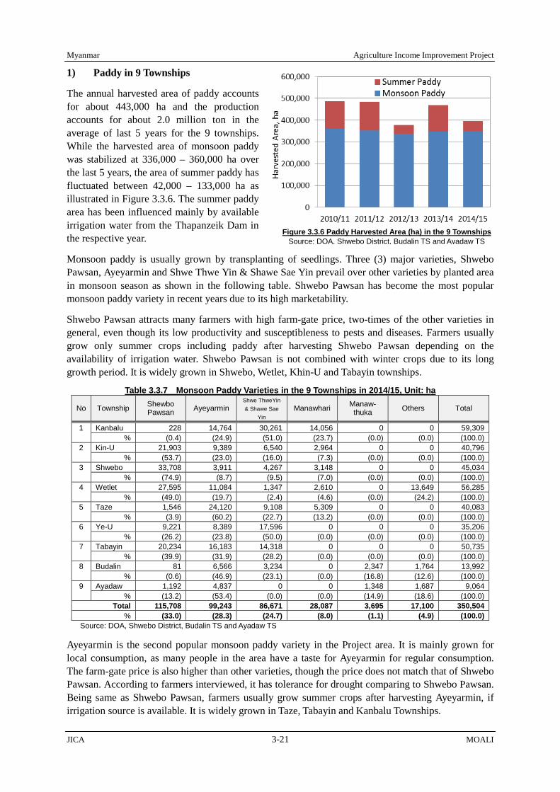
Myanmar Agriculture Income Improvement Project
JICA 3-21 MOALI
1) Paddy in 9 Townships
The annual harvested area of paddy accounts for about 443,000 ha and the production accounts for about 2.0 million ton in the average of last 5 years for the 9 townships. While the harvested area of monsoon paddy was stabilized at 336,000 – 360,000 ha over the last 5 years, the area of summer paddy has fluctuated between 42,000 – 133,000 ha as illustrated in Figure 3.3.6. The summer paddy area has been influenced mainly by available irrigation water from the Thapanzeik Dam in the respective year.
Monsoon paddy is usually grown by transplanting of seedlings. Three (3) major varieties, Shwebo Pawsan, Ayeyarmin and Shwe Thwe Yin & Shawe Sae Yin prevail over other varieties by planted area in monsoon season as shown in the following table. Shwebo Pawsan has become the most popular monsoon paddy variety in recent years due to its high marketability.
Shwebo Pawsan attracts many farmers with high farm-gate price, two-times of the other varieties in general, even though its low productivity and susceptibleness to pests and diseases. Farmers usually grow only summer crops including paddy after harvesting Shwebo Pawsan depending on the availability of irrigation water. Shwebo Pawsan is not combined with winter crops due to its long growth period. It is widely grown in Shwebo, Wetlet, Khin-U and Tabayin townships.
Table 3.3.7 Monsoon Paddy Varieties in the 9 Townships in 2014/15, Unit: ha No Township Shewbo
Pawsan Ayeyarmin Shwe ThweYin & Shawe Sae
Yin Manawhari Manaw-
thuka Others Total
1 Kanbalu 228 14,764 30,261 14,056 0 0 59,309 % (0.4) (24.9) (51.0) (23.7) (0.0) (0.0) (100.0)
2 Kin-U 21,903 9,389 6,540 2,964 0 0 40,796 % (53.7) (23.0) (16.0) (7.3) (0.0) (0.0) (100.0)
3 Shwebo 33,708 3,911 4,267 3,148 0 0 45,034 % (74.9) (8.7) (9.5) (7.0) (0.0) (0.0) (100.0)
4 Wetlet 27,595 11,084 1,347 2,610 0 13,649 56,285 % (49.0) (19.7) (2.4) (4.6) (0.0) (24.2) (100.0)
5 Taze 1,546 24,120 9,108 5,309 0 0 40,083 % (3.9) (60.2) (22.7) (13.2) (0.0) (0.0) (100.0)
6 Ye-U 9,221 8,389 17,596 0 0 0 35,206 % (26.2) (23.8) (50.0) (0.0) (0.0) (0.0) (100.0)
7 Tabayin 20,234 16,183 14,318 0 0 0 50,735 % (39.9) (31.9) (28.2) (0.0) (0.0) (0.0) (100.0)
8 Budalin 81 6,566 3,234 0 2,347 1,764 13,992 % (0.6) (46.9) (23.1) (0.0) (16.8) (12.6) (100.0)
9 Ayadaw 1,192 4,837 0 0 1,348 1,687 9,064 % (13.2) (53.4) (0.0) (0.0) (14.9) (18.6) (100.0)
Total 115,708 99,243 86,671 28,087 3,695 17,100 350,504 % (33.0) (28.3) (24.7) (8.0) (1.1) (4.9) (100.0)
Source: DOA, Shwebo District, Budalin TS and Ayadaw TS
Ayeyarmin is the second popular monsoon paddy variety in the Project area. It is mainly grown for local consumption, as many people in the area have a taste for Ayeyarmin for regular consumption. The farm-gate price is also higher than other varieties, though the price does not match that of Shwebo Pawsan. According to farmers interviewed, it has tolerance for drought comparing to Shwebo Pawsan. Being same as Shwebo Pawsan, farmers usually grow summer crops after harvesting Ayeyarmin, if irrigation source is available. It is widely grown in Taze, Tabayin and Kanbalu Townships.
Figure 3.3.6 Paddy Harvested Area (ha) in the 9 Townships Source: DOA, Shwebo District, Budalin TS and Ayadaw TS

Agriculture Income Improvement Project Myanmar
MOALI 3-22 JICA
Since characteristics of Shwe Thwe Yin and Shawe Sae Yin are similar, DOA Shwebo District lumps them together in its statistics. Because of their short growth duration, farmers usually combine winter crops with the both varieties in their farming system. Most of the winter crops are grown using leftover moisture in the paddy field without irrigation. With their relatively good quality, farmers grow them for their own consumption or local market. They, Shwe Thwe Yin and Shawe Sae Yin, are widely grown in Kanbalu, Ye-U and Tabayin townships.
Figure 3.3.7 shows the changes of harvested area of monsoon paddy by varieties in the 9 townships during 2010/11 – 2014/15. The harvested area of the 3 major varieties has increased replacing other varieties during the period. The area of Shwebo Pawsan shows a stable trend after the sharp increase in 2012/13, while the area of Shwe Thwe Yin and Shawe Sae Yin shows a substantial increase after 2013/14. The area of Ayeyarmin shows a steady transition during the period.
Summer paddy is grown only with irrigation. Shwe Thwe Yin & Shawe Sae Yin and IR-747 are the major varieties grown in summer season in the 9 townships. Shwe Thwe Yin & Shawe Sae Yin have increased the percentage of the planted area replacing IR-747 in recent years except in Wetlet township. The percentage of Shwe Thwe Yin & Shawe Sae Yin accounted for 74.4 %, 73.2 % and 68.2% in 2012/13, 2013/14 and 2014/15 respectively, while the share was only 25.4 % in 2010/11. Though Pale Thwe, a hybrid variety, was promoted by the previous regime due to its high productivity, it has still a limited popularity among farmers in the 9 townships due probably to its coarse quality.
Table 3.3.8 Summer Paddy Varieties in the 9 Townships in 2014/15, Unit; ha No Township Shwe ThweYin &
Shawe Sae Yin IR-747 Pale Thwe Others Total
1 Kanbalu 459 0 31 0 490 % (93.7) (0.0) (6.3) (0.0) (100.0)
2 Kin-U 4,454 34 304 0 4,792 % (92.9) (0.7) (6.3) (0.0) (100.0)
3 Shwebo 6,804 3,041 1,623 0 11,468 % (59.3) (26.5) (14.2) (0.0) (100.0)
4 Wetlet 0 3,870 144 0 4,014 % (0.0) (96.4) (3.6) (0.0) (100.0)
5 Taze 4,299 1,651 236 0 6,186 % (69.5) (26.7) (3.8) (0.0) (100.0)
6 Ye-U 3,705 0 238 2,262 6,205 % (59.7) (0.0) (3.8) (36.5) (100.0)
7 Tabayin 10,735 0 416 0 11,151 % (96.3) (0.0) (3.7) (0.0) (100.0)
8 Budalin 349 0 8 0 357 % (97.8) (0.0) (2.2) (0.0) (100.0) 9 Ayadaw 0 92 0 417 509
% (0.0) (18.1) (0.0) (81.9) (100.0) Total 30,805 8,688 3,000 2,679 45,172
% (68.2) (19.2) (6.6) (5.9) (100.0) Source: DOA, Shwebo District, Budalin TS and Ayadaw TS
As duration of cropping season is limited for summer paddy, farmers choose early maturing varieties, such as Shwe Thwe Yin & Shawe Sae Yin and IR-747. In contrast to monsoon season, broadcasting is popular though transplanting can also be seen. Due to relatively favorable weather condition, a unit
Figure 3.3.7 Trend of Monsoon Paddy Harvested Area Source: DOA, Shwebo District, Budalin TS and Ayadaw TS
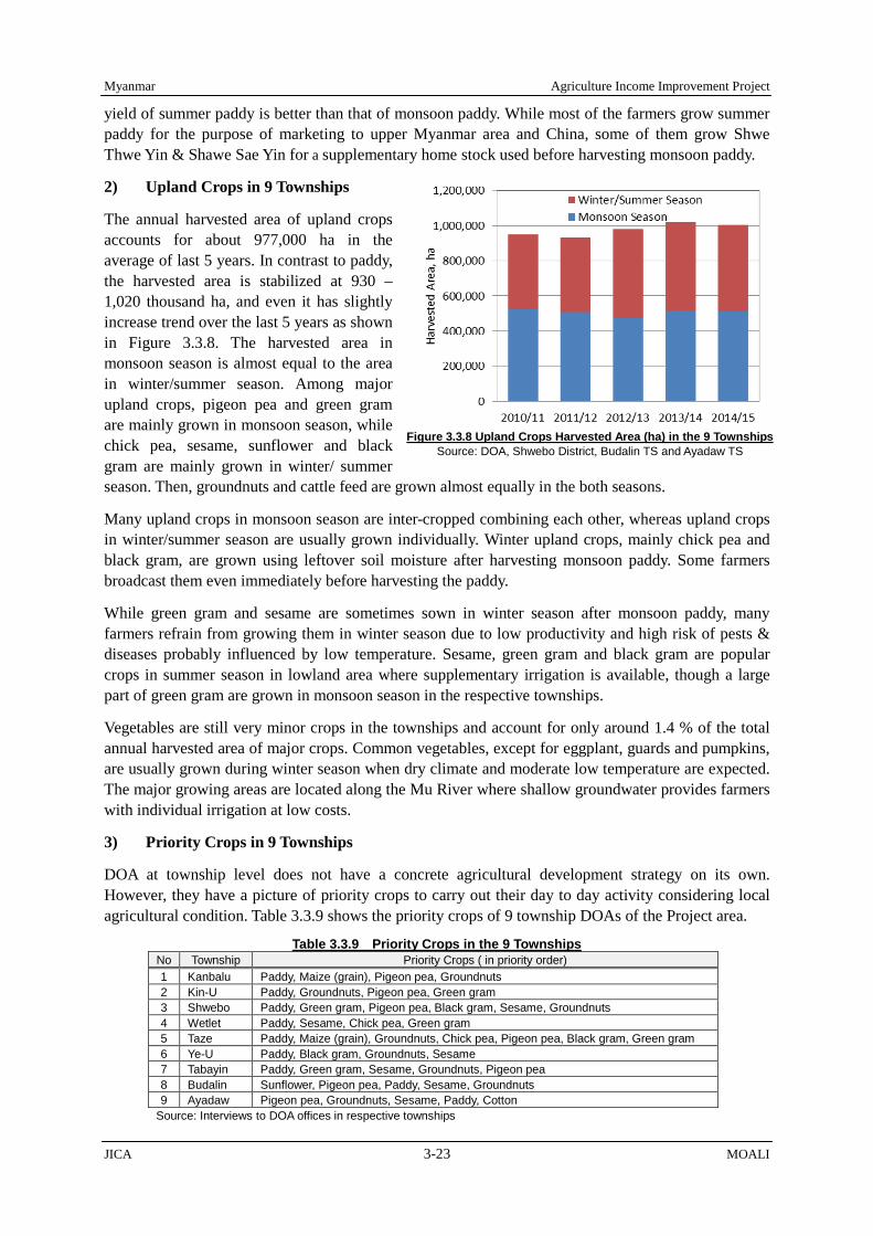
Myanmar Agriculture Income Improvement Project
JICA 3-23 MOALI
yield of summer paddy is better than that of monsoon paddy. While most of the farmers grow summer paddy for the purpose of marketing to upper Myanmar area and China, some of them grow Shwe Thwe Yin & Shawe Sae Yin for a supplementary home stock used before harvesting monsoon paddy.
2) Upland Crops in 9 Townships
The annual harvested area of upland crops accounts for about 977,000 ha in the average of last 5 years. In contrast to paddy, the harvested area is stabilized at 930 – 1,020 thousand ha, and even it has slightly increase trend over the last 5 years as shown in Figure 3.3.8. The harvested area in monsoon season is almost equal to the area in winter/summer season. Among major upland crops, pigeon pea and green gram are mainly grown in monsoon season, while chick pea, sesame, sunflower and black gram are mainly grown in winter/ summer season. Then, groundnuts and cattle feed are grown almost equally in the both seasons.
Many upland crops in monsoon season are inter-cropped combining each other, whereas upland crops in winter/summer season are usually grown individually. Winter upland crops, mainly chick pea and black gram, are grown using leftover soil moisture after harvesting monsoon paddy. Some farmers broadcast them even immediately before harvesting the paddy.
While green gram and sesame are sometimes sown in winter season after monsoon paddy, many farmers refrain from growing them in winter season due to low productivity and high risk of pests & diseases probably influenced by low temperature. Sesame, green gram and black gram are popular crops in summer season in lowland area where supplementary irrigation is available, though a large part of green gram are grown in monsoon season in the respective townships.
Vegetables are still very minor crops in the townships and account for only around 1.4 % of the total annual harvested area of major crops. Common vegetables, except for eggplant, guards and pumpkins, are usually grown during winter season when dry climate and moderate low temperature are expected. The major growing areas are located along the Mu River where shallow groundwater provides farmers with individual irrigation at low costs.
3) Priority Crops in 9 Townships
DOA at township level does not have a concrete agricultural development strategy on its own. However, they have a picture of priority crops to carry out their day to day activity considering local agricultural condition. Table 3.3.9 shows the priority crops of 9 township DOAs of the Project area.
Table 3.3.9 Priority Crops in the 9 Townships No Township Priority Crops ( in priority order) 1 Kanbalu Paddy, Maize (grain), Pigeon pea, Groundnuts 2 Kin-U Paddy, Groundnuts, Pigeon pea, Green gram 3 Shwebo Paddy, Green gram, Pigeon pea, Black gram, Sesame, Groundnuts 4 Wetlet Paddy, Sesame, Chick pea, Green gram 5 Taze Paddy, Maize (grain), Groundnuts, Chick pea, Pigeon pea, Black gram, Green gram 6 Ye-U Paddy, Black gram, Groundnuts, Sesame 7 Tabayin Paddy, Green gram, Sesame, Groundnuts, Pigeon pea 8 Budalin Sunflower, Pigeon pea, Paddy, Sesame, Groundnuts 9 Ayadaw Pigeon pea, Groundnuts, Sesame, Paddy, Cotton
Source: Interviews to DOA offices in respective townships
Figure 3.3.8 Upland Crops Harvested Area (ha) in the 9 Townships Source: DOA, Shwebo District, Budalin TS and Ayadaw TS

Agriculture Income Improvement Project Myanmar
MOALI 3-24 JICA
3.3.4 Irrigated Area by Thapanzeik Dam Irrigable Area
Above discussions referred to those in the 9 townships provided by DOA relevant offices. In addition, IWUMD has a record of the irrigated area by season and by year commanded by the Thapanzeik dam since its operation 2001. The JICA team had conducted a household questionnaire survey covering 240 farmer households in which yields and productions were asked by crop, and plus another 240 households only for the yield survey for major crops in the irrigable area.
Table 3.3.10 summarizes the irrigated area by the Thapanzeik dam from 2001/02 to date. The dam irrigates monsoon paddy (MP) and summer paddy (SP) in principle, and in the recent years since 2014/15 the dam started irrigating green gram and sesame during summer season in addition to the conventional summer paddy. As is summarized below, monsoon paddy has been planted and irrigated over almost all the irrigable area during monsoon season at around 500,000 acre (about 200,000 ha) with cropping intensity of 98%.
With regard to summer crop, the irrigated area has fluctuated widely depending on the irrigation water available in the dam reservoir (see Figure 3.3.9). The irrigated area has ranged from as low as 101,191 acre (2012/13) to as much as 369,385 acre (2010/11), or 21% (2012/13) to 77% (2010/11) for the summer paddy area against that of monsoon paddy. The overall average area of the summer crop irrigated arrives at 285,426 acre (115,506 ha), equivalent to 58% of the irrigable area.
Table 3.3.10 Irrigated Area for Monsoon and Summary for Thapanzeik Dam Irrigation Area, Unit; Acre
Year MP, acre Summer Crop, acre Total
Cultivated (acre)
T. Paddy Cultivated
(acre)
SP/ MP %
Others/ S. Crops
% Total (acre) Total (Acre)
Only SP (acre)
Others (acre)
2001/02 452,491 171,159 171,159 623,650 623,650 38 2002/03 472,648 278,231 278,231 750,879 750,879 59 2003/04 471,468 196,883 196,883 668,351 668,351 42 2004/05 495,215 304,956 304,956 800,171 800,171 62 2005/06 498,788 306,487 306,487 805,275 805,275 61 2006/07 514,166 333,469 333,469 847,635 847,635 65 2007/08 497,745 337,592 337,592 835,337 835,337 68 2008/09 486,836 350,372 350,372 837,208 837,208 72 2009/10 476,085 363,481 363,481 839,566 839,566 76 2010/11 478,953 369,385 369,385 848,338 848,338 77 2011/12 485,156 320,118 320,118 805,274 805,274 66 2012/13 488,224 101,191 101,191 589,415 589,415 21 2013/14 488,565 294,654 294,654 783,219 783,219 60 2014/15 488,414 193,000 107,463 85,537 681,414 595,877 22 44 2015/16 490,001 360,409 267,216 93,193 850,410 757,217 55 26 2016/17 489,593 - - - 489,593 489,593 - -
Total 7,774,348 4,281,387 4,102,657 178,730 12,055,735 11,877,005 Average 485,897 285,426 273,510 89,365 753,483 742,313 56 31
Irrigable Area, acre: 493,887 Intensity, % 98 58 55 18 153 150
Source: Shwebo Maintenance Office, IWUMD
As aforementioned, green gram and sesame had been introduced as an alternative summer crop replacing summer paddy since 2014/15 (in Table 3.3.10, indicated by ‘Others’). The areas irrigated for these alternative crops were 85,537 acre (34,615 ha) in 2014/15 and 93,193 acre (37,713 ha) in
Figure 3.3.9 Irrigated Area by Thapanzeik Dam Source: IWUMD Shwebo Maintenance Office

Myanmar Agriculture Income Improvement Project
JICA 3-25 MOALI
2015/16. The areas for the alternative crops are mostly located downstream of main canals and downstream of big distributary canals where there is often water shortage taking place.
In overall, the cropping intensity comes to 153 % composed of monsoon paddy, summer paddy and alternative crops and 150 % for the both paddy only. Note that there area winter crops, e.g. chick pea, black gram, green gram, which are cultivated in the Thapanzeik irrigable area but not irrigated. Therefore, the data provided by IWUMD cannot reflect the winter crops cultivation, whereby the crop intensities mentioned here are in fact lower than those of actually cultivated in the area.
3.3.5 Irrigated and Cultivated Areas by Satellite Image Analysis
DALMS is in charge of statistical data keeping both for planting area and harvested area together with production tonnage. However, the statistical data provided by DALMS, and also from DAO, are available only at the level of township, district, and region. Therefore in order to know the planted and/or harvested area within the Thapanzeik dam irrigable area, there is no way than depending on the irrigated area provided by IWUMD, though it is not exactly the planted/ harvest area.
What was mentioned in above ‘3.3.4 Irrigated Area by Thapanzeik Dam Irrigable Area’ is based on the data for irrigated area provided by IWUMD maintenance office (Shwebo maintenance office). The data is taken here as the cropped area by season, and in order to verify the data a satellite image analysis is introduced. The satellite image analysis is conducted for the following years:
2008/2009: The 2008/09 season had a normal rainfall of about 1,200 mm, 2013/2014: The season stood for a long draught succeeded from the previous year 2012, and 2015/2016: This season received sufficient rainfall more than 160 % of that of average year.
Among several available satellite remote sensors, Thematic Mapper (TM) and Operational Land Imager (OLI) sensors provided by Landsat 5 and 8 satellites were employed for the analysis. Those sensing data have moderate spatial resolution of 30 m with multi-spectral images (seven and eight bands) and a short revisit interval (16 days). Note that Landsat 5 was launched in January 1984 and ended in 2013 (TM by 2011), while Landsat 8 was lanced in February 2013 carrying an improved OLI sensor and Thermal Infra-Red sensor (TIRS).
The satellite image analysis identified 4 cropping areas such as monsoon paddy, winter crop (pulses), summer paddy and summer alternative crops such as sesame or green gram (see Figure 3.3.10 for the case of 2015/16). On the other hand, the data provided by IWUMD do not include data for winter crop since the crop is not irrigated but grows on residual moisture. Taking into this account, following table compares the analysis data and IWUMD data provided:
Table 3.3.11 Crop Acreage and a Comparison B/T Study and Agricultural Statistics Comparison between study and agriculture statistic (DOA) Unit: ha
Year 2008/2009 2013/2014 2015/2016 Source a) Satellite b) IWUMD a/b a) Satellite b) IWUMD a/b a) Satellite b) IWUMD a/b
Monsoon paddy 272,630 197,016 138% 249,906 197,715 126% 266,895 198,296 135% Winter crop 11,842 0 - 44,248 0 - 29,659 0 - Summer crop*1 11,446 0 - 25,501 - - 37,048 37,714 98% Summer paddy 154,876 141,791 109% 105,590 119,242 89% 108,822 108,138 101%
Comparison between study and agriculture statistic (DOA) Unit: acre Year 2008/2009 2013/2014 2015/2016
Source a) Satellite b) IWUMD a/b a) Satellite b) IWUMD a/b a) Satellite b) IWUMD a/b Monsoon paddy 673,683 486,836 138% 617,532 488,565 126% 659,512 490,001 135% Winter crop 29,263 0 - 109,340 0 - 73,288 0 - Summer crop *1 28,284 0 - 63,014 0 - 91,546 93,193 98% Summer paddy 382,706 350,372 109% 260,919 294,654 89% 268,904 267,216 101%
Note: *1/ summer crop is for example sesame and green gram in this area. Source: JICA Survey Team

Agriculture Income Improvement Project Myanmar
MOALI 3-26 JICA
Figure 3.3.10 Planted Areas of Crops (2015/16, in this year IWUMD intentionally irrigated summer crops) Source: JICA Survey Team based on Landsat satellite image analysis

Myanmar Agriculture Income Improvement Project
JICA 3-27 MOALI
Figure 3.3.11 Land Cover Type (Oct. 2015 – May 2016)
Souse: Study team, delineated from Landsat OLI (Oct2015/May16)
It is known from the table above that monsoon paddy area detected by satellite image surpasses much the data provided by IWUMD, namely the ratios of the 2 areas are 138%, 126% and 136% respectively for the years of 2008/09, 2013/14, and 2015/16. In fact, the area for the monsoon paddy identified by satellite image analysis cannot differentiate irrigated monsoon paddy from rain-fed monsoon paddy. There are spotted areas which cannot be irrigated by the Thapanzeik GRAVITY irrigation system, and those areas are dependent on rainfall and/or pumping irrigation available within the Project area. These rain-fed and pumping areas must have raised the total area of the monsoon paddy.
In fact, the satellite image analysis identified total 328,699 ha (812,244 acre) land area within the Project area which is covered by the 4 main canals of Thapanzeik dam irrigation system (see Figure 3.3.11). Of the land area identified, approximately 91% (300,360 ha) is occupied by farmland and remaining 9 % (28,339 ha) is classified as non-farming area including open water, residential area, and so on. The net irrigable area registered is 199,866 ha (493,886 acres), equivalent to 67% of the farmland area identified by the satellite image analysis. It means that there is still 33% (100,494 ha) farmland area within the Project area but not covered by the irrigation canals. This farmland area must be dependent on rainfall and/or pumping system.
Concerning summer crops (not summer paddy), IWUMD data provide only the area of year 2015/16. Though satellite image analysis identified some summer crop areas, e.g. 11,446 ha in 2008/09 and 25,501 ha in 2013/14, IWUMD had not provided any irrigation water for those years. Therefore, the summer crops cultivated in these years of 2008/09 and 2013/14 must have grown on residual moistures, early rainfall probably in May, or groundwater. Then, IWUMD intentionally started providing irrigation water for summer crop from 2014/15, and the irrigated area of year 2015/16 was 37,714 ha (93,193 acre), which is very close to the area identified by satellite, that is 37,048 ha (98%).
With regard to summer paddy, comparison can be done for the 3 years, and ratios between the satellite identified area and IWUMD area are 109%, 89% and 101% for the years of 2008/09, 2013/14 and 2015/16 respectively. Thus the differences between the 2 areas are 9%, 11%, and only 1% respectively. With this result, it can be concluded that satellite image analysis can be well employed in assessing the cropped area, and especially if the analysis is conducted on dry season, it can detected the irrigated

Agriculture Income Improvement Project Myanmar
MOALI 3-28 JICA
area as well with high accuracy. Note that for the monsoon season cropped area can be well identified; however there is a difficulty of demarcating irrigated and rain-fed cropped area.
3.3.6 Yield of Crops and Paddy Production in Thapanzeik Dam Irrigable Area
Household questionnaire survey asked 240 sampled households of their production and yield by crop/ variety, and plus 240 farm households were asked the yield only, totaling 480 sample households for the yield estimation. Following table summarizes the number of samples surveyed and the average yield by crop/ variety in comparison with the yield reported by DOA Shwebo office.
Table 3.3.12 Yield by Crop and Variety in the Thapanzeik Irrigable Area, Unit: Basket and Ton/ha
Variety Household Survey Yield Survey Weighted
Average, bsk/ac
Weighted Average,
ton/ha
DOA Statistics* Sample
No. Yield, bsk/ac
Sample No.
Yield, bsk/ac
bkt/acre ton/ha
MP Shwebo Pawsan 179 56 148 56 56 2.88
89.38 4.62 Ayeyarmin 48 56 12 53 55 2.86
SM IR747 7 77 5 76 77 3.96 Shawe Sae Yin 9 86 2 70 83 4.29
Sesame 11 5 6 6 5 0.33 14.49 0.88 Green Gram 62 12 8 11 12 0.97 16.42 1.33 * DOA Statistics: 5 years average (2010/11 - 2014/15) from DOA Shwebo District, Note: MP means monsoon paddy and SM means summer paddy. Source: A Household Questionnaire Survey (240 samples) and also Yield Survey (240 samples) conducted by JICA Team (2016)
As indicated above, the yield of the most popular monsoon paddy, Shwebo Pawsan, marked 56 basket/ac (2.88 ton/ha), and that of Ayeyarmin is 55 basket/ac (2.86 ton/ha). IR747 and Shawe Saw Yin are cultivated mostly during summer, so that the yields are higher than those of the former varieties as 77 baskets and 83 baskets. Yield of sesame is 5 basket/ac only (0.33 ton/ha) while that of green gram comes to 12 basket/ac (0.97 ton/ha). Note that the yields reported by the DOA Shwebo office are all very much higher.
3.3.7 Farmland and Farm Holdings
Table 3.3.13 shows the farming land by category for the 9 townships where the irrigable area of Thapanzeik dam falls. Farmland in Myanmar is categorized by such 5 types as; 1) lowland called Le which is the farmland where paddy can be cultivated, 2) upland called Ya where upland crop is cultivated and not irrigated, 3) Kaing Kyun which is the farmland existent along rivers, and 4) orchard land and 5) fallow land. The beneficial irrigable area by the Thapanzeik dam lies in the lowland (Le).
Table 3.3.13 Farmland Holdings by Land Type (240 samples)
Township Farming Land (FL), Ha Irrigable Area
Lowland (Le)
Upland (Ya)
Kaing Kyun, Orchard Fallow
Land Total Irrigable Area, ha
% ag/ total FL % ag/ Le
Kanbalu 56,331 113,246 819 245 5,196 175,837 13,242 8% 24% Khin-U 37,650 45,299 229 35 90 83,303 22,354 27% 59% Shwebo 45,806 14,963 102 10 728 61,609 34,072 55% 74% Wetlet 59,848 41,309 1,218 4 48 102,427 38,674 38% 65% Taze 34,693 22,846 4,396 183 509 62,627 17,499 28% 50% Ye-U 33,611 10,603 557 97 501 45,369 23,683 52% 70% Tabayin 48,286 47,360 100 2,993 62 98,801 39,661 40% 82% Ayadow 30,608 224,818 3,432 31 - 258,889 5,728 2% 19% Budalin 45,498 163,776 598 457 - 210,329 3,326 2% 7%
Total 392,331 684,220 11,451 4,055 7,134 1,099,191 199,866 18% 79% Source: Department of Agricultural Land Management Statistics: DALMS (2016), For the irrigable area, IWUMD Shwebo Maintenance Office
As shown in the table, lowland where paddy is cultivated shares about 40% of whole the farming land,

Myanmar Agriculture Income Improvement Project
JICA 3-29 MOALI
say 392,331 ha of paddy land out of total 1,099,191 ha, while upland shares the most, about 70% of the total farming area (684,220 ha against 1,099,191 ha). The table also shows the irrigable area by township together with the ratio. In overall, the irrigable area shares 18% of the total farming land and also as much as 79% of the paddy land for the 9 townships. Ratio of irrigable area is minimal in Ayadow and Budalin townships located south-western side which presents gently hilly landscape. Ye-U township is endorsed with much irrigable area, say 52%.
Table 3.3.14 shows the farmland holdings identified through the household survey covering 240 samples at 12 villages. The mean farmland holding arrives at 3.13 ha (7.74 acre) for the whole farmland composed of 3 ha (7.42 acre) paddy land, 0.12 ha (0.31 acre) of upland and 0.01 acre of Kaing Kyun. As is expected, the share of lowland (paddy farmland) occupies as much as 96%. The biggest farmland is 16.19 ha (40 acre) while the minimum is only 0.4 ha (1 acre) for the paddy land. Farmland holding by male is bigger than that of female headed household; however the gap is not much, namely the former is 3.18 ha (7.86 acre) for the lowland while the latter is 2.35 ha (5.8 acre), equivalent to 74%.
Table 3.3.14 Farmland Holdings by Land Type (240 samples)
Particulars Lowland (Le) Upland(Ya) Kaing
Kyun, Acre Total
Acre Ha Acre Ha Acre Ha All Households
Mean 7.42 3.00 0.31 0.12 0.01 7.74 3.13 Median 7.00 2.83 0.00 0.00 0.00 7.00 2.83 SD 4.85 1.96 0.76 0.31 0.13 5.74 2.32 Max 40.00 16.19 4.00 1.62 2.00 46.00 18.62 Min 1.00 0.40 0.00 0.00 0.00 1.00 0.40
By Category Male Headed HH 7.86 3.18 0.29 0.12 0.00 8.15 3.30 Female Headed HH 5.80 2.35 0.35 0.14 0.04 6.19 2.51
Kanbalu 6.25 2.53 0.24 0.10 0.00 6.49 2.62 Kin-U 8.44 3.41 0.06 0.03 0.00 8.50 3.44 Shwebo 6.71 2.72 0.15 0.06 0.00 6.86 2.78 Wetlet 7.70 3.12 0.68 0.27 0.10 8.48 3.43 Taze 6.77 2.74 1.22 0.49 0.00 7.99 3.23 Ye-U 6.71 2.72 0.16 0.07 0.00 6.87 2.78 Tabayin 8.20 3.32 0.27 0.11 0.00 8.47 3.43
Source: Household Survey covering 240 samples at 12 village conducted by JICA Survey Team (2016)
3.3.8 Issues Facing the Farmers
The household survey asked 240 sampled farmers of their problems/ challenges they are facing in their farming. Figure 3.3.12 summarizes the issues which were multiple-answered. What comes first is the water shortage for irrigation (24%), followed by occurrence of flood (15%), and further by bad/ poor transportation road to market/ millers (12%). These 3 issues together consist of almost half their problems/ challenges. In addition, lack of farm labors was ranked at 4th (7%), and also high price of farm labors at 7th (4%), totaling to 11%.
It means that rehabilitation of irrigation system probably together with improvement of water management should be given the highest priority, and also drainage improvement and/or flood mitigation should also be given high priority. As is expected, improvement of rural road and farm-to-market road should be undertaken under the Project with high priority since this issue is ranked at 3rd. To cope with labor shortage and high price of farm labors, farm mechanization should be promoted.

Agriculture Income Improvement Project Myanmar
MOALI 3-30 JICA
Figure 3.3.12 Farmers’ Problems/ Challenges (Total 424 Answers by 240 Sample Households) Source: Household Survey by JICA Team
3.3.9 Soil Fertilization
The household survey further asked 240 sampled farmers of how they foster their soil fertilization. Figure 3.3.13 summarizes their responses, by which it is known that more than two-third farmers practice compost/ manure application (73%), followed by deep ploughing (38%), by mixing plant residues (25%), planting trees along field borders (17%), and fallowing land (15%), etc. Note that planting trees along filed borders and fallowing land are mostly practiced in their upland (Yar), and not in paddy land. Almost 3 in every 4 farmers practice compost/ manure application, which is a good indication to physically improve the soil property aside from fostering the soil fertilization.
3.3.10 Farm Economy per Production Area
The household survey which was conducted in October 2016 and covered 240 sampled farm households identified farm economy such as gross profit by crop, production cost by crop, and therefore net profit by crop. Table 3.3.15 shows the gross profit by representative crop per unit production area. According to the survey, about 3 in every 4 farmers (74.6%) grow Shwebo Pawsan followed by Ayeyarmin (acre or 20%) during monsoon season. As for summer paddy, IR 747 and Shwe Sae Yin are the major varieties in the Project area, and therefor the table indicates those data1.
1 In fact, the percentage of the famers who replied they grow IR747 and Shwe Sae Yin were very small, e.g. 2.9% and 3.8 % respectively. This is because most of the farmers just replied other varieties for the summer paddy though the others are almost similar to the 2 major varieties, namely, members of the 2 varieties group.
24%
15%
12%7%5%
5%
4%
4%
4%
4%
3%2%
2% 2% 2% 5% Water shortage for irrigationOccurrence of floodsBad/poor transportation road to market/millersLack of farm laborsDamage by pest and diseasesLack of market/ buyersHigh price of farm laborsLow farm-gate price of cropsLack of agricultural machineriesLack of technical information &extension servicesHigh price of agriculture inputLow quality of fertilizer and agro-chemicalsLittle (or non) availability of certified seedsLow quality of seedsUnstable rainfallOthers
Figure 3.3.13 Responses for Soil Fertilization by Farmers Source: JICA Survey Team
(240 sampled questionnaire survey, 2016)

Myanmar Agriculture Income Improvement Project
JICA 3-31 MOALI
Table 3.3.15 Gross Profit by Representative Crops per Unit Area (Acre, Ha)
Crops
% of Cultivation Household
Production Farm gate Price Gross Profit
% Basket/ac Basket/ha Kyat/bsk Kyat/ac Kyat/ha Shwebo Pawsan 74.6 56 138 9,200 515,200 1,273,105 Ayeyarmin 20.0 56 138 7,800 436,800 1,079,371 IR747 2.9 77 190 5,100 392,700 970,396 Shwe Sae Yin 3.8 86 213 4,700 404,200 998,814 Sesame 4.6 5 12 28,500 142,500 352,130 Green Gram 25.8 12 30 30,700 368,400 910,349
Source: Household Survey covering 240 samples at 12 village conducted by JICA Survey Team (2016)
Normally, the farm gate price reaches the peak several months after the harvesting season because Myanmar people prefer to long-stored rice; however, most of the farmers have to sell their paddy just after harvesting for, e.g., settlement of their debts. For example, Shwebo Pawsan, if farmers can wait for selling about half a year, the farm gate price would increase up to 12,000 – 14,000 Kyats/basket while the average farm gate price per basket just after harvesting remains 9,200 Kyats only, which is referred to the table above.
Unit (per acre) gross profit is the largest on Shwebo Pawsan indicating 515,200 Kyats/acre, followed by Ayeyarmin (436,800 Kyats/acre), Shwe Sae Yin (404,200 Kyats/acre), and IR747 (392,700 Kyats/acre), aside from pulses, beans and sesame. In fact, the first 2 paddies are for monsoon while the latter 2 are for summer. Summer paddy usually marks higher yields than those of monsoon paddies. This is because the varieties of summer paddies are in most cases high yielding ones, and the water supply is almost exclusively dependent on irrigation water, meaning that the water management is generally done properly better than that of monsoon season. However, with the difference of the farm gate price, the gross margin is higher on the monsoon paddies.
Table 3.3.16 indicates average agro-input costs by representative crop. Unit (per acre) input costs are 97,934 Kyats for Shwebo Pawsan, 72,317 Kyats for Ayeyarmin, 98,245 Kyats for IR747, and 102,521 Kyats for Shwe Sae Yin. Seed cost seems significantly larger in summer varieties rather than monsoon varieties. This may be a result of direct sowing more in summer paddy cultivation, requiring more seeds than transplant practiced in monsoon paddy. The result also reveals that T-Super is used only for monsoon varieties among the sampled farmers. Green gram uses a lot of insecticide for a unit acre cultivation (29,169 Kyats/acre). Also, it seems that farmers apply less fertilizer for Ayeyarmin variety as compared to others.
Table 3.3.16 Cost of Inputs by Representative Crops per Unit Area (Acre)
Variety Seed (kyats)
Urea Compound TSP Compost Insecticide Herbicide Fungicide Total Total
(kyats) Total
(kyats) Total
(kyats) Total
(kyats) Total
(kyats) Total
(kyats) Total
(kyats) Total
(kyats) Shwebo Pawsan 24,821 24,404 30,641 1,558 3,565 9,336 3,245 365 97,934 Ayeyarmin 20,289 18,558 27,278 1,430 378 1,318 2,955 110 72,317 IR747 24,170 32,064 35,724 0 4,255 1,426 606 0 98,245 Shwe Sae Yin 17,627 37,388 36,334 0 764 5,151 4,025 1,229 102,521 Sesame 9,225 7,570 3,389 0 389 1,645 1,167 400 23,784 Green Gram 26,035 1,253 5,267 0 602 29,169 1,451 5,427 69,203
Source: Household Survey covering 240 samples at 12 villages conducted by JICA Survey Team (2016)
Table 3.3.17 demonstrates farming costs by category and by representative crop. According to unit (per acre) farming cost, Shwebo Pawsan expenses quite larger than other varieties; namely, 229,000 Kyats/acre for Shwebo Pawsan, 154,000 Kyats/acre for Ayeyarmin, 162,000 Kyats/acre for IR747, and 166,000 Kyats/acre for Shwe Sae Yin. Compared to other variety, labor cost and machine rental cost are remarkably high in the production of Shwebo Pawsan as 74,000 Kyats/acre and 54,000 Kyats/acre respectively. It implies that Shwebo Pawsan cultivation is characterized with labor-intensive farming.

Agriculture Income Improvement Project Myanmar
MOALI 3-32 JICA
Note that many farmers have already introduced machineries in their farming. On average, a typical farmer spends 54,000 Kyats/acre as machinery rental fee for Shwebo Pawsan, 34,000 Kyats/acre for Ayeyarmin, 34,000 Kyats/acre for IR747, and 26,000 Kyats/acre for Shwe Sae Yin. The machinery rental fee from AMD of Shwebo township in 2016 is 6,500 Kyats/acre for harrowing, 13,000 Kyats/acre for plowing, 13,000Kyats/acre for rotary, and 38,000 Kyats/acre for combine harvester. Famers try to access AMD machineries; however the service is limited and therefore they tend to go to private companies and/or neighbors.
Table 3.3.17 Costs of Input and Others by Category and by Representative Crop
Crops
% of Cultivation Household
Total Cost of Input
Total Cost of Labor
Total Cost of Animal
Rental
Total Cost of Machine
Rental Total Cost
% Kyat/ac Kyat/ac Kyat/ac Kyat/ac Kyat/ac Kyat/ha Shwebo Pawsan 74.6 98,000 74,000 3,000 54,000 229,000 565,879 Ayeyarmin 20.0 72,000 46,000 2,000 34,000 154,000 380,548 IR747 2.9 98,000 28,000 2,000 34,000 162,000 400,316 Shwe Sae Yin 3.8 103,000 36,000 1,000 26,000 166,000 410,201 Sesame 4.6 24,000 10,000 1,000 11,000 46,000 113,670 Green Gram 25.8 69,000 53,000 1,000 18,000 141,000 348,423
Source: Household Survey covering 240 samples at 12 village conducted by JICA Survey Team (2016)
Table 3.3.18 summarizes farming cost-profit balance; namely, net profit and its ratio, per unit cultivation area. Net profit per unit area for Shwebo Pawsan is the highest among the 4 paddy varieties and among the 6 major crops cultivated in the Project area as 286,200 Kyats per acre, followed by another monsoon paddy, Ayeyarmin (282,800 Kyats/acre), further by the two summer paddy varieties (230,700 Kyats/ac and 238,200 Kyats/ac for IR 747 and Shwe Sae Yin respectively).
However, here noted is that the net profit ratio for the Shwebo Pawsan is not high, rather the lowest among the 6 major crops as 56%. In fact, Ayeyarmin marks as high as 65% of its net profit ratio. As expected, net profit ratios of green gram and sesames are relatively higher than those of paddies as 62% for green gram and 68% for sesames.
Table 3.3.18 Net Profit and Net Profit Ratio by Representative Crop
Crops % of HHs Gross Profit Total Cost Total Net Profit Net Profit
Ratio % Kyat/ac Kyat/ha Kyat/ac Kyat/ha Kyat/ac Kyat/ha %
Shwebo Pawsan 74.6 515,200 1,273,105 229,000 565,879 286,200 707,225 55.6 Ayeyarmin 20.0 436,800 1,079,371 154,000 380,548 282,800 698,824 64.7 IR747 2.9 392,700 970,396 162,000 400,316 230,700 570,080 58.7 Shwe Sae Yin 3.8 404,200 998,814 166,000 410,201 238,200 588,613 58.9 Sesame 4.6 142,500 352,130 46,000 113,670 96,500 238,460 67.7 Green Gram 25.8 368,400 910,349 141,000 348,423 227,400 561,925 61.7
Source: Household Survey covering 240 samples at 12 village conducted by JICA Survey Team (2016)
3.3.11 Seed Multiplication and Distribution System
Seeds of major crops are multiplied and distributed by the system as shown below. Breeder’s seed (BS) is maintained and distributed by breeders mainly in research institutes of DAR, and Foundation Seed (FS) and Registered Seed (RS) are multiplied by seed farms managed by DOA in the relevant districts in accordance with a plan formulated by the Sagaing regional DOA.
Then, Certified Seed (CS) of paddy is multiplied by seed growers, who are in most cases lead farmers, in accordance with a plan formulated by a district DOA concerned and township DOAs in the district, whereas a part of CS of upland crops are multiplied by DOA seed farms. CS is directly sold to ordinary farmers from the seed growers. Several private seed companies in and around the Project area also take part in the multiplication and distribution of FS, RS and CS.

Myanmar Agriculture Income Improvement Project
JICA 3-33 MOALI
1) Seed Production in DOA Seed Farms
There are 8 DOA seed farms in and around the Project area as summarized in following table. Out of the 8 seed farms, 3 farms are for paddy seeds and remaining 4 farms are for upland crops. In addition to the DOA seed farms, there is also one more seed farm (Pan Gone seed farm) producing seeds of paddy and upland crops managed by DAR in Ye-U township.
Table 3.3.19 DOA Seed Farms in and around the Project Area No Farm Name Location
(Township) Management (District DOA)
Area (Acre/ha) Crop
1 Chi Par Shwebo Shwebo 70/ 28.3 Paddy 2 Ye-U Ye-U Shwebo 80/ 32.4 Paddy 3 Gwe Gone Kin-U Shwebo 40/ 16.2 Paddy
4 Wetto-1 Taze Shwebo 300/ 121.4 Upland crops 5 Wetto-2 Taze Shwebo 270/ 109.3 Upland crops 6 Myaymon Kanbalu Kanbalu 650/ 263.1 Upland crops 7 Kanblu Kanbalu Kanbalu 150/ 60.7 Upland crops 8 Kyaemone Monywa Monywa 240/97.1 Upland crops
Source: DOA, Shwebo District and Monywa District
Above 8 seed farms produced 12,022 ton of FS (foundation seed), 332,158 ton of RS (registered seed) and 104,794 ton of CS (certified seed) or F1 seeds for 10 crops in 2015/16 in total. The crops are paddy (7 varieties), pigeon pea, groundnuts, sunflower, maize, sorghum, chick pea, sesame, green gram and black gram (for detail, see the table below). The produced seeds are distributed not only in the Project area but also to other areas within Sagaing Region. For example, paddy varieties of Hmaw Bi-2 and Sin Akari-3 are mainly produced in Kanti district located in the northern part of Sagaing Region.
Table 3.3.20 Seed Production of DOA Farms in and around the Project Area in 2015/16 No. Crop Variety
Seed Stage (kg) FS (foundation seed) RS (registered seed) CS/F1 (certified seed/F1)
1 Paddy Shwebo Pawsan 0 85,586 0 Ayeyarmin 4,849 85,252 0 Shwe Thwe Yin 1,400 0 0 Shwe Sae Yin 0 3,135 0 Sin Thuka 1,359 7,524 0 Hmaw Bi-2 690 22,405 0 Sin Akari-3 1,672 12,540 0
2 Pigeon pea - 0 84,464 33,910 3 Groundnuts - 2,052 10,488 4,560 4 Sunflower - 0 0 11,745 5 Maize - 0 0 1,868 6 Sorghum 0 0 11,802 7 Chick pea - 0 1,878 15,494 8 Sesame - 0 6,983 9,359 9 Green gram - 0 5,363 16056 10 Black gram - 0 6,540 0
Total 12,022 332,158 104,794 Source: Seed Division, DOA Shwebo District and Monywa District
Breeder’s Seed (DAR)
Foundation Seed (DAR/DOA)
Register Seed (DOA Seed Farms)
Certified Seed (Seed Growers/DOA Seed Farms)
Multiplication
Multiplication
Multiplication
Distribution (sales)
Figure 3.3.14 Seed Multiplication and Distribution System Source: DOA Seed Division
Ordinary Farmers

Agriculture Income Improvement Project Myanmar
MOALI 3-34 JICA
2) CS (Certified Seed) Production
As described above, the majority of CS is multiplied and distributed by seed growers who are usually advanced farmers selected by the township DOA in the area. They buy RS through the township DOA, and produce and sell CS to ordinary farmers who do the farming nearby. Table 3.3.21 below shows CS production by the seed growers in Shwebo District in 2015/16.2
Table 3.3.21 CS Production of Seed Production in Shwebo District in 2015/16
No. Crop CS Production*
Acreage (Acre)
Yield (basket/ac)
Production (basket)
Acreage (ha)
Yield (ton/ha)
Production (ton)
1 Shwebo Pawsan (Paddy) 3,765 82.58 310,911 1,524 4.26 6,498 2 Ayeyarmin (Paddy) 2,815 86.65 243,949 1,139 4.48 5,099 3 Summer Sesame 10 13.20 132 4 0.75 3 4 Winter Sesame 90 19.12 1,712 36 1.17 42 5 Pigeon Pea 60 20.28 1,217 24 1.67 40 6 Groundnuts 180 55.84 9,907 73 1.55 113 7 Chick Pea 120 20.93 211 49 0.14 7 Note: *Production is the amount of produced candidate CS before the official inspection. Source: Seed Division, DOA Shwebo District
It is curious that the produced paddy CS in the table could be more than 4 -5 times of the potential demand in Shwebo District according to a JICA Team’s estimation, though it is generally understood that CS shortage is a critical issue of rice farmers throughout the Country. The DOA Shwebo District also shares the same question, and has explained the difficulty collecting a reliable picture of CS production and distribution as follows;
1) Township DOAs, who are responsible for supervising the CS production at field level, overestimate the production (reporting almost similar figures in the original plan instead of actual figures),
2) The exact amount of CS which can pass laboratory inspection is open question to District DOAs, as the information is not shared with the Seed Division of DOA who is responsible for the inspection, and
3) The amount of CS actually marketed is unclear, as the sales are responsible for each of the individual seed growers3.
As seen above, reliable information of paddy CS production and distribution is still a missing-link among parties involved in the seed multiplication and distribution.
3) Seed Inspection
There are two kinds of inspection in the seed multiplication and distribution system as shown below in order to guarantee the quality of CS. Field inspections are carried out by extension workers who have participated in a training course on seed production technology. According to the DOA Shwebo district, there are about 10 qualified extension workers in each township DOA. The extension workers have to make a report to the seed division of District DOA after the inspection. A report of JICA project on “Quality Rice Seed Multiplication System and Distribution in Myanmar” indicates that the field inspection is unsatisfactory implemented in many places due to shortage of competent staff and budget, even though a disciplined field inspection is the gateway to success in quality seed production.
2 Kanbalu District wasn’t separated from Shwebo District at the time this information was prepared. 3 It is reported that seed growers sell a large part of their produced CS as food because of the undeveloped market and also they cannot wait until the time when the ordinary farmers buy the seed, usually the beginning of the following season. They are not able to find a sufficient number of buyers by themselves in times.

Myanmar Agriculture Income Improvement Project
JICA 3-35 MOALI
Table 3.3.22 CS Inspections Inspection Contents In Charge
Field Inspection (2 times/crop season)
Field condition Other varieties Disease damages Weeds
Qualified Extension Workers of DOA
Laboratory Inspection (after processing)
Purity of the variety Germination power Moisture contents Contamination of weed seeds Contamination of red rice
Seed Laboratory (the Seed Division, MOALI)
Source: Seed Division, DOA Shwebo District
The laboratory inspection is carried out by a seed laboratory managed by the Seed Division of DOA There are only two seed laboratories in Myanmar, and the Project area is located in the jurisdiction of the laboratory in Mandalay. The seed laboratory inspects a sample of CS sent by the seed growers. The average pass rate for the inspection (the number of passed sample divided by the number of total sample) was, however, only 59 % for Shwebo Pawsan and 46% for Ayeyarmin as at 2015. Considering seed growers’ convenience, it is advisable to implement a mean of speeding up the time required for the seed inspection and, as a matter of fact, capacity building on the inspection staff and the seed growers should be further practiced.
4) Seed Growers Association (SGA)
MOALI has started a new policy to shore up CS production in 2016/17. In the new policy, seed growers are organized in a seed growers association (SGA) in each township; namely, one SGA is established in each of the townships. Therefore, there are 9 SGAs with 193 seed growers and 340.1 ha (840 acre) in the 9 townships as shown in the following table. SGAs are organized only for paddy CS production in Kanbalu township and 6 townships in Shwebo District, while SGAs in 2 Townships in Monywa District produce CS of various upland crops in addition to paddy in keeping with the priority crop of the townships.
Table 3.3.23 Seed Growers Associations in the 9 Townships (2016/17) No. Township (District)
No: of Seed Growers
Total Area Ave. Area (ha/grower)
No: of Villages
Crop (acre) (ha)
1 Kanbalu (Kanbalu) 27 120 48.6 1.8 3 Paddy 2 Kin-U (Shwebo) 11 84 34.0 3.1 7 Paddy 3 Shwebo (Shwebo) 33 225 91.1 2.8 7 Paddy 4 Wetlet (Shwebo) 14 100 40.5 2.9 8 Paddy 5 Taze (Shwebo) 22 41 16.6 0.8 11 Paddy 6 Ye-U (Shwebo) 27 70 28.3 1.0 5 Paddy 7 Tabayin (Shwebo) 15 80 32.4 2.2 2 Paddy
8 Budalin (Monywa) 25 60 24.3 1.0 8 Paddy, Pigeon pea, Chick pea, Sunflower, Groundnut
9 Ayadaw (Monywa) 19 60 24.3 1.3 9 Paddy, Pigeon pea, Green gram, Chick pea
Total 193 840 340.1 1.8 60 - Source: Seed Division, DOA Shwebo District, Budalin TS and Ayadaw TS
MOALI intends to empower SGAs so that they will be an independent private entity having a competitive power in seed business. However, the seed growers are simply instructed to be organized in SGAs by DOA without good incentives. It seems that the representatives of SGAs are not well prepared to be a leader of the expected business entity, and are not really confident about the new direction of the policy with the following reasons either;
1) SGAs do not have necessary facilities and equipment to process and store produced seed, e.g. seed dryer, seed cleaners, packing machine and storage space, and
Agriculture Income Improvement Project Myanmar
MOALI 3-36 JICA
2) Leaders of SGAs are not experienced in managing a business entity (the leaders are not business personnel, but well experienced farmers).
DOA is well aware of above situation, and is examining a plan to support SGAs during the transition period, such as government purchase system of CS, according to the DOA Shwebo District. It may take a certain more time to make SGAs an independent private entity as expected.
5) Private Seed Company
A rice milling company in Wetlet Township has entered paddy seed business since last year, 2015/16. The company is producing CS of Shwebo Pawsan and Ayeyarmin at a field of 150 acres. It sells all produced CS to its contract farmers mostly on credit together with chemical fertilizers. The company is preparing to expand the seed business with business associates. It expects to start a new seed company in 2017 monsoon season with 400 acre after getting approval from the Seed Division of MOALI. According to the manager of the rice milling company, a profitability of paddy seed business is reasonable, and he has a plan to increase the producing area gradually in coming years. This is the only case of CS production by private sector in and around the Project area at present.
6) Challenges in Promoting Quality Seeds Production
It is widely recognized in Myanmar that limited use of quality seeds is a serious bottleneck in the increased crop production, especially in the improvement of paddy rice productivity. The following describes considerations about the low popularity of quality paddy seeds among farmers based on observations in the Project area.
6.1) Revitalization of Breeding Research
Major popular paddy varieties in the Project area are old varieties which were officially released before early 1990s. The most popular monsoon paddy, Shwebo Pawsan was registered in 1995. The situation that local farmers have not well accepted new paddy varieties during last 20 years is an evidence of stagnation in the breeding research in Myanmar. Development of new varieties with characteristics tackling the present farmers’ issues, such as high productivity and quality, pests and diseases resistance, drought tolerance, etc. must be a good incentive to use quality seeds for the farmers. Activated breeding research including evaluation of genetic resources for developing new attractive varieties to farmers shall pave a way to increased demand of CS.
6.2) Quality Improvement of CS
Definition of quality seeds is discussed by 2 major aspects, i.e. genetic purity (keeping original characteristics of the variety) and vigorous viability (high germination power and diseases-free). The quality is only secured by good field condition, careful field management and proper post-harvest processing including storing. According to a report of JICA project for “Quality Rice Seed Multiplication System and Distribution in Myanmar”, a problem of insufficient genetic purity is reported not only in the case of CS but also in the case of BS which is the base seeds in the seed multiplication system.
As a matter of fact, only a limited number of farmers use paddy CS at present. However, it is also true that many farmers in the Country buy paddy seeds from neighbor farmers in order to replace their self-produced seeds once every 3 - 4 crops4. This implies that there is a reasonable potential demand for paddy CS, if quality CS is widely marketed and is well recognized by farmers. Farmers always 4 According to the report of “Myanmar: Analysis of Farm Production Economics, February 2016, the World Bank”, 22.5 – 30.4 % of sample farmers in Shwebo area buy monsoon paddy seeds from neighbor farmers. From a view point of agronomy, it is good enough to replace self-produced paddy seeds once every 3 crops for keeping a reasonable seed quality at farmer level.

Myanmar Agriculture Income Improvement Project
JICA 3-37 MOALI
concern about actual seed quality instead of the nominal prestige.
It is supposed that the CS quality is gradually improving with the implementation of JICA technical cooperation. The improvement should be more progressed by strengthening a total quality management system from BS to CS at field level, at post-harvest level and at laboratory inspection level. Especially, much attention should be paid to the management at field level as the nature of quality seeds, the genetic purity and the vigorous viability are mostly determined before harvesting. The national seed policy, then, should promote the total quality management system by strengthening the quality-oriented policy as the high-quality has usually a trade-off relation with the high-productivity in seed production.
6.3) Empowerment of Seed Growers
It is also reported that many seed growers have still limited know-how and experience to produce quality paddy seeds. They also have difficulty to find a sufficient number of clients after producing CS. Not a small part of produced CS is consequently marketed as a general paddy for consumption. It is easy to assume that the seed growers lose their motivation for continuing CS production, and the decreased motivation creates a vicious spiral of low quality CS production and flagging CS marketing. Capacity building of seed growers should be the core subject for addressing the present seed issue.
Almost seed growers are only general farmers selected by respective township DOAs. Marketing must be a headache for them while they are asked to market the produced CS by their own effort. In general, they do not have enough know-how to run a seed marketing business. DOA has already recognized that low marketing ability of seed growers is one of the reasons for the little penetration of CS into farmers. Then, DOA has started organizing a Seed Growers Association in each township in order to empower them. While a certain government intervention might be expected for supporting the associations, the intervention should include a component to facilitate interactions between the associations and local private companies who are interested in the seed business in order to promote smooth marketing of CS.
6.4) Information Sharing among Stakeholders
Stakeholders of CS production share only limited information each other. This makes it difficult for them to have a clear picture to improve the present situation. District DOA, who is responsible for coordinating the CS production at field level, does not have comprehensive and reliable information concerned, such as amount of CS sent for laboratory inspection, amount of CS which passed the inspection, amount of CS sold to farmers, etc.
As far as paddy seeds are concerned, it is assumed that the multiplication of CS can be the bottleneck as more than sufficient amount of RS is produced and distributed to seed growers in Shwebo district. However, the District DOA has difficulty to make countermeasures to address critical issues in the CS multiplication with priority due probably to lack of reliable information. A monitoring system covering from the production to the distribution will contribute to establishing a favorable CS business environment.
6.5) Starting with possible small steps
Farmers in the Project area do not practice “salt water selection” which is a method to select vigorous paddy seeds by a certain specific gravity of salt water. Although many farmers express a serious concern for securing quality paddy seeds, they don not carry out the simple, economical and effective practice. In addition, basic farming practices for producing quality seeds at field level, such as keeping a seed field away from other varieties, rogueing off-type or damaged plants, etc. are not properly done by them. Such practices are not exclusively for producing CS, but also for keeping their self-producing
Agriculture Income Improvement Project Myanmar
MOALI 3-38 JICA
seeds in good quality.
Many reports about paddy production in Myanmar indicate that farmers use more than 40 kg/acre (about 100kg/ha) of seeds for growing paddy seedlings. This amount is about 3 times larger than the amount in other paddy producing countries. An appropriate seed dosage is a precondition for producing vigorous seedlings and for encouraging a vital initial growth of plant. The reduced seed dosage also contributes to avoiding overestimation of CS requirement. The present dosage of the seeds can and should be reduced with agricultural extension activities improved.
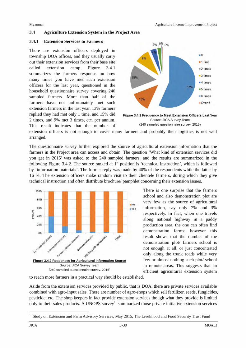
Myanmar Agriculture Income Improvement Project
JICA 3-39 MOALI
3.4 Agriculture Extension System in the Project Area
3.4.1 Extension Services to Farmers
There are extension officers deployed in township DOA offices, and they usually carry out their extension services from their base site called extension camp. Figure 3.4.1 summarizes the farmers response on how many times you have met such extension officers for the last year, questioned in the household questionnaire survey covering 240 sampled farmers. More than half of the farmers have not unfortunately met such extension farmers in the last year. 13% farmers replied they had met only 1 time, and 15% did 2 times, and 9% met 3 times, etc. per annum. This result indicates that the number of extension officers is not enough to cover many farmers and probably their logistics is not well arranged.
The questionnaire survey further explored the source of agricultural extension information that the farmers in the Project area can access and obtain. The question ‘What kind of extension services did you get in 2015' was asked to the 240 sampled farmers, and the results are summarized in the following Figure 3.4.2. The source ranked at 1st position is ‘technical instruction’, which is followed by ‘information materials’. The former reply was made by 40% of the respondents while the latter by 16 %. The extension officers make random visit to their clientele farmers, during which they give technical instruction and often distribute brochure/ pamphlet concerning their extension issues.
There is one surprise that the farmers school and also demonstration plot are very few as the source of agricultural information, say only 7% and 3% respectively. In fact, when one travels along national highway in a paddy production area, the one can often find demonstration farms; however this result shows that the number of the demonstration plot/ farmers school is not enough at all, or just concentrated only along the trunk roads while very few or almost nothing such plot/ school in remote areas. This suggests that an efficient agricultural extension system
to reach more farmers in a practical way should be established.
Aside from the extension services provided by public, that is DOA, there are private services available combined with agro-input sales. There are number of agro-shops which sell fertilizer, seeds, fungicides, pesticide, etc. The shop keepers in fact provide extension services though what they provide is limited only to their sales products. A UNOPS survey1 summarized those private initiative extension services
1 Study on Extension and Farm Advisory Services, May 2015, The Livelihood and Food Security Trust Fund
Figure 3.4.1 Frequency to Meet Extension Officers Last Year Source: JICA Survey Team
(240 sampled questionnaire survey, 2016)
Figure 3.4.2 Responses for Agricultural Information SourceSource: JICA Survey Team
(240 sampled questionnaire survey, 2016)

Agriculture Income Improvement Project Myanmar
MOALI 3-40 JICA
in comparison with DOA’s one as follows:
Main agro-chemical companies and their official dealers/shops, seed companies: Ad-hoc advice, on-farm demos, network of agronomists travelling the villages, qualified staff in official shops,
Input-supply shops: Ad-hoc advice to customers on request, basic/rudimentary qualification of the staff in many shops, and
DOA: work with “contact farmers”, on-farm demos (mainly “show-case”) , focus on rice, low presence at village level,
From above and based on the Team’s observation in the fields, though numerical data are not available, private initiative extension services are gaining momentum nowadays. Even demonstration plots established by private initiative can be seen in paddy fields especially along trunk roads. Though their knowledge may be rudimentary in cases, nowadays extension services should not disregard such private initiative or rather proactively try to include.
3.4.2 DOA Extension System
DOA of MOALI is the responsible organization for providing agricultural extension services in the public sector, and it has branch offices at each of the local administration levels. In fact, all the regions/ states, districts and also townships in principle have DOA offices. Of them, the township (TS) office, which is the lowest stair office, plays a practical role in the extension services at the field level contacting farmers directly under supervision and coordination of the upper stair offices.
1) Township DOAs and their Roles
There are 9 townships mainly concerning to the Project area. As Kanbalu district newly separated from Shwebo district this year 2016, 6 townships belong to Shwebo district, while Kanbalu township is located in Kanbalu district at present. The remained two townships, Budalin and Ayadaw, belong to Monywa district. Organizational structure of TS DOA is standardized as shown in following Figure 3.4.4:
Township Officer represents a TS DOA under supervision of the representative of district DOA in the area. A TS DOA consists of 2 major sections, i.e. the Agricultural Extension Force and the Accounting & Planning Section, whereas the later section for administration is divided further into 2 sections in
Figure 3.4.3 Hierarchy of DOA Offices at HQs and Local Areas Source: DOA Headquarters, MOALI
Department of Agriculture (DOA),MOALI
Regional/State Offices
Township Offices
Regional/State Offices
District Offices District Offices
District Offices
District Offices District Offices
District Offices
Township Offices Township Offices
Township Offices
Township Offices Township Offices
Township Offices
Township Offices Township Offices
Township Offices Township Offices
Township Offices Township Offices
Township Offices
Township Offices Township Offices
Township Offices Township Offices
Township Offices Township Offices
Township Offices

Myanmar Agriculture Income Improvement Project
JICA 3-41 MOALI
some cases. In any cases, a limited number of staff is allocated in the Accounting & Planning Section since mandated roles of TS DOAs almost concentrate on providing agricultural extension services. Major roles of TS DOAs are, according to Shwebo district office, as follows:
Technical guidance to farmers (visiting consultation and implementing various supporting programs such as demonstration plot and trial plot),
Supervision of seed growers and the field-inspection, Monitoring and adjustment of crop production in cooperation with IWUMD and DALMS under
MOALI, in order to mitigate the difference between an actual crop production and the government target2,
Yield evaluation of major crops, and Statistical data collection about agriculture and rural conditions.
2) Extension Camps and Staffing
The TS area is divided into several units of extension area called as Extension Camp or Production Camp. There are 52 Extension Camps in total in the 9 TSs of the Project area, while only 39 of them cover irrigable area. Each TS DOA allocates several Deputy Staff Officers (DSOs) for supervising the Extension Camp. A DSO is usually responsible for 2 – 3 Extension Camps. An Assistant Officer (AO) and several Deputy Assistant Officers (DAOs) and Daily Wage Staff are assigned as a unit to each Extension Camp in principle. The unit is a front-line task force to provide agricultural extension services led by the AO. They normally work based in their assigned Extension Camp without an office facility.
Table 3.4.1 shows the number of DSOs, AOs, DAOs and Daily Wage Staff in 9 TS DOAs of the Project area. The number of agricultural extension staff in the Project area is 192 (32 DSOs plus 160 extension workers), of whom total number of front-line extension workers accounts for 160, sharing 83% of the extension staff. The average number of extension workers excluding DSOs per Extension Camp is only 3.1.
2 The government still set a production target of major crops, even though the government has allowed farmers to choose crops with their interests at present.
Figure 3.4.4 Organizational Structure of Township DOAs Source: DOA Townships in Shwebo District
Agricultural Extension Force
Township Officer
Accounting & Planning Section
(Administration)
Extension Camp
Assistant Officer (AO) Deputy Assistant
Officers (DAOs) Daily Wage Staffs
Extension Camp
Assistant Officer (AO) Deputy Assistant
Officers (DAOs) Daily Wage Staffs
Deputy Staff Officers (DSOs)

Agriculture Income Improvement Project Myanmar
MOALI 3-42 JICA
Table 3.4.1 Number of Agricultural Extension Staff in the 9 TS DOAs (as of January 2017)
No. Township (District)
Position No. of
Extension Camps
Ave. No. of Extension
Workers per Camp
Deputy Staff Officer (DSO)
In Extension Camp (Extension Worker)
Assistant Officer (AO)
Deputy Assistant
Officer (DAO)
Daily Wage Staff Total
1 Kanbalu (Kanbalu) 2 2 9 2 13 9 1.4 2 Kin-U (Shwebo) 4 5 2 5 12 5 2.4 3 Shwebo (Shwebo) 4 7 8 10 25 7 3.6 4 Wetlet (Shwebo) 5 7 6 2 15 9 1.7 5 Taze (Shwebo) 5 7 7 5 19 5 3.8 6 Ye-U (Shwebo) 2 10 7 6 23 4 5.8 7 Tabayin (Shwebo) 3 8 3 5 16 5 3.2 8 Budalin (Monywa) 3 8 2 4 14 3 4.7 9 Ayadaw (Monywa) 4 7 7 9 23 5 4.6
Total 32 61 51 48 160 52 3.1 Source: 9 DOA Township Offices Concerned
As shown in the Table 3.4.1, the number of AOs who are mid-career staff accounts for 61 out of the 160 extension workers, though the number of DAOs and Daily Wage Staffs who have limited experience in the extension services are 51 and 48, respectively. Consequently, there are some Extension Camps having 2 AOs, whereas some others have no DAOs or Daily Wage Staff. It seems that an appropriate number and formation of AO, DAOs and Daily Wage Staff cannot be always allocated to Extension Camps due to limited human resources. Such formation of the front-line extension workers represents a decreased number of new DOA employments during the last decade.
DSO, AO, DAO and Daily Wage Staff are staff-grades of junior to intermediate staff in DOA, instead of managerial posts in DOA offices. As shown in Table 3.4.2, DOA employees start their career from Daily Wage Staff and step up the grades up to DSO based on their educational background and in accordance with their professional career. As new employees of MOALI are recruited all at once by the central office, the extension staff are sometimes transferred to other TS, to other district or even to other Region during their career. The majority of front-line extension workers in the Project area are graduates of the State Agricultural Institutes (SAIs) under DOA with a 3-year diploma course.
Table 3.4.2 Experience of DOA Staff by Grades Grades
(Junior to Intermediate Staff)
Normal Experience Year Bachelor
(Agri. Univ.) Diploma
(Agri. Institute) 1 Daily Wage Staff 0 - 2 0 - 3 2 Deputy Assistant Officer (DAO) 3 - 5 4 - 8 3 Assistant Officer (AO) 6 - 8 9 - 15 4 Deputy Staff Officer (DSO) > 9 > 16
Source: DOA Shwebo District
There are 1,775 villages in the 9 townships, and the number of farm households and the acreage of farmland area are 365,286 HH and 820,693 ha (2,028,001 acre), respectively as in Table 3.4.3. An extension worker in Extension Camps, in fact, has to cover about 11 villages, 2,280 HH and 5,130 ha, respectively on average. While the workload per extension worker differs much from TS to TS, it is heavier in Kanbalu TS and Wetlet TS and is lighter in Shwebo TS, Ye-U TS and Ayadaw TS.
In any case, the extension workers have more works than what one can handle, if they try to provide an effective service as expected. Extension workers explain that the workload has increased much because of the Government policy to decrease the number of extension workers from 2004 to 2011. The staff number in an Extension Camp has reduced to one-fourth of that of peak period in an extreme example despite the recent small increase in the number, according to the extension workers3.
3 It is interesting that there is comparative high ratio in the female extension workers at field level. Several
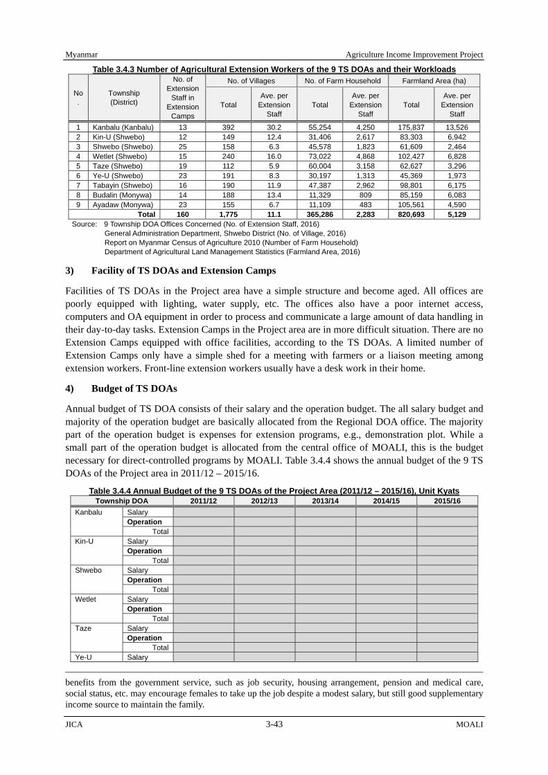
Myanmar Agriculture Income Improvement Project
JICA 3-43 MOALI
Table 3.4.3 Number of Agricultural Extension Workers of the 9 TS DOAs and their Workloads
No.
Township (District)
No. of Extension
Staff in Extension
Camps
No. of Villages No. of Farm Household Farmland Area (ha)
Total Ave. per
Extension Staff
Total Ave. per
Extension Staff
Total Ave. per
Extension Staff
1 Kanbalu (Kanbalu) 13 392 30.2 55,254 4,250 175,837 13,526 2 Kin-U (Shwebo) 12 149 12.4 31,406 2,617 83,303 6,942 3 Shwebo (Shwebo) 25 158 6.3 45,578 1,823 61,609 2,464 4 Wetlet (Shwebo) 15 240 16.0 73,022 4,868 102,427 6,828 5 Taze (Shwebo) 19 112 5.9 60,004 3,158 62,627 3,296 6 Ye-U (Shwebo) 23 191 8.3 30,197 1,313 45,369 1,973 7 Tabayin (Shwebo) 16 190 11.9 47,387 2,962 98,801 6,175 8 Budalin (Monywa) 14 188 13.4 11,329 809 85,159 6,083 9 Ayadaw (Monywa) 23 155 6.7 11,109 483 105,561 4,590
Total 160 1,775 11.1 365,286 2,283 820,693 5,129 Source: 9 Township DOA Offices Concerned (No. of Extension Staff, 2016)
General Administration Department, Shwebo District (No. of Village, 2016) Report on Myanmar Census of Agriculture 2010 (Number of Farm Household) Department of Agricultural Land Management Statistics (Farmland Area, 2016)
3) Facility of TS DOAs and Extension Camps
Facilities of TS DOAs in the Project area have a simple structure and become aged. All offices are poorly equipped with lighting, water supply, etc. The offices also have a poor internet access, computers and OA equipment in order to process and communicate a large amount of data handling in their day-to-day tasks. Extension Camps in the Project area are in more difficult situation. There are no Extension Camps equipped with office facilities, according to the TS DOAs. A limited number of Extension Camps only have a simple shed for a meeting with farmers or a liaison meeting among extension workers. Front-line extension workers usually have a desk work in their home.
4) Budget of TS DOAs
Annual budget of TS DOA consists of their salary and the operation budget. The all salary budget and majority of the operation budget are basically allocated from the Regional DOA office. The majority part of the operation budget is expenses for extension programs, e.g., demonstration plot. While a small part of the operation budget is allocated from the central office of MOALI, this is the budget necessary for direct-controlled programs by MOALI. Table 3.4.4 shows the annual budget of the 9 TS DOAs of the Project area in 2011/12 – 2015/16.
Table 3.4.4 Annual Budget of the 9 TS DOAs of the Project Area (2011/12 – 2015/16), Unit Kyats Township DOA 2011/12 2012/13 2013/14 2014/15 2015/16
Kanbalu Salary Operation
Total Kin-U Salary
Operation Total
Shwebo Salary Operation
Total Wetlet Salary
Operation Total
Taze Salary Operation
Total Ye-U Salary
benefits from the government service, such as job security, housing arrangement, pension and medical care, social status, etc. may encourage females to take up the job despite a modest salary, but still good supplementary income source to maintain the family.

Agriculture Income Improvement Project Myanmar
MOALI 3-44 JICA
Township DOA 2011/12 2012/13 2013/14 2014/15 2015/16 Operation
Total Tabayin Salary
Operation Total
Budalin Salary Operation
Total Ayadaw Salary
Operation Total
Average for Operation Total of Operation
Source: DOA Shwebo District
As an average, one TS office has spent operation budget with a range of million to million Kyats per annum excluding year 2011/12. Dividing the annual expenditure by 12 months, only __ million to about million Kyats is available per month. It is reported that DOA offices generally have a limited budget for allowances to extension workers. The compensation paid for using private motorcycles4 is not adequate according to extension workers interviewed, in most cases not more than 10,000 Kyats per staff per month.
3.4.3 Extension Activity
TS DOAs play the afore-mentioned 5 roles such as technical guidance to farmers, supervision of seed growers, monitoring of crop production, yield evaluation, statistical data collection, etc. through their extension workers based in Extension Camps. Table 3.4.5 shows a typical annual schedule of extension workers by activity in an Extension camp in Shwebo District.
Table 3.4.5 A Typical Annual Working Schedule of Extension Workers in the Project Area Activity Month
4 5 6 7 8 9 10 11 12 1 2 3 Visit target villages (Mainly organizing meetings with farmers with assistance of a village chief)
Supervision of extension programs (Monsoon) Supervision of extension programs (Winter) Supervision of extension programs (Summer) Monitoring and adjustment of crop production(in cooperation with ID & AFMS)
Yield evaluation of major crops Source: Information collected from Seike Extension Camp in Shwebo TS
1) Visiting Villages and Organizing Farmers
An extension worker usually is to visit each village in his/her area 1 – 2 times per month as a basic routine. It seems, however, that their motivation spins around without a certain direction to shape the extension activities. They are not informed a comprehensive annual working schedule based on a strategic policy focusing on needy issues by the farmers in their working area. They usually repeat a compulsory element of farming model developed at the central level. Then, a high ratio of little-experienced extension workers contributes to limited interactions between farmers and them.
DOA had introduced “Training & Visit (T&V)” extension approach in the 1970s in a project financed by the World Bank. However, DOA abandoned the T&V approach with some reasons. A distinctive extension approach like the T&V approach is not in place at present. As well, there is no systematic attempt to organize farmers for agricultural extension purpose which was once applied in the T&V
4 Extension workers get a fuel allowance for their day-to-day transportation, as the majority of them have own motorcycle.

Myanmar Agriculture Income Improvement Project
JICA 3-45 MOALI
approach. Though many extension workers use a terminology of “contact farmer” during interviews, the contact farmer just means an individual farmer working with the extension workers for implementing extension programs instead of representing any farmers’ group5.
2) Extension Programs
Extension workers in TS DOAs implement several extension programs such as a demonstration plot, a trial plot, etc. in addition to regular visits to villages (see Appendix for details). The programs are implemented in cooperation with farmers in general. The farmers are responsible for providing a farm plot for the programs and for managing the plot under supervision of the extension workers in charge. Demonstration of quality seed (CS) production is a part of the programs.
TS DOAs can make a request about the contents of the programs to the Regional DOA through the District DOA in advance, while an implementation plan of the programs is instructed from the Regional DOA in the inverse route before a few months of each cropping season. Almost all of the extension programs implemented to date focus on general topics of farming instead of aiming at addressing specific local issues in the TSs.
The total number of farm plots under the extension programs must be huge since a size of the plots is standardized to 1 acre except for seed production programs. While a field day is combined with a lot of extension programs, the programs are not necessarily correlated with regular visits to villages under a strategic policy, according to the TS DOAs. It is supposed that extension workers should be enough burdened only with implementing the extension programs6. There is therefore a doubt whether the objectives of each extension program are properly shared by all the extension staff.
3.4.4 Training to Extension Workers
CARTC under DOA, which was established in 1980s, provides training to agricultural extension staff of DOA though Daily Wage Staffs are not eligible for the training. Only a small number of extension workers in Shwebo district could participate in the training every year due to a limited number of training courses applicable for them and also a limited quota (see Table 3.4.6).
Table 3.4.6 No. of Participants from Shwebo District by CRTC Training (2013/14-2015/16) Year Name of Training No. of
Participants In Charge
2013/2014 Pre-Service Training (Freshman training) 25 CARTC Advance Administration, Finance and Agricultural Technology Training 5 CARTC Advanced Agricultural Technology Training 2 CARTC GAP Training 1 CARTC
Annual total 33 2014/2015 Pre-Service Training (Freshman training) 7 CARTC
Capacity Building for Extension Staff 4 CARTC Training for Administration, Finance and Accounting 5 CARTC Agricultural Extension Training 1 CARTC Post-Harvest Technology 3 MDLY Seed Div.Seed Quality Inspection Training 1 MDLY Seed Div.GAP Training 4 CARTC Knowledge Sharing and Marketing of Agricultural Product Training 1 Yezin DAR
Annual total 26 2015/2016 Pre-Service Training (Freshman training) 27 CARTC
Capacity Building Training for Extension Staff 4 CARTC Training for Administration, Finance and Accounting 2 CARTC Training for Fertilizer Quality Control 1 CARTC IPM Training (Predators and Effective Microbe) 1 CARTC
5 Contact farmer means a representative farmer who has his/her group members to whom he/she is supposed to deliver extension practices first provided by the extension worker in charge of the area. 6 A front-line extension worker in the project area should cover 5 - 6 plots/year on average, according to an estimated calculation in accordance with information given by Shwebo district DOA office.

Agriculture Income Improvement Project Myanmar
MOALI 3-46 JICA
Year Name of Training No. of Participants In Charge
Capacity Building for Land Use Division Staff 1 CARTC Training for Seed Purification and Seed Storage of Pulses 6 CARTC Training for Field inspection and Seed Quality Control 1 CARTC Post-Harvest Technology Training 2 MDLY Seed Div.Training for Seed Multiplication and Paddy GAP Training 2 CARTC Technology Training for Production of Pulse 1 CARTC Food Procession Technology Training 2 CARTC
Annual total 50 Source: DOA Shwebo District
The Regional DOA also organizes 2 times of 2-days training courses every year in order to provide capacity building to extension workers in the Region as shown in Table 3.4.7. Regional DOA invites all extension workers in the Region. The Regional DOA also organizes several liaison and technical workshops mainly for DSOs in addition to the following trainings.
Table 3.4.7 Training to Extension Workers organized by the Regional DOA (2011/12-2015/16) Year Times Training Topic Participants from
Shwebo District 2011- 2012 1st Soil (fertilizing) protection and using chemical fertilizers 146
Technologies for seed production and training for how to get quality seed Integrated methods for pests and diseases protection Scientific agriculture with good agricultural practices
2nd Appropriate cropping patterns according to the climate changes 146 Making and appropriate using for natural fertilizers Quality control for seed production Integrated technologies for protection of rats, stem borer, plant hoppers
2012 - 2103 1st Scientific agriculture with good agricultural practices 156 Soil (fertilizing) protection and management Seed production methods Appropriate using for pesticides
2nd Post-harvest technology 156 Appropriate usage of natural fertilizers and chemical fertilizers Quality control for seed production Training for fungal diseases control on rice plant
2013 - 2014 1st Good quality production and food safety 166 Technologies for using fertilizers according to plant life Seed production methods (step by step) Training for protection of Nematode, Bacteria and Viruses on Rice
2nd Scientific agriculture with good agricultural practices 166 Law (rules and regulations) for fertilizers Good quality seed production for other crops Training for rules of law of pesticide
2014 - 2015 1st Presenting general agriculture technologies 104 Making and appropriate using for natural fertilizers Good quality and pure seed production Making and using natural pesticides
2nd Scientific cultivation with good agricultural practices 104 Appropriate using for natural fertilizers and chemical fertilizers Growing summer crops using with good quality seed Integrated protection methods for Rice Case Worm, Cut Worm and Leaf Folder
2015 - 2016 1st Scientific agriculture with good agricultural practices 208 Using fertilizers according to the law Seed production methods and trying to get new varieties Appropriate using the pesticide and pesticide law
2nd Good practice for post-harvest technologies 208 Soil protection Seed law and seed quality control Integrated plant protection methods for rats, stem borer, plant hopper
Source: DOA Shwebo District

Myanmar Agriculture Income Improvement Project
JICA 3-47 MOALI
3.4.5 Call Center and Web-based Extension
DOA established a “Call Centre” in the Headquarters, Nay Pyi Taw, on March 1, 2017. The purpose of the Call Centre is to provide advisory services to clientele farmers through telephone correspondences. This program collaborates with a private IT company in Myanmar. Private Company provides know-how and software for operating the center. Around 35 DOA staff have been trained in February 2017. The operators answer the question by the farmers and collect basic information of the farmers such as name, address and others. The questions from farmers are accumulated in their server and these data will be analyzed for the future use. At least 7 staff (5 staffs for Call Centre, 2 staff for IT based extension service) are stationed in the center,
In addition to the Call Centre, DOA puts an effort on a web based extension service to strengthen agricultural extension service. DOA has, in fact, started a web based extension service through a Social Networking Service (SNS) such as Facebook in 2016 as pilot basis. The information of extension services, farming techniques, news and others are posted in the Facebook page. Currently, about 30,000 users are following the page and make a lively communication with the host. There are around 100 cases of questions or comments from users on a weekly basis, and DOA staff reply in a real time. This service enables DOA to carry out the interactive communication. The farmers are now able to ask their specific problems in their farmlands to DOA staff even with some photos showing, for example, pest and diseases.
3.4.6 Other Important Players in Agricultural Extension
1) DAR
DAR is the responsible organization for agricultural research in MOALI. It is reported that linkages between agricultural research and extension are still weak in Myanmar, especially due to a widespread “silo-mentality” promoted by the prevailing budgetary and administrative system of the Government. An annual meeting named “Technical Transfer Meeting” is organized for 2 – 3 days every year as a platform to exchange information between DOA and DAR.
However, a system to promote the information exchange on a day-to-day basis has not been well developed, according to DOA. The information exchange depends much on a tie between individuals, as many graduates of YAU are working in the both organizations. The linkages should be strengthened in order to adjust the policy direction of DOA and DAR toward actual needs of farmers.
2) Private Sector
Many private suppliers of fertilizers and agro-chemicals are active in providing agricultural extension services in the project area. Sales staffs of the private companies are traveling villages and organizing farmer-meetings and field-days combining with a demonstration plot for promoting their fertilizers and agro-chemicals. Some companies also provide an organized training about their products to retail shop owners.
Though qualification of the staff is still rudimentary in most cases, they are becoming popular among farmers because they provide rather careful services close to the farmers. Some companies develop a linkage with public institutions as business partners mostly on a basis of personal relationship. Also some companies hire a graduate from YAU or qualified personnel retired from DOA for providing
DOA Call Centre: Operator is answering to farmer’s question, officially opened on March 1, 2017
Agriculture Income Improvement Project Myanmar
MOALI 3-48 JICA
professional advice to farmers, even to the company staff.
Agricultural input retail shops are also the closest information sources to many farmers. They frequently rely for various information about farming technique and marketing on the shop owners. It is reported that not a small number of shop owners have linked with retired extension workers for providing practical advices to their customers. On the other hand, it is also reported that many farmers do not place mush trust in the shop owners, as the owners often do not have enough educational background and knowledge. Being same as the case with DAR, a systematic linkage between DOA and the private sector is still at an infant stage, while informal linkages on a basis of personal relationship are emerging at present.
3.4.7 Difficulties of Extension Workers
Front-line extension workers in the Project area face various difficulties in providing their extension services in the field. Table 3.4.8 shows the difficulties collected from the extension workers:
Table 3.4.8 Difficulties of Extension Workers in the Project Area Category Difficulty/Request Remarks
Farmers’ Attitude Farmers are inactive in participating a meeting organized by extension workers, especially males in productive years.
Matured males are always busy. They usually have a job outside the village during off-farm -season.
Farmers are only interested in participating a meeting organized by the private sector.
Private companies of fertilizers or agro-chemicals attract them by offering small gifts. e.g. T-shirts, hat, etc.
Farmers are not interested in accepting farming technique recommended by extension workers.
Extension workers fail to win the real trust of farmers. Many farmers still think that they work for the Government interests, not for them
Working Conditions
Extension workers have to consume a large amount of the fuel cost for their transportation
A limited budget is allocated for their transportation allowance.
Extension workers are paid modest salary. Not a small number of extension workers, especially Daily Wage Staffs, have a side job.
Extension workers have more works than one can handle.
Limited number of extension workers comparing to their workload.
Ability of Extension Workers/Extension Technique
Extension workers are willing to have more opportunities for improving their professional ability.
They have limited opportunity to participate in training courses.
Extension workers want to have practical reference-materials.
Comprehensive technical guidelines and manuals for them aren’t well developed.
Extension workers have no choice but to depend on a verbal explanation when they provide services
Audio visual equipment and other simple tools, such as soil testing kits, soil pH meters, aren’t equipped in Extension Camps or TS DOAs
Farming technique recommended by the central or regional office are sometimes not applicable in the field
A stereotyped technical package is instructed unilaterally.
Unbalanced budget is allocated to extension programs.
-
Other Rural road condition to villages is bad. The condition gets worse in monsoon season. Source: Interview to extension workers in 7 TS DOAs in the project area
3.4.8 Challenges in Extension Strengthening
A series of interviews with the 9 TS DOAs of the Project area reveals the present condition that extension services provided by DOA have shrunken due to mainly limited budgetary allocation for the services. The agricultural extension services should deeply be based on constant interaction between farmers and the service providers. Then, a people-to-people contact must be the core of the interaction. The public service provider in any country, therefore, needs to secure great financial resources, as well as have a rich store of human resources.
The burden to keep proper quality of the services is often beyond a financial capability of the government in development countries. As a matter of fact, not a small number of development countries suffered serious damage on the public extension system through a policy of economic

Myanmar Agriculture Income Improvement Project
JICA 3-49 MOALI
structure adjustment suggested by donors. Though various attempts have been made to develop an innovative extension system, they have hardly made significant progress to mitigate the financial burden of the government.
The JICA survey team acknowledges the above mentioned condition and understands DOA’s difficulties in encouraging the public extension system in Myanmar. The following could be suggested challenges in order to deal with the difficulties in a realistic way:
1) Focusing on the Prioritized Scope of Target
Focusing on prioritized issues in accordance with a consistent policy is clearly essential to make effective use of limited financial and human resources for the extension services. Selection and concentration is the most basic and indispensable strategy.
2) Introduction of Systematic Extension Approach
DOA does not have a systematic extension approach at present. No alternative approach is applied after the abandonment of T&V approach that requires a great expense. Many DOA extension workers randomly visit farmers in their areas without well-organized schedule. The situation might only waste human resources even though they are in a shortage condition. DOA should introduce a systematic extension approach which will make it possible to reach more farmers with less number of extension workers and also with fewer costs.
3) Promotion of Hands-on Policy (Go beyond a Stereotyped Farming Model)
Productivity per unit area of major crops has come at a modest level in Myanmar, though it is still far below the potential. Such condition is naturally applied to paddy which is the most important crop in the Country. After achieving the modest level of productivity, a strategy to achieve an increase in the productivity of the Country with a packaged universal farming model does not show the same significant effect as the model developed during the Green Revolution.
Specific issues of farmers, which vary according to local circumstances, should be more in the spotlight in order to break through the present level of productivity. It is important for DOA to change the strategy from the central-oriented one towards the local-oriented one nowadays. The new strategy should focus on specific local issues which are carefully screened out based on actual needs of farmers and prioritized in accordance with a consistent agricultural policy in the area. DOA should review its agricultural extension policy with a concept that local available resources shall fully be mobilized for addressing the local issues.
4) Linkage with the Agricultural Research
A close linkage between DOA and DAR will be more vital to promote a hand-on policy as explained above. While a role of agricultural extension workers is taking up various farming issues at the field level, researchers are primary responsible for developing practical solution to the issues by using scientific knowledge. The researchers under DAR should work together with DOA in a well-coordinated manner. As well as DOA extension workers, DAR researchers also should take a serious look at actual farming issues at field level by broadening their day-to-day research activity instead of confining themselves to the ivory tower.
5) Linkage with the Private Sector
As mentioned before, many private suppliers of fertilizers and agro-chemicals are active in providing agricultural extension services in the Project area. Many DOA extension workers, however, look bewildered with the private activity. They consider that the private companies do not provide the services in a fair and equitable manner as the companies work for a profit. While quality of the
Agriculture Income Improvement Project Myanmar
MOALI 3-50 JICA
services provided by such companies might be mixture of wheat and chaff at present, it is supposed that only companies providing reliable services can survive after competition among the companies.
DOA and the private sector should share roles in promoting effective extension services with mutual cooperation and check-and-balance. It is reported that farmers in Myanmar often rely on various information about farming technique and marketing on staff of the private companies and retail shop owners. If the staff and the shop owners are systematically educated about production technology of major crops, they would be able to provide reliable information to farmers supplementing the public extension services. Considering the present shortage of extension workers at field revel, an idea to involve the private sector in the national agricultural extension system would be worth serious examination.
6) Empowerment of DOA Extension Workers
Competent DOA extension workers must be basic resources supporting the public extension services, as extension workers directly interact with farmers in their day-to-day activity. Improvement of their ability in agricultural technology and social-facilitation and coaching is a priority issue of DOA considering a comparative high ratio of under-experienced extension workers at field level. In addition, a personnel system to acknowledge competent extension workers as a qualified position in DOA with incentive would be recommended, so that they could maintain a good motivation for performing their duty. AO who is expected to discharge leadership in Extension Camp should be at least obliged to have a license of the qualification under the system.
7) Practical Use of ICT Network
Practical use of ICT (Information and Communication Technology) network is also a priority issue of DOA to improve working productivity of extension workers. DOA extension workers still heavily depend on a traditional system, i.e. a direct meeting, for providing the services to farmers. Not only popular mass media like the radio and the TV, but also ICT like website and SNS shall contribute to develop new communication with a huge number of farmers with fewer costs. As the majority of extension workers in the Project area already have a smartphone, ITC is expected to be, or has been in some places, popular mainly among the younger generations in a short time even in rural areas in Myanmar.
8) Improvement of Facility and Equipment
Office facilities of all 9 TS DOAs of the Project area are getting aged. There is no Extension Camps equipped with even simple office facilities for front-line extension workers. Basic facilities of the DOA offices and Extension Camps such as lighting, water supply, office space and furniture, etc. should be renovated or newly equipped. The DOA offices are also equipped with quite minimal information handling equipment, while they have to process and communicate vast amount of data every day.
Taking into account above condition, given additional computers, OA equipment and data communication equipment, the extension workers activities would be very much facilitated and streamlined in the offices and Extension Camps. Moreover, extension workers should equip themselves with technical manuals to provide practical and reliable information to farmers, as well as with basic tools and measuring equipment, such as pH meter, soil test kits, meteorological equipment, etc. to provide their services founded on fact.

Myanmar Agriculture Income Improvement Project
JICA 3-51 MOALI
3.5 Agriculture Mechanization and Land Consolidation in the Project Area
3.5.1 Agricultural Mechanization in the Project Area
The JICA team has collected data for agricultural machineries in the Project area from AMD Sagaing regional office. Table 3.5.1 shows the number of power tiller, tractor, and combine harvesters in 8 townships, namely all 6 townships of Shwebo district, Kanbalu township of Kanbalu district, and Budalin township of Monywa district. These numbers include the agricultural machineries owned by AMD, farmers, and private contractors, of which brackets shows only the AMD owned machineries:
Table 3.5.1 Number of Agricultural Machineries in the Project Area as at 2016
Township Power Tiller Tractor Combine Harvester
within TS From Outside Total Shwebo, (AMS) 4,335 (0) 231 (42) 75 161 236 (23) Khin-U, (Sub-AMS) 2,239 (0) 158 (0) 70 79 149 (2) Wetlet, (AMS) 4,209 (0) 90 (11) 31 132 163 (8) Ye-U, (AMS) 2,308 (0) 72 (12) 84 26 110 (18) Taze, (Sub-AMS) 1,703 (0) 137 (0) 104 24 128 (2) Tabayin, (no AMS) 2,012 (0) 62 (0) 46 27 73 (0) Kanbalu, (AMS) 1,978 (0) 432 (15) 46 0 46 (2) Budalin, (AMS) 1,293 (0) 139 (11) 3 0 3 (3)
Total, (AMS/Sub-AMS) 20,077 (0) 1,321 (91) 459 449 908 (58) Note: Numbers in brackets are the numbers owned only by AMD. Source: AMD Sagaing Regional Office 2016
There are as many as about 20,000 power tillers, 1,300 tractors, and total 900 combine harvesters in the 8 townships, of which AMD owns 0, 91 (7%), and 58 (6%) for power tiller, tractor and combine harvester respectively. With regard to tractor, Kanbalu township has the largest number, i.e. 432 units, followed by Shwebo (231), Khin-U (158), and Budalin (139). For the combine harvester, in fact nowadays, lots number of owners come to the Project area from outside and provide the harvesting service. The number of the harvester from outside is almost comparable to that available within the townships, namely 449 vs 459.
Table 3.5.2 shows the estimated coverage rate by agricultural mechanization on the tilling and the harvesting. With regard to calculation for approximation, cultivated area in monsoon season including both lowland and upland was divided by following units; 8 ha multiplied by the number of power tillers, and 80 ha multiplied by the number of tractors. Concerning paddy harvesting, cultivated paddy area in monsoon season is divided by 60 ha multiplied by the number of combine harvesters.1
Table 3.5.2 Coverage Rate of Agricultural Mechanization in the Project Area
T/S Tilling Rice Harvesting
Power Tiller, % Tractor, % Total, % Combine Harvester, % Shwebo 43 27 70 29 Khin-U 19 14 33 22 Wetlet 33 7 40 17 Ye-U 42 13 55 20 Taze 24 19 43 22 Tabayin 17 5 22 9 Kanbalu 13 29 42 5 Budalin 30 35 65 2 Average 28 19 46 16 Source: Created from data from AMD Sagaing Regional Office 2016
1 AMD Sagaing Regional Office provides the average tilling and harvesting area (ha/unit/season) by power tiller, tractor, and combine harvester, e.g. 8 ha, 80 ha, and 60 ha respectively. Note that township level AMD has its own capacity figures, which are a little different from what were given by Regional AMD each other, and therefore those figures are estimated as average capacities at the Sagaing regional level.

Agriculture Income Improvement Project Myanmar
MOALI 3-52 JICA
Machine coverage for tilling ranges from as little as 22 % in Tabayin township to 70 % in Shwebo township in total of power tiller and tractor. By machine type, coverage by power tillers is much bigger than those of tractors. Concerning combine harvester, the coverage is from only 5 % in Kanbalu township and 2% in Budalin township, where upland is prevalent and thereby paddy is less cultivated as compared to other townships, to as much as 29 % in Shwebo township. In fact, except for Tabayin (9 %), Kanbalu (5 %), and Budalin (2 %) townships, the combine harvester coverage has now reached more than 20% to nearly 30 %.
Concerning private sector in agricultural mechanization, there are 28 agricultural machinery shops, dealers, or spare parts stores in the 6 townships of Shwebo district and Kanbalu township. Ten (10) out of 28 are in fact located at Shwebo township. They are dealing with power tiller, tractor, combine harvester, diesel engine, spare parts, etc. According to the interview to KUBOTA (G.B.S) CO., LTD in Shwebo town, they sold 40 units of combine harvesters in 2015 and 80 units of them from January to November of 2016, and the brand name is SIAM KUBOTA DC70-G.
The Team interviewed private contractors which provide rice harvesting service by combine harvesters with operators. According to their impression, the number of private-owned combine harvesters is increasing in the Project area. A lot of private contractors come into the Project area in the harvest season as is indicated in afore-mentioned Table 3.5.2. They sometimes operate their combine harvesters from early morning to late evening in the busiest season. They transport their combine harvester to lower Myanmar and also further upper Myanmar during the off-season in the Project area in order to reduce the non-operated time.
Through the interviews to AMD officers in Shwebo district and also to some farmers at fields, it was found that users have strong demands of maintenance and skilled operators. In general, farmers hardly know the maintenance of agricultural machineries and also repair is almost out of their knowledge when the machineries get broken-down. Worse, operators are not well trained either in many cases. Though there are car workshops in most of the relevant townships, no workshops are specialized for repair and maintenance of agricultural machineries.
3.5.2 AMD’s Role and Activities in the Project Area
AMD consists of Regional Offices, District Offices, Agricultural Mechanization Stations (AMS), Agricultural Machinery Factories, Workshops, Training Centers, etc. in addition to the Headquarters in Nay Pyi Taw. There are 5 AMS and 2 Sub-AMS in the Project area which are managed by Shwebo district office, Kanbalu district office, and Monywa district office under Sagaing regional office. Sub-AMS is a supplementary base of the services by AMS. One medium workshop is available in Monywa town where mechanics repair broken agricultural machineries owned by AMSs in the Project area. One training center where farmers in the Project area can be trained is located in Meiktila district, Mandalay region.
Figure 3.5.1 Institution of AMD in the Project Area Source: AMD

Myanmar Agriculture Income Improvement Project
JICA 3-53 MOALI
1) Agricultural Mechanization Station (AMS)
There are 5 Agricultural Mechanization Stations (AMSs) in the Project area. The general condition of the 5 AMSs in the Project area are briefed below (refer to Table 3.5.3):
AMS No.3 (Shwebo TS): This AMS covers Shwebo TS and Khin-U TS. Sub-AMS located at Khin-U TS is managed by this AMS. No staff and mechanic have been posted at the Sub-AMS at Khin-U TS. 32 tractors (KUBOTA L4708SP) and 2 combine harvesters (KUBOTA DC70-G) were provided to this AMS by 2KR in December 2014. Additional 10 tractors and 5 combine harvesters which are purchased by AMD budged are also allocated.
AMS No.21 (Ye-U TS): This AMS handles Sub-AMS in Taze TS at which 6 staffs are hired. 10 tractors (50HP) and 2 combine harvesters (70HP) are distributed to this AMS. Though one transplanter was also provided from AMD, it has not been utilized.
AMS No.61 (Wetlet TS): 10 tractors (50HP) and 2 combine harvesters (70HP) are owned and operated by this AMS. The officer has recognized that farmers desire to use 90HP tractors on their upland farm.
AMS No.40 (Kanbalu TS): This AMS operates only 10 tractors (90HP, produced in India) for upland farming. It does not have any 50HP tractors and combine harvesters. Though 5 tractors (40HP, produced in India) are allocated at this AMS, they have been not operated more than 1 year. 40HP tractor is not appropriate for upland farming in the Kanbalu TS.
AMS No.62 (Budalin TS): This AMS has 11 tractors operated (90HP, 75HP, and 40HP, produced in India) and 3 combine harvesters (produced in Korea and India) non-operated. Few combine harvesters are utilized in Budalin township.
Table 3.5.3 Summary of the Manpower and Machineries for the 4 AMSs AMS No.3 No.61 No.21 No.40 No.62 T/S Shwebo Wetlet Ye-U Kanbalu Budalin
Manpower Township Officer 1 1 1 1 1 Assistant Staff Officer 3 3 3 3 4 Accountant (Grade 3) 1 1 1 1 1 Accountant (Grade 4) 1 1 1 Clark (senior) 1 1 1 1 1 Clark (junior) 1 1 1 1 1 Typist 1 1 1 1 Store Keeper (Grade 3) 1 1 1 1 Store Keeper (Grade 4) 2 1 1 Store Keeper (Casual) 1 Welder (Grade 3) 1 Welder (Grade 4) 1 Mechanic (Grade 3) 3 4 4 2 Mechanic (Grade 4) 3 3 Mechanic (Grade 5) 1 2 4 Operator (Grade 3) 2 3 4 5 3 Operator (Grade 4) 11 15 14 15 8 Operator (Grade 5) 5 4 Operator (Casual) 23 8 12 6 2 Electrician (Grade 3) 1 1 Carpenter, Painter 1 1 1 1 Security Guard 1 1 Total 52 40 46 47 39
Tractor Kubota L-4708 AMD: 10 (2KRx32) 10 10 Sonalika Worldtrac70/90 RX (India) 10 10

Agriculture Income Improvement Project Myanmar
MOALI 3-54 JICA
AMS No.3 No.61 No.21 No.40 No.62 T/S Shwebo Wetlet Ye-U Kanbalu Budalin
New Holland 4010 (India) 5 1 Combine Harvester
KUKJE DKC865 (Korea) ※ 10 4 10 2 KS Group KS-9300 (India) ※ 8 2 8 2 1 Kubota DC-70G AMD: 5 (2KRx2) 2 2
Transplanter Zhongi Southern Machinery (China)※ 1 1 1 Kubota NSPU68CMD※ 1
Excavator JCB India 2 1
Source: AMD Note: ※ Not Utilized
At each of the Agricultural Mechanization Stations (AMSs), such AMD staff as officers, mechanics, and operators are posted. Major services provided by the AMS are as follows:
Tilling and Harvesting Service with Operator for Farmers: AMS implements the tilling and harvesting service by request from their clientele farmers. The price of the tilling service is dependent on such agricultural implements as disk plough, disk harrow, and rotavator.2 The cost of the harvesting service is based on feeding type of the combine harvesters like ordinary type or front feeding type; namely, 35,000 Kyats/ac and 30,000 Kyats/ac respectively as of November 2016. Five (5) AMS in the Project area have the target tilling area, total 32,500 acre in 2016, by tractors, and also harvesting area, total 2,200 acre in 2016, by combine harvesters.
Land Consolidation Work: AMS provides such machines as tractors, small excavators, implements, etc. with operators for land consolidation works. AMD achieved approximately 1,000 acre land consolidation from 1996 to 2015 in the Project area. AMD also has a plan to implement the land consolidation on 600 acre farmland in the Project area in 2015/16. The construction is done directly by AMD or sometimes by private companies selected through tender with AMD supervision.
Minor Repair and Maintenance Work: AMS sometimes provides repair service to private owned machineries; however, they do not have workshop in their compound and do not have necessary tools and any spare parts either. They repair machines with simple tools in the garage or in the open-air workshop. AMS can not therefore meet the requirement for restoring farmer’s machines.
10-day Training for Operating Machinery: AMS holds a 10-day training for farmers; however, the content is related only to operation of machineries and the training is held only once a year. The attendance is usually 30 to 40 farmers per one time of the training. The table3.5.4 shows the record of the 10-day training.
2) Medium Workshop No.6 in Monywa Town
AMD manages 8 medium workshop in the Country. Medium workshop No.6 is located at Monywa town and it covers whole Sagaing region. The role of the medium workshop is to provide repair and maintenance for broken machineries owned by AMS, farmers, and private contractors. If the AMS in the Project area has their machineries broken, they have to carry the machineries to Monywa. Although the medium workshop No.6 has such equipment as boring machine, lathe machine, grinder, fuel pump tester, and so on, all equipment are aged and are needed to replace. The renovation is now under discussion with the Indian government.
The medium workshop No.6 has commenced to provide 1-month training for repair and maintenance 2 The prices are 6,500kyat/ac with disk plough, 13,000kyat/ac with disk harrow, and 13,000kyat/ac with rotavator.

Myanmar Agriculture Income Improvement Project
JICA 3-55 MOALI
of agricultural machineries since 2016 to farmers and mechanics hired at AMS. They have a plan of 3 times training in 2016, and 2 of 3 were already completed by the time of this Survey, October 2016. Thirty (30) trainees and 40 trainees took part in for the first training and for the second training respectively. The content of training is composed of both practice and lectures for engine overhaul, repair and maintenance of gearbox, transmission, and hydraulic system.
3) Mechanization Training Center in Meiktila
There are 3 Mechanization Training Centers in the Country, sited at Phayargyi township, Bago region, at Zayarthiri township, Nay Pyi Taw council area, and at Meiktila township, Mandalay region. Mechanization Training Center in Meiktila receives farmers and AMD staff including operators and mechanics in the Project area as trainee. The center offers 3 training courses; namely, 1) farm machinery training course and combine harvesters course3 for 12 weeks for farmers, 2) staff training course for 6 weeks for AMD staffs, and 3) joint training course for 2 weeks which is conducted with international organization and private companies. All training are free of charge for their accommodation and meal. The content of training is for operating, repair, and maintenance of power tiller, tractor, and combine harvester. Table 3.5.4 shows the record of training conducted in the Training Center in Meiktila and AMSs in the Project area.
Table3.5.4 Training conducted by AMD in the Project area Year Trainee
in/from Project area No of
attendance Venue Duration
2015/16 Farmer 21 persons Meiktila Training Center 3 months Farmer 80 persons AMS 10days × 3times
2014/15 Farmer 27 persons Meiktila Training Center 3 months Farmer 84 persons AMS 10days × 3times
2013/14 Farmer 19 persons Meiktila Training Center 3 months Farmer 30 persons AMS 10days × 3times
Source: AMD Shwebo District Office 2016
4) Changes in Role of AMD in the Project Area
AMS will continue to provide tilling and harvesting services to farmers. Although the number of agricultural machineries owned by farmers or private contractors is increasing, the coverage ratio by the machineries is still low; 22% to 70% for tilling and 2% to 29 % for harvesting in the Project area. To increase the coverage ratio, AMD has a plan to establish “Frontline Station” in Shwebo, Wetlet, Ye-U, Kanbalu, and Budalin townships in 2016/17 (see Table 3.5.5). AMS will put tractors and combine harvesters at each of the Frontline Stations during busy season.
AMS provides the training on operation of the tractors and combine harvesters to farmers in the villages utilizing the venue of Frontline Station. Farmers themselves, then, operate machineries. This system is more convenient for the farmers in harvesting and tilling seasons. As an 3 Data provided by AMD further divides the “farm machinery training course and combine harvesters course” into 2 categories, so that there are in total 4 training courses. However, in fact, the farm machinery training course and combine harvesters course are conducted at once targeting the same participants, and therefore this report counts the training course at 3.
Table 3.5.5 Sites of Frontline Stations in the Project Area TS Village Remarks
Shwebo Nyaungbintha / Minkangyi Wetlet Tharnar / Tadar-U Ye-U Pankone / Tintingyan Kanbalu Kanyoe / Htankone Budalin Kyun Phya / Budalin Maung Htong Source: AMD Sagaing Regional Office 2016
Frontline Station in The-lone Village: 2KR project provided 5 tractors, now operated by the farmers

Agriculture Income Improvement Project Myanmar
MOALI 3-56 JICA
example, photo shows the Frontline Station established in The-lone Village, Shwebo TS, in 2014, where a 2KR project provided 5 tractors in 2013. Farmers have operated these tractors by themselves.
As the availability of repair and maintenance service in the Project area is very much limited, AMD should install workshop and spare parts stores in each AMS. Farmers and private contractors who own agricultural machineries are not familiar with maintenance and repair of them in spite of the increase of agricultural machineries. Operators do not have sufficient knowledge and drive them forcibly sometimes. Regarding spare parts, it usually takes around 1 month after order till the arrival from Yangon.
AMD therefor should equip AMS No.21 (Ye-U), No.61 (Wetlet), No.40 (Kanbalu), and No.62 (Budalin) with workshop and spare parts store for minor repair. On top of that, AMS No.3 (Shwebo) should be equipped with a medium workshop such that in Monywa in order able to repair engine, gear box, etc. In addition, training and lecture on repair, maintenance and operation should be often held at each AMS. The medium workshop in Monywa has started such training from 2016; however it is not enough in terms of the frequency and the number of participants. Each AMS should provide such trainings as well.
Further in addition to above, an agricultural machinery testing center needs to be established in the Country. Though lots number of agricultural machineries are being imported to the Country, no national institution has tested these machineries. AMD should establish the standards and conduct necessary test for evaluation and judging performance, mechanism, endurance, operation, and safety. The results of the test should be made public accessible by all farmers and users of the machineries. Such testing center is supposed to prevent the spreading of inferior agricultural machineries.
3.5.3 Land Consolidation Carried Out in the Project Area
The main objectives of land consolidation (LC) are to increase agricultural productivity and to contribute to establishing a favorable farming environment through comprehensive consolidation of agricultural land together with the introduction of agricultural infrastructure and mechanization. In the Project Area, AMD has carried out land consolidation mainly for demonstration purposes since 2011/12. Table 3.5.6 summarizes the land consolidation implemented and Table 3.5.7 indicates the unit of machineries per 100 acres used for the land consolidation works:
Table 3.5.6 Implemented Land Consolidation in the Project Area by AMD Fiscal Year
Budget Source
Implementing Agency Township Village Tract Land Owner Area
(acre)
2011/12 Farmer No.3 AMS, Shwebo Shwebo Seikkon 1 farmer (paddy) 60 Farmer No.3 AMS, Shwebo Shwebo Thaelone 1 farmer (paddy) 20
2012/13
MOAI (MOALI) No.3 AMS, Shwebo Shwebo Minkone 15 farmers (paddy) 100 Regional Gov No.3 AMS, Shwebo Shwebo Minkone 27 farmers (paddy) 100 Regional Gov No.61 AMS, Wetlet Wetlet Mohsoechon 25 farmers (paddy) 100 DOA No.21 AMS, Ye-U Ye-U Magyitaw DOA seed farm (paddy) 80
2013/14 ID (IMWUD) No.61 AMS, Wetlet Wetlet Kyikan Demonstration farm (paddy) 20 MOAI (MOALI) No.3 AMS, Shwebo Shwebo Minkone+Myoma 28 farmers (paddy) 28
2014/15
State Agri. Institute No.3 AMS, Shwebo Shwebo Nyaungpintha Research farm 8 DAR No.21 AMS, Ye-U Ye-U Pankone Research farm 7 DOA No.3 AMS, Shwebo Shwebo Chipa DOA seed farm (paddy) 70 Regional Gov Private Co./ AMD Shwebo Chipa South 16 farmers (paddy) 100
Minkon+Myoma 38 farmers (paddy) 163
2015/16
Regional Gov Private Co../ AMD Khin-U Kanthit 24 farmers (paddy) 100 Taze Khapaungkyaing 32 farmers (paddy) 100 Kanbalu Hteintaw 32 farmers (paddy) 100
DOA No.40 AMS, Kanbalu Kanbalu Kanbalu DOA seed farm (upland crop) 100 Kanbalu Myaemon DOA seed farm (upland crop) 200
Remarks: The ‘Private Co.’ is Zayar Aung Myae Co.Ltd.(HQ: Yangon), who was selected as the contractor for 3 years through a bidding process in 2014. Source: AMD Shwebo District Office, October 2016

Myanmar Agriculture Income Improvement Project
JICA 3-57 MOALI
Table 3.5.7 Input Machineries for LC Works in Sagaing Region
LC Works Machinery Q’ty Required
Days for 100ac Local Specifications of LC Works
Off-farm In-farm Removing Levee 90HP Tractor + Front Dozer 3 units 7 Ploughing 90HP Tractor + 4-disc Plough 3 units 20 Harrowing 90HP Tractor + 7-disc Harrow 3 units 15 Excavating Canal Small Excavator 2 units 20 30-45° side slope Excavating Drainage Small Excavator 2 units 20 30-45° side slope Compacting Farm Road 90HP Tractor + Front Dozer 3 units 10 12-16 ft width, 30-45° side
slope Constructing Levee 50HP Tractor + Front Dozer 7 units 7 30-45° side slope Leveling (rough) 90HP Tractor + 7-disc Harrow
50HP Tractor + 6-disc Harrow 3 units 7 units
20 120’×360’ per plot
Leveling (Leveling) 90HP Tractor + Leveler 50HP Tractor + Rotavator
3 units 7 units
20
Inspection 1 Total Required Days 50 90
Source: AMD Shwebo District Office
From the year 2013/2014, Sagaing Regional Government started tendering4 for private companies to offer LC works. The contacted cost was 550,000MMK/acre in 2016/17 mainly used for operators and fuel. The working period is limited between after harvesting monsoon paddy and before planting dry season paddy; e.g. January to March at 90 days. It is noted that the selected private company was not much capable on LC works including survey, detail design, resources on manpower and machineries and working performance. AMD therefore still has to implement the LC works ordered from Sagaing Regional Government.
No improved works such as concrete hydraulic structures, water intakes, concrete lining of canals and gravel pavement of farm roads have been included in the LC works so far implemented. Main focus here was given to levelling works. Farm roads are not piled up by compacted soils from the ground level, and irrigation water over paddy fields can hardly reach as downstream as to some terminals. AMD and the related department concerning on LC are requested to pay attentions on the improvement of hydraulic structures and farm roads including drainage system in the lowlands of the Project areas, especially for the sake of improving the harvesting work efficiency for monsoon paddy.
3.5.4 Issues in Agricultural Mechanization and Land Consolidation
The biggest farmers’ interest in paddy farming is higher yields, prompt tilling and harvesting at suitable timing, pest control especially for stem borer and availability of irrigation water. All factors are affecting price and income. Along with labor shortage, agricultural mechanization has progressed at rapid speed in the Project areas. The farmers especially in Shwebo township are leading the mechanization. Probably, the shortage of man labors and increase of cash income invited such agricultural mechanization. Increase of harvesting service providers is also supporting mechanization.
For more mechanization and increase of the working efficiency, it is required to improve the current conditions such as limited accessibility by combine harvester to farmlands during monsoon paddy harvesting season, small sized and curved plots, rough flatness of paddy fields, poor drainage condition, etc. The LC works together with the integrated irrigation/drainage/farm-road improvement very much facilitate the mechanization due to efficient tilling and harvesting works.
Therefore, the coordination between IWUMD Construction Circle No.4 together with Maintenance Division Shwebo/Ye-U Offices and AMD Shwebo District Office is the critical essence for
4 The drawings for the tender were prepared only for three types of standard sections and typical plan. It is required for detail working drawings and also relocation plan for farm plots.

Agriculture Income Improvement Project Myanmar
MOALI 3-58 JICA
implementation of LC works. The required steps for preparation works should include the following:
1) Detailed topographic survey: Identification of the targeted farm lots and calculation of earthmoving volume on a map with a scale of 1/1,000 to 1/5,000, depending on the size of the target area.
2) Field plots planning: A plan of the field plots and irrigation canal networks shall be prepared in consideration with the current arrangement of the cultivation plots.
3) Design of paddy field and elevation: A tentative elevation should firstly be obtained by the geometric mean of the area including the level of each existing plot. The designed paddy-field elevation is calculated by balancing the cut and fill volumes in the target paddy field.
4) Roads, irrigation and drainage canals and other related structures: It is recommended that the structure be standardized as much as possible and that prefabricated structure be utilized to improve quality, shorten construction period, and save manpower for construction. If considering introduction of 70HP class combine harvesters, it is recommended the width of 15ft or more for farm-roads.
5) Calculation of earthmoving volume: earthmoving volume is calculated on the basis of the elevations of the present and design paddy field. It is recommended that the calculation of earth moving volume be carried out accurately and speedily by spreadsheet software.
6) Selection of construction method: The construction method should be determined to suit the construction procedure, available construction equipment, and materials.
7) Determination of construction period: Constriction period should be determined in accordance with the meteorological (rainfall) condition, cropping season, etc. The construction is recommended to be done during the off-crop season, whereby no compensation is required. The suitable period in Shwebo District is from January to March, but the timing water intake for dry season paddy can be moved from north to south.
8) Preparation of specification: Except for general specification, specification should be prepared for particular items to ensure proper execution of works. A clause should be incorporated in the general specification that an agreement should be reached between interested parties before the commencement of construction to avoid any conflict of interests.
9) Estimation of construction cost: based on the design quantities, cost estimation shall be carried out. Since most construction works are carried out by direct force account by utilizing the machineries and operators owned by AMD and IWMUD, major components of the construction costs are diesel, lubricant, construction materials such as cement, concrete pipes, small intake, gravels and bricks for constructing structures, and labors.
10) Use of plant growth stimulator, biological fertilizer and effective micro-organisms can help to recover the yields in the first year. The treatment of surface soils should be considered.
11) Overall coordination plan: since land consolidation project involves many stakeholders such as AMD, IWUMD, DALMS, DOA, Cooperative Department, General Administration Office, and the beneficiary farmers, an overall coordination plan shall be prepared showing which stakeholder undertakes which parts of the necessary works with time frame.

Myanmar Agriculture Income Improvement Project
JICA 3-59 MOALI
3.6 Thapanzeik Dam Irrigation Scheme
3.6.1 Irrigation System in the Project Area
Thapanzeik Dam Irrigation Scheme is composed of one dam, one diversion dam, one weir and 4 main canal irrigation systems; namely Old Mu Canal (OMC) Irrigation System, Right Main Canal (RMC) Irrigation System, Shwebo Main Canal (SMC) Irrigation System, and Ye-U Main canal (YMC) Irrigation System with irrigable area about 200,000 ha (about 500,000 acre). The scheme is meant to irrigate monsoon paddy as supplemental to rainfall, and summer paddy as well.
Replacing the summer paddy, some famers started cultivating sesame and green gram since the 2015 summer season. Since water volume stored at the dam at the end of December 2014 was much smaller than those of other years, it was difficult to irrigate the same area of the pasts. Accordingly, it was necessary to convert paddy to other crops in the 2015 summer. This was the trigger, and the sesame and green gram were cultivated in more areas in the following year, 2016 summer.
Table 3.6.1 Outline of Thapanzeik Dam Irrigation Scheme Water Source Thapanzeik Dam
Main Canal & Branch Canal
Completion of Construction Year 2001 Effective storage of Dam 3,434 Million cubic –m Average Annual Inflow 4,359 Million cubic –m Eff. Storage Capacity/ Annual Inflow) 1.27 Planed Irrigable Area 229,169 ha Scrutinized Irrigable Area 199,866 ha
OMC Irrigation System 26,347 ha RMC Irrigation System 43,347 ha SMC Irrigation System 83,622 ha YMC Irrigation System 46,550 ha
Intake for OMC, RMC Kindat Diversion Dam Completion of Construction Year 1997
Intake for SMC, YMC Kabo Weir
Completion of Construction Year 1905 Rehabilitation: 1956
OMC Irrigation System Original: Year 1753
Rehabilitated by UK: 1900- Rehabilitated by ID: 1997
RMC Irrigation System Year 1997 SMC Irrigation System Year 1905
YMC Irrigation System Year 1918 Rehabilitated by WB: 1985
Total Canal length 1,813 km OMC Irrigation System 318 km RMC Irrigation System 476 km SMC Irrigation System 620 km YMC Irrigation System 399 km
By category (km) Main Branch Dy/Mr Total Canal length 272 166 1,375 OMC Irrigation System 76 0 242 RMC Irrigation System 84 73 319 SMC Irrigation System 44 64 513 YMC Irrigation System 68 29 301
Source: JICA Survey Team, Data Source: IWUMD, Note: Dy is distributary canal, MR is minor canal
1) Thapanzeik Dam
Thapanzeik dam, one of the biggest dams in Myanmar, is the main water source for the target irrigation area. It is located in the upstream of Mu River and it has 3,552 million cum of storage capacity with irrigable area of 199,866 ha. This dam was constructed for irrigation purpose on Mu River located in Kyunhla township of Kanbalu district, Sagaing Region. Construction of the dam
Thapanzeik Dam
Old Mu Canal (OMC)
Right Main Canal (RMC)
Kindat Diversion Dam
Ye-U Main Canal (YMC)
Kha Pung Kyaing Branch Canal (KBC)
Shwebo Main Canal (SMC)
Budalin Extension Canal (BEC)
Ayadaw Extension Canal (AEC)
Kabo Weir
Ma Ya Kan Branch Canal (MBC)
Mu River
Shwebo
Mode Soe Chone Branch Canal (MBC)
Hla Daw Branch Canal (HBC)
Bifurcation

Agriculture Income Improvement Project Myanmar
MOALI 3-60 JICA
started in 1996 and completed in 2001, and then the water storage was started from January of 2001. Water discharge from the dam for irrigation was commenced from June of 2001 to supplementary irrigate monsoon paddy.
In fact, 99.8% of the water being utilized is for irrigation purpose, while only 0.2% of water is used for Shwebo Town’s domestic water supply and sugarcane factory (industrial water). Although water right was not fixed by official written base, this dam was constructed primarily for irrigation purpose, and therefore the water right for irrigation is given the top priority and will be maintained in future too.
There is one more purpose for the Thapanzeik dam, which is to generate 117.2 Megawatt hydropower per year by utilizing the discharge of irrigation water (note that discharge only for hydropower generation is not done). Dead storage capacity is 118 million cum (95,800 ac-ft) while the effective storage for irrigation is 3,434 million cum (2,784,200 ac-ft). The planned irrigable area of Thapanzeik Dam was about 229,166 ha (566,289 acre) while the scrutinized area is 199,866 ha (493,887 acre) through the 4 main canals of OMC, RMC, SMC and YMC.
Table 3.6.2 Data of Thapanzeik Dam Location Kyun Hla Township, Sagaing
(N 23°18'26.29", E95°20'54.53")
View of the Dam & Reservoir
Intake for Irrigation & Power generation
Service Spillway
Project Started 1996-97 Project to be Completed 2001-02 Name of River Mu River Catchment Area 8,961 Sq.km 3,460 Sq. Miles Average Annual Rainfall 963 mm 37.91 inches Average Annual Inflow 5,420 Million cubic -m 4.394 Million Acre-ft Type of Dam Zoned Earth Dam Height of Dam 32.9 m 108 ft Length of Dam 6,884.5 m 22,587 ft Storage Capacity 3,552 Million cubic -m 2,880,000 Acre ft Dead Storage Capacity 118 Million cubic -m 95,800 Acre ft Effective Storage Capacity 3,434 Million cubic –m 2,784,200 Acre ft Ratio (Effective Storage Capacity/ Annual Inflow) 1.27
Water Spread Area at FTL 430 Sq-km 106,200 Acres Outflow (Conduit pipe)
(a) Power Outlet 6 Meter Dia; x 3 Nos (b) Irrigation Outlet 6 Meter x 6 Meter x 1 Nos
Service Spillway (a) Type of Spillway Ogee Type (Radial Gate) (C) Width of Spillway 133.2 m 437 ft (C) Design Discharge 3,964 cubic -m /s 140,000 cusecs
Auxiliary Spillway (a) Type of Spillway Ogee Type (b) Width of Spillway 367.9 m 1,207 ft (C) Design Discharge 1,133 cubic -m /s 40,000 cusecs
Planed Irrigable Area 229,169 ha 566,289 acre Scrutinized Irrigable Area 199,866 ha 493,877 acre Extent hydropower 30 Megawatt
Average annual volume of water used by category Item Volume Rate
Shwebo TS Tap Water (domestic water supply) 2,763,000 m3 (2,240 ac-ft) 0.08% Sugarcane Factory (industry water) 2,363,000 m3 (1,915 ac-ft) 0.07% Irrigation Water (Pump Irrigation area) 31,196,000 m3 (25,291 ac-ft) 0.94% Irrigation Water (for target irrigation area) 3,266,454,000 m3 (2,648,157 ac-ft) 98.90%
Total 3,302,776,000 m3 (2,677,603 ac-ft) 100.00% Source: JICA Survey Team, Data Source: IWUMD Note: Scrutinized Irrigable Area includes Irrigable area by 10 pump station (total irrigable area is 4,700 acre) along Old Mu
Canal in addition to the 4 canal irrigation systems (OMC, RMC, SMC, YMC).

Myanmar Agriculture Income Improvement Project
JICA 3-61 MOALI
2) Kindat Diversion Dam
At the downstream of Thapanzeik dam, there are Kindat diversion dam, whose construction was completed in 1997, to intake irrigation water to RMC and OMC. The RMC was constructed at the same time of the diversion dam, while the OMC was originally constructed at beginning of 18th century and then rehabilitated at same time of diversion dam construction. At present, Kindat diversion dam diverts Mu river water discharged from the Thapanzeik dam into the irrigable areas of RMC with 84 km length and OMC with 76 km length respectively.
Thapanzeik dam with Kindat diversion dam were constructed in order to mitigate serious damages from floods and to supplementary irrigate monsoon paddy during the monsoon period, and also to promote summer paddy cultivation. Those irrigation facilities have contributed a lot in realizing stable supplemental irrigation for monsoon paddy and increasing the irrigable area for the summer paddy.
Table 3.6.3 Data of Kindat Diversion Dam (Head Work for OMC & RMC) Construction period Year 1994 - 1997 Name of River Mu River Catchment area 10,256 Sq.km (500 sq-mile) Average annual rainfall 963 mm (37.91 inches) Average annual inflow 4.983 Billion cubic-m (4,040,000 acre-ft) Type of Dam Earth filled dam Height of dam 15.24 m (50 ft) Length of dam 1.9 km (6279 ft) Storage capacity 88 Million cubic-m (38,295 acre-ft) Dead storage capacity 13 Million cubic-m (5,560 acre-ft) Water spread area at E.T.L 38.85 Sq.km (9,600 acre) Head regulator of Right Main Canal (RMC) 2.4 m x 1.8 m x 6 nos (8 ft x 6 ft x 6 nos) Head regulator of Old Mu Canal (OMC) 2.4 m x 1.8 m x 4 nos (8 ft x 6 ft x 4 nos) Undersluice 3.0 m x 2.4 m x 6 nos (10 ft x 8 ft x 6 nos) Type of spillway Ogee type with shutter (4,5’ width x 4’ height) Width of spill way 182.86 m (600 ft) Spillway design discharge 2,127 cubic-m /s (75,100 Cusecs) Width of emergency spillway 152.4 m (500 ft) Emergency spillway design discharge 467 cubic-m /s (16,500 Cusecs) Irrigable area and Design discharge of OMC 26,347 ha (65,105 acre)/ 28.32 cubic-m /s (1,000 cusec) Irrigable area and Design discharge of RMC 43,347 ha (107,115 acre)/ 51.96 cubic-m /s (1,835 cusec)
1.4km
Undersluice
Emergency spillway (Earth dike)
1.9km
Mu River
RMC OMC
Spillway (Shatter gate)
Head Regulator for OMC
Head Regulator for RMC

Agriculture Income Improvement Project Myanmar
MOALI 3-62 JICA
Head Regulator for OMC、Spillway, Undersluice
Head Regulator for RMC
Source: JICA Study Team, Data Source: IWMUD
3) Kabo Weir
Kabo weir takes irrigation water to SMC and YMC. The construction was started in 1901 and completed in 1905, following which it started delivering the irrigation water in 1906. At around the same time, SMC and YMC were also constructed in 1905 and 1918 respectively. Those irrigation facilities have already passed 110 years after the completion of the facilities. Kobo weir distributes Mu river water discharged from the Kindat Diversion Dam into its irrigable areas by SMC with 43 km length and by YMC with 68 km length.
Kabo weir was once seriously damaged by a large flood occurred in 1956. During the time, under-sluices at SMC side, half of the spillway and the head regulator of SMC were washed away, and they were reconstructed by RC concrete instead of the original masonry structure. In addition, guide bund at the left side of the diversion weir, on the Shwebo side, was destroyed by a flood again in August 1971 and repaired. Though the structures of the remaining parts, which were constructed by brick and masonry, have already passed 110 years, it is still functioning. However, shutter gate of the spillway is obsolete for appropriate gate operation.
There are some issues in this weir. Big problem is the type of shutter gate on the spillway. When flood comes, these gates are sequentially overturned by a group of the gates based on the flood water level. Theses gates should be put back to the perpendicular position manually once after having overturned. Once gates have been overturned, it is in fact difficult to put the gates up again during rainy season. In addition, as under-sluice gates are aged, water leakage occurs through the gate bottom and side coupled with damaged water stop function.
This situation causes the increase of discharge, which is not utilized for irrigation, and accordingly it shall increase the outflow from the dam. The increase of outflow from the dam will result in the reduction of water volume in the dam for summer paddy. According to an evaluation by JICA survey team, loss of water volume is estimated at as much as 25 – 30 % of irrigation water for the 4 main canals.
Shutter gates installed on the spillway of Kabo Weir: They were made by teak wood after damaged by 1956’s largest flood. Much water flows through between the gates (see inset).

Myanmar Agriculture Income Improvement Project
JICA 3-63 MOALI
Table 3.6.4 Data of Kabo Weir (Head Work for SMC & YMC) Location Kanbalu Township, Sagaing (N 23°18'26.29", E95°20'54.53") Construction completed/ Big rehabilitation Year 1905/ around 1953 Name of River Mu River Catchment area 1,205 Sq. km (4,828 Sq. miles) Average annual rainfall 762 mm (30 inch) Average annual inflow 5.535 Billion cubic-m (4,487,500 Acre-ft) Type of Weir Concrete Weir with shutter and undersluice Length of Weir 3.81 m (12.57 ft) Length of Weir 218.54 m (717 ft) Head regulator of Shwebo Main Canal (SMC) for irrigation 5.79 m x 2.29 m x 5 nos (19 ft x 7.5 ft) Head regulator of SMC for water supply 1.22 m x 0.91 m x 2 nos (4 ft x 3 ft) Head regulator of Ye-U Main Canal (YMC) 5.59 m x 1.76 m x 3 nos (18.33 ft x 5.8 ft) Undersluice (Left side in front of head regulator of SMC) 12.19 m x 3.35 m x 4 nos (40 ft x 11 ft) Undersluice (Right side: in front of head regulator of YMC) 9.14 m x 3.65 m x 2 nos (30 ft x 12 ft) Type of spillway Shutter gate 1.52 m x 1.21 m x 91 nos (5 ft x 4 ft) Width of spillway 138.71 m (455 ft) Irrigable area and Design discharge of SMC 83,662 ha (206,638 acre)/ 51.96 cubic-m /s (2,800 cusec) Irrigable area and Design discharge of YMC 46,550 ha (115,029 acre)/ 28.32 cubic-m /s (1,750 cusec)
Head Regulator for SMC, Undersluice
Head Regulator for YMC, Undersluice
Source: JICA Survey Team, Data Source: IWMUD
4) Main Canal Irrigation Systems
Thapanzeik Dam Irrigation Scheme has 4 main canal irrigation systems, namely Old Mu Canal (OMC) Irrigation System, Right Main Canal (RMC) Irrigation System, Shwebo Main Canal (SMC) Irrigation System, and Ye-U Main canal (YMC) Irrigation System. Irrigable area of each canal and township basis are summarized in Table 3.6.5. SMC canal irrigation system has the largest irrigable area of 83,622 ha (41.8% of total irrigable area) among them. RMC and YMC have almost same irrigable areas of 43,347 ha and 46,550 ha respectively. OMC has the smallest irrigable area with 26,347 ha. By township basis, Shwebo district is endorsed with the largest irrigable area of 83,622 ha,
218 m
Undersluice
Mu River
YMC SMC
Spillway (Shutter gate)
Head Regulator
for SMC
Head Regulator for YMC
Undersluice

Agriculture Income Improvement Project Myanmar
MOALI 3-64 JICA
sharing as much as 88.0% of the total irrigable are).
Table 3.6.5 Irrigable Area by (4) Main Canals and Township
District Township Irrigable Area (ha)
OMC SMC RMC YMC Total Total Kanbalu Kanbalu 12,959 283 13,242 6.6% 13,242 6.6%
Shwebo
Kin U 10,421 11,934 22,354 11.2%
175,944 88.0%
Shwebo 2,968 31,105 34,072 17.0% Wetlet 38,674 38,674 19.3% Taze 17,499 17,499 8.8% Ye-U 13,071 10,612 23,683 11.8%
Tabayin 7,308 32,353 39,661 19.8% Sagaing Sagaing 1,626 1,626 0.8% 1,626 0.8%
Monywa Ayadaw 2,143 3,585 6.6%
9,054 4.5% Budalin 3,326 11.2%
Total 26,347 83,622 43,347 46,550 199,866 100% 199,866 100% Percentage (%) 13.2% 41.8% 21.7% 23.3% 100% 100%
Source: JICA Survey Team, Data Source: IWUMD
As indicated in Table 3.6.6, the 4 Irrigation systems consist of 4 main canals with total 272 km, 6 branch & extension canals with 166 km, 101 distributary canals (Dy canal) with 676 km, 184 minor canals with 606km, and 23 large direct outlet (DO) canals under OMC with 90 km. Overall total number of the canals arrives at 295 with total length of 1,813km. Number of outlet and average irrigable area of such outlet is summarized in Table 3.6.7.
Irrigable area of a typical one outlet is usually planned from 20 to 60 ha (50 - 150 acre) in Myanmar. As mentioned in Table 3.6.7, average irrigable area of the outlets in these irrigation systems comes to 42 ha. Average irrigable area per outlet is the smallest in the OMC irrigation system, 29 ha only, among the 4 irrigation systems. Though it is 48ha in SMC and 36 ha in YMC, these 2 canal systems have waterways (farm ditch) after the outlets. These waterways were firstly constructed during the British colonial period, making the irrigation management at plot level easier than the others.
Table 3.6.6 Number of Canal and Total length of Canal (km) by category
Canal category OMC SMC RMC YMC Total
Nos km Nos km Nos km Nos km Nos km Main canal 1 76.2 1 43.7 1 84.0 1 68.0 4 271.9 Branch canal 0 0.0 2 63.5 3 73.4 1 29.1 6 166.0
Sub total 1 76.2 3 107.2 4 157.4 2 97.1 10 437.9 Dy Canal 21 44.4 21 267.1 21 125.8 38 241.7 101 679.0 Minor Canal 35 106.8 76 246.0 46 193.2 27 59.8 184 605.8 DO 23 90.4 90.4
Sub total 79 241.6 97 513.1 67 319.0 65 301.5 285 1,375.2 Total 80 317.8 100 620.3 71 476.4 67 398.6 295 1,813.1
Note: Branch canal, Dy (Distributary) canal, Minor canal and DO (watercourse) are categorized by the size of irrigable area. DO has 50 – 150 acre, Minor canal has less than approx. 2,000 acre, Dy canal has more than approx. 2,000 acre and Branch canal is of main canal class having Dy canals. However, some of the Dy canals are quit smaller even than minor canal. Irrigable area of DO is usually 50 – 150 acre; however, DO of OMC is quite different from those DOs of other irrigation systems, which have large irrigable area likely same as Dy canal. Therefore, only DO of OMC is mentioned in above table.
Table 3.6.7 Number of Outlet and Average Irrigable Area of Outlet
Canal category OMC SMC RMC YMC Total
Nos ha Nos ha Nos ha Nos ha Nos ha Main canal 0 60 43 65 120 142 31 267 55 Branch canal 0 77 36 75 60 79 37 231 44 Dy Canal 238 19 770 54 358 25 841 39 2,207 40 Minor Canal 429 27 819 45 359 62 224 28 1,831 42 DO 250 42 250 42
Whole 917 29 1,726 48 857 51 1,286 36 4,786 42 Source: JICA Survey Team, Data Source: IWUMD

Myanmar Agriculture Income Improvement Project
JICA 3-65 MOALI
5) Old Mu Canal (OMC)
OMC irrigation system is the smallest system among 4 irrigation systems, with 26,347 ha through 318 km of canals. OMC was originally constructed by a king Alaung Payar around 1750 to transport water from the Mu River to the Palace of Shwebo dynasty. During the British colonial period, this canal system was rehabilitated together with a Kabo weir, SMC and YMC. In addition, at the same time of Kindat diversion dam construction, which started in 1994, ID (currently IWMUD) developed OMC with additional distributary canals and DO canals to expand the irrigable area. Aside from the OMC irrigable area by canal, there are 10 small pump irrigation systems irrigating total 1,900 ha (4,700 acre) for high land areas along the OMC.
OMC has a total of 23 Direct Outlet (DO) canals. In general, irrigable area as per one DO ranges usually 20-60ha (50-150 acre) in Myanmar. However, DO of the OMC is quite different from direct outlets for other irrigation systems in the Thapanzeik dam irrigation scheme as well as in Myanmar. The DOs of OMC have larger irrigable areas likely same as distributary canal. In fact, some DO canals have more than 2,000 ha (5,000 acre) of command area, under which there are minor canals too. Therefore, outsiders sometimes confuse canal size of the DOs in the OMC. Upon the Project completion, it may be better to reclassify all the canals and rename especially the large DOs.
There is a section, at which full supply water cannot flow, at an upstream reach of the OMC. When more than 80 % of the full supply water is discharged, overflow from the OMC takes place through overtype spill-out. The reason of this overflow may be contraction of the canal section due to sedimentation, low elevation set for the floor of the spill-out, and/or backwater effect by the new structure constructed at the downstream side such as check structure, bridge, etc.
OMC has unique characteristics different from the other main canals. In general, drainage should be designed to pass through the main canal by means of canal bridge, siphon, drainage culvert and over passage to prevent the drainage water from entering the main canal and therefor damaging the main canal. However, OMC has many large and small varieties of drainage-spill-in to the main canal from the left side of OMC (upstream catchment side). Therefore, there are total 18 spill-outs in order to release the flood coming into the main canal, out of which 7 spill-outs have gate while the remaining 11 spill-outs are of overflow type (see photos above). OMC may be said to a like-river system, and
Spill- out with gate Overflow type Spill-out
Kindat Diversion Dam
Kabo Weir
Mu River
Old Mu Canal (OMC)
Stream
Figure 3.6.1 OMC Irrigation System

Agriculture Income Improvement Project Myanmar
MOALI 3-66 JICA
therefore preparation of the rehabilitation plan should have a view point of river & flood management. In addition, flood conveys much soil into the canal, and therefore, periodical dredging of sedimentation is critically needed.
6) Right Main Canal (RMC)
RMC irrigation system is the 3rd largest system among the 4 irrigation systems, with 43,347 ha through 476 km of canals. Construction of this irrigation system was completed in 1997, and irrigation service was started from 1998. RMC irrigation system has very complicated problems in the main canal and also in the Ayadaw Extension canal and Budalin Extension canal.
RMC construction with a planned irrigable area of about 40,000 ha (100,000 acre) was commenced in November 1994 in connection with the construction of Kindat diversion Dam. During the starting period of irrigation water distribution in 1998-99, Paungkadaung syphon installed at RD 36+000 and Sipadone (2) syphon constructed at RD 86+000 had collapsed (top roof of the box culvert sunk and broken). After the ID Head office has inspected, repairing works were performed.
In April 1998, then Head of the State instructed ID during a inspection tour to the Thapanzeik Dam, which was to newly construct an extension call, that is Ayadaw extension canal. To provide the additional irrigation water to the Ayadaw extension canal, the design discharge of the main canal right after the distributary canal No.4 to the tail portion was revised to 8.5 m3/s (300 cusec). The original length of Ayadaw extension canal was about 33.8 km (21 mile) and designed to cover 5,985 ha (14,790 acres) of irrigable area with discharge of 8.4 m3/s (296 cusec). Then Ayadaw extension canal was further extended with an additional 5.5 km (3.4 mile) for 954 ha (2,358 acre) of irrigable area without changing of the design discharge.
Budalin extension canal was designed for 4,209 ha (10,400 acre) of irrigable area with the design discharge of 208 cusec. According to an instruction made by the then area commander, Bishu branch canal, branching from the Budalin extension canal, was constructed to irrigate an additional 526 ha (1,300 acre) of cultivated area. For Bishu branch canal, the discharge was the same as the original design discharge of 5.9 m3/s (208 cusec), not considering its irrigable area of 526 ha (1,300 acre). Moreover, according to an instruction made by the then Head of the State in March 2002,
Even though the original irrigable area of RMC is 40,469 ha (100,000 acres), due to the newly constructed 2 branch canals (Ayadaw extension and Budalin extension canals), the canal design discharge from Dy-4 to tail was changed from 8.5 m3/s (300 cusec) to 17.0 m3/s (600 cusec). However, design discharge of RMC at intake was same as the original.
Since there is a big difference between the present irrigable area and planned irrigable area, the JICA survey team scrutinized irrigable area of all the canals including direct outlets of main and branch
At D/S of Ayadaw Extension canal: Trees and weeds are growing in the canal due to no supply of irrigation water
Bifurcation
Kindat Diversion Dam
YMC
Ayadaw extension canal (AEC)
Budalin extension canal (BEC)
Right Main Canal (RMC)
Bifurcation
Kha Pung Kyaing Branch Canal (KBC)
Figure 3.6.2 RMC Irrigation System
Dy-4
Bishu branch canal
Kabo Weir
Mu River

Myanmar Agriculture Income Improvement Project
JICA 3-67 MOALI
canals. Finally irrigable area of RMC came to 43,347 ha (107,115 acre). Since design discharge of each canal was designed by original irrigable area, some of the canals haves too big discharge for present irrigable area; on other hand some of the canals have smaller discharge against the present irrigable area. Therefore, design discharge should be revised based on the current irrigable area.
One of the current big problems is Sipadone (2) syphon installed at RD 86+000. When irrigation service started in 1998, it was collapsed (top roof of barrel broken) and repaired. However, since vibration started again at almost full supply discharge of 52.0 m3/s (1,835 cusec), RMC is now operated to discharge only 39.6 m3/s (1,400 cusec (76% of full supply water). Accordingly, enough irrigation water cannot reach the tail portions of the system, especially for the irrigable areas of Ayadaw extension canal and Budalin extension canal. For the 2 canals, only about 30 % of the irrigable areas can receive irrigation water.
7) Shwebo Main Canal (SMC)
SMC irrigation system is the largest system with 83,622 ha through 620 km of canals among the 4 irrigation systems. Construction of this irrigation system was completed in 1905 during British colonial era. Although rehabilitation of SMC including YMC was requested to the World Bank, SMC was not selected as the target of rehabilitation. Accordingly, large scale rehabilitation of SMC has yet to be implemented to this present date.
Full supply discharge of SMC was set at 79.3m3/s (2,810 cusec) in 1933 for the irrigable area of 86,073 ha (212,690 acre) realizing the cropping pattern of 65,680 ha (162,300 acre) of paddy, 6,582 ha (16,265 acre) of cotton/wheat, 969 ha (2,395 acre) of sesame, and 8,903 ha (22,000 acre) of pulses. This discharge was calculated based on the irrigation duty of 1,172 ha/m3 (82 acre/cusec) for monsoon paddy plus some upland crops, not considering irrigation for the summer paddy. Since summer paddy started after the construction of Thapanzeik dam, it is necessary to evaluate the discharge based on the planned irrigable area of summer paddy.
Canal facilities look sound at glance. However, some of the facilities are already over 50 years age - 100 years age; therefore most of them need to repair and rehabilitation to extend the life span. Especially, improvement on the energy dissipaters and canal slope protection (canal lining) at downstream side of hydraulic structures need to be implemented in order to protect the canal structures over long period of usage. In fact, the energy dissipaters and canal slopes have been damaged during long service period. This is not limited to only
Sipadone (2) syphon: vibration occurs at around the inlet.
Drop Structure installed at Dy-6 of SMC: It is original structure constructed before 1905. There is leakage through cracks on the wall.
Kabo Weir
Mu River
Shwebo Main Canal (SMC)
OMC
Mode Soe Chone Branch Canal (MBC)
Hla Daw Branch Canal (HBC)
Bifurcation
Figure 3.6.3 SMC Irrigation System

Agriculture Income Improvement Project Myanmar
MOALI 3-68 JICA
SMC, but also to OMC.
8) Ye-U Main Canal (YMC)
YMC irrigation system is the 2nd largest system among the 4 irrigation systems, with 46,550 ha through total 399 km length of canals. Construction of this irrigation system started in 1911, right after the construction of SMC, and it was completed in 1918. A large scale rehabilitation of the YMC, namely, Ye-U Irrigation Rehabilitation and Modernization Project financed by the WB, was started in December 1987, and completed in June 1993 (see Table 3.6.8).
Main components of the project were repair/ rehabilitation of Ye-U intake structure, bifurcation, head regulators, cross drainages and drop structures, road and foot bridges, and re-sectioning of the main, distributary and minor canals, cross drains, feeder drains, etc. In addition for system modernization, construction of a sedimentation excluder, cross regulators, control structures at the heads of minor canals and water courses, and side and tail escapes in the main canals, and installation of measurement devices at the heads of the branch canal and at distributary canals. For on-farm development, re-construction and realignment of water courses were also conducted to limit the command area to 30 ha (75 acre) as maximum.
Most of the canals and the facilities look good since the rehabilitation was once implemented under the afore-mentioned project funded by the WB. However, already having passed 23 years after the rehabilitation, some of the facilities have been somewhat damaged. Like SMC, some of the structures do not have enough length of canal protection and some protections had in fact collapsed due to soil erosion-out behind the protection and/or due to piping. Therefore, energy dissipaters and canal slope protection (canal lining) at the downstream side of the structures need to be newly established in order to protect the canal structures for long period of time.
Full supply discharge of YMC was designed at 49.6 m3/s (1,750 cusec) in 1966. Though the discharge was evaluated under the above-mentioned project including some case studies with discharges of 7.9 m3/s and 9.5 m3/s (2,100 and 2,500 cusec), the design discharge same as the original was finally applied. However, discharge is calculated based on the irrigation duty of 73.65 acre/cusec for monsoon paddy & some upland crops, of course not considering irrigation for the summer paddy. 1,052 ha/m3 (82 acre/cusec) Damaged Drop Structure in Dy23 of YMC: It is an original structure
constructed before 1918. It was damaged due to piping.
Kabo Weir
Ma Ya Kan Branch Canal (MBC)
AEC
RMC
Bifurcation
Ye-U Main Canal (YMC)
Mu River
KBC
Figure 3.6.4 YMC Irrigation System

Myanmar Agriculture Income Improvement Project
JICA 3-69 MOALI
Table 3.6.8 Project Components of Ye-U Irrigation Rehabilitation and Modernization Project Item unit Appraisal
estimate Revised Actual Remark
A. Maintenance Works Ye-U intake structure Main Canal Re-sectioning of main canal th. cyd 945 658 658 (503,000 m3) Rehabilitation of bifurcation 1 1 Rehabilitation of cross drainage Nos 29 27 (2) Rehabilitation of drop structure numbers 10 5 (5) Rehabilitation of bridge numbers 47 41 (6) Construction of bridge numbers 4 3 (1) Rehabilitation of bridge numbers 41 41 Dy & Minor Canal Re-sectioning of main canal th. cyd 218 1,460 (1,117,000 m3) Rehabilitation of offtake structure 42 32 (10) Rehabilitation of drop structure numbers 155 63 (92) Rehabilitation of bridge numbers 77 18 (59) Head of minor canal numbers 11 9 (2) Drainage & Flood Protection Re-sectioning of drains th. cyd 2,580 4,920 4,902 (27) (3,750,000 m3) New Main drains th. cyd 970 44 44 New other drains th. cyd 168 Not required Reconstruction of bridge numbers 1 Not required Flood embankment numbers 550 66 66 B. System Modernization Excluder th. cyd 1 1 Ejector th. cyd 168 Not required Cross Regulator numbers 11 7 7 Side/Tail escapes numbers 10 1 (1) Siltation Spurs numbers 1 1 Measurement device at MBC numbers 1 1 Control device for outlet numbers 219 103 (116) Control on minor canals numbers 1 4 1 (3) Measurement device at Dy numbers 42 42 Offtake of Minor canal numbers 22 22 Road to Kabo 000 ft 45 45 (13.7km) Inspection roads 000 ft 312.5 312.5 (95.2km) Communication system lot 1 1 C. System Modernization Re-sectioning of watercourse th. cyd 390 37 (353) (28,000 m3) Offtake of watercourse numbers 1615 1,050 574 (476) (503,000m3)
Source: The Document of the World Bank, Report Number 14217, Project Completion Report of “Ye-U Irrigation Rehabilitation and Modernization Project” (Credit 1731-BA) on April 3, 1995
3.6.2 Area Irrigated by Year and by Crop
Table 3.6.9 shows the area irrigated by year, irrigation system, cropping season, and crop from year 2001/02 to 2013/14. In the monsoon season, an average of 485,103 acre is being cultivated during the monsoon season, which accounts for 98% of 493,887 acre, the total size of the irrigable area within the four irrigation systems. This high percentage is enabled by abundant rainfall during monsoon season coupled with supplemental irrigation by the systems. Even after the monsoon season cultivation, furthermore, water volume of the dam remains on average 80% of the full capacity of the dam, possibly ensuring irrigated farming during the summer season.
Looking at the area irrigated during the summer season, furthermore, on average 58.1% of the total irrigable area is being irrigated, which ranges from 53.4% in the RMC system up to 63.7% in the YMC system. As a result of almost full range of irrigated farming during monsoon season and 58.1%

Agriculture Income Improvement Project Myanmar
MOALI 3-70 JICA
of it during summer season, the total area irrigated is 156.3% per year on an average of past 13 years from 2001 (winter cropping is not accounted for the calculation of the total area irrigated).
The reasons why the area irrigated during the summer season is low are insufficient development of waterways and dilapidated gates for water management, excess water intake at upstream of canals due to poor water management, uncontrolled discharges to the downstream specially at the Kabo weir caused by the aged facilities, and seepage from the earthen canals, etc.
Table 3.6.9 Area Irrigated by Year and by Crop (2001 – 2016)
From the year 2013-15, the situation has changed; as shown at the bottom of the table, cultivation of sesame and green gram has started during summer season given the limited amount of irrigation water in 2014-15. Thereafter, farmers in the area still continues cultivating such crops, accounting for 17.3% in 2014-15 and 18.9% in 2015-16. As a result, cropping intensity, or total area irrigated per year, has been kept as high as 155% on average of last two years (765,890 acre out of 493,887 acre)
3.6.3 Operation and Maintenance
Thapanzeik Irrigation Scheme are operated and maintained by 2 Assistant Director’s (AD’s) offices of IWMUD Monywa Maintenance office. Shwebo AD’s office is responsible for Thapanzeik Dam, Kabo Weir, OMC and SMC, while Ye-U AD’s office is responsible for Kindat Diversion Dam, RMC and YMC. Information such as rainfall, water level of dam reservoir, outflow from dam, intake volume of respective canals, flood (in rainy season) are collected and sent to each AD’s offices, and then reported to Monywa Maintenance office.
As illustrated in Figure 3.6.5, there are 5 sections in AD’s office: Headquarters, Accountant, Administration, Drawing, and Operation and Maintenance (OM) under AD. When AD is absent, the responsible person of Headquarters, Staff Officer (SO) acts as AD. The OM section has some Staff Officer’s offices for operation and maintenance of irrigation systems.
OMC RMC SMC YMC Total1 2001-02 52,972 79,856 200,661 119,002 452,491 2,836,144 (98%) 5,724 (8.8%) 17,602 (16.4%) 89,469 (43.3%) 58,364 (50.7%) 171,159 (34.7%) 623,650 (126.3%)2 2002-03 61,443 93,113 207,172 110,920 472,648 2,139,220 (74%) 30,478 (46.8%) 53,737 (50.2%) 120,241 (58.2%) 73,775 (64.1%) 278,231 (56.3%) 750,879 (152.0%)3 2003-04 60,720 96,943 200,114 113,691 471,468 938,808 (33%) 15,469 (23.8%) 39,188 (36.6%) 87,750 (42.5%) 54,476 (47.4%) 196,883 (39.9%) 668,351 (135.3%)4 2004-05 63,941 102,191 213,461 115,622 495,215 2,638,661 (92%) 35,269 (54.2%) 58,884 (55.0%) 130,511 (63.2%) 80,292 (69.8%) 304,956 (61.7%) 800,171 (162.0%)5 2005-06 63,298 105,316 213,861 116,313 498,788 1,243,500 (43%) 38,764 (59.5%) 60,104 (56.1%) 129,729 (62.8%) 77,890 (67.7%) 306,487 (62.1%) 805,275 (163.0%)6 2006-07 65,151 112,357 220,191 116,467 514,166 2,806,541 (97%) 46,310 (71.1%) 71,750 (67.0%) 128,682 (62.3%) 86,727 (75.4%) 333,469 (67.5%) 847,635 (171.6%)7 2007-08 67,475 102,297 214,724 113,249 497,745 2,825,180 (98%) 49,919 (76.7%) 72,052 (67.3%) 130,803 (63.3%) 84,818 (73.7%) 337,592 (68.4%) 835,337 (169.1%)8 2008-09 64,699 99,345 208,703 114,089 486,836 2,880,000 (100%) 49,491 (76.0%) 75,255 (70.3%) 139,646 (67.6%) 85,980 (74.7%) 350,372 (70.9%) 837,208 (169.5%)9 2009-10 63,798 95,499 202,635 114,153 476,085 2,774,746 (96%) 51,562 (79.2%) 74,179 (69.3%) 146,894 (71.1%) 90,846 (79.0%) 363,481 (73.6%) 839,566 (170.0%)10 2010-11 63,849 95,976 204,509 114,619 478,953 2,819,698 (98%) 53,099 (81.6%) 74,772 (69.8%) 149,953 (72.6%) 91,561 (79.6%) 369,385 (74.8%) 848,338 (171.8%)11 2011-12 64,461 99,234 205,941 115,520 485,156 2,822,987 (98%) 48,391 (74.3%) 63,733 (59.5%) 134,413 (65.0%) 73,581 (64.0%) 320,118 (64.8%) 805,274 (163.0%)12 2012-13 65,815 100,748 205,800 115,861 488,224 1,121,154 (39%) 7,241 (11.1%) 25,401 (23.7%) 44,051 (21.3%) 24,498 (21.3%) 101,191 (20.5%) 589,415 (119.3%)13 2013-14 65,773 100,696 206,042 116,054 488,565 2,002,636 (70%) 45,093 (69.3%) 57,237 (53.4%) 122,074 (59.1%) 70,250 (61.1%) 294,654 (59.7%) 783,219 (158.6%)
63,338 98,736 207,986 115,043 485,103 2,296,098 (80%) 36,678 (56.3%) 57,223 (53.4%) 119,555 (57.9%) 73,312 (63.7%) 286,768 (58.1%) 771,871 (156.3%)67,475 112,357 220,191 119,002 514,166 2,880,000 (100%) 53,099 (81.6%) 75,255 (70.3%) 149,953 (72.6%) 91,561 (79.6%) 369,385 (74.8%) 848,338 (172%)52,972 79,856 200,114 110,920 452,491 938,808 (33%) 5,724 (8.8%) 17,602 (16.4%) 44,051 (21.3%) 24,498 (21.3%) 101,191 (20.5%) 589,415 (119%)
7,326 (11.3%) 170 (0.2%)3,362 (5.2%) 1,517 (1.4%)
327 (0.5%) 9 (0.0%)1,422 (2.2%) 279 (0.3%)
16 2016-17 67,272 100,411 206,115 115,795 489,593
Note:54,742 (26.5%) 5,559 (4.8%)12,844 (6.2%) 17 (0.0%)51,048 (24.7%) 16,937 (14.7%)16,790 (8.1%) 6,336 (5.5%)
67,797 (13.7%)17,740 (3.6%)68,321 (13.8%)24,827 (5.0%)
Year
2014-15
2015-16
Year
2014-15
2015-16
(49%)
(91%)
Water volume of dam beforesummer paddy (Acre・ft) & %
of dam storage Capacity
Water volume of dambefore summer paddy(Acre・ft) & % of dam
AverageMax
No YearMonsoon Paddy (Acre)
Sesame/GG Total
Summer Paddy (Acre) & % of irrigable area Total Cultivated Acre& % of irrigable areaOMC RMC SMC YMC Total
2014-15 67,120 99,810 205,650 115,834 488,414 1,422,901 309
Min
No YearMonsoon Paddy (Acre) Summer Crop (Paddy & Sesame & GG) (Acre) & % of irrigable area
OMC RMC SMC YMC Total OMC RMCPaddy Sesame/GG Total Paddy
(0.5%) 10,997 (16.9%) 16,189 (15.1%) 17,876 (16.7%)
15 2015-16 67,206 100,508 206,475 115,812 490,001 2,611,926 51,801 (79.6%) 53,550 (82.3%) 63,421 (59.2%) 63,709 (59.5%)
14
SMC YMCPaddy Sesame/GG Total Paddy Sesame/GG Total
Irrigation for Monsoon Paddy is from middle of July (forpreparation) to end of November.Irrigation for summer paddy is from February to Middle ofJune.Irrigable area for summer cop is estimated based on the watervolume at the end of December before summer paddy.dam storage Capacity is 2,880,000 acre-ft.
49,308 (23.9%) 116,894 (56.6%) 41,657 (36.2%) 47,233 (41.1%)
96,358 (46.6%) 164,196 (79.5%) 55,636 (48.4%) 78,909 (68.6%)
Total of Summer Crop (Acre) & % of irrigable area Total Cultivated Acre & % of irrigable areaPaddy Sesame/GG Total Paddy Sesame/GG Total
(138.0%)
267,216 (54.1%) 360,364 (73.0%) 757,217 (153.3%) 93,148 (18.9%) 850,365 (172.2%)
107,463 (21.8%) 193,000 (39.1%) 595,877 (120.7%) 85,537 (17.3%) 681,414

Myanmar Agriculture Income Improvement Project
JICA 3-71 MOALI
Figure 3.6.5 Typical Structure of AD’s Office Source: JICA Survey Team based on information from IWUMD
As mentioned in Table 3.6.10, Shwebo AD’s office has 6 Staff Officer’s (SO’s) offices in Shwebo, Wetlet, Kabo, Kanbalu, Kin-U, and Thapanzeik. Shwebo SO’s, office is responsible for the middle area (Shwebo Township) of SMC Irrigation System where canals are operated and maintained by 62 staff such as SOs of management group, Senior Sub-Assistant Engineers, (SSAEs), Sub-Assistant Engineers (SAEs), Engineering Surveyors (ESs), and Assistant Engineering Surveyor (AESs) of the engineering group, Canal Inspectors (CIs), Assistant Canal Inspectors (ACIs), Assistant Canal Revenue Surveyors (ACRSs), Gate Keepers and Maintenance Labors of the operation group.
On the other hand, Wetlet SO’s office is responsible for downstream area (Wetlet Township) of SMC Irrigation System where canals are operated and managed by 82 staff. Kabo SO’s office is responsible for upstream area (Kin-U Township) of SMC Irrigation System where the weir and canals are operated and maintained by 51 staff. Kanbalu SO’s office is responsible for the upstream half of the irrigable area (Kanbalu Township) of OMC; the canals are operated and maintained by 61 staff. Kin-U OS’s office is responsible for the downstream half of the irrigable area (Kin-U & Shwebo Township) of OMC; the canals are operated and maintained by 26 staff.
Regarding the operation and maintenance of Thapanzeik dam, except for the intake facilities for irrigation & power generation, it is managed by 45 staff of Thapanzeik SO’s office. The intake facilities for irrigation & power generation are managed under Department of Hydropower; and power generation is operated by the Department of Hydropower according to the irrigation schedule. Maintenance of the intake facility is also implemented by the Department of Hydropower.
Table 3.6.10 Number of the staff for Operation and Maintenance in Shwebo AD's Office of Sagaing Regional Maintenance Office
Group Position Engineer class
AD’s Office Staff Officer’s Office Total
Shwebo Shwebo Wetlet Kabo Kanbalu Kin-U Thapanzeik Management group
Assistant Director (AD) EE 1 - - - - - - 1 Canal Revenue Assistant (CRA) - 1 - - - - - - 1 Staff Officer (SO) AE - 1 1 1 1 1 1 6
Engineering Group
Deputy Staff Officer SSAE - 2 3 3 2 2 - 12 SAE - 3 2 2 1 1 9
Engineering Surveyors (ES) 2 2 2 1 7 Assistant Engineering Surveyor (AES) - 3 3
Operation group
Canal Inspector (CI) 4 3 1 2 1 11 Assistant Canal Inspector (ACI) 9 11 2 4 3 29 Assistant Canal Revenue Surveyor (ACRS) 2 - - - - - 2 Maintenance Labor (Salary base) 16 39 31 11 9 10 116 Maintenance Labor (Daily charge) 23 18 13 37 8 33 132
Total 2 62 82 51 61 26 45 329 Source: JICA Survey Team, Data Source: IWUMD Note: Administration staffs are not included in the table.
About engineer class, EE: Executive Engineer, AE: Assistant Engineer, SSAE: Senior Sub-Assistant Engineer, SAE: Sub-Assistant Engineer Maintenance Labors (Monthly salary base) are about 30 % of gate keepers. The remaining 70% of Maintenance Labors are Daily –wage-basis gate keepers and labors who are employed for daily maintenance of canal.
Assistant Director (AD)
Accountant Headquarters Administration Drawing Operation & Maintenance
Director
Deputy Director
AD
AD

Agriculture Income Improvement Project Myanmar
MOALI 3-72 JICA
Table 3.6.11 Number of the staffs for Operation and Maintenance in Ye-U AD's Office of Sagaing Regional Maintenance Office
Group Position Engineer class
AD's Office SO’s Office Total Ye-U Ye-U Tabayin Kindat Taze Saing Pyin
Management group
Assistant Director (AD) EE 1 - - - - - 1 Canal Revenue Assistant (CRA) 1 - - - - - 1 Staff Officer (SO) AE - 1 1 1 1 1 6
Engineering Group
Deputy Staff Officer SSAE - 3 1 2 2 1 12 SAE - 1 2 1 - 2 9
Engineering Surveyors (ES) 2 1 - - - - 7 Assistant Engineering Surveyor (AES) 1 4 3 1 1 - 3
Operation group
Canal Inspector (CI) - 3 6 - 1 1 11 Assistant Canal Inspector (ACI) - 2 2 1 6 5 18 Assistant Canal Revenue Surveyor (ACRS) - 4 - - - - 0 Maintenance Labor (Salary base) - 5 6 - - - 11 Maintenance Labor (Daily charge) - 12 12 4 4 - 32
Total 5 34 33 10 16 10 108 Source: JICA Survey Team, Data Source: IWUMD Note: Administration staffs are not included in the table.
About engineer class, EE: Executive Engineer, AE: Assistant Engineer, SSAE: Senior Sub-Assistant Engineer, SAE: Sub-Assistant Engineer Maintenance Labors (Monthly salary base) are about 30 % of gate keepers. the remaining Maintenance Labors are daily–wage-basis gate keepers and labors who are employed for daily maintenance of canal.
As mentioned in Table 3.6.11, Ye-U AD’s office has 5 staff officer’s (SO’s) offices in Ye-U, Tabayin, Kindat, Taze and Saing Pyin. Compared with the Shwebo AD’s office, OM staffs in Ye-U AD’s office is fewer. Especially, RMC irrigation system is operated and maintained by only 36 staff, including staff of Kindat diversion dam. It seems not sufficient when considering the size of its irrigable area and the number of canals in the system.
Ye-U SO’s office, which also has the role as the headquarters of AD’s office, is responsible for the upstream area of YMC Irrigation System, including Ma Ya Kan Branch Canal; canals are operated and maintained by 34 staff. Tabayin SO’s office is responsible for downstream area of YMC Irrigation System; canals are operated and maintained by 33 staff. Kindat SO’s office is responsible for upstream area of RMC and Kindat Diversion Dam; the diversion dam and canals are operated and maintained by 10 staff. Taze SO’s office is responsible for middle reach area of RMC Irrigation System; canals are operated and maintained by 16 staff. Saing Pyin SO’s office is responsible for downstream area of RMC; the weir and canals are operated and maintained by 10 staff.
The average annual maintenance cost of Thapanzeik Irrigation scheme for the last 5 years, as summarized in Table 3.6.12, is 1,658 million kyats. Application of the budget of following fiscal year (from April to March) is usually made in October to November. According to Shwebo AD, his office requests approximately 1,000 million kyats every year, but the budget approved is around 70 % of what is requested. Looking at the trend over the past five years, annual maintenance cost continues to decline after the peak of 2012-13 (2,014 million kyat in 2012-13 to 1,141 Million kyat in 2015-16). There is a rule that government organization can disburse more than budged if necessary; however, the expense used beyond the budget will be deducted from the budget of the following fiscal years.
Ordinary repair is considered as annual maintenance, e.g. greasing gates, repairing gate leaf, patching/repairing canal slope protection, which is usually small maintenance of less than 300,000 kyat per work. Although an average annual cost of ordinary repair is 165 million kyats, personnel expenses for Maintenance Labor (daily wages) accounts for a large share. Maintenance Labor, some of them are gate keeper, does daily maintenance of canals such as bush clearing in canal.
Special repair is considered as large maintenance like dredging of canal, rehabilitation/replacement of canal structure, and gate replacement. An average annual cost of special repair is 1,493 million kyats. At Thapanzeik dam, rehabilitation of the pitching on dam slope was implemented from 2011 to 2014. From 2011 to 2012-14, dredging was implemented for OMC, SMC, Dy-1, 6, 7 of SMC and some part of Mode Soe Chone Branch Canal and Hla Daw Branch Canal.

Myanmar Agriculture Income Improvement Project
JICA 3-73 MOALI
Table 3.6.12 Maintenance Cost of last 6 years (2010 -2016) for Thapanzeik Irrigation Scheme
Sr Description 2011- 2012
2012- 2013
2013- 2014
2014- 2015
2015- 2016
2016- 2017
Annual Average (2011 – 2016)
% of ordinal repair cost
% of total
repair cost
1 Ordinary Repair
1-1 Thapanzeik Dam 20.60 22.55 28.51 27.83 31.32 14.52 26.17 15.8% 1.6%
1-2 Kindat Diversion Dam 7.70 6.02 6.50 6.40 5.58 1.92 6.44 3.9% 0.4%
1-3 OMC 10.40 12.71 11.55 25.55 19.30 7.45 15.90 9.6% 1.0%
1-4 SMC 45.81 57.78 80.35 88.93 47.70 18.91 64.12 38.8% 3.9%
1-5 RMC 19.93 26.46 39.93 26.33 22.62 5.33 27.05 16.4% 1.6%
1-6 YMC 22.37 32.45 32.93 19.19 20.76 2.11 25.54 15.5% 1.5%
Sub-total 126.81 157.97 199.78 194.23 147.29 50.23 165.22 100% 10.0% 2 Special Repair
2-1 Thapanzeik Dam 221.34 179.23 143.71 65.06 25.22 23.19 126.91 8.5% 7.7%
2-2 Kindat Diversion Dam 64.45 135.95 65.36 49.67 21.86 18.22 67.46 4.5% 4.1%
2-3 OMC 315.17 532.99 682.73 316.94 97.71 4.50 389.11 26.1% 23.5%
2-4 SMC 315.17 429.47 323.73 323.56 347.97 32.24 347.98 23.3% 21.0%
2-5 RMC 140.21 268.47 271.27 314.18 324.81 3.49 263.79 17.7% 15.9%
2-6 YMC 735.41 310.73 50.14 217.59 176.13 39.23 298.00 20.0% 18.0%
Sub-total 1,791.75 1,856.83 1,536.95 1,286.99 993.70 120.87 1,493.24 100% 90.0%
Total 1,918.55 2,014.81 1,736.72 1,481.23 1,140.99 171.10 1,658.46 - 100% 3. Total (Ordinary Repair & Special Repair)
3-1 Thapanzeik Dam 241.94 201.78 172.22 92.89 56.54 37.70 153.07 - 9%
3-2 Kindat Diversion Dam 72.15 141.97 71.86 56.07 27.44 20.14 73.90 - 4%
3-3 OMC 325.57 545.70 694.28 342.49 117.01 11.95 405.01 - 24%
3-4 SMC 360.98 487.25 404.09 412.49 395.68 51.15 412.10 - 25%
3-5 RMC 160.14 294.93 311.20 340.51 347.43 8.82 290.84 - 18%
3-6 YMC 757.78 343.18 83.07 236.78 196.89 41.34 323.54 - 20% Source: JICA Survey Team, Data Source: IWUMD
3.6.4 Water Management and System Operation
Thapanzeik irrigation scheme, consisting four (4) main canal irrigation systems, has a large water source of Thapanzeik dam. Water released from the dam is taken from Kindat diversion dam for OMC Irrigation System and RMC Irrigation System, and then taken from Kabo weir for SMC Irrigation System, and YMC Irrigation System. Operations and water management for irrigation are carried out at Thapanzeik dam, Kindat diversion dam and Kabo weir as follows.
Kabo weir maintains the water level at RL 362.4ft. When water level becomes lower/higher, Kabo SO’ s office requests Kindat SO’s office, through Ye-U AD’ office, to increase/reduce water discharge from Kindat diversion dam. Kindat diversion dam maintains the water level at RL 462ft with necessary water discharge for Kabo weir. When water level becomes lower/higher, Kindat SO’ s office requests Shwebo AD’ office, through Ye-U AD’ office, to increase/reduce water discharge from Thapanzeik dam. Since intake facility for irrigation & power generation is under the authority of the Department of Hydropower, Shwebo AD’s office requests them to increase/reduce water discharge from Thapanzeik dam.
Irrigation canal system is operated by some SO’s offices under the management of AD. Canals and facilities of irrigation system under SO’s office is further divided into several parts, then operated by Senior Sub-Assistant Engineer, (SSAE) or Sub-Assistant Engineer (SAE) with other staff under the management of SO. As illustrated in Figure 3.6.6, under SSAE and SAE, there are Engineering Surveyors (ES), Assistant Engineering Surveyor (AES), Canal Inspector (CI), Assistant Canal Inspector (ACI), Assistant Canal Revenue Surveyor (ACRS), and Gate Keeper Maintenance Labor.

Agriculture Income Improvement Project Myanmar
MOALI 3-74 JICA
Figure 3.6.6 Typical Structure of AD’s Office for Maintenance and operation Source: JICA Survey Team, Data Source: IWUMD
CI, ACI and ACRS, Gate Keeper and Maintenance Labor, who belongs to the operation group, check the condition of irrigation area, including famers request about irrigation, and then report to SO through SSAE and SAE. Based on the collected information, rainfall condition and the operation experience in the past, AD decides the intake volume of irrigation water to main canal and instructs it to the SOs under him. According to the irrigation schedule, SO manages the water discharge of each canal with SSAE and SAE. Based on the report about water depth of each canal from the gate keeper at 6 am, 12 pm, and 6 pm, SSAE and SAE calculate the discharge of each canal, then, instruct the proper water depth to each gate keeper in accordance with the irrigation schedule.
Rotational irrigation system is being carried out in all the four irrigation systems. As for the rotation of OMC irrigation system, as abovementioned in Table 3.6.13, Dy minor and DO canals that intake water from the main canal are divided into 3 groups, 2 groups of which receive the full supply water for 4 days simultaneously, while the other group cannot receive water during that period. For the following 4 days, one group out of the former 2 groups does not receive water and the latter group receives water instead. That is, the group that does not receive water is replaced every four days. In other words, one group receives the full supply water volume continuously for 8 days and then stops receiving the irrigation water for the following 4 days: 8-day duration and 4-day interval.
The rotation of RMC irrigation system, as abovementioned in Table 3.6.14, is that Dy and minor which intake water from the main canal are divided into 2 groups, one of which is given the priority to receive the full supply water for 6 days; the surplus water is given to another group. In addition, there is a rotation for Ayadaw Extension Canal (AEC) and Budalin Extension Canal (BEC). While irrigation water flows into AEC for 3 days, irrigation water supply to BEC stops. For the following 3 days, irrigation water supply to AEC comes to stop, while BEC receives water supply for 3 days.
The rotation of SMC & YMC irrigation systems, as abovementioned in Tables 3.6.15 and 3.6.16 respectively, is that Dy and minor which intake water from the main canal are divided into 2 groups, one of which is given the priority to receive the full supply water for 6 days; the surplus water is given to the other group. For the following 6 days, the priority to receive the full supply water is transferred to the latter that did not receive water.
It is common to all main canals that the DO on the main canal receives full supply water almost throughout the irrigation period since such a DO does not have any intake gate to stop water. In addition, the opening of DO is usually made based on the water level corresponding to 75% discharge of the full supply water. Therefore, DOs along the main canals take water more than designed volume when water flows in the main canal at a discharge that exceeds 75% of the full supply.
AD
SO
SSAE
ES
AES
CI
ACI
Gate Keeper
Maintenance Labor
CRA SO SO
ACRA
ES
AES
CI
ACI
Gate Keeper
Maintenance Labor
ACRA
SSAE
SAE

Myanmar Agriculture Income Improvement Project
JICA 3-75 MOALI
Table 3.6.13 Rotation Rule of OMC Irrigation System Category Group A Group B Group C
Target
Canal Dy-3, Dy-4, Dy5, Dy-6, Dy-7, Do-1, Do-2, Dy-9, Do-3, Cause Way-7, Do-5
Pump Irrigation Kindat -98,103,108,126
Canal Lay Htoke Dy, Do-6, Do-6A, Do-7A, Do-7, Do-8A, Do-8, Tha Yat Kan Drainage,
Pump Irrigation Tha Yat Kan , Zee Kone, Aung Mingalar, Laung Shae Than Bo
Canal Do-9, Laung Shae Dy, Ywa Than, Dy, Si Thar Dy, Do-11, Do-12, Do-13, Do-14,
Pump Irrigation Pa Tauk Gone, Ma Daung Hla
Irrigable area 10,521 ha (25,997acre ) 8,866 ha (21,9073acre) 6,961 ha (17,201 acre )
Rotation rule
Group A & B are given the priority to get the full supply water for 4 days; the surplus water.is given to Group C. For next 4 days Group B & C are given the priority to get the full supply water; the surplus water.is given to Group A. For next 4 days Group C & A are given the priority to get the full supply water; the surplus water.is given to Group B.
Table 3.6.14 Rotation rule of RMC Irrigation System
Category Group A Group B
Target Dy-1, Thae Sar Direct Minor, Dy-2 Kha Pung Kyaing Branch Canal (KBC)
Direct Minor-1, 2, 3, 4 Dy-5, Dy-5A, Direct Minor- 5, Ayadaw Extension Canal (AEC), Budalin Extension Canal (BEC)
Irrigable area 26,477ha (65,426 acre ) 20,074 ha (49,603acre)
Rotation rule Group A is given the priority to get the full supply water for 6 days; the surplus water.is given to Group B. For next 6 days 600 cusec of full supply water at cross regulator for Dy-4 is release for Group B; the surplus water.is given to Group A
Group B1 Group B2 Target Ayadaw Extension Canal (AEC), Budalin Extension Canal (BEC)
Irrigable area 3,135.1 ha (7,747 acre ) 3,326 ha (8,219 acre)
Rotation rule Group B1 is given the priority to get the supply water for 3 days; no water.is given to Group B2. For next 3 days Group B2 is given the priority to get the supply water; no water.is given to Group B1
Table 3.6.15 Rotation rule of SMC Irrigation System
Category Group A Group B
Target Dy-1, Dy-5, Dy-7, Dy-8 and Mode Soe Chone Branch Canal (MBC)
Dy-2, Dy-3, Dy-4, Dy-6 and Hla Daw Branch Canal (HBC)
Irrigable area 35,145 ha (86,846 acre ) 48,478 ha (119,792 acre)
Rotation rule Group A is given the priority to get the full supply water for 6 days; the surplus water.is given to Group B. For next 6 days Group B is given the priority to get the full supply water; the surplus water.is given to Group A
Table 3.6.16 Rotation rule of YMC Irrigation System
Category Group A Group B
Target
Dy-1, Dy-3, Dy-4, Dy-4A, and Ma Ya Kan Branch Canal (MBC)
Dy-5, Dy-6, Dy-7, Dy-8, Dy-9, Dy-10, Dy-11, Dy-12, Direct Minor-1A, Dy-13, Dy-14, Dy-15, Dy-15A, Dy-16, Dy-17, Dy-18, Dy-19, Dy-20, Dy-21, Dy-22, Direct Minor-1, Dy -23, Dy-24, Direct Minor-2, Tail Dy
Irrigable area 23,587 ha (58,285 acre ) 22,964 ha (56,744 acre)
Rotation rule Group A is given the priority to get the full supply water for 6 days; the surplus water.is given to Group B. For next 6 days Group B is given the priority to get the full supply water; the surplus water.is given to Group A

Agriculture Income Improvement Project Myanmar
MOALI 3-76 JICA
3.7 Distribution Infrastructure: Road Network, Bridges and Jetty
Distribution infrastructure connected to the Project area is composed of: national roads and bridges under the Department of Road or the Department of Bridge (DOR, DOB) of Ministry of Construction (MOC); rural roads and bridges by the Department of Rural Development (DRD) which was under MOALI till July 2017 and now under MOC as Department of Rural Road Development (DRRD); canal inspection/ maintenance roads, which function as important rural roads, managed by IWUMD; and Kyaung Myaung jetty located by the riverside of Ayeyarwady river about 25 km (15 miles) east of Shwebo town. Following briefs the current condition of these distribution infrastructure.
3.7.1 Roads under DOR, Ministry of Construction
The roads under the Department of Road are classified into two categories: 1) union roads connecting mainly to regional capitals, and 2) regional roads, which link up centers of districts and townships within the region. In fact, there are cases in which township-to-township roads had been improved/ constructed by the DRD (DRRD as of now); however, in many of such cases, the improved/ constructed roads are handed over, upon the completion of work, to the Department of Road.
Following table summarizes the union and regional roads within Shwebo district managed by the Department of Road. Note that the department of Shwebo district covers all the 6 townships of Shwebo district and also 2 townships, Kyunhla and Kanbalu TSs, under Kanbalu 1 district. The Shwebo office of the Department of Road is responsible for total 319 km of union roads and 397 km of regional roads. All the roads are asphalt paved, and in many places, road widening works are on-going as at 2016.
Table 3.7.1 Summary of Union and Regional Roads in Shwebo District under the Department of Road
No Road Name Type of Pavement
Load Length mile km
1. Length of Union Road (1) Mandalay-Sagaing-Monywa Road Asphalt 7.00 11.27 (2) Mandalay-Shwebo-Myit Kyi Nar Road Asphalt 81.75 131.56 (3) Ye U-Ka Lay Wa Road Asphalt 50.00 80.47 (4) Ya Da Nar Thein Ga Bridge Approach Road (Kyauk Maung Side) Asphalt 2.13 3.43 (5) Shwebo-Kyauk Myaung Road Asphalt 16.75 26.96 (6) Mandalay-Sagaing-Monywa-Ye U Road (B.O.T) Asphalt 15.13 24.35 (7) Mandalay-Sagaing-Shwebo (B.O.T) Asphalt 25.63 41.25
Sub-total 198.39 319.29 2. Length of Regional Road
(1) Shwebo-Ye U Road Asphalt 22.88 36.82 (2) Monywa-Tarsi-Naung Gyi Aing- Mu Kan Gyi-Seik Khon-Shwebo Road Asphalt 20.00 32.19 (3) Monywa-Ayardaw-Shwebo Shortcut Road Asphalt 7.25 11.67 (4) Ywar Tar Gyi-Wetlatt-Shi Ma Road Asphalt 21.63 34.81 (5) Hla Daw-Wetlatt-Thit Seint Gyi Road Asphalt 20.13 32.40 (6) Khin U-Tin Baung Road Asphalt 23.63 38.03
1 Kanbalu district was separated from Shwebo district in year 2015/16; before that, it was a part of Shwebo district.
Taze
Ye-U
Tabayin
to
Shwebo
Kin-U
Wetlet
Kanbalu
Kyunhla
Kyaung Myaung
Figure 3.7.1 Roads under Department of Road Source: Department of Road, Shwebo District

Myanmar Agriculture Income Improvement Project
JICA 3-77 MOALI
No Road Name Type of Pavement
Load Length mile km
(7) Ye U-Khin U Road Asphalt 11.38 18.31 (8) Ye U-Khin U (Mu Bridge's Approach Road) Asphalt 3.50 5.63 (9) Kyun Hla-Chat Tin-Kaw Lin Road Asphalt 18.00 28.97
(10) Sabal Nant Tar-Kanbalu-Kyun Hla Asphalt 22.13 35.61 (11) Ma Lal-Ya Ma Nay-Zegon-Kabo Road Asphalt 35.13 56.54 (12) Kabalu By Pass Road Asphalt 2.88 4.63 (13) Hnget Pyaw Daing Road Asphalt 6.25 10.06 (14) Shwe Ka Daw-Taze Road Asphalt 2.36 3.80 (15) Taze-Kabo Road Asphalt 7.06 11.36 (16) Ye U-Ta Mar Daw-Kan Htoo Ma Road Asphalt 19.75 31.78 (17) Kyun Hla By Pass Road Asphalt 2.65 4.26
Sub-total 246.61 396.87 Grand Total 445.00 716.16
Source: Department of Road, Shwebo District
Since before, improvement and upgrading of major roads in Sagaing region have been given high priority by its regional government (Assistant Director of RD, Shwebo district). As indicated in Table 3.7.2 and Table 3.7.3, the total investment cost for both union and regional roads in Shwebo district in 2016/17 reaches more than 11 Billion Kyats. A range of around 10 million US$ has been invested annually since year 2011, according to the assistant director of Shwebo Road Department office.
Table 3.7.2 Summary of Investment Plan for Union Road in Shwebo District, 2016/17, DOR No. Description Number Estimate Fund (Million-Kyats) 1 Asphalt water layer sealing work 1 1.75 Mile 136 2 Asphalt road extension and AC laying 2 2.30 Mile 1,028 3 Embankment extension 1 3 Mile 114 4 RCC bridge construction 3 19 Nos 172 5 Installing Kilometer Post 2 194 Nos 7 Total 1,457
Source: Department of Road, Shwebo District
Table 3.7.3 Summary of Investment Plan for Regional Road in Shwebo District, 2016/17, DOR No. Township Name of Road Total, Million Kyats 1 Shwe Bo Shwe Bo-NyaungPinThar-Ye U Road 184 2 Shwe Bo Momywa-TharSi-NaungKyiAii-MuuKanKyi-SateKhon-Shwe Bo Road 293 3 Wet Latt Momywa-AaYarTaw-Shwe Bo Cross Road 783 4 Wet Latt HlaTaw-Wet Latt-ThitSeintKyi Road 672 5 Wet Latt YwarTharKyi-Wet Latt-SheimMaKar Road 381 6 Khin Oo Shwe Bo-Ye U Road 204 7 Khin Oo Khin Oo-ThinPaungKar Road 350 8 Khin Oo Ye U-Khin Oo Road 186 9 Khin Oo Ye U-Khin Oo Road (Approach Channel accross of Muu River bridge) 73
10 Kant Ba Lu Approach by Road of Kant Ba Lu 18 11 Kant Ba Lu MaLal-YaMaNay-ZeeGone-KarBoe Road 507 12 Kant Ba Lu Elude Road of KyayPinAtt dam 45 13 KyunHla SaPalNantThar-Kant Ba Lu-KyunHla Road 361 14 KyunHla KyunHla-ChatThin-KawLin Road 1,523 15 Ye U Ye U-TaMarTaw-KanHtuuMa Road 657 16 DiPe'Yin Momywa-TharSi-NaungKyiAii-MuuKanKyi-SateKhon-Shwe Bo Road 284 17 Thanse Ye U-TaMarTaw-KanHtuuMa Road 316 18 Thanse ShweKaTaw-Thanse Road 215 19 Thanse Thanse-KarBoe Road 508 20 Thanse Ye U-Ka Lay Wa Road 1,809 21 Maintainance of River bank 10 22 Construction of Building 297
Total 9,674 Source: Department of Road, Shwebo District
When traveling in Shwebo district, everyone sees many places where road improvement and construction works are on-going. With the annual investment cost of around 10 million US$, the road
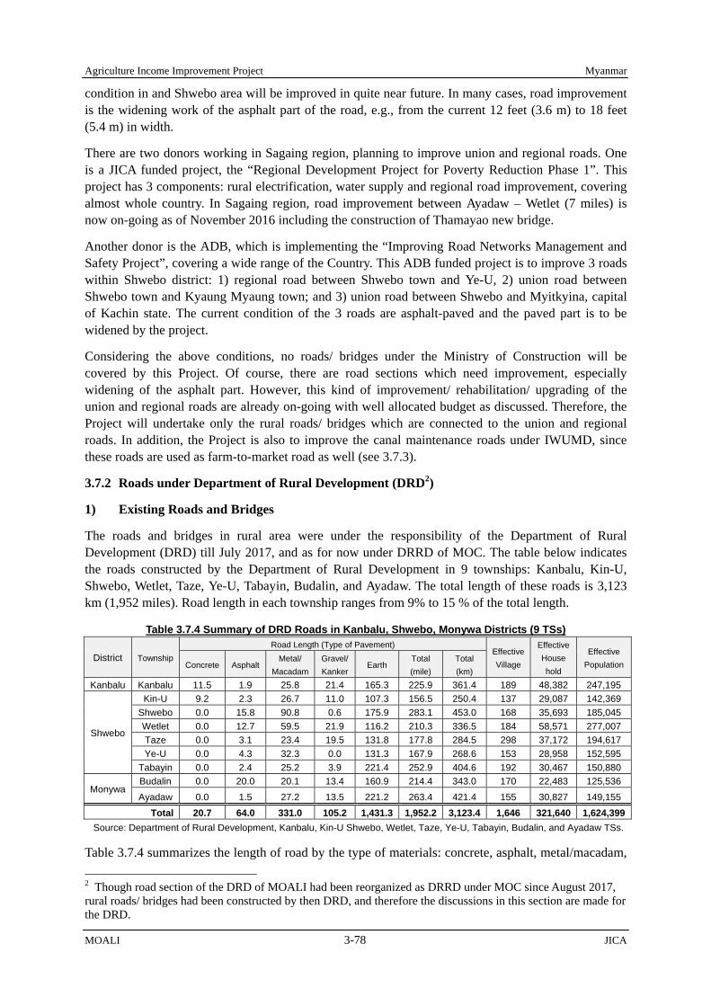
Agriculture Income Improvement Project Myanmar
MOALI 3-78 JICA
condition in and Shwebo area will be improved in quite near future. In many cases, road improvement is the widening work of the asphalt part of the road, e.g., from the current 12 feet (3.6 m) to 18 feet (5.4 m) in width.
There are two donors working in Sagaing region, planning to improve union and regional roads. One is a JICA funded project, the “Regional Development Project for Poverty Reduction Phase 1”. This project has 3 components: rural electrification, water supply and regional road improvement, covering almost whole country. In Sagaing region, road improvement between Ayadaw – Wetlet (7 miles) is now on-going as of November 2016 including the construction of Thamayao new bridge.
Another donor is the ADB, which is implementing the “Improving Road Networks Management and Safety Project”, covering a wide range of the Country. This ADB funded project is to improve 3 roads within Shwebo district: 1) regional road between Shwebo town and Ye-U, 2) union road between Shwebo town and Kyaung Myaung town; and 3) union road between Shwebo and Myitkyina, capital of Kachin state. The current condition of the 3 roads are asphalt-paved and the paved part is to be widened by the project.
Considering the above conditions, no roads/ bridges under the Ministry of Construction will be covered by this Project. Of course, there are road sections which need improvement, especially widening of the asphalt part. However, this kind of improvement/ rehabilitation/ upgrading of the union and regional roads are already on-going with well allocated budget as discussed. Therefore, the Project will undertake only the rural roads/ bridges which are connected to the union and regional roads. In addition, the Project is also to improve the canal maintenance roads under IWUMD, since these roads are used as farm-to-market road as well (see 3.7.3).
3.7.2 Roads under Department of Rural Development (DRD2)
1) Existing Roads and Bridges
The roads and bridges in rural area were under the responsibility of the Department of Rural Development (DRD) till July 2017, and as for now under DRRD of MOC. The table below indicates the roads constructed by the Department of Rural Development in 9 townships: Kanbalu, Kin-U, Shwebo, Wetlet, Taze, Ye-U, Tabayin, Budalin, and Ayadaw. The total length of these roads is 3,123 km (1,952 miles). Road length in each township ranges from 9% to 15 % of the total length.
Table 3.7.4 Summary of DRD Roads in Kanbalu, Shwebo, Monywa Districts (9 TSs)
District Township Road Length (Type of Pavement)
Effective Village
Effective House hold
Effective PopulationConcrete Asphalt
Metal/ Macadam
Gravel/Kanker
Earth Total (mile)
Total (km)
Kanbalu Kanbalu 11.5 1.9 25.8 21.4 165.3 225.9 361.4 189 48,382 247,195
Shwebo
Kin-U 9.2 2.3 26.7 11.0 107.3 156.5 250.4 137 29,087 142,369Shwebo 0.0 15.8 90.8 0.6 175.9 283.1 453.0 168 35,693 185,045Wetlet 0.0 12.7 59.5 21.9 116.2 210.3 336.5 184 58,571 277,007Taze 0.0 3.1 23.4 19.5 131.8 177.8 284.5 298 37,172 194,617Ye-U 0.0 4.3 32.3 0.0 131.3 167.9 268.6 153 28,958 152,595
Tabayin 0.0 2.4 25.2 3.9 221.4 252.9 404.6 192 30,467 150,880
Monywa Budalin 0.0 20.0 20.1 13.4 160.9 214.4 343.0 170 22,483 125,536Ayadaw 0.0 1.5 27.2 13.5 221.2 263.4 421.4 155 30,827 149,155
Total 20.7 64.0 331.0 105.2 1,431.3 1,952.2 3,123.4 1,646 321,640 1,624,399Source: Department of Rural Development, Kanbalu, Kin-U Shwebo, Wetlet, Taze, Ye-U, Tabayin, Budalin, and Ayadaw TSs.
Table 3.7.4 summarizes the length of road by the type of materials: concrete, asphalt, metal/macadam, 2 Though road section of the DRD of MOALI had been reorganized as DRRD under MOC since August 2017, rural roads/ bridges had been constructed by then DRD, and therefore the discussions in this section are made for the DRD.

Myanmar Agriculture Income Improvement Project
JICA 3-79 MOALI
gravel/kanker, and earth. If the roads are divided into 2 categories, paved and unpaved, length of unpaved roads exceeds paved roads. Specifically, the length of road paved with concrete, asphalt, metal/macadam, or gravel/kanker shares 27 % of the total length, while unpaved earthen road is 73 %.
Taking account the density of the road against land size of each township, Shwebo, Tabayin, Wetlet, and Kin-U TSs have relatively better accessibility than the other townships. In addition, the number of effective household and population is more than 80 % of the total household and populations in most of the townships. Considering condition of the roads, primary road facilities have been already developed, while enhancement of the road quality, namely road pavement, is the coming needs from road users.
On the other hand, bridges in the 9 townships constructed under the Department of Rural Development are summarized in the table below. Currently, there are a total of 754 bridges in the 9 townships. Bridge construction is relatively active in Tabayin and Shwebo TSs, while less is observed in Ayadaw and Budalin TSs, which may imply potential needs in a way.
Bridges are divided into 4 types: concrete, wood, causeway, and box/pipe culvert. The common types are box/pipe culvert, wood and concrete with a total number of 271, 260 and 185, respectively, which are 36%, 34% and 25 % of the total number. Then, causeway is 31 bridges with 4 % likewise.
Considering the number of bridges among the townships, Tabayin and Shwebo TSs share higher percentages in each type of bridges, whereas causeways are found more in Kin-U and Budalin TSs. It might attribute to the geographical settings of each township. As with the effective number of household, and population, bridges benefit more than 80 % of the total population and households in most of the townships.
Table 3.7.5 Summary of DRD Bridges in Kanbalu, Shwebo, Monywa Districts (9 TSs)
District Township Bridge Numbers (Type of Bridge)
Effective Village
Effective House Hold
EffectivePopulationConcrete Wooden
Cause-way
Box/Pipe Culvert
OthersTotal
(number)Kanbalu Kanbalu 1 29 2 46 0 78 189 48,382 247,195
Shwebo
Kin-U 16 22 11 5 0 54 137 29,087 142,369 Shwebo 19 54 4 79 3 159 168 35,693 185,045 Wetlet 14 27 2 20 2 65 202 54,080 303,481 Taze 15 40 0 4 0 59 144 15,260 80,986 Ye-U 41 11 1 17 1 71 153 28,958 152,595
Tabayin 73 61 2 82 1 219 192 30,467 150,880
Monywa Budalin 5 15 7 8 0 35 170 22,483 125,536 Ayadaw 1 1 2 10 0 14 41 7,671 37,415
Total 185 260 31 271 7 754 1,396 272,081 1,425,502Source: Department of Rural Development, Kanbalu, Kin-U Shwebo, Wetlet, Taze, Ye-U, Tabayin, Budalin, and Ayadaw TSs.
2) Organization and Staffing
In terms of the organization structure, the Department of Rural Development (DRRD after July 2017) has a similar structure among the concerned districts and townships, although the type of officer at the top of organization varies depending on the class of the office. There are 4 types of offices under the DRD, which are district, township class a, b, and c. In the 9 townships, the applicable organization types are district, township class b (Shwebo TS), and class c (other than Shwebo TS).
As shown in the figure next, all levels of the offices have 4 distinctive sections: namely, 1) Rural Socio-Economic Development/ Administration and Finance Section, 2) Poverty Reduction Support/ Project Planning, and International Relation Section, 3) Rural Road, Bridge, Water Supply, and Sanitation Section, and 4) Rural Electricity Supply, Good Village Implementation, and Procurement & Distribution Section.
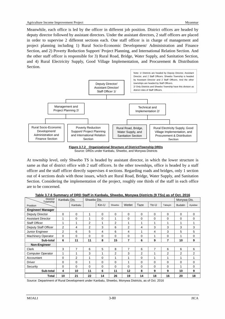
Agriculture Income Improvement Project Myanmar
MOALI 3-80 JICA
Meanwhile, each office is led by the officer in different job position. District offices are headed by deputy director followed by assistant directors. Under the assistant directors, 2 staff officers are placed in order to supervise 2 different sections each. One staff officer is in charge of management and project planning including 1) Rural Socio-Economic Development/ Administration and Finance Section, and 2) Poverty Reduction Support/ Project Planning, and International Relation Section. And the other staff officer is responsible for 3) Rural Road, Bridge, Water Supply, and Sanitation Section, and 4) Rural Electricity Supply, Good Village Implementation, and Procurement & Distribution Section.
At township level, only Shwebo TS is headed by assistant director, in which the lower structure is same as that of district office with 2 staff officers. In the other townships, office is headed by a staff officer and the staff officer directly supervises 4 sections. Regarding roads and bridges, only 1 section out of 4 sections deals with those issues, which are Rural Road, Bridge, Water Supply, and Sanitation Section. Considering the implementation of the project, roughly one thirds of the staff in each office are to be concerned.
Table 3.7.6 Summary of DRD Staff in Kanbalu, Shwebo, Monywa Districts (9 TSs) as of Oct. 2016 District/
Township Position
Kanbalu Dis. Shwebo Dis. Monywa Dis.
Kanbalu Kin-U Shwebo Wetlet Taze Ye-U Tabayin Budalin Ayadaw
Engineer/ Manager Deputy Director 0 0 1 0 0 0 0 0 0 0 0 Assistant Director 1 0 1 0 1 0 0 0 0 0 0 Staff Officer 1 1 2 1 2 1 1 1 1 1 1 Deputy Staff Officer 2 4 2 3 6 2 4 3 3 3 3 Junior Engineer 2 6 5 4 6 4 1 4 3 5 5 Machinery Operator 0 0 0 0 0 0 0 1 0 1 0
Sub-total 6 11 11 8 15 7 6 9 7 10 9 Non-Engineer
Clerk 3 7 6 5 8 7 6 7 6 6 6 Computer Operator 1 1 3 1 2 3 2 1 2 2 2 Accountant 0 2 1 0 1 1 0 1 1 1 1 Driver 0 0 1 0 0 1 0 0 0 0 0 Security 0 0 0 0 0 0 0 0 0 1 0
Sub-total 4 10 11 6 11 12 8 9 9 10 9 Total 10 21 22 14 26 19 14 18 16 20 18
Source: Department of Rural Development under Kanbalu, Shwebo, Monywa Districts, as of Oct. 2016
Figure 3.7.2 Organizational Structure of District/Township DRDs Source: DRDs under Kanbalu, Shwebo, and Monywa Districts
Note: 1/ Districts are headed by Deputy Director, Assistant Director, and 2 Staff Officers. Shwebo Township is headed by Assistant Director and 2 Staff Officers. And the other townships are headed by Staff Officers. 2/ Only Districts and Shwebo Township have this division as district roles of Staff Officers.
Management and Project Planning 2/
Technical and Implementation 2/
Rural Road, Bridge, Water Supply, and Sanitation Section
Poverty Reduction Support/ Project Planning and International Relation
Section
Rural Electricity Supply, Good Village Implementation, and Procurement & Distribution
Section
Rural Socio-Economic Development/
Administration and Finance Section
Deputy Director/ Assistant Director/
Staff Officer 1/

Myanmar Agriculture Income Improvement Project
JICA 3-81 MOALI
The table above provides the numbers of present staff in the relevant offices. As a whole, the ratio of total numbers of engineering staff and non-engineering staff are the same (50% each). Each office has minimum 14 to maximum 26 staff in total of engineering staff and administrative staff. The total number of engineering staff in each office ranges from 6 to 15 people, while non-engineering administrative staff is from 4 to 12 people.
As mentioned, only one thirds of the staff is estimated to be under the road and bridge concerning section, namely Rural Road, Bridge, Water Supply, and Sanitation Section. Therefore, taking account the number of staff who can actually be involved in the Project, it can be around 2-5 engineering staff, and 1-4 administrative staff, totaling 3-9 staff in each office.
3) Budget and Volume of Construction
The annual budget approved in the past five years in the 9 TSs is summarized in the tables below, which is almost equal to the actually disbursed amount. Table 3.7.7 indicates the budget approved related to road construction; Table 3.7.8 shows the one related to bridge construction; and then Table 3.7.9 provides the total budget of roads and bridges.
Table 3.7.7 DRD Budget (Roads) Approved in the 9 TSs (Million Kyats) District/
Township Year
Kanbalu Shwebo Monywa Year TotalKanbalu Kin-U Shwebo Wetlet Taze Ye-U Tabayin Budalin Ayadaw
2012/13 2013/14 2014/15 2015/16 2016/17
TS Av (2013-16) Source: Department of Rural Development, Kanbalu, Kin-U Shwebo, Wetlet, Taze, Ye-U, Tabayin, Budalin, and Ayadaw TSs.
Table 3.7.8 DRD Budget (Bridges) Approved in the 9 TSs (Million Kyats) District/ Township
Year
Kanbalu Shwebo Monywa Year TotalKanbalu Kin-U Shwebo Wetlet Taze Ye-U Tabayin Budalin Ayadaw
2012/13 2013/14 2014/15 2015/16 2016/17
TS Av (2013-16) Source: Department of Rural Development, Kanbalu, Kin-U Shwebo, Wetlet, Taze, Ye-U, Tabayin, Budalin, and Ayadaw TSs.
Table 3.7.9 DRD Budget Approved (Total) in the 9 TSs (Million Kyats) District/ Township
Year
Kanbalu Shwebo Monywa Year TotalKanbalu Kin-U Shwebo Wetlet Taze Ye-U Tabayin Budalin Ayadaw
2012/13 2013/14 2014/15 2015/16 2016/17
TS Av (2013-16) Source: Department of Rural Development, Kanbalu, Kin-U Shwebo, Wetlet, Taze, Ye-U, Tabayin, Budalin, and Ayadaw TSs.
Regarding the road construction in the 9 TSs in the past 5 years, the amount of budget, thus disbursement, had dramatically increased in 2013/14 fiscal year, kept increasing until 2015/16, and then decreased in the year 2016/17. Based on the budget allocation in the recent 4 years average of

Agriculture Income Improvement Project Myanmar
MOALI 3-82 JICA
each township, a lot of construction work had been implemented especially in Wetlet TS ( million), followed by Budalin ( million), Ye-U ( million), and Kanbalu ( million) TSs. The average amount of annual budget for road construction is million kyats.
On the other hands, the budget approved for bridge construction for the 9 TSs in the last 5 years is comparatively lower than that of road construction: 1,166 million kyats on average. According to the table, it is understood that bridge construction work is implemented more in Kanbalu and Wetlet TSs. The budget for bridge construction in the Project area had dramatically increased in 2014/15 and decreased after that.
As the total of road and bridge, active construction work in 9 TSs can be seen in the past 3 years from 2014/15 to 2016/17 with the peak of 2015/16. Especially, Wetlet and Kanbalu TS have conducted more amount of construction works as compared to the other townships, while relatively less in Ayadaw, Tabayin, and Shwebo TSs. The average annual budget of the 9 townships in road and bridge construction is 6,160 million kyats. The ratio of road and bridge construction is about 4:1..
3.7.3 Canal Maintenance Road under IWUMD
1) Volume of Canal Maintenance Roads
Canal maintenance roads are managed under the responsibility of IWUMD. The maintenance roads are constructed alongside of main canals (including branch canals and extension canals) and distributary canals (except direct outlets and minor canals) in the 4 irrigation systems under the Project area, Kindat Right (Right Main Canal: RMC), Kindat Left (Old Mu Canal: OMC), Kabo Right (Ye-U Main Canal: YMC), and Kabo Left (Shwebo Main Canal: SMC).
The canal length reflects the length of canal maintenance roads. The canal length, namely road length, by each irrigation system is given in the table below. Although there are some minor canals where there is canal maintenance roads, those roads along miner canals are not taken account in the table.
Table 3.7.10 Length of Canal Maintenance Road (Miles) Irrigation System
(Main Canal) Main canal Distributary canal Total
By System Main Branch/Extension Distributary Kindat Right (RMC) 52.2 45.6 78.2 176.0 Kindat Left (OMC) 47.3 0.0 27.6 74.9 Kabo Right (YMC) 42.3 18.1 150.2 210.5 Kabo Left (SMC) 27.2 39.5 166.0 232.6
Sub-Total 169.0 103.1 421.9 694.0 Total 272.1 421.9 694.0
Source: IWUMD, Shwebo and Ye-U Assistant Director Office.
In the Project area, there are total 169 miles of roads along main canals, and 103 miles along branch and extension canals, total 272 miles as the category of “main canals”. In addition, around 422 miles of roads were constructed along distributary canals. The length of distributary canals are more than the main canals with a rough ratio of 3:2 (422 miles : 272 miles). In total, about 694 miles (272.1 miles and 421.9 miles) of canal maintenance roads exist at present. By irrigation system, SMC has the longest road length and YMC, RMC, and OMC follows. OMC has relatively short length of roads due to no branch or extension canal and lots of direct outlets from the main canal.
2) Material and Condition of Canal Maintenance Roads
The types of materials to pave the maintenance road are metal/macadam or gravel/kanker. Currently, maintenance roads along main canals are mainly made of gravel/kanker, and some parts of main canal of the OMC are made of metal/macadam, while maintenance roads in distributary canals are made of gravel/kanker or earth.

Myanmar Agriculture Income Improvement Project
JICA 3-83 MOALI
Among the canal maintenance roads, inspection path (IP) where machineries and cars can go through is constructed, in principle, by 12 feet width with 3 feet shoulders. The width of non-inspection path, which is used only for the small maintenance, varies depending on the path, usually around 6-10 feet in width. The gravel/kanker is compiled 6 inches on subgrade. In the case of metal/macadam, road is paved with 3 layers on subgrade; the first top layer is 2 inches of kanker, the second layer is 6 inches of metal and the third bottom layer is 6 inches of metal and filling material.
When it rains, earthen and gravel/kanker roads tend to change its surface shape and to slip easily by the effect of passage of the cars or machines, and as a result the roads are blocked. For distributary canals, there are some needs for repair of kanker and upgrade of earth to kanker. In main canals, there are also some requests for upgrade kanker (partially metal/macadam) to asphalt or metal/macadam.
Maintenance road is essential not only for canal maintenance but also for agriculture and daily transportation, especially in places where there is difficulties in the accessibility such as remote area from major roads.
Even if some farmers try to introduce agricultural machinery for their farming, some of them need to give up because narrow path does not allow them to go through with those big machineries. Yet, it is not easy to construct new roads penetrating paddy fields that requires the agreement from all the land users or lawful tillers. Canal and canal maintenance roads cannot be separated. And it appears to be very important with multipurpose for farming activities and farmers’ daily life. Repair or upgrade of those canal maintenance roads can accelerate agricultural mechanization and land consolidation as well in the future.
3.7.4 Kyauk Myaung Jetty
There is a jetty located at the riverside of Ayeyarwady river about 25 km (15 miles) east of Shwebo town. There is an asphalt road in between the Shwebo town and Kyauk Myaung sub-township, and the road is to be widened in 2017/18 by the ADB funded “Improving Road Networks Management and Safety Project”. The jetty was opened more than hundreds years ago, and this is the only jetty which ferries rice to northern parts of Myanmar for the people who cannot produce paddy. Furthermore, the rice is exported to China via Bhamo located 440 km upstream from Mandalay, though this is not official.
The jetty does not have any structured facilities but only simple wooden boards temporality used by labors to load and unload cargoes. The responsible organization of this jetty is Inland Water Transport
Kyaung Myaung Jetty: Left photo shows dry season condition, while right photo shows loading/ unloading condition during monsoon season. There is no concrete structure for this jetty, but only temporary installed wooden boards.
Condition of Canal Maintenance Road after Rain
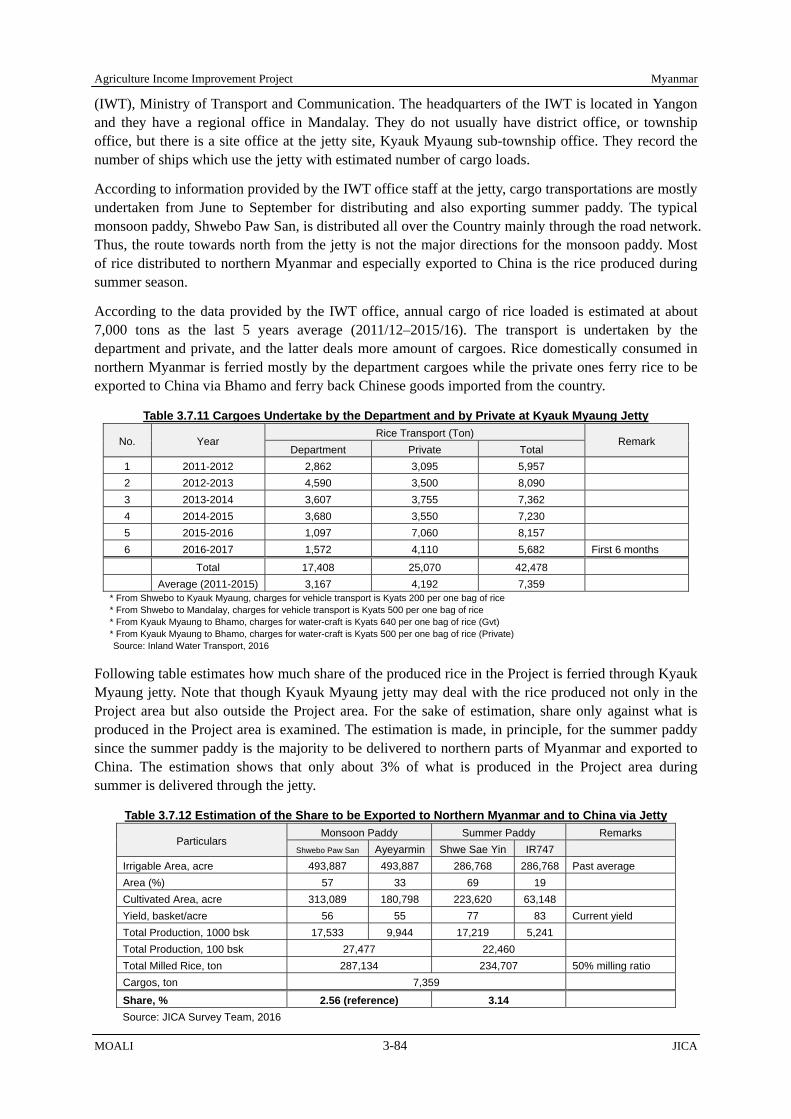
Agriculture Income Improvement Project Myanmar
MOALI 3-84 JICA
(IWT), Ministry of Transport and Communication. The headquarters of the IWT is located in Yangon and they have a regional office in Mandalay. They do not usually have district office, or township office, but there is a site office at the jetty site, Kyauk Myaung sub-township office. They record the number of ships which use the jetty with estimated number of cargo loads.
According to information provided by the IWT office staff at the jetty, cargo transportations are mostly undertaken from June to September for distributing and also exporting summer paddy. The typical monsoon paddy, Shwebo Paw San, is distributed all over the Country mainly through the road network. Thus, the route towards north from the jetty is not the major directions for the monsoon paddy. Most of rice distributed to northern Myanmar and especially exported to China is the rice produced during summer season.
According to the data provided by the IWT office, annual cargo of rice loaded is estimated at about 7,000 tons as the last 5 years average (2011/12–2015/16). The transport is undertaken by the department and private, and the latter deals more amount of cargoes. Rice domestically consumed in northern Myanmar is ferried mostly by the department cargoes while the private ones ferry rice to be exported to China via Bhamo and ferry back Chinese goods imported from the country.
Table 3.7.11 Cargoes Undertake by the Department and by Private at Kyauk Myaung Jetty
No. Year Rice Transport (Ton)
Remark Department Private Total
1 2011-2012 2,862 3,095 5,957 2 2012-2013 4,590 3,500 8,090 3 2013-2014 3,607 3,755 7,362 4 2014-2015 3,680 3,550 7,230 5 2015-2016 1,097 7,060 8,157 6 2016-2017 1,572 4,110 5,682 First 6 months
Total 17,408 25,070 42,478 Average (2011-2015) 3,167 4,192 7,359 * From Shwebo to Kyauk Myaung, charges for vehicle transport is Kyats 200 per one bag of rice * From Shwebo to Mandalay, charges for vehicle transport is Kyats 500 per one bag of rice * From Kyauk Myaung to Bhamo, charges for water-craft is Kyats 640 per one bag of rice (Gvt) * From Kyauk Myaung to Bhamo, charges for water-craft is Kyats 500 per one bag of rice (Private) Source: Inland Water Transport, 2016
Following table estimates how much share of the produced rice in the Project is ferried through Kyauk Myaung jetty. Note that though Kyauk Myaung jetty may deal with the rice produced not only in the Project area but also outside the Project area. For the sake of estimation, share only against what is produced in the Project area is examined. The estimation is made, in principle, for the summer paddy since the summer paddy is the majority to be delivered to northern parts of Myanmar and exported to China. The estimation shows that only about 3% of what is produced in the Project area during summer is delivered through the jetty.
Table 3.7.12 Estimation of the Share to be Exported to Northern Myanmar and to China via Jetty
Particulars Monsoon Paddy Summer Paddy Remarks
Shwebo Paw San Ayeyarmin Shwe Sae Yin IR747 Irrigable Area, acre 493,887 493,887 286,768 286,768 Past average Area (%) 57 33 69 19 Cultivated Area, acre 313,089 180,798 223,620 63,148 Yield, basket/acre 56 55 77 83 Current yield Total Production, 1000 bsk 17,533 9,944 17,219 5,241 Total Production, 100 bsk 27,477 22,460 Total Milled Rice, ton 287,134 234,707 50% milling ratio Cargos, ton 7,359
Share, % 2.56 (reference) 3.14 Source: JICA Survey Team, 2016

Myanmar Agriculture Income Improvement Project
JICA 3-85 MOALI
3.8 Agriculture Produce Distribution and Value Chain System
3.8.1 Overall Distribution and Value Chain
Geographically, the Project area has several advantages in terms of agro-produces distribution. First of all, the roads directly access big markets; it is only 2 – 3 hours driving to Mandalay city; and the area is located in the middle of the borders with China and India. For India, Monywa – Kalay- Kankaw - Tamu corridor has been renovated. On the other hand, ASEAN highway network (Muse – Lashio – Mandalay) and inland water transportation (Mandalay - Kyauk Myaung -Bhamo) are available towards China.
In addition, the area is blessed with inland water transportation system. Around 26km driving from Shwebo town can reach Kyauk Myaung jetty which connects upper Myanmar with Bhamo (China border) in the north, and Mandalay in the south. Although it is longer distance to Yangon, water transportation enables shipments to ferry agro-commodities at relatively reasonable costs. For example, ADB compares freight modal1 of three transportation methods: road, rail and river, indicating that unit price of river transportation is significantly cheaper than others (3.3 US$ per ton-km, 2.3 US$ per ton-km, and 1.6 US$ per ton-km respectively).
In spite of such geographical advantages, the poor road system in the area constraints intra/inter distribution of the region. Most of the main roads and districts roads are in good condition, however, some of the farm-to-market roads and most of the farm roads are small and become non-passable during many months of the year. For example, JICA (2016): “Preparatory Survey for Intensive Agriculture Promotion Program In the Republic of Myanmar” pointed out that canal roads, which play important roles on agro-commodity transportations, are usually not paved resulting in poor condition and sometimes not allowed to enter in monsoon season.
Figure 3.8.1 Overall Distribution Map of the Project Area Source: JICA Survey Team
1 Myanmar Transportation Sector Policy Note, How to Reduce Transportation Cost, 2016
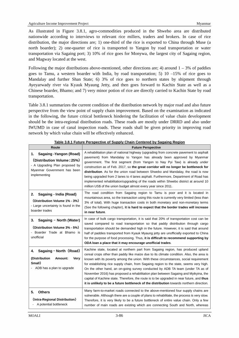
Agriculture Income Improvement Project Myanmar
MOALI 3-86 JICA
As illustrated in Figure 3.8.1, agro-commodities produced in the Shwebo area are distributed nationwide according to interviews to relevant rice millers, traders and brokers. In case of rice distribution, the major directions are; 1) one-third of the rice is exported to China through Muse (a north boarder); 2) one-quarter of rice is transported to Yangon by road transportation or water transportation via Sagaing port; 3) 10% of rice goes for Monywa, the largest city of Sagaing region, and Magway located at the west.
Following the major distributions above-mentioned, other directions are; 4) around 1 – 3% of paddies goes to Tamu, a western boarder with India, by road transportation; 5) 10 –15% of rice goes to Mandalay and further Shan State; 6) 3% of rice goes to northern states by shipment through Ayeyarwady river via Kyauk Myaung Jetty, and then goes forward to Kachin State as well as a Chinese boarder, Bhamo; and 7) very minor potion of rice are directly carried to Kachin State by road transportation.
Table 3.8.1 summarizes the current condition of the distribution network by major road and also future perspective from the view point of supply chain improvement. Based on the examination as indicated in the following, the future critical bottleneck hindering the facilitation of value chain development should be the intra-regional distribution roads. These roads are mostly under DRRD and also under IWUMD in case of canal inspection roads. These roads shall be given priority in improving road network by which value chain will be effectively enhanced.
Table 3.8.1 Future Perspective of Supply Chain Centered by Sagaing Region Route Future Perspective
1. Sagaing -Yangon (Road)
(Distribution Volume:25%) - A Upgrading Plan proposed by Myanmar Government has been implementing
A rehabilitation plan of national highway (upgrading from concrete pavement to asphalt pavement) from Mandalay to Yangon has already been approved by Myanmar government. The first segment (from Yangon to Nay Pyi Taw) is already under construction as of Feb. 2017, so the great corridor will no longer be bottleneck for distribution. As for the union road between Shwebo and Mandalay, the road is now being upgraded from 2 lanes to 4 lanes asphalt. Furthermore, Department of Road has implemented rehabilitation/upgrading of the roads within Shwebo district at around 10 million US$ of the union budget almost every year since 2011.
2. Sagaing - India (Road)
(Distribution Volume 1% - 3%) - Large uncertainty is found in the boarder trades
The road condition from Sagaing region to Tamu is poor and it is located in mountainous area, so the transaction using this route is currently very limited (less than 3% of total). With huge transaction costs in both monetary and non-monetary terms (See the following chapter), it is hard to expect that the border trades will increase in near future.
3. Sagaing - North (Water)
(Distribution Volume 3% - 5%) - Boarder Trade at Bhamo is unofficial
In case of bulk cargo transportation, it is said that 20% of transportation cost can be saved compared to road transportation so that paddy distribution through cargo transportation should be demanded high in the future. However, it is said that around half of paddies transported from Kyauk Myaung jetty are unofficially exported to China for the purpose of food processing. Thus, it is difficult to recommend supporting by ODA loan a place that it may encourage unofficial trades.
4. Sagaing - North(Road)
(Distribution Amount: Very Small) - ADB has a plan to upgrade
Kachine state, located at northern part from Sagaing region, has produced upland cereal crops other than paddy like maize due to its climate condition. Also, the area is known with its poverty among the union. With these circumstances, social requirement for establishing rice supply chain, from Sagaing region to the state, seems very high. On the other hand, an on-going survey conducted by ADB TA team (under TA as of November 2016) has proposed a rehabilitation plan between Sagaing and Myikyina, the capital of Kachine state. Therefore, the route is to be upgraded in near future, and thus it is unlikely to be a future bottleneck of the distribution towards northern direction.
5. Others
(Intra-Regional Distribution) - A potential bottleneck
Many farm-to-market roads connected to the above-mentioned four supply chains are vulnerable. Although there are a couple of plans to rehabilitate, the process is very slow. Therefore, it is very likely to be a future bottleneck of entire value chain. Only a few number of main roads are existing which are connecting South and North, whereas

Myanmar Agriculture Income Improvement Project
JICA 3-87 MOALI
Route Future Perspective some good east-west roads are available. Meanwhile, most of the south-north roads are used for canal inspection purpose, and become non-passable during rainy season. In short, the intra-regional distribution has the largest potential risks to be a bottleneck of future agro-supply chain.
Source: JICA Survey Team
3.8.2 Overview of Major Markets concerning Shwebo Area
An important feature of the target area is its “commercial-oriented” production. In our calculation based on household survey, only 12% of paddy production is for home consumption, in other words, almost 90% of paddies are marketed. With such commercial oriented environment, it is important to find some stable markets. However, one of the problems of the area is that there is no dominant and reliable market for their commodities. Following illustrates overall features of five important markets;
1) Mandalay
In the past, Mandalay was the dominant distribution hub of the rice in Upper Myanmar from this Sagaing region. Rice millers used to sell their rice to traders in Mandalay city at first, and the traders used to distribute the purchased rice over the country in addition to export. In these days, however, rice millers in and around the Project area can sell their milled rice directly everywhere in Myanmar by the name of their own brands, still, it is no doubt that the Mandalay is one of the most important market for the Shwebo area.
Table 3.8.2 shows an estimated domestic demand-supply balance of rice (2011/2012) of the Union. The table finds that Mandalay marks only 56% of self-sufficiency ratio of rice. The urban population in Mandalay city and its suburb areas are to increase, and also from the view point of industrialization of Mandalay area, securing the staple food supply is becoming crucial. With this future scenario, the Sagaing region in which the Project area is located should play the pivotal role taking into consideration the distance between the 2 places; namely only 2 – 3 hours driving:
Table 3.8.2 Estimated Paddy Production and Consumption Balance (2011/2012)
State / Division Sown acre Production Population Consumption
Seed for next season
Losses Total Utilization
Self-sufficiency by consump’n
(%)
Self-sufficiency based on total utilization (%)
(1) (2) (3) (4) (5) (6) (7) (8) (9)=(3/5) (10)=(3/8) Nay Pyi Taw 185 16,045 1,161 16,104 370 555 17,029 100 94 Kachin 545 35,418 1,600 22,407 1,090 1,635 25,132 158 141 Kayah 106 6,637 361 5,100 212 318 5,630 130 118 Kayin 652 45,633 1,837 26,658 1,304 1,956 29,918 171 153 Chin 108 4,852 563 8,079 216 324 8,619 60 56 Sagaing 2,181 187,712 6,603 95,337 4,362 6,543 106,242 197 177 Taninthayi 357 24,718 1,736 24,570 714 1,071 26,355 101 94 Bago 3,055 216,047 6,073 86,670 6,110 9,165 101,945 249 212 Bago (East) 1,911 137,135 3,995 56,676 3,822 5,733 66,231 242 207 Bago (West) 1,144 78,912 2,078 29,994 2,288 3,432 35,714 263 221 Magway 1,055 90,368 5,682 82,056 2,110 3,165 87,331 110 103 Mandalay 789 64,491 7,352 102,753 1,578 2,367 106,698 63 60 Mon 911 63,028 3,168 44,424 1,822 2,733 48,979 142 129 Yakhine 1,143 76,826 3,341 48,330 2,286 3,429 54,045 159 142 Yangon 1,383 97,376 7,104 90,312 2,766 4,149 97,227 108 100 Shan 1,513 118,824 5,726 80,802 3,026 4,539 88,367 147 134 Shan South 632 42,304 2,117 30,048 1,264 1,896 33,208 141 127 Shan North 472 45,334 2,508 35,661 944 1,416 38,021 127 119 Shan East 409 31,186 1,101 15,093 818 1,227 17,138 207 182 Ayeyarwaddy 4,778 342,371 8,131 117,348 9,556 14,334 141,238 292 242 Union 18,761 1,390,346 60,438 850,950 37,522 56,283 944,755 163 147
Reference: Larry C.Y. Wong and Eh Mywe Aye Wai (2013), Background Paper No6. Rapid Value Chain Assessment: Structure and Dynamics of the Rice Value Chain in Myanmar Note: This result assumed that per capita rice consumption in rural and urban is 150kg and 120kg respectively.

Agriculture Income Improvement Project Myanmar
MOALI 3-88 JICA
2) Yangon
Yangon market is the leading price maker of pulses and beans in the Union, influenced by Mumbai. In fact, pulses, beans and oilseeds in Shwebo Exchange Center are transacted with reference to Yangon market prices. Although agro-commodities which go to Yangon have been transported by both road and inland water transportation, Mandalay port has no government cargo shipment for southern direction (to Yangon) as of January 2017. For going to Yangon, only private shipments is available via Pakkoku, where it has a function as commercial place of pulses and beans which are marketed to Yangon.
3) China (Muse and Bhamo)
Market demand in China has large impact on price formulation of summer paddy as well as various types of pulses, beans, and oil seeds. It is difficult to find the accurate data about the volume of transaction at Chinese boarders since informal trading are dominant. According to the Team’s interview to Muse crop exchange center in September 2015, the annual export volume of paddy through Muse is estimated at around 0.8 million ton in 2014 fiscal year. If it is true, China market would be the largest rice importing country for the Union (See Table 3.8.3, export volume for China does not include informal transaction).
Table 3.8.3 Rice exports by Destination, 1995-2012, Thousand tons Destination 1995-99 2000-04 2005-09 2008 2009 2010 2011 2012
EU 0 15 * * * 0 12 28 Former Soviet Union 0 0 * 0 2 11 19 44 Africa 43 195 261 196 899 318 506 460 Burkina Faso 0 11 9 10 29 64 71 82 Cameroon 2 13 14 25 24 15 37 21 Guinea 7 31 70 44 246 85 125 173 Ivory Coast 2 49 73 25 252 95 122 125 Sierra Leone 5 18 18 20 44 0 4 9 Togo 0 4 13 22 40 11 33 6 Asia 170 264 129 403 150 156 276 72 Bangladesh 10 108 99 385 70 116 215 0 China** 0 1 0 0 1 0 0 13 Indonesia 122 132 5 0 11 5 2 10 Philippines 27 2 9 0 47 16 13 33 Total 222 484 391 598 1052 485 816 605 Note:* Less than 500 tons. Note: ** the column “China” does not include informal transaction. Reference: World Bank 2014, “Myanmar Capitalizing on Rice Export Opportunities”
It is said that the market demand in Muse is very much fluctuated depending on Chinese market demand. In worst case, sudden gate closing is enforced in order to restrict importing of rice. Stakeholders such as farmers and rice millers recognize importance of market diversification other than China. So far, there are varieties of agro-commodities transacted in Muse and Bhamo. As for paddy variety, IR747, Manaw Thu Kha, Sin Thu Kha varieties are exported. Aside from paddy, pulses, beans, sugar, maize, mango, water melon are transacted.
4) India (Tamu)
There are no reliable data about the transaction volume at Tamu, but it has to be quite small according to the Team’s interview to the chairman of Myanmar India Border Chambers of Commerce. According to a WB report (Myanmar Capitalizing on Rice Export Opportunities, 2014), only 8,000 tons of paddies were transacted at Tamu in 2012/13. Major agro-commodities transacted there are betel nut, coconut, dry ginger, and some varieties of pulses and beans (green gram and chick pea, for example).

Myanmar Agriculture Income Improvement Project
JICA 3-89 MOALI
Concerning neighboring 7 states of India, the demand of pulses and beans is not so much large because their eating habit is mostly dependent on fish and meats. In fact, vegetarian states such as Telangana, West Bengal, Orissa, and Kerala are far from Tamu, and they are located in coastal or near the coastal areas. It means that shipping transportation has an advantage for those states. Such information illustrate difficulty of border trade increase at Tamu. Large uncertainty is still behind of the border transaction.
5) Monywa
Monywa is the largest city in Sagaing region. One may think that agro-commodities from the Shwebo area must be marketed to Monywa. Despite the common belief, however, the influence of Monywa market is becoming weak as rice millers in and around the Shwebo area sell their milled rice directly over the Union. Other issues are addressed in inflation of land price, which makes it difficult to install additional capacity of warehouses. According to Myanmar Rice Millers Association (MRMA) in Monywa city, only 10 rice millers are located with Monywa city as at January 2017.
3.8.3 Paddy Distribution and Value Chain
As for monsoon variety, Shwebo Pawsan is a very popular rice variety in Myanmar, and distributed nationwide. The variety became famous in Myanmar since awarded “world’s best rice” at the World Rice Conference 2011 held in Vietnam. Ayeyarmin is another important monsoon variety, which is more familiar to local people. According to a large rice miller in Wetlet township, around 40% of monsoon paddy goes forward to Shan State and partly China, another 40% goes to Lower Myanmar such as Yangon, Bago, Pyi, and Mawlamyaing, and the remaining 20% goes to Middle Myanmar (e.g. Magway, Mandalay).
On the other hand, the vast majority (around 80%) of summer paddies are marketed to China aside from minor portion going for domestic consumption and food processing such as flour, noodle, snack, and for alcohol making. Shwe Sae Yin, Shwe Thwe Yin, IR747 and Pa Le Thwe are major summer varieties according to DOA statistic. There are two alternative border trade markets to China: Muse and Bhamo. The government of Myanmar allows border trade only of the former case, whereas the latter is unofficial. In spite of this, it is said that many of rice from this Sagaing region are exported via Bhamo because of the cheaper river transportation cost.
In the paddy distribution in Myanmar, several dealers take part in. In the case of rice for self-home consumption, farmers directly bring paddy to nearby rice millers. As for surplus rice for sale, farmers often sell it to collectors or brokers in his/her village tract or at township and these buyers are apt to mill their purchased paddy at nearby medium or large scale millers. The milled rice is then sold to middlemen in local towns and it is traded in large cities including Yangon and Mandalay. Finally, it is sold to wholesalers in consumption areas and to exporters.
Among the several dealers, rice millers play a central role in the rice distribution; therefore, knowing the location of rice miller is the first step to understand entire distribution system of rice. According to Ministry of Commerce (MOC), the majority of the millers are small scale, less than 14 tons per day capacity (see Table 3.8.4). However, there are 134 rice millers with more than 15 tons/day capacity in and around the Project area as of 2015/2016. Most of the large rice millers in Sagaing region are concentrated in three townships: Shwebo TS, Wetlet TS, and Kanbalu TS, and thus improvement in accessibility to the three townships should be one of the priorities in terms of the paddy distribution.
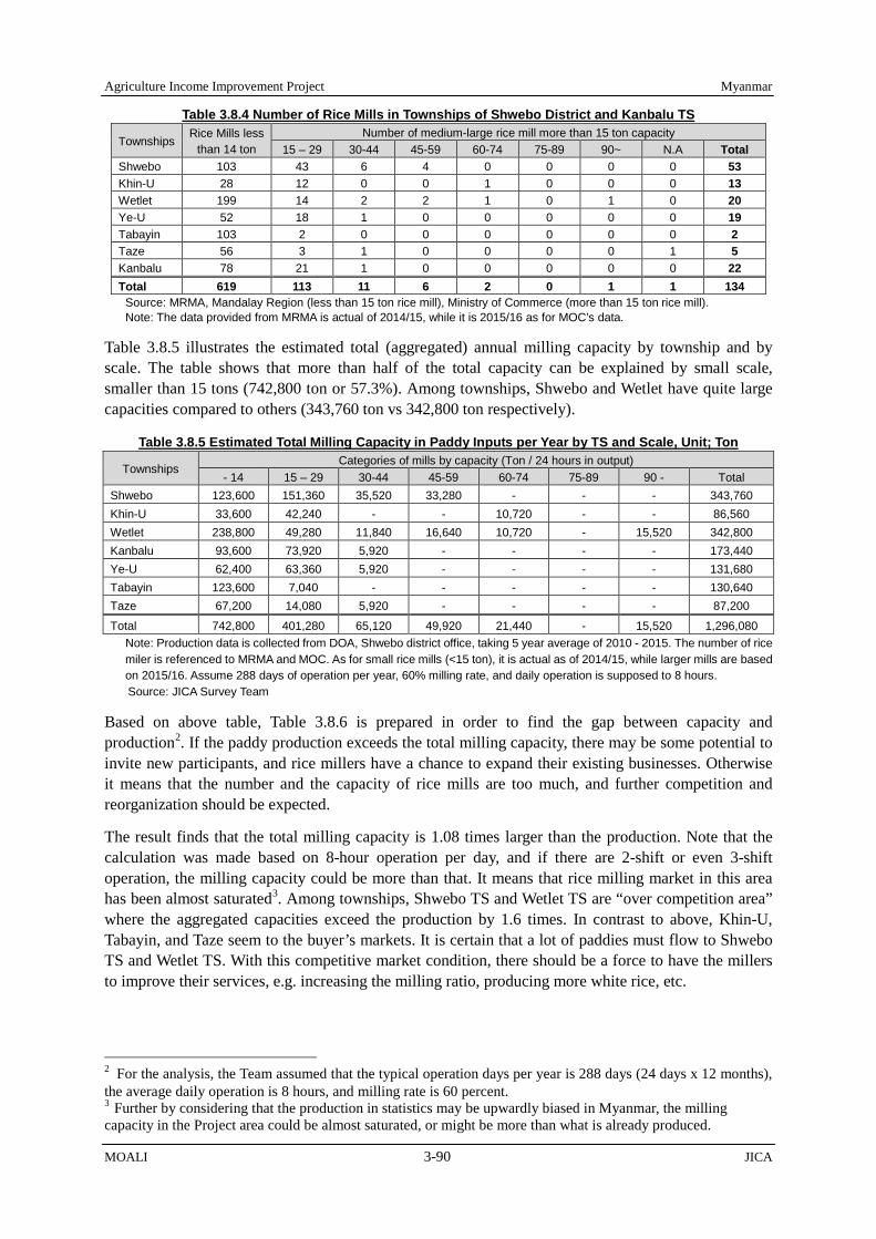
Agriculture Income Improvement Project Myanmar
MOALI 3-90 JICA
Table 3.8.4 Number of Rice Mills in Townships of Shwebo District and Kanbalu TS
Townships Rice Mills less
than 14 ton Number of medium-large rice mill more than 15 ton capacity
15 – 29 30-44 45-59 60-74 75-89 90~ N.A Total Shwebo 103 43 6 4 0 0 0 0 53 Khin-U 28 12 0 0 1 0 0 0 13 Wetlet 199 14 2 2 1 0 1 0 20 Ye-U 52 18 1 0 0 0 0 0 19 Tabayin 103 2 0 0 0 0 0 0 2 Taze 56 3 1 0 0 0 0 1 5 Kanbalu 78 21 1 0 0 0 0 0 22 Total 619 113 11 6 2 0 1 1 134
Source: MRMA, Mandalay Region (less than 15 ton rice mill), Ministry of Commerce (more than 15 ton rice mill). Note: The data provided from MRMA is actual of 2014/15, while it is 2015/16 as for MOC’s data.
Table 3.8.5 illustrates the estimated total (aggregated) annual milling capacity by township and by scale. The table shows that more than half of the total capacity can be explained by small scale, smaller than 15 tons (742,800 ton or 57.3%). Among townships, Shwebo and Wetlet have quite large capacities compared to others (343,760 ton vs 342,800 ton respectively).
Table 3.8.5 Estimated Total Milling Capacity in Paddy Inputs per Year by TS and Scale, Unit; Ton
Townships Categories of mills by capacity (Ton / 24 hours in output)
- 14 15 – 29 30-44 45-59 60-74 75-89 90 - Total Shwebo 123,600 151,360 35,520 33,280 - - - 343,760 Khin-U 33,600 42,240 - - 10,720 - - 86,560 Wetlet 238,800 49,280 11,840 16,640 10,720 - 15,520 342,800 Kanbalu 93,600 73,920 5,920 - - - - 173,440 Ye-U 62,400 63,360 5,920 - - - - 131,680 Tabayin 123,600 7,040 - - - - - 130,640 Taze 67,200 14,080 5,920 - - - - 87,200
Total 742,800 401,280 65,120 49,920 21,440 - 15,520 1,296,080 Note: Production data is collected from DOA, Shwebo district office, taking 5 year average of 2010 - 2015. The number of rice miler is referenced to MRMA and MOC. As for small rice mills (<15 ton), it is actual as of 2014/15, while larger mills are based on 2015/16. Assume 288 days of operation per year, 60% milling rate, and daily operation is supposed to 8 hours. Source: JICA Survey Team
Based on above table, Table 3.8.6 is prepared in order to find the gap between capacity and production2. If the paddy production exceeds the total milling capacity, there may be some potential to invite new participants, and rice millers have a chance to expand their existing businesses. Otherwise it means that the number and the capacity of rice mills are too much, and further competition and reorganization should be expected.
The result finds that the total milling capacity is 1.08 times larger than the production. Note that the calculation was made based on 8-hour operation per day, and if there are 2-shift or even 3-shift operation, the milling capacity could be more than that. It means that rice milling market in this area has been almost saturated3. Among townships, Shwebo TS and Wetlet TS are “over competition area” where the aggregated capacities exceed the production by 1.6 times. In contrast to above, Khin-U, Tabayin, and Taze seem to the buyer’s markets. It is certain that a lot of paddies must flow to Shwebo TS and Wetlet TS. With this competitive market condition, there should be a force to have the millers to improve their services, e.g. increasing the milling ratio, producing more white rice, etc.
2 For the analysis, the Team assumed that the typical operation days per year is 288 days (24 days x 12 months), the average daily operation is 8 hours, and milling rate is 60 percent. 3 Further by considering that the production in statistics may be upwardly biased in Myanmar, the milling capacity in the Project area could be almost saturated, or might be more than what is already produced.

Myanmar Agriculture Income Improvement Project
JICA 3-91 MOALI
Table 3.8.6 Gap Analysis between Capacity and Production in the Project Area, Unit: Ton of Paddy
Townships Milling Capacity in TS (A)
Paddy Production (B)
Gap (A-B)
Ratio (A/B)
Shwebo 343,760 205,873 (+) 137,887 1.67 Khin-U 86,560 150,295 (-) 63,735 0.58 Wetlet 342,800 194,799 (+) 148,001 1.76 Kanbalu 173,440 170,325 (+) 3,115 1.02 Ye-U 131,680 144,593 (-) 12,913 0.91 Tabayin 130,640 203,590 (-) 72,950 0.64 Taze 87,200 135,100 (-) 47,900 0.65 Total 1,296,080 1,204,576 (+) 91,504 1.08
Note: Production data is collected from DOA, Shwebo district office, taking 5 year average of 2010 - 2015. The number of rice miler is referenced to MRMA and MOC. As for small rice mills (<15 ton), it is actual as of 2014/15, while larger mills are based on 2015/16. Assume 288 days of operation per year, 60% milling rate, and daily operation is supposed to 8 hours. Source: JICA Survey Team
3.8.4 Pulses, Beans, and Oilseeds Distribution and Value Chain
Basically, pulses, beans, and oilseeds are transacted in Crop Exchange Center (CEC) where brokers, millers, and exporters come together to negotiate these commodities. There are three TS-level CECs in and around the Project area: Shwebo TS, Monywa TS, and Myinmu TS. The Team conducted an interview to the CEC in Shwebo TS. They mentioned that 137 members belong to Pulses Traders Association in Shwebo district.
Only registered traders are permitted to participate in the deals at the CEC. By bringing samples of their commodities on weekday mornings, they decide selling prices through mutual negotiations between buyers and sellers. If the negotiation is successfully concluded, middleman in production place, or seller themselves, send product to the buyers. Making fare price is the most important objective of the establishment of CEC.
Most of the traders who are located in the eastern side of Mu river sell their products through CEC of Shwebo TS. On the other hand, traders located in the western side of the rivers can choose both CECs of Shwebo TS and Monywa TS, depending on the market conditions. Upon the transaction at the TS level CEC, buyers bring the commodities to Mandalay or Yangon, and then they are exported to overseas in most cases.
Table 3.8.7 shows a typical destination of each of the crops. According to a trader the Team interviewed, pigeon pea, green gram, and black gram are export-oriented crops and almost all of them (more than 99%) go to foreign countries. Ground nuts, sesame, and maize are also exported, but some remaining ones are locally consumed. Sunflower is for domestic purposes by almost 100%. Groundnuts, sesame, and sunflowers are used for producing edible oil; however, their demand shows a decreasing trend as the palm oil imported from Malaysia characterized with low price is occupying the large share.
Table 3.8.7 Destination for pulses, beans, and oilseeds. Crop Percentage Direction
Pidgeon Pea 100% (Almost) Export to India, Malaysia 0% (Almost) Local Consumption
Green Gram 99.5% Export to China (Muse) 0.5% Local Consumption
Black Gram 99.5% Export to India 0.5% Local Consumption
Groundnuts 75% Export to China (Muse) 25% Local Consumption
Sesame 75% Export to China (Muse) 25% Local Consumption
Maize 50% Export to China (Muse) 50% Local Consumption
Sunflower 0% Export to Other Areas 100% Local Consumption
Source: Interview to a member of Pulses Trader’s Association

Myanmar Agriculture Income Improvement Project
JICA 4-1 MOALI
CHAPTER 4 DIRECTION SETTING AND COMPONENTS IDENTIFIED
This chapter discusses the direction setting and components identified based upon the requested components, preliminary identified ones in the predecessor survey, Intensive Agriculture Promotion Program, and what have been discussed in the previous chapters. The direction is set with reference to the needy agriculture development in the context of Myanmar and based on the current national development plans. The project components are categorized basically in production and distribution.
4.1 Direction Settings
4.1.1 Historical Implication over Agricultural Development
In theory, before industrialization, agriculture sector holds surplus labors in rural areas. Industrialization promotes labor shift from relatively low value-added industries including agriculture sector to high value-added industries such as manufacture industry and/or service sectors, resulting in economic growth, at least GDP base, of the nation. If the industrialization progress further, industry sector peels off labor forces from agriculture sector, and accordingly the surplus labor in the agriculture sector in turn reaches the bottom. The bottom is so called “Lewis Turning Point1”, after which the wages will increase due to tightening of demand and supply balance.
A theory of development economics indicates that labor shortage in rural area increases farming costs through wage increase, which results in increase in selling price of agricultural products. Increase in food prices in urban areas may seriously affect household economy of urban labors, and hence may incur social unrest provided that Engel's coefficient of the labors becomes too high. To avoid such situation, increase in wages of urban labors and of manufacturing workers is needed. However, the wage increase in industry sector causes weakening of competitive power of the sector in the world market, resulting in gear down of the industrialization process.
To mitigate rapid progress of the negative scenario of industrial development above-mentioned, it is important to supply well-affordable, or modest priced2, staple food constantly through increase in basic food production including rice, the staple food of Myanmar people. For this purpose, shifting from the labor intensive farming currently practiced in wider range of Myanmar to a capital intensive with labor saving agriculture is due necessary in this Country. Shifting to the capital based intensive agriculture thus contributes to assuring the continuous provision of affordable and stable food, and thereby able to keep the progress of industrialization.
4.1.2 Agricultural Development in Myanmar Context
Myanmar is basically agricultural based Country, at least at this moment, where agriculture sector absorb around 50% of labors and makes up around 30% of the national GDP. However, it is expected that the labor intensive industry sector will be accumulated particularly in Yangon and Mandalay areas, the poles of the two-pole growth strategy of the national economy, and industrialization will be rapidly
1 Named after economist W. Arthur Lewis, is term used in economic development to describe a point at which surplus rural labor reaches a financial zero. This in turn typically causes urban wages to rise dramatically. Upon reaching the Lewis turning point, a country or state usually experiences a labor shortage which leads to a rise in agricultural and unskilled industrial real wage. This usually continues until a labor surplus can be reached once again. Typically, reaching the Lewis turning point also causes an improvement in the wage bill and the functional distribution favoring labor. (Source: Wikipedia). 2 In the project area, a high value added rice, Shwebo Paw San, is targeted for monsoon paddy. From producer farmers’ point of view, they need high price; however still affordable price supported by production increase could contribute to satisfying the nation who want to consume such high value rice. In addition, the summer paddy in the Project area, less value added rice, can be for poorer people who may be employed in construction and industry sectors as common/unskilled labors. To those people, provision of cheap staple food is of very important as indicated in the above text.

Agriculture Income Improvement Project Myanmar
MOALI 4-2 JICA
progressed. It is said that one of advantages of the Myanmar’s industrialization is the competitive priced and abundant labor force in rural areas.
However, Myanmar’s population pyramid has already shifted from the stable type to a bell shape. In addition, labor force drain to urban areas and abroad is observed in rural areas due to lack of permanent working opportunities. As a result, labor shortage is becoming serious issue in rural areas, where labor intensive agriculture has been the dominant mode, resulting in competition with other industries. It is expected that the tendency will accelerate hereafter. Therefore, it can be said that the above negative scenario caused by shortage of labor in agricultural sector is a coming risk in Myanmar economy. For this reason, increase in agricultural productivity to supply stable food to domestic markets is urgently needed.
Looking at outside the Country, ASEAN Economic Community (AEC) started in the end of 2015, and, under that AEC, market integration among ASEAN countries will be accelerated. To survive in the competitive market, agriculture in Myanmar has to improve quality of products, adding value on agricultural products, and reduce transportation costs and losses, based on competitive advantages and markets needs. In this regard, role of private sector is quite important, and the government has to improve distribution infrastructure and, in cases processing infrastructure to support agribusiness of the private sector.
4.1.3 Overall Direction Setting
Agriculture development and also relevant income increase should comprise two major strategies, including “increase in agricultural productivity” and “promotion of agribusiness”. The former will be achieved through enhancement of production infrastructure including irrigation structure rehabilitation, land consolidation, and agricultural mechanization. Of course, extension service strengthening should be coupled with those interventions. Primary target area for the enhancement of production infrastructure should be those irrigable areas in lowland plains served by the Thapanzeik dam; namely vast irrigable areas by 4 main canals such as Kindat LMC (OMC), Kindat RMC, and SMC and Ye-U canal starting from Kabo weir.
Whereas, the latter, promotion of agribusiness, will be materialized through improvement of distribution and processing infrastructure. One of the project components will, therefore, be improvement of farm-to-market roads with rural bridges composed of canal inspection roads under IWUMD and rural roads under the DRRD, jetty improvement by which river transportation will be enhanced targeting the shipment towards northern parts of Myanmar, and seed production related industry. Note that certified seeds can be produced by farmers, or farmer organization, and therefore this component may also be placed under “increase in agriculture productivity”’.
The priority should be given to the both strategies of “the increase in agricultural productivity” as well as “the promotion of agribusiness” with the latter paying consideration to the facilitation of private sector’s participation. Though the priority is given to the both strategies, the speed of the impact appearance is different as may be that the impact from the “increase in agricultural productivity” would accrue from the beginning at a relatively constant level while the impact from the “promotion of agribusiness” will progressively increase in line with the economic development as a whole country. With this, the Project will undertake both components relating to the increase in agricultural productivity and promotion of agribusiness.
4.2 Relevancy to National Development Policy and Plans
4.2.1 Relevancy to Economic Policy of the Union of Myanmar (July 2016)
The current government issued an economic policy in July 2016 starting with vision, followed by 4

Myanmar Agriculture Income Improvement Project
JICA 4-3 MOALI
objectives and further by 12 policies. The vision maintains hat the economic policy be people centered, and aims to achieve inclusive and continuous development, and further aims to establish an economic framework that supports national reconciliation, based on the right balancing of sustainable natural resource mobilization and allocation across the States and Regions.
Based on the visions, the objectives uphold, for example, national reconciliation and the emergence of a united democratic union, balanced economic development across the country, creation of opportunities for the emergence of capable and skilled new generations for the benefit of the Country, and establishment of economic system that can achieve and maintain positive development outcomes through the participation, innovation and efforts of all the citizens.
Following the objectives, there are 12 policies that the new government pursues in its national development. Of them, policy No.5 and No.6 are very much relevant to the Project; namely,
Policy No.5 states creation of employment opportunities for all citizens including those returning from abroad, and giving greater priority in the short term to economic enterprises that create many job opportunities, and
Policy No.6 maintains the establishment of an economic model that balances agriculture and industry, and supports the holistic development of the agriculture, livestock and industrial sectors, so as to enable rounded development, food security, and increased exports.
The Project upon implementation will very much contribute to the realization of above 2 policies. The Project, of course, creates direct job opportunities during the construction such as for skilled labors, unskilled labors, operators of construction machineries, suppliers of construction materials, transporters, etc. Then, upon completion of the Project, such employment will be created as agriculture input related business, e.g., machinery, fertilizer, pesticides, and seed businesses, etc. and agriculture output related business, e.g. rice milling, seed packing and distribution business, sesame processing company, rice noodle company, etc.
Categorizing the impact by direct and in-direct, such impacts are of direct/ semi-direct ones as; 1) increase in rice milling sector thanks to increased production of rice in the area, and 2) increase in farming service sector thanks to increased land areas suitable for mechanization, and indirect impacts are for example ‘increase in food processing and marketing sectors thanks to the increased production’. In fact, there could be a decrease in employment at farming sector due to mechanization in crop production; however this can be absorbed in other sectors, e.g. industry sector.
There is a good example; Japan’s experience in agricultural modernization and rapid economic growth, in which infrastructure development especially irrigation development and land consolidation together with agricultural mechanization had facilitated population flow from rural to urban areas and led to industry sector’s growth with the robust agriculture as the foundation of the overall economic growth. In other words, development of industry sector had taken place supported by the food and work force from the robust rural society, which also realized the balanced growth between (agriculture-based) rural and (industry-oriented) urban areas. This example can also be applied to Myanmar as a lead-case by the Project to be implemented.
4.2.2 Conformity to the 2nd Five Year Short Term Plan (including New Policy, Oct. 2016)
Ministry of Agriculture, Livestock and Irrigation, under the previous government, formulated a growth strategy and programs of agriculture sector for the 5 years, so called 2nd Five Year Short Term Plan 2016/17-2020/21. This 2nd Five Year Plan had been reviewed under the new government which came into power in April 2016, and a new policy, called Agriculture Sector Policy and Thrust for Second Five Year Short Term Plan, was issued in October 2016. Though the original 5-year development plan

Agriculture Income Improvement Project Myanmar
MOALI 4-4 JICA
was not explicitly abandoned, this new policy should override the current agriculture development plan.
The new policy states vision, mission, goal (9 goals stated), objectives (11 objectives stated), 10 policies and strategic thrusts to achieve the policies. The vision aims at establishing an inclusive, competitive, food and nutrition secured and sustainable agricultural system, and the mission upholds to enable rural population and agribusiness enterprises earning profit from production and trade of diverse, safe and nutritious foods and agricultural products. Here, it is clearly seen that the current policy puts emphasis on not only production but also the after-production. The policy sees value chain more emphasized than the previous ones.
Further in line with the vision and mission, the new policy presents 9 goals and 11 objectives. Of the 9 goals, such 4 goals are to be undertaken directly or in-direct by the Project as; 1) Improve food security, nutritional status of food and food safety of the people, 2) Enhance agricultural diversification programmes, 3) Improve dissemination of markets and prices information, and 4) Develop seed industry. Among the 11 objectives in the policy, such statements are to be pursued under the Project as; 1) to ensure food and nutrition security, 2) to promote competitiveness and value-added production of exportable commodity complex, and 4) To improve the coordination mechanism of inter-governmental agencies, to foster public-private partnership.
The Project will improve food security and the quality by means of infrastructure improvement and agriculture extension services strengthening. In addition, it is noted that diversification above-stated can be facilitated by introducing alternative crops from summer paddy, e.g. to sesame and/or green gram under the Project, and this will contribute to enlarging the summer crop cultivation area as well since the upland crops consume less irrigation water than paddy. A seed center is also planned in the Project, which can be a model of public-private partnership.
The agriculture development undertaken by the Project is therefore relevant in many aspects of the above vision, mission, goals and objectives, especially in view of; 1) increasing yield and production by means of infrastructure improvement, e.g. irrigation rehabilitation, and agriculture extension strengthening, 2) facilitating value chain improvement accompanied with rural (farm-to-market) roads and bridges upgrading/ improvement meant for agriculture commodities, and 3) facilitating farm mechanization together with land consolidation.
With respect to irrigation component sharing the biggest investment in the Project, the new policy is to ensure that the entire irrigation system of each and every completed irrigation dams, cannels, water pumping station becomes fully operational. Here, rehabilitation and/or upgrading should be given priority, in line with which this Project has been planned. In addition, for the first time in Myanmar, Water User Participatory Approach is mentioned in the policy, and the Project is to undertake establishment of pilot WUAs.
4.2.3 Relevancy to Food Value Chain Road Map (2016 – 20) in Myanmar
MOALI and MAFF, Japan, have been preparing a food value chain road map covering 2016 – 2020 through both sides dialog and working groups established. Also, JICA is supporting food value chain development process in Myanmar by implementing a set of technical cooperation projects including dispatch of agriculture policy advisors, as well as loan-assisted project. JICA further tries to bring in private initiatives to Myanmar agriculture sector by supporting Japanese private companies, which play an important role in establishing food value chain with Myanmar private companies.
The road map is largely divided into 2 parts covering; 1) measures to establish value chain by crop, and 2) measures commonly applied across sub-sectors, e.g. finances, machineries, agro-inputs, food industry, farmer organization, research, etc. The former part covers such crops as rice & pulses, upland

Myanmar Agriculture Income Improvement Project
JICA 4-5 MOALI
crops, horticulture crops, etc., and elaborates necessary measures in terms of production, post-harvest and processing, distribution and export.
The road map identified varieties of projects to promote value chain development for the rice & pulses as; breeding to be undertaken by DAR, good seed production with a JICA technical cooperation project, farm mechanization supported by TSL project, irrigation improvement supported by donors, improvement of post-harvest techniques, etc., which are to be organized by the public sector, while private sector participation can contribute to seed production, dissemination of agricultural machineries, introduction of agricultural insurance, improvement of milling factories, etc. As indicated here, development of the value chain involves all the processes, e.g. from production to the point at which the foods reach the consumers.
Further in addition to above, JICA is planning the Project area to be the target area for the establishment and promotion of food value chain. The logic behind is that the improvement of the infrastructure under the Project will facilitate private investment, and thus connects this area to the world market as well as domestic market. The Project area covers vast irrigable area, say about 500,000 acre, and with infrastructure improvement by the Project, especially irrigation and distribution network improvement, together with JICA technical cooperation support, private investment could be facilitated, leading to the development of value chain.
4.2.4 Relevancy to Myanmar Industrial Development Vision
Myanmar Industrial Development Vision was developed by Ministry of Economy, Trade and Industry of Japan in July 2015, aiming at providing a reference of industrial development direction and policy when Myanmar government prepares next Five Year Development Plan and other development plans/ policies. The vision contains past experiences of many countries, so that Myanmar government could attain leapfrogging development scenario.
For agriculture sector, the vision introduced a view that agriculture sector in Myanmar plays important role for employment and preservation of national land, but rooms for increasing productivity still remains a lot due to delay of mechanization and dissemination of modernized skills and know-how. In addition, establishment of quality management, improvement of distribution infrastructure, and development of food processing industry are the issues to be solved to develop the sector further. As a conclusion, the vision suggests to develop the agriculture sector as key industry through expansion of scale, export increase and high value-adding.
The vision includes a recommendation list which suggests priority measures to be taken by the Myanmar government for the industrial development. Following table shows the recommendation regarding realization for agriculture sector development potential, and corresponding components of the Project, from which it can be said that the Project will contribute to the industry sector development whereby leading to a balanced national development:
Table 4.2.1 Relevancies of Myanmar Industrial Development Vision and the Project Item Recommendation (selected) Components in the Project
Development of Food Value Chain
Rice, pulses, sesame
Support measures for productivity increase (farm mechanization, instruction for appropriate usage of fertilizers/ pesticides, dissemination and fosterage of quality seeds, irrigation and farmland improvement)
Enhancement of agricultural mechanization, Supply chain enhancement of rice by road improvement, irrigation rehabilitation, land consolidation, and agriculture extension service strengthening
Establishment of modernized distribution system
Farm-to-Market road (FMR) improvement, Jetty improvement
Establishment of mid and long term credit system of MADB
(Dissemination promotion of agriculture machineries by a loan scheme, another JICA Two-step loan project)

Agriculture Income Improvement Project Myanmar
MOALI 4-6 JICA
Item Recommendation (selected) Components in the Project
Expansion of processed food
Guidance for improvement of food processing technology
Promotion of food processing industry by availing of TSL as facilitated by the government officers and consultants engaged in the Project, and further leading to a food industry enhancement (not directly by the Project but to be facilitated upon the Project completed).
Source: Myanmar Industrial Development Plan, and JICA Survey Team
4.3 Project Component Identification for the Project
4.3.1 Potential Component Identification along the Value Chain
The Project area is a rice producing area in the Upper Myanmar. Particularly, the area is a production center of “Shwebo Pawsan”, which is a high value variety of monsoon paddy for domestic markets, and is possible for combining with summer crops such as summer paddy, sesame, green gram, etc. in irrigated area. To increase food supply to the rice shortage area in the Central Dry Zone (CDZ) and Mandalay in which accumulation of manufacturing industry is progressing, improvement of production infrastructure, including irrigation facility rehabilitation and land consolidation, is important to materialize stable supply of basic food such as rice.
In view of rice distribution, major drawbacks in the agro-products marketing are poor farm-to-market roads which often become unable to pass 2 to 3 days after rain due to poor surface condition, and jetty which has to rely on manual labors for up- and re-loading of cargoes due to delay of port modernization. Therefore, improvement of distribution infrastructure to reduce distribution costs is necessary, which can result in assurance of continuous supply of stable rice to urban and industry sectors.
In addition, by enhancing collaboration with stakeholders, quality improvement and intensification of agro-products supply chain as a whole could be promoted. This can be realized through agriculture extension strengthening, dissemination of good quality seeds, appropriate dosages of fertilizers, proper/timely weeding, plant protection, and improvement of post-harvest technologies including rice mill improvement. Especially, rice mill should be improved since the current milling ratio is reported to be very low (DOA Shwebo district office reported there are cases of milling ratio being less than 50%).
Based on the above brief discussion, Figure 4.3.1 provides a comprehensive framework for the agriculture development and income improvement in the Project area, which shows issues that we need to tackle, potential project components in order to solve these issues, and effects and/or impacts to accrue from the potential components along with the supply chain starting from input, then production, processing, distribution and markets. Further, the potential components are broadly demarcated into two groups such as ones contributing to productivity increase and the rest for agri-business promotion as follows:
The potential components to increase agricultural productivity are to be irrigation rehabilitation, land consolidation and enhancement of agricultural machinery station, and
The potential components for promotion of agribusiness are to be farm-to-market (rural) road (FMR) improvement together with bridges, jetty improvement, rural market improvement, dissemination promotion of agricultural machineries, supply chain improvement of rice, and enhancement of plant protection function.
With above components implemented, the farmers in the Project area will further cultivate the high value local variety of Shwebo Pawsan, a monsoon paddy. Especially, after 2011 when the former

Myanmar Agriculture Income Improvement Project
JICA 4-7 MOALI
government came into power, economy started improving and it is said in parallel with it certain share of the nation started preferring such high value rice. In 2014/15 season, the sown area of the Shwebo Pawsan in Shwebo district had occupied as much as 35% of the cultivated area, which includes paddy area under rain-fed. As far as irrigated farmland is concerned, about two-third of the area is now planed with Shwebo Pawsan.
Contrary to the monsoon season, the Shwebo Paw San variety cannot be grown during summer season due to the property of short-day plant, for which short-daytime (longer night time) is required to flower. Therefore, the farmers should cultivate common high yielding variety during summer season, primarily for the purse of export to China. To enable this switching of rice variety between monsoon and summer, water management is due required and rehabilitation of the irrigations systems will play a great role together with road improvement and land consolidation.
Figure 4.3.1 Issues-Projects-Effects in View of Supply Chain (Shwebo) Source: JICA Survey Team
4.3.2 Component Examination for the Project
Above discussions have identified all the necessary components for the agriculture development and income improvement in the Project area covering both the improvement of production infrastructure and the facilitation/ promotion of agri-businesses including distribution networks. Here, following discussions further try to identify suitable components which can be supported by Yen-loan provision out of what were all afore-identified. Table 4.3.1 summarizes all the components identified along the said value chain, components requested by the MOALI, and the recommendation by this Survey together with alternatives:

Agriculture Income Improvement Project Myanmar
MOALI 4-8 JICA
Table 4.3.1 Potential Components for the Project and the Final Selection Component Requested Alternative Final Selection
I. Component for Production Increase 1. Agriculture Extension Strengthening 〇 - 〇 2. Irrigation Rehabilitation 〇 -
〇 3. Flood & Water Monitoring System Establishment 〇 - 4. Land Consolidation 〇 - 〇 5. Agricultural Machinery Station Enhancement 1/ 〇 - 〇 6. Agricultural Machinery Dissemination By TSL 2/ II. Component for Agribusiness Promotion 7. Farm-to-Market (Rural) Road Improvement 〇 - 〇 8. Jetty Improvement 〇 By Gvt Budget 9. Market Improvement 〇 By Gvt Budget 10. Seed Center Establishment 〇 11. Small and Medium Agro-enterprise Promotion By TSL 3/ 12. Supply Chain Improvement of Rice By Technical Cooperation 13. Plant Protection and Quarantine Enhancement In Mandalay
Note: 1/ Agricultural machinery station enhancement should have 2 sub-components; 1) strengthening of Agricultural Machine Station and also establishment of a new machine testing center at Mandalay, which issues certificate for a properly and legally produced machine. 2/ TSL to be provided to Myanma Agricultural Development Bank is now under appraisal, and approximately 16 billion Yen loan will be provided to MADB. 3/ Two-Step Loan for Small and Medium Enterprises Development is available as of 2016, and its Phase 2 is to be prepared. Source: JICA Survey Team,
Above table identified 13 components in total, and taking into consideration alternatives in terms of budgeting and implementation modality, this Survey is to recommend total 6 components suitable to be implemented by Yen loan provision; 4 components for the production increase and 2 components in agri-business promotion. Following are the clarification of those selections:
1) All the components for production increase are important and suitable to be implemented by loan provision, except for No.6 Agriculture Machinery Dissemination, from the view point of investment size and implementation modality. Note that 1. Agriculture Extension Strengthening may be implemented by a technical cooperation scheme in cases; however, the Project area covers about 500,000 acre for paddy area, so that a loan assisted implementation can better undertake such huge area.
2) No.6 Agriculture Machinery Dissemination can be supported by a Two Step Loan (TSL), and therefore such component can be set aside from the Project components. There is already a agriculture sector TSL program available in Myanmar, and the first disbursement is scheduled to be in June 2017. This loan’s ceiling is 50 million Kyats and 500 million Kyats for an individual farmer and a farmer group respectively. With this TSL scheme, eligible famers or groups of famers can borrow capital, with which they can purchase agriculture machineries and also promote agriculture related industry.
3) There was a flood in early July 2015, which caused breaches in parts of Old Mu canal. In addition, there are areas within the Project area where flood and inundation often take place, affecting the monsoon paddy production. Therefore, a flood monitoring system should be included and such system can be combined with irrigation water monitoring system. Therefore, this flood and water monitoring system (No.3 in above table) should be installed in parallel with the rehabilitation of irrigation facilities.
4) On the components for agri-business promotion, component No.7 Farm-to-Market (Rural) Road Improvement and also No.10 Seed Center are to be selected for the possible Yen loan provision since there could be alternatives for others. Note that seed center was not included in the request

Myanmar Agriculture Income Improvement Project
JICA 4-9 MOALI
by MOALI; however it is counted very important and thereby it is included as one of loan assisted components, which is to be implemented under agriculture development and extension strengthening component.
5) One of the agri-business promotion components not undertaken by loan is a jetty in Kyauk Myaung (No.8). It needs improvement; however, it ferries only about 3% of the rice produced in the Project area. In addition, more than half of the rice is for export to China unofficially, and hence only less than half is for the domestic consumption for the population who cannot produce paddy in the northern Myanmar. The construction cost of the jetty is not more than 3 million US$, not suitable for loan application. Further, at the time of repayment, there will be a very much difficulty for the Inland Water Transport Department to practically do the repayment due to a system3 peculiar to Myanmar.
6) In addition to the jetty, one of the agri-business promotion components, there is a market in Shwebo town (No.9), which in fact needs improvement. However, the market sells rice and pulses, major produces from the Project area, only to the town dwellers whereby not much engaged in a line of the value chain. In addition, the cost will not be more than one million US$, not suitable for loan assisted component. Further, at present in Myanmar, loan can not be utilized by local government, but by only the Union government. Therefore, in essence, loan cannot be utilized for the market improvement at this moment.
7) No.11 Small and Medium Agro-enterprise Promotion here especially targets the improvement of rice milling industry. Rice milling machineries are in most case very old and dilapidated. For example, in Kanbalu township located in north of Shwebo town, where 21 large scale rice millers and 78 medium and small scale rice millers are operated, all rice millers do not have color sorting system, and they have to entrust rice millers in Shwebo township with color sorting process at a cost of 600 Kyats/bag. This Small and Medium Agro-enterprise Promotion can be undertaken by the TSL afore-mentioned, and therefore it is dropped from the Project component.
8) No.12 Supply Chain Improvement of Rice could better be supported by a technical cooperation scheme carried out over a long period of time 5 to 10 years. This program should be implemented somewhat later stage upon improvement of production and distribution infrastructure. Therefore, this Supply Chain Improvement of Rice is not included in the Project component. Note that members of MRF consist of rice farmers, post-harvest treating agents, marketing agents, sales agents, export agents, etc., and thus, as a representative of rice industry covering the whole rice supply chain, MRF could be an appropriate organization to promote this chain improvement.
9) No.13 Plant Protection and Quarantine Enhancement should have higher priority on the import of agricultural produces from foreign countries in order to protect domestic plants, and therefore not first priority on the export of, e.g., rice, pulses, sesame produced in the Project area. Of course, residual chemicals and fruit flies shall be checked prior to their export, and in this case a laboratory should be established in Mandalay or otherwise post harvest center located in Mandalay under DOA should be so improved as to have required function. Therefore, this component can be dropped from the Project components.
3 In Myanmar, disbursement of a loan is not much difficult, almost same as in other countries. However, repayment system is very much different, in which each of the departments/ institutes who had borrowed the loan has to pay back the interest and principals as approved in the year’s budget by the parliament. It means that all the relevant departments/ institutes who had borrowed the loan shall have prior approval from the parliament on their to-be-repaid budget to JICA, and they all need coordination amongst them for going to Myanmar Economic Bank to arrange the repayment at almost the same time. This arrangement will make IWT Headquarters, located in Yangon and not in NPT, in charge of such Jetty to practically do the repayment.

Agriculture Income Improvement Project Myanmar
MOALI 4-10 JICA
4.3.3 Components Selected and Relevant Departments
Through the above examinations, components for the Project have been selected, and thus the following summarize the components with expected responsible departments to implement (Note that the component names were a little modified from the ones listed in Table 4.3.1):
Table 4.3.2 Selected Project Components & Prospective Implementing Department No. Component Department 1 Agriculture Development and Extension Strengthening DOA, including seed center 2 Agriculture Mechanization Strengthening (including more activities) AMD 3 Land Consolidation IWUMD, AMD, DALMS 4 Irrigation and Drainage Improvement (to include drainage upgrading) IWUMD 5 Distribution Infrastructure Improvement (farm-to-market road improvement) DRRD (rural road), IWUMD (canal road)
Source: JICA Survey Team

Myanmar Agriculture Income Improvement Project
JICA 5-1 MOALI
CHAPTER 5 PROJECT PLANNING AND DESIGNING
This chapter addresses the detailed plan of five project components: 1) agricultural development and extension strengthening, 2) agriculture mechanization strengthening, 3) land consolidation, 4) irrigation and drainage improvement and flood monitoring, and 5) distribution infrastructure improvement, as well as the outline design of major facilities for the implementation of these components:
5.1 Agriculture Development and Extension Strengthening
This section discusses the project plan of three sub-components which are critically important for agricultural development under irrigation: 1) agriculture development, 2) agriculture extension and marketing strengthening and 3) seed production strengthening. In the section of “agriculture development,” concept and main target in agriculture development are explained. In the area, as technical level of farming practice remains still low, strengthening of agriculture extension is the key approach. Also, it has been pointed out that low quality of paddy seeds is a root cause of low productivity in paddy production; thus, the seed production system should be improved.
5.1.1 Direction of Agricultural Development in the Project Area
The Project area is largely divided into two areas based on the local agricultural condition. One is the command area of Thapanzeik irrigation system which is the main target area of the Project, and the other is the surrounding area of the irrigation system. Then, the Thapanzeik irrigation system area is further divided in the area of outer systems, i.e. OMC and RMC and the area of inner systems, i.e. SMC and YMC. Table 5.1.1 summarizes typical agricultural condition in the areas. Direction of agricultural development for each area should therefor be given considering such condition:
Table 5.1.1 Typical Agricultural Condition in the Project Area
Condition Thapanzeik Irrigation System Surrounding Area Inner System Outer System Topography Flat (Alluvial plain) Flat to gentle slope Gentle slope to mountain Soil Classification Dark Compact Soil
Meadow Soil Yellow Brown Dry Forest and
Indaing Soil Light Forest Soil
Yellow Brown Dry Forest and Indaing Soil & Light Forest Soil
Red Brown Forest Soil (north-west)
Dark Compact Soil (south) Texture Clay-rich Sandy-loam Sandy-loam to clay-loam
Irrigation system SMC (constructed in 1905) YMC (constructed in 1918) Many shallow tube-wells
(individual irrigation)
OMC and RMC (Kindat Diversion Dam commenced water discharge from 2001)
None (some pump irrigation)
Present Agriculture Monsoon paddy (late varieties) + summer crops (paddy, sesame or pulses)
Vegetables and horticulture farming (along the Mu River)
Monsoon paddy (late varieties) + summer crops (paddy, sesame or pulses)
Monsoon paddy (early varieties) + winter crops + summer paddy
Beans and pulses (pigeon pea, green gram, chickpea) and oil crops (sesame, groundnuts, sunflower)
Intercropping is popular Livestock farming
Source: JICA Survey Team, based on field observation and interviews to DOA officers
1) Inner System of the Thapanzeik Irrigation System
This area spreads over alluvial plain of the Mu River, and is blessed with favorable soil condition for growing various kinds of crops. With more than a hundred-year history of paddy-based irrigated farming after the construction of Kabo weir, this area has been recognized as the main food basket within the Project area.
Shwebo Pawsan becomes the predominant monsoon paddy variety in recent years in this area as it is the most profitable paddy at present in spite of its lower productivity. Shwebo Pawsan should therefore

Agriculture Income Improvement Project Myanmar
MOALI 5-2 JICA
continue to be the leading crop in this area in the near future. On the other hand, as growing period of Shwebo Pawsan is about 150 days, farmers should give up growing winter crops if they expect to grow summer crops. Development of winter crops will remain low priority strategy in this area, unless otherwise there are consolidated farmlands which can speed up farming with mechanization and the development of new monsoon paddy varieties with early maturity character.
In summer season, sesame, green gram and black gram are popular crops in addition to summer paddy. As soil condition is favorable for growing various kinds of crops, crop diversification after monsoon paddy is an important strategy in this area. Farmers, mainly on the both sides of Mu River, grow vegetables and some fruits (mainly banana and papaya) by pumping up ground water individually at present. In the area where ground water condition allows farmers to utilize it at a minimal cost, vegetables could be promising winter/summer crops in this area as the market demand is high.
2) Outer System of the Thapanzeik Irrigation System
This area surrounds the inner system, and mainly spreads over the northern part of the Project area. While soil condition is reasonably good for crop farming, its relatively sandy texture is not as favorable as the soil texture in the inner system for growing paddy. It is also said that paddy soil has not been developed well in many parts of this area due to the short history of irrigated paddy farming.
Paddy is the dominant crop in this area in spite of the soil condition for paddy production. The cropping pattern of paddy-based farming is not so different from that of the inter system in the upper reaches of irrigation canal where water can be easily secured. Popular monsoon paddy varieties, however, are Ayeyarmin being the majority, and then Shwe Thwe Yin & Shawe Sae Yin in this area. The cropping period of Ayeyarmin is about 140-150 days, almost same as to or a bit shorter than that of Shwebo Pawsan.
In other limited areas mainly in RMC, monsoon paddy is combined with winter crops like chick pea or black gram, and then summer crops. In case of the 3-cropping, an early maturity paddy variety is grown in monsoon season for securing enough time for growing a winter crop. As long as irrigation is sufficiently available, majority of farmers chose paddy in summer crop season as profitability of summer paddy is more stable than other crops in this area.
Considering the above condition, the area shall be developed as a production center of paddy other than Shwebo Pawsan in the Project area. In the upper to middle reaches of irrigation canal, such 2-cropping, i.e. monsoon paddy (late maturity varieties) + summer crops shall be promoted. In the end reaches of irrigation canal, the 3-cropping, i.e. monsoon paddy (early maturity varieties) + winter crops + summer crops, can be promoted rather than the 2-cropping for the following reasons:
Farmers cannot expect stable productivity and quality of late maturity varieties of monsoon paddy due to soil and irrigation condition in the area (water shortage frequently occurs in and around the heading to flowering period of paddy, if farmers grow late maturity varieties), and
Higher net income with the 3-cropping is expected than the 2-cropping in normal year in the area.
3) Surrounding Area of the Thapanzeik Irrigation System
Upland soils are dominant in this area except for the southern parts of the Project area. Red Brown Forest Soil, which is not suitable for sustainable crop farming without soil remediation and conservation measures, spreads over the north-western part. Upland farming is the typical farming system in this area, although a limited paddy field has been developed alongside of irrigation cannels and small rivers/ streams and in the southern lowland areas.
Various kinds of beans and pulses, oil crops and fodder crops are grown in this area. Intercropping

Myanmar Agriculture Income Improvement Project
JICA 5-3 MOALI
farming combining with those crops, mainly pigeon pea + others, are very common. Sugarcane and cotton are also grown where farmers have a market channel with a merchant or a factory. Note that there is one sugar factory in Kanbalu township, to which many upland farmers produce sugar cane and deliver.
Soil conservation measures must be the most critical issue in agricultural development in this area. Ideally, farming practice in the area of Red Brown Forest Soil should be limited only to unavoidable cases due to the soil’s fragile nature. Conversion from monocrop farming to agro-forestry farming combining with timber trees or fruit trees shall be promoted in the existing farmland in this soil area.
In other part of the area, a comprehensive soil friendly farming shall be promoted with physical measures and agronomical measures. As crop productivity per unit area is basically lower than the irrigated area, livestock farming should be combined with crop farming in order to establish a stable income base, as well as to secure organic material for keeping soil in good structure. A good combination of crops in crop rotation and/or intercropping together with livestock farming should be the basic direction of the agricultural development in this area.
5.1.2 Agriculture Development
Through the implementation of the Project, agricultural production in the area will become much more productive. Figure 5.1.1 illustrates the conceptual cropping pattern now and the plan. As afore-mentioned, typical cropping pattern in the irrigable lowland area of the Project area is double cropping of paddy, and a few triple cropping of paddy-pulse-paddy practiced in areas where Shwebo Pawsan or Ayeyarmin, a late variety, is not cultivated. Thanks to abundant rainfall, cropping intensity in monsoon season is as much as 98% already but the cropping intensity of paddy in summer season remains only 58% on average, which are also associated with relatively low yields.
Note that the cropping pattern in the area has changed a bit these years. As described in chapter 3.6.2, double cropping of paddy has been the primary cropping pattern in the lowland irrigated area but sesame cropping during summer season has been introduced in the past two cropping years. For easy understanding, however, the above chart does not reflect that minor change of these days.
Figure 5.1.1 Conceptual Cropping Pattern: Existing and Plans (Base 0 and Bae 1) Source: JICA Survey Team
Monsoon Season Winter Summer
156%(MP 98%)(SP 58%)
Futu
re P
lan
Bas
e 0 179%
(MP: 100%)(SP: 79%)
Bas
e 1
200% (MP: 100%)(SP: 69%)(Summer
Others:31%)
Irrig
able
Low
land
[199
,866
ha]
Cur
rent
Jan Feb Mar AprCroppingPattern
CroppingIntensity in2 SeasonsJun Jul Aug Sep Oct Nov Dec May
(Shwebo Powsan: 150days)(mainly in Inner System)
Summer Paddy(CI: 58%)
Pulses
(ex. Ayeyarmin, Shwe Thwe Yin &Shawe Sae Yin: 105-150 days)
(mainly in Outer System)
Pulses
Summer Paddy(CI: 79%)
Summer Paddy(CI: 69%)
Pulses/ Sesame (CI: 31%)
Monsoon Paddy (CI: 98%)
Monsoon Paddy (CI: 100%)
Monsoon Paddy (CI: 100%)
Pulses (ex. Shwe Sae Yin:
120 days)
(ex. Shwe Sae Yin:120 days)
(ex. Shwe Sae Yin:120 days)
(Shwebo Powsan: 150days)(mainly in Inner System)
(Shwebo Powsan: 150days)(mainly in Inner System)
( (ex. Ayeyarmin, Shwe Thwe Yin &Shawe Sae Yin: 105-150 days)
(mainly in Outer System)
(ex. Ayeyarmin, Shwe Thwe Yin &Shawe Sae Yin: 105-150 days)
(mainly in Outer System)

Agriculture Income Improvement Project Myanmar
MOALI 5-4 JICA
Now, by the rehabilitation and the improvement of farming practices through the Project, cropping intensity in monsoon season will be maximized to 100%, in which yield of monsoon paddy is expected to reach 3.62 t/ha for inner area where Shwebo Pawsan is much planted and to 4.65 t/ha in the outer area where Ayeyarmin is planted. Furthermore, as far as double cropping of paddy is concerned, cropping intensity of summer paddy can reach as much as 79% with improved irrigation water supply. Then, yield of it can also be improved to 4.65 t/ha for the major varieties of Shwe Sae Yin and IRR 747.
Furthermore, it is envisaged that the cropping intensity during summer season can reach 100% by introducing pulses such as green gram, black gram and/or sesame, more than 31% of the total irrigated lowland. As such, the ultimate objective of the Project is to make the full use of farmland with the improved irrigation water supply and technical advancement, which leads to the agricultural income improvement of the beneficial farmers.
The concept and scope of the agriculture development is summarized in Table 5.1.2. With the implementation of the Project, two major benefits in agricultural production are expected: 1) increment of area irrigated, and thus planted, through the rehabilitation of irrigation facilities; and 2) improvement of crop yield through the improved irrigation water supply and application of advanced farming technologies, such as use of quality seeds.
Table 5.1.2 Concept and Scope of Agriculture Development by Area
Target Area Cropping Season Type of Benefit Expected Remarks
Main Target Area
Lowland Irrigable Area (199,866 ha)
Monsoon Increment of area planted (paddy) CI: From 98% to 100%
Improvement of yield 2.88 t/ha to 3.62 t/ha (Inner area) *1 2.86 t/ha to 4.65 t/ha ( Outer area) *2
Winter Not particular
Summer
Increment of area planted (paddy & pulses/ sesame)
CI: From 58% to 79% -100%*3
Improvement of yield (paddy & pulses)
3.96 t/ha to 4.65 t/ha (Shwe Sae Yin) 4.29 t/ha to 4.65 t/ha (IRR747)
Sub Target Area
Lowland non-irrigable area
Monsoon Improvement of yield (paddy) -
Upland Area Monsoon Improvement of yield (field crops) - Source: JICA Survey Team *1/ this case applies to Shwebo Pawsan which is mostly planted in inner area commanded by Ye-U canal and SMC. *2/ this case applies to Ayeyarmin which is mostly planted in outer area commanded by RMC and OMC. *3/ Due to the difference in water requirement between paddy and pulses (paddy requires 3 times much amount of water than pulses), cropping intensity may vary depending on types of crops planted. Considering the irrigation water availability, if only paddy is planted during summer season, cropping intensity can reach as much as 58% at a maximum.
1) Increment of Area Irrigated
Current monsoon paddy cropping intensity is 98%, and an increment of area planted can be attained during the monsoon season, as there are still some areas where irrigation water cannot reach due to degradation of irrigation facilities. Expected size of the area, however, is not much significant. As shown in Table 5.1.3, 485,897 acre (196,633 ha), 98% of the total lowland irrigable area is already planted. As a benefit of irrigation rehabilitation together with drainage improvement, in addition, remaining 7,990 acre (3,233 ha), 2% of the irrigable area, can be under cultivation.
Concerning summer paddy, 286,768 acre (116,049 ha), only 58% of lowland irrigable area, is being cultivated during an average 1 summer season due to insufficient irrigation water. With the rehabilitation of the irrigation facilities, it is estimated that the cropping intensity during the summer
1 Average here means that the area planted can be achieved once in every 2 years based on probability.

Myanmar Agriculture Income Improvement Project
JICA 5-5 MOALI
season can be increased from this 58% up to 79% (391,221 acre, 158,319 ha) provided that paddy is cultivated in these areas.
Yet, cropping intensity can be further improved in summer season by the replacement of paddy area with other crops such as green gram, or sesame, which consume less amount water than paddy. In principle, irrigation water requirement of paddy is three times greater than that of pulses and sesame listed above. In theory, therefore, area irrigated (planted) can be tripled by the introduction of such crops to the area planted currently with paddy.
Concerning the objective of increasing farmers income with the Project, productivity improvement shall be pursued, and thus it is proposed to increase summer paddy area with the rehabilitation at least (Base 0), and further introduce water less consuming crops targeting 100% cropping intensity (Bae 1) in summer season. It is therefore planned to increase the planted area of paddy from the current 286,768 acre (116,049 ha) to 340,782 acre (137,908 ha), while 153,105 acre (61,959 ha) of the land under irrigation is served for pulses/ sesame. As a result as indicated by the Base 1 in the table below, cropping intensity can be maximized. Through this approach, 100% monsoon paddy and also 100% summer cropping intensity can be achieved, and thus the increment is 2% and 42 % for monsoon and summer season respectively.
Table 5.1.3 Land Use Plan in Lowland Irrigable Area [Summer Season] Season Item Crop Area Planted,
acre Area Planted,
ha Cropping Intensity Increment
Monsoon Current Paddy 485,897 196,633 98%
Plan Paddy 493,887 199,866 100% 2%
Summer
Current Paddy 286,768 116,049 58% Plan (Base 0) Paddy 391,221 158,319 79% 21%
Plan (Base 1) Paddy 340,782 137,908 69%
Pulses/ Sesame 153,105 61,959 31% Total 493,887 199,866 100% 42%
Source: JICA Survey Team
2) Improvement of Yield (Paddy)
Through the strengthening of agriculture extension system, including an application of quality seeds and improvement of soil fertilization and plant protection, crop yield can still be improved. In terms of the yield of paddy, for example, yields of four major varieties became available through a household questionnaire survey conducted by JICA team in 2016. As shown in Table 5.1.4, actual yield reported by farmers in the Project area remains lower than those of DOA statistics for Shwebo district. For example, yield of Shwebo Pawsan was found 2.88 t/ha (55 baskets) as compared to 4.62 t/ha (89 baskets) as an average of paddy as a whole.
Now, potential yields of major crops are suggested by DOA regional office from the minimum value to the maximum value. Thus, the mean value of those figures are selected as the reasonably expected yields after the implementation of the Project. For instance, yield of Shwebo Pawsan, cultivated mostly in the inner area of Thapanzeik irrigation system, is expected to increase 25% from 2.88 t/ha to 3.62 t/ha, while yield of Ayeyarmin, cultivated in the outer area, still has a lot of potential to increase 62% from 2.86 t/ha to 4.65 t/ha.
As for the summer paddy such as Shwe Sae Yin and IR747, there is also still a potential to increase the yield though the margin for IR is not much as the yield of it has already reached 4.29 t/ha (83 baskets). The Shwe Sae Yin is planned to increase from the current 3.96 t/ha to 4.65 t/ha while that of IT747 is from 4.29 t/ha to 4.65 t/ha. The increment is therefor 17% and 8% respectively for Shwe Sae Yin and IR747, mush smaller than those of monsoon paddy.
Concerning alternative summer crops such as sesame and pulses e.g. green gram, the current yields are
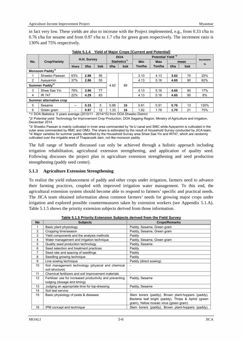
Agriculture Income Improvement Project Myanmar
MOALI 5-6 JICA
in fact very low. These yields are also to increase with the Project implemented, e.g., from 0.33 t/ha to 0.76 t/ha for sesame and from 0.97 t/ha to 1.7 t/ha for green gram respectively. The increment ratio is 130% and 75% respectively.
Table 5.1.4 Yield of Major Crops [Current and Potential]
No. Crop/Variety H.H. Survey DOA
Statistics*1 Potential Yield *2
Increment
% Min
Ton/ha Max
Ton/ha mean
Share t/ha bsk t/ha bsk t/ha bsk Monsoon Paddy*3
1 Shwebo Pawsan 63% 2.88 56
4.62 89
3.10 4.13 3.62 70 25% 2 Ayeyarmin 37% 2.86 55 4.13 5.16 4.65 90 62%
Summer Paddy*4 3 Shwe Sae Yin 78% 3.96 77 4.13 5.16 4.65 90 17% 4 IR 747 22% 4.29 83 4.13 5.16 4.65 90 8%
Summer alternative crop 5 Sesame -- 0.33 5 0.88 15 0.61 0.91 0.76 13 130% 6 Green gram - 0.97 12 1.33 16 1.62 1.78 1.70 21 75%
*1/ DOA Statistics: 5 years average (2010/11 - 2014/15) from DOA Shwebo District *2/ Potential yield: Technology for Improvement Crop Production, DOA Sagaing Region, Ministry of Agriculture and Irrigation, December 2014 *3/ Shwebo Pawsan is mainly cultivated in inner area commanded by Ye-U canal and SMC while Ayeyarmin is cultivated in the outer area commanded by RMC and OMU. The share is estimated by the result of Household Survey conducted by JICA team. *4/ Major varieties for summer paddy identified by the Household Survey area Shwe Sae Yin and IR747, which are randomly cultivated over the irrigable area of Thapanzeik dam, not like monsoon paddy.
The full range of benefit discussed can only be achieved through a holistic approach including irrigation rehabilitation, agricultural extension strengthening, and application of quality seed. Following discusses the project plan in agriculture extension strengthening and seed production strengthening (paddy seed center).
5.1.3 Agriculture Extension Strengthening
To realize the yield enhancement of paddy and other crops under irrigation, farmers need to advance their farming practices, coupled with improved irrigation water management. To this end, the agricultural extension system should become able to respond to farmers’ specific and practical needs. The JICA team obtained information about common farmers’ needs for growing major crops under irrigation and explored possible countermeasures taken by extension workers (see Appendix 5.1.A). Table 5.1.5 shows the priority extension subjects derived from those information.
Table 5.1.5 Priority Extension Subjects derived from the Field Survey No Subjects Crops/Remarks 1 Basic plant physiology Paddy, Sesame, Green gram 2 Cropping time/season Paddy, Sesame, Green gram 3 Yield components and the analysis methods Paddy 4 Water management and irrigation technique Paddy, Sesame, Green gram 5 Quality seed production technology Paddy, Sesame 6 Seed selection and treatment practices Paddy 7 Seed rate and spacing of seedlings Paddy 8 Seedling growing technique Paddy 9 Line sowing technique Paddy (direct sowing) 10 Soil management technology (physical and chemical
soil structure) -
11 Chemical fertilizers and soil improvement materials - 12 Fertilizer use for increased productivity and preventing
lodging (dosage and timing) Paddy, Sesame
13 Judging an appropriate time for top-dressing Paddy, Sesame 14 Soil test service - 15 Basic physiology of pests & diseases Stem borers (paddy), Brown plant-hoppers (paddy),
Bacteria leaf bright (paddy), Thrips & Aphid (green gram), Yellow mosaic virus (green gram)
16 IPM concept and technique Stem borers (paddy), Brown plant-hoppers (paddy),

Myanmar Agriculture Income Improvement Project
JICA 5-7 MOALI
No Subjects Crops/Remarks Thrips & Aphid (green gram)
17 Basic plant physiology of weeds Paddy field 18 Agri. chemicals use for controlling pests & diseases
and weeds (dosage & timing) Stem borers (paddy), Brown plant-hoppers (paddy), Bacteria leaf bright (paddy), Aphid (green gram), Weeds (paddy)
19 Judging an appropriate time for agri. chemicals application
Paddy, Green gram
20 Early warning system of pests & diseases Stem borers (paddy), Brown plant-hoppers (paddy), Bacteria leaf bright (paddy)
21 Safety use of agri. Chemicals - 22 Relevant lows & regulations to fertilizers and agri.
Chemicals -
23 Introducing new promising varieties in consultation with DRA
Paddy (high quality + pests & diseases resistance and lodging resistance), Sesame (high value), Green gram (YMV resistance and synchronized maturing )
24 Matching seed growers and farmers Paddy, Sesame Source: JICA Survey Team, based on interviews to farmers and extension staff
Considering agricultural condition of Thapanzeik irrigation system, a different approach would be taken to achieve the above described agricultural development respectively in the inner system and in the outer system. Table 5.1.6 shows the approaches and possible priority farmers’ needs to be addressed by agricultural extension activities in the both systems.
Table 5.1.6 Priority Issues of Agriculture Extension in the Inner System and in the Outer System Area Basic Approach Possible Priority Issues
1. Inner System Promotion of Shwebo Pawsan in monsoon season
Quality seeds Optimum planting time Insects control (stem borers and brown plant hoppers) Diseases control (bacterial leaf bright) Lodging
Promotion of summer paddy Weed control Proper fertilizer use (dosage and timing) Insects control (stem borers and brown plant hoppers) Diseases control (bacterial leaf bright)
Promotion of green gram in summer season
Yellow Mosaic Virus resistant varieties Varieties which can mature at once Insects control (thrips and aphid)
Promotion of sesame in summer season
New varieties (high yielding and high quality) Proper fertilizer use (dosage and timing)
2. Outer System (upper & middle reaches)
Promotion of Ayeyarmin in monsoon season
Quality seeds Lodging
Promotion of summer paddy As same as the case in the inner system 3. Outer System
(end reaches) Promotion of early maturity paddy in monsoon season
Weed control Proper fertilizer use (dosage and timing) Insects control (brown plant hoppers) Optimum growing time
Promotion of winter crops Short and cold resistant crops such as chick peas Promotion of summer paddy As same as the case in the inner system
Source: JICA Survey Team, based on interviews to farmers and extension staff
For agricultural extension system to be able to respond to such farmers’ needs, therefore, three major activities should be implemented; namely, 1) capacity building for DOA extension staff and private sector; 2) agricultural extension strengthening (demo-activities) including marketing enhancement, and 3) improvement of camp and DOA offices concerned. Contents of the activities have been identified through a series of filed observation, interviews to extension staff and famers, etc.
Public service provider of agricultural extension in any country needs to secure great financial resources, as well as have a rich store of human resources for maintaining the orthodox extension approaches like T&V2. The orthodox approaches used to recognize that farmers were only a subject to 2 DOA abandoned T&V (training and visit) system with some reason. DOA extension workers in the Project area simply visit villages in their working territory on regular basis, but not on a fixed day and without

Agriculture Income Improvement Project Myanmar
MOALI 5-8 JICA
teach advanced farming know-how and skills by extension providers.
Then, the extension providers developed a standardized package of farming technologies and pursued an information transfer system by establishing hierarchically setup. Such extension system, however, consumed a lot of costs for keeping appropriate number of intermediators like field extension workers, contact farmers, facilitators, etc., especially in countries where the agriculture sector depends on a huge number of small-scale farmers.
After that, a modified or supplementary approach for streamlining the orthodox approaches, like Farmer Field School, Farmer to Farmer Extension etc. was introduced in many countries. However, those attempts could not remarkably alleviate the burden on them. Moreover, a “one fits all” technologies is becoming to lose farmers’ interest as their interest has started to be diversified into various aspects with increased crop productivity to a certain level after the green revolution.
Not a small number of the governments in many development countries still struggle with such difficulties of the extension services. Myanmar is not an exceptional case as a matter of fact. Even though DOA allocates substantial budget for keeping its agricultural extension services every year, majority of farmers can hardly meet DOA’s extension workers as frequently as expected3.
The said three activities aim at promoting a network approach in the existing agricultural extension system in order to improve DOA’s extension services together with the reduction of financial burden of the services. DOA extension workers are expected to change the way of thinking and the way of their services to needs-based extension through the new approach proposed here. Farmers should be so facilitated that they will be able to analyze their problem and to find out the way out on their own by drawing out a sound consultation from DOA extension workers and other service providers based on their interest (See Figure 5.1.2).
Figure 5.1.2 Image of Extension Approaches: Existing and Proposed Ones Source: JICA Survey Team
The 3 activities have 5 major implications; namely, 1) changing way of extension service of DOA extension workers, 2) improving functional capacity of extension camps, 3) equipping the extension system with ICT networks, 4) developing on-farm technical handbooks/manuals and 5) increasing competent local inputs suppliers (fertilizers and agro-chemicals). Table 5.1.7 shows expected effects of the implications on promoting the new approach. organizing target farmer groups for their extension activity. When the extension workers visit villages, they come in contact with village administrators or village leaders instead of appointing fixed contact farmers systematically or purposefully for the extension activity like T&V. 3 An average number of villages or farm-households per extension worker is calculated about 11 villages/worker or 2,283 households/worker in the 9 townships of the Project area. It is easy to assume that the extension workers can reach only a limited number of farmers considering the present visiting system and their workloads for other activities.

Myanmar Agriculture Income Improvement Project
JICA 5-9 MOALI
Table 5.1.7 Implications of the 3 Activities and their expected Effects on the New Approach No Implications Expected Effects on the New Approach 1 Changing way of extension
service of DOA extension workers
DOA extension workers will be familiar with a needs-based extension approach
2 Improving functional capacity of extension camps
Farmers will have a base facility for interaction activities with DOA extension workers, farmers themselves and other stakeholders of agricultural extension, including information exchange, training workshops, self-help group activity, etc. within easy reach of them, like a Knowledge Centre introduced by IFAD FARM project
3 Equipping the extension system with ICT networks
ICT networks firstly shall contribute to streamline day-to-day administrative operations of DOA extension workers, like information collection and reporting, correspondence with other offices, etc. DOA extension workers will be able to share more time for technical dissemination activities by mitigating their workloads. Furthermore, all stakeholders, i.e. District/TS DOA offices, DOA extension workers, farmers, agricultural researchers, private inputs suppliers/service providers will share necessary information in a timely and effective manner through linking the networks
4 Developing on-farm technical handbooks/manuals
The handbooks/manuals will support the self-help attempts of individual farmers, as well as of DOA extension workers. They will be able to refer to the handbooks/manuals about farming technology as the closest starting point in their questioning.
5 Increasing competent local inputs suppliers (fertilizers and agro-chemicals)
They will be competent technical advisors familiar to farmers who perform a complementary role to DOA extension workers for teaching farmers with better agriculture practices, especially safe and effective use of fertilizers and pesticides.
Source: JICA Survey Team
Table 5.1.8 further shows the relevance between the implications above-mentioned and the 8 challenges described in Chapter 3.4.8. It shows that the 5 implications identified out of the major 3 activities are closely related with each other for improving the existing agricultural extension system.
Table 5.1.8 Relevance between the Implications of the 3 Activities and the Challenges
No Challenges (Chap. 3.4.7) Implications (See Table 5.1.7) 1 2 3 4 5
1 Focusing on the prioritized scope of target ✔ ✔ 2 Introduction of systematic extension approach ✔ ✔ ✔ ✔ 3 Promotion of hands-on policy ✔ ✔ ✔ ✔ ✔ 4 Linkage with the agricultural research ✔ ✔ 5 Linkage with the private sector ✔ ✔ 6 Empowerment of DOA extension workers ✔ ✔ ✔ ✔ 7 Practical use of ICT network ✔ ✔ ✔ ✔ 8 Improvement of facility and equipment ✔ ✔ ✔
Source: JICA Survey Team
In the meantime, marketing aspect should be taken into more consideration as this Project is for agriculture income improvement. One of the potential approaches for improved marketing in the future is contract farming, wherein farmers produce high quality produces at a right timing with the amount required from the buyers. To realize such a situation, however, various stakeholders, including private sector, Ministry of Commerce and the DOA, shall take part in the system of supporting those farmers and buyers who wish to enter into contract farming.
For the DOA, in particular, linking these buyers with potential farmers in the area could be the main and basic task. In these days, a number of Japanese companies are willing to venture agribusinesses in Myanmar and the project area can be a potential area for stable agriculture production. Thus, linking these international companies, in addition to local buyers, with farmers, or providing reliable information of useful resources/opportunities for them, ex., access to agriculture Two Step Loan, shall be considered as a part of the DOA’s role for marketing strengthening in the area.
1) Capacity Building of DOA Extension Staff and the Private Sector
1.1) Objective
The objective is to improve the abilities and competence of DOA extension staff at field level to identify

Agriculture Income Improvement Project Myanmar
MOALI 5-10 JICA
actual farmers’ needs, to formulate countermeasure solutions, and to evaluate the solutions by participatory interaction with target farmers; and to share necessary information in a timely and effective manner through linking the District DOA office with DOA extension staff, farmers, agricultural researchers, private inputs suppliers/service providers, etc.
1.2) Approach
The activity will provide a series of technical trainings to DOA extension staff through a step-wise training including the Training of Trainers (TOT) to deputy staff officers and also workshop and on-the-job training to extension staff. They should also be trained basic computer skills for data processing and IT based communication. In line with the training process, on-farm technical handbooks/manuals shall be developed in order to mitigate the limitations of individual farmers, as well as of DOA extension staff. They will be able to refer to the handbooks/manuals for information about farming technology and farm management improvement as the closest starting point in their questioning. All information on technical issues should be supported by photos or graphic drawings both in printed format and electronic ones.
Furthermore, the DOA offices concerned shall develop and manage a communication network system connecting with other DOA offices and extension camps for internal correspondence with ICT networks in order to mitigate their workloads of daily administrative operations. Besides, the Shwebo District DOA office should develop and manage a DOA web-extension system including web-based interactive extension covering the Project area by using available SNS services. With SNS services available nowadays, in fact, farmers can send photos, which for example show a symptom of crop disease, and ask the DOA office through the web site of what the diseases is and how to cope with, thus so-called interactive web-based extension system could be available. This system can be linked to the web-based SNS (Facebook) extension system4 available in the DOA HQs since 2016 (see photo right).
Above web-site will cover basic topics about farming technology like crop variety selection, seed rate, soil management, fertilizer application, plant protection, weed control and post-harvest practice, as well as technical advisory Q&A, announcement and notification from DOA, meteorological information, market information, etc. The web-site should start from simple contents mainly targeting DOA extension staff in extension camps, and gradually improve the contents according to the farmers needs. The web-site is expected to become the core of interaction between all stakeholders not only in the Project but also in Myanmar through the HQs SNS (Facebook) web-extension system after operation for a certain period.
In addition, collaboration with private sector is pursued as to increase the number of competent technical advisors who perform a complementary role to DOA extension staff. In so doing, a short-term certificate training system should be established to train shop owners of fertilizers and pesticides in Shwebo District, Kanbalu Township, and Budalin and Ayadaw Townships in Monywa District, so that they will be able to provide the right information about farming technology to their clientele farmers.
4 This SNS extension system is operated on Facebook, and available since 2016. In addition, a call center was added to the SNS extension system on March 1, 2017. There are, as of March 2017, 35 staff trained on the web-extension and call service, who are divided into 5 groups, namely, each 7 members per group. Out of the 7 staff, 5 are engaged in the call service while the rest 2 are engaged in the web-extension. They as a group rotate weekly.
DOA IT-based Extension System, operated on a SNS (Facebook), combined with call center

Myanmar Agriculture Income Improvement Project
JICA 5-11 MOALI
Though, at present, many private inputs companies are providing a similar training to affiliated shop owners for expanding their business influence, the training contents and quality vary from company to company. In addition, qualification of many shop owners is still rudimentary. The new training system, therefore, intends to provide basic but well applicable information with a systematic approach. The training should be combined with on-going business license system that obliges all shop owners to renew their business license in every, e.g., 2 years.
1.3) Activities
(Capacity Building of Extension Staff)
1) Provide trainings to DOA extension staff on;
- Extension and facilitation/coaching methodologies with due consideration of the experiences of the recent practices,
- Development of extension materials including the use of computer technologies, - On-the-job training through conducting the demonstration activity discussed in the next activity,
and - Basic computer skills to process collected information and for communication. - DOA staff to participate in the training are 10 staff x 9 TSs + 10 staff x 3 district = 120 staff per
training. 120 staff x 6 years = total 720 staff to participate.
(Upgrading and Diversification of Extension Modality)
2) Establish an editing policy of the handbooks/manuals (organizing an editing committee in the Shwebo District DOA office), drafting the handbooks/manuals in consultation with technical experts in different agricultural disciplines in DAR research institutes, Yezin Agricultural University (YAU), the Shwebo State Agricultural Institute, Central Agriculture Research and Training Centre (CARTC), etc.,
3) Print and distribution of the handbooks (approximately 30,000 copies),
4) Organize an orientation program of the handbooks for DOA extension staff and leading farmers,
5) Develop collaborative programs between DOA, DAR researchers and the private sector at district level to provide technical information regarding good agriculture practices and local information on markets, inputs supply, events, etc.,
6) Collect, analyze, process, and publish agricultural information including statistics through digital networks,
7) Train DOA staff to be engaged in a ICT task-force established in the Shwebo District DOA office to develop, maintain and update the web-site and the internal communication networks,
8) Establish a system to interact more effectively with DOA extension staff and to distribute extension services to farmers by cell and/or tablet phones through a SNS like Facebook,
9) Raise capacities of DOA staffs concerned to use ICT tools and social media for more effective communication with farmers and other stakeholders, as well as between DOA offices and extension camps in Shwebo District, Kanbalu Township and Budalin and Ayadaw Townships in Monywa District,
(Public-Private Partnership for Agricultural Extension)
10) Establish a training system with curriculum applicable to the shop owners in consultation with agricultural experts from various sectors including private companies,
11) Develop training materials in accordance with the curriculum and in consultation with the agricultural experts concerned to the curriculum,
12) Carry out the training by outsourcing to a competent training organization, such as the Shwebo State

Agriculture Income Improvement Project Myanmar
MOALI 5-12 JICA
Agricultural Institute, and
13) Qualify excellent performers as “superior shop owner” with incentive, such as certification and extension of the business license period, based on an examination score after the training.
2) Agriculture Extension and Marketing Strengthening (Demonstration Program)
2.1) Objective
The objective is to provide farmers with appropriate technical information and know-how through the participatory action learning; and to provide extension staff with an opportunity of on-the-job training especially of what they have learned through the training. Here, focus is also put on the aspect of marketing strengthening, especially of crop selection.
2.2) Approach
On-going demonstration plot program should firstly be reviewed in order to fit the concept of needs-based extension approach. Each extension camp carries out a demonstration or trial plot program that shall be deployed with practical strategy considering the specific condition and priorities of target villages. Based fully on the know-how gained through the series of trainings stated above, the program will demonstrate tailored approaches toward motivating farmers to adopt new technologies or supporting them to solve problems, instead of being a top-down showcase of “one fits all” technologies. Involvement of the private sector should also be considered according to the circumstances.
In addition, the DOA will review the marketability of target crops upon the latest information and introduce highly marketable crops in demonstration plot especially in dry season. For day to day market information, the Project will collaborate with Department of Planning (DOP) in improvement and practical use of the system to collect agriculture commodity prices at major trading centers and share them with extension staff and farmers by SNS and/or SMS.
2.3) Activities
1) Design the demonstration or trial plot program, through which specific locations, subjects and methods are prioritized together with participating farmers,
2) Implement a demonstration program including field-days and workshops by each extension camp in a participatory manner in each monsoon season and non-monsoon season using the manuals developed,
3) Expected size and the number of demonstration plot: 1 acre per plot by 2 plots/staff by 2 staff/camp in a year (actual implementation period: 6 years), say, 52 camps x 2 staff x 2 plots x 2 seasons = 416 demonstration plots per year (416 plots x 6 years = total 2,496 demonstration plots for 6 years),
4) Provide day-to-day extension services to clientele farmers, making the best use of camp extension office to be established and equipped by the Project,
5) Evaluation of the demonstration or trial plot program with farmers’ participated manner for improvement,
6) Awarding a prize to the extension staff whose performance was outstanding,
7) Collect agriculture commodity prices at major trading centers such as Shwebo, Monywa, Mandalay, Yangon, etc., and share the prices with the trends among the extension staff and farmers by using SNS and/or SMS of cellphone, and
8) Promising crops shall be cultivated at a part of demonstration plot as a show-case of marketable crops based on the market information collected.
9) Through the web-based extension system established in Shwebo District DOA office, operated on an available SNS like Facebook, farmers will deliver their questions and inquiries on their farming, and

Myanmar Agriculture Income Improvement Project
JICA 5-13 MOALI
DOA staff engaged in the system will provide answers. The questions and answers are posted on the web-site accessible by all the followers of the web-based extension system once they are registered.
3) Improvement of Camp and DOA Offices Concerned
3.1) Objective
The objective is to renovate and empower the DOA extension set-up at field level in order to support farmers to collect and exchange necessary information through interact activity; to have self-help group activity; to educate themselves with various training programs; and to link with DOA extension staff and the private sector.
3.2) Approach
DOA extension camps in Shwebo District, Kanbalu Township and Budalin and Ayadaw Townships in Monywa District will be equipped with office building with meeting facilities including internet system, computers and accessories, audio-visual equipment, simple measurement tools for soil and plants, office furniture, etc. In order to achieve inclusive and continuous agricultural development, the DOA extension policy needs to give more priority on supporting farmers in accordance with the farmers’ actual needs. The finely equipped extension camps could be a platform providing participatory extension services to the farmers.
The expected functions of the extension camp are as follows: 1) to be an activity base of extension staff 2) to be a facility for keeping their activity record, farmers’ information, and analysis equipment (pH meter, EC meter, soil moisture meter, grain moisture meter, etc.). Even if the extension staff is transferred to other place, such information and records need to be kept and taken over to successors in the extension camp.
3.3) Activities
1) To prepare a design of new facility and equipment attached to the extension camps and DOA offices concerned,
2) To secure land for the facility, if necessary,
3) To construct the camp facility,
4) To procure necessary equipment including office equipment and ICT network equipment, and
5) To set-up a management system of new facility of extension camps together with all farming communities concerned.
3.3) Facility and Equipment
1) Extension Camp (standardized model for 1 camp) No Facility/Equipment Q’ty Unit
<Building & Facility> 1 Office room 30 m2 2 Meeting hall (wall-less structure) 75 m2 3 Measuring and testing room 10 m2 4 Bathroom & toilet 10 m2 5 Storeroom, passage, etc. 25 m2 6 Water-well with pump 1 unit 7 Back-up generator system 1 unit
<Equipment, Tools and Furniture> 1 Office table and chair 3 sets 2 Chair (for meeting hall) 50 units 3 Working table 1 unit 4 White board 1 unit 5 Lap-top computer 1 units 6 Internet accessories (modem & router) 1 set 7 Printer 1 unit

Agriculture Income Improvement Project Myanmar
MOALI 5-14 JICA
No Facility/Equipment Q’ty Unit 8 Photocopy machine 1 unit 9 Projector 1 unit
10 Digital camera 1 unit 11 Refrigerator 1 unit 12 Microscope, biological 1 unit 13 pH meter, portable 1 unit 14 EC meter, portable 1 unit 15 Measuring tape 1 unit 16 Vernier caliper 1 unit 17 Weighing scale balance 1 unit 18 Rice moisture meter, portable 1 unit 19 Thermo-humid recorder 1 unit
2) DOA District Offices No Facility/Equipment Q’ty Unit 1 Desk-top computer 2 unit 2 Lap-top computer 1 unit 3 Hard disk (for data back-up) 1 unit 4 Internet accessories (modem & router) 1 set 5 Printer 1 unit 6 Photocopy machine 1 unit 7 Projector 1 unit 8 UPS 1 unit
3) DOA Township Office (standardized model for Township office) No Facility/Equipment Q’ty Unit 1 Desk-top computer 1 unit 2 Lap-top computer 1 unit 3 Hard disk (for data back-up) 1 unit 4 Internet accessories (modem & router) 1 set 5 Printer 1 unit 6 Photocopy machine 1 unit 7 Projector 1 unit 9 UPS 1 unit
5.1.4 Establishment of Seed Center
1) Problems in Seed Production and Distribution
Rice production in Shwebo District is very famous in Myanmar especially for Shwebo Pawsan and Ayeyarmin. Shwebo Pawsan rice has been selected as a Geographical Indication (GI) Product by the Union Ministries headed by Ministry of Science and Technology cooperated with UNCTAD and FAO. Yet, the contamination with red rice and other varieties has affected the trading pricing and damaged the bland image.
According to Upper Myanmar Seed Laboratory, the certification ratio (by number of samples) of seeds from seed growers is accounted only at 42.0% in 2015/16. The main reason of disqualification is the lower purity ratio than 97% defined by the International Seed Test Standard. The Foundation Seed (FS) and the Registered Seed (RS) in the DOA seed farm also show not satisfactorily results such as 79% and 88% respectively.
Table 5.1.9 Testing Results of Received Paddy Seed Samples at Upper Myanmar Seed Laboratory
Sr. Seed Source
Seed Class
2011-2012 2012-2013 2013-2014 2014-2015 2015-2016
Received Sample
Meet Seed Std.
Received Sample
Meet Seed Std.
Received Sample
Meet Seed Std.
Received Sample
Meet Seed Std.
Received Sample
Meet Seed Std.
1 DAR Yezin BS 28 7 5 0 11 0 6 6 4 1(25)*
Photo: Red Rice Contamination after Husking of Pawsan
Place: Zigone, Shwebo TS

Myanmar Agriculture Income Improvement Project
JICA 5-15 MOALI
Sr. Seed Source
Seed Class
2011-2012 2012-2013 2013-2014 2014-2015 2015-2016
Received Sample
Meet Seed Std.
Received Sample
Meet Seed Std.
Received Sample
Meet Seed Std.
Received Sample
Meet Seed Std.
Received Sample
Meet Seed Std.
Seed Farm
2 DOA Seed Farm
FS 39 7 32 8 20 6 21 8 38 30(79) RS 55 34 66 40 70 39 76 54 107 94(88) F1 1 1 - - 14 14 10 7 6 4(67) CS - - - - - - 9 3 4 1(25)
3 State/Region CS 790 288 794 533 1,106 503 1,152 596 1,732 727(42) Total 913 337 897 581 1,221 562 1,274 674 1,891 857(45) % of CS from State/ Region (seed growers) 36.5 % 67.1 % 45.5 % 51.7 % 42.0 %
*/ Numbers in the parenthesis are the percentage whish passed the test. Source: Upper Myanmar Seed Laboratory, Seed Division, DOA Mandalay Region Office, Oct 2016 | (unit: number of samples) Remarks: The Standard of Paddy Certified Seed: i) Purity: ≥97%, ii) Germination: ≥80%, iii) Moisture Contents: ≤13%, iv) Foreign Matters: ≤3%,v) Different Variety Contamination:≤1.0%, vi) Weed Seed Contamination: ≤10pcs/500g-seed, vii) Red Seed Contamination: ≤5pcs/500g-seed
Seed transaction in the distribution flow is also one of the reasons to make lower quality as shown in Figure 5.1.3 (marked by red ellipses). The negative factors are: 1) majority of seed growers do not acquire the certification; 2) seed brokers mix up certified with non-certified seeds; and 3) grain farmers also select seeds from harvested grains, and also the DNA of Pawsan has been changed by pollination with other varieties or natural strains.
Figure 5.1.3 Distribution Flow of Paddy Seeds in Shwebo District Source; JICA Survey Team
Distribution Gaps, a situation wherein supply of high quality CS cannot meet the demands, are being caused by the following factors:
Low purity seeds are prevailing, Seed growers need cash immediately after harvesting for the next cropping and livelihoods; thus
they sell the produce as grain paddy or they sell seeds without getting certificate, Seed growers do not own warehouses to keep CS in suitable conditions in terms of temperature,
humidity, and insect prevention, For certification of seeds, it takes minimum three months for cross-checking with a limited
numbers of inspectors in Upper Myanmar Seed Laboratory and the laboratory covers wide areas,
DOA Seed Farm (Chipar, Ye-U, Gweygone)
Registered Seed (RS)
CS Grower
(with the certificate)
Large-Scale Rice Miller
Seed Broker
Grain Farmer (in-house seed production)
RS
Certified Seed (CS)
CS, Not Certified Seed
Seed Grower (without the certificate)
CS
CS
Not Certified Seed
Private Co. such as Mone Thidar Seed Co. (Pwuint Phyu, Magway) Breeder’s Seed (BS),
BS, FS
FS, RS
DAR Seed Farm
Breeder’s Seed (BS),
Foundation Seed (FS))

Agriculture Income Improvement Project Myanmar
MOALI 5-16 JICA
more than 1,300 samples by only 13 inspectors (2016), Field inspection is not carried out by professional experts, Seed growers do not follow regulations of Good Agricultural Practice (GAP) for seed production
but wish high yield of seeds like grain cultivation, e.g., dense planting and excessive application of chemical fertilizer, pesticides and herbicides,
There is no organization to purchase high quality CS at the reasonable prices, and Rice millers have a limited capacity to procure purified CS, to conduct field inspection, to invest
in the processing plant for CS, and to store CS in independent warehouses.
To minimize the distribution gap, bottleneck along the flow should be resolved. Considering the recent policy of Department of Agriculture as to strengthen seed growers associations, this Project focuses on the segment of post-harvest handling and certifications of the seeds so that seed growers can have a secured distribution channel of CS with reasonable quality control and pricing mechanism. Particularly, establishment of seed center is planned.
2) Seed Center
Some of the large scale rice millers have tried to procure FS and RS from DAR and to multiply them to be CS by contracting reliable seed growers. In that trial, however, they were not able to avoid contamination with red rice and other varieties. From this experience, improvement of CS quality should be carried out widely at the district level. To meet the CS demand, therefore, establishment of rice seed center is recommended by relevant organizations including the Rice Millers’ Association.
The scheme of ‘Seed Center’ is planned referring to the results of a JICA technical cooperation project ‘Development of Participatory Multiplication and Distribution System for Quality Rice Seed in Ayeyarwady Region (2011-17). The distribution gap has not been solved between the CS growers and the grain farmers form the viewpoints of technical and financial aspects. For the design of the scheme of the ‘Seed Center’, followings are considered to alleviate the distribution gaps:
There should be 3 types of seed centers under the Project, namely Type-A, Type-B, and Type-C in descending order of its processing capacity. The centers shall be located on the government land, e.g. at Extension Camp in Sai Naing Gyi for Type-A (or B), at Chipar for Type-B (or Type A), and at Thelone Village, Shwebo for Type-C. For Type-A, the Project will procure drying/ processing/ packaging plant and construct warehouse. For Type-B, the Project will procure processing plant, and such plant with same capacity can meet TSL lending maximum amount, and construct warehouse. For Type-C, the Project is to procure seed cleaner and materials for warehouse only.
The centers will deal with the high value variety of Shwebo Pawsan (monsoon paddy) and the locally-consumed variety of Shwe Thwe Yin (IR-50, summer paddy).
The centers or the DOA Seed Farms should provide FS to the seed growers. The center will support seed growers to procure locally-available organic input products such as organic liquid fertilizers, plant growth stimulators and effective microorganisms by providing them a credit. The Beauveria bassiana can be one of the choices to control Stem borer5. By introducing these measures, repeated application of chemical pesticide can be reduced.
The centers for Type-A and B should purchase whole quantity of CS from the seed growers just after the harvest. The additional bonus or pay-cut shall be determined based on the purity of seeds, and the moisture contents after the processing. Also, CS should be certificated by DOA Seed Laboratory after the processing. A seed laboratory in Shwebo town is expected to be established by DOA, and the inspectors will be trained by DOA.
The field inspection shall be carried out by DOA extension staff or private agronomists. At least, 5 Fungus of Beauveria Bassiana is promoted in the Central Thailand and multiplied by groups of paddy farmers.

Myanmar Agriculture Income Improvement Project
JICA 5-17 MOALI
three times field inspection per season is required, e.g., at nursery/transplanting, heading/maturing and harvesting stages.
The center for Type-A will have several functions such as; 1) receiving of CS with weighing and checking of moisture contents, 2) drying of seeds to around 13% by a drying equipment to be installed, 3) processing such as cleaning, grading and packaging, 4) long-term storing, etc. On the other hand, Type-B will function only with above mentioned 1), 3), and 4). It will be equipped with a concrete yard for drying instead of installing drying equipment.
The Centers will sell CS to large-scale grain farmers, registered farmers’ groups and the members of Rice Millers’ Association.
Seed amount to receive for monsoon paddy is assumed at approximately 400 ton (20,000 baskets) in 60 processing days for Type-A and 200 ton (10,000 baskets) for Type-B. For Type-C, the farmers group clean up the CS, which is then kept by member farmers.
Operator for Type A and Type B will be selected through tender. Operation and maintenance cost should be covered by these operators. Written contract should be concluded between the operators and DOA to avoid misuse of the equipment and maximize the benefit of the seed center.
The centers will accept the auditing annually by a certified public accountant appointed by DOA.
The following diagram indicates the working flow and the table summarizes the plan of 3 types of seed center under the proposed scheme of the seed centers of Type-A and B:
Figure 5.1.4 Proposed Scheme of Seed Center for Transaction of Paddy Certified Seeds Source; JICA Survey Team
Table 5.1.10 Proposed Seed Centers by Type Type Type A Type B Type C
Site On Govt. Land (e.g. at Ext. Camp, Sai Naing Gyi )
On Govt. Land (e.g. at Chipper/ Ye-U Seed Farm)
At Village (e.g. Thelone, Shwebo (Birthplace of Shwebo Powsan))
Operator To be selected by tendering To be selected by tendering Seed grower’ group in village (Farmers in birthplace of Shwebo Pawsan)
Scale 400 ton (20,000 basket) 200 ton (10,000 basket) 100 ton (5,000 basket) Seed Production Farm 160 ha (400 ac) 80 ha (200 ac) 40 ha (100 ac)
Grain Production Farm 8,000 ha (20,000 ac) 4,000 ha (10,000 ac) 2,000 ha (5,000 ac)
Step-4: Sample Seed
Step-2: Field Inspection Step-1: Supply of Registered Seed
Loan Project
Step-5: Certification
Step-6: Payment Step-3: Harvesting & Unloading Seed
Step-7: Selling Certified Seed Step-8: Payment
DOA Seed Farm DOA (Extension) supported by Rice Section
Members of Shwebo TS Seed Growers’ Association DOA Seed Lab
SEED CENTER (Receiving, Drying, Processing/Packaging, Long-term Storing, Agronomic Services and Bank-Accounting)
Large-scale Grain Farmers or Farmers’ Groups in Villages
Members of Shwebo TS Rice Millers’ Association

Agriculture Income Improvement Project Myanmar
MOALI 5-18 JICA
Type Type A Type B Type C CS Purchase Scale 280 million kyat 140 million kyat Seed growers sell directly.
Major Sales Lending to grain farmers& selling to rice millers
Lending to grain farmers& selling to rice millers Rice millers and seed brokers
Major Equipment Drying/ Processing/ Packaging Processing Seed Cleaner
Warehouse To be constructed To be constructed To provided materials of warehouse
Source: JICA Survey Team
3) Coordination with JICA Quality Rice Seed Project
The Technical Assistance Project for Improvement on Accessibility of Rice Certified Seed (CS) supported by JICA has been launched in October, 2017 for 5 years in Shwebo and Ayeyarwaddy areas. The Project is expected to produce such outcomes of; i) strengthening of public-private partnership, ii) capacity building of the seed farm technical staff and the agricultural extension staff of DOA regarding CS farm inspection and cultivation techniques, iii) support for efficient operation of seed inspection by the DOA seed laboratories, and iv) enlightenment of CS usage by rice farmers. The activities of the Project Team shall contribute to increasing transacting volumes and upgrading quality of CS. Therefore, the following supports on establishment of the Seed Centers are requested:
1) Provision of technical advices to the Yen Loan project, 2) Stabilization of Rice Registered Seed (RS) quality produced at DOA seed farms and support on
efficient delivery to the CS farmers, 3) Promotion of involving rice millers and seed producers in operation of the Seed Centers, 4) Technical supports for field inspections conducted by DOA at CS farms, 5) Technical supports on postharvest activities such as processing, testing, packaging/labeling,
storing, collecting/paying from/to the CS farmers, selling CS, and the related works of the Seed Centers,
6) Support for establishment of annual planning and sustainable management system of the Seed Centers,
7) Support for marketing of the rice variety of Shwebo Pawsan, and 8) Monitoring of the outcomes from the Seed Centers.
5.1.5 Strengthening of DOA Seed Farms
As described in the previous section, it is important to minimize the distribution gap between the supply and demand of quality seeds or certified seeds. At the upper end of the supply chain, the production of foundation seeds, registered seeds and certified seeds at DOA seed centers is crucial and needs to be strengthened.
There are three DOA seed farms in the Project area that produces paddy seeds: Chi Par (Shwebo TS), Ye-u (Ye-U TS), and Gwe Gone (Khin-U TS). For the strengthening of these DOA seed farms, procurement of farm equipment, post-harvest equipment, seed testing equipment and other equipment is now considered by the DOA seed farm, detailed list of which is shown in Table 5.1.11.
As shown in the table, a total of US$218,322, US$200,282, and US$117,442 are estimated for Chi Par, Gwe Gone, and Ye-U seed farms, respectively. Roughly half of the estimated cost is shared by the procurement of farm equipment such as thresher, combined harvester, and transplanter. For post-harvest equipment, seed cleaner and dryer are listed. As for seed testing equipment, seed counter shares the biggest portion. Note that, for Ye-U seed farm, no post-harvest equipment, seed testing equipment and building are planned as they have already been put in place.

Myanmar Agriculture Income Improvement Project
JICA 5-19 MOALI
Table 5.1.11 Equipment Planned to Strengthen the Seed Farms
Items Chi Par Gwe Gone Ye-U
Shwebo TS Khin-U TS Ye-U TS Nos. Cost (US$) Nos. Cost (US$) Nos. Cost (US$)
Farm Equipment Tractor 1 172 1 172 1 172 Rotary vator 0 0 0 0 0 0 Inter-cultivator 0 0 0 0 0 0 Seeder 1 11,000 1 11,000 1 11,000 Soil pH meter 0 0 0 0 0 0 Combined Harvester 1 27,700 1 27,700 0 0 Transplanter 1 15,400 1 15,400 1 15,400 Transporter 1 3,000 1 3,000 1 3,000 Thresher 1 38,500 1 38,500 1 38,500 Dumper Truck 1 10,000 1 10,000 1 10,000 Born Spray 1 1,920 1 1,920 1 1,920 Water Pump 1 1,150 1 1,150 1 1,150 Sub-Total 108,842 108,842 81,142 Post-Harvest Equipment Seed Cleaner 1 18,800 1 18,800 0 0 Dryer 1 15,400 1 15,400 0 0 Sub-Total 34,200 34,200 0 Seed Testing Equipment Electronic Balance 1 480 1 480 0 0 Seed Counter 1 11,100 1 11,100 0 0 Grain Moisture Meter 1 1,000 1 1,000 0 0 Sub-Total 12,580 12,580 0 Building Ware house/ Seed Storage 2 29,200 2 29,200 0 0 Seed Laboratory 0 0 0 0 0 0 Machinery building 0 0 0 0 0 0 Dried Ground 1 13,800 1 13,800 Bridge 1 2,800 Sub-Total 45,800 43,000 0 Others Farm Road Repair 1 16,900 0 1,660 0 36,300 Meteorological Station 0 0 0 0 0 0 Transformer 0 0 0 0 0 0 Sub-Total 16,900 1,660 36,300
Grand Total 218,322 200,282 117,442 Source: DOA Seed Division, through the ADB project team on climate-Friendly Agribusiness Value-chain Sector Project
Through the survey, it was confirmed that the ADB is planning to support the upgrading of the seed farm in Chi Par under the “Climate-Friendly Agribusiness Value-chain Sector Project.” Then, the seed farm in Ye-U is being funded by the World Bank through the Agriculture Development Support Project, by which seed cleaner has been already procured and installed. Furthermore, there is a plan for the seed farm in Gwe Gone to be privatized, though it is yet to be decided. Given all these situations considered, JICA survey team proposes not to include the component for strengthening of DOA seed farms in the loan portion of the Project.
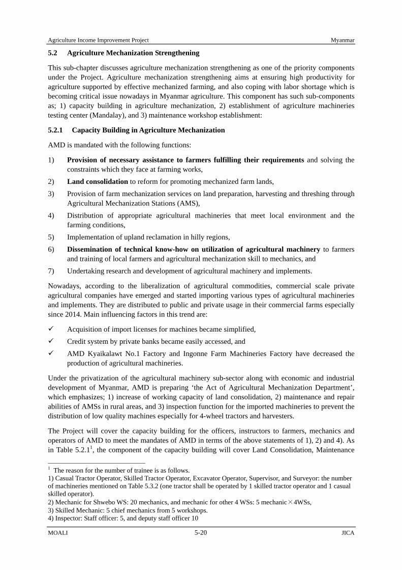
Agriculture Income Improvement Project Myanmar
MOALI 5-20 JICA
5.2 Agriculture Mechanization Strengthening
This sub-chapter discusses agriculture mechanization strengthening as one of the priority components under the Project. Agriculture mechanization strengthening aims at ensuring high productivity for agriculture supported by effective mechanized farming, and also coping with labor shortage which is becoming critical issue nowadays in Myanmar agriculture. This component has such sub-components as; 1) capacity building in agriculture mechanization, 2) establishment of agriculture machineries testing center (Mandalay), and 3) maintenance workshop establishment:
5.2.1 Capacity Building in Agriculture Mechanization
AMD is mandated with the following functions:
1) Provision of necessary assistance to farmers fulfilling their requirements and solving the constraints which they face at farming works,
2) Land consolidation to reform for promoting mechanized farm lands, 3) Provision of farm mechanization services on land preparation, harvesting and threshing through
Agricultural Mechanization Stations (AMS), 4) Distribution of appropriate agricultural machineries that meet local environment and the
farming conditions, 5) Implementation of upland reclamation in hilly regions, 6) Dissemination of technical know-how on utilization of agricultural machinery to farmers
and training of local farmers and agricultural mechanization skill to mechanics, and 7) Undertaking research and development of agricultural machinery and implements.
Nowadays, according to the liberalization of agricultural commodities, commercial scale private agricultural companies have emerged and started importing various types of agricultural machineries and implements. They are distributed to public and private usage in their commercial farms especially since 2014. Main influencing factors in this trend are:
Acquisition of import licenses for machines became simplified, Credit system by private banks became easily accessed, and AMD Kyaikalawt No.1 Factory and Ingonne Farm Machineries Factory have decreased the
production of agricultural machineries.
Under the privatization of the agricultural machinery sub-sector along with economic and industrial development of Myanmar, AMD is preparing ‘the Act of Agricultural Mechanization Department’, which emphasizes; 1) increase of working capacity of land consolidation, 2) maintenance and repair abilities of AMSs in rural areas, and 3) inspection function for the imported machineries to prevent the distribution of low quality machines especially for 4-wheel tractors and harvesters.
The Project will cover the capacity building for the officers, instructors to farmers, mechanics and operators of AMD to meet the mandates of AMD in terms of the above statements of 1), 2) and 4). As in Table 5.2.11, the component of the capacity building will cover Land Consolidation, Maintenance
1 The reason for the number of trainee is as follows. 1) Casual Tractor Operator, Skilled Tractor Operator, Excavator Operator, Supervisor, and Surveyor: the number of machineries mentioned on Table 5.3.2 (one tractor shall be operated by 1 skilled tractor operator and 1 casual skilled operator). 2) Mechanic for Shwebo WS: 20 mechanics, and mechanic for other 4 WSs: 5 mechanic×4WSs, 3) Skilled Mechanic: 5 chief mechanics from 5 workshops. 4) Inspector: Staff officer: 5, and deputy staff officer 10

Myanmar Agriculture Income Improvement Project
JICA 5-21 MOALI
Workshop, and Agricultural Machineries Testing Center. For Land Consolidation, the content of the training will be tractor operation, excavator operation, and measurement by auto level and the total station. As per Maintenance Workshop, the mechanics will be skilled on restoring engine and gearbox and repairing tractors, harvesters, and power tillers. Regarding Agricultural Machineries Testing Center, AMD should know how to test and evaluate 4-wheel tractor, establish Myanmar Testing Standard, and maintain the testing devices.
Table 5.2.1 Capacity Building for Mechanics, Operators and Instructors to Farmers Component Trainee No. Place/ Trainer Description Duration Budget
Source Land Consolidation Work
Casual Tractor Operator (Grade 5 and Casual)
100 AMD Mechanization Training Center (Meiktila)
practice on 4-wheel tractor, operation of tractor implements, mechanism of engine/ transmission/ hydraulic/ electric parts, daily maintenance, safety
90 days AMD
Skilled Tractor Operator (Grade 3 and 4)
100 AMD Land Consolidation Section (NayPyiTaw)
practice on 4-wheel tractor, operation of tractor implements (laser leveler & ridge plastering machine), daily maintenance
15 days AMD+ Project (Instructor)
Excavator Operator (Grade 3 and 4)
10 AMD Shwebo District Office -Supplier
practice on hydraulic excavator, safety operation, mechanism of hydraulic system, daily maintenance
15 days Project (Instructor)
Supervisor Surveyor
15 AMD Land Consolidation Section (NayPyiTaw)
preparation works on LC, use of auto level and total station, drawing, operation of tractor implements (laser leveler & ridge plaster), communication skill with farmers, work reporting
30 days AMD + Project (Instructor)
Maintenance Workshop
Mechanic (Grade 4 and 5)
40 AMD Shwebo District Office Workshop and sending to Monywa Technical School
rebuilding works using metallic processing machines, de-assembling & assembling of engine & transmission gear box, repair works of 4-wheel tractors & combine harvesters, checking instruments, terminal maintenance, safety works
30 days AMD + Project (Instructor)
Skilled Mechanic (Grade 3)
5 Manufacturer’s Factory-Supplier
mechanism of 4-tractors & combine harvesters including fuel/ hydraulic/ electric systems, replacement of spare parts, inspection methods & trouble-shootings
30 days Project
Agricultural Machineries Testing Center
Inspector (Staff Officer, Deputy Staff Officer)
15 Agricultural Machineries Testing Center (Mandalay)
detail testing methods, handling and maintenance of testing machines, data collection and analysis, safety operation
30 days AMD + Project (Instructor)
Chief Inspector (Dy-Director, Assistant Director, Chief Staff Officer)
3 Institute of Agricultural Machinery, NARO/ MAFF (Saitama, Japan), Manufacturers (Japan)
analysis and evaluation methods of testing results, safety checking methods, cooperation project with manufactures, information dissemination to consumers, research procedure (new agricultural mechanization enhancement project)
360 days Project
Source: JICA Survey Team
5) Chief Inspector: Deputy-Director (Testing Center Director): 1, Assistant Director: 1, and Senior Chief Officer: 1.

Agriculture Income Improvement Project Myanmar
MOALI 5-22 JICA
5.2.2 Maintenance Workshop Establishment
Dealers for agricultural machineries concentrate in Shwebo township, and sell various machineries of 4-wheel tractors, hand tractors and combine harvesters which are imported from Japan, Thailand, China and India and also those assembled locally. Nowadays, in fact, there are many numbers of agriculture machineries already available at the hand of farmers (see Table 5.2.2). However, the distributors and the dealers do not possess maintenance workshop for engine overhaul, test of fuel injection and hydraulic pressure, replacement of spare parts and other diagnosis equipment for machine performance.
When machine troubles take place, the owners of machines sometimes have to try to dis-assemble the parts without knowledge. In this case, the troubled machines can seldom recover or otherwise result in shortening of the working period. Especially since 2014, 4-wheel tractors and combine harvesters are increasing in Shwebo district instead of power tillers and engine threshers according to interviews to dealers in the district. The rapid mechanization to large scale machines may have been caused by:
1) Shortage of farm labors in villages even for operating power tillers and associated with the increase of labor costs,
2) High demands of tilling and harvesting in short period of time between monsoon paddy harvest and summer crop’s land preparation to meet stable demands of summer rice (IR-747) from China’s processing factories, e.g., for noodles, crackers and brewery, and beans from India, and
3) Availability of durable machines from Japan and also from India, and farmers’ awareness on the effective farming with agricultural mechanization including land consolidation.
The function of AMD should change from selling the assembled machines manufactured at AMD Ingonne Farm Machineries Factory and providing tractor services with operators to services of maintenance & repair of large agricultural machines. The capacity building of mechanics and renovation of maintenance workshop facilities both at district and township levels are strongly requested by the farmers interviewed by the Team.
Shwebo Agriculture Mechanization Station (AMS) will function as a core workshop in the Project area at the level of complete overhauling and rebuilding of engines and transmissions like AMD Monywa Medium Workshop. The training to AMD mechanics and the private mechanics of dealers and villages will be conducted using rebuilding machines and tools. Four AMSs such as Kanbalu, Ye-U, Wetlet and Budalin should support the machine users at the maintenance level of spare parts replacement and simple repairs. Selection of the necessary equipment for the AMS maintenance workshops are as follows (see Table 5.2.3 for the list):
Basically, the equipment which are installed in AMD medium workshop No.6 in Monywa was referred to decide the equipment and machineries taking into account the frequency of the use.
Table 5.2.2 Farmers’ Own Agri- Machineries in Shwebo/ Kanbalu/ Monywa Districts
No. Township
Existing Agricultural Machineries (unit)
4-Wheel Tractor
Power Tiller
Puddling Roller Boat
Rice Trans- planter
Power Reaper
Engine Thresher
Combine Harvester
1 Shwebo 74 4,398 415 6 3 902 67 2 Kyaukmyaung 80 178 - - - - - 3 Khin-U 28 2,256 80 1 649 44 4 Wetlet 90 4,211 37 1 18 217 31 5 Ye-U 158 2,322 24 1 5 645 84 6 Taze 203 1,703 3 - - 278 104 7 Tabayin 160 2,012 17 - - 715 46 8 Kanbalu 432 1,983 - - 15 969 46 9 Budalin 139 1,337 - - - 445 - Total 1,364 20,400 576 8 42 4,820 422
Source: AMD Shwebo District Office, Oct 2016, AMD Budalin TS Office, Feb 2017

Myanmar Agriculture Income Improvement Project
JICA 5-23 MOALI
The quantity is that engine overhaul machine should be installed only at Shwebo AMS while others are basically provided one each to each of the AMSs.
However, some equipment are planned to provide 2 sets per maintenance workshop such as; Positioner (No.35): 5 in Shwebo maintenance workshop to make works easy for engine disassembling and re-assembling, Air Hose Reed with Air Gun (No.39): 2 in Shwebo maintenance workshop to cope with many repair requests, Tool Cabinet (No.41): 2 in Shwebo maintenance workshop to prepare for repair and adjustment of combine harvesters, and Service Car (No.43): 1 in Shwebo while the other one in Ye-U, and
Equipment/ machines of No.1 – 7, No.11, No.14 – No.16, No.21 and No.24 are equipped with cutting-bit, which are not available in Myanmar, and therefore these are to be imported.
With the collaboration of the dealers, spare parts for major models can be sold at the AMD workshops. The maintenance workshops in Sub-AMS at Taze, Tabayin and Khin-U will be improved after capacity building of the mechanic and upon dealers’ requests. A service car with engineer’s tools should also be arranged as a mobile workshop under the Project. The mobile workshop is to be placed at Shwebo AMS. The proposed equipment for the AMS maintenance workshops are presented in the following table:
Table 5.2.3 Equipment List for AMS Maintenance Workshops Sr. Equipment Name Specification Q'ty
Allocation (unit or set) Shwebo
AMS WetletAMS
Ye-U AMS
Kanbalu AMS
BudalinAMS
1 Cylinder Boring Machine boring size φ180mm×460mmD 1 unit 1 0 0 0 0
2 Cylinder Honing Machine honing size φ170mm 1 unit 1 0 0 0 0 3 Line Boring Machine block length 1800mm 1 unit 1 0 0 0 0 4 Connecting Rod Aligner rod length 420mm 1 unit 1 0 0 0 0 5 Crank Shaft Grinder center distance 1,800mm 1 unit 1 0 0 0 0 6 Surface Grinder grinding length 1,600mm 1 unit 1 0 0 0 0 7 Eccentric Valve Seat Grinder valve seat φ65mm 1 unit 1 0 0 0 0 8 Diesel Compression Gauge Set for agricultural tractors 1 unit 1 0 0 0 0 9 Diesel Fuel Injection Pump Tester plunger 8pcs 1 unit 1 0 0 0 0 10 Nozzle Tester 50 Mpa 1 unit 1 0 0 0 0 11 Engine Lathe swing over bed 500-510mm 1 unit 1 0 0 0 0 12 Diesel Engine Arc Welder 7.9kW 5 units 1 1 1 1 1 13 Gas Welder Set oxygen and acetylene gas 5 sets 1 1 1 1 1 14 Bench Drill, large capacity capacity 23mm 1 unit 1 0 0 0 0 15 Bench Drill, small capacity capacity 13mm 5 units 1 1 1 1 1 16 Bench Electric Grinder 640W, stand 5 units 1 1 1 1 1 17 Hydraulic Shop Press 480N 5 units 1 1 1 1 1 18 Air Compressor diesel engine 7.5kW, unloading 5 units 1 1 1 1 1 19 Portable Gantry Crane load 3.0ton 1 unit 1 0 0 0 0 20 Giant Tire Mounting and Demounting Machine tire size 25"-51" 1 set 1 0 0 0 0 21 Cut-off Machine disc 405mm 5 units 1 1 1 1 1 22 Silicon Quick Charger 1.1KVA 5 units 1 1 1 1 1 23 Hydraulic Garage Jack 10ton 5 units 1 1 1 1 1 24 Disc Grinder 860W 5 units 1 1 1 1 1 25 Outside Micrometer Set 50-75mm, 75-100mm 1 set 1 0 0 0 0 26 Standard Thickness Gauge 19 leaf 1 unit 1 0 0 0 0 27 Tap & Dies Set M8-M18, holder, reamer wrench 5 sets 1 1 1 1 1 28 Torque Wrench preset ratchet, 12Nm, 23Nm 5 sets 1 1 1 1 1 29 Engineer Tools Kit 5 sets 1 1 1 1 1 30 Special Tools for Combine Harvester 1 set 1 0 0 0 0 31 Diesel Engine Generator 50KVA 1 unit 1 0 0 0 0 32 Diesel Engine Generator 30KVA 4 units 0 1 1 1 1 33 Cylinder Sleeve Puller 17 ton 5 units 1 1 1 1 1 34 AC Arc Welder 250A 5 units 1 1 1 1 1 35 Positioner 1.0 ton 9 units 5 1 1 1 1 36 Parts Cleaner 20lit/min 5 units 1 1 1 1 1
37 Portable Hydraulic Test Kit with Hoses & Adaptors 40MPa, 400lit/min., 120C 5 units 1 1 1 1 1
38 Hydraulic Test Gauge Set 2.5, 10, 40MPa with Hoses & Adaptors 5 units 1 1 1 1 1 39 Air Hose Reel with Air Gun 15m 6 units 2 1 1 1 1 40 Air Impact Wrench with impact wrench set 3/4" 5 units 1 1 1 1 1 41 Tool Cabinet 6 units 2 1 1 1 1

Agriculture Income Improvement Project Myanmar
MOALI 5-24 JICA
Sr. Equipment Name Specification Q'ty Allocation (unit or set)
ShweboAMS
WetletAMS
Ye-U AMS
Kanbalu AMS
BudalinAMS
42 Mobile Work Bench With stationary type machine vice, 1,200mmL×800mmW×740mmH 6 units 2 1 1 1 1
43 Service Car 4×4, front winch and diagnostic instrument 2 units 1 0 1 0 0
Source: AMD and JICA Survey Team
5.2.3 Agriculture Machineries Testing Center
In Myanmar, AMD has assembled 4-wheel tractors, implements, hand tractors, mono wheel tractors, roller boat, trans-planters and other machines so far. However, private sector has started importing 4-wheel tractors and assembling hand tractors since 2014. Since 2014/15 onwards, 20,000-25,000 units of 4-wheel tractors and approximately 5,000-7,000 units of combine harvesters have been imported as shown in the following Figure 5.2.1:
AMD is requested to inspect the performance and the safety of agricultural machineries, because some imported machines are not fulfilling their described specifications, and also showing poor durability. AMD comments the following points for the establishment of testing center:
1) Definition of Testing Legal basis: The Act of Agricultural Mechanization Department (draft) The testing shall not be carried out compulsory, but based on request from importers, distributors, dealers and local manufacturers of agricultural machineries.
2) Objective of Testing By clarifying the performance regarding operating efficiency, operating accuracy, safety check of devices and long use durability, AMD promotes quality machineries and supports farmers’ income improvement.
3) Testing Organization and Place Agricultural Machineries Testing Center at Mandalay City, which place should be in the compound of AMD Mandalay Regional Office2 under Research and Technology Section.
4) Target of Testing Machineries The target for the machineries to be tested shall be determined by the AMD director general and promulgated by the Minister. At the first stage, 4-wheel tractors more than 25 hp (in nominal
2 The address of the Testing Center is AMD Regional Office (Mandalay), 78 Road, Ta Kun Dai Quarter, Pyi Gyi Ta Kun Township, Mandalay District, Mandalay Region. Digging a deep well is needed to cool the testing equipment. The projected specification is as follows: Drilled Depth: 150m, Diameter: 100mm, Galvanized Iron Pipe w/ Casing. Screen Depth: 100-125m, Submersible Pump Lift: 50m, Top of Pump: 45m.
4-Wheel Tractors
No. of Units No. of Units
Combine Harvesters
Forecast 7,000
Figure 5.2.1 Imported Units of Agricultural Machineries in Myanmar Source: AMD Design and Research Section, Oct 2016
Forecast 30,800

Myanmar Agriculture Income Improvement Project
JICA 5-25 MOALI
power output) should be selected depending on the importance in agricultural mechanization. 5) Methods of Testing
The applicants such as importers, distributers, dealers and manufactures should submit the machineries by the manufacturer’s model and be tested by the Agricultural Machineries Testing Center. The test is conducted on the sample tractor of one model which is selected by the applicants and AMD. The test results shall refer to the AMD standards to be prepared or the Manufacturer’s standards. When the specifications and the safety have been proved, AMD will issue a ‘Testing Certificate’ to each of the models tested. The applicants will be allowed to put the plate of ‘Testing Certificate’ on machineries, but limited only for the certified model.
6) Testing Items The testing items are selected by eligible tests determined by OECD Standard Code for the Official Testing of Agricultural and Forestry Tractor Performance Test (July, 2012) and Japanese Testing Code for Tractor to meet rice cultivation conditions. The following testing items are recommended; i) Structure diagnosis, ii) Investigation on safety devices, iii) PTO performance test, iii) Engine performance test with Fuel Consumption, iv) Hydraulic power lifting performance test, v) Drawbar performance test, vi) Noise at operator, vii) Minimum turning radius, ix) Dust and waterproof test, and x) Handling test.
7) Dissemination of Information To familiarize the Testing Center, AMD should inform dealers of its establishment. Also AMD should disseminate the testing certified models and the testing results to AMD regional offices and AMSs, Myanmar Agricultural Development Bank and relevant associations/ organizations regarding agricultural production through internet, broachers, e-mails, etc. For the Union or Regional projects, only the machineries of the certified models should be in use. Two step loan project for agriculture and rural development sector, under preparation as of end 2016, should be linked with the purchase of the certified models. It is recommended that the certified models of tractors would be the targets of repair services by the AMS workshops.
8) Capacity Building Necessary training for 3 key persons including Deputy Director, Assistant Director and Chief Staff Officer should be planned as described in Table 5.2.4. As the results, the training is to produce the following outcomes:
The trained three persons will conduct training to AMD Staff Officers, who will be assigned to the Testing Center,
Deputy Director is to obtain general knowledge of testing works and report management methods of the Testing Center,
Assistant Director will prepare a National Testing Code (draft) for 4-Wheel Tractor, and Staff Officer will work as the chief inspector and prepare for simplified instruction
manuals in Myanmar language.
After delivery and installation of testing equipment, the Supplier contracted should conduct training for operation, maintenance and processing of data at the site. In addition, it is requested that AMD should consider becoming a member of ANTAM (Asian and Pacific Network of Agricultural Machinery), which is composed of national agricultural machinery testing stations, research and extension institute and aims at promoting adoption of safe, efficient and environmentally friendly agricultural machinery through harmonization of testing code.

Agriculture Income Improvement Project Myanmar
MOALI 5-26 JICA
Table 5.2.4 Capacity Building for Key Persons for Agricultural Machineries Testing Center Site Learning Contents Remarks
Institute of Agricultural Machinery, NARO, Japan
1. Significance of official testing for tractors and other agricultural machineries
2. Basic knowledge in testing including SI unit system 3. Knowledge of OECD testing code and the national testing code of
Japan 4. Establishment of national testing code of Myanmar 5. Procedures of testing and dissemination of testing results 6. Operation and maintenance of testing devices 7. Calibration of measuring instruments 8. Structure diagnosis 9. Investigation of safety device 10. Engine exhaust gas performance test and fuel consumption rate
test 11. PTO performance test (eligible) 12. Drawbar performance test on concrete paved track (eligible) 13. Hydraulic power lifting performance test (eligible) 14. Dust and water proof test 15. Handling test 16. Minimum turning radius on concrete paved road 17. Output, analysis and description of data 18. Practice
It is expected that a JICA technical assistance should make an arrangement of the training with the Institute of Agricultural Machinery, NARO, Japan. This training arrangement should be started right after the LA concluded; preferably arrangement in early 2018 and the training from mid 2018. The cost should be eligible for the loan.
Tractor Manufacturer
1. Internal testing code 2. Efficient testing system design 3. OECD ineligible test (engine, transmission, braking, electronic
device) 4. Operation and maintenance of testing devices 5. Continuous engine test 6. Continuous hydraulic device test 7. Exhaust gas emission test (Tier-3 and Tier-4) 8. Safety test 9. Management of testing section 10. Practice
A third country training is planned for this activity, e.g., Japanese affiliated tractor company in Thailand. The cost should be eligible form the loan.
Testing Device Manufacturer
1. Components of testing devices, especially for dynamometers, and working theory
2. Operation and maintenance of testing devices 3. Measuring method 4. Calibration of measuring instruments 5. Preparation of instruction manuals 6. Practice
During the training in the Institute of Agricultural Machinery, the testing device manufacture should also be involved in the training.
Source: JICA Survey Team
9) Procurement of Equipment
The necessary testing equipment for the Agriculture Machineries Testing Center are listed in the following Table 5.2.5:
Table 5.2.5 Equipment List of Agricultural Machineries Testing Center Sr . Equipment Name Specification Q’ty Remarks
1 PTO Dynamometer 120kW 1 set To measure torque and rotation speed of Power-Take-Off shaft of tractor
2 Axle Dynamometer (for left & right wheels) 170kW 1 set
To measure of output torque and rotation speed at rear wheel axle and fuel consumption ratio in loaded conditions
3-1 Cooling Tower 500lit/min, with borehole pump 1 set To make cool down loaded dynamometers
3-2 Tank, Booster Pump and Plumbing Pipes 1 set To make cool down loaded dynamometers
4 Dynamometer Car 30kN m 1 set To measure traction force at the drawbar
5 Exhaust Line & Fuel Supply Line
Flexible Pipe & Fuel Tank 200L 1 set To provide fuel and measure consumed volume
6 Diesel Smoke Meter (Opacimeter)
Resolution of opacity 0.1 % 1 set To measure smoke density in exhaust gas emitted
from diesel engines
7 Power Lift Testing Device
Load 60000N, Lift 5000kg, 1200mm, 30MPa, 100L/min.
1 set To measure hydraulic lifting force of 3-point linkage frame

Myanmar Agriculture Income Improvement Project
JICA 5-27 MOALI
Sr . Equipment Name Specification Q’ty Remarks
8 Water Proof Testing Device
Load 6000kg, lift 800mm 1 set To test leakage of casing of engine and gear box
of tractors 9 Truck Scale 5 ton×2 units 1 set To measure dry weight of machines
10 Diagnostic Tool Set 1 setTo measure size, tolerance, ampere, voltage, resistance, noise, rotation speed, hydraulic pressure, etc.
11 Mechanic Tool Set 1 set To disassemble and assemble of parts for test and maintain testing equipment
12 Portable Gantry Crane 3 ton 1 unit To jack-up engines and gear boxes
13 Office Equipment (Control Room)
PC, printer, network, copier, camera 1 set
To detect, record and analyze obtained data and to provide information to the related agencies and consumers through internet
14 Standby Generator 250kVA 1 set To secure power supply during testing Source: AMD and JICA Project Team
5.2.4 Operation and Maintenance upon Project Completion
1) Maintenance Workshops in AMSs
AMD shall manage and operate the maintenance workshop in Shwebo AMS and the small workshops in Wetlet, Ye-U, Kanbalu, and Budalin AMSs. The financial situation of the 5 AMS in 2015/2016 fiscal year is as follows, indicating positive balance due to sales of hand tractors and 4-wheel tractors procured by AMD budget and the tilling and harvesting service.
Table 5.2.6 Financial Balance of AMSs in 2015/2016, MMK
Income No. 3 No. 61 No.21 No.40 No. 62 Shwebo Wetlet Ye-U Kanbalu Budalin
Allocated Budget Income by Services Tilling Harvesting Repair Land Consolidation
Sales of Machines(Cash) (Credit)
Others Total (A)
Expenditure No. 3 No. 61 No.21 No.40 No. 62 Shwebo Wetlet Ye-U Kanbalu Budalin
Salaries Administration Electricity Communication Others Fuel & Lubricant Purchase of parts Total (B)
Surplus (A-B) Source: AMD Shwebo District Office 2016, Monywa District Office 2017 Remark: 5 AMSs have conducted minor repair service by limited tools, which has been free of charge. AMS cannot provide enough maintenance service for users. Note: Fuel and Lubricant are provided from AMD Head Quarter.
AMD allocates 39 - 52 staffs in each AMS. Under the present situation, not only the mechanics but also the operators repair and maintain the machineries in the AMSs. The number of mechanics and operators except casual operators in each AMS is 16 in Shwebo AMS, 19 in Wetlet AMS, 27 in Ye-U AMS, 29 in Kanbalu AMS, and 24 in Budalin AMS respectively. These mechanics and operators will be trained under the Project and will utilize and maintain the equipment to be procured. AMSs of Shwebo and Wetlet TSs shall acquire the mechanics from Monywa medium workshop No.6 or be transferred from other AMSs in Sagaing Region.

Agriculture Income Improvement Project Myanmar
MOALI 5-28 JICA
Table 5.2.7 Manpower for the 5 AMSs AMS No.3 No.61 No.21 No.40 No.62
Shwebo Wetlet Ye-U Kanbalu Budalin
Covered District Office AMD Shwebo District Office
AMD Shwebo District Office
AMD Shwebo District Office
AMD Kanbalu District Office
AMD Monywa District Office
Township Officer 1 1 1 1 1 Assistant Staff Officer 3 3 3 3 4 Accountant (Grade 3) 1 1 1 1 1 Accountant (Grade 4) 1 1 1 Clark (senior) 1 1 1 1 1 Clark (junior) 1 1 1 1 1 Typist 1 1 1 1 Store Keeper (Grade 3) 1 1 1 1 Store Keeper (Grade 4) 2 1 1 Store Keeper (Casual) 1 Welder (Grade 3) 1 Welder (Grade 4) 1 Mechanic (Grade 3) 3 4 4 2 Mechanic (Grade 4) 3 3 Mechanic (Grade 5) 1 2 4 Operator (Grade 3) 2 3 4 5 3 Operator (Grade 4) 11 15 14 15 8 Operator (Grade 5) 5 4 Operator (Casual) 23 8 12 6 2 Electrician (Grade 3) 1 1 Carpenter, Painter 1 1 1 1 Security Guard 1 1 Total 52 40 46 47 39 Source: AMD
Though currently AMD does not charge the repair fee for private machinery owners, AMD has a plan to charge it after installment of the maintenance workshops and sell spare parts at suitable prices. The following table shows the expected annual balance of operating the maintenance workshops after the Project implemented. As is well indicated, the balance will be positive both for the Shwebo medium and other small AMSs.
Table 5.2.8 Expected Annual Balance of Maintenance Workshops Contents Shwebo
Workshop Small Workshop Remarks
Expenditure Electricity A 500,000 kyats 350,000 kyats Refer to expenditure of electricity in AMS Diesel for Generator 0 kyats 0 kyats Diesel is supplied by AMD Head Office Lubricants 0 kyats 0 kyats Lubricant is supplied by AMD Head Office Maintenance of equipment and tools B 5,000,000 kyats 2,500,000 kyats Total (A+B) C 5,500,000 kyats 2,850,000 kyats Revenue Tractor Units of Restored Machinery D 10 units - units 2units/month*5month Restore Fee E 70,000 kyats - kyats Units of Repaired Machinery F 75 units 38 units Med: Record*0.5, Small: Record*0.75 Repair Fee G 15,000 kyats 15,000 kyats Units of Maintained Machinery H 75 units 25 units Med: Record*0.5, Small: Record*0.5 Maintenance Fee I 10,000 kyats 10,000 kyats Sub Total (D*E+F*G+H*I) J 2,575,000 kyats 812,500 kyats Combine Harvester Units of Restored Machinery K 10 units - units 2units/month*5month Restore Fee L 70,000 kyats - kyats Units of Repaired Machinery M 25 units 38 units Med: Record*0.5, Small: Record*0.75 Repair Fee N 15,000 kyats 15,000 kyats Units of Maintained Machinery O 25 units 38 units Med: Record*0.5, Small: Record*0.5 Maintenance Fee P 10,000 kyats 10,000 kyats Sub Total (J*L+M*N+O*P) Q 1,325,000 kyats 937,500 kyats Power Tiller Units of Restored Machinery R 20 units - units 4units/month*5month Restore Fee S 50,000 kyats - kyats Units of Repaired Machinery T 35 units 53 units Med: Record*0.5, Small: Record*0.75 Repair Fee U 15,000 kyats 15,000 kyats Units of Maintained Machinery V 35 units 35 untis Med: Record*0.5, Small: Record*0.5 Maintenance Fee W 10,000 kyats 10,000 kyats Sub Total (R*S+T*U+V*W) X 1,875,000 kyats 1,137,500 kyats Implements Units of Restored Machinery Y 20 units - units 4units/month*5month
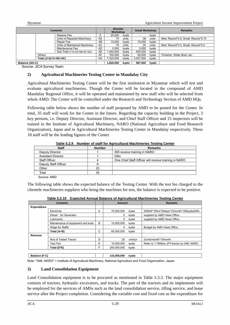
Myanmar Agriculture Income Improvement Project
JICA 5-29 MOALI
Contents Shwebo Workshop Small Workshop Remarks
Restore Fee Z 20,000 kyats - kyats Units of Repaired Machinery AA 70 units 38 units Med: Record*0.5, Small: Record*0.75 Repair Fee AB 10,000 kyats 10,000 kyats Units of Maintained Machinery AC 70 units 25 untis Med: Record*0.5, Small: Record*0.5 Maintenance Fee AD 5,000 kyats 5,000 kyats Sub Total (Y*Z+AA*AB+AC*AD) AE 1,450,000 kyats 500,000 kyats Others AF 100,000 kyats 50,000 kyats Thresher, Roller Boat, etc. Total (J+Q+X+AE+AF) AG 7,325,000 kyats 3,437,500 kyats Balance (AG-C) 1,825,000 kyats 587,500 kyats
Source: JICA Survey Team
2) Agricultural Machineries Testing Center in Mandalay City
Agricultural Machineries Testing Center will be the first institution in Myanmar which will test and evaluate agricultural machineries. Though the Center will be located in the compound of AMD Mandalay Regional Office, it will be operated and maintained by new staff who will be selected from whole AMD. The Center will be controlled under the Research and Technology Section of AMD HQs.
Following table below shows the number of staff proposed by AMD to be posted for the Center. In total, 35 staff will work for the Center in the future. Regarding the capacity building in the Project, 3 key persons, i.e. Deputy Director, Assistant Director, and Chief Staff Officer and 15 inspectors will be trained in the Institute of Agricultural Machinery, NARO (National Agriculture and Food Research Organization), Japan and in Agricultural Machineries Testing Center in Mandalay respectively. These 18 staff will be the leading figures of the Center.
Table 5.2.9 Number of staff for Agricultural Machineries Testing Center Staff Number Remarks
Deputy Director 1 Will receive training in NARO Assistant Director 1 Ditto Staff Officer 4 One Chief Staff Officer will receive training in NARO Deputy Staff Officer 6 Other 23 Total 35
Source: AMD
The following table shows the expected balance of the Testing Center. With the test fee charged to the clientele machineries suppliers who bring the machines for test, the balance is expected to be positive.
Table 5.2.10 Expected Annual Balance of Agricultural Machineries Testing Center Contents Amount Remarks
Expenditure Electricity A 75,000,000 kyats 250kW*10hrs*20days*10month*150kyats/kWh Diesel for Generator 0 kyats supplied by AMD Head Office Lubricants 0 kyats supplied by AMD Head Office Maintenance of equipment and tools B 10,000,000 kyats Wage for Staffs 0 kyats Budget by AMD Head Office Total (A+B) C 85,000,000 kyats Revenue Nos of Tested Tractor D 20 units/yr 2units/month*10month Test Fee E 10,000,000 kyats Refer to 1.7Million JPY/tractor by IAM, NARO Total (D*E) F 200,000,000 kyats Balance (F-C) 115,000,000 kyats
Note: "IAM, NARO" = Institute of Agricultural Machinery, National Agriculture and Food Organization, Japan
3) Land Consolidation Equipment
Land Consolidation equipment is to be procured as mentioned in Table 5.3.3. The major equipment consists of tractors, hydraulic excavators, and trucks. The part of the tractors and its implements will be employed for the services of AMSs such as the land consolidation service, tilling service, and lease service after the Project completion. Considering the variable cost and fixed cost as the expenditure for

Agriculture Income Improvement Project Myanmar
MOALI 5-30 JICA
these services, e.g. fuel, lubricant, part-time operators, annual depreciation cost, and repair cost, the balance between the income from the services and the expenditure for the services will be in deficit. However, if the depreciation cost is not considered, the operation and maintenance will be feasible.
Table 5.2.11 Financial Balance for Operation and Maintenance of Land Consolidation Equipment
1 Income 1,231,240,000Land ConsolidationService
400 ha 950,000,000 The service fees are paid by the contracted applicants of land consolidation workssuch as the project donors, the regional government, farmers' groups, etc.
Tillage Service 7300 ha 201,240,000 The residual units of tractors after completion of the JICA AIIP project shall be usedexcept the period of land consolidation works.
Lease Service 20 sets 80,000,000 The set of 90 hp tractor and the attachments of disc plough, harrow and front dozershall be leased to the large-scale farmers.
2 Expenditure 1,796,716,7552-1. Variable Costs 1,089,379,356
Fuel & Lubricants 796,283 lit 748,506,032 The costs are borne by the contracted applicants of land consolidation works.
Wages 780 man・day 330,300,000 The wages of AMD staff are paid by each AMS budget, and the wages of casuallabours are paid by the contracted applicants.
Other Expenses 10,573,3252-2. Fixed Costs 707,337,398
Annual Depreciation 8 years 662,470,964 The legal durable years for agricultural machineries in Japan are set on 8 years, butthe actual durable years can extend longer periods.
Repair Costs 44,866,434 The repair works of machineries can be taken by AMS Workshops, the extra costsare limited in spare parts and some lubricants.
Tax 03 Financial Balance
with Annual Depreciation Costs -565,476,755 It is in deficit condition.without Annual Depreciation Costs 96,994,209 It is feasible in cash flow.
Source: AMD and JICA Project Team
Items of Financial Balance RemarksQ'ty Breakdown,MMK
Amount,MMK
5.2.5 Impact and Output Expected
Agricultural mechanization in Myanmar especially in Shwebo area is rapidly developing. However, maintenance and repair technics have not been well available at rural areas. With this current condition, it may cause losing the investment opportunities in agricultural sector. Therefore, the empowerment of AMD technical staff with procurement of maintenance facilities is the key emergent element for promoting agricultural mechanization in order to improve farmers’ income and local employment. The impact on agricultural mechanization will be evaluated by the following indicators:
Table 5.2.12 Impact and Output on Agricultural Mechanization Sub-Components Objective of the
Sub-Components Impact on Farmers’ Income
Improvement Expected Output Indicators
Establishment of Maintenance Workshop
Provision of technical facilities for maintenance and repair of agricultural machineries
Enlargement of life cycles of machines will reduce production costs.
- No. of repaired machines - No. of visitors to repair - Working time of mechanics
in man-day Establishment of Agricultural Machineries Testing Center
Testing imported machineries mainly for public projects
The consumers can select cost-effective and safety machineries.
- No. of tested models - Coordination results with
two step loan project of MADB
Capacity Building in Agricultural Mechanization
Training to mechanics, operators and instructors to farmers
Efficient operation, appropriate use and prompt repair of machineries will reduce production costs.
- No. of trained staff - No. of trained farmers and
local mechanics (employment improvement in rural areas, especially in the villages where Frontline Station will be installed)
Agricultural Mechanization Support Strengthening (Procurement of machineries and works for Land Consolidation)
Implementation of LC at 2,000ha (5,000ac) and training on planning and implementation of LC 1st Year : 500ac 2nd Year: 500ac 3rd Year: 1,500ac 4th Year: 2,500ac 5th Year: Maintenance 6th Year: Maintenance
As the results of LC, efficient mechanical usages will be realized to reduce production costs and harvest losses.
- Areas of LC accepted by farmers = Upgrading of quality of works
- Speed of LC works
Source: JICA Survey Team

Myanmar Agriculture Income Improvement Project
JICA 5-31 MOALI
5.3 Land Consolidation
This sub-chapter discusses land consolidation as one of the priority components under the Project. Land consolidation aims at ensuring high productivity for agriculture supported by effective mechanized farming and rationalized water management to meet future agricultural requirements. The works accompany rearrangement and consolidation of farmland plots, improvement/upgrading of irrigation and drainage canals, and farm road construction. Following discuss the land consolidation works to be implemented in the Project area.
5.3.1 Land Consolidation Target Setting
Land consolidation works will realize improving and consolidating overall farm conditions including related farmland-use rights. In fact, nowadays almost everyone knows the impact and effective use of the consolidated farmland, especially with the accelerated farm mechanization, and therefore there is not much hesitation amongst famers on the introduction of land consolidation. However, still there are some and in the previous days there were many farmers who hesitate to bring about the land consolidation works into their areas. There may be 2 major points, based on which some farmers are, and many farmers were, not very much for the consolidation works to accept as:
1) One is the voluntarily surrendering of a part of their farmland in order to avail of necessary land for the construction of new farm roads and also tertiary canals, both for irrigation and drainage. This land to be surrendered usually requires 6 – 10 % of the original land, that shall be converted into the farm roads and tertiary canals to be newly constructed with the consolidation works. There is no compensation for this land surrendering according to a government policy, and therefore the concerned farmers shall submit a part of their farmland without any compensation.
2) In the consolidated farmland, there will be a series of rectangular plots to be arranged side by side, usually 1 acre plot (120 ft x 360 ft) as standard. Consolidation means that before the consolidation works there were a lot of fragmented plots owned, for example, by just one farmer. One farmer may have 2 – 3, or even more than 5 pieces of farm plots, making his effective farming very much difficult. To cope with this situation, all the farm plots owned by a farmer shall be collected at one place, and thus in essence there will be plot reallocation a lot among the concerned farmers. Almost all the concerned farmers should reallocate their farmland, by exchanging their plot with other colleague farmers nearby.
Further in addition to above issues, there will not be consultancy services for the implementation of land consolidation. With a government intention of minimizing consultancy cost, there was a consensus between the JICA Fact Finding mission and concerned departments for land consolidation works. The consensus is that no consultancy services is arranged for the land consolidation works, and accordingly the concerned departments such as AMD, IWUMD and DALMS shall proceed on their own initiative by coordinating each other. This condition will lead to a setting of land consolidation target area to be conservative side by referring to what has been actually done in the past.
Table 5.3.1 summarizes the land consolidation area implemented within Sagaing region since 2011/12.
Table 5.3.1 Implemented Land Consolidation Fiscal Year Area (acre)
2011/12 80 2012/13 380 2013/14 48 2014/15 348 2015/16 600
Source: AMD Shwebo District Office, October 2016, for Sagaing region.
Example of land consolidation implemented in Nay Pyi Taw area (farm road and tertiary canals constructed)
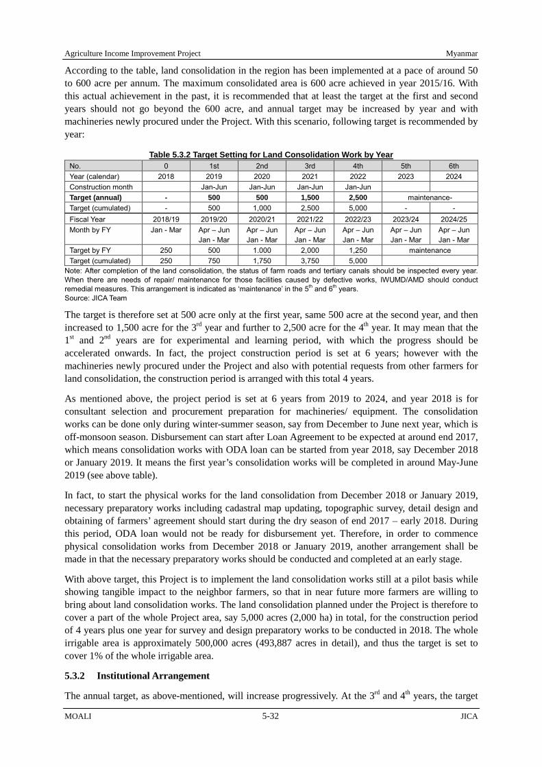
Agriculture Income Improvement Project Myanmar
MOALI 5-32 JICA
According to the table, land consolidation in the region has been implemented at a pace of around 50 to 600 acre per annum. The maximum consolidated area is 600 acre achieved in year 2015/16. With this actual achievement in the past, it is recommended that at least the target at the first and second years should not go beyond the 600 acre, and annual target may be increased by year and with machineries newly procured under the Project. With this scenario, following target is recommended by year:
Table 5.3.2 Target Setting for Land Consolidation Work by Year No. 0 1st 2nd 3rd 4th 5th 6th Year (calendar) 2018 2019 2020 2021 2022 2023 2024 Construction month Jan-Jun Jan-Jun Jan-Jun Jan-Jun Target (annual) - 500 500 1,500 2,500 maintenance- Target (cumulated) - 500 1,000 2,500 5,000 - - Fiscal Year 2018/19 2019/20 2020/21 2021/22 2022/23 2023/24 2024/25 Month by FY Jan - Mar Apr – Jun
Jan - Mar Apr – Jun Jan - Mar
Apr – Jun Jan - Mar
Apr – Jun Jan - Mar
Apr – Jun Jan - Mar
Apr – Jun Jan - Mar
Target by FY 250 500 1.000 2,000 1,250 maintenance Target (cumulated) 250 750 1,750 3,750 5,000
Note: After completion of the land consolidation, the status of farm roads and tertiary canals should be inspected every year. When there are needs of repair/ maintenance for those facilities caused by defective works, IWUMD/AMD should conduct remedial measures. This arrangement is indicated as ‘maintenance’ in the 5th and 6th years. Source: JICA Team
The target is therefore set at 500 acre only at the first year, same 500 acre at the second year, and then increased to 1,500 acre for the 3rd year and further to 2,500 acre for the 4th year. It may mean that the 1st and 2nd years are for experimental and learning period, with which the progress should be accelerated onwards. In fact, the project construction period is set at 6 years; however with the machineries newly procured under the Project and also with potential requests from other farmers for land consolidation, the construction period is arranged with this total 4 years.
As mentioned above, the project period is set at 6 years from 2019 to 2024, and year 2018 is for consultant selection and procurement preparation for machineries/ equipment. The consolidation works can be done only during winter-summer season, say from December to June next year, which is off-monsoon season. Disbursement can start after Loan Agreement to be expected at around end 2017, which means consolidation works with ODA loan can be started from year 2018, say December 2018 or January 2019. It means the first year’s consolidation works will be completed in around May-June 2019 (see above table).
In fact, to start the physical works for the land consolidation from December 2018 or January 2019, necessary preparatory works including cadastral map updating, topographic survey, detail design and obtaining of farmers’ agreement should start during the dry season of end 2017 – early 2018. During this period, ODA loan would not be ready for disbursement yet. Therefore, in order to commence physical consolidation works from December 2018 or January 2019, another arrangement shall be made in that the necessary preparatory works should be conducted and completed at an early stage.
With above target, this Project is to implement the land consolidation works still at a pilot basis while showing tangible impact to the neighbor farmers, so that in near future more farmers are willing to bring about land consolidation works. The land consolidation planned under the Project is therefore to cover a part of the whole Project area, say 5,000 acres (2,000 ha) in total, for the construction period of 4 years plus one year for survey and design preparatory works to be conducted in 2018. The whole irrigable area is approximately 500,000 acres (493,887 acres in detail), and thus the target is set to cover 1% of the whole irrigable area.
5.3.2 Institutional Arrangement
The annual target, as above-mentioned, will increase progressively. At the 3rd and 4th years, the target

Myanmar Agriculture Income Improvement Project
JICA 5-33 MOALI
area therefore becomes much bigger than what has been actually implemented (refer to Table 5.3.1). In this regard, not only enough budgetary arrangement but also institutional arrangement and procurement of tractors should be well undertaken. Especially without good institutional arrangement with which farmers are willing to accept the land consolidation works, the target will not be achieved.
There is an example experienced by an IFAD project implemented in Nay Pyi Taw area, Fostering Agricultural Revitalization in Myanmar (FARM). The project targeted land consolidation of total 10,000 acres1, and its annual target was from 2,000 to 4,000 acres, comparable to the maximum annual target of the Project in Thapanzeik dam irrigable area. The first year of implementation for FARM was 2015/16, and the achievement was only 351 acres (2% only against target 2,000 acres).
Such low achievement was caused by a practice of many farmers who had already sown the seeds of black grams during the winter season during which the land consolidation works was to be implemented according to the original plan. In fact, consensus making amongst the targeted beneficiary farmers not to cultivate winter crops may have not been clearly enough to allow the construction to proceed. According to the PMU of the IFAD funded project, they obtained consensus not to cultivate the winter crop on about 500 acres only. With this agreed areas, the project was able to implement the consolidation works on the 351 acre of farm land.
With above experience, this Project proposes 3 measures such as: 1) establishment of working group, 2) request basis implementation (first come, first served basis), and 3) deployment of facilitators;
1) As land consolidation involves many stakeholders, there should be a working group to be in charge of announcement of land consolidation project, facilitation of farmers to submit their intension of bringing the land consolidation project, selection of the land consolidation areas, facilitation of farmers to reach consensus on the land surrendering for the construction of farm roads and tertiary canals and re-allocation of consolidated farm plots, and acceptance of grievances on the course of the implementation. The members of the working group should be:
IWUMD (the leader): take the leading role in announcing the land consolidation project, deploying facilitators, accepting farmers request, obtaining farmers’ agreement, carrying out detail design for the land consolidation including necessary topographic survey, etc., and constructing farm roads and tertiary canals,
AMD: take the co-leader role, and support the IWUMD in the above-mentioned activities, and carry out land leveling and ridge making for the consolidation works,
DALMS: carry out cadastral map and farmers list updating, and also conduct registration of newly allocated farmland upon the consolidation works completed,
DOA: explain the benefit of land consolidation especially from the view point of water distribution, production increase, and transportation of agriculture produces, and
FAB (farmland administration body, composed of village tract leader & concerned local GAD officers): inform the land consolidation project to the relevant farmers, and take the frontline role of facilitating farmers to accept the land consolidation, soliciting the request for the consolidation project, facilitating the farmers on the agreement of surrender of a part of their farmlands and also acceptance of plots newly allocated, and mediating grievances when arisen, etc.
2) There should be a mechanism under which the farmers should make a request to bring about land consolidation works to their areas, and upon confirmation of the farmers willingness to proceed
1 There are 3 areas in Nay Pyi Taw for the land consolidation area; Paung Loung (6,000 acres), Chaung Mange (2,000 acres), and Madan (2,000 acres), totaling 10,000 acres.

Agriculture Income Improvement Project Myanmar
MOALI 5-34 JICA
with the agreement of surrendering their part of the land for the construction of farm road/ tertiary canals, the necessary project activities should be commenced. Under the mechanism, following should be prepared and undertaken:
Farmers should be well informed that the selection of the land consolidation areas is not by the Government but by the famer themselves upon request, and also the total area will be up to 5,000 acre, meaning the first comes, the first served basis in principle.
For the promotion of land consolidation, brochures and videos will be prepared to inform the potential farmer beneficiaries of the impacts on the land consolidation works together with actual examples especially carried out within the Project area (see box right).
The government members of the working group, i.e., IWUMD, AMD, DOA and DALMS, should be well aware of such topics as benefits from the land consolidation, process of the land consolidation works, facilitation methods for the beneficiary farmers, necessary works including update of cadastral map with land tillage right and new registration upon land consolidation completed. They should be answerable whenever they are given inquiries from the potential beneficiary farmers.
Dispatch relevant IWUMD, AMD, DOA and DALMS officers to the farmers’ meetings as needed, and also install claim acceptance venue at relevant township General Administration offices (GAD) including IWUMD, AMD and DALMS relevant officers.
The working group is to explain the conditions, advantage, disadvantage and procedures of land consolidation together with brochures and videos, and ask the farmers to consolidate their willingness towards the implementation of land consolidation with the unanimous agreement on the voluntary surrendering of about 6-10 % of their farmlands to be converted to farm road and tertiary canals. In addition, the working group should notify that the area which requests the land consolidation should be so demarcated into a hydraulically delineated area, e.g. an irrigable area served by a minor canal or distributary canal. The responsibility of farmers about maintenance of farm road and water courses of land consolidation site should be explicitly explained to the farmers before accepting request by farmers. Also, it shall be noted that the implementation of land consolidation works will be based on first-comes first served.
There may be a case that a few members of the agreed farmer group are to change their mind not to proceed the implementation due probably to unacceptance of the plot to be newly allocated upon completion of the works. In this case, the role of obtaining the unanimous agreement is the farmer themselves although the working group should be in charge of facilitation and/or mediation. In case that it takes time for the farmers to again reach the unanimous consensus, the physical works in the area should be postponed to, e.g., next season, and instead next priority area should be given the implementation. Thus, if an area once selected does not reach unanimous consensus on the physical implementation till the time total 5,000 acre is to be consolidated, the
An example of land consolidation in Shwebo TS: In a village, called Min Kon located in Shwebo township, about 100 acre of farmlands were consolidated. The results are as follows: There were many farm plots with as small as 01
acre to 0.7 acre per plot before the consolidation project.
These small plots were consolidated into each 1.0 acre plot, and therefore they can now use combine-harvester, resulting in the reduction of harvest cost by as much as 40%.
With the leveled farmland, in addition, they are also benefitted from less amount of weeds as water distribution became very smooth and the land is very ideally inundated subsiding the weed.
Of course, the yield has increased by more than 10% to as much as 20%. (interview to U Chit Thein, October 2016).

Myanmar Agriculture Income Improvement Project
JICA 5-35 MOALI
farmer group will lose the chance of land consolidation2, that is the first comes with unanimously agreement, the first served principle.
3) There should be facilitators or community mobilizers to be employed by the Project and deployed to the farmers’ villages concerned. They are supposed to continuously communicate and facilitate the prospective beneficiary famers in such activities of; 1) organizing the farmers to collectively accept the land consolidation works including the surrendering of parts of their farmlands, 2) coordinating the concerned famers to smoothly proceed to and settle the plot reallocation, and 3) supporting the farmers to register the newly allocated plots, etc. Note that the cost will be covered by loan and placed in IWUMD budget, which is the key government office in the working group.
5.3.3 Construction Arrangement (Direct Force Account)
1) Direct Force Account by IWUMD and AMD
In Myanmar, land consolidation works have been implemented by 3 departments under MOALI; namely, IWUMD, AMD and DALMS. IWUMD undertakes construction of farm roads and tertiary canals both for irrigation and drainage while AMD is in charge of land leveling and ridge making bisecting newly constructed rectangular plots. These 2 departments undertake the construction works, while DALMS is in charge of farmland registration, very often including updating of the existing parcel maps (cadastral map) with the farmer-tillers name.
There is a new movement in the land consolidation implementation, that is the engagement of a private construction company to the works. In Sagaing region, a tender for land consolidation works was conducted in 2015/16, in which a private company was awarded with a unit construction cost of 500,000 Kyats per acre farmland. Though utilization of private sector has just started in the land consolidation sector, this Project recommends the implementation by conventional arrangement, namely, construction by the 2 departments of IWUMD and AMD because;
1) In Myanmar land consolidation works, land leveling and ridge making are carried out by tractor equipped with blade, not by bulldozer. There is almost no private company which has many number of tractors to be utilized in the land consolidation works. In fact, the private company awarded in Sagaing region borrowed necessary tractors including the operators from AMD. Further, there is not other private companies at present, who have similar experiences in the consolidation works.
2) Implementation of land consolidation works can easily be affected by farmers cultivation. Pre-condition for the implementation should, of course, be not to cultivate subsidiary crops, e.g. winter crop and if further agreed with the farmers plus summer crop3. This condition could rather negatively affect private companies since there may be cases that the farmers have started the cultivation of the subsidiary crops despite the prior agreement not to cultivate them. In this case, the private company will claim the project owner for the loss of the construction opportunity.
2 If this case in that the farmers have lost the opportunity of land consolidation implementation, the farmers may request the regional government to implement the consolidation work next year. Since the organizing of the farmers, surveys, and design have been finished under the Project, the regional government should give priority of implementing land consolidation work to the farmer group. 3 Note that monsoon paddy is the principal crop, so that the construction should be commenced right after the harvest of monsoon paddy while be completed before the summer crop, or if agreed with the farmers till the onset of the following season’s monsoon paddy. Thus, construction can be done only during winter season, and if agreed with the farmers it can be done from winter to summer season. Since Shwebo Pawsan, major monsoon paddy in monsoon season requires 150 days cultivation period, this Project strongly recommends that the construction for land consolidation should be done from winter to summer, not during only winter season. Winter season after the Shwebo Pawsan having been harvested, just from late December to February, is not enough to implement land consolidation works.

Agriculture Income Improvement Project Myanmar
MOALI 5-36 JICA
With the above 2 conditions, this JICA team recommends that the land consolidation works should be implemented according to the conventional arrangement, namely, by IWUMD for the farm road and tertiary canal construction and AMD for the land leveling in addition to the DALMS in charge of farmland registration and issuing new certificate.
2) Necessary Machineries Procurement
The land consolidation works will be implemented by IWUMD and AMD as aforementioned. The IWUMD undertakes construction of farm road and tertiary canals, which are not much work volume and therefore can be managed by the machineries that the IWUMD owns at present. However, covering vast areas for land leveling needs more number of 90 HP tractors. In fact, AMD has carried out the land leveling by using both 70-75 HP and 90 HP tractors with the former being the majority due to the tractor’s availability.
AMD Land Consolidation Section now recommends introducing more number of 90 HP tractors in order to accelerate the construction speed, resulting in the shortening of working periods, as compared to the current land consolidation works implemented in Sagaing region. Note that 90 HP tractor is not much employed in tillage services provided by private companies, and thus the provision of 90 HP tractors to the government will little affect the private companies business opportunities.
Operators are to be availed within AMSs concerned. For example, Shwebo AMS has 36 operators including casuals, and likewise 26 operators in Wetlet AMS, 35 operators in Ye-U AMS, 26 operators in Kanbalu AMS, and 17 operators in Budalin AMS (see Table 5.2.7). Note that these operators include casual operators which are those ones once trained by AMD but not permanently employed. Those operators are once again employed, trained and then deployed for the land consolidation works.
With 90 HP tractors and other machineries and equipment to be procured, a working unit will be organize at 20 ha (50 acre) scale and therefore necessary machineries arrangement is shown below in order to cover a total area of 2,500 acres of land consolidation at maximum. In addition, necessary manpower per 20 ha is to be 28 mechanical operators and 3 surveyors.
Table 5.3.3 Equipment List of AMD Land Consolidation Works
Sr Agricultural Machineries for Land Consolidation Works Specification Unit
Q'ty per Working Unit
(500acre)
Required Q'ty
(2500ac/yr) 1 90 HP Tractor 4WD, diesel engine unit 15 75 2 50 HP Tractor 4WD, diesel engine unit 5 25 3 Rotavator Attachment, for 50 HP, side gear system unit 5 25 4 Plough type Disc Harrow Attachment, 6 disc for 50 HP unit 3 15 5 Plough type Disc Harrow Attachment, 7 disc for 90 HP unit 8 40 6 Disc Plough Attachment, 4 disc for 90 HP unit 5 25 7 Rear Blade Leveler Attachment, for 90 HP unit 10 50 8 Front Blade Leveler (Front Dozer) Attachment, for 90 HP unit 15 75 9 Front Blade Leveler (Front Dozer) Attachment, for 50 HP unit 5 25 10 Ridge Plastering Machine Attachment, for 90 HP unit 3 15 11 Total Station For survey (contour and ridge) set 1 5 12 Auto Level Instrument Fro survey set 2 10 13 Hydraulic Excavator 5 Ton unit 2 10 14 Tipper Truck 4-5 Ton unit 2 10 15 Self-loading track 40-50 ton unit 1 5
Source: JICA Survey team with AMD of Sagaing Region
5.3.4 Implementation Procedure for Land Consolidation
A typical work procedure for farmland consolidation needs 3 years, or 3 dry seasons in fact. This is because there should be 3 off-crop seasons required for 1) survey of existing farmlands, 2)

Myanmar Agriculture Income Improvement Project
JICA 5-37 MOALI
implementation of land consolidation, and 3) re-survey for registration of newly consolidated farmlands as follows (refer to the Table 5.3.4):
1) As a matter of fact, survey both for plain survey and contour survey can only be done during off-season, namely, from December to the following year’s February which is winter season, and plus from March to June which is summer season if the concerned farmers do not cultivate summer crop. During this first off-crop season, the surveys should be carried out, and based on the results cadastral map will be updated together with farmers list. In addition, topographic contour map should also be availed which is to be forwarded to detail design. (refer to No.1 to No.3 in Table 5.3.4)
2) During the second off-crop season, physical construction of land consolidation will be carried out (refer to No.15). During the time in between the surveys and this implementation, detail design will be prepared and delivered to the concerned farmer beneficiaries (No.13). The farmers are supposed to establish a group, by which succeeding activities such as consensus making on the land consolidation, surrendering a part of farmlands, reallocation of newly consolidated farm plots, etc. shall be conducted (No.6 to No.12).
3) The third year’s activities are cadastral survey for the newly consolidated farmlands (No.16), and based on the results land certificate will be issued (No.17). In fact, if the physical construction intended in the 2nd year can be finished in shorter period time, leaving at least 1.5 to 2 months off-crop season before the coming monsoon season, this cadastral survey could be completed within the second year. In this case, the land consolidation for the target area could be finished within 2 off-crop seasons.
Referring to an example of pilot farmland consolidation project carried out under a JICA assisted pilot program in 2013-20144, at least 9 months should be allocated for settling all the preparatory works required before the commencement of the construction works including engineering design of the project, estimation of and agreement on the loss of farmland for the construction of farm road and canals, establishment of plot re-allocation plan, and agreement thereon, and the establishment of the farmer organization.
4 A pilot land consolidation project was implemented under The Preparatory Survey fro the Project for Rehabilitation of Irrigation System, May 2014
Note: Working committee (WC) will be composed of IWUMD, AMD, DALMS, GAD, DOA, and FAB (Farmland Administration Body) Source: JICA Survey Team
Table 5.3.4 Typical Implementation Procedure of Land Consolidation
In charge A M J J A S O N D J F M A M J J A S O N D J F M A M J J A S O N D J F M A M J J A0 Selection of land consolidation areas
Establishment of working committee (WC) WC Review and finalization of the eligible land consolidation sites Announcement of land consolidation project WC Acceptance of request by farmers WC Selection of land consolidation sites WC
1 Cadastral map updating (plain survey) DALMS2 Topographic survey (contour survey) IWUMD3 Mapping of the survey results DALMS4 Draft design of land consolidation IWUMD5 Identification of farmers with farmland use right DALMS6 Establishment of temporal general assembly Farmers, WC7 Selection of members of Management Committee Farmers, WC8 Preparation and agreement on land loss, X% of their land Farmers, WC9 Preparation of farm plot re-allocation plan WC10 Agreement on the plot re-allocation by all the members Farmers, WC11 Drafting of constitutional and operational rules and regulations Farmers, WC12 Announcement of rules & regulations and acceptance by farmers Farmers, WC13 Finalization of the farmland consolidation plan WC14 Application of registration of the organization Farmers15 Construction of farmland consolidation IWUMD, AMD16 Farmland measurement for cadastral update DALMS17 Re-issuing of land certificate DALMS
FY 2019/20 FY 2020/212017 2018 2019 2020 Calendar Year
Fiscal Year FY 2017/18 FY 2018/19
First Batch(500 acre)
Second Batch(500 acre)
Preparation of the firstbatch implementation
as pilot basis
Month

Agriculture Income Improvement Project Myanmar
MOALI 5-38 JICA
It is noted that updating of the farmland-use-right, i.e. identifying the current rightful cultivator, may need much longer time than primarily estimated since such updating has not been made for decades in many places5. In addition, if there are long-lost farmland-use-right owners, it may need involvement of a court in order to transfer the right to relatives6. Likewise, agreement on accepting the newly re-plotted farmland would also need longer time as farmers try to obtain farm plots near farm roads. Thus, approximately one-year preparation period before the physical implementation planned in the Project is reasonably needed from the view point of smooth project implementation. With this in mind, the update of the cadastral map should be well completed one-year before the physical implementation of the land consolidation woks.
It is therefore stressed that till the time all the concerned farmers have agreed upon the plot re-allocation plan, no construction work shall be commenced. However, such arrangement, obtaining prior agreement, has not been made in the past land consolidation projects in this Country, and the backward measure gave a lot of burden to the DALMS for the land registration newly required with the consolidation works completed. For upcoming consolidation works, therefore, the agreement should be reached unanimously prior to the commencement of the physical construction works.
5 Since 2011/12, the Government has been updating the cadastral map, and in Shwebo district only about 6% of the whole area had been completed till 2015/16, say for last the 5 years. With this pace, the updating of cadastral map and farmers list by DALMS has been done only at a ratio of about 1% per annum against whole farmland in Shwebo district. 6 This case in fact took place in the said JICA assisted pilot program. There was on long-lost land owner, and it took 6 months to transfer the right to the closest relative through a court.
Figure 5.3.1 Implementation Flow of Land Consolidation Project Source: JICA Survey Team (modified from PRIS Preparatory Survey, 2014)

Myanmar Agriculture Income Improvement Project
JICA 5-39 MOALI
Figure 5.3.1 shows the flow of the major activities applied under the Project in corresponding to the implementation schedule indicated in above-mentioned table. As aforementioned, major activities for the beneficiary farmers should be conducted and tackled by the farmer themselves, meaning by the farmer organization to be established before the commencement of physical construction.
5.3.5 Establishing Farmer Organization
There should be a farmer organization in implementing land consolidation covering the concerned area consolidated. This organization is meant to not only undertake the O&M of facilities such as farm road and canals but also play a central role of obtaining consensus from all the farmers for the consolidation project. Difficult part pertaining to the land consolidation is concerned mainly with 2 issues; namely, 1) consensus building on surrendering a part of their farmland, and 2) agreement on farmland re-plotting. Of the two issues, in fact, the latter would take longer time to settle since most of the farmers try to obtain farm plots located near the farm road.
With the consolidation work implemented, farmers are to lose a part of their farmland for the sake of construction of farm road and irrigation/ drainage canals, share of which ranges from 5 – 10 % in most cases (see Figure 5.3.2 as an example). The farmers are also meant to move their original farm plots to a newly arranged area in many cases (also refer to Figure 5.3.2). If a farmer has 2 – 3 plots apart each other within the consolidation area, it is better to collect all the pieces of plot into one merged area. In fact, it takes time to obtain such agreement on this loss of a part of farmland and also on the arrangement of plot re-allocation from all the concerned famers.
Above-mentioned agreements should be reached unanimously prior to the commencement of the consolidation works. Then, the farmer organization, or precisely the management committee, shall be in charge of obtaining the agreements from all the farmers supported by IWUMD/AMD/DALMS. This is because the farmer themselves know the best of their colleague farmers. Government officers should play a role of facilitating them to form the organization as well as supporting the process of obtaining the agreements by farmer themselves.
The basic structure of the organization is given of the following chart: In fact, this organizational
Before-project After-project
Total Farmland Area: ZZZ acre - Common Area: **** acre - Farm Plot: **** acre - Total Farmland: ZZZ acre
To avail of the land occupied by farm road, irrigation and drainage canals, some share of the farmland shall be offered by all the farmers concerned. Also, small pieces of farm plots will be merged in a bigger
rectangular plot, usually 1 acre plot. Thus, farmers should move their original farm plots to other places.
Farm Road
Irrigation Canal
Drainage Canal
Figure 5.3.2 Reduction of Farmland by Construction of Agricultural Infrastructure Source JICA Survey Team

Agriculture Income Improvement Project Myanmar
MOALI 5-40 JICA
structure, roles and responsibility are basically same as those of WUG/WUA to be established in a hydraulically demarcated canal command area. The WUG is to be established at a level of water course, and aggregated WUGs are to form a WUA along the upper canal command area, e.g. along a distributary canal, Therefore, if the land consolidation is implemented covering a water course, the organization discussed below is the same as WUG while the land consolidation is carried out over command area of a distributary canal, the organization discussed below will be same as the WUA.
The highest organ in the organization is the general assembly, which shall be composed of all the member farmers concerned. This is the supreme organ in the organization especially vested in the decision making power. All the plans shall be forwarded to the general assembly and the decision shall be made in this assembly, meaning all the important decision, like agreement on the plot re-allocation, shall be made by all the members themselves.
Under the general assembly, there should be the management committee. The members of the management committee shall, of course, be selected by the general assembly as aforementioned by all the participants to the first general assembly meeting. The members of the committee can be composed of; 1) chairperson, 2) vice-chairperson, 3) secretary, 4) treasure, 5) auditor, and 6) members coming from all the concerned villages for the land consolidation project. It should be noted that all the concerned villages should send at least one – two members to the management committee, meaning that all the villages can be represented at the level of management committee.
In above regard, the management committee is therefore in charge of execution or day-to-day management of the issues decided by the general assembly. Further, under land consolidation project, there should be 3 special roles vested in the committee; namely, 1) obtaining consensus from all the famers on the loss of a part of their farmland, 2) planning of the plot re-allocation and obtaining agreement on the plan from all the farmers, and 3) acceptance and mediation of grievances arising through the process from the member farmers. IWUMD/AMD should assist the management committee to obtain the consensus/ agreement while the General Administration Office should assist the committee when they are struggling on a problem or grievance.
The management committee should, thus, be the one discharging the central role in obtaining the
General Assembly
Management Committee In charge of land re-plotting &
grievances acceptance
Decision Making
Planning
Any plan should be forwarded to the General Assembly for its Approval.
Figure 5.3.3 Internal Organizational Set-up for the Farmer Organization Source JICA Survey Team
Any decision made by the General Assembly shall be executed by all the members under the supervision of the Management Committee.
Member, Member, Member, Member,
Member, Member,
Member, Member, Member, Member,
Member, Member,
Member, Member, Member, Member,
Member, Member,
Member, Member, Member, Member,
Member, Member,
Member, Member, Member, Member,
Member, Member,
Member, Member, Member, Member,
Member, Member,
Member, Member, Member, Member,
Member, Member,
Member, Member, Member, Member,
Member, Member,
Member, Member, Member, Member,
Member, Member,
Member, Member, Member, Member,
Member, Member,
Member, Member, Member, Member,
Member, Member,
Member, Member, Member, Member,
Member, Member,
Implementation
Canal O&M Sub-Committee
Agriculture Dev. Sub-Committee
Farm Road O&M Sub-Committee
Financial Mgt Sub-Committee

Myanmar Agriculture Income Improvement Project
JICA 5-41 MOALI
agreements from all the famers on the issues of losing a part of their farmland and the plan of plot reallocation. The committee should also be in charge of mediating relevant farmers who insist specific location for their plots over the same area each other. In addition, the committee should fix the price per acre to be prepared for the cases in that farmers owning small pieces of land hope to sell them to other farmers in the process of finalizing the plot reallocation. This fixing price can be applied only during the consensus making on the plot reallocation, but not at a later stage after the consolidation works have been completed.
The farmer organization, upon consensus by the general assembly, can form sub-committees in charge of planning composed of volunteer farmers or elected persons within the organization, usually placed under the management committee. These sub-committees can be led by the members of the management committee. The basic role of the sub-committees is to prepare for a plan e.g. maintenance schedule of farm road and canals, bulk purchase of farm input, collection of some fund required for maintenance, etc., and forward such plans to the general assembly for the decision making.
5.3.6 Technical Aspect for Land Consolidation
The land consolidation provides a basis for the water management and farming benefit after the completion of the project. The plan should generate a visible design in shape and size of farm lots equipped with well aligned irrigation/drainage canals and farm road. In this process, the farmland can be roughly divided into field lots, field blocks and farm blocks with their shapes and sizes having a functional relationship with each other as follows:
1) Field lots: Field lots are the smallest units of farmland divided by boundary levees. The shape and size of the field lots shall be arranged in such a manner as to allow an efficient farm management with a use of farm machinery along with adequate irrigation/drainage; namely, 1 acre (360 ft x 120 ft) field lot is applied in most cases in Myanmar, and in the Project as well.
2) Field block: Field blocks are larger units of farmland which enables the adequate water management for enhanced paddy cropping. They are usually divided by permanent structures like small irrigation canals or road where irrigation canals are commonly laid along the roads. In general, one field block will basically consist of 10 to 15 lots.
3) Farm blocks: Farm blocks are rectangular in shape surrounded by farm road on all four sides, and are adopted as the unit for farm management, cultivation and land use to ensure uniform water management within the blocks. In general, one farm block consists of two field blocks extending along both sides of the small drainage canals.
Figure 5.3.4 Relations among Field Lots, Field Blocks, and Farm Blocks
(Source: Japanese Institute of Irrigation and Drainage)

Agriculture Income Improvement Project Myanmar
MOALI 5-42 JICA
Figure 5.3.5 Example of Surface Soil Handling; Stockpile (left), Rotational Moving (right) Source: Japan Irrigation and Drainage Institute
Layout of irrigation/drainage canals, farm roads and farmland blocks is the basic frame of the land consolidation. Layout of irrigation/drainage canals and farm roads in the Project area should be made taking into consideration topography, ground slope, and existing irrigation networks in and around the project areas. Studies shall also be made for determining field blocks and field lots in a detailed step by step approach paying close attention to the following points:
1) Layout of irrigation/drainage canals, farm roads and farmland blocks shall be made so as to enable easy access to field lots from relevant farmers’ villages, and to enhance the capability of independent irrigation/drainage operation for each field lot or field block;
2) In principle, irrigation and drainage should be separated; to this end, the layout of the main and lateral irrigation canals and the main and lateral drainage canals shall be organized as to make the separation possible;
3) Farm roads should be planned along the main/lateral irrigation/drainage canals and farm ditches where possible; and
4) When a farmland block formation is to be undertaken, the shapes and layout of field blocks should determined in relation with the irrigation/drainage canals and farm roads.
Recommended shapes and areas of field blocks are as follows: the longer side of field block shall be within the range of 1,200 ft to 1,800 ft as an allowable length for farm ditches while the shorter side shall be within the range of 120 ft to 360 ft in consideration of distance from farm drains for smooth surface drainage. As a result, the recommendable field blocks shall be within the range of 120 ft x 1,200 ft (3 acre) as the smallest unit to 360 ft x 1,800 ft (15 acre) as the largest unit.
Recommended shape of field lots shall be rectangular, while angled or curved border lines may be applied in sloping land areas. In determining shapes and areas of field lots, such factors shall be examined; 1) working efficiency of farm machinery and 2) convenience of irrigation/drainage water control at on-farm level, 3) convenience of irrigation/drainage management at block level. The general shapes and areas of the standard field lots are given in the following table as a reference:
Table 5.3.5 Shapes and Areas of Standard Farm Land Lots Category Field Condition Width (ft) Length (ft) Acreage
Field lot Paddy Field 360 120 1.0 Field block Paddy Field 360 1,200 – 1,800 10 - 15 Farm block Paddy Field 360 - 720 1,200 – 1,800 20 - 30
Source: JICA Survey team, and also referred to a technical manual of Japanese Institute of Irrigation and Drainage
In land consolidation works carried out in Myanmar, there is one issue which is the handling of surface soil. For example, land consolidation carried out in Japan undertakes surface soil handling by a means of, depending on the natural topography of the project area, 1) temporary stockpile method, or 2) rotational earth moving method. It means that the surface soil which is the most fertile part of the soil is once set aside and brought back upon leveling completed.
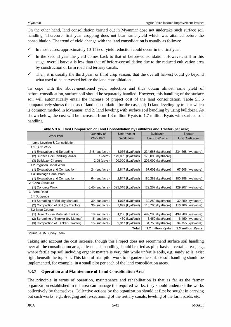
Myanmar Agriculture Income Improvement Project
JICA 5-43 MOALI
On the other hand, land consolidation carried out in Myanmar dose not undertake such surface soil handling. Therefore, first year cropping does not bear same yield which was attained before the consolidation. The trend of yield change with the land consolidation is usually as follows:
In most cases, approximately 10-15% of yield reduction could occur in the first year, In the second year the yield comes back to that of before-consolidation. However, still in this
stage, overall harvest is less than that of before-consolidation due to the reduced cultivation area by construction of farm road and tertiary canals.
Then, it is usually the third year, or third crop season, that the overall harvest could go beyond what used to be harvested before the land consolidation.
To cope with the above-mentioned yield reduction and thus obtain almost same yield of before-consolidation, surface soil should be separately handled. However, this handling of the surface soil will automatically entail the increase of project cost of the land consolidation. Table 5.3.6 comparatively shows the costs of land consolidation for the cases of; 1) land leveling by tractor which is common method in Myanmar, and 2) land leveling with surface soil handling by using bulldozer. As shown below, the cost will be increased from 1.3 million Kyats to 1.7 million Kyats with surface soil handling.
Table 5.3.6 Cost Comparison of Land Consolidation by Bulldozer and Tractor (per acre) Work Item
Quantity of Work Item
Unit Price of Work Item
Bulldozer Tractor Unit Cost/ acre Unit Cost/ acre
1. Land Leveling & Consolidation 1.1 Earth Work (1) Excavation and Spreading 218 (sud/acre) 1,076 (kyat/sud) 234,568 (kyat/acre) 234,568 (kyat/acre) (2) Surface Soil Handling, dozer 1 (acre) 179,099 (kyat/sud) 179,099 (kyat/acre) (3) Bulldozer Charges 2.08 (days) 100,000 (kyat/sud) 208,000 (kyat/acre) 1.2 Irrigation Canal Work (1) Excavation and Compaction 24 (sud/acre) 2,817 (kyat/sud) 67,608 (kyat/acre) 67,608 (kyat/acre) 1.3 Drainage Canal Work (1) Excavation and Compaction 64 (sud/acre) 2,817 (kyat/sud) 180,288 (kyat/acre) 180,288 (kyat/acre) 2. Canal Structure (1) Concrete Work 0.40 (sud/acre) 323,018 (kyat/sud) 129,207 (kyat/acre) 129,207 (kyat/acre) 3. Farm Road 3.1 Subgrade (1) Spreading of Soil (by Manual) 30 (sud/acre) 1,075 (kyat/sud) 32,250 (kyat/acre) 32,250 (kyat/acre) (2) Compaction of Soil (by Tractor) 30 (sud/acre) 3,892 (kyat/sud) 116,760 (kyat/acre) 116,760 (kyat/acre) 3.2 Base Course (1) Base Course Material (Kanker) 16 (sud/acre) 31,200 (kyat/sud) 499,200 (kyat/acre) 499,200 (kyat/acre) (2) Spreading of Kanker (by Manual) 15 (sud/acre) 430 (kyat/sud) 6,450 (kyat/acre) 6,450 (kyat/acre) (3) Compaction of Kanker ( Tractor) 15 (sud/acre) 2,317 (kyat/sud) 34,755 (kyat/acre) 34,755 (kyat/acre)
Total 1.7 million Kyats 1.3 million Kyats Source: JICA Survey Team
Taking into account the cost increase, though this Project does not recommend surface soil handling over all the consolidation area, al least such handling should be tried as pilot basis at certain areas, e.g., where fertile top soil including organic matters is very thin while unfertile soils, e.g. sandy soils, exist right beneath the top soil. This kind of trial pilot work to organize the surface soil handling should be implemented, for example, in a small plot per each of the land consolidation areas.
5.3.7 Operation and Maintenance of Land Consolidation Area
The principle in terms of operation, maintenance and rehabilitation is that as far as the farmer organization established in the area can manage the required works, they should undertake the works collectively by themselves. Collective actions by the organization should at first be sought in carrying out such works, e.g., dredging and re-sectioning of the tertiary canals, leveling of the farm roads, etc.

Agriculture Income Improvement Project Myanmar
MOALI 5-44 JICA
Of course, the organization can anytime request technical assistances from the respective government offices such as IWUMD and/or AMD. If the maintenance and rehabilitation which require heavy machineries, the farmer organization can ask the respective government offices such as IWUMD and/or AMD for the works, and the cost for deploying heavy machineries should be, in principle, born by the farmer organization's reserve fund.
Then, when the required works fall beyond the organization’s capacity, for example in financial terms, the legally established organization can have an opportunity of receiving the government supports. For example, dredging and re-sectioning of the tertiary canals can be mostly managed by the organization while major rehabilitation for the farm road, which may be required once in 5-10 years including surface gravel placement, will go beyond the organization’s financial capacity. In this latter case, the government should assist.
5.3.8 Land Consolidation Pilot Activities (Leik Chin Village)
1) Location of the pilot land consolidation area Figure 5.3.6 presents the location of the pilot farmland consolidation site in Leik Chin Village. The pilot land consolidation covers an area of 235 ha (580 acre) and the number of beneficially households is 272. The pilot farmland is located about 15km north-west from Shwebo Township and the farmland area is divided into two areas by Shwebo-Ye-U road. The reasons why the Leik Chin village was selected as the pilot land consolidation site are; 1) the area can be easily covered by Shwebo district office, which is the core office in the implementation of the Project, and 2) the area can present a good view for the promotion of land consolidation because it is located along one of the main roads in Shwebo district, connecting Shwebo town to Ye-U town.
2) Current status of pilot land consolidation site Figure 5.3.7 presents the current plot shape of pilot farmland consolidation site. Farmer who has farmland-use right beside the irrigation canal can manage irrigation water by their own decision for their farming. However, other farmers can use water only from rainfall or water flows from neighboring farm plot for their farming. Further to mention, the latter farmers cannot use farm machineries (combined harvester, tiller, etc.) due to a lack of farm road connected to their field.
Figure 5.3.6 Location Map of Pilot Land Consolidation Source: JICA survey Team
Shwebo Township
Leik Chin Village
Ye-U Township
Figure 5.3.7 Current Farm Plot Shape Source: JICA survey Team
Leik Chin Village

Myanmar Agriculture Income Improvement Project
JICA 5-45 MOALI
3) Activities under the AIIP preparatory survey Table 5.3.7 summarizes the activities for the pilot land consolidation under the AIIP preparatory survey.
Table 5.3.7 Activities for the Pilot Land Consolidation in Leik Chin Village
i) Selection of potential pilot land consolidation area. Stakeholder meeting was held on 20 and 21 of June 2017 among the relevant government departments (IWUMD, AMD, DALMS, DOA and GAD) and the Leik Chin village farmers to select the potential location as the pilot land consolidation area. Through these discussions, irrigable area of WC-1, CCP-2, CCP-3 and CCP-6 under Dy-4, Minor-2 of Shwebo Main Canal (SMC) was selected. Figure 5.3.8 shows 417 acres of current irrigable area by pink color line and originally planned area for the land consolidation by black dotted line.
ii) Discussion among the concerned departments’ staff To promote land consolidation, close collaboration among concerned departments (namely, IWUMD, AMD, DALMS, DOA and GAD) and consultation/ coordination with the farmers are important. In this regards, the concerned departments’ staff and JICA survey team hold the meeting at 11 Nov and 4 Dec 2017. During the discussion, each department staff confirmed the activities and each role on the pilot land consolidation under the AIIP preparatory survey.
The potential pilot land consolidation location was selected on June 2017. As a next step, the exact pilot land consolidation area should be selected by the farmers.
Consensus from all the beneficiaries should be obtained for the acceptance of implementation of land consolidation.
Temporal farmer organization among all the beneficiaries should be set up for smooth conduct of the selection of land consolidation site and making consensus among the beneficiaries.
Meeting with the farmers to explain the pilot land consolidation should be held. In the meeting, the department staff has a responsibility to explain to the farmers about the pilot land consolidation while JICA survey team will support the department staff.
Topographic survey, cadastral map survey will start after the harvest (from middle January 2018). Draft design of land consolidation will start after the survey work has finished.
iii) Farmer meeting The farmer meeting was held on 8 December 2017 at Leik Chin Village monastery. Attendees for the meeting were the relevant department officers (namely, IWUMD, AMD, DALMS, DOA and GAD), JICA survey team and 71 numbers of the beneficial farmers. Given the former meeting among the relevant department officers, this time, the department officers explained the pilot land consolidation (ex. the reason of land consolidation, the advantage and disadvantage of the land
No Activity i) Selection of the potential pilot land consolidation site. ii) Discussion among the concerned government staff (IWUMD, AMD, DALMS, DOA and GAD) iii) Farmer meeting. iv) Making consensus for the fixing land consolidation area and acceptance of land consolidation. v) Topographic survey, cadastral map survey and draft design for pilot land consolidation
Figure5.3.8 Potential Pilot Land Consolidation Area
Source: JICA survey team
Legend Current Irrigable Area (417 acre) Originally planned area for the Land Consolidation (500 acre)

Agriculture Income Improvement Project Myanmar
MOALI 5-46 JICA
consolidation) to the beneficial farmers.
The reason why farmland consolidation is necessary (Explained by IWUMD officer) The population cohort in Shwebo area was surveyed by the JICA survey team in 2017. According
to the survey result, the number of generation below age-14 is small. This result indicated that farmers will face workforce shortage in the future accrued from the decline of the number of young generations.
The advantage and disadvantage of the land consolidation (Explained by IWUMD officer) Currently, many farmers depend on animal power and manual labor for their farm work and can
hardly manage irrigation water according to the crop requirement. With farmland consolidation with which farm road and irrigation/drainage canals are to be established, farmers can effectively introduce agriculture machinery and control irrigation water, whereby the crop yields will be increased. However, farmers are to lose a part of their farmland for the sake of construction of farm road and irrigation/ drainage canals, share of which ranges from 5 – 10 % in most cases.
Establishment of temporal farmer organization (Explained by DALMS officer) The exact pilot land consolidation site should be selected by the farmer themselves, and the
consensus among the farmers is necessary to initiate the pilot land consolidation. In this regards, the potential farmer organization should be established and the potential management committee member should be selected from the members.
iv) Making consensus for the fixing land consolidation area and acceptance of land consolidation. At the farmer meeting, 9 people were selected as temporal management committee members. After the farmer meeting, the temporal management committee members explained the pilot land consolidation to the farmers who did not attend the farmer meeting. After the farmer meeting, the pilot land consolidation area was fixed by all the concerned farmers (see Figure 5.3.9) and the consensus from all the farmers for the promotion of the pilot land consolidation was made (the agreement with farmer’s signature are attached in the Appendixes XIII).
Farmers are carefully listing to the government staff explanation
The IWUMD staff explains the land loss, farm plot shape before and after the land consolidation
Figure5.3.9 Selected Pilot Land Consolidation Area Source: JICA survey Team
Legend Current Irrigable Area Adjusted Land Consolidation Area

Myanmar Agriculture Income Improvement Project
JICA 5-47 MOALI
v) Topographic survey, cadastral map survey and draft design for pilot land consolidation Topographic survey and cadastral map survey
Topographic survey and cadastral map survey started from middle of January 2018 and finished in February 2018. The survey drawing is attached on the appendixes XIII.
Draft design of pilot land consolidation Based on the topographic survey, the draft pilot land consolidation was designed. The draft design drawing is attached on the appendixes XIII. This draft pilot land consolidation design will be finalized during the “Implementation Assistance on the Agriculture Income Improvement Project (AIIP-F)”.

Agriculture Income Improvement Project Myanmar
MOALI 5-48 JICA
5.4 Irrigation and Drainage Improvement, and Flood Monitoring
5.4.1 Present and Potential Irrigable Areas to Expand
The Survey team examined and estimated how many hectares (acres) can be expanded with the rehabilitation of the irrigation systems: OMC, RMC, SMC and YMC as well as Kabo Weir and Kindat diversion dam. Also, the effect of improving irrigation water management is taken into account. Since the irrigation system from Thapanzeik dam to the 4 canal systems is vast and complicated, there are unknown factors such as river discharge, inflows from watersheds to Mu River and so forth. The Survey team therefore estimated the area to be expanded by examining past records related to irrigation as well as an expected performance improvement to be attained through the prospective intervention.
The planned irrigable areas of the 4 main canals were determined by the Survey team based on the data provided by IWUMD (see Table 5.4.1). The basic idea of the examination is that how many hectares (acres) can be irrigated by the water stored in Thapanzeik dam at the end of the monsoon season (31st of December). Therefore, the data used are precipitation, dam-related data (capacity, inflow, outflow, etc.), and canal discharge, which are provided by Shwebo Maintenance Office and Ye-U Maintenance Office of IWUMD. The flowchart of the examination is as follows:
1) Estimation of Irrigation Depth at the Canal Head
1.1) Rainfall Analysis
In order to estimate the irrigation depth from the records of actual practices in the past, firstly, years to be used for the estimation must be selected. The precipitation data of Shwebo and Ye-U were selected since these townships are located in the middle reach of irrigated areas of the left bank and right bank of Mu River, respectively. The probability analysis is essential to determine standard rainfall years to be analyzed because the rainfall highly varies from year to year in the Shwebo area, which makes us difficult to use average values simply (see Figure 5.4.2).
The annual precipitation was divided into two periods: summer (1st of January to 15th of June) and monsoon (16th June to 31st of December). They were analyzed separately. The Survey team applied
Table 5.4.1 Planned Irrigable Areas of 4 Main Canals Main Canal ha (acre)
OMC 26,347 ( 65,105 ) RMC 43,347 ( 107,115 ) SMC 83,662 ( 206,638 ) YMC 46,550 ( 115,029 ) Total 199,866 ( 493,887 )
Source: IWUMD
Figure 5.4.1 Flowchart of Potential Irrigable Area Analysis Source: JICA Survey Team
(1) Estimation of Irrigation Depth at the Canal Head before & after Rehabilitation
(2) Estimation of Irrigation Water Volume for Monsoon Paddy at the Canal Head before & after Rehabilitation
(4) Estimation of Irrigation Depth at Thapanzeik Dam before & after Rehabilitation
(5) Estimation of Irrigation Water Available for Summer Paddy at Thapanzeik Dam before & after Rehabilitation
(6) Estimation of Potential Irrigable Areas before & after Rehabilitation
(3) Estimation of Irrigation Water Volume for Monsoon Paddy at Thapanzeik dam before & after Rehabilitation

Myanmar Agriculture Income Improvement Project
JICA 5-49 MOALI
the Iwai method for the analysis of the return period of the rainfall event. The Survey team selected standard rainfall years between 2002 and 2015 since the operation of Thapanzeik dam started in 2001 and its water storage just before the monsoon season of 2001 was significantly small compared to 2002 and after. Namely, the condition in 2001 was quite different from other years because the dam was being used for storing water. In addition, no discharge data of OMC and RMC of year 2001 were found. Thus, it is considered that years 2002 and later are eligible for the standard rainfall year, on which irrigation system operation is examined. Rainfall analysis was conducted by using the data shown in Figure 5.4.2. The 1982- 2015 rainfall data of Shwebo was used for OMC and SMC, and that of 1981-2015 of Ye-U for RMC and YMC.
The Survey team took years whose rainfall probabilities lie between 5-year exceedance probability and 5-year non-exceedance probability, as standard rainfall year, because data close to the normal year is few. Standard rainfall years selected from Shwebo precipitation record are nine years: 2003, 2004, 2005, 2006, 2007, 2009, 2012, 2013 and 2014. Those for Ye-U are 8 years: 2002, 2003, 2006, 2008, 2010, 2011, 2012 and 2014.
1.2) Irrigation Depth at the Canal Head
An estimate of irrigation depth at the canal head was derived from dividing the irrigation water volume at the canal head by the irrigated area of a canal. The estimates obtained here are those under the current practice, which means before rehabilitation. In order to determine those estimates at the canal head after rehabilitation, the Survey team has made 2 assumptions associated with rehabilitation of the facilities and improvement of water management as:
Assumption #1: Water use is improved by 3%1 after rehabilitation of canals, that is, the necessary irrigation depth become 97% of that of before rehabilitation.
Assumption #2: Water use is improved by 2%2 by improvement of water management, that is, the depth becomes 98% of that of before improvement.
The Survey team used 1,220 mm (4 feet) for the design irrigation depth of summer paddy at the 4 1 The seepage-loss will be reduced through lining works of the canals. It is estimated that lining canal section saves about 96.5 million m3 of water per year. Since average annual intake water volume for 4 main canals is 3.2 billion m3, water saving by lining works is estimated to be 3%. 2 The water intake capacity of the outlet (for watercourse, and pipe outlet) is designed for summer paddy. Since the irrigation depth of the monsoon paddy is satisfactory at 75% of summer paddy, irrigation water is taken excessively in the monsoon season due to no gate of outlets. If 10 to 15% of outlet in mainly the upstream of the canals can be controlled, excessive water can be reduced; it is estimated about 74 million m3 per year. Thus, water saving by water management improvement is estimated to be 2%.
0
200
400
600
800
1,000
1,200
1,400
1,600
1,800
Pre
cipi
tatio
n (m
m)
Precipitation at Shwebo (1982 - 2015)
Summer
Monsoon
0
200
400
600
800
1,000
1,200
1,400
1,600
1,800
Pre
cipi
tatio
n (m
m)
Precipitation at Ye-U (1981 - 2015)
Summer
Monsoon
Figure 5.4.2 Precipitation of Shwebo (Upper) and Ye-U (Lower)
Source: Irrigation and Water Utilization Mgt Department
Thapanzeik dam operation begins.
Thapanzeik dam operation begins.
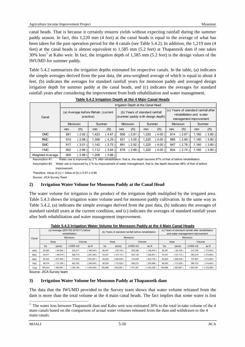
Agriculture Income Improvement Project Myanmar
MOALI 5-50 JICA
canal heads. That is because it certainly ensures yields without expecting rainfall during the summer paddy season. In fact, this 1,220 mm (4 feet) at the canal heads is equal to the average of what has been taken for the past operation period for the 4 canals (see Table 5.4.2). In addition, the 1,219 mm (4 feet) at the canal heads is almost equivalent to 1,585 mm (5.2 feet) at Thapanzeik dam if one takes 30% loss3 at Kabo weir. In fact, the irrigation depth of 1,585 mm (5.2 feet) is the design values of the IWUMD for summer paddy.
Table 5.4.2 summarizes the irrigation depths estimated for respective canals. In the table, (a) indicates the simple averages derived from the past data, the area-weighted average of which is equal to about 4 feet, (b) indicates the averages for standard rainfall years for monsoon paddy and averaged design irrigation depth for summer paddy at the canal heads, and (c) indicates the averages for standard rainfall years after considering the improvement from both rehabilitation and water management.
2) Irrigation Water Volume for Monsoon Paddy at the Canal Head
The water volume for irrigation is the product of the irrigation depth multiplied by the irrigated area. Table 5.4.3 shows the irrigation water volume used for monsoon paddy cultivation. In the same way as Table 5.4.2, (a) indicates the simple averages derived from the past data, (b) indicates the averages of standard rainfall years at the current condition, and (c) indicates the averages of standard rainfall years after both rehabilitation and water management improvement.
Table 5.4.3 Irrigation Water Volume for Monsoon Paddy at the 4 Main Canal Heads
Canal
(a) Average (2001/02-2016/17) before rehabilitation (b) Years of standard rainfall before rehabilitation
(c) Years of standard rainfall after rehabilitation and water management improvement
Monsoon Monsoon Monsoon
Area Volume Area Volume Area Volume
ha (acre) x1000 m3 ac-ft ha (acre) x1000 m3 ac-ft ha (acre) x1000 m3 ac-ft
OMC 25,925 ( 64,062 ) 232,317 ( 188,345 ) 26,347 ( 65,105 ) 225,326 ( 182,678 ) 26,347 ( 65,105 ) 214,195 ( 173,653 )
RMC 40,071 ( 99,019 ) 366,715 ( 297,305 ) 43,347 ( 107,115 ) 403,134 ( 326,831 ) 43,347 ( 107,115 ) 383,219 ( 310,685 )
SMC 84,023 ( 207,628 ) 770,003 ( 624,261 ) 83,622 ( 206,638 ) 744,649 ( 603,705 ) 83,622 ( 206,638 ) 707,863 ( 573,882 )
YMC 46,614 ( 115,188 ) 420,162 ( 340,636 ) 46,550 ( 115,029 ) 408,272 ( 330,996 ) 46,550 ( 115,029 ) 388,103 ( 314,645 )
Total 196,633 ( 485,897 ) 1,789,198 ( 1,450,546 ) 199,866 ( 493,887 ) 1,781,381 ( 1,444,209 ) 199,866 ( 493,887 ) 1,693,381 ( 1,372,866 )
Source: JICA Survey team
3) Irrigation Water Volume for Monsoon Paddy at Thapanzeik dam
The data that the IWUMD provided to the Survey team shows that water volume released from the dam is more than the total volume at the 4 main canal heads. The fact implies that some water is lost 3 The water loss between Thapanzeik dam and Kabo weir was estimated 30% to the total in-take volume of the 4 main canals based on the comparison of actual water volumes released from the dam and withdrawn to the 4 main canals.
Table 5.4.2 Irrigation Depth at the 4 Main Canal Heads
Assumption #1: Water use is improved by 3 % after rehabilitation, that is, the depth become 97% of that of before rehabilitation. Assumption #2: Water use is improved by 2 % by improvement of water management, that is, the depth becomes 98% of that of before
improvement. Therefore, Value of (c) = Value of (b) x 0.97 x 0.98 Source: JICA Survey Team
mm (ft) mm (ft) mm (ft) mm (ft) mm (ft) mm (ft)OMC 891 ( 2.92 ) 1,423 ( 4.67 ) 856 ( 2.81 ) 1,220 ( 4.00 ) 814 ( 2.67 ) 1,160 ( 3.80 )RMC 910 ( 2.98 ) 1,308 ( 4.29 ) 931 ( 3.05 ) 1,220 ( 4.00 ) 885 ( 2.90 ) 1,160 ( 3.80 )SMC 917 ( 3.01 ) 1,142 ( 3.75 ) 891 ( 2.92 ) 1,220 ( 4.00 ) 847 ( 2.78 ) 1,160 ( 3.80 )YMC 902 ( 2.96 ) 1,112 ( 3.64 ) 878 ( 2.88 ) 1,220 ( 4.00 ) 834 ( 2.74 ) 1,160 ( 3.80 )
Weighted Average 909 ( 2.98 ) 1,208 ( 3.96 )
Canal
Monsoon Summer Monsoon Summer Monsoon Summer
Irrigation Depth at the Canal Head
(a) Average before Rehab. (currentpractice)
(b) Years of standard rainfall(summer paddy w ith design depth)
(c) Years of standard rainfall afterrehabilitation and w ater
management improvement

Myanmar Agriculture Income Improvement Project
JICA 5-51 MOALI
between the dam and Kabo weir and also by leakage at and overflow from Kabo weir. It was assumed that water equivalent to approximately 30% of the total water volume taken by the 4 main canals is lost between Thapanzeik dam and Kabo weir4 by comparing the outflow data from the dam and the total water volume withdrawn to the 4 main canals.
Then, the Survey team assumed that the 30% loss will decrease to 25% by rehabilitating Kindat diversion dam and Kabo weir, because the rehabilitation enhances the water-tightness of its under-sluice gates. In addition, rehabilitation including the replacement of the gates installed on the Kabo weir will minimize overflow loss over the weir to the downstream. Namely, the water volume at the dam before rehabilitation is estimated to be 30% more than that of the canal heads, and it turns to 25% after rehabilitation of Kabo and Kindat weirs.
Table 5.4.4 shows the irrigation water volume released from Thapanzeik dam before and after rehabilitation. In the table, (b) indicates the averages of standard rainfall years before rehabilitation, and (c) indicates the averages of standard rainfall years after both rehabilitation and water management improvement. Meanwhile, (a) is no longer our concern and has been omitted because the purpose here is comparison of water volumes before and after rehabilitation.
Table 5.4.4 Irrigation Water Volume for Monsoon Paddy at Thapanzeik Dam
Canal (b) Year of standard rainfall before rehabilitation
(c) Years of standard rainfall after rehabilitation and water management improvement
Area Volume Area Volume ha (acre) x1000 m3 ac-ft ha (acre) x1000 m3 ac-ft
OMC 26,347 ( 65,105 ) 292,924 ( 237,481 ) 26,347 ( 65,105 ) 267,744 ( 217,067 ) RMC 43,347 ( 107,115 ) 524,075 ( 424,880 ) 43,347 ( 107,115 ) 479,024 ( 388,357 ) SMC 83,622 ( 206,638 ) 968,043 ( 784,816 ) 83,622 ( 206,638 ) 884,829 ( 717,352 ) YMC 46,550 ( 115,029 ) 530,754 ( 430,295 ) 46,550 ( 115,029 ) 485,129 ( 393,306 ) Total 199,866 ( 493,887 ) 2,315,796 ( 1,877,472 ) 199,866 ( 493,887 ) 2,116,726 ( 1,716,082 )
Source: JICA Survey team
4) Irrigation Depth at Thapanzeik Dam before and after Rehabilitation
In the same way as the water volume, the irrigation depth at Thapanzeik dam before rehabilitation is 30% more than those totals at the 4 main canal heads. And it is 25% more after rehabilitation, equivalent to 5% reduction of the loss. Table 5.4.5 shows the irrigation depth required at the dam before rehabilitation and after rehabilitation including the loss reduction of 5% between the dam and Kabo weir and also aforementioned 3% by rehabilitation of the irrigation system and 2 % by water management improvement.
Table 5.4.5 Irrigation Depth at Thapanzeik dam before & after Rehabilitation
Canal
Irrigation Depth at Thapanzeik Dam
(b) Year of standard rainfall before rehabilitation (c) Years of standard rainfall after rehabilitation and water management improvement
Monsoon Summer Monsoon Summer mm (ft) mm (ft) mm (ft) mm (ft)
OMC 1,112 ( 3.65 ) 1,585 ( 5.20 ) 1,016 ( 3.33 ) 1,449 ( 4.75 ) RMC 1,209 ( 3.97 ) 1,585 ( 5.20 ) 1,105 ( 3.63 ) 1,449 ( 4.75 ) SMC 1,158 ( 3.80 ) 1,585 ( 5.20 ) 1,058 ( 3.47 ) 1,449 ( 4.75 ) YMC 1,140 ( 3.74 ) 1,585 ( 5.20 ) 1,042 ( 3.42 ) 1,449 ( 4.75 )
Source: JICA Survey Team
5) Irrigation Water Available for Summer Paddy at Dam before & after Rehabilitation
The catchment area of Thapanzeik dam is vast and inflow analysis is important to estimate how much water is available for the summer paddy irrigation. The JICA team collected data of inflow to the dam 4 IWUMD data shows 24.2% loss for summer season of year 2011 and 35.9% loss for monsoon season of year 2011, averaging to about 30%.
Agriculture Income Improvement Project Myanmar
MOALI 5-52 JICA
and conducted probability analysis by Iwai method. As a result, the JICA team adopted 4,933,859,000 m3 (4,000,000 ac-ft), which is the 50% probability of occurrence, as the standard inflow.
Likewise, the evaporation from the stored-water surface at the dam was estimated at 487,219,000 m3 (395,000 ac-ft). Moreover, the Team obtained data of water consumption by domestic purpose, industrial use, and pump irrigation at the upper reach of OMC. Table 5.4.6 shows the water balance at the dam. In this regard, water released for the hydropower generation installed at the dam is used for irrigation in the downstream; water is not released only for the purpose of hydropower generation. The water available for the summer paddy irrigation is therefore the difference of inflow and those uses including the irrigation water for the monsoon paddy, which is the balance of water left in the dam at the end of the monsoon season.
Table 5.4.6 Irrigation Water Available for Summer Paddy at Thapanzeik Dam before and after Rehabilitation Item Volume
Inflow of Standard Year Inflow to Dam 4,933,859,000 m3 (4,000,000 ac-ft)
Outflows (Data from 2001 to 2015) Evaporation of Standard Year#1 487,219,000 m3 (395,000 ac-ft) Shwebo TS Tap Water (domestic use) 2,763,000 m3 (2,240 ac-ft) Sugarcane Factory (industry use) 2,362,000 m3 (1,915 ac-ft) Pump Irrigation for Monsoon Paddy 21,147,000 m3 (17,144 ac-ft) Pump Irrigation for Summer Upland Crops 10,049,000 m3 (8,147 ac-ft) Irrigation Water for Monsoon Paddy
Before Rehabilitation 2,315,796,000 m3 (1,877,472 ac-ft) After Rehabilitation and Water Mgt. Improvement 2,116,726,000 m3 (1 716,082 ac-ft)
Balance: Irrigation Water Available for Summer Paddy With the Design Irrigation Depth 2,094,524,000 m3 (1,698,082 ac-ft) Above + Loss Reduction by Rehabilitation & WM Improvement 2,293,593,000 m3 (1,859,472 ac-ft)
Data source: IWUMD #1 Data of the record, which is estimated based on the result observed with an evaporation pan at the dam by IWUMD Source: JICA Survey team
6) Potential Irrigable Areas before and after Rehabilitation
The water balance at Thapanzeik dam available for summer paddy is proportionally allocated to each of the 4 main canals corresponding to their irrigable areas. Then, the allocated volume of water is divided by the irrigation depth at the dam for summer paddy. The quotient is the potential irrigable area for summer paddy. Table 5.4.7 shows the potential irrigable areas for summer paddy and Table 5.4.8 comparatively summarizes the potential irrigable area for both monsoon paddy and summer paddy with the percentage to the planned irrigable area.
Table 5.4.7 Irrigation Water at Thapanzeik dam Available for Summer Paddy before & after Rehabilitation
Canal
Planned Irrigable
Area
(a) Average (2001/02-2013/14) before rehabilitation
(c) Years of standard rainfall after rehabilitation and water management improvement
Summer Summer
ha (acre) Area Volume Area Volume
ha (acre) x1000 m3 ac-ft Ha (acre) x1000 m3 ac-ft OMC 26,347 ( 65,105 ) 14,843 ( 36,678 ) 212,922 ( 172,621 ) 20,870 ( 51,571 ) 302,345 ( 245,119 )
RMC 43,347 ( 107,115 ) 23,157 ( 57,223 ) 317,829 ( 257,672 ) 34,337 ( 84,849 ) 497,438 ( 403,285 )
SMC 83,662 ( 206,638 ) 48,382 ( 119,555 ) 588,508 ( 477,118 ) 66,239 ( 163,683 ) 959,619 ( 777,987 )
YMC 46,550 ( 115,029 ) 29,668 ( 73,312 ) 349,905 ( 283,676 ) 36,873 ( 91,117 ) 534,190 ( 433,081 )
Total 199,866 ( 493,887 ) 116,049 ( 286,768 ) 1,469,163 ( 1,191,087 ) 158,319 ( 391,221 ) 2,293,593 ( 1,859,472 )
Percentage 58% 79%
Note: The percentage is the ratio of the potential irrigable area to the planned irrigable area Source: JICA Survey Team
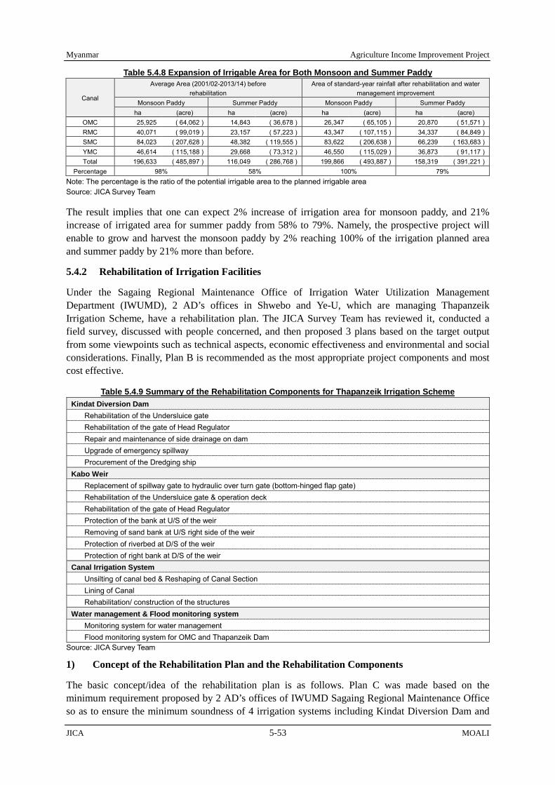
Myanmar Agriculture Income Improvement Project
JICA 5-53 MOALI
Table 5.4.8 Expansion of Irrigable Area for Both Monsoon and Summer Paddy
Canal
Average Area (2001/02-2013/14) before rehabilitation
Area of standard-year rainfall after rehabilitation and water management improvement
Monsoon Paddy Summer Paddy Monsoon Paddy Summer Paddy ha (acre) ha (acre) ha (acre) ha (acre)
OMC 25,925 ( 64,062 ) 14,843 ( 36,678 ) 26,347 ( 65,105 ) 20,870 ( 51,571 ) RMC 40,071 ( 99,019 ) 23,157 ( 57,223 ) 43,347 ( 107,115 ) 34,337 ( 84,849 ) SMC 84,023 ( 207,628 ) 48,382 ( 119,555 ) 83,622 ( 206,638 ) 66,239 ( 163,683 ) YMC 46,614 ( 115,188 ) 29,668 ( 73,312 ) 46,550 ( 115,029 ) 36,873 ( 91,117 ) Total 196,633 ( 485,897 ) 116,049 ( 286,768 ) 199,866 ( 493,887 ) 158,319 ( 391,221 )
Percentage 98% 58% 100% 79% Note: The percentage is the ratio of the potential irrigable area to the planned irrigable area Source: JICA Survey Team
The result implies that one can expect 2% increase of irrigation area for monsoon paddy, and 21% increase of irrigated area for summer paddy from 58% to 79%. Namely, the prospective project will enable to grow and harvest the monsoon paddy by 2% reaching 100% of the irrigation planned area and summer paddy by 21% more than before.
5.4.2 Rehabilitation of Irrigation Facilities
Under the Sagaing Regional Maintenance Office of Irrigation Water Utilization Management Department (IWUMD), 2 AD’s offices in Shwebo and Ye-U, which are managing Thapanzeik Irrigation Scheme, have a rehabilitation plan. The JICA Survey Team has reviewed it, conducted a field survey, discussed with people concerned, and then proposed 3 plans based on the target output from some viewpoints such as technical aspects, economic effectiveness and environmental and social considerations. Finally, Plan B is recommended as the most appropriate project components and most cost effective.
Table 5.4.9 Summary of the Rehabilitation Components for Thapanzeik Irrigation Scheme Kindat Diversion Dam
Rehabilitation of the Undersluice gate Rehabilitation of the gate of Head Regulator Repair and maintenance of side drainage on dam Upgrade of emergency spillway Procurement of the Dredging ship
Kabo Weir Replacement of spillway gate to hydraulic over turn gate (bottom-hinged flap gate) Rehabilitation of the Undersluice gate & operation deck Rehabilitation of the gate of Head Regulator Protection of the bank at U/S of the weir Removing of sand bank at U/S right side of the weir Protection of riverbed at D/S of the weir Protection of right bank at D/S of the weir
Canal Irrigation System Unsilting of canal bed & Reshaping of Canal Section Lining of Canal Rehabilitation/ construction of the structures
Water management & Flood monitoring system Monitoring system for water management Flood monitoring system for OMC and Thapanzeik Dam
Source: JICA Survey Team
1) Concept of the Rehabilitation Plan and the Rehabilitation Components
The basic concept/idea of the rehabilitation plan is as follows. Plan C was made based on the minimum requirement proposed by 2 AD’s offices of IWUMD Sagaing Regional Maintenance Office so as to ensure the minimum soundness of 4 irrigation systems including Kindat Diversion Dam and

Agriculture Income Improvement Project Myanmar
MOALI 5-54 JICA
Kabo Weir. But some of rehabilitation components proposed by AD’s offices are considered not sufficient enough for long-term service period.
Plan B was made by adding additional factors to Plan C. As compared to Plan C, Plan B increases the safety of the facilities and reduces the operation and maintenance costs by not only upgrading quality and functions but also rehabilitation methods for some components. Also, for improving water management to reduce the water loss in the irrigation systems, which aims at expanded irrigable area for summer paddy, gate installation to all of the outlets and construction of new check structures are planned. Improvement of drainage is also planned to prevent/reduce flood damage to irrigated area. Moreover, construction/rehabilitation of facilities for reusing drainage water is planned so that the irrigation water released from Thapanzeik dam can be reduced.
Plan A is proposed as a modern irrigation system by adding advanced facilities to Plan B. Plan A modernizes the operation system by introducing motor-driven gate-lifting device to some of the major hydraulic structures like Kindat Diversion dam and Kabo Weir. Moreover, considering the increase of personnel expenses in near future, the portion of canal lining is increased as much as possible for reducing the maintenance cost.
Introduction of the flood monitoring system is included for all plans in order to ensure and increase the safety of Thapanzeik dam and Old Mu Canal (OMC) against flood (detail is described in 5.4.4 Flood Monitoring and Mitigation). Considering the future effective operation, a monitoring system for water management improvement will be introduced and devices are installed at some principal irrigation facilities such as Thapanzeik dam, Kindat Diversion Dam, Kabo Weir, intakes of the 4 main canals, bifurcations, and some large canals on a trial basis. This monitoring system is included in all the three plans (detail is describe in 5.4.5 Water Management and System Operation).
In view point of technical aspects, plan C, which was formulated based on the minimum requirement, cannot be so much recommendable in considering soundness of the irrigation systems for long service period. Plan A, which is proposed to install modern gate operation system to some major facilities, seems to be premature in consideration with the current condition of the electric power system and comparison of the operation cost. In addition, Plan A (IRR: 17.2%) and plan C (IRR: 15.3%) are not cost effective than Plan B (IRR: 20.1%). The rehabilitation effect of plan A is not much different from the plan B. The rehabilitation effect of plan C is not so much different from the current condition. The JICA Survey Team has explained to and discussed with IWUMD about the proposed 3 plans, and finally, Plan B is selected as the most appropriate and cost effective project component.
2) Rehabilitation of Kindat Diversion Dam
2.1) Concept and Component on Rehabilitation of Kindat Diversion Dam
Kindat diversion dam, whose construction was completed in 1997, supplies irrigation water to RMC and OMC. The dam is nearly 20 years old, and some facilities are damaged by aging; especially, gate facilities are dilapidated a lot. The shutter gates on spillway are scheduled to be replaced to the hydraulic overturning flap gate fabricated by a Chinese manufacture, starting from December 2016.
Therefore, the components planned for rehabilitation of Kindat Diversion Dam are: 1) rehabilitation of the undersluice gate, 2) rehabilitation of the gates of head regulator, 3) repair and maintenance of side drainage on the dam, 4) upgrade of emergency spillway, and 5) dredging of sedimentation around RMC head regulator. The rehabilitation level is mentioned in Table 5.4.10.

Myanmar Agriculture Income Improvement Project
JICA 5-55 MOALI
Table 5.4.10 Concept and Level of Rehabilitation Plan for Kindat Diversion Dam
Description Concept and Level of Rehabilitation Plan A Plan B Plan C
1 Kindat Diversion Dam
In addition to the plan B, modernizing gate operation system
In addition to the plan C, reducing the gate maintenance cost by introducing stainless materials, while increasing the safety of diversion dam
In order to ensure the minimum safety of diversion dam and intake of the irrigation water for OMC & RMC.
1-1. Rehabilitation of the Undersluice gate
To modernize gate operation system, existing gate will be replaced to stainless steel gate and the lifting device of under-sluice gate is also replaced to motor-driven winch. Further, the scale of gate opening will be installed.
To reduce the maintenance cost for gate, existing gate leaves will be replaced to stainless steel ones and lifting device will be repaired.
To ensure the intake of the irrigation water for OMC & RMC, the existing gate leaf will be replaced to steel gate and lifting device will be repaired.
1-2. Rehabilitation of the gate of Head Regulator
1-3. Repair and maintenance of side drainage on dam
To increase the safety of diversion dams, existing side drains to cope with rainfall will be repaired and additional side drains will be constructed.
1-4. Upgrade of emergency spillway
To increase the safety of diversion dams, a permanent concrete spillway structure with riverbed protection at downstream will be constructed.
In order to ensure minimum safety of the diversion dam, concrete lining protection on the existing earth spillway will be introduced.
1-5. Dredging of sedimentation for RMC Head Regulator
For ensuring the intake of irrigation water from the head regulator of RMC, by using hydraulic excavator and amphibious hydraulic excavator which will be procured for maintenance works in the project and dredging boat to be procured for this work, dredging of sediment around the RMC Head Regulator and in the head-race canal will be implemented after reducing water level during off-irrigation period.
Cost (Million Kyat) 3,446 3,260 2,049 Source: JICA Survey Team
2.2) Rehabilitation of the Undersluice Gates and the Head Regulator Gates
As mild steel is used for the gates and is used nearly 20 years, all the gates are aging, and rusting is severe and extensive. Especially, some plate girders of gate leaf have been corroded. Accordingly, it is not recommendable to use the gates for a long period from now on. Therefore, it is planned to replace all gate leaves of all of the gates to new steel gate leaves. In addition, for the reduction of the maintenance cost and the cost for repeated replacement in future, replacing the gate with stainless steel gates are also planned in Plan B.
1-1
1-4
Mu River
RMC OMC
1-2 1-2
1-3
1-5
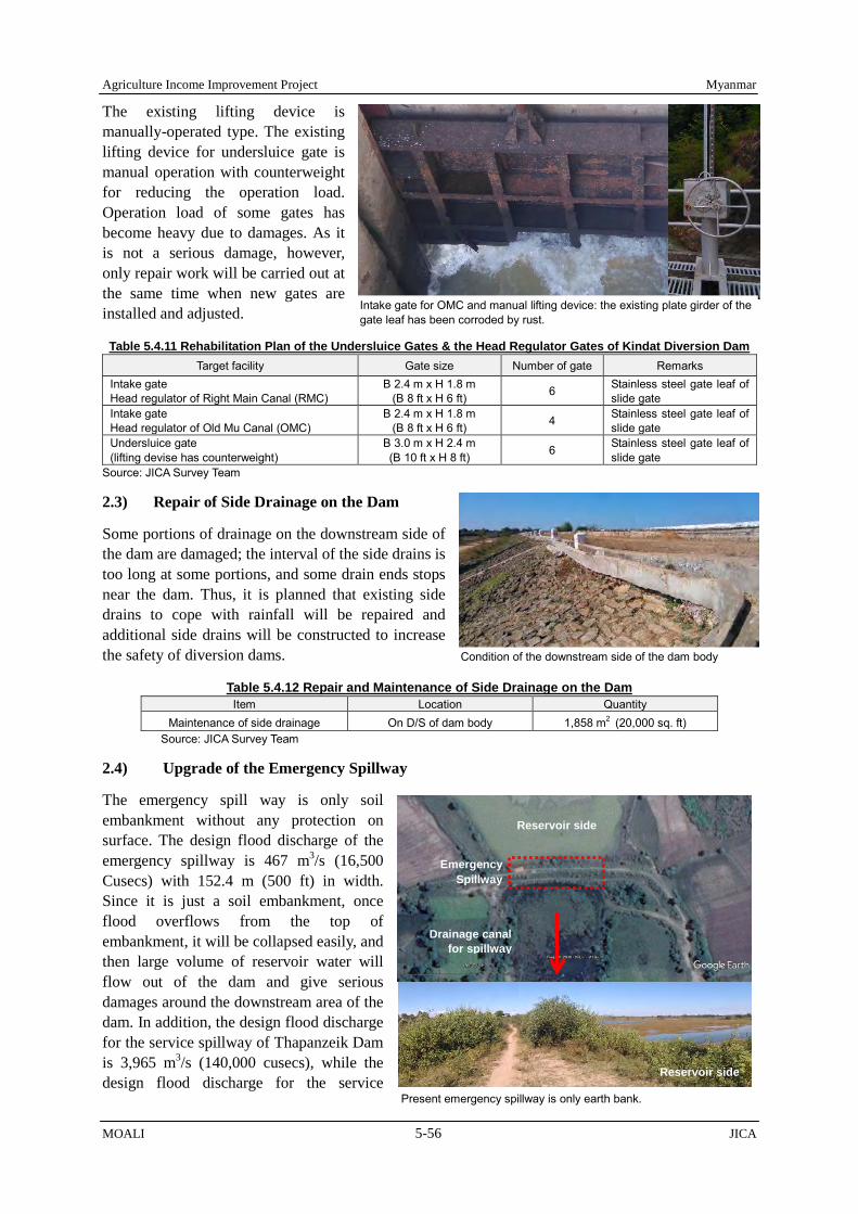
Agriculture Income Improvement Project Myanmar
MOALI 5-56 JICA
Present emergency spillway is only earth bank.
Reservoir side
Emergency Spillway
Drainage canal for spillway
Reservoir side
The existing lifting device is manually-operated type. The existing lifting device for undersluice gate is manual operation with counterweight for reducing the operation load. Operation load of some gates has become heavy due to damages. As it is not a serious damage, however, only repair work will be carried out at the same time when new gates are installed and adjusted.
Table 5.4.11 Rehabilitation Plan of the Undersluice Gates & the Head Regulator Gates of Kindat Diversion Dam Target facility Gate size Number of gate Remarks
Intake gate Head regulator of Right Main Canal (RMC)
B 2.4 m x H 1.8 m (B 8 ft x H 6 ft) 6 Stainless steel gate leaf of
slide gate Intake gate Head regulator of Old Mu Canal (OMC)
B 2.4 m x H 1.8 m (B 8 ft x H 6 ft) 4 Stainless steel gate leaf of
slide gate Undersluice gate (lifting devise has counterweight)
B 3.0 m x H 2.4 m (B 10 ft x H 8 ft) 6 Stainless steel gate leaf of
slide gate Source: JICA Survey Team
2.3) Repair of Side Drainage on the Dam
Some portions of drainage on the downstream side of the dam are damaged; the interval of the side drains is too long at some portions, and some drain ends stops near the dam. Thus, it is planned that existing side drains to cope with rainfall will be repaired and additional side drains will be constructed to increase the safety of diversion dams.
Table 5.4.12 Repair and Maintenance of Side Drainage on the Dam Item Location Quantity
Maintenance of side drainage On D/S of dam body 1,858 m2 (20,000 sq. ft) Source: JICA Survey Team
2.4) Upgrade of the Emergency Spillway
The emergency spill way is only soil embankment without any protection on surface. The design flood discharge of the emergency spillway is 467 m3/s (16,500 Cusecs) with 152.4 m (500 ft) in width. Since it is just a soil embankment, once flood overflows from the top of embankment, it will be collapsed easily, and then large volume of reservoir water will flow out of the dam and give serious damages around the downstream area of the dam. In addition, the design flood discharge for the service spillway of Thapanzeik Dam is 3,965 m3/s (140,000 cusecs), while the design flood discharge for the service
Intake gate for OMC and manual lifting device: the existing plate girder of the gate leaf has been corroded by rust.
Condition of the downstream side of the dam body

Myanmar Agriculture Income Improvement Project
JICA 5-57 MOALI
spillway of Kindat Diversion Dam is 2,127 m3/s (75,100 Cusecs), which is only 54% of Thapanzeik Dam’s one.
In October 2015, a large amount of flood water spilled out of the service spillway and also the emergency spillway of Thapanzeik dam5. The flood water entered into the Kindat diversion dam reservoir, accordingly the water level of the reservoir rose up to the crest height of the emergency spillway. IWUMD maintenance office put sand backs on the emergency spillway to prevent overflow. It means that the existing emergency spillway does not function as an emergency spillway. Therefore, it is planned to construct permanent concrete spillway structure with downstream-riverbed protection and excavation of the spillway canal in order to increase the safety of diversion dams.
Table 5.4.13 Main Items for Upgrading the Emergency Spillway Item Quantity Remarks
Upgrading the crest of the emergency spillway 152 m(500 ft) Concrete structure
Protection wall for inlet and outlet of the spillway 91 m(300 ft) Concrete structure
Riverbed protection at D/S of the spillway 4,645 m2 (50,000 sq. ft) Concrete protection with energy dissipator
excavation of the spillway canal 2,590 m (8,800 ft) Source: JICA Survey Team
2.5) Dredging of Sedimentation and Procurement of Hydraulic Excavator, Amphibious Hydraulic Excavator and the Dredging Boat
In between Thapanzeik Dam and Kindat diversion dam, there are some big streams that flow into Mu River. These streams transfer a lot of soil particles to the diversion dam during the rainy season. As a result, sedimentation has been proceeding in the reservoir since the construction of the diversion dam. The thickness of sediment is assumed to be 0.6 m (2 ft) or more. The water depth around the intake of RMC is 1.2 to 3 m (4 to 10 ft), and there are many water plants, which can grow with water of 2 m in depth or shallower. Sometime the water plants are flowed to the intake; they interfere with the water intake at the RMC head regulator. In future, the sedimentation becomes a more serious problem for irrigation water intake at the RMC head regulator.
Considering the condition and size of dam reservoir, dredging boat is suitable for removing sediment. Although Mechanical Branch of IWUMD has 4 dredging boats as shown in Table 5.4.14, of which 3 boats, procured in the 1980s, are dilapidated old and have operational problems. Therefore, IWUMD has purchased a new boat in 2015 for dredging of sediments in Inle Lake. It is one option to procure a dredging boat for dredging sediments in Kindat diversion reservoir.
On the other hand, if reservoir water level can be lowered during non-irrigation period by releasing reservoir water through undersluice, it is possible to dredge the sediment of target area by hydraulic excavator and amphibious hydraulic excavator which will be procured for maintenance works in the project. Therefore, in this project, for ensuring the intake of irrigation water from the head regulator of RMC, it is planned to dredge sediment around the RMC Head Regulator and in head-race canal by the
5 Estimated peak volume of discharge through both spillway of Thapanzeik dam is about 1,800m3/s (65,000 cusec) against design discharge 3,964 m3/s (140,000 cusecs) of service spillway and 1,133 m3/s (40,000 cusecs). Considering the inflow into Mu River from Thapanzeik to Kindat, it assumes that discharge of spillway was almost design discharge of spillway at Kindat diversion dam.
After the construction of the diversion dam, sedimentation has increased due to soil flowing into the reservoir from big stream in the catchment area.
Water depth (8-10ft)
Water depth (4-6ft)
(8ft)
Water depth (4-6ft)
Water depth (4-6ft)

Agriculture Income Improvement Project Myanmar
MOALI 5-58 JICA
excavator and to dredge at the area under water by the dredging boat. The dredging boat will also be procured in this project. It will also be used to dredge sedimentation at other dam reservoirs and lakes after the completion of the Project..
Table 5.4.14 List of Dredging Boats that IWUMD Owns Item Purchase year Country origin Remarks
Ellicott DCS-04、10" suction、55HP 1980s UK The aging is intense. Ellicott DCS-06、10" suction、165HP 1980s UK The aging is intense. Beaver DCS-09、10" suction、220HP 1980s Netherlands The aging is intense. Bell 250、12"、12" suction、464HP 2015 Netherlands Use for the dredging in the Inle Lake
Source: JICA Survey Team
Table 5.4.15 Plan for Dredging of Sedimentation Item Location & Quantity Remarks
Dredging of Sedimentation head-race canal: 550 m (1,800ft) RMC intake area: 4,000 m2 (43,000 sq. ft)
by using hydraulic excavator and amphibious hydraulic excavator which will be procured for maintenance works in the project and the dredging boat which will be procured for this work.
Source: JICA Survey Team
3) Rehabilitation of Kabo Weir
3.1) Concept and Component on the Rehabilitation of Kabo Weir
Kabo weir was originally constructed in 1905, and then it has been seriously damaged by a large flood occurred in 1956. The flood washed away the under-sluices at SMC side, half of the spillway and the head regulator of SMC. Then, they were reconstructed with reinforced concrete, instead of the original masonry structure. Some structures are already 110 years old and the others are 60 years old.
There are issues about this weir. To solve the issues and reduce the maintenance cost of the gate while increasing the safety of weir, the components planned for rehabilitation of Kabo weir are: 1) replacement of spillway gate to hydraulic flap gate, 2) rehabilitation of the undersluice gate and operation deck, 3) rehabilitation of the gate of head regulator, 4) protection of the bank at U/S of the weir, 5) removing sand bank at U/S right side of the weir, 6) protection of riverbed at D/S of the weir, and 7) protection of the right bank at D/S of the weir. The rehabilitation level is as mentioned in Table 5.4.16.
Table 5.4.16 Concept & Level of Rehabilitation Plan for Kabo Weir
Mu River
Mu River
2-1.
2-3. 2-2. 2-6.
2-5.
2-4.
2-4.
2-7.

Myanmar Agriculture Income Improvement Project
JICA 5-59 MOALI
Description Concept & Level of Rehabilitation
Plan A Plan B Plan C 2 Kabo Weir In addition to the plan B, gate
operation system will be modernized.
In addition to the plan C, reducing the maintenance cost of the gate, while increasing the safety of weir.
In order to ensure the minimum safety of the weir and intake of the irrigation water for SMC & YMC, following are taken:
2-1. Replacement of spillway gate to hydraulic over-turn gate (bottom-hinged flap gate)
To reduce discharge flow loss to D/S of river, the existing shutter gate will be replaced with hydraulic overturning stainless steel flap gate with an automatic operation system according to the water level.
To reduce discharge flow loss to D/S of river and maintenance cost, the existing shutter gate will be replaced with hydraulic overturning stainless steel flap gate.
To reduce discharge flow loss to D/S of the river, the existing shutter gate will be replaced with hydraulic overturning steel flap gate.
2-2. Rehabilitation of the undersluice gate & operation deck
To modernize the gate operation system, existing gate will be replaced with stainless steel gate, and the lifting device of under-sluice gate will be also replaced with motor-driven winch. Further, the scale of gate opening will be installed.
To reduce the maintenance cost of the gate, existing gate leaf will be replaced with stainless steel gate and lifting device will be repaired.
To ensure the intake of the irrigation water for SMC& YMC, the existing gate leaf will be replaced with steel gate and lifting device will be repaired.
2-3. Rehabilitation of the gate of head regulator
In order to ensure the intake of the irrigation water for SMC & YMC, intake gates for YMC will be replaced to new gate, and necessary repair for other gates facilities will be done.
2-4. Protection of the bank at U/S of the weir
In order to increase safety of weir and Ye-U canal against flood, river bank protection will be made at U/S right& left bank of the weir.
In order to ensure minimum safety of weir, minimum river bank protection will be made at U/S right bank of the weir.
2-5. Removing of sand bank at U/S right side of the weir
In order to ensure the intake of irrigation water for YMC, sand natural bank at U/S right side of the weir will be removed as much as possible to reduce the soil flowing into the Ye-U canal. In addition, lead-wall and/or silt ejector for flashing the sediment will be considered.
In order to ensure the intake of irrigation water for YMC, sand natural bank at U/S right side of the weir will be removed at minimum area.
2-6. Protection of riverbed at D/S of the weir
In order to ensure safety of weir for a long period, riverbed protection against the design flood will be undertaken at D/S of the weir.
In order to ensure the minimum safety of weir, minimum riverbed protection lasting for some years will be considered at D/S of the weir.
2-7. Protection of right bank at D/S of the weir
In order to protect the right riverbank at D/S of the weir and village near the bank, riverbank protection will be extended.
Cost (Million Kyat) 13,626 13,258 10,219 Source: JICA Survey Team 3.2) Replacements of Spillway Gates, Undersluice Gates and Intake Gates of YMC Head
Regulator, and Repair of Other Intake Gates
One of the problems is associated with the shutter gate on the spillway. When flood comes, these gates are sequentially overturned by a group of the gates depending on the flood water level. Theses gates should be put back to the upright position manually after having overturned. However, once the gates are overturned, it is quite difficult to put the gates back to upright again during the rainy season. In
The undersluice gate (upper photo) and shutter gates (lower photo) was installed after damaged by the 1956’s largest flood.

Agriculture Income Improvement Project Myanmar
MOALI 5-60 JICA
addition, as under-sluice gates are nearly 60 years old, as old as the shutter gates, water leakage occurs through the gate bottom and side because of damaged water-tightness function.
This situation causes the increase of discharge, which is not utilized for irrigation, and accordingly the outflow from the dam has to be increased. This increase of the outflow from the dam will result in the reduction of water volume stored in the dam for summer paddy. According to an evaluation by the JICA Survey Team, loss of water volume is estimated as much as 25-30% of irrigation water for the 4 main canals.
Therfore, to reduce discharge flow loss to D/S of river and maintenance cost, it is planned that the existing shutter gate on spillway will be replaced with hydraulic overturning gate made of stainless steel. In addtion, existing gate leaf of undersluice gates and intake gate of YMC head regulator will be replaced with new steel gate leaf. Moreover, for the reduction of the maintenance cost and cost for repeated replacement in future, the stainless steel gates are also proposed in Plan B.
The counterweight-type-lifting-devices of gates are relatively in good condtion and only small repairer is required, but the steel cable of lifting device needs to be replaced with a new one in cosideration with the aging for a long terms’ use. In addtion, the operation deck made by wooden boards is damaged by aging and, some places are very dengerous to walk. Therefore, the exsiting desk will also be replaced with a new steel-made one for safe operation. For intake gate of the head regulator, necessary repair will be made in order to ensure a long-terms use and water intake for SMC & YMC.
Table 5.4.17 Rehabilitation Plan of the Spillway Gates Existing Plan Width of spillway 138.71 m (455 ft) 138.71 m (455 ft) Type of spillway Wooden shutter gate hydraulic overturning stainless steel gate Gate size & Number B 1.52 m x H 1.21 m (B 5 ft x H 4 ft) x 91 nos B 15.2 m x H 1.21 m (B 50 ft x H 4 ft) x 9 spans
Source: JICA Survey Team Note: Gate size and gate span of the above plan is tentative design. Final design will be selected during detail design stage in implementation.
Table 5.4.18 Rehabilitation Plan of the Undersluice Gates & Intake Gates of Kabo Weir Target facility Gate size Number of
gate Remarks
Undersluice Gate (Left side in front of head regulator of SMC)
B 12.19 m x H 3.35 m (B 40 ft x H 11 ft) 4 Replacement to Stainless steel
slide gate Undersluice Gate (Right side: in front of head regulator of YMC)
B 9.14 m x H 3.65 m (B 30 ft x H 12 ft) 2 Replacement to Stainless steel
slide gate Intake Gate for Irrigation (Head regulator of SMC)
B 5.79 m x H 2.29 m (B 19 ft x H 7.5 ft) 5 Repair of the existing radial gate
with counterweight Intake Gate for Water supply (Head regulator of SMC)
B 1.22 m x H 0.91 m (B 4 ft x H 3 ft) 2 Repair of the existing slide gate
Intake Gate (Head regulator of YMC)
B 5.59 m x H 1.76 m (B 18.33 ft x H 5.8 ft) 3 Replacement to hydraulic
overturning stainless steel gate Source: JICA Survey Team
3.3) Countermeasures against Flood and Sedimentation
Against large flood, river management, flood control and flood protection are very important for the protection of important facilities such as Kabo Weir. Mu River near the weir bends more than 90 degree at U/S of the weir. For that reason, the riverbank and riverbed have been scoured continuously at the outside of the curve. The most scoured point is nearly 10 m (33 feet) in depth at the end of
Gate lifting device is a manual operation type. Reducing the operation load, counterweight is installed to balance with gate. There are some aged and damaged portions on the wooden deck.

Myanmar Agriculture Income Improvement Project
JICA 5-61 MOALI
curved part. Scoring proceeds 1.5 m (5 ft) to the further outside every year, according to the IWUMD maintenance office staff. Therefore, it is planned to extend the riverbank with slope protection at U/S left bank of the weir in order to increase safety of weir against flood.
In addition, the height of the right riverbank at U/S of the weir was not so sufficient at some portions against a big flood like the one occurred in 2015. Once flood water overflows the right riverbank, it flows into Ye-U main canal. In this case, the irrigation canal system may be seriously damaged and Ye-U town and some villages may be flooded. Therefore, it is planned to extend and raise the riverbank at the U/S right bank of the weir in order to protect Ye-U canal from flood.
On the other hand, sedimentation has been proceeding inside the curve and been expanding toward outside in front of the right undersluice. Sediments are too much to flash out through the undersluice. Therefore, it is planned to remove the sand natural bank at U/S right side of the weir as much as possible in order to extend flow area for prevention of scouring outside the curve, to reduce soils flowing into Ye-U main canal, and also to ensure the intake of irrigation water for YMC for a long term.
To reduce the sedimentation, a silt ejector had been installed in front of the undersluice at Ye-U side before. However, it had not functioned well and already been removed. Sedimentation could not be flashed out through the silt ejector, because sedimentation included much silt. In this Project, construction of a lead-wall and/or super dike at the curve portion of left side leading the river flow to the center will be considered in order to avoid/reduce the sedimentation around right upstream side.
Figure 5.4.3 Main Issues against the Food and Sedimentation at Kabo Weir
Source: JICA Survey Team
Erosion (scouring) easily happens at the outside of river-curved part.
Large sedimentation area (Area where sediment is easy to accumulate as it is the inside of river curve)
The downstream riverbed has been scourged by the large flood of 2015. Deepest point is 11.6 m (38 ft) at D/S of undersluice at Shwebo side.
Erosion of the riverbank is particularly intense at the end of curved part. Erosion is proceeding 1.5m (5 ft) every year. Mu River
Mu River The height of the riverbank was not enough against the flood water level occurred in 2015. Once flood water overflows the riverbank, it flows into Ye-U main canal. In this case, the canal system may be seriously damaged and Ye-U town and some villages may be flooded.
River bank was eroded at D/S of the weir due to not enough length of bank protection.

Agriculture Income Improvement Project Myanmar
MOALI 5-62 JICA
The downstream riverbed has been scoured by the large flood of 2015. The deepest point is 11.6 m (38ft) at the D/S of Shwebo side undersluice. The present condition is seriously dangerous. It may trigger collapse of the D/S apron of weir in future. It is urgent to rehabilitate the D/S of the riverbed by some riverbed protection method. Therefore, it is planned to construct the riverbed protection against the design flood at the D/S of the weir in order to ensure safety of weir for a long period. In addition, extension of right riverbank protection at the D/S of weir will be considered in order to increase safety of the weir and protect the village from flood near the bank.
Regarding the bed protection at D/S of Kabo weir, there are some candidate plans such as concrete brock protection, concrete slab protection and gabion protection. The bed protection type should be selected based on the durability & safety against the design flood flow, construction & maintenance cost, etc. Since the material of the riverbed is of sand, the riverbed is easily to be scoured by floods, especially at the downstream of structure, because velocity of river flow at the concrete becomes faster than that flow at the downstream of structure. Therefore flexible type of riverbed protection is suitable and sustainable for long service period in consideration with the above.
Table 5.4.19 Main Items for Countermeasure against Flood and Sedimentation Item Quantity Remarks
Raising of the right river bank at U/S of the weir
330 m (1,100 ft) For right riverbank: embankment will be raised about 2 to 4 ft
Protection of the bank at U/S of the weir
800 m (3,600 ft)
For left riverbank: embankment with slope protection will be extended and the riverbed protection at some portions.
Removing of sand bank at U/S right side of the weir
68,000 m3 (24,000 sud)
Removed soils will be transported to the scored area at outside of the curve for filling.
Protection of riverbed at D/S of the weir
12,000 m2 (130,000 sq. ft) Concrete block protection with rock
Protection of right bank at D/S of the weir
80 m (262 ft) River embankment extends with slope protection
Source: JICA Survey Team
4) Rehabilitation of the Irrigation Canal System
The irrigation canal system consists of main canal, distributary canal, canal structures such as cross regulator, head regulator, outlet, drop structure, syphon, flume (canal bridge), spill-in structure, spill-out structure (escape structure), cross drainage and inspection path (maintenance road) for canal and canal structures. There are 3 major components for the irrigation system rehabilitation. One is canal rehabilitation such as desilting of the canal bed and reshaping of the canal section and lining of canal. The second is canal structure rehabilitation, and the last is Inspection road rehabilitation. The components and rehabilitation level are as mentioned in Table 5.4.20. Regarding the rehabilitation of IP, detail is described in “5.5 Distribution Infrastructure Improvement/ Upgrading.”
Cross Regulator (Steel flame type)
Cross Regulator (concrete struture type)

Myanmar Agriculture Income Improvement Project
JICA 5-63 MOALI
Head Regulator
Outlet
Drop structure
Siphone
spill-out (gate type)
Flume (Canal Bridge)
spill-out (Overflow type)
inspection path
Table 5.4.20 Concept & Level of Rehabilitation Plan of the Canal System
Description Concept & Level of Rehabilitation Plan A Plan B Plan C
3 Canal Irrigation System
In addition to the plan B, reduce the maintenance cost for the canals as much as possible
In addition to the plan C, modernizing of canal operation system and reducing of the maintenance cost for the canals will be considered.
In order to ensure the capacity of irrigation canal and minimum safety of irrigation facilities, the following are undertaken:
3-1. Desilting of canal bed and reshaping of canal section
In order to ensure soundness of irrigation canal, desilting of canal bed and reshaping of canal section will be implemented for all the canals.
In order to ensure soundness of irrigation canal, desilting of canal bed and reshaping of canal section will be implemented for major canals.

Agriculture Income Improvement Project Myanmar
MOALI 5-64 JICA
Description Concept & Level of Rehabilitation Plan A Plan B Plan C
3-2. Lining of canal In order to ensure soundness of irrigation canal and reduce the maintenance cost in the long term use, lining will be installed to major canal as much as possible.
In order to ensure soundness of irrigation canal and reduce the maintenance cost in the long term use, lining will be installed to main canal.
In order to ensure minimum soundness of irrigation canal, lining will be made at particular portions like sandy soil portions and curved areas and D/S & U/S of structure.
3-3. Rehabilitation/ construction of the structures
In order to increase safety of irrigation facilities, structures will be rehabilitated and new drainage facilities will be constructed to reduce the flood risk.
In order to ensure minimum safety of irrigation facilities, structures will be rehabilitated.
Cost (Million Kyat) 126,873 91,746 59,351 Source: JICA Survey Team
4.1) Full Supply Discharge of the Canal and Irrigation Duty
Original full supply discharge and irrigation duty for each irrigation system were set several times. The original full supply discharge of SMC was set at 79.3 m3/s (2,800 cusec) with 1,172 ha/m3/s (82 acre/cusec) of irrigation duty in 1933 for monsoon paddy plus some upland crops. Of course, irrigation for summer paddy was not considered. The full supply discharge of YMC was designed at 49.6 m3/s (1,750 cusec) with 1,053 ha/m3/s (73.65 acre/cusec) of irrigation duty in 1966 for monsoon paddy plus some upland crops. Since summer paddy cultivation had started after the construction completion of Thapanzeik dam, it is necessary to evaluate the discharge based on the planned irrigable area of summer paddy.
When Thapanzeik dam, Kindat diversion dam and RMC were planned and constructed, the full supply discharge and irrigation duty for OMC and RMC were set for monsoon paddy, considering irrigation for summer paddy. The full supply discharge of OMC was set at 28.3 m3/s (1,000 cusec) with 929 ha/m3/s (65 acre/cusec) and full supply discharge of RMC was designed at 52.0 m3/s (1,835 cusec) with 715 ha/m3/s (50 acre/cusec) of irrigation duty. The 715 ha/m3/s (50 acre/cusec) irrigation duty is generally used for design of the full supply discharge for dry season (summer paddy) by IWUMD.
The JICA Survey Team evaluated each irrigation duty, present discharge and potential irrigable area for summer paddy (details are described in 5.4.1 Present and Potential Irrigable Areas to Expand). Lastly, the Survey Team proposed the irrigation duty as 929 ha/m3/s (65 acre/cusec) for monsoon paddy and 715 ha/m3/s (50 acre/cusec) for summer paddy. The full supply discharge of each main canal was calculated based on the irrigation duty, the irrigable area for monsoon paddy (whole irrigable area) and potential irrigable area for summer paddy. The result is presented in Table 5.4.21.
Table 5.4.21 Design Discharge and Irrigation Duty for the Canal in 4 Irrigation Systems Item Unit OMC RMC SMC YMC
Scrutinized Irrigable area ha 26,347 43,347 83,622 46,550 acre 65,105 107,115 206,638 115,029
Present Full Supply Discharge M3/s 28.3 52.0 79.3 49.6 cusec 1000 1835 2800 1750
Original Irrigation Duty ha/m3/s 929 715 1,172 1,053 Acre/cusec 65 50 82 73.65
Present Irrigation Duty based on the original Full Supply discharge and irrigable area
ha/m3/s 930 834 1,055 939
Acre/cusec 65 58 74 66
Maximum % rate of irrigable area to set full supply discharge for summer paddy after rehabilitation 80% 80% 80% 80%
Target irrigable area of summer paddy after rehabilitation
Ha 21,078 34,678 66,898 37,240 acre 52,084 85,692 165,310 92,023
Proposed design Irrigation Duty for monsoon paddy
ha/m3/s 929 929 929 929 Acre/cusec 65 65 65 65
Proposed design Irrigation Duty for summer paddy
ha/m3/s 715 715 715 715 Acre/cusec 50 50 50 50
Proposed design discharge for monsoon paddy
M3/s 28.4 46.7 90.0 50.1 cusec 1,002 1,648 3,179 1,770

Myanmar Agriculture Income Improvement Project
JICA 5-65 MOALI
Item Unit OMC RMC SMC YMC Proposed design discharge for summer paddy
M3/s 29.5 48.5 93.6 52.1 cusec 1,042 1,714 3,306 1,840
Proposed design discharge M3/s 29.5 48.5 93.6 52.1 cusec 1,042 1,714 3,306 1,840
Increase rate from original design discharge 104% 93% 118% 105% Source: JICA Survey Team
4.2) Rehabilitation of Canal
IWUMD maintenance office have been trying to dredge sediments on the canal bed and reshape the canal section for the main canals, branch canals and major distributary canals. Therefore, most parts of the main canals are in good condition. However, some parts do not have canal capacity enough to flow the design discharge in RMC, HBC and MBC of SMC, and OMC due to the sedimentation and other reasons (ex. the canal section does not meet the area enough to flow based on the canal longitudinal slope).
On the other hand, the rehabilitation of Distributary canal (Dy canal) and minor canal has not been carried our periodically due to budget limitation. Sediments in canals are transported through headworks from MU River during rainy season and also from upstream areas through the spill-in by floodwater containing a lot of soils, and/or originated from collapsed canal areas, canal banks and side slopes along canals especially along sandy soil portion. In addition, we can see waterweed flourishing on the canal bed especially where covered by thick sediment even in the main canal. Therefore, it is planned to dredge sediments on the canal bed and reshape the canal section of most of the canals in order to ensure soundness of irrigation canal. The target length of dredging and reshaping is as mentioned in Table 5.4.22.
Canal lining is undertaken for only the section around U/S and D/S of the canal structure to prevent the canal from scouring. There is no canal lining even along bending portion, sandy soil portion and other necessary portion. Even though the canal lining is installed, most of the lining is too short to protect the canal from the scouring. Accordingly, canal slope and canal bed are scoured at D/S of the canal lining. In addition, some lining/slope protection is damaged and collapsed due to intrusion of fine soil grains to the backside of lining.
In order to ensure soundness of irrigation canal and canal structures and also to reduce the maintenance cost in the viewpoint of a long-term use, lining shall be installed at necessary portions. Criteria of installing canal lining are as follows and the target length of lining is as mentioned in Table 5.4.22.
Criteria for the Canal Lining
U/S and D/S of the canal structure Sandy soil portion where the canal side slope is easily collapsed Curved portion Near the village Portions where water velocity becomes faster Portions where canal flow capacity needs to be increased
Slope protection at the D/S of the drop structure is damaged and canal at the D/S of slope protection is scoured

Agriculture Income Improvement Project Myanmar
MOALI 5-66 JICA
Table 5.4.22 Proposed Canal Rehabilitation Works in 4 Irrigation System Item Unit OMC RMC SMC YMC Total
Main & Branch canal
Desilting of canal bed and Reshaping of Canal Section Thousand m3 411 726 1,015 726 2,878
Lining of Canal Km 28 21 60 28 137 % of total length 36% 14% 56% 29% 31%
Dy & Minor canal
Unsilting of canal bed & Reshaping of Canal Section Thousand m3 474 627 648 791 2,540
Lining of Canal Km 31 30 143 41 245 % of total length 12% 9% 28% 14% 18%
Source: JICA Survey Team 4.3) Rehabilitation of the Canal Structure
To all appearance, canal structures look fine. However, some of the facilities are already more than 50 years old, or even 100 years old. Therefore, to prolong the life span, most of them need to be repaired and rehabilitated. Especially, improvement of the energy dissipaters and canal slope protection (canal lining) at the downstream side of hydraulic structures need to be implemented in order to protect the canal structures for a long period of usage. In fact, the energy dissipaters and canal slopes have been damaged during a long service period. Therefore, the canal structures are planned to be rehabilitated/ renovated in order to increase safety of irrigation facilities, and also construction of new drainage facilities is planned to reduce the flood risk. The target number of structure is mentioned in Table 5.4.23.
Gate is a key element of the irrigation system. The gate facilities are required for proper operation, which shall be based on irrigation demand of the irrigable area. However, it is observed that most of the cross regulators do not have gates or not enough number of gates for proper operation. In addition, some of the gate lifting devices of the head regulators are difficult to operate due to some damages. In addition, except for the head regulator of Dy and direct minor canal, outlets have no gates. Even in the main canal, there are many direct outlets without gates, which are taking water from the main canal without control.
Therefore, proper water management is difficult with the present irrigation system. Since gate is essential for water management, it is planned to install additional gates to some of the cross regulators and to all the outlets along canals together with rehabilitation of the gate leafs, lifting devices and facilities for operation. Installation of gate opening meter is considered for major cross regulators and head regulators.
This canal bridge with spill-out is the original structure constructed about 100 years ago. It is repaired periodically. Since D/S of river at the canal bridge was scoured by the 2015 flood, IWUMD constructed grand sills for protection of the canal bridge. Such a work to increase the safety of structure is necessary for other structures too.
Direct outlet without gate at Branch Canal

Myanmar Agriculture Income Improvement Project
JICA 5-67 MOALI
Table 5.4.23 Proposed Works on Canal Structure in 4 Irrigation System Item Unit OMC RMC SMC YMC Total
Main canal
Rehabilitation of the Cross Regulator Nos 13 6 6 7 32 Rehabilitation of the Bifurcation Nos - 1 1 1 3 Rehabilitation of the Head Regulator Nos 40 14 15 29 98 Rehabilitation of the Direct outlet Nos - 65 60 142 267 Rehabilitation of the Drop Structure Nos 1 - - - 1 Rehabilitation of the Syphon Nos 2 13 4 2 21 Rehabilitation of the flume (canal bridge) Nos - 2 2 - 4 Rehabilitation of the Spill-in structure Nos - 4 4 - 8 Construction of the Spill-in structure Nos 8 - - 1 9 Rehabilitation of the Spill-out structure Nos 17 3 1 - 21 Rehabilitation of the Cross Drainage Nos - 10 - 14 24 Rehabilitation of the Bridge Nos 4 21 2 9 36
Branch & Extension canal
Rehabilitation of the Cross Regulator Nos
11 - - 11 Rehabilitation of the Head Regulator Nos 30 9 13 52 Rehabilitation of the Direct outlet Nos 75 77 79 231 Rehabilitation of the Check Drop Nos 10 25 8 43 Rehabilitation of the Syphon Nos 5 1 - 6 Rehabilitation of the flume (canal bridge) Nos 1 - - 1 Rehabilitation of the Spill-in structure Nos 18 - - 18 Rehabilitation of the Spill-out structure Nos 8 - - 8 Rehabilitation of the Cross Drainage Nos 19 - - 19 Rehabilitation of the Bridge Nos 9 9 8 26
Dy & Minor canal
Rehabilitation of the Check Structure Nos 36 10 12 10 68 Rehabilitation of the Head Regulator Nos 39 29 75 23 166 Rehabilitation of the Outlet (Turn-out) Nos 917 717 1,589 1,065 4,288 Rehabilitation of the Drop Structure Nos 114 80 173 75 442 Rehabilitation of the Syphon Nos 1 1 5 - 7 Rehabilitation of the flume (canal bridge) Nos 2 - - - 2 Rehabilitation of the Spill-in structure Nos 3 - - - 3 Rehabilitation of the Spill-out structure Nos - - - - - Rehabilitation of the Cross Drainage Nos 10 3 9 17 39 Rehabilitation of the Bridge Nos 31 10 18 9 68
Source: JICA Survey Team
5.4.3 Strengthening of Drainage Function
Improvement and strengthening of drainage function is as important as rehabilitation and improvement of irrigation facilities. When it rains, paddy fields can hold rainwater for some period of time. Paddy can withstand submergence for some days. However, when paddy is at young stage, it can easily incur some damages from increased water level associated with rainfall and flooded water. In the project area, there are some areas frequently inundated near MU River in Shwebo Township, along Ye-U main canal in Ye-U Township and D/S area of Mode Soe Chone Branch Canal of SMC Irrigation System in Wetlet Township.
Since monsoon paddy cultivation starts in July, August’s rainfall is wary of caution. When typhoon on the South China Sea continues to go westward after landed in Vietnam and China, collapsed rain clouds may cause rain in the eastern part of Myanmar. In this case, rainfall starts from the time typhoon is still in the South China Sea; as a result, the period of rainfall tends to become longer. If this phenomenon overlaps with the rain generated by the southwest monsoon, heavy rain falls over a wider range of the region especially from July to September.
In August 2015, heavy rainfall has occurred. At this time, there were many places prominently inundated and young paddy plants were severely damaged; as a result, many famers gave up paddy cultivation. In addition, the floodwater in inundated areas had overflowed into the canal at some place, and then some canal got damages. One of the inundated areas around Hnamazayit near Mu River in Shwebo Township is irrigation area of D/S of Dy canals and minor canals, and is the point where three large drainage channels meet. Because of the situation, this area is inundated almost every year.

Agriculture Income Improvement Project Myanmar
MOALI 5-68 JICA
In response to this flood damage, the IWUMD Shwebo maintenance office has considered improving the drainage function and planned to expand the drainage channel, strengthening embankment of drainage channels, and construct some bypass drainage channels in order to improve the drainage capacity as mentioned in Table 5.4.24. Since the strengthening of embankment of Hnamazayit drainage channel is in emergency; it is scheduled to be implemented in 2017. In addition, to reduce the drainage load to the drainage channel and discharge for irrigation water from Thapanzeik dam, necessary structures for the reuse of drainage water are also planned in the project.
Table 5.4.24 Proposed Drainage Excavation and Strengthening of Embankment 1 Excavation of
Hnamazayit drainage channel
5m
2 Strengthening of embankment of Hnamazayit drainage channel
2km
3 Excavation of Nyaungpintha - Kyeekan drainage channel
7km
4 Excavation of Natkyitan drainage channel
15km
5 Excavation of Thabyetha – Zeetaw drainage channel
3km
6 Excavation of Repair of inside Thatkal chaung
20km
Source: JICA Survey Team
In addition to the works mentioned in Table 5.4.24, IWUMD Shwebo maintenance office has plans mentioned in Table 5.4.23 such as excavation of Natkyitan drainage channel for reducing influence of flood to the irrigation area around Seik Kun village, excavation of Thabyetha – Zeetaw drainage channel to protect Dy-8 of SMC, excavation of Thatkal chaung for reducing the flood water of OMC flowing into Hnamazayit by flood water release to Thatkal chaung through Mahannandarkan pond. The drainage improvements including above are to be undertaken by the Project.
1
5
3
2
4 6
Although expansion of the drainage canal has been continuously implemented by own budget, there are many drainage canals which need to expand the section.
The structure (check structure) for the reuse of drainage water was constructed in drainage to supply the water to the land which is not irrigated enough and is not covered by irrigation system.

Myanmar Agriculture Income Improvement Project
JICA 5-69 MOALI
Table 5.4.25 Work Plan of Flood Mitigation by Drainage Channel near Hnamazayit 1 Excavation of
Hnamazayit drainage channel
5m
2 Strengthening of embankment of Hnamazayit drainage channel
2km
3 Excavation of Nyaungpintha - Kyeekan drainage channel
7km
4 Excavation of drainage channel 8km
5 Construction of new bypass drainage channels
11km
Source: JICA Survey Team
5.4.4 Flood Monitoring and Mitigation
During the rainy season, Old Mu Canal needs flood management to prevent flood, because there are many uncontrollable inflows into the main canal, which is called “spill-in”. The spill-in flow which has the catchment at east side along the canal enters directly into the canal from adjacent backlands. Thus, floods occur even if the intake gate of the main canal is shut down. In order to cope with such floods, what is important is “spill-out,” which is the word as opposed to spill-in. The spill-out is also a name of facility to prevent floods by draining excess water in the canal to a drainage canal.
The current flood forecasting method is an empirical way, which uses daily rainfall data. Rainfall produces surface runoff that flows into the canal. But this is a cause-effect relationship just known empirically, which is neither scientific nor quantitative. We need to know the cause-effect more precisely, for example, by correlation, by probabilistic analysis and so forth. In order to establish a scientific flood management system, the first thing to be done is collection of information related to floods, i.e. rainfall, rainfall intensity, canal water level and discharge. Rainfall should be observed some points in the catchment area of the drainage and the dam, which supplies water to OMC, so as to forecast the occurrence of floods.
Also, in order to operate spill-out gates properly during flood, it is necessary to monitor the canal water level and flood discharge. If these kinds of information are collected on a real-time basis, flood mitigation activities will be much easier and efficiency. The flood mitigation reduces damages to not only irrigation facilities but also agricultural lands and even property of farmers and citizens. Yet, the scientific system should not be a totally-new method but should integrate the empirical method being carried out for years. In addition, the rainfall, water level and water discharge monitoring will be also useful for irrigation water management during non-flood period.
1) Rainfall Observation at Present
Shwebo maintenance, Ye-U maintenance and other offices observe daily rainfall and utilize the data for flood forecasting, water management and traffic management for IP. The following table shows the locations where rain gauges are installed and years of available data at major stations.
1
5
3
2
4

Agriculture Income Improvement Project Myanmar
MOALI 5-70 JICA
Table 5.4.26 Location of Rainfall Observation
No. Location Type Frequency Year
Installed
Available Data since
Data Used For#
1 Kin-U Town (Staff Officers’ office) Manual Daily - 1982 O 2 Paygyi Dam site Manual Daily - - T 3 Linban Dam site Manual Daily - - T 4 Kanbulu Town (Staff Officers’ office) Manual Daily - 1997 T, O 5 Thapanzeik Dam site Manual Daily 2001 2001 T 6 WunTho Town, Thapanzeik Catchment
Area Manual Daily - 1985 T
7 KawLin Town, Thapanzeik Catchment Area
Manual Daily - 1997 T
8 PinLeBu Town, Thapanzeik Catchment Area
Manual Daily - 1997 T
9 Kabo weir Weir site Manual Daily - - S,Y 10 Wetlet Town (Staff Officers’ office) Manual Daily - 1982 S 11 Shwebo Town (DMH office) Manual Daily - 1982 S, O 12 Kindat dam Dam site Manual Daily - - R, O 13 Kyaypineik Vicinity of Kanbulu Dam Manual Daily - - O 14 Theinyin Dam Construction Department Manual Daily - - O 15 Taze Town (Staff Officers’ office) Manual Daily - 1988 R 16 Ye-U Town (Staff Officers’ office) Manual Daily - 1981 Y 17 Dabayin Town (Staff Officers’ office) Manual Daily - 1998 Y 18 RMC DY-4 Site (Gate keeper’s office) Manual Daily - - R 19 RMC Bifurcation to AEC Site (Gate keeper’s office) Manual Daily - - R 20 YMC Bifurcation to MBC Site (Gate keeper’s office) Manual Daily - - Y 21 MBC DY-7 Site (Gate keeper’s office) Manual Daily - - Y 22 MBC Tail-end Site (Gate keeper’s office) Manual Daily - - Y
# T: Thapanzeik Dam, O: OMC, S: SMC, R: RMC, Y: YMC (NOTE) Locations of No.18 -22 are expressed using the canal names. Source: IWUMD
Observation is carried out at 6:00 am every day. The AD’s maintenance office puts observed values together which are reported from AE’s offices by telephone. Then, the AD’s office reports them to the director’s office in Monywa. This reporting is a routine work of every day. However, the director has to report rainfall data to the DG office in Nay Pyi Taw, if daily rainfall exceeds 25.4 mm/day (1 inch/day). Also, once water release from the spillway starts, the situation is reported to the DG office in Nay Pyi Taw every hour. IWUMD utilizes the rainfall data exclusively within the department and does not share them with other organizations as a general rule. IWUMD utilizes the data for flood forecasting, dam operation and traffic restriction of canal maintenance roads.
The Department of Meteorology and Hydrology (DMH) also observes precipitation in Shwebo, Ye-U and Kanbalu. The observation is made at 9:30 am every day. Actually, the Shwebo maintenance office asks the observed value of DMH. IWUMD Shwebo maintenance office utilizes the DMH data as well as other rainfall data for flood management in the monsoon season, water management and traffic restriction of canal maintenance roads. Meanwhile, Ye-U maintenance office uses its own rainfall data.
2) Flood Management of RMC
RMC has spill-in water at some places. Flood management of RMC against spill-in water depends on its water level in the main canal. The AD of Ye-U maintenance office contacts Kindat diversion dam operation office and orders to close the intake gates of RMC, when the water levels of RMC at KBC and DY-4 rises by 30cm (1 feet) from full supply water level (in present, 30 cm from maximum water supply level under the current condition of RMC).

Myanmar Agriculture Income Improvement Project
JICA 5-71 MOALI
3) Flood Management of OMC
The present flood management of OMC is carried out by an empirical method. The method uses rainfall data observed by rain gauges installed at Kin-U, Paygyi, Linban, Kanbulu and Kyaypineik. It is empirically known that the flood occurs at OMC most likely when daily rainfall exceeds 38mm (1.5 inches) at all of 5 places on the same day. Particularly, Shwebo maintenance office pays attention to rainfall during night time although the rainfall data is daily.
If such a rainfall event occurs, the AD of Shwebo maintenance office check water level of OMC at some points, then immediately contacts Ye-U maintenance office and asks the AD to reduce the discharge to OMC at Kindat diversion dam, when water level is higher than full supply water level. Depending on the state of flood, the discharge of intake may be further reduced little by little and the OMC intake gate is closed completely if necessary.
3.1) Operation for Cross Regulator and Head Regulator
Cross Regulators get fully opened in order to prevent them and canal from turbulent flood flow. Meanwhile, head regulators get totally closed so as to prevent off-take canals from scouring, sedimentation and other possible damages. Usually, flood is sediment-laden flow with soil particles eroded in the upstream area. Therefore, head regulators must be shut down before flood arrives.
3.2) Operation for Spill-Outs
There are 18 spill-out structures on OMC as to protect the canal from excess water spilled-in from hilly area in the east side of OMC. Out of 18, 7 spill-outs are gated type, and the other 11 are overflow type. Tables 5.4.27 and 5.4.28 show locations of the spill-outs by gated type and overflow type, respectively.
Table 5.4.27 Location of Gated Type Spill-outs S/N Location Name No. of gates Gate Size 1 29+040 Side Spillway - 2 & Escape 6 1.35x1.5m (4.5’ x 5’) 2 86+500 Side Spillway - 6A & Escape 9 1.5x1.5m (5’ x 5’) 3 112+500 Side Spillway & Escape 12 1.5x1.5m (5’ x 5’) 4 171+500 Escape & Bridge 5 0.6x0.6m (2’ x 2’) 5 217+900 Escape & Bridge 3 0.9x0.9m (3’ x 3’) 6 239+000 Escape & Bridge 12 1.8x1.8m (6’ x 6’) 7 257+700 Escape & Bridge 11 1.8x1.8m (6’ x 6’)
Source: IWUMD
Table 5.4.28 Location of Overflow Type Spill-outs S/N Location Name 1 12+800 Side Spillway - 1 2 37+000 Side Spillway - 3 3 40+000 Side Spillway - 4 4 57+000 Side Spillway - 4A 5 70+700 Side Spillway - 5 6 79+500 Side Spillway - 6 7 108+000 Head Regulator & Side Spillway - 7 8 146+100 Escape & Bridge 9 151+000 Side Spillway - 8
10 166+900 Escape & Bridge 11 209+000 Escape & Bridge
Source: IWUMD
The operation rule of the gated type spill-out is simple. Once the water depth where Shwebo maintenance office monitors exceeds the predetermined depth at the water measurement points, upstream spill-outs from the water measurement point have their gates opened to keep the full supply water level. Table 5.4.29 shows those 5 points where the water depth is observed, their full supply level and the predetermined water depth for spill-out operation.

Agriculture Income Improvement Project Myanmar
MOALI 5-72 JICA
Table 5.4.29 Water Depth Observation S/N Location Name Full Supply Level Water level at which Spill-out are operated 1 29+800 Bridge 1.2 m (4’) Spill-out gates in the upstream region gets opened
when the water depth becomes 1.8 m (6’). 2 75+500 Bridge (HtanKone-Kabo Road) 1.2 m (4’) ditto 3 134+200 Bridge 1.2 m (4’) ditto 4 239+000 Escape & Bridge 2.4 m (8’) Spill-out gates in the upstream region gets opened
when the water depth becomes 2.7 m (9’). 5 257+700 Escape & Bridge 2.4 m (8’) Firstly, spill-out gates in the upstream area get
opened a little when the water depth becomes 2.7 m (9’). The gates are opened little by little if necessary so that the downstream area of Shwebo is not flooded.
Source: IWUMD
3.3) Operation for Other Structures
Kantawmin Escape is located at the tail-end reservoir of OMC (Mahar Nandar Lake). The flood management here utilizes the reservoir and the escape. Firstly, flood water is allowed to flow into the reservoir. Then, it is drained into the drainage channel from Kantawmin Escape. The gate of Kantawmin Escape gets opened when the water depth rises to 2.7 m (9 feet), which exceeds the full water level by 0.45 m (1.5 feet). There are 15 gates (1.5x1.5m (5’x5’)) abreast, and two gates in the middle get opened by 25.4 mm (1 inch) first. Then, adjacent gates get opened by 25.4 mm (1 inch) next. In the same way, gates are opened little by little if necessary.
4) Organizations Related Flood Management
4.1) Proactive Countermeasure
As mentioned above, the AD of Shwebo maintenance office judges that flood will occur soon when rainfall amount exceeds 38 mm (1.5 inches) simultaneously at 5 stations: Kin-U, Paygyi, Linban, Kanbulu and Kyaypineik. The AD announces Notification/Alert of floods. The AD also informs the prospective flood to the district office of General Administration Department (GAD). If the AD is absent for any reason, the AD temporarily deputes the staff officer (SO) of Shwebo maintenance office beforehand since the SO must stay in Shwebo as a duty assignment during the AD’s absence.
Then, GAD (district level) informs townships of the flood, townships inform it to village tracts and village tracts inform it to villages. At the same time, the AD orders SOs at the AE’s offices (branch offices) to fully open the gates of cross regulators, to gradually open spill-out gates observing the water level and to close the gates of head regulators.
4.2) Related Organizations during Floods
During floods, police, fire department and Red Cross under GAD operate whenever necessary for such as rescue.
4.3) Related Organizations after Floods
After floods, the main task is recovery from flood damage. IWUMD plays an important role for recovering of agricultural area damaged by flood, in cooperation with GAD, the Department of Agriculture (DOA) and the Department of Agricultural Land Management and Statistics (DALMS).
5) Improvement of Flood Monitoring System
As mentioned above, the present flood management is carried out empirically by experienced engineers. Accordingly, the flood management system should be more scientific and renovated. The scientific way makes the flood forecasting more precisely since it does not depend on personal

Myanmar Agriculture Income Improvement Project
JICA 5-73 MOALI
experience. Also, the data compiled may give us hints to improve hardware. Concretely, the canal systems should have more advanced water-level gauges installed and monitored by them. Thus, the Survey Team proposes to install discharge meter with water level measurement and the water-pressure type water level measurement, which can transmit the data to the distant place such as maintenance offices.
Direct Access system
Advantage No need sever system Simple component Operation by ready-made software Low initial/ running cost Disadvantage Need AC power Low data security Simultaneous multi-access is difficult Availability depends on GPRS condition
Figure 5.4.4 Monitoring System (data transmission) Source: Takuwa Corporation
The water level and discharge are logged and coded. Then, it is transmitted to the AD’s maintenance offices and the director’s office, and displayed on the monitor and/or smartphone after being decoded. The Survey Team proposes to use the 3G network that does not use a cloud server because of the simplicity of the system. The flood monitoring system for forecasting will be established by consulting service during the implementation, after the contents of the irrigation system rehabilitation is determined. Above Figure 5.4.4 shows the image of the flood monitoring system.
Table 5.4.30 shows the proposed locations of water-level gauges and water discharge for the flood monitoring. The locations are 7 in total: 3 gauges and 2 discharge meters at 5 locations for OMC and 2 gauges at 2 locations for RMC. Those points are selected from the current observation points.
Table 5.4.30 Proposed Locations to Install Water Level Gauges (Pressure Type) S/N and Discharge Meter No. Facility Location to Install nos. Remark 1 OMC Bridge (29+800)
Bridge (75+500, HtanKone-Kabo Road) Bridge (134+200) Escape & Bridge (239+000) Escape & Bridge (257+700)
(Main canal) (Main canal) (Main canal) (Main canal) (Main canal)
1 1 1 1 1
Water level gauge With discharge meter With discharge meter Water level gauge Water level gauge
2 RMC Head regulator of KBC Head regulator of DY-4
(Main canal) (Main canal)
1 1
Water level gauge Water level gauge
TOTAL 5 2
Water level gauge With discharge meter
Source: JICA Survey Team
Likewise, rainfall observation should be improved to real-time basis (hourly-basis). At present, rainfall observation is daily. However, rainfall intensity such as mm/hour (inch/hour) is strongly related to the surface runoff and floods; the surface runoff is pronouncedly big when rainfall intensity exceeds the soil infiltration rate. Also, the surface runoff is related to antecedent soil moisture because of limitation of infiltration.
Above phenomena must be observed hourly-basis so as to precisely predict flood occurrence beforehand; daily-basis observation can cope with low-intensity rain for a long period (e.g. several
Measurement device

Agriculture Income Improvement Project Myanmar
MOALI 5-74 JICA
days) but cannot cope with high-intensity rain for a short period (e.g. several hours), which is supposed to be increasing due to global warming. Therefore, the rainfall observation should be also improved in the same way as the water level, namely using 3G network systems.
Rainfall and rainfall intensity is strongly related to flood occurrence. Therefore, it is useful to observe/monitor the catchment areas of Thapanzeik dam and OMC so as to forecast flood. Table 5.4.31 shows the proposed locations of rain gauges with data transmission by 3G network. There are 8 locations. At present, daily rainfall is observed at all of 8 locations, but it is necessary to observe hourly rainfall for flood forecasting. The locations of S/N 1 to 5 are related spill-in to OMC, and the others are related to inflow to Thapanzeik dam. In this regard, the Survey Team has got information that the Hydrological Division of IWUMD has already installed a rainfall gauge and started hourly rainfall observation although it is not for usage on the real-time basis; it should be improved to use at the real-time basis. Thus, the table below does not list the Thapanzeik dam site at this moment.
Table 5.4.31 Proposed Locations to Install Rain Gauges (Tipping Bucket Type) S/N Location to Install Remark 1 Kin-U Town 2 Paygyi Dam site 3 Linban Dam site 4 Kanbulu Town 5 Kyaypineik Vicinity of Kanbulu Dam 6 WunTho Town (Thapanzeik Catchment Area) 7 KawLin Town (Thapanzeik Catchment Area) 8 PinLeBu Town (Thapanzeik Catchment Area)
Note: The Hydrological Division of IWUMD has installed an hourly-basis rain gauge at Thapanzeik dam Source: The Study team
6) Improvement of Flood Management and Mitigation
In order to improve the flood management and mitigation, hydraulic simulation for flood and inundation based on existing hydrological data and past flood situation and then preparation of conceptual design for flood protection and drainage improvement will be included in the loan consultant service. Flood management will be improved based on the hydraulic simulation under cooperation with IWUMD Shwebo maintenance office during implementation. In future, IWUMD Shwebo maintenance office is expected to conduct the hydraulic simulation again after getting the enough new detail data measured by new monitoring system. With this, they can improve the flood management and mitigation continuously.
5.4.5 Water Management and System Operation
1) Problems of Water Management
Outlets at the head of canals have no gates, except for distributary and direct minor canals that take water directly from the main canal. Accordingly, there is no proper water management in the irrigation system. The problem is a lack of the proper water management system throughout from the canal head to the tail end. In addition, farmers think there is no problem as long as water comes and keep flowing in their paddies, except for harvesting time.
There are a number of outlets that take water from the main canal. Thus, even if the water discharge that each of such outlets takes is small, the total discharge taken by all outlets becomes large. Usually direct outlets (DOs) are designed so that they can take designed discharge even if the main canal discharge is to some extent lower than the designed one. Namely, the discharge of DOs located in the upstream area tends to exceed the designed discharge more frequently than downstream DOs. That is, because of excess water intake in the upper reach, it becomes difficult to flow the designed discharge in the middle reach and more difficult in the lower reach. As a result, the rotational irrigation at the

Myanmar Agriculture Income Improvement Project
JICA 5-75 MOALI
main canal level must be introduced as a countermeasure in order to enable to supply irrigation water to the lower reach.
As above mentioned, the water management at the main canal is not proper at present due to too many Dos without gate. And, distributary canals are in the same situation as the main canal. Existence of no gates at turnouts has resulted in giving the priority for water intake to the upper reach. There are distributary and minor canals that practice rotational irrigation. But it is difficult for most of distributary and minor canals to make rotations because of a lack of water-control facilities such as cross-regulators.
2) Water Management Improvement
The objective of the water management improvement is to practice more efficient use of water, that is, to irrigate more area with less amount of irrigation water so that the irrigable area of summer paddy can increase. For the objective to be attained, it is necessary to improve both hardware and software of irrigation water management.
Regarding hardware, it is important to establish the foundation of water management at the whole irrigation system. The whole system should be improved so that gate keepers can manage water-intake discharge at the canal head. The possible method is the introduction of water-control facilities (e.g. sluice gate at the outlet, and cross-regulator/check structure) and installation of discharge-measuring facilities (e.g. Parshall flume, and water-level gauge) at more locations. As for discharge-measuring facilities, they are installed at outlets on main canals, branch canals and large distributary canals so as to reduce excess water intake, but not at outlets on smaller canals that would be transferred to Water Users Associations (WUAs) to be established.
Now, the transfer of water management and maintenance on smaller canals to WUA, i.e. Irrigation Management Transfer (IMT)/ Participatory Irrigation Management (PIM), is planned as one of software improvements. That is, the irrigation system management is to be restructured from the government-managed system to the jointly-managed system. In the jointly-managed irrigation system, the government, i.e. the maintenance office staff, is in charge of the water conveyance system and delivers water to the water distribution system under the responsibility of WUAs in accordance with the irrigation schedule. Each WUA is an autonomous organization and has to distribute water equitably to its members, namely water users.
As for other software improvement, the following water management improvements are to be examined, (a) reduction of water loss on the way from Thapanzeik dam through Kindat diversion dam to Kabo weir, and (b) water management of each irrigation system of 4 main canals, inclusive of irrigation rotation. These are strongly related to the rehabilitation of irrigation facilities and shall be provided as a part of consulting services at the implementation stage.
Also, though the current monitoring system of the water intake is basically used after rehabilitation, the number of staff shall be increased and/or proper facilities shall be installed, as necessity, so as to improve water management accuracy. Firstly, for that improvement, the project installs the automatic water level gauge and discharge meter with the real-time monitoring system at the major points of the canal systems on a trial basis. Thapanzeik dam, Kindat diversion dam and Kabo weir also have such a gauge installed and are to be monitored on a real-time basis, as well.
Moreover, what is important for improving water management is continual improvement of water management planning, monitoring, analysis & evaluation, and operation procedures, etc. in order to realize such continual improvement. The capacity enhancement of not only government officers but also all operation staff, including gate keepers, and WUAs is necessary. The consulting service shall provide trainings for such capacity enhancement.
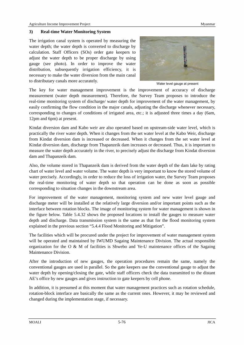
Agriculture Income Improvement Project Myanmar
MOALI 5-76 JICA
Water level gauge at present
3) Real-time Water Monitoring System
The irrigation canal system is operated by measuring the water depth; the water depth is converted to discharge by calculation. Staff Officers (SOs) order gate keepers to adjust the water depth to be proper discharge by using gauge (see photo). In order to improve the water distribution, subsequently irrigation efficiency, it is necessary to make the water diversion from the main canal to distributary canals more accurately.
The key for water management improvement is the improvement of accuracy of discharge measurement (water depth measurement). Therefore, the Survey Team proposes to introduce the real-time monitoring system of discharge/ water depth for improvement of the water management, by easily confirming the flow condition in the major canals, adjusting the discharge whenever necessary, corresponding to changes of conditions of irrigated area, etc.; it is adjusted three times a day (6am, 12pm and 6pm) at present.
Kindat diversion dam and Kabo weir are also operated based on upstream-side water level, which is practically the river water depth. When it changes from the set water level at the Kabo Weir, discharge from Kindat diversion dam is increased or decreased. When it changes from the set water level at Kindat diversion dam, discharge from Thapanzeik dam increases or decreased. Thus, it is important to measure the water depth accurately in the river, to precisely adjust the discharge from Kindat diversion dam and Thapanzeik dam.
Also, the volume stored in Thapanzeik dam is derived from the water depth of the dam lake by rating chart of water level and water volume. The water depth is very important to know the stored volume of water precisely. Accordingly, in order to reduce the loss of irrigation water, the Survey Team proposes the real-time monitoring of water depth so that operation can be done as soon as possible corresponding to situation changes in the downstream area.
For improvement of the water management, monitoring system and new water level gauge and discharge meter will be installed at the relatively large diversion and/or important points such as the interface between rotation blocks. The image of monitoring system for water management is shown in the figure below. Table 5.4.32 shows the proposed locations to install the gauges to measure water depth and discharge. Data transmission system is the same as that for the flood monitoring system explained in the previous section “5.4.4 Flood Monitoring and Mitigation”.
The facilities which will be procured under the project for improvement of water management system will be operated and maintained by IWUMD Sagaing Maintenance Division. The actual responsible organization for the O & M of facilities is Shwebo and Ye-U maintenance offices of the Sagaing Maintenance Division.
After the introduction of new gauges, the operation procedures remain the same, namely the conventional gauges are used in parallel. So the gate keepers use the conventional gauge to adjust the water depth by opening/closing the gate, while staff officers check the data transmitted to the distant AE’s office by new gauges and gives instruction to gate keepers by cell phone.
In addition, it is presumed at this moment that water management practices such as rotation schedule, rotation-block interface are basically the same as the current ones. However, it may be reviewed and changed during the implementation stage, if necessary.
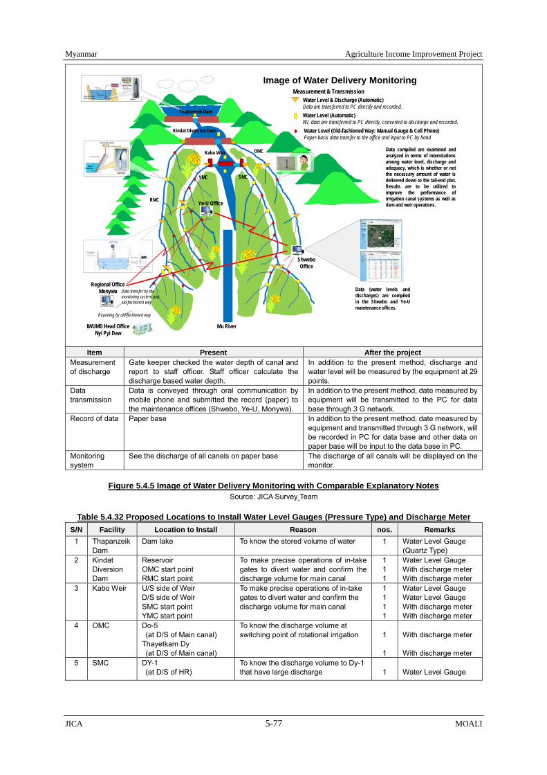
Myanmar Agriculture Income Improvement Project
JICA 5-77 MOALI
Measurement & TransmissionWater Level & Discharge (Automatic)Data are transferred to PC directly and recorded.Water Level (Automatic)WL data are transferred to PC directly, converted to discharge and recorded. Water Level (Old-fashioned Way: Manual Gauge & Cell Phone)Paper-basis data transfer to the office and input to PC by hand
Image of Water Delivery Monitoring
Data (water levels anddischarges) are compiledin the Shwebo and Ye-Umaintenance offices.
Data compiled are examined andanalyzed in terms of interrelationsamong water level, discharge andadequacy, which is whether or notthe necessary amount of water isdelivered down to the tail-end plot.Results are to be utilized toimprove the performance ofirrigation canal systems as well asdam and weir operations.
Kabo Weir
Kindat Diversion Dam
OMC
RMC
ShweboOffice
SMCYMC
Mu River
Thapanzeik Dam
Ye-U Office
Regional OfficeMonywa
IWUMD Head OfficeNyi Pyi Daw
Reporting by old-fashioned way
Data transfer by the monitoring system plusold-fashioned way
Item Present After the project
Measurement of discharge
Gate keeper checked the water depth of canal and report to staff officer. Staff officer calculate the discharge based water depth.
In addition to the present method, discharge and water level will be measured by the equipment at 29 points.
Data transmission
Data is conveyed through oral communication by mobile phone and submitted the record (paper) to the maintenance offices (Shwebo, Ye-U, Monywa).
In addition to the present method, date measured by equipment will be transmitted to the PC for data base through 3 G network.
Record of data Paper base In addition to the present method, date measured by equipment and transmitted through 3 G network, will be recorded in PC for data base and other data on paper base will be input to the data base in PC.
Monitoring system
See the discharge of all canals on paper base The discharge of all canals will be displayed on the monitor.
Figure 5.4.5 Image of Water Delivery Monitoring with Comparable Explanatory Notes
Source: JICA Survey Team
Table 5.4.32 Proposed Locations to Install Water Level Gauges (Pressure Type) and Discharge Meter S/N Facility Location to Install Reason nos. Remarks 1 Thapanzeik
Dam Dam lake To know the stored volume of water 1 Water Level Gauge
(Quartz Type) 2 Kindat
Diversion Dam
Reservoir OMC start point RMC start point
To make precise operations of in-take gates to divert water and confirm the discharge volume for main canal
1 1 1
Water Level Gauge With discharge meter With discharge meter
3 Kabo Weir U/S side of Weir D/S side of Weir SMC start point YMC start point
To make precise operations of in-take gates to divert water and confirm the discharge volume for main canal
1 1 1 1
Water Level Gauge Water Level Gauge With discharge meter With discharge meter
4 OMC Do-5 (at D/S of Main canal)
Thayetkam Dy (at D/S of Main canal)
To know the discharge volume at switching point of rotational irrigation
1
1
With discharge meter With discharge meter
5 SMC DY-1 (at D/S of HR)
To know the discharge volume to Dy-1 that have large discharge
1
Water Level Gauge

Agriculture Income Improvement Project Myanmar
MOALI 5-78 JICA
S/N Facility Location to Install Reason nos. Remarks DY-3 & Main canal (at D/S of HR) (at D/S of main canal)
To know the discharge volume to Dy-3, that have large discharge, and remaining water volume flowing to D/S in the main canal
1 1
Water Level Gauge Water Level Gauge
Bifurcation) (at D/S of HBC) (at D/S of MBC)
To know the discharge volume to HBC, MBC
1 1
With discharge meter With discharge meter
HBC DY-3 (at D/S of HR) (at D/S of HBC)
To know the discharge volume to HBC Dy-3 that have large discharge, and remaining water flowing to D/S in the HBC
1 1
Water Level Gauge Water Level Gauge
MBC DY-3 MBC (at D/S of HR) (at D/S of HBC)
To know the discharge volume to MBC Dy-3 that have large discharge, and remaining water flowing to D/S in the MBC
1 1
Water Level Gauge Water Level Gauge
6 RMC DY-4 (at D/S of Main canal)
To know the discharge volume at switching point of rotational irrigation
1
With discharge meter
Bifurcation at AEC/BEC (at U/S of main canal) (at U/S of AEC) (at U/S of BEC)
To know the discharge volume at switching point of rotational irrigation
1 1 1
With discharge meter Water Level Gauge Water Level Gauge
7 YMC Bifurcation for MBC (at D/S of main canal) (at D/S of MBC )
To know the discharge volume at switching point of rotational irrigation
1 1
With discharge meter With discharge meter
MBC DY5 (at D/S of HR ) (at D/S of MBC)
To know the discharge volume to MBC Dy-5 and remaining water flowing to D/S of MBC at the middle reach of MBC
1 1
Water Level Gauge Water Level Gauge
DY-18 (at D/S of HR ) (at D/S of main canal)
To know the discharge volume to DY-18 and remaining water flowing to D/S of main canal at the middle reach of YMC
1 1
Water Level Gauge Water Level Gauge
TOTAL 17 12
Water Level Gauge With discharge meter
Note: The quartz type gauge, which is a kind of pressure type, is installed at Thapanzeik Dam, because high accuracy (0.01% of the depth) is necessary due to the depth of the dam lake. In the meanwhile, Kindat Diversion Dam, Kabo weir and canals are shallow and do not need such an accuracy. Therefore, the pressure type of diaphragm, which is low cost, is selected.
Source: JICA Survey Team
4) Irrigation Management Transfer
The significant change is the introduction of Irrigation Management Transfer (IMT). That is, operation and management (O&M) of the lower portion of the irrigation system is transferred from the government to the group of farmers, which shall be established as water users association (WUA). In the long term, it is planned that approximately 500 WUAs are established in the Project area. During the Project implementation period, 2 WUAs from each main canal, namely total 8 WUAs, are to be established as a pilot. Thus, O&M of the upper portion of the irrigation system is under the responsibility of Shwebo and Ye-U maintenance offices, namely the government of Myanmar, while O&M of the lower portion of the irrigation system are under the responsibility of WUA.
The upper portion managed by the government is, in principle, the main canals, branch canals, extension canals, big distributary canals and the related irrigation facilities, and the lower portion managed by WUA is relatively small distributary canals, direct outlets, direct minor, minor canals and the interconnected irrigation facilities including water courses. This kind of irrigation management by the government and water users is called the joint management.
In the joint management, Shwebo and Ye-U maintenance offices have to make equitable irrigation water delivery to all WUAs. In other words, those maintenance offices have to deliver water to the

Myanmar Agriculture Income Improvement Project
JICA 5-79 MOALI
interface where O&M responsibility switches in accordance with the irrigation schedule predetermined and agreed by both the maintenance offices and WUAs. The flow rate, interval and duration of irrigation should be precise so that farmers can practice timely irrigation. In the meantime, WUA has to distribute the water received at the interface by themselves. In order to make WUA functional, some training, such as institutional development, accounting, water management for distribution, are indispensable.
5.4.6 IMT and Water Users Association Establishment
With rehabilitation of the irrigation system, the operation and maintenance (O&M) of the facilities are to be another crucial sphere to enhance irrigation performance, as well as, to sustain the facilities and ensure the water supply up to the end beneficiaries. In order to make irrigation facilities function equally to the upstream, midstream, and downstream water users, handing over the irrigation management from the government to farmers’ organization, so-called irrigation management transfer (IMT), is to be one of the solutions. This section provides the plan for the government – farmer joint irrigation management upon completion of the irrigation rehabilitation.
1) Cadre of Irrigation Management
The O&M of irrigation facilities such as dam, diversion dam, weir, main canal (including branches and extension canals) and distributary canals (including direct outlet, direct minor, and minor canal) in the targeted irrigation system are officially conducted under the responsibility of IWUMD, although farmers can implement small maintenance works such as weeding, un-siltation and minor repair, occasionally along those canals. Table 5.4.33 shows the number of engineering staff under the 4 irrigation systems, namely Kindat Right, Kindat Left, Kabo Right and Kabo Left irrigation systems.
Table 5.4.33 Engineering Staff under 4 Irrigation Systems1
Sr Description AD's Office (Shwebo)
Sub-Total (Shwebo)
AD's Office (Ye-U)
Sub-Total
(Ye-U) Total 6 AEs' Offices (Total)
5 AEs' Offices (Total)
1 Assistant Director (AD) 1 - 1 1 - 1 2 2 Canal Revenue Assistant (CRA) 1 - 1 1 - 1 2 3 Assistant Engineer (AE) - 6 6 - 5 5 11
4 Senior Sub-Assistant Engineer (SSAE) - 12 12 - 9 9 21
5 Sub-Assistant Engineer (SAE) - 9 9 - 6 6 15 6 Engineering Surveyors (ES) - 7 7 2 1 3 10
7 Assistant Engineering Surveyor (AES) - 3 3 1 10 11 14
8 Draft Man (DM) - - - 6 - 6 6 9 Canal Inspector (CI) - 11 11 - 11 11 22 10 Mechanic - - - - 2 2 2 11 Assistant Canal Inspector (ACI) - 29 29 - 18 18 47
12 Assistant Canal Revenue Surveyor (ACRS) - 2 2 - - - 2
13 Permanent Labor - 116 116 - 11 11 127 14 Casual Labor - 132 132 - 32 32 164
Total 2 327 329 11 105 116 445 Note: 1. 4 irrigation systems include Kindat Right, Kindat Left, Kabo Right and Kabo Left irrigation systems. Source: Shwebo and Ye-U Assistant Director Office, Maintenance Division, IWUMD
The operation of Thapanzeik dam is conducted by Sub Assistant Engineer (SAE), and the weirs are by operators under the instruction of Assistant Director (AD). The permanent labors paid per month, and casual labors paid per day, implement daily O&M of the weir and canal facilities. Gatekeepers (permanent or casual labors) live besides or near to each gate for the operation and to report the water level 3 times a day at 6 am, 12 am and 6 pm. In addition, the other permanent and casual labors live near villages from the irrigation facilities in order easily to engage in the daily maintenance in collaboration with other staff such as Canal Inspectors (CI) and Assistant Canal Inspectors (ACI).

Agriculture Income Improvement Project Myanmar
MOALI 5-80 JICA
The O&M of tertiary canals, so-called water courses, is conducted by the farmers, while the government manages down to the turnouts of each distributary canal, branch and extension canals, and/or minor canals from which such courses are branched through turnouts. In most cases, turnouts do not have gates, and they are closed by locally available materials such as sandbags or plastic bags.
The 4 irrigation systems were constructed each in distinctive time. The Kindat Left (Old Mu Canal, OMC) irrigation system was constructed during 18th century and rehabilitated in the late 1990s by IWUMD (at that time, Irrigation Department, ID). In a time of the British colony estimated around 1901 – 1907, the Kabo Right (Ye-U Main Canal, YMC) and the Kabo Left (Shwebo Main Canal, SMC) irrigation systems had been constructed including water courses. Farmers take water directly from the water courses or farm ditches extended from the water courses made by individual farmers. Then, the plots which are not directly connected with water course or farm ditches draw water by plot-to-plot irrigation.
Finally, the Kindat Right (Right Main Canal, RMC) irrigation system was completed in 1997 by IWUMD (formerly, ID), which in fact does not have clear water courses and therefore water from each turnout is supplied to the downstream farm plots mainly by plots-to-plot irrigation. There are some cases in which farmers make a short water course individually or among neighbor plots who have agreed otherwise within family members.
Among those 4 irrigation systems, some differences could be recognized regarding the distributary and water course management. First 3 irrigation systems, namely OMC, YMC, and SMC, which had been constructed more than 100 years ago, tend to have water course leaders or the similar function for the water course management, while RMC which was newly constructed around 20 years ago, tend not to have water course leaders.
The reason of this difference appears to be the Canal Act which was promulgated in 1905 during British colonial period. The Act addresses the importance of water course management among the farmers. Accordingly, water course leaders were selected among the related water users and were set up to each water course in order to lead the water course management. The canals, which were constructed around this period and especially have such water courses, provide a likelihood that there is a possibility of having water course leader till now.
Water course leaders do not entail the group of farmers organized by the leaders, yet just there is a leader to lead the maintenance of the water courses. The main duty of water course leaders is to mobilize colleague farmers to implement weeding and un-siltation along each of the water courses before water is supplied to the canal based on the announcement through IWUMD and village tract leaders. The weeding and un-siltation are conducted manually for example by using a hoe (mattock). Re-sectioning of the water courses can hardly be implemented by the farmers, and therefore farmers can request it to IWUMD depending on their necessity.
In these days, those water course leaders are existent in several ways in each of distributary canals along OMC, SMC, and YMC, while lately constructed RMC does not always have water course and the leaders. The information of water course leaders is not kept in a uniform recording method throughout the 4 irrigation systems. Sometimes the water course leaders are still functioning, some have already disappeared, and some have remained partially (refer to the examples in the box).
2) Direction of Irrigation Management
To improve irrigation performance, there are mainly 3 options of irrigation management: government management, farmers’ management, and joint management. Several countries where there are national irrigation systems have chosen joint management between the government and the beneficiary farmers, and transferred the responsibility, or a part of the responsibility, of irrigation management from the

Myanmar Agriculture Income Improvement Project
JICA 5-81 MOALI
government to farmers’ organizations.
This handing over of irrigation management is known as irrigation management transfer, so-called IMT. The movement had gradually begun around the 1950s to 1970s in distinct parts of the world, such as France, Taiwan, the United States of America, and Colombia; then it was spread in the 1980s to 1990s to the other various countries such as Mali, Tunisia, Bangladesh, the Philippines, New Zealand, Mexico, and Dominican Republic, totaling more than 60 countries.
The advantages of the IMT are considered as the beneficially-oriented irrigation management and the better cost and human allocation based on the reformation of the government irrigation sector. Farmers are the ones who use the water, conduct irrigation farming, and are directly benefited from the irrigation systems, and also, know the condition and the needs of the terminal irrigation facilities.
Frequent minor maintenance by the end water users can reduce necessity of large-scale rehabilitation to be organized by the government. In addition, reduction of the government maintenance expenses allows them to invest more in the primary construction needs in the other parts of the country. Finally, it leads to the increment not only of agricultural productivity but also overall revenue related to the irrigated agriculture, e.g. irrigation service fee, within the country.
From the farmers’ perspective, there are both burdens and benefits associated with IMT. The possible burdens and benefits for the farmers are as follows, indicating that there are considerable benefits to the farmers with IMT though there are some burdens for the farmers:
(Burdens) 1) Need to spare long time for the meetings, group activities, and consensus making. 2) Need to bear the expenses such as membership fee or maintenance fee. 3) Need to learn some technical matters such as water management, farming and financial
management.
(Benefits) 1) Can promptly maintain damages or malfunctions of the canals and/or water courses where the
farmers maintain. 2) Can consider cropping patterns and the water distribution for the area collectively among the
Current Distributary Canal Management by Canal System: 1) The Kindat Left Irrigation System (Old Mu Canal: OMC.)
In a direct outlet, weeding and un-siltation of the direct outlet, before or during water supply, is supervised by 4 canal leaders (the number of leaders depends on the existence of active farmers), while management of each water course is facilitated by a water course leader. Furthermore, each water course has a group of 10 farmers and the leader (If there were around 20 farmers, 2 groups are organized). The groups along a water course collaboratively conduct weeding and un-siltation. In addition, if there were any conflict related to water distribution between farmers, the group leader reports to the water course leader or a village tract leader in a serious case. The date and method of weeding and un-siltation are decided by 4 canal leaders and the village tract leader, and then announced to water users with a speaker. In these days, 4 leaders collect money from the water users and hire a backhoe for maintenance of the direct outlet (40,000 Kyats per hour x 15 hours = 600,000 Kyats composed of 5,000 Kyats/ac x 120 acre was collected).
2) The Kabo Right Irrigation System (Ye-U Main Canal: YMC.) In a minor canal, all water course leaders still have been in their position. When a leader becomes old or passes away, the leader is replaced with another water user (sometimes by discussion among water users, but sometimes not). In this way, the system of water course leader has continued until today. It is, however, noted that each water course leader does not work in collaboration with the other leaders.
3) The Kabo Left Irrigation System (Shwebo Main Canal: SMC.) In a distributary canal, all water course leaders are still functioning. In case the farmers need weeding or un-siltation of the minor canal, the water course leaders have a meeting to decide the date of activity, and all water users are mobilized to conduct the maintenance on the day. The water users under each water course carry out the activity in a minor canal section between an upstream turnout and their beneficial turnout.
4) The Kindat Right Irrigation System (Right Main Canal: RMC.) In a distributary canal under Ayadaw extension canal, basically there is no water course unless the water users make short water course individually or with some farmers. When necessary, some water users can jointly do weeding or un-siltation by sharing information each other. In the other direct minor canal, IWUMD tried to install water course leaders, but on the farmers’ side there was not such initiative and it has not taken place.

Agriculture Income Improvement Project Myanmar
MOALI 5-82 JICA
water users using the same turnout.
3) Can examine the water course construction or maintenance as a group, even in the area where plot-to-plot irrigation is major.
4) Can get water in proper timing with proper amount due to above 3 benefits.
5) Can increase yield and quality of the products due to proper crop selection, uniform planting period or cropping pattern in the area, reduction of disease, insect and pests, and proper water management.
6) Can rapidly claim to the relevant government department such as IWUMD as an association in case the water users need large-scale repair.
7) Can open the bank account as an association to manage collective capital. And can collect funds other than water tax.
8) Joint purchase of the agricultural inputs and joint sale of the products may possible in the future.
Having seen this, joint irrigation management is recommended as the potential breakthrough in enhancing the irrigation performance after the rehabilitation by the Project. To date, the construction and maintenance of the irrigation systems in the country have been carried out only by the government, except for water course (on-farm ditches) where existent. In order to introduce above fundamental restructuring of the actors for irrigation maintenance, establishment of farmers’ organization is to be required as the new responsible entities, to which handing over of operation and maintenance of some irrigation facilities from the government should be made.
Figure 5.4.6 shows the plan for joint irrigation management in the 4 irrigation canal systems. After the rehabilitation, the red colored canals in the figure are basically to be operated and maintained by the government, while the blue colored canals by the farmers’ organization, or water users association called WUA.
Figure 5.4.6 Plan for Joint Irrigation Management Source: JICA Survey Team

Myanmar Agriculture Income Improvement Project
JICA 5-83 MOALI
3) Farmer Organization: Water Users Association (WUA)
Based on the plan of joint irrigation management above-mentioned, the main canals, branch canals, extension canals, big distributary canals and the related irrigation facilities are, in principle, managed by the government, and the relatively small distributary canals, direct outlets, direct minor, minor canals and the interconnected irrigation facilities including water courses are to be managed by the farmers’ organization namely Water Users Association (WUA), though it can be adjusted depending on the length or irrigable area of the canals.
Water courses are basically created and managed under the farmers’ responsibility regardless of current water course conditions. In case the area does not have clear water course at present, the water users will discuss, plan and construct those if necessary after establishment of WUG or WUA. Of course, the construction of new water courses are to be conducted only when the water users understand advantages and challenges as well as required costs and labors of water course installation, and recognize the necessity together with crop diversification and future water use.
The management, such as operation and maintenance of the irrigation system including weeding, un-siltation and irrigation service fee collection, should be handed over to the WUAs for the blue colored canals in the figure. The gates installed at the boundary of the government management and WUA management should be operated by IWUMD, and the downstream facilities after there will be operated and maintained under the responsibility of the concerned WUAs.
For the management of small turnouts directly drawing water from the canals under the government management, one Water Users Group (WUG), in other words turnout group, will be formed by each of such turnouts. It can be standardized that 5 WUGs are to be organized as one WUA for main canals and branch canals under the government management. In the case of distributary canals under the government management, 10 WUGs can be standardized as per one WUA referring to the average WUG numbers for one distributary canal under the farmers’ management. The image of IMT is shown in Figure 5.4.7.
Total 222 WUAs are planned to be organized directly under the main canals in the long run. The WUA numbers will be 34, 87, and 101 for each Kindat Right (RMC), Kabo Right (YMC), and Kabo Left (SMC) irrigation system. In Kindat Left (OMC) irrigation system, only the main canal is to be managed by the government, under which there is no small direct turnout eligible for WUG establishment, and therefore there is no WUG/WUA directly set up under the OMC. The irrigable area of a WUA for each main canal ranges from 745 to 1,194 acres with an average of 969 acres. The water
Figure 5.4.7 Image of Irrigation Management Transfer Source: JICA Survey Team

Agriculture Income Improvement Project Myanmar
MOALI 5-84 JICA
users’ numbers of each WUA are estimated from 69 to 154 farmers. Therefore, 6 to 8 WUGs will be included in one WUA.
On the other hand, for the canals managed by farmers’ organization, basically one WUA will be established per distributary canal. Each WUA consists of WUGs counting equal numbers of the turnouts. Total 56 to 86 WUAs are to be formed in each irrigation system, totaling 295 WUA are intended to be under the canals by farmers’ management. The irrigable area of a WUA in each irrigation system is planned to be 896 to 1,089 acres with an average 945 acres. The average numbers of WUGs under a WUA is assumed to be 12 WUGs in average, ranging from 9 to 14 WUGs for each irrigation system. The average numbers of water users per each WUA are to be 103 to 141 in each system, and the average arrives at 122 water users.
Table 5.4.34 Water Users Association and Water Users Group under the Government Management Canals
Irrigation System (Main Canal)
Command Area (acre)
No. of WUAs1)
Av. Acre Coverage per WUA
(acre)
No. of WUGs
Av. No. of WUGs per
WUA1)
Av. No. of Farmers per
WUA
Av. No. of Farmers per
WUG
Av. Farmland per
Hosuehold2) (acre)
Kindat Right (RMC) 40,607 34 1,194 196 6 154 26
7.74
Main Canal 19,201 13 1,477 65 5 191 38 Branch Canal 11,049 15 737 75 5 95 19 Distributary Canal 10,357 6 1,726 56 10 223 22 Minor Canal 0 0 0 0 0 0 0 Kindat Left (OMC) 0 0 0 0 0 0 0 Main Canal 0 0 0 0 0 0 0 Branch Canal 0 0 0 0 0 0 0 Distributary Canal 0 0 0 0 0 0 0 Minor Canal 0 0 0 0 0 0 0 Kabo Right (YMC) 64,849 87 745 654 8 96 12 Main Canal 10,712 28 383 142 5 49 10 Branch Canal 7,313 16 457 79 5 59 12 Distributary Canal 46,824 43 1,089 433 10 141 14 Minor Canal 0 0 0 0 0 0 0 Kabo Left (SMC) 109,722 101 1,086 854 8 140 18 Main Canal 6,449 12 537 60 5 69 14 Branch Canal 6,823 15 455 77 5 59 12 Distributary Canal 92,829 69 1,345 690 10 174 17 Minor Canal 3,621 5 724 27 5 94 19
Total/av. (acre) 215,178 222
969 1,704 8 125 16
7.74
Total/av. (ha) 87,079 392 3.13 Note: 1) The turnouts of main canal, branch canal and minor canal under the government management are assumed to form 1 WUA by 5 WUGs.
While the turnouts of distributary canal under the government management are set as 10 WUGs per 1 WUA taking account the average WUG numbers per WUA of WUA management distributary canal.
2) The average farmland size per household is referred from household survey.
Considering both the government and WUA management canals, there will be total 517 WUAs composed of total 4,786 WUGs. The average size of 1 WUA is projected to cover 957 acres with 9 WUGs and 124 water users. One WUG includes 14 water users on average. In order to organize farmers into such a great number of organizations, some supportive factors and bottleneck should be taken into account. First, the water course leaders can be considered as a supportive element to find the key persons to organize farmers, or he/she can be the key person, even though the water users are rarely organized as a group at present.
Table 5.4.35 Water Users Association and Water Users Group under WUA Management Canals Irrigation System
(Main Canal) Command Area (acre)
No. of WUAs
Av. Acre Coverage per WUA (acre)
No. of WUGs
Av. No. of WUGs per
WUA
Av. No. of Farmers per
WUA
Av. No. of Farmers per
WUG
Av. Farmland per Hosuehold1)
(acre)
Kindat Right (RMC) 66,508 68 978 661 10 126 13
7.74
Direct Outlet 514 2 257 25 13 33 3 Direct Minor 19,046 27 705 228 8 91 11 Distributary Canal 11,421 15 761 277 18 98 5 Minor Canal 35,527 24 1,480 131 5 191 38 Kindat Left (OMC) 65,105 82 794 917 11 103 9 Direct Outlet 25,942 26 998 260 10 129 13 Direct Minor 0 0 0 0 0 0 0

Myanmar Agriculture Income Improvement Project
JICA 5-85 MOALI
Irrigation System (Main Canal)
Command Area (acre)
No. of WUAs
Av. Acre Coverage per WUA (acre)
No. of WUGs
Av. No. of WUGs per
WUA
Av. No. of Farmers per
WUA
Av. No. of Farmers per
WUG
Av. Farmland per Hosuehold1)
(acre) Distributary Canal 10,986 21 523 228 11 68 6 Minor Canal 28,177 35 805 429 12 104 9 Kabo Right (YMC) 50,180 56 896 632 11 116 11 Direct Outlet 0 0 0 0 0 0 0 Direct Minor 2,278 5 456 30 6 59 10 Distributary Canal 34,305 28 1,225 399 14 158 11 Minor Canal 13,597 23 591 203 9 76 8 Kabo Left (SMC) 96,916 89 1,089 872 10 141 14 Direct Outlet 0 0 0 0 0 0 0 Direct Minor 3,542 3 1,181 32 11 153 14 Distributary Canal 9,072 6 1,512 80 13 195 15 Minor Canal 84,302 80 1,054 760 10 136 14
Total/av. (acre) 278,709 295
945 3,082 10 122 12
7.74
Total/av. (ha) 112,790 382 3.13 Summary Total/av.
(acre) 493,887 517
957 4,786 9 124 14
7.74
Summary Total/av. (ha) 199,869 387 3.13
Note: 1) The average farmland size per household is referred from household survey.
The farmers, who are mobilized by the water course leaders and get used to the water course maintenance at present, tend to emphasize the similarities between their current water course management and the proposed joint irrigation management for distributary canals, when they were asked for their opinions on the joint irrigation management. However, the difference lies in the size between the current conventional organization and the WUAs, the latter of which is far bigger than the current one. Therefore, systematic organizing procedure should be required.
The existing interpretation of the “leader” might be a challenge in the future to involve farmers into the voluntary activities. So far, in most of the “leader” system observed in the Country, a leader alone acts as a responsible decision maker and implementer, and the other farmers are the followers or the passive participants. Therefore, stimulation of each farmer’s voluntary sense and a sense of responsibility is to be one of the challenges to organize farmers and conduct group activities in the operation and maintenance of irrigation facilities in future.
Considering above issues, the WUA is planned as multilayer structure to prevent centralization of the power to one specific person. The functions of planning, decision making, and implementation, should be de-centralized into the other groups of the members within the structure. As shown in the figure below, the base structure should be the WUGs, which are organized by each turnout water users. Each WUG has a leader and co-leader, in addition, supporters depending on their necessity.
On the other hand, the top structure in the WUA structure is the General Assembly (GA) composed of all the water users to decide most crucial issues for the association such as budget, registration of the association, rules and regulations. Board of Directors (BOD) formed by all the WUG leaders also function as decision making body for the issues related more to the implementation such as annual target setting of the maintenance. When the BOD members have a meeting, IWUMD officers will also participate in this meeting as an observer to secure the opportunity for the BOD members to consult about association management.
Under the BOD, 5-8 executive officials should be nominated from the BOD members and organize Management Board (MB), which is responsible for the day-to-day implementation. Each of the MB officials has their own duty as chairperson, vice-chairperson, secretary, treasurer, auditor, and the MB members. The nominated MB members and their duties including the ones of the BOD should be finally approved and decided by the General Assembly.
The workloads of these executive officials may discourage themselves to continue their duties on a voluntary basis. Therefore, incentives to the officials such as honorarium from the collected fees from

Agriculture Income Improvement Project Myanmar
MOALI 5-86 JICA
members or prior water distribution might be considered and discussed among the water users based upon their needs. In addition, some position requires technical knowledge such as treasurer and auditor. Therefore, the WUA can employ those officials as a part time worker from outside of the association, if necessary.
All planning of each specific concern is made in the Planning Committees (PC) placed under the MB. The committee may include financial committee, water distributary committee, and agricultural development committee, depending on their necessity. The MB officials can lead each committee as a leader: for instance, financial committee by a treasurer, water distributary committee by a vice-chairperson, and agricultural development committee by a secretary. Then, the committee members are selected from water users who are willing to participate in the activities.
The necessary steps to organize WUA can be as follows, and the steps, especially the confirmation of turnout locations and the steps which involve farmers, such as list-up of water users and the update of the list, introduction of WUA, and establishment of WUGs, are desirable to start in parallel with the rehabilitation and upon actual water supply. To take an attention and initial motivation of the beneficiary water users, ensured water supply from the irrigation facilities is to be the crucial and fundamental settings to mobilize farmers into the initial multiple works required for the farmers during the formation of WUA.
1) Confirmation of turnout location 2) List-up water users by each turnout 3) Introduction of WUA to the water users 4) Decide leader and co-leader for Water Users Groups (establishment of WUGs) 5) Hold 1st meeting among leaders from all WUGs (establishment of BOD) 6) Hold 1st GA by all the WUA members (establishment of GA)*
* Hold GA of representatives (WUG leaders), if the water users were too many to gather at once 7) Hold 1st meeting among selected 5 – 8 executive officials (start-up of MB) 8) Hold 1st meeting for PC (start-up of the PC) 9) Hold 2nd GA meeting (approval and start-up of activities as WUA) 10) Preparation for legal registration of WUA 11) Trainings on O&M and others
In above process of the pilot WUA establishment, IWUMD and the farmers will act as the main actors of implementation, while consultants are to be the supporters to present WUA concepts, structures and necessary preparations. This whole process requires 1-2 years. During the project implementation, the responsible officers of IMT and WUA establishment may organize as a committee such as a ‘WUA
Figure 5.4.8 Structure of WUA of Distributary Canal Source: JICA Survey Team

Myanmar Agriculture Income Improvement Project
JICA 5-87 MOALI
promotion committee’ in order to proceed the 8 pilot WUA establishment and lead or share the knowledge in the future WUA establishment of the area after the Project.
Provision of offices from the government to the pilot WUAs is not planned as an initial input, considering numerous numbers of WUAs which will be established by IWUMD after the Project in the broad area of the country, and the reproducibility in the other areas. Therefore, in the primary stage of pilot WUA establishment, the venues of the meetings will follow the existing meeting style of each area such as in a monastery or someone’s house. After each WUA is to be economically stable, construction of the office might be considered if each WUA wants to establish their office by their own budget with some subsidy from the government.
In the step 11) Training on O&M and others, different kinds of training needs should be taken account based on the various condition of irrigation facilities and water users. For example, some areas, such as OMC, YMC, and SMC, tend to have water courses already; therefore these water users may need more information on the maintenance of water courses.
In contrast, the other area such as RMC tend not to have water courses, so they may need more information on consensus making or construction methods for new water courses. In this sense, during the Project, information sharing and/or study meetings among relevant actors such as IWUMD and the consultants might be required to provide the water users with various kinds of options and supports.
Furthermore, for the future expansion of the WUA establishment in the beneficial area, it is recommendable to get the participation of the Irrigation Technology Center (ITC) staffs in addition to IWUMD to share the process and trainings. Plus on this, further technical supports might be necessary through an additional technical assistance project after this pilot attempt, for WUA dissemination to whole area or the country.
5.4.7 Operation and Maintenance of Irrigation Systems
1) Operation and Maintenance at Present
Two maintenance offices, Shwebo and Ye-U, are responsible for the O&M of the irrigation systems consisting of OMC, SMC, RMC and YMC together with Thapanzeik dam, Kindat diversion dam and Kabo weir.
1.1) Operation
Shwebo Maintenance Office
Shwebo maintenance office has 6 Staff Officer’s (SO’s) offices: Shwebo, Wetlet, Kabo, Kanbalu, Kin-U and Thapanzeik. As for SMC, 3 SO’s offices, Kabo, Shwebo and Wetlet, are responsible for O&M of the upper, middle and lower reaches, respectively. The boundaries of the canal reaches are township boundaries of Kin-U, Shwebo and Wetlet townships. The SO’s offices at Kabo, shwebo and Wetlet have 51, 62 and 82 staff, respectively.
In addition, the Kabo SO’s office is responsible for the O&M of Kabo weir. Meanwhile, 2 SO’s offices, Kanbalu and Kin-U, are responsible for O&M of the upstream and downstream reaches of OMC, respectively. The boundary between the upstream and downstream is the township boundary between Kanbalu and Kin-U townships. Kanbalu and Kin-U SO’s offices have 61 and 26 staff, respectively.
Although Shwebo maintenance office is in charge of Thapanzeik dam, there are 45 staff members at Thapanzeik SO’s office. They are responsible for all dam facilities but the intake facilities. The Department of Hydropower is responsible for the O&M of the intake facilities. Here, it should be noted that IWUMD makes the irrigation schedule and the Department of Hydropower operates the intake facilities and release water in accordance with the irrigation schedule or in accordance with the

Agriculture Income Improvement Project Myanmar
MOALI 5-88 JICA
instruction of IWUMD.
Ye-U Maintenance Office
Ye-U Maintenance Office has 5 SO’s offices: Ye-U, Tabayin, Kindat, Taze and Saing Pyin. The upstream reach of YMC is operated by 34 staff of Ye-U SO’s, office. Here, the upstream reach is from the weir to the bifurcation to Ma Ya Kan Branch Canal, which is also under the responsibility of Ye-U SO’s office. The downstream half of YMC is operated and maintained by 33 staff of Tabayin SO’s office. In addition to Kindat diversion dam, the upper reach of RMC is operated by 10 staff of Kindat SO’s office. The middle reach is by 16 staff of Taze SO’s office, and the lower reach is by 10 staff of Sagaing Pyin SO’s office.
1.2) Maintenance
There are 2 categories of maintenance: ordinary maintenance and special maintenance. The former is the routine annual maintenance, e.g. greasing gates, repairing the gate leaf, and patching/repairing the canal slope protection. Each maintenance cost is less than 300,000 Kyats. In the case of Shwebo maintenance office, the average annual cost for ordinary maintenance from 2011/12 to 2015/16 is approximately 165 million Kyats. In the expenses, the personnel expense for maintenance labor accounts for a large share. Their work is routine maintenance such as bush clearing of the canal bank.
The latter, the special maintenance, is heavy maintenance. Canal dredging, rehabilitation/replacement of canal structures and gate replacement are categorized into the special maintenance. In the case of Shwebo maintenance office, the average annual cost for special maintenance from 2011/12 to 2015/16 is approximately 1,493 million Kyats, which is tenfold of the ordinary maintenance (see Table 3.6.12 for the detailed maintenance costs).
The sum of the averages of ordinary and special maintenance costs is 1,658 million Kyats. This amount is equivalent to nearly 80% of the applied amount of budget. Roughly, Shwebo maintenance office applies for 2,000 million Kyats as annual budget, of which 80% is approved.
1.3) Staff of Maintenance Office
Staff of Shwebo and Ye-U maintenance offices is divided into 3 categories (groups): management, engineering and operation. The Assistant Director (AD), Canal Revenue Assistant (CRA) and Staff Officer (SO) belong to the management group. The Deputy Staff Officer, Engineering Surveyors (ESs) and Assistant Engineering Surveyor (AESs) belong to the engineering group. The Canal Inspectors (CIs), Assistant Canal Inspectors (ACIs), Assistant Canal Revenue Surveyors (ACRSs), Gate Keepers and Maintenance Labors belong to the operation group. Shwebo and Ye-U maintenance offices have a total of 329 and 108 staff members, respectively (see Tables 3.6.10 and 3.6.11 for the detail).
2) Problems regarding Maintenance
2.1) Bush-Clearing of Canal Banks
There are no substantial problems in ordinary maintenance, except for bush-clearing of canal bank. Labors hired by IWUMD clears the banks of main and distributary canals. However, they do not clear minor canal banks. They do clear just around head regulators. As a general rule, the government is responsible for the maintenance of canals that the government operates, and WUA is responsible for those that WUA operates after the IMT. The responsibility and scope of maintenance by canal and by organization are planned in “5.6.4 IMT and Water Users Association Establishment”.
2.2) Construction Machines
Problem associated with maintenance is insufficient machineries for special maintenance.

Myanmar Agriculture Income Improvement Project
JICA 5-89 MOALI
Construction machineries are necessary for required maintenance works. However, only 4 dilapidated excavators are usable: 2 for Shwebo maintenance office (one of two is amphibious type) and 2 for Ye-U maintenance office. 2 excavators for Shwebo belong to the Mechanical Circle Division 4 at Mandalay, and 2 excavators for Ye-U belong to Sagaing Regional Maintenance Office at Monywa. They are rented and also operators are sent from the mechanical division.
It is obviously not possible that only 4 excavators cover about 1,800 km length of canals in nearly 200,000 ha (500,000 acres) irrigation area. Besides, heavy maintenance works (special maintenance) are required only 1 to 2 months (December and January during non-irrigation period) every year, when canals have no water. Therefore, construction machines must be prepared so that special maintenance can be implemented simultaneously at some places, in order to keep the irrigation systems in good condition. Otherwise, the irrigation system cannot perform as designed even if the water management is improved. Consequently, construction machines essential for maintenance should be procured.
2.3) Maintenance Schedule
The irrigated area is approximately 200,000 ha (500,000 acres) and the period when maintenance works (special maintenance) is possible is for only 2 months, as mentioned above. It is not possible to dredge all canals every year unless some more machines are procured and prepared. Also, some places are necessary to be dredged every year and, every three years is enough for other places. It depends on the extent of sedimentation.
After the completion of rehabilitation of the canal systems, which includes canal lining, situation of sedimentation will be improved. Also, gates of weir and dams are replaced and enhanced in terms of water-tightness. Further, the material will be stainless steel which needs less maintenance. Therefore, a maintenance plan/schedule for periodic inspection, special maintenance and dredging shall be made at the end of the implementation stage as a part of consulting services.
3) Machines Necessary for Special Maintenance (Heavy Maintenance Works)
3.1) Construction Machines for Maintenance
Other than excavators, several kinds of construction machines are required for earthworks such as dredging, canal reshaping and road maintenance. Further, the suitable size of construction machines depends on the size of canal, road and other structure as well as site conditions. For example, it is very hard for a large excavator to dredge a small canal because of big size of its bucket; a small size excavator is suitable for the work. Inversely, it is just time-consuming and inefficient if a small excavator dredges a large canal with a lot of sediments because its working radius is small and its bucket size is small. Also, an amphibious-type machine is necessary for swampy area; normal type just sinks, gets stuck and cannot work at all.
3.2) Operators and Maintenance of the Constriction Machines
After procurement of those machines, Shwebo and Ye-U maintenance offices shall maintain them. As for machine operators, it is supposed difficult to employ new operators because heavy maintenance is required only from December to January. Accordingly, Mechanical Division Circle 4 at Mandalay shall send operators to Shwebo and Ye-U maintenance offices as necessary. Also, those maintenance offices have neither know-how nor equipment to maintain/repair construction machines. The maintenance schedule of these machines shall follow the schedule recommended in the Owner’s Manual and the Service Manual of respective machines.
4) Maintenance Cost for Thapanzeik Dam Irrigation Scheme after the Project Completion
The average annual maintenance cost of Thapanzeik Irrigation scheme for the last 5 years is 1,658

Agriculture Income Improvement Project Myanmar
MOALI 5-90 JICA
million kyats (refer to the Table 3.6.12). After the project completion, it is necessary to increase the operation staff, such as gatekeeper, canal inspector and maintenance labor in the areas where the gatekeepers are in shortage in order to improve the water management and keep good condition for the irrigation system. Since such cost is included in budget “Ordinary Repair “, IWUMD should allocate enough budget to the item “Ordinary Repair”.
On the other hand, the special repair will be small for some years upon completion of the project. However, large maintenance works such as overhaul of gate facilities of Thapanzeik dam, Kindat Diversion Dam, and Kabo Weir are necessary periodically. In addition, dredging of sedimentation in the canals will need to be done after 5 to 10 years from the project completion. The maintenance cost for Thapanzeik dam irrigation scheme is therefore estimated at total 2,395.5 million kyat per year, 708.5 million kyat for Ordinary Repair and 1,687.0 million kyat for Special Repair.
Table 5.4.36 Maintenance Cost for Thapanzeik Dam Irrigation Scheme (Unit: million Kyat)
Thapanzeik
Dam
Kindat Diversion
Dam Kabo Weir OMC SMC RMC YMC Total
Ordinary Repair 1) 50.0 30.0 30.0 80.0 280.5 119.0 119.0 708.5 Special Repair 2) 250.0 100.0 0.0 400.0 400.0 227.0 310.0 1,687.0
Total 300.0 130.0 30.0 480.0 680.5 346.0 429.0 2,395.5 Source: JICA Survey Team Note:
1) Ordinary Repair: Annual maintenance, e.g. greasing gates, repairing gate leaf and patching/ repairing canal slope protection, repairing canal embankment, repairing maintenance road, minor repair of canal structure, etc.
2) Special Repair: Large maintenance, e.g. dredging of canals, rehabilitation/ replacement of canal structure and gate replacement, etc.
5.4.8 Procurement of Maintenance Machineries
The procurement of construction machineries will be planned under necessary civil works to alleviate sedimentation in Kindat dam, maintenance of irrigation canals, improvement of the drainage system and upgrading of gravel-paved farm road and the parts of land consolidation. For the land consolidation works, the AMD cannot make a plan regarding irrigation, drainage and farm roads systematically. The collaboration between IWUMD maintenance branch and the AMD is essential to improve working quality. The maintenance and repair of machineries will be carried out by IWUMD Mechanical Branch Circle 4.
Table 5.4.37 Equipment List of IWUMD Maintenance Branch
Sr. Construction Machineries Specification Qty
Allocation to IWUMD Maintenance Branch
AD (Shwebo) Office
AD (Ye-U) Office
1 Mini Hydraulic Excavator 7 ton 20 units 10 units 10 units 2 Hydraulic Excavator 20 ton 10 units 5 unit 5 unit 3 Long Armed Hydraulic Excavator 20 ton + long arm 2 units 1 unit 1 unit 4 Amphibious Hydraulic Excavator 20 ton + amphibious crawlers 1 units 1 units - 5 Track Dozer CL III T-4 or T-5 4 units 2 units 2 units 6 Motor Grader 120-150 HP 2 units 1 unit 1 unit 7 Roller Compacter 10-20 ton 2 units 1 unit 1 unit 8 Self-Loading Truck 40-50 ton 2 units 1 unit 1 unit 9 Water Bowser Truck 1600 gal (7.2 m3 or more) 2 units 1 unit 1 unit 10 Tipper Truck 6x4, 6-8 ton 10 units 5 units 5 units
11 Dredging boat 12" suction, more than 450 HP 1 units
It will be procured for dredging sedimentation in reservoir of Kindat diversion dam and will also be used for other dam reservoirs and lakes after the project
Source: JICA Survey Team

Myanmar Agriculture Income Improvement Project
JICA 5-91 MOALI
5.5 Distribution Infrastructure Improvement and Upgrading
This section discusses the development plan on distribution infrastructure improvement or upgrade, which includes 1) rural road improvement/ upgrading, 2) bridge improvement/ new construction, and 3) canal inspection road improvement/ upgrading. As far as the road improvement is concerned, the development plan is divided into two different sections by the responsible agency: “1) rural road improvement/ upgrading” that is under the responsibility of the Department of Rural Road Development (DRRD) which was formerly DRD under MOALI till July 2017, and “3) canal inspection road improvement/ upgrading” under the Irrigation and Water Utilization Management Department (IWUMD).
5.5.1 Rural Road Improvement/ Upgrading (DRRD)
In the Project area where there are a total of about 200,000 ha of irrigated farmland, roughly 1 million tons of paddy (approximately 50 million baskets) are produced every year as an average production, and this is to be increased to almost 1.5 million tons of paddy (about 74 million baskets) with the Project completed. Of them, some are self-consumed and others are transferred to outside areas through roads and inland transportation networks. However, the road network especially within and around the Project area is still underdeveloped, being the bottleneck of agricultural/food value chain.
There is a union road running along south to north direction, through which people can enjoy transportation or movement between big towns, i.e., Mandalay to Kachin. However, except this road, there are very few roads able to ferry goods and people from south to north, or from north to south, especially around and within the Project area. While, roads running from west to east have been developed in recent years, e.g. connecting Zeegoon in Kanbalu TS to Kalaymyo (located western side of Chindwin river) via Kabo weir, Khin-U to Ye-u and further to Monywa, and Shwebo to Monywa. It means that trunk roads running from south to north or visa versa should be given priority in improving the road network in and around the Project area.
Then, once going into the paddy production area commanded by the Thapanzeik dam, we can find easily that the rural roads are very poorly developed. To ferry agriculture produces reaching as much as 1.5 million tons of paddy in near future, the roads existent in the Project area should be improved, and then trunk roads running from north to south should be given priority as well. Fortunately, main canals of the Thapanzeik dam irrigation system run from north to south, or from upstream to downstream direction of Mu river, and therefore the improvement of main canal inspection roads could contribute to facilitating the farm produces transportation coming from rural roads therein.
Thus, the development direction in road improvement and upgrading is oriented toward the strengthening of rural road network which works as farm-to-market roads, and connect them to existing union and regional roads, and also to canal inspection roads of Thapanzeik dam irrigation system, which are to be improved as well. This improvement will ensure the transportation of the agriculture produces and goods to mega cities or even to other countries. Now, one type of the target roads is the rural road which is under the responsibility of the DRRD that connect rural farm area to union or regional road and to canal inspection roads, and the other is the canal inspection road (sometimes called path) under IWUMD.
There may be an issue associated with union highway’s capacity, e.g. the union road connecting Shwebo town and Mandalay. If the union road between Shwebo town and Mandalay is small in the capacity of transporting agriculture produces from the Project area, the distribution will not be functional even if rural roads were to be improved. Here, based on the production of agriculture commodities with the Project, traffic loads at present and in future are estimated, by which the union road connecting Shwebo with Mandalay is judged if it has enough capacity or needs to enlarge.
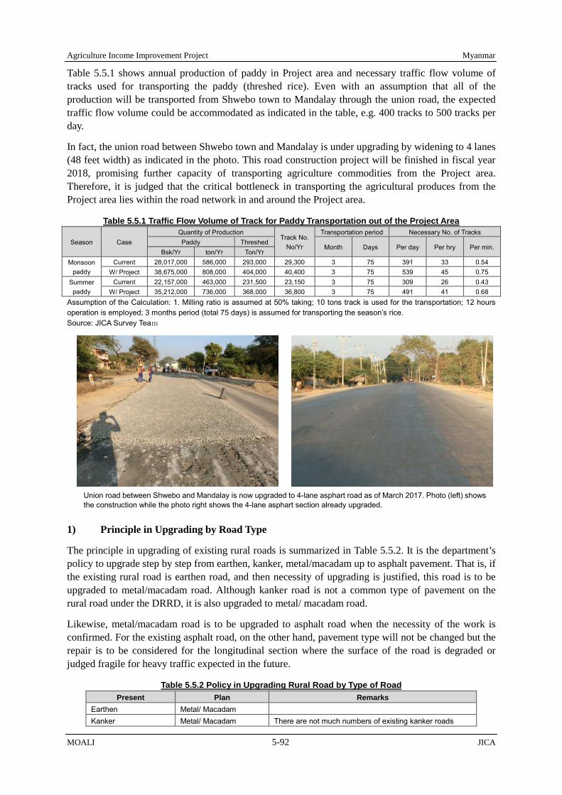
Agriculture Income Improvement Project Myanmar
MOALI 5-92 JICA
Table 5.5.1 shows annual production of paddy in Project area and necessary traffic flow volume of tracks used for transporting the paddy (threshed rice). Even with an assumption that all of the production will be transported from Shwebo town to Mandalay through the union road, the expected traffic flow volume could be accommodated as indicated in the table, e.g. 400 tracks to 500 tracks per day.
In fact, the union road between Shwebo town and Mandalay is under upgrading by widening to 4 lanes (48 feet width) as indicated in the photo. This road construction project will be finished in fiscal year 2018, promising further capacity of transporting agriculture commodities from the Project area. Therefore, it is judged that the critical bottleneck in transporting the agricultural produces from the Project area lies within the road network in and around the Project area.
Table 5.5.1 Traffic Flow Volume of Track for Paddy Transportation out of the Project Area
Season Case Quantity of Production
Track No. No/Yr
Transportation period Necessary No. of Tracks Paddy Threshed
Month Days Per day Per hry Per min. Bsk/Yr ton/Yr Ton/Yr
Monsoon paddy
Current 28,017,000 586,000 293,000 29,300 3 75 391 33 0.54 W/ Project 38,675,000 808,000 404,000 40,400 3 75 539 45 0.75
Summer paddy
Current 22,157,000 463,000 231,500 23,150 3 75 309 26 0.43 W/ Project 35,212,000 736,000 368,000 36,800 3 75 491 41 0.68
Assumption of the Calculation: 1. Milling ratio is assumed at 50% taking; 10 tons track is used for the transportation; 12 hours operation is employed; 3 months period (total 75 days) is assumed for transporting the season’s rice. Source: JICA Survey Team
1) Principle in Upgrading by Road Type
The principle in upgrading of existing rural roads is summarized in Table 5.5.2. It is the department’s policy to upgrade step by step from earthen, kanker, metal/macadam up to asphalt pavement. That is, if the existing rural road is earthen road, and then necessity of upgrading is justified, this road is to be upgraded to metal/macadam road. Although kanker road is not a common type of pavement on the rural road under the DRRD, it is also upgraded to metal/ macadam road.
Likewise, metal/macadam road is to be upgraded to asphalt road when the necessity of the work is confirmed. For the existing asphalt road, on the other hand, pavement type will not be changed but the repair is to be considered for the longitudinal section where the surface of the road is degraded or judged fragile for heavy traffic expected in the future.
Table 5.5.2 Policy in Upgrading Rural Road by Type of Road Present Plan Remarks
Earthen Metal/ Macadam Kanker Metal/ Macadam There are not much numbers of existing kanker roads
Union road between Shwebo and Mandalay is now upgraded to 4-lane asphart road as of March 2017. Photo (left) shows the construction while the photo right shows the 4-lane asphart section already upgraded.

Myanmar Agriculture Income Improvement Project
JICA 5-93 MOALI
Present Plan Remarks Metal/ Macadam Asphalt Asphalt Asphalt For the existing asphalt road, repair is to be conducted only
for the longitudinal section where degraded. Source: JICA Survey Team
2) Standard Cross Section
The DRRD maintains its own standard on road cross section, which includes the thickness of the pavement as per a type of pavement, for example. To begin with, the JICA survey team has reviewed the DRRD standard with reference to the road construction standard of the relevant ministry in Japan so as to examine the validity of the DRRD standard from a different point of view. As a result, it was concluded that the DRRD standard is reliable enough. To make sure, the result of the review is summarized in the box below.
The typical cross section of asphalt pavement and also metal/macadam pavement for rural road are illustrated in Figure 5.5.1 and Figure 5.5.2 respectively. As seen in the figures, total sectional width is composed of pavement section (road-way) and shoulder section, and the former’s width is set at 12 feet. Then, the width of shoulder was in fact 3 feet each till 2015, and it was increased to 4 feet each as new design criteria introduced in 2016 by DRRD (DRD at that time under MOALI), widening one feet each for the both sides.
In this Project, this widening is applied only to the road to be upgraded to asphalt pavement while other types of roads retain the same shoulder width of 3 feet each. This arrangement is to minimize the land acquisition required for the widening of the shoulder portion, and JICA FF mission dispatched in February 2016 agreed with then-DRD in which the widening is applied only to the section of roads to be improved to asphalt paved one.
Comparison Analysis of Typical Structure and Thickness of Asphalt Road between Japan and Myanmar
1. Typical Structure of Asphalt Road in Japan (1) Surface Layer: Asphalt mixture (t= 3-5 cm depending on the amount of traffic) (2) Base Layer: Asphalt mixture (t= 4-6 cm, depending on the amount of traffic) (3) Upper Base Coarse: Asphalt stabilization (t= around 10cm, depending on the amount of traffic) (4) Lower Base Coarse: Coarse-graded material about 40 mm in diameter (converted based on design CBR and traffic) (5) Roadbed: about 1 m in thickness (6) Filled-up ground: Earth filling
2. Typical Structure of Asphalt Road by the DRRD (Rural Road) (1) 1st Layer: Asphalt Coating (Hot Bitumen Surface Dressing)
* Quantity of Bitumen; 8(ton/mile) at 12 feet pavement width, 12(ton/mile) at 18 feet pavement width. (2) 2nd Layer: Laying and Compaction of Stone Metal(1/2"-3/4" Dia.),thickness=1" (3) 3rd Layer: Asphalt Coating (Hot Bitumen Dressing)
* Quantity of Bitumen; 21 (ton/mile) at 12 feet pavement width, 31.5 (ton/mile) at 18 feet pavement width. (4) 4th Layer: Laying and Compaction of Stone Metal(1"-2" Dia.),thickness=6" (5) 5th Layer: Laying and Compaction of Stone Metal(2"-4" Dia.) and Filling Material, thickness=6"
3. Discussion and Conclusion (1) Under the DRRD standard, 1st and 2nd layers are the mixture of hot bitumen and stone metal (1/2"-3/4"), having equivalent
function to the surface layer. (2) Under the DRRD standard, 1st and 2nd layers are the mixture of hot bitumen and stone metal (1"-2" Dia.). As size-adjusted
crush stone (25mm or 40mm) is employed for upper roadbed in Japanese standard, these layers have enough stability. In addition, upper part of the 3rd layer which is facing with asphalt coating (hot bitumen dressing) maintains high mixture ratio with base coarse materials, it can function as a base layer.
(3) Under the DRRD standard, filling materials are mixed for the 5th layer, depending on the grain size of the material. Similar arrangement is sometimes done in Japan, like a use of mountain gravel; thus, it can be concluded that the 5th layer is having a similar materials and thus function with the lower base coarse of Japanese standard. In addition, as it is an improvement of existing road, road bed and filled-up ground have been already well compacted, design CBR value is on the better side; thus, thickness of the base coarse is considered enough.
(4) Existing road bed and filled-up ground, especially along the embankment of canal, can be used without replacement.
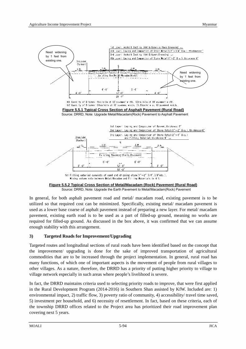
Agriculture Income Improvement Project Myanmar
MOALI 5-94 JICA
Figure 5.5.1 Typical Cross Section of Asphalt Pavement (Rural Road) Source: DRRD, Note: Upgrade Metal/Macadam(Rock) Pavement to Asphalt Pavement
Figure 5.5.2 Typical Cross Section of Metal/Macadam (Rock) Pavement (Rural Road)
Source: DRRD, Note: Upgrade the Earth Pavement to Metal/Macadam(Rock) Pavement
In general, for both asphalt pavement road and metal/ macadam road, existing pavement is to be utilized so that required cost can be minimized. Specifically, existing metal/ macadam pavement is used as a lower base coarse of asphalt pavement instead of preparing a new layer. For metal/ macadam pavement, existing earth road is to be used as a part of filled-up ground, meaning no works are required for filled-up ground. As discussed in the box above, it was confirmed that we can assume enough stability with this arrangement.
3) Targeted Roads for Improvement/Upgrading
Targeted routes and longitudinal sections of rural roads have been identified based on the concept that the improvement/ upgrading is done for the sake of improved transportation of agricultural commodities that are to be increased through the project implementation. In general, rural road has many functions, of which one of important aspects is the movement of people from rural villages to other villages. As a nature, therefore, the DRRD has a priority of putting higher priority to village to village network especially in such areas where people’s livelihood is severe.
In fact, the DRRD maintains criteria used to selecting priority roads to improve, that were first applied in the Rural Development Program (2014-2016) in Southern Shan assisted by KfW. Included are: 1) environmental impact, 2) traffic flow, 3) poverty ratio of community, 4) accessibility/ travel time saved, 5) investment per household, and 6) necessity of resettlement. In fact, based on these criteria, each of the township DRRD offices related to the Project area has prioritized their road improvement plan covering next 5 years.
Need widening by 1 feet from existing one.
Need widening by 1 feet from existing one.
Myanmar Agriculture Income Improvement Project
JICA 5-95 MOALI
Yet, the ultimate goal of the Project is to improve agricultural income of farmer households. Thus, as far as the project’s scope is concerned, the priority should be given to the strengthening of farm to market distribution in addition to the rural village to rural village networking. That is to consider the amount of agricultural commodities first in addition to the criteria that the DRRD usually applies. Therefore, in prioritizing the roads to be improved under the Project, at first the JICA team collected the road improvement plan that the DRRD township offices already have, and further put priorities on them from the view point of agriculture commodities transportation.
Pavement type and road length of rural road planned for the project is summarized in Table 5.5.3. As shown in the table, total length of metal/ macadam type road is as much as 607 km which accounts for 92% of the total length of rural road planned. On the other hand, total length of asphalt is 52 km, accounting for 8% of the total. Among the townships, accumulated length of rural road to be upgraded in each township varies from 23 km of Ayadow TS up to 120 km of Taze depending on the necessity for agricultural distribution.
Table 5.5.3 Pavement Type and Road Length of Rural Road Planned (DRRD)
District Township Pavement Type and Road Length
Metal / Macadam Asphalt Total (mile) (km) (mile) (km) (mile) (km) %
Kanbalu Kanbalu 46.04 74.11 0.00 0.00 46.04 74.11 11%
Shwebo
Kin-U 29.95 48.21 9.30 14.97 39.25 63.18 10% Shwebo 62.04 99.83 4.25 6.84 66.29 106.67 16% Wetlet 43.25 69.63 0.00 0.00 43.25 69.63 11% Taze 72.20 116.23 2.50 4.02 74.70 120.25 18% Ye-U 29.05 46.76 3.25 5.23 32.30 51.99 8%
Tabayin 61.09 98.32 6.00 9.65 67.09 107.97 16%
Monywa Budalin 26.25 42.25 0.00 0.00 26.25 42.25 6% Ayadaw 7.50 12.07 7.00 11.27 14.50 23.34 4%
Total 377.37 607.41 32.30 51.98 409.67 659.39 100%
92% 8% 100% Source: JICA Survey Team
The routes of rural roads targeted are illustrated in Figure 5.5.3 where asphalt pavement road is shown in blue color, metal/ macadam pavement is in purple. The figure also shows the location of bridges to be upgraded/ improved, and with the rehabilitation plan of canal inspection road to be discussed in Section 5.5.3. As shown in the figure, distance of each rural road is not as long as the ones for canal inspection road. Improvement/ upgrading of rural road aims at connecting rural villages to primary roads such as union road, regional road, and canal maintenance road along main and branch canal.
In addition, there are a few number of rural roads planned to be improved outside of irrigation command areas. They are identified in light of the importance in transporting agricultural product from upland farming areas, cultivators of which are sometimes the same farmers who has farmlands in the irrigated area. Also, those roads were given almost highest priority by DRRD township offices with reference to their criteria of village-to-village commutation.
DRRD township offices manage directly the rural roads and bridges located in each township. In case of the small amount of damages, DRRD township office will conduct repair or improvement of roads and bridges by themselves. If the roads and bridges suffer huge amount of damages, DRRD will contract the repair or improvement work to private company through tender. In this case, DRRD Sagaing regional office will hold the tender at the regional office (Monywa town). Then, the DRRD township office will conduct supervision works during the construction work contracted. The result of supervision will be reported from the township office to the district office and next to the Regional (State) office and finally reported to the DRRD head office in Nay Pyi Taw.

Agriculture Income Improvement Project Myanmar
MOALI 5-96 JICA
Figure 5.5.3 Rehabilitation Plan of Rural Road/ Bridges (DRRD) and Canal Inspection Road (IWUMD) Source: JICA Survey Team

Myanmar Agriculture Income Improvement Project
JICA 5-97 MOALI
5.5.2 Bridge Improvement/ Upgrading (DRRD)
In planning rural bridges to be improved/ upgraded, firstly, targeted bridges are selected from the existing bridges attached to the rural roads that are selected for the improvement or upgrading by the Project as described in the section 5.5.1. This is simply because road improvement only cannot facilitate effective transportation for agriculture produces if there are bottleneck in transporting over stream/ rivers. It is, on the other hands, noted that bridges attached to the canal inspection roads to be upgraded by the Project will be included as a part of irrigation facility rehabilitation plan.
Typical Wooden Bridges in the Project Area, to be improved under the Project Source: JICA Survey Team
As for the structure of the bridges, wooden bridges, pipe culvert, or course-ways are the main target to be upgraded to concrete bridges. The standard specification of bridges is as shown in the table below. Bridge width is expected to be more than 18 feet, including 12 feet of roadway and 3 feet each for shoulder as a standard width. Lane load capacity is designed to be 20 tons so that dump track which transport paddy or other agricultural products/ machinery can safely pass. Structure shall be reinforced concrete (RC) slab or steel-concrete composite slab for superstructure; the RC or brick structure for substructure; and spread foundation or cast-in-place concrete pile for foundation.
Table 5.5.4 Planned Design Conditions of Bridges attached to Rural Road Item Specification
1) Bridge Width: More than 18 feet (roadway width; 12 feet+ shoulder; 3 feet * 2) or more than existing width 2) Lane Load Capacity: 20 ton (for dump track etc.) 3) Length of Corner Cut* More than 5 feet 4) Structure:
a) Superstructure; Reinforced Concrete (RC) slab or steel-concrete composite slab b) Substructure; Reinforced Concrete (RC) or brick structure c) Foundation; Spread foundation or cast-in-place concrete pile (depending on the ground condition)
Source: JICA Survey Team | Note *: Corner Cut: approach portion between road and bridge
Table 5.5.5 summarizes the rural bridges to be improved/ upgraded. There are total 42 bridges undertaken by the Project, composed of 3 bridges, 36, and 3 for Kanbalu, Shwebo and Monywa districts respectively. The total length of 42 bridges, shortest one being 20 ft of bridge length while longest being 610 ft, is 3,570 ft and thus the average length comes to 85 ft. In case that the bridge length will be more than 60 ft, bridge pier should be installed because the span length of superstructure has a structural limitation. Figure 5.5.4 illustrates typical drawings for singly span and multiple span bridges. Note that the width differs as 18 ft for a bridge with less than 100 ft length while 24 ft in case of more than 100 ft length.
The total gross amount of beneficiary villages, beneficiary households and population are 199 villages, 43,537 households and 201,579 population respectively according to the concerned DRRD TS offices.

Agriculture Income Improvement Project Myanmar
MOALI 5-98 JICA
However, some roads have 2 to 4 bridges which are planned in this Project and also the beneficiary villages, households and population are counted repeatedly by road. Therefore, net numbers comes to 162 villages, 32,670 households and 147,699 population as the beneficiaries.
Table 5.5.5 Summary of Rural Bridges to be Improved (DRRD)
District Township No. of
Bridges Total Length of Bridges
Villages concerned
Beneficiary households
Beneficiary population
Remarks
Kanbalu Kanbalu 2 120 ft 6 1,923 8,022 Kyunhla 1 150 ft 4 687 2,250
Shwebo
Kin-U 2 120 ft 7 1,691 8,394 Shwebo 14 1,400 ft 36 8,713 40,133 Wetlet 3 220 ft 8 3,589 12,778 Taze 7 940 ft 35 5,401 22,791 Ye-U 2 130 ft 29 2,991 15,201
Tabayin 8 350 ft 26 5,727 27,861 Monywa Budalin 3 140 ft 11 1,948 10,269
Total 42 3,570 ft 162 32,670 147,699 Source: JICA Survey Team, Source for no. of villages, beneficiary household and population: Township offices of DRRD
5.5.3 Canal Inspection Road Improvement/ Upgrading (IWUMD)
As afore-mentioned in section 5.5.1, the road network in the Project area has a unique and distinctive characteristic. Major trunk roads, e.g. regional roads, are running more on the east-west direction, while rural roads stretch into mesh pattern though rural roads are fragile in structure. In addition, canal inspection and maintenance paths, called “canal inspection roads”, play an important role especially in the direction of north-south in people’s movement associated with farming as well as distribution of agricultural commodities.
Canal inspection roads are constructed along the canals so that the accessibility to farmlands is much more preferable. However, as most of the canal inspection roads are earthen or kanker, they are often closed during rain as a result no traffic becomes possible –implying a huge economic loss. Thus, the improvement/ upgrading of canal inspection roads, where agricultural production is considerably active, is necessary for improved transportation of agricultural commodities and also for agricultural mechanization.
1) Principle in Upgrading by Road Type
The principle in upgrading existing canal inspection roads is basically the same as the one for
Figure 5.5.4 Single Span (less than 60 ft) and Multiple Span (more than 60 ft) Bridges Source: JICA Team with reference to the DRRD Standard Design

Myanmar Agriculture Income Improvement Project
JICA 5-99 MOALI
upgrading rural road that is described in section 5.5.1. It is expected that the majority of canal inspection roads are currently earthen or kanker road. It was the department’s initial idea as to upgrade existing ones up to the level of kanker road, which means no metal/ macadam or asphalt. However, in consideration with the above, the JICA team proposed to upgrade existing kanker road to metal/ macadam or even up to asphalt road.
Table 5.5.6 Policy in Upgrading Canal Inspection Road by Type of Road Present Plan Remarks
Earthen Metal/ Macadam - Kanker Metal/ Macadam -
Asphalt Asphalt pavement is done for the section of main canals where heavy traffic is expected.
Metal/ Macadam Asphalt Not much number of existing metal/ macadam is expected. Asphalt Asphalt There is only one case of asphalt inspection road along Dy
1 canal of Shwebo main canal, which was constructed with the contribution from the villagers. Thus, this is quite an exceptional case, only one case in whole Myanmar.
Source: JICA Survey Team
2) Standard Cross Section
IWUMD has its own standard for the design of canal inspection road. However, as the type of road pavement is limited only to earthen or kanker, in principle, for the canal inspection road, the department does not have any particular standard cross section for asphalt or metal/ macadam. Therefore, it was decided to use the department’s standard for kanker road and the DRRD’s standard for metal/ macadam and asphalt. However, there is one difference from DRRD standard, which is the width of shoulder for asphalt pavement road. The asphalt pavement road for DRRD will have 4 feet shoulder width while canal inspection road will keep 3 feet width of shoulder even in case of asphalt improvement road. This is because canal inspection roads are constructed mostly on embankment, which makes difficult to widen the shoulder by small width, e.g. 1 feet only, with enough compaction measures.
Figures 5.5.5 to 5.5.7 illustrate the typical cross section of asphalt, metal/ macadam, and kanker designed for the canal inspection road. In general, existing pavement is used for all types as a filling-up ground or sometimes for a lower base coarse layer so that cost can be minimized. As for the design for canal inspection road, in addition, some slopes are created inclined toward the farmlands instead of canal as to prevent rainwater from coming into the canal: 2% for asphalt road, and 3% for metal/ macadam and kanker road.
Figure 5.5.5 Typical Cross Section of Asphalt Pavement (Canal Inspection Road)
Source: IWUMD/DRRD, finalized by JICA Survey Team

Agriculture Income Improvement Project Myanmar
MOALI 5-100 JICA
Figure 5.5.6 Typical Cross Section of Metal/ Macadam Pavement (Canal Inspection Road) Source: IWUMD/DRRD, finalized by JICA Survey Team
Figure 5.5.7 Typical Cross Section of Kanker Pavement (Canal Inspection Road) Source: IWUMD, finalized by JICA Survey Team
3) Canal Inspection Roads Planned for Improvement/ Upgrading
In general, inspection roads along main canal, branch canal and distributary canal are considered for upgrading. Then, specific routes and longitudinal sections of canal inspection roads have been identified in consideration with the request from IWUMD and also the amount of traffic in each road as well as the current condition of the road that have been confirmed by the field reconnaissance. Table 5.5.7 below summarizes the canal length of inspection road by pavement type and canal system. As shown in the table, a total length of canal inspection road reaches as long as 634 km as compared to 659 km of total length of rural road planned.
Table 5.5.7 Pavement Type and Road Length of Canal Inspection Road Planned
Type of Canal Kanker to Asphalt
Kanker to Metal/Macadam Earth to Kanker Repair of
Kanker Total
(mile) (km) (mile) (km) (mile) (km) (mile) (km) (mile) (km) (%) Main Canal 15.09 24.29 134.76 216.88 0.00 0.00 9.11 14.64 158.96 255.81 40%
Branch Canal 11.53 18.56 47.91 77.11 5.11 8.23 6.24 10.04 70.79 113.95 18% DY Canal 0.00 0.00 27.89 44.90 136.60 219.81 0.00 0.00 164.49 264.71 42%
Total 26.62 42.85 210.56 338.89 141.71 228.04 15.35 24.68 394.24 634.47 100%
7% 53% 36% 4% 100% Source: JICA Survey Team
In terms of the type of pavement, metal/ macadam pavement shares the biggest portion, that is, a total of 339 km in length, accounting for 53% of the total length. The second longest road is kanker pavement upgraded from earthen road (36%). If including the repair of kanker road, it is almost equal to the length of metal/ macadam (40%). As far as the type of canal is concerned, improvement of the canal inspection road along distributary canal shares the longest portion, accounting for 42% of the total length, while that of main canal shares 40%. Then, branch canal shares only 18% which belongs to SMC, YMC and OMC (for detail, see Appendix)
In addition, the routes of canal inspection roads targeted are illustrated in Figure 5.5.8 where asphalt road is shown in blue color, and metal/ macadam pavement is in yellow (see also Figure 5.5.8 for both rural road and canal inspection road). As shown in the figure, there are two asphalt pavement roads
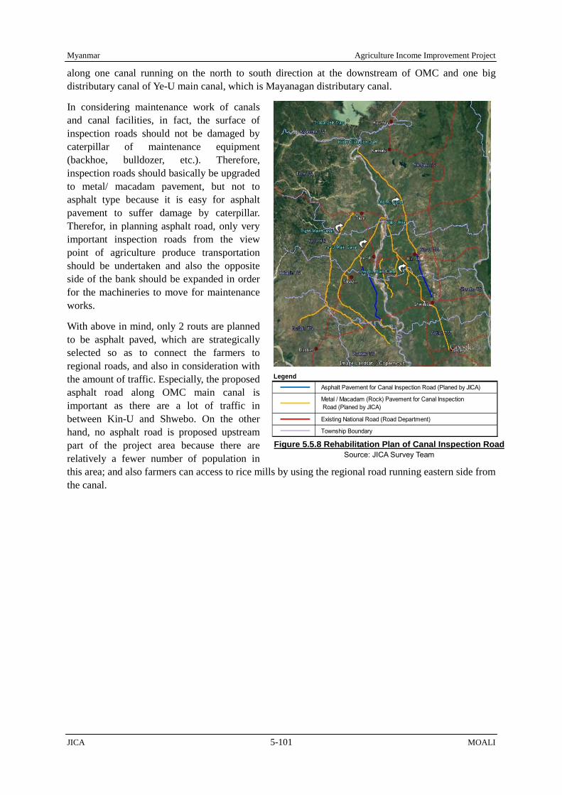
Myanmar Agriculture Income Improvement Project
JICA 5-101 MOALI
along one canal running on the north to south direction at the downstream of OMC and one big distributary canal of Ye-U main canal, which is Mayanagan distributary canal.
In considering maintenance work of canals and canal facilities, in fact, the surface of inspection roads should not be damaged by caterpillar of maintenance equipment (backhoe, bulldozer, etc.). Therefore, inspection roads should basically be upgraded to metal/ macadam pavement, but not to asphalt type because it is easy for asphalt pavement to suffer damage by caterpillar. Therefor, in planning asphalt road, only very important inspection roads from the view point of agriculture produce transportation should be undertaken and also the opposite side of the bank should be expanded in order for the machineries to move for maintenance works.
With above in mind, only 2 routs are planned to be asphalt paved, which are strategically selected so as to connect the farmers to regional roads, and also in consideration with the amount of traffic. Especially, the proposed asphalt road along OMC main canal is important as there are a lot of traffic in between Kin-U and Shwebo. On the other hand, no asphalt road is proposed upstream part of the project area because there are relatively a fewer number of population in this area; and also farmers can access to rice mills by using the regional road running eastern side from the canal.
Figure 5.5.8 Rehabilitation Plan of Canal Inspection Road Source: JICA Survey Team
Asphalt Pavement for Canal Inspection Road (Planed by JICA)
Metal / Macadam (Rock) Pavement for Canal Inspection Road (Planed by JICA)
Existing National Road (Road Department)
Township Boundary
Legend

Myanmar Agriculture Income Improvement Project
JICA 6-1 MOALI
CHAPTER 6 PROJECT COST AND IMPLEMENTATION ARRANGEMENT
This chapter discusses the project cost by component and necessary implementation arrangement, which especially needs coordination amongst relevant departments. The cost consists of direct work and equipment cost, in-direct cost, consultant cost, physical contingency and price escalation for inflation, etc. In fact, there are several project components and sub-components, and the implementation modality differs each other such as direct force account, international competitive bidding, local competitive bidding, etc. These issues including the implementation arrangement are elaborated below:
6.1 Project Components and Scoping for Yen Loan
6.1.1 Components Selected and Relevant Departments
Through the afore-mentioned discussions in Chapter 4 and Chapter 5, five project components have been identified for potential loan assisted components together with sub-components. The department to be involved in implementing the 5 components are; DOA, AMD, IWUMD, DALMS, DRRD, all of which are under the Ministry of Agriculture, Livestock and Irrigation.
Following tables summarize the components/ sub-components together with the relevant responsible departments to implement; Table 6.1.1 starts with the components followed by sub-contents and implementing department while Table 6.1.2 indicates the departments first together with the components/ sub-components that the organization should undertake:
Table 6.1.1 Project Components by Prospective Implementing Department No. Component Sub-component Department 1 Agriculture Development and
Extension Strengthening 1. Capacity building for DAO extension staff 2. Agriculture extension and marketing strengthening 3. Improvement of camp & TS offices 4. Establishment of seed center (PPP)
DOA
2 Agriculture Mechanization Strengthening
1. Maintenance workshop establishment 2. Agriculture machineries testing center (Mandalay) 3. Capacity building for AMD staff and operators
AMD
3 Land Consolidation 1. Farm road and tertiary canal construction 2. Land leveling and consolidation 3. Cadastral map update & registration of consolidated farmland
IWUMD AMD DALMS
4 Irrigation and Drainage Improvement
1. Irrigation and drainage rehabilitation 2. Water management and flood monitoring system 3. Procurement of maintenance machineries
IWUMD
5 Distribution Infrastructure Improvement
1. Rural road improvement 2. Rural bridge improvement 3. Canal inspection road improvement
DRRD DRRD IWUMD
Source: JICA Survey Team
Table 6.1.2 Implementing Department by Sub-component/ Major Components No. Department Sub-component Major Component 1 DOA 1. Capacity building for DAO extension staff
2. Agriculture extension and marketing strengthening 3. Improvement of camp & TS offices 4. Establishment of seed center (PPP)
Agriculture Development and Extension Strengthening
2 AMD 1. Maintenance workshop establishment 2. Agriculture machineries testing center, Mandalay 3. Capacity building for AMD staff and operators
Agriculture Mechanization Strengthening
4. Land leveling and consolidation Land consolidation 3 IWUMD 1. Irrigation and drainage rehabilitation
2. Water management and flood monitoring system 3. Procurement of maintenance machineries
Irrigation and Drainage Improvement
4. Canal inspection road improvement Distribution Infra. Improvement
Agriculture Income Improvement Project Myanmar
MOALI 6-2 JICA
No. Department Sub-component Major Component 5. Farm road and tertiary canal construction Land Consolidation
5 DRRD 1. Rural road improvement 2. Rural bridge improvement
Distribution Infrastructure Improvement
6 DALMS 1. Cadastral map update & registration of consolidated farmland Land Consolidation Source: JICA Survey Team
According to the above tables, though most of the major components are to be carried out by only one single department, such 2 components of Land Consolidation and Distribution Infrastructure Improvement have to be implemented by more than one departments hand in hand; the former by 3 departments of IWUMD, AMD and DALMS and the latter by 2 departments of DRRD and IWUMD. In fact, the implementation of Distribution Infrastructure Improvement may not be so difficult since the works can be clearly demarcated by the responsible department, e.g. rural roads and bridges by DRRD while the canal inspection roads by IWUMD.
For the Land Consolidation, due coordination should be established because the whole required works are to be implemented in a sequential way; namely, starting with the updating of the existing cadastral maps indicating the right cultivators by DALMS, designing, farmers consensus making on the consolidation works, and construction of farm roads and tertiary canals by IWUMD, and implementation of land leveling and ridge making by AMD, and finally again DALMS to register the newly consolidated farm plots with the right cultivators.
Whole process of this wok shall flow in a successive manner, so that the 3 departments should coordinate each other in implementing land consolidation works. For the smooth coordinated implementation, a working group should be established composed of IWUMD, AMD, DALMS, DOA and Farmland Administration Body (FAB) as aforementioned in Chapter 5.3 Land Consolidation.
6.1.2 Eligible Scope for Yen Loan
The major 5 components under the Project are composed of direct works including construction and activities, e.g., agriculture extension activities, procurement of machineries and equipment, etc. by its nature. Aside from the so-called direct costs incurred in these components, the project cost should include consultant cost, contingency, taxes, etc. Following table summarizes the major cost items and the prospected investors; namely, indicating the demarcation between the donor and the government:
Table 6.1.3 Project Components and Project Cost Sharing between Donor and MOALI No. Items Examples Calculation or Rate (%) Investor 1 Construction Works Irrigation rehabilitation, etc. BOQ1 Donor (JICA) 2 Component Activities Agriculture extension activities BOQ1 Donor (JICA) 3 Machinery Procurement Tractors, spare parts BOQ2 Donor (JICA) 4 Equipment Procurement e.g. for seed center BOQ2 Donor (JICA) 5 Price Escalation Foreign: 1.7%, Local: 7.0% Donor (JICA) 6 Physical contingency 5% of BOQ1, BOQ2, BOQ3 Donor (JICA) 7 Consulting Services DD, SV, Procurement Experts BOQ3 Donor (JICA)
8 Land Acquisition e.g. widening of asphalt road As per market price MOALI 9 Administration Cost, 1/ Government expenditure 10% of BOQ1, BOQ2, No.5, 6,
7, 8 MOALI
10 VAT 5.0% MOALI 11 Import Tax 10.0% MOALI 12 Interest during Construction 0.01% MOALI Note: 1/ administration cost in MOALI ranges from 10% to 15%, and since there is consultant team in the Project, the administration cost is assumed to be the minimum percentage, namely, 10%. Source: JICA Survey Team, 2016
As above-mentioned, costs directly incurred for the Project shall be undertaken by the donor, and in addition such indirect costs as price escalation, physical contingency, as well as consultancy fee will also be eligible for loan disbursement. On the other hand, the MOALI should bear such costs of land

Myanmar Agriculture Income Improvement Project
JICA 6-3 MOALI
acquisition, administration cost, taxes e.g. VAT and import tax, and also interest.
It is noted that land acquisition will be required for 2 sub-components; namely, 1) widening of asphalt road section by each 1 ft at both sides under the component of Distribution Infrastructure Improvement, and 2) construction of DOA extension camp building under the component of Agriculture Development and Extension Strengthening in case that the existing camp is operated on a leased land. Note that there are total 52 camps in the Project area, of which lands for 24 camps should be acquired.
6.2 Implementation Modality by Component
To implement the Project components and sub-components, the best implementation modality should be applied, e.g. direct force account, contractor/ supplier through local competitive bidding, contractor/ supplier through international competitive bidding, direct shopping, etc. One thing noted is that contractors able to undertake large scale civil works are very few in Myanmar since there are direct force construction units/ circles in such government departments as IWUMD for constructing dams and irrigation facilities, Department of Road, Department of Bridges, etc. In fact, there are large scale private contractors in Myanmar as well; however most of them are specialized in building construction as developer.
Table 6.2.1 proposes the implementation modality for each of the sub-components, e.g., by direct force account (DFA), local competitive bidding (LCB), and international competitive bidding (ICB). Note that some of the sub-components shown in the table are further divided in detail (2 parts), e.g. procurement of equipment, and construction of building/ workshops, in which the procured equipment are to be installed:
Table 6.2.1 Project Components and Implementation Modality Agency Sub-component Modality
IWUMD
1 Irrigation and Drainage Rehabilitation DFA 2 Water management and flood monitoring system (equipment procurement) ICB 3 Procurement of maintenance machineries ICB 4 Canal inspection road improvement, utilized as farm-to-market road LCB 5 Farm road and tertiary canal construction (land co consolid’ n, 5,000 ac), with AMD DFA
DRRD 1 Rural road improvement LCB 2 Rural Bridge improvement LCB
AMD
1.1 Maintenance workshop (equipment procurement, 4 places) ICB 1.2 Maintenance workshop (building construction, 4 places) LCB 2.1 Agriculture Machineries Testing Centre (equipment procurement) ICB 2.2 Agriculture Machineries Testing Centre (building construction) LCB 3 Capacity building for AMD staff & operators DFA
4.1 Land leveling & consolidation (procurement of LC machineries, tractor, etc.) ICB 4.2 Land leveling & consolidation (LC construction), with IWUMD DFA
DOA
1 Capacity building for DOA extension staff (trainings, manuals, etc.) DFA 2 Agriculture extension and marketing strengthening (demo farms, logistics, etc.) DFA
3.1 Improvement of camp and TS offices (52 camps + 9 TSs) LCB 3.2 Improvement of cam & TS offices (procurement of office equipment.) LCB 4.1 Establishment of seed center (equipment procurement), PPP ICB 4.2 Establishment of seed center (building and storage construction), PPP LCB
DALMS 1 Cadastral map update & registration of consolidated farmland DFA Source: JICA Survey Team, 2016
In proposing the implementation modality following were taken into consideration:
1) ICB should in most cases be applied in procuring machineries and equipment to be imported, not available within Myanmar. These are equipment for flood monitoring and water management system (IWUMD), machineries for maintenance of canals (IWUMD), equipment and machineries

Agriculture Income Improvement Project Myanmar
MOALI 6-4 JICA
for AMD workshops and agriculture machineries testing center, machineries required for land consolidation (e.g. tractor), and equipment for seed center (DOA).
2) LCB can be applied for construction of building/ offices and workshop housing as far as there are private civil and/or building construction companies. In fact, there are lots number of small – medium sized local companies to be engaged in the construction of building/ offices/ workshop housing, so that they shall be utilized as much as possible. In fact, the cost of the construction for those facilities is not big, namely, in all the cases they are less than 1 million US$ per construction site. Therefore, LCB should be applied rather than ICB in those construction works. In addition, procurement of equipment available in Myanmar can also be done by LCB, as in the case of “3.2 Procurement of camp & TS office equipment (PC, copier, projector, etc.)”.
3) LCB can also be applied in such civil works of canal inspection road upgrading (IWUMD), rural road improvement under DRRD, and also rural bridge construction under DRRD. In fact, DRRD does not have direct force unit, and therefore the department has applied LCBs (see box). IWUMD, on the other hand, has a large scale direct force units, called construction circle, which however have seldom experienced road/ bridge construction except for earthen road and simple over-canal bridge. There are already lots number of civil contractors, from small size to large scale, which can undertake road and bridge works. Therefore, road and bridge improvement/ construction works should engage private civil contractors, including in the improvement/ upgrading of IWUMD canal inspection roads.
4) Direct force account implementation is recommended in such sub-components as; 1) irrigation and drainage rehabilitation by IWUMD, 2) land consolidation by IWUMD/AMD, 3) capacity building for AMD staff/ operator and DOA extension staff, 4) agriculture extension and marketing strengthening, and 5) cadastral map update & registration of consolidated farmland. In fact, there is no other way than applying direct force account implementation on the 3) to 5) sub-components. In these sub-components, however, one may say that irrigation and drainage rehabilitation works and land consolidation works may be better out-sourced to civil contractors. Yet, with following situation, these works should be undertaken by IWUMD and AMD direct force account.
5) For the land consolidation, civil companies do not have tractors which are used in land-leveling works (Note that bulldozer can also carry out the leveling works; however, the cost is more than double so that in all the cases tractor, preferably 90HP, has been employed in the leveling work). In addition, land consolidation work is very much affected by farmers’ cultivation and also attitude. Even after farmers have agreed not to cultivate at lease one crop, e.g. winter pulses crop, some of them might start cultivating, should the commencement of the consolidation works be delayed a bit. In this case, whole consolidation works covering a certain area of block should be postponed to next year. With this kind of risk, private companies had better not to undertake but the government entity, i.e. IWUMD and AMD, can better implement.
LCB to the Road/ Bridge Construction:
LCB for DRRD road/ bridge construction is implemented by Tender Selection Committee established at Region/ State level, basically. However, the tendering of the Loan Project can/should be managed at HQs level, according to the DRRD HQs. The bidders are supposed to submit their bids within 30 days after the bid announcement in a newspaper, i.e. New Right of Myanmar. In this case, the bidders are instructed to offer 2 envelopes composed of 1st envelope: technical requirements, company profile, financial statement, etc. and the 2nd envelope: the Financial bid. Pre-Qualification (PQ) and Limited Competitive Bidding are not implemented for DRRD’s construction works in general. A tender lot for DRRD works is usually comprised of about 300 Million kyat (30 million Yen) while one lot that the Project is to undertake will be around at 2 billion Kyats due to the scale of the works, and implementation period is assumed to be one year (from March to next year April). As above-mentioned, the road/ bridge components under the Project should therefore be conducted by Myanmar civil contractors through LCBs as experienced by DRRD (note that the tender should be conducted at Nay Pyi Taw).

Myanmar Agriculture Income Improvement Project
JICA 6-5 MOALI
6) Concerning the works for irrigation and drainage improvement (IWUMD), as a matter of fact there are very few, or almost nothing, of big private companies able to undertake works related to hydraulic structures. As afore-mentioned, there are civil contractors already in road construction sector. However, other big construction companies are specialized in building construction and at the same time developers, who invest in procuring the land and constructing private buildings, e.g. apartment, on it and sell it to the market. There are therefore very few in such works required for irrigation and drainage improvement. With this situation, irrigation and drainage improvement shall be implemented by IWUMD direct-force except for small civil works mentioned below,
7) In case of small works for irrigation and drainage improvement (IWUMD), of course, they can be out-sourced to local contractors; for example rehabilitation of minor canals can be done by local contractors since this kind of works does not need large construction machines and can be done mostly by manual labors. To accelerate the works and also from the view point of facilitating private companies market, the rehabilitation of terminal facilities can and should engage private civil construction companies.
8) A JICA team conducted an interview survey to registered general contractors based in Yangon in 2005 (under Preparatory Survey on Intensive Agriculture Promotion Program, 2016). First, the team contacted Myanmar Engineering Society and picked up 11 biggest contractors. Though the team tried to contact all the 11 biggest companies, only 4 companies accepted the team’s interview. Fortunately, the 4 companies are well known in Myanmar and 3 out of the 4 are said to be within the top 5 civil contractors in Myanmar. Following Table 6.2.2 refers to the interview results;
In terms of workforce, it ranges from 300 to about 1000, while the construction machineries they have are bulldozer, excavator, wheel/road loader, concrete batching plant, etc. the number of owned machines are; less than 10 for bulldozer, 5 to 111 for excavator, 14 to 39 for dump truck, and so on.
For the works experienced, 2 companies have been engaged in irrigation related works which was also confirmed in IWUMD HQs. In fact, IWUMD has made contract-out to these companies, and Company C has undertaken at least 4 numbers of works whose contract amounts were more than 1 billion Kyats.
Table 6.2.2 Information of Civil Contractors in Myanmar
Name of Company A Company
B Company
C Company
D Company
1. General Information Location of Head Office Capital Fund (million kyat) Number of Employee Annual Total Sales (million kyat) 2. Number of Construction Equipment
Bulldozer Excavator (Backhoe) Dump Track Wheel / Road Loader Batching Plant Hydraulic Pile Machine Others
3. Experience of Construction (for the last 10 years) Irrigation related (Dam, Canal etc.)
> 1,000 million kyat 1,000 million kyat <
Others (Building, Port etc.)
> 1,000 million kyat 1,000 million kyat <
Source: Preparatory Survey on Intensive Agriculture Promotion Program (2016)
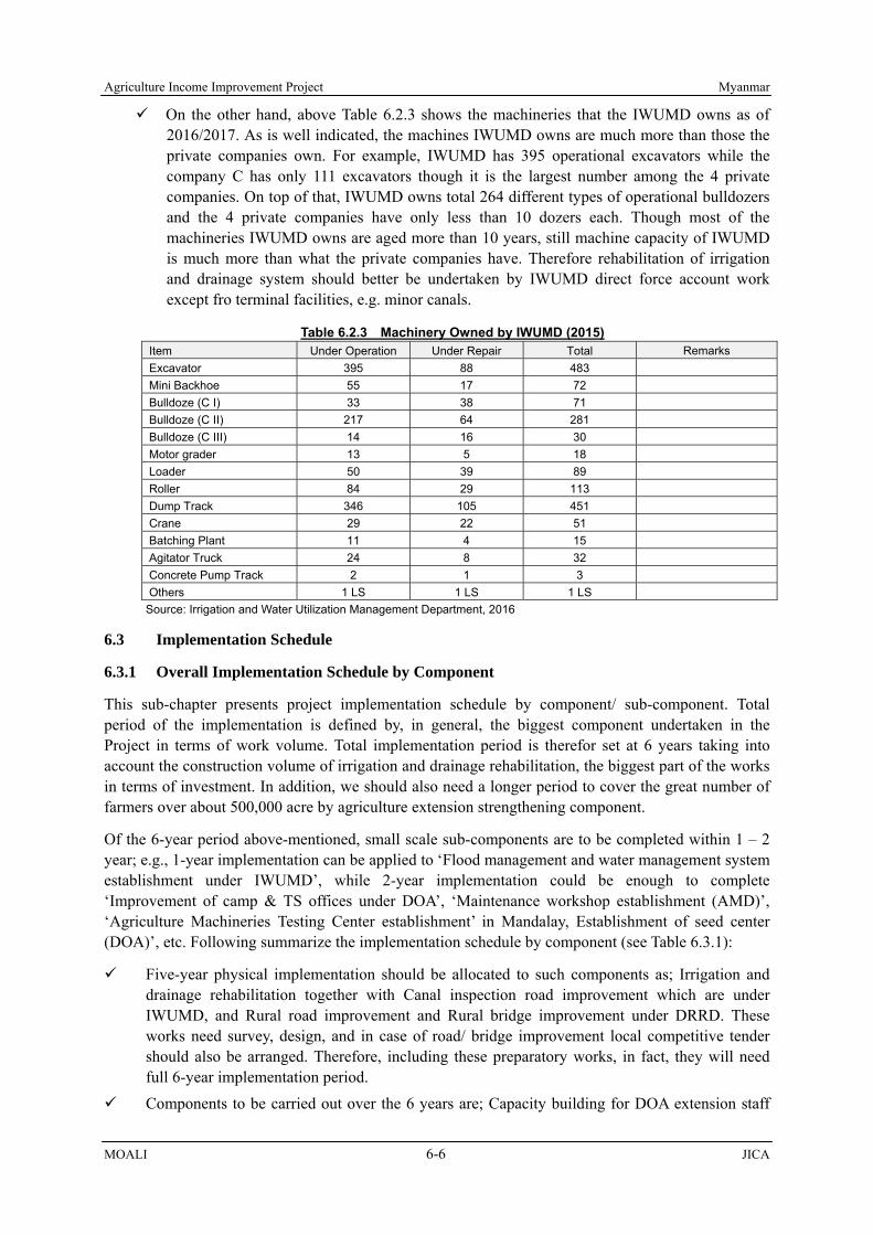
Agriculture Income Improvement Project Myanmar
MOALI 6-6 JICA
On the other hand, above Table 6.2.3 shows the machineries that the IWUMD owns as of 2016/2017. As is well indicated, the machines IWUMD owns are much more than those the private companies own. For example, IWUMD has 395 operational excavators while the company C has only 111 excavators though it is the largest number among the 4 private companies. On top of that, IWUMD owns total 264 different types of operational bulldozers and the 4 private companies have only less than 10 dozers each. Though most of the machineries IWUMD owns are aged more than 10 years, still machine capacity of IWUMD is much more than what the private companies have. Therefore rehabilitation of irrigation and drainage system should better be undertaken by IWUMD direct force account work except fro terminal facilities, e.g. minor canals.
Table 6.2.3 Machinery Owned by IWUMD (2015) Item Under Operation Under Repair Total Remarks Excavator 395 88 483 Mini Backhoe 55 17 72 Bulldoze (C I) 33 38 71 Bulldoze (C II) 217 64 281 Bulldoze (C III) 14 16 30 Motor grader 13 5 18 Loader 50 39 89 Roller 84 29 113 Dump Track 346 105 451 Crane 29 22 51 Batching Plant 11 4 15 Agitator Truck 24 8 32 Concrete Pump Track 2 1 3 Others 1 LS 1 LS 1 LS
Source: Irrigation and Water Utilization Management Department, 2016
6.3 Implementation Schedule
6.3.1 Overall Implementation Schedule by Component
This sub-chapter presents project implementation schedule by component/ sub-component. Total period of the implementation is defined by, in general, the biggest component undertaken in the Project in terms of work volume. Total implementation period is therefor set at 6 years taking into account the construction volume of irrigation and drainage rehabilitation, the biggest part of the works in terms of investment. In addition, we should also need a longer period to cover the great number of farmers over about 500,000 acre by agriculture extension strengthening component.
Of the 6-year period above-mentioned, small scale sub-components are to be completed within 1 – 2 year; e.g., 1-year implementation can be applied to ‘Flood management and water management system establishment under IWUMD’, while 2-year implementation could be enough to complete ‘Improvement of camp & TS offices under DOA’, ‘Maintenance workshop establishment (AMD)’, ‘Agriculture Machineries Testing Center establishment’ in Mandalay, Establishment of seed center (DOA)’, etc. Following summarize the implementation schedule by component (see Table 6.3.1):
Five-year physical implementation should be allocated to such components as; Irrigation and drainage rehabilitation together with Canal inspection road improvement which are under IWUMD, and Rural road improvement and Rural bridge improvement under DRRD. These works need survey, design, and in case of road/ bridge improvement local competitive tender should also be arranged. Therefore, including these preparatory works, in fact, they will need full 6-year implementation period.
Components to be carried out over the 6 years are; Capacity building for DOA extension staff

Myanmar Agriculture Income Improvement Project
JICA 6-7 MOALI
and Agriculture extension and marketing strengthening. These 2 components are undertaken by DOA and should proceed in parallel hand in hand, needing the full 6-year period as the Project area covers vast area with more than 60,000 farm households.
Land consolidation is to be implemented area by area over the 4 year period targeting 5,000 acres in total. The consolidation works need updating of cadastral maps with farmers list and also registration of the newly re-plotted parcels for the farmers. Taking into account the updating and new registration, total implementation period will be 5 years, one-year plus to the physical implementation period.
Building/ office / housing structures are planned to complete within 2 years including survey, design, quantity estimation, cost estimation, preparation of bid documents for LCB, tendering and awarding, and construction. Since the structures planned under the Project are not so big in size, e.g. maintenance workshop, agri-machineries testing center, etc., 2-year schedule is planned to be enough to complete.
Procurement is also planned to complete within 2-year period, except for procuring the equipment for flood monitoring and water management system. The equipment of the flood monitoring and water management system is not big scale, and mostly composed of water level gauge, rainfall gauge, 3G transmission system, and PC with necessary software. Such procurement will be completed within one-year. Note that this procurement will be done at 2nd last year from the project completion of irrigation and drainage rehabilitation since the equipment shall be installed almost with the completion of the rehabilitation works.
Most of the sub-components under ‘Agriculture Mechanization Strengthening’ will be completed in 2 years except for Capacity building for AMD staff and operators. The works under AMD are the procurement of equipment/ machineries/ tools and construction of building, which can be completed within 2 years, with which capacity building should follow. Therefore, capacity building is planned to start one year after the commencement of other AMD sub-components.
Defect notification period (DNP) is set at 1-year only for ICB and LCB components. For the direct force account works, DNP is not set.
At almost mid of the project implementation; i.e., by the time of October 2020, there are components/ works which will have been already completed. These components and works are as follows:
[Irrigation and Drainage Improvement] Rehabilitation of one (1) irrigation system, out of 4 main canal systems Procurement of the maintenance machinery [Distribution Infrastructure Improvement] Rehabilitation of the road (approx. 80km) Rehabilitation/construction of bridge (9 places) Upgrade of canal inspection road (80km) [Agriculture Mechanization Strengthening] Construction of maintenance workshop (5 places) Construction of agriculture machineries testing center (1 place) [Land Consolidation] Procurement of machinery for land consolidation Land consolidation (1,000 ac, 400 ha) [Agriculture Development and Extension Strengthening] Improvement of camp and TS office (52 places for camp and 9 places for TS offices) Construction of seed center Procurement of the equipment for seed center
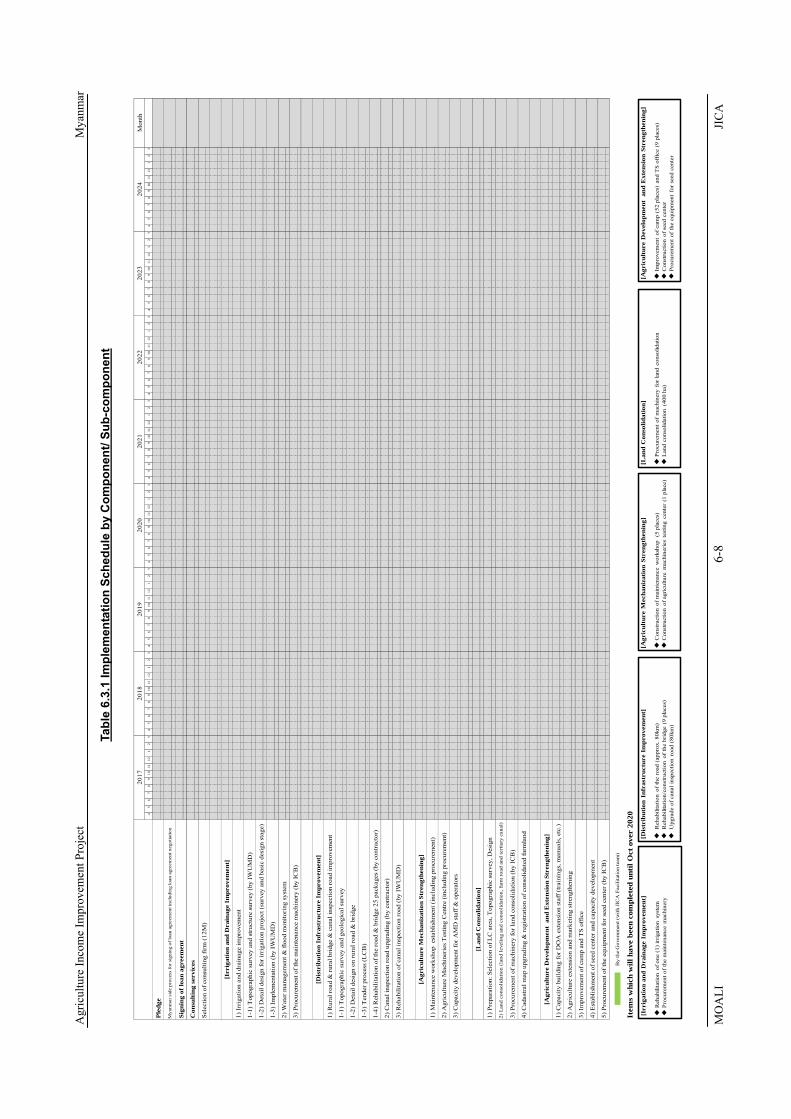
Agr
icul
ture
Inco
me
Impr
ovem
ent P
roje
ct
M
yanm
ar
MO
ALI
6-
8 JI
CA
Tabl
e 6.
3.1
Impl
emen
tatio
n Sc
hedu
le b
y C
ompo
nent
/ Sub
-com
pone
nt
Mon
th4
56
78
910
1112
12
34
56
78
910
1112
12
34
56
78
910
1112
12
34
56
78
910
1112
12
34
56
78
910
1112
12
34
56
78
910
1112
12
34
56
78
910
1112
12
34
56
78
910
1112
12
3
Item
s w
hich
will
hav
e be
en c
ompl
eted
unt
il O
ct o
ver
2020
1) I
rrig
atio
n an
d dr
aina
ge im
prov
emen
t
Sign
ing
of lo
an a
gree
men
t
Con
sult
ing
serv
ices
2021
2022
Mya
nmar
sid
e pr
oces
s fo
r sig
ning
of l
oan
agre
emen
t inc
ludi
ng lo
an a
gree
men
t neg
otia
tion
Ple
dge
2023
2024
2017
2018
2019
2020
Sele
ctio
n of
con
sulti
ng fi
rm (1
2M)
3) P
rocu
rem
ent o
f the
mai
nten
ance
mac
hine
ry (
by IC
B)
1-2)
Det
ail d
esig
n fo
r ir
riga
tion
proj
ect (
surv
ey a
nd b
asic
des
ign
stag
e)
2) W
ater
man
agem
ent &
floo
d m
onito
ring
sys
tem
[Irr
igat
ion
and
Dra
inag
e Im
prov
emen
t]
1-2)
Det
ail d
esig
n on
rur
al r
oad
& b
ridg
e
1-1)
Top
ogra
phic
sur
vey
and
stru
ctur
e su
rvey
(by
IWU
MD
)
1) R
ural
roa
d &
rur
al b
ridg
e &
can
al in
spec
tion
road
impr
ovem
ent
1-3)
Impl
emen
tatio
n (b
y IW
UM
D)
[Dis
trib
utio
n In
fras
truc
ture
Im
prov
emen
t]
3) R
ehab
ilita
tion
of c
anal
insp
ectio
n ro
ad (
by IW
UM
D)
1-1)
Top
ogra
phic
sur
vey
and
geol
ogic
al s
urve
y
2) C
anal
insp
ectio
n ro
ad u
pgra
ding
(by
cont
ract
or)
[Agr
icul
ture
Mec
hani
zati
on S
tren
gthe
ning
]
1-3)
Ten
der p
roce
ss (L
CB
)
1-4)
Reh
abili
tatio
n of
the
road
& b
ridg
e 25
pac
kage
s (b
y co
ntra
ctor
)
1) M
aint
enan
ce w
orks
hop
est
ablis
hmen
t (in
clud
ing
proc
urem
ent)
3) C
apac
ity d
evel
opm
ent f
or A
MD
sta
ff &
ope
rato
rs
2) A
gric
ultu
re M
achi
neri
es T
estin
g C
entr
e (i
nclu
ding
pro
cure
men
t)
[Lan
d C
onso
lidat
ion]
1) P
repa
ratio
n: S
elec
tion
of L
C a
rea,
Top
ogra
phic
sur
vey,
Des
ign
3) I
mpr
ovem
ent o
f cam
p an
d T
S of
fice
2) L
and
cons
olid
atio
n (l
and
leve
ling
and
cons
olid
atio
n, fa
rm r
oad
and
tert
iary
can
al)
3) P
rocu
rem
ent o
f mac
hine
ry fo
r lan
d co
nsol
idat
ion
(by
ICB
)
4) C
adas
tral
map
upg
radi
ng &
reg
istr
atio
n of
con
solid
ated
farm
land
2) A
gric
ultu
re e
xten
sion
and
mar
ketin
g st
reng
then
ing
[Agr
icul
ture
Dev
elop
men
t an
d E
xten
sion
Str
engt
heni
ng]
1) C
apac
ity b
uild
ing
for D
OA
ext
ensi
on s
taff
(tr
aini
ngs,
man
uals
, etc
.)
4) E
stab
lishm
ent o
f see
d ce
nter
and
cap
acity
dev
elop
men
t
5) P
rocu
rem
ent o
f the
equ
ipm
ent f
or s
eed
cent
er (
by IC
B)
[Irr
igat
ion
and
Dra
inag
e Im
prov
emen
t]
◆R
ehab
ilita
tion
of o
ne (
1) ir
rigat
ion
syst
em◆
Proc
urem
ent o
f th
e m
aint
enan
ce m
achi
nery
[Dis
trib
utio
n In
fras
truc
ture
Im
prov
emen
t]
◆R
ehab
ilita
tion
of th
e ro
ad (
appr
ox. 8
0km
)◆
Reh
abili
tatio
n/co
nstr
uctio
n of
the
brid
ge (
9 pl
aces
)◆
Upg
rade
of c
anal
insp
ectio
n ro
ad (
80km
)
[Agr
icul
ture
Mec
hani
zati
on S
tren
gthe
ning
]
◆C
onst
ruct
ion
of m
aint
enan
ce w
orks
hop
(5
plac
es)
◆C
onst
ruct
ion
of a
gric
ultu
re m
achi
nerie
s te
stin
g ce
nter
(1
plac
e)
[Lan
d C
onso
lidat
ion]
◆Pr
ocur
emen
t of
mac
hine
ry f
or la
nd c
onso
lidat
ion
◆L
and
cons
olid
atio
n (4
00 h
a)
[Agr
icul
ture
Dev
elop
men
t a
nd E
xten
sion
Str
engt
heni
ng]
◆Im
prov
emen
t of
cam
p (5
2 pl
aces
) an
d T
S of
fice
(9 p
lace
s)◆
Con
stru
ctio
n of
see
d ce
nter
◆Pr
ocur
emen
t of
the
equi
pmen
t fo
r se
ed c
ente
r
By
the
Gov
ernm
ent (
with
JIC
A F
acili
tatio
n te
am)

Myanmar Agriculture Income Improvement Project
JICA 6-9 MOALI
6.3.2 Seasonal Implementation Schedule
There are components which cannot be implemented over a year. These are for example irrigation and drainage rehabilitation, land consolidation and road/ bridge improvement with following reasons:
1.1) The irrigation system in the Project should discharge irrigation water during monsoon season since the monsoon paddy is the most and principal crop, from which the farmers get essential income. Therefore any canal related works should be suspended during the monsoon season. There are winter crops, e.g. pulses; however, they grow on residual moisture. Therefore irrigation water is not needed during this winter season, whereby the works can be implemented during winter season without any difficulty, starting from mid November – early December.
1.2) In addition to above, upon farmers consensus, required works for irrigation rehabilitation may be able to continue during summer season. In summer season, usually summer paddy is cultivated where water is available, and in recent years alternative sesame/ green gram are cultivated in water shortage areas. Referring to the stakeholder meetings, most of the farmers have agreed not to cultivate summer paddy for 1 – 3 seasons. Therefore, with the farmers’ consensus, the irrigation rehabilitation works could be planned to implement from mid November to mid June, 7 months a year.
1.3) There is one more idea which can extend the construction period for irrigation rehabilitation by once providing water at the beginning of summer, though not continuous. In this case, farmers have to cultivate green gram or sesame instead of summer paddy. These green gram and sesame can be grown given one time water at the sowing period as already practiced in the Project area where water shortage is prevalent. In this case, the farmers will not lose any income they had gained from summer crop cultivation, and this arrangement is the most recommended for the implementation of irrigation rehabilitation. The construction period with this arrangement will be total 6 months from mid November to mid June excepting one month from mid February to mid March.
2) For the land consolidation, the works will be commenced from mid December. Though irrigation water can be stopped at the mid November, monsoon paddy is harvested from December. Therefore the land consolidation works can be started from mid December. In this case, available period for land consolidation is only 2 months from mid December to mid February, which is till the onset of summer crops. This 2-month construction period is too short to complete the necessary land consolidation works. Here, most of the farmers have agreed not to cultivate winter and the successive summer crops during the stakeholder meetings given the idea of land consolidation. Therefore, the construction period for land construction is planned from mid December to mid June, total 6 months.
3) Dry season is the best for the construction works of rural roads and bridges under DRRD, including canal inspection roads under IWUMD. In fact, road improvement can proceed even during monsoon season though the work efficiency becomes low. However, bridge construction
Table 6.3.2 Seasonal Implementation Schedule
Component Department
IWUMD
IWUMD, AMD, DALMS
DRD, IWUMD
Source: JICA Survey Team Construction can be done without difficultyConstruction can be done with farmers consensusConstruction cannot be done with alternative crop (no SP)
Jun Jul DecAug Sep Oct NovMar
Irrigation and drainage improvement
Apr May
Land consolidation
Distribution infrastructure improvement(road, bridge, canal inspection road)
Jan Feb

Agriculture Income Improvement Project Myanmar
MOALI 6-10 JICA
should not be done during monsoon season taking into account the risk of flooding. Therefor, the road improvement is planned to proceed except for the 4-month monsoon season when the rainfall is much, thus the period from December to July, total 8 months, will be given for the construction/ improvement of roads including canal inspection roads. Note that bridge construction should be done only from the December to May.
6.4 Cost Estimation and Disbursement
6.4.1 Basis of Cost Estimation
In the previous chapters, series of project components and sub-components have been identified and the implementation plans and schedule have been formulated. This sub-chapter stipulates cost estimation by component, and the manner of the estimation is summarized below:
No.1 Agriculture Development and Extension Strengthening: Major costs are establishment of seed center, and agriculture extension and marking strengthening, together with camp/ TS offices improvement, including demonstration farms, farmer field school, training for the regional/ district/ TS extension staff, dissemination materials, etc. Also, a set of extension lead team is arranged, who is composed of regional and national experts. The DOA extension staff are in charge of frontline extension to the famers upon trainings completed by the lead team.
No.2 Agriculture Mechanization Strengthening: Major costs under this component are establishment of Agriculture Machineries Testing Center (Mandalay) and procurement of machineries to be used in land consolidation works (e.g. 90HP tractors). In addition, cost to equip TS level AMSs with workshop for providing maintenance and repair services is considered in addition to the trainings for the AMD staff and also operators.
No.3 Land Consolidation: Major costs are for construction of farm road, tertiary level irrigation and drainage canals which run alongside the road, land leveling and re-allocation, demarcation of plot and making ridges, etc. There are number of land consolidation projects already implemented including a JICA pilot project implemented in 2013, and the base cost refers to those actually expensed in the previous projects. Note that facilitation of farmers takes time and this is managed by the relevant government staff (mainly IWUMD staff), which should be eligible for loan disbursement.
No.4 Irrigation and Drainage Improvement: Major costs are rehabilitation of the aged hydraulic structures and canal lining, upgrading of gate facilities on the Kabo weir, and in some places enhancement of drainage capacity. The cost is referred to those ones IWUMD Shwebo and Ye-U maintenance offices gave to the JICA survey team, on which the team has carried out some modifications examining the facilities at the field in order to enhance the irrigation function. Note that improvement of canal maintenance road (inspection pass) is not counted here but in the category of No.5 ‘Distribution Infrastructure Improvement’.
No.5 Distribution Infrastructure Improvement: There are 3 categories of roads/ bridges to be improved under this component; 1) rural roads under the responsibility of Department of Rural Road Development (DRRD), 2) rural bridges under the DRRD, and 3) canal inspection and maintenance roads under IWUMD. The cost estimation is made on basis of quantities estimated and relevant unit prices applied in the current road works.
Direct costs under this Project are composed of; direct civil and structure construction cost, machineries and equipment procurement cost, demonstration farm establishment cost with necessary logistics cost, construction of offices/ building/ housing unit, and consulting services cost, while in-direct cost shall cover price escalation, physical contingency, administration cost, interest during the construction, land acquisition and compensation when required, and VAT and import taxes. The

Myanmar Agriculture Income Improvement Project
JICA 6-11 MOALI
in-direct costs under this Project are estimated as follows including exchange ratio;
Exchange Rate: 1) US$ 1 = ¥ 112.0, 2) US$ 1 = Kyat 1,350, 3) Kyat 1 = ¥ 0.083 Price Escalation Rate: 1) Foreign Currency Portion: 1.7%, 2) Local Currency Portion: 7.0% Physical Contingency: 1) Construction: 5.0%, 2) Consultants: 5.0% Rate of Tax: 1)VAT: 5.0%, 2) Import Tax: 10.0% Rate of Administration Cost: 10.0% Rate of Interest During Construction: 1) Construction: 0.01%, 2) Consultants: 0.01% Payment for Interest during construction: not covered by loan
1) Foreign exchange ratios are set at 112.0 Yen against one US dollar and 1,350 Kyats against one US dollar, accordingly 0.083 Yen per one Kyat, which values are also to be applied by a Fact Finding Mission to have come in February and March 2017 for the purpose of setting the loan eligible portions with the costs.
2) Price escalation for foreign currency portions of direct cost is set at 1.7% of inflation index while the price escalation of local currency portions to be 7.0% of inflation index. Note that the price escalation is applied for the direct construction cost, machineries procurement cost, and consulting services cost, latter of which is also a part of the direct cost.
3) Physical contingency is set at 5% to be applied both for foreign and local portions and also for all the direct cost such as construction and procurement costs and the consulting services cost. This physical contingency ratio is applied over the direct cost plus the above price escalation cost.
4) VAT is set at 5% while import tax is set at 10.0% according to information given by other loan assisted project, e.g. Western Bago Irrigation Development Project. Note that import tax ranges from 5 to 10 % for most of the construction related materials and equipment so that the average, 7.5%, is reasonable in this cons estimation.
5) Administration cost covers salaries of government staff engaged in the Project including various allowance, depreciation cost for existing machineries, maintenance cost of machineries and equipment, material management cost, etc. The ratio of the administration cost is set at 10% over the direct costs and also those price escalation and physical contingencies. Note that IWUMD usually applies 10 – 15% of the direct construction cost as the administration cost, and under this Project, since consultants are to be employed, its minimum ratio, 10%, is applied.
6) Ratio of interest during the construction is set to be 0.01% against the direct cost, applied both for the foreign and local portions of the construction, procurement and consulting services as well. Payment of interest during construction is not covered by loan.
6.4.2 Project Cost by Component and Total
The project cost is estimated by component, which is in most cases composed of; 1) civil and structure construction works, 2) machineries and equipment procurement, 3) price escalation, 4) physical contingency, 5) consulting services, 6) land acquisition, 7) administration cost, 8) VAT, 9) import tax, and 10) interest during construction.
The project total cost arrives at 425.77 billion Kyats (35,339 million Yen), out of which 367.10 billion Kyats (30,469 million Yen) will be covered by loan, and 425.77 billion Kyats (35,339 million Yen) composed of land acquisition, administration cost, VAT, import tax and interest during construction shall be covered by Myanmar government. This total 425.77 billion Kyats (35,339 million Yen) will be disbursed over total 8 financial years (see Table 6.4.1), of which the first 2 years are mostly for preparation including survey, and physical implementation is carried out over the following 6 years.

Agriculture Income Improvement Project Myanmar
MOALI 6-12 JICA
Table 6.4.1 Disbursement of the Project Cost, Unit Million JP Yen Year Total JICA Portion Myanmar Gvt Total JICA Portion Myanmar Gvt
2017/18 0 0 0 0.0% 0.0% 0.0% 2018/19 3,003 2,521 482 8.5% 7.1% 1.4% 2019/20 7,632 6,535 1,097 21.6% 18.5% 3.1% 2020/21 5,345 4,632 712 15.1% 13.1% 2.0% 2021/22 6,140 5,282 858 17.4% 14.9% 2.4% 2022/23 5,523 4,800 722 15.6% 13.6% 2.0% 2023/24 5,229 4,554 675 14.8% 12.9% 1.9% 2024/25 2,461 2,142 320 7.0% 6.1% 0.9% 2025/26 7 3 3 0.2% - -
Total 35,339 30,469 4,870 100.0% 86.2% 13.8% Source: JICA Survey Team
The project total cost of 425.77 billion Kyats (35,339 million Yen) is composed of; 163.80 billion Kyats for IWUMD portion, 58.24 billion Kyats for DRRD, 22.84 billion Kyats for AMD, 12.99 billion Kyats for DOA, billion Kyats for DALMS, billion Kyats for price escalation, billion Kyats for physical contingency, billion Kyats for consulting services, billion Kyats for land acquisition, billion Kyats for administration cost, billion Kyats for VAT, billion Kyats for import tax, billion Kyats for interest during construction (see Table 6.4.2).

Myanmar Agriculture Income Improvement Project
JICA 6-13 MOALI
Table 6.4.2 Summery of Project Cost Department, Unit Billion Kyats & Million JP Yen
Agency Sub-Component Modality Cost, B. Kyats
cost, M. JPY Remarks
IWUMD 1 Irrigation and Drainage Rehabilitation DFA
2 Water management & flood monitoring system (equipment procurement) ICB
3 Procurement of maintenance machineries ICB
4 Canal inspection road improvement, utilized as farm-to-market road LCB
5 Farm road and tertiary canal construction (land c., 5,000 ac), with AMD DFA
Sub-total 163.80 13,595
DRRD 1 Rural road improvement LCB 2 Rural bridge improvement LCB
Sub-total 58.24 4,834
AMD 1.1 Maintenance workshop (equipment procurement, 5 places) ICB
1.2 Maintenance workshop (building construction, 5 places) LCB
2.1 Agriculture Machineries Testing Centre (equipment procurement) ICB
2.2 Agriculture Machineries Testing Centre (building construction) LCB
3 Capacity building for AMD staff & operators DFA
4.1 Land leveling & consolidation (procurement of LC machineries) ICB
4.2 Land leveling and consolidation (LC construction), with IWUMD DFA
Sub-total 22.84 1,896
DOA 1 Capacity building for DOA extension staff (trainings, manuals, etc.) DFA
2 Agriculture extension strengthening (demo farms, logistics, etc.) DFA
3.1 Improvement of camp & TS offices (about 50 places) LCB
3.2 Improvement of camp & TS offices (procurement of office equipment) LCB
4.1 Establishment of seed center (equipment procurement), PPP ICB e.g., w/
Millers association4.2 Establishment of seed center (building and storage
construction), PPP LCB
Sub-total 12.99 1,078
DALMS 1 Cadastral map update & registration of consolidated farmland DFA
a Above Total b Price Escalation c Physical contingency d Consultant fee (including Price Escalation & Contingency)
I Total cost covered by loan (a+b+c+d) 367.10 30,469
1 Land Acquisition 2 Administration Cost 3 VAT 4 Import Tax 5 Interest during construction II Total cost of the portion not covered by loan
Grand Total (I+II) 425.77 35,339
IWT 1 Jetty construction LCB to be by GvtShwebo 1 Shwebo Market Improvement LCB to be by Reg. Gvt
Exchange Rate: 0.083JPY/Kyat
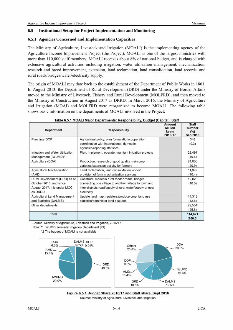
Agriculture Income Improvement Project Myanmar
MOALI 6-14 JICA
6.5 Institutional Setup for Project Implementation and Monitoring
6.5.1 Agencies Concerned and Implementation Capacities
The Ministry of Agriculture, Livestock and Irrigation (MOALI) is the implementing agency of the Agriculture Income Improvement Project (the Project). MOALI is one of the largest ministries with more than 110,000 staff members. MOALI receives about 8% of national budget, and is charged with extensive agricultural activities including irrigation, water utilization management, mechanization, research and breed improvement, extension, land reclamation, land consolidation, land records, and rural roads/bridges/water/electricity supply.
The origin of MOALI may date back to the establishment of the Department of Public Works in 1861. In August 2013, the Department of Rural Development (DRD) under the Ministry of Border Affairs moved to the Ministry of Livestock, Fishery and Rural Development (MOLFRD), and then moved to the Ministry of Construction in August 2017 as DRRD. In March 2016, the Ministry of Agriculture and Irrigation (MOAI) and MOLFRD were reorganized to become MOALI. The following table shows basic information on the departments of MOALI involved in the Project:
Table 6.5.1 MOALI Major Departments: Responsibility, Budget (Capital), Staff
Department Responsibility
Amount Million kyats
2016-17
Staff number
(%) Sep 2016
Planning (DOP) Agricultural policy, plan formulation/cooperation, coordination with international, domestic agencies/reporting statistics
348 (0.3)
Irrigation and Water Utilization Management (IWUMD)*1
Plan, implement, operate, maintain irrigation projects 22,491 (19.6)
Agriculture (DOA) Production, research of good quality main crop varieties/extension activity for farmers
24,000 (20.9)
Agricultural Mechanization (AMD)
Land reclamation, land consolidation works/ provision of farm mechanization services
11,892 (10.4)
Rural Development (DRD) as of October 2016, and since August 2017, it is under MOC as DRRD.
Construct, maintain rural feeder roads, bridges connecting one village to another, village to town and inter-districts road/supply of rural water/supply of rural electricity
12,023 (10.5)
Agricultural Land Management and Statistics (DALMS)
Update land map, registers/produce crop, land use statistics/administer land disputes
14,313 (12.5)
Other departments 29,554 (25.8)
Total 114,621 (100.0)
Source: Ministry of Agriculture, Livestock and Irrigation, 2016/17 Note: *1 IWUMD: formerly Irrigation Department (ID)
*2 The budget of MOALI is not available
DRD 49.5%
IWUMD 29.0%
AMD 15.4%
DOA 6.0%
DALMS 0.05%
DOP 0.04% DOA
20.9%
IWUMD 19.6%
DALMS 12.5%
DRD 10.5%
AMD 10.4%
DOP 0.3%
Others 25.8%
Figure 6.5.1 Budget Share,2016/17 and Staff share, Sept 2016
Source: Ministry of Agriculture, Livestock and Irrigation

Myanmar Agriculture Income Improvement Project
JICA 6-15 MOALI
Assuming the budget share of departments other than the six major departments are negligible, DRD takes up approx. 49.5% of the capital budget for 2016/17 followed by IWUMD (29.0%), AMD (15.4%), DOA (5.98%), DALMS (0.05%) and DOP (0.04%). On the other hand, DOA (20.9% of total staff number) and DALMS (12.5%) retain relatively large number of staff members compared to the size of their expenditures due to the nature of their works, extension and land registration services, respectively.
The expenditure of the primary sector (agriculture, irrigation, livestock, fishery, rural development, forestry, environmental conservation), now mostly covered by MOALI, was 6.18% of the total government expenditure in 2011/12, and 7.75% in 2015/16 (see Figure 6.5.2 below). GDP-wise, the budget expenditure for the primary sector doubled from 1% in 2011/12 to more than 2% in 2015/16
Finance 19.9%
Energy 15.8%
Defence 13.3%Electric Power
11.9%
Education,Social Security
11.3%
Agriculture, Livestock, Fishery,
Forestry 7.8%
Others 20.0%
Figure 6.5.2 Budget Expenditure by Ministries 2015-16 Source: Aung Myat Kyaw (2015), Myanmar’s Budget System Reform, MOPF
MOALI has conducted a number of projects both on its own budget and also with international assistance, both grants and concessional loans. For concessional loans, the major multilateral donors are the World Bank (IDA), IFAD and ADB while JICA is a major bilateral donor. The following table shows a list of recent major donor-assisted concessional loan projects for MOALI:
Table 6.5.2 Major Donor-assisted Concessional Loan Projects for MOALI
Donor Project Relating Department Approval date Amount (million)
JICA Irrigation Development Projects in Western Bago Region
IWUMD Sept.5, 2014 USD146.8 (JPY 14,870)
IDA Agricultural Development Support Project
IWUMD/DALMS/AMD/DOA/DAR* Apr.23, 2015 USD 100.0
IFAD Fostering Agricultural Revitalization in Myanmar Project (FARM)
IWUMD/DALMS/AMD/DOA Apr. 8, 2014 USD 18.7
ADB Irrigated Agriculture Inclusive Development Project
IWUMD/DOA/DAR*/DALMS/AMD Nov.28, 2016 USD 75.0
AFD** Co-financing with above ADB loan Oct. 20, 2016 USD 27.9 (€25.0)
Source: MOALI Note: DAR*= Department of Agricultural Research, AFD**: Agence Française de Développement
As indicated in the above table’s “Relating Department” column, MOALI’s major departments involved in the Project, namely, IWUMD, DOA, AMD, DALMS, have experience in implementing major donor-assisted concessional loan projects. DRRD also has experience in major donor-assisted rural infrastructure projects including an IDA credit for National Electrification Project, an IDA grant for National Community Driven Project, and a JICA ODA loan, Regional Development Project for Poverty Reduction (Phase 1), covering town water supply projects in 23 towns. Currently, with its technical assistance, ADB is preparing Rural Roads and Access Project (USD 50 million) to be

Agriculture Income Improvement Project Myanmar
MOALI 6-16 JICA
implemented by DRRD.
6.5.2 Responsible Implementation Body at Central Level
Since the Project is comprehensive in nature, it involves six departments with different areas of responsibilities, namely, DOP, IWUMD, DOA, AMD, DALMS, DRRD, and also Minister’s office as well as Sagaing regional government. To ensure the smooth implementation of the Project, setting up of Steering Committee (SC) at the central level, comprising of the six departments and Minister’s office plus Sagaing regional government, and Project Management Unit (PMU) at the regional level, comprising of the counterpart executing arms of the central-level departments, are proposed as diagramed below:
Figure 6.5.3 Project Implementation Arrangement Source: JICA Survey Team
This SC/PMU arrangement is designed basically with reference to that of the on-going JICA loan for Irrigation Development Project in Western Bago Region (Loan Amount: 14,870 million yen, for which the Loan Agreement was signed on September. 5, 2014. Hereinafter, Western Bago Project)1. Western Bago Project’s PIC/PMU arrangement has a proven record of effective functioning to date. It is basically aligned with and built on the existing and functioning practices and procedures of IWUMD, neither reinventing the wheel nor creating a parallel structure which could deplete already thin layer of capable IWUMD personnel.
Furthermore, JICA has extended an implementation support for Western Bago Project by means of providing IWUMD with a practical Operation Manual for Project Implementation, April 2015, which includes documenting of undocumented practices and procedures in a manual form. The manual is referred to in their daily operations of Western Bago Project (JICA also provided IWUMD with Implementation Manual for Construction Supervision and Management, October 2014). In such a way, capacity of IWUMD has been strengthened, and appreciated even by other major donors now supporting one of MOALI’s priority projects, benefiting from JICA’s capacity development efforts for IWUMD. 1 In Western Bago project, the committee in the central level is called “Project Implementation Committee (PIC)” instead of SC. Basic function of SC is same as those of PIC in Western Bago Project.

Myanmar Agriculture Income Improvement Project
JICA 6-17 MOALI
The major difference between the PIC/PMU arrangement of Western Bago Project and the SC/PMU arrangement of this Project is that the former involved basically one MOALI department, IWUMD, at the central level and its executing counterpart, Construction Circle (2), at the regional level, while the latter involves several MOALI departments.
In Myanmar, department with the largest portion of a project cost is to take responsibility of implementing the project. The largest portion of Western Bago Project was taken by IWUMD, and therefore the Chairperson of PIC was set to be the Director General of IWUMD (vice-chairperson: Deputy Director General, Lower Myanmar). In the case of the Project, IWUMD also takes up the largest portion of the project cost. However, given the complexity of the Project involving several departments in MOALI, it is appropriate that the Deputy Minister of MOALI takes the SC Chairpersonship, and Permanent Secretary (PS) would play its coordinating role, as Vice Chair. Under Chair and Vice chair, the deputy Director General (DyDG: Upper Myanmar) of IWUMD takes the secretariat in the SC.
All communication with JICA, especially on procurement and disbursement procedures, needs to be done in the name of Chairperson or by dully designated appropriate official, for instance, IWUMD DG, Deputy DG (Upper Myanmar). In other words, IWMUD will play a role of secretariat to the SC, managing day to day project administration on behalf of the SC. It is proposed that SC members should include key members from all departments involved and they are expected to cooperate closely.
With the foregoing, the SC is to facilitate smooth project implementation through appropriate deployment of construction machinery, timely material procurement and delivery, proper budget allocation, provision of necessary technical guidance, and control of budget expenditures. The SC has responsibility and authority on all activities such as planning, coordination between sections, management at the central level. Also, SC has the authority to supervise financial and accounting section as well in order to secure sufficient financial resources and appropriate payment for smooth project implementation. This terms and reference of SC of the Project is basically the same as PIC of Western Bago Project. In addition, two working groups will be established at the SC, namely;
1) Accounting & Disbursement Management Group: Accounting & Disbursement Management Group takes responsibility of managing the accounting and disbursement status and internal procedure based on the report from field level. Accounting & Disbursement Management Group will be comprised of Deputy Director level of Accounting Division in respective departments.
2) Project Monitoring & Evaluation Group: The Project Status Report (PSR) will be compiled once in three months. In order to monitor the project progress and to ensure submission of the PSR without delay, the Project Monitoring & Evaluation Group manages the necessary internal procedures for the preparation of PSR. The Project Monitoring and Evaluation Group will be comprised of Assistant Director level from respective departments.
Each department has its own distinctively different task, hence separate budget, and they are accustomed to executing their tasks independently from other departments in spite of the fact that they are all under one ministry, MOALI. Therefore, the departments other than IWUMD have to become proficient in JICA’s guidelines, procurement and disbursement procedures, by learning from IWUMD, and to be capable of conducting JICA procedures by themselves.
In fact, since IWUMD, including Construction Circle (2), now implementing Western Bago Project, has accumulated its experience and strengthened its capacity through actually implementing project works assisted by JICA and other major donors, IWUMD’s contribution in sharing their experience and knowledge with other departments is quite vital for the success of the Project as a whole.
As above-mentioned, it would be efficient that IWUMD takes over other department’s procedures as

Agriculture Income Improvement Project Myanmar
MOALI 6-18 JICA
has been the case for AMD in Western Bago Project where the procurement of agricultural machinery for AMD was made by IWUMD in close cooperation with AMD. However, the Project involves several departments, and given the different responsibility of each departments, and also already heavy work load shouldered by IWUMD, it may be difficult for IWUMD to absorb procedures for other departments.
Therefore, for departments procuring goods and services under International Competitive Bidding (ICB), international consultant firm’s assistance would be necessary, even for IWUMD. In addition, if there is an arrangement in which a JICA facilitation consultant is dispatched towards the smooth commencement of the Yen loan project, such JICA consultant should assist the preparation of necessary documents of ICB and also the tendering procedure. Nevertheless, IWUMD is expected to assist other departments abide by JICA’s procurement and disbursement procedures as the secretariat of SC.
Assuming all departments perform their own works in accordance with the JICA’s guidelines, certain communication with JICA may need special attention, such as request for disbursement, repayment of principal and payment of interest. Such actions should be taken in a coordinated manner among departments concerned and communicated with JICA unitarily in the name of Deputy Minister or its dully designated official(s). In that regard, SC and secretariat should also collaborate closely with the Ministry of Planning and Finance (MOPF) for the debt management of the JICA loan for the Project.
In the case of Western Bago Project, PIC meeting was held in July 15 and November 29, 2016. Both meetings were attended also by JICA representative in Myanmar. With all relevant MOALI representatives from the center and the project site, JICA’s presence has been effective in sharing current status and future prospects of the project among all parties, and moreover, effective in deciding on any issues right on the spot. It is recommended that this practice be replicated in the Project as well.
Procurement will be done separately department-wise basically, but overseen by SC and IWUMD as the secretariat. As has been the case with Western Bago Project, procurement under ICB for items such as equipment and machinery would be done at the MOALI headquarters. Procurement other than ICB such as Local Competitive Bidding (LCB) and Direct Force Account (DFA) would be performed basically by the respective regional offices in Monywa, or otherwise at the field offices where physical activities and construction take place.
Here are some of specific topics concerning procurement to be taken note of:
IWUMD: Con (4) is located at Shwebo and it would carry out LCB and DFA there.
DOA: As a general rule for all governmental agencies, DOA conducts tender for estimated cost of more than five million Kyats. However, by the nature of its extension activities, small purchases such as fertilizer, insecticide, seeds are to be done by shopping. For buildings of extension camps and offices for DOA, DOA HQs intends to conduct bidding at Nay Pyi Taw.
DRRD: DRRD DG expressed its intention to carry out its tender for rural roads and bridges construction through LCB at DRRD HQs in Nay Pyi Taw.
DALMS: Fund allocation under the Project for DALMS is mainly for updating of the cadastral maps with farmers’ rightful names, and also registration of farmlands newly allocated upon consolidation works completed, estimated to be 120 million kyats only.
Essentially, supervision of works by each agency is done at all levels: township, district, and region, in close collaboration among them.

Myanmar Agriculture Income Improvement Project
JICA 6-19 MOALI
6.5.3 Responsible Implementation Body at Field Level
PMU will be located at Monywa, Sagaing Region, where most of the regional directors are assigned, except for CON 4 located in Shwebo, at least at the initial stage when local procurement takes place there. PMU will be shifted in a phased manner from Monywa to Shwebo during the physical implementation stage of the Project. PMU members will be comprised of regional Director level officials from IWUMD (Construction Circle 4 (Shwebo), Maintenance Division (Sagaing)), DOA, AMD, DRRD, DALMS and General Administration Office (GAD)2.
Given the importance of coordination among different departments, it is proposed that Director, of CON 4 of IWUMD, takes the responsibility of leading the PMU as Project Director (PD) taking into consideration the daily close operational relations with other departments. Incidentally, there is already the Agricultural Supervising Committee existing in Monywa chaired by the Director, Maintenance Division (Sagaing) of IWUMD, and its members are regional Director level officials from CON 4 of IWUMD, DOA, DALMS, AMD, Agricultural Development Bank, Livestock, and Fishery. DOA Director is the secretariat. The meeting is held bimonthly aiming at achieving agricultural sector goals in the region.
As has been the case with Western Bago Project, PMU is tasked with managing and monitoring day-to-day activities of the Project at the field level. Project Director has the responsibility and authority for overall activities to ensure smooth progress of the Project during the implementation period. IWUMD’s experience at Western Bago needs to be shared not only at the central level but also at the regional level. Staff members from IWUMD headquarters and/or from Construction Circle 2 may need to be dispatched to Monywa and Shwebo, if and when needed. In the case of Western Bago Project, PMU meeting is being held weekly basis, in principle.
Within this PMU, three working groups should be established at the regional level, namely, 1) Accounting and disburse management group, 2) Project Monitoring Group, and 3) Land Consolidation Group as follows:
1) Accounting & Disbursement Management Group; Accounting & Disbursement Management Group takes responsibility of managing the accounting and disbursement status and internal procedure based on the activities at the field level, and reports to the central level Accounting & Disbursement Management Group. Accounting & Disbursement Management Group should be comprised of assistant director class and/or staff officer from the respective departments.
2) Project Monitoring Group; this working group monitors the project progress especially in compiling the Project Status Report (PSR) which should be submitted once in three months to JICA. It should be comprised of 10 members (2 members from IWUMD and 2 members each from AMD, DOA, DALMS and DRRD) from respective departments. Project Monitoring Group should be comprised of assistant director class and/or staff officer from the respective departments.
3) Land Consolidation Group; this working group deals with specific matters of Land Consolidation. This group will be comprised of IWUMD, AMD, DALMS, DOA and GAD and Farmland Administration Board (FAB), which is responsible for implementing Land Consolidation component. The members are in principle assistant director class and/or staff officer (Assistant Engineer) from respective departments.
Physical implementation of the Project will take place basically in Shwebo district. The following table shows basic information of budget and staff of MOALI agencies in Shwebo:
2 The main task of GAD is reporting the project status to Regional Government.

Agriculture Income Improvement Project Myanmar
MOALI 6-20 JICA
Table 6.5.3 Executing Agencies at the Project site
Irrigation and Water Utilization Management (IWUMD; Construction Circle No.4) Budget 2015-2016
(Million Kyat) staff
556 (Officer:33, Staff:523)
Department of Agriculture (DOA; 9TS) Township Shwebo Wetlet Ye-U Khin-U Taze Tabayin Kanbalu Budalin Ayadaw
Budget for Operation 2015-2016 (Million Kyat)
Staff (Extension Staff)
33 (29)
17 (12)
25 (23)
16 (12)
24 (19)
22 (19)
13 (11)
21 (na)
27 (23 )
Agricultural Mechanization Department (AMD; 5 AMS) Agricultural
Mechanization Station
Shwebo Wetlet Ye-U Kanbalu Budalin
Budget 2015-2016 (Million Kyat)
Staff 48 39 41 31 37
Department of Rural Development (DRD; 9TS) Township Shwebo Wetlet Ye-U Khin-U Taze Tabayin Kanbalu Budalin Ayadaw
Project Budget for Road & Bridge 2015-2016 (Million Kyat)
Staff 26 19 18 14 14 16 21 20 18
Department of Agricultural Land Management and Statistics (DALMS; 9TS) Township Shwebo Wetlet Ye-U Khin-U Taze Tabayin Kanbalu Budalin Ayadaw
Budget 2015-2016 (Million Kyat) x x x x x x x x x
Staff 65 7 39 48 55 51 76 61 58 Source: MOALI x: Not available
With the contents of the above table, the following table shows an assessment on absorptive aspect of MOALI’s Shwebo agencies.
Table 6.5.4 MOALI Agencies in Shwebo: Absorptive Aspect Agency Assessment on Absorptive Aspect
Con (4) billion kyat (approx. JPY billion) is estimated for works under Con (4), and the Project implementation period is 6 years including detail design (5 years for construction), annual disbursement will be billion kyat (approx. JPY billion). Average annual budget of Con (4) was 21.9 billion kyat (approx. JPY 1.9 billion) between 2010-11 and 2015-16. 7% less than the expected annual disbursement amount and this is not too much of difference. Moreover, 2010-11 recorded budget actual cost of 48 billion kyat (approx. JPY4.1 billion), more than double that of the expected annual amount of 23.5 billion kyat, thus Con (4) may absorb budget volume envisaged under the Project.
DOA Basically, the project portion for DOA is to develop capacity of extension officers now averaged 20 per township through trainings, improving/providing necessary facilities (demo farms, camp buildings/offices) and equipment (PC, fax, copiers, etc.). The quality of works by extension officers is expected to be significantly enhanced through implementation of the Project by afore-mentioned inputs.
AMD The largest land consolidation work done in the Project area was 600 ac. in 2015-16. The Project is to consolidate 5,000 acre in total with maxim 2,500 acre per year during the peak, which is much larger than the record 600 ac. With additional machineries and capacity building for AMD staff and operators, the Project is judged to be achievable physically. However, its precondition is the cooperation of farmers in consolidating their farm lands which requires all-MOALI concerted efforts.
DRRD (former DRD)
DRD (DRRD since August 2017) basically carries out its rural roads/bridges construction works through outsourcing to private sector, tendering at the regional office. The average of the largest budget for each township from 2012/13 to 2016/17 is approx. 1.5 billion Kyats in case of Wetlet TS (see Table 3.7.9). Multiply it by 9 townships arrives at 13.5 billion Kyats. Project implementation period is 6 years including detail design (5 years for construction) for about 60 billion Kyats (Road billion Kyats, bridge billion Kyats), billion kyat per year which is still less than or almost equal to the above-mentioned billion Kyats. Therefore, it implies that the DRRD could have the absorptive capacity of the intended scope (volume) of the project component. DRRD HQs intends to conduct

Myanmar Agriculture Income Improvement Project
JICA 6-21 MOALI
Agency Assessment on Absorptive Aspect tender in Nay Pyi Taw. DRRD is capable of managing such volume of tender having its experience with the World Bank and JICA.
DALMS Fund allocation under the Project for DALMS is for cadastral update and registration of the consolidated farmland, estimated to be million kyats (approx. JPY million). Considering the small size of the estimated cost, DALMS would absorb it within the land consolidation component. Note that cost related to the facilitation of farmers is included in the IWUMD portion of the Project.
Source: JICA Survey Team
6.6 Fund Flow
6.6.1 Fund Management Mechanism
Fund management mechanism is also designed with reference to that of already tested Western Bago Project. It is also basically the same arrangement applied by the World Bank and ADB, with which many of the MOALI departments are already familiar: IWUMD, DOA, AMD, DRRD and DALMS. IWUMD, as the secretariat to the SC, will manage the flow of funds.
JICA’s Transfer Procedure will be applied for disbursement for international procurement (e.g., consultant and construction/agricultural machinery). JICA’s Advance Procedure will be applied for disbursement for local procurement (e.g., construction materials, payment to laborers), as in the case of Western Bago Project. Fund flow differs between Advance Procedure and Transfer Procedure, outlined3 as below, respectively:
6.6.2 Advance and Transfer Procedures
1) Advance Procedure
Basic arrangements for disbursement under Advance Procedure are:
1) After signing of the Loan Agreement, Designated Account (D/A) denominated in Japanese Yen is opened with MEB (Myanmar Economic Bank), Nay Pyi Taw, after obtaining the approval of MOPF.
2) Project Operating Account (POA) denominated in Kyat for each department is opened with MEB after opening of D/A. The purpose of opening of POA is to facilitate payments in Kyat to suppliers and laborers efficiently.
3) SC requests departments to prepare financial forecast of expenditure under the Project for the next 2 terms (6 months).
4) SC submits combined Request for Disbursement to JICA on the basis of prepared financial forecast by departments.
5) JICA disburses loan proceeds. The disbursed proceeds are transferred to D/A with MEB through Loan Account (the Borrower’s account).
6) SC withdraws JICA loan proceeds from D/A, and transfer to POA in Kyat to departments applying the prevailing exchange rate on the day of withdrawal.
7) Departments withdraw from POA to pay their expenditure for the Project. 8) The statement of expenditure (SOE) and related evidence documents for payments are prepared
by departments and these documents are reported monthly to SC. 9) SC prepares monthly reports on the above SOE, and then submitted to JICA.
JICA’s Statement of Expenditure (SOE) Procedure was applied for Advance Procedure under the
3 The following is based on Western Bago Project’s Operation Manual for Project Implementation, April 2015.
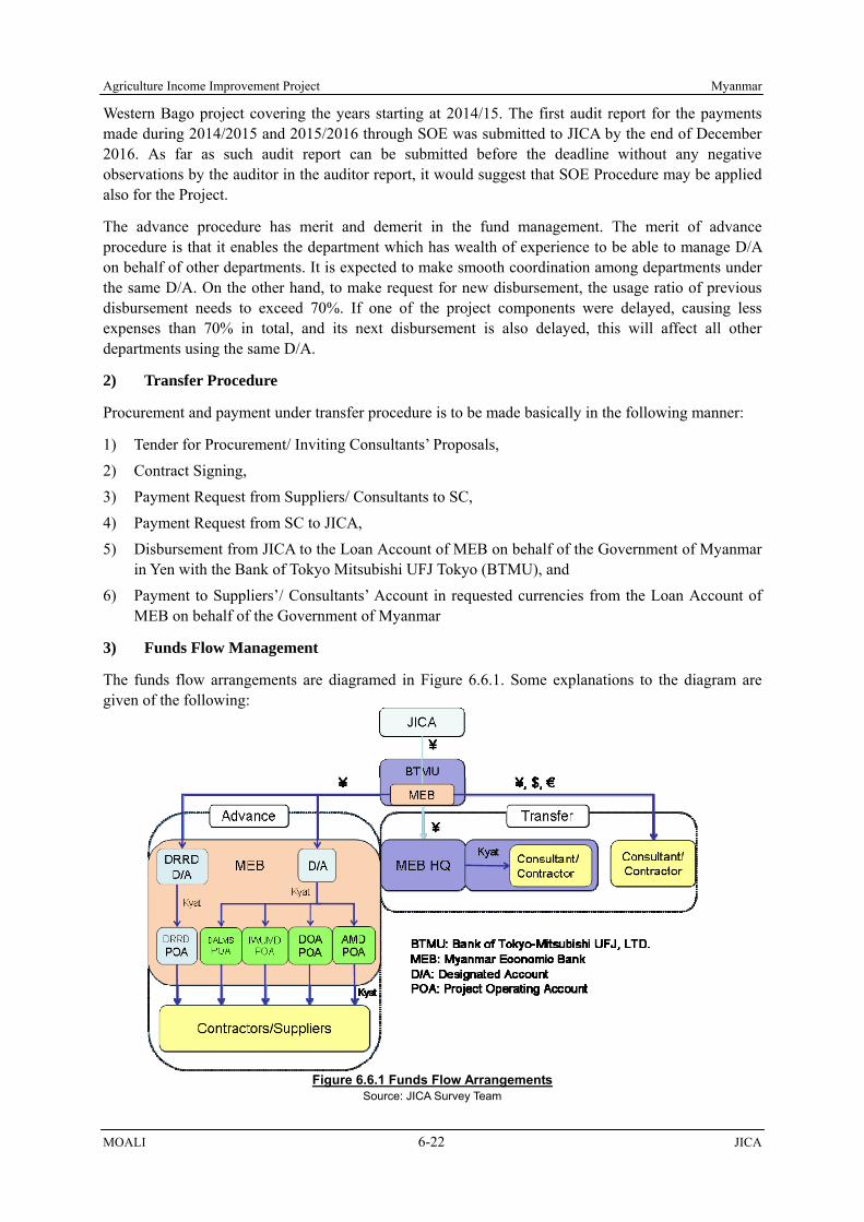
Agriculture Income Improvement Project Myanmar
MOALI 6-22 JICA
Western Bago project covering the years starting at 2014/15. The first audit report for the payments made during 2014/2015 and 2015/2016 through SOE was submitted to JICA by the end of December 2016. As far as such audit report can be submitted before the deadline without any negative observations by the auditor in the auditor report, it would suggest that SOE Procedure may be applied also for the Project.
The advance procedure has merit and demerit in the fund management. The merit of advance procedure is that it enables the department which has wealth of experience to be able to manage D/A on behalf of other departments. It is expected to make smooth coordination among departments under the same D/A. On the other hand, to make request for new disbursement, the usage ratio of previous disbursement needs to exceed 70%. If one of the project components were delayed, causing less expenses than 70% in total, and its next disbursement is also delayed, this will affect all other departments using the same D/A.
2) Transfer Procedure
Procurement and payment under transfer procedure is to be made basically in the following manner:
1) Tender for Procurement/ Inviting Consultants’ Proposals, 2) Contract Signing, 3) Payment Request from Suppliers/ Consultants to SC, 4) Payment Request from SC to JICA, 5) Disbursement from JICA to the Loan Account of MEB on behalf of the Government of Myanmar
in Yen with the Bank of Tokyo Mitsubishi UFJ Tokyo (BTMU), and 6) Payment to Suppliers’/ Consultants’ Account in requested currencies from the Loan Account of
MEB on behalf of the Government of Myanmar
3) Funds Flow Management
The funds flow arrangements are diagramed in Figure 6.6.1. Some explanations to the diagram are given of the following:
Figure 6.6.1 Funds Flow Arrangements Source: JICA Survey Team

Myanmar Agriculture Income Improvement Project
JICA 6-23 MOALI
Transfer Procedure: Procurement of consultancy and agricultural machineries through ICB will apply Transfer Procedures, transferring hard currencies such as Japanese Yen, U.S Dollars, Euro and Kyat to consultants and suppliers. For DRRD’s rural road and bridges construction, LCB is envisaged. Its disbursement can be done by Transfer Procedure and also by Advance Procedure with or without SOE depending on the number of contracts. Number of contracts may be reduced to a manageable level. In that case, Transfer Procedure or Advance Procedure without SOE can be applied for DRRD. Note that during the Fact Finding mission in February 2017, DRRD proposed to adapt advance procedure without SOE.
Advance Procedure: Advance Procedure will be used for other local procurement such as LCB and DFA. In the Western Bago Project, there were many number of items of procurement, and therefore eventually SOE procedure was introduced. For this Project, SOE Procedure would be applied from the start. As for DRRD, given the volume of funds, the second to IWUMD, and to meet fund requirements in a timely manner, DRRD would have its own D/A separated from D/A for other departments, as shown in the above diagram.
The disbursement procedure is conducted by each D/A. Submission of necessary expenditure reports and also disbursement request is therefore conducted respectively. In the advance procedure, documents including evidence of payment such as receipts are required, and the SOE procedure exempts such documentation provided that the documents are audited annually. This means DRRD will be conducting disbursement procedure by itself, while other departments together will be conducting the procedure, separately from DRRD, in this Project.
A JICA Fact Finding (FF) mission met Auditor General on February 16, 2017, and procedure especially concerning SOE was discussed. For the auditor general to audit the accounting with SOE, the Minister of MOALI should issue a TOR letter for the auditing in advance and then after each financial year the Minister should issue a request letter for the auditing. The auditing could be completed within 9 months after the end of the said financial year.
In any case, there should a project operation manual including accounting, settlement, auditing and disbursement procedure, which has to be prepared in advance of the commencement of the Project. To finalize the operation manual, the auditor general requested to hold a workshop to familiarize with and conclude the manual, with which the first disbursement from JICA could be started. The manual, with reference to the overall schedule, should be prepared within 2018, probably with technical assistances from JICA.
6.7 Consultancy Services and Possible JICA Technical Assistances
To lead the project implementation smoothly, technical assistances should be arranged involving international and national consultants/experts. Those consultants/experts shall work closely with and under the supervision of the Project Management Unit (PMU) in case of loan assisted components. In case of technical cooperation project by JICA, Japanese experts should closely work with the counterpart personnel assigned by the relevant departments, supported by national experts.
6.7.1 Consultancy Services (Loan Consultants)
To carry out a loan project, consultants should be employed mainly for the 2 works such as; 1) detail design and also tender documents preparation, and 2) progress management including the supervision of construction works. In most cases, detail design and the tender documents preparation shall be carried out under a Task Concept for the consultants while the management/ supervision is to be under an Assistant Concept to the project owner. As the Project is to cover various components, a team of consultants and/or sets of consultants should be employed, and assigned to the PMU.
Agriculture Income Improvement Project Myanmar
MOALI 6-24 JICA
Consultants will be composed of both international experts and national experts, who are to undertake 1) necessary surveys, 2) detail design 3) quantification of works, 4) cost estimation, 5) preparation of tender documents as required, which are all undertaken during the detail design stage, and 6) progress management/ supervision of works during the construction period. In case that the construction is done by direct force account, the consultants have to be in charge of monitoring and endorsing the expenses made by the implementing departments, which are then disbursed by the Loan.
Table 6.7.1 shows consultants to be required with major components which could be covered by the loan and composed of international and national consultants. In fact, there are five major components as; 1) irrigation and drainage improvement, 2) distribution infrastructure improvement, 3) agriculture mechanization strengthening, 4) land consolidation, and 5) agriculture development and extension strengthening. Of which, the last 2 components will not have consultants, but be proceeded by the government staff only.
The reason why the consultants are not planned in the components of land consolidation and agriculture development & extension strengthening is that there were series of discussions on the consultancy fee, which concluded in keeping the percentage not more than 7% against the project cost. Therefore, basically there are 4 groups of consultants engaged in the services of; 1) irrigation and drainage improvement, 2) distribution infrastructure improvement, 3) agriculture mechanization strengthening, and those overall management as per following:
Table 6.7.1 Consultant Person-Month Expected for Major Loan Assisted Components
Program Components Consultants, MM Project Cost (M JPY) Rate
International National Total (1) Consulting (2) (2) / (1) 0. Overall Management 1. Irrigation and Drainage Improvement 2. Distribution Infrastructure Improvement 3. Agriculture Mechanization Strengthening 4. Land Consolidation 5. Agriculture Dev. & Ext. Strengthening Overall/ average Total MM
Note: */ the project cost is only for the loan eligible potions, and it does not include the government management cost, land acquisition, etc. Source: JICA Survey Team
In addition to above, concerning ‘1. Irrigation and Drainage Improvement’, a plan of establishing WUG/WUA will be prepared by the consultants employed in the Project during the detail design stage while the actual activities of establishing them should be made by IWUMD (consultant service does not cover the establishment stage). Likewise, the consultants engaged in the ‘3. Agriculture Mechanization Strengthening’ will undertake capacity building of the AMD staff, detail design and supervision of buildings, etc.; however, the operation and maintenance of Maintenance Workshops and Machineries Testing Center should be managed by AMD itself.
The consultancy services are planned to provide person-month and person-month for international and national experts respectively, totaling person-month for the both (for detail consultant deployment, see Table 6.7.2). The cost of the services arrives at million JPY including logistics, office operation & maintenance, local support staff, etc., and this shares of the project cost eligible for the disbursement from the loan.

Mya
nmar
A
gric
ultu
re In
com
e Im
prov
emen
t Pro
ject
JIC
A
6-25
M
OA
LI
Tabl
e 6.
7.2
Con
sulta
nt D
eplo
ymen
t
Po
siti
on
FC
/ JP
YL
C/
MM
K10
11
12
12
34
56
78
910
11
12
12
34
56
78
910
11
12
12
34
56
78
910
11
12
12
34
56
78
910
11
12
12
34
56
78
910
11
12
12
34
56
78
910
11
12
12
34
56
78
910
11
12
12
3
A1
Pro
ject
Tea
m L
eader
A2
Pro
cure
men
t/ B
id D
ocu
men
tA
3D
isb
urs
emen
t M
anag
emen
tA
4E
IA M
onit
ori
ng
B1
Dep
uty
Pro
ject
Tea
m L
eader
B2
Pro
ject
monit
ori
ng
exper
tB
3P
rocu
rem
ent
Exp
ert/
Bid
Do
cum
ent
B4
Dis
burs
emen
t M
anag
emen
tB
5E
IA M
onit
ori
ng
[Irr
igati
on
an
d D
rain
age
Imp
rovem
ent]
A5
Secti
on L
ead
er
(DD
fo
r Ir
rigat
ion P
roje
ct)
/ C
hie
f E
ngin
eer
A6
Sec
tion
Lea
der
(S
V f
or
Irri
gati
on
Pro
ject
)A
7Ir
riga
tion
Des
ign E
ngi
nee
rA
8H
ydra
ulic
Str
uctu
re E
ngin
eer
1 (
Can
al &
Dra
inag
e S
truc
ture
)
A9
Hydra
ulic
Str
uct
ure
Engi
nee
r 2 (
Wei
r &
sp
illw
ay)
A10
Hydro
Mec
han
ical
Engi
nee
rA
11
Hydro
logi
st/D
rain
age/
Flo
od M
anag
emen
tA
12
Pro
cure
men
t E
xper
t on
Co
nst
ruct
ion M
achin
ery
A13
Co
nst
ruct
ion
Pla
n/
Co
st E
stim
atio
nA
14
Sy
stem
En
gin
eer
of
Mo
nit
ori
ng
Sy
stem
fo
r W
ater
man
agem
ent
& F
loo
d
A15
Wat
er M
anag
emen
t/ S
yst
em O
per
atio
nA
16
Co
nst
ruct
ion S
uper
vis
ion
(Ir
riga
tion
)B
6D
epu
ty S
ection
Lea
der
(D
D f
or
Irri
gatio
n P
roje
ct)
B7
Dep
uty
Tea
m L
ead
er (
SV
for
Irri
gation
Pro
ject
)B
8Ir
riga
tion
Des
ign E
ngi
nee
r 1
B9
Irri
gation
Des
ign E
ngi
nee
r 2
B10
Irri
gation
Des
ign E
ngi
nee
r 3
B11
Irri
gation
Des
ign E
ngi
nee
r 4
B12
Hyd
raul
ic S
truc
ture
Eng
inee
r 1 (
Can
al &
Dra
inag
e S
truc
ture
)
B13
Hyd
raul
ic S
truc
ture
Eng
inee
r 2 (
Can
al &
Dra
inag
e S
truc
ture
)
B14
Hyd
raul
ic S
truc
ture
Eng
inee
r 3 (
Can
al &
Dra
inag
e S
truc
ture
)
B15
Hyd
raul
ic S
truc
ture
Eng
inee
r 4 (
Can
al &
Dra
inag
e S
truc
ture
)
B16
Hyd
raul
ic S
truc
ture
Eng
inee
r 5 (
Can
al &
Dra
inag
e S
truc
ture
)
B17
Hyd
raul
ic S
truc
ture
Eng
inee
r 6 (
Can
al &
Dra
inag
e S
truc
ture
)
B18
Hyd
raul
ic S
truc
ture
Eng
inee
r 7 (
Can
al &
Dra
inag
e S
truc
ture
)
B19
Hyd
raul
ic S
truc
ture
Eng
inee
r 8 (
Can
al &
Dra
inag
e S
truc
ture
)
B20
Hydra
ulic
Str
uct
ure
Engi
nee
r 9 (
Wei
r &
sp
illw
ay)
B21
Hydro
Mec
han
ical
Engi
nee
rB
22
Hydro
logi
st/D
rain
age/
Flo
od M
anag
emen
tB
23
Co
nst
ruct
ion P
lan
B24
Quan
tity
& C
ost
Est
imat
ion
1B
25
Quan
tity
& C
ost
Est
imat
ion
2B
26
Quan
tity
& C
ost
Est
imat
ion
3B
27
Wat
er M
anag
emen
t/ S
yst
em O
per
atio
nB
28
Co
nst
ruct
ion S
uper
vis
ion
(Ir
riga
tion
) 1
B29
Co
nst
ruct
ion S
uper
vis
ion
(Ir
riga
tion
) 2
B30
Co
nst
ruct
ion S
uper
vis
ion
(Ir
riga
tion
) 3
B31
Co
nst
ruct
ion S
uper
vis
ion
(Ir
riga
tion
) 4
B32
Qual
ity
Man
agem
ent
En
ginee
r
[Dis
trib
uti
on
In
fra
stru
ctu
re I
mp
rove
me
nt
(IW
UM
D,
Ca
na
l In
spe
ctio
n R
oa
d)]
A17
Ro
ad D
esig
n E
ngi
nee
rA
18
Co
nst
ruct
ion S
uper
vis
ion
(R
oad
& B
ridge
)B
33
Ro
ad D
esig
n E
ngi
nee
r 1
B34
Ro
ad D
esig
n E
ngi
nee
r 2
B35
Quan
tity
& C
ost
Est
imat
ion
B36
Co
nst
ruct
ion S
uper
vis
ion
(R
oad
& B
ridge
) 1
B37
Co
nst
ruct
ion S
uper
vis
ion
(R
oad
& B
ridge
) 2
[Dis
trib
uti
on I
nfr
astr
uct
ure
Im
prov
emen
t (D
RD
, Ru
ral
Roa
d &
Bri
dge)
]
A19
Sec
tion
Lea
der
(R
oad
& B
rid
ge)
A20
Bri
dge
Des
ign E
ngi
nee
rA
21
Hydro
logi
st/R
iver
Man
agem
ent
B38
Dep
uty
Sec
tion
Lea
der
(R
oad
& B
rid
ge)
B39
Ro
ad D
esig
n E
ngi
nee
r 1
B40
Ro
ad D
esig
n E
ngi
nee
r 2
B41
Bri
dge
Des
ign E
ngi
nee
r 1
B42
Bri
dge
Des
ign E
ngi
nee
r 2
B43
Geo
logi
cal E
ngi
nee
rB
44
Hydro
logi
st/R
iver
Man
agem
ent
B45
Quan
tity
& C
ost
Est
imat
ion
B46
Co
nst
ruct
ion S
uper
vis
ion
(R
oad
& B
ridge
) 1
B47
Co
nst
ruct
ion S
uper
vis
ion
(R
oad
& B
ridge
) 2
B48
Qual
ity
Man
agem
ent
En
ginee
r
[Agri
cult
ure
Mec
han
izati
on
Str
eng
then
ing
]A
22
Secti
on L
ead
er
(Agri
cult
ure
Mechan
izat
ion S
trength
enin
g)
B49
Co
nst
ruct
ion S
uper
vis
ion
for
Mac
hin
ery
Tes
ting
Cen
ter
B50
Co
nst
ruct
ion S
uper
vis
ion
for
Mac
hin
ery
Tes
ting
Cen
ter
B51
Sp
ecia
list
on
mai
nte
nan
ce o
f A
gric
ulture
Mac
hin
ery
B52
Sp
ecia
list
on
Agr
icu
ltu
re M
ach
iner
y T
esting
[La
nd
Co
nso
lid
ati
on
]
[Agri
cult
ure
De
velo
pm
en
t a
nd E
xte
nsi
on S
tren
gth
enin
g]
[To
tal o
f P
ro-A
][T
ota
l o
f P
ro-B
][T
ota
l o
f P
ro-A
+P
ro-B
]
20
24
20
25
Fri
ght
To
tal
202
2202
32
021
20
20
Bill
ing
Rat
e20
18
20
19

Agriculture Income Improvement Project Myanmar
MOALI 6-26 JICA
6.7.2 Technical Assistances from JICA
Aside from the deployment of consultants under the implementation of loan assisted components, technical assistances should also be taken into account in order for the Project to lead to a smooth commencement. In fact, L/A is to take place at the end of year 2017, and therefore year 2018 will be spent for the selection of the loan consultants. In this case alone, the commencement of the Project may be from end of year 2018, or otherwise from the beginning of year 2019, waiting for the deployment of the consultants. Therefore, there should be a JICA technical assistance which can facilitate the project commencement as early as possible. Following are some recommendations (see Table 6.7.3):
1) Technical Assistances required in 2017/18
In this year, there should be a JICA technical assistance which undertakes; 1) environmental and social consideration for the land owners who are to lose a part of their land located alongside the to-be-asphalt road in that each 1 ft widening is planned, approximately 60 km, 2) preparation of first batch land consolidation e.g. organizing of beneficiary farmers, topographic survey, updating of cadastral map with farmers list, designing of the first batch land consolidation, and 3) assisting IWUMD to start surveys which can be done only during winter season (December to February).
2) Technical Assistances required in 2018/19
Within this year 2018/19, steering committee (SC) and project management unit (PMU) should be established officially, and the SC and PMU should institutionalize implementation mechanism with necessary procedural documents available. The documents are, e.g., project operation manual, financial management and disbursement manual, etc. Also, bid documents should be prepared for the machineries and equipment to be procured under the Project, and if tendering should take place in around mid 2018, procured machineries and equipment can be delivered by the time of Project commencement, say early 2019. A JICA technical assistance is highly required in supporting these activities, and it is recommended to provide this assistance from early 2018.
There is an issue associated with agriculture development and extension strengthening component, to which loan consultant service is not provided. Therefore, if a JICA TA team is to assist the first batch capacity development program composed mainly of trainings including extension material preparation for the DOA extension staff, the start-up activities would be smoothly launched. Of course, actual expenditures required for the training, extension material preparation, etc. could be disbursed from the loan till that time.
Table 6.7.3 Areas to Need Technical Assistances by JICA
Note: AMTC means Agriculture Machineries Testing Center (to be established in Mandalay), Source: JICA Survey Team
A M J J A S O N D J F M A M J J A S O N D J F M A M J J A S OLoan Agreement expectedLoan Consultant SelectionProject Implementation
Technical Assistances in FY2017/18Environmental & Social Consideration (for road)Preparation for 1st Batch Land ConsolidationPreparation for IWUMD Survey (Canal, Structures)
Technical Assistances in FY2018/19Assistance to establish SC & PMUPreparation of Bid Documents (for machineries)Assistance to Tendering (for machineries)Assistance to 1st Batch DOA Extension TrainingAssistance to 1st Batch LC ImplementationArrangement of Training Course for AMTC Key StaffFollow up of the AMTC Key Staff Training
MonthFY 2017/18 FY 2018/19 FY 2019/20Fiscal Year

Myanmar Agriculture Income Improvement Project
JICA 6-27 MOALI
During the dry season from end 2018 to early 2019, the first batch of land consolidation is to be implemented (preparatory works up to the detail design to be done during the dry season of 2017/18). As the service of loan consultants does not cover land consolidation, if JICA provides technical assistance to the first batch implementation of the land consolidation, concerned government staff will learn a lot, and thus leading to a continuous successful implementation.
Finally, to operate testing machines to be installed at Agriculture Machineries Testing Center, which will be constructed in Mandalay AMD regional office, there should be technically competent staff. The staff can hardly be trained within Myanmar, and therefor overseas training for the key staff to operate the testing machines should be arranged, e.g. with Institute of Agricultural Machinery, NARO (National Agriculture and Food Research Organization) in Japan. The JICA technical assistant is expected to make necessary arrangement for the training from early 2018.
6.8 Possibility of Incorporating Japanese Experiences/ Knowledge
Japan may have advantages and/or potential to assist some of the components to implement on its own experiences and knowledge accumulated to date. The potential experiences/ knowledge that Japan may better provide are summarized in the following table:
Table 6.8.1 Possibility of Introducing Japanese Experiences/Knowledge Component Experiences/Knowledge from Japan
1. Agriculture Development and Extension Strengthening
Farming knowledge to achieve more than 100 baskets/acre, quality improvement including good certified seed production/ distribution (e.g. seed center establishment)
2. Irrigation and Drainage Improvement (inclusive of Water Management and Flood Monitoring System)
Introduction of IMT/ PIM (1/), with the establishment of farmer organizations in charge of O&M of distributary/ minor canal level, introduction of water level/ flow measurement equipment with high accuracy
3. Land Consolidation (LC) Introduction of LID (2/)1 based procedure of land consolidation 4. Agriculture Mechanization Strengthening Introduction of Japanese farm machineries, and agriculture
machineries testing equipment Note: 1/ IMT and PIM mean Irrigation Management Transfer (from the government to farmer organization) and Participatory Irrigation Management. 2/ LID means Land Improvement District, same as water users association established legally covering a specific command area with the responsibility of O&M for irrigation facilities and land consolidation related facilities. Source: JICA Survey Team
As indicated in above table, most of the areas that Japan could well contribute are related to software approaches/experiences, and machineries. For example, Japan had achieved more than 100 baskets per acre yield of paddy (5.2 ton paddy/ha) already long time ago. The present yield of milled rice is more than 5 tons/ha or more. Extension services to achieve high yield should start with procurement of good quality seeds, establishment of good nursery, proper fertilization, on-time weeding, top-dressing fertilization, drying paddy field for aeration, better management in harvest and post harvest, etc. Just only single intervention can hardly achieve high yield but a set of good practices should be applied, to which Japan’s experiences can contribute under Agriculture Development and Extension Strengthening (No.1 in above table).
On the irrigation and drainage improvement (No.2), the construction is not much difficult technically and in fact IWUMD has carried out such rehabilitation works so far. Now in this area, farmers or farmer organization should be included in its O&M. At present, IWUMD operates and maintains from the water source down to the minor canals, which in turn entails financial burden on the government side. Water users association should be established, to which irrigation management should be transferred. So called IMT (irrigation management transfer) should be carried out at distributary or minor canal level. In Japan, such farmer organization is called LID (Land Improvement District), which can be referred to in Myanmar’s irrigation system as well as in land consolidation project (as in

Agriculture Income Improvement Project Myanmar
MOALI 6-28 JICA
No.3 component in the above table).
Farm machineries manufactured by Japanese makers are very much durable and advanced, though costly as compared with counterpart machineries. Considering life-cycle maintenance cost, Japanese manufactured machineries could still have advantage, especially sophisticated machines e.g. combine harvester, paddy-planter, etc. These agriculture machines and also machineries/ equipment to be installed in Maintenance Workshops and Testing Center, which are yet to be familiar in Myanmar, should be introduced and promoted by Japanese makers through such components of Agricultural Mechanization Strengthening (No.4).
Though not direct benefit, a value chain including food processing sector could be promoted with the Project implemented. In this sector, HACCP and KAIZEN should be introduced. HACCP is a systematic preventive approach to food safety from biological, chemical, and physical hazards in production processes. In this manner, HACCP is referred as the prevention of hazards rather than finished product inspection. The HACCP system can be used at all stages of a food chain, from food production and preparation processes including packaging, distribution, etc. To this sector, Japanese experiences can be introduced.
KAIZEN is a Japanese term for "improvement". When used in the business sense and applied to the workplace, kaizen refers to activities that continuously improve all functions and involve all employees from the head to the common workers. It also applies to processes, such as purchasing and logistics, which crosses organizational boundaries into the supply chain. It has been applied in many sectors, and as a first step KAIZEN can be practiced in Agriculture Maintenance Workshops to be established under the Project, and also in rice millers operation as one of in-direct benefits.
6.9 Areas to Share and Collaborate with JICA TCP / Donors
There are relevant on-going projects such as Irrigation Development Project in Western Gabo Region (Yen Loan assisted), Project for Profitable Irrigated Agriculture in Western Bago Region (JICA TCP), Project on Development of Participatory Multiplication and Distribution System for Quality Rice Seed (JICA TCP), Fostering Agricultural Revitalization in Myanmar (IFAD loan assisted), WB funded Agriculture Development Support Project, ADB funded Irrigated Agricultural Inclusive Development Project, and others. Of them, the last 2 projects are in designing stage as of March 2017, and the implementation is yet to start. Therefor, lessons from other projects, which can be forwarded to the Project, are summarized in the following table:
Table 6.9.1 Lessons Learnt and Forwarded to the Project Project Lessons learnt and Forwarded to the Project
Irrigation Development Project in Western Bago Region (BWID, Yen Loan assisted)
Water users association is now under establishment at 4 distributary canals, which is the first experience in IWUMD. As the new Policy 2016 (October) upholds Water User Participatory Approach, the experiences accumulated in the said project should be shared with the IWUMD field staff in the Project area, Shwebo and Ye-U maintenance staff. According to design practice by IWUMD, protection works upstream and downstream of hydraulic structure are usually set very short, causing erosion in the canal section. To protect structures from erosion, enough length of protection works should be designed taking into account seepage path beside and beneath the structures. CON2 and IWUMD HQs have accumulated accounting with SOE and disbursement experiences under the said project. This experiences should be shared with the staff of the Project as well as to other department staff in charge.
Project for Profitable Irrigated Agriculture in Western Bago Region (PROFIA, JICA TCP)
There were about 30 farmers who delivered their intension to change summer paddy to alternative crops, e.g. sesame. However, as they have been planting only paddy to date and thus have not experienced any crop diversification, finally only 3 farmers remained for the trial of crop diversification. It may imply that farmers who have received somewhat enough water for summer paddy cultivation may hesitate to

Myanmar Agriculture Income Improvement Project
JICA 6-29 MOALI
Project Lessons learnt and Forwarded to the Project change the summer paddy to other crops more difficult to cultivate. Therefore this sort of crop diversification should be introduced to mid-downstream areas of canal system first, since those areas tend to suffer water shortages and therefor have difficulty of cultivating summer paddy by nature. One issue is associated with land consolidation conducted in the PROFIA area. The works were contracted-out to private companies, and in fact the quality of the works are very poor, e.g., tertiary canal section does not have enough area not able to deliver the design discharge, land leveling is not enough inducing more water requirement, etc. Since there is almost nothing private company which has experienced land consolidation works, IWUMD and AMD should still discharge initiative in implementing the consolidation works.
Project on Development of Participatory Multiplication and Distribution System for Quality Rice Seed (JICA TCP), to complete February 2017 The Project for Improvement on Accessibility of Rice Certified Seed (from September 2017 to 5 years)
The Technical Cooperation Project by February 2017 has achieved; i) Quality improvement of Breeder’s Seeds (BS) by DAR for 9 rice varieties, and capacity building of DAR researchers on multiplication and removal of weed paddy and other rice varieties, ii) Up-grading of Foundation Seeds (FS) and Registered Seeds (RS) by DOA in Ayeyarwady Region in terms of genetic purity with stability, and capacity building of DOA officers, and iii) Increase of interest on production of Certified Seed (CS) by seed growers. However, the certification ratio of CS has fluctuated at 22-73% and some seed growers had abandoned to follow DOA guidance due to low profitability or delay of cash flow for CS production. The new Technical Cooperation Project expected from September 2017 shall succeed the purity improvement on the specified varieties of BS, FS and RS. The loan project will support efficient distribution through model Seed Centers. The Technical Cooperation Project shall focus on seed growing technique and certification system, while the Seed Center(s) operated by rice millers would purchase the seeds from the seed growers.
Fostering Agricultural Revitalization in Myanmar (FARM, IFAD loan assisted)
First year land consolidation was delayed very much. The original target was 2000 to 4000 acre per year, yet only 315 acre was implemented. This is because farmers started planting winter crop despite the agreement not to cultivate the crop for the year. From this experience, the Project should apply request-basis land consolidation implementation from the farmers first, and also well inform the implementation prior to the year’s construction period, not to cultivate the winter crop and probably the next summer crop as well. If the farmers started planting such crops despite the prior agreement, the area should be dropped and the Project shall move the other areas requested from the farmers.
Source: JICA Survey Team with reference to relevant reports
Of above project, as a successor of Project on Development of Participatory Multiplication and Distribution System for Quality Rice Seed (JICA TCP), new TCP called ‘The Project for Improvement on Accessibility of Rice Certified Seed is to be commenced from September 2017 for 5 years implementation period. This project is to cover Ayeyarwady region and also Shwebo area. Therefore, in relation to certified seed dissemination as a part of agriculture development and extension strengthening component, the Project should be linked up with this new JICA technical cooperation project as follows:
1) TCP will improve BS, FS and RS of economically valuable varieties such as Shwebo Pawsan, Ayeyarmin and Shwe Sae Yinin (summer variety) in DAR Taze Farm and 3 DOA paddy farms in Shwebo district. The genetic purity and stable RS produced in DOA farms shall be distributed to Seed Centers, and the Centers will distribute them to the contract seed growers including non-members of Seed Growers’ Association.
2) TCP may support operation of Seed Laboratories. Seed Centers will submit the CS samples to the Seed Laboratories to reduce the period required for certification, currently taking for 3 months.

Agriculture Income Improvement Project Myanmar
MOALI 6-30 JICA
3) TCP will provide capacity building for field inspectors of DOA. It can benefit finally rice millers due to stable trading price of milled rice through distribution of seed centers. TCP is expected to disseminate Good Agricultural Practice on rice CS multiplication using know-how accumulated in Ayeyarwady region under the predecessor project.
4) TCP will support Seed Growers who are a key player in CS distribution. Seed Centers may purchase the seeds from them, and process/ re-distribute them to members of Rice Millers’ Association.
5) The activities of TCP and Seed Centers can contribute to improvement of Geological Indication (GI) System for Shwebo Pawsan.

Myanmar Agriculture Income Improvement Project
JICA 7-1 MOALI
CHAPTER 7 PROJECT EVALUATION
The proposed components in the Agriculture Income Improvement Project include both production-increase oriented components and value-chain-promotion oriented ones. The main components are: 1) Agriculture Development and Extension Strengthening, 2) Agriculture Mechanization Strengthening, 3) Land Consolidation, 4) Irrigation and Drainage Improvement, and 5) Distribution Infrastructure Improvement.
Although there are many components to be included in the Project, main four components; 1) irrigation & drainage improvement together with 2) agriculture development and extension strengthening, 3) land consolidation, and 4) distribution infrastructure improvement share around 90% of the total cost. In this respect, these four components are taken for the economic analysis to show whether each of them are economically viable, though overall viability should also be evaluated by the total project cost.
7.1 Condition, Methodology and Evaluation Cases
7.1.1 Basic Condition and Assumptions
1) Referring to other similar projects in the irrigation/agriculture sector, the economic life of the project related to agriculture production is designed as 30 years. It means that economic evaluations are encoded over this period considering the initial investments and also operation and maintenance costs to accrue.
2) Project cost and benefit are calculated in Myanmar currency Kyat (Ks.). 3) For the operation and maintenance cost, following percentages of the total costs are applied,
(see Table 7.1.1) Table 7.1.1 Applied Operation and Maintenance Cost Percentage
Operation and Maintenance cost
Irrigation & Drainage Improvement Land Consolidation Distribution Infrastructure
Improvement 2.0 % 1 1.0 %2 2.0 %3
4) In the evaluation, the foreign exchange rate of 1 Kyats = 0.083 JPY is applied as of June 2017. 5) The opportunity cost of capital in Myanmar is not established yet; however, a range of 12% to
15% can be applied with reference to practices that the World Bank, ADB, and JICA have done in the sector of irrigation/agriculture development in the world. In this economic evaluation, the EIRR should therefore be more than 12% and targeted to be 15% or more, or otherwise the investment cannot be justified.
6) Transfer costs such as tax and duties are eliminated from the economic cost. Also, price contingency (inflation) cost is not counted in the economic evaluation while physical contingency is counted in the evaluation.
7) Conversion factors are applied to estimate economic costs/prices, or border prices from the
1 According to Maintenance Division (Shwebo and Ye-U office), IWUMD, the current annual maintenance cost is about 3,300 Kyats/ac for the 6 years average (2011-2016). On the contrary, the two percent is equal to about 6,400 Kyats/ ac, and therefore the O&M cost considered in the economic evaluation is judged enough to cover necessary O&M works upon completion of the Project. 2 Since land consolidation covers only a small area, excluding distributary and main canal command area, one percent is assumed as the necessary O&M cost of the consolidated area. In addition, there will be a farmer organization established in the consolidated area, who are to be in charge of the O&M of the tertiary canals and farm-to-market roads, reducing the O&M cost born by the Government. 3 “The Survey Program for the National Transport Development Plan in the Republic of the Union of Myanmar”, Feasibility Study on Inland Water Transport Facilities Improvement and Development Project, Final Report”, estimated annual maintenance cost and periodic maintenance cost of Thathon bypass at 0.03% and 10.0%, respectively. As compared to this, 2.0% of total cost is larger as present value.

Agriculture Income Improvement Project Myanmar
MOALI 7-2 JICA
financial market ones. Note that conversion factors are not standardized in Myanmar, so that a SCF which was employed in “Feasibility Study on the Yangon – Mandalay Rail Improvement Project” is applied in this economic evaluation4 (see Table 7.1.2).
Table 7.1.2 Applied Conversion Factors Particulars Factor Remarks
Standard Conversion Factor (SCF) 0.880 SCF which is employed in “Feasibility Study on the Yangon – Mandalay Rail Improvement Project”
Skilled Labor 1.000 Assumed placed under competitive market Unskilled Labor/ Family Labor 0.800 Assumed with reference to rural unemployment
Source: JICA Survey Team
7.1.2 Cases for Project Evaluation
The project evaluation was conducted for the major four components: namely, 1) irrigation and drainage improvement with agriculture development and extension strengthening, 2) land consolidation, and 3) distribution infrastructure improvement. The following sections summarize the evaluation cases by each component:
1) Cases for Irrigation & Drainage Improvement + Agricultural Extension Strengthening
Table 7.1.3 illustrates the cases to examine the project economic viability of the irrigation & drainage improvement together with agriculture development & extension strengthening. In total, 2 cases (Base 0 – Base 1) were undertaken as follows;
Base 0: it is assumed that the current yields will increase up to practically expected levels which have been set from the data reported by the regional DOA officers in charge of the extension area of the target irrigation systems. Also, with rehabilitation and better dam operation, there should be an extra irrigation water to be availed. Thanks to this, there is an opportunity of enlarging monsoon and summer paddy cultivation.
Base 1: it is based on the same assumption as the Base 0 case, but here, we assume that 9.5% of the summer paddy area is diversified to sesame and green gram in order to achieve 100% cropping intensity for the summer season. It is also assumed that the area expansion of sesame and green gram is three times larger than the original summer paddy area replaced as the sesame and green gram consume about one-third of irrigation water against summer paddy.
Table 7.1.3 Cases for Irrigation & Drainage Improvement with Agricultural Extension Strengthening Case Monsoon Paddy Summer Paddy Pulses / Sesame Remarks
Base 0 Yield increase*1 Yield increase*1 Yield not changed
O&M Cost:2% Area increase Area increase Area not changed
Base 1 Same as Base 0 Yield increase Yield increase*1
O&M Cost:2% 9.5% less than Base 0 Area increase
Note; *1: Yields increase to be the practically expected ones. Practically expected yields have been assumed based on the data reported by regional DOA officers in charge of the irrigation area. The data were provided in the range of minimum to maximum so that the Team applied the medium point between the two.
Source: JICA Survey Team
2) Cases for Land Consolidation
The Survey Team identified the major benefits from land consolidation as summarized in Table 7.1.4.
4 According to “The Survey Program for the National Transport Development Plan in the Republic of the Union of Myanmar”, Feasibility Study on Inland Water Transport Facilities Improvement and Development Project, Final Report”, examples of SCF in the surrounding countries are 0.88 in India, 0.86 in Cambodia and 0.87 in Vietnam, which are close to 0.88.

Myanmar Agriculture Income Improvement Project
JICA 7-3 MOALI
It is expected that land consolidation accelerates farm mechanization that intends to save labor costs. Also, thanks to land leveling, weeding, herbicide application, transportation costs are expected to decrease. However, farmers have to pay additional fuel charges and rental cost of machineries. To illustrate them numerically, farming costs per acre were calculated in each working schedule with/without land consolidation. Then, the Team compared the total farming costs between with and without land consolidation in each of the representative crops.
Table 7.1.4 Benefits of the Land Consolidation Project
Title of Benefit Monsoon Paddy
Summer Paddy
Pulses / Sesame Reasoning of Benefit Generation
a) Yield Increase X X X
1. After land leveling, irrigation water to be flooded entire the plots will prevent weeds from growing. 2. Upgrading of irrigation and drainage canal systems enables proper water management. 3. A well drainage system improves soil condition.
b) Cost Reduction in Weeding X X - After land leveling, irrigation water to be flooded entire the plots
will prevent weeds from growing. c) Cost Reduction in Herbicide Application X X - Ditto
d) Cost Reduction in Harvesting/ Threshing/ Transportation
X X - After land consolidation, manual labors are expected to be replaced by combine harvesters since machinery will be able to enter the plots easily.
e) Introducing Three Times Cropping Pattern X X X Saving in working time generates additional time for famers
that may trigger to shift forward to three-times cropping pattern. Source: JICA Survey Team
In addition to farming cost reduction, this economic evaluation also considers yields increase as reported in model farms in Nay Pyi Taw (JICA 2014) with 18% of increase for monsoon paddy, 19% of increase for summer paddy, and 17% of increase for winter pulses. Note that because of data limitation, sesame yield is assumed to increase up to the same target yield in case of irrigation and drainage improvement.
On top of them applied in Base 0 case, Base 1 and Base 2 consider that cropping patterns shift to more intensive ones upon land consolidation completed because farmers will have additional time with enhanced farm mechanization, which may lead them to applying three times cropping pattern. Table 7.1.5 summarizes the cases for land consolidation.
Table 7.1.5 Cases for Land Consolidation Case Monsoon Paddy Summer Paddy Summer Sesame Winter Pulses
Base0
Labor cost, and weeding-related costs reduce, but machinery
costs increase. Yield increases by 18%*1. Area does not change*3
Labor cost, and weeding-related costs reduce, but machinery
costs increase. Yield increases by 8%*1
Area does not change*3
Yield does not change Area does not change
Yield does not change Area does not change
Base1 Ditto (Variety is changed*2) Ditto Ditto Yield increases by 17%*1
Area increases
Base2 Ditto (Variety is changed*2) Not Cultivated
Yield increases up to potential yields
Area Increases Ditto
Note: *1 Magnitudes of yield increases are based on the “Preparatory Survey for the Project for Rehabilitation of Irrigation Systems”, 2014. Note that for summer paddy (IR747), current yield is already close to the potential one, and therefore increase up to potential yield is assumed. Note: *2 In Base 1 and Base 2 cases, the Team assumes monsoon paddy variety shifts from Shwebo Paw San to Ayeyarmin variety because the former variety has longer life time (150 days) so that it is difficult to apply three times cropping pattern with the Shwebo Pawsan variety Note: *3 More precisely, target famers have to surrender their farmland about 8%, so cultivated area will decrease by 8% and this is considered in the economic evaluation.
3) Case for Distribution Infrastructure Improvement
The benefit of distribution infrastructure improvement is estimated by calculating how much

Agriculture Income Improvement Project Myanmar
MOALI 7-4 JICA
transportation cost is reduced in line with the improvement of roads. The total transportation cost is composed of vehicle operation cost (VOC: defined as fuel costs plus depreciation cost), loading/ unloading cost, and personnel/operator costs. With the road improvement, 1) loading capacity improvement, 2) velocity speed improvement, and 3) changes in transportation mode are expected, being supposed to contribute to transportation cost saving. Considering them, the Team has calculated the difference of total transportation costs between with and without the roads improvement5.
Table 7.1.6 Cases for Distribution Infrastructure Improvement Case Products Explanation Remarks
Base 0
Monsoon Paddy (MP), Summer Paddy (SP), Agro-Input
Plot-to-market transportation costs such as VOC, loading/unloading cost, and personnel operation costs reduce. The cropping areas are corresponding to “with case” of base 0 of irrigation & drainage improvement (irrigable area expansion for summer paddy, but not taking into account crop diversification)
O&M Cost:2%
Base 1 MP, SP, Agro-Input, Summer Pulses and Sesame
Basic assumption and conditions are the same as Base 0, except for taking into account crop diversification (corresponding to “with case” of Base 1 of irrigation & drainage improvement)
O&M Cost:2%
Source: JICA Survey Team
Prior to the evaluation, following assumptions are taken into account (see Figure 7.1.1 for the basic idea of transportation distance identification):
1) Aside from home consumption (assuming 12% of the total production), the products are marketed to outside of the region6.
2) With the distribution improvement, as above-mentioned, transportation mode will be changed from the animal-cart, current typical mode of transport, to Trollergyi, and then further small and medium tracks. In fact, animal cart can carry only small amount of agro-products per time, and therefore there should be more cost including labors, etc. in this transportation mode. With the mode change to Trollergyi and to small and medium tracks, more volume can be transported with shorter time, thus transportation cost would be reduced (for an example, in case of earthen road, it costs 10.6 Kyats/basket, 4.6 Kyats/basket, 1.8 Kyats/basket respectively for animal-cart, Trollergyi, and small and medium truck7).
3) A typical distribution route is expected as follows: at first, a farmer carries his products from plot to his/ her house-yard; then, the farmer / a trader / a broker transports the commodities to the nearest main towns (i.e. main town of each TS) for milling and/or marketing; and then, the commodities go toward Mandalay because the market in Mandalay has a distribution hub function8.
5 Note that, in this evaluation, the benefit of bridge construction projects is not taken into account because there are too many factors to specify the benefits of each construction. 6 As for home consumption, the products are milled nearby villages, therefore, up to secondary transportation (mentioned below) are taken into consideration. 7 For more detail on the unit cost by transportation mode and road condition, see Appendix Table X.3.17 (Page X-10). 8 Paddies produced in Sagaing region has been promoted to the entire union, however, most of them go to lower Myanmar as well as China; in any case, the commodities have to go to Mandalay first.
Legend:Target VillageMain CityTypical Distribution RouteProposed Rural RoadsProposed Canal Roads
Basic Idea:1) Plot ‐ Farmer: 0.8 km is assumed2) Farmer ‐main road: Distance
between village to main road 3) Main Road ‐Market : Distance
between main road to MandalayThe benefit generates if only the distribution route overlaps the proposed roads
Shwebo City
Target Village A
Target Village B
Go to Mandalay
Figure 7.1.1 Basic Idea of Transportation Distance IdentificationSource: JICA Survey Team | Copyright: Google Map

Myanmar Agriculture Income Improvement Project
JICA 7-5 MOALI
4) In above respect, transportations can be divided into four segments: primary transportation (plot-farmer), secondary transportation (farmer – main road), tertiary transportation (main road – market, i.e. Mandalay), and “after tertiary” transportations (Mandalay - consumers). After-tertiary transportations are out of the analysis because the project does not concern any union roads. For the primary transportation (plot - farmer), it is difficult to identify typical routes on a map, and therefore, the average distance of 0.8 km is assumed based on interviews made to farmers. Meanwhile, the length of secondary transportation is measured on a map based on representative sample villages. For the distance between canal roads to market, so many villages are concerned. Thus, the distances between main towns of the TS and the market (i.e. Mandalay) are assumed to represent the others. The benefit will accrue only if the afore-mentioned distribution routes are connected to the roads targeted by the Project.
5) To calculate the distance from farm to main road, it is assumed that a villager who lives in one of the target villages will carry his products through the respective targeted road as long as there is no alternative route which has a shorter distance to major towns. To calculate the distance from main roads to the market, it is assumed that farmers always use canal roads for transportations of agro-commodities, if they are produced in the irrigable areas of the respective canal systems (e.g. RMC, OMC, YMC, and SMC).
6) To simplify, non-agro-related transportations are not taken into account in the project evaluation. 7) For the volume of agro-commodities, the irrigable-area expansion and the yield increase after
irrigation and drainage improvement are considered. In other words, production volumes are in accordance with the plan.
7.2 Economic Term of Project Cost and Benefit
In this sub-chapter, the financial cost and benefit are converted to economic terms with appropriate conversion factors. Table 7.2.1 summarizes the financial and economic total costs by project component. Then, the following Table 7.2.2 summarizes the economic term of project benefits:
7.2.1 Economic Term of Project Cost
Table 7.2.1 summarizes the financial and economic total cost by main project component. In order to carry out the economic analysis, the cost has to be divided into two groups: foreign currency and local currency. Also, for the sake of applying appropriate specific conversion factors, domestic currency portions should be divided into skilled labor costs, unskilled labor costs, and other material costs. Then, these costs are converted to economic costs with 1.0 conversion factor to skilled labor, 0.8 to unskilled labor, and 0.88 to others. It should be noted that the costs below are base cost plus physical contingency, not including price contingency and transfer items as such costs are out of scope in the evaluation. Table 7.2.2 – Table 7.2.4 shows the financial and economic total costs of each component.
Table 7.2.1 Financial and Economic Cost by Main Component, million Kyat Component Financial Cost (BC + PhC) Economic Cost (BC + PhC)
FC LC Total FC LC Total Irrigation Improvement & Agriculture Extension 20,608 146,252 166,862 20,608 129,856 150,464Land Consolidation 90 8,334 8,425 90 7,375 7,465 Distribution Infrastructure Improvement 4,298 109,606 113,906 4,298 98,217 102,516Program Overall 24,997 264,192 289,193 24,997 235,448 260,446
Note1: The project cost used in the economic evaluation excludes Tax, Interest and Subsidies (so-called, “Transfer Items”) since they represent only transfer between individuals of the nation. Likewise, price escalation is excluded as long as it can be assumed that the influences of escalation are equally likely between benefits and costs.
Note2: Program Overall is the cost of all components, that is why the sum of the three is not corresponding to it. Note3: To accomplish the yield increases, not only irrigation & drainage improvement but also agricultural extension services
need to be implemented. Therefore, the economic evaluation is performed with the total cost of these two components. Source: JICA Survey Team

Agriculture Income Improvement Project Myanmar
MOALI 7-6 JICA
Table 7.2.2 Financial and Economic Cost of Irrigation & Drainage Improvement with Agriculture Development and Extension Strengthening, million Kyat
Component Financial Cost Economic Cost FC LC Total FC LC Total
Construction Cost Other Material Skilled Labor Unskilled Labor
Land Acquisition Consultant Fee Administration Fee (10%)
Base Cost 19,567 138,436 158,005 19,567 123,672 143,239 Physical Contingency
BC+PhC 20,608 146,252 166,862 20,608 129,856 150,464 Price Escalation VAT Import Tax Interests
Total 21,945 192,621 214,569 21,945 129,856 151,801Source: JICA Survey Team
Table 7.2.3 Financial and Economic Cost of Land Consolidation, million Kyat Component Financial Cost Economic Cost
FC LC Total FC LC Total Construction Cost
Other Material Skilled Labor Unskilled Labor
Land Acquisition Consultant Fee Administration Fee (10%)
Base Cost 86 7,887.7 7,973.7 86 7,024 7,110 Physical Contingency
BC+PhC 90 8,334 8,425 90 7,375 7,465 Price Escalation VAT Import Tax Interests
Total 98.2 10,793.0 10,891.2 98 7,375 7,473Source: JICA Survey Team
Table 7.2.4 Financial and Economic Cost of Distribution Infrastructure Improvement, million Kyat Component Financial Cost Economic Cost
FC LC Total FC LC Total Construction Cost
Other Material Skilled Labor Unskilled Labor
Land Acquisition Consultant Fee Administration Fee (10%)
Base Cost 4,082 103,583 107,667 4,082 93,540 97,622 Physical Contingency
BC+PhC 4,298 109,606 113,906 4,298 98,217 102,516 Price Escalation VAT Import Tax Interests
Total 4,594 145,732 150,325 4,298 98,217 102,516Source: JICA Survey Team
7.2.2 Economic Term of Project Benefit
1) Irrigation and Drainage Improvement
Table 7.2.5 – Table 7.2.7 summarize farm-gate prices and net profit ratio in financial and in economic terms. The project benefit is calculated as the difference of aggregated net benefits between with and without project as follows:

Myanmar Agriculture Income Improvement Project
JICA 7-7 MOALI
Table 7.2.5 Economic Term of Farm-gate Price and Net Profit Ratio (Current)
Title
Current Monsoon Summer Winter
Shwebo Paw San Ayeyarmin Shwe Sae
Yin IR747 Green Gram Sesame
Irrigable Area (Current), acre 485,897 485,897 286,768 286,768 - - Area (%) 56.8 32.8 68.7 19.4 0 0 Cultivated Area, acre 308,024 177,873 223,620 63,148 0 0 Yield, basket/acre 56 55 77 83 12 5 Financial Price, Kyats/bsk 9,200 7,800 4,700 5,100 30,700 28,500 Economic Price, Kyats/bsk 8,096 6,864 4,136 4,488 27,016 25,080 Profit Ratio, Financial (%) 55.6 64.1 54.1 61.7 61.7 67.7 Profit Ratio, Economic (%) 54.7 62.9 52.4 61.4 61.6 63.6
Net Financial Profit, Million Ks 88,234 48,913 43,782 16,492 - - Net Economic Profit, Million Ks 76,389 42,238 37,318 14,443 - -
Source: JICA Survey Team
Table 7.2.6 Economic Term of Farm-gate Price and Net Profit Ratio (Base0)
Title
Planned Monsoon Summer Winter
Shwebo Paw San Ayeyarmin Shwe Sae
Yin IR747 Green Gram Sesame
Irrigable Area (Base0), acre 493,887 493,887 391,221 391,221 - - Area (%) 56.8 32.8 68.7 19.4 50 50 Cultivated Area, acre 313,089 180,798 305,072 86,148 - - Yield, basket/acre 70 90 90 90 21 11.5 Financial Price, Kyats/bsk 9,200 7,800 4,700 5,100 30,700 28,500 Economic Price, Kyats/bsk 8,096 6,864 4,136 4,488 27,016 25,080 Profit Ratio, Financial (%) 55.6 64.1 54.1 61.7 61.7 67.7 Profit Ratio, Economic (%) 54.7 62.9 52.4 61.4 61.6 63.6
Net Financial Profit, Million Ks 112,105.7 81,335.7 69,813.6 24,397.6 - - Net Economic Profit, Million Ks 97,056.2 70,252.8 59,505.5 21,365.5 - -
Source: JICA Survey Team
Table 7.2.7 Economic Term of Farm-gate Price and Net Profit Ratio (Base1)
Title
Planned Monsoon Summer Winter
Shwebo Paw San
Ayeyarmin Shwe Sae
Yin IR747
Green Gram
Sesame
Irrigable Area (Base1), acre 493,887 493,887 340,782 340,782 153,105 153,105 Area (%) 56.8 32.8 68.7 19.4 50 50 Cultivated Area, acre 313,089 180,798 265,740 75,042 76,553 76,553 Yield, basket/acre 70 90 90 90 21 11.5 Financial Price, Kyats/bsk 9,200 7,800 4,700 5,100 30,700 28,500 Economic Price, Kyats/bsk 8,096 6,864 4,136 4,488 27,016 25,080 Profit Ratio, Financial (%) 55.6 64.1 54.1 61.7 61.7 67.7 Profit Ratio, Economic (%) 54.7 62.9 52.4 61.4 61.6 63.6
Net Financial Profit, Million Ks 112,105.7 81,355.7 60,812.7 21,251.9 30,451.0 16,986.9 Net Economic Profit, Million Ks 97,056.2 70,252.8 51,833.6 18,610.7 26,753.4 14,043.2 Note1: Farm-gate price was averaged within the farmer households surveyed under this JICA Survey Team. Note2: The planned (targeted) yields are based on practically expected yields which are reported by regional DOA officers in
charge of the irrigation area. The data is provided by a range of minimum and maximum, so that the Team applied medium point between the two.
Note3: Net profit ratio was calculated by JICA Survey Team based on the baseline survey results conducted in September – October 2016. The Team assumes constant net profit ratio between with/ without project. It means that farming cost will increase at the same proportion of the increment of gross-profit.
Note4: For economic pricing, standard conversion factor (0.88) is applied. Source: JICA Survey Team
2) Land Consolidation
Table 7.2.8 summarizes annual economic net benefits of without-project case and in Base 0 case. In addition, Table 7.2.9 shows the expected annual economic net benefit in Base 1 and Base 2 cases. Same as the case of irrigation and drainage improvement, farm-gate prices and farming costs (e.g. labor costs, input costs, and rental cost of machineries) were converted to economic prices by using

Agriculture Income Improvement Project Myanmar
MOALI 7-8 JICA
conversion factors:
Table 7.2.8 Economic Terms of Net Benefit Calculation (Non-Land Consolidation)
Title
Current Planned, Base0 Monsoon Summer Winter Monsoon Summer Winter Shwebo Paw San IR747 No Crop Shwebo
Paw San IR747 No Crop
Land Consolidation Target Area, acre 5,000.0 5,000.0 5,000.0 4,600.0 4,600.0 4,600.0 Area (%) 100 58 0 100 58 0 Cultivated Area, ac 5,000 2,900 0 4,600 2,668 0 Yield, bsk/ac 56 83 0 66 90 0 Economic Farmgate Price , Kyat/bsk 8,096 4,488 0 8,096 4,488 0 Economic Gross Profit per ac, Kyat/ac 453,376 372,504 0 534,336 403,920 0 Economic Cost per ac, Kyat/ac 247,440 207,600 0 203,920 166,720 0 Total Economic Gross Profit , million Kyat 2,266.9 1,080.3 0.0 2,457.9 1,077.7 0.0 Total Gross Profit Increase , million Kyat 191.1 -2.6 0.0 Total Economic Cost , million Kyat 1,237.2 602.0 0.0 938.0 444.8 0.0 Total Cost Reduction, million Kyat 299.2 157.2 0.0 Source: JICA Survey Team
Table 7.2.9 Economic Terms of Net Benefit Calculation (Land Consolidation)
Title
Planned, Base1 Planned, Base2 Monsoon Summer Winter Monsoon Summer Winter
Ayeyarmin IR747 Green Gram Ayeyarmin Sesame Green
Gram Land Consolidation Target Area, acre 4,600.0 4,600.0 4,600.0 4,600.0 4,600.0 4,600.0 Area (%) 100 58 58 100 58 58 Cultivated Area, ac 4,600 2,668 2,668 4,600 2,668 2,668 Yield, bsk/ac 65 90 14 65 12 14 Economic Farmgate Price , Kyat/bsk 6,864 4,488 27,016 6,864 25,080 27,016 Economic Gross Profit per ac, Kyat/ac 446,160 403,920 378,224 446,160 300,960 378,224Economic Cost per ac, Kyat/ac 156,560 166,720 124,640 156,560 44,800 124,640Total Economic Gross Profit , million Kyat 2,052.3 1,077.7 1,009.1 2,052.3 803.0 1,009.1 Total Gross Profit Increase , million Kyat -214.5 -2.6 1,009.1 -214.5 -277.3 1,009.1 Total Economic Cost , million Kyat 720.2 444.8 332.5 720.2 119.5 332.5 Total Cost Reduction, million Kyat 517.0 157.2 -332.5 517.0 482.5 -332.5 Source: JICA Survey Team Note1: Financial farming cost per acre was calculated by JICA Survey Team, based on the average of the baseline household
survey conducted in September - October 2016. Note2: For economic pricing of farm-gate price, standard conversion factor (0.88) is applied. As for economic conversion of
farming cost, the Team applies appropriate conversion factors, for example, 0.8 for casual labors, and 0.88 for livestock and machinery rental fees. It should be noted that there is no agro-related taxes and subsidies which significantly distort market competitions, according to the DOA, Shwebo district.
Note3: Team assumes that farmers will use machineries (i.e. combine harvester) after land consolidation for weeding, harvesting, threshing, and transportation. For herbicide application, it is assumed that the amount of usage becomes one quarter.
3) Distribution Infrastructure Improvement
Table 7.2.10 and Table 7.2.11 show a list of basic assumptions and conditions of distribution infrastructure improvement. Among assumptions below, the most important and influential parameter is “vehicle share”. The major vehicles used in rural roads are animal cart, trollergyi (hand-tractor-engine-driven cart), and small and medium truck (S&M truck). The team assumes that transportation mode will shift from animal cart to trollergyi and then to S&M trucks as the road has been upgraded.
Table 7.2.10 Basic Assumptions of Distribution Infrastructure Improvement
Type of Vehicle Pavement
Typical Speed
(km/hours)
Capacity (ton/vehicle)
Number of Labor
(psn/time)
Working time
(hrs/time)
Unit Cost of operator (Kyats/hrs)
Operator (psn)
Unit Cost of
operator (kyats/hrs)
VehicleShare
(%)
Animal Cart non-paved 6 0.50 3 0.5 1,200 1 1,200 97.5 Animal Cart Earthen 7 0.53 3 0.5 1,200 1 1,200 52.5 Animal Cart Gravel 7 0.56 3 0.5 1,200 1 1,200 10.0 Animal Cart Metal 9 0.60 3 0.5 1,200 1 1,200 2.5
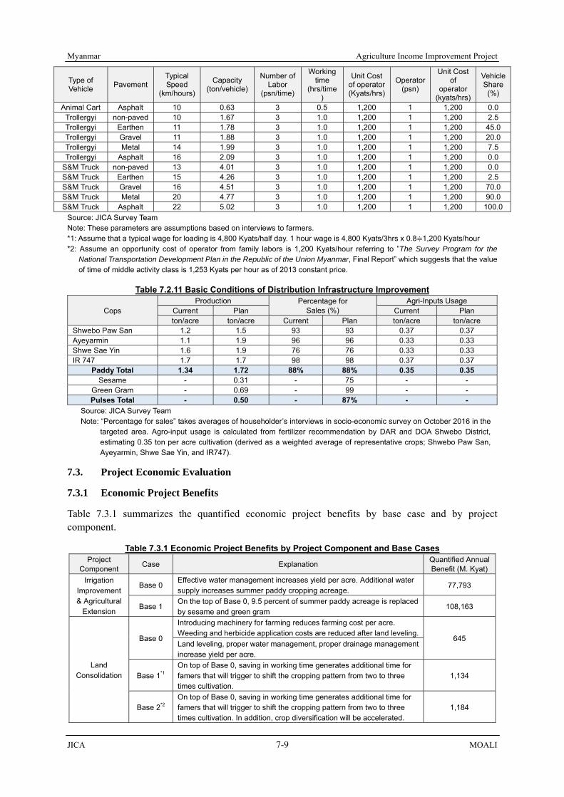
Myanmar Agriculture Income Improvement Project
JICA 7-9 MOALI
Type of Vehicle Pavement
Typical Speed
(km/hours)
Capacity (ton/vehicle)
Number of Labor
(psn/time)
Working time
(hrs/time)
Unit Cost of operator (Kyats/hrs)
Operator (psn)
Unit Cost of
operator (kyats/hrs)
VehicleShare
(%)
Animal Cart Asphalt 10 0.63 3 0.5 1,200 1 1,200 0.0 Trollergyi non-paved 10 1.67 3 1.0 1,200 1 1,200 2.5 Trollergyi Earthen 11 1.78 3 1.0 1,200 1 1,200 45.0 Trollergyi Gravel 11 1.88 3 1.0 1,200 1 1,200 20.0 Trollergyi Metal 14 1.99 3 1.0 1,200 1 1,200 7.5 Trollergyi Asphalt 16 2.09 3 1.0 1,200 1 1,200 0.0
S&M Truck non-paved 13 4.01 3 1.0 1,200 1 1,200 0.0 S&M Truck Earthen 15 4.26 3 1.0 1,200 1 1,200 2.5 S&M Truck Gravel 16 4.51 3 1.0 1,200 1 1,200 70.0 S&M Truck Metal 20 4.77 3 1.0 1,200 1 1,200 90.0 S&M Truck Asphalt 22 5.02 3 1.0 1,200 1 1,200 100.0
Source: JICA Survey Team Note: These parameters are assumptions based on interviews to farmers. *1: Assume that a typical wage for loading is 4,800 Kyats/half day. 1 hour wage is 4,800 Kyats/3hrs x 0.8≑1,200 Kyats/hour *2: Assume an opportunity cost of operator from family labors is 1,200 Kyats/hour referring to ”The Survey Program for the
National Transportation Development Plan in the Republic of the Union Myanmar, Final Report” which suggests that the value of time of middle activity class is 1,253 Kyats per hour as of 2013 constant price.
Table 7.2.11 Basic Conditions of Distribution Infrastructure Improvement
Cops Production Percentage for
Sales (%) Agri-Inputs Usage
Current Plan Current Plan ton/acre ton/acre Current Plan ton/acre ton/acre
Shwebo Paw San 1.2 1.5 93 93 0.37 0.37 Ayeyarmin 1.1 1.9 96 96 0.33 0.33 Shwe Sae Yin 1.6 1.9 76 76 0.33 0.33 IR 747 1.7 1.7 98 98 0.37 0.37
Paddy Total 1.34 1.72 88% 88% 0.35 0.35 Sesame - 0.31 - 75 - -
Green Gram - 0.69 - 99 - - Pulses Total - 0.50 - 87% - -
Source: JICA Survey Team Note: “Percentage for sales” takes averages of householder’s interviews in socio-economic survey on October 2016 in the
targeted area. Agro-input usage is calculated from fertilizer recommendation by DAR and DOA Shwebo District, estimating 0.35 ton per acre cultivation (derived as a weighted average of representative crops; Shwebo Paw San, Ayeyarmin, Shwe Sae Yin, and IR747).
7.3. Project Economic Evaluation
7.3.1 Economic Project Benefits
Table 7.3.1 summarizes the quantified economic project benefits by base case and by project component.
Table 7.3.1 Economic Project Benefits by Project Component and Base Cases Project
Component Case Explanation Quantified Annual Benefit (M. Kyat)
Irrigation Improvement & Agricultural
Extension
Base 0 Effective water management increases yield per acre. Additional water supply increases summer paddy cropping acreage.
77,793
Base 1 On the top of Base 0, 9.5 percent of summer paddy acreage is replaced by sesame and green gram
108,163
Land Consolidation
Base 0
Introducing machinery for farming reduces farming cost per acre. Weeding and herbicide application costs are reduced after land leveling.
645 Land leveling, proper water management, proper drainage management increase yield per acre.
Base 1*1 On top of Base 0, saving in working time generates additional time for famers that will trigger to shift the cropping pattern from two to three times cultivation.
1,134
Base 2*2 On top of Base 0, saving in working time generates additional time for famers that will trigger to shift the cropping pattern from two to three times cultivation. In addition, crop diversification will be accelerated.
1,184

Agriculture Income Improvement Project Myanmar
MOALI 7-10 JICA
Project Component Case Explanation Quantified Annual
Benefit (M. Kyat)
Distribution Infrastructure Improvement
Base 0 Road upgrading reduces lot-to-market transportation costs such as VOC, loading/unloading cost, and personnel operation costs.
20,729
Base 1 On the top of Base 0, crop diversification (sesame and green gram) will be accelerated (corresponding to Base 1 of irrigation improvement).
20,508
Source: JICA Survey Team *1: The future cropping pattern is supposed to be MP (Ayeyarmin) - SP (IR747) – WC (Green Gram) *2: The future cropping pattern is supposed to be MP (Ayeyarmin) - SC (Sesame) – WC (Green Gram)
These benefits, however, will not be fully realized immediately. The project evaluation also needs to identify negative aspect of the project, land surrendering associated with land consolidation, opportunity loss of summer cultivation during the construction periods, for example. Taking into consideration those negative aspects Table 7.3.1 should be interpreted as economic benefits of the project after fully realized.
As for the benefit of irrigation & drainage improvement, it seems a reasonable assumption that area expansion will accrue immediately after the construction, however, the yields-increases should need a lot of times, waiting for the implementation of agriculture services extension. Therefore, the Team assumes that, to achieve the planned yield, it will take several years as 0% in the first year of the construction completion (assumed that extension is still in the preparation stage), 0% in the 2nd year (assumed to be the extension commencement but farmers have not applied the technology yet), 10% in the 3rd year, 30% in the 4th year, 60% in the 5th years, and 100% in the 6th year and onwards after the completion of the project.
As the construction will be implemented by segments (5 segments are assumed here), the benefit also accrues by the segments. It is therefore assumed that, for example, 10% in the 3rd year is supposed to show only the 2 % of it in its first segment, and likewise 30% in the 4th year is to show only 6% in its first segment. Thus, the percentage of benefit generation of irrigation and drainage improvement is set as show in Table 7.3.2:
Table 7.3.2 Percentage of Benefit Generation of Irrigation & Drainage Improvement Particulars 1st (DD) 2nd Year 3 4 5 6 7 8 9 10 11 After 11th years 1st Segment 0% 0% 0% 0% 2% 6% 12% 20% 20% 20% 20% 20% 2nd Segment 0% 0% 0% 0% 0% 2% 6% 12% 20% 20% 20% 20% 3rd Segment 0% 0% 0% 0% 0% 0% 2% 6% 12% 20% 20% 20% 4th Segment 0% 0% 0% 0% 0% 0% 0% 2% 6% 12% 20% 20% 5th Segment 0% 0% 0% 0% 0% 0% 0% 0% 2% 6% 12% 20%
Total 0% 0% 0% 0% 2% 8% 20% 40% 60% 78% 92% 100% Source: JICA Survey Team
On the other hand, as for the benefit of land consolidation, it usually accrues from one year after the completion. Considering that the consolidation will be implemented by segments too, the degree of benefit generation of land consolidation is set as Table 7.3.3; namely, 5 year equal implementation was assumed in this economic evaluation:
Table 7.3.3 Percentage of Benefit Generation of Land Consolidation Particulars 1st year 2 3 4 5 6 7 8 9 10 After 11th years1st Segment 0% 0% 20% 20% 20% 20% 20% 20% 20% 20% 20% 2nd Segment 0% 0% 0% 20% 20% 20% 20% 20% 20% 20% 20% 3rd Segment 0% 0% 0% 0% 20% 20% 20% 20% 20% 20% 20% 4th Segment 0% 0% 0% 0% 0% 20% 20% 20% 20% 20% 20% 5th Segment 0% 0% 0% 0% 0% 0% 20% 20% 20% 20% 20%
Total 0% 0% 20% 40% 60% 80% 100% 100% 100% 100% 100% Source: JICA Survey Team
For distribution infrastructure improvement, it is simply assumed that the project benefit accrues at the same proportion of the expenses of the total budget disbursed till the previous years (see Table 7.3.4).
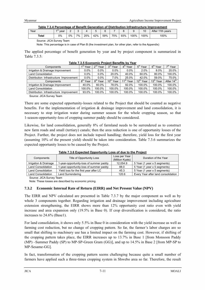
Myanmar Agriculture Income Improvement Project
JICA 7-11 MOALI
Table 7.3.4 Percentage of Benefit Generation of Distribution Infrastructure Improvement Year 1st year 2 3 4 5 6 7 8 9 10 After 11th years
Total 0% 0% 7% 25% 42% 59% 75% 93% 100% 100% 100%
Source: JICA Survey Team Note: This percentage is in case of Plan B (the investment plan, for other plan, refer to the Appendix)
The applied percentage of benefit generation by year and by project component is summarized in Table 7.3.5:
Table 7.3.5 Economic Project Benefits by Year Components 1st Year 2nd Year 3rd Year 4th Year 5th Year 6th Year 7th Year
Irrigation & Drainage Improvement 0.0% 0.0% 0.0% 0.0% 2.0% 8.0% 20.0%Land Consolidation 0.0% 0.0% 20.0% 40.0% 60.0% 80.0% 100.0%Distribution Infrastructure Improvement 0.0% 0.0% 7.0% 25.0% 42.0% 59.0% 75.0%
Components 8th Year 9th Year 10th Year 11th Year 12th Year 13th Year After 14th
Irrigation & Drainage Improvement 40.0% 60.0% 78.0% 92.0% 100.0% 100.0% 100.0%Land Consolidation 100.0% 100.0% 100.0% 100.0% 100.0% 100.0% 100.0%Distribution Infrastructure Improvement 93.0% 100.0% 100.0% 100.0% 100.0% 100.0% 100.0%Source: JICA Survey Team
There are some expected opportunity-losses related to the Project that should be counted as negative benefits. For the implementation of irrigation & drainage improvement and land consolidation, it is necessary to stop irrigation water during summer season for the whole cropping season, so that 1-season-opportunity-loss of cropping summer paddy should be considered.
Likewise, for land consolidation, generally 8% of farmland needs to be surrendered as to construct new farm roads and small (tertiary) canals; then the area reduction is one of opportunity losses of the Project. Further, the project does not include topsoil handling; therefore, yield loss for the first year (assuming 10% of the present yield) should be taken into consideration. Table 7.3.6 summarizes the expected opportunity losses to be caused by the Project.
Table 7.3.6 Expected Opportunity Loss of due to the Project Components Title of Opportunity Loss Loss per Year
(Million Kyats) Duration of the Year
Irrigation & Drainage 1-year-opportunity-loss of summer paddy 12,054.9 5 Year (1 year x 5 segments) Land Consolidation 1-year-opportunity-loss of summer paddy 88.0 5 Year (1 year x 5 segments) Land Consolidation Yield loss for the first year after LC 45.3 5 Year (1 year x 5 segments) Land Consolidation Land Surrendering 120.6 Every Year after land consolidationSource: JICA Survey Team Note: These losses are described by economic pricing.
7.3.2 Economic Internal Rate of Return (EIRR) and Net Present Value (NPV)
The EIRR and NPV calculated are presented in Table 7.3.7 by the major component as well as by whole 3 components together. Regarding irrigation and drainage improvement including agriculture extension strengthening, the EIRR shows more than 12% opportunity cost ratio even with yield increase and area expansion only (19.5% in Base 0). If crop diversification is considered, the ratio increases to 24.6% (Base1).
For land consolidation, it shows only 5.5% in Base 0 in consideration with the yield increase as well as farming cost reduction, but no change of cropping pattern. So far, the farmer’s labor charges are so small that shifting to machinery use has a limited impact on the farming cost. However, if shifting of the cropping pattern takes place, the EIRR increases up to 13.7% in Base 1 [from Monsoon Paddy (MP) –Summer Paddy (SP) to MP-SP-Green Gram (GG)], and up to 14.5% in Base 2 [from MP-SP to MP-Sesame-GG].
In fact, transformation of the cropping pattern seems challenging because quite a small number of farmers have applied such a three-times cropping system in Shwebo area so far. Therefore, the result

Agriculture Income Improvement Project Myanmar
MOALI 7-12 JICA
implies that the component may not be viable in terms of economic efficiency. However, land consolidation project can be justified as a pilot project, in order to cope with future cost increase because price escalation of farm casual labor’s wage is very likely to occur in the near future.
The benefit of distribution infrastructure improvement marks 17.9% of EIRR in Base 0 and 17.7% in Base 1, which is large enough to ensure the economic validity. NPV at the cut-off discount ratio of 12% comes to 25,194 million Kyats with B/C ratio of 1.37 (Base 0), and 24,205 million Kyats with B/C ratio of 1.36 (Base 1). There is a justification that the investment into the distribution infrastructure improvement should be done as proposed.
In order to investigate the economic validity of the Project overall, the EIRR for the major 3 components is calculated with aggregated benefits and costs for the said 3 major component. The result marks 18.9% EIRR with 130,802 million Kyats of NPV and 1.46 B/C ratio. Further, overall EIRR is also estimated by involving all the costs including agriculture mechanization components (Note that in this estimation, the benefits are counted only from the major 3 components as the other benefits are difficult to estimate). The overall return marks 16.5% (Base0) and 20.2% (Base1) respectively, indicating the Project is justified in EIRRs to invest.
Table 7.3.7 Economic Internal Rate of Return and Net Present Value Case IRR NPV*1 , million Kyats B/C*1
Irrigation & Drainage Improvement Base0 (only yield and area increase considered) 19.5% 107,563 1.78 Base1 (crop diversification of summer crop considered) 24.6% 203,331 2.48
Land Consolidation Base0 (2 crops per year) 5.5% -1,955 0.59 Base1 (3 crops per year) 13.7% 531 1.11 Base2 (3 crops per year, w/ summer crop diversification) 14.5% 789 1.17
Distribution Infrastructure Improvement Base0 (monsoon paddy + summer paddy) 17.9% 25,194 1.37 Base1 (monsoon paddy + SP plus diversification) 17.7% 24,205 1.36
Major Three Components Base0 (only yield and area increase considered)
18.9%
130,802
1.46
All Components (5 components) Base0 (only yield and area increase considered) 16.5% 98,450 1.26 Base1 (crop diversification of summer crop considered) 20.2% 196,586 1.67 Note: discount ratio of 12% was applied in calculating NPV and B/C ratio. Source: JICA Survey Team
7.4 Farm Budget Analysis
7.4.1 Farm Budget Analysis in Irrigation & Drainage Improvement (& Extension Services)
Table 7.4.1 summarizes the net benefits without- and with-projects for irrigation & drainage improvement with agriculture development and extension strengthening. As for the number of farmer households, there is no reliable data available. However, the Team conducted household survey in September–October 2016, covering 240 households; and therefore the survey has made out the area of farmlands of the sampled farmer households. Dividing the irrigable areas by the average farmland area, we can estimate the number of farmer households (see the mid part of Table 7.4.1).
The current (without) net benefit is calculated as the sum of the total net profit of monsoon paddy, summer paddy, pulses (green gram), and sesame. On the other hand, with the estimated number of farmers, a typical farmer’s incremental benefit can be calculated by dividing the net benefits increase with the number of farmers. By adding this net benefit increase to the current net benefit afore-mentioned, the net income with project per household is estimated.
The results are summarized in the bottom part of Table 7.4.1. As shown, a typical farmer at present, namely without project, earns a net income of 2.9 million Kyats (household survey for a total of 260 farmer households). After the project, the net income of ‘with- project’ would increase up to 4.3 million Kyat, or by 45.7% in Base 0, and increase up to 4.8 million Kyats or by 63.6% if we consider crop diversification (Base 1). These results suggest a great impact on the beneficiary farmers:

Myanmar Agriculture Income Improvement Project
JICA 7-13 MOALI
Table 7.4.1 Farmer’s Budget with/without Extension-Services & Irrigation & Drainage Improvement Particular Base 0 Base 1
Net Benefit with Project (Million Kyats) 90,251 125,543 Net Irrigable Area (acre) 493,887 493,887 Average Farmland Area (acre/FHH) 7.4 7.4 No. of Farm Household (FHHs) 66,562 66,562 Net Income without Project (Kyats/FHH) 2,965,996 2,965,996 Net Income with Project (Kyats/FHH) 4,321,903 4,852,107 Ratio b/t with & without Project, (%) 145.7 163.6
Source: JICA Survey Team
7.4.2 Farm Budget Analysis in Land Consolidation
Table 7.4.2 summarizes the farm budget for land consolidation. The process of calculation is almost the same as that of irrigation & drainage improvement, but this time, the net benefit per household is divided into two, namely gross profit per household and cost per household. The applied farm-gate price, yield per acre, etc. are same as those of irrigation improvement, while the cost is different because it is supposed that farmers in target land consolidation areas are usually located in a place far from main roads, and therefore machinery cannot access to their plot easily, raising the farming cost.
Net benefit per farmer household is calculated at 2.5 million Kyats without project. In Base 0, the estimated gross-profit-increase per household is by 5.6%, and the estimated cost-reduction per household is by 27.1%. In total, the estimated net-profit-increase is by 47.1%. These results show that even if farmers would have lost their farmlands around 8% for public utilization (e.g. construction of farm roads, drainage), they can still get much more profits than before the Project.
However, the IRR in Base 0, which is shown in above section 7.4.2, cannot exceed cut-off ratio of 12%. It implies that the investment cannot produce much fruits from the national economy’s point of view. If farmers shift their cropping pattern to three cropping, however, the EIRR comes to over 12%. In this case, gross-income per household is increased by 23.7% (Base 1) and 15.5% (Base 2) respectively, and the cost-reduction per household is by 21.0% (Base 1) and by 38.9% (Base 2). Then, the estimated net-income is increased by 80.3% (Base 1) and by 84.4% (Base 2). These increments are large enough to secure the economic efficiency of the Project.
Table 7.4.2 Farmer’s Budget with/without Land Consolidation Particular Base0 Base1 Base2
Net Benefit with Project (Kyats), for 5,000 acre 790,562,000 1,346,648,400 1,415,992,400Total Financial Gross Profit Increase (Kyats) 214,162,000 899,948,400 587,792,400Total Financial Cost Reduction (Kyats) 576,400,000 446,700,000 828,200,000
Targeted Area (acre) 5,000 5,000 5,000Targeted Area after land consolidation (acre) 4,600 4,600 4,600Average Farmland Area (acre/FHH) 7.42 7.42 7.42Average Farmland Area after land consolidation (acre/FHH) 6.83 6.83 6.83No. of FHHs 674 674 674Net Benefit with Project per farmer (Kyats/FHH) 1,172,941 1,997,995 2,100,879
Total Financial Gross Profit Increase per FHH (Kyats) 317,748 1,335,235 872,096Total Financial Cost Reduction per FHH (Kyats) 855,193 662,760 1,228,783
Without Projects Net Profit per FHH (Kyats/FHH) 2,487,789 2,487,789 2,487,789Gross Profit per FHH (Kyat/FHH) 5,643,279 5,643,279 5,643,279Cost per FHH (Kyat/FHH) 3,155,490 3,155,490 3,155,490
With Projects Net Profit per FHH (Kyats/FHH) 3,660,730 4,485,784 4,588,668Gross Profit per FHH (Kyat/FHH) 5,961,027 6,978,514 6,515,375Cost per FHH (Kyat/FHH) 2,300,297 2,492,730 1,926,706
Ratio b/t with & without Project Net Benefit (%) 147.1% 180.3% 184.4%Gross Profit (%) 105.6% 123.7% 115.5%Cost (%) 72.9% 79.0% 61.1%
Source: JICA Survey Team

Agriculture Income Improvement Project Myanmar
MOALI 7-14 JICA
7.5 Effect on Rice Supply to Urban and Industry Workers
Myanmar aims at becoming an industrialized country in its Myanmar Comprehensive Development Plan 2011-2030. To realize this vision, the agriculture sector should supply modest price of staple food, that is rice, or otherwise the industry sector should increase the wage for the workers, which in turn results in the loss of competitive power in the international markets under the current condition where expenditure on staple food for the workers occupies much share.
Table 7.5.1 once again summarizes the yield and area fro both current and targeted, and Table 7.5.2 estimates how many population the rice produced with the Project can support. Here, assumptions were made as such; 1) a typical person consumes 150 kg of rice per annum and 2) milling rate is set at 0.50 (50%). The result shows that the Project area with the current condition has already supported 3.5 million population. With-project, the Project area now supports 5.1 million population by the surplus rice produced.
Looking into the balance between before-project and after-project, the increments are 1.6 million. Thus, it is found that the Project area, even under present condition, plays a very important role in supplying staple food to the non-agricultural population, and this role will be further strengthened by the Project.
Table 7.5.1 Present and Targeted Yield, Planted Area in the Project Area Season Item Crop Yield, ton/ha Area Planted,
ha Cropping Intensity Increment, ha
Monsoon Current Paddy 2.98 196,633 98% - Plan Paddy 4.04 199,866 100% 3,236
Summer Current Paddy 3.99 116,049 58% -
Plan (case 1) Paddy 4.65 158,319 79% 42,303 Plan (case 2) Paddy 4.65 137,908 69% 21,513
Source: JICA Survey Team
Table 7.5.2 Production and Population Supported by the Project Area Season Current Production Production Population Supported*
Monsoon Paddy Current 28,017,000 bsk 1,952,000 (586,000 ton)
With Project 38,675,000 bsk 2,694,000 (808,000 ton)
Summer Paddy Current 22,157,000 bsk 1,544,000 (463,000 ton)
With Project 35,212,000 bsk 2,453,000 (736,000 ton)
Total Current 50,173,000 bsk 3,495,000 (1,049,000 ton)
With Project 73,887,000 bsk 5,147,000 (1,544,000 ton)
Increase With project – current 23,714,000 bsk 1,652,000 (496,000 ton) Note: To estimate ‘population supported’, milling ratio and per-capita-consumption for rice were assumed as 50% and 150 kg/head/year Source: JICA Survey Team
7.6 Effect on Transport Cost Reduction by Distribution Infrastructure Improvement
Major effect of upgrading of intra-regional distribution comes from the reduction on transportation cost per unit-weight-distance. Perhaps, there are a lot of determinants of transportation cost such as transportation mode, type of commodities to transport, roads conditions, and distance of transportation. For the relationship between transportation cost and distance, ADB “Myanmar Transport Sector Policy Note: How to Reduce Transport Costs, 2016” established a cost curve in the union overall, by transportation mode (road, rail, and river).

Myanmar Agriculture Income Improvement Project
JICA 7-15 MOALI
As it shown in Figure 7.6.1, the unit transport costs are supposed to be inversely proportional to the distances, and the magnitude becomes dramatically large with less than 100 km distance. It might be attributed to large fixed cost, for example, the cost of loading/unloading. Same trend has been indicated in the Project area as well; namely, huge unit costs are observed from the travels up to the distance of Mandalay city (i.e. travels about less than 80km).
Figure 7.6.1 Transport Cost of Low Value Commodities (Left) and High Value Commodities (Right) Source: ADB “Myanmar Transport Sector Policy Note: How to Reduce Transport Costs”
Note: ADB established the cost curve by categories of commodities; and by corridor (Yangon-Mandalay and Others) The figure above is referred from “Others”. According to the report, vegetable, fruits, grain, and other agricultural products except for livestock and fishery are classified as “Medium Value”. The cost is evaluated at economic cost.
Large unit transportation costs imply that there are potentials to be rationalized. The Team estimates current and target unit transportation cost of the roads benefited by the Project as summarized in the following table. The result shows that transportation costs will reduce dramatically, by 64% after upgrading of targeted roads thanks to the improvements in velocity, in capacity of vehicle, and in transportation mode.
Table 7.6.1 Estimated Present and Target Unit Transport Cost of the Roads Benefited by the Project
Unit Cost Current Unit Cost Kyats/km/kg
Target Unit Cost Kyats/km/kg
Unit Cost Reduction
Plot - Farmer (0.8km) 2.795 1.156 59% Farmer - Rural Road / Canal Road (5.46km) 0.898 0.301 66% Canal Road - Market (22.68 km) 0.502 0.184 63% Weighted Average 0.640 0.233 64% (Reference) Shwebo - MDL (81km) 0.074 - (Reference) YGN - MDL (710 km) 0.033 -
Source: JICA Survey Team, references are sourced by ADB report.
7.7 Effect on Food Value Chain Establishment
In this section, an analysis will be extended to entire value chain. According to Ministry of Agriculture, Forestry and Fisheries of Japan, establishment of food value chain is defined as “creating a chain of value-addition pivoted by food, through enhancing the linkage with each stage of the chain from production, manufacturing, processing, distribution, and to consumption”. Following this, it enables to create larger-added value which makes it possible to allocate larger added-value to the stakeholders (producers/manufacturers/distributers/consumers).
In this analysis, added-values of the stakeholders are separated by unit-added value (defined as net-income per kg) and handling volume per actor. Effect on handling of volume is expected from the enhancement of the production basis, such as, mainly, irrigation & drainage improvement and agriculture extension strengthening. On the other hand, effect on value chain rationalization is supposed to come from rationalizing market distribution system like road rehabilitation. The overall benefit of value chain is calculated as the sum of added values of all stakeholders in the chain.
Unit Transport Costs
of which Less than
100 km is
significantly high

Agriculture Income Improvement Project Myanmar
MOALI 7-16 JICA
Table 7.7.1 shows the target beneficiaries, unit added values, handling volumes, incomes, and total benefits by each stakeholder and by case (current/ with-project). These parameters are based on the result of farm budget analysis, baseline household survey, and interviews to each of the stakeholders. Along the chain, the overall benefit of the Project is estimated at 156,981 million Kyats (sum of the bottoms). Of them, 93,385 million Kyats (60%) are on the farmers, while brokers, transporters, rice millers are benefited by 32,638 million Kyats (21%), 2,027 million Kyats (1%), and 28,933 million Kyat (18%) respectively.
Table 7.7.1 Target Beneficiaries, Target Income, and Total Effect on Value Chain, Million Kyats Actors Farmers (Irrigation) (LC) Brokers Transporters Rice Millers
Target Beneficiaries
Existing Beneficiaries 67,236 66,562 674 3,365 1,010 631 New Beneficiaries 0 0 0 1,577 473 288
Effect on VC Rationalization
Current Price per kg 336 336 336 438 4 476 Current Cost per kg 148 148 185 372 1.8 445 Current Unit Added Value 188 188 151 66 2.2 31 Target Price per kg 336 336 336 438 4 476 Target Cost per kg 148 148 131 372 1.2 436 Target Unit Added Value 188 188 205 66 2.8 40
Effect on Handling
Volume Increase
Current Volume per actor, kg 15,767 15,760 16,454 315,000 1,050,000 1,680,000Target Volume per actor, kg 23,155 23,196 19,083 315,000 1,050,000 1,680,000
Income per Actor
Current Income per actor 2,964,187 2,965,996 2,487,789 20,695,500 2,310,000 51,979,200 Target Income per actor 4,353,097 4,321,903 3,911,291 20,695,500 2,940,000 67,173,120
Benefit
Current Benefit 199,300 197,423 1,677 69,640 2,333 32,799 Target Benefit 292,685 287,675 2,636 102,277 4,360 61,732 Difference 93,385 90,252 959 32,637 2,027 28,933 Percent 60% - - 21% 1% 18% Total of Differences 156,981
Source: JICA Survey Team
7.8 Effect on Generating Employment
In this sub-chapter, an analysis is extended to the effect on generating employment. Sub-chapter 7.7.1 estimates direct impact of employment related to the Projects such as employments during the construction period, incremental employments due to handling of increased production volume, etc. Sub-chapter 7.7.2 simulates some indirect impacts on employment for other industries by using a framework of input-output analysis.
7.8.1 Generating Employment in the Respective Stages
Table 7.8.1 summarizes expected amount of employments to be generated in each of the Project implementation stage. As for irrigation & drainage improvement, there will be 6 month-construction period in a year. Approximately 648,000 person-day/year (4,300 person/day, 108,000 person-day/ month) of employment opportunities are to be created to meet the construction demand. Likewise, the distribution infrastructure improvement is expected to generate additional employments; about 456,000 person-day/year, consisting of 1,800 person/day or 3,000 person/day for the construction period of 10 months and 6 months respectively.
In relation to increased agricultural production with the Project completed, there will be a lot of employment opportunities for farm casual labors. If the current labor intensive agriculture is assumed to continue even in future, it is expected to generate new employments of 4,636,000 person-day per year (62,000 person/day, 1,545,000 person-day/month) for the farm casual labors, composed of 228,915 person-day per season for monsoon paddy, 1,345,038 person-day per season for summer paddy, and 3,062,100 person-day per season for such alternative crops as sesame or green gram as summer crop. Note that since increment for monsoon paddy is minimal with the Project, the newly created employment is also minimal, and visa versa.
Due to increments of the paddy production, rice millers also need additional manpower to handle the

Myanmar Agriculture Income Improvement Project
JICA 7-17 MOALI
increased amount. Approximately 694,000 person-day/year (4,960 person/day, 124,000 person-day/ month) of employment are generated in this stage. As for the distribution of products, approximately 696,000 person-day per year (5,414 person/day, 135,348 person-day/month) of employment will be expected to occur upon the Project completed.
Table 7.8.1 Expected Generating Employment by Project Implementation (Base 1 applied)
Component Description Million Kyat Person (no. / day)
per month (Person× days
per month)
per year (Person×days
per year) Irrigation
Rehabilitation Irrigation Rehabilitation 16,160 4,320 108,000 648,000
Road Improvement
Case 1 (10 month of construction period)
Canal Inspection Road 4,030 744 18,600 186,000Rural Road 5,196 936 23,400 234,000
Rural Bridge 746.5 144 3,600 36,000Sub-Total 9972.5 1,824 45,600 456,000
Case 2 (6 month of
construction period)
Canal Inspection Road 4,030 1,240 31,000 234,000Rural Road 5,196 1,560 39,000 76,000
Rural Bridge 746.5 240 6,000 36,000Sub-Total 9972.5 3,040 76,000 456,000
Total of During Construction 25,386Case1:6,144 Case1:153,600
1,104,000Case2:7,360 Case2:184,000
Agriculture
Monsoon Paddy 916 3,052 76,305 228,915*1
Summer Paddy 4,708 17,934 448,346 1,345,038*1
Sesame/ Pulses 9,186 40,828 1,020,700 3,062,100*1
Sub-Total 14,810 61,814 1,545,351 4,636,053
Processing (Rice Miller)
Permanent Labor 1,642.8 992 24,800 297,600Seasonal Labor 1,785.6 3,968 99,200 396,800
Sub-Total 3,428.4 4,960 124,000 694,400
Distribution Permanent Labor 1,127 773 19,335 232,024Seasonal Labor 2,254 4,640 116,012 464,049
Sub-Total 3,381 5,414 135,348 696,073Total of After Project 21,619.4 72,188 1,804,699 6,026,526
*1/ It is calculated from the number of labors required for respective season. Source: JICA Survey Team
7.8.2 Ripple Effect on Employment in Other Sectors
To simulate the ripple effect on employment in other industries, the analysis refers to an input-output analysis approach. Input-output relationship summarized in a table represents national accounting framework describing production and flows of goods & services between sectors of an economy. ILO suggests that input-output analysis is good for a starting point of empirical analysis of employment outcome because national account is already available in many developing countries, and thus it can be combined with labor force / household survey data.
In Myanmar, input-output table has not frequently been updated. The Team could find only 2000-2001 version prepared by a Japanese university Team9, and therefore the Team employs it with necessary modifications. An “employment matrix”, which is also a necessary tool of the analysis, has been prepared by the Team with reference to “Labor Force, Child Labor, and School-to-Work Transition Survey, 2015” conducted by ILO for Myanmar.
Table 7.8.2 is the result of calculation, showing number of jobs generated by a change in demand incurred by the Project based on general industrial structure in the union of Myanmar10. It is estimated that 51,392 numbers of employment will be generated thanks to 125,543 million Kyats for additional demand to be born by the Project, which is the benefit with irrigation & drainage improvement including agriculture development and extension strengthening (Base 1 case).
9 “Industrial Structure in Myanmar using a new Estimated Input Output Table (2000-2001)”, Kan Khine Su Thwin et al (2010) 10 The input-output table is based on 2000-2001. It is unrealistic if one would claim that current industrial structure is not significantly different from 2000-2001, but inter-sectoral linkage generally becomes stronger as being industrialized. In this regard, the result can be interpreted as lower bound of the effect on employment.

Agriculture Income Improvement Project Myanmar
MOALI 7-18 JICA
The most benefitted sector is “Trade”, creating 8,533 numbers of employment opportunities followed by “Transportation” (694 employed), “Livestock and Fishery” (534 employed), and “Processing & Manufacturing” (458 employed). As the overall effect, 51,392 numbers of employment opportunities are supposed to be created.
Table 7.8.2 Ripple Effect on Employment to Other Sectors based on Input-Output Table in 2000-2001 No Sectors
Additional Demand, Million Kyats (Based on Current Price in 2015)
Ripple Effect on EmploymentPerson
1 Agricultural 125,543 40,880 2 Livestock and Fishery 0 534 3 Forestry 0 21 4 Mining 0 4 5 Processing & Manufacturing 0 458 6 Power 0 2 7 Construction 0 213 8 Transportation 0 694 9 Communication 0 30
10 Financial Sector 0 3 11 Social and Administrative Sector 0 0 12 Rental and Other Service 0 20 13 Trade 0 8,533 14 Total 125,543 51,392
Source: JICA Survey Team Reference: “Industrial Structure in Myanmar using a new Estimated Input Output Table (2000-2001)”, Nan Khie Su Thwin et al (2010); “Labor Force, Child Labor and School-to-Work Transition Survey, 2015”, Executive Summary, January-March 2015, ILO.
7.9 Proposed Indicators for Project Operation and Effects
Several indicators are proposed in order to measure project impacts by comparing before- and after- project. There are two types of indicators; operation and effect indicators. Operation indicator aims to measure operational status of the project, while effect indicator aims to measure effects generated. In other words, as a result of improving facilities by the project, how the improved ones are utilized properly is evaluated by the operation indicator, and how the improved ones make effects to beneficiaries is evaluated by effect indicator.
7.9.1 Agriculture Development and Extension Strengthening
The proposed indicators for Agriculture Development and Extension Strengthening are shown in Table 7.9.1. The operation indicator is “Total Number of Farmers who utilize New Extension Camps in a Year” because it can be regarded as a proxy, showing how their service is well-functioning and fascinating to farmers. On the other hand, the effect indicator should be “Average Yields of Major Crops per Ha” because yield increase is one of major expected outcome of the project and the component should be responsible for it.
For seed center, above might not necessarily indicate its operation and effect properly, so it is better to apply other alternatives. The Team proposes, as a secondary indicators, “Annual Volume of Processed Seed Production at Seed Center” (operation indicator), and “Approval Ratio of Certified Seeds Produced by Seed Center (%)” (effect indicator).
Table 7.9.1 Proposed Operation and Effect Indicator of Agriculture Development and Extension Strengthening Operation Indicator Effect Indicator
Definition: 1. Total number of farmers who utilize new extension
camps in a Year (Farmers/Year/total extension camps)2. 2. Annual Volume of Processed Seed Production at
Seed Center (ton/year)
Definition: 1. Yield of Major Crops Per Unit Area: Monsoon / Summer /
Winter (Ton /Ha) 2. Approval Ratio of Certified Seeds Produced by Seed
Center (ton/year/FHH) Method of Data Collection: 1. Interview DOA 2. Data Collection to Seed Center
Method of Data Collection: 1. Farmer Household Survey 2. Interview Seed Laboratory (DOA)

Myanmar Agriculture Income Improvement Project
JICA 7-19 MOALI
Baseline (2017) Target (3 years after Completion) Baseline (2017) Target (3 years after
Completion)
1. 0(Zero) Farmers/Year 1. 1,000 Farmers/Year
1. SPS: 2.88 ton/ha AYM: 2.86 ton/ha SSY: 3.96 ton/ha IR747: 4.29 ton/ha SS: 0.33 ton/ha GG: 0.97 ton/ha
1. SPS: 3.45 ton/ha AYM: 4.26 ton/ha SSY: 4.50 ton/ha IR747: 4.57ton/ha SS: 0.66 ton/ha GG: 1.54 ton/ha
2. 0 (Zero) Ton/Year 2. 600 Ton/Year 2. 45% 2. 60% Remarks: Irrigation and drainage improvement and extension service are planned by irrigation scheme, so the beneficiary is divided by each of 5 segments, and each segment needs a series of extension services to reach target yields. The Team assumes 0% increase after 1st year of agricultural extension strengthening, likewise, 0% increase of 2nd year, 30% increase by 3rd year, 60% increase by 4th year, and 100% increase by 5th year. The achievement of yield increase is calculated as a weighted average of five segments. It is equivalent to 78% of full-yield increase (1/5 x (100%+100%+100%+60%+30%)) based on 3 years after of completion. Source: The Survey Team, Note: SPS is Shwebo Paw San, likewise, AYM is Ayeyarmin, SSY is Shwe Sae Yin, SS is Sesame, and GG is Green Gram
7.9.2 Agriculture Mechanization Strengthening
The proposed indicators for Agriculture Mechanization Strengthening are shown in Table 7.9.2. As operation indicators, the Team proposes “Average Operation Hours of Major Workshop Machinery per day in Busy Farming Season”, and “Number of Model of Tractors Tested by Agriculture Machineries Testing Center” to evaluate whether the output works properly or not. As for effect indicator, the Team proposes “Number of Times of Repairment for private owned Machinery in a Year” to evaluate if the output will actually benefit the machinery owners.
Table 7.9.2 Proposed Operation and Effect Indicator of Agriculture Mechanization Strengthening Operation Indicator Effect Indicator
Definition: 1. Average Operation Hours of Major Workshop
Machinery per day in Busy Farming Season. 2. Number of Models of Tractors Tested by Agriculture
Machineries Testing Center
Definition: Number of Times of Repairment for private owned machinery in a Year (Times/Year/5AMS)
Method of Data Collection: Reference to the Data recorded by Agriculture Machineries Testing Center
Method of Data Collection: Reference to the Data recorded by 5 Maintenance Workshops
Baseline (2017) Target (3 years after Completion) Baseline (2017) Target (3 years after
Completion)
1. 0 (Zero) Hours/Day 1. 4 Hours/Day a. Tractor
161 Times/Year b. Combine Harvest
32 Times/Year c. Power Tiler
343 Times/Year
a. Tractor 190 Times/Year
b. Combine Harvest 40 Times/Year
c. Power Tiler 410 Times/Year
2. 0 (Zero) Models/Year 2. 15 Models/Year
Remarks: NA
Source: The Survey Team
7.9.3 Land Consolidation
The proposed indicator for Land Consolidation is shown in Table 7.9.3. The operation indicator of Land Consolidation is proposed as “Cultivated Area by Major Crops” because it represents both crop intensity and crop diversification. Farmers benefited by land consolidation project are expected to improve in gross income and in farming cost reduction as their farming system will shift forward to machinery intensive agriculture, so the proposed effect indicator is “Net Annual Average Farming Income” as it considers both.
Table 7.9.3 Proposed Operation and Effect Indicator of Land Consolidation Operation Indicator Effect Indicator
Definition: Cultivated Area By Major Crops (Ha/FHH)
Definition: Net Annual Average Farming Income (Kyats/Year/Household)
Method of Data Collection: Reference to Household Survey Results
Method of Data Collection: Reference to Household Survey Results

Agriculture Income Improvement Project Myanmar
MOALI 7-20 JICA
Baseline (2017) Target (3 years after Completion) Baseline (2017) Target (3 years after
Completion)
Monsoon Paddy: 2.9 ha (3.0ha x 98%) Summer Paddy: 1.7 ha (3.0ha x 58%)
Monsoon Paddy:2.8 ha (3.0 ha x 100% x 0.92) Summer Paddy: 2.2 ha (3.0 ha x 79% x 0.92)
Net Profit: 2,487,789 Kyats/FHH (Note: Average Farmland Area: 3.00 Ha/FHH, Gross Profit per FHH: 5,643,279 Kyats, Cost per FHH: 3,155,490 Kyats)
Net Profit: 3,660,730 Kyats/FHH (Note: Average Farmland Area after LC: 2.8 Ha/FHH, Gross Profit per FHH: 5,961,027 Kyats, Cost per FHH: 2,300,297 Kyats)
Remarks: Current average cultivated area is 3.0 ha with 98% and 58% of crop intensity in monsoon and summer season respectively. Cost in the effect indicator is stipulated based on the household survey for a total of 260 farmer households. Here, the cost does not include any one for renting farm machineries but only for hiring farm labors because farm mechanization has yet to spread over a wide area in the target land consolidation areas and thus most of farming activities are still being done manually. Note that the target average cultivated area is supposed with the help of irrigation and drainage improvement. Land Surrendering (8% of arable farmland) is considered for target cultivated areas.
Source: The Survey Team
7.9.4 Irrigation and Drainage Improvement
The proposed indicators for Irrigation and Drainage Improvement are shown in Table 7.9.4. Current irrigable area is less than that of designed capacity. According to the Team’s examination, current irrigable area is 98% and 58% for monsoon and summer paddy in years of standard rainfall. In the plan, the percentage will reach 100% and 79% respectively, and it will increase more if crop diversification proceeds for summer paddy. Thus, proposed operation indicator of Irrigation and Drainage Improvement is “Irrigable Area Benefited by the Project” which aims to measure the performance of irrigation and drainage facilities. Also, the Team employs “Gross Annual Average Farming Income” as a basic effect indicator because it considers both yield and area improvement.
One might think that “Net Annual Average Farming Income” reflects the effect more exactly. It is true, however, one of the desirable features as a good effect indicator is “easiness to collect”. In contrast to Land Consolidation, drastic changing in farming system is not necessarily expected under this irrigation and drainage improvement, therefore, the Team proposes “Gross Annual Average Farming Income” as the basic effect indicator, and “Net Annual Average Farming Income” is proposed only for a secondary effect indicator.
Table 7.9.4 Proposed Operation and Effect Indicator of Irrigation and Drainage Improvement Operation Indicator Effect Indicator
Definition: Irrigable Area Benefited by The Project (Ha)
Definition: Gross Annual Average Farming Income (Kyats/Year/Household)
Method of Data Collection: Interview to IWUMD Method of Data Collection: Reference to Household Survey Results
Baseline (2017) Target (3 years after Completion) Baseline (2017) Target (3 years after
Completion) Monsoon: 196,633 ha (98%) Summer: 116,049 ha (58%)
Monsoon: 199,866 ha (100%) Summer: 190,023 ha (95%)11
1. Gross Profit: 5,148,006 Kyats/FHH
1. Gross Profit: 7,468,827 Kyats/FHH
Remarks: Current average farmland size per FHH is 3.0 ha; The Breakdown of 190,023 ha of target Irrigable Area for summer season are 142,655 ha of summer paddy and 47,368 ha of summer pulses and summer sesame. Gross profit was estimated based on the household survey for a total of 260 farmer households. Cost reduction is estimated only as a benefit of land consolidation but not for irrigation and drainage improvement component. The Project aims at diversification of crops; in this concern, farming intensity in summer season in the target year (95%) is composed of 80% of summer paddy and also 15% of other crops such as sesame.
Source: The Survey Team
7.9.5 Distribution Infrastructure Improvement
The proposed indicators for Distribution Infrastructure Improvement are shown in Table 7.9.5. Since the Project intends to enhance agro-productivity, relevant traffic has to increase, and at the same time,
11 Not 100% is set since farmer’s needs vary by household but targeting “almost 100%”, 95 % is proposed here.

Myanmar Agriculture Income Improvement Project
JICA 7-21 MOALI
the future traffic volume must not exceed its capacity. In any case, it is better to monitor “Annual Average Daily Traffic by Vehicle”, as an operation indicator, to evaluate whether the traffic volume is at the appropriate range.
The indicator, “Annual Average Daily Traffic by Vehicle”, is also a candidate of effect indicator because it represents how many vehicles are benefited by the improvement of target roads and bridges.
Table 7.9.5 Proposed Operation and Effect Indicator of Distribution Infrastructure Improvement Operation Indicator Effect Indicator
Definition: Annual Average Dairy Traffic by Major Vehicle : Bull Cart / Trollergyi/ S&M Truck (vehicle/day)
Definition: Annual Average Dairy Traffic by Major Vehicle: Bull Cart / Trollergyi/ S&M Truck (vehicle/day)
Method of Data Collection: By Conducting Traffic Survey Method of Data Collection: By Conducting Traffic Survey
Baseline (2017) Target (3 years after Completion) Baseline (2017) Target (3 years after Completion)
N.A Bull-Cart: Reduce by 84% Trollergyi: Reduce by 69% S&M Truck: Increase by 124%
Same as Operation Indicator Same as Operation Indicator
Remarks: It should be noted there are no reliable and detail baseline data. Further traffic survey should be conducted at the time of harvesting season of monsoon and summer paddy (normally, Oct-Nov and May-June, but differs depending on variety and area). Source: The Survey Team
7.10 Risk Identification and Management
When the Project is implemented, some risks and impacts are expected. Therefore, it is needed to examine expected issues and to prepare for a risk management framework. The proposed items of the risk management framework could consist of; 1) stakeholder risk, 2) executing agency risk composed of capacity risk, governance risk, fraud and corruption risk, and 3) project risks such as design risk, program & donor risk and delivery quality risk. Following table summarizes the risk identification and its management, concluding that the overall risk rating should be medium for probability and medium for the impacts.
Table 7.10.1 Risk Management Framework Project Name: Agriculture Income Improvement Project Sector: Agriculture In charge: Ministry of Agriculture, Livestock and Irrigation (IWUMD, DOA, AMD, DRD, DALMS, DOP)
Potential project risks Assessment 1. Stakeholder Risk Probability: H/M/L L (Description of risk) Impact: H/M/L M Land acquisition, 1 feet each at both
sides, is necessary for widening the rural roads to be upgraded to asphalt (total 52 km), for which agreement with land owners may be delayed than assumed.
The construction work for land consolidation may be delayed, if it takes time to make consensus building among the beneficiary farmers than assumed.
Analysis of probability and impact: The proposed components will not create large environmental
and social impacts, and therefore there is little possibility of receiving negative impact to the project judging from stakeholder meetings.
Mitigation measures: Enough explanation of the compensation to the land owners who
are to lose the land for the expansion of the road by 1 feet each at both sides.
Enough explanation of investment benefits to the beneficiary farmers for land consolidation.
Action during the implementation: Adjusting schedule to shorten the construction period (over time,
night work etc.). Contingency plan (if applicable): Not applicable
2. Executing Agency Risk 2.1. Capacity Risk Probability: H/M/L L (Description of risk) Impact: H/M/L M The procedure for tender of rural road
/ bridge construction may be delayed (bidding price will be 5 - 10 times as
Analysis of probability and impact: Construction schedule will be delayed Mitigation measures:

Agriculture Income Improvement Project Myanmar
MOALI 7-22 JICA
Potential project risks Assessment large as their common practice) due to lack of enough experience of ODA loan project by the officers of DRD.
The staff of IWUMD need to be deployed for the establishment of WUG/WUA; however, there is a risk of delayed implementation due to lack of human resource.
The project is comprehensive in nature as there are six departments to implement the project, thus, smooth coordination is necessary for project implementation.
Finalize the tender documents and specifications etc. in time, and conduct tendering as per schedule.
Re-examination/ adjustment of construction plan and mobilization plan (especially machinery allocation plan, labor and materials as well) etc.
Formulation of management unit both at central level (steering committee) and at field level (project management unit).
Action during the implementation: Assistance in tender procedure by the consultant. Adjusting schedule to shorten the construction period (over time,
night work etc.). Also, make sure to avail of enough construction machineries
Project Steering Committee (Central Level) and Project Management Unit(Regional Level) will be established in advance of the commencement of the project implementation.
Contingency plan (if applicable): Not applicable
2.2. Governance Risk Probability: H/M/L M (Description of risk) Impact: H/M/L L Procedure from consultation to
approval of ODA Loan in government has been fixed, but lack of experience for procedure and involving multiple government offices may cause slow decision making and procedural delay.
Analysis of probability and impact: Project implementation will be delayed. Mitigation measures: Develop the capacity about procedures of Japanese ODA loan in
the relevant government offices. Action during the implementation: Public relations on the project benefits with the project
implementation will be disseminated to the whole country. Contingency plan (if applicable): Not applicable
2.3. Fraud & Corruption Risk Probability: H/M/L L (Description of risk) Impact: H/M/L H Corrupt practice act for public
employee was established and intermediary of bribes and bribe taker are punished.
Myanmar joined South East Asian Parliamentarians against Corruption (SEA-PAC) and tries to prevent corruption. Therefore, project implementation under the management of the third party such as consultant can reduce the risk of corruption.
Analysis of probability and impact: If corruption occurred, the project may be suspended or be
postponed. Mitigation measures: Myanmar government should supervise public organizations
whether they keep the law of anti-corruption. Action during the implementation: Procurement will be implemented with high transparency under at
the presence of the consultant under assistant concept,. Contingency plan (if applicable): Not applicable
3. Project Risk 3.1. Design Risk Probability: H/M/L L (Description of risk) Impact: H/M/L M There is a risk that bidding procedure,
especially in international competitive bidding process, may take long term, thus, the procurement of machineries for AMD component may be delayed accompanied with the process of manufacturing, transportation, custom clearance and others.
Analysis of probability and impact: The expected risks are very small, because preparation,
administration and procurement works for the projects are not so different from MY-P7 now under implementation by IWUMD.
Mitigation measures: Appropriate preparation of tender documents (as an option, utilize
a JICA technical assistance to prepare for the tender documents in advance).
Action during the implementation: Modifying the schedule of each plan, and In case of land
consolidation, adjusting the construction schedule from original 4 years to 5 or 6 years.
Contingency plan (if applicable): Not applicable
3.2. Program & Donor Risk Probability: H/M/L M (Description of risk) Impact: H/M/L M H There are some similar projects in the country by government as well as by donors. Delay of implementation of extension services, e.g. delay of demonstration plot
Analysis of probability and impact: Exchange of information and coordination with other programs
may reduce the risk. Mitigation measures: Adjustment with other government programs, providing higher

Myanmar Agriculture Income Improvement Project
JICA 7-23 MOALI
Potential project risks Assessment establishment, may be caused due to overlap with other extension programs.
priority to the Project component and fine-tune all the activities each other.
Action during the implementation: Adjustment of the extension component by carrying out periodical
evaluation and follow-up workshops (before and after every crop season)
Contingency plan (if applicable): Not applicable
3.3. Delivery Quality Risk Probability: H/M/L M (Description of risk) Impact: H/M/L H Agriculture Machineries Testing
Center may cause negative impact such as poor operation and maintenance due to lack of human resources development (not competent of the staff to operate the testing machines).
Analysis of probability and impact: Low performance of the center, thereby low sustainability Mitigation measures: Enough training to develop the capacity of the key staff to operate
and maintain the machineries, including overseas training. Action during the implementation: Dispatch of experts to the Center who can train the AMD staff for the testing machines, and carry out on-site trainings at the center. Contingency plan (if applicable): Not applicable
4. Other Risk Probability: H/M/L L (Description of risk) Impact: H/M/L L Analysis of probability and impact:
Mitigation measures: Action during the implementation: Contingency plan (if applicable):
5. Overall Risk Rating Probability: H/M/L M (Overall comments) Impact: H/M/L M The project is comprehensive in nature, involving six MOALI departments with different areas of responsibilities
(DOP, IWUMD, DOA, AMD, DRD and DALMS). To ensure the smooth implementation, therefore, coordination mechanism among relevant organizations is due necessary.
Source; JICA Survey Team

Myanmar Agriculture Income Improvement Project
JICA 8-1 MOALI
CHAPTER 8 ENVIRONMENTAL CONSIDERATION
This chapter specifies anticipated environmental impacts to be caused by the project, and examine countermeasures against such impacts and practical monitoring measures. Firstly, the contents of the proposed components are briefly described, followed by current conditions of the Project area, legal and institutional framework of environmental consideration, expected environmental impacts, and countermeasures and monitoring system. Then, summary of discussions at the Stakeholder Meetings is presented, which have been conducted to explain the Project outline in the representative villages.
8.1 Project Components
As described in Chapter 5 and summarized in Table 8.1.1, following components are proposed. Some components are structural measures, namely, “Land consolidation”, “Irrigation and drainage improvement” and “Distribution Infrastructure Improvement”, which accompany a series of construction works. Other components, namely, “Agriculture Development and Extension Strengthening” and “Agriculture Mechanization Strengthening” aim at capacity development without construction works. The former components may cause some negative impacts on surrounding environment, which should be avoided and minimized, while the latter components are not expected to entail any negative impacts. Therefore, this chapter discusses on the impacts by the structural measurement. The project sites of such components are illustrated in Figure 8.1.1 and Figure 8.1.2.
Table 8.1.1 Proposed Project Components No. Component Sub-component Department 1 Agriculture Development
and Extension Strengthening
1. Capacity building for DOA extension staff DOA 2. Agriculture extension strengthening 3. Improvement of camp & TS offices 4. Establishment of seed center (within the compound)
2 Agriculture Mechanization Strengthening
1. Maintenance workshop establishment AMD 2. Agriculture machineries testing center (Mandalay, within the
AMD compound) 3. Capacity building for AMD staff and operators
3 Land Consolidation 1. Farm road and tertiary canal construction IWUMD 2. Land leveling and consolidation AMD 3. Cadastral map update & registration of consolidated farmland DALMS
4 Irrigation and Drainage Improvement
1. Irrigation and drainage rehabilitation IWUMD 2. Flood monitoring and water management system 3. Procurement of maintenance machineries
5 Distribution Infrastructure Improvement
1. Rural road improvement DRRD 2. Rural bridge improvement DRRD 3. Canal inspection road improvement IWUMD
Source: JICA Survey Team
It is noted that the actual sites of land consolidation, expected to be around 2,000 ha (5,000 acre), cannot be fixed at this preparatory survey stage since the location will be decided based on the request from farmers. The specific target area of land consolidation will, therefore, be determined during the implementation stage. Referring to a good practice regarding land consolidation by IFAD1. It is proposed to select land consolidation sites based on application by the target farmers after building consensus among them. This chapter, therefore, examines the overall impacts concerning the land consolidation, instead of site specific and detailed ones. 1 IFAD takes“Free Prior Informed Consents”approach, based on a participatory approach, instead of site identification by the governmental side. At first, IFAD announced the land consolidation project to the farmers in the whole target area and requested them to submit application form for land consolidation, if they are interested. The groups/villages which have interests have to collect signatures for the land consolidation from all the farmers, fill and submit the application form to IFAD. As a result, such farmers covering 4,000 acre have applied in 2006, which is much more than the planned target of 2,000 acre per year. The target sites are thus determined based on the application from the farmers, which makes it possible to implement land consolidation smoothly and quickly. In addition, IFAD explained the farmers that suspension for one farming season is needed for the construction works.

Agriculture Income Improvement Project Myanmar
MOALI 8-2 JICA
As land consolidation is to be implemented upon farmers’ request, at this moment there are not specific land consolidation sites decided. The land consolidation works will be implemented in covering up to 5,000 acre (about 2,000 ha) at hydraulically demarcated areas, meaning that a land consolidation area will be delineated based upon minor canal command area and/or lower cadre distributary canal command area. In anyway, the one who decides the consolidation area is not the Government but the beneficiary farmer themselves, that is request-basis implementation with first-come, first served basis.
To proceed to the land consolidation works under request basis implementation, there should be a working committee composed of the relevant government officers such as IWUMD (the leader), AMD, DALMS, DOA, FAB (Farmland Administration Body). This committee is in charge of the announcement of land consolidation project, facilitation of farmers to submit their intension of bringing about the land consolidation works, selection of the land consolidation areas, facilitation of farmers to reach consensus on the land surrendering for the construction of farm roads & tertiary canals and re-allocation of consolidated farm plots, etc.
Concerning the selection of the land consolidation areas, announcement of the works should be made at stakeholder meetings inviting all the village tract leaders held at township level by the working committee. The participant village tract leaders are to deliver the information to his/her villagers, and with the facilitation by the committee members and township GAD officers, the potential beneficiary farmers should get together, discuss together, and make a request to bring about land consolidation works to their areas.
The selection of the land consolidation sites will be made, under first-comes first served basis, upon confirmation of all the farmers’ willingness to proceed with the signed agreement of surrendering their part of the land for the construction of farm road/ tertiary canals. The basic principle, namely, no compensation for land loss due to the land consolidation, shall be presented to the farmers prior to the signing. This selection will continue till the planned area will come to the total 5,000 acre (2,000 ha), that is the first comes with unanimously agreement, the first served principle.
A typical work procedure for farmland consolidation needs 3 years, or 3 dry seasons in fact. This is because there should be 3 off-crop seasons required for 1) survey of existing farmlands, 2) implementation of land consolidation works, and 3) re-survey for registration of newly consolidated farmlands. Of course, prior to the survey for existing farmlands of the selected area, the working committee should be established, announcement be made, request be made from the farmers, and then the selection be made as per the following table (for the schedule with implementation and the steps, refer to Table 5.3.4 and Figure 5.3.1 in Chapter 5.3 Land Consolidation):
Table 8.1.2 Selection Schedule of the Farmland Consolidation Sites
Procedures for LC Area Selection 2017 2018 2019 Dec Jan Feb Mar Apr May Jun Jul Aug Sep Oct Nov Dec Jan Feb
Establishment of working committee (WC)
Preparation of im
plementation (alm
ost 1 year including farm
er organization establishm
ent) and implem
entation in the follow
ing year
Announcement of land consolidation works
Acceptance of request by farmers
Selection of LC sites (first-come, first served basis)
Cadastral map updating, topographic survey, design, etc.
Establishment of farmers organization in the 1st year
Note: In above table, L/A is expected in December 2017, at which the committee should be established and starts the following activities. Source: JICA Survey Team

Myanmar Agriculture Income Improvement Project
JICA 8-3 MOALI
Apart from the components mentioned above, the improvement of Kyauk Myaung Jetty is also planned, which may be covered by the Government of Myanmar, instead of the Government of Japan. A socio-economic survey targeting the project affected persons of the jetty improvement was implemented, and the result is attached to Appendix VIII.1 together with layout of the affected area in Appendix VIII.2. When any measures to minimize the impacts by the jetty improvement are taken, the data can be utilized.
Figure 8.1.1 Location of Canals to be Improved Source: JICA Survey Team

Agriculture Income Improvement Project Myanmar
MOALI 8-4 JICA
Figure 8.1.2 Location of Roads to be Improved
Source: JICA Survey Team
8.2 Legislative and Institutional Framework of Environmental Consideration in Myanmar
8.2.1 Legislative and Institutional System for Environmental Impact Assessment in Myanmar
After the election in 2015, the Ministry of Environmental Conservation and Forest, which was responsible for forestry, logging, implementing national environmental policy, strategy, framework, planning and action plan for the integration of environmental consideration, was combined with the Ministry of Mines, and the ministry name was changed to the Ministry of Natural Resource and

Myanmar Agriculture Income Improvement Project
JICA 8-5 MOALI
Environmental Conservation (MONREC).
Under the Ministry, the Environmental Conservation Department (ECD) is responsible for environmental conservation and it has around 100 official personnel in total in Nay Phi Taw office. Under the ECD, there are four Divisions, of which the Division of Natural Resource Conservation and EIA is in charge of EIA in Myanmar (See Figure 8.2.1). Apart from those personnel in Nay Pyi Taw, the ECD has one office in each Region/State, and assigns 22 staff and 15 staff in Yangon/Mandalay Region and other Regions/States, respectively.
Figure 8.2.1 Organization Chart of the Ministry of Natural Resources and Environmental Conservation
Source: hearing from the ECD staff as of December 2016, the numbers in parenthesis show the number of staff
The first full-scale legal framework of EIA in Myanmar was established by the "Environmental Assessment Procedure, Notification No.616/2015" which came into force in December, 2015. Any projects are categorized into one of the three: namely, 1) projects which require an EIA, 2) projects which require an Initial Environmental Examination (IEE), and 3) projects which do not require an EIA and IEE.
Projects requiring an EIA are the ones which could cause negative impacts on environment and society; the ones whose environmental impacts cannot be identified; or the ones that continuous monitoring is needed. Projects which need an IEE are the ones that have potential of negative impacts, however, less than those of projects which need an EIA. List of projects which require an EIA and/or IEE, and procedures for the EIA and IEE are attached in the Guideline (see Appendix VIII.3 and Appendix VIII.4).
Concerning irrigation projects, an EIA is needed for a project covering 5,000 ha and above area, while IEE is necessary for a project with 100 ha to 5,000 ha development area. There is no mention for rehabilitation/improvement in existing facilities in the list; however, according to the Division of Natural Resource Conservation and EIA under the ECD, rehabilitation works require only a preparation of Environmental Management Plan (EMP). On the other hand, if any projects target expansion of existing facilities, they require an IEE or EIA report depending on the scale of the project. Therefore, it is not necessary to prepare an EIA/IEE for the proposed components of this Project.
With respect to road and bridge construction/ improvement, in case of a category of ‘upgrading roads’, it is stated that upgrading of road above 50 km in length needs to undertake an IEE, while an EIA may be required for the ones more than that length depending upon the impact. New construction or

Agriculture Income Improvement Project Myanmar
MOALI 8-6 JICA
expansion of roads with 50–100 km in length has to undergo an IEE, while road construction with more than 100 km needs EIA. Regarding bridge upgrading, a bridge less than 300 m in length does not require an IEE or EIA, however, an IEE is necessary if the bridge has more than 300 m length.
The proposed component under distribution infrastructure improvement is the improvement of existing rural roads and bridges, and the length for the bridges to be improved/ upgraded will not be more than 300 m length. Therefore, there is little possibility that the component is categorized into the projects which require an EIA; however, IEE may be required for the road improvement/ upgrading especially in case of canal maintenance road under IWUMD (Note that requirement of IEE is under inquiry to ECD).
In summary, it is necessary to prepare an EMP for “Irrigation and Drainage Improvement” and an IEE for “Distribution Infrastructure Improvement”, while no environmental document is required for the component of “Land Consolidation”. Following table shows necessary documents by scale of the Project components.
Table 8.2.1 Summary of Environmental Categorization and Necessary Documents Component Scale Necessary document
1.Land Consolidation No mention in the Environmental Assessment Procedure, Notification No.616/2015
None
2.Irrigation and Drainage Improvement
≥ 5,000 ha EIA ≥ 100 ha but < 5,000 ha IEE No mention, however, it can be judged in case of <100ha. EMP
3.Distribution Infrastructure Improvement* 1) Roads except highways (state,
region, urban; new construction or widening)
Length ≥ 100 km EIA Length ≥ 50 km but < 100 km IEE No mention, however, it can be judged in case of <50km. EMP
2) Road Improvement (upgrading from seasonal to all weather surface, widening of shoulders)
All activities where the Ministry requires that the Project shall undergo EIA
EIA
Length ≥ 50 km IEE No mention, however, it can be judged in case of <50km. EMP
3) Bridges, River Bridges and Viaducts (new construction)
Length ≥ 2 km EIA Length ≥ 200 m but < 2 km IEE No mention, however, it can be judged in case of <200m. EMP
4) Bridges, River Bridges and Viaducts (upgrading)
All activities where the Ministry requires that the Project shall undergo EIA
EIA
Length ≥ 300 m IEE No mention, however, it can be judged in case of <300m. EMP
*No new road and bridge construction is planned to be constructed.
There are two main stages for the EIA process, namely, 1) scoping, and 2) environmental study and an EIA report preparation. Public consultation shall be organized for both stages and the project proponent shall submit the scoping report and an EIA report to the department. If any objection to the proposed project comes out, it is possible for anyone to issue an appeal letter to the Environmental Conservation Committee (ECC). Necessary contents to be filled in an EIA report are stipulated in the EIA Procedure and they are as follows:
1) Summary 2) Introduction 3) Policy, legal and institutional framework 4) Project description and alternative selection 5) Description of the surrounding environment 6) Impact and risk assessment and mitigation measures

Myanmar Agriculture Income Improvement Project
JICA 8-7 MOALI
7) Cumulative impact assessment 8) Environmental management plan 9) Public consultation and disclosure
Necessary contents to be described in an IEE report are stipulated in the EIA Procedure. They are as follows:
1) Project description 2) Identification of the project proponent 3) Identification of the IEE experts 4) Description of applicable laws, decrees, regulations, standards, guidelines and corporate
policies related to environmental and social matters of the project 5) Maps and description illustrating physical, biological, social, socio-economic and cultural
status around the project area description of the surrounding environmental and social conditions of the project
6) Identification and assessment of potential environmental impacts response by letter from project proponent to comments gained at the public consultations
7) Results of the public consultation and public participation processes, recommendations received from the public, and the Project Proponent's written responses to comments received during that process
8) Environmental protection measures 9) Environmental Management Plan (EMP) 10) Persons, organizations and budgets needed for implementation of the EMP
The Department, then, invites some technical experts from various ministries to formulate a Report Review Body (RRB) on the project, and the RRB will review the report and make some comments on the IEE/EIA report. The RRB has two teams, namely, 1) EIA Review team consisting of staff from the ministries concerned and 2) IEE and EMP Review team consisting of the ECD staff.
Based on the RRB’s comments, the MONREC make a decision for approval on the IEE/EIA report, and finally an Environmental Compliance Certificate is issued by the Environmental Conservation Committee (ECC), which is placed over the MONREC and chaired by the Minister of MONREC. As of December 2016, two projects have obtained approvals for their EIA reports; however, the Environmental Compliance Certificates for the projects have yet to be issued.
In line with the procedure, the project proponent is supposed to prepare an EIA report by employing registered environmental consultants in case that the project is to cause a significant environmental impact, and submits it to the ECD. On the other hand, it is not a duty for any project proponents to employ environmental consultants for preparation of an EMP and an IEE.
There are no rules/regulations for involuntary resettlement. In such case, the General Administrative Department (GAD) under the Ministry of Home Affairs is requested to be involved in the negotiation with the affected persons/ households. The roles and responsibilities of organizations concerning environmental and social consideration in Myanmar are as follows:
Table 8.2.2 Roles and Responsibility by each Governmental Organization for EIA/IEE Name of Organization Roles and Responsibilities
Proponent Assignment of specialist for EIA/ IEE report and EMP preparation, supervision of EIA report preparation, and organizing and conducting of public consultation. It is compulsory for the proponent to hire registered environmental consultants for EIA report preparation, while it is not a must for the case of EMP and IEE preparation.

Agriculture Income Improvement Project Myanmar
MOALI 8-8 JICA
Name of Organization Roles and Responsibilities Environmental experts IEE and EIA report preparation. Environmental Conservation Committee (ECC)
ECC is responsible for final approval of IEE and EIA reports at national level and issues Environmental Compliance Certificates for the proposed projects. The committee consists of official personnel from various ministries. It is a permanent organization chaired by the Minister of MONREC. ECC makes decision whether any appeal/objection to the proposed project is acceptable or not.
EIA Report Review Body (RRB) 1) EIA report review team consisting of
personnel from ministries concerned 2) IEE/EMP review team consisting of the
ECD staff
RRB is responsible for preparation of comments on EMP, IEE and EIA report in terms of technical view. RRB consists of technical experts concerned to the proposed projects.
Environmental Conservation Department The Department formulates RRB by inviting technical experts on project basis. It receives IEE/EIA report from the proponents and submits them to RRB.
Ministry of Natural Resource and Environmental Conservation (MONREC)
Making decision of approval on IEE and EIA report based on the RRB’s comments and recommendation. Making recommendation to the project proponent about the level public consultation is needed.
General Administrative Department (GAD) under the Ministry of Home Affair
If the proposed projects cause involuntary resettlement and land acquisition, GAD is involved for setting of compensation rate for affected structures and smooth consultation with the project affected persons.
Source: Ministry of Natural Resources and Environmental Conservation (MONREC)
In Articles 123 and 124 of the EIA Procedure, there is a mention of Strategic Environmental Assessment (SEA); however, there is an only general description, and no clear description is made about programs which require SEA, procedure of SEA report preparation, contents of SEA report and so on. According to the ECD staff, the Guidelines of SEA is under preparation as of December 2016.
8.2.2 Environmental Standards in Myanmar
The National Environmental Quality (Emission) Guidelines was established and approved in December 2015. The guidelines mainly focus on pollution control from some project/construction sites, and the tolerance limits are determined by industrial sector2. There is emission limits to be applied for large-scale commercial annual crop production, however, given that the proposed Components are improvement works of existing facilities and land consolidation, general guidelines (not for specific industry) can be applied for the Components. General ambient-air-quality tolerance-limits are described in Table 8.2.3:
Table 8.2.3 Ambient Air Quality Tolerance Limits Parameter Average period Guideline value (μg/m3)
NO2 1-year 1-hour
40 200
Ozone 8-hour daily maximum 100 Particle matter PM10 1-year
24-hour 20 50
Particle matter PM2.5 1-year 24-hour
10 25
SO2 24-hour 10-minute
20 500
Source: National Environmental Quality (Emission) Guidelines, 2015
Regarding waste water from the construction sites of the proposed Components, following tolerance effluent limits, which are specified in the Guidelines, can be applied:
2 There is no standard for waste in the National Environmental Quality Guidelines except for waste treatment
facility projects. Considering that heavy metals are not generated by the Project, the standard for waste is not applied accordingly.

Myanmar Agriculture Income Improvement Project
JICA 8-9 MOALI
Table 8.2.4 Effluent limits of Site Run-off Wastewater (Construction Phase) Parameter Unit Maximum concentration
BOD mg/l 30 COD mg/l 125 Oil and grease mg/l 10 pH Standard Unit 6-9 Total coliform bacteria 100ml 400 Total Nitrogen mg/l 10 Total Phosphorus mg/l 2 Total Suspended Solid mg/l 50 Source: National Environmental Quality (Emission) Guidelines, 2015
Concerning noise, following limitation values are regulated in the Guidelines, which can be applied for the Component:
Table 8.2.5 Tolerable Noise Limits
Receptor One Hour LAeq (dBA)*
Daytime 07:00 - 22:00 (10:00 - 22:00 for Public holidays)
Nighttime 22:00 - 07:00 (22:00 - 10:00 for Public holidays)
Residential, institutional, Educational
55 45
Industrial, commercial 70 70 *Equivalent continuous sound level in decibels Source: National Environmental Quality (Emission) Guidelines, 2015
8.2.3 JICA Policy for Involuntary Resettlement and Land Acquisition
The key principle of JICA policies on involuntary resettlement is summarized below:
a) Involuntary resettlement and loss of means of livelihood are to be avoided when feasible by exploring all viable alternatives.
b) When, population displacement is unavoidable, effective measures to minimize the impact and to compensate for losses should be taken.
c) People who must be resettled involuntarily and people whose means of livelihood will be hindered or lost must be sufficiently compensated and supported, so that they can improve or at least restore their standard of living, income opportunities and production levels to pre-project levels.
d) Compensation must be based on the full replacement cost3 as much as possible.
e) Compensation and other kinds of assistance must be provided prior to displacement.
f) For projects that entail large-scale involuntary resettlement, resettlement action plans must be prepared and made available to the public. It is desirable that the resettlement action plan include elements laid out in the World Bank Safeguard Policy, OP 4.12, Annex A.
g) In preparing a resettlement action plan, consultations must be held with the affected people and their communities based on sufficient information made available to them in advance. When consultations are held, explanations must be given in a form, manner, and language that are understandable to the affected people.
h) Appropriate participation of affected people must be promoted in planning, implementation, and monitoring of resettlement action plans.
3 Description of “replacement cost” is as follows.
Land Agricultural Land
The pre-project or pre-displacement, whichever is higher, market value of land of equal productive potential or use located in the vicinity of the affected land, plus the cost of preparing the land to levels similar to those of the affected land, plus the cost of any registration and transfer taxes.
Land in Urban Areas
The pre-displacement market value of land of equal size and use, with similar or improved public infrastructure facilities and services and located in the vicinity of the affected land, plus the cost of any registration and transfer taxes.
Structure Houses and Other Structures
The market cost of the materials to build a replacement structure with an area and quality similar or better than those of the affected structure, or to repair a partially affected structure, plus the cost of transporting building materials to the construction site, plus the cost of any labor and contractors’ fees, plus the cost of any registration and transfer taxes.

Agriculture Income Improvement Project Myanmar
MOALI 8-10 JICA
i) Appropriate and accessible grievance mechanisms must be established for the affected people and their communities.
j) Above principles are complemented by World Bank OP 4.12, since it is stated in JICA Guideline that “JICA confirms that projects do not deviate significantly from the World Bank’s Safeguard Policies”. Additional key principle based on World Bank OP 4.12 is as follows.
k) Affected people are to be identified and recorded as early as possible in order to establish their eligibility through an initial baseline survey (including population census that serves as an eligibility cut-off date, asset inventory, and socioeconomic survey), preferably at the project identification stage, to prevent a subsequent influx of encroachers of others who wish to take advance of such benefits.
l) Eligibility of Benefits include, the PAPs who have formal legal rights to land (including customary and traditional land rights recognized under law), the PAPs who don't have formal legal rights to land at the time of census but have a claim to such land or assets and the PAPs who have no recognizable legal right to the land they are occupying.
m) Preference should be given to land-based resettlement strategies for displaced persons whose livelihoods are land-based.
n) Provide support for the transition period (between displacement and livelihood restoration.
o) Particular attention must be paid to the needs of the vulnerable groups among those displaced, especially those below the poverty line, landless, elderly, women and children, ethnic minorities etc.
p) For projects that entail land acquisition or involuntary resettlement of fewer than 200 people, abbreviated resettlement plan is to be prepared.
In addition to the above core principles on the JICA policy, it also laid emphasis on a detailed resettlement policy, inclusive of all the above points; project specific resettlement plan; institutional framework for implementation; monitoring and evaluation mechanism; time schedule for implementation; and, detailed financial plan as well.
8.2.4 Project Categorization by JICA in terms of Environmental and Social Consideration
According to the JICA Guidelines for Environmental and Social Considerations (2010, referred to as “JICA Guidelines”), any projects are categorized into either Category A, Category B, Category C or Category FI in terms of magnitude of environmental impacts. Category A projects have a possibility to cause significant negative impacts; Category B could cause medium scale of impacts; and Category C projects will not cause negative ones. Category FI projects are defined as ones which cannot be classified into any of Category A, B and C with such reason that specific project sites are not fixed and detailed examination of expected impacts is difficult. However, the land consolidation will not cause significant impacts, since the component implementation premises willingness of the beneficiaries. Thus, the Project including land consolidation component is classified into Category B4.
8.2.5 Gap Analysis
It is needed for any JICA assisted projects to implement environmental and social considerations based on the JICA Guidelines. The JICA Guidelines and the Environmental Assessment Procedures in Myanmar are compared, and gaps between them and measures to be taken against the gaps are analyzed as follows. The gaps between the JICA Guidelines and Laws in Myanmar are discussed in Table 8.8.1.
Table 8.2.6 Gap Analysis between the Environment Guideline in Myanmar and JICA Guidelines Items JICA Guidelines Laws in Myanmar GAP Measures taken
at the Project
1 Language of the EIA report
EIA Reports must be written in the official language or in a language widely used in the country in which the project is to be implemented. When
EIA report shall be prepared in either of Burma and English. Summary of EIA report shall be prepared in Burma
Local people cannot understand full-EIA report if it is prepared in
Explanation of EIA report should be done in Burma language, which is
4 As for the land consolidation component, studies corresponding to Category FI are to be done, given that specific construction sites which cover 2,000ha (5,000 acre) of farmlands have yet to be determined at this stage. Therefore, a specific survey to identify concrete environmental and social impacts cannot be done at this stage; thus only general expected issues are to be discussed in this chapter. In such case, only Environmental and Social Management System (ESMS) checklist is to be prepared during this the preparatory stage (See Chapter 8.10).

Myanmar Agriculture Income Improvement Project
JICA 8-11 MOALI
Items JICA Guidelines Laws in Myanmar GAP Measures taken at the Project
explaining projects to local residents, written materials must be provided in a language and form understandable to them.
language.(Article 51 and 62) English. understandable for the people.
2 Consultation with local stakeholders and information disclosure
Project proponents shall consult with local stakeholders through means that induce broad public participation to a reasonable extent, in order to take into consideration the environmental and social factors in a way that is most suitable to local situations, and in order to reach an appropriate consensus. EIA Reports are required to be made available to the local residents of the country in which the project is to be implemented. The EIA Reports are required to be available at all times for perusal by project stakeholders such as local residents and copying must be permitted;
It is needed to organize public consultations at two stages: 1) Scoping and 2) before submission of EIA report to the environmental conservation department. Public consultation to present an EIA report shall be organized. In advance, it is needed to announce the public consultation to the public by signboards, notice boards, local media and social organizations (Article 50 and 61).
None As provided in the laws in Myanmar
3 Monitoring of environmental impact
Monitoring is done in order to confirm that project proponents etc. are undertaking environmental and social considerations for projects.
Proponent shall implement monitoring during all phases of the project regarding adverse impacts in compliance with regulation/rules, EMP and so on. (Article 106)
None As provided in the laws in Myanmar
Source: JICA Survey Team
8.3 Environmental and Social Considerations
The Project area extends over a vast irrigable area, which is composed mainly of Thapanzeik dam command area and relevant agro-produces distribution-network around Mu River. The Project area is mainly located in Shwebo District and Kanbalu District in Sagain Region, where even monsoon paddy cultivation was associated with some difficulties without an irrigation system in the past. After the completion of Thapanzeik dam in 2001, summer paddy cultivation in addition to the monsoon paddy has been practiced. By means of production increase of summer and monsoon paddy, the Project area has become the central staple food production area in Upper Myanmar.
Thapanzeik dam irrigable area extends over parts of 10 townships within 4 districts, namely, Kanbalu, Shwebo, Sagaing and Ayadaw districts. There are 6 beneficiary townships (TSs) within Shwebo district, 2 TSs in Ayadaw district, and one TS each in Kanbalu and in Sagaing districts; 10 TSs in total (see Table 8.3.1). The table depicts that approximately 20% of the irrigable area lies in Wetlet TS and Tabayin TS, followed by Shwebo TS (17%), Ye-U TS (12%), Taze TS (9%) and Kanbalu TS (7%). Remaining 3 TS, namely, Sagaing, Ayadaw and Budalin have only a small irrigable area, e.g. 1%-2%. Therefore, following discussions focuses on the 7 TSs except for those 3 TSs.
Table 8.3.1 Current Irrigable Area and Share by Township District Township Irrigable Area (Acre) Irrigable Area ( Ha) Share by TS (%)
Kanbalu Kanbalu 32,722 13,242 6.7
Shwebo Khin-U 55,239 22,354 11.2 Shwebo 84,196 34,072 17.1 Wetlet 95,567 38,674 19.4
Sagaing Sagaing 4,019 1,626 0.8
Shwebo Taze 43,242 17,499 8.8 Ye-U 58,522 23,683 11.9
Tabayin 98,006 39,661 19.9
Ayadaw Ayadaw 11,955 4,838 2.4 Budalin 8,219 3,326 1.7
Total 10 townships 491,687 198,976 100 Source: Irrigation and Water Utilization Management (Maintenance Office, Shwebo and Ye-U)

Agriculture Income Improvement Project Myanmar
MOALI 8-12 JICA
8.3.1 Current Environmental and Social Conditions
1) Meteorological Conditions
In and around the Project area, rain starts falling usually in April and continues till November. Figure 8.3.1 shows monthly rainfall pattern (averaged 2001- 2015) in the target TSs, where the average rainfall peaks in August and September. There is a unique pattern in the monthly rainfall; the rain falls very much in May and once reduces towards July; after that, the rain falls in a full range up to October. This bi-nodal rainfall pattern is peculiar to that of Central Dry Zone.
Temperature at Shwebo meteorological stations within the Project area is illustrated in Figure 8.3.2. Monthly temperature averaged for the years from 2001 to 2015 are shown. The temperature peaks just before the onset of rainy season, which is April. The maximum temperature, in April, reaches as high as 40 degree Celsius or more in Shwebo. As rain starts falling, the temperature also starts falling toward winter. The minimum temperature during winter season, from November to January/ February, falls down to almost 10 degree Celsius.
2) Land Use
The total acreage of the 7 townships is 1,189,483 ha (2,937,833 acre). Out of the total area, 53.0 % is categorized as farmland area in 2016. Lowland (paddy land) and upland (upland farm) account for 26.6 % and 24.9 % of the total area, respectively, while forest area accounts for 27.8 % of that. Relatively extensive forest area still remains in north to northwest area, i.e. Kanbalu, Taze and Ye-U in contrast to other TSs. However, the Project area stretches only over the existing farmlands; in other words, development of forest area is not planned.
3) Protected Areas
In 2010, 35 designated and 8 proposed protected areas are identified in the Country; there are 43 National Parks and Wildlife Sanctuaries at this moment. Out of 43 protected areas, 5 areas are located in Sagain Region. However, Shwebo area is located with a sufficient distance from those protected areas and the nearest one, Chatthin Wildlife Sanctuary is more than 100km away from Shwebo Town and around 20km away from Thapanzeik Dam. Therefore, the target area does not have concerns with such protected areas. Basic information and location of those areas are shown in following table and
Paddy field along the Old Mu Canal
0
5
10
15
20
25
30
35
40
45
JanFeb
MarApr
May Jun JulAug
Sep OctNov
Dec
Temp
eratur
e, C.
Degre
e
MaxMinMean
Figure 8.3.2 Monthly Basis Max. Min. and Mean Temperatures in Shwebo Average of 2001 to 2015)
Source: Department of Meteorology and Hydrology
0
50
100
150
200
250
Jan Feb Mar Apr May Jun Jul Aug Sep Oct Nov Dec
Mon
thly
Rai
nfal
l, m
m
Kanbalu
Khin-U
Shwebo
WetletTaze
Ye-U
Tabayin
Figure 8.3.1 Monthly Rainfall Trend at 7 Stations (2001-2015) Source; Irrigation and Water Utilization Management Dept.

Myanmar Agriculture Income Improvement Project
JICA 8-13 MOALI
figure:
Table 8.3.2 Specifications of Protected Area in Myanmar ID Site Name National Designation Status Establishment
Year Area(km2)
1 Alaungdaw Kathapa National Park Designate 1989 1597.62 2 Bawditataung Nature Reserve Proposed 2008 72.52 3 Bumhpabum Wildlife Sanctuary Designated 2004 1854.43 4 Chatthin Wildlife Sanctuary Designated 1941 269.36 5 Hlawga Wildlife Park Designated 1989 6.24 6 Hponkanrazi Wildlife Sanctuary Designated 2003 2703.95 7 Htamanthi Wildlife Sanctuary Designated 1974 2150.73 8 Hukaung Valley Wildlife Sanctuary Designated 2004 6371.37 9 Hukaung Valley (Extension) Wildlife Sanctuary Designated 2004 15431.16
10 Indawgyi Lake Wildlife Sanctuary Designated 2004 814.99 11 Inlay Lake Wildlife Sanctuary Designated 1985 641.9 12 Kahilu Wildlife Sanctuary Designated 1928 160.56 13 Kelatha Wildlife Sanctuary Designated 1942 23.93 14 Khakaborazi National Park Designated 1998 3812.46 15 Kyaikhtiyoe Wildlife Sanctuary Designated 2001 156.23 16 Kyauk-Pan-Taung Wildlife Sanctuary Proposed 2001 132.61 17 Lampi Island Marine National Park Designated 1996 204.84 18 Lawkananda Wildlife Sanctuary Designated 1995 0.47 19 Lenya National Park Proposed 2002 1761.19 20 Lenya (Extension) National Park Proposed 2004 1398.59 21 Loimwe Protected Area Designated 1996 42.84 22 Maharmyaing Wildlife Sanctuary Proposed 2002 1180.39 23 Mainmahla Kyun Wildlife Sanctuary Designated 1993 136.69 24 Minsontaung Wildlife Sanctuary Designated 2001 22.6 25 Minwuntaung Wildlife Sanctuary Designated 1972 205.88 26 Moscos Island Wildlife Sanctuary Designated 1927 49.19 27 Moyingyi Wetland Wildlife Sanctuary Designated 1988 103.6 28 Mulayit Wildlife Sanctuary Designated 1936 138.54 29 Natma Taung National Park Proposed 1997 722.61 30 Panlaung-Pyadalin Cave Wildlife Sanctuary Designated 2002 333.8 31 Parasar (Par Sar) Protected Area Designated 1996 77.02 32 Pidaung Wildlife Sanctuary Designated 1918 122.08 33 Popa Mountain Park Designated 1989 128.54 34 Pyin-O-Lwin Bird Sanctuary Designated 1918 127.25 35 Rakhine Yoma Elephant Range Wildlife Reserve Designated 2002 1755.7 36 Shinpinkyetthauk Wildlife Sanctuary Proposed 2006 71.9 37 Shwesettaw Wildlife Sanctuary Designated 1940 552.7 38 Shwe-U-Daung Wildlife Sanctuary Designated 1918 325.95 39 Tanintharyi National Park Proposed 2002 2071.81 40 Tanintharyi Nature Reserve Designated 2005 1699.99 41 Taunggyi Bird Sanctuary Designated 1930 16.06 42 Thamihla Kyun Wildlife Sanctuary Designated 1970 0.88 43 Wenthtikan Bird Sanctuary Designated 1939 4.4
Source: “Myanmar Protected Areas, Context, Current Status and Challenges” (Istituto Oikos and Biodiversity and Nature Conservation Association, 2011) *Hatched 5 protected areas are located on Sagain Region. However, they are outside of the project area.

Agriculture Income Improvement Project Myanmar
MOALI 8-14 JICA
4) Population
JICA survey team together with counterpart personnel from IWUMD, DOA, DALMS had a series of Stakeholder Meetings at 12 villages scattered in Thapanzeik dam irrigable area (for the location, refer to Figure 8.3.4) considering a balance of village distribution in the Project area. During the meeting, project purpose, project components, benefits and beneficiaries’ roles were explained. Following the stakeholder meeting, village profile, such as number of households, population, number of farmer households, number of non-farmer household, and other industries, was confirmed with the participants of the stakeholder meeting.
No government offices have data for the number of farm households or farmer population benefitted by Thapanzeik dam irrigation scheme. Yet, it is possible to estimate the beneficiary population referring to the average farmland area based on a questionnaire survey conducted in September/ October 2016 by the JICA team. Based on the 240 samples result, it
Figure 8.3.3 Protected Area in Myanmar and four Priority Areas Source: “Myanmar Protected Areas, Context, Current Status and Challenges” (Istituto Oikos and
Biodiversity and Nature Conservation Association, 2011)
Shwebo Area
Figure 8.3.4 Location of Surveyed Villages Source: JICA Survey Team

Myanmar Agriculture Income Improvement Project
JICA 8-15 MOALI
has found that a typical farmer household has 7.42 acre (3 ha) of paddy farmland. Dividing the irrigable area by the average farmland area of 7.42 acre, number of farm beneficiary household is estimated to be 66,562 households. An average farm household has 4.53 family members according to the same survey result, excluding children/members who reside outside the family. Therefore, the beneficiary population can be estimated by multiplying the typical number of family members to the beneficiary household number, that is, about 301,000 beneficiary peoples.
5) Income Source
In most of the villages, the dominant households are engaged in farming. The major income source is crop production, followed by casual labor and cottage industry, though it depends on the village (see Figure 8.3.5). As the average of the 12 villages, crop production shares as much as 71% of the income sources; casual labor shares 15% and cottage 5%. Cottage here means in most cases weaving, one of rural people’s traditional income sources.
Household income was surveyed for the sampled 240 farmer and 60 non-farmer households at the 12 villages mentioned above. Non-farmer household income is lower than that of farmer household to about 60%. The net household incomes are 3.7 million Kyats and 2.2 million Kyats for farmer and non-farmer households respectively.
6) Cropping Pattern
Cropping patterns differ from place to place. Farmlands are classified mainly into 1) farmland with irrigated, 2) rain-fed lowland area, and 3) upland area. The major farmland undertake by the Project is the irrigated lowland, in which a combination of monsoon paddy and summer paddy is the most popular cropping pattern, and then chick pea, green gram, black gram or sesame are cultivated during inter-season or instead of summer paddy.
In rain-fed lowland area, monsoon paddy is the major crop which is often sole cropping per year. Where there is enough residual moisture, farmers try black gram, green gram and sometimes oil crops such as sunflower or groundnuts in the winter season after the monsoon paddy. In upland areas, on the other hand, the dominant crop is rain-fed pigeon pea, which is a drought tolerant crop, followed by sesame which is also popular in dry area, and green gram, groundnuts, etc.
7) Issues of Farming
According to the household survey covering 240 sampled farmers of their problems/ challenges they are facing in their farming, the most urgent issue is the water shortage for irrigation (24% of respondents), followed by occurrence of flood (15%), and further by bad/ poor transportation road to market/ millers (12%). The percentage of sum of those three (3) issues accounts for almost half of the problems/ challenges which were raised. In addition, lack of farm labors was ranked at 4th (7%), and also high price of farm labors at 7th (4%), totaling to 11%.
8) Current Water Quality of the Canal Water, Air Emission and Noise
For the purpose of understanding of basic environmental conditions, a series of baseline survey regarding water quality of canal water, air emission and noise was implemented. Water sampling and measurement of air quality and noise were done at 8 points along the main canals in the target area as
Figure 8.3.5 Major Income Source by Village Source: A household questionnaire survey conducted by JICA Team

Agriculture Income Improvement Project Myanmar
MOALI 8-16 JICA
shown in Figure 8.3.6. Table 8.3.3 - Table 8.3.5 show the results of the series of environmental baseline surveys.
Concerning ambient air quality, from 10 to 40 μg/m3 of SPM, which are within the standard, were detected, while other parameters, namely, SO2, NO2 and Ox were not detected. As a whole, air quality in the target area satisfies the Standard of Myanmar.
Regarding water quality, given that TSS permissible value is 50 mg/l (0.05g/l) for effluent limit in Myanmar, current canal water is beyond the bounds of permissibility sufficiently, the canal water is very muddy regardless of the any construction works. On the other hand, pH values of all of water samples are within the standard, namely, 6-9, and this situation will not be changed due to the planned construction works. Regarding EC and DO, there is no standard in Myanmar, therefore, Japanese Water Quality Standard for Irrigation can be applied as shown in table above. The measures values of EC and DO are within the standards. Regarding noise, maximum value exceeds the standard at only one site, however, as a whole, noise conditions are not very serious in the target area.
As for noise, at some points, values that exceed the standards were detected, it is probably because rural road are located near the measurement points. However, all of the points are located on the farmlands, which are outside of village, and the impacts on the surrounding people are probably very limited.
Table 8.3.3 Result of Air Quality Check Measurement Point
Measurement Date
SO2 (ppm) SPM
(μg/m3) NO2 (ppm) Ox (ppm)
1. OMC up-stream 30-03-2017 Max: 0.00
Mean: 0.00 Max: 40
Mean: 20 Max: 0.00
Mean: 0.00 Max: 0.00
Mean: 0.00
2. OMC down-stream 31-03-2017 Max: 0.00
Mean: 0.00 Max: 20
Mean: 10 Max: 0.00
Mean: 0.00 Max: 0.00
Mean: 0.00
3. SMC up-stream 01-04-2017 Max: 0.00
Mean: 0.00 Max: 10
Mean: 10 Max: 0.00
Mean: 0.00 Max: 0.00
Mean: 0.00
4. SMC down-stream 01-04-2017 Max: 0.00
Mean: 0.00 Max: 20
Mean: 10 Max: 0.00
Mean: 0.00 Max: 0.00
Mean: 0.00
5. RMC up-stream 01-04-2017 Max: 0.00
Mean: 0.00 Max:10
Mean 10: Max: 0.00
Mean: 0.00 Max: 0.00
Mean: 0.00
6. RMC down-stream 01-04-2017 Max: 0.00
Mean: 0.00 Max: 40
Mean: 30 Max: 0.00
Mean: 0.00 Max: 0.00
Mean: 0.00
7.YMC up-stream 01-04-2017 Max: 0.00
Mean: 0.00 Max: 40
Mean: 20 Max: 0.00
Mean: 0.00 Max: 0.00
Mean: 0.00
8. YMC down-stream 31-03-2017 Max: 0.00
Mean: 0.00 Max: 20
Mean: 20 Max: 0.00
Mean: 0.00 Max: 0.00
Mean: 0.00
Standard in Myanmar* <20 (24hr)
<500 (10 min)
<40 (year) <200 (hr)
Standard in Japan <0.04 (day)
<0.1 (hr) <100 (day) <200 (hr)
0.04-0.06 (hr) <0.06 (hr)
Source: JICA Survey Team *Units of SO2 and NO2 of the Myanmar Standards are μg/m3. **There is no mention about mean and maximum permissible level in both standards of Myanmar and Japan. However, they can be regarded as maximum admissible values.
①
②
③
④
⑤
⑥
⑦
⑧
Figure 8.3.6 Points for Water Sampling and Air Quality & Noise Measurement in the Target Area

Myanmar Agriculture Income Improvement Project
JICA 8-17 MOALI
Table 8.3.4 Result of Water Quality Check Sampling Point Sampling Date
Total Suspended Solid (TSS) (g/l)
pH Electric Conductivity
(EC) (μmhos/cm) Dissolved Oxygen
(DO) (mg/l) 1. OMC up-stream 30-03-2017 0.28 7.52 186 7.0 2. OMC down-stream 31-03-2017 0.27 7.58 167 6.9 3. SMC up-stream 01-04-2017 0.20 7.50 158 6.8 4. SMC down-stream 01-04-2017 0.16 8.09 163 7.0 5.RMC up-stream 01-04-2017 0.16 7.44 162 6.8 6.RMC down-stream 01-04-2017 0.26 7.38 152 6.9 7.YMC up-stream 01-04-2017 0.16 7.55 168 6.9 8.YMC down-stream 31-03-2017 0.28 7.56 171 6.9
Effluent Standard in Myanmar
<0.05 6-9
Irrigation water standard in Japan
<0.10 6-7.5 <300 >5.0
Source: JICA Survey Team
Table 8.3.5 Result of Noise and Vibration Measurement Point
Measurement Date
Noise (dB) Max Mean
1.OMC up-stream 30-03-2017 48.63 45.53 2.OMC down-stream 31-03-2017 60.05 55.20 3.SMC up-stream 01-04-2017 50.50 45.30 4.SMC down-stream 01-04-2017 49.50 47.30 5.RMC up-stream 01-04-2017 51.60 47.20 6.RMC down-stream 01-04-2017 58.20 44.70 7.YMC up-stream 01-04-2017 49.20 45.33 8.YMC down-stream 31-03-2017 56.40 46.80
Standard in Myanmar <55.00 (day-time)
<45.00 (night-time)
International Fund Cooperation (IFC) Standard*
<55.00 (day-time)
<45.00 (night-time)
Source: JICA Survey Team * The permissible values are applied for residential; institutional; educational. **There is no mention about mean and maximum permissible level in both Myanmar standards and IFC standard. However,
they can be regarded as maximum admissible values.
8.3.2 Examination of Alternatives
1) Land Consolidation
Regarding land consolidation, there are various levels depending on the implementing organization. For instance, leveling only is also effective for the purpose of efficient irrigation since water depth will be equal. However, in this case, still farming machines can hardly enter the farmland due to lack of farm roads. On the other hand, if replotting and establishment of canals and roads within the farmlands in addition to leveling are done, the effectiveness will be very high; however, such comprehensive interventions results in decrease of farmland area of individual and change of farm plot locations. Following table summarizes the comparison of those alternatives. Considering various factors, Option 3, integrated activities including levelling, replotting and establishment of canal/drainage and road within the farmlands, is recommended in this Project.
Table 8.3.6 (1) Examination of Alternative for “Land Consolidation”
Environmental items
Option 0 (no
project) Option 1:
Leveling only Option 2:
Leveling & Plot arrangement
Option 3: Leveling & Plot arrangement &
Canal/ Drainage/ Farm road establish
Technical/ financial difficulty
None
Techniques to be applied have already been established, and it is not very difficult
Techniques to be applied have already been established, and it is not very difficult
Techniques to be applied have already been established, and it is not very difficult

Agriculture Income Improvement Project Myanmar
MOALI 8-18 JICA
Environmental items
Option 0 (no
project) Option 1:
Leveling only Option 2:
Leveling & Plot arrangement
Option 3: Leveling & Plot arrangement &
Canal/ Drainage/ Farm road establish
Resettlement and land acquisition
None None X - No land acquisition is
needed, however, farm plots will be changed due to re-plotting
XX - Farm plots will be changed due
to re-plotting, - 5-10% of farmlands will be
reduced by canal and road establishment.
Effect of project None + - Water depth will be
stable, which leads to easy water management
++ - Water depth will be
stable, which makes it possible to supply water efficiently.
- Farm machines will be operated easily.
+++ - Water depth will be stable,
which makes it possible to supply water efficiently.
- Farm machines will be operated easily.
- Transportation of harvested crop can be easy.
Project cost Zero Relatively small Relatively small Medium Selection - Selected
Source: JICA Survey Team X:small-scale negative impact, XX: middle-scale negative impact, XXX: large-scale negative impact +:small-scale positive impact, ++: middle-scale positive impact, +++: large-scale positive impact
2) Irrigation and Drainage Improvement
As an examination of alternative activities, following three alternatives are examined by comparison; namely, alternative Option 0: No intervention (zero-option), alternative Option 1: Improvement of canals and facilities, and alternative Option 2: new canal construction. As shown in the following table, it can be concluded that the alternative Option 1 (the Project) is the most feasible one amongst these three alternatives.
Table 8.3.6 (2) Examination of Alternative for “Irrigation and Drainage Improvement”
Environmental items
Option 0 (no
project)
Option 1 Rehabilitation of canal/ facilities
Option 2 New canal construction
Construction site
- Same site as the present facilities New canal constructions should be prepared
Technical/ financial difficulty -
Techniques to be applied have already been established. Since the project consists mainly of improvement of the existing canals, the incurred cost is lower than that of the whole new construction
This requires new study, survey, design and construction work to realize.
Resettlement and land acquisition (land recovery)
None
No resettlement and land acquisition is needed, since no expansion of canals is planned.
XXX From the necessity of new canal reclamation, huge areas of land acquisition (land recovery) will be sought; hence great negative impact which may include resettlement in local environment will arise.
Effect of project
None
++ The Project enables to secure stable supply of irrigation water, thus increased crop production can be expected.
+ Same as left column.
Project cost Zero Medium Very high Selection - Selected - Source: JICA Survey Team X:small-scale negative impact, XX: middle-scale negative impact, XXX: large-scale negative impact +:small-scale positive impact, ++: middle-scale positive impact, +++: large-scale positive impact
3) Distribution Infrastructure Improvement
As an examination of alternative activities, following three alternatives are examined by comparison:

Myanmar Agriculture Income Improvement Project
JICA 8-19 MOALI
namely, alternative Option 0: no intervention (zero-option), alternative Option 1: Improvement/ upgrading of road and bridges, and alternative Option 2: new road construction. As shown in the following table, it can be concluded that the alternative Option 1 (the Project) is the most feasible one amongst these three alternatives.
Table 8.3.6 (3) Examination of Alternative for “Distribution Infrastructure Improvement”
Environmental items
Option 0 (no
project)
Option 1 Improvement of road and bridge
Option 2 New road construction
Construction site - Same site as the present facilities
New road construction should be prepared
Technical/ financial difficulty
same as it is now
Techniques to be applied have already been established. Since the project consists mainly of improvement of the existing road and bridges, the incurred cost is lower than that of the whole new construction
This requires new study, survey, design and construction work to realize.
Resettlement and land acquisition (land recovery) - -
XXX From the necessity of new road reclamation, huge areas of land acquisition (land recovery) will be sought; hence great negative impact which may include resettlement in local environment will arise.
Effect of project
-
+++ The Project enables to secure smooth transportation of crops to the markets, which leads to activation of crop sale.
Same as left column.
Project cost Zero Medium High Selection - Selected - Source: JICA Survey Team X:small-scale negative impact, XX: middle-scale negative impact, XXX: large-scale negative impact +:small-scale positive impact, ++: middle-scale positive impact, +++: large-scale positive impact
8.3.3 Scoping and the TOR for Environmental and Social Consideration As shown in the following tables, the expected adverse impacts by three components, namely, “Land consolidation”, “Irrigation and Drainage Improvement” and “Distribution infrastructure improvement” are examined as shown in Table 8.3.7 (1), (2) and (3).
As mentioned before, the target area of land consolidation has not been fixed at this moment, since it targets 4,000 ha within the whole area, namely, 200,000 ha. It is difficult to examine expected impacts, since current actual conditions of target farmers are not clear. Therefore, following table shows just general scoping for land consolidation.
Table 8.3.7 (1) Scoping for “Land Consolidation”
Environmental Parameters Evaluation
Reason Construction period
Operation period
1. Air Pollution B- D
Construction period: With regard to improvement works, heavy machinery and trucks are supposed to emit exhaust gas. In addition, dust is generated by vehicle passage and consolidation works. However, the site is within farmland instead of residential area, and the period is limited to only construction period. Operation period: Once offered for use, no air pollution arises.
2. Water Pollution D D Land consolidation works will not cause water pollution. During operation, no water pollution will be caused, neither.
3. Waste D D Construction period: Excavated soil generated by the land consolidation works can

Agriculture Income Improvement Project Myanmar
MOALI 8-20 JICA
Environmental Parameters Evaluation
Reason Construction period
Operation period
be reused for land consolidation works, which results in no waste generation. Operation period: Once offered for use, no waste is generated.
4. Soil Contamination/ Salinization
D D
Construction period: Oil leakage from construction vehicles is expected, however, the extent is negligible. Operation period: Once offered for use, no soil contamination is generated.
5. Noise and Vibration B- D
Construction period: Transport of materials by heavy machinery and trucks takes place toward the construction sites. It is needed to pay consideration to residential houses, when the heavy machinery and trucks pass through the living quarters. Operation period : Once offered for use, no noise/ vibration is emitted.
6. Ground Subsidence D D Since no groundwater lifting is planned in the Component, no land subsidence takes place.
7. Offensive Odor D D No cause of odor is resulted from the construction work and operation period either.
8. Bottom Sediment D D No erosion of river bottom is resulted from the work and operation period either.
9. Protected Area D D The Component will cover only existing farmlands, which will not result in damage to the protected area.
10. Ground Water D D Use of ground water is not planned.
11. Hydrological Situation D D No hydrological situation for existing rivers and drainages will be changed by the Component.
12. Topography and Geographical Features
D D Since this Component deals with improvement of existing farmlands, no topographical and geographical change by the works will be caused.
13. Involuntary Resettlement D D Since the Component deals with improvement of existing farmlands, no resettlement by the works will take place.
14. Land Acquisition B- B-/B+
Construction period: Due to land consolidation, farmers cannot use their farmland during construction period. Operation period: After the component completion, parts of farmland will be reduced, however, values of the farmlands are increased and crop productivities are improved.
15. Cultural Heritage D D There is no cultural heritage in and around site.
16. Landscape D D Since the Component covers improvement works for the existing facilities, no change of landscape is resulted from the work.
17. The Poor, Indigenous and Ethnic People
D D It is confirmed that there are no ethnic minority people’s residential areas in the priority areas according to the official personnel of General Administrative Office in Shwebo Town.
18. Livelihood/ Local Economy
B- B-/B+
Construction period: During land consolidation works, farmers cannot cultivate their farmlands. Operation period: Due to land consolidation, efficiency of farming and crop productivity will be improved, which will result in improvement of living standard and local economy. Given that use of agricultural machines is increased, job opportunity for casual labors can be decreased.
19. Land use and Local Resource Utilization
D D No impacts on land use and local resource utilization are expected.
20. Existing Social Infrastructures and
B- D Construction period: Due to an increase of vehicle number during the works, traffic

Myanmar Agriculture Income Improvement Project
JICA 8-21 MOALI
Environmental Parameters Evaluation
Reason Construction period
Operation period
Services jam will be caused around the construction sites. Operation period: Once offered for use, no traffic jam will be generated.
21. Misdistribution of Benefit and Damage
D B-
Construction period: During the land consolidation, the farmers concerned cannot use the farmland evenly, which results in no misdistribution of damage. Operation period: The farmers will lose their lands at equal percentage among them for land consolidation, therefore, misdistribution of benefit and damage will not be caused. On the other hand, due to an increase of use of agricultural machines, job opportunity for casual labors can be decreased.
22. Social Institutions D D No negative impact on social institutions is expected.
23. Water Usage or Water Rights and Rights of Common
D B+
Construction period: No impacts on water usage/rights will be caused. Operation period: After land consolidation, the farmers can access to canal easier and more efficiently than before.
24. Gender D D No gender issue is caused by the Component. 25. Children Rights D D Children’s rights are not spoiled by the Component.
26. Hazards (Risk) of Infectious Diseases such as HIV/AIDS
B- D
Construction period: Labors for improvement works will be hired outside, while some are hired from local people, therefore, there is risk of HIV infection. Operation period: No impact is expected.
27. Work Environment/Accidents
B- D
Construction period: Potential risk of accidents would arise from the Component such as a possibility of traffic accidents by vehicles of the construction work. Operation period: No accident is expected during the operation period.
28. Global Warming D D No global warming by the Component is anticipated. Source: JICA Survey Team A+/-: Significant positive/negative impact is expected. B+/-: Positive/negative impact is expected to some extent. C+/-: Extent of positive/negative impact is unknown. (A further examination is needed, and the impact could be clarified
as the study progresses) D: No impact is expected. Hatched parameters are those which can cause negative impacts.
Table 8.3.7 (2) Scoping for “Irrigation and Drainage Improvement”
Environmental Parameters Evaluation
Reason Construction period
Operation period
1. Air Pollution B- D
Construction period: With regard to improvement works, heavy machinery and trucks are supposed to emit exhaust gas. In addition, dust is generated when vehicles pass. Operation period: Once offered for use, no air pollution arises.
2. Water Pollution B- D
Construction period: Accompanying with improvement works, turbid water may occur in the canals. Operation period: Once offered for use, no water pollution arises.
3. Waste B- D Construction period: Wastes and scraps (mostly excavated soils and bricks of existing

Agriculture Income Improvement Project Myanmar
MOALI 8-22 JICA
Environmental Parameters Evaluation
Reason Construction period
Operation period
canal) can be generated. Operation period: Once offered for use, no waste is generated.
4. Soil Contamination/ Salinization
D D
Construction period: During improvement works of irrigation canals, oil leakage can be caused;, however, it is negligible. Operation period: If paddy field is pounded by sufficient irrigation water, pest insects can be damaged, which results in decrease of chemical use. Therefore, no soil pollution will be caused.
5. Noise and Vibration B- D
Construction period: Transport of materials by heavy machinery and trucks takes place toward the construction sites. Though serious noise / vibration are not generated from these activities, consideration should be paid when the heavy machinery and trucks pass through the living quarters. Operation period: Once offered for use, no noise/ vibration are expected.
6. Ground Subsidence D D Since no groundwater lifting is planned in the Component, no land subsidence will be caused.
7. Offensive Odor D D Since the Component deals with irrigation water supply, no odor is caused during both construction and operation period.
8. Bottom Sediment D D Since the Component has the objective of irrigation water supply, no erosion of river bottom is resulted from the work and operation period either.
9. Protected Area D D There is no protected area in and around the sites, and any construction works within the protected areas will not be done.
10. Ground Water D D Use of groundwater is not planned.
11. Hydrological Situation D D No hydrological situation for existing rivers and drainages will be changed by the Component.
12. Topography and Geographical Features
D D Since this Component deals with improvement of existing facilities, no topographical and geographical change by the works will be caused, whereby no impact is expected.
13. Involuntary Resettlement D D
Since the Component which deals with improvement of existing facilities dose not expand the current canals, no resettlement by the works will take place, whereby no involuntary resettlement is necessary.
14. Land Acquisition D D Since it is an improvement of existing irrigation facilities without expansion, no impact is expected.
15. Cultural Heritage D D There is no cultural heritage in and around the sites and the Component deals with the existing canals.
16. Landscape D D Since the Component covers improvement works for the existing facilities, no change of landscape is expected.
17. The Poor, Indigenous and Ethnic People
D D It is confirmed that there are no ethnic minority people’s residential areas in the priority areas according to the official personnel of General Administrative Office in Shwebo Town.
18. Livelihood/Local Economy B- B+
Construction period: During the improvement works, farmers cannot use irrigation facilities, which will result in suspension of crop production. Operation period: Due to improvement of irrigation facilities, productivity will be increased, which results in improvement of living standard and local economy.
19. Land use and Local Resource Utilization
D D No impacts on land use and local resource utilization are expected.
20. Existing Social Infrastructures and Services
B- D
Construction period: Due to an increase of vehicle number for the works can cause traffic jam; however, the extent will not be significant and temporary.

Myanmar Agriculture Income Improvement Project
JICA 8-23 MOALI
Environmental Parameters Evaluation
Reason Construction period
Operation period
Operation period: Existing irrigation facilities are improved, which results in stable farming.
21. Misdistribution of Benefit and Damage
D D No biased distribution of benefits and suffering takes place from the Component.
22. Social Institutions D D No negative impact on social institutions is expected.
23. Water Usage or Water Rights and Rights of Common
B- B+
Construction period: Due to the improvement works, the target canals will not be available in use for one summer season. Operation period: The target farmers can access to stable irrigation water.
24. Gender D D No gender issue is caused by the Component. 25. Children Rights D D Children’s rights are not spoiled by the Component.
26. Hazards (Risk) of Infectious Diseases such as HIV/AIDS
B- D
Construction period: Labors for improvement works will be hired outside, while some are hired from local people; therefore, there is risk of HIV infection. Operation period: No impact is expected.
27. Work Environment/Accidents
B- D
Construction period: Potential risk of accidents would be arisen from the Component such as a possibility of traffic accidents by vehicles of the construction work. Operation period: No accident is expected during the operation period.
28. Global Warming D D No global warming by the Component is anticipated. Source: JICA Survey Team A+/-: Significant positive/negative impact is expected. B+/-: Positive/negative impact is expected to some extent. C+/-: Extent of positive/negative impact is unknown. (A further examination is needed, and the impact could be clarified
as the study progresses) D: No impact is expected. Hatched parameters are those which can cause negative impacts.
Table 8.3.7 (3) Scoping for “Distribution Infrastructure Improvement”
Environmental Parameters Evaluation
Reason Construction period
Operation period
1. Air Pollution B- D
Construction period: With regard to improvement works, heavy machinery and trucks are supposed to emit exhaust gas. In addition, dust is generated when vehicles pass, which results in air pollution. This situation will be caused only during the construction period. Operation period : After the construction works are completed, air pollution will not be increased.
2. Water Pollution B- D
Construction period: When bridges within farm road are rehabilitated, mud water can be caused; however, it is temporary only during construction stage and not very severe. Operation period : No water pollution can be caused.
3. Waste B- D
Construction period: Wastes and scraps (mostly excavated soils, reinforcing steel and concrete blocks of existing canal) are generated to some extent. Operation period : During operation stage, no waste is generated.
4. Soil Contamination/ Salinization
D D The Project is to improve road, hence no soil pollution arises during both the construction and operation phases.
5. Noise and Vibration B- D Construction period:

Agriculture Income Improvement Project Myanmar
MOALI 8-24 JICA
Environmental Parameters Evaluation Reason Transport of materials by heavy machinery and trucks takes place toward the construction sites. Though serious noise / vibration are not generated from these activities, consideration should be needed to pay when the heavy machinery and trucks pass through the living quarters. Operation period : Once offered for use, no noise/ vibration are expected.
6. Ground Subsidence D D Since no groundwater lifting is planned in the Component, no land subsidence takes place.
7. Offensive Odor D D No cause of odor is resulted from the construction work and operation period either.
8. Bottom Sediment D D No erosion of river bottom is resulted from the works. 9. Protected Area D D There is no protected area in and around the sites. 10. Ground Water D D Use of ground water is not planned.
11. Hydrological Situation D D No hydrological situation for existing rivers and drainages will be changed by the Component.
12. Topography and Geographical Features
D D Since this Component deals with improvement of existing facilities, no topographical and geographical change by the works will be caused.
13. Involuntary Resettlement D D Since the Component deals with improvement of existing facilities, no resettlement by the works will take place.
14. Land Acquisition B- D
Construction period: No new road construction is planned; however, road width expansion is needed due to change of the DRRD standards, which results in land acquisition. Therefore, it is necessary to prepare a Resettlement Action Plan. Operation period No land acquisition is needed.
15. Cultural Heritage D D There is no cultural heritage in and around the sites.
16. Landscape D D Since the Component covers improvement works for the existing facilities, no change of landscape is resulted from the work.
17. The Poor, Indigenous and Ethnic People
D D It is confirmed that there are no ethnic minority people’s residential areas in the priority areas according to the official personnel of General Administrative Office in Shwebo Town.
18. Livelihood/ Local Economy
D B+
Construction period: No negative impact on livelihood is expected. Operation period: Easy access to market can improve livelihood and local economy in the target areas.
19. Land use and Local Resource Utilization
D D No impacts on land use and local resource utilization are expected.
20. Existing Social Infrastructures and Services
B- B+
Construction period: Due to improvement of existing road, half of lane is closed, and inconvenient situation such as traffic jam will be caused. Operation period: Traffic conditions will be improved.
21. Misdistribution of Benefit and Damage
D D The farmers in and around the project can access to farm road equitably and no biased distribution of benefits and damages will not be caused by the Component.
22. Social Institutions D D No negative impact on social institutions is expected. 23. Water Usage or Water
Rights and Rights of Common
D D No impact on water use is anticipated.
24. Gender D D No gender issue is caused by the Component. 25. Children Rights D D Children’s rights are not spoiled by the Component.
26. Hazards (Risk) of Infectious Diseases such as HIV/AIDS
B- D
Construction period: Labors for improvement works will be hired outside, while some are hired from local people; therefore, there is risk of HIV infection. Operation period: No impact is expected.
27. Work B- D Construction period:
Myanmar Agriculture Income Improvement Project
JICA 8-25 MOALI
Environmental Parameters Evaluation Reason Environment/Accidents Potential risk of accidents would be caused by the Component
such as a possibility of traffic accidents by vehicles of the construction work. Operation period: No accident is expected during the operation period.
28. Global Warming D D No global warming by the Component is anticipated. Source: JICA Survey Team A+/-: Significant positive/negative impact is expected. B+/-: Positive/negative impact is expected to some extent. C+/-: Extent of positive/negative impact is unknown. (A further examination is needed, and the impact could be clarified
as the study progresses) D: No impact is expected. Hatched parameters are those which can cause negative impacts.
Concerning parameters which can cause negative and unknown impacts in the scoping mentioned above, the Terms of Reference (TOR) for environmental study by using desk study and field survey covering all of the proposed components are presented as shown in following tables:
Table 8.3.8 (1) TOR for Environmental Examination for “Land Consolidation” Environmental
parameters Study item Method
Air pollution
• Confirmation of environmental standard in Myanmar
• Impact to be caused during the construction stage
• Examine the location of hospitals, schools, resident areas, to which the air pollution will give nasty and unhealthy effects. In addition, construction time/period and construction sites will also be surveyed.
• Data collection of similar projects • Confirmation of environmental standard in Myanmar • Baseline survey
Noise and vibration
• Confirmation of environmental standards
• Noise and vibration by the Project
• Examine the location of hospitals, schools, residence areas, to which the noise and vibration will give nasty and unhealthy effects. In addition, construction time/period and construction sites will also be surveyed.
• Data collection of similar projects • Confirmation of environmental standard in Myanmar • Baseline survey
Land acquisition
• Impact assessment in case of land consolidation
• Review of other similar cases in Myanmar • Interview to the target farmers whether decrease of farmland area is
acceptable due to land acquisition works
Livelihood/local economy*
• Identification of affected area by involuntary resettlement and land acquisition
• Assessment of impacts if farmland cannot be used during land consolidation works
• Interview to the target farm households in villages covered by 2 minor canals, namely, 1) SMC DY-9 Minor-1, and 2) SMC DY-4 Minor-2
• Stakeholder Meeting the representatives of 12 villages mentioned above Existing social infrastructure and services
• Traffic jam due to the construction works • Confirmation of road conditions around the construction sites
Misdistribution of Benefit and Damage
• Examination in case of irrigation canal cannot available
• Interview to the target farmers
Hazard (Risk) of Infectious diseases such as HIV/AIDS
• Check the influence under the construction phase
• Check the components of construction works, passes and ways served for the construction, construction time/period, kind of construction machineries, number of driving trucks, etc., and also conduct site surveys concerning present traffic condition.
Work environment /Accidents
• Study the influence under the construction phase
• Check the influence under the construction phase
• Check the scale of the employed labors in terms of numbers, and examine prevalent infectious diseases so far experienced in similar projects.
• Check the components of construction works, passes and ways served for the construction, construction time/period, kind of construction machineries, number of driving trucks, etc., and also conduct site surveys concerning present traffic condition.
Source: JICA Survey Team, * It is proposed to select two sites as the pilot sites for land consolidation, and to expand the land consolidation area based on the lessons leant in the Shwebo area. The proposed sites are two areas, which are covered by two minor canals.

Agriculture Income Improvement Project Myanmar
MOALI 8-26 JICA
Table 8.3.8 (2) TOR for Environmental Examination for “Irrigation and Drainage Improvement” Environmental
parameters Study item Study Method
Air pollution
• Confirmation of environmental standard in Myanmar
• Impact to be caused during the construction stage
• Examine the location of hospitals, schools, resident areas, to which the air pollution will give nasty and unhealthy effects. In addition, construction time/period and construction sites will also be surveyed.
• Data collection of similar projects • Confirmation of environmental standard in Myanmar • Baseline survey
Water pollution
• Confirmation of environmental standard in Myanmar
• Impact to be caused during the construction stage
• Examine the degree of the water pollution and the sites where the pollution will take place.
• Examine the location of resident areas, to which the water pollution will give nasty and unhealthy effects.
• Data collection of similar projects • Confirmation of environmental standard in Myanmar • Baseline survey
Waste • Examination of waste disposal
• Examine the contents of waste disposal and the disposal site(s) required for the construction work in order to know the degree of the hazardousness of the waste and safe disposal method(s).
Noise and vibration
• Confirmation of environmental standards
• Noise and vibration by the Project
• Examine the location of hospitals, schools, residence areas, to which the noise and vibration will give nasty and unhealthy effects.
• Data collection of similar projects • Confirmation of environmental standard in Myanmar • Construction time/period and construction sites • Baseline survey
Livelihood/local economy
• Identification of affected area by involuntary resettlement and land acquisition
• Assessment of impacts if irrigation canal cannot be used during improvement works
• Interview to the farmers about the impacts on their livelihood by the Component
Existing social infrastructure and services
• Traffic jam due to the construction works • Confirmation of road conditions around the construction sites
Water Usage/ Water Rights
• Examination in case of irrigation canal cannot available
• Interview to the target farmers whether suspension of farming due to Irrigation and Drainage Improvement works is acceptable
Hazard (Risk) of Infectious diseases such as HIV/AIDS
• Check the influence under the construction phase
• Check the components of construction works, passes and ways served for the construction, construction time/period, kind of construction machineries, number of driving trucks, etc., and also conduct site surveys concerning present traffic condition.
Work environment /Accidents
• Study the influence under the construction phase
• Check the influence under the construction phase
• Check the scale of the employed labors in terms of numbers, and examine prevalent infectious diseases so far experienced in similar projects.
• Check the components of construction works, passes and ways served for the construction, construction time/period, kind of construction machineries, number of driving trucks, etc., and also conduct site surveys concerning present traffic condition.
Source: JICA Survey Team
Table 8.3.8 (3) TOR for Environmental Examination for “Distribution Infrastructure Improvement” Environmental
parameters Study item Method
Air pollution
• Confirmation of environmental standard in Myanmar
• Impact to be caused during the construction stage
• Examine the location of hospitals, schools, resident areas, to which the air pollution will give nasty and unhealthy effects. In addition, construction time/period and construction sites will also be surveyed.
• Data collection of similar projects • Confirmation of environmental standard in Myanmar • Baseline survey
Water pollution
• Confirmation of environmental standard in Myanmar
• Impact to be caused during the construction stage
• Examine the degree of the water pollution and the sites where the pollution will take place.
• Examine the location of resident areas, to which the water pollution will give nasty and unhealthy effects.
• Data collection of similar projects • Confirmation of environmental standard in Myanmar

Myanmar Agriculture Income Improvement Project
JICA 8-27 MOALI
Environmental parameters Study item Method
• Baseline survey
Waste • Examination of waste disposal
• Examine the contents of waste disposal and the disposal site(s) required for the construction work in order to know the degree of the hazardousness of the waste and safe disposal method(s).
Noise and vibration
• Confirmation of environmental standards
• Noise and vibration by the Project
• Examine the location of hospitals, schools, residence areas, to which the noise and vibration will give nasty and unhealthy effects.
• Construction time/period and construction sites • Data collection of similar projects • Confirmation of environmental standard in Myanmar • Baseline survey
Land acquisition
• A Resettlement Action Plan (RAP) preparation
• Identification of affected persons, structures and area • Organization of consultation meetings
Existing social infrastructure and services
• Traffic jam due to the construction works
• Confirmation of road conditions around the construction sites • Data collection of other similar projects
Hazard (Risk) of Infectious diseases such as HIV/AIDS
• Check the influence under the construction phase
• Check the components of construction works, passes and ways served for the construction, construction time/period, kind of construction machineries, number of driving trucks, etc., and also conduct site surveys concerning present traffic condition.
Work environment /Accidents
• Study the influence under the construction phase
• Check the influence under the construction phase
• Check the scale of the employed labors in terms of numbers, and examine prevalent infectious diseases so far experienced in similar projects.
• Check the components of construction works, passes and ways served for the construction, construction time/period, kind of construction machineries, number of driving trucks, etc., and also conduct site surveys concerning present traffic condition.
Source: JICA Survey Team
8.3.4 Results of Environmental and Social Examination
Following the Terms of Reference indicated in Table 8.3.8 (1), (2) and (3), Environmental and Social Examination was carried out based on the site surveys, review and examination of the contents of the works, information obtained through interviews to the Project beneficiaries and affected persons, field survey and so on. The results of the examination are discussed below:
1) Land Consolidation
1.1) Air Pollution
Major construction machineries to be used are excavator, dozer, roller, loader, truck, and trailer truck. These machineries emit exhaust gasses to some extent. Moreover, dust may be generated by the land consolidation works. However, the targets of land consolidation are farmlands, which are far away from residential areas. Therefore, the expected impacts by the Component are not very significant.
1.2) Noise and Vibration
Noise and vibration will be caused by construction works; however, hospital, schools and residential area are not located near construction sites of land consolidation, since the target farmlands have enough distance from surrounding residential area. Therefore, noise and vibration generated from the construction work of the components will not be significant.
1.3) Land Acquisition
For the purpose of understanding farmers’ minds toward the proposed land consolidation, village level stakeholder meetings were held at 12 villages, where household interview survey was conducted as in the afore-mentioned “Figure 8.3.4 Location of Surveyed Villages”. Further in addition, additional stakeholder meetings were conducted in 4 villages at two potential land consolidation sites located each along a minor canal. They are 1) SMC DY-9 Minor-1, and 2) SMC DY-4 Minor-2.

Agriculture Income Improvement Project Myanmar
MOALI 8-28 JICA
Those sites are located oppositely facing the Mu River as illustrated in Figure 8.3.7. The 1st site extends over villages of Ywa Shae and Tabayin in Tabayin TS in right bank of Mu River, while the 2nd site is located on villages of Ka Daung Gyi and Late Chin in Shwebo TS on left bank of Mu River, namely, total 4 villages.
It is noted that land consolidation sites should be demarcated by an irrigation block, which means land consolidation areas should be selected in accordance with, for example, a minor canal command area or a distributary canal command area, which in any case should have same irrigation water source. For this purpose, the 4 villages mentioned above were selected for stakeholder meeting especially for soliciting opinions for land consolidation component.
During the stakeholder meetings, all the 12 villages and additional 4 villages replied they can accept up to 10% of the farmland loss for the sake of land consolidation works (for the detail, refer to 8.5 Stakeholder Meetings). After the village level stakeholder meeting, individual household interview was conducted in the 4 villages, and out of 76 households, 66 (87%) answered that farmland reduction is acceptable up to 10%; 9 (12%) replied that they accept 6-9% land loss; and 1 (1%) answered that he/she accepts only 1-5% land loss, not more than 5%. There was no complete objection from the interviewees (see Figure 8.3.8). Note that loss ratio will be in general between 6 and 8 % depending upon the area size to be consolidated; the smaller the target area is, the bigger the loss ratio becomes, vice versa.
It is estimated that, due to the land consolidation, around 6-8 % of farmland will be reduced as afore-mentioned. However, the works will make it possible to supply irrigation water to the farmlands effectively, and to operate agricultural machines in the farmlands easily. It means that land consolidation works will bring about yield increase as well as cost reduction by shifting labor intensive farming to mechanized one. At this moment, proposed target area for land consolidation is around 2,000ha (5,000 acre). The number of affected/beneficiary people has yet to be determined, since the land consolidation areas have not been fixed.
12%1%0%
87%
0%
1-5%
6-9%
10%
Figure 8.3.8 Answers to the question “Up to how many percentages reduction by Land
Consolidation is acceptable?” Source: JICA Survey team
Figure 8.3.7 Locations of Candidate Sites for Land Consolidation Source: JICA Survey team
No cultivation due to water shortage
DY9 Minor 1
DY4 Minor 2
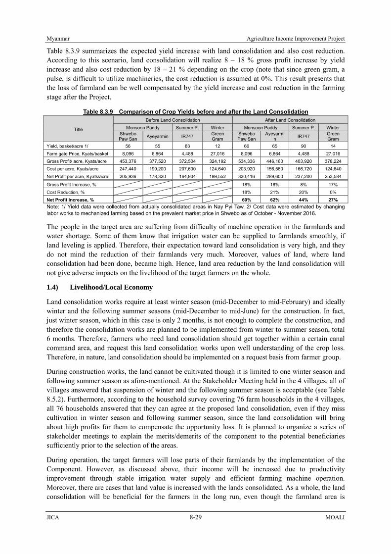
Myanmar Agriculture Income Improvement Project
JICA 8-29 MOALI
Table 8.3.9 summarizes the expected yield increase with land consolidation and also cost reduction. According to this scenario, land consolidation will realize 8 – 18 % gross profit increase by yield increase and also cost reduction by 18 – 21 % depending on the crop (note that since green gram, a pulse, is difficult to utilize machineries, the cost reduction is assumed at 0%. This result presents that the loss of farmland can be well compensated by the yield increase and cost reduction in the farming stage after the Project.
Table 8.3.9 Comparison of Crop Yields before and after the Land Consolidation
Title
Before Land Consolidation After Land Consolidation Monsoon Paddy Summer P. Winter Monsoon Paddy Summer P. Winter
Shwebo Paw San Ayeyarmin IR747 Green
Gram Shwebo Paw San
Ayeyarmin IR747 Green
Gram Yield, basket/acre 1/ 56 55 83 12 66 65 90 14 Farm gate Price, Kyats/basket 8,096 6,864 4,488 27,016 8,096 6,864 4,488 27,016 Gross Profit/ acre, Kyats/acre 453,376 377,520 372,504 324,192 534,336 446,160 403,920 378,224 Cost per acre, Kyats/acre 247,440 199,200 207,600 124,640 203,920 156,560 166,720 124,640 Net Profit per acre, Kyats/acre 205,936 178,320 164,904 199,552 330,416 289,600 237,200 253,584
Gross Profit Increase, % 18% 18% 8% 17% Cost Reduction, % 18% 21% 20% 0% Net Profit Increase, % 60% 62% 44% 27% Note: 1/ Yield data were collected from actually consolidated areas in Nay Pyi Taw. 2/ Cost data were estimated by changing labor works to mechanized farming based on the prevalent market price in Shwebo as of October - November 2016.
The people in the target area are suffering from difficulty of machine operation in the farmlands and water shortage. Some of them know that irrigation water can be supplied to farmlands smoothly, if land leveling is applied. Therefore, their expectation toward land consolidation is very high, and they do not mind the reduction of their farmlands very much. Moreover, values of land, where land consolidation had been done, became high. Hence, land area reduction by the land consolidation will not give adverse impacts on the livelihood of the target farmers on the whole.
1.4) Livelihood/Local Economy
Land consolidation works require at least winter season (mid-December to mid-February) and ideally winter and the following summer seasons (mid-December to mid-June) for the construction. In fact, just winter season, which in this case is only 2 months, is not enough to complete the construction, and therefore the consolidation works are planned to be implemented from winter to summer season, total 6 months. Therefore, farmers who need land consolidation should get together within a certain canal command area, and request this land consolidation works upon well understanding of the crop loss. Therefore, in nature, land consolidation should be implemented on a request basis from farmer group.
During construction works, the land cannot be cultivated though it is limited to one winter season and following summer season as afore-mentioned. At the Stakeholder Meeting held in the 4 villages, all of villages answered that suspension of winter and the following summer season is acceptable (see Table 8.5.2). Furthermore, according to the household survey covering 76 farm households in the 4 villages, all 76 households answered that they can agree at the proposed land consolidation, even if they miss cultivation in winter season and following summer season, since the land consolidation will bring about high profits for them to compensate the opportunity loss. It is planned to organize a series of stakeholder meetings to explain the merits/demerits of the component to the potential beneficiaries sufficiently prior to the selection of the areas.
During operation, the target farmers will lose parts of their farmlands by the implementation of the Component. However, as discussed above, their income will be increased due to productivity improvement through stable irrigation water supply and efficient farming machine operation. Moreover, there are cases that land value is increased with the lands consolidated. As a whole, the land consolidation will be beneficial for the farmers in the long run, even though the farmland area is

Agriculture Income Improvement Project Myanmar
MOALI 8-30 JICA
reduced by 6-8% and also during the construction they have to stop cultivation of winter and the following summer season. After the target sites are fixed, both positive and negative impacts by the land consolidation shall be presented to the beneficiaries sufficiently.
1.5) Existing Social Infrastructure and Services
During the construction works, it is expected that traffic jam will be caused by the increase of traffic volume and by the increase of vehicle passage in and around the construction sites; however, it is not necessary to close the target roads. Therefore, negative impacts on surrounding environment will not be significant. It is recommended to decentralize the use of construction vehicles to avoid traffic jam.
1.6) Misdistribution of Benefit and Damage
The Component will make it easy to operate farming machines in the farmlands, which leads to cost and time saving for the beneficiary farmers. On the other hand, there is a possibility that casual labors those who are hired by the farmers would lose their job opportunities due to the mechanization. According to the interview to some casual labors in the target area, such situation has been already caused, since the farmers have started using machines, especially, for harvesting, recently (JICA Team, 2016).
The casual labors realize the issue and they make efforts to get income, for instance, from working as a waitress in cafe, immigrant labor in Yangon or foreign countries, serving mohinga (local noodle), and vegetable cultivation. Moreover, even after the works, not all farming activities cannot be mechanized, and needs of casual labors for farming still remain. Given that one of the issues raised by farmers is labor shortage (JICA Survey Team, 2016), the probability that livelihood of casual labors is damaged by the Component will be limited.
1.7) Hazard (Risk) of Infectious Diseases such as HIV/AIDS
There will be a number of labors during the construction stage. Under such situation there may be a possibility of extending infectious diseases such as TB, HIV/AIDS among the labors, though with reference to similar construction works, no noticeable examples have been reported so far. It is needed to always pay attention to the labors’ health condition, and should there be such a possibility, the supervisors shall inform the health office of the township. Also, awareness creation on HIV/AIDS shall be made among the labors, which can be initiated by the township health office.
1.8) Work Environment /Accidents
There is a possibility of some accidents by the construction works and traffic accidents. Therefore, safety measures should be addressed prior to the commencement of the Project. It is needed to make a schedule to assign enough number of watchmen to avoid accident. In addition, pre-explanation to workers employed at sites should be made well, so that the works will be done in a safe manner.
2) Irrigation and Drainage Improvement
2.1) Air Pollution
Major construction machineries to be used are excavator, dozer, breaker, roller, loader, truck, and trailer truck. These machineries emit exhaust gasses to some extent. Moreover, dust may be generated from the construction works and transportation of materials to the construction site. In this case, spraying water along and at the construction site should be done, which can greatly reduce such dust. Further, most of the construction sites are along and at the canals, which are far away from any of the residential areas, schools, hospitals and so on.
Therefore, air pollution will not cause any hazardous impact on surrounding environment. It can be

Myanmar Agriculture Income Improvement Project
JICA 8-31 MOALI
said that air pollution by the component is expected to be within an accepted and/or controlled level. However, still, IWUMD is requested to undertake proper maintenance of the machineries to prevent them from unacceptable level of gas exhaustion, and to spray water regularly around the construction sites to minimize air dust generation as much as possible.
2.2) Water Pollution
During the construction works, turbid water may be generated from such improvement sites; however, it can be caused only during the construction period. Moreover, such turbid water will not give damages to the water sources for surrounding residents, since the construction sites have enough distance from any residential areas, hospital, schools and so on. The level of the turbidity is not expected to be significant and it is possible to confine the mud water by putting up an earthen band within the canal. Therefore, it is reasonably guessed that the water pollution can be managed to the acceptable level, and water pollution is considered not to be a major issue.
2.3) Waste
Wastes, namely, excavation of soils, stones, bricks from dilapidated canal portion, concrete pavement and so on will be generated during construction. Excavated soils can be reused for the backfilling of embankment, at which slope had collapsed, except for such soils containing organic matters. Removed stones and bricks can also be re-used for the protection/lining of the canals. However, after having re-used such waste, there may be a possibility that some excessive wastes still remain. In such case, remaining soil can be dumped along the canal, which is under control of IWUMD. Other remaining materials shall be disposed at specified sites. In addition, waste from the labor camp will be generated, and it should be classified and disposed based on regulations in Myanmar.
2.4) Noise and Vibration
Noise and vibration will be caused by the construction works, however, hospital, schools and residential area are not located near construction site of irrigation improvement, since the target canals pass through farmlands, which are far away from residential area. Therefore, noise and vibration generated from the construction work of the components will not give noticeable impacts on surrounding environment.
2.5) Livelihood/Local Economy
The rehabilitation works will be implemented from mid-November to mid-June of the following year with one month suspension during mid-February to mid-March. This arrangement will enable the farmers to cultivate full range of monsoon paddy (from mid-June to mid-November), which is the major income source, and also an alternative summer crop to summer paddy. The alternative crops can be green gram or sesame, which have been already practiced for the last 2 summer seasons at places where there was water shortage.
Figure 8.3.9 shows the cost, gross profit and net profit of 2 verities of summer paddies of Shwe Sae Yin and IR747, green gram and sesame according to the farm household questionnaire survey having covered 240 samples (JICA team, 2016). Though sesame’s net profit is very low, this is due probably to its very low input cost. In fact, the available sample number for sesame was only 11 out of 240 surveyed farm households5, and thus it may imply that those farmers just tried sesame instead of making the farmland fallow.
Anyway, the green gram’s net income falls in between the net incomes of Shwe Sae Yin and IR747 of summer paddy (see the right most bar chart in the figure below). In fact, the cultivated area of Shwe
5 As a reference, the number of farmers who have cultivated green gram was 62 out of the 240 surveyed households.

Agriculture Income Improvement Project Myanmar
MOALI 8-32 JICA
Sae Yin is more than that of IR747; namely, 78% vs. 22% according the questionnaire survey result. Therefore, if the farmers cultivate the alternative crop, i.e. green gram instead of summer paddy, with one time irrigation water supply at the onset of the summer season, they can mostly recover the loss of summer paddy cultivation.
The rehabilitation works will continue throughout winter season from mid-November, and during this winter season there are farmers who cultivate pulses such as chick pea, green gram and black gram. These crops are cultivated on residual moistures available out of monsoon cultivation. It means that these winter crops are not irrigated, so that the rehabilitation works carried out through winter season will not hinder the cultivation of winter crops at all.
There may be a possibility that the rehabilitation works could continue from mid-November to the following year’s mid-June without any suspension afore-mentioned. In this case, the beneficiary farmers have to lose one summer cultivation income. In fact, at present the summer crop is cultivated only in 60% of the whole irrigable area as average due to the amount of available irrigation water in the dam reservoir.
This means that 40% of the farmers cannot cultivate summer crops at present, or even if rotational irrigation was conducted over the whole irrigable area, every farmer could not cultivate 2 summer seasons out of every 5 years. This logic automatically entails that only one season suspension of summer crop for a specific area will not generate any income loss on the whole irrigable area.
In other words, even if some farmlands cannot be irrigated during a summer season by the construction works, other farmlands can be irrigated through other main irrigation canals. Note that the rehabilitation works are carried out and completed from one main canal command area to the other every year, so that one winter-summer season for the rehabilitation works is enough for a main canal command area.
Further in addition, according to the stakeholder meetings conducted at the 12 villages and plus 4 villages (see “8.5 Stakeholder Meeting”), all the villages have agreed with the Project even with 3-summer seasons water stoppage except one village. The village, which did not agree the 3-summer seasons water stoppage, notified that they can agree only one summer season water stoppage. It means that the farmers do not have an objection against the suspension of cultivation due to the improvement works.
According to the above stakeholder meetings held at the total 16 villages, the rehabilitation works may
361,900
195,900
423,300
261,300
368,400
227,400
142,50096,500
166,000162,000141,000
46,000
0
50,000
100,000
150,000
200,000
250,000
300,000
350,000
400,000
450,000
Total Cost Gross Profit Net Profit
Cos
t/ P
rofit
, Kya
ts/a
cre
Shwe Sae Yin IR747 Green Gram SesameFigure 8.3.9 Comparison of Net Incomes for Summer paddy, Green gram and Sesame
Source: A Questionnaire Survey (240 FHHs covered), JICA Survey Team (2016)

Myanmar Agriculture Income Improvement Project
JICA 8-33 MOALI
be able to continue from mid-November to mid-June of the following year without any one-month suspension. However, it is recommended that alternative summer crop cultivation, e.g. green gram to summer paddy, by providing one-time irrigation water at the sowing period should be practiced in order for the farmers not to lose any income opportunity from summer crop.
2.6) Water Usage/ Water Rights
Irrigation water will not be available throughout whole summer season during the rehabilitation works. However, it is noted that about 40% beneficiaries cannot use irrigation water in summer season at present due to insufficient water in the dam reservoir. Even for the other farmers who are provided with the summer irrigation water, they also need rehabilitation works in order to obtain stable irrigation water.
As a whole, the beneficiary farmers welcome the Component, in spite of alternative summer crop cultivation or suspension of summer farming, since they understand the effectiveness of the works as indicated at the stakeholder meetings (see “8.5 Stakeholder Meeting”). Therefore, it can be said that impact on the water usage by the Component is still minimal and acceptable, and further noted that the total irrigation area by the Thapanzeik Dam will not be decreased during the works.
2.7) Existing Social Infrastructure and Services
During the construction works, it is expected that traffic jam will be caused by the increase of construction vehicles. They will be operated around the construction sites and they will be parked in the area during the night, which results in no severe traffic jam, and no road closure will be necessary. Hence, it can be judged that the impact will not be significant. Still, it is recommended to decentralize the use of construction vehicles to avoid traffic jam as much as possible.
2.8) Hazard (Risk) of Infectious Diseases such as HIV/AIDS
There will be a number of labors during the construction stage. Under such situation there may be a possibility of extending infectious diseases such as TB, and HIV/AIDS among the labors, though with reference to similar construction works, no noticeable examples have been reported so far. It is needed to always pay attention to the labors’ health condition, and should there be such a possibility, the supervisors shall inform the health office of the township. Also, awareness creation on HIV/AIDS shall be made among the labors, which can be initiated by the township health office.
2.9) Work Environment /Accidents
There is a possibility of some accidents by the construction works and traffic accidents. Therefore, safety measures should be addressed prior to the commencement of the Project. It is needed to make a schedule to assign enough number of watchmen to avoid accident. In addition, pre-explanation to workers employed at sites should be made well, so that the works will be done in a safe manner.
3) Distribution Infrastructure Improvement
3.1) Air Pollution
Major construction machineries to be used are excavator, dozer, breaker, roller, loader, truck, and trailer truck and these machineries emit exhaust gasses to some extent. Moreover, dust may be generated from the construction works and transportation of materials to the construction site and some construction sites are within the villages. In this case, spraying water along and at the construction sites should be applied, which can greatly reduce such dust.
Still, IWUMD is requested to undertake proper maintenance of the machineries to prevent from unacceptable level of gas exhaustion, and to spray water around the construction sites to minimize air

Agriculture Income Improvement Project Myanmar
MOALI 8-34 JICA
dust generation as much as possible.
3.2) Water Pollution
During the improvement works of bridge on the road, turbid water may be generated from such road improvement sites. However, such situation will be caused only during the construction period. In other sites apart from bridges, no water pollution will be generated from the road improvement sites.
Even if turbid water is generated, the level of turbidity will not be significant. Further, it is possible to prevent the mud water from spilling over to the downstream areas through putting up an earthen band within the canal. Therefore, it can be said that the water pollution can be managed within the acceptable level, and water pollution is considered not to be a major issue.
3.3) Waste
The road pavement will be applied over the existing pavement; therefore, only small amount of waste will be generated from the works. However, it is needed to melt asphalt in the drums by burning for the pavement works, and after the works, many used drums have to be disposed as waste, which shall be transported at specified sites.
3.4) Noise and Vibration
In general, target roads pass through farmlands; however, sometimes pass through villages. In such case, construction works and passage of construction vehicles can generate noise and vibration for surrounding residents. Moreover, hammering of gravels is needed to prepare road beds, which cause noise and vibration. Still, the period is limited to the beginning of a series of construction works, and the extent will be acceptable.
3.5) Land Acquisition
Current standard road width specified by DRRD is set at 18 feet, however, due to the change of DRRD design standards, if the target road width is less than 20 feet, it is necessary to expand the roads to 20 feet for upgrading from Macadam to asphalt pavement. Consequently, some target roads have to be expanded in width, which results in land acquisition, one foot each for both sides, respectively. Compensation for the land loss shall be provided to the affected persons based on the law in Myanmar, namely, 15% plus of market prices in the area.
3.6) Existing Social Infrastructure and Services
Due to the road improvement works, one-side of the target roads will not be utilized, which will be inconvenient for the users. However, it is limited to the construction period, and the construction sites will be shifted in turn in the short period. It is recommended to decentralize the use of construction vehicles to minimize traffic jam as much as possible.
3.7) Hazard (Risk) of Infectious Diseases such as HIV/AIDS
There will be a number of labors during the construction stage. Under such situation, there may be a possibility of extending infectious diseases such as TB, and HIV/AIDS among the labors, though with reference to similar construction works, no noticeable examples have been reported so far. It is needed to always pay attention to the labors’ health condition, and should there be such a possibility, the supervisors shall inform the health office of the township. Also, awareness creation on HIV/AIDS shall be made among the labors, which can be initiated by the township health office.
3.8) Work Environment /Accidents
There is a possibility of some accidents by the construction works and traffic accidents. Therefore,

Myanmar Agriculture Income Improvement Project
JICA 8-35 MOALI
safety measures should be addressed prior to the commencement of the Project. It is needed to make a schedule to assign enough number of watchmen to avoid accident. In addition, pre-explanation to workers employed at sites should be made well, so that the works will be done in a safe manner.
8.3.5 Impact Evaluation of the Environmental and Social Examination
Based on the results discussed above, Table 8.3.9 (1), (2) and (3) summarize the impact evaluation of the environmental and social examination for the three proposed components, respectively.
Table 8.3.10 (1) Impact Evaluation for “Land Consolidation”
Environmental Parameters
Evaluation at Scoping Evaluation based on the Results of environmental and social consideration Reason
Construction period
Operation period
Construction period
Operation period
1. Air Pollution B- D B- N/A
Construction period: With regard to land consolidation works, heavy machinery and trucks are supposed to emit exhaust gas. In addition, dust is generated when vehicles pass. However, as the target area is within farmlands, the impact will not be severe. Operation period: Once offered for use, no air pollution arises.
2. Water Pollution D D N/A N/A 3. Waste D D N/A N/A 4. Soil Contamination/
Salinization D D N/A N/A
5. Noise and Vibration B- D B- N/A
Construction period: Transport of materials by heavy machinery and trucks takes place toward the construction sites. Though serious noise / vibration are not generated from these activities, consideration should be paid when the heavy machinery and trucks pass through the living quarters. Operation period: Once offered for use, no noise/ vibration are expected.
6. Ground Subsidence
D D N/A N/A
7. Offensive Odor D D N/A N/A 8. Bottom Sediment D D N/A N/A 9. Protected Area D D N/A N/A 10. Ground Water D D N/A N/A 11. Hydrological
Situation D D N/A N/A
12. Topography and Geographical Features
D D N/A N/A
13. Involuntary Resettlement
D D N/A N/A
14. Land Acquisition B- B+ B- B+
Construction period: During one winter season and following summer season, the target farmlands will not be cultivated due to the works. For this arrangement, land consolidation works will be done based on request from the farmers’ side. Operation period:

Agriculture Income Improvement Project Myanmar
MOALI 8-36 JICA
Environmental Parameters
Evaluation at Scoping Evaluation based on the Results of environmental and social consideration Reason
Construction period
Operation period
Construction period
Operation period
About 8% of farmland area will be reduced by the Component. However, the land value and productivity will be increased. In the long run, the Component will be profitable for the farmers.
15. Cultural Heritage D D N/A N/A 16. Landscape D D N/A N/A 17. The Poor,
Indigenous and Ethnic People
D D N/A N/A
18. Livelihood/Local Economy
B- B+ B- B+
Construction period: Due to the works, farmers cannot use farmlands for one winter season and following summer season. For this arrangement, land consolidation works will be done based on request from the farmers’ side. Operation period: Due to the works, productivity will be increased, which results in improvement of living standard and also local economy.
19. Land use and Local Resource Utilization
D D N/A N/A
20. Existing Social Infrastructures and Services
B- B+ B- B+
Construction period: During construction period, traffic jam can be caused due to an increase of vehicle passage in the roads around the sites. Operation period: Once offered for use, no waste is generated.
21. Misdistribution of Benefit and Damage
D B- N/A B-
Construction period: No impact is expected. Operation period: Recently, casual labors have opportunities to work as a waiter/waitress or migrant workers, consequently, labor fee is increased (see Figure 3.2.8). Due to mechanization for farming, there is a possibility that job opportunities as farm labors will be reduced. However, given that labor shortage and increase of farm labor fee are regarded as problems, the income loss by the Component is not severe and can be manageable.
22. Social Institutions D D N/A N/A 23. Water Usage or
Water Rights and Rights of Common
D D N/A N/A
24. Gender D D N/A N/A 25. Children Rights D D N/A N/A
26. Hazards (Risk) of Infectious Diseases such as HIV/AIDS
B- D B- N/A
Construction period: Labors for the improvement works will be hired outside, while some are hired from local people; thus there will be a lot of workers who stay and work together,

Myanmar Agriculture Income Improvement Project
JICA 8-37 MOALI
Environmental Parameters
Evaluation at Scoping Evaluation based on the Results of environmental and social consideration Reason
Construction period
Operation period
Construction period
Operation period
congestion of whom may lead to infectious diseases, e.g. HIV/AIDS. Operation period: No impact is expected.
27. Work Environment/Accidents
B- D B- N/A
Construction period: Potential risk of accidents would be arisen from the Component such as a possibility of traffic accidents by vehicles of the construction work. Operation period: No accident is expected during the operation period.
28. Global Warming D D N/A N/A A+/-: Significant positive/negative impact is expected. B+/-: Positive/negative impact is expected to some extent. C+/-: Extent of positive/negative impact is unknown. (A further examination is needed, and the impact could be clarified
as the study progresses) D: No impact is expected. Hatched parameters are those which can cause negative impacts.
Table 8.3.10 (2) Impact Evaluation for “Irrigation and Drainage Improvement”
Environmental Parameters
Evaluation at Scoping Evaluation based on the Results of environmental and social consideration Reason
Construction period
Operation period
Construction period
Operation period
1. Air Pollution B- D B- N/A
Construction period: With regard to improvement works, heavy machinery and trucks are supposed to emit exhaust gas. In addition, dust is generated when vehicles pass. Operation period: Once offered for use, no air pollution arises.
2. Water Pollution B- D B- N/A
Construction period: Accompanying with improvement works, turbid water may occur in the canals. Operation period: Once offered for use, no water pollution arises.
3. Waste B- D B- N/A
Construction period: Wastes and scraps (mostly excavated soils and bricks of existing canal) are expected. Operation period: Once offered for use, no waste is generated.
4. Soil Contamination/ Salinization
D D N/A N/A
5. Noise and Vibration B- D B- N/A
Construction period: Transport of materials by heavy machinery and trucks takes place toward the construction sites. Though serious noise / vibration are not generated from these activities, consideration should be paid when the heavy machinery and trucks pass through the living quarters. Operation period:

Agriculture Income Improvement Project Myanmar
MOALI 8-38 JICA
Environmental Parameters
Evaluation at Scoping Evaluation based on the Results of environmental and social consideration Reason
Construction period
Operation period
Construction period
Operation period
Once offered for use, no noise/ vibration are expected.
6. Ground Subsidence
D D N/A N/A
7. Offensive Odor D D N/A N/A 8. Bottom Sediment D D N/A N/A 9. Protected Area D D N/A N/A 10. Ground Water D D N/A N/A 11. Hydrological
Situation D D N/A N/A
12. Topography and Geographical Features
D D N/A N/A
13. Involuntary Resettlement
D D N/A N/A
14. Land Acquisition D D N/A N/A 15. Cultural Heritage D D N/A N/A 16. Landscape D D N/A N/A 17. The Poor,
Indigenous and Ethnic People
D D N/A N/A
18. Livelihood/Local Economy
B- B+ B- B+
Construction period: Due to the improvement works, farmers cannot use irrigation facilities for one summer season. However, other farmlands can be cultivated during the works, and total irrigation area will not be decreased as a whole. Further, if the summer paddy is altered to green gram/ sesame to which one-time irrigation is applied, they can continue the summer cultivation and do not lose any farming opportunity. Operation period: Due to improvement of irrigation facilities, water distribution loss will be reduced, and productivity will be increased, which leads to improvement of living standard and local economy.
19. Land use and Local Resource Utilization
D D N/A N/A
20. Existing Social Infrastructures and Services
B- D B- D
Construction period: During construction period, traffic jam can be caused due to an increase of vehicle passage on the roads around the sites. Operation period: Once offered for use, no waste is generated.
21. Misdistribution of Benefit and Damage
D D N/A N/A
22. Social Institutions D D N/A N/A
23. Water Usage or Water Rights and Rights of Common
B- D B- N/A
Construction period: Due to improvement of existing irrigation facilities, farmers who cultivate in summer season at present may have to suspend the cultivation for one summer

Myanmar Agriculture Income Improvement Project
JICA 8-39 MOALI
Environmental Parameters
Evaluation at Scoping Evaluation based on the Results of environmental and social consideration Reason
Construction period
Operation period
Construction period
Operation period
season. However, other farmlands will be irrigated during the works, and as a whole, irrigable area in the Project area will not be reduced. Further, if one-time irrigation is applied at the onset of summer season to alternative crop, e.g. green gram, the farmers will not lose any summer crop cultivation. Operation period: Existing irrigation facilities are improved, which results in stable and more productive farming.
24. Gender D D N/A N/A 25. Children Rights D D N/A N/A
26. Hazards (Risk) of Infectious Diseases such as HIV/AIDS
B- D B- N/A
Construction period: Labors for improvement works will be hired from outside, while some are hired from local people; thus there will be a lot of workers who stay and work together, congestion of whom may lead to infectious diseases, e.g. HIV/AIDS. Operation period: No impact is expected.
27. Work Environment/Accidents
B- D B- N/A
Construction period: Potential risk of accidents would be arisen from the Component such as a possibility of traffic accidents by vehicles of the construction work. Operation period: No accident is expected during the operation period.
28. Global Warming D D N/A N/A A+/-: Significant positive/negative impact is expected. B+/-: Positive/negative impact is expected to some extent. C+/-: Extent of positive/negative impact is unknown. (A further examination is needed, and the impact could be clarified
as the study progresses) D: No impact is expected. Hatched parameters are those which can cause negative impacts.
Table 8.3.10 (3) Impact Evaluation for “Distribution Infrastructure Improvement”
Environmental Parameters
Evaluation at Scoping Evaluation based on the Results of environmental and social consideration Reason
Construction period
Operation period
Construction period
Operation period
1. Air Pollution B- D B- N/A
Construction period: With regard to improvement works, heavy machinery and trucks are supposed to emit exhaust gas. In addition, dust is generated when vehicles pass. Operation period: Once offered for use, no air pollution arises.
2. Water Pollution B- D B- N/A
Construction period: Accompanying with improvement works, turbid water may occur around the bridges on the roads. Operation period:

Agriculture Income Improvement Project Myanmar
MOALI 8-40 JICA
Environmental Parameters
Evaluation at Scoping Evaluation based on the Results of environmental and social consideration Reason
Construction period
Operation period
Construction period
Operation period
Once offered for use, no water pollution arises.
3. Waste B- D B- N/A
Construction period: A large number of drums for melting asphalt will be used and they have to be disposed. Operation period: Once offered for use, no waste is generated.
4. Soil Contamination/ Salinization
D D N/A N/A
5. Noise and Vibration B- D B- N/A
Construction period: Transport of materials by heavy machinery and trucks takes place toward the construction sites. Moreover, hammering of gravels will cause severe noise and vibration. However, it will be limited to the beginning of works. Operation period: Once offered for use, no noise/ vibration are expected.
6. Ground Subsidence
D D N/A N/A
7. Offensive Odor D D N/A N/A 8. Bottom Sediment D D N/A N/A 9. Protected Area D D N/A N/A 10. Ground Water D D N/A N/A 11. Hydrological
Situation D D N/A N/A
12. Topography and Geographical Features
D D N/A N/A
13. Involuntary Resettlement
D D N/A N/A
14. Land Acquisition B- D B- D
Construction period: Some of target roads whose width is less than 20 feet have to be expanded, which results in land acquisition. Compensation for the land loss is shall be provided. Operation period: Once offered for use, no land acquisition arises.
15. Cultural Heritage D D N/A N/A 16. Landscape D D N/A N/A 17. The Poor,
Indigenous and Ethnic People
D D N/A N/A
18. Livelihood/Local Economy
D D N/A N/A
19. Land use and Local Resource Utilization
D D N/A N/A
20. Existing Social Infrastructures and Services
B- B+ B- B+
Construction period: During construction period, traffic jam can be caused due to an increase of vehicle passage in the roads around the sites. Operation period: Once offered for use, no waste is

Myanmar Agriculture Income Improvement Project
JICA 8-41 MOALI
Environmental Parameters
Evaluation at Scoping Evaluation based on the Results of environmental and social consideration Reason
Construction period
Operation period
Construction period
Operation period
generated. 21. Misdistribution of
Benefit and Damage
D D N/A N/A
22. Social Institutions D D N/A N/A 23. Water Usage or
Water Rights and Rights of Common
D D N/A N/A
24. Gender D D N/A N/A 25. Children Rights D D N/A N/A
26. Hazards (Risk) of Infectious Diseases such as HIV/AIDS
B- D B- N/A
Construction period: Labors for improvement works will be hired outside, while some are hired from local people; thus there will be a lot of workers who stay and work together, congestion of whom may lead to infectious diseases, e.g. HIV/AIDS. Operation period: No impact is expected.
27. Work Environment/Accidents
B- D B- N/A
Construction period: Potential risk of accidents would be arisen from the Component such as a possibility of traffic accidents by vehicles of the construction work. Operation period: No accident is expected during the operation period.
28. Global Warming D D N/A N/A A+/-: Significant positive/negative impact is expected. B+/-: Positive/negative impact is expected to some extent. C+/-: Extent of positive/negative impact is unknown. (A further examination is needed, and the impact could be clarified
as the study progresses) D: No impact is expected. Hatched parameters are those which can cause negative impacts.
8.4 Mitigation Measures and Monitoring
8.4.1 Mitigation Measures and Cost
Some adverse effects by the project are anticipated, and in general they are limited to the construction phase only, e.g. air pollution, wastes, noise/vibration, work environment and accidents. The damages are thus tentative and reversible. For the purpose of alleviation of such negative impacts by the Projects, following countermeasures shown in tables below are needed to be done. In addition, necessary budget shall be allocated for implementation of the countermeasures. Concerning the measures against air pollution, water pollution, noise/vibration, existing social infrastructure, hazard/ infectious disease and work environment/accident, the necessary cost is to be included in the construction cost to be covered by the contractor. Concerning land acquisition due to “Distribution Infrastructure Improvement”, DRRD is requested to secure the budget for the compensation.
Table 8.4.1 (1) Mitigation Measures to/against the Negative Impacts for “Land Consolidation”
Negative impact Alleviating or avoiding measures Responsible Agency
Cost
1. Air pollution Exhaust gas emission takes place. Dust occurs during the passage of
• Conduct regular check and full maintenance of construction machineries and vehicles.
• Spray water in and around entrances of construction sites and on the road, along which machineries are to
Construction Division (4) (CON (4)) and Maintenance
Included in construction cost

Agriculture Income Improvement Project Myanmar
MOALI 8-42 JICA
Negative impact Alleviating or avoiding measures Responsible Agency
Cost
construction vehicles. move. Division (MD) under the IWUMD
5. Noise/ vibration During construction work, noise/ vibration evolve from the operation of back-hoes and passage of trucks., etc.
• Refrain construction work at night in such areas where residential quarters are located.
CON (4) and MD IWUMD
Included in construction cost
14. Land acquisition 8% reduction of farmland areas of beneficiaries 18. Livelihood/Local Economy Income loss due to suspension of farming in one winder season and following summer season
• Explain the effectiveness of the Component and obtaining consensus from the beneficiaries
IWUMD TS office
None
20. Existing social infrastructure and services Traffic jam will be caused.
• Prepare a schedule which deconcentrates vehicle operation
CON (4) and MD
Included in construction cost
22. Work environment 23. Accident During construction work, traffic and/or site-work accidents may take place.
• Identify if there is too tight operation schedule or not, and if so rectify it.
• Place traffic control staff along the construction roads. • Explain contents of the work to the workers with
necessary care taking for their safety prior to the start of the work, and make daily confirming safe meeting before starting the work.
CON (4) and MD IWUMD
Included in construction cost
24. Hazards (Risk) of Infectious diseases such as HIV/AIDS During construction stage, infectious diseases such as TB and HIV/AIDS may take place among the workers.
• Pay attention to the workers’ health condition, and if there is a possibility of incident of infectious diseases taking place, immediately inform the township health office and the Consultant office.
• Request the township health office to carry out awareness creation on HIV/AIDS among the workers and recommend them to voluntary check the status of HIV/AIDS.
CON (4), MD, Town Health Office
Included in construction cost
Source: JICA Survey Team *Concerning “21 Misdistribution of benefit and damage” mentioned in Table 8.3.10 (1), it is not very difficult for the casual labors to find other jobs, given that job opportunities apart from farm labor have been increased in rural areas, recently. Therefore, it is judged that mitigation measures against this issue are not necessary.
Table 8.4.1 (2) Mitigation Measures to/against the Negative Impacts for “Irrigation and Drainage Improvement”
Negative impact Alleviating or avoiding measures Responsible Agency
Cost
1. Air pollution Exhaust gas emission takes place. Dust occurs during the passage of construction vehicles.
• Conduct regular check and full maintenance of construction machineries and vehicles.
• Spray water in and around entrances of construction sites and on the road, along which machineries are to move.
CON (4) and MD
Included in construction cost
2.Water pollution Turbid water from the construction sites
• Prevent turbid water from going down by putting earth band in case mud water is generated from the construction sites.
CON (4) and MD
Included in construction cost
3. Wastes Excavated earth evolves from some construction works and waste scrap pieces from improvement works.
• Re-use excavated soils, removed bricks and dilapidated concrete portions.
• Dispose of such soils containing organic matters in the lands running alongside the canals, the lands of which are owned by IWUMD.
• Dispose wastes out of machineries according to construction regulation in Myanmar.
• Note that the remaining ones which cannot be re-used will be dumped and buried in the IWUMD owned lands stretching alongside the main and distributary canals.
CON (4) and MD
Included in construction cost

Myanmar Agriculture Income Improvement Project
JICA 8-43 MOALI
Negative impact Alleviating or avoiding measures Responsible Agency
Cost
• Finally, entrust proper disposal of waste, which cannot be reused, though such waste will be minimal.
5. Noise/ vibration During construction work, noise/ vibration evolve from the operation of back-hoes and passage of trucks., etc.
• Refrain construction work at night in such areas where residential quarters are located.
CON (4) and MD
Included in construction cost
18. Livelihood/Local Economy Income loss due to suspension of farming in one summer season 23. Water Usage or Water Rights and Rights of Common Irrigation canals will not be available for the works
• Explain effectiveness of the Component and obtaining consensus from the beneficiaries
IWUMD TS office
None
20. Existing social infrastructure and services Traffic jam will be caused.
• Prepare a schedule which deconcentrates vehicle operation
CON (4) and MD
Included in construction cost
26. Hazards (Risk) of Infectious diseases such as HIV/AIDS During construction stage, infectious diseases such as TB and HIV/AIDS may take place among the workers.
• Pay attention to the workers’ health condition, and if there is a possibility of incident of infectious diseases taking place, immediately inform the township health office and the Consultant office.
• Request the township health office to carry out awareness creation on HIV/AIDS among the workers and recommend them to voluntary check the status of HIV/AIDS.
CON (4) and MD, TS Health Office
Included in construction cost
27. Work environment /Accident During construction work, traffic and/or site-work accidents may take place.
• Identify if there is too tight operation schedule or not, and if so rectify it.
• Place traffic control staff along the construction roads. • Explain contents of the work to the workers with
necessary care taking for their safety prior to the start of the work, and make daily confirming safe meeting before starting the work.
CON (4) and MD
Included in construction cost
Source: JICA Survey Team
Table 8.4.1 (3) Mitigation Measures to/against the Negative Impacts for “Distribution Infrastructure Improvement”
Negative impact Alleviating or avoiding measures Responsible Agency
Cost
1. Air pollution Exhaust gas emission takes place. Dust occurs during the passage of construction vehicles.
• Conduct regular check and full maintenance of construction machineries and vehicles.
• Spray water in and around entrances of construction sites and on the road, along which machineries are to move.
DRRD Included in construction cost
2.Water pollution Turbid water from the construction sites
• Prevent turbid water from going down by putting earth band in case mud water is generated from the construction sites.
DRRD Included in construction cost
3. Wastes Excavated earth evolves from some construction works and waste scrap pieces from improvement works.
• Dispose wastes such as used drums for the works according to construction regulation in Myanmar.
DRRD Included in construction cost
5. Noise/ vibration During construction work, noise/ vibration evolve from the operation of back-hoes and passage of trucks., etc.
• Refrain construction work at night in such areas where residential quarters are located.
DRRD Included in construction cost
14. Land acquisition Due to change of DRRD standard, it is needed to expand
• A Resettlement Action Plan (RAP) except socio-economic survey result is to be prepared.
• Compensation for the land loss, damage to
DRRD Shouldered by DRRD

Agriculture Income Improvement Project Myanmar
MOALI 8-44 JICA
Negative impact Alleviating or avoiding measures Responsible Agency
Cost
the road cross section to 20 feet in case of to-be-asphalt paved one, as far as current road section is less than 20 feet.
structures/standing crops is to be done.
20. Existing social infrastructure and services Traffic jam can be caused by the works
• Prepare a schedule which deconcentrates vehicle operation
• Close half side of roads during the construction works instead of complete road closure
DRRD Included in construction cost
26. Hazards (Risk) of Infectious diseases such as HIV/AIDS During construction stage, infectious diseases such as TB and HIV/AIDS may take place among the workers.
• Pay attention to the workers’ health condition, and if there is a possibility of incident of infectious diseases taking place, immediately inform the township health office and the Consultant office.
• Request the township health office to carry out awareness creation on HIV/AIDS among the workers and recommend them to voluntary check the status of HIV/AIDS.
DRRD, TS Health Office
Included in construction cost
27. Work environment /Accident During construction work, traffic and/or site-work accidents may take place.
• Identify if there is too tight operation schedule or not, and if so rectify it.
• Place traffic control staff along the construction roads. • Explain contents of the work to the workers with
necessary care taking for their safety prior to the start of the work, and make daily confirming safe meeting before starting the work.
DRRD Included in construction cost
Source: JICA Survey Team
Consultant engaged in the Projects receives the related reports from the CON (4), MD and DRRD. The Consultant, upon confirmation of the contents with reference to the site situation, submits the report to the head offices of IWUMD and DRRD for seeking approval on the proceeding implementation taking due care on the environmental and social issues as planned.
8.4.2 Monitoring Plan
Anticipated environmental impacts are limited to the construction phase, and thus related monitoring will be implemented during the period. The environmental parameters which can be affected by the construction works shall be monitored that are: air pollution, wastes, noise/vibration, work environment and accidents, and infectious diseases such as HIV/AIDS. The monitoring is conducted basically every month except maintenance check of equipment, and the results are recorded in monthly progress report submitted to IWUMD head office. It is noted that the proposed monitoring for the component of “Land consolidation” shall be done at all the land consolidation sites, the locations have not been fixed yet, though. Regarding other two components, the same points of baselines survey will be set as the monitoring points.
The environment monitoring is to be made by CON (4) for the Components of “Land Consolidation” and “Irrigation and Drainage Improvement”, while DRRD for “Distribution Infrastructure Improvement”6. A statement of dissatisfaction or claim from neighbor villagers is to be received by a sub assistant engineer at site. Then, CON (4) and DRRD are to report it to the Consultant, and the Consultant should report to IWUMD head office recorded in the monthly progress report and also taking such opportunity of periodical site inspection or site meeting by the IWUMD head office. In addition, such monitoring reports should be submitted to the ECD to be reviewed. Table 8.4.2 shows the recommended monitoring plan, and the procedure of the monitoring and reporting are as follows. Note that all the monitoring cost is included in the construction cost.
6 CON(4) is planned to work as contractors for “Land Consolidation” and “Irrigation and Drainage Improvement”, while a
private contractor is planned to be hired for “Distribution Infrastructure Improvement”.

Myanmar Agriculture Income Improvement Project
JICA 8-45 MOALI
Table 8.4.2 (1) Recommended Monitoring Plan for “Land Consolidation” 1) Construction Stage
(1) Response and actions by the government Monitoring Item Monitoring Results during Report Period Responsible Organization
Number and contents of formal comments made by the public CON(4)
Number and contents of responses from the people CON(4) (2) Pollution
- Air Pollution
Item Unit Measured
Value (Mean)
Measured Value (Max)
Country’s Standards
Referred IFC Guidelines
Remarks (Measurement
Point, Frequency, Method, etc.)
Responsible Organization
At construction site
SO2 [μg/m3]
10 min. 24 hr
<500μg/m3 <20μg/m3
<500μg/m3 <20μg/m3
Once per month CON(4)
PM10 [μg/m3]
1 year 24 hour
<20μg/m3 <50μg/m3
<20μg/m3 <50μg/m3
Once per month CON(4)
PM25 [μg/m3]
1 year 24 hour
<10μg/m3 <25μg/m3
<10μg/m3 <25μg/m3
Once per month CON(4)
NO2 [μg/m3]
1 year 1 hour
<40μg/m3 <200μg/m3
<40μg/m3 <200μg/m3
Once per month CON(4)
Ox [μg/m3]
8 hours daily max
<100μg/m3 <100μg/m3 Once per month CON(4)
- Maintenance of heavy machine
Type of machine Kinds of disorder Measures taken Monitoring date Responsible Organization
Hydraulic Excavator Every day CON(4) Hydraulic Breaker Every day CON(4) Track Dozer (Bulldozer) Every day CON(4) Wheel Loader Every day CON(4) Earth Work Vibration Roller Every day CON(4) Agitator Truck (Concrete Mixer Truck) Every day CON(4) Lowbed semi-Trailer Truck Every day CON(4) Dump Truck Every day CON(4) Concrete Pump Truck Every day CON(4) Workshop Equipment Every day CON(4)
- Noise / Vibration
Item Unit Measured Value (Mean)
Measured Value (Max)
Country’s Standards
Referred IFC Guidelines
Remarks (Measurement
Point, Frequency, Method, etc.)
Responsible Organization
Noise dB <55 (daytime)
<45 (night) <55 (daytime)
<45 (night) Once per month
CON(4)
(3) Natural environment
Environmental parameter Monitoring
results Measures taken Monitoring date Responsible Organization
Wastes In principle, re-use of excavated soils Remaining waste cannot be re-used shall be disposed at the specified site following regulations in Myanmar.
Every day CON(4)

Agriculture Income Improvement Project Myanmar
MOALI 8-46 JICA
(4) Social environment (Traffic Jam)
Environmental parameter Monitoring results Measures taken Responsible Organization
Number of complaint about traffic jam CON(4) (5) Working environment (Include working safety)/ Accident
Environmental parameter Monitoring results Measures
taken Monitoring date
Responsible Organization
Safety check for carrying the heavy machineries into the work area.
First time of the construction work. CON(4)
Safety check for refueling car accessing the work sites.
Every day. CON(4)
Safety check for carrying-out of the heavy machineries from the work sites.
Last time of the construction work. CON(4)
Checking of the heavy machineries if keeping correct routes and speed.
Every day CON(4)
Installation of project sign board around the field.
First time of the construction work. CON(4)
(6) Hazards (Risk) of Infectious diseases such as HIV/AIDS
Environmental parameter Monitoring results Measures taken Monitoring date Responsible Organization
Pay attention to the workers’ health condition.
Every day CON(4)
Arrange with the township health office to carry out awareness creation on HIV/AIDS among the workers.
Once half a year CON(4)
Source: the Survey Team (2016)
2) Operation Stage None
Table 8.4.2 (2) Recommended Monitoring Plan for “Irrigation and Drainage Improvement”
1) Construction Stage
(1) Response and actions by the government Monitoring Item Monitoring Results during Report Period Responsible Organization
Number and contents of formal comments made by the public
CON(4)
Number and contents of responses from the people
CON(4)
(2) Pollution - Air Pollution
Item Unit Measured
Value (Mean)
Measured Value (Max)
Country’s Standards
Referred IFC
Guidelines
Remarks (Measurement
Point, Frequency, Method, etc.)
Responsible Organization
At construction site
SO2 [μg/m3]
10 min. 24 hr
<500μg/m3 <20μg/m3
<500μg/m3 <20μg/m3
Once per month CON(4)
PM10 [μg/m3]
1 year 24 hour
<20μg/m3 <50μg/m3
<20μg/m3 <50μg/m3
Once per month CON(4)
PM25 [μg/m3]
1 year 24 hour
<10μg/m3 <25μg/m3
<10μg/m3 <25μg/m3
Once per month CON(4)
NO2 [μg/m3]
1 year 1 hour
<40μg/m3 <200μg/m3
<40μg/m3 <200μg/m3
Once per month CON(4)

Myanmar Agriculture Income Improvement Project
JICA 8-47 MOALI
Item Unit Measured
Value (Mean)
Measured Value (Max)
Country’s Standards
Referred IFC
Guidelines
Remarks (Measurement
Point, Frequency, Method, etc.)
Responsible Organization
Ox [μg/m3]
8 hours daily max
<100μg/m3 <100μg/m3 Once per month CON(4)
- Maintenance of heavy machine
Type of machine Kinds of disorder Measures taken Monitoring date Responsible Organization
Hydraulic Excavator Every day CON(4) Hydraulic Breaker Every day CON(4) Track Dozer (Bulldozer) Every day CON(4) Wheel Loader Every day CON(4) Earth Work Vibration Roller Every day CON(4) Agitator Truck (Concrete Mixer Truck) Every day CON(4) Lowbed semi-Trailer Truck Every day CON(4) Dump Truck Every day CON(4) Concrete Pump Truck Every day CON(4) Workshop Equipment Every day CON(4)
- Water pollution
Item Unit Measured
Value (Mean)
Measured Value (Max)
Country’s Standards
Referred IFC Guidelines
(sanitary sewage water)
Remarks (Measurement Point, Frequency, Method,
etc.)
Responsible Organization
Total Suspended Solid
mg/l
<50 <50 Once per month CON(4)
- Noise / Vibration
Item Unit Measured
Value (Mean)
Measured Value (Max)
Country’s Standards
Referred IFC Guidelines
Remarks (Measurement
Point, Frequency, Method, etc.)
Responsible Organization
Noise dB <55 (daytime)
<45 (night) <55 (daytime)
<45 (night) Once per month
CON(4)
(3) Natural environment
Environmental parameter Monitoring
results Measures
taken Monitoring
date Responsible Organization
Wastes In principle, re-use of excavated soils, re-use of the removed bricks, and re-use of the dilapidated concrete portions. Remaining waste such as soil, which cannot be re-used will be dumped and buried in the IWUMD owned lands stretching alongside the canals. Waste from the labor camp shall be classified and disposed at the specified sites following regulations in Myanmar
Every day CON(4)
(4) Working environment (Include working safety)/ Accident
Environmental parameter Monitoring
results Measures
taken Monitoring date
Responsible Organization
Safety check for carrying the heavy machineries into the work area.
First time of the construction work. CON(4)
Safety check for refueling car accessing the work sites. Every day. CON(4) Safety check for carrying-out of the heavy machineries from the work sites.
Last time of the construction work. CON(4)
Checking of the heavy machineries if keeping correct routes and speed.
Every day CON(4)
Installation of project sign board around the field. First time of the CON(4)

Agriculture Income Improvement Project Myanmar
MOALI 8-48 JICA
Environmental parameter Monitoring
results Measures
taken Monitoring date
Responsible Organization
construction work.
(5) Hazards (Risk) of Infectious diseases such as HIV/AIDS
Environmental parameter Monitoring results Measures
taken Monitoring date
Responsible Organization
Pay attention to the workers’ health condition. Every day CON(4) Arrange with the township health office to carry out awareness creation on HIV/AIDS among the workers.
Once half a year CON(4)
CON(4) Source: JICA Survey Team (2016)
2) Operation Stage None
Table 8.4.2 (3) Recommended Monitoring Plan for “Distribution Infrastructure Improvement”
1) Pre-construction stage
(1) Public Consultation
No. Date Place Contents of the consultation/ main comments and
answers Responsible Organization
1 DRRD
2 DRRD
(2) Progress of land acquisition
Land Acquisition Activities
Planned Total Unit
Progress in Quantity Progress in % Expected Date of
Completion
Responsible Organization
During the
Quarter
Till the Last
Quarter
Up to the
Quarter
Till the Last
Quarter
Up to the
Quarter Preparation RAP DRRD
Employment of Consultants Man-mont
h DRRD
Implementation of Census Survey (including socioeconomic survey)
DRRD
Approval of RAP Date of Approval: DRRD Finalization of PAPs List No. of
PAPs DRRD
Progress of Compensation Payment
No. of PAHs DRRD
Lot 1 No. of PAHs DRRD
Lot 2 No. of PAHs DRRD
Lot 3 No. of PAHs DRRD
Progress of Land Acquisition (all lots) Ha DRRD
Lot 1 Ha DRRD
Lot 2 Ha DRRD
Lot 3 Ha DRRD PAP: Project affected people, PAHs: Project affected households

Myanmar Agriculture Income Improvement Project
JICA 8-49 MOALI
(3) Construction Stage
(1) Response and actions by the government Monitoring Item Monitoring Results during Report Period Responsible Organization
Number and contents of formal comments made by the public
DRRD
Number and contents of responses from the people
DRRD
(2) Pollution - Air Pollution
Item Unit Measured
Value (Mean)
Measured Value (Max)
Country’s Standards
Referred IFC Guidelines
Remarks (Measurement
Point, Frequency, Method, etc.)
Responsible Organization
At construction site
SO2 [μg/m3]
10 min. 24 hr
500μg/m3 20μg/m3
500μg/m3 20μg/m3
Once per month DRRD
PM10 [μg/m3]
1 year 24 hour
20μg/m3 50μg/m3
20μg/m3 50μg/m3
Once per month DRRD
PM25 [μg/m3]
1 year 24 hour
10μg/m3 25μg/m3
10μg/m3 25μg/m3
Once per month DRRD
NO2 [μg/m3]
1 year 1 hour
40μg/m3 200μg/m3
40μg/m3 200μg/m3
Once per month DRRD
Ox [μg/m3]
8 hours daily max
100μg/m3 100μg/m3 Once per month DRRD
- Maintenance of heavy machine
Type of machine Kinds of disorder Measures taken Monitoring date Responsible Organization
Hydraulic Excavator Every day Contractor Hydraulic Breaker Every day Contractor Track Dozer (Bulldozer) Every day Contractor Wheel Loader Every day Contractor Earth Work Vibration Roller Every day Contractor Agitator Truck (Concrete Mixer Truck) Every day Contractor Lowbed semi-Trailer Truck Every day Contractor Dump Truck Every day Contractor Concrete Pump Truck Every day Contractor Workshop Equipment Every day Contractor - Water pollution
Item Unit Measured
Value (Mean)
Measured Value (Max)
Country’s Standards
Referred IFC Guidelines
(sanitary sewage water)
Remarks (Measurement
Point, Frequency, Method, etc.)
Responsible Organization
Total Suspended Solid
mg/l
<50 <50 Once per month DRRD
- Noise / Vibration
Item Unit Measured
Value (Mean)
Measured Value (Max)
Country’s Standards
Referred IFC Guidelines
Remarks (Measurement
Point, Frequency,
Method, etc.)
Responsible Organization
Noise dB <55 (daytime)
<45 (night) <55 (daytime)
<45 (night) Once per month DRRD

Agriculture Income Improvement Project Myanmar
MOALI 8-50 JICA
(3) Natural environment
Environmental parameter Monitoring
results Measures taken Monitoring date Responsible Organization
Wastes Waste from the construction site such as drums shall be disposed at the specified sites following regulations in Myanmar
Every day DRRD
(4) Social environment (Traffic Jam)
Environmental parameter Monitoring results Measures taken Responsible Organization
Number of complaint about traffic jam DRRD (5) Working environment (Include working safety)/ Accident
Environmental parameter Monitoring
results Measures
taken Monitoring date
Responsible Organization
Safety check for carrying the heavy machineries into the work area.
First time of the construction work. DRRD
Safety check for refueling car accessing the work sites. Every day. DRRD Safety check for carrying-out of the heavy machineries from the work sites.
Last time of the construction work. DRRD
Checking of the heavy machineries if keeping correct routes and speed.
Every day DRRD
Installation of project sign board around the field. First time of the construction work. DRRD
(6) Hazards (Risk) of Infectious diseases such as HIV/AIDS
Environmental parameter Monitoring
results Measures
taken Monitoring date
Responsible Organization
Pay attention to the workers’ health condition. Every day DRRD
Arrange with the township health office to carry out awareness creation on HIV/AIDS among the workers.
Once half a year DRRD
Source: the Survey Team (2016)
2) Operation Stage None
8.5 Stakeholder Meeting
As described in “Chapter 8.3.1 4) Population”, a series of stakeholder meetings have been held to explain the Project objectives and three main components, namely, “Land consolidation”, “Irrigation and Drainage Improvement” and “Distribution Infrastructure Improvement” in the 12 villages which were selected from the target area considering their locational balance (see afore-mentioned Figure 8.3.4) and also in additional 4 villages located along minor canals (see Figure 8.3.7). The dates and participants’ number in the 12 villages and 4 villages are as shown in following table:
Table 8.5.1 Dates and Participants’ Number of the Stakeholder Meetings (12 & 4 Villages)
No. Date Village TS Participants by Sex Farmer/ Non-farmer Male Female Total Farmer Non-farmer Total
1. 21-Sep-16 Late Chin Shwebo 36 43 79 64 15 79 2. 23-Sep-16 Htan Zin Shwebo 95 34 129 97 32 129 3. 26-Sep-16 Lat Pan Gyi Kin-U 48 10 58 56 2 58 4. 28-Sep-16 Pyin Htaung Kin-U 43 17 60 59 1 60 5. 30-Sep-16 Ywet Kyan Kanbalu 24 7 31 15 16 31 6. 3-Oct-16 Ta Kaung Min Wetlet 24 6 30 26 4 30 7. 5-Oct-16 Indai Taze 71 44 115 115 0 115 8. 7-Oct-16 Htan Gyi Ye-U 37 30 67 64 3 67 9. 10-Oct-16 Kone Thar Ye-U 39 27 66 66 0 66 10. 12-Oct-16 Pauk Taw Tabayin 36 24 60 40 20 60 11. 17-Oct-16 Mee Kaung Ai Tabayin 39 13 52 50 2 52 12. 19-Oct-16 Na Ga Bo Tabayin 52 163 215 113 102 215

Myanmar Agriculture Income Improvement Project
JICA 8-51 MOALI
No. Date Village TS Participants by Sex Farmer/ Non-farmer Male Female Total Farmer Non-farmer Total
Total 544 418 962 765 197 962 Average 45 35 80 64 16 80 Portion 57% 43% 100% 80% 20% 100%
No. Date Village TS Participants by Sex Farmer/ Non-farmer Male Female Total Farmer Non-farmer Total
1. 24-Oct-16 Late Chin Shwebo 127 37 164 154 10 164
2. 27-Oct-16 Kan Byar (Ywa Shae) Tabayin 51 19 70 55 15 70
3. 31-Oct-16 Khon Taung Gyi Shwebo 80 32 112 83 29 112 4. 3-Nov-16 Tabayin Tabayin 60 14 74 63 11 74
Total 318 102 420 355 65 420 Average 80 26 105 89 16 105 Portion 76% 24% 100% 85% 15% 100%
Source: JICA Survey Team It is noted that the number of affected households by the land consolidation has yet to be determined.
Minutes of those meetings are attached in Appendix VIII.5 and VIII.6. In general, the participants welcomed the proposed components, and they accepted to miss cultivation up to three seasons due to the Component of “Irrigation and Drainage Improvement”, while only one village answered that up to one season suspension is acceptable (see No.7 in Table 8.5.2). Given that those Components undertaken at a specific place will be completed within one winter-summer season according to the current design, their demand will be fulfilled. Note that monsoon paddy, the major income source for the beneficiary famers, will not be suspended in any case, and further it is recommended that one-time irrigation water should be released at the onset of summer cultivation, with which farmers can cultivate alternative summer crops such as pulses or sesame.
Regarding land consolidation, though it is expected that about 6-10% of farmland area will be lost for farm road and tertiary canal establishment within the farmlands by the land consolidation works, all of the villages answered that up to 10% of farmland loss is acceptable. Further, for the additional 4 villages, a question of “do you accept winter and the following summer crop stoppage for the consolidation works?’ was asked, and all the 4 villages answered “Yes”. Therefore, it can be judged that the villages agree with both “Irrigation and Drainage Improvement” and “Land Consolidation” as a whole in spite of necessity of the cultivation suspension (see Table 8.5.2). Note that land consolidation should be implemented only based upon request from the farmers provided that the applicant farmers agree the land loss as well as suspension of winter-summer crops suspension.
Table 8.5.2 Summary of Responses for the Proposed Components
No. Village
1. (1) Up to how many summer
crops suspension acceptable for the irrigation improv’t?
1. (2) Do you agree with the Project under the condition
left?
2. (1) Do you agree the LC with 6-10% land loss?
2. (2) Up to how much
percentage of the farmland
loss is acceptable?
2. (3) Do you accept winter and
summer crop stoppage for land
consolidation work?
1. Late Chin Three seasons Yes Yes 10% - 2. Htan Zin Three seasons Yes Yes 10% - 3. Lat Pan Gyi Three seasons Yes Yes 10% - 4. Pyin Htaung Three seasons Yes Yes 10% - 5. Ywet Kyan Three seasons Yes Yes 10% - 6. Ta Kaung Min Three seasons Yes Yes 10% - 7. Indai One season Yes Yes 10% - 8. Htan Gyi Three seasons Yes Yes 10% - 9. Kone Thar Three seasons Yes Yes 10% - 10. Pauk Taw Three seasons Yes Yes 10% - 11. Mee Kaung Ai Three seasons Yes Yes 10% - 12. Na Ga Bo Three seasons Yes Yes 10% - 1. Late Chin Three seasons Yes Yes 10% Yes 2. Ywa Shae Three seasons Yes Yes 10% Yes 3. Tabayin Three seasons Yes Yes 10% Yes

Agriculture Income Improvement Project Myanmar
MOALI 8-52 JICA
No. Village
1. (1) Up to how many summer
crops suspension acceptable for the irrigation improv’t?
1. (2) Do you agree with the Project under the condition
left?
2. (1) Do you agree the LC with 6-10% land loss?
2. (2) Up to how much
percentage of the farmland
loss is acceptable?
2. (3) Do you accept winter and
summer crop stoppage for land
consolidation work?
4. Khon Taung Gyi Three seasons Yes Yes 10% Yes Source: JICA Survey Team
It is noted that the number of Project Affected Households has yet to be fixed, since actual target sites have not been determined yet. In the process of the land consolidation implementation, the number of the affected persons will be clarified. After the determination of the target sites, stakeholder meetings shall be organized to present both positive and negative impacts to promote their understanding.
8.6 Grievance Handling Mechanism
Grievance handling mechanism is categorized into three; 1) one for land consolidation, 2) one for irrigation & drainage improvement, and 3) one for distribution infrastructure improvement. For the latter two mechanisms, almost same institutionalized arrangement can be applied, and therefore, following explain the handling mechanism for land consolidation and the other for the latter 2 components:
8.6.1 Grievance Handling Mechanism for “Land Consolidation”
When a farmer has some complaints associated with the land consolidation work, the management committee of the farmers’ association to be established is to receive the complaints first (for the establishment of farmer organization, refer to 5.3.5 Establishing Farmer Organization). After the committee has accepted the complaints, they at first demarcate the complaints by category such as; 1) those associated with plot re-allocation, 2) those associated with construction, 3) those associated with land registration, and 4) others. Proposed complaint handling flow is illustrated in following figure:
For the first category, complaints concerning plot re-allocation, the management committee calls upon the concerned farmers, the one who made the complaint and the other who is affected by the claim, and tries to mitigate the issue. Most expected complaint may be the location to which the farm plot is to be moved not preferably by the affected farmer(s). To solve this issue, the committee should be in the position of mediating the concerned farmers, and the farmer themselves should reach the agreement. Project implementer should wait for the unanimous agreement for the plot re-allocation.
Figure 8.6.1 Flow of Compliant Handling for “Land Consolidation” Source: JICA Survey Team, 2017
b) Complaints concerning construction
a) Complaints concerning plot re-allocation
Claimant Affected farmer
Management Committee Try to solve
c) Complaints concerning land registration
Farmer Management Committee Construction supervisor
Farmer Management Committee
Farmer Management Committee DALMS (MOALI) Township Officer, Concerned TS office,
Sagaing region
Farmer Management Committee GAD
Township Administrator, Concerned township, Sagaing
d) Complaints concerning other matters
IWUMD (MOALI) Staff Officer (AE), Shwebo or Ye-U Office

Myanmar Agriculture Income Improvement Project
JICA 8-53 MOALI
On the 2nd issue concerning construction, the management committee is to receive any complaint from their member farmers and deliver the complaint to the construction supervisor at site. If the complaint is not taken up by the site supervisor, the committee shall deliver the issue to the IWUMD staff officer in Shwebo or Ye-U TS, Sagaing region. The committee will discuss the issue with the IWUMD staff officer, and the feedback/mitigation measures will be instructed by the officer to the construction site.
Concerning the 3rd issue, land registration, likewise the management committee is to receive any complaint from their member farmers and go together with the claimant to the township office of DALMS in charge of the registration of land tillage deed. The committee will assist the member farmers to have the registration process done smoothly or assist in solving any problems associated with land registration. For other complaints, the committee may try to solve with the claimant or otherwise they may have to go to GAD of the respective township.
8.6.2 Grievance Handling Mechanism for “Irrigation and Distribution Improvement”
When a farmer has some complaints associated with construction works for irrigation and drainage improvement and distribution infrastructure improvement, the complaints shall be delivered to the construction supervisor of either IWUMD or DRRD, first through village tract level GAD (i.e. village tract leader), and then through township GAD office. During the construction, IWUMD will deploy staff officer (Assistant Engineer; AE) to the respective construction site and DRRD will deploy quality supervisor officer to the construction site from respective township office
Then, the site responsible officer shall take action to settle the grievance, and such grievances which can be handled at the site could be those ones, e.g., noise, turbid construction water, dust, track moving near village, etc. If the issue goes beyond what the site responsible officer can handle, the issue shall be immediately forwarded to the Project Implementation Unit (PIU), and the PIU shall take necessary action, e.g. allocating additional mon-power and/or resources to settle the grievances. Then, this coping measure shall be informed to the township GAD and also to the concerned villagers.
Further, in case of asphalt pavement under distribution infrastructure improvement component by DRRD, 1 feet width expansion is to be arranged at each side of the shoulders. The land owners who will lose the 1 feet narrow strip of land just running alongside the road shall be compensated according to the full replacement cost. When a grievance takes place on the course of the compensation, that issue shall firstly be delivered to the township GAD office, and then the township GAD office together with the claimant shall inform it to respective DRRD township office, and then to PIU. The DRRD office shall take necessary action, guaranteeing pre-agreed compensation, in consultation with the DRRD HQs.
If the PIU will not take necessary action within a reasonable period of time, e.g. hal-month for minor issues and maximum 2 months for major issues including compensation, then the next step is that the affected people shall go to the regional GAD office. GAD belongs to the Ministry of Home Affairs which is in charge of internal/domestic peace and order. Therefore, the GAD office has a supreme power to act on behalf of the people who are affected by the Project. The GAD may recommend the affected people to institutionalize the matter at a court should the GAD office think not able to settle by them. However, since most of the construction works are of rehabilitation and improvement from the existing structure, such case would hardly be expected.

Agriculture Income Improvement Project Myanmar
MOALI 8-54 JICA
8.7 Environmental Framework for the Land Consolidation
Location of all land consolidation sites will be decided during project implementation by November 2018 according to the schedule described below. That means the compliance with the JICA’s environmental and social consideration guideline in land consolidation site has not yet been confirmed at the time of appraisal. Hence, the framework to ensure the compliance with the JICA’s environmental and social consideration guideline in land consolidation site should be described here.
Table 8.7.1 Selection Schedule of the Farmland Consolidation Sites
Procedures for LC Area Selection 2017 2018 2019 Dec Jan Feb Mar Apr May Jun Jul Aug Sep Oct Nov Dec Jan Feb
Establishment of working committee (WC)
Preparation of im
plementation (alm
ost 1 year including farm
er organization establishm
ent) and implem
entation in the follow
ing year
Announcement of land consolidation works
Acceptance of request by farmers
Selection of LC sites (first-come, first served basis)
Cadastral map updating, topographic survey, design, etc.
Establishment of farmers organization in the 1st year
Note: In above table, L/A is expected in December 2017, at which the committee should be established and starts the following activities. Source: JICA Survey Team
Regarding the environmental aspect, environmental review has been done in the preparatory survey for all project sites of “Agriculture Income Improvement Project”. Land consolidation sites shall be selected inside the project site of “Agriculture Income Improvement Project”, so that additional survey is not necessary, but environmental management plan, monitoring plan and monitoring form should be used for the land consolidation site.
Referring the environmental management plan in Chapter 8.4.1 as well as monitoring plan and monitoring form in Chapter 8.4.2, IWUMD and AMD who implement the construction work shall implement the environmental management plan based on the monitoring plan and monitoring form. Loan consultants will assist IWUMD and AMD to comply with the environmental management plan for Land Consolidation sites.
Figure 8.6.2 Flow of Compliant Handling for “Irrigation and Distribution Improvement” Source: JICA survey Team, 2017
a) Complaints concerning construction (IWUMD and DRRD Construction Works)
b) Complaints concerning compensation (DRRD asphalt road)
Affected person GAD (Village Tract level) Construction Supervisor IWUMD (MOALI), DRRD (MOC)
Staff Officer (AE), Quality Supervisor
Township Staff Officer DRRD
Project Implementation Unit (PIU)
Affected person GAD (Township Level)
GAD (Regional Level)
Project Implementation Unit (PIU)
GAD (Regional Level)
GAD (Township Level)

Myanmar Agriculture Income Improvement Project
JICA 8-55 MOALI
Regarding the social aspect, the voluntarily surrendering of a part of their farmlands is necessary for land consolidation in order to avail of necessary land for the construction of new farm roads and also tertiary canals, both for irrigation and drainage. This land to be surrendered usually requires 6 – 10 % of the original land that shall be converted into the farm roads and tertiary canals to be newly constructed with the consolidation works.
This land surrender can be regarded as a voluntary one based on the farmers’ requests, and it is judged unnecessary to provide compensation for the land loss due to the component, if the executing agency can confirm the satisfaction of the following 8 criteria for all Land Consolidation sites decided during the project implementation. According to the “WB Involuntary Resettlement Sourcebook”, 8 criteria shall be satisfied so as to be regarded as voluntary resettlement/land acquisition. Based on the criteria mentioned above, framework/basic principle for the Land Consolidation under the Project is necessary and it is proposed as follows:
Table 8.7.2 Basic Principles for the Land Consolidation Component Criteria in the WB Resettlement Sourcebook Basic principles to be applied in the Project
1 The infrastructure must not be site specific. The land consolidation sites of the Project will be determined based on the request from the farmers, and the sites are not specific.
2 The impacts must be minor, that is, involve no more than 10 percent of the area of any holding and require no physical relocation.
Percentage of land decrease by the land consolidation will be ensured by the executing agency to be less than 10% through the designing and consensus making process led by the executing agency.
3 The land required to meet technical project criteria must be identified by the affected community, not by line agencies or project authorities.
All beneficiaries’ signatures shall be collected for the application for the land consolidation and application form for the component shall be submitted.
4 The land in question must be free of squatters, encroachers, or other claims or encumbrances.
Before the implementation of land consolidation, DALMS updates cadastral map of the target site by implementing topological survey in the field and identify exact land owner and land user. So the existence of encroachment will surely be examined. The executing agency will discontinue the implementation of land consolidation at the site if squatters, encroachers, or other claims or encumbrances are found.
5 Verification of the voluntary nature of land donations must be obtained from each person donating land.
As mentioned in No.1 above, the farmers’ application should attach signature of all affected households so the voluntary nature of land donations will surely be obtained from each person donating land.
6 If any loss of income or physical displacement is envisaged, verification of voluntary acceptance of community-devised migratory measures must be obtained from those expected to be adversely affected.
Construction work will be implemented only in dry season so that farmers can grow monsoon paddy and mitigate the negative impact on their livelihood. Also, the construction period will be arranged within the period the target community made consensus among farmers (mostly 2 seasons, winter season and summer season). Since the profit of land consolidation can compensate or exceed the loss due to land decrease, and its re-plot plan is made by community with the assistance by the executing agency, the profit will be fairly and equally allocated.
7 If community services are to be provided under the project, land title must be vested in the community, or appropriate guarantees of public access to services must be given by the private titleholder.
After land consolidation, each farm plot is owned by each farmer. Also, the road, drainage and canal which do not belong to individual farmers will be owned by the farmers’ group established in the land consolidation site. So land title is vested in the community.
8 Grievance mechanisms must be available. Depending on the procedure stage, grievance mechanism is to be established as mentioned below.
Source: WB resettlement source book, JICA survey team
The conformity with the above 8 criteria will be confirmed by the executing agency in the following way: 1) establishment of working committee, 2) request basis implementation (first comes, first served basis), and 3) deployment of facilitators;

Agriculture Income Improvement Project Myanmar
MOALI 8-56 JICA
1) Establishment of Working Committee
As land consolidation involves many stakeholders, there should be a working committee to be in charge of announcement of land consolidation project, facilitation of farmers to submit their intension of bringing the land consolidation project, selection of the land consolidation areas, facilitation of farmers to reach consensus on the land surrendering for the construction of farm roads and tertiary canals and re-allocation of consolidated farm plots, and acceptance of grievances on the course of the implementation. The members of the working committee and their tasks should be as follows:
Table 8.7.3 Working Committee Members and their Tasks Organizations concerned Tasks
IWUMD Leader of working committee, takes the leading role in announcing the land consolidation project, deploying facilitators, accepting farmers request, obtaining farmers’ agreement, carrying out detail design for the land consolidation including necessary topographic survey, etc., constructing farm roads and tertiary canals, and handling grievance for construction issues.
AMD Co-leader of working committee, supports the IWUMD and carry out land leveling and ridge making for the consolidation works.
DALMS Updating cadastral map, re-allocation plan preparation, land registration, member of the working committee, grievance handling for land registration issues
DOA explain the benefit of land consolidation to farmers especially from the view point of water distribution, production increase, and transportation of agriculture produces
Farmland Administration Body
composed of village tract leader & concerned local GAD officers, informs the land consolidation project to the relevant farmers, and take the frontline role of facilitating farmers to accept the land consolidation, soliciting the request for the consolidation project, facilitating the farmers on the agreement of surrender of a part of their farmlands and also acceptance of plots newly allocated, and mediating grievances when arisen, etc.
GAD Facilitation of the beneficiaries, support of the working committee, grievance handling for other general matters
Management Committee The farmer organization being in charge of obtaining the agreements from all the farmers supported by IWUMD/AMD/DALMS. This is because the farmer themselves know the best of their colleague farmers. Acceptance and handling of grievance from farmers, report the grievance to governmental organizations if necessary, collection of farmers’ signatures to participate in the land consolidation.
Figure 8.7.1 Proposed Organization Structure and Tasks
The management committee of the farmer’s organization is in charge of execution or day-to-day management of the issues decided by the general assembly. Further, under land consolidation project, there should be 3 special roles vested in the committee; namely, 1) obtaining consensus from all the famers on the loss of a part of their farmland, 2) planning of the plot re-allocation and obtaining agreement on the plan from all the farmers, and 3) acceptance and mediation of grievances arising through the process from the member farmers. IWUMD/AMD should assist the management

Myanmar Agriculture Income Improvement Project
JICA 8-57 MOALI
committee to obtain the consensus/ agreement while the General Administration Office should assist the committee when they are struggling on a problem or grievance.
2) Request Basis Implementation
The working committee administers request basis site selection process scheduled in 2018 (see Table 8.7.1). A mechanism will be established by the working committee, under which the farmers should make a request to bring about land consolidation works to their areas, and upon confirmation of the farmers willingness to proceed with the agreement of surrendering their part of the land for the construction of farm road/ tertiary canals, the necessary project activities should be commenced. Under the mechanism, following will be prepared and undertaken:
Farmers should be well informed that the selection of the land consolidation areas is not by the Government but by the famer themselves upon request, and also the total area will be up to 5,000 acre, meaning the first comes, the first served basis in principle.
For the promotion of land consolidation, brochures and videos will be prepared to inform the potential farmer beneficiaries of the impacts on the land consolidation works together with actual examples especially carried out within the Project area.
The government members of the working committee, i.e., IWUMD, AMD, DOA and DALMS, should be well aware of such topics as benefits from the land consolidation, process of the land consolidation works, facilitation methods for the beneficiary farmers, necessary works including update of cadastral map with land tillage right and new registration upon land consolidation completed. They should be answerable whenever they are given inquiries from the potential beneficiary farmers.
Dispatch relevant IWUMD, AMD, DOA and DALMS officers to the farmers’ meetings as needed, and also install claim acceptance venue at relevant township GAD including IWUMD, AMD and DALMS relevant officers.
There may be a case that a few members of the agreed farmer group are to change their mind not to proceed the implementation due probably to unacceptance of the plot to be newly allocated upon completion of the works. In this case, the role of obtaining the unanimous agreement is the farmer themselves although the working committee should be in charge of facilitation and/or mediation. In case that it takes time for the farmers to again reach the unanimous consensus, the physical works in the area should be postponed to, e.g., next season, and instead next priority area should be given the implementation. Thus, if an area once selected does not reach unanimous consensus on the physical implementation till the time total 5,000 acre is to be consolidated, the farmer group will lose the chance of land consolidation that is the first comes with unanimously agreement, the first served principle.
3) Deployment of Facilitators;
There should be facilitators or community mobilizers to be employed by the Project and deployed to the farmers’ villages concerned. They are supposed to continuously communicate and facilitate the prospective beneficiary famers in such activities of; 1) organizing the farmers to collectively accept the land consolidation works including the surrendering of parts of their farmlands, 2) coordinating the concerned famers to smoothly proceed to and settle the plot reallocation, and 3) supporting the farmers to register the newly allocated plots, etc. Note that the cost will be covered by loan and placed in IWUMD budget, which is the key government office in the working committee.

Agriculture Income Improvement Project Myanmar
MOALI 8-58 JICA
8.8 Land Acquisition for the “Distribution of Infrastructure Improvement”
8.8.1 Necessity of Land Acquisition
Due to the change of DRRD road design standard, when upgrading works from Macadam/Metal to Asphalt pavement, the roads should be expanded one foot for each side, as illustrated in Figure 8.8.1 and Figure 8.8.2, as far as current road width (road way width + shoulder) is less than 20 feet. It means that land acquisition, one foot for each side of the road, namely, in total two feet along the target roads, is necessary, if current road width is less than 20 feet. In such case, not only farmlands but also residential area within villages can be affected by the Component, however, it is confirmed that there are no household to be resettled to other area due to the component.
Figure 8.8.2 Land to be Acquired by the Road Up-grading Source: JICA Team
8.8.2 Legal Framework regarding Land Acquisition in Myanmar
Previously, the Settlement and Land Record Department (under MOALI) was responsible for land use and land ownership rights. However, due to the restructure of governmental organizations in April 2016, at present, the Department of Agricultural Land Management and Statistics (DALMS) under the MOALI is in charge of those matters.
In Myanmar, there are some policies and rules regarding land acquisition and procedures. The “National Land Use Policy”, which emphasizes public participation, was prepared in January 2016. It mentions compensation for land acquisition; however, it does not state any rate of compensation. The Land Acquisition Act (1894) is still effective, and it states that rate for land compensation is calculated
Need widening by 1 foot from existing one.
Need widening by 1 foot from existing one.
Current road Upgraded road
1 foot 1 foot
: Private land to be acquired
Metal/Macadam Asphalt
Figure 8.8.1 Typical Cross Section of Asphalt Pavement (Rural Road) Source: DRRD, Note: Upgrade Metal/Macadam (Rock) Pavement to Asphalt Pavement

Myanmar Agriculture Income Improvement Project
JICA 8-59 MOALI
from market price of land plus fifteen (15) % of the market value7. On the other hand, illegal settlers/land occupants are not covered by the Act, which basically means such people cannot be provided with any compensation for land loss and involuntary resettlement.
Based on Section 16, Sub-Section (B) of “Farmland Law” and “Order No-1/2016 (2016 October)”, Farmland Management Committee (FMC) is to be established at each level of the government. Especially, FMC at TS level is in charge of solution of any conflicts with farmland and the FMC also handles farmland acquisition and compensation for any projects, and it is supposed to consist of seven members as follows:
1) Township Administrator (GAD) 2) Township Officer (Department of Agriculture) 3) Township Officer (Livestock Breeding and Veterinary Department) 4) Township Officer (Planning Department under the Ministry of Finance) 5) Township Officer (Fishery Department) 6) Township Officer (Forestry Department) 7) Township Officer (DALMS)
According to the Article 67 of “Farmland Law”, Township administrative body of farmland, namely, FMC, shall estimate compensation cost and submit it to the Central Farmland Management Committee through via District Farmland Management Committee and Nay Pyi Taw council (or) Regional (or) State Farmland Management Committee. Calculation for the compensation shall be set as follows:
(1) Compensation for crop and building - 3 times for Paddy and other crops based on market prices and yield - 3 times for Perennial crops based on current value and market price - Twice for buildings/structures in farmland based on market price
(2) Compensation for land - Market Prices for government construction project which will not get profit from them8 but
intend for state long term benefits and national security - Negotiation rate or rate defined by FMC in accordance with business type for government
profitable project (such as electrical project that can charge to the users)
The detail measures of market price setting for compensation are not mentioned clearly in any laws and regulations. In practice, FMC confirms the market prices by communication with Village Tract Administrators and sets the unit prices. FMC is in charge of farmland, not residential area, while Valuation Committee at TS level handles residential area. However, the Valuation Committee pays attention to only residential areas within town, not to those within village. Governmental organization which manages residential area in village is GAD9.
Actual compensation rate fixing and payment to the Project Affected Persons (PAPs) are implemented as follows10, it is noted that the procedure is sometimes case by case, though:
1) Site survey of the affected areas and confirmation of their willingness
2) Calculation of the compensation cost based on the market price
7 The compensation rate, 15% plus of market value is to be referred, however, it is not applied in practice. 8 “Profitable projects for the Government” means any projects that the Government can gain income by the public utility
charges, e.g., electrification projects that can get electricity bill. On the other hand, irrigation or rural infrastructure improvement are not categorized into “profitable project for the government”.
9 It is mentioned by the DALMS officer of Khin-U TS. 10 The procedures is not described in any laws and regulations clearly, however, some FMCs at TS level generally follow the
procedure.

Agriculture Income Improvement Project Myanmar
MOALI 8-60 JICA
3) Submission of the compensation amount and request to the district level FMC for the budget securement
4) Approval by the Government of Union
5) Payment to the Project Affected Persons (PAPs) before the construction works
When anybody purchases new farmland after the compensation payment, land tax and stamp tax shall be paid. However, the tax rates are still under the discussion and not fixed, therefore, tax payment of farmland is not done in reality.
Following table discusses gap regarding land acquisition between JICA Guidelines and laws/regulations in Myanmar.
Table 8.8.1 Gap Analysis between the Laws in Myanmar and JICA Guidelines for Land Acquisition
Items JICA Guidelines Laws in Myanmar GAP Measures taken
at the Project 1 RAP
(Resettlement Action Plan) preparation
For projects that entail large-scale involuntary resettlement, resettlement action plans must be prepared and made available to the public. (JICA GL)
There’s no provision. In Myanmar, preparation of RAP is not required.
RAP is to be prepared according to necessity.
2 Avoidance and minimization of resettlement and land loss
Involuntary resettlement and loss of means of livelihood are to be avoided when feasible by exploring all viable alternatives. (JICA GL)
There’s no provision. There is no mention in any laws. But, such concept is becoming general in Myanmar, thus, there is no big gap.
Minimization of land loss shall be applied.
3 Measure to minimize the loss
When population displacement is unavoidable, effective measures to minimize impact and to compensate for losses should be taken. (JICA GL)
Compensation for land loss, crop loss and structures is needed.
None Measures to minimize the loss by compensation are to be applied.
4 Restoration of the PAPs to the pre-project level
People who must be resettled involuntarily and people whose means of livelihood will be hindered or lost must be sufficiently compensated and supported, so that they can improve or at least restore their standard of living, income opportunities and production levels to pre-project levels. (JICA GL)
There’s no provision. However, compensation rate is fixed based on the market price, which means that it is possible to restore the PAPs’ living conditions to some extent.
None Compensation based on market price to minimize the loss is to be provided.
5 Compensation at full replacement cost
Compensation must be based on the full replacement cost as much as possible. (JICA GL)
For land loss, it is needed to compensate at market price for any public projects according to Article 67 (B) (1) of Farmland Law, Attachment. Moreover, the Land Acquisition Act (1894) is still effective and to be referred, and according to the Law, 15% plus market price is provided as compensation price. However, rules and regulations of the Farmland Law has yet to be publicized, and rates of land tax and stamp tax have not been fixed.
None Compensation rate is set at 15% plus of market price, which can cover taxes.
6 Timing of compensation payment
Compensation and other kinds of assistance must be provided prior to displacement. (JICA GL)
There’s no provision in laws and regulations. However, payment is generally completed before construction works in Myanmar.
None Compensation shall be done before the construction works.

Myanmar Agriculture Income Improvement Project
JICA 8-61 MOALI
Items JICA Guidelines Laws in Myanmar GAP Measures taken
at the Project 7 Consultation for
RAP In preparing a resettlement action plan, consultations must be held with the affected people and their communities based on sufficient information made available to them in advance. (JICA GL)
There is no mention since RAP preparation is not needed. However, Article 8 of “National Land Use Policy (2016)” stipulate ”To promote inclusive public participation and consultation in decision making processes related to land use and land resource management”.
None Stakeholder meeting is to be held.
8 Language for consultation on RAP
When consultations are held, explanations must be given in a form, manner, and language that are understandable to the affected people.
There’s no provision. However, local language (Burma Language) is used for such consultation.
None Burma language should be used.
9 Participation of affected people for RAP preparation and monitoring
Appropriate participation of affected people must be promoted in planning, implementation, and monitoring of resettlement action plans. (JICA GL)
There is no mention in any laws. However, as mentioned in “6. Consultation of RAP”, public participation is promoted.
No severe gap is identified.
PAPs participate in stakeholder meeting.
10 Grievance handling system
Appropriate and accessible grievance mechanisms must be established for the affected people and their communities. (JICA GL)
In the EIA procedure, “Appeal Process” is provided, and it is possible to issue an appeal/objection letter to the ECC.
When anybody appeals decision related to land, assistance from individuals and civil society with ability to support systematically, shall be allowed (Chapter II of Part 6, the National Land Policy, 2016)
None As provided in the laws concerned.
11 Identification of affected persons at initial stage and cut-off date
Affected people are to be identified and recorded as early as possible in order to establish their eligibility through an initial baseline survey (including population census that serves as an eligibility cut-off date, asset inventory, and socioeconomic survey), preferably at the project identification stage, to prevent a subsequent influx of encroachers of others who wish to take advance of such benefits. (WB OP4.12 Para.6)
There is no law describing identification of PAPs and cut-off date. However, FMCs at TS level actually implement survey of the affected area and confirm their feelings at early stage.
Given that the concept of cut-off date is acceptable for Myanmar side, there is no severe gap.
Cut-off date is to be established on the date that Stakeholder Meetings for the rural infrastructure improvement are to be organized.
12 Eligibility of persons for compensation
Eligibility of benefits includes, the PAPs who have formal legal rights to land (including customary and traditional land rights recognized under law), the PAPs who don't have formal legal rights to land at the time of census but have a claim to such land or assets and the PAPs who have no recognizable legal right to the land they are occupying. (WB OP4.12 Para.15)
Those who do not have official land usufruct are not entitled for compensation. However, according to current trend in Myanmar, if project affected persons stayed long time in the affected area, it is needed to pay consideration to them; it is not officially documented, though.
Eligibility for compensation is limited to legal land owners.
Regardless of land ownership, consideration should be paid to PAPs. According to GAD and DALMS, there is no illegal occupant in the Project target area.
13 Land for land compensation
Preference should be given to land-based resettlement strategies for displaced persons whose livelihoods are land-based. (WB OP4.12 Para.11)
Cash compensation is done generally.
Land for land compensation is not common in Myanmar.
Given that land to be acquired for each owner is relatively small, cash compensation for

Agriculture Income Improvement Project Myanmar
MOALI 8-62 JICA
Items JICA Guidelines Laws in Myanmar GAP Measures taken
at the Project the land loss is realistic.
14 Support for transitional period
Provide support for the transition period (between displacement and livelihood restoration). (WB OP4.12 Para.6)
There is no description. None Resettlement will not be caused by the proposed components, and support for transitional period is not needed.
15 Attention to vulnerable people
Particular attention must be paid to the needs of the vulnerable groups among those displaced, especially those below the poverty line, landless, elderly, women and children, ethnic minorities etc. (WB OP4.12 Para.8)
No mention In Myanmar, there is no documented law/regulation which stipulates necessity of consideration to affected vulnerable people.
Resettlement will not be caused by the proposed components, and attention to vulnerable people is not needed.
Source: JICA Survey Team
8.8.3 Scope of Land Acquisition
The number of target roads is 11 in total and the roads pass through in six TSs, namely, Shwebo, Kin-U, Taze, Tabayin, Ye-U, and Ayadaw. The total length of the target roads is 32.3 miles (51.98km) as shown following table.
Table 8.8.2 Distance of the Target Roads to be Upgraded No. District TS Road
No. Road Length Remarks Mile Kilometer
1 Shwebo Kin-U KU-7 5.00 8.05 2.1 miles is earth road 2 Shwebo Kin-U KU-10 1.50 2.41 3 Shwebo Kin-U KU-12 2.80 4.51 4 Shwebo Shwebo Sb-33 2.25 3.62 5 Shwebo Shwebo Sb-36 2.00 3.22 6 Shwebo Taze Tz-17 2.50 4.02 1.35 miles is earth road.
7 Shwebo Ye-U YU-3 3.25 5.23 DRRD plans upgrade 0.625 miles by own budget. Moreover, one mile has been already paved.
8 Shwebo Tabayin Tb-20 1.50 2.41 9 Shwebo Tabayin Tb-25 4.50 7.24 DRRD plans upgrade one mile by own budget.
10 Monywa Ayadaw Ad-3 2.00 3.22 Mostly earth road
11 Monywa Ayadaw Ad-5 5.00 8.05 DRRD plans upgrade one mile by own budget. 0.75 mile of earth road is included.
Total 32.30 51.98 Source: DRRD and JICA Team
As mentioned before, the Component results in land acquisition of farmlands, residential areas and so on. When the lands from one foot of all of the target roads (32.3 miles x 2 sides x 1 foot) are acquired, the numbers of affected farm plots and households are as shown below. Based on the identified PAPs, the stakeholder meeting at each target road was organized, and the results are shown in Chapter 8.8.10.
Table 8.8.3 Project Affected Households (PAHs) and Farm/Residential Plots No Road Number of PAHs Number of Affected Plots
Legal Illegal Total Paddy Upland Kine* Residence 1 KU-7 107 0 107 59 12 0 37 2 KU-10 52 0 52 17 2 0 38 3 KU-12 132 0 132 30 13 0 97 4 Sb-33 115 0 115 5 0 0 89 5 Sb-36 127 0 127 21 12 0 128 6 Tz-17 167 0 167 12 6 4 165 7 YU-3 36 0 36 23 16 0 0 8 Tb-20 78 0 78 11 3 0 70 9 Tb-25 177 0 177 138 0 0 54

Myanmar Agriculture Income Improvement Project
JICA 8-63 MOALI
No Road Number of PAHs Number of Affected Plots Legal Illegal Total Paddy Upland Kine* Residence
10 Ad-3 ***31 0 31 ***31 0 0 0 11 Ad-5 ***111 0 111 ***111 0 0 0
Total 1,133 0 1,133 458 64 4 678 Source: JICA Survey Team *Kine is a field for vegetable cultivation in the river bed in dry season, which is inundated during rainy season. **There are some cases that one household has plural land plots. ***Concerning number of affected plots for Ad-3 and Ad-5, they are not clear, since the cadastral maps were not provided.
Out of the 11 target roads, some roads, namely, KU-7, YU-3, Tb-20, Tb-25, Ad-3 and Ad-5 have enough width, larger than 20 feet at this moment. Even for those roads, there is a possibility that embankment for the road construction could cause encroachment to private lands along the roads. However, the possibility is very low, considering that the target area is very flat in general. Therefore, the actual area to be affected by the Component is limited to ones along the remaining roads only, namely, Sb-36, Sb-33, KU-12, KU-10 and Tz-17. Therefore, the actual number of the Project Affected Households and affected plots can be small compared with those shown in Table 8.8.3.
An investigation to identify actual affected area along Sb-36, Sb-33, KU-12, KU-10 and Tz-17was implemented in June 2017. It was unveiled that Tz-17 road has also enough width throughout the road, and other roads widths are not constant, partly smaller than 20 feet and partly wider than 20 feet. As shown in Table 8.8.4 and Table 8.8.5 The affected road distances are 12,900 feet, 17,200 feet and 2,900 feet for residential area, paddy land and farm ditch, respectively, and total one is 33,000 feet (=9.9km), instead of whole road distance, namely, 52km (=32miles).
Not only land, but also some facilities can be affected by the road expansion. If the roads are expanded, existing structures, namely, walls of monasteries, electrical poles, bridges, box culver and so on are can be damaged. However, when road expansion is implemented by DRRD, it is general not to widen roads to avoid giving damages to such structures11. Therefore, the structures are excluded from the affected ones. Following tables summarize the areas, trees and facilities to be affected.
Table 8.8.4 Affected Road Distances and Affected Areas Road Affected length (feet) Affected Area
Residence Paddy Upland Residence (feet sq) Paddy (acre) Upland (acre) Sb-36 7,400 13,000 7,400 7,400 0.30 0.00 Sb-33 4,400 0 4,400 4,400 0.00 0.00 KU-12 1,100 3,000 1,100 1,100 0.07 0.00 KU-10 0 1,200 0 0 0.03 0.00 Tz-17 0 0 0 0 0.00 0.00
Total 12,900 17,200 0 12,900** (=0.30 acre) 0.40 0.00
*1feet sq.=10-5 ×2.296acre ** 1 foot x 12,900 feet =12,900 feet square. *** Distance is sum of affected length of both sides. Source: JICA Survey Team
Table 8.8.5 Affected Structures and Trees
Road Farm ditch length (feet)
Drinking water spot Pump Tree
Palm Mango Eucalyptus Others SB 36 2,000 1 1 40 6 0 35 SB 33 900 - - 0 0 30 0 KU 12 - - - 7 0 18 15 KU 10 0 - - 5 0 0 8 TZ 17 - - - 0 0 0 0 Total 2,900 1 1 52 6 48 58 Source: JICA Survey Team
8.8.4 Compensation Measures
Due to the road widening, some trees and facilities are to be affected, while no house is to be resettled.
11 The information was gained from 1) the Director of DRRD, Rural Road and Bridge Section, Headquarters and 2) Deputy
Director of DRRD, Sagaing Region.

Agriculture Income Improvement Project Myanmar
MOALI 8-64 JICA
Cash compensation for the loss based on the market prices in the area is a general compensation measure in Myanmar, and it is to be applied for the Project. Moreover, considering that there is no house to be resettled, it is not needed to take measures for their livelihood reconstruction. Regarding standing crops, it is possible to avoid giving damage to such cultivated crops, namely, paddy, by prior notice, while it is needed cut down trees along the roads. Based on the discussion above, following Entitlement Matrix is proposed:
Table 8.8.6 Entitlement Matrix Type of Loss Definition of Entitlement Person Entitlement
Loss of land Land user/occupants of the affected areas regardless of legal ownership
Cash compensation for acquired land based on the market prices in the area
Loss of facilities User of the ditch, drinking water spot Compensation for affected facilities at market price in the area
Loss of trees Damaged trees Compensation for damaged tress to the owners at market price in the area
Source: JICA Survey Team
It is noted that a socio-economic survey for the Project was not implemented considering the affected areas are very narrow, which will not results in serious damage to the PAPs. Therefore, cut-off date can be set at the day which stakeholder meeting was organized at each road.
8.8.5 Grievance Redress Mechanism
Depending on the complaints by the PAPs, responsible organizations for grievance handling are various. When complaints concerning land ownership registration for outside of the village are raised, they are to be handled by DALMS through Village Tract Head. In case of land dispute within the villages, it can be solved by Village Heads/Village Tract Heads. Complaints regarding compensation rate setting and payment are to be controlled by PMU/DRRD, while any other issues are to be managed by GAD. The proposed grievance handling mechanism, which is illustrated in following figure, was presented to the PAPs at the Stakeholder Meetings, and it was accepted by the participants.
a) Complaints concerning land ownership registration for outside of the village b) Complaints concerning land ownership registration for inside of the village
c) Complaints concerning land compensation rate and payment
d) Complaints concerning other matters
Figure 8.8.3 Grievance Redress Mechanism
8.8.6 Implementation Structure
In the Project implementation process, following implementation modality to cope with the PAPs and governmental organizations concerned is recommended.
Table 8.8.7 Major Tasks of Organizations Concerned No. Organization Task 1 Project Management Unit Complaint handling related to land ownership outside of villages, monitoring of
compensation payment 2 Farmland Management To fix compensation rate of farmlands, payment and monitoring
Land owner Village Head/ Village Tract Head
Land owner PMU/DRRD
Land owner GAD Township Administrator, Concerned Township, Sagaing Region
Land Owner Village Head/
Village Tract Head PMU/DRRD DALMS

Myanmar Agriculture Income Improvement Project
JICA 8-65 MOALI
No. Organization Task Committee (FMC)
3 Village Tract Heads /Village Heads
To provide information of market prices of farmlands, residential areas, structures, standing crops, tress and so on to the FMC, complaint handling related to land ownership, support for compensation payment, and monitoring
4 DRRD Identification of PAPs in collaboration with Village Tract Head and GAD, and handling of complaints regarding the compensation rate and compensation payment
5 DALMS To identify the PAPs outside of the villages and to compose FMC 6 GAD To identify the PAPs within the villages and to compose FMC, and grievance handling of
matters except land ownership and compensation payment, monitoring Source: JICA Survey Team
8.8.7 Implementation Schedule
Construction works for rural infrastructure improvement are to be implemented for five years, from 2019 to 2024 as shown in following table. Prior to the construction works, land acquisition and compensation payment shall be done.
Table 8.8.8 Schedule of Construction Works, Land Acquisition and Compensation Payment
Schedule of construction works by road is described in following table. In the 1st year and 2nd year, most of the roads upgrading will be completed, while Ad-3 and Ad-5 will be improved in 5th year.
Table 8.8.9 Yearly Construction Schedule by Road Annual Year Township Road No. Road Name (Route)
1st Year Kin-U KU-7 Khin U - Kan Tar Yar - Ba Oo Road KU-12 Pauk thin dan-Gya Bo-Si Bok taya-Tha yet kan-OMC Road Shwebo Sb-33 Yin Mar Ywar Ah Win Road Sb-36 Zee Kone Lay- Myin Chin Road Taze Tz-17 In Kok Ka - Chaung Zon Road Ye-U YU-3 Tabayin-Tin Tain Yan Road Tabayin Tb-20 (Tabayin - Monywa Road ) - Yin dwe - Let ti Road
2nd Year Kin-U KU-10 OMC- Ma daing gyi - Ma daung hla - Shwe Kar Road Tabayin Tb-25 YMC-Min Swe Hnit-Ohn Ta Pin Road
3rd Year Construction works are not planned 4th Year Construction works are not planned 5th Year Ayadaw Ad-3 FokeKone-Oak Shi Gyi-Kaung Thit Access Road
Ad-5 Ayadaw-Wartawma Access Road Source: JICA Survey Team
8.8.8 Cost and Fund Source
The total estimated cost for land acquisition is approximately 35 million Kyats including contingency, and breakdown of the cost are shown in following tables. The cost shall be covered by the implementation agency, namely, DRRD. It is noted that only road upgrading except for road expansion
Fiscal Year
Month 10 11 12 1 2 3 4 5 6 7 8 9 10 11 12 1 2 3 4 5 6 7 8 9 10 11 12 1 2 3 4 5 6 7 8 9 10 11 12 1 2 3 4 5 6 7 8 9 10 11 12 1 2 3 4 5 6 7 8 9 10 11 12 1 2 3 4 5 6 7 8 9 10 11 12
1. Detail Design of Rural Road &Bridge (by International Expert &Local Expert)
1 1 1 1 1 1 1 1 1
2. Tender Process (Rural Road &Bridge, LCB 25 Package)
1 1 1 1 1 1 1 1 1 1 1 1 1 1 1 1 1 1 1 1 1 1 1 1 1
3. Construction of Rural Road &Bridge, LCB 25 Packages (bycontractor)
1 1 1 1 1 1 1 1 1 1 1 1 1 1 1 1 1 1 1 1 1 1 1 1 1 1 1 1 1 1 1 1 1 1 1 1
(Work Items)
4. Land Acquis ition for Asphalt Road (Finalization of affected persons, Negotiation with the affected persons, Payment of the compensation etc.)
(1) Identification of PAPs 1 1 1
(2) Compensation agreement 1 1 1
(3) Payment 1 1 1
Bridge, Asphalt Road,Metal/ Macadam Road
2023 20242018 2019 2020 2021 2022
Asphalt Road,Metal/ Macadam Road
Bridge, Asphalt RoadMetal/ Macadam Road
(1st Year) (2nd Year) (5th Year)
(for 1st Year)
(for 2nd Year)
(for 5th Year)

Agriculture Income Improvement Project Myanmar
MOALI 8-66 JICA
will be done, if budge for compensation for the Component cannot be secured.
Table 8.8.10 Cost of Compensation (1) Compensation for Land Loss
Road Affected Areas Unit Price (Market price plus 15%) Compensation Amount (Kyat) Total Amount
(Kyat) Residence (feet sq)
Paddy (acre)
Residence (Kyat/feet sq.)
Paddy (Kyat/acre) Residence Paddy
Sb-36 7,400 0.30 1,725 5,750,000 12,765,000 1,725,000 14,490,000
Sb-33 4,400 0.00 2,634 4,255,000 11,589,600 0 11,589,600
KU-12 1,100 0.07 1,346 3,450,000 1,480,600 241,500 1,722,100
KU-10 0 0.03 1,725 2,185,000 0 65,550 65,550
Tz-17 0 0.00 0
Total 12,900 0.40 25,835,200 2,032,050 27,867,250
(2) Compensation for Tree Loss Tree Species Affected No. Unit Price (Kyat/tree) Compensation Amount (Kyat)
Palm 52 50,000 2,600,000 Mango 6 100,000 600,000
Eucalyptus 48 30,000 1,440,000 Others 58 20,000 1,160,000 Total 5,800,000
(3) Compensation for Facility Damage
Facilities Affected No. Unit Price (Kyat/unit) Compensation Amount (Kyat) Farm ditch length (feet) 2,900 40 116,000
Drinking water spot 1 150,000 150,000 Pump 1 88,000 88,000 Total 354,000
(4) Total Amount of Compensation Cost
No Items of Compensation Cost (Kyat) 1 Land loss 27,867,250 2 Tree loss 5,800,000 3 Facility damage 354,000 Sub-total 34,021,250
4 Contingency (5%) 1,701,063 Grand total 35,722,313
Source: JICA Project Team, Noted that compensation unit price is gained from Village Tract Administrators.
8.8.9 Monitoring Structure
In the implementation process of the Component, various organizations, namely, DRRD, GAD, DALMS and FMC are involved. FMC can lead the monitoring activities, considering that the committee consists of GAD and DALMS. In addition, supports from Village Tract Administrators are also important. They are entirely responsible for monitoring, based on the format as presented below. The monitoring indicators include; 1) Information dissemination and community consultation, 2) The complaint procedures, especially the involved problems in management, 3) payment for affected households in accordance with the compensation plan, and 4) progress of land acquisition. DRRD/PMU shall acquire the information from the monitoring team. The database collected in the resettlement plan will be kept and updated monthly.
Table 8.8.11 Sample Format for Monitoring Responsible organization: DRRD/PMU
Work Planned in total Progress in quantity Progress in percentage Announcement to the affected people Identification of final PAPs Cost estimation for expropriation

Myanmar Agriculture Income Improvement Project
JICA 8-67 MOALI
Work Planned in total Progress in quantity Progress in percentage Consultation meeting Revise of the RAP and signing based on the feedback at the consultation meeting
Compensation in cash Number of unresolved grievances. Announcement to the affected people
Date: Township: Village Tract: Village
Date: Township: Village Tract: Village
Date: Township: Village Tract: Village
Consultation meeting with the affected people
Date: Township: Village Tract: Village
Date: Township: Village Tract: Village
Date: Township: Village Tract: Village 8.8.10 Stakeholder Meeting on the Land Acquisition
For the purpose of building of consensus between the PAPs and the Project proponent on the land acquisition by the Component, namely “Distribution Infrastructure Improvement”, a series of stakeholder meeting covering all of the target roads was organized from April to May, 2017. Prior to the meeting organization, DRRD, DALMS, GAD and Village Tract Heads identified the PAPs by the component.
(1) Comparison of Actual Land Cultivates and Land Owners in the Cadastral Maps
There is no official data regarding the land owners of the residential area in the villages. Therefore, GAD concerned implemented a site survey to identify the PAPs of the residential area in April 2017. On the other hand, DALMS owns the land owners’ list of the farmlands outside of the villages, and DRRD identified the PAPs referring to the data owned by DALMS. At the Stakeholder Meeting, actual land cultivators were identified based on the land owners’ list mentioned above, and it was confirmed that more than half are the same (see following table). However, concerning Ayadaw TS, only PAPs list was provided and no cadastral map was provided, and it is not possible to compare actual cultivators and registered ones.
Table 8.8.12 Comparison between Actual Land Cultivators and Registered Ones
Road TS Plot number of farmlands(A)
The number that actual cultivators and registered ones are the same (B)
(B) / (A) (%)
SB 36 Shwebo 33 21 64% SB 33 Shwebo 5 5 100% KU 7 Khin-U 71 53 75% KU 12 Khin-U 43 41 95% KU 10 Khin-U 19 11 58% TZ 17 Taze 22 20 91% Tb-20 Tabayin 20 10 50% Tb-25 Tabayin 138 70 51% YU-10 Ye-U 34 21 62% Ad-3 Ayadaw N.A. N.A. - Ad-5 Ayadaw N.A. N.A. -
Source: JICA Survey Team N.A: Not available (only seven farmers are the same for each road, which does not seem to be accurate.)
※DALMS has only farmland owners list, and there is no official data concerning land owners’ list in residential area.
(2) Organization of Stakeholder Meetings for Land Acquisition
The schedule of the stakeholder meetings and participants number (only PAPs) are as shown below and the minutes of meetings are attached as Appendix VIII.7.

Agriculture Income Improvement Project Myanmar
MOALI 8-68 JICA
Table 8.8.13 Stakeholder Meeting Dates and PAPs Participant’ Number*
No. Date Road TS Village Tract Participants of PAPs* Participants from Project Side
Male Female Total JICA
Team** Gov’t staff Total
1 25-April-2017 SB-33 Shwebo Yin Mar 74 20 94 4 11 15 2 26-April-2017 SB-36 Shwebo Myin Chin 90 23 113 4 8 12 3 27-April-2017 KU-7 Khin-U Kan Tar Yar 60 16 76 4 11 15 4 28-April-2017 KU 12 Khin-U Si Bok taya 95 21 116 4 5 9
5 2-May-2017 2-May-2017
KU-10 KU-10
Khin-U Ma daung gyi Ma daung hla
28 16
13 8
41 24
4 4
4 4
8 8
6 29-April-2017 TZ 17 Taze Chaung Zon
(South) 88 18 106 4 11 15
7 16-May-2017 Tb-20 Tabayin Yin dwe 37 8 45 4 7 11
8 17-May-2017 18-May-2017
Tb-25 Tabayin Min Swe Hnit Ohm Ta Pin
41 44
9 5
50 49
4 4
5 5
9 9
9 19-May-2017 YU-3 Ye-U Shaw Phyu 19 9 28 4 10 14 10 23-May-2017 Ad-3 Ayadaw Oak Shi Gyi 7 0 7 4 5 9 11 22-May-2017 Ad-5 Ayadaw Wartawma 7 0 7 4 5 9
Total 606 150 756 Concerning KU-10 and Tb-25, stakeholder meetings were organized twice, since main village tracts are located far away. *Only the number of PAPs was counted. ** Including Myanmar staff
At the meetings, project outline, necessity of land acquisition and compensation policies and so on were presented to the participants. The compensation policies are as follows:
• If the PAPs refuse the road expansion, the expansion will not be implemented (road width is not changed).
• Compensation for the land loss by the Project is provided based on the law, as far as the Government of Myanmar can get the budget, if not, no widening work is implemented.
• In case of compensation, unit price of the land is set by the Farmland Management Committee at TS level based on the market price and the law.
Based on these policies, the project side asked following questions at each meeting:
• Do you agree with the road improvement, even if a part of your land is lost and compensation is provided?
• If compensation is not provided for the land loss, do you agree with the road improvement? If yes, why?
• Do you accept the unit price set by the Land Management Committee? If no, any suggestions? • Do you accept the proposed grievance handling mechanism? Any modification of that is
needed?
The participants at the meetings answered “Yes” to the all of questions mentioned above (See “Minutes of Stakeholder Meeting for Rural Road Improvement” for the detailed information).
As a whole, expectation for the road improvement by the participants is very high, it is probably because that that the target road conditions are very bad, which causes inconvenient situations for the villagers. Most of the participants expressed their positive attitude toward the Component. For instance, they said that “We can donate our lands for the road expansion”, “Road improvement is not only for us but for next generation”, “If road is improved, out village will be developed”, “If road is improved, we can access to school, hospital, religious places and so on”. In addition, some of villagers requested to implement the road improvement as soon as possible or to increase number of the target roads.

Myanmar Agriculture Income Improvement Project
JICA 8-69 MOALI
It is noted that one PAPs in KU-12 in Khin-U TS refuses the land acquisition for the road expansion, since the tamarind trees in his land are very important for him, which cannot be compensated by cash or anything. In such case, taking into consideration his feeling, it is recommended not to expand the road width but only to upgrade the one facing to his land, and the proposal was accepted by DRRD and GAD staff of Khin-U TS. It is only one case that against the component, and no other opponent of the road expansion has been confirmed. Therefore, it can be concluded that the Component is accepted by the PAPs, as far as the Project pays attention to the opponent.
8.9 Environmental Check List for the Proposed Components
Check list, which shows environmental concerned items, main check items, responses whether the check has been done or not, and confirmation results of the environmental considerations, is described below:
Table 8.9.1 Environmental Check List for the Proposed Project
Category Environmental Item Main Check Items
Confirmation of Environmental Considerations
1 Permits and Explanation
(1) EIA and Environmental Permits
1) Have EIA reports been officially completed? 2) Have EIA reports been approved by authorities of the host country’s government? 3) Have EIA reports been unconditionally approved? If conditions are imposed on the approval of EIA reports,
1) No, the project deals with mainly improvement of existing facilities. It is not planned to expand them or to shift the routes. Therefore, it
Participants show their approval of the compensation policies at the Stakeholder Meeting for Tb-20
Participants pay attention to the presentation at the Stakeholder Meeting for Ad-3
A part of KU-12, which is inconvenient for the villagers to pass through
A parliament member of Shwebo TS makes a speech at the stakeholder meeting for Sb-33.
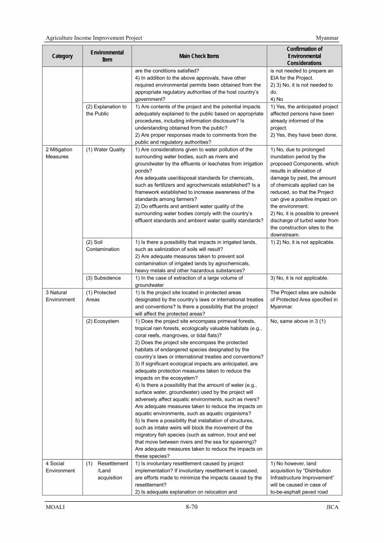
Agriculture Income Improvement Project Myanmar
MOALI 8-70 JICA
Category Environmental Item Main Check Items
Confirmation of Environmental Considerations
are the conditions satisfied? 4) In addition to the above approvals, have other required environmental permits been obtained from the appropriate regulatory authorities of the host country’s government?
is not needed to prepare an EIA for the Project. 2) 3) No, it is not needed to do. 4) No
(2) Explanation to the Public
1) Are contents of the project and the potential impacts adequately explained to the public based on appropriate procedures, including information disclosure? Is understanding obtained from the public? 2) Are proper responses made to comments from the public and regulatory authorities?
1) Yes, the anticipated project affected persons have been already informed of the project. 2) Yes, they have been done.
2 Mitigation Measures
(1) Water Quality 1) Are considerations given to water pollution of the surrounding water bodies, such as rivers and groundwater by the effluents or leachates from irrigation ponds? Are adequate use/disposal standards for chemicals, such as fertilizers and agrochemicals established? Is a framework established to increase awareness of the standards among farmers? 2) Do effluents and ambient water quality of the surrounding water bodies comply with the country’s effluent standards and ambient water quality standards?
1) No, due to prolonged inundation period by the proposed Components, which results in alleviation of damage by pest, the amount of chemicals applied can be reduced, so that the Project can give a positive impact on the environment. 2) No, it is possible to prevent discharge of turbid water from the construction sites to the downstream.
(2) Soil Contamination
1) Is there a possibility that impacts in irrigated lands, such as salinization of soils will result? 2) Are adequate measures taken to prevent soil contamination of irrigated lands by agrochemicals, heavy metals and other hazardous substances?
1) 2) No, it is not applicable.
(3) Subsidence 1) In the case of extraction of a large volume of groundwater
3) No, it is not applicable.
3 Natural Environment
(1) Protected Areas
1) Is the project site located in protected areas designated by the country’s laws or international treaties and conventions? Is there a possibility that the project will affect the protected areas?
The Project sites are outside of Protected Area specified in Myanmar.
(2) Ecosystem 1) Does the project site encompass primeval forests, tropical rain forests, ecologically valuable habitats (e.g., coral reefs, mangroves, or tidal flats)? 2) Does the project site encompass the protected habitats of endangered species designated by the country’s laws or international treaties and conventions? 3) If significant ecological impacts are anticipated, are adequate protection measures taken to reduce the impacts on the ecosystem? 4) Is there a possibility that the amount of water (e.g., surface water, groundwater) used by the project will adversely affect aquatic environments, such as rivers? Are adequate measures taken to reduce the impacts on aquatic environments, such as aquatic organisms? 5) Is there a possibility that installation of structures, such as intake weirs will block the movement of the migratory fish species (such as salmon, trout and eel that move between rivers and the sea for spawning)? Are adequate measures taken to reduce the impacts on these species?
No, same above in 3 (1)
4 Social Environment
(1) Resettlement /Land acquisition
1) Is involuntary resettlement caused by project implementation? If involuntary resettlement is caused, are efforts made to minimize the impacts caused by the resettlement? 2) Is adequate explanation on relocation and
1) No however, land acquisition by “Distribution Infrastructure Improvement” will be caused in case of to-be-asphalt paved road

Myanmar Agriculture Income Improvement Project
JICA 8-71 MOALI
Category Environmental Item Main Check Items
Confirmation of Environmental Considerations
compensation given to affected persons prior to resettlement? 3) Is the resettlement plan, including proper compensation, restoration of livelihoods and living standards developed based on socioeconomic studies on resettlement? 4) Does the resettlement plan pay particular attention to vulnerable groups or persons, including women, children, the elderly, people below the poverty line, ethnic minorities, and indigenous peoples? 5) Are agreements with the affected persons obtained prior to resettlement? 6) Is the organizational framework established to properly implement resettlement? Are the capacity and budget secured to implement the plan? 7) Is a plan developed to monitor the impacts of resettlement?
under DRRD. 2) Yes, a series of stakeholder meeting to introduce the “Distribution Infrastructure Improvement” has been done. 3) Yes, compensation measure is proposed considering market price; however, socio-economic survey was not implemented. 4) There are no houses to be relocated, therefore, special consideration is not needed. 5) Since the loan agreement between the governments has yet to be exchanged, there is no agreement with the affected persons. 6) Yes, It is planned to establish the PMU and there ae some existing bodies for compensation payment. DRRD has a plan to request budget for the compensation. 7) Yes, a monitoring plan has been prepared.
(2) Living and Livelihood
1) Is there a possibility that the project will adversely affect the living conditions of inhabitants? Are adequate measures considered to reduce the impacts, if necessary? 2) Are proper allotments, such as water rights allotment in the project area made? Is there a possibility that the allotments will result in inequitable distribution or usurpation of water rights and available resources? 3) Is there a possibility that the amount of water used (surface water, groundwater) by the project will adversely the downstream fisheries and water uses? 4) Is there a possibility that water-borne or water-related diseases (e.g., schistosomiasis, malaria, filariasis) will be introduced? Is adequate consideration given to public health education, if necessary?
1) No, although some adverse impacts can be caused by the Project, they will not be severe. 2) The Project can contribute to even water distribution; no spoiling the water rights. 3) No. 4) No.
(3) Heritage 1) Is there a possibility that the project will damage the local archeological, historical, cultural, and religious heritage sites? Are adequate measures considered to protect these sites in accordance with the country’s laws?
Not applicable
(4) Landscape 1) Is there a possibility that the project will adversely affect the local landscape? Are necessary measures taken?
Not applicable
5. Others (1) Impacts during Construction
1) Are adequate measures considered to reduce impacts during construction (e.g., noise, vibrations, turbid water, dust, exhaust gases, and wastes)? 2) If construction activities adversely affect the natural environment (ecosystem), are adequate measures considered to reduce impacts? 3) If construction activities adversely affect the social environment, are adequate measures considered to reduce impacts? 4) If necessary, is health and safety education (e.g.,
1)-1 Dust and exhaust gases Regular sprinkling of water (when needed) on open soil surface to avoid dust emission; 1)-2 Turbid water Monitoring to avoid the discharge of turbid water from the construction site by

Agriculture Income Improvement Project Myanmar
MOALI 8-72 JICA
Category Environmental Item Main Check Items
Confirmation of Environmental Considerations
traffic safety, public health) provided for project personnel, including workers?
putting earth band; 1)-3 Noise and vibration Working schedule during construction must be during day-time. Maintenance of construction equipment and vehicles 1)-4 Waste Excavated soil, and/or removed spoil/waste must be re-used as much as possible and other remaining waste should be disposed at specified sites. 2) No. The Project targets only existing facilities, and there are no Protect Areas around the construction sites. 3) Yes. Traffic jam will be caused by an increase of vehicle numbers. However, the extent is not severe. Decentralization of vehicle will be done. Installation of traffic signage or/and traffic control are to be arranged. 4) Yes. Rigid screening of workers’ health is needed. Orientation for health and safety will be held for the workers.
(2) Monitoring 1) Does the proponent develop and implement monitoring program for the environmental items that are considered to have potential impacts? 2) Are the items, methods and frequencies included in the monitoring program judged to be appropriate? 3) Does the proponent establish an adequate monitoring framework (organization, personnel, equipment, and adequate budget to sustain the monitoring framework)? 4) Are any regulatory requirements pertaining to the monitoring report system identified, such as the format and frequency of reports from the proponent to the regulatory authorities?
1) Yes, the monitoring plan is prepared. 2) Yes, they are included in the plan. 3) Yes. 4) Yes.
Source: JICA Survey Team
8.10 Check List for Environmental Social Management System
Check list, which shows questions and answers with improvement plan for the FI component, that is Land Consolidation, is presented in the following table:
Table 8.10.1 Check List for Environmental Social Management System No. Questions Answer Improvement Plan
1. Policy (1) Does the financial intermediary/executing agency
have any formal environmental policy or procedures? If yes, please describe them and provide appropriate documentation. If no, does
Yes. "Environmental Assessment Procedure, Notification No.616/2015" was enforced in December, 2015.
Not necessary

Myanmar Agriculture Income Improvement Project
JICA 8-73 MOALI
No. Questions Answer Improvement Plan the financial intermediary/executing agency have any plan to set such policy or procedures?
(2) Are there any types of projects in which the financial intermediary/executing agency will not take part due to the environmental risks? (e.g., projects involving handling of hazardous wastes or endangered plants or animals).
No. There is no project in which the executing agency will not take part due to environmental risks.
Not necessary
2. Procedures
(3) Does the financial intermediary/executing agency have any environmental procedures such as screening, categorization and environmental review? If yes, please describe.
Yes, screening of projects to categorize projects which need IEE, EIA or EMP should be done considering location, type of project, scale and so on.
Not necessary
(4) Please describe how you ensure that your subproject companies and their subprojects are operated in compliance with the national laws and regulations and applicable JICA’s requirements.
Regarding environmental aspect, IWUMD and AMD which implement construction work monitor the environmental aspect. As for social aspect, Land Consolidation working committee will ensure the subprojects are operated in compliance with the national laws and regulations and applicable JICA’s requirements.
Not necessary
(5) How are environmental considerations taken into account in the credit review and approval process for project loans or equity investments? (For financial intermediary only)
(6) How are environmental issues taken into account in deciding whether to offer or extend commercial credit, working capital finance, trade finance, payment services and other financial services to a company? (For financial intermediary only)
3. Organization and Staff (7) Please provide us with the organization chart of
the financial intermediary/executing agency’s Environmental and Social Management System (ESMS).
ESMS for the Project will be administered by the Project Management Unit to be established during the project implementation. Project director is the head of the PMU.
It is needed to assign some official personnel for ESMS. There is a case that two staff of IWUMD are assigned for environmental monitoring in MY-P7 project. It will apply the same system, dispatching such staff to the site operating under the PMU.
(8) Who is responsible for environmental and social management within the financial intermediary/executing agency? (name/role and title)
There is no such organization and responsible person within MOALI/IWUMD/AMD at present.
As mentioned in 3 (7), the PMU will be in charge.
(9) Are there any staff with training for environmental and social considerations in the financial intermediary/executing agency? If so, describe.
Since there is no responsible organization for ESMS, there is no staff who are trained at present.
There are some official personnel of ECD who have been trained, thus, it is possible for them to transfer their knowledge about ESMS to staff of MOALI/IWUMD/AMD.
(10) Are there any technical staff with an engineering/industry background responsible for technical analysis of credit proposals?
IWUMD and AMD have enough experience in the sector of land consolidation, and the former has much experience in irrigation, drainage, and rural road. There are engineering staff trained on
Not necessary

Agriculture Income Improvement Project Myanmar
MOALI 8-74 JICA
No. Questions Answer Improvement Plan environmental issues in the Investigation Branch and Irrigation Technology Center (ITC) of IWUMD.
(11) What experience, if any, does the financial intermediary/executing agency have of hiring or dealing with environmental consultants?
Under MY-P7 funded by JICA (2015-2019), the IWUMD employs a consultant team, one of whose members is in charge of environment. He provided trainings to staff of Investigation Branch of IWUMD, and also in charge of periodical monitoring/ assessment of environmental and social issues under the project. Besides, an environmental and social consultant was employed under an IFAD funded project of ‘Fostering Agricultural Revitalization in Myanmar, FARM (2015-2020)’, and as a plan, IWUMD is to employ and deploy environmental consultant(s) under WB funded project ‘Agriculture Development Support Project (ADSP)’ in year 2018.
(12) What was the budget allocated to the ESMS and its implementation during a year? Please provide budget details including staff costs and training as well as any actual costs.
For employing consultant(s), it is included in the loan budget for the case of, e.g., MY-P7 (JICA), WB ADSP, and IFAD FARM. For the government staff to be in charge of ESMS, administration cost is spent, prepared and allotted by the government implementing agency.,
4. Monitoring and Reporting (13) Do you receive environmental and social
monitoring reports from subproject companies that you finance?
In the MY-P7 loan project, periodical monitoring is conducted and the results are incorporated in the monthly supervision report, prepared by the consultants and submitted to the PMU. In case of IFAD FARM, environmental issues are also incorporated in the monthly/ quarterly/ annual reports.
Not necessary
(14) Please describe how you monitor the subproject company and their subprojects’ social and environmental performance.
PMU to be established at the Project site is in charge of day-to-day implementation management including environmental and social consideration. Staff assisted by consultant(s) will conduct the monitoring at the sites, and report to the PMU with monthly monitoring report (incorporated in the Monthly Supervision Report).
Not necessary
(15) Is there an internal process to report on social and environmental issues to senior management?
Yes. If some problems are identified, they should be reported from general staff to the Directors, from Directors to the DG, from DG to the Permanent Secretary.
Not necessary
(16) Do you prepare any social and environmental reports: - For other multilateral agencies or other
stakeholders - E&S reporting in the Annual Report
Yes, in the PY-P7 project, the social and environmental reports are incorporated in the monthly supervision report, and also summarized reports are presented at the Project Implementation Committee established at the HQ’s level, and then in the PSR submitted to JICA. In IFAD FARM, environmental issues are incorporated in the monthly/ quarterly/ annual report.
It is recommended to prepare annual reports.
5. Experience (17) Has the financial intermediary/executing agency
signed any national or international agreements or declarations concerning environmental issues?
Yes, Myanmar is a signatory of various international agreements relevant to environment protection, such as Kyoto Protocol.
Not necessary

Myanmar Agriculture Income Improvement Project
JICA 8-75 MOALI
No. Questions Answer Improvement Plan
(18) Has the financial intermediary/executing agency ever received any criticism of its environmental record? If so, what was the criticism?
There is an example experienced by an IFAD project implemented in Nay Pyi Taw area, Fostering Agricultural Revitalization in Myanmar (FARM). It is noted that one official personnel of IWUMD works as the member of FARM in charge of land consolidation component. The first year of implementation for FARM was 2015/16, and the achievement was only 351 acres (18% only against target 2,000 acres). Such low achievement was caused by a practice of many farmers who had already sown the seeds of black grams during the winter season during which the land consolidation works was to be implemented according to the original plan. In fact, consensus making amongst the targeted beneficiary farmers not to cultivate winter crops may have not been clearly enough to allow the construction to proceed. According to the PMU of the IFAD funded project, they obtained consensus not to cultivate the winter crop on about 500 acres only. With this agreed areas, the project was able to implement the consolidation works on the 351 acre of farm land.
Not necessary
(19) Does the financial intermediary/executing agency carry out environmental audits of its properties to analyze health and safety issues, waste disposal, etc.?
No. It is recommended to implement environmental auditing.
(20) Please state any difficulties and/or constrains related to the implementation of the ESMS.
There are still few staff who have knowledge and experiences in ESMS in the ministry, especially the agencies other than IWUMD have had very little, or almost nothing, experiences in the subject. Therefore, before or upon the commencement of the project, trainings on ESMS should be arranged and conducted by resource persons (e.g. consultants).
A specific branch and/or section undertaking environmental and social issues should be established.
6. Need of Capacity Development and Improvement Plan There is a high need for the implementing agencies, especially IWUMD, AMD and DALMS engaged in Land Consolidation, of taking up trainings for capacity development and improvement on EMP, EMOP, ESMS, etc. One of the TOR for the consultants to be employed under the Project will be to conduct trainings and capacity development for the staff to be engaged in the project. With this training and periodical monitoring practice during the implementation stage assisted by the consultants, the capacity is to be ensured.
Source: JICA Survey Team

Myanmar Agriculture Income Improvement Project
JICA 9-1 MOALI
0
1,000,000
2,000,000
3,000,000
4,000,000
5,000,000
6,000,000
Current With Project(MP+SM)
W/ Project(MP+GG/Sesame)
Ann
ual N
et In
com
e K
yats
0
500,000
1,000,000
1,500,000
2,000,000
2,500,000
3,000,000
3,500,000
4,000,000
4,500,000
5,000,000
Current MP+SP MP+Pulses+SP
MP+Pulses+GG/Sesame
Ann
ual N
et In
com
e, K
yats
Figure 9.1.2 Income Increase by Land Consolidation Source: JICA Survey Team
Figure 9.1.1 Income Increase by Irrigation Improvement Source: JICA Survey Team
CHAPTER 9 GLOBAL ISSUES
This chapter discusses the proposed components in relation to such global issues as poverty reduction, climate change, and gender. It means that this chapter explores the possibility of; 1) reduction of poverty for the beneficiaries, both direct beneficiaries and indirect-beneficiaries, 2) mitigating or coping with negative impact of climate change, and 3) relevance to gender significance:
9.1 Poverty Reduction
Following table shows the poverty ratios of 2 years, 2005 and 2010, by urban and by rural for Sagaing region, where the Project area is located, together with those of other regions/states. In fact, the poverty ratio of Sagaing region is not comparatively high, rather lower than those of other regions/states. The ratio of Sagaing rural area in 2005 was 27.4 % 3rd lowest among all the regions/ states, and it has been reduced to as low as 14.9 %, the lowest ratio among all. This means that the poverty reduction in Sagaing region has very much progressed during the years from 2005 to 2010, yet 14.9% population, equivalent to one out of 7 persons, in Sagaing region falls below the poverty line.
Table 9.1.1 Poverty Ration by Region and State in Myanmar (2005, 2010) State, Region
and Union Urban Rural Total
2005 2010 2005 2010 2005 2010 Sagaing 21.9 16.0 27.4 14.9 26.6 15.1 Mandalay 24.1 14.1 44.7 31.6 38.9 26.6 Magway 25.8 15.8 43.9 28.2 42.1 27.0 Bago 30.7 19.0 31.8 18.2 31.6 18.3 Ayeyarwady 24.4 23.1 30.3 33.9 29.3 32.2 Shan 31.0 14.1 50.5 39.2 46.1 33.1 Kachin 37.7 23.4 46.8 30.6 44.2 28.6 Kayah 26.1 2.3 38.2 16.3 33.6 11.4 Kayin 7.8 16.8 12.5 17.5 11.8 17.4 Chin 45.9 52.1 80.9 80.0 73.3 73.3 Tanintharyi 20.8 16.7 37.2 37.5 33.8 32.6 Mon 22.5 17.8 21.3 16.0 21.5 16.3 Rakhine 25.5 22.1 41.2 49.1 38.1 43.5 Yangon 14.4 11.9 17.4 28.7 15.1 16.1
UNION 21.5 15.7 35.8 29.2 32.1 25.6 Source: UNDP Integrated Household Living Conditions Survey in Myanmar, 2009-2010, Poverty Profile, June 2011
There are components which can raise the income of the beneficiaries through the increase of production of agricultural produces; namely, 1) agriculture development and extension strengthening, together with 2) irrigation and drainage improvement, and 3) land consolidation. For these components, farm budgets were estimated at each case of before-after projects (impact from agriculture development and extension strengthening was counted together with the irrigation & drainage improvement). Following figures summarize the net profits before and after the project implementation, and Tables 9.1.2 & 9.1.3 summarizes the incremental ratio for the “with project” case:

Agriculture Income Improvement Project Myanmar
MOALI 9-2 JICA
Table 9.1.2 Net Income Increase for Farmer Household by Realization of the Project
Particular Case 1 Case 2
Remarks MP + SP MP + GG/Sesame
Number of Farm Households (FHH) 66,562 66,562 Average Farmland Area (acre/FHH) 7.4 7.4 Net Income without Project (Kyats/FHH) 2,965,996 2,965,996 Net Income with Project (Kyats/FHH) 4,321,903 4,852,107 Increment with Project (%) 146 164
Note: case 1 cultivates monsoon paddy + summer paddy, while case 2 does monsoon paddy + green gram/ sesame as summer alternative crop. Source: JICA Survey Team
Table 9.1.3 Net Income Increase for Farmer Household by Realization of the Project
Particular Case 1 Case 2 Case 3
2 Crops (MP, SP) 3 Crops *1 3 Crops *2 Without Project
Net Profit per FHH (Kyats/FHH) 2,487,789 2,487,789 2,487,789 Gross Profit per FHH (Kyat/FHH) 5,643,279 5,643,279 5,643,279 Cost per FHH (Kyat/FHH) 3,155,490 3,155,490 3,155,490
With Project
Net Profit per FHH (Kyats/FHH) 3,660,730 4,485,784 4,588,668 Gross Profit per FHH (Kyat/FHH) 5,961,027 6,978,514 6,515,375 Cost per FHH (Kyat/FHH) 2,300,297 2,492,730 1,926,706
Ratio b/t with & without Project Net Benefit (%) 157% 190% 195% Gross Profit (%) 118% 136% 128% Cost (%) 86% 93% 75% Note: 3 crops *1 cultivates monsoon paddy + summer paddy + winter pulses, while case 2 does monsoon paddy + green gram/ sesame as summer alternative crop + winter pulses. Source: JICA Survey Team
Based on above examination, a typical average farmer household could increase their net income to 146% - 164% in case of monsoon paddy (MP) + summer paddy (SP) cultivation and monsoon paddy + green gram/ sesame cultivation respectively with the project of irrigation and drainage improvement combined with agriculture extension services provided. In case of land consolidation, benefit accrues both in production increase and cost reduction. The land consolidation increases a typical farmer’s income to 157%, 190% and 195% for the cases of 2 cops of monsoon paddy and summer paddy, monsoon paddy + summer paddy + winter pulses, and monsoon paddy + summer alternative crops such as green gram/ sesame and winter pulses respectively.
With these above results, it can be concluded that the proposed components; namely, 1) agriculture development and extension Strengthening, 2) irrigation and drainage improvement, and 3) land consolidation, will collectively contribute to reducing poverty in rural areas, through increasing net profit by about 50% to 100 % depending on the project intervention and what crops are to be cultivated.
9.2 Climate Change
9.2.1 Climate Change Review and Future Simulation by UNEP
United Nations Environment Programme (UNEP) has conducted a climate change simulation and recommended a Myanmar’s National Adaptation Programme of Action (NAPA) to climate change (2012). The simulation reviewed about past 60 years climate change according to the actual records, and based on those date the simulation run a computer model of RECIS. The observed climate variability and change in Myanmar over the last six decades include the following:
1) a general increase in temperatures across the whole country (up to 0.08°C per decade), most notably in the northern and central regions;

Myanmar Agriculture Income Improvement Project
JICA 9-3 MOALI
2) a general increase in total rainfall over most regions; however, with notable decreases occurring in certain areas (e.g. Bago region);
3) a decrease in the duration of the south-west monsoon season as a result of a late onset and early departure times; and
4) increases in the occurrence and severity of extreme weather events, including; cyclones/strong winds, flood/storm surges, intense rains, extreme high temperatures and drought.
On the observed changes in temperature over the last six decades (1951 to 2007), the temperature in Myanmar has increased on average by up to 0.08°C per decade. This has been reflected by fewer cold days and more frequent hot days. From 1951 to 2000, up to 15 heat waves occurred per year, and the most extensive heat wave (covering up to 60% of the country) occurred in 1998 during an El Niño Southern Oscillation (ENSO) year. As for Lower Sagaing region where the Project area is located, an average 0.3°C increase per decade has been recorded, which is in fact 2nd biggest temperature increase after Kayin state (0.32°C increase per decade).
As for the observed changes in rainfall over the last six decades (1951-2007), the rainfall in Myanmar has increased on average by 29 mm per decade. Rainfall trends have however been variable over the period. The majority of regions have experienced an increase in rainfall with the upper Sagaing region experiencing the greatest increases (up to 215 mm per decade). However, 6 regions experienced a decrease in annual rainfall including Lower Sagaing region where the Project area falls, showing 17.4 mm in decrease per decade. Changes in rainfall have also influenced the duration of the monsoon season. The south-west monsoon onset has become later in the year and withdrawal earlier in the year (see figure below).
After having reviewed the past 60 years climate change, the UNEP has carried out a climate change computer simulation by employing PRECIS mode over a period of 2001 to 2100. This simulation was conducted using 20km x 20km resolution, and operated by the South East Asia System Analysis Research and Training Regional Centre (SEA START RC) using A2 emission scenario. The base line information used modelled data for the period of 1971 to 2000 with reference to the 7 stations assumed to be representatives of seven physiographic regions in Myanmar. Climate change projections for Myanmar were predicted as follows:
1) a general increase in temperature across the whole country, particularly from December – May
Figure 9.2.1 Departure from the Mean Normal Monsoon Duration (144 days) over the period 1950 to 2005 ‘blue line), indicating a relative shorter annual monsoon season since 1975
Source: UNEP: Myanmar’s National Adaptation Programme of Action to CC (2012)

Agriculture Income Improvement Project Myanmar
MOALI 9-4 JICA
with the Central and Northern regions experiencing the greatest increases; 2) a increase in clear sky days exacerbating drought periods; 3) an increase in rainfall variability during the rainy season including an increase across the whole
country from March – November (particularly in Northern Myanmar), and decrease between December and February;
4) an increase in the risk of flooding resulting from a late onset and early withdrawal of monsoon events; and
5) an increase in the occurrence and intensity of extreme weather events, including cyclones/strong winds, flood/storm surge, intense rains, extreme high temperatures and drought.
Figure 9.2.2 below indicates temperature and rainfall changes in Myanmar for the next 80 years, and Table 9.2.1 details climate change predictions in Myanmar for the time periods of 2001-2020, 2021-2050 and 2051-2100 (UNEP). These results show that the temperature will increase as has been increasing in the past and may be accelerated nearing to 2100, and also the rainfall is to increase though the incremental ratio may not be as much as that of temperature:
Table 9.2.1 Detailed Projected Climate Change Trends for 2001 to 2100 (UNEP) CC predictions 2001 - 2020 CC predictions 2021 - 2050 CC predictions 2051 - 2100
an increase in temperature of - 0.4 ºC to 0.7 ºC across Myanmar with the Yangon Deltaic region experiencing the greatest increase (-0.7 ºC);
an increase in clear sky days in Northern and Central Myanmar exacerbating drought events;
highly variable rainfall changes throughout the country including large increases in the Northern Hilly region (-228 mm per annum) as well as decreases in the Rakhine Coastal, Yangon Deltaic, and Southern Coastal region (-58 mm per annum); and
an increase in floods and droughts resulting from variable rainfall conditions.
an increase in temperature of 0.8 ºC to 1.4 ºC across Myanmar with the Yangon Deltaic (1.4 ºC) and Rakhine Coastal region (1.2°C) experiencing the greatest increases;
an increase in rainfall across the country with the Rakhine Coastal region experiencing the greatest increases (-661 mm per annum) and the Eastern Hilly region experiencing the smallest increase (-36 mm per annum);
periods of heavier rains; and longer dry spells.
an increase in temperature of 2.8 ºC to 3.5 ºC across Myanmar with the highest increases in the Rakhine Coastal and Yangon Deltaic regions (3.5°C);
a weakened monsoon climate supported by decreased cloud coverage;
an increase in drought periods across most of Myanmar; and
an increase in precipitation with highest increases in the Rakhine Coastal region (~1582 mm per annum) and smallest increases in the Eastern Hilly region (~209 mm per annum).
Source: UNEP: Myanmar’s National Adaptation Programme of Action to CC (2012), CC means Climate Change
Figure 9.2.2 Predicted Temperature Trend (Left) and Predicted Mean Rainfall (Right) Source: UNEP: Myanmar’s National Adaptation Programme of Action to CC (2012)

Myanmar Agriculture Income Improvement Project
JICA 9-5 MOALI
9.2.2 Project Intervention in the Climate Change
Major issues relating to climate change are probably; 1) temperature increase and 2) shorter period of monsoon season though the total rainfall amount is to increase, based on the past review of the climate change as well as the simulation result covering up to 2100.
A rise of 1 – 2 ºC combined with lower solar radiation has the potential to cause rice spikelet sterility (i.e. infertile rice seeds). Rice becomes sterile if the paddy is exposed to temperature above 35 ºC for more than one hour during flowering and consequently produces no grain1. This will limit rice production. Furthermore, higher temperatures will increase the incidence of crop diseases, insect pests and rodents. To avoid this sterility associated with high temperature, there should be a new variety, which can stand against the high temperature or otherwise the flowing and pollination should be made during not-day time but during early morning time. This kind of research is not included in the components proposed under this Project. This kind of research could better be done by an international institute, e.g. IRRI.
On the other hand, there are 2 components which can cope with or at least mitigate the impact of climate change concerning shorter monsoon season. The change to the shorter monsoon season is very much associated with intensive rainfall pattern, meaning though the duration of the monsoon season becomes shorter, the rain tends to fall at once with severer intensity, often resulting in torrential rain and flood, as has been already observed. The components of irrigation rehabilitation and land consolidation would work in mitigating this climate change, rainfall and monsoon season pattern change.
As per its nature, irrigation system rehabilitated would be able to supply on-time water at the onset of monsoon season which is now predicted to come late, and also at the end of monsoon which is predicted to come sooner than before. The irrigation systems rehabilitated are expected to provide supplemental water to the unstable rainfall during monsoon season, and accordingly the rehabilitated system would contribute to mitigating and coping with the negative impact of climate change, especially the shorter period of monsoon season.
In addition, land consolidation, though this is implemented as pilot basis, will bring about tertiary level irrigation canals running alongside farm road. With these tertiary level canals, farmers can implement better water management at the field level. More precise water management, e.g., water supply and stop according to the crop need, and in cases drying of the paddy field in order to aerate the soils, etc., can be practiced. In addition, drainage to be established alongside the other side of the farm road would contribute to draining a part of torrential rainfall, which is also predicted in future. Thus, with land consolidation component implemented, farmers would have a possibility of keeping an expected yields even under such climate change.
9.3 Gender
9.3.1 Current Gender Conditions in Myanmar
Gender Inequality Index (GII) is recently used to examine gender-based inequalities of counties in terms of three dimensions, namely, reproductive health, empowerment, and economic activity. Myanmar has a GII value of 0.413 and ranks 85 out of 188 countries in 2014 (see following table). In terms of GII, Myanmar is ahead of Cambodia ranked 104, while it is behind of Thailand which is ranked 76 (UNDP, 2014). On the other hand, male and female are generally equal in terms of 1 Referred to in the UNEP report ‘Myanmar’s National Adaptation Programme of Action (NAPA) to Climate Change (2012), Karim, Z., 1996. Agricultural Vulnerability and Poverty Alleviation in Bangladesh. In Climate Change and World Food Security, T.E. Downing (Ed.), NATO ASI Series, 137. Springer-Verlag, Berlin, Hiedelberg, 1996. pp. 307-346.

Agriculture Income Improvement Project Myanmar
MOALI 9-6 JICA
population with at least some secondary education and labor force participation rate. Note that the following data is for whole Myanmar, and if it is concerned to Burmese society only, the GII may become higher due to high status of Burma women at least in the household.
Table 9.3.1 GII Values of Myanmar and other South-East Asian Countries
Country GII Value
GII ranking in 188
countries in 2014
Maternal mortality ratio for 100,000 birth in 2013
Adolescent birth rate for 1,000 live
birth in 2010/2015
Female seats in
parliament in 2015* (%)
Population with at least some
secondary education (%) 2005-2014
Labor force participation rate
(%) in 2013
Female Male Female Male Myanmar 0.413 85 200 12.1 12.7 22.9 15.3 75.2 82.3 Cambodia 0.477 104 170 44.3 20.3 9.9 22.2 78.8 86.5 Lao PDR - - - 65.0 25.0 22.9 37.0 76.3 79.1 Thailand 0.380 76 26 41.0 6.1 35.7 40.8 64.3 80.7
East Asia and Pacific
0.328 - 72 21.2 20.0 54.7 66.3 62.8 79.3
Source: UNDP, 2015, Human Development Report * World Bank, 2016 (http://data.worldbank.org/indicator/SG.GEN.PARL.ZS)
The Constitution, which was established in 2008, provides equal rights to women and men, still, women are not well represented in the political and higher level administrative sphere outside the traditional areas of social services, health and education. The situations, however, are changing gradually, percentage of female parliament members had been only 1-3% from 1948 to 2010, without any of female cabinet ministers, however, in 2012, one female minister and five female deputy ministers came into existence. Moreover, as a result of national election in 2015, 41 out of total 323 parliament members are female, it accounts for 12.7% of the total number (Inter Parliament Union)2.
In 2011, the Department of Social Welfare prepared a “National Plan of Action for the Advancement of Women 2011-2015”. Its final goal is that all women of Myanmar are empowered and able to fully enjoy their rights, and twelve main objectives are stipulated in the plan. One of them is “To strengthen mechanisms for gender mainstreaming in interventions that improve livelihoods and reduce poverty for women and their families”. In agricultural sector, however, there is no unified gender mainstreaming policy/strategy, and it has been considered on project basis. International donors mainly pay attention to female headed households and landless women3.
At the local levels (districts, townships, villages), there are few women representatives, particularly in key decision-making bodies (IFAD, 20134). Moreover, household heads are generally male, it is relatively rare that women take initiatives and express their opinions in public. However, women are quite dominant in decision-making and often have ownership of assets at household level, women manage family budget instead of, or in partnership with, men. Men and women can equally access to official land usufruct, still, it is noted that generally land ownerships are registered in husbands’ names after the marriage, even though it includes inherited one from wives’ parents (IFAD, 20165).
As for farming activities at the field level, men generally cover heavy works, namely, preparing lands for crop growing, plowing, harrowing, irrigation and transportation/sale of harvested crops, while women cover sowing, transplantation of rice, weeding and so on. Book keeping of household is shouldered by women in general. In many cases, farmers hires labors for rice cultivation, and husbands and wives can be regarded as joint managers. It is usual that men make decisions for farming, for instance, number of labors to be hired and timing of each farming activity, while women can express their opinions and make suggestion to their husbands. Still, women have less knowledge and 2 http://www.gender.go.jp/policy/seijibunya_jouhouteikyou/pdf/gikai_josei2015.pdf 3 Hearing from the Director of International Cooperation Division, DOP, 2015 4 IFAD, 2013, Fostering Agricultural Revitalization in Myanmar (FARM) Final Project Design Report
5 Hearing result from the community development/gender expert of IFAD

Myanmar Agriculture Income Improvement Project
JICA 9-7 MOALI
experience of farming techniques than men, and crop variety selection to be planted is determined by husbands.
On the other hand, it is noted to consider existing hierarchies among women in the rural area depending on income sources, namely, casual labors, farmers (land owners), cottage owners, official personnel and so on. Some interventions from outside can result in different impacts on women. For instance, if transplanting, which is generally covered by women, is mechanized drastically, female casual labors would lose their job opportunities, while female famers can reduce labor costs and get more net income, the proposed component does not cover mechanization of transplanting, though. Not only gender issue, it is important to minimize misdistribution of benefit and damage among women considering current situations.
9.3.2 Gender Mainstreaming in the Proposed Components
JICA promotes gender mainstreaming for inclusive and dynamic development and has three strategic development objectives in this field. Projects related to gender are categorized based on the objectives, and the relationship between the objectives and the categories is as shown in the following table. Considering that the targets of the proposed components are farmers with farmlands, governmental organization related to agriculture, distributer, agro-enterprises and so on, the components are not “Gender equality Projects” nor “Project Targeting Women”. Moreover, gender biases to be corrected are not big constraints to implement the components. Therefore, all of them are not categorized into “Gender Integrated Projects”. However, it is still noted that involvement of female farmers in the implementation of components should be promoted, resulting in better decision-making by both the husbands and wives.
Table 9.3.2 Strategic Development Objective and Project Category Strategic Development Objective Contents of Project Project Category
1. Promoting Gender-Responsive Policies, Strategies and Institutions:
Strengthening national machinery and reforming public institutions from a gender perspective; and
Supporting information management, and establishing monitoring and evaluation systems from a gender perspective
Gender Equality Projects
2. Promoting Women’s Empowerment
Girls’ education; Mother and child health; Women’s entrepreneurship development and
micro finance systems; and Gender-based violence issues such as trafficking
in persons and domestic violence
Projects Targeting Women
3. Promoting Gender Integration in Programs and Projects
Projects which do not aim at gender equality and women’s empowerment directly, but require measures to be taken to correct existing gender biases in their planning and implementation stages
Gender Integrated Projects
Source: JICA, 2011, “Gender Mainstreaming, Inclusive and Dynamic Development”
Generally, women are not involved in irrigation activity such as canal management directly, since it is a very heavy work. However, in fact, women are responsible for payment of water fee at household level and they are indirectly involved in the irrigation activity. Therefore, it is necessary to provide men and women with equal opportunity to understand the Project at the beginning stage. Women are busy for daily household affairs, and it is needed to consider their available date, time and so on prior to meeting organization. It is also requested for the staff of project proponent like IWUMD to understand such gender consideration for active participation of the beneficiaries.
In addition, agriculture trainings should be given not only to the farmers but also to farm casual labors. In fact, many of farm casual labors are female workers engaged in, for example, transplanting of rice, weeding, and also harvesting. Therefore, if related agriculture extension trainings are provided to farm

Agriculture Income Improvement Project Myanmar
MOALI 9-8 JICA
casual labors apart from farmers, the direct target beneficiaries, female participants will automatically be increased. Thus training provision to not only farmers but also to farm labors will contribute to promoting gender balanced development in the Project implementation.
Concerning land consolidation, both of merit and demerit should be presented sufficiently to the target farmers. In case of land consolidation by IFAD, Project Implementation Committee (PIC) and sub-PIC are established, and they cover 500 acre and 50 acre, respectively. Leaders consisting of one man and woman are selected at each sub-PIC, which makes it possible for other female beneficiaries to understand the effectiveness of land consolidation. As mentioned before, after the marriage, lands inherited from the wives’ parents are registered in husbands’ names in general. However, wives have assertiveness about their rights of lands, thus, women’s consensus on the land consolidation leads to smooth implementation. Such a good practice can be referred in the land consolidation of the Project.

Myanmar Agriculture Income Improvement Project
JICA 10-1 MOALI
CHAPTER 10 CONCLUSION AND RECOMMENDATIONS
10.1 Conclusion
Taking into account below, this Survey concludes that the Project to improve agriculture income of the beneficiaries by improving infrastructure such as irrigation, road, bridges together with strengthening of agriculture extension services and farm mechanization should be implemented as soon as possible. The GOM should therefore take immediate action toward availing of the funds, approximately 30 billion Yen (367 billion Kyats) for Japanese ODA loan. Appropriation from the Government coffer should also be made available, approximately total 4.9 billion Yen (59 billion Kyats), for the project management, taxes relevant, land acquisition, etc.
1) The Project, from the viewpoint of national development, gives an overall EIRR 16.5% - 20.2% for all the 5 components combined and also 18.9% for the major 3 components such as irrigation & drainage improvement with agriculture development and extension service strengthening, distribution infrastructure improvement (rural road and bridges improvement), and land consolidation. By major component, irrigation & drainage improvement with extension service strengthening gives 19.5 – 24.6 % return, land consolidation shows 5.5% - 14.5% return, and the distribution infrastructure improvement provides 17.7 – 17.9% return. All, excepting only the base case of land consolidation, show higher returns than the opportunity cost of capital, 12-15 %, applied in most of the development projects.
2) With the improvement/rehabilitation of irrigation and drainage facilities of Thapanzeik dam irrigation system, the past averaged 58% of summer paddy area will be enlarged to as much as 79%, and also the area of monsoon paddy will be increased from the current 98% to 100%. Further if a part of summer paddy area is diversified to other upland crops, e.g. sesame and green gram, the copping intensity of the summer crop will increase even up to 100% composed of 31% upland crop and 69% summer paddy. With this area increment and also yield increase by enhanced extension services, a typical farmer’s net income will increase from 3.0 to 4.3 million Kyats per annum in case of monsoon and summer paddies cultivated and from the same 3.0 to 4.9 million Kyats if sesame/ green gram cultivated instead of summer paddy. The increments are therefore 146% and 164 % respectively.
3) On employment creation, approximately 4,300 person/day and 1,800 – 3,000 person/day will be employed during the construction period for irrigation & drainage improvement and distribution infrastructure (road & bridge) improvement respectively. Upon completion of the Project, approximately 5,000 persons will newly be employed in rice milling industry and another 5,400 persons will find new employment in the distribution/delivery process of agriculture produces. Further, if current labor intensive farming dependent on casual farm labors were to continue, additional 62,000 farm labors were to be employed altogether for 3 cropping seasons per year. In addition, a ripple effect simulation based on 2000/01 Myanmar input-output table indicated that there would be total 51,000 employments newly created in the sectors of agriculture, processing, construction, transportation, etc.
10.2 Recommendations
1) The consultants to be engaged in the Project will be availed from the end 2018 or the beginning of year 2019; namely spending year 2018 for the selection of the consultants under ICB. It means that the MOALI should seek a way of preparing for the bid documents for machineries and equipment to be procured under the Project. The machineries and equipment need to arrive at the sites within 2019 except for equipment of flood and water management which are to be installed at the 2nd last year. Therefore tender should be held by mid 2018 at the earliest case, e.g. procurement of machineries engaged in land consolidation (first batch works to be implemented

Agriculture Income Improvement Project Myanmar
MOALI 10-2 JICA
from December 2018 to May 2019), and at latest case by March 2019. MOALI may request JICA technical assistances to support the works afore-mentioned.
2) There are 5 implementing departments, i.e., DOA, IWUMD, AMD, DALMS, DRRD, and further DOP and the minister’s office are involved at the HQs level while GAD (general administration department) takes part in at the regional level. Therefore, coordination mechanism shall be well institutionalized both at the HQs level and at regional level, and further at the implementation level mainly in Shwebo. Steering Committee and Project Management Unit should be established at HQs level and the regional level well in advance of the project commencement. A project operation manual including project operation & management, accounting and disbursement management, reporting, etc. should be prepared, practically tested, and approved by the SC.
3) To execute daily management, there should be working committee groups under the SC and also under the PMU. There should be Accounting and Disbursement Management committee and Project Monitoring and Evaluation committee under the SC while those two committees plus Land Consolidation committee under the PMU. The committees for the SC should be composed of director/ assistant director class officers, and the committees under PMU by assistant directors. They shall work in coordinating the relevant departments and undertake the key tasks as indicated by the name of the committee. They are supposed to prepare necessary documents for accounting, disbursement, others including Project Status Report (PSR) to be submitted to the SC, PMU and JICA.
4) There would be 2 designated accounts (D/A) expected under the Project; one for DRRD and the other for DOA, IWUMD, AMD, DALMS. Each of the designated accounts should be allocated sole responsible officers, e.g. 2 officers for DRRD D/A and for the other joint D/A, one lead officer from IWUMD and 4 supportive staff, each of whom should come from each of the 4 departments of DOA, IWUMD, AMD and DALMS. They can be a member of Accounting and Disbursement Management Group to be established under the SC.
5) Taking into account the present low yields of paddy and sesame/ green gram, there could be a lot of potential of increasing the yield given appropriate agriculture extension services together with irrigation water. To enhance the extension services, there should be a technical assistance provided by an international institute or donor. DOA, aside from discharging the extension services on their own, should consider inviting a team of agricultural experts from international institutes. Note that the cost will be eligible from the loan disbursement.
6) Concerning potential technical assistance from JICA, there should be a strong need in 2 areas; 1) certified seed production and distribution, and 2) introduction of participatory irrigation management (PIM) to be conducted under irrigation management transfer (IMT). In fact, there is already an agreement between DOA and JICA in that JICA assists certified seed dissemination in Ayeyarwady region and also in Shwebo area by dispatching a team of experts from late 2017. This technical cooperation should be expected to link up with the extension strengthening component under the Project. In addition, IWUMD may request JICA to provide a technical cooperation which supports IWUMD to introduce IMT and PIM.
7) Irrigation and drainage improvement works will be carried out by IWUMD direct force except for, probably, minor canal rehabilitation. In this regard, IWUMD should prepare for enough number of construction machineries. According to the work volume expected, many heavy machineries are to be required; for example, during peak period there should be 20 track dozers, 39 hydraulic excavators, 55 dump tracks, 31 truck cranes, 18 water bowsers, 39 concrete mixers, and so on. The construction machineries should be well maintained and in case of out-of-order

Myanmar Agriculture Income Improvement Project
JICA 10-3 MOALI
repair should be made as early as possible. Note that maintenance and repair including spare part procurement will be eligible from the loan disbursement.
8) Water stop in the Thapanzeik dam irrigation system is very short, say from mid November to mid February. Though the construction could be carried out during this winter season and also during the following summer season upon consensus from the concerned farmers, longitudinal and cross sectional surveys for detail design purpose should only be done during the ordinal water stop period, which is only winter season. IWUMD should conduct those surveys during the winter season from December 2017 to February 2018; otherwise detail design could not be commenced from the end 2018 or from the early 2019 when the consultants are to come.
9) Irrigation Technology Center (ITC) of IWUMD in Mandalay shall be fully utilized for quality control such as the checking of concrete mortar strength, confirmation of design mixture of concrete and mortar, and the level of soil compaction, etc. for the works carried out by IWUMD direct force account. These test results shall be sent to the consultants for their approval before the commencement of relevant construction works. In case that testing equipment and tools are not enough, procurement or otherwise availing of existing equipment from relevant laboratories shall be arranged.
10) For the rural roads to be upgraded to asphalt, each one feet of the shoulder portion will be extended to both sides. This design change from the original existing section, from 3 ft width shoulder to 4 ft shoulder each, will require land acquisition of narrow strips both sides of the planned roads along total 9.9 km (6.2 miles) length, which are parts of asphalt to-be-upgraded 52 km (32 miles). The DRRD should be prepared for the compensation. As for the standard design by DRRD, longitudinal designing is not usually included but cross section only is prepared. However, the longitudinal section of asphalt road planned under the Project should undertake longitudinal designing, and therefore longitudinal and sectional surveys are to be required.
11) One of the AMD components is to establish agriculture machineries testing center to be in Mandalay. This is the first time facility to be available in Myanmar, and the test equipment will be sophisticated ones. Therefore, to operate and maintain the testing center, capacity building for the operators/ officers in charge is due important. The capacity building should be done not only at the delivery time/place of the equipment by the supplier but also at an international institute which has similar testing experiences. The AMD should consider dispatching the staff to such international institute, e.g. Institute of Agricultural Machinery, Japan.


