Embed Size (px)
Citation preview
WORK PACKAGE 10
First Confrontation of Theory and Practice: Test of the Tools and Discussion of their Use for Sustainable Regional Development in Five (Six!) Test Regions
FINAL REPORT – 9. 11. 2007
WORK PACKAGE RESPONSIBLE:
Anton Melik Geographical Institute of Scientific Research Centre of the Slovenian Academy of Sciences and Arts (AMGI SRC SASA)
CONTENT
I. Introduction II. Methodology III. Searching for sustainable regional development in the Alps: Bottom-up approach IV. Workshops in selected test regions
1. Austria - Waidhofen/Ybbs 1.1. Context analysis of the test region 1.2. Preparation of the workshop
1.2.1. The organizational aspects of the workshop 1.3. List of selected instruments 1.4. List of stakeholders 1.5. The structure of the workshop
1.5.1. Information on the selection of respected thematic fields/focuses
1.6. Questions for each part of the workshop/ for each instrument 1.7. Revised answers 1.8. Confrontation of the context analysis results with the workshop results 1.9. Starting points for the second workshop 1.10. Conclusion 2. France – Gap 2.1. Context analysis of the test region 2.2. Preparation of the workshop
2.2.1. The organizational aspects of the workshop 2.3. List of selected instruments 2.4. List of stakeholders 2.5. The structure of the workshop
2.5.1. Information on the selection of respected thematic fields/focuses
2.6. Questions for each part of the workshop/ for each instrument 2.7. Revised answers 2.8. Confrontation of the context analysis results with the workshop results 2.9. Starting points for the second workshop 2.10. Conclusion 3. Germany - Alpsee-Grünten 3.1. Context analysis of the test region 3.2. Preparation of the workshop
3.2.1. The organizational aspects of the workshop 3.3. List of selected instruments 3.4. List of stakeholders 3.5. The structure of the workshop
3.5.1. Information on the selection of respected thematic fields/focuses
3.6. Questions for each part of the workshop/ for each instrument 3.7. Revised answers 3.8. Confrontation of the context analysis results with the workshop results 3.9. Starting points for the second workshop
3.10. Conclusion 4. Germany - Traunstein/Traunreut 4.1. Context analysis of the test region 4.2. Preparation of the workshop
4.2.1. The organizational aspects of the workshop 4.3. List of selected instruments 4.4. List of stakeholders 4.5. The structure of the workshop
4.5.1. Information on the selection of respected thematic fields/focuses
4.6. Questions for each part of the workshop/ for each instrument 4.7. Revised answers 4.8. Confrontation of the context analysis results with the workshop results 4.9. Conclusion 5. Italy – Tolmezzo 5.1. Context analysis of the test region 5.2. Preparation of the workshop
5.2.1. The organizational aspects of the workshop 5.3. List of selected instruments 5.4. List of stakeholders 5.5. The structure of the workshop
5.5.1. Information on the selection of respected thematic fields/focuses
5.6. Questions for each part of the workshop/ for each instrument 5.7. Revised answers 5.8. Confrontation of the context analysis results with the workshop results 5.9. Starting points for the second workshop 5.10. Conclusion 6. Slovenia – Idrija 6.1. Context analysis of the test region 6.2. Preparation of the workshop
6.2.1. The organizational aspects of the workshop 6.3. List of selected instruments 6.4. List of stakeholders 6.5. The structure of the workshop
6.5.1. Information on the selection of respected thematic fields/focuses
6.6. Questions for each part of the workshop/ for each instrument 6.7. Revised answers 6.8. Confrontation of the context analysis results with the workshop results 6.9. Starting points for the second workshop 6.10. Conclusion
V. Common results of the workshops VI. Common starting points for second workshop VII. Conclusions VIII. References
I. Introduction The goal of the working package 10 in correspondence with the project announcement is to combine theory with practice on a basis of tools of regional development in test regions, which were selected beforehand. For the planned assignment, we confronted the practical needs of the chosen test areas with the theoretical basis, which was determined with preceding deduction of the project. ''Land take management'' was chosen as the main problematic big challenge, which represents the basic phenomenon, taking into account all the geographical peculiarities of the Alps (difficult land access, deficit of space suitable for building) and should also combine a majority of key development questions and areas: population, land usage, regional management, regional planning... Although the research field has been shrunk to just one complex of phenomena and the method of choosing test areas was standardized (the question of methodology of choosing test areas will be addressed later), it was not possible to define instruments of regional development, common to all areas. With this reason, we decided to replace the first examination of instruments which were ready, with the examination of instruments, already present in a certain area and in so doing define their deficiencies. Based on the results, we plan to collect and compare instruments, which would help the chosen test area to develop further. The goal of the workshop was also to identify potential conflicts in a single test area, which appear because of different points of view and positions of included stakeholders. With the reverse course of action a better review of the needs of chosen test areas was made. The project was also broadened with a bottom up approach, which managed to relate needs of the population with theoretical positions and knowledge of all the partners taking part in the project. Taking into account the peculiarities of chosen test areas, the adaptation of methodology to the circumstances of a certain area was necessary. That also meant that a possibility of comparing the results was more relative. Even though this weakens the value of the project, seeing that the comparison of results is limited, it was the only possible step with which we could combine the planned activities with the expectancies of stakeholders in our test areas. Adaptation to the specifications of a single case study area is a proof of our willingness to contribute to the development of these areas and form knowledge and instruments, which could be used in practice in the future. In the context of last WPs, and the overall objectives of the project, DIAMONT planned to set up workshops with local actors to intensify its participatory, networking and bottom-up approach, testing not only the data sets and indicators elaborated so far in the project but also tools to steer regional development and to enhance sustainable development processes. Therefore sets of indicators dedicated to sustainable development issues and instruments to steer regional development were presented as impulses to the participants of the workshops. These instruments have been stepwise elaborated in the course of the project: WP7 proposed an indicator-based approach focused on phenomena which are relevant for sustainable development, within the framework of Alpine main development issues; WP8 elaborated some indicators based on alpine wide available data; WP9 set up fact sheets describing main characteristics of development instruments that can be activated in alpine regions.
These workshops objectives are to finalize DIAMONT tools and to ensure their ability to steer sustainable development in alpine regions, based on experiences in selected regions. Besides the elaboration of instruments that should be available in time for the tests, the preparation phase has to deal with a main issue, namely the selection of test regions, in complement with other issues, for example to decide which will be the main thematic focus of the workshops.
Long discussions between partners resulted in establishing guidelines to select relevant test regions: these could be so-called Labour Market Regions, that is employment basins centred on an Alpine SMESTO. The main thematic focus envisaged from the beginning was ‘urbanisation processes in the LMRs’, but it was stepwise widened, in taking into account land take issues and even a more comprehensive issue, land management in area where urbanisation processes are manifested.
In practice, DIAMONT partners had to choose one or two test regions in respective countries, basing on LMR delineations worked up by WP8, and to decide which aspects referred to land take or even sustainable land management would be focused on in the workshops. Then, WP10 responsible asked the partners to complete a SWOT analysis of the selected test regions, which would act as a starting point for discussions and exchanges with local stakeholders in the studied regions. The partners were also in charge of identifying relevant stakeholders, which could express opinions on DIAMONT tools and suggest ways to improve them.
Table 1. Starting points for WP 10 according to application form.
Title of WP 10 First Confrontation of Theory and Practice: Test of the Tools and Discussion of their Use for Sustainable Regional Development in Five Test Regions
Responsible leader
AMGI, Ljubljana
Duration March 07 - End of July 07 (5 months)
Objectives Drawing on the results of WP 8 and 9, this WP will: · test the tools developed in WP 9 · confront the scientific results with practical attitudes towards indicator based and qualitative tools for sustainable regional development · and provide first recommendations for the improvement of the tools.
Main activities · Selection of five characteristic test regions (one in each country, except of Switzerland) on the basis of the cluster analysis (WP 8) and the different cultural milieus of regional development (see WP 5 and 9) · Test of the tools · 5 workshops serving to discuss the conditions promoting and confining the use of indicator based and qualitative tools for sustainable regional development in the respective test regions · Comparison and analysis of the test and workshop results · Compilation of internal and external reports
Tasks of WP leader
Conceptualization of the workshops; selection of 1 test region in Slovenia on the basis of the cluster analysis (WP 8) and the different cultural milieus of regional development (WP 6 and 9); organization of 1 workshop in the Slovenian test region; comparison and analysis of the workshop results with a view to providing recommendations for the improvement of the tools and possible strategies for the solution of regional conflicts; compilation of reports
Tasks of other partners
Ifuplan: Transfer of methodology and adjustment of tools for the test regions; test of the tools
Partners: Selection of 4 test regions in Austria (UIBK), Germany (Bosch & Partner), France (CEMAGREF) and Italy (EURAC, UNCEM) taking into account the cluster analysis (WP8) and the different cultural milieus of regional development (WP6 and 9); organization of 1 workshop each in their respective test region; compilation of workshop results and delivery to AMGI
Outputs · 5 workshops in 5 test regions characterized by different natural, political, socio-economic and cultural conditions · 1 report and 1 contribution to the DIAMONT information platform providing recommendations for the improvement of indicator based tools (see WP9)
Expected results
50 stakeholders participating in workshops giving them the opportunity to utter their views on the use of indicator based tools in their regions and to discuss with DIAMONT partners and subcontractors
II. Methodology The main aim of the WP 10 was to make an assessment of the appropriateness of selected regional development instruments as a tool for improvement of regional policy in six selected regions: in Italy, France, Germany (2), Austria and Slovenia. According to the main aim the workshops have been performed in order to get the opinion of the main stakeholders regarding the instruments provided for better regional development in the selected alpine areas. Stakeholders have got opportunity to utter their views on the use of development tools in their regions and additionally, the strategies for the solution of regional conflicts will be provided (WP 11). The workshop would also strengthen the co-operation between private corporations, public authorities, scientific institutions, Alpine organizations, local communities, stakeholders and citizens. Furthermore, the project promotes public participation in policy making by involving stakeholders and citizens and thus raising their awareness for these issues. Due to complexity of the appraisal, the process was divided in some crucial steps:
1. Structuring 2. Observing 3. Analyzing 4. Judging.
STRUCTURING: The first step consists of the appointment of the test region in each country. Additionally some basic characteristics of the area have been described and according to these characteristics some adequate instruments among existing development instruments have been selected. Each partner has had to choose the location of the workshop, and to define the list of participants, based on the main stakeholders in the selected areas. Main tasks of step 1:
• Selection of the test region (defining the field of observation). • Preparation of a simple context analysis for selected region. • Selection of appropriate existing regional development instruments suitable for the
selected region. • Selection of the place, where the workshop was carried out. • Making the list of participants. • Clarification of the procedures planned in the workshop.
OBSERVING: The second step is dedicated to carrying out the workshop. Within it the stakeholders were asked to make an appraisal of selected existing instruments relating to their effects on sustainable regional development in the selected area. Main task of step 2:
• Performance of the workshop.
ANALYSING: The third step is based on results of the preceding step. Each partner has prepared conclusions of the workshop and linked them to detected findings from the context analysis. Main tasks of the step 3:
• Definition of appropriateness of selected instruments for sustainable regional development.
• Preparation of the part-reports for each test region based on the workshop conclusions and the results of the context analyses.
JUDGING: After receiving the part-reports from partners AMGI has prepared a final report, which comprises a synthetic judgment on selected instruments. It is based on the experiences of the stakeholders and project partners. Main tasks of the step 4:
• Preparation of the final report • Comments to the final report
Concretisation of a theory
DIAMONT did not want to stay on a theoretical level. Therefore two work packages (WP10 and WP11) were envisaged in order to gain usefulness and appropriateness of selected regional development instruments as a tool for improvement of regional policy in six selected regions. Within the workshops representing work package 10 the selected instruments of land resource management have been discussed in view of sustainable regional development, while WP11 will go a step further in fine-tuning of selected instruments and solving detected problems. Hence in the second workshop we will provide and discuss strategies for the solution of problems brought forward in WP10 by the stakeholders.
According to the main aim, workshops have been performed in order to get an opinion of the main stakeholders regarding the instruments provided for better regional development in the selected alpine areas. Stakeholders have got the opportunity to utter their views on the use of development tools in their regions. Furthermore, the workshops would promote public participation in policy making by involving stakeholders and citizens and thus raising their awareness for these issues.
Preparatory phase
There were two time consuming and difficult tasks to be performed before confrontation with stakeholder in case study areas: selecting test areas and analyzing them. The first task was supported by EURAC from Bolzano/Bozen within the work package 8. Their work referring to test areas selection was based on agreement between partners on an integrative issue/main trend for DIAMONT, which was “Urban centres and fringes between competition and co-operation - Steering towards sustainability”. In the next steps this issue was narrowed to labour market regions which were defined as centres with more than 10.000 inhabitants and more than 5.000 employees. Having a positive commuter balance was an additional criterion. The map and the data provided by EURAC collaborators were the starting point for partners to select the
appropriate test area. Additionally partners from Germany, Austria and France carried out extensive national analysis in order to select a suitable and sensible test area with the help of additional indicators.
As set out in the final report of WP 8 starting point of our considerations were the so-called „urban areas“ (PERLIK 2001). They are regions in whose centre there is a small and medium sized town (SMESTO). These centres surround municipalities which are strongly linked to the centre thanks to natural conditions, historical background and regional labour market. Together with the core cities they form the urban areas. We could adopt the basic idea of connected regions, which had to be especially adjusted to the DIAMONT project. A clear distinction between our regions and the „urban areas“ is drawn by the fact that we do not take into consideration cultural and historical connections between the surrounding municipalities. Our main focus is on the labour market. Therefore the delineated regions we are talking of are „Labour Market Regions“ (LMR), see fig. 1. In their centre there is a Labour Market Centre (LMC) that is a municipality or city with following features:
• more than 10.000 inhabitants or
• more than 5.000 employees and
• a positive commuter balance.
Ideally a city or a rural municipality forms the centre of a LMR. In some cases, however, several municipalities with corresponding features are situated so close to each other, that they form a common LMR. Some examples of this structure are following regions: Salzburg / Wals-Siezenheim / Freilassing or Albertville / Ugine.
Besides a certain number of work places, another very important factor in the selection of centres is a positive commuter balance. Only these centres exert actually a force of attraction on employees of neighbouring municipalities. Nevertheless, through lack of data about real commuter flows, we do not know where employees come from. We do however assume that a large part of commuters are coming in from surrounding municipalities therefore only municipalities with a negative commuter balance were assigned to a LMR. Additionally we were only interested in LMRs inside the Alpine bow: all LMRs situated not entirely in the Alpine bow have therefore been excluded from following analysis. Altogether there are 108 LMRs in the Alpine bow (Fig. 1), most of them are situated in Austria (28), 24 are in Italy, 20 in Switzerland, 17 in Germany, 16 in France and 3 in Slovenia. In Lichtenstein there is no proper LMR, but the municipalities of Lichtenstein have been assigned to the LMR of Buchs (CH).
On average LMRs are formed by approximately 20 municipalities, whereas in French and Swiss LMRs some more municipalities are put together and in Germany and Slovenia significantly less municipalities are combined in one LMR.
A similarly balanced picture emerges from the total area of LMRs too. On average it is approximately 550 km², where German LRMs are a little under the average and Slovenian LMRs are clearly above it.
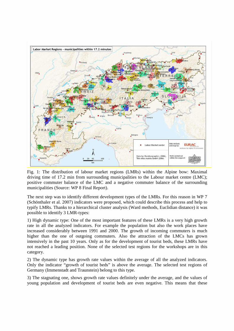
Fig. 1: The distribution of labour market regions (LMRs) within the Alpine bow: Maximal driving time of 17.2 min from surrounding municipalities to the Labour market centre (LMC); positive commuter balance of the LMC and a negative commuter balance of the surrounding municipalities (Source: WP 8 Final Report).
The next step was to identify different development types of the LMRs. For this reason in WP 7 (Schönthaler et al. 2007) indicators were proposed, which could describe this process and help to typify LMRs. Thanks to a hierarchical cluster analysis (Ward methods, Euclidian distance) it was possible to identify 3 LMR-types:
1) High dynamic type: One of the most important features of these LMRs is a very high growth rate in all the analyzed indicators. For example the population but also the work places have increased considerably between 1991 and 2000. The growth of incoming commuters is much higher than the one of outgoing commuters. Also the attraction of the LMCs has grown intensively in the past 10 years. Only as for the development of tourist beds, these LMRs have not reached a leading position. None of the selected test regions for the workshops are in this category.
2) The dynamic type has growth rate values within the average of all the analyzed indicators. Only the indicator “growth of tourist beds” is above the average. The selected test regions of Germany (Immenstadt and Traunstein) belong to this type.
3) The stagnating one, shows growth rate values definitely under the average, and the values of young population and development of tourist beds are even negative. This means that these
regions have experienced an excessive aging of the population and have lost some of their importance as tourist areas between 1991 and 2000. Idrija (Slovenia), Tolmezzo (Italy), Waidhofen/Ybbs (Austria) and the Gap-Region in France are members of this type.
These delineations were the basic for the selection of the test region in each participating country within the Alpine bow. Whereas in some countries (Germany, Austria and France) national analysis were accomplished for further interpretations of the LMR’s with data only accessible to the respective countries. The next step encompasses a context analysis of the selected region. The object of this step is to get an insight into the selected test region. This enables us to choose appropriate instruments and to interpret them after the workshops. The analysis is composed of the indicator analysis and the SWOT analysis. The result of the former is a database comprising of available harmonised data selected within WP8 and additional national data for the specific test area. This database is divided into three thematic fields: productive environment, human resources and basic infrastructure. For each of this problem field a SWOT analysis which gives insights into somebody’s strengths and weaknesses, opportunities and threats is carried out. The SWOT-Analysis (SWOT stays for Strengths, Weaknesses, Opportunities and Threats) is a quick methodology to define starting position of the test regions. Strengths and weaknesses are focused on the actual internal situation of the region, opportunities and threats to the future. The SWOT analysis is an effective strategy maximizing strength and chances and minimizing weaknesses and threats for regions.
In the frame of the SWOT analysis, each region has elaborateed a data set (data base), relevant for Diamont. This database is based on the WP 8 results (if possible). Each region has defined strength, weaknesses, opportunities, threats and priorities. The summary of the data set and the priorities are integrated into the SWOT report. The harmonization of data was needed, but not complete harmonization, since the available data in different states are different in definition and time of collection. The SWOT-Analysis points out all crucial aspects of the development, starting with advantages of the region, obstacles that do hinder current development, challenges that could be reached and risks that might prevent further development. Accordingly all action should be performed in compliance with next four guidelines:
• Build on strengths
• Eliminate weaknesses
• Exploit opportunities
• Mitigate the effect of threat
The main goal of the SWOT-analysis is to show the systematic call for action and ease the development of strategies. The analysis has its roots in the strategic management. Within regional development the SWOT instrument is intended to highlight those dominant and determining factors, which are likely to influence the success of the projects/instruments/tools.
The fields of interest for the Diamont SWOT analysis are three: productive environment, human resources and basic infrastructure. These topics are main issues of a sustainable regional development, showing a high potential in connection with resource efficiency and innovation,
facing as well lots of bottlenecks for a sustainable growth in future. Additionally they are of crucial importance by effective land take management.
The SWOT analysis was the base for the tool/instrument assessment. Indicators were selected according the priorities and the goal concretization. The SWOT analysis was based on the needs of Diamont according the main objectives in order to avoid huge data analysis.
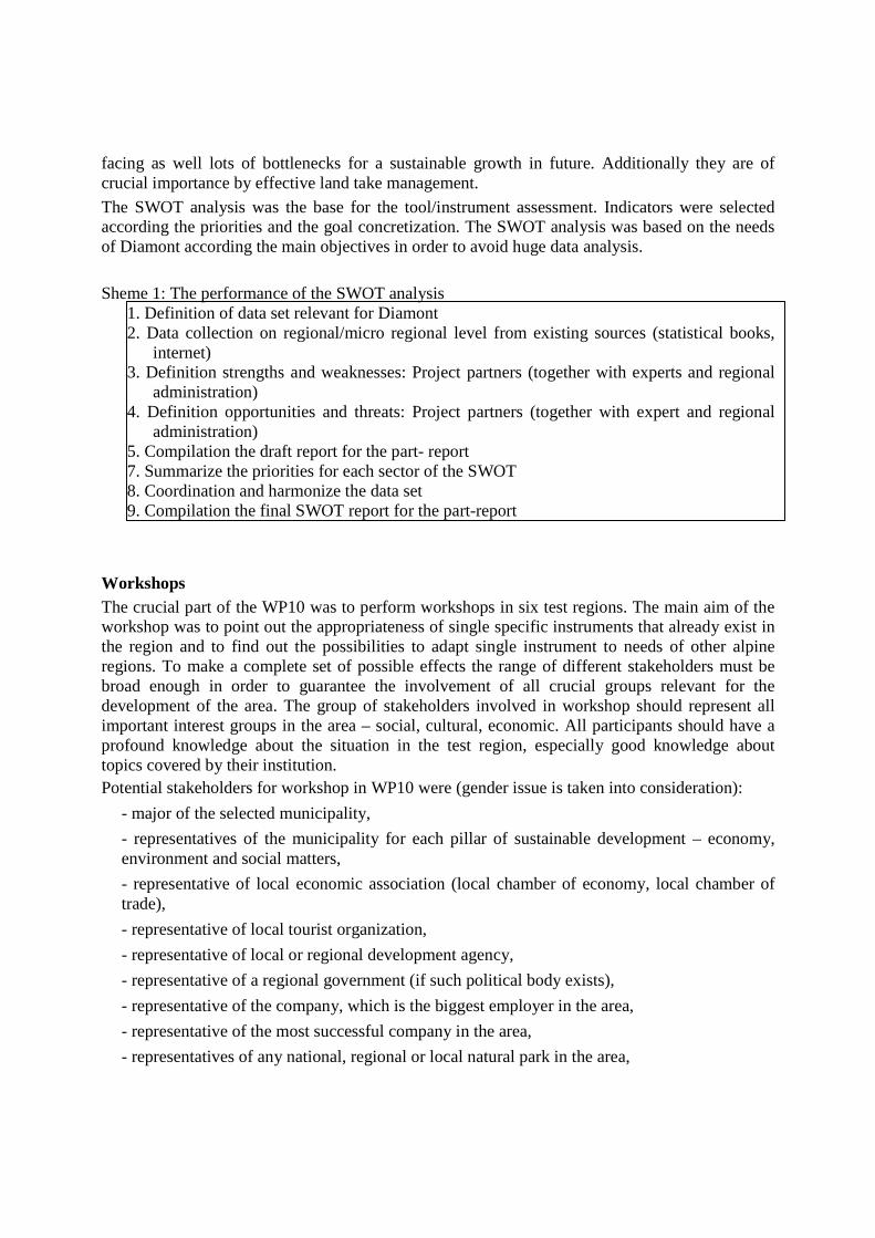
Sheme 1: The performance of the SWOT analysis
1. Definition of data set relevant for Diamont 2. Data collection on regional/micro regional level from existing sources (statistical books,
internet) 3. Definition strengths and weaknesses: Project partners (together with experts and regional
administration) 4. Definition opportunities and threats: Project partners (together with expert and regional
administration) 5. Compilation the draft report for the part- report 7. Summarize the priorities for each sector of the SWOT 8. Coordination and harmonize the data set 9. Compilation the final SWOT report for the part-report
Workshops The crucial part of the WP10 was to perform workshops in six test regions. The main aim of the workshop was to point out the appropriateness of single specific instruments that already exist in the region and to find out the possibilities to adapt single instrument to needs of other alpine regions. To make a complete set of possible effects the range of different stakeholders must be broad enough in order to guarantee the involvement of all crucial groups relevant for the development of the area. The group of stakeholders involved in workshop should represent all important interest groups in the area – social, cultural, economic. All participants should have a profound knowledge about the situation in the test region, especially good knowledge about topics covered by their institution. Potential stakeholders for workshop in WP10 were (gender issue is taken into consideration):
- major of the selected municipality,
- representatives of the municipality for each pillar of sustainable development – economy, environment and social matters,
- representative of local economic association (local chamber of economy, local chamber of trade),
- representative of local tourist organization,
- representative of local or regional development agency,
- representative of a regional government (if such political body exists),
- representative of the company, which is the biggest employer in the area,
- representative of the most successful company in the area,
- representatives of any national, regional or local natural park in the area,
- representatives of NGO’s,
- representatives of research institutes.
Other representatives, linked to the people in the region (priest, doctor) and those, important for the test region from the context analysis perspective:
- citizen groups,
- private individuals,
- directors of schools,
- pupils,
- real-estate managers,
- others (representatives of other interest groups according to each partners choice).
Our method for the workshop was a simplification of the World Café Conversations method, which is a creative process for leading collaborative dialogue, sharing knowledge and creating possibilities for action in groups of all sizes. This flexible method is relatively easy to organize. It can be organized and facilitated by a single person or by a team, as available. In any case, one or two persons act as facilitators. The job of the facilitator is to see that the guidelines for dialogue and engagement are put into action.
The environment is set up like a café, with tables for four-five persons. People sitting to a table have a series of conversational rounds lasting from 15 to 20 minutes for about one or more questions presented by the facilitator. They write on a big sheet the answers to the questions and after 15—20 minutes a person chosen by the group (the reporter) presents the results to the audience. The second group acts the same. Each sheet is put on a wall. In subsequent rounds they answer to new questions or go deeper into the original one. After three or more rounds, the whole group gathers to share and explore emerging themes, insights, and learning’s, which are captured on flipcharts or other means for making the collective intelligence of the whole group visible to everyone so they can reflect on what is emerging in the room. During the coffee break the facilitators summarize the results on the flipchart asking to participants to assign marks (from 1 to 5) to the topics according to their priorities in the case study area or to focus on actions needed to improve the situation of respected region.
The bottom-up approach is considered a normative participation process based on people participating in the decision process from the very beginning. It therefore contrasts with the usual top-down approach based on a hierarchical structure. The main advantage of adopting a bottom up approach is participant identification with decisions concerning their environment. It is important to underline that bottom-up process will not be successful without top-down governmental support and side-in effects due to support from NGOs, research institutes etc. increasing know-how and competence within the region. When performing a workshop it is important to include people who are protagonists and to establish a dialogue with them. They must perceive that their contribution is not finalized for our purposes (to prepare a report) but that we really want to help them in a concrete way providing different solutions for their conflicts.
Final report After performance of the context analysis and the workshop in selected region a part report for each region was prepared. It combines the results of workshops and results obtained with the context analysis, while the regional specifics are important for the interpretation of the results.
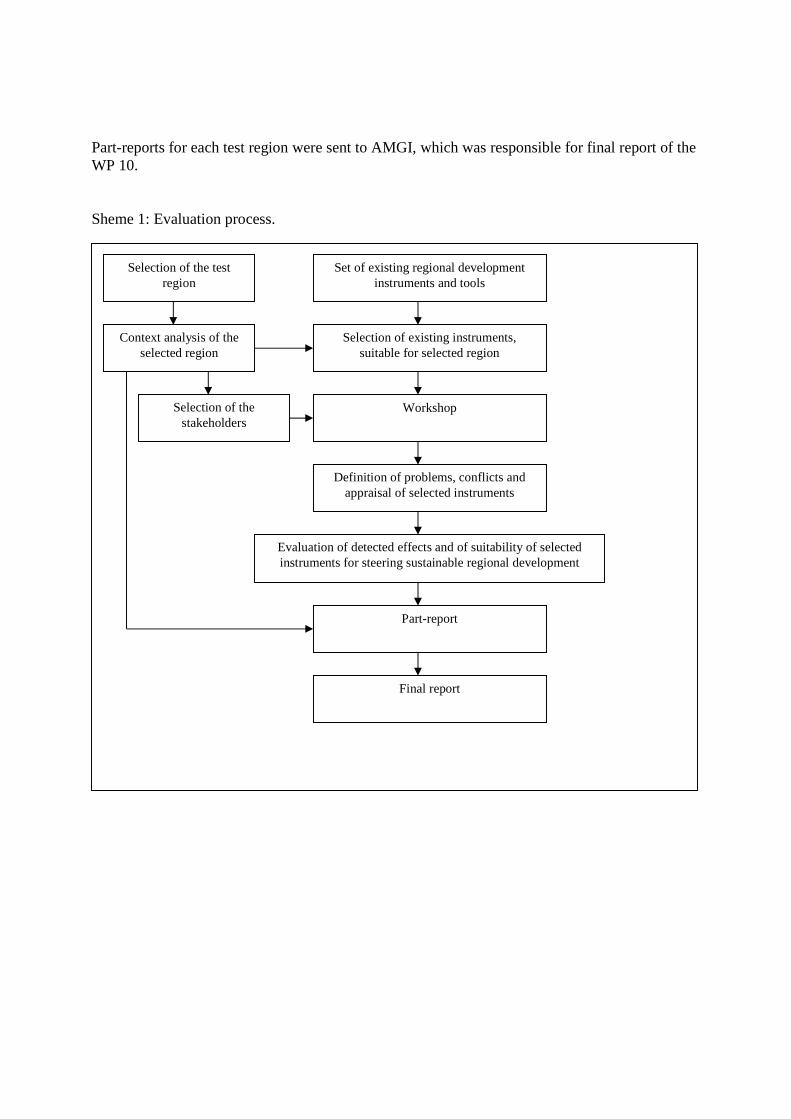
Part-reports for each test region were sent to AMGI, which was responsible for final report of the WP 10. Sheme 1: Evaluation process.
Set of existing regional development instruments and tools
Context analysis of the selected region
Selection of existing instruments, suitable for selected region
Selection of the test region
Workshop
Definition of problems, conflicts and appraisal of selected instruments
Evaluation of detected effects and of suitability of selected instruments for steering sustainable regional development
Part-report
Final report
Selection of the stakeholders
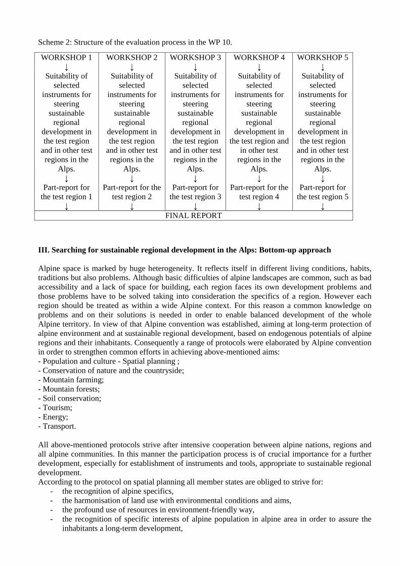
Scheme 2: Structure of the evaluation process in the WP 10.
III. Searching for sustainable regional development in the Alps: Bottom-up approach Alpine space is marked by huge heterogeneity. It reflects itself in different living conditions, habits, traditions but also problems. Although basic difficulties of alpine landscapes are common, such as bad accessibility and a lack of space for building, each region faces its own development problems and those problems have to be solved taking into consideration the specifics of a region. However each region should be treated as within a wide Alpine context. For this reason a common knowledge on problems and on their solutions is needed in order to enable balanced development of the whole Alpine territory. In view of that Alpine convention was established, aiming at long-term protection of alpine environment and at sustainable regional development, based on endogenous potentials of alpine regions and their inhabitants. Consequently a range of protocols were elaborated by Alpine convention in order to strengthen common efforts in achieving above-mentioned aims: - Population and culture - Spatial planning ; - Conservation of nature and the countryside; - Mountain farming; - Mountain forests; - Soil conservation; - Tourism; - Energy; - Transport. All above-mentioned protocols strive after intensive cooperation between alpine nations, regions and all alpine communities. In this manner the participation process is of crucial importance for a further development, especially for establishment of instruments and tools, appropriate to sustainable regional development. According to the protocol on spatial planning all member states are obliged to strive for:
- the recognition of alpine specifics, - the harmonisation of land use with environmental conditions and aims, - the profound use of resources in environment-friendly way, - the recognition of specific interests of alpine population in alpine area in order to assure the
inhabitants a long-term development,
WORKSHOP 1 WORKSHOP 2 WORKSHOP 3 WORKSHOP 4 WORKSHOP 5 ↓ ↓ ↓ ↓ ↓
Suitability of selected
instruments for steering
sustainable regional
development in the test region
and in other test regions in the
Alps.
Suitability of selected
instruments for steering
sustainable regional
development in the test region
and in other test regions in the
Alps.
Suitability of selected
instruments for steering
sustainable regional
development in the test region
and in other test regions in the
Alps.
Suitability of selected
instruments for steering
sustainable regional
development in the test region and
in other test regions in the
Alps.
Suitability of selected
instruments for steering
sustainable regional
development in the test region
and in other test regions in the
Alps. ↓ ↓ ↓ ↓ ↓
Part-report for the test region 1
Part-report for the test region 2
Part-report for the test region 3
Part-report for the test region 4
Part-report for the test region 5
↓ ↓ ↓ ↓ ↓ FINAL REPORT
- the balanced economic development and equal distribution of inhabitants; - the respect of regional identities and cultural peculiarities, - the equal opportunities of the inhabitants, living in the Alps, - the consideration of alpine specifics, common interests and limitations of resources.
In this manner the protocol establishes the foundation for a harmonized preparation of strategies, programs and plans, based on cooperation between all crucial stakeholders, starting with local communities. The importance of local communities is stressed also in the protocol Conservation of nature and the countryside, where the preparation of international regulation should respect the interests of local population. Realizing the specifics of alpine environment some special protocols were prepared in order to establish economic bases for further alpine development. Starting with the protocol on mountain farming and continuing with protocols on tourism, energetic and transport the Alpine convention has tried to assure a good economic and infrastructural basis of alpine development. The aim of all mentioned protocols is to balance the care for alpine environment and the promotion of such economic activities that would enable adequate living standard to alpine population and protect the long–term development potentials of alpine regions as well. Development should not only be adjusted to the needs of the local population, but it should also base on their initiatives. The aims of the Alpine convention are directed towards basic principles of sustainability and sustainable regional development. Furthermore, they are much in line with modern perception of regional policy or endogenous regional development respectively. According to new development concepts the main potential for sustainable regional development should be searched in a region itself, starting with human, social and environmental capital and followed by tacit knowledge, institutional thickness, regional identity and personal contacts. Not only local/regional potentials should be used, but also local/regional ideas, expectations and initiatives must be respected in order to reach harmonized development and in order to avoid further centralization on one side and marginalization and depopulation on the other. Simultaneously with local initiatives also interregional cooperation should be established, based on exchange of knowledge and if possible also on common actions, especially in regions, where problems are in common and could be effectively solved by cooperation of different local and regional actors/authorities. For this reason also DIAMONT project is focused not only on scientific elaboration of different development concepts, instruments and tools, but also on the participation process, based on a bottom-up approach. We were searching for an adequate response of selected communities on instruments and tools, elaborated within the project, knowing that all scientific elaborations are limited if such elaborations are not proved and tested in reality. Furthermore, the confrontation of scientific knowledge with needs and opinions of local stakeholders has led to improvement of selected instruments and what is even more important; it has helped the local communities to identify their problems and to search for the possibilities for their solution. In addition, not only local impetus was given, but also interregional comparison was enabled, as the workshops were carried out in five different countries and six different regions. Delightfully the participation process has provoked an intensive cooperation between local stakeholders, with one crucial aim – to improve the situation in the region and to enable further development. In this way local dynamism was strengthened, new ideas appeared and - together with scientific input of DIAMONT partners – the transmission of international knowledge was enabled.For all these reasons the workshops in selected test regions have been successful, due to the fact that they enhanced learning process in the region and between the regions. Accordingly benchmarking between test regions was enabled, based on common cluster analysis and on experiences of stakeholders in each test region and in some cases also best practise examples were found, suitable for transmission in other alpine regions. Following the objectives of the workshop the results could be compared with the expectations of the Alpine convention aiming at sharing the knowledge and experiences and also at exchange of different problem resolution possibilities. For this reason all workshops are presented in the Chapter IV, in order to experience the heterogeneity of alpine regions and on the other side, to learn the lesson from their rich knowledge.
IV. Workshops in selected test regions 1 Austria – Waidhofen/Ybbs Country: AUSTRIA Test region: WAIDHOFEN/YBBS Workshop results Location of the workshop: Waidhofen an der Ybbs Date of the workshop: 12. 05. 2007 Number of participants: 21 Project partner: Institute of Geography, University of Innsbruck
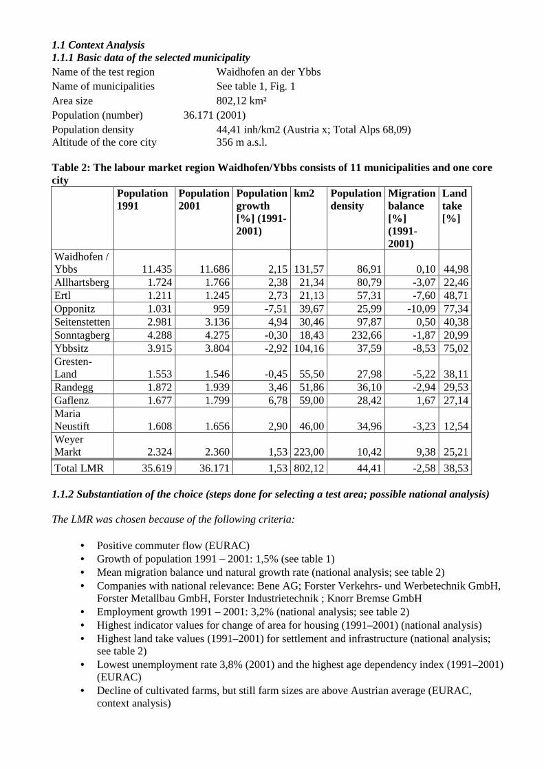
1.1 Context Analysis 1.1.1 Basic data of the selected municipality Name of the test region Waidhofen an der Ybbs Name of municipalities See table 1, Fig. 1 Area size 802,12 km² Population (number) 36.171 (2001) Population density 44,41 inh/km2 (Austria x; Total Alps 68,09) Altitude of the core city 356 m a.s.l. Table 2: The labour market region Waidhofen/Ybbs consists of 11 municipalities and one core city
Population 1991
Population 2001
Population growth [%] (1991-2001)
km2 Population density
Migration balance [%] (1991-2001)
Landtake [%]
Waidhofen / Ybbs 11.435 11.686 2,15 131,57 86,91 0,10 44,98 Allhartsberg 1.724 1.766 2,38 21,34 80,79 -3,07 22,46 Ertl 1.211 1.245 2,73 21,13 57,31 -7,60 48,71 Opponitz 1.031 959 -7,51 39,67 25,99 -10,09 77,34 Seitenstetten 2.981 3.136 4,94 30,46 97,87 0,50 40,38 Sonntagberg 4.288 4.275 -0,30 18,43 232,66 -1,87 20,99 Ybbsitz 3.915 3.804 -2,92 104,16 37,59 -8,53 75,02 Gresten-Land 1.553 1.546 -0,45 55,50 27,98 -5,22 38,11 Randegg 1.872 1.939 3,46 51,86 36,10 -2,94 29,53 Gaflenz 1.677 1.799 6,78 59,00 28,42 1,67 27,14 Maria Neustift 1.608 1.656 2,90 46,00 34,96 -3,23 12,54 Weyer Markt 2.324 2.360 1,53 223,00 10,42 9,38 25,21
Total LMR 35.619 36.171 1,53 802,12 44,41 -2,58 38,53 1.1.2 Substantiation of the choice (steps done for selecting a test area; possible national analysis)
The LMR was chosen because of the following criteria:
• Positive commuter flow (EURAC) • Growth of population 1991 – 2001: 1,5% (see table 1) • Mean migration balance und natural growth rate (national analysis; see table 2) • Companies with national relevance: Bene AG; Forster Verkehrs- und Werbetechnik GmbH,
Forster Metallbau GmbH, Forster Industrietechnik ; Knorr Bremse GmbH • Employment growth 1991 – 2001: 3,2% (national analysis; see table 2) • Highest indicator values for change of area for housing (1991–2001) (national analysis) • Highest land take values (1991–2001) for settlement and infrastructure (national analysis;
see table 2) • Lowest unemployment rate 3,8% (2001) and the highest age dependency index (1991–2001)
(EURAC) • Decline of cultivated farms, but still farm sizes are above Austrian average (EURAC,
context analysis)
Source: Statistik Austria (1991, 2001); EURAC (WP8) e.g. context analysis; Heinrich, K. and Bender, O.: National Analysis (2007) 1.1.3 Basic characteristics of the region
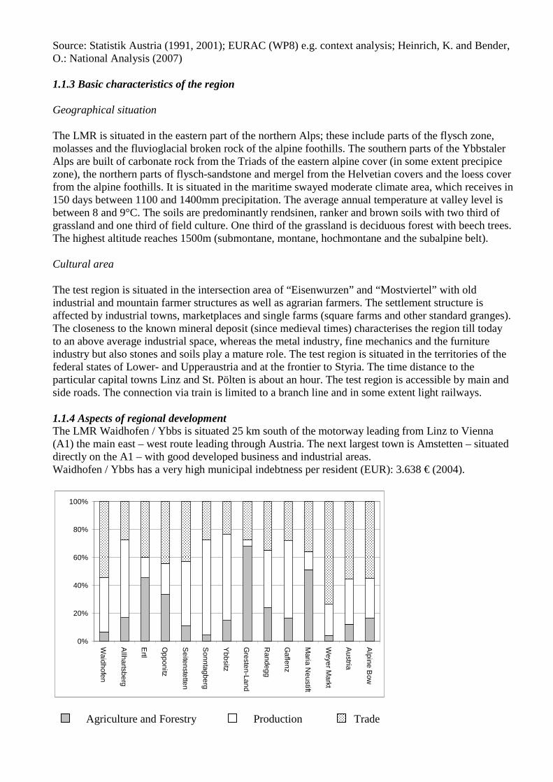
Geographical situation
The LMR is situated in the eastern part of the northern Alps; these include parts of the flysch zone, molasses and the fluvioglacial broken rock of the alpine foothills. The southern parts of the Ybbstaler Alps are built of carbonate rock from the Triads of the eastern alpine cover (in some extent precipice zone), the northern parts of flysch-sandstone and mergel from the Helvetian covers and the loess cover from the alpine foothills. It is situated in the maritime swayed moderate climate area, which receives in 150 days between 1100 and 1400mm precipitation. The average annual temperature at valley level is between 8 and 9°C. The soils are predominantly rendsinen, ranker and brown soils with two third of grassland and one third of field culture. One third of the grassland is deciduous forest with beech trees. The highest altitude reaches 1500m (submontane, montane, hochmontane and the subalpine belt).
Cultural area
The test region is situated in the intersection area of “Eisenwurzen” and “Mostviertel” with old industrial and mountain farmer structures as well as agrarian farmers. The settlement structure is affected by industrial towns, marketplaces and single farms (square farms and other standard granges). The closeness to the known mineral deposit (since medieval times) characterises the region till today to an above average industrial space, whereas the metal industry, fine mechanics and the furniture industry but also stones and soils play a mature role. The test region is situated in the territories of the federal states of Lower- and Upperaustria and at the frontier to Styria. The time distance to the particular capital towns Linz and St. Pölten is about an hour. The test region is accessible by main and side roads. The connection via train is limited to a branch line and in some extent light railways. 1.1.4 Aspects of regional development The LMR Waidhofen / Ybbs is situated 25 km south of the motorway leading from Linz to Vienna (A1) the main east – west route leading through Austria. The next largest town is Amstetten – situated directly on the A1 – with good developed business and industrial areas. Waidhofen / Ybbs has a very high municipal indebtness per resident (EUR): 3.638 € (2004).
0%
20%
40%
60%
80%
100%
Waidhofen
Allhartsberg
Ertl
Opponitz
Seitenstetten
Sonntagberg
Ybbsitz
Gresten-Land
Randegg
Gaflenz
Maria N
eustift
Weyer M
arkt
Austria
Alpine B
ow
Agriculture and Forestry Production Trade
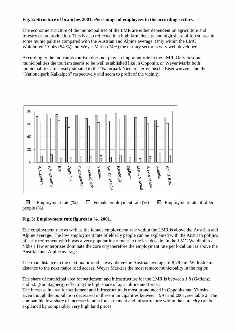
Fig. 2: Structure of branches 2001: Percentage of employees to the according sectors. The economic structure of the municipalities of the LMR are either dependent on agriculture and forestry or on production. This is also reflected in a high farm density and high share of forest area in some municipalities compared with the Austrian and Alpine average. Only within the LMC Waidhofen / Ybbs (54 %) and Weyer Markt (74%) the tertiary sector is very well developed.
According to the indicators tourism does not play an important role in the LMR. Only in some municipalities the tourism seems to be well established like in Opponitz or Weyer Markt both municipalities are closely situated to the “Naturpark Niederösterreichische Eisenwurzen” and the “Nationalpark Kalkalpen” respectively and seem to profit of the vicinity.
0
20
40
60
80
Waidhofen
Allhartsberg
Ertl
Opponitz
Seitenstetten
Sonntagberg
Ybbsitz
Gresten-Land
Randegg
Gaflenz
Maria N
eustift
Weyer M
arkt
Austria
Alpine B
ow
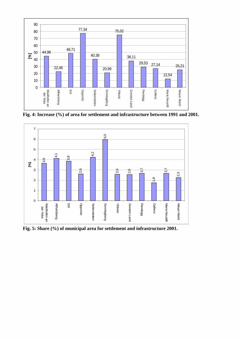
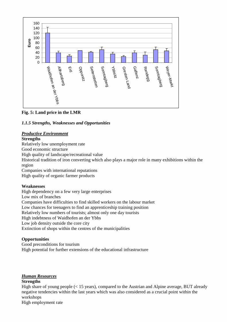
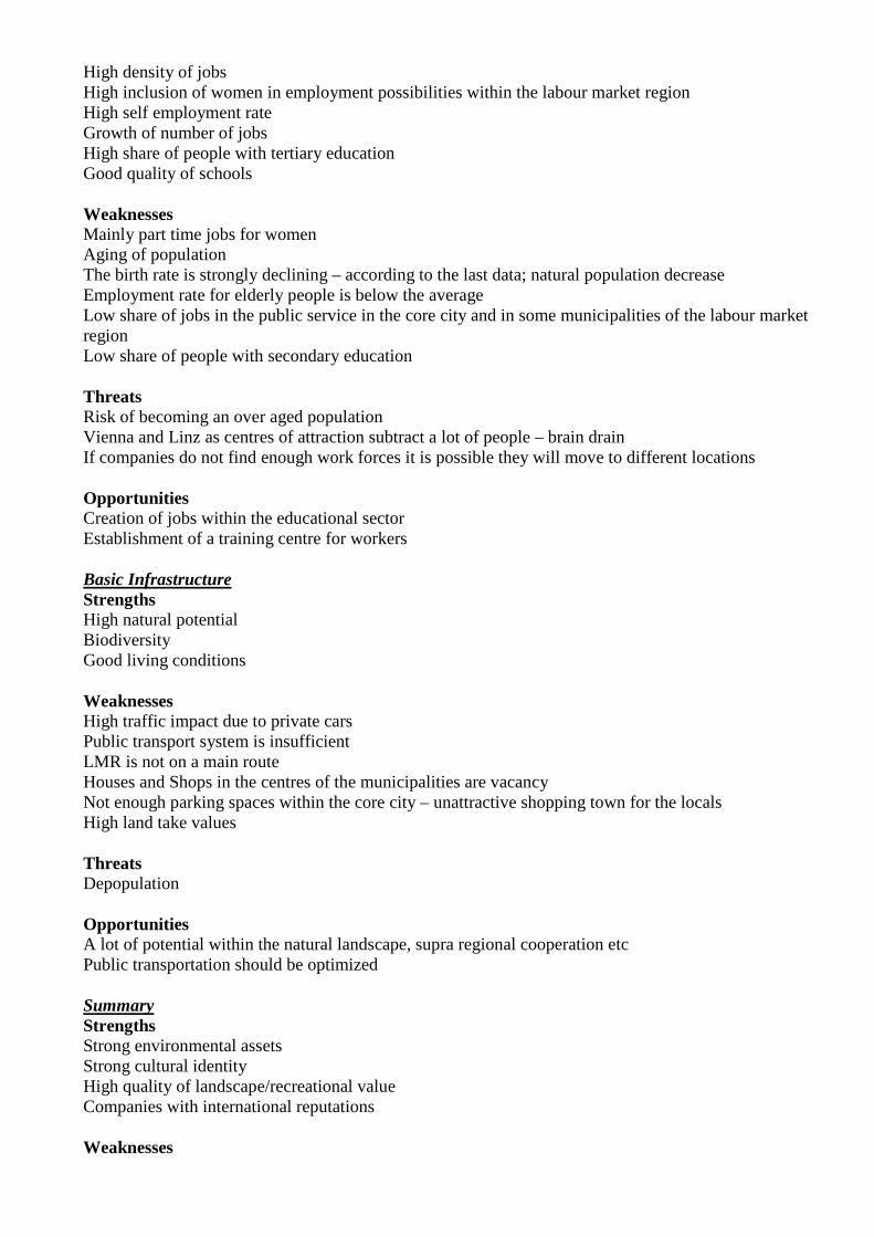
Employment rate (%) Female employment rate (%) Employment rate of older people (%) Fig. 3: Employment rate figures in %, 2001. The employment rate as well as the female employment rate within the LMR is above the Austrian and Alpine average. The low employment rate of elderly people can be explained with the Austrian politics of early retirement which was a very popular instrument in the last decade. In the LMC Waidhofen / Ybbs a few enterprises dominate the core city therefore the employment rate per local unit is above the Austrian and Alpine average. The road distance to the next major road is way above the Austrian average of 8,78 km. With 36 km distance to the next major road access, Weyer Markt is the most remote municipality in the region. The share of municipal area for settlement and infrastructure for the LMR is between 1,8 (Gaflenz) and 6,0 (Sonntagberg) reflecting the high share of agriculture and forest. The increase in area for settlement and infrastructure is most pronounced in Opponitz and Ybbsitz. Even though the population decreased in these municipalities between 1991 and 2001, see table 2. The comparable low share of increase in area for settlement and infrastructure within the core city can be explained by comparably very high land prices.
44,98
22,46
48,71
77,34
40,38
20,99
75,02
38,11
29,53 27,14
12,54
25,21
0
10
20
30
40
50
60
70
80
90
Waidhofen ander Y
bbs
Allhartsberg
Ertl
Opponitz
Seitenstetten
Sonntagberg
Ybbsitz
Gresten-Land
Randegg
Gaflenz
Maria N
eustift
Weyer M
arkt
[%]
Fig. 4: Increase (%) of area for settlement and infrastructure between 1991 and 2001.
3,6
4,1
3,8
2,6
4,2
6,0
2,6
2,6 2,7
1,8
2,7
2,3
0
1
2
3
4
5
6
7
Waid
hofe
n a
n
der Y
bbs
Allh
artsb
erg
Ertl
Opponitz
Seite
nste
tten
Sonnta
gberg
Ybbsitz
Gre
sten-L
and
Randegg
Gafle
nz
Maria
Neustift
Weye
r Markt
[%]
Fig. 5: Share (%) of municipal area for settlement and infrastructure 2001.
020406080
100120140160
Wa
idhofen an de
r Ybb
sA
llhartsb
erg
Ertl
Opp
onitz
Seite
nstetten
Sonntag
berg
Ybbsitz
Gre
sten-Land
Gaflenz
Ra
ndegg
Sonntag
berg
We
yer-Markt
Eur
o
Fig. 5: Land price in the LMR 1.1.5 Strengths, Weaknesses and Opportunities Productive Environment Strengths Relatively low unemployment rate Good economic structure High quality of landscape/recreational value Historical tradition of iron converting which also plays a major role in many exhibitions within the region Companies with international reputations High quality of organic farmer products Weaknesses High dependency on a few very large enterprises Low mix of branches Companies have difficulties to find skilled workers on the labour market Low chances for teenagers to find an apprenticeship training position Relatively low numbers of tourists; almost only one day tourists High indebtness of Waidhofen an der Ybbs Low job density outside the core city Extinction of shops within the centres of the municipalities Opportunities Good preconditions for tourism High potential for further extensions of the educational infrastructure Human Resources Strengths High share of young people (< 15 years), compared to the Austrian and Alpine average, BUT already negative tendencies within the last years which was also considered as a crucial point within the workshops High employment rate
High density of jobs High inclusion of women in employment possibilities within the labour market region High self employment rate Growth of number of jobs High share of people with tertiary education Good quality of schools Weaknesses Mainly part time jobs for women Aging of population The birth rate is strongly declining – according to the last data; natural population decrease Employment rate for elderly people is below the average Low share of jobs in the public service in the core city and in some municipalities of the labour market region Low share of people with secondary education Threats Risk of becoming an over aged population Vienna and Linz as centres of attraction subtract a lot of people – brain drain If companies do not find enough work forces it is possible they will move to different locations Opportunities Creation of jobs within the educational sector Establishment of a training centre for workers Basic Infrastructure Strengths High natural potential Biodiversity Good living conditions Weaknesses High traffic impact due to private cars Public transport system is insufficient LMR is not on a main route Houses and Shops in the centres of the municipalities are vacancy Not enough parking spaces within the core city – unattractive shopping town for the locals High land take values Threats Depopulation Opportunities A lot of potential within the natural landscape, supra regional cooperation etc Public transportation should be optimized Summary Strengths Strong environmental assets Strong cultural identity High quality of landscape/recreational value Companies with international reputations Weaknesses
Brain drain to the attractive centres of Vienna and Linz Companies do not find enough highly skilled workers Public transport is insufficient Threats Depopulation Threat of companies moving to different locations Opportunities Extension of the already well developed school system in further offering adult education in order to stop the brain drain Enhancement of environmental assets: further development of environmental tourism 1.2. Preparation of the workshop After receiving the delimitations of the labour market regions calculated within WP8 (EURAC) a further national analysis was conducted. The result of the national analysis as well as the cooperation of the major of Waidhofen / Ybbs was the base for selecting the LMR Waidhofen / Ybbs as our test region. The thematic fields were chosen after the preparation of the context analysis as proposed by the work package leader AMGI. We sent out 200 invitations for the workshop too people working within the city council, municipal council (majors of the municipalities belonging to the LMR delimitated by the EURAC), governmental-, economic-, public- and private sector and to NGOs. The address list was given to us by the major of Waidhofen / Ybbs, which was than called the VIP list by the participants of the workshop since it included all important addresses of the core city. Finally 21 persons participated in the workshop. The weakest response was achieved by people working within the economy, whereas the participation of people working in the public sector was quite high. The major of Waidhofen / Ybbs as well as members of the district council belonging to the same political party did not participate due to a party congress at the same day. 1.2.1. The organizational aspects of the workshop The workshop was divided in three rounds each lasting 30 minutes. Within the first two rounds three topics were discussed on at least 5 tables with 4 participants. Within the third round only 2 topics were discussed. The discussion was moderated by one student and notes of the ongoing discussion were taken by another student. The rounds were structured as follows:
o 10 minutes open discussion about the topic o 10 minutes about opportunities and problems o 10 minutes about possible instruments
Altogether two presentations comprehended the ongoing discussions on the tables, with further possible inputs on the topics from the participants. Timetable for the workshop:
Time Round/Question Topic
10:15 Introduction by Axel Borsdorf
10:30 1. Round
1. Question
Labour Market Region Waidhofen / Ybbs in Austria
1. Round
2. Question
Quality of life
1. Round
3. Question
Population structure and development
11:00 2. Round
1. Question
Economic development
2. Round
2. Question
Transport and infrastructure
2. Round
3. Question
Level of debt
11:30 Lunch
12:30 Presentation of the six results from the first two rounds
12:50 3. Round
1. Question
Regional cooperation
3. Round
2. Question
Undeveloped area usage
13:20 Coffee break
13:35 Presentation of the results from the last round
13:50 Conclusion
1.3. List of selected instruments In the Austrian case the following instruments were mentioned by the participants of the workshop:
• Land use plan • Housing aid • Building-land-acquisition-fund • Fund for small-scale business promotion – “Vitalisation of the city center” • Programmes of regional planning (integrated concept) • Planning alliance • “RIZ” Regional Innovation Center • Leader + • Civil participation • Cooperation federation, state municipalities • Rededication of agricultural land
1.4. List of stakeholders Surname and
Name Institution Type Town Position
1 Abfalter Erich Local government Teacher
Public sector Waidhofen / Ybbs
Member of the city council
2 Aigner Werner Head of building law Public sector Waidhofen / Ybbs
Division Manager / Office for building law
3 Broscha Helmut
ASKÖ Sports Club NGO Waidhofen / Ybbs
Chairman
4 Eibenberger Klemens
Clinical Centre Mostviertel Waidhofen / Ybbs
Public sector Waidhofen / Ybbs
Medical Management of the Hospital
5 Galbavy Johann
Raiffeisenbank Ybbstal
Economic Sector
Waidhofen / Ybbs
Management
6 Gamp Susanne ÖAV Austrian Alpine Association
NGO Waidhofen / Ybbs
Management
7 Gattermeier Martin
Clinical Centre Mostviertel Waidhofen / Ybbs
Public sector Waidhofen / Ybbs
Department Manager
8 Helmel Johann Austrian Train Holding
Governmental Sector
Waidhofen / Ybbs
Station Manager
9 Hochpöchler Leopold
Local government Public sector Waidhofen / Ybbs
Member of the city council
10 Horchmarcher Josef
Local government Public sector Ybbsitz Mayor - Municipal council
11 Jell Christian Austrian Forest Holding Waldviertel-Voralpen
Governmental Sector
Waidhofen / Ybbs
12 Kalteis Christoph
Local government Public sector Waidhofen / Ybbs
Division Manager / Office for Personal Management
13 Knoll Karl Heinz
Local government Public sector Waidhofen / Ybbs
Member of the city council
14 Kortschak Margit
Local government Waidhofen / Ybbs
Public sector Weyer Public Health Officer
15 Lai Ilse Clinical Centre Mostviertel Waidhofen / Ybbs
Public sector Waidhofen / Ybbs
Head of Care
16 Martin Matthias
Catholic Church Public sector Waidhofen / Ybbs
Chaplain
17 Merkinger Josef
ÖAV Austrian Alpine Association Teacher
NGO Public sector
Waidhofen / Ybbs
Assistant Management
18 Rogenhofer Hubert
Clinical Centre Mostviertel
Public sector Waidhofen / Ybbs
Assistant Doctoral
Waidhofen / Ybbs Manager
19 Schürer-Waldheim Gernot
Local government Public sector Waidhofen / Ybbs
Member of the city council
20 Stock Brita ÖAV Austrian Alpine Association Teacher
NGO Public sector
Waidhofen / Ybbs
Consultant of Nature Conservation
21 Tremetsberger Raimund
Internist Privat sector Weyer
Types of institutions Governmental sector Representing institutions of the federal
government Public sector Public authorities – organisations with public
mandate (schools, ministries, administrative units …)
Economic sector Private sector NGO (non-governmental organization)
Societies and associations, based on civil initiative
1.5. The structure of the workshop The workshop was divided in 8 thematic rounds and two rounds to present the latest results:
1. Labour Market Region Waidhofen / Ybbs in Austria 2. Quality of life 3. Population structure and development 4. Economic development 5. Transport and infrastructure 6. Level of debt 7. Regional cooperation 8. Land use
1.5.1. Information on the selection of respective thematic fields/focuses For choosing our thematic topics we had in mind the participants who had to identify themselves with the topics (labour market region Waidhofen / Ybbs in Austria and quality of life) and on the other hand we tried to focus also on topics strongly connected with the main focus of the workshop “undeveloped area usage”: population structure and development, economic development, transport and infrastructure and level of debt. Respective thematic rounds have been selected according to following criteria: For choosing our thematic topics we had in mind the participants who had to identify themselves with the topics (labour market region Waidhofen / Ybbs in Austria and quality of life) and on the other hand we tried to focus also on topics strongly connected with the main focus of the workshop “undeveloped area usage”: population structure and development, economic development, transport and infrastructure and level of debt. Respective thematic rounds have been selected according to following criteria:
1. Labour Market Region Waidhofen / Ybbs in Austria
We presented the delimitation of the labour market region done by the EURAC giving the participants the possibility to either agree or redefine it.
2. Quality of life Since the LMR Waidhofen / Ybbs is one of the regions with the highest indicator values for change of area for housing and highest land take values according to the national analysis we thought it a consequent question in order to explain the attractiveness as residential area and business location.
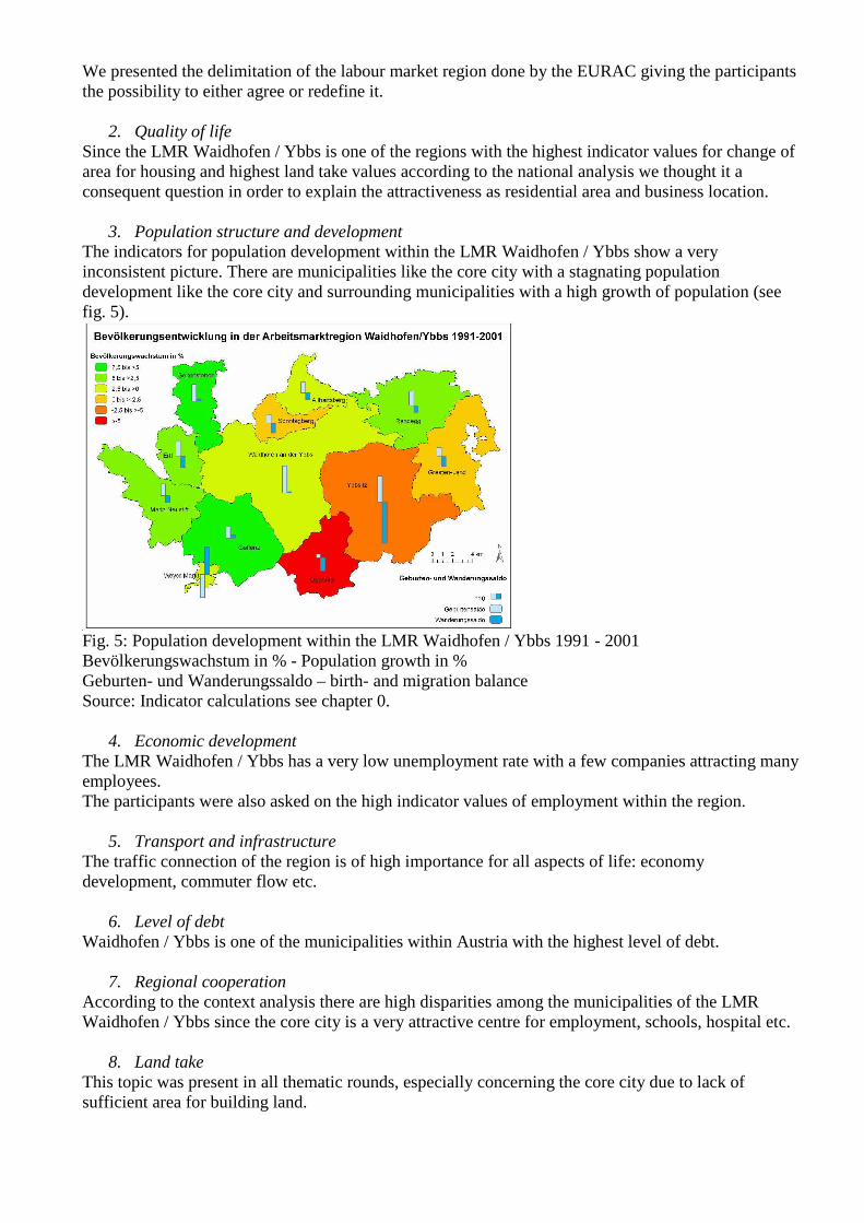
3. Population structure and development The indicators for population development within the LMR Waidhofen / Ybbs show a very inconsistent picture. There are municipalities like the core city with a stagnating population development like the core city and surrounding municipalities with a high growth of population (see fig. 5).
Fig. 5: Population development within the LMR Waidhofen / Ybbs 1991 - 2001 Bevölkerungswachstum in % - Population growth in % Geburten- und Wanderungssaldo – birth- and migration balance Source: Indicator calculations see chapter 0.
4. Economic development The LMR Waidhofen / Ybbs has a very low unemployment rate with a few companies attracting many employees. The participants were also asked on the high indicator values of employment within the region.
5. Transport and infrastructure The traffic connection of the region is of high importance for all aspects of life: economy development, commuter flow etc.
6. Level of debt Waidhofen / Ybbs is one of the municipalities within Austria with the highest level of debt.
7. Regional cooperation According to the context analysis there are high disparities among the municipalities of the LMR Waidhofen / Ybbs since the core city is a very attractive centre for employment, schools, hospital etc.
8. Land take This topic was present in all thematic rounds, especially concerning the core city due to lack of sufficient area for building land.
1.6. Questions for each part of the workshop/ for each instrument 1. Labour Market Region Waidhofen / Ybbs in Austria
Is the delimitation of the LMR realistic? Which municipalities are oriented towards Waidhofen / Ybbs? Are any of those municipalities orientating themselves towards other regions?
2. Quality of life What do you think of the quality of life within the municipality? What are the strengths, weaknesses and opportunities of the region?
3. Population structure and development What is your explanation for the disparities of the population growth within the LMR Waidhofen / Ybbs?
4. Economic development Discussion on the high indicator values for employment within the region. Is it difficult to find a job in the region, especially for women and young people? Is it possible that the tourism is going to become one of the main pillars of the region? According to our data in the last few years a lot of farmer working on a regular basis have become farmers working only on a sideline basis. Have you got an explanation for that? Are there any other possible employment possibilities?
5. Transport and infrastructure Define the main problems for the LMR on the infrastructural level.
6. Level of debt Are there any threats for the population of the core city emerging from its debts?
7. Regional cooperation Are there any supra-regional cooperation’s? Any examples like public transport, infrastructure, industrial / business park etc.
8. Land take According to the national analyses this LMR belongs to one of the regions with the highest indicator values for change of area for housing and highest land take values but mean indicator values for migration. Therefore within the last 10 years even though the population did not change significant land take increased: Have you noticed / sensed this development as well? What is your opinion of this development? What kind of reasons are responsible for this development?

1.7. Revised answers Round 1 1. Labour Market Region Waidhofen / Ybbs in Austria
Questions Summary Time 30' Is the delimitation
of the LMR realistic?
Yes
Which municipalities are oriented towards Waidhofen / Ybbs?
Further commuters are coming from Steyr, Altenmarkt, St. Valentin and Amstetten to the core city Waidhofen/Ybbs.
Are any of those municipalities orientating themselves towards other regions?
People living in the municipalities of Ertl and Seitenstetten commute to Steyr; whereas people living in Gresten and Randegg are also commuting to Scheibbs. One mentioned reason is the geographical situation.
All in all the participants agreed with the delimitation of the LMR thus in some cases they made further remarks.
2. Quality of life
Questions Instruments Time 30' What do you think
of the quality of life within the municipality?
• Local recreation • Good labour market • Good infrastructure (education,
health, and administration) • Security • Good social climate • Good living environment - clean
drinking water • Low traffic within the outer
municipalities
What are the weaknesses of the region?
• High commuter flows since people – especially families – move to the surrounding municipalities; in order to enhance life quality and due to lower land prices.
• Public transport is only on the main routes well developed, hence increasing the commuter flow with private cars.
• Offer of events of medium standard
• Hardly any upmarket leisure and sport offers
• Low offers for adolescent persons
Land use planning: Was mentioned by the participants in order to protect residential areas but also to further develop industrial and commercial areas
Housing aid: An important instrument to support habitat efficiency and to regulate high land prices
What are the opportunities of the region?
• Tourism: especially in supra regional tourisms projects: Eisenstraße (Waidhofen/Ybbs and Ybbsitz) and in the development of a tourism concept for the whole region.
• Development of a more sufficient cycle track to reduce the commuter flow on short distances.
3. Population structure and development
Questions Instruments Time 30' What is your
explanation for the disparities of the population growth within the LMR Waidhofen / Ybbs?
• Different property prices among the municipalities - especially in Waidhofen / Ybbs property prices are very high due to a lack of building land.
• Allartsberg is very popular since building land for young families is especially promoted. Additionally the transport connection to Waidhofen / Ybbs is very well developed. No rededications of agriculture land in Ybbsitz therefore less in coming migration.
• Opponitz is not very attractive for living due to its situation in a valley and due to a bad infrastructure.
Further discussions
• Elderly people tend to move again back into the heart of the core city in order to have better access to shopping, administration, health care etc.
Fund for small-scale business promotion
Housing Aid Building-land-
acquisition-fund
Round 2 4. Economic development
Questions Instruments
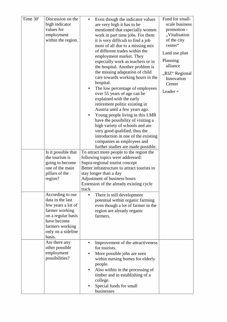
Time 30' Discussion on the high indicator values for employment within the region.
• Even though the indicator values are very high it has to be mentioned that especially women work in part time jobs. For them it is very difficult to find a job most of all due to a missing mix of different trades within the employment market. They especially work as teachers or in the hospital. Another problem is the missing adaptation of child care towards working hours in the hospital.
• The low percentage of employees over 55 years of age can be explained with the early retirement politic existing in Austria until a few years ago.
• Young people living in this LMR have the possibility of visiting a high variety of schools and are very good qualified, thus the introduction in one of the existing companies as employees and further studies are made possible.
Is it possible that the tourism is going to become one of the main pillars of the region?
To attract more people to the region the following topics were addressed: Supra-regional tourist concept Better infrastructure to attract tourists to stay longer than a day Adjustment of business hours Extension of the already existing cycle track
According to our data in the last few years a lot of farmer working on a regular basis have become farmers working only on a sideline basis.
• There is still development potential within organic farming even though a lot of farmer in the region are already organic farmers.
Fund for small-scale business promotion - „Vitalisation of the city center“
Land use plan
Planning alliance
„RIZ“ Regional Innovation Center
Leader +
Are there any other possible employment possibilities?
• Improvement of the attractiveness for tourists.
• More possible jobs are seen within nursing homes for elderly people.
• Also within in the processing of timber and in establishing of a college.
• Special funds for small businesses
Further discussions
• The participants also mentioned the great dependency of the region to those few companies with a high employment rate.
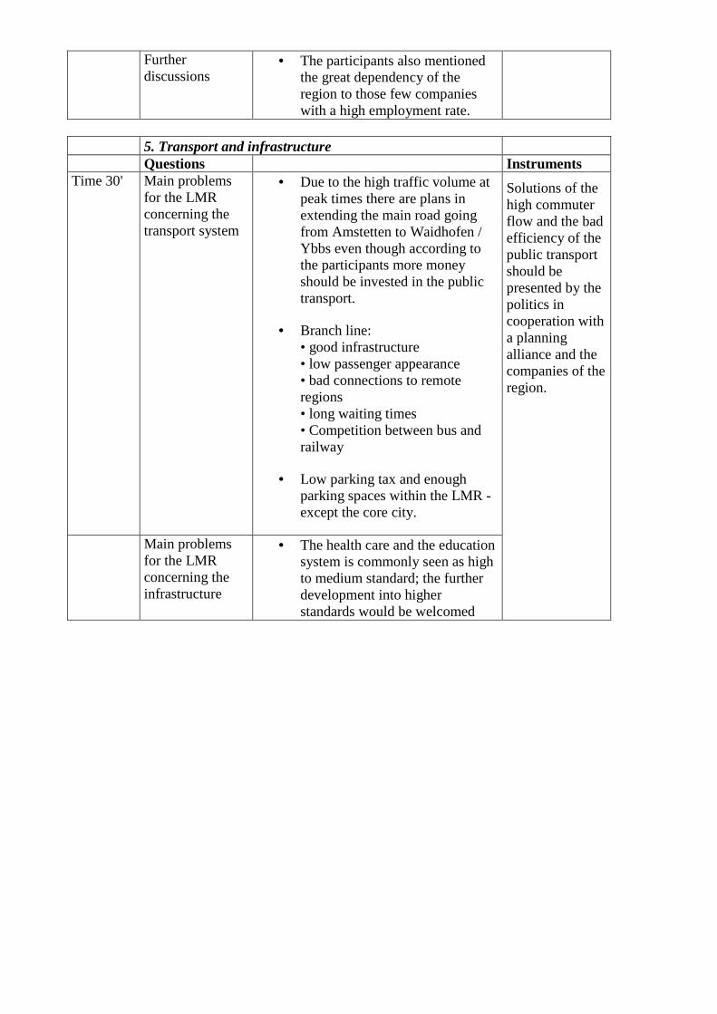
5. Transport and infrastructure Questions Instruments Time 30' Main problems
for the LMR concerning the transport system
• Due to the high traffic volume at peak times there are plans in extending the main road going from Amstetten to Waidhofen / Ybbs even though according to the participants more money should be invested in the public transport.
• Branch line: • good infrastructure • low passenger appearance • bad connections to remote regions • long waiting times • Competition between bus and railway
• Low parking tax and enough parking spaces within the LMR - except the core city.
Main problems for the LMR concerning the infrastructure
• The health care and the education system is commonly seen as high to medium standard; the further development into higher standards would be welcomed
Solutions of the high commuter flow and the bad efficiency of the public transport should be presented by the politics in cooperation with a planning alliance and the companies of the region.
6. Level of debt Questions Summary Time 30' Which are the
consequences for the population of the core city emerging from its public debts?
The investments were seen positively among the participants:
• Improvement of life quality • Preservation of jobs • Development of infrastructure • Water quality • The ongoing exhibition 2007
Since the money was reinvested in the improvement of public life the participants did not see the level of debt in a negative way.
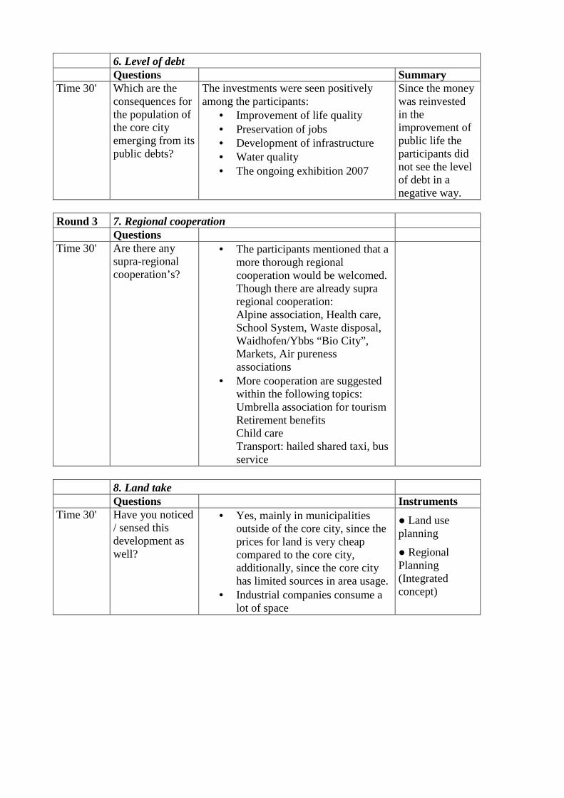
Round 3 7. Regional cooperation Questions Time 30' Are there any
supra-regional cooperation’s?
• The participants mentioned that a more thorough regional cooperation would be welcomed. Though there are already supra regional cooperation: Alpine association, Health care, School System, Waste disposal, Waidhofen/Ybbs “Bio City”, Markets, Air pureness associations
• More cooperation are suggested within the following topics: Umbrella association for tourism Retirement benefits Child care Transport: hailed shared taxi, bus service
8. Land take Questions Instruments Time 30' Have you noticed
/ sensed this development as well?
• Yes, mainly in municipalities outside of the core city, since the prices for land is very cheap compared to the core city, additionally, since the core city has limited sources in area usage.
• Industrial companies consume a lot of space
● Land use planning
● Regional Planning (Integrated concept)
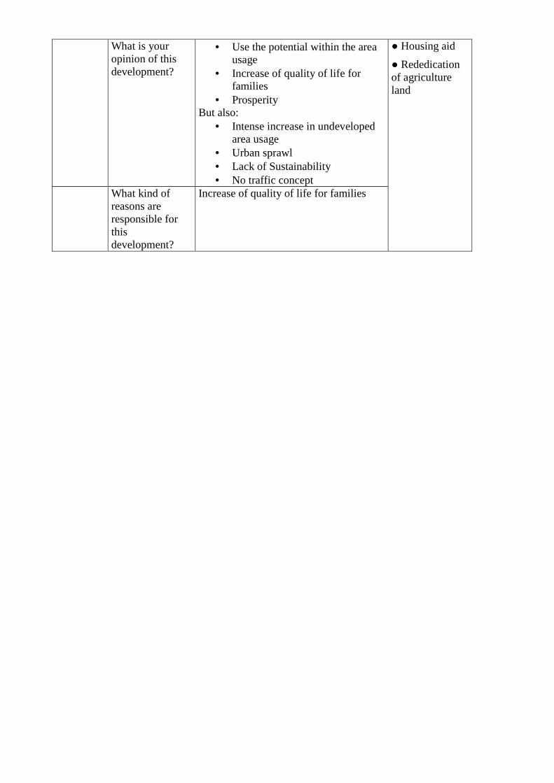
What is your opinion of this development?
• Use the potential within the area usage
• Increase of quality of life for families
• Prosperity But also:
• Intense increase in undeveloped area usage
• Urban sprawl • Lack of Sustainability • No traffic concept
What kind of reasons are responsible for this development?
Increase of quality of life for families
● Housing aid
● Rededication of agriculture land
1.8. Confrontation of the context analysis results with the workshop results During the discussion it turned out that the results of the context analysis compare well with the existing regional, economic and social structure of the labour market region Waidhofen/Ybbs. There were no corrections necessary. Additionally all participants of the workshop agreed that the delimitation of the labour market region, including communities of the Federal States of Lower Austria and Upper Austria, fits the regional tradition, structures and necessities. 1.9. Starting points for the second workshop The focus of the second workshop will be orientated towards the demands and necessities of the region. One of the most important results of the first workshop is, that conflicts couldn’t be distinguished, but quite a lot of development problems like public transport, road traffic, tourism etc. The second workshop once more will be orientated mainly on regional problems, solutions, and the search for good practices. The participants are highly interested to learn more about the experiences of other alpine labour market regions and thus to discuss best practices, realised in other regions. In order to enforce the bottom-up approach of the DIAMONT project the Austrian team filtered some of the most striking problems of the region and let the participants themselves choose two most relevant topics they want to discuss on more profoundly. The four proposed themes are:
1) Improvement of the educational infrastructure with the help of regional cooperation and the reinforcement / upgrading of the infrastructure of public transport.
2) Adaptation of tourist offers in regard to future needs 3) Supra regional land use management 4) Supra regional traffic concept.
The focus will be to initiate and safeguard sustainable regional development processes on the base of intraregional cooperation. Therefore the second workshop should focus more on strategies to reinforce the inter-municipal collaboration. The participants expect that this workshop can initiate new impulses to this strategy. 1.10. Conclusion The engagement of the participants of the first workshop in Waidhofen/Ybbs made the workshop a success. It was surprising to watch the open and vivid atmosphere, which came up soon after the opening of the event. The participants themselves asked for a second workshop and even for a final event, in which the results should be presented to a broader public. They saw a real impulse to implement sustainable regional development processes to their region by this kind of participatory work. The bottom-up approach of DIAMONT therefore was confirmed to be a necessary and basic strategy to initiate sustainable processes. The Alpine Convention and the ideas of sustainability need to be reflected on a regional level or they are only theoretical paper work. Methodology: The Austrian DIAMONT team decided to modify the World Café method slightly, as it was supported by 14 engaged university students. They acted as moderators on the tables and made the necessary minutes, which later on were distributed to the participants. Six topics, dedicated from the context analysis were discussed for 30 minutes each. The discussion was structured in an analytic part, an evaluation process and in a reflection on possible existing instruments to face the existing regional problems. After a short introduction by the Austrian team in which the objectives and structure of the DIAMONT project were presented and a first insight to the context analysis of the labour market region
Waidhofen/Ybbs was given, the moderators started with an impulse, based on maps, diagrams, tables and figures in order to illustrate the existing problems. It turned out that the given time was sufficient and the ongoing discussions were very fruitful. Perception of the region and basic knowledge of the participants: The participants were very good informed on the structures and problems of their region. They already have somewhat like a regional identity, based on tradition, image and existing networks. They were able to analyse the problems and their reasons, see a lot of options to improve the situation and to strengthen the position of their region within the national and international context. Especially the problems of the labour market, the emigration from remote communities and the remote location of their region are regarded as weaknesses. Thematic focus: The given topics were discussed intensively. All topics were apprehended with great interest, only the question of land take was not perceived the way the DIAMONT team thought. Consumption of open land for industrial and habitat purposes is seen as an indicator for prosperity, growth and wealth of a region. The main results of the workshop are seen in new perspectives for regional cooperation.
2. France - Gap Country: FRANCE Test region: GAP Workshop results Location of the workshop: Gap Date of the workshop: 3. 7. 2007 Number of participants: 21 Project partner: Cemagref
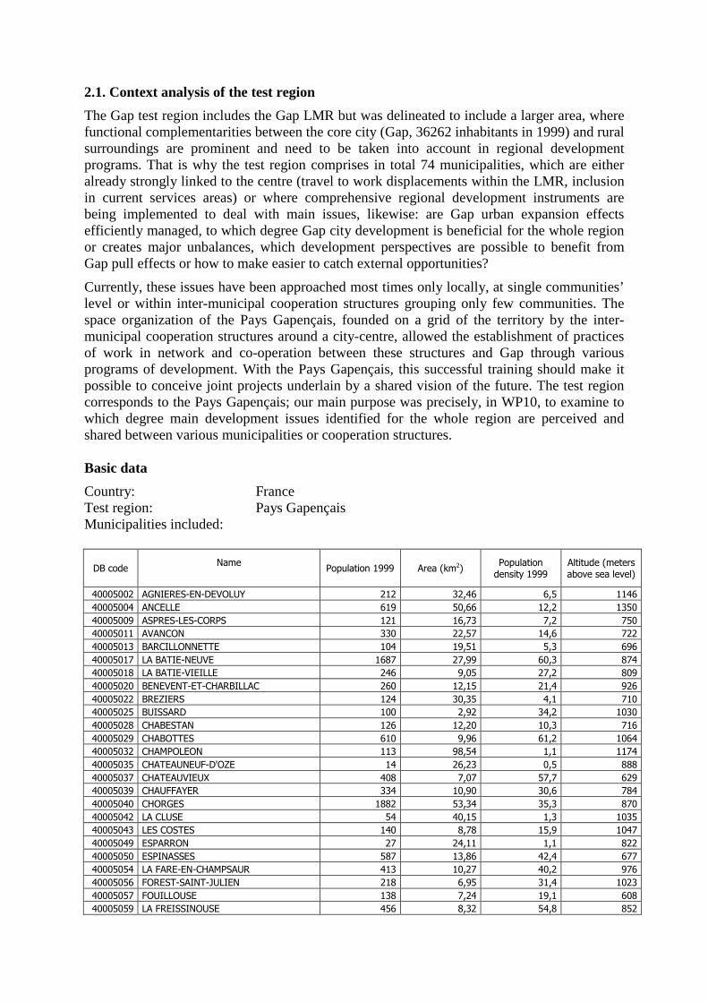
2.1. Context analysis of the test region
The Gap test region includes the Gap LMR but was delineated to include a larger area, where functional complementarities between the core city (Gap, 36262 inhabitants in 1999) and rural surroundings are prominent and need to be taken into account in regional development programs. That is why the test region comprises in total 74 municipalities, which are either already strongly linked to the centre (travel to work displacements within the LMR, inclusion in current services areas) or where comprehensive regional development instruments are being implemented to deal with main issues, likewise: are Gap urban expansion effects efficiently managed, to which degree Gap city development is beneficial for the whole region or creates major unbalances, which development perspectives are possible to benefit from Gap pull effects or how to make easier to catch external opportunities?
Currently, these issues have been approached most times only locally, at single communities’ level or within inter-municipal cooperation structures grouping only few communities. The space organization of the Pays Gapençais, founded on a grid of the territory by the inter-municipal cooperation structures around a city-centre, allowed the establishment of practices of work in network and co-operation between these structures and Gap through various programs of development. With the Pays Gapençais, this successful training should make it possible to conceive joint projects underlain by a shared vision of the future. The test region corresponds to the Pays Gapençais; our main purpose was precisely, in WP10, to examine to which degree main development issues identified for the whole region are perceived and shared between various municipalities or cooperation structures. Basic data
Country: France Test region: Pays Gapençais Municipalities included:
DB code Name
Population 1999 Area (km2) Population density 1999
Altitude (meters above sea level)
40005002 AGNIERES-EN-DEVOLUY 212 32,46 6,5 1146
40005004 ANCELLE 619 50,66 12,2 1350
40005009 ASPRES-LES-CORPS 121 16,73 7,2 750
40005011 AVANCON 330 22,57 14,6 722
40005013 BARCILLONNETTE 104 19,51 5,3 696
40005017 LA BATIE-NEUVE 1687 27,99 60,3 874
40005018 LA BATIE-VIEILLE 246 9,05 27,2 809
40005020 BENEVENT-ET-CHARBILLAC 260 12,15 21,4 926
40005022 BREZIERS 124 30,35 4,1 710
40005025 BUISSARD 100 2,92 34,2 1030
40005028 CHABESTAN 126 12,20 10,3 716
40005029 CHABOTTES 610 9,96 61,2 1064
40005032 CHAMPOLEON 113 98,54 1,1 1174
40005035 CHATEAUNEUF-D'OZE 14 26,23 0,5 888
40005037 CHATEAUVIEUX 408 7,07 57,7 629
40005039 CHAUFFAYER 334 10,90 30,6 784
40005040 CHORGES 1882 53,34 35,3 870
40005042 LA CLUSE 54 40,15 1,3 1035
40005043 LES COSTES 140 8,78 15,9 1047
40005049 ESPARRON 27 24,11 1,1 822
40005050 ESPINASSES 587 13,86 42,4 677
40005054 LA FARE-EN-CHAMPSAUR 413 10,27 40,2 976
40005056 FOREST-SAINT-JULIEN 218 6,95 31,4 1023
40005057 FOUILLOUSE 138 7,24 19,1 608
40005059 LA FREISSINOUSE 456 8,32 54,8 852
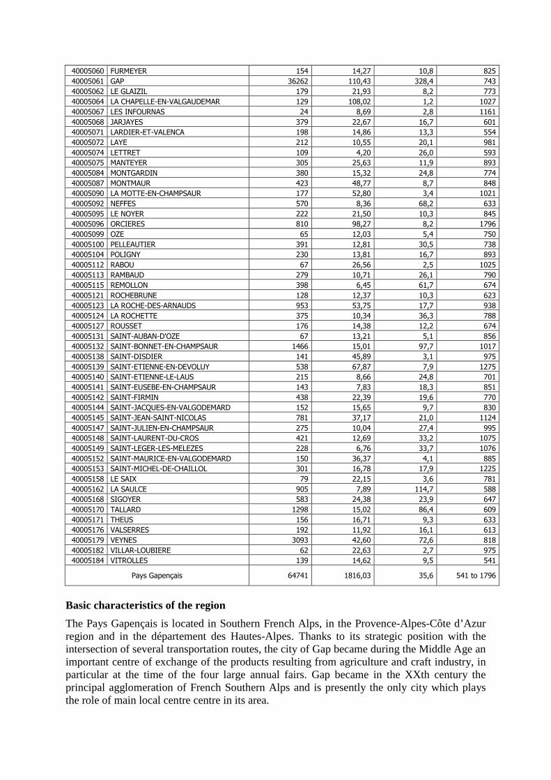
40005060 FURMEYER 154 14,27 10,8 825
40005061 GAP 36262 110,43 328,4 743
40005062 LE GLAIZIL 179 21,93 8,2 773
40005064 LA CHAPELLE-EN-VALGAUDEMAR 129 108,02 1,2 1027
40005067 LES INFOURNAS 24 8,69 2,8 1161
40005068 JARJAYES 379 22,67 16,7 601
40005071 LARDIER-ET-VALENCA 198 14,86 13,3 554
40005072 LAYE 212 10,55 20,1 981
40005074 LETTRET 109 4,20 26,0 593
40005075 MANTEYER 305 25,63 11,9 893
40005084 MONTGARDIN 380 15,32 24,8 774
40005087 MONTMAUR 423 48,77 8,7 848
40005090 LA MOTTE-EN-CHAMPSAUR 177 52,80 3,4 1021
40005092 NEFFES 570 8,36 68,2 633
40005095 LE NOYER 222 21,50 10,3 845
40005096 ORCIERES 810 98,27 8,2 1796
40005099 OZE 65 12,03 5,4 750
40005100 PELLEAUTIER 391 12,81 30,5 738
40005104 POLIGNY 230 13,81 16,7 893
40005112 RABOU 67 26,56 2,5 1025
40005113 RAMBAUD 279 10,71 26,1 790
40005115 REMOLLON 398 6,45 61,7 674
40005121 ROCHEBRUNE 128 12,37 10,3 623
40005123 LA ROCHE-DES-ARNAUDS 953 53,75 17,7 938
40005124 LA ROCHETTE 375 10,34 36,3 788
40005127 ROUSSET 176 14,38 12,2 674
40005131 SAINT-AUBAN-D'OZE 67 13,21 5,1 856
40005132 SAINT-BONNET-EN-CHAMPSAUR 1466 15,01 97,7 1017
40005138 SAINT-DISDIER 141 45,89 3,1 975
40005139 SAINT-ETIENNE-EN-DEVOLUY 538 67,87 7,9 1275
40005140 SAINT-ETIENNE-LE-LAUS 215 8,66 24,8 701
40005141 SAINT-EUSEBE-EN-CHAMPSAUR 143 7,83 18,3 851
40005142 SAINT-FIRMIN 438 22,39 19,6 770
40005144 SAINT-JACQUES-EN-VALGODEMARD 152 15,65 9,7 830
40005145 SAINT-JEAN-SAINT-NICOLAS 781 37,17 21,0 1124
40005147 SAINT-JULIEN-EN-CHAMPSAUR 275 10,04 27,4 995
40005148 SAINT-LAURENT-DU-CROS 421 12,69 33,2 1075
40005149 SAINT-LEGER-LES-MELEZES 228 6,76 33,7 1076
40005152 SAINT-MAURICE-EN-VALGODEMARD 150 36,37 4,1 885
40005153 SAINT-MICHEL-DE-CHAILLOL 301 16,78 17,9 1225
40005158 LE SAIX 79 22,15 3,6 781
40005162 LA SAULCE 905 7,89 114,7 588
40005168 SIGOYER 583 24,38 23,9 647
40005170 TALLARD 1298 15,02 86,4 609
40005171 THEUS 156 16,71 9,3 633
40005176 VALSERRES 192 11,92 16,1 613
40005179 VEYNES 3093 42,60 72,6 818
40005182 VILLAR-LOUBIERE 62 22,63 2,7 975
40005184 VITROLLES 139 14,62 9,5 541
Pays Gapençais 64741 1816,03 35,6 541 to 1796
Basic characteristics of the region
The Pays Gapençais is located in Southern French Alps, in the Provence-Alpes-Côte d’Azur region and in the département des Hautes-Alpes. Thanks to its strategic position with the intersection of several transportation routes, the city of Gap became during the Middle Age an important centre of exchange of the products resulting from agriculture and craft industry, in particular at the time of the four large annual fairs. Gap became in the XXth century the principal agglomeration of French Southern Alps and is presently the only city which plays the role of main local centre centre in its area.
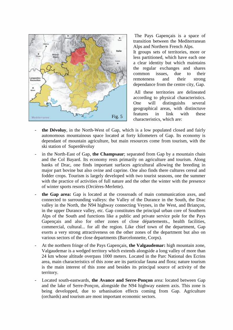
The Pays Gapençais is a space of transition between the Mediterranean Alps and Northern French Alps. It groups sets of territories, more or less partitioned, which have each one a clear identity but which maintains the regular exchanges and shares common issues, due to their remoteness and their strong dependance from the centre city, Gap.
All these territories are delineated according to physical characteristics. One will distinguishs several geographical areas, with distinctuve features in link with these characteristics, which are:
- the Dévoluy, in the North-West of Gap, which is a low populated closed and fairly autonomous mountainous space located at forty kilometers of Gap. Its economy is dependant of mountain agriculture, but main resources come from tourism, with the ski station of Superdévoluy
- in the North-East of Gap, the Champsaur; separated from Gap by a mountain chain and the Col Bayard. Its economy rests primarily on agriculture and tourism. Along banks of Drac, one finds important surfaces agricultural allowing the breeding in major part bovine but also ovine and caprine. One also finds there cultures cereal and fodder crops. Tourism is largely developed with two tourist seasons, one the summer with the practice of activities of full nature and the other the winter with the presence of winter sports resorts (Orcières-Merlette).
- the Gap area: Gap is located at the crossroads of main communication axes, and connected to surrounding valleys: the Valley of the Durance in the South, the Drac valley in the North, the N94 highway connecting Veynes, in the West, and Briançon, in the upper Durance valley, etc. Gap constitutes the principal urban core of Southern Alps of the South and functions like a public and private service pole for the Pays Gapençais and also for other zones of close départements., health facilities, commercial, cultural... for all the region. Like chief town of the department, Gap exerts a very strong attractiveness on the other zones of the department but also on various sectors of the close departments (Barcelonnette, Corps).
- At the northern fringe of the Pays Gapençais, the Valgaudemar: high mountain zone, Valgaudemar is a wedged territory which extends alongside a long valley of more than 24 km whose altitude overpass 1000 meters. Located in the Parc National des Ecrins area, main characteristics of this zone are its particular fauna and flora; nature tourism is the main interest of this zone and besides its principal source of activity of the territory.
- Located south-eastwards, the Avance and Serre-Ponçon area: located between Gap and the lake of Serre-Ponçon, alongside the N94 highway eastern axis. This zone is being developped, due to urbanisation effects coming from Gap. Agriculture (orchards) and tourism are most important economic sectors.
Fig. 5
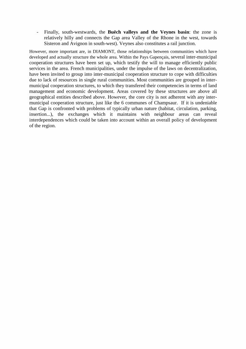
- Finally, south-westwards, the Buëch valleys and the Veynes basin: the zone is relatively hilly and connects the Gap area Valley of the Rhone in the west, towards Sisteron and Avignon in south-west). Veynes also constitutes a rail junction.
However, more important are, in DIAMONT, those relationships between communities which have developed and actually structure the whole area. Within the Pays Gapençais, several inter-municipal cooperation structures have been set up, which testify the will to manage efficiently public services in the area. French municipalities, under the impulse of the laws on decentralization, have been invited to group into inter-municipal cooperation structure to cope with difficulties due to lack of resources in single rural communities. Most communities are grouped in inter-municipal cooperation structures, to which they transfered their competencies in terms of land management and economic development. Areas covered by these structures are above all geographical entities described above. However, the core city is not adherent with any inter-municipal cooperation structure, just like the 6 communes of Champsaur. If it is undeniable that Gap is confronted with problems of typically urban nature (habitat, circulation, parking, insertion...), the exchanges which it maintains with neighbour areas can reveal interdependences which could be taken into account within an overall policy of development of the region.
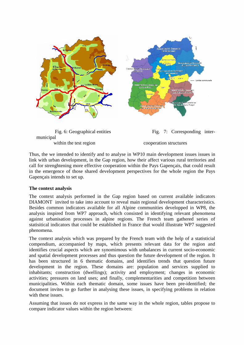
Fig. 6: Geographical entities Fig. 7: Corresponding inter-municipal within the test region cooperation structures
Thus, the we intended to identify and to analyse in WP10 main development issues issues in link with urban development, in the Gap region, how their affect various rural territories and call for strenghtening more effective cooperation within the Pays Gapençais, that could result in the emergence of those shared development perspectives for the whole region the Pays Gapençais intends to set up. The context analysis
The context analysis performed in the Gap region based on current available indicators DIAMONT invited to take into account to reveal main regional development characteristics. Besides common indicators available for all Alpine communities developped in WP8, the analysis inspired from WP7 approach, which consisted in identifying relevant phenomena against urbanisation processes in alpine regions. The French team gathered series of statisitical indicators that could be established in France that would illustrate WP7 suggested phenomena.
The context analysis which was prepared by the French team with the help of a statisticial compendium, accompanied by maps, which presents relevant data for the region and identifies crucial aspects which are synomimous with unbalances in current socio-economic and spatial development processes and thus question the future development of the region. It has been structured in 6 thematic domains, and identifies trends that question future development in the region. These domains are: population and services supplied to inhabitants; construction (dwellings); activity and employment; changes in economic activities; pressures on land uses; and finally, complementarities and competition between municipalities. Within each thematic domain, some issues have been pre-identified; the document invites to go further in analysing these issues, in specifying problems in relation with these issues.
Assuming that issues do not express in the same way in the whole region, tables propose to compare indicator values within the region between:
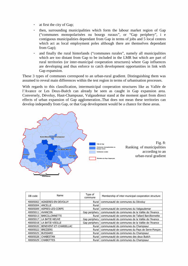
- at first the city of Gap;
- then, surrounding municipalities which form the labour market region of Gap (“communes monopolarisées ou bourgs ruraux”, or “Gap periphery”, i e contiguous municipalities dependant from Gap in terms of jobs and 5 local centres which act as local employment poles although there are themselves dependant from Gap);
- and finally the rural hinterlands (“communes rurales”, namely all municipalities which are too distant from Gap to be included in the LMR but which are part of rural territories (or inter-municipal cooperation structures) where Gap influences are developing and thus enforce to catch development opportunities in link with Gap expansion.
These 3 types of communes correspond to an urban-rural gradient. Distinguishing them was assumed to reveal main differences within the test region in terms of urbanisation processes.
With regards to this classification, intermunicipal cooperation structures like as Vallée de l’Avance or Les Deux-Buëch can already be seen as caught in Gap expansion area. Conversely, Dévoluy, Haut-Champsaur, Valgaudemar stand at the moment apart from direct effects of urban expansion of Gap agglomeration..That does not mean these territories can develop independly from Gap, or that Gap development would be a chance for these areas.
Fig. 8: Ranking of municipalities
according to an urban-rural gradient
DB code Name Type of commune
Membership of inter-municipal cooperation structure
40005002 AGNIERES-EN-DEVOLUY Rural communauté de communes du Dévoluy
40005004 ANCELLE Rural
40005009 ASPRES-LES-CORPS Rural communauté de communes du Valgaudemar
40005011 AVANCON Gap periphery communauté de communes de la Vallée de l'Avance
40005013 BARCILLONNETTE Rural communauté de communes de Tallard Barcillonnette
40005017 LA BATIE-NEUVE Gap periphery communauté de communes de la Vallée de l'Avance
40005018 LA BATIE-VIEILLE Gap periphery communauté de communes de la Vallée de l'Avance
40005020 BENEVENT-ET-CHARBILLAC Rural communauté de communes du Champsaur
40005022 BREZIERS Rural communauté de communes du Pays de Serre-Ponçon
40005025 BUISSARD Rural communauté de communes du Champsaur
40005028 CHABESTAN Rural communauté de communes des deux Buëch
40005029 CHABOTTES Rural communauté de communes du Champsaur
20
Kilomètres
100
TallardTallardTallardTallardTallardTallardTallardTallardTallard
VeynesVeynesVeynesVeynesVeynesVeynesVeynesVeynesVeynes
Saint-Bonnet-en-ChampsaurSaint-Bonnet-en-ChampsaurSaint-Bonnet-en-ChampsaurSaint-Bonnet-en-ChampsaurSaint-Bonnet-en-ChampsaurSaint-Bonnet-en-ChampsaurSaint-Bonnet-en-ChampsaurSaint-Bonnet-en-ChampsaurSaint-Bonnet-en-Champsaur
La Bâtie-NeuveLa Bâtie-NeuveLa Bâtie-NeuveLa Bâtie-NeuveLa Bâtie-NeuveLa Bâtie-NeuveLa Bâtie-NeuveLa Bâtie-NeuveLa Bâtie-Neuve
ChorgesChorgesChorgesChorgesChorgesChorgesChorgesChorgesChorges
GapGapGapGapGapGapGapGapGap
Périmètre du Pays Gapençais
Communes rurales
Communes monopolarisées ou bourgs ruraux
V ille de Gap
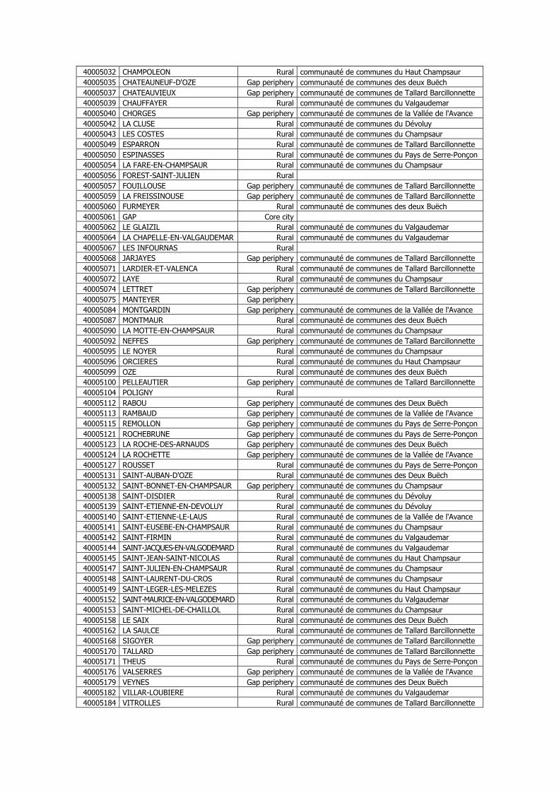
40005032 CHAMPOLEON Rural communauté de communes du Haut Champsaur
40005035 CHATEAUNEUF-D'OZE Gap periphery communauté de communes des deux Buëch
40005037 CHATEAUVIEUX Gap periphery communauté de communes de Tallard Barcillonnette
40005039 CHAUFFAYER Rural communauté de communes du Valgaudemar
40005040 CHORGES Gap periphery communauté de communes de la Vallée de l'Avance
40005042 LA CLUSE Rural communauté de communes du Dévoluy
40005043 LES COSTES Rural communauté de communes du Champsaur
40005049 ESPARRON Rural communauté de communes de Tallard Barcillonnette
40005050 ESPINASSES Rural communauté de communes du Pays de Serre-Ponçon
40005054 LA FARE-EN-CHAMPSAUR Rural communauté de communes du Champsaur
40005056 FOREST-SAINT-JULIEN Rural
40005057 FOUILLOUSE Gap periphery communauté de communes de Tallard Barcillonnette
40005059 LA FREISSINOUSE Gap periphery communauté de communes de Tallard Barcillonnette
40005060 FURMEYER Rural communauté de communes des deux Buëch
40005061 GAP Core city
40005062 LE GLAIZIL Rural communauté de communes du Valgaudemar
40005064 LA CHAPELLE-EN-VALGAUDEMAR Rural communauté de communes du Valgaudemar
40005067 LES INFOURNAS Rural
40005068 JARJAYES Gap periphery communauté de communes de Tallard Barcillonnette
40005071 LARDIER-ET-VALENCA Rural communauté de communes de Tallard Barcillonnette
40005072 LAYE Rural communauté de communes du Champsaur
40005074 LETTRET Gap periphery communauté de communes de Tallard Barcillonnette
40005075 MANTEYER Gap periphery
40005084 MONTGARDIN Gap periphery communauté de communes de la Vallée de l'Avance
40005087 MONTMAUR Rural communauté de communes des deux Buëch
40005090 LA MOTTE-EN-CHAMPSAUR Rural communauté de communes du Champsaur
40005092 NEFFES Gap periphery communauté de communes de Tallard Barcillonnette
40005095 LE NOYER Rural communauté de communes du Champsaur
40005096 ORCIERES Rural communauté de communes du Haut Champsaur
40005099 OZE Rural communauté de communes des deux Buëch
40005100 PELLEAUTIER Gap periphery communauté de communes de Tallard Barcillonnette
40005104 POLIGNY Rural
40005112 RABOU Gap periphery communauté de communes des Deux Buëch
40005113 RAMBAUD Gap periphery communauté de communes de la Vallée de l'Avance
40005115 REMOLLON Gap periphery communauté de communes du Pays de Serre-Ponçon
40005121 ROCHEBRUNE Gap periphery communauté de communes du Pays de Serre-Ponçon
40005123 LA ROCHE-DES-ARNAUDS Gap periphery communauté de communes des Deux Buëch
40005124 LA ROCHETTE Gap periphery communauté de communes de la Vallée de l'Avance
40005127 ROUSSET Rural communauté de communes du Pays de Serre-Ponçon
40005131 SAINT-AUBAN-D'OZE Rural communauté de communes des Deux Buëch
40005132 SAINT-BONNET-EN-CHAMPSAUR Gap periphery communauté de communes du Champsaur
40005138 SAINT-DISDIER Rural communauté de communes du Dévoluy
40005139 SAINT-ETIENNE-EN-DEVOLUY Rural communauté de communes du Dévoluy
40005140 SAINT-ETIENNE-LE-LAUS Rural communauté de communes de la Vallée de l'Avance
40005141 SAINT-EUSEBE-EN-CHAMPSAUR Rural communauté de communes du Champsaur
40005142 SAINT-FIRMIN Rural communauté de communes du Valgaudemar
40005144 SAINT-JACQUES-EN-VALGODEMARD Rural communauté de communes du Valgaudemar
40005145 SAINT-JEAN-SAINT-NICOLAS Rural communauté de communes du Haut Champsaur
40005147 SAINT-JULIEN-EN-CHAMPSAUR Rural communauté de communes du Champsaur
40005148 SAINT-LAURENT-DU-CROS Rural communauté de communes du Champsaur
40005149 SAINT-LEGER-LES-MELEZES Rural communauté de communes du Haut Champsaur
40005152 SAINT-MAURICE-EN-VALGODEMARD Rural communauté de communes du Valgaudemar
40005153 SAINT-MICHEL-DE-CHAILLOL Rural communauté de communes du Champsaur
40005158 LE SAIX Rural communauté de communes des Deux Buëch
40005162 LA SAULCE Rural communauté de communes de Tallard Barcillonnette
40005168 SIGOYER Gap periphery communauté de communes de Tallard Barcillonnette
40005170 TALLARD Gap periphery communauté de communes de Tallard Barcillonnette
40005171 THEUS Rural communauté de communes du Pays de Serre-Ponçon
40005176 VALSERRES Gap periphery communauté de communes de la Vallée de l'Avance
40005179 VEYNES Gap periphery communauté de communes des Deux Buëch
40005182 VILLAR-LOUBIERE Rural communauté de communes du Valgaudemar
40005184 VITROLLES Rural communauté de communes de Tallard Barcillonnette
Main results of the context analysis The appendix presents main elements of the statistical compendium on which the context analysis was based. Some indicators are WP8 indicators, even when their presentation has been changed or has been adapted (for example, employment rates concern persons aged between 15 and 64 years, to fit with current Eurostat definitions); some indicators inspire from WP7 proposals (for example, distinctions between high tech and traditional industries), other indicators are ‘national’ and thus have no equivalent in DIAMONT. Most important indicators have been mapped. This compendium is an extract of the document sent to participants of the workshop.
Main development characteristics illustrated by these indicators are summarized below and are interpreted in terms of strengths and weaknesses against socio-economic and spatial development of the region.
Population and services � With regard to demographic trends, most indicators reveal active development of the
zone, although its concerns above all the core city and its periphery. Population increases are mainly due to in-migration flows. However indicators reveal that the rates of arrivals of new residents are less important in the region than in the whole French Alps. In fact, departures overpass arrivals for persons aged 15-24; students must leave the region. They are more balanced for persons aged 25-29; for persons aged 30-39 or 40-59, arrivals are more important. Thus the region is marked be a rather selective attractiveness, focused on certain age groups. Population is ageing, but since in-migration flows concern amongst others young families, population increases are not focused on older persons.
� In terms of service supply, indicators (services per inhabitant) do not reveal major unbalances with regards to population figures in the region taken as a whole. Besides, employment in trade or current services is developing. However, services activities concentrate in Gap, and are less developed in rural municipalities, where access of current services makes inhabitants dependent from private transportation.
Housings � In terms of housing provision, there has been an important increase in main homes,
due to two main factors: on one hand, demographic growth, on the other hand, reduction in the average number of occupants per main home. Although outside Gap, most main homes are semi-detached houses, there has been an increase in the number of flats and in rented houses in Gap. In more distant communities, most houses are second homes, without noticeable increase in their number.
Activity and employment � There has been an increase of active population up to 2000, in link with arrivals of
adults and in the same time a rise in activity rates for women who sought paid jobs. These trends are especially marked in rural communities than in Gap or in its periphery. Like in most French alpine rural areas, unemployment rates for young adults who keep staying in the region are high.
� The indicators reveal important increase up to 2000 in jobs in the region, except in rural remote communes. It results above in a development of female employment, but also in a decrease of the share of full-time jobs. Thus the region is faced with jobs precarity. In recent years (2000-2004), paid jobs grew appreciably, in particular in rural communes: the zone was particularly dynamic, whereas before, the trends
were similar to those observed in the whole French Alps. Due to differences in location of residence and of jobs, travel to work displacements are increasing. These flows concern above all the Gap periphery, where less than 40% of residents work in the same commune.Gap residents work more commonly in their commune.
� Most important economic activities are current private or public services, while the secondary sector has little importance. Within services activities, business related services are low developed, while tourism is the main economic sector in certain rural communes located outside Gap and its periphery. High added value companies or services are still not important in the region, although they are developing. Thus residential services are the mainstream in economic activities, although agriculture and tourism have a certain importance in the region.
Pressure on land use � In comparison with the whole of the French Alps, built-up areas or urbanized
territories count for little in the region. Agriculture areas are the main space occupation around Gap, whereas forest and semi-natural areas are prominent in more distant communes. Alhtough land cover changes slowly, the tendency was a slight retreat in agriculture areas, in link with further land consumption by construction and infrastructure in the centre of the region, and in link with further forest extension in mountain areas.
� However, no indicator is precise enough to reveal to which degree pressures on land use in link with development and urbanisation processes resulted in further space consumption. Agriculture holdings are more and more professional; indicators do not reveal significiant decrease in utilised agriculture area, exept for arable land in certain communes. Since construction, setting up new activities and infrastructure is more active in Gap and its periphery, there is possibly a risk those factors will result in further space consumption, but land reserves look still important.
Cooperation between communities � Since most communes take already part in cooperation structures, few indicators were
developped aimed at highlighting differences in tax resources which could be an obstacle with an increased cooperation between communes. In fact, they revealed important differences within the region; rates of taxes on dwellings are higher in Gap than in peripehral communes. Indicators did not help in analysing in-depht inter-municipal cooperation issues, but invited to reflect on the multiplicity and the efficiency of still existing cooperation structures.
Further elements for a SWOT analysis
Departing from the context analysis, WP10 asked partners to complete a SWOT analysis, underscoring main strengths and weaknesses of the region and identifying opportunities to catch in the future and threats to which development will be faced. The indicator-based context analysis helped to reveal some important characteristics of development processes, but since DIAMONT indicators proved insufficient to analyse in depth development issues in the test region, even when reducing the analysis to those issues which are in link with urbanisation processes or urban land take, the French team proposed to base on a previous study of the region which intended to fix and rank development objectives in the region. Although this study, completed by a private company, ARCADEO, in 2003-2004 was criticized in times since its conclusions and priorities set up were not so far discussed, it included a SWOT analysis based mainly on qualitative information. Thus it was felt relevant
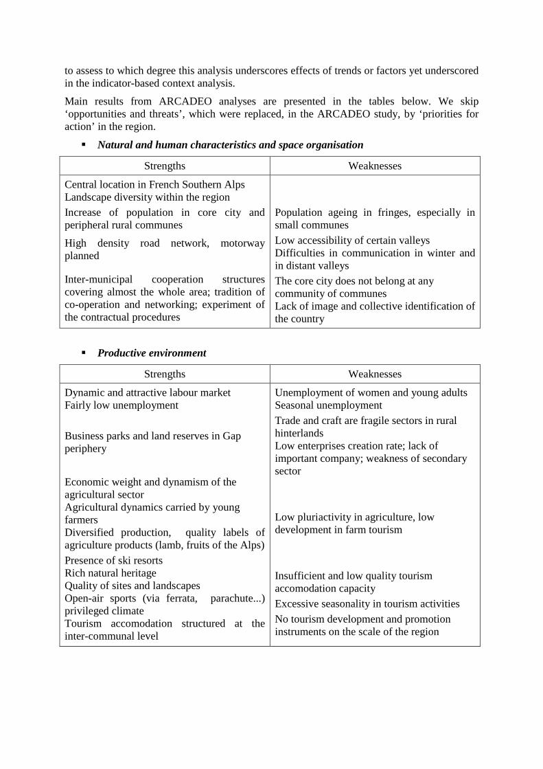
to assess to which degree this analysis underscores effects of trends or factors yet underscored in the indicator-based context analysis.
Main results from ARCADEO analyses are presented in the tables below. We skip ‘opportunities and threats’, which were replaced, in the ARCADEO study, by ‘priorities for action’ in the region.
� Natural and human characteristics and space organisation
Strengths Weaknesses
Central location in French Southern Alps Landscape diversity within the region Increase of population in core city and peripheral rural communes
High density road network, motorway planned
Inter-municipal cooperation structures covering almost the whole area; tradition of co-operation and networking; experiment of the contractual procedures
Population ageing in fringes, especially in small communes
Low accessibility of certain valleys Difficulties in communication in winter and in distant valleys
The core city does not belong at any community of communes Lack of image and collective identification of the country
� Productive environment
Strengths Weaknesses
Dynamic and attractive labour market Fairly low unemployment
Business parks and land reserves in Gap periphery
Economic weight and dynamism of the agricultural sector Agricultural dynamics carried by young farmers Diversified production, quality labels of agriculture products (lamb, fruits of the Alps)
Presence of ski resorts Rich natural heritage Quality of sites and landscapes Open-air sports (via ferrata, parachute...) privileged climate Tourism accomodation structured at the inter-communal level
Unemployment of women and young adults Seasonal unemployment
Trade and craft are fragile sectors in rural hinterlands Low enterprises creation rate; lack of important company; weakness of secondary sector
Low pluriactivity in agriculture, low development in farm tourism
Insufficient and low quality tourism accomodation capacity
Excessive seasonality in tourism activities
No tourism development and promotion instruments on the scale of the region
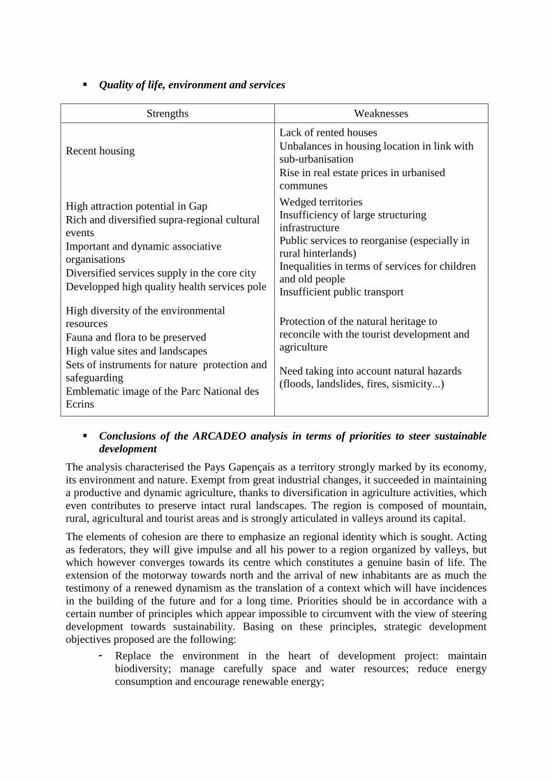
� Quality of life, environment and services
Strengths Weaknesses
Recent housing
High attraction potential in Gap Rich and diversified supra-regional cultural events Important and dynamic associative organisations Diversified services supply in the core city Developped high quality health services pole
High diversity of the environmental resources Fauna and flora to be preserved High value sites and landscapes Sets of instruments for nature protection and safeguarding Emblematic image of the Parc National des Ecrins
Lack of rented houses Unbalances in housing location in link with sub-urbanisation Rise in real estate prices in urbanised communes
Wedged territories Insufficiency of large structuring infrastructure Public services to reorganise (especially in rural hinterlands) Inequalities in terms of services for children and old people Insufficient public transport
Protection of the natural heritage to reconcile with the tourist development and agriculture
Need taking into account natural hazards (floods, landslides, fires, sismicity...)
� Conclusions of the ARCADEO analysis in terms of priorities to steer sustainable
development
The analysis characterised the Pays Gapençais as a territory strongly marked by its economy, its environment and nature. Exempt from great industrial changes, it succeeded in maintaining a productive and dynamic agriculture, thanks to diversification in agriculture activities, which even contributes to preserve intact rural landscapes. The region is composed of mountain, rural, agricultural and tourist areas and is strongly articulated in valleys around its capital.
The elements of cohesion are there to emphasize an regional identity which is sought. Acting as federators, they will give impulse and all his power to a region organized by valleys, but which however converges towards its centre which constitutes a genuine basin of life. The extension of the motorway towards north and the arrival of new inhabitants are as much the testimony of a renewed dynamism as the translation of a context which will have incidences in the building of the future and for a long time. Priorities should be in accordance with a certain number of principles which appear impossible to circumvent with the view of steering development towards sustainability. Basing on these principles, strategic development objectives proposed are the following:
- Replace the environment in the heart of development project: maintain biodiversity; manage carefully space and water resources; reduce energy consumption and encourage renewable energy;
- Promote sustainable economic development in the whole region: create conditions for a balanced and unified development of the territory of the region; implement coherent development and economic promotion instruments on the scale of the region; give effective support to local trade and craft in rural communes; strengthen agriculture and forest activities;
- Steer tourism development towards sustainability: privilege diversification in tourism activities; perpetuate the tourist attractiveness;
- Maintain quality of life with the view of sustainability: keep public services and services open to inhabitants in rural territories to guarantee access to high quality services; set up social policies taking into account the specificities of the region and which consolidates residential activity branches; better identify and develop housing provision possibilities; make easier displacements within the region; ensure cultural and sporting vitality in the region.
2.2 Preparation of the workshop
Once the test region was selected and the context analysis was prepared, the first workshop preparation could enter in an active phase. The main concern was to find an agreement with local representatives (persons and organisms in charge of regional development and planning instruments in the region) on the aims of the workshop, the expected results and the way in which DIAMONT could renew their own approach of sustainable development.
In fact, flowing contacts initiated since March 2007 with various bodies in charge of implementing regional development instruments (Gap municipality, State civil servants, regional planners, etc), we succeeded getting support for the exercise from the Comité du Pays Gapençais, insofar we proposed to develop an indicator-based analytic approach, based on DIAMONT experience, that would help in identifying main development issues in the test region. Although it was suggested in WP10 to focus on those instruments that were analysed in WP9 and/or to detect which conflicts hinder development sustainability in the test regions, we decided to focus the first workshop on those issues to deal with in steering sustainable development in a city-centred region, assuming a precondition for an efficient implementation of possible RD instruments was a correct and shared perception of development issues in the whole region.
In this context, the Comité du Pays Gapençais accepted to support our exercise since it would meet his own objectives, namely setting up a common development strategy that could be accepted in the whole region by local authorities, in Gap and as well in the rural hinterlands. The Comité de Pays was especially interested on the indicator-based approach, and on phenomena which were identified in WP7 as relevant against urbanisation in the Alps. However, since we were aware that the context analysis based on indicators would results in identifying only those general issues (that could be indicated roughly), we did not propose to assess the relevance of the context analysis, but to launch a general analysis on main issues that are perceived in the region, assuming the indicators would help to initiate an analysis that would be stepwise deepened and supplemented by qualitative information and experiences gained by participants in the workshop.
2.2.1 The organisational aspects of the workshop
The workshop was held on Tuesday, 3rd of July 2007, in the Château de Charance in Gap, thanks to the courtesy of Gap municipality. Preparation phase came to and end with sending end of June documents to participants (the context analysis in form of ‘indicator based diagnosis of the test region’, maps, documents presenting DIAMONT and expectations for the
workshop) that were invited by the Comité du Pays Gapençais. Invitations were sent to about 60 persons, the date of the workshop had to be delayed due to elections in France which disturbed work schedules of organizations in which take part elected officials.
According to word café method principles, discussions were organised in four thematic rounds led in parallel, each of them dealing with a general topic, afterwards Cemagref introduced the workshop:
- Impacts of demographic changes on the allocation and the spatial distribution of current services for inhabitants and on housing provision;
- Employment generation opportunities and change in economic activities;
- Pressures on land use in relation with social and economic development;
- And finally, ways to improve cooperation between municipalities to set up a shared development strategy for the whole region.
To organise the discussions, participants were distributed in four groups, which succeeded one another for each topic. Each discussion round (one group – one topic) lasted 30 to 40 minutes; a moderator assigned to each topic was in charge of copying out on ‘post-it’ main ideas developed by the group and to present them to the following group, before summing up the debates at the end of the discussions rounds and presenting the conclusions to the whole audience.
Participants prepared the debates with the helps of documents sent before the meeting. These documents dealt with the main aims of the test and proposed to stimulate discussions starting from an indicator based diagnosis prepared by Cemagref, structured in abovementioned topics. More precisely, participants were invited to react on the following aspects:
- At first, strengths or weaknesses of the proposed indicators
Cemagref calculated and mapped indicators coming from WP8 or inspired from WP7 proposals and focusing on phenomena assigned to main trend urbanisation. How far they contribute to identify important issues for the region, in the related topic? Which other indicators should be desirable?
- Second, specifying problems in link with identified development issues against the topic
Cemagref proposed interpretations of differences in indicator values that could reveal possible problems, participants had to go more in depth in assessing to which degree conclusions driven from indicators are realistic and how the indicator based approach paves the way for specifying in concrete terms which problems municipalities are faced to.
- And finally, possible solutions to cope with problems specified Participants had to discuss on instruments to implement and on needed conditions to implement them successfully. 2.2.2 The atmosphere
According to this programme, the first workshop was a real success in the sense we feared there would be less participants or they would re-open conflicting discussions without clear conclusions. Nobody left the séance. Furthermore, they appreciated the lunch which was offered at the end of the meeting. Even when opinions diverged, participants discussed freely and considered divergences revealed different facets of problems which are nowhere similar. Some operative conclusions were drawn from the debates, notably about indicators (how to map them, how to supplement them, which indicators should be analysed simultaneously), but main results consisted in deepening the analysis of the current status quo of the region,
identifying factors which results in problems and aspects which call for efficient solutions through promising instruments which are low implemented at the moment
2.3 List of selected instruments
Main instrument analysed in the workshop was, obviously, the Pays Gapençais and the inter-municipal co-operation structures, but the main purpose was to deal with most urgent questions in the test region and to bind those questions with existing instruments. Discussions helped to identify which instrument can help to cope with problems specified and with aspects or specific objectives are to be taken into account in their implementation in the test region.
� The Pays The Pays were created by the Outline Act on Land Planning and Sustainable Development (Voynet law) of June 25th, 1999 and were set up in response to the national government’s desire to sustain land development and planning policy within the country based on sub-units with real geographic, economic and human relevance. The Pays are not a new administrative district; each Pays, through its managing authority (Comité de Pays) has to draw up a charter which is a contact signed on the one hand by the communes and inter-municipal co-operation structures, on the other hand by the State and administrative region, defining the local strategy as regards socio-economic development, spatial management and service structuring. The charter defines the operational terms by which the development strategic objectives will be pursued and guarantees the communes funding from the State and region for all implementation. By this way, the Pays will make it possible to lead a common reflexion, on a relevant scale for certain projects. The Pays associates, on the basis of voluntariate, elected officials, socio-professional and associative of all the territory in order to define project of a strong, coherent and interdependent development between the various economic sectors and the various geographical areas. The Pays has a role of impulse, animation and coordination of the local initiatives which must lead to the establishment and the implementation of a project of for the region. It makes it possible to engage of the projects and mutualiser means, in particular financial and human.
� Planning instruments evoked In the course of the workshop, various formal spatial planning instruments were evoked, on which participants eventually reacted. Examples of these instruments are: at first, the local urban planning document, then the local housing programs, the local displacements plans, without forgetting the most comprehensive regional planning instrument, the Regional Integrated Development plan, which is still in the limbo in the test region.
� Other instruments Participants did not fail to mention some economic or cooperation instruments or development tools that have been yet implemented in the region. Besides the inter-municipal cooperation structures, a particular attention was paid to the Leader + program Gapençais-Buëch-Durance, to the Pacte Territorial pour l’Emploi Gapençais-Drac-Buëch-Durance (territorial pact for employment), and to the Plan Local pour l’Insertion et l’Emploi des Hautes-Alpes, which is intended to help persons in finding jobs. Note that although this instrument is not implemented in the test region, Local Agenda 21 could have been in the focus of the workshop.
2.4 List of stakeholders
21 participants attended the meeting. They are listed in the table below. The animation of the meeting was carried out by Cemagref (V. Briquel, E. Felix-Faure) and the Terriscope bureau (S. Billet) which was committed by Cemagref to support the French team WP10 activities.
Institution Name - Function
Marie de Gap Mr D’Amato, Vice-mayor Mr Morel , Mme Reynaud, municipal services (economic development, land management)
National Forest services - Hautes-Alpes Mr Gauthier (Natura 2000 zones)
Pays Gapençais Mr Dusserre, President (mayor of Saint-Bonnet-en-Champsaur) Mr Saint-Aman, Director MM Rispaud, Quiblier, Guibert, Chaume (Chamber of agriculture), Conseil de Développement du Pays Gapençais
AREREF (regional association for employment and training in rural communes)
Mr Morgues-Débat, Melle Manhès
Parc National des Ecrins Mme Garin (lcoal development), Mr Cortot (scientific service)
Comité d’Expansion des Hautes-Alpes Mr Marchello, Mmes Roulée (Leader + projects), Valette
Communauté de communes du Dévoluy Mme Bonneau
Communauté de communes des Deux-Buëch
Mme Eyraud (mayor of Saint-Jean-Saint-Nicolas)
Communauté de communes du Haut-Champsaur
Mr Ricou
Conservatoire National Botanique Alpin Mme Gardet
2.5 Structure and agenda of the workshop
Main topics addressed in the workshop have been presented in 6.2.1. We give here further details:
� Agenda:
9.00 to 9.30: introduction (V. Briquel) - DIAMONT presentation, aims of the workshop, organisational aspects
9.30 to 11.00: four thematic rounds in parallel
- Demographic development and related issues (service supply and allocation, changes in demand, managing housing provision in the region) – Moderation: V. Briquel (Cemagref);
- Jobs generation and changes in economic activities (quality of jobs, increase in travel to work displacements, potentials of main sectors for economic development) - Moderation: E. Felix-Faure (Cemagref);
- Pressures on land resources in link with economic development (factors that can result in higher pressures and possibly in changes in land occupations) – moderation : S. Billet (Terriscope);
- Ways to stimulate cooperation between communes (diversity and efficiency in existing cooperation structures) – Moderation : J. Saint-Aman (Pays Gapençais).
11.00 to 11.30: coffee break
11.30 to 12.30: conclusions of the meeting (with regards to indicators, problems identified and instruments that could give responses to identified problems)
The meeting was followed by a lunch offered to participants.
� Selection of questions addressed in the workshop
In the thematic fields that have been discussed in the successive table rounds, we wanted to focus on those issues that are prominent and well perceived in the region, even when they concern only some communes. These issues have been evoked in previous studies, as for example the ARCADEO analysis. We proposed to depart from our own conclusions drawn from the context analysis (‘in desk conclusions’) which identified some questions in link with development trends, assuming that important differences in indicator values between the test region and the whole French Alps, and possibly within the test region, would mean oppositions between favourable and unfavourable developments. Thus participants in the workshop were asked to react on certain statements proposed by Cemagref, which identified possible problem fields. As a start point for the discussions, they were invited to assess their relevance, and above all to specify and identify which factors are responsible for problems and how these problems are perceived: workshop discussions were initiated by preliminary questions which emerged from the context analysis
For example, with regards to demographic development and related issues, Cemagref questioned participants at first on the continuation in the future of current demographic growth and on undesirable effects of increasing unbalances in age structure, in terms of demand for services for ageing population and relocation of services in easy access areas. With regards to housing provision, Cemagref questioned on possible bottlenecks since building new houses is not possible everywhere, rise in real estate prices results in social segregation and more and more distant locations, and besides there is demand for second homes (which may compete in certain communes with main homes), although in last years the tendency was to convert second homes in main homes.
Concerning employment and economic activities, Cemagref questioned on further rise in employment rate, since differences in employment rates between men and women are being made up, and on possibilities to propose more qualified jobs since low jobs qualification did not diminish the attractiveness of the region. Cemagref questioned also on the need to diversify economic activities, since they proved efficient in creating jobs in response to local demand for services.
Concerning pressures on land resources, since the indicators could not identify precisely important tensions, Cemagref introduced the discussions in evoking risks of abandonment of agriculture land pieces in the region in relation with rationalizing production methods and in asking to which degree agriculture land consumption is seen as a real concern in the region, since land resources are abundant.
Finally, with regards to inter-municipal cooperation issues, Cemagref launched the discussions with the help of various questions concerning possible obstacles to a fruitful
cooperation, and above all, the necessity to develop cooperation since existing cooperation structures do not call for more links between them and with the core city.
Note that questions addressed in the workshop have been prepared in a pre-test carried out in another region, the Albertville basin. To prepare the workshop and to assess to which degree topics addressed and questions to discuss were clearly understood by participants and were relevant, Cemagref completed, in parallel with the Gap exercise preparation, a draft exercise for the Albertville basin including a shorter context analysis and a first identification of possible problem fields, based on the context analysis. This pre-test was finalised in a working session held in Albertville beginning of June, which helped in re-formulating unclear questions and in identifying possible first reactions on the method and on documents prepared. Participants were, besides the Cemagref team and the Terriscope bureau, two local stakeholders: Mme Letinois, Director of the Syndicat Arlysère, and Mme Baccari, project leader for sustainable development in the same organisation. The Syndicat Arlysère is an inter-municipal cooperation structure, in charge of local development in the Albertville basin. This structure initiated a local Agenda 21 project and paid especially attention to aspects like public awareness and better communication to steer sustainable development in the Albertville region.
2.7. Revised answers
See tables below.
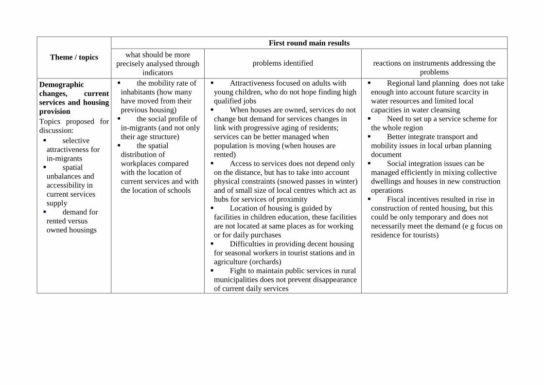
First round main results
Theme / topics what should be more precisely analysed through
indicators problems identified reactions on instruments addressing the
problems
Demographic changes, current services and housing provision Topics proposed for discussion: � selective attractiveness for in-migrants � spatial unbalances and accessibility in current services supply � demand for rented versus owned housings
� the mobility rate of inhabitants (how many have moved from their previous housing) � the social profile of in-migrants (and not only their age structure) � the spatial distribution of workplaces compared with the location of current services and with the location of schools
� Attractiveness focused on adults with young children, who do not hope finding high qualified jobs � When houses are owned, services do not change but demand for services changes in link with progressive aging of residents; services can be better managed when population is moving (when houses are rented) � Access to services does not depend only on the distance, but has to take into account physical constraints (snowed passes in winter) and of small size of local centres which act as hubs for services of proximity � Location of housing is guided by facilities in children education, these facilities are not located at same places as for working or for daily purchases � Difficulties in providing decent housing for seasonal workers in tourist stations and in agriculture (orchards) � Fight to maintain public services in rural municipalities does not prevent disappearance of current daily services
� Regional land planning does not take enough into account future scarcity in water resources and limited local capacities in water cleansing � Need to set up a service scheme for the whole region � Better integrate transport and mobility issues in local urban planning document � Social integration issues can be managed efficiently in mixing collective dwellings and houses in new construction operations � Fiscal incentives resulted in rise in construction of rented housing, but this could be only temporary and does not necessarily meet the demand (e g focus on residence for tourists)
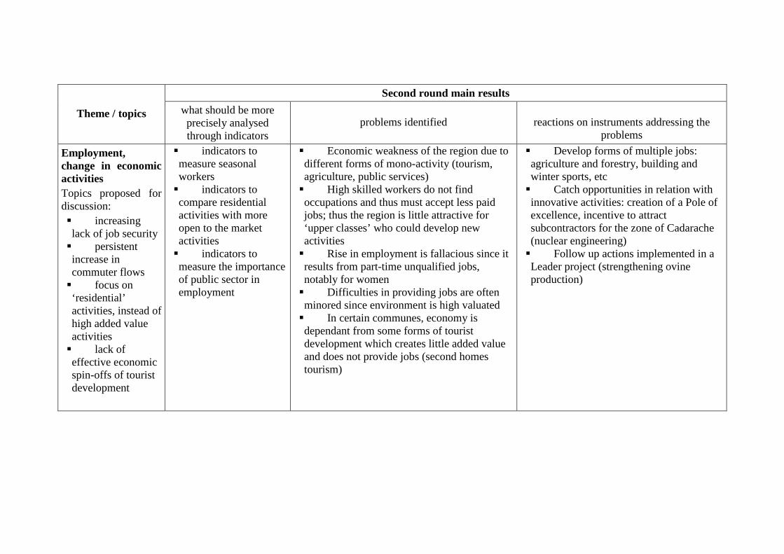
Second round main results
Theme / topics what should be more precisely analysed through indicators
problems identified reactions on instruments addressing the problems
Employment, change in economic activities Topics proposed for discussion: � increasing lack of job security � persistent increase in commuter flows � focus on ‘residential’ activities, instead of high added value activities � lack of effective economic spin-offs of tourist development
� indicators to measure seasonal workers � indicators to compare residential activities with more open to the market activities � indicators to measure the importance of public sector in employment
� Economic weakness of the region due to different forms of mono-activity (tourism, agriculture, public services) � High skilled workers do not find occupations and thus must accept less paid jobs; thus the region is little attractive for ‘upper classes’ who could develop new activities � Rise in employment is fallacious since it results from part-time unqualified jobs, notably for women � Difficulties in providing jobs are often minored since environment is high valuated � In certain communes, economy is dependant from some forms of tourist development which creates little added value and does not provide jobs (second homes tourism)
� Develop forms of multiple jobs: agriculture and forestry, building and winter sports, etc � Catch opportunities in relation with innovative activities: creation of a Pole of excellence, incentive to attract subcontractors for the zone of Cadarache (nuclear engineering) � Follow up actions implemented in a Leader project (strengthening ovine production)
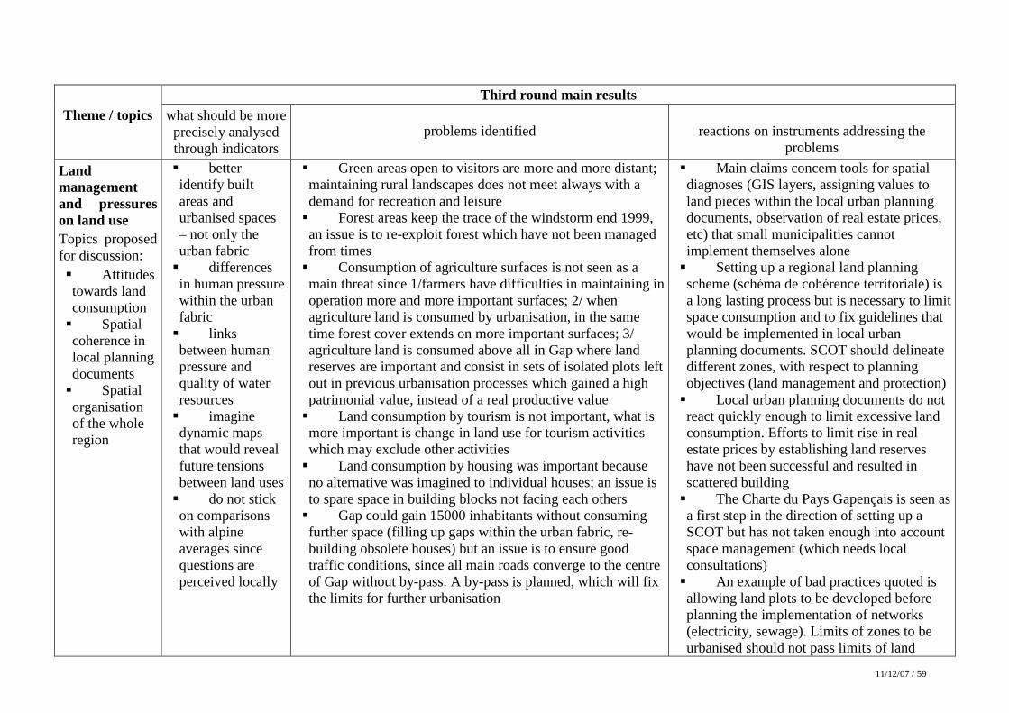
11/12/07 / 59
Third round main results
Theme / topics what should be more precisely analysed through indicators
problems identified reactions on instruments addressing the problems
Land management and pressures on land use Topics proposed for discussion: � Attitudes towards land consumption � Spatial coherence in local planning documents � Spatial organisation of the whole region
� better identify built areas and urbanised spaces – not only the urban fabric � differences in human pressure within the urban fabric � links between human pressure and quality of water resources � imagine dynamic maps that would reveal future tensions between land uses � do not stick on comparisons with alpine averages since questions are perceived locally
� Green areas open to visitors are more and more distant; maintaining rural landscapes does not meet always with a demand for recreation and leisure � Forest areas keep the trace of the windstorm end 1999, an issue is to re-exploit forest which have not been managed from times � Consumption of agriculture surfaces is not seen as a main threat since 1/farmers have difficulties in maintaining in operation more and more important surfaces; 2/ when agriculture land is consumed by urbanisation, in the same time forest cover extends on more important surfaces; 3/ agriculture land is consumed above all in Gap where land reserves are important and consist in sets of isolated plots left out in previous urbanisation processes which gained a high patrimonial value, instead of a real productive value � Land consumption by tourism is not important, what is more important is change in land use for tourism activities which may exclude other activities � Land consumption by housing was important because no alternative was imagined to individual houses; an issue is to spare space in building blocks not facing each others � Gap could gain 15000 inhabitants without consuming further space (filling up gaps within the urban fabric, re-building obsolete houses) but an issue is to ensure good traffic conditions, since all main roads converge to the centre of Gap without by-pass. A by-pass is planned, which will fix the limits for further urbanisation
� Main claims concern tools for spatial diagnoses (GIS layers, assigning values to land pieces within the local urban planning documents, observation of real estate prices, etc) that small municipalities cannot implement themselves alone � Setting up a regional land planning scheme (schéma de cohérence territoriale) is a long lasting process but is necessary to limit space consumption and to fix guidelines that would be implemented in local urban planning documents. SCOT should delineate different zones, with respect to planning objectives (land management and protection) � Local urban planning documents do not react quickly enough to limit excessive land consumption. Efforts to limit rise in real estate prices by establishing land reserves have not been successful and resulted in scattered building � The Charte du Pays Gapençais is seen as a first step in the direction of setting up a SCOT but has not taken enough into account space management (which needs local consultations) � An example of bad practices quoted is allowing land plots to be developed before planning the implementation of networks (electricity, sewage). Limits of zones to be urbanised should not pass limits of land

11/12/07 / 60
pieces that could be equipped
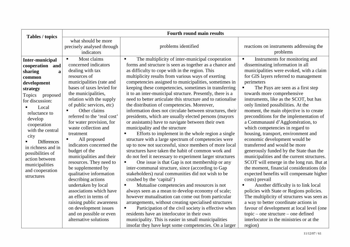
11/12/07 / 61
Fourth round main results
Tables / topics what should be more
precisely analysed through indicators
problems identified reactions on instruments addressing the problems
Inter-municipal cooperation and sharing a common development strategy Topics proposed for discussion: � Local reluctance to develop cooperation with the central city � Differences in richness and in possibilities of action between municipalities and cooperation structures
� Most claims concerned indicators dealing with tax resources of municipalities (rate and bases of taxes levied for the municipalities, relation with the supply of public services, etc) � Other claims referred to the ‘real cost’ for water provision, for waste collection and treatment � All proposed indicators concerned the budget of the municipalities and their resources. They need to be supplemented by qualitative information describing actions undertaken by local associations which have an effect in terms of raising public awareness on development issues and on possible or even alternative solutions
� The multiplicity of inter-municipal cooperation forms and structure is seen as together as a chance and as difficulty to cope with in the region. This multiplicity results from various ways of exerting competencies assigned to municipalities, sometimes in keeping these competencies, sometimes in transferring it to an inter-municipal structure. Presently, there is a need to better articulate this structure and to rationalise the distribution of competencies. Moreover, information does not circulate between structures, their presidents, which are usually elected persons (mayors or assistants) have to navigate between their own municipality and the structure � Efforts to implement in the whole region a single structure with a large spectrum of competencies were up to now not successful, since members of more local structures have taken the habit of common work and do not feel it necessary to experiment larger structures � One issue is that Gap is not membership or any inter-communal structure, since (according to Gap stakeholders) rural communities did not wish to be crushed by the ‘capital’) � Mutualise competencies and resources is not always seen as a mean to develop economy of scale; however mutualisation can come out from particular arrangements, without creating specialised structures � Participation of the civil society is effective when residents have an interlocutor in their own municipality. This is easier in small municipalities insofar they have kept some competencies. On a larger
� Instruments for monitoring and disseminating information in all municipalities were evoked, with a claim for GIS layers referred to management perimeters � The Pays are seen as a first step towards more comprehensive instruments, like as the SCOT, but has only limited possibilities. At the moment, the main objective is to create preconditions for the implementation of a Communauté d’Agglomération, to which competencies in regard to housing, transport, environment and economic development would be transferred and would be more generously funded by the State than the municipalities and the current structures. SCOT will emerge in the long run. But at the moment, financial considerations (do expected benefits will compensate higher costs) prevail � Another difficulty is to link local policies with State or Regions policies. The multiplicity of structures was seen as a way to better coordinate actions in favour of development at local level (one topic – one structure – one defined interlocutor in the ministries or at the region)
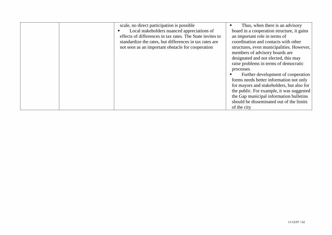
11/12/07 / 62
scale, no direct participation is possible � Local stakeholders nuanced appreciations of effects of differences in tax rates. The State invites to standardize the rates, but differences in tax rates are not seen as an important obstacle for cooperation
� Thus, when there is an advisory board in a cooperation structure, it gains an important role in terms of coordination and contacts with other structures, even municipalities. However, members of advisory boards are designated and not elected, this may raise problems in terms of democratic processes � Further development of cooperation forms needs better information not only for mayors and stakeholders, but also for the public. For example, it was suggested the Gap municipal information bulletins should be disseminated out of the limits of the city
2.8. Confrontation of the context analysis results with the workshop results
With regard to DIAMONT WP10 objectives and aspects focused on in the context analysis, important conclusions emerge from discussions in the meeting. They go much further than assessing the relevance of interpretations proposed by the authors of the context analysis.
� Indicators are still to be improved to reveal real issues for the region
Indicators were not criticized so far since everyone was well aware of their limitations, but discussions underscored main problems in indicator based territorial diagnoses, which were identified as follows:
- Limitations due to lack of data and obsolescence Some important phenomena are not indicated. For example, tourism development, in terms of employment or in terms of real estate facilities, is not illustrated through available indicators. Some difficulties are partly alleviated in comparing and even combining various data, in order to get some information on complex phenomena. However, one may be surprised by messages carried by complex indicators, which are hardly understandable.
Moreover, as most indicators come from official statistics, data become quickly obsolete and cannot inform on dynamic phenomena. That deals notably for demographic trends, which have different characteristics from those observed 8 years ago in the last population census.
- Limitations due to using generic data and indicators
Available information obliges to base on generic data and to compare fixed time periods, which in many cases do not reveal changes in directions of phenomena. Besides, DIAMONT indicators are established at the scale of municipalities, and thus ignore relevant phenomena which are revealed at an infra-communal scale, as for example changes in land uses and land take, or rise in real estate prices. Moreover, comparisons with the whole Alps are not relevant where phenomena take specific aspects in regions. Thus, generic indicators carry a poor message when they address alpine specific issues.
These discussions put to the fore as well limits as expectations in indicator based approaches, like those developed here for DIAMONT, to establish territorial diagnoses. Moreover, they revealed complex linkages between thematic domains and topics focused on in the diagnosis. Better understanding a given phenomena requires analysing other phenomena. Against this, grouping indicators in thematic domains is a bit illusive, since a more systemic approach is needed to structure the diagnosis to identify better driving forces that creates changes and the consequences of these changes.
� In spite of their limits, indicators pave the way for analysing the regions and significant phenomena
The workshop revealed convergences in identifying key issues and in some cases in identifying relations with various phenomena. Simple facts or trends identified by indicators help in approaching more complex issues.
As an answer to the criticism evoked above, discussions resulted in a general agreement on the prevailing importance to attach to demographic attractiveness and to space as a resource in the region. Discussions centred around two main issues: since demographic attractiveness in a chance for the region, new inhabitants are welcome but there is a need to organise and rationalize services and jobs without prejudice to the quality of the living environment, which is the main factor for attractiveness. Stakeholders evoked notably problems in terms of
housing conditions, pressures due to increase in home to work displacements, which moreover do not follow the same routes as home to school or home to supermarket displacements. In this context, agriculture activities play an important role to maintain rural and attractive landscapes, even when they are not currently open to the public. However, since up to now agriculture landscapes are common in the test region, they are not perceived as endangered. That is why agriculture land take is not yet seen as a major threat.
In a general manner, new developments (in terms of housing or activities) question the capacity of the region to manage efficiently space resources and to reduce conflicts in land claims. Encouraging newcomers to settle in the region needs to be able to propose decent housing and services, besides jobs. With regards to the test region attractiveness, main conclusions which emerged from the discussions are the following:
� Housing provision issues
The arrival of newcomers in the region raises important issues for land planning and management, with regard to social diversity, age structure, incomes, social integration and lifestyles. Current trends address the access to housing, notably in a context of rise in prices of the real-estate, of competition between main homes and second homes, and more generally question the spatial and qualitative distribution of housing, in terms of choice of urban, periurban or rural lifestyles. These problems are exemplified in the region by the scarcity of affordable and cheap houses, which creates difficulties for tourism and agriculture seasonal worker. Moreover, newcomers call for the cheapest houses, which are fairly distant from workplaces. This results in increasing mobility within the region, where traffic is already problematic.
These questions lead to new developments to be associated with the various lifestyles in the Pays Gapençais: basic infrastructure and services to create or to adapt to the needs of a not inevitably mobile population. These various aspects question as for the location of the residences towards workplaces and current daily services.
In regard to these questions, an emerging concern is to make denser already build-up areas, rather than to develop new urbanisation zones. But this concern is also viewed through the question of the building houses in the countryside and its consequences in terms of disturbance of the agricultural activities and the degradation of the landscapes, which could possibly in the long run question to a certain degree the attractiveness of the region. Besides, quality of life sought by the newcomers could be decreased by the increase of the residence to work displacements, which result in a difficulty manageable traffic if it is not anticipated.
� Labour supply
Obviously, the installation and still more the assimilation of these new populations become effective through their participation in the economic life of the region. With regard to this aspect, a certain number of central questions have been tracked down.
So, threats are pressing in certain zones on an economy sometimes felt like exclusively turned towards tourism. In the same way, many interrogations came to feed the reflexion concerning the problem of the seasonal activities, the professional training and the precariousness of a certain number of active persons in the Pays Gapençais. The diversification of the economic activities is another concern. It reveals a will to direct the development towards activities with high value added in spite of the current obstacles (distance of the innovation centres), which would make it possible to widen the panel of the populations settling in the Pays Gapençais.
These questions raise the problem of the maintenance of a strong attractiveness of the region and of pressures generated upon space resources. Within the process of urbanization,
residences and economic activities can be in competition, even if the concern of sparing use of space is not necessarily put from the start ahead. The attractiveness of the territory is also perceived through the maintenance of its current framework landscape, which passes by the maintenance of agriculture on the zone. Efforts are made in this direction, with however the reserve that presently agriculture activities are not necessarily any more completely able to maintain space. Moreover, agriculture is faced with uncertainties with respect to possibilities to increase value of farm products and is dependant from orientations decided at the European level. So the consumption of space by urbanisation is done with the detriment of the best arable lands; agricultural activity also competed with by the extension of the forest on the less productive grounds.
� These issues question spatial planning and development in the region
In spite of their limits, indicators made it possible to identify some central issues, but were appreciated insofar they are means to encourage reflections on spatial development choices to be set up in the region. The indicator based diagnosis and the workshop discussions raised conscienciousness the Pays Gapençais Country is at one turning point. Spatial develpment choices are wished to control and orient demographic and economic growth.
In this context, the Pays Gapençais keeps room for manoeuvre that makes it possible to implement various scenarios for the future, which are still to be defined. They should take into account both chances (demographic growth, important space resources) and current weaknesses (residential activities generating little added value, threats against tourism due to climate change, lack of valuation of space resources to low accessibility, etc). In this context, the Pays Gapençais could take benefit from its configuration and its spatial organization. Beyond polarisation and competition between different zones, one can highlight within the region strong complementarities of the various components of the territory. In terms of potential asset, the Pays Gapençais draws its attractiveness in the articulation between an urban centre providing jobs, services, administrations, and a periphery offering a sought after living environment. These complementarities give its coherence to the territory making of this one a centre of attraction to the measurement of the other alpine territories. The stake today is of being able to arrange it and develop it like a coherent unit.
� Solutions need to implement spatial planning tools covering the whole region
Even when this stake is shared in the whole region, solutions are not obvious since they question relationships between municipalities. Discussions focused on recipes making it possible to develop efficiently inter municipal cooperation, with the objective making it a means for better management and control of expected development. They questioned in the same time local democracy, relations between persons and elected representatives or associations, as well as range of competencies assigned to communes and cooperation structures, and dilution of competencies shared in various cooperation levels.
Somewhat leaving aside discussions on the phenomena taking place in the Pays Gapençais, the debates directly entered the problems of mobilizable tools, and more still in considerations relating to the good practices than it is desirable to implement in the mobilization of the aforesaid tools for co-operation. In this respect, seemed key factors:
- The development of instruments to capitalize knowledge and scientific expertise for the region, to prepare the implementation of land planning and development instruments
In spite of (or thanks to) the recent installation of a GIS, the requirement in cartography was many times evoked, for all that relates to spatial issues. But increased requirements in terms
of knowledge and monitoring remain not very satisfied (absence of land and real estate observatory, difficulty of follow-up of seasonal employment, etc).
- The relevance of the planning instruments
In the same manner, spirit, land planning instruments (territorial coherence scheme, local urban planning documents, urban displacements plans, etc) of course were evoked and criticized with regards to difficulties to implement them that weaken their efficiency (the scale of analysis for the reflexion, measures to be associated for more effectiveness, communication on the choices which they impose, etc).
- The setting up or territorial orientations within the Pays Gapençais
Within the Pays Gapençais, participants also wondered about the drafting and the adoption, in the long run, of a Pays charter more targeted, more adapted to the problems taking place on the territory. Setting up territorial orientations leads nevertheless to a reflexion on the tools being able to implement them. Currently, the interrogations are concerned on the way of re-initiating the work preliminary to the establishment of a SCOT extended to the whole region or the benefits one can expect from the establishment of a Communauté d’Agglomération Gapençaise, and the changes in organisation it would imply with respect to existing Communautés de Communes
It also appeared the need for setting up or for perpetuating specific and sector policies, on the professional training, on the organization of the multi-activity, on forest management, on agriculture… However one could sometimes regret the non spatial dimension of some of these policies.
Lastly, within the workshop round dealing with the cooperation between communes, interrogations emerged concerning the mobilization of the financial resources in order to implement actions and projects at the scale of the whole Pays Gapençais Country. In this context, the questions of taxes, tax competition between communes, of differences in tax potential and of financial resources of the inter-municipal structures were just mentioned, but not seen as the most problematic.
2.9. Starting points for the second workshop and conclusions
We did not fix a date for the second workshop. During the summer, we will send to the participants not only the minutes of the meeting, but also a new document including new indicators (or reformulated indicators) and maps.
As a main focus for the second workshop in the Gap region, we proposed the participants to go further into the analysis of pre-conditions for efficient implementation of spatial regional planning instruments, like as the SCOT. We keep in mind identifying ‘good practices’ which help to solve tensions and local oppositions coming from the fact that a more consistent development is a wish, when at the moment less consistent solutions can prove efficient in certain municipalities. By this way, we would leave out other aspects that are commonly put under the banner of ‘conflicts’, like as enhancing public participation in decision making’ or keeping a balance between private and public interests.
However, we informed the participants that the second workshop objectives and content were still to be precised, in the light of the first workshop experiences. In theory, focus will be given in the second workshops to efficient solutions to alleviate conflicts or tensions, and to instruments that could be implemented for that. In the French test region, main outputs from the first workshop are above all a better identification of issues in link with development trends and of threats and opportunities the region could catch for a consistent future spatial development; thus the workshop gave further elements that would support the Pays Gapençais
or further initiatives. Conversely, conflicts or even tensions were not so far evoked by the participants, one reason for that is that instruments focused on do not create binding obligations and have little effects on residents’ everyday life. Oppositions may result from the way in which local governance systems operate, particularly from the low public participation in decision-making processes.
Beforehand, we expect further elements will come out from the cross-analysis the WP leader will complete. We just raise at the moment pendant questions, such as: which are most important findings of the first workshops? Do they reveal important differences in the way in which development is perceived and steered in various test regions? Are successful experiences in implementing relevant instruments transposable in other territorial / institutional contexts? Which difficulties are they commonly faced with? Shall we content on sets of monographs dealing with different case studies, or will it be intended to draw more general conclusions from WP10? Responses to these questions will orient the proposals we will make to the Comité de Pays Gapençais, which was interested in participating in a pan-alpine experience but expects transnational dimension of DIAMONT will result in greater insight in topics addressed.
3. Germany - Alpsee-Grünten Country: GERMANY Test region: ALPSEE-GRÜNTEN Workshop results Location of the workshop: Immenstadt Date of the workshop: 17th July 2007 Number of participants: 16 Project partner: Bosch & Partner GmbH Realisation of the Workshop:
Andreas Raab - Regionalplaner Konstanze Schönthaler - Bosch & Partner GmbH Stefan v. Andrian-Werburg - Bosch & Partner GmbH
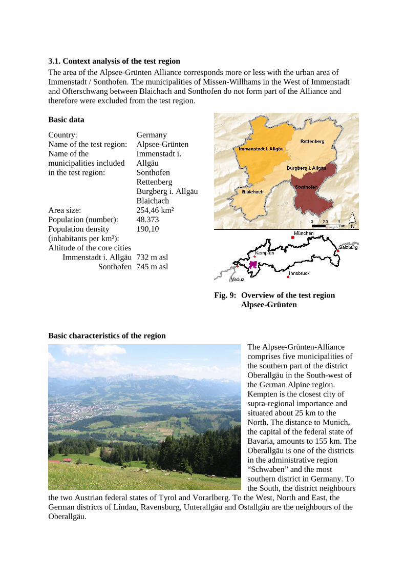
3.1. Context analysis of the test region The area of the Alpsee-Grünten Alliance corresponds more or less with the urban area of Immenstadt / Sonthofen. The municipalities of Missen-Willhams in the West of Immenstadt and Ofterschwang between Blaichach and Sonthofen do not form part of the Alliance and therefore were excluded from the test region. Basic data
Country: Germany Name of the test region: Alpsee-Grünten Name of the municipalities included in the test region:
Immenstadt i. Allgäu Sonthofen Rettenberg Burgberg i. Allgäu Blaichach
Area size: 254,46 km² Population (number): 48.373 Population density (inhabitants per km²):
190,10
Altitude of the core cities Immenstadt i. Allgäu
Sonthofen
732 m asl 745 m asl
Fig. 9: Overview of the test region Alpsee-Grünten
Basic characteristics of the region The Alpsee-Grünten-Alliance comprises five municipalities of the southern part of the district Oberallgäu in the South-west of the German Alpine region. Kempten is the closest city of supra-regional importance and situated about 25 km to the North. The distance to Munich, the capital of the federal state of Bavaria, amounts to 155 km. The Oberallgäu is one of the districts in the administrative region “Schwaben” and the most southern district in Germany. To the South, the district neighbours
the two Austrian federal states of Tyrol and Vorarlberg. To the West, North and East, the German districts of Lindau, Ravensburg, Unterallgäu and Ostallgäu are the neighbours of the Oberallgäu.
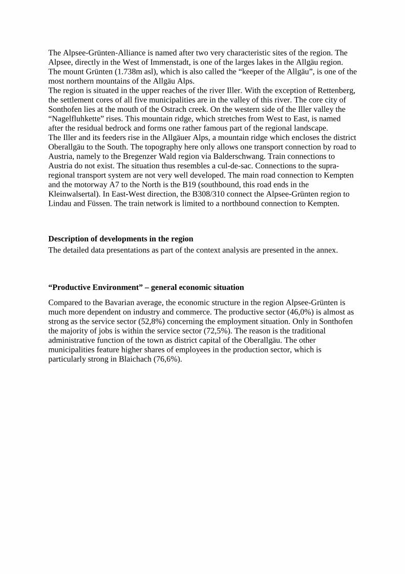
The Alpsee-Grünten-Alliance is named after two very characteristic sites of the region. The Alpsee, directly in the West of Immenstadt, is one of the larges lakes in the Allgäu region. The mount Grünten (1.738m asl), which is also called the “keeper of the Allgäu”, is one of the most northern mountains of the Allgäu Alps. The region is situated in the upper reaches of the river Iller. With the exception of Rettenberg, the settlement cores of all five municipalities are in the valley of this river. The core city of Sonthofen lies at the mouth of the Ostrach creek. On the western side of the Iller valley the “Nagelfluhkette” rises. This mountain ridge, which stretches from West to East, is named after the residual bedrock and forms one rather famous part of the regional landscape. The Iller and its feeders rise in the Allgäuer Alps, a mountain ridge which encloses the district Oberallgäu to the South. The topography here only allows one transport connection by road to Austria, namely to the Bregenzer Wald region via Balderschwang. Train connections to Austria do not exist. The situation thus resembles a cul-de-sac. Connections to the supra-regional transport system are not very well developed. The main road connection to Kempten and the motorway A7 to the North is the B19 (southbound, this road ends in the Kleinwalsertal). In East-West direction, the B308/310 connect the Alpsee-Grünten region to Lindau and Füssen. The train network is limited to a northbound connection to Kempten.
Description of developments in the region The detailed data presentations as part of the context analysis are presented in the annex.
“Productive Environment” – general economic situation
Compared to the Bavarian average, the economic structure in the region Alpsee-Grünten is much more dependent on industry and commerce. The productive sector (46,0%) is almost as strong as the service sector (52,8%) concerning the employment situation. Only in Sonthofen the majority of jobs is within the service sector (72,5%). The reason is the traditional administrative function of the town as district capital of the Oberallgäu. The other municipalities feature higher shares of employees in the production sector, which is particularly strong in Blaichach (76,6%).
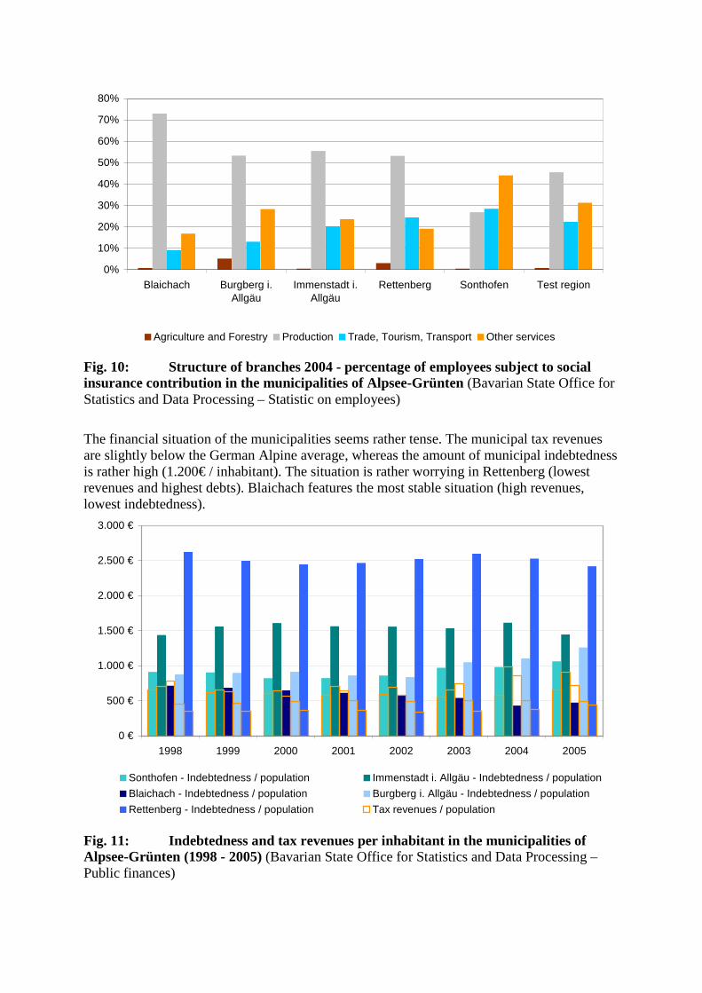
0%
10%
20%
30%
40%
50%
60%
70%
80%
Blaichach Burgberg i.Allgäu
Immenstadt i.Allgäu
Rettenberg Sonthofen Test region
Agriculture and Forestry Production Trade, Tourism, Transport Other services
Fig. 10: Structure of branches 2004 - percentage of employees subject to social insurance contribution in the municipalities of Alpsee-Grünten (Bavarian State Office for Statistics and Data Processing – Statistic on employees)
The financial situation of the municipalities seems rather tense. The municipal tax revenues are slightly below the German Alpine average, whereas the amount of municipal indebtedness is rather high (1.200€ / inhabitant). The situation is rather worrying in Rettenberg (lowest revenues and highest debts). Blaichach features the most stable situation (high revenues, lowest indebtedness).
0 €
500 €
1.000 €
1.500 €
2.000 €
2.500 €
3.000 €
1998 1999 2000 2001 2002 2003 2004 2005
Sonthofen - Indebtedness / population Immenstadt i. Allgäu - Indebtedness / population
Blaichach - Indebtedness / population Burgberg i. Allgäu - Indebtedness / population
Rettenberg - Indebtedness / population Tax revenues / population
Fig. 11: Indebtedness and tax revenues per inhabitant in the municipalities of Alpsee-Grünten (1998 - 2005) (Bavarian State Office for Statistics and Data Processing – Public finances)
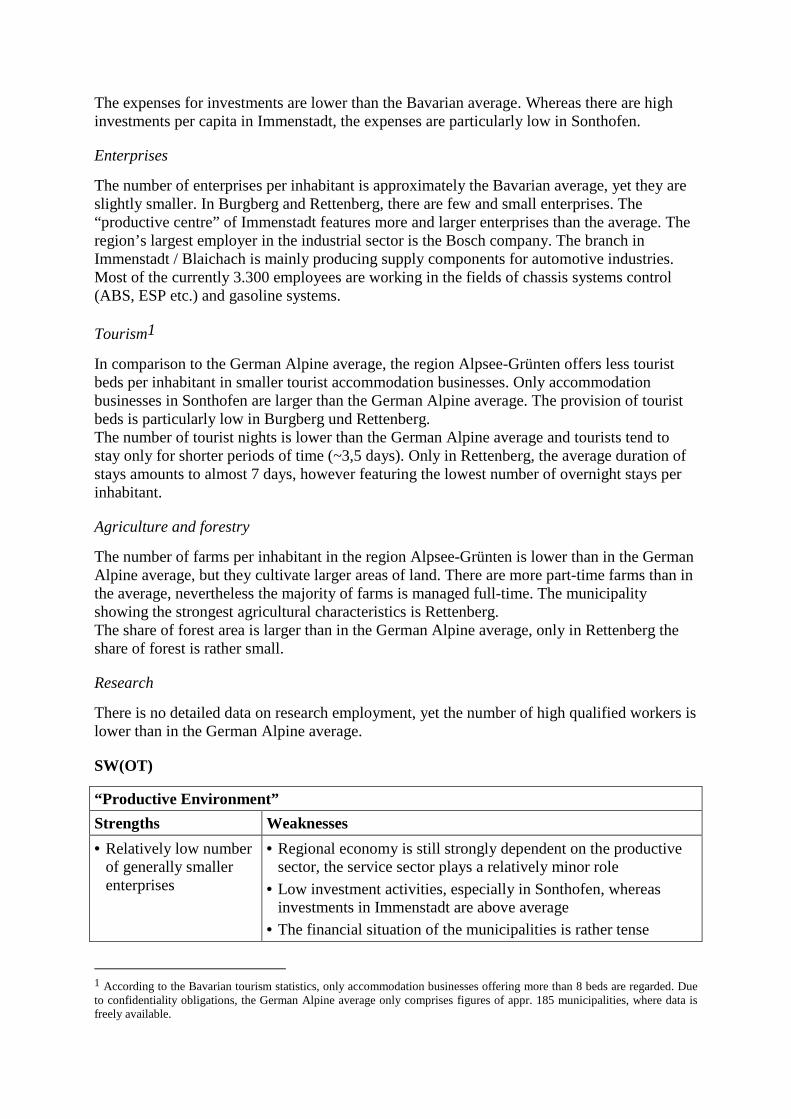
The expenses for investments are lower than the Bavarian average. Whereas there are high investments per capita in Immenstadt, the expenses are particularly low in Sonthofen.
Enterprises
The number of enterprises per inhabitant is approximately the Bavarian average, yet they are slightly smaller. In Burgberg and Rettenberg, there are few and small enterprises. The “productive centre” of Immenstadt features more and larger enterprises than the average. The region’s largest employer in the industrial sector is the Bosch company. The branch in Immenstadt / Blaichach is mainly producing supply components for automotive industries. Most of the currently 3.300 employees are working in the fields of chassis systems control (ABS, ESP etc.) and gasoline systems.
Tourism1
In comparison to the German Alpine average, the region Alpsee-Grünten offers less tourist beds per inhabitant in smaller tourist accommodation businesses. Only accommodation businesses in Sonthofen are larger than the German Alpine average. The provision of tourist beds is particularly low in Burgberg und Rettenberg. The number of tourist nights is lower than the German Alpine average and tourists tend to stay only for shorter periods of time (~3,5 days). Only in Rettenberg, the average duration of stays amounts to almost 7 days, however featuring the lowest number of overnight stays per inhabitant.
Agriculture and forestry
The number of farms per inhabitant in the region Alpsee-Grünten is lower than in the German Alpine average, but they cultivate larger areas of land. There are more part-time farms than in the average, nevertheless the majority of farms is managed full-time. The municipality showing the strongest agricultural characteristics is Rettenberg. The share of forest area is larger than in the German Alpine average, only in Rettenberg the share of forest is rather small.
Research
There is no detailed data on research employment, yet the number of high qualified workers is lower than in the German Alpine average.
SW(OT)
“Productive Environment”
Strengths Weaknesses
• Relatively low number of generally smaller enterprises
• Regional economy is still strongly dependent on the productive sector, the service sector plays a relatively minor role
• Low investment activities, especially in Sonthofen, whereas investments in Immenstadt are above average
• The financial situation of the municipalities is rather tense
1 According to the Bavarian tourism statistics, only accommodation businesses offering more than 8 beds are regarded. Due to confidentiality obligations, the German Alpine average only comprises figures of appr. 185 municipalities, where data is freely available.
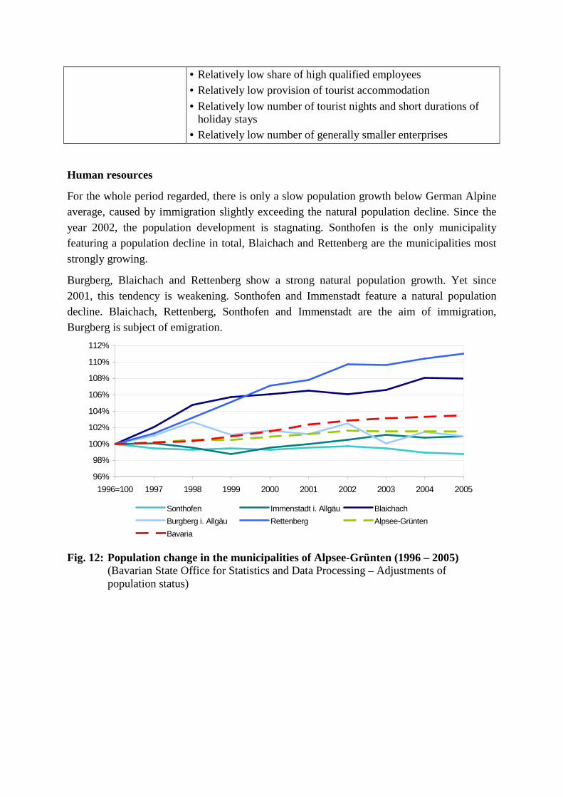
• Relatively low share of high qualified employees • Relatively low provision of tourist accommodation
• Relatively low number of tourist nights and short durations of holiday stays
• Relatively low number of generally smaller enterprises
Human resources
For the whole period regarded, there is only a slow population growth below German Alpine average, caused by immigration slightly exceeding the natural population decline. Since the year 2002, the population development is stagnating. Sonthofen is the only municipality featuring a population decline in total, Blaichach and Rettenberg are the municipalities most strongly growing.
Burgberg, Blaichach and Rettenberg show a strong natural population growth. Yet since 2001, this tendency is weakening. Sonthofen and Immenstadt feature a natural population decline. Blaichach, Rettenberg, Sonthofen and Immenstadt are the aim of immigration, Burgberg is subject of emigration.
96%
98%
100%
102%
104%
106%
108%
110%
112%
1996=100 1997 1998 1999 2000 2001 2002 2003 2004 2005
Sonthofen Immenstadt i. Allgäu Blaichach
Burgberg i. Allgäu Rettenberg Alpsee-Grünten
Bavaria
Fig. 12: Population change in the municipalities of Alpsee-Grünten (1996 – 2005) (Bavarian State Office for Statistics and Data Processing – Adjustments of population status)
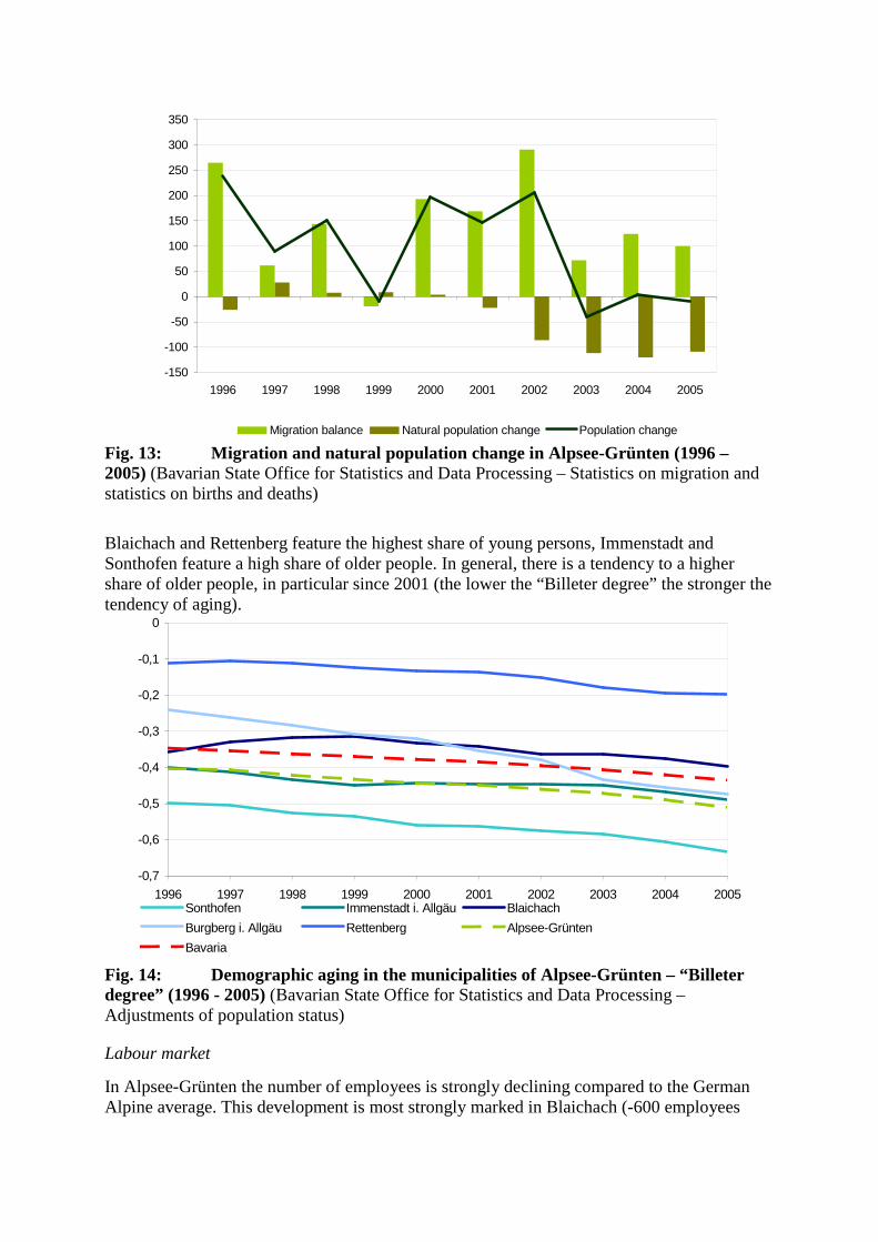
-150
-100
-50
0
50
100
150
200
250
300
350
1996 1997 1998 1999 2000 2001 2002 2003 2004 2005
Migration balance Natural population change Population change Fig. 13: Migration and natural population change in Alpsee-Grünten (1996 – 2005) (Bavarian State Office for Statistics and Data Processing – Statistics on migration and statistics on births and deaths)
Blaichach and Rettenberg feature the highest share of young persons, Immenstadt and Sonthofen feature a high share of older people. In general, there is a tendency to a higher share of older people, in particular since 2001 (the lower the “Billeter degree” the stronger the tendency of aging).
-0,7
-0,6
-0,5
-0,4
-0,3
-0,2
-0,1
0
1996 1997 1998 1999 2000 2001 2002 2003 2004 2005Sonthofen Immenstadt i. Allgäu Blaichach
Burgberg i. Allgäu Rettenberg Alpsee-Grünten
Bavaria
Fig. 14: Demographic aging in the municipalities of Alpsee-Grünten – “Billeter degree” (1996 - 2005) (Bavarian State Office for Statistics and Data Processing – Adjustments of population status)
Labour market
In Alpsee-Grünten the number of employees is strongly declining compared to the German Alpine average. This development is most strongly marked in Blaichach (-600 employees
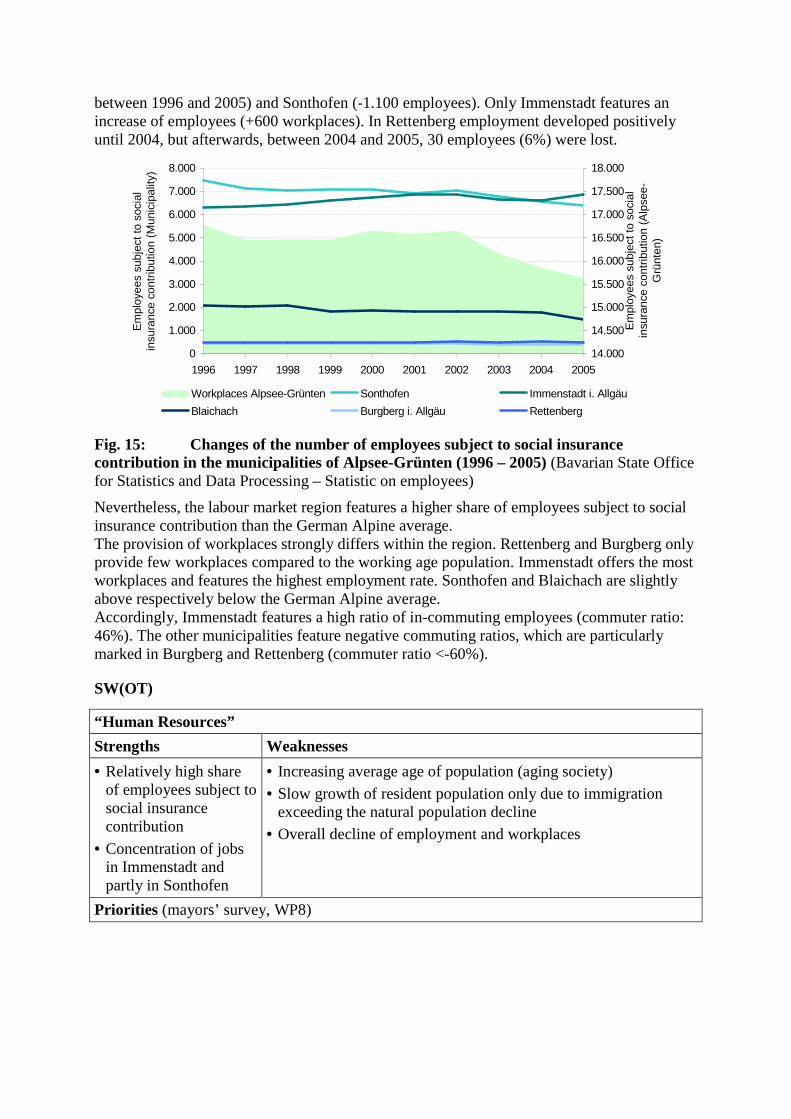
between 1996 and 2005) and Sonthofen (-1.100 employees). Only Immenstadt features an increase of employees (+600 workplaces). In Rettenberg employment developed positively until 2004, but afterwards, between 2004 and 2005, 30 employees (6%) were lost.
0
1.000
2.000
3.000
4.000
5.000
6.000
7.000
8.000
1996 1997 1998 1999 2000 2001 2002 2003 2004 2005
Em
ploy
ees
subj
ect t
o so
cial
in
sura
nce
cont
ribut
ion
(Mun
icip
ality
)
14.000
14.500
15.000
15.500
16.000
16.500
17.000
17.500
18.000
Em
ploy
ees
subj
ect t
o so
cial
in
sura
nce
cont
ribut
ion
(Alp
see-
Grü
nten
)
Workplaces Alpsee-Grünten Sonthofen Immenstadt i. Allgäu
Blaichach Burgberg i. Allgäu Rettenberg
Fig. 15: Changes of the number of employees subject to social insurance contribution in the municipalities of Alpsee-Grünten (1996 – 2005) (Bavarian State Office for Statistics and Data Processing – Statistic on employees)
Nevertheless, the labour market region features a higher share of employees subject to social insurance contribution than the German Alpine average. The provision of workplaces strongly differs within the region. Rettenberg and Burgberg only provide few workplaces compared to the working age population. Immenstadt offers the most workplaces and features the highest employment rate. Sonthofen and Blaichach are slightly above respectively below the German Alpine average. Accordingly, Immenstadt features a high ratio of in-commuting employees (commuter ratio: 46%). The other municipalities feature negative commuting ratios, which are particularly marked in Burgberg and Rettenberg (commuter ratio <-60%).
SW(OT)
“Human Resources”
Strengths Weaknesses
• Relatively high share of employees subject to social insurance contribution
• Concentration of jobs in Immenstadt and partly in Sonthofen
• Increasing average age of population (aging society)
• Slow growth of resident population only due to immigration exceeding the natural population decline
• Overall decline of employment and workplaces
Priorities (mayors’ survey, WP8)
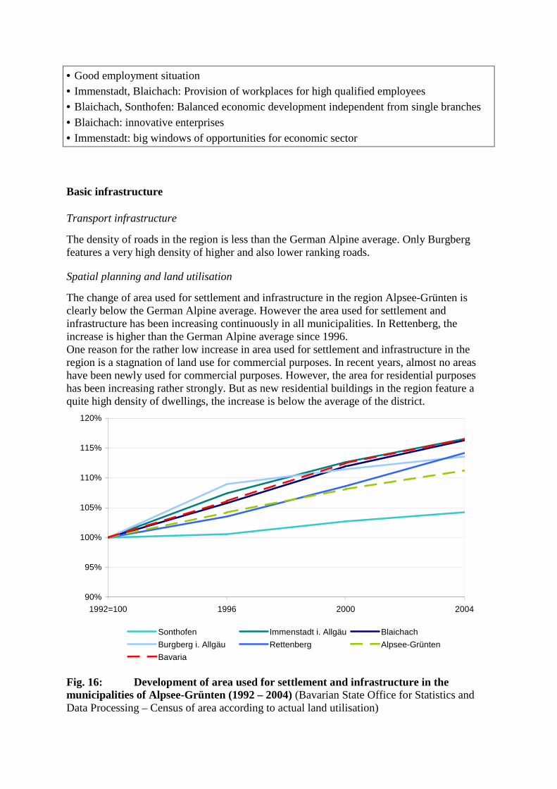
• Good employment situation • Immenstadt, Blaichach: Provision of workplaces for high qualified employees • Blaichach, Sonthofen: Balanced economic development independent from single branches • Blaichach: innovative enterprises • Immenstadt: big windows of opportunities for economic sector
Basic infrastructure
Transport infrastructure
The density of roads in the region is less than the German Alpine average. Only Burgberg features a very high density of higher and also lower ranking roads.
Spatial planning and land utilisation
The change of area used for settlement and infrastructure in the region Alpsee-Grünten is clearly below the German Alpine average. However the area used for settlement and infrastructure has been increasing continuously in all municipalities. In Rettenberg, the increase is higher than the German Alpine average since 1996. One reason for the rather low increase in area used for settlement and infrastructure in the region is a stagnation of land use for commercial purposes. In recent years, almost no areas have been newly used for commercial purposes. However, the area for residential purposes has been increasing rather strongly. But as new residential buildings in the region feature a quite high density of dwellings, the increase is below the average of the district.
90%
95%
100%
105%
110%
115%
120%
1992=100 1996 2000 2004
Sonthofen Immenstadt i. Allgäu Blaichach
Burgberg i. Allgäu Rettenberg Alpsee-Grünten
Bavaria
Fig. 16: Development of area used for settlement and infrastructure in the municipalities of Alpsee-Grünten (1992 – 2004) (Bavarian State Office for Statistics and Data Processing – Census of area according to actual land utilisation)
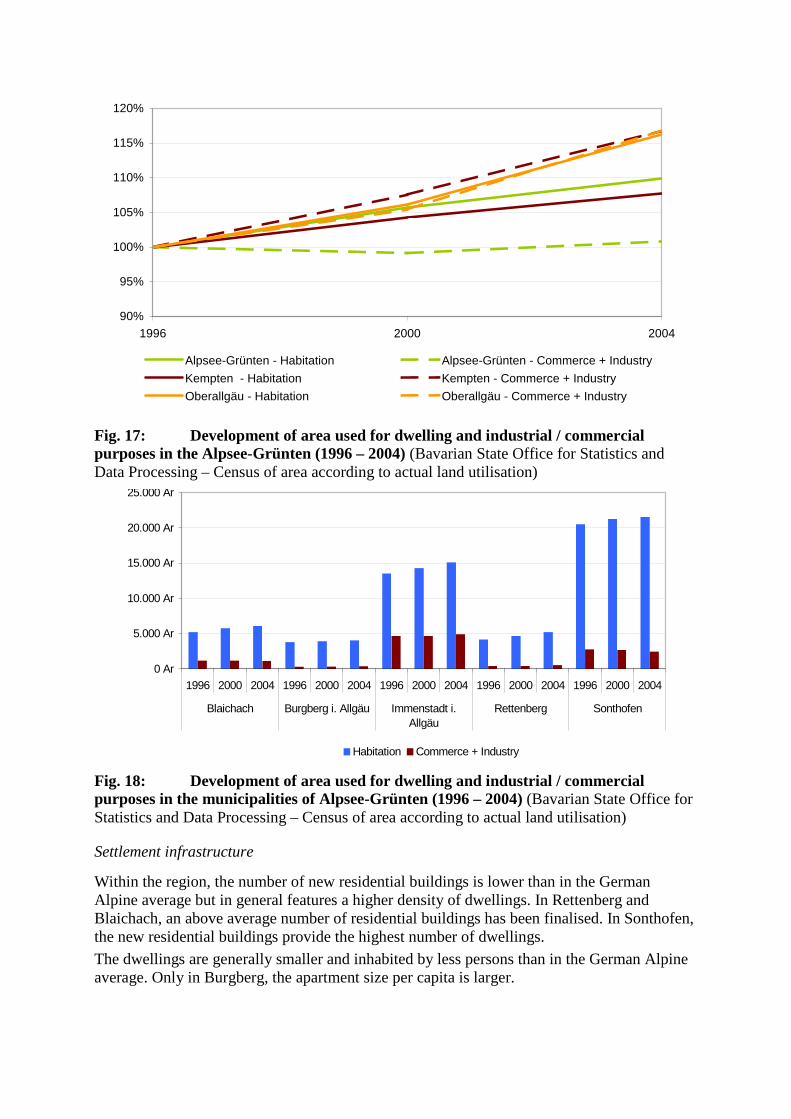
90%
95%
100%
105%
110%
115%
120%
1996 2000 2004
Alpsee-Grünten - Habitation Alpsee-Grünten - Commerce + Industry
Kempten - Habitation Kempten - Commerce + Industry
Oberallgäu - Habitation Oberallgäu - Commerce + Industry
Fig. 17: Development of area used for dwelling and industrial / commercial purposes in the Alpsee-Grünten (1996 – 2004) (Bavarian State Office for Statistics and Data Processing – Census of area according to actual land utilisation)
0 Ar
5.000 Ar
10.000 Ar
15.000 Ar
20.000 Ar
25.000 Ar
1996 2000 2004 1996 2000 2004 1996 2000 2004 1996 2000 2004 1996 2000 2004
Blaichach Burgberg i. Allgäu Immenstadt i.Allgäu
Rettenberg Sonthofen
Habitation Commerce + Industry
Fig. 18: Development of area used for dwelling and industrial / commercial purposes in the municipalities of Alpsee-Grünten (1996 – 2004) (Bavarian State Office for Statistics and Data Processing – Census of area according to actual land utilisation)
Settlement infrastructure
Within the region, the number of new residential buildings is lower than in the German Alpine average but in general features a higher density of dwellings. In Rettenberg and Blaichach, an above average number of residential buildings has been finalised. In Sonthofen, the new residential buildings provide the highest number of dwellings.
The dwellings are generally smaller and inhabited by less persons than in the German Alpine average. Only in Burgberg, the apartment size per capita is larger.
The area which is newly used for residential purposes is smaller than in the German Alpine average. Only in Rettenberg the increase of area used for residential purposes is strongly above average.
The area which is newly used for commercial and industrial purposes is much smaller than in the German Alpine average. It is even decreasing in Blaichach and Sonthofen.
The real estate prices are higher than the German Alpine average. They are particularly high in Blaichach, Burgberg and Sonthofen. Strong increases are featured in Rettenberg and Burgberg.
SW(OT)
“Basic Infrastructure”
Strengths Weaknesses
• Low density of road infrastructure except for Burgberg
• Relatively low change of area used for settlement and infrastructure
• Relatively high density of new residential buildings and dwellings
Low density of road infrastructure except for Burgberg
• Continuous increase of area used for settlement and infrastructure
• Decrease of commercial areas in some municipalities, but strong increases in others
• Real estate prices are relatively high
Division of functions between municipalities The results of the context analysis show a distinct division of functions between the municipalities of the region Alpsee-Grünten. This is also underlined by the results of a cluster analysis which has been carried out to classify the municipalities in the Alpine space according to their development (see chap. 0). The following paragraphs try to describe the role of the different municipalities in the region.
Sonthofen …
is the town with traditional administrative functions. This results in a high share of jobs in the third sector and also in the highest share of jobs in urban branches. Sonthofen features the highest population density and the highest share of area used for settlement and infrastructure. A dense real estate market leads to rather high real estate prices. However, the economic situation is not as good as one could expect. The number of workplaces has been decreasing for several years, the employment rate is rather low and further declining. Also the population development is negative, as the immigration does not exceed the natural population decline. This development also leads to strong aging tendencies of the society.
Immenstadt …
is the economic centre of the region. The town offers most of the working places, its position on the labour market is underlined by a high number of employees commuting into Immenstadt to work. It features a rather high share of workplaces in the production sector (55,7%), has the highest density of enterprises as well as the largest ones. Immenstadt attracts most of the investment capital of the five municipalities. Despite these signs of a dynamic economic development, Immenstadt also shows some worrying tendencies as for example continuous aging of population.
Blaichach …
is very much characterised by industrial influences. A very high share of employees (76,6%) works in the production sector. The locational qualities of Blaichach also result in a high share of investments in the municipality, which is generally in a good financial position regarding tax revenues and indebtedness. Agriculture only plays a minor role and is mostly managed part-time, also the third sector is rather weak. Nevertheless, Blaichach also has some importance as a place of living for employees of the adjacent towns of Sonthofen and Immenstadt. This living function is on the one hand shown by a rather high share of employees commuting to Sonthofen and Immenstadt. On the other hand it is shown by a continuous immigration throughout recent years, while at the same time the provision of jobs was declining. To accommodate the new residents, a rather high number of new residential buildings has been installed during the last years. The real estate prices in Blaichach, where land resources are rare and the existing potentials are already used with a high intensity, are rather high.
Burgberg …
is also a municipality, where land resources seem to be rare and the existing potentials are already used with a high intensity. So the population density referring to the area used for settlement and infrastructure is rather high, so are the real estate prices. Nevertheless, Burgberg also bears characteristics of a declining development path of rural municipalities. So there are only few workplaces and the employment situation is even declining, there are relatively few and small firms. So a high share of people is commuting to Sonthofen or Immenstadt to work. In contrast to Blaichach or Rettenberg, people tend to move away from Burgberg. The natural population growth only shortly exceeds the emigration rate. As a consequence the number of new residential buildings and new dwellings is relatively low.
Rettenberg …
is the most rural municipality of the region. It features the highest number and the highest density of farms as well as a very low percentage of part time farming. The number of jobs in urban branches is rather low, only few and relatively small enterprises are situated there. The financial situation of the municipality is very tense as tax revenues are low and the indebtedness is very high. Rettenberg gains in importance as living municipality for employees of Immenstadt and Sonthofen. On the one hand, Rettenberg shows a strong increase of population, driven to the larger extent by immigration, to a lower extent by natural growth (yet these trends are decreasing since the 2000/2001). It features the strongest increase of area used for residential purposes, the strongest increase of room area in dwellings as well as the strongest increase of residential buildings. On the other hand, the number of workplaces in Rettenberg is rather low and further declining. Most of the residents of Rettenberg are commuting to Sonthofen or Immenstadt.
3.2. Preparation of the workshop The workshop was intended to be a workshop of and for the region. DIAMONT was seen as a project providing the adequate framework for the discussions, but local conditions, problems and customs should strictly be respected. Therefore it has been decided to commit parts of the workshop’s organisation to the mayoralty of Immenstadt. They coordinated the date for the two workshops, sent out the invitation and helped with other details of preparation. As consequence all mayors were present in the workshop, and the participants developed a strong empathy with this joint adventure. Before the workshop no material has been sent out. The methodology of the workshop was strictly oriented on the World Café Method as agreed with all DIAMONT partners: • We created a good discussion atmosphere by inviting the
participants in the meeting hall of the “Gasthof Krone” which is a well known and prestigious inn of Immenstadt. The cuisine made for a modest catering.
• The participants changed tables after the respective discussion rounds to avoid deadlocked discussions. The changing process was guided by fortune (“Schafkopf” playing cards).
• All results of the workshops were documented using the Metaplan techniques.
The detailed organisation of the workshop was guided by the following principles: • We tried to inspire discussions from an integrative point of view, avoiding the formation
of sectoral thematic sub-groups, whose results are often difficult to amalgamate afterward. We decided to offer only three rounds, which were thematically more complex, in order to let more time for discussion (40 - 45 minutes per round).
• All participants should deal with the same set of questions in order to integrate all of them in the whole discussion procedure and to get a view as broad as possible of the topics discussed.
• The rounds should build up on each other thematically in order to create a continuous discussion flow. The people remaining seated on the table were responsible to preserve continuity.
• The discussions in the sub-groups should be strictly governed by the participants themselves to ensure that we really catch the opinions, visions and perspectives of the local people. Therefore the moderators on the tables were recruited completely from the participants, and the participants themselves had to present the results of their discussions.
3.3. List of selected instruments In accordance with the local stakeholders involved in the workshop preparation, the following overall concept for the two workshops has been developed: 1st Workshop: Identifying needs for action and developing objectives for future development;
1st Workshop Test region: Alpsee-Grünten Location of the workshop: Immenstadt Date of the workshop: 17. 7. 2007 Duration of the workshop: 9.00 till 12.30 a.m. Number of participants: 16
2nd Workshop: Discussing strategies and possible instruments.
The first workshop seemed necessary to find a common view and perception of the problems the region has. All mayors of the municipalities forming part of the test region (= Alpsee-
Grünten) could participate in the workshop2. So the workshop offered the mayors a platform to exchange their visions and perceptions and to commonly discuss necessities of future cooperation. During the preparatory talks with some selected stakeholders from Immenstadt and Sonthofen, it became already apparent that land use problems are evident in the region, and a better management of the remaining land resources will be necessary in future to stand up to the very dynamically developing centre of Kempten with its adjacent municipalities. Nevertheless, the first workshop embarked on the strategy that the participants themselves should perceive these challenges and discover the great potential of a more intensive inter-municipal cooperation. It was intended that the participants clear the way for discussing suitable strategies and instruments all together. A list of suitable instruments for strengthening inter-municipal cooperation and better coordinating of actions in order to foster the development of the local economy as well as best practice examples were actively required by the participants at the end of the first workshop as preparation for the second workshop.
2 In the case of Rettenberg the second mayor participated, because the first mayor is involved in a lawsuit and there will be a reelection in the near future.
3.4. List of stakeholders (participants) The 16 participants of the first workshop in the test region Alpsee-Grünten were listed in the table below. We consciously restricted the participants primarily to members of the municipalities. It seemed to be important that at least in this first workshop a close exchange between the mayors and the representatives of the building authorities will be possible to focus the discussion on the selected thematic aspects of inter-municipal cooperation and the better planning and management of industrial and commercial areas. For the second workshop it is planned to integrate more representatives of local big enterprises to get more information about the real demand of the local economy.
Participants of the first workshop for Alpsee-Grünten
Name and surname institution type position Otto Steiger Municipality of
Blaichach Local self-government
First Mayor
Dieter Fischer Municipality of Burgberg
Local self-government
First Mayor
Wendelin Socher Municipality of Rettenberg
Local self-government
Second Mayor
Gerd Bischoff City of Immenstadt Local self-government
First Mayor
Hubert Buhl City of Sonthofen Local self-government
First Mayor
Ludwig Bertele Main office of Blaichach
Public sector Director
Wolfgang Gossow Building authority of Blaichach, building administration, environmental protection and disaster management
Public sector Department manager
Ludwig Wegscheider Main office and building authority of Burgberg
Public sector Director
Nikolaus Weißinger Building authority of Rettenberg
Public sector Director
Adalbert Martin Building authority of Immenstadt
Public sector Director
Hans Wernick Building authority of Sonthofen
Public sector Director
Fritz Weidlich Department of business development of Sonthofen
Public sector Director
Siegfried Zengerle City of Immenstadt Public sector City treasurer
Dr. Sabine Society of Regional Local, regional Managing
Weizenegger Development Altusried-Oberallgäu, situated in the District Office Oberallgäu
economy Director
Reinhard Reitzner District Office Oberallgäu, Department of Finances and Civil Engineering
Local, regional economy
Director
Mr. Zeller Self-employed architect in Burgberg
Local, regional economy
Managing Director
local self-government elected representatives of the municipality public sector representatives of the municipal and regional
administration Local, regional economy
Representatives of the local economy and resident enterprises
Types of institutions
3.5. Structure of the workshop The central aim of the two workshops was to clarify the demand and the willingness for jointly steering the industrial and commercial development in the region. Hereby a holistic view of qualitative and functional aspects should be preferred to small-scale solutions in the single municipalities. At the same time rules for a sustainable development of the municipalities and the whole regions should be agreed on, with special focus on sustainable land resource management, the latter in accordance to special thematic focus of DIAMONT. The objective of the first workshop was to identify the requirements of action and possible objectives of an inter-municipal cooperation. An integral view of the situation and the recent development of the municipalities was presented to the stakeholders in order to make them aware of common interests beyond the tourism sector which the Alpsee-Grünten Alliance is exclusively oriented on so far.
According to these objectives the workshop has been split up in three rounds: Round 1: Analysis and evaluation of the situation and development trends
Round 2: Demands and leeway for the development of commercial and industrial areas
Round 3: Objectives and requirements for steering and action
The proceeding of the workshop was structured as follows:
9.00: Arriving of participants
9.05 – 9.35: Introduction
- Presentation of the workshop organisers - Short presentation of the objectives of the Alpine Space Programme and the
DIAMONT project - Explanation of the role of the workshop in the context of the LEADER-process - Presentation of some exemplary results of the fitness check for Alpsee-Grünten (more
detailed information was handed out in form of four DIN A 3 posters with the most important data impulses and a collection of maps and graphs, all displayed on the three tables)
- Short introduction of the time table and the workshop methodology
- Presentation of the leading questions for the three rounds
There were no additional introductions on the tables by the organisers. The questions for the respective round were shown on a PP-slide. The participant remaining on the table summarized the results of the previous round for the newcomers. The organisers partly listened the discussions on the tables but did not actively participate. There were only open for urgent questions.
9.35 – 10.20: First discussion round
10.25 – 11.05: Second discussion round
11.10 – 11.50: Third discussion round
12.00 – 12.25: Summary
- Short summary by three participants
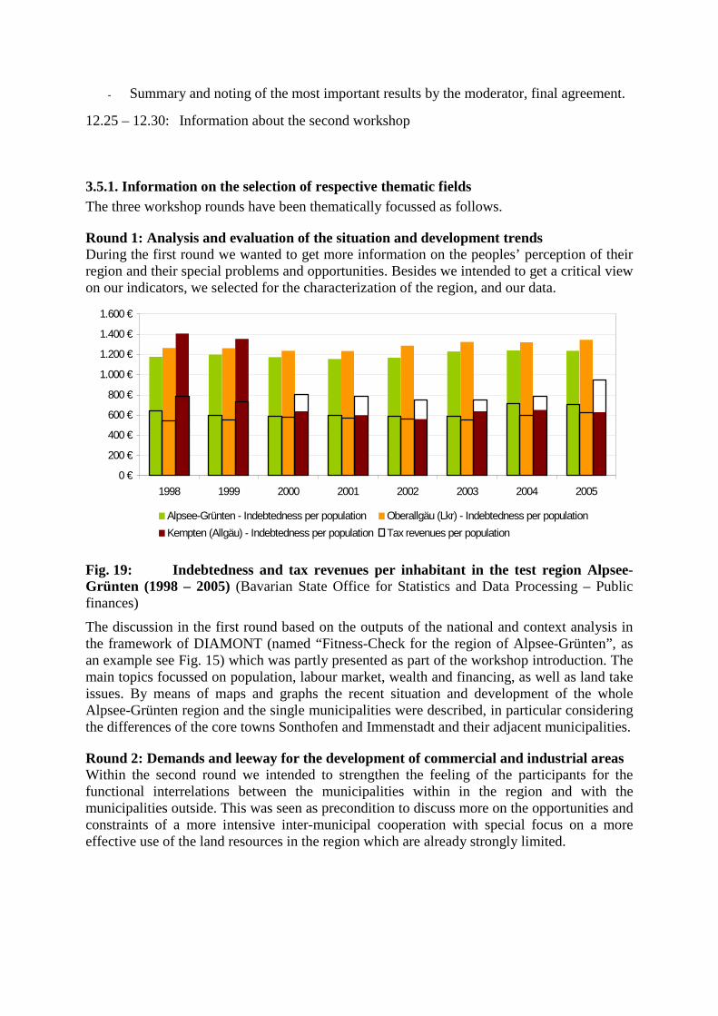
- Summary and noting of the most important results by the moderator, final agreement.
12.25 – 12.30: Information about the second workshop
3.5.1. Information on the selection of respective thematic fields The three workshop rounds have been thematically focussed as follows.
Round 1: Analysis and evaluation of the situation and development trends During the first round we wanted to get more information on the peoples’ perception of their region and their special problems and opportunities. Besides we intended to get a critical view on our indicators, we selected for the characterization of the region, and our data.
0 €
200 €
400 €
600 €
800 €
1.000 €
1.200 €
1.400 €
1.600 €
1998 1999 2000 2001 2002 2003 2004 2005
Alpsee-Grünten - Indebtedness per population Oberallgäu (Lkr) - Indebtedness per population
Kempten (Allgäu) - Indebtedness per population Tax revenues per population
Fig. 19: Indebtedness and tax revenues per inhabitant in the test region Alpsee-Grünten (1998 – 2005) (Bavarian State Office for Statistics and Data Processing – Public finances)
The discussion in the first round based on the outputs of the national and context analysis in the framework of DIAMONT (named “Fitness-Check for the region of Alpsee-Grünten”, as an example see Fig. 15) which was partly presented as part of the workshop introduction. The main topics focussed on population, labour market, wealth and financing, as well as land take issues. By means of maps and graphs the recent situation and development of the whole Alpsee-Grünten region and the single municipalities were described, in particular considering the differences of the core towns Sonthofen and Immenstadt and their adjacent municipalities.
Round 2: Demands and leeway for the development of commercial and industrial areas Within the second round we intended to strengthen the feeling of the participants for the functional interrelations between the municipalities within in the region and with the municipalities outside. This was seen as precondition to discuss more on the opportunities and constraints of a more intensive inter-municipal cooperation with special focus on a more effective use of the land resources in the region which are already strongly limited.
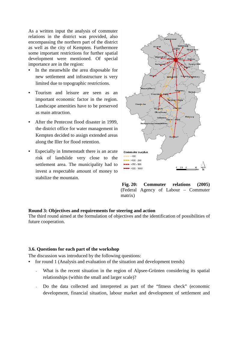
As a written input the analysis of commuter relations in the district was provided, also encompassing the northern part of the district as well as the city of Kempten. Furthermore some important restrictions for further spatial development were mentioned. Of special importance are in the region: • In the meanwhile the area disposable for
new settlement and infrastructure is very limited due to topographic restrictions.
• Tourism and leisure are seen as an important economic factor in the region. Landscape amenities have to be preserved as main attraction.
• After the Pentecost flood disaster in 1999, the district office for water management in Kempten decided to assign extended areas along the Iller for flood retention.
• Especially in Immenstadt there is an acute risk of landslide very close to the settlement area. The municipality had to invest a respectable amount of money to stabilize the mountain.
Fig. 20: Commuter relations (2005) (Federal Agency of Labour – Commuter matrix)
Round 3: Objectives and requirements for steering and action The third round aimed at the formulation of objectives and the identification of possibilities of future cooperation.
3.6. Questions for each part of the workshop The discussion was introduced by the following questions: • for round 1 (Analysis and evaluation of the situation and development trends)
- What is the recent situation in the region of Alpsee-Grünten considering its spatial relationships (within the small and larger scale)?
- Do the data collected and interpreted as part of the “fitness check” (economic development, financial situation, labour market and development of settlement and
infrastructure) reflect the actual situation of the region? Are there further important developments not reflected by these data?
- Which developments has the region to get ready for? Which challenges has the regions Alpsee-Grünten to face up concerning the future spatial development?
• for round 2 (Demands and leeway for the development of commercial and industrial areas)
- Which demand of space (extension and quality) is expected for industrial and commercial development in the municipalities in the medium term?
- Which leeway does still exist for the development of industrial and commercial areas with special view on the existing and future demands of other land uses in the municipalities and the region?
• for round 3 (Objectives and requirements for steering and action)
- Which requirements for action concerning the future development of industry, trade and services do you see? Where will intervention be necessary?
- Which common objectives would you deduce from the requirements for action?
3.7. Revised answers
Written results In the following the results of the workshops are documented. The documentation bases on the metaplan documentation of the participants. To avoid repetitions the results of the three rounds were summarized and structured inserting subtitles. All statements are free from interpretations of the workshops facilitators. We only tried to give some summarizing impressions under the category “Summarizing Results”.
1st round
What is the recent situation in the region
Demography The data are correct and reflect the reality. Immigration of old people preponderates.
1st round of Alpsee-Grünten considering its spatial relationships (on the small as well as on the larger scale)? Do the data collected and interpreted as part of the “fitness check” reflect the situation of the region? Are there further important developments not reflected by these data?
Employment Qualified working places are missing. Nevertheless, the employment situation is satisfying in general. A certain structural transformation already takes place and a positive trend on the labour market is noticeable. A strong competition between the municipalities for attracting firms is evident. The consequence is that businesses relocate from one municipality to the other (municipalities are ”poaching in the own stomping ground“). At the moment, the industrial economy strongly depends on one big enterprise (currently Bosch Immenstadt / Blaichach employs some 3.300 employees). Its location is seen as one of the biggest godsend for the whole region. Nevertheless, this structure seems to be risky the more so as Bosch does not attract additional ancillary industries. Therefore it would be desirable to attract at least one further big enterprise. At present there is no moving in of producing industries from outside the region. The importance of agriculture and forestry for employment and the overall regional economy is underestimated. The high landscape amenities of the region (and other ”soft” location factors) are not so important as “pull factor” as it is often assumed. Especially young people look much more for a close touch with bigger cities or for working places close-by their former training institutions (schools and universities), where often familiar relations have their seeds, too. In this regard, the city of Kempten has a lot of advantages in comparison to the southern municipalities. The question arises: For whom do we protect our pretty landscape, if nobody wants to live here?
Land resources
There is a great scarcity of available space. Especially flooding prevention requires extensive areas. The same applies to protected areas. The analysis of the real estate prices is correct. There is a “tradition” of high prices which do not seem adjusted to the market yet. The comparatively high prices impair the competitiveness with other adjacent regions where prices are much lower.
1st round
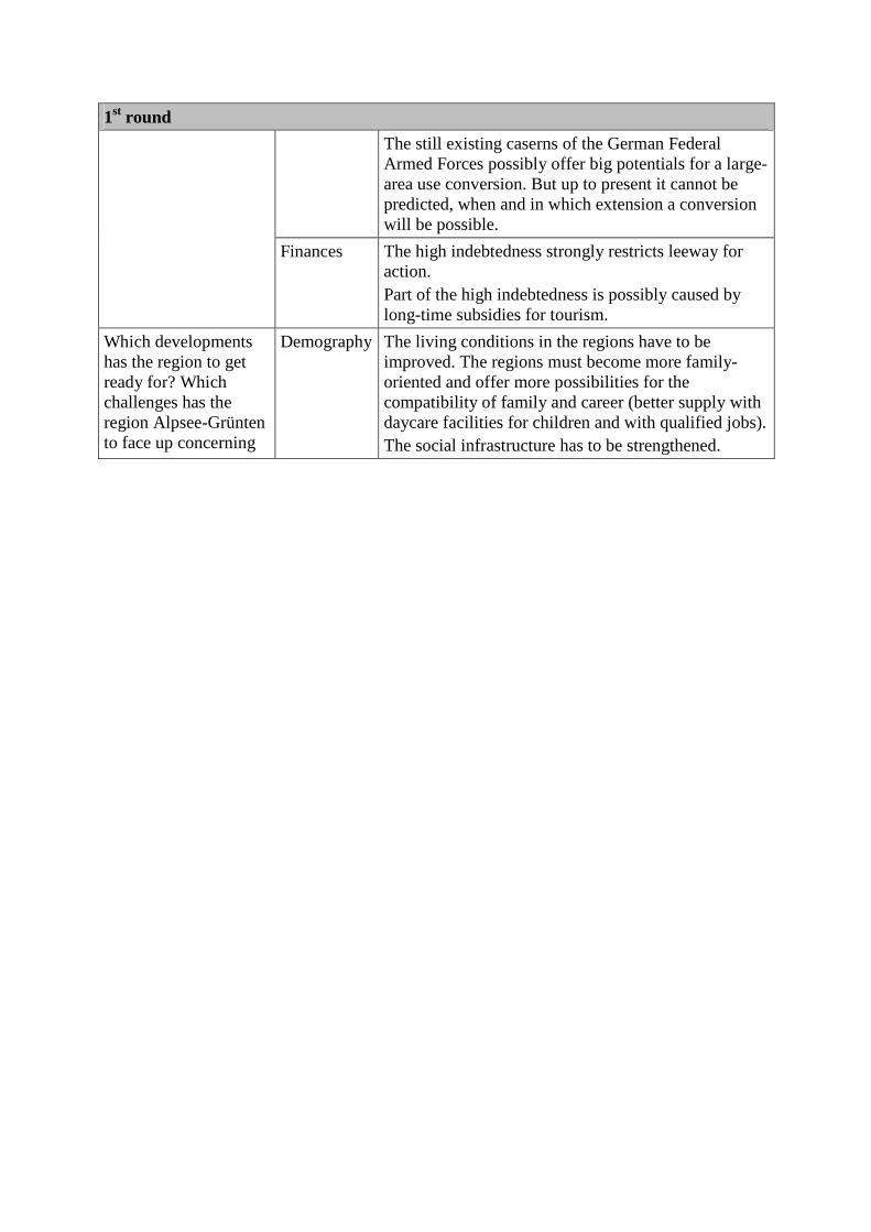
1st round
The still existing caserns of the German Federal Armed Forces possibly offer big potentials for a large-area use conversion. But up to present it cannot be predicted, when and in which extension a conversion will be possible.
Finances The high indebtedness strongly restricts leeway for action. Part of the high indebtedness is possibly caused by long-time subsidies for tourism.
Which developments has the region to get ready for? Which challenges has the region Alpsee-Grünten to face up concerning
Demography The living conditions in the regions have to be improved. The regions must become more family-oriented and offer more possibilities for the compatibility of family and career (better supply with daycare facilities for children and with qualified jobs). The social infrastructure has to be strengthened.
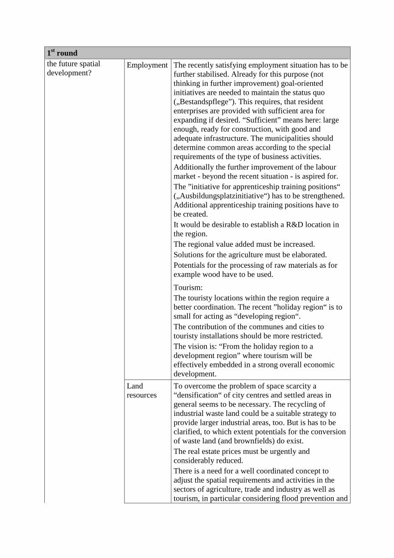
1st round the future spatial development?
Employment The recently satisfying employment situation has to be further stabilised. Already for this purpose (not thinking in further improvement) goal-oriented initiatives are needed to maintain the status quo („Bestandspflege”). This requires, that resident enterprises are provided with sufficient area for expanding if desired. “Sufficient” means here: large enough, ready for construction, with good and adequate infrastructure. The municipalities should determine common areas according to the special requirements of the type of business activities. Additionally the further improvement of the labour market - beyond the recent situation - is aspired for. The ”initiative for apprenticeship training positions“ („Ausbildungsplatzinitiative“) has to be strengthened. Additional apprenticeship training positions have to be created. It would be desirable to establish a R&D location in the region. The regional value added must be increased. Solutions for the agriculture must be elaborated. Potentials for the processing of raw materials as for example wood have to be used.
Tourism: The touristy locations within the region require a better coordination. The recent ”holiday region“ is to small for acting as “developing region“. The contribution of the communes and cities to touristy installations should be more restricted. The vision is: “From the holiday region to a development region” where tourism will be effectively embedded in a strong overall economic development.
Land resources
To overcome the problem of space scarcity a “densification“ of city centres and settled areas in general seems to be necessary. The recycling of industrial waste land could be a suitable strategy to provide larger industrial areas, too. But is has to be clarified, to which extent potentials for the conversion of waste land (and brownfields) do exist. The real estate prices must be urgently and considerably reduced. There is a need for a well coordinated concept to adjust the spatial requirements and activities in the sectors of agriculture, trade and industry as well as tourism, in particular considering flood prevention and
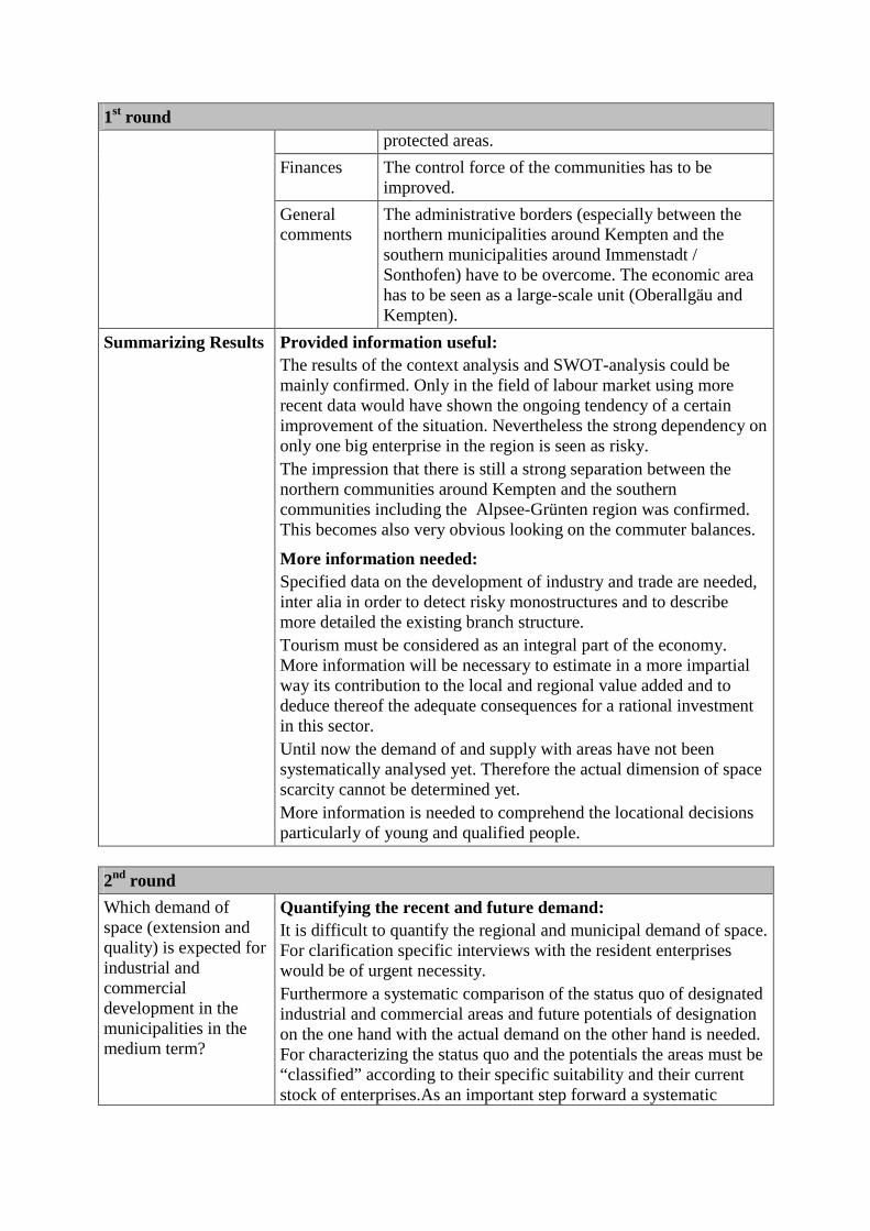
1st round protected areas.
Finances The control force of the communities has to be improved.
General comments
The administrative borders (especially between the northern municipalities around Kempten and the southern municipalities around Immenstadt / Sonthofen) have to be overcome. The economic area has to be seen as a large-scale unit (Oberallgäu and Kempten).
Summarizing Results Provided information useful: The results of the context analysis and SWOT-analysis could be mainly confirmed. Only in the field of labour market using more recent data would have shown the ongoing tendency of a certain improvement of the situation. Nevertheless the strong dependency on only one big enterprise in the region is seen as risky. The impression that there is still a strong separation between the northern communities around Kempten and the southern communities including the Alpsee-Grünten region was confirmed. This becomes also very obvious looking on the commuter balances.
More information needed: Specified data on the development of industry and trade are needed, inter alia in order to detect risky monostructures and to describe more detailed the existing branch structure. Tourism must be considered as an integral part of the economy. More information will be necessary to estimate in a more impartial way its contribution to the local and regional value added and to deduce thereof the adequate consequences for a rational investment in this sector. Until now the demand of and supply with areas have not been systematically analysed yet. Therefore the actual dimension of space scarcity cannot be determined yet. More information is needed to comprehend the locational decisions particularly of young and qualified people.
2nd round
Which demand of space (extension and quality) is expected for industrial and commercial development in the municipalities in the medium term?
Quantifying the recent and future demand: It is difficult to quantify the regional and municipal demand of space. For clarification specific interviews with the resident enterprises would be of urgent necessity. Furthermore a systematic comparison of the status quo of designated industrial and commercial areas and future potentials of designation on the one hand with the actual demand on the other hand is needed. For characterizing the status quo and the potentials the areas must be “classified” according to their specific suitability and their current stock of enterprises.As an important step forward a systematic
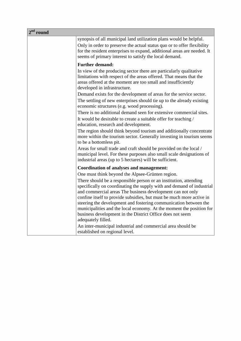
2nd round synopsis of all municipal land utilization plans would be helpful. Only in order to preserve the actual status quo or to offer flexibility for the resident enterprises to expand, additional areas are needed. It seems of primary interest to satisfy the local demand.
Further demand: In view of the producing sector there are particularly qualitative limitations with respect of the areas offered. That means that the areas offered at the moment are too small and insufficiently developed in infrastructure. Demand exists for the development of areas for the service sector. The settling of new enterprises should tie up to the already existing economic structures (e.g. wood processing). There is no additional demand seen for extensive commercial sites. It would be desirable to create a suitable offer for teaching / education, research and development. The region should think beyond tourism and additionally concentrate more within the tourism sector. Generally investing in tourism seems to be a bottomless pit. Areas for small trade and craft should be provided on the local / municipal level. For these purposes also small scale designations of industrial areas (up to 5 hectares) will be sufficient.
Coordination of analyses and management: One must think beyond the Alpsee-Grünten region. There should be a responsible person or an institution, attending specifically on coordinating the supply with and demand of industrial and commercial areas The business development can not only confine itself to provide subsidies, but must be much more active in steering the development and fostering communication between the municipalities and the local economy. At the moment the position for business development in the District Office does not seem adequately filled. An inter-municipal industrial and commercial area should be established on regional level.
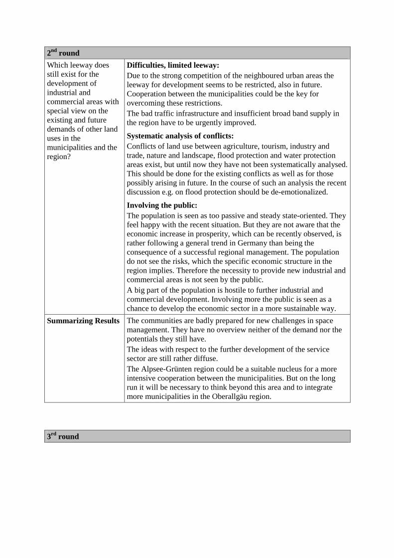
2nd round
Which leeway does still exist for the development of industrial and commercial areas with special view on the existing and future demands of other land uses in the municipalities and the region?
Difficulties, limited leeway: Due to the strong competition of the neighboured urban areas the leeway for development seems to be restricted, also in future. Cooperation between the municipalities could be the key for overcoming these restrictions. The bad traffic infrastructure and insufficient broad band supply in the region have to be urgently improved.
Systematic analysis of conflicts: Conflicts of land use between agriculture, tourism, industry and trade, nature and landscape, flood protection and water protection areas exist, but until now they have not been systematically analysed. This should be done for the existing conflicts as well as for those possibly arising in future. In the course of such an analysis the recent discussion e.g. on flood protection should be de-emotionalized.
Involving the public: The population is seen as too passive and steady state-oriented. They feel happy with the recent situation. But they are not aware that the economic increase in prosperity, which can be recently observed, is rather following a general trend in Germany than being the consequence of a successful regional management. The population do not see the risks, which the specific economic structure in the region implies. Therefore the necessity to provide new industrial and commercial areas is not seen by the public. A big part of the population is hostile to further industrial and commercial development. Involving more the public is seen as a chance to develop the economic sector in a more sustainable way.
Summarizing Results The communities are badly prepared for new challenges in space management. They have no overview neither of the demand nor the potentials they still have. The ideas with respect to the further development of the service sector are still rather diffuse. The Alpsee-Grünten region could be a suitable nucleus for a more intensive cooperation between the municipalities. But on the long run it will be necessary to think beyond this area and to integrate more municipalities in the Oberallgäu region.
3rd round

Which requirements for action concerning the future development of industry, trade and services do you see? Where will intervention be necessary?
Task sharing and focal points: The further development of trade and services in the region needs a more stringent task sharing. The expansion of the existing industries and the greenfield development should be concentrated in the north of Immenstadt. In the southern part of the Oberallgäu there should be put more emphasis on the further and coordinated development of tourism and the supply with suitable locations in order to prepare the ground for the sectors of research and education / training. Existing and future industrial areas have to be “classified”, that means clear functions have to be assigned to the respective areas. The development potentials should be studied for possible new branches (e.g. for wood processing) considering the regional and supra-regional market situation.
Marketing: An important requirement is a purposeful interior and exterior marketing for business development. Part of the internal marketing could be to spark interest of second home owners of the region in the industrial situation and the future of the region and to address them as a target group for investing in the region. Nevertheless, marketing will not be successful if there are no activities for supplying suitable areas in parallel.
Financing: The credit financing by the local banks seems too strongly restricted. The impression is that in Germany the Basel II regulations are implemented more strictly than in the neighbouring countries. A closer cooperation with the local and regional banks is necessary to foster investment activities. The financial equalisation between the municipalities must be re-organized.
Creation of awareness: The population has to be more intensively involved in the current development of the region and informed in time about possible risks and options. The citizens should develop more sensitivity for processes occurring in their region. People have to understand that the main objective is that the existing enterprises will remain in the region, but not necessarily in the own municipality. Politicians should not be obliged to justify business relocations from one to another municipality in the same region. In general, the population needs more willingness for changing.
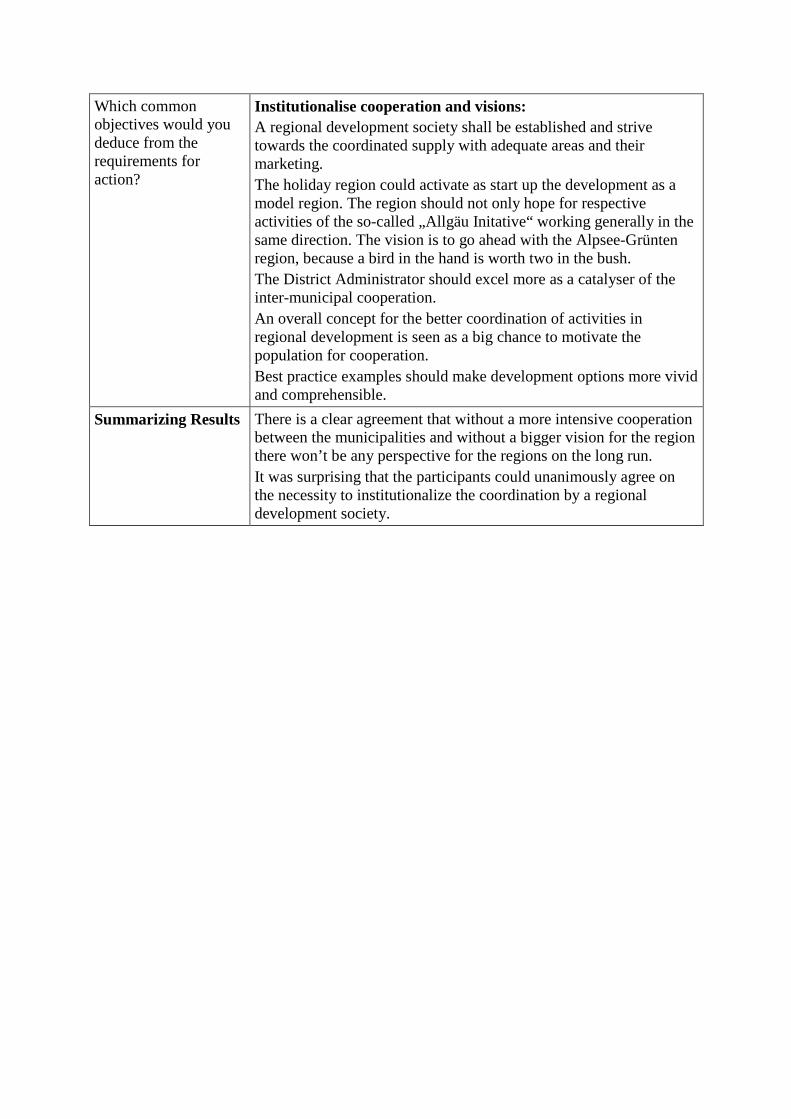
Which common objectives would you deduce from the requirements for action?
Institutionalise cooperation and visions: A regional development society shall be established and strive towards the coordinated supply with adequate areas and their marketing. The holiday region could activate as start up the development as a model region. The region should not only hope for respective activities of the so-called „Allgäu Initative“ working generally in the same direction. The vision is to go ahead with the Alpsee-Grünten region, because a bird in the hand is worth two in the bush. The District Administrator should excel more as a catalyser of the inter-municipal cooperation. An overall concept for the better coordination of activities in regional development is seen as a big chance to motivate the population for cooperation. Best practice examples should make development options more vivid and comprehensible.
Summarizing Results There is a clear agreement that without a more intensive cooperation between the municipalities and without a bigger vision for the region there won’t be any perspective for the regions on the long run. It was surprising that the participants could unanimously agree on the necessity to institutionalize the coordination by a regional development society.
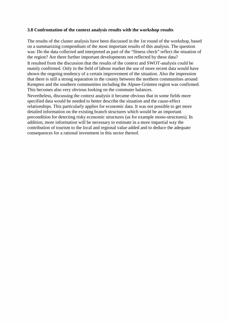
3.8 Confrontation of the context analysis results with the workshop results
The results of the cluster analysis have been discussed in the 1st round of the workshop, based on a summarizing compendium of the most important results of this analysis. The question was: Do the data collected and interpreted as part of the “fitness check” reflect the situation of the region? Are there further important developments not reflected by these data? It resulted from the discussion that the results of the context and SWOT-analysis could be mainly confirmed. Only in the field of labour market the use of more recent data would have shown the ongoing tendency of a certain improvement of the situation. Also the impression that there is still a strong separation in the county between the northern communities around Kempten and the southern communities including the Alpsee-Grünten region was confirmed. This becomes also very obvious looking on the commuter balances. Nevertheless, discussing the context analysis it became obvious that in some fields more specified data would be needed to better describe the situation and the cause-effect relationships. This particularly applies for economic data. It was not possible to get more detailed information on the existing branch structures which would be an important precondition for detecting risky economic structures (as for example mono-structures). In addition, more information will be necessary to estimate in a more impartial way the contribution of tourism to the local and regional value added and to deduce the adequate consequences for a rational investment in this sector thereof.
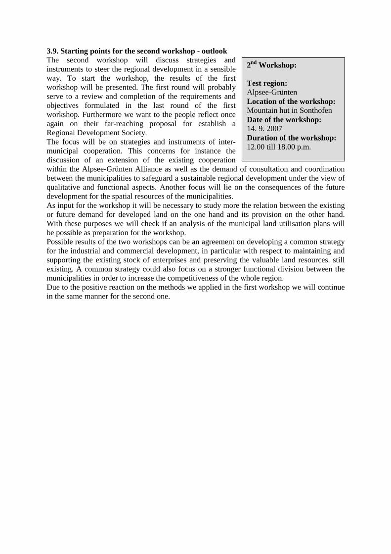
3.9. Starting points for the second workshop - outlook The second workshop will discuss strategies and instruments to steer the regional development in a sensible way. To start the workshop, the results of the first workshop will be presented. The first round will probably serve to a review and completion of the requirements and objectives formulated in the last round of the first workshop. Furthermore we want to the people reflect once again on their far-reaching proposal for establish a Regional Development Society. The focus will be on strategies and instruments of inter-municipal cooperation. This concerns for instance the discussion of an extension of the existing cooperation within the Alpsee-Grünten Alliance as well as the demand of consultation and coordination between the municipalities to safeguard a sustainable regional development under the view of qualitative and functional aspects. Another focus will lie on the consequences of the future development for the spatial resources of the municipalities. As input for the workshop it will be necessary to study more the relation between the existing or future demand for developed land on the one hand and its provision on the other hand. With these purposes we will check if an analysis of the municipal land utilisation plans will be possible as preparation for the workshop. Possible results of the two workshops can be an agreement on developing a common strategy for the industrial and commercial development, in particular with respect to maintaining and supporting the existing stock of enterprises and preserving the valuable land resources. still existing. A common strategy could also focus on a stronger functional division between the municipalities in order to increase the competitiveness of the whole region. Due to the positive reaction on the methods we applied in the first workshop we will continue in the same manner for the second one.
2nd Workshop: Test region: Alpsee-Grünten Location of the workshop: Mountain hut in Sonthofen Date of the workshop: 14. 9. 2007 Duration of the workshop: 12.00 till 18.00 p.m.
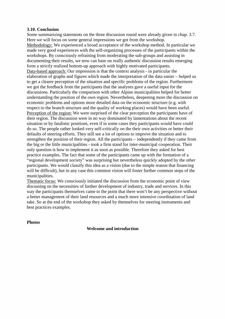
3.10. Conclusion Some summarizing statements on the three discussion round were already given in chap. 3.7. Here we will focus on some general impressions we got from the workshop. Methodology: We experienced a broad acceptance of the workshop method. In particular we made very good experiences with the self-organizing processes of the participants within the workshops. By consciously refraining from moderating the sub-groups and assisting in documenting their results, we now can base on really authentic discussion results emerging form a strictly realized bottom-up approach with highly motivated participants. Data-based approach: Our impression is that the context analysis - in particular the elaboration of graphs and figures which made the interpretation of the data easier – helped us to get a clearer perception of the situation and specific problems of the region. Furthermore we got the feedback from the participants that the analyses gave a useful input for the discussions. Particularly the comparison with other Alpine municipalities helped for better understanding the position of the own region. Nevertheless, deepening more the discussion on economic problems and options more detailed data on the economic structure (e.g. with respect to the branch structure and the quality of working places) would have been useful. Perception of the region: We were surprised of the clear perception the participants have of their region. The discussion were in no way dominated by lamentations about the recent situation or by fatalistic positions, even if in some cases they participants would have could do so. The people rather looked very self-critically on the their own activities or better their defaults of steering efforts. They still see a lot of options to improve the situation and to strengthen the position of their region. All the participants – independently if they came from the big or the little municipalities - took a firm stand for inter-municipal cooperation. Their only question is how to implement it as soon as possible. Therefore they asked for best practice examples. The fact that some of the participants came up with the formation of a “regional development society” was surprising but nevertheless quickly adopted by the other participants. We would classify this idea as a vision (due to the simple reason that financing will be difficult), but in any case this common vision will foster further common steps of the municipalities. Thematic focus: We consciously initiated the discussion from the economic point of view discussing on the necessities of further development of industry, trade and services. In this way the participants themselves came to the point that there won’t be any perspective without a better management of their land resources and a much more intensive coordination of land take. So at the end of the workshop they asked by themselves for steering instruments and best practices examples.
Photos Welcome and introduction
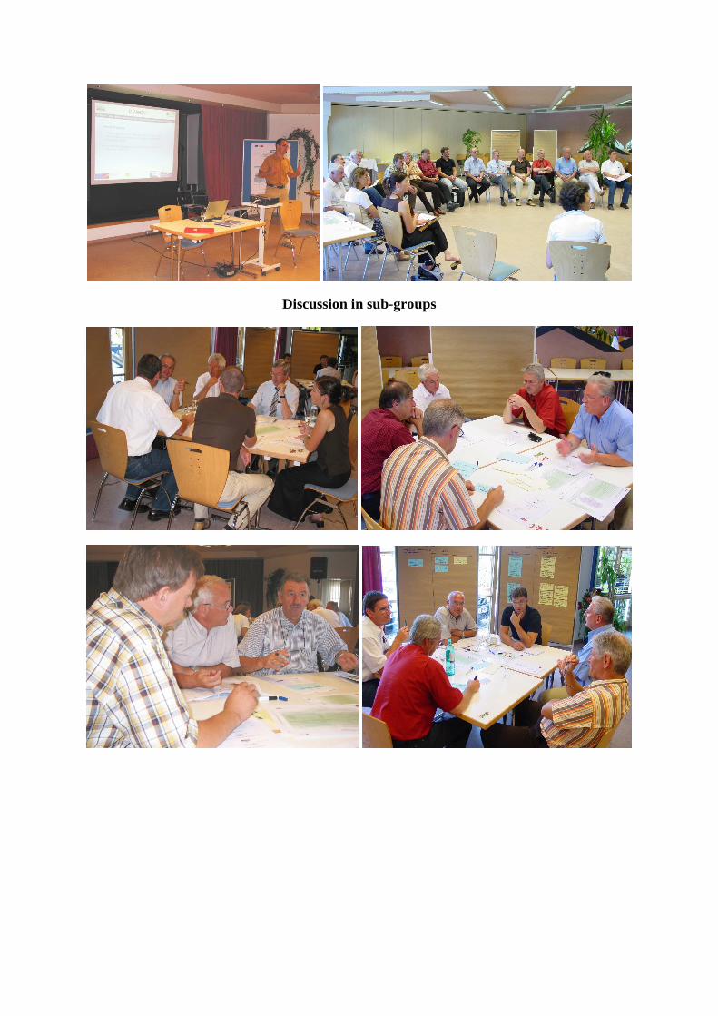
Discussion in sub-groups
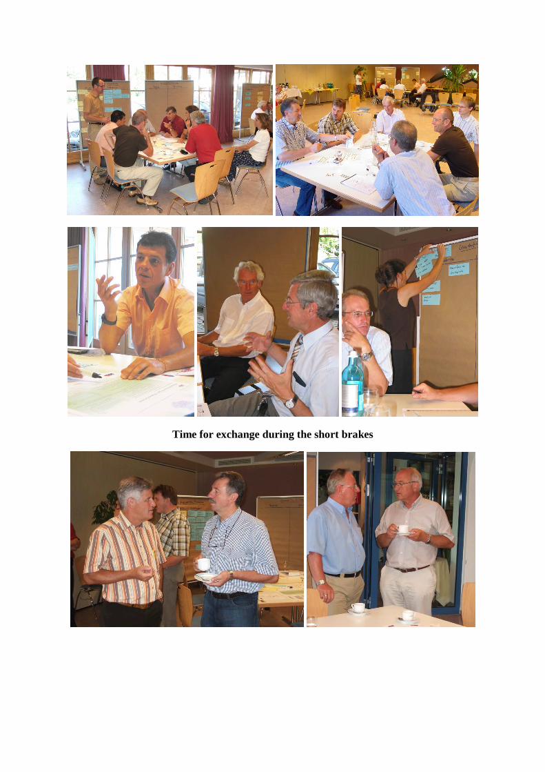
Time for exchange during the short brakes
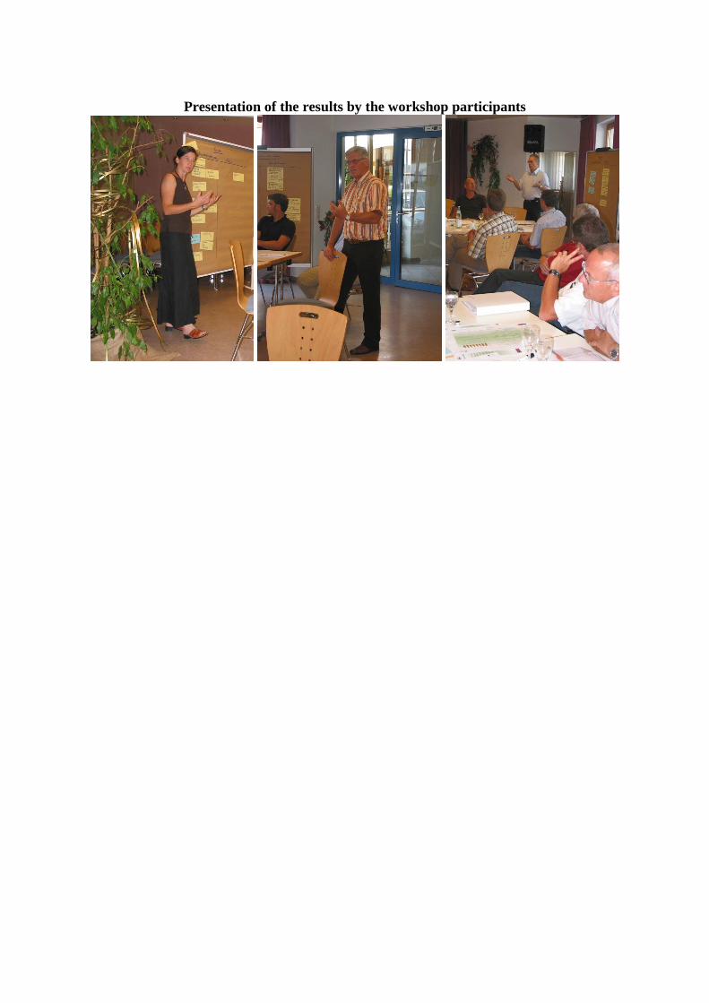
Presentation of the results by the workshop participants
4. Germany – Traunstein/Traunreut Country: Germany Test region: TRAUNSTEIN/TRAUNREUT Workshop results Location of the workshop: Traunstein Date of the workshop: 27. 06. 2007 Number of participants: 18 Project partner: ifuplan – Institut für Umweltplanu ng, Landschaftsentwicklung und Naturschutz
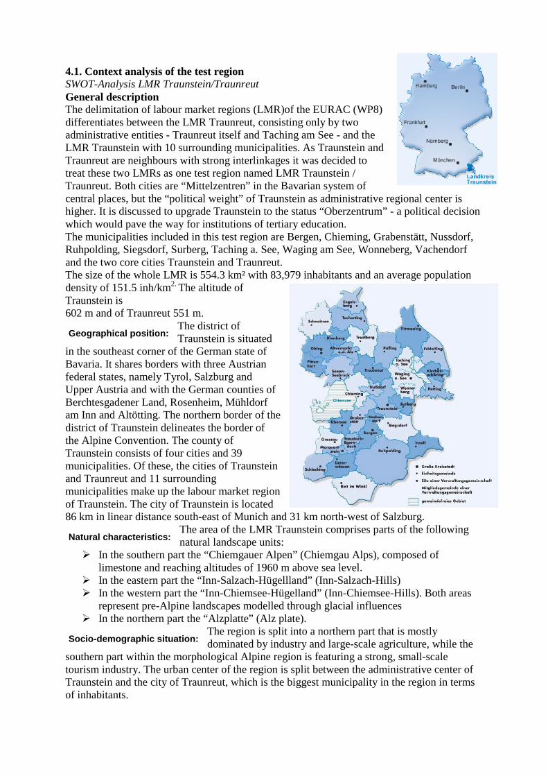
4.1. Context analysis of the test region SWOT-Analysis LMR Traunstein/Traunreut General description The delimitation of labour market regions (LMR)of the EURAC (WP8) differentiates between the LMR Traunreut, consisting only by two administrative entities - Traunreut itself and Taching am See - and the LMR Traunstein with 10 surrounding municipalities. As Traunstein and Traunreut are neighbours with strong interlinkages it was decided to treat these two LMRs as one test region named LMR Traunstein / Traunreut. Both cities are “Mittelzentren” in the Bavarian system of central places, but the “political weight” of Traunstein as administrative regional center is higher. It is discussed to upgrade Traunstein to the status “Oberzentrum” - a political decision which would pave the way for institutions of tertiary education. The municipalities included in this test region are Bergen, Chieming, Grabenstätt, Nussdorf, Ruhpolding, Siegsdorf, Surberg, Taching a. See, Waging am See, Wonneberg, Vachendorf and the two core cities Traunstein and Traunreut. The size of the whole LMR is 554.3 km² with 83,979 inhabitants and an average population density of 151.5 inh/km2. The altitude of Traunstein is 602 m and of Traunreut 551 m.
The district of Traunstein is situated
in the southeast corner of the German state of Bavaria. It shares borders with three Austrian federal states, namely Tyrol, Salzburg and Upper Austria and with the German counties of Berchtesgadener Land, Rosenheim, Mühldorf am Inn and Altötting. The northern border of the district of Traunstein delineates the border of the Alpine Convention. The county of Traunstein consists of four cities and 39 municipalities. Of these, the cities of Traunstein and Traunreut and 11 surrounding municipalities make up the labour market region of Traunstein. The city of Traunstein is located 86 km in linear distance south-east of Munich and 31 km north-west of Salzburg.
The area of the LMR Traunstein comprises parts of the following natural landscape units:
� In the southern part the “Chiemgauer Alpen” (Chiemgau Alps), composed of limestone and reaching altitudes of 1960 m above sea level.
� In the eastern part the “Inn-Salzach-Hügellland” (Inn-Salzach-Hills) � In the western part the “Inn-Chiemsee-Hügelland” (Inn-Chiemsee-Hills). Both areas
represent pre-Alpine landscapes modelled through glacial influences � In the northern part the “Alzplatte” (Alz plate).
The region is split into a northern part that is mostly dominated by industry and large-scale agriculture, while the
southern part within the morphological Alpine region is featuring a strong, small-scale tourism industry. The urban center of the region is split between the administrative center of Traunstein and the city of Traunreut, which is the biggest municipality in the region in terms of inhabitants.
Geographical position:
Natural characteristics:
Socio-demographic situation:
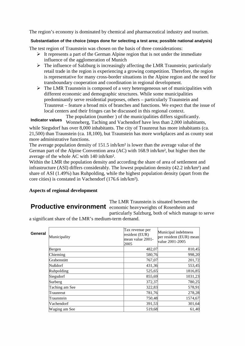
The region’s economy is dominated by chemical and pharmaceutical industry and tourism.
The test region of Traunstein was chosen on the basis of three considerations: � It represents a part of the German Alpine region that is not under the immediate
influence of the agglomeration of Munich � The influence of Salzburg is increasingly affecting the LMR Traunstein; particularly
retail trade in the region is experiencing a growing competition. Therefore, the region is representative for many cross-border situations in the Alpine region and the need for transboundary cooperation and coordination in regional development.
� The LMR Traunstein is composed of a very heterogeneous set of municipalities with different economic and demographic structures. While some municipalities predominantly serve residential purposes, others – particularly Traunstein and Traunreut – feature a broad mix of branches and functions. We expect that the issue of local centers and their fringes can be discussed in this regional context.
The population (number ) of the municipalities differs significantly. Wonneberg, Taching and Vachendorf have less than 2,000 inhabitants,
while Siegsdorf has over 8,000 inhabitants. The city of Traunreut has more inhabitants (ca. 21,500) than Traunstein (ca. 18,100), but Traunstein has more workplaces and as county seat more administrative functions. The average population density of 151.5 inh/km² is lower than the average value of the German part of the Alpine Convention area (AC) with 168.9 inh/km², but higher then the average of the whole AC with 140 inh/km². Within the LMR the population density and according the share of area of settlement and infrastructure (ASI) differs considerably. The lowest population density (42.2 inh/km²) and share of ASI (1.49%) has Ruhpolding, while the highest population density (apart from the core cities) is constated in Vachendorf (176.6 inh/km²). Aspects of regional development
The LMR Traunstein is situated between the economic heavyweights of Rosenheim and particularly Salzburg, both of which manage to serve
a significant share of the LMR’s medium-term demand.
Municipality
Tax revenue per resident (EUR) mean value 2001-2005
Municipal indebtness per resident (EUR) mean value 2001-2005
Bergen 482,07 810,45Chieming 580,76 998,20Grabenstätt 767,07 201,72Nußdorf 431,36 553,45Ruhpolding 525,65 1816,85Siegsdorf 855,69 1031,23Surberg 372,37 780,25Taching am See 322,83 578,91Traunreut 781,76 278,28Traunstein 750,48 1574,67Vachendorf 391,53 301,64Waging am See 519,68 61,40
Substantiation of the choice (steps done for selecting a test area; possible national analysis)
Indicator values
Productive environment
General
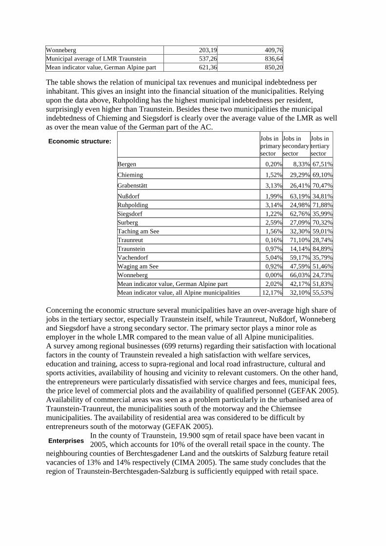
Wonneberg 203,19 409,76Municipal average of LMR Traunstein 537,26 836,64Mean indicator value, German Alpine part 621,36 850,20
The table shows the relation of municipal tax revenues and municipal indebtedness per inhabitant. This gives an insight into the financial situation of the municipalities. Relying upon the data above, Ruhpolding has the highest municipal indebtedness per resident, surprisingly even higher than Traunstein. Besides these two municipalities the municipal indebtedness of Chieming and Siegsdorf is clearly over the average value of the LMR as well as over the mean value of the German part of the AC.
Jobs in primary sector
Jobs in secondary sector
Jobs in tertiary sector
Bergen 0,20% 8,33% 67,51%
Chieming 1,52% 29,29% 69,10%
Grabenstätt 3,13% 26,41% 70,47%
Nußdorf 1,99% 63,19% 34,81%Ruhpolding 3,14% 24,98% 71,88%Siegsdorf 1,22% 62,76% 35,99%Surberg 2,59% 27,09% 70,32%Taching am See 1,56% 32,30% 59,01%Traunreut 0,16% 71,10% 28,74%Traunstein 0,97% 14,14% 84,89%Vachendorf 5,04% 59,17% 35,79%Waging am See 0,92% 47,59% 51,46%Wonneberg 0,00% 66,03% 24,73%Mean indicator value, German Alpine part 2,02% 42,17% 51,83%Mean indicator value, all Alpine municipalities 12,17% 32,10% 55,53%
Concerning the economic structure several municipalities have an over-average high share of jobs in the tertiary sector, especially Traunstein itself, while Traunreut, Nußdorf, Wonneberg and Siegsdorf have a strong secondary sector. The primary sector plays a minor role as employer in the whole LMR compared to the mean value of all Alpine municipalities. A survey among regional businesses (699 returns) regarding their satisfaction with locational factors in the county of Traunstein revealed a high satisfaction with welfare services, education and training, access to supra-regional and local road infrastructure, cultural and sports activities, availability of housing and vicinity to relevant customers. On the other hand, the entrepreneurs were particularly dissatisfied with service charges and fees, municipal fees, the price level of commercial plots and the availability of qualified personnel (GEFAK 2005). Availability of commercial areas was seen as a problem particularly in the urbanised area of Traunstein-Traunreut, the municipalities south of the motorway and the Chiemsee municipalities. The availability of residential area was considered to be difficult by entrepreneurs south of the motorway (GEFAK 2005).
In the county of Traunstein, 19.900 sqm of retail space have been vacant in 2005, which accounts for 10% of the overall retail space in the county. The
neighbouring counties of Berchtesgadener Land and the outskirts of Salzburg feature retail vacancies of 13% and 14% respectively (CIMA 2005). The same study concludes that the region of Traunstein-Berchtesgaden-Salzburg is sufficiently equipped with retail space.
Economic structure:
Enterprises
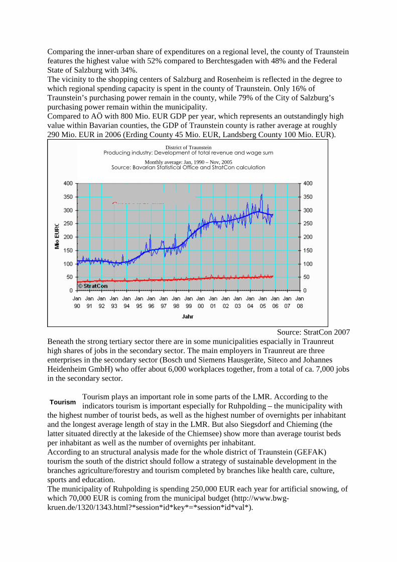
Comparing the inner-urban share of expenditures on a regional level, the county of Traunstein features the highest value with 52% compared to Berchtesgaden with 48% and the Federal State of Salzburg with 34%. The vicinity to the shopping centers of Salzburg and Rosenheim is reflected in the degree to which regional spending capacity is spent in the county of Traunstein. Only 16% of Traunstein’s purchasing power remain in the county, while 79% of the City of Salzburg’s purchasing power remain within the municipality. Compared to AÖ with 800 Mio. EUR GDP per year, which represents an outstandingly high value within Bavarian counties, the GDP of Traunstein county is rather average at roughly 290 Mio. EUR in 2006 (Erding County 45 Mio. EUR, Landsberg County 100 Mio. EUR).
Source: StratCon 2007
Beneath the strong tertiary sector there are in some municipalities espacially in Traunreut high shares of jobs in the secondary sector. The main employers in Traunreut are three enterprises in the secondary sector (Bosch und Siemens Hausgeräte, Siteco and Johannes Heidenheim GmbH) who offer about 6,000 workplaces together, from a total of ca. 7,000 jobs in the secondary sector.
Tourism plays an important role in some parts of the LMR. According to the indicators tourism is important especially for Ruhpolding – the municipality with
the highest number of tourist beds, as well as the highest number of overnights per inhabitant and the longest average length of stay in the LMR. But also Siegsdorf and Chieming (the latter situated directly at the lakeside of the Chiemsee) show more than average tourist beds per inhabitant as well as the number of overnights per inhabitant. According to an structural analysis made for the whole district of Traunstein (GEFAK) tourism the south of the district should follow a strategy of sustainable development in the branches agriculture/forestry and tourism completed by branches like health care, culture, sports and education. The municipality of Ruhpolding is spending 250,000 EUR each year for artificial snowing, of which 70,000 EUR is coming from the municipal budget (http://www.bwg-kruen.de/1320/1343.html?*session*id*key*=*session*id*val*).
Tourism
District of Traunstein Producing industry: Development of total revenue and wage sum
Monthly average: Jan, 1990 – Nov, 2005 Source: Bavarian Statistical Office and StratCon calculation
Total revenue Gross wage sum
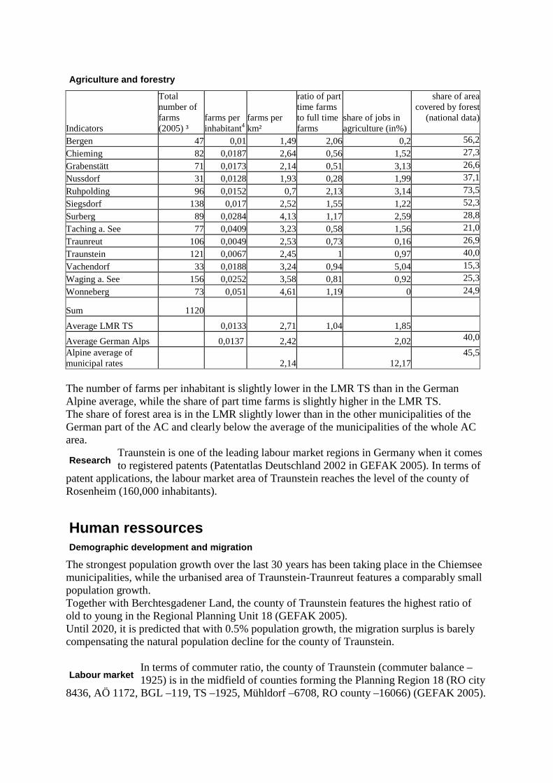
Indicators
Total number of farms (2005) ³
farms per inhabitant4
farms per km²
ratio of part time farms to full time farms
share of jobs in agriculture (in%)
share of area covered by forest
(national data)
Bergen 47 0,01 1,49 2,06 0,2 56,2
Chieming 82 0,0187 2,64 0,56 1,52 27,3
Grabenstätt 71 0,0173 2,14 0,51 3,13 26,6
Nussdorf 31 0,0128 1,93 0,28 1,99 37,1
Ruhpolding 96 0,0152 0,7 2,13 3,14 73,5
Siegsdorf 138 0,017 2,52 1,55 1,22 52,3
Surberg 89 0,0284 4,13 1,17 2,59 28,8
Taching a. See 77 0,0409 3,23 0,58 1,56 21,0
Traunreut 106 0,0049 2,53 0,73 0,16 26,9
Traunstein 121 0,0067 2,45 1 0,97 40,0
Vachendorf 33 0,0188 3,24 0,94 5,04 15,3
Waging a. See 156 0,0252 3,58 0,81 0,92 25,3
Wonneberg 73 0,051 4,61 1,19 0 24,9
Sum 1120
Average LMR TS 0,0133 2,71 1,04 1,85
Average German Alps 0,0137 2,42 2,02 40,0
Alpine average of municipal rates 2,14 12,17
45,5
The number of farms per inhabitant is slightly lower in the LMR TS than in the German Alpine average, while the share of part time farms is slightly higher in the LMR TS. The share of forest area is in the LMR slightly lower than in the other municipalities of the German part of the AC and clearly below the average of the municipalities of the whole AC area.
Traunstein is one of the leading labour market regions in Germany when it comes to registered patents (Patentatlas Deutschland 2002 in GEFAK 2005). In terms of
patent applications, the labour market area of Traunstein reaches the level of the county of Rosenheim (160,000 inhabitants).
The strongest population growth over the last 30 years has been taking place in the Chiemsee municipalities, while the urbanised area of Traunstein-Traunreut features a comparably small population growth. Together with Berchtesgadener Land, the county of Traunstein features the highest ratio of old to young in the Regional Planning Unit 18 (GEFAK 2005). Until 2020, it is predicted that with 0.5% population growth, the migration surplus is barely compensating the natural population decline for the county of Traunstein.
In terms of commuter ratio, the county of Traunstein (commuter balance –1925) is in the midfield of counties forming the Planning Region 18 (RO city
8436, AÖ 1172, BGL –119, TS –1925, Mühldorf –6708, RO county –16066) (GEFAK 2005).
Agriculture and forestry
Research
Human ressources
Demographic development and migration
Labour market
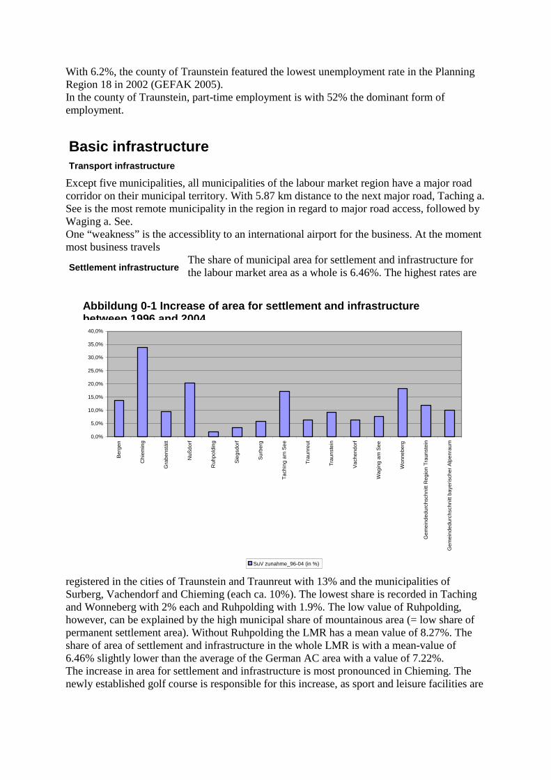
With 6.2%, the county of Traunstein featured the lowest unemployment rate in the Planning Region 18 in 2002 (GEFAK 2005). In the county of Traunstein, part-time employment is with 52% the dominant form of employment.
Except five municipalities, all municipalities of the labour market region have a major road corridor on their municipal territory. With 5.87 km distance to the next major road, Taching a. See is the most remote municipality in the region in regard to major road access, followed by Waging a. See. One “weakness” is the accessiblity to an international airport for the business. At the moment most business travels
The share of municipal area for settlement and infrastructure for the labour market area as a whole is 6.46%. The highest rates are
registered in the cities of Traunstein and Traunreut with 13% and the municipalities of Surberg, Vachendorf and Chieming (each ca. 10%). The lowest share is recorded in Taching and Wonneberg with 2% each and Ruhpolding with 1.9%. The low value of Ruhpolding, however, can be explained by the high municipal share of mountainous area (= low share of permanent settlement area). Without Ruhpolding the LMR has a mean value of 8.27%. The share of area of settlement and infrastructure in the whole LMR is with a mean-value of 6.46% slightly lower than the average of the German AC area with a value of 7.22%. The increase in area for settlement and infrastructure is most pronounced in Chieming. The newly established golf course is responsible for this increase, as sport and leisure facilities are
Basic infrastructure
Transport infrastructure
Settlement infrastructure
0,0%
5,0%
10,0%
15,0%
20,0%
25,0%
30,0%
35,0%
40,0%
Ber
gen
Chi
emin
g
Gra
bens
tätt
Nuß
dorf
Ruh
pold
ing
Sie
gsdo
rf
Sur
berg
Tac
hing
am
See
Tra
unre
ut
Tra
unst
ein
Vac
hend
orf
Wag
ing
am S
ee
Won
nebe
rg
Gem
eind
edur
chsc
hnitt
Reg
ion
Tra
unst
ein
Gem
eind
edur
chsc
hnitt
bay
eris
cher
Alp
enra
um
SuV zunahme_96-04 (in %)
Abbildung 0-1 Increase of area for settlement and i nfrastructure between 1996 and 2004

also part of the indicator. Nussdorf, Wonneberg and Taching am See have also seen increases of above 15% over the time period. Ruhpolding again ranks as the municipality with the lowest increase in area for settlement and infrastructure, followed by Siegsdorf, Surberg and surprisingly Traunreut. Obviously, significant increases are not necessarily related to high population numbers. The labour market region as a whole is ranking above the Bavarian average in regard to land take for settlement and infrastructure. SWOT-Analysis of the municipality results Productive environment Strengths:
• Innovativeness • Mix of branches • High added value per resident • High share of jobs in the tertiary sector
Weaknesses: • Productive sector: jobs in Traunstein rely to a great share on only three enterprises=>
risk of high unemployment if one enterprise moves out • Forested areas lower than in other regions • Except Ruhpolding, Chieming and Siegsdorf, tourism is not well developed (below
average tourist beds/inh. compared to the AC area) • Outflow of regional spending capacity towards Salzburg and Rosenheim
Opportunities: • Some municipalities have good preconditions for tourism (the municipalities in the
southern part of the LMR and those with direct access to the lakes) Threats: Human Resources Strengths:
• Positive perception by entrepreneurs of education and training services in the region •
Weaknesses: • recruitment of qualified personnel difficult • ratio of old to young second highest in the Planning Region 18
Opportunities: Threats: Basic Infrastructure Strengths:
• Quality of the landscape/recreational value Weaknesses:
• Limited availability of land •
Opportunities: Threats: 4.2. Preparation of the workshop Methodology The meeting started at 2 p.m. with a short introduction of ourselves and the DIAMONT project. We presented a brief overview of the issue and the region’s situation in regard to statistical data related to land resource management. After this 20 min. presentation, we briefly introduced the World Café method and asked the participants to draw lots, which
determined four discussion groups for the first round. By mixing the groups for the first round randomly, we avoided that people that already know each other and each other’s point of view would end up in the same group. For the subsequent rounds, we asked participants to not move to the next table as a whole group, but to come together in new constellations. The intention behind that was to avoid that a person that adopted the role of group leader or spokesperson at one table would not necessarily remain in that position for the following rounds, thus giving more reserved participants also the chance to share their ideas. The table rounds were moderated by ifuplan staff, who gave a short introduction in the table’s topic in the beginning of each round and summed up what has been discussed in the rounds before. During the table round discussion, the participants were asked to put down their ideas and contributions on paper cards. For some rounds it worked well, while for others the discussion had to be recorded by ifuplan staff. After 4 table rounds with 30 min. each the results of discussions at each table was structured by ifuplan staff and presented to the audience using the paper cards and a flip chart. At the end of the workshop, participants were asked to weigh the various aspects on the flip chart with “points of importance”, of which two were handed out to participants. In the follow-up of the workshop, we forwarded the electronic version of presentations to the participants and prepared a summary, which we sent out in hardcopy form. 4.3. List of selected instruments In the first workshop, we laid more emphasise on discussing the various aspects of sustainable land resource management and building a common basis for discussion potential instruments. In that course, various instruments such as the regional pool of commercial areas, the taxation of greenfield parking facilities or the requirement to develop a regional retail concept have been raised by the participants, but these instruments have not been explicitly introduced by us. 4.4. List of stakeholders
Name and surname Institution/Municipality type position Marlene
Berger-Stöckl Water and Environmental
Association Chiemsee Association of
municipalities around Lake Chiemsee that addresses issues of water management and environmental development in an
inter-municipal way
Head of Environment Division
Sepp Daxenberger
Waging a. See Elected politician Mayor
Manfred Doetsch
Agenda21 Traunstein Local Agenda 21-groups are a platform
for non-elected citizens to contribute
to municipal development in several fields of
sustainable development.
Representative
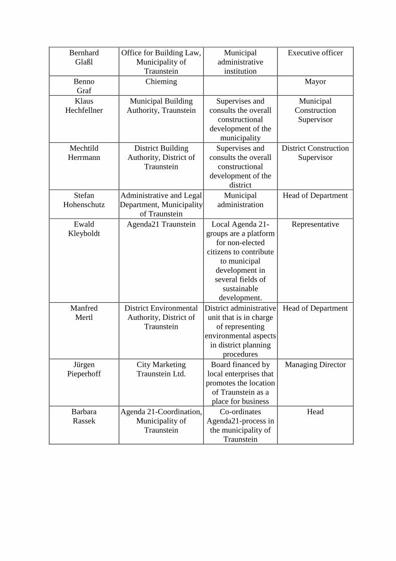
Bernhard Glaßl
Office for Building Law, Municipality of
Traunstein
Municipal administrative
institution
Executive officer
Benno Graf
Chieming Mayor
Klaus Hechfellner
Municipal Building Authority, Traunstein
Supervises and consults the overall
constructional development of the
municipality
Municipal Construction Supervisor
Mechtild Herrmann
District Building Authority, District of
Traunstein
Supervises and consults the overall
constructional development of the
district
District Construction Supervisor
Stefan Hohenschutz
Administrative and Legal Department, Municipality
of Traunstein
Municipal administration
Head of Department
Ewald Kleyboldt
Agenda21 Traunstein Local Agenda 21-groups are a platform
for non-elected citizens to contribute
to municipal development in several fields of
sustainable development.
Representative
Manfred Mertl
District Environmental Authority, District of
Traunstein
District administrative unit that is in charge
of representing environmental aspects
in district planning procedures
Head of Department
Jürgen Pieperhoff
City Marketing Traunstein Ltd.
Board financed by local enterprises that promotes the location
of Traunstein as a place for business
Managing Director
Barbara Rassek
Agenda 21-Coordination, Municipality of
Traunstein
Co-ordinates Agenda21-process in the municipality of
Traunstein
Head
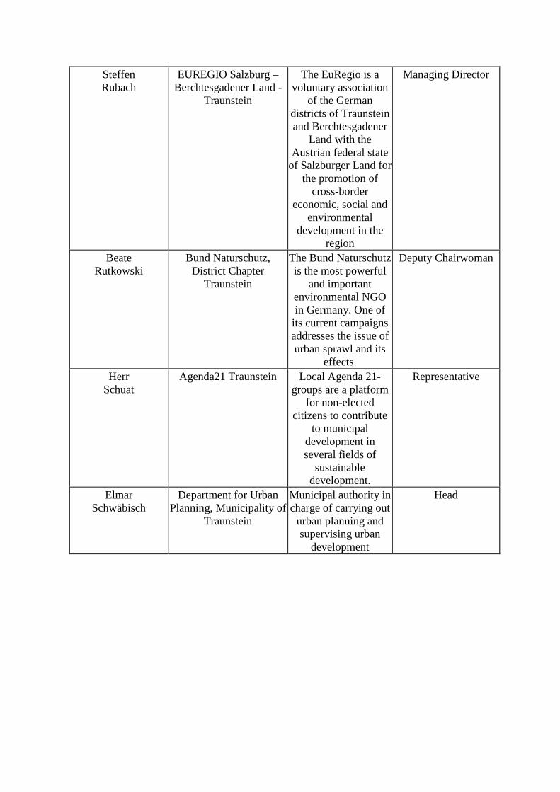
Steffen Rubach
EUREGIO Salzburg – Berchtesgadener Land -
Traunstein
The EuRegio is a voluntary association
of the German districts of Traunstein and Berchtesgadener
Land with the Austrian federal state
of Salzburger Land for the promotion of
cross-border economic, social and
environmental development in the
region
Managing Director
Beate Rutkowski
Bund Naturschutz, District Chapter
Traunstein
The Bund Naturschutz is the most powerful
and important environmental NGO in Germany. One of
its current campaigns addresses the issue of urban sprawl and its
effects.
Deputy Chairwoman
Herr Schuat
Agenda21 Traunstein Local Agenda 21-groups are a platform
for non-elected citizens to contribute
to municipal development in several fields of
sustainable development.
Representative
Elmar Schwäbisch
Department for Urban Planning, Municipality of
Traunstein
Municipal authority in charge of carrying out
urban planning and supervising urban
development
Head
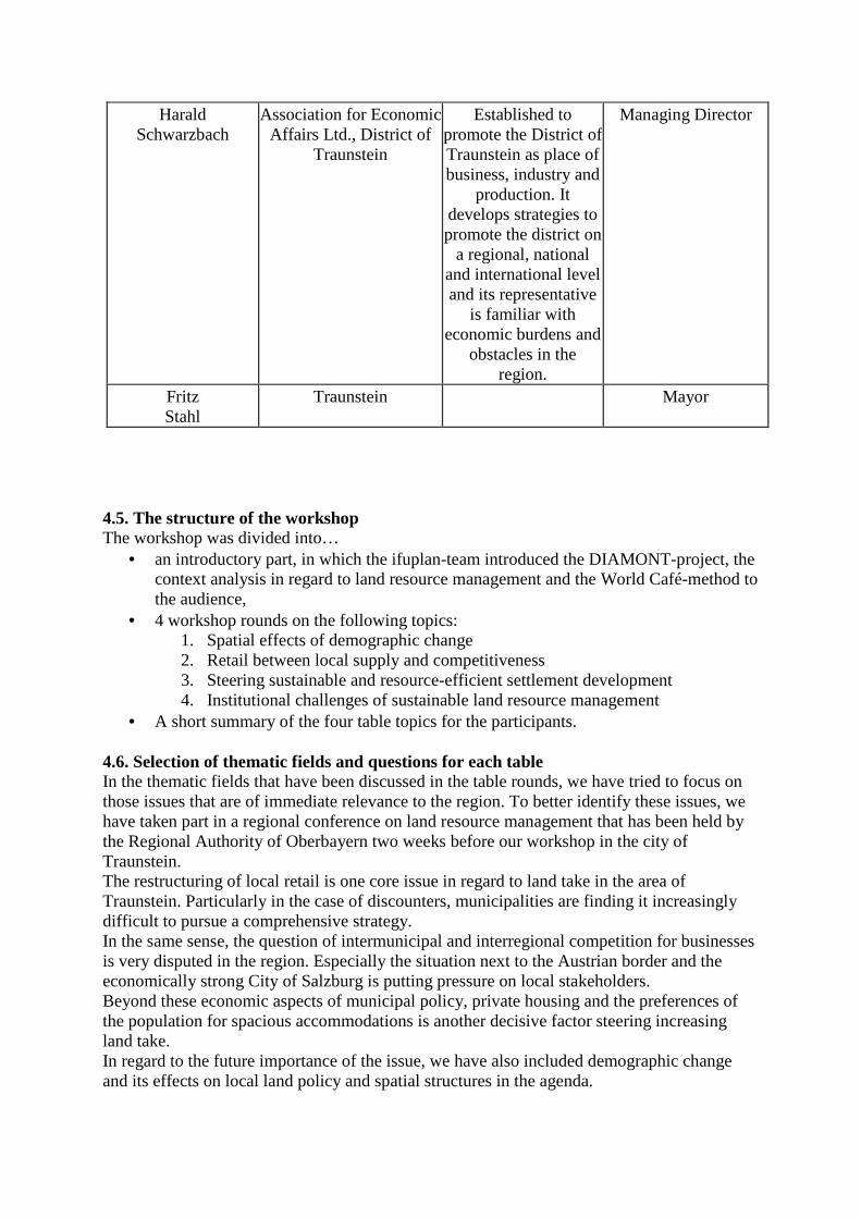
Harald Schwarzbach
Association for Economic Affairs Ltd., District of
Traunstein
Established to promote the District of Traunstein as place of business, industry and
production. It develops strategies to promote the district on
a regional, national and international level and its representative
is familiar with economic burdens and
obstacles in the region.
Managing Director
Fritz Stahl
Traunstein Mayor
4.5. The structure of the workshop The workshop was divided into…
• an introductory part, in which the ifuplan-team introduced the DIAMONT-project, the context analysis in regard to land resource management and the World Café-method to the audience,
• 4 workshop rounds on the following topics: 1. Spatial effects of demographic change 2. Retail between local supply and competitiveness 3. Steering sustainable and resource-efficient settlement development 4. Institutional challenges of sustainable land resource management
• A short summary of the four table topics for the participants. 4.6. Selection of thematic fields and questions for each table In the thematic fields that have been discussed in the table rounds, we have tried to focus on those issues that are of immediate relevance to the region. To better identify these issues, we have taken part in a regional conference on land resource management that has been held by the Regional Authority of Oberbayern two weeks before our workshop in the city of Traunstein. The restructuring of local retail is one core issue in regard to land take in the area of Traunstein. Particularly in the case of discounters, municipalities are finding it increasingly difficult to pursue a comprehensive strategy. In the same sense, the question of intermunicipal and interregional competition for businesses is very disputed in the region. Especially the situation next to the Austrian border and the economically strong City of Salzburg is putting pressure on local stakeholders. Beyond these economic aspects of municipal policy, private housing and the preferences of the population for spacious accommodations is another decisive factor steering increasing land take. In regard to the future importance of the issue, we have also included demographic change and its effects on local land policy and spatial structures in the agenda.
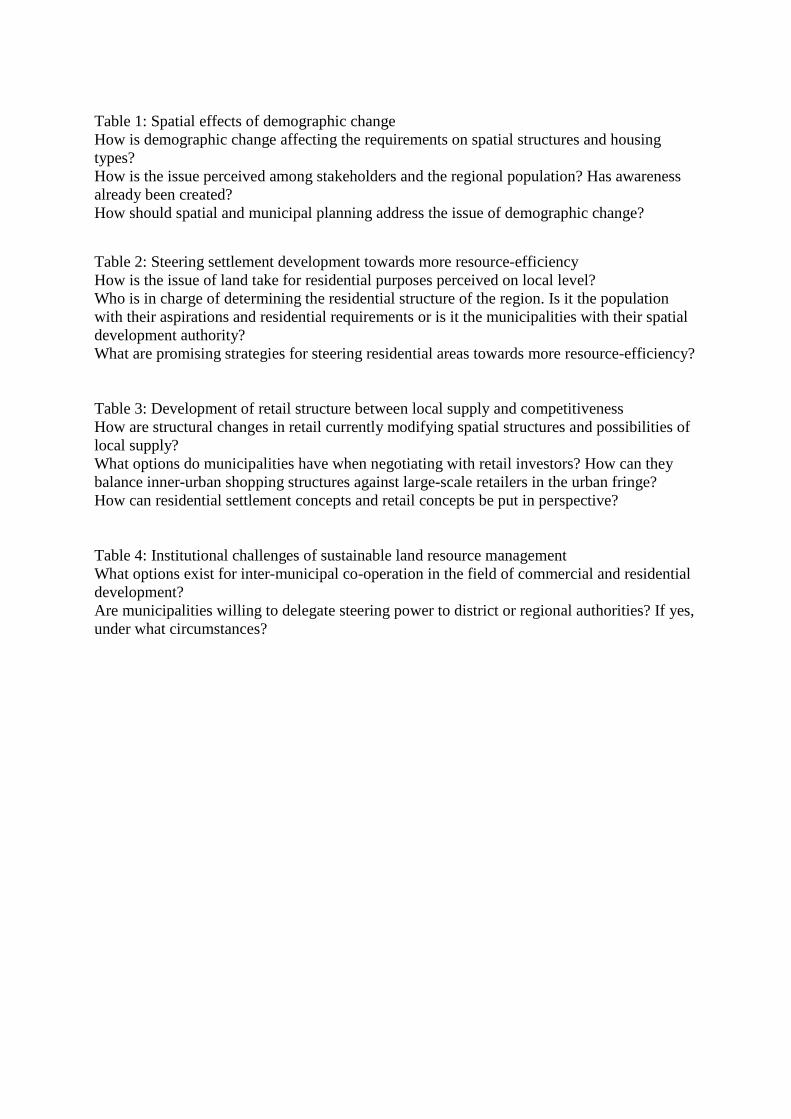
Table 1: Spatial effects of demographic change How is demographic change affecting the requirements on spatial structures and housing types? How is the issue perceived among stakeholders and the regional population? Has awareness already been created? How should spatial and municipal planning address the issue of demographic change? Table 2: Steering settlement development towards more resource-efficiency How is the issue of land take for residential purposes perceived on local level? Who is in charge of determining the residential structure of the region. Is it the population with their aspirations and residential requirements or is it the municipalities with their spatial development authority? What are promising strategies for steering residential areas towards more resource-efficiency? Table 3: Development of retail structure between local supply and competitiveness How are structural changes in retail currently modifying spatial structures and possibilities of local supply? What options do municipalities have when negotiating with retail investors? How can they balance inner-urban shopping structures against large-scale retailers in the urban fringe? How can residential settlement concepts and retail concepts be put in perspective? Table 4: Institutional challenges of sustainable land resource management What options exist for inter-municipal co-operation in the field of commercial and residential development? Are municipalities willing to delegate steering power to district or regional authorities? If yes, under what circumstances?
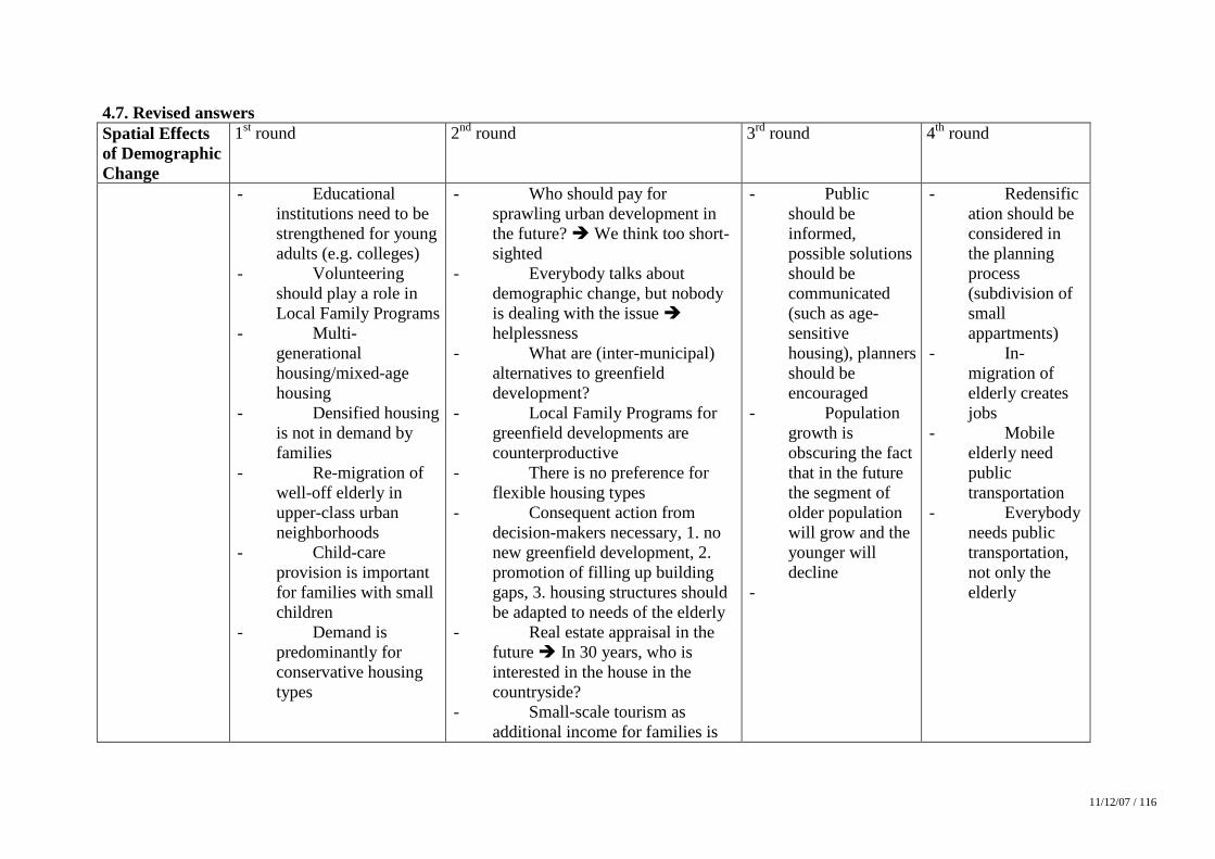
11/12/07 / 116
4.7. Revised answers Spatial Effects of Demographic Change
1st round 2nd round 3rd round 4th round
- Educational institutions need to be strengthened for young adults (e.g. colleges)
- Volunteering should play a role in Local Family Programs
- Multi-generational housing/mixed-age housing
- Densified housing is not in demand by families
- Re-migration of well-off elderly in upper-class urban neighborhoods
- Child-care provision is important for families with small children
- Demand is predominantly for conservative housing types
- Who should pay for sprawling urban development in the future? � We think too short-sighted
- Everybody talks about demographic change, but nobody is dealing with the issue � helplessness
- What are (inter-municipal) alternatives to greenfield development?
- Local Family Programs for greenfield developments are counterproductive
- There is no preference for flexible housing types
- Consequent action from decision-makers necessary, 1. no new greenfield development, 2. promotion of filling up building gaps, 3. housing structures should be adapted to needs of the elderly
- Real estate appraisal in the future � In 30 years, who is interested in the house in the countryside?
- Small-scale tourism as additional income for families is
- Public should be informed, possible solutions should be communicated (such as age-sensitive housing), planners should be encouraged
- Population growth is obscuring the fact that in the future the segment of older population will grow and the younger will decline
-
- Redensification should be considered in the planning process (subdivision of small appartments)
- In-migration of elderly creates jobs
- Mobile elderly need public transportation
- Everybody needs public transportation, not only the elderly
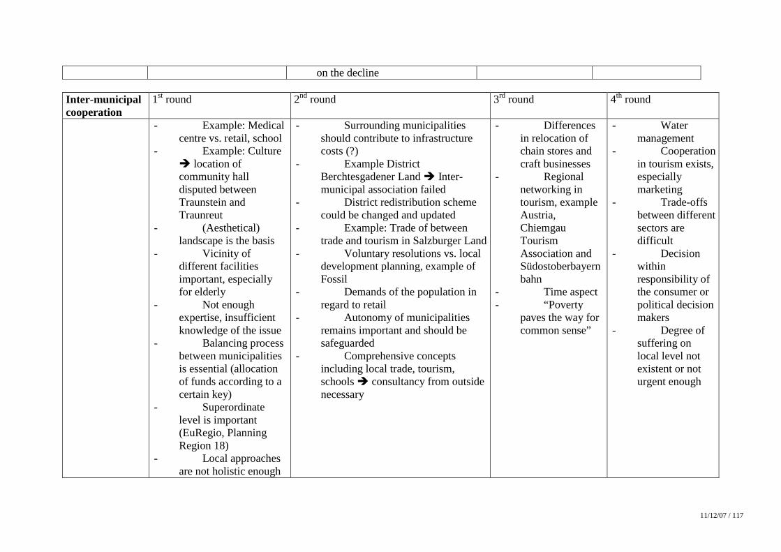
11/12/07 / 117
on the decline Inter-municipal cooperation
1st round 2nd round 3rd round 4th round
- Example: Medical centre vs. retail, school
- Example: Culture � location of community hall disputed between Traunstein and Traunreut
- (Aesthetical) landscape is the basis
- Vicinity of different facilities important, especially for elderly
- Not enough expertise, insufficient knowledge of the issue
- Balancing process between municipalities is essential (allocation of funds according to a certain key)
- Superordinate level is important (EuRegio, Planning Region 18)
- Local approaches are not holistic enough
- Surrounding municipalities should contribute to infrastructure costs (?)
- Example District Berchtesgadener Land � Inter-municipal association failed
- District redistribution scheme could be changed and updated
- Example: Trade of between trade and tourism in Salzburger Land
- Voluntary resolutions vs. local development planning, example of Fossil
- Demands of the population in regard to retail
- Autonomy of municipalities remains important and should be safeguarded
- Comprehensive concepts including local trade, tourism, schools � consultancy from outside necessary
- Differences in relocation of chain stores and craft businesses
- Regional networking in tourism, example Austria, Chiemgau Tourism Association and Südostoberbayernbahn
- Time aspect - “Poverty
paves the way for common sense”
- Water management
- Cooperation in tourism exists, especially marketing
- Trade-offs between different sectors are difficult
- Decision within responsibility of the consumer or political decision makers
- Degree of suffering on local level not existent or not urgent enough
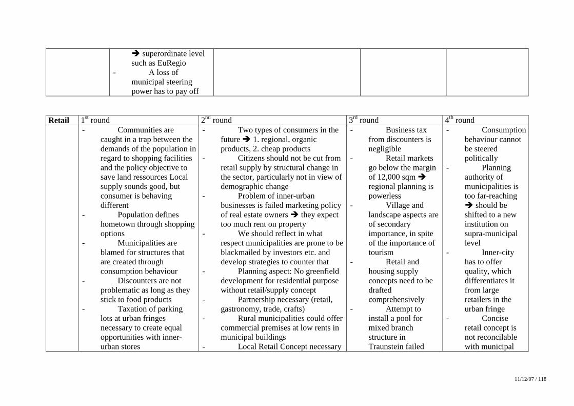
11/12/07 / 118
� superordinate level such as EuRegio
- A loss of municipal steering power has to pay off
Retail 1st round 2nd round 3rd round 4th round - Communities are
caught in a trap between the demands of the population in regard to shopping facilities and the policy objective to save land ressources Local supply sounds good, but consumer is behaving different
- Population defines hometown through shopping options
- Municipalities are blamed for structures that are created through consumption behaviour
- Discounters are not problematic as long as they stick to food products
- Taxation of parking lots at urban fringes necessary to create equal opportunities with inner-urban stores
- Two types of consumers in the future � 1. regional, organic products, 2. cheap products
- Citizens should not be cut from retail supply by structural change in the sector, particularly not in view of demographic change
- Problem of inner-urban businesses is failed marketing policy of real estate owners � they expect too much rent on property
- We should reflect in what respect municipalities are prone to be blackmailed by investors etc. and develop strategies to counter that
- Planning aspect: No greenfield development for residential purpose without retail/supply concept
- Partnership necessary (retail, gastronomy, trade, crafts)
- Rural municipalities could offer commercial premises at low rents in municipal buildings
- Local Retail Concept necessary
- Business tax from discounters is negligible
- Retail markets go below the margin of 12,000 sqm � regional planning is powerless
- Village and landscape aspects are of secondary importance, in spite of the importance of tourism
- Retail and housing supply concepts need to be drafted comprehensively
- Attempt to install a pool for mixed branch structure in Traunstein failed
- Consumption behaviour cannot be steered politically
- Planning authority of municipalities is too far-reaching � should be shifted to a new institution on supra-municipal level
- Inner-city has to offer quality, which differentiates it from large retailers in the urban fringe
- Concise retail concept is not reconcilable with municipal
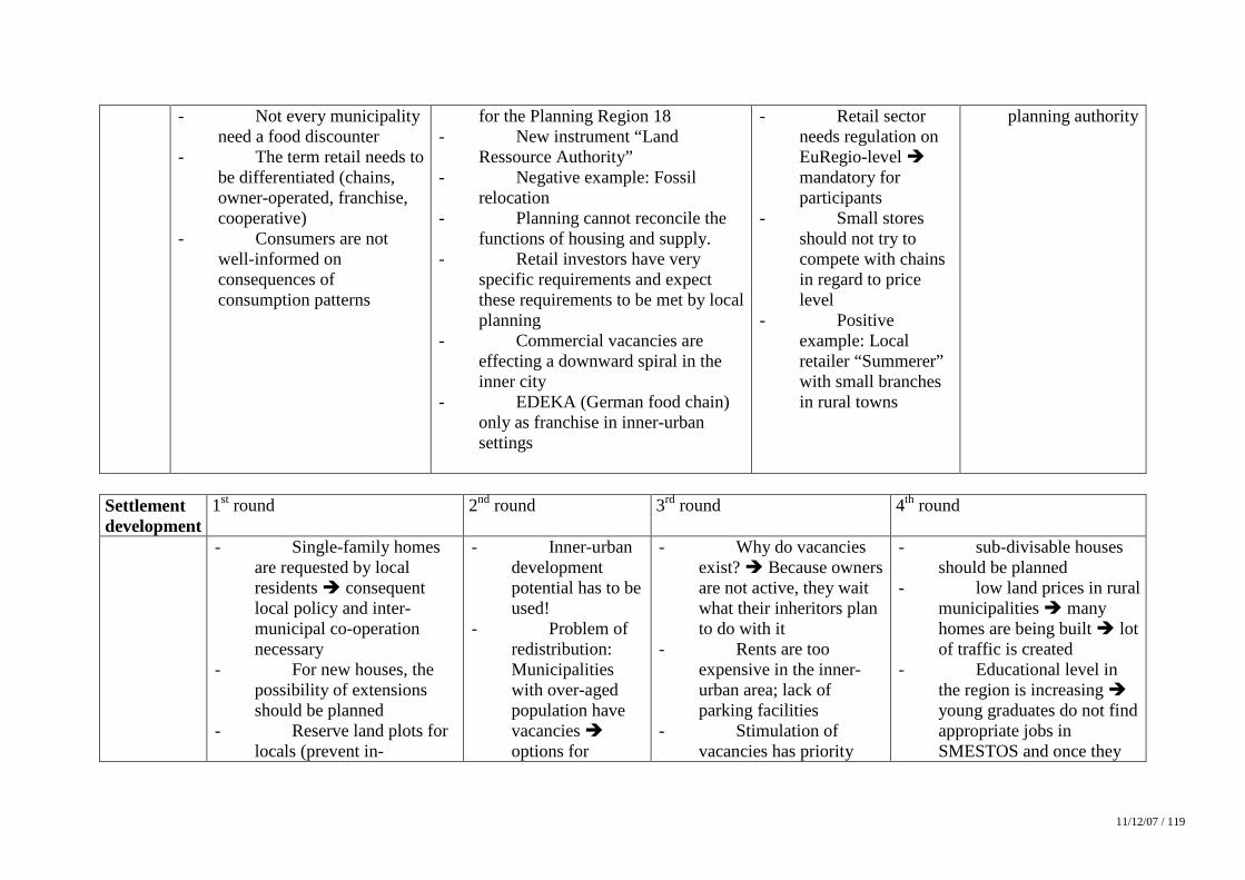
11/12/07 / 119
- Not every municipality need a food discounter
- The term retail needs to be differentiated (chains, owner-operated, franchise, cooperative)
- Consumers are not well-informed on consequences of consumption patterns
for the Planning Region 18 - New instrument “Land
Ressource Authority” - Negative example: Fossil
relocation - Planning cannot reconcile the
functions of housing and supply. - Retail investors have very
specific requirements and expect these requirements to be met by local planning
- Commercial vacancies are effecting a downward spiral in the inner city
- EDEKA (German food chain) only as franchise in inner-urban settings
- Retail sector needs regulation on EuRegio-level � mandatory for participants
- Small stores should not try to compete with chains in regard to price level
- Positive example: Local retailer “Summerer” with small branches in rural towns
planning authority
Settlement development
1st round 2nd round 3rd round 4th round
- Single-family homes are requested by local residents � consequent local policy and inter-municipal co-operation necessary
- For new houses, the possibility of extensions should be planned
- Reserve land plots for locals (prevent in-
- Inner-urban development potential has to be used!
- Problem of redistribution: Municipalities with over-aged population have vacancies � options for
- Why do vacancies exist? � Because owners are not active, they wait what their inheritors plan to do with it
- Rents are too expensive in the inner-urban area; lack of parking facilities
- Stimulation of vacancies has priority
- sub-divisable houses should be planned
- low land prices in rural municipalities � many homes are being built � lot of traffic is created
- Educational level in the region is increasing � young graduates do not find appropriate jobs in SMESTOS and once they
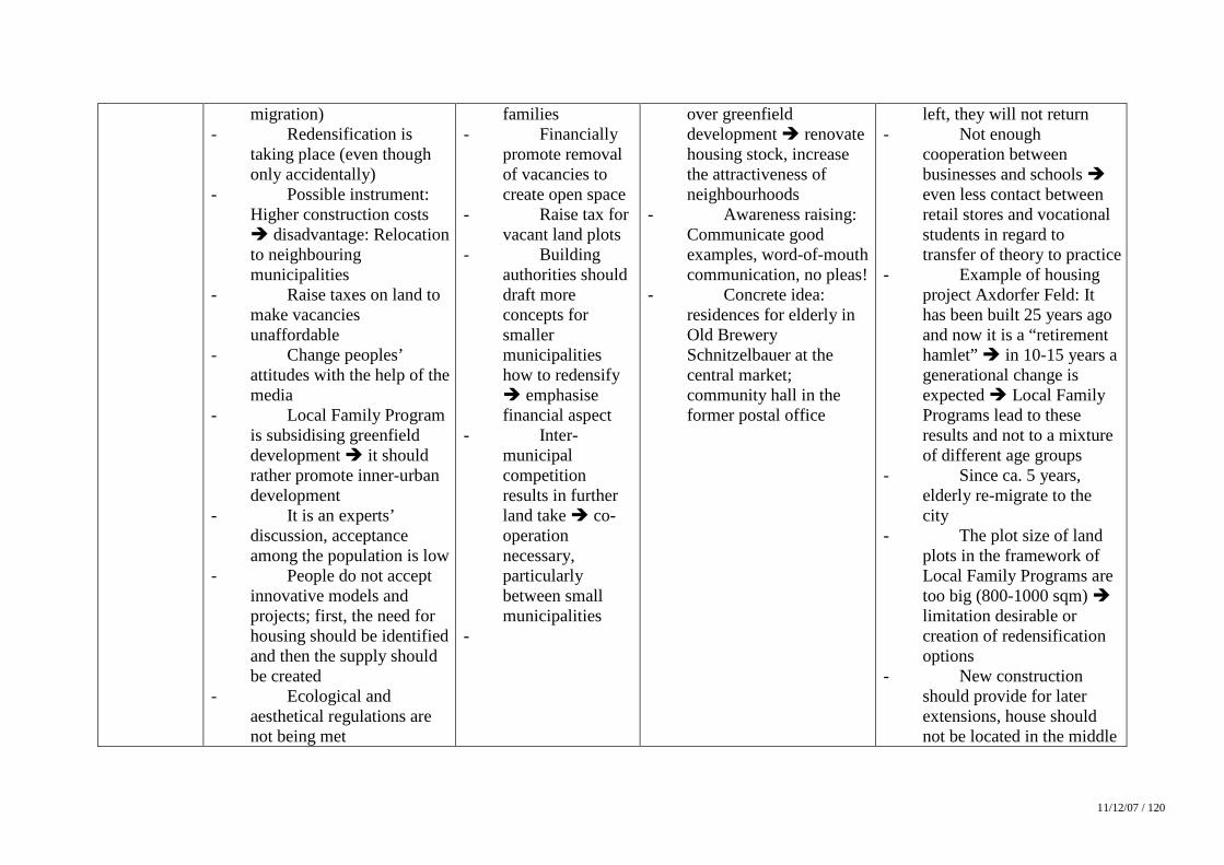
11/12/07 / 120
migration) - Redensification is
taking place (even though only accidentally)
- Possible instrument: Higher construction costs � disadvantage: Relocation to neighbouring municipalities
- Raise taxes on land to make vacancies unaffordable
- Change peoples’ attitudes with the help of the media
- Local Family Program is subsidising greenfield development � it should rather promote inner-urban development
- It is an experts’ discussion, acceptance among the population is low
- People do not accept innovative models and projects; first, the need for housing should be identified and then the supply should be created
- Ecological and aesthetical regulations are not being met
families - Financially
promote removal of vacancies to create open space
- Raise tax for vacant land plots
- Building authorities should draft more concepts for smaller municipalities how to redensify � emphasise financial aspect
- Inter-municipal competition results in further land take � co-operation necessary, particularly between small municipalities
-
over greenfield development � renovate housing stock, increase the attractiveness of neighbourhoods
- Awareness raising: Communicate good examples, word-of-mouth communication, no pleas!
- Concrete idea: residences for elderly in Old Brewery Schnitzelbauer at the central market; community hall in the former postal office
left, they will not return - Not enough
cooperation between businesses and schools � even less contact between retail stores and vocational students in regard to transfer of theory to practice
- Example of housing project Axdorfer Feld: It has been built 25 years ago and now it is a “retirement hamlet” � in 10-15 years a generational change is expected � Local Family Programs lead to these results and not to a mixture of different age groups
- Since ca. 5 years, elderly re-migrate to the city
- The plot size of land plots in the framework of Local Family Programs are too big (800-1000 sqm) � limitation desirable or creation of redensification options
- New construction should provide for later extensions, house should not be located in the middle
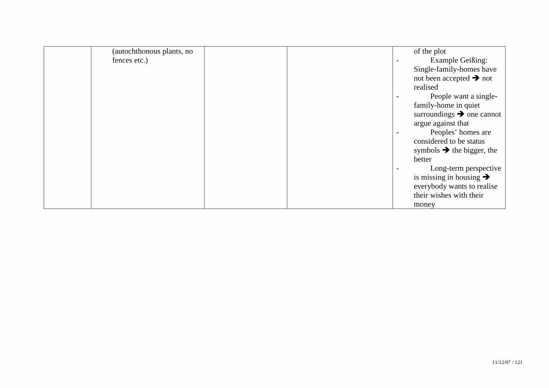
11/12/07 / 121
(autochthonous plants, no fences etc.)
of the plot - Example Geißing:
Single-family-homes have not been accepted � not realised
- People want a single-family-home in quiet surroundings � one cannot argue against that
- Peoples’ homes are considered to be status symbols � the bigger, the better
- Long-term perspective is missing in housing � everybody wants to realise their wishes with their money
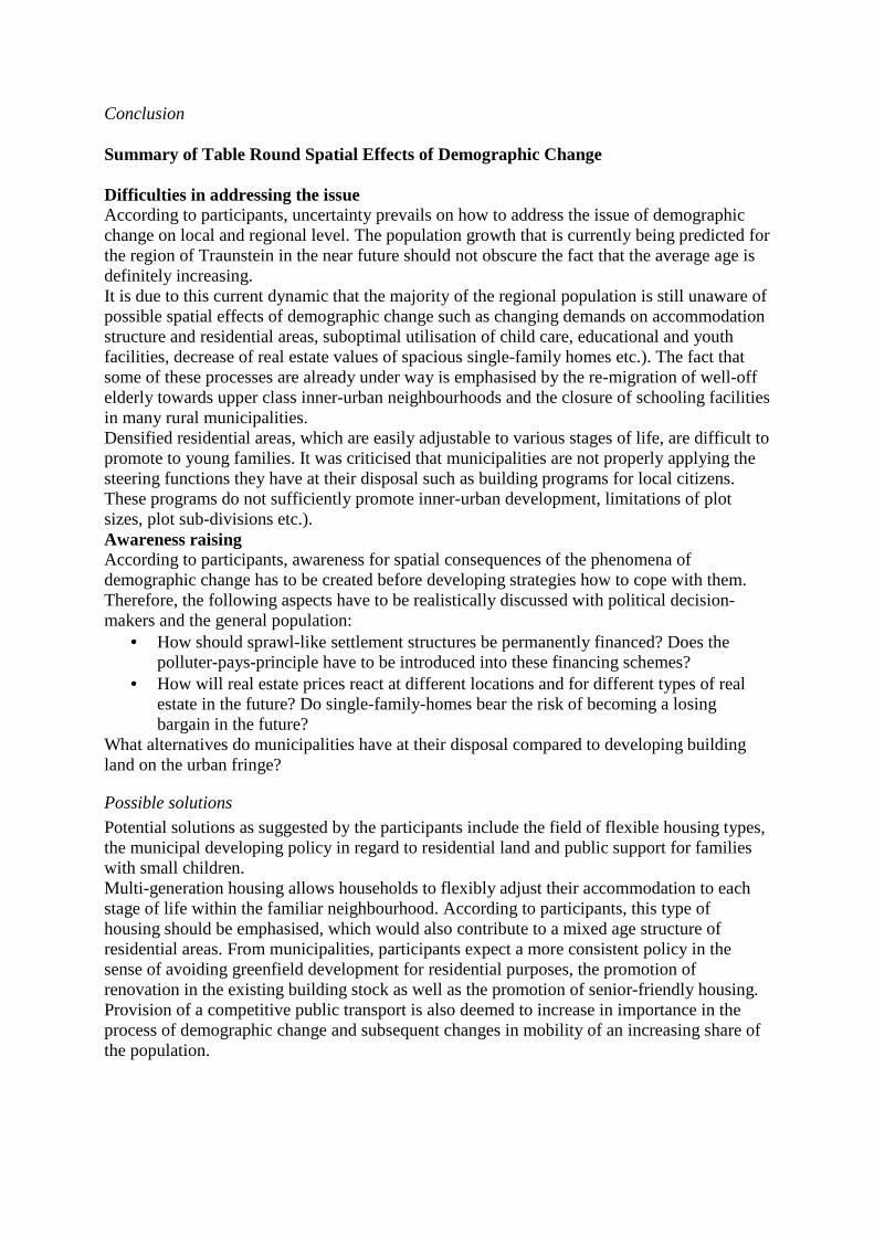
Conclusion Summary of Table Round Spatial Effects of Demographic Change Difficulties in addressing the issue According to participants, uncertainty prevails on how to address the issue of demographic change on local and regional level. The population growth that is currently being predicted for the region of Traunstein in the near future should not obscure the fact that the average age is definitely increasing. It is due to this current dynamic that the majority of the regional population is still unaware of possible spatial effects of demographic change such as changing demands on accommodation structure and residential areas, suboptimal utilisation of child care, educational and youth facilities, decrease of real estate values of spacious single-family homes etc.). The fact that some of these processes are already under way is emphasised by the re-migration of well-off elderly towards upper class inner-urban neighbourhoods and the closure of schooling facilities in many rural municipalities. Densified residential areas, which are easily adjustable to various stages of life, are difficult to promote to young families. It was criticised that municipalities are not properly applying the steering functions they have at their disposal such as building programs for local citizens. These programs do not sufficiently promote inner-urban development, limitations of plot sizes, plot sub-divisions etc.). Awareness raising According to participants, awareness for spatial consequences of the phenomena of demographic change has to be created before developing strategies how to cope with them. Therefore, the following aspects have to be realistically discussed with political decision-makers and the general population:
• How should sprawl-like settlement structures be permanently financed? Does the polluter-pays-principle have to be introduced into these financing schemes?
• How will real estate prices react at different locations and for different types of real estate in the future? Do single-family-homes bear the risk of becoming a losing bargain in the future?
What alternatives do municipalities have at their disposal compared to developing building land on the urban fringe?
Possible solutions
Potential solutions as suggested by the participants include the field of flexible housing types, the municipal developing policy in regard to residential land and public support for families with small children. Multi-generation housing allows households to flexibly adjust their accommodation to each stage of life within the familiar neighbourhood. According to participants, this type of housing should be emphasised, which would also contribute to a mixed age structure of residential areas. From municipalities, participants expect a more consistent policy in the sense of avoiding greenfield development for residential purposes, the promotion of renovation in the existing building stock as well as the promotion of senior-friendly housing. Provision of a competitive public transport is also deemed to increase in importance in the process of demographic change and subsequent changes in mobility of an increasing share of the population.
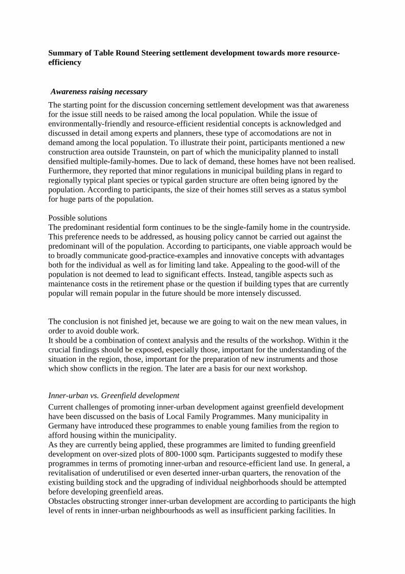
Summary of Table Round Steering settlement development towards more resource-efficiency
The starting point for the discussion concerning settlement development was that awareness for the issue still needs to be raised among the local population. While the issue of environmentally-friendly and resource-efficient residential concepts is acknowledged and discussed in detail among experts and planners, these type of accomodations are not in demand among the local population. To illustrate their point, participants mentioned a new construction area outside Traunstein, on part of which the municipality planned to install densified multiple-family-homes. Due to lack of demand, these homes have not been realised. Furthermore, they reported that minor regulations in municipal building plans in regard to regionally typical plant species or typical garden structure are often being ignored by the population. According to participants, the size of their homes still serves as a status symbol for huge parts of the population. Possible solutions The predominant residential form continues to be the single-family home in the countryside. This preference needs to be addressed, as housing policy cannot be carried out against the predominant will of the population. According to participants, one viable approach would be to broadly communicate good-practice-examples and innovative concepts with advantages both for the individual as well as for limiting land take. Appealing to the good-will of the population is not deemed to lead to significant effects. Instead, tangible aspects such as maintenance costs in the retirement phase or the question if building types that are currently popular will remain popular in the future should be more intensely discussed. The conclusion is not finished jet, because we are going to wait on the new mean values, in order to avoid double work. It should be a combination of context analysis and the results of the workshop. Within it the crucial findings should be exposed, especially those, important for the understanding of the situation in the region, those, important for the preparation of new instruments and those which show conflicts in the region. The later are a basis for our next workshop.
Inner-urban vs. Greenfield development
Current challenges of promoting inner-urban development against greenfield development have been discussed on the basis of Local Family Programmes. Many municipality in Germany have introduced these programmes to enable young families from the region to afford housing within the municipality. As they are currently being applied, these programmes are limited to funding greenfield development on over-sized plots of 800-1000 sqm. Participants suggested to modify these programmes in terms of promoting inner-urban and resource-efficient land use. In general, a revitalisation of underutilised or even deserted inner-urban quarters, the renovation of the existing building stock and the upgrading of individual neighborhoods should be attempted before developing greenfield areas. Obstacles obstructing stronger inner-urban development are according to participants the high level of rents in inner-urban neighbourhoods as well as insufficient parking facilities. In
Awareness raising necessary
general, family-friendly accomodation is considered to be difficult to find in inner-urban areas. Possible solutions: To more offensively promote inner-urban development and redensification, building authorities should particularly provide small, rural municipalities with redensification concepts and schemes. Especially the financial advantages of inner-urban development such as lower access fees and local supply close to peoples' homes should be stressed in this context. Aspects such as the option to subdivide homes to create appartments for singles within single-family homes or the option to add an extension to the existing building body should be considered in municipal building plans as well as in the individual architecture of buildings. A plot-edge construction allow more leeway in this respect than a construction in the middle of a plot. Participants expect an increase in real estate tax for vacant plots to play a major role in activating brownfields and inner-urban potentials. Furthermore, inner-urban areas should be adjusted to the needs of an elderly population.
Inter-municipal co-operation in settlement development
The single-family home as the preferred housing type of the population can only be brought in line with a sustainable management of land resources if a co-operation succeeds on a supra-municipal level. The increasing land take that results from inter-municipal competition for population and businesses will not be stopped unless a co-ordination of new residential areas is carried out on supra-municipal level. Summary of Table Round Retail between local supply and competitiveness Consumption behaviour Consumption behaviour is responsible for the spatial distribution of retail facilities – this was the prevailing impression of the participants. Representatives from municipalities reported that in regard to structural changes in municipal retail, they are positioned between the policy objective of reducing land take and the consumption patterns and demands of the population. The population assesses their place of residence according to the supply of shopping facilities. Discounters are part of the range of shopping options that local residents are demanding and local policy cannot disregard these preferences. Possible solutions: According to assessments by local decision-makers, it is necessary to “save” municipalities from the line of fire from public pressure by investors and residents in regard to the relocation of large-scale retail enterprises. Structures of retail Food retail is currently undergoing a significant structural change towards chains and franchise structures and particularly discounters on greenfield sites. Even chains such as EDEKA, who used to run the “last store in town” are nowadays increasingly leaving inner-urban sites for sites situated in the urban fringe. Commercial premises below 1000 qm are currently only supplied by EDEKA if they are owner-operated; that means that the commercial risk is on behalf of the store manager. In times of demographic change and consequently of reduced mobility of bigger shares of the population, there is the danger of cutting peoples’ access to local supply.
Commercial taxes from discounters, municipal participants reported, are marginally small. An additional negative effect is registered through the expansion of the range of products towards specialised niche products. This would redirect local purchase power away from specialised non-food retail stores. For inner-urban sites, this development is bringing about new challenges. In the course of commercial vacancies, there is the danger that these urban quarters will enter a downward spiral of rental decrease and disinvestment. Real estate owners intensify the inner-urban problems by expecting overpriced rents at the expense of a balanced and established store structure. Possible solutions: For inner-urban retail, participants saw only the option to offer better quality and service than large-scale retail does on the urban fringe. To compete in terms of prices with retail chains was deemed illusionary. For a balanced municipal retail structure, participants urged a partnership between retail, gastronomy and trade. In the city of Traunstein, an initiative in that respect has failed. It tried to establish a pool to promote the relocation of stores to the Traunstein downtown area which would complete the range of stores situated in the city. Further instruments that have been suggested by participants were the taxation of parking facilities in the urban fringe to establish equal opportunities with stores in the downtown area as well as the rental of commercial premises within buildings owned by rural municipalities at low rents.
Inter-municipal regulations
As already discussed, a majority of workshop participants opted for a stronger regional responsibility for retail development in the region of Traunstein. Currently, municipalities are in the situation that retail investors confront them with detailed specifications regarding their relocation plan. If these specifications cannot sufficiently be met by municipalities, they threaten to move on to the next municipality. In this process, communities are prone to blackmailing, which can only be eliminated once municipalities decide to act jointly. In this context, participants called for a binding retail and local supply concept on regional level, which needs to be concisely implemented on municipal level. As appropriate levels for such a concept, participants identified either the Planning Region 18 (Planungsregion 18 – Südostoberbayern) or the EuRegio with the Austrian federal state of Salzburger Land and the German districts of Traunstein and Berchtesgadener Land. Furthermore, participants suggested to adopt an integral view on retail and housing when drafting such a concept instead of restricting it to the sector or local retail. The result would be a comprehensive retail and settlement concept for the district of Traunstein, the Planning Region 18 or the EuRegio, implemented by a so-called “Land Resources Authority” that participants suggested to install at district level. As potential impediment to the implementation of such an instrument, participants pointed out that such a transfer of steering authority towards supra-municipal levels is in conflict with the municipal planning authority as laid down in the German Constitution.
Summary of table round “Institutional development”
According to participants, the “degree of suffering” is not urgent enough in the region to initiate a steering of land take on regional level – quote one participant “Poverty paves the way towards common sense”. In other
words, only if a sufficient need for cooperation is perceivable on municipal level and only if tangible positive effects can be realised by transferring some local steering authority towards
Current situation
regional levels, will individual strategies on municipal level be abandoned. In any case, it needs to be made clear that it is not the intention of this approach to question the municipal autonomy as a whole. This autonomy is of core importance for municipalities and should be safeguarded in the future.
Among participants, there was a broad consensus that many aspects of municipal policy require a
comprehensive regulation on supra-regional level. This level could either be the Planning Region 18 (Planungsregion Südostoberbayern) or the EuRegio. A range of existing sectoral examples of inter-municipal cooperation such as the Südostoberbayernbahn (regional co-funding of public transport), the cooperation in tourism marketing such as the Chiemgau Tourism Association or the existing inter-municipal trade-off between tourism and trade in the Austrian federal state of Salzburg could serve as potential starting points. Beyond these sectoral approaches of cooperation, participants found it particularly important in regard to aspects of land resource management to adopt an integral approach, which combines policy fields such as housing, industry and trade, retail, education, tourism and their interactions in a comprehensive regional concept.
A number of voluntary commitments and resolutions on the level of the Planning Region 18 or the EuRegio is already addressing spatial development in the region of Traunstein/Traunreut. Examples are the EuRegio Development Concept of 2001, the Bergen Resolution concerning relocation of large-scale retail projects or the Regional Plan of the Planning Region 18 in its latest version of 2002. These concepts all fulfil an important function as they represent the basis for further spatial development in the region. From the perspective of participants, what is still pending and what urgently needs to be accomplished is a more binding regulation and implementation of these regional guidelines and development objectives. In this context, procedures have to be developed how to facilitate the trade-off between development advantages and disadvantages among municipalities, e.g. in the form of the familiar allocation of public funds according to a municipal key – a sort of inter-municipal balance of development burdens and returns. In regard to management of commercial areas, this kind of trade-off-scheme could be an instrument to reduce the blackmailing liability of municipalities in regard to relocation projects. When moving towards implementing the transfer of planning authority towards supra-municipal level, a number of challenges have to be addressed, including…
• lack of know-how and expertise on local level to balance advantages and disadvantages of a supra-municipal arrangement,
• the fact that certain developments can more effectively be influenced by change of consumption patterns than by policy,
• a trade-off-mechanism between various municipalities and thematic issues of regional policy (trade and commerce, housing, tourism, flood protection etc.) is very complex.
As implementation strategies, participants mentioned a further development of the existing allocation of district funds to municipalities according to a specific key in the sense of an inter-municipal Land Resource Joint Body as well as a stronger sharing of infrastructure costs between core cities and their surrounding area. The technical implementation as well as the moderation of the process, however, would need to be accompanied by external experts and moderators. .
Challenges and fields of inter-municipal cooperation
Institutional embeddedness of regional concepts – Need for action and potential difficulties
4.8 Confrontation of the context analysis results with the workshop results Within the course of the workshop, selected indicator values with relevance to the issue of sustainable land resource management have been presented to the stakeholders. The confrontation of indicators with the situation in the test region has produced the following contradictions and difficulture. Land take The figures in regard to land take have been obtained from the Bavarian Statistical Office. Data on area used for settlement and infrastructure (Siedlungs- und Verkehrsfläche) has been found to be misleading in two respects. First, the morphological situation in the southern test region is not reflected in the percentage of area for settlement and infrastructure. Despite the fact that most land suitable for settlement in the valley bottoms has been used for construction, the municipality of Ruhpolding has the lowest share of the entire test region. Secondly, facilities that are related to sports and recreation such as golf courses and soccer fields are also counted as settlement and infrastructure area, which particularly for the case of golf courses (such as in the municipality of Chieming) conveys a slightly misleading impression of the region, as these golf courses sometimes have a lesser impact on the environment than intensified agriculture. The same effect is true for the growth of percentage share of area used for settlement and infrastructure. Economy The commuter balance neatly identifies the most important core cities of the region, Traunstein and Traunreut, but fails to describe the exact direction of commuter flows. The levels of municipal indebtedness have also been confirmed by participants. The distribution of work force into primary, secondary and tertiary sector is particularly misleading for the primary sector, as self-employed workforce such as the overwhelming majority of farmers is not registered. This results in the paradox situation that an urban municipality such as Traunstein features higher rates in the primary sector than some rural municipalities with a relatively important agricultural sector. This effect can be traced back to work force employed for municipal greenkeeping and gardening. Tax revenue per capita in the region reflects the locational advantages of municipalities along the motorway (Siegsdorf, Grabenstätt) over more remote municipalities such as Taching. Basic infrastructure The number of finalised residential buildings with three or more accommodation units is for most municipalities beneath 10% of those with only one accommodation unit, which has been stressed by the participants to reflect the lacking awareness among individuals for housing-related land take. 4.9. Conclusion When analysing the workshop results, two aspects need to be emphasised. First it is remarkable that virtually all participants were very aware of the issue of land take and the need to contain for the economic, social and ecological sake of the region. A need for action has been identified in regard to raising awareness for the issue among the local population how individuals could contribute through their consumption behaviour and housing preferences to containing sprawl. Instead of blaming the population, the individual advantages of densified settlement structures and nearby shopping and other facilities should be stressed.
On the other hand, across all table rounds it became obvious that there is an urgent need within the region for inter-municipal co-ordination in spatial planning and development. Within the current institutional setting, this coordination is only insufficiently taking place. This is on the one side due to the lack of supra-municipal authority for certain policy fields such as housing, on the other side the influence e.g. of Regional Planning Authorities on economic and retail development is very limited and is currently rather cut back instead of broadened. A regional Land Resource Joint Body could be an appropriate framework to address a variety of negative effects for sustainable spatial and regional development such as inter-municipal competition for commercial and housing developments and different development capacities among the region’s municipalities. Within such a framework, regional development in the field of commerce and housing could be steered towards appropriate areas, where they make sense from a regional perspective. A joint and professional management of these regional land resources could thus be established, which would not be affordable for a single municipal entity. The burdens of overall regional services provided by individual municipalities such as an attractive landscape for regional tourism, recreational purposes of the local population or the provision of flood control measures on the territory of a single municipality could be shared within the region through a jointly drafted and binding trade-off-mechanism.
5. Italy – Tolmezzo LRM Country: ITALY Test region: TOLMEZZO LMR Location of the Workshop: Tolmezzo Date of the Workshop: 20 June 2007 Number of participants: 19 Project Partner: UNCEM Realisation of the Workshop:
Loredana Alfarè – UNCEM Marco Zumaglini – UNCEM
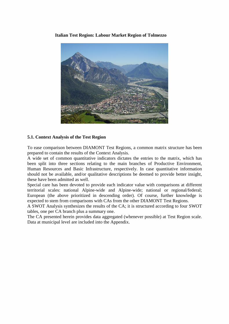
Italian Test Region: Labour Market Region of Tolmezzo
5.1. Context Analysis of the Test Region To ease comparison between DIAMONT Test Regions, a common matrix structure has been prepared to contain the results of the Context Analysis. A wide set of common quantitative indicators dictates the entries to the matrix, which has been split into three sections relating to the main branches of Productive Environment, Human Resources and Basic Infrastructure, respectively. In case quantitative information should not be available, and/or qualitative descriptions be deemed to provide better insight, these have been admitted as well. Special care has been devoted to provide each indicator value with comparisons at different territorial scales: national Alpine-wide and Alpine-wide; national or regional/federal; European (the above prioritized in descending order). Of course, further knowledge is expected to stem from comparisons with CAs from the other DIAMONT Test Regions. A SWOT Analysis synthesizes the results of the CA; it is structured according to four SWOT tables, one per CA branch plus a summary one. The CA presented herein provides data aggregated (whenever possible) at Test Region scale. Data at municipal level are included into the Appendix.
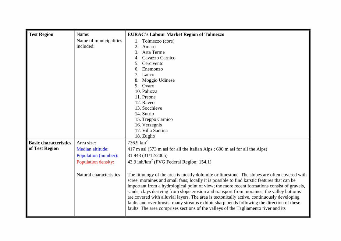
Test Region Name: Name of municipalities included:
EURAC’s Labour Market Region of Tolmezzo 1. Tolmezzo (core) 2. Amaro 3. Arta Terme 4. Cavazzo Carnico 5. Cercivento 6. Enemonzo 7. Lauco 8. Moggio Udinese 9. Ovaro 10. Paluzza 11. Preone 12. Raveo 13. Socchieve 14. Sutrio 15. Treppo Carnico 16. Verzegnis 17. Villa Santina 18. Zuglio
Basic characteristics of Test Region
Area size: Median altitude: Population (number): Population density: Natural characteristics
736.9 km2 417 m asl (573 m asl for all the Italian Alps ; 600 m asl for all the Alps) 31 943 (31/12/2005) 43.3 inh/km2 (FVG Federal Region: 154.1) The lithology of the area is mostly dolomite or limestone. The slopes are often covered with scree, moraines and small fans; locally it is possible to find karstic features that can be important from a hydrological point of view; the more recent formations consist of gravels, sands, clays deriving from slope erosion and transport from moraines; the valley bottoms are covered with alluvial layers. The area is tectonically active, continuously developing faults and overthrusts; many streams exhibit sharp bends following the direction of these faults. The area comprises sections of the valleys of the Tagliamento river and its
Social characteristics
tributaries: although anthropogenic perturbation exists, this river network represents one of the very few instances in all the Alps still bearing remarkably pristine character from headwaters to outlet. Thanks to the phytogeographical crossbreed setting and the extended altitudinal interval allowing various climatic conditions, the area is characterized by a high variety of vegetation types, featuring a number of endemic and rare or very rare plant species. Due to the low anthropogenic pressure and presence of protected areas, and due to contiguity with areas of great ecological value such as Slovenia and Carinthia, the wildlife heritage in the pilot area is rather rich and exhibits a high biodiversity. The disastrous earthquake occurred in 1976 caused devastation in some parts of the area. The reconstruction has changed the landscape (modern buildings). Part of the historical heritage has been lost. The A23 motorway (Venice-Vienna, tollgate at Amaro) follows the course of the river Fella impacting on the narrow valley.
Since the middle of the last century, the area has been exhibiting a constant, in some cases sharp, decline in the number of inhabitants. Only the valley bottom settlements, (Tolmezzo, Arta Terme, Amaro), where services and economic activities (secondary and tertiary sectors mainly) are located, have been maintaining and in some cases increasing their population; it should be noted, however, that such increases appear to be lower than during the previous decades, possibly representing a sign of demographic stabilization. The agriculture (mostly traditional-type) exhibits a constant decline, while tourism faces problems stemming from: 1) insufficient awareness concerning the environmental potential of the area; 2) the relatively low altitude of the mountains coupled with climate change (lack of snow) affecting the traditional ski infrastructure. Concerning transportation, the main roads are supplemented by a well-developed network of secondary roads that ensure connections to main settlements of the municipalities when not situated in valley bottoms, and/or to smaller villages. The railway system in the area is based on a line linking Udine to Tarvisio; nowadays, it is used mainly for goods transport: since a decade, most of the way runs in tunnels, so a lot of secondary railway stations have been closed making it more difficult for local population to use the train. There is a well developed network of public transport buses; the core of the network is the main town of Tolmezzo, connected to Udine by frequent service; reaching other destinations in the valley, on the other hand, can take a lot of time due to low-frequency connections.
Geographical position
The cultural heritage keeps some importance, esp. related to the language (throughout Italy, Friulian is not considered as a mere dialect); some religious rites have almost disappeared, together with the rural civilization they were part of, but some processions have survived (e.g., the Kiss of the Crosses, which takes place on Ascension Day in the parish church of Zuglio); such events strengthen the sense of community of the local population.
The area is part of the Province (county) of Udine, the biggest of the four provinces into which the Autonomous Federal Region of Friuli Venezia Giulia, located in the northeastern end of Italy, is subdivided. It is wholly encompassed within the boundaries of the upper Tagliamento river basin, which occupies most of the Carnian Alps, the mountain section of FVG Region (i.e., most of the northern part of the Region).
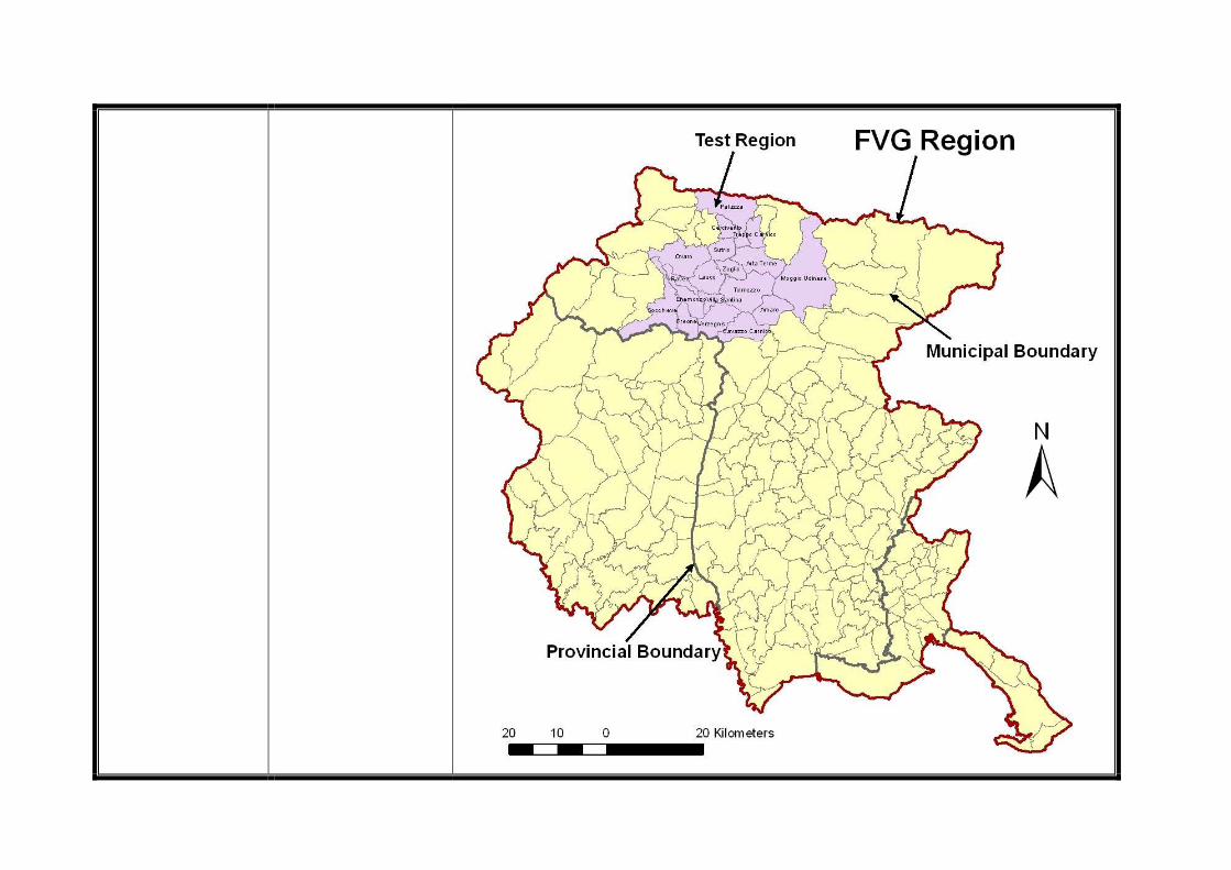
Substantiation of the choice (steps followed to select Test Region; possible national analysis)
Main Assets: • High environmental values (esp., the Tagliamento river); • Stakeholders’ willingness to participate. Main Problems: • (Prospect) Land take for linear infrastructure (transportation, electricity); • Land take for industry (hydropower). Main Challenges: • Implementation of the ‘Environment as Development’ concept; • Implementation of public participation policies. The above delineated Assets-Problems-Challenges clearly show both the strong representativeness of the area within the (national) Alpine context and its specific appeal in view of carrying out DIAMONT workshops.
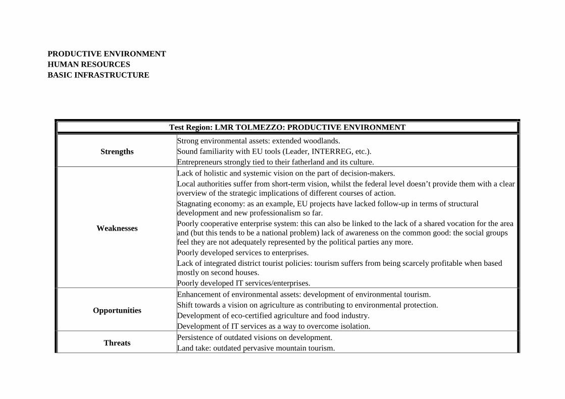
PRODUCTIVE ENVIRONMENT HUMAN RESOURCES BASIC INFRASTRUCTURE
Test Region: LMR TOLMEZZO: PRODUCTIVE ENVIRONMENT
Strengths Strong environmental assets: extended woodlands. Sound familiarity with EU tools (Leader, INTERREG, etc.). Entrepreneurs strongly tied to their fatherland and its culture.
Weaknesses
Lack of holistic and systemic vision on the part of decision-makers. Local authorities suffer from short-term vision, whilst the federal level doesn’t provide them with a clear overview of the strategic implications of different courses of action. Stagnating economy: as an example, EU projects have lacked follow-up in terms of structural development and new professionalism so far. Poorly cooperative enterprise system: this can also be linked to the lack of a shared vocation for the area and (but this tends to be a national problem) lack of awareness on the common good: the social groups feel they are not adequately represented by the political parties any more. Poorly developed services to enterprises. Lack of integrated district tourist policies: tourism suffers from being scarcely profitable when based mostly on second houses. Poorly developed IT services/enterprises.
Opportunities
Enhancement of environmental assets: development of environmental tourism. Shift towards a vision on agriculture as contributing to environmental protection. Development of eco-certified agriculture and food industry. Development of IT services as a way to overcome isolation.
Threats Persistence of outdated visions on development. Land take: outdated pervasive mountain tourism.
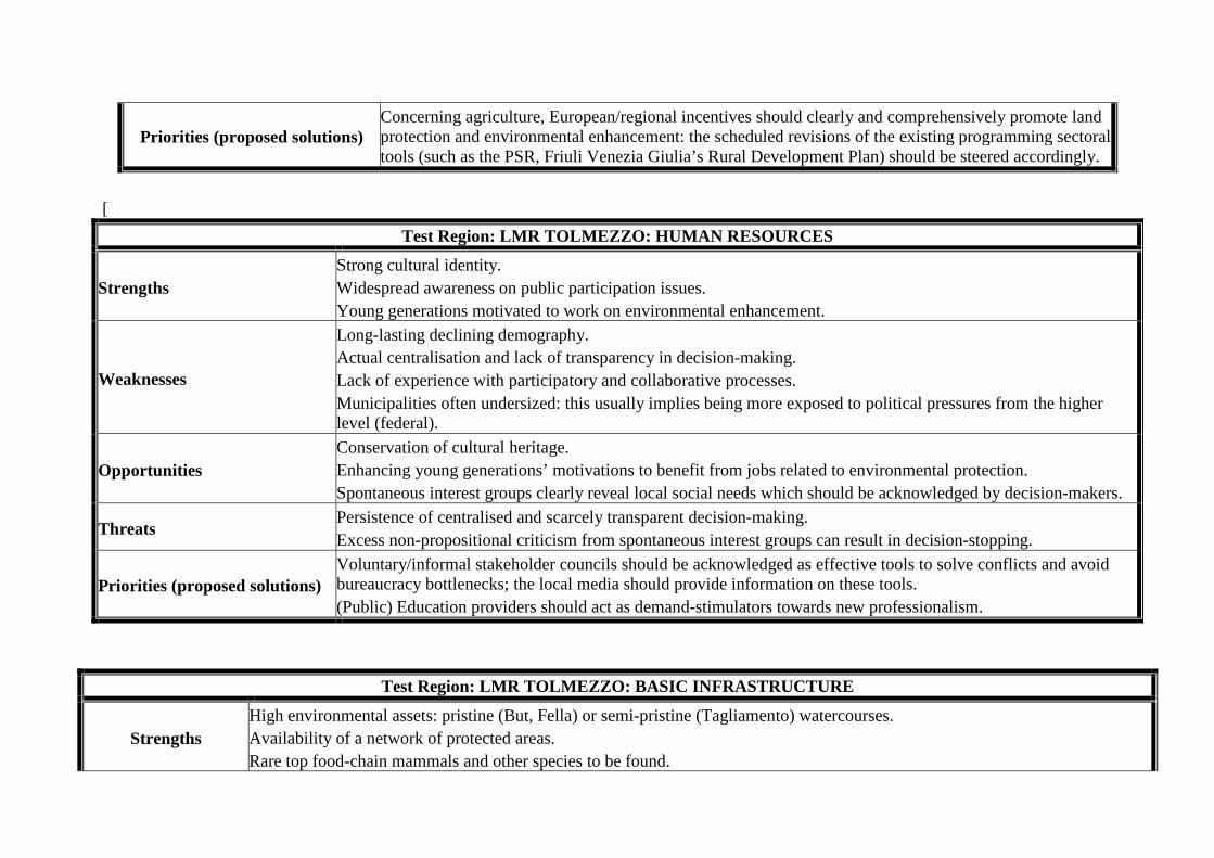
Priorities (proposed solutions) Concerning agriculture, European/regional incentives should clearly and comprehensively promote land protection and environmental enhancement: the scheduled revisions of the existing programming sectoral tools (such as the PSR, Friuli Venezia Giulia’s Rural Development Plan) should be steered accordingly.
[
Test Region: LMR TOLMEZZO: HUMAN RESOURCES
Strengths Strong cultural identity. Widespread awareness on public participation issues. Young generations motivated to work on environmental enhancement.
Weaknesses
Long-lasting declining demography. Actual centralisation and lack of transparency in decision-making. Lack of experience with participatory and collaborative processes. Municipalities often undersized: this usually implies being more exposed to political pressures from the higher level (federal).
Opportunities Conservation of cultural heritage. Enhancing young generations’ motivations to benefit from jobs related to environmental protection. Spontaneous interest groups clearly reveal local social needs which should be acknowledged by decision-makers.
Threats Persistence of centralised and scarcely transparent decision-making. Excess non-propositional criticism from spontaneous interest groups can result in decision-stopping.
Priorities (proposed solutions) Voluntary/informal stakeholder councils should be acknowledged as effective tools to solve conflicts and avoid bureaucracy bottlenecks; the local media should provide information on these tools. (Public) Education providers should act as demand-stimulators towards new professionalism.
Test Region: LMR TOLMEZZO: BASIC INFRASTRUCTURE
Strengths High environmental assets: pristine (But, Fella) or semi-pristine (Tagliamento) watercourses. Availability of a network of protected areas. Rare top food-chain mammals and other species to be found.
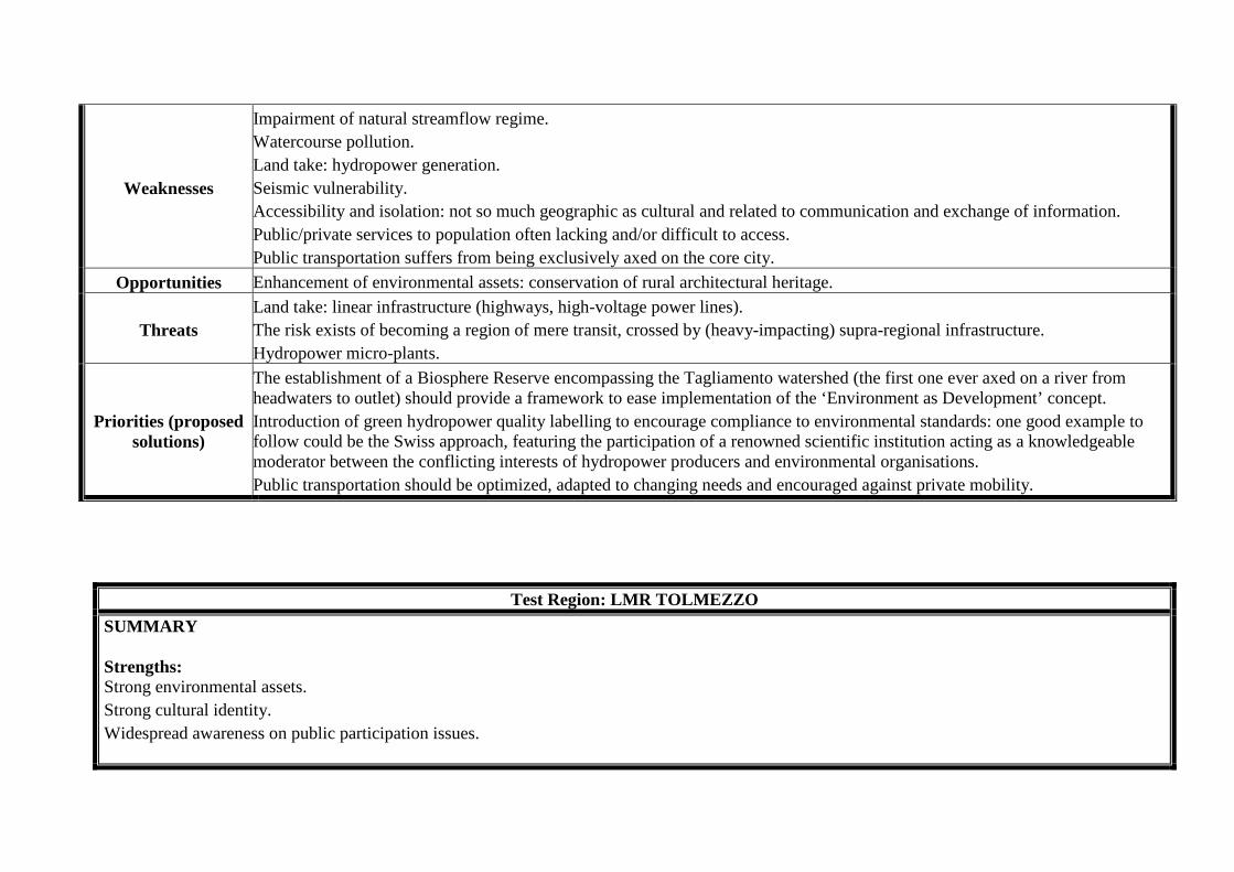
Weaknesses
Impairment of natural streamflow regime. Watercourse pollution. Land take: hydropower generation. Seismic vulnerability. Accessibility and isolation: not so much geographic as cultural and related to communication and exchange of information. Public/private services to population often lacking and/or difficult to access. Public transportation suffers from being exclusively axed on the core city.
Opportunities Enhancement of environmental assets: conservation of rural architectural heritage.
Threats Land take: linear infrastructure (highways, high-voltage power lines). The risk exists of becoming a region of mere transit, crossed by (heavy-impacting) supra-regional infrastructure. Hydropower micro-plants.
Priorities (proposed solutions)
The establishment of a Biosphere Reserve encompassing the Tagliamento watershed (the first one ever axed on a river from headwaters to outlet) should provide a framework to ease implementation of the ‘Environment as Development’ concept. Introduction of green hydropower quality labelling to encourage compliance to environmental standards: one good example to follow could be the Swiss approach, featuring the participation of a renowned scientific institution acting as a knowledgeable moderator between the conflicting interests of hydropower producers and environmental organisations. Public transportation should be optimized, adapted to changing needs and encouraged against private mobility.
Test Region: LMR TOLMEZZO
SUMMARY Strengths: Strong environmental assets. Strong cultural identity. Widespread awareness on public participation issues.
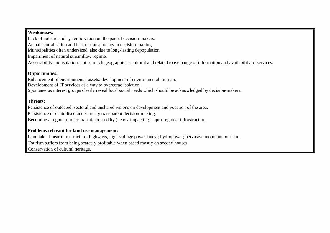
Weaknesses: Lack of holistic and systemic vision on the part of decision-makers. Actual centralisation and lack of transparency in decision-making. Municipalities often undersized, also due to long-lasting depopulation. Impairment of natural streamflow regime. Accessibility and isolation: not so much geographic as cultural and related to exchange of information and availability of services. Opportunities: Enhancement of environmental assets: development of environmental tourism. Development of IT services as a way to overcome isolation. Spontaneous interest groups clearly reveal local social needs which should be acknowledged by decision-makers. Threats: Persistence of outdated, sectoral and unshared visions on development and vocation of the area. Persistence of centralised and scarcely transparent decision-making. Becoming a region of mere transit, crossed by (heavy-impacting) supra-regional infrastructure. Problems relevant for land use management: Land take: linear infrastructure (highways, high-voltage power lines); hydropower; pervasive mountain tourism. Tourism suffers from being scarcely profitable when based mostly on second houses. Conservation of cultural heritage.
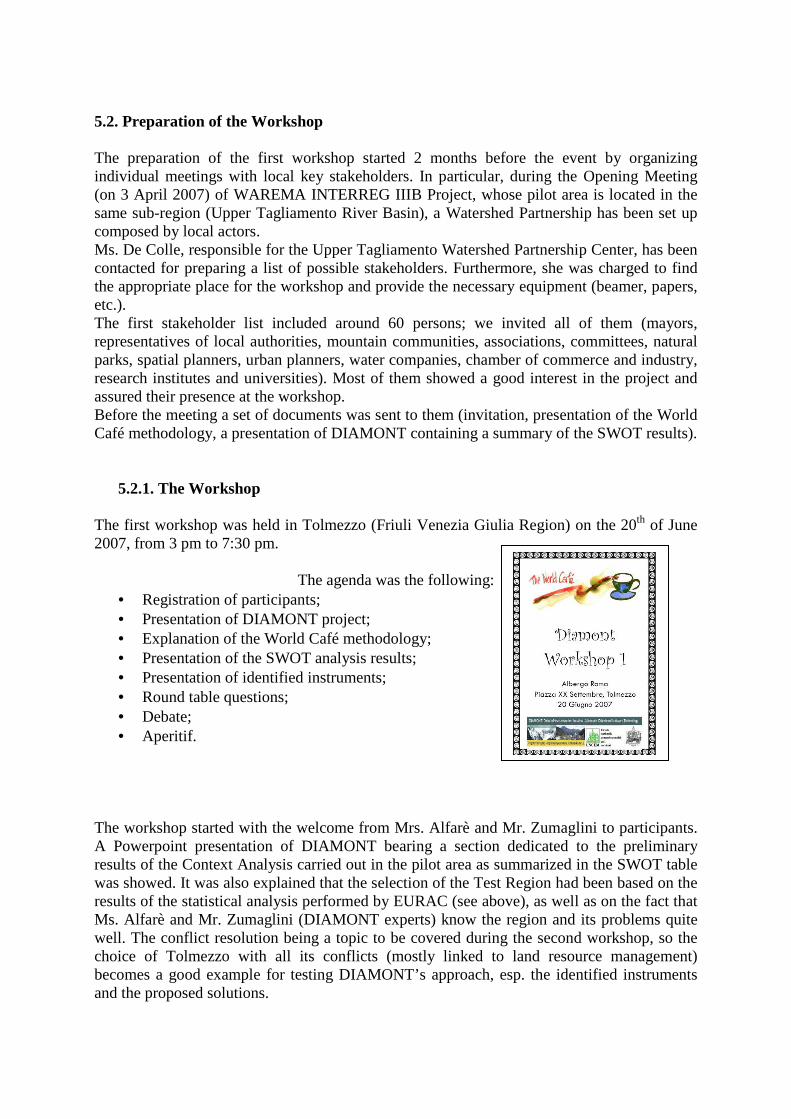
5.2. Preparation of the Workshop
The preparation of the first workshop started 2 months before the event by organizing individual meetings with local key stakeholders. In particular, during the Opening Meeting (on 3 April 2007) of WAREMA INTERREG IIIB Project, whose pilot area is located in the same sub-region (Upper Tagliamento River Basin), a Watershed Partnership has been set up composed by local actors. Ms. De Colle, responsible for the Upper Tagliamento Watershed Partnership Center, has been contacted for preparing a list of possible stakeholders. Furthermore, she was charged to find the appropriate place for the workshop and provide the necessary equipment (beamer, papers, etc.). The first stakeholder list included around 60 persons; we invited all of them (mayors, representatives of local authorities, mountain communities, associations, committees, natural parks, spatial planners, urban planners, water companies, chamber of commerce and industry, research institutes and universities). Most of them showed a good interest in the project and assured their presence at the workshop. Before the meeting a set of documents was sent to them (invitation, presentation of the World Café methodology, a presentation of DIAMONT containing a summary of the SWOT results).
5.2.1. The Workshop The first workshop was held in Tolmezzo (Friuli Venezia Giulia Region) on the 20th of June 2007, from 3 pm to 7:30 pm.
The agenda was the following:
• Registration of participants; • Presentation of DIAMONT project; • Explanation of the World Café methodology; • Presentation of the SWOT analysis results; • Presentation of identified instruments; • Round table questions; • Debate; • Aperitif.
The workshop started with the welcome from Mrs. Alfarè and Mr. Zumaglini to participants. A Powerpoint presentation of DIAMONT bearing a section dedicated to the preliminary results of the Context Analysis carried out in the pilot area as summarized in the SWOT table was showed. It was also explained that the selection of the Test Region had been based on the results of the statistical analysis performed by EURAC (see above), as well as on the fact that Ms. Alfarè and Mr. Zumaglini (DIAMONT experts) know the region and its problems quite well. The conflict resolution being a topic to be covered during the second workshop, so the choice of Tolmezzo with all its conflicts (mostly linked to land resource management) becomes a good example for testing DIAMONT’s approach, esp. the identified instruments and the proposed solutions.
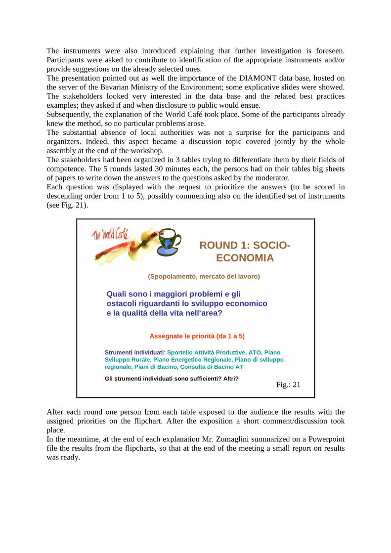
The instruments were also introduced explaining that further investigation is foreseen. Participants were asked to contribute to identification of the appropriate instruments and/or provide suggestions on the already selected ones. The presentation pointed out as well the importance of the DIAMONT data base, hosted on the server of the Bavarian Ministry of the Environment; some explicative slides were showed. The stakeholders looked very interested in the data base and the related best practices examples; they asked if and when disclosure to public would ensue. Subsequently, the explanation of the World Café took place. Some of the participants already knew the method, so no particular problems arose. The substantial absence of local authorities was not a surprise for the participants and organizers. Indeed, this aspect became a discussion topic covered jointly by the whole assembly at the end of the workshop. The stakeholders had been organized in 3 tables trying to differentiate them by their fields of competence. The 5 rounds lasted 30 minutes each, the persons had on their tables big sheets of papers to write down the answers to the questions asked by the moderator. Each question was displayed with the request to prioritize the answers (to be scored in descending order from 1 to 5), possibly commenting also on the identified set of instruments (see Fig. 21).
ROUND 1: SOCIO-ECONOMIA
Gli strumenti individuati sono sufficienti? Altri?
Strumenti individuati : Sportello Attività Produttive, ATO, PianoSviluppo Rurale, Piano Energetico Regionale, Piano di svilupporegionale, Piani di Bacino, Consulta di Bacino AT
Quali sono i maggiori problemi e gli ostacoli riguardanti lo sviluppo economicoe la qualità della vita nell‘area?
Assegnate le priorità (da 1 a 5)
(Spopolamento, mercato del lavoro)
After each round one person from each table exposed to the audience the results with the assigned priorities on the flipchart. After the exposition a short comment/discussion took place. In the meantime, at the end of each explanation Mr. Zumaglini summarized on a Powerpoint file the results from the flipcharts, so that at the end of the meeting a small report on results was ready.
Fig.: 21
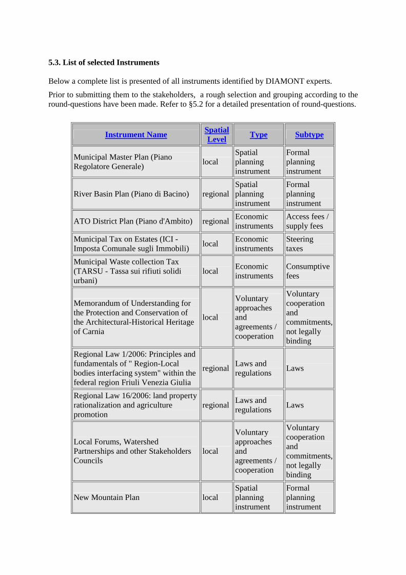
5.3. List of selected Instruments
Below a complete list is presented of all instruments identified by DIAMONT experts.
Prior to submitting them to the stakeholders, a rough selection and grouping according to the round-questions have been made. Refer to §5.2 for a detailed presentation of round-questions.
Instrument Name Spatial Level
Type Subtype
Municipal Master Plan (Piano Regolatore Generale)
local Spatial planning instrument
Formal planning instrument
River Basin Plan (Piano di Bacino) regional Spatial planning instrument
Formal planning instrument
ATO District Plan (Piano d'Ambito) regional Economic instruments
Access fees / supply fees
Municipal Tax on Estates (ICI - Imposta Comunale sugli Immobili)
local Economic instruments
Steering taxes
Municipal Waste collection Tax (TARSU - Tassa sui rifiuti solidi urbani)
local Economic instruments
Consumptive fees
Memorandum of Understanding for the Protection and Conservation of the Architectural-Historical Heritage of Carnia
local
Voluntary approaches and agreements / cooperation
Voluntary cooperation and commitments, not legally binding
Regional Law 1/2006: Principles and fundamentals of " Region-Local bodies interfacing system" within the federal region Friuli Venezia Giulia
regional Laws and regulations
Laws
Regional Law 16/2006: land property rationalization and agriculture promotion
regional Laws and regulations
Laws
Local Forums, Watershed Partnerships and other Stakeholders Councils
local
Voluntary approaches and agreements / cooperation
Voluntary cooperation and commitments, not legally binding
New Mountain Plan local Spatial planning instrument
Formal planning instrument
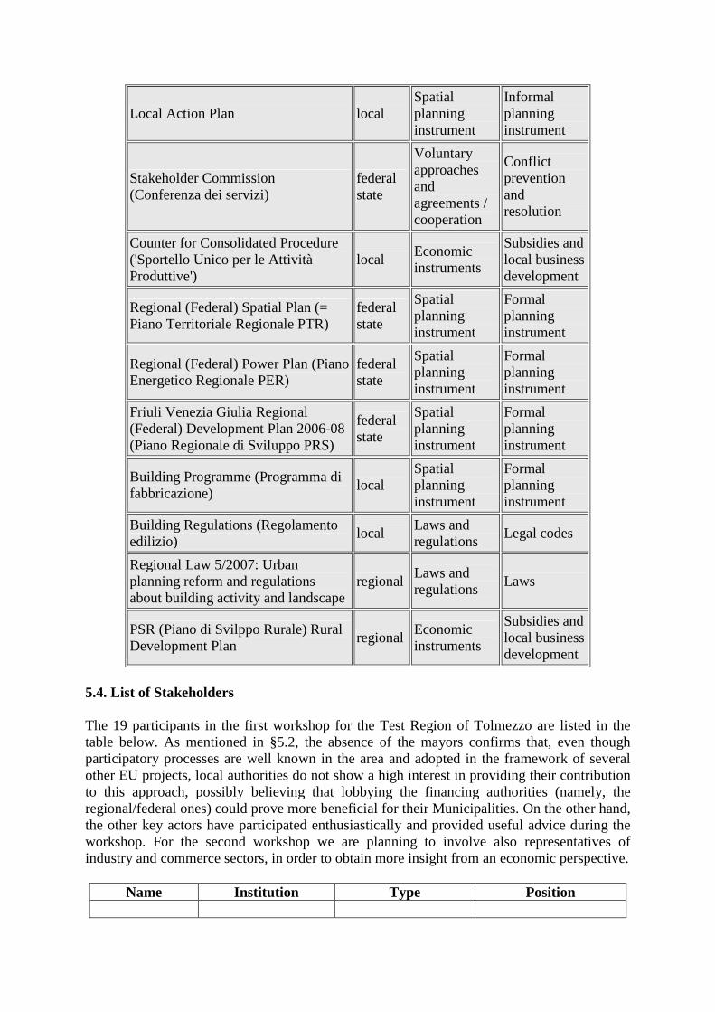
Local Action Plan local Spatial planning instrument
Informal planning instrument
Stakeholder Commission (Conferenza dei servizi)
federal state
Voluntary approaches and agreements / cooperation
Conflict prevention and resolution
Counter for Consolidated Procedure ('Sportello Unico per le Attività Produttive')
local Economic instruments
Subsidies and local business development
Regional (Federal) Spatial Plan (= Piano Territoriale Regionale PTR)
federal state
Spatial planning instrument
Formal planning instrument
Regional (Federal) Power Plan (Piano Energetico Regionale PER)
federal state
Spatial planning instrument
Formal planning instrument
Friuli Venezia Giulia Regional (Federal) Development Plan 2006-08 (Piano Regionale di Sviluppo PRS)
federal state
Spatial planning instrument
Formal planning instrument
Building Programme (Programma di fabbricazione)
local Spatial planning instrument
Formal planning instrument
Building Regulations (Regolamento edilizio)
local Laws and regulations
Legal codes
Regional Law 5/2007: Urban planning reform and regulations about building activity and landscape
regional Laws and regulations
Laws
PSR (Piano di Svilppo Rurale) Rural Development Plan
regional Economic instruments
Subsidies and local business development
5.4. List of Stakeholders
The 19 participants in the first workshop for the Test Region of Tolmezzo are listed in the table below. As mentioned in §5.2, the absence of the mayors confirms that, even though participatory processes are well known in the area and adopted in the framework of several other EU projects, local authorities do not show a high interest in providing their contribution to this approach, possibly believing that lobbying the financing authorities (namely, the regional/federal ones) could prove more beneficial for their Municipalities. On the other hand, the other key actors have participated enthusiastically and provided useful advice during the workshop. For the second workshop we are planning to involve also representatives of industry and commerce sectors, in order to obtain more insight from an economic perspective.
Name Institution Type Position
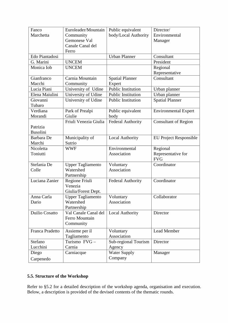
Fanco Marchetta
Euroleader/Mountain Community Gemonese Val Canale Canal del Ferro
Public equivalent body/Local Authority
Director/ Environmental Manager
Edo Piantadosi Urban Planner Consultant G. Marini UNCEM President Monica Iob UNCEM Regional
Representative Gianfranco Macchi
Carnia Mountain Community
Spatial Planner Expert
Consultant
Lucia Piani University of Udine Public Institution Urban planner Elena Maiulini University of Udine Public Institution Urban planner Giovanni Tubaro
University of Udine Public Institution Spatial Planner
Verdiana Morandi
Park of Prealpi Giulie
Public equivalent body
Environmental Expert
Patrizia Busolini
Friuli Venezia Giulia Federal Authority Consultant of Region
Barbara De Marchi
Municipality of Sutrio
Local Authority EU Project Responsible
Nicoletta Toniutti
WWF Environmental Association
Regional Representative for FVG
Stefania De Colle
Upper Tagliamento Watershed Partnership
Voluntary Association
Coordinator
Luciana Zanier Regione Friuli Venezia Giulia/Forest Dept.
Federal Authority Coordinator
Anna Carla Dario
Upper Tagliamento Watershed Partnership
Voluntary Association
Collaborator
Duilio Cosatto Val Canale Canal del Ferro Mountain Community
Local Authority Director
Franca Pradetto Assieme per il Tagliamento
Voluntary Association
Lead Member
Stefano Lucchini
Turismo FVG – Carnia
Sub-regional Tourism Agency
Director
Diego Carpenedo
Carniacque Water Supply Company
Manager
5.5. Structure of the Workshop Refer to §5.2 for a detailed description of the workshop agenda, organisation and execution. Below, a description is provided of the devised contents of the thematic rounds.
We note that the original structural scheme derived from the World Café method – i.e., three different discussion tables; public presentation of the results from each table at the end of each question-round – appears to have been somehow altered during the last two rounds, when the high sensitivity on the topics, sharpened by the substantial absence of local authorities, made the stakeholders spontaneously join in a general and passionate discussion, whose largely shared results continued being duly recorded on the flipchart. 5.5.1. Selection of the respective thematic fields/focuses The following basic concepts have driven the selection of the thematic fields to be submitted to the stakeholders’ attention: Complying with DIAMONT partners’ recommendations, where Land Resource Management issues have been identified as crucial in order to address DIAMONT objectives referring to contribution to sustainable development in the Alpine bow; Taking advantage of DIAMONT Italian team’s expertise gained in the Test Region area and its neighborhood: their vision on the problems/conflicts has been shaped during several participatory events having been held in the framework of other INTERREG projects (INNOREF, WAREMA). The above has led to the final identification of a limited number of strategic thematic fields to be operationally utilized during the workshop(s): 1. Economy and Society: this topic should include all aspects dealing with Labour Market,
stagnating economy, multi-decadal declining demography, etc; 2. Land Use: Land Take issues should be covered here (at present they concern
infrastructure rather than building); 3. Quality of Services: owing also to problem economic compatibility, mountain areas
frequently suffer from lack of adequate public/private services; 4. Institutional and Cooperation: this broad class should include a number of crucial
issues concerning not only relations of different levels of local government between themselves, but also the extent to which public information and participation to decision-making are fulfilled.
5.6. Questions for each part of the Workshop/for each Instrument A complete translation is presented herein of the presentation slides bearing the various round-questions, as submitted to the stakeholders’ attention. ROUND 1 – Socio-economy (Depopulation, Labour Market) What are the main problems and bottlenecks affecting the Region’s development and quality of life? Prioritize your answer (1 to 5, descending order). Identified Instruments: Counter for Consolidated Procedure ('Sportello Unico per le Attività Produttive'); ATO District Plan (Piano d'Ambito) ; PSR (Piano di Svilppo Rurale) Rural Development Plan ; Regional (Federal) Power Plan (Piano Energetico Regionale PER) ; Friuli Venezia Giulia Regional (Federal) Development Plan 2006-08 (Piano Regionale di Sviluppo PRS) ; River Basin Plan (Piano di Bacino) ; Local Forums, Watershed Partnerships and other Stakeholders Councils.
Are the identified Instruments adequate? Would you suggest others? ROUND 2 – Land Take (Infrastructure, Agriculture, Building)
What are the main factors relating to land take which hinder sustainable development? Prioritize your answer (1 to 5, descending order). Identified Instruments: Municipal Master Plan (Piano Regolatore Generale) ; Building Programme (Programma di fabbricazione) ; Building Regulations (Regolamento edilizio) ; Regional (Federal) Spatial Plan (= Piano Territoriale Regionale PTR) ; PSR (Piano di Svilppo Rurale) Rural Development Plan ; Regional (Federal) Power Plan (Piano Energetico Regionale PER) ; River Basin Plan (Piano di Bacino); Regional Plan of Transportation. Are the identified Instruments adequate? Would you suggest others? ROUND 3 – Services (Transportation, Health, Recreation, Waste) Do services meet the Region’s needs? Prioritize your answer (1 to 5, descending order). Identified Instruments: Municipal Tax on Estates (ICI - Imposta Comunale sugli Immobili) ; Municipal Waste collection Tax (TARSU - Tassa sui rifiuti solidi urbani) ; Municipal Master Plan (Piano Regolatore Generale) ; Building Programme (Programma di fabbricazione) ; Building Regulations (Regolamento edilizio) ; Regional Plan of Transportation; Friuli Venezia Giulia Regional (Federal) Development Plan 2006-08 (Piano Regionale di Sviluppo PRS). Are the identified Instruments adequate? Would you suggest others? ROUND 4 – Cooperation (Between Local Authorities, with Federal Authority; Participation) Does cooperation between Local Authorities, Federal Authority, stakeholders contribute
to sustainable and shared development? Prioritize your answer (1 to 5, descending order). Identified Instruments: Local Forums, Watershed Partnerships and other Stakeholders Councils; Memorandum of Understanding for the Protection and Conservation of the Architectural-Historical Heritage of Carnia ; Stakeholder Commission (Conferenza dei servizi). Are the identified Instruments adequate? Would you suggest others? ROUND 5 – Conflicts Which are the existing conflicts in your Region?
Identified Instruments: Local Forums, Watershed Partnerships and other Stakeholders Councils; Stakeholder Commission (Conferenza dei servizi). Are the identified Instruments adequate? Would you suggest others? 5.7. Results of the Workshop Below the complete matrix is presented bearing the workshop results. Starting from left, the column containing the questions (printed in blue color) is followed by the various tables’ answers, ranked according to the priorities as attributed by the stakeholders. In the last column DIAMONT experts have recorded in a concise form the most significant findings from all the tables, assigning global round-priorities as deducted from the individual tables’ priorities, as well as from their subjective gathering of the atmosphere evoked among the stakeholders by the different issues treated.
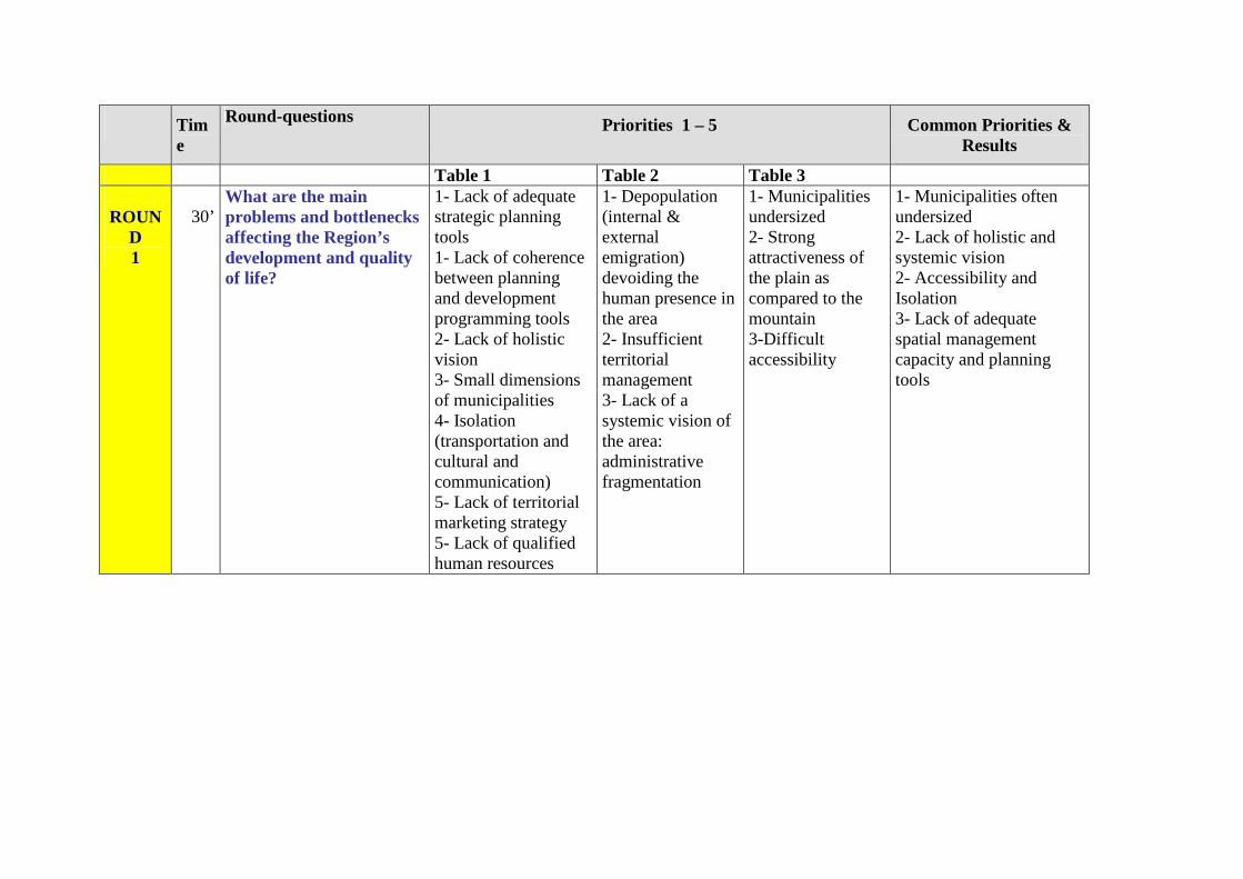
Time
Round-questions Priorities 1 – 5 Common Priorities & Results
Table 1 Table 2 Table 3 ROUN
D 1
30’
What are the main problems and bottlenecks affecting the Region’s development and quality of life?
1- Lack of adequate strategic planning tools 1- Lack of coherence between planning and development programming tools 2- Lack of holistic vision 3- Small dimensions of municipalities 4- Isolation (transportation and cultural and communication) 5- Lack of territorial marketing strategy 5- Lack of qualified human resources
1- Depopulation (internal & external emigration) devoiding the human presence in the area 2- Insufficient territorial management 3- Lack of a systemic vision of the area: administrative fragmentation
1- Municipalities undersized 2- Strong attractiveness of the plain as compared to the mountain 3-Difficult accessibility
1- Municipalities often undersized 2- Lack of holistic and systemic vision 2- Accessibility and Isolation 3- Lack of adequate spatial management capacity and planning tools
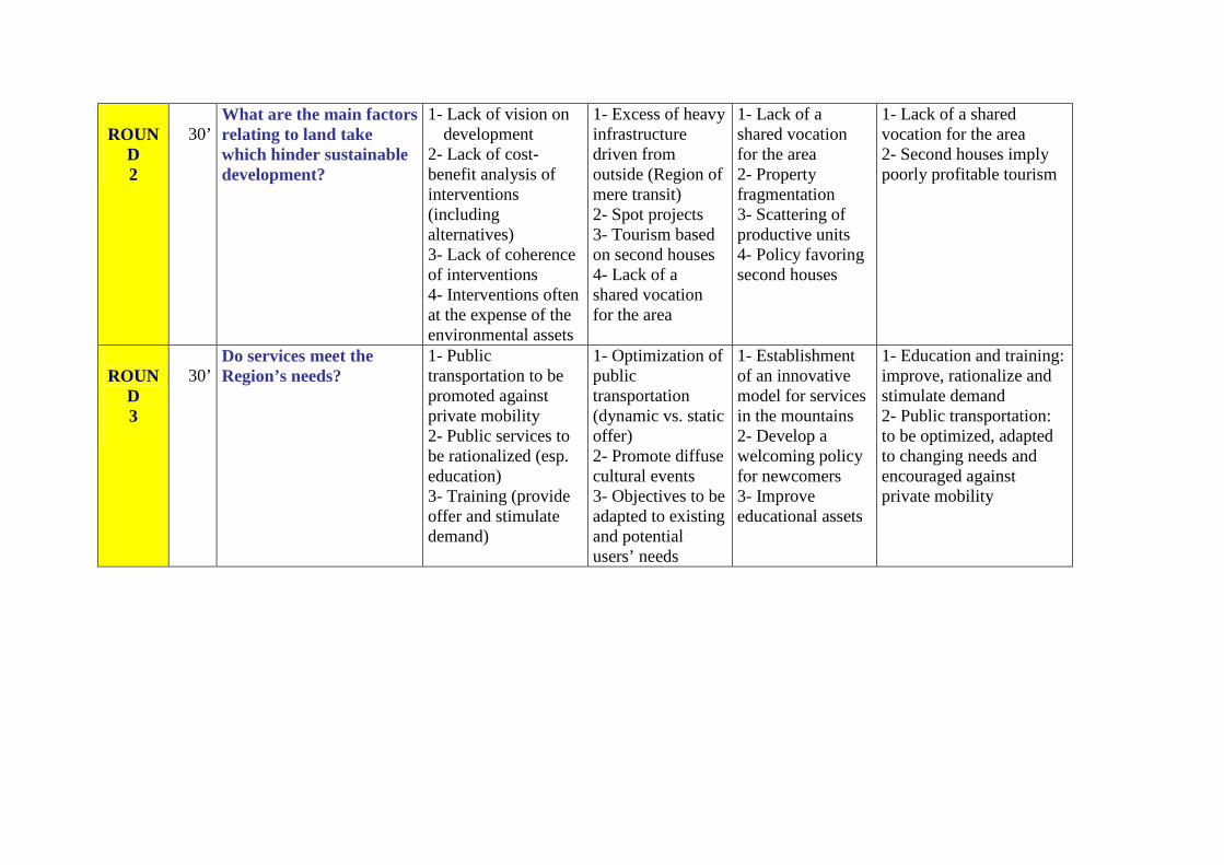
ROUN
D 2
30’
What are the main factors relating to land take which hinder sustainable development?
1- Lack of vision on development
2- Lack of cost-benefit analysis of interventions (including alternatives) 3- Lack of coherence of interventions 4- Interventions often at the expense of the environmental assets
1- Excess of heavy infrastructure driven from outside (Region of mere transit) 2- Spot projects 3- Tourism based on second houses 4- Lack of a shared vocation for the area
1- Lack of a shared vocation for the area 2- Property fragmentation 3- Scattering of productive units 4- Policy favoring second houses
1- Lack of a shared vocation for the area 2- Second houses imply poorly profitable tourism
ROUN
D 3
30’
Do services meet the Region’s needs?
1- Public transportation to be promoted against private mobility 2- Public services to be rationalized (esp. education) 3- Training (provide offer and stimulate demand)
1- Optimization of public transportation (dynamic vs. static offer) 2- Promote diffuse cultural events 3- Objectives to be adapted to existing and potential users’ needs
1- Establishment of an innovative model for services in the mountains 2- Develop a welcoming policy for newcomers 3- Improve educational assets
1- Education and training: improve, rationalize and stimulate demand 2- Public transportation: to be optimized, adapted to changing needs and encouraged against private mobility
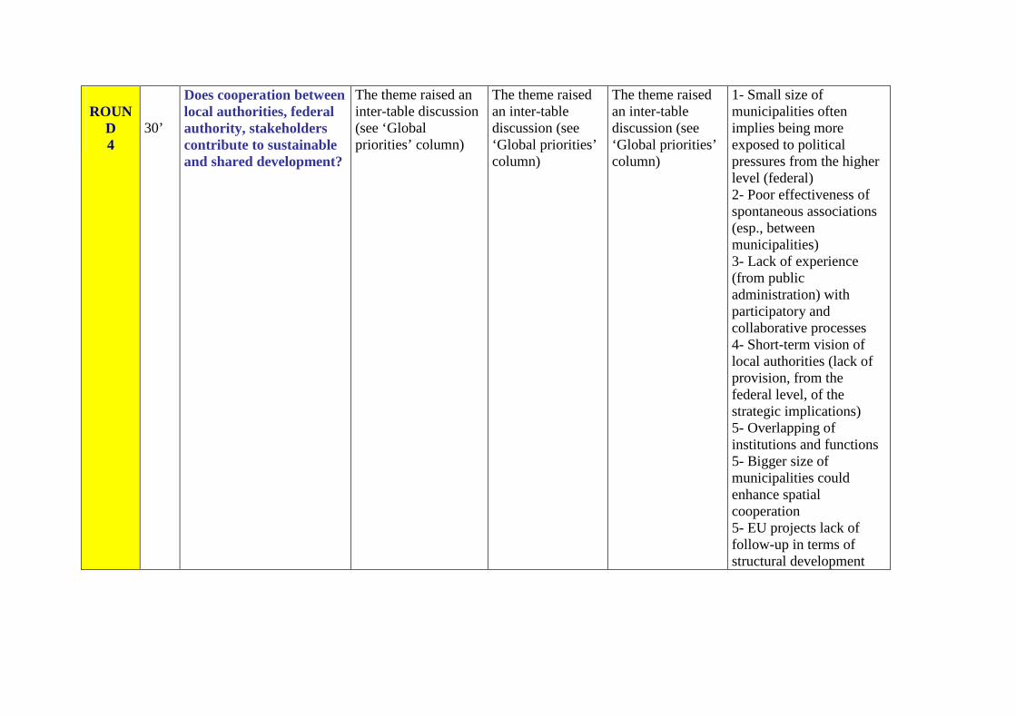
ROUN
D 4
30’
Does cooperation between local authorities, federal authority, stakeholders contribute to sustainable and shared development?
The theme raised an inter-table discussion (see ‘Global priorities’ column)
The theme raised an inter-table discussion (see ‘Global priorities’ column)
The theme raised an inter-table discussion (see ‘Global priorities’ column)
1- Small size of municipalities often implies being more exposed to political pressures from the higher level (federal) 2- Poor effectiveness of spontaneous associations (esp., between municipalities) 3- Lack of experience (from public administration) with participatory and collaborative processes 4- Short-term vision of local authorities (lack of provision, from the federal level, of the strategic implications) 5- Overlapping of institutions and functions 5- Bigger size of municipalities could enhance spatial cooperation 5- EU projects lack of follow-up in terms of structural development
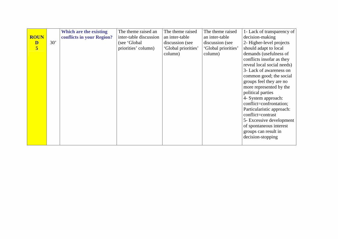
ROUN
D 5
30’
Which are the existing conflicts in your Region?
The theme raised an inter-table discussion (see ‘Global priorities’ column)
The theme raised an inter-table discussion (see ‘Global priorities’ column)
The theme raised an inter-table discussion (see ‘Global priorities’ column)
1- Lack of transparency of decision-making 2- Higher-level projects should adapt to local demands (usefulness of conflicts insofar as they reveal local social needs) 3- Lack of awareness on common good; the social groups feel they are no more represented by the political parties 4- System approach: conflict=confrontation; Particularistic approach: conflict=contrast 5- Excessive development of spontaneous interest groups can result in decision-stopping
5.7.1. Discussion results Several problems and conflicts affecting the area emerged to common appreciation during the meeting, the most relevant of which (substantially based on stakeholders’ assigned priorities) may be summarized as follows:
1 – Socio-economy - Education and training: not only should the offer become more adequate, but the need is
also perceived for demand-stimulation on the part of the (public) education providers, esp. orienting towards innovative sectors (IT, environment, etc).
- Development: tourism suffers from being scarcely profitable when based almost exclusively on second houses; on the other hand, EU projects have lacked of follow-up in terms of structural development and new professionalism so far.
2 – Land Take - Lack of holistic and systemic vision and lack of adequate land and resource management
capacity and planning tools (institutions and functions often overlap). Local authorities suffer from short-term vision, whilst the federal level doesn’t provide a clear overview of the strategic implications of different courses of action.
3 – Services - Accessibility and isolation: not so much geographic as cultural and related to
communication and exchange of information. The offer of services appear to be too rigid: development of innovative services is needed, to be possibly enclosed within the framework of a specific model for services in mountain areas. Concerning particularly public transportation, it should be optimized, adapted to changing needs and encouraged against private mobility; furthermore, it suffers from being exclusively axed on the core city (Tolmezzo). Last but not the least, the area runs the risk of becoming a region of mere transit, crossed by (heavy-impacting) supra-regional infrastructure.
4 – Cooperation - The Municipalities are often undersized, also due to long-lasting depopulation: this
usually implies being more exposed to political pressures from the higher level (federal). On the other hand, voluntary associations (esp., between municipalities) have proved poorly effective so far.
5 – Conflicts - Lack of a shared vocation for the area and (but this tends to be a national problem) lack of
awareness on the common good: the social groups feel they are not adequately represented by the political parties any more. On the other hand, development of spontaneous interest groups can result in decision-stopping when excessive, even though they clearly reveal local social needs which should be acknowledged by higher-level projects impacting on their territories: failing to do so, reveals also the public administration’s lack of both transparency in decision-making and experience with participatory and collaborative processes.
5.8. Comparison of the Context Analysis results with the Workshop results Indeed there appears to be a certain gap between the conditions of the Italian Test Region as depicted by the Context Analysis results (see §5.1) on one side, and perceived by the workshop stakeholders on the other.
The picture emerging from the former shows a Region that, in spite of some problems mostly tied to decades-long declining demography, still keeps a favorable structure based on strong and substantially unimpaired environmental assets, as bear witness the shares of forest cover and near-natural areas, truly overwhelming when compared to either the remaining land uses or the corresponding mean values for the Alps and the Italian Alps (moreover, it should be noted that an additional number of municipalities exist, located at the outskirts of Tolmezzo LMR and still somehow resenting its attraction, which keep an even more pristine character). The agriculture appears to be even more marginal than in the reference regions (although the bigger size of the holdings could ensure higher profitability); however, this does not necessarily represent a drawback in our opinion, since agriculture has often been held responsible for serious environmental impacts (suffice it to mention not only the use of pesticides and fertilizers, but also the overwhelming – and unreasonable, from an economic point of view – consumption of water for irrigation, at virtually no cost for farmers, at least in Italy). Concerning the other sectors, the available data show no dramatic problems: the productive structure appears to be solid and variegated (see indicators concerning enterprise size and tourism), although somewhat lacking in innovation and dynamics (see indicators on enterprise birth rate and RTDI sectors). Labour market indicators do not appear to highlight particular problems, as do not educational indicators. Not even services to both population and, to a lesser extent, enterprises, look so insufficient, at least at first sight…
As a matter of fact, the selected Test Region does exhibit a number of serious problems and conflicts as perceived not only by the local stakeholders, but also by external and possibly neutral observers. Thus, the CA results seem to have proved poorly adequate to highlight them properly; this may be due to either:
- Lack of sufficient information coming from the available sources and data; this is probably the case with the following: enterprise financial assets/costs and employees salaries, RTDI sector, spreading of new-generation infrastructure (communications and web, renewable energies) and building permits trend; although such information would have added to the understanding of the effective conditions of the area, nonetheless we doubt that the key problems/conflicts would have thence emerged to full clarity.
- Poor suitability of the selected indicators; let us mention environmental quantitative indicators, which seem hardly able to unveil the existing weaknesses. (Concerning the specific issue of stream corridor pollution and impairment, we trust that the imminent enforcing of the Water Framework Directive strict requirements on watercourse quality assessment standards will prompt availability of – so far restrained or altogether lacking – bountiful information and indicators).
On the other hand, it remains clear that the pitfall should be avoided of over-expectation from the CA results: it is fairly obvious that the main source of stakeholders’ dissatisfaction and criticism, being related to perceived insufficient participation of local populations in decision-making and lack of transparency especially on the part of regional/federal authorities, appears to be hardly conveyable by any available indicators. This is also true for the criticism concerning the lack of policy-makers’ holistic and strategic vision on development of the area, whereas the indication that the small size of municipalities
represents a drawback in terms of being more exposed to pressures from the higher governmental levels could possibly have been inferred from analysis of breakdown indicators at municipal level (it is fairly obvious that the Test Region aggregation proves of no help in ascertaining this issue). To finalize this discussion, let us shortly comment on what has been perceived by DIAMONT workshop moderation team as a kind of hyper-criticism on the stakeholders’ part concerning their own Region’s strengths, weaknesses and potential. We cannot but point out that the very complexity and pointedness of their reasoning can be regarded as somehow contradicting their own sense of backwardness, revealing instead their strong cultural background and variegated knowledge of the latest advances of modern society (in terms not only of technology and communications, but also politics, economy, education, environment and so on). 5.9. Starting points for the second Workshop The main topic of the second workshop which will be held in October 2007 is conflict resolution in the Test Region. The problems and conflict identification phase has been quite satisfactorily covered during the first workshop. From this starting point DIAMONT experts will prepare a new proposal focused on conflict resolution, to be submitted to stakeholders’ attention. No doubt that the Test Region presents many problems, but only the most important – as from the stakeholders’ prioritization - will be taken under consideration. The main conflicts involve the citizens and the Region (federal level); here, a conflict resolution strategy will be prepared based on a selection of adequate instruments. The experience gained in the other DIAMONT Test Regions and workshops concerning conflict managing/avoiding will be carefully analyzed and discussed before and during the second workshop, with a view of identifying innovative instruments potentially susceptible of transposition to the Italian context. The instrument discussion phase has just started during the first workshop (this was also due to the fact that the conflict/problem identification phase actually – and quite appropriately – took most of the available time and energy), but it is expected to be thoroughly finalized during the second workshop. As a matter of fact, the stakeholders did go further, supplementing problem identification with a rough outline of proposed solutions. These can represent another productive starting point to more in-depth investigation, aimed at assessing the suitability of the available instruments in order to achieve the desired solutions. Up to present, the stakeholders have:
- Highlighted the lack of a comprehensive land planning tool, suitable to implement a holistic vision and to overcome the present splitting and overlapping of responsibilities;
- Pointed out the inefficiency affecting the system of local/federal authorities, raising sharp criticism against the lack of internal cooperation, of implemented participation processes, as well as the poor effectiveness of the experienced inter-municipal voluntary association tools;
- Discussed the pros and cons coming from the spreading of spontaneous associations and interest groups;
- Suggested the need for a specific Model for services to be provided in mountain areas, where the issues of economic compatibility, innovation, and the socio-institutional constraints are duly dealt with through an integrated approach.
5.10. Conclusions
DIAMONT Work Package 10 has initiated confrontation between theory and practice: the expert work leading to the selection of a number of instruments deemed to be suitable or anyhow related to the specific issue of land resource management or the more general issue of sustainable development in the selected Test Regions, have been submitted to the stakeholders’ scrutiny and judgment. Subsequently, they will have to be steered accordingly: with WP 11 confrontation should extend so as to cover possible strategies suitable to tackle and solve the identified conflicts within the Test Regions. As it was to be expected, the impact with practice has produced, at least for Italy, a rearrangement of the foreseen schedule: rather than instruments assessment, the stakeholders’ focus during WP 10 workshop has been directed towards problem (or phenomenon, for sake of using DIAMONT terminology) identification, as well as towards the conflicts that almost invariably problems imply, without omitting some precious hints at their possible solutions. Even if it is true that the boundaries between solutions and instruments – as well as between problems and conflicts – often appear somewhat dim or artificial, UNCEM’s moderation team will pursue a higher degree of pointedness in WP 11 scheduled workshop, trying to steer stakeholders’ criticism and suggestions towards concrete either existing or possible instruments and solutions.
Coming now to speak about the selected Italian Test Region – coinciding with EURAC’s Labour Market Region of Tolmezzo – no doubt a complex picture has emerged from the analyses and information recorded in the previous sections. Nonetheless, it is possible to make a final effort for sake of synthesizing the main findings; the following aspects are worth highlighting: 1) Tolmezzo Test Region Context Analysis:
Basically following AMGI’s specifications, a Context Analysis has been prepared consisting mostly of quantitative indicators; when deemed useful to add to the knowledge of the area, we have included a limited number of extra indicators, either quantitative or qualitative. Data are presented according to both the aggregation at Test Region level and the breakdown (see Appendix) at municipal level (no. 18 municipalities included into Tolmezzo Test Region).
As noted above (see §6.3), the CA depicts a Region whose weaknesses appear to be somewhat mild, mostly related to decades-long declining demography, having reverberated through unsatisfactory innovation of the productive structure and services. Strengths on the other hand emerge more clearly, especially when you compare the Test Region to other areas (typically, both the Italian Alps and the whole Alpine space): they are mainly linked to the environmental assets, as bear witness the overwhelming shares of forest cover and near-natural areas.
However, the Test Region does feature a number of serious problems, as the stakeholders have sharply but accurately pointed out. They are mainly related to the socio-political sphere, and chiefly consist of the perception of insufficient participation of local populations in decision-making, poor transparency from local and especially regional (i.e., federal) authorities, as well as lack of decision-makers’ holistic and strategic vision on development of the area.
The reasons for this gap between CA results and stakeholders’ perception could partly be linked to lack of available data and indicators refined enough to capture such elusive, almost immaterial, problems (their consequences can be quite substantial, though!). This is also why the prepared SWOT (Strengths-Weaknesses-Opportunities-Threats) Analysis, which has been attached to the CA at Test Region level, has been thoroughly revised to integrate such important perceptions and concerns as are likely to be substantially shared by external and
possibly neutral observers; UNCEM’s moderation team can be regarded as such, their expertise featuring participatory events having been previously attended/organised in the same Region in the framework of other European projects.
2) WP 10 Workshop:
Public Participation Methodology: Workshop participants have shown a high degree of involvement: the good interaction established between stakeholders and UNCEM team suggests the same methodology (the World Café method) be maintained also for the second (WP 11) workshop.
Instrument Data-Base: The creation of such data base at Alpine Space level has been appreciated by all participants and perceived as an important knowledge-provider suited to steer land management and sustainable development issues. In particular, Italian stakeholders expect relevant inputs to come from the other DIAMONT Test Regions: best practices exchange can improve the local know-how on available instruments at Alpine-wide scale.
Thematic focus: We tried to focus the discussion on the problems affecting the area, the possible solutions and the suitability of the identified instruments to achieve these. Stakeholders’ answers and comments showed the need to more effectively apply the existing instruments and follow a common and shared approach to land resource management problems. A common strategy coupled with integrated planning tools is needed to enhance development of the area.
Perception of the Region: The presentation of the SWOT Analysis and the request for cooperation with UNCEM team has obtained widespread consensus from the stakeholders. A clear message coming from them is to obtain concrete and lasting results in the Test Region: the cooperation among different EU projects leads towards this objective, and this has been acknowledged. Furthermore, the comparison with other Alpine municipalities will help to better understand their own Region’s needs and assets. Participants showed a very good knowledge of problems affecting the Test Region as well as of available instruments to tackle them. Beside highlighting problems, they also outlined possible solutions or hinted at the objectives to be attained. Tentative voluntary agreements for cooperation between municipalities (the so-called ASTERs, Territorial Associations) have proved poorly effective so far, possibly due to competition among municipalities or valleys and lack of awareness: this results in being more exposed to pressures and decisions made at higher (federal) level, and hinders definition and application of a common strategy for sustainable development. Nevertheless, a new spur is now represented by citizens’ participation: numerous committees and voluntary associations have been established for protecting the threatened environmental assets of the area, especially the Tagliamento river ecosystem, and enhancing the local sustainable economy through the proposed creation of a Biosphere Reserve.
6. Slovenia - Idrija Country: SLOVENIA Test region: IDRIJA Workshop results Location of the workshop: Idrija Date of the workshop: 5. 6. 2007 Number of participants: 13 Project partner: Anton Melik Geographical Institute at the Scientific Centre of the Slovenian Academy of Sciences and Arts
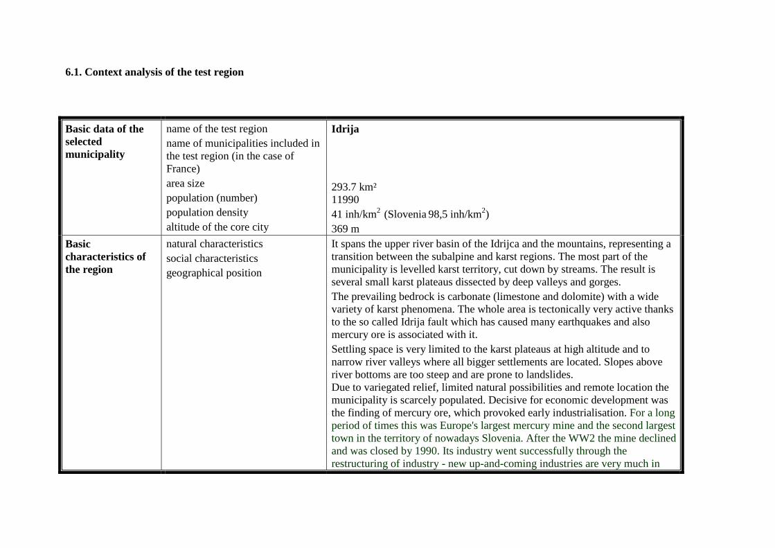
6.1. Context analysis of the test region
Basic data of the selected municipality
name of the test region name of municipalities included in the test region (in the case of France) area size population (number) population density altitude of the core city
Idrija 293.7 km² 11990 41 inh/km2 (Slovenia 98,5 inh/km2) 369 m
Basic characteristics of the region
natural characteristics social characteristics geographical position
It spans the upper river basin of the Idrijca and the mountains, representing a transition between the subalpine and karst regions. The most part of the municipality is levelled karst territory, cut down by streams. The result is several small karst plateaus dissected by deep valleys and gorges. The prevailing bedrock is carbonate (limestone and dolomite) with a wide variety of karst phenomena. The whole area is tectonically very active thanks to the so called Idrija fault which has caused many earthquakes and also mercury ore is associated with it. Settling space is very limited to the karst plateaus at high altitude and to narrow river valleys where all bigger settlements are located. Slopes above river bottoms are too steep and are prone to landslides. Due to variegated relief, limited natural possibilities and remote location the municipality is scarcely populated. Decisive for economic development was the finding of mercury ore, which provoked early industrialisation. For a long period of times this was Europe's largest mercury mine and the second largest town in the territory of nowadays Slovenia. After the WW2 the mine declined and was closed by 1990. Its industry went successfully through the restructuring of industry - new up-and-coming industries are very much in
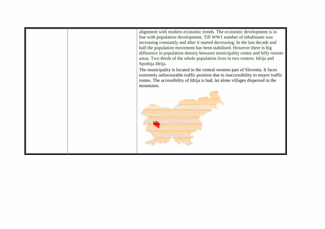
alignment with modern economic trends. The economic development is in line with population development. Till WW1 number of inhabitants was increasing constantly and after it started decreasing. In the last decade and half the population movement has been stabilised. However there is big difference in population density between municipality centre and hilly remote areas. Two thirds of the whole population lives in two centres: Idrija and Spodnja Idrija. The municipality is located in the central western part of Slovenia. It faces extremely unfavourable traffic position due to inaccessibility to mayor traffic routes. The accessibility of Idrija is bad, let alone villages dispersed in the mountains.
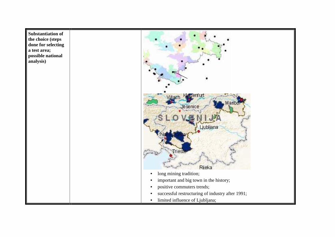
Substantiation of the choice (steps done for selecting a test area; possible national analysis)
• long mining tradition; • important and big town in the history; • positive commuters trends; • successful restructuring of industry after 1991; • limited influence of Ljubljana;
• industries are very much in alignment with modern economic trends;
• limited accessibility • lack of space • sensitive monostructural enterprises
PRODUCTIVE ENVIRONMENT HUMAN RESOURCES BASIC INFRASTRUCTURE
IDRIJA: PRODUCTIVE ENVIRONMENT
Strengths
high wages good economic structure attractive employment centre agriculture is not too intensive relatively large farms people do not depend on farming natural environment is at good condition the economy is export oriented high productivity companies with solid financial basis
intensive research activities historical tradition openness to new ideas due to historical connections to world market sense of solidarity due to mining tradition strongly pronounced identity flexibility of working force tacit knowledge institutional thickness
Weaknesses
low investment activity terrain, not appropriate for farming firms are relatively large - the entrepreneurship is relatively weak - high dependency on the successfulness of bigger firms lower income per company and smaller return of assets weak tourists capacities it is not well recognisable as a tourist destination remoteness bad accessibility lack of space, suitable for industry weak infrastructure systems isolation
Opportunities
high potential for "educational" tourism high potential for clustering close to development axis plans for improvement of roads - better accessibility innovativeness
Threats
spatial limitations for firm growth limited commuter hinterland overspecialization in a specific sector
movement of firms and activities out of the regions due to space limitations crisis in specific sector movement of labour intensive activities to the countries with cheaper working force limited amount of working force
Priorities (proposed solutions)
to improve accessibility of the area, especially to the development corridor SW-NE to intensify knowledge intensive activities to strengthen tourist activities and capacities to assure proper business zones for different types of firms to foster entrepreneurship to foster innovativeness to improve cooperation between companies (joint development groups)
IDRIJA: HUMAN RESOURCES
Strengths
due to favourable economic structure number of inhabitants is stable positive net migration share of old people is for now smaller than is Slovenian average the number of societies is above average in Slovenia, so there is a sense of belonging; people are active in the sphere of civil society; strong identity; intensive face to face contacts good employment opportunities; good employment possibilities for unskilled and semiskilled workers high inclusion of women in employment possibilities (Female employment rate is higher as is Slovenian and Alpine EU average) very low rate of registered unemployment; high concentration and specialization of metal, timber and electrical industry perspective well paid jobs number of people with secondary education is higher than elsewhere in Slovenia
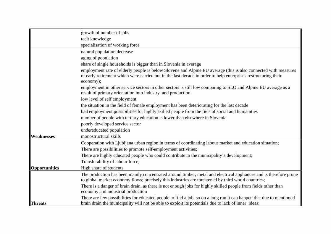
growth of number of jobs tacit knowledge specialisation of working force
Weaknesses
natural population decrease aging of population share of single households is bigger than in Slovenia in average employment rate of elderly people is below Slovene and Alpine EU average (this is also connected with measures of early retirement which were carried out in the last decade in order to help enterprises restructuring their economy); employment in other service sectors in other sectors is still low comparing to SLO and Alpine EU average as a result of primary orientation into industry and production low level of self employment the situation in the field of female employment has been deteriorating for the last decade bad employment possibilities for highly skilled people from the fiels of social and humanities number of people with tertiary education is lower than elsewhere in Slovenia poorly developed service sector undereducated population monostructural skills
Opportunities
Cooperation with Ljubljana urban region in terms of coordinating labour market and education situation; There are possibilities to promote self-employment activities; There are highly educated people who could contribute to the municipality’s development; Transferability of labour force; High share of students
Threats
The production has been mainly concentrated around timber, metal and electrical appliances and is therefore prone to global market economy flows; precisely this industries are threatened by third world countries; There is a danger of brain drain, as there is not enough jobs for highly skilled people from fields other than economy and industrial production There are few possibilities for educated people to find a job, so on a long run it can happen that due to mentioned brain drain the municipality will not be able to exploit its potentials due to lack of inner ideas;
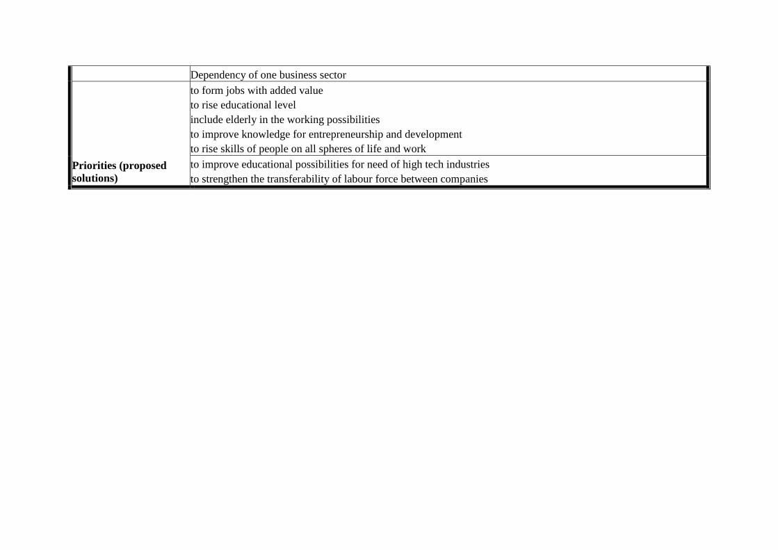
Dependency of one business sector
to form jobs with added value to rise educational level include elderly in the working possibilities to improve knowledge for entrepreneurship and development to rise skills of people on all spheres of life and work
Priorities (proposed solutions)
to improve educational possibilities for need of high tech industries to strengthen the transferability of labour force between companies
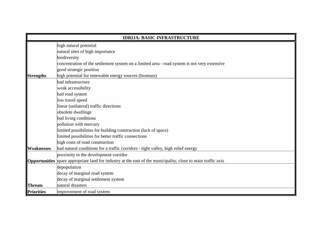
IDRIJA: BASIC INFRASTRUCTURE
Strengths
high natural potential natural sites of high importance biodiversity concentration of the settlement system on a limited area - road system is not very extensive good strategic position high potential for renewable energy sources (biomass)
Weaknesses
bad infrastructure weak accessibility bad road system low travel speed linear (unilateral) traffic directions obsolete dwellings bad living conditions pollution with mercury limited possibilities for building construction (lack of space) limited possibilities for better traffic connections high costs of road construction bad natural conditions for a traffic corridors - tight valley, high relief energy
Opportunities proximity to the development corridor spare appropriate land for industry at the east of the municipality, close to main traffic axis
Threats
depopulation decay of marginal road system decay of marginal settlement system natural disasters
Priorities improvement of road system
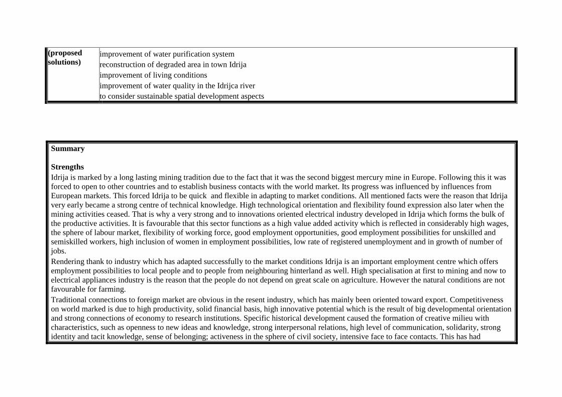
(proposed solutions)
improvement of water purification system reconstruction of degraded area in town Idrija improvement of living conditions improvement of water quality in the Idrijca river to consider sustainable spatial development aspects
Summary Strengths Idrija is marked by a long lasting mining tradition due to the fact that it was the second biggest mercury mine in Europe. Following this it was forced to open to other countries and to establish business contacts with the world market. Its progress was influenced by influences from European markets. This forced Idrija to be quick and flexible in adapting to market conditions. All mentioned facts were the reason that Idrija very early became a strong centre of technical knowledge. High technological orientation and flexibility found expression also later when the mining activities ceased. That is why a very strong and to innovations oriented electrical industry developed in Idrija which forms the bulk of the productive activities. It is favourable that this sector functions as a high value added activity which is reflected in considerably high wages, the sphere of labour market, flexibility of working force, good employment opportunities, good employment possibilities for unskilled and semiskilled workers, high inclusion of women in employment possibilities, low rate of registered unemployment and in growth of number of jobs. Rendering thank to industry which has adapted successfully to the market conditions Idrija is an important employment centre which offers employment possibilities to local people and to people from neighbouring hinterland as well. High specialisation at first to mining and now to electrical appliances industry is the reason that the people do not depend on great scale on agriculture. However the natural conditions are not favourable for farming. Traditional connections to foreign market are obvious in the resent industry, which has mainly been oriented toward export. Competitiveness on world marked is due to high productivity, solid financial basis, high innovative potential which is the result of big developmental orientation and strong connections of economy to research institutions. Specific historical development caused the formation of creative milieu with characteristics, such as openness to new ideas and knowledge, strong interpersonal relations, high level of communication, solidarity, strong identity and tacit knowledge, sense of belonging; activeness in the sphere of civil society, intensive face to face contacts. This has had
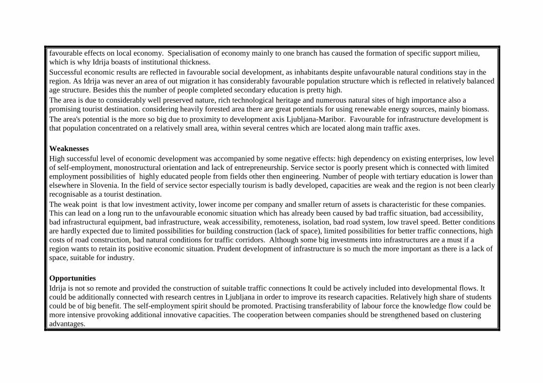
favourable effects on local economy. Specialisation of economy mainly to one branch has caused the formation of specific support milieu, which is why Idrija boasts of institutional thickness. Successful economic results are reflected in favourable social development, as inhabitants despite unfavourable natural conditions stay in the region. As Idrija was never an area of out migration it has considerably favourable population structure which is reflected in relatively balanced age structure. Besides this the number of people completed secondary education is pretty high. The area is due to considerably well preserved nature, rich technological heritage and numerous natural sites of high importance also a promising tourist destination. considering heavily forested area there are great potentials for using renewable energy sources, mainly biomass. The area's potential is the more so big due to proximity to development axis Ljubljana-Maribor. Favourable for infrastructure development is that population concentrated on a relatively small area, within several centres which are located along main traffic axes. Weaknesses High successful level of economic development was accompanied by some negative effects: high dependency on existing enterprises, low level of self-employment, monostructural orientation and lack of entrepreneurship. Service sector is poorly present which is connected with limited employment possibilities of highly educated people from fields other then engineering. Number of people with tertiary education is lower than elsewhere in Slovenia. In the field of service sector especially tourism is badly developed, capacities are weak and the region is not been clearly recognisable as a tourist destination. The weak point is that low investment activity, lower income per company and smaller return of assets is characteristic for these companies. This can lead on a long run to the unfavourable economic situation which has already been caused by bad traffic situation, bad accessibility, bad infrastructural equipment, bad infrastructure, weak accessibility, remoteness, isolation, bad road system, low travel speed. Better conditions are hardly expected due to limited possibilities for building construction (lack of space), limited possibilities for better traffic connections, high costs of road construction, bad natural conditions for traffic corridors. Although some big investments into infrastructures are a must if a region wants to retain its positive economic situation. Prudent development of infrastructure is so much the more important as there is a lack of space, suitable for industry. Opportunities Idrija is not so remote and provided the construction of suitable traffic connections It could be actively included into developmental flows. It could be additionally connected with research centres in Ljubljana in order to improve its research capacities. Relatively high share of students could be of big benefit. The self-employment spirit should be promoted. Practising transferability of labour force the knowledge flow could be more intensive provoking additional innovative capacities. The cooperation between companies should be strengthened based on clustering advantages.
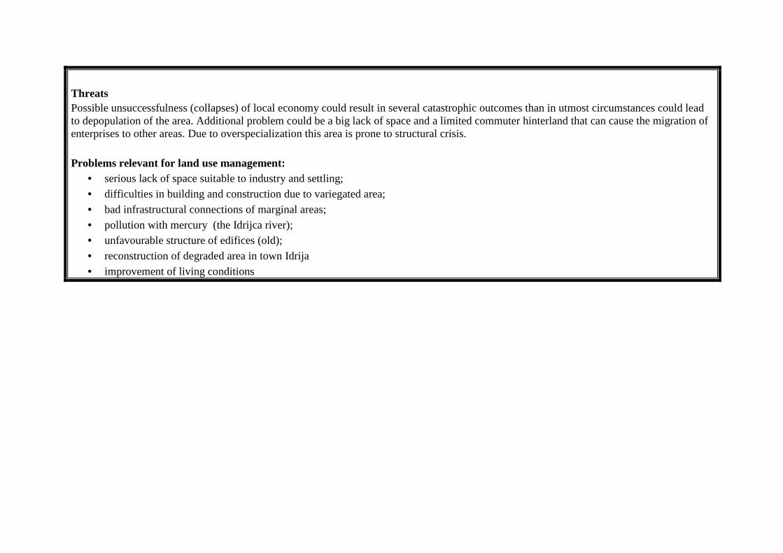
Threats Possible unsuccessfulness (collapses) of local economy could result in several catastrophic outcomes than in utmost circumstances could lead to depopulation of the area. Additional problem could be a big lack of space and a limited commuter hinterland that can cause the migration of enterprises to other areas. Due to overspecialization this area is prone to structural crisis. Problems relevant for land use management:
• serious lack of space suitable to industry and settling; • difficulties in building and construction due to variegated area; • bad infrastructural connections of marginal areas; • pollution with mercury (the Idrijca river); • unfavourable structure of edifices (old); • reconstruction of degraded area in town Idrija • improvement of living conditions

6.2. Preparation of the workshop After the selection of test region, we prepared a detailed context analysis, which was a base for the selection and preparation of thematic fields. According to selected topics we decided to invite people from different institutions, according to the list, prepared by AMGI for the purposes of WP 10 workshop. In this manner we invited the mayor of the municipality and officials, responsible for economy, environment and social matters. The invitation was also sent to different local communities, societies and associations, to regional development agency, local chamber of craft, to some more important companies and to participants of all crucial political parties. The weakest response was reached at NGOs, where only two members attended to the workshop. On the other side a remarkable response was noticed at the representatives of local communities. Due to misunderstanding with the mayor also officials from the municipalities were absent. In the preparation phase we tried to get deeper connections with municipality leadership and with regional development agency in order to include all crucial decision makers into the workshop discussion. 6.2.1. The organizational aspects of the workshop The workshop was divided on seven thematic rounds and on concluding round. After the fifth round, when all crucial topics were already discussed, a short presentation was made, comprehending all important aspects, essential for further discussions on advantages and the disadvantages and on the development possibilities and conflicts. The discussion on each thematic round lasted 30 minutes, where 15-20 minuter were reserved for the discussion within groups. Additional 10- 15 minutes were dedicated to presentations and concluding remarks. 6.3. List of selected instruments In Slovenian case no preliminary selection of the instruments was made. Our intention was to deal with most urgent questions in the selected region and to bind those questions with existing instruments. In this manner some crucial instruments could be exposed:
- Slovenia's Development Strategy; - Promotion of Balanced Regional Development Act; - Spatial Planning Act; - Law on Agricultural Land; - Law on Water; - Regional Development Plan; - Regional Conception of Spatial Development; - Spatial Development Strategy of a Municipality; - Municipal Spatial Order.
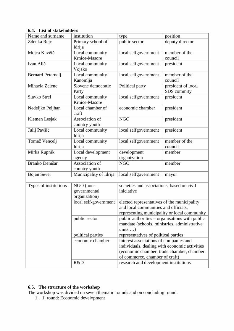
6.4. List of stakeholders Name and surname institution type position Zdenka Rejc Primary school of
Idrija public sector deputy director
Mojca Kavčič Local community Krnice-Masore
local selfgovernment member of the council
Ivan Alič Local community Vojsko
local selfgovernment president
Bernard Peternelj Local community Kanomlja
local selfgovernment member of the council
Mihaela Zelenc Slovene democratic Party
Political party president of local SDS commity
Slavko Strel Local community Krnice-Masore
local selfgovernment president
Nedeljko Peljhan Local chamber of craft
economic chamber president
Klemen Lesjak Association of country youth
NGO president
Julij Pavšič Local community Idrija
local selfgovernment president
Tomaž Vencelj Local community Idrija
local selfgovernment member of the council
Mirka Rupnik Local development agency
development organization
member
Branko Demšar Association of country youth
NGO member
Bojan Sever Municipality of Idrija local selfgovernment mayor
NGO (non-governmental organization)
societies and associations, based on civil iniciative
local self-government elected representatives of the municipality and local communities and officials, representing municipality or local community
public sector public authorities – organisations with public mandate (schools, ministries, administrative units …)
political parties representatives of political parties economic chamber interest associations of companies and
individuals, dealing with economic activities (economic chamber, trade chamber, chamber of commerce, chamber of craft)
Types of institutions
R&D research and development institutions
6.5. The structure of the workshop The workshop was divided on seven thematic rounds and on concluding round.
1. 1. round: Economic development
2. 2. round: Transport and infrastructure 3. 3. round: Land use (the problems of land take management) 4. 4. round: Quality of life 5. 5. round: Regional cooperation 6. Comprehension of earlier conclusions 7. 6. round: Defining the advantages and the disadvantages 8. 7. round: Definition of development possibilities and conflicts 9. Conclusions and decisions on further cooperation
6.5.1. Information on the selection of respective thematic fields/focuses At defining crucial thematic fields we tried to focus on the situation in selected region not forgetting basic starting points of Diamont project. In this manner we want to provoke debate on all crucial aspects, important for the development of selected municipality and on the other side we want to focus on a land use management and its instruments as a red line between all thematic rounds and questions. Respective thematic rounds have been selected according to following criteria: Economic development:
- importance of the economic development for the region, beginning with very high performance of local companies, export oriented activities, low unemployment rate …
Transport and infrastructure: - traffic connections are of crucial importance for every region. In case of Idrija
connections are very bad, due to unfavourable natural conditions. Those are also the reason for underdevelopment of other sorts of infrastructure (water purification systems, telecommunications …).
Land use (the problems of land take management): - this is an all-embracing topic, represented in all thematic rounds and especially
important for the municipality of Idrija, due to a lack of land, appropriate for the construction and industry.
Quality of life: - this topic is a consequence of issues, detected in previous problem fields, upgraded
with different social interventions, services and personal relationships. Regional cooperation:
- each municipality, even the most marginal, has to maintain its connections to neighbouring areas, in order to construct common infrastructure system, supply system or to combine different development initiatives with aim of reaching synergetic effects.
6.6. Questions for each part of the workshop/ for each instrument 1. round: Economic development: Which are the basic hindrances of economic progress in a municipality? What circumstances should be established for the economy to work even more effectively? Are state and municipal documents and instruments helping the economy or are they obstructing it? (name meaningful documents?) 2. round: Transport and infrastructure Define the main problems for the municipality on the infrastructural level.
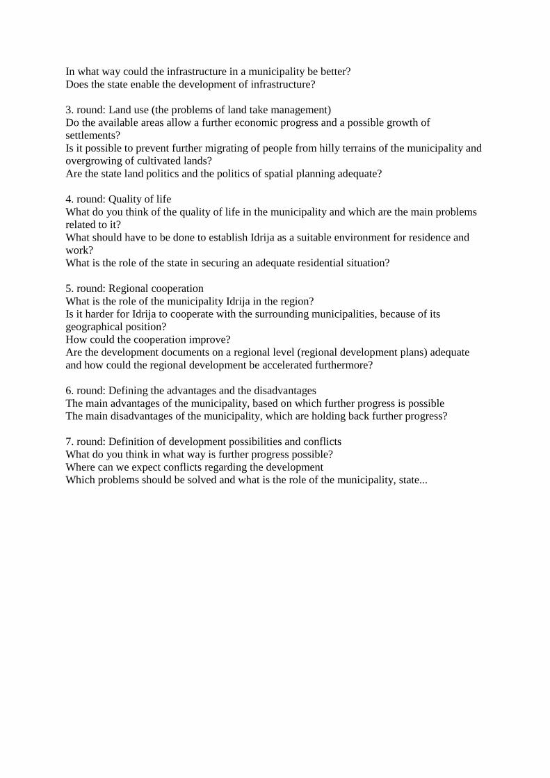
In what way could the infrastructure in a municipality be better? Does the state enable the development of infrastructure? 3. round: Land use (the problems of land take management) Do the available areas allow a further economic progress and a possible growth of settlements? Is it possible to prevent further migrating of people from hilly terrains of the municipality and overgrowing of cultivated lands? Are the state land politics and the politics of spatial planning adequate? 4. round: Quality of life What do you think of the quality of life in the municipality and which are the main problems related to it? What should have to be done to establish Idrija as a suitable environment for residence and work? What is the role of the state in securing an adequate residential situation? 5. round: Regional cooperation What is the role of the municipality Idrija in the region? Is it harder for Idrija to cooperate with the surrounding municipalities, because of its geographical position? How could the cooperation improve? Are the development documents on a regional level (regional development plans) adequate and how could the regional development be accelerated furthermore? 6. round: Defining the advantages and the disadvantages The main advantages of the municipality, based on which further progress is possible The main disadvantages of the municipality, which are holding back further progress? 7. round: Definition of development possibilities and conflicts What do you think in what way is further progress possible? Where can we expect conflicts regarding the development Which problems should be solved and what is the role of the municipality, state...
6.7. Revised answers ECONOMIC DEVELOPMENT
1st group 2nd group 3rd group The discussion SUMMARY
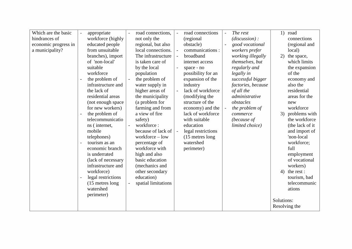
Which are the basic hindrances of economic progress in a municipality?
- appropriate workforce (highly educated people from unsuitable branches), import of 'non-local' suitable workforce
- the problem of infrastructure and the lack of residential areas (not enough space for new workers)
- the problem of telecommunications ( internet, mobile telephones)
- tourism as an economic branch is underrated (lack of necessary infrastructure and workforce)
- legal restrictions (15 metres long watershed perimeter)
- road connections, not only the regional, but also local connections. The infrastructure is taken care of by the local population
- the problem of water supply in higher areas of the municipality (a problem for farming and from a view of fire safety)
- workforce : because of lack of workforce – low percentage of workforce with high and also basic education (mechanics and other secondary education)
- spatial limitations
- road connections (regional obstacle)
- communications : - broadband
internet access - space - no
possibility for an expansion of the industry
- lack of workforce (modifying the structure of the economy) and the lack of workforce with suitable education
- legal restrictions (15 metres long watershed perimeter)
- The rest (discussion) :
- good vocational workers prefer working illegally themselves, but regularly and legally in successful bigger factories, because of all the administrative obstacles
- the problem of commerce (because of limited choice)
1) road connections (regional and local)
2) the space, which limits the expansion of the economy and also the residential areas for the new workforce
3) problems with the workforce (the lack of it and import of 'non-local workforce; full employment of vocational workers)
4) the rest : tourism, bad telecommunications
Solutions: Resolving the
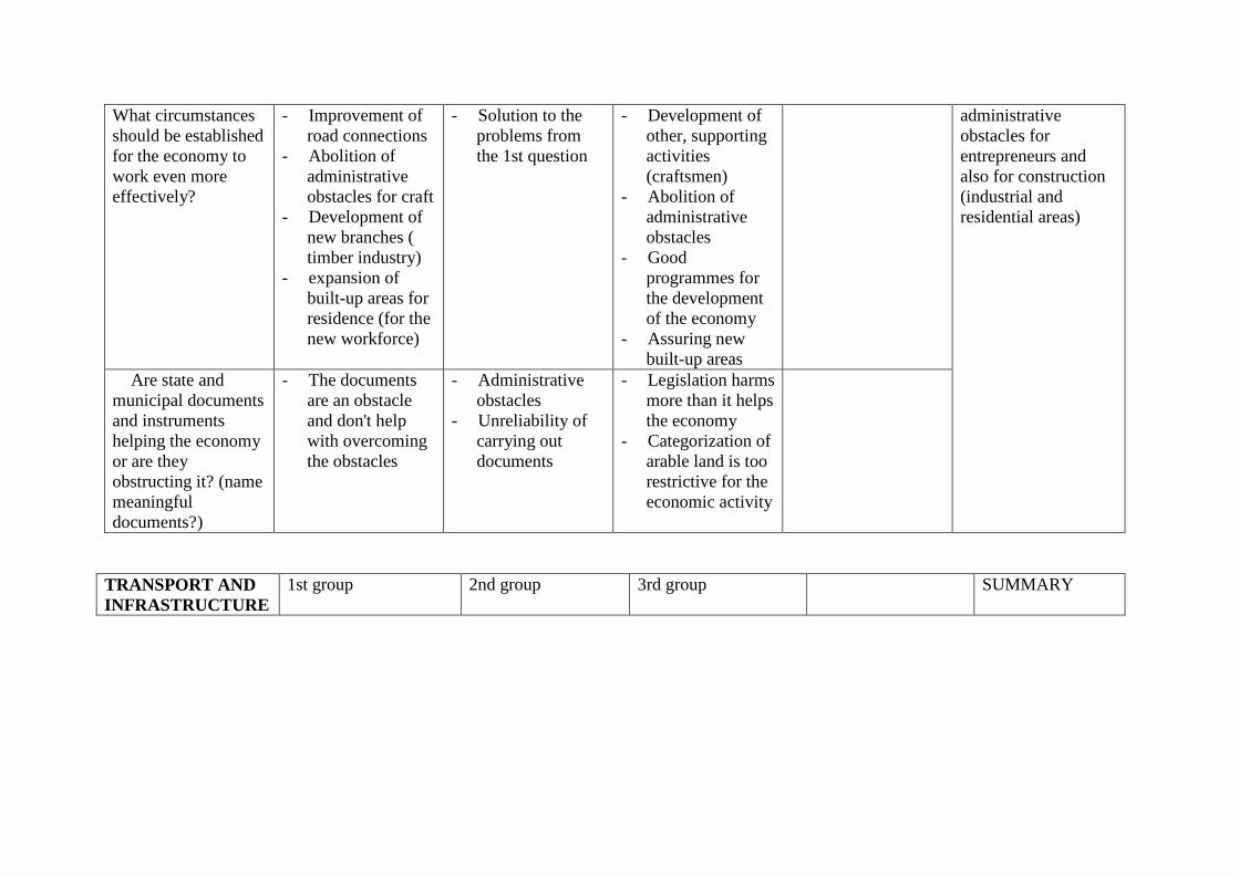
What circumstances should be established for the economy to work even more effectively?
- Improvement of road connections
- Abolition of administrative obstacles for craft
- Development of new branches ( timber industry)
- expansion of built-up areas for residence (for the new workforce)
- Solution to the problems from the 1st question
- Development of other, supporting activities (craftsmen)
- Abolition of administrative obstacles
- Good programmes for the development of the economy
- Assuring new built-up areas
Are state and municipal documents and instruments helping the economy or are they obstructing it? (name meaningful documents?)
- The documents are an obstacle and don't help with overcoming the obstacles
- Administrative obstacles
- Unreliability of carrying out documents
- Legislation harms more than it helps the economy
- Categorization of arable land is too restrictive for the economic activity
administrative obstacles for entrepreneurs and also for construction (industrial and residential areas)
TRANSPORT AND INFRASTRUCTURE
1st group 2nd group 3rd group SUMMARY
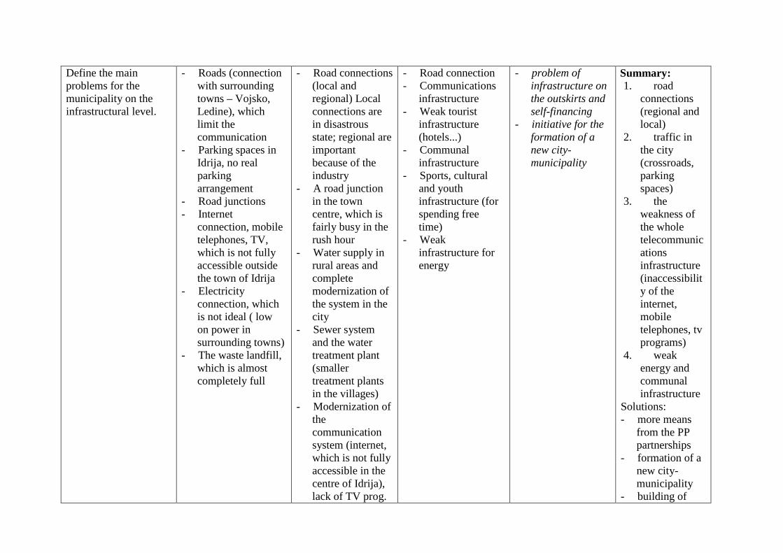
Define the main problems for the municipality on the infrastructural level.
- Roads (connection with surrounding towns – Vojsko, Ledine), which limit the communication
- Parking spaces in Idrija, no real parking arrangement
- Road junctions - Internet
connection, mobile telephones, TV, which is not fully accessible outside the town of Idrija
- Electricity connection, which is not ideal ( low on power in surrounding towns)
- The waste landfill, which is almost completely full
- Road connections (local and regional) Local connections are in disastrous state; regional are important because of the industry
- A road junction in the town centre, which is fairly busy in the rush hour
- Water supply in rural areas and complete modernization of the system in the city
- Sewer system and the water treatment plant (smaller treatment plants in the villages)
- Modernization of the communication system (internet, which is not fully accessible in the centre of Idrija), lack of TV prog.
- Road connection - Communications
infrastructure - Weak tourist
infrastructure (hotels...)
- Communal infrastructure
- Sports, cultural and youth infrastructure (for spending free time)
- Weak infrastructure for energy
- problem of infrastructure on the outskirts and self-financing
- initiative for the formation of a new city-municipality
Summary: 1. road
connections (regional and local)
2. traffic in the city (crossroads, parking spaces)
3. the weakness of the whole telecommunications infrastructure (inaccessibility of the internet, mobile telephones, tv programs)
4. weak energy and communal infrastructure
Solutions: - more means
from the PP partnerships
- formation of a new city-municipality
- building of
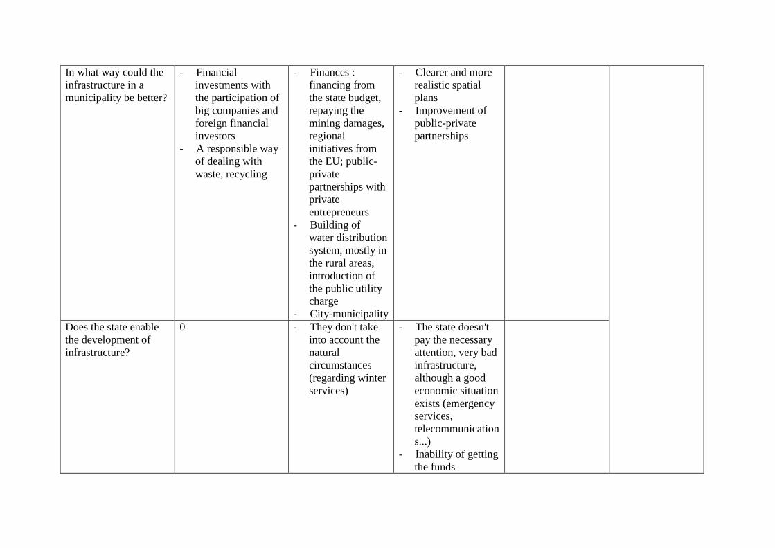
In what way could the infrastructure in a municipality be better?
- Financial investments with the participation of big companies and foreign financial investors
- A responsible way of dealing with waste, recycling
- Finances : financing from the state budget, repaying the mining damages, regional initiatives from the EU; public-private partnerships with private entrepreneurs
- Building of water distribution system, mostly in the rural areas, introduction of the public utility charge
- City-municipality
- Clearer and more realistic spatial plans
- Improvement of public-private partnerships
Does the state enable the development of infrastructure?
0 - They don't take into account the natural circumstances (regarding winter services)
- The state doesn't pay the necessary attention, very bad infrastructure, although a good economic situation exists (emergency services, telecommunications...)
- Inability of getting the funds
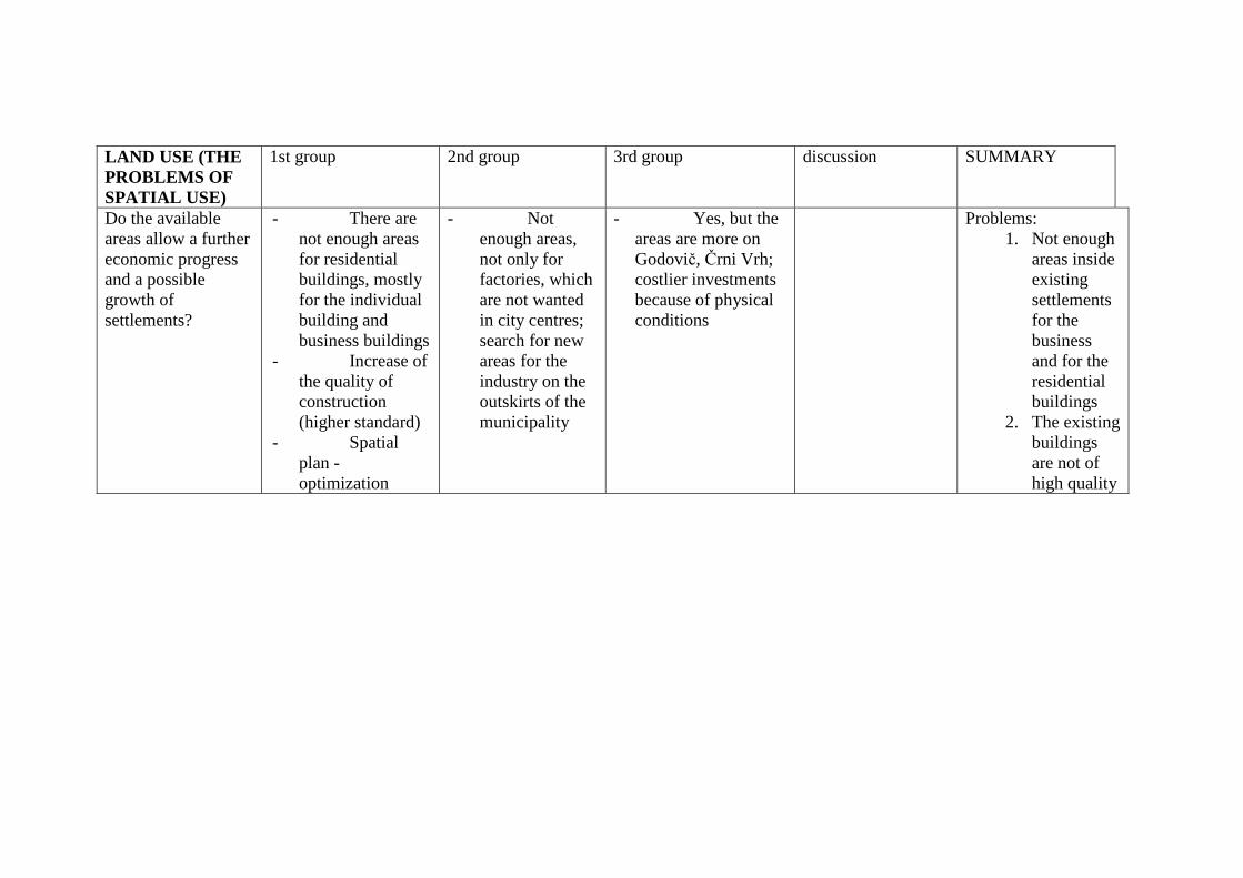
LAND USE (THE PROBLEMS OF SPATIAL USE)
1st group 2nd group 3rd group discussion SUMMARY
Do the available areas allow a further economic progress and a possible growth of settlements?
- There are not enough areas for residential buildings, mostly for the individual building and business buildings
- Increase of the quality of construction (higher standard)
- Spatial plan - optimization
- Not enough areas, not only for factories, which are not wanted in city centres; search for new areas for the industry on the outskirts of the municipality
- Yes, but the areas are more on Godovič, Črni Vrh; costlier investments because of physical conditions
Problems: 1. Not enough
areas inside existing settlements for the business and for the residential buildings
2. The existing buildings are not of high quality
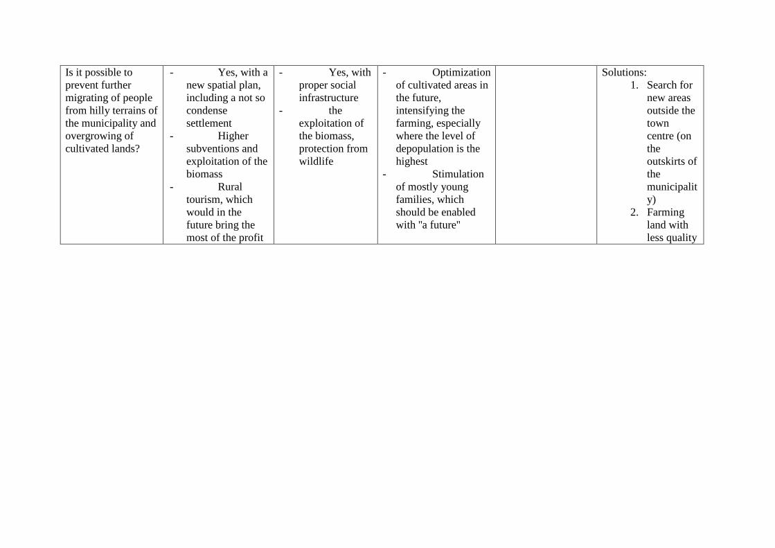
Is it possible to prevent further migrating of people from hilly terrains of the municipality and overgrowing of cultivated lands?
- Yes, with a new spatial plan, including a not so condense settlement
- Higher subventions and exploitation of the biomass
- Rural tourism, which would in the future bring the most of the profit
- Yes, with proper social infrastructure
- the exploitation of the biomass, protection from wildlife
- Optimization of cultivated areas in the future, intensifying the farming, especially where the level of depopulation is the highest
- Stimulation of mostly young families, which should be enabled with ''a future''
Solutions: 1. Search for
new areas outside the town centre (on the outskirts of the municipality)
2. Farming land with less quality
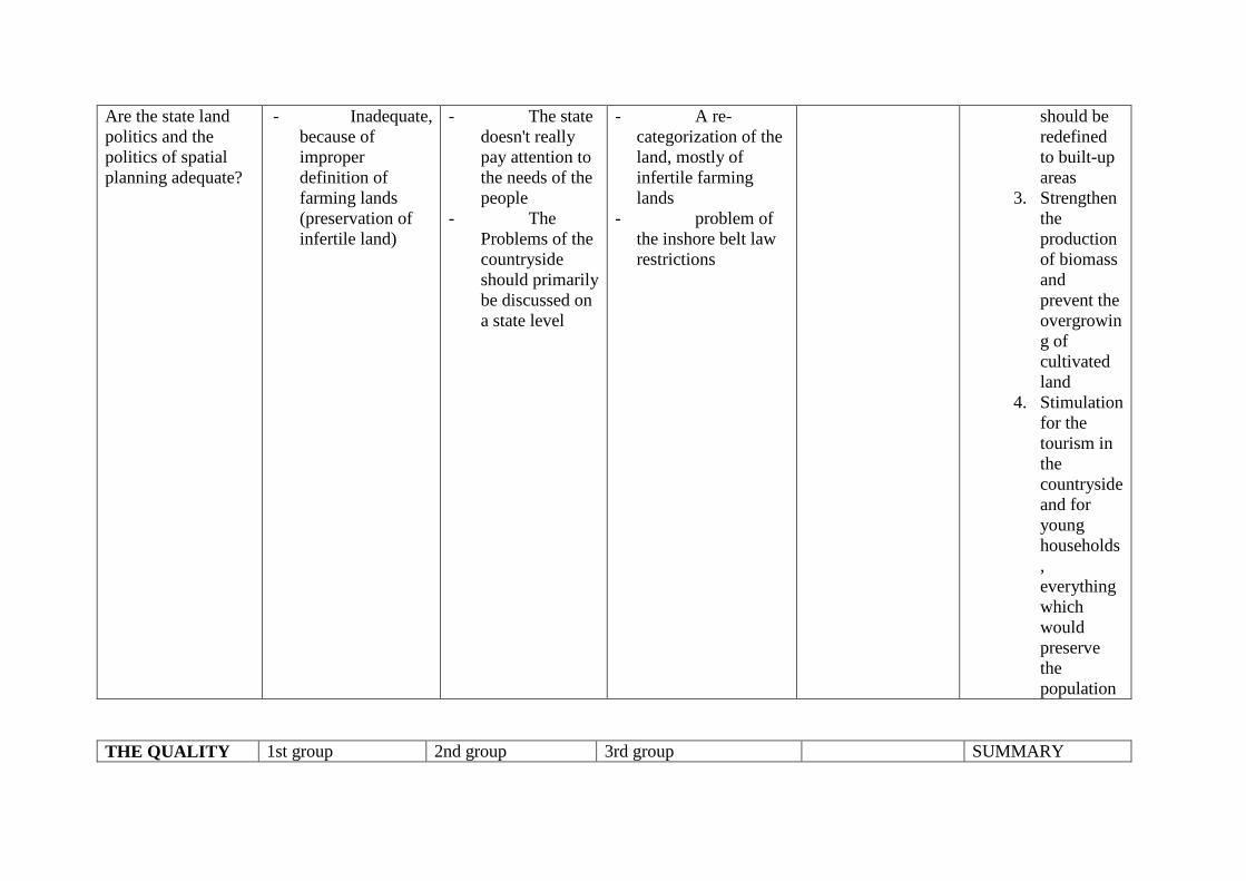
Are the state land politics and the politics of spatial planning adequate?
- Inadequate, because of improper definition of farming lands (preservation of infertile land)
- The state doesn't really pay attention to the needs of the people
- The Problems of the countryside should primarily be discussed on a state level
- A re-categorization of the land, mostly of infertile farming lands
- problem of the inshore belt law restrictions
should be redefined to built-up areas
3. Strengthen the production of biomass and prevent the overgrowing of cultivated land
4. Stimulation for the tourism in the countryside and for young households, everything which would preserve the population
THE QUALITY 1st group 2nd group 3rd group SUMMARY

OF LIFE
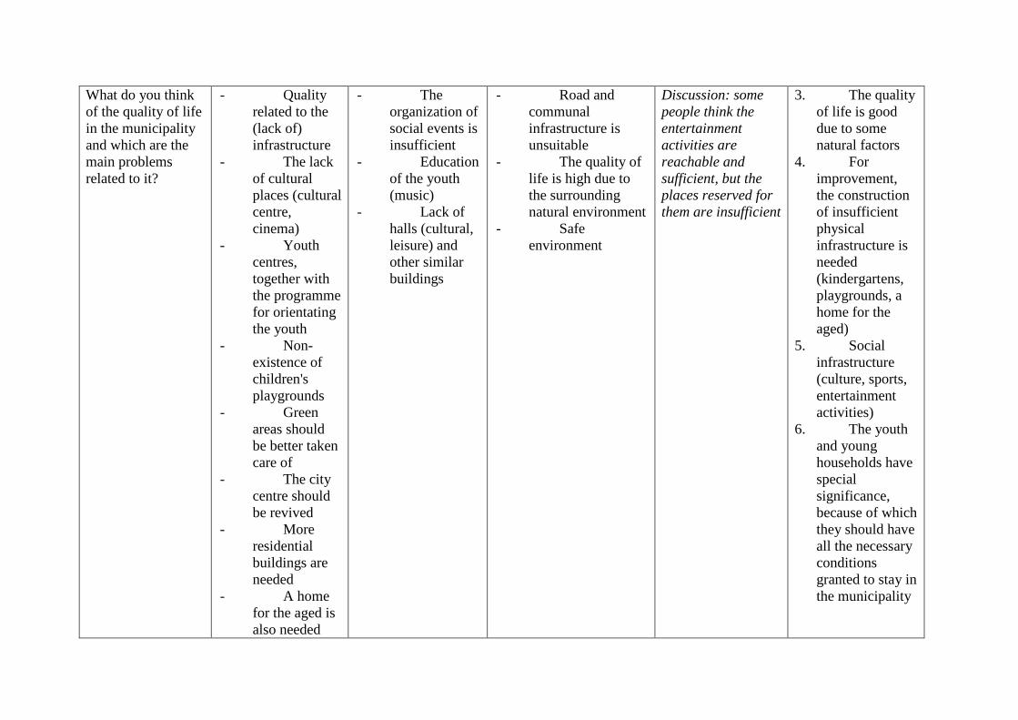
What do you think of the quality of life in the municipality and which are the main problems related to it?
- Quality related to the (lack of) infrastructure
- The lack of cultural places (cultural centre, cinema)
- Youth centres, together with the programme for orientating the youth
- Non-existence of children's playgrounds
- Green areas should be better taken care of
- The city centre should be revived
- More residential buildings are needed
- A home for the aged is also needed
- The organization of social events is insufficient
- Education of the youth (music)
- Lack of halls (cultural, leisure) and other similar buildings
- Road and communal infrastructure is unsuitable
- The quality of life is high due to the surrounding natural environment
- Safe environment
Discussion: some people think the entertainment activities are reachable and sufficient, but the places reserved for them are insufficient
3. The quality of life is good due to some natural factors
4. For improvement, the construction of insufficient physical infrastructure is needed (kindergartens, playgrounds, a home for the aged)
5. Social infrastructure (culture, sports, entertainment activities)
6. The youth and young households have special significance, because of which they should have all the necessary conditions granted to stay in the municipality
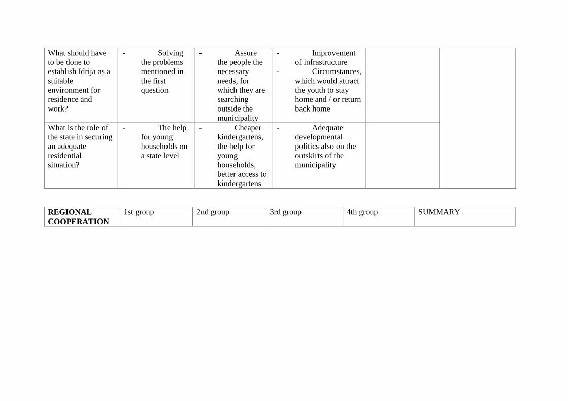
What should have to be done to establish Idrija as a suitable environment for residence and work?
- Solving the problems mentioned in the first question
- Assure the people the necessary needs, for which they are searching outside the municipality
- Improvement of infrastructure
- Circumstances, which would attract the youth to stay home and / or return back home
What is the role of the state in securing an adequate residential situation?
- The help for young households on a state level
- Cheaper kindergartens, the help for young households, better access to kindergartens
- Adequate developmental politics also on the outskirts of the municipality
REGIONAL COOPERATION
1st group 2nd group 3rd group 4th group SUMMARY
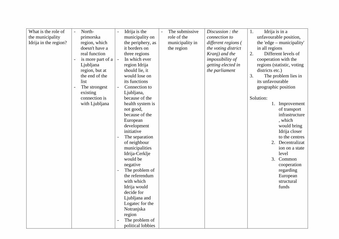
What is the role of the municipality Idrija in the region?
- North-primorska region, which doesn't have a real function
- is more part of a Ljubljana region, but at the end of the list
- The strongest existing connection is with Ljubljana
- Idrija is the municipality on the periphery, as it borders on three regions
- In which ever region Idrija should lie, it would lose on its functions
- Connection to Ljubljana, because of the health system is not good, because of the European development initiative
- The separation of neighbour municipalities Idrija-Cerklje would be negative
- The problem of the referendum with which Idrija would decide for Ljubljana and Logatec for the Notranjska region
- The problem of political lobbies
- The submissive role of the municipality in the region
Discussion : the connection to different regions ( the voting district Kranj) and the impossibility of getting elected in the parliament
1. Idrija is in a unfavourable position, the 'edge – municipality' in all regions
2. Different levels of cooperation with the regions (statistic, voting districts etc.)
3. The problem lies in its unfavourable geographic position
Solution:
1. Improvement of transport infrastructure, which would bring Idrija closer to the centres
2. Decentralization on a state level
3. Common cooperation regarding European structural funds
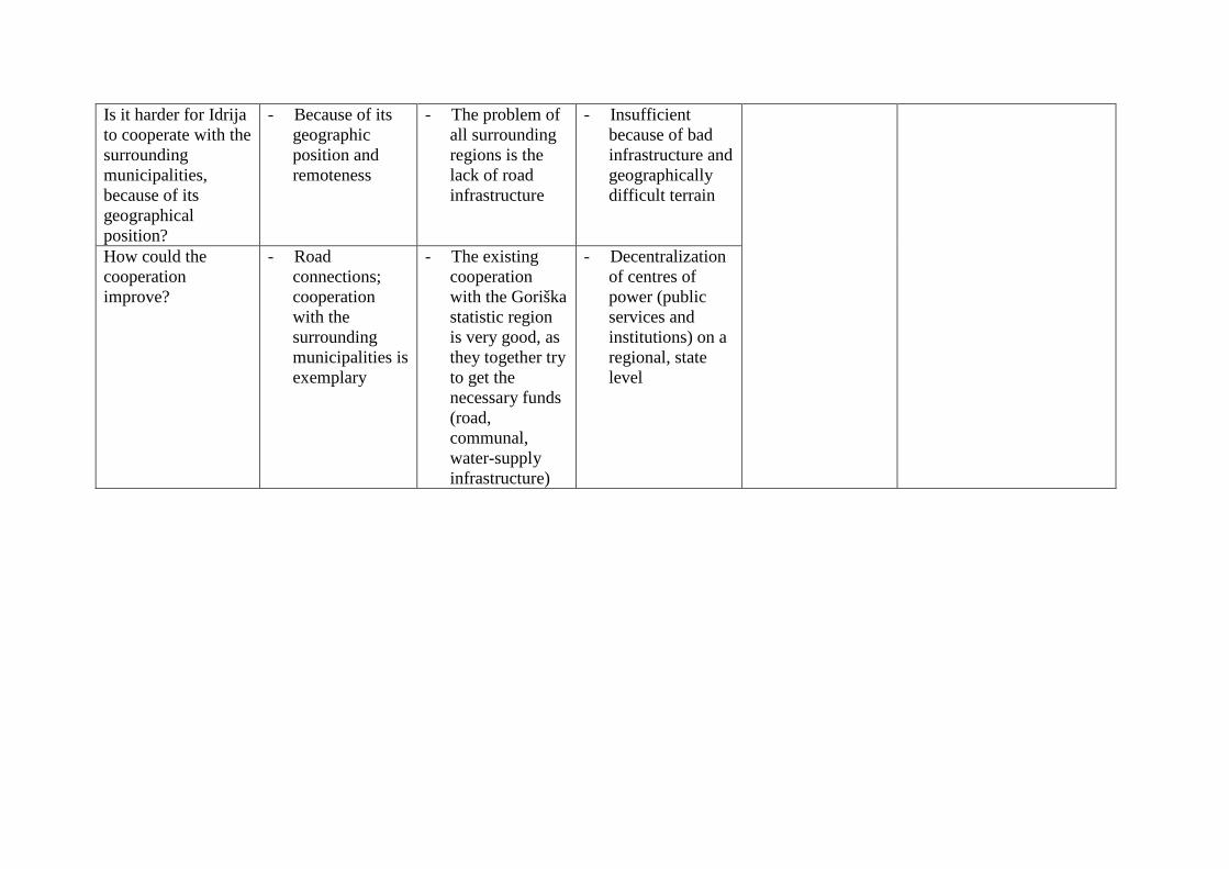
Is it harder for Idrija to cooperate with the surrounding municipalities, because of its geographical position?
- Because of its geographic position and remoteness
- The problem of all surrounding regions is the lack of road infrastructure
- Insufficient because of bad infrastructure and geographically difficult terrain
How could the cooperation improve?
- Road connections; cooperation with the surrounding municipalities is exemplary
- The existing cooperation with the Goriška statistic region is very good, as they together try to get the necessary funds (road, communal, water-supply infrastructure)
- Decentralization of centres of power (public services and institutions) on a regional, state level
Are the development documents on a regional level (regional development plans) adequate and how could the regional development be accelerated furthermore?
- Active attending to the documents and publications is problematic
- The problem of cooperation of the business sector in regional development
- Due to the physical geography, they can cooperate only with the Goriška region
- Don't know
Defining the advantages and the disadvantages
1st group 2nd group 3rd group discussion SUMMARY
The main advantages of the municipality, based on which further progress is possible
- Strong economy - Nature and
historical sightseeing places and tourism
- Good possibility of employment
- Good employment
- Educated local workforce
- Providing for further development of good programs, which would be in correlation with the worldwide level
- Developed economy and successful businesses
- intact natural environment, bio farming and ecotourism
- Innovativeness and diligence of the people
- A possibility of development of small economy (crafts, tourism)
- even bigger progress of the countryside
The main disadvantages of the municipality, which are holding back further progress?
- New spatial plans - Lacking initiative
for the crafts activities
- Regional non-definition
- The progress of small economy
- Self-initiative and self-enterprise
- Mono-structural economy
- The lack of workforce
- Demographic endangerment of areas, closing down of schools
- Regionalization - Reduction of
state funds
Advantages 1. Developed and
strong economy 2. Tourist potential
(untouched nature, history)
3. Good employment rates, innovativeness of the local people
Disadvantages 1. A mono-
structural economy
2. The lack of small entrepreneurs, craftsmen
3. The danger of regionalization
4. The problem, considering the workforce
Definition of development possibilities and conflicts
1st group 2nd group 3rd group SUMMARY
What do you think in what way is further progress possible?
- Further development of the economy with complete spatial plans and changes of the water management legislature
- Development of tourism, based on existing possibilities with the construction of additional buildings in the city and in the countryside
- The help for farmers with bigger farms and for foresters
- Keep the existing economical trend
- Better social conditions for the youth
- Besides the infrastructure, a better decentralization and more even development of the municipality
- Investing in tourism, timber industry and bio-farming
-
Where can we expect conflicts regarding the development
- Coordination between big companies and the policies of the municipality
- Coordination of the inspection services
- The problem of regional policy making and political lobbying
- Centralization - The fear of the
existing economy breakdown
-
It is necessary to keep the existing level of economical progress and strengthen additional activities in order to prevent mono-structuralism...the existing sources (tourism, timber industry) should be taken into account Because of regionalization and weak adherence, conflicts are possible. The danger is also presented by further centralization and uneven development of the municipality. The problems could be solved with better connection of the municipality with the state, greater financial funding and
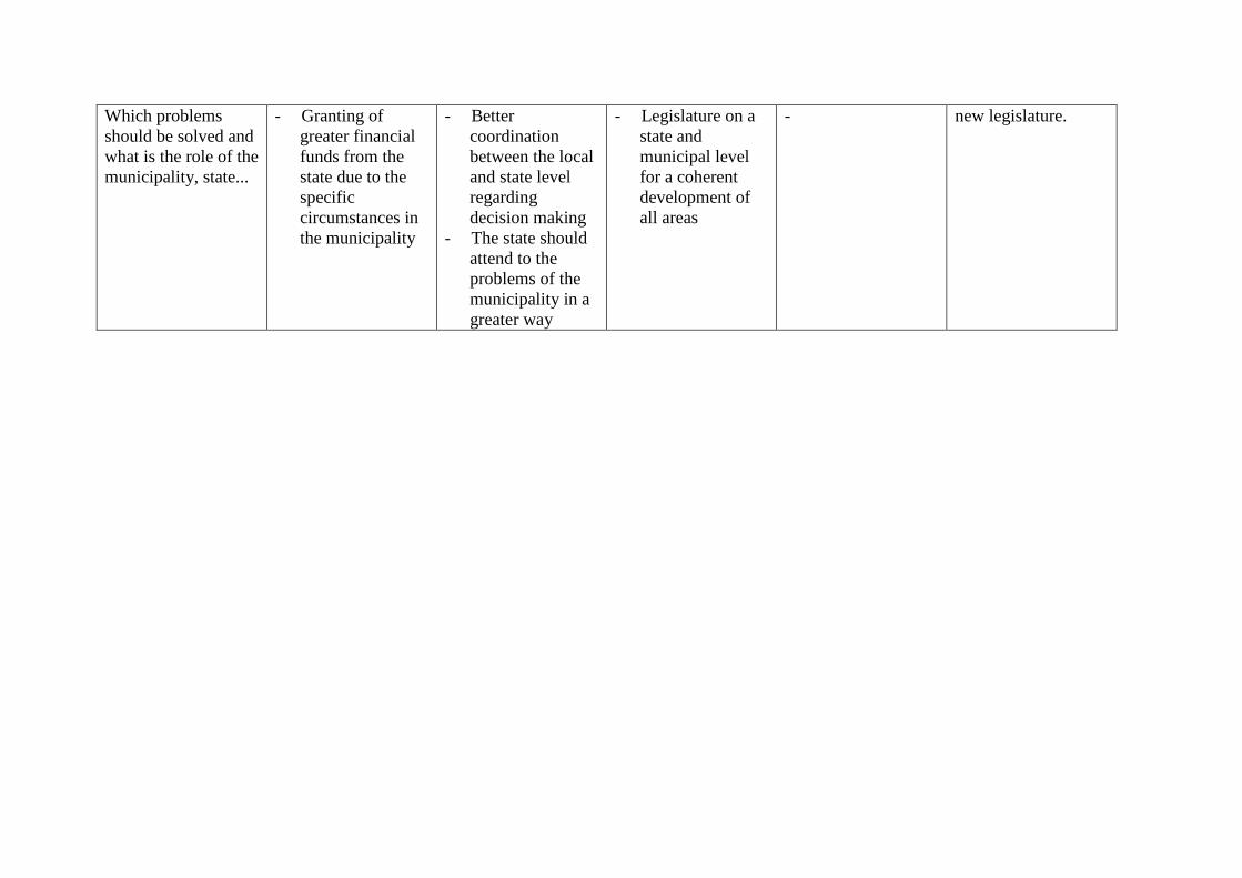
Which problems should be solved and what is the role of the municipality, state...
- Granting of greater financial funds from the state due to the specific circumstances in the municipality
- Better coordination between the local and state level regarding decision making
- The state should attend to the problems of the municipality in a greater way
- Legislature on a state and municipal level for a coherent development of all areas
- new legislature.
6.8. Confrontation of the context analysis results with the workshop results The comparison of the context analysis, made on the basis of the chosen indicators and the results of the workshop, indicates a significant matching in defining the main strengths, weaknesses, opportunities and treats of the chosen area in the field of economy, human resources and infrastructure. The results of the context analysis are more accurately defined and don't duplicate themselves in single areas (productive environment, human resources, basic infrastructure). On the other hand the participants of the workshop present the same problem in various thematic fields (unsuitable road infrastructure is the cause of a slower economic progress and insufficient transport access, lesser quality of life and weak inter-regional cooperation). With this they point out the factors, which are mainly present on the level of regional development, are intertwined and need most attention. A part of the workshop was intended for regional cooperation and the relationship between the region and the state, which were not included in the contextual analysis. Economic progress The participants of the workshop perceive the main obstacle of economic progress in the imbalance of the workforce (the lack of suitable highly-educated workforce and the surplus of educated people from unsuitable humanistic branches) and unsuitable (mostly road) infrastructure and weak connection to the surrounding regions. The main conclusion of the workshop and contextual analysis is that the economy in the municipality of Idrija is on a satisfactory level. Economy attracts the workforce, but is centralised and has limited spatial potential for future development. The most over-looked branch of the economy is tourism. The results of both analyses show that the extensiveness of agriculture is perceived as something positive. The local people see their chances in connection with the tourist offer of remote and depopulate areas of the municipality. They perceive definitions of farming areas in spatial plans critically, since they are unsuitable in lots of areas and additionally limit the existing poor possibilities of expanding the industrial and residential areas. Infrastructure On the basis of the contextual analysis the conclusion was that the weakness of the infrastructure is related to the road network system with its bad quality of roadways and inaccessibility. The proximity of the developmental corridor is viewed as incentive for the improvement of the connections. The participants of the workshop added the lack of parking spaces in the employment centre of Idrija, insufficient electrical, water and communal supply in some agricultural areas and insufficient access to telecommunication, mobile and internet services in addition to the previously mentioned bad condition of the roads in the municipality. Human resources and the quality of life The participants of the workshop and also the context analysis itself confirm the fact of a stable demographic picture being the advantage of Idrija. But they warn that it can quickly worsen with an unsuitable nurturing of residential and social areas. The SWOT analysis based on indicators, warns of the population aging and low employment rates of the elderly and also of the below average educational structure and low percentage of self-employed. Potential negative changes in larger companies can bring to the demographic catastrophe of these areas. Lively social activity strengthens the connections between people and the identity of this area. With this reason the local stakeholders express the need for the regulation of suitable public places for cultural and youth activities, playgrounds, a retirement home and green areas. They also wish to revive the city centre and warn about the obsolete construction fund. The residential area is in their opinion qualitative and safe, with the exception of the river Idrijca, which is contaminated with mercury. Land usage and spatial planning
The participants of the workshop and also the contextual analysis warn about the lack of land in formed settlements for economic and residential activities. Local stakeholders feel that the specific land usage is the most problematic since it occupies too many agricultural areas, which are mainly uncultivable and because of it they suggest re-categorization. 6.9. Starting points for the second workshop On the basis of the contextual analysis and the results of the workshop a conclusion can be made that the most conflict areas are the following:
- Spatial planning The economic efficiency of big companies and their aspiration for expansion; an ever growing demand for the workforce and securing a reasonable amount of residential buildings; small amount of areas, suitable for intensive agricultural activity on one side and spatial limitations on the other stress the meaning of spatial planning, which has to be thought through. Because of the foreseen struggles the participation of all stakeholders is necessary.
- Financing of infrastructural projects A better infrastructure is in the interest of the local community, economy, agriculture and tourism. A satisfactory accessibility needs major financial inputs, which raises the question who and in what amount will take part in it.
- Interregional cooperation Interregional cooperation is of great importance when it comes down to bigger projects. Should the region seek its opportunities within the cooperation with Ljubljana or should it rather strengthen and cooperate with neighbourly regions?
- The ideas of forming an urban municipality of Idrija What can partitioning and forming of the urban municipality of Idrija bring to the town and what would be the consequences for its fringes/periphery? 6.10. Conclusion Although Idrija is not a typical alpine municipality it is characterised by some obvious alpine elements such as bad accessibility and a lack of space, adequate for settling and industry. As shown in the previous results the economy of Idrija is very powerful due to successful transformation from mining to electro-industry with some world-class companies. One of the crucial factors of Idrijas development is its long mining tradition, marked by intensive exchange of knowledge on a world scale. Since our main interest was focused on the land use management, Idrija was a good example of a region, which has problems not only because of its alpine characteristics, but also due to fast economic development, which is faced with some spatial and human resources limitations. Additionally, long mining tradition and tourist potential based on the technical culture of the region have consequently influenced the development, as the effort of the municipality to set Idrija into United nations tourist resorts is opening some prospects for tourism, but on the other side, it imposes restrictions on the possibilities of town reconstruction, as all technical monuments have to be protected. For this reason old edifices will have to be changed in order to revitalize town centre and to enable its further development. Topics, selected for the discussion within the workshop proved to be adequate to the situation in the region. Consequently a vivid discussion appeared directed toward identification of problems, conflicts and possibilities, which could be identified in region or might appear in the future.

In any case Idrija will have to adapt to a current situation with a profound land take management and with a long term planning, which could prevent Idrija from structural crisis and additionally, assure its long term development into successful high-tech economy. Some aspects of further development possibilities were discussed and furthermore they are the base for further discussions on the conflict resolution and on preparation of long-term strategies.
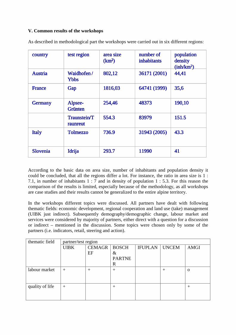
V. Common results of the workshops As described in methodological part the workshops were carried out in six different regions:
According to the basic data on area size, number of inhabitants and population density it could be concluded, that all the regions differ a lot. For instance, the ratio in area size is 1 : 7.1, in number of inhabitants 1 : 7 and in density of population 1 : 5.3. For this reason the comparison of the results is limited, especially because of the methodology, as all workshops are case studies and their results cannot be generalized to the entire alpine territory. In the workshops different topics were discussed. All partners have dealt with following thematic fields: economic development, regional cooperation and land use (take) management (UIBK just indirect). Subsequently demography/demographic change, labour market and services were considered by majority of partners, either direct with a question for a discussion or indirect – mentioned in the discussion. Some topics were chosen only by some of the partners (i.e. indicators, retail, steering and action).
partner/test region thematic field UIBK CEMAGR
EF BOSCH & PARTNER
IFUPLAN UNCEM AMGI
labour market + + + + o
quality of life + + +
country test region area size (km 2 )
number of inhabitants
population density ( inh /km 2 )
Austria Waidhofen / Ybbs
802,12 36171 (2001) 44,41
France Gap 1816,03 64741 (1999) 35,6
Germany Alpsee - Gr ü nten
254,46 48373 190,10
Traunstein / T raunreut
554.3 83979 151.5
Italy Tolmezzo 736.9 31943 (2005) 43.3
Slovenia Idrija 293.7 11990 41
country country test region test region area size (km 2 ) area size (km 2 )
number of inhabitants number of inhabitants
population density ( inh /km 2 )
population density ( inh /km 2 )
Austria Austria Waidhofen / Ybbs Waidhofen / Ybbs
802,12 802,12 36171 (2001) 36171 (2001) 44,41 44,41
France France Gap Gap 1816,03 1816,03 64741 (1999) 64741 (1999) 35,6 35,6
Germany Germany Alpsee - Gr ü nten Alpsee - Gr ü nten
254,46 254,46 48373 48373 190,10 190,10
Traunstein / T raunreut Traunstein / T raunreut
554.3 554.3 83979 83979 151.5 151.5
Italy Italy Tolmezzo Tolmezzo 736.9 736.9 31943 (2005) 31943 (2005) 43.3 43.3
Slovenia Slovenia Idrija Idrija 293.7 293.7 11990 11990 41 41
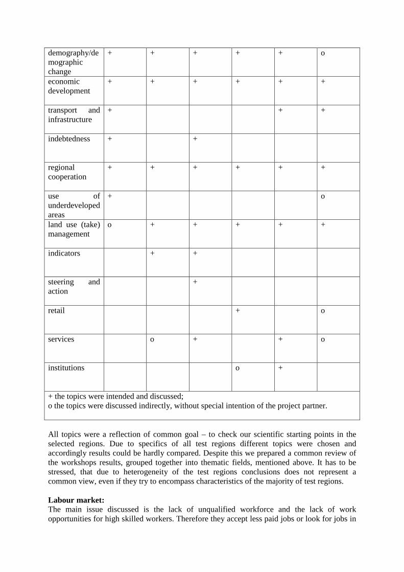
demography/demographic change
+ + + + + o
economic development
+ + + + + +
transport and infrastructure
+ + +
indebtedness + +
regional cooperation
+ + + + + +
use of underdeveloped areas
+ o
land use (take) management
o + + + + +
indicators + +
steering and action
+
retail + o
services o + + o
institutions o +
+ the topics were intended and discussed; o the topics were discussed indirectly, without special intention of the project partner.
All topics were a reflection of common goal – to check our scientific starting points in the selected regions. Due to specifics of all test regions different topics were chosen and accordingly results could be hardly compared. Despite this we prepared a common review of the workshops results, grouped together into thematic fields, mentioned above. It has to be stressed, that due to heterogeneity of the test regions conclusions does not represent a common view, even if they try to encompass characteristics of the majority of test regions. Labour market: The main issue discussed is the lack of unqualified workforce and the lack of work opportunities for high skilled workers. Therefore they accept less paid jobs or look for jobs in
other employment centres. The deficit of labour force is filled with part-time employment, which first of all affects women. Certain structural transformations are already taking place and a positive trend on the labour market is noticeable due to education and training of labour force. Lessons learned: 1. Structural discrepancy (lack of unqualified workforce, lack of work opportunities for high skilled workers and for women); 2. Less paid jobs or search for jobs in other employment centres; 3. More qualified workforce is needed and adaptation of labour market to the global and regional structural transformations is required. Quality of life: Stakeholders in regions Waidhofen, Alpsee-Grünten, Tolmezzo and Idrija find the issue of quality of life important for sustainability of regional development. From the environmental and social point of view living conditions are favourable. The main weakness in all regions is the absence of youth and cultural centres, leisure and sport facilities, playgrounds and vibrant city centres. Second problem is the isolation and difficult accessibility. Young families require special attention in order to stay in these regions. Lessons learned: 1. Special care for the social infrastructure (youth and cultural centres, leisure and sport facilities, playgrounds and vibrant city centres) is needed; 2. Overcoming the problems of isolation and difficult accessibility and special care for young families is required in order to attract them to stay in the region. Demography / demographic change: Demography seems to be one of the crucial factors of further development discussions since all development activities depend on qualified young population, which is very rare in mountain areas due to the aging of the population and out migration of the young people. The current process present in all selected regions is aging of the population. Demographic disparities occur because of differences in property prices, accessibility of services and employment possibilities. Lessons learned: It is important to: - balance living conditions, - create attractive environment for young families, - dedicate special attention to depopulating areas (for example with higher subventions).
Economic development: Economic activities are of crucial importance for a further development of the area especially because of jobs they offer to the local population. But even though the tested regions are predominantly big employment centres, they are facing many problems. Some areas have potential problems regarding the inappropriate workforce due to monostructural economy, which demands only one type of workers, others are dependant on only one type of economic activity or even one single large factory. Other economic activities that have the potential are underrepresented and should be fostered (especially tourism, forestry, eco-farming, etc.) by public and other funds to prevent monostructural economy. Shortage of adequate space can hinder further economic progress – lack of suitable building plots in plains, valleys is also a problem. Problem of female unemployment is detected in two case studies (A and F), additionally also problem of younger and educated workforce migrating to bigger and more attractive cities. Lessons learned: Better flexibility is needed in order to be prepared to all the challenges coming from global market. Therefore, diversification of the economic structure is needed and the supporting environment should be invigorated. Transport and infrastructure: The main problem seems to be relative isolation (transportation and communication) of those areas and regional differences between the centres and the periphery. There are additional problems regarding parking in town centres and overall personal/private mobility. Unsatisfactory road connections and other infrastructure in remote areas (hilly or mountainous peripheral areas) do hinder further development and push especially young people into the out migration. In two out of three areas (Austria and Italy) the need for better or more organized public transportation was mentioned (better accessibility, travel times, integration with BUS/rail systems, etc). In this perspective a sustainable solution would be hard to reach due to scarcely inhabited mountain areas, which prevent efficient public transportation system. In this manner inhabitants are forced to use their own vehicles to reach their working places. The problem of telecommunication infrastructure was mentioned only in Idrija and Alpsee-Grünten, whereas in other areas it was satisfactory or good. Lessons learned: Regarding the transport two things should be mentioned. On one side public transportation in less inhabited alpine area is limited due to its unprofitability and on the other side the usage of personal vehicles is absolutely needed, but unsustainable. For this reason it will be very hard to find a sustainable solution to overcome the problems related to isolation and bad accessibility. Indebtedness: The problem of indebtedness in public sector is most evident in the Austrian and German case studies. In Austria public debt was not seen so negatively as in Germany (Aplsee-Grünten) where high debt and difficult credit financing by local banks were mentioned. Due to the lack of information on other test regions no real conclusions can be made. Regional cooperation: We can conclude that there are some important differences among included regions regarding existing regional cooperation. A range of existing sectoral examples of inter-municipal cooperation was introduced such as the cooperation in tourism marketing, the regional co-funding of public transport or the inter-municipal trade-off between tourism and trade, waste disposal and other ecological cooperation, public health cooperation, etc. In France the Pays
are seen as a first step towards more comprehensive instruments. At the moment, the main objective is to create preconditions for the implementation of a Communauté d’Agglomération, to which competencies regarding housing, transportation, environment and economic development would be transferred. In some regions such as Slovene Idrija and Italian associations (esp., between municipalities) have proved poorly effective so far. The main problem lies in its unfavourable geographic position or depopulation. Without a more intensive cooperation between the municipalities and without a common vision for the region there won’t be any perspective for the regions in the long run. Closer cooperation was suggested within the following topics: tourism, public transportation, retirement benefits, childcare, common strategies for industrial and commercial development and for marketing, building regional GIS databases and layers, etc. Further development of cooperation forms needs better information not only for mayors and stakeholders, but also for the public. Lessons learned: Intermunicipal and interregional cooperation is of crucial importance for further development in the Alps, especially when talking about land take management. It is self evident that cooperation is hindered with difficult natural conditions, but due to the sensitive environment cooperation is even more important. Hence, common action is needed in order to share both risks and benefits. Use of underdeveloped areas: This theme was discussed only on two workshops, in Austria and in Slovenia but we presume the same problems are faced also by majority of the remaining test regions. Due to geographical position many of alpine municipalities are hindered by uneven development of their territories. On one side there is a developed centre and on the other side a range of predominantly underdeveloped areas that suffer depopulation, lack of infrastructure and also lack of jobs. For this reason these areas have to be integrated in the municipality functional system and some extra care for their development should be provided. They could prosper from the search of new areas outside the town centre (on the outskirts of the municipality) since there is already a lack of space, convenient for bigger construction projects. The price for land is cheaper compared to the core city, additionally, the core city has limited space especially for industrial activities, which consume a lot of space. Land use (take) management: Alpine landscape is marked by a huge diversity and heterogeneity. Hills and mountains are divided by narrow valleys where majority of human activities is located. For this reason there is only a limited amount of space, convenient for construction and productive activities. Furthermore, this space is additionally limited by natural disasters risks (floods, landslides, avalanches etc.) and regarding their high natural values also due to extensive natural protection efforts. For this reason land use (take) management is one of the crucial topics of sustainable regional development in Alps especially because there is huge variety of different activities, which interfere within Alpine space. Consequently, due to the lack of holistic and systemic/systematic vision and lack of adequate land and resource management capacity and planning tools, local authorities suffer from short-term vision also marked by the lack of sustainable activities. Constant collision appears between different development actors (agriculture, tourism, industry etc.), which is normally directed towards exaggerated consumption of scarce disposable land plots. Green areas open to visitors are more and more distant; maintaining rural landscapes does not always meet with a demand for recreation and leisure; agricultural land is consumed by urbanisation and at the same time forest cover extends on more important surfaces etc. To overcome the problem of space scarcity a “densification“ of city centres and a settled area in general seems to be necessary. Brownfield
development could be a suitable strategy to provide larger industrial areas, too. But it has to be clarified, to which extent potentials for the conversion of waste land (and brownfields) do exist. There is a need for a well coordinated concept to adjust the spatial requirements and activities in the sectors of agriculture, trade and industry as well as tourism, in particular considering sustainable development, related also to common trends in demography and urbanisation. From this point of view a constant conflict appears between land protection and ever growing demands of different actors upon new available areas. Due to qualitative limitations of the space this conflict is extremely intense particularly in the Alps. This process could hinder further development of Alpine areas, especially if combined with bad infrastructure and accessibility. Accordingly a range of different planning activities and tools should be provided in order to minimize existing problems and to make further development more sustainable and less risky. A lot of irrational land take is caused by insufficient coordination between the municipalities. Scarce land resources should be managed based on a common concept of regional task sharing and marketing. Lessons learned: Appropriate land for settling and industry is very limited in the Alps, but on the other side large land consumption tensions can be observed. Due to scarce land available for different activities, conflicts in the land use appear very often. For this reason a profound land management is needed in order to prevent unjustified interventions in space and furthermore, to preserve the environment from unfavourable activities. Indicators: Indicators were not meant to be a crucial part of the workshop, but they could be a good basis for the steering and monitoring sustainable regional development. Thus they were discussed only in one workshop where they were compared to the real estate in the region investigated (Gap). Steering and action: Although this topic was discussed directly only in the Austrian workshop it could be a red line between all test regions discussions due to its importance for achieving sustainable development. In this way tasks detected in Austrian case (marketing, financing, creation of awareness, institutional cooperation and visions etc.) could be shared with all partners and all test regions studied. Accordingly this question could be a good starting point for the second workshop discussions as well. Retail: The issue of retail was discussed in workshop Traunstein/Traunreut region. Food retail is currently undergoing a significant structural change towards chains and franchise structures and particularly discounters on greenfield sites. More and more shops are nowadays increasingly leaving inner-urban sites for sites situated in the urban fringe. In times of demographic change and consequently of reduced mobility of bigger shares of the population, there is the danger of cutting peoples’ access to local supply. For inner-urban sites, this development is bringing about new challenges. In the course of commercial vacancies, there is the danger that these urban quarters will enter a downward spiral of rental decrease and disinvestment. As well as the rental of commercial premises within buildings owned by rural municipalities at low rents. According to our opinion such processes are also in progress in other test regions. Services:
Services are becoming the most important sector in the economy and they are also in a tight connection to the human well being, especially if we look at public services, and to economic activities as well if they are part of supporting environment of the local economy. For this reason all kind of services should be intensified, although there is a constant demand to rationalize them. In any case rationalisation is needed, but not on behalf of people living in the area. Due to a scarce settlement system the services in alpine area are often weak, which provokes a lot of problems in the everyday life. For this reason development/establishment of an innovative model of services in the mountains is needed, to be possibly enclosed within the framework of a specific model for services in mountain areas. Particularly concerning public transportation, which should be optimized, adapted to changing needs and encouraged against private mobility. The effort should be focused on educational institutions because there is a big outflow of young people if educational centres are distant. More emphasis should be put on further and coordinated development of tourism and the supply with suitable locations in order to prepare the basis for the sectors of research and education / training. Additionally development potentials should be studied for possible new branches of services considering the regional and supra-regional market situation. In addition the outflow of the services form the city centre should be stopped in order to assure the basic provision of the population living there. Furthermore some cultural and social events (cultural centre, cinema) should be supported, assuring basic cultural and social supply. Institutions: According to new economic geography institutional thickness is one of the crucial factors for innovative and successful regional development. For this reason DIAMONT had to refer on this segment of developmental impulses. Small municipalities have no potential for effective promotion of innovation through the institutions since there are only a few respective organisations in the scarcely inhabited alpine area. For this reason small alpine areas/municipalities are limited in their development if broader cooperation is not assured. Additionally all institutions have to open to participatory and collaborative processes in order to reach their potential in the future development. Furthermore the common vision must be reached on the development of the area in order to strengthen common efforts and to mitigate possible conflicts.
VI. Common starting points for the second workshop The main question of WP 10 and WP 11 is how to assure a common approach in all test regions on the one side and adaptation to test regions specifics on the other. In the case of WP 10 only methodological concept was identical, topics for discussion and questions were rather different. This should have some implications on WP 11, namely the approach must be much more unified in order to get useful results. This is achievable by more detailed instructions to the partners and by consistent realisation of the workshops in each test region. For this sake some starting points for WP 11 are given from the experience of WP 10:
- all partners must respect instructions of WP responsible in order to get common results;
- a solution must be found how to fulfil expectations of the stakeholders in test region and our common goals at the project simultaneously;
- it has to be solved how to relate specific needs of our test regions to instruments, elaborated in WP 9;
- a common goal should be pursued. As there are some changes in the general framework of the project, especially in case of WP 10 and WP 11 a common decision has to be accepted, regarding what is the content of WP 11. On one side all instruments, elaborated in WP 9 should be tested and on the other side conflicts are supposed to be resolved. Additional hindrances appear due to commitments from the first workshop. This is very important question since there are some partners that have no information on possible conflicts in their test regions due to different approach they used in the first workshop. From this viewpoint it is reasonable to connect both workshops in order to assure integral approach, where all partners will do the same within two workshops. The dynamics of elaboration of the tasks within the workshops or the objectives of single workshop should be decided by a single project partner, obviously with a special respect of the common goals.
VII. Conclusions The main aim of WP 10 was to strengthen participation process and to include bottom-up approach in the refinement of the instruments discussed in different test regions. With participatory approach the needs of inhabitants could be better assessed and consequently such instruments could be found, which would best fit the specific situation of the test region. Starting from the Alpine diversity the first step was focused on the context analyses in order to get adequate information on the specifics of the selected test regions and on their needs with a special relation to sustainable regional development. Additionally, context analyses have served as a base for the comparison between test regions and furthermore, they were used for the explanation of some test region’s related peculiarities detected in the first workshops. Context analyses were verified during the course of the workshops, where all crucial problems were discussed and elaborated in depth. Additionally, some topics were either broadened or proposed by the participants. Lessons learned from the first round of workshops could be briefly summarized in one sentence: no mater from which viewpoint you look, you cannot miss the diversity of the Alps. All test regions are unique, characterised by a variety of features typical for alpine environment. Parallel to the diversity of spatial structures are also the problems faced by each test region, which are hardly ever compared by problems faced in another test region. Since there are so many factors influencing spatial structure of unique region, its problems could also be detected and solved only with special regards to the same factors. Furthermore, the spatial structure of the selected test region could be defined as a crucial factor of the differentiation of specific alpine areas and all measures and instruments have to be adapted to the spatial structure if they attend to achieve the planned results. Consequently, common knowledge on problems and their solution is welcome, but we should bear in mind that transferability of solutions is limited. As each region is characterized by its own specifics, these specifics could at the same time influence the results of actions taken in order to improve the situation in the region – and these results could be either positive or negative. For this reason participation process and bottom-up approach are even more important in order to steer development in accordance with the needs of a region. Furthermore, local activities are usually more suited to the specifics of the area and are in this way more probable to succeed. Accordingly, participation process should be strengthened and involvement of local stakeholders should be assured. Linkages between scientific institutions and local stakeholders should also be established and promoted. Thus the Alpine convention is of crucial importance, starting from common knowledge and emphasizing the importance of local experiences, and what is even more important, caring for common alpine identity and protection of the alpine environment in a sustainable manner. The results of the first workshop have shown that a variety of approaches is needed if we want to fulfil the needs of all alpine regions. Consequently, the dialog within and in between the regions should be strengthened and the second workshop could be a great opportunity for this step. Taking into account the results of the first workshop and our intentions for the second one, DIAMONT could be perceived as a good example of the bottom-up approach, especially if further use of the findings will be achieved and if some further concrete actions in the test regions will be performed.
VIII. References
Bavarian State Office for Statistics and Data Processing – Public finances. URL: http://www.statistik.bayern.de/
Bürgerliche Wählergemeinschaft Krün. URL: http://www.bwg-kruen.de/1320/1343.html?*session*id*key*=*session*id*val*.
CARNAZZI WEBER, S. & RÜHL, T. (2006): Verkehr als Wirtschaftsfaktor. NAB Regionalstudie Aargau, Zürich.
CIMA Stadtmarketing (2005): Salzburg-Bayerische Strukturuntersuchung des Einzellhandelsverflechtungsbereiches (SABE-V). München.
EURAC: WP 8 final report. Forthcomming.
EuRegio Salzburg-Berchtesgadener Land-Traunstein (2001): EuRegio Entwicklungskonzept. Salzburg. http://salzburg.gv.at/pdf-sir_ro_euregio_kurzfassung.pdf.0
Federal Agency of Labour – Commuter matrix. URL: http://www.arbeitsagentur.de/
GEFAK (2005): Strukturanalyse Landkreis Traunstein. Marburg.
Heinrich, K. and Bender, O.: National Analysis (2007). University of Innsbruck, Insbruck.
INSEE, recensement de la population 1999. URL: http://www.recensement.insee.fr/RP99/rp99/page_accueil.paccueil?nivgeo=F&theme=ALL&typeprod=ALL&lang=EN
PERLIK, M. (2001): Alpenstädte – zwischen Metropolisation und neuer Eigenständigkeit. Geographica Bernensia 38.
Statistik Austria (1991, 2001). URL: http://www.statistik.at/
StratCon (2007): Aktuelle Wirtschafts- und Sozialdaten Landkreis Traunstein. URL: http://www.stratcon.de/TS/index.html.