Embed Size (px)
Citation preview

This article was downloaded by: [Universita Studi di Pavia]On: 26 November 2012, At: 01:39Publisher: Taylor & FrancisInforma Ltd Registered in England and Wales Registered Number: 1072954 Registeredoffice: Mortimer House, 37-41 Mortimer Street, London W1T 3JH, UK
International Journal of ArchitecturalHeritage: Conservation, Analysis, andRestorationPublication details, including instructions for authors andsubscription information:http://www.tandfonline.com/loi/uarc20
Organization of a Geographic InformationSystem (GIS) Database on NaturalHazards and Structural Vulnerability forthe Historic Center of San Giuliano DiPuglia (Italy) and the City of Valparaiso(Chile)Maurizio Indirli aa ENEA (Italian Agency for New Technologies, Energy and theEnvironment), Bologna, ItalyVersion of record first published: 20 May 2009.
To cite this article: Maurizio Indirli (2009): Organization of a Geographic Information System (GIS)Database on Natural Hazards and Structural Vulnerability for the Historic Center of San GiulianoDi Puglia (Italy) and the City of Valparaiso (Chile), International Journal of Architectural Heritage:Conservation, Analysis, and Restoration, 3:4, 276-315
To link to this article: http://dx.doi.org/10.1080/15583050902803780
PLEASE SCROLL DOWN FOR ARTICLE
Full terms and conditions of use: http://www.tandfonline.com/page/terms-and-conditions
This article may be used for research, teaching, and private study purposes. Anysubstantial or systematic reproduction, redistribution, reselling, loan, sub-licensing,systematic supply, or distribution in any form to anyone is expressly forbidden.
The publisher does not give any warranty express or implied or make any representationthat the contents will be complete or accurate or up to date. The accuracy of anyinstructions, formulae, and drug doses should be independently verified with primarysources. The publisher shall not be liable for any loss, actions, claims, proceedings,demand, or costs or damages whatsoever or howsoever caused arising directly orindirectly in connection with or arising out of the use of this material.

ORGANIZATION OF A GEOGRAPHIC INFORMATIONSYSTEM (GIS) DATABASE ON NATURAL HAZARDS ANDSTRUCTURAL VULNERABILITY FOR THE HISTORICCENTER OF SAN GIULIANO DI PUGLIA (ITALY) AND THECITY OF VALPARAISO (CHILE)
Maurizio Indirli
ENEA (Italian Agency for New Technologies, Energy and the Environment),Bologna, Italy
Remote sensing (RS) and geographic information systems (GIS) are powerful tools to
create maps, scenarios, and inventories for habitats and heritage to manage hazard, vulner-
ability, and risk due to natural/anthropic disasters. In the framework of this huge investiga-
tion field, some research, susceptible to development, has been done. The first GIS nucleus,
targeted on earthquake and joining architectonic/urban planning analyses with vulnerability
evaluation, began in the framework of four master’s theses, a cooperation between the ENEA
(Italian Agency for New Technologies, Energy and the Environment) and Ferrara
University. The work concerned San Giuliano di Puglia (hit by the 2002 earthquake)
because a lot of material was available due to several activities performed there by ENEA
experts. Architectonic/urban planning studies regarded the whole ancient core, while vulner-
ability analysis focused a specific inner sector. Another GIS activity grew in the MAR
VASTO Project (centered on Valparaiso, Chile), managed by ENEA, with participation
of Italian/Chilean partners and support of local stakeholders. The project stressed the
following points: to evaluate the impact of main natural/anthropic hazards; to provide
architectonic/urban planning and vulnerability analyses for a pilot building stock in the
historic area; to carry out surveys and vulnerability evaluations on monumental churches;
and to suggest guidelines for future interventions.
KEY WORDS: natural hazard, anthropic hazard, risk assessment, architectonic ana-
lyses, urban planning analyses, structural vulnerability, GIS, RS, historic centers, cultural
heritage structures
1. INTRODUCTION
Many urban habitats, and especially their historic centers and monuments, areprone to natural and anthropic hazards. The main catastrophes (varying in magni-tude, frequency, duration, extent area, onset speed, spatial dispersion and temporalspacing) are earthquakes, volcano eruptions, landslides, tsunamis, coastal erosions,floods, hurricanes, for example. Furthermore, both wild and human-induced firesshould be included (Indirli 2007a). First, to assess the risk due to the previously noteddisasters, hazard and building vulnerability must be carefully evaluated. Second, risk
International Journal of Architectural Heritage, 3: 276–315, 2009
Copyright � Taylor & Francis Group, LLC
ISSN: 1558-3058 print / 1558-3066 online
DOI: 10.1080/15583050902803780
Address correspondence toMaurizio Indirli, ENEA, Italian Agency for New Technologies, Energy and
Environment, via Martiri di Monte Sole 4, 40129 Bologna, Italy. E-mail: [email protected]
Received 13 November 2008; accepted 8 February 2009.
276
Dow
nloa
ded
by [
Uni
vers
ita S
tudi
di P
avia
] at
01:
39 2
6 N
ovem
ber
2012

analysis, urban planning, rehabilitation projects and mitigation actions (usually notvery well linked one each other) should be strongly integrated.
In the past decade, geomatics — emerging technology playing a vital role innatural disasters mitigation — has been developing; it is a conglomerate of measuring,mapping, geodesy, satellite positioning (global positioning system [GPS]), photogram-metry, computer systems and graphics, remote sensing (RS) (Shinozuka 2005), geo-graphic information systems (GIS), and environmental visualization. A GIS -basedapplication can store, represent, and elaborate a huge amount of different data sets, joinhazard and vulnerability information, andmerge inputs coming fromupdated cadastralmaps, RS satellite images and in-field differential GPS (DGPS) surveys (diagnosticsinvestigations and damage assessment included). Thus, geo-referred maps can linksingle building structural features to the surrounding environmental and social context(Midorikawa 2005). Standard loss estimation methodologies and GIS-based softwarehave been implemented also by the United States Federal Emergency ManagementAgency (FEMA) for conducting hazard/risk analysis: HAZUS (HAZUS 1992) is acomprehensive tool to support mitigation, emergency management, response, andrecovery. Therefore, RS technology and GIS platforms are very helpful to:
� Develop and properly overlap hazard modeling and scenarios;� Organize inventory assets, including structural vulnerability evaluation for each
hazard profile, by using or implementing specific algorithms (for example, in case ofearthquake: Agibilita e Danno nell` Emergenza Sismica [AeDES] 2000; Bernardiniet al. 1990; D’Ayala and Speranza 2003; Gruppo Nazionale per la Difesa daiTerremoti [GNDT] 1999; Manuale di Esercitazioni sul Danno Ed Agibilita perEdifici Ordinari [MEDEA] 2005; Regione Molise, Consiglio Nazionale delleRicerche 2003; Valluzzi et al. 2004); and
� Provide hazard-targeted and integrated risk assessment procedures for losses esti-mate and mitigation options.
Of course, a whole investigation on the previously noted themes requires huge inter-disciplinary and long-term efforts. Nevertheless, in order to identify some basic stepsof a general methodology and satisfy at the same time the projects objectives, ouractivities focused, as starting points, the following main topics:
� Creation of hazard-targeted maps for urban habitats, taking into account thatstudy approaches are often inhomogeneous;
� Organization of inventories for building stocks located inside historic centers, storingand crossing different data (history, architecture, urban planning, topologic and struc-tural characteristics) with procedures for the earthquake vulnerability evaluation; and
� Survey and structural vulnerability evaluation for some relevant heritage monu-ments, as single critical units inside the urban tissue.
Being aware of this incomplete approach, the investigation shall be enlarged anddeepened in the future, taking advantage of further studies, as the activity, now inprogress, foreseen by the ongoing European Union (EU) C26 Action (COST 2006), inwhich the Vesuvius eruption is the study case of the Working Group 4 (‘‘Risk assess-ment for catastrophic scenarios in urban areas’’).
The first nucleus of the GIS database, focused on earthquake hazard andjoining architectonic/urban planning and structural vulnerability analyses, hasbeen developed in the framework of four master’s theses, thanks to cooperation
GIS DATABASE 277
INTERNATIONAL JOURNAL OF ARCHITECTURAL HERITAGE 3(4): 276–315
Dow
nloa
ded
by [
Uni
vers
ita S
tudi
di P
avia
] at
01:
39 2
6 N
ovem
ber
2012

between ENEA (Italian Agency for New Technologies, Energy and the Environment)and the University of Ferrara, Faculty of Architecture (Mazzanti 2007; Miglioli 2007;Nascosi 2007; Simonini 2007; Mazzanti et al. 2008). The work concerned the historiccenter of San Giuliano di Puglia, heavily hit by the M 5.4 October 31, 2002 earth-quake, when masonry residential buildings and notable heritage structures sufferedsevere damage or partial collapse. In fact, a lot of material was available due to theseveral activities previously performed there by ENEA experts in the following phases(Cami et al. 2007; Indirli et al. 2004a; 2004b; 2006a; 2007b):
� The emergency, under the coordination of the Civil Defense;� The post-emergency, carrying out a detailed evaluation of damage, drafting the
demolition plan, ensuring safe conditions to the buildings to be repaired, andoperating for allowing residents to safely reenter their non-damaged houses;
� The San Giuliano di Puglia reconstruction plan; and� The advice to the Italian Office of the PublicWorksMinistry for reconstruction and
rehabilitation projects.
The architectonic/urban planning studies regarded the whole San Giuliano his-toric center, while vulnerability analysis has been carried out for a specific innersector.
A second step of the activity has been carried out in the framework of theProject MAR VASTO (managed by ENEA, with the participation of Italian andChilean partners and the support of local stakeholders), interesting the City ofValparaiso, Chile, declared patrimony of the humanity by United NationsEducational, Scientific and Cultural Organization (UNESCO) in 2003 (MARVASTO 2007, Indirli et al. 2008).
2. A BRIEF SUMMARY ON GEOGRAPHIC INFORMATION SYSTEMS
AGIS is a digitized tool in which is possible to store, handle, elaborate, analyze,and represent spatial variables, supported by geo-referenced data. This complexarchitecture (joining a computer-aided design [CAD] ‘‘engine,’’ a stratified databaseand representation procedures) permits to correlate/compare different sets of datathrough different actions (topologic overlay, spatial query, buffering, network analy-sis, for example), often with the help of ortho-rectified imagery (both from satelliteand aerial sources). GIS technology can be used for scientific investigations, resourceand asset management, risk and environmental impact assessment, emergencyresponse, urban planning, cartography, geographic history, marketing, and logistics,for example.
The fundamental goal of a GIS system is geo-referencing the information(geometry, topology, and attributes), representing real world objects with digitaldata in a relational structure. Geometry regards shape (point, line, polygon), dimen-sion and geographical position. Topology involves reciprocal relationships betweenobjects (e.g., connection, contiguity, inclusion). Attributes incorporate informationassociated to each object (e.g., numbers, text). Real-world objects can be divided intotwo abstractions: discrete objects (i.e., a house) and continuous fields (i.e., elevation).There are two broad data typologies for both abstractions: raster and vector. Rasterdata are grids of elementary cells called pixel units, for which the dimension depends
278 M. INDIRLI
INTERNATIONAL JOURNAL OF ARCHITECTURAL HERITAGE 3(4): 276–315
Dow
nloa
ded
by [
Uni
vers
ita S
tudi
di P
avia
] at
01:
39 2
6 N
ovem
ber
2012

on the datum accuracy. As example, raster data can be images, where each pixel (orcell) contains a color value. Vector data are points, lines, and polygons, codified andstored according to their spatial coordinates. The relational organization of a GISdatabase permits to create new information layers by managing previous stored datawithout forced paths, following selected keywords and building different scenarios.Some examples of spatial analysis are:
� Topologic overlay, for which different information layers are superimposed to createa new thematic item;
� Spatial query, crossing spatial criteria (e.g., contiguity, inclusion, superimposition);� Buffering, starting from a theme punctual, linear, or polygonal, definition of a
polygonal strip with respect to a fixed or variable distance, in function of theelement attributes;
� Network analysis for which algorithms identify the minimum distance between anetwork of linear elements.
GIS information can be accessed, transferred, transformed, overlaid, processed anddisplayed using numerous software applications through a huge variety of formats(for example, maps, drawings, videos, tables). Great attention must be paid to qualityparameters, as updating, metric precision, resolution, semantic precision, logic andgeometric congruence.
Moreover, a GIS database should be flexible, freely available for use by anycountry and organization through internet access, open-source, capable to be multi-hazard and international in scope, encouraging the worldwide community to partici-pate to their development and validation.
3. SAN GIULIANO DI PUGLIA: SOME ELEMENTS FOR A GEOGRAPHIC
INFORMATION SYSTEM (GIS) DATABASE
3.1. General Concepts and Methodology
Firstly, the geographic, social and economic context of Molise Region hasbeen identified (for details, see Mazzanti 2007; Nascosi 2007). The following stepconcerned the research on history and morphologic evolution of San Giulianoand its historic center (Figure 1; see Mazzanti 2007; Nascosi 2007). The wholeancient core was catalogued crossing redundant information: cadastral maps;damage forms completed by Italian Civil Defense teams during the earthquakeemergency (AeDES 2000) and forms for damage mechanisms (MEDEA 2005);data gathered by ENEA experts during their stay at San Giuliano (Cami et al.2007; Indirli et al. 2004a; 2004b; 2006a; 2007b); materials on reconstructionprojects coming from the San Giuliano Municipality and professionals; informa-tion coming directly from in situ surveys. The GIS database has been implemen-ted carrying out two analyses: the architectonic/urban planning study for all theSan Giuliano historic center and the structural vulnerability investigation for aninner pilot sector (C2bis), very interesting for its position, morphology, patri-monial value and architectonic features.
GIS DATABASE 279
INTERNATIONAL JOURNAL OF ARCHITECTURAL HERITAGE 3(4): 276–315
Dow
nloa
ded
by [
Uni
vers
ita S
tudi
di P
avia
] at
01:
39 2
6 N
ovem
ber
2012

rotcestolipdnaretneccirotsiherutciplairea
sllawgnicneftneicnasixaniam
Marchesale Castle and Tower
Sant’Antonio Church
San Giuliano Martyr Church
1 - Porta Palizzi 2 - Porta Piedi 3 - Porta Iaqua
transversal road mesh secondary road mesh variations in the perimetral line
Figure 1. Morphologic evolution of the San Giuliano historic center (figure is provided in color online).
280 M. INDIRLI
INTERNATIONAL JOURNAL OF ARCHITECTURAL HERITAGE 3(4): 276–315
Dow
nloa
ded
by [
Uni
vers
ita S
tudi
di P
avia
] at
01:
39 2
6 N
ovem
ber
2012

3.2. The GIS Tool for an Architectonic/Urban Planning Study of San Giuliano
Historic Center
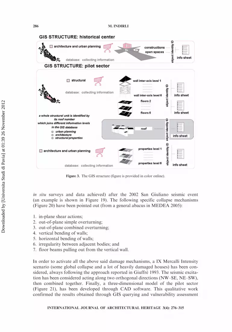
The architectonic/urban planning study interested all the buildings, open spaces,and road networks of the historic center. (Table 1 shows an example for the buildinginventory.) The study used a form currently used by the University of Ferrara forUNESCO sites, but adapted for San Giuliano, and used a specific software(Geomedia, also developed by the University of Ferrara, Figure 2). A huge amountof information (e.g., identification, general description, architecture quality, struc-tural condition) was stored in the GIS. Different indexes have been properly elabo-rated and then overlapped (for example architectonic quality versus generalconditions), in order to obtain further data layers. TheGIS whole structure is reportedby Figure 3, and some results are shown by Figure 4. The work continued with aSWOT analysis (strategic planning method used to evaluate the Strengths,Weaknesses,Opportunities, andThreats involved in a project or in a business venture,technique developed by Albert Humphrey at the Stanford University in the 1960s and1970s), suggestions for intervention strategies for a reconstruction plan (details in arenoted in Mazzanti 2007; Nascosi 2007).
3.3. The GIS Tool for the Vulnerability Analysis of the Pilot Sector
The vulnerability analysis (details are noted in Miglioli 2007; Simonini 2007),focused on a specific inner sector (C2bis), has been carried out by using Italianprocedures (AeDES 2000, GNDT 1999), and following the well-known methodologybased on the analysis of collapse mechanisms (Giuffre 1993). The sector C2bis insidethe historic center (Table 1) has been selected for several reasons: its central position,strategic from an urban and architectonic point of view, with the presence of manyvaluable buildings; the almost untouched medieval tissue, which permitted to identifyvarious typologies of the basic ancient residential units, made by stone masonrythrough original techniques; finally, the surveys underlined the widespread existenceof several damage mechanisms, until partial collapse.
Requiring months of work, all the collected data and direct surveys permitted toclassify accurately in the GIS platform: the building geometry (plans, sections, fronts);planimetry (position, elevation and foundations); materials and details (type ofmasonrywalls, floors and roofs; distance between the walls; mortar type; presence of externalstairs and balconies, buttresses, steel ties and connections, weak points; non-structuralelements); earthquake damage andmaintenance, for example (Figures 5–10). A detailedwork has been dedicated to identify the abacus of the building typologies, taking intoaccount that most of the Italian historic nuclei evolved similarly, in plan and elevation,starting from common basic cells (Giuffre 1993); at San Giuliano, being absent isolatedunits, the cells have been divided into four principal categories: A (internal in-plane), B(internal in-slope), C1 (low corner) and C2 (high corner), as shown by Figure 11; theyhave been further classified following a more detailed tree (Figure 12) and then mappedusing the GIS database (Figure 13). Moreover, the procedure used to label verticalwalls, floors and roofs is shown by Figures 14–15.
3.3.1. Analysis of all the structural units of the pilot sector and selection of
paradigmatic structural units The GIS database was asked for classifying, inside
GIS DATABASE 281
INTERNATIONAL JOURNAL OF ARCHITECTURAL HERITAGE 3(4): 276–315
Dow
nloa
ded
by [
Uni
vers
ita S
tudi
di P
avia
] at
01:
39 2
6 N
ovem
ber
2012

Table 1. Form for the architectonic/urban planning analyses: Building
BUILDING Section 1: Identification
Identity number (ID) of the object (progressive numeration) Structural unit number and sector; source: San Giuliano Reconstruction Plan Cadastral unit number; source: San
Giuliano Technical Office
Section 2: General Description isolated internal row end row corner Position of the object
1 2 3 4 5 6 7 > 7 Total floor number
5891<5891-66915691-64915491-91919191<egagnidliuBetavirPcilbuPytreporP
Cadastral particles in use; source: San Giuliano Technical Office
oNseY
House production commercial
Public service Other Tourism/Hotel
Religious Office Store
Usage destination: ground floor and basement
Usage destination: upper floors
House production commercial
Public service Other Tourism/Hotel
Religious Office Store
Over the street level Same street level Under the street level Position level
(Continued)
282 M. INDIRLI
INTERNATIONAL JOURNAL OF ARCHITECTURAL HERITAGE 3(4): 276–315
Dow
nloa
ded
by [
Uni
vers
ita S
tudi
di P
avia
] at
01:
39 2
6 N
ovem
ber
2012
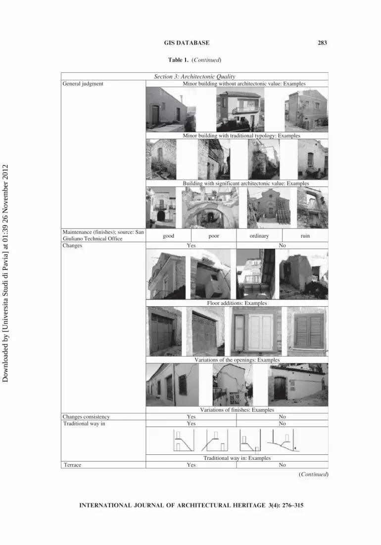
Table 1. (Continued)
Section 3: Architectonic Quality Minor building without architectonic value: Examples
Minor building with traditional typology: Examples
Building with significant architectonic value: Examples
General judgment
Maintenance (finishes); source: San Giuliano Technical Office good poor ordinary ruin
oNseY
Floor additions: Examples
Variations of the openings: Examples
Changes
Variations of finishes: Examples oNseYycnetsisnocsegnahCoNseYTraditional way in
Traditional way in: Examples oNseYecarreT
(Continued)
INTERNATIONAL JOURNAL OF ARCHITECTURAL HERITAGE 3(4): 276–315
GIS DATABASE 283
Dow
nloa
ded
by [
Uni
vers
ita S
tudi
di P
avia
] at
01:
39 2
6 N
ovem
ber
2012

each building typology, all the C2bis structural units, depending on the number N ofthe following negative parameters:
1. heavy pushing roofs;2. at least three elevation floors;3. insufficient horizontal connections;4. resistant system organization (scarce connections between vertical and horizontal
structures);5. resistant system quality (scarce resistance of vertical walls);6. non well-connected additional levels;7. lack of buttresses and contrasting structures;8. slope .45% and quality of foundations;9. non-regular buildings (plan and elevation).
The results are shown by Table 2 and examples by Figure 16. Furthermore, foreach building typology, two cases (with minimum/maximum N) have been selected asparadigmatic structural units (Table 3).
9
Table 1. (Continued)
Section 4: General ConditionsLevel 0: No damage Level 1: First evidence of damage due
to activation of damage mechanisms Level 2: Limited development of damage due to damage mechanisms
Level 3: Clear evidence of damage due to damage mechanisms
Structural damage level
Level 4: Damage close to collapse or presence of some collapsed parts
Level 5: Building near collapse or almost collapsed
Evaluation of safety; Source: AeDES form
Safe Partially safe temporary unsafe
Unsafe Unsafe for external risk totally demolished
General conditions
good ordinary bad ruin Section 5: Design Proposal
Hypothesis for use; ground floor and basement destination
House Production Commercial Public service Training /Education Other
Tourism/Hotel Religious Office Store Cultural
Hypothesis for use; upper floors destination
House Production Commercial Public Service Training /Education Other
Tourism/Hotel Religious Office Store Cultural
Possible interventions Restoration Requalification Partial reconstruction
Substitution Partial demolition Total demolition
INTERNATIONAL JOURNAL OF ARCHITECTURAL HERITAGE 3(4): 276–315
284 M. INDIRLI
Dow
nloa
ded
by [
Uni
vers
ita S
tudi
di P
avia
] at
01:
39 2
6 N
ovem
ber
2012

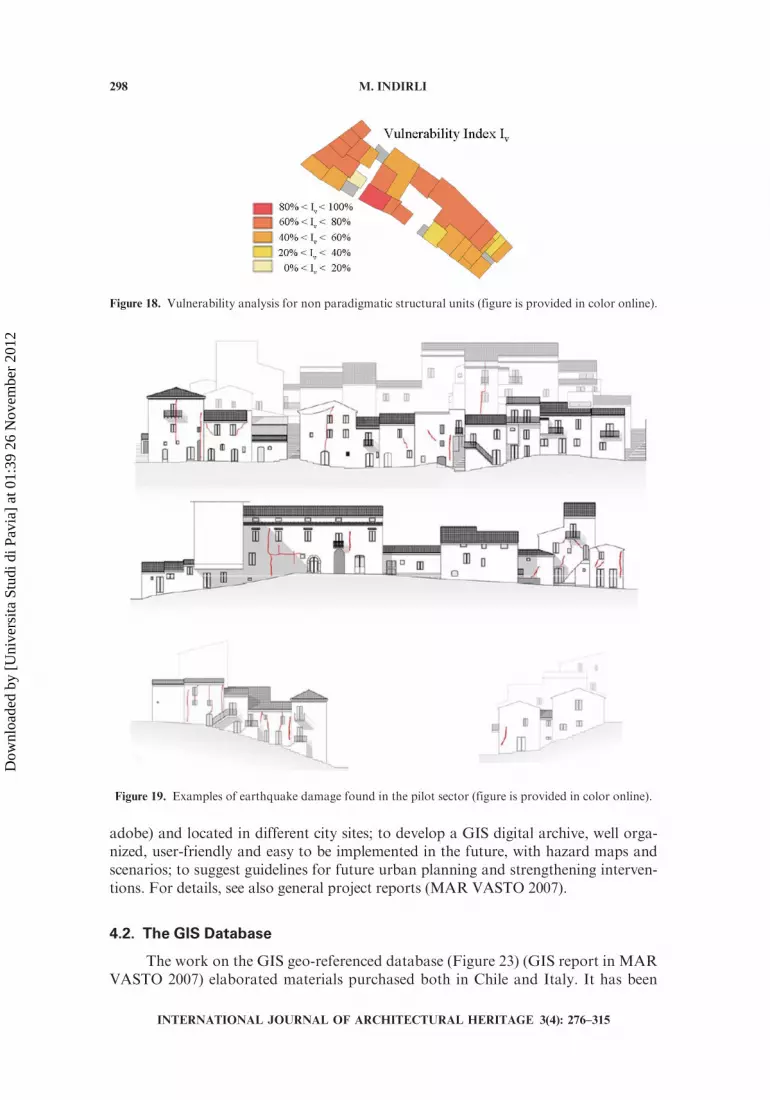
3.3.2. Evaluation of the seismic vulnerability Most of the San Giuliano historiccenter constructions are masonry-made buildings. Thus, vulnerability analyseshave been carried out by using a prompt and checked Italian procedure (GNDT1999), taking into account 11 parameters, as shown by Table 4. The vulnerabilityindex IV (0 , IV , 382.5, then normalized in percentage between 0 and 100) hasbeen calculated for the set of paradigmatic structural units (Figure 17) previouslyidentified through the GIS interrogation (Table 3); the C1–713 unit resulted themost vulnerable (IV ¼ 82.6%).
Furthermore, a simplified method for IV computation (i.e., without compilingthe GNDT form) has been arranged for non-paradigmatic buildings (but within thesame typology); IV has been calculated (through linear interpolation) from the func-tion defined by the couples of values IvMIN – NMIN, IvMAX – NMAX (Table 5 showsexamples). This simplified procedure showed an error lower than 5%, checking theresults computing in some cases the GNDT form. Thus, it was possible ‘‘to spread’’very quickly in the GIS database a vulnerability index IV on all the pilot sector units(Figure 18).
3.3.3. Evaluation of the collapse mechanisms In parallel with the vulnerabilitystudy seen before, and thanks to well known Italian studies which analyze themasonrystructures as an assemblage of rigid bodies or ‘‘macro-elements’’ (Giuffre 1993), aqualitative identification of collapse mechanisms has been carried out for all the pilotsector structural units, taking into account the earthquake damage observed (from
Figure 2. TheGraphical User Interface (GUI) of theGeomedia program (figure is provided in color online).
GIS DATABASE 285
INTERNATIONAL JOURNAL OF ARCHITECTURAL HERITAGE 3(4): 276–315
Dow
nloa
ded
by [
Uni
vers
ita S
tudi
di P
avia
] at
01:
39 2
6 N
ovem
ber
2012
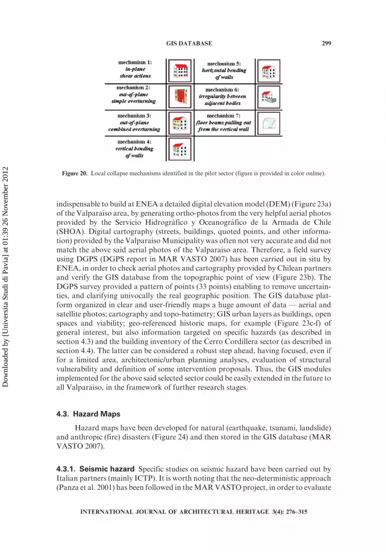
in situ surveys and data achieved) after the 2002 San Giuliano seismic event(an example is shown in Figure 19). The following specific collapse mechanisms(Figure 20) have been pointed out (from a general abacus in MEDEA 2005):
1. in-plane shear actions;2. out-of-plane simple overturning;3. out-of-plane combined overturning;4. vertical bending of walls;5. horizontal bending of walls;6. irregularity between adjacent bodies; and7. floor beams pulling out from the vertical wall.
In order to activate all the above said damage mechanisms, a IX Mercalli Intensityscenario (some global collapse and a lot of heavily damaged houses) has been con-sidered, always following the approach reported in Giuffre 1993. The seismic excita-tion has been considered acting along two orthogonal directions (NW–SE, NE–SW),then combined together. Finally, a three-dimensional model of the pilot sector(Figure 21), has been developed through CAD software. This qualitative workconfirmed the results obtained through GIS querying and vulnerability assessment
Figure 3. The GIS structure (figure is provided in color online).
INTERNATIONAL JOURNAL OF ARCHITECTURAL HERITAGE 3(4): 276–315
286 M. INDIRLI
Dow
nloa
ded
by [
Uni
vers
ita S
tudi
di P
avia
] at
01:
39 2
6 N
ovem
ber
2012
Figure 4. Architectonic and urban planning analyses: some results stored in the GIS platform (figure is
provided in color online).
GIS DATABASE 287
INTERNATIONAL JOURNAL OF ARCHITECTURAL HERITAGE 3(4): 276–315
Dow
nloa
ded
by [
Uni
vers
ita S
tudi
di P
avia
] at
01:
39 2
6 N
ovem
ber
2012
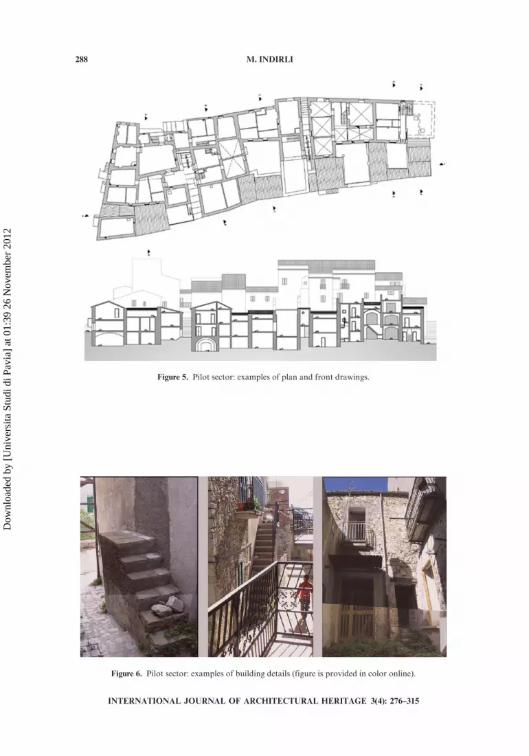
Figure 5. Pilot sector: examples of plan and front drawings.
Figure 6. Pilot sector: examples of building details (figure is provided in color online).
288 M. INDIRLI
INTERNATIONAL JOURNAL OF ARCHITECTURAL HERITAGE 3(4): 276–315
Dow
nloa
ded
by [
Uni
vers
ita S
tudi
di P
avia
] at
01:
39 2
6 N
ovem
ber
2012

procedure, evidencing the unit C1–713 as the most vulnerable (for details, see Miglioli2007; Simonini 2007).
3.3.4. Calculation of the damage index and the anti-seismic strengthening of
the unit C1–713 Based on the peak ground acceleration (PGA) known for SanGiuliano di Puglia (equal to 0.21 g for anti-seismic design), the damage index ID
a) in-plane shear actions f) wall flexural failure m) Yielding of architraves
b) in-plane shear actions in the higher wall belt
g) horizontal floor sliding n) material irregularity, local weakness, etc.
c) global wall overturning h) foundation settlement o) out-of-plane tympanum overturning
d) partial wall overturning i) irregularity between adjacent bodies
p) out-of-plane overturning of the superior angle wall
e) wall vertical instability l) floor beams pulling out from the vertical wall
q) roof wall belt out-of plane overturning
Figure 7. Damage mechanisms observed in San Giuliano di Puglia (figure is provided in color online).
GIS DATABASE 289
INTERNATIONAL JOURNAL OF ARCHITECTURAL HERITAGE 3(4): 276–315
Dow
nloa
ded
by [
Uni
vers
ita S
tudi
di P
avia
] at
01:
39 2
6 N
ovem
ber
2012

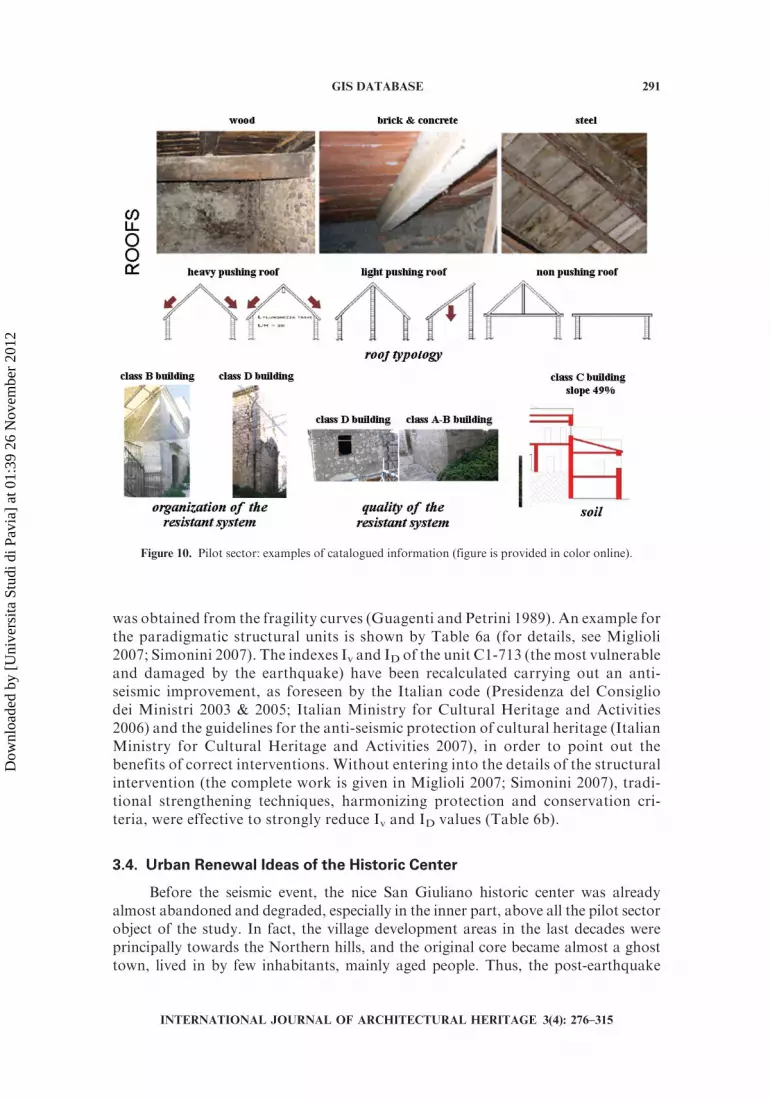
Figure 8. Pilot sector: examples of catalogued information (figure is provided in color online).
Figure 9. Pilot sector: examples of catalogued information (figure is provided in color online).
290 M. INDIRLI
INTERNATIONAL JOURNAL OF ARCHITECTURAL HERITAGE 3(4): 276–315
Dow
nloa
ded
by [
Uni
vers
ita S
tudi
di P
avia
] at
01:
39 2
6 N
ovem
ber
2012
was obtained from the fragility curves (Guagenti and Petrini 1989). An example forthe paradigmatic structural units is shown by Table 6a (for details, see Miglioli2007; Simonini 2007). The indexes Iv and ID of the unit C1-713 (the most vulnerableand damaged by the earthquake) have been recalculated carrying out an anti-seismic improvement, as foreseen by the Italian code (Presidenza del Consigliodei Ministri 2003 & 2005; Italian Ministry for Cultural Heritage and Activities2006) and the guidelines for the anti-seismic protection of cultural heritage (ItalianMinistry for Cultural Heritage and Activities 2007), in order to point out thebenefits of correct interventions. Without entering into the details of the structuralintervention (the complete work is given in Miglioli 2007; Simonini 2007), tradi-tional strengthening techniques, harmonizing protection and conservation cri-teria, were effective to strongly reduce Iv and ID values (Table 6b).
3.4. Urban Renewal Ideas of the Historic Center
Before the seismic event, the nice San Giuliano historic center was alreadyalmost abandoned and degraded, especially in the inner part, above all the pilot sectorobject of the study. In fact, the village development areas in the last decades wereprincipally towards the Northern hills, and the original core became almost a ghosttown, lived in by few inhabitants, mainly aged people. Thus, the post-earthquake
Figure 10. Pilot sector: examples of catalogued information (figure is provided in color online).
GIS DATABASE 291
INTERNATIONAL JOURNAL OF ARCHITECTURAL HERITAGE 3(4): 276–315
Dow
nloa
ded
by [
Uni
vers
ita S
tudi
di P
avia
] at
01:
39 2
6 N
ovem
ber
2012

Figure 12. Detailed tree of building typologies (figure is provided in color online).
internal in-plane typology A
internal in-slope typology B
low corner typology C1
high corner typology C2
Figure 11. Principal building typologies (figure is provided in color online).
292 M. INDIRLI
INTERNATIONAL JOURNAL OF ARCHITECTURAL HERITAGE 3(4): 276–315
Dow
nloa
ded
by [
Uni
vers
ita S
tudi
di P
avia
] at
01:
39 2
6 N
ovem
ber
2012

reconstruction plan (which generated high expectations, later frustrated [Indirli et al.2007b]) could have been a strong and positive change. The architectonic/urban plan-ning and structural vulnerability analyses, carried out as student’s exercises (Mazzanti2007; Miglioli 2007; Nascosi 2007; Simonini 2007) and supported by GIS databasetools, can give some stimulating suggestions in order to produce a global rehabilita-tion and reorganization of the historic center, integrated in the environment, as awhole and precious aggregate, pointing out the potential opportunities for residentialand spread guest housing, as much as local handicraft and agriculture products,crossing GIS information, pilot sector vulnerability and ‘‘transformability’’ factors.Finally, the property dispersion has been completely reorganized, preferring a uniqueowner for each structural unit, from foundation to roof (Figure 22) (details inMazzanti 2007; Miglioli 2007; Nascosi 2007; Simonini 2007).
Figure 13. Pilot sector: building typology classification (figure is provided in color online).
Figure 14. GIS classification of vertical walls, floors and roofs (figure is provided in color online).
GIS DATABASE 293
INTERNATIONAL JOURNAL OF ARCHITECTURAL HERITAGE 3(4): 276–315
Dow
nloa
ded
by [
Uni
vers
ita S
tudi
di P
avia
] at
01:
39 2
6 N
ovem
ber
2012

4. THE MAR VASTO PROJECT
4.1. An Important Cooperation: Italy–Chile
The Project MAR VASTO (Risk Management in Valparaiso/Manejo deRiesgos en Valparaıso, funded by Banco InterAmericano de Desarrollo [BID])(MAR VASTO 2007; Indirli et al. 2008) started in March 2007, with coordinationof ENEA, participation of several partners (Italy: University of Ferrara, University ofPadua, Abdus Salam International Centre for Theoretical Physics–ICTP/Universityof Trieste; Chile: Technical University Federico Santa Maria of Valparaiso, ChileUniversity of Santiago), and support of local stakeholders, being Valparaiso includedsince 2003 in the UNESCO Word Heritage List of protected sites.
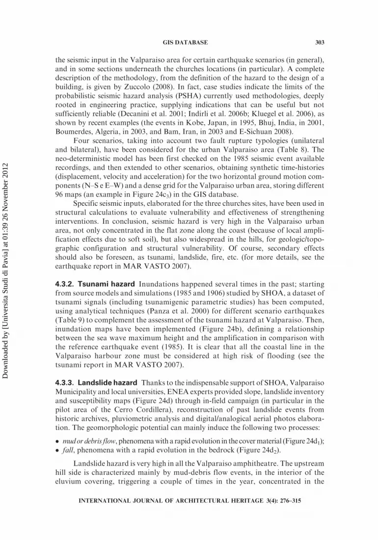
Chile is one of the most earthquake-prone country in the world, struck by themost powerful seismic event ever recorded. In fact, the 1960 Valdivia earthquake (orGreat Chilean Earthquake, May 22, 1960) rated 9.5 on the Moment Magnitude scale,with a terrible impact on population, constructions, and landscape; its resultingtsunami affected southern Chile, Hawaii, Japan, the Philippines, Eastern NewZealand, southeast Australia, and the Aleutian Islands (United States GeologicalSurvey [USGS] 2006). Even if this event did not hit Valparaiso due to long distance(more than 800 km north), this town was struck by other major earthquakes (Table 7).In particular, the 1906 event was the most destructive. The damages (classified using1906 photographs) were concentrated mostly in the El Almendral neighborhood ofthe Valparaiso harbor (Figure 24c1 and c2). Chilean partners provided microzonation
Figure 15. Results in GIS classification of vertical walls, floors and roofs.
294 M. INDIRLI
INTERNATIONAL JOURNAL OF ARCHITECTURAL HERITAGE 3(4): 276–315
Dow
nloa
ded
by [
Uni
vers
ita S
tudi
di P
avia
] at
01:
39 2
6 N
ovem
ber
2012
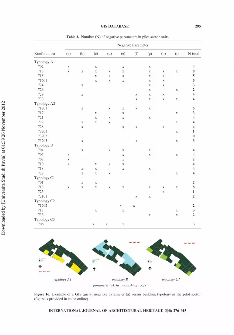
Table 2. Number (N) of negative parameters in pilot sector units
Negative Parameter
Roof number (a) (b) (c) (d) (e) (f) (g) (h) (i) N total
Typology A1
702 x x x x 4
713 x x x x x x x x 8
715 x x x x x 5
71601 x x x x x 5
724 x x x 3
726 x x 2
729 x x x x 4
730 x x x x 4
Typology A2
71201 x x x x x 5
717 x x x 3
721 x x x x 4
722 x x x x 4
728 x x x x 4
73201 x 1
73202 0
73203 x x x 3
Typology B
704 x x x x 4
705 x x x x 4
708 x x 2
710 x x x x 4
718 x x x x 4
722 x x x x 4
Typology C1
701 x x 2
713 x x x x x x x x 8
723 x 1
73101 x x 2
Typology C2
71202 x x 2
717 x x x 3
733 x x 2
Typology C3
706 x x x 3
typology C1typology Btypology A1
parameter (a): heavy pushing roofs
Figure 16. Example of a GIS query: negative parameter (a) versus building typology in the pilot sector
(figure is provided in color online).
GIS DATABASE 295
INTERNATIONAL JOURNAL OF ARCHITECTURAL HERITAGE 3(4): 276–315
Dow
nloa
ded
by [
Uni
vers
ita S
tudi
di P
avia
] at
01:
39 2
6 N
ovem
ber
2012

studies (to identify local soils effects), new evaluation of earthquake intensities, andisoseismal maps in the damaged area, also identifying three 1906 centennial survivingbuildings (Astroza 2007; Saragoni Huerta 2007; SturmMoreira 2008). For details, seealso general project reports (MAR VASTO 2007).
Valparaiso represents a distinctive case of growth, inside a remarkable land-scape, of an important Pacific Ocean seaport (over the nineteenth and twentiethcenturies), up to reaching a strategic importance in shipping trade, declined after thePanama Canal opening (1914). Thus, Valparaiso tells the never-ending story of a tightinteraction between society and environment, stratifying different urban and archi-tectonic layers, sometimes struck by disasters and always in danger. Certainly, the cityis subjected to various natural hazards (seismic events, but also tsunamis, landslides,etc.) and anthropic calamities (mainly wild and human-induced fires). These featuresmake Valparaiso a paradigmatic study case about hazard mitigation, and risk factorsmust be very well evaluated during the restoration phases to be planned in the future.
Table 3. Set of cases with minimum/maximum N for each building typology
Unit label Unit typology Typology tree Negative parameters IV (%)
726 A1 A1 2 41.0
713 A1 A12 8 72.0
73201 A2 A2 1 24.0
71201 A2 A211 5 65.0
708 B1 B1 2 18.6
718 B1 B11 4 61.0
723 C1 C1 1 32.0
713 C1 C121 8 82.6
71202 C2 C21 2 40.0
717 C2 C21 3 45.0
706 C3 C3 3 73.0
Table 4. Gruppo Nazionale per la Difesa dai Terremoti (GNDT) form parameters
class Cvi
Parameter A B C D weight P
1 Type and organization of the resistant system 0 5 20 45 1.00
2 Quality of the resistant system 0 5 25 45 0.25
3 Conventional resistance 0 5 25 45 1.25
4 Building position and foundations 0 5 15 45 0.75
5 Horizontal elements 0 5 25 45 *
6 Planimetry 0 5 25 45 0.50
7 Elevation regularity 0 5 25 45 *
8 Maximum distance between structural units 0 5 25 45 0.25
9 Roofing 0 10 25 45 *
10 Non-structural elements 0 0 25 45 0.25
11 Present situation 0 5 25 45 1.00
Vulnerability index IV IV ¼P11
I¼1
CviPi
*Varying parameter
296 M. INDIRLI
INTERNATIONAL JOURNAL OF ARCHITECTURAL HERITAGE 3(4): 276–315
Dow
nloa
ded
by [
Uni
vers
ita S
tudi
di P
avia
] at
01:
39 2
6 N
ovem
ber
2012

The MAR VASTO project stressed the following points: to collect, analyze andelaborate the existing information; to evaluate the impact ofmain natural and anthropichazards (earthquake, tsunami, fire, and landslide); to carry out architectonic/urbanplanning and vulnerability analyses for a building stock in the Cerro Cordillera (par-tially inside the UNESCO area); to provide surveys and vulnerability evaluations forthree monumental churches made by various materials (masonry, concrete, wood, and
Figure 17. Vulnerability analysis through GNDT procedure for the set of paradigmatic structural units
(figure is provided in color online).
Table 5. Interpolation simplified method for A1 generic buildings
Label Typology Negative parameters N Iv (%)
726 A1 2 41.0
713 A1 8 72.0
702 A1 3 46.2
724 A1 4 51.3
729 A1 4 51.3
730 A1 4 51.3
71601 A1 5 56.5
715 A1 5 56.5
GIS DATABASE 297
INTERNATIONAL JOURNAL OF ARCHITECTURAL HERITAGE 3(4): 276–315
Dow
nloa
ded
by [
Uni
vers
ita S
tudi
di P
avia
] at
01:
39 2
6 N
ovem
ber
2012
adobe) and located in different city sites; to develop a GIS digital archive, well orga-nized, user-friendly and easy to be implemented in the future, with hazard maps andscenarios; to suggest guidelines for future urban planning and strengthening interven-tions. For details, see also general project reports (MAR VASTO 2007).
4.2. The GIS Database
The work on the GIS geo-referenced database (Figure 23) (GIS report in MARVASTO 2007) elaborated materials purchased both in Chile and Italy. It has been
Figure 18. Vulnerability analysis for non paradigmatic structural units (figure is provided in color online).
Figure 19. Examples of earthquake damage found in the pilot sector (figure is provided in color online).
298 M. INDIRLI
INTERNATIONAL JOURNAL OF ARCHITECTURAL HERITAGE 3(4): 276–315
Dow
nloa
ded
by [
Uni
vers
ita S
tudi
di P
avia
] at
01:
39 2
6 N
ovem
ber
2012
indispensable to build at ENEA a detailed digital elevationmodel (DEM) (Figure 23a)of the Valparaiso area, by generating ortho-photos from the very helpful aerial photosprovided by the Servicio Hidrografico y Oceanografico de la Armada de Chile(SHOA). Digital cartography (streets, buildings, quoted points, and other informa-tion) provided by the ValparaisoMunicipality was often not very accurate and did notmatch the above said aerial photos of the Valparaiso area. Therefore, a field surveyusing DGPS (DGPS report in MAR VASTO 2007) has been carried out in situ byENEA, in order to check aerial photos and cartography provided by Chilean partnersand verify the GIS database from the topographic point of view (Figure 23b). TheDGPS survey provided a pattern of points (33 points) enabling to remove uncertain-ties, and clarifying univocally the real geographic position. The GIS database plat-form organized in clear and user-friendly maps a huge amount of data — aerial andsatellite photos; cartography and topo-batimetry; GIS urban layers as buildings, openspaces and viability; geo-referenced historic maps, for example (Figure 23c-f) ofgeneral interest, but also information targeted on specific hazards (as described insection 4.3) and the building inventory of the Cerro Cordillera sector (as described insection 4.4). The latter can be considered a robust step ahead, having focused, even iffor a limited area, architectonic/urban planning analyses, evaluation of structuralvulnerability and definition of some intervention proposals. Thus, the GIS modulesimplemented for the above said selected sector could be easily extended in the future toall Valparaiso, in the framework of further research stages.
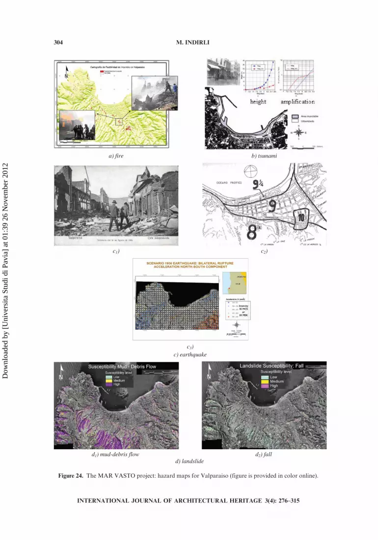
4.3. Hazard Maps
Hazard maps have been developed for natural (earthquake, tsunami, landslide)and anthropic (fire) disasters (Figure 24) and then stored in the GIS database (MARVASTO 2007).
4.3.1. Seismic hazard Specific studies on seismic hazard have been carried out byItalian partners (mainly ICTP). It is worth noting that the neo-deterministic approach(Panza et al. 2001) has been followed in theMARVASTO project, in order to evaluate
Figure 20. Local collapse mechanisms identified in the pilot sector (figure is provided in color online).
GIS DATABASE 299
INTERNATIONAL JOURNAL OF ARCHITECTURAL HERITAGE 3(4): 276–315
Dow
nloa
ded
by [
Uni
vers
ita S
tudi
di P
avia
] at
01:
39 2
6 N
ovem
ber
2012

seismic action in X direction
seismic action in Y direction
combination of X-Y seismic actions
Figure 21. 3D model with the local collapse mechanisms identified in the pilot sector, evidencing the unit
C1-713 (figure is provided in color online).
300 M. INDIRLI
INTERNATIONAL JOURNAL OF ARCHITECTURAL HERITAGE 3(4): 276–315
Dow
nloa
ded
by [
Uni
vers
ita S
tudi
di P
avia
] at
01:
39 2
6 N
ovem
ber
2012

Table 6. (a) Damage index in paradigmatic structural units and (b) comparison before and after
strengthening (Unit C1-713)
(a)
Label Typology IV (%) ID Damage
726 A1 41.0 0.36 significant
713 A1 72.0 0.61 unsafe
73201 A2 24.0 0.26 light
71201 A2 65.0 0.55 significant
708 B1 18.6 0.23 light
718 B1 61.0 0.52 significant
723 C1 32.0 0.31 significant
713 C1 82.6 0.71 unsafe
71202 C2 40.0 0.36 significant
717 C2 45.0 0.39 significant
706 C3 73.0 0.62 unsafe
(b)
Unit C1-713 not strengthened Unit C1-713 strengthened
IV ID IV ID82.6% 0.71 20.6% 0.24
Figure 22. Some sketches about urban renewal ideas (figure is provided in color online).
GIS DATABASE 301
INTERNATIONAL JOURNAL OF ARCHITECTURAL HERITAGE 3(4): 276–315
Dow
nloa
ded
by [
Uni
vers
ita S
tudi
di P
avia
] at
01:
39 2
6 N
ovem
ber
2012
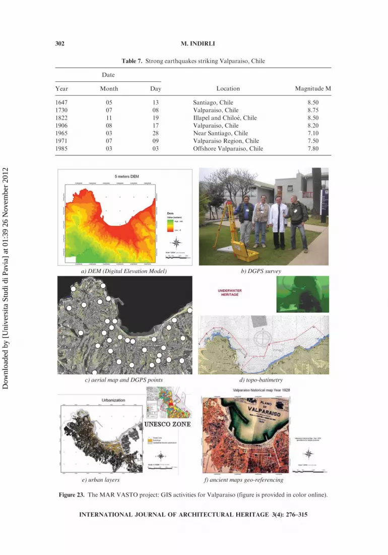
Table 7. Strong earthquakes striking Valparaiso, Chile
Date
Location Magnitude MYear Month Day
1647 05 13 Santiago, Chile 8.50
1730 07 08 Valparaiso, Chile 8.75
1822 11 19 Illapel and Chiloe, Chile 8.50
1906 08 17 Valparaiso, Chile 8.20
1965 03 28 Near Santiago, Chile 7.10
1971 07 09 Valparaiso Region, Chile 7.50
1985 03 03 Offshore Valparaiso, Chile 7.80
b) DGPS survey a) DEM (Digital Elevation Model)
d) topo-batimetryc) aerial map and DGPS points
f) ancient maps geo-referencinge) urban layers
Figure 23. The MAR VASTO project: GIS activities for Valparaiso (figure is provided in color online).
302 M. INDIRLI
INTERNATIONAL JOURNAL OF ARCHITECTURAL HERITAGE 3(4): 276–315
Dow
nloa
ded
by [
Uni
vers
ita S
tudi
di P
avia
] at
01:
39 2
6 N
ovem
ber
2012
the seismic input in the Valparaiso area for certain earthquake scenarios (in general),and in some sections underneath the churches locations (in particular). A completedescription of the methodology, from the definition of the hazard to the design of abuilding, is given by Zuccolo (2008). In fact, case studies indicate the limits of theprobabilistic seismic hazard analysis (PSHA) currently used methodologies, deeplyrooted in engineering practice, supplying indications that can be useful but notsufficiently reliable (Decanini et al. 2001; Indirli et al. 2006b; Kluegel et al. 2006), asshown by recent examples (the events in Kobe, Japan, in 1995, Bhuj, India, in 2001,Boumerdes, Algeria, in 2003, and Bam, Iran, in 2003 and E-Sichuan 2008).
Four scenarios, taking into account two fault rupture typologies (unilateraland bilateral), have been considered for the urban Valparaiso area (Table 8). Theneo-deterministic model has been first checked on the 1985 seismic event availablerecordings, and then extended to other scenarios, obtaining synthetic time-histories(displacement, velocity and acceleration) for the two horizontal ground motion com-ponents (N–S e E–W) and a dense grid for the Valparaiso urban area, storing different96 maps (an example in Figure 24c3) in the GIS database.
Specific seismic inputs, elaborated for the three churches sites, have been used instructural calculations to evaluate vulnerability and effectiveness of strengtheninginterventions. In conclusion, seismic hazard is very high in the Valparaiso urbanarea, not only concentrated in the flat zone along the coast (because of local ampli-fication effects due to soft soil), but also widespread in the hills, for geologic/topo-graphic configuration and structural vulnerability. Of course, secondary effectsshould also be foreseen, as tsunami, landslide, fire, etc. (for more details, see theearthquake report in MAR VASTO 2007).
4.3.2. Tsunami hazard Inundations happened several times in the past; startingfrom source models and simulations (1985 and 1906) studied by SHOA, a dataset oftsunami signals (including tsunamigenic parametric studies) has been computed,using analytical techniques (Panza et al. 2000) for different scenario earthquakes(Table 9) to complement the assessment of the tsunami hazard at Valparaiso. Then,inundation maps have been implemented (Figure 24b), defining a relationshipbetween the sea wave maximum height and the amplification in comparison withthe reference earthquake event (1985). It is clear that all the coastal line in theValparaiso harbour zone must be considered at high risk of flooding (see thetsunami report in MAR VASTO 2007).
4.3.3. Landslide hazard Thanks to the indispensable support of SHOA, ValparaisoMunicipality and local universities, ENEA experts provided slope, landslide inventoryand susceptibility maps (Figure 24d) through in-field campaign (in particular in thepilot area of the Cerro Cordillera), reconstruction of past landslide events fromhistoric archives, pluviometric analysis and digital/analogical aerial photos elabora-tion. The geomorphologic potential can mainly induce the following two processes:
� mudordebris flow, phenomenawitha rapid evolution in the covermaterial (Figure 24d1);� fall, phenomena with a rapid evolution in the bedrock (Figure 24d2).
Landslide hazard is very high in all the Valparaiso amphitheatre. The upstreamhill side is characterized mainly by mud-debris flow events, in the interior of theeluvium covering, triggering a couple of times in the year, concentrated in the
GIS DATABASE 303
INTERNATIONAL JOURNAL OF ARCHITECTURAL HERITAGE 3(4): 276–315
Dow
nloa
ded
by [
Uni
vers
ita S
tudi
di P
avia
] at
01:
39 2
6 N
ovem
ber
2012
imanust)berif)a
c1 c) 2)
c3)c) earthquake
d1 d2wolfsirbed-dum) ) fall d) landslide
Figure 24. The MAR VASTO project: hazard maps for Valparaiso (figure is provided in color online).
304 M. INDIRLI
INTERNATIONAL JOURNAL OF ARCHITECTURAL HERITAGE 3(4): 276–315
Dow
nloa
ded
by [
Uni
vers
ita S
tudi
di P
avia
] at
01:
39 2
6 N
ovem
ber
2012
summer season. The intensity of those phenomena can vary widely, but the presenceof densely populated urban settlements in ravine beds, escarpment sides and valleyheads (often artificially terraced) makes the associated risk very high. The coastalflat is reached by moved materials only when the event is intense or when severalactivated areas merge and flow together in the same bed. Fall events are punctualand characterized by local effects, but often destructive, at the basis of the sub-vertical sides. Certainly, seismic ground shaking as starting point of landslidephenomena should be carefully investigated (see the landslide report in MARVASTO 2007).
4.3.4. Fire hazard Fires certainly are the most frequent and dangerous disastersin Valparaiso. The state-of-the-art information has been provided by FiremenCorp and Valparaiso Municipality, with particular regard to the Calle Serranotragedy. In fact, on February 3, 2007 a violent explosion due to a gas leak killedfour people, destroyed some heritage buildings and damaged others in CalleSerrano, in the core of the UNESCO zone. Despite the good expertise of localfiremen, fires occur in the urban area (due to poor maintenance of electric systemsand gas pipelines, building materials, lack of education and vandalism), but also inthe surroundings forests and bushes (mainly human-made events). Furthermore,the risk is worsened by usual windy weather, narrow and tortuous hill roads,presence of wooden houses and sometimes insufficient water pressure in thehydrants. Also the presence of the close harbor facilities represents a further riskfactor. Moreover, important monuments were burned during the 1906 earthquake,but also damaged by recent fires (as the Church of San Francisco del Baron in1983). Figure 24a shows the hazard map, marking the most Valparaiso fire-pronelocations. The work has been verified by a couple of recent fire events: theyoccurred exactly in one of the most prone areas identified in the GIS database(see the fire report in MAR VASTO 2007).
Table 9. Tsunami scenarios for Valparaiso
Magnitude Occurrence Period (yrs)
7.0 Scenario event Frequent � 70–80 Moderate/Strong
7.5 Scenario event Occasional � 120–140 Strong
7.8 1985 event Sporadic* � 200–250 Very Strong
8.3 1906 event Rare* � 500 Disastrous
8.5 Scenario event Exceptional � 1000 Catastrophic
*From Servicio Hidrograficoy Oceanografico de la Armada de Chile (SHOA)
source models and simulations.
Table 8. Earthquakes scenarios for Valparaiso, Chile
Magnitude Occurrence Period (yrs)
7.5 Scenario event Occasional � 120–140 Strong
7.8 1985 event Sporadic � 200–250 Very strong
8.3 1906 event Rare � 500 Disastrous
8.5 Scenario event Exceptional � 1000 Catastrophic
GIS DATABASE 305
INTERNATIONAL JOURNAL OF ARCHITECTURAL HERITAGE 3(4): 276–315
Dow
nloa
ded
by [
Uni
vers
ita S
tudi
di P
avia
] at
01:
39 2
6 N
ovem
ber
2012

4.4. The Investigation on the Cerro Cordillera Building Stock
Geo-referred hazard maps must interact with a detailed land and buildinginventory, in which urban planning and single construction features (architecture,structural characteristics, vulnerability, present status, etc.) are linked to the sur-rounding environmental and social context. The pilot zone of the Cerro Cordillerahas been selected in agreement with the Valparaiso Municipality. It is a historically‘‘virgin’’, socially complicated and poor sector, partially inside the UNESCO area,and delimited by Calle Serrano (plan side), the San Agustin cable car upper station(hill side), and by the two opposite ravines of San Francisco and San Agustin(Figure 25).
The architectonic/urban planning investigation (carried out mainly by theUniversity of Ferrara) interested 230 constructions, four public areas, andapproximately 50 road network stretches. The information (function, architec-tonic style, general condition, for example) (Figure 25a1-a3) has been picked upthrough in situ surveys (by using an investigation form currently used by theUniversity of Ferrara for UNESCO sites, but specifically modified forValparaıso, summarized in Table 10), and then stored in the GIS database.Different indexes properly overlapped (for example, high architectonic qualityand bad conditions, Figure 25a4), enabled to identify rehabilitation priorities, inprimis the San Agustin cable car and its surroundings (Figure 25c).
On the base of the above mentioned architectonic/urban planning GIS classi-fication, prompt earthquake vulnerability analyses (mainly thanks to the Universityof Padua) interested 70 structures of the Cerro Cordillera pilot sector (Figure 25b),when exhaustive cadastral data were available (for example, plans, prospects, sec-tions, construction details, geotechnical features), excluding informal and illegalhouses. A special form has been elaborated for Valparaiso, based on Italian estab-lished procedures (AeDES 2000; GNDT 1999), modifying classes and weights ofTable 4, in order to take into account the existing differences in building character-istics (Table 11). Almost one half of the analyzed units shows a high vulnerabilityindex IV (22% 0 , IV , 30 low vulnerability; 20% 30 , IV , 45; 16% 45 , IV , 60;42% 60 , IV , 100 high vulnerability). For more details, see the Cerro Cordillerareport (MAR VASTO 2007).
4.5. The Investigation on Three Important Valparaiso Churches
Three important churches, located in different sites andmade by differentmaterials(Figure 26a), have been investigated, in agreement with the ValparaisoMunicipality: LaMatrız, San Francisco del Baron, Las Hermanas de la Divina Providencia. About eachchurch, thanks mainly to the effort of Padua and Ferrara Universities and the help ofChurch Authorities and Valparaiso Firemen, the following steps have been carried out:
� collection of historic data;� laser scanner (performed by Geocom Santiago) and photographic survey, visual
investigation and evaluation of maintenance and damage (Figure 26b);� vulnerability evaluation (Figure 26c);� execution of preliminary numerical calculations, if necessary (Figure 26d); and� indication of rehabilitation actions.
306 M. INDIRLI
INTERNATIONAL JOURNAL OF ARCHITECTURAL HERITAGE 3(4): 276–315
Dow
nloa
ded
by [
Uni
vers
ita S
tudi
di P
avia
] at
01:
39 2
6 N
ovem
ber
2012

Damage and vulnerability have been evaluated by using a well-knownItalian procedure, completing specific survey forms conceived for churches(Regione Molise, Consiglio Nazionale delle Ricerche 2003). Also in this case,the procedure is based upon a qualitative identification of selected parameters.More details are reported in the churches laser scanner and vulnerability reports(MAR VASTO 2007).
a) history, architecture, urban planning analysis of 230 buildings, open spaces, viability using a specifically elaborated investigation form
a1 anoitcnuf) 2) architectonic style
a3 asnoitidnoclareneg) 4) quality + condition
b) vulnerability analysis of 70 buildings using a modified II Level GNDT form
c) rehabilitation proposals
vulnerability index
vulnerability level
percentage in the building stock
0 < Iv < 30 low 22%
30 < Iv < 45 average 20%
45 < Iv < 60 high 16%
60 < Iv < 100 very high 42%
Figure 25. TheMARVASTOproject: investigation on the pilot building stock of Cerro Cordillera (figure is
provided in color online).
GIS DATABASE 307
INTERNATIONAL JOURNAL OF ARCHITECTURAL HERITAGE 3(4): 276–315
Dow
nloa
ded
by [
Uni
vers
ita S
tudi
di P
avia
] at
01:
39 2
6 N
ovem
ber
2012

Table 10. Form for the architectonic/urban planning analyses in the investigation for Valparaiso, Chile
Section 1: Identification and Building General Information
ID – GIS building number
Typology Horizontal additions
Architectural style Primary land use at ground floor
Quality of the architectonic elements Primary use of upper floors
Presence of a facade of interest Incompatible uses
Number of floors Describe the characteristic building use
Property Building occupation
Recent alterations (in the last ten years) General architectonic quality
Undergoing transformation Level of interest
Vertical additions Level of integration in the urban context
Section 2: Building Quality and Materials
Roof type Support Stilt typology
External roofing material Support stilt typology — Structural material
State or condition of the roof Support stilt typology — State or condition
Primary load baring structural typology of the building Out of alignment walls
External material of load baring structure Extent of surface cracking
State or condition of the building’s structural integrity General condition of the building
State or condition of the external finish material
Section 3: Building Main Facades
General composition of the facade Balconies — Material
Ground floor — principle exterior finish material Balconies — Balustrade material
Upper floors — principle exterior finish material Balconies — General condition
Doors — Form Ornamentation — Location
Doors — Materials Ornamentation — material
Doors — General condition Ornamentation — Type
Window — Forms Ornamentation — General condition
Windows — material Facade — General architectonic quality
Windows — General condition Level of interest
Balconies — Form Level of integration into the urban context
Table 11. Gruppo Nazionale per la Difesa dai Terremoti (GNDT) form parameters in the investigation
for Valparaiso, Chile
Parameter
Class Cvi
Weight PA B C D
1 Type and organization of the resistant system 0 5 20 45 1.00
2 Quality of the resistant system 0 5 25 45 1.50
3 Conventional resistance 0 5 25 45 0.50
4 Building position and foundations 0 5 25 45 0.75
5 Horizontal elements 0 5 15 45 0.35
6 Planimetry 0 5 25 45 0.35
7 Elevation regularity 0 5 25 45 0.35
8 Maximum distance between structural units 0 5 25 45 0.35
9 Roofing 0 5 25 45 0.35
10 Non-structural elements 0 0 25 45 0.75
11 Present situation Parameter 2: A-B 0 5 25 45 1.00
Parameter 2: C-D 0 0 45 45 1.00
Vulnerability index IV Iv ¼P11
I¼1
CviPi
308 M. INDIRLI
INTERNATIONAL JOURNAL OF ARCHITECTURAL HERITAGE 3(4): 276–315
Dow
nloa
ded
by [
Uni
vers
ita S
tudi
di P
avia
] at
01:
39 2
6 N
ovem
ber
2012

4.5.1. La Matrız Periodically destroyed by earthquakes, tsunamis and fires, the presentfourth version of the Iglesia del Salvador, Matrız de Valparaiso was constructed from1837 to 1842 (and modifications after 1897), in the same place of the original first chapel,built after the discovery of theValparaısoBay in 1559, in the ancient nucleus of the Puerto.The church, in simple neoclassic style, is made by adobe perimetral walls (height 12 m;thickness 1.30 m), masonry facade, with a roof by clay tiles. The bell-tower (height 40 m),modified at the end of the nineteenth century, is woodenmade and presents an iron spiralstaircase inside. The internal colonnades, forming the naves, are also woodenmade. In thetwentieth century, a certain damage occurred, due to seismic activity, scarce maintenanceand termite attacks. Partial interventions have been done between 1971 and 1988.
a) churches sites b) Laser Scanner, geometric, photographic and damage survey “La Matriz” “Hermanas” “San Francisco”
c) vulnerability evaluation
“La Matriz” global damage index: 8%
local damage index: -“Hermanas”
global damage index: 58% local damage index: -
“San Francisco” global damage index: 33%
local damage index: (façade) 66%
d) numerical models
Figure 26. TheMARVASTOproject: investigations on three monumental churches of Valparaiso (figure is
provided in color online).
GIS DATABASE 309
INTERNATIONAL JOURNAL OF ARCHITECTURAL HERITAGE 3(4): 276–315
Dow
nloa
ded
by [
Uni
vers
ita S
tudi
di P
avia
] at
01:
39 2
6 N
ovem
ber
2012
Themost relevant damagemechanism is in-plane shear actions in the facade, butthe global vulnerability index speaks approximately 8%, which is a very low value. Inconclusion, La Matrız can be considered in sufficiently good static conditions, but ageneral restoration is anyway suggested, for fire, materials degradation and termiteattacks prevention.
4.5.2. San Francisco del Baron The Iglesia San Francisco del Baron was con-structed when the Franciscans moved from the Puertoto the Baron Hill, from 1845to 1851 (thick adobe walls, wood colonnades, clay tiles later replaced by galvanizediron plates). Later, adjacent buildings and cloisters were added. The neo-baroquetower and facade were erected in 1890–1892, thanks to the project of the architectEduardo Provasoli (brick masonry connected by lime). The church faced severalearthquakes (mainly 1906 and 1985) without collapse, but a severe damage wasfound mainly in the bell-tower and the arcades during the investigation. The con-struction seems to be (in the facade and in the bell-tower) a very regular masonrybrickwork, but diagnostics testing is strongly recommended. The building showsheavy widespread structural damage and lack of effective anti-seismic protections.
The most relevant damage mechanisms are out-of-plane facade overturning andcollapse of the bell-tower. The global damage index speaks about 33%, but the localdamage index in the facade (66%) is very high. The present damage situation must beconsidered very worrying, because partial or total collapse (especially in the bell-towerand in the facade) can occur in case of earthquake (i.e. medium to high magnitudeseismic excitations, as expected in the Valparaiso area); in fact, the church is unsafeand urgently must be closed partially of totally, planning both prompt safety measuresand overall strengthening as soon as possible.
4.5.3. Hermanas de la Divina Providencia The congregation of Las Hermanas dela Divina Providencia extended its work from Canada to Chile in 1853, and inValparaiso in 1858. The congregation constructed in the Puerto, after 1867, a firstchapel, which underwent various modifications until the fire of 1880. Then, a secondversion was erected on the Merced Hill (1880–1883), but collapsed almost completelydue to the 1906 earthquake and later demolished. The present building (designed bythe architect Victor Auclair in a neo-renaissance style but made by a rare primitivereinforced concrete) began in 1907. Las Hermanas Chapel is located in the Almendralat the Merced foothill, exactly where the 1906 earthquake Intensity reached the Xhighest value (Figure 24c2). The present church was severely damaged by the 1985earthquake, declared unsafe and almost completely closed, without any rehabilitation.The monument is characterized by a lot of critical parameters (facade tympanumoverturning, in-plane shear mechanism in the facade, transversal response of nave andtransept, collapse of the dome, apse overturning, apse and presbytery vaults, and wallshear rupture). The global vulnerability index speaks approximately 58%.
The present damage situation must be considered very worrying, because partialor total collapse (in several structural parts, due to widespread weakness) can occur incase of earthquake (i.e., medium to high magnitude seismic excitations, as expected inthe Valparaiso area). Due to the particular typology of the construction materials (aprimitive reinforced concrete very rare in the world), a strengthening intervention withconventional techniques can be ineffective or very invasive; a solution should beplanned only after a detailed design work. As a suggestion, an innovative solution
310 M. INDIRLI
INTERNATIONAL JOURNAL OF ARCHITECTURAL HERITAGE 3(4): 276–315
Dow
nloa
ded
by [
Uni
vers
ita S
tudi
di P
avia
] at
01:
39 2
6 N
ovem
ber
2012

can be imagined to reduce drastically the seismic input as the introduction of a baseisolation system (with all the due precaution, avoiding elevation and foundation wallcutting by means of the insertion of a new subfoundation system), which seemspossible due to the apparent absence of crypt.
CONCLUSIONS
The work developed in the framework of the four master’s theses ( Mazzanti2007; Miglioli 2007; Nascosi 2007; Simonini 2007) and the MAR VASTO project(MAR VASTO 2007) showed importance and effectiveness to build up GIS data-bases, in order to merge together different approaches to study historic centers,important for their patrimonial value, prone to natural/anthropic disasters.
At the present stage of the research, it is possible to say that the methodology hasbeen enough defined in case of earthquake (e.g., hazard mapping; building inventory;architectonic/urban planning and structural vulnerability analyses; intervention propo-sals). It is also worth noticing that earthquake neo-deterministic models and scenarioshave been applied, already developed in the framework of important internationalprojects for the protection of strategic structures, cultural heritage, and urban environ-ment. In another regard, further standardization in data storing and application ofdifferent vulnerability functions for a larger set of building typologies (including specificalgorithms already developed by the scientific community) should be necessary.
Furthermore, the identification of a global risk factor (due to several natural andanthropic hazards) for a given area (or a building) needs deeper analyses to carry outin the future, because the definition of combination methods is another crucial step toimplement, together with the comparison of codes and standards regarding thenatural hazards mitigation, inside and outside the European community.
Being aware of this incomplete approach, the purpose of this article is to providesome elements for a step ahead. The investigation shall be enlarged and deepened inthe future, taking advantage of further studies, as the activity, now in progress,foreseen by the ongoing EUC26 Action (COST 2006), in which the Vesuvius eruptionis the study case.
ACKNOWLEDGEMENTS
About the master’s theses cited in text (Mazzanti 2007; Miglioli 2007; Nascosi2007; Simonini 2007), special thanks are due to the great effort of the architecturestudents Silvia Mazzanti, Marco Nascosi, Marco Miglioli and Gian Paolo Simonini(University of Ferrara), under supervision of Professors Andrea Alberti, ClaudioAlessandri, Daniele Pini, the support of architects Sergio Fortini, Luca Lanzoni,Saveria Teston, and tutoring of Maurizio Indirli.
As regard to the projectMARVASTO (MARVASTO 2007), during the work inValparaiso many local Organizations strongly cooperated to the Italian team in situwork: above all, the Municipality of Valparaıso (providing logistic and technicalsupport); the Ministry of Culture (Consejo Nacional de la Cultura y Las Artes); theRegional Authority (Intendencia V Region Valparaıso); the Regional Civil Defense(OREMI); SHOA (Servicio Hidrografico y Oceanografico de la Armada de Chile);PRDUV (Programa de Recuperacion y Desarrollo Urbano de Valparaıso); theFiremen (Bomberos) and the Sea Rescue (Bote Salvavidas) Corps of Valparaıso;
GIS DATABASE 311
INTERNATIONAL JOURNAL OF ARCHITECTURAL HERITAGE 3(4): 276–315
Dow
nloa
ded
by [
Uni
vers
ita S
tudi
di P
avia
] at
01:
39 2
6 N
ovem
ber
2012

city organizations (Junta de Vecinos of the Cerro Cordillera and Gerencia BarrioPuerto, which is the historic district of the City); the Board of Architects of Valparaısoand other professionals; the Police (Carabineros de Chile); Church Authorities andother Universities (Pontificia Universidad Catolica de Valparaıso, Universidad deValparaıso, Universidad de Playa Ancha Valparaıso); the Valparaıso ItalianCommunity. Finally, important was the contribution of the Geocom Santiago,which provided Laser-Scanner equipment and personnel.
As coordinator of the MAR VASTO project, many people need to be thanked;Italian team: Lorenza Bovio, Fabio Geremei, Francesco Immordino, LorenzoMoretti, Claudio Puglisi, Augusto Screpanti and Edi Valpreda (ENEA); ClaudioAlessandri, Marcello Balzani, Daniel Blersch, Paolo Ceccarelli, Daniel Chudak,Gianfranco Franz, Luca Lanzoni, Marco Miglioli, Enrico Milani, Gian PaoloSimonini and Antonio Tralli (University of Ferrara); Nieves Lopez Izquierdo(ENEA and University of Ferrara); Claudio Modena and Marco Munari(University of Padua); Cristina La Mura, Giuliano Panza, Hoby Raza, FabioRomanelli, Franco Vaccari and Elisa Zuccolo (ICTP/University of Trieste);
Chilean partners: Rodolfo Saragoni Huerta, Maximiliano Astroza Inostrozaand Thomas Sturm (Chile University of Santiago); Carlos Aguirre Ahumada, LuisAlvarez, Raul Galindo Urra, Marcela Hurtado Saldıas, Gilberto Leiva Henriquez(Federico SantaMaria University of Valparaiso); OsvaldoNeira Figueroa andMarcoQuevedo Tapia (GeocomChile); furthermore, the support of Andres Enriquez, DanteGutierrez and other SHOA researchers has been wonderful.
Chilean Institutions: Above all, Sotero Apablaza Minchel, Mauricio GonzalezLoyola, Cristian Palma Valladares, Carolina Avalos Avalos, Claudia Zuniga Jara(professionals of the Valparaıso Municipality at the time of MAR VASTO, whichworked strongly joining the Italian team also in the framework of some bursariesprovided in Italy by the Istituto Italo-Latino Americano); Mayors of Valparaıso AldoCornejo and Jorge Castro, Vice-Mayor Omar Jara Aravena; other ValparaısoMunicipality professionals (Paulina Kaplan Depolo, director of the Oficina deGestion Patrimonial, Karen Fried Agosin, Sandra Aliaga Vera, Sofia AyalaSantander, Gabriela Lozano Sandoval, Carolina Penaloza Pinto, Claudia UlloaEspinoza, Juan Carlos Molina Carvajal, Samuel Castro Zamora, Oriana RamirezMunoz, Mauricio Sanchez Pincheira, Cecilia Jimenez, Tania Bertoglio, JoseCampusano, Mauricio Gonzalez Pena y Lillo); Intendente V Region ValparaisoIvan de la Maza, Karina Englander Kalderon, Juan Carlos Garcia Perez de Arce,Marcio Tala Lopez, and others (Valparaiso Regional Government); Father FernandoCandia (San Francisco Church), Mons. Gonzalo Duarte Garcıa de Cortazar (Bishopof Valparaıso) and other Church Authorities; Ana Maria Icaza and FranciscoSaavedra (Programa de Recuperacion y Desarrollo Urbano de Valparaiso-PRDUV); Guillermo De La Maza (OREMI, Civil Defense); Enzo Gagliardo Leiva(Head), Vicente Maggiolo Oyarzun and colleagues (Bomba Italia) of the ValparaisoFiremen; all the personnel of the Bote Salvavidas; Nelson Morgado Larranaga andmany others of the Valparaiso Board of Architects;
Chilean professionals: above all, Milagros Aguirre Donoso, always very helpfuland kind; Luis Bork Vega, Fabio Mezzano Pendola, Octavio Perez Abarzua, AlfonsoSalinas, Francisco Silva Ite, Gunther Suhrcke and many others; Luis Enriquez andJavier Troncoso (Jerencia Barrio Puerto).
312 M. INDIRLI
INTERNATIONAL JOURNAL OF ARCHITECTURAL HERITAGE 3(4): 276–315
Dow
nloa
ded
by [
Uni
vers
ita S
tudi
di P
avia
] at
01:
39 2
6 N
ovem
ber
2012

A grateful thought for the great support to: the Italian Embassy in Santiago;Roberto Santilli, Maruzzella Giannini, and other office workers of the Italian TradeCommission in Chile; Pablo Peragallo of the Valparaiso Italian Community. Finally,last but not least, special thanks to Arcindo Santos and other professionals ofBID/IADB (Banco Interamericano de Desarrollo/InterAmerican DevelopmentBank).
REFERENCES
Agibilita e Danno nell’ Emergenza Sismica (AeDES). 2000. First level form for safety assess-ment, damage investigation, prompt intervention for ordinary buildings in the post-earthquakeemergency [in Italian]. Civil Defense Department, Rome, Italy.
Astroza Inostroza, M. I. 2007. A re-interpretation of the Valparaiso 1906 earthquake intensities.[in Spanish]. In Proceedings of the VI Congreso Chileno de Geotecnia. Valparaiso, Chile,November 28–30, 2007. Santiago, Chile: Department of Civil Engineering, University of Chile.
Bernardini, A., R. Gori R., and C.Modena. 1990. Application of coupled analytical models and
experimental knowledge to seismic vulnerability analyses of masonry buildings. InEarthquake Damage Evaluation and Vulnerability Analysis of Buildings Structures, ed., A.Kortize. Tarzana, CA: INEEC, Omega Scientific.
D’Ayala, D., and E. Speranza. 2003. Definition of collapse mechanisms and seismic vulner-ability of historic masonry buildings. Earthquake Spectra, 19: 479–509.
Cami, R., C. Alessandri, M. Indirli, and A. Tralli. 2007. Damage assessment and retrofitting of
the Marchesale Castle (San Giuliano di Puglia). In Proceedings of the 10th InternationalConference on Studies, Repairs and Maintenance of Heritage Architecture, Incorporating theMarittime Heritage Seminar (STREMAH). Prague, Czech Republic, July 4–6, 2007.
COST. 2006. COST, European COoperation in the field of Scientific and Technical research,Transport and Urban Development, COST Action C26: Urban habitat constructions undercatastrophic events. In Proceedings of the Symposium on Urban Habitat Construction Under
Catastrophic Events, Working Group 4: Risk Assessment for Catastrophic Scenarios in UrbanAreas, Session 6: Volcanic Hazard and the Vesuvius Study Case. La Valletta, Malta, October23–25, 2008.
Decanini, L., F. Mollaioli, G. F. Panza, F. Romanelli, and F. Vaccari. 2001. Probabilistic vsdeterministic evaluation of seismic hazard and damage earthquake scenarios: A generalproblem, particularly relevant for seismic isolation. In Proceedings of the 7th InternationalPost-Smirt Seminar on Seismic Isolation, Passive Energy Dissipation and Active Control of
Vibration of Structures. Assisi, Italy, October 2–5, 2001.Giuffre, A. 1993. Guide to the antiseismic restoration design. In Safety and preservation of
historic centers, the Ortigia study case. [in Italian]. In Sicurezza e conservazione dei centri
storici, il caso Ortigia. Bari, Italy: Editori Laterza.Gruppo Nazionale per la Difesa dai Terremoti (GNDT). 1999. Second level vulnerability form
for masonry buildings [in Italian]. Civil Defense Department, Rome, Italy.
Guagenti, E., and V. Petrini. 1989. The case of old constructions: Towards a new relationshipdamage intensity [in Italian]. In Proceedings of the IV Convegno Nazionale L’IngegneriaSismica in Italia. Milan, Italy, October 4–6, 1989.
HAZUS. 1992. HAZUS, FEMA’s Software Program for Estimating Potential Losses fromDisasters. Available at: http://www.fema.gov/plan/prevent/hazus/index.Shtm (accessed April9, 2009).
Indirli, M., P. Clemente, and B. Spadoni. 2004a. The reconstruction of San Giuliano di Puglia
after the October 31st 2002 earthquake. In Proceedings of the 13th World Conference onEarthquake Engineering. Vancouver, British Columbia, Canada, August 1–6, 2004, Paper 1805.
GIS DATABASE 313
INTERNATIONAL JOURNAL OF ARCHITECTURAL HERITAGE 3(4): 276–315
Dow
nloa
ded
by [
Uni
vers
ita S
tudi
di P
avia
] at
01:
39 2
6 N
ovem
ber
2012
Indirli, M., P. Clemente, B. Spadoni, R. Cami, E. Speranza, M. Mucciarella, and F. Pistola.
2004b. Seismic protection of historical centers using innovative techniques, with focus on SanGiuliano di Puglia after the 2002 Molise earthquake. In Proceedings of the SAHC’04, 4thInternational Conference on Structural Analysis of Historical Construction. Padua, Italy,
November 10–13, 2004.Indirli, M., R. Cami., B. Carpani, C. Algeri, P. Panzeri, G. Rossi, and L. Piova. 2006a. Theantiseismic rehabilitation of Marchesale Castle at San Giuliano di Puglia. In Proceedings ofthe SAHC’06, 5th International Conference on Structural Analysis of Historical Construction.
New Delhi, India, November 6–8, 2006.Indirli, M., B. Carpani., G. Panza, F. Romanelli, and B. Spadoni. 2006b. Damage evaluationand rehabilitation of the Montorio medieval tower after the September 14th, 2003 earth-
quake. In Proceedings of the First European Conference on Earthquake Engineering andSeismology (A Joint Event of the 13th ECEE and 30th General Assembly of the ESC).Geneva, Switzerland, September 3–8, 2006, Paper 666.
Indirli, M. 2007a. Overview on risk assessment approaches for natural hazards. In Proceedingsof the Project Workshop EU COST ACTION C26 — Urban Habitat Constructions underCatastrophic Events. Prague, Czech Republic, March 30–31, 2007.
Indirli M., B. Carpani, A. Martelli, and B. Spadoni. 2007b. Contribution of ENEA and otherexperts at SanGiuliano di Puglia: from emergency to reconstruction [in Italian]. InProceedingsof the XII Convegno ANIDIS: L’Ingegneria Sismica in Italia. Pisa, Italy, June 10–14, 2007.
Indirli, M., F. Geremei, C. Puglisi, A. Screpanti, D. Blersch, L. Lanzoni, N. Lopez Izquerdo, E.
Milano, M. Miglioli, G. Simonini, M. Munari, F. Romanelli, 2008. A GIS platform on mainnatural hazards for Valparaiso City (Chile) and vulnerability studies for some historicalconstructions and urban sectors. In Proceedings of SAHC’08, 6th International Conference
on Structural Analysis of Historic Construction. Bath, United Kingdom, July 2–4, 2008.Italian Ministry for Cultural Heritage and Activities. 2007. Guidelines for evaluation andmitigation of seismic risk to cultural heritage. Rome, Italy: Italian Ministry for Cultural
Heritage and Activities, Gangemi Editore.Kluegel, J. U., L.Mualchin, and G. F. Panza. 2006. A scenario-based procedure for seismic riskanalysis. Engineering Geology. 88: 1–22.
Manuale di Esercitazioni sul Danno Ed Agibilita per Edifici Ordinari (MEDEA). 2005. User’s
manual on damage and safety for ordinary buildings [in Italian]. Civil Defense Department,Rome, Italy.
MAR VASTO 2007. Risk Management in Valparaıso/Manejo de Riesgos en Valparaıso,
Servicios Tecnicos (MAR VASTO). Project ATN/II-9816-CH, BID/IDB-ENEA ContractPRM.7.035.00-C, March 2007–June 2008. Available at http://www.marvasto.bologna.enea.it (accessed March 23, 2009).
Mazzanti, S. 2007. The reconstruction at San Giuliano di Puglia after the October 31st, 2002earthquake: Urban planning and GIS, first part [in Italian]. University of Ferrara, Faculty ofArchitecture, Master’s Thesis. Ferrara, Italy.
Mazzanti, S., M. Miglioli, M. Nascosi, G. Simonini, M. Indirli, L. Lanzoni, S. Teston,C. Alessandri, and D. Pini. 2008. The construction of a GIS database for the historical centerof San Giuliano di Puglia. In Proceedings of SAHC’08, 6th International Conference onStructural Analysis of Historic Construction. Bath, United Kingdom, July 2–4, 2008.
Midorikawa, S. 2005. 3D seismic hazard and risk maps for earthquake awareness of citizenswith aids of GIS and remote sensing technologies. In Proceedings of the 3rd InternationalWorkshop on Remote Sensing for Post-Disaster Response. Chiba, Japan, September 12–13,
2005.Miglioli, M. 2007. The reconstruction at San Giuliano di Puglia after the October 31st, 2002earthquake: Structural vulnerability and rehabilitation interventions, Second Part [in Italian].
University of Ferrara, Faculty of Architecture, Master’s Thesis. Ferrara, Italy.
314 M. INDIRLI
INTERNATIONAL JOURNAL OF ARCHITECTURAL HERITAGE 3(4): 276–315
Dow
nloa
ded
by [
Uni
vers
ita S
tudi
di P
avia
] at
01:
39 2
6 N
ovem
ber
2012
Nascosi, M. 2007. The reconstruction at San Giuliano di Puglia after the October 31st, 2002
earthquake: Urban planning and GIS, First Part [in Italian]. University of Ferrara, Faculty ofArchitecture, Master’s Thesis. Ferrara, Italy.
Panza, G. F., F. Romanelli, and F. Vaccari. 2001. Seismic wave propogation in laterlly hetero-
geneus an elastic media: Theory and applications to seismic zonation.Advances in Geophysics43: 1–95.
Panza, G. F., F. Romanelli, and T. Yanovskaya. 2000. Synthetic Tsunami mareograms forrealistic oceanic models. Geophysical Journal International 141: 498–508.
Presidenza del Consiglio dei Ministri 2003 and 2005. OPCM 3274, 3316, 3431, GazzettaUfficiale: May 8, 2003, Serie Generale n. 105, Supplemento Ordinario n. 72; October 10,2003, Serie Generale n. 236; May 10, 2005, Serie Generale n. 107, Supplemento Ordinario
n. 85.Regione Molise, Consiglio Nazionale delle Ricerche. 2003. Second level form for the evaluation
of damage and vulnerability in the churches [in Italian]. Civil Defense Department, Rome,
Italy.Saragoni Huerta, R. G. 2007.The 1906 Valparaiso earthquake [in Spanish]. InProceedings of the
VI Congreso Chileno de Geotecnia. Valparaiso, Chile, November 28–30, 2007. Santiago,
Chile: Department of Civil Engineering, University of Chile.Shinozuka, M. 2005. Application of remote sensing technology in natural hazard assessment —
Examples from 2004 and 2005. In Proceedings of the 3rd International Workshop on RemoteSensing for Post-Disaster Response. Chiba, Japan, September 12–13, 2005.
Simonini, G. 2007. The reconstruction at San Giuliano di Puglia after the October 31st, 2002earthquake: Structural vulnerability and rehabilitation interventions, Second part [in Italian].University of Ferrara, Faculty of Architecture, Master’s Thesis. Ferrara, Italy
Sturm Moreira, T. W. 2008. Valparaiso: Its historic heritage and earthquakes [in Spanish].University of Chile, Faculty of Physical and Mathematical Sciences, Department of CivilEngineering, Master’s Thesis. Santiago de Chile, Chile.
United States Geological Survey (USGS). 2006. Historic Earthquakes, Chile 1960 May 2219:11:14 UTC Magnitude 9.5: The largest earthquake in the world. Available at: http://earthquake.usgs.gov/regional/world/events/1960_05_22.php (accessed March 21, 2009).
Valluzzi, M. R., G. Cardani, L. Binda, and C. Modena. 2004. Analysis of the seismic vulner-
ability of masonry buildings in historical centres and intervention proposals. In Proceedingsof the 6th International Symposium on the Conservation of Monuments in the MediterraneanBasin [CD-ROM]. Lisbon, Portugal, April 7–10, 2004.
Zuccolo, E., F. Vaccari, A. Peresan, A. Dusi, A. Martelli, and G. F. Panza. 2008. Neo-deterministic definition of seismic input for residential seismically isolated buildings.Engineering Geology 101: 89–95.
GIS DATABASE 315
INTERNATIONAL JOURNAL OF ARCHITECTURAL HERITAGE 3(4): 276–315
Dow
nloa
ded
by [
Uni
vers
ita S
tudi
di P
avia
] at
01:
39 2
6 N
ovem
ber
2012


![[Nanotechnology--possibilities and hazards]](https://img.dokumen.tips/doc/110x75/634d2bd5024fe175900ac942/nanotechnology-possibilities-and-hazards.jpg)