Embed Size (px)
Citation preview
NOTICE
The Materials Source data and information included in this file has been gathered and compiled for the express purpose of assisting in The Alaska Department of Transportation and Public Facilities during the des i^ process of various projects. It does not signify that &e soitfce is available or suitabl&ftruse during the construction of any specific current or iiiture project The included data and information does not detennine that this Materials Source will provide suitable materials in the requinsd quantities for any construction project.
The included data and mformation is suitable for use hy eji^erienced and qualified experts in the fields of geology, geological engineering and geotechnical engineering to make reasonable estimates regarding tiie quantity, quality, and suitability for construction purposes'of material that can be produced fi'om the source.
Sources mtended for use fi)r any specific construction project will be referenced in. the appropriate sectibn of the Plans and Specifications of the Contract Docfuments for that construction project.
52-2-051-2
STATE OF ALASKADEPARTMENT OF NATURAL RESOURCESDIVISION OF MINING, LAND AND WATER
[X] Northern Region [ ] Southcentral Region [ ] Southeast Region3700 Airport Way 3601 C Street, Suite 1080 400 Wilbughby, #400Fairbanks, AK 99709 Anchorage, AK 99503 Juneau, AK 99801
(907) 451-2740 (907) 269-8552 (907) 465-3400
NEGOTIATED MATERIAL SALE CONTRACT RENEWALADL 408733
Effective Date: January 1. 1999 Expiration Date: December 31, 2009
Under AS 38.05.110-38.05.120 (Disposal of Timber and Materials), AS 38.05.125, as 38.05.810(a) and theregulations implementing these statutes, the State of Alaska, the SELLER, agrees to sell, and, the BUYER, AlaskaDepartment of Transportation and Public Facilities, agrees to buy the material designated in this contract,subject to the provisions which follow:
1. Description: Location, Material, Quantity, and Price.
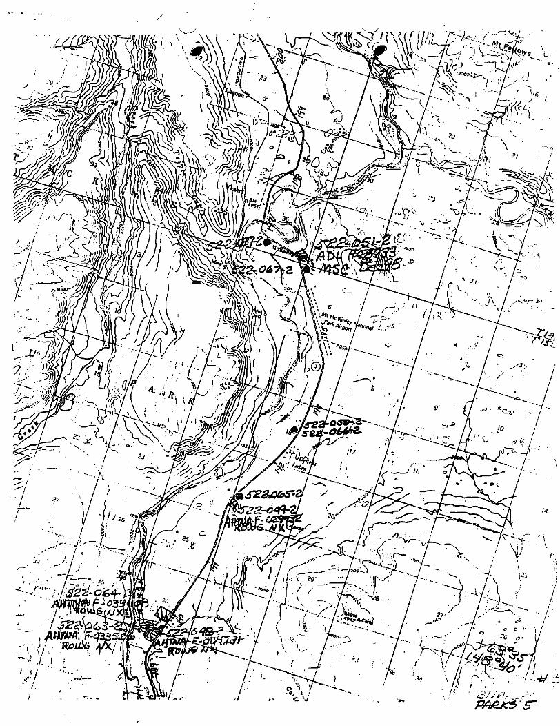
(a) The material sale area covered by this contract consists of approximately 13.18 acres. This area is designatedby the boundaries shown on the attached sale area map, which is made part of this contract, or as designated onthe ground by the seller, and described as follows:
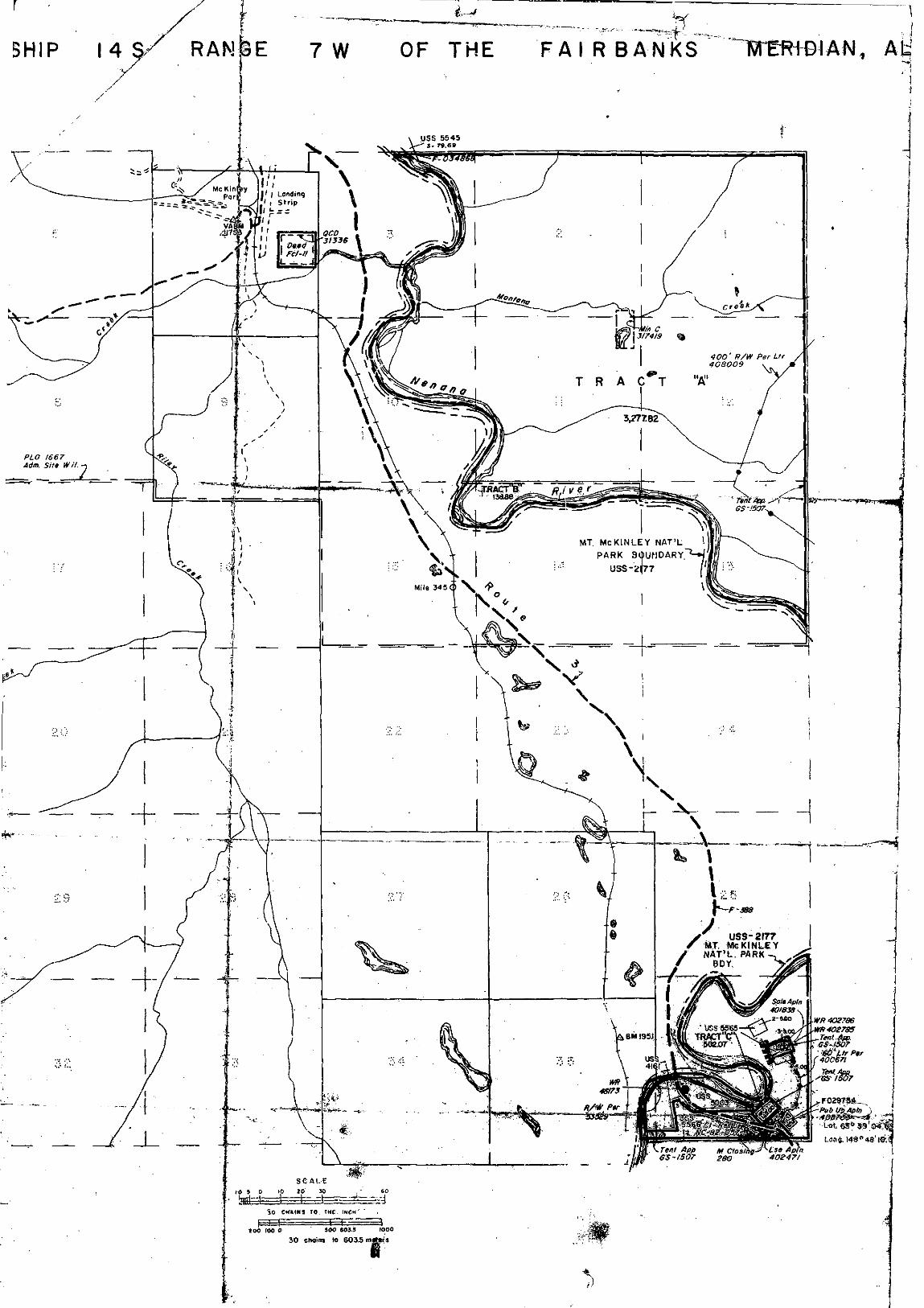
MS 52-2-051-2 located within the SW1/4 Section 36, Township 13 South, Range 7 West, Fairbanks Meridian;Tract D, ASLS 83-194.
(b) The material to be removed and the prices are:
Kind of Material No. of Units Unit Price Total Price
sand & gravel 50,000 Of * ' , *
* 11 AAC 05.010(e)(16) requires state, federal, and local agencies to pay for materials used in constructing,reconstructing, or maintaining a public project as follows: 1) no charge for the first 5,000 CY of material tobe used on a project (each year of maintenance constitutes a separate project) and 2) material in excessof 5,000 Of will be charged for at the unit price listed in the annual base price schedule established under11 AAC 71.090 (currently $0.50/CY).
«2. Payments and Deposits. No part of the materials sold under this contract may be extracted from the salearea by the buyer except in accordance with the following terms: i - •
(a) Initial Payment. NA. The buyer will remit ah initial payment in the amount of NA (consistent with 11 AAC71.045) at the time the contract is signed.
(b) Application of Initial Payment. NA. The seller will retain on deposit the initial payment required by paragraph2(a), to be applied in whole or in part to the final payment which becomes due under this contract. Additionalperiodic installment payments as required in paragraph 2(c) of this section must be made for material extracted asof the date payment becomes due but may not exceed the total purchase price.
102-138(Rev. 2/94) ADL 408733Page 1
(c) Annual Payments. Annual accounting and annual payments for material extracted must be made by ADOT&PFno later than thirty (30) days following December 31 of each year as long as the contract is in force. If accountingand payments are made by a contractor of the DOT/PF, it must be received no later than 30 days following jobcompletion in any one year. These payments are to be based on records required by Section 3 of this contract, andmust be submitted to the seller no later than the fifth working day following the date the installment payment isdue.
(d) Final Payment. A final accounting and payment for material removed, and a completion statement must besubmitted by ADOT&PF no later than thirty (30) days following contract completion, expiration, termination, or byoperation of the law. Final accounting payment made by a contractor of ADOT&PF must be received no later thanthirty (30) days following job completion. Whether completion is satisfactory will be decided by the Director of theDivision of Mining, Land and Water within ninety (90) days after receiving the final accounting report and completionstatement.
(e) Reappraisal. NA. The unit price is subject to reappraisal under 11 AAC 71.090(f) by the seller every two yearsfor the period that this contract is in force.
(f) Suspension for Non-Payment. If the buyer fails to make a payment provided for in this contract, the seller may,under Section 8(b) of this contract, order all material extraction suspended immediately. Materials extracted by thebuyer during any period of suspension are considered taken in trespass and are to be charged to and paid for bythe buyer at triple the unit contract price or at triple the reappraised price if a reappraisal has been made underSection 2(e) of this contract. Resumption of the lawful taking of materials may be authorized, in writing, by theDivision of Mining, Land and Water only after the payments in arrears plus the penalty provided for in Section 2(g)have been made.
(g) Late Payment Penalty. NA. The greater of either the fee specified in 11 AAC 05.010 or interest at the rate setby AS 45.45.010(a) will be assessed on a past-due account until payment is received by the seller.
(h) All payments and deposits are remitted to the Department of Natural Resources, Division of Mining, Land andWater, Northern Regional Office, 3700 Airport Way, Fairbanks, AK 99709 (PH# 907-451-2740), payable to the AlaskaDepartment of Revenue.
(i) NA. If the total amount of materials covered by this contract is not extracted, the money on deposit maybecome forfeited in the seller's discretion as liquidated damages in an amount not to exceed the seller's totalentitlement under this contract, or the seller will receive the measure of actual damages to the seller, at the seller'selection.
(j) Special Provisions. NONE
3. Method of Volume Determination.
(a) Volume Determination. The method of volume determination for purposes of payment under this contract iseither based on: 1) a loose cubic yard quantity as determined by an "in-place" measurement multiplied by a factorof 1.3; 2) stockpile survey in cubic yards; 3) cubic yard estimates obtained by daily vehicle counts; 4) conversionof weight to cubic yards.
(b) Records. The buyer will keep accurate and up-to-date records of all materials extracted. These records aresubject to verification by check measure and inspection of the buyer's books by the seller at any time without notice.
(c) Submission of Annual/Final Accounting Records. ADOT&PF will submit annual/final accounting records, alongwith payments, no later than thirty (30) days following December 31 of each year. If annual/final accountingrecords, along with payments, are made by a contractor of the ADOT/PF, it must be received no later than thirty(30) days following job completion in any one year. The ADOT/PF, or the ADOT/PF's agent, employee, contractor,
102-138(Rev. 2/94) ADL 408733Page 2
subcontractor must be identified, as well as the cubic yard quantity used, designated by location, type of use, anddate used.
(d) Quantity Conversion. Material quantity measured on a ton basis must be converted to cubic yards (CY). Theconversion factor is 1.6 tons/CY, unless another figure is supplied by an engineer, which is based upon testsperformed at the material source. In this case, an average of 5 density measures will be taken throughout the useof the material site.
4. Operating Requirements.
(a) Boundary Lines and Survey Monuments. No boundary mark of the sale area nor any survey line or witness treefor any survey corner or monument, may be severed or removed, nor may any survey corner or monument bedamaged or destroyed. Any violation of this clause requires the buyer to bear the expense of reestablishing the line,corner, or monument by a registered surveyor in a manner approved by the seller.
(b) Standard of Operations. The buyer will properly locate himself and his improvements within the sale area, andmay not commit waste, whether ameliorated or otherwise. In addition to complying with all laws, regulations,ordinances, and orders, the buyer will maintain the land in a reasonably neat and clean condition, and will take allprudent precautions to prevent or suppress grass, brush, or forest fires, and to prevent erosion or destruction ofthe land.
(c) Erosion Control and Protection of Waters. Road construction or operations in connection with this contract mustbe conducted so as to avoid damage to streams, lakes, or other water areas and land adjacent to them. Vegetationand Materials may not be deposited into any stream or other water area. Locations and improvements necessaryfor stream crossings for haul roads must be approved in advance by the seller. All roads to be abandoned must betreated with measures necessary to prevent erosion in a manner acceptable to the seller. Any damage resultingfrom failure to perform these requirements must be repaired by the buyer to the satisfaction of the seller. Thisincludes waters defined in 5 AAC 95.010, Protection of Fish and Game Habitat.
(d) Fire Protection. The buyer will take all necessary precautions for the prevention of wild fires and is responsiblefor the suppression, and must bear the suppression costs, of all destructive or uncontrolled fires occurring in oroutside the sale area resulting from any of the buyer's operations under this contract. The buyer will comply withall laws, regulations, and ordinances promulgated by all governmental agencies responsible for fire protection in thearea.
(e) Roads. Before constructing any mainhaul, secondary or spur roads across state land, the buyer will obtainwritten authorization from the seller.
(f) Supervision. The buyer will maintain adequate supervision at all times when operations are in progress toensure that the provisions of this contract and all applicable federal, state, and local laws, regulations, andordinances governing the operations are enforced. At all times when operations are in progress, the buyer or aperson authorized by him to assume the responsibilities imposed by this contract, will be present on the sale area.
(g) Agents. The provisions of this contract apply with equal force upon an agent, employee, or contractordesignated by the buyer to perform any of the operations relating to extraction of the materials sold under thiscontract. The buyer is liable for noncompliance caused by any such agent, employee, or contractor.
(h) Location. The buyer is responsible for the accurate location of operations under this contract, including anysurvey that may be necessary for accurate location, unless otherwise specified in this contract.
(i) Access. The seller makes no representations that it will construct or maintain access to the land. Access overany route not under the seller's control is the responsibility of the buyer. The buyer agrees that any permanentaccess or right-of-way obtained over privately owned property will provide a permanent easement to the seller.
102-138(Rev. 2/94) ADL 408733Page 3
0) Special Provisions. The following special provisions also apply to operations under this contract:
1) Authorized Representative. The Authorized Representative for the Department of Natural Resources is theNorthern Regional Manager of the Division of Mining, Land and Water. The Authorized Representative maybe contacted at 3700 Airport Way, Fairbanks, Alaska 99709, or (907) 451-2740. The AuthorizedRepresentative reserves the right to modify these stipulations or use additional stipulations as deemednecessary.
2) Extraction Area. This contract authorizes removal of material only from the area defined in Section l(a) of thiscontract. The buyer is responsible for properly locating the material site and the working limits within that area,as shown on the attached map.
3) Mining and Reclamation Plan. No material removals are authorized under this contract unless in accordancewith the approved Mining and Reclamation Plan Guidelines and the Special Provisions of the contract. TheSpecial Provisions shall take precedence over the approved plan should there be a contradiction between saidplan and the Special Provisions of the contract. If a multiyear mining and reclamation plan has not beendeveloped for this site, a plan shall be submitted and approved prior to commencing any majordevelopment/construction project. Road maintenance may require material removal on an as-needed basis,which will not involve any major site development. A final plan shall be submitted and approved prior tovacating the material site.
4) Site Operations. The ADOT/PF is responsible for all aspects of material extraction and transport. Any surveystakes or markers that are removed must be replaced at the ADOT/PF's expense. The work area will bemaintained after each use in a graded, neat, clean condition, free of any solid waste, debris or litter. Thedisposal of hazardous substances or hydrocarbons is prohibited. After completion, expiration, or termination ofthe contract, the site will be left in a condition that is acceptable to the Division of Mining, Land and Water.
5) Reclamation. Upon expiration, project completion, or termination of the contract, the site shall be reclaimedin accordance with the attached Mining and Reclamation Plan Guidelines. Reclamation may include re-contouringand smoothing slopes, back-filling holes, removing berms, restructuring drainage, providing for the adequateinstallation of drainage structures, repairing access roads or trails to and/or within the site, disposing ofremaining stockpiles, replacing overburden, providing for natural or re-vegetation by cultivation, and otherprocedures that will be used to stabilize and reclaim the area, including blending the boundaries into the naturallandscape of the area, and any other site specific measures that may be necessary, or agreed upon.
6) Alaska Historic Preservation Act. The buyer will consult the Alaska Heritage Resources Survey (907) 269-8721so that known historic, archaeological and paleontological sites may be avoided.
The Alaska Historic Preservation Act (AS 41.35.200) prohibits the appropriation, excavation, removal, injury, ordestruction of any state-owned historic, prehistoric (paleontological) or archaeological site without a permit fromthe commissioner. Should any sites be discovered during the course of field operations, activities that maydamage the site will cease and the Office of History and Archaeology in the Division of Parks and OutdoorRecreation (907) 269-8721 and will be notified immediately.
7) Wastewater Disposal. Disposal of wastewater from any operation associated with this authorization mustsatisfy the requirements of the Alaska Department of Environmental Conservation.
8) Vehicle Maintenance. Vehicle maintenance will be performed only over an effective impermeable barrier.
9) Fuel and Hazardous Substances. No fuel or hazardous substances are to be stored on the subject land.Prior written approval written approval from an Authorized Representative of the Division of Mining, Landand Water is required for a change in this restriction. Such approval may include additional stipulations anda change in the amount required for the performance guaranty.
102-138(Rev. 2/94) ADL 408733Page 4
10) Notification. The contract holder shall immediately notify DNR and DEC by phone of any unauthorizeddischarge of oil to water, any discharge of hazardous substances (other than oil), and any discharge of oilgreater than 55 gallons on land. All fires and explosions must also be reported.
The DNR 24 hour spill report number is (907) 451-2678; the Fax number is (907) 451-2751. The DEC spillreport number is (800) 478-9300. DNR and DEC shall be supplied with all follow-up incident reports.
5. Indemnity of Seller. The buyer will indemnify and hold the seller harmless from: (1) all claims and demandsfor loss or damage, including property damage, personal injury, wrongful death, and wage or employment claims,arising out of or in connection with the use or occupancy of the land or operations by the buyer or his successors,or at his invitation; (2) any accident or fire on the land; (3) any nuisance on the land; (4) any failure of the buyerto keep the land in a safe and lawful condition consistent with applicable laws, regulations, ordinances, or orders;and (5) any assignment, sublease, or conveyance, attempted or successful, by the buyer which is contrary to theprovisions of this contract. The buyer will keep all goods, materials, furniture, fixtures, equipment, machinery, andother property on the land at sole risk, and will hold the seller harmless from any claim of loss or damage to themby any cause.
6. Bonding. NA. At the seller's discretion, a buyer may be required to file a bond designed to ensure the buyer'sperformance and to help protect the seller against any liability that may arise as a result of the activities of thebuyer. A bond acceptable to the seller in the amount of NA (11 MC 71.095) must be filed with the seller at thetime of execution of this contract to ensure the buyer's performance and financial responsibility.
7. Improvements and Occupancy.
(a) Any improvements or facilities including crushers, mixing plants, buildings, bridges, roads, etc., constructed bythe buyer in connection with this sale and within the sale area must be in accordance with plans approved by theseller.
(b) The buyer must, within 60 days after contract completion or termination of the contract by the seller or byoperation of law, remove equipment and other personal property from the sale area. After removal, the buyer mustleave the land in a safe and clean condition which is acceptable to the seller. If the buyer can demonstrate unduehardship, the time for removal of the improvements under this paragraph may be extended at the seller's discretion.
(c) If any of the buyer's property having an appraised value in excess of $10,000, as determined by the seller, isnot removed within the time allowed, that property may, upon 30 days notice to the buyer, be sold at a publicauction under the direction of the seller. The proceeds of the sale will inure to the buyer after satisfaction of theexpense of the sale and deduction of all amounts then owed to the seller. If there are no other bidders at the sale,the seller may bid on the property, and the seller will acquire all rights, both legal and equitable, which any otherpurchaser could acquire through a sale and purchase.
(d) If any of the buyer's property having an appraised value of $10,000 or less, as determined by the seller, is notremoved within the time allowed, title to that property automatically vests in the seller.
(e) Special Provisions. NONE
8. Inspection.
(a) The seller must be accorded access, at all times, to the sale area and to the books and records of the buyer,his contractors, and any subcontractor relating to operations under this contract for purposes of inspection to assurethe faithful performance of the provisions of this contract and other lawful requirements.
(b) At all times when construction or operations are in progress, the buyer will have a representative readilyavailable to the area of operations who is authorized to receive, on behalf of the buyer, any notices and instructions
102-138(Rev. 2/94) ADL 408733Page 5
given by the seller in regard to performance under this contract, and to take appropriate action as is required bythis contract.
9. Termination and Suspension.
(a) The seller may terminate the buyer's rights under this contract if the buyer breaches the contract and fails tocorrect this breach within 30 days after written notice of the breach is served upon the buyer.
(b) If the buyer fails to comply with any of the provisions of this contract, the seller may shut down the buyer'soperations upon issuance of written notice, until corrective action, as specified by the seller in its notice, is taken.If this corrective action is not taken within 30 days after written notice is served upon the buyer, the seller may
terminate the contract under paragraph 8(a) of this contract. The buyer's failure to take immediate corrective actionwhen ordered to remedy dangerous conditions or unwarranted damage to natural resources may be corrected bythe seller to prevent danger or additional damage. Any cost incurred by the seller as a result of this correctiveaction, or by the buyer's failure to take corrective action, must be paid by the buyer.
(c) This contract may also be terminated by mutual agreement of both parties on terms agreed to in writing by bothparties.
10. Reservations. The seller reserves the right to permit other compatible uses, including the sale of materials,on the land in the sale area if the seller determines that those uses will not unduly impair the buyer's operationsunder this contract. Under AS 38.05.125 the seller further expressly reserves to itself, and its successors, forever,(a) all oil, gas, coal, ores, minerals, fissionable materials, geothermal resources, and fossils of every kind, which maybe in or upon the land described above, or any part of it; and (b) the right to explore the land for oil, gas, coal,ores, minerals, fissionable materials, geothermal resources, and fossils; and (c) the right to enter by itself or itsagents, attorneys, and servants on the land, or any part of it, at any time for the purpose of opening, developing,drilling, and working mines or wells on this or other land and taking out and removing from it all oil, gas, coal, ores,minerals, fissionable materials, geothermal resources, and fossils; and (d) the right by itself or its agents, attorneys,and servants at any time: (1) to construct, maintain, and use all buildings, machinery, roads, pipelines, power lines,and railroads; and (2) to sink shafts, drill wells, and remove soil; and (3) to occupy as much of the land as maybe necessary or convenient for these purposes; and (e) generally all rights to and control of the land, which arereasonably necessary or convenient to make beneficial and efficient the complete enjoyment of the property andrights which are expressly reserved.
11. Inclusion of Applicable Laws and Regulations. The buyer will comply with all laws and regulationsapplicable to operations under this contract, including the Alaska Fire Control Act, the provisions of AS 38.05.110- 38.05.120, material sale regulations 11 AAC Chapter 71, state fish and game regulations pertaining to theprotection of wildlife and wildlife habitat, and state regulations pertaining to safety, sanitation, and the use ofexplosives. These laws and regulations are, by this reference, made a part of this contract, and a violation of themis cause for termination or suspension of this contract in addition to any penalties prescribed by law. These lawsand regulations control if the terms of this contract are in conflict with them in any regard.
12. Assignment. This contract may not be assigned by the buyer without the seller's prior written consent to theassignment.
13. Permits. Any permits necessary for operations under this contract must be obtained by the buyer beforecommencing those operations.
14. Passage of Title. All right, title and interest in or to any material included in the contract will remain in theState until it has been paid for; provided, however, that the right, title and interest in or to any material which hasbeen paid for but not removed from the sale area by the buyer within the period of the contract or any extensionthereof as provided for in this contract will vest in the seller.
102-138(Rev. 2/94) ADL 408733Page 6
15. Expiration and Extension. This contract expires December 31, 2009. unless an extension is granted bythe seller in accordance with 11 AAC 71.210 (Material Sale Regulations).
16. Warranties. This sale is made without any warranties, express or implied, as to quantity, quality,merchantability, profitability, or fitness for a particular use, of the material to be extracted from the area undercontract.
17. Valid Existing Rights. This contract is entered into and made subject to all valid existing rights, includingeasements, rights-of-way, reservations, or other interests in land, in existence on the date the contract is enteredinto.
18. Notices. All notices and other writings required or authorized under this contract must be made by certifiedmail, postage prepaid, to the parties at the following address:
to the Seller: Alasjka: Department of Natural Resources, ' - , ' " < ' ' • • ' : . ' , ',. - ' • ' ' ' , „ " " - . ^'' --:VJ'•-'".•; : ' :- „- ' Division of Mining, Land and Water ' • _ ' . - - . I ' , ''",i \ - . -* . ] " ' , ' < ! - • ; - • -^ ! l
_' -" ' '!; 37ob Airport way ' '"\ ' ".".. \..^ • ' . x>," - - ' . " • ' • ' / ; , • " . • . . ' '-'";,"; u iTI"',: '•. -- IFairbiihks^ Alaska 99709: "^ ',;' •. , - . . _ - • -" ' ' ' , , , < , ; - ' j \ ' f ' 'V.J-."':.r'
To the Buyer: Alaska Department of Transportation and Public Facilities..,. : ' : • ' , ' ; 2301 Peger Road , - ,. ^ v-,:: .- /_•
:;i:r Fairbanks, Alaska 99701 , " -:
19. Integration and Modification. This contract, including all laws and documents which by reference areincorporated in it or made a part of it, contains the entire agreement between the parties. This contract may notbe modified or amended except by a document signed by both parties to this contract. Any amendment ormodification which is not in writing, signed by both parties, and notarized is of no legal effect.
20. Severability of Clauses of Sale Contract. If any provision of this contract is adjudged to be invalid, thatjudgment does not affect the validity of any other provision of this contract, nor does it constitute any cause ofaction in favor of either party as against the other.
21. Construction. Words in the singular number include the plural, and words in the plural number include thesingular.
22. Headings. The headings of the numbered paragraphs in this contract will not be considered in construing anyprovision of this contract.
23. "Extracted"and "Extraction." In this contract, use of the terms "extracted" and "extraction" encompassesthe severance or removal, as well as extraction, by the buyer of any materials covered by this contract.
24. Waiver. No agent, representative or employee of the seller has authority to waive any provision of thiscontract unless expressly authorized to do so in writing by the Director of the Division of Mining, Land and Water.
102-138(Rev. 2/94) . ADL 408733Page 7
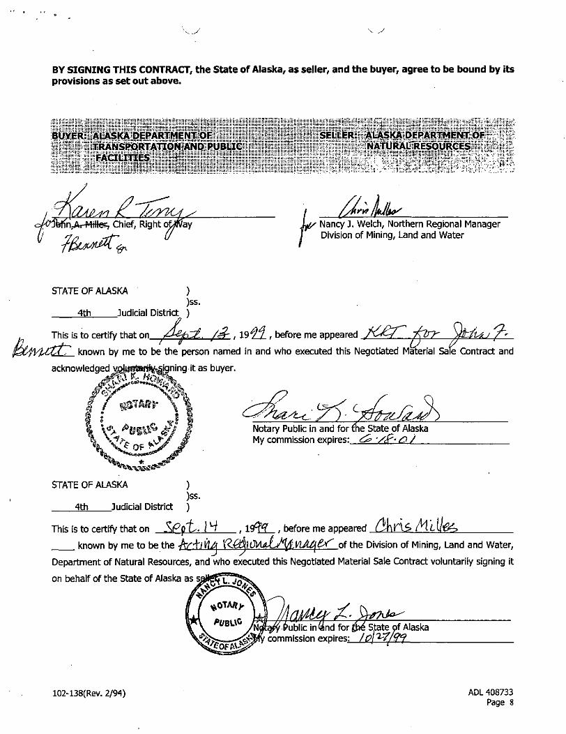
BY SIGNING THIS CONTRACT, the State of Alaska, as seller, and the buyer, agree to be bound by itsprovisions as set out above.
BUYER: ALASKA DEPARTMENT OF' ,; \' TRANSPORTATION AND PUBLIC
FACILITIES r 1
SELLER: ALASKA DEPARTMENT OFNATURAL RESOURCES> „
Chief, Right ofJA/ay r Nancy J. Welch, Northern Regional ManagerDivision of Mining, Land and Water
STATE OF ALASKA ))ss.
4th Judicial District )
This is to certify that on /J^p^L, /a~ , 19^7 , before me appeared.17
aleknown by me to be the person named in and who executed this Negotiated Material Sale Contract and
acknowledged yoJi|t5*M'»<v igning it as buyer.
Notary Public in and for fhe State of AlaskaMy commission expires: g^ '/£< <D /
STATE OF ALASKA ))ss.
4th Judicial District )
This is to certify that on Js^p'u-.
known by me to be the
, before me appeared
of the Division of Mining, Land and Water,_/ s
Department of Natural Resources, and who executed this Negotiated Material Sale Contract voluntarily signing it
on behalf of the State of Alaska as s^HgEf 3^
r x«P vk\ %-^~^
fcOTM)' \ « )A* , y wflMtf''^'»*?*>^V UBl Mjkqft Public in^lnd for fyi State of Alaska^%>^__- . y commission expires: /g/^7/<?!fS^PP^^ ^tes-—----3&^
102-138(Rev. 2/94) ADL 408733Page 8
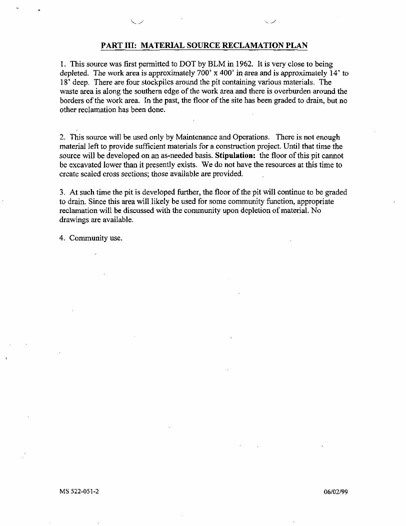
PART III: MATERIAL SOURCE RECLAMATION PLAN
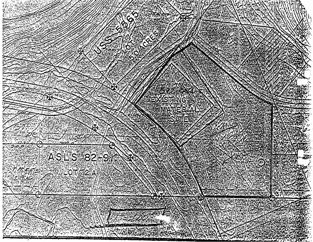
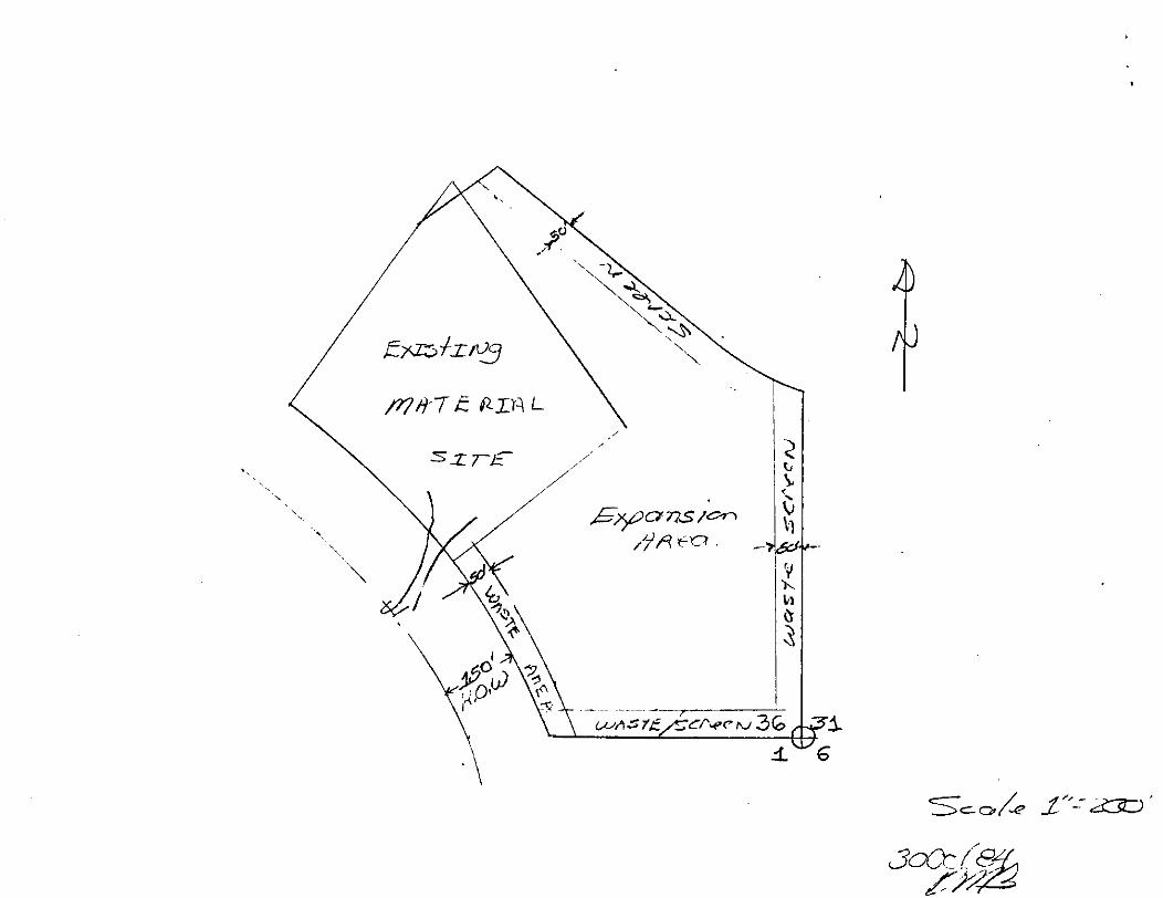
1. This source was first permitted to DOT by BLM in 1962. It is very close to beingdepleted. The work area is approximately 700' x 400' in area and is approximately 14' to18' deep. There are four stockpiles around the pit containing various materials. Thewaste area is along the southern edge of the work area and there is overburden around theborders of the work area. In the past, the floor of the site has been graded to drain, but noother reclamation has been done.
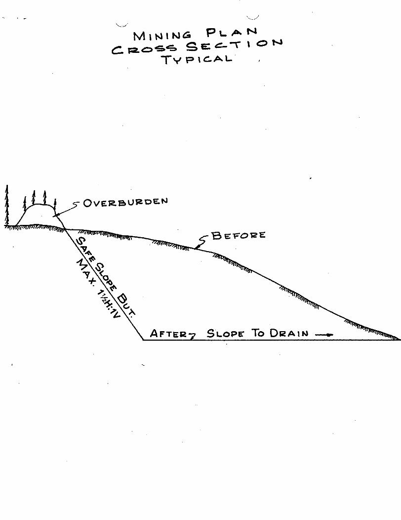
2. This source will be used only by Maintenance and Operations. There is not enoughmaterial left to provide sufficient materials for a construction project. Until that time thesource will be developed on an as-needed basis. Stipulation: the floor of this pit cannotbe excavated lower than it presently exists. We do not have the resources at this time tocreate scaled cross sections; those available are provided.
3. At such time the pit is developed further, the floor of the pit will continue to be gradedto drain. Since this area will likely be used for some community function, appropriatereclamation will be discussed with the community upon depletion of material. Nodrawings are available.
4. Community use.
MS 522-051-2 06/02/99
\c.AU
MEMORANDUM State of AlaskaDEPARTMENT OF NATURAL RESOURCES-DIVISION OF LAND
NORTHERN REGIONAL OFFICE - 3700 AIRPORT WAY, FAIRBANKS, ALASKA 99709
TO.- Shari HowardRight of Way AgentADOT/PF
THRU:
FROM: Bill
NRO
DATE: November 5, 1991
FILE NO: ADL 412703
TELEPHONE NO: 451-2700
SUBJECT: McKinley VillageGravel Application
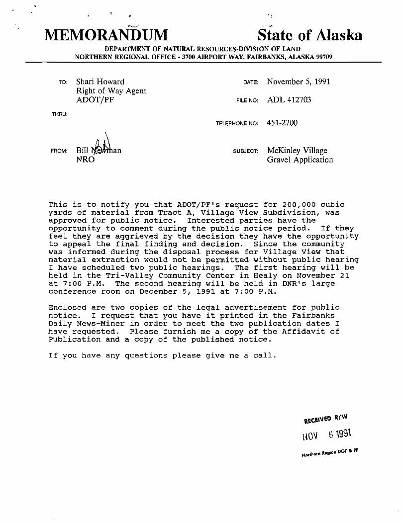
This is to notify you that ADOT/PF's request for 200,000 cubicyards of material from Tract A, Village View Subdivision, wasapproved for public notice. Interested parties have theopportunity to comment during the public notice period. If theyfeel they are aggrieved by the decision they have the opportunityto appeal the final finding and decision. Since the communitywas informed during the disposal process for Village View thatmaterial extraction would not be permitted without public hearingI have scheduled two public hearings. The first hearing will beheld in the Tri-Valley Community Center in Healy on November 21at 7:00 P.M. The second hearing will be held in DNR's largeconference room on December 5, 1991 at 7:00 P.M.
Enclosed are two copies of the legal advertisement for publicnotice. I request that you have it printed in the FairbanksDaily News-Miner in order to meet the two publication dates Ihave requested. Please furnish me a copy of the Affidavit ofPublication and a copy of the published notice.
If you have any questions please give me a call.
lR.9ionDOTa.PF
STATE OF ALASKADEPARTMENT OF TRANSPORTATION AND PUBLIC FACILITIES
ADL Number 412703Preliminary Finding and Decision
PROPOSED ACTION:
1. Requested Action: Negotiated Material Sale under AS 38.05.810 from Tract A,ASLS 83-194.
2. ADL Number: 412703
3. Case Type Code: 561-6601
4. Amount and Type of Resource Requested: 200,000 cubic yards of gravel overa ten year period.
5. Context of Request: Materials are needed for the continued upgrade andimprovements to the Parks Highway. The existing source is depleted and thisalternate source is requested.
AUTHORITY:
The application is being adjudicated pursuant to AS 38.05.115, AS 38.05.810, AS38.05.120 and 11 AAC 71.005 - 280.
ADMINISTRATIVE RECORD:
This application was received on March 18,1986. Following in-house and agencyreview it was decided to place this application on a hold status pending thedepletion of the site commonly referred to as the McKinley Extraction Site locatedon Tract D of ASLS 83-194. This site is under casefile ADL Number 408733.During the public review Mr. Gordon Haber, private owner of land near this site,expressed his concern about the opening of this site. Since he expressed thisconcern he was informed that we would not open this site for extraction until fullpublic notice and review had been accomplished even though this site received fullpublic review and comment under the subdivision design and sale. This area wassubdivided and sold both as a subdivision lottery and homesite entry area. TractD was reserved as a material source site. Tract D is currently close to depletion,hence the processing of this application. The Preliminary Decision and Final
Preliminary Finding and DecisionADL Number 412703Page 2
Finding for that sale has been extensively referred to in the development of thisdecision. Also incorporated by reference are: 'The Tanana Basin Area Plan"(TBAP), 1990; Susitna Basin Planning Report, "Scenic Resources Along the ParksHighway", 1981.
LOCATION:
1. Geographic: The site is located on the south side of the George ParksHighway, milepost 230, within the Village View Subdivision. The property to thenorthwest is under private ownership. AHTNA Corporation owns the land to thesouthwest. Mt. McKinley National Park is located approximately a mile to thesouth. McKinley Village is located approximately one half mile to the northeast.
The general features of the area can best be described as rolling terrain with twosteep hills, covered by spruce, aspen and birch trees up to 40 feet tall, willows,and a mixture of less dominant vegetation. The aesthetics of the area aretremendous-characterized by panoramic views in several directions over lakes,valleys, rivers and forests to the high mountain backdrops. There are no adversenatural hazards.
There is considerable commercial activity in the area. Besides the mining activity,there are two river rafting companies, one lodge, a general contractor, big gameguide service, and aircraft charter service.
2. Borough/Municipality: Denali Borough.
3. Alaska Coastal District: Not located within a coastal district.
4. Regional/Village Corporation/Councils: AHTNA Regional Corporation, Inc. andDoyon, Ltd.
5. USGS Map Coverage: May be viewed on USGS Healy C-4.
6. Legal Description: Tract A, Alaska State Land Survey 83-194 being a portionof the SW1/4 SW1/4 of Section 36, Township 14 South, Range 7 West of theFairbanks Meridian. This property was originally surveyed as part of U.S. Survey5566. The site contains 6.721 acres, more or less.
Preliminary Finding and DecisionAOL Number 412703Page 3
TITLE:
1. Acquisition Authority: The State of Alaska selected this land as a GeneralGrant, casefile General Selection 1507, under the Statehood Entitlement Act.
2. Title Status: Patented. The State received patent under this entitlement onMarch 29, 1985 under Patent Number 50-85-0295.
3. Title Restrictions: A right-of-way for ditches or canals constructed by theauthority of the United States. Act of August 30,1890, 26 Stat. 391, 43 U.S.C. 945.A portion of ASLS 83-194 is subject to an Easement Vacation, however, thisvacation does not affect Tract A. The plat indicates a 50 foot section lineeasement along the south lot line of Tract A.
4. Other Conflicting and Pending Interests: A lease application for a one acre sitehas been received by the Northern Region. The applicant would like to constructa commercial campsite and related facilities in the area bordering the entrance toDenali National Park and Preserve.
BACKGROUND:
1. Chronological Background: As stated above this area was part of a state landdisposal area known as the Village View Subdivision. The disposal included bothsubdivision lots by lottery and homesite entry lots.
2. History: The history for this property is detailed in the files for the disposalaction. This tract was reserved for state retention. Tract D is reserved as a sourceof gravel for the McKinley area.
PLANNING AND CLASSIFICATION:
The subject parcel is currently classified Settlement (NC-83-024). The parcel iswithin the Nenana River corridor, subunit 4C-1 of TBAP. Primary surface usedesignation is settlement and the secondary disignation is public recreation/wildlife habitat. Under TBAP guidelines the state land is retained in publicownership for multiple use management. The emphasis is on managing recreationand maintaining fish and wildlife habitat. TBAP states that the highest priorityshould be to use existing material sources and to minimize the construction andmaintenance cost of transportation facilities, material sites should be located as
Preliminary Finding and DecisionADL Number 412703
near as is feasible to the site where the material will be used. Mineral ClosureOrder 377 has been placed on the parcel. TBAP does allow for new developmentwithin the corridor to the extent feasible and prudent and visually screened fromthe public. This portion of the corridor is recommended for State Recreation Riverstatus.
The Susitna Basin Planning Report: "Scenic Resources along the Parks Highway",recommends the "McKinley View" area for future development because of theexisting development and the area's moderate to low scenic resource value.
TRADITIONAL USE FINDING:
The area has traditionally been used for general camping by the public.
WATERBODIES:
No waterbodies are affected by this action. The Nenana River is located a halfmile to the north of the subject property and no effects will be experienced onnavigation by this proposed action. This portion of the Nenana River has beendetermined to be non-navigable.
ACCESS:
Access to the lot is via the Parks Highway. The south lot line is the section lineseparating Section 36, Township 15 South, Range 7 West of the FairbanksMeridian and an easement of 50 feet in width is reserved. There are no trailscrossing the subject site.
SURVEY AND APPRAISAL
The site is currently surveyed as part of the Village View Subdivision. Additionalsurvey will not be required. An appraisal will also not be required since thisapplication is being processed under AS 38.05.810, Public Use.
AGENCY COMMENTS:
1. Alaska Department of Fish and Game: No objection or comment on this permit.
Preliminary Finding and DecisionADL Number 412703Page 5
2. Alaska Department of Environmental Conservation. No response.
3. Alaska Department of Transportation and Public Facility. Supports the requestand offers no further comments or objections.
4. Alaska Division of Parks and Outdoor Recreation. No response.
5. Alaska Division of Mining. No Response
6. Alaska Division of Forestry. Firewood is in short supply in this immediate area.All firewood should be salvaged for public use. It is requested that a stipulationbe placed on the contract which would require that all trees over six inchesdiameter be hand felled, limbed and stacked in an area accessible to the public.
7. Alaska Division of Land. Informed that a competitive lease has also beenapplied for on this parcel. Applicant has requested the entire parcel. Possiblenegotiations are currently in progress between the ADOT\PF and the applicant.The applicant may be able to utilize only one acre for his proposed project. Arecommendation was made that a 50 foot easement along the section line bereserved for future access.
Adhere to the TBAP guidelines that the site be visually screened. The area to theeast is classified as settlement and along the river as public recreation/wildlifehabitat. The proposed use appears to be consistent with the TBAP.
8. CZM/OMB. The site is not within the Coastal Zone and does not requirecoastal review.
9. Mental Health. This material site is not located on Mental Health Trust landsand is not affected by the current litigation.
10. Municipality. This site is not located within or near a municipality.
11. Borough: The parcel is within the boundaries of the newly formed DenaliBorough. The borough does not have zoning authority at this time.
12. Alaska Division of Parks and Outdoor Recreation/SHPO: Should cultural orpaleontological resources be discovered as a result of material excavation werequest that the activity which would disturb such resources be stopped and theDivision of Parks and Outdoor Recreation, Office of History and Archaeology becontacted immediately.
Preliminary Finding and DecisionADL Number 412703Page 6
ENVIRONMENTAL RISK ASSESSMENTS:
The environmental risks associated with this proposed action is considered to besmall. A mining plan has been submitted as part of the application which hastaken into consideration rehabilitation following depletion of the resources. An on-site inspection failed to note any current environmental injury.
BONDING AND INSURANCE:
Bonding and insurance will not be required. The applicant is a state agency andthe permit is being processed under 38.05.810, Public Use.
ALTERNATIVES:
1. Denial of the application:
If the application is denied the material will have to be acquired from an alternativesite. The closest state owned site would be in the Cantwell area. Costs fortransportation of the materials would be prohibitive considering the distancetraveled to and from the site and the time involvement. This would, however,would leave the parcel in an undisturbed state, adhering to the strictestinterpretation of the TBAP in the preservation of the Nenana River Corridor for itsrecreational and scenic character. Or, it would permit the state to lease to theadjacent landowner for development as a commercial campsite.
2. Denial of the application for preference of an alternative site:
Tract D, Village View Subdivision is currently being used as the gravel resource sitefor this portion of the Parks Highway. This site was originally approved for materialextraction by the BLM since 1950 and has been in constant use since. This wasthe source for materials when the original Denali Highway was constructed toprovide automotive access to Mt. McKinley Park. Subsequent construction of theGeorge H. Park's Highway as a major road link between the two largest cities hasrequired use of the site in construction and maintenance of the highway. FollowingTentative Approval the ADOT/PF submitted a material application for continued useof this site on June 10, 1982. A request to expand the site was received on June21, 1983 stating that expansion is of extreme importance for the continuation ofeconomical road maintenance. Much of the land in this area has been conveyedto AHTNA, Inc. and the National Park Service and established sources are scarce.This site is the sole active source for durable sandy gravel suitable for supplyingmaterial needed for paving and concrete aggregate within haul distance.
Preliminary Finding and DecisionADL Number 412703
i7
Similar alluvial material is not available for fifteen miles to the north. Comparablealluvial material is available to the south at a distance of four miles but is extremelylimited in its resources. This would not meet the maangement guidelines of TBAPwhich states that material sites are to be located as near as is feasible to the sitewhere the material will be used.
At a public meeting held at McKinley Park to discuss the Village View Subdivisionon March 6, 1984, the local residents felt the existing material site and theproposed expansion offered conflicts with the proposed residential subdivision.During this review process Tract A was discussed as a good future materialsource. It was decided that the ADOT/PF would continue to use Tract D andsubmit an application for Tract A. Further, because the unique quality of thematerial from the existing pit the ADOT/PF was permitted continued use with thestipulation that the pit would not exceed twenty feet in depth. This would leave avery useable community site for public related purposes.
An alternative considered is to permit the extraction to a depth greater that thetwenty foot stipulation placed on the contract. This alternative would also reopenthe site for third party users.
3. Approve the request:
Approving the request would provide the state and the public a viable gravelsource in the McKinley area. The closest state source for public use is the DryCreek site. The site could be developed in such a manner as not to be obtrusiveto the casual automotive visitor. The terrain is steep and access would be alongthe lot line furthest from the highway. The opening of this site would leave TractD available for other uses, i.e., public, leases, residential, etc.
COMMENTS:
Soil borings have been conducted on this site. The soils observed in theexploration can be described as comprising a three layered system with all boringscontaining gravels of varying silt contents. The test holes revealed that most of thesite contains soils suitable for roadway construction and maintenance.
Layer one consists of a thin organic mat which generally did not extend below onefoot in depth. Layer two consists of thin lenses of moderately to highly frostsusceptible sands and silts. Layer three was generally non-frost susceptible sandygravel. Details of the soil investigation may be found in the Village ViewSubdivision file.
Preliminary Finding and DecisionADL Number 412703Page8
A detrimental effect of gravel extraction may be to the recreational community. Thearea receives heavy use for berry picking, photography, and cross country skiing.The extraction may be viewed as not amenable to the pristine attitude of thesurrounding area. This site being located within the Alaska Range offers views ofthe surrounding mountains from all locations. Some locations offer vistas of theNenana River Canyon at McKinley Village.
There is no known evidence of major historical or archaeological points of interestwithin the immediate area.
To the immediate west of the property is private land. A waste and screen areaof 200 feet in width will be utilized. The site would be excavated in levels until theroad level is attained. Mining depth is not expected to exceed ten feet.
Gravel is an important mineral in this area and existing source sites are few. TheAHTNA Native Regional Corporation and the Alaska Railroad each have extractionsites, however, the ARR site is not open for public use. This site was recognizedas a potential material source for several years and is believed to be a viable publicsource for the McKinley area. An alternative reviewed is the denial of the request.This was not the preferred choice since it does nothing to relieve the public needfor gravel nor does it present a solution to the closure of the existing source site.
No adverse effect will be experienced by water right holders in the area. The watertable is below that of the extraction area. Erosion potential will be taken intoconsideration during the extraction period. A mining plan will be required whichwill specifically address possible erosional problems. Since this site is not locatednear the Nenana River there will be no impact on the fish habitat nor therecreational (commercial) raft users.
Rehabilitation of the site will be in accordance with the mining plan. The site hasthe potential for commercial use once the material has been depleted similar to theHornet Creek Pad just north of this site.
The McKinley View pit is the only state source of quality material available in thearea. This site has in the past served the material needs of the ADOT/PF and ofthe general public. The problem of maintaining material availability for all userswas compounded by a complaint and lawsuit by Mr. Gordon Haber, who stridentlyopposed the expansion of this site. Local residents requested that the pit belimited to a depth of no more than twenty feet. Due to this restriction the resourceavailability suddenly became quite scarce and the site was closed to the generalpublic use. The nearest public use area is at Dry Creek in Healy. There arecommercial sources available from AHTNA, Inc. or from the Alaska Railroad.
Preliminary Finding and DecisionADL Number 412703Page9
A field trip was conducted on August 14, 1991. Timothy Stevens, NRO; JackReisland, owner of the adjacent parcel who has requested to lease the subjectproperty; Mr. Gordon Haber; and Bill Newman, NRO, were present. Duringdiscussion of both proposals the entire tract was walked. Mr. Reisland explainedhis proposition for this property and his concerns over the lack of public campingfacilities in the area around the National Park. Mr. Haber expressed adamantopposition to the material site. He emphasized that ADOT/PF should find anothersite away from this particular area. His repeated suggested area was Cantwell orDry Creek.
RECOMMENDATION:
The discussion regarding this site has been continuous since 1985. It was theDivision's recommendation that the ADOT/PF consider and apply for Tract A forits future material resource needs following the depletion of the active site on TractD. This was discussed at public meetings and has been a matter of public record.It is recommended that extraction be permitted from the new site as stated inalternative 3. No new evidence has been offered to alter that decision. If, followingpublic review, it is decided not to issue the contract, it is recommended thatconsideration be given to permitting the allowable extraction depth imposed on theMcKinley Village Pit be removed.
The following stipulations are proposed to be attached to the material contract:
1. No material removals are authorized under this contract unless in accordancewith the approved mining plan and Special Provisions of the contract. The SpecialProvisions of the contract shall take precedence over the approved mining planshould there exist a contradiction between said mining plans and SpecialProvisions. Gravel removal operations will commence only upon receipt ofapproval from the Division of Land.
2. This contract authorizes removal only from that area defined in 1 (a) of theSpecial Provisions of the contract. Approvals will be required for each material sitefrom which removals are to be made.
3. The Division of Land reserves the right to suspend removal operations fromapproved material sites and to designate alternate sites. Purchaser shall have theright to request reconsideration of such action and to be heard on its requestwithin seventy-two (72) hours of requesting reconsideration. A decision shall bemade by the Director within five (5) days after hearing the request.
4. Any overburden material including but not limited to topsoil, peat, sand ororganic material used for any purpose shall be accounted for as in Section 2
Preliminary Finding and DecisionAOL Number 412703Page 10
above and paid for as in Section 1 (b) of the Special Provisions of the contract.
5. The purchaser shall maintain the pit in a graded, clean and orderly condition.Access to other areas of the pit shall not be blocked or impeded.
6. The Alaska Historic Preservation Act (A.S. 41.35.000) prohibits theappropriation, excavation, removal, injury or destruction of any historic, prehistoric,or archaeological resources of the State. No historic site, archaeological site, orcamp, either active or abandoned, shall be disturbed in any manner nor shall anyitem be removed therefrom. Should any sites be discovered during the course offield operations, all operation will be suspended immediately and the Division ofLand promptly notified. (6 AAC 80.150)
7. Upon completion of the activities rehabilitation and restoration of disturbedareas will be required. All stockpiles of materials will be accounted for andremoved from the site. (6 AAC 80.140)
8. All gravel extraction will be completed in accordance with the approved miningplan for this site.
9. GRAVEL EXTRACTION IN EXCESS OF THE CONTRACTED AMOUNT WILL BECONSIDERED TAKEN IN TRESPASS AND AT THE DISCRETION OF THEDIRECTOR OF THE DIVISION OF LAND CHARGED TO AND PAID FOR BY THEBUYER AT NO LESS THAN TRIPLE THE UNIT CONTRACT PRICE OR UP TOTHREE TIMES THE PECUNIARY GAIN REALIZED BY THE BUYER AS A RESULTOF THE TRESPASS. SAID TRESPASS PENALTIES ARE IN ADDITION TO ANYOTHER ADMINISTRATIVE OR LEGAL PROCEEDINGS IMPOSED BY STATE LAW.
10. Marketable timber (6" DBH and larger) will be salvaged. The timber will bestacked in an accessible area not susceptible to water flood and made availableto the public.
11. This contract does not obviate nor preclude the necessity to obtain otherpermits that may be required by law or regulation.
12. As per the guidelines of the Tanana Basin Area Plan (pg 2-22) the site will bescreended from roads, residential areas, and other areas of significant human use.
Preliminary Finding and DecisionADL Number 412703Page 11
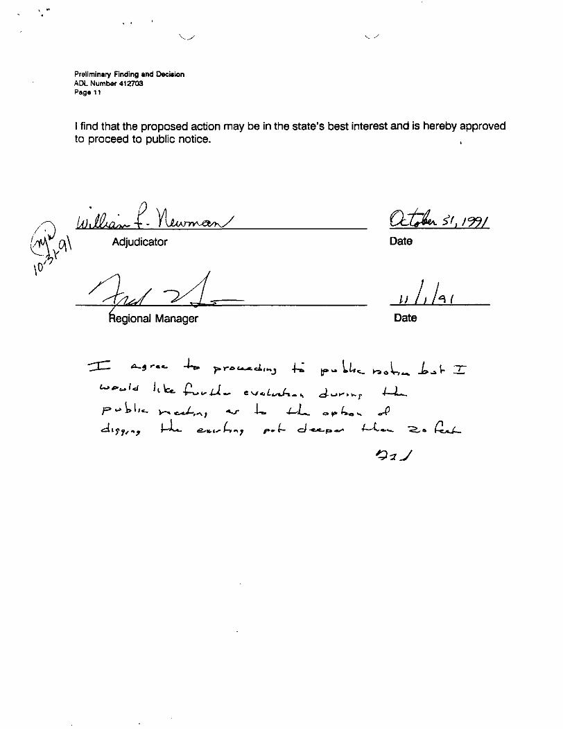
I find that the proposed action may be in the state's best interest and is hereby approvedto proceed to public notice.
Adjudicator
'l/99/Date
Regional Manager
I) ULDate
"'J1?'"4^ 1— '~«- fixn,c^H( 7 f-*-
MEMORANDUM State c 'AlaskaDEPARTMENT OF NATURAL RESOURCES - DIVISION OF LAND AND WATER MANAGEMENTNORTHERN REGIONAL OFFICE - 4420 AIRPORT WAY, FAIRBANKS, ALASKA 99709
TO: Shari HowardDOT/PF
THRU:
DATE:
.FILENO:
; 198g
^ 4 Q 8 7 3 3
TELEPHONE NO: 479 -2243
SUBJECT: Material Sale Contract
FROM: ^/Frederick L. SmithI Natural Resource Manager
I
RECEIVED R/W
MAY 16 1988
Northern Region DOT & PF
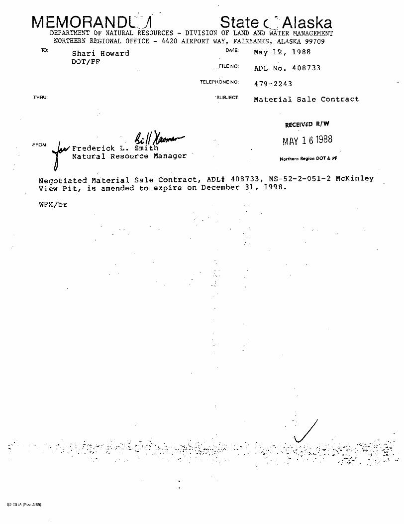
Negotiated Material Sale Contract, ADL# 408733, MS-52-2-051-2 McKinleyView Pit, is amended to expire on December 31, 1998.
WFN/br
02-001A (Rev. 8/35)
DEPARTMENT OF TRANSPORTATION AND PUBLIC FACILITIES
NORTHERN REGION, DESIGN AND CONSTRUCTION
STEVE COWPER, GOVERNOR
2301 PEGER ROADFAIRBANKS, ALASKA 99709-5316PHONE: (907) 451-22OO
November 17, 1987
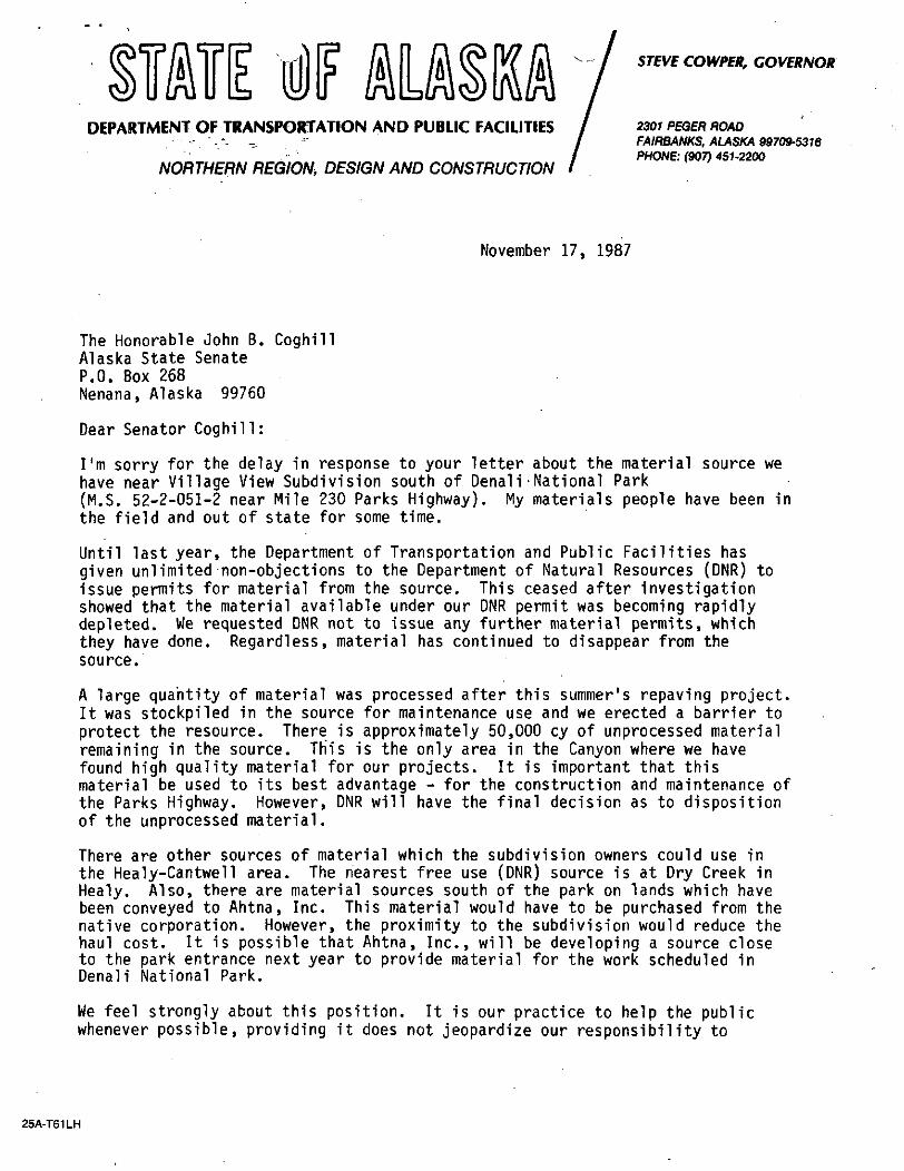
The Honorable John B. CoghillAlaska State SenateP.O. Box 268Nenana, Alaska 99760
Dear Senator Coghill:
I'm sorry for the delay in response to your letter about the material source wehave near Village View Subdivision south of Denali-National Park(M.S. 52-2-051-2 near Mile 230 Parks Highway). My materials people have been inthe field and out of state for some time.
Until last year, the Department of Transportation and Public Facilities hasgiven unlimited non-objections to the Department of Natural Resources (DNR) toissue permits for material from the source. This ceased after investigationshowed that the material available under our DNR permit was becoming rapidlydepleted. We requested DNR not to issue any further material permits, whichthey have done. Regardless, material has continued to disappear from thesource.
A large quantity of material was processed after this summer's repaying project.It was stockpiled in the source for maintenance use and we erected a barrier toprotect the resource. There is approximately 50,000 cy of unprocessed materialremaining in the source. Th'is is the only area in the Canyon where we havefound high quality material for our projects. It is important that thismaterial be used to its best advantage - for the construction and maintenance ofthe Parks Highway. However, DNR will have the final decision as to dispositionof the unprocessed material.
There are other sources of material which the subdivision owners could use inthe Healy-Cantwell area. The nearest free use (DNR) source is at Dry Creek inHealy. Also, there are material sources south of the park on lands which havebeen conveyed to Ahtna, Inc. This material would have to be purchased from thenative corporation. However, the proximity to the subdivision would reduce thehaul cost. It is possible that Ahtna, Inc., will be developing a source closeto the park entrance next year to provide material for the work scheduled inDenali National Park.
We feel strongly about this position. It is our practice to help the publicwhenever possible, providing it does not jeopardize our responsibility to
25A-T61LH
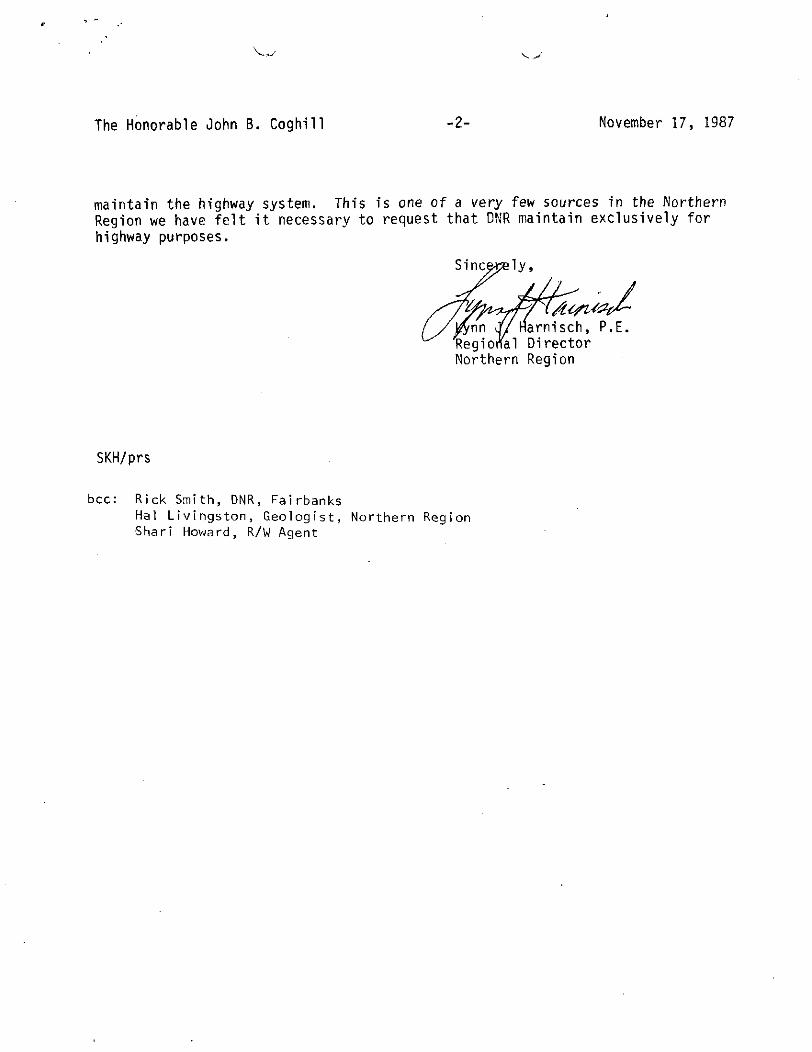
The Honorable John B. Coghill -2- November 17, 1987
maintain the highway system. This is one of a very few sources in the NorthernRegion we have felt it necessary to request that DNR maintain exclusively forhighway purposes.
Sine
• /'2f/^arnisch, P.E.
'Regional DirectorNorthern Region
SKH/prs
bcc: Rick Smith, DNR, FairbanksHal Livingston, Geologist, Northern Region•Shari Howard, R/W Agent
MEMORANDUM f Stave of AlaskaDepartment of Transportation & Public Facilities
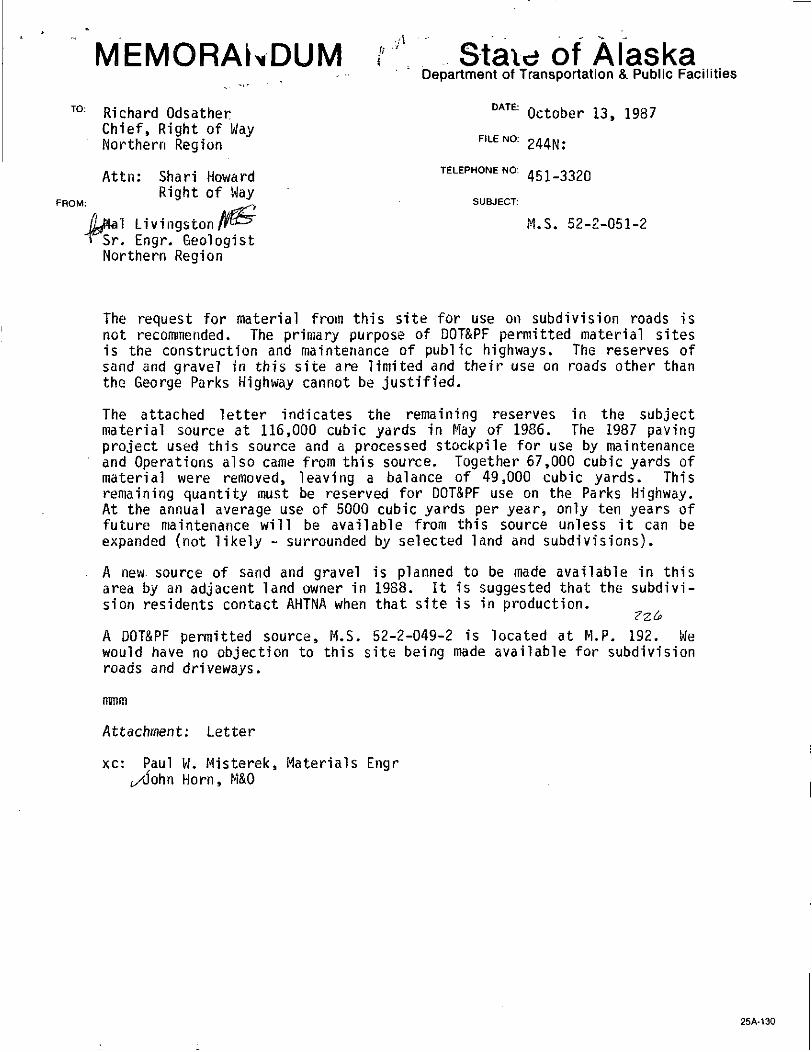
T0: Richard Odsather DATE: October 13, 1987Chief, Right of WayNorthern Region FILENO: 244N:
Attn: Shari Howard TELEPHONE NO: 451.3320
Right of WayFROM: 3 * SUBJECT:
1 Livlngston/r^ M.S. 52-2-051-2Sr. Engr. GeologistNorthern Region
The request for material from this site for use on subdivision roads isnot recommended. The primary purpose of DOT&PF permitted material sitesis the construction and maintenance of public highways. The reserves ofsand and gravel in this site are limited and their use on roads other thanthe George Parks Highway cannot be justified.
The attached letter indicates the remaining reserves in the subjectmaterial source at 116,000 cubic yards in May of 1986. The 1987 pavingproject used this source and a processed stockpile for use by maintenanceand Operations also came from this source. Together 67,000 cubic yards ofmaterial were removed, leaving a balance of 49,000 cubic yards. Thisremaining quantity must be reserved for DOT&PF use on the Parks Highway.At the annual average use of 5000 cubic yards per year, only ten years offuture maintenance will be available from this source unless it can beexpanded (not likely - surrounded by selected land and subdivisions).
A new. source of sand and gravel is planned to be made available in thisarea by an adjacent land owner in 1988. It is suggested that the subdivi-sion residents contact AHTNA when that site is in production.
A DOT&PF permitted source, M.S. 52-2-049-2 is located at H.P. 192. Wewould have no objection to this site being made available for subdivisionroads and driveways.
mmm
Attachment: Letter
xc: Paul W. Misterek, Materials EngrHorn, M&O
25A-130
Pouch V
Juneau. Alaska 99811(907)4654921
Box 55028
Xonh Pole. Alaska 99705(907)488-0862
Alaska Jl»tale
October 5, 1987
v/
CHIEF R/W AGENT
PRE AUDIT
ENGINeEfsiMG
TITLE
FLANS
JMATEWAIS
JAPPHAia-tlo
* NS2CTSA71CW3
' !&L->
<~-*i
$L^
FiEUJCA^iOfM^^O?. ;V«3MT. |
I
RET WN TO:
FILE I
0>
•oJP-• •— m
JB-
• >">--^^or
«ZC3
'5»5^rnm-noo• m~~ 1
°0
^Lynn HarnischNorthern Regional DirectorDept. of Transportation2301 Peger RoadFairbanks, AK 99709
Dear Lynn:
My office has been contacted by the landowners of the VillageView subdivision, M.P. 230 of Parks Highway, regarding theusage of a gravel pit that is within the subdivision toimprove the roads in the subdivision. The lottery for thisdisposal was held in December 1985.
We have been in contact with the Department of NaturalResources, and they have informed us that the reserves in thepit belong to D.O.T. Would it be possible for D.O.T. to issuea permit to the subdivision residents allowing them to use thegravel for the purpose of improving their roads? Weunderstand that each landowner would have to apply for apermit.
Lynn, if this particular pit cannot be used, I wouldappreciate any assistance you can give to help the subdivisionresidents gain access to another gravel pit. If you have anyquestions, please feel free to give me a call.
I look forward to your response.
Sincerely,
S nat/or Jack Coghill
TBC/slg
cc: Alan Seegert
I/
^y
N03TMESN n33:ON
R^ciinnnl Director
DtC Dir-cfT
Ptsrrir," ": ~i--??rch C!i!nf
Artm. S?rv. r.V\c-'
r^TO Eii-rcv.r £?
'Lp.^n? O'iiTor
I,-)i: -o:.".;r?! D'r. Vi:/<ci
VvE.~?-rr 2". f.?mt
P!rn-r^V
/*
MEMORANDUM State of AlaskaDEPARTMENT OF NATURAL RESOURCES - DIVISION OF IAND 2ND WATER MANAGEMENT
NORTHERN REGION - 4420 AIRPORT WAY, FAIRBANKS, ALASKA 99709TO:
FROM:
Harold A. CameronChief Right of Way agentNorthern Region
Chris Guinn/j6,Chief - Operations
DATE:
FILE NO:
TELEPHONE NO:
SUBJECT:
July 30, 1986
479-2243
ADL 408733
The Department of Natural Resources (DNR) will authorize DOT and^rS^Xtrac^ion of 9ravel below a 20-foot depth in material siteADL 408733 ("McKinley Village Site") for an amount equal to thatauthorized for extraction by users other than DOT and PF duringthe 1986 construction season provided the alternative site ADL412703 is not estabished by the 1987 construction season. DNRexpects to authorize approximately 20,000 c.y. this summer.
LJK/ps
/^
Chief R/W AgentAdministrationAirportsAppraisalsEp^tffeering
^MaterialsNP .CationsP'-e-»V-ditRein. & Prop. Mgt.Title
Return to:File
'sZZ&L
r"
• ' •'•->
. . . ^».02-001A(Rpv 10/79)
TO:
FROM:
'— -ttUW- - ™ ^fc?5S?S«« «. »»»«' ««» ^
DATE: April 22, 1986Harold CameronChief Right of Way Agent FILE NO:Northern RegionDOT/PF TELEPHONE NO: ^_22^
Frederick L. Smith J YIDLWM, Northern RegionRetained Lands Section
SUBJECT:ADL 408733
The legal deScription of yo-r contractread Tract D of ASLS 83-194.
408733 is amended to
FLS/LJK/ps
m•
v/
Chief R/W AgentAdministrationAirportsAppraisalsEngineeringMaterialsNegotiationsPre-Audit
Rein. & Prep. Mgf.Title
Return to:
File
J%&^
xO
w. -
1
02.001A(Rev. 10/79)
. MEMORANDUM
TO Harold CameronChief, Right of WayNorthern Region
Attn: Shari Howard.
FROM: Hal Livingston /&*Sr. Engineering GeologistNorthern Region
AlaskaDepartment of Transportation & Public Facilities
DATE: Hay 15f
FILE NO: 244N:
TELEPHONE NO: 451-2230
SUBJECT: Material needs inthe McKinley Park areaof the Geo. Parks HwyM.S. 52-2-051-2
Calculations of remaining gravel reserves against future use in the sitegives the following information:
Site excavated to 20 ft. depth, including the expansion area withallowances for slopes of 1.5:1 and a safety factor of 1.35 = 116,400cubic yards of gravel reserve.
One repaving project in the area of McKinley Park and halfway to the nextsource south will require 100,000 c.y. One reconstruction project in thesame interval will require 150,000 c.y. from this site.
Maintenance needs from this site will be about 2000 c.y. per year.
Conclusion: This site will be depleted of material at the end of the nextrepave or reconstruction project. These will most likely be done within thenext 15 years.
Use of the site by others is not in the interest of the State of Alaska.
Quantities
Test holes show silty overburden to an average depth of 1.5 feet and cleangravel below that to a drilled depth of 10.0 ft.
A 800 x 500 x 1.5 - Waste 22,200 c.y.
Known 8.5 ft. gravelB 800 x 500 x 8.5 = Gravel
27= 125,925 c.y.
C 400 x 500 x 15 = Excavated .- ; 27 : - . Gravel = 111,100 c.y.
B - C = Remaining gravel =' 125,900 - 111,100 = 14,800
Assume 20 ft. gravel " "-" . " .800 x 500 x 20 = 296,296 c.y. ; " •• \ ; • . - " • . - - -
•• . 27 • . -•----• . - . • - " ' - ' • ' - . ' - ' • ' . - . - -
...... . - . r Q : ..,.v^Cameron • _' Page 2 May 15, 1986
296.000 - 111,000 = 185,000 c.y.185,000 c.y. - slope allowance 15%-(27750) = 157,200 = 116,400 c.y.
1.35
If all local use is stopped this site will provide material for maintenanceand one repaVing project in the next 15 years.
xc: Paul W. Misterek, Materials EngrW. Slater, Chief Geotech Engr

• ;: ";<i:-!; l ;,£-::^:
B L 0 C K
±-ZW,mJ:'-H^teua:
EXISTINGMATERIAL • LOCATION MAP
Scale l"= I Mile
STATEOFALASKALot 2-A
U.SS. 5565DEPARTMENT OF TRANSPORTATION
. AND PUBLIC FACILITIES
ARC =78.54R,= 50.00*! K ..'
v PLAT. SHOWING MATERIAL SOURCE. REQUIRED: FOR
and Screen Area
A L A S K A PROJECT NO.r FAP 522S3I°2347"E N89°56'53 E I
PARCEL NO. M.S. 52-2-051-2DATEv2/l2/86.
SCALE l"=200'
DRAWN BY L.L.
MEMORANDUM
TO:Harold Cameron, ChiefRight-of-WayNorthern Region
Attn: Shari HowardROM Agent
State of AlaskaDepartment of Transportation & Public Facilities
DATE: April 28, 1986
FILE NO: 244N.'
TELEPHONE NO: 451-2228
FROM:
Hal LivingstSr. EngineerNorthern Reg
SUBJECT:
GeologistM.S. 52-2-051-2Critical CrusherSource
This site is one which has been in use since 1950 when the original OenaliHighway was constructed to provide automotive access to Mt. McKinley Park inthe 1950's. Subsequent construction of the George H. Park's Highway as amajor road link between the two largest cities in the state has required useof the site in construction and maintenance of this Federal Primary Highway.Other use of this site has been requested by the National Park Service, byState Subdivision developers, and by private citizens within ten miles northand south of the site. Alluvial gravel suitable for crushing and use inasphalt paving, concrete aggregate, crushed D-l, crushed base material, andBorrow Type A and Type B are all available from this source.
The presence of Mt. McKinley (Denali) National Park immediately north of thissite means that no material of any kind is available for seven miles north.Similar alluvial material 1s not available for fifteen miles north. Compara-ble alluvial material 1s available to the south at a distance of four milesbut it is a very small source with limited reserves. The next site 1s sixmiles distant.
Because M.S. 52-2-051-2 is the sole source for durable sandy gravel suitablefor supplying material needed for paving and concrete aggregate within a hauldistance of twenty-one miles along this segment of the Parks Highway, it isrequested that exclusive use of the site be reserved to the Department ofTransportation and Public Facilities (DOT&PF). Further, it is recommendedthat diligent efforts be made to locate and make available to DOT&PF addi-tional sources of similar material in the vicinity of this site. Long termneeds (50 years plus) will exceed the reserves presently in the sole source(M.S. 52-2-051-2), probably within 20 years. If additional sources are notidentified and reserved now, future highway construction costs will benecessarily inflated by having to haul gravel very long distances. Prelimi-nary information available now indicates that similar durable alluvial gravelis present in the vicinity on State land (Sec 36 T 14S, R7W).
Please consider the above Information and contact the Alaska Division ofLands so that the necessary steps can be taken to reserve adequate quantitiesof gravel for construction and maintenance of public highways.
mmra
xc: Paul W. Misterek, Materials EngrWillard Slater, Chief Geotech. ServicesJohn Horn, Director, M&O
MEMORANDUM (Brief imunications) State of Alaska
523-051-2
02-001C(12/8O)
<f+ «i -Y
, w *
wiV
* 'L«'t!i V
'7>
ri•
;S
^Wv-^
: ,*sX" '^nra>
!iiWJ'avic/*'r
t_
'•'•.' / .' J^'"'*• t\'•f'?
;'c--'-'/•»-f:'>r-.rv.V
i-."
JoCr AS
MEMORANDUM State of AlaskaTO:
FROM:
Hike TinkerEnvironmental CoordinatorNorthern Region
Brian L. GannonEnvironmental AssistantNorthern Region
DATE:
FILE NO:
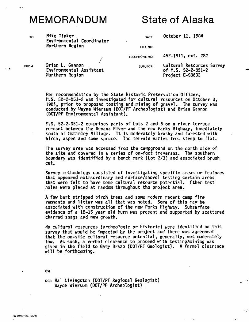
October 11, 1984
TELEPHONE NO: 452-1911, 6Xt. 28?
SUBJECT Cultural Resources Surveyof M.S. 52-2-051-2Project E-38632
Per recommendation by the State Historic Preservation Officer,M.S. 52-2-051-2 was investigated for cultural resources on October 3,1984, prior to proposed testing and mining of gravel. The survey wasconducted by Wayne Wiersura (DOT/PF Archeologist) and Brian Gannon(DOT/PF Environmental Assistant).
M.S. 52-2-051-2 comprises parts of Lots 2 and 3 on a river terraceremnant between the Nenana River and the new Parks Highway, immediatelysouth of McKinley Village. It is moderately brushy and forested withbirch, aspen and some spruce. The terrain varies from steep to flat.
The survey area was accessed from the campground on the north side ofthe site and covered in a series of on-foot traverses. The southernboundary was identified by a bench mark (Lot 2/3) and associated brushcut.
Survey methodology consisted of investigating specific areas or featuresthat appeared extraordinary and surface/shovel testing certain areasthat were felt to have some cultural resource potential. Other testholes were placed at random throughout the project area.
A few bark stripped birch trees and some modern recent carap fireremnants and litter was all that was noted. Some of this may beassociated with construction of the new Parks Highway. .Subsurfaceevidence of a 10-15 year old burn was present and supported by scatteredcharred snags and new growth.
No cultural resources (archeologic or historic) were identified on thissurvey that would be impacted by the project and there was agreementthat the on-site cultural resource potential, generally, was moderatelylow. As such, a verbal clearance to proceed with testing/mining wasgiven in the field to Gary Brazo (DOT/PF Geologist). A formal clearancewill be forthcoming.
dw
cc: Hal Livingston (DOT/PF Regional Geologist)Wayne Wiersum (DOT/PF Archeologist)
02-001A(Rev. 10/79)
DEPARTMENT OF NATURAL RESOURCES
DIVISION OF PARKS AND OUTDOOR RECREATION
September 19, 1984
Re: 1120-10
BILL SHEFFIELD, GOVERNOR
225A CORDOVA STREETANCHORAGE, ALASKA 99501PHONE: (907) 276-2653
MAILING ADDRESS:POUCH 7001ANCHORAGE, ALASKA 99510
Subject: Material Source 52-2-051-2 - Testing and MiningProject No. E88632
Mike TinkerEnvironmental CoordinatorDepartment of Transportationand Public Facilities
2301 Peger RoadFairbanks, Alaska 99701
Dear Mr. Tinker:
STATE HISTORIC PRESERVATION OFFICER
Our information indicates that this area has moderate potential for culturalresources. The project area is not very far from the Dry Creek Site, a veryold and significant prehistoric cultural resource. There are also severalother significant cultural resource sites in the area.
The proposed Material Site should be surveyed for cultural resources prior tothe Testing and Mining Project.
Judith E. BittnerState Historic Preservation Officer
STATE PARK PLANNING
No comment.
LAND AND WATER CONSERVATION FUND GRANT PROGRAM
No comment.
Sincerely,
Neil C. JohannsenDirector
MEM<TO:
FROM:
SUBJ.:
jRANDUMf Brief Communications) StdtC Of AldSkd
"'"VarAW^eoName
Dep,/DiV./Sec, ^QcQJJ fif
Dept./Div./Sect.
M «C •«r/ O» Oi^/y/j/^^
Mail Stop
Telephone
Date
pouts
I 02-0010(12/80)
SHIP 14 SX RAN' .... , J
7 W O F T H E F A I R B A N K S '~^TEfH91AN, A t 1
40O' ff/lf Per4OSOO9
PLO 16674dm. Site W-il
MT. McKINLEY NAT'L '.PARK
USS -2(77
\
X USS-2177/^ m. McKINLEY
•WR4O278S.Tent.Are.GS-I5O7• ' Ltr Ptr
200 IOO 0 500 SO35 IOOO
30 choirn to 6032 miters
MEMORANDUM (Brief Commriications) State of AlaskaTO:
FROM:
SUBJ.;
Dept./C>iv./Sect
r-v.
Mail Stop
Name
(4 CX( Llt/IIAQ
Dept./Div./Sect. Telephone
of
oF rj^ sfa/
P^^J^V vooT "to "tires-pas S
4oc^ me
-Sf*> .\£,ca I
CLAA.J
02-001 C( 12/80)
MEMORANDUM State uf AlaskaDEPARTMENT OF NATURAL RESOURCES - DIVISION OF LAND AND WATER MANAGEMENTNORTHCENTRAL DISTRICT OFFICE - 4420 AIRPORT WAY, FAIRBANKS, ALASKA 99701
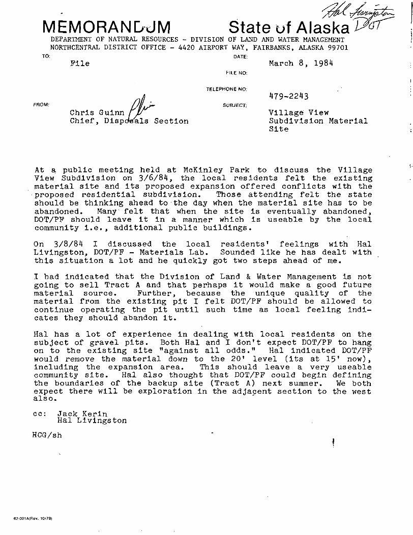
TO: DATE:
File March 8, 1984FILE NO:
FROM:
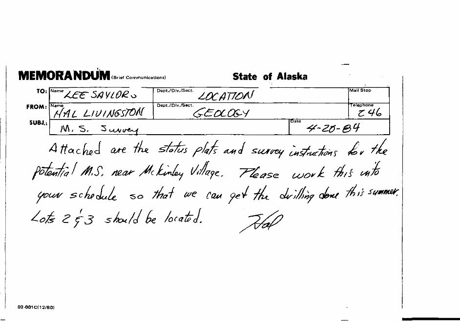
TELEPHONE NO.
SUBJECT:
Chris GuinnChief, Disposals Section
479-2243
Village ViewSubdivision MaterialSite
At a public meeting held at McKinley Park to discuss the VillageView Subdivision on 3/6/84, the local residents felt the existingmaterial site and its proposed expansion offered conflicts with theproposed residential subdivision. Those attending felt the stateshould be thinking ahead to the day when the material site has to beabandoned. Many felt that when the site is eventually abandoned,DOT/PF should leave it in a manner which is useable by the localcommunity i.e., additional public buildings.
On 3/8/84 I discussed the local residents' feelings with HalLivingston, DOT/PP - Materials Lab. Sounded like he has dealt withthis situation a lot and he quickly got two steps ahead of me.
I had indicated that the Division of Land & Water Management is notgoing to sell Tract A and that perhaps it would make a good futurematerial source. Further, because the unique quality of thematerial from the existing pit I felt DOT/PF should be allowed tocontinue operating the pit until such time as local feeling indi-cates they should abandon it.
Hal has a lot of experience in dealing with local residents on thesubject of gravel pits. Both Hal and I don't expect DOT/PF to hangon to the existing site "against all odds." Hal indicated DOT/PFwould remove the material down to the 20' level (its at 15' now),including the expansion area. This should leave a very useablecommunity site. Hal also thought that DOT/PF could begin definingthe boundaries of the backup site (Tract A) next summer. We bothexpect there will be exploration in the adjacent section to the westalso.
cc: Jack KerinHal Livingston
HCG/sh
02-001A(Rev. 10/79)
/
C
MEMORANDUM (Brief Com cations) State c AlaskaTO:
FROM:
SUBJ.:
Dept./Div./Sect. 'f Mail Stop
Name Dept./Div./Sect. Telephone
Date /•
-^ J/5/5W
02-001 C( 12/80)
"' "y^^ir '^sl-
• -i :%
'- H* -^
-
^^SM
M^^
STATE OF ALASKADEPARTMENT OF NATURAL RESOURCES
DIVISION OF LAND AND WATER MANAGEMENT ADL 408733
XXX
Northcentral District4420 Airport Way-
Fairbanks, Alaska 99701(907) 479-2243
Southcentral DistrictPouch 7-005
Anchorage, Alaska 99510(907) 276-2653
Southeastern District230 S. Franklin, Roan 407Juneau, Alaska .99801
(907) 465-3400
NEGOTIATED MATCTTAT. SALE CONTRACT
Under AS 38.05.110-38.05.120 (Disposal of Timber and Materials),AS 38.05.125 and AS 38.05.315(a) and the regulations implementing thesestatutes, the State of Alaska, the seller, agrees to sell, and The Departmentof Transportation & Public Facilities , the buyer, whose address is2301 Peger Road*, Fairbanks, AK 99701 agrees to buy, the materialdesignated in this contract, subject to the provisions which follow:
1. Description: Location, Material, Quantity, and Price. (a) The materialsale area covered by this contract consists of approximately N/A acresdescribed as follows: within Section 36, Township 14 South, Range 7 West,Fairbanks Meridian; the area designated by F-029734. /%5 <
This area is further designated by the boundaries shown on the attached salearea map, which is made a part of this contract, or as designated on theground by the seller.
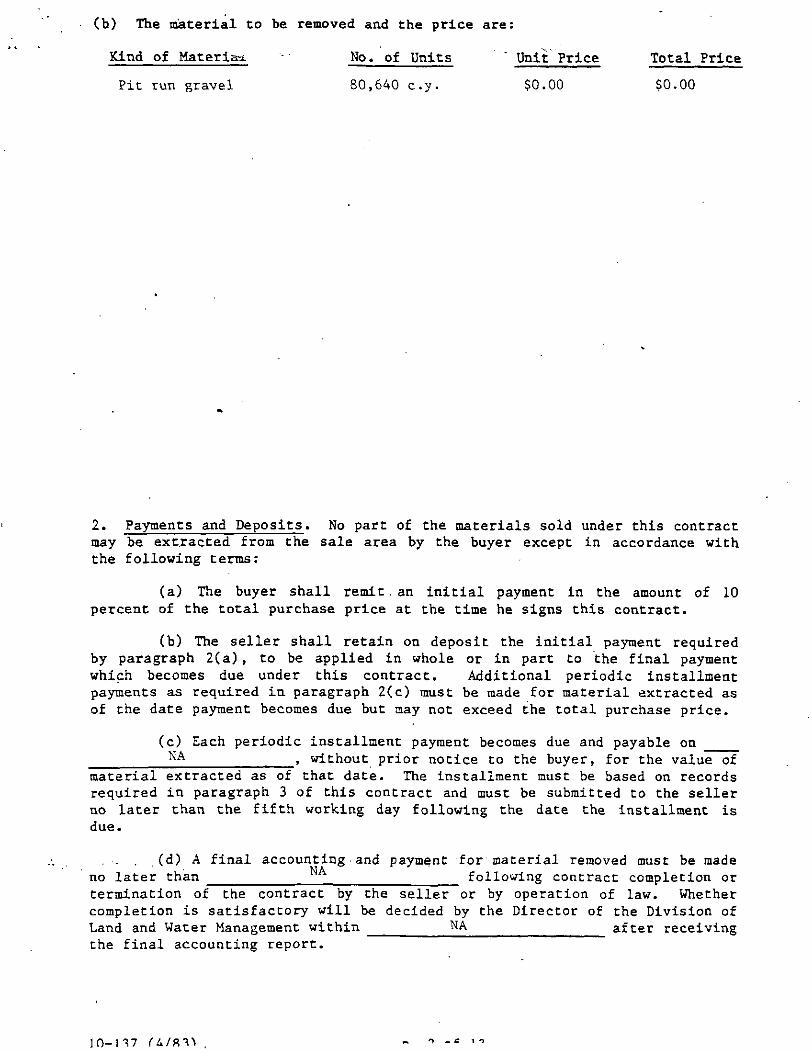
(b) The material to be removed and the price are:
Kind of Materiaa. - No. of Units " Unit Price Total Price
Pit run gravel 80,640 c.y. $0.00 $0.00
2. Payments and Deposits. No part of the materials sold under this contractmay be extracted from the sale area by the buyer except in accordance withthe following terms:
(a) The buyer shall remit . an initial payment in the amount of 10percent of the total purchase price at the time he signs this contract.
(b) The seller shall retain on deposit the initial payment requiredby paragraph 2(a) , to be applied in whole or in part to the final paymentwhich becomes due under this contract. Additional periodic installmentpayments as required in paragraph 2(c) must be made for material extracted asof the date payment becomes due but may not exceed the total purchase price.
(c) Each periodic installment payment becomes due and payable onNA , without prior notice to the buyer, for the value of
material extracted as of that date. The installment must be based on recordsrequired in paragraph 3 of this contract and must be submitted to the sellerno later than the fifth working day following the date the installment isdue.
. . . (d) A final accounting and payment for material removed must be madeno later than following contract completion ortermination of the contract by the seller or by operation of law. Whethercompletion is satisfactory will be decided by the Director of the Division ofLand and Water Management within NA after receivingthe final accounting report.
JO-M7
(e) If '. b jr fails to make a p lent ,rovided for in thiscontract, the seiner may, under paragraph 8(b) of this contract, order allmaterial extraction suspended immediately. Materials extracted by the buyerduring any .period of suspension are considered taken in trespass and are tobe charged to and paid for by the buyer at triple the unit contract price.Resumption of the lawful taking of materials may be authorized, in writing,by the Division of Land and Water Management only after the payments inarrears plus the penalty provided for in paragraph 2(f) have been made.
(f) A late-payment penalty equal to one and one-half percent of theamount due will be assessed for each month, or portion thereof, of any perioda payment is delinquent.
(g) All payments and deposits must be remitted to the Division ofLand and Water Management and must be made payable to the Alaska Departmentof Revenue.
(h) If the total amount of materials covered by this contract is notextracted, the money on deposit may become forfeited in the seller'sdiscretion as liquidated damages in an amount not to exceed the seller'stotal entitlement under this contract, or the seller shall receive themeasure of actual damages to the seller, at the seller's election.
*
(i) Special Provisions. The following special provisions also applyto payments and deposits under this contract: none
« ">
3. Method of Vc" Tie -.ermination. (a) The m \od volume determinationfor purposes of payment*-under this contract is:
(1) The method of volume determination for payment purposes shall be onthe basis of an in-place cubic yard or by in-place measurements at thepoints of use.
(2) All measurements will be made by or under the direct supervisionof a qualified engineer with quantities certified thereto by theengineer.
(3) Accounting of the quantity used will be designated by the typeof use , i.e.,
Road Identity ' Location QuantityPad Identity Location QuantityField GatheringStation Identity Location Quantity
Other:
(4) The Purchaser shall keep adequate records of all materials severed,extracted or removed. Such records are subject to verification by checkmeasure and/or inspection of the Purchaser's books.
(5) The Purchaser shall submit the information from (c) above to4420 Airport Way, Fairbanks, Alaska for computation of payment due.
(b) The buyer shall keep accurate and up-to-date records of all materialsextracted. These records are subject to verification by check measure andinspection of the buyer's books by the seller at any time without notice.
ID-l 17 U/RTV • n. 4 nf 17
.(c) Special Pro ->ior The following speci pr .sions also apply tovolume determinations uiider this contract: none
4. Operating Requirements. (a) Boundary Lines and Survey Monuments. Noboundary mark of the sale area nor any survey line or witness tree for anysurvey corner or monument, may be severed or removed, nor may any surveycorner or monument be damaged or destroyed. Any violation of this clauserequires the buyer to bear the expense of re-establishing the line, corner,or monument by a registered surveyor in a manner approved by the seller.
(b) Standard of Operations. The buyer shall properly locate himself and hisimprovements within the sale area, and may not commit waste, whetherameliorated or otherwise. In addition to complying with all laws,regulations, ordinances, and orders, the buyer shall maintain the land in areasonably neat and clean condition, and shall take all prudent precautionsto prevent or suppress grass, brush, or forest fires, and to prevent erosionor destruction of the land.
(c) Erosion Control and Protection of Waters. Road construction oroperations in connection with this contract must be conducted so as to avoiddamage to streams, lakes, or other water areas and land adjacent to them.Vegetation and materials may not be deposited into any stream or other waterarea. Locations and improvements necessary for stream crossings for haulroads must be approved in advance by the seller. All roads to be abandonedmust be treated with measures necessary to prevent erosion in a manneracceptable to the seller. Any damage resulting from failure to perform theserequirements must be repaired by the buyer to the satisfaction of theseller. This includes waters -defined in 5 AAC 95.010-5 AAC 95.050,Protection of Fish and Game Habitat.
(d) Fire Protection. The buyer shall take all .necessary precautions for theprevention of wild fires and is responsible for the suppression, and mustbear the suppression costs, of all destructive or uncontrolled fires
occurring in or (its ; the sale area result g f.s j. any of the buyer'soperations under this contract. The buyer shall comply with all laws,regulations, and ordinances promulgated by all governmental agenciesresponsible for fire protection in the area.
(e) Roads. Before constructing any mainhaul, secondary, or spur road acrossstate land, the buyer shall obtain written approval of the proposed locationand construction standards of the road from the seller.
(f) Supervision. The buyer shall maintain adequate supervision at all timeswhen operations are in progress to insure that the provisions of thiscontract and all applicable federal, state, and local laws, regulations, andordinances governing the operations are enforced. At all times whenoperations are in progress, the buyer or a person authorized by him to assumethe responsibilities imposed by this contract, shall be present on the salearea.
(g) Agents. The .provisions of this contract apply with equal force upon anagent, employee, or contractor designated by the buyer to perform any of theoperations relating to extraction of the materials sold under this contract.The buyer is liable for noncompliance caused by any such agent, employee, orcontractor.
<%
(h) Location. The buyer is responsible for the accurate location ofoperations under this contract, including any survey that may be necessaryfor accurate location unless otherwise specified in this contract.
(i) Access. The seller makes no representations that it will construct ormaintain access to the land. Access over any route not under the seller'scontrol, is the responsibility of the buyer. The buyer agrees that anypermanent access or right-of-way obtained over privately owned property willprovide a permanent easement to the seller,
(j) Special Provisions. The following special provisions also apply tooperations under this contract: see attached
.5. Indemnity of '.lie and Bonding. (a) The er all indemnify and holdthe seller harmless from
(1) all claims and demands for loss or damage, including propertydamage, personal injury, wrongful death, and wage or employment claims,arising out of or in connection with the use or occupancy of the land oroperations by the buyer or his successors, or at his invitation; and
(2) any accident or fire on the land; and
(3) any nuisance on the land; and
(4) any failure of the buyer to keep the land in a safe and lawfulcondition consistent with applicable laws, regulations, ordinances, ororders; and
(5) any assignment, sublease, or conveyance, attempted or successful,by the buyer which is contrary to the provisions of this contract.
The buyer will keep all goods, materials, furniture, fixtures,equipment, machinery, and other property on the land at his sole risk, andwill hold the seller harmless from any claim of loss or damage to them by anycause. -
(b) At the seller's discretion a buyer may be required to file a bonddesigned to insure the buyer's performance and to help protect the selleragainst any liability that may arise as a result of the activities of thebuyer. A bond acceptable to the seller in the amount of $ NA mustbe filed with the seller at the time of execution of this contract to insurethe buyer's performance and financial responsibility.
6. Improvements and Occupancy. (a) Any improvements or facilitiesincluding crushers, mixing plants, buildings, bridges, roads, etc.,constructed by the buyer in connection with this sale and within the salearea must be in accordance with plans approved by the seller.
(b) The buyer must, within 60 days after contract completion or terminationof the contract by the seller or by operation of law, remove his equipmentand other personal property from the sale area. After removal, the buyermust leave the land in a safe and clean condition which is acceptable to theseller. If the buyer can demonstrate undue hardship, the time for removal ofthe improvements under this paragraph may be extended at the seller'sdiscretion.
(c) If any of the buyer's property having an appraised value ' in excess of$10,000, as determined by the seller, is not removed within the time allowed,that property may, upon 30 days notice to the buyer, be sold at publicauction under the direction of the seller. The proceeds of the sale willinure to the buyer after satisfaction of the expense of the sale anddeduction of all amounts then owed to .the seller. If there are no otherbidders at the sale, the seller may bid on the property, and the seller willacquire all rights, both legal and equitable, which any other purchaser couldacquire through a sale and purchase.
1D-M7
(d) If any of t bir 's property having an , /rai. J value of $10,000 orless, as determined by the seller, is not removed within the time allowed,title to that property automatically vests in the seller.
(e) Special Provisions. The following special provisions also apply toimprovements and occupancy under this contract: NA
7. Inspection. (a) The seller must be accorded access, at all times, to thesale area and to the books and records of the buyer, his contractors, and anysub-contractors relating to operations under this contract, for purposes ofinspection to assure the faithful performance of the provisions of thiscontract and other lawful requirements.
(b) At all times when construction or operations are in progress, the buyershall have a representative readily available to the area of operations whois authorized to receive, on behalf of the buyer, any notices andinstructions given by the seller in regard to performance under thiscontract, and to take appropriate action as is required by this contract.
8. Termination and Suspension. (a) The seller may terminate the buyer'srights under this contract if the buyer breaches the contract and fails tocorrect this breach within 30 days after written notice of the breach isserved upon t h e buyer. • - ' • • ' .
(b) If the buyer fails to comply with any of the provisions of this contract,the seller may shut down the buyer's operations upon issuance of writtennotice, until corrective action, as specified by the seller in its notice, istaken. If this corrective action is not taken within 30 days after written
i n_ 1
notice is served Non ^ buyer, the seller may irmi :e the contract underparagraph 8(a) o* thrs~ contract. The buyer's"failure to take immediatecorrective action when ordered to remedy dangerous conditions or unwarranteddamage to natural resources may be corrected by the seller to prevent dangeror additional damage. Any cost incurred by the seller as a result of thiscorrective action, or by the buyer's failure to take corrective action, mustbe paid by the buyer.
(c) This contract may also be terminated by mutual agreement of both partieson terms agreed to in writing by both parties.
9. Reservations. The seller reserves the right to permit other compatibleuses, including the sale of materials, on the land in the sale area if theseller determines that those uses will not unduly impair the buyer'soperations under this contract. Under AS 38.05.125 the seller futherexpressly reserves to itself, and its successors, forever,
(a) all oil, gas, coal, ores, minerals, fissionable materials,geothermal resources, and fossils of every kind, which may be in or upon theland described above, or any part of it; and
(b) the right to explore the land for oil, gas, coal, ores, minerals,fissionable materials, geothermal resources, and fossils; and
(c) the right to enter by itself or its agents, attorneys, andservants on the land, or any part of it, at any time for the purpose ofopening, developing , drilling, and working mines or wells on this or otherland and taking out and removing from it all oil, gas, coal, ores, minerals,fissionable materials, geothermal resources, and fossils; and
(d) the right by itself or its agents, attorneys, and servants at anytime
(1) to construct, maintain, and use all buildings, machinery,roads, pipelines, powerlines, and railroads;
. (2) to sink shafts, drill wells, and remove soil; and
(3) to occupy as much of the land as may be necessary orconvenient for these purposes; and
(e) generally all rights to and control of the . land, which arereasonably necessary or convenient to make beneficial and efficient thecomplete enjoyment of the property and rights which are expressly reserved.
10. Inclusion of Applicable Laws and Regulations. The buyer shall complywith all laws and regulations applicable to operations under this contract,including the Alaska Fire Control Act, the provisions of AS 38.05.110 -38.05.120, material sale regulations 11AAC Chapter 71, state fish and gameregulations pertaining to the protection of wildlife and wildlife habitat,and state regulations pertaining to safety, sanitation, and the use ofexplosives. These laws and regulations are, by this reference, made a partof this contract, and a violation of them is cause for termination orsuspension of this contract in addition to any penalties prescribed by law.These laws and regulations control if the terms of this contract are inconflict with them in any regard.
10-137
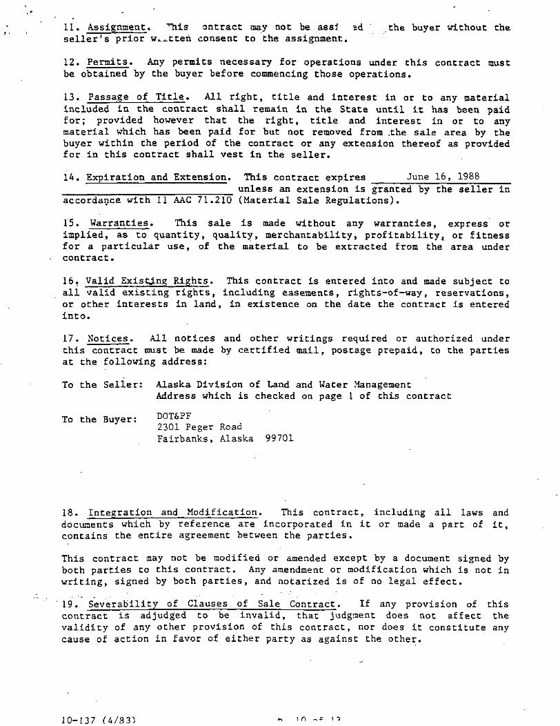
11. Assignment. ''"his ontract may not be assi ad the buyer without theseller's prior w^tten consent to the assignment.
12. Permits. Any permits necessary for operations under this contract mustbe obtained by the buyer before commencing those operations.
13. Passage of Title. All right, title and interest in or to any materialincluded in the contract shall remain in the State until it has been paidfor; provided however that the right, title and interest in or to anymaterial which has been paid for but not removed from .the sale area by thebuyer within the period of the contract or any extension thereof as providedfor in this contract shall vest in the seller.
14. Expiration and Extension. This contract expires June 16, 1988unless an extension is granted by the seller in
accordance with 11 AAC 71.210 (Material Sale Regulations).
15. Warranties. This sale is made without any warranties, express orimplied, as to quantity, quality, merchantability, profitability, or fitnessfor a particular use, of the material to be extracted from the area undercontract.
16. Valid ExistJLng Rights. This contract is entered into and made subject toall valid existing rights, including easements, rights-of-way, reservations,or other interests in land, in existence on the date the contract is enteredinto.
17. Notices. All notices and other writings required or authorized underthis contract must be made by certified mail, postage prepaid, to the partiesat the following address:
To the Seller: Alaska Division of Land and Water ManagementAddress which is checked on page 1 of this contract
To the Buyer: DOT&PF2301 Peger RoadFairbanks, Alaska 99701
18. Integration and Modification. This contract, including all laws anddocuments which by reference are incorporated in it or made a part of it,contains the entire agreement between the parties.
This contract may not be modified or amended except by a document signed byboth parties to this contract. Any amendment or modification which is not inwriting, signed by both parties, and notarized is of no legal effect.
19. Severability of Clauses of Sale Contract. If any provision of thiscontract is adjudged to be invalid, that judgment does not affect thevalidity of any other provision of this contract, nor does it constitute anycause of action in favor of either party as against the other.
10-137 U/83) in ~
20. Construction. WOP in the singular number ;luc :he plural, and wordsin the plural numtser include the singular.
21. Headings. The headings of the numbered paragraphs in this contract .shallnot be considered in construing any provision of this contract.
22. ^Extracted", "Extraction". In this contract, use of the terras"extracted" and "extraction" encompasses the severance or removal, as well asextraction, by the buyer of any materials covered by this contract.
23. Waiver. No agent, representative or employee of the seller has authorityto waive any provision of this contract unless expressly authorized to do soin writing by the director of the Division of Land and Water Management.
T PI- 1 T 7 (I.
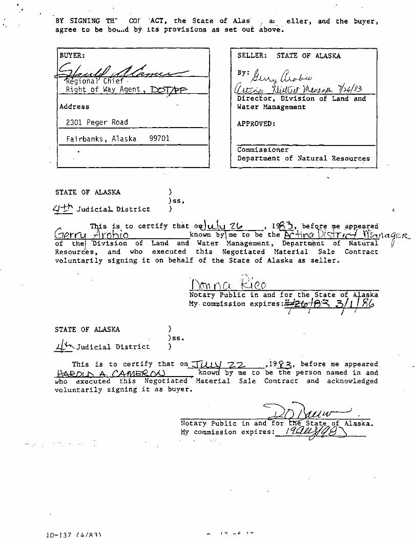
BY SIGNING TH" COf 'ACT, Che State of Alas , as .eller, and the buyer,agree to be bouud by its provisions as set out above.
BUYER:
Regional' Ctrief •Right of Way Agent ,
Address
2301 Peger Road
Fairbanks, Alaska 99701
SELLER: STATE OF ALASKA
By:
Director, Division of Land andWater Management
APPROVED:
CommissionerDepartment of Natural Resources
STATE OF ALASKA ))ss.
</"i:h Judicial. District )
This is^ to certify that oif)u_\vj "2.0*yArokvO known by] me to be the
before me appearedUf'vT/r-/
of the! Division of Land and Water Management , Department of NaturalResources, and who executed this Negotiated Material Sale Contractvoluntarily signing it on behalf of the State of Alaska as seller.
Notary Public in and for the State of AlaskaMy. commission expirestijMgfer/ffi^
/ l I
STATE OF ALASKA
Judicial District
))ss.)
This is to certify that on
V_A.~2- "2- , 19 ' Before me appeared
known by me to be the person named in andwhoexecutedthis Negotiated Material Sale Contract and acknowledgedvoluntarily signing it as buyer.
Notary Public in and for ChlT State^of Alaska.My commission expires:I'
10-137 11 „ C 1-1
CERTIFICATE OF CORPORATF UYEF- N If the Buyer is a Corporation)
I, , certify that I am the Secretary ofthe corporation named as buyer in this contract and that
, who has signed this contract is(was) atthe time of signing the contract .theof that corporation, and that he(she) did so for and on behalf of thecorporation at the direction and by the authority of the corporation'sgoverning body acting within the scope of its corporate powers.
Corporate Seal Secretary
STATE OF ALASKA ))ss.
Judicial District )
This is to certify that on , 19 , before me appearedknown by me to be the Secretary of the
corporation named as buyer in this contract and who acknowledged voluntarilysigning as Secretary of the corporation.
Notary Public in and for the State of Alaska.My commission expires:
10-137 (4/83) 'o. 13 of
Special Conditions of ADL 408733Gravel Extraction
(1) No material removals are authorized under this permit unlessin accordance with the approved mining plan and Special Conditionsof the permit. The Special Conditions of the permit shall takeprecedence over the approved mining plan should there exist a con-tradiction between said mining plans and Special Conditions.
(2) The following information, if not previously submitted, willbe required by the Division of Land and Water Management prior toapproval.
a. Aliquot part or .other description of the material sitearea.
b. The intended uses for the material.c. The location of use..d. The time interval in which removal will be made.e. The method and manner of removal.f. The estimated quantities of material.g. Stockpiling of materials.
(3) Overburden removed from the areas to be mined shall be stock-piled and/or used as cover for debris and restoration work, asdirected by the Division of Land and Water Management.
(4) If ground water is encountered during the material extractionand if dewatering is employed, an effluent permit must be obtainedfrom the Department of Environmental Conservation.
(5) Depth of mining shall not exceed the specifications of themining plan.
(6) Wastewater from gravel washing operations (should they beused1) must meet State Standards before being discharged to ariver.
(7) Fuel or motor oil storage areas shall be located wherespilled fuel or motor oil could easily be contained and retreived.
(8) The Division of Land and Water Management reserves the rightto suspend removal operations from this material site and to desig-nate alternate sites.
(9) Upon completion of mining activities, rehabilitation andrestoration of disturbed areas not designated for future use willbe required.
(10) Final, Slopes of the pit shall be no steeper than one (1) footvertical to five (5) feet horizontal from a water depth of at leastfive (5) feet below the seasonal low water level to the seasonalhigh water level.
(11) The site shall be graded smooth after completion of themining operation.
(12) Timber less than six inches in diameter, brush, and slashshall be disposed of as directed by the Division of Land and WaterManagement.
(13) Marketable timber (6" DBH and larger) will be salvaged. Thetimber will be felled with conventional logging methods, limbed,toppta ac. <±" aiamecer, and stacked in an accessible area. Thestacked logs shall not be mixed with other clearing debris. Titleto the timber shall remain with the State. Timber salvage opera-tions are co be coordinated with the State Area Forester. The AreaForester may, in writing, waive salvage requirements.
%
(14) This permit does not obviate nor preclude the necessity toobtain other permits that may be required by law or regulation.
For those material sites located on shore or tidelands (State landacquired pursuant to the Submerged Lands Act) the followingstipulations also apply:
(15) Alaska water quality standards as promulgated in 18 AAC 70will be maintained.
(16) Equipment shall not operate in flowing water without writtenauthorization from the Division of Land and Water Management.
(17) There shall be no river diversion, channelization or bankmodification without written authorization from the Division oiLand and Water Management.
(18) Depth of mining shall not exceed -the specifications of themining plan or be conducted to a depth that could induce channelchanges or create ponded areas.
(19) To prevenc risn ent rapuient, the site shall be graded smooth'after completion of mining operations.
(20) Gravel shall not be stockpiled within the flood plain.
(21.) Summer mining operations must be conducted during low flood"'periods'.
(22) dpoil from processing operations anc seoiraenns from settlingbasins must be removed from the flood pla-in to an approved disposalsite prior to freeze-up.
(23) Dikes, material stockpiles, drainage structures, and settlingGaSins iTiUst O6 'csiucvtd frcni t'nc active tlooci plain prior cofreeze-up unless approval to the contrary is acquired in writingfrom the Division of Land and -Water Management.
(<i4) fuel or motor oil storage areas shall not be located on theactive flood plain; such storage areas snail be located wherespilled fuel or motor oil could easily be contained and retrieved.Refueling of equipment shall not occur on the active flood plain ofa river.
(25) To prevent concentrated removal which could cause localizedsevere -upstream and/or downstream scour, extraction shall belimited to 75,000 cubic yards per year from any area with maximumdimensions of 500 feet laterally (acrc^, c<.-, .. : r), and 2,000 feetlongitudinally (parallel 'with the river flow).
%
(26) Extraction in the protected (inactive flow channel) areadownstream of any existing or proposed dikes which are part of alevee protection system will not be permitted.
(27) Extraction in areas where such activity will diminish theintegrity of any approved river training structures is notpermitted.
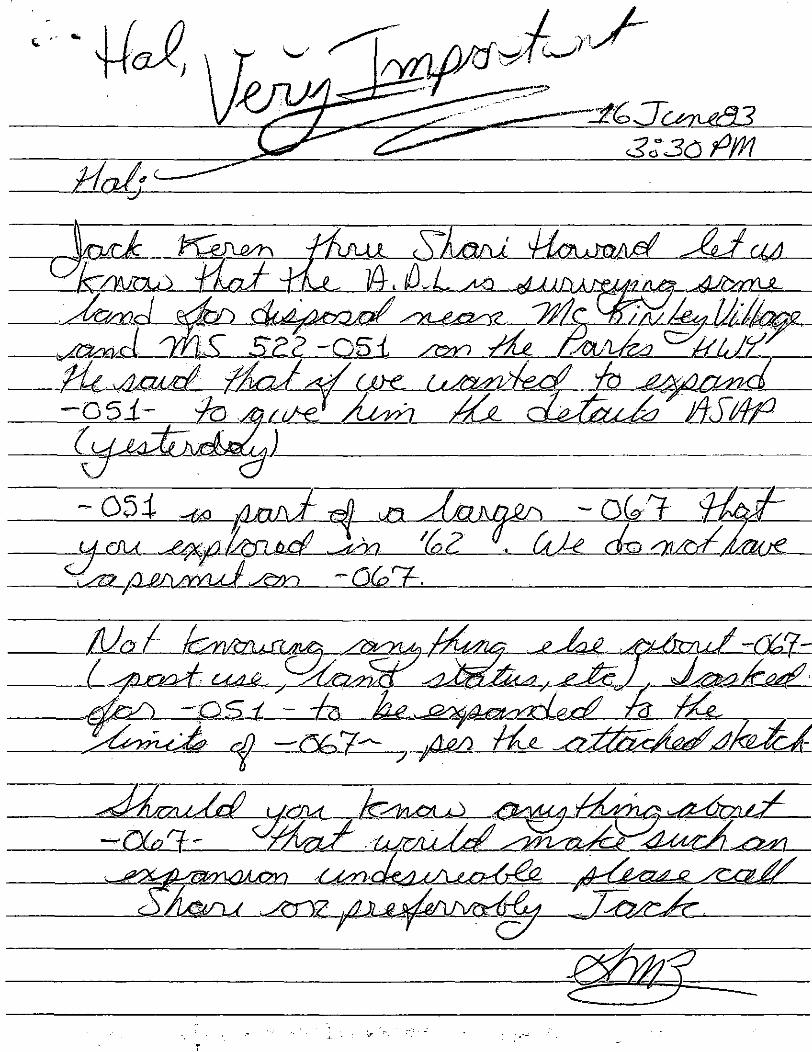
J&Stfg.
-054
MaA
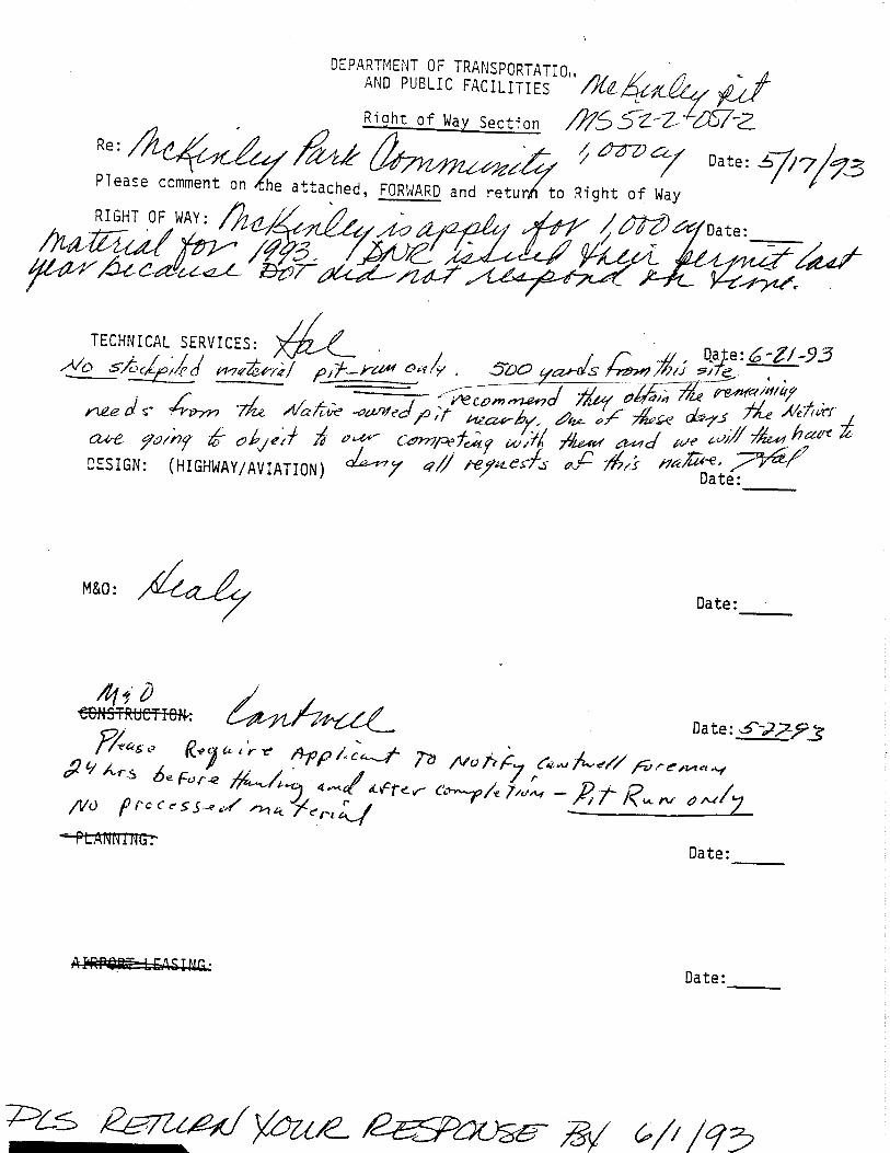
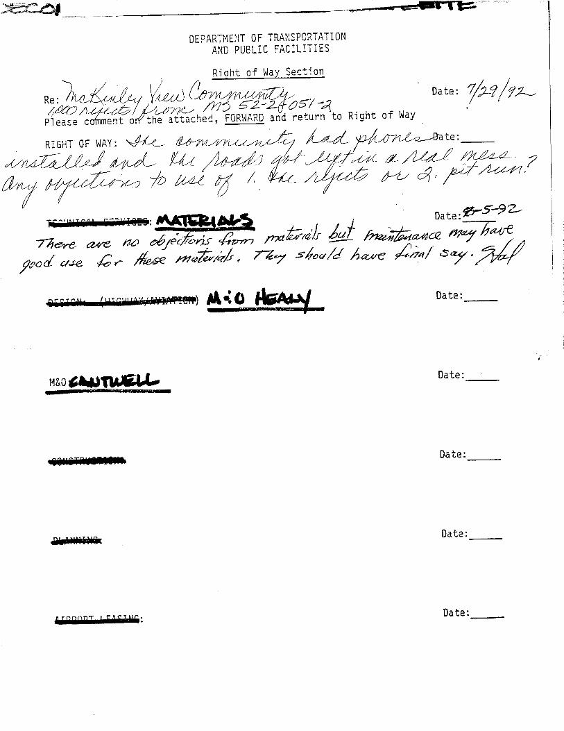
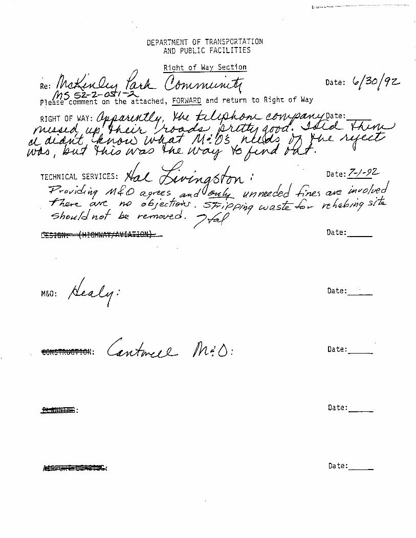
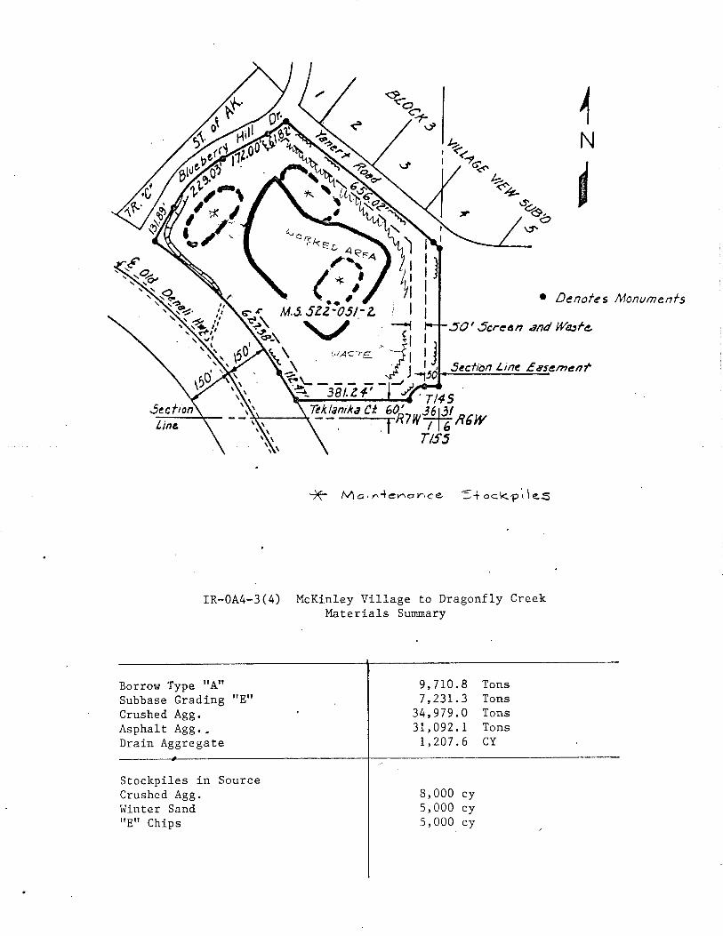
Gi ""i .8 9
|3sr2-/yis?z ; .
-/ 700.00' -/ / J
NOTE:
BOUNDARIES MOT SURVEYED
i T.H.E-2
"O;°:Qgs?"
fe^j
W-OSOrg.Mat.Sand Jilt ___
1.5 -10 -f^san SandyGrasel A-f~a
ao-OS Og.Maf.?g£g? 05-2.0 SiltyScnd
2.O-/O* Sar/dv Gravel
IP
t&H
O.5-2.O Sandy SJ/fO-/O+Sand-/ercrsel
8% */0' .A-l-a.f-/
Sample '£-2, f.0-5.0'
T.H.E-t tH.E-5 TH.E-6- aJ Org. KG!. (Silt
03-10 fJafld/GraYe]A-l-a
O.O-OJ 'Org.Maf. (Silt
KJ-iS-LJPfeffi
Staple 'E-3,S.O-7.0'
O.O-OJOrg.Mat. (Silt0.5-10' Sandy Crave/
A-1-a
JH.E-7
83
tt:*.^;/'-.'C.'.- -C'SrI>«L
iMs
O.O-0.5 Org.MaHS C.*"- l
&s:
Somf/e '£- *• 50-7.0'
OO-/.O Org. flat {S/tfla- lot Sandy Gravel
15-20%'2 '10-IS'i '10'
TH.E-I
Cross Sec/ton S/a. 'L"2if93too
QUANTITY: ^19,^00yd3
Q'JALfTY: A-l-a, fJFS-F-2OVEZSIZE-- 2O% +2'. 5-6% */0'
fr?asr- NoneVEGETATION: ^pruce^frc,1) c 3urnedO<serJ/TOPOGRAPHY: Level, S'Bench fr Of Site £
OC-y: Stream Gravels ConsistingChiefly of 'iifne5lonsl Cre^risfc
: STATE Of-ALASKA
DEPARTMENT OF H/QHWAYSFAIRBANKS DISTRICT MATERIALS SECTION
L- MCKlttLEYPROJECT No F-052-SC!)
DA TA '• H.R.L. \ US. CODE No'22-336-63
DATE: 1-63
'*/N:H.A.N. MAT.5/TSNO: '£'
SCALE:'"
MEMORANDUM Stai of Alaska
ToJerry BrossiaDistrict ManagerDepartment of Natural Resources
ATTN: Greg Young
FROwAlan H. TownsenA^i/Interior Projects Review CoordinatorHabitat DivisionDepartment of Fish and Game
DATE: December 8, 1982
FILE NO:
TELEPHONE NO:
SUBJECT: FUP - ADOT/PF aslisted
The Department of Fish and Game has reviewed the Free Use Permit applica-tions listed below and has comments as indicated:
1. No objection to the following material source requests:
?//-^>2-2ADL32713
i ADL408562? ADL408766? ADL4087687 ADL40S7717 ADL408770
o"7-/-02^-ZADL408772? ADL408736
V7-Z-069-Z.ADL408748^ ADL408755? ADL408885
7//-^??-JLADL400781T AD.L408913
J>7-/-<9</V-;iAbL30743? ADL408886? ADL408885
Jack WarrenJack WarrenJack WarrenNenana areaNenana areaFairbanks -Fairbanks -Fairbanks -Parks HighwayCentral areaNenana areaParks HighwayParks HighwayDelta JunctionAlaska HighwayNenana areaParks HighwayParks Highway
Rd. areaRd. areaRd. area
NenanaNenanaNenana
area
1,4502256508008001242261701113
64032010010515150480112
,000,000,000,000,000,800,560,000,520,000,000,000,000,000,000,000,000,000
cu.cu.cu.cu.cu.Cu.
cu.cu.cu.cu.cu.cu.cu.cu.cu.cu.cu.cu.
ydydwrlJ"-1
ydydydydydydydydydydydydydydyd
2. The following applications lacked specific locating information and couldnot be adequately reviewed for fish and wildlife conflicts. By copy of thismemo we request ADOT/PF to provide the township, range, section and fractionthere of for these material sources.
? ADL408739^7-J-/:U-«aADL408740
? ADL408741? ADL408742
07_l2.09/!-4ADL408743
Parks HighwayParks HighwayParks HighwayParks HighwayParks Highway
249,760 cu191,520 cu181,970 cu38,560 cu
yd,yd,yd.yd.
110,240 cu. yd.
? ADL408744?- ADL408769
/ 'S2-0& '-2 ADL408733? ADL408738
Z. ADL408737
ADL408747ADL408717ADL408745
Parks HighwayFairbanks - Nenanaf-t-T'r'/ .KSParks HighwayParks HighwayParks Highway-Parks HighwayParks HighwayParks Highway
473,760540,00080,64089,920194,72064,32089,920146,880143,350
cu. yd.cu. yd.cu. yd.cu. yd.cu. yd.cu. yd.cu. yd.cu. yd.cu. yd.
cc: Hal Livingston - ADOT/PFDoug Lowery - ADEC
MEMORY NrjM Strtej)f AlaskaDepartment^Cn Transportation & Public Facilities
T0: Dept.\of Natural Resources4420. Airport WayFairbanksAttn: Chris Guinn, Chief
Disposal Section
FROM Harold A. CaraeroRegional Chief
DATE:
FILE NO:
TELEPHONE NO:
SUBJECT:
September 22, 1982
452-1911, ext. 286
McKinley Park Area-FY 84M.S. 522-051-2
As discussed today with Chris Guinn by Paul Wild of this office, we sent youcomments by our memorandum dated September 1, 1982 (copy attached) on subjectproposed lend disposals.
We now have additional comments in response to your memorandum copy to RobertVenusti, Director, Planning and Programing as follows:
1) Hornet Creek and Village View disposals - the number of roads onto theParks Highway must be kept to a ir.inircum. DOT/PF driveway permits willbe required for ell new roads from these areas (including Montana CreekRemote) to the Parks.
2) We would appreciate the opportunity to review the access plans as theyare developed.
3) We will be sending you cur comments to DNR's FY35 proposed landdisposals by September 27.
Attachments: as stated
cc: Robert Venusti, DirectorPlanning & Programming
PJW/skc
SLacwdiBg District
„ , . . ^^^^^Fairbmnka 02973*
SariJtl number balowBS?ARTKSrt 0? THE INTERIOR
Bureau of Lsind Managa»«ntPairbanka LanU orflc«
P. 0, Box 1150Fairbanks, Alaska
DECI3ICH
RIGIfT-OF-WAY
bat»: OCT 2 6
of
*S^rlal number of' grant
of029734
of Alaska,.Bos 1841, jtrnaau,
ahowlrsg tha location
of
Hap
filed , 1962
Bapartasptal Map, Trojoct ?O052~i(2)
Sits
^ Authority for grant Fsdaral Highway Act of Hovs»b*r S^ 1921regulations appllea*j>la to gr^at; (23 U^S.G. 317) «-s aaandad
Coda r&fsarenca ^3 ClfR' 244.5^ thyu
Clrculai- nugaib«r 1915,
:Dat« of grant
ration data ©f grant
Whan t fej grantee
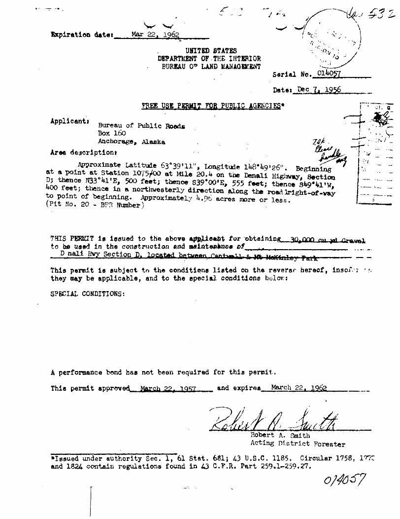
J «-
Expiration datet.V
Mar 22. 1962
UNITED STATESDEPARTMENT OF.THE INTERIOR
EURJEAU 0* LAND IEANAQIXKNTSerial No.
Datei Dec 7, 1956
TREE USE PERMIT FOR PUBLIC AGENCIES*
Applicant)Bureau of Public RoadsBox 160Anchorage, Alaska .
Arae descriptioni -
Approximate Latitude 63039'11", Longitude lU8"U9'26". Beginningat a point at Station 1075/00 at Mile 20. U on the Denali Highway, SectionD; thence H33*M% 500 feet; thence S39°00% 555 f««t; thence Sfc9*fcL'WfkQO feet; thence in a northvesterly direction along the road bright -of -vayto point of beginning. Approximately U.9fc acres more or less.(Pit No. 20 - BPR Number)
f .::•:>:
THIS PERMIT is issued to the above aj*jklifl*&$ for obtaining _ 30^000to bfi ua«d in the construction and taflinteakncs t>t ._. ^^ _ _______
D nali livy Section D. located- - - - *«.. 1. *--,f|« MBhUTLL«;j
This permit is subject te» the conditions listed on the reversr hereof, inaoiV: •they may be applicable, and to the special conditions holer.;
SPECIAL CONDITIONS:
A performance bond has not been required for this permit.
This permit approved Jtfe'Jcb 22, 1057 and expires , .March 22. .962
Robert A. SmithActing District Forester
•Issued"under authority Sec. 1, 61 Stat. 681; 43 U.S.C. 1185. Circular 1758,and 182 contain regulations found in A3 C.F.R. Part 259,1-259.27.
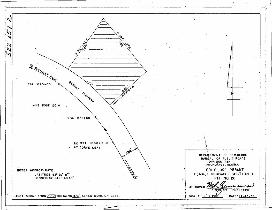
STA. I0754-00
MILE POST 20.4
RC. STA. 1068 + 51.64° CURVE LEFT
NOTE: APPROXIMATE
LATITUDE 63° 39' ifLONGITUDE 148° 49'26"
AREA SHOWN THUS V / /}( CONTAINS 4.9.4 ACRES MORE OR LESS.
-i
DEPARTMENT OF COMMERCEBUREAU OF PUBLIC ROADS
DIVISION TENANCHORAGE,ALASKA
FREE USE PERMITDENALI HIGHWAY- SECTION D
PIT NO. 20
APPROVED:DISTRICT ENGINEER
SCALE : l" - ZOO DATE: 11 -15 -56

RIGHT OF WAY INFORMATION _____________________________________
GEOLOGIC INFORMATION
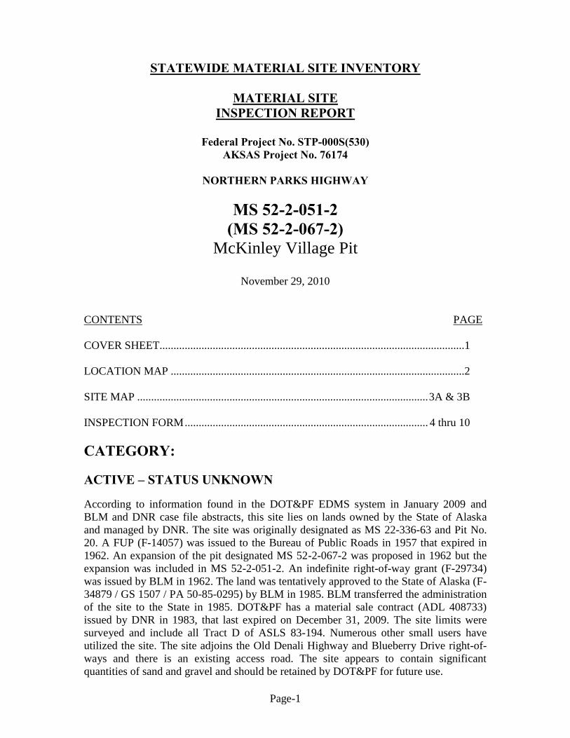
Page-1
STATEWIDE MATERIAL SITE INVENTORY
MATERIAL SITE INSPECTION REPORT
Federal Project No. STP-000S(530)
AKSAS Project No. 76174
NORTHERN PARKS HIGHWAY
MS 52-2-051-2 (MS 52-2-067-2)
McKinley Village Pit
November 29, 2010
CONTENTS PAGE
COVER SHEET.............................................................................................................1
LOCATION MAP .........................................................................................................2
SITE MAP ........................................................................................................ 3A & 3B
INSPECTION FORM ....................................................................................... 4 thru 10
CATEGORY:
ACTIVE – STATUS UNKNOWN
According to information found in the DOT&PF EDMS system in January 2009 and
BLM and DNR case file abstracts, this site lies on lands owned by the State of Alaska
and managed by DNR. The site was originally designated as MS 22-336-63 and Pit No.
20. A FUP (F-14057) was issued to the Bureau of Public Roads in 1957 that expired in
1962. An expansion of the pit designated MS 52-2-067-2 was proposed in 1962 but the
expansion was included in MS 52-2-051-2. An indefinite right-of-way grant (F-29734)
was issued by BLM in 1962. The land was tentatively approved to the State of Alaska (F-
34879 / GS 1507 / PA 50-85-0295) by BLM in 1985. BLM transferred the administration
of the site to the State in 1985. DOT&PF has a material sale contract (ADL 408733)
issued by DNR in 1983, that last expired on December 31, 2009. The site limits were
surveyed and include all Tract D of ASLS 83-194. Numerous other small users have
utilized the site. The site adjoins the Old Denali Highway and Blueberry Drive right-of-
ways and there is an existing access road. The site appears to contain significant
quantities of sand and gravel and should be retained by DOT&PF for future use.
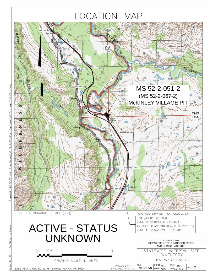
MP 227
MP 228
MP 231
MP 230
MP 229
MP 232
MP 234
MP 233
MP 235
T14S
T15S
R7W
R6
W
MS 52-2-051-2
(MS 52-2-067-2)
McKINLEY VILLAGE PIT
2
STATE OF ALASKA
DEPARTMENT OF TRANSPORTATION
AND PUBLIC FACILITIES
ACTIVE - STATUS
UNKNOWN
3A
STATE OF ALASKA
DEPARTMENT OF TRANSPORTATION
AND PUBLIC FACILITIES
ACTIVE - STATUS
UNKNOWN
3B
STATE OF ALASKA
DEPARTMENT OF TRANSPORTATION
AND PUBLIC FACILITIES
ACTIVE - STATUS
UNKNOWN
STATEWIDE MATERIAL SITE INVENTORY
MATERIAL SITE INSPECTION FORM
1. MS_ID
Enter the full material site number e.g.. 37-3-045-2
2. DATE_INSPECT
Date of field inspection
3. FLD INSPEC_ORGName of inspector / Organization or Company
4. REGION
5. LOCATION
Name of Highway
6. MILEPOST
List the closest main highway milepost `
7. NAME
Enter commonly used name (s), e.g. Hess pit, Gobblers Knob, Midway. List all that apply separated by commas.
8. MAINT_DIST/STAT
Highway Maintenance District and Station, for locations not on highways select other.
9. QUAD
U.S.G.S. Quad. Map
10. TOWNSHIP T#S R#E & Meridian
/RANGE Section
11. COOR_UTM 12. COOR_STATE_PLANE
ZONE ZONE
UTM WGS84 - Meters
13. BOROUGH/CITY TAX ID NO.
14. DNR_LAND_USE_PLAN
15. CATEGORY (To be filled in the office)
15a. CLASSIFICATION
15b. STATUS
3,528,839
MCKINLEY VILLAGE PIT
Enter Name of Facility or Secondary Route Name
(i.e.Kotzebue Airport, Nash Road, etc.)
UNKNOWN
DENALI BOROUGH
4
NORTHING
EASTING
FM
Alaska State Plane NAD83 - Survey Feet
YUKON-TANANA AREA PLAN
410,503
THIS REPORT IS BASED ON A REVIEW OF EXISTING DATA AND BRIEF FIELD INSPECTIONS. THUS THE
DATA CONTAINED HEREIN SHOULD BE CONSIDERED PRELIMINARY AND USED FOR PLANNING
PURPOSES ONLY. USERS OF THIS DATA SHOULD VERIFY THE INFORMATION PRIOR TO USING IT FOR
DESIGN OR CONSTRUCTION PURPOSES.
EASTING 1,834,209
ACTIVE
NORTHING
C-4
INTERIOR/FAIRBANKS
7,059,506
Station
HEALY
T14S R7W
36
NORTHERN PARKS HIGHWAY
230
District
52-2-051-2
8/3/2010
WILL RHODES / R&M CONSULTANTS
NORTHERN
HEALY
6
IF OTHER IS SELECTED FOR A SECTION, EXPLAIN IT IN SECTION 44. NOTES.
IF AN ANSWER IS UNKNOWN SELECT "UNKNOWN" OR LEAVE BLANK
PREPARED BY:
R&M CONSULTANTS, INC. Page 4 MS 52-2-051-2
STATEWIDE MATERIAL SITE INVENTORY
MATERIAL SITE INSPECTION FORM
16. POTENTIAL_STATUS
Estimated quantity of material in the site at the time of inspection.
The pit has not been mined/explored (used only for proposed sites).
17. PRESENT_USERS
17a. PRESENT_USER_1
17b. PRESENT_USER_2
17c. PRESENT_USER_3
18. PERMITTED _ACREAGE
Area within site permit or R.O.W. boundaries, from permit application or property plat.
19.
Area within an existing pit, excluding spoil berms lying outside the pit, access roads etc. Explain below.
20. ACREAGE_COMP_METHOD
Method used to determine developed acreage.
21. EST_QUAN_AVAIL
Estimated quantity available (b.c.y.), may be based on acreage computed above plus expansion area.
Explain computation assumptions and calculations below.
Area
Square Ft.
Acres
Est. Depth (ft.)
Factor (b.c.y. / acre-foot)
Est. Quant. (c.y.)
1,000
55128 0
35000 0
0 27 0
1,000 1000
8.0
346768
DOT&PF MAINTENANCE
Existing Pit Expansion Area Other area
UNKNOWN
UNDEVELOPED
CLOSED
There was limited material within the developed site, but there appeared to be significant
material outside existing site limits.
NONE
Permitted acreage is taken from survey drawing ASLS 83-194 / Tract D. Developed acreage includes
areas within the screening buffer.
ROUGH ESTIMATE
DEVELOPED_ACREAGE
LIMITED
SIGNIFICANT
35,000
There may be useable material left in the pit but it is not available.
13.2
SIGNIFICANT
FROM MAP/PHOTO
There appeared to be no useable material in the site.
EXPANDABLE
8.5
There appeared to be less than 25,000 c.y. available within the developed site.
There appeared to be greater than 25,000 c.y. available within the developed site.
OTHER The site does not fit any of the categories above. Explain in Section 44, Notes.
0.0
0
1.3
The last contract stipulated that the pit floor cannot be deepened. To expand the pit to the edge of the
screening area spoil berms would have to be moved. Estimates for this expansion assume an average working
depth of 32 feet with 5 feet of overburden.
PREPARED BY:
R&M CONSULTANTS, INC. Page 5 MS 52-2-051-2
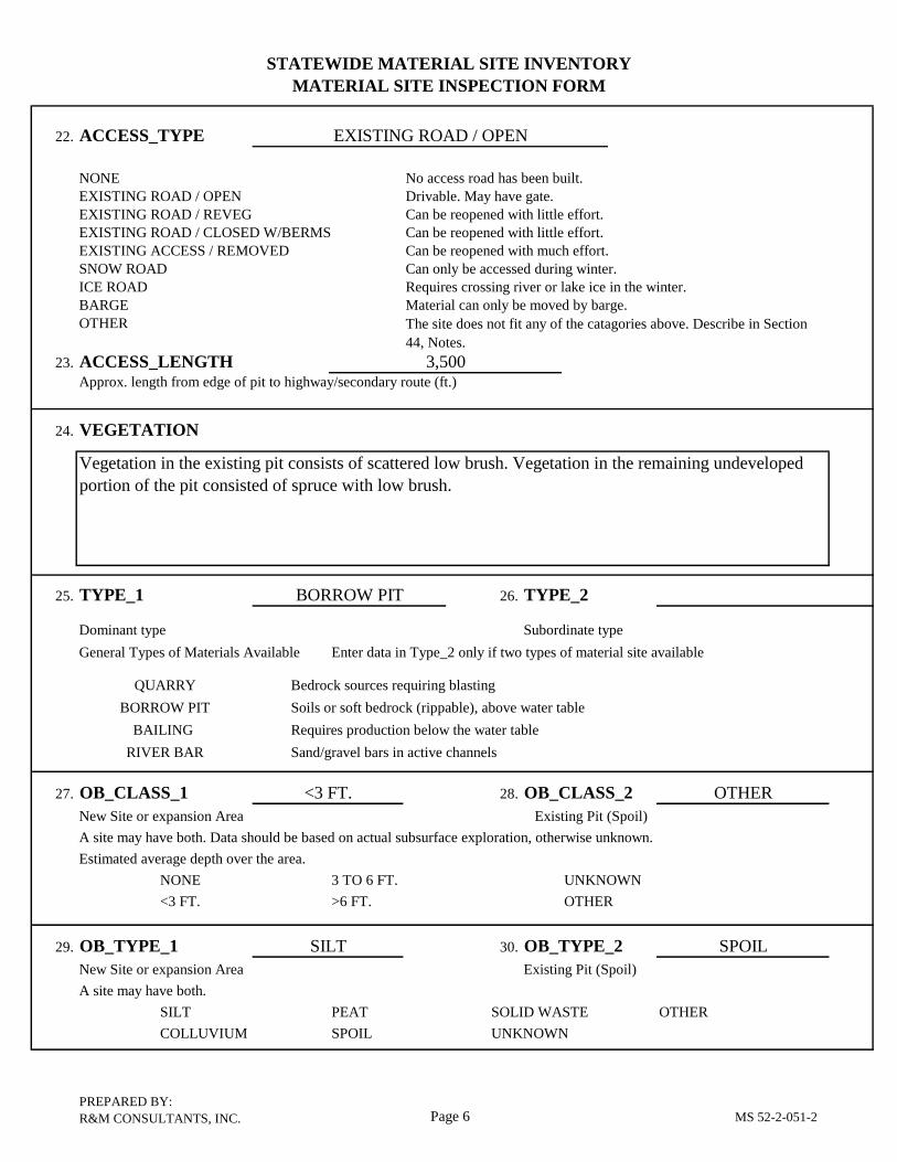
STATEWIDE MATERIAL SITE INVENTORY
MATERIAL SITE INSPECTION FORM
22. ACCESS_TYPE
NONE No access road has been built.
EXISTING ROAD / OPEN Drivable. May have gate.
EXISTING ROAD / REVEG Can be reopened with little effort.
EXISTING ROAD / CLOSED W/BERMS Can be reopened with little effort.
EXISTING ACCESS / REMOVED Can be reopened with much effort.
SNOW ROAD Can only be accessed during winter.
ICE ROAD Requires crossing river or lake ice in the winter.
BARGE Material can only be moved by barge.
OTHER
23. ACCESS_LENGTHApprox. length from edge of pit to highway/secondary route (ft.)
24. VEGETATION
25. TYPE_1 26. TYPE_2
Dominant type Subordinate type
General Types of Materials Available
Bedrock sources requiring blasting
Soils or soft bedrock (rippable), above water table
Requires production below the water table
Sand/gravel bars in active channels
27. OB_CLASS_1 28. OB_CLASS_2
New Site or expansion Area Existing Pit (Spoil)
A site may have both. Data should be based on actual subsurface exploration, otherwise unknown.
Estimated average depth over the area.
NONE 3 TO 6 FT. UNKNOWN
<3 FT. >6 FT. OTHER
29. OB_TYPE_1 30. OB_TYPE_2
New Site or expansion Area Existing Pit (Spoil)
A site may have both.
SILT PEAT SOLID WASTE OTHER
COLLUVIUM SPOIL UNKNOWN`
OTHER
EXISTING ROAD / OPEN
SPOIL
<3 FT.
The site does not fit any of the catagories above. Describe in Section
44, Notes.
3,500
Vegetation in the existing pit consists of scattered low brush. Vegetation in the remaining undeveloped
portion of the pit consisted of spruce with low brush.
SILT
BORROW PIT
BAILING
QUARRY
BORROW PIT
Enter data in Type_2 only if two types of material site available
RIVER BAR
PREPARED BY:
R&M CONSULTANTS, INC. Page 6 MS 52-2-051-2
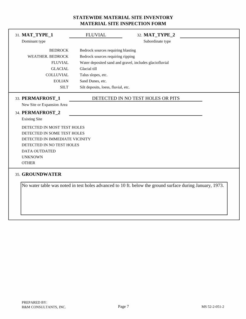
STATEWIDE MATERIAL SITE INVENTORY
MATERIAL SITE INSPECTION FORM
31. MAT_TYPE_1 32. MAT_TYPE_2
Dominant type Subordinate type
Bedrock sources requiring blasting
Bedrock sources requiring ripping
Water deposited sand and gravel, includes glaciofluvial
Glacial till
Talus slopes, etc.
Sand Dunes, etc.
Silt deposits, loess, fluvial, etc.
33. PERMAFROST_1
New Site or Expansion Area
34. PERMAFROST_2
Existing Site
DETECTED IN MOST TEST HOLES
DETECTED IN SOME TEST HOLES
DETECTED IN IMMEDIATE VICINITY
DETECTED IN NO TEST HOLES
DATA OUTDATED
UNKNOWN
OTHER
35. GROUNDWATER
SILT
COLLUVIAL
EOLIAN
GLACIAL
No water table was noted in test holes advanced to 10 ft. below the ground surface during January, 1973.
BEDROCK
DETECTED IN NO TEST HOLES OR PITS
FLUVIAL
FLUVIAL
WEATHER. BEDROCK
PREPARED BY:
R&M CONSULTANTS, INC. Page 7 MS 52-2-051-2
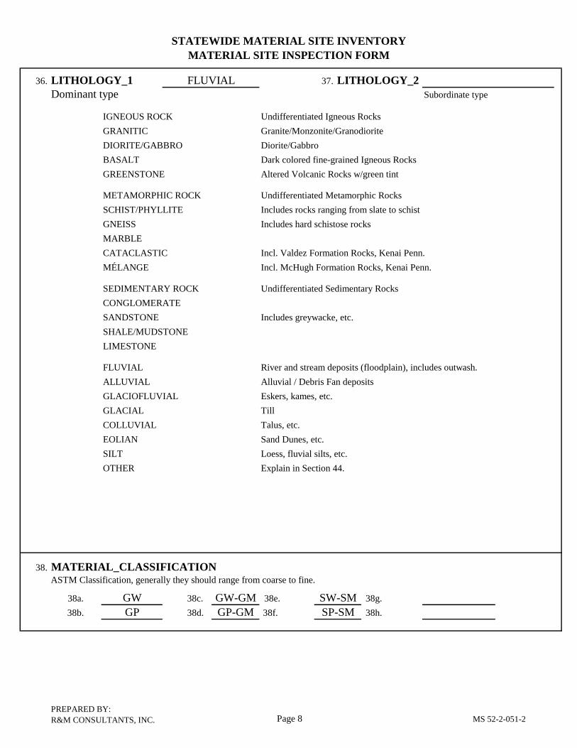
STATEWIDE MATERIAL SITE INVENTORY
MATERIAL SITE INSPECTION FORM
36. LITHOLOGY_1 37. LITHOLOGY_2
Dominant type
IGNEOUS ROCK Undifferentiated Igneous Rocks
GRANITIC Granite/Monzonite/Granodiorite
DIORITE/GABBRO Diorite/Gabbro
BASALT Dark colored fine-grained Igneous Rocks
GREENSTONE Altered Volcanic Rocks w/green tint
METAMORPHIC ROCK Undifferentiated Metamorphic Rocks
SCHIST/PHYLLITE Includes rocks ranging from slate to schist
GNEISS Includes hard schistose rocks
MARBLE
CATACLASTIC Incl. Valdez Formation Rocks, Kenai Penn.
MÉLANGE Incl. McHugh Formation Rocks, Kenai Penn.
SEDIMENTARY ROCK Undifferentiated Sedimentary Rocks
CONGLOMERATE
SANDSTONE Includes greywacke, etc.
SHALE/MUDSTONE
LIMESTONE
FLUVIAL River and stream deposits (floodplain), includes outwash.
ALLUVIAL Alluvial / Debris Fan deposits
GLACIOFLUVIAL Eskers, kames, etc.
GLACIAL Till
COLLUVIAL Talus, etc.
EOLIAN Sand Dunes, etc.
SILT Loess, fluvial silts, etc.
OTHER Explain in Section 44.
38. MATERIAL_CLASSIFICATIONASTM Classification, generally they should range from coarse to fine.
38a. GW 38c. GW-GM 38e. 38g.
38b. GP 38d. GP-GM 38f. 38h.
SW-SM
SP-SM
FLUVIAL
Subordinate type
PREPARED BY:
R&M CONSULTANTS, INC. Page 8 MS 52-2-051-2
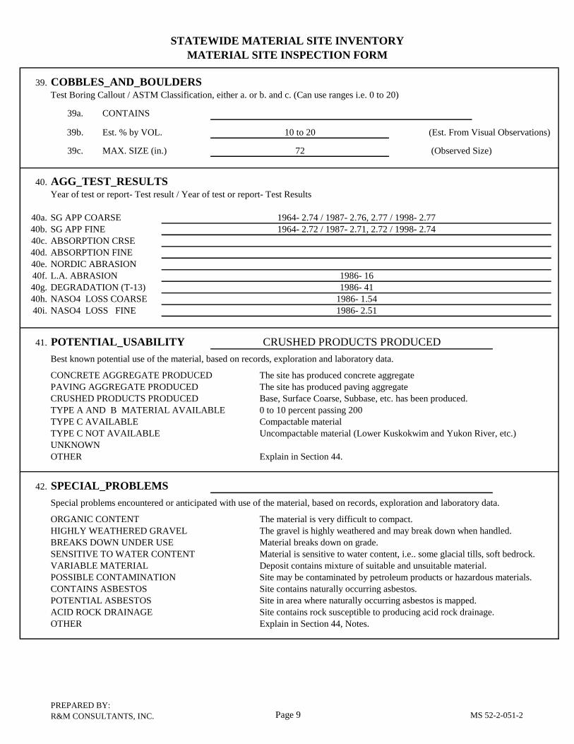
STATEWIDE MATERIAL SITE INVENTORY
MATERIAL SITE INSPECTION FORM
39. COBBLES_AND_BOULDERSTest Boring Callout / ASTM Classification, either a. or b. and c. (Can use ranges i.e. 0 to 20)
39a. CONTAINS
39b. Est. % by VOL. (Est. From Visual Observations)
39c. MAX. SIZE (in.) (Observed Size)
40. AGG_TEST_RESULTSYear of test or report- Test result / Year of test or report- Test Results
40a. SG APP COARSE
40b. SG APP FINE
40c. ABSORPTION CRSE
40d. ABSORPTION FINE
40e. NORDIC ABRASION
40f. L.A. ABRASION
40g. DEGRADATION (T-13)
40h. NASO4 LOSS COARSE
40i. NASO4 LOSS FINE
41. POTENTIAL_USABILITY
Best known potential use of the material, based on records, exploration and laboratory data.
CONCRETE AGGREGATE PRODUCED The site has produced concrete aggregate
PAVING AGGREGATE PRODUCED The site has produced paving aggregate
CRUSHED PRODUCTS PRODUCED Base, Surface Coarse, Subbase, etc. has been produced.
TYPE A AND B MATERIAL AVAILABLE 0 to 10 percent passing 200
TYPE C AVAILABLE Compactable material
TYPE C NOT AVAILABLE Uncompactable material (Lower Kuskokwim and Yukon River, etc.)
UNKNOWN
OTHER Explain in Section 44.
42. SPECIAL_PROBLEMS
Special problems encountered or anticipated with use of the material, based on records, exploration and laboratory data.
ORGANIC CONTENT The material is very difficult to compact.
HIGHLY WEATHERED GRAVEL The gravel is highly weathered and may break down when handled.
BREAKS DOWN UNDER USE Material breaks down on grade.
SENSITIVE TO WATER CONTENT Material is sensitive to water content, i.e.. some glacial tills, soft bedrock.
VARIABLE MATERIAL Deposit contains mixture of suitable and unsuitable material.
POSSIBLE CONTAMINATION Site may be contaminated by petroleum products or hazardous materials.
CONTAINS ASBESTOS Site contains naturally occurring asbestos.
POTENTIAL ASBESTOS Site in area where naturally occurring asbestos is mapped.
ACID ROCK DRAINAGE Site contains rock susceptible to producing acid rock drainage.
OTHER Explain in Section 44, Notes.
1964- 2.74 / 1987- 2.76, 2.77 / 1998- 2.77
CRUSHED PRODUCTS PRODUCED
1986- 1.54
1986- 41
72
1964- 2.72 / 1987- 2.71, 2.72 / 1998- 2.74
1986- 2.51
10 to 20
1986- 16
PREPARED BY:
R&M CONSULTANTS, INC. Page 9 MS 52-2-051-2
STATEWIDE MATERIAL SITE INVENTORY
MATERIAL SITE INSPECTION FORM
43. RIPRAP
Class II or larger. Does not include production for erosion control riprap for ditches or culverts.
PREVIOUS PRODUCTION There is a record of production.
POSSIBLE FURTHER INVESTIGATION NEEDED The site is a bedrock quarry containing hard rock
NOT POSSIBLE The site has soft rock or soil.
UNKNOWN
OTHER Explain in Section 44, Notes.
44. NOTES
Note number of item being discussed.
NOT POSSIBLE
28. Spoil berms were noted along all sides of the existing pit except the west side. There was a small slash pile
on the pit floor.
PREPARED BY:
R&M CONSULTANTS, INC. Page 10 MS 52-2-051-2
niiiini.rniiaBHMiriiiii I -mtnnur.r T niiiiuinnMiiMiiiii i i i i iMii
ALASKA DEPARr^flENT OF TRANSPORTATION S^UBLIC FACILITIESJP
MATERIAL SITE DATA COLLECTION FORM
:ollected by: \H\G\K
Z. GENERAL SITE DATA
1. Material Site No . : I
2. Site Name:|CiaiSI \PW\R\MS\~U
JHI LZL^Ll^f
3. Community: \ P \ A \ R I / V I S
4. Owner/Agency:
5. Permit No. : [/$"
6
8
Permit Type:
Contac t:
SI/ \R
1
1. Expiration Date: \J \ t , ]a}&>\8\8\
\ \
9. Lat/Long: [61315191 / I/I N I / W \&W W\2,\£'\ W
10 . Quad-Map: ' " ^ ^
11. Legal Description:
12. Acreage: Iff 13. Reference Data:
1 4 . Maps & Photos: \O\3\O\3\<OW-\£>\6*\ I I 1 1 1
15; Special Considerations:
16. History:!
17. Remarks: \T\0 I .Iffic^I ^? I/MZ? \&\£>\
\3-\
n.19.
20.
21.
LAB DATA
Soil Class:
Test Values:
Remarks :
18. Date:
514- MZ7 1 I/I kS-li&l/?/ ' ^ l ^ l d P l - I V
l/|cr| £.
'I/ 14/1 |
1
1
1
CODES
6. PEP-MIT00 NonaGrants01 Grant02 Rt. of Hay GrantDeeds11 D««d12 Suit Claia DeedPennits21222324252627
PermitPUPTOP
Prospect PermitMat'l Site PermitRt. of Entry Permit
28 Rt. of Way Permit29 PTTBOther41 ILMT2 ILHA3 Leaae4 Agreement5 Haste Area Agreemt.6 Easement7 Rt. of Way Easenrt.B Court Award
49 withdrawal50 Release51 Material Sales
A Applied forB Issued
_ _ DATA00 None available01 Published M.S. rpt.02 Lab analy9«a of mac'l03 Design study/loc. rpt.04 Construction use data05 Environmental data06 TH Loc. Hap & Logs07 Mono (ref. to file)99 Other (Ramarfcs)
14. MAPS (. PHOTOS
22.ACT
Los Angel«s AbrasionDegradation?rost Suscept. Valu*% paaainq 4200 screenSulfate SoundnessSpecific GravityLiquid LimitPLaatic IndexOrganic ContentpH of Organic*
PPJSSENT STATUS
0001020304OS0699
DPLSTKHWYAVI5TAPRVSQOCMPJUT2ZZ
23.3OHRR7ACRSNDBINTOPSTXMTN'STATSTrniREL'rfPA£ZZ
Active aiiningInactive siteDepletedStockpile liteHighway M 6 0 DaeAviation M & 0 DMMainter^nce StationPrivate PitSquattersCump siteJoint Use (Remark*)Othar (Renaz-ks)
PZCOHMEMDSO USEBorrowRiprapCrushed Aggz.Sand SourceBinder Mat1 1TopmoilStJcp. /Varehsing.Hain tenaace UseMaintenance Station?ui*her Testing ?*c.rature u««Rttlinquish PermitsWaste Disposal AreaOther
None availableSketch mapLocation mapSite platVert, air photosObi. j>ir photosGround photosOth*r (Remarks)
SPECIAL CONS IP15.00 None01 Pit obligated02 Royalty Payments03 Proof of Ose (incl. yr.)04 3rd Party Encumbr.05 Environmental Restr.06 Historical Site07 Archeologicai Site08 Paleontological Site09 Quantity Restr. (Remarks)99 Other (Remarks)
USE DATA
22. Present Status: 23. Recommended Use: \&WW w\rw\24. Quantities - Indicated:
Removed:
\8 \0\M\0\ cubic yards
\O\ cubic yards
Date:
Date: i i im25. Remarks:
ri i
71Vly0|£l Wl^
i 1 1 1 j | ! |
1
MATERIAL SITE DATA COLLECTION FORM
Material Site No.:
Collected by:
2. - 2_- D Date:
"IE. SURFACE SITE
26. Date: £| Vl<7 l£
29. Geomorphic Desc
30. Vegetation:
31. Topography: ^
33. Rock Outcrops:
36. Boundary Marker
38. Site Iitiprovemen
39. Remarks: T~|L
[v5lT"U4-l'C-rr!/ 1/Ul^
\A \P \P \L 1 I^U)j-i ,5i- <c-f/^/i«oi i/c
V _ i
DATA
[ £|3 21. Investigation: \/= T\£>\ / \ 2Q
tription: |T~| Zrl/^J/Qj/'-rlC^lcrl
IS I PI ° 1 " 1 0/° 1 ° 1 " 1 °'o D f | °/c
^ (_\°/° \ |% 32. Debris: [7~|/^|% | °/0
|0|% 34. Water Bodies: £>\O\ \ 35. AccessS: \ & \ & \ \ \ 37- Utility Corridors: \~T\L\
ts: \p i r £\H\R\
\/YI\A]^ \c. &\o is> 1^ \4f\c,\c.\ \~7~\O \£i & U\ 5~l<5"|£> i >4 3
\F?V)\£-\ ^ *.\P\A \/j\s / &\*(J\
5 15 ISy^ i j i/fi j/° i
1^ ^J^l l^-kXl2) Icr"!^ / 15*17^1" 1$ IS" I1 1 , , *
. Drainage: [^H
1 %
•• \&m|
J
f CODESVEGETATION 30. VEGETATION (cent ' d) 33. ROCK OUTCROPS 35. ACCESS
000 None - bare soil SK Shrub A I ' - IO' hfilR Birch ST Small Tree « 5" 0 ) E 10'-25'
BK Backhoe ^P Aspen LT LqTree (12"-30"0) D SO'-lOO'WA Wheel-mount Auger WIi Killov species HT Huae Tree (> 30" 0 ) E >100'TA Track-mount Auger ^der iefi ;PD Portable Drill ._ - * of site -covered * of site cFT Foot Recon. ^ 6££ s£™"Ml Aerial Recon. <s i»k . snruri.SK Sei^c Survey f" ^°. f?"" 31. TOPOGRAPHY 34. WATER BOCD Conductivity Survey ^R"." Res i 6 ti vi cy Survey " ^~.ZZ Other (Remarks) „
01 Re cor, , sparse coverage PC02 Part coverage , random GR03 Part coverage, specific BOC04 High-density TH invest. ZZ05 Special Survey
26 . DRAINAGE
r Fair
. H-T Flat and level 00 None' 3«"«»=k K,_ Ro;iing , 01 KVKj >_e<lar MQD m^^,^ hillside 02 Strea»
- «"= de=louous aj ciiffside 04 ir.wrmit5 Lov ground cover Q5 l^e
eight 00 > 1 mile fror. nearest rd01 Adj to unimproved rd02 Adj to secondary grl rd03 Adj to secondary pvd rd04 Adj to primary pvd rd05 Access by water
OVfcr*d 9? Other (Remarks)
00 None found01 One corner foundioc Number corners found
. Strean RE RebarIP Iron Pipe
; Other (unit/iovn; ,_ _, .Os Impoundment BZ Blaze Marks on trees
3 None 08 Bog /Swamp BR Brush Line
• -c"-"r'^, , wo woody debris " mj.j.iLt
M at. "P ™ C0n6'1- "'?" "tllB
. _f ra *,. . TB Dump mat ' 1 , trash * of site eofl High «3 sep) ^ ^ ^^^^
ZZ Other (Remarks)
% of site, each category
vere<! ZZ Other f**™"**
^\37. UTILITY CORRIDORS
EL ElectricWA WaterTL TelephoneCS GasPT Petroleum.SW SewerRR RailroadZZ Other (Remark*)
38. SITE IMPROVEMENTSI"NC FencingSCR ScreeningBDG Bridge (Remarks)SCL Scales
SWA Solid Waste AreaGAT Locked Gate on access
BLD- BuildingsZZZ Other (Remarks)
% of site occupied
Z. SUBSURFACE
40.
43.
46.
49 .
50.
Date: 1
SITE DATA
1Water Table: [Q_ o]Soil Description:
Quantity Estimal
Remarks :
:e:
41.
44.
c \ B \ / \ \
lTTViPI /^1 1X3
Investigation :
Permafrost: |y\y 1
A n | | 1 IH;uh
1 1 i45. Overburden:
1 lAn
>ic yards
- \(2\£-\U\S \^-\£\£.\
47 . % + 3
An
42. Drainage: 1^.
I < |c2'| |*n
^c-c/ QD(j(a<Z4-^. fa'
i 1 1 1 1
CODES42. DRAINAGE
F Poor - fine- cm, saturatedF FairG Good - coarot— arr. , wtl i -dim
44. PERMAFROST
4E. OVERBURDENSoil Typt (see Zteir. 46)Thicknesfi ( f t . )Hcistur* (see Item 46)Method of Analysis
49-. ™JAKT:TY ESTIHATECubic Yards (Visual Est. )
46. SOIL DESCR:A Gravel& SandC SiltD ClayE AshF OraanicG &« crockZ Other
:?riot;0 Unoetenru.ned1 Dr>-2 Damp
Method of Analysis
KTTKOD OF AKALYSISA&CD£
Cutbank exposureShovel piiSoil auoerScii prob*Prev. rpts .Other
>i) 90
E £/:•:• EME.TT
38| .24
StaTS'of Alaska Department of Transportation ""
Northern Region Materials Lab
SOIL and AGGREGATE REPORT
Project Name: PARKS HWY-NENANA CANYON SAFETY/ACCESS 1 Lab Number: 98-1050Ledger Code: 30950422
Project Number: HHE-OA4-4(1 0)Sampled By: J BENNETT
Source: ATHNA M S Test Hole: GRAB Depth In meters: STOCKPILEDate Sampled: 4-22-98 Offset: Station: M P 230
ATMT-7
SIEVES
+75
75
50
37.5
25.0
19.0
12.5
9.5
4.75
2.36
2.00
1.18
0.850
0.600
0.425
0.300
0.250
0.180
0.150
0.075
ATM T-l
.02mm
.005mm
.002mm
% PASS
100
99948562
44
4030
191411
10
8
75.5
5.8
3.6
3.1
TEST
Wo. TEST RESULTS
AASHTO T-89
AASHTO T-90
AASHTO T-8S
L>Ch*toi<r
ATMT-6
AASHTO T-21
ATMT-6
LL
PI
NV
NP
SpG's
Coarse
Fine
ORGANIC
ORG PPM
2.77
2.74
0.7
MOISTURE
STOCKPILE
AASHTO T-104
AASHTO T-96
ATMT-13
SODIUM
Coarse
Fine
LA
DEG
AASHTO CLASS: A-1-a
SOIL DESCRIPTION: SaGr
UNIFIED CLASS:
PRECONSTUCTION ROUTING: Geologists. Rxjoni Lao
MOISTURE / DENSITY PLOT ASSHTOT.,**)
Moisture/Density Relationships
E 222° \3 \^ —no v
** ~-inrr' x ^5 \ \Q \ \
\ \
5 6 7 8 9 10 11
% Moisture
Opf. Moisture: fa V0
Max. Density: e3\c?G?
Sample Dry Unit Wt. % Moist. Free Moist
1 2186.6 5.0
2 2194.6 5.8
3 2186.6 6.7
4
5
ZAV 2126.6 @ 10.7
ZAV 2254.6 @ 8
//) /-VSignature: *-// / auAJ&L^^L-e-*
Maureen E. Lee
REGIONAL LAB SUPERVISOR
R-8/78
CHIEF MATERIALS ENGINEER
51 AT fc UP- ALASKA
DEPARTMENT OF TRANSPORTATIONAND PUBLIC FACILITIES
- LAB REPORT
THE RESULTS OF THIS TESTING ARE ONLYREPRESENTATIVE OF THE MATERIAL AS SUBMITTED
PRECONSTRUCTION JS CONSTRUCTION
TEST OF Pit Run Gravel .ITEM NO..PROJECT NO.^IR-OA4-3 (4)SAMPLED FROM Pit
SOURCE
. P R O J E C T N A M F McKinlev Village - Dragonfly Cr.SUBMITTED BY P. Misterek
MS 52-2-051-2Parks HighwayLOCATION (RDWY.)
E X A M I N E D FOR Degradation, L.A. , Sodium
.QUANTITY REPRESENTED,
DEPTH
ACCEPTANCE
ASSURANCE
.LABORATORY NO..
.FIELD NO
.DATE
D QUALITY 0
CH INFORMATION CH
FINAL RECORD D
86B-048O J
_SPECIF ICATIOM-
_ DAZE-SAMPLED _
ECEIVED.
5-1 Q-Rfi
buitaue% PASSING
SIEVE
4"
3"
2"
1 1/2"
1"
3/4"
1/2"
3/8"
.4
,8
.10
.16
.20
.30
.40'
.50
.80
• 100
.200
.02MM
.005MM
ASRECEIVED
86
7667
60
52
47
35
27
25
, 20
12
6
4
4
2
SPEC.
OUST RATIO:
DELETERIOUS MATERIALS:
MINUS .200 MESH
SOFT FRAGMENTS
COAL & LIG. OR LT. WT. PART.
CLAY LUMPS
STICKS* ROOTS
FRIABLE PARTICLES
SPECIFIC GRAVITY
ABSORPTION
FINENESS MODULUS
SULFATE SOUNDNESS
FREEZE-THAW RATIO
L.A. ABRASION LOSS 16%
COURSE
/w$-y
i>l C
OPTIMUM MOISTURE/
MAX. DRY DENSITY /
MAX DENSITY NUMBER
CORR. MAX. DRY DENSITY
FIELD DENSITY
FIELD MOISTURE
% COMPACTION
% + >/."
% + NO. 4
-K
-f
fJU£U \/JwU«t.
/i,.v. <?- •*
FSV
LL
PL
AASHO T180D CD ALASKA T-12 CH
% FRAfTIJHF
DEGRADATION VALUE 41
NATURAI DFNSITY
NATORA1 MOISTURF
WFIT,HT LOnSF
WEIGHT RODDED
MISCELLANEOUS
STATIC IMMERSION
BRAND 0% 14%
1% IVi* 2%
SPEC FINE SPEC
p. T/
r,RADE A
THIN-ELONGATED
ORGANIC COLOR THAN 500 PPM
VIORTAR COMPRESSION STRENGTH:
STANDARD SAMPLE RATIO SPEC
DAY PSI
t-u.
00QZ13
OQ_
1-
inZUl
0
K
PI
SOIL CLASS
NV
NP
NP
MOISTURE - PERCENT
nAY ps| - >- FOR ROAD MATERIALS LABORATORY USE ONLY ^P-
3ESCRIPTION OF MATERIALS:
^EMARKsJr
WHEN PROCESSED TO CONFORM TO GRAD NG REQUIREMENTS. THIS MATERIAL IS SATISFACTORY FOR:
CONFORM TO SPECIFICATIONS:
YES D NO D N.A.
SIGNATURE-
Paul W. Misterek, SMETITLE.
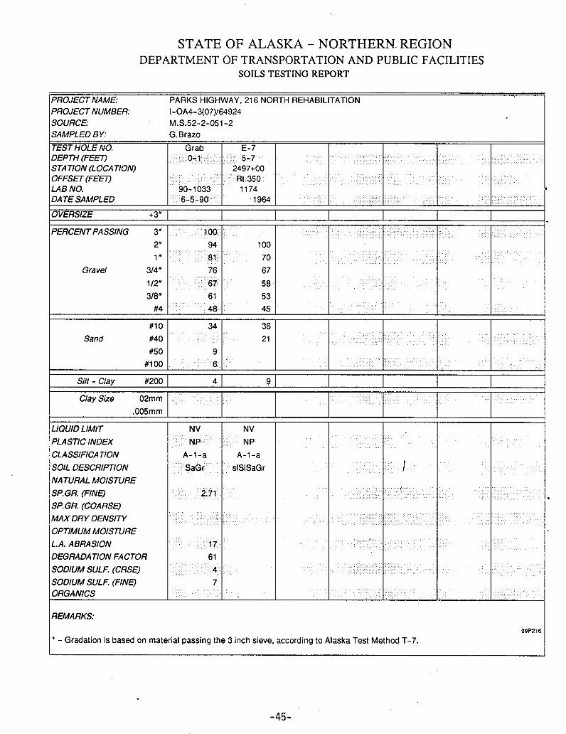
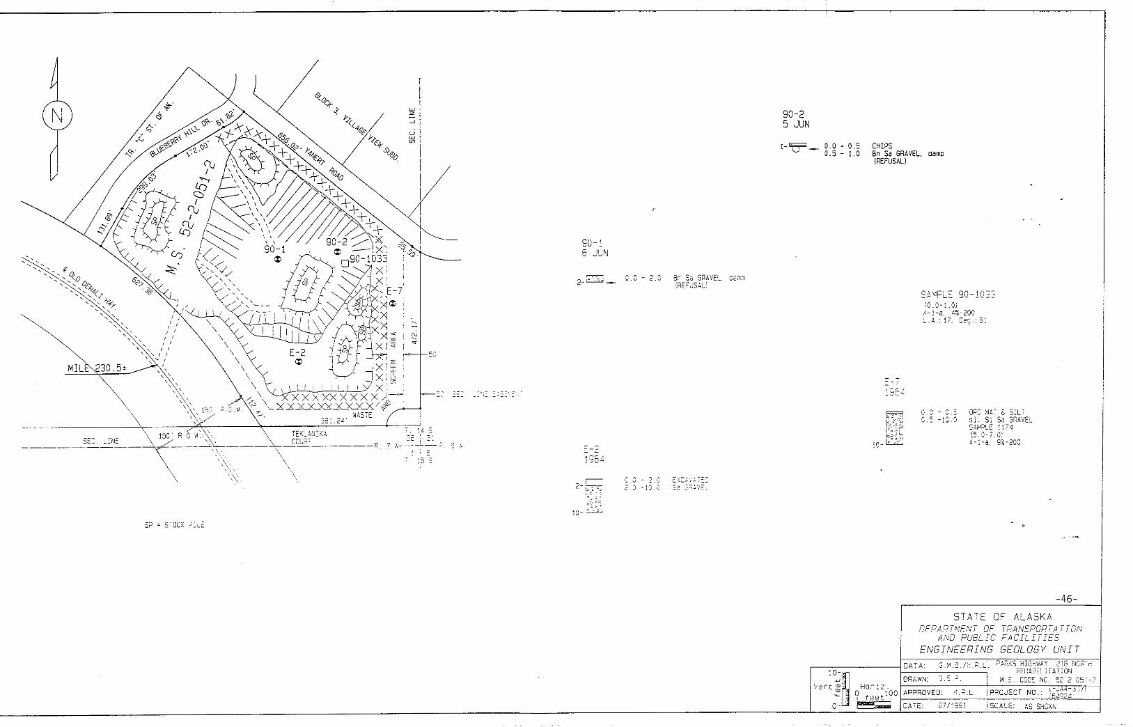
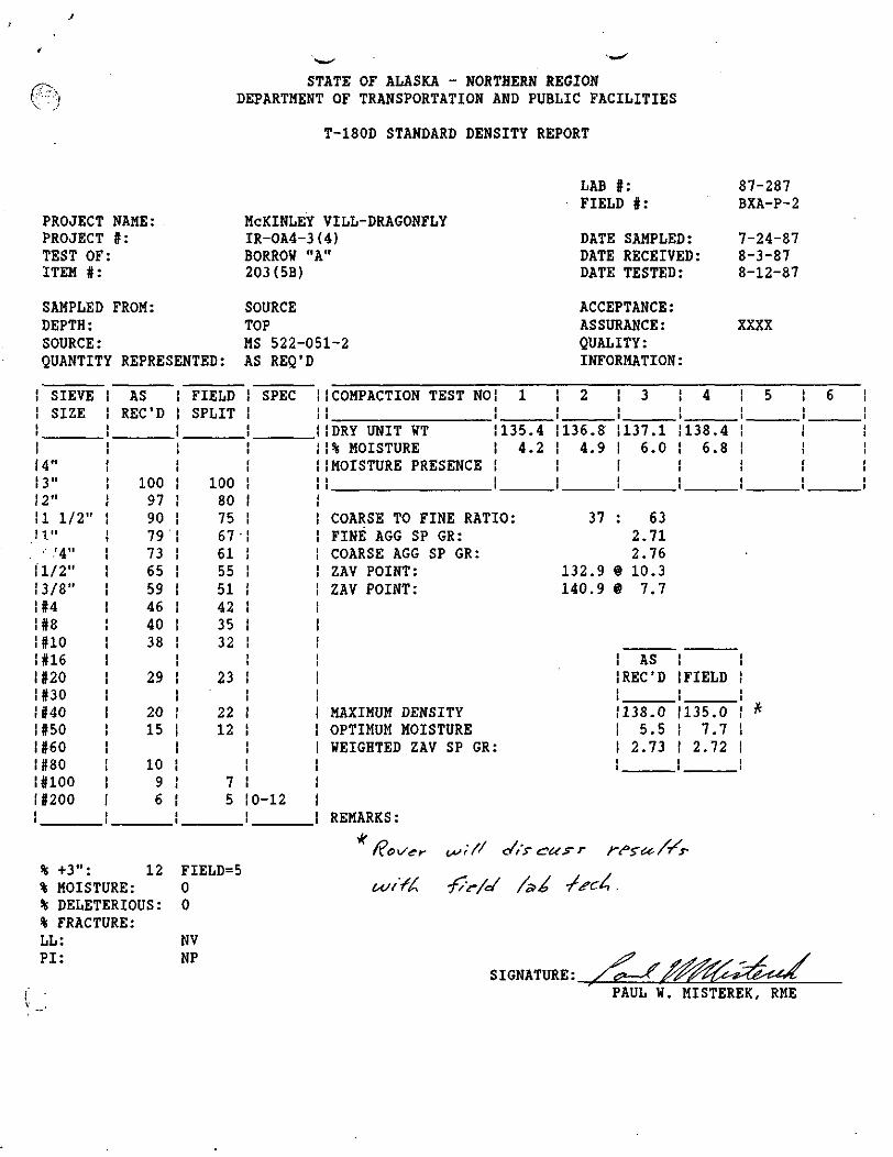
STATE OF ALASKA - NORTHERN REGIONDEPARTMENT OF TRANSPORTATION AND PUBLIC FACILITIES
T-180D STANDARD DENSITY REPORT
PROJECT NAME:PROJECT #:TEST OF:ITEM #:
SAMPLED FROM:DEPTH:SOURCE:QUANTITY REPRESENTED:
McKINLEY VILL-DRAGONFLYIR-OA4-3(4)BORROW "A"203(5B)
SOURCETOPMS 522-051-2AS REQ'D
LAB #:FIELD #:
DATE SAMPLED:DATE RECEIVED:DATE TESTED:
ACCEPTANCE:ASSURANCE:QUALITY:INFORMATION:
87-287BXA-P-2
7-24-878-3-878-12-87
XXXX
SIEVESIZE
J
2"1 1/2"I".'4"
1/2"3/8"#4#8#10#16#20#30#40#50#60#80#100#200
ASREC'D
100979079736559464038
29
2015
1096
FIELDSPLIT
100807567'615551423532
23
2212
75
SPEC
0-12
! COMPACTION TEST NO! 1 | 2 ! 3 4 i 5 6! i ! i !!DRY UNIT WT !135.4 !136.8 137.1 138.4 !!% MOISTURE ! 4.2 ! 4.9 6.0 6.8 
LAB #:FIELD #:
87-287BXA-P-2
PLOT OF MOISTURE - DENSITY RELATION
147
146
145 i
144
143 !
142
140
139
DRYDENSITY
(LBS/CU FT)137
136
5 6 7 8
% MOISTURE
10 11 12 13 14
STATE OF ALASKA - NORTHERN REGIONDEPARTMENT OF TRANSPORTATION AND PUBLIC FACILITIES
T-180D STANDARD DENSITY REPORT
PROJECT NAME:PROJECT f:TEST OF:ITEM #:
SAMPLED FROM:DEPTH:SOURCE:QUANTITY REPRESENTED:
McKINLEY VILLAGE-DRAGONFLYIR-OA4-3(4)BASE COURSE D-l301(1) SP -200 = 0-5
STOCKPILEN/AMS 522-051-2AS REQ'D
LAB |:FIELD #:
DATE SAMPLED:DATE RECEIVED:DATE TESTED:
ACCEPTANCE:ASSURANCE:QUALITY:INFORMATION:
87-289BC-P-1
7-17-878-3-878-19-87
XXXX
i SIEVE! SIZE!1
!4"13"12"il 1/2"11".! V4"
'2"13/8"\U!#8!#10!#16!#20i#30!#40!#50!#60!#80!#100!#200i
ASREC'D
100100958577553935
19
118
654
FIELDSPLIT
100968780584744
28
1511
95
SPEC
10070-100
50-8035-6520-50
8-30
0-5
(COMPACTION TEST NOi 1: i!DRY UNIT ¥T 134.3!% MOISTURE 3.0(MOISTURE PRESENCEii
COARSE TO FINE RATIO:FINE AGG SP GR:COARSE AGG SP GR:ZAV POINT:ZAV POINT:
MAXIMUM DENSITYOPTIMUM MOISTUREWEIGHTED ZAV SP GR:
REMARKS :
! 2 ! 3 ! 4 i 5 6! i i !1134.2 1134.5 1135.8 1138.0! 3.9 ! 4.8 ! 5.8 | 6.2i !LT BEA H BEADILT SW§ i i ii i i i
42 : 582.722.77
130.7 « 11.3138.7 @ 8.5
ASREC'D FIELD
135.9 136.05.8 6.42.74 2.76
% +3":% MOISTURE:% DELETERIOUS:% FRACTURE:LL:PI:
NVNP
82 FIELD = 73
SIGNATURE:PAUL W. MISTEREK, RME
LAB #:FIELD I:
PLOT OF MOISTURE - DENSITY RELATION
87-289BC-P-1
DRYDENSITY
(LBS/CU FT)
145
144
143
142
141
140
139
138
137
136
135
134
133
132
131
130
129
128
127
126
1255 6 7 8
% MOISTURE
10 11 12 13 14
0.0 - 0.5 CHIPS0.5-1.0 Bn Sa GRAVEL, damp
(REFUSAL)
0 . 0 - 2 . 0 Bn 35 GRAVtL. dcinq(REFUSAL!
-
L . A . : !7, Deo. : 6
0.0 - 0.50 . 5 - i O . O
ORG MAT S £ ILTsi. Si Sa GRAVESAMP! E '1(5 .0 -7 .01
-a. 9X-200
0.0 - 2.0 EXCAVA5.0-10.0 Sa G^
Ve'n't "ill. Hor iz
-46-'
S T A T E OF ALASKA. , .DEPARTMENT OF TRANSPORTATION
AND PUBLIC FACILITIESENGINEERING GEOLOGY L/A/ITV--
DATA- G M.3V.H R Ll PARKS. HIGHWAY.-'2i6,NORTH,-. :..'";: • ' ' ' j -^:.>a,REHA8ILITAr[0>i.i,%|ORAWN;-VG.S.P . . . ; . - - j; M . s ? CODE TNG:-;-'52-2V'6.5X;0?
7 JlffO 9O
L I M E
For
5 X
STATE OF ALASKA
^DEPARTMENT OF TRANSPORTATWJ
AND
PUBLIC FACILITIESf^ •
ComputationsProject No
Bridge No
Calc by DmteChecked by .................. D.te
Y\J
( > . X
5 X 150/ X - -
.X ' X
390' X
s
125 O^L— — - " " " / r^ _ »<
Sheet of SheeU25D-119 8 / 8 2
"••£-•
T.H. E-50.00.5
Denotes
^SEC. LINE EASEMENT
MATERIALS SOURCE NO. f552'-051-2 (#2Cty (Pit "E" 522-067-2)
Remarks
The extension to the north in ^his source contains A-l-asandy gravel with some boulde > to 18 inches in diameter.Vegetation in this well-drain c site is restricted to dwarfbirch and scattered'white s~r-^oe trees.
D 2*~ £^ ^••' 3.7•
Area
Recommended area D *~ ^ ••' 3.7 acresWaste area • 0.6 acresTotal area , 4.3 acres
Recalculated Quantities
Stripping (average thickness 1.5 feet)
400 x 400 x 1.527 s 8,900 cu. yds.
Estimated borrow (calculated thickness 20.0 feet)•
400 x 400 x 2027 = 114,800 cu. yds.
Less slope allowance 11,500 cu. yds.
Total estimated borrow 103,300 cu. yds.
An exposure in the Nenana Canyon 300 feet to the northeastshows more than 30 feet of. clean sandy gravel present fora horizontal distance of over 800 feet.
Indicated borrow (calculated thickness.. 8. 5 feet)
400 x 400 x 8.527 = ' 50,400 cu. yds.
Less slope allowance • 5,000 cu. yds.
. Total indicated borrow •• 45,400 cu. yds.
•47-
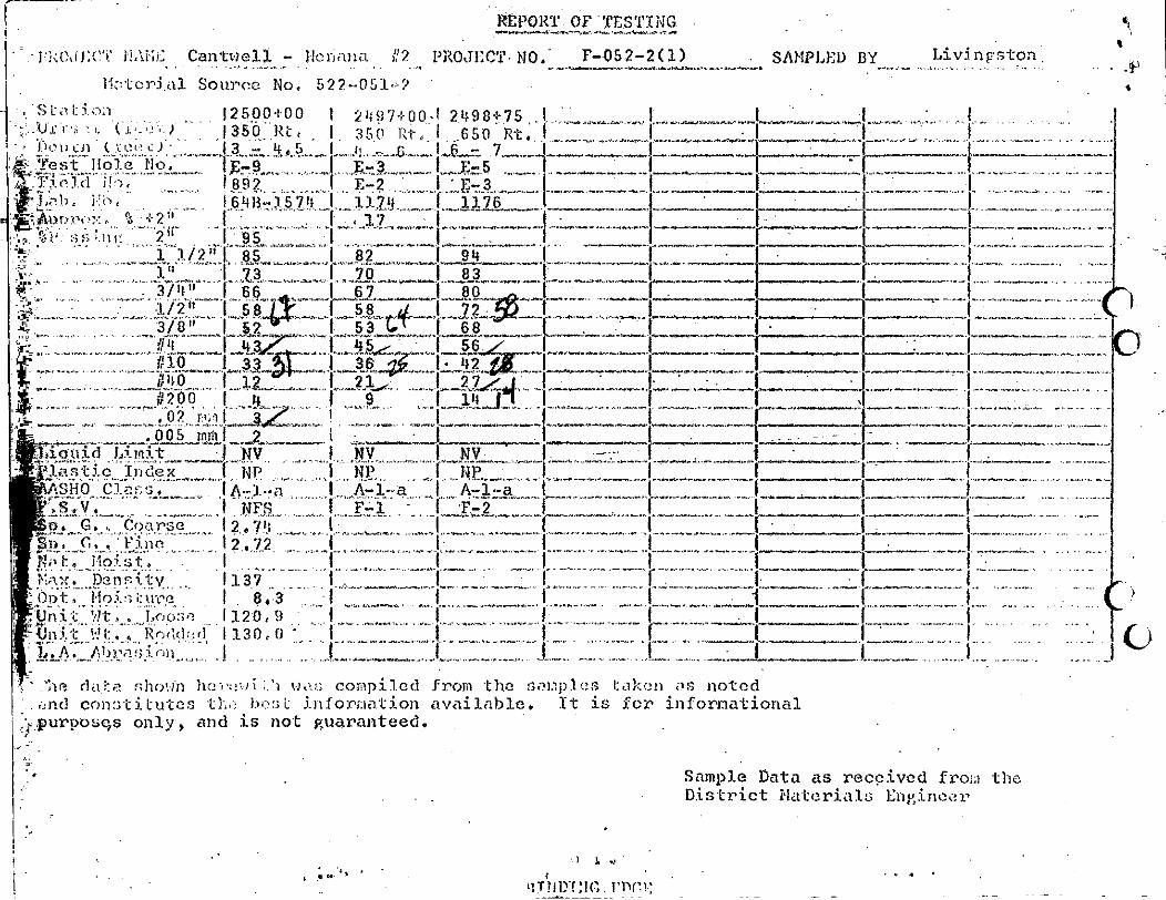
____ £_M_.F _ TEs_t_. • I - J U V f J - X ' T HAM.:: CantwelX - J-Ierinna i?? PROJECT-NO," F-052-2C1)
\-iul Source No, 522-051~?
SAMPLED BY Livingston.
1250.0+00 { 2 M 9 7 + 00.-1-2.19
11 _U.
*? - f/'l" "*"" i?"io
_Jxg_u;id' Lijnit_w _,_^l „.NVKasticllnde'x'""' I" NP™ " : T^" r i HP
! A- -a
|3. G. , Coarse 1.2.,7'Jn<"."_,C,"',' :Finn ." ". " I 2 .72"
it V7t . . Loo:;o 1120,9130.0 •
17. A,
:P'-"he dai>?, r,hr;v;n ho vc:<.vi :.'i vj , - : ; compiled from tho soi.ip.lcs taken os noted1 . «nd const i tutes thii bo:; L information available. It is for informational
c,s only, and is not guaranteed.
Sample Data as received from theDistrict Materials Enj'incer
- ) i .
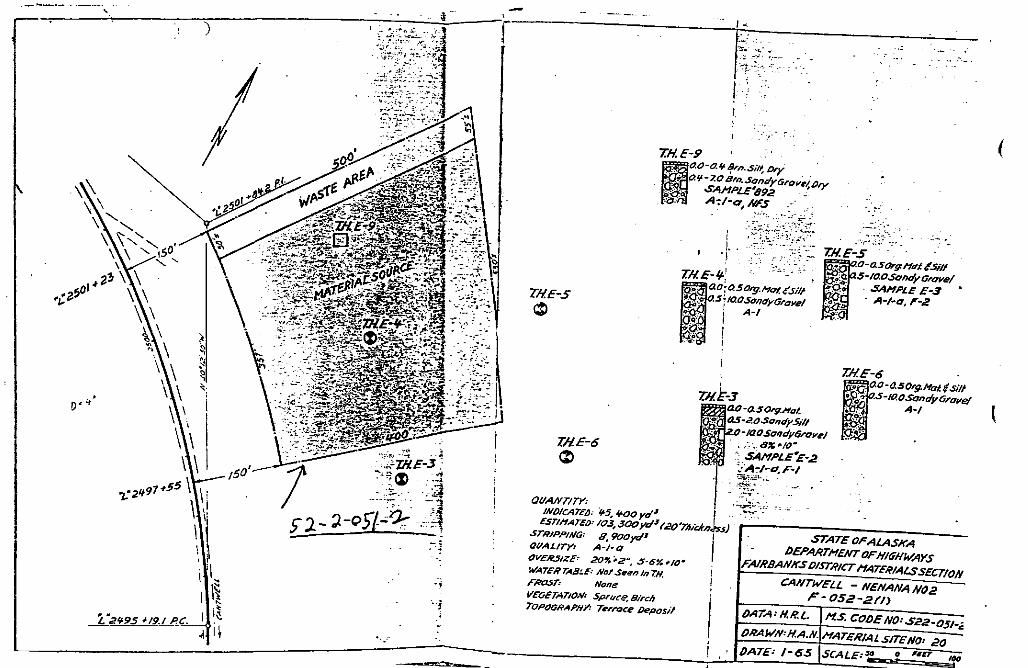
.
I?
ill;
Bs?s
1s
§J
II;«Q
|3§15
3l*y
")iI
ha
4I ,
"~8
*trli§">
01v g
*o^
T^-tT
TS
p^T T! 1
i»4 ;.'
* rSev'-'A;
.^-•!r^,-M|.":N
;I
^
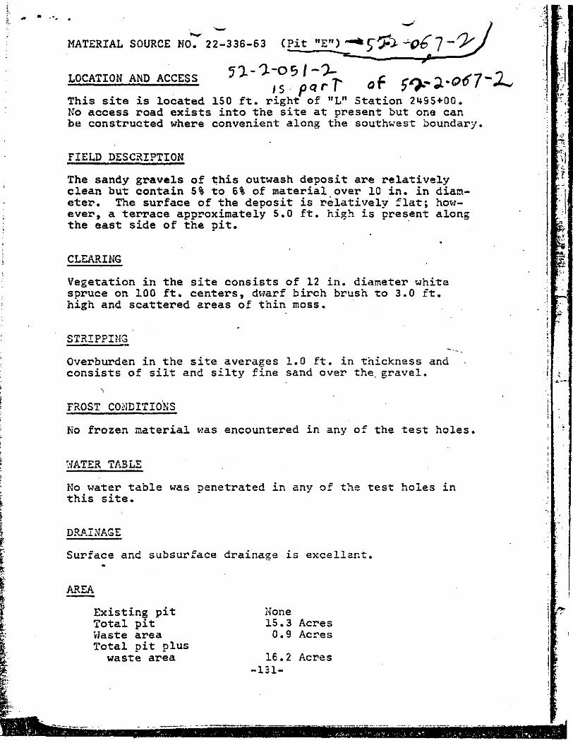
MATERIAL SOURCE MO. 22-336-63 (Pit
LOCATION AND ACCESS
This site is located 150 ft. right of "L" Station 2^95+00.No access road exists into the site at present but one canbe constructed where convenient along the southwest boundary.
FIELD DESCRIPTION
The sandy gravels of this outwash deposit are relativelyclean but contain 5% to 6% of material over 10 in. in diam-eter. The surface of the deposit is relatively flat; how-ever, a terrace approximately 5.0 ft. high is present alongthe east side of the pit.
CLEARING
Vegetation in the site consists of 12 in. diameter whitespruce on 100 ft. centers, dwarf birch brush to 3.0 ft.high and scattered areas of thin moss.
STRIPPING
Overburden in the site averages 1.0 ft. in thickness andconsists of silt and silty fine sand over the. gravel.
FROST CONDITIONS
No frozen material was encountered in any of the test holes,
WATER TA3L5
No water table was penetrated in any of the test holes inthis site.
DRAINAGE
Surface and subsurface drainage is excellent.
AREA
Existing pitTotal pitWaste areaTotal pit pluswaste area
15.3 Acres0.9 Acres
16.2 Acres•131-
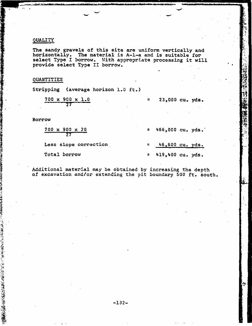
QUALITY
The sandy gravels of this site are uniform vertically andhorizontally. The material is A-l-a and is suitable forselect Type I borrow. With appropriate processing it willprovide select Type II borrow.
QUANTITIES
Stripping (average horizon 1.0 ft.)
700 x 900 x 1.057
23,000 cu. yds,
Borrow
700 x 900 x 2057
Less slope correction
Total borrow
166,000 cu. yds.
16,600 cu. yds.
119,400 cu. yds.
Additional material may be obtained by increasing the depthof excavation and/or extending the pit boundary 500 ft. south.
-132-
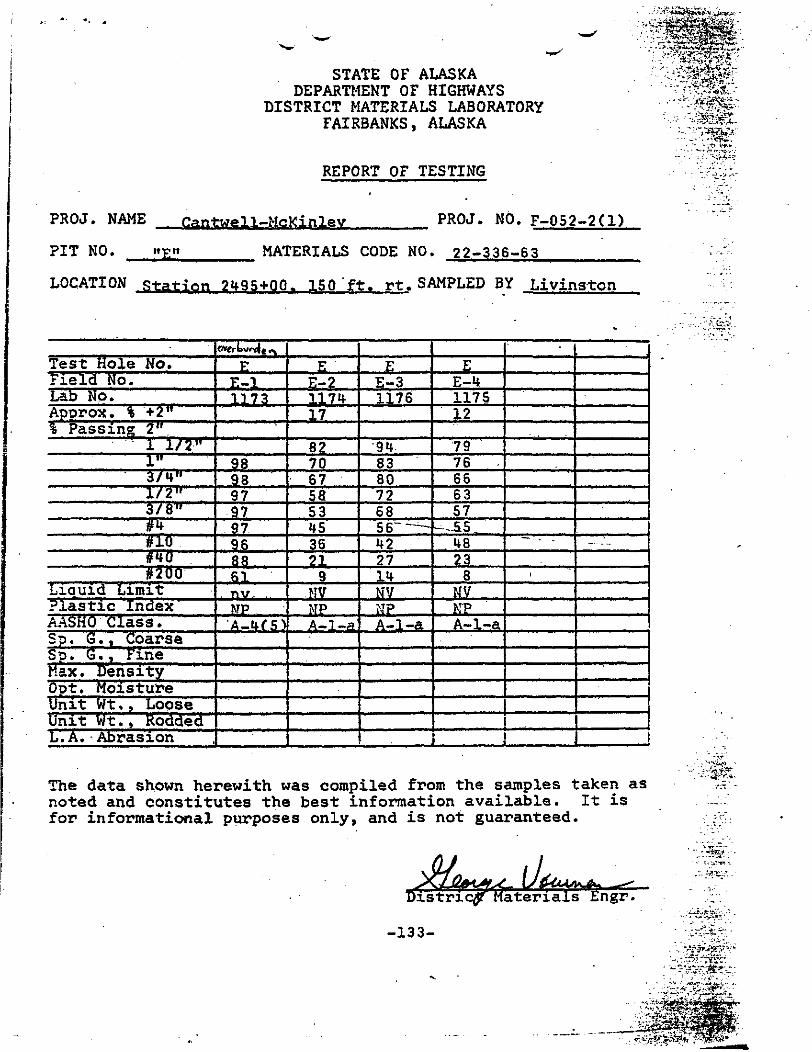
STATE OF ALASKADEPARTMENT OF HIGHWAYS
DISTRICT MATERIALS LABORATORYFAIRBANKS, ALASKA
REPORT OF TESTING
, • •' VMJ jWMLv-.jttW*---
PROJ. NAME
PIT NO.
Cantwell—McKinlev PROJ. NO. F-052-2U)
MATERIALS CODE NO. 22-336-63
LOCATION station 2495+00. 150'ft, rt. SAMPLED BY Livinston
Test Hole No.Field No.Lab No.Aoorox. % +2"% Passing 2".
1 1/2"1"3/4"1/2"3/8"!R#10#40#200
Liauid LimitPlastic IndexAASHO Class .Sp. G., CoarseSp. G., FineMax. DensityOt>t. MoistureUnit Wt , , LooseUnit Wt . , RoddedL.A. Abrasion
O"frk>v<-o|t
EE-l1 ,73
9898979797968861
. ny, .MPA-UfS)
EE-2117417
82706758534536219
MVMPA-l-a
EE-31176
•948380726856--—422714NVMPA-l-a
EE-4117512
7976666357
U..ss48238
NVNPA-l-a
••- -
i
.! !
The data shown herewith was compiled from the samples taken asnoted and constitutes the best information available. It isfor informational purposes only, and is not guaranteed.
aterials Engr.
-133-
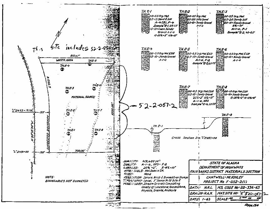
*•
I
WASTE AREA TH.E-5 : ~
\ ' *** V '^
\| , /ml£ TH.E-41 v. v.\^ Trf.e-3 Q ; ":*ir'\ O H '?^
;
\ MATERIAL SOURCE -'-!
X
Xs1S
_ •
TH.E-2/ T.H.E-7 §;J2>^/ ®: S_
— *l
-/
THE-l '-\TH.E-8 ••• ' . ' •
!-ISO' -
T.H.E-2OO-OSOrg.Mat
p 05-2.0 SiltySandiO-IO'Sand/Gravel
4-/-0A-l-a, F-t
Sorapte'E-2, W-6.O1
NOTE:BOUNDARIES NOTSURVEYZ3
Nona3pruci,3irc.'l r a-jrne
' Level, S'SsacnfrOfSife E-?f.'t&. '.'LOS/-- Jfrectr, Gravels Consisting
CAia/tyGfL/.Tiestona, Greans/one,Rfsyo/ife, 3ranife,Andesifs
\ STATE OF ALASKADEPAKTMSNT OF HIGHWAYS
FAIR3ANKS DISTRICT MATERIALS SECTION
\' PROJECT No F-052-afn
DATA- H.K.L.
DATc\ 1-63
MS. CODSNo-22-336-63MAT.SITEN& '
ion iatf
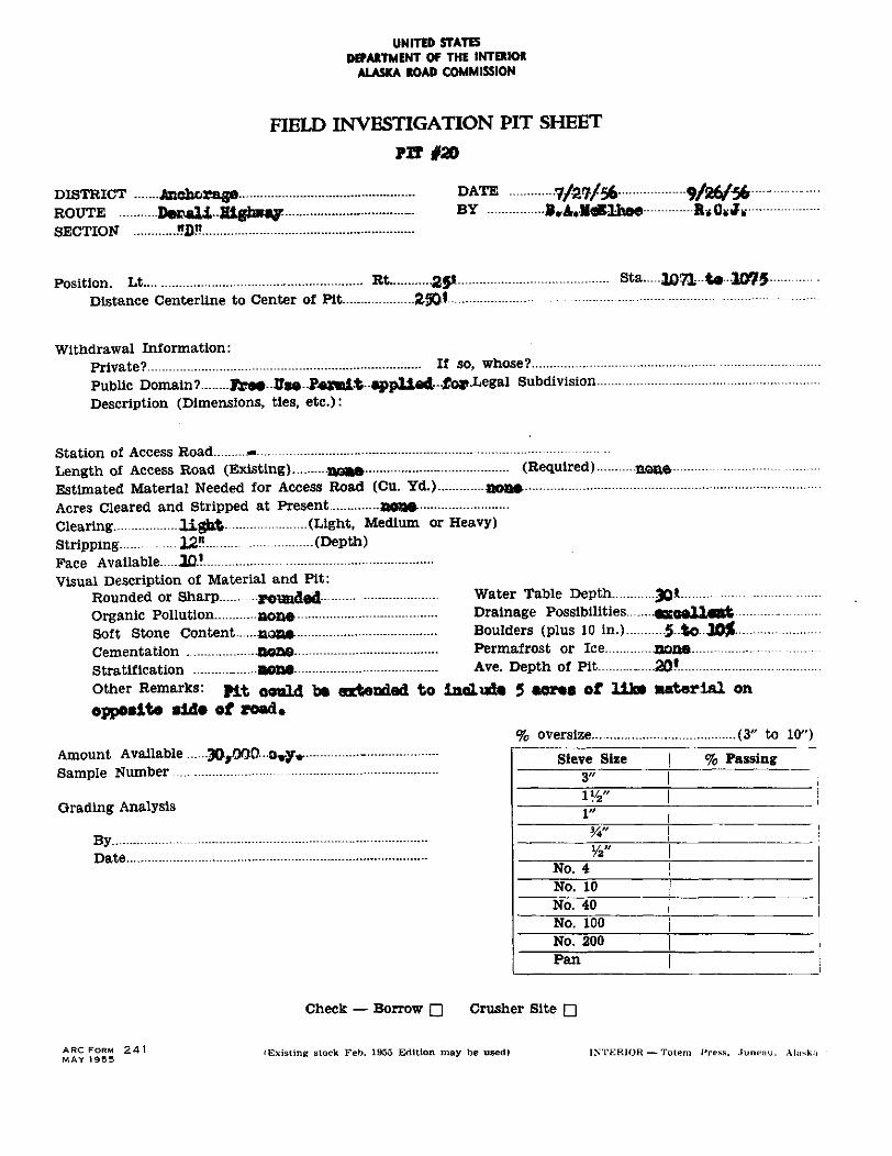
UNITED STATESDEPARTMENT OF THE INTERIOR
ALASKA ROAD COMMISSION
FIELD INVESTIGATION PIT SHEET
PIT #20
DISTRICT ....... Jtochorage ................................................. DATE 7/27/56 9/26/56ROUTE ........... De&ali -Highway .................................... BY B»A.JkRU»* &*G*JF*SECTION ............ .?D« ...........................................................
Position. Lt ............................................................ Rt ........... -2-51 .......................................... Sta ..... JflTl -t« -1075-Distance Centerline to Center of Pit
Withdrawal Information:Private? If so» whose?Public Domain? R?«*-fls«-P«»i-t-appU«d-fo»-Legal SubdivisionDescription (Dimensions, ties, etc.):
Station of Access Road **Length of Access Road (Existing) n0*» (Required)Estimated Material Needed for Access Road (Cu. Yd.) aoa»Acres Cleared and Stripped at Present XMKM-Clearing light (Light, Medium or Heavy)Stripping 12" (Depth)Face Available .10.!Visual Description of Material and Pit:
Rounded or Sharp. pouad«d Water Table DepthOrganic Pollution none Drainage Possibilities «saall«ntSoft Stone Content aone- Boulders (plus 10 in.) 5 to J0£Cementation none Permafrost or Ice noneStratification _ none Ave. Depth of Pit 20*other Remarks: jy.t oould b» extended to laeludUl 5 «OT«B of lik» material onopposite sid« of road*
% oversize (3" to 10")Amount Available .3QrOOO 0*yv -Sample Number....
Grading Analysis
ByDate.
Sieve Size % Passing3"
i"
No. 4No. 10No. 40No. 100No. 200Pan
Check — Borrow Q Crusher Site Q
ARC FORM 241 (Exist ing stock Feb. 1955 Edition may be used) INTERIOR — Totem Press, .luneuu. AlaskaMAY 1955
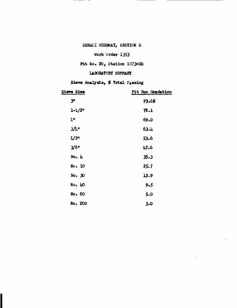
DENALI HIGWAX, SECTION D
Work Order 1353
Pit No. 20, Station 1073*00
UBORaTOHT SUMMART
Sieve Analysis, % Total Passing
Sieve Sis« Pit Run Gradation
3M 93.6*
1-1/2" 78.1
1" 69,0
3A" 63.U
1/2" 53.6
3/8" k7.6
No. k 35.3
No. 10 25.7
No. 30 13.9
No. kO 9.5
No. 80 5.0
No. 200 3.0
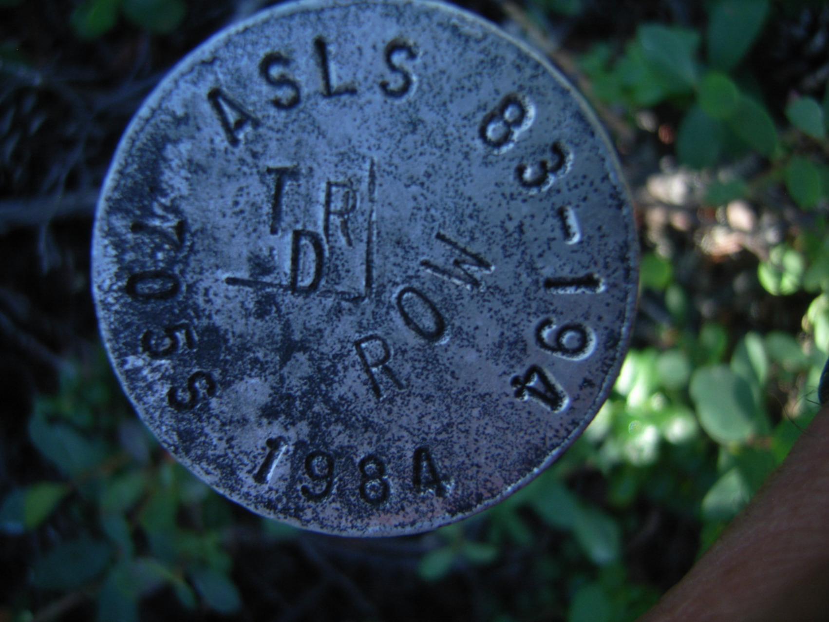
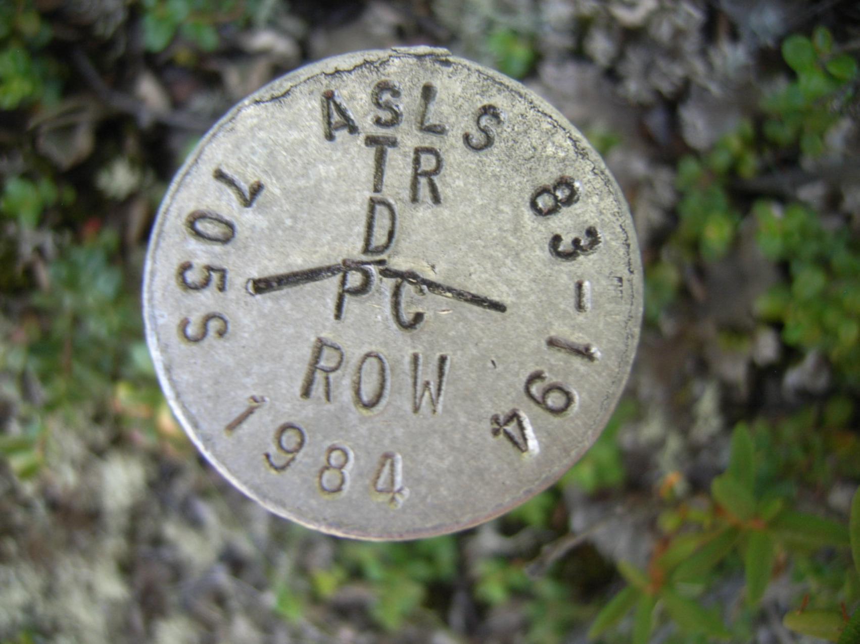
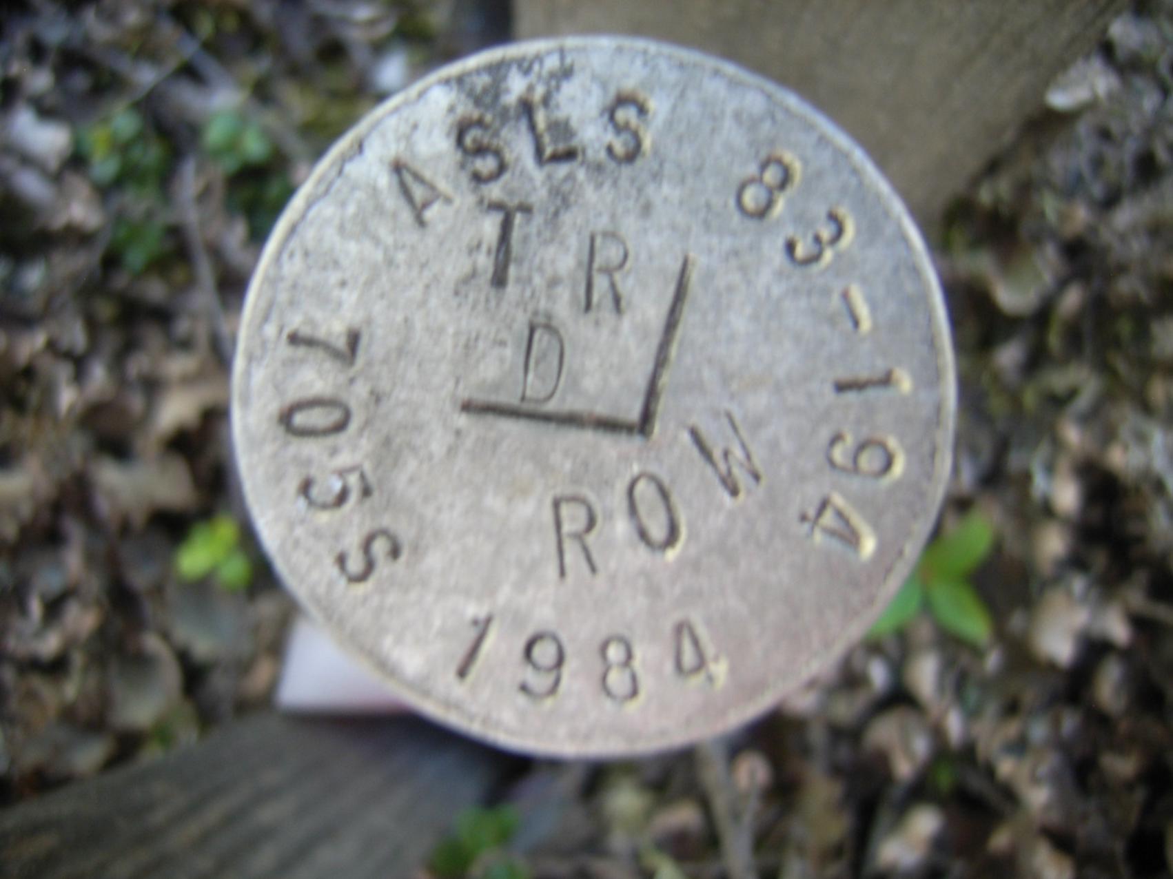
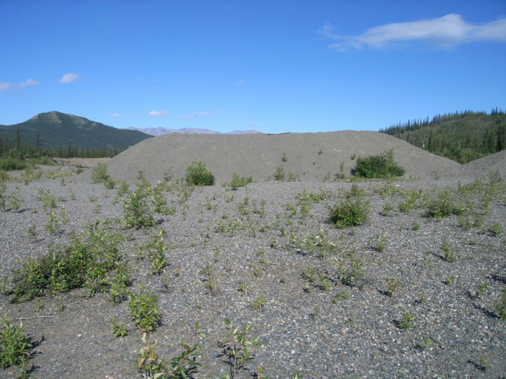
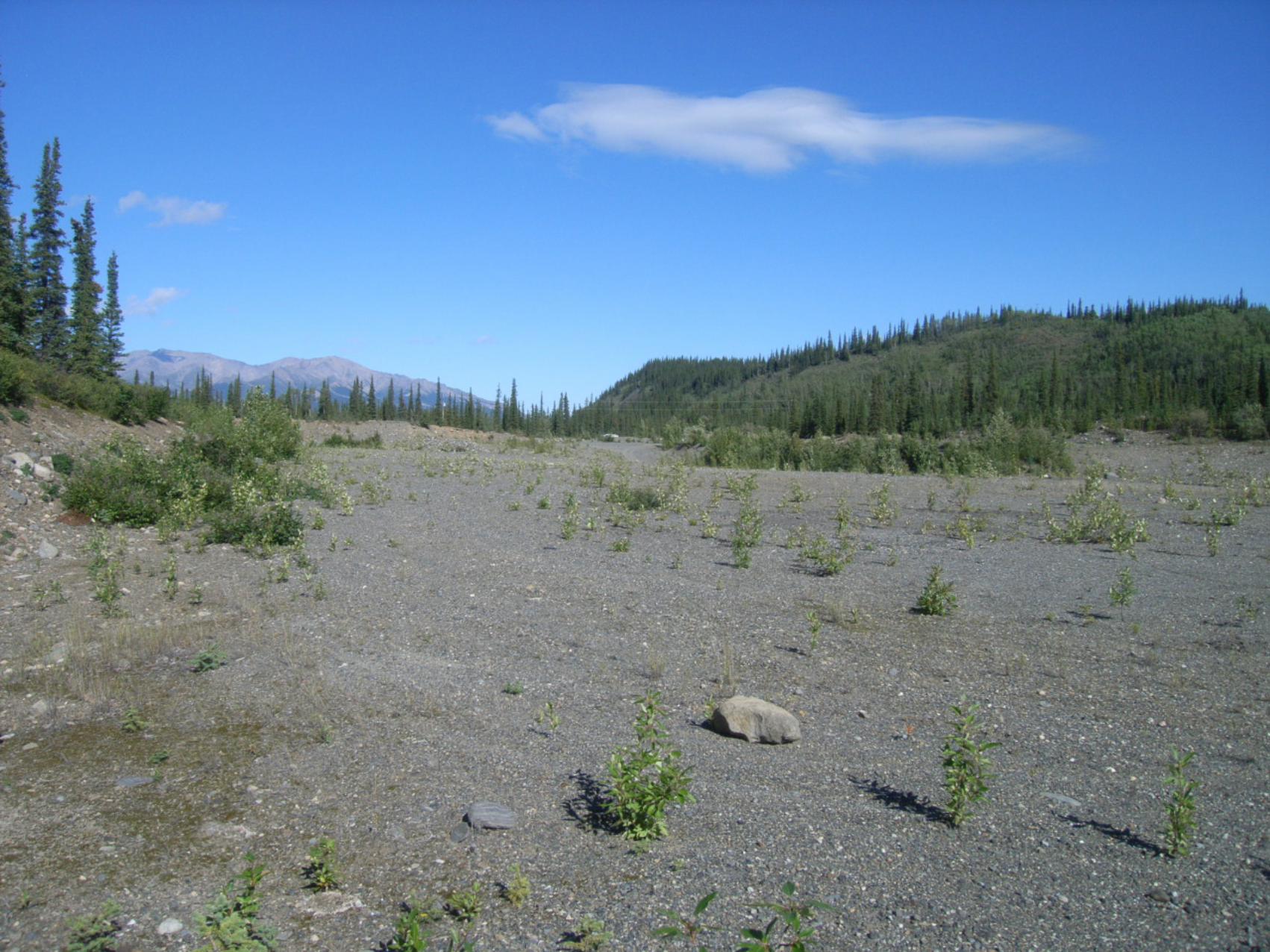
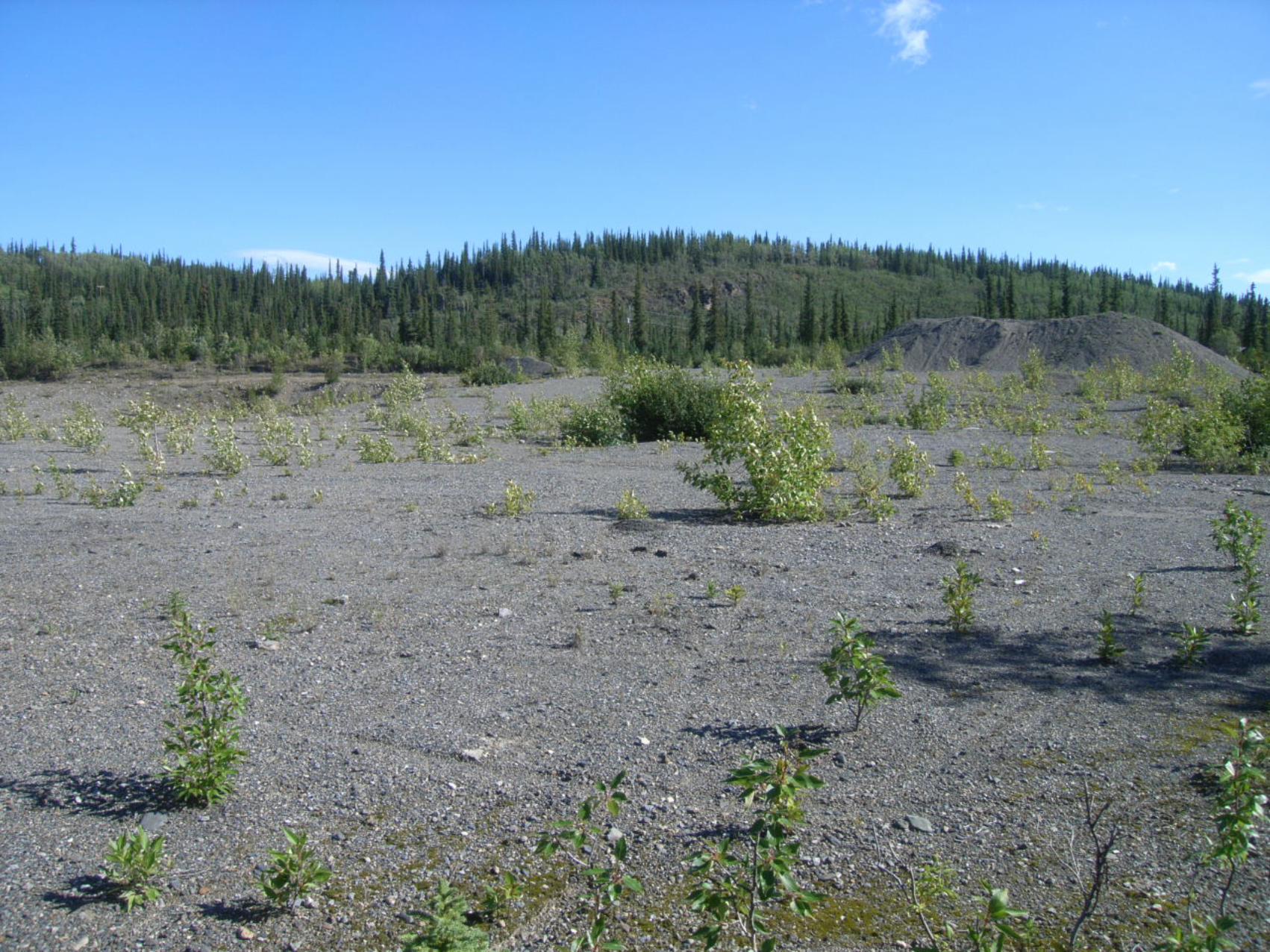
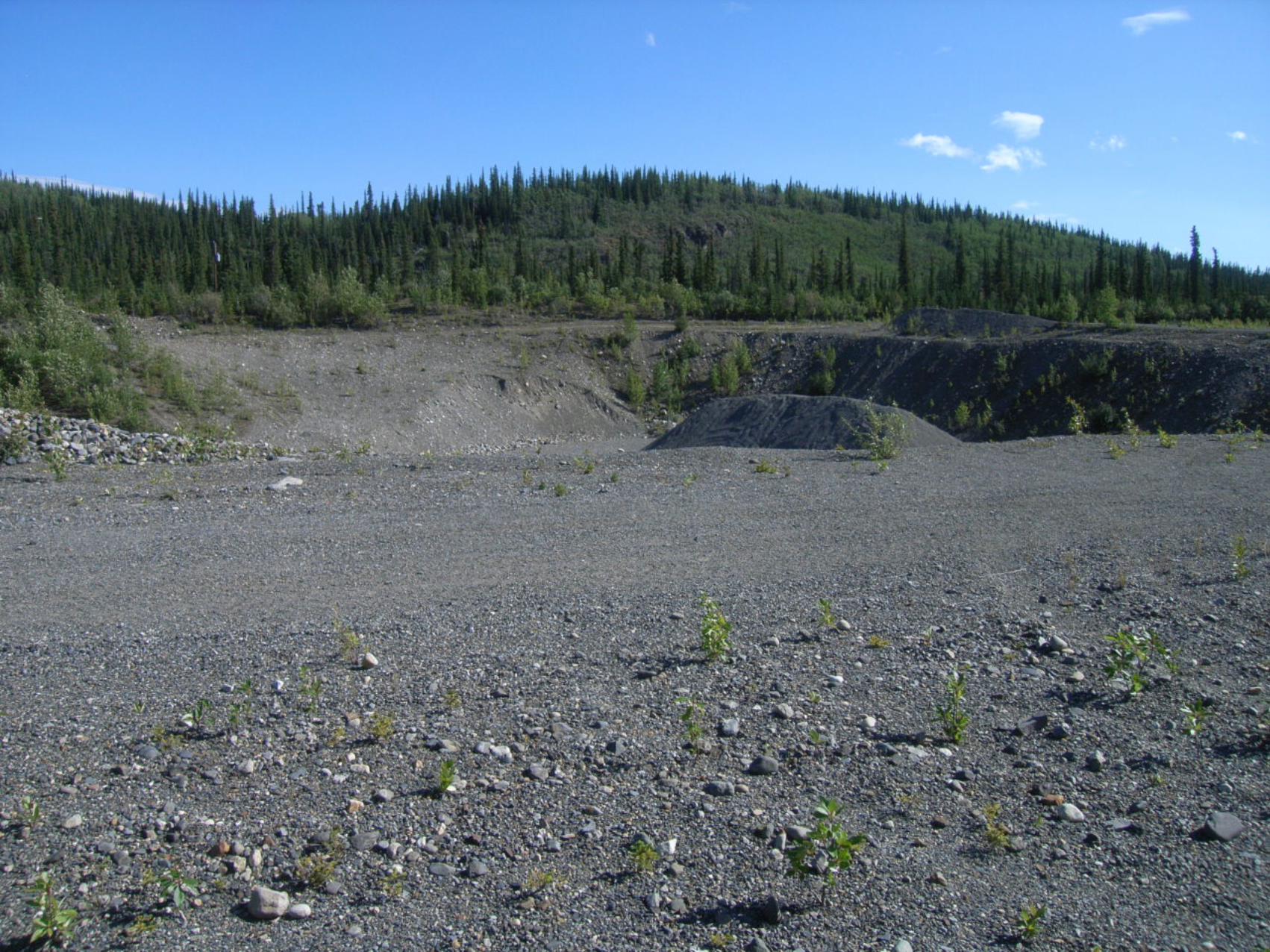
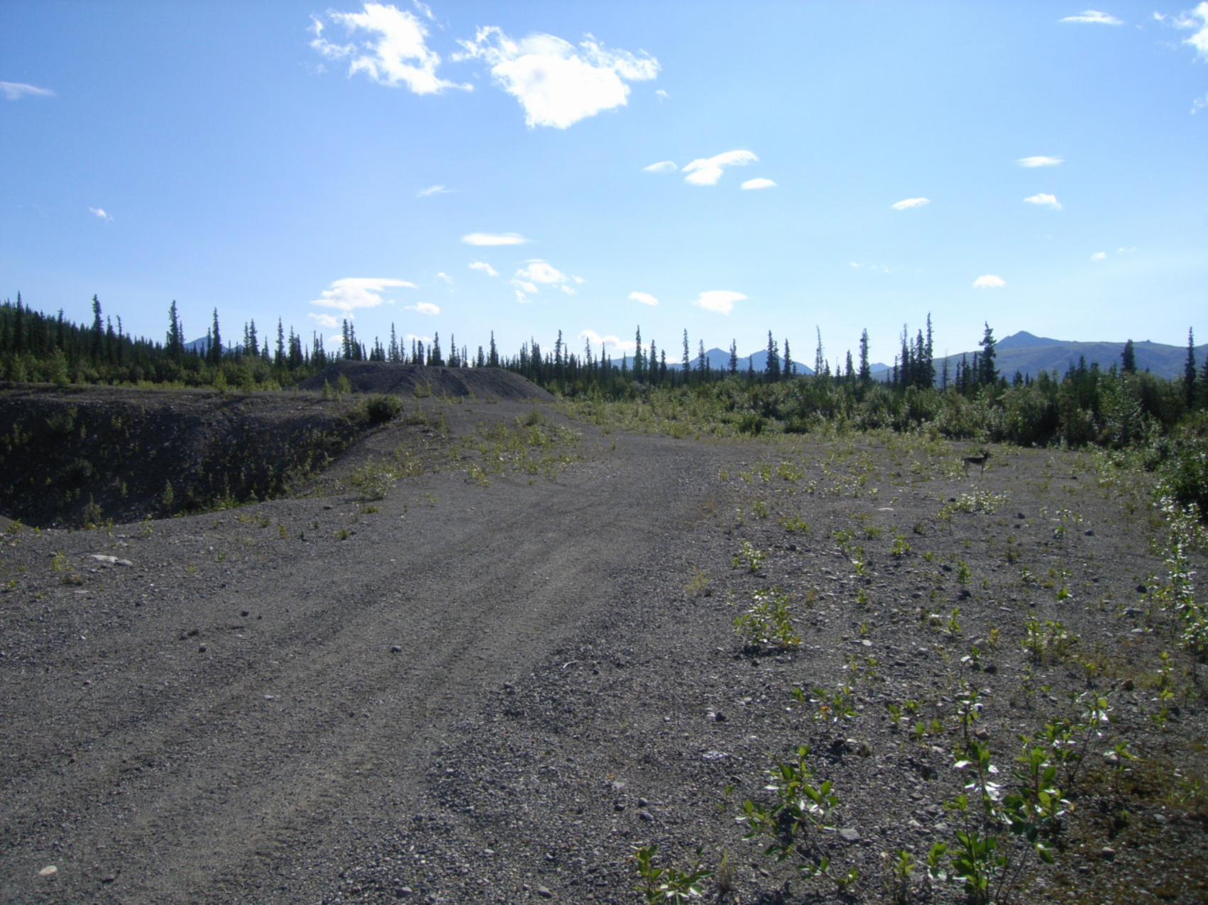
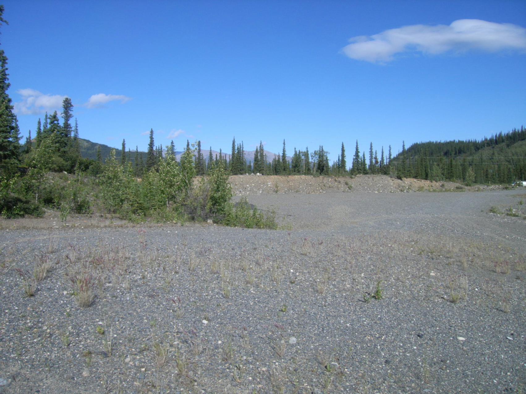
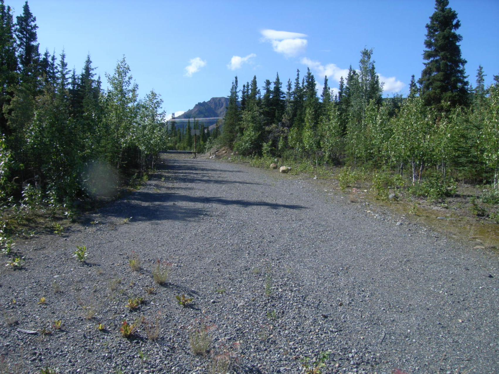
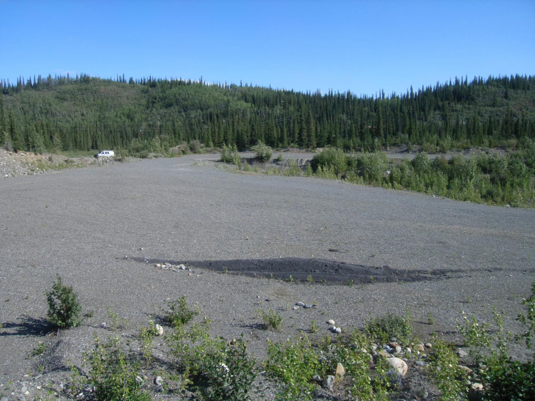
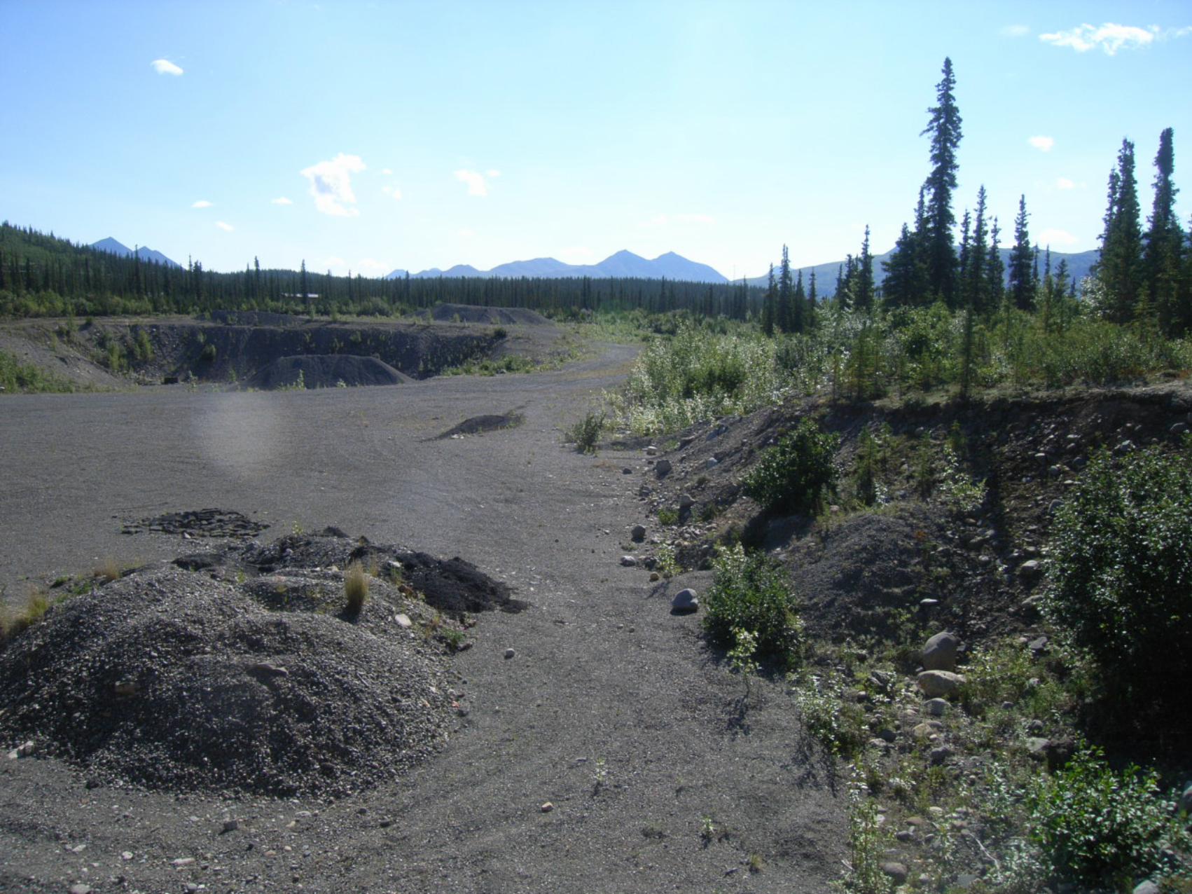
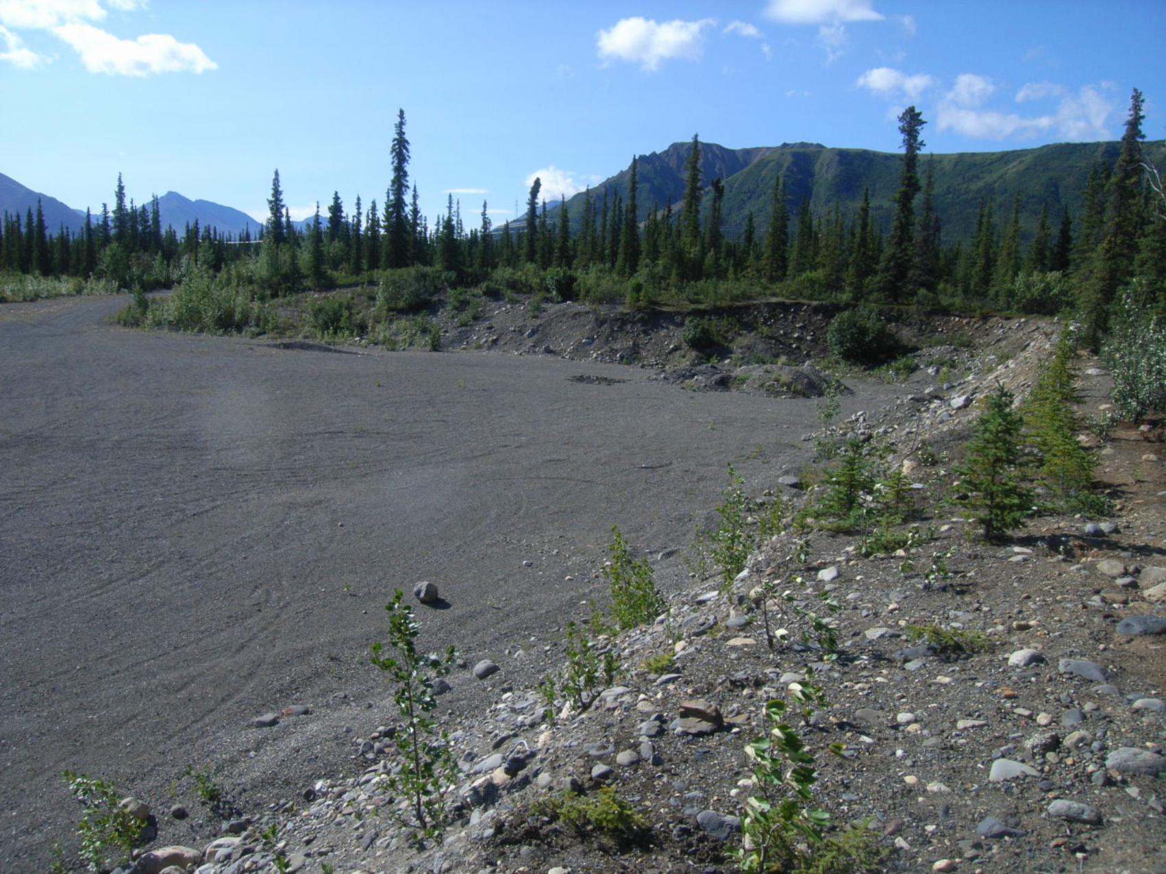
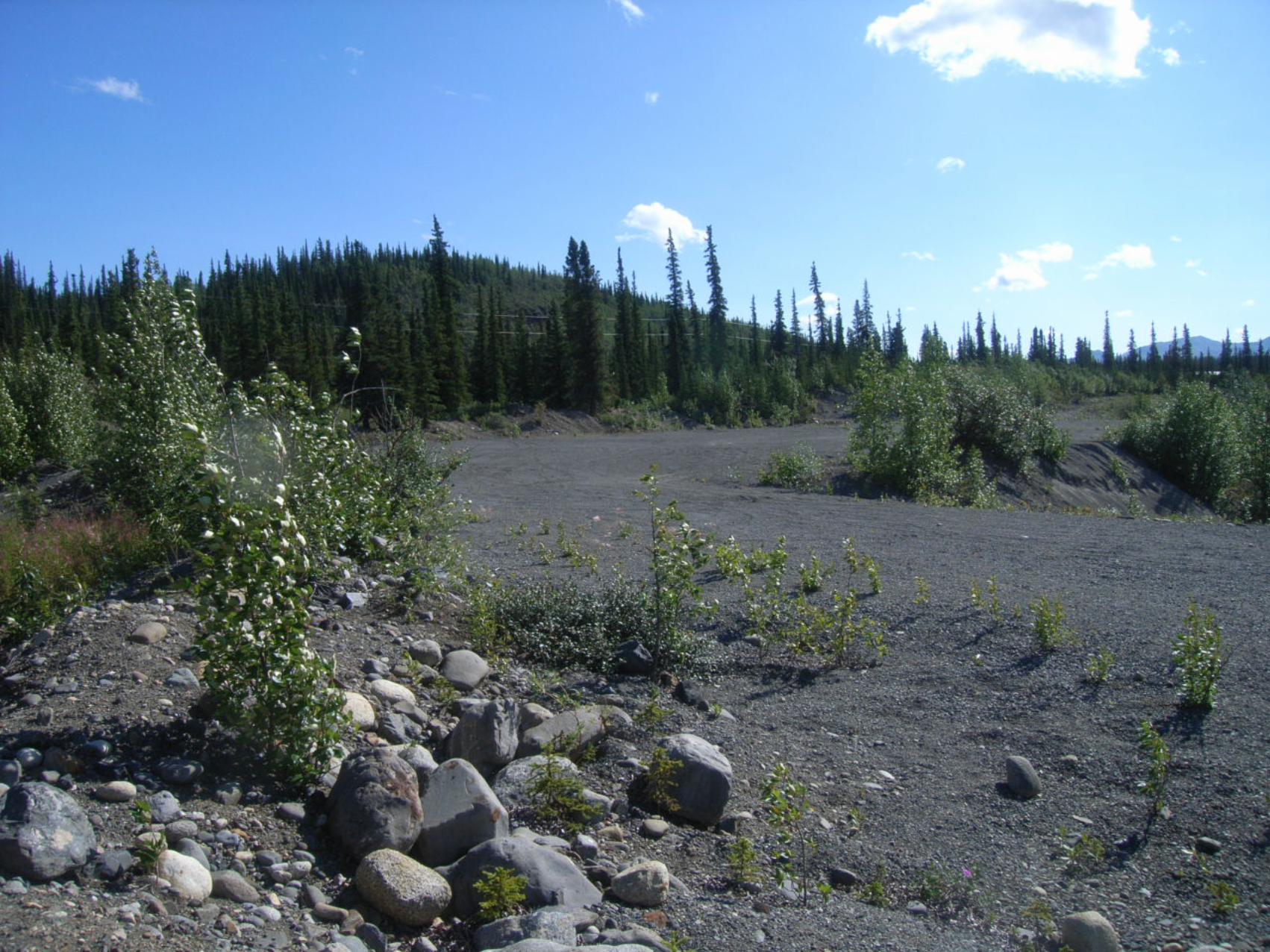
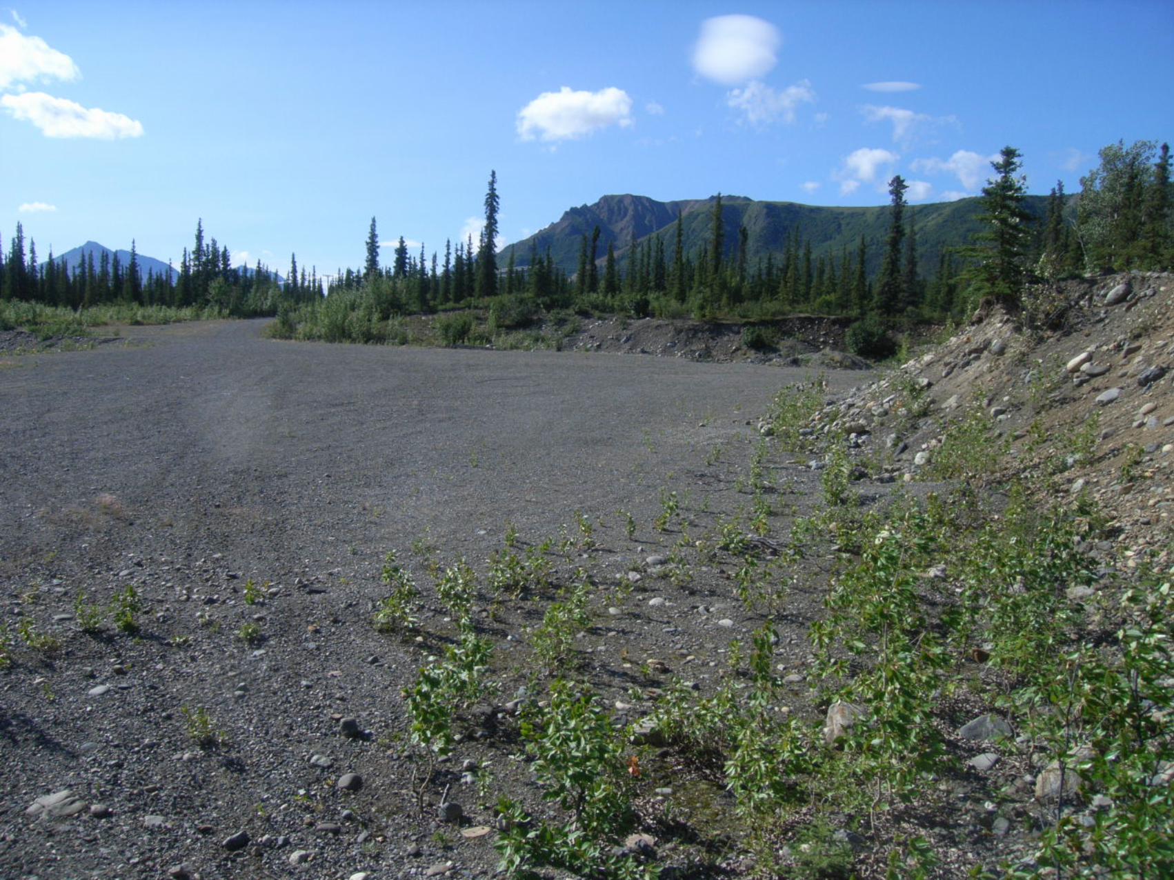
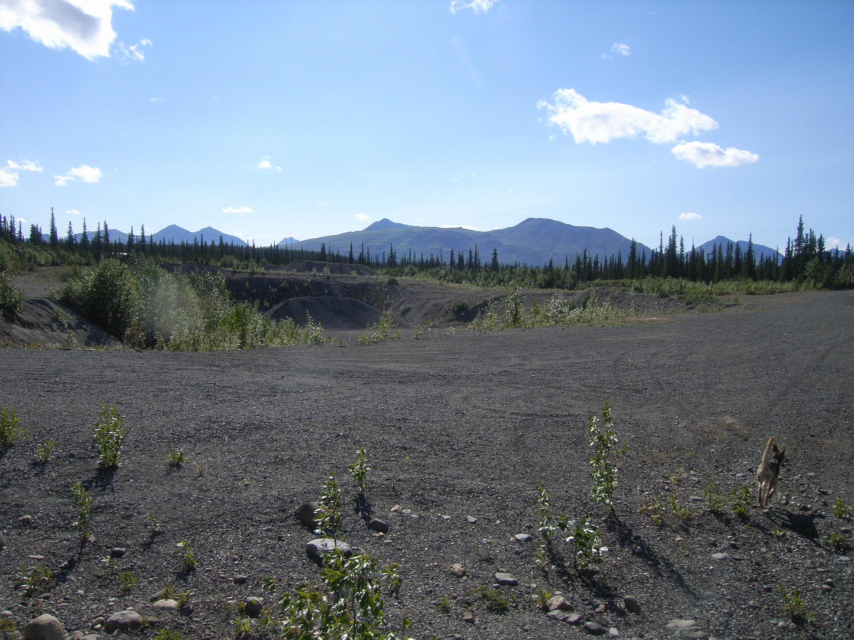
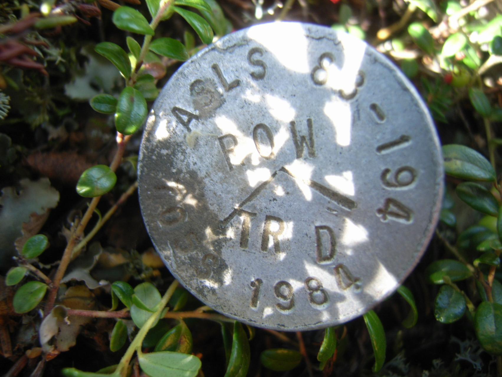
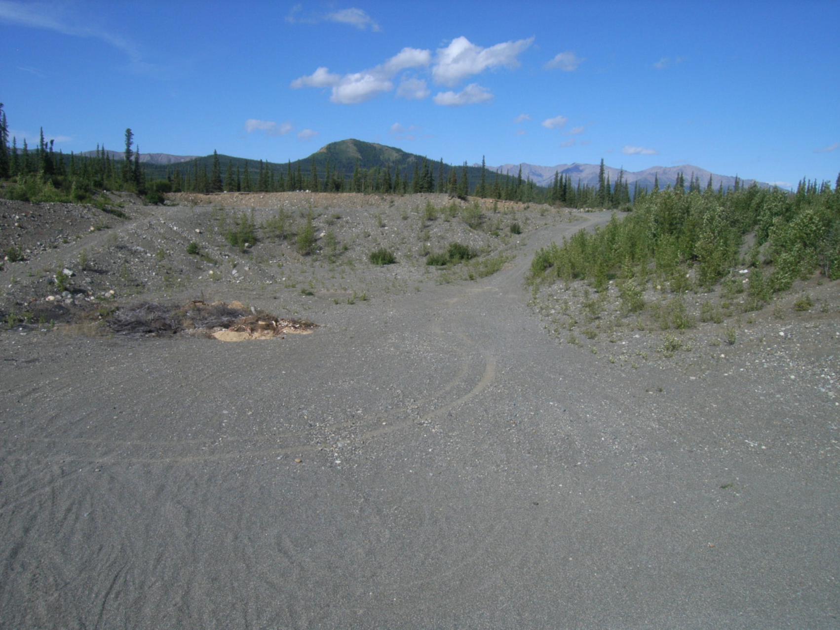
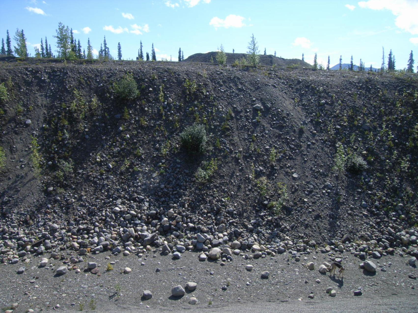

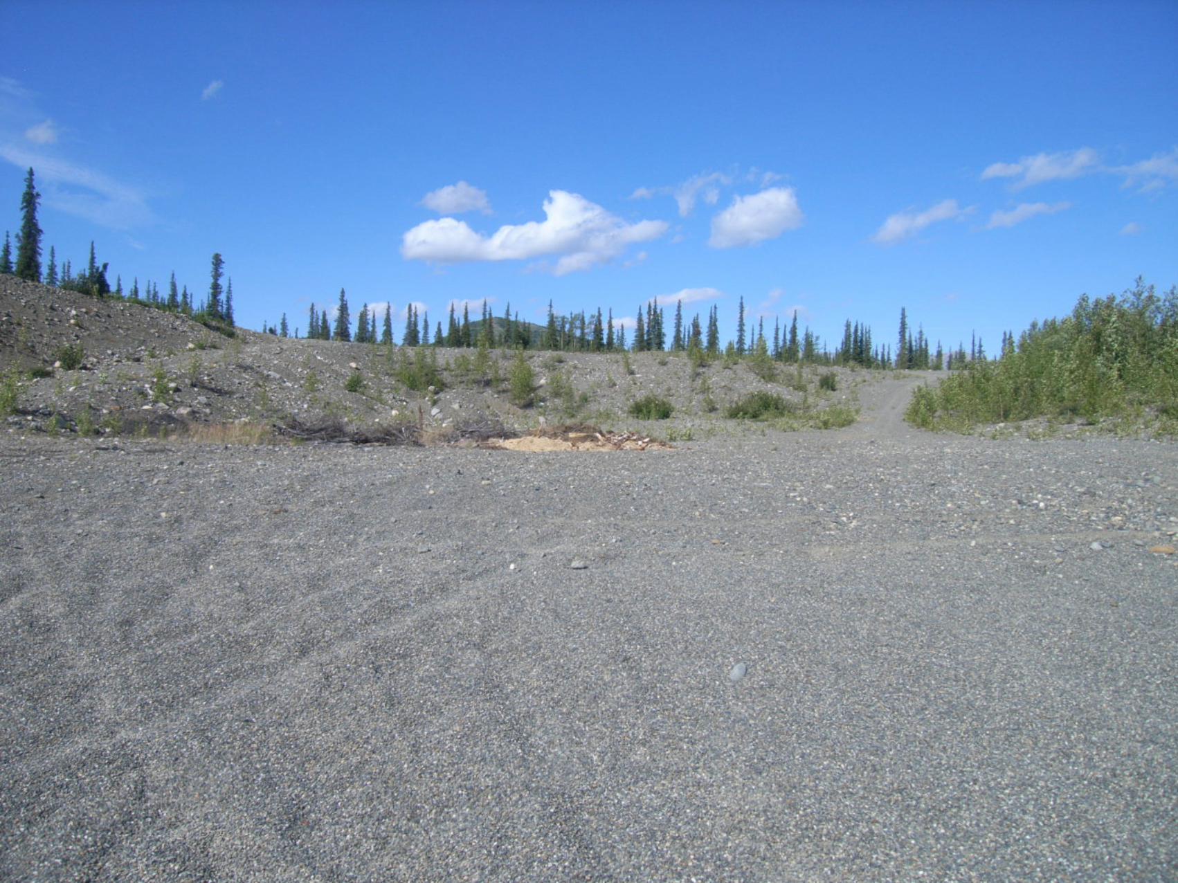
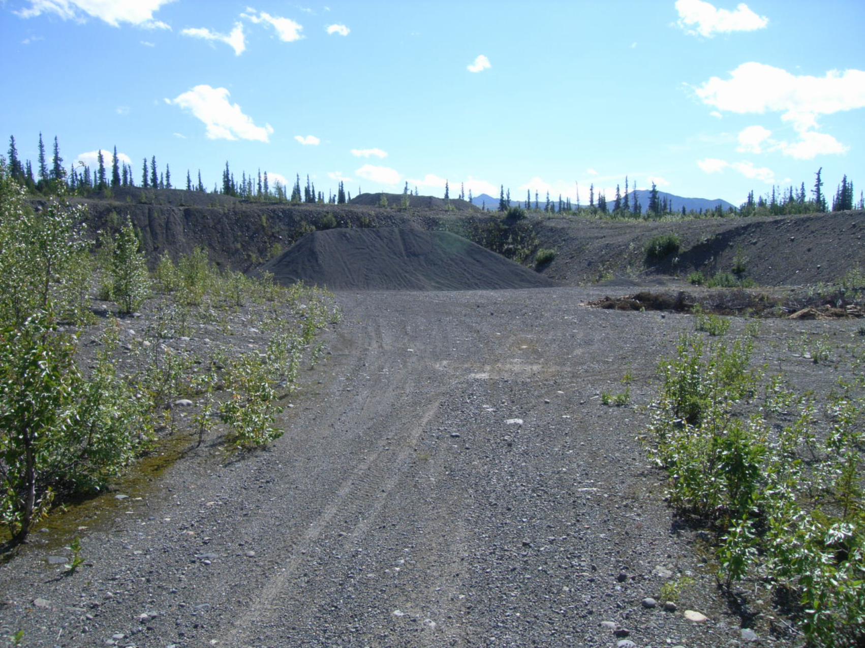
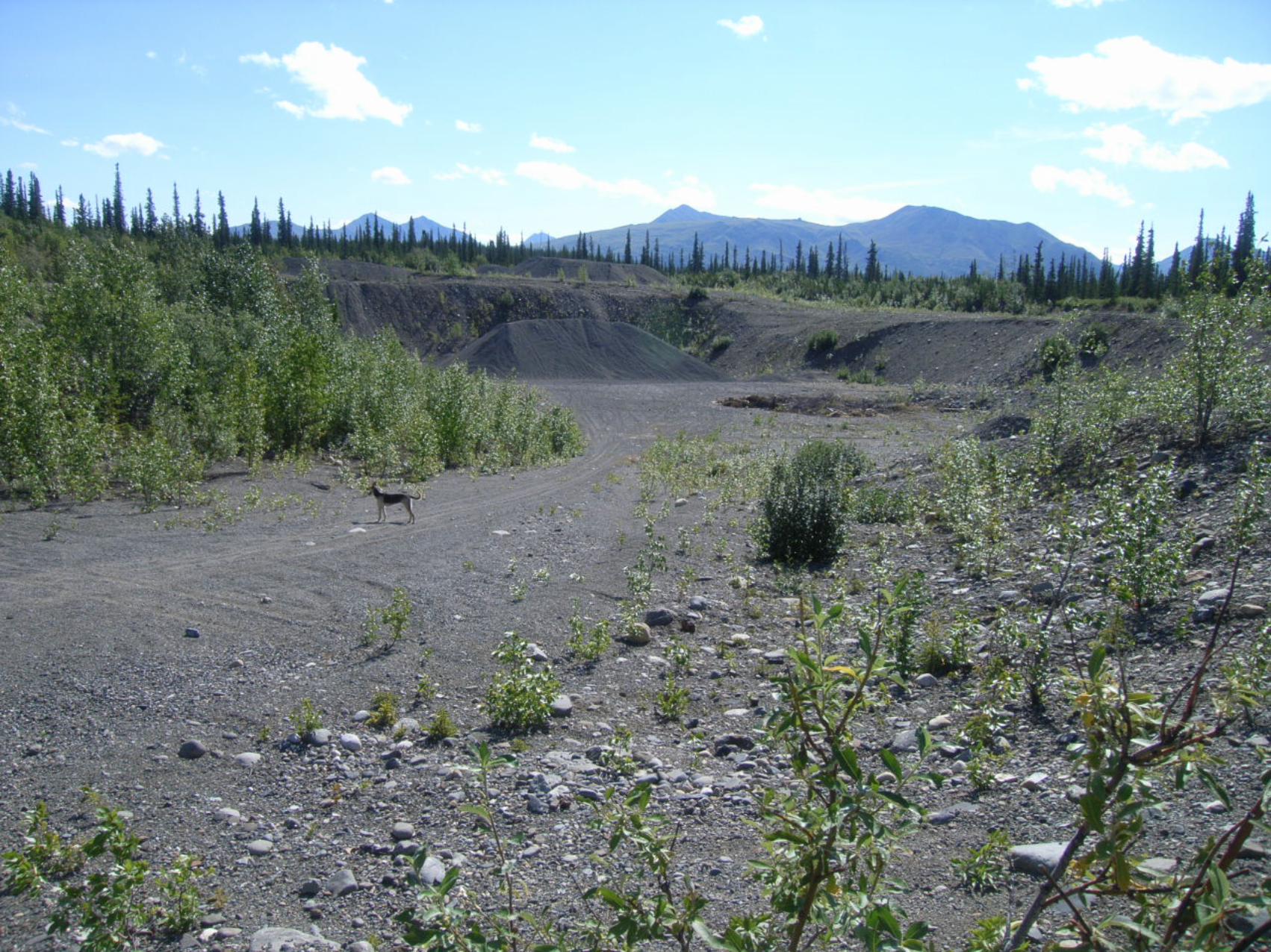
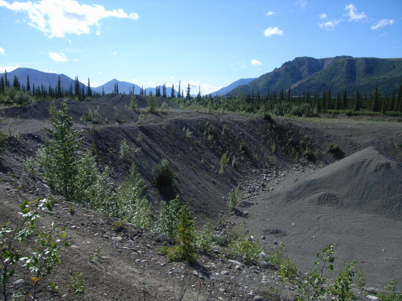
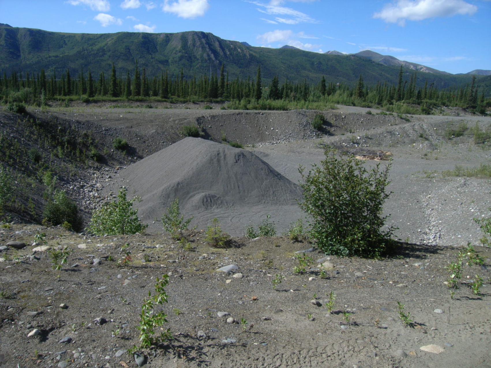
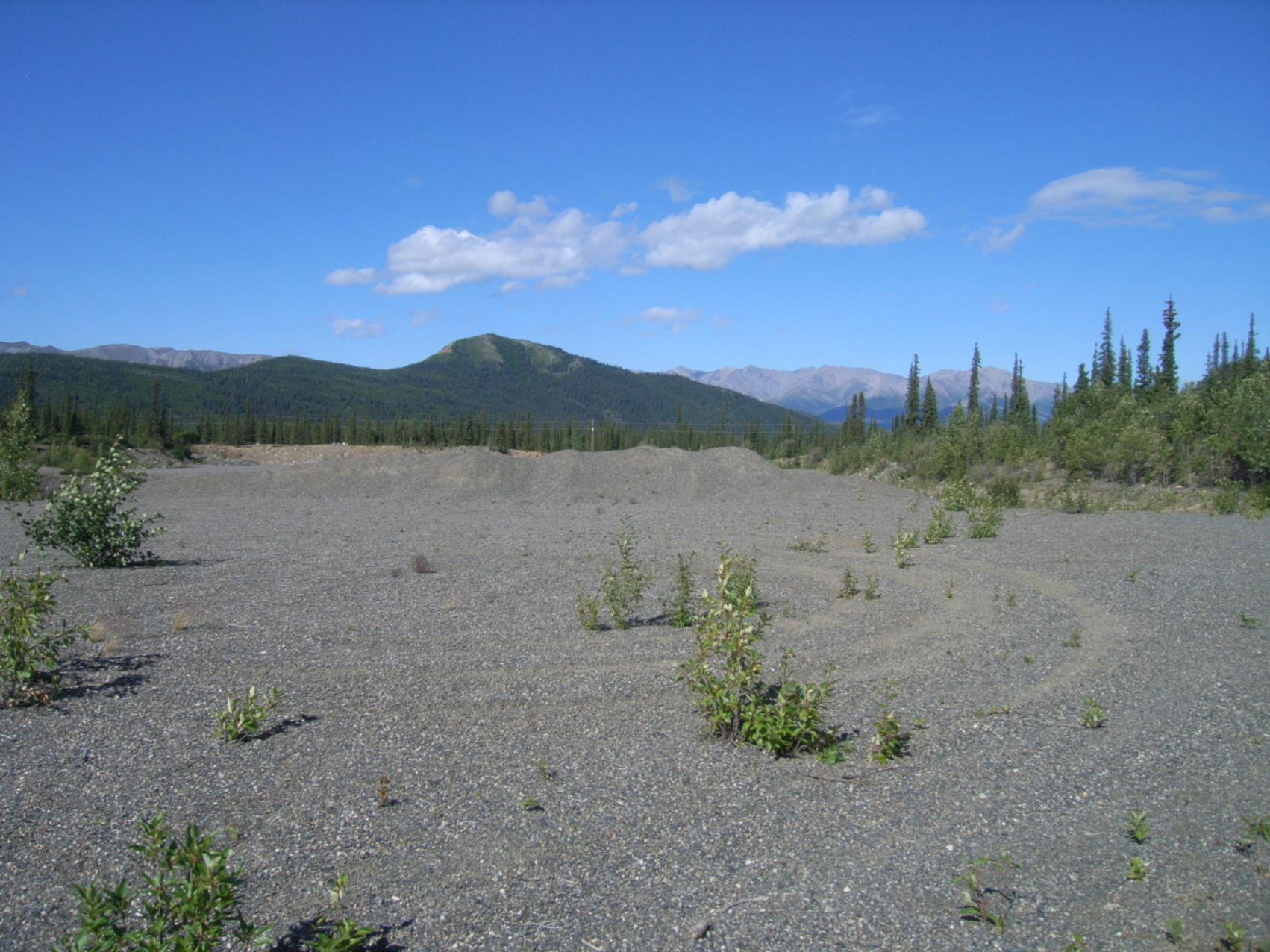
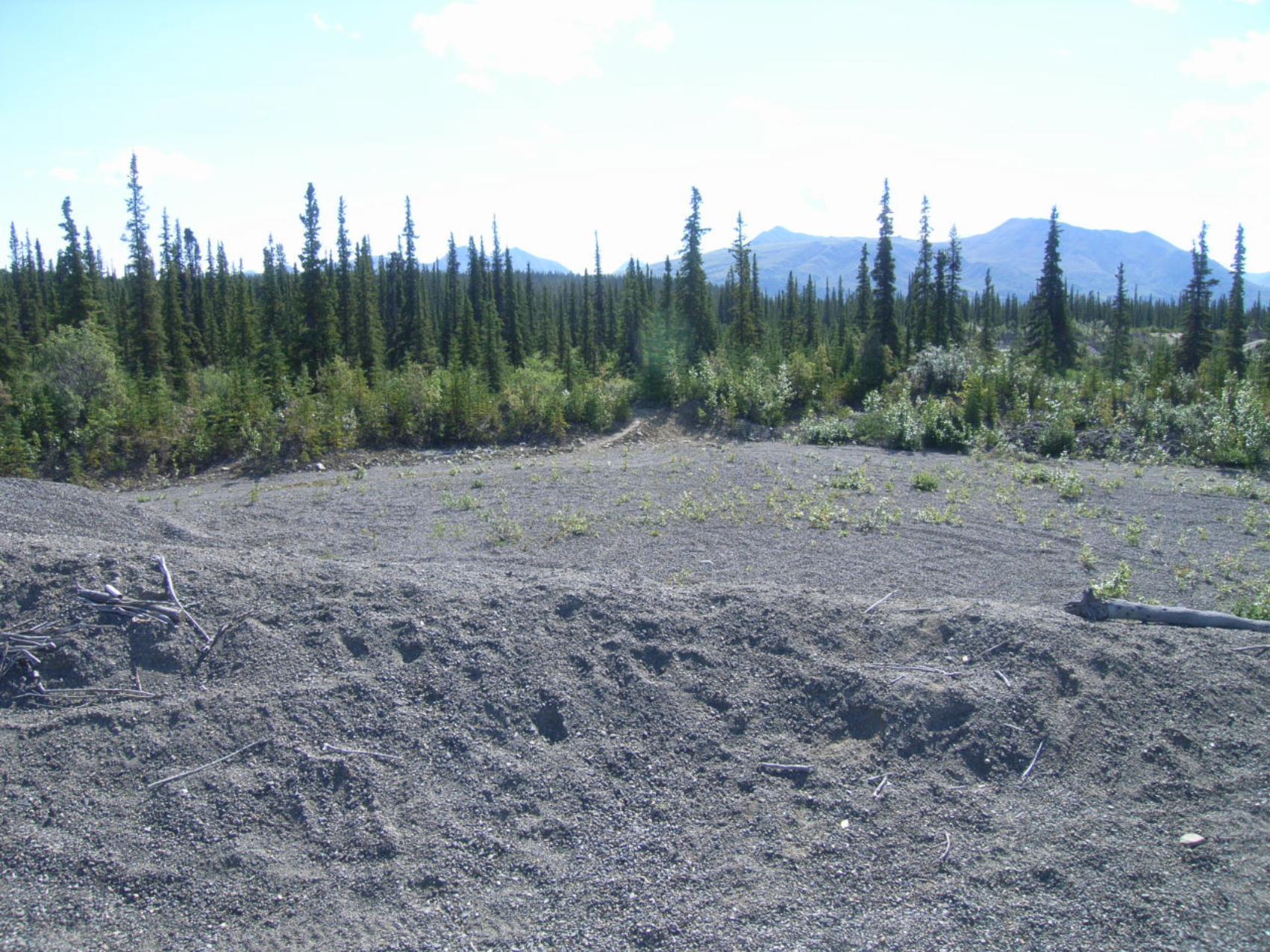
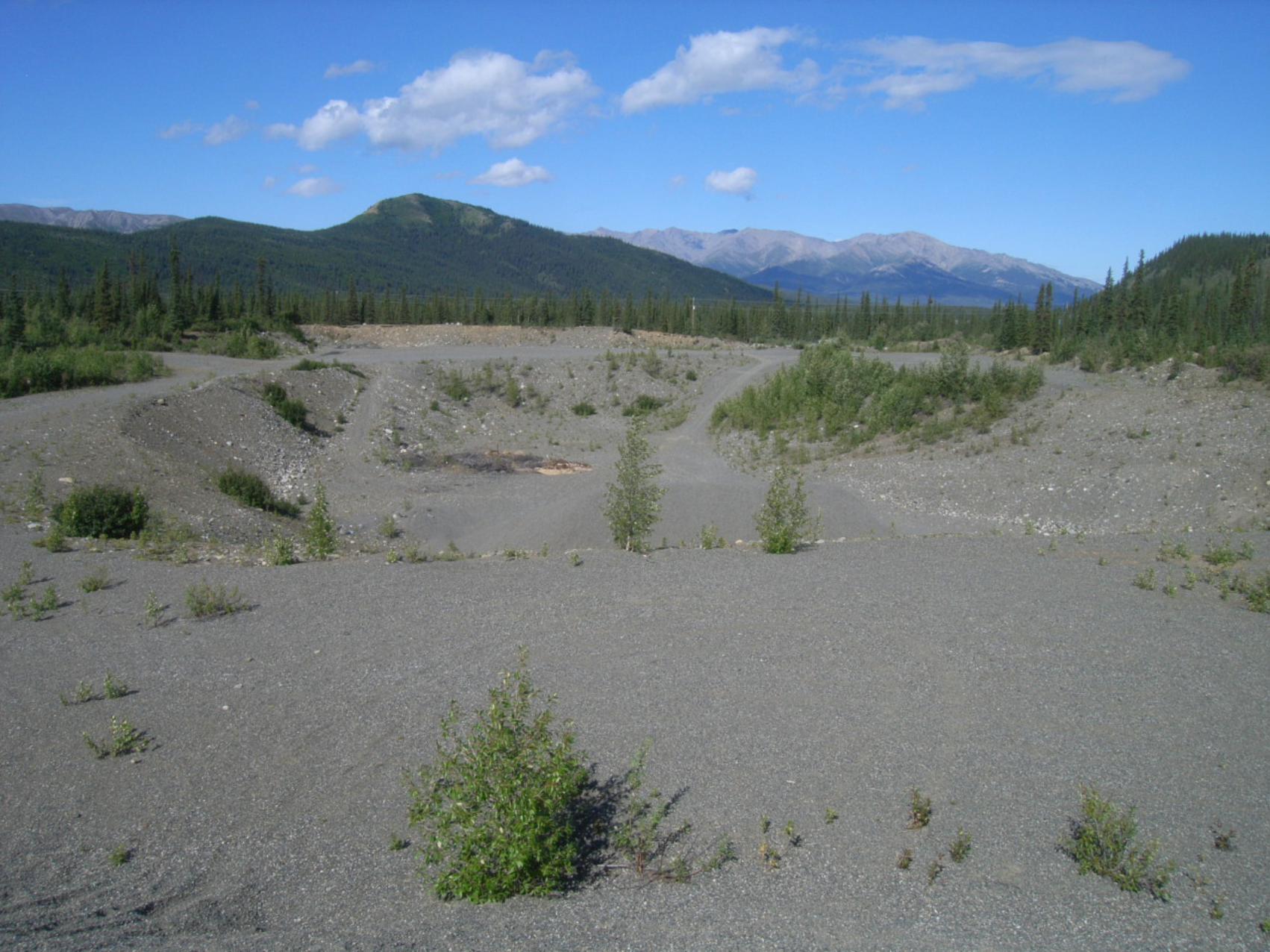
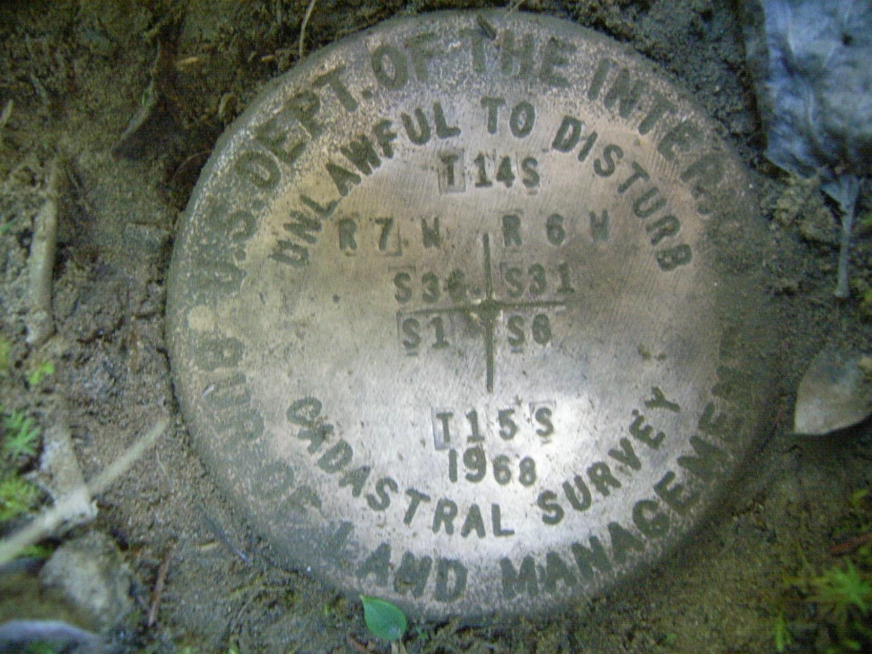
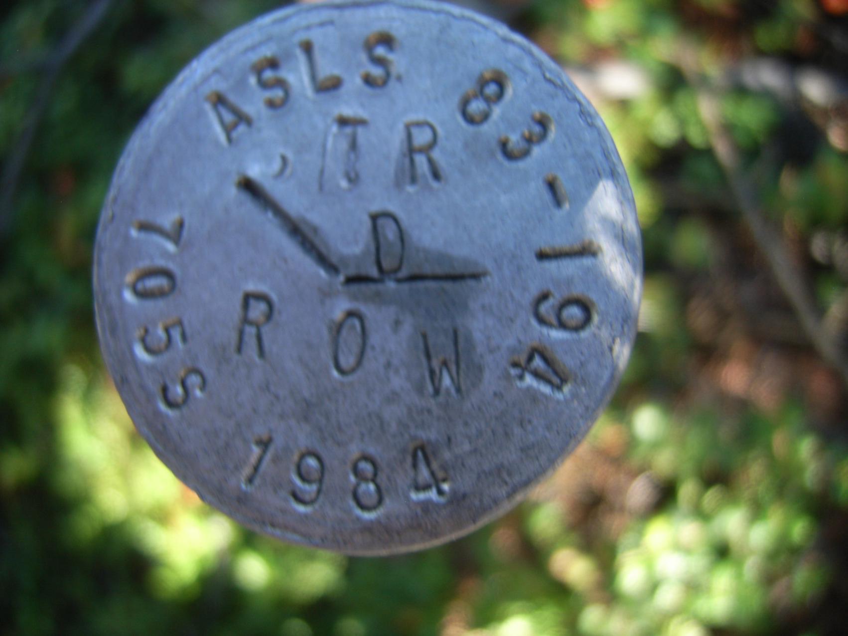
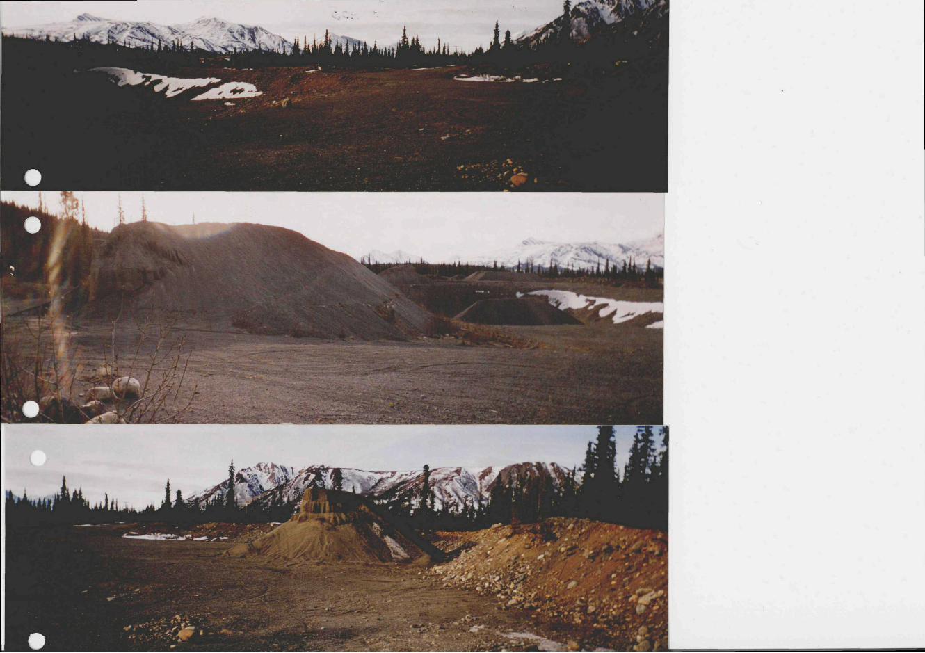
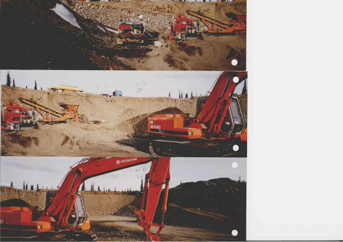
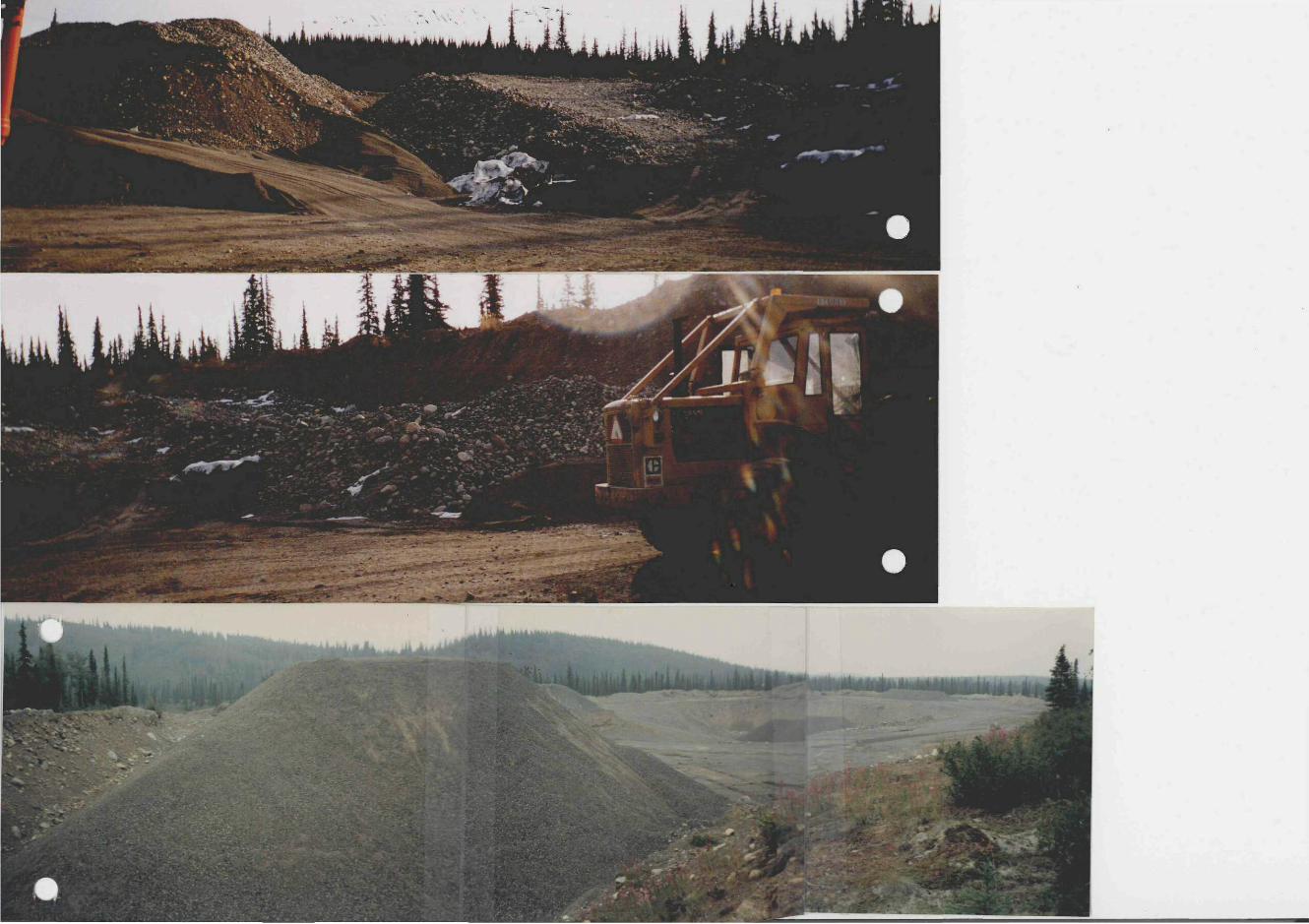
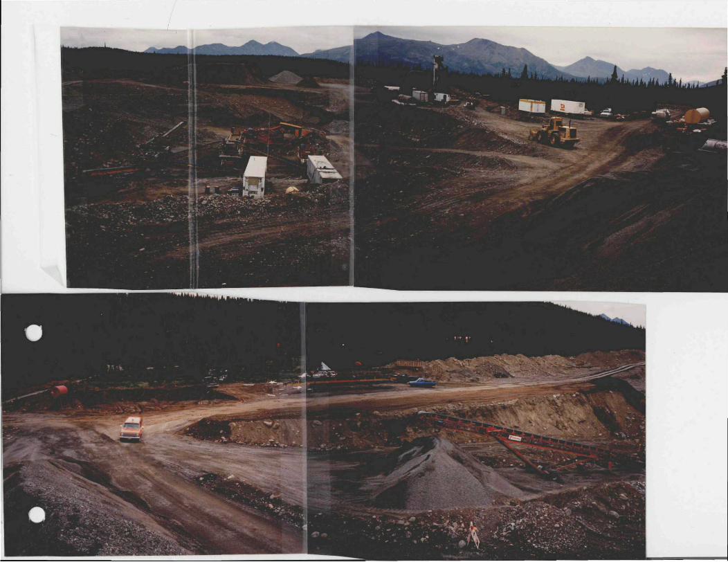
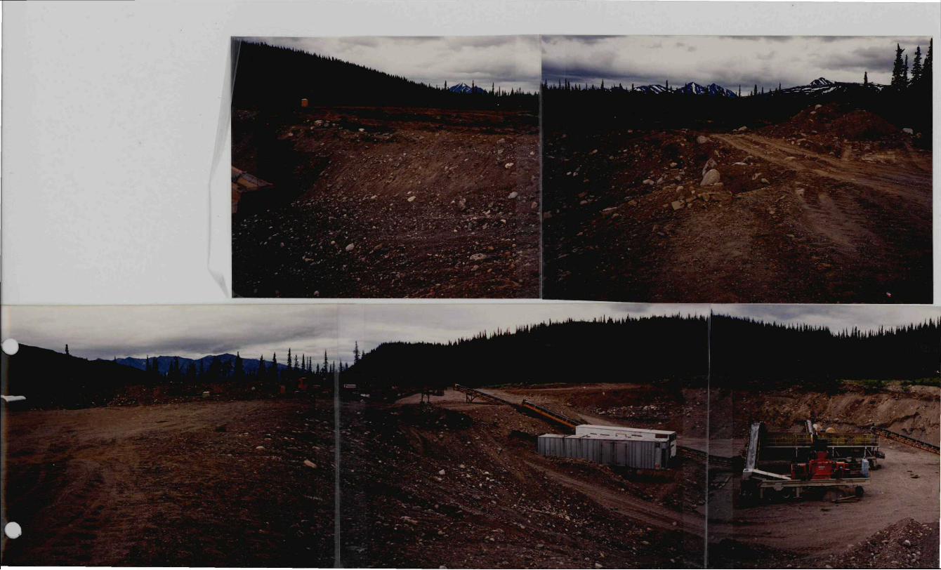
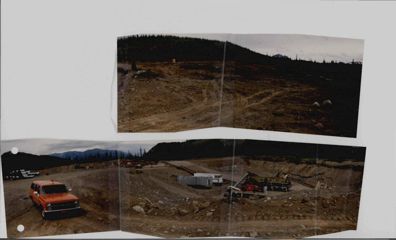
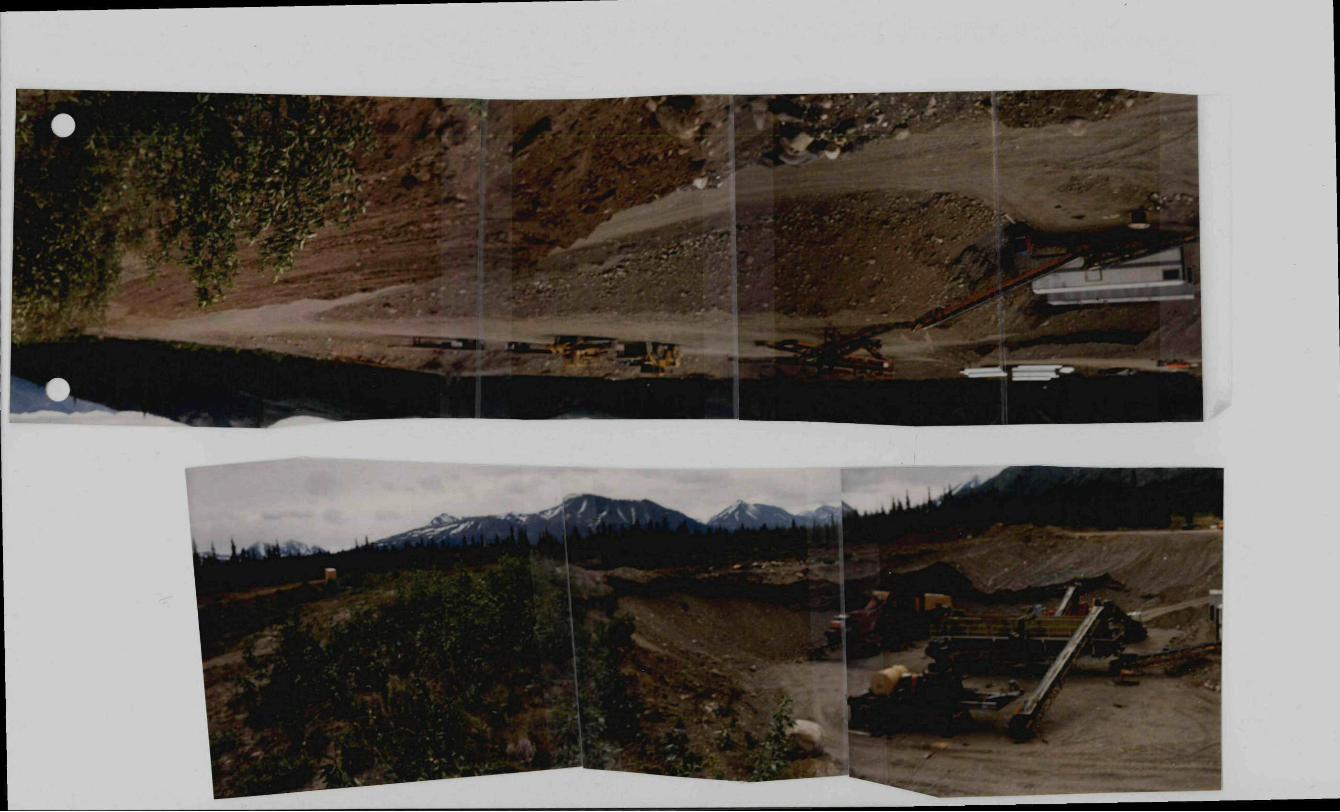


![Marginales [notice]](https://img.dokumen.tips/doc/110x75/6332429b4e01430403009661/marginales-notice.jpg)