Embed Size (px)
Citation preview

lable at ScienceDirect
Cretaceous Research 32 (2011) 823e832
Contents lists avai
Cretaceous Research
journal homepage: www.elsevier .com/locate/CretRes
New evidence for the record of the CenomanianeTuronian oceanic anoxic event(OAE2) in the Pamphylian basin (Akdo�gan Section, Antalya Nappes, SW Turkey):Comparison with surrounding basinal settings
Ayse Bozcu*, François Baudin, Taniel Danelian, Bruno Vrielynck, Mustafa Bozcu, André PoissonÇanakkale Onsekiz Mart University, Engineering and Architecture Faculty, Department of Geological Engineering, Terzio�glu Campus, 17020 Çanakkale, Turkey
a r t i c l e i n f o
Article history:Received 24 June 2009Accepted in revised form 25 May 2011Available online 7 June 2011
Keywords:Black shalesRadiolariansOrganic matterTauridesPaleogeography
* Corresponding author. Tel.: þ90 286 2180018; faxE-mail address: [email protected] (A. Bozcu).
0195-6671/$ e see front matter � 2011 Elsevier Ltd.doi:10.1016/j.cretres.2011.05.010
a b s t r a c t
The organic-rich black shales in the Akdo�gan section (Antalya Nappes, SW Turkey) are the first reportedevidence of the global Cenomanian-Turonian Oceanic Anoxic Event (OAE2) in the "Isparta Angle" region.Their age and organic geochemical characteristics are similar to those of other OAE2 intervals in thePamphylian basin and neighbouring basins of the Tethyan realm. A short description of the wholeAkdo�gan sequence allows us to compare it with other similar sequences in the surrounding areas and todiscuss the local versus global controlling factors on the record of OAE in the Pamphylian basin.
� 2011 Elsevier Ltd. All rights reserved.
1. Introduction
The Cenomanian-Turonian boundary (93.5 Ma) is marked byworldwide deposition of organic-rich black shales in the oceans, anda large positive carbon isotope excursion, reflecting enhanced burialof 13C-depleted organic carbon. This episode of extensive organic-matter burial is known as the Oceanic Anoxic Event 2 (OAE2;Schlanger and Jenkyns, 1976; Jenkyns, 1980). Both increased primaryproductivity leading to higherfluxes of organic carbon to the seafloor,and better preservation of organic matter due to anoxic conditions,have been invoked to explain enhanced organic-matter burial.Schlanger and Jenkyns (1976), Jenkyns (1980, 2010), andmany othersafter them hypothesized that the deposition of organic-carbon-richsediments across a range of paleodepths (shallow marine epiconti-nental basins, continental margins and slopes, as well as in the deepocean) during Cenomanian-Turonian time resulted from anexpanded oxygen-minimum zone. These authors point out thatalthough the OAE2 is characterized by widespread black-shaledeposition, an OAE as such does not imply anoxic conditions overthe entire world ocean. That is probably the case in very deep basinswhere organic rich layers are scarce (Baudin, 1995a, b). Owing to thevertically restricted depth of the oxygen-minimumzone,much of theabyssal part of the seafloor was in oxygenated waters.
: þ90 286 2180541.
All rights reserved.
Nevertheless, basin morphology and structural evolution havean important effect on the deposition and preservation of organicmatter because they induce closing and opening of seaways and,hence, new circulation patterns with local modifications in theoxygenation state of the water.
This is particularly true in SW Turkey where the paleogeographyafter the Triassic and throughout the Mesozoic was controlled bythe geodynamic configuration of the eastern part of southernNeoTethys and the adjacent continental areas. Major paleogeo-graphic elements included the Bey Da�gları and Anatolian conti-nental blocks, both having Gondwanian affinities, and anintervening deep oceanic basin, the so-called Pamphylian basin,whose central part evolved into the “Isparta Angle” during LateCretaceous-Tertiary times (Dercourt et al., 2000; Poisson et al.,2003a; Fig. 1). During the mid Cretaceous time interval, the Pam-phylian basin accumulated radiolarites with subordinate redepos-ited limestones and organic-rich black shales (Demirel et al., 2001).
Yurtsever et al. (2003) demonstrated that the organic-rich blackshales described by Kalafatcioglu (1973) in the Doyran area, 20 kmwest of Antalya, are the record of the OAE2 in the Pamphylian basin.Demirel (2005) analysed the organic matter and clay minerals ofthe Dereköy and Büyükalan sections, 40 km west of Antalya.Although the age of these sections is not fully constrained, Demirel(2005) postulated that these facies are coeval to those of the Doyransection. Finally, Yurtsever and Demirel (2006) mentioned the YazirMezarligi section, located 30 km NW of Antalya, as another siterecording the OAE2 in the Pamphylian basin.

Fig. 1. Location map of the study area in the Western Taurus (southwest Turkey).
A. Bozcu et al. / Cretaceous Research 32 (2011) 823e832824

A. Bozcu et al. / Cretaceous Research 32 (2011) 823e832 825
Despite these records of the OAE2 in the Pamphylian basin, untilnow no data have been presented from its northern part. The aim ofthis paper is to argue for the existence of organic carbon-richsediments encompassing the Cenomanian-Turonian boundary inthe Akdo�gan section, a site located 50 km east of Isparta and 150 kmnorth of Antalya (Fig. 1). Our purpose is (1) to provide informationabout organic matter and radiolarian content of these organic-richfacies, (2) to discuss the paleogeographic conditions which led totheir deposition and (3) to compare their occurrence with otherdeep settings from nearby basins.
2. Geological background
2.1. Geological setting
In the area between Isparta and Antalya, autochthonous andallochthonous units are tectonically imbricated in rather compli-cated piles of thrust sheets, known as the Antalya Nappes or Ant-alya Complex (historic review in Robertson, 1993; Fig. 1). Thesenappes include tectonic slices which derived from various paleo-geographic domains, i.e., shallow marine Mesozoic carbonateplatforms, mainly from the Bey Da�gları platform, and deep basinalsedimentary sequences and ophiolites corresponding to the Pam-phylian basin. The Antalya Nappes resulted from the closure of thePamphylian basin due to the convergence, and then collision, of theBey Da�gları and Taurus blocks in Late Cretaceous-Paleocene times.First in the Maastrichtian-Paleocene, deep basinal sedimentarysequences and ophiolites of the oceanic crust were expelled fromthe Pamphylian basin and were thrust onto the neighbouringplatforms, Bey Da�gları to the SWand Taurus to the NE (Gutnic et al.,1979). This event initiated the formation of the Isparta Angle. In thesecond step (Late Miocene-Early Pliocene), very strong westwardslicing imbricated the Antalya Nappes along with their basementand Miocene clastic cover giving rise to the Antalya Complex(Poisson et al., 2003a). The complete closure of the Isparta Angleresulted from this event which gave rise to several NNW-SSEstriking thrust faults known as the Aksu thrusts (Poisson, 1977;Gutnic et al., 1979; Poisson et al., 2003a, b).
The Antalya Nappes include widespread Mesozoic basinaldeposits which have been described in several areas such as: IspartaÇay (Gutnic and Poisson, 1970), Çatal Tepe (Marcoux and Poisson,1972), Alakir Çay (Robertson and Woodcock, 1981), E�girdir(Waldron, 1981), and Sütçüler (Bozcu, 1996). The deposits are char-acterisedby thepresenceof radiolarites in intervalsdatedmid Jurassicto Late Cretaceous. The type section of this unit is located in the valleyof the Isparta river (Isparta Çay, near Isparta), where it was firstdescribed by Gutnic and Poisson (1970). This section has been rein-vestigated by Vrielynck et al. (2003) for litho- and bio-stratigraphicpurposes and by Poisson et al. (2003a) for detailed mapping of thetectonic imbrications. Near E�girdir, to the east of Isparta, Waldron(1981) described a sequence in which he reported intervals rich inorganicmatter. This sequence is re-analysed here indetail andnamedthe Akdo�gan section. For the description of this section, we adopt thenomenclature of Waldron (1981) with some modifications.
2.2. The Akdo�gan section
The stratigraphic succession in the Akdo�gan area is divided intoa number of tectonic slices (Fig. 2). From base to top, the successioncomprises three formations (Fig. 3) described briefly below interms of fossil content, ages, and environment of deposition.
The Sofular formation is composed of an assemblage of sedi-mentary rocks up to 1000m thick. This thicknessmaybe reduced dueto tectonic thinning. The lower half of the formation is characterisedby dark grey clayey mudstones with thin bands of sandstone rich in
plant debris with thin, lenticular coal seams. The upper half isdominated by graded sandstones and marls. The sandstones showturbiditic sedimentary structures and bioturbated basal surfaces.Lenticular, redeposited calcarenites and limestone breccias areintercalated with the succession and can also be interpreted to beturbidites. Clasts of limestone and plant debris were derived froma shallow marine platform and an emergent land area, respectively.The presence of Halobia shells in the sandstones indicates a LateTriassic age. Waldron (1981) also reported the presence of siliceoustubular fossils identified as Torlessia mackayi Bather which is knownto occur in Upper Triassic successions in New Zealand and the LowerLiasofAlaska (Bather,1905; Jaworski,1915). These tubular fossils havebeen reported in many locations in Isparta in the so-called “grès àtubes” facies (Brunn et al., 1970; Gutnic, 1977; Juteau, 1975).
Due to its moderate thickness relative to other formations andits lenticular geometry the Akdo�gan Formation (equivalent ofAkdo�gan Limestone) was included in the Sofular Formation as the“Akdo�gan member” by Waldron (1981). At a regional scale (fromIsparta to Antalya), the limestones represent a distinct depositionalfacies and they are here assigned a formation status. The Akdo�ganFormation comprises the following members:
(i) The Halobia Limestone Member (“calcaires à halobies” Brunnet al., 1970), which is transitional from the Sofular Forma-tion, whose sandstones are progressively replaced by thinbedded (15e30 cm thick) micritic limestones interlayeredwith marls. The limestones are rich in radiolaria and locally infragments of thin-shelled bivalves (Halobia), a microfacies alsocalled “calcaires à filaments” (Brunn et al., 1970). The faunalcontent (Halobia, Aulacoceras and ammonites) indicates a LateTriassic (Norian) age (Vrielynck et al., 2003).
(ii) The Kirazlar Limestone Member (Waldron, 1981), whichtransitionally overlies the Halobia limestones and consists ofthinly laminated pink micrites and grey calcilutites (3e4 mthick), grading up into calcarenites and oolitic limestones(5e10 m thick). The latter contain small benthic foraminiferawhich may be Jurassic (G. Bignot, pers. comm. 2005). Waldron(1981) reported the presence of Palaeodasycladus medi-terraneus Pia in the uppermost part of this member. In theIsparta Çay sequence, Protopeneroplis striatus has been foundin the oolitic limestone (Vrielynck et al., 2003) assigninga Dogger age for this member.
The Yılanlı Formation is usually composed of radiolarites withsubordinate redeposited limestones and sandstones.
(i) the radiolarites s.l. consist of thinly bedded red mudstones andcherty mudstones, and red to green bedded cherts. Manganif-erous cherts and intercalations of mudstones rich in organicmatter (see below) are also reported locally. These faciescontain a very rich assemblage of radiolaria which gave agesfrom Early Jurassic to Late Cretaceous. The first dates obtainedfrom radiolaria in this area were given by Waldron (1981) withthree assemblages which were attributed respectively to theLias (Late Pliensbachian to Toarcian), the Oxfordian to Turonian,and the Early Cretaceous (Hauterivian to Aptian).
(ii) Redeposited limestones are interpreted as turbidites andinclude breccias, calcarenites and calcilutites with bandedreplacement cherts. Turbiditic beds have a lenticular geometryand their thickness is variable. They are composed of clasts ofshallow-marine limestones, fine- to coarse-grained sand-stones, well rounded pebbles and angular rock fragments ofvarious sizes. Benthic foraminifera, frequent in these lime-stones, are most probably Jurassic in age. From a locationlaterally equivalent to the Akdo�gan succession, Waldron

Fig. 2. Map of the location of the organic matter-rich site near Akdo�gan. Below the Dulup Da�g massive limestone the Akdo�gan unit is tectonically dilacerated in several tectonicslices. The slices are composed of the same sequence including Sofular, Akdo�gan and Yılanlı formations (modified from Waldron, 1981).
A. Bozcu et al. / Cretaceous Research 32 (2011) 823e832826
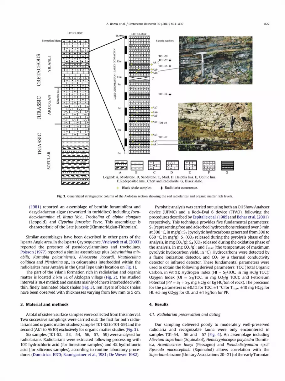
Fig. 3. Generalized stratigraphic column of the Akdo�gan section showing the red radiolarites and organic matter rich levels.
A. Bozcu et al. / Cretaceous Research 32 (2011) 823e832 827
(1981) reported an assemblage of benthic foraminifera anddasycladacean algae (reworked in turbidites) including Pseu-docyclammina cf. lituus Yok., Trocholina cf. alpina elongata(Leopold), and Clypeina jurassica Favre. This assemblage ischaracteristic of the Late Jurassic (Kimmeridgian-Tithonian).
Similar assemblages have been described in other parts of theIsparta Angle area. In the Isparta Çay sequence, Vrielynck et al. (2003)reported the presence of pseudocyclammines and trocholines.Poisson (1977) reported a similar assemblage plus Labyrinthina mir-abilis, Kurnubia palastiniensis, Alveosepta jaccardi, Nautiloculinaoolithica and Pfenderina sp., in calcarenites interbedded within theradiolarites near Antalya in the Çatal Tepe unit (location on Fig. 1).
The part of the Yılanlı formation rich in radiolarian and organicmatter is located 2 km SE of Akdo�gan village (Fig. 2). The studiedinterval is 18.4mthick andconsistsmainlyof cherts interbeddedwiththin, finely laminated black shales (Fig. 3). Ten layers of black shaleshave been observed with thicknesses varying from fewmm to 5 cm.
3. Material and methods
Atotal of sixteen surface sampleswere collected fromthis interval.Two successive samplings were carried out: the first for both radio-lariansandorganicmatter studies (samplesT01-52toT01-59) and thesecond (Ak1 to Ak10) exclusively for organic matter studies (Fig. 3).
Six samples (T01-52,�53,�54,�56,�57,�59) were analysed forradiolarians. Radiolarians were extracted following processing with10% hydrochloric acid (for limestone samples) and 4% hydrofluoricacid (for siliceous samples), according to routine laboratory proce-dures (Dumitrica, 1970; Baumgartner et al., 1981; De Wever, 1982).
Pyrolytic analysiswas carried out using both anOil ShowAnalyserdevice (UPMC) and a Rock-Eval 6 device (TPAO), following theprocedures described by Espitalie et al. (1985) and Behar et al. (2001),respectively. This technique provides five fundamental parameters:S1 (representing free and adsorbed hydrocarbons released over 3minat 300 �C, inmg/g); S2 (pyrolytic hydrocarbons generated from300 to650 �C, in mg/g); S3 (CO2 released during the pyrolysis phase of theanalysis, inmg CO2/g); S4 (CO2 released during the oxidation phase ofthe analysis, in mg CO2/g); and Tmax (the temperature of maximumpyrolytic hydrocarbon yield, in �C). Hydrocarbons were detected bya flame ionization detector, and CO2 by a thermal conductivitydetector or infrared detector. These fundamental parameters wereused to obtain the following derived parameters: TOC (Total OrganicCarbon, in wt %); Hydrogen Index (HI ¼ S2/TOC, in mg HC/g TOC);Oxygen Index (OI ¼ S3/TOC, in mg CO2/g TOC); and PetroleumPotential (PP ¼ S1 þ S2, mg HC/g or kg HC/ton of rock). The precisionfor the parameters is�0.1% for TOC,�1 �C for Tmax, �10 mg HC/g forHI, �5 mg CO2/g for OI, and �1 kg/ton for PP.
4. Results
4.1. Radiolarian preservation and dating
Our sampling delivered poorly to moderately well-preservedradiolaria and recognizable fauna were only encountered insamples T01-54, �56 and �57 (Fig. 4). An assemblage includingAlievium superbum (Squinabol), Hemicryptocapsa polyhedra Dumitr-ica, Acanthocircus hueyi (Pessagno) and Pseudodictyomitra sp.cf.P.pseudo macrocephala (Squinabol) allows correlation with theSuperbumbiozone (UnitaryAssociations20e21)of the early Turonian

Fig. 4. Scanning electron micrographs of Late Cretaceous radiolaria from samples TO1-54 (Microphotographs 1-4) and TO1-56 (Microphotographs 5-6). (1) Dictyomitra multicostataZittel; (2) Acanthocircus huyei (Pessagno); (3) H. polyhedra Dumitrica; (4) Alievium superbum (Squinabol); (5) Pseudodictyomitra sp.cf. P.pseudomacrocephala (Squinabol); (6)H. polyhedra Dumitrica.
A. Bozcu et al. / Cretaceous Research 32 (2011) 823e832828
or younger (O’Dogherty,1994;O’Doghertyet al., 2005).A. superbum isknown from lower Turonian-lower Coniacian strata in the CaliforniaCoastal Ranges and from the upper part of the Bonarelli horizon inItaly (Marcucci Passerini et al.,1991;Masuvu-Moussavou et al., 2007)which is regarded as uppermost Cenomanian (Coccioni and Luciani,2004). In conclusion, the above assemblage can be regarded aslatest Cenomanian to earliest Coniacian.
4.2. Total organic carbon and Rock-Eval pyrolysis data
The black shale samples are characterized by very high TOCvalues, ranging from 0.8 to 44.5 wt %, with an average of 31.8 wt %(Table 1). On an HI-Tmax diagram (Fig. 5), the organic matter plots asType I/II kerogen with high HI values (567e674 mg HC/g TOC). Thematurity of the organic matter is relatively low as indicated by Tmaxvalues ranging from 419 to 427 �C.
The average petroleum potential (S1 þ S2) of this interval isexcellent (more than 200 kg HC/ton rock), but it should be kept inmind that the cumulate thickness of these black shales is only about30 cm. Nevertheless, low Tmax values indicate that the organicmatter has not experienced sufficient temperatures to generate oil.
5. Discussion
Biostratigraphical and geochemical data on the alternation ofblack shales and radiolarites from the Akdo�gan section display verysimilar properties to neighbouring sections where the OAE2 was
previously recognized. Although the radiolarian assemblage is notvery precise, a late Cenomanian to early Turonian age is very likely.In terms of cumulative thickness of black shales and TOC contentthe Akdo�gan section is similar to the OAE2 levels in the Ionian zonein Greece (Godzikas section; Karakitsios et al., 2007) and in theother sites in the Pamphylian basin in SW Turkey (Demirel et al.,2001; Yurtsever et al., 2003; Demirel, 2005; Yurtsever andDemirel, 2006) with thickness reduced to a mere 30e35 cm andTOC values as high as 45%. Because the OAE2 is not recorded inother basinal settings such as the Pindos basin (Neuman andZacher, 2004), it is interesting to discuss similarities and differ-ences between these basins to decipher factors which controlledthe record of this event.
5.1. Origin of the record of the Cenomanian-Turonian OAE2 in the“Isparta Angle” area
Since the Triassic the area of deposition of the Akdo�gansequence was located in the NE of the Pamphylian basin, close tothe margin of this basin and thus near to the Taurus platformborder. At the same time, the area of deposition of the Isparta Çaysequence was on the opposite side of the basin near the Bey Da�glarıplatform. This is alsowhere the Alakir Çay and Catal Tepe sequencesnear Antalya were deposited. Since the Late Triassic these areasexperienced very similar sedimentation conditions and theirsequences present quite comparable facies which justifies locatingthem in the same basin. In summary the similarities are as follows:

Table 1Rock-Eval parameters for samples from the Akdo�gan section. Total Organic Carbon(TOC %. wt); S1 and S2: mg HC/g rock; S3: mg CO2/g rock; Tmax (�C); hydrogen index(HI: mg HC/g Corg); oxygen index (OI: mg CO2/g Corg).
SampleNumber
TOC S1 S2 S3 Tmax HI OI
Ak1 36.70 4.01 242.13 3.83 422 660 10Ak2 44.05 4.95 296.95 3.63 421 674 8Ak3 26.04 2.68 167.31 2.73 422 643 10Ak4 32.35 3.1 200.82 3.4 420 621 11Ak5 42.27 5.01 272.9 4.27 420 646 10Ak6 31.48 3.32 201.53 3.22 419 640 10Ak7 27.75 2.8 184.83 2.71 420 666 10Ak8 30.93 4 204.66 4.25 422 662 14Ak9 44.52 5.01 294.98 4.85 422 663 11Ak10 33.99 2.97 192.64 9.32 422 567 27TO1.52 30.61 12.11 190.96 e 419 623 e
TO1.53 32.29 14.16 215.70 e 420 668 e
TO1.54 0.79 0.11 1.17 e 427 148 e
A. Bozcu et al. / Cretaceous Research 32 (2011) 823e832 829
1. Late Triassic clastics (marls and sandstones with plant debris),surrounded by micritic limestones with more or less abundantpelecypod shells (Halobia) and radiolarians. The environmentof deposition is a moderately deep basin (hemipelagic?).
2. The Liassic (and early Dogger?) interval is characterized bymicritic reddish limestones, limestone breccias and ooliticcalcarenites. These latter are reworked from an adjacent plat-form which could be the Bey Da�gları platform.
3. During the Dogger-Malm and Cretaceous (up to Turonian) thearea was the site of deposition of radiolaritic facies whichinclude purely radiolarian cherts, silty radiolarian mudstonesand lensoidal intercalations of limestone breccias (debrisflows) and calcarenitic turbidites. The reworked fossilsincluded in these calcarenites are benthic foraminifera; the age
400 420 440 460 480 500 520
150
300
450
600
750
0
Hyd
roge
n In
dex
(mg
HC
/g T
OC
)
TypeII
Type III
TypeI
Tmax (°C)
Immature Oil zone Gas zone
Vitrinite Isoreflectance
1,3
%
0,5%
Fig. 5. Results of Rock-Eval pyrolysis of the Akdo�gan section plotted on a modified vanKrevelen diagram (Espitalie et al., 1985).
of which indicates late Jurassic and early to mid Cretaceous.These reworked elements indicate the persistence of shallow-marine carbonate platforms at the margin of the basin in theAkdo�gan area and in the Isparta Çay area.
4. During the Late Cretaceous (Campanian-Maastrichtian), in theÇatal Tepe sequence the sedimentation was characterised bymarls, fine grained calcarenites and sandstones indicatinga change in the source area and a less deep environment(Poisson, 1977).
5. With regards to the Triassic-Liassic period, since the Dogger thebasin became deeper as shown by the deposition of the radi-olaritic sequence. Most probably the depth was below the CCDdespite the presence of limestones in the sequence, whichcorrespond to instantaneous deposits which could not be dis-solved before they were covered by siliceous sediments.
As a result, the Isparta Angle basin, which was a hemipelagicbasin during the Triassic-Liassic time, became a deep basin (belowCCD) during the Dogger and remained deep up to the Late Creta-ceous. During the Mesozoic the adjacent platforms (Bey Da�gları tothe SW and Taurus to the NE) remained shallow marine platforms,frequently of internal to restricted platform type in the case of theBey Da�gları. These platforms had divergent evolutions since theCenomanian. While the Taurus became emergent and was the siteof bauxite deposition (Monod, 1977; Gutnic et al., 1979), the BeyDa�gları platform suffered a non uniform evolution from south tonorth. The southern area (Susuz Dag) remained a shallow platformup to the Lutetian while the northern area was tectonically frag-mented and subsided to deep marine conditions at the end of theCenomanian in some areas, and completely by the end of Santonianand just after. The maximum depth was reached in Campanian-Maastrichtian and Danian times. The fragmentation of the plat-form margin registered in the adjacent basin in the form of hugebreccias essentially composed of fragments of Albian, Aptian andCenomanian limestones derived from the Bey Da�gları platform andresedimented during the Turonian in the adjacent Isparta Anglebasin (Catal Tepe unit; Poisson, 1977; Gutnic et al., 1979). The globalOAE2 registered diversely (or did not register) in the Isparta Angle.In the northern part of the Bey Da�gları large areas became restrictedlagoon, separated from open marine areas by coral reefs and rudistbioherms (Bozcu et al., 2003). However, some areas in the southernBey Da�gları remained shallow-marine up to the Coniacian withdevelopment of rudist bioherms (Sari et al., 2009).
Due to the tectonic event which provoked the break-up of thenorthern Bey Da�gları platform, the Isparta Angle basin was prob-ably divided into several smaller sub-basins in which local watercirculation was disturbed at that time. Moreover, the Anamas-Akseki platform on the opposite side of the basin (Fig. 6) becameemergent throughout the Late Cretaceous and Paleocene (Monod,1977). Complete interruption of oceanic circulation through theAnamas-Akseki platform towards the Isparta Angle basin and theSouthern NeoTethys resulted from this emergence. This mayexplain the restricted marine conditions which prevailed in theremnants of the Bey Da�gları platform and the anoxic conditions insome areas of the adjacent deep basin (Akdo�gan and Doyran sub-basins; Fig. 6).
5.2. Comparison with surrounding deep basins
The Akdo�gan section and similar sections in the Antalya areapresent some of the main characteristics typical of the Pamphylianbasin:
1. Late Triassic-Liassic hemipelagic carbonate with subordinatequartzose turbidites.

Fig. 6. Paleogeographyandpaleoenvironments at the end of the Cenomanian in theMiddle East (modified fromBarrier andVrielynck, 2008). Location of the restrictedmarine platformof the Bey Da�gları (BDP) and of the deep-marine confined area in the Western Pamphylian basin. Location of the sections cited in text: D ¼ Doyran, A ¼ Akdo�gan, G ¼ Gotzikas.
A. Bozcu et al. / Cretaceous Research 32 (2011) 823e832830

A. Bozcu et al. / Cretaceous Research 32 (2011) 823e832 831
2. Dogger-Malm-Early Cretaceous radiolaritic sequence includingdebris-flow of shallow-marine carbonate material and turbi-dites of the same composition. Benthic foraminifera arefrequent. These intercalations are frequent all through theDogger, Malm and Early Cretaceous. They culminated inCenomano-Turonian times near Antalya.
3. The sequences grade up to the Maastrichtian and they weretectonised just after.
4. Such a sequence characterizes a basin, more or less deep,located near the margin of shallow-marine carbonate plat-forms (Bey Da�glari platform for instance).
5. The frequent redepositional inputs can be related to a succes-sion of tectonic events culminating in a major Mid-Cretaceousphase in the Isparta Angle. These events underline the quasipermanent instability along the borders of the platforms.
In the eastern parts of the Pamphylian basin such sequences areknown in Cyprus, south-eastern Turkey and north Syria (Delaune-Mayere et al., 1977). All around the Arabic continental area, suchsequences are transitional from carbonate platform to the adjacentbasin (Dercourt et al., 2000). Towards the west of Antalya, similarsequences are known in the Hellenic domain where they charac-terize the Pindos basin (Neuman and Zacher, 2004). On the island ofCrete, the Ethia unit represents a very similar stratigraphicsuccession including a radiolaritic sequence with calci-turbiditesbut without organic-rich levels (Bonneau and Fleury, 1971). Incontinental Greece and the Peloponnesus the Early Cretaceousradiolaritic sequence includes subordinate calciturbidites andgreen organic-rich levels (Aptian-Albian), grading into the LateCretaceous (Cenomanian, up to Coniacian). Carbonated debris-flows are interbedded with terrigenous turbidites in the LowerCenomanian. During Campano-Maastrichtian times the sedimentsare essentially calci- and mud-turbidites with redeposited shallow-marine fauna (benthic foraminifera). As is the case in the Antalyaarea, the increase in redeposited carbonate derived from a platformunderlines the instability of the platform margin. This instabilitypersisted up to the latest Cretaceous. In this sedimentary context,several organic carbon-rich levels have been observed.
The similarities between the Isparta Angle basinal radiolariticsequences and the Pindos radiolarites are essentially: (a) theposition of the basin adjacent to a platform, (b) the age of theradiolarites and (c) the geodynamical context of active tectonicsculminating in the Mid-Cretaceous and giving way to redepositedcalciclastic sediments in the basin.
6. Conclusions
The Mesozoic succession of the Akdo�gan section records thesedimentary history of a complex marginal basin located betweentwo continental blocks (Bey Da�glari and Anatolia platforms), inwhich vertical movements due to regional tectonics influencedsediment supply and paleoceanographic effects along slopes and onbasinal plains. The OAE2 anoxic event described in the IspartaAngle (Akdo�gan and Doyran sections) is synchronous with a majorpaleogeographic reorganisation of the southern NeoTethyandomain, from Greece to the Arabic plate through the Pamphylianbasin. In the Isparta Angle, tectonics were responsible for theformation of small isolated basins favourable to the accumulationand preservation of organic material, especially during the world-wide OAE2.
Acknowledgments
The authors are indebted to Florence Savignac (UPMC) for herhelp and technical assistance. The authors would like to thank to
the editors, Dr. D.J. Nichols and Prof. M.B. Hart; Dr. H. Tsikos(University of Rhodes) and an anonymous reviewer for editorialhandling and constructive comments. We also thank Prof. K. Gür-gey for constructive comments on an early version of themanuscript.
References
Barrier, E., Vrielynck, B., 2008. Palaeotectonic Maps of the Middle East. Map 6.Cenomanian (99.6e93.5 Ma). CGMW.
Bather, F.A., 1905. The Mount Torlesse Annelid. Geological Magazine 2, 532e541.Baudin, F., 1995a. Depositional controls on the mesozoic source rocks in the Tethys.
In: Huc, A.Y. (Ed.), Paleogeography, Paleoclimates and Source Rocks. AAPGStudies in Geology, Tulsa, pp. 191e211.
Baudin, F., 1995b. Carbon and carbonate contents of the Cenomanian-Turoniansediments from Hole 869B (Leg 143): comparison with other deep basinsfrom central and northwestern Pacific ocean. In: Winterer, E.L., Sager, W.W.,Firth, J.V., Sinton, J.M. (Eds.), Proceedings ODP. Scientific Results, Vol.143,pp. 587e591.
Baumgartner, P.O., Bjorklund, K.R., Caulet, J.P., De Wever, P., Kellogg, D.,Labracherie, M., Nakaseko, K., Nishimura, A., Schaaf, A., Schmidt-Effing, R.,Yao, A., 1981. Second european meeting of radiolarian paleontologists: currentresearch on Cenozoic and Mesozoic radiolarians. Eclogae Geologicae Helvetiae74, 1027e1061.
Behar, F., Beaumont, V., De, B., Penteado, H.L., 2001. Rock-Eval 6 technology:performances and developments. Oil & Gas Science And Technology e Revue deIFP 56 (2), 111e134.
Bonneau, M., Fleury, J., 1971. Précisions sur la série d’Ethia (Crète, Grèce): existenced’un premier flysch mésocrétacé. Comptes Rendus Académie des Sciences Paris272, D1840eD1842.
Bozcu, A., 1996. Examination of the Mesozoic marine sediments in Kasimlar(Sütçüler-Isparta) area by the geology, petrography and organic geochemistry.Unpublished Ph.D Thesis, Süleyman Demirel University, Sciences Institute,Isparta-Turkey, 135 pp.
Bozcu, A., Bignot, G., Poisson, A., Senturk, M., Bozcu, M., 2003. The Peçenek Bogaziand Söbü Da�g sections: The restricted marine environments in the north BeyDa�glari carbonate platform. Süleyman Demirel University, Sciences InstituteBulletin. 7/2, 99e106.
Brunn, J.H., Graciansky, P.C., De Gutnic, M., Juteau, T., Lefevre, R., Marcoux, J.,Monod, O., Poisson, A., 1970. Structures majeures et correlations strati-graphiques dans les Taurides occidentales. Bulletin de la Société Géologique deFrance 7 (12), 515e524.
Coccioni, R., Luciani, V., 2004. Planktonic foraminifera and environmental changesacross the Bonarelli event (OAE2, latest Cenomanian) in its type area: a high-resolution study from the Tethyan reference Bottaccione section (Gubbio,Central Italy). Journal of Foraminiferal Research 34, 109e129.
De Wever, P., 1982. Radiolaires du Trias et du Lias de la Téthys (Systématique,Stratigraphie). Société géologique du Nord 7, 1e600.
Delaune-Mayere, N., Marcoux, J., Parrot, J.F., Poisson, A., 1977. Modèle d’évolutionmésozoique de la paléo-marge téthysienne au niveau des nappes radio-laritiques et ophiolitiques du Taurus lycien, d’Antalya et du Baer-Bassit. 25congrès de la C.I.E.S.M. Split 1976. Editions Technip. 79e94.
Demirel, I.H., 2005. Whole-rock, clay mineral contents and matrix effect on theCenomanian/Turonian petroleum source rocks in the Lower Antalya Nappe,western Taurus region of Turkey. Petroleum Science and Technology 23 (9e10),1183e1197.
Demirel, I.H., Günay, Y., Yurtsever, T.S., 2001. Evaluation of petroleum source rockson the coastal area of the western Taurus region, Turkey. energy sources, partA :recovery. Utilization, and Environmental Effects 23, 541e552.
Dercourt, J., Gaetani, M., Vrielynch, B., Barrier, E., Biju-Duval, B., Brunet, M.F.,Cadet, J.P., Crasquin, S., Sandulescu, M., 2000. Atlas Peri-Tethys. Commission forthe Geologic Maps of the World, Paris.
Dumitrica, P., 1970. Cryptocephalic and cryptothoracic nassellaria in some mesozoicdeposits of Romania. Revue roumaine de géologie, géophysique et géographie14, 45e124.
Espitalie, J., Deroo, G., Marquis, F., 1985. La pyrolyse Rock Eval et ses applications.Revue de Institut Français du Pétrole 10, 755e784.
Gutnic, M., 1977. frGéologie du Taurus Pisidien au Nord d’Isparta (Turquie). Travauxdu Laboratoire de Géologie Historique et de Paléontologie. Université Paris-Sud,Orsay, France.
Gutnic, M., Poisson, A., 1970. Un dispositif remarquable des chaînes tauriques dansle sud de la courbure d’ Isparta (Turquie). Comptes rendus Académie desSciences Paris 270, 672e675.
Gutnic, M., Monod, O., Poisson, A., Dumont, J.F., 1979. Géologie des Taurides occi-dentales (Turquie). Mémoire de la Société Géologique de France 137, 112.
Jaworski, E., 1915. Die systematische und stratigraphische Stellung von «TorlessiaMackayi» Bath. (¼Terebellina) von Neuseeland. Centralblatt fur MineralogieGeologie und Palaontologie 16, 504e512.
Jenkyns, H.C., 1980. Cretaceous anoxic events: from continents to oceans. Journal ofthe Geological Society of London 137, 171e188.
Jenkyns, H.C., 2010. Geochemistry of oceanic anoxic events. Geochemistry,Geophysics Geosystem 11, 30. doi:10.1029/2009GC002788. G3.

A. Bozcu et al. / Cretaceous Research 32 (2011) 823e832832
Juteau, T., 1975. Les ophiolites des nappes d’Antalya (Taurides occidentales, Tur-quie). Thèse Doctorat d’Etat, Nancy. Sciences de la Terre Mémoire 32, 692 p.
Kalafatcioglu, A., 1973. Geology of the western part of the Antalya Bay. Bulletin ofthe Mineral Research and Exploration Institute of Turkey 81, 31e84.
Karakitsios, V., Tsikos, H., Van Breugel, Y., Koletti, L., Sinninghe Damste, J.S.,Jenkyns, H.C., 2007. First evidence for the Cenomanian-Turonian anoxic event(OAE2, "Bonarelli" event) from the Ionian zone, western continental Greece.International Journal of Earth Sciences (Geologische Rundschau) 96, 343e352.
Marcoux, J., Poisson, A., 1972. Une nouvelle unité structurale majeure dans lesnappes d’ Antalya: la nappe inférieure et ses séries mésozoiques radiolaritiques(Taurides occidentales Turquie). Comptes rendus Académie des Sciences Paris275, 655e658.
Marcucci Passerini, M., Bettini, P., Dainelli, J., Sirugo, A., 1991. The "Bonarellihorizon" in the central Apennines (Italy): Radiolarian biostratigraphy. Creta-ceous Research 12, 321e331.
Masuvu-Moussavou, B., Danelian, T., Baudin, F., Coccioni, R., Fröhlich, F., 2007. Theradiolarian biotic response during OAE2. a high-resolution study across theBonarelli level at Bottacione (Gubbio, Italy). Revue de Micropaleontologie 50,253e287.
Monod, O., 1977. Recherches géologiques dans le Taurus occidental, au Sud deBeysehir. Thèse Doctorat d’Etat, Université de Paris-Sud, Orsay, 432 p.
Neuman, P., Zacher, W., 2004. The Cretaceous sedimentary history of the PindosBasin (Greece). International Journal of Earth Sciences (Geologische Rundschau)93, 119e131.
O’Dogherty, L., 1994. Biochronology and paleontology of Mid-Cretaceous Radiolar-ians from Northern Appennines (Italy) and Betic Cordillera (Spain). Mémoire deGéologie (Lausanne) 21, 1e351.
O’Dogherty, L., Bill, M., Gorican, S., Dumitrica, P., Masson, H., 2005. Bathonianradiolarians from an ophiolitic mélange of the Alpine Téthys (Gets nappe,Swiss-French Alps). Micropaleontology 51, 425e485.
Poisson, A., 1977. Recherches géologiques dans les Taurides occidentales (Turquie).Thèse Doctorat d’Etat, Université Paris-Sud Orsay, France, 795 p.
Poisson, A., Ya�gmurlu, F., Bozcu, M., Sentürk, M., 2003a. New insights on the tectonicsetting and evolution around the apex of the Isparta Angle (SW Turkey).Geological Journal 38, 257e282.
Poisson, A., Wernli, R., Sagular, E.K., Temiz, H., 2003b. New data concerning the ageof the Aksu thrust in the South of the Aksu valley, Isparta Angle (SW Turkey):consequences for the Antalya Basin and the Eastern Mediterranean. GeologicalJournal 38, 311e327.
Robertson, A.H.F., 1993. Mesozoic-Tertiary sedimentary and tectonic evolution ofNeotethyan carbonate platforms, margins and small ocean basins in the Antalyacomplex, southwest Turkey. In: Frostick, L.E., Steel, R.J. (Eds.), Special Publica-tion of the International Association of Sedimentologists, 20, pp. 415e465.
Robertson, A.H.F., Woodcock, N.H., 1981. Alakir Cay group, Antalya complex, SWTurkey: deposition on a mesozoic passive carbonate margin. SedimentaryGeology 30, 95e131.
Sari, B., Tasli, K., Özer, S., 2009. Benthonic foraminiferal biostratigraphy of the UpperCretaceous (Middle Cenomanian-Coniacian) sequences of the Bey Daglaricarbonate platform, Western Taurides, Turkey. Turkish Journal of Earth Sciences18, 393e425.
Schlanger, S.O., Jenkyns, H.C., 1976. Cretaceous oceanic anoxic events: causes andconsequences. Geologie en Minjbouw 55, 179e184.
Vrielynck, B., Bonneau, M., Danelian, T., Cadet, J.P., Poisson, A., 2003. New insightson the Antalya Nappes in the apex of the Isparta Angle: The Isparta Cay unitrevisited. Geological Journal 38, 283e293.
Waldron, J.W.F., 1981. Mesozoic sedimentary and tectonic evolution of the northeastAntalya Complex, Egirdir, SW Turkey. Ph.D Thesis, University of Edinburgh.
Yurtsever, T.S., Demirel, I.H., 2006. Petroleum potential of the Cenomanian/Turonianboundary black shales in the Lower and Middle Antalya Nappes, western Taurusregion of Turkey. Energy Sources Part A: Recovery, Utilization, and Environ-mental Effects 28, 299e309.
Yurtsever, T.S., Tekin, U.K., Demirel, _IH., 2003. First evidence of the Cenomanian/Turonian boundary event (CTBE) in the Alakir Çay Nappe of the Antalya Nappes,southwest Turkey. Cretaceous Research 24, 41e53.


