Embed Size (px)
Citation preview
SARC 352 Pacific Designed Environments
Navigation at the Forefront of a Culture: A Case Study on the Marshall Islands Stick
Charts.
By Gerard O’Connell 300206257
Word count: 3211
Gerard O!Connell 300206257! ! 1!
Introduction:
The standard definition of a map is “a representation, usually on a flat surface, of a portion of
space” (Webster!s New Collegiate Dictionary). Humans have used maps for thousands of
years to orientate themselves within space; usually they are the focus of landforms and
landmarks. Their general purpose is to locate specific places in relationship to other places.
What is most fascinating about the "maps! of some cultures situated in places where they
basically have nothing to orientate themselves with, such as the Arctic and the Pacific Ocean,
is the methods that they created to find their way or recognise a place they have already
been. The Inuit people built rock formations called inuksuk “rock man” every couple of
kilometres along their path. The reason it is a human figure is because only a human would
build a figure like that and it is distinguishable from a pile of rocks, it!s a fancy form of a
breadcrumb trail, which is the simplest means to find your way. (Ascher 348)
This essay is on a form of map designed and used in the Marshall Islands called stick charts,
and their affiliation with the Marshallese cultural practises, climate and material resources.
Stick charts are a significant part of the Marshallese navigation tradition. These
representations were used to teach prospective navigators the principles and specifics of the
unique Marshallese system of "wave piloting!. (Davenport 10)
An American missionary L. H. Gulik compiled the first written report on the Marshall Island
stick charts in 1862 (Gulik 304). In the half-century following that report, 70 charts and some
information about them were obtained from Marshall Island navigators or those who claimed
to know their secrets. The Marshallese were very secretive about the information stored
within the maps, “… the individual who first divulged the art to us, though the husband of a
chief, was threatened with death.” (Gulik 304)
These maps and charts are made from palm ribs tied together with coconut fibre and
sometimes with a few shells attached. There are generally two types of charts. They are
quite large objects, usually about 60 by 60 cm to 120 by 120 cm. Many are maps showing a
few or many atolls in relationship to each other and to significant features of the environment.
(Åkerblom 118) These are referred to as meddo or rebbelith, meddo having few atolls and
rebbelith representing a larger area. The second type, called mattang, are very different and
more abstract as they model the underlying methodology of the dynamic structure of the wave
piloting system of the Marshall Island navigators. Used as training devices, they show the
interplay of oceanographic phenomena and landmasses. They are representations of shapes
and motions in the sea and at the land/sea interface. They introduce the prospective
navigator to the features of the environment used on the maps. To use a meddo or rebbelith
map the navigator must first understand the intricate underlying movements in the mattang.
As the navigator learns what is significant, they are learning why it is significant and what role
it plays in the system. (Ascher 349)
Gerard O!Connell 300206257! ! 2!
The charts were never brought on voyages but their information was committed to memory
and supported by other methods. One such method is the rojen koklol “navigational formulas”
used to remember sailing directions and indicator signs for particular routes. They are also
said to have magical properties that help maintain a high level of confidence during a difficult
voyage. Closely related to these are alinlokonwa “sailing songs”, sung by canoe steersmen
and, although they are relatively short, each can be repeated for many hours. Their function
too, is to maintain alertness and confidence while reminding the navigator of dangers and
indicators. Also the number of times a particular song is repeated is used as an aid in
measuring elapsed time and assists in estimating how much of the journey has been covered.
(Davenport 233-237)
Environment:
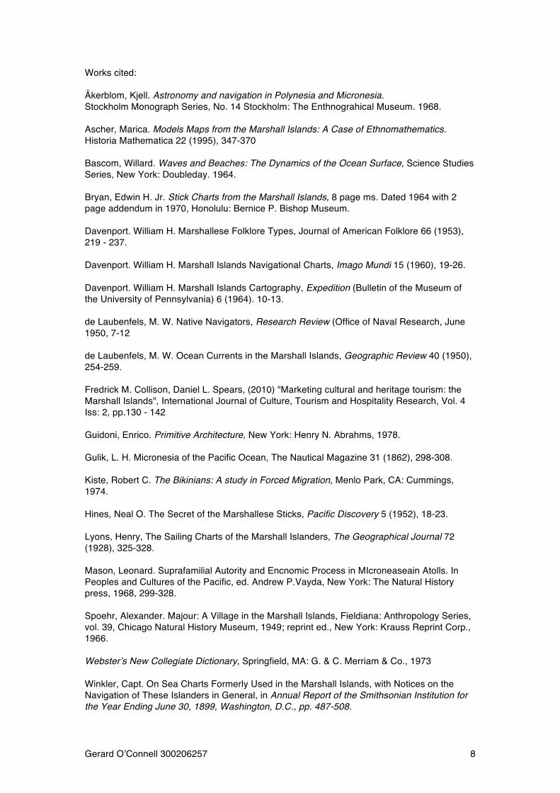
The Marshall Islands are located in the northern Pacific Ocean. Lying between 4° 30! and 15°
latitude and 160° and 175° longitude. The archipelago consists of 29 coral atolls and 5 small
coral islands, which run in two parallel chains stretching 960 km in a northwest – southeast
direction (Ascher 349). These chains are named the Ratak chain (sunrise) and the Ralik
chain (sunset). (Winkler 491) Atolls are small islands within a narrow ring of coral surrounding
a lagoon. Lagoons of the larger atolls range from 32 to 48 km long and 8 to 16 km across.
The Marshall Islands have a land area around about 180 km! scattered over 970,000 km! of
ocean. The archipelago is situated in the warmest part of the Pacific Ocean, where the mean
annual temperature is 27°C with a variance 5.5° between night and day. (Ascher 349)
Bikini Island, the northern most atoll, and the most famous due to the American nuclear
testing following WWII (and the swim suit which dons its name from the atoll), consists of a
ring of 51 small islands with a land area of 7.7 km! surrounding a 630 km! lagoon, Bikini is no
longer inhabited. (Kiste) Another example of the geography is the southern most densely
populated Majuro atoll, a ring of 61 small islands with a land area of just under 180 km!
surrounding a 260 km! lagoon. (Spoehr)
Because there is so little land, the community focuses on how land is transmitted, how it is
used, and how its fruits are distributed. There are clear social classes and, within these, kin
and clan delineations. On Majuro, about 10% of the people are nobility while others are
commoners. Land is never sold or personally owned. Although worked by the commoners,
the paramount chief, a noble lineage, and a commoner lineage share right to the produce of
any piece of land. Coconut palms, pandanus and breadfruit trees, some tropical hardwoods,
and taro are of primary importance for food as well as for construction, weaving materials,
and fuel. Copra (dried coconut meat) has been exported since 1860. (Kiste) (Mason)
(Spoehr).
Gerard O!Connell 300206257! ! 3!
With so much of the environment dominated by water, sailing and boats are an essential and
integral part of life. On an atoll, within the lagoon, sailing canoes are used for fishing, for
travelling to visit friends, and for the collection of food and copra. And, of course, boats are
used for open sea fishing, in the vicinity of the atoll and for open sea travel to other atolls.
Some small sailing canoes of about five metres, which can also be paddled or rowed, are for
use around the edges of the reefs. But to cross the lagoon and to carry passengers and
cargo, the boats are seven to nine metres long and require a crew of two or three people.
These, and still larger boats, are for travel to other atolls in the Marshall Archipelago and
beyond. Very long distance trips to the Caroline Islands, the Palaus, and Saipan are recalled
as trips in "the olden days!. (Spoehr 255) Gulik!s report describes boats that could carry 50 to
100 men in an open sea and also recounts the festive return from some northern atolls to
Ebon of 800 people in a fleet of 40 boats. (Gulik) These large sailing expeditions were led by
chiefs, but their success and the success of more common trips within the atoll chains
depended on the navigators. The navigators, usually relatives of the paramount chief, were
specially selected and specially trained. Their knowledge and techniques were highly prized
and well kept secrets. It was strongly and religiously forbidden to divulge anything concerning
this art to the people; the chiefs wished to hold this knowledge for their sole benefit, partly for
the elevation of their functions; partly to hinder their subjects from learning it, in order to free
themselves from the frequently tyrannical government of their chiefs. (Winkler 505)
Knowledge was viewed as a personal possession; you take the responsibility for its
preservation and transmission. The navigators passed their knowledge and personally
developed systems on to one of their children or someone specifically adopted because of
special interest or aptitude. Some who were considered master navigators oversaw the
teaching of others in their extended family, giving rise to shared systems and ongoing
“schools” that traced back to a master. The child selected by a navigator to carry on the
knowledge could be male or female. Eventually, some of this knowledge was told to
westerners. However, what was told was far from complete, as the Marshall Island tellers
never intended to give full understanding to others. Since the Marshall Islanders are an oral
culture and had no indigenous writing system, we have only what was eventually recorded by
others. (Ascher 351).
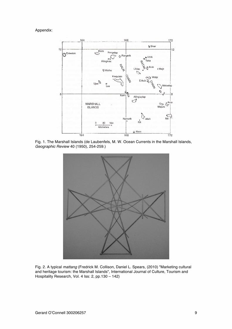
The mattang:
The mattang is a stick chart that was used by the Marshallese to train navigators. These are
formalised models of the underlying systems used to map the definitive movements of the
ocean. There are several defining features of these charts. One is their symmetry, another is
the inter play of geometric forms bringing together triangles, arcs and interesting points,
angles and intersections, also their diagram like clarity. (Ascher 351) Writers have described
explanations of various elements of these charts differently but from these descriptions, it is
clear that the mattang are generalised configurations containing idealised shapes and forms
Gerard O!Connell 300206257! ! 4!
that were used to explicate the principles of swell and land interaction. (Åkerblom 118) The
difficult thing to interpret for western people about these charts is that they are not specific
and concrete. M. W. de Laubenfels writes of an exchange where a Marshall Islander first
associated a point with Jaluit atoll and later with Namorik atoll. When asked, “the natives were
quick to explain that it didn!t matter – the chart was not where Jaluit in particular lay, but
where land was.” (de Laubenfels 10) Before reading into the mattang specifically, it is best to
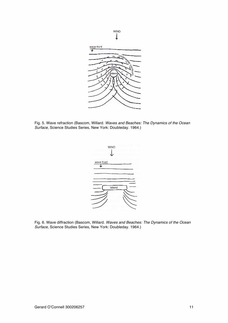
be introduced to some of the oceanographic phenomena fundamental to the system of wave
piloting. The three basic terms to explain these phenomena are refraction, reflection and
diffraction of swells. (Åkerblom 118). As waves move away from the winds that create them
they merge into swells formed by groups of waves of similar period and height. Because the
Marshall islands are surrounded by deep (4000-5000m) open ocean, long, fast moving swells
that are clear and consistent in pattern move toward them across the water. These swells
change when they meet underwater obstructions or reach shallower water. In and around the
Marshall Archipelago, approaching swells are modified in direction and energy. The
complicated and distinctive interactions of modified swells are the “landmarks” which the
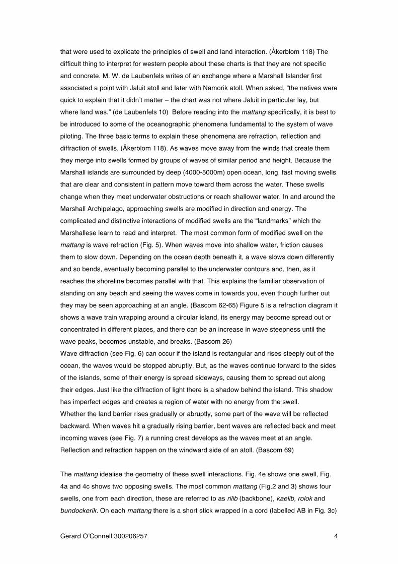
Marshallese learn to read and interpret. The most common form of modified swell on the
mattang is wave refraction (Fig. 5). When waves move into shallow water, friction causes
them to slow down. Depending on the ocean depth beneath it, a wave slows down differently
and so bends, eventually becoming parallel to the underwater contours and, then, as it
reaches the shoreline becomes parallel with that. This explains the familiar observation of
standing on any beach and seeing the waves come in towards you, even though further out
they may be seen approaching at an angle. (Bascom 62-65) Figure 5 is a refraction diagram it
shows a wave train wrapping around a circular island, its energy may become spread out or
concentrated in different places, and there can be an increase in wave steepness until the
wave peaks, becomes unstable, and breaks. (Bascom 26)
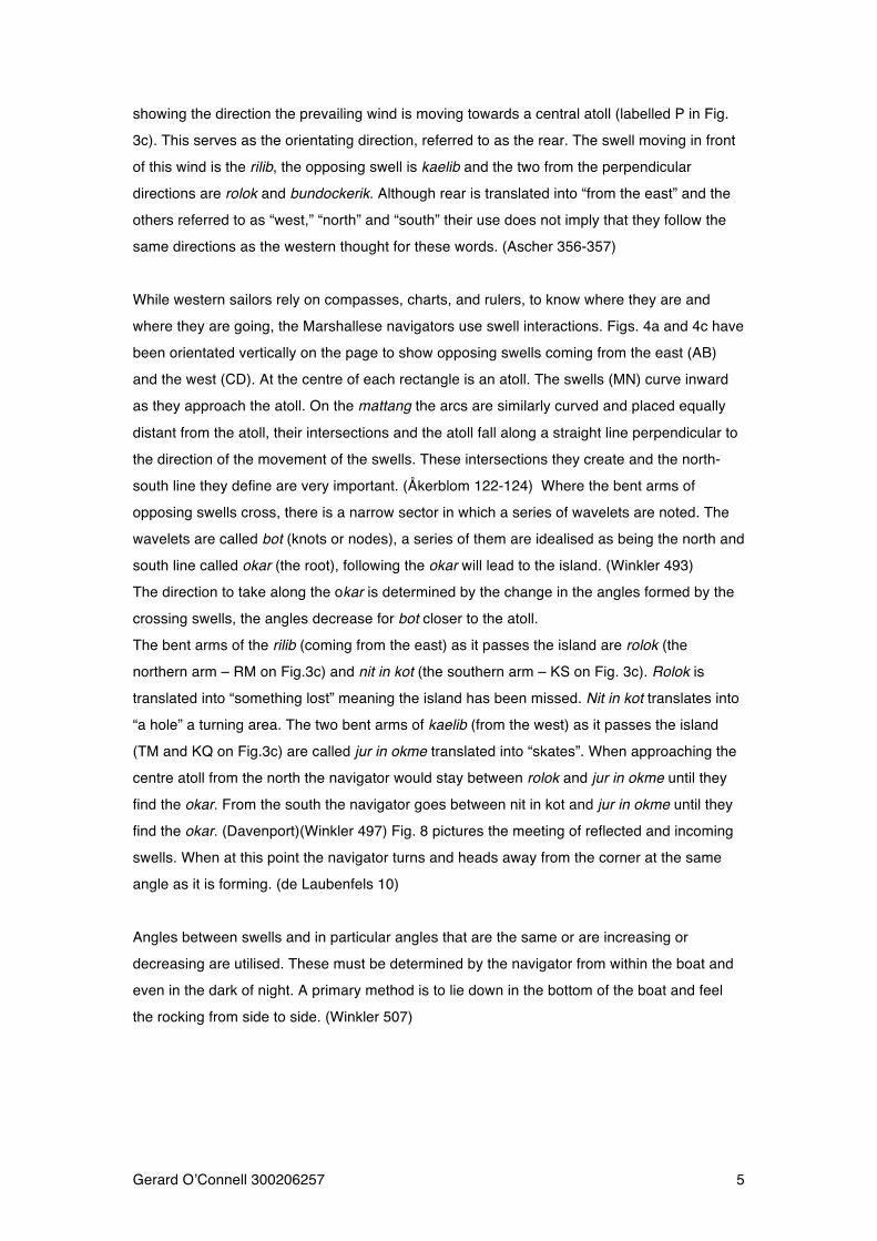
Wave diffraction (see Fig. 6) can occur if the island is rectangular and rises steeply out of the
ocean, the waves would be stopped abruptly. But, as the waves continue forward to the sides
of the islands, some of their energy is spread sideways, causing them to spread out along
their edges. Just like the diffraction of light there is a shadow behind the island. This shadow
has imperfect edges and creates a region of water with no energy from the swell.
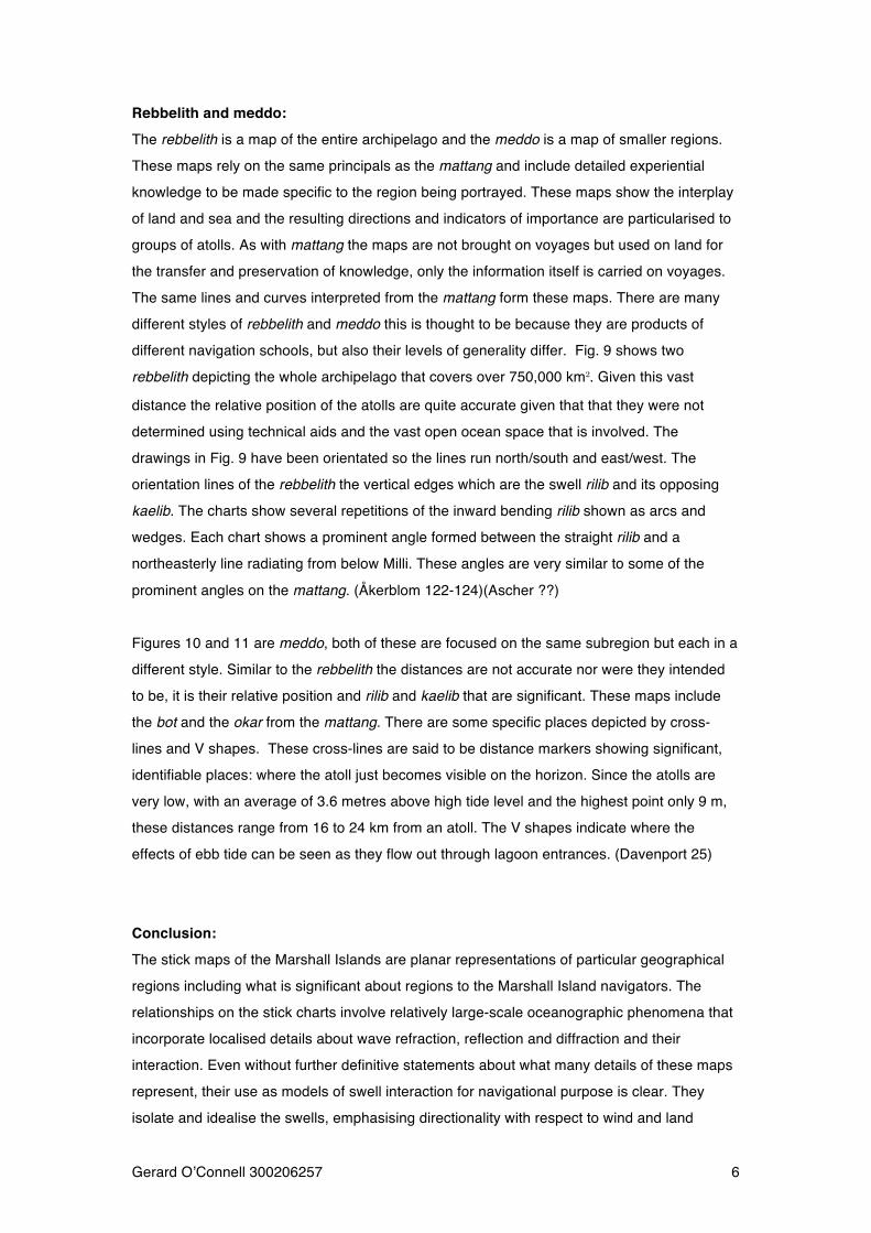
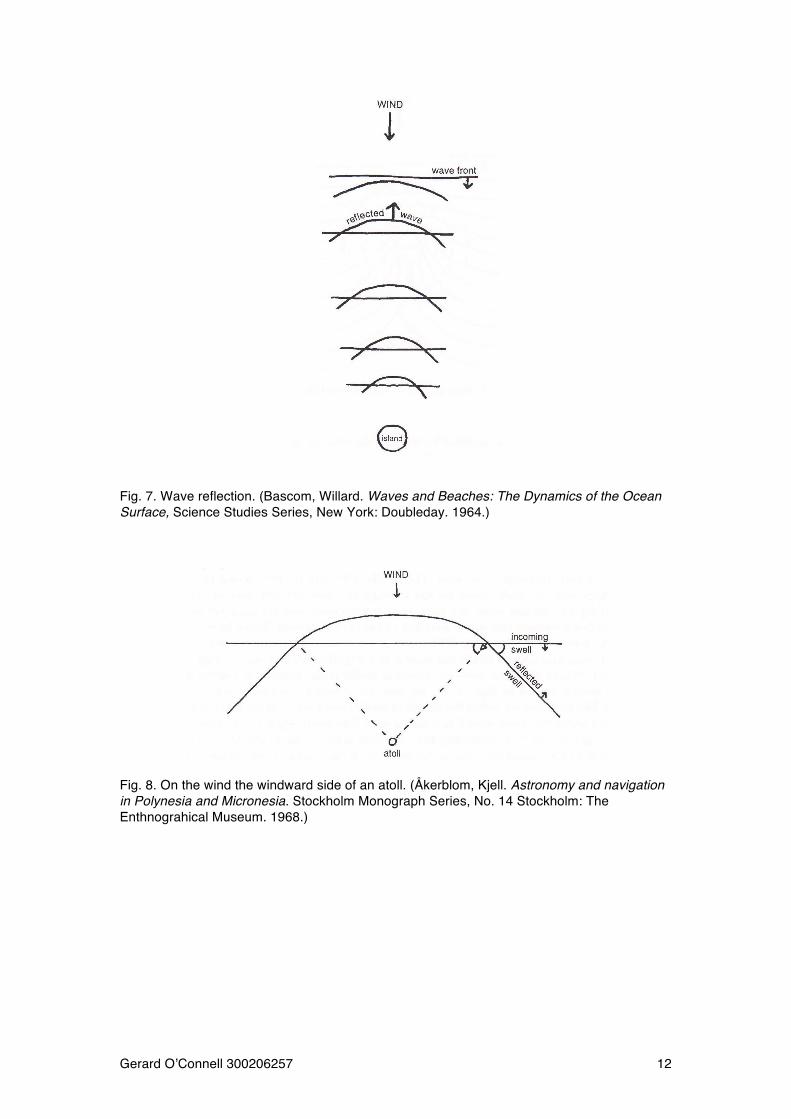
Whether the land barrier rises gradually or abruptly, some part of the wave will be reflected
backward. When waves hit a gradually rising barrier, bent waves are reflected back and meet
incoming waves (see Fig. 7) a running crest develops as the waves meet at an angle.
Reflection and refraction happen on the windward side of an atoll. (Bascom 69)
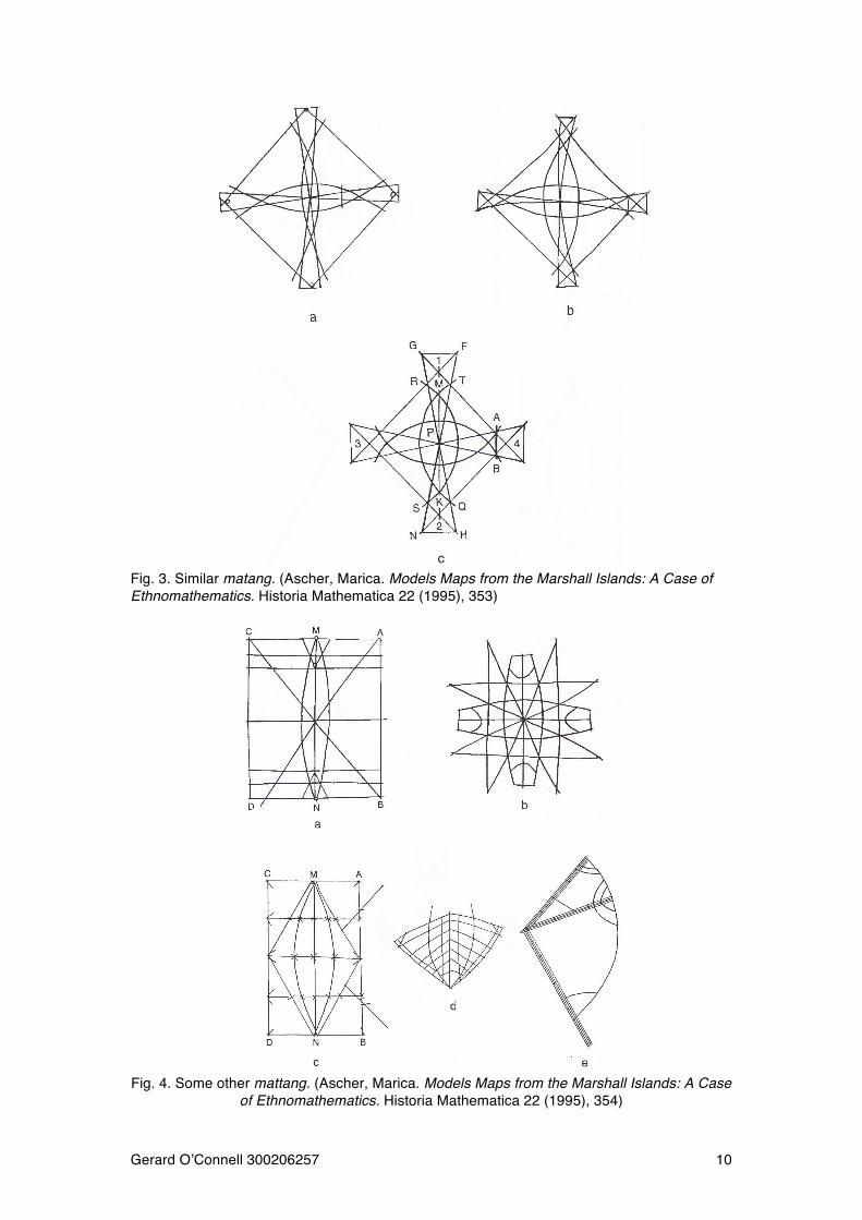
The mattang idealise the geometry of these swell interactions. Fig. 4e shows one swell, Fig.
4a and 4c shows two opposing swells. The most common mattang (Fig.2 and 3) shows four
swells, one from each direction, these are referred to as rilib (backbone), kaelib, rolok and
bundockerik. On each mattang there is a short stick wrapped in a cord (labelled AB in Fig. 3c)
Gerard O!Connell 300206257! ! 5!
showing the direction the prevailing wind is moving towards a central atoll (labelled P in Fig.
3c). This serves as the orientating direction, referred to as the rear. The swell moving in front
of this wind is the rilib, the opposing swell is kaelib and the two from the perpendicular
directions are rolok and bundockerik. Although rear is translated into “from the east” and the
others referred to as “west,” “north” and “south” their use does not imply that they follow the
same directions as the western thought for these words. (Ascher 356-357)
While western sailors rely on compasses, charts, and rulers, to know where they are and
where they are going, the Marshallese navigators use swell interactions. Figs. 4a and 4c have
been orientated vertically on the page to show opposing swells coming from the east (AB)
and the west (CD). At the centre of each rectangle is an atoll. The swells (MN) curve inward
as they approach the atoll. On the mattang the arcs are similarly curved and placed equally
distant from the atoll, their intersections and the atoll fall along a straight line perpendicular to
the direction of the movement of the swells. These intersections they create and the north-
south line they define are very important. (Åkerblom 122-124) Where the bent arms of
opposing swells cross, there is a narrow sector in which a series of wavelets are noted. The
wavelets are called bot (knots or nodes), a series of them are idealised as being the north and
south line called okar (the root), following the okar will lead to the island. (Winkler 493)
The direction to take along the okar is determined by the change in the angles formed by the
crossing swells, the angles decrease for bot closer to the atoll.
The bent arms of the rilib (coming from the east) as it passes the island are rolok (the
northern arm – RM on Fig.3c) and nit in kot (the southern arm – KS on Fig. 3c). Rolok is
translated into “something lost” meaning the island has been missed. Nit in kot translates into
“a hole” a turning area. The two bent arms of kaelib (from the west) as it passes the island
(TM and KQ on Fig.3c) are called jur in okme translated into “skates”. When approaching the
centre atoll from the north the navigator would stay between rolok and jur in okme until they
find the okar. From the south the navigator goes between nit in kot and jur in okme until they
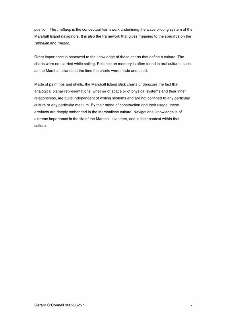
find the okar. (Davenport)(Winkler 497) Fig. 8 pictures the meeting of reflected and incoming
swells. When at this point the navigator turns and heads away from the corner at the same
angle as it is forming. (de Laubenfels 10)
Angles between swells and in particular angles that are the same or are increasing or
decreasing are utilised. These must be determined by the navigator from within the boat and
even in the dark of night. A primary method is to lie down in the bottom of the boat and feel
the rocking from side to side. (Winkler 507)
Gerard O!Connell 300206257! ! 6!
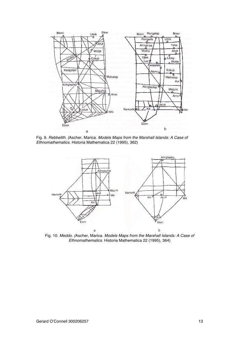
Rebbelith and meddo:
The rebbelith is a map of the entire archipelago and the meddo is a map of smaller regions.
These maps rely on the same principals as the mattang and include detailed experiential
knowledge to be made specific to the region being portrayed. These maps show the interplay
of land and sea and the resulting directions and indicators of importance are particularised to
groups of atolls. As with mattang the maps are not brought on voyages but used on land for
the transfer and preservation of knowledge, only the information itself is carried on voyages.
The same lines and curves interpreted from the mattang form these maps. There are many
different styles of rebbelith and meddo this is thought to be because they are products of
different navigation schools, but also their levels of generality differ. Fig. 9 shows two
rebbelith depicting the whole archipelago that covers over 750,000 km!. Given this vast
distance the relative position of the atolls are quite accurate given that that they were not
determined using technical aids and the vast open ocean space that is involved. The
drawings in Fig. 9 have been orientated so the lines run north/south and east/west. The
orientation lines of the rebbelith the vertical edges which are the swell rilib and its opposing
kaelib. The charts show several repetitions of the inward bending rilib shown as arcs and
wedges. Each chart shows a prominent angle formed between the straight rilib and a
northeasterly line radiating from below Milli. These angles are very similar to some of the
prominent angles on the mattang. (Åkerblom 122-124)(Ascher ??)
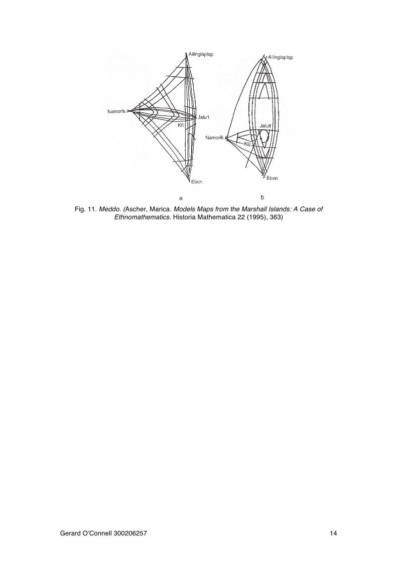
Figures 10 and 11 are meddo, both of these are focused on the same subregion but each in a
different style. Similar to the rebbelith the distances are not accurate nor were they intended
to be, it is their relative position and rilib and kaelib that are significant. These maps include
the bot and the okar from the mattang. There are some specific places depicted by cross-
lines and V shapes. These cross-lines are said to be distance markers showing significant,
identifiable places: where the atoll just becomes visible on the horizon. Since the atolls are
very low, with an average of 3.6 metres above high tide level and the highest point only 9 m,
these distances range from 16 to 24 km from an atoll. The V shapes indicate where the
effects of ebb tide can be seen as they flow out through lagoon entrances. (Davenport 25)
Conclusion:
The stick maps of the Marshall Islands are planar representations of particular geographical
regions including what is significant about regions to the Marshall Island navigators. The
relationships on the stick charts involve relatively large-scale oceanographic phenomena that
incorporate localised details about wave refraction, reflection and diffraction and their
interaction. Even without further definitive statements about what many details of these maps
represent, their use as models of swell interaction for navigational purpose is clear. They
isolate and idealise the swells, emphasising directionality with respect to wind and land
Gerard O!Connell 300206257! ! 7!
position. The mattang is the conceptual framework underlining the wave piloting system of the
Marshall Island navigators. It is also the framework that gives meaning to the specifics on the
rebbelith and meddo.
Great importance is bestowed to the knowledge of these charts that define a culture. The
charts were not carried while sailing. Reliance on memory is often found in oral cultures such
as the Marshall Islands at the time the charts were made and used.
Made of palm ribs and shells, the Marshall Island stick charts underscore the fact that
analogical planar representations, whether of space or of physical systems and their inner
relationships, are quite independent of writing systems and are not confined to any particular
culture or any particular medium. By their mode of construction and their usage, these
artefacts are deeply embedded in the Marshallese culture. Navigational knowledge is of
extreme importance in the life of the Marshall Islanders, and is their context within that
culture.
Gerard O!Connell 300206257! ! 8!
Works cited: Åkerblom, Kjell. Astronomy and navigation in Polynesia and Micronesia. Stockholm Monograph Series, No. 14 Stockholm: The Enthnograhical Museum. 1968. Ascher, Marica. Models Maps from the Marshall Islands: A Case of Ethnomathematics.
Historia Mathematica 22 (1995), 347-370 Bascom, Willard. Waves and Beaches: The Dynamics of the Ocean Surface, Science Studies Series, New York: Doubleday. 1964. Bryan, Edwin H. Jr. Stick Charts from the Marshall Islands, 8 page ms. Dated 1964 with 2 page addendum in 1970, Honolulu: Bernice P. Bishop Museum. Davenport. William H. Marshallese Folklore Types, Journal of American Folklore 66 (1953), 219 - 237. Davenport. William H. Marshall Islands Navigational Charts, Imago Mundi 15 (1960), 19-26. Davenport. William H. Marshall Islands Cartography, Expedition (Bulletin of the Museum of the University of Pennsylvania) 6 (1964). 10-13. de Laubenfels, M. W. Native Navigators, Research Review (Office of Naval Research, June 1950, 7-12 de Laubenfels, M. W. Ocean Currents in the Marshall Islands, Geographic Review 40 (1950), 254-259. Fredrick M. Collison, Daniel L. Spears, (2010) "Marketing cultural and heritage tourism: the Marshall Islands", International Journal of Culture, Tourism and Hospitality Research, Vol. 4 Iss: 2, pp.130 - 142 Guidoni, Enrico. Primitive Architecture, New York: Henry N. Abrahms, 1978. Gulik, L. H. Micronesia of the Pacific Ocean, The Nautical Magazine 31 (1862), 298-308. Kiste, Robert C. The Bikinians: A study in Forced Migration, Menlo Park, CA: Cummings, 1974. Hines, Neal O. The Secret of the Marshallese Sticks, Pacific Discovery 5 (1952), 18-23. Lyons, Henry, The Sailing Charts of the Marshall Islanders, The Geographical Journal 72 (1928), 325-328. Mason, Leonard. Suprafamilial Autority and Encnomic Process in MIcroneaseain Atolls. In Peoples and Cultures of the Pacific, ed. Andrew P.Vayda, New York: The Natural History press, 1968, 299-328. Spoehr, Alexander. Majour: A Village in the Marshall Islands, Fieldiana: Anthropology Series, vol. 39, Chicago Natural History Museum, 1949; reprint ed., New York: Krauss Reprint Corp., 1966. Webster!s New Collegiate Dictionary, Springfield, MA: G. & C. Merriam & Co., 1973 Winkler, Capt. On Sea Charts Formerly Used in the Marshall Islands, with Notices on the Navigation of These Islanders in General, in Annual Report of the Smithsonian Institution for
the Year Ending June 30, 1899, Washington, D.C., pp. 487-508.
Gerard O!Connell 300206257! ! 9!
Appendix:
!Fig. 1. The Marshall Islands (de Laubenfels, M. W. Ocean Currents in the Marshall Islands, Geographic Review 40 (1950), 254-259.)
Fig. 2. A typical mattang (Fredrick M. Collison, Daniel L. Spears, (2010) "Marketing cultural and heritage tourism: the Marshall Islands", International Journal of Culture, Tourism and Hospitality Research, Vol. 4 Iss: 2, pp.130 – 142)
Gerard O!Connell 300206257! ! 10!
!Fig. 3. Similar matang. (Ascher, Marica. Models Maps from the Marshall Islands: A Case of
Ethnomathematics. Historia Mathematica 22 (1995), 353)
Fig. 4. Some other mattang. (Ascher, Marica. Models Maps from the Marshall Islands: A Case
of Ethnomathematics. Historia Mathematica 22 (1995), 354)
Gerard O!Connell 300206257! ! 11!
Fig. 5. Wave refraction (Bascom, Willard. Waves and Beaches: The Dynamics of the Ocean
Surface, Science Studies Series, New York: Doubleday. 1964.)
Fig. 6. Wave diffraction (Bascom, Willard. Waves and Beaches: The Dynamics of the Ocean
Surface, Science Studies Series, New York: Doubleday. 1964.)
Gerard O!Connell 300206257! ! 12!
Fig. 7. Wave reflection. (Bascom, Willard. Waves and Beaches: The Dynamics of the Ocean
Surface, Science Studies Series, New York: Doubleday. 1964.)
Fig. 8. On the wind the windward side of an atoll. (Åkerblom, Kjell. Astronomy and navigation
in Polynesia and Micronesia. Stockholm Monograph Series, No. 14 Stockholm: The Enthnograhical Museum. 1968.)
Gerard O!Connell 300206257! ! 13!
!Fig. 9. Rebbelith. (Ascher, Marica. Models Maps from the Marshall Islands: A Case of
Ethnomathematics. Historia Mathematica 22 (1995), 362)
Fig. 10. Meddo. (Ascher, Marica. Models Maps from the Marshall Islands: A Case of
Ethnomathematics. Historia Mathematica 22 (1995), 364)
Gerard O!Connell 300206257! ! 14!
Fig. 11. Meddo. (Ascher, Marica. Models Maps from the Marshall Islands: A Case of
Ethnomathematics. Historia Mathematica 22 (1995), 363)


