Embed Size (px)
Citation preview
Sensors 2022, 22, 1786. https://doi.org/10.3390/s22051786 www.mdpi.com/journal/sensors
Article
Modifying Hata‐Davidson Propagation Model
for Remote Sensing in Complex Environments Using
a Multifactional Drone
Faris A. Almalki 1 and Ben Othman Soufiene 2,*
1 Department of Computer Engineering, College of Computers and Information Technology, Taif University,
P.O. Box 11099, Taif 21944, Saudi Arabia; [email protected] 2 PRINCE Laboratory Research, ISITcom, Hammam Sousse, University of Sousse, Sousse 4023, Tunisia
* Correspondence: [email protected]
Abstract: The coupling of drones and IoT is a major topics in academia and industry since it signif‐
icantly contributes towards making human life safer and smarter. Using drones is seen as a robust
approach for mobile remote sensing operations, such as search‐and‐rescue missions, due to their
speed and efficiency, which could seriously affect victims’ chances of survival. This paper aims to
modify the Hata‐Davidson empirical propagation model based on RF drone measurement to con‐
duct searches for missing persons in complex environments with rugged areas after manmade or
natural disasters. A drone was coupled with a thermal FLIR lepton camera, a microcontroller, GPS,
and weather station sensors. The proposed modified model utilized the least squares tuning algo‐
rithm to fit the data measured from the drone communication system. This enhanced the RF con‐
nectivity between the drone and the local authority, as well as leading to increased coverage foot‐
print and, thus, the performance of wider search‐and‐rescue operations in a timely fashion using
strip search patterns. The development of the proposed model considered both software simulation
and hardware implementations. Since empirical propagation models are the most adjustable mod‐
els, this study concludes with a comparison between the modified Hata‐Davidson algorithm against
other well‐known modified empirical models for validation using root mean square error (RMSE).
The experimental results show that the modified Hata‐Davidson model outperforms the other em‐
pirical models, which in turn helps to identify missing persons and their locations using thermal
imaging and a GPS sensor.
Keywords: IoT; propagation model; tuning models; remote sensing; drones; complex environment;
thermal imaging; rescue operations
1. Introduction
The importance of having reliable wireless communication links and systems during
or after manmade or natural disasters is highlighted in [1]. In 2017, Florida was hit by one
of the most damaging hurricanes in American history, with winds reaching up to 220
km/h. This resulted in around 50% of cell sites going of service, as well as around 1.2
million subscribers losing their wireless connections. Therefore, during disaster scenarios,
space‐based wireless communication systems including satellites, aerial Platforms, and
unmanned aerial vehicles (UAVs) could offer a wide range of services. These would in‐
clude, for instance, evaluating damage zones, coordinating rescue teams activities, deliv‐
ering first‐aid kits, accounting for missing people, and delivering good‐quality signals in
disaster areas [2,3]. However, terrestrial communication links are often disrupted when
disaster strikes, as they are more vulnerable to physical damage. Thus, outer‐space com‐
munication systems would serve as better solutions [4,5].
Citation: Almalki, F.A.; Ben, O.S.
Modifying Hata‐Davidson
Propagation Model for Remote
Sensing in Complex Environment
Using a Multifactional Drone.
Sensors 2022, 22, 1786.
https://doi.org/10.3390/s22051786
Academic Editors:
Omprakash Kaiwartya
and Renato Machado
Received: 9 December 2021
Accepted: 22 February 2022
Published: 24 February 2022
Publisher’s Note: MDPI stays neu‐
tral with regard to jurisdictional
claims in published maps and institu‐
tional affiliations.
Copyright: © 2022 by the authors. Li‐
censee MDPI, Basel, Switzerland.
This article is an open access article
distributed under the terms and con‐
ditions of the Creative Commons At‐
tribution (CC BY) license (https://cre‐
ativecommons.org/licenses/by/4.0/).
Sensors 2022, 22, 1786 2 of 22
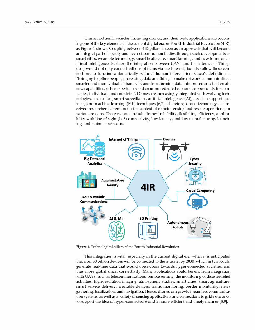
Unmanned aerial vehicles, including drones, and their wide applications are becom‐
ing one of the key elements in the current digital era, or Fourth Industrial Revolution (4IR),
as Figure 1 shows. Coupling between 4IR pillars is seen as an approach that will become
an integral part of society and even of our human bodies through such developments as
smart cities, wearable technology, smart healthcare, smart farming, and new forms of ar‐
tificial intelligence. Further, the integration between UAVs and the Internet of Things
(IoT) would not only connect billions of items via the Internet, but also allow these con‐
nections to function automatically without human intervention. Cisco’s definition is
“Bringing together people, processing, data and things to make network communications
smarter and more valuable than ever, and transforming data into procedures that create
new capabilities, richer experiences and an unprecedented economic opportunity for com‐
panies, individuals and countries”. Drones are increasingly integrated with evolving tech‐
nologies, such as IoT, smart surveillance, artificial intelligence (AI), decision support sys‐
tems, and machine learning (ML) techniques [6,7]. Therefore, drone technology has re‐
ceived researchers’ attention tin the context of remote sensing and rescue operations for
various reasons. These reasons include drones’ reliability, flexibility, efficiency, applica‐
bility with line‐of‐sight (LoS) connectivity, low latency, and low manufacturing, launch‐
ing, and maintenance costs.
Figure 1. Technological pillars of the Fourth Industrial Revolution.
This integration is vital, especially in the current digital era, when it is anticipated
that over 50 billion devices will be connected to the internet by 2030, which in turn could
generate real‐time data that would open doors towards hyper‐connected societies, and
thus more global smart connectivity. Many applications could benefit from integration
with UAVs, such as telecommunications, remote sensing, the monitoring of disaster‐relief
activities, high‐resolution imaging, atmospheric studies, smart cities, smart agriculture,
smart service delivery, wearable devices, traffic monitoring, border monitoring, news
gathering, localization, and navigation. Hence, drones can provide seamless communica‐
tion systems, as well as a variety of sensing applications and connections to grid networks,
to support the idea of hyper‐connected world in more efficient and timely manner [8,9].

Sensors 2022, 22, 1786 3 of 22
To the best of our knowledge, this is the first work that considers a modified Hata‐
Davidson propagation model from a UAV perspective, despite UAVs’ advantages of ac‐
curacy, coverage, and correction factors. To obtain novelty and mark a noticeable shift
from existing work, the key contributions of this work are as follows:
Modifying the Hata‐Davidson empirical propagation model based on RF drone
measurement using the least squares tuning algorithm, which offers the advantages
of accuracy, strong connectivity, and wide coverage.
Building and testing a multifactional drone equipped with state‐of‐art 5G MIMO an‐
tennae as well as a thermal camera and sensors for search‐and‐rescue operations.
Validating the results against other well‐known modified empirical models in view
of further development.
The rest of this paper is organized as follows. Section 2 presents related work, and
then highlights this paper’s motivation. This is followed by Section 3, which describes the
proposed model. Section 4 presents the implementation setup and discusses the results.
Section 5 concludes the study.
2. Related Work
UAVs, including drones, are increasingly seen as innovative solutions for rapid
search‐and‐rescue operations. They could provide many satellite advantages, but without
the distance penalty. Receivers may experience a better signal quality as the system offers
line‐of‐sight (LoS) communications and, hence, less propagation delay in relation to sat‐
ellite systems [10,11]. Our review of relevant literature reveals that there has been some
consideration of the capabilities of drones for emergencies, including different cameras,
propagation models, altitudes, and search patterns. This section then concludes with a
review of related research, and highlights this paper’s motivation.
The most critical requirement for search‐and‐rescue teams to be able to save people’s
lives is having high‐performance communication links. The authors of [11–15] focused on
proposing different propagation models that could provide robust wireless communica‐
tion between aerial stations and interdepartmental headquarters, including rescue teams.
Hata and Okumura are typical empirical models, while air‐to‐ground and free‐space are
typical deterministic propagation models. These propagation models can measure path
loss (PL) and coverage, which in turn are important parameters for monitoring wireless
system performance and network planning. The results of using these propagation mod‐
els in various emergency scenarios show that they exhibit advantages in relation to high
altitude, wide coverage range, and adaption across different terrains. However, there are
some shortcomings of existing models that should be addressed to enhance resilience and
offer better quality of service (QoS) in harsh environmental conditions.
Utilizing a drone to detect humans and their location in real‐time disastrous situa‐
tions is simulated and experimented in [16]. The proposal aims to identify the location of
survivors buried under wreckage using a camera module, a microcontroller, and a sensor.
The results show that the drone with its payload can be a vital and cost‐effective tool for
detecting victims who are still alive in harsh environmental conditions. In [17], re‐search‐
ers introduced a drone prototype for intelligent search, rescue, and disaster recovery mis‐
sions. A colored camera, a GPS sensor, machine learning, and image processing were the
tools used to carry out the missions. The results show that the proposed prototype can
operate autonomously and quickly for search operations.
A lifeguard drone flying at a 100 m altitude was designed to alert divers at beach
locations and deliver an automatic inflating vest to drowning victims [18]. The initial call
is started by a swimmer, who wears wristband, so they can press a button on the device;
the drone can then the location using a GPS and ZigBee transmitter. The experimental
results show a reasonable response from the drone. However, the use of a HD camera
along with artificial intelligence are recommended to enhance the work.

Sensors 2022, 22, 1786 4 of 22
The authors of [19] proposed an automated human detection system mounted on a
drone, with components including RGB camera and GPS sensor, for search‐and‐rescue mis‐
sions. The system aims to offer rapid localization and allocate a score of confidence for each
detection. At a 15 m altitude, the results show moderate accuracy in detecting persons with
a higher level of confidence. A fully autonomous drone equipped with human detection
sensors, communication modules (e.g., GSM/GPRS module, GPS), and an object collision
detection sensor for search‐and‐rescue operations is discussed in [20]. At a 7 m altitude, both
simulation and trials have shown that using inexpensive and reliable sensors such as pas‐
sive infrared (RIP) sensors, ultrasonic sensors, and Arduino microcontrollers offered the
ability to detect humans trapped under ruins. However, the paper recommends thermal
cameras and advanced sensors to enhance the accuracy and response times.
The authors of [21] present a drone that utilizes multi‐sensors and geolocalization to
detect survivors after natural disasters as part of search‐and‐ rescue operations. The auton‐
omous and robust drone is also equipped with an ultra‐wideband radar, microphone array,
camera, RFID reader, laser range finder and LIDAR at an altitude of 13 m. The results sug‐
gest the capability of early‐stage survivor detection; however, the authors promise further
development of the prototype in relation to the camera module and propagation model.
The authors of [22] used a drone as the first responder in natural and/or man‐made
disasters due to its rapid response, as well as its adaptability to particular environments.
The first‐responder drones (FRDs) system implemented a long‐range (LoRa) system,
which is enabled by low power‐wide area network (LP‐WAN), as well as a GPS module
and a camera onboard. The results suggest that the proposed FRDs could respond within
a range of 10‐46 s of a footprint up to 30 km in rural areas; the range decreases as the drone
moves towards urban areas. Moreover, increase the distance between a drone and the
terrestrial receivers is an issue that is repeatedly highlighted in the literature. Where it is
argued that optimizing propagation path loss and power consumption would be key pa‐
rameters to enhance wireless connectivity at different drone altitudes.
In [23], a drone model is shown that uses a deep‐learning algorithm to enhance aerial
image processing for search‐and‐rescue operations that deal with human lives. At an alti‐
tude of 61 m, with a small onboard GPS device and a colored camera, the proposed drone
taken thousands of human pictures, before using them as training, test, and validation
primary data for the deep‐learning algorithm. The results show a high level of sensitivity
with an acceptable false‐positive rate. For further work, thermal cameras at different
drones altitudes could be used to improve the search‐and‐rescue operations further.
The authors of [24] present an architecture of human detection during or after natural
disasters using UAVs integrated with head‐mounted display (HMD) devices. This archi‐
tecture aims to deliver a solution to protect human lives in search‐and rescue operations.
Support vector machines (SVM) and adaptive boosting (AdaBoost) are traditionally used
for human detection via an RGB camera installed on an UAV. The experimental results
show reasonable object detection architecture with search‐and‐rescue operations via RGB
images. Thermal cameras are recommended to improve detection in low light and/or in
camouflaging foliage scenarios.
In [25], a multipurpose UAV is presented to carry out a rescue operations due to
avalanche events in mountains. The aerial platform is integrated with avionics that meet
the environmental requirements for mountainous terrain (e.g., low temperatures, high al‐
titude, and strong winds). The model uses a visible thermal camera for search‐and‐rescue
missions involving missing persons in snow and in woods during any time of the day.
Results show that the proposed model can operate autonomously and in quick search
operations at different altitude. The thermal FLIR Tau 2 IR camera shows an acceptable
level of performance for snow‐covered bodies up to 20 cm. There is a trade‐off between
flight endurance and payload weight against power consumption.
The detection of the heat profile to locate missing persons using drones integrated
with a thermal camera is considered in [26]. The proposal calculated target coordinates of
a missing person using a closed‐form formula. The results indicate that UAV can detect
Sensors 2022, 22, 1786 5 of 22
humans lying or sitting on the ground as well as identifying their location. The authors of
[27] introduced an overview of drones used for hyperspectral remote sensing at low alti‐
tudes. The drone payload’s weight, size, flight duration and cost are criteria that help to
choose the right payloads (e.g., sensors) and drone design.
The authors of [28] integrated a convolutional neural network (CNN) and an auton‐
omous drone with a thermal camera to locate victims quickly and efficiently in disaster
zones. The experimental results confirm that detecting victims from an aerial thermal
view was achieved with AP = 82.49%. However, the drone’s altitude and coverage range
were not clarified. Moreover, in [29], the CNN also used autonomous drone‐surveillance
and a RGB camera for search‐and‐rescue in natural disasters at 40 m altitude. The results
confirm that detecting accuracy of victims from an aerial view was achieved with 98%.
Further image processing and optimization techniques are introduced in [29,30], where a
drone‐based system is developed to detect the breathing movements of casualties or lost
people within natural‐disaster zones. The results show reasonable precision average
measures from altitudes ranging from 2–8 m. Further work is recommended, involving
tuning to high altitude and high image resolution, to gain better results.
The authors of [31] presented a multifunctional drone combined with a machine
learning (ML) approach that helps in fighting against the coronavirus pandemic. The pro‐
posed drone, with its payload of thermal cameras and ML, can not only detect people
wearing face masks in public for security reasons, but also help to sense elevated body
temperatures in order to minimize cross‐infection through close contact. Furthermore, the
proposed work pays attention to the optimization of communication links for better wire‐
less connectivity and power consumption. The authors of [32–36] covered different tech‐
niques that can allow UAVs to divide the target area for search and rescue operations.
Where snooping or strips are the most well‐known searching techniques.
In [37,38], the authors emphasize the importance of UAV trajectory design, which
affects not only the communication and link budget between UAVs and ground users, but
also UAVs’ energy consumption. They also considered a deep‐reinforcement algorithm
for trajectory design and power allocation optimization.
In the literature, a few types of camera have been used for detecting humans and/or
wildlife animals from a bird’s‐eye view on satellites or UAVs; they are mainly classified
as thermal cameras and RGB cameras. However, this work focuses on using a thermal
camera based on the heat signature of objects using mid‐ or long‐wavelength infrared en‐
ergy. It has the advantages of easy installation and usage, independent of light, the provi‐
sion of fast and accurate measurements of objects, and limited privacy issues [39–45].
The authors of [46,47] studied a drone’s ad hoc network for mobility and service‐oriented
modeling using various protocols and techniques, such as neuro‐fuzzy, and a quality of ser‐
vice provisioning framework for UAV‐assisted environments. The results of these innovative
approaches have emphasized the significant potential of enabling smart services.
Based on our review, our motivations and contributions are as follows. Our study aims
to modify the Hata‐Davidson empirical propagation model based on RF drone measure‐
ment using the least squares tuning algorithm. The optimum experimental configuration is
considered to allow a drone with a thermal camera and other payloads flying over disaster
zones in rugged areas to help identify lost people as part of robust and efficient search‐and‐
rescue operations. The deployment of portable drones with thermal cameras and state‐of‐
art 5G MIMO antennae, as well as sensors, for search‐and‐rescue operations is scarcely re‐
ported in the literature, let alone the optimization of a propagation model to ensure strong
wireless connectivity and a wider coverage footprint. To the best of our knowledge, this is
the first work to consider the Hata‐Davidson propagation model from a UAV perspective,
despite UAVs’ advantages of accuracy, coverage, and correction factors. To obtain novelty
and mark a noticeable shift from existing work, six objectives were pursued:
Investigate more empirical propagation models that suit the nature of low‐altitude
drones.
Sensors 2022, 22, 1786 6 of 22
Optimize an empirical propagation model that offers advantages (e.g., accuracy,
suite different environment, strong received signal strength (RSS) connectivity, and
wide coverage).
Built a drone with onboard equipment (e.g., thermal FLIR lepton camera, 5G MIMO
antenna, weather station, and GPS sensors.
Identify the optimum wireless communication configuration of the drone (e.g., drone
altitude, covered footprint, weather conditions (temperature, wind speed), longi‐
tude, and latitude). These parameters were linked to the optimized model to ensure
cohesion and accurate results.
Perform a hardware calibration before the implementation of the proposed design
for testing and verification in a real scenario.
Validate the results against other well‐known modified empirical models for valida‐
tion using RMSE.
3. Proposed Model and Experiment Setup
Emergency responders require real‐time imagery and information in cases of disas‐
ters that threatens lives. These events involve large number of workers carrying out rescue
missions for injured or missing people at rugged or isolated areas, which require more
effort, cost, and risk. Figure 2 shows a proposed model architecture consisting of two main
segments, a space segment, and a ground segment, to serve the purpose of carrying out
search‐and‐rescue operations to detect casualties or lost people within rugged natural
and/or manmade disaster zones using a drone integrated with 5G telecommunication
payloads and a thermal camera. The space segment contains a drone with communication
payloads such as a thermal camera, a GPS sensor, and telecommunication payloads with
5G MIMO antennae. The ground segment consists of fixed or mobile users, as well as a
ground control center (GCC) that acts as the focal point between two segments and hosts
gateways to external networks.
In the literature, well‐known search techniques that allow UAVs to divide a target
area for search‐and‐rescue operations include strips, lines, or random techniques [34,36].
In our study, we used the strips technique, as Figure 3 shows, since it is the most suitable
approach to achieving our research goal. To illustrate, when a drone conducts a search
mission it makes sense to divide a target area into strips so that they can go over the di‐
vided areas one‐by‐one, performing only one turn at the end, which in turn achieves two
goals. The first is coverage of each raw target area; the second is energy savings in com‐
parison to other search techniques.

Sensors 2022, 22, 1786 7 of 22
Figure 2. Proposed structure of a drone for use in search‐and‐rescue operations.
Figure 3. Strips searching technique performed by a drone.
3.1. Conceptual Model
Figure 3 displays the use of Mission Planner software, which is used as a ground
control station for the drone, where vital configuration and setup can be performed to
attain the optimum performance of aerial vehicles. The strips search technique is used
when flying a drone to conduct search‐and‐rescue missions autonomously. When the
drone flies autonomously to a targeted area, two main steps should be considered. The
first step involves using thermal camera and a GPS sensor to detect missing people and
identify their locations. The second step involves a reliance on the optimized Hata‐Da‐
vidson propagation model, which enhances connectivity to report cases for rescue and
medical aid. These two steps can be visualized in more detail in Figure 4, as a flowchart.

Sensors 2022, 22, 1786 8 of 22
The section includes two subsections. The first presents the mathematical concept sup‐
porting the proposed framework. The second describes the hardware and software archi‐
tecture used in the experiment.
Notably, the experiment focuses on using a drone with a thermal camera and com‐
munication payloads to fly over disaster zones in rugged areas and detect lost people as
part of robust and efficient search‐and‐rescue operations. Thus, an optimum‐channel
wireless communication model should be optimized to achieve four main objectives be‐
tween the drone and the control station: 1—strong wireless connectivity; 2—wide cover‐
age footprint; 3—high‐throughput transmission; and 4—low power consumption and,
thus, longer drone flight time.
Figure 4. Flowchart of the proposed model and experiment setup.
3.2. Mathematical Calculation
This subsection aims to highlight the mathematical calculations for conducting the
experiment from the space segment, which represents the drone, to the ground segment,
which represents the GCC. This includes the Hata‐Davidson empirical model [48,49],
which is a radio propagation model used to predict path loss in fifth‐generation multiple‐
input multiple‐output (5G MIMO) antennae transmissions between drones and ground
control stations (GCS). This is followed by the equations of the proposed optimization
techniques for tunning the propagation model, called the “least squares tuning algo‐
rithm”. Additionally, more mathematical details are presented to calculate the related link

Sensors 2022, 22, 1786 9 of 22
budget parameters, such as: RSS, signal‐to‐interference‐noise‐ratio (SINR), and through‐
put (T). Additional to geolocation information using a GPS sensor that is used to identify
the locations of casualties or lost people, and then notify authorities as to the target’s exact
GPS coordinates. The Hata‐Davidson empirical propagation model can be calculated as
per (1) to (5) [48,49]:
P HD P Hata A h , d S d S h , d S f S f, d (1)
d [km] = 2 E cos ∗ cos θ θ] (2)
For urban areas:
a h 3.2 log 11.75 x h 4.9 (3)
For suburban, or rural areas:
a h 1.1 log f 0.7 h 1.56 log f 0.8 (4)
P Hata 69.55 26.16log f 13.82 log h a h 44.9 6.55 log h log d (5)
where P HD denotes the path loss of Hata‐Davidson, h denotes the transmitter antenna
altitude, h denotes the receiver antenna altitude, a h denotes the correction factor for
the mobile antenna height, f denotes the carrier frequency, E denotes the Earth radius, P Hata denotes the path loss of Hata, d denotes the distance at which the propagation
model’s range is computed based on the elevation angle (θ), A and S represent factors that extend the distance to 300 km, S denotes the correction factor for the height h of the base station antenna extending the value of h to 2.5 km, and S and S represent the correc‐
tion factors for the Hata‐Davidson model that extend the frequency to 1.5 GHz [46,47].
To reach an optimum communication link with different environment characteris‐
tics, the least squares tuning algorithm is considered where tuning is necessary to adjust
the Hata‐Davidson propagation model’s parameters to the measured data. Mathematical
equations for the least squares tuning algorithm are presented as per Equations (6) to (8).
E Y PLHD (6)
where the tuning algorithm is exemplified by the concept of minimizing the sum of the
squares of the differences E between the measured data Y and the predicted data PLHD ; n denotes the total number of used data. In the Hata‐Davidson propagation model,
we used two main tuning terms, as per Equations (7) and (8). These two terms reportedly
affect propagation models, which are related to distance (d), and frequency (f).
K A h , d (7)
K log f (8)
where K and K denote the Hata‐Davidson propagation model coefficients for the tun‐
ing and optimization process.
The link budget parameters can be expressed by Equation (9) through to (11) [11]:
RSS P G h G h P HD L (9)
SNIR (10)
T B log 1 SNIR (11)
where RSS denotes the received signal strength, P denotes the transmitter power, G h
denotes the transmitter antenna height gain, G h denotes the receiver antenna height
gain, L denotes the connector and cable loss, N denotes the noise figure, I denotes the interference, B denotes the bandwidth, SINR denotes the signal‐to‐interference‐ratio, and
T denotes the throughput (b/s). The position of the drone is assumed to be at the centre of
Sensors 2022, 22, 1786 10 of 22
the image because the GPS module is placed above the camera. Therefore, the coverage of
an image can be estimated using the camera’s field of view (FOV), as shown in Figure 5,
while the target’s GPS coordinates can be calculated as per (12) to (19) [44]. Notably, the
coverage of an image from an aerial perspective can be estimated using the camera’s field
of view (FOV). This makes it possible to obtain an FOV with 180 degrees of peripheral
vision. This is why it is presented as a rectangular shape.
a = (12)
b =
(13)
scale x ht
80 FOV x2
(14)
scale y ht
60 FOV y2
(15)
where a denotes the length of the area, FOV (x) denotes the horizontal FOV of the camera,
b denotes the width of the area, FOV (y) denotes the vertical FOV of the camera, scale (x)
denotes the linear relationship between the x pixels and the distance, and scale (y) denotes
the linear relationship between the y pixels and the distance. A target is assumed to be
located on the (x, y) pixel in the photograph, and the offset of the target from the centre of
the picture is as per (16):
offset target = scale x ∗ xscale y ∗ y (m) (16)
Figure 5. A drone with a bride’s eye view of the vertical coordinates of GPS positions.
Sensors 2022, 22, 1786 11 of 22
As the GPS location of the image frame is referenced from the centre of the image,
the GPS must be corrected. In this way, missing persons on the edges of the frame can be
located more accurately. The pixel values are given to the software in x and y Cartesian
coordinates, then multiplied by the distance per pixel in their respective directions. The x
and y directions are then rotated depending on the heading of the drone using the rotation
of matrix, as per (17):
Rcw=
cos Ψ sin Ψsin Ψ cos Ψ (17)
where denotes the angle of the drone. Consequently, the position offset in the world
frame can be solved as per (18):
P = Rcwoffset target
PxPy (18)
where P denotes the position offset in the world frame, Px denotes the latitude, and Py
denotes the longitude.
GPS target = GPS cam +
Pxfx
Pyfy (19)
where the GPS target denotes the target’s GPS coordinates, and GPS cam denotes the lon‐
gitude and latitude of the camera, fx and fy, respectively. Table 1 lists the abbreviations
used in this paper.
Table 1. List of abbreviations.
Abbreviations Description Abbreviations Description
P HD Path loss of Hata‐Davidson G h Transmitter antenna height gain
P Hata Path loss of Hata G h Receiver antenna height gain
A (h ,d) Correction factors for extend distance and
transmitter antenna altitude L Connector and cable loss
S d Correction factors for extend distance SNIR Signal‐to‐interference‐ratio
S h , d Correction factor for transmitter antenna
altitude N Noise figure
S f , S f, d Correction factors that extend frequency I Interference
θ Elevation angle T Throughput
d Distance of the propagation model’s range B Bandwidth
f Carrier Frequency a Length of GPS area
E Earth radius FOV (x) Horizontal field of view of the camera
h Transmitter antenna altitude B Width of GPS area
h Receiver antenna altitude FOV (y) Vertical field of view of the camera
a h Correction Factor for mobile antenna
height Scale (x)
Linear relationship between x pixels and
distance
E Error function Scale (y) Linear relationship between y pixels and
distance
Y Measured data Rcw Rotation matrix
PLHD Predicted data Angle of drone
K Hata‐Davidson model coefficient 1 P Position offset in the world frame
K Hata‐Davidson model coefficient 2 Px Position latitude
RSS Received Signal Strength Py Position longitude
P Transmitter power fx GPS cam longitude
RMSE Root Mean Square Error fy GPS cam latitude
Sensors 2022, 22, 1786 12 of 22
4. Experiment Setup and Results
This section starts with information about the experiment’s setup and technical specifi‐
cations. Next, a discussion of the experimental results, which starts by presenting the final
configuration of the drone and the experiment location, is presented. This is followed by in‐
troducing the Hata‐Davidson empirical propagation model with its tuned results, highlight‐
ing the results of the drone’s search‐and‐rescue missions using its components. When reach‐
ing the final setup and configuration of the drone with its components, all the components
were calibrated and tested for both ground segments and space segments. Mission Planner,
MATLAB, ThingSpeak, Blynk, and TCP/IP package were used as the software enablers for the
communication, GPS coordination, and live tracking of the drone.
4.1. Experiment Setup and Technical Specifications
This subsection gives a brief outline of the experiment setup and the hardware specifica‐
tions of its components. Table 2 highlights the configurations of the experiment’s components
in both ground and space segments. A FLIR Lepton 2.5 thermal camera was used for aerial
imaging to scan and search for lost persons in disaster zones. Raspberry Pi 3 B+ was used for
controlling the thermal camera and GPS sensor of the universal asynchronous receiver trans‐
mitter (UART); these two components were linked synchronously to detect missing persons
and identify their GPS coordinates. A BME280 sensor was used to sense the humidity, altitude,
air pressure, and temperature measurements, since these are important for any aerial mis‐
sions. A FOXEER 5.8 GHz Circular Polarized Omni Antenna is used. This circular, polarized,
omnidirectional antenna can be used on both sides of the transmitters and receivers. A video
transmitter and video receiver were used with wireless devices for transmitting and receiving
the FLIR camera video.
The proposed drone used in this experiment features four propellers and few compo‐
nents. It has a frame that uses an F450 multicomputer quadcopter kit frame (PCB Version). An
electronic speed controller (ESC) was used to control the speed of the motor and protect the
batteries. Four propellers were used to provide lift to the drone by spinning to obtain different
pressures between the top and bottom surfaces, which counteracts the force of gravity. Brush‐
less DC motors were used and powered by a DC electric source via a switching power supply,
which produced an AC electric signal to drive the motor. A drone battery was used due its
advantages (e.g., light weight, high power, and quick charging). A flight controller (Pixhawk‐
4) was used to provide the standard for readily available, high‐quality, and low‐cost autopilot
hardware designs. A transmitter remote controller was used to control the drone wirelessly;
the signal/commands were then received by a radio receiver connected to a flight controller.
An air receiver was used to receive commands from the transmitter to help to control the
drone.
Sensors 2022, 22, 1786 13 of 22
Table 2. The configurations of the experiment’s components.
Thermal camera and GPS connection with Rasp‐
berry Pi 3 B+
BME280 weather sensor connection with Raspberry
Pi 3 B+
Plug Wi‐Fi antenna in Raspberry Pi USB port
Drone components

Sensors 2022, 22, 1786 14 of 22
Connect the Pixhawk to a computer and mission
planner software
The rest of this subsection gives a briefed outline of the hardware specifications of
the experiment’s components, which were:
FLIR Lepton 2.5 Thermal Camera used as a thermal sensor for imaging to scan and
search for lost persons in disaster zones. The technical specifications are as follows. (50°
HFOV, 60° diagonal, 80 (h) × 60 (v) active pixel. Thermal sensitivity <50 mK, Pixel Size: 17
micrometers. Frame rate: 9 Hz. Output format: User‐selectable 14‐bit, 8‐bit, or 24‐bit RGB.
SPI video interfaces. Two‐wire I2C‐like serial‐control interface. Fast time to image (< 1.2
sec). Low operating power, nominally 150 mW).
Raspberry Pi 3 B+ used for controlling the thermal camera and GPS sensor. The tech‐
nical specifications are as follows. CPU: Quad‐Core 64‐bit 1.4 GHz. RAM: 1 GB LPDDR2
SDRAM. Wi‐Fi: Dual‐band 2.4 GHz + 5 GHz. Ethernet: 300 Mbps Gigabit. PoE HAT com‐
patible. GPIO: Extended 40‐pin header. Storage: Micro‐SD card slot. Video: HDMI, DSI
display port, CSI camera port, USB: 4 USB 2.0 ports + Micro USB 5 V/2.5 A power.
GPS Module used to connect this module to the Raspberry Pi, controlled by a univer‐
sal asynchronous receiver transmitter (UART). The technical specifications are as follows:.
Supply voltage: DC 3–5 V. Interface: UART (Serial). Data transfer rate: 9600 bits per sec‐
ond. Module size: 2.5 × 3.5 cm. Size of the ceramic antenna: 2.5 × 2.5 × 0.8 cm).
Drone Frame using an F450 multicomputer quadcopter kit frame (PCB Version). The
technical specifications are as follows. Color: white/red. Wheel base: 17.7 in/450 mm.
Weight: 248 g.
Electronic Speed Controllers (ESC) used to control the speed of the motor and protect
the batteriesError! Reference source not found. The technical specifications are as follows.
Constant current: 30 A, compatible with LiPo battery. Input: 2–3 LiPo).
Brushless DC Motor used and powered by a DC electric source via a switching power
supply, which produces an AC electric signal to drive the motor. The technical specifica‐
tions are as follows. KV: 920. Weight: 53 g. ESC: 30 A.
Propellers used to provide lift to the drone by spinning to obtain different pressures
between the top and bottom surfaces, which counteracts the force of gravity. The technical
specifications are as follows. Ten‐inch multi‐copter RC quadcopter. Material: ABS. Size:
10 × 4.5’’. Diameter of shaft: 6.0 mm. Thickness of center: 9.0 mm. Recommended frame:
550–700 mm. Recommended motor: 800–1100 KV. Weight: 0.9 g.
Flight Controller (Pixhawk‐4) used to provide the standard for readily available,
high‐quality, and low‐cost autopilot hardware designs. The technical specifications are as
follows. Processor: 32‐bit, 168 MHz, 256 KB. Sensors: gyroscope, accelerometer. Power: 7
v. Interfaces serial ports. CAN, PWM or voltage input. External micro‐USB port.
BME280 Sensor used to sense humidity, altitude, air pressure, and temperature meas‐
urements. The technical specifications are as follows. ESP32 to support IoT applications.
Supply Voltage: 1.8–5 V DC. Interface: I2 C (up to 3.4 MHz), SPI (up to 10 MHz).
Transmitter Remote Controller used to control the drone wirelessly; the sig‐
nal/commands are then received by a radio receiver connected to a flight controller. The
Sensors 2022, 22, 1786 15 of 22
technical specifications are as follows. RF range: 2.40–2.48 GHz. Bandwidth: 500 Hz. RF
power: less than 20 dBm. Power: 12 V DC. Weight: 590 g.
Air Receiver used to receive commands from the transmitter that help to control the
drone. The technical specifications are as follows. Channels: 6. Length: 36.6 mm. Width:
26.7 mm. Height: 12.7 mm. Weight: 0.9 g. Antenna length: 190 mm.
5G MIMO Antenna using FOXEER 5.8 GHz Circular Polarized Omni Antenna Cloud
Spirit Tx Rx RP‐SMA Male Black for the FPV multicopper. This circular, polarized omni‐
antenna can be used for both Vℎ antenna and Vℎ antenna. The technical specifications are as follows: Frequency range: 5.6–5.9 GHz. Gain: 3 DBi. Polarization: omni. Resistance:
50 Ω. Lightning protection: DC‐grounded. Polarization: RHCP. Connector: RP‐SMA. Size:
105 × 35 mm (feeder line 75 mm, weight: 12 g).
Video transmitter and video receiver using wireless devices for transmitting and re‐
ceiving the FLIR camera video. The technical specifications are as follows. Transmitter
antenna gain: 2 dB. Frequency: 5.8 G. Transmitting power: 600 Ma. Weight: 85 g. Receiver
antenna gain: 2 dB. Power input: 12 V. Weight: 85 g.
4.2. Experiment Results and Discussions
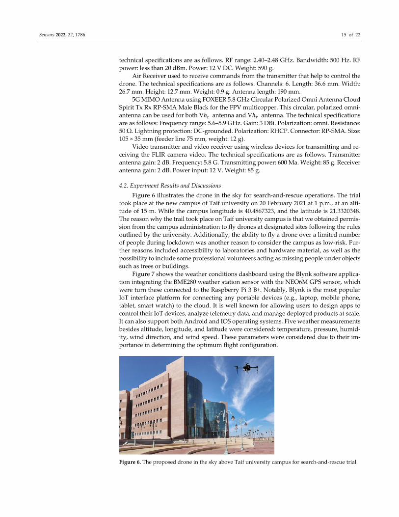
Figure 6 illustrates the drone in the sky for search‐and‐rescue operations. The trial
took place at the new campus of Taif university on 20 February 2021 at 1 p.m., at an alti‐
tude of 15 m. While the campus longitude is 40.4867323, and the latitude is 21.3320348.
The reason why the trail took place on Taif university campus is that we obtained permis‐
sion from the campus administration to fly drones at designated sites following the rules
outlined by the university. Additionally, the ability to fly a drone over a limited number
of people during lockdown was another reason to consider the campus as low‐risk. Fur‐
ther reasons included accessibility to laboratories and hardware material, as well as the
possibility to include some professional volunteers acting as missing people under objects
such as trees or buildings.
Figure 7 shows the weather conditions dashboard using the Blynk software applica‐
tion integrating the BME280 weather station sensor with the NEO6M GPS sensor, which
were turn these connected to the Raspberry Pi 3 B+. Notably, Blynk is the most popular
IoT interface platform for connecting any portable devices (e.g., laptop, mobile phone,
tablet, smart watch) to the cloud. It is well known for allowing users to design apps to
control their IoT devices, analyze telemetry data, and manage deployed products at scale.
It can also support both Android and IOS operating systems. Five weather measurements
besides altitude, longitude, and latitude were considered: temperature, pressure, humid‐
ity, wind direction, and wind speed. These parameters were considered due to their im‐
portance in determining the optimum flight configuration.
Figure 6. The proposed drone in the sky above Taif university campus for search‐and‐rescue trial.

Sensors 2022, 22, 1786 16 of 22
Figure 7. Weather conditions dashboard using Blynk application.
The RSS parameter is useful when calculating path loss (PL,) since it is related to the
distance between the transmitter and the receiver through an adequate propagation
model. Although RSS calculations are quite simple to perform, achieving an optimized
propagation model might be the opposite. Therefore, optimizing propagation models is
crucial for the IoT, as it is the key foundation for communication resource allocation, lo‐
calization, interference management, and sensing. Propagation path loss is a useful ap‐
proach for monitoring system performance, network planning, and coverage to achieve
perfect reception. Thus, the proposed modified Hata‐Davidson empirical model is a no‐
ticeable contribution of this paper for calculating path loss for two reasons. First, the con‐
sideration of the elevation angle in relation θ to calculate the distance d that suits the drone’s nature as a space‐based system. Second, the enhancement of the Hata‐Davidson
empirical model’s outcomes using experimental work with the least squares tuning algo‐
rithm. This adaptation yields improved coverage footprint, LoS connectivity, and RSS re‐
sults from the receiver side.
Figure 8 shows a GUI of the link budget plots of PL and the rest of the link budget
parameters at an altitude of 15 m. Furthermore, it shows the Hata‐Davidson model, mod‐
ified‐Hata‐Davidson model, and measured data integrated between the communication
payload on the drone and the receiver that connected to MATLAB. Notably, a MATLAB
toolbox was used for predicting the link budget parameters. As can be seen, the PL in‐
creased with distance, while the RSS decreased as the PL increased. The average PL
ranged between −150 dB and −50 dB, while the RSS ranged between 40 dB and 140 dB.
Noticeably, the RSS was improved when increasing the transmitter altitude or transmis‐
sion power. The SINR produced reasonable results: it increased as the transmitter altitude
increased, due to the increase in coverage. However, T decreased with altitude, high PL,
and shadowing. In general, the optimized Hata‐Davidson model showed improvement
in comparison to the non‐optimized model in terms of connectivity, footprint, and RSS,
which in turn led to the enhancement of communication links between the drone on one
hand, and the GCS and rescue teams on the other hand. Notably, 15 m was found to be

Sensors 2022, 22, 1786 17 of 22
the optimum drone altitude based on the characteristics of the experimental area. There‐
fore, the altitude parameter can be changed based on the features of the covered area.
Unsurprisingly, the modified Hata‐Davidson model displayed a good‐level of im‐
provement when using the proposed algorithm of least squares tuning. Another observa‐
tion is that the measured data showed similar characteristics using modified Hata‐Da‐
vidson model, which is a good performance indicator of the proposed least squares tuning
algorithm. More details are presented on Table 3, which shows the two Hata‐Davidson
model coefficients before and after the tuning process. Once again, the table emphasizes
the performance of the modified Hata‐Davidson model against the non‐modified model.
Figure 8. GUI of link budget plots of modified Hata‐Davidson empirical model at 15 m altitude.
Table 3. Two Hata‐Davidson model coefficients.
Hata‐Davidson
Model Coefficients
Before
Least Squares Tuning Algo‐
rithm
After
Least Squares Tuning Algorithm
K 10.41 6.53
K 13.75 8.92
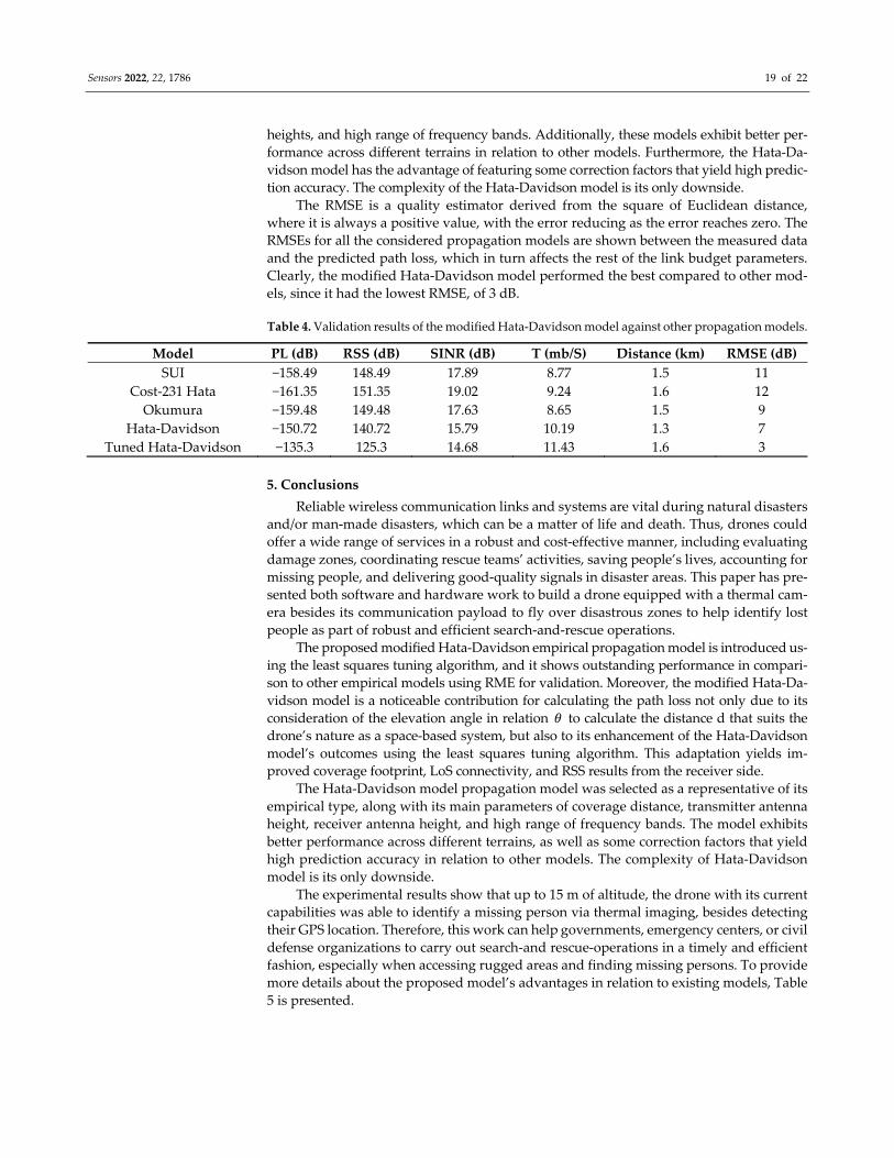
At the 15 m drone altitude determined previously, the drone was able to send the
video from the FLIR lepton camera using the TCP/IP protocol. This TCP/IP protocol pack‐
age was used to perform basic wireless network communication protocol between the
drone and the ground station, as well as locating the positions of missing persons using
the GPS sensor. The results of the vertical view using t the thermal camera to detect per‐
sons at different altitudes are shown on Figure 9. The figure shows a person labeled with
a red circle from heights of 5, 10, and 15 m, respectively. Clearly, reasonable thermal vis‐
uals were observed from these altitudes; however, as the altitude increased above 15 m
both low image quality and transmission delay became noticeable. Despite the high cost,
a powerful thermal camera would enhance the thermal imaging quality of these results.
Sensors 2022, 22, 1786 18 of 22
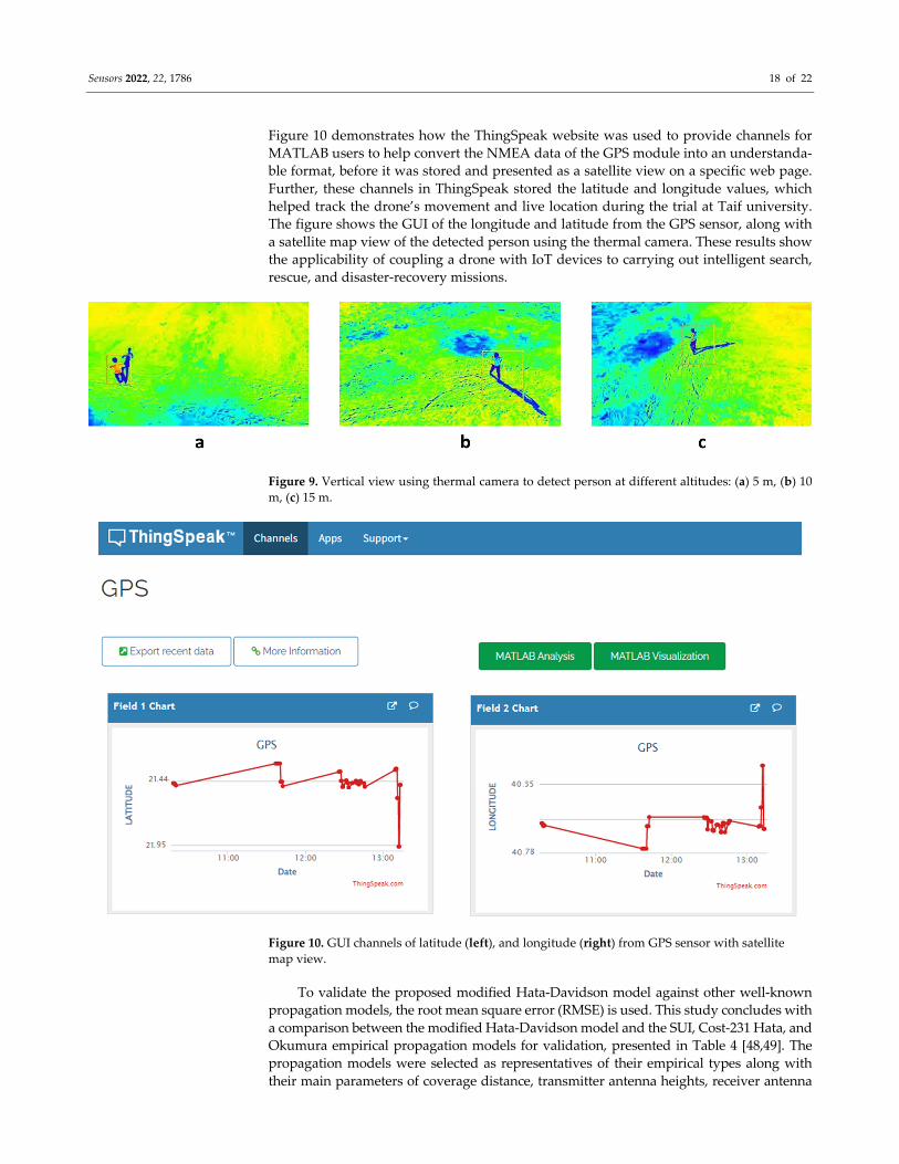
Figure 10 demonstrates how the ThingSpeak website was used to provide channels for
MATLAB users to help convert the NMEA data of the GPS module into an understanda‐
ble format, before it was stored and presented as a satellite view on a specific web page.
Further, these channels in ThingSpeak stored the latitude and longitude values, which
helped track the drone’s movement and live location during the trial at Taif university.
The figure shows the GUI of the longitude and latitude from the GPS sensor, along with
a satellite map view of the detected person using the thermal camera. These results show
the applicability of coupling a drone with IoT devices to carrying out intelligent search,
rescue, and disaster‐recovery missions.
Figure 9. Vertical view using thermal camera to detect person at different altitudes: (a) 5 m, (b) 10
m, (c) 15 m.
Figure 10. GUI channels of latitude (left), and longitude (right) from GPS sensor with satellite
map view.
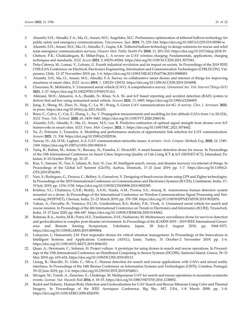
To validate the proposed modified Hata‐Davidson model against other well‐known
propagation models, the root mean square error (RMSE) is used. This study concludes with
a comparison between the modified Hata‐Davidson model and the SUI, Cost‐231 Hata, and
Okumura empirical propagation models for validation, presented in Table 4 [48,49]. The
propagation models were selected as representatives of their empirical types along with
their main parameters of coverage distance, transmitter antenna heights, receiver antenna
Sensors 2022, 22, 1786 19 of 22
heights, and high range of frequency bands. Additionally, these models exhibit better per‐
formance across different terrains in relation to other models. Furthermore, the Hata‐Da‐
vidson model has the advantage of featuring some correction factors that yield high predic‐
tion accuracy. The complexity of the Hata‐Davidson model is its only downside.
The RMSE is a quality estimator derived from the square of Euclidean distance,
where it is always a positive value, with the error reducing as the error reaches zero. The
RMSEs for all the considered propagation models are shown between the measured data
and the predicted path loss, which in turn affects the rest of the link budget parameters.
Clearly, the modified Hata‐Davidson model performed the best compared to other mod‐
els, since it had the lowest RMSE, of 3 dB.
Table 4. Validation results of the modified Hata‐Davidson model against other propagation models.
Model PL (dB) RSS (dB) SINR (dB) T (mb/S) Distance (km) RMSE (dB)
SUI −158.49 148.49 17.89 8.77 1.5 11
Cost‐231 Hata −161.35 151.35 19.02 9.24 1.6 12
Okumura −159.48 149.48 17.63 8.65 1.5 9
Hata‐Davidson −150.72 140.72 15.79 10.19 1.3 7
Tuned Hata‐Davidson −135.3 125.3 14.68 11.43 1.6 3
5. Conclusions
Reliable wireless communication links and systems are vital during natural disasters
and/or man‐made disasters, which can be a matter of life and death. Thus, drones could
offer a wide range of services in a robust and cost‐effective manner, including evaluating
damage zones, coordinating rescue teams’ activities, saving people’s lives, accounting for
missing people, and delivering good‐quality signals in disaster areas. This paper has pre‐
sented both software and hardware work to build a drone equipped with a thermal cam‐
era besides its communication payload to fly over disastrous zones to help identify lost
people as part of robust and efficient search‐and‐rescue operations.
The proposed modified Hata‐Davidson empirical propagation model is introduced us‐
ing the least squares tuning algorithm, and it shows outstanding performance in compari‐
son to other empirical models using RME for validation. Moreover, the modified Hata‐Da‐
vidson model is a noticeable contribution for calculating the path loss not only due to its
consideration of the elevation angle in relation 𝜃 to calculate the distance d that suits the drone’s nature as a space‐based system, but also to its enhancement of the Hata‐Davidson
model’s outcomes using the least squares tuning algorithm. This adaptation yields im‐
proved coverage footprint, LoS connectivity, and RSS results from the receiver side.
The Hata‐Davidson model propagation model was selected as a representative of its
empirical type, along with its main parameters of coverage distance, transmitter antenna
height, receiver antenna height, and high range of frequency bands. The model exhibits
better performance across different terrains, as well as some correction factors that yield
high prediction accuracy in relation to other models. The complexity of Hata‐Davidson
model is its only downside.
The experimental results show that up to 15 m of altitude, the drone with its current
capabilities was able to identify a missing person via thermal imaging, besides detecting
their GPS location. Therefore, this work can help governments, emergency centers, or civil
defense organizations to carry out search‐and rescue‐operations in a timely and efficient
fashion, especially when accessing rugged areas and finding missing persons. To provide
more details about the proposed model’s advantages in relation to existing models, Table
5 is presented.

Sensors 2022, 22, 1786 20 of 22
Table 5. Comparison of proposed model against existing models.
Ref. Altitude Propagation
Model Frequency
Antenna
Type
Human
Detecting
Weather
Station GPS
Thermal
Camera
Image
Capturing
[16] NA Free‐space NA Omni √ × √ × √
[17] 100 m Free‐space 915 MHz Directional √ × √ × ×
[18] 15 m Free‐space 2.4 GHz Omni √ × √ × √
[19] 7 m Free‐space 1.8 GHz Omni √ × √ × ×
[20] 13 m Free‐space 2.4 GHz Omni √ × × × √
[21] NA Free‐space 863 MHz Directional × × √ × ×
[22] 61 m Free‐space NA Directional √ × √ × √
[23] NA Free‐space NA Directional √ × √ × √
[24] 5 m Free‐space 457 kHz Directional × × √ √ √
[25] 50 m Free‐space 1.4 GHz MIMO √ × √ √ √
[26] NA Free‐space NA Omni √ × × √ √
[27] 40 m Okumura NA Directional √ × × × √
[28] 5 m Free‐space NA Omni √ × √ × √
[29] 4–8 m Free‐space NA Omni √ × √ × √
[30] 21 m Two‐rays 3.5 GHz Omni × × √ √ √
Proposed
Model 15 m
Optimized
Hata
Davidson
5.8 GHz 5G MIMO √ √ √ √ √
√ Refers to an element is existed. × Refers to an element is not existed.
Further work can be elaborated in four possible directions to enhance these results.
1—Despite the high cost, a more powerful thermal camera would enhance thermal imag‐
ing quality. 2—Using a radio frequency identification (RFID) sensor, which can detect the
signals of electronic devices, would offer the further element of detecting lost persons who
do not appear on thermal camera images. 3—Using solar panels on larger drones would
enhance the flying time. 4—Considering high‐frequency bands, such as 12 GHz or higher.
Author Contributions: Conceptualization, methodology, software, formal analysis, investigation,
writing—original draft preparation, writing—review and editing, supervision, project administra‐
tion, funding acquisition F.A.A. Validation, resources, data curation, visualization B.O.S. Both au‐
thors have read and agreed to the published version of the manuscript.
Funding: This research was funded by Deanship of Scientific Research at Taif University, Kingdom
of Saudi Arabia through Taif University Researchers Supporting Project Number (TURSP‐2020/265).
Informed Consent Statement: Not applicable.
Data Availability Statement: The data used to support the findings of this study are included
within the article.
Acknowledgments: The authors are grateful to the Deanship of Scientific Research at Taif Univer‐
sity, Kingdom of Saudi Arabia, for funding this project through Taif University Researchers Sup‐
porting Project Number (TURSP‐2020/265). Furthermore, the authors are thankful to Wejdan Al‐
mansori, Manal Almalki, Maha Alzahrani, and Nouf Alharthi for their corporation.
Conflicts of Interest: The authors declare no conflict of interest.
References
1. Almalki, F.; Angelides, M. Deployment of an aerial platform system for rapid restoration of communications links after a disaster:
A machine learning approach. Comput. J. 2019, 102, 829–864. https://doi.org/10.1007/s00607‐019‐00764‐x.
2. Alhusayni, S.A.; Alsuwat, S.K.; Altalhi, S.H.; Almalki, F.A.; Alzahrani, H.S. Experimental study of a tethered balloon using 5G
antenna to enhance internet connectivity. In Intelligent Computing. Lecture Notes in Networks and Systems; Arai, K., Ed.; Springer:
Cham, Switzerland, 2021; Volume 285. https://doi.org/10.1007/978‐3‐030‐80129‐8_46.
Sensors 2022, 22, 1786 21 of 22
3. Alsamhi, S.H.; Almalki, F.A.; Ma, O.; Ansari, M.S.; Angelides, M.C. Performance optimization of tethered balloon technology for
public safety and emergency communications. Telecommun. Syst. 2019, 75, 235–244. https://doi.org/10.1007/s11235‐019‐00580‐w.
4. Alsamhi, S.H.; Ansari, M.S.; Ma, O.; Almalki, F.; Gupta, S.K. Tethered balloon technology in design solutions for rescue and relief
team emergency communication services. Disaster Med. Public Health Pre 2018, 13, 203–210. https://doi.org/10.1017/dmp.2018.19.
5. Chittoor, P.K.; Chokkalingam, B.; Mihet‐Popa, L. A review on UAV wireless charging: Fundamentals, applications, charging
techniques and standards. IEEE Access 2021, 9, 69235–69266. https://doi.org/10.1109/ACCESS.2021.3077041.
6. Peña‐Cabrera, M.; Lomas, V.; Lefranc, G. Fourth industrial revolution and its impact on society. In Proceedings of the 2019 IEEE
CHILEAN Conference on Electrical, Electronics Engineering, Information and Communication Technologies (CHILECON), Val‐
paraiso, Chile, 13–27 November 2019; pp. 1–6. https://doi.org/10.1109/CHILECON47746.2019.8988083.
7. Alsamhi, S.H.; Ma, O.; Ansari, M.S.; Almalki, F.A. Survey on collaborative smart drones and internet of things for improving
smartness of smart cities. IEEE Access 2019, 7, 128125–128152. https://doi.org/10.1109/ACCESS.2019.2934998.
8. Chaurasia, R.; Mohindru, V. Unmanned aerial vehicle (UAV): A comprehensive survey. Unmanned Aer. Veh. Internet Things (IoT)
2021, 1–27. https://doi.org/10.1002/9781119769170.ch1.
9. Alkinani, M.H.; Almazroi, A.A.; Jhanjhi, N.; Khan, N.A. 5G and IoT based reporting and accident detection (RAD) system to
deliver first aid box using unmanned aerial vehicle. Sensors 2021, 21, 6905. https://doi.org/10.3390/s21206905.
10. Jiang, X.; Sheng, M.; Zhao, N.; Xing, C.; Lu, W.; Wang, X. Green UAV communications for 6G: A survey. Chin. J. Aeronaut. 2021,
in press. https://doi.org/10.1016/j.cja.2021.04.025.
11. Briso, C.; Calvo, C.; Cui, Z.; Zhang, L.; Xu, Y. Propagation measurements and modeling for low altitude UAVs from 1 to 24 GHz.
IEEE Trans. Veh. Technol. 2020, 69, 3439–3443. https://doi.org/10.1109/TVT.2020.2968136.
12. Alsamhi, S.H.; Almalki, F.; Ma, O.; Ansari, M.S.; Lee, B. Predictive estimation of optimal signal strength from drones over IoT
frameworks in smart cities. IEEE Trans. Mob. Comput. 2021, 1. https://doi.org/10.1109/TMC.2021.3074442.
13. Xu, Z.; Petrunin, I.; Tsourdos, A. Modeling and performance analysis of opportunistic link selection for UAV communication.
Sensors 2021, 21, 534. https://doi.org/10.3390/s21020534.
14. Nawaz, H.; Ali, H.M.; Laghari, A.A. UAV communication networks issues: A review. Arch. Comput. Methods Eng. 2020, 28, 1349–
1369. https://doi.org/10.1007/s11831‐020‐09418‐0.
15. Tariq, R.; Rahim, M.; Aslam, N.; Bawany, N.; Faseeha, U. DronAID: A smart human detection drone for rescue. In Proceedings
of the 15th International Conference on Smart Cities: Improving Quality of Life Using ICT & IoT (HONET‐ICT), Islamabad, Pa‐
kistan, 8–10 October 2018; pp. 33–37.
16. Kao, Y.; Samani, H.; Tasi, S.; Jalaian, B.; Suri, N.; Lee, M. Intelligent search, rescue, and disaster recovery via internet of things. In
Proceedings of the Global IoT Summit (GIoTS), Aarhus, Denmark, 17–21 June 2019; pp. 1–7. https://doi.org/10.1109/GI‐
OTS.2019.8766391.
17. Nair, S.; Rodrigues, G.; Dsouza, C.; Bellary, S.; Gonsalves, V. Designing of beach rescue drone using GPS and Zigbee technologies.
In Proceedings of the 2019 International Conference on Communication and Electronics Systems (ICCES), Coimbatore, India, 17–
19 July 2019; pp. 1154–1158. https://doi.org/10.1109/ICCES45898.2019.9002385.
18. Krishna, S.L.; Chaitanya, G.S.R.; Reddy, A.S.H.; Naidu, A.M.; Poorna, S.S.; Anuraj, K. Autonomous human detection system
mounted on a drone. In Proceedings of the International Conference on Wireless Communications Signal Processing and Net‐
working (WiSPNET), Chennai, India, 21–23 March 2019; pp. 335–338. https://doi.org/10.1109/WiSPNET45539.2019.9032876.
19. Valsan, A.; Parvathy, B.; Vismaya, D.G.H.; Unnikrishnan, R.S.; Reddy, P.K.; Vivek, A. Unmanned aerial vehicle for search and
rescue mission. In Proceedings of the 4th International Conference on Trends in Electronics and Informatics (ICOEI), Tirunelveli,
India, 15–17 June 2020; pp. 684–687. https://doi.org/10.1109/ICOEI48184.2020.9143062.
20. Rohman, B.A.; Andra, M.B.; Putra, H.F.; Fandiantoro, D.H.; Nishimoto, M. Multisensory surveillance drone for survivor detection
and geolocalization in complex post‐disaster environment. In Proceedings of the IGARSS 2019—2019 IEEE International Geosci‐
ence and Remote Sensing Symposium, Yokohama, Japan, 28 July–2 August 2019; pp. 9368–9371.
https://doi.org/10.1109/IGARSS.2019.8899804.
21. Lemayian, J.; Hamamreh, J.M. First responder drones for critical situation management. In Proceedings of the Innovations in
Intelligent Systems and Applications Conference (ASYU), Izmir, Turkey, 31 October–2 November 2019; pp. 1–6.
https://doi.org/10.1109/ASYU48272.2019.8946353.
22. Quan, A.; Herrmann, C.; Soliman, H. Project vulture: A prototype for using drones in search and rescue operations. In Proceed‐
ings of the 15th International Conference on Distributed Computing in Sensor Systems (DCOSS), Santorini Island, Greece, 29–31
May 2019; pp. 619–624. https://doi.org/10.1109/DCOSS.2019.00113.
23. Llasag, R.; Marcillo, D.; Grilo, C.; Silva, C. Human detection for search and rescue applications with UAVs and mixed reality
interfaces. In Proceedings of the 14th Iberian Conference on Information Systems and Technologies (CISTI), Coimbra, Portugal,
19–22 June 2019; pp. 1–6. https://doi.org/10.23919/CISTI.2019.8760811.
24. Silvagni, M.; Tonoli, A.; Zenerino, E.; Chiaberge, M. Multipurpose UAV for search and rescue operations in mountain avalanche
events. Geomat. Nat. Hazards Risk 2016, 8, 18–33. https://doi.org/10.1080/19475705.2016.1238852.
25. Rudol and Doherty, Human Body Detection and Geolocalization for UAV Search and Rescue Missions Using Color and Thermal
Imagery. In Proceedings of the IEEE Aerospace Conference, Big Sky, MT, USA, 1–8 March 2008; pp. 1–8.
https://doi.org/10.1109/AERO.2008.4526559.
Sensors 2022, 22, 1786 22 of 22
26. Zhong, Y.; Wang, X.; Xu, Y.; Jia, T.; Cui, S.; Wei, L.; Ma, A.; Zhang, L. MINI‐UAV borne hyperspectral remote sensing: A review.
In Proceedings of the IEEE International Geoscience and Remote Sensing Symposium (IGARSS), Fort Worth, TX, USA, 23–28 July
2017; pp. 5908–5911.
27. Perdana, M.I.; Risnumawan, A.; Sulistijono, I.A. Automatic aerial victim detection on low‐cost thermal camera using convolu‐
tional neural network. In Proceedings of the International Symposium on Community‐centric Systems (CcS), Tokyo, Japan, 23–
26 September 2020; pp. 1–5. https://doi.org/10.1109/CcS49175.2020.9231433.
28. Mishra, B.; Garg, D.; Narang; Mishra, V. Drone‐surveillance for search and rescue in natural disaster. Comput. Commun. 2020, 156,
1–10. https://doi.org/10.1016/j.comcom.2020.03.012.
29. Perera, A.G.; Khanam, F.‐T.‐Z.; Al‐Naji, A.; Chahl, J. Detection and localisation of life signs from the air using image registration
and spatio‐temporal filtering. Remote Sens. 2020, 12, 577. https://doi.org/10.3390/rs12030577.
30. Lygouras, E.; Santavas, N.; Taitzoglou, A.; Tarchanidis, K.; Mitropoulos, A.; Gasteratos, A. Unsupervised human detection with
an embedded vision system on a fully autonomous UAV for search and rescue operations. Sensors 2019, 19, 3542.
https://doi.org/10.3390/s19163542.
31. Almalki, F.A.; Alotaibi, A.A.; Angelides, M.C. Coupling multifunction drones with AI in the fight against the coronavirus pan‐
demic. Computing 2021, 2021, 1–27. https://doi.org/10.1007/s00607‐021‐01022‐9.
32. Zhou, X.; Yi, Z.; Liu, Y.; Huang, K.; Huang, H. Survey on path and view planning for UAVs. Virtual Real. Intell. Hardw. 2020, 2,
56–69. https://doi.org/10.1016/j.vrih.2019.12.004.
33. Aggarwal, S.; Kumar, N. Path planning techniques for unmanned aerial vehicles: A review, solutions, and challenges. Comput.
Commun. 2020, 149, 270–299. https://doi.org/10.1016/j.comcom.2019.10.014.
34. Câmara, D. Cavalry to the rescue: Drones fleet to help rescuers operations over disasters scenarios. In Proceedings of the IEEE
Conference on Antenna Measurements & Applications (CAMA), Antibes Juan‐les‐Pins, France, 16–19 November 2014; pp. 1–4.
https://doi.org/10.1109/CAMA.2014.7003421.
35. Péter, H.; László, D.; János, V. Civilian use of drones in the life of mining rescue helicopters. In Proceedings of the IEEE 17th
International Symposium on Computational Intelligence and Informatics (CINTI), Budapest, Hungary, 17–19 November 2016;
pp. 299–302. https://doi.org/10.1109/CINTI.2016.7846422.
36. Giordan, D.; Adams, M.S.; Aicardi, I.; Alicandro, M.; Allasia, P.; Baldo, M.; De Berardinis, P.; Dominici, D.; Godone, D.; Hobbs,
P. The use of unmanned aerial vehicles (UAVs) for engineering geology applications. Bull. Eng. Geol. Environ. 2020, 79, 3437–3481.
https://doi.org/10.1007/s10064‐020‐01766‐2.
37. Ding, R.; Gao, F.; Shen, X.S. 3D UAV trajectory design and frequency band allocation for energy‐efficient and fair communication:
A deep reinforcement learning approach. IEEE Trans. Wirel. Commun. 2020, 19, 7796–7809.
https://doi.org/10.1109/TWC.2020.3016024.
38. Cui, Y.; Deng, D.; Wang, C.; Wang, W. Joint trajectory and power optimization for energy efficient UAV communication using
deep reinforcement learning. In Proceedings of the IEEE INFOCOM 2021—IEEE Conference on Computer Communications
Workshops (INFOCOM WKSHPS), 10–13 May 2021; pp. 1–6. https://doi.org/10.1109/INFOCOMWKSHPS51825.2021.9484490.
39. Nielsen, S.Z.; Gade, R.; Moeslund, T.B.; Skov‐Petersen, H. Taking the temperature of pedestrian movement in public spaces.
Transp. Res. Procedia 2014, 2, 660–668. https://doi.org/10.1016/j.trpro.2014.09.071.
40. Kurmi, I.; Schedl, D.C.; Bimber, O. Thermal airborne optical sectioning. Remote Sens. 2019, 11, 1668.
https://doi.org/10.3390/rs11141668.
41. Spremolla, I.R.; Antunes, M.; Aouada, D.; Ottersten, B. RGB‐D and thermal sensor fusion—Application in person tracking. In
Proceedings of the 11th Joint Conference on Computer Vision, Imaging and Computer Graphics Theory and Applications, Rome,
Italy, 27–29 February 2016. https://doi.org/10.5220/0005717706100617.
42. Negishi, T.; Abe, S.; Matsui, T.; Liu, H.; Kurosawa, M.; Kirimoto, T.; Sun, G. Contactless vital signs measurement system using
RGB‐thermal image sensors and its clinical screening test on patients with seasonal influenza. Sensors 2020, 20, 2171.
https://doi.org/10.3390/s20082171.
43. Salh, A.; Audah, L.; Abdullah, Q.; Aydoğdu, Ö.; Alhartomi, M.; Alsamhi, S.H.; Shah, N.S.M. Low computational complexity for
optimizing energy efficiency in mm‐wave hybrid precoding system for 5G. IEEE Access 2022, 10, 4714–4727.
https://doi.org/10.1109/ACCESS.2021.3139338.
44. Sun, J.; Li, B.; Jiang, Y.; Wen, C. A camera‐based target detection and positioning UAV system for search and rescue (SAR) pur‐
poses. Sensors 2016, 16, 1778. https://doi.org/10.3390/s16111778.
45. Alsamhi, S.H.; Almalki, F.A.; AL‐Dois, H.; Shvetsov, A.V.; Ansari, M.S.; Hawbani, A.; Gupta, S.K.; Lee, B. Multi‐drone edge
intelligence and SAR smart wearable devices for emergency communication. Wirel. Commun. Mob. Comput. 2021, 2021, 6710074.
https://doi.org/10.1155/2021/6710074.S.
46. Kumar, K.; Kumar, S.; Kaiwartya, O.; Sikandar, A.; Kharel, R.; Mauri, J.L. Internet of unmanned aerial vehicles: QoS provisioning
in aerial Ad‐Hoc networks. Sensors 2020, 20, 3160. https://doi.org/10.3390/s20113160.
47. Kumar, K.; Kumar, S.; Kaiwartya, O.; Kashyap, K.; Lloret, J.; Song, H. Drone assisted flying Ad‐Hoc networks: Mobility and
service oriented modeling using neuro‐fuzzy. Ad Hoc Netw. 2020, 106, 102242. https://doi.org/10.1016/j.adhoc.2020.102242.
48. Kasampalis, S.; Lazaridis, P.I.; Zaharis, Z.D.; Bizopoulos, A.; Zettas, S.; Cosmas, J. Comparison of Longley‐rice, ITU‐R P.1546 and
Hata‐Davidson propagation models for DVB‐T coverage prediction. In Proceedings of the IEEE International Symposium on
Broadband Multimedia Systems and Broadcasting, Beijing, China, 25–27 June 2014.
49. Lustgarten, M.; Madison, J. An empirical propagation model (EPM‐73). IEEE Trans. Electromagn. Compat. 1977, EMC‐19, 301–309.


