Embed Size (px)
Citation preview
Palaeogeography, Palaeoclimatology, Palaeoecology 160 (2000) 223–237www.elsevier.nl/locate/palaeo
Middle Triassic paleomagnetic data from northern Bulgaria:constraints on Tethyan magnetostratigraphy
and paleogeography
Giovanni Muttoni a,*, Maurizio Gaetani b, Kiril Budurov c, Ivan Zagorchev c,Ekaterina Trifonova c, Daria Ivanova c, Lyudmila Petrounova c,
William Lowrie aa Institute of Geophysics, ETH-Honggerberg, CH-8053 Zurich, Switzerland
b Dipartimento di Scienze della Terra, Universita di Milano, via Mangiagalli 34, I-20133 Milan, Italyc Geological Institute ‘Strashimir Dimitrov’, Bulgarian Academy of Science, ‘Acad. G. Bonchev’ Str., Bl .24, 1113 Sofia, Bulgaria
Received 21 July 1999; accepted for publication 13 January 2000
Abstract
Magnetostratigraphic and biostratigraphic data are presented from the Anisian (Middle Triassic) Peri-TethyanEdivetur section of northwestern Bulgaria. A dual-polarity component of magnetization carried by magnetite delineatesa magnetic stratigraphy of mainly reversed polarity. Magnetozones are dated by means of foraminifer and conodontbiostratigraphy. Data from Edivetur are compared with data from Middle Triassic Tethyan limestone sections withthe aim of contributing to the completion of the Middle Triassic magnetic polarity time scale. We also propose thatpaleomagnetic data from Edivetur can be used as proxy data for the paleogeographic position of the Moesianplatform. The Moesian platform was located at 21–24°N along the southern margin of Europe. It was probablymarginally separated, but not detached or rotated away from Europe by the North Dobrugea transtensional trough,which is interpreted as a back-arc basin resulting from the northward subduction of the Neo-Tethys (Vardar) orPaleo-Tethys ocean. Paleomagnetic data from this study and other minor tectonic elements are used to generate apaleogeographic sketch map of the Pangea-bounded western Tethys and Peri-Tethys at Middle/early Late Triassictime. © 2000 Elsevier Science B.V. All rights reserved.
Keywords: Balkanides; Bulgaria; magnetostratigraphy; Middle Triassic; Moesia; paleogeography
1. Introduction Muttoni et al., 1998). In the Tethys realm, a totalof 29 biostratigraphically calibrated reversals wererecognized over the late Early Triassic to lateMiddle Triassic magnetostratigraphy and bio-Middle Triassic interval of perhaps 10–15 m.y.stratigraphy have been investigated in bothlength (Muttoni et al., 1998). This sequence ofTethyan marine and continental sequences (e.g.reversals, here upgraded with data from GalletMolina-Garza et al., 1991; Gallet et al., 1998;et al. (1998), is, however, still incomplete, especi-ally in the Anisian (Middle Triassic). This paper* Corresponding author. Tel.: +41-1-633-2633;presents magnetostratigraphic and biostratigraphicfax: +41-1-633-1065.
E-mail address: [email protected] (G. Muttoni) results from the Aegean to upper Illyrian (Anisian)
0031-0182/00/$ - see front matter © 2000 Elsevier Science B.V. All rights reserved.PII: S0031-0182 ( 00 ) 00070-5
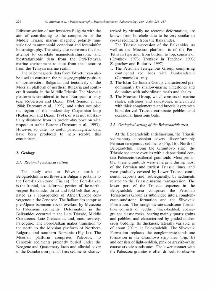
224 G. Muttoni et al. / Palaeogeography, Palaeoclimatology, Palaeoecology 160 (2000) 223–237
Edivetur section of northwestern Bulgaria with the terized by virtually no tectonic deformation, areknown from borehole data to be very similar toaim of contributing to the completion of the
Middle Triassic marine magnetic polarity time coeval sediments from the Balkanides.The Triassic succession of the Balkanides, asscale tied to ammonoid, conodont and foraminifer
biostratigraphy. This study also represents the first well as the Moesian platform, is of the Peri-Tethyan type and, from bottom to top, consists ofattempt to correlate magnetostratigraphic and
biostratigraphic data from the Peri-Tethyan (Tronkov, 1973; Tronkov in Tenchov, 1993;Zagorchev and Budurov, 1997):marine environment to data from the literature
from the Tethyan marine realm. 1. The Petrohan Terrigenous Group, comprisingcontinental red beds with BuntsandsteinThe paleomagnetic data from Edivetur can also
be used to constrain the paleogeographic position (Germanic) affinity.2. The Iskur Carbonate Group, characterized pre-of northwestern Bulgaria, and tentatively of the
Moesian platform of northern Bulgaria and south- dominantly by shallow-marine limestones anddolomites with subordinate marls and shales.ern Romania, in the Middle Triassic. The Moesian
platform is considered to be of European affinity 3. The Moesian Group, which consists of marineshales, siltstones and sandstones, intercalated(e.g. Robertson and Dixon, 1984; Sengor et al.,
1984; Dercourt et al., 1993), and either occupied with thick conglomerate and breccia layers withhorst-derived Triassic carbonate pebbles, andthe region of the modern-day Carpathian loop
(Robertson and Dixon, 1984), or was not substan- occasional limestone beds.tially displaced from its present-day position withrespect to stable Europe (Dercourt et al., 1993). 2.2. Geological setting of the Belogradchik areaHowever, to date, no useful paleomagnetic datahave been produced to help resolve this At the Belogradchik anticlinorium, the Triassic
sedimentary succession covers disconformablyconundrum.Permian terrigenous sediments (Fig. 1b). North ofBelogradchik, along the Granitovo strip, theTriassic sequence overlies with a depositional con-2. Geologytact Paleozoic weathered granitoids. Most proba-bly, these granitoids were emergent during most2.1. Regional geological settingof the Permian and earliest Triassic times, andwere gradually covered by Lower Triassic conti-The study area at Edivetur north of
Belogradchik in northwestern Bulgaria pertains to nental deposits and, subsequently, by sedimentsrelated to the Triassic marine transgression. Thethe Fore-Balkan zone (Fig. 1a). The Fore-Balkan
is the frontal, less deformed portion of the north- lower part of the Triassic sequence in theBelogradchik area comprises the Petrohanvergent Balkanides thrust-and-fold belt that origi-
nated as a consequence of Africa/Europe con- Terrigenous Group as subdivided into a conglom-erate-sandstone formation and the Slivovnikvergence in the Cenozoic. The Balkanides comprise
pre-Alpine basement rocks overlain by Mesozoic Formation. The conglomerate-sandstone forma-tion consists of reddish, thick-bedded, coarse-to Paleogene sediments. Deformation in the
Balkanides occurred in the Late Triassic, Middle grained clastic rocks, bearing mainly quartz grainsand pebbles, and characterized by graded and/orCretaceous, Late Cretaceous, and, most severely,
Paleogene. The Fore-Balkan makes transition to cross bedding. Its thickness, laterally variable, isof about 200 m at Belogradchik. The Slivovnikthe north to the Moesian platform of Northern
Bulgaria and southern Romania (Fig. 1a). The Formation replaces the conglomerate-sandstoneformation in the Granitovo strip area (Fig. 1b)Moesian platform comprises Paleozoic to
Cenozoic sediments presently buried under the and consists of light-reddish, pink or grayish-whitecoarse arkosic sandstones. The lower contact withNeogene and Quaternary loess and alluvial cover
of the Danube river plain. These sediments, charac- the Paleozoic granites is often difficult to observe
225G. Muttoni et al. / Palaeogeography, Palaeoclimatology, Palaeoecology 160 (2000) 223–237
Fig
.1.
(a)
Sim
plifi
edge
olog
ical
map
ofB
ulga
ria.
The
stud
yse
ctio
nis
loca
ted
atE
dive
tur
clos
eto
the
villa
geof
Gra
nito
voan
dab
out
4km
nort
hof
the
tow
nof
Bel
ogra
dchi
kin
nort
hwes
tern
Bul
gari
a;th
elo
calit
ies
ofSm
olia
novc
ian
dB
ovof
Noz
haro
vet
al.
(198
0)
are
also
repo
rted
.(b
)D
etai
led
geol
ogic
alm
apof
the
stud
yar
ea(a
fter
Hay
dout
ovet
al.,
1995
)w
ith
the
loca
tion
ofth
eE
dive
tur
sam
plin
gse
ctio
nin
the
Edi
vetu
rF
orm
atio
n.
226 G. Muttoni et al. / Palaeogeography, Palaeoclimatology, Palaeoecology 160 (2000) 223–237
because the Slivovnik basal arkosic sandstones are 3.2. Edivetur Formation of the Iskur CarbonateGroupvery similar to the weathered granitoids from
which they derived. The marine ingression is repre-sented by the overlying Iskur Carbonate Group. The Edivetur Formation contains a rich fora-
minifer fauna with, among others, MeandrospiraThe basal part of the Iskur Carbonate Group,transgressional over the conglomerate-sandstone deformata Salaj, Nodosaria cf. scyphica Efimova,
Nodosaria expolita Trifonova, Pilammina densaformation, comprises the Svidol Formation, whichconsists of alternating reddish, pink, yellowish and Pantic, Glomospirella vulgaris Ho, Meandrospira
dinarica Kochansky-Devide & Pantic,gray siltstones, marls and limestones. Accordingto Tronkov (1973) and Tronkov (in Tenchov, Arenovidalina chialingchiangensis Ho, Earlandia
tintinniformis (Misik), Pilamminella semiplana1993), the Svidol Formation is gradually thinningout and is laterally replaced by the Edivetur Kochansky-Devide & Pantic, Ophthalmidium exi-
guum Koehn-Zanninetti and Oberhauserella mesot-Formation, which can be followed as a thin striponly along the northern limb of the Belogradchik riasica Fuchs. The Edivetur Formation is
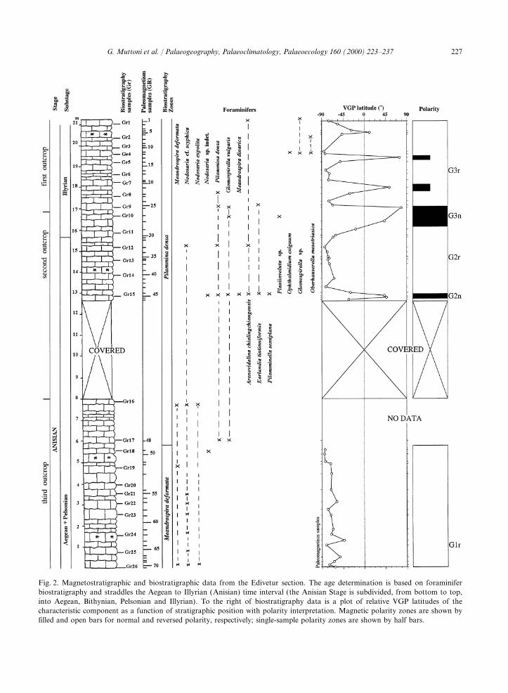
attributed to M. deformata and P. densa foramini-anticlinorium where it reaches a thickness of 20 mat the type section of Edivetur (Fig. 1b). The fer zones of Aegean to upper Illyrian (Anisian)
age (Fig. 2). Conodonts in the Edivetur FormationEdivetur Formation, which is the object of thisstudy, is characterized by calcareous sandstones are scarce. Fragments of platform conodonts,
probably Paragondolella cf. bulgarica Budurov &and oolithic, biodetrital limestones light brownishor whitish gray in colour, often containing fora- Stefanov or Paragondolella cf. regale (Mosher),
were found in sample Gr15 (Fig. 2). These cono-minifers at the core of large ooids. The IskurCarbonate Group ends with the Babino Formation donts are attributed to the Pelsonian (Anisian), in
general agreement with foraminifer biostratigra-(Tronkov, 1973; Tronkov in Tenchov, 1993). Thisformation, well exposed along the nearby Bobouk phy. The ramiform element Enantiognathus ziegleri
(Diebel ) of Triassic age was found in sample Gr16.Valley, consists of nodular clayey-silty limestones,sandy limestones and sandy marls, with thin In Bulgaria, this element is not known to occur in
the earliest part of the Triassic, as well as after theinterbeds of pure limestones, containing brachio-pods, bivalves and crinoid ossicles. The thickness earliest Carnian (earliest Late Triassic). The range
of E. ziegleri was, however, probably controlledof this formation in the Granitovo strip is of about50 m or less. by peculiar environmental conditions in the Peri-
Tethyan realm.
3.3. Babino Formation of the Iskur CarbonateGroup3. Biostratigraphy
3.1. Petrohan Terrigenous Group Budurov (1960, 1962) found the first conodontassemblage in the Babino Formation from theGranitovo strip with specimens of ‘GondolellaThe Petrohan Terrigenous Group is considered
Early Triassic in age because it lies immediately mombergensis Tatge’ and ‘Gondolella naviculaHuckriede’. After taxonomic revision, these con-below biostratigraphically dated Middle Triassic
sediments. Moreover, at the village of Belotintsi dont taxa are referred in this study toParagondolella bulgarica Budurov & Stefanov and(Vidin District), the plant species Equisetites
mougeoti Brogniart, known from the Early Triassic Paragondolella hanbulogi Sudar & Budurov,respectively. We found additional specimens of P.of Germany, France and Yugoslavia (Harkovska
and Tenchov, 1963), was found in the portion of bulgarica and P. hanbulogi at Babino Formationsections located in the Bobouk Valley and in athe conglomerate-sandstone formation which,
according to Tronkov (in Haydoutov et al., 1995), quarry on the road Belogradchik-Oreshets(Fig. 1b). At these localities, the Babinocorrelates with the Slivovnik Formation.
227G. Muttoni et al. / Palaeogeography, Palaeoclimatology, Palaeoecology 160 (2000) 223–237
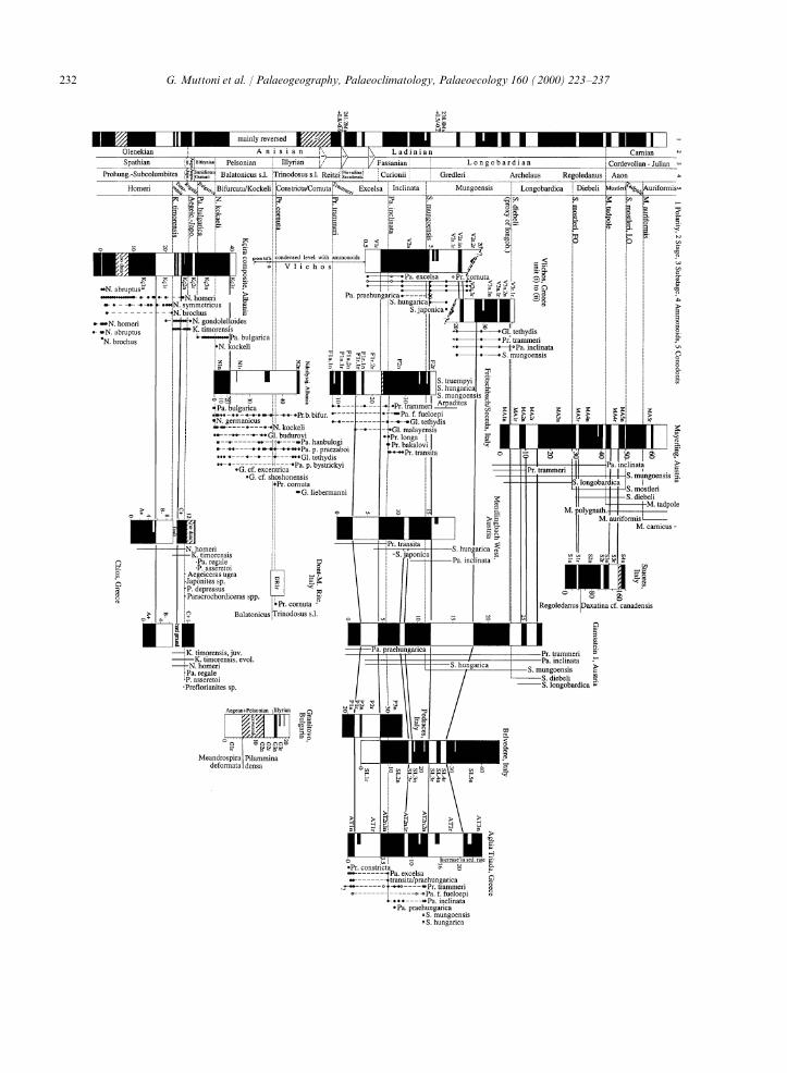
Fig. 2. Magnetostratigraphic and biostratigraphic data from the Edivetur section. The age determination is based on foraminiferbiostratigraphy and straddles the Aegean to Illyrian (Anisian) time interval (the Anisian Stage is subdivided, from bottom to top,into Aegean, Bithynian, Pelsonian and Illyrian). To the right of biostratigraphy data is a plot of relative VGP latitudes of thecharacteristic component as a function of stratigraphic position with polarity interpretation. Magnetic polarity zones are shown byfilled and open bars for normal and reversed polarity, respectively; single-sample polarity zones are shown by half bars.
228 G. Muttoni et al. / Palaeogeography, Palaeoclimatology, Palaeoecology 160 (2000) 223–237
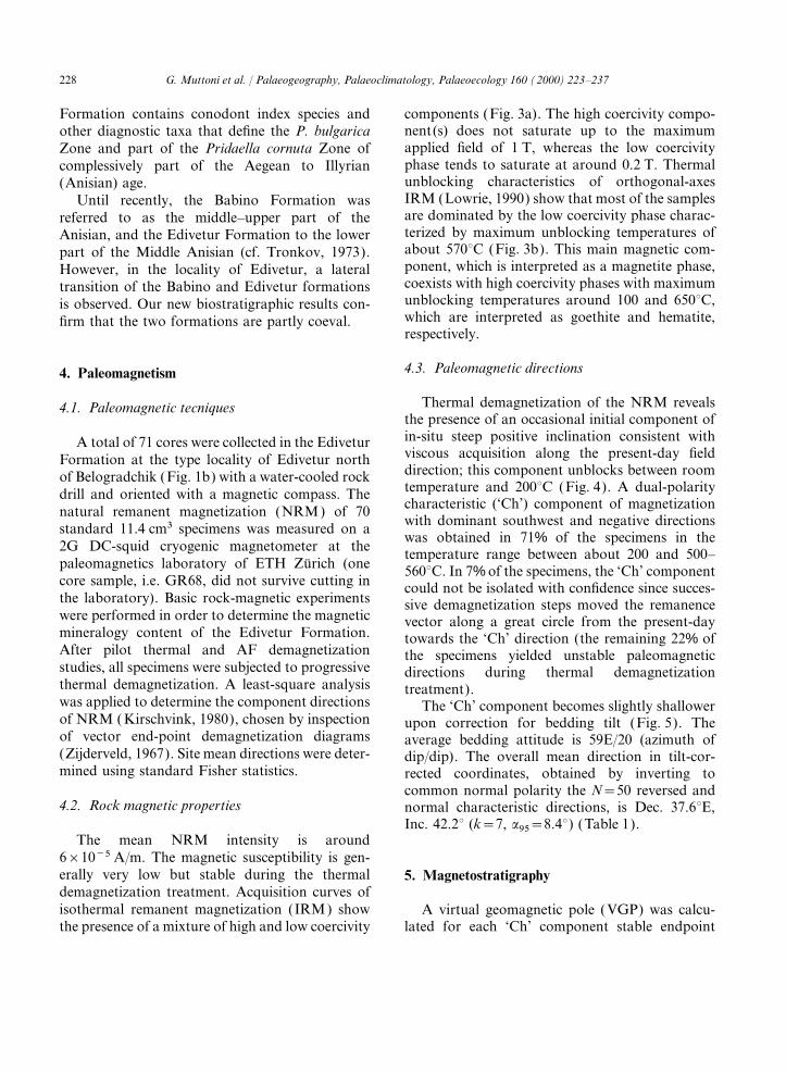
Formation contains conodont index species and components (Fig. 3a). The high coercivity compo-nent(s) does not saturate up to the maximumother diagnostic taxa that define the P. bulgaricaapplied field of 1 T, whereas the low coercivityZone and part of the Pridaella cornuta Zone ofphase tends to saturate at around 0.2 T. Thermalcomplessively part of the Aegean to Illyrianunblocking characteristics of orthogonal-axes(Anisian) age.IRM (Lowrie, 1990) show that most of the samplesUntil recently, the Babino Formation wasare dominated by the low coercivity phase charac-referred to as the middle–upper part of theterized by maximum unblocking temperatures ofAnisian, and the Edivetur Formation to the lowerabout 570°C (Fig. 3b). This main magnetic com-part of the Middle Anisian (cf. Tronkov, 1973).ponent, which is interpreted as a magnetite phase,However, in the locality of Edivetur, a lateralcoexists with high coercivity phases with maximumtransition of the Babino and Edivetur formationsunblocking temperatures around 100 and 650°C,is observed. Our new biostratigraphic results con-which are interpreted as goethite and hematite,firm that the two formations are partly coeval.respectively.
4.3. Paleomagnetic directions4. Paleomagnetism
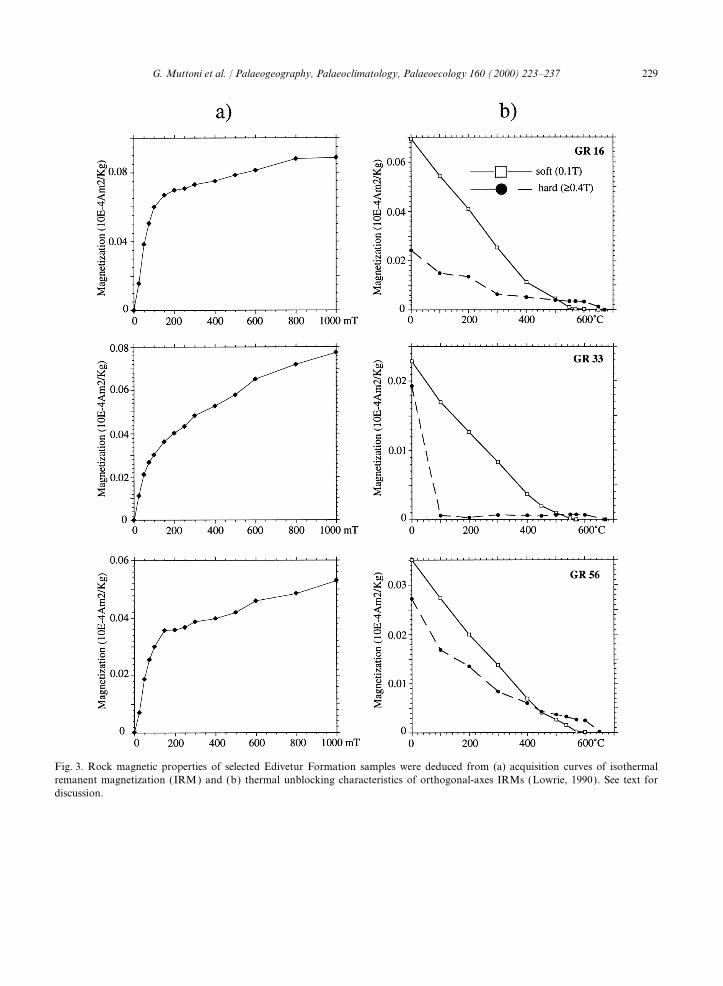
Thermal demagnetization of the NRM reveals4.1. Paleomagnetic tecniquesthe presence of an occasional initial component ofin-situ steep positive inclination consistent withA total of 71 cores were collected in the Ediveturviscous acquisition along the present-day fieldFormation at the type locality of Edivetur northdirection; this component unblocks between roomof Belogradchik (Fig. 1b) with a water-cooled rocktemperature and 200°C (Fig. 4). A dual-polaritydrill and oriented with a magnetic compass. Thecharacteristic (‘Ch’) component of magnetizationnatural remanent magnetization (NRM) of 70with dominant southwest and negative directionsstandard 11.4 cm3 specimens was measured on awas obtained in 71% of the specimens in the
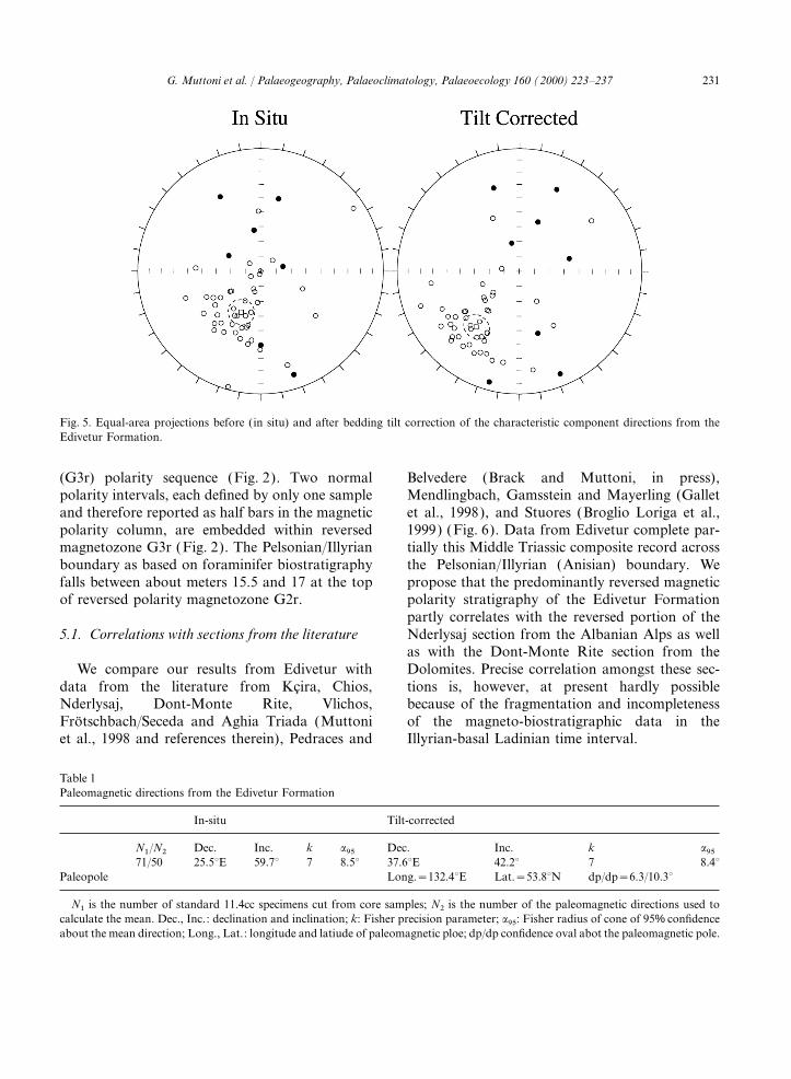
2G DC-squid cryogenic magnetometer at the temperature range between about 200 and 500–paleomagnetics laboratory of ETH Zurich (one 560°C. In 7% of the specimens, the ‘Ch’ componentcore sample, i.e. GR68, did not survive cutting in could not be isolated with confidence since succes-the laboratory). Basic rock-magnetic experiments sive demagnetization steps moved the remanencewere performed in order to determine the magnetic vector along a great circle from the present-daymineralogy content of the Edivetur Formation. towards the ‘Ch’ direction (the remaining 22% ofAfter pilot thermal and AF demagnetization the specimens yielded unstable paleomagneticstudies, all specimens were subjected to progressive directions during thermal demagnetizationthermal demagnetization. A least-square analysis treatment).was applied to determine the component directions The ‘Ch’ component becomes slightly shallowerof NRM (Kirschvink, 1980), chosen by inspection upon correction for bedding tilt (Fig. 5). Theof vector end-point demagnetization diagrams average bedding attitude is 59E/20 (azimuth of(Zijderveld, 1967). Site mean directions were deter- dip/dip). The overall mean direction in tilt-cor-mined using standard Fisher statistics. rected coordinates, obtained by inverting to
common normal polarity the N=50 reversed and4.2. Rock magnetic properties normal characteristic directions, is Dec. 37.6°E,
Inc. 42.2° (k=7, a95=8.4°) (Table 1).The mean NRM intensity is around
6×10⁻⁵ A/m. The magnetic susceptibility is gen-erally very low but stable during the thermal 5. Magnetostratigraphydemagnetization treatment. Acquisition curves ofisothermal remanent magnetization (IRM) show A virtual geomagnetic pole (VGP) was calcu-
lated for each ‘Ch’ component stable endpointthe presence of a mixture of high and low coercivity
229G. Muttoni et al. / Palaeogeography, Palaeoclimatology, Palaeoecology 160 (2000) 223–237
Fig. 3. Rock magnetic properties of selected Edivetur Formation samples were deduced from (a) acquisition curves of isothermalremanent magnetization (IRM) and (b) thermal unblocking characteristics of orthogonal-axes IRMs (Lowrie, 1990). See text fordiscussion.
230 G. Muttoni et al. / Palaeogeography, Palaeoclimatology, Palaeoecology 160 (2000) 223–237
Fig. 4. Zijderveld thermal demagnetization diagrams of NRM of selected Edivetur Formation samples bearing characteristic magne-tizations of reversed (GR16, GR33, GR50) and normal (GR26) polarity. Closed symbols are projections onto the horizontal plane,and open symbols are projections onto the vertical plane in in-situ coordinates. Demagnetization temperatures are in °C.
direction after correction for bedding tilt. The −90°N are interpreted as recording normal andreversed polarity, respectively. For polarity magne-latitude of the specimen VGP with respect to the
overall mean north paleomagnetic pole was used tozone identification, we adopt the nomenclatureused by Kent et al. (1995). The VGP latitudes atto delineate the magnetic polarity stratigraphy
(Lowrie and Alvarez, 1977; Kent et al., 1995). Edivetur define a lower reversed (G1r)–normal(G2n)–reversed (G2r)–normal (G3n)–reversedVGP relative latitudes approaching +90°N and
231G. Muttoni et al. / Palaeogeography, Palaeoclimatology, Palaeoecology 160 (2000) 223–237
Fig. 5. Equal-area projections before (in situ) and after bedding tilt correction of the characteristic component directions from theEdivetur Formation.
(G3r) polarity sequence (Fig. 2). Two normal Belvedere (Brack and Muttoni, in press),Mendlingbach, Gamsstein and Mayerling (Galletpolarity intervals, each defined by only one sample
and therefore reported as half bars in the magnetic et al., 1998), and Stuores (Broglio Loriga et al.,1999) (Fig. 6). Data from Edivetur complete par-polarity column, are embedded within reversed
magnetozone G3r (Fig. 2). The Pelsonian/Illyrian tially this Middle Triassic composite record acrossthe Pelsonian/Illyrian (Anisian) boundary. Weboundary as based on foraminifer biostratigraphy
falls between about meters 15.5 and 17 at the top propose that the predominantly reversed magneticpolarity stratigraphy of the Edivetur Formationof reversed polarity magnetozone G2r.partly correlates with the reversed portion of theNderlysaj section from the Albanian Alps as well5.1. Correlations with sections from the literatureas with the Dont-Monte Rite section from theDolomites. Precise correlation amongst these sec-We compare our results from Edivetur with
data from the literature from Kcira, Chios, tions is, however, at present hardly possiblebecause of the fragmentation and incompletenessNderlysaj, Dont-Monte Rite, Vlichos,
Frotschbach/Seceda and Aghia Triada (Muttoni of the magneto-biostratigraphic data in theIllyrian-basal Ladinian time interval.et al., 1998 and references therein), Pedraces and
Table 1Paleomagnetic directions from the Edivetur Formation
In-situ Tilt-corrected
N1/N2 Dec. Inc. k a95 Dec. Inc. k a9571/50 25.5°E 59.7° 7 8.5° 37.6°E 42.2° 7 8.4°
Paleopole Long.=132.4°E Lat.=53.8°N dp/dp=6.3/10.3°
N1 is the number of standard 11.4cc specimens cut from core samples; N2 is the number of the paleomagnetic directions used tocalculate the mean. Dec., Inc.: declination and inclination; k: Fisher precision parameter; a95: Fisher radius of cone of 95% confidenceabout the mean direction; Long., Lat.: longitude and latiude of paleomagnetic ploe; dp/dp confidence oval abot the paleomagnetic pole.
232 G. Muttoni et al. / Palaeogeography, Palaeoclimatology, Palaeoecology 160 (2000) 223–237
233G. Muttoni et al. / Palaeogeography, Palaeoclimatology, Palaeoecology 160 (2000) 223–237
Finally, it is still difficult to incorporate orcorrelate the magnetic polarity stratigraphy frommainly continental redbed sections from EasternSpain and Western US (Molina-Garza et al., 1991)because of the limited and endemic biostrati-graphic control and the generally lower samplingresolution in the available continental sequencesfor the Middle Triassic.
6. Tectonic interpretation
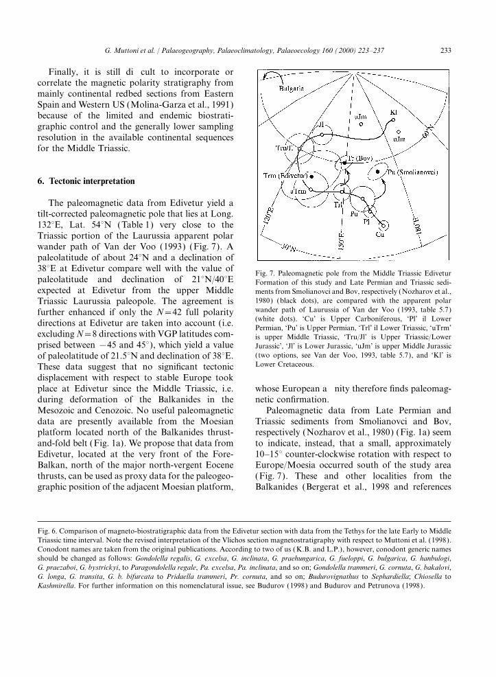
The paleomagnetic data from Edivetur yield atilt-corrected paleomagnetic pole that lies at Long.132°E, Lat. 54°N (Table 1) very close to theTriassic portion of the Laurussia apparent polarwander path of Van der Voo (1993) (Fig. 7). Apaleolatitude of about 24°N and a declination of38°E at Edivetur compare well with the value of
Fig. 7. Paleomagnetic pole from the Middle Triassic Ediveturpaleolatitude and declination of 21°N/40°E Formation of this study and Late Permian and Triassic sedi-expected at Edivetur from the upper Middle ments from Smolianovci and Bov, respectively (Nozharov et al.,
1980) (black dots), are compared with the apparent polarTriassic Laurussia paleopole. The agreement iswander path of Laurussia of Van der Voo (1993, table 5.7)further enhanced if only the N=42 full polarity(white dots). ‘Cu’ is Upper Carboniferous, ‘Pl’ il Lowerdirections at Edivetur are taken into account (i.e.Permian, ‘Pu’ is Upper Permian, ‘Trl’ il Lower Triassic, ‘uTrm’
excluding N=8 directions with VGP latitudes com- is upper Middle Triassic, ‘Tru/Jl’ is Upper Triassic/Lowerprised between −45 and 45°), which yield a value Jurassic’, ‘Jl’ is Lower Jurassic, ‘uJm’ is upper Middle Jurassic
(two options, see Van der Voo, 1993, table 5.7), and ‘Kl’ isof paleolatitude of 21.5°N and declination of 38°E.Lower Cretaceous.These data suggest that no significant tectonic
displacement with respect to stable Europe tookplace at Edivetur since the Middle Triassic, i.e. whose European affinity therefore finds paleomag-
netic confirmation.during deformation of the Balkanides in theMesozoic and Cenozoic. No useful paleomagnetic Paleomagnetic data from Late Permian and
Triassic sediments from Smolianovci and Bov,data are presently available from the Moesianplatform located north of the Balkanides thrust- respectively (Nozharov et al., 1980) (Fig. 1a) seem
to indicate, instead, that a small, approximatelyand-fold belt (Fig. 1a). We propose that data fromEdivetur, located at the very front of the Fore- 10–15° counter-clockwise rotation with respect to
Europe/Moesia occurred south of the study areaBalkan, north of the major north-vergent Eocenethrusts, can be used as proxy data for the paleogeo- (Fig. 7). These and other localities from the
Balkanides (Bergerat et al., 1998 and referencesgraphic position of the adjacent Moesian platform,
Fig. 6. Comparison of magneto-biostratigraphic data from the Edivetur section with data from the Tethys for the late Early to MiddleTriassic time interval. Note the revised interpretation of the Vlichos section magnetostratigraphy with respect to Muttoni et al. (1998).Conodont names are taken from the original publications. According to two of us (K.B. and L.P.), however, conodont generic namesshould be changed as follows: Gondolella regalis, G. excelsa, G. inclinata, G. praehungarica, G. fueloppi, G. bulgarica, G. hanbulogi,G. praezaboi, G. bystrickyi, to Paragondolella regale, Pa. excelsa, Pa. inclinata, and so on; Gondolella trammeri, G. cornuta, G. bakalovi,G. longa, G. transita, G. b. bifurcata to Pridaella trammeri, Pr. cornuta, and so on; Budurovignathus to Sephardiella; Chiosella toKashmirella. For further information on this nomenclatural issue, see Budurov (1998) and Budurov and Petrunova (1998).
234 G. Muttoni et al. / Palaeogeography, Palaeoclimatology, Palaeoecology 160 (2000) 223–237
therein) are located south of the major Eocene 230 Ma paleopole of Laurussia of Torcq et al.(1997) is used instead.thrusts, and may have been affected by tectonic
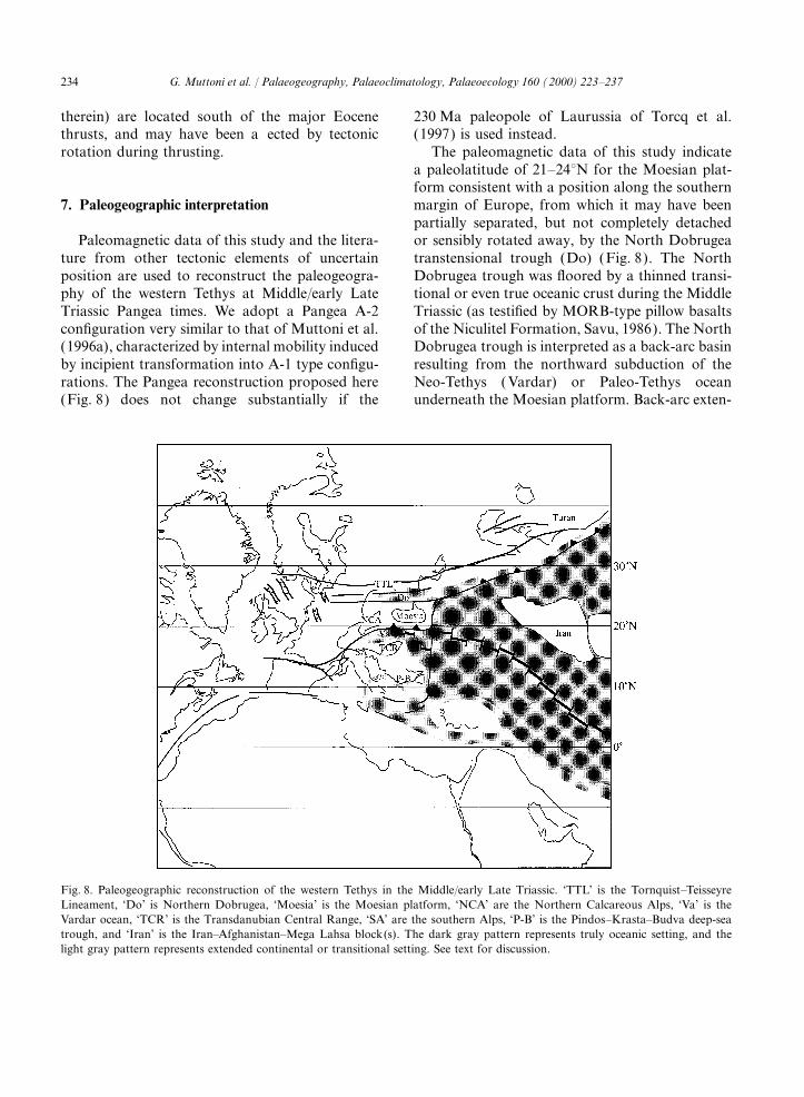
rotation during thrusting. The paleomagnetic data of this study indicatea paleolatitude of 21–24°N for the Moesian plat-form consistent with a position along the southernmargin of Europe, from which it may have been7. Paleogeographic interpretationpartially separated, but not completely detachedor sensibly rotated away, by the North DobrugeaPaleomagnetic data of this study and the litera-
ture from other tectonic elements of uncertain transtensional trough (Do) (Fig. 8). The NorthDobrugea trough was floored by a thinned transi-position are used to reconstruct the paleogeogra-
phy of the western Tethys at Middle/early Late tional or even true oceanic crust during the MiddleTriassic (as testified by MORB-type pillow basaltsTriassic Pangea times. We adopt a Pangea A-2
configuration very similar to that of Muttoni et al. of the Niculitel Formation, Savu, 1986). The NorthDobrugea trough is interpreted as a back-arc basin(1996a), characterized by internal mobility induced
by incipient transformation into A-1 type configu- resulting from the northward subduction of theNeo-Tethys (Vardar) or Paleo-Tethys oceanrations. The Pangea reconstruction proposed here
(Fig. 8) does not change substantially if the underneath the Moesian platform. Back-arc exten-
Fig. 8. Paleogeographic reconstruction of the western Tethys in the Middle/early Late Triassic. ‘TTL’ is the Tornquist–TeisseyreLineament, ‘Do’ is Northern Dobrugea, ‘Moesia’ is the Moesian platform, ‘NCA’ are the Northern Calcareous Alps, ‘Va’ is theVardar ocean, ‘TCR’ is the Transdanubian Central Range, ‘SA’ are the southern Alps, ‘P-B’ is the Pindos–Krasta–Budva deep-seatrough, and ‘Iran’ is the Iran–Afghanistan–Mega Lahsa block(s). The dark gray pattern represents truly oceanic setting, and thelight gray pattern represents extended continental or transitional setting. See text for discussion.
235G. Muttoni et al. / Palaeogeography, Palaeoclimatology, Palaeoecology 160 (2000) 223–237
sion was accompanied by transtension along the Alps/Moesia, enough room is left for the Vardar(Va) transtensional deep-water to oceanic basinTornquist–Teisseyre (TTL) or associated linea-
ments that mark the modern-day boundary with (e.g. Pamic et al., 1998). Recently publishedMiddle Triassic paleomagnetic data from Albaniathe East European Platform.
The Northern Calcareous Alps (NCA) of and Greece (Muttoni et al., 1996b; Muttoni et al.,1997, 1998) can be used as proxy data for theAustria were recently investigated paleomagneti-
cally at three main Upper Anisian to Lower paleolatitude of the Pindos–Krasta–Budva deep-water basin (P–B), which attains a position ofCarnian sections: Mayerling, Mendlingbach and
Gamsstein (Gallet et al., 1998; see also Fig. 6). about 13–15°N (Fig. 8).Finally, more to the east, in a truly oceanicThe average inclination indicates that the Northern
Calcareous Alps were located at about 19.5°N, in setting, the Iran–Afghanistan–Mega Lahsablock(s) navigates to the north to eventually collidesubstantial agreement with the paleolatitude
expected from the Laurussia pole (i.e. 21°N) (Van with the southern margin of Europe in theMiddle/Late Triassic ( Wensink, 1982 and refer-der Voo, 1993, table 5.7), and not far from Moesia.
The average declination at Mayerling and ences therein; Ricou, 1996; Besse et al., 1998).Gamsstein of 95°E indicates a 58° clockwise rota-tion relative to the Laurussia pole (or 107° relativeto West Gondwana), in agreement with the consis- 8. Conclusionstent pattern of clockwise paleomagnetic rotationsobserved in the Adnet Limestone of Liassic age We found a dual-polarity component of magne-
tization of presumed Anisian (Middle Triassic)(Channell et al., 1992). Data from the NorthernCalcareous Alps do not conform to the African age in the biostratigraphically dated Peri-Tethyan
Edivetur Formation from northwestern Bulgaria.polar wander loop typically observed in Adriadata. The Northern Calcareous Alps are there- This component delineates a magnetic polarity
stratigraphy that was tentatively correlated withfore interpreted as a unit of non-Africa affinity(European?), facing to the east the western Tethys, magneto-biostratigraphic data from Tethyan sec-
tions from the literature. Despite these new results,and which underwent clockwise rotation in post-Liassic times (Channell et al., 1992; Channell, a gap of data of Illyrian (Anisian) age is still
present in the Middle Triassic marine magnetic1996).The Transdanubian Central Range (TCR) of polarity time scale.
The study area of Edivetur is located adjacentnorthern Hungary, located between the westernCarpathians to the north and the Zagreb–Kulcs to the Moesian platform in the Fore-Balkan
domain, which is the less deformed frontal portionlineament to the south in modern-day coordinates,is considered to have moved in conjunction with of the Balkanides thrust-and-fold belt. Paleo-
magnetic data from Edivetur have EuropeanWest Gondwana since at least Late Cretaceoustimes, to undergo successively an approximately affinity, and, in virtue of the regional structural
setting of the Fore-Balkan domain, they are used30° counter-clockwise rotation of thrust sheetsprobably during Pannonian deformation in the as proxy data for the paleogeographic position of
the Moesian platform in the Middle Triassic. TheCenozoic (Channell, 1996). Therefore, in Pangeatimes, the Transdanubian Central Range was the Moesian platform was located at 21–24°N along
the southern margin of Europe in a position similarnortheastern ‘bulge’ of the African promontory ofAdria (Van der Voo, 1993) and is predicted to to that proposed by Dercourt et al. (1993). The
Moesian platform was probably only marginallyhave a paleolatitude similar to that of the SouthernAlps (SA), i.e. about 15.5°N (Muttoni et al., 1996a separated, but not rotated away, from the
European margin by the North Dobrugea trans-upgraded with data from Broglio Loriga et al.,1999 and Brack and Muttoni, in press). tensional trough interpreted as a back-arc basin
resulting from the northward subduction of theIn between the Southern Alps/TransdanubianCentral Range and the Northern Calcareous Neo-Tethys (Vardar) or Paleo-Tethys ocean.
236 G. Muttoni et al. / Palaeogeography, Palaeoclimatology, Palaeoecology 160 (2000) 223–237
Paleoenvironmental Maps 1993. Gauthier-Villars, Paris,Acknowledgements307 pp.
Gallet, Y., Krystyn, L., Besse, J., 1998. Upper Anisian to LowerWe thank Wout Krijgsman and Yves Gallet for Carnian Magnetostratigraphy from the Northern Calcare-revision of the manuscript. ous Alps (Austria). Journal of Geophysical Research 103,
605–621.Harkovska, A., Tenchov, Y., 1963. First finding of fossil flora
in the Buntsandstein of Bulgaria. Travaux sur la geologiede la Bulgarie, ser. Paleontologie 5, 241.References
Haydoutov, I., Yanev, S., Tronkov, D., Sapunov, I., Tchou-matchenco, P., Tzankov, Tz., Popov, N., Dimitrova, R.,
Bergerat, F., Martin, P., Dimov, D., 1998. In: Crasquin-Soleau,Nikolov, T., Aladzhova-Khrischeva, K., Tchounev, D., Fili-
S., Barrier, E. (Eds.), The Moesian Platform as a key forpov, L., 1995. Explanatory note on the Geological map of
understanding the geodynamical evolution of the Carpatho-Bulgaria 1:100.000, Sheet Knyazhevats and Belogradchik.
Balkan alpine system. Peri-Tethys Memoir 3: StratigraphyCommittee of Geology and Mineral Resources, Geology
and evolution of Peri-tethyan platforms. Mem. Mus. Natn.and Geophysics. in Bulgarian, 144 pp.Hist. Nat, Paris, pp. 129–150.
Kent, D.V., Olsen, P.E., Witte, W.K., 1995. Late Triassic–ear-Besse, J., Torcq, F., Gallet, Y., Ricou, L.E., Krystyn, L., Saidi,liest Jurassic geomagnetic polarity sequence and paleolati-A., 1998. Late Permian to Late Triassic paleomagnetic datatudes from drill cores in the Newark rift basin, eastern Northfrom Iran: constraints on the migration of the Iranian blockAmerica. Journal of Geophysical Research 100,through the Tethys Ocean and initial destruction of Pan-14965–14998.gaea. Geophysical Journal International 135, 77–92.
Kirschvink, J.L., 1980. The least-squares line and plane and theBrack, P., Muttoni, G., press. High-resolution magnetostrati-analysis of paleomagnetic data. Geophysical Journal of thegraphic and lithostratigraphic correlations in Middle Trias-Royal Astronomical Society 62, 699–718.sic pelagic carbonates from the Dolomites (northern Italy).
Lowrie, W., Alvarez, W., 1977. Late Cretaceous geomagneticPalaeogeography, Palaeoclimatology, Palaeoecology, inpolarity sequence: detailed rock and paleomagnetic studiespress.of the Scaglia Rossa limestone at Gubbio, Italy. GeophysicalBroglio Loriga, C., Cirilli, S., De Zanche, V., di Bari, D., Gia-Journal of the Royal Astronomical Society 51, 561–581.nolla, P., Laghi, G.F., Lowrie, W., Manfrin, S., Mastandrea,
Lowrie, W., 1990. Identification of ferromagnetic minerals in aA., Mietto, P., Muttoni, G., Neri, C., Posenato, P., Rechi-rock by coercivity and unblocking temperature properties.chi, M., Rettori, R., Roghi, G., 1999. The Prati di Stuores/Geophysical Research Letters 17, 159–162.Stuores Wiesen section (Dolomites, Italy): a candidate
Molina-Garza, R.S., Geissman, J.W., Van der Voo, R., Lucas,Global Stratotype Section and Point for the base of theS.G., Hayden, S.N., 1991. Paleomagnetism of the MoenkopiCarnian stage. Rivista Italiana di Stratigrafia 105 (1),and Chinle Formations in central New Mexico: Implications37–78.for the North American apparent polar wander path andBudurov, K., 1960. On the presence of Conodonta in the Ani-Triassic magnetostratigraphy. Journal of Geophysicalsian at the village of Granitovo Vidin District. Review ofResearch 96, B9, 14239–14261.the Bulgarian Geological Society 21 (3), 78–79. in
Muttoni, G., Kent, D.V., Channell, J.E.T., 1996a. The Evolu-Bulgarian.tion of Pangea: Paleomagnetic constraints from the South-Budurov, K., 1962. Conodonts from the Anisian at the villageern Alps, Italy. Earth and Planetary Science Letters 140,of Granitovo, Vidin District. Review of the Bulgarian Geo-97–112.logical Society 23 (2), 113–129. in Bulgarian.
Muttoni, G., Kent, D.V., Meco, S., Nicora, A., Gaetani, M.,Budurov, K., 1998. Middle Triassic paleoenvironment: climate,Balini, M., Germani, D., Rettori, R., 1996b. Magneto-bio-provincialism and biofacies control of conodont evolution.stratigraphy of the Spathian to Anisian (Lower to MiddleIn: Bagnolli, G. (Ed.), ECOS VII, Abstracts, 21–22.Triassic) Kcira Section, Albania. Geophysical JournalBudurov, K., Petrunova, L., 1998. Muschelkalk Conodonts asInternational 127, 503–514.Components of the Peri-Tethyan Conodont Fauna, Epicon-
Muttoni, G., Kent, D.V., Brack, P., Nicora, A., Balini, M.,tinental Triassic International Symposium. Hallesches Jahr-1997. Middle Triassic Magneto-Biostratigraphy from thebuch fur Geowissenschaften, Reihe B, Beiheft 5, Halle,Dolomites and Greece. Earth and Planetary Science Letters28–29.146, 107–120.Channell, J.E.T., Brandner, R., Spieler, A., Stoner, J.S., 1992.
Muttoni, G., Kent, D.V., Meco, S., Nicora, A., Balini, M.,Paleomagnetism and paleogeography of the Northern Cal-Gaetani, M., Krystyn, L., 1998. Towards a better definitioncareous Alps (Austria). Tectonics 11 (4), 792–810.of the Middle Triassic magnetic polarity stratigraphy in theChannell, J.E.T., 1996. Paleomagnetism and paleogeography ofTethys realm. Earth and Planetary Science Letters 164,Adria. In: Morris, A., Tarling, D.H. (Eds.), Paleomagnetism285–302.and Tectonics of the Mediterranean Region. Geological
Nozharov, P., Petkov, N., Yanev, S., Kropacek, V., Krs, M.,Society Special Publication, 119–132.Dercourt, J., Ricou, L.E., Vrielynck, B. (Eds.), Atlas Tethys Pruner, P., 1980. A paleomagnetic and petromagnetic study
237G. Muttoni et al. / Palaeogeography, Palaeoclimatology, Palaeoecology 160 (2000) 223–237
of Upper Carboniferous, Permian and Triassic sediments, Tenchov, Y. (Ed.), Glossary of the Formal LithostratigraphicUnits in Bulgaria (1882–1992) 1993. Publishing House ofNW Bulgaria. Studia. Geophys. Geod. 24, 252–284.the Bulgarian Academy of Science, 397 pp. (in Bulgarian).Pamic, J., Gusic, I., Jelaska, V., 1998. Geodynamic evolution
Torcq, F., Besse, J., Vaslet, D., Marcoux, J., Ricou, L.E., Hala-of the Central Dinarides. Tectonophysics 297, 251–268.wani, M., Basahel, M., 1997. Paleomagnetic results fromRicou, L.E., 1996. The Plate Tectonic History of the Past TethysSaudi Arabia and the Permo-Triassic Pangea configuration.Ocean. In: Nairn, A.E.M., Ricou, L.E., Vrielynck, B., Der-Earth and Planetary Science Letters 148, 553–567.court, J. (Eds.), The Ocean Basins and Margins. The Tethys
Tronkov, D., 1973. Bases for the stratigraphy of the Triassic inOcean. Plenum Press, New York, pp. 3–70.the Belogradchik anticlinorium (Northwestern Bulgaria).Robertson, A.H.F., Dixon, J.E., 1984. Introduction: Aspects ofBulletin of the Geological Institute, ser. Stratigraphy andthe geological evolution of the Eastern Mediterranean. In:Lithology 22, 73–98.Dixon, J.E., Robertson, A.H.F. (Eds.), The Geological Evo-
Van der Voo, R., 1993. Paleomagnetism of the Atlantic, Tethyslution of the Eastern Mediterranean. Geological Society
and Iapetus Oceans. Cambridge University Press, Cam-Special Publication, 1–74. bridge. 411 pp.
Savu, H., 1986. Triassic, continental intra-plate volcanism in Wensink, H., 1982. Tectonic inferences of paleomagnetic dataNorth Dobrugea. Rev. Roum. Geol. Geoph. Geogr., Geol. from some Mesozoic formations in Central Iran. Journal of30, 21–29. Geophysics 51, 12–23.
Sengor, A.M.C., Yilmaz, Y., Sungurlu, O., 1984. Tectonics of Zagorchev, I., Budurov, K., 1997. Outline of the Triassic paleo-the Mediterranean Cimmerides: Nature and evolution of the geography of Bulgaria. Albertiana 19, 12–24.western termination of Paleo-Tethys. In: Dixon, J.E., Rob- Zijderveld, J.D.A., 1967. A.C. demagnetization of rocks—ertson, A.H.F. (Eds.), The Geological Evolution of the analysis of results. In: Collinson, D.W., Creer, K.M., Runc-Eastern Mediterranean. Geological Society Special Publica- orn, S.K. (Eds.), Methods in Paleomagnetism. Elsevier,
New York, pp. 254–286.tion, 77–112.


