Embed Size (px)
Citation preview
MEDIEVAL AGRARIAN COLONIZATION IN ALENTEJO(PORTUGAL)Magali Watteaux
Editions de l’E.H.E.S.S. | « Etudes rurales »
2011/2 No 188 | pages 39 - 71 ISSN 0014-2182ISBN 9782713223259
This document is a translation of:--------------------------------------------------------------------------------------------------------------------Magali Watteaux, « La colonisation agraire médiévale en Alentejo (Portugal) », Etudes rurales2011/2 (No 188), p. 39-71.--------------------------------------------------------------------------------------------------------------------Translated from the French by JPD Systems Available online at :--------------------------------------------------------------------------------------------------------------------http://www.cairn-int.info/article-E_ETRU_188_0039--medieval-agrarian-colonization-in-alente.htm--------------------------------------------------------------------------------------------------------------------
!How to cite this article :--------------------------------------------------------------------------------------------------------------------Magali Watteaux, « La colonisation agraire médiévale en Alentejo (Portugal) », Etudes rurales2011/2 (No 188), p. 39-71.--------------------------------------------------------------------------------------------------------------------
Electronic distribution by Cairn on behalf of Editions de l’E.H.E.S.S..
© Editions de l’E.H.E.S.S.. All rights reserved for all countries.Reproducing this article (including by photocopying) is only authorized in accordance with the general terms andconditions of use for the website, or with the general terms and conditions of the license held by your institution, whereapplicable. Any other reproduction, in full or in part, or storage in a database, in any form and by any means whatsoeveris strictly prohibited without the prior written consent of the publisher, except where permitted under French law.
Powered by TCPDF (www.tcpdf.org)
Doc
umen
t dow
nloa
ded
from
ww
w.c
airn
-int.i
nfo
- U
nive
rsité
de
Par
is X
IV -
-
90.2
.222
.143
- 0
8/09
/201
5 15
h51.
© E
ditio
ns d
e l?
E.H
.E.S
.S. D
ocument dow
nloaded from w
ww
.cairn-int.info - Université de P
aris XIV
- - 90.2.222.143 - 08/09/2015 15h51. © E
ditions de l?E.H
.E.S
.S.
known to medievalists has left significant traces on planimetric maps.3 Further, we will examine the reason for historians’ blindness or, more precisely, ignorance of this morphology. The answers are to be found in the archeology of knowledge of the medievalists. This leads us down three avenues of inquiry: the historical, which leads to the Reconquista (reconquest) and a resettlement process; the epistemolog-ical, which identifies the researchers’ rep-resentations and filters to be set aside in order to gain better understanding of the phenome-non under study; and the archeogeographical, which brings in a morphological perspective. This last informs the infinite variety of out-comes of multiple historical legacies, while also presenting cartographical arguments to substantiate the case for medieval agrarian land planning during the Christian Reconquista.4
Magali WatteauxMEDIEVAL AGRARIAN COLONIZATION IN ALENTEJO (PORTUGAL)
Agrarian colonization in the Middle Ages is a chapter of history that was opened long ago but remains incom-
plete. The morphology of this colonization, accepted only recently, despite historically being necessary for changing property bound-aries and allocating land to colonists, has been underestimated to an extent that varies according to the country.1 In France, with the exception of a few parcels of cleared land, it was not until the late 1990s that, through Cédric Lavigne (2002), a model for this his-torical subject emerged. In Italy, the discov-eries of Gérard Chouquer (1981 and 1982) 30 years ago, and the more recent work of Robin Brigand (2010) made it possible to discern shapes formed by agricultural land planning associated with the new settlements, until then ignored. In Spain, it was thanks to the efforts of Ricardo González Villaescusa (1996 and 2002) that these planned shapes really became part of the historian’s morphologi-cal catalogue. Finally, in Portugal, this field of research remains almost untouched, with a bare handful of studies focusing on a few hypothetical Roman centuriations.
For this reason we intend to demonstrate that in the Lower Alentejo region of south-ern Portugal, agrarian land planning2 so well
1. This paper will only consider Mediterranean countries. However, it appears that in Germany too it took until the end of the twentieth century to identify (Higounet 1989) the outlines of planned agrarian land allocations associ-ated with medieval colonization.
2. The notion of “agrarian land planning” designates a foundation, a standardized metrology, and an allocation of agricultural land to colonists.
3. This work has been carried out as part of post-doc-toral study at the Centro de Estudos Arqueológicos das Universidades de Coimbra e Porto (CEAUCP), at the University of Coimbra-Porto, Portugal, where, since 2008, teaching and research in archeogeography has been in development.
4. Along these avenues we have made use of biblio-graphic, textual, cartographic, photographic, and cadas-tral documents, together with geographical databases. We must clarify that archeology plays only a minor role in documenting land use. Indeed, it is primarily written sources scrutinized by historians and aerial and satellite images that inform study of agrarian land planning.
Doc
umen
t dow
nloa
ded
from
ww
w.c
airn
-int.i
nfo
- U
nive
rsité
de
Par
is X
IV -
-
90.2
.222
.143
- 0
8/09
/201
5 15
h51.
© E
ditio
ns d
e l?
E.H
.E.S
.S. D
ocument dow
nloaded from w
ww
.cairn-int.info - Université de P
aris XIV
- - 90.2.222.143 - 08/09/2015 15h51. © E
ditions de l?E.H
.E.S
.S.
Magali Watteaux
. . .II These three main avenues of inquiry do not run
exactly parallel to each other.The Lower Alentejo is the site of inquiry. We
shall briefly describe this little-known region, using broad strokes (Ribeiro and Lautensach 1989; Guichard 1990; Gaspar 1993). Centered on the capital town, Beja, the region is rugged, with hills rising to 400 meters in height. It has a Mediterranean climate with particularly dry summers and alternating drought and floods from irregular rainfall, something which dom-inates agriculture. The soil is generally poor and subject to significant erosion, thus not suited to quality agriculture, a fact that has not prevented the region from being seen since the late Middle Ages as “Portugal’s wine cel-lar”—particularly the area around Beja. The landscape comprises what is known locally as the montado (a man-made landscape of cereal crops, holm oaks, cork oaks, and grazing land), dry plains, a dense charneca (scrubland) and intensively-irrigated growing areas in the val-ley floors cutting through the montado. Within these landscape units, the local population lives either in towns (often of ancient origin), or scattered in montes (steep-sided valleys) within the vast latifundia (estates). Population density of the region is the lowest in the coun-try (15.2 inhabitants/km2 in 2005), making it one of the poorest regions in the European Union, with demographic, economic, and social indicators all in decline. The structure of ownership and use of the land, dominated by latifundia often more than 1,000 hectares in size,5 explains the demand for manual workers, who, as they are poorly paid, have been driven in waves to leave the region. Meanwhile, the dwindling population encourages more lati-fundia. Thus the estates are strengthened as the rural proletariat becomes impoverished.
This micro-region is particularly well-suited to a crossover study, in view of its history and because the Roman, medieval, and modern occupied settlements have been closely studied by archeologists and histori-ans.6 In addition, in 2008 Gerard Choquer car-ried out an initial reconnaissance of planned declinations of land; and, to a lesser degree, Cédric Lavigne (2006) placed this question at the heart of a broader study of the morphol-ogy of roads and plots of land around Beja. Conditions are thus ripe for an in-depth study of this subject.
The Historical Avenue: Reconquista and Medieval Agrarian Colonization
A review of historical studies allows us to consider the matter of the Reconquista and focus work on a specific period. Here, the Reconquista refers to the expansion of Western Christianity in the Iberian Peninsula beginning in the late eleventh century and the coloniza-tion of lands won from the Muslims. However, in southern Portugal, this process began in the mid-twelfth century, although the defini-tive recapture of the towns in this area did not occur until the years 1220–1230.
There are two dimensions to the Recon-quista. Firstly, it reflects an agrarian reality
5. Above all, following the nationalization of Church property in the nineteenth century, which benefited the large landowners.
6. See Lopes (2003b) on the old town of Beja; Boissellier (1999 and 2003) on the Portuguese Midi from the Islamic period to the end of the Middle Ages; Rau ([1946] 1982) on the system of medieval sesmarias; and Silbert (1966) on the Portuguese Midi between the end of the eighteenth century and the start of the nineteenth century.
Doc
umen
t dow
nloa
ded
from
ww
w.c
airn
-int.i
nfo
- U
nive
rsité
de
Par
is X
IV -
-
90.2
.222
.143
- 0
8/09
/201
5 15
h51.
© E
ditio
ns d
e l?
E.H
.E.S
.S. D
ocument dow
nloaded from w
ww
.cairn-int.info - Université de P
aris XIV
- - 90.2.222.143 - 08/09/2015 15h51. © E
ditions de l?E.H
.E.S
.S.
Medieval Agrarian Colonization in Alentejo (Portugal)
. . .IIIlinked to colonization and the allocation of
land to colonists, which must be examined even though we possess only limited under-standing of what came before. Secondly, it is an intellectual and ideological construct for defending a bloody military campaign and the principle of immutable Spanish iden-tity, according to which the Iberian Peninsula always belonged to “Spanish Christians” long before the Arabs arrived, and is the reason why the Christian kings referred to a recon-quest. Although the notion of the Reconquista is debated and often dismissed by historians, who prefer the expression “feudal conquest,” we will make use of it here because it remains a very widely used, evocative term. And while this ideological rewriting of history has been thoroughly analyzed by several historians (Jiménez 2000; Torró 2000; Ladero Quesada 2003), the agrarian reality of Portugal comes down to how the colonists shaped these new-ly-conquered lands. It is the study of these agricultural shapes and patterns that concerns us here.
The Reconquista is seen as a process of partial replacement of an earlier popu lation, which Iberian historiography refers to as Repoblación (“repopulation”).7 However, historian Stéphane Boissellier (1999) draws attention to the fact that this notion is “the product of a late, ideologically-tainted histo-riography that treats Christian colonization as a demographic compensation for ‘deser-tification’ as well as a ‘return’ of Christians following an Islamic interval.” The medieval texts only refer to “settling” (Boissellier 1999, 109). On the other hand, the great speed of the annexation of most of southern Portugal in the years 1120–1250 means it is hard to envisage a mass disappearance of the native peoples and
a significant colonial “settling” (Boissellier 1999, 616–617). For the same reason, no dis-tribution of land took place following the con-quest of the Algarve, unlike what happened in the area around Seville: “It cannot be stated more clearly that a voluntary and systematic ‘repopulation’ did not take place.” (Boissellier 1999, 617).
Despite the care with which we must treat these ideas, the fact remains that the conse-quences of the Reconquista for the popula-tion and land use are considerable, since the Muslim and the Christian populations had very different notions of space and of society.8 Boissellier (2003, 57) summarizes them as follows:
Without neglecting the “legacy” of the logic and forms of human settlement that came before the Reconquista (above all, the towns and major roads that connected them, which established a lasting organi-zation on a regional scale), I believe that it is the very process of reconquest that explains the land occupation patterns vis-ible throughout the Christian Portuguese Middle Ages, primarily at the level of the settlements themselves.
With specific regard to the question of land, Boissellier (1999, 531) writes further:
The fundamental aim (and sole aim after the year 1250) of colonization was to bring the conquered lands under culti-vation. Medieval Portuguese agrarian history (in the areas to the south of the
7. It is no longer believed that the Reconquista brought about a mass exodus of Muslims (Boissellier 1999, 91–98).
8. Less so with regard to the urban network and the main routes of communication (Boissellier 1999).
Doc
umen
t dow
nloa
ded
from
ww
w.c
airn
-int.i
nfo
- U
nive
rsité
de
Par
is X
IV -
-
90.2
.222
.143
- 0
8/09
/201
5 15
h51.
© E
ditio
ns d
e l?
E.H
.E.S
.S. D
ocument dow
nloaded from w
ww
.cairn-int.info - Université de P
aris XIV
- - 90.2.222.143 - 08/09/2015 15h51. © E
ditions de l?E.H
.E.S
.S.
Magali Watteaux
. . .IV
Douro) is defined by its origin, that is, an expropriation on a vast scale (whether direct or indirect) followed by a reap-propriation that took the most varied of forms.
Boissellier (1999, 557) and Virginia Rau (1965b) provide key information for under-standing this “process of expropriation and reappropriation.” At the time of the Conquest, the king seized lands and declared himself supreme proprietor of all the lands either con-quered or abandoned by their inhabitants.9 He retained a large part for himself and his retinue: these are what are known as the reguengos (from the Latin regalengum), created through the sovereign’s regalia (right of confiscation). These reguengos were scattered through-out the region, sometimes in the form of vast blocs forming large farms with whole villages receiving colonists. The rest of the lands were allocated: in the south, the monarch granted almost all the remainder to the military orders (primarily in the twelfth century and between the years 1220–1250), as a reward for efforts in battle and as a sign of devotion, and with a view to putting these vast territories, which were hard to rule directly, to good use (Rau 1965b; Marreiros 1992, 8–9; Boissellier 1999, 536). The Order of Aviz received most of the Upper Alentejo, while almost all the south was granted to the Order of Santiago. The non-mil-itary orders and the secular Church were also well rewarded. It should not be imagined, however, that this led to the creation of huge, continuous estates. Boissellier (1999, 556) warns against such an interpretation:
Too much emphasis has probably been placed on the vast scale of the lands belonging to the military orders in the Portuguese Midi, as a result of confusing,
from unclear documents, the truly huge jurisdictions over which they held sway and their actual estates. The failure of the military orders to defend themselves from the usurpation of their lands con-trasts with their dogged attachment to their other sources of revenue. Their domains, whether conquered or assigned to them, were extensively intermingled with those of allodial lands, royal proper-ties, and common lands belonging to the municipalities they ruled over.
As well as grants, there were two principal means of acquiring lands. One entailed taking possession, by force or by simple occupation, of lands left vacant after their integration into the royal patrimony. This is known as presúria (“taking”).10 To characterize the situation, Boissellier (1999, 532) offers the image of “a kind of Far West where the law of the strongest ruled.” This system was only possible as long as the demands of war and society granted full reign to the conqueror (Boissellier 1999, 532). Once the territorial boundaries of a state were fixed, and to the extent it was in control, this system was destined to disappear (Rau 1965b, 568). Economic and social advances would no longer allow for appropriation by force, demanding a fairer distribution of the land among colonists (Rau 1982, 50). The presúria would however continue to be invoked until
9. It should not be forgotten however that the precise circumstances in which Islamic properties were acquired during the Reconquista are poorly understood, and even more so now that the mass expulsion of Muslims is no longer believed to have occurred (Boissellier 1999, 531).
10. A mode comparable to the occupation of Antiquity, which allowed citizens to take up occupation of lands assumed to be vacant on condition they cultivated them and paid the vectigal (tax) (Chouquer 2010a, 155–161).
Doc
umen
t dow
nloa
ded
from
ww
w.c
airn
-int.i
nfo
- U
nive
rsité
de
Par
is X
IV -
-
90.2
.222
.143
- 0
8/09
/201
5 15
h51.
© E
ditio
ns d
e l?
E.H
.E.S
.S. D
ocument dow
nloaded from w
ww
.cairn-int.info - Université de P
aris XIV
- - 90.2.222.143 - 08/09/2015 15h51. © E
ditions de l?E.H
.E.S
.S.
Medieval Agrarian Colonization in Alentejo (Portugal)
. . .Vthe end of the thirteenth century, particularly
in the territory of Evora (Boissellier 1999, 532–533).
The other mode of land acquisition is known as the sesmarias, a system for allocat-ing and distributing lands in an ordered man-ner. Rau (1982, 21) studied sesmarias, in a book that remains unsurpassed, and saw them as “one of the drivers of the rural life and col-onization of Portugal’s interior.” They served to encourage the settlement and cultivation of vacant land held in royal and private owner-ship (Rau 1982, 41). Boissellier (1999, 538) describes “the implementation of an organized distribution of lands,” based on the system’s division of land surveyed in order to distribute plots to colonists. In this respect, the allocation resembles the land distribution in Castile and Aragon, except that here it was a simpler, more drawn-out process, with smaller-scale and less complex operations (Boissellier 1999, 538).
The implementation of the sesmarias was carried out by the sesmeiros, municipal offi-cials responsible for supervising the opera-tion of division and allocation of lands (Rau 1982, 42).11 All these terms come from the word sesmo, which refers to a defined area of land from which the plots allocated to the colo-nists were taken (Rau 1982, 54). According to Rau (1982, 55 and 1965b), the sesmos acquired their name because the set of lands allocated (sesmarias) in each concelho (municipality) was divided into six lots supervised by six sesmeiros for six days of the week, with the exception of Sunday, each taking charge of a sesmo for a specific day. The methodical nature of this system and the occasional use of math-ematical measurements (astil and arançada) allows us to imagine, according to Boissellier (1999, 541), a regular, geometric shape to the
plot of land: “It also appears that the agrarian landscapes born of the sesmarias form regular plots of land, or even a true cadastral survey.”12
However, we must bear in mind that an allocation (that is, the distribution of land to colonists) does not necessarily imply a sur-vey. The division could be carried out without restructuring the shape of the parcel of land, allowing a simple exchange to take place.13
The system of sesmarias was implemented following the upheavals of the military con-quest:
The sesmeiros emerged from the need to divide up and distribute lands to the colonists in the regions where rural own-ership was being reorganized—the land belonged either to the king, the nobles, or the military and monastic orders. They appeared when dividing lands through presúria, when appropriating them by cultivation could no longer guarantee the colonization and cultivation of the con-quered provinces, and in places where the social order no longer tolerated such a system. As a result, their presence is recorded during a specific period and in specific regions, in parallel to the devel-opment of the municipal government,
11. They appear as such in texts dating from the early thirteenth century, but the earliest officials responsible for allocating lands are mentioned from the second half of the twelfth century (Rau 1982; Boissellier 1999, 539).
12. Boissellier is using the term in a general sense, although a cadastral survey in reality refers to the act of mapping and/or making a list of lands for different pur-poses.
13. As occurred in Antiquity with the commutatio (Chouquer 2010a) and in the Middle Ages, for example in Murcia (Spain), where one of the allocations of land did not require restructuring of the parcels, unlike the others (Lavigne 2006).
Doc
umen
t dow
nloa
ded
from
ww
w.c
airn
-int.i
nfo
- U
nive
rsité
de
Par
is X
IV -
-
90.2
.222
.143
- 0
8/09
/201
5 15
h51.
© E
ditio
ns d
e l?
E.H
.E.S
.S. D
ocument dow
nloaded from w
ww
.cairn-int.info - Université de P
aris XIV
- - 90.2.222.143 - 08/09/2015 15h51. © E
ditions de l?E.H
.E.S
.S.
Magali Watteaux
. . .VI
and reflects more of an attempt at organ-ization on the part of the crown that fol-lows the social and economic trends of the period. In short, the sesmeiro and his functions became closely tied to the municipal assemblies and their agrarian economy. (Rau 1982, 57)
The sesmarias bear witness to the high level of organization in the settlements of colonists, who, according to Boissellier (1999, 538), sought to “avoid colonization becoming a rat race.”14 Recourse to them was sought under the pressure of a new community. This pro-cedure was thus less favorable to retaining the earlier land parcels,15 unlike the presúria, which displayed greater respect for the histor-ical legacy (Boissellier 1999, 152). With writ-ten documentation so rare, it is hard to gauge the extent of this system and we struggle to produce a complete picture of all these oper-ations. Once the communities and fields were roughly established, the sesmarias developed “operations to redistribute unoccupied lands or periodical redistribution of common lands” (Boissellier 1999, 543).
We pause here to look briefly at the units of subdivision known as the cavalaria and the peonaria. In the south, and despite what these names evoke, these units appear to have land allocations unrelated to the status of their occupants (Boissellier 1999, 541). These units became abstract standards of measurement. The lack of equivalence with the metric system (and with the French conversion tables of the eighteenth century) make it difficult to deter-mine their scale.16 Nevertheless, Boissellier (1999, 541) indicates that two or three cav-alarias were a sufficient reward for the high dignitaries of the court of Alfonso III, evi-dence of the great agricultural value of these
lands. The peonaria appear to constitute—in Montemor-o-Novo in the year 1269 at least—a subdivision of the cavalaria.
As we can see, the avenue of historical inquiry briefly described here opens up excit-ing perspectives on the matter of the settlement of colonists in a time of vast upheaval driven by conquest and appropriation of land. However, we may note that no archeology of knowledge has been undertaken, and major questions arise. What is the place of the Middle Ages in the national narrative of Portugal (as a diminutive sibling of Spain or an autonomous zone)? What are the topoi that feed on discourse: the vast latifundia; the exaggerated vision of stability? Why have historians not noted the patterns of agrarian development that correspond to this colonization? A chapter analyzing land owner-ship rights is also lacking. Work undertaken by legal historians—a group with whom medie-valists are not well acquainted—has shown that the medieval colonial situation tended to gen-erate an overlapping of rights, and that in this part of the Iberian peninsula a notion existed of crown lands bound up with the imperative to control and manage the new lands won by the
14. Boissellier refines his assertion by recalling that, on occasion, donations of land via sesmarias covered for abusive appropriations by a lord.
15. The problem is all the more crucial since we know next to nothing about the Muslim policies of land owner-ship, leaving aside a few ambiguous references to a sys-tematic distribution in certain towns (Boissellier, 538).
16. Though it is not clear that this would be sufficient. Lavigne has further shown that applying the agrarian measurements used at the end of the eighteenth century to those of the Middle Ages led to an impasse because of the scale of variation observed.
Doc
umen
t dow
nloa
ded
from
ww
w.c
airn
-int.i
nfo
- U
nive
rsité
de
Par
is X
IV -
-
90.2
.222
.143
- 0
8/09
/201
5 15
h51.
© E
ditio
ns d
e l?
E.H
.E.S
.S. D
ocument dow
nloaded from w
ww
.cairn-int.info - Université de P
aris XIV
- - 90.2.222.143 - 08/09/2015 15h51. © E
ditions de l?E.H
.E.S
.S.
Medieval Agrarian Colonization in Alentejo (Portugal)
. . .VIIReconquista. As a result, we may observe the
urgent need to turn to epistemological inquiry.
The Epistemological Avenue: Rereading Concepts and Objects
Work on the archeology of knowledge on this subject brings to light two principal problems. The first concerns the nature of the documen-tation available: only very few indications of morphology have come down to us. Yet anal-ysis of agrarian planning in the Middle Ages cannot do without such elements. As under-scored by Lavigne (2002), it is by bringing to light the outlines as executed that we can demonstrate their existence. This obviously does not mean that texts are not equally indis-pensable. Thus, establishing the physical exist-ence of the shapes while balancing this with documentary evidence is of prime importance. For this reason, our approach never separates the historical from the archeogeographical.
In this respect we follow historian Ludolf Kuchenbuch (2004, 306), who transforms his corpus of documentation into “a source of knowledge and recognition of the past, works on it as on a raw material, as a resource for histori-cal reconstruction.” In effect, a document is not a source until it is applied to a specific problem according to its nature, scale, aims, date, etc. Thus with medieval colonization and, in particu-lar, the planned agrarian layouts to which it gave rise, texts and images (maps, plans, aerial pho-tographs, satellite images) usefully complement each other on our list of sources of knowledge on the issue17—in this particular case, we would compare the ancient texts with planimetric doc-umentation. Further, as Chouquer put it, “there is no reason to reproduce an investigation in exactly the same way since another researcher
will feel the need to take a different route any-way.” (Chouquer and Watteaux 2012).
The second difficulty concerns issues of Portuguese historiography in relation to the country’s recent history. For example, Coimbra Law School asks whether there is such a thing as “Portuguese” law. This reflects a search for identity, but does not relate to medieval Portugal, where the question should be posed in very different terms. In addition, the vicis-situdes of building the nation in the modern period raised the issue of property: Portugal as a colonial power should provide an example of the power it intended to exercise abroad. Large properties are, from this perspective, more satisfying than small ones and are, as a result, favored in studies even when not the most rep-resentative of past realities. In this respect, the Roman period is valued more highly than the Islamic period, which for a long time was the poor relation of historical research. Work on Antiquity clearly shows that the question of land ownership nourished the history of modern nation-building, notably by taking up the ques-tion of the latifundium or large Roman estate, which has dominated Portuguese historiogra-phy. Chouquer (2008, 73–83) also asserts that the latifundium is a classic subject of research that has become an “obese collector” on which, in the context of national narratives, the history of the ancient and subsequently medieval coun-tryside has long been founded:
17. Archeologists might be surprised that sedimentary data do not appear on this list. There are two reasons for this: first, data of this kind are rare in the Portuguese Midi and only provide information about some types of habi-tat; second, the scale of this data is too large and unsuited to the study of agrarian land parcels, which require a par-ticular spatial extension.
Doc
umen
t dow
nloa
ded
from
ww
w.c
airn
-int.i
nfo
- U
nive
rsité
de
Par
is X
IV -
-
90.2
.222
.143
- 0
8/09
/201
5 15
h51.
© E
ditio
ns d
e l?
E.H
.E.S
.S. D
ocument dow
nloaded from w
ww
.cairn-int.info - Université de P
aris XIV
- - 90.2.222.143 - 08/09/2015 15h51. © E
ditions de l?E.H
.E.S
.S.
Magali Watteaux
. . .VIII
[. . .] ancient and medieval realities have been enticed, despite themselves, to take part in the construction of modernity by reinforcing the legitimacy of a class of landowners that emerged in the eight-eenth century and became established in the following century. The close rela-tionship between the assertion of own-ership of land and nation-building in all European countries, above all in the nine-teenth century, makes the large estate the perfect example of a product of methodo-logical nationalism. (Chouquer 2008, 73)
Rau (1965a, 65), meanwhile, talks of the “great historical myth” concerning this type of large property holding, which supposedly con-stituted a very ancient mode of using the land in Portugal.
For his part, Ouzoulias (2006) has shown that the opposition between a good system (a non-resident owner who attends to the finances) and a bad system (an absentee land-owner and poor management) dates back to the eighteenth century, due to the importance at the time of renewing farming. In this way, the historical reconstruction contradicts the much more complex ancient reality. As for Gaul, Ouzoulias (2006, 249) again denounces the excessive emphasis placed on the major Gallo-Roman farms to the detriment of other rural establishments:
A distant heir of physiocratic notions, the typical studies produced by this current of thought (the dualist view of agrarian economy) set the large farms, the sole producers of wealth, against the small establishments, the symbols of a world in which history is coming to an end.
It is this simplified schema that underlay the study of the celebrated Roman villa of São Cucufate, sited to the north of Beja. The
magnificence of the building has long caused archeologists to see it as the center of a uniform latifundium estimated at 1,500 hectares (Lopes 2003a, 58). Since the 1980s, digs and surveys around the villa have corrected this impres-sion, bringing to light some dozen farms of similar, modest size dating from the first cen-tury CE, the respective evolution of which has been explored (Sillières 1994). The desire to interpret this large area of cropland as if it had been managed from a single vast villa made it possible to justify the contemporary estate sys-tem, marked by huge social divisions:18
In fact, the present could well appeal to history to bear witness and warn today’s vast estates about the difficulties of maintaining them, as well as a debatable agricultural policy that has transformed the south of Portugal into one immense wheat field, endless and monotonous, with no concern for the agronomic qual-ity of the soils (Sillières 1994).
Thus, beginning with the large estates of ancient times and the all-too-real latifundia of the modern period, a deeply-rooted “tradition” of such estates was deduced to exist through-out southern Iberia.19 In parallel, displaying
18. The excavations of the pars urbana (owner’s family quarters) of the villae around Beja have all contributed to furthering this idea.
19. Roger Agache, comparing the French colonization of Algeria with the Roman colonization of northern Gaul established a similar link with the contemporary large estate; in both cases he believes that these “capitalist agri-cultural enterprises” are a factor in peace and prosperity: “the latifundia of northern Gaul in the Roman period in a sense are forerunners of the vast ‘model’ concerns set up on the fertile plains of Algeria from the beginning of the French occupation, for example.” (Ouzoulias 2006, 128).
Doc
umen
t dow
nloa
ded
from
ww
w.c
airn
-int.i
nfo
- U
nive
rsité
de
Par
is X
IV -
-
90.2
.222
.143
- 0
8/09
/201
5 15
h51.
© E
ditio
ns d
e l?
E.H
.E.S
.S. D
ocument dow
nloaded from w
ww
.cairn-int.info - Université de P
aris XIV
- - 90.2.222.143 - 08/09/2015 15h51. © E
ditions de l?E.H
.E.S
.S.
Medieval Agrarian Colonization in Alentejo (Portugal)
. . .IXto the general public the objects discovered
during excavations at the São Cucufate villa contributed to spreading the idea that this was a “powerful moment of history” (Sillières 1994.). Today, the image of the vast latifun-dium has gradually given way to a more bal-anced reading, shared between large villae and small agricultural holdings. Archeology attempts to grasp the connections between the two types of farm (Ouzoulias 2006).
With regard to the medieval period, both Rau and Boissellier reject the idea of a land-scape dominated by large estates. Rau even considers such very large farms unknown in Portugal before the mid-nineteenth century, as the landowners did not possess sufficient technical resources to cultivate all their lands (1960, 427). Boissellier emphasizes the domi-nance of small and mid-sized farms, and indi-cates that the larger estates did not occupy as much land as these former. Created by colo-nists, these private plots created “gaps” in these estates and, beyond a certain size, could be organized into municipalities. In addition, there is no way to assess the size of these domains before the second half of the fifteenth century. It was the demographic crises of the mid-fourteenth century that initiated the gath-ering of lands into a smaller number of hands. Boissellier (556) writes:
The true latifundia of Alentejo, as the only ones to have serious social conse-quences, are a phenomenon of the late Middle Ages, and it would be anachro-nistic to project the structures we know of from fifteenth-century documents—the century in which the system was implemented—onto an earlier age. In all the regions where documentation provides reasonable clarity, rights to the most fertile lands do not appear until
the mid-fourteenth century, split up and divided among many owners, in a land ownership context of small and medi-um-sized properties.
Boissellier concurs with Chouquer (2011) and Buscail (2011) in their work on medie-val land ownership except that he retains the modern category of “property.” Chouquer and Buscail have revealed, in other contexts, the explosion of manorial estates and crown lands that only network mapping can describe cor-rectly. Property fortunes are characterized by a deep territorial discontinuity. Medieval land ownership does not appear to have formed a legally autonomous registry but, on the con-trary, displays—as in the ancient period, often wrongly considered uniform and straightfor-ward (Chouquer 2010a)—a situation of signif-icant overlaps: “The norm is complexity and an overlapping of different rights everywhere, both in Roman times and in the Middle Ages” (Chouquer 2011a, §15). These critical reread-ings reveal that the latifundium applies nei-ther to the ancient nor medieval epochs, if by this term we mean the vast estates of the type that appeared in the modern period. We might add that the notion of small properties makes equally little sense for these premodern peri-ods insofar as it ignores the fact that ancient and medieval realities were fundamentally dif-ferent from modern and contemporary ones, being situated in an analogical ontology differ-ent from the naturalistic ontology of the mod-ern age (Chouquer 2011b). Further, Chouquer (2011a, §2 and 5) has recently claimed that, for the Middle Ages, the very idea of property makes no sense:
The notion of property in our modern understanding of the term does not exist
Doc
umen
t dow
nloa
ded
from
ww
w.c
airn
-int.i
nfo
- U
nive
rsité
de
Par
is X
IV -
-
90.2
.222
.143
- 0
8/09
/201
5 15
h51.
© E
ditio
ns d
e l?
E.H
.E.S
.S. D
ocument dow
nloaded from w
ww
.cairn-int.info - Université de P
aris XIV
- - 90.2.222.143 - 08/09/2015 15h51. © E
ditions de l?E.H
.E.S
.S.
Magali Watteaux
. . .X
in this period. On the contrary, we may identify social control and control of property and the right to use land organ-ized in levels and networks by the sys-tem of vassalage and feudalism, of lord and tenant [. . .]. In the Middle Ages, nobody could be said to own property since a single definition of access to land had simply become inconceivable and impossible to formulate.
For the medieval period it is thus preferable to think in terms of “enjoyment” and of “sei-sin.”20 In this light, even allodial rights are not equivalent to individual private property in the modern and contemporary periods: it is a form of immovable property or an inheritance that, while free of feudal hierarchy nevertheless remains subject to other types of obligation (taxes, justice) (Chouquer 2011a, §27). The colonial situation gives rise to an overlapping of rights that is difficult to describe. It is thus necessary to rethink the legal system at the base of the social system by relying more on state ownership than on property: the appropriation by the Crown is accompanied by a regime of dominium-domanium21 in which the king does not give up the property but establishes, by means of a gift, a relationship of crown owner-ship.22 Sketching a history of state ownership obliges us to criticize the way in which some legal historians (including Almeida Costa, Paulo Merea, and Gama Barros) and social historians refer to ownership and the transfer of property.
The final stage of epistemological of inquiry concerns medieval agrarian coloniza-tion from a morphological perspective, so far barely touched upon. Indeed, save for a few brief analyses of the mapping of settlements considered to be cleared villages (Higounet 1989) and despite a number of isolated cases
studied in Italy (Chouquer 1981–1982) and in Spain (González Villaescusa 1996 and 2002), no real modeling of the shapes has ever been undertaken. Historians speak of agrarian col-onization, clearing, new settlements, a push towards the east, but they hardly, if at all, take the time to examine the maps and aerial pho-tographs that show the shapes that might be associated with these events. We may draw attention to Spanish research that is making progress in this field thanks to the work done on agrarian archeology (Ballestros et al. 2010) and a few still isolated initiatives by historian Guinot Rodriguez (2008) and archeogeogra-pher Lavigne (2004), who take up the pioneer-ing work of Ricardo González Villaescusa.23
20. Furthermore, this corresponds to the Christian idea espoused since Augustine, that we never possess some-thing, because it belongs to God (Chouquer 2011a, §32).
21. Which does not contradict the existence of allodial rights, which are attested, together with the creation of municipalities, independently of the king (Boissellier 1999, 316, 462, 465).
22. In Portugal, these relationships are not very feudal in nature, as Boisselier observes (1999, 316ff).
23. It is not insignificant that González Villaescusa is an archeologist and not a historian, an antiquary and not a medievalist. Under Chouquer’s tutelage, he introduced morphological analysis into the study of irrigated sys-tems, together with a diachronic approach to landscape. He brought to light irrigated fields, concentric fields, and strip fields dating from the Arab and Christian medieval period that recall our examples from Alentejo. He has proposed a heuristic concept, “organic regularity,” to define the planned irrigated layouts according to a flexi-ble arrangement, since they are constantly adapted to the topography and water runoff. He has shown (2008) that the vocabulary of medieval surveying borrows a great deal from ancient texts in the European context of the renewed interest in Roman law that began in the twelfth
Doc
umen
t dow
nloa
ded
from
ww
w.c
airn
-int.i
nfo
- U
nive
rsité
de
Par
is X
IV -
-
90.2
.222
.143
- 0
8/09
/201
5 15
h51.
© E
ditio
ns d
e l?
E.H
.E.S
.S. D
ocument dow
nloaded from w
ww
.cairn-int.info - Université de P
aris XIV
- - 90.2.222.143 - 08/09/2015 15h51. © E
ditions de l?E.H
.E.S
.S.
Medieval Agrarian Colonization in Alentejo (Portugal)
. . .XIWith regard to Portugal, only a very few
works have taken this dimension into account, especially for the Alentejo region. Even when they do, they only tend to deal with medieval urbanism (Paio et al. 2007; Boissellier 2010). Thus, since the early 2000s, in the context of a research program on planned settlements, morphological analyses have been undertaken, but appear to be fairly superficial. This is the case of Aguiar, where the editors failed to notice the superb boundary that probably iden-tifies the franchises granted by charter in 1269, despite the fact that this boundary dominates all the aerial photographs of the area. The pub-lished photograph (see Figure 1) is more or less centered on the built-up area and thus cuts off much of the concentric outline around the urban center. This approach conceals essential information. More generally, these studies, presented in the form of records, remain con-fined to urban areas and ignore even the sur-rounding countryside.
The example above demonstrates the extent to which the reading can set restric-tions. With simple recourse to Google Earth, of 14 cases out of 27, we may observe inter-esting agricultural forms around villages and towns mentioned in the study. Finally to point out, in Barata’s (2004) work on the medieval cadastral surveys in the region of Evora (to the north of the our area of interest), the maps are hard to read and the interpretation reprises the classic pattern of historians, contrasting the Roman grid pattern (the centuriations of Evora) to the medieval concentric patterns that reflect the circular distribution of lands on the basis of their economic utilization. In doing so, Barata altogether ignores the strips that may be observed to the north and northeast of the town, whose morphology strongly recalls that
examined by Lavigne in Gascony. Historians and archeologists, who are untrained in read-ing morphological evidence, have a tendency to believe that textual evidence is sufficient. Their knowledge is disconnected from geo-graphical knowledge, something other than what is typically used to address the issues of history.
The case of Portugal is particularly interest-ing since historians have accepted the existence of agrarian colonization on the fringes of medi-eval Europe but not in the ancient monarchies. Thus French historian Higouent (1989) noted the herringbone-shaped plots of land in eastern Germany connected to the Ostsiedlung, but took no note of the planned shapes of the cultivated lands around the Gascon fortified towns, despite studying them throughout his career.24 The idea underlying this exclusion is that radically new forms of agrarian colonization can only con-cern later cultivated lands and not ancient ones. Portugal, which should thus be the flagship for research into planned layouts, is no such thing. Despite being on the fringes of medieval Europe and in the center of the Reconquista, there are no studies of the later agrarian layouts in this
century). We may also note that the medievalist Enric Guinot Rodriguez (2008) has integrated a small mor-phological and metrological component into his study of the lands cultivated by the “Moors.” Ideally, these fasci-nating studies would be comprehensively formalized to have the agrarian land planning of the medieval Christian period come to life. We note that, in Spain, the impor-tance of the research into the irrigation systems of the Islamic period (led by Miquel Barcelo, Patrice Cressier, and Helena Kirchner) appears to have attenuated the impact of the discoveries on other medieval forms.
24. Nevertheless, Higounet (1990) has identified similar land parcels in the Paris Basin, though these examples are connected to specific clearings).
Doc
umen
t dow
nloa
ded
from
ww
w.c
airn
-int.i
nfo
- U
nive
rsité
de
Par
is X
IV -
-
90.2
.222
.143
- 0
8/09
/201
5 15
h51.
© E
ditio
ns d
e l?
E.H
.E.S
.S. D
ocument dow
nloaded from w
ww
.cairn-int.info - Université de P
aris XIV
- - 90.2.222.143 - 08/09/2015 15h51. © E
ditions de l?E.H
.E.S
.S.
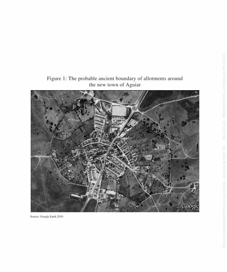
Figure 1: The probable ancient boundary of allotments around the new town of Aguiar
Figure 1: The probable ancient boundary of allotments around the
new town of Aguiar.
The case of Portugal is particularly interesting since historians have accepted the
existence of agrarian colonization on the fringes of medieval Europe but not in
the ancient monarchies. Thus French historian Higouent (1989) noted the
herringbone-shaped plots of land in eastern Germany connected to the
Ostsiedlung, but took no note of the planned shapes of the cultivated lands
around the Gascon fortified towns, despite studying them throughout his
career. 24 The idea underlying this exclusion is that radically new forms of
agrarian colonization can only concern later cultivated lands and not ancient
ones. Portugal, which should thus be the flagship for research into planned
layouts, is no such thing. Despite being on the fringes of medieval Europe and in
24 Nevertheless, Higounet (1990) has identified similar land parcels in the Paris Basin, though these
examples are connected to specific clearings).
Source: Google Earth 2010
Doc
umen
t dow
nloa
ded
from
ww
w.c
airn
-int.i
nfo
- U
nive
rsité
de
Par
is X
IV -
-
90.2
.222
.143
- 0
8/09
/201
5 15
h51.
© E
ditio
ns d
e l?
E.H
.E.S
.S. D
ocument dow
nloaded from w
ww
.cairn-int.info - Université de P
aris XIV
- - 90.2.222.143 - 08/09/2015 15h51. © E
ditions de l?E.H
.E.S
.S.
Medieval Agrarian Colonization in Alentejo (Portugal)
. . .XIIIcountry. With historical research lagging in
terms of the analysis of agrarian morphologies, the scheme that prevails for Eastern Europe is therefore not valid in Portugal.
Another question emerges in relation to the interpretation of historical shapes. Why, when looking for regular shapes, are they immedi-ately attributed to the Roman Empire, when it is zones of medieval colonization that are under examination? The centralizing power of this empire is often considered the only one to have been capable of creating such endur-ing transformation of the landscape. This also explains why the history of land in Portugal is dominated by the latifundium, in effect, a way of recalling its Romanization, when it was a power of sorts. Moreover, under the Salazar dictatorship, the ancient latifundium served as a propaganda tool (excavating a large villa was good for the image of bountiful fields, in connection with wheat-growing campaigns). In contrast, it has long been believed that during the Middle Ages the capacity to implement real agrarian planning did not exist: the medieval model appeared to be the perfect counter-ex-ample to the Roman model, taking into account the crumbling of government and the profound intricacy of bureaucracy. Thus, even the cele-brated medievalist Marc Bloch ([1931]1999) failed to mention medieval planning in his chapter on “the great clearances,” even though he was aware of the study of cadastral surveys.
The rather gloomy scene we have just painted may be tempered by the fact that research into this subject has made a great deal of progress since the 1990s. We may mention first of all the agrarian archeology conducted by Barceló (1989) into the irrigated lands of Andalucia, who put forward the notion of “diseño” (“design”) to refer to the planned layout shown
by several Islamic irrigation systems. Though this Catalan scholar establishes the notion of agrarian planning for the medieval period, it is planning connected to irrigation and associated with Islam, and thus relates to a period prior to the Christian Reconquista. With respect to later planning and configurations, independent of irrigated systems, the first impetus came from Chouquer (1981–1982 and 1985), who in 1981 discovered three medieval outlines in Emilia-Romagna, Italy, and subsequently invited medievalists to apply the methods used by researchers of Roman centuriations to the study of medieval villages. This approach gave rise to Lavigne’s (2002) hypothesis on agrarian plan-ning in medieval Gascony,25 the first to model this new research subject from the point of view of its morphology and metrology and according to an archeogeographical approach, combining planimetric mapping and written sources. Our intention here is to continue this work.
To date, the controversy surrounding this published work led many researchers to aban-don the subject.26 Our view is that before
25. Chouquer’s intuition was also followed by González Villaescusa in Spain (1996 and 2002) and by Abbé (1996). We note however that Abbé’s results are very different from Lavigne’s.
26. Upon publication of the study, two types of crit-ics emerged: the authors of favorable accounts (Jean- Jacques Schwien, Samuel Leturcq, Valérie Bauchet, David Bryson), who nevertheless took various points to task, and whose criticisms were all the more acceptable since they were not based on a priori assumptions; and the authors of controversial accounts (Elisabeth Zadora-Rio and Mireille Mousnier), who asserted that nothing deserved to be retained, further saying that Lavigne had falsified the measurements. Thus, Zadora-Rio (2003), in three reviews, rejected his discoveries and questioned his entire methodology (This however is not the place to consider these criticisms in detail.)
Doc
umen
t dow
nloa
ded
from
ww
w.c
airn
-int.i
nfo
- U
nive
rsité
de
Par
is X
IV -
-
90.2
.222
.143
- 0
8/09
/201
5 15
h51.
© E
ditio
ns d
e l?
E.H
.E.S
.S. D
ocument dow
nloaded from w
ww
.cairn-int.info - Université de P
aris XIV
- - 90.2.222.143 - 08/09/2015 15h51. © E
ditions de l?E.H
.E.S
.S.
Magali Watteaux
. . .XIV making use of Lavigne’s work, we must
inquire into the basis for criticism of it. In this respect, as rightly pointed out by Jean-Jacques Schwien in his account, it proves difficult to reconstruct the method used during the spe-cific era for land division and metrology, when we must rely on the Napoleonic cadastral sur-veys, which inevitably recorded subsequent changes that occurred after the thirteenth and fourteenth centuries. This reservation does not call into question the idea that the regularity of these divisions date back to the Middle Ages, but simply emphasizes a finer point, namely that the transformation of these plots of land does not prevent the recording of reliable mor-phological and metrological information.
Lavigne worked according to the rules of morphology: identifying and modeling the intermediate outlines in medieval land divi-sion; relating the framework to the medieval territories; identifying a coherent and orig-inal metrological system based on the sys-tematic use of three commensurate modules. However—and this is a valid criticism—he did not conduct an archeology of knowl-edge of medieval studies in matters of plan-ning, which would have made the need for new and better-founded proposals even more urgent.
Wanting to move forward on these issues and avoid the type of situation in which, fol-lowing a major discovery, it is preferable to play for time while waiting for the furor to subside, we sought to obtain a scientific eval-uation of the metrological analysis undertaken by Lavigne. This evaluation was carried out by Ghiath Monnet,27 who was good enough to dissect the series of figures used by Lavigne, in order to test their coherence and thus assess the validity of the results strictly arithmetically.
Monnet determined that arithmetical logic does confirm Lavigne’s results. This is not a logic to which we can say whatever we want. In fact, the relationships found between the dif-ferent measurements of length are either whole numbers or simple ratios (that is, a whole number divided by a whole number), which indicates a strong correlation. If these meas-urements showed no correlation, these simple ratios—that is, relationships between low inte-gers—would not be present.28 The ratios cited by Lavigne (2002, 88) are extremely simple (3/2; 2; 3; 4). In addition, if we take half of the three fundamental units that he identified (16.41 meters, 21.09 meters, 37.5 meters), the correlation becomes a simple multiplication (by factor 3, 4, 6, or 8), something that cannot be the outcome of chance or purely arithmeti-cal manipulation. Moreover, there is a larger common denominator to these new fundamen-tal units (those obtained after dividing by 2), which is close to 2 (on average 2.08 meters). This result is strikingly similar to the standard unit of measurement known as the rod, used by surveyors, and which medieval texts allow us to estimate at 2.343 meters in length.
Moving from the evaluation of the metro-logical series presented by Lavigne to their appearance in the Napoleonic cadastral survey, we note that this cadastral survey, dating from some five centuries later than the planned divi-sion of land as claimed, can only have recorded the effects of social change that will inevitably have changed the details of lot boundaries. Yet today, nothing prevents us from recognizing
27. Whose invaluable assistance we acknowledge.
28. The stronger the correlation between the numbers, the smaller the integers are in relation to the initial numbers.
Doc
umen
t dow
nloa
ded
from
ww
w.c
airn
-int.i
nfo
- U
nive
rsité
de
Par
is X
IV -
-
90.2
.222
.143
- 0
8/09
/201
5 15
h51.
© E
ditio
ns d
e l?
E.H
.E.S
.S. D
ocument dow
nloaded from w
ww
.cairn-int.info - Université de P
aris XIV
- - 90.2.222.143 - 08/09/2015 15h51. © E
ditions de l?E.H
.E.S
.S.
Medieval Agrarian Colonization in Alentejo (Portugal)
. . .XVthe effects of this “transformission”29 nor
from acknowledging that a planned initiative can become reified over the long term. This is demonstrated by the reports from Veneto and Emilio-Romagna, which reveal how Roman centuriations were extensively taken up in later periods (Brigand 2010).
It therefore seems possible for us to address the point under debate in a non-controversial manner. As several authors have anticipated, what we read in the Napoleonic cadastral sur-vey cannot be regarded as wholly “medieval.” Rather we are reading the product of a gradual materialization of a plan that was marked out on the ground by the surveyor but implemented in the long term by generations of farmers. Thus we cannot deny Lavigne a process that we are happy to accept with respect to 2000-year-old centuriations of Emilio-Romagna and Veneto. However, it should be noted that Lavigne pro-poses a modeling of the transmission effect in fairly novel terms, with disturbing results. Regardless, in either case, the argument for the planned plotting of land comes out stronger.
We must therefore look elsewhere; metrol-ogy appears to be the most serious obstacle to the acknowledgement of surveyed agricultural planning in the Middle Ages, because it upsets a deeply-rooted but mistaken belief that medi-eval societies were no match for the Romans’ use of right angles and measuring in agrar-ian land division. Yet the agrarian metrology originally observed in medieval foundations becomes a strong argument in favor of sur-veyed planning.
One final point is worth noting. Returning to the subject recently, Elisabeth Zadora-Rio (2010) wrote that Lavigne and Chouquer have rejected any form of planning that refers to
collective management of agrarian practices (such as the “collective constraints” of the open field system) and only consider forms that involve surveying. In noting that nei-ther of the two have written anything of the sort, we will pose the inverse question, ask-ing why certain medievalists refuse to admit that in the Middle Ages planned, geomet-ric shapes could have been implemented by surveyors.
Subsequently, other studies have validated these first results (González Villaescusa 1996 and 2002; Brigand 2010). In all European countries, the characteristic morphology of these arrangements displays a series of paral-lel lines, whether curved or straight, organized into sections, without necessarily covering all the communal lands of a village or town. To this is added the use of a system of measure-ment. These shapes adapt in a flexible manner to the local landforms and hydrography, and in many cases are the hallmark of medieval planning.30 As a result, they are often the first clue available. There can be no question that, starting in the twelfth and thirteenth centu-ries, the Middle Ages saw the inception of an agrarian planning system that represented a
29. This is a term coined by Gérard Chouquer to describe the double action of the “transformation” of geographic realities and the “transmission” of certain features of these realities, the whole granting an impression of an enduring form.
30. It is important to recall that this strip shape of fields is not unique to the medieval period. It is also to be found in the Bronze Age and classical Antiquity. It is a com-fortable solution to the problem of agrarian allocation of land. In the Middle Ages, it became the preferred tool of agrarian colonization because it adapted easily to topo-graphical details and local conditions.
Doc
umen
t dow
nloa
ded
from
ww
w.c
airn
-int.i
nfo
- U
nive
rsité
de
Par
is X
IV -
-
90.2
.222
.143
- 0
8/09
/201
5 15
h51.
© E
ditio
ns d
e l?
E.H
.E.S
.S. D
ocument dow
nloaded from w
ww
.cairn-int.info - Université de P
aris XIV
- - 90.2.222.143 - 08/09/2015 15h51. © E
ditions de l?E.H
.E.S
.S.
Magali Watteaux
. . .XVI partial rupture with ancient forms.31 The case
of Portugal provides supplementary evidence for the argument.
The Archeogeographical Avenue: Diverse Planimetric Mapping Legacies
Archeogeographical research brings us to the great variety of outlines that are the result of multiple legacies. Unlike historically framed analysis, morphological analysis cannot be confined to a single period of history. Linking a particular shape to a particular period would exclude from the study transmission of outlines or the breaks that might occur with respect to earlier structures. The work of the archeogeog-rapher here is to identify the various planned patterns on a given area of land and to pick out those that might be linked to the historical process under study, in this case the Christian Reconquista. If we do not exclude supposed earlier forms or those treated as such, neither will we exclude their development simply because our documentation is contemporary.
For each of the major historical periods, we now possess a fairly solid morphological sub-ject. Maps of the Portuguese Iron Age are start-ing to emerge thanks to the work of Lavigne (2006), in relation to the area around Beja, and to the work of Chouquer (2010b), relating to the site of Outeiro do Circo, a major oppidum (for-tified settlement) from the end of the Bronze Age. This research, still in its infancy, must yet pass through a stage of mapping index fossils, even those not protohistorical. The material is there and is waiting to be worked on.
With respect to Antiquity, the subject has long been dominated by the false discovery of a centuriation in the ancient city of Beja, by the archeologist Mantas (1996), who hypothesized
the presence of a centuriation around Pax Iulia and claimed to have identified the grid pattern of two networks. Lavigne (2006, 32–35), how-ever, attacked this claim, questioning Mantas’s methods. Thus, much rests on the planimetric mapping of ancient sites, better researched elsewhere than at a currently invisible centuria-tion in the Beja region. A good example of this is the archeogeographical work being carried out at the University of Coimbra (Costa 2010).
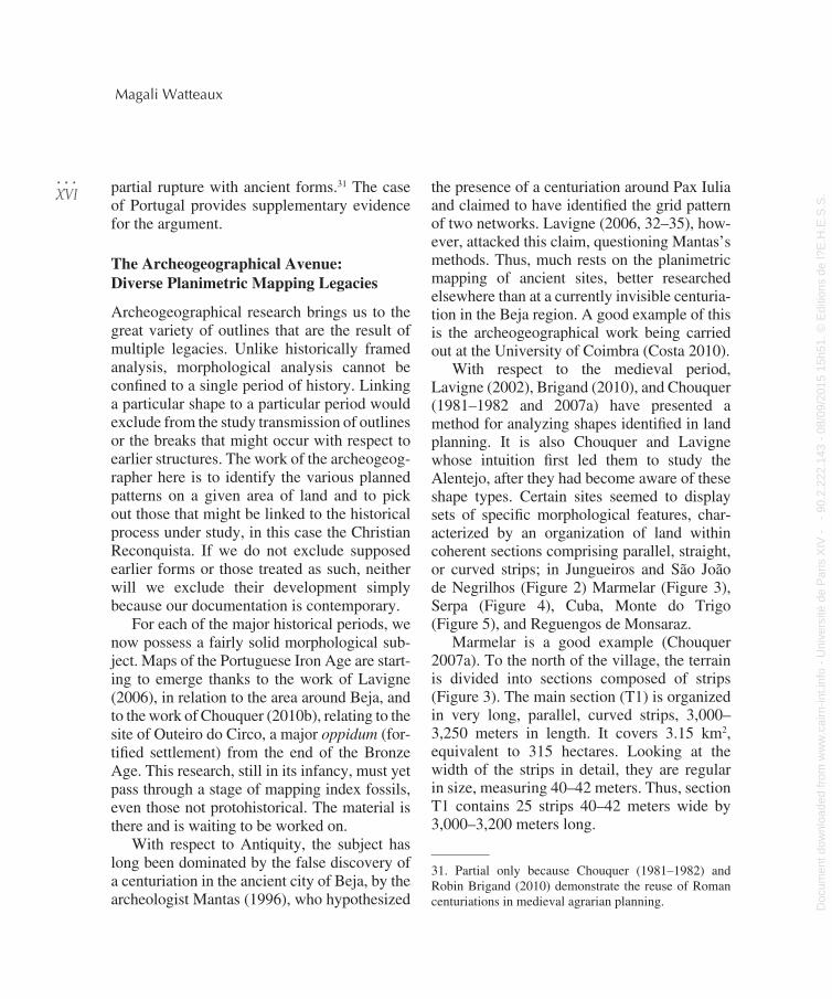
With respect to the medieval period, Lavigne (2002), Brigand (2010), and Chouquer (1981–1982 and 2007a) have presented a method for analyzing shapes identified in land planning. It is also Chouquer and Lavigne whose intuition first led them to study the Alentejo, after they had become aware of these shape types. Certain sites seemed to display sets of specific morphological features, char-acterized by an organization of land within coherent sections comprising parallel, straight, or curved strips; in Jungueiros and São João de Negrilhos (Figure 2) Marmelar (Figure 3), Serpa (Figure 4), Cuba, Monte do Trigo (Figure 5), and Reguengos de Monsaraz.
Marmelar is a good example (Chouquer 2007a). To the north of the village, the terrain is divided into sections composed of strips (Figure 3). The main section (T1) is organized in very long, parallel, curved strips, 3,000–3,250 meters in length. It covers 3.15 km2, equivalent to 315 hectares. Looking at the width of the strips in detail, they are regular in size, measuring 40–42 meters. Thus, section T1 contains 25 strips 40–42 meters wide by 3,000–3,200 meters long.
31. Partial only because Chouquer (1981–1982) and Robin Brigand (2010) demonstrate the reuse of Roman centuriations in medieval agrarian planning.
Doc
umen
t dow
nloa
ded
from
ww
w.c
airn
-int.i
nfo
- U
nive
rsité
de
Par
is X
IV -
-
90.2
.222
.143
- 0
8/09
/201
5 15
h51.
© E
ditio
ns d
e l?
E.H
.E.S
.S. D
ocument dow
nloaded from w
ww
.cairn-int.info - Université de P
aris XIV
- - 90.2.222.143 - 08/09/2015 15h51. © E
ditions de l?E.H
.E.S
.S.
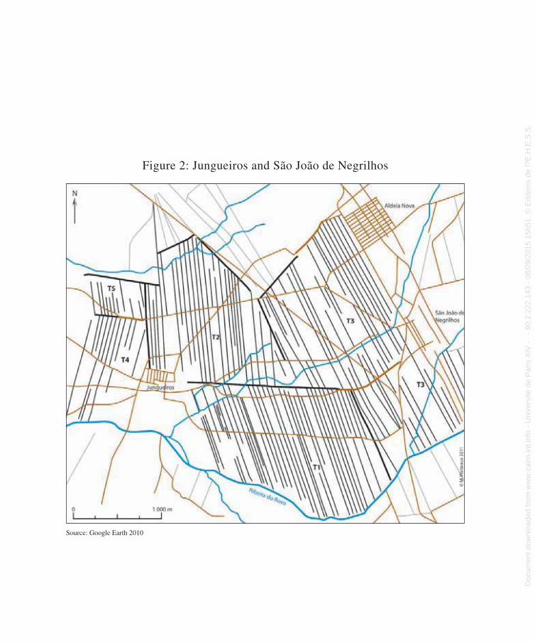
Figure 2: Jungueiros and São João de Negrilhos
parallel, straight, or curved strips; in Jungueiros and São João de Negrilhos
(Figure 2) Marmelar (Figure 3), Serpa (Figure 4), Cuba, Monte do Trigo (Figure
5), and Reguengos de Monsaraz.
Marmelar is a good example (Chouquer 2007a). To the north of the village, the
terrain is divided into sections composed of strips (Figure 3). The main section
(T1) is organized in very long, parallel, curved strips, 3,000–3,250 meters in
length. It covers 3.15 km2, equivalent to 315 hectares. Looking at the width of the
strips in detail, they are regular in size, measuring 40–42 meters. Thus, section
T1 contains 25 strips 40–42 meters wide by 3,000–3,200 meters long.
Figure 2: Jungueiros and São João de Negrilhos
Source: Google Earth 2010
D
ocum
ent d
ownl
oade
d fr
om w
ww
.cai
rn-in
t.inf
o -
Uni
vers
ité d
e P
aris
XIV
-
- 90
.2.2
22.1
43 -
08/
09/2
015
15h5
1. ©
Edi
tions
de
l?E
.H.E
.S.S
. Docum
ent downloaded from
ww
w.cairn-int.info - U
niversité de Paris X
IV - - 90.2.222.143 - 08/09/2015 15h51. ©
Editions de l?E
.H.E
.S.S
.
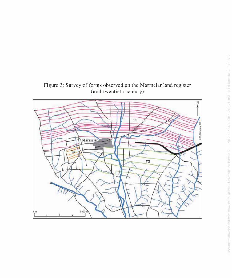
Figure 3: Survey of forms observed on the Marmelar land register (mid-twentieth century)
Figure 3: Survey of forms observed on the Marmelar land register
(mid-twentieth century)
D
ocum
ent d
ownl
oade
d fr
om w
ww
.cai
rn-in
t.inf
o -
Uni
vers
ité d
e P
aris
XIV
-
- 90
.2.2
22.1
43 -
08/
09/2
015
15h5
1. ©
Edi
tions
de
l?E
.H.E
.S.S
. Docum
ent downloaded from
ww
w.cairn-int.info - U
niversité de Paris X
IV - - 90.2.222.143 - 08/09/2015 15h51. ©
Editions de l?E
.H.E
.S.S
.
Figure 4: Curvilinear strips around Serpa
Figure 4: Curvilinear strips around Serpa
Source: Google Earth 2010
D
ocum
ent d
ownl
oade
d fr
om w
ww
.cai
rn-in
t.inf
o -
Uni
vers
ité d
e P
aris
XIV
-
- 90
.2.2
22.1
43 -
08/
09/2
015
15h5
1. ©
Edi
tions
de
l?E
.H.E
.S.S
. Docum
ent downloaded from
ww
w.cairn-int.info - U
niversité de Paris X
IV - - 90.2.222.143 - 08/09/2015 15h51. ©
Editions de l?E
.H.E
.S.S
.
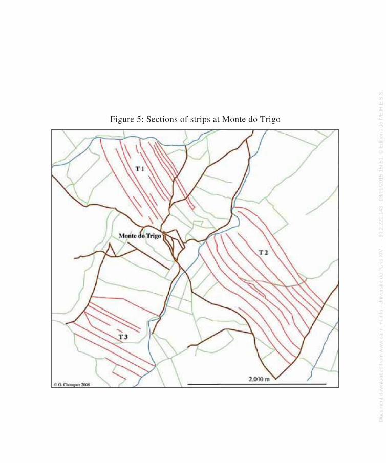
Figure 5: Sections of strips at Monte do Trigo
Figure 5: Sections of strips at Monte do Trigo
Doc
umen
t dow
nloa
ded
from
ww
w.c
airn
-int.i
nfo
- U
nive
rsité
de
Par
is X
IV -
-
90.2
.222
.143
- 0
8/09
/201
5 15
h51.
© E
ditio
ns d
e l?
E.H
.E.S
.S. D
ocument dow
nloaded from w
ww
.cairn-int.info - Université de P
aris XIV
- - 90.2.222.143 - 08/09/2015 15h51. © E
ditions de l?E.H
.E.S
.S.
Medieval Agrarian Colonization in Alentejo (Portugal)
. . .XXIEach strip would have an area of about
12.5 hectares, which is closer to an intermedi-ate unit of size than an actual plot of land for cultivation. Section T2, measuring around 100 hectares, with fairly indistinct boundaries, and a very small section T3, complete the division. In section T2, the few clearly distinguishable strips measure between 12 and 16 hectares, close to the size of the very elongated strips in T1. Altogether, 320 hectares were system-atically divided into long strips. In the field, we can identify one boundary or the other by mentally calculating on the basis of plani-metric mapping documentation. These esti-mates are simple observations made on the basis of the current state of the lots and thus do not represent historical information. It is necessary to have points of comparison and medieval documents available. In addition, the unit formed by the strip may be a survey-ing unit. Chouquer considers it farfetched to see it as a unit of allocation. Yet the overall shape is fairly explicit in relation to known models—as is the grid pattern of the village, recalling the checkerboard pattern of the new towns. This allows us to put forward the rea-sonable hypothesis of agrarian planning that is medieval or of medieval origin if we want to account for the evident changes in the plots of land.
Dating particular regular and standardized shapes to the Middle Ages is at the heart of the issue.32 Some believe that it is the weak point of morphological study, one that has never been demonstrated. Such reticence may be found in, at best, a certain circumspection with regard to morphology or, at worst, a denial and relegation of this type of analysis to the rank of the outmoded, descriptive geography of yes-teryear (Chouquer 2009).
For many researchers, morphological data needs to be validated in the field, which creates a hierarchy between archeology and morphology. Though there is no question here of calling into question the scientific oversight of morphology, it is worth debating the prevailing conditions, to move away from this hierarchical deference towards archeology (Chouquer 2007b).
The texts do not focus long on the issue of surveying and the specific distribution of lands to colonists. This is sometimes taken as repu-diation of the possibility of planned field lay-outs in the Middle Ages, and confining them to the modern period. Yet this creates a paradox: although texts on the modern period are more numerous, they too do not refer to surveying. Why therefore deny to the Middle Ages what we are happy to accept for the modern period? Likewise, those who consider medieval origins to be too early and thus too uncertain do not question the presence of Roman centuriations on planimetric site maps. Why is transmission over five centuries (fourteenth to nineteenth) an implicit error, while transmission spanning 20 to 22 centuries is evidence? In addition, despite tenuous textual evidence, the Roman centuriations are accepted unanimously. Dating some instances of agrarian land plan-ning to the Middle Ages can thus only proceed on the basis of the accumulation of evidence, not as a mechanical demonstration supported by texts and archeological data, which will never be sufficient.33
32. Beginning in the thirteenth century in Alentejo, tak-ing account of the chronology of the Reonquista in the area under study.
33. The same problem arises in relation to the dating of traces of roads.
Doc
umen
t dow
nloa
ded
from
ww
w.c
airn
-int.i
nfo
- U
nive
rsité
de
Par
is X
IV -
-
90.2
.222
.143
- 0
8/09
/201
5 15
h51.
© E
ditio
ns d
e l?
E.H
.E.S
.S. D
ocument dow
nloaded from w
ww
.cairn-int.info - Université de P
aris XIV
- - 90.2.222.143 - 08/09/2015 15h51. © E
ditions de l?E.H
.E.S
.S.
Magali Watteaux
. . .XXII Thus, even in the best-documented cases,
such as that of Villafranca di Verona in Veneto, studied by Robin Brigand to sup-port his theory and cited in his contribution to this issue of Études rurales, we can only gather evidence. Here, we encounter the same organized sections as those brought to light in Gascony by Lavigne. We observe a close correlation between the strips of cultivated land and the topography and hydrography; the context is one of agricultural land improve-ment; and we have the charter for the founda-tion of the new settlement dating from 1185. Brigand concludes that there are sections of medieval origin linked to Villafranca’s foun-dation, either contemporaneous or from not long after.34 The same line of reasoning has led González Villaescusa (1996, 161) to propose that the strip fields observed in Moixen, in Pla des Alcuses, date from the Middle Ages. Here, again, why should modern origins be assumed when no textual evidence from this period sup-ports this and there are arguments in favor of a medieval origin?
The argument, frequently invoked, that the change in these shapes invalidates any interpre-tation, while admissible, should not be treated as the last word on the matter. To understand why, we need only return to the special treat-ment assigned to the centuriations: these too change over time to a greater or lesser extent as they are handed down, yet no one would suggest that the regular shapes observed are not Roman or of Roman origin.35 Villafranca is a perfect illustration of this: this centuriation was not only preserved but was also revital-ized by medieval land planning. This does not mean either that the centuriation is a figment of the imagination or that it is solely medieval in origin. Underlying the argument outlined
above is that the shapes are either definitively created in a given period, or they change and therefore become unrecognizable compared to their original shape. Nevertheless the plani-metric maps are full of relevant forms from different periods, and these do not obliterate the earlier forms. How could we otherwise explain the regular shapes observed if they are not intentional, and thus relate to a par-ticular period? With this argument, we con-front an insurmountable paradox, even when the initial question is legitimate. In addition, the origin and evolution of the forms are not mutually exclusive. To return to the example of Villafranca, we see that the later (medieval) periods can help to fix the earlier forms (such as the centuriation).
Turning to the Lower Alentejo, we can likely date the extensive concentric shapes that surround Beja to the Middle Ages. For Lavigne (2006, 38–41), this shape comes from the connection between a vast network of radial roads leaving the town and envelopes of roads and land lots articulated according to the topography and hydrography (Figure 6). The radial network is the result of the nodal importance of the town since ancient times, combined with the layout of the hydrographic network, which radiates in all directions from
34. A conclusion taken up by Zadora-Rio (2011) in a recent article even though she rejected the dating pro-posed by Lavigne for the regular shapes in Gascony based on the same arguments.
35. Except Alain Ferdière (2008, §59), who asserts that Carlotta Franceschelli and Stefano Marabino showed that the centuriations in Emilio-Romagna date from the end of the Middle Ages. He does deny, however, that there could have been centuriations elsewhere, in Roman colonial territories (2008, §60).
Doc
umen
t dow
nloa
ded
from
ww
w.c
airn
-int.i
nfo
- U
nive
rsité
de
Par
is X
IV -
-
90.2
.222
.143
- 0
8/09
/201
5 15
h51.
© E
ditio
ns d
e l?
E.H
.E.S
.S. D
ocument dow
nloaded from w
ww
.cairn-int.info - Université de P
aris XIV
- - 90.2.222.143 - 08/09/2015 15h51. © E
ditions de l?E.H
.E.S
.S.
Medieval Agrarian Colonization in Alentejo (Portugal)
. . .XXIIIthe high point where Beja is sited. It is thus a
physical and social hybrid shape that has been built up over a very long period. Lavigne has hypothesized an extensive network that takes advantage of the sloping terrain to channel and distribute runoff water to all the land lots sited along the principal axis. On the basis of this morphology, he suggests this network dates to the end of the Middle Ages and beginning of the modern period.
The study of the site by the geographer Ribeiro (1970, 213) reveals that three of these concentric boundaries that are particularly distinct, located west and south of the town, appear to be ancient sesmos boundaries, mark-ing enclosures around settlements, as in Beja (Figure 7). We can identify similar significant concentric boundaries around Evora, the capi-tal of Upper Alentejo. This might also explain the specific outline of the curving strips around the ancient citadel of Serpa, which recall the boundaries of former sesmos (Figure 4). This series of discoveries enables us to expand the typology of medieval land planning with a new category, adding concentric strips to the straight and curved parallel strips already identified.
It is worth noting that González Villaescusa (1996, 163–165) has identified large groups of fairly similar concentric boundaries on the bor-der of Castile and Catalonia, although there are fewer parallel strips and a more radial layout with a number of significant concentric bound-aries at one end. He seeks to link this discovery to the history of the region between the ninth and thirteenth centuries, meaning these forms would be located in the oldest of the territories reclaimed from the Arabs. He also associates this morphological evolution to the twin pro-cesses of incastellamento and ensagrerament.
Let us conclude this review with modern and contemporary forms. Chouquer (2010c) made an astonishing discovery on Google Earth: vast, highly regular grid patterns like those in the extensive common lands left fal-low (baldio) of Serpa, known as Serra Grande de Serpa.36
What Chouquer observed was an extensive, squared grid based on a division of the baldio that began in 1906–1907, following a cam-paign of agricultural modernization. It is a rare example in Europe of such an extensive grid pattern (measuring 35 kilometers from east to west at its widest point). Previously, the baldio was a vast area of charneca, measuring some 40,000 hectares in size, given over to grazing, olive groves, and bee hives. The aim of the project was to establish 5,464 lots measuring six hectares each (a total of 32,784 hectares), which explains why this division generally ignores the topography save for the occasional steep-sided valley (montes). The routes taken by the roads in the area are completely inde-pendent of this vast grid. What is surprising about this example is the adoption of a uniform means of dividing up the land across such a huge area, in a region where there is no indica-tion of any other grid pattern of the kind. This decision thus suggests no historical continuity but rather the conscious imitation of models being used in the New World at the outset of the twentieth century, such as the US survey townships.
Finally, for a long period including the Middle Ages and the modern age, we may
36. Roxo (1994) also indicates the section of Serra de Serpa in publishing the surveying arrangements of the topographer Manuel Fracisco Veiga.
Doc
umen
t dow
nloa
ded
from
ww
w.c
airn
-int.i
nfo
- U
nive
rsité
de
Par
is X
IV -
-
90.2
.222
.143
- 0
8/09
/201
5 15
h51.
© E
ditio
ns d
e l?
E.H
.E.S
.S. D
ocument dow
nloaded from w
ww
.cairn-int.info - Université de P
aris XIV
- - 90.2.222.143 - 08/09/2015 15h51. © E
ditions de l?E.H
.E.S
.S.
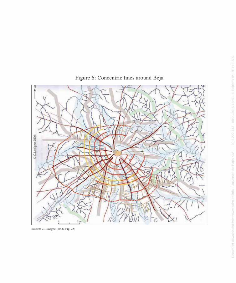
Figure 6: Concentric lines around Beja
Source: C. Lavigne (2006, Fig. 25)
patterns like those in the extensive common lands left fallow (baldio) of Serpa,
known as Serra Grande de Serpa.36
Figure 6: Concentric lines around Beja
Source: C. Lavigne (2006, Fig. 25)
36 Roxo (1994) also indicates the section of Serra de Serpa in publishing the surveying arrangements of the
topographer Manuel Fracisco Veiga.
Doc
umen
t dow
nloa
ded
from
ww
w.c
airn
-int.i
nfo
- U
nive
rsité
de
Par
is X
IV -
-
90.2
.222
.143
- 0
8/09
/201
5 15
h51.
© E
ditio
ns d
e l?
E.H
.E.S
.S. D
ocument dow
nloaded from w
ww
.cairn-int.info - Université de P
aris XIV
- - 90.2.222.143 - 08/09/2015 15h51. © E
ditions de l?E.H
.E.S
.S.
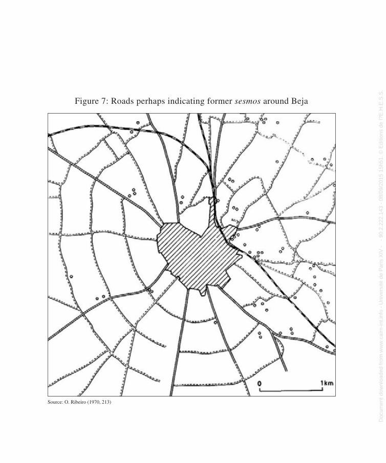
Figure 7: Roads perhaps indicating former sesmos around Beja
Source: O. Ribeiro (1970, 213)
Figure 7: Roads perhaps indicating former sesmos around Beja
Source: O. Ribeiro (1970, 213)
Doc
umen
t dow
nloa
ded
from
ww
w.c
airn
-int.i
nfo
- U
nive
rsité
de
Par
is X
IV -
-
90.2
.222
.143
- 0
8/09
/201
5 15
h51.
© E
ditio
ns d
e l?
E.H
.E.S
.S. D
ocument dow
nloaded from w
ww
.cairn-int.info - Université de P
aris XIV
- - 90.2.222.143 - 08/09/2015 15h51. © E
ditions de l?E.H
.E.S
.S.
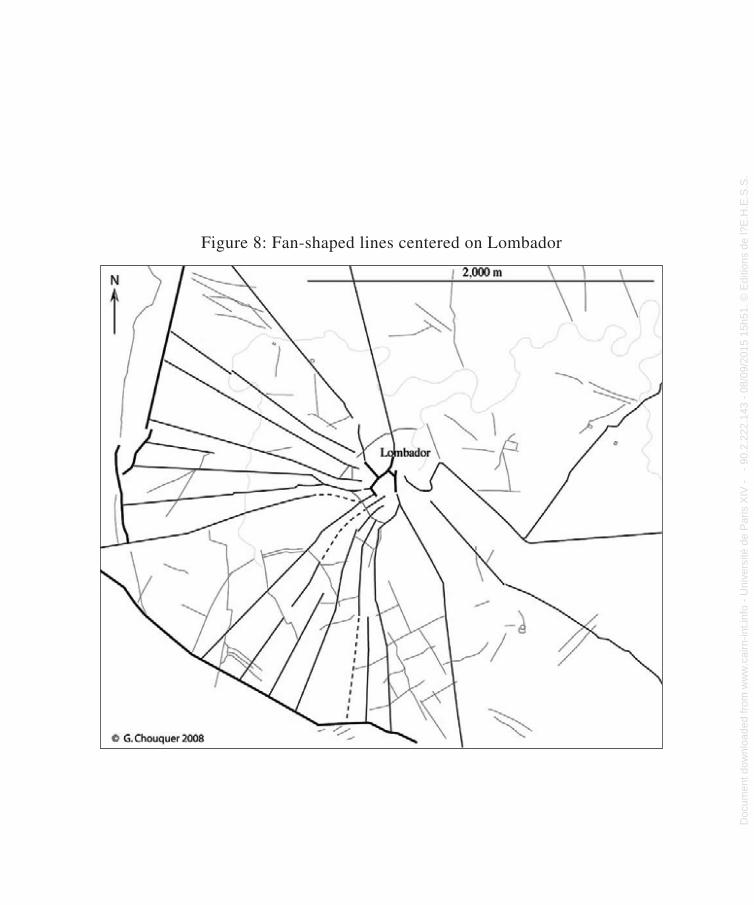
Figure 8: Fan-shaped lines centered on Lombador
Figure 8: Fan-shaped lines centered on Lombador
Doc
umen
t dow
nloa
ded
from
ww
w.c
airn
-int.i
nfo
- U
nive
rsité
de
Par
is X
IV -
-
90.2
.222
.143
- 0
8/09
/201
5 15
h51.
© E
ditio
ns d
e l?
E.H
.E.S
.S. D
ocument dow
nloaded from w
ww
.cairn-int.info - Université de P
aris XIV
- - 90.2.222.143 - 08/09/2015 15h51. © E
ditions de l?E.H
.E.S
.S.
Medieval Agrarian Colonization in Alentejo (Portugal)
. . .XXVIIidentify “fan-shaped” forms present in the
south of the sector under study, above all in the serras of the southern Alentejo region and the Algarve, whose steep slopes create a substantial barrier. The soils in this region are poor. These forms always take a roughly similar shape, with some variations related to the amplitude of the fan and its position in relation to the settlement. They are almost exclusively connected to either montes or small villages. For example, the farmed land around Lombador (Figure 8) is marked by a radial network covering a 180-degree arc that fans out from the village. These bands gen-erate only a limited number of defined plots of land, which are juxtaposed with plots from prior models (prominences, terraces, wooded strips), which for the most part are discordant. These are not, therefore, large groups of con-centric forms like those identified by González Villaescusa (1996, 163–164) between Castile and Catalonia, structured by a significant radial road network and relatively important settlements. Though these strips do not rad-ically reorganize the layout of land parcels, they are most likely intermediate units for colonists to subdivide and adapt according to their needs.
The recurrence of this particular morpho-logical arrangement in a precise area raises the question of its connection to a particu-lar phase of the history of land occupation. Unfortunately the available texts offer no answer to this. Dating the settlements linked by these shapes would certainly help to resolve the issue, taking their close relation to the shapes into account—the fans cannot be any older than they are. The colonization of such marginal areas might suggest they were brought under cultivation more recently,
in the modern epoch, as has been observed elsewhere in Europe. Nevertheless—and to remove all doubt—if these shapes (not all of them) probably date to the modern period, this does not imply that the land was not previously occupied, something that is demonstrated by the existence of prior, discordant outlines. It is simply a matter of observing that from a morphological point of view these fan-shaped groups appear to be linked to the period run-ning from the Middle Ages to the modern age.
Conclusion
This subject deserves further investigation but, for now, the research into the Lower Alentejo already provides valuable information on the medieval and modern agrarian morphology of the region; and on agrarian morphology in general.
The matter of medieval agrarian coloni-zation is partly resolved in the identification of patterns until recently unknown. The dual historical and archeogeographical avenues of research are particularly effective. The histor-ical identifies the phenomenon but still fails to describe it accurately from a legal point of view, and it omits the morphological dimen-sion. The archeogeographical is interesting, but needs to go through a quasi-global typology of land parcels. The encounter between these two intellectual itineraries—the classic intersection of history and geography in light of archeo-geographical deconstruction—has us on firmer ground with respect to a little known aspect of medieval agrarian colonization that gradually emerged at the end of the twentieth century: medieval, surveyed, agricultural planning.
Not long ago, the Lower Alentejo was described solely in terms of its Roman colony,
Doc
umen
t dow
nloa
ded
from
ww
w.c
airn
-int.i
nfo
- U
nive
rsité
de
Par
is X
IV -
-
90.2
.222
.143
- 0
8/09
/201
5 15
h51.
© E
ditio
ns d
e l?
E.H
.E.S
.S. D
ocument dow
nloaded from w
ww
.cairn-int.info - Université de P
aris XIV
- - 90.2.222.143 - 08/09/2015 15h51. © E
ditions de l?E.H
.E.S
.S.
Magali Watteaux
. . .XXVIII Pax Iulia, its centuriation, and its latifun-
dia. Since however, the notion of centuria-tion has wholly disappeared; the archeology of Beja has evolved into an “archeology of the towns of Beja,” placing greater empha-sis on transmission, as shown by the current
work at Maria da Conceçãio Lopes; and the great number of agrarian forms occupying the region that date from the Iron Age, the Middle Ages, and the modern period oblige us to reconsider the terms of reference of local history.
Bibliography
Abbé, Jean-Loup. 1996, “Permanences et muta-tions des parcellaires médiévaux.” In Les formes du paysage. T. II: Archéologie des parcellaires. Actes du colloque d’Orléans (March), edited by Gérard Chouquer, 223–233. Paris: Errance.Ballesteros, Arias P., Jorge Eiroa, Margarita Fernández Mier, Helena Kirchner, Julián Ortega Ortega, Juan Antonio Quirós Castillo, Felix Retamero, Eugenia Sitjes, Josep Torró, and Alfonso Vigil-Escalera Guirado. 2010. “Por una arqueología agraria de las sociedades medievales hispánicas. Propuesta de un protocolo de investigación.” In Por una arqueología agraria. Perspectivas de investigación sobre espacios de cultivo en las sociedades medievales hispáni-cas, edited by Helena Kirchner 185–202. Oxford: Archeopress, BAR International Series 2062.Barata, Felipe Themudo. 2004. “Medieval cadastres in the surroundings of Evora.” In De la terre au ciel. II: Paysages et cadastres antiques, edited by Monique Clavel-Lévêque, and Georges Tirologos, 157–169. Besançon, France: Presses universitaires de Franche-Comté.Barceló, Miquel. 1989. “El diseño de espacios irriga-dos en al-Andalus: un enunciado de principios gener-ales.” In I Coloquio de Historia y Medio Fisico, xv–1. Almeria, Spain: Instituto de estudios almerienses.Bloch, Marc. 1999 (1931). Les caractères originaux de l’histoire rurale française. Paris: Armand Colin.Boissellier, Stéphane. 1999. Naissance d’une iden-tité portugaise. La vie rurale entre Tage et Guadiana de l’Islam à la Reconquête (Xe–XIVe siècle). Lisbon: Impresa nacional, Casa da Moeda.
———. 2003. Le peuplement médiéval dans le sud du Portugal. Constitution et fonctionnement d’un réseau d’habitats et de territoires (XIIe–XVe siècle). Paris: Fundação Galouste Gulbenkian.Brigand, Robin. 2010. “Centuriations romaines et dynamique des parcellaires. Une approche dia-chronique des formes rurales et urbaines de la plaine centrale de Venise (Italie).” PhD dissertation, Université de Franche-Comté, Besançon, France.Buscail, Marie-Pierre. 2011. “Archéogéographie du domaine royal en Gâtinais d’après la prisée de 1332.” PhD dissertation, Université Paris 1-Panthéon Sorbonne.Chouquer, Gérard. 1981–1982. “Les centuriations de Romagne orientale. Étude morphologique.” MEFRA 93:823–866.———. 1985. “Traitements d’images et paysages médiévaux.” Archéologie médiévale 15:7–30. ———. 2007a. “La planification agraire de Marmelar en Alentejo.” Accessed from: http://www.archeo-geographie.org/index.php?rub=dossiers/etudes/mar-melar.———. 2007b. “Les centuriations: topographie et morphologie, reconstitution et mémoire des formes.” Archeologia aerea. Studi di aerotopografia archeolog-ica 2:65–81.———. 2008. La crise des récits géohistoriques. Paris: Errance. ———. 2009. “Ce que le temps fait aux formes plani-métriques. Du péché originel de l’analyse de mor-phologie agraire à sa réhabilitation.” Géocarrefour 84 (4):217–226.
Doc
umen
t dow
nloa
ded
from
ww
w.c
airn
-int.i
nfo
- U
nive
rsité
de
Par
is X
IV -
-
90.2
.222
.143
- 0
8/09
/201
5 15
h51.
© E
ditio
ns d
e l?
E.H
.E.S
.S. D
ocument dow
nloaded from w
ww
.cairn-int.info - Université de P
aris XIV
- - 90.2.222.143 - 08/09/2015 15h51. © E
ditions de l?E.H
.E.S
.S.
Medieval Agrarian Colonization in Alentejo (Portugal)
. . .XXIX
———. 2010a, La terre dans le monde romain. Anthropologie, droit, géographie. Paris, Errance. ———. 2010b. “La recherche des parcellaires préro-mains en Alentejo: une question de méthode en archéogéographie.” Accessed from: http://outeirodo-circo.blogspot.com/2010/09/la-recherche-des-par-cellaires.html.———. 2010. “Division initiale et dynamique des formes dans le baldio de la Serra de Serpa (Portugal, Alentejo).” Accessed from: http://www.formesdufon-cier.org/index.php?rub=etudes/europeoccid. ———. 2011a. “Le ‘foncier’ au Moyen Âge: le régime domanial et les maîtrises socio-foncières aux xie–xive siècles.” Accessed from: http://www.formes-dufoncier.org/index.php?rub=thematiques/ fonciers.———. 2011b. “Les mondes analogiques antiques et l’archéogéographie de l’espace: l’exemple des contro-verses agraires.” Les Nouvelles de l’Archéologie 125.———, and Magali Watteaux. 2012. L’archéologie des disciplines géohistoriques. Paris: Errance.Costa, Miguel Cipriano Esteves. 2010. “Redes viárias de Alenquer e suas dinâmicas. Um estudo de arqueogeografia.” Master’s thesis, Universidade de Coimbra, Portugal.Ferdière, Alain. 2008. “Voyage à travers les campagnes de la Gaule romaine-XIII.” Revue archéologique du Centre de la France 47. Accessed from: http://racf.revues.org/1240.Gaspar, Jorge. 1993. As regiões portuguesas. Lisbon: Ministério do Planeamento e da Administração do território.González Villaescusa, Ricardo. 1996. “Centuriations, alquerias et pueblas. Éléments pour la compréhen-sion du paysage valencien.” In Les formes du pay-sage. T. II: Archéologie des parcellaires, edited by Gérard Chouquer, 155–166. Paris, Errance. ———. 2002. Las formas de los paisajes mediterrá-neos. Jaén, Universidad de Jaén. ———. 2008. “Renacimiento del vocabulario técnico agrimensor de la Antigüedad y recepción del derecho romano en el siglo XIII.” Agri centuriati 5:21–31.Guichard, François. 1990. Géographie du Portugal. Paris: Masson.Guinot Rodríguez, Enric. 2008. “De la vega anda-lusí a la huerta feudal. El regadío del mundo
mudéjar-morisco.” In Actas XI Simposio internac-ional de mudejarismo (Teruel, 18–20 September 2008, 223–253. Teruel, Spain: Instituto de estudios turolenses.Higounet, Charles. 1989. Les Allemands en Europe centrale et orientale au Moyen Âge. Paris: Aubier. ———. 1990. Défrichements et villeneuves du Bassin parisien (xie–xive siècle). Paris: CNRS Éditions.Jiménez, Manuel González. 2000. “¿Re-conquista? Un estado de la cuestión.” In Tópicos y realidades de la Edad Media. Vol. I, edited by Eloy Benoti Ruano, 155–178. Madrid: Real Academia de la Historia.Kuchenbuch, Ludolf. 2004. “Sources ou documents? Contribution à l’histoire d’une évidence méthod-ologique.” In L’historien et “ses sources.” Journée d’étude de l’École doctorale d’histoire de Paris 1, Hypothèses 2003, edited by Joseph Morsel, 287–315. Paris: Publications de la Sorbonne.Ladero Quesada, Miguel Ángel. 2003. “La ‘Reconquête,’ clef de voûte du Moyen Âge espagnol.” In L’expansion occidentale (xie–xve siècle). Formes et conséquences. Actes du xxxiiie Congrès de la SHMESP (Madrid, 2002), 23–45. Paris: Publications de la Sorbonne.Lavigne, Cédric. 2002. Essai sur la planification agraire au Moyen Âge. Les paysages neufs de la Gascogne médiévale (xiiie–xive siècle). Bordeaux: Ausonius Publications. ———. 2004. “Étude archéogéographique d’un espace de colonisation: la huerta de Murcie au milieu du xiiie siècle.” Study report, Casa de Velázquez.———. 2006. “Espaço das sociedades antigas: dinamica das paisagens da região de Pax Iula (Beja).” Rapport intermédiaire d’étude. Coimbra, Portugal: Universidade de Coimbra, Faculdade de Letras, Instituto de Arqueologia.Lopes, Maria da Conceçãio. 2003a. “Réflexions sur le modèle de la cité antique: l’exemple de Pax Iulia (Beja, Portugal).” Études rurales 167/168:55–67.———. 2003b. A ciudad romana de Beja. Percursos e debates acerca da “civitas” de Pax Iulia. Coimbra, Portugal: Universidade de Coimbra, Faculdade de Letras, Instituto de Arqueologia.Mantas, Vasco Soares. 1996. “Teledetecção, cidade e território.” Arquivo de Beja 1 (3): 5–30.
Doc
umen
t dow
nloa
ded
from
ww
w.c
airn
-int.i
nfo
- U
nive
rsité
de
Par
is X
IV -
-
90.2
.222
.143
- 0
8/09
/201
5 15
h51.
© E
ditio
ns d
e l?
E.H
.E.S
.S. D
ocument dow
nloaded from w
ww
.cairn-int.info - Université de P
aris XIV
- - 90.2.222.143 - 08/09/2015 15h51. © E
ditions de l?E.H
.E.S
.S.
Magali Watteaux
. . .XXX
Marreiros, Rosa. 1992. “A política de fomento agrícola e de povoamento do rei D. Dinis.” Revista portuguesa de História 27:1–41.Ouzoulias, Pierre. 2006. “L’économie agraire de la Gaule: aperçus historiographiques et perspectives archéologiques.” PhD dissertation, Université de Franche-Comté, Besançon, France.Paio, Alexandra, Henrique Albergaria, Ana Madaleno and Lusitano dos Santos. 2007, Vilas medievais planeadas de Portugal. Coimbra, IERU.Rau, Virginia. 1960. “Large-scale agriculture enter-prise in Post-Medieval Portugal.” In Première Conférence internationale d’histoire économique (Stockholm, août 1960), 425–432. Paris: La Haye, Mouton & Co.———. 1965a. “A grande exploração agraria em Portugal a partir dos fins da Idade Média.” Revista de História (Brasil) XXX, 61:65–74.———. 1965b. “Presúrias e sesmos no povoamento de Portugal até ao século XIII.” In Homenaje a Jaime Vicens Vives. Vol. I, 567–570. Barcelona: Universidad de Barcelona, Facultad de Filosofía y Letras.———. 1982. (1946). Sesmarias medievais portugue-sas. Lisbon: Editorial Presença.Ribeiro, Orlando. 1970. A evolução agrária no Portugal mediterrâneo. Notícia e comentário de uma obra de Albert Silbert. Lisbon: Universidade de Lisboa, Centro de estudos geográficos.———. Ribeiro, Orlando and Hermann Lautensach. 1989. Geografia de Portugal. Lisbon: João da Costa.
Roxo, Maria José. 1994. “A acção antrópica no pro-cesso de degradação de solos. A Serra de Serpa e Mértola.” PhD Dissertation, Universidade nova de Lisboa, Departamento de Geografia.Silbert, Albert. 1966. Le Portugal méditerranéen à la fin de l’Ancien Régime. xviiie siècle–début du xixe siè-cle. Contribution à l’histoire agraire comparée, 2 vols. Paris: SEVPEN.Sillières, Pierre. 1994. “Les premiers établissements romains de la région de Vila de Frades (Vidigueira, Portugal).” In Les campagnes de Lusitanie romaine. Occupation du sol et habitats, edited by Jean Gerard Gorges and Manuel Salinas de Frías, 89–98. Madrid: Casa de Velázquez, Universidad de Salamanca, de Boccard.Torró, Josep. 2000. “Pour en finir avec la ‘Recon-quête.’ L’occupation chrétienne d’al-Andalus, la soumission et la disparition des populations musul-manes (xiie–xiiie siècle).” Cahiers d’histoire 78:79–97.Zadora-Rio, Élisabeth. 2003. “Compte rendu du livre de Cédric Lavigne. Essai sur la planification agraire au Moyen Âge (2002).” Archéologie médiévale 33:348–351.———. 2010. “Planifications agraires et dynamiques spatiotemporelles.” In Sistemi centuriali e opere di assetto agrario tra età romana e primo medioevo. Aspetti metodologici, ricostruttivi ed interpretativi, edited by Guido Rosada and Pier Luigi Dall’Aglio, 133–153. Actes du colloque de Padoue et Ravennes, September 10–12, 2009 (Agri centuriati 7).
AbstractThis paper examines the morphology of agrarian land planning in the Middle Ages, focusing on the case of Alentejo in southern Portugal. In Alentejo, history offers an ideal context for the analysis of agrarian morphology on account of the Reconquista and the process of Repoblación. Historians have extensively studied the phenomenon of allocation and redistri-bution of land allotments in agrarian colonization.
However, the shapes forming the resulting plots of land have yet to be studied. Exploring along three research avenues—the historical, epistemological, and archeogeographical—this paper demonstrates the potential of this subject and promotes greater recognition of the importance of the morphology of agricultural land planning in the Middle Ages in a country where this issue has so far been largely ignored
Doc
umen
t dow
nloa
ded
from
ww
w.c
airn
-int.i
nfo
- U
nive
rsité
de
Par
is X
IV -
-
90.2
.222
.143
- 0
8/09
/201
5 15
h51.
© E
ditio
ns d
e l?
E.H
.E.S
.S. D
ocument dow
nloaded from w
ww
.cairn-int.info - Université de P
aris XIV
- - 90.2.222.143 - 08/09/2015 15h51. © E
ditions de l?E.H
.E.S
.S.


