Embed Size (px)
Citation preview
Journal of Archaeological Science (1999) 26, 809–819Article No. jasc.1998.0357, available online at http://www.idealibrary.com on
Mediaeval Lead Pollution in the River Ouse at York, England
Karen A. Hudson-Edwards* and Mark G. Macklin
School of Geography, University of Leeds, Leeds LS2 9JT, U.K.
Rhona Finlayson
York Archaeological Trust for Excavation and Research Ltd., Cromwell House, T3-Ogleforth, York Y01 2IG,U.K.
David G. Passmore
Department of Geography, University of Newcastle-upon-Tyne, Newcastle-upon-Tyne NE1 7RU, U.K.
(Received 4 September 1997, revised manuscript accepted 4 September 1998)
The City of York in northern England has a long history of being flooded by the River Ouse. Excavations of a 9 msedimentary profile were carried out by the York Archaeological Trust on the site of a pumping station associated witha flood prevention scheme at North Street on the south-west bank of the River Ouse. This profile records evidence ofhuman activity and episodic river sedimentation over a period from the 2nd to the 14th century . Anthropogenicmaterials in the profile include waterfront timber and wattle structures, and dumps of organic domestic debris andindustrial waste. Evidence of historic floods is preserved in interleaved alluvial deposits. This study reports on thedegree of lead (Pb) contamination at the site from Roman to Mediaeval times and the sources of both alluvial andmanufactured lead deposited in the profile. Archaeological, sedimentological, geochemical and mineralogical evidencesuggest that Yorkshire Dales mining activity during the 9th–13th centuries may have both directly and indirectlycaused lead contamination of the alluvial deposits at North Street. ? 1999 Academic Press
Keywords: LEAD POLLUTION, FLOODING, LEAD ISOTOPES, ALLUVIAL STRATIGRAPHY, YORK,MEDIAEVAL BASE METAL MINING AND MANUFACTURE.
*Now at Department of Geology, Birkbeck College, University ofLondon, London WC1E 7HX, U.K.
Introduction
I n Britain as elsewhere in the world, rivers havelong been the foci of human settlement andactivity (Evans, 1991; Needham & Macklin, 1992).
Human exploitation of natural resources from prehis-toric times through to the present day, however, hashad a very significant impact on the hydrology, sedi-ment regime and ecology of most of Britain’s rivers.This has arisen sometimes inadvertently after de-forestation or land-use change but also deliberately, forexample, by construction of weirs for navigation orembankments for flood protection. Increases in flood-ing and flood peaks, river sediment loads and rates ofvalley floor alluviation following human disturbance,or disturbance of vegetation, are now well documented(Robinson & Lambrick, 1984; Brown & Barber, 1985;Macklin et al., 1991). Widespread river pollution
8090305–4403/99/070809+11 $30.00/0
associated with the Industrial Revolution, particularlyfrom base metal mining and manufacture, has alsobeen the subject of considerable recent research (Lewin& Macklin, 1987; Bradley & Cox, 1990; Macklin, 1996;Taylor, 1996). What is less clear from these studies,however, is precisely when mining, manufacture anduse of base metals first increased contaminant metalconcentrations in British river systems above pre-industrial, ‘‘natural’’ levels. It has generally beenbelieved that localized contamination of some riversmay have begun in the Roman period (e.g., Macklin,Bradley & Hunt, 1985) but evidence for this is largelycircumstantial primarily because few geochemicalinvestigations of Roman age alluvial deposits havebeen undertaken. Indeed, one of the very few studiesthat has been carried out on well-dated Roman allu-vium at Doncaster, northern England, on the RiverDon (Macklin, 1997), shows no metal contaminationand that significant river pollution, at least in thisregion, began much later in the 13th century .
? 1999 Academic Press
810 K. A. Hudson-Edwards et al.
Similarly, in a post-1st millennium alluvial sequenceat Lambley on the River South Tyne (Passmore &Macklin, 1997), significant lead contamination isnot encountered in material younger than the 12thcentury .
Recent archaeological investigations at York, north-ern England, of a 9 m thick river bank sequence datingfrom the 2nd to the 15th century , provided a uniqueopportunity to study flooding and pollution during theRoman and Mediaeval periods in the Yorkshire Ouse,one of Britain’s major rivers affected by historic metalmining (Macklin, Hudson-Edwards & Dawson, 1997).Excavations revealed a series of superimposed water-front structures which interdigitated with domesticand industrial waste, and river sediments. A rangeof geochemical, mineralogical and sedimentologicalanalyses were carried out on these deposits with threeprincipal aims. The first was to establish the degree oflead contamination at the site and document how thishad varied over Roman and Mediaeval times. Thesecond was to determine whether lead in alluviumoriginated from metalliferous waste discharged bymines located in the headwater tributaries of the RiverOuse 40–50 km upstream of York, or from localdomestic and industrial sources from within the cityitself. The third aim was, using lead isotopic ratios, toidentify if ore from the Yorkshire Dales was theprimary source of lead used in metal manufacturing, orwhether material was imported from mining areasoutside the region.
Study Area
The City of York—history and geological settingThe area occupying the present-day City of York hashad a long history of human habitation. It has beendemonstrated that prehistoric settlement was present inthe Vale of York, although no evidence of structureshas yet been found in the city itself (Radley, 1974).Roman occupation began with the construction of alegionary fortress on the north-east bank of the RiverOuse in the last quarter of the 1st century . Civiliansettlement soon followed until the Roman town ofEboracum covered a large area on both banks of theriver Ouse. The settlement prospered, becoming amarket for domestic and industrial goods from all overEurope (Salway, 1981; Ottaway, 1993). The focus ofsettlement appears to have moved just south of theconfluence of the rivers Ouse and Foss during theAnglian period but returned to overlie the Romantown when the thriving Viking settlement of Jorvik wasconstructed. Excavations at Coppergate (Figure 1)have revealed evidence (antler, jet, amber, leather,metal) of extensive Viking Age commercial activity(e.g., Bayley, 1992).
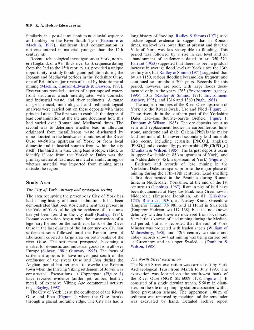
The City of York lies at the confluence of the RiversOuse and Foss (Figure 1) where the Ouse breaksthrough a glacial morainic ridge. The City has had a
long history of flooding. Radley & Simms (1971) usedarchaeological evidence to suggest that in Romantimes, sea level was lower than at present and that theVale of York was less susceptible to flooding. Thisperiod was followed by a rise in sea level and anabandonment of settlements dated to 350–370.Farrant (1953) suggested that there has been a gradualincrease in average flood levels at York since the 13thcentury , but Radley & Simms (1971) suggested thatby 1150, serious flooding became less frequent andcontinued so for about 700 years. Records for thisperiod, however, are poor, with large floods docu-mented only in the years 1263 (Environment Agency,1995), 1315 (Radley & Simms, 1971; EnvironmentAgency, 1995), and 1316 and 1360 (Pugh, 1961).
The major tributaries of the River Ouse upstream ofYork are the Rivers Swale, Ure and Nidd (Figure 1).These rivers drain the southern part of the YorkshireDales lead–zinc flourite–baryte Orefield (Figure 1;Dunham & Wilson, 1985). The ore deposits occur asvein and replacement bodies in carboniferous lime-stone, sandstone and shale. Galena [PbS] is the majorlead ore mineral, but several secondary lead mineralsalso occur, including cerussite [PbCO3], anglesite[PbSO4] and occasionally, pyromorphite [Pb5Cl(PO 4)3](Dunham & Wilson, 1985). The largest deposits occurin upper Swaledale (c. 85 km upstream of York), andin Nidderdale (c. 45 km upstream of York) (Figure 1).
Evidence and records of lead mining in theYorkshire Dales are sparse prior to the major phase ofmining during the 17th–19th centuries. Lead smeltingis first documented in the Pennines during Romantimes in Nidderdale, Yorkshire, at the end of the 1stcentury (Jennings, 1967). Roman pigs of lead havebeen documented at Heyshaw Bank near Greenhow inNidderdale (Emperor Domitian, 81; Kirkshaw,1735; Raistrick, 1930), at Nussey Knot, Greenhow(Emperor Trajan, 98), and at Hurst in Swaledale(Emperor Hadrian, 117–138), but it is not knowndefinitely whether these were derived from local lead.Very little is known of lead mining during the Mediae-val period, but it is recorded that the roof of YorkMinster was protected with leaden sheets (William ofMalmesbury, 690), and 12th century state andabbey records show that mining was being carried outat Greenhow and in upper Swaledale (Dunham &Wilson, 1985).
The North Street excavationThe North Street excavation was carried out by YorkArchaeological Trust from March to July 1993. Theexcavation was located on the south-west bank ofthe River Ouse (NGR SE 6009 5178; Figure 1). Itconsisted of a single circular trench, 5·50 m in diam-eter, on the site of a pumping station associated with aflood prevention scheme. The uppermost 1·80 m ofsediment was removed by machine and the remainderwas excavated by hand. Detailed archive report
Mediaeval Lead Pollution in the River Ouse at York, England 811
(b)
York
North StreetPumping Station
MINSTER
R. Ouse
R. Foss
Coppergate
500 m
CityWalls
N
(a)
HurstRichmond
York
River Ure
River Nidd
GreenhowRipon
River
Der
went
Leyburn
River Wharfe
River Sw
ale
River Ouse
Major lead deposits
River Ouse
Leeds
Humber Estuary
0 10 20 30 km
N
Figure 1. (a) Location map of Yorkshire Ouse River basin, showing major Yorkshire Dales lead deposits; (b) the City of York, showing thelocations of North Street, Coppergate, and the Rivers Ouse and Foss.
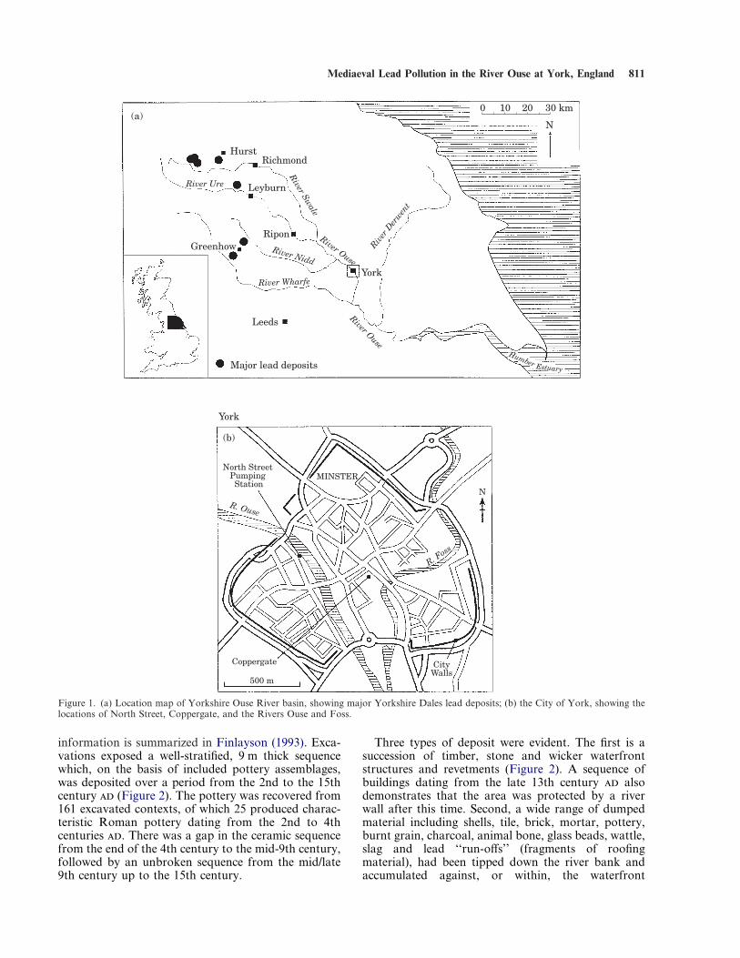
information is summarized in Finlayson (1993). Exca-vations exposed a well-stratified, 9 m thick sequencewhich, on the basis of included pottery assemblages,was deposited over a period from the 2nd to the 15thcentury (Figure 2). The pottery was recovered from161 excavated contexts, of which 25 produced charac-teristic Roman pottery dating from the 2nd to 4thcenturies . There was a gap in the ceramic sequencefrom the end of the 4th century to the mid-9th century,followed by an unbroken sequence from the mid/late9th century up to the 15th century.
Three types of deposit were evident. The first is asuccession of timber, stone and wicker waterfrontstructures and revetments (Figure 2). A sequence ofbuildings dating from the late 13th century alsodemonstrates that the area was protected by a riverwall after this time. Second, a wide range of dumpedmaterial including shells, tile, brick, mortar, pottery,burnt grain, charcoal, animal bone, glass beads, wattle,slag and lead ‘‘run-offs’’ (fragments of roofingmaterial), had been tipped down the river bank andaccumulated against, or within, the waterfront
812 K. A. Hudson-Edwards et al.
Figure 2. East, south-west and north-west facing stratigraphic sections at North Street excavation.
structures described above. Most of the dumpedmaterial had been reworked by the river and mixedwith river sediment. The third group of deposits werewell-sorted beds of sandy alluvium (with minoramounts of silt and clay), ranging in thickness from 3to 30 cm, which had been sedimented on, and in some
cases, over the top of the river bank. Some alluvialunits, notably those deposited between the 2nd to 4th,and 12th to 14th centuries, could be traced right acrossthe circular trench and are likely to represent majorfloods that overtopped the channel. Other alluvialunits, generally those dated to the 9th to 10th century
Mediaeval Lead Pollution in the River Ouse at York, England 813
, were found only in the western-facing parts of thesection, closest to the river (Figure 2). They probablyrelate to more moderate flood events where sedimen-tation was confined within the channel. Both thealluvial and dump deposits dip towards the RiverOuse, although the angle of dip decreases up-sectionfrom 20) at the base to less than 3) at the top of theprofile, consistent with a progressive north-easterlyshift in the position of the river bank at this site.Previous excavations in the centre of York (YorkArchaeological Trust, 1988b) have shown a similarpattern with evidence that the banks of the River Ousehave narrowed by as much as 40 m since the 1stcentury .
Table 1. Lead isotope ratio analyses (corrected values against SRM-981) for North Street alluvium, mixed alluvium and dump material and lead‘‘run-offs’’
Sample Century 208/206Pb 207/206Pb 206/207Pb 204/206Pb
Alluvium1103 late 13 2·0623&0·003 (0·13%) 0·84247&0·0009 (0·11%) 1·1870&0·0013 (0·11%) 0·05417&0·00001 (0·2%)1113 10–15 late 13 2·0704&0·010 (0·47%) 0·84269&0·0018 (0·21%) 1·1867&0·0025 (0·21%) 0·05417&0·00007 (0·13%)1181 11 2·0631&0·008 (0·38%) 0·84382&0·0024 (0·29%) 1·1851&0·0034 (0·29%) 0·05424&0·00011 (0·20%)1195a 11 2·0586&0·011 (0·55%) 0·84282&0·0028 (0·33%) 1·1865&0·0039 (0·33%) 0·05377&0·00011 (0·21%)1281a 10 2·0631&0·019 (0·94%) 0·84382&0·0014 (0·17%) 1·1879&0·0020 (0·17%) 0·05424&0·00008 (0·15%)1281b 10 2·0607&0·011 (0·52%) 0·84048&0·0039 (0·46%) 1·1898&0·0055 (0·46%) 0·05385&0·00020 (0·37%)1287 10 2·0652&0·007 (0·34%) 0·84171&0·0023 (0·27%) 1·1881&0·0032 (0·27%) 0·05363&0·00017 (0·31%)1390 2–9 9–10 2·0580&0·005 (0·26%) 0·84440&0·0011 (0·13%) 1·1843&0·0015 (0·13%) 0·05429&0·00006 (0·11%)1391 9–10 2·0728&0·009 (0·42%) 0·84646&0·0018 (0·21%) 1·1814&0·0025 (0·21%) 0·05443&0·00005 (0·09%)1438 8 2·0672&0·008 (0·38%) 0·84660&0·0016 (0·19%) 1·1812&0·0022 (0·19%) 0·05454&0·00020 (0·37%)1440 4 2·0591&0·020 (0·98%) 0·84223&0·0010 (0·12%) 1·1873&0·0014 (0·12%) 0·05428&0·00018 (0·33%)
Mixed alluvium and Dump Material1026 late 13–14 2·0756&0·014 (0·68%) 0·84363&0·0015 (0·18%) 1·1854&0·0021 (0·18%) 0·05397&0·00010 (0·19%)1102 late 13 2·0664&0·015 (0·75%) 0·84557&0·0005 (0·06%) 1·1826&0·0007 (0·06%) 0·05427&0·00003 (0·05%)1188 11 2·0617&0·013 (0·61%) 0·84221&0·0031 (0·37%) 1·1874&0·0044 (0·37%) 0·05412&0·00024 (0·45%)1195b 11 2·0576&0·015 (0·73%) 0·84403&0·0030 (0·35%) 1·1848&0·0041 (0·35%) 0·05412&0·00010 (0·18%)1272 10 2·0570&0·015 (0·75%) 0·84473&0·0018 (0·21%) 1·1838&0·0025 (0·21%) 0·05412&0·00016 (0·29%)1274 10 2·0748&0·011 (0·53%) 0·84438&0·0010 (0·12%) 1·1843&0·0014 (0·12%) 0·05392&0·00009 (0·17%)1279 10 2·0583&0·011 (0·52%) 0·83960&0·0021 (0·25%) 1·1910&0·0030 (0·25%) 0·05385&0·00018 (0·34%)1386 9–10 2·0607&0·007 (0·35%) 0·84180&0·0032 (0·38%) 1·1879&0·0045 (0·38%) 0·05398&0·00015 (0·27%)
Lead ‘‘run-offs’’1174 12 2·0720&0·004 (0·20%) 0·84040&0·0009 (0·11%) 1·1899&0·0013 (0·11%) 0·05390&0·00001 (0·01%)1289 9–10 2·0767&0·006 (0·31%) 0·84224&0·0015 (0·18%) 1·1864&0·0021 (0·18%) 0·05409&0·00001 (0·02%)1295 9–10 2·0773&0·003 (0·16%) 0·84291&0·0003 (0·03%) 1·1864&0·0004 (0·03%) 0·05411&0·00001 (0·01%)1441 4 2·0851&0·001 (0·05%) 0·84928&0·0013 (0·15%) 1·1775&0·0018 (0·15%) 0·05452&0·00001 (0·01%)
MethodologySeventy-three samples of river sediment, mixed dumpand alluvium, and building materials were collectedduring the excavation. Duplicate samples were col-lected by the York Archaeological Trust and archaeo-logical materials extracted. Samples were air-dried andsieved to <2 mm. Sediment pH was measured in a 1:2·5air-dried sediment: de-ionized water (DIW) slurry. Thesamples were placed in porcelain crucibles and ashedfor 15–24 h at 450)C. The ashed material was thenpulverized using a porcelain mortar and pestle. Twohundred and fifty milligrams of ashed sample was
digested in 2 ml of concentrated Aristar HNO3 for 1 hat 95)C. The amount of lead in acid was <1 ppb. Aftercooling, 8 ml of 18 MÙ DIW from a NANOpuresystem was added and the samples were transferred topolypropylene vials. Analysis for lead concentrationwas carried out using flame atomic absorption (PyeInstrument). Standards ranging from 5 to 20 ìg/g wereused, and blank values were below detection limits.Lead values were approximately within 10% of the leadconcentration of the reference standard GBW07311(Office of Reference Materials, Laboratory of theGovernment Chemistry, U.K).
Isotope ratios of 208Pb/206Pb, 207Pb/206Pb and 204Pb/206Pb were determined for a representative subset ofthe 73 original samples, comprising 19 alluvial andmixed alluvial/dump material samples, and for foursamples of lead ‘‘run-off ’’. The lead ‘‘run-offs’’ werecleaned thoroughly by scraping away the weatheringcrust, washed with 5% HNO3 and finally DIW.Approximately 100 mg of each sample was thenscraped off with a stainless steel knife to form mm-sized particles. The sediment and ‘‘run-off ’’ sampleswere digested in nitric acid as described above, and thelead concentration of the sample solution adjusted toapproximately 50 ng/g using 100 ml volumetric flasksand 18 MÙ DIW prior to isotope analysis. The leadisotope ratio in solution was measured using induc-tively coupled plasma-mass spectrometry (ICP-MS,
814 K. A. Hudson-Edwards et al.
Results
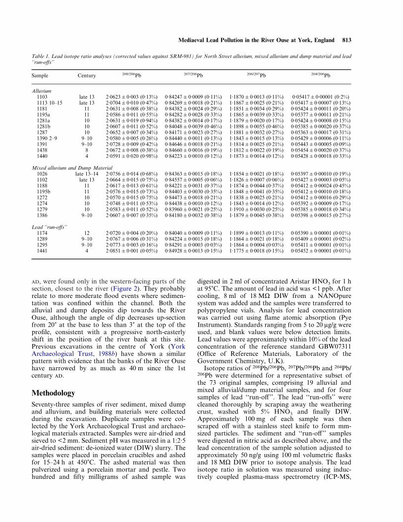
Lead concentrationsFour types of sedimentary units within the NorthStreet section have been distinguished (Figure 2), andinclude (i) ‘‘alluvium’’, composed of sand, silt andsome clay; (ii) ‘‘mixed alluvium and dump material’’,which contains alluvium and discarded materialincluding shells, tile, brick, mortar, pottery, burntgrain, charcoal, animal bone, glass beads and wattle;(iii) ‘‘mixed alluvium and dump material with lead‘run-off’, which is comprised of the materials in unittype (ii) along with lead ‘‘run-off’’ (see below); and (iv)‘‘building material’’, comprising cobbles, mortar andsand. Concentrations of total lead for these four typesare plotted against height and age in Figure 3, and aresummarized in Table 2.
Just over 50% of the North Street samples exceed themaximum lead concentration (100 mg/kg) for pre-Roman alluvium in the Yorkshire Ouse basin (Table 2;Hudson-Edwards & Macklin, unpubl. data). Tenthand 11th century mixed alluvium and dumpmaterial with lead ‘‘run-off’’ samples exhibit thehighest lead concentrations. Values for the mixed allu-vium and dump material units are highest in the 9th to12th centuries , and for alluvium in the 10th, 11thand 13th centuries . The mixed alluvium and dumpmaterial with lead ‘‘run-off’’ exhibit the highest meanvalues, followed by mixed alluvium and dump
Figure 3. Lead contents in North Street alluvium, alluvium anddump material with and without lead ‘‘run-off’’, and buildingmaterial. Depth down-section is given in metres (m) above ordnancedatum (AOD). Vertical dashed line shows the maximum pre-RomanYorkshire Ouse basin alluvial lead concentration.
Sediment composition and forms of leadThe alluvial sediment at York is composed of quartz[SiO2], shale bedrock, calcite [CaCO3], baryte [BaSO4],and zircon [ZrSiO4] detrital fragments, and authigenicgypsum [CaSO4·2H2O], vivianite [Fe3(PO4)2·8H2O]and framboidal pyrite [FeS2]. Lead occurs in the NorthStreet profile in two major forms. ‘‘Run-offs’’ and
VG Plasma Quad, Fisons Instruments). The certifiedcommon lead isotope standard SRM-981 from theNational Institute of Standards and Technology(NIST) was used to calibrate the instrument. Observedmass range was 201–210. Each sample was measuredsix times, and the average lead isotope ratios werecalculated. These were corrected for mass fractionationand were normalized against values obtained from thestandard SRM-981. Accuracy was found to be "0·01to "0·19% for 208/206 Pb, +0·05 to "0·20% for207/206Pb and "0·04 to "0·20% for 204/206Pb. Valuesof short-term precision were calculated as percentrelative standard deviation (RSD %; Table 1) for208/206Pb, 207/206Pb and 204/206Pb, and varied between0·05 and 0·98%, 0·03 and 0·46%, and 0·01 and 0·45%,respectively.
Polished thin sections of unashed, dried sedimentsamples and lead ‘‘run-off ’’ were examined using a JeolJSM 6400 scanning electron microscope (SEM) com-bined with energy dispersive X-ray spectrometry(EDX) and equipped with a Link Analytical back-scattered electron detector. Operating conditions were15 kV accelerating voltage and 1·5 nA incident speci-men current. Analytical data were obtained using astandardless Link Analytical eXL energy dispersiveanalysis system with a ZAF4-FLS deconvolution/recalculation package. Counting time was 45 s for eachanalysis.
material, the building material sample, and alluvium(Table 2).
Mediaeval Lead Pollution in the River Ouse at York, England 815
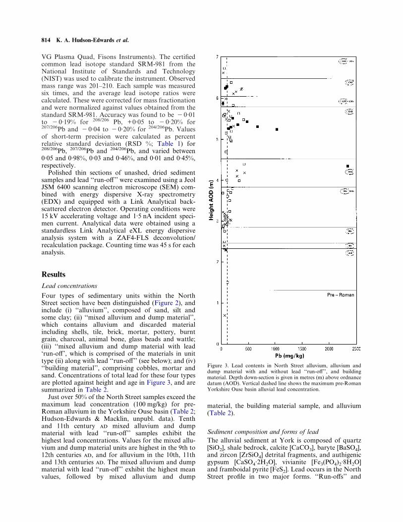
folded scraps of lead alloy occur in 4th, 9th–10th(Figure 4(a)), 11th, 12th and 13th century mixeddump and alluvial units. The ‘‘run-offs’’ are the wasteproducts of the manufacture of lead sheets for usein roofing and other activities. They generally areelongate to equant, flattened fragments with roundededges, and range in length and thickness between0·5–7 cm and 0·5–1 cm, respectively. They exhibit fine,mm-thick, weathering rinds composed of iron–leadoxyhydroxides.
Lead is also found as 10–50 ìm, rectangular andirregular, zoned minerals occurring on the edges of,and enclosed by, shale bedrock grains (Figure 4(b), (c))in alluvial and mixed alluvial/dump units. Semi-quantitative SEM-EDX analysis reveals that these areall lead phosphates with an average composition(PbO 67·0 weight%, CaO 11·5 weight%, P2O5 15·2weight%, FeO 1·5 weight% and Cl 1·2 weight%) nearcalcium-rich chloro-pyromorphite [(Pb,Ca)(PO4)3Cl].
Lead isotopesMeasurements of lead isotope ratios using ICP-MS inenvironmental materials with accuracies and precisionsof better than 0·5% (e.g., Russ, 1989), can be used toidentify major sources of lead. The ratios of leadisotopes to each other vary with the geological agesand the geographical locations of lead ores. Leadisotopes have thus been used for provenancinglead sources in environmental (Chow & Earl, 1972;Grousset et al., 1994) and archaeological materials(Brill & Wampler, 1967; Gale, 1989; Ghazi, 1994).
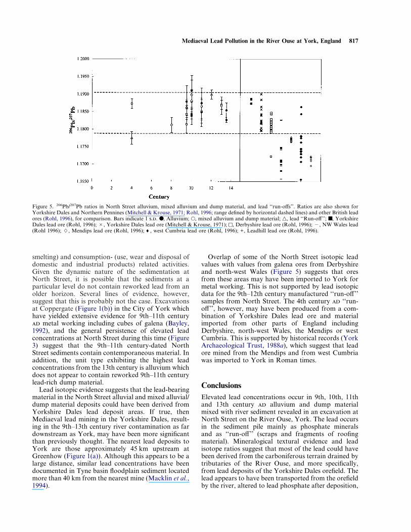
The 208Pb/206Pb, 207Pb/206Pb, 206Pb/207Pb, and 204Pb/206Pb North Street isotope results are summarized inTable 1. The 206Pb/207Pb ratio is generally used as anenvironmental tracer because it can be measured mostaccurately (Maring et al., 1987). 206Pb/207Pb ratios forYork alluvium, mixed alluvium and dump materialand lead ‘‘run-offs’’ are depicted in Figure 5. Theseresults show that the alluvium, mixed alluvium anddump material, and all lead ‘‘run-offs’’ except the 4thcentury sample have similar signatures. Statisticalcomparisons were made using mean 206Pb//207Pb ratiosusing a Mann–Whitney U-test (Swan & Sandilands,1995). Comparisons were made between mean values
for the North Street alluvium, mixed alluvium anddump material and lead ‘‘run-offs’’, and galena oresfrom the Yorkshire Dales (Mitchell & Krouse, 1971;Rohl, 1996). Statistically significant differences werenot found in all cases, suggesting that all of theseNorth Street materials may have been derived fromYorkshire Dales sources.
Statistical comparisons were also made betweenmean 206Pb//207Pb ratios for the North Street samplesand galena ores from other U.K. deposits (Rohl, 1996)which were mined at least as far back as Roman times(Derbyshire, north-west Wales, the Mendips, westCumbria, Leadhills; Woodward, 1876; Gough, 1930;Davies, 1935; Lewis, 1967; Buchanan & Cossans,1969). Although these tests showed that the meanisotopic values are significantly different than meanvalues for the other galena ores, it is appreciated thatsome of the North Street alluvium and mixed alluviumand dump material values (within 1 standard devia-tion) correspond to some of the Derbyshire values andtwo of the north-west Wales orefield values (Figure 5).This is confirmed by Mann–Whitney U-tests. Similarly,Mann–Whitney U-tests for the individual North Street‘‘run-off’’ samples show that only the ‘‘run-off’’ fromthe 4th century gives a non-statistically significantdifference from isotopic values for galena are fromDerbyshire, north-west Wales, the Mendips, and westCumbria.
Discussion
Table 2. Lead concentrations in North Street alluvium, mixed alluvium and dump material, and building material
Unit type NPb concentration (mg/kg)
arithmetic mean Range
Alluvium 30 90 21–42Mixed alluvium and dump material 32 110 20·0–420Mixed alluvium and dump material with lead ‘‘run-off ’’ 10 310 72–2300Building material 1 97† —Pre-Roman Yorkshire Ouse basin alluvium* 122 24 4–100
N, number of samples.*Hudson-Edwards & Macklin, unpubl. data.†Concentration of single sample.
Lead phosphate minerals
Mineralogical compositional and textural informationcan be used to provenance sediment sources (e.g.,Hudson-Edwards, Macklin & Taylor, 1997). The leadphosphate minerals in the North Street profile arelikely to originate from three possible sources: (1)secondary weathering products of the mineral veins inthe Yorkshire Dales orefield (cf. Dunham & Wilson,1985) which have been transported down-river anddeposited in the North Street profile; (2) in situ authi-genic precipitates which formed directly in thesediment pile; or (3) in situ weathering products ofriver-transported lead-bearing minerals.
816 K. A. Hudson-Edwards et al.
Figure 4. Photograph and photomicrographs of lead ‘‘run-off’’ andshale-hosted lead phosphate minerals. (a) Ninth–10th century lead ‘‘run-off’’ (roofing material). Scale is 7 cm long. (b) Calcium-bearing lead phosphate embedded within shale bedrock grain in 10thcentury mixed alluvial/dump unit. (c) Calcium-bearing leadphosphate on edge of shale bedrock grain in 10th century alluvialunit, exhibiting zoned growth texture.
Sources of lead and implications of lead contaminationElevated lead concentrations in 9th–13th century alluvium and mixed alluvium and dump material withand without lead ‘‘run-off’’ at North Street reflectriver contamination from both production- (mining,
Secondary lead phosphate mineral vein weatheringproducts (option 1) are extremely rare in the lead oredeposit areas (Dunham & Wilson, 1985) and wouldthus probably not be the major source of North Streetlead phosphates.
The weathering rinds on the lead ‘‘run-offs’’ suggestthat some movement of lead may have occurred withinthe North Street profile. Such redistribution of leadcould have given rise to precipitation of secondary,authigenic lead minerals at North Street (option 2). Ifthis had been the mechanism of lead phosphate for-mation, then these minerals would probably be foundon a variety of substrates. All of the lead phosphategrains observed, however, occur on and within shalebedrock grains. In addition, the present high pHs ofthe North Street samples (7·3–9·3) suggest that the leadmobility may have been extremely limited (Korte et al.,1976), although pH conditions may have differed in thepast. Finally, the lead ‘‘run-offs’’ are relatively scarce inthe profile and of small size (e.g., Figure 4(a)) suggest-ing that weathering alone may not have caused thegeneral enrichment of lead seen in the profile.
The precursors of the ‘‘option 3’’ North Street leadphosphates could be lead-bearing ore minerals suchas galena and cerussite, or lead-bearing ore mineralweathering products such as ferromanganese oxy-hydroxides. Evidence for this comes from the Tyne andTees Rivers north of the Yorkshire Ouse basin, whichalso drain Yorkshire Dales/Northern Pennine lead oredeposit areas and are contaminated with lead-bearingsediment (Macklin & Dowsett, 1989; Macklin et al.,1994; Hudson-Edwards, Macklin & Taylor, 1997).Downstream of the mining areas, the sediment leadmineralogy is dominated by ferromanganese oxy-hydroxides which often occur on and within shalebedrock grains (Hudson-Edwards et al., 1996;Hudson-Edwards, Macklin & Taylor 1997). Theassociation of the North Street lead phosphates withshale bedrock fragments, and relationship of York tothe lead ore deposit areas of the Yorkshire Dales(Figure 1(a)) suggests that lead-bearing ferromanga-nese oxyhydroxides may have been the originallead-bearing minerals deposited at North Street. TheNorth Street lead phosphates could then have formedas pseudomorphs of ferromanganese oxyhydroxideswhich experienced reduction and dissolution (cf.Nriagu & Dell, 1974; Nriagu, 1984). Thus, option 3(above) is the most reasonable for the origin of the leadphosphate minerals.
Pyromorphite is only very slightly soluble (Ksp=10"84·4) (Nriagu, 1974) and has a greater field ofstability at earth surface conditions than other leadsulphides, oxides and carbonates (Nriagu, 1984). Thissuggests that once formed, the York calcium-bearingpyromorphites would have not weathered to anygreat extent, thus preserving the integrity of the leadconcentration versus age profile (Figure 3).
Mediaeval Lead Pollution in the River Ouse at York, England 817
smelting) and consumption- (use, wear and disposal ofdomestic and industrial products) related activities.Given the dynamic nature of the sedimentation atNorth Street, it is possible that the sediments at aparticular level do not contain reworked lead from anolder horizon. Several lines of evidence, however,suggest that this is probably not the case. Excavationsat Coppergate (Figure 1(b)) in the City of York whichhave yielded extensive evidence for 9th–11th century metal working including cubes of galena (Bayley,1992), and the general persistence of elevated leadconcentrations at North Street during this time (Figure3) suggest that the 9th–11th century-dated NorthStreet sediments contain contemporaneous material. Inaddition, the unit type exhibiting the highest leadconcentrations from the 13th century is alluvium whichdoes not appear to contain reworked 9th–11th centurylead-rich dump material.
Lead isotopic evidence suggests that the lead-bearingmaterial in the North Street alluvial and mixed alluvial/dump material deposits could have been derived fromYorkshire Dales lead deposit areas. If true, thenMediaeval lead mining in the Yorkshire Dales, result-ing in the 9th–13th century river contamination as fardownstream as York, may have been more significantthan previously thought. The nearest lead deposits toYork are those approximately 45 km upstream atGreenhow (Figure 1(a)). Although this appears to be alarge distance, similar lead concentrations have beendocumented in Tyne basin floodplain sediment locatedmore than 40 km from the nearest mine (Macklin et al.,1994).
Overlap of some of the North Street isotopic leadvalues with values from galena ores from Derbyshireand north-west Wales (Figure 5) suggests that oresfrom these areas may have been imported to York formetal working. This is not supported by lead isotopicdata for the 9th–12th century manufactured ‘‘run-off ’’samples from North Street. The 4th century ‘‘run-off ’’, however, may have been produced from a com-bination of Yorkshire Dales lead ore and materialimported from other parts of England includingDerbyshire, north-west Wales, the Mendips or westCumbria. This is supported by historical records (YorkArchaeological Trust, 1988a), which suggest that leadore mined from the Mendips and from west Cumbriawas imported to York in Roman times.
Figure 5. 206Pb/207Pb ratios in North Street alluvium, mixed alluvium and dump material, and lead ‘‘run-offs’’. Ratios are also shown forYorkshire Dales and Northern Pennines (Mitchell & Krouse, 1971; Rohl, 1996; range defined by horizontal dashed lines) and other British leadores (Rohl, 1996), for comparison. Bars indicate 1 .. ●, Alluvium; •, mixed alluvium and dump material; n, lead ‘‘Run-off ’’; ■, YorkshireDales lead ore (Rohl, 1996); #, Yorkshire Dales lead ore (Mitchell & Krouse, 1971); [, Derbyshire lead ore (Rohl, 1996); ", NW Wales lead(Rohl 1996); L, Mendips lead ore (Rohl, 1996); ♦, west Cumbria lead ore (Rohl, 1996); +, Leadhill lead ore (Rohl, 1996).
ConclusionsElevated lead concentrations occur in 9th, 10th, 11thand 13th century alluvium and dump materialmixed with river sediment revealed in an excavation atNorth Street on the River Ouse, York. The lead occursin the sediment pile mainly as phosphate mineralsand as ‘‘run-off ’’ (scraps and fragments of roofingmaterial). Mineralogical textural evidence and leadisotope ratios suggest that most of the lead could havebeen derived from the carboniferous terrain drained bytributaries of the River Ouse, and more specifically,from lead deposits of the Yorkshire Dales orefield. Thelead appears to have been transported from the orefieldby the river, altered to lead phosphate after deposition,
818 K. A. Hudson-Edwards et al.
and subsequently, not moved appreciably in the pro-file. This information, combined with elevated leadvalues in the North Street alluvial sequence and exten-sive evidence of 9th–11th century metal working atCoppergate in York, suggests that lead mining wastaking place in the Yorkshire Dales during this period.Furthermore, this mining activity appears to haveresulted in significant river contamination in the Ousedownstream at least as far as York. Information onlead levels and river pollution in the Yorkshire Ouseduring the Roman period between the 2nd–4th century, and during the 5th–8th centuries is, however,more limited. At North Street, lead concentrations areat or below pre-Roman levels, suggesting that metalproduction- and consumption-related activities atthis time had relatively little impact on the riverenvironment at York.
AcknowledgementsThe authors wish to extend their thanks to P. Lythgoe(Department of Earth Sciences, University ofManchester) for assistance with ICP-MS analysis, D.Plant and T. Hopkins (Manchester Electron Micro-probe Facility) with the SEM, the Graphics Unit(School of Geography, University of Leeds) for dia-gram preparation, and W. Stelling (Department ofGeography, University of Newcastle) for sediment leadanalysis. J. Bayley and K. Eckstein at English Heritageprovided useful insights into historical lead industrialtechnology, and S. Longfield (Leeds) furnished infor-mation on the documentary flood record at York. A.Howard (Leeds) is thanked for reading an early versionof the manuscript. Part of this work was carried outwhen KH-E was a research assistant at the Departmentof Earth Sciences, University of Manchester, U.K.Funding was provided from the York ArchaeologicalTrust, and from the NERC Land–Ocean InteractionStudy (LOIS) Programme. The three anonymous ref-erees are thanked for their constructive commentswhich greatly improved the manuscript. This is LOISpublication number 409.
ReferencesBayley, J. (1992). Non-ferrous metalworking from Coppergate. In
(P.V. Addyman, Ed.) The Archaeology of York, Volume 17: TheSmall Finds. London: York Archaeological Trust for Excavationand Research, Council for British Archaeology.
Bradley, S. B. & Cox, J. J. (1990). The significance of the floodplainto the cycling of metals in the river Derwent catchment, UK.Science of the Total Environment 65, 135–153.
Brill, R. H. & Wampler, J. M. (1967). Isotope studies of ancient lead.American Journal of Archaeology 71, 63–77.
Brown, A. G. & Barber, K. E. (1985). Late Holocene palaeoecologyand sedimentary history of a small lowland catchment in centralEngland. Quaternary Research 24, 87–102.
Buchanan, R. A. & Cossans, N. (1969). The Industrial Archaeologyof the Bristol Region. Newton Abbot: David and Charles.
Chow, T. J. & Earl, J. L. (1972). Lead isotopes in North Americancoals. Science 176, 510–511.
Davies, O. (1935). Roman Mines in Europe. Oxford: Oxford Univer-sity Press.
Dunham, K. C. & Wilson, A. A. (1985). Geology of the NorthernPennine Orefield: Volume 2, Stainmore to Crave. Economic Mem-oir of the British Geological Survey, Sheets 40, 41, 50, and parts of31, 32, 51, 60 and 61, New Series.
Environment Agency (1995). Unpublished Table of Past Floods atYork. Coverdale House, Clifton Moor, York.
Evans, J. G. (1991). River valley bottoms and archaeology in theHolocene. In (B. Coles, Ed.) The Wetland Revolution in Prehistory.WARP Occasional Paper 6, 47–53.
Farrant, A. E. (1953). A memorandum on flooding at York. Unpub-lished report to the Yorkshire Ouse River Board.
Finlayson, R. (1993). North Street. York Archaeological TrustArchive Report 1993·1.
Gale, N. H. (1989). Lead isotope studies applied to provenancestudies—a brief review. In (Y. Manaiatis, Ed.) Archaeometry,Proceedings of the 25th International Symposium. Amsterdam:Elsevier, pp. 469–502.
Ghazi, A. M. (1994). Lead in archaeological samples: an isotopicstudy by ICP-MS. Applied Geochemistry 9, 627–636.
Gough, J. (1930). The Mines of Mendip. Oxford: Clarendon Press.Grousset, F. E., Quetel, C. R., Thomas, B., Buat-Menard, P.,
Donard, O. F. X. & Bucher, A. (1994). Transient Pb isotopicsignatures in the western European atmosphere. EnvironmentalScience and Technology 28, 1605–1608.
Hudson-Edwards, K. A., Macklin, M. G., Curtis, C. D. & Vaughan,D. J. (1996). Processes of formation and distribution of Pb-, Zn-,Cd-, and Cu-bearing minerals in the Tyne Basin, north-eastEngland: implications for metal-contaminated river systems.Environmental Science and Technology 30, 72–80.
Hudson-Edwards, K., Macklin, M. & Taylor, M. (1997). Historicmetal mining inputs to Tees river sediment. Science of the TotalEnvironment 194/195, 437–445.
Jennings, B. (Ed.) (1967). A History of Nidderdale. Huddersfield:Advertiser.
Kirkshaw, S. (1735). A letter concerning two pigs of lead, found nearRipley. Philosophical Transactions 41, 560.
Korte, N. E., Skopp, J., Fuller, W. H., Niebla, E. E. & Alesii, A.(1976). Trace element movement in soils: influence of soil physicaland chemical properties. Soil Science 122, 350–359.
Lewin, J. & Macklin, M. G. (1987). Metal mining and floodplainsedimentation in Britain. In (V. Gardiner, Ed.) InternationalGeomorphology 1986, Part 1. Chichester: Wiley, pp. 1009–1027.
Lewis, W. J. (1967). Lead Mining in Wales. Cardiff: University ofWales Press.
Macklin, M. G. (1996). Fluxes and storage of sediment-associatedheavy metals in floodplains systems: assessment and river basinmanagement issues at a time of rapid environmental change. In(M. G. Anderson, D. E. Walling & P. D. Bates, Eds) FloodplainProcesses. Chichester: Wiley and Sons, pp. 441–460.
Macklin, M. G. (1997). Geochemical analysis of Doncaster NorthBridge excavation alluvial sediment samples. Unpublished Reportto York Archaeological Trust.
Macklin, M. G. & Dowsett, R. B. (1989). The chemical and physicalspeciation of trace metals in fine grained overbank flood sedimentsin the Tyne basin, north-east England. Catena 16, 135–151.
Macklin, M. G., Bradley, S. B. & Hunt, C. O. (1985). Early miningin Britain: the stratigraphic implications of metals in alluvialsediments. In (N. G. R. Fieller, D. D. Gilbertson & N. G. R.Ralph, Eds) Palaeoenvironmental Investigations; Research Design,Methods and Interpretation. Oxford: British ArchaeologicalReports, International Series, pp. 45–54.
Macklin, M. G., Passmore, D. G., Stevenson, A. C., Cowley, D. C.,Edwards, D. N. & O’Brien, C. F. (1991). Holocene alluviation andland-use change on Callay Moore, Northumberland, U.K. Journalof Quaternary Science 6, 225–232.
Macklin, M. G., Ridgway, J., Passmore, D. G. & Rumsby, B. T.(1994). The use of overbank sediment for geochemical mappingand contamination assessment: results from selected English andWelsh floodplains. Applied Geochemistry, 9, 689–700.
Mediaeval Lead Pollution in the River Ouse at York, England 819
Macklin, M. G., Hudson-Edwards, K. A. & Dawson, E. J. (1997).The significance of pollution from historic metal mining in thePennine orefields on river sediment contaminant fluxes to theNorth Sea. Science of the Total Environment 194/195, 391–397.
Maring, H., Settle, D. M., Buat-Menard, P., Dulac, F. & Patterson,C. C. (1987) Stable lead isotope tracers of air mass trajectories inthe Mediterranean region. Nature 300, 154–156.
Mitchell, R. H. & Krouse, H. R. (1971). Isotopic composition ofsulfur and lead in galena form the Greenhow–Skyreholme area,Yorkshire, England. Economic Geology 66, 243–251.
Needham, S. & Macklin, M. G. (Eds) (1992). Alluvial Archaeology inBritain. Oxford: Oxbow Monograph 27.
Nriagu, J. O. (1974) Lead Orthophosphates. IV—Formation andstability in the environment. Geochimica et Cosmochimica Acta 38,887–898.
Nriagu, J. O. (1984). Formation and stability of base metal phos-phates in soils and sediments. In (J. O. Nriagu & P. B. Moore,Eds) Phosphate Minerals. Berlin Heidelberg: Springer-Verlag,pp. 318–329.
Nriagu, J. O. & Dell, C. I. (1974). Diagenetic formation of ironphosphates in recent lake sediments. American Mineralogist 59,934–946.
Ottaway, P. (1993). Book of Roman York. London: Batsford/EnglishHeritage.
Passmore, D. G. & Macklin, M. G. (1997). Geoarchaeology of theTyne Basin: Holocene river environments and the archaeologicalrecord. In (C. Tolan-Smith, Ed.) Landscape Archaeology inTynedale. Tyne-Solway Ancient and Historic LandscapesResearch Monograph 1. Newcastle-upon-Tyne: University ofNewcastle-upon-Tyne, pp. 11–28.
Pugh, R. B. (1961). A History of Yorkshire—The City of York.Oxford: Oxford University Press.
Radley, J. (1974). The prehistory of the Vale of York. YorkshireArchaeological Journal 46, 10–22.
Radley, J. & Simms, C. (1971). Yorkshire Flooding—Some Effects onMan and Nature. York: Ebor Press.
Raistrick, A. (1930). A pig of lead with Roman inscriptions.Yorkshire Archaeological Journal 30, 181–183.
Robinson, M. A. & Lambrick, G. H. (1984) Holocene alluviationand hydrology in the upper Thames basin. Nature 308, 809–814.
Rohl, B. M. (1996). Lead isotope data from the isotrace laboratory,Oxford: Archaeometry data base 2, galena from Britain andIreland. Archaeometry 38, 165–180.
Russ, G. P. (1989). Isotope ratio measurements using ICP-MS. In(A. R. Date & A. L. Gray, Eds) Applications of InductivelyCoupled Plasma Mass Spectrometry. Glasgow: Blackie, pp. 90–114.
Salway, P. (1981). Roman Britain. Oxford History of England.Oxford: Oxford University Press.
Swan, A. R. H. & Sandilands, M. (1995). Introduction to GeologicalData Analysis. Oxford: Blackwell.
Taylor, M. P. (1996). The variability of heavy metals in floodplainsediments: a case study from mid Wales. Catena 28, 71–87.
William of Malmesbury (c. 690). De Gestis Pontificum Anglorum.London: Rolls Series, 1870.
Woodward, H. B. (1876) Geology of the East Somerset and theBritish Coal-Fields. Memoir of the Geological Survey.
York Archaeological Trust (1988a). Roman and Anglian York.Ordnance Survey, Historical Map and Guide.
York Archaeological Trust (1988b). The Waterfronts of York.Prospects for Archaeological Research.


