Embed Size (px)
Citation preview
"'m

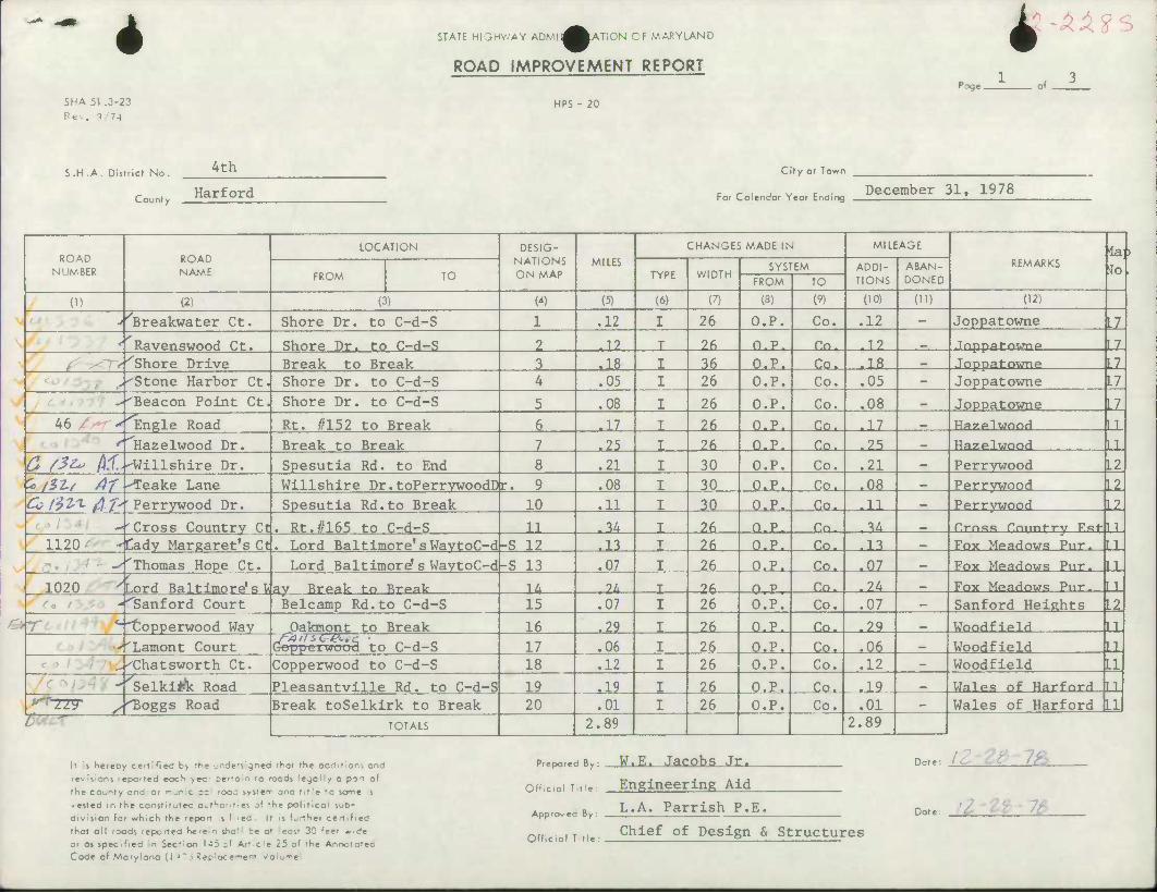
4 STATE HIGHWAY ADMIl^^ATiON OF MARYLAND
ROAD IMPROVEMENT REPORT 4 ZA?
SHA 51 .3-23 Rev. 5 74
HPS - 20
S.H.A. District No.
County
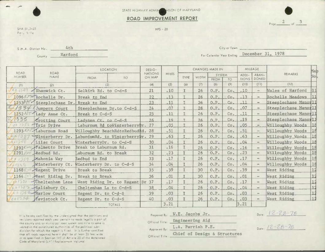
4th
Harford
CUy or Town
For Colendor Year Ending December 31, 1978
ROAD NUMBER
•^Breakwater Ct. r
JL <-''Shore Drive .•'Stone Harbor Ct. -'Beacon Point Ct
ROAD NAME
(2)
Ravenswood Ct.
LOCATION
FROM TO
(3)
Shore Dr. to C-d-S
Shore Dr. to C-d-S Break to Break Shore Dr. to C-d-S Shore Dr. to C-d-S
DESIG- NATIONS ON MAP
(4)
MILES
(5)
.12
J2_ ^18_ .05
,08
CHANGES MADE IN
TYPE
(6)
WIDTH
(7)
26
_2£. ^_ 26
26
SYSTEM
FROM
(8)
O.P.
n.p, Q.P. O.P,
O.P.
TO
(') Co,
MILEAGE
ADDI- TIONS
(10)
,12
_Ca. Co. Cq^
Co.
JL2- ^1B_ ,05
.08
ABAN- DONED
OD
REMARKS
(12)
Joppatowne
.Tnppaf-nijnp
Joppatowne Joppatowne
Joppatowne
to
.11
11 L7
LZ
U
46 / ^^Engle Road Rt. #152 to Break ,17 JZfL. Q.P, Co. J-L Hazp.lwnod
''^Hazelwood Dr. Break to Break Q_/SZo /If.^illshire Dr.
^25_ JA. P.P. Xo. ^5_ Hazplwnnd
Spesutia Rd. to End .21 30 O.P. Co. .21 Perrywood
.L2 *> /5Z-/ Af ^Teake Lane Willshire Dr.toPerrywoodDr .08 30 O.P. Co. • 08 Perrywood Cc IW*. ^t Perrywood Dr. Spesutia Rd.to Break 10 11 J£L Q.P, Co. ^IX. Perrywood
Cross Country Ct Rt.#165 to C-d-S JX .-Mx 2£u P.P. Xo. JJL.
1120 Cady Margaret's Ct. Lord Baltimore'sWaytoC-d-S 12 -JJ_ .26. P.P. Co. ^li Fox Meadows Pur. ^Thomas Hope Ct.
1020 vL Lord Baltimore's WaytoC-d -S 13 ,07 JA^ O.P. Xo. J12_
ord Baltimoi <•(. / -''Sanford Court
Break tn Brpak JJL -24^ -26- Q.P. Co. ^24_ Belcamp Rd.to C-d-S 15 ,07 26 O.P. Co. ,07
L2
Cross Country F.st U- LL LL 1
12
Fox Meadows Pur. Fnx Mp.aHrnjs Pur.
Sanford Heights
ter _ ^opperwood Way Qakmont to Break Lament Court Ge
16 ^2_ ^5_ Q.P. Co. ^23_ WnndfIPIH epperwoo5 to C-d-S 17 ,06 26 O.P. Co. .06 Woodfield
.,^Chatsworth Ct.
Selkliftc Road
Copperwood to C-d-S 18 .12 26 O.P. Co. ,12 Woodfield
Pleasantville Rd. to C-d-S
r •rBogg s Road Break toSelkirk to Break 19 20
^_19_ .2^ JLZ^ .01 26 O.P.
.Co.. Co.
J^. Wales of Harfnrd .01
TOTALS 2.89 2.89 Wales of Harford
LL LL Xi 1
It is h«reby certified b> tK« jndenigned 'Hot the oddltlon: ond
revisions reported eoc1^ >ec- oer-c n ro roods le^lly o port of
the county ond. or mufiicipa rocc system ond title to some is
vested in the constitutec authorities of 'he political sub-
division for which the 'epo^ s t ;ea If is further certified
that all roods reportcO he'e-n she i be a' east 3C ''eer wide
or as specified In Section 143 3* Ar.cle 25 of the Annotated Code of Maryland (1 ^ > Replacement v'oiume
Prepared By: W.E, Jacobs Jr.
Official Title: Engineering Aid
ft L.A. Parrlsh P,E. Apprcrvec By:
Offidoi Title Chief of Design & Structures
Dote: IC- ' CC' 7fc
Dot ̂ 'I rt 7&

»
*
SHA 51 .3-23 Rev, i 74
STATE HIGHWAY ADMlN^^UiON CF MARYLAND
ROAD IMPROVEMENT REPORT
HPS - 20
rage.
S.H.A. District No.
County
4th
Harford
City or Town
c /- i v c j- December 31, 1978 For Calendar Year Ending ^ »
ROAD NUMBER
(1)
~A 1096' ' 1253^^Steeplechase Dr.
*'• s??? 1252
-,}^6 'Iris Drive
1293 -"la
/
ROAD NAME
(2)
Shanwick Ct.
Rochelle Dr.
Jumpers Court Lady Anne Ct.
dotting Court
aburnum Road Jilloughby BeachRdtoRedbudUd. 28 "^interberry Dr.
Lilac Court 1292•' ^'Palmetto Drive 5reak to Laburnum Rd. 1291 ^-Redbud Rd.
^^lahonia Way
LOCATION
FROM TO
(3)
Selkirk Rd. to C-d-S
Break to End Break to End Steeplechase Dr.to C-d-S Break to C-d-S T.adyAnn Ct. to C-d-S Laburnum Rd toWinterberryDr. 27
liaburdumRd. to WinterberryHr. 29 JinterberryDr. to C-d-S
^aburnum Rd. to Break ledbud to End
DESIG- NATIONS ON MAP
(4)
21
22 22_
24 25
_2fi_
30 31 32 33
MILES
(5)
.10
^JLL ^LL ^HL ,11
JL9- .05 ,51 63
,04 ,16
,23 ,17
CHANGES MADE IN
TYPE
(6)
WIDTH
(7)
26
.26_ _2£_
26
-26. 26 26 26 26 26 26 26
SYSTEM
FROM
(8)
O.P.
p.p. O.P.
^CL.P^ O.P.
n.p. P.P. P.P. P.P. P.P. P.P. p.p. P.P.
TO
(9)
Co.
_C£L>
Co. JGP^
Co. Co. Co. Co. Co.
-£0. Co, Co. Co.
MILEAGE
ADDI- TIONS
(10)
10
JJ_ JX
^oi_ .11
.19
^15_ .51
.63 ^M_ ,16 .23 .17
ABAN- DONED
OD
Wales of Harford
Willoughby Woods
REMARKS *ab Ho
(12)
Rochelle Meadows
11
U Steeplechase Manoijll Steeplechase Manoi 11 Steeplechase Hanoi 11 Steeplechase Manoi 11
Willoughby Woods Willoughby Woods Willoughby Woods Willoughby Woods Willoughby Woods Willoughby Woods
11 It It li u li Ij li „.Winterberry Ct. Jinterberry Dr. to C-d-S 34 .04 26 P.P. Co. ,04 Willoughby Woods
1168 -."Regent Drive Break to Break 35 ,39 30 P.P. Co. ,39 West Riding
1164 ..'West Riding Dr. Break to Break 36 ,01 30 P.P. Co. .01 West Riding Cheltenham Lane West Riding Dr. to Regent Dr 37 .17 26 P.P. Co. .17 West Riding
Cheltenham La to C-d-S 38 .04 26 P.P. £su ^4_ West Riding Regent Dr. to C-d-S 39 ,03 26 P.P.
avistock Ct. Regent Dr. to C-d-S 40 .03 26 O.P. TOTALS 3.21
West Riding West Riding
If is hereby certified b> fhe .nde-s gnea that the addition; and revisions reporfed eoc^ >ec- oerroln to roods lejoily a part of the county and or r^nici;:- rooc system and title to some is vested in the constitutec author,f,es of •he political sub- division for which the report if filed It is further certified that all roods reported he-e-n shcl' be at 'east 30 feet wide or as specified in Section 145 of Ar',c!e 25 of the Annotated Code of Maryland (1^~3 Replocemtm v'olurre
Prepared By: W.E. Jacobs Jr.
Officoi Tine: Engineering Aid
Appro-ec By:
Dote 7£_
L.A. Parrish P.E. Dot t..h
Official Title: Chief of Design & Structures
1 1 ii
4 SHA 51 .3-23 Rev. 1 -74
STATE HIGHV-AY ADMlf-^^^TION CF MARYLAND
ROAD IMPROVEMENT REPORT
HPS - 20
r-jqe ,
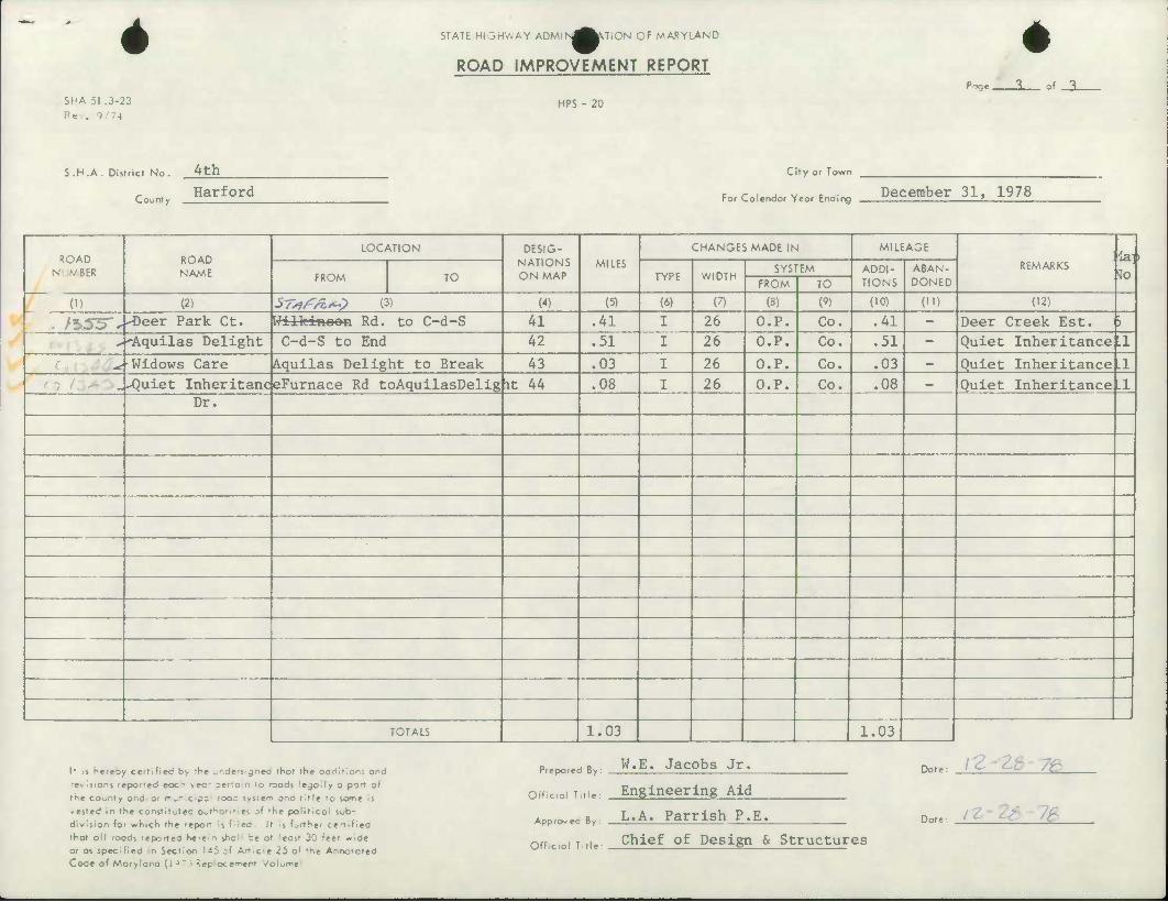
S.H.A . District No.
County
Ath
Harford
City or Town
c r , , v c ^_ December 31, 1978 ror Calendar Year Ending I
ROAD NUMBER
ROAD NAME
LOCATION DESIG- NATIONS ON MAP
MILES
CHANGES MADE IN MILEAGE
REMARKS la] To FROM TO TYPE WIDTH
SYSTEM ADDI- TIONS
ABAN- DONED FROM TO
(1) (2) sr*/?/**? o) (4) (5) (6) (7) (8) (9) (10) (ID (12)
. /*.55"^ -Deer Park Ct. Wilkinoon Rd. to C-d-S 41 .41 I 26 O.P. Co. .41 - Deer Creek Est. )
" 'Aquilas Delight C-d-S to End 42 .51 I 26 O.P. Co. .51 - Quiet Inheritance .1
* •Widows Care Aquilas Delight to Break 43 .03 I 26 O.P. Co. .03 - Quiet Inheritancel.1 -Quiet Inheritanc eFurnace Rd toAquilasDelig it 44 .08 I 26 O.P. Co. .08 - Quiet Inheritance LI
Dr.
TOTALS 1.03 1.03
It Is hereby certifieci b> rh« •.rdcvgneb fhat the oddition; and revisions reported eoc^ >ec' ser'o n to roods lejoily a port of fhe county ond or municipa rooc system and title to some is vested in the constitufec Out^onfici of »he poiiticoi sub- division for which the fepo^r j filed. It "s further certified thot oil roods reported he'e-n iholl be a' east 30 t'eef wide or os specified in Section 143 cf Art<cle 25 of the Annotated Code of Maryland (i^T3 ltcpIoc«m«nl -/oiji^e
Prepared By: W.E. Jacobs Jr.
Offieiol Title: Engineering Aid
Appro.ec By. L.A. Parrish P.E.
Offieiol Title: Chief of Design & Structures
Dot
Date
,: i?-zt 7e
ic 7S
DEC 2 9 1978
BUf, F HIGHWAY
SIATISTJCa
"f
i Mil iuiUillytiii nil, HakMiMiiAh lllul. i,li. A* lU.lKli,
TO DAK.
CHAPEL
I ORI SI ESTATES K
/(. 15'00 ro JOPPATOWNE
395 MAP NO. 18 TO BUSH RIVIR
PREPARED BY THE
MARYLAND DEPARTMENT OF TRANSPORTATION STATE HIGHWAV ADMINISTRATION
IN COOPERATION WITH THE
U. S. DEPARTMENT OF TRANSPORTATION FEDERAL HIGHWAY ADMINISTRATION
GREENRIDGI
C5
95 I 25
31 - 39999
41 - 49999
51 - 59999
61 - 69999
71 - 79999
81 - 89999
Interstate, U.S., and State Highways
County Roads
Other Public Roads
Private Roods
Municipal Roads and 1 •
Misc. State Roads (Forests, Parks, and Institutions)
U.S. Government Roads
7/ott JARRETTSVILLE ^P
•
UiLiJltl.i.iiliiiiiUi..UiiUlii[iit iii wmmmmu^ammmm^mmmmmmmm
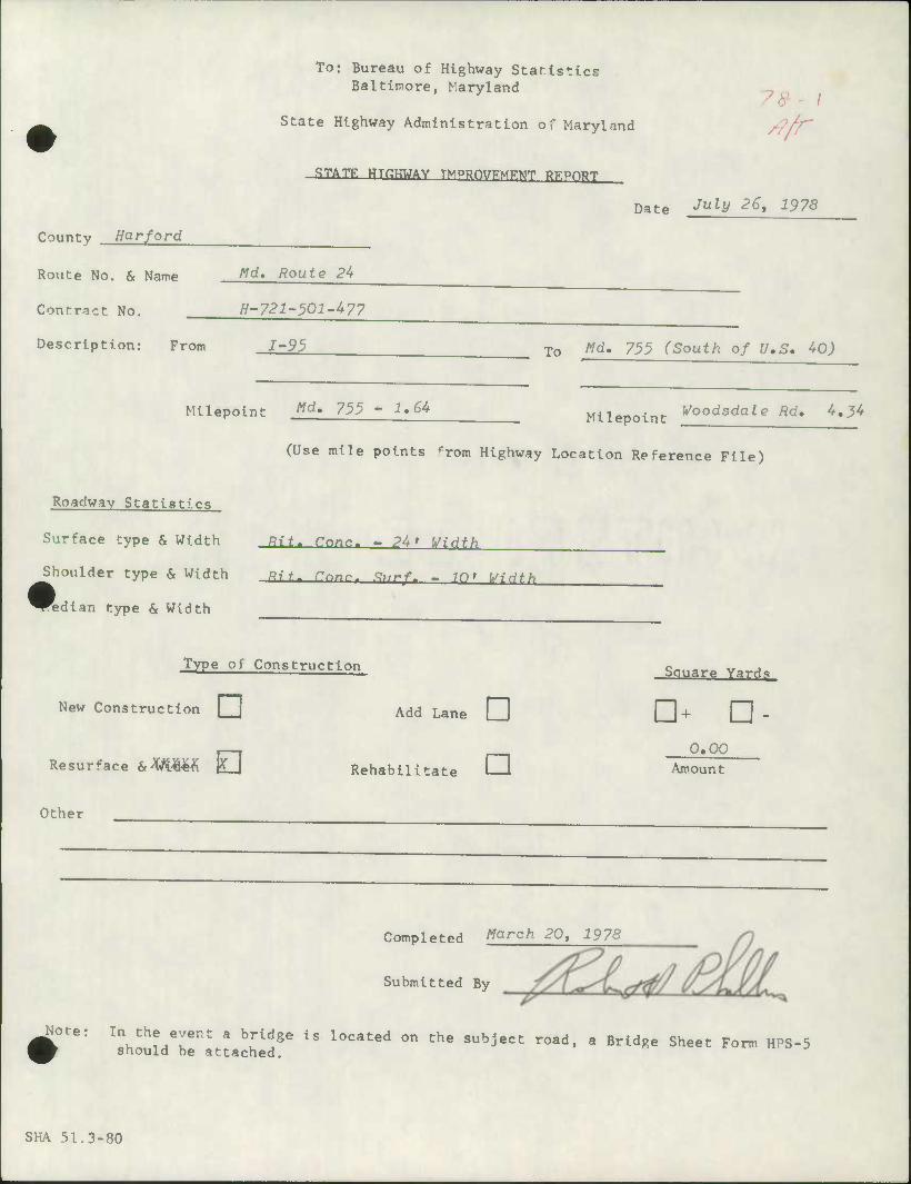
To: Bureau of Highway Statistics Baltimore, Maryland
State Highway Administration of Maryland
•STATE HTHHWAY TMPRfWFMFMT BKPORT
7^ /
Date Jul\i 2et ^7S
County Harford
Route No. & Name fld. Route 24
Contract No. H-721-501-477
Description: From 1-95 To Md. 755 (South of U.S. 40)
Milepolnt Md' 755 -1,64 Mllepoint j^oodsdaleRd.4.34
Roadway Statistics
Surface type & Width
Shoulder type & Width
^Rdlan type & Width
(Use mile points from Highway Location Reference File)
Rit. Tone. ~ P4> Widfh
Rif- Cnnr. .?,/rf. - igt WiHth
Type of Construction
New Construction • Add Lane Q
Resurface &^^M 0 Rehabl lltate I—i
Square Yards
n+ n- 0.00
Amount
Other
Completed ^arch 20> 1978
Submitted By
Note: ln^/Tnt a brid8e l- located on the subject road, a Bridge Sheet Form HPS-5 should be attached.
SHA 51.3-80
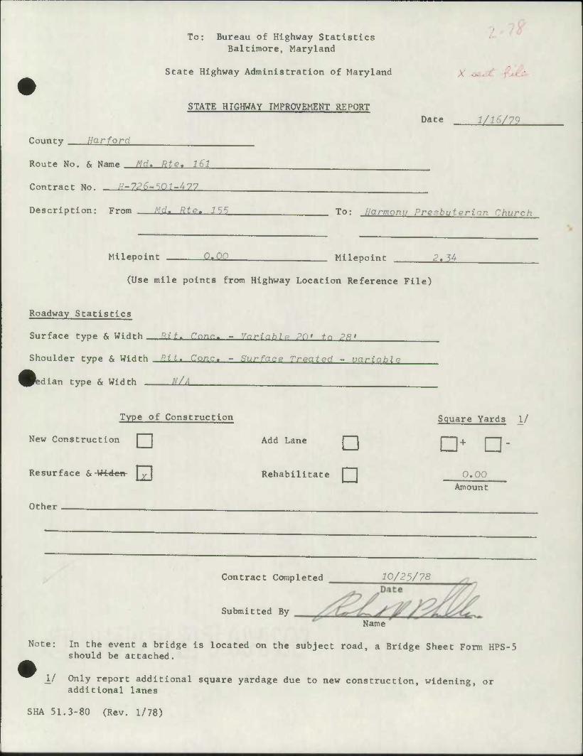
To: Bureau of Highway Statistics Baltimore, Maryland
State Highway Administration of Maryland X o*
STATE HIGHWAY IMPROVEMENT REPORT
County Harford
Route No. & Name Md, Rte. 161
Contract No. "-7,?^-SO7-^77
Description: From rd. RJP. 7SS
Milepoint -.i
Date 1/16/79
To: llarmonu Prenbuterian Church
Milepoint 2.^
(Use mile points from Highway Location Reference File)
Roadway Statistics
Surface type & Width ^it. Cnnr. - Vnrinhlv PD' tn ?R'
Shoulder type & Width P.it. Cone. - Surface Troatpd - unriablp
Median type & Width N/A
Type of Construction
New Construction Add Lane
Resurface & -Widcti j
Other
• Rehabilitate
Contract Completed
Submitted By
Square Yards 1/
•+ • 0.00
Amount
10/23/78
Name
Note: In the event a bridge is located on the subject road, a Bridge Sheet Form HPS-5 should be attached.
_!/ Only report additional square yardage due to new construction, widening, or additional lanes
SHA 51.3-80 (Rev. 1/78)
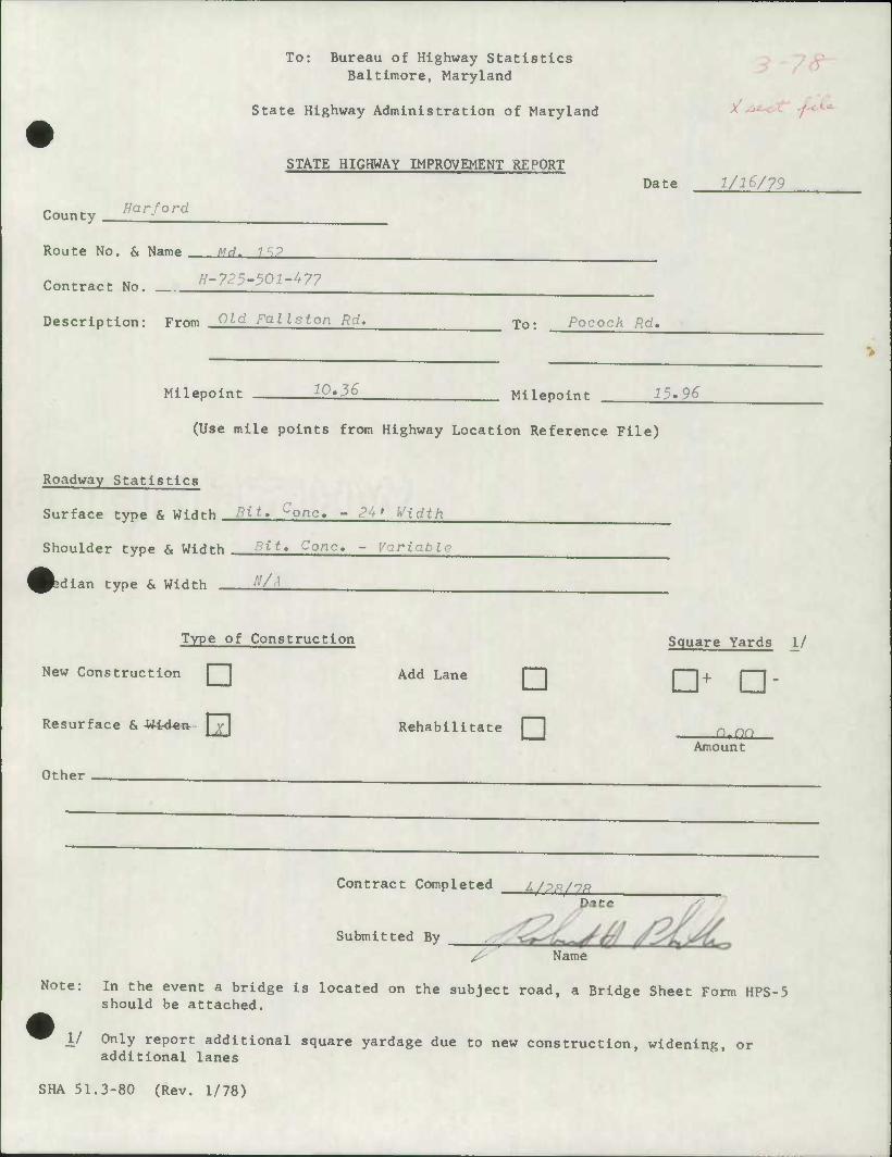
To: Bureau of Highway Statistics Baltimore, Maryland
State Highway Administration of Maryland /-
STATE HIGHWAY IMPROVEMENT REPORT
County //ar-ford
Route No. & Name Mrl- 1SP
Contract No. E-725-501-^77
Description: From CUd Falls ton Rd.
Date 1/16/79
To: Pocock Rd,
Milepoint 10.3S Milepoint 15.96
(Use mile points from Highway Location Reference File)
Roadway Statistics
Surface type & WiHt-h Bit, conc. - 24' Width
Shoulder type & Width .pit« Cone. - Variable
^bdian type & Width -
Type of Construction
New Construction
Resurface & -Widen I
Add Lane D Rehabilitate
Other
Contract Completed 4/p,9/7,3 Date
Submitted By ^
^ —
Name
Square Yards 1/
•+ • —
Amount
Note: In the event a bridge is located on the subject road, a Bridge Sheet Form HPS-5 should be attached.
V Only report additional square yardage due to new construction, widening, or additional lanes
SHA 51.3-80 (Rev. 1/78)
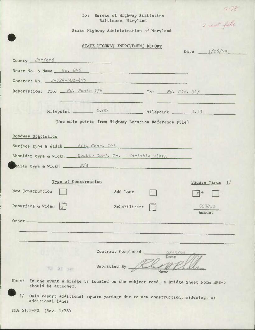
To: Bureau of Highway Statistics Baltimore, Maryland
State Highway Administration of Maryland
STATE HIGHWAY IMPROVEMENT REPORT Date 1/16/79
County Harford
Route No. & Name ^d« 646
Contract No. //-724-50:?-477
Description: From A'd. Route 136 To; 'd. Rte. 54j
Milepoint 0.00 Milepoint 5.33
(Use mile points from Highway Location Reference File)
Roadway Statistics
Surface type & Width Bit. Cone, 19'
Shoulder type & Width Double Surf. Tr, - Variahle loidth
>dian type & Width 'l/A
Type of Construction
New Construction Add Lane
Resurface & Widen
Other
D Rehabilitate
Contract Completed
Submitted By
Square Yards 1/
C3+ n- 6838,0 Amount
Name
Note: In the event a bridge Is located on the subject road, a Bridge Sheet Form HPS-5 should be attached.
j./ Only report additional square yardage due to new construction, widening, or additional lanes
SHA 51.3-80 (Rev. 1/78)
DISTRICT 4
DEC 14 19T8
WTE HIGHWAY ADMINISTRATIH
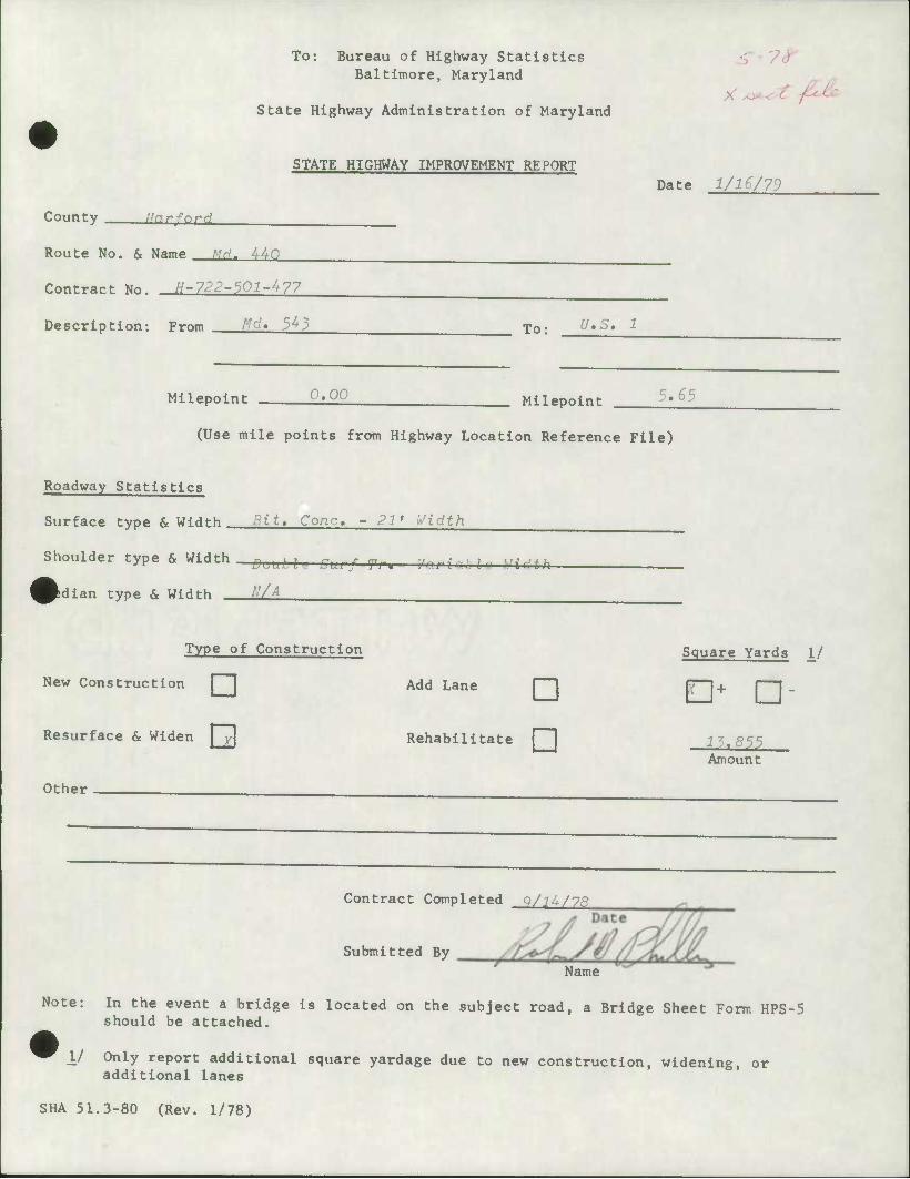
To: Bureau of Highway Statistics Baltimore, Maryland
State Highway Administration of Maryland PCX,
STATE HIGHWAY IMPROVEMENT RE PORT
County Rnrfnrrl
Route No. & Name MH- UhO
Contract No. //-722-501-477
Description: From A'd. 5^3
Milepoint 0.00
Date 1/1&/73
To: f/.5. 1
Milepoint ;.£5
(Use mile points from Highway Location Reference File)
Roadway Statistics
Surface type & W<dt-h Kit. Cone, - 21' Width
Shoulder type & Width DlJ[lLl[ ^ / ^ t Vnrin,ln ]Hdth
fedian type & Width tl/A
Type of Construction
New Construction
Resurface & Widen
Add Lane • Rehabilitate
Other
Contract Completed q/lA/78
Submitted By Name
Square Yards \l
t22L Amount
Note: In the event a bridge is located on the subject road, a Bridge Sheet Form HPS-5 should be attached.
1/ Only report additional square yardage due to new construction, widening, or additional lanes
SHA 51.3-80 (Rev. 1/78)
To: Bureau of Highway Statistics Baltimore, Maryland
State Highway Administration of Maryland
STATE HIGHWAY IMPROVEMENT REPORT
County Bar ford
Route No. & Name ^' 22
Contract No. //-695-000-^77
Description: From 0.^ mi. west of Md, 156
Date 1/16/79
To; A?d. 5^3
Milepoint 2.OS Milepoint £.06
(Use mile points from Highway Location Reference File)
Roadway Statistics
Surface type & Width Bit* Cone, - 24*
Shoulder type & Width
Idian type & Width _
Bit, Cone, - Variable
N/A
Type of Construction
New Construction Add Lane ["""1
Resurface &- WIflgg
Other
Rehabilitate
Contract Completed
Submitted By
6/7/76
Name
Square Yards 1/
•+ D- 0.00
Amount
Note: In the event a bridge is located on the subject road, a Bridge Sheet Form HPS-5 should be attached.
1/ Only report additional square yardage due to new construction, widening, or additional lanes
SHA 51.3-80 (Rev. 1/78)
To: Bureau of Highway Statistics Baltimore, Maryland
State Highway Administration of Maryland
7-
STATE HIGHWAY IMPROVEMENT REPORT
County Harfnrrl Business Route 24
Route No. & NamP A/..?. T'-r,t Rnnd Rt. f.n Md. 24 fMain St.)
H-520-003-^71 Contract No.
Description: From See above To:
Milepoint 0.00 CRu*. ?U) Milepoint
Date 1/16/79
0.06 (Bus, 24)
(Use mile points from Highway Location Reference File)
Roadway Statistics
Surface type & Width Bit. Cone, - J6' Width
Shoulder type & Width rnmb. Curh and Gutter
idian type & Width Mono
Type of Construction
New Construction Add Lane
Resurface & Widen
Other
• Rehabilitate
Square Yards 1/
55^6 Amount
Contract Completed
Submitted By
4/10/78 Date
Name
Note: In the event a bridge is located on the subject road, a Bridge Sheet Form HPS-5 should be attached.
1/ Only report additional square yardage due to new construction, widening, or additional lanes
SHA 51.3-80 (Rev. 1/78)
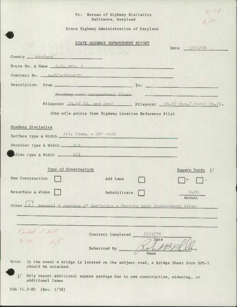
To: Bureau of Highway Statistics Baltimore, Maryland
State Highway Administration of Maryland
A/r
County Mar ford
STATE HIGHWAY IMPROVEMENT REPORT
Route No. & Name ^..9. ff^g. 7
Contract No. A/-7^-so7-^77
Description: From To;
Date 1/1G/79
Milepoint l^-UG (S. pnd dam) Milepoint 20,36 Har,/ Cecil Co./L.
(Use mile points from Highway Location Reference File)
Roadway Statistics
Surface type & Width Bit, Conn, - 20' wide
Shoulder type & Width V/A
^^dlan type & Width '-'/A
Add Lane
Type of Construction
New Construction
Resurface & Widen
Other -LXJ Rpmnval P. rpplnce 1" Surfacing - Roadivau over Susouehanna River
D Rehabilitate
Square Yards 1/
•+ •- 0,00
Amount
/}/r Contract Completed 11/1/7
Submitted By _
Date
17 Name
Note: In the event a bridge is located on the subject road, a Bridge Sheet Form HPS-5 should be attached.
\l Only report additional square yardage due to new construction, widening, or additional lanes
SHA 51.3-80 (Rev. 1/78)
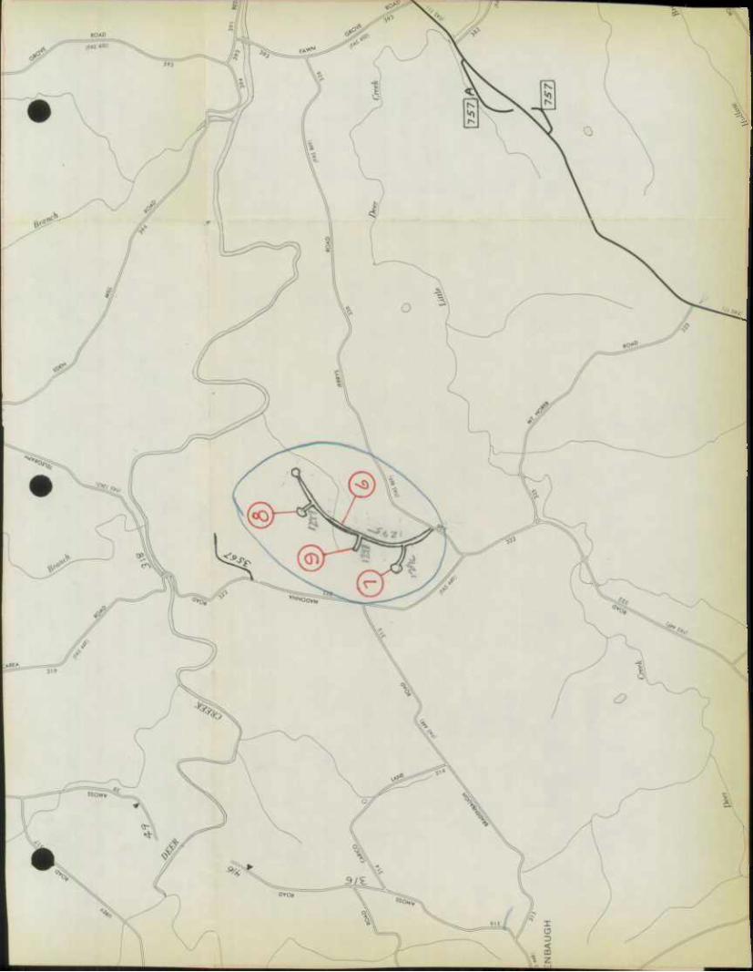
Locust Knoll
. Benson
Hills
FALLSTOlI \ Twin -J /Brool)
Estate
^vv* Lynchs Corner
\ ^y^'
rCart^elf
'Ceda^ 'Sprrtig-"^ Valley
iew
rood 0
Fairwas
r^
o^V ^Oaks
EmmortonJ^
lATKISS
Wilna VS^ ^
^VOIR
-(4-
Stockton
\^>^5S^
North rid
-£&//
reston ^1^^ Manor I
ROAD) l
Norris Corner
Constant Friendshic
Crtl. ^Mountain
^Gre kQ. SpV
^L
Green :resl \
.^^•vFranklmvilleX^ Manor
AB/NG^
.Lou Mar Estates
95
<^ la A
ylean A
Van c^i \Bibberf
\GUNPO
view
\
ropi
136
Creswell
UNE
EAST CHRIST COLLE
Bynlim § -iHills 5
HarW
Fores
3 Estates
HOOKERS ^^V// ( JOj
FAS
t^^grf Abingdon
jsh
Edge Vlllc
<w*
Magnolia
EDGEWOOD
Cr6stw Atres J
.\vv-
ao^
y^ ABERDEENyJ^0
IWOQD PROVING-
^
A
^
ARSENAL
GFiOUNQ^
o Ea^e PL
^
^z
(!hillii]r\
Pi
liu^h I'l.
-T-f
J5 TO
Z'l
:w
So
05
w
<Dl
<<
\S^C • Mr-///, /,
O
0
^>3
w ^
UJ V in
hi (Y) —^
Q CM' /
Q:' •(L .'•.•.•••••! UJ m
O. j
T-A
-V „>''
occ
/^
FORD
fAS
«*»
oTT
5^0
^THC
^
w 11 ̂ i ̂ V s^^ 1 ••
^c^fc -X
% \ 5i< ^\
[•]l ^B^ O ^-"^ \ 5\ = 4 Mjjjjjk ̂ vu
5^ A
Q 1 /t HI CM
zr XJ ^
*• <z 1 K 1 f y_fc y- •A » s ̂
^ < j
ro c ^W^y ^fii/^ —,. 1 t^-fc? ^* ̂ > /"•+,» •f. r ^- OJ ra^- ^O^r * ^-^ ( v IftW ICQX
^^ ** *. "I hiv£t > / ^m J-/J ̂
4\
}
0 0 y
) "B^ 0 E r3^ ̂ \ 0 ^ —^•(,9 0 \ 0 -NV -^ A
0) 00
(1)
v^
/ NOil
o ^l
TO QJ
20
^
OJ O QJ O
UJ
•v-
NOS1IM
1 \ ^ K: "l ^ ^
^ ^^ \>L C/J
^ U V^^A M07 ̂ •^r JL^^ ^N m -^F^ \ \ >^v»
vi^> / ^m^m^^ ̂ ^*. \ V—^^^F^mTS ^1 a rW 0 9
T3 (fc**/ ^a Tl L_J < NXVS. 1 Y ̂ 1" iVv\
d/ RO^P, ^'syr 1
li:Mk:lM
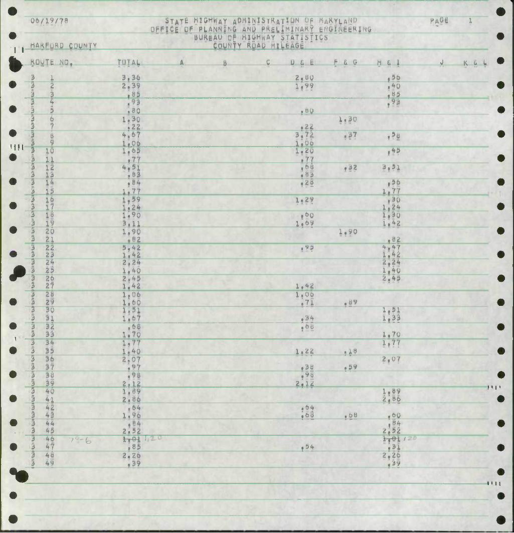
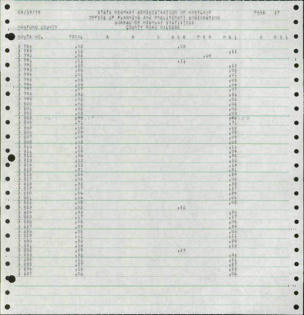
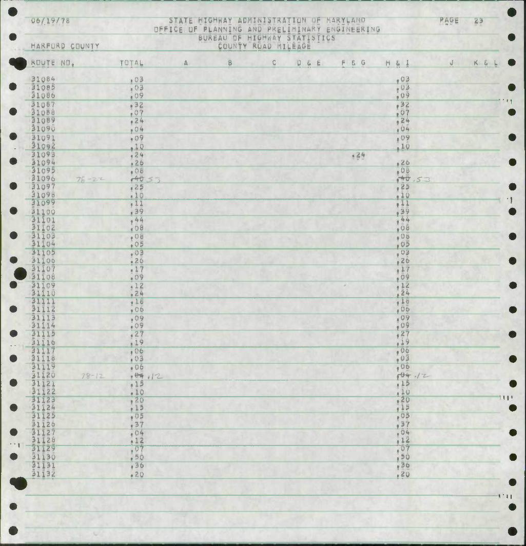
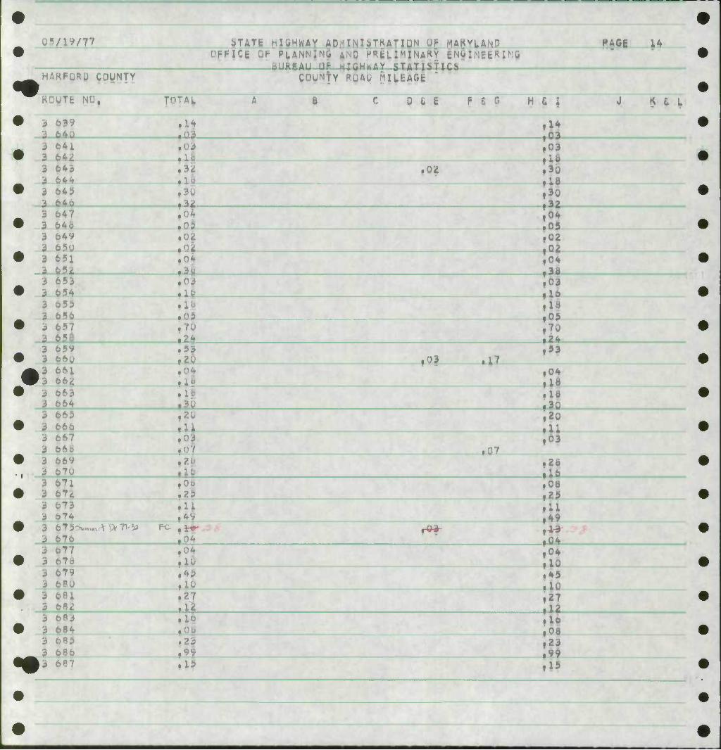
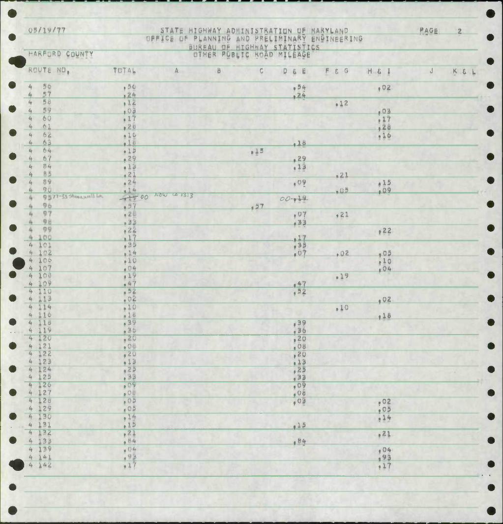
06/19/7*
hAKFyap couHiy
STATt HIGHWAY AD^HNIS T^A r lUN "I- 'VIAKYU.. p PLANNING ANU P^SL- r tr'Gi,;tt^
BUKEAU CF HUH^AY iTATi^Tl
coyNfY m9 mitm 1
PAGE
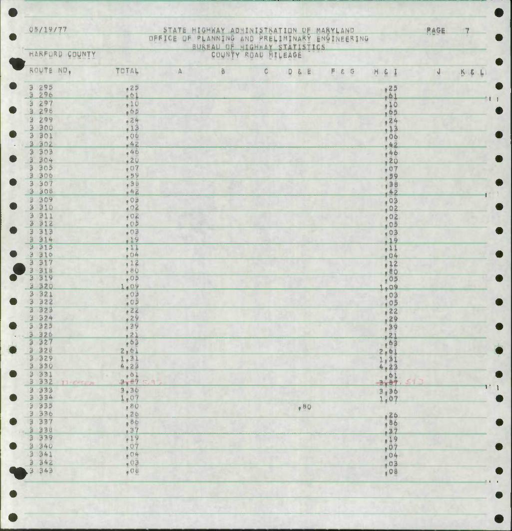
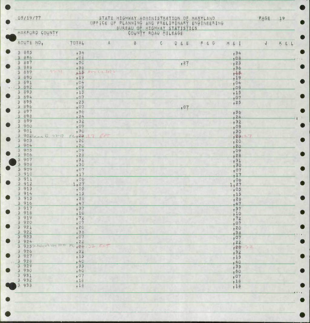
t KOVTt NQ.
3 1 2
I I 3f36 2,39
1.30 .22
US
B U L fe f- & G H fc i
ii«y l|99
f5? ^0
I
K c L
II
3 3
f-rf ?
i ay
3.72
1.30
37 ,'«
3.51 3 3
3
^ ^
lf6 »77
S51
.84 1.77
l.^U
:'' 32
ll .50
3 3 3 | 3
ii l^ 20
?i
1.59 1,24 1.90
3.11 1.90 a-82
Xt29
fGO 1,69
1.90
l,Z4 1.3U
fi
3 3 3 3 3
22 23 24 25 2b 27
3 26 19 30 31
3.4;
1.40 2.45 1,42 rjoj
1.70
,V9
2,2^ 1,40
\'** Z?45
I 3 3 3 3
3 3 3 3 3 3
32 33 3^ 35 36 37
39 4J
1,7 1.40 2,07
.96
2.12
1,06
»«?
,34 ,6b
i.n 1,33
1,7U 1,77
3 4 I 4. 3 43 3 44 3 45
3 47
1,89 2,86
,64 1.96
2.5, » f "1
2,20 ,39
TTV
uu Oi ,3d ,D9
2,07
2,1^ 1,B9
t^ 68 ,60
2^52
M I
W —
••
40 49
7^-b 64 .31
:,2&
.3>
II l
4
M
%
IM
I • I •c
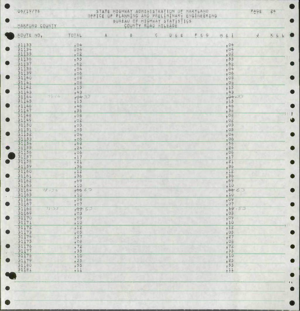
06/1V/78 STATE HIGHWAY A5MTN|STRATTUN "^ lAKYUAMD nf-FICE UF PLANNING Ar'U KRtLl
BUKEAU CP HIGHWAY i FATiSTlQS couN'tv RUAU MILEAGE
PAGE
KOUTE NO, 0 L C P £ 0 H »• \ K a L
W^* ^1. 3.11
7 .* 8
19
fH-Zii^.
36 17 0 I
.az
1.17
l.^o 3.35
2,07
26 ^2 5?
f^ ao
r}7 .26 fS
l.U
i*5
2f2tt i,20
25 U 22 28 28 20 08 74 69 81 40
51 87 06 78 5U 5 5 10 34 16 40 5b
08 28 45 46 q 72 25 2i
20
7 4 69
4.27
2,40
«>3 70
6^ 63 06
04 34
72
2H
^3
4U
?0b uof 2.tf7 2,f4 i;33
f06
1,16 3,^0
ill
! 40 l,b4
,02
-1 •
<
U6/.IV/78
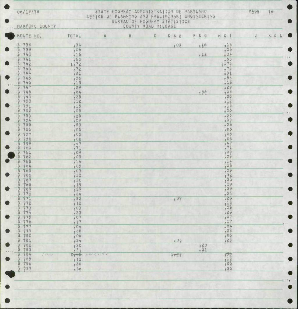
h^K
STATt HIGHWAY AT ffUTIUN DPF|C| UF PLANNING ANU PK£L I "I^AK Y c'lb 1 UfcfcK i'^G
BUREAU^PF HIuHwAY STATibTICS COUNTY RUAD filUAGfe
PAGE 16
KQUTE
3 7 3 73^
i 7^i
3 7^3 3 7^ 3 t^S 3 Ho 3 747
5 ir4v 3 750 3 75i 3 752
3 ^5fe
S 757 I 75u 3 75^ 3 760 3 Hi 3 76ii
f63 3 764
[AV
34 06
B U g <: I6 6 G h t i
,yp ^
tt? 06 04
J. K ^. "r
ii 60 72 72 3i 56 13 29 64 25 12 15
•^
,60 72 ,72 3i 56 13 2V ,ytt
U 15 05
75H 755
•r765 3 766 3 767 | 76b 3 769 3 77u 3 77i 3 772
^73 | 774 3 775 3 776
25 09 53 05 05
47 Tl 0 9 09 14 0
,25 ,0 1 ,5 ,05 ,05 ,0b Of ,7 i 6 ,09
,05 103 Jl ,20
29 24 23 12
23
17 :64
00 .2b
til f36
3 3 3 3 3 3 3 3
m 779 76o 781 782 783
785 3 78o 3 787
ymr
o 32 20 19 29 24
12 0 3 23
2b 06 34 20 2;
09
,00
c * I •FT- Ir^
.20
12 26 36
06/19/78 STATE HIGHWAY ADMIisiyTKAH. OFFICE JF PLANNING ANU PKBLlMlNARY
HAGE 17
MAKPURD gOUNTY BUREAU CF HIGHWAY iTATlbTICS
^DUNTY RUAO ULtAGt
• KGUTt • , T A B C U 6 b h • H u J 4 K
3 78b .05 .05 3 ? 3 1
.12 ,06 • 01
|l? 3 79! 3 79^ ;i III
3 793 3 79^
,00
?9^ 3 79b .09
,05 ,09
3 797 3 ^
f07 .32 • »2
/9V 3 aoo .02 3 aoi
.01 ,02 .0>
3 do4 .71 5^
In 3 ao5 3 boo ,09 ,09 3 607 1 ind
.09 rn5
,0? toi
3 BIO 3 an $ :Ji
fc 3 B12 ' 3 ai3
.56 ,56 ,10
3 (m .15 .31
,15
if* 3 Bib 3 817
f ,08
3 61b 3 B
,35 ,17
,35
3 U20 3 62i
.24 »24 ,0! 3 522
3 623 ,22 .28 ,05
3 d24 3 625
,38 »1? ,17
3 B2b 3 o27
,06 •8 .39
3 620 3 829
,01 .11
,08 III
3 e3u 3 831
,20 f IB
,20 ill
3 BB^ 3 1
,29 ,19 f3^
3 ti3H 3 635
ill ,27 27
3 B3b 3 637
,1b ,16 ,06
>
< '
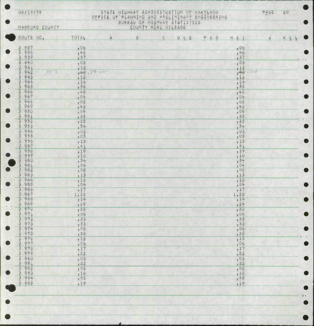
06/19/78
HAK
STATfc HIGHWAY ADMI UlUN DFFICE Of PLANN1 ?HiP \
BUREAU DF HI^HrtAY STATISTICS C0UNtv ^ MILEAGJ '
MAKYLA IitttilMG
HAUfc iO
KUUTt I C u L fe F 6 G H L | J K U I
3 937 .06 ,06 3 93f I 93V
,46
•3t 1 ;l! 3 94i
.03 ,12
f03 .1^
3 942 943 .12 ,
3 944 3 941)
|1J .56
1| ,58
3 940 3 947
.45 ,06 , ,06
3 V 3 9<f9
.05
.43 , ,05
3 950 3 95i
I .35 ,35
3 952 3 953 •if ' .54 . III 3 95^ 3 955
.03 ,05
03
3 950 3 957
.15 .15
3 95b .19 .10
,1V ,10
| 3 V60 ' 3 961
.34 ^i 3 962 3 963
.08
.13
_
3 96^ 3 965
.16 , ,04 ,
^66 3 967
.17 1.Z6 1, :«
3 966 3 969
.14 f29 1
iH
3 976 | 971
,zfi ] 2o ,00
3 97^ 3 973
.23
.33 1^3 3 97^ 3 975
,06 ,2c
|06
3 977 III 1 ,06 5 y 3 979 \l\ : iiT 3 980 3 ^8J
.03
•ft f0t
ii5 2
3 983 ,08 j .16
3 9 3 9
k ll^ (
,85
U6./1V/78
.u HAKf NJY
^TATE HIGHWAY ADMlNl$TftATIQ tYUAfMO ICE UF PLANN^G AND P^fcL EJRINQ
bUKEAUDP HIGHWAY STATibTlCi* COUN'TY RUAQ MlUAGt '
KAlifc dl
^9yit
^
3
3 3 •
I 3 •
3 3 2 i 3 3 31 31 31 3l 31 31 31 n 31 31 31 31 31 31 31 3l 31 31 31 3i 3i 31 3i 31 31
31 31 31 3i 31 31 31 31 31
987
9?g 99i
993 99^ 995 99b
999 OOP UUi UO£ 003
OOfc
U10 Oil J12 U13 uit Ul3 Olb 017 OK- 01^ 020 021 022 02SJ 02^
02b 02 7
029 030 03i 032 033 034
B 0 6 c I- G 0
.24
-tT fO • u .10 »07
? !2 .16 •19 .12 ,25 ,2b
.17
1*9
.03
,22
.•13
,0b
.12 I 09
1,05 f04
7^-/^
1,«4
.09 ,lb ,21 ,10
.34 ,M4 ,73 ,04
»o
.04
I
04
^i
M ^ i
I07 5.
Si 10 ,07
21 10 IV U ^^ 2b IV
U 40 ,64 ,02 03 ,03 ,04 14 2i ,05 ,03 ,06 U 05 05
K b L
11
T^f
1?
10 t3 34 04
*\
J ,04 OJ ,04
< < <
I •
f > ir
06/IW78
*AK^*B_mNIY
STATE HIGHWAY ADMIM6TKATlUN UP KAKYL; DPFICJ UP PLANNING ANU fRjl
bUKEAu'rp HIGHWAY STATJSJI^S gPVNfY RUAp MIJ.EAGfc;
HAOfc tt
KDUTE NO. [AV g u t t P 6 G H L i i * <?^
lU3i) lU3t> 1U37
103^
IQ41
10^
1043
1U47 1J4^
ml 105U lG5i 1052 1053 105H 1033 1056 1051
105^ 1060 1061
1063 1064 106| ___^_^rr 10 61 1067 106S
1070 1071 107^ 107 107*
90 21
90
i
>•
1075 1070
1079 loeo 1081
09 26
22 16
6 46
30
IJ 70
23
4 T 48 13 08 08
li 3- 3i 97
i05
9 2u
U 16
I
1.51
09 03 30
• 01
JL2i
^iii't •-^ jJ -1/*^ 'in vvn .^i
J T 07 09 60 22 )9 77 46 45 19
80 14 4b 54 13
70
23
U 34 3.
21 16
09 60 22 0* rr 46 45 19 05 80 14 48 04
fl3
II
,04
II
<f
U6./IV/78
HAKFURP COUNTY
STATE HIGHWAY ADMIINI oT ^ ATI UICE UF PIANNTG ANU FKEL
BUREAU OF HIGHWAY JTATiilUS COUNTY Ru
SkRYU PAGt ^3
KDuTt NO I B Q U t F £ G H 8 | K L I
U8^
09w 091
U9i 094 093 090 097
094
100
103
03 "3 09
03 03 09
• i
32 0 I 2 0* 09 10
3^ 07 24 04 09
?£_
24 26
25
12
.4^
U 39 44
20
39 *4 Ob 00 05
IUC5
107 ioa
UO u 1U 113 114 115
16
03 26
03 26
17 09
3li 3 3 3 3 3 3 3 3
3 3 3 3 3 3 I 3 3
3 3 3
Ho 11*
121 122 123 124 125 12o i2f
131) 131
132
7^-
17 09 12 24 lb Cb 0 4
27 19
06 0 3 06
1$ 10 1^ 15
37
12 Tf 50 36
20
12 24 15 00 oy 09 V 19 oo 03 00
15
io 2B 15 05
87 50 30
i
\ • i
06/19/78
HAKPyRp 9PWNIY
iARYL STATt HIGHWAY ADMINI5TRATII Mf-FICE uF PLANNT-'O AND PMklMMf<3
bUKEAl^Ti- HIGHWAY iTATibTigb
PAGE 2*»
KQUTt NO, 'H B c U u t f- fi G H 1 K u L
133
139
Ui ^2
U5
150 151 152 53
04
02
154 155 156 157 15* isv 16U 161
i6J 164 1^3 i6b 16?
ui i7i 172 I7i 174 17i 176 17? i7c 179 iou l^i
ff ^
55 62
nb 0 6
15
$ V"T
15 46 36
02
05 04
24 06 17 21
12 36
10 fTTO " -^
ifi
35 6^ 04 00
fli 13 4J
"la 4b
o^ 05 U5 04 06 6b 24 Ob 17 *£! 3b
3b 6^ U H> 10
sx
••
09 i 03 09 10 12 0 5 27 OS 72 35 10 25 55 11
OV 0
03 ov IU 12 05 27 U<3
7^
16
55 ill
••
06/19/78
hAKPUPU COUNTY
STATE HIGHWAY ADMIlMlbTKAllUN -YLA.^lD UI-FICE J^ PLANNI^C ANU PKEU|w|NARY ENQ
UUREA HIGHWAY jTAToUCb COUNTY ftUAU MIUEAGE '
PAbfc 27
KDUTfc NO, 'H b P t 6 I- £ G
2Bb £B7 28t} 289 290 i9i 292 ^93 29^ 293 296 297 299 ioo 301 302 5o3 JO4
1>DI 306
30o So>
3u
^
06 U
•j fi I K L L
,06
ill 1^?
75LI
|0 f06 .11
of 57 10 05 25 Ob
03 06 U
05
It 1U 05 25 00
26 15 00
u 24
20 15 yo 0^ 1..
|Xil|
u
20 lo 0
!
U 09 05 20
06
15
33
326 329 330 331 332 333 000 001
19
10
1^
77^ /}*£ -^Vfr- , 5f i 7^.5 1-5-11 > 90 06
,06
? 0 03 26 10
i2i
09 10 0^
J 27
H
9U 06 9
,53>
^ 0 03 20 10

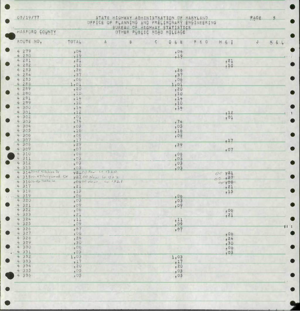
06/19/78 i>TATt HIGHWAY ADiilUliTRA HUN uh rlAKYLA^U -FjCE Of- PLANN^C ANU PRfel. I M JNAK Y t t:Ri Nli
PAGE ^n
• BURfcAu np HIGHWAY STATISTICS MAKf- CUUK'tY ftuAU MlLEAGfc
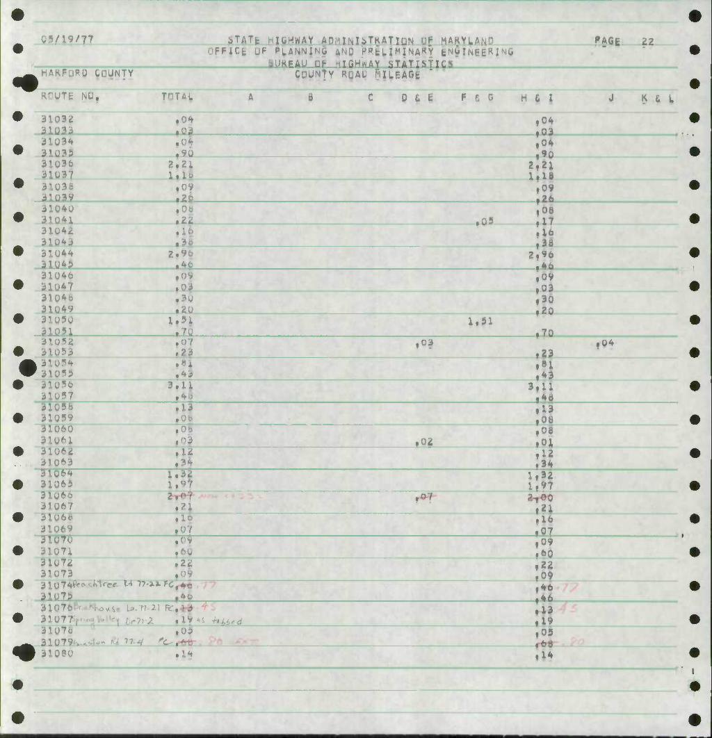
4Q KUUTE NO, TOTAL A B C U & fc ^ 6 I 0 K u L
3300i 1,51 ltll • 33003 ,09
33004 fii •4 33009 ,13
• 33006 ,6d »1| t6o
33007 .69 774,39 197,^ 30.23
,69 906,49 ,08
0 ApTtweTim' 2.^ ,oS
• M^PX m 7L, 7 /i 7. - f. *1
/ - s . .
£a /3'Sy s>-'4 fa/is OS/ZT&^'ZC a-o?
• ,12-
.( -4-
0 ^/ C,. vVT^y ^ /^3 7^'// /33
. c
A "
///
# ''7
Tf' 0 .6*
1 • 0-3
0 ,/4
O'^C* UlAsTe/Ci'^Kftv rr ,o<f. Tp~i<& ^4- P
2.4/
3 -T
"t-1- 7 'S7,30 Z~2 5-^, ,<? 1
•
V •
k
778
MAKj
STATE HIGHWAY ADMlNlbTKA FIUN nh liARYL/ ICE LiF PLA,NNi:-.& AND PRgL
BUREAU DP MICMWAY iTATisTlLb OTHER PUBIrlt ROAD'^ILEAGl
HAliE
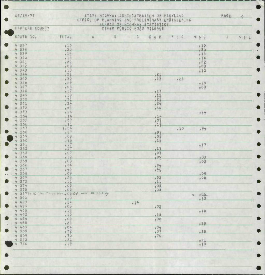
KOuTfc NO, B JJ_t | f- t G H fi | B S L
4
4 4 4 k 4 4 4 4 4 4 4 4 4 4
^
3^
3^
iii 353 35^
35o
361 36^
364 36^ 36o
374 373 39U (7?-a.S) 423
10 2 i 3 29 03 17 13 2 i 2
24 14
1 I 0 37
16 17
58
05
1* AJ^OO c^rnETis"
Oi
U3
17 13
24
.10
U3
07 09
»4 40
i>2
05
:0^ ,10
03 I
i24
,94
17
,03 ,03
tO*. 06
I'
r*r •
439
464 465 469 5o3
5U 74u 769 7tu
1023 10^5 121? Ulc
03
15 06 23
03
3 7C 21 19
.05
.04
.14 ,34
.06
15 06
70
05 04
115
10
,23
«l
.1*
• 25
,1?
,06
11
\
06/1^/78
HAKf^p cuyN.n
STATE HIGHWAY ADMIMbTKA T lUN • OPFICE OP PLANNivG ANU K«ELlMiNAKY
bUKEAUCF- HIGHWAY aTATiSlICS
ptHift P-QHU RPAP tiutAtfE
t'AbE
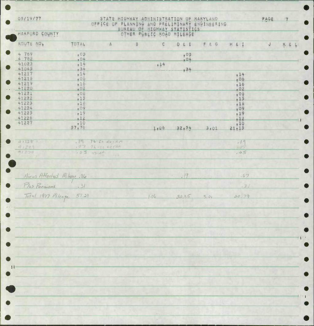
KOGTk NO,
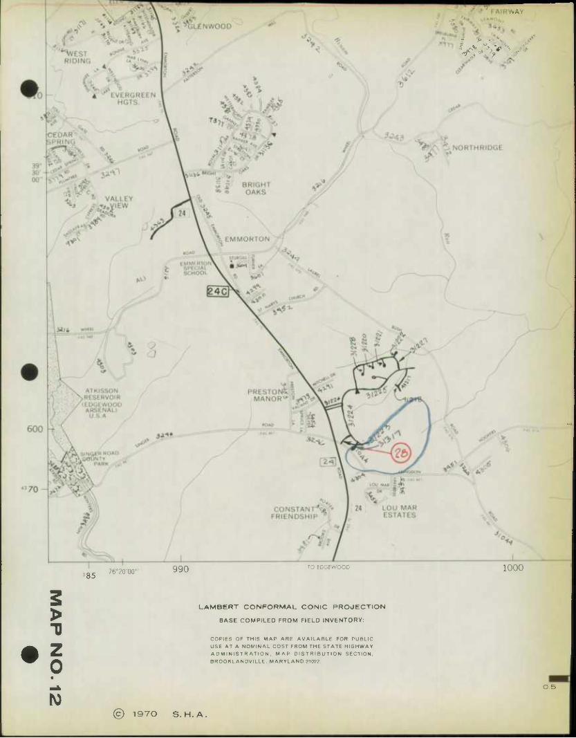
nzzO HUZI —12&_
B g ft 6 P 6 G
,10
^ 6 L
4lZ25 41226 nZ27
• lo ,09 .19 .12
41230 57,21 l.U-6 __32i^> i.wl • 7*
TTTT ^z- > ^ '>0/ ^.o ^O
/dL ^> ;£o^
77/ T7"
«
%
•AMta
I 1
«
#
-J -^

MEMORANDUM OF ACTION OF FREDERICK GOTTEMOELLER OFFICE OF PLANNING AND PRELIMINARY ENGINEERING
March 22, 1978
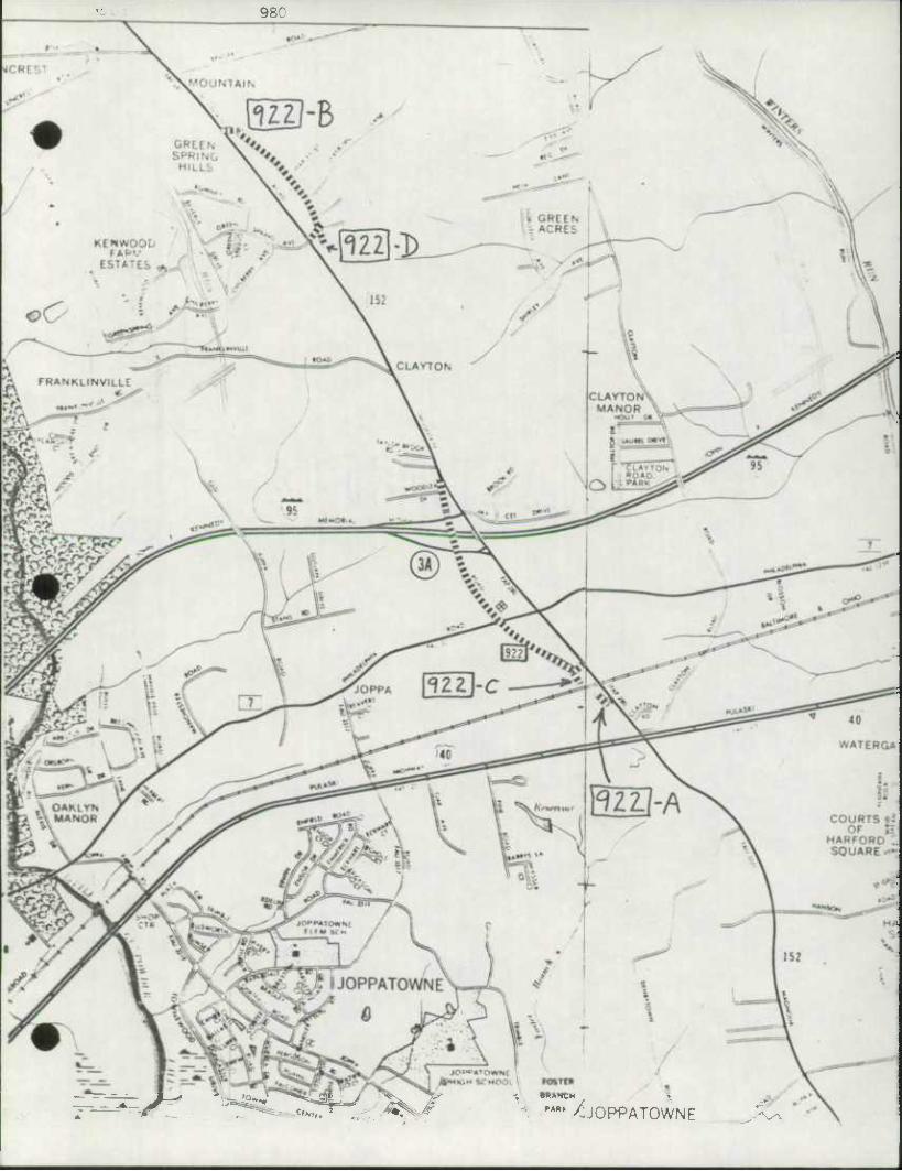
Director Gottemoeller, Office of Planning and Preliminary Engineering executed Agreement dated March 22, 1978 between the State Highway Administration, the Maryland Transportation Authority and Harford County, Maryland, relative to the transfer by the Highway Administration to Harford County of the following described sections of State constructed roads subject to the conditions more fully set forth in the agreement.
i /Md. 922 - from Md. 152 northerly over 1-95 to Md. 152 a distance V of 0.90+ mile.
L
r t J
3,
Md. 922-A - from Md. 152 to the B&O Railroad a distance of 0.06+ mile.
Md. 922-B - from Md. 152 at Green Spring Avenue to Md. 152 a distance of 0.54+ mile.
Md. 922-C - from Md. 922 to the B&O Railroad a distance of 0.07+ mile.
Md. 922-D - from Md. 922-B to a road end a distance of 0.03+ mile.
Said agreement had previously been executed by the Executive Secretary of the Maryland Transportation Authority and the County Executive Harford County and approved as to form and legal sufficiency by Administrative Special Attorney Norman Polski.
Copies to: N. B. Friese H. G. Downs A. W. Tate A. L. Gardner F. Gottemoeller C. W. Reese H. J. Pistel J. N. Day T. Hicks R. C. Pazourek W. F. Lins
E. J. Dougherty C. P. Hyatt E. S, Freedman C. Lee P. S. Jaworski J. T. Neukam R. C. Davison E. K. Roche Harford County Secretary's File S.H.A. Harford County
980
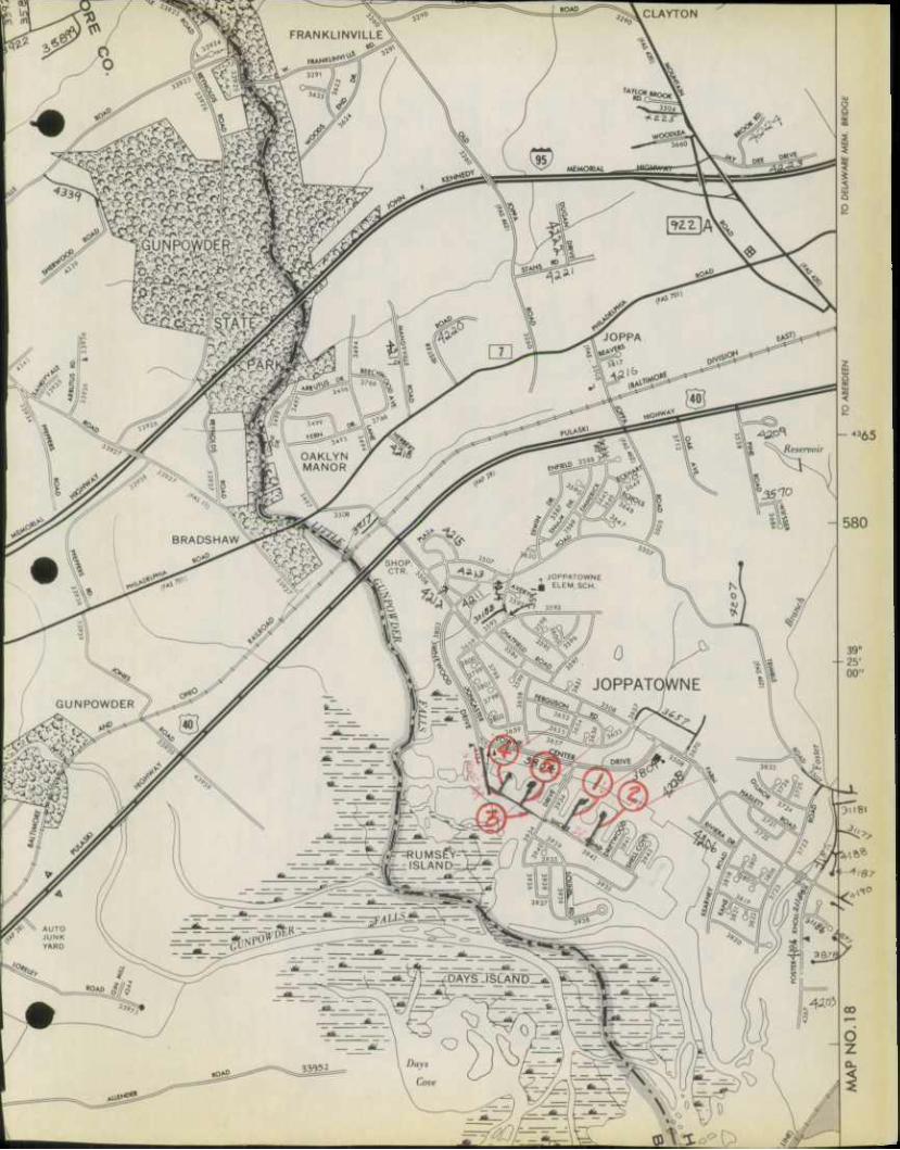
:4N/ $ "** ^JOPPATOWNE
SHA 5] .3-23
Rev. 1 74
STATE HIGHWAY ADK^^TRATION OF MARYLAND
ROAD IMPROVEMENT REPORT
HPS - 20
4 rage . of
S.H.A. District No.
Counts
Ath
Harford
City or Town
For Colendor Yeor Ending December 30. 1977
ROAD NUMBER
ROAD NAME
LOCATION DESIG- NATIONS ON MAP
MILES
CHANGES MADE IN MILEAGE
REMARKS
Map No.
FROM TO TYPE WIDTH SYSTEM ADDI-
TIONS ABAN- DONED FROM TO
(1) (2) (3) (4) (5) (6) (7) (8) (') (10) 01) (12)
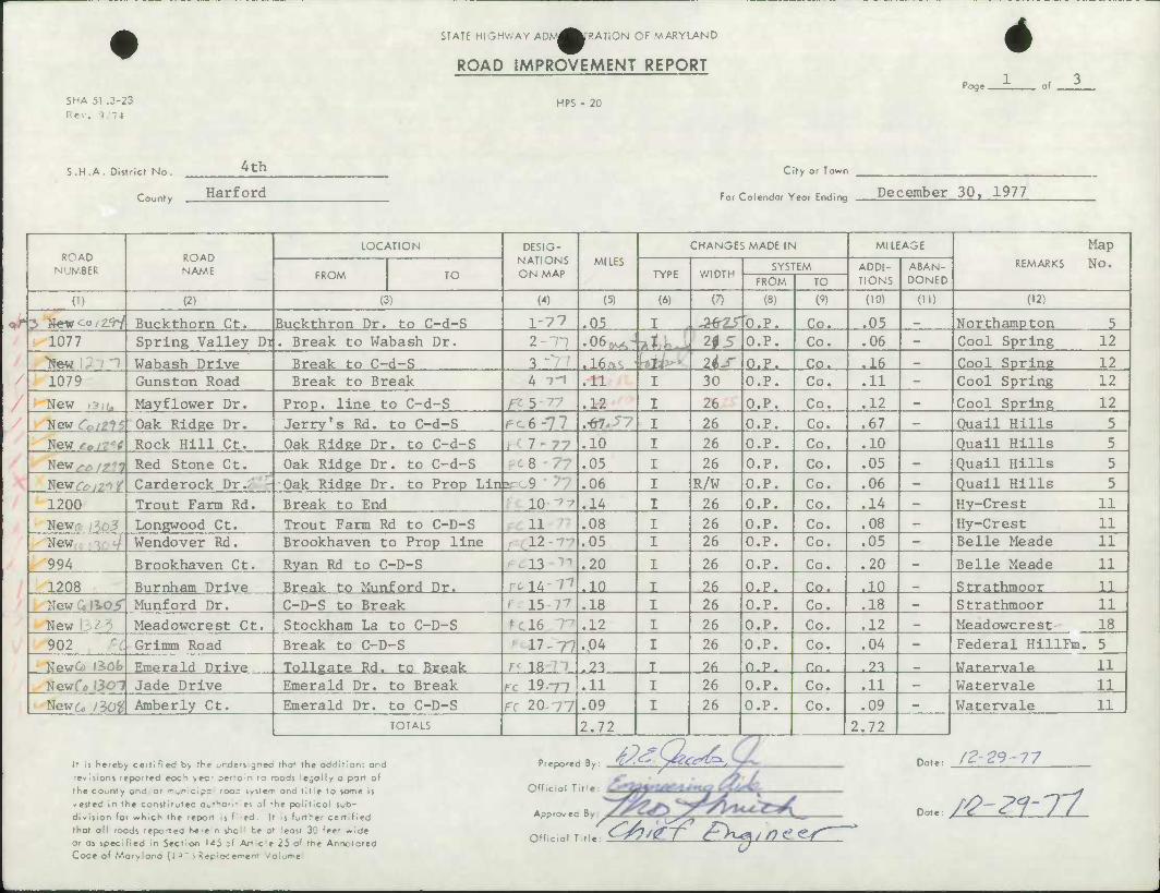
5 »ew^o/2<r/ Buckthorn Ct. Buckthron Dr. to C-d-S 1'77 .05 I AfrTSO.F. Co. .05 _ Northampton 5 1077 Spring Valley Di . Break to Wabash Dr. 2-11 .06^-J -I , 2fS O.P. Co. .06 - Cool Spring 12
"ftew Wabash Drive Break to C-d-S 3" .16^. Jj 2^-r O.P. Co. .16 _ Cool Spring 12 1079 Gunston Road Break to Break 4 'i .11 I 30 O.P. Co. .11 - Cool Spring 12
New \3iim Mayflower Dr. Prop, line to C-d-S /^ 5 - 77 .12 I 26 O.P. Co. .12 - Cool Spring 12
New<^/z?5 Oak Ridge Dr. Jerry's Rd. to C-d-S pc6-77 .-67. -7 I 26 O.P. Co. .67 — Quail Hills 5
New re i Rock Hill Ct. Oak Ridee Dr. to C-d-S • 7-77 .10 I 26 O.P. Co. .10 Quail Hills 5
New^/^^ Red Stone Ct. Oak Ridge Dr. to C-d-S 8 • /'• .05 I 26 O.P. Co. .05 - Quail Hills 5
Newrrv^^r Carderock Dr. Oak Ridge Dr. to Prop Lin * 9 .06 I R/W O.P. Co. .06 - Quail Hills 5
1200 Trout Farm Rd. Break to End lOt? .14 I 26 O.P. Co. .14 — Hy-Crest 11
New,-, ,305 Longwood Ct. Trout Farm Rd to C-D-S 11 .08 I 26 O.P. Co. .08 - Hy-Crest 11 New Wendover Rd. Brookhaven to Prop line 12- .05 I 26 O.P. Co. .05 - Belle Meade 11
994 Brookhaven Ct. Ryan Rd to C-D-S 13 .20 I 26 O.P. Co. .20 — Belle Meade 11
1208 Burnham Drive Break to Munford Dr. rciA-T' .10 I 26 O.P. Co. .10 _ Strathmoor 11 New 0 li.O/' Munford Dr. C-D-S to Break l 15 7^ .18 I 26 O.P. Co. .18 — Strathmoor 11 New 2 - Meadowcrest Ct. Stockham La to C-D-S me .12 I 26 O.P. Co. .12 — Meadowcrest 18
902 Grimm Road Break to C-D-S 17-77 .04 I 26 O.P. Co. .04 - Federal HillFm . 5
NewO* (iOfc Emerald Drive Tollgate Rd. to Break rf 18 .23 T 26 O.P. Co. .23 _ Wat.p.rvalp 11
Newfi) «307 Jade Drive Emerald Dr. to Break ^ 19--71 .11 I 26 O.P. Co. .11 — Watervale 11
New 6, fiO^ Amberly Ct. Emerald Dr. to C-D-S Fc 20 77 .09 I 26 O.P. Co. .09 — Watervale 11 TOTALS 2.72 2.72
It n hereDy certified b> rhe -ndevgnee fhaf the addition; and
revisions reported coc^ >ec- terrain ro roads legally a part of
the county and or mumcipa roo= system and title to some il
-ested in the constitutec o^t^or-1;ei of 'he political sub-
division foi which the repon s filed It is further certified
that all roods reported he-e-n she! be a' east 30 feer wide
or os specified in Section 143 ;f Art-cle 25 of the Annotcted Code of Maryland (i J ~ '^ Rep;oce'^ent Volufn*1
Prepared iy: 4/<^\^CC^-.
Official Tit
Approvec 8
Official T
Date: f2-23-77
..^'f-fph^tr) nn.e /^-<Pf-77
gg^
w
SHA 51 .3-23 Rev. ? T-I
STATE HIGHV/AY ADMII^^ATiON OF MARYLAND
ROAD IMPROVEMENT REPORT
HPS - 20
rnge . rf 3
S.H.A. District No. ^th
County Harford
City or Town
for Coiendor Yeor Ending December 30. 1977
ROAD NUMBER
ROAD NAME
LOCATION DESIG- NATIONS ON MAP
MILES
CHANGES MADE IN MILEAGE
REMARKS
Map No.
FROM TO TYPE WIDTH SYSTEM ADDI-
TIONS ABAN- DONED FROM TO
(1) (2) (3) (") (5) (6) (7) (8) W (10) (ID (12)
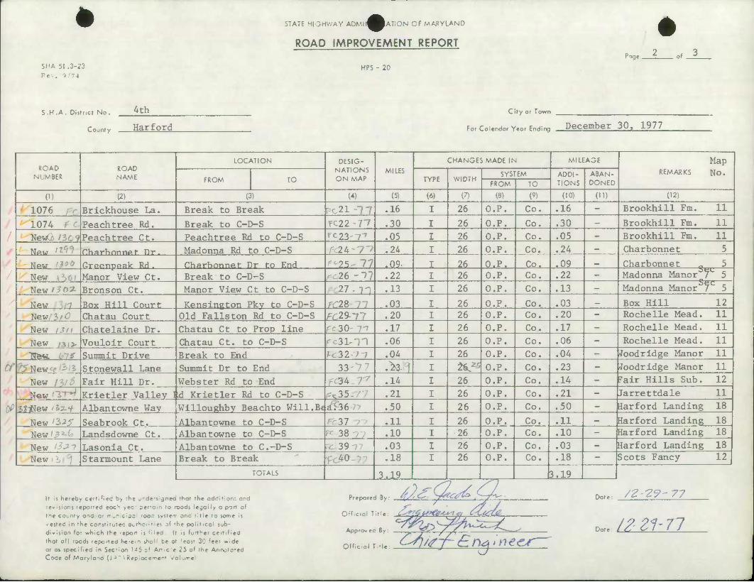
1076 Brickhouse La. Break to Break PC 21-17 .16 I 26 O.P. Co. .16 - Brookhill Fm. 11
1074 • Peachtree Rd. Break to C-D-S ^11 If .30 I 26 O.P. Co. .30 - Brookhill Fm. 11
NewG tic't Peachtree Ct. Peachtree Rd to C-D-S rc23--r» .05 I 26 O.P. Co. .05 - Brookhill Fm. 11
NPW '^r/ flhflrhnnnpf Tlr . Madonna Rd to C-D-S r 2h-l'i .24 I 26 O.P. Co. .24 - Charbonnet 5
New '"s Oreenpeak Rd. Charbonnet Dr to End 25- 77 .09 I 26 O.P. Co. .09 _ Charbonnet „ 5
New Manor View Ct. Break to C-D-S 26 -•>? .22 I 26 O.P. Co. .22 - Madonna Manor I L 5
New/5o3i Bronson Ct. Manor View Ct to C-D-S 27-11 .13 I 26 O.P. Co. .13 - Madonna Manor 7 L 5
New -7 Box Hill Court Kensington Pkv to C-D-S ;r28 .03 I 26 O.P. Co. .03 _ Box Hill 12
New/3'C Chatau Court Old Fallston Rd to C-D-S FC29--11 .20 I 26 O.P. Co. .20 - Rochelie Mead. 11
New I3i\ Chatelaine Dr. Chatau Ct to Prop line re 30- 7-7 .17 I 26 O.P. Co. .17 - Rochelle Mead. 11
New /3i> Vouloir Court Chatau Ct. to C-D-S - si--n .06 I 26 O.P. Co. .06 - Rochelle Mead. 11
TTfew. UlS Summit Drive Break to End ^32-7 7 .04 I 26 O.P. Co. .04 - •Joodridge Manor 11
H Stonewall Lane Summit Dr to End 33-77 .>3. y I *^5 O.P. Co. .23 - Woodridge Manor 11
New /3/5 Fair Hill Dr. Webster Rd to End f&^r7 .14 I 26 O.P. Co. .14 - Fair Hills Sub. 12
New 'TH Krietler Valley I .d Krietler Rd to C-D-S .^35- .21 I 26 O.P. Co. .21 - Jarrettdale 11
3?-Wew /Sz-V Albantowne Way Willoughby Beachto Will.Be ^T36 77 .50 I 26 O.P. Co. .50 - Harford Landing 18
New '3^5" Seabrook Ct. Albantowne to C-D-S 37 .11 I 26 O.P. Co. .11 - Harford Landing 18
New / 9 i- Landsdowne Ct. Albantowne to C-D-S PC 38 .10 I 26 O.P. Co. .10 - Harford Landing 18
New Lasonia Ct. Albantowne to C-D-S U 39 .03 I 26 O.P. Co. .03 - Harford Landing 18
New Starmount Lane Break to Break , 40 .18 I 26 O.P. Co. .18 - Scots Fancy 12
TOTALS 3,19 B.19
It is hereby ccftifieci b> rhc _r,defs;9ned rhor the oddltlon: and revisions reported eoc^ yec perrain to roods legoily o port of the county and or r-^nicrp; rooc svstem and title to some is -ested in the constitutec owt^oriti«i of »he political sub- division for which the Tcport is f. ieo It Is further certified that all roads reported he-e-n shol: be at 'east 30 feet wide or as specified In Section t-5 z* Article 25 of the Annotated Code of Maryland (1 ^ ~ ^ep'oce^ent -/olume
Prepared By: 4/(^yt-*j£> .QC
fficial Title: Cs*?CjS>€le-Usi c, &OsX2
Dote: /£-£?-77 o
Approvec By
Off cioi T tie: CS]/<ff~£ng>n<
Dote: /ZZ1-71
SHA 51 .3-23
Rev. 1/74
STATE HIGHWAY ADMlj^fcATiON OF MARYLAND
ROAD IMPROVEMENT REPORT
HPS - 20
Poge £_
S.H.A. District No.
County
4 th
Harford
City or Town
c ,- i ., ^ r ,• December 30, 1977 For Colendor Year Ending ^>-v---m••>•-.•• -t^y ^-^ ' '
ROAD NUMBER
ROAD NAME
LOCATION DESIG- NATIONS ON MAP
MILES
CHANGES MADE IN MILEAGE
REMARKS
Map No.
FROM TO TYPE WIDTH SYSTEM ADDI-
TIONS
ABAN- DONED FROM TO
0) (2) (3) (4) (5) (6) (7) (8) (9) (10) (ID (12)
925 St. Andrews Way Break to End Fb 4I-I-7 .01 26 O.P. Co. .01 - Scots Fancy 12
1200 Trout Farm Rd. Break to End fc 42-7? .16 26 O.P. Co. .16 _ Hv-Crest 11
New Zleglers Ct. Trout Farm Rrl tn fl-D-S FC 43 '7> .11 26 O.P. Co. .11 _ Hy-Crest 11 TTfew ' Andover Rd. Trout Farm Rd to Prop Lir e/c 44 .04 26 O.P. Co. .04 _ Hy-Crp.st 11
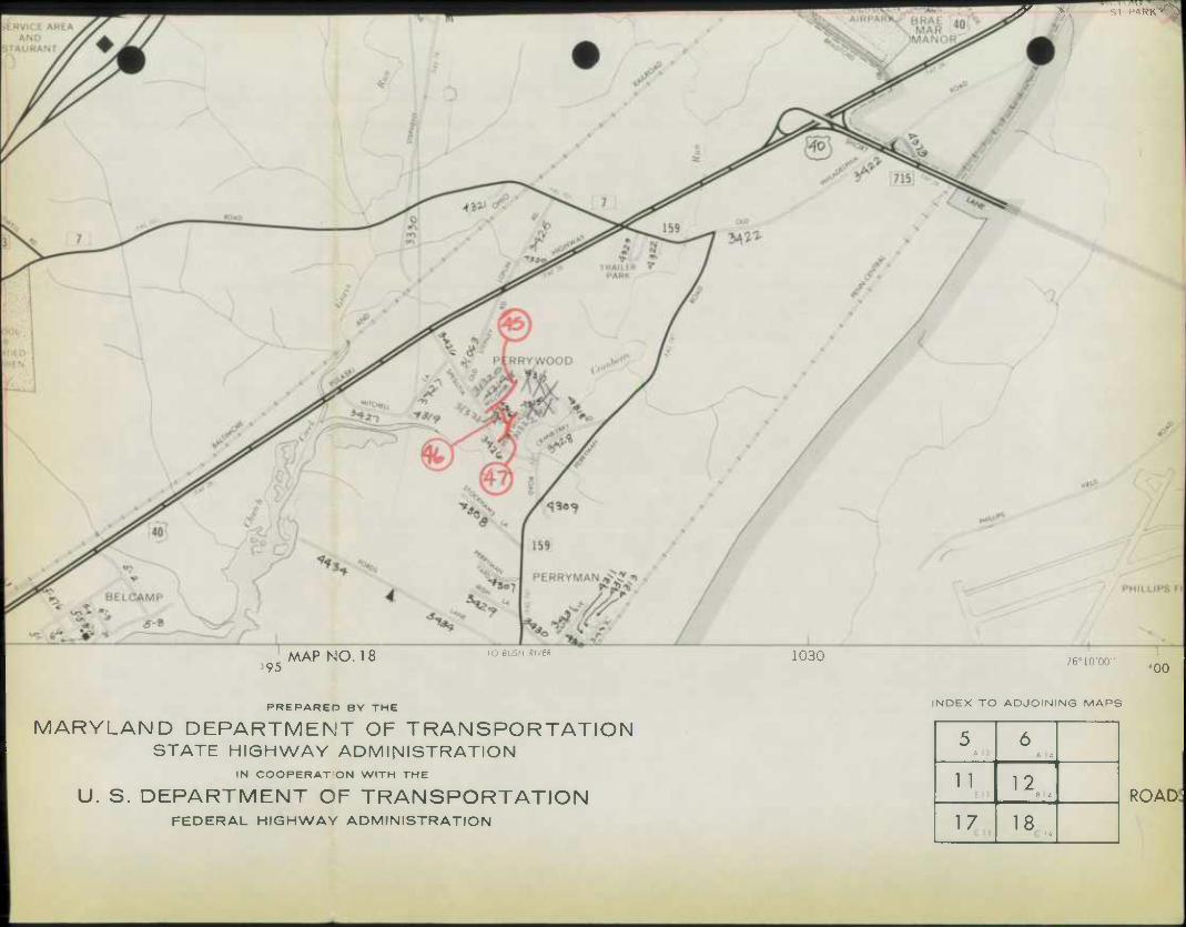
(4 New^^2.0 Willshire Drive Spesntia Rd. to Knd 45 .2il 30 O.P. Co. _ Perrywood 12 New o/Jil Teake Lane Willshire to Perrywood 46- M* 30 O.P. Co. .06 - Perrywood 12
New Perrywood Dr. Spesutia to End 47-7? ,1^ 30 O.P. Co. .11 - Perrywood 12
TOTALS .69 .69
It Is hereby certifieci b> rhe .'•.dcvgned fHor the oddltion; and
revisions reported eoc^ vec' terrain to roods lejoily o port of
the county ond or municipa 'ooc svsfem and title to some is
-ested in the constitutec ctHontres of »hc politlcoi sub-
division for which the report is fited It is further certified
that all roads reporteo he-e-n iholl be ol 'east 30 feet wide
or os specified in Section 1-5 of Ar^de 25 of rhe Annotated
Code of Maryland (1 ^ *> Repioce^eot Volume
Prepared By:
Official Title:
Approv ec By:
Dot ,: /Z-2J9-77
offico, v^6/)i^P>i^jinee4 ^t. /^^/7
05/19/77
HARFURO COUNTY
RHUTE NO
3 .9 3 3 3 3 3 I 3 3 3 3 3 3 3 ^ 3 3 3 3 i 3 3 3 3 3 3 3 3 3 3 3 3 3 3 3 3 3 3 3 3 3 3 J 3
3 3 5
99 OU 01 02 ni 04 n? 06 07 oe 09 10 11 u l)
15 16 17 u zy 2i 22 23 24 2S 26 27 ?b 29 30 31 32 ?3 34 35 36 37 38 39 40 41 <*<. A3 44 45 46 47
'
iTATfe hlbHwAY AD^INUTKATIDN Uh MARYLAND DFFICE UF PLANNING AND FRfcLI^INAKY ENGINEERING BURI5AU Qt HIGH^AX STiUiflCS .
COUNTY RQLU MILEAGE
TOTAL D fc E F fi C H 6 |
+r^ IT*9 2,56
PAGE
J K fc L
f'O
»19 4,09
76
,06 f29
;ri5
• 93 f95 flO
2,94 ,93 1.62
ai 1,89
»? •^
2.39 1,03
;ti .35 »20 2,23 1,)6 2,09 2,72
f»3 ,n ^
2.10
.53
.62
.64
.69 l,«>4
.79 141
31
.33
.07
.04
-Oi .06
,08 • U
•UU- ,44 »T4
2,06 1,27
.56
• 02
U1J
1.59
^l* 2,95
• 15 • ft2
,34 2,26
• 97
%
/1V/77 bTATt HIGHWAY ADMINliTKATIUN DP MAKYLAiMD PAGE 7 FPICI OF PLANNING faMD PRfcLIMlNAHY ENGINEERING
dUhEiAU QC nIuH*:AY STATIST ICb HARFQRD COUNTY
1 COUNTY RQAU MILEAGE
RnuTE NO, TH A 6 C DUk PEG H6I J K C L
3 il^S
3 297
3 299 3nu
(4 29
J
am 13
2W
i 24 13 06 ^2 46 20 07 99 38 42
.•*09 3 3U 3 311 i 312
313 |U 313 31&
3 3 3
3 317 3 31b 3 31.S
320
0| oj
(-5 03
li
it
ol oi
321 322 3?3 3?t 375 32
7
03
2 t
o 0 22 29
I 39
H 6]
3 3 3 3 3 3
32"
32V 330 331 na—L
6
11 •1 3|97
3 333 3 334 3 335 3 33&
317 33o
36
26 HO
86 a: 07
36 07
26 86 37
3^9 34o 34i
343 Ob
19 07 04 03 08
%
0-V19/77
h^RFuPD COUNTY
iTATt hlCHwAY UTKATIUN UF MAKYL^ nFFICfc DF PUNNT -'bLIMINARY ENGINEER)
RnuTb NO,
59u
TrJTAV
J
II H JJY COUNTY RQAl MILEAGE:
P t fe P C G H 6 I
,03
;5f
t'ece 13
K t L
592 593 594 595
596 5«7
27 23 It?
2 .23
? 3^
i>9o
599
600
603
U
2Q ft
3t
,04 I I
94 .20
.12 • 03
,78
604
606 007
609
• 11
,06
,06 ,06 34 ,03
^
I 3 3
3 3 3 3 3 3 i 3
', i 3 3 3 3 3 3 3 3 3
61U 6U
613 61* 61
10 It 17
10 10
n 09
61 617
619 620
622 623 624 625 626 627
,^3 ,23
,38 23 >*2
04
10 2b
,04 ,20 ,44 10 28
19
629 630 631 632 633
07
u
30 29.
30
10 634 635
637 63fe
U
13 13 02 17
%
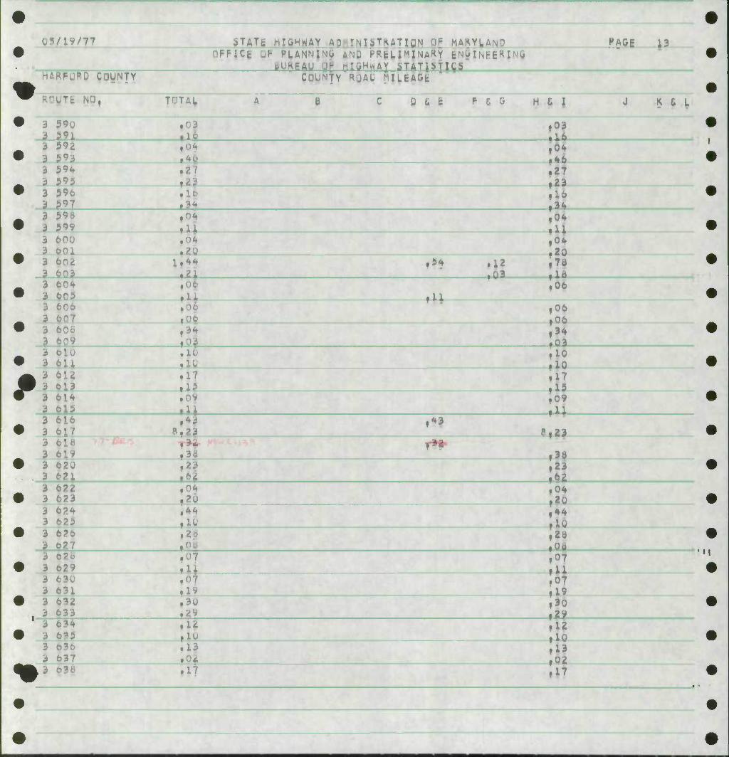
OB/19/77 ;>TATE r lO^WAY AD - IN UTKATIUN 01 MAKYLANO PAGE 14 •
^^ ARFQRO COyNTY
PFFICE UP PLANNI^o ANQ Hf.tL I^INARY ENOIMEE^I'
BUBiAu nF-taftm>AY STATISTICS COUNtY RCAU MIl-EAGE
^Royn NO, FAV A • C 0 t E P E G H 6 } J K t L
• i 639 3 640 tna
• 3 t^L ,03 f03
.10 3 64^ i 644
• 3^ . <
fO?
• 3 645
r*8 ,30 • It
3 647 • 3 644
,04 ,0?
3 649 3 650
,02 ,02
• 3 651 a ^92 t3l
,04
3 653 • * 654
si ,16
3 055 3 656
.i • 05
|I8 ,05
• i 657 3 6?6
.70
t2^ ,70 iff
3 699 • 3 6^V
r9{ f0f tl7
»93
^3 6M WB 66ij :
,04 ill
• 3 663 3 664 .10
,19 .15
3 6*0 • 3 666
^0 Ilo ill
3 667 3 666 • 07
!03
., J 67u .16 • II
3 67i • 3 67c
,0fl f25
.06
3 673 3 674
.11
.^9 ill ,49
• 3 675^.,,. 1 \>7V^ 3 67c f04
f<*- .04
3 07? • 3 e
»06 ,10
,04 - 10
3 679 3 6Pu
.4i> ,10
.45 ,10
• 3 6S1 3 682
.27
.112 |27
3 ftflj • 3 684
.lo ,01
3 bP5 ^^^3 6B6 f9*
,23 .99
Mft^ .15 |15
•
05/19/77
HARFURD COUNTY
.'TE NO '
j 787 3 7fl| 3 789 i ? 3 701 3 7^ 3 793 3 7^ 3 79i 5 796
/97 3 79e 3 799 3 BOO
STATfc MyMWAY AD MNl iTKATIQN Uh MAKYj^AND OFPlCi DP PLANNING AMD HftLIMIMAKY EMOINEERIMC
BUftBAU DP HlfiH^AI 5T.ATPII&5 INTY Rf
TOTAL
oi
COUNTY RQAO MUEAGk
D L 6 F f. G H L I
^5- 36
fAoe IT
J * C L
u
06 01 05
3i
02
• 08
fU
"
lo ,06
,05 ,09 ,07 32 >0<
3 BOX 3 boz 3 803 3 t 3 c
55 7A
QV
,0; ,0: 55
:SI
3 3 3 3 3 3 3 3 3 3
3 3 3 3 3 3 —* 3 3 3 5 3
B07
809
en m 813
816 817 Hi
of
u
si 10 IS 3i
3?
,09 ,05 .0*
,56
,31
,08 35
819 b2u 821 822 823 c?^
826 827
629 8 3t
U 04 0
H 06 59
li
.2?
;^ ,04 ,05
.38
:l 59
II
1
83*t 835
2V .29 18
32 U 27
• •
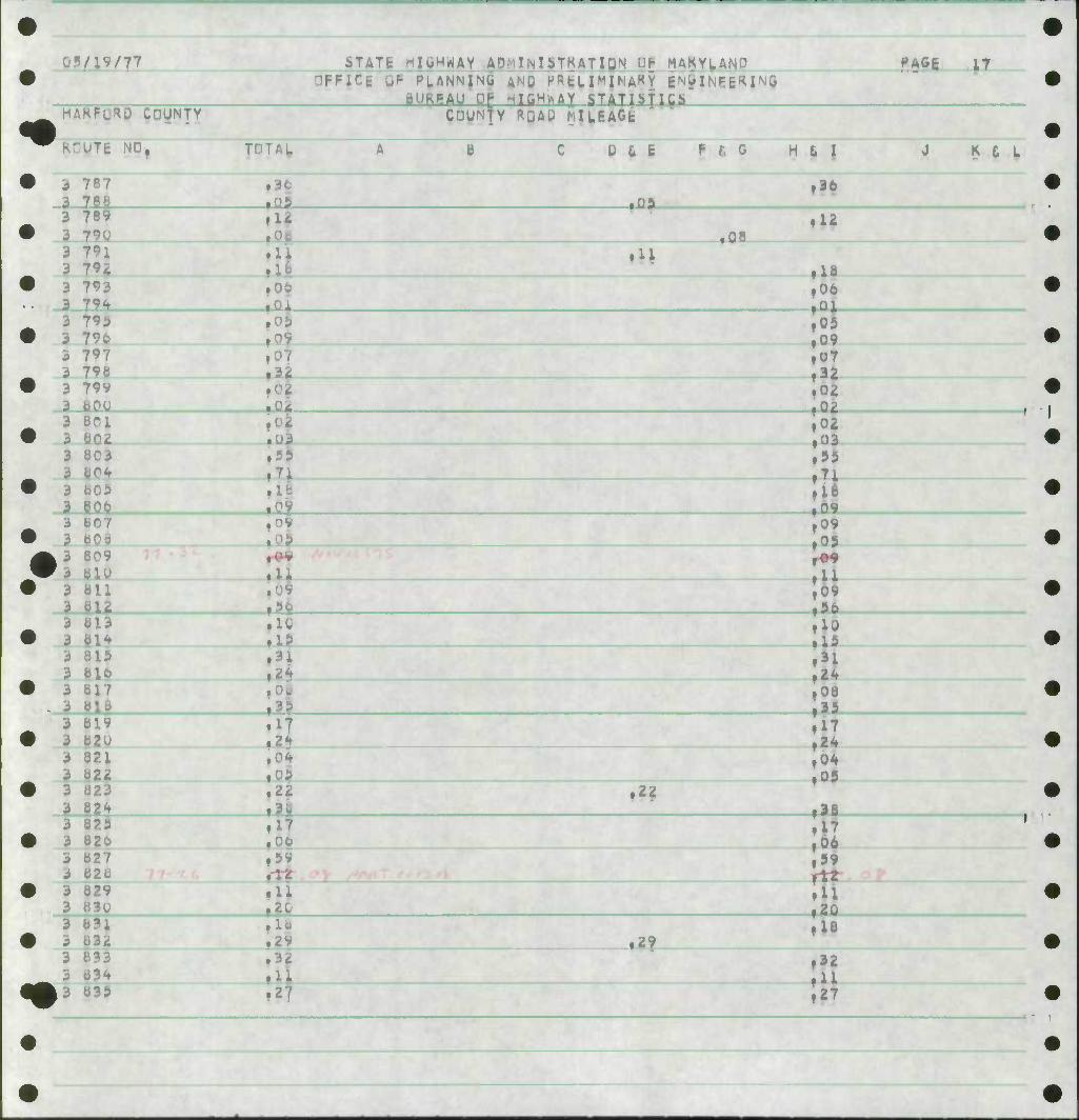
0«/19/77 jTATt HIQWHAY .ADilLNliTKATIDN UP MAKYLAN? PAGE 19 DFF|C6 UP PLANNING ANQ HRfeUMlNAKY feNUIfsRE^ INU
BURPAU'ap HTGHisAY STATISTICS ^^' ^FORP COUNTY COUNTY RQAu MUEAGt
K^UTE NOf <H A B C D 6 E F S G H 6 I J K t L
• 3 885 3 886
• 34 f0C
,34
3 b87 • 3 b8o
,90 •
•?7 :*! 3 889
_ 3 b9g .15
*1V % • 3 891
.- 3 892 T0? ,04 ,00
J93
• 3 694 Ill .07 u 3 895
_ * y9o .25
.07 Izi
• 3 d97 3 898
.96 r2^
it* ,24
3 899 • 3 9nu
.3.
% 3 901 3 VOt 17 •
,30 ,23
• 3 903 3 904 r2U
,20 tf9
3 9ns •
,09 28
AJ 907 ^^3 90o : ,30 • 3 909
3 91U •it ,07 lit
3 911 • 3 91^
.06 i.
06 1»27
3 913 3 914
.05 .05 iM
• 3 915 3 9lb f*7
,28 fff
3 917 • 3 91b
.37
.K f37 flO
3 919 3 92(.•
,72 172 ,07
• 3 9?i 3 9?*. .38
!io til
3 9?3 • 3 92*
;o7 ,28 1 '
3 923
3 926
W«| »*' . 1 • 3 927
. 3 92c .15 .40 i*0
3 919 • 3 93U
,19 ,60 IS
3 931 3 93i>
,07 tl8
^^3 933 ,U
•
''19/77
HARFuRD COUNTY
iTATfc nIl»HWAY ''FFICe QF PLANNING ttURFAU -DJL
TKATIUN UF MAKYIAN^ AND HRtUMINARY INJJlNEBRlNC iililHttAY STATISTICS
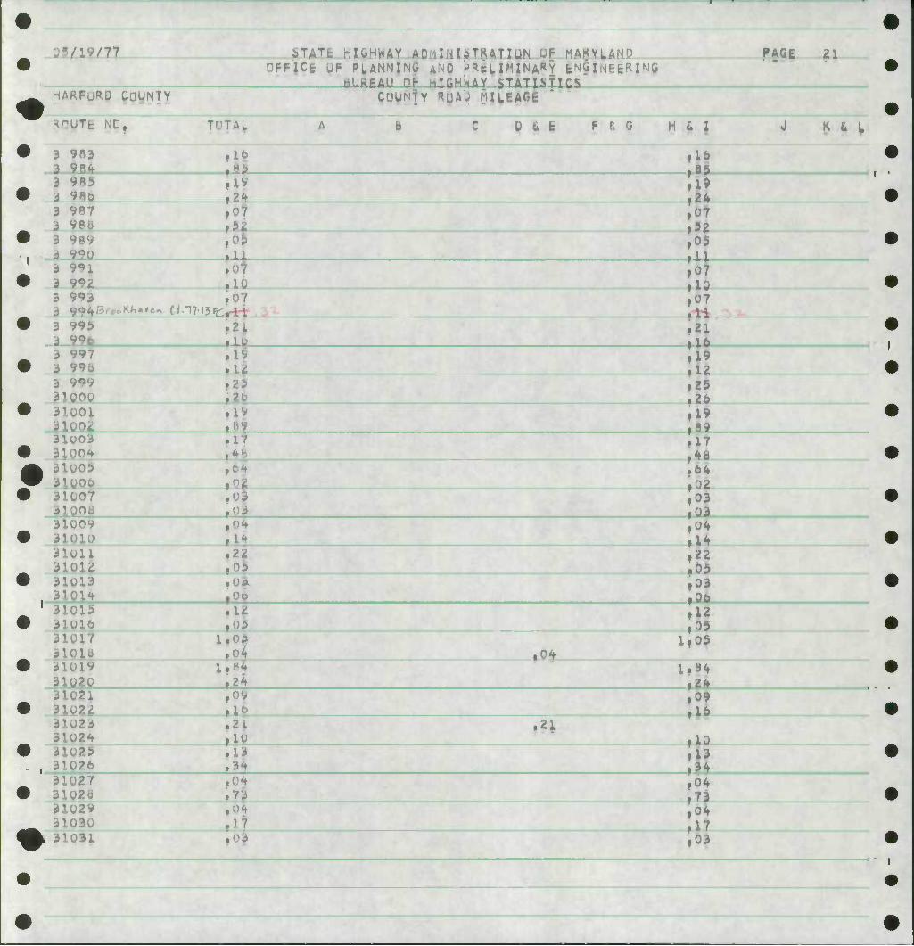
PAGE 21
COUNTY RQAU MILEAGE
KnUTfc ND r^Wf T-TAI, 0 t fc F 6 0 H t I
9fl3 984
10 16 85
J K 6 1,
9B5 9RG 9^7
989 990
iJ :SI ,05
^ 991
5
3 3 3 3 3
993
995 H. 997 99o
f^-^^ir^ftt
,0 10 j07 .11 21
99V 3iunu 31U01
.9 12 25 26 19 .99
3100 3iun4 3U'05
31007 jiyoc }1009 3li
-'11 31012 31U13
31U15 31U16 31U1/
31019 3ly?o
31.023 3102^ il025 310?6 31027 3l02d 3102V 31030 31031
0$ It
05
Co It 05
2^ Of
10 13 34 0$
,04
f2i
il ,64 i02 ,03 ,03 ,04 ,14 22 ,05 03 06 12 05 ,05
10 13
'-V19/77
HAKFURD COUNTY
^TATfc IgHWAy AH INUTKATIUN Q| MA^YUND "FFiCfe UF PUNNING AND HPfcL IMINA^Y fcNblNEER JNG
R^UTE NO,
31032 31013
TDTAL
,0^
.90 2.2i
;AU QF iTGHttAY STATISTICS COUNTY RQAU FllLKAGE
D 6 E F fi C H & I
04 • 03
fAGE 22
K fc I.
31034 mu 31036
J37 31036
JIO?^
i04 f»0
:^ i09 26
31040 31041 3104^
ill 31044 .mm
.22
.It;
Z.9t
,05 ,08
:!l ,96 ,46
31046 310*7 3104b 31049
Uflll
|I0 .20
1.51 1.51
,09 03 30 20
70 |S2
311 154
)S7 3U9b
)59 )E0
310^1 31U^t 310*3
.8i
1,11 _t4d
.13
fO?
^ 11 46
,04
31064 31065 31.- 31067
;6e 31069
• Ob
-1 34
f02
32 ^7
L07 m 11071 31u7^ 31073 j1u74'P«-<v'^1''e« W 77-J.V F^^f
3107? ^Afi_
r*? ,21 10
,0 I .2.:
|0 ,60
3107 9wLS« 77
3107o
31080
U..17-21 Rl,*f f C
2 iJ^
77.^ '•<^. ,14
22 ,09 ,46 ,46 13 19 i05 ,66 14
-Ql/IV/??
HARFURD COUNTY
ilklc nICiHWAY -AUiUMiTKATlON UF MAKYLANO OFFICE UF PLANNING AMQ P«bLIMINARY ENGINFERINO BUREAU nK-fOfiHAAY iTATIhtlCb
COUNTY RQAU MHEAGfc
PAGE 23
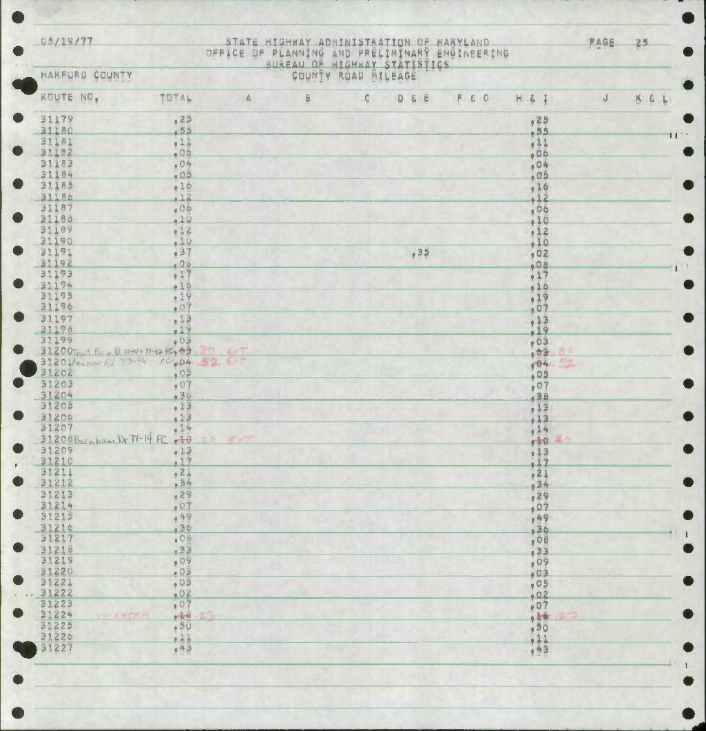
KrUTE NO,
3U7V 3111Q 31181
3U 31184 3U85 31186 ill87 31180 3i;89 31190 3li»l
i9i
TOTAL, C D t t F £ G H 6 I J K £ L
29 5A
29 95 11
U 00
09 It
lu It Ifl 37
Si 04 09 16
S;
39
10 12 10 02 Oi
16 3U93 31194 31199 3U96 3U97 31111
17
19
13 I 13 19
312 0 u c
3]iJ03
* v-A-yvC* FO^
li-
es 63
09 07 3o
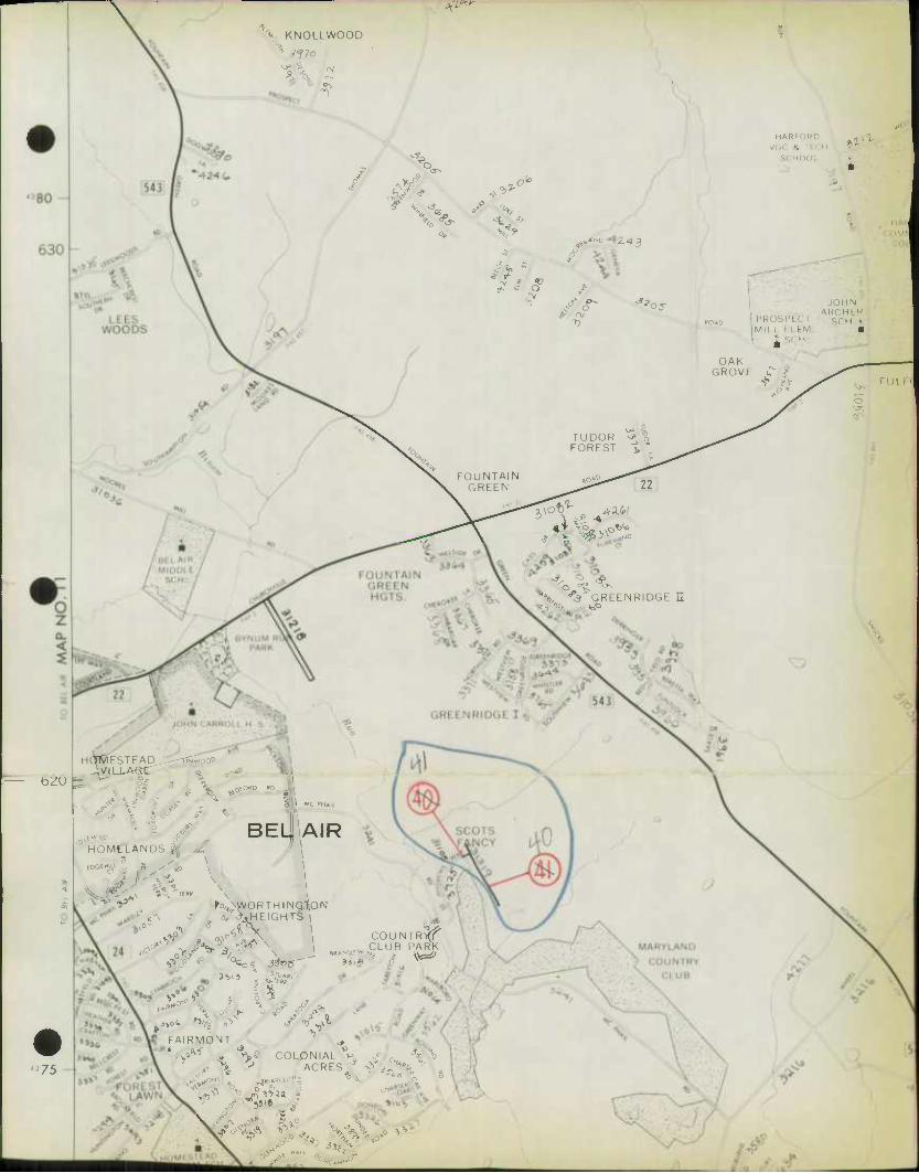
31205 31206 31207 312 31209 31iifl_
rTH4fi:
13 13 IH
13 17
13 13 14 10 13
31211 31212 35213 31214 31219 3l2ie 3lfl7
218 31219 31220 31221
31223 31224
31220 31227
2i
4V 30
33
5U
*3
1 34 29
f07 49 3 I 33 09 03 09 02 07
90 11 43
il
*
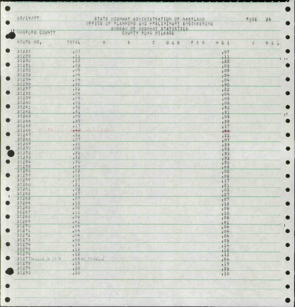
us/iy/77 iTATt HIGHWAY AD:-IMiTKATigN UK MAKYL,ANU PAG6 26 -PiCfc if- %ANN{N$ |N0 HPfcLIMINARY E^&INEE«riO
BURFAU DP HTGH^&Y STATISTICS . -KFLRD COUNTY COUNTY RQAO MIUAGE
JTfc NO, TnTAL A B C O&E F fi 0 HGI J K & L
iU2S ^J-
07
03 09 04 04 30
3123U 31231 31232 3W 31.23* 31230
• ,13
i i
Ji 237
3U39 31240 3l24i 3ii4iL
243 31244 31245 31246 31247 312^
,22
, •
^09
,22
22 04 08 OB B2 1
^ 0 39 17
22 0 I 35249
3125U 3^252
^53 3125*
:55 m 312
260 31261 31262 31263 31.264 312*? 31267 311 31269
• U 1"
rsi
z 05 33 32 30
I
31270 31271 312 31273 3127* 31275
? .10 .cu
,0*
0 oe 17
|21 03
I 0 u 06 10 08
6 J I ,04 ,06
31276 31277K vti. ^ / 3i27e
279 312
.1*
flV
o 04 04 06 14 U 12 64
10
19 26 10
i IIWI-W" 'I'f'nupif I ", F" PPPPBf
I I
IIRII »•^^iP^!i^p>;F,",!,l
4
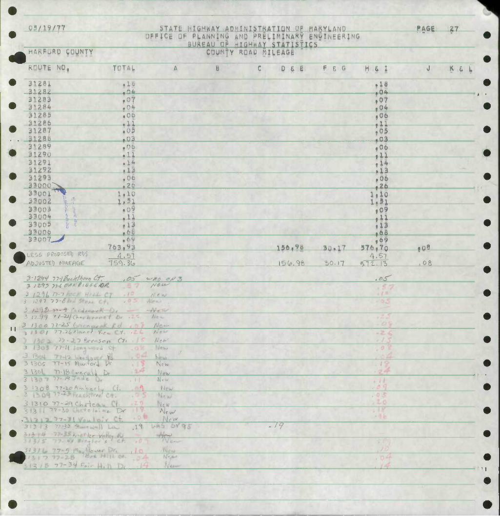
M/1V/77 iTATt i:H,HWAY AD^iINliTKATIDN D| MAKYLAND PAGE 27 HFFICfc
HARFuRD COUNTY
QF PLANNING
NTY «
AND PRtLI^INAKY ENUINEERIMO GHMrSTAT 1S ! I OS
COgMTY RQAU MILEAGE
jTt NO,
-ai2B2
TOTAL 0 & E F C G M 6 1
31284 31285 31286 ^1287 312M.
.00
.11
Id
i07
,06 U 05
•-03
J K C L
31289 31290 3129i 31292 31293 Oflflfl 33U0
yo2 3^003 33i 33005 330CO 3?>
"^
.11
.I**
.13 ,06 an
1.1U
.13 LfejL
iLESS PKoposel) I2«)S 763.
4.51
3-12*'/ 77-/ L^ ^^ ^3
,06 11 14 13
,06 26
I I
13 ,6a
I56|9e 3u.l7
50.17
376 4
511
69 70 f08
, 06
J /W ?U 4*.
* HOI 7-7-l(,t\o*cl Y.,* cy.
3 \3oS "11-\5 («\v^W4
fJe"
_yc«_
^S^^fc 3 ^OT "J^- 1^^ "77
it PK-
II XL. New
Hew
31713 r'-33 <*«,.• t^H Uv. I iTiTbbTqT •^
1^^ ->7-3VF..V t4.h n. l7t o>
i4 • I
w
^f MiL UtT T
s ". ^_L
i , 5t"7
^7^^ /V ^ ^c;
/•
^M.6 /?/VW H/^ //^7 ^
^L M. FLi L tf^L 1.33 • %(* n.^i
dll± -
itf-lS' / 57.5.2- 3CP.^3 jr7f. ^^ .or
M
m HFFICE
>TATfc hlWHWAY .AMlMlilKATIQN UP MAKYIAND AND P«fcLIMINAf<Y ENGINFEKINQ HTGHflAX STATISTICS
JF PUNNING BUftPAU Qf
PAGE
HARFURD COUNTY
Tc NU.
OTHER PUBLIC ROAD MUEA*
<»
^
^ 4 <* H
rAL b U L E F C G H t I
1 2
4 iniSHchtft/Tr) cr A i
^:^?^- 5
7
1? /jaw £0 il-li
9| 2t
17
27 ^5).^(?
39 i05
93 26.
R 6 L
4 4 4 t
06
Z2
,U^
22 ,06
1,03 4 A
13 1H
1>
1 ? 15 1
^ 4
4 4
4 4
15 16 17 o<
24
1"
0
S| .04 .21
13
8 26
21 22
15 2^
>:
4 25
3b .29 .16
05
a
,09
fol
4 4 4 4 4 ^
28 2V
36
IV
11 15 05.
1?
• U 15
fl9
.Qi 4 4 4 4 4 4
39 40 41 4t 43 44
.14
,36 .22 16 1"
,y*
,06 14 I
4 4 4 4
45 46 47 Jo] ."7
.12
.03
,04
4 49 94 .^ .25
4 4
51 5i
4 53 4 4 55 .is
.03
.16
.1* 16
- ^ •' -
.09
.15
.07
- - - -
U5/1W77
hAKFuRD COUNTY
i>TATc hICHWAY AMINliTKATlQN UP JJAMVAlifl • FFiCt Lp PUNNINCI AND HffcLIWINARY gNilNEEHTw aURPAU OP HIGHWAY STATISTICS
OTHER P&IHIC KOAD MiLtAGE
fAOE
TE NDf T^TAI, 0 & I F £ G H 6 I K £ L
<*
<*
56 ,5t 02
58
59 k 60 ,17
12
JJ -Ui-
,03 .17 • 28
.16
4 *
64 .15 29
4 P4
4 ?g
<21 .13
.24
. ]
.3i
,0f ^21
OQ—wTncr-nrrjrr ,U5 fl5 »0?
4 4
4 4 4 4 4
4 4 4 't
4 4 4
101
107
i0^ llu 113
ll**
11* l?-0 121
123 124 12^ 126 127
129
Pi
i33
144 142
f3!
10
13
^36
|3|
• C5
.17
,37 ^(p-rW-
^
HI f20 ,08
,20
41 .25
I ,08 • 03
21
.02
19
10
f22
,05 • 10 ,04
,02
• U
,02 ,05 • l*
7»r ,04 ,93 .17
/IV/77
COUNTY
>T^ ^MWAY ADMIWI^TKATIDN UP MAKYLAND ;1FFIC6 OF PLANNING AND HPfcLlMINAKY ENUIIMFE^. BUftPAU DP HTpHWAy STATTSTTCS
OTHER PUBLIC KHAD MILEAGE
RPUTE NO • TOTAL I 0 L E F C G H L I
4 279
lt ,0]
PAGE
K G I,
2P^
2i
t iPj
37
l
f26 .37 ,06
J
.21
.10
2B5
29 U 291 2(9y 300
zo
IH
14 u
f2 .10
• 10
#12 4 302 ^ 3 4 304 H 3 t 3 4 307
74 .74
It .61 ,16
I fou
.01
17
31 u ill
HI
2
21.
H 3 V fiov <-** '3i~l * 117 Oi
,29
,oy
,03
4 ̂
.07
4
4 4 t 4
31o
J19 »n
!
,21 15
320
3?J 324 325
,0
•
.11
.0?
'Ji »
,06 .21
4 3?fc H 3 2 T 4 32o t 32V
^ 331
,06 .24
LOI
.24
.30 ,06
H i32 t 3?3 4 334 ** 335
.20
4 336 05
l:il ,20 0 •
II
0g/19/T7
HAKFuRD COUNTY
^TATt HIGHWAY ACilNliTKATlON Of MAKYL^- "FFICt DP PLANNING A^.C HPtL IMlNA^Y EMG IiNRfc« I^ti BIJKBAU np riTCHXAY .SlATIbflC5
nTWER PGBLIC K^AD MILEAGE
•Tt NO rAL 0 6 |
"AGE 6
• F f. G H 6 I
4 i .15 llf .2Q
J K t^
4 33^
H 341
4
k
H
4 4
.14
.It ^
343
34t 347 34o 349 i5>;
.22 * |03
10
$ 23
,09 »17
:^
13
rti- ,44
351 3?2 353
355
?
.14 24
14
4 35
4 3M ^ 3^
fU3
f1?
Io3 41
10
17
»94
17
4 363 3^4
367 266
.^7 ,03 03
- -'•
H 37j ^ 37'(t 4 373 * 3" 4 390
^09_ »5o
:^ .09 ,06
_ .^3
iIS «*?—^06L_
liO 4 423 ^ <i
4 4 4 tft2 4 46* 4 4^5
.14
.13
.14 ,03
JL2l
15 • U
,06 ,23
4 469 4 505 4 909 4 9l| 4 '
7u
,04 • 0? .70
.25
Jli
03/19/77 bT^ yHWAY AD' iNliTKATlQN Uf- MAKYlAfM^ FFICg UF PLANNING AND HPfcLI^lNAHY ENGINEERING
puRD COUNTY BUkgAU Dg WIGHWAy bTATlsncs nT^ER PGBLIC KHAD MILEAGE
Tfc NO^
4 T82
TAL B D t t P C G H t I
»09
.3H
,05
PAGE 7
J K 6 L
4l(
H1217
'•T219
• i* .34
06 16 02
41< .15 ?l .1. 10
09 .19
57.
19 1^ I 227
1.U6 32,»* 3iOl 21 10 15
Ai .1*1 7
* 1 , b S i-). 4* . oS
)
d;*us fi-Weskd Mltsjf .fa .If .(,7 1
13*1 Il?7 iVJrof^ 3/J) i-oL -te*? 5,01 JO. l°i /
II
I
II
-T-r,
GARLAND
INGHILL
\ ^ QUAKER
HILLS
/ J
ROAD
33«z i3itr
[155^ i ̂ f
o.
r-
»
-J 5 FOXRIDGE
95
S ^i^11 EARLTON
'60
/•H/3 155
3^' q0
404 •O1
i WEBSTER ^
0>z »OAO
>•«» WFHS1CR ' VILLAGE
^ig
00
3291
DR ^
MARI
MFMOHIAI ,
GARpi
462 33^ ^^
tfi-f
SUSQUFHANN/ RIVf R H
^ DO O
"HI
WA • 111 IKAI inisy
t'l AN I
^0
k*'6 tin
HD
1 CHAPEL
i4ll
156
/
ALDINO
Ik
$32.
7 "]
0>
A1;AM
HQJS
*0 \
Ti. 'Vl 5» ftl
SIO^W ^
FORI ESTATI > O
^
ABERDEEIS
CHI SAPI AKI
— ST :
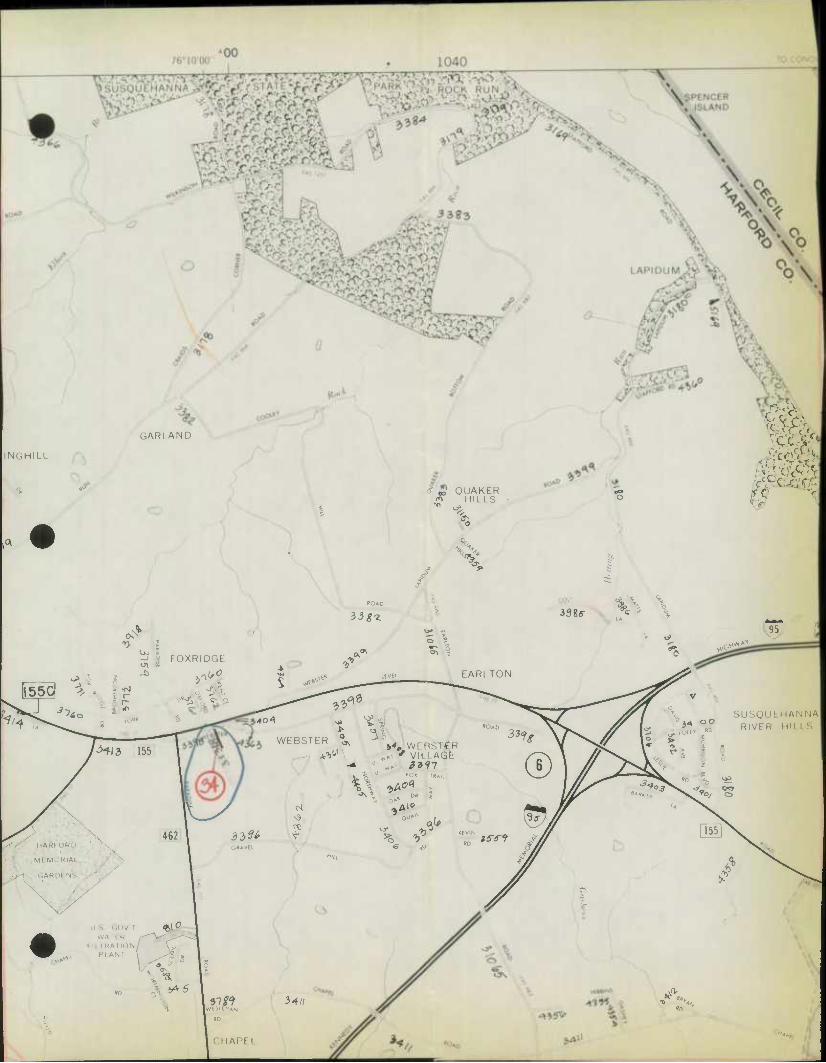
395 MAP NO. 18 TO BUSH RIVER 1030 /6°10W
'00
PREPAREO BY THE
MARYLAND DEPARTMENT OF TRANSPORTATION STATE HIGHWAY ADMINISTRATION
INDEX TO ADJOINING MAPS
IN COOPERATION WITH THE
U. S. DEPARTMENT OF TRANSPORTATION FEDERAL HIGHWAY ADMINISTRATION
5 6
11 12
17 ^
ROAD<
WAY
J85 /h^OOO 990
2 >
z 0 •
TO EDGEWOOD
LAMBERT CONFORMAL CONIC PROJECTION
BASE COMPILED FROM FIELD INVENTORY:
COPIES OF THIS MAP ARE AVAILABLE FOR PUBLIC
USE AT A NOMINAL COST FROM THE STATE HIGHWAY
ADMINISTRATION. MAP DISTRIBUTION SECTION.
BROOKLANDVILLE. MARYL AND 21022.
1000
o 5
© 1970 S.H.A.
VZ-^
^c KNOLLWOOD
(V
/ V3^
^ < o^
%' A*»-
V5"
9- x o
HAHI . ^
II KU
^2.43
>** '03-
OAK GROV
JOHN
PKOSf'iCI Mil I M hM •
^ ,. H
1>J
o
TUDOR ^."i FOREST >
FOUNTAIN GREEN
no* 22
b^U
%. -^ GREENRIDGE II
H^ESTEAD,,- AVILLAdf
,^ ':- MC PHA
BELJAIR HOMELANDS t,
8 • x (DGfHIU a x
^75
re .\ ^o^ ,(«. s
K\WORTHINQ.tON
^ ^ ,\^ 1 C0UN,R^
^^
Sru4„ ,
5 ^
FAIRMONT
%S COLONIAL ^ lOLONIAL v. •
I III I
•••• liiiiki
J
TO JACKSONVIUE 1
vo
NORTH
JCALE IN FEET 2000
0.5
4000
1 MILE SCALE IN MILES
PREPARED BY THE
STATE ROADS COMMISSION OF MARYLAN DIVISION OF PLANNING
BUREAU OF HIGHWAY STATISTICS IN COOPERATION WITH THE
U. S. DEPARTMENT OF TRANSPORTATIOIS FEDERAL HIGHWAY ADMINISTRATION
BUREAU OF PUBLIC ROADS
u_
)00 390
TO OEIAWAW MIM SR/DGE I 1010 76o15'00" TO ABERDEEN
To: Bureau of Highway Statistics Baltimore, Maryland
State Highway Administration oF Maryland
1
County Har 'ord
STATK HTCHWAV TMPRQVFMFMT RF.PQRX
Date October 26, 1S77
Route No. & Name fld. Rte, 152
Contract No. //.705-000-^77
Description: From f/..?. Rm,t? An To Edgewood Arsenal
and connecting spurs (Old Rte, 152) Spur Lines - North Rte, 40
Milepolnt 2,39 U.S, Ao Milepoint 0«00 Edgewood Arsenal
(Use mile points ^rom Highway Location Reference File)
Roadway Statistics
Surface type & Width
Shoulder type & Width
Idlan type & Width
Bituminous Concrete ~ 21' to 24* width
Bituminous Concrete -2' to A' width
Type of Construction
New Construction Q Add Lane Q
Resurface & Wt*m- H Rehabili itate I—I
Square Yards
0.00 Amount
Other
Completed April 15* 1977
Submitted By
Note: V^T^ a b!idge iS l0Cated 0n the SubJect road' a Brid^ Sheet Form HPS-S should be attached.
SHA 51.3-80
^ 7 &*? <* 7 - //at ^
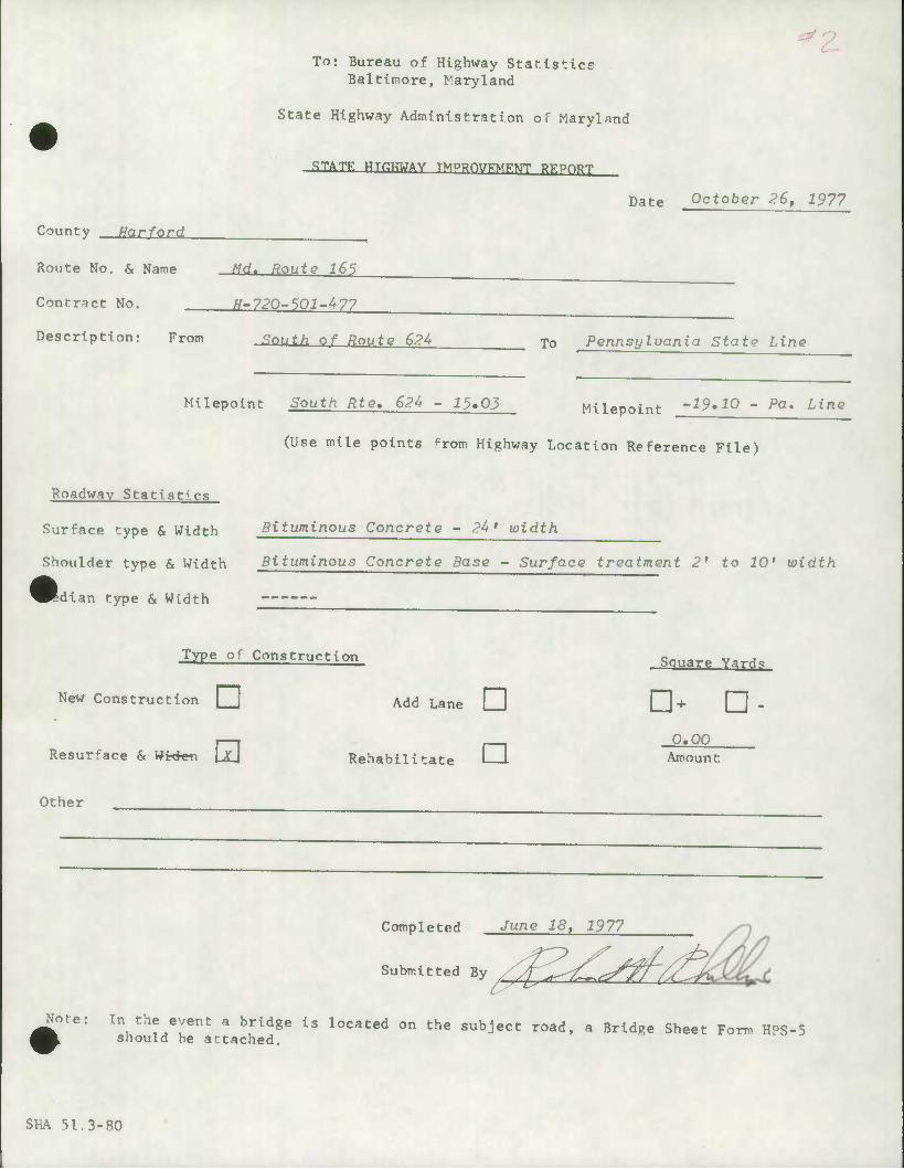
z To: Bureau of Highway Star.lstice
Baltimore, Maryland
State Highway Administration of Maryland
STATK HTflUTJAV TMPRf»7FME;tJT RKPO^J
Date October 26, 1977
County Harford
Route No. & Name Md. Route 165
Contract No. fj-?20-501-^77
Description: From <7rw/^ nf Route 62U To Pennsylvania State Line
Milepoint South Rte, 62U - i5.03 Milpnoinf '19*10 - Pa, Line Milepoint
(Use mile points ^rom Highway Location Reference File)
Roadway Statistics
Surface type & Width bituminous Concrete - 24' width
Shoulder type & Width Bituminous Concrete Base - Surface treatment 2' to 10' width
Idian type & Width
Type of Construction Souare Varri.
New Construction • Add Lane C] 0+ CH -
H . 0.00 Rehabilitate I I Amount
Other
Completed June 18, 1977
Submitted By ^ /^^^L^^f/^Ji
Hot.! In the event a bridge is located on the subject road, a Bridge Sheet Form HPS-5 should be attached.
SHA 51.3-80

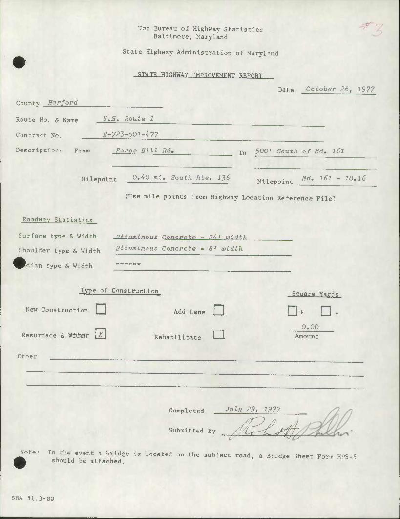
To: Bureau of Highway Staf.ls'ricE Baltimore, Maryland
State Highway Administration of Maryland
STATF. HTKHWAV TMPBfWFMFNT RKPORT
Date October 26, 1977
County Harford
Route No. & Name y.S. Route 1
Contract No. H-723'501-^77
Description: From Forge Hi 11 Rd. To 500' South of Md, 161
Milepoint 0«^0 mi. South Rte» 1J>6 Milepoint Wd. 161 - 18.16
Roadway Statistics
Surface type & Width
Shoulder type & Width
Idian type & Width
(Use mile points ^rom Highway Location Reference File)
RitximinaxiR Cnncrpte - 24' width
Bituminous Concrete - 8' width
Type of Construction
New Construction |_J Add Lane CI
Resurface & Wtrterr Rehablli itate I—i
Square Yards
• - D- 0.00
Amount
Other
Completed ^^ 291
Submi '"- BV ,4^/^ Note; In the event a bridge is located on the subject road, a Bridge Sheet Form HPS-5
should be attached.
SKA 51.3-80
To: Bureau of Highway Staf.lstlce Baltimore, Maryland
State Highway Administration of Maryland
.STATK HTCHWAV TMPPnyKMKNT RF.Pf^J
Date October 26, 1977
County Harford
Route No. & Name Md. 462 - Paradise Road
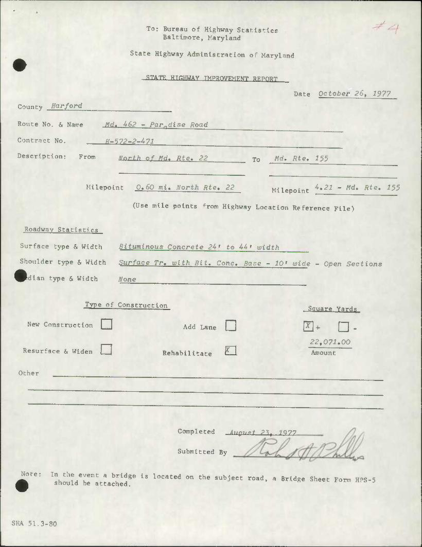
Contract No. tf-572-2-473
Description: From Mnrth nf Md. Rte. 22 To Wd. Rte, 155
Milepoint 0.60 mi. North Rte, 22 Milepoint ^•21 " Mdt Rte' 155
(Use mile points ^rom Highway Location Reference File)
Roadway Statistics
Surface type & Width
Shoulder type & Width
idian type & Width
Bituminous Concrete 24' to 44' width
Surface Tr, with Bit. Cone, Base - 10' wide
None
- Open Sections
Type of Construction
New Construction Q] Add Lane Q]
Resurface & Widen || Rehabilitate O Other
Square Yard?;
a- •- 22,07^.00
Amount
Completed i,,?,,*+ P^( 7Q77
Submitted By
i0^' ^h^nT^^ ^^ iS l0Cated ^ the SUbjeCt r0ad' a Brld«e Sheet Form HPS-S snould be attached.
SHA 51.3-80

To: Bureau of Highway Statistics Baltimore, Maryland
State Highway Administration or Maryland
^
.STATF. HTHHWAV TMPBQVKMFNT RF.PORT
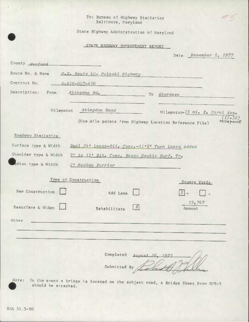
Date November 1, 1977
County fjn r ford
Route No. & Name U.S. Route 40- Pulaski Highwat/
Contract No. H-618-007-470
Description: From Abinadon Rd, To Aberdeen
Milepoint Abingdon Road
Roadway Statistics
Surface type & Width
Shoulder type & Width
idlan type & Width
Milepoint'^3 mi. Em Carol Ave» (12.32)
(Use mile points ^rom Highway Location Reference File) ^t'epftint
Dual 24' Lanes-Bit, Cone,-11'6" Turn Lanes Added
7' to 11' Bit. Cone. Base- Double Surf, Tr.
2* Median Barrier
Type of Construction
New Construction • Add Lane []]
Resurface & Widen |__] Rehabilitate Q
Square Yards
i9,767 Amount
Other
Note:
Completed A,.•,** p<t 7077
Submitted By
^^fT^Z ^^^ ^ ^"'^ 0n the SubjeCt r0ad' a Brld«e Sheet Form HPS-5 snould be attached.
SKA 51.3-80

To: Bureau of Highway Starlstlce Baltimore, Maryland
State Highway Administration of Maryland
G
•STATK HTCTMAV TMPBnyKMKNT RKPOT^
Date November 1, 1977
County Harford
Route No. & Name n ? Bnufn An - Pr.lncki High^'j
Contract No. H~6l8-006-470
Description: From Harford County Line To Abinodon Rd,
Baitimore-Harford Milepoint 0»00 County Line Milepoint Abingdon Rd,
Roadway Statistics
Surface type & Width
Shoulder type & Width
^Rdian type & Width
(Use mile points from Highway Location Reference File)
Dual 24 > Lanes (Bit, Cone) 11'6" Turn Lanes Added
7' to 11> Bit, Cone, - Double Surf, Tr,
2' Median Barrier
Type of Construction
New Construction [] Add Lane Q
Resurface & Widen | |
Other
Rehabili itate li-l
Square Yard<j
• - •- 15,526
Amount
Completed August 22r 1977
Submitted By ^Mi Note:
V^'Z'l^Tl3 located on th8 subject rMd-a Brldse ^ *°•Hre-5
SHA 51.3-80
# .^^

#

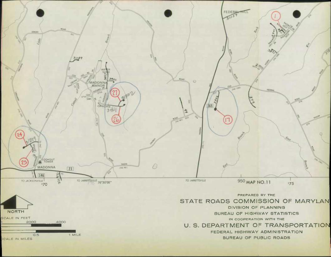
4 SHA 51 .3-23 Rev. 1/74
STATE HIGHWAY ADM^STRATiON OF MARYLAND
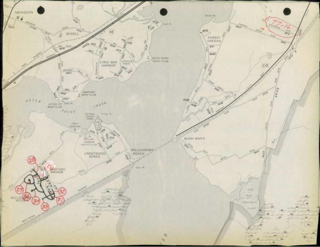
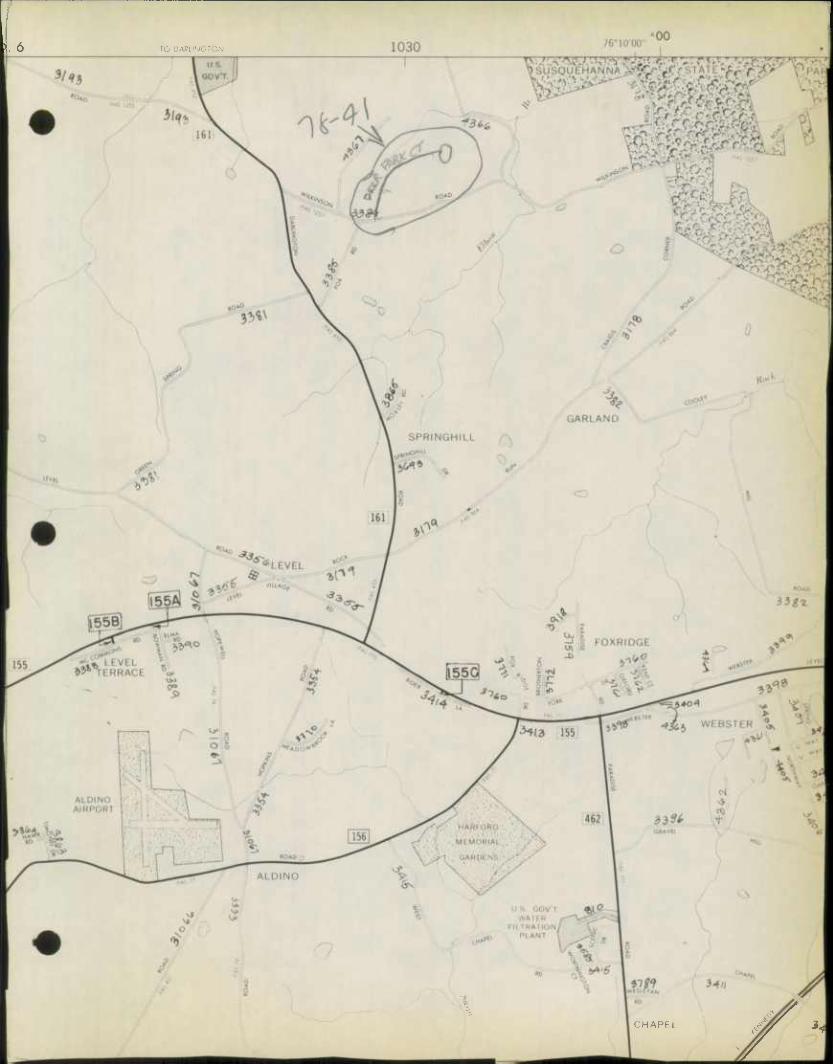
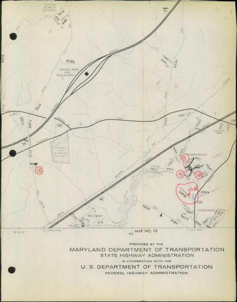
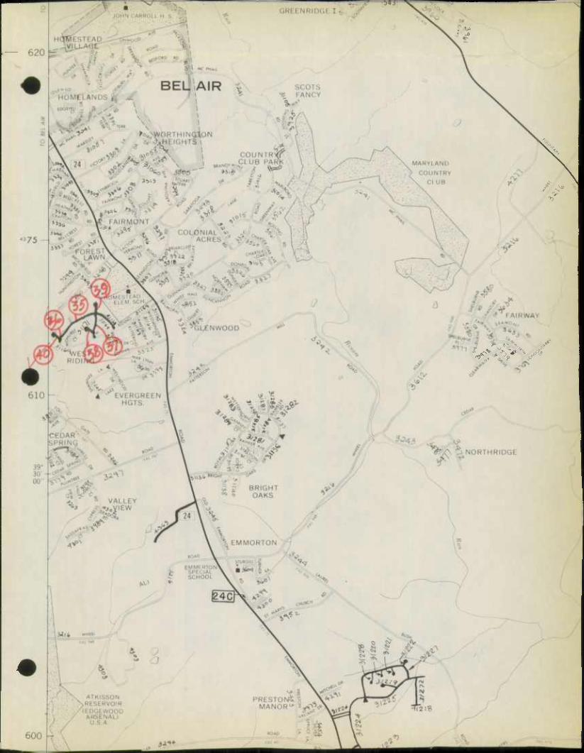
ROAD IMPRWEMENT REPORT Locations on Map are shown
Page.
t HPS - 20
Red
S.H.A. District No. 84
County Harford
City or Town
For Calendar Year Ending December 31, 1976
ROAD NUMBER
ROAD NAME
LOCATION DESIG- NATIONS ON MAP
MILES
CHANGES MADE IN MILEAGE
REMARKS FROM TO TYPE WIDTH
SYSTEM ADDI- TIONS
ABAN- DONED FROM TO
(1) (2) (3) (4) (5) (6) (7) (8) (9) (10) (H) (12)
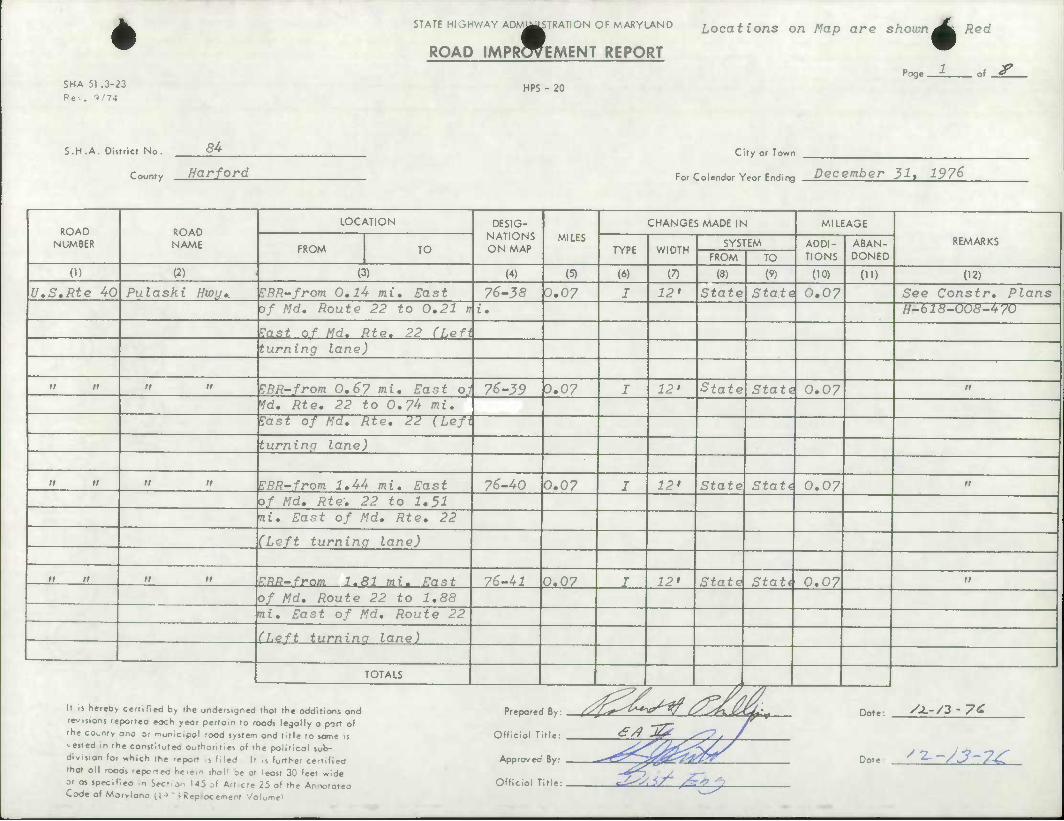
U.S.Rte 40 Pulaski Hwy,. EBR-from 0,lU mi. East 76-38 0.07 I 12> State i Statej 0.07 See Constr, Plans of Md. Route 22 to 0,21 n X, H-618-008-470
?ast of Nd. Rte. 22 (Left turning lane)
rt tt n n EBR-from 0,6? mi. East oj| 76-39 0.07 I 12' State State 0.07 it
Vd, Rte, 22 to 0,74 mi. Tast of Md, Rie, 22 (Left
turning lane)
n II n ii EBR-from 1,44 mi. East 76-40 0.07 I 12' State Stati 0.07 II
of Md, Rte, 22 to 1*51 ni. East of Md, Rte, 22
(Left turning lane)
ll II n n ERR-from 1.81 mi. East 76-41 0.07 I 12' State Stati 0.07 n
of Md, Route 22 to 1,88 mi. East of Md, Route 22
(Left turnina lane)
1 If is hereby certified by the undersigned
TOTALS
that the additions and Pr^pored Ry X^^Z^^V^V t>C#ij& 4 rd^^ Dnl» yj.-/2 • yt revisions reported eoch yeor pertain to roods legally a part of the county ana or municipal rood system ond title to some is Official T -ested in the constituteo authorities of the political sub- division lot Y.hlch the report s li led It ,s further ce-t,fled Approved that all IOOOS reportec Heiem shoM be at least 30 feet wide or asspeofiea in Sect.on 145 of Art.cle 25 of the An-ototeo Official T Code of Morvlanc 0°" Ueplocement Volume^
.... £/> 1& ^?. / r '
i.u. TZ^/.-iT*- /£>? ^
Date '^-/J-TS
^
SHA 51 .3-23 Rev. 1/74
STATE HIGHWAY AD^^TRATiON OF MARYLAND Locations on Map are shown
ROAD IMPROVEMENT REPORT
HPS - 20
^Red
Page. of ^
S.H.A. Districr No. 84
County Harford
Cify or Town
Fo, Coiendor Yeor Ending December 31, 1976
ROAD NUMBER
ROAD NAME
LOCATION DESIG- NATIONS ON MAP
MILES CHANGES MADE IN MILEAGE
REMARKS FROM TO TYPE WIDTH
SYSTEM ADDI- TIONS
ABAN- DONED FROM TO
(1) (2) (3) (4) (5) (6) (7) (8) (9) (10) OD (12)
U,S.Rte.40 Pulaski Hwy,_ IBR-from 2,03 mi. East 76-42 3.07 I 12' State Statej 0.07 See Constr, plans
>/ AW. Rf.o. ?? to P,10 H-6l8-UU8-4yu
ni. East of Rte, 22 'left turning lane)
It II n ii kBR-from 2,31 mi. East oj\ 76-43 3.07 I 12' State 5tate| 0.07 n
f^. Rfv. 7? flf ^t ^^ """r fast of Md, Rte, 22 (Left turning lane)
II It n n EBR-from. 0,33 mi. East 76-44 0.07 I 12' State State 0.07 n
o/ Did Post Rd, to 0.40 ni. East of Old Post Rd,
(Left turning lane)
II II n n ERR-from 0,60 mi. East 76-45 0.07 I 12* State Stat< 0.07 it
of Old Post Rd, to 0,67
m7T fnit r,f CilH Pnxt Rri.
(Left turning lane)
TOTALS n =
It is hereby certified by the undersigned that the additions and
revisions reported each yeor pertain to roads legally a port of
rhe county ana or -nonicipol rood system and title to some is
nested m the constituted authorities of the political sub-
division lor which the report .s filed It ,5 further certified
that oil roods reporteo herein shaM oe ot least 30 feet wide
or as speciflea m Sedon 145 of Article 25 of the Annototea Code of Marvlana IIJ" iReplocement Volume*
y^e^*?^ Date: /-Z'/3- ^
Dot , /g--/*-?^

SHA 51 .3-23 Rev. 1/74
STATE HIGHWAY ADf^^STRATiON OF MARYLAND Locations on Map are shown i
ROAD IMPRMEMENT REPORT Page 2.
HPS - 20
ed
of <9
84 S.H.A. Districr No. Cify or Towr
r—r Harford December 31, 1976
ROAD NUMBER
ROAD NAME
LOCATION DESIG- NATIONS ON MAP
MILES CHANGES MADE IN MILEAGE
REMARKS FROM TO TYPE WIDTH
SYSTEM ADDI- TIONS
ABAN- DONED FROM TO
(1) (2) (3) (4) (5) (6) (7) (8) (9) (10) OD (12)
U.S.Rte.^O PuJnski Huiy,- KBR-frvm ^,^ mi, Wait 7^_/f^ 1,07 T 12' ifntG a+n + A n./T? n. ^1 s.. 3f Rte, 7 to 0,51 mi. H-618-008-U70 Sest of Md, Rte, 7 (Left turning lane)
it n n n VDD-'F^r.rr, ^ 70 mV T./^ o + «-4 lC_An 3 0n r 1 pt ?f n f r O + SJ + ^ n r\n ii
Itxeqo St. fMd- Rfo- 7) to 0,12 mi. West of Md, ?te. 7 (Left turning lane 7~
U It // ti SBR-from Q,Oj> mi, Womt ^6 Ji8 0 0^5 r 11' 9f a t r <?+ r, + r n n? n
•'f rif?'?"^ st tn n.np ni, ¥est of Otsepo St, (Left turning lane)
It II n n i/BR-from 0,11 mi. West 76-49 O.OJ i 12' State Stati 0,03 n
of Otsego St, to 0,lA mi.
Vest of Otseao St. Cl.eft turning lane)
TOTALS 1
It is hereby certified by the undersigned that the oddlfions ond
revisions reported eoch year pertoln to roods legally a part of
the county ono or -nonicipol rood system ond title to some is
nested in rhe consfltutea authorities ol the political sob-
division for »hlch the report s filed It .s further certified
that all roods reported herein shol! be ot leost 30 feet wide
or as specifieo In SMtion 145 of Art.cle 25 of the Annotofea Code of Marylanc {[^~ iRepiocement Volume*
Prepared By:
Official Title:
Approved By:
Official Title:
e'j nz -r^ Date: /2--/*-7L
Date ^2.-/^-7^
/5y^r J£ASC
SHA 51 .3-23 Rev. 1/74
STATE HIGHWAY ADf^^STRATiON OF MARYLAND
ROAD IMPRWEMENT REPORT
Locations on Map are shown
HPS - 20
S.H.A. District No. 8U
County Harford
City or Town
c r i J v c J- December 51. 1976 For Calendar Year Ending '
ROAD NUMBER
ROAD NAME
LOCATION DESIG- NATIONS ON MAP
MILES CHANGES MADE IN MILEAGE
REMARKS FROM TO TYPE WIDTH
SYSTEM ADDI- TIONS
ABAN- DONED FROM TO
(1) (2) (3) (4) (5) (6) (7) (8) (9) (10) 01) (12)
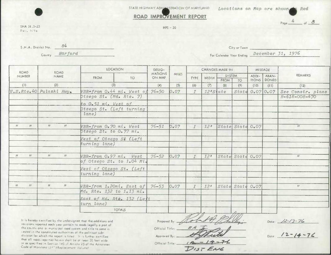
U.S,Rte.40 Pulaski Hwy* VBR^from. 0.44 mi. West ojj 76-50 0.07 J 12*s\ate State 0.07 0.07 See Constr, plans Itsego St, (Md. Rte. 7) H-618-008-470
to 0.11 mi. WPst of Otsego St, (Left turning lane)
n n n n VBR-from 0,70 mi. West 76-52 3.07 I 12' State State 0.07 II
Dtsego St. to 0,77 mi.
Jest of Otsego St (Left turning lane)
II n n n SBR-from 0,97 mi. West 76-52 0.07 J 12' State Stati 0.07 n
of Otsego St, to 1,0U Mi,
Vest of Otsego St, (Left turning lane)
n n n n WBR-from l,20mi. East of 76-53 0.07 J 12' State Stati 0.07 n
Md, Rte, 132 to 1,13 mi.
*n»± of Md. Rta. 11? n.e 't turn lane)
TOTALS 1 •* ,<>„„
It is hereby certified by the undersigned that the additions and
revisions reported eoch year pertain to roods legally a part of
rhe county ano or -nonicipol rood system and title to some is
-esfed m rhe constituteo authorities of the political sob-
division lor which the report .s filed It 1] further certified
that all roods reportec herein shal1 oe at leost 30 feet wide
or as specifiea In Sec- on 145 of Article 25 of the Annotatea Code of Marvlanc 11°' >Reoiocement Volume^
Official Title:
& &* ' • £sLs' •
Approved By: ^4 ^^/
Official Title: - Jf^JX~£
Dote: y^-/3- VC
Dot e /'>~-/+-7t
IP'** r ^*s£
SHA 51 .3-23 Rev. 9/74
STATE HIGHWAY ADf^^STRATi ON OF MARYLAND Locations on Map are shovon
ROAD IMPRWEMENT REPORT
HPS - 20
Poge.
Red
S.H.A. District No. 84
County Harford
City or Town
For Colendor Year Ending Doromhor* ^7, 7Q7^
ROAD NUMBER
ROAD NAME
LOCATION DESIG- NATIONS ON MAP
MILES
CHANGES MADE IN MILEAGE
REMARKS FROM TO TYPE WIDTH
SYSTEM ADDI- TIONS
ABAN- DONED FROM TO
(1) (2) (3) (4) (5) (6) (7) (8) (9) (10) 01) (12)
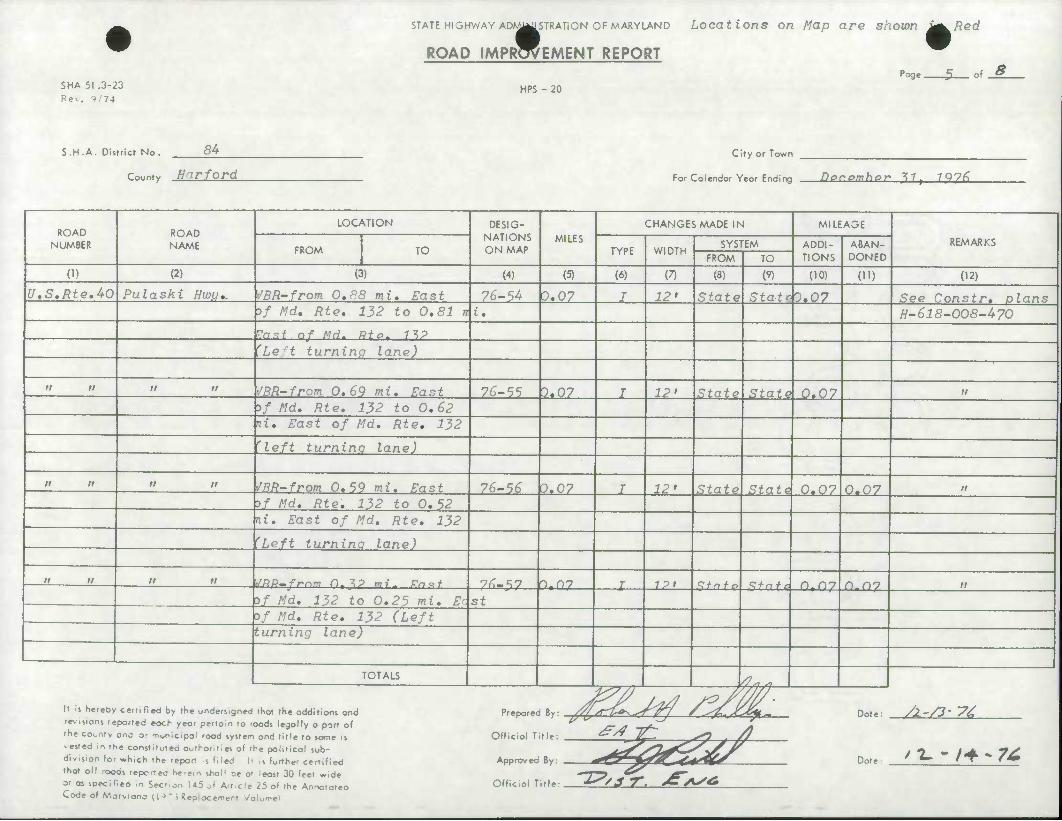
U.S,Rte,40 Pulaski HWL/,. SBR-from 0,88 mi. East 76-54 0.07 I 12* State Stath,07 See Constr. plans of Md, Rte, 132 to 0,81 rr i. H-618-008-470
Pn«< of MH. Pfa. "MP
'Le t turning lane)
It It n it SBR~from 0,69 mi. East 76-55 3.07 I 12> State State 0.07 n
5/ Md, Rte, 132 to 0,62 If. East of Md, Rte, 132
'left turninq lane)
It II it n /BR-from 0,59 mi. East 76-56 0.07 I 12' State State 0.07 0.07 11
>f Md, Rte, 132 to 0.52 ni. East of Md, Rte, 132
'Left turninq lane)
It It tt it Wnn-frnm D.M mi- fnit 76-5? ntny I 1?t Rfnfo Sfn + ii n,ny n.ny it
of Md, 132 to 0,25 mi. Ec St of Md, Rte, 132 (Left turning lane)
1 TOTALS /7^ s,
/ 7- - /-f ~ 7^
It is hereby certified by the undersigned that the additions and Preparec
Official T
... JZIJV? /?/M- Dote:
Date
revisions reported eoch yeor pertain to roods legally a port of the county ana or municipal rood system and title to some is ^J it: ^ /) vested in the constituted authorities of ihe political sub- division for which the report .s filed U is further certified Rv **4&4US that all rooas repcrrec herem shoM oe at least 30 feet wide or as speclfiea in Sec',on 145 of Art.cle 25 of the Annotatea Code of Mor>lane (!•>'i Replacement Volume*
Official Title: "^ •3 ^ . ^AS*
SHA 51 .3-23 Rev. 1/74
STATE HIGHWAY AD)^WISTRATiON OF MARYLAND
ROAD IMPRWEMENT REPORT
HPS - 20
Locations on Map are shown Red
Page
m -r S of
S.H .A. Disrricr No. 8U
County Harford
Clfy or Town
Fo, Colendor Yeor Ending December 31, 1976
ROAD NUMBER
ROAD NAME
LOCATION DESIG- NATIONS ON MAP
MILES CHANGES MADE IN MILEAGE
REMARKS FROM TO TYPE WIDTH
SYSTEM ADDI- TIONS
ABAN- DONED FROM TO
(1) (2) (3) (4) (5) (6) (7) (8) (9) (10) 0') (12)
U.S.Rte.40 Pulaski Hwu* VBR-from 0,82 mi. East 7<J-5S 0.07 I 12' State | Statdi 0.07 See Constr. plans of Md, Rte, 22 to 0,75 mi • H-618-008-470
FaRt nf Md. ?? (hpft turning lane)
ti n a it WBR-from 0,29 mi. East ot 76-59 0.07 J 12' State Staid 0.07 it
Vd. Rte. 22 to 0.22 mi. East of Md, Rte. 22 (Left
turninq lane)
It n it n WBR-from 0,09 mi. West o) 76-60 0.07 I 12' State Statd 0.07 0.07 it
Md, Rte. 22 to 0.16 mi. West of Md. 22 (Left
turninq lane)
MH- Rt0-7A _—— Old Bail Lane to 76-61 0.80 I VnriesState Stati O.SO O.SO Resurfacing Bloomsburg Ave. H-671-001-478
Md.Rte.624 WiI son Corner Md. Rte, 165 to Pa, Line 76-62 3.20 I 21' State Stati 3.20 3.20 Resurfacing .-, Rd,
W_ 6 7*5-000^77 • TOTALS /?. /7
It is hereby certified by the undersigned that the additions and rev.sions reported each year pertain to roods legally a port of rhe county ono or Tiunicipal rood system ond title to some is • ested m the constitutea authorities of 'he political sub- division lor »hlch the report .s filed |i it further cenlfied that oil roods repcrteo he-em shal1 be at leost 30 feet wide or as speclfieo in Sec',on U5 of Art.cle 25 of the Annotatea Code of Morvlano (1J- (Replacement Voiume>
Prepared By:
Official Title: •^^
Approved By:
Official Title:
Dot e: s-t-yj- ze
Dote S^-/?'?*
27/. rr. ^>^^

SHA 51 .3-23
Rev. 9/74
STATE HIGHWAY AD^MISTRATION OF MARYLAND Locations on map are shown i^led
ROAD IMPROVEMENT REPORT
HPS - 20
Page. of $
S.H.A. Disrriet No. 84
County Harford
City or Town
c r i J v c J- December 31* 1976 For Calendar Year Ending '
ROAD NUMBER
ROAD NAME
LOCATION DESIG- NATIONS ON MAP
MILES
CHANGES MADE IN MILEAGE
REMARKS FROM TO TYPE WIDTH
SYSTEM ADDI- TIONS
ABAN- DONED FROM TO
(1) (2) (3) (4) (5) (6) (7) (8) (9) (10) OD (12)
Md.Rte 2U _—_ Wd. Rte, 23 to Deer Creek 76-65 4.90 I 20' State State 4.90 4.90 fiesur/acinsr H-693-000-477
Md.Rte. 7 Old Phila. Rd, Balto, County Line to 76-64 4.20 I Tdrie. (State Stati 4,20 4.20 Resurfacing Md, Rte, 755 H-694-000-477
Md.Rte,7 Old Phila,Rd, Id, Rte, 755 to Md, 136 76-65 3.50 I /arieistafe State 3.50 3.50 Resurfacing H-e95-000-477
Md.Rte,7 Old Phila, Rd, Md, 136 to U,S, 40 76-66 4,10 I 2i» State State 4.i0 4.10 Resurfacing H-696-000-477
Md, RtP. - •**"• „ Md^llG tn rarxinf! Run RH. 7/^7 ptin I P7 » Z + n + a Sfnfi ?, T~> p. in 5*3
'•" " ' fc
U-697-000-477
U.S.Rtd Belair Rd, 500' South of Md. 161 to 76-68 2-00 T Vari o\iXtn + o Stnti 2.00 2. on South End of Conowingo H-704-000-477 Dam
TOTALS .'^-* /7. .
It is hereby certified by the undersigned that the additions and
revisions reported eoch year pertoln to roods legally a part of
the county ana or monicipol rood system ond title to some is
nested in the constituted outhoritles of the political sub-
division for *hich the report .s filed It ii further certified
that all rooas reportec he-em shol1 be at leost 30 feet wide
or as spec.fiea in Sec'.on 145 of Art.cle 25 of (he Annototea Code of Marvlanc llJ' iRepiocement Volume*
Prepared By:
Official Title:
Approved By:
Official Title:
Dote: /2-/?- T'L
Dot e /-Z. - f*~TC
TP'.i-r BAS£>

STATE HIGHWAY AD^MSTRATiON OF MARYLAND
ROAD IMPLEMENT REPORT
SHA 51 .3-23
Rev. 1/74 HPS - 20
Locations on Map are show^in Red
Page -x 8 of
S.H .A. District No.
County
84
Harford City or Town
c r , . v c ,- December 31, 1976 For Calendar Year Ending -^ * ^
ROAD NUMBER
ROAD NAME
LOCATION DESIG- NATIONS ON MAP
MILES
CHANGES MADE IN MILEAGE
REMARKS FROM TO TYPE WIDTH
SYSTEM ADDI- TIONS
ABAN- DONED FROM TO
(1) (2) (3) (4) (5) (6) (7) (8) (9) (10) (ID (12) .
Md,Rt.p.P4 mmmtmm* M.S. Rte. 1 to .Tarretsvike 76-69 5.90 J yariekstate State J.90 3.90 Resurfacing Id. //-705-000-4 77
i
1 TOTALS yi
It is hereby certified by the unders^ned that the additions and Propor^H Ry/V^^~i?l>-jT ^7 /%~^Zj£&i^ Dnt.- /^Si-VL revisions reported eoch year pertain to roods legally a port of rhe county ona or municipal rood system ond title to same is Official T -ested m the constitutea authorities of the political sub- division for «hich the report .s filed It i| further certified Approved that oil roods repcrteo herem shall be at least 30 feet wide or as speclfieo In Section 145 of Article 25 of the Annotatea Official T Code of Morvlano (1 J " i Replacement Volume*
tl,: ^^ ^- ^ /
flv. {•^zZ-Cs^^* ̂
"A/^
Date '2--/*-/^
ti. 77i < r. A
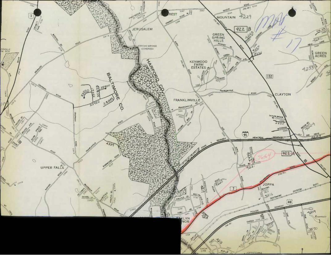
T^TTT; •^C
GSVILLE M SCH
mw?
Qi
^tr>.
Vr': \MOUNTAIN
^^f ^S-"
^ ? 3°° \
\
'^^L - |iJERICH0 BRIDGE >-'--.^>.cF3Ji'^ (COVERED)
K ENWOOD FARM
3'^
FARM ESTATES <
ii «^
FRANKLINVILLEX
:-<Dis
>c:^-; r^
av*
s
KOA^. '^^CLAYTON
MEMOWAl.
yg^
»«G£^«
JOPPATOWNE
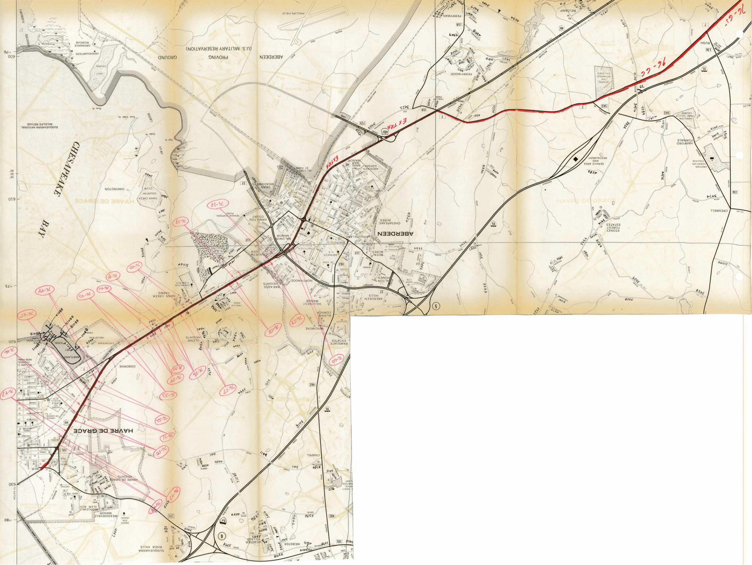
OZc. 009
•
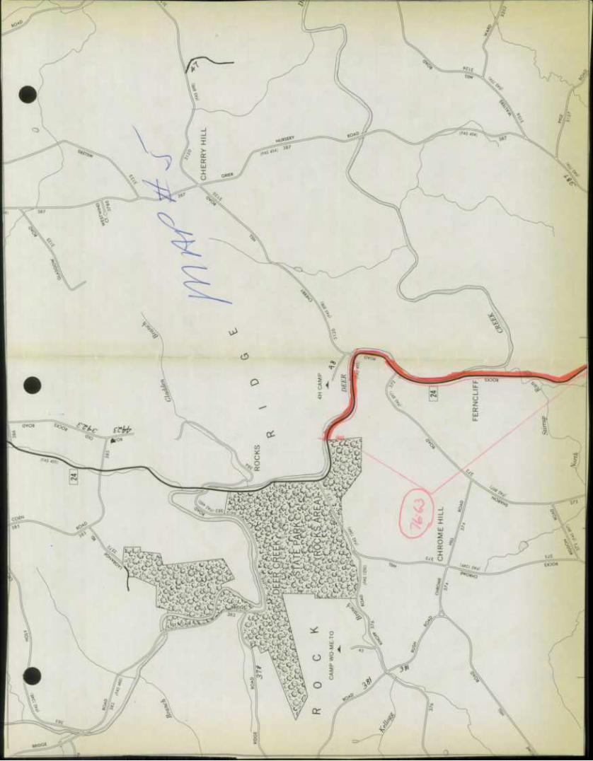
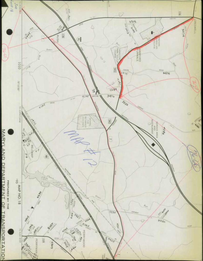
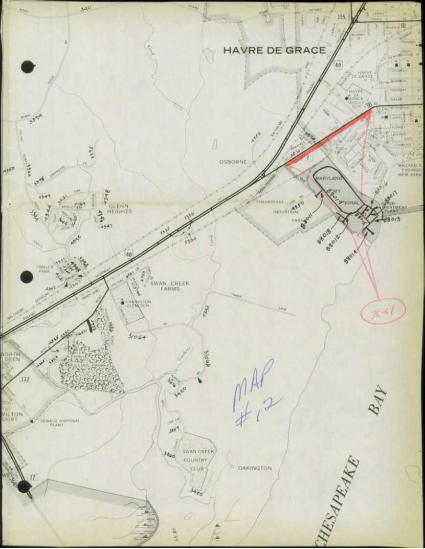
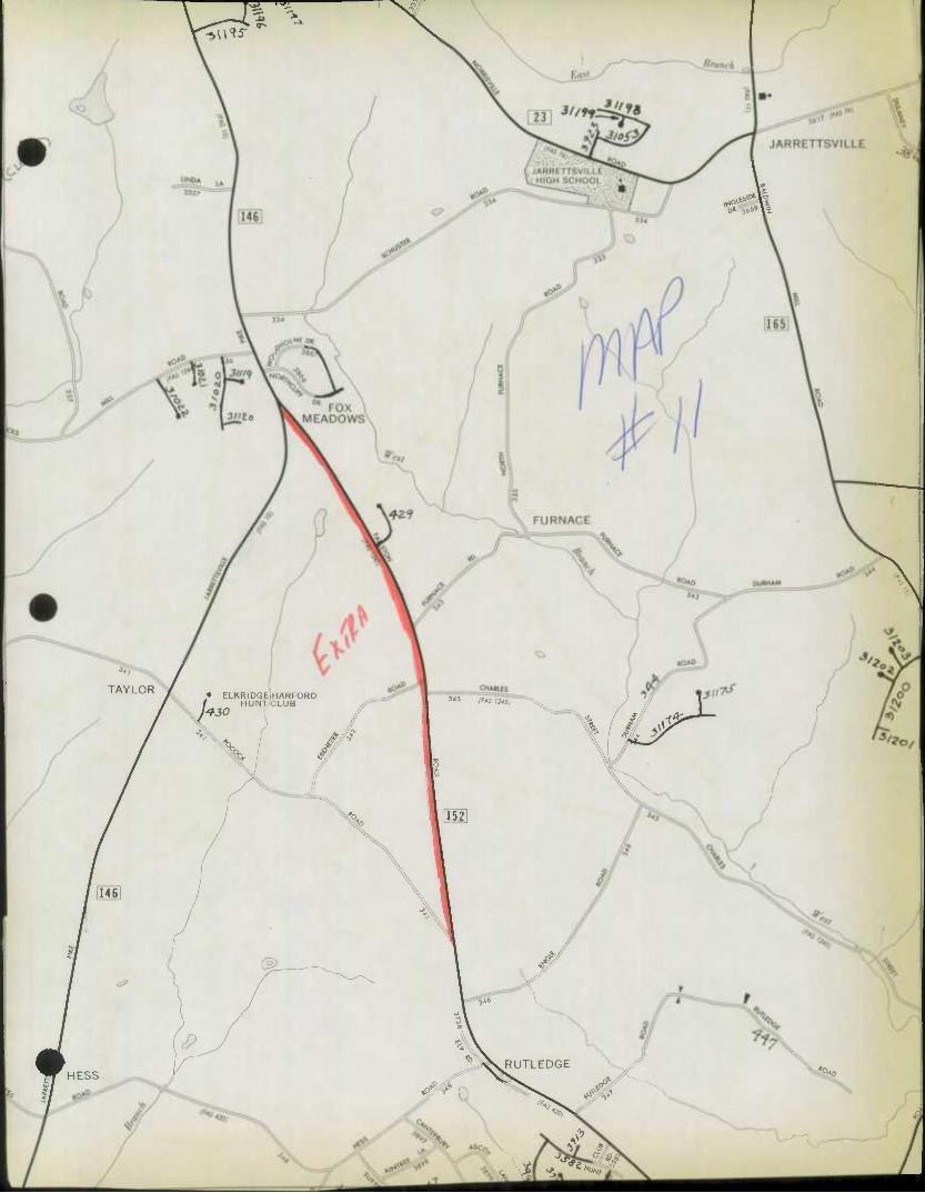
Ri*^
JARRETTSVILLE
0* -ibb* \x
TAYLOR « ELKRIDGElHARFORD / HUNT'CLUB JfJO
CHARLES
345 (MS 12451
\ %
HESS
S
P
@_
"•Q. So B52]
"346
/J
RUTLEDGE
»oJ# *5#
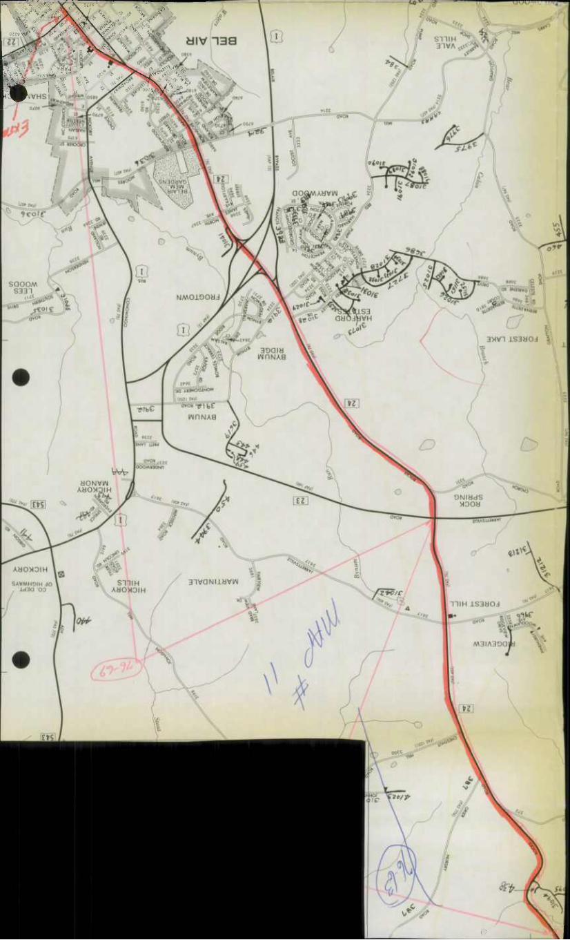
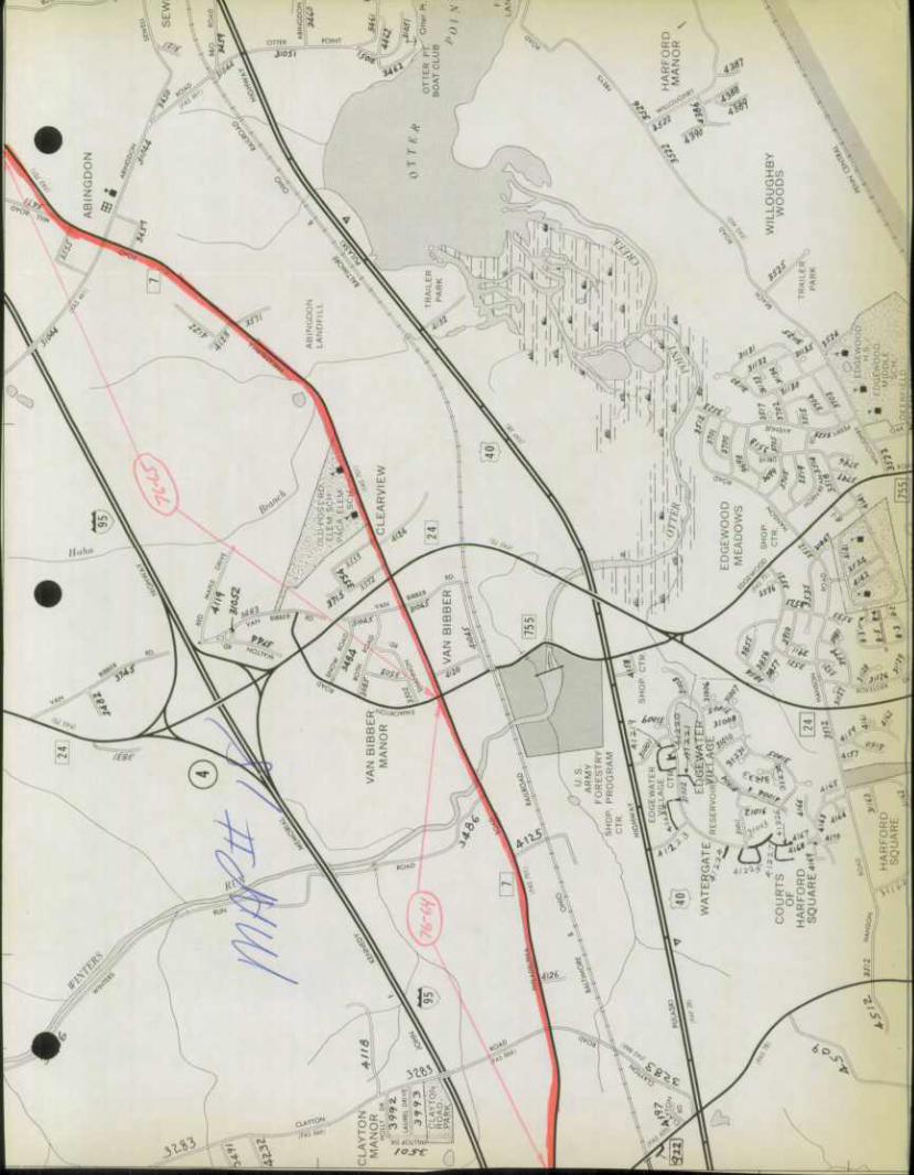
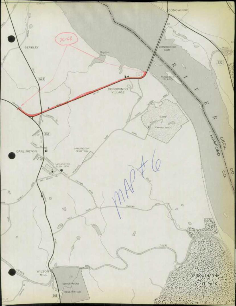
SUSQUEHANNA1 rXprS-\
STATE PARK. -vCrCy
I. AiW: 111 II iiU .jlilill.i.ikJi.i mliili
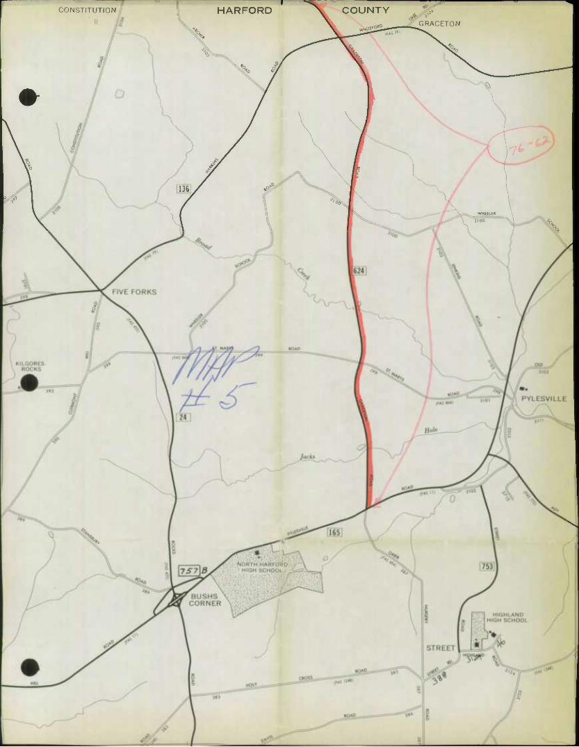
CONSTITUTION HARFORD
^ X^
^
^o ^
COUNTY ^|
^225- ^ G'RACET'
<o
K
l>
County
STATE HIGHWAY ADA STRATION OF MARYLAND
iPROVEiV
SHA 51 .3-23 Rev. 9/74
S .H .A . District No . 4th
Harford
HPS - 20
f Page. J of_5_
CUy or Town
For cdendor Yeor Ending December 29. 1976
ft
ROAD NUMBER
ROAD NAME
LOCATION DESIG- NATIONS ON MAP
MILES
CHANGES MADE IN MILEAGE
REMARKS FROM TO TYPE WIDTH
SYSTEM ADDI- TIONS
ABAN- DONED FROM TO
(1) (2) (3) (4) (5) (6) (7) (3) (9) (10) (U) (12)
Dear Hill Road Cherry Hill Rd. to Break 1 .31 I 24.5 O.P. Co. .31 Cherrywood Estates
Creek View Court Dear Hill Rd. to C-D-S 2 .23 I 24.5 O.P. Co. .23 Cherrywood Estates
Rosecrest Court Foster Knoll Dr. to C-D-S 3 .05 I 24.5 O.P. Co. .05 Joppatowne,Sec.6Pt3 East Branch Court Kreitler Rd. to C-D-S 4 .08 I 24.5 O.P. Co. .08 Jarrettswood
Wileywood Court Kreitler Rd. to C-D-S 5 .07 I 24.5 O.P. Co. .07 ——
Kreitler Road End to End 6 .61 I 24.5 O.P. Co. .61
Kreitler Valley Kreitler Rd. to Kreitler R I. 7 .60 I 24.5 O.P. Co. .60 __
Baywood Drive Kreitler Vallev to Kreitle- .
Valley 8 .30 I 24.5 O.P. Co. .•W __
Love Road Md. #165 to Andover RH. Q ,"7 I 24.5 O.P. Co. .07 Clear Spring Estates •• Parkwood Drive Md. #16S tn Break in .24 I 24.5 O.P. Co. .24
Stillwater Court Parkwood Dr. to C-D-S 11 .17 T 74.5 O.P. C.n. .17 __
Andover Road End to Parkwood 12 .36 I 24.5 O.P. Co. .36
b Andover Road Parkwood Dr. to C-D-S 13 .11 I 24.5 O.P. Co. U Parkwood
- ^^- Parkwood Drive Break to End 14 .16 I 24.5 O.P. Co. .16
Treeline Drive Parkwood Dr. to End 15 .22 I 24.5 0.0. Co. .22
Moran Court Parkwood Dr. to C-D-S 16 .07 I 24.5 O.P. Co. .07
Birmingham Ct. Madonna Rd. to C-D-S 17 .28 I 24.5 O.P. Co. .28 Madonna Manor, Sec.11 £o Tangier Road Birmingham Ct. to End 18 .09 I 24.5 O.P. Co. .09
Trout Farm Rd. MD. //165 to Lady Anne Ct. 19 .13 I 24.5 O.P. Co. .13 Steeplechase Manor
TOTALS 4.15 4.15
It is hereby certified by the undersigned that the additions and revisions reported each year pertain to roads legally a port of the county and/or municipal road system and title to some is vested in the constituted authorities of the political sub- division for which the report is filed. It is further certified that all roads reported herein shall be at least 30 feet wide or as specified in Section 145 of Article 25 of the Annotated Code of Marvianc flQ73 Reolocement Volume)
Prepared
Official Tit!
Approved B/
Official
Sy:!^
,.ll/ • '^ ,-v.
Title: ChlC-^U- JiWV
Dote
Dote:
J2'Z9~7k
\Qm-iir
U6l £ NVf
SHA 51 .3-23 Rev. 9/74
STATE HIGHWAY AD^^WRATION OF MARYLAND
ROAD IMPROVEMENT REPORT
HPS - 20
Page. of
S .H .A. Distrlcf No. ^h
Harford County
City or Town
For Calendar Year Ending December 29, 1976
ROAD NUMBER
ROAD NAME
LOCATION DESIG- NATIONS ON MAP
MILES
CHANGES MADE IN MILEAGE
REMARKS FROM TO TYPE WIDTH
SYSTEM ADDI- TIONS
ABAN- DONED FROM TO
(1) (2) (3) (4) (5) (6) (7) (8) (9) (10) (U) (12)
"A. Lady Anne Ct. Morse Rd. to Break 20 .24 I 24.5 O.P. Co. .24 __
Steeplechase Dr. Morse Rd. to Break 21 .20 I 24.5 O.P. Co. .20 StPPT)1 prhflSP Mflnnr • 3577 Matthews Ave. Break to Farm Road 22 .29 I 24.5 O-rPr - 9xrr~ .?q ArlpTti« Heiehts ^ 3755- Randolph Dr. Break to Cul-de-sac 23 .26 I 24.5 <Sr*-. G-e-r .26
i/ 3756fts-W Ashley Court Randolph Dr. to c-d-s 24 .05 I 24.5 Or^V G^. .05 3754 Garrett Court Randolph Dr. to C-D-S 25 .09 I 24.5 erP^. e^-. .09
KS Farm Road Break to Break 26 .16 I 24.5 O.P. Co. .16
r^ Wheaton Lane End to End 27 .49 I 24.5 O.P. Co. .49 — Priestford Hills pt hixs^y Goucher Way Wheaton La. to Wheaton La. 28 .67 I 24.5 O.P. Co. .67 —
F«- Wheaton Ct. Wheaton La. to C-D-S 29 .05 I 24.5 O.P. Co. .05 —
f- Hood Court Wesleyan Dr. to C-D-S 30 .09 I 24.5 O.P. Co. .09
Weslevan Drive College View Dr. to
r' • /J 2 ' IfiftJ) \ Goucher Way 31 .22 I 24.5 O.P. Co. .22 — S'/.TSA/S/O*
^ Perry Drive Goucher Way to PL. 32 .05 — — O.P. Co. .05 — Unimproved Stub
Shady Grove Dr. Moores Rd. to C-D-S 33 .17 I 24.5 O.P. Co. .17 — Pleasant Prospect Sn Placid Drive Shady Grove to Break 34 .22 I 24.5 O.P. Co. .22 — Glen Elyn
Raynham Court Placid to Break 35 .03 I 24.5 O.P. Co. .03
MpflHnw Trpp Dr. Mr!. i\ ^ 1-n RrP^W ifi .?fi T 24.5 O.P. Co. .26 Meadowstream 31101 Hampton Court Break to C-D-S 37 .33 I 24.5 O.P. Co. .33 — Bellvale
(•<- Trent Road Break to Hampton 38 .07 I 24.5 O.P. Co. .07 —
TOTALS 3.94 3.94
It is hereby certified by the undersigned that the additions and revisions reported each year pertain to roads legally a part of the county and/or municipal road system and title to same is vested in the constituted authorities of the political sub- division for which the report is ft led . It is further certified that all roads reported herein shall be at least 30 feet wide or as specified in Section 145 of Article 25 of the Annotated Code of Maryland (1973 Replacement Volume)
Prepared By:
Official Titl
Approveo By
Off
/SUrC £ . - / •
\::-\ . '•
ciai r.,.. riwp rl .\teipn Uviw
Date:
Date:
/^-Z9-7^
\Qon-i(r
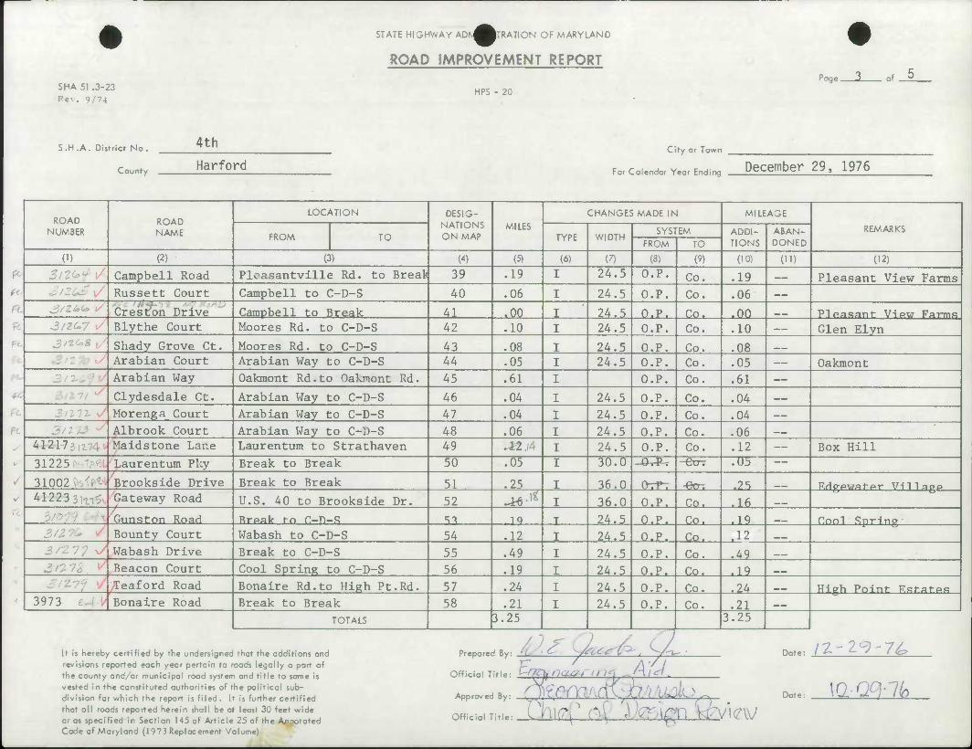
SHA 51 .3-23 Rev. 9/74
STATE HIGHWAY ADK^WRATION OF MARYLAND
ROAD IMPROVEMENT REPORT
HPS - 20
Page . of
S.H.A. District No.
County
4th City or Town
Harford For coiendor Yeor Ending December 29. 1976
ROAD NUMBER
ROAD NAME
LOCATION DESIG- NATIONS ON MAP
MILES CHANGES MADE IN MILEAGE
REMARKS FROM TO TYPE WIDTH
SYSTEM ADDI- TIONS
ABAN- DONED FROM TO
(1) (2) (3) (4) (5) (6) (7) (8) (9) (10) (ID (12)
. 3 !&(£>" Campbell Road Ploasantville Rd. to Break 39 .19 I 24.5 O.P. Co. .19 Pleasant View Farms . Russett Court Campbell to C-D-S 40 .06 I 24.5 O.P. Co. .06
' HA- Creston Drive Campbell to Break 41 .00 I 24.5 O.P. Co. .00 __ Pleasant Vip.w Farms
: Blythe Court Moores Rd, to C-D-S 42 .10 I 24.5 O.P. Co. .10 Glen Elyn • Shady Grove Ct. Moores Rd. to C-D-S 43 .08 I 24.5 O.P. Co. .08
Arabian Court Arabian Way to C-D-S 44 .05 I 24.5 O.P. Co. .05 Oakmont Arabian Way Oakmont Rd.to Oakmont Rd. 45 .61 I O.P. Co. .61
• Clydesdale Ct. Arabian Way to C-D-S 46 .04 I 24.5 O.P. Co. .04
Morenga Court Arabian Way to C-D-S 47 .04 I 24.5 O.P. Co. .04
. Albrook Court Arabian Way to C-D-S 48 .06 I 24.5 O.P. Co. .06
41217/ Maidstone Lane Laurentum to Strathaven 49 a2,;4 I 24.5 O.P. Co. .12 Box Hill
31225 Laurentum PUy Break to Break 50 .05 I 30.0 -0 P -&TT .05
31002 Brookside Drive Break to Break 51 .25 I 36.0 OrP": •cOl .25 F.dppwafpr VI'IIPOP ^ 41223: .-- Gateway Road U.S. 40 to Brookside Dr. 52 ^ I 36.0 O.P. Co. .16 __
Gunston Road Rrpak t-o C-Tl-S ST .1^ T 24.5 O.P. Co. .19 Cnnl Snrinp Bounty Court Wabash to C-D-S 54 .12 I 24.5 O.P. Co. -12
3/277 J Wabash Drive Break to C-D-S 55 .49 I 24.5 O.P. Co. .49 Beacon Court Cool Spring to C-D-S 56 .19 I 24.5 O.P. Co. .19 __
Teaford Road Bonaire Rd.to High Pt.Rd. 57 .24 I 24.5 O.P. Co. .24 __ High Point Fstatps 3973 Bonaire Road Break to Break 58 .21 I 24.5 O.P. Co. .21 ___
TOTALS 3.25 •
3.25
If is hereby certified by the undersigned that the additions and revisions reported each year pertain to roads legally a part of the county and/or municipal road system and title to same is vested in the constituted authorities of the political sub- division for which the report is filed. It is further certified that all roads reported herein shall be at least 30 feet wide or os specified in Section 145 of Article 25 of the Annotated Code of Maryland (1973 Replacement Volume)
icial Title: CV/?V na&i I / ^1 'H / d•
.proved By: ^f' A-jV/ I/dip .
Prepared By
Off
App
Off
Date:
Date:
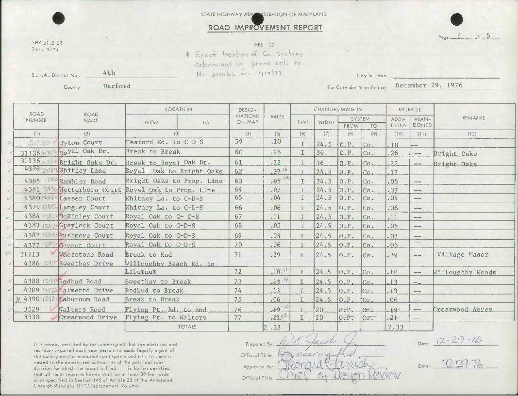
SHA 51 .3-23 Rev. 9/74
S.H.A. District No.
County
4th
Harford
STATE HIGHWAY ADW«ttSTRATION OF MARYLAND
ROAD IMPR^EMENT REPORT
HPS - 20
dtjeiwumd y>H pWoot ca\l TO
Mr Jocolos oo >li-ihT. Clfy or Town
Page .
For Caiendor Yeor Ending December 29. 1976
of
ROAD NUMBER
ROAD NAME
LOCATION DESIG- NATIONS ON MAP
MILES CHANGES MADE IN MILEAGE
REMARKS FROM TO TYPE WIDTH
SYSTEM ADDI- TIONS
ABAN- DONED FROM TO
(1) (2) (3) (4) (5) (6) (7) (3) (9) (10) (11) (12)
Byton Court Teaford Rd. to C-D-S 59 .10 24.5 O.P. Co. .10 • 31136 Royal Oak Dr. Break to Break 60 .26 36 O.P. Co. .26 Bright Oaks \/ 31136 Bright Oaks Dr. Break to Roval Oak Dr. 61 .22 36 O.P. Co. .22 Pripht HaL-q 1/ 437° Whitney Lane Royal Oak to Bright Oaks 62 .HXL 24.5 O.P. Co. .17
4385 Rambler Road Bright Oaks to Prop. Line 63 .05 24.5 O.P. Co. .05 __
4381 Wetterhorn Court Royal Oak to Prop. Line 64 .07 24.5 O.P. Co. .07
b 4380 '- Lassen Court Whitney La. to C-D-S 65 .04 24.5 O.P. Co. .04
4379 Langley Court Whitney La. to C-D-S 66 .06 24.5 O.P. Co. .06
^ 4384 lli McKinley Court Royal Oak to C- D-S 67 .11 24.5 O.P. Co. .11
4383 , Greylock Court Royal Oak to C-D-S 68 .05 24.5 O.P. Co. .05
4382 Rushmore Court Royal Oak to C-D-S 69 .03 24.5 O.P. Co. .03
4377 Cinnpt- Cnnrt- Royal Oak to C-D-S 70 .06 24.5 O.P. Co. .06
31213 Whetstone Road Break to Knd 71 .99 2^.5 n.p. r.n. .29 Village Manor
4386 Sweetbay Drive Willoughbv Beach Rd. to Laburnum 72 ^r-11 24.5 O.P. Co. .10 ^illoughby Woods
4388 !'•:' Redbud Road Sweetbay to Break 73 ^•'4 24.5 O.P. Co. .13 4389 Palmetto Drive Redbud to Break 74 .13 24.5 O.P. Co. .13
* 4390 .. ^ Laburnum Road Break to Break 75 .06 24.5 O.P. Co. .06
3529 Walters Road Flving Pt. Rd. to End 76 A1'V 20 frrP-. Rrr. .V*- Crestwood Acres 3530 Crestwood Drive Flying Pt. to Walters 77 <Z\^ 20 O.PT CtTT- .Ur
TOTALS 2 .33 2.33
U is hereby certified by the undersigned that the additions and revisions reported each year pertain to roads legally a part of the county ond/or municipal road system and title to same Is vested in the constituted authorities of the political sub- division for which the report Is filed. It Is further certified that all roads reported herein shall be at least 30 feet wide or as specified in Section 145 of Article 25 of the Annotated Code of Marvlard flQ~3 Reclacement Volume)
ored By: A Mcf^ Prep'
Official Title
Approved By;
Official Title
ii na<21' It let-
,h(?C (^ ^ipn lj?vi(rvv
Date:
Date:
/Z-29-7^
1(2^-7^
STATE HIGHWAY ADMJUSTRATiON OF MARYLAND
ROAD IMPRWEMENT REPORT
SHA 51 .3-23 Rev. 9/74
HPS - 20
Page 5 of ^
S.H.A. District No.
County
4th
Harford
City or Town
p^r r-^ion^r v»„r F^;n^ December 29, 1976 ror twalendar Year tnding Z
ROAD NUMBER
ROAD NAME
LOCATION DESIG- NATIONS ON MAP
MILES
CHANGES MADE IN MILEAGE
REMARKS FROM TO TYPE WIDTH
SYSTEM ADDI- TIONS
ABAN- DONED FROM TO
(1) (2) (3) (4) (5) (6) (7) (8) (9) (10) (U) (12)
35.31 Love Road Crestwood Dr. to Kennard 78 Ai* I 20 n P, £Q. .1? Crestwood Acres
^ 3532 Crestwood Court Crestwood Dr. to C-D-S 79 J}2?? I 20 a ..p. -Go-,- ^ Ji2
y 3513 Love Court Love Rd. to C-D-S 80 ^•^ T 20 O.P. •et^r- -rft^ __
TOTALS .17 .17
It is hereby certified by the undersigned that the additions and revisions reported each year pertain to roads legally a part of the county and/or municipal road system and title to same is vested in the constituted authorities of the political sub- division for which the report is fi led . It is further certified that ail roads reported herein shall be at least 30 feet wide or as specified In Section 145 of Article 25 of the Annotated Code of Marvland (1Q7 3 Reclccemenr VOIL--3
Prepared B
Official Title
Approved By:
Off
,<2.^ U 'j
Da
Date:
t,: IZ -29-7^
\nQc}lL
li 09/1^/76
HARFURO COUNTY
STATE HIGHWAY ADMINISTRATION OF MARYIpAND PPFICE OF PLANNING AND PRELIMINARY ENGINEERING
BUREAU OF HIGHWAY STATISTICS COUNTY RUAD MILEAGE
A PAGE
• ROUTE NO, TDTAL A 1 3 C 0 & E F t G H £ I J K & L
3 50 51
1.39^/ r5(K/ i50
1,39
3 3
52 53
,46^ 1.9 1.
.*6 l*9l
• 1 3
54 55
.52^ .46 .66
.00
li 3 5b 57
4.38^/ 3.46V/. ,•2
4,38 2,64
3 i
58 59
i.7b.y 2.04
1,76 2,04
• 3
60 61
1.65 lf41^/ lf«l
1.65
3 #
62 63
2,10^ .17//
2.10
3 3
6^ 65
.13 .13 .04 .06
• . 3 67 .3^
1.98 T82
69 ^r ^^V ,47
• 70 71
1,66 '3 1.73
1,66
• 3
72 73
3.12-7 1.91^/
3,12
3 •
74 75
2.08V 1,72 .75
2,08 ,97
3 3
7o 77
2,11 2,80^
I.10 1,01 2,80
• 3
76 79
2.23 2(70v</
1.63 .60 2,70
ii 3 *
BO 81 1.50
f59 1.50
•ov
3 3
B2 S3 3,42 3.27
3,28 ,15
• 3
84 85
6 /" l,08-V
.82
.53 .55 ,04
3 •
86 Ml 6,35
i 3
8b 89 1.14 1.14
.28
• 3
90 91
2.43^" l.OOV,
,4? 1.00
1,96
3 •
92 93
i.8oy 4,19 V
1,80 4,19
3 3
94 95
2,09 1,41
1,93 1.41
,16
^^ 3 9b 97
,6 5^7 ItU-V liU
.65
3 •
98 ,35-/ .35
•
<1
•
il
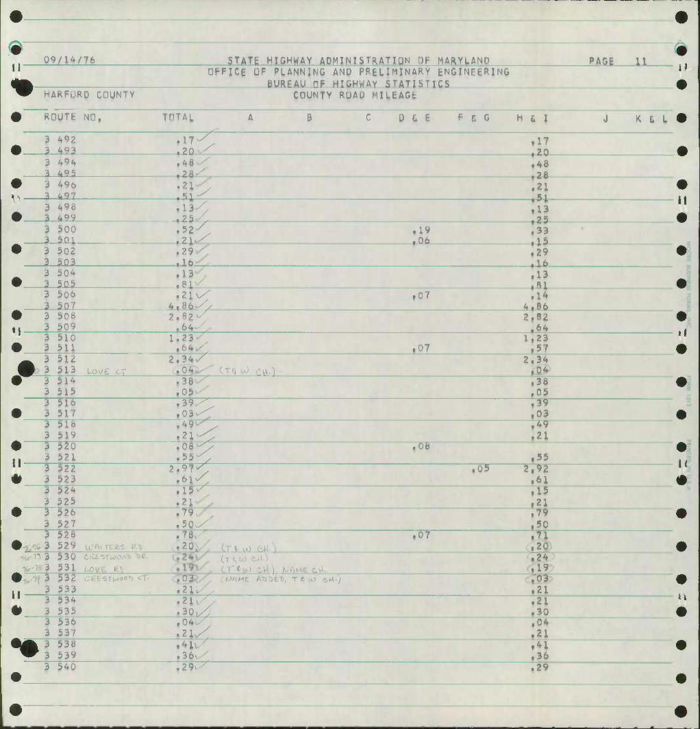
II" 99/1^/76
HARFURD CDUNTY
$TATt HIGHWAY ADMINISTRATION HP MARYLAND •FFICE DF PLANNING AND PRELIMINARY ENGINEERING
BUREAU OF HIGHWAY STATIbTICS CDUNTY ROAD MILEAGE
PAGE IX
ROUTE NO, THTAL B 0 G E F t G H t I
20 Z_
K & L
^92 ^9i
.17
.20
.48 ,28
49^
i 3
496 497
48 28- ^1 .21
,51 .13 .25
^98 497
l^
52^ 3 I
500 501
3 502 303
29v/r
.19 ,06
.33
.15
.29 •lit
3 3
504 505
13 .13 .81
3 3
506
3 3
50b 509
86^/ ,07 .14
4,86
23^ 66
i_ 2.82
3 3
510 511 07
1,23 ,57
3 3
512 513 UwE ct
2.34 .04
3 3
514 515 51b 517 TTT 519
38 05
03^
,38 05 •
3 3 5" 3
3" 3
T 3
T 3 T 3
3" ^ 3
52U 521
4 21 ^
08 55
^T
.39
.03
.49
.21 ,0b
522 523 524 525
Voir » 61
526 527 32b 529
h z 7^7 50^
.15 ,21
-.W
.79 ,50
.20
ifc-ig 3
3
530 c^-snoooTi T)e. 531 LOV£ g')
CT *, u> c
21,
.24
.03 532 cce^Ttpo07) ^T- 533 .21
3 3
534 535
3 3 3 3
536 53/ 53b 539
21 30
3 540
04.
4^/ 36u/ .29^^"
.21
.30
•
,04 .21 .41 .36 .29
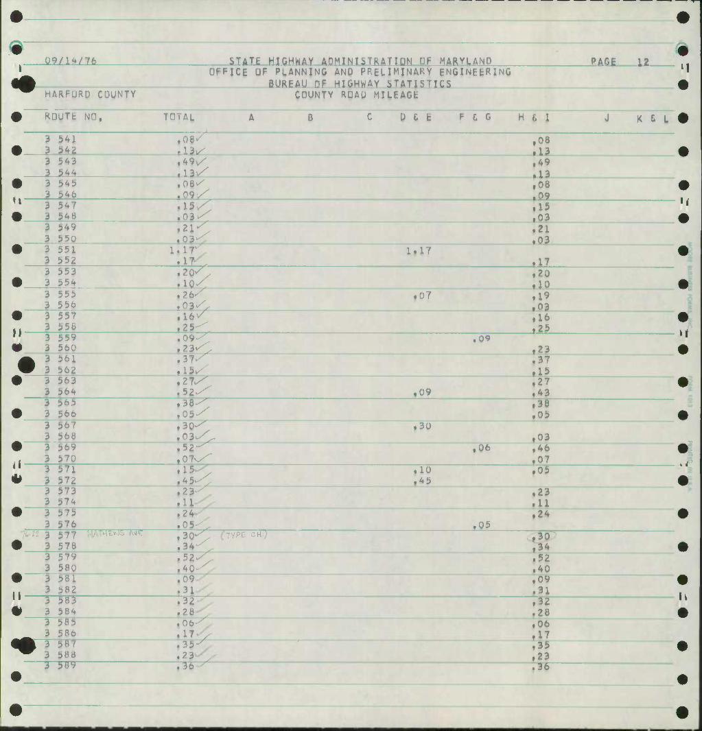
Q9/lW7fe
HARFURD COUNTY
SUTi JUGHMY ADM INISTRATIDN DF MARYLAND OFFICE OF PLANNING AND PRELIMINAKY ENGINEERING
BUREAU OF HIGHWAY STATISTICS COUNTY RDAU MILEAGE
PAGE 12
ROUTE NO, TOTAL B D & E F & G H t I K & L
08- ' 3 3
541
3 3
5A3 5^
49\/
,08 .13
.13 3 3 5^0
08^ 09 v< 15v^
,08 .09
3 2
547 548
.15
.03 3 3
549 550
3 3
551 552
if
2CK/ 1^1
1.17
.21
.03
17 3 3
553 554
2*
16 25
.20
.10 3 555
556 557 556
09^ 23-
,07 .19 .03 .16 125
3 3 3 3
559 560 561 562
52^ 38^7 05^
,09 23
.37 15
3 3
563 564 565 566
09 .27 .43 ,3F .05
567 568
3 3
569 570
30^ 03vX/ 52-" OTv/^ 15^/
30
,06 .03 .46 ,07
3
3 571 572
3 3
573 574 57S 57b
?nrx~577 MATHER 3 578
Twr-
2 3
24. 05 BO1-"" (TYPE cH.j
.10
LOA
• 05
.23
.11 ,24
34 /
40
.30 a?
3 3 3 3 T
579 580 581 582 5H3 584
09 31
.52
.40
.09
.31
3 3
585 586 587 588
3 28
35 23 ^ 3b 7^"
.32
.28
.06
.17
.35
.23
.36
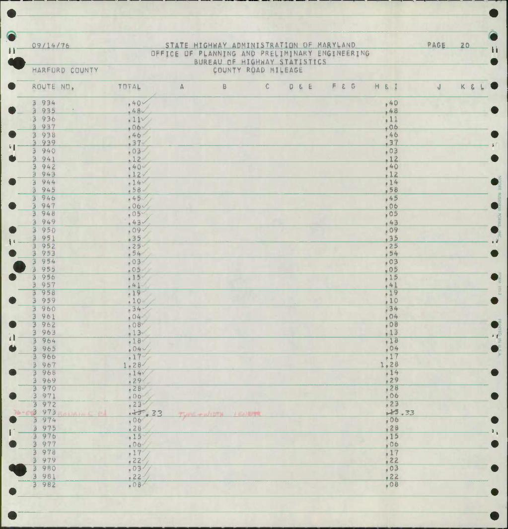
II 09/1^/76 STAT1.J1ICHWAY ADMINISTRATION UF MARYLANP
HARFURD COUNTY
DFFJCE OF PLANNING AND PRELIMINARY ENGINEERING BUREAU DF HIGHWAY STATISTICS
COUNTY ROAD MILEAGE
PACE 20
ROUTfc NO. THTAL B D t fc F £ G H £ I K & L
3 a
934 .9JL5. 48-
ll^
40 4B
3 3
936 937 06
37
U 06
3 a
938 iaa
12
46 37
3 3
940
3 3
942 943
40
58
03 12 40 u
•
m
3 3
944 94i)
45^7
14 58
946 947
45 06
3 3
948 949
3 3
950 951
05 43
15 n
05 43 09 35
3 3
952 953
3 3
954 955
3 3
956 957
54 03 05 15 4 J
25 54 03 05 15 4 \ 7
3 958 959
3 3
960 961
3 3
962 963 9M 965
1 10 . 34 04 08 13^
04/
1 10 34 04 08 13 IF 04 17 28
3 3
96b 967 28^
14 29
966 969 970 971
Ttiy Ob
28 06
3 3
972 973
3 3
974 975
06 28
?SL
23
06 26
97b 977
3 3
978 979
3 3
980 981
15 06
1 08^
22 , 037/ 22
15 06 17 22 03 22
3 982 08
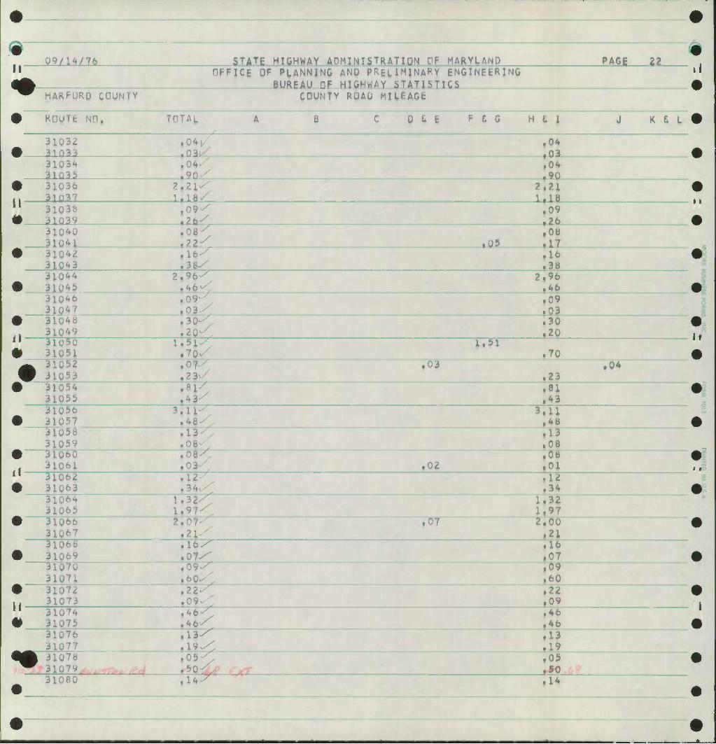
m 09/14/76 STATE HIGHWAY ADMINISTRATION OF MARYLAND PAGE 22
OFFICE OF PLANNING AND PRELIMINARY ENGINEERING BUREAU DF HIGHWAY STATISTICS
^^ HARFQRD C0UN1Y COUNTY ROAD MILEAGE
• KDUTt NH, A [) L t f L 0 H £ I J K d L
31032 • 31033
04/ ,04 • 03
31034 31035 , 90/
.04
.90 • 2, ,. 31037 I, ISv^
2.21 1,18
" 31038 • 31039
.09
.26 31040 31041 ,
.08^ 71^ fQ5
,08 .17
• 310^ . 31043
116-/ .16
,38 31044 2,
• 31043 96-; 46-
2,96 .46
310*6 31047
09- 03-/
,09 .03
• J48 31049
30^ 20^1
.30
.20 il 31050 I, # 31U51 Ml/ .70 ^ 310b2 07 .03
f23 • 04
• 31054 31055 43'/
.81
.43 31056 3,
• 31057 48-^ 3,U .48
31056 31059
13v ,13 ,08
• 31060 31061
08^. 03/ ,02
.08 • 01
11 31062 • 31063
,12^ .12 .34
)64 1 )65 1
.32 ,97<
1.32 1,97
• 31060 2 31067
,07 ,21^
2.00 .21
31068 • 31069
,16/ ,07-
ill .07
31070 31071 ,60^:
.09
.60 W 31072 1, 31073
,22^ .22 .09
11 31074 # 31075
,46/ ,*6 .46
31076 31077
,13/" .19/:
.13 ,19
M| 31078 W 31079 / ,50^ ^r
.05
31080 ,14/ .1*
•i S
•HKFOH^P^H
m m
m 09/14/76 STATE HIGHWAY ADMINISTRATIQN UF MARYLAND PAGE 29
•
II OFFICE UF PLANNING AND PRELIMINARY ENGINEfcPlNG BUREAU OF HIGHWAY STATISTICS
i|
• '^ HAKFURD COUNTY COUNTY ROAD MILEAGE
0 KOUTfc NO, TOTAL A B C D 6 E F C G H t I J K t L
31081 , # 310B2
4V .48
31083 , 31084 ,
13^ .13 • 03
• ,, 31086
03^0 0?^
.03
" 31087 • 31088
32/ 07^/, .32
31089 31090 04-/
.24
.04 • 31091
31092 09>/ 10^
.09 flQ
31093 # 31094
24^ 26^.
.24 .26
31095 31096
08/> 40/.
.08
.40 • 31097 .. 31098
.25^ .25 r10
31099 • 3110U
.11/
.39X ,11 .39
A 3U01 W 31102
• .12 ,08
• 31103 31104
.08^. .08 .05
31105 • 31106
,03'V ,03 ,26
31107 31108
.IT y .17 .09
• 31109 31110 ,24/>
.12
.24 " 31111 • 31112
.18// ,06^/
.18 ,06
31113 31114
> ,09 ^
,09 .09
• 31115 31116 ,19^
.27
.19 31117
• 31118 < ,06 .03
31119 31120
.P6 ' ,06 .04
• 31121 , 31122
.15//
.10// .15 .10
11 31123 # 31124
.20//
.15 V .20 .15
31125 31126
/ V
.05
.37 •A 31127 ^^ 3U28 .12^
.04
.12 3U29
•
.07- .07
•
II
Wo
II
•»
-
n 09/14/76
HARFURD COUNTY
STATE HIGHWAY ADMINISTRATIUN tiF MARYLAND [TFFlCfc UF PLANNING ANU PRtLI^INARY ENGlNEfcRINQ BUREAU DF HIGHWAY STATISTICS
COUNTY RQAU MILEAGt
PAG6 Z5L
ROUTE: NO, TOTAL B D i t F t G H t I K £ L
25^ 179 25 55
181 06
Qi
11 06
183
u
04 05
185
10//
16 12
187
189
37/ 09//
06 .10 12 •
191 I9i_
35 02 08
193 194
I7v 17 16
19^ 196
19- 07^
19 07
197 19B
13
i ^T
13 19
3
3 3
199 200 y^ttr^ftAt g^ 201 202
OV^ 05/
38^
03 .^^^ OA 05
203 204
37^
07 38
205 206
13 y
13 13
207 208
14 10
209 210
13, 13 17
211 21^ 213 214
21 34
49 .06
33/
21
^^ 07
215 216 217 218
03
49 06 08 33
219 220 JIT 222
ottr
09 03
IB
02 223 224 22^ 22b I7T
07 18 50 11
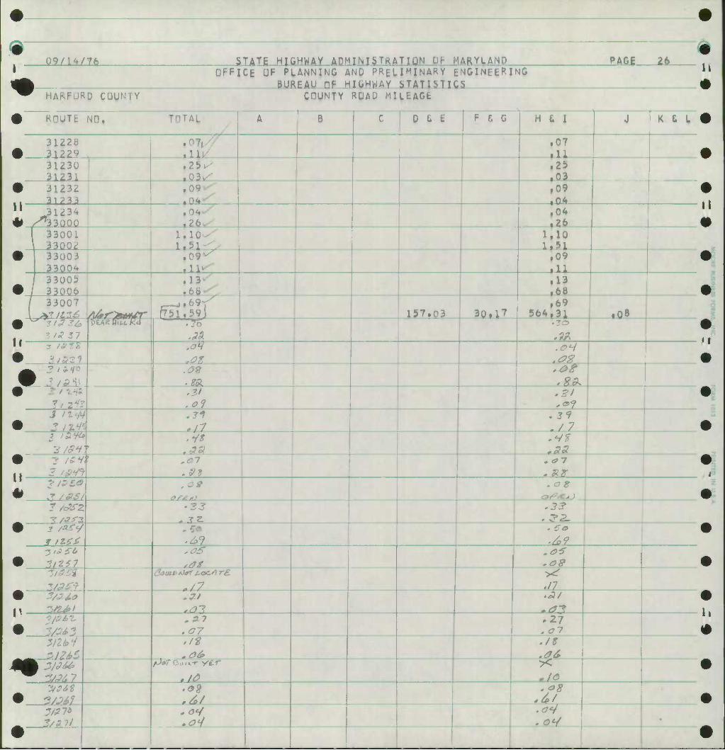
Q9/1W76
HARFURD CGUN7Y
STATE HIGHWAY ADMINISTRATION OF MARYLAND OFFICE UF PLANNING AND PRELIMINARY ENGINEERING BUREAU DF HIGHWAY STATISTICS
COUNTY RDAU MILEAGE
PAGI te- rn
• ROUTE NO, TiiTAL A B C D i- 1 F t G H & I J K £ L
31228 0 31229 .1.
.07
.11
31230 31231
.25^ 3^
.25 T03
• , 317^3
9 ,09 • 04
11 ^,31234 * ^33000 ,26
i04 .26
I 33001 \ 33002
UlOv-^ 1. b 1 -^
1.10 1,51
• 33003 3300A
.0 •
.11^- ,09
• 33005 33006
.1.
.to .13 .68
• •
33007 yyitr^fitt^r r751.59j A57.0 3 10.^7
.69 564,31 .Q8
3'J 27
pr^ijnrrj .7o .JW
-at .^*/ .<?%
,•
3 mo .09
.SI .01
.21
.71 ./7
r .*/»
.3S •
.S3 .a-7
11 3/*sa • JT/£S/
.0* .ag •CAJ
1 &SZ •3 * J2.
.33
• .^9 ,/o9
•31 SSI*
ft .as .09
daaa>*i*r i.oe.'
./7 • .11
.^7
.*7 .07
.27
.al
«i .at*
.it
.06 >< -/<9
• ,6/ •
l#i* 1/aH - 0^ _
•
•
It
•i
<f
ii
9$ Vt-S ires. u-V Ze>'M'L
•
1 r
il ' SP'/r/ ^ *y U'&l kf w
7t V 4E' i
>?'/ .^#
1
It'h?? Ll'OZ Zol£/ •^-ThU^ 90 If •
11
A/1 11
9 SO- se- lf "'
•
1Q' A f.t2/ •
~ he- ho* rn 8/'
91' \ 8/' C/'
•
i •
*
•
6/ ' • 7^'
^L7f
A/' A/ • ^ • zit/
•
•
J? 2*/* J+d z^q P ^7 f 'JOJ^ ytp/
•
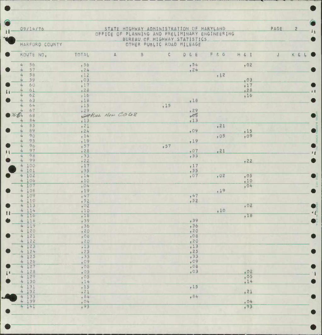
m 09/1^/76 STATE HIGHWAY ADMINISTRATION DP MARYLAND PAGE 2
II OFFICE OF PLANNING AND PRELIMINARY ENGINEERING BURFAU HF HIGHWAY STATISTICS
"^ HAKFURO COUNTY OTHER PUBLIC ROAD MILEAGE
• ROUTE NO, TOTAL A B C 0 & fc F f. G H & I J K t L
* •
56 57
.56
.24 ,54 il4
.02
4 58 59
.12 ,c
.12 ,03
• 60 61 .28
,17 .28
4 • 4
62 63
.16
.18 ,18 .16
4 64 .15 .29
,15 .29
4 68 84 .13
/V«f«^ £<s>e»s *** .13
4 •
85 89
.21
.24 ,09 .21
,15 i 4
90 95
.14
.19 ,19 .05 .09
• 96 97 .28
.57 .07 .21
# 98 99
.33 ,33 .2i_
• ti ,00 .01 .17 .35
.17
.35 9 .02
,06 .10 .02 .05
.10
9 .0? ,08
.04
.19 .19 ,04
^ ] ,09 LlO
,47 ,52
,47 .52
9 [ll Ll4 .10 .10
.02
II 4 ] L16 18
.18 ,39 .39
.18
4 ] ^ ]
119 L20
.36
.20 .36 .20
• L21 122 .20
.08 ,20
^ ] #
L23 124
.13 ,13 •
4 ; 4 ]
125 L26
.33 .33 .09
• • « 4 ]
127 L28
.08
.05 ,03 .02 4 ]
• L29 L30
.05 .05 .14
4 ] 4 ]
k31 i32 .2
.15 .21
133 i39
.84
.04 .84
,04
•
[41 .93 .93
il
11
•i
•i
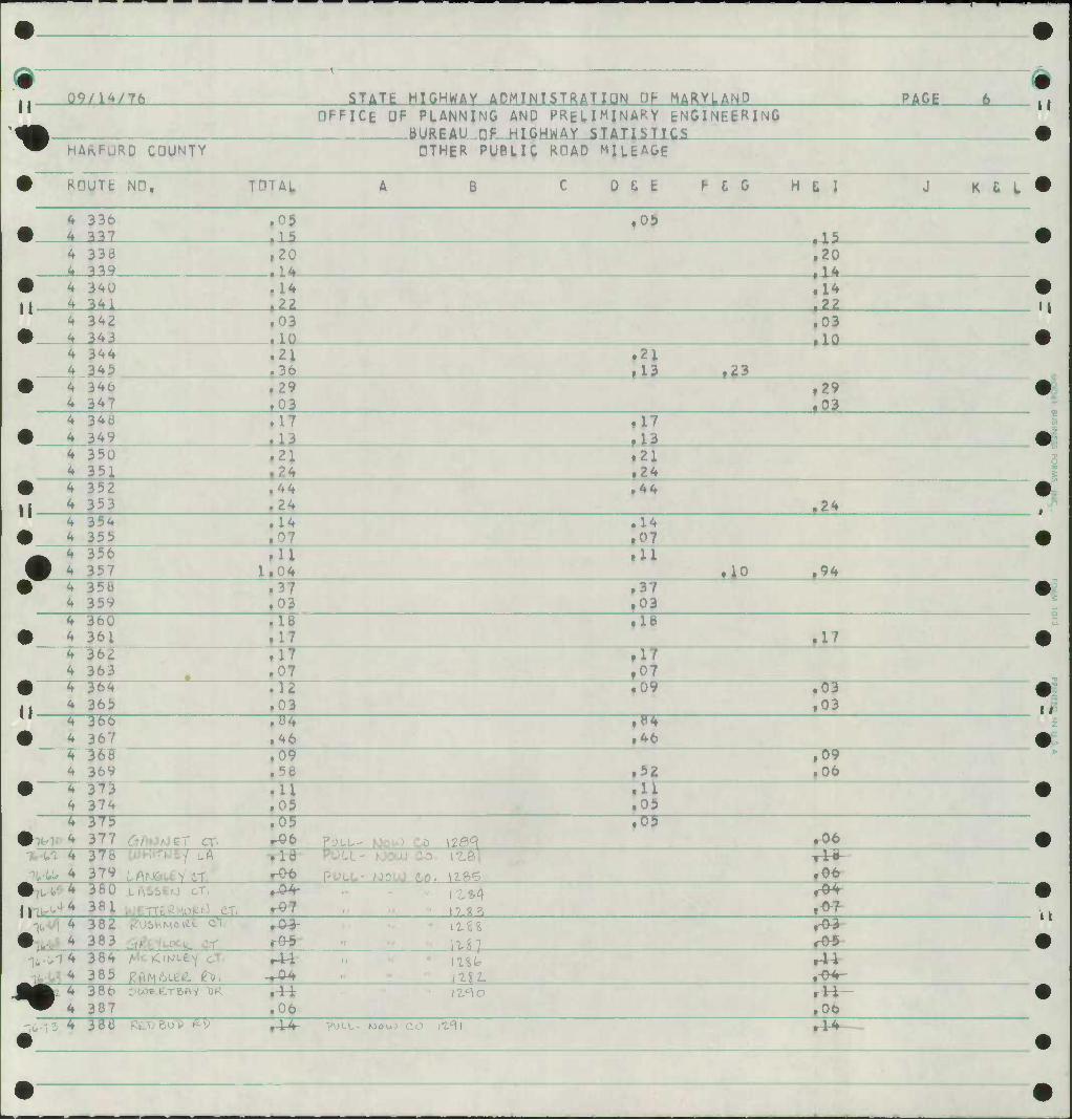
09/lW7ft STATE HIGHWAY ADMINISTRATION OF MARY^ANO PAGE t» II
HPFICE OF PLANNING AND PRHIMJNARY ENGINEERING BURPAU nF HIGHWAY STATISTICS
^ HAKFURD COUNTY OTHER PUBLIC ROAD MILEAGE
• NO, THTAl. A B C 0 fi b F C G H & I J K £ L
• 336 337
.05
i1 ^
f09 • I?
4 4
33<3 ^^9
,20 • 1 4
.20 • 14
•
11 ^
340 341
.14
.22 .14
f22
4 •
342 343
.03
.10 .03
.10 4 344
345 .21
36 ,21
fl3 ,23
347 ,29 .03
.29 ,03
4 346 349
.17
fl3 fl7
4 4
3 50 351
.21
.24 .21 .24
• |i <*
352 353
,44 .24
.44 .24
4 •
354 355
.14
.07 .14 .07
• :
356 357
.11 li
.11 .10 .94
• 4
35b 359 .03
.37 ,03
4 •
360 361
,18 ,17
»18 .17
4 4
36£ 363 •
.17
i .07 364 365 .03
.09 .03 .03
" 4 •
366 367
.H4
.46 f»4 .46
4 4
36b 369
.09 .52
,09 .06
• 4
373 374
.11
.05 .11 .05
4
•
37i> 377 6^fOAJ£T CT'
.05 Pouu- hJouJ Co \Z0^
Of .06
^ 4
-](,-(.(. 4
37b 379
.16 POLL- MOUJ CO. I'Lftl
PULL- NJOLO Co, 1186 3B0
3B1 LASStO cT. 11*4
^IfcVl 4
•
3BZ 383
r£-3-
^-(,14 384 385
Al mi* mi.
^: 38t 387
^u)E.E,rBPi-y "OR
.00 iz^o ..
.06
^t-15 ^ 38ti RtXiBoD ftp rU PULL- MOuO CO 111) M~
11
tl
11
11
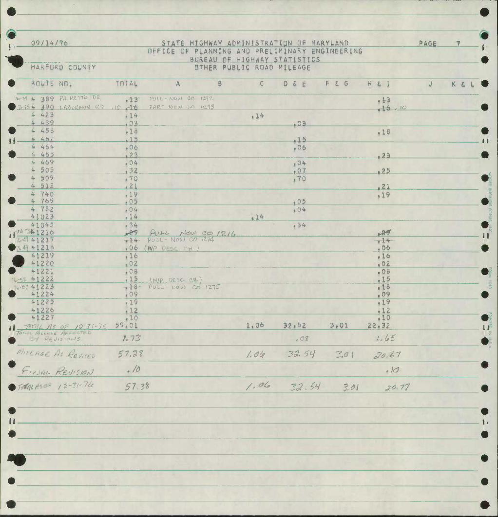
# #
m j. 09/14/76 STATE HIGHWAY ADMINISTRATION DF MARYLAND PAG^ T
-4* OFFICE OF PLANNING
BUREAU OF AND PRELIMINARY ENGINEERING HIGHWAY STATISTICS
^ HAKFURD COUNTY OTHER PUBLIC ROAD MILEAGE
• RDUTfc ND, TOTAI. A 1 C 0 & E F f. G H t I J K C L •
7fo-14 4 389 PflLMtTTo DR.
# Mii 390 LAftvj(2woM K^? ,10 r«5 PULL- PAIif
WOU) .43 *-lr6 • "0
4 423 4 439
.14 ,03
a* .0?
• 4 45ti jj 4 46?
.10 • 19 il?
.18
4 464 # 4 465
.06 f?3
,06 .?3
4 469 4 505
.04
.32 .04 t07 .?&
• 4 512
.70
.21 .70
.21
^40 •
.19
.05 f05 .19
4 782 41023
.04
.14 .u .04 S
• 41045 11'^ "'*• 1216
.34 PL»i-/- AJOIP tfto y^.y/
.34 ^ir
W41217 • ^i 41218
-rJr4" ,06
pULL- IslotO
ESC c
C^D 12-74
H.) ^06 ^ 41219 W 41220
.16 ,16 .02
• 41221 41222
.06
.15 ^N/P DESC- CH) .08
.19 . :41223
• ^Hk PULL- NOlO Co 111?
_L09 u
41225 41226 .12
.19
.12 •
59,01 1.06 32.«»2 3,01 iio
22.32 1 i 7?
0 t.13 ,0* u6S
rt'^**cAs &*Sep $1,7% /^ 3& Scj 3.0 \ &M7
t-'*jAi~ ^eUfStaJ Jd ,1
mrmfc f*m 57.32 /.*(* 32.M ?^j JOT?
• •
^P •
• •
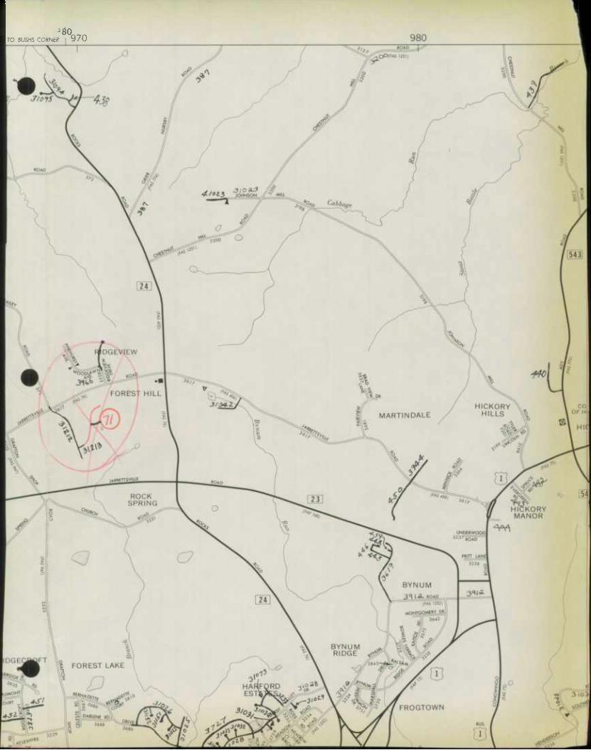
ro BUSHS CORNER \ 970
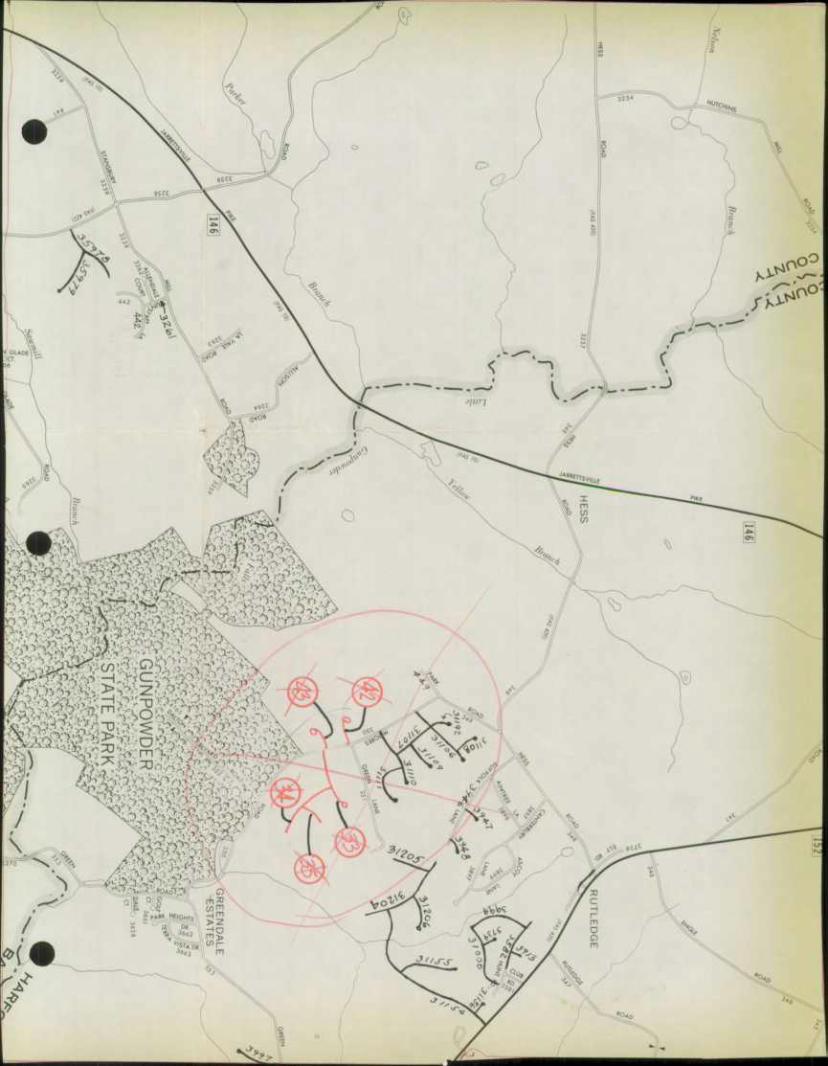
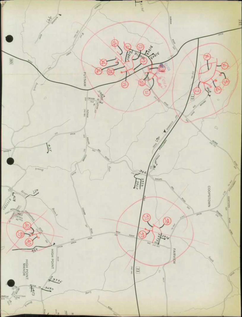
— F?
pNfVUf
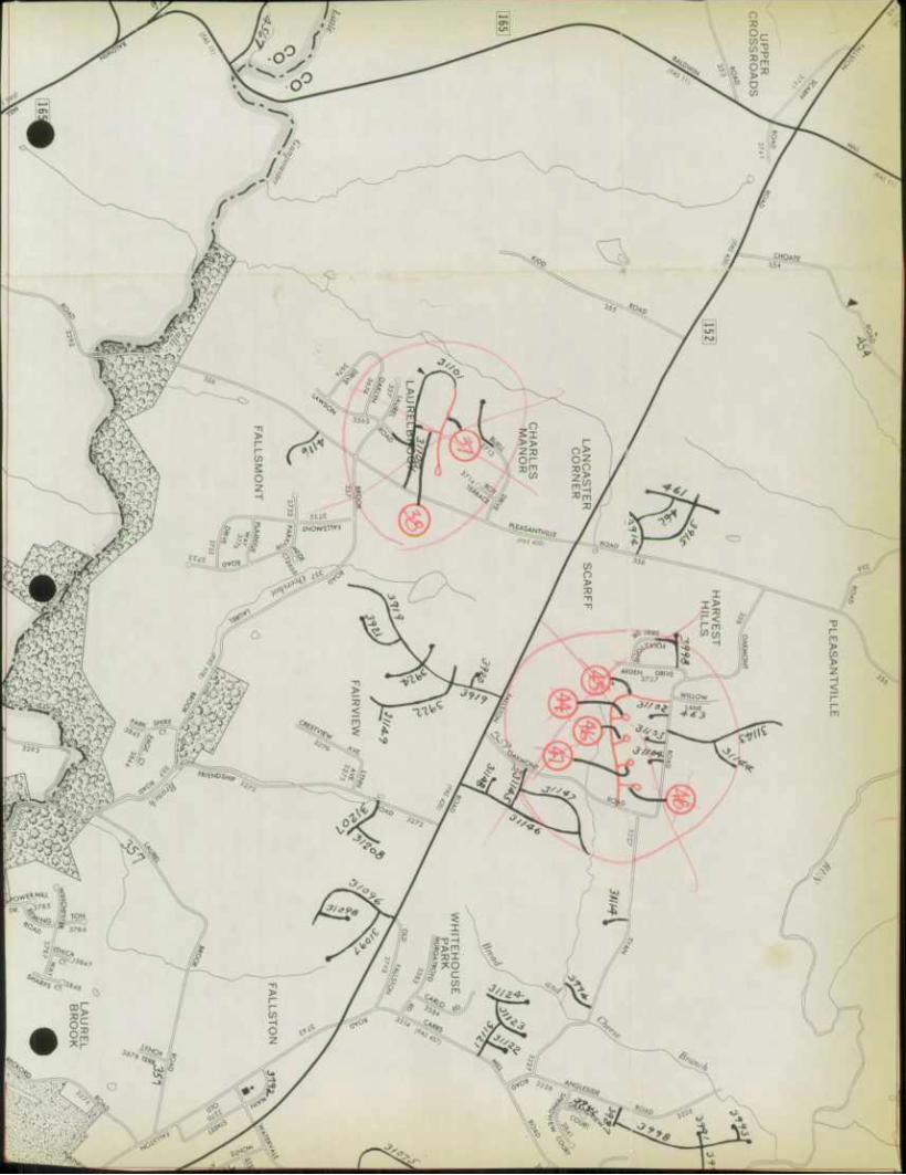
.iit.Uii.'i.
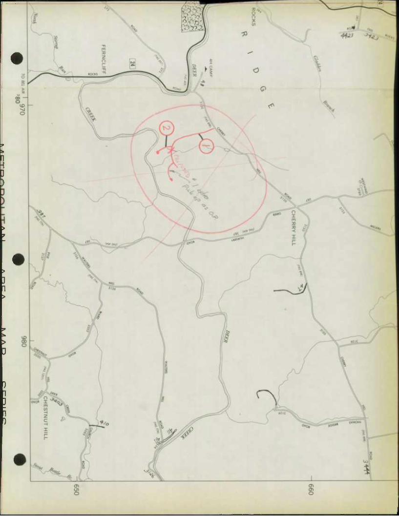
1
mtu wr
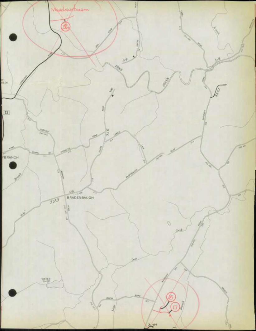
-i365
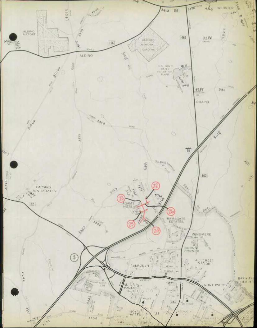
0 CARSINS
^^RUN ESTATES
IT.
3-
.^ «D sh
DOW5 o <
^0 « JfNNIFeR LA Q O
ABERDEEN * * I, B«NDA t. HILLS «
ANDREWS RD 22
BURNS5 CORNEjR
HILLCREST MANOR
/i/Al ION'*, fHOMES
J
CHAPE
I
f WAMD
ROYAL° ACRES ;
? o 3
'
WliERTS -'•• CT £
Q COWALEF
CT
COlAINI C
I 462
s^:!* ^^w
is
^7^. NORTH WOOD"1
BAR f I fc HI IGH1
'••<•.
132 i*
::0" ">
PI A M I f. .' X
PARK \
••
4^AKi F
ABI
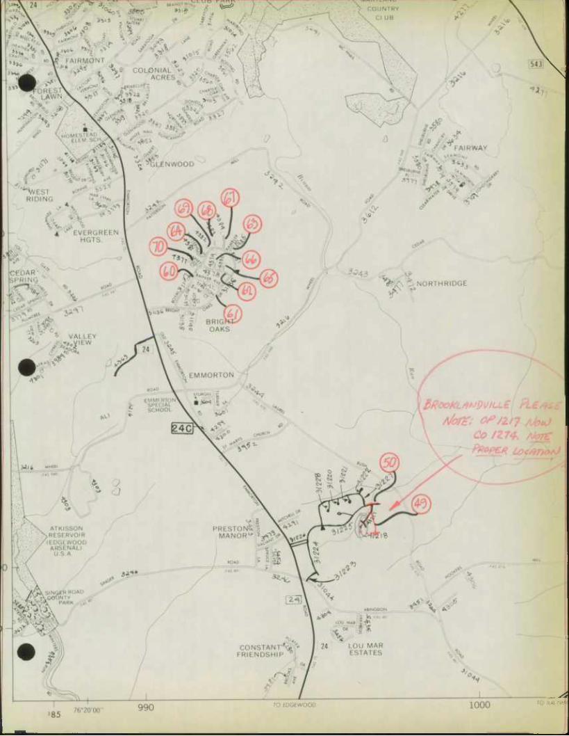
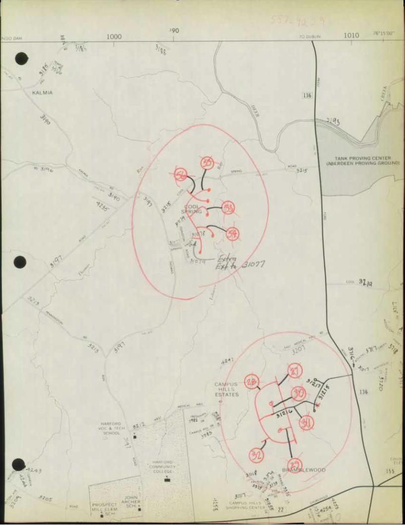
i
\1
•
•

* STATE HIGHWAY ADMINISTRATION
December 16, 1975
MEMORANDUM
To: Mr. Thomas L. Cloonan, Chief Bureau of Highway Statistics
From: Mr. H. J. Pistel Highway District Engj
Re: Highway Mileage - State
As requested, we have completed the maps and forms
sent to this office with your memorandum of October 15th,
and are enclosing them herewith.
ke
Encs.
soumivii AVMHDIH iO nV3WB
Si6l 11 030
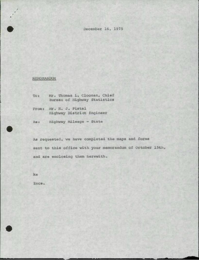
December 16, 1975
MEMORANDUM
Tot Mr. Thomas L. Cloonan, Chief Bureau of Highway Statistics
Fromt Mr. H. J. Pistel Highway District Engineer
Rat Highway Mileage - State
As requested, we have completed the maps and forms
sent to this office with your memorandum of October 15tn,
and are enclosing them herewith.
Xe
Encs.
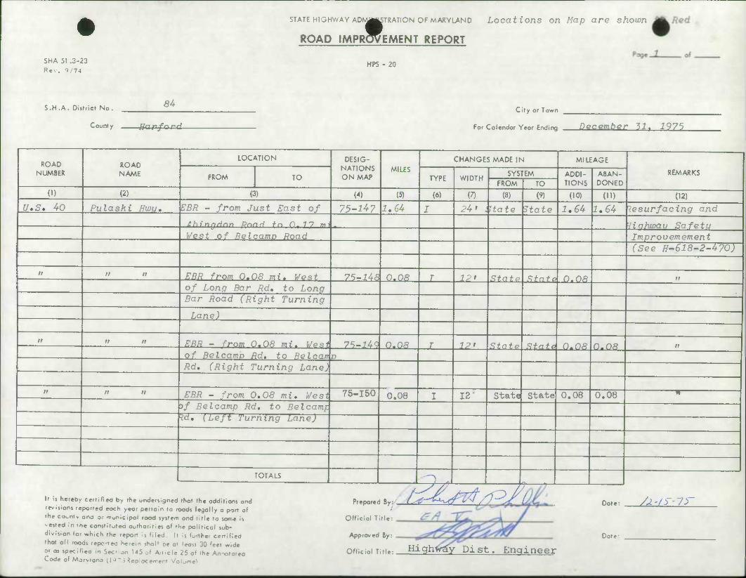
SHA 51 .3-23 Rev. ^m
STATE HIGHWAY AD^g^TRATiON OF MARYLAND
ROAD IMPR^EMENT REPORT
Locations on Map are shown
HPS - 20
S.H.A. District No. 84
County fjarford
City or Town
For Colendor Year Ending DQCQinher 71. 1975
ROAD NUMBER
ROAD NAME
LOCATION DESIG- NATIONS ON MAP
MILES CHANGES MADE IN MILEAGE
REMARKS FROM TO TYPE WIDTH SYSTEM ADDI-
TIONS ABAN- DONED FROM TO
0) (2) (3) W (5) (6) (7) (8) (9) (10) OD (12)
U.S. 40 Pulaski Hwu* EBR - from Just East of 75-^7 1,64 I 24' ktate State 1,64 1,64 Resurfacing and
Ahingrinn Rnnri to. 0.7 7 rm •liahwau Safetu West of Relcamp Road Improvemement
(See H-618-2-470)
i> n n EBR from. 0.08 mi. Wont 75-148 0.08 T 12> Statp State JD.08 it
of Long Bar Rd. to Long Bar Road (Right Turning
Lane)
n n II ERR - from 0.08 mi. Vo»i 75-lUQ 0.08 T IP' State State 0.08 0.08 n
of Belcamo Rd, to Belcan p Rd, (Right Turning Lane)
it n n . . , EBR - from 0,08 mi. West 75-150 0.08 I 12" State State 0.08 0.08 •n
of Be I camp Rd, to Belcamf. Hd, {Left Turning Lane)
TOTALS ^—^M
It ii hereby certified by the undersigned thof the odditions and revisions reported each year pertain to roods legally a port of fhe county ana or -nuoicipal rood system and title to same is -ested in ihe constifufeo authorities of the political sub- division for which the report is filed It ,s further certified that all roods reported he.em shol! be at least 30 feet wide or as speclfieo in Section 145 of Art.cle 25 of the Annototea Code of Marvlano 0 ^ ~ i Replocement Volume*
Prepared By:
Official Title:
Approved By:
Official Title:
/^O^ Date: /j.-/)-7>
Date:
Highway Pist. Engineer
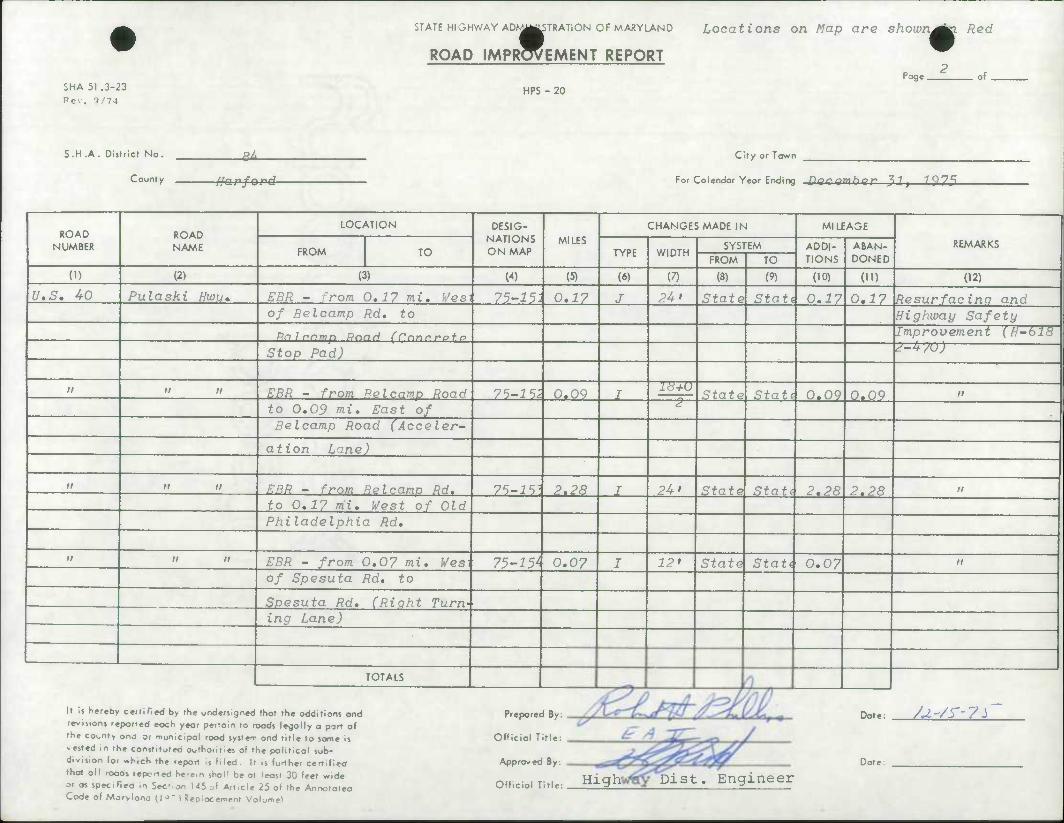
SHA 51 .3-23 Rev. 1/74
STATE HIGHWAY AD^||STRATiON OF MARYLAND
ROAD IMPROVEMENT REPORT
Locations on Map are shown^ha Red
2 Page. of
HPS - 20
S.H .A. Districf No.
County
^i-
Marford
City or Town
For Calendar Year Ending fff'-^"l^W r 37i ^975
ROAD NUMBER
(D
U.S. 40
ROAD NAME
(2)
Pulaski Hwu*
LOCATION
FROM TO
(3)
EUR - rom 0,1? mi. [/esi 75-i5: of Be I camp Rd, to
Ralr.nmp PnnH (Cnnnr'o + o
Stop Pad)
EBR - from Relcamp Road to 0,09 mi. East of Belcamp Road (Acceler-
ation Lane)
DESIG- NATIONS ON MAP
W
75-15,
MILES
(5)
0.17
0*09
ERR - from Relcamp Rd. to 0.17 nii. West of Old Philadelphia Rd,
EBR - from 0.07 mi. 1/esi 75-15* of Spesuta Rd, to
Spesuta Rd. (Right Turn-' ing Lane)
TOTALS
7'?-i'?] 2.28
0.07
CHANGES MADE IN
TYPE
(6)
J
WIDTH
(7)
2U'
-T~7U
SYSTEM
FROM
(8)
State Stati 0.17
State
24'
12'
TO
(9)
MILEAGE
ADDI- TIONS
(10)
State 0.09
State
State
Stati 2,28 2.28
It Is hereby certified by the undersigned thot the additions and revisions reported eoch year pertain to roods legally a port of the county ono or muoicipol rood system ond title to same is < ested m the constituted authorities of the political sub- division for which the report is filed It ,s further certified that oil roods reported herein shall be at least 30 feet wide or as specifleo .n Section U5 of Article 25 of the Annotofea Code of Morvlano (l^" 5 Replacement Volume^
Prepared By:
Official Title:
Approved By:
Official Title: .
ABAN- DONED
01)
0,17 Resurfacing and Highway Safety
0,0?
REMARKS
(12)
Improvement (H-bl8 2-4yu)
Statt 0,07
Dote:
Date
/U'/s'-y^
High Dist. Engineer
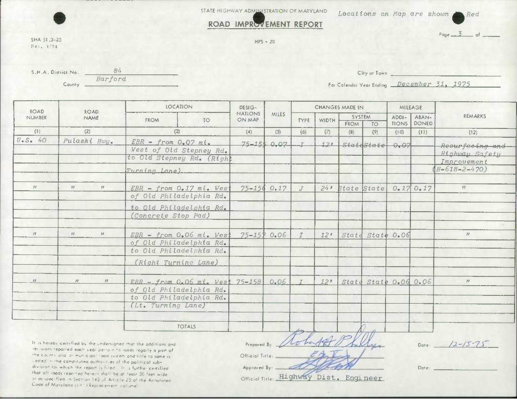
SHA 51 .3-23
Rev. >'74
STATE HIGHWAY ADMMISTRATION OF MARYLAND
ROAD IMPROVEMENT REPORT
HPS - 20
Locations on Map are shown J^Red
Page 3 of
S.H.A. District No.
County
84 Harford
City or Town
For Calendar Year Ending December 31. 1975
ROAD NUMBER
ROAD NAME
LOCATION DESIG- NATIONS ON MAP
MILES CHANGES MADE IN MILEAGE
REMARKS FROM TO TYPE WIDTH
SYSTEM ADDI- TIONS
ABAN- DONED FROM TO
(I) (2) (3) (4) (5) (6) (7) (8) (9) (10) (U) (12)
U,S. 40 Pulaski Hwy, EBR - from 0.07 mi. Ts-ic; ; CO'7 J 1 l' C+^ + , C4-^+ « n c)'~> Vest of Old Stepney Rd, Hi.nhmnu Sn-Fo + u
to Old Stepney Rd. (Righ . Imnrovement
Turning r.nno) h-6l8~2-470)
ll n n EBR - from 0,1? mi. Ves 75-15( 0.17 J 24' state State 0.17 0,17 11
of Old Philadelphia Rd.
to Old Philadelohia Rd. (Concrete Stop Pad)
n n ii EBR - from 0.06 mi. Ves • 75-15 ' 0.06 I 12' State S-tati 0.06 11
of Old Philadelphia Rd. to Old Philadelnhia Rd.
(Riaht Turning Lane)
n n n PRR _ frnm 0.06 mi. [/PS t 75-158 0.06 I 12' Stati Statb O.od 0.06 11
of Oid Philadelphia Rd. to Old Philadelphia Rd. (Lt. Turning Lane)
TOTALS ,^y > A.. w—
If s neieov certified b> the undersigned -^or the additions and
'e^s.oni 'epoi'ed eocr vec oe'-o n -o ioods legally a parr of
'he c j. nr, ona 3- -"on cipa • ooa wsrem and title to some 15
• ested r -he const.tuteo authom.es of the political sub-
division to, «hich -he report It died It 5 further certified
that oH rooas repc-eo Ke.em shoM be at leost 30 'eet wide
M os specifiea n Sec- on U5 jl Art.cl* 25 o» the Annotatea Code of Morvlana (1 ' ' i ReDiocement volume*
Prepared By
Official Title:
Approvea By:
/ytir£ Date:
Date:
/1~/S"7t
Official Title: Highway Dist. Engineer
SHA 51 .3-23 Rev. ?'74
STATE HIGHWAY ADMMSTRATION OF MARYLAND IM^IS
ROAD IMPROVEMENT REPORT
HPS - 20
Locations on Map are shown itmEed •
Page. of
S.H.A. District No.
County
84
Harford
City or Town
For Calendar Year Ending December 31, 1975
ROAD NUMBER
ROAD NAME
LOCATION DESIG- NATIONS ON MAP
MILES
CHANGES MADE IN MILEAGE
REMARKS FROM TO TYPE WIDTH
SYSTEM ADDI- TIONS
ABAN- DONED FROM TO
(1) (2) (3) (4) (5) (6) (7) (8) (9) (10) 01) (12)
U.S, 40 Pulaski Hwij* EBR - from Old Phil- 75-159 1,03 I 24' State Stati 1,03 2.03 Resurfacing and adelphia Rd, to Md, Rte, Highway Safety 715 Improvement
H-618-2-470
" n ii FRQ _ -Fmm D.nq mi. Uomi 7S-i6n O.OQ 7" I6i State Stati 0,09 0.09 n
of Cn-Ramp Rte, 715 to On-Ramp Rte, 715 (Decel- eration Lane)
II n n WBR - from Rte, 715 to 7^-1^1 nt«< 7" pL> Sfntv Xfn+A O-Rf, Or86 II
0,86 mi, Vest of Rte, 715
II n n WBR - from ,07 mi, Eas' 75-162 0.07 I u» Statistate 0.07 0,07 it
on-Ramp Md, Rte, 715 to On-Ramp Md, Rte, 715
(Deceleration Lane)
» n it URR - from Rxit Ramp Md, 75-163 O.OS I 2U+1
-Stati State 0.08 0,08 it
Rte, 715 to WBR Rte, 40 2—
( Acceleratioixoiftge) -^2- , \ /I r
It s neieov certified bv the unders.gned 'hat the additions and
• r. .sions 'epor-ed eocr veo- sc-j n >o .oods legally a part of
•he c j^ n'. ono 3' -"on cipa 'Ooa ivstem and title to same is
• ested n 'he conjt'tufea ouihont.es ol 'he political sub-
division toi «h,ch 'he tepori i] Filed It $ furfhe- certified
that oM ooas repe'ec he.ein ihaM be ot leost 30 'eet wide
si as specifiea n Sec'on U5 J Art.ctc 25 o* the Annototea Code ot Marylana ti J " > Repiocement /olu<n«1
Prepared By /t^J^-^M. Dote. JX -/} - 75
Date:
y Dist. Engineer
SHA 51 .3-23 Rev. 1/74
STATE HIGHWAY AD M^IS STRATiON OF MARYLAND Locations on Map are shown i
ROAD IMPROVEMENT REPORT
HPS - 20 Page_5_ of
S.H .A. District No. 84
County Harford
City or Town
For Calendar Year Ending December 31, 1975
ROAD NUMBER
ROAD NAME
LOCATION DESIG- NATIONS ON MAP
MILES
CHANGES MADE IN MILEAGE
REMARKS FROM TO TYPE WIDTH
SYSTEM ADDI- TIONS
ABAN- DONED FROM TO
(I) (2) (3) (4) (5) (6) (7) (8) (9) (10) (H) (12)
U.S. 40 Pulaski Highway VBR - from 0,17 mi. Easi 75-^4 0.17 J 24' Stat^State 0.^7 0.i7 Resurfacing and of Old Philadelphia Rd, Highway Safety
to Old Philadelphia Pd. Improvement (Concrete Stop Pad) (H-618-2-470)
II n n WBR - from 0.06 mi. Eas\ 75-165 0.06 I 12' State Statk 0.06 0.06 n
Old Philadelphia Road
t o Old Philadelohia Rd. (Right Turning Lane)
II n n WBR - from 0.06 mi. Eas 75-166 0.06 I 12' StattState 0.06 0,06 n
Old Philadelphia Road t( 1
Old Philadelphia Rd.
(Left Turning Lane)
II n n VRR - from Old Philadel- • 7^-167 2.28 I 24' Statkstate 2,28 2,28 II
phia Rd. to 0.17 mi. East of Be I camp Rd,
TOTALS n i Prepared Rv /,//^T^
S t J /I /T CC^ Dnte It .s heieov certified b> rhe undersigned 'Sot the additions and ^w /y^ /*i- /f- 7S~
• e^ is.ons 'epoi-ed eocr »eor per-a n IQ >oods legally a part of •H« cjv nt, jnj 3. -r-^rcipo 'Ooo svstem ond title to some is Official T
Approved
Offlcidl T
<f^ ^ ^ /
Date: • ested n -he conjt.totea authoni.es of the political sub- division toi »h,ch -he -eoon ii Med ll , forth*. c*ri,fi»rf . ^m?W that aH oo 31 as specif Code of Mo
as 'epc-eo he^em shal' be at ea n Sec' on U5 jf Ari.c;e rvlana il-> ~ i Reoioceme"' .c
|eost 30 'eet wide 25 o* the Annotated ifl,. Higfiway Dist. Engineer

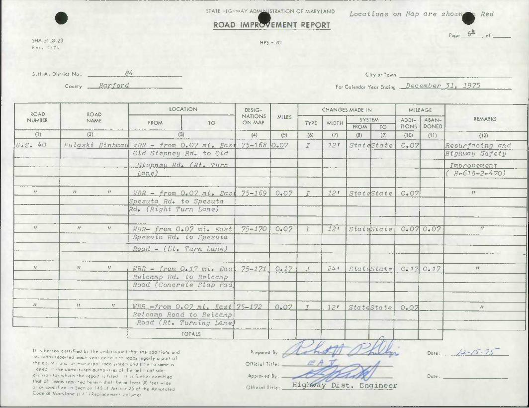
SHA 51 .3-23
Rev. i/74
STATE HIGHWAY ADM^I STRATI ON OF MARYLAND
ROAD IMPRWEMENT REPORT
HPS - 20
Locations on Map are show.
Page. ^T
Red
of
S.H.A. District No.
County
84
fjarford
City or Town
For Calendar Year Ending December 31, 1975
ROAD NUMBER
ROAD NAME
LOCATION DESIG- NATIONS ON MAP
MILES
CHANGES MADE IN MILEAGE
REMARKS FROM TO TYPE WIDTH
SYSTEM ADDI- TIONS
ABAN- DONED FROM TO
(D (2) (3) (4) (5) (6) (7) (8) (9) (10) (U) (12)
U.S. 40 Pulaski H '.qhwau WBR - from 0.07 mi. Easi 75-168 0,07 I 12* Statelstatc 0.07 Resurfacing and Old Stepney Rd, to Old Highway Safety
Sf.ppney flrf. (Rt. Turn Improvement Lane) ( H-618-2-470)
ti ii II WRR - from 0.07 mi. Ras 75-^9 0.07 I 12' Stattktate 0.07 n
Spesuta Rd. to Spesuta Rd, (Right Turn Lane)
n n n WBR- from 0,07 mi. East 75-170 0.07 I 12' Statd&tate 0.07 0.07 n
Spesuta Rd, to Spesuta
Road - (Lt, Turn Lane)
n n n WBR - from 0,17 mi. Eas ; 75-171 0.17 J 24' StatdState 0.17 0.i7 II
Be I camp Rd. to Be I camp Road (Concrete Stop Pad.
n n n WRR -from 0.07 mi. Kant 75-172 0.07 T 12' State State 0.07 II
Re I camp Road to Belcamp Road (Rt, Turning Lane,
TOTALS s\ *r ) / , . //^ ^ It s neieov cettifieO b> the undersigned 'tiot the additions and
• e^ s.ons 'epofed eocr yeor per-a n -3 ,oods legally a part of
'ht c Jv n», ono a' -"on cipo 'ooo ivstem and title to some is
• ested n -he constrt^teo aottiont.es ol the political sub-
divis.on to. •h.ch -he report is Med It .s furthe' certified
that oil -ocas repc-ea Ke.e,n shol1 be ot leost 30 >et wide
31 as speciflea n Sec' an 145 J Art.cie 25 a* the Annototea Code of Marvlana H-> " i Reoiocemem <o:jme>
Prepared By
Official Title:
Approved By:
Official Title:
Date
Date
/^-/j--7y
Highly Pi st. Engineer
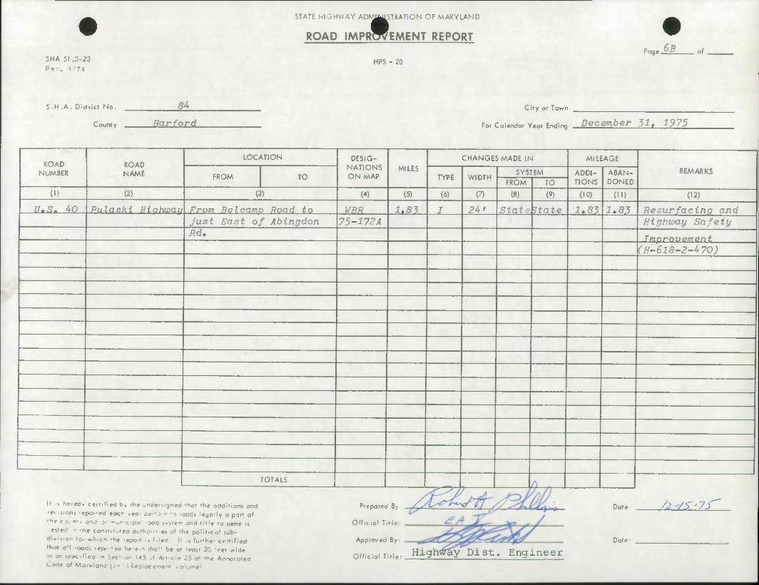
STATE HIGHWAY AD^^WSTRATiON OF MARYLAND
ROAD IMPROVEMENT REPORT
SNA 51 .3-23
Rev. 1'74 HPS - 20
Pag eM. of
S.H.A. Districf No.
County
84
Harford
City or Town
For Colendor Yeor Ending December 311 1975
ROAD NUMBER
ROAD NAME
LOCATION DESIG- NATIONS ON MAP
MILES CHANGES MADE IN MILEAGE
REMARKS FROM TO TYPE WIDTH
SYSTEM ADDI- TIONS
ABAN- DONED FROM TO
(1) (2) (3) (4) (5) (6) (7) (8) (9) (10) (U) (12)
n-s. 4o Pulaski Highway From Re I camp Road to WBR i.S5 J 24' StatP State 1.83 1,83 Resurfacing and Just East of Abingdon 75-172 A Highway Safety Rd, Tmnroupmpnf.
(H-618-2-470)
TOTALS o 1 .
\> i hereDv cettiHeci by the undersigned 'hot the odditlons ond
'e% .5.onj -epoi-ed eocr veor pe'-a n 'o 'oods legoily o port of
•he ex n'. ono j' -"on cipo 'Ooo system and tit'e to some is
• ested n -he const.f jteo outhom.es of fhe politicol sub- dlv.s.on i0, ^h.ch .he ,fpor, ;, (,|ed |, ;, fort(,e, cerrjfje^
thof oM ooos 'epc-eo he'em shal1 be ot leost 30 'eet wide
?> m speof.ea n Set- on 145 ^f Art c:e 25 o* the Annototea Code of Mo r> I one (1 J ' i Repiocemem /olum«1
^W^7 . Official Title:
Approved By:
offi.ini Titu- High^^y'Dist. Engineer
Dot
Date:
.: /2-/S'7S^
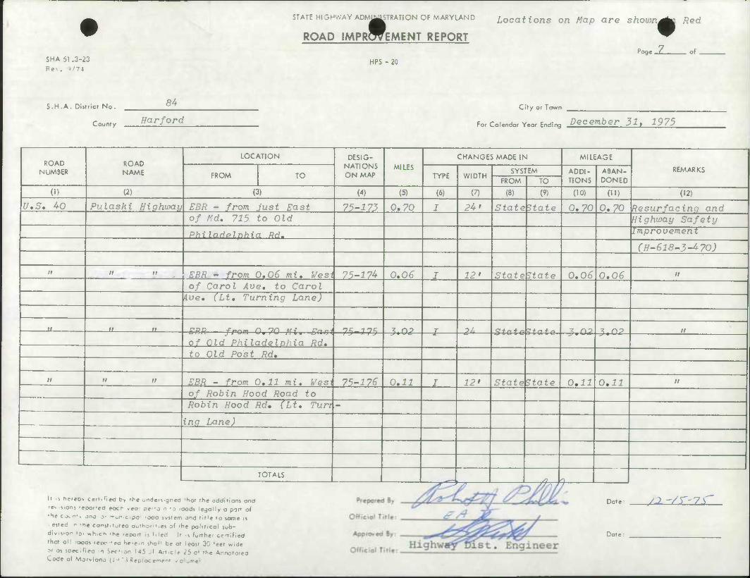
SHA 51 .3-23 Re-.. 5'74
STATE HIGHWAY ADM^STRATION OF MARYLAND
ROAD IMPRWEMENT REPORT
Locations on Map are shown •
HPS - 20 Poge_Z_
Red
of
S.H.A. Dlstricr No. 84
County Harford
City or Town
For Colendor Year Ending December 31, 1975
ROAD NUMBER
ROAD NAME
LOCATION DESIG- NATIONS ON MAP
MILES
CHANGES MADE IN MILEAGE
REMARKS FROM TO TYPE WIDTH
SYSTEM ADDI- TIONS
ABAN- DONED FROM TO
(1) (2) (3) (4) (5) (6) (7) (8) (9) (10) (ID (12)
U.S. 40 Pulaski Highway EBR - from Just East 75-:? 73 0.70 I 24' StateEtate 0.70 0.70 Resurfacing and of Md. 715- to Old Highway Safety
Philadelphia Rd. Improvement
(H-618-3-470)
it n a EBR - from 0.06 mi. West 75-^74 0.06 I 12* \statehtate 0.06 0.06 n
of Carol Ave. to Carol iue. (Lt. Turning Lane)
u n n n^-inc ? no T ?.. d + r, + sJC + n + n t no ? no n
of Old Philadelohia Rd. to Old Post Rd,
n n n EBR - from 0.11 mi. Wesi 75-176 0.11 I 12> StateState 0,11 0,11 n
, , .. of Robin Hood Road to Robin Hood Rd, (Lt, Turt -
ing Lane)
TOTALS jr,*~. "-T; ' ; T^T-i 9
It ti heieo* cerrifieO b> the onderMgned 'Sot the additions and
r^ .j.oni •epoi-ed eocr ,eo' aefj n '0 'oods legally a part of
'h* co^ nf, jnj 3- -ri^r-cipo • oca ivstem and title to jome it
• eited K -he conjt.toteo aoftio>ii.es of 'he political sub- divi^.on loc «h,ch -he -epott ,s Med ll ••, furthe- certified
that ol! ooos tepc--eo Se'e.n ^hol' be at leost 30 'eet wide
M os spec.f.ea n Sec- on 145 si 4rt.clc 25 o* the Annotatea Code of Morvlonc H ' ' i Reoiocement .o^ome1
Dote: /^ '/r-7s'
Date:
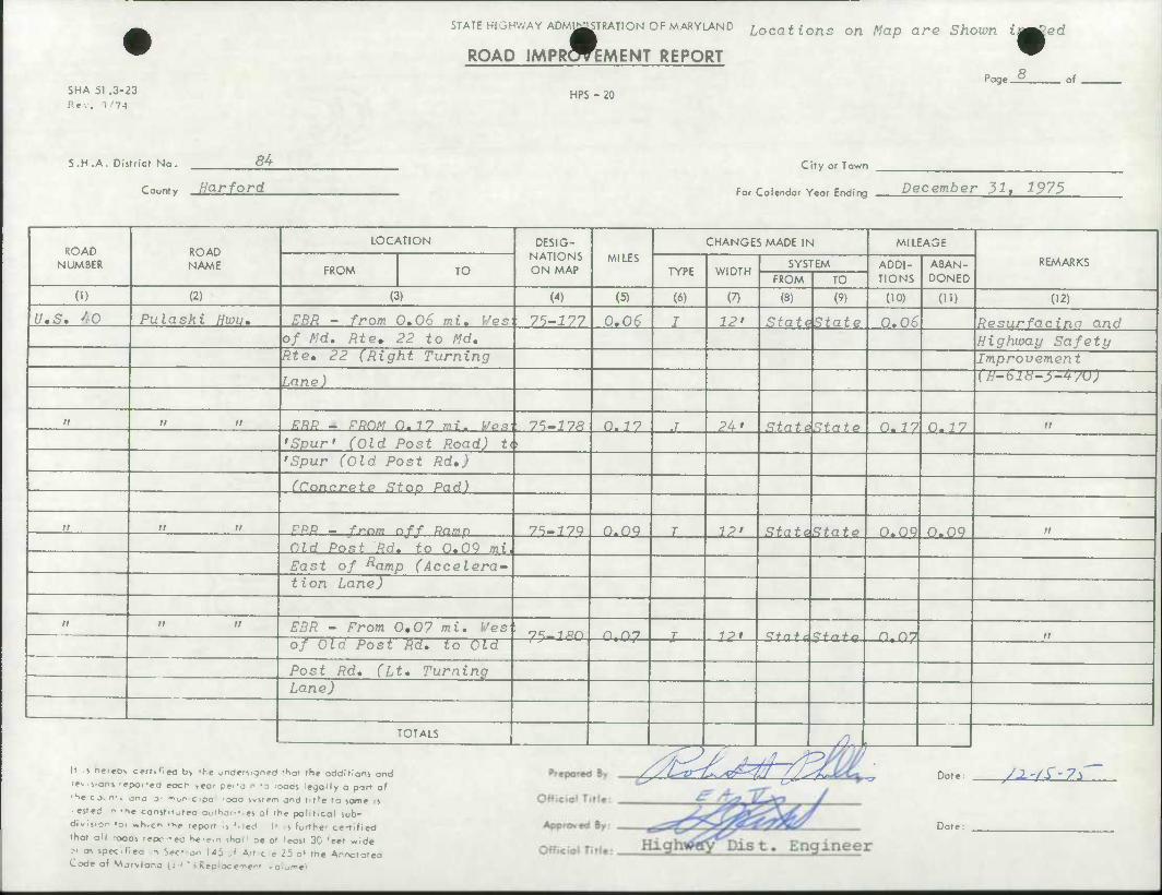
STATE HIGHWAY ADMIRATION OF MARYLAND Locations on Map are Shown i^ed
ROAD IMPROVEMENT REPORT
SHA 51 .3-23 Rev. )'74
HPS - 20
•
Page 8 of
S.H.A. Districr No. S4_
County Harford
City or Town
For Calendar Year Ending December 31, 1975
ROAD NUMBER
ROAD NAME
LOCATION DESIG- NATIONS ON MAP
MILES
CHANGES MADE IN MILEAGE
REMARKS FROM TO TYPE WIDTH
SYSTEM ADDI- TIONS
ABAN- DONED FROM TO
(I) (2) (3) (4) (5) (6) (7) (8) (9) (10) (H) (12)
U.S. 40 Pulaski Hwu, EBR - from 0,06 mi, i/es 75-177 0.06 I 12' Stat^State 0,06 Resurfacina and of Md, Rte* 22 to Md, Highway Safety Rte, 22 (Right Turning Improvement
Lane) (H-6l8-l-4yU)
/; a n ERR - RRDM O.77 mi. We* 75-17R 0- 7 7 .1 24' StatdState 0.17 0.17 n
'Spur' (Old Post Road) t( 'Spur (Old Post Rd.)
(Concrete Stop Pad) . .
ii it n RRR - frnm nff Ramp 75-17Q O.oq T 12' State. State 0.09 0.09 it
Old Post Rd. to 0.09 mi
East of Ramp (Accelera- tion Lane)
ti n ii EBR - From 0,07 mi. Wes ' T^—ixn n. r\n T 7P» Qf n + r <Z + n + a n 07 n of Old Post Rd. to Old
Post Rd, (Lt, Turning Lane)
TOTALS /L 1 It s nereDv certified b> the under^.gned 'tior the additions end
^ .s.onj -epor-ed eocr yea' pe'-a n -o loads legally a part of
•He co^ n*. jnj 3- -"on c jpo 'ooa ivstem and title to same is
• ested r -he const.t^teo aurhoril!*) of the political sub-
division to. «h,cn -he .eport ••, Med It .s furthe- certified
that aM -ooas repc-eo hatam shal1 be at least 30 'eet wide
at as specifiea n Sec' on 145 J Atf,c;e 25 o» the Annototea Code of Morvlanc ll-»'i Reoiocemem /olum«\
/fc^^^ Date yx-n-?*
Date
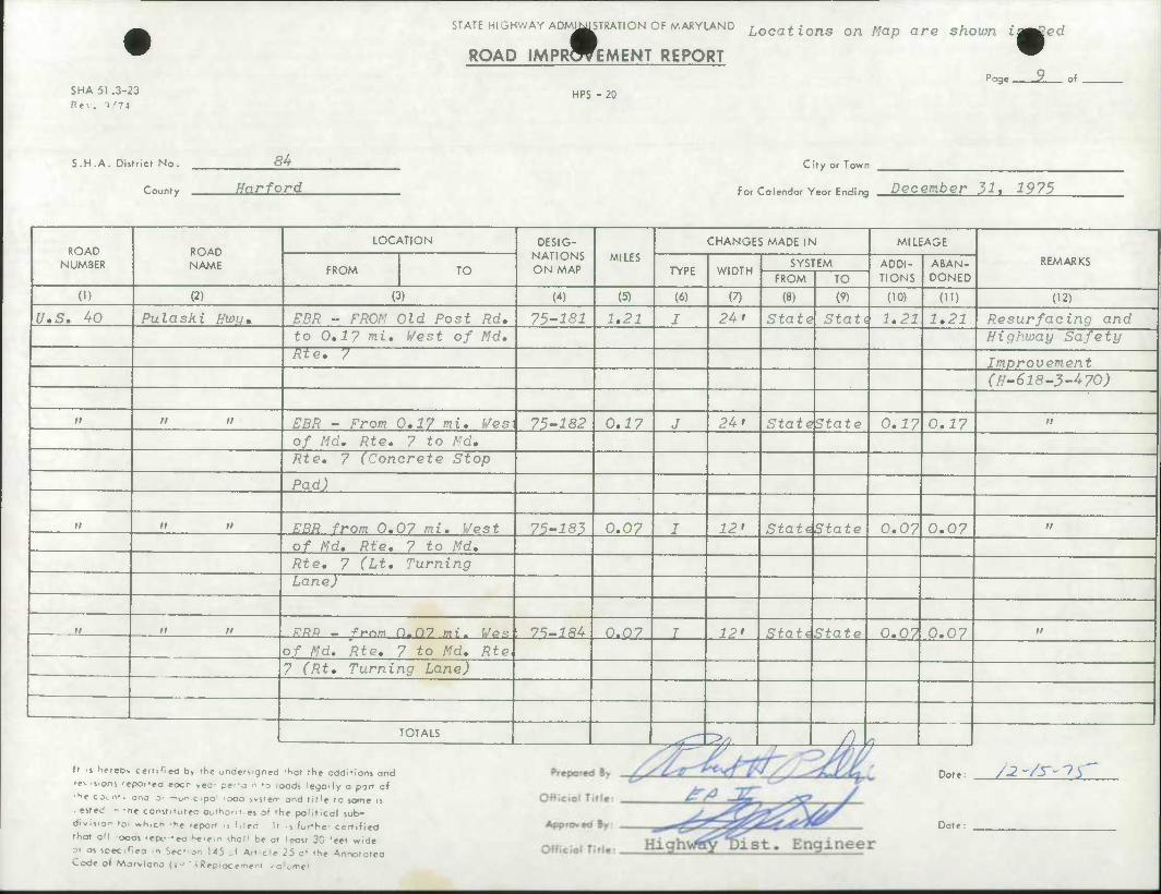
STATE HIGHWAY ADMINISTRATION OF MARYLAND MIM1S Locations on Map are shown iamCed
SHA 51 .3-23 Re-.. 1'74
ROAD IMPROVEMENT REPORT
HPS - 20 Page 9 of
S.H.A. District No.
County
84
Harford
Cify or Town
For Calendar Year Ending December 31, 1975
ROAD NUMBER
ROAD NAME
LOCATION DESIG- NATIONS ON MAP
MILES
CHANGES MADE IN MILEAGE
REMARKS FROM TO TYPE WIDTH
SYSTEM ADDI- TIONS
ABAN- DONED FROM TO
(1) (2) (3) (4) (5) (6) (7) (8) (9) (10) (11) (12)
U*S, 40 Pulashi Hwij* EBR - FROM Old Post Rd, 75-181 1,21 J 24* State Stati 1,21 1.21 Resurfacing and to 0,1? mi, Vest of Md, Highway Safety Rte, 7
Improvement (H-618-3-470)
II n n EBR - From 0,17 mi, f/esi 75-182 0,17 J 24 > [stat^tate 0,17 0,17 n
0/ Md, Rte, 7 to Md, Rte, 7 (Concrete Stop
Pad)
II n n EBR from 0,07 mi, West 75-183 0.07 I 12' Stathtate 0,07 0,07 it
of Md, Rte, 7 to Md, Rte, 7 (Lt, Turning Lane)
II n n RRR _ from 0.07 mi. Ves 75-184 0.07 I 12' Stati State 0,07 0,07 n
of Md. Rte, 7 to Md, Rte 7 (Rt, Turning Lane)
TOTALS ^•i^ ^— —j ' /3U
It s hereOv certified t)> ,^e undersigned 'hot the additions and
'e% isions 'epofed eocr ,eor per'o n -o ioods legally a pan of
•he ex nt, ono 0. -n0n.c,pa .300 system ond title to some is
ested n -he const't^teo oofho'n.es of the political sub- division to. «h,ch .he feport ,5 Mad It .5 furthe- ce-r.fied
fhot oM ooos 'epc-eo he.em shol1 be ot leost 30 'eet wide
3r as spec.llea n Sec' on 145 al Artcie 25 o* the Annotated Code of Morylone 11 •' " > Seciocemem vo!ome>
Dote:
Dote:
/2-/y^y
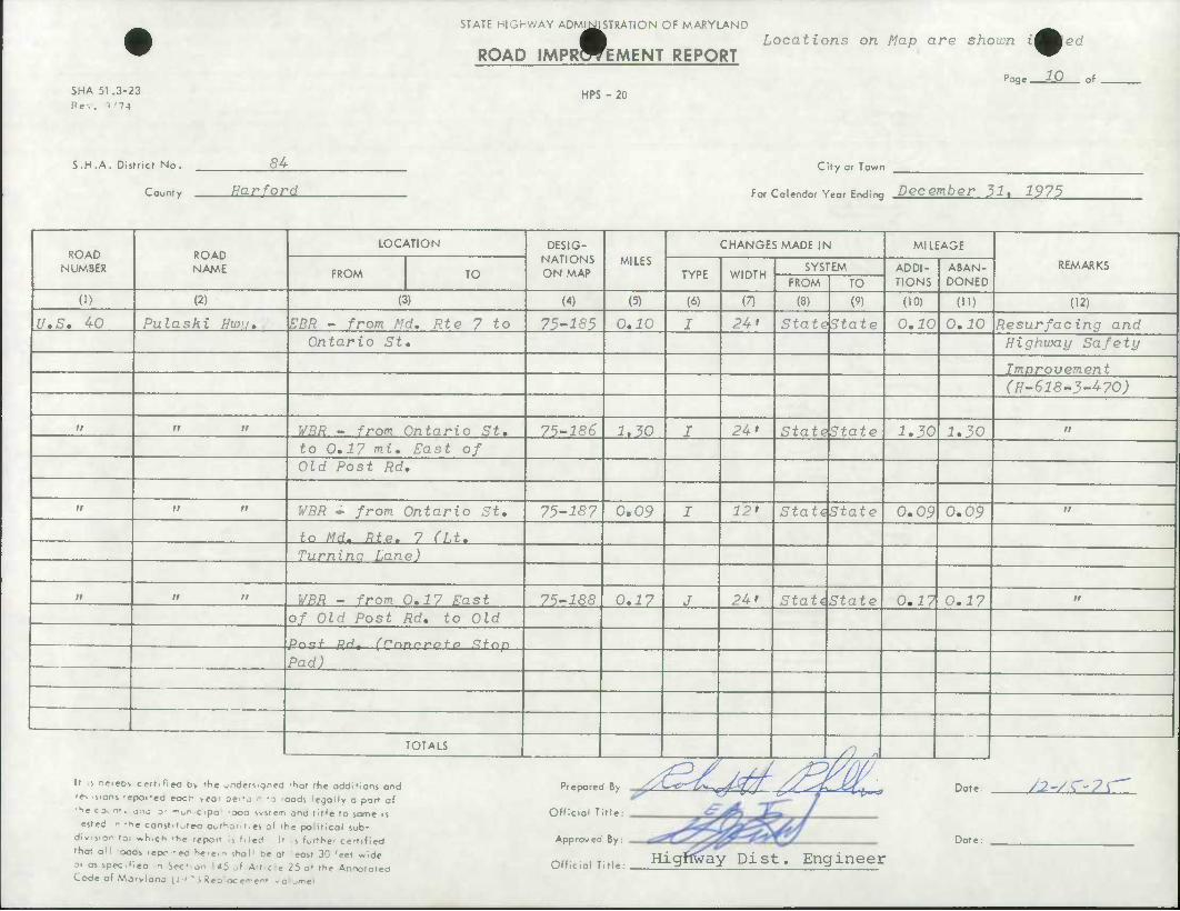
SHA 51.3-23
Rev. >/74
STATE HIGHWAY ADMINISTRATION OF MARYLAND MINIS
ROAD IMPROVEMENT REPORT
HPS - 20
Locations on Map are shown i^^ed
Poge 10 of
S.H.A. District No. 3A City or Towr
For Colendor Yeor Endinc
1
rn.,ntv Har^ord December 31, 1975
ROAD NUMBER
ROAD NAME
LOCATION DESIG- NATIONS ON MAP
MILES CHANGES MADE IN MILEAGE
REMARKS FROM TO TYPE WIDTH
SYSTEM ADDI- TIONS
ABAN- DONED FROM TO
(1) (2) (3) (4) (5) (6) (7) (8) (9) (10) OD 02) U.S. 40 Pulaski Hwu. EBR - from Md. Rte 7 to 75-185 0.10 I 24 > S'iatels'tate 0.^0 0.10 Resurfacing and
Ontario St, Highway Safety
Imorovement (H-618-3-470)
ir n a WBR - from Ontario St. 75-186 1.30 I 2U' [stat ^State 1,30 1,30 it
to 0,17 mi. East of Old Post Rd.
II ii n WBR - from Ontario St. 75-187 0,09 I 12' StatdState 0,09 0,09 II
tn Md. Rtc. 7 n.t. Turnina Lane)
n it n WBR - from 0.17 East 75-188 0,17 J 24' StatiState 0,17 0,17 n
of Old Post Rd. to Old
pnc;/ pHt (rnnrrofo Ifnp
Pad)
TOTALS /,? .«
It i fiereo> certified b> the jnders.gned 'hot the additions and
re^ cons 'epor-ea eocr- ,eo' pe'-a n -o ioods legally a port 0f
•he co^nr, jnc j- •"on cipo 'oca ivstem and title to same is
• ested r -he const.t^reo authont.es of the political sub-
divis.ar to, „h,ch -he report Is filed It .<, furthe' certified
that oM ocas repc -eo h«.e,n sh0|i be at least 30 'eet wide
Dr as spec.f.ea n Sec' on 145 ^1 Art.cie 25 o* the Annotated Code of Morvlane u-' ' i Reoiocemem .0KJme'i
Prepared By
Official Title:
Approved By:
Official Title:
'tCc/tf/ Date:
Date:
/2~/C'?\
Highway Dist. Engineer
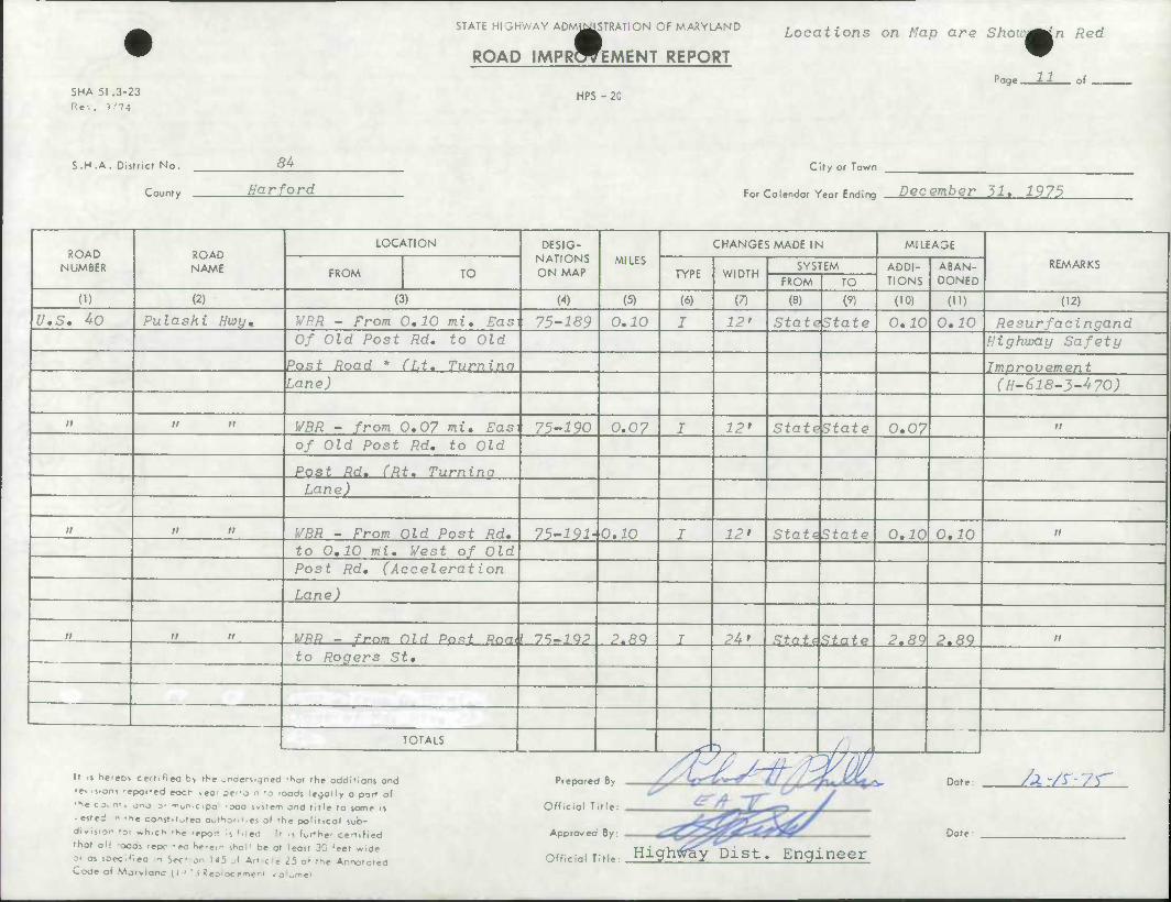
SHA 51 .3-23
Re-.. }/74
STATE HIGHWAY ADMINISTRATION OF MARYLAND
ROAD IMPROVEMENT REPORT
HPS - 20
Locations on Map are Show^in Red
11 rage. of
S.H .A. District No.
County
54
Harford City or Town
For Calendar Year Ending December 31, 1975
ROAD NUMBER
ROAD NAME
LOCATION DESIG- NATIONS ON MAP
MILES CHANGES MADE IN MILEAGE
REMARKS FROM TO TYPE WIDTH
SYSTEM ADDI- TIONS
ABAN- DONED FROM TO
(1) (2) (3) (4) (5) (6) (7) (8) (9) (10) (ID (12)
U.S. 40 Pulaski Hwy* | WRR - From 0,10 mi, Easi 75-189 0.10 I 12' Lstatektate 0,10 0,10 Resurfacingand Of Old Post Rd, to Old Highway Safety
Post Road * (Lt. Turnina Improvement Lane) (H-618-3-470)
a n n WBR - from 0,07 mi, Easi 75-^90 0.07 I 12* Statektate 0,07 II
of Old Post Rd, to Old
Post Rd. (Rt. Turnina Lane)
n n ii WBR - From Old Post Rd, 75-191- 0.10 I 12' StattState 0,10 0,10 n
to 0,10 mi, West of Old Post Rd, (Acceleration
Lane)
n n n VRR - frnm Dl.H Post Rnm { 7^-lQP P.RQ T 24' State State 2.89 2,89 II
to Rogers St,
TOTALS ^ 5-,— -/^
It is hereov certified b> the ondersrgned 'hot the additions and
rev s.ons -epofed eocr »ea' Be>-a n IQ roods legally a part of
'H« cxmt ono 3' -"^ cipa 'Ooo system and title to some is
• ested r -he const.tuteo outhonr.es o( the polllicol sub-
division toi «h,ch -he report ii Mcd Ii s furthe- certified
that oM ooos repc-ea htr«in shal1 be at least 30 'eet wide
or as specifiea n Sec- on U5 J Artcie 25 o» the Annotatea Code of Mjrvlanc: ii ' ' i Reoiocemen' /olumcl
Official Title:
Approved By:
Off
Date: /^-/r-'/V^
Date:
ciai Title: Highly Dist. Engineer
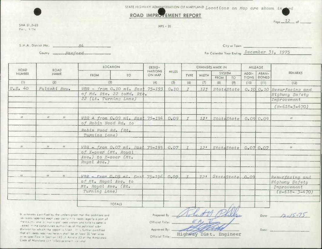
^^TKMMWIN wronMiML^iNu Locattons on
PRWEMENT REPORT
SHA 51 .3-23 Re-.. >'74
STATE HIGHWAY ADMJ^STRATION OF MARYLAND Locations on Map are sholon (^
Page. I?
HPS - 20
of
S.H .A. District No.
County
Ak.
Hnrfard
City or Town
For Colendor Yeor Ending December 31, 1975
ROAD NUMBER
ROAD NAME
LOCATION DESIG- NATIONS ON MAP
MILES CHANGES MADE IN MILEAGE
REMARKS FROM TO TYPE WIDTH
SYSTEM ADDI- TIONS
ABAN- DONED FROM TO
(1) (2) (3) (4) (5) (6) (7) (8) (9) (10) 01) (12)
U.S, 40 Pulaski Hwi/t WBR - from 0,10 mi, Eas : 75-193 0,10 I 121 Stathtate 0,10 0,10 Resurfacing and of Md, Rte, 22 toMd, Rt '• Highway Safety 22 (Lt, Turning Lane) Improvement
(H-618-3-470)
it n n WRR i from 0.09 mi. Bam 75-194 0.09 J 12' Stat^State 0,09 0.09 ft
of Robin Hood Rd, to
Robin Hnnd RH- (Rt.
Turnina Lane)
n a n WRR - from 0.07 mi. "as 75-195 0.07 T 12' Stati State 0,07 0.07 tt
of X-over (Mt, Roual Aue,) to X-over (Mt, Royal Aue,)
n n n WRR r Pfnw n.DQ mt, prtQ 1 7^-196 n.no I 1?t Sfnfc S + nfo r^nq Ff^RiiT^fdcLnn nnH of Mt, Royal Ave, to Highway Safety Mt, Royal Aue, (Rt, Improvement
Turning Lane) (H-61S- 3-470)
TOTALS / o S)
It ij neteov ceitifie^ by ff,e jndersrgned 'Sat the additions and
rev .s.ons -epoi'ed eocr yeor pe-'j n • g .oods legally a port of
•He c jv n». onj 3- -^^pc ipa 'Oca svsfem and tit'e to same is
• ested r >h« const.t^ieo oothont.es of the political sub-
division toi »,h,ct> -he report Is filed It s further certified
that all rooos tepr-ea Ke'e.n shal1 be ot leost 30 'eet wide
9t os spec.fieo n Sec- on 145 al Artcie 25 o» the Annototea Code of Mo rv I one U J ' i Reoiocemem v0;omei
Dote
Dat«
/?.vr-7r
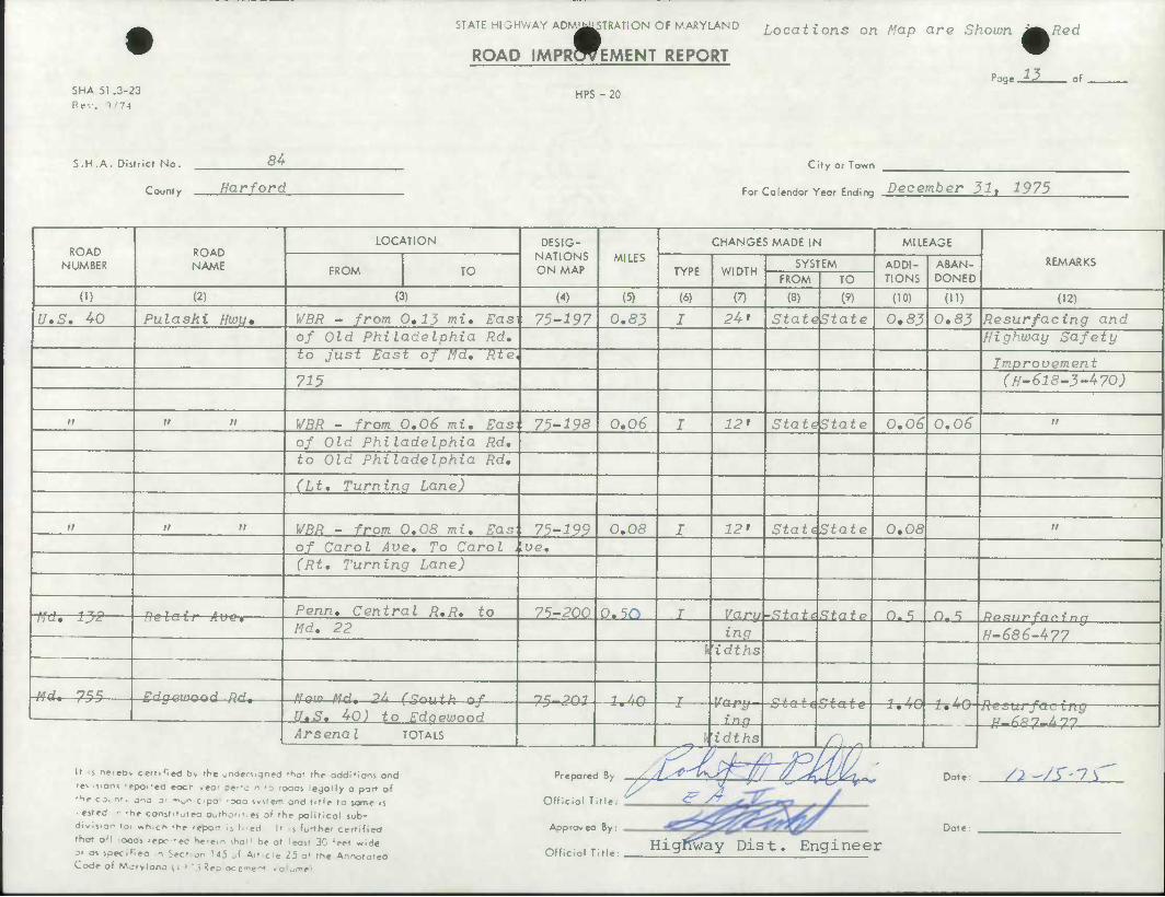
SHA 51 .3-23 Re-.. J/74
STATE HIGHWAY ADMI^STRATION OF MARYLAND
ROAD IMPROVEMENT REPORT
HPS - 20
Locations on Map are Shown J^^Red
Page ^ of
S.H .A. District No. 84 City or Town
rnnntv Harforo ; For Calendar Year Endins December 31, 1975
ROAD NUMBER
ROAD NAME
LOCATION DESIG- NATIONS ON MAP
MILES CHANGES MADE IN MILEAGE
REMARKS FROM TO TYPE WIDTH
SYSTEM ADDI- TIONS
ABAN- DONED FROM TO
(1) (2) (3) (4) (5) (6) (7) (8) (9) (10) (H) (12)
U,S. 40 Pulaski Hwu* WBR - from 0.13 mi, Easi 75-197 0.83 I 24' State State 0,83 0,83 Resurfacing and of Old Philadelphia Rd, Highway Safety to Just East of Md. Rte, Improvement 715 (H-618-3-470)
it n n WBR - from 0,06 mi. Eas] 75-198 0.06 J 12* 1 Statcktate 0,06 0,06 ii
of Old Philadelphia Rd. to Old Philadelphia Rd.
(Lt. Turning Lane)
n n a WBR - from 0.08 mi. Eas 75-199 0,08 J 12' Stat^State 0,08 ii
of Carol Aue. To Carol . ue. (Rt. Turning Lane)
•fkti—f^f —fielair Avei Penn. Central R.R. to 75-200 0.5^ r Varu -State State O. S 0- ^ Md. 22 ing H-S86-477
\\idths
-m*—753 Edgewood Rd, A'ai" Md, 24 Cs^uth of T^ ?01 1 J,r\ T r*± j. - •f / /^ t t r\
U.S. 40) to Edaewood i.
inn omit^tute —1,40 1*40 Resurfacing
Arsena I TOTALS h.dths r. n It s leteov cettiHe^ b> the undersigned 'tiot the additions and
re^ s.ons 'epor-ed eocr vea' pti'a n 'a .oads legally a parr of
'H« c Jv nt, ono 3' -^oncipa 'Ooa ivsrem and title to some is
ested r -tie constitutea outhont.es of the political sub-
division toi which -he .export Is filed |l s furthe- certified
that o'l ooas repc-eo he'em shal1 be at least 30 'eet wide
si as spec.flea n Sec- on 145 J Article 25 o* the Annotatea Code of Mo rv I ana (1 " ' i Reoiocement .oiume>
Prepared By / , L *'
Official Title
Approved By
Official Title
Dat«
Date
/2^^'1\
Hignway Dist. Engineer
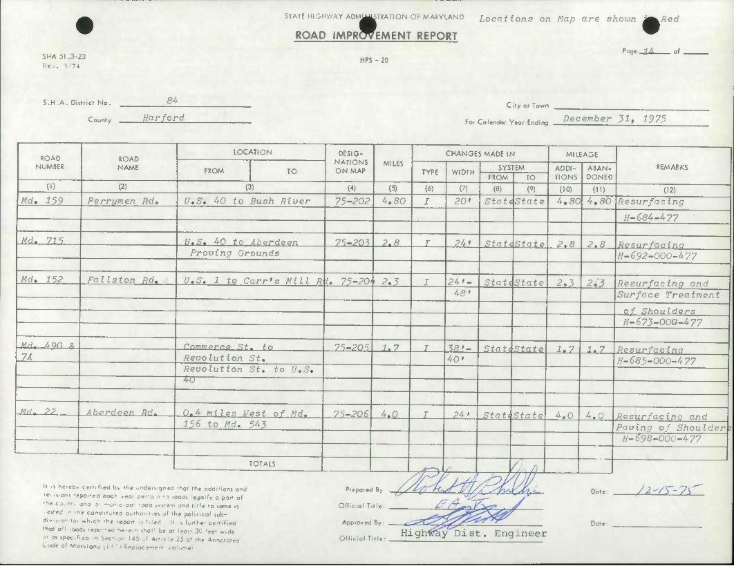
SHA 51 .3-23 Rev. >/74
STATE HIGHWAY ADMm^TRATiON OF MARYLAND Locations on Map are shown l
ROAD IMPRW-MENT REPORT
HPS -20 Poge-lA- of
S.H .A. Dislricr No.
County
84
Harford City or Town
For Colendor Year Ending December 31, 1975
ROAD NUMBER
ROAD NAME
LOCATION DESIG- NATIONS ON MAP
MILES
CHANGES MADE IN MILEAGE
REMARKS FROM TO TYPE WIDTH SYSTEM ADDI-
TIONS ABAN- DONED FROM TO
(1) (2) (3) (4) (5) (6) (7) (8) (9) (10) 01) (12)
Md. 159 Ferrymen Rd, U,S, 40 to Bush River 75-202 4,80 J 20' StatiState 4,80 4,80 Resurfacing
H-684-477
Md, 715 U.S. 40 to Aberdeen 7^-70^5 2.8 T 24' Statcistato 2.8 2.8 Re R\IT* "fci ci nn Proving Grounds H-S92-'000-477
Md. 1^2 Fallston Rd, U.S. 1 to Carr's Mill R i, 75-201 2.5 I 24'- StatdState 2,3 2,3 Resurfacing and 48' Surface Treatment
H-673-0OO-477
Md, 490 & Cnmmprr.P St.- to 7WO^ 1.7 T M»- Stat^State 1.7 1,7 Resurfacinn 7A
——• __ Revolution St. 40' H-685-000-477 Revolution St. to U.S. 4U
Md. ?? Aberdeen Rd. 0.4 miles West of Md. 7W0^ 4.0 I 24' StatAStnfo 4.0 4,0 156 to Md, 543 Pavina of Shoulder ?
H-698-000~477
TOTALS ;f^> C : 1 i a
It s neteov cettifiea by the under^gned 'hot the additions and
'ev s.oni -epoi'ed eocr yea' sfj n -o ,oods legally a port of
'he ex n», jnj o- — o^cipo • ooa system ond title to same is
• ested n rh« const.t^r^o ouiho'.i.es of the political sub-
div.sio^ 101 «h,ch -he -eport 1] Med It ,s furthe' certified
that all -ocas tepc-ec he.em shal1 be of least 3C 'eef wide
31 as specifiea n Sec- on U5 al Artcie 25 o* the Annotated Code of Morylonc u J ' ' Replacement /olu«n«l
Prepared By
Official Ttlle:
Approved By:
Official Title:
Dat«
Dot«
/j -'/T- ?\
st. Engineer
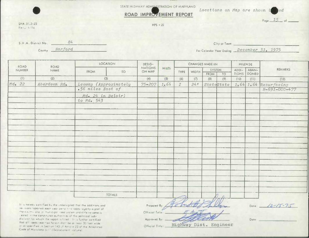
STATE HIGHWAY ADM^STRATION OF MARYLAND
ROAD IMPRWEMENT REPORT
SHA 51 .3-23 Rev. 1/74
Locations on Map are shouin i^Aed
Page ^5 of HPS - 20
S.H .A. District No. 54
County Harford
CUy or Town
for Calendar Year Ending December 31, 1975
ROAD NUMBER
ROAD NAME
LOCATION DESIG- NATIONS ON MAP
MILES CHANGES MADE IN MILEAGE
REMARKS FROM TO TYPE WIDTH
SYSTEM ADDI- TIONS
ABAN- DONED fROM TO
(1) (2) (3) (4) (5) (6) (7) (8) (9) (10) (H) (12)
Md. 22 Aberdeen Rd* Leeway (Approximately 75-207 1.64 J 24' Stattktate 1.64 1.64 Resurfacing ,36 miles East of H~691-000-477
Md. 2U in Belair) to Md. 54J
TOTALS ^-O / 7 r It s nereov certified b> the unders.gned 'Sat the additions and
• f- s.ons 'epoi'ed eocr veor pm'a n to ioods le^oMy a part of
•^f C-K n'. ono a' "on c 1 pa 'ooa system and title to same 15
ested r -he const,toteo outhoiiiin of 'he political sub- division to, »h,ch -he repon is t.led It .s furthe- certified
that aM rooas 'epc-ec h«icin shal1 be at least 30 'eet wide
»i as spec.fiea n Sec' on US si Article 25 a* the Annotated Code of Matvlana [l->'i Reoiocemem volume*
Prepared B^
Official Title:
Approved By:
Official Title: Highway Dist. Engineer
Dote.
Dote:
/^vr-7.r
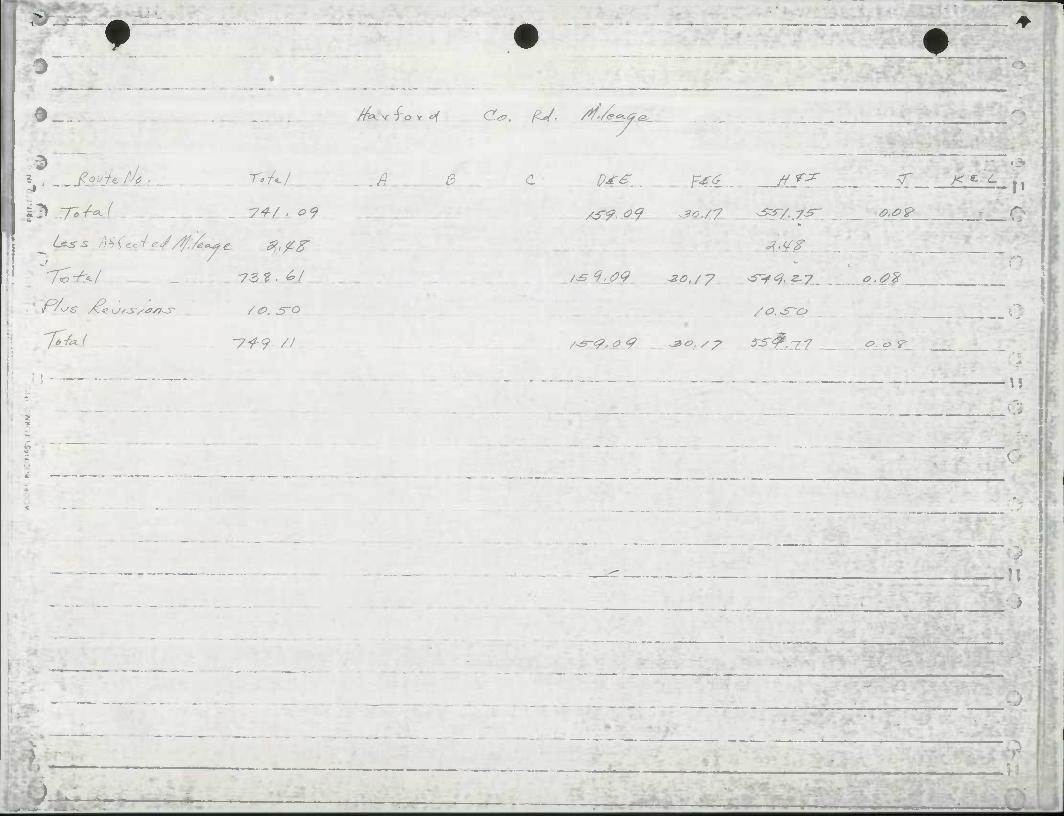
4 • ' —
7*^/ '7il'9- //
/7^-vfor^ Crf>, ^/, /tf'/e.^
.A 0. C P4€ , £££,
(O.^1?
c.<?%
&. o ^
W
•> i
-^

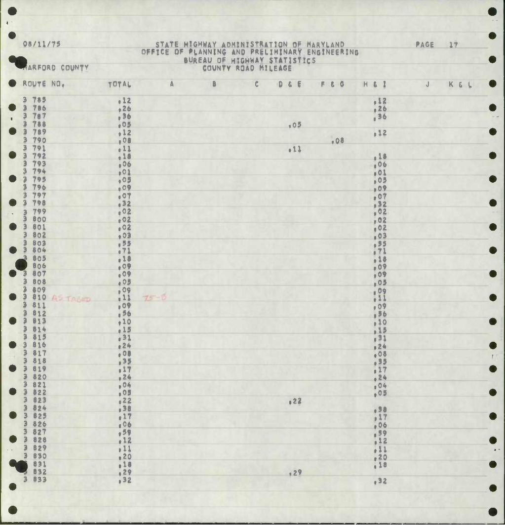
08/U/75
•• ARFQRD COUNTY
ROUTE NO,
STATE HIGHWAY ADMINISTRATION OF MARYUND OFFICE OF FtANNINQ AND PRELIMINARY ENfilNEERINQ
BUREAU OF HIGHWAY STATISTICS COUNTY ROAD MILEAGE
RAGE
TOTAL 0 & I F & 0
3 785 ill • 3 786 • 26 . 1 787 ,36
1 788 id • 3 789 • U
3 790 ,06 3 791 ill
• 3 792 • 11 3 793 ,06 3 79* • 01
• 3 795 • 09 3 796 • 0? 3 797 • 07
• 3 796 • 32 . 3 799 • 02
3 800 • 02 • 3 801 • 02
3 602 • 03 3 803 • 55
• 3 604 .71 ^ 605 m 606
• 11 • 09
• 3 607 • Of 3 606 • 05 3 609 • 09
• 3 610 fll 3 611 • 09 3 612 ,56
• 3 613 flO 3 616 • 19 3 615 • 31
• 3 616 • 26 3 617 • 06 3 616 ill
• 3 619 • 17 3 620 • 26 3 621 • 06
• 3 822 • 09 3 823 • 22 3 626 • 36
• 3 625 • 17 3 626 ,06 3 827 • 59
• 3 626 • 12 3 629 • U 3 830 • 20
ftA 831 ^ 632
• U • 29
3 633 • 32
.05
,08
22
.29
H ( I
• 12 • 26 ,36
• U
.18 ,06 • 01 ,09 • 09 • 07 • 32 • 02 • 02 • 02 • 03 • 55 .71 • 16 .09 .09 • 09 • 09 • U • 09 ,56 • 10 .15 .31 .26 ,06 .99 .17 .26 .06 .09
.36
.17
.06
.59
.12
.11
.20
.U
.32
17
K & L
S€.
£0,
81. PC,
eo.
•e.
si,
) IT ? J T 4 T <
a
S^
81
if
«I
• <•>
ir
••
1
• 08/11/75 si
OFFK
^^ARFQRO COUNTY
• R0UT6 NO. TOTAL
1°)
I |
1 3 998
3 900 , 3 901
• 3 902
4 III • 9 905
3 906 , 3 907 ,
# 3 908 3 909 ,
3 912 I,
•*$ 3 931 !o7
•
STATE HIGHWAY ADMINISTRATION OF MARYUND OFFICE OF PLANNING AND PRELIMINARY ENGINEERI
BUREAU OF HIGHWAY STATISTICS COUNTY ROAD MILEAGE
NC PACE 19
B C 0 6 E F £ C H * I
jO il9
27
K £ L
,07
tin
e$«
d?.
90 t
8S,
eot
I! .
.
tl*
'
. 1
» .
01.
•
I
08/U/75
•• ARFQRD COUNTY
STATE HIGHWAY ADMINISTRATION DF MARYUNO OFFICE OF PLANNING AND PRELIMINARY ENGINEERING
BUREAU OF HIGHWAY STATISTICS COUNTY ROAD MILEAGE
PAGE 21
W ROUTE NO.
m 3iooo
• L001 L002
i 91003 31004 31005
• 31006
•*
31007 31008 31009 31010 31011 31012 31013 3101* 31015 31016 31017 31018 31019 31020 31021 31022 31023 31024 31025 31026 1027 1028
31029
£
TOTAL
22 01 16 89 19 26 07 52 05 U 07 10 07 11 21 16 19 12 29 26 19 36 10 33
B 0 & E F e G
02 03 03 06 16 22 05 0} 06 12 09 09 06 86 26 09 16 21 10 13 36 06 73 06
rc C7^-- :r-4iA
• 06
• 21
H & I
• 22 .08 • 16 • 89 • 19 • 26 • 07 • 52 • 05 • u .07 • 10 • 07 • U .21 .16 • 19 .12 • <5 • 26 • 19 • 96 .10 f»3 • 26 • 02 • 03 • 03 • 06 • U • « • 05 • 09 • 06 • U ,05
1,05
1,86 • «6 • 09 • 16
• 10 • 13 • 36 • 06 .T3 .06
J K t L
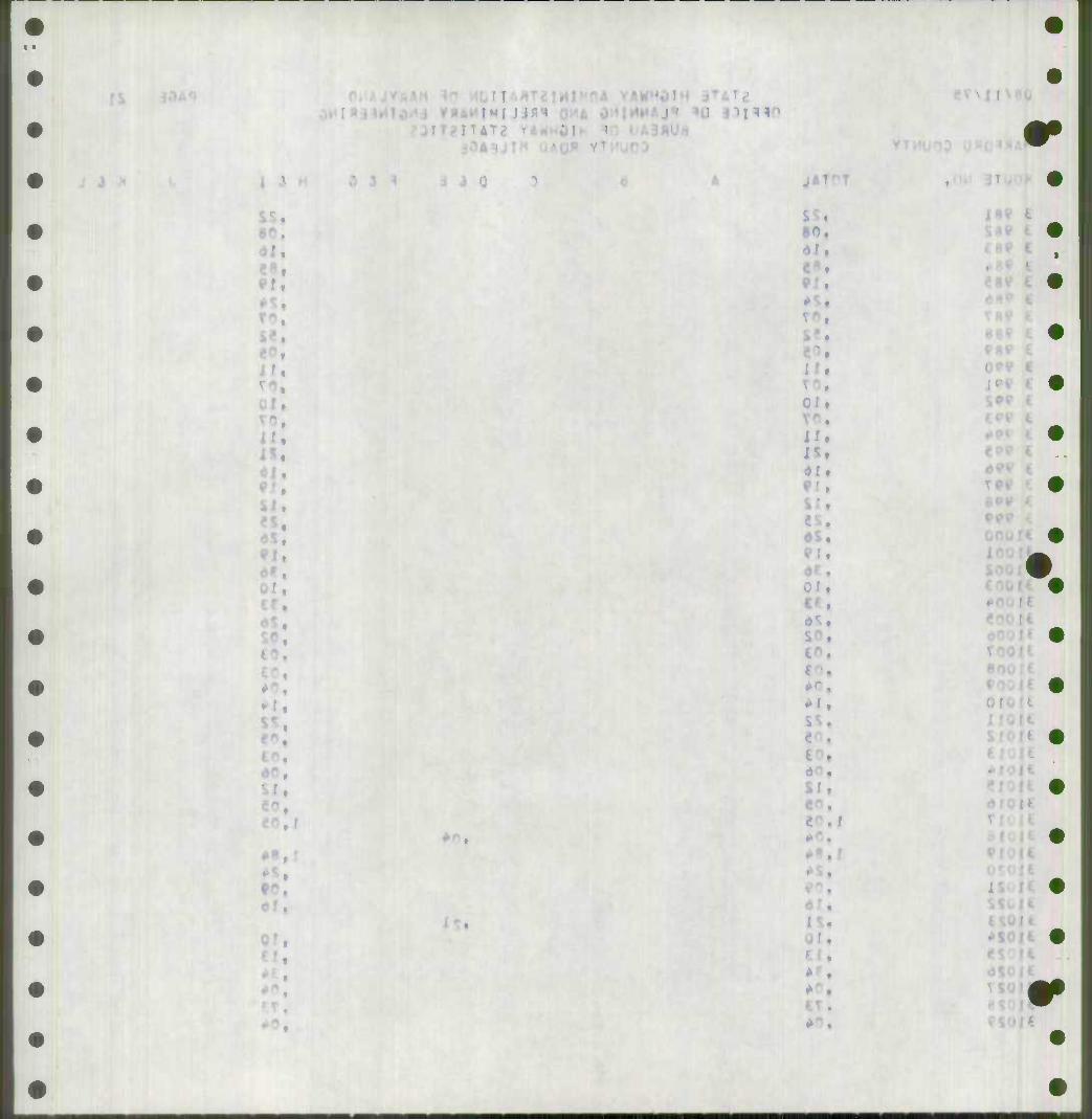
PI.
TO,
H.
el.
*«, r
MJ Jifl«»
J41
80.
01 t
IN
dS,
• li
«".
i >•
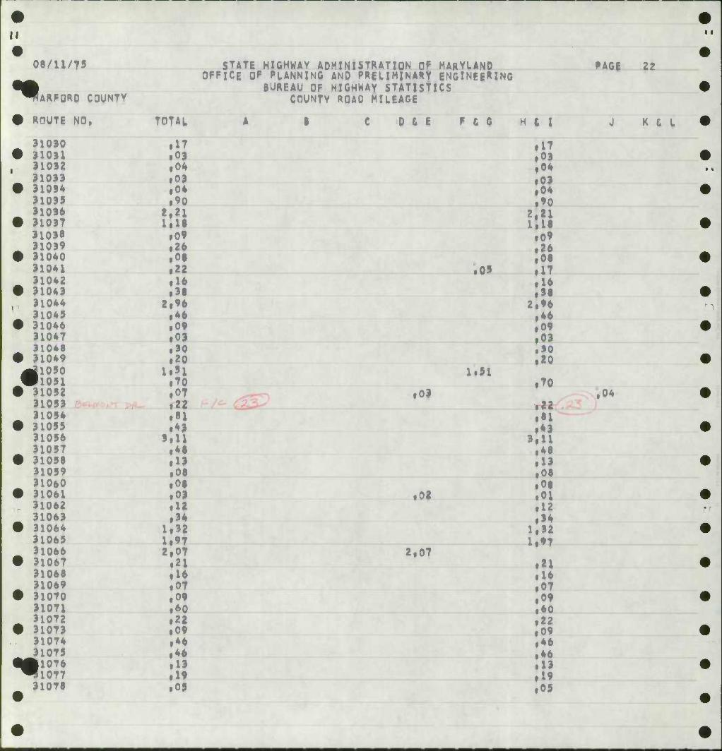
II
08/U/75
•• ARFORD COUNTY
STATE HIGHWAY ADMINISTRATION OP MARYLAND OFFICE OF PLANNING AND PRELIMINARY ENGINFEMNG
BUREAU OF HIGHWAY STATISTICS COUNTY ROAD MILEAGE
PAGE 22
•
*•
ROUTE NO. TOTAL
91030 .17 910)1 • 03 31092 .04 91099 .03 91094 .04 91095 .90 91096 t.2l 91097 llll 31098 .09 91099 .26 91040 .01 91041 .22 91042 .16 91049 .'• 91044 2.96 91049 .46 91046 .09 91047 .03 91046 .30 91049 .20 ilOSO 1.51 il05l .70 91052 .07 91059 .22 91054 .si 91055 .43 91056 9.U 91057 .41 91058 .19 91059 .06 91060 .08 91061 .03 91062 .12 91069 .94 91064 1.92 91069 1.97 91066 2.07 91067 .21 91068 .16 91069 .07 91070 .09 91071 .60 91072 .22 91079 .09 910T4 .•6 91075 .«6 |1076 .19 91077 .19 91078 .05
D & E Fee
09
1.91
03
:02
2,07
H i 1
•i7 .09 .04 .09 .04 .»0
2,21 1.18 .09 .26 .08 .17 ,16
•!• 2,96 .46 .09 .09 .»0 .20
.70
.22
.•1
.43 9.U .48 .19 ,08 .08 .01 .12 .94
1,92 1.97
.21
.16
.07
.09
.60
.22
.09
.•6
.46
.13
.19
.09
J K L L
.04
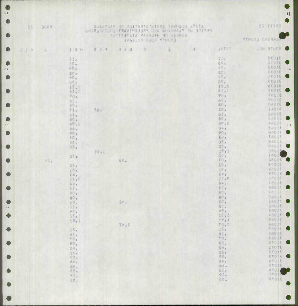
I J H
a?.
90, to,
0Ct
T^tt
U.
i
fO.
SP.
.
90,
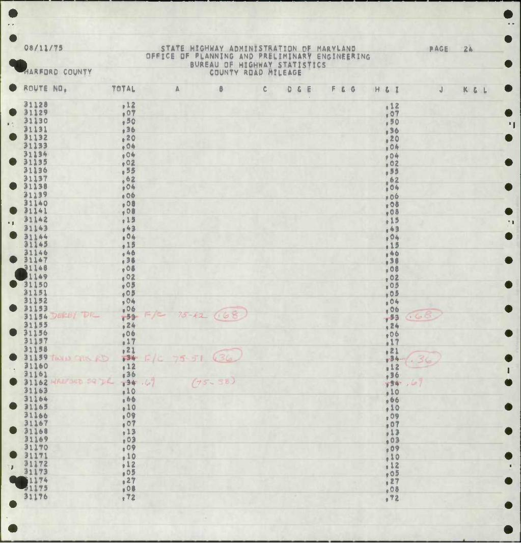
08/11/79
^ ARFQRD COUNTY
STATE HIGHWAY A0M1NISTRATIDN OF MARYtAND OFFICE OF PLANNING AND PRELIMINARY ENGINEERING
BUREAU OF HIGHWAY STATISTICS COUNTY ROAD MILEAGE
ROUTE NO, TOTAL 0 & E F t G
31128 • 31129
.12 »07
^ 1 A J v .90 .36 f20 .04 f04 .02 .99
;o4 .06
i i
.08 • 08 .19 1*1 .04 .19
yM .46 .38 .08 |02 .09 «09 .04 .06
.24 ,06 .17 .21 .34 .12 • 36 .34 • 10 .66 • 10 .09 ,07 .13 .03 .09 .10
' 31173 .12 ,09
lift .27 .08
31176 .72
H t I
12 07 ,90 96 20 ,04 ,04 ,02 95 *2 ,06 ,06 ,08 ,08 19 43 ,04 19 ,46 38 ,08 ,02 ,09 .05 ,04 ,06 93 ,24 ,06 17 ,21 • »• 12 36
• 96 ,10 ,66 10 ,09 ,07 13 ,03 ,09 10 12 ,09 27 ,08 ,72
PAGE 24
J K ( L
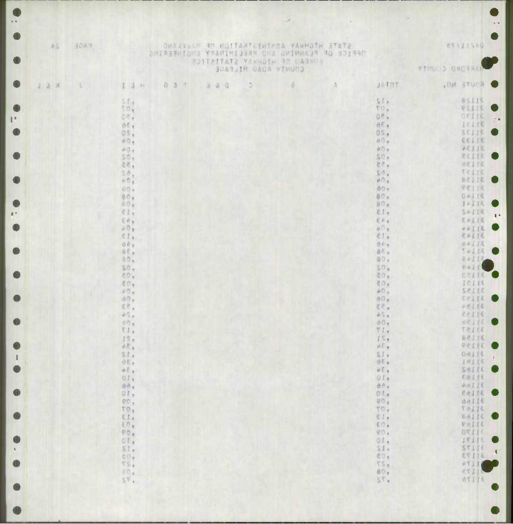
J J X I J
OS, •0,
60,
O/i
10,
I
if.
I U
Sd
inr.
r
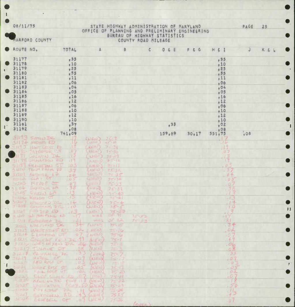
••
08/11/79
| WARFORD COUNTV
ROUTI NO. TOTAL
i55 .10 .25 .5S >U ,06 .04 .05 .16 .12 .06 .10 .12 .10 .»T
31192 .01 741, .09
STATE HIGHWAY ADMINISTRATION Of MARYLAND OFFICE OF FLANNINC AND PRELIMINARY ENGINEERING
BUREAU OF HIGHWAY STATISTICS COUNTY ROAD MILEAGE
B 0 6 E F ft G H t I
15 ,0
PAGE 25
J K t L
159,09 30il7 551 '.OS
/ /
> iVi
I 3
^. Mi 40,
d0,
i
rX. 9r\.
61,
-t V O}
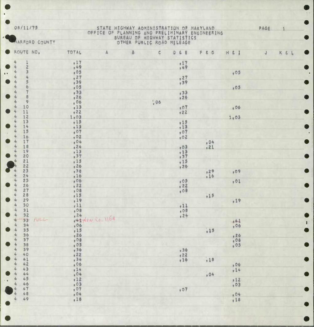
<•
08/U/75
ARFDRO COUNTY
ROUTE NO,
4
4 4 4 4 4 4 4 4 4 4 4 4 4 4 4
I 2 3 4 5 6 7 8 9
10 U 12 13 14 15 16 17 18 19
4 20
STATE HIGHWAY ADMINISTRATIQN OF MARYLAND OFFICE OF PLANNING AND PRELIMINARY ENGINEERING
BUREAU OF HIGHWAY STATISTICS OTHER PUBLIC ROAD MILEAGE
TOTAL
^ 2l .15 W* 22 .26 4 23 .38 4 24 • 16 4 25 • 06 4 26 .22 4 27 .06 4 28 • 19 4 29 .19 4 30 •u 4 31 .08 4 32 .24 4 33 rH 4 34 .06 4 35 .15 4 36 • 26 4 37 • 08 4 38 • 09 4 39 • 36 4 40 • 22 4 41 • 34 4 42 .06 4 43 .14 4 44 • 04 4 45 • 12 4 46 .03
|4 47 • 07 •4 48 .04 4 49 • 16
0 6 E F t G H L I
• 36 • 22 • 16
07
• 41 .06
PAGE
K t L
• 17 .17 • ^ .49 • 05 • 09 • 27 . 27 • 39 .39 • 09 .05 • 33 .33 • 26 .26 . 06 ,06 • 13 1 .07 • 06 • 22 22
1.03 1.03 • 15 , 19 • 19 . 13 .07 , 07 • 02 02 • 04 • 04 • 24 , .03 • 21 • 13 1 13 • 37 .37
15 • 15 • 26 , .26 • 36 • 29 .09 • 16 • 16 • 06 ( ,09 .01 • 22 , 22 • 06 , .06 • 15 • I' • 19 .19 •u ill • 06 .06 • 24 .2*
.1' .26 • 08 .05
• 18 .06
• 04 .14
.12
.03
.04
.18
9r,
%
?i.
I'
*'t
«1
^
08/U/75
flARFORQ COUNTY
ROUTE NO,
4 50 4 51 4 52 4 53
TOTAJ.
.25
.U
.15
.07 4 54 4 55
.32
.14 4 56 4 57
.56
.24 4 58 4 59
.U
.03 4 60 4 61
.17
.28 4 62 4 63
.16
.19 4 64 4 65 4 66 4 67 4 68 4 69
.15
.05
.08
.29
.08
.08 k4 70 "4 71 4 72 4 73 4 74 4 75
.08
.15
.38
.09
.15 4 76 4 77 4 78 4 84
.10
.20
.15
.13 4 85 4 89
.21
.24 4 90 4 9X 4 92 4 93
.14
.17
.21
.05 4 94 4 95
.12
.19 4 96 4 97
.57
.28 4 98 4 99
.33
.22 4 100 4 m 4 102 4 104 4 i05 4 106 4 107
.17
.35 lU .33 .36 .10 .04
STATE HIGHWAY ADMINISTRATION Of MARYUND OFFICE OF PLANNING ANQ PREUMINARY ENGINEERING
BUREAU OF HIGHWAY STATISTICS OTHER PUBLIC ROAD MILEAGE
.15
'.57
D 6 E
,03
.16
.14
.54
.24
• I'
.07
.33
.17
.35
.07
F t G H 6 I
.25
.09
.15
.07 16
12
.21
.02
,02
.03
.17 ,26 .16
.16
.09
.06 .29 .08
,06 .36 ,10
,06 .19
*
,36 ,09 ,15 .10 .20 .15
.13 .21
.09 .15 .05 .09
.17
.21 ,05 .12
22
.05
.33
.36
.10
.04
PAGE 2
J K £ L
I J
Cn.
M.
80. 8 .
8^«
VI.
08/11/75
^» ARFORD COUNTY
STATE HIGHWAY ADMINISTRATION OF MARYLAND OFFICE OF PLANNING AND PRELIMINARY ENGINEERING
BUREAU OF HIGHWAY STATISTICS OTHER PUBLIC ROAD MILEAGE
• ROUTE NO, TOTAL A
•
4 ]
160 1*1 162 L63 164 163
• 13 .03 .04 .30
• 4 4 ]
.10
.10 ^ ]
• 4 166 167
.12
.03 4 ] 4 ;
t68 169 170 171
ill .08
• 4 4 '
.08
.35 4 1
• 4
,. * 4 ,
L72 173 174 175
.10 • 11 .29 .21
• 4 4
176 177
.21 f20
• i 173 179 180 181 182 183
.25
.37
4 ]
.16
.05
.04
.35 4 ]
• 4 ] 184 ,85
.11
.11 4 ; 4 ]
,86 187
.24
.13 • *
4 ] 188 189
.02
.06 4 1
• * k90 191
.24
.09 ^ ] 4 ;
.92 193 ,94 .95
.09
.10
4 \ .12 .03
4 ; •
196 .97
.22
.08 4 ] 4 ;
t98 .99
.19
.17 • 4 i
4 4 :oo .19
.12 4 :
• 4 i !02 503
.05
.0?
• :; J04 t05
.12
.06
%:; J06 507
.20
.26 4 i
• 508 .07
••
C 0 & i F £ 6
B^
.21
.20 .21
i09
.12
H ( I
.13
.03
.04
.50
.10
.10
.12
.03
.11 • 06 ,08 .35 ,10 rU ftf
.25
.37
.16
.09 ,04 ."
• U .11 .24 .13 .02 ,06
,05 .09 .10 .12 ,03 • 22
.19
.n
.19
.09 ,09 .12 • 06 .10 .26 .07
PAGE 4
J K £ L
SI.
ITA^
IS, I*.
-r.
si
I r
%
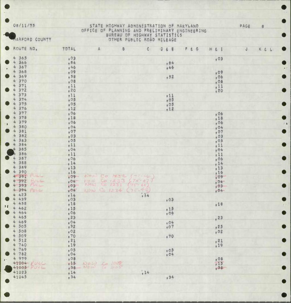
08/11/75
•^ ARFORO COUNTY
STATE HIGHWAY ADMINISTRATION 0^ MARYUNO OFFICE OF PLANNING AND PRElIMINARY ENGINEERING
BUREAU OF HIGHWAY STATISTICS OTHER PUBLIC ROAD MILEAGE
PAGE 8
ROUTE NO, TOTAL
4 365 .OJ <* 366 |84 4 367 .46 4 368 • 09 4 369 .58 4 370 ,08 k 371 • u 4 372 Izo <* 373 • 11 4 374 .05 4 375 • 05 <* 376 .12 k 211 .06 <f 378 »!• 4 379 .06 4 380 .04 4 381 .07 4 382 • 09 4 383 .05 4 384 • U .4 385 .04 * 386 • U 4 387 .06 4 388 .14 4 3R9 .13 4 390 .16 4 391 .09 4 392 .04 4 393 .03 4 394 .04 4 423 .14 4 439 .03 4 458 .18 4 462 .19 4 464 .06 4 465 .23 4 469 • 04 4 505 • 32 4 508 • 02 4 509 • 70 4 512 .21 4 740 • 19 4 769 .05 4 782 .04 4 979 .08 41004 .15 41005 .38 41023 .14 41U45 .34
;i4
D t I
.84
.46
F £ G
52
.11 • 09 • 09 • 12
• 01
• 19 .06
.04
.07
.70
.05
.04
H t I
• 03
• 09 .06 .08 .U .20
.06
.18
.06
.04
.07
.03
.05
.11
.04
.11
.06
.U
.13 • 16 • 09 • 04 .03 ,04
18
.23
• 25 .02
• 21 • 19
,08 • 15
J K £ L
.14 34
•
•
M.
-
*r.
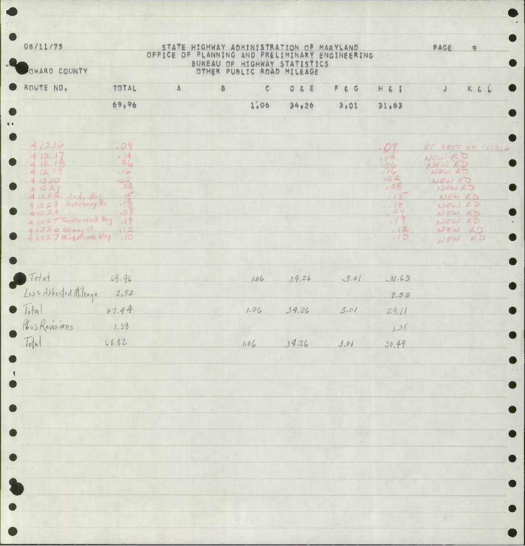
^
08/11/75
t POWARO COUNTY
ROUTE NO, TOTAL
69tH
STATE HIGHWAY ADMINISTRATION 0^ MARYLAND OFFICE OF PLANNING AND PRELIMINARY ENGINEERING
BUREAU OF HIGHWAY STATISTICS OTHER PUBLIC ROAD MILEAGE
6 C
1.06
D & E
34,26
F t 0
3.01
H t I
31*63
PAGE
K & L
%
P TrlA
7^1
^•%
z^Mt^z/T/^i* ii?* /.Oifi
h(>(,
3^^
/•oc, J4.-ZG
J4'2(,
i
J.Oi 30, W
•P-
%
4
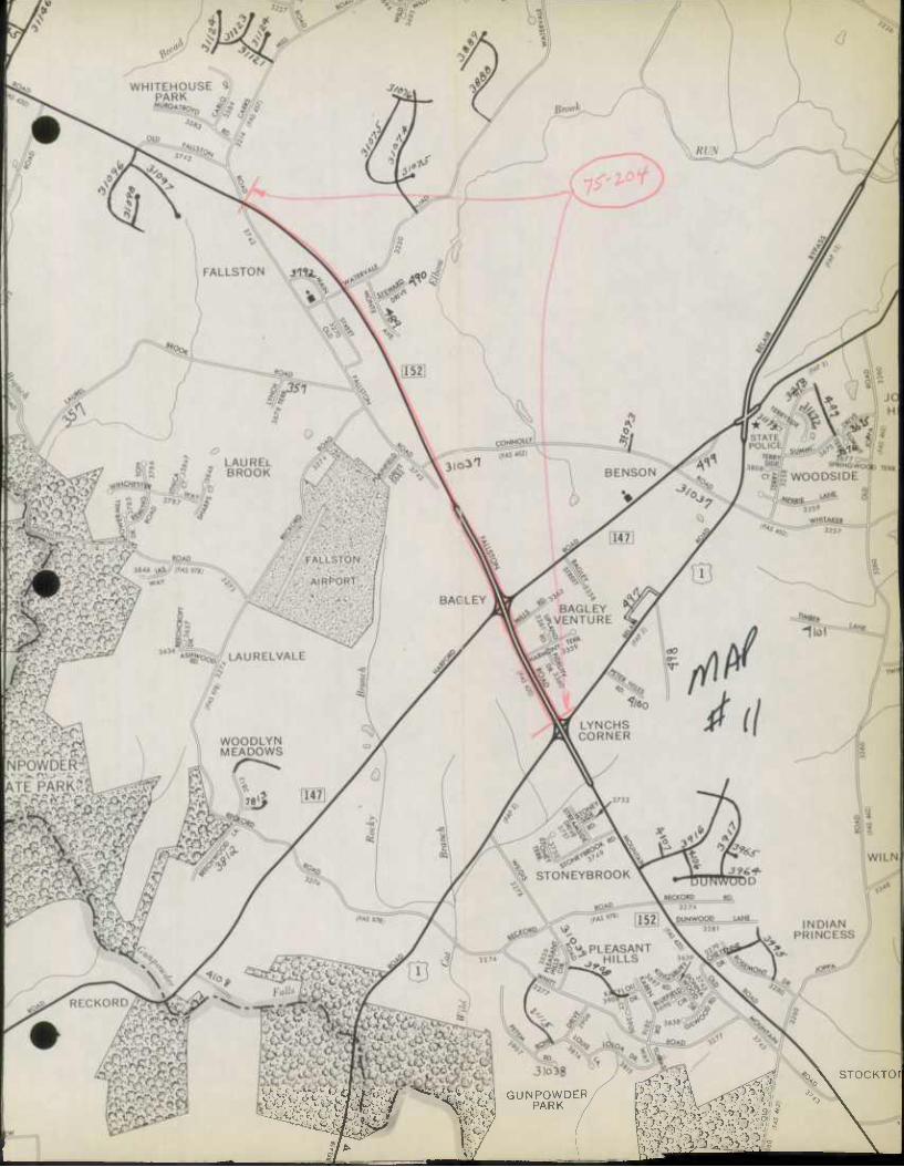
GUNPOWDER PARK
STOCKTOIl
mm
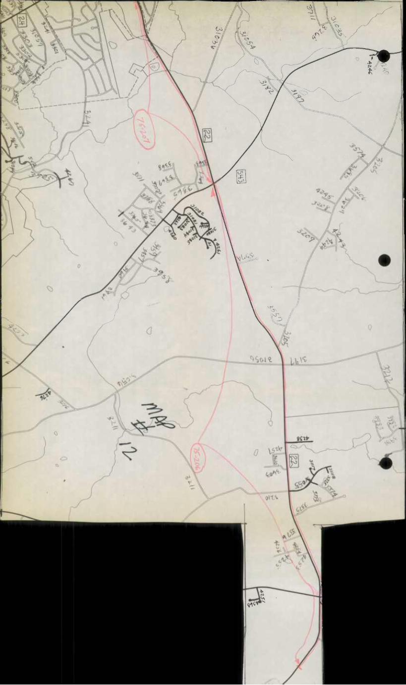
u.. w/ VV« y-/ \k ^ r// ^Kv
(y
i\&
A \ i
~A /^^
~V s y e ^. /
t> 0
i -5o~
-3-
l^
iMiHuUMliiibili UMhiUkiMkd
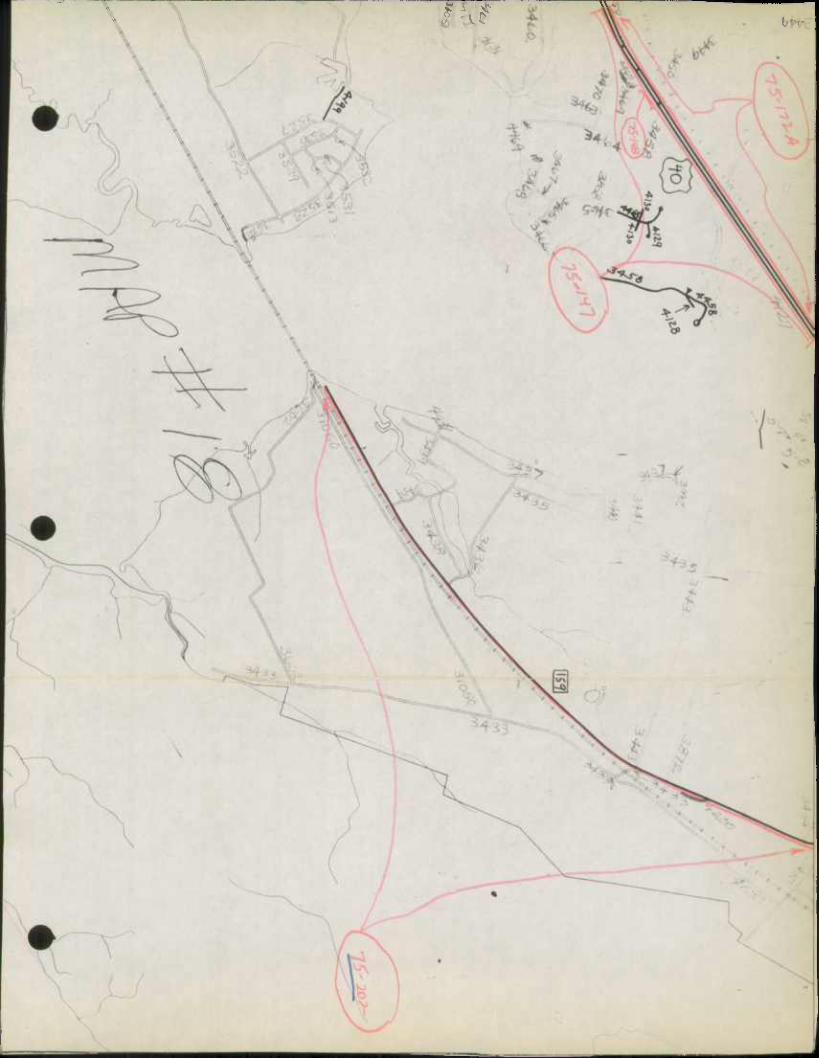
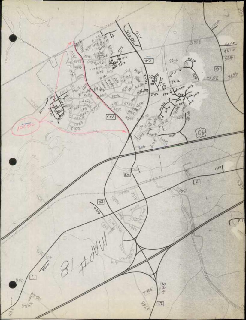
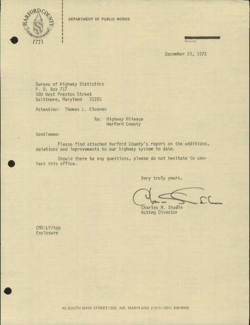
^Q?>
nn
DEPARTMENT OF PUBLIC WORKS
Director
December 23, 1975
Bureau of Highway Statistics P. 0. Box 717 300 West Preston Street Baltimore, Maryland 21203
Attention: Thomas L. Cloonan
Re: Highway Mileage Harford County
Gentlemen:
Please find attached Harford County's report on the additions, deletions and improvements to our highway system to date.
Should there be any questions, please do not hesitate to con- tact this office.
Very truly yours,
CC_ Charles M. Shadle Acting Director
CMS:LP/tgg Enclosure
45 SOUTH MAIN STREET/BEL AIR, MARYLAND 21014/(301) 838-6000
SDUSIIVIS AVMHDIH JO nV3»fW
SI61 fz 01Q
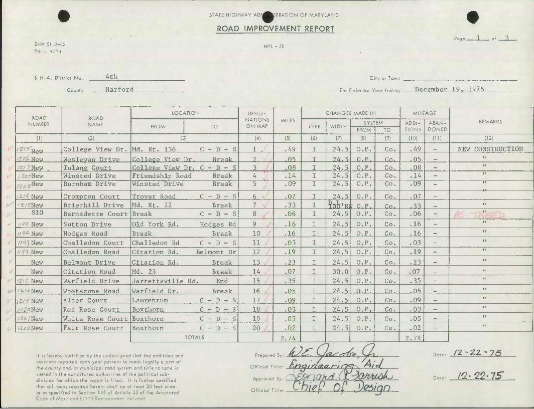
SHA 51 .3-23 Rev. 9/74
STATE HIGHWAY ADf^^TRATION OF MARYLAND
ROAD IMPROVEMENT REPORT
HPS - 20
Page L of
S.H.A. District No.
County
4th
Harford
City or Town
For Calendar Year Ending December 19. 1975
ROAD NUMBER
ROAD NAME
LOCATION DESIG- NATIONS ON MAP
MILES CHANGES MADE IN MILEAGE
REMARKS FROM TO TYPE WIDTH
SYSTEM ADDI- TIONS
ABAN- DONED FROM TO
(1) (2) (3) (4) (5) (6) (7) (8) (9) (10) (ID (12)
College View Dr. Md. Rt. 136 C - D - S 1 .49 24.5 O.P. Co. .49 _ NEW CONSTRUCTION
izii, NPW Weslevan Drive College View Dr. Break ?. .05 24.5 O.P. Co. .05 _
/?/ 7 New Tulane Court College View Dr. C - D - S 3 .08 24.5 O.P. Co. .08 —
/ zo/New Winsted Drive Friendship Road Break 4 .14 24.5 O.P. Co. .14 -
r .,.,-. New Burnham Drive Winsted Drive Break 5 .09 24.5 O.P. Co. .09 -
I^I"? New Crompton Court Trover Road C - D - S 6 .07 24.5 O.P. Co. .07 _
i«/fNew Brierhill Drive Md. Rt. 22 Break 7 .33 Sofe'Rlt O.P. Co. .33 810 Bernadette Court Break C - D - S 8 .06 24.5 O.P. Co. .06 -
/i'? 3 New Sutton Drive Old York Rd. Hodges Rd 9 .16 24.5 O.P. Co. .16 -
/' ''" New Hodges Road Break Break 10 .16 24.5 O.P. Co. .16 —
//•i^New Challedon Court Challedon Rd C - D - S 11 .03 24.5 O.P. Co. .03 -
ii^l New Challedon Road Citation Rd. Belmont Dr 12 .19 24.5 O.P. Co. .19 -
New Belmont Drive Citation Rd. Break 13 .23 24.5 O.P. Co. .23 _
New Citation Road Md. 23 Break 14 .07 30.0 O.P. Co. .07 _
/2/2 New Warfield Drive Jarrettsville Rd. End 15 .35 24.5 O.P. Co. .35 —
/•z.is New Whetstone Road Warfield Dr. Break 16 .05 I 24.5 O.P. Co. .05 _
/z./f New Alder Court Laurentum C - D - S 17 .09 I 24.5 O.P. Co. .09 —
/ZZoNew Red Rose Court Boxthorn C - D - S 18 .03 1 24.5 O.P. Co. .03 - II
/2z/New White Rose Court Boxthorn C - D - S 19 .05 I 24.5 O.P. Co. .05 _ II
/EZZNew Fair Rose Court Boxthorn C - D - S 20 .02 I 24.5 O.P. Co. .02 -
TOTALS 2.74 2.74
It is hereby certified by the undersigned that the additions and revisions reported each year pertain to roads legally a part of the county and/or municipal road system and title to same Is vested in the constituted authorities of the political sub- division for which the report is fi led . It is further certified that all roads reported herein shall be at least 30 feet wide or as specified In Section 145 of Article 25 of the Annotated Coae of Warvlanc f 1 a73 Reo'ccer^ent Volume)
Prepared 5y:
Official Title
Approv
Offic
US. 6Lvr?£ (2, r. -77 • M- ^2 AU-
oi Titie ChkP Of j)(ttign
3ote /2-22.-7.5
Dote: n-lZ-lS
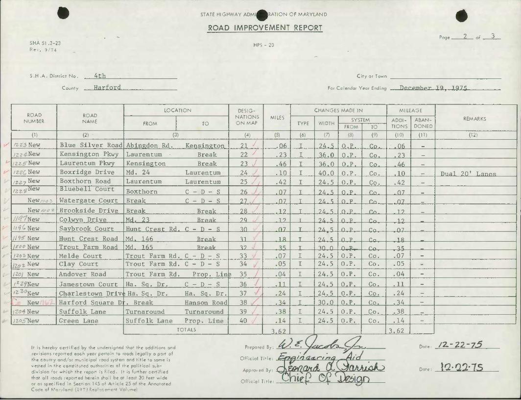
SHA 51 .3-23 Rev. 9/74
STATE HIGHWAY ADMI^MWiON OF MARYLAND
ROAD IMPROVEMENT REPORT
HPS - 20
Page .
S.H.A. District No. 4th
County Harford
City or Town
For Calendar Year Ending Dprprnhpr IQ^ 1.975
ROAD NUMBER
ROAD NAME
LOCATION DESIG- NATIONS ON MAP
MILES
CHANGES MADE IN MILEAGE
REMARKS FROM TO TYPE WIDTH
SYSTEM ADDI- TIONS
ABAN- DONED FROM TO
(1) (2) (3) (4) (5) (6) (7) (3) (9) (10) (11) (12)
ft Z2 New Blue Silver Road Abingdon Rd. Kensington 21 .06 24.5 O.P. Co. .06 _
/cv^New Kensington Pkwy Laurentum Break 22 .23 36.0 O.P, Co. .23 _
2^5 New Laurentum Pkwy Kensington Break 23 .46 36.0 O.P. Co. .46 _
/22£.New Boxridge Drive Md. 24 Laurentum 24 .10 40.0 O.P. Co, .10 _ Dual 20' Lanp.s /Z27New Boxthorn Road Laurentum Laurentum 25 .42 24.5 O.P. Co, ,42 _
/2z?New Bluebell Court Boxthorn C - D - S 26 .07 24.5 O.P. Cn. .07 New Watergate Court Break C - D - S 27 .07 24.5 O.P. Cn. .07
New^^z Brookside Drive Break Break 28 .12 24.S C.c. - 12
//^"/New Colwyn Drive Md. 23 Break 2q .1? 24,5 n p Co ,12 z/'?^ New Saybrook Court Hunt Crest Rd . C - D - S 30 .07 24 5 n p Co 07 // 9^ New Hunt Crest Road Md. 146 Break 31 ,18 24. 5 n p Co 18 lioo New Trout Farm Road Md. 165 Brpak 39 , "^ 30 0 n p Co 35 /zoiNew Melde Court Trout Farm Rd . C - D - S 33 .07 24.5 O.P. Co. ,07 —
\loi New Clay Court Trout Farm Rd . C - D - S 34 .05 24.5 O.P. Co. ,05 -
iZoi New Andover Road Trout Farm Rd Prop. Lin 5 35 .04 24.5 O.P. Co. .04 -
/rZfNew Jamestown Court Ha. Sq. Dr. C - D - S 36 .11 24.5 O.P. Co. .11
'2-3:'New Charlestown Driv( iHa. Sq. Dr. Ha. Sq. Dr. 37 .24 24.5 O.P. Co. .24 _
New Harford Square D: r. Break Hanson Road 38 .34 30.0 O.P. Co. .34 -
(2*94 New Suffolk Lane Turnaround Turnaround 39 .38 24.5 O.P. Co, .38
yzo^New Green Lane Suffolk Lane Prop. Line 40 .14 24.5 O.P. Co. .14 -
TOTALS 3.62 3.62
It is hereby certified by the undersigned that the additions and revisions reported each year pertain to roods legally a part of the county and/or municipal rood system and title to same is vested in the constituted authorities af the political sub- division for which the report is filed. It is further certified that all roads reported herein shall be at least 30 feet wide or as specified In Section 145 of Article 25 of the Annotated Code of \*arv(and (1Q ~ 3 •'- I Volume)
cial Title: CZ*Mina<t.r-trtq -Mid
,roved B,: Q^lQn/k OLKjCVUuakj
Prepared By:
Offici
Appn
Offn
Date:
Date:
/Z-22-75
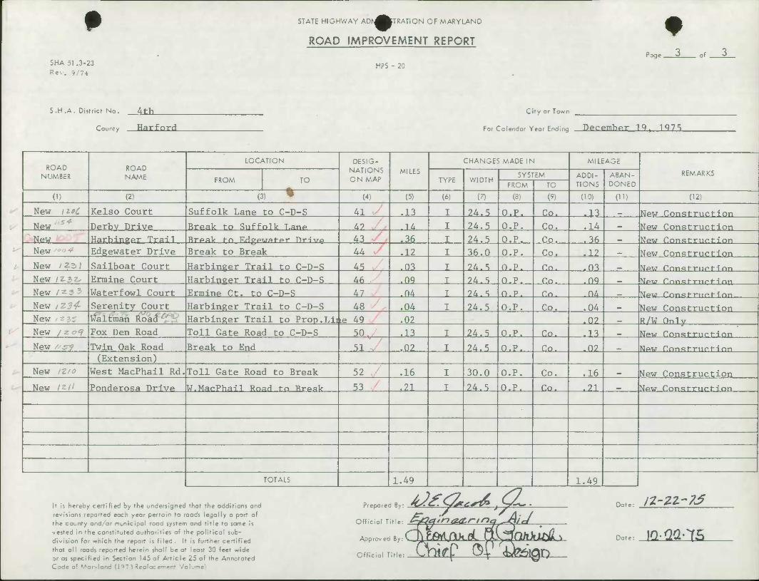
SHA 51 .3-23 Rev. 9/74
STATE HIGHWAY ADA^^TRATION OF MARYLAND
ROAD IMPROVEMENT REPORT
HPS - 20
Page 0 of "^
S.H.A. District No. _4Lb_
County Harfnrd
City or Town
For Calendar Year Ending DeCP.mher 19, 1Q7S
ROAD NUMBER
'
ROAD NAME
LOCATION DESIG- NATIONS ON MAP
CHANGES MADE IN MILEAGE
REMARKS FROM TO
MILES TYPE WIDTH
SYSTEM ADDI- TIONS
ABAN- DONED FROM TO
(1) (2) (3) ' (") (5) (6) (7) (8) (9) (10) (H) (12)
New /zeC Kelso Court Suffolk Lane to C-D-S Al .13 24.5 O.P. Co. .13 _ New Construction
New Derbv Drive Break to Suffolk Lane A9 .14 24.5 O.P. Co. .14 _ New Construction New Harbinger Trail Break fn Edgewater Drive 43 .36 24.5 O.P. .36 _ New Construction New Edgewater Drive Break to Break 44 .12 36.0 O.P. Co. .12 _ New Construction
New /?2>i Sailboat Court Harbinger Trail to C-D-S 45 .03 24.5 n.p. Co. .03 New f!nnst-riic1--i nn
New IZ3Z- Ermine Court Harbinger Trail to C-D-S 46 .OQ 24.5 O.P. Co. .OQ New rnnst-rncM nr|
New /z 3 3 Waterfowl Court Ermine Ct. to C-D-S 47 .04 ?4.5 n.p. Cn- .04 New rrmst-T-ncM nn
New /Z34- Serenity Court Harbinger Trail to C-D-S 48 .04 24.5 O.P. Co. .04 _ New Construction New • zz ^altman Road Harbinger Trail to Prop.Lit ie 49 .02 .02 _ R/W Only New / z of Fox Den Road Toll Gate Road to C-D-S 50 .13 24.5 O.P. Co. .13 _ New Construction
New "sry Twin Oak Road Break to End 51 .02 24.5 O.P. Co. .0? New Crmstructi rm (Extension)
New /Z/<? West MacPhail Rd. Toll Gate Road to Break 52 .16 30.0 O.P. Co. .16 _ New Construction
New 12/1 Ponderosa Drive W.Mar.Pha-il Road to Ereak 53 .21 24.5 O.P. Co. .21 New ConstrucMnn
TOTALS 1.49 1.49
It is hereoy certified by the undersigned revisions reported each year pertain to r the county and/or municipal road systetr vested in the constituted authorities of t
that the additions and oods legally a part of
and title to same is ne political sub-
is further certified least 30 feet wide
Prepare
Official T
Approv ec
Official 1
fr- Date:
Date: ^C 'l&Ml ikdi rt! J^ClhitU^L \ division for which fhe report is riled. 1 that all roads reported herein shall be a ;„.. CVW P of £te>ian or as speci Code of M
tied m bectton Ko ot Article arvjond (la73 Reoioce---- •'
^j ot the Annotated \ I ^ '
^ 1 i
N:
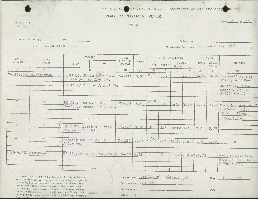
STATE ;-I3HV,AY ^^NiSTRATiON OF VARYLAND Locations on Map are shou^^n Red
ROAD IMPROVEMENT REPORT
.3-22 Pe-.. ) --t
HPS - 2C
^ge. ^_
S .H .A. Dis"ict No.
County
M. RnrfnrH
City or Town
Fo, Coier.dor Yecr Endino December 31, 197^
ROAD NUMBER
ROAD NAME
LOCATION DESIG- NATIONS ON MAP
MILES
CHANGES MADE IN MILEAGE
REMARKS FROM TO TYPE WIDTH SYSTEM ADDI-
' DNS
ABAN- DONED FROM TO
(3) (4) (5-< (6) (7) (8) W r:- (11) (12)
MdtRte,l6l ZJarZinQton 0,05 Hi. South Of Trnnp* 74«7 74 n, ^-7 V J?P» <' + ^*« 0.37 0.37 Relocation, ¥id— Church Rd, to 0,4-0 Mi,
? t a t e ening, and Re-
Smith nf TrnnLnn rh,,^r.h R*
Constr. Plans H~340~2~471)
ff tt US Rte,l to 0,03 Mi, 74-115 1,10 \VU 20* Statp ilfnfo 1. m i in
South oj Trappe ChurchRd, w7 ngn tno—ana flq— surfacina (See Constr, Plans
N—^Ari—A Lit \ , W,
h— •>'+{)—t—t+yi }
ft ir A 0/37 Hi, North of Price 74-116 0. ?7 T PO' ^fn + O^.+n + r* n "^7 O xn - , \ $d, to Price Rd,
l-1, J /
—i s \ - . " / Harmony Church Rd, to 74-11? 1,72 •>T S 22' State State 1,72 1,72 ii
V Price Rd, -*• • i <*
Vd,Rte,152 /fountain US Rte,40 to R&O RR Rm'Hr o iL 1 1 Q rt o o n / • U, e?<i I 24' Hnva e Sta v.e0,21 New Construction (See Constr, Plans H-360-5-471)
TOTALS
H s f.e:ecy ccrrifiad b) rh« i/nd*nigncd 'hot the odcJl'ions end
-e- t>oni 'epo.--«o eoc- ,eo- pertain to roods legoily o pin of tie co„r,rF anc: o- -^ z.?~ .^^ sysrer. ond , tie ,0 Jome j,
• e-.-fC - -n, cons-.'^-eo ».fhoiit;«s of -he political wb-
o:. son (3, «n,cK 'hr report rj f,)ed Ii ii l^^her c»fti<!«d
that a'! -ocai -epc-ec here - shoi: oe a- ecs- 30 'eet w.de
Prepared By: s^ZZzZf ^ yt&^xK^i^ />,
or as speclfiea in Set-,or. i<5 -J Art.cie 25 of the Arnotctec
Official T.tle: ^S? -^
Approver By:
Official Title:
Dote-
Dote
//- ^S'^
I I
^1 ft c.
03
1)
'? 6^
SnA 51 .3-23
CTATE hi 3-'.-, A^^^'.INISTRATiGN OF MARYLAND
ROAD IMPROVEMENT REPORT
HPS - 20 -^ge- of
S.H.A. Disti cf No.
County
84
Harford
City or Town
For Colendar Year Ending December Ji , 197^
It i Kcrafty ccrtifitd b> rh« undersigned rttot the additions and re-, s.ons rjpof.fj, „,., iec, .j,^ r t0 rOQds ie9ai|y Q p0r, 0f
rn* cOknty one o- m^r cipal -ooa s.stfr- one ! t'e to sc»ne is • eve;: In -ne const.•jtea Owrhoritias 0< rh« pontlcol sub- divisier loi -hrch 'hr 'eport ij Filad. !t Is Fufthai certideO •no? ad -ooas :epc"ec hac«ir iha| ce a- ecv 30 'eet w,oe o- as soecl'ec - Sec- o^ US -J Aft.cU 25 o« the Arnototea
Prepared By: ^<Zs£&n^ /^. s£4-?£-**Ctt*-' L. Dote: /^-^W^
Official Title:
Approvea By:
Official Title:
^
Date
RCAC NoVBER
AD NAME
LOCATION DESIG- NATIONS ON MAP
MILES CHANGES MADE IN MILEAGE
REM.ARKS FROM TO TYPE WIDTH SYSTEM ADDI-
TIONS ABAN- DONED FROM TO
(1 - (3) (4) (5) (6) (7) (8/ O (10) (li) (12)
Vd.Rte,152 fountain Ri, Turn Lane at US R+o. 74-77Q O.OU r 7P» ^t nt 0 Strife n,n£ n nA 40
Constrm Plans H-360-5-471)
a :Zd and New Rte, 152 •74-22^ n no T 0/ 1 D n
«
Connectina Rd, South of -i lin T c -tare 0,02
3 & 0 JW
tr a 9*0 RR Bridge to JFK Hwu, 7^-121 0,63 I 24' P "ivatdState 0,63 n
tf ii lid and New Rte, 152 7^-122 0.04 I 24' P "ivateSiato 0.04 11
Connecting Rd, south of
._, JFK Hwy, O.55 Mi,
/F n Ramp 'A' Extension at 74-121 0.74 T 7S' Phii,n + o Itn + o n IA TFK Hwy,
n lamp *A> Extension Accel, 74-124 0.15 I 121 PrivateStata 0- 7S 11 Lane at Md, Rte,152
TOTALS

STATE hlSH.VAYl IMSTRATION OF MARYLAND
SHA 51 J-23 R«v. 1 T4
ROAD IMPROVEMENT REPORT
HPS -2C
'*3e. J of_ii_
S.H .A. District No.
County
84
Harford
City or Town
For Colander YMT Ending December 31, 197^
ROAD NoM.BER
AD NAME
LOCATION DESIG- NATIONS ON MAP
MILES
CHANGES MADE IN MILEAGE
REMARKS FROM TO TYPE WIDTH
SYSTEM ADDI- TIONS
ABAN- DONED FROM TO
(1 - (3) (4) (5) (6) (7) (3; ('• (10) (") (12)
Md.Rte,152 fountain Ramp 'A' Extension Lmft 74-1?*; 0.0^ T 7 S ' f ri 7)rt + 'Sfnto O.O^ Turn Lane at Md. Rte,152 Constr, Plans
H-360-5-471) n n Ramp 'B' Extension at 74-126 0.06 I 15' frivatkstate 0,06 n
JFK Hwy. -
it <i Ramp 'B' Extension Rt, 74-127 0.05 I 15'Pr ivatestate 0.05 n »
Turn Lane at Md. Rte.112
n n Ramp 'B' Extension Decel- 74-12R 0.O6 T IP' fl r-i nn + i<Z + n + n _0^06 a Lane at Md. Rte, 152
— , n n B&O RR Bridge to Taylor 74-129 0.50 I 24' F ri un + t'^H-n + o 0. ^o
•
Brook Lane
n n Taylor Brook Lane to 74-130 0.^9 I 24' State State 0.S9 0.S9 ii
Greenspring Ave,
TOTALS
ll s hereov cer:.;iec t, -t-e .r-detngned thot the additions and '«-• sors 'epoceo eoc.- r*ai ier-o n -o roods legally a pin of tie co^nt, one ;• -o" c.p^ roac svs-er- o-ia t t'e to swne is • es'ed in -ne coi-st'^teo OL.,uor-t.e> of the political sub- divitier (oi wh.ch -he -eport .5 filod. It Ii furthw ce-T,(ie<3 •r.o- all -ooos -epc-e-.- herein ire, ne ol ecit 30 'eet w.oe otassoee'ee -Sec-,^ <i ^t A.^ c .e 25 o( the Aroc' = fe=
Prepared By: /&<^T^^ /^, *^4r?Cvrt*z*^ In
Official Tlfle:
Approvec By :
Official Title:
^^ ^Z ^
Dote: X^ J/- 7-?-
Date
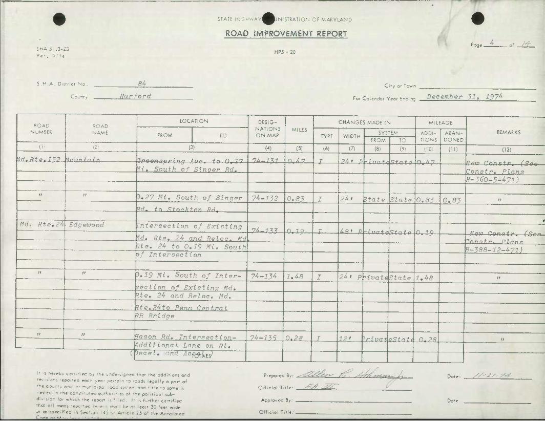
STATE hi 3riv.AY^MlNI5TRATiON OF MARYLAND
ShA 51 .3-23 Rev. - -4
ROAD IMPROVEMENT REPORT
HPS - 20
•"Tge. J±.
S .H .A. Dls'ncr No.
C 0'_ r' y
S-4
Harford C if y or Town
For Coiendor Year Ending December 31, 197^
ROAO NuMBEi;
ROAD NAM.E
LOCATION DESIG- NATIONS ON MAP
MILES CHANGES MADE IN MILEAGE
FROM TO TYPE WIDTH SYSTEM ADDI-
TIONS ABAN- DONED
REMARKS FROM TO
(1) P (3) W (5) (6) (7) (8) (9, (10) (H) (12)
1ri,Rfe.15P ynuntnin ^r»o/3n ^prfrt" '[v tc n 'yr7 7^_-M7 n.47 r PZ. f D ^-f T,/-. + ^ <Z + n + n n A 7
H, South of Sinner Rd. Vom—Constr, (Soo— 7onstr, Plans H-360-5-4?!)
n 11 5.27 Afi, South of Singer 74-132 0,83 I 24' State State 0.83 0,83 rt
M. to Sf.or.kfnr, Rr1T
0 Md. Rte.2A Edgewood Intersection of Existing yA.m n. 7 0 I Apr P n -ro
—— 1 Id, Rte. 24 and Rolnc. MH Now Gonatr,—(goo
Ue. 2U to 0,19 Mi, South ff~386-12~4-71) )/ Intersection
it 11 0,19 Mi. South of Inter- 74-134 1,48 I 24' R "ivat&State 1,48 n
. section of Existina Md, 1 ;
Rte, 24 and Reloc, Md. [?te.24to Penn Central RR Bridge
11 11 '•fason Rd, Intersection- 74-^35 0.28 I 12' iriiinf eStn11 0.28 n additional Lane on Rt,
[[ )eceL. -nd Acftftl^J
U .s hereDv cert.-Ire by th* jr-ders gned thai iht oddlfioos ond
»»v sors -epofea eocr- ,«:• pertain ro roods lejolly 0 por- of
•rt co^rt, ono o- itiur c.pa rooc s/iter- ana rirl« to iane 15
. es'fi - -rte cc's-''^e<; authocitiei o1' rh« po-.ncol sub-
Aviuer toi «n,cK ••>« report is Filed. Il if KirtKef certified
ritat a:i rooai repc-ec here n iha{ be at eau 30 'eet «..ae
ot aj jpeclfiea in Sec-.^ U5 si Affcle 25 o1 the Arnototea
Prepared By: .^
Official Title: ^^ -^7
Approved By:
Official Title:
^^^"^ S^- s^rTfsrn^z*— I; Dat«
Don
//-J/- 7^
£
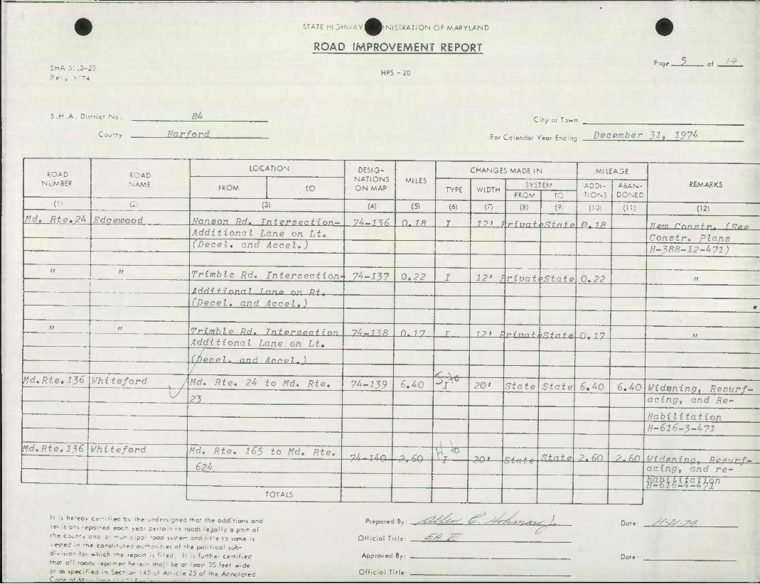
SHA 5: .5-23 ?e . ' '74
STATE 1-1 3.-wAY^^|N|STRATION OF MARYLAND
ROAD IMPROVEMENT REPORT
HPS - 20
-oge. of _Z21
S.H.A. Dtstriei No. 84
Farford City or lawn
For Cciendor Year Ending December 31* 197^
ROAD NUMBER
RCAD NAME
LOCATION DESIG- NATIONS ON MAP
MILES CHANGES MADE IN MILEA3E
REMARKS FROM TO TYPE WIDTH SYSTEM ADDI-
TIONS ABAN- DONED FROM TO
(• (2 (3) (4) (5) (6) (7) (3; (9: (10) (") (12) /fd. RtQ.2U Edaewood Hanson Rd. Tnterxpr.tinn- 74-7^ 0.7^? r 12' !• r-inn + .tZ + n + o o^ ip
Additional Lane on Lt, Constr, Plans (Decel, and Accel,) H-388-12-471)
n a Trimble Rd, Intersection- 74-137 0,22 I 12* frivat,'State 0,22 ft
Idditi nnnl r.nn? r,n Rf t
(Decel, and Accel,)
ti n Trimble Rd. Tntprxerfinn 1U-1^R n. 77 T 1?l F ^.17,^. + , . <y-t-y, •/• *
Additional Lane on Lt, U, 1 /
Ifiecel* and Arrol.)
/ ^ ^ * Md.Rte.136 Whiteford Md. Rte, 2U to Md, Rte, 74-139 6.40 V0 20' State State 6,40 6,40 Wt dnnina * /?p<?7y r/— 1/ 23 acing, and Re~
Hnhi 1 i f n f i rtD
fl-6l 6-3-471
Md.Rte,136 Whiteford Md. Rte, 165 to Md, Rte, nJ, i Jtr\ o <rn V;T^
^fnfo P 6Ci p fin .. ..
£2U L', OiJ— —±— 30'— State r , v)\/ r « 01/ [•/idjenmn, Rpxiirf-
acing, and re-
fiimmibT I TOTALS
If .5 hereov ce-r, •< ec t, -he undsnigntd rhof fSe oddlflons and
'f- 5 o.-i -epot-eo eocr- .ec- pertain -D roads Ie9aily a porr of
the ccK.r', enc sr munieipa -DOC sys-fr- and riti* ro s<»r.e is
-«-ed In -ne co'-sti'^'e-c: outKotitici oi rh« poliiicol sub-
Avisior foi «n,ch rhc report It filed. It is further certified
ff.ot o11 roocs repr-ec Ke'Ctn sr>o!' ce o' ecs- 3C 'eef wid«
O' as spec - cct.on '45 ^t AJ' c e 25 o' the Ar.notofec
Prepared By:
Official Title:
Approved By:
Official Tifle:
^ ^
Dat«
Date:
//-jy-^
i Hi
^
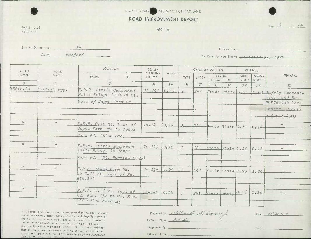
SHA 51 a-22 Rev. - -4
STATE hi 3-.-.AV^^l|NlSTRATiON CF MARYLAND
ROAD IMPROVEMENT REPORT
HPS - 20
J3ge. of_^L
S.H.A. District Nc
Court
JSRte,A-0 bulaski Hwy,
ROAD NUMBER
84 City or Town
Harfard For Co;endar Year Ending frooombOP 31,—197&
ROAD NAME
LOCATION
E.B,R, Little Gunpowder rails Bridge to 0,14 Mi,
FROM TO
(3)
DESIG- NATIONS ON MAP
(4)
Vest Of Joppn Farm QH,
Z.B.R. Q.U Mi. We*f r,f Toppa Farm Rd, to Joppa
'arm Rd. r.?^on Pnri)
I.B.R. Little Gunpowder Palls Bridge to Joppa
74-14-1
7^-16?
MILES
(5)
0.03
n. 14
CHANGES MADE IN
TYPE
(6)
WIDTH SYSTEM
(7)
24j_ Itate
-J~
74-143
rarm Rd. CRt. Tuminn r.nn
.g. fl.ff. Joppa Farm RHt
,ll
to 0,16 Mi, Vest of Md, We,152
E.B.R. 0,1S Mi. Vest of Vd, Rte, 152 to Md, Rte.
•iV (Stop /W^TALS
74-144
0,18
1.7Q
2Al ,?tato
FROM
(8)
Ml ?tate State
2LL ^fnfo
'Jt-Lk5- -0,16 -*Z-
rc (9.
State
State
MILEAGE
ADDI- TIONS
(10)
0.03
&r44
2kl—?tato
.State
5*&*-e-
0.18
ABAN-
DONED
(")
REMARKS
(12)
£U£l.\-Safetlj Tmnr'min-
nents and Re' surfacing (See
^Constr. Dlans)
H-618 1 /,70)
0*14
U3£ U^
0.18
0,16 0,16
It •i nereov ce,- R^ b> -fe .-ders.gned fSor the oddities and re-, s.ors -epor-fa eocr yec- pertain -s roods legally a por- of the co,.!-.-, 3nc 3, ~„r- z.p~ ,occ 5,5:,^ anc f,,ie fo vjme |5
• esrei In tie co^st.'jiec authoril es of the political sub- divijion «o. «hich the repoti 1 filed It ij fwrther certified rt»e» all rood* repctteo herem ihoj beat east 30 feet wide V as specif>o In S«-.^- 145 of Art ce 25 o' rhe Ar.ootoreo
'repored By: -~-<^^£S>^/^ -^. ^Wa^£-*-^ • Dote: ^^V-^
Offlciol Title
Approved By
Official Title
Dote:
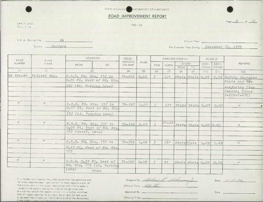
SHA 51 .3-23
Rev. - -4
:TA:E HI 3HVMY^BNISTRATION OF MARYLAND
ROAD IMPROVEMENT REPORT
HPS -20 P^-^Z- of _^±_
5.H.A. DisT'icf No . S4
County Ha r ford
City or Town
For Cclendar Year Ending December HI. i 9 74
ROAD NUMBER
to NAME
LOCATION DESIG- NATIONS ON MAP
MiLES CHANGES MADE IN MILEAGE
REMARKS FROM TO TYPE WIDTH SYSTEM ADDI-
TIONS ABAN- DONED FROM TO
('l i' (3) (4) (5) (6) (7) (3,: (9) (10) ('•') (12)
US Rte.40 Pulaski Hwu, E.B.R. Md. Rte. 112 to 74-U6 0.0<3 T 12' State State 0.0^ 0.06 Safetu Tmnrove— 0,06 Mi. West of Md. Rte. Ments and Re- IIP (Rt. Tnr-ning J.nno)
Constr, Plans H-618-1-470)
it n E.B.R. Md. Rte. 152 to 74-1U7 0.07 I 12' State State 0.07 0,07 a 0 0.07 Mi. West of Md, Rte
152 (Lt. Turning Lane)
n 11 E.B.R. Md, Rte, 152 to 7U~1U8 0.05 T 2'-24
State State O-OS O OS it 0,05 Mi. East of Md. Rte, 152 (Accel. Lane)
11 E.B.R, Md, Rte, 152 to 74-U9 1,49 I 24' StateBtate 1.49 1,49 it
0,17 Mi, West of Md. Rto 775
. it n E,B.R, 0,53 Mi, West of 74-150 0,09 I 9' State State 0.09 (3,09 n
Md, Rte, 775 (Lt, Turnin, r Lan^ TOTALS
It rS hereDv cert, nee b> -re .rdef, 5"fc rhal "he oddirlors ond
'f-. S'ors 'epor-ea eocr .ecr pcrtaii -o roods iegolly a porr of
r^e co_r.f, one 3- - „' c.p:: -ooc lysrem one r r'e to %ant is
• es-fd in -ne co-sv^-ec authoriliai of the poaticol sub-
division for »h,ch rK« report is filed . Ir s F»rth«< ce-r.fied
•n.at all -ooas repc-ec hcrc.n she: be o' .eosr 30 feet wide
or a» spec.r.ea in Sec-.or US o. Art.ce 25 o* the Ar.noforea
Prepared By: , .^-. Ss~^ t<f\ .^^^L^^t^- A -
Official Title: ^V^- J^ ^
Approvea By:
Off.cial Title:
Dote
Dor*
y/-^- 7^
as
si ^
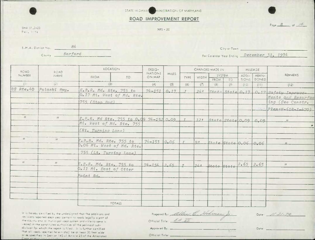
SNA 51 .3-23
Rev.
STATE hi :•• ^^.'.INI STRATI ON OF MARYLAND
ROAD IMPROVEMENT REPORT
HPS - 20
'sge. .s_ =f_^_
S.H .A. District No.
Cour-.'y
54
Harford C ify or Town
For Ccendor Year Eyeing December 31, 197^
ROAD NUMBER
ROAD NAME
LOCATION DESIG- NATIONS ON MAP
MILES CHANGES MADE IN Ml LEASE
REMARKS FROM TO TYPE WIDTH
SYSTEM ADDI- TIONS
ABAN- DONED FROM TO
(i' - (3) (4) (5) (6) (7) (3} (' (10) (") (12)
^5" RteAO Pulaski Hwy, E.B.R. Md, Rte. 755 to 7A-151 0-7 7 J Pi> Sfnfo Stn + o n. 77 n 77 0.17 Mi. West of Md. Rte.
Ments and Resurfac 755 (Ston Pad) ing (See Constr.
^ 7 rtn a U £l & 7 / 'T/O \
it n E.B.R. Md Rte. 755 to O.C 9 74-J5P O.OQ T IP' Stnfo R+nfQ n.no n no ft
Mi. West of Md. Rte, 755 9
(Rt. Turnina Lane)
a n Z.B.R. Md, Rte. 755 to 74-1^3 0.0^ T Q' ^tn i" o CH- n + a n n/C A /^t^r ).06 Mi. West of Md. Rte.
UmUb |
755 Cf.t. 'Turnrnp r.nna)
it it E.B.R. Md. Rte. 755 to 74-7^4 P. ^^ T OJ. 1
C-t- r* 4- ~. 2.65 2.^5 tt
0.11 Mi. East of Otter "- ^ • « 1) U (- t-1— Sta te
*oint Rd.
TOTALS
If s fiere0> Cfrt.-lec by -l-.e jraeriigned rhot fhe additions and
•f- sons 'epor-ea eoc- vec- pe-o;r. -D 'oads legally a part of r'1e CO«.nty anj o: mupieipal 'ooc s«5'»r- o-ia t t'e to some is
• ested In rr,, co^st'-jtec oofhciiies of 'he politico! sub-
divisior for «h,cK -tie -eport 1] f.led. Ir is farther cen.fied
fho» all -ooas -epc-ec herein shoi ce at ecsr 3C 'eet wide
O' as soee.'iec n Sec-.o^ US al Art c^e 25 o( the A.-notofea
Prepared By: ^r^^^r^^ £>• ~S&?~?CK*C**-*^ J^, PPG
Official Title: ^-^ J5
Appraveo By: .
Official Title:
Date: y/^/-7^
Dat«
to c
5
Oi
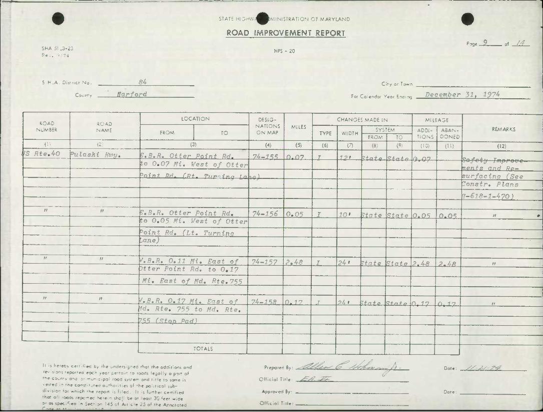
ShA 5! .3-23
STATE HI3'-.-.;^^),V,IMSTRAT;ON CF MARYLAND
ROAD IMPROVEMENT REPORT
HPS - 20 "^ge- of_Z£.
S.H.A. District No.
C DL rt v
84
Bar ford
City or T own
For Co:endor Year Ending December 31, 197^
ROAD NUMBER
ROAD NAME
LOCATION DESIG- NATIONS ON MAP
MILES CHANGES MADE IN MILEAGE
REAtARKS FROM TO TYPE WIDTH SYSTEM ADDI-
TIONS ABAN- DONED FROM TO
(" U; (3) (4) (5) (6) (7) (8) (9, (10) (11) (12)
'S RteAO Dulaski Hviy, V.B.R. Otter Point Rrl. 74-1^ oTn7 I 1 pt Q-f/-. + ^ fii r\n to 0,0? Mi. West of Otter bafcty Improve-
nents and R0— ^Oint R<i- rQ+. T,,^ ir^n in l«J surfacing (See
7onstr. Plans
v-618-1-470)
tt n V.B.R, Otter Point Rd, 74-^5^ 0.05 I 10' Hate State 0.05 0.0s . m to 0.05 Mi, West of Otter
^oint Rd, (Lt, Turnina Mne)
it n S.B,R. 0,11 Mi, East of 7^-157 2,48 I 24' Itate State 2.48 2.48 n Itter Point Rd. to 0,1?
Mi, East of Md, /?*«?, 755
a ii S.B.R. 0,17 Mi. East 0* 74-1^R 0- 77 .7 P4t ^tn f 0 ^+n + r> n 77 O 7 "7 ff W. Rte. 755 to Md. Rte.
^S ffHnp Pad)
TOTALS
lr s hereov can RM by -he ^r-derjgrec thot the oddltions and r»> sons 'epor-ea eocr' >«:• pertain -o roods legolly o port of the co^nt, ona si mupicipel rooc irrer- ond ritlf to seme is -esfed In 'ne eentfitutad OuHioritid of 'he peliticol sub- dlvis.or tor «n,ch rKc report It filed . Il ^s furthai canifiad tnat all -ocas repc-ec hatam s^c; ba o' ecs' 30 feet wide o- as spec.r.eo In Sacfion 145 of Art.cie 25 o( the ArrTototea
Piepored By: ^^^^^ ^^ktC^^^-/} - Dote: //'^/s''?
Official Tide: ^^ -^T
Approv eo By:
Official Title
Date:
T 33 m
en ^
I o>
ID
ShA 51 J-23
P e •.. ) - 4
STATE hi 3^'.-.^^DNMNlSTRAT;ON OF MARYLAND
ROAD IMPROVEMENT REPORT
HPS - 20
J3ge. 2Q- J -/±.
S.H.A. District No.
Courty
S4
Harford City or Town
For Coiendor Year E-.cing December 31t 197^
ROAD NUMBER
RCAD NA.V.E
LOCATION DESIG- NATIONS ON MAP
MILES CHANGES MADE IN MILEAGE
RE//. ARKS FROM TO TYPE WIDTH SYSTEV ADDI-
TIONS ABAN- DONED FROM, re
(2 (3) (4) (51 (6) (7) (Si W (10) (11) (12)
IS Rte.AO Pulaski Hwu* V.B.R. Ottvr Pnfni- RHt fn 7^-1*5 r\%r\n J 101 ^fnfn n n'v 3.07 Hi, East of Otter
Safety Improve- MOD f" Q n ri H Dr>
Pr,in+ DH, (Rf l T'vrninr surfacino (See Lane) Donstr. Plans
M-618-1-4-70)
" it '/.B.R. Otter Point Rd. to 74-3 60 0-05 J 9' rta t Q Slate O.OS o.ns — ——_ 3.05 Mi. East of Otter ^n jPTij—/ mnrnup— i_
r.ents and Re- >oint Rd, CLt. Turnino
surfacing (See
..ane) ^onst r. P7an«j , ff-6l8-l~A-70)
M n S.B.R. Otter Point Rd, tn 1U-161 o,os r or K+^+^
3.05 Mi. West of Otter U.05— 0.05 u.
-'oint Rd. {Accel. Lane)
n " /.B.R. 1,14 Mi. West of 1U-16? o.of. T int I** 4. - 0.0^ 0.0^ a
Otter Point Rd. (it. —^^ cfauijij peuEe
— ''urninn l.ano)
TOTALS
It .s hereov cert ••ecc, —t .-ders gntd fhot the additions and 'r-. s.or. rgpot.fg ^QCP ^ec. =er.a;n ,0 ^g^ lejoily o par- of
",* CO^r.-, gna j. _ „ ; p., --,0,- 5,s-»^ ~-c . ,le t0 ^^n^ j,
• es'ed in me conjt.-jtec a^-'-or.rles of th< political sub-
division foi «t>,ch rK« report s Filed. It is farther cen,fied
tr.ot all -ocas repc-rec hatc.n she. b« ol cost 30 feet w.de
o- as ipaeifiM n Sec- or \4i ai An c e 25 of the Ar.notcfeo
Prepared By: ^fjZ&L^ tZ^ yt^TZ^Z**.*--/n
Official Title. ^S? Z^"
Approvea By:
Official Title
Date:
Dote
//'^S-^
ShA 5' .3-23 Rev. ? T4
STATE :-i 3- ^^.MNlSTRATION OF MARYLAND
ROAD IMPROVEMENT REPORT
HPS - 20
'tjge. a of-^L
5.H.A. District No.
Court v
8^
"•-" "^"^
C > t y or T DWn
For Co.endor Yea, Ending Jecefflber 3^. 35?^
ROAD NUMUR
ROAD NAME
LOCATION DESIG- NATIONS ON MAP
MILES CHANGES MADE IN MILEAGE
REMARKS FROM TO TYPE WIDTH SYSTEM ADDI-
TIONS ABAN- DONED FROM i u
(1 P) (3) (4) (5) (6) (7) (3) (9) (10) (1!) (12)
U S Rte,40l 'ulaski Hwu, /, R, B. AfW. fi>fVl 7^^ f* ih-lf,^. n,n6 J 7P» If a f P S±a_te 0.06 0-06 ^nfofu Tmni^nno^
0.06 Mi. East of Md. Rte, nents and Re-
x£^—Cfitt—Turning Lane)
• •" " D lans
H-618-1-470)
n n S.B.R. Q,ll Mi, West to 7^-164- 0,17 J 12' Itate State 0.17 0,17 II 0 3.06 Mi, East of Md, Rte,
755 (Lt, Storaqe Lane)
it n •/,B,R, Md, Rte, 755 to 7U-1G5 1.49 r 2Ui -if n f o Qfnfo 1 Ao 1 A a btlS Mi. East o* Md. Rte, 152
it n j.n.R. n. 16 m. p„»* „^ IL-IZZ n i £ i •»/ • ~*j. ± State ).16 0,16 tt
fd. Rte, 152 to Md, Rte, *•< • p tu te
152 (Stop Pad)
it n f.B.R. 0.34 Mi, Vest of 7^-167 0.06 j 10' .Itafe S + nfo 0.06 O 06 ff
Id, Rte, 755 (Lt. Turning jane)
TOTALS
ll s he<ecv cen^ec t, rhc .-den gncd rttol rhe oddlflons ond r»v s-ons reported eocr- ,ec- pertain :D roocs ^ego.iy a por of 'he co.rt, ano ;• -^ c.pi rooa s<5-ef- one title to «»ne .5 •«'ed In me eorqfituted Duthotitiei of the pelittcol iob- di.s.o.- fei «h,cK rhe -eoct .s Filed. Ii it f^the- certified tnot c^! -oooi repc-ec '•«•»." sno, Lt c cost 30 feet vide O' as spee.fleo n Sec- o^ 145 ol Art cle 25 of the Arootorea
Prepared By: ^Z^is^ s^ ^4y£*r^
Official Title: -^W -^^
•M Dote: //'^S^
Approveo By:
Official Title:
Dot 1
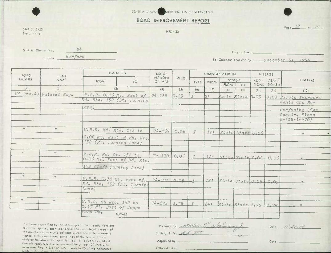
ShA 5] .3-23
Rev. J "4
STATE HIDr-.-.AT^^-.INISTRATiON OF VARYLAND
ROAD IMPROVEMENT REPORT
HPS - 20 P^ge.
12 of _Zf_
S.H.A. Distrid No. 84
Co.n.y Ear ford
C if y or Town
For Calendar Year E.naing J) Q n Q7r[h o r* 7 7 1 0*7^
ROAD NUMBER
ROAD NAME
LOCATION DESIG- NATIONS ON MAP
MILES CHANGES MADE IN MILEAGE
REM.ARKS FROM TO TYPE WIDTH SYSTEM ADDI-
TIONS ABAN- DONED FROM, TO
(i (2) (3) (4) (5) (6) (7) (3; W (10) {") (I2) f/5 flte.40 Pulaski Hwy, W.B.R. 0,16 Mi, East of 7^-168 0,03 J 8' t'tate Hate D,03 0.03 ^df Q'tii TmnmiiOmm
I M, Rte, 152 (Li, Turning lents and Re- ,ane)
lonstr. Plans f-618-1-470)
rf 11 V,B,R, Md. Rte, 152 to 7^-169 0,06 J 12' State State o*n6 0,06 Mi, Fast of Md, Rte. 152 (Rt, Turninn fnno)
'
n W.B,R. Md, Rt, 152 to 7^-170 0,06 J 12' Stnfo ^fni-o n rtC 0.06 Mi, East of Md, Rte, U.06 "
. ^ 1^2 (Left Turninn r.nn*)
>i M V.B.R. O.W Mi. Wost nf 74-7 7 7 n n^ IP* Q + n + n
Md, Rte, 152 (Lt, Turninr Lane)
—J oratg Q,05 0.05 "
n 11 V.B.R. Md Rte, 152 to 7^-172 1,78 J 24' ^tnfo C+n + si 1 no 0.1? Mi, East of Joppa
*arm Ha* TOTALS
It s lereov eartifiad by the und«nign«d that the oddirioos and •-«-• liieiM 'epor-»o eoc- ,ec- cfo-r -o roods l«gally a part of t->e c^r-, an; or m&< c.pa; rooa s-srer- ana ritt« la iome is >«««d In iti« cons'.-jtec authofitie of -he poliilcol sob- div.s.or fo. «h,ch 'he report Is Filed. It Is father certified rhol a;: rooas -epc-ec h*r« - sne; De a' eos' 30 'eet wide O' as spec.Tea in Sec- or, 145 E>1 Article 25 o' the Ar.notatea
Prepared iy. ^o^Z^Z^ /ZT ^^zf^^**^-^X .
Official Title. ^"^^^2
Date: x^^7/ S*?
Approvea By:
Official Title:
Date:
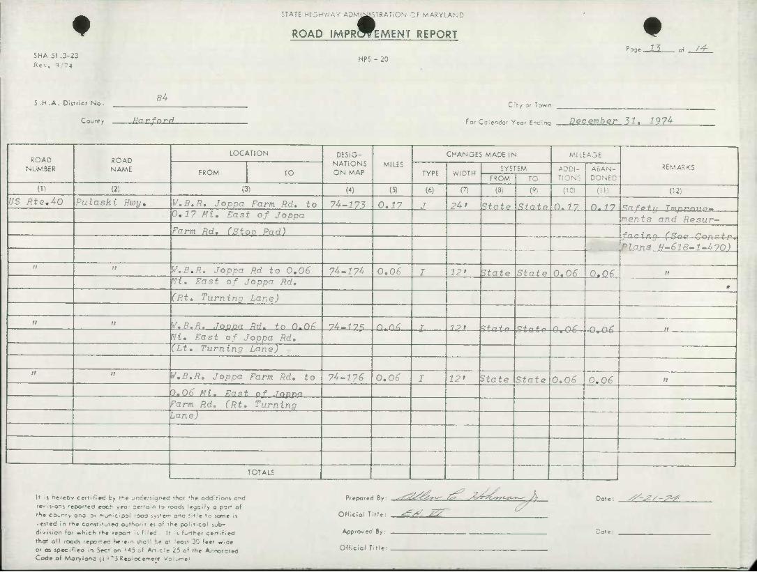
SHA 51 .3-23
Rev. 3 -4
STATE HI 3HWAY AD,V:J^STRAT10N OF MARYLAND
ROAD IMPRWEMENT REPORT
HPS - 20
^ge JJ. .i /-f
S.H .A. District No. 84
County Harfnrcf
Cit V Of 1 own
For Cciendo.- Year E-C:ng December "51, 1974-
ROAD NUMBER
ROAD NAME
LOCATION DESIG- NATIONS ON MAP
MILES
CHANGES MADE IN M.1LEA3E
REMARKS FROM TO TYPE WIDTH
SYSTEM ADDI- TIONS
ABAN-
DONED FROM TO
0) {2; (3) W (5) (6) n (3) W (10) (il) (12)
US Rte,40 Pula ski Hwy, W,B,R. Joppa Farm Rd, to 7^-173 0,17 J ?4» State State o. 77 n. 77 £!n fof 11 Tmnt*r*jio~ 0,1? Mi, East of Joppa ments and Hesur- Farm Rd. CSton Pad)
Plan3 ff-6]8-1-47(1)
a n I'/.B.R. Jopnn Rd to 0,06 7^-174 0,06 I 12 > State State 0.0^ 0.06 >r Mi, East of Joppa Rd, » (Rt, Turning Lane)
ti tt W.B.R. Joppa Rd, tn n.DZ 7^-77S nTn< I 12* ^tatr State O 06 O 06 tt
Vi. East of Joppa Rd, (Lt, Turning Lane)
n u V,B.R, Joppa Farm Rd, to 74-^7^ 0,06 I 12' State State 0.06 0.06 tt
0,06 Mi, Fast of Joppa Farm Rd. (Rt, Turning
Lane)
TOTALS
It ^s herebv certified by the jr.deri.gre4 thct the additions and
rt«i«<en] -epor-eo eocr yeo- ier-an to roods legally o part of
rHe co,nrv ana or —unicipol rooa system and t't'e to some is
- ested in rne censtt'^ted autHofr'es o' rhe political sob-
division for >»hicli the repot s ^'ec It ii further ce-tified
that o'l ocas repc-tec h*-ein snd se at 'eost 30 feet o.ae
or aj specifiea 1 Sec'on 145 cf Art.c.'e 25 of 'he A,-notated Code of Mar-yionc <i '~iRepioce'^enf Vo ^r-ei
Prepared By: ^ZS&ZSir^ Z^ ytrV-zCort-*^— A Dote y^-J?/-^
Official Title:
Approvea By:
Official Title:
cs
^ 1^ Co
fifp ..
% I
f SHA 51 .3-23 Rev, 9 74
STATE HIGHWAY AC^^ISTRATiON OF MARYLAND
ROAD IMPRWEMENT REPORT
HPS - 20
3ge . JA of _Z±.
S.H.A. District No.
County
,34. Harford
City or Town
For Colendar Year Enaing Doromhor ^7( 7Q74
ROAD NUMBER
ROAD NAME
LOCATION DESIG- NATIONS ON MAP
MILES
CHANGES MADE IN MILEAGE
REMARKS FROM TO TYPE WIDTH
SYSTEM ADDI- TIONS
ABAN- DONED FROM TO
(li (2) (3) W (5) (6) (7) (3) w (10) (11) (12)
US Rte.4C Pulaski Hwy. W,B.R, Joppa Farm Rd, to 7^-177 0.06 I 12' State Stats 0.06 0.06 Safety Improve- 0,06 Mi. East of Joppa
Farm RH. (T*. Turning facina (See Constr* Lane) Plans H~6l3-l<J+70)
it tf V.R.R. Joppa Farm Rd. to 7^-178 0.16 J 24 » State State 0,16 0,16 tt
Little Gunpowder Falls 0
-c V >fd, Rte.l5i >1 Idino Kd, Pte. 2? to Md. Rte. 7^-179 l.oo >T^ 20 > Strto Stnfo i, on % QO Po <sii r*•fnr* i n rt nn H
155 Wideninq H-676-U77
TOTALS
It is hereDv certi^ed by the jrdervgned that the additions and
rev sions -epor-ec eocn year perroin to roods iegoily a port of
the COcnty anc or -^^rcipal rooo sysrer-i ond t-t'e to same is
• ested in tne constitutea authorities of rhe po'ittcal sub-
division for which the report i| filed \•. s farther certified
that all rooas repctec he'e«n snci: te or .'ecsr 30 ^ee* w.ae
or as specifiea In Sect or-. 145of Art.cle 25 of the Anototec Code ot Moryianc (; ^ "i Repiocemem /o .r^e'
Prepared By: --F^^^— /^T- ^ttZ^*c*L~~ 1
Official Title: ^4? -J^
Approvea By: ,
Official Title: ,
Dct«
Dote:
^-2/-^
OT ATE P. 0. Box 71
HIGHWAY ADMINISTRATION H/^r^^D 7 I 300 West Preston Street. Baltimore, Maryland 21203 '
MEMORANDUM
To.
FROM:
:CT
Mr. Harry J. Pistel District Highway Engineer District #4 - Brooklandville, Md; Mr. Clyde P. Hyatt,Chief Records Statistics Section Bureau of Highway Statistics
Route Number Assignment
October 24
Upon completion of relocated Md. Route 24 from the junction of Md. 755 south of U.S. 40 to a point south of the Penn Central Railroad, the following route number changes will be made.
The new road will carry the Md. Rout^ 24 designation and the old section of Md. 24 (Edgewood Road) will be designated-Md. 755 from the junction of Md.:
24 southerly to a point south of the Penn Central Railroad. Enclosed is a map segment indicating the changes as outlined above.
Should there be any additional information required regarding this matter, please advise this office.
•
mt
Enclosure
Copies to; A.W. Tate C." E. Caltrider R. Davison G. Hermes T. Hicks P. Jaworski L. McCarl B. Stewart R. Ward
J. White A. Yurek Sgt. J. Harvey *C. R. Anderson W. Knipple ^ P. Becker D. A. Wiles W. Hicks
SHA-20.01
ft-7-72
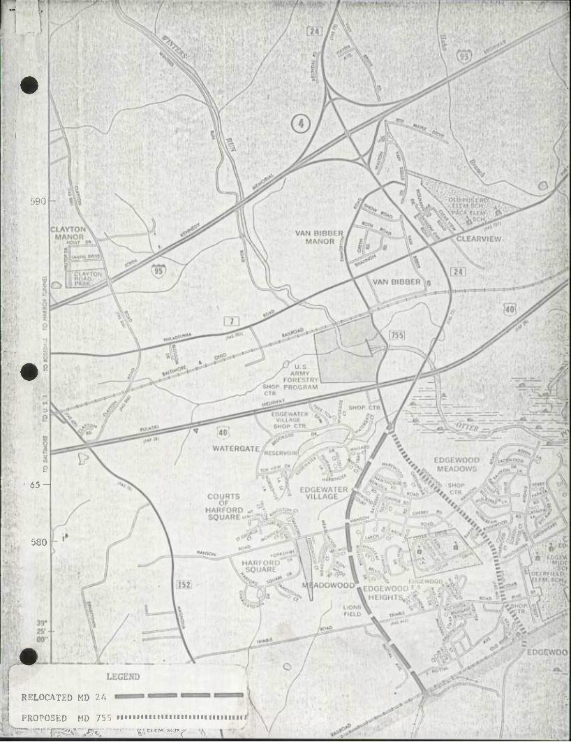
590
65-
580
RELOCATED MD ?.A
PROPOSED MD 755 tiMiiimiummiiiiiiimiiiri
li-^lOK' ^ " * "• V??
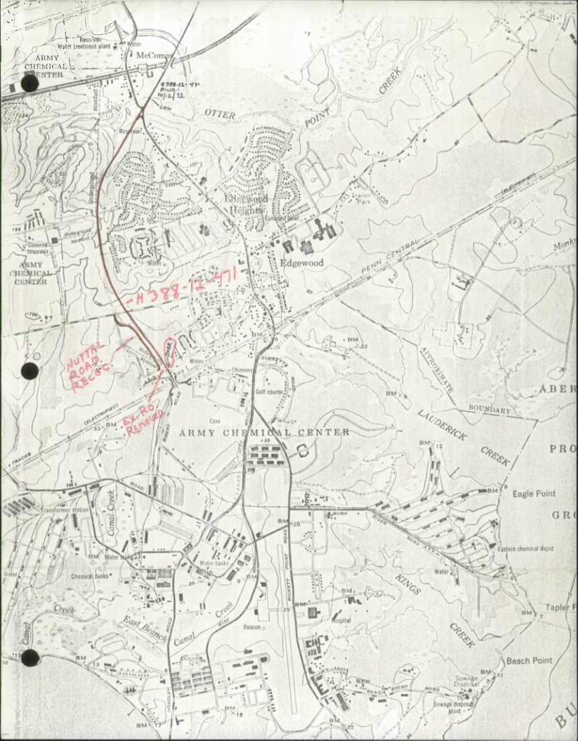
\ i ^ - Wilwlrw
' .- ARMY , ^CHKMICALL.
.; r^^'
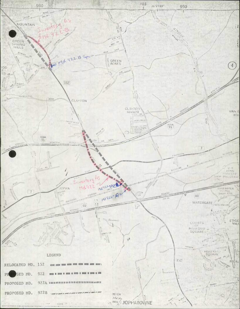
fiw-11
FOUNTAIN
A SI'HING i \ HILLS
A^^
T
\^V
^e ^v-' \ GRTTN !ACRLS
: **•'
' fBANKLINVlUt
A CLAY ION
rAHCB
.o 95 OK^f-
®,
• > \ VAN M;
\ -
JOPPA f^^^W.
riHvJ^_
:..^ V- 40,
* n
,c<^
V
LEGEND
RELOCATED MD. 152 tmmkwmwmmtmnmwm^m\
PI^fcsED MD. 922 « i •• i— •••••"••• •
PROPOSED MD. 922A IIIHI IMHUIHIUIIMMI
PROPOSED MD. 922B ,^^~——•'—'-"-"-'
\Kearn<oir
\
?
/HESI RVOIRL
LDGC VILL CO I
•
HAK'I ORL) „, SQUAUI •
— . \ \, HAHFOUD ' " SQUARC
• ,«»•»;'
••/'"^JOPHATOVVNE •v\
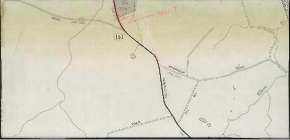
r'^
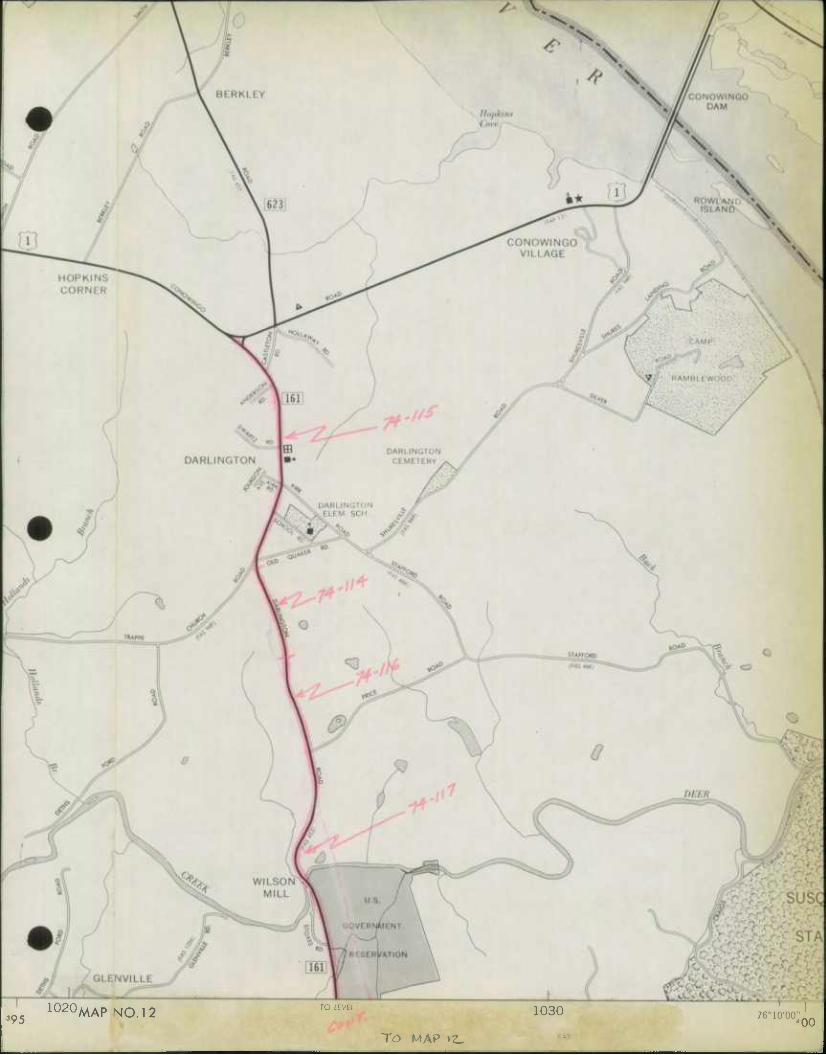
395 1020MAP NO. 12 TO LEVEL 1030 76°10'00" 00
T<3 MAP »Z.
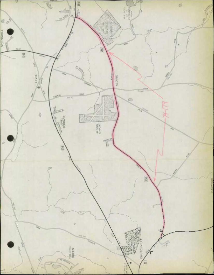
V ^"9*
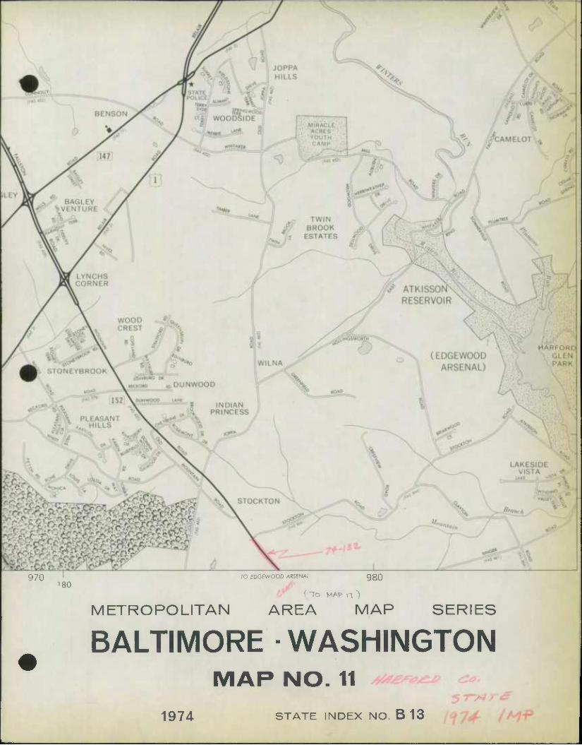
970 TO EOGEWOOD ARSENAL 3 80
980
( ~7o MAP n ")
METROPOLITAN AREA MAP SERIES
BALTIMORE • WASHINGTON
1974
MAP NO. 11 y^^>^ c
STATE INDEX NO. B 13 7^
^ «r ^ ^ * ^
- •S |
i 1 ^
^ <^ ^
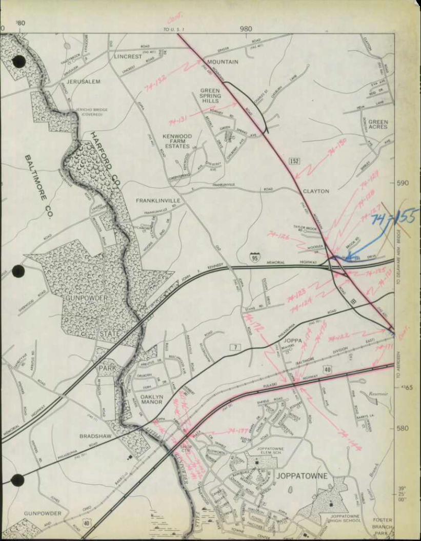
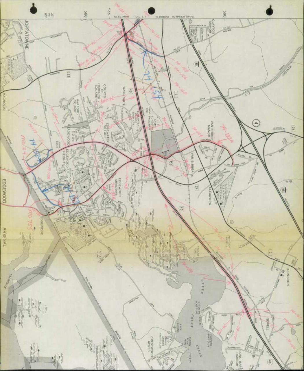
* 4
<:
ill: KiliJlHIIJUliiS;,]*.* iil,i.lll.lilU j
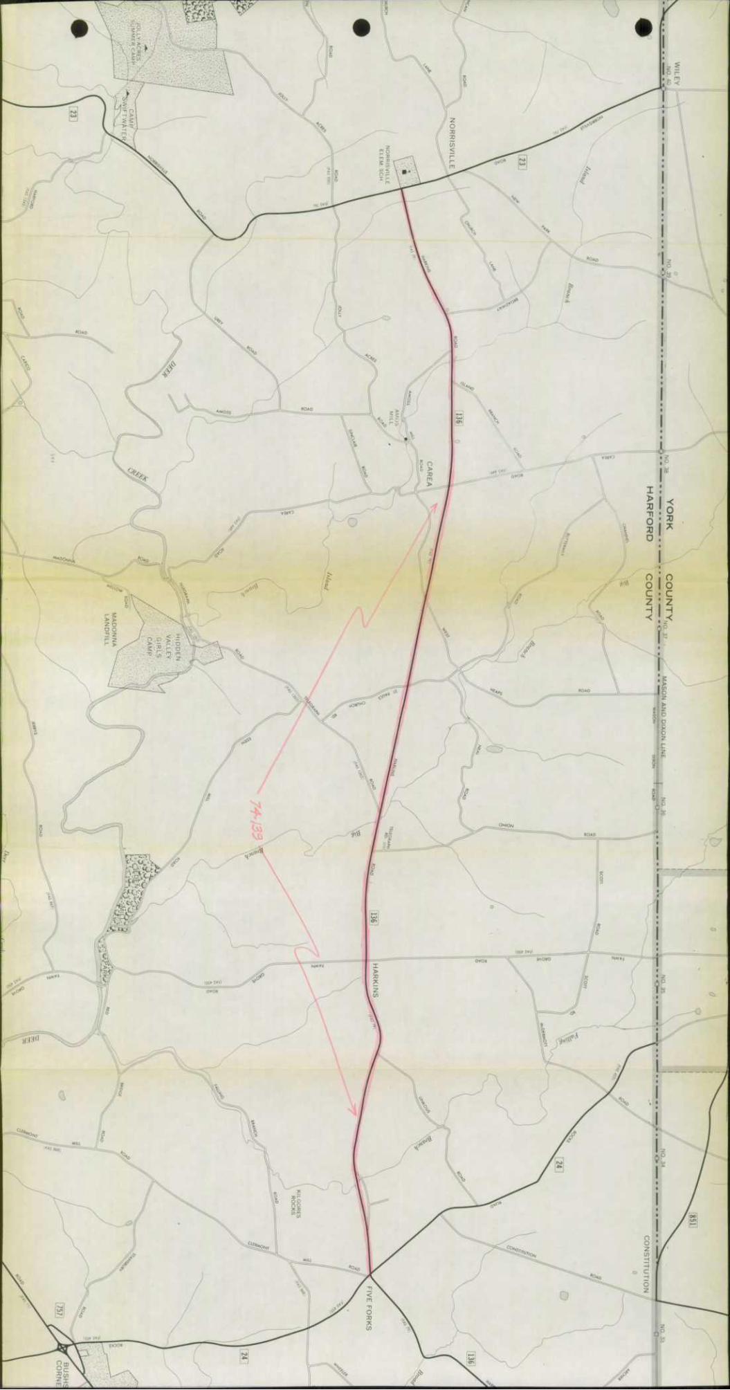
'wi«m>i*m<imiiimMinMiiiipi>ipiniiinfiiii •
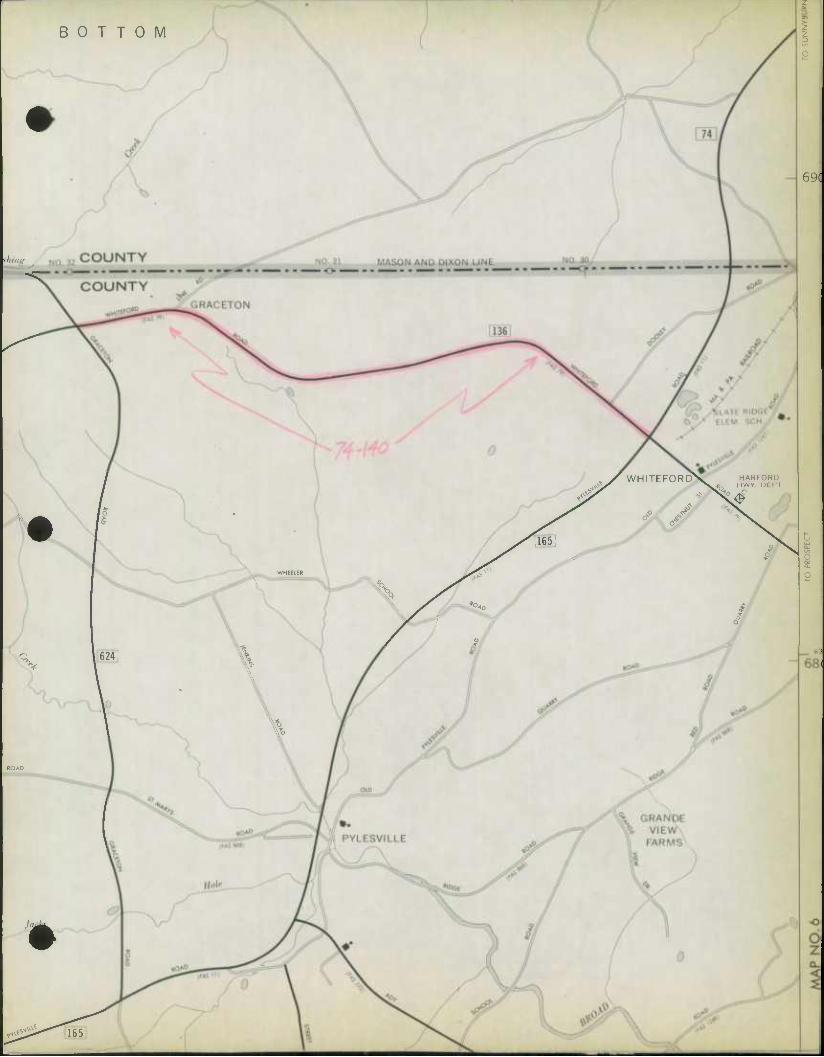
BOTTOM
69(
WHITEFORD>v HARFORD ^ * HWY DF PI
^4
%
%
165
o 1 I o
sW%
/773
DEPARTMENT OF PUBLIC WORKS
WILLIAM BRZOZOWSKI Director
December 12, 1974
Thomas L. Cloonan, Chief Bureau of Highways Statistics Maryland Department of Transportation State Highway Administration P. 0. Box 717 300 West Preston Street Baltimore, Maryland 21203
Re: Highway Mileage - County
Dear Mr. Cloonan:
In resoonse to your letter of October 15th requesting a report on the additions, deletions and improvements to our high- way system for the calendar year ending December 31, 1974, we are forwarding herewith the completed forms and maps.
We trust this is the information you desire.
Very truly yours.
William Brzozowski Director
liB:CS:tgg
Enclosures
45 SOUTH MAIN STREET/BEL AIR, MARYLAND 21014/(301) 838-6000
S&PSQ,
im
DEPARTMENT OF PUBLIC WORKS
WILLIAM BRZOZOWSKI Director
January 3, 1974
Mr. Thomas L. Cloonan Chief, Bureau of Highway Statistics State Highway Administration P.O. Box 717 Baltimore, Maryland 21^03
Dear Mr. Cloonan:
In re: Road Additions Harford County, Maryland
Transmitted herewith is one copy of our road additions and maps 5, 11, and 12 of the Metropolitan Area Maps showing the locations of these new additions.
Very truly yours.
William Brzozowski, P.E. Director
WB:WEJ:lkw Enc.
45 SOUTH MAIN STREET/BEL AIR, MARYLAND 21014/(301) 838-6000/879-2000

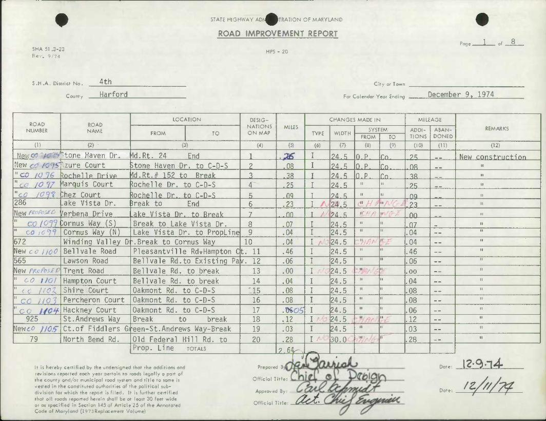
SHA 51 .3-23 Rev. 9/74
STATE HIGHWAY ADN^WRATION OF MARYLAND
ROAD IMPROVEMENT REPORT
HPS - 20
Poge . of 8
S .H .A . District No . 4th
County Harford
City or Town
For Calendar Year Ending December 9, 1974
ROAD NUMBER
ROAD NAME
LOCATION DESIG- NATIONS ON MAP
MILES CHANGES MADE IN MILEAGE
REMARKS FROM TO TYPE WIDTH
SYSTEM ADDI- TIONS
ABAN- DONED FROM TO
(1) (2) (3) (4) (5) (6) (7) (8) (9) (10) (H) (12)
Newer u&tt ̂ to/ie Haven Dr. Id.Rt. 24 End 1 .& 24.5 O.P. f.n. ?R New construrtinn Mew zure Court )tone Haven Dr. to C-D-S 2 .08 24.5 O.P. Cn. nfl n
" co IO 16 ^ochelle Drivp 1d.Rt.# 152 to Break 3 .38 24.5 n.p. Tn. 3« n
"cc /Of/ larquis Court U)chelle Dr. to C-D-S 4 .25 24.5 ii n .25 n
"cc iOyi "Mez Court tochelle Dr. to C-D-S 5 nq ?4 ^ ii n 09 n
286 .ake Vista Dr. 5reak to End 6 .23 24.5 n II .23 n
New <'' /erbena Drive .ake Vista Dr. to Break 7 . nn 90. «; n II 00 II
" CO loil )ornus Way (S) Break to Lake Vista Dr. 8 .07 24.5 n II .07 n
" CO ,0^ Cornus Way (N) Lake Vista Dr. to PropLine 9 .04 24.5 n n .04 -- n
672 Winding Valley D -.Break to Cornus Way 10 .04 24.5 II II .04 "
New co iicC Bell vale Road Pleasantville Rd-rHampton C t. 11 .46 24.5 M n .46 -- n
565 Lawson Road Bell vale Rd.to Existing Pa v. 12 .06 24.5 M II .06 -- M
New fKcfc Trent Road Bell vale Rd. to break 13 .00 24.5 M n .00 -- II
" co tlOl Hampton Court Bellvale Rd. to break 14 .04 24.5 n II .04 n
" 11 not Shire Court Oakmont Rd. to C-D-S '.15 .08 24.5 n n .08 n
" cc not Percheron Court Oakmont Rd. to C-D-S 16 .08 24.5 II II .08 -- n
"cc ItOV Hackney Court Oakmont Rd. to C-D-S 17 .ttCS 24.5 M II .06 "
925 St.Andrews Way Break to break 18 .12 24.5 N II .12 -- II
^lewd^ /JCT Ct.of Fiddlers Gi •een-St.Andrews Way-Break 19 .03 24.5 n n .03 -- n
79 North Bend Rd. Old Federal Hill Rd. to 20 .28 30.0 II II .28 _ — n
Prop. Line TOTALS 2.64^ .^•^
T >) O t
It is hereby certified by the undersigned that the additions and revisions reported each year pertain to roads legally a part of the county and/ar municipal road system and title to same is vested in the constituted authorities of the political sub- division for which the report Is filed. It Is further certified that all roods reported herein shall be at least 30 feet wide or as specified In Section 145 of Article 25 of the Annotated Code of Maryland (1973Replacement Volume)
Prepared 8
Official Title
Off
Approved By. _
icial Title: C^C^%
Date:
Date:
12-^4.
/t////??
-0

SHA 51 .3-23 Rev. 9/74
STATE HIGHWAY ADA^MTRATION OF MARYLAND
ROAD IMPROVEMENT REPORT
HPS - 20
Page. of
S .H .A . District No . 4th
county Harford
City or Town
For Coiendor Yeor Ending December 9. 1974
ROAD NUMBER
ROAD NAME
LOCATION DESIG- NATIONS ON MAP
MILES CHANGES MADE IN MILEAGE
REMARKS FROM TO TYPE WIDTH
SYSTEM ADDI- TIONS
ABAN- DONED FROM TO
(1) (2) (3) (4) (5) (6) (7) (8) (9) (10) (H) (12)
New,.- Ralton Drive N.Bend Rd.to Break 21 .00 I 24.5 O.P. Co. .00 _ _ New construction c;^ not Glen Elvn Wav Moore's Rd. to End 22 .26 3n.n II n 9fi M
"c o 110 7 Brandon Hunt La. Pembarton Ridqe to C-D-S 23 .24 24.5 II n .24 _ m " "cottOt Fernwood Ct. GlenElyn Way to C-D-S 24 .08 24.5 II M .08 II
CO JJOI Stevens Court Brandon Hunt La. to C-D-S 25 .12 24.5 II u .12 n
*Ct> Ij 10 Pemberton Ridge Moore's Road to C-D-S 26 .24 24.5 II M .24 M
Vf? nil Morning Side Ct. Pemberton Ridqe to C-D-S 27 .18 24.5 II M .18 M
984 Cypress Drive Break to Break 28 .14 24.5 II M .14 n
Hevicc f//X Leeland Court Cvoress Dr. to C-D-S 29 .06 24.5 II ii .06 M
327 Duncannon Road Break to Rolling Road 30 .19 24.5 II ii .19 — _ H
560 Charter Oak Ave. Break to Duncannon Rd. 31 .11 24.5 II n .11 __ n
New^./zH Charter Oak PI. Charter Oak Ave to C-D-S 32 .09 24.5 II M .09 _ _ n
561 Rolling Road Break to End 33 .10 24.5 II n .10 H
Newco ///¥ Lippizan Court Ryan Road to C-D-S 34 .09 24.5 II n .09 _ — n
"ca ft if Gary Drive Whitt Rd. to Rohe Drive 35 .27 24.5 II n .27 -- n
866 Northcliff Dr. Break to Break 36 .06 24.5 II II .06 -- II
867 wlood Holme Dr. Break to Northcliff Drive 37 .18 24.5 II M .18 n
New II/G Duxbury Court Rigdon Road to C-D-S 38 .19 24.5 " n .19 _ _ n
2^/0^' Rhineforte Drive Break to Break 39 .23 30.0 M n .23 — H
1/17 3enton Court Rhineforte Drive to C-D-S 40 .06 24.5 II •I .06 ._ n
TOTALS 2.89 p, \ /TS ^H
It is hereby certified by the undersigned that the additions and revisions reported each year pertain to roads legally a part of the county and/or municipal road system and title to same is vested in the constituted authorities of the political sub- division for which the report is filed . It is further certified that all roods reported herein shall be at least 30 feet wide or as specified in Section 145 of Article 25 of the Annotated Code of Maryland (1973 Replacement Volume)
Prepared By:
Official Title:
Approved By:
Official Title:
Date:
Date:
4U&<
00
CO
^
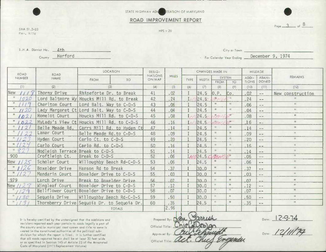
SHA 51 .3-23 Rev. 9/74
STATE HIGHWAY ADA^^TRATION OF MARYLAND
ROAD IMPROVEMENT REPORT
HPS - 20
Poge. of
S.H .A. District No. dth
Harford County
City or Town
For Colendor Yeor Endirv; December 9, 1974
ROAD NUMBER
ROAD NAME
LOCATION DESIG- NATIONS ON MAP
MILES CHANGES MADE IN Ml LEASE
REMARKS FROM TO TYPE WIDTH
SYSTEM ADDI- TIONS
ABAN- DONED FROM TO
(1) (2) (3) (4) (5) (6) (7) (8) (9) (10) (U) (12)
New ///? Thorny Drive Rhineforte Dr. to Break 41 .02 24.5 O.P. Co. .02 __ New construction " I0W Lord Baltmore Wy Houcks Mill Rd. to Break 42 .24 24.5 II M .24 n
" nn Char!ton Court Lord Bait. Way to C-D-S 43 .06 24.5 II n .06 n
" nlO Lady Margaret Ct Lord Bait. Way to C-D-S 44 .04 24.5 II " .04 _ _ •I
" ifill Homelot Court Houcks Mill Rd. to C-D-S 45 .08 24.5 II ti .08 -- H
" fn.z^ MyLadv's View Ct Houcks Mill Rd. to C-D-S 46 .16 24.5 II M ,16 „ H
" 11 2l Belle Meade Rd. Carrs Mill Rd. to Hvden Ct 47 .14 24.5 II 11 .14 m — n
" //22 Lamar Court Belle Meade Rd.to C-D-S 48 .09 24.5 II " .09 M
"1121 Hyden Court Carlo Ct. to C-D-S 49 .20 24.5 II II .20 n
" II1.H Carlo Court Carlo Rd. to C-D-S 50 .16 9A * II II .16 n
" 9.21 Nodleiqh Terrace Break to C-D-S 51 .14 24.5 II II .14 _ _ M
900 Croftleiqh Ct. Break to C-D-S 52 .06 I 24.5 II II .06 n
^lew IIXZ Scholar Court Willoughby Beach Rd-C-D-S 53 .06 24.5 II II .06 n
" 1116 Boxelder Drive Hanson Rd to Break 54 .37 30.0 II 11 .37 _ _ n
" //:: • Mandarin Court Boxelder Drive to C-D-S 55 .03 30.0 II II .03 __ n
979 Larch Drive Break to Bnypldpr Drivp Rfi .07 ?n n II II n? H
New//.; Wingleaf Court Boxelder Drive to C-D-S 57 .12 30.0 II " .12 n
"//,7'l Bell flower Court Boxelder Drive to C-D-S 58 .07 30.0 II II .07 -- M
"//^ Sequoia Drive Willouqhby Beach Rd-C-D-S 59 .50 30.0 II II .50 __ n
"y/5/ Thornberry Drive Sequoia Dr. to Sequoia Dr. 60 .35 24.5 II II .35 ii
' TOTALS 2.96
1 ra i i -^ s~t •* A
It is hereby certified by the undersigned that the additions and revisions reported each year pertain to roads legally a port of the county and/or municipal road system and title to same is vested in the constituted authorities of the political sub- division for which the report is filed . It is further certified that oil roads reported herein shall be at least 30 feet wide or as specified in Section 145 of Article 25 of the Annotated Code of Maryland (1973 Replacement Volume)
Approved By:
Official Title
Date:
Date: /?////&
CD cr
> •<
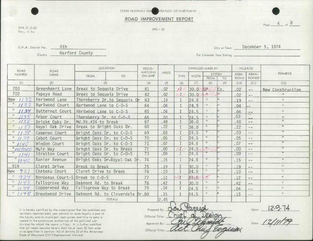
SHA 51 .3-23 Rev. 9/74
STATE HIGHWAY ADA^MTRATION OF MARYLAND
ROAD IMPROVEMENT REPORT
HPS - 20 Poge . of
S.H.A. District No.
County
4th Harford County
city or Town December 9, 1974
For Calendar Year Ending
ROAD ROAD NAME
LOCATION DESIG- NATIONS ON MAP
MILES CHANGES MADE IN MILEAGE
REMARKS NUMBER FROM TO TYPE WIDTH SYSTEM ADDI-
TIONS ABAN- DONED FROM TO
(1) (2) (3) (4) (5) (6) (7) (8) (9) (10) (U) (12)
703 Greenheart Lane Break to Sequoia Drive 61 .02 30.0 OP. Co. .02 __ New Construction 702 Papaya Road Break to Sequoia Drive 62 .02 30.0 II ii .02 __ II
New II M Hartwood Lane Thornberry Dr.to Sequoia D r 63 .19 24.5 II n .19 n
' //^? Burlwood Court flartwood Lane to C-D-S 64 .04 24.5 II n .04 H
1 //3Y Butternut Court Hartwood Lane to C-D-S 65 .04 24.5 II H .04 __ II
1 //^r Arbor Court Thornhprry Dr. to C-D-S fifi m 24 ^ II n .03 II
1 //TiT Bright Oaks Dr. Md.Rt.#24 to Break 67 .48 36.0 II n .48 -- M
1 i/V Royal Oak Drive Break to Bright Oaks Dr. 68 .22 36.0 II n .22 -- H
1 // 5^ Cameron Court Bright Oaks Dr. to C-D-S 69 .03 24.5 II II .03 — H
1 //.19 Cabot Court Bright Oaks Dr. to C-D-S 70 .05 24.5 II n .05 -- M
1 //-yr Windom Court Bright Oaks Dr. to C-D-S 71 .07 24.5 II n .07 -- II
'/ve «srz? Muir Way Bright Oaks Dr. to Break 72 .00 24.5 II i .00 — "n-
' //V/ Stratton Court Bright Oaks Dr. to C-D-S 73 .09 24.b II II .09 -- —n—
"ffVZ Ranier Avenue Bright Oaks Dr-:Royal Oak D '. 74 .15 24.5 II II .15 — n
919 Claret Drive Break to Break 75 .19 30.0 II M .19 __ M
New 7^./ Chateau Court Claret Drive to Break 76 .10 24.5 II n .10 II
" 9^y Bordeaux Court-S Break to C-D-S 77 .12 T 24.5 II II .12 _ _ II
" ;/v? Fallsqrove Way Oakmont Rd. to Break 78 .42 30.0 II H .42 _ _ II
" //W Copperwood Way Fallsgrove Way to Break 79 .04 24.5 II II .04 __ II
" //^S" Brentwood Drive Oakmont Rd. to Cloverdale )r.80 .15 I 24.5 II • .15 — _ II
TOTALS 2.45 .
It is hereby certified by the undersigned that the additions and
revisions reported each year pertain to roads legally a part of
the county and/or municipal road system and title to same is
vested in the constituted authorities of the political sub-
division for which the report is filed. It is further certified
that all roads reported herein shall be at least 30 feet wide
or as specified in Section 145 of Article 25 of the Annotated Code of Maryland (1973 Replacement Volume)
Date: 12^-14
Date /^//^
o Co i
^

SHA 51 .3-23 Rev. 9/74
STATE HIGHWAY ADK^WRATION OF MARYLAND
ROAD IMPROVEMENT REPORT
HPS - 20
Page. of
S.H .A. District No. 4th
County Harford City or Town
For Calendar Year Ending December 9, 1974
ROAD NUMBER
ROAD NAME
LOCATION DESIG- NATIONS ON MAP
MILES CHANGES MADE IN MILEAGE
REMARKS FROM TO TYPE WIDTH
SYSTEM ADDI- TIONS
ABAN- DONED FROM TO
(1) (2) (3) (4) (5) (6) (7) (8) (9) (10) (U) (12)
New //Y^ Cloverdale Drive Rt. #152 to Break 81 .20 24.5 O.P. Co. .20 -- New Construction 11 /yv7 Larchmont Drive Brentwood to Break 82 .00 24.5 II n .00 -- H
" //Vi? Thornwood Court Cloverdale to C-D-S 83 .08 24.5 11 n .08 _ m ir
tt //i'f Lynn Avenue Burqandy to Break 84 .01 24.5 II ii .01 __ n
^et 11% Burqandy Drive Break to Break 85 .30 24.5 II n .30 n
919 Claret Drive Break to Property Line 86 .18 30.0 II M .18 II
New Chateau Court Break to C-D-S 87 .10 24.5 II M .10 n
" f'Td Carriage Court Webster-Lapidum Rd.- C-D-S 88 .05 24.5 II n .05 II
" //S'/ Collptt.p rnnrt YvPttP t.n r- n-s RQ OR 24.5 II •i 05 n
//SA Yvette Court Yvette to C-D-S 90 .05 24.5 II ii " .05 n
" icXG Yvette Drive Bernadette Drive to Break 91 .19 24.5 II M .19 n
" 7/7 Rolling Green Rd Break to Cool Branch Road 92 .27 24.5 II n .27 _ _ n
" 10 17 Whitefield Road Break to Rolling Green Dr. 93 .28 24.5 II ii .28 n
" if.ri Whitefield Court Whitefield Road to C-D-S 94 .06 24.5 II n .06 __ N
" '//.5-T Preakness Road Break to Break 95 .24 24.5 II n .24 __ II
11 / / 6y Derby Drive Break to Break 96 .14 24.5 II n .14 _ _ II
^liSG Hunt Road Derby Drive to Break 97 .06 24.5 II n .06 II
hew 7V^r Preakness Drive Derby Drive to Break 98 .00 24.5 II n .00 « _ II
?r^ Derby Drive Md. # 152 to Break 99 .38 24.5 II n .38 _ _ II
//i 7 Justin Road Houcks Mill Rd. to Break 100 .17 24.5 II M .17 II
TOTALS 2.81
It is hereby certified by the undersignec that the additions ana Prepare i*rUA UJ QteU iL Date: \2-^l4 revisions reported each year pertain to roads legally a part of the county and/or municipal road system and title to same is vested in the constituted authorities of the political sub- division for which the report is filed. It is further certified that all roads reported herein shall be at least 30 feet wide or as specified in Section 145 of Article 25 of the Annotated Code of Maryland (1973Replacement Volume)
Official Title:
Approved By:
Official Title: .
^ ... /^////7f
"3
• 'I C. O
-<
05
SHA 51 .3-23 Rev. 9/74
STATE HIGHWAY AD^^^TRATION OF MARYLAND
ROAD IMPROVEMENT REPORT
HPS - 20
Page. of
S.H.A. District No.
County
4th Harford
City or Town
ForCalendar Year Ending December 9. 1974
ROAD NUMBER
ROAD NAME
LOCATION DESIG- NATIONS ON MAP
MILES CHANGES MADE IN MILEAGE
REMARKS FROM TO TYPE WIDTH
SYSTEM ADDI- TIONS
ABAN- DONED FROM TO
(1) (2) (3) (4) (5) (6) (7) (8) (9) (10) (11) (12)
New //S% Marcus Court Justin Road to C-D-S 101 .21 24.5 O.P. Co. .21 _ _ New Construction " //r? Twin Oaks Road Md.#165 to Prooertv Line 102 .34 24.5 II n .34 11
" //so Bishop Lane Meriweather Dr to Dellwood -N 103 .11 24.5 II 11 ,11 n
" /on Meriweather Driv ! Break to C-D-S 104 .77 24^.5 22 11
" nti Dell wood Drive S Millwood Drive to C-D-S 105 .13 24.5 II 11 .13 n
//£/ Dell wood Dr. N Millwood Drive to C-D-S 106 .23 24.5 II n ,?3 n n 1071 Millwood Drive Break to End 107 .31 24.5 II 11 .31 11
" 7^2 Larchmont Drive Break to End 108 .37 24.5 II n .37 _ ^ M
" 77-?/ Cloverdale Dr. Break to Larchmont Dr. 109 .25 24.5 II 11 .25 __ H
" :• i Kimberton Road Cloverdale Dr.to End(Unimp ) 110 _ II 11
"ffc. Harford Sq. Dr. Hanson Road to Break 111 .34 30.0 II n .34 _ _ 11
"I/Ci Yorkshire Drive Harford Sq.Dr. tn Break 119 .in 24.5 II 11 10 n
" //ev West Riding Dr. Rt. #24 to Break 113 .62 30.0 II 11 .62 _ — n
" //.: Westminster Courl West Riding Dr.to C-D-S 114 .10 24.5 II n .10 _«. M
" *f££ Amesbury Court West Riding Dr. to C-D-S 115 .09 24.5 II 11 .09 II
" (/£? Kittering Court West Riding Dr. to C-D-S 116 .07 24.5 II 11 .07 M
" IfCV Regent Drive C-D-S to Break 117 .14 ?4.5 II 11 Id II
" i/r Houndslow Court West Riding Dr. to C-D-S 118 .08 24.5 II 11 h08 ._ II
" Ii6<n Coventry Court West Ridina Dr. to C-D-S 119 .03 ?4.5 II u .03 II
" It?/ Midhurst Court West Riding Dr. to C-D-S 120 .10 ?4.5 II n in II
TOTALS 3 44 -
It is hereby certified by the undersigned that the additions and revisions reported each year pertain to roads legally a part of the county and/or municipal road system and title to same is vested in the constituted authorities of the political sub- division for which the report is filed . It is further certified that all roads reported herein shall be at least 30 feet wide or as specified in Section 145 of Article 25 of the Annotated Code of Maryland (1973Replacement Volume)
Prepared By
icial Title: V— Off
Approved By:
Official Title:
Dat<
c a? m
CO > D
-HC -T1 3> "1
^ 04 ix Jo UD
' X S! ^ > -<
c=^
^nijf
SHA 51 .3-23 Rev. 9/74
STATE HIGHWAY ADN^m-RATION OF MARYLAND
ROAD IMPROVEMENT REPORT
HPS - 20
Poge. of
S.H.A. District No.
County
4th
Harford CIfy or Town
For Colendor Year Ending December 9. 1974
ROAD NUMBER
ROAD NAME
LOCATION DESIG- NATIONS ON MAP
MILES CHANGES MADE IN MILEAGE
REMARKS FROM TO TYPE WIDTH
SYSTEM ADDI- TIONS
ABAN- DONED FROM TO
(I) (2) (3) (4) (5) (6) (7) (8) (9) (10) (ID (12)
?«w Terry Way Stonewall Lane to Break 121 .17 24.5 O.P. Co. .17 NPW Cnnst.nirtinn New //72 Fieldstone Ct. Terry Way to C-D-S 122 .13 24.5 II M .13 — _ II
" y/7.? Surrey Court Terry Way to C-D-S 123 .06 24.5 II n .06 — tl
713 • Buell Drive Break to C-D-S 124 .13 ?4.5 II n .13 i.
New // 7^ Bellchasse Rd. Durham Road to Break 125 .27 24.5 II ii .27 ..
f/15 Huntfield Court Bellchasse Rd. to C-D-S 126 .08 24.5 II M .08 __ n
" //7C- Haverhill Rnad Rrpak t.n Rrpak 1?7 A9 qfi n II M 42 II
" /I 77 Acadia Drive Haverhill Rd. to Break 128 .08 24.5 II II .08 n
508 Joppa Farm Road Haverhill Road to Break 129 .09 36.0 M .09 __ n
876 Ripplewood Road Haverhill Road to Break 130 .13 ?4.R II M P II
New //7f Sheffield Court Ripplewood Road to C-D-S 131 .10 24.5 M II .10 __ II
" mn Falconbridae Dr. Trimble Road to Trimblp Rd . 13? .24 24.5 II II 9A II
" It90 Foster Knoll Dr. Trimble Rd. to Break 133 .19 36.0 II •a .19 n
" //f/ Tanglewood Ct. Foster Knoll Dr. to C-D-S 134 .11 24.5 II n .11 _ _ II
" //tl Wycliff Court Acadia Drive to C-D-S 135 .06 24.5 II M .06 _ _ n
" 7V-/^7 Haverhill Road Trimble Road to Break 136 .29 36.0 II n .29 II
" 77-/^? Acadia Drive Foster Knoll To Break 137 .26 24.5 M n .26 n
"//<Z3 Charmuth Court Haverhill Road to C-D-S 138 .04 24.5 II M .04 II
" //Z¥ Barrinqton Court Newberrv Court to C-D-S 139 .05 ?4.5 II M .ftt II
" //irr Newberry Court Haverhill to C-D-S 140 .15 24.5 II M .15 -. II
TOTALS 3.05 r
It is hereby certified by the undersigned that the additions and revisions reported each year pertain to roads legally a port of the county ond/or municipal road system and title to same is vested in the constituted authorities of the political sub- division for which the report is filed . It is further certified that all roads reported herein shall be at least 30 feet wide or as specified in Section 145 of Article 25 of the Annotated Code of Maryland (1973Replacement Volume)
Date
sr s^'
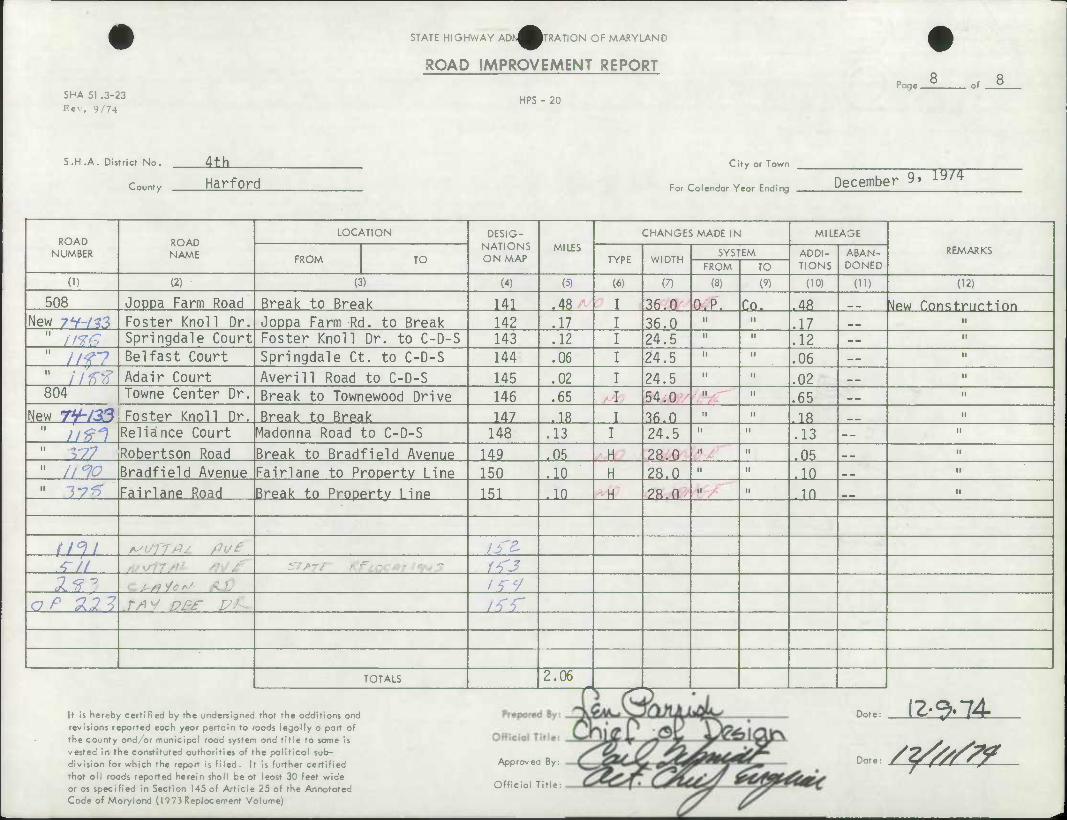
SHA 51 .3-23 Rev. 9/74
STATE HIGHWAY ADN^WRATION OF MARYLAND
ROAD IMPROVEMENT REPORT
HPS - 20
Page. of
S.H.A. District No.
County
Alh. Harford
Cify or Town
For Calendar Year Ending December 9. 19/4
ROAD NUMBER
ROAD NAME
LOCATION DESIG- NATIONS ON MAP
MILES CHANGES MADE IN MILEAGE
REMARKS FROM TO TYPE WIDTH
SYSTEM ADDI- TIONS
ABAN- DONED FROM TO
(D (2) (3) (4) (5) (6) (7) (8) (9) (10) (U) 02)
508 Joppa Farm Road Break to Break 141 .48 36.0 O.P. Co. .48 ^Jew Construction New 7Y-/r3 Foster Knoll Dr. Joppa Farm Rd. to Break 142 .17 36.0 n .17 __
" //^ Springdale Court Foster Knoll Dr. to C-D-S 143 .12 24.5 ii .12 --
" //f7 Belfast Court Springdale Ct. to C-D-S 144 .06 24.5 1! .06 --
" //^ Adair Court Averill Road to C-D-S 145 .02 24.5 II .02 __ 804 Towne Center Dr. Break to Townewood Drive 146 .65 54.0 II .65 __
New TV-za^S Foster Knoll Dr. Break to Break 147 .18 3fi.n II ,18 " //^ Reliance Court Madonna Road to C-D-S 148 .13 I 24.5 II II .13 — ir
n V77 Robertson Road Break to Bradfield Avenue 149 .05 H 28.0 M II .05 .... II
" //W Bradfield Avenue Fairlane to Property Line 150 .10 H 28.0 II II .10 __ II
" ly^ Fairlane Road Break to Property Line 151 .in H 28.n II II .in ..
tni /^tz/yw/ /JTZ <-// KJ 2 5?^ ato*/ AJ) ir<J
aP 271 jv^y OBT I ifT
TOTALS 2.06
It is hereby certified by the undersigned that the additions and revisions reported each year pertain to roads legally a part of the county and/or municipal rood system and title to some is vested in the constituted authorities of the political sub- division for which the report is filed. It is further certified that all roods reported herein shall be at least 30 feet wide or as specified in Section 145 of Article 25 of the Annotated Code of Maryland (1973 Replacement Volume)
Approved By:
Official Title:
Date
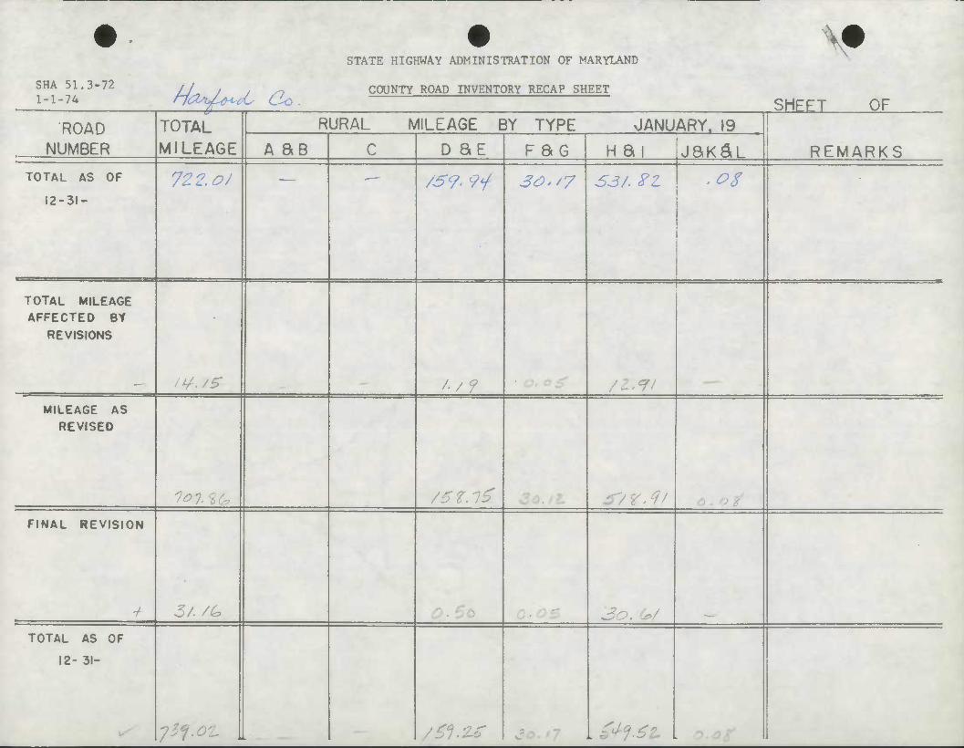
STATE HIGHWAY ADMINISTRATION OF MARYLAND ^
SHA 51.3-72 1-1-74 n<^fi^^C do. COUNTY ROAD INVENTORY RECAP SHEET
SHEET OF ROAD TOTAL
MILEAGE RURAL MILEAGE BY TYPE JANUARY. 19
NUMBER A SB C D SE FBG H ai jaK^L REMARKS TOTAL AS OF
12-31-
72.2. OJ /S9> 9*f 30-/? S3/. FZ .os
TOTAL MILEAGE AFFECTED BY
REVISIONS
'/? /--r- MILEAGE AS
REVISED
FINAL REVISION
5/. /6
TOTAL AS OF
12- 31-
ySf.o-L /£1>z* . ^%£t

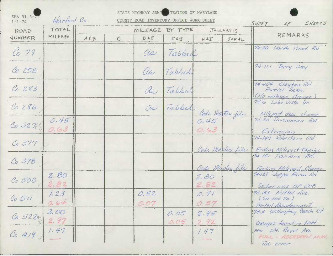
SHA 51.3 1-1-74
f Narhd (?o
STATE HIGHWAY ADMl^pTRATION OF MARYLAND
COUNTY ROAD INVENTORY OFFICE WORK SHEET
ROAD
& 79
&> ZS3
&> Z?3
Go ZZC?
TOTAU SfJtfT of St/rETJS
MILEAGE Br rvpc: jA.tMUARY |9
AiB
&> 3z yd
Co 377
&> 373
Co SOS
0.4£
Z,BO Z.8Z
D^E"
a^ CUJ
(&u
a^
f=*6
TakUd
/(XJDhzsL.
/ab/uJ--
/dlbbce't.
w*-x
&iU ML
o.^s idSu^ J^s
z.so
X'K^L-
^ZL yka otc'v 7Uc
d<?A Wfiltv^lLs
REMARKS
W-ZO A/os/t, i3e„c/ £4
74-/Zl ftrr-y OLby
74-/S4- C/ayj-c.-, /Pc/
74-30 DurtCartnon &c/.
^x/ errSto*-? 74-/^ PoUriso.-, f2c/
7^-/Zf j0/>/>a- te^m /Zc/
Secfas? coos O/3 S'od
& S/f A 23
&> SZZ^ 2,00
2.97
O.sz. #. 7/ 74'S£3 A/j-rto/ /4i/&.
0. OS
£.OS
2, 9* Z. 7Z-
7V-X (/J/Z/otytiby Beoct* £c7
Co ^/f y A ^7 /.47
Tab t/'r-or'
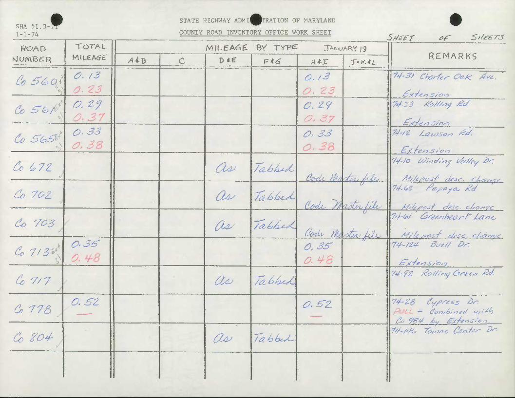
SHA 51,3 1-1-74
•
ROAD TOTAU WLeA<jt
&> S&ot O. 23
. Co tTG/o O. ZJ
Co S<h&\ O* 33
MB
Co t,7Z
Co 7oz
Co 703
&> 7/3v[ 0-36'
Co 7/7
Co 776 0.3Z
Co XO^
STATE HIGHWAY ADNI^^TRATION OF MARYLAND
COUNTY ROAD INVENTORY OFFICE WORK SHEET SdefT of St/rer-js
MILEA6E Br rvpe: JANUARY |9 D*? r*6
6U;
a^ Ov
a^
Ov
/^LcaC
/abbcsC
/tt^bt^C
/(Z&k^L
/a£>k*J~
Wi-X
O, /3 O. 23 O. Z9 O, 37 0, 33 0.3&
C7-.--^
CML, Mioti^^J^
o.3£r
O.Z'Z
T'K^L
d/Zm ^<UJU
C&iU Jfa yotZi.' £LU.
REMARKS
74-33 &>///*? £<*
74-/Z /UlcOSo^ /^/
J&A '£r?S» Or?
74-/O u);,}</,'r7y ubz/ey l>r
74'M tirZenhearf' jUis?^
74- fZ &//' 'if Ore <* £4
74-23 (fi/ftss £>r- POLL — <?oy>i6''n*J ujt/^i Co 984 4, S'xk'OS'C
74-/4C 72>OJS>C Ceil"' ^
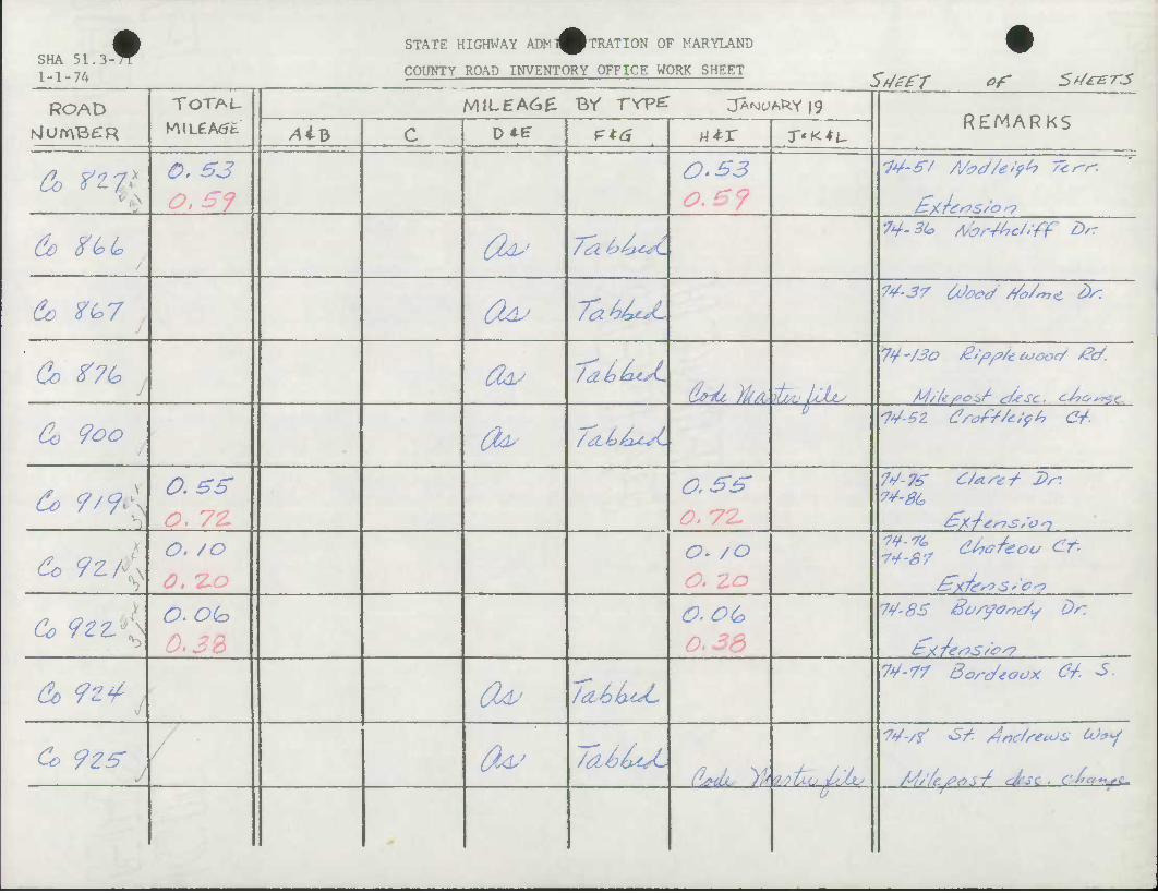
SHA 51. 3-^ 1-1-74
STATE HIGHWAY ADMl^TRATION OF MARYLAND
COUNTY ROAD INVENTORY OFFICE WORK SHEET
•
ROAD TOTAU MILEA6E Br rrp^ JA^^A^Y 19 NjUmBfTR AiB c
• •..*• ——
PK6 1 ' rt*r X'K^L REMAR KS
Co ft\ 0, 63 0-33
&> ZtoL Ou Jtikb^'C 1*f'3(* Asbr+hc/.ff D''
d) ^67 / 6UL' Ta^U^L 74-37 abc-J //<?/*, <L dr.
Co $?(* j fa /abbcsL &nL^ JjAj^lty
7*/-/So giff/ttuoocy A?C/.
Co 9oo fa U^LU. W-sz draf//c;ff> &.
do 9/9'A 0,BS O. 7Z
CSS
Cc 9z, O. /O o- /o
Co <fzz!*\ O.Oto O.OG 7*7-85 /Bo/yanc/y Dr.
Co <?z¥- 4 o* /a^6L^ 7¥-77 Bordtoox &. ^
Co 92ff l fcu TcliUsL AJMLU yh'uiXijJtA/
0
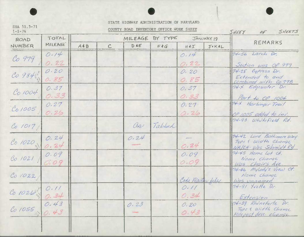
SHA 51.3-71 1-1-74
STATE HIGHWAY ADMINISTRATION OF MARYLAND
COUNTY ROAD INVENTORY OFFICE WORK SHEET SdefT ef Sdeer-J
ROAD TOTAL
MILEAGE MiLEAC*£ Br rrpe: jAMOARYig
REMARKS NlUmB^R AiB c D*e" ?K6 U*-X T'K*t-
6? f 7f O'/'f' <o. /4-
•Section 6oc/s Of 979 o- ZO 0' 20 7*/-^" fyfstss Dr-
Corh?h,ntc/ w'/h Co 773
Co /OOt/- 0-37 0,37 ^74-/ Sc/yecoafcs- Dr.
Far 7 ¥0 OF /ooot-
Cc/oos 0-27 O. 7-
0. '17 ?V-X t/ar6/nfer 7ro/7
s)f /o<?S' ztfc/tc/ To 7nS.
60 /0/7 Oay /abLtsC- 74-93 a>h/*tf;e/</ £t7-
60 /ozo v 0- Z^ 0'2-4
do /oz/ o.o<? 0,09 74-¥s dome t&t o/-.
Co /oz^ dUc Maai •u Iclc/
74-44, /VyLaJy's 17/eu) ef, AJorr>C CdanfC
0
C' // O- // u
74-9/ ii/ctfc L)r.
t:-/.Te*fS'0'?
60 /056 x
O, 43 0, 23 0, zo 74-Sf ^/^e/or-Zc ^. Typt % CO'e/-/tf Cttar?(?c.
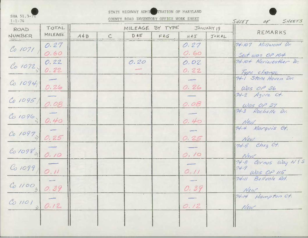
STATE HIGHWAY ADMI^^TRATION OF MARYLAND SHA 51,3-7T 1 _ 1 _ 7A COUNTY ROAD INVENTORY OFFICE WORK SHEET
SdZfT of Srf&r-J
ROAD TOTAU MILEA60: Br rvpe: jA^A.kY 19 REMARKS NJUmBCR /4iB C DiE" p*a H4-X T'K^L.
Co /07/ , 0,Z7 O.bO
0<27 O. £>o
7¥-/D7 M;//AJootS i>r
Secf coos Of /o*/-
&> /o7Z^ 0.2.2- O. ZO o.oz
Co fo<f^ O. 2.C*
74-/ S-faw //auen £>s:
Co /oqs /O &&
74-2 dsost. C/.
CfJc/s Or7 37
Co 'o?G^ —- 74-3 /?oc/>*//e £''
/i/tof
Co /o97^ O, 25* Qt '££' /\/eur
Co /o9?,^ 0. /O
Co /o^ tJt?s O/^ //±>
Co '/00^ 0.39 0. 3f 74-// Be//i/a/e £c/.
74-/4 /4arr?^^Orr, Ct.
/l/tctS
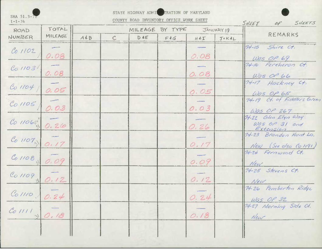
SHA 51.3- 1-1-74
f STATE HIGHWAY ADMI^^TRATION OF MARYLAND
COUNTY ROAD INVENTORY OFFICE WORK SHEET
ROAD sJumBeTR
Co f/oi.
Co //o3/
Co //o*/-
Co tfog
Co //OG X
TOTAU
MlL£A(Jfc
O.OP>
O. OS
O. o£
n. r> %
Co 1/07. A
Co //OQ
Co //o 9 O, /Z.
SfUfT *f St/*£-rs MILEACZ BY TYpZ JA^AP-Y 19
AiV 0*6- F*^ N^r
O.OS
O. O^
o. 03
o. zc /O / ^y
O. 09
O. /Z
T'K^L REMARKS
U'/S S^t's-e Of.
7V-/6 tferetterai of.
74~'7 /Jocks?**/ Cf.
Uhs OS3 &£'
Cites Or3 3/ a^J
7*/-23 Brando si Merit lo.
/>/ttd (See a/so CoZ/qi) 74-2.4- f-^r'ryioooc/ Of.
7¥-2S -STt'stnS Ot.
Co //so
(Co /// / ^ O, /S O. /8
74-27 Afcr*;^ S/'c/e Ct.
Astco'
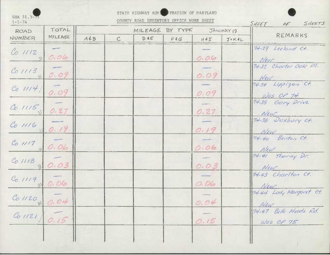
SHA 51,3 1-1-74
t STATE HIGHWAY ADM^pTRATION OF MARYLAND
COUNTY ROAD INVENTORY OFFICE WORK SHEET
ROAD
Co ///z -•>
&> /f/6 ^
Co (//<+
Co f/zS'
Co ///G
TOTAU
M»LeA<Jfc
O.o&
o.oj
Co ////
Co ///8
Co ///<?
£. nu
COS
O.o(o
MlLEAGe. BY TVpe: 3AWARY|9
Sd££r of St/mr-jS
AiB D *f P*^ utx
O'Ote
0.O9
SS *7 1
/O. /OA
O.Oda
X'K^L. REMARKS
74'2<? leefo^cf C+.
74-31 Chos/es O&te £>/.
/Jos Of VA 74-35 &c?r-y Dr/l/C
74-3S tDuxhory Cf.
74-40 Beaton C/.
74-4/ Tlho'-iy ^Vr
74-43 Chor/Jon Of.
At L~.
Co //zo * 0.04-
74-44 t-oc/y Mo/nyos-et Ct
G} //2/ O./g n, tS
7*/-47 6e//t AS/oc/t /?c/.
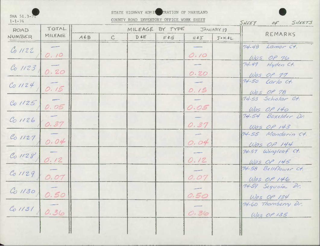
STATE HIGHWAY ADMll^PrRATION OF MARYLAND SHA 51.3-rr 1-1-74 COUNTY ROAD INVENTORY OFFICE WORK SHEET
Sfj££r of 5t/*£-rs ROAD TOTAU MILEAC£ BY TYPZ JA-M^ARY 19
REMARKS NlUmBCTR AiB c — ,-,-•• +•
P*6 mx r'K^L
Co HZt /Mas OF Vte
Co //Z51 /) *? rs
Co f/Z't
Co //Z6' 0. €>£ /} rt^ 74-63 Soho/or- e*.
Ubs O/3 /4a
Co //ZC? - —
0.37 74-54 Box*/c/*s- D*
COas O/? /4S
Co //z/ O' orf-
74-SS Afortc/a^'r, C-f.
/jJas O/? /44
Co "Z? 74-67 COtty/eof C+.
Mas OS /4S
&> //£? 74-58 Be/zf/ouj*^ C4.
Co //3o /) ^"/O
74-S9 Stjuc,;*- J':
UJas OS /34
do //3/ 74-(PO Yfar'nbz/'fy 6>s~.
COts. OS '35
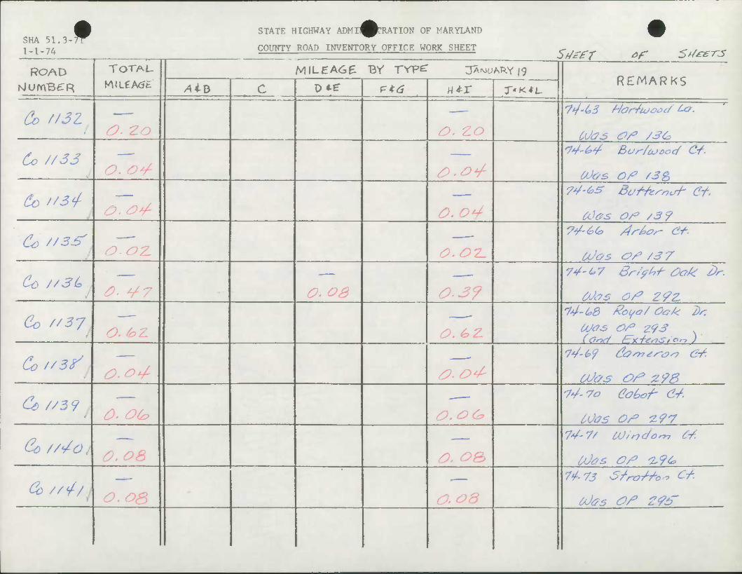
SHA 51.3-^ 1 -1-7A
STATE HIGHWAY ADMI^^TRATION OF MARYLAND
COUNTY ROAD INVENTORY OFFICE WORK SHEET
•
St/eft of 5t/*er-3
ROAD TOTAU MILEAGE BV rrpe: JA^ARY ig REMARKS NlUmBdR Aib c DAE" F*6 - * ! «*r T'K^L.
Co f/3Z O. 2.0 0, zo
Co //33 O. o*/-
<74'^ Bur/o-'ooc/ C-f.
OOos Of /3&
60 "3 + O-tO^ O.o^ CO0S Of /3 9
Co //as* 0.02. O.OT-
Co //3L a OS 0.39 OJc7S Of ZfZ
Co "37 O. hZ O.&Z.
74-(*8 Zoyo/ Ook dr. Was Of z<?3 (Orxi Fzrr-fieshStOrt )
Cof/3^ y £>.0<A Utos of z9B
Cz //5 9 0- OC?
-74-70 eo^o-f- 64
COas Of 1197
Co //'/O / S) SlA 0, oe> 74-7* iV,ndo^7 C4
OOos Of 1,9&
& ///A o.os 7^-73 S/rtTThtbt Ct.
6^65 Of ZfS

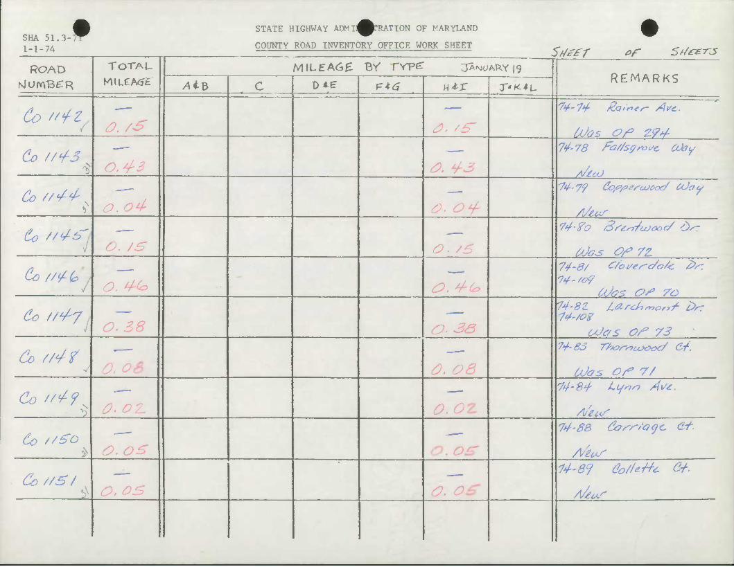
SHA 51.3 1-1-74
f STATE HIGHWAY ADMIJ^^TRATION OF MARYLAND
COUNTY ROAD INVENTORY OFFICE WORK SHEET
ROAD N)UmB£R
TOTAL
Co "tZ / O. /S
Co //^3 *> 0.4-3
Co //^^ o. o4
& z/^^" o. /&
Co //<£Q>
SfJefT of St/ez-rs MILEA6£ BY rvpe: jA^Aky |9
/4iB D*e P*^ n-tr
^. /^
^. ^3
^P. ^^
/o
O. 4~(0
T'K^L- REMARKS
74-78 Fa/Zsgrvsc Uhy
74-fro Sstrr/coooc/ £>ST
74-8/ C/ot/es-c/ok. Z>s:
do //^7 O. Z8
&> //^f v
Co //</-? O. OZ.
O- 33
0. OS
O.OZ.
74-8Z larchnar,/- Drr IS'/oz
Odas OF 73 74'63 Thor-syuxooc/ Or.
U)<7s OF 7/ 74-84- Lynn A\/£.
6o //£o ) /O < i.o
74-88 &?^''oqc. C-t.
Co //S / O.OS <o. og
74-87 do/U-tft' £+•
A/ew*
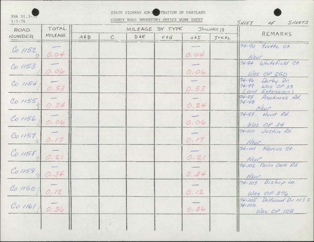
SHA 51. 3-^ 1-1-74
STATE HIGHWAY ADM^^TRATION OF MARYLAND
COUNTY ROAD INVENTORY OFFICE WORK SHEET •
ROAD TOTAL
M(LCA<Jfc
MILEA6E Br rvpc: JAWARY 19 REMARKS NlurrVBeR /4iB c D*E: P*^ «*r X'K^L
Co //SZ ^ ^y1
14-90 X/^Mi c/.
Co t/53 o.oto
74-9t (jh/Zefic/c/ Cf.
i,(J(?s OP 2£o
Co //S4 14'9(* Dt-rLs 7>r. 14-:49 (Jos Of 33
Co '/SS'^ O. £4 O. 2.4-
74-95 Prtciiess &. 74-96
60 //&£> . — 74-97 f4os>t Pc/.
frJas OP jy
Gc//S7 • 0- /7 O- /7
14-/00 Jos/fo Pc/.
p/eow
Co z/^/ 74-/o/ A/oscc/s C4.
Co "£9 N
do '/&o —
74-/o3 S/sbof /.c
CPas OP 37&
Co //£>/ 74-/OS De/Zcooex/ &^ A/ t S 74-/e&
tPos. OP /OB
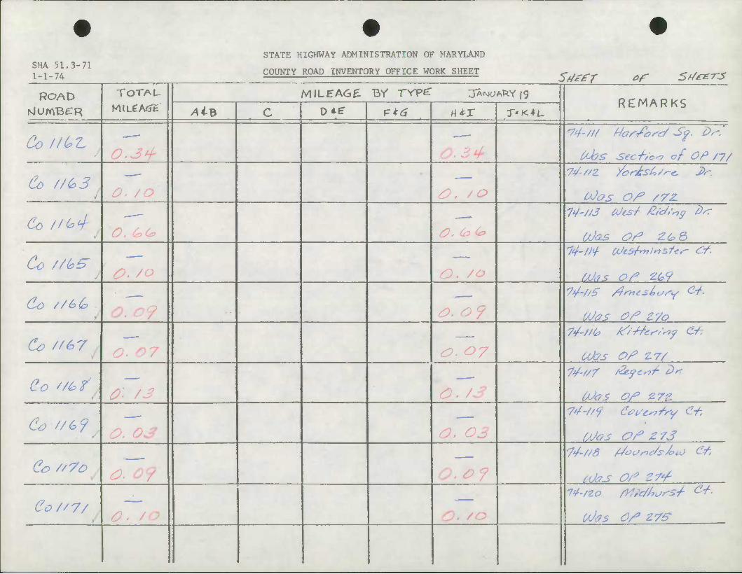
SHA 51.3-71 1-1-74
STATE HIGHWAY ADMINISTRATION OF MARYLAND
COUNTY ROAD INVENTORY OFFICE WORK SHEET SdzfT of 5>/i-£-rjs
ROAD TOTAU KULeA<Jt
MILEA6£ Br TYP^ 3A<MCAkY |9 REMARKS
NlOmBCR /4iB c D*tr p*^ H*r T'XtL.
Co ll(*Z. —
C-bs secf/oo of OP /y/
Co //C.3J 00OS O/* /72L
(U> //^ —
&,(&(&
74'//3 bJts-/- £/d>'r7g dsT
Co //G& J
14-//+ OiJiSfnilnsfes- Ct-
Co //£>& OOas Of Z7o
Co //67 —
<o • ^7
7^'f/^ tf'&CfSrtf Ct:
Utos Of £7/
Co //t?f OJ&S Of Z7Z
Co //&?/ 0. 03 0. c IAJGS Of Z73
Co //7o •74'//8 /JotSric/s/ou} Cf.
UJ<?S Of 5/-/
C0//7/ O' /& uJas of zve
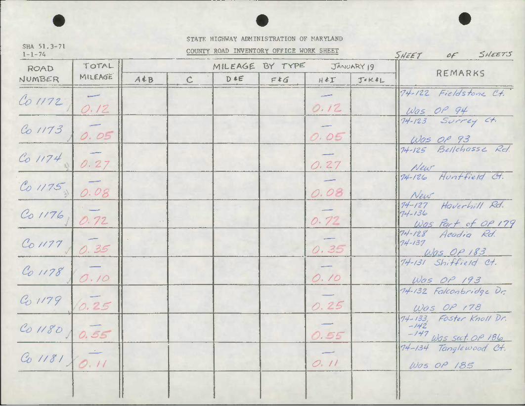
STATE HIGHWAY ADMINISTRATION OF MARYLAND SHA 51.3-71 1-1-74 COUNTY ROAD INVENTORY OFFICE WORK SHEET St/zfT of St/eer-js
ROAD TOTAU
K\lLCA<Jfc MILEA6& BV TYP^ JANUARY |9
REMARKS NlUmBCR /4iB c D*r P*^ w*-x T'K^L
Co //7£
Co "73 /jJoz OS 93
Co //74 S) '7'7
Co //vs- "
Co //7& . 4
74-/27 Ho^ri-?/// &/
fXlOS ferf of Of / 79
(U>/'77 74-/37 Ubs OP /ZS
Cv /'7t 74-/3/ Sh:fAe/c/ C4.
tOas OP /93
Oo "7? 23* /), 2.£ 14-/3Z fhkoihr/c/qc 6>/r
OJos OP /78
Co //go j oTsz 14-133 Pc*5tts- fao// Dr.
-/4Z
-'/4/7 U)as scct.oP /8U.
Go //$/ y
14-/34 lonflecoocx/ C4.
toos oP /3S
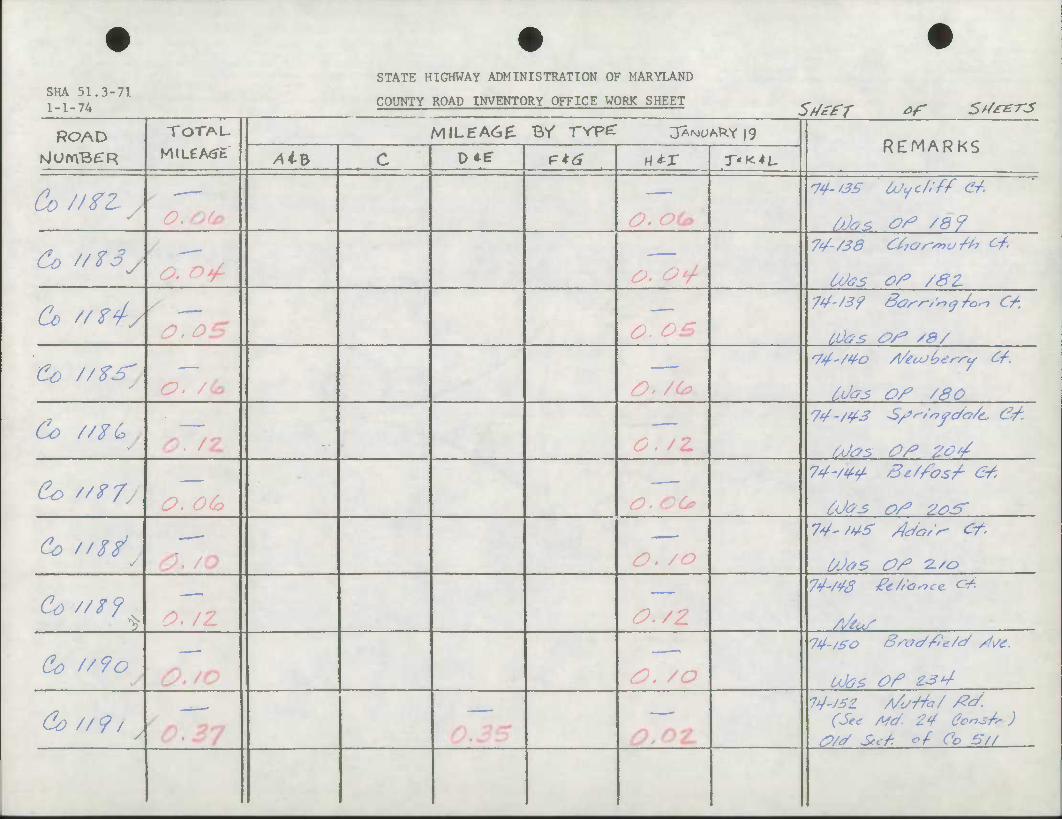
SHA 51.3-71 1-1-74
STATE HIGHWAY ADMINISTRATION OF MARYLAND
COUNTY ROAD INVENTORY OFFICE WORK SHEET 5/y^rr ^ 5t/*e-rs
ROAD TOTAL
M(LeA<Jfc
MILEA6^ By rrpe: jA^^RYig REMARKS
NjUmB£R Ai3 c D*e P*^ «*r T'i<*L.
Co //ZLy — 74-'3S bJyc/i'ff &.
OJos O^ /&?
Co //Z3y a ^y1 74-/38 CfrOr'/nuSb Of.
Was o/* /ez
Co //ZJ-y ^. ^5" ^, ^^
74-/3'? 8&^r-/~cj/o.-i <r/.
Co //Z-^ —
Idas Of /SO
Co //ZG y
71/./4.3 S/J^/nfc/G/c 6f.
Mas Of 2o¥
Co //<?/ /9 /9/ •O /0/>»
74-/44 St/fosf G6
6Jos of 20^
•
74'/*/^ Aia/r- Cf-
C/M5 Of Z-'a
2
—
O./Z 74m Zc/'Q^c* c4.
Co f/9o —
74-/£0 Broc/Zle/t/ /f\/C.
UJas Of £34
Co //9, /
14-J3Z A/urfa/ /?J. (See M4. 24 Ccn^ )
O/J Sec/: of Co 57/
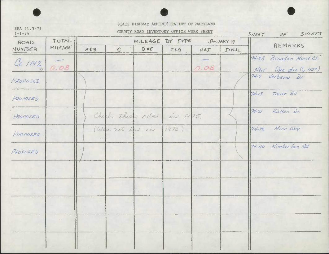
SHA 51.3-71 1-1-74
STATE HIGHWAY ADMINISTRATION OF MARYLAND
COUNTY ROAD INVENTORY OFFICE WORK SHEET
ROAD
Go //9Z SL
Proposed
pXoposzD
TOTAU
MJLeA^t
SftefT of 5d*£-rjs MILEAGE Br rrpc: jAfMu/s^Y |9
/UB D*f P*^ M-tr T'K*L. REMARKS
^V-fJ Branc/on /JonJ Cf.'
A/JUT (Stc o/sc Co //or) 74-7 l/erLew 2)^.
74-/3 7?-^/ £4
ptfoposel) CIL'M lu XlUc ^ yL6L<LJ ^yy O /9 76 74-2/ £ci/4or> 7)r
P/?0PO5E2> (OOX LC lL*t i* KJ Asr^ /974 ) 74-7Z /^o"P ^>Y
PPOPOSJZD \
74-//0 /^'/'mbe/'ibrt &/
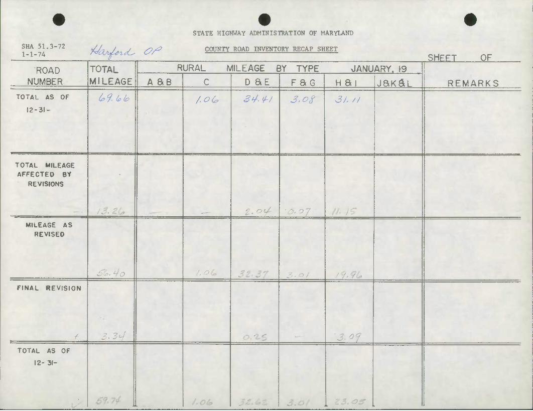
STATE HIGHWAY ADMINISTRATION OF MARYLAND
SHA 51.3-72 1-1-74 rdcZtJ^LtC' <?/* COUNTY ROAD INVENTORY RECAP SHEET
SHEET OF
ROAD TOTAL MILEAGE
RURAL MILEAGE BY TYPE JANUARY. 19
NUMBER A SB C D BE pao H ai jaK^L REMARKS
TOTAL AS OF
12-31-
U9. L?lo /.oC 24-f/ J7-^/ 3/. //
TOTAL MILEAGE AFFECTED BY
REVISIONS
MILEAGE AS REVISED
:o f
FINAL REVISION
/ "3 ml •'. otf
TOTAL AS OF
12- 31-
____________
6f /.OCc, '^
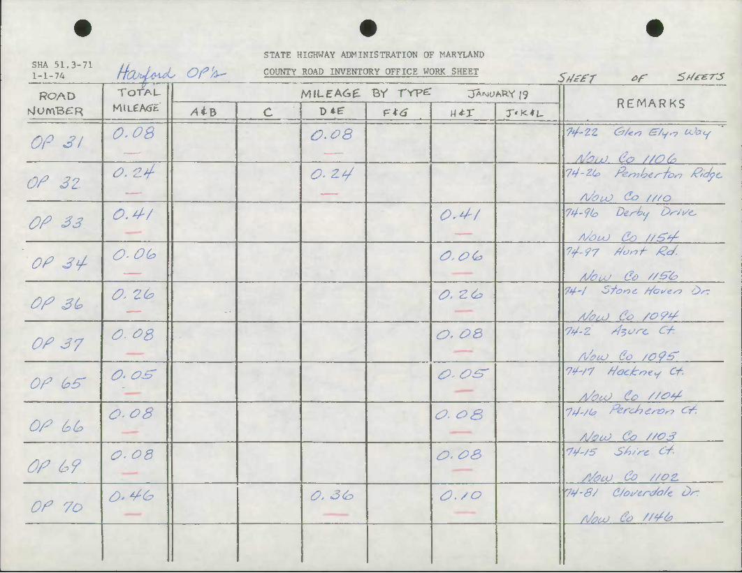
SHA 51.3-71 ,, . . _ _. 1-1-74 H'a'4^yuL Of'A-
STATE HIGHWAY ADMINISTRATION OF MARYLAND
COUNTY ROAD INVENTORY OFFICE WORK SHEET Sdiffr of 5t/*-e-n5
ROAD TOTAL
MlLeA<Jfc MILEA6E BY TYpe: JANUARY 19
REMARKS NlUmBtTR AiB c D^ p*<S utx T'K*L
OP 31 0.0Q &.&8
AhuJ (la //06>
Of 3Z O. 2>/ o.z*/
A/buJ &> ///o
OP S3 0,4-/ o.^z 74-9CJ Derhy Ds-'i/c
A/OuJ do //&*/-
OP 3^ O-Ob (O.OG
A/OUJ CO //&&
OP SL> O, 2b O.Z& 74'/ Sfonc f/cves? c>/r
OP 37 o.og O, OQ
OP (PS' O' OS' 0,0^- 7¥-/7 tiac/tney Cf.
OP && 0-08 O- o& 74-/(a Per-<J7£rz?ry <&.
A/OLO CO //OS
OP &? O- OQ o<oa tt/'/S S'tj/rc Of.
S/^cd Co //OZ
OP 70 O-^G O. 3<h <0./0 74-8/ C/osert/a/c Dr:
A/o<xJ CO //</&
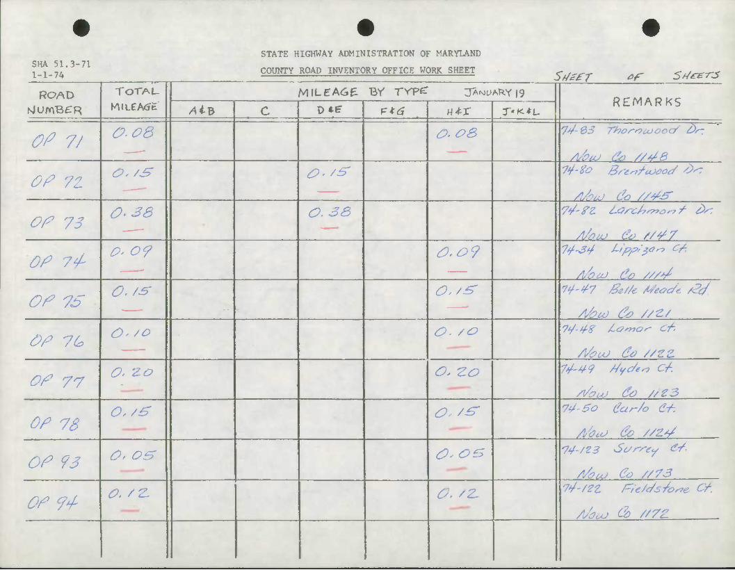
SHA 51.3-71 1 1 "7/.
STATE HIGHWAY ADMINISTRATION OF MARYLAND
COUNTY ROAD INVENTORY OFFICE WORK SHEET SfJefT of 5d£z-rs
ROAD TOTAL MILEA6E By TYP^ JA^ARY 19 REMARKS
NlUmB^R AiB c D*e etti HtX —* . .
0? 7/ O-OB o-os 7V-0S Thoriouoccf' tin
Of 7Z o,/s ^ /^
Of 75 0.38 O. 33
Mom & s/^r
OP 7/ a- 09 O.O?
Of 7S O.ts 0''& W'4-7 &e//e ASeoc/e &,
Of 76 O- /o O. /o 7*/-4-8 lamor- ct.
S/eoU Co //ZZ
Of 77 O' Zo o* -zo
/VouJ &) //Z3
Of 73 0,/£ O- /^ 7^-So ear-Zo Ct-.
Abu; Oo //Z*/
Of 93 O' OS COB "74-/23 Sc/rsey <5/.
S/OLU CO //73
Of 7+ o./z. a. /z~ 7^-/2Z fre/c/s/os7e Cf.
/l/auj OD //7Z
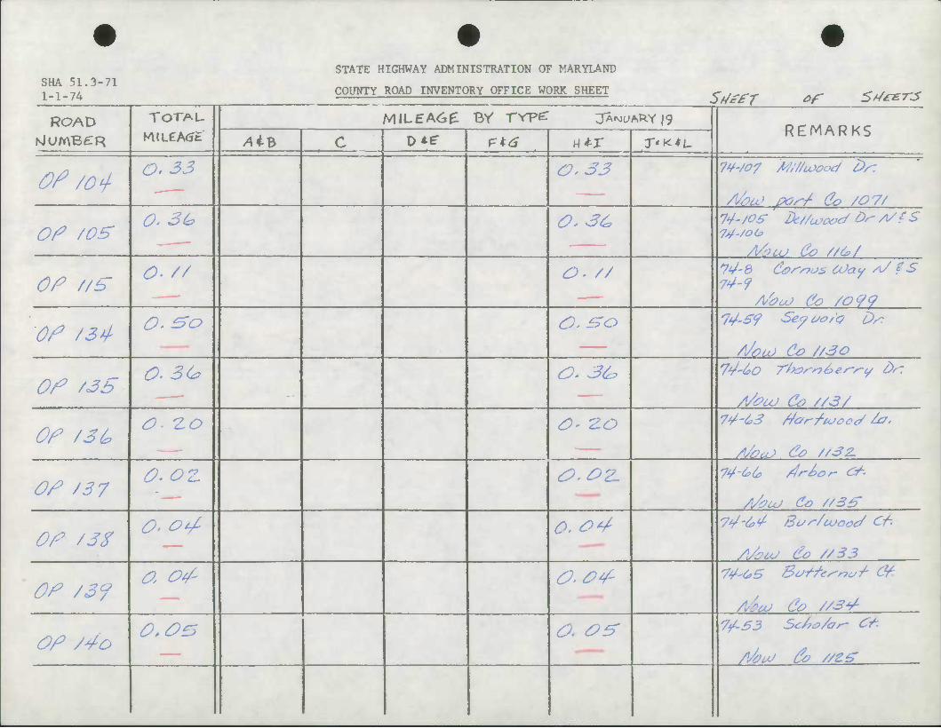
STATE HIGHWAY ADMINISTRATION OF MARYLAND SHA 51.3-71 1-1-74 COUNTY ROAD INVENTORY OFFICE WORK SHEET 5^£T of 5>/*£-r5
ROAD TOTAL
MiLeA<JE MILEAC>£ BY TYPZ jA^uAkY |g
REMARKS NlUmBCR AiB c OMT P*^ H*r T'K*L
Of /cf O. 33 0.33 W-/07 M/f/uxxxj Ds:
Abu) ivr-/- Co /07/
Of /oz 0. 3(* 0.3& W-/05- J)t//coooc/ Of yV? S
Afauj Co //&/
OP //h O- // o. // V-S Corpus COaw A/ ? S 74-9
AboO Co /0<?c?
Of /3^ O.&o O.^o
A/ou) CO //3O
Of /3S O. 3C* O. 3^ 74-^0 Thar-n&es-s-c/ d/l
^UJ Co //3/
Of /3(? O- 2-0 a- Z.O 7'/-6>3 far/ujooe/ ^7-
AhtcJ Co //32.
Of /37 O<02. &.OZ. 7¥-^& fr^or &.
/y$uJ Co //S^
Of /3Z O' Otf o. o^
^y^uJ Co //33
Of /39 O, Otf o.otf
//*uJ Co //34-
Of /4o O.OES O. Of? 7^-53 Sc/70/ar- Ct-
/At/ fo //e^
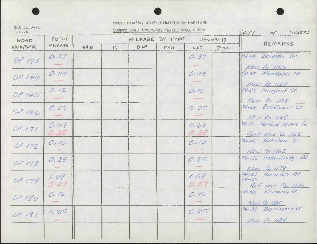
STATE HIGHWAY ADMINISTRATION OF MARYLAND SHA 51.3-71 i _ i -ii. COUNTY ROAD INVENTORY OFFICE WORK SHEET SdefT ef 6t/£Z-rs
ROAD TOTAL
MiLeA<Jfc MILEA6& Br rrpe: JA^ARY |9
REMARKS NlUmBCR Alt c D*? P*^ utx r'K*L.
Of rts 0,37 0.37
Of /^ O- O^ 0,o¥ 7^-S£ /fasrc/osyh C/.
S/#6U do //Z-7
Of z+S O- /z O'/Z* 74-57 OJ/nj/eof Ct.
Of /4G 007 o. 07 74-56 Be////o coes- Ct:
Of /7/ 0.(*9 o.b9 0.3£ Part A&LJ CO //<££
Of J7Z O, /o O./O 74-//Z yorksh/rc L>r:
Of z?? 0. zs <o. zs Aha) Oo //7<?
Of /v? / of A 09 74-/27 HaLtr/,/// /?S
74-/S<° far/ WUJ Co //76
Of /Vo o, /& 0. /c? /*/#uJ & //S5
Of /?/ O. o£ o> 0^ 74-/3? Bors-'syj/o^ C/:
AJhuJ Oo //#¥•
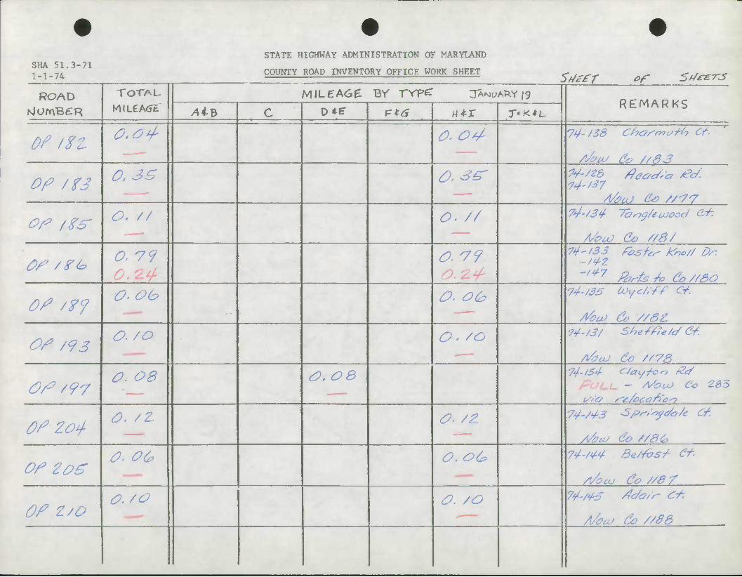
SHA 51.3-71 1 _ 1 _ 7/.
STATE HIGHWAY ADMINISTRATION OF MARYLAND
COUNTY ROAD INVENTORY OFFICE WORK SHEET SdcfT *f St/cer-j
ROAD TOTAU MILEA6E Br rVF^ 3A.MtMfc.Y |9 REMARKS
NlOmBCR AiB c D*? etti «*r r-K+L
Of tZt 0<o4- ^ Os/ 74-J2S C/xTsmo/b Cf.
A/euJ &? //83
OP /?3 0.3S 0.3^ 74-'37
op /Zs- o. // o. // 74-/3^ Tang/euJood CJ-.
A/ou) Co //8/
OP /?£=> O 79 0.79 ^-'33 rosfr^ Xno// Dr.
'/^7 Z?rfe/o &//30
OP /?J O.Oh o> o& 74-/3S U^c/.ff Of.
/Voa) do //8&
OP /<?3 O. /o Q. /o 74- /S/ She We/c/ Cf.
0/0/97 O. OB (Or OB 74,)S4 C/ay/on £c/
pucu - A/OUO Co -zes
OP Zoj- O. /Z o. /z 7yv/^ Spr-Zsydo/e C/.
OP zoz 0. o& o. o& 74.W4 BeZ/bsT- Cf-
A/OCU &> //S7
OP Z/t o./o O. /O
A/au.> do //S3

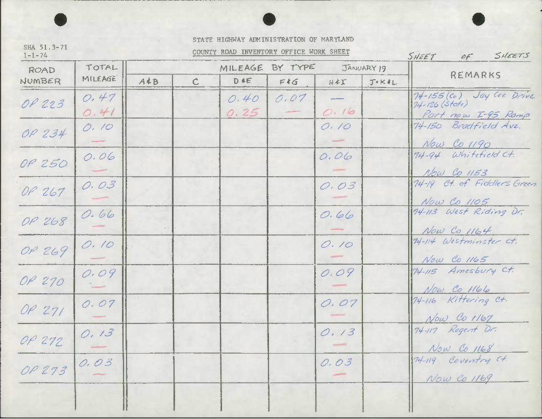
STATE HIGHWAY ADMINISTRATION OF MARYLAND SHA 51.3-71 1-1-74 COUNTY ROAD INVENTORY OFFICE WORK SHEET
St/efT of Srf*e-rs
ROAD TOTAL MiLeA<Jt
MILEA6E BV TVP^ JANUARY 19 REMARKS
NjUmB£R AiV c o« £16 — -—- •• - *
w*-x T'K^L-
Of ZZ3 ^ 4-7 O. Z£
0.07 & • / (0
'7^-/S3(Cc) Joy C*e. p^lt.
Par/ sioou JT-fS th^fO
0/? 23^ O- /o O. /o 7^-/5b Brtx/f/e/e/ 4**.
AboO Co f/9a
Of z£o O- o& 0. o& 74 ^i/. OJln/teftefc/ C-/-.
/Uba) Co //S3
Of 2&7 O. 03 O, 03 14-/9 &• of RdU/e^ One*
Abco Co //o£
Of ZhZ ^ &0> &. &o> It/'/rf Mis/ /Z/c/f-of dsr
A/ouJ CO //CO'T-
Of £(*<? £>' /O O. /o A^uv Co //&£'
Of 270 0-0 9 O.o?
A/aaj Co //66
Of 27/ O. 07 &. 07 74-//k MHtr/nf &••
A/OUJ &> //(o7
Of 27Z O, '3 0), / 3
Of Z 73 O, <P3 O. 03 74-/iq C^/tm^cf <ryf
A/nuJ Co //h<?
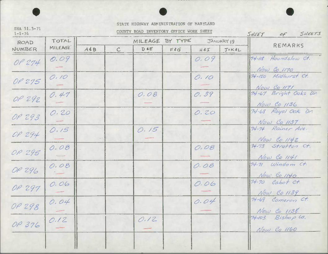
SHA 51,3-71 1-1-74
STATE HIGHWAY ADMINISTRATION OF MARYLAND
COUNTY ROAD INVENTORY OFFICE WORK SHEET St/efT ef 5rf*£-r3
ROAD TOTAL-
KULCAtft
M\LEAC>£ Br Trpe: OA^A^Y |g REMARKS
NlumBCR AiB c D*^ — — ., . i—
utx T'K^L
0fZ74 0.09 0. 07 Aszcd Co //70
0fZ75 O, /O 0. /o 74-/20 M/dUoss/ C/.
Of 19Z 0.4-7 ^ &s O.S? 74-t>7 Br/cjln-h Oaks fo
fou) Co //3G
Of Z93 O. Zo O. Zo 74-&S foyaJ Oak bn
A'OUJ CO U37
£f Z?*/- O./S 0. /s 14-7^ /Za/mr- di/e-
A/PU) CV //4z.
Of Z96' O. 06 Or OB
A/oco Co ////
OfZ9C O. o& <0< OS 74-7/ OJirtdom Ct-
A/ZCO CO //4O
tff Z97 O- OG 0,06? 74-70 etLLo-/- (i4
Aku' Co //39
Of Z9S O. Otf 0><Plf 7^-G9 Comeror? &-•
S/OUJ Co //Stf
Of 37^ O'/Z tf./Z. 74-/03 /S/sbo/p te.
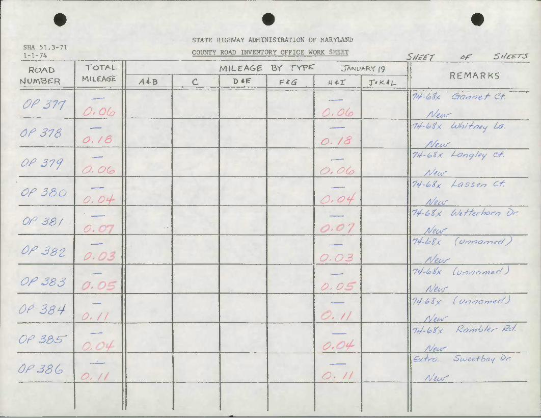
STATE HIGHWAY ADMINISTRATION OF MARYLAND SHA 51.3-71 1 _ 1 _ "7/. COUNTY ROAD INVENTORY OFFICE WORK SHEET Sdiffr of Srftt-ns
ROAD TOTAL
M(LeA<Jt MILEA6E BY TYpe: JANUARY 19
REMARKS NlUmBCR AiB c D*^ P*6 H*X T'<*L
OP 377
Of 378 l^-tofK COht'/ney La.
Afeus
OP 37J —- 74-^Sx i-Ony/ey Cf.
AkuT
Of 3&0 74-^Sx lasses? C*
Of 38/
Of 38Z —-
/*5 /O 2?
Of 383 '
OP 384 \S iff
7L/-6>%X (O'^f^o^ec/J
OP 35^ D SlU* o,o<p A/MT
0P38G A/eof
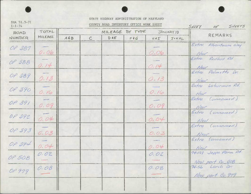
SHA 51.3-71 1 _ 1 -7/.
STATE HIGHWAY ADMINISTRATION OF MARYLAND
COUNTY ROAD INVENTORY OFFICE WORK SHEET SdafT of St/*£-rs
ROAD TOTAU
M«LCA<Jfc MILEAC*£ BY TVpe: JAMUARY|9
REMARKS NlUmBfTR AiB c D4e F*a «*r T'K*L
OP 337 •
Of 238
OP 33 f 0' 13 <^. /^
gx/rtt. Po/m € //o fir*.
Of 3?o
Of 39/ 0, 09
Of 39Z S) /O /A -#* ^*\ / y
Of 39 3
OP 39"/ 0' O*^" ^' ^*/ As'iuS
Of so a 0.0Z. o.oz U'/Z? JorfCL /=ar-r, £<*
/lhaJ /x?rJ Co $08
OP 97J 0-O3 O. OS
/focv Mr/ Oo 979
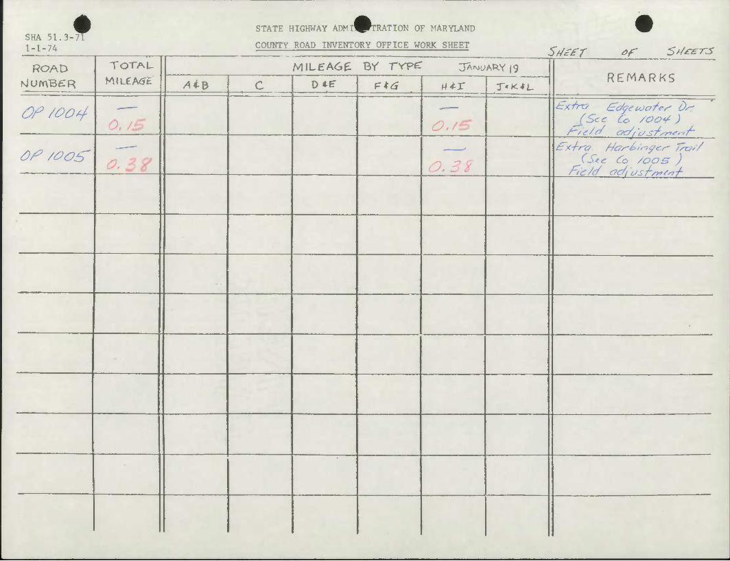
STATE HIGHWAY ADMI^FTRATION OF MARYLAND SHA 51.3-71 1-1-74 COUNTY ROAD INVENTORY OFFICE WORK SHEET
SfJafT ef 5t/*er-3 ROAD TOTAL
MiLeA<Jt MiLEA6e Br rrpc: S^o*&X\<)
REMARKS NlumBeiR AiB c D*E- ?*£ M*r T'K^i,
Of /004 JStc Co ZOO'S- )
Of /OO^ fi 2 C? 0.3% (See. Co ZOOS )
-
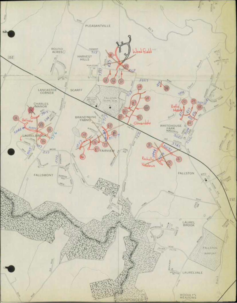
WOODLYN MEADOWS
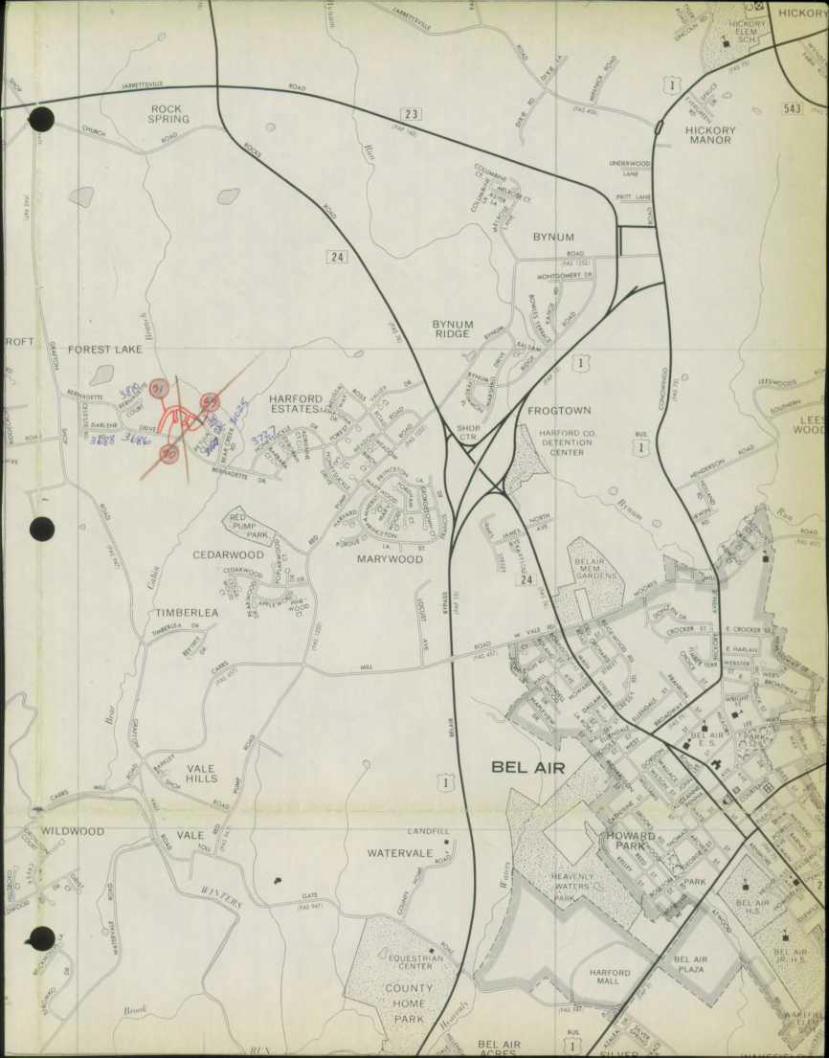
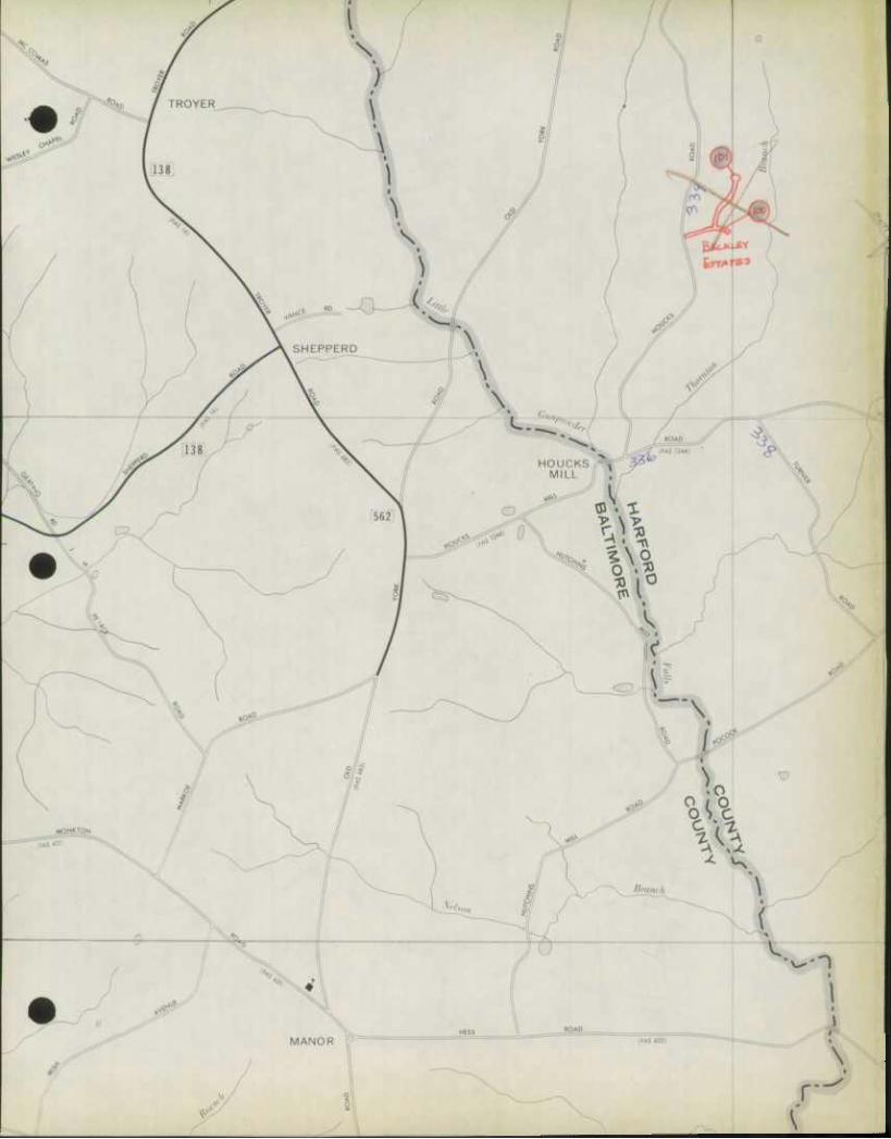

fURNACE ^^
fufr J V 1 / >y
HO D»l * X^^N v
yj fe^
^ s
UPPER CROSSROADS
- ••- •' ••--•--•'••;
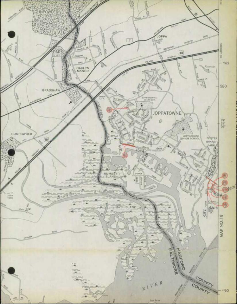
|0_|(_«D. \,
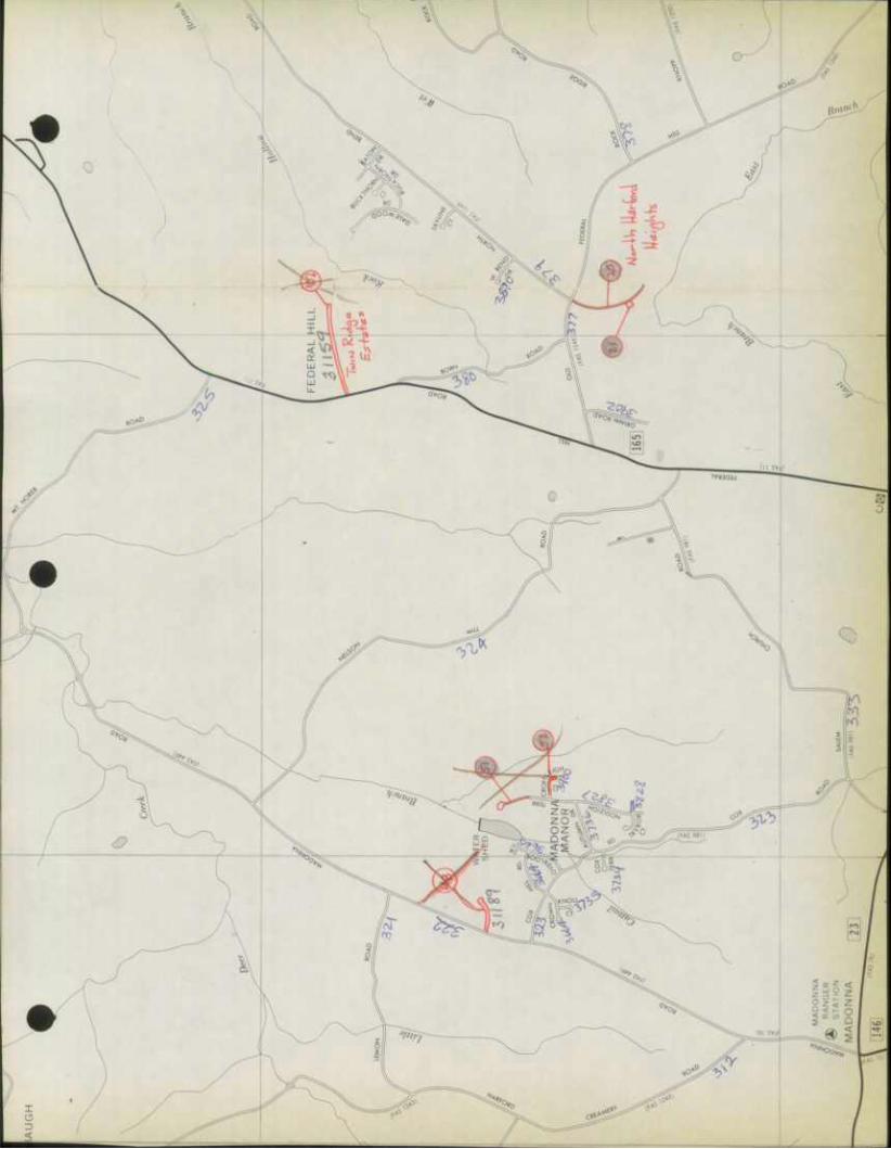
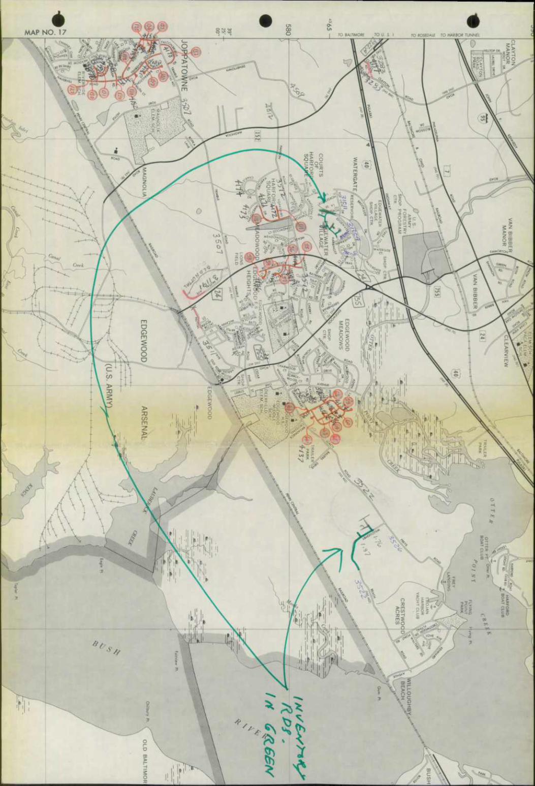
*
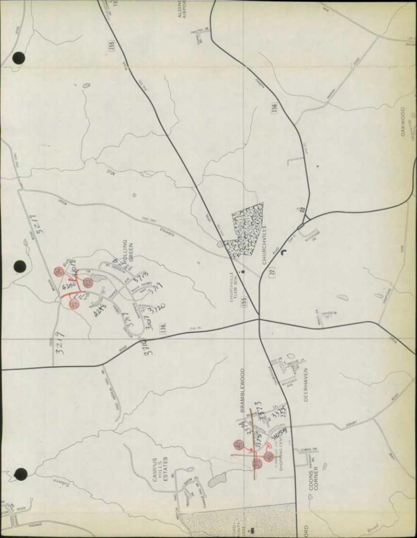
3 85 ze^o'oo" TO mfSVlUE 990 70 CONOW/NGO DAW 1000
385
640
00"
• I
S.
O
380
GIBSON -'•^^m* ^^ » GIBSON
SVn MANOR
%
^t
^
*t
%*.
HARFORD VOC A
SCHi O
JOHN
MILL L I HN' •
FUL
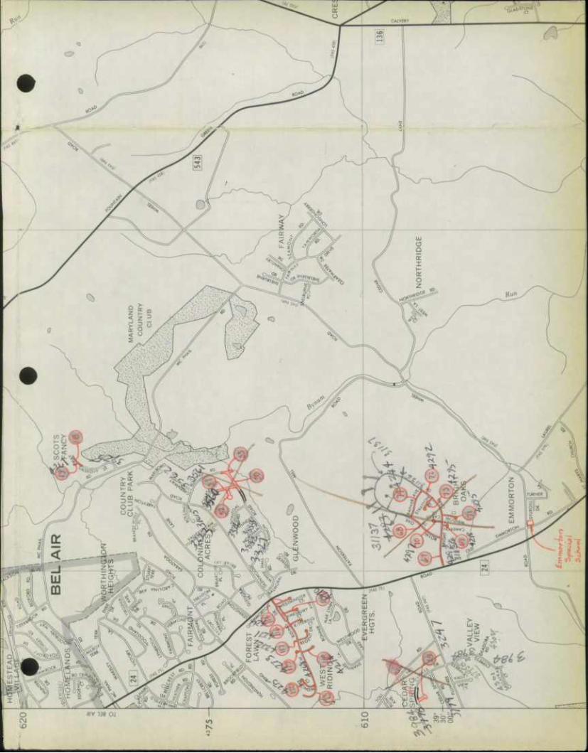
970 380 TO EDGEWOOD ARSENAl
METROPOLITAN AREA
980
MAP SERIES
BALTIMORE • WASHINGTON MAP NO. 11
ma^tmaummmmmamamamimMu
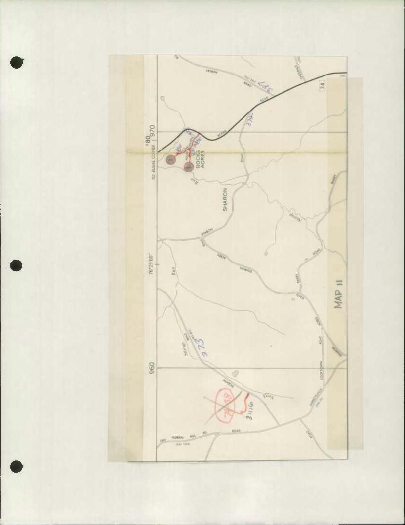
OM1 QSIVD ONJ
saoD rid
3003 asivD
z 61
isodriw Ainvnoa iSOd3TIW ONlaN3 NOSV3!l
1 i • i i 1 « 1 1 " 1 •
08 8Z 11 91 SZ U EZ ZZ IZ 0Z 69 89 Z9
:SNOISIA3a
aanNUNOD awvN avoa
i ! i I i i 1 1 1 1 1 1 1 r
99 S9 f? £9 29 19 09 65 8S Z5 9S SS K es K
3WVN avoa
"i i i i i i I 1 1 \ 1 1 r
IS OS 6t' 8> Zt- 9f S> VV Cf Z* It- Of 6C 8E ZC
3003 3003 31 Id ddVD
NOIiVDiaNI dVW
1 1 ONIHUION -A
T—i—i ONUSV3 - X
n i 1 1 %-
9E St K ZZ ZZ IE OE 6Z BZ LZ 9Z SZ tZ ZZ
S3ivNiaaoo3
OMI omo Nio3a
3NO a!IVDaN3
3NO aavD woaj 3ivDndna JZ- I sNwmco OAU aavD NIO3«
a3nNliNOD NOUdl!l3S3a ISOddllW
~i i i i i i i 1 1 1 1 1 1 1 1 1 r
08 6i BZ ZZ 9Z SZ t-Z EZ ZZ IZ OZ 69 89 Z9 99 S9 W E9 Z9 19
NOIidl!OS3a ISOd 31IW "i ( i i 1 1 1 1 1 r "T T" T 1 r
W 65 85 Z5 95 55 W E5 ZS 15 05 6V Bt It 91- S>
-r
n zt zf !• o*
)l38WnN 3inO!l 3DN3!l3d3!f SSOa3
NOiiSddia xiddns asawnN xidsad NoiiD3S nodiNOD isoddiiw jivisvaiNi
a T 1 r "T i r ~i s 1 r
K 8E Z!: ^ « "E EE JE IE OE 6Z SZ LZ 9Z SZ tZ ZZ
iisawnN IVdlDINflW dNHNIVW lSOd31IW MNOODViUNI NOUD3!lia XlddHS
1 • 1 1 T r ] a iidavynN 3ino)i
)l39WnN Xld3!ld AiNHOD NoiiDiasidnr
a T 1 r
K [z oz «l 81 Zl 91 51 H El Zl II 01 6 8 Z 9 5
1' ~r
ft Z [
3No aavD Niosa
133HS HOOD 3 lid il31SVW
Zl.-i\-l\
01 - CIS YHS aN>nAavw JO Nonvuxswimav AVMHOM aivxs
^
^
v s n "I 'poy*
sqai pojo/o^—08S-G3
•

4 4 Form HPS-20
S.H. A.DUfrict No.
Coonfy
STATE HIGHWAY ADMINISTRATION OF MARYLAND
ROAD IMPROVEMENT REPORT
8U
Project Locations on Map are shown in red
City Of Town
Harford For Co lender Yeor Ending Der.omhor, ^ 11 7Q7^
ROAD NUMBER
LOCATION DESIG- NATIONS ON MAP
MILES CHANGES MADE IN MILEAGE
REMARKS FROM TO TYPE WIDTH SYSTEM BUILT! ADDI- ABAN- DONED FROM TO FROM TO FROM TO (NEW) TIONS
(1) (2) (3) (4) , (5) (6) , (7) (8) (9) CO) (H) (12) (13) (14) y Md,Rte,^3S tfd. /?te. 23 to Balto, 73-18 1,20 B I 20' 20' 2 2 1.20 1.20 ff-6'52—477
County Line "•ehahi li tat ion
. -/ Md,Rte^Ul Md. Rte, 22 to Md. Rte. 71-19 3.70 1 T 1«» 221 2 0 3- 70 ?. 70 H-61P-4.76
136 Videnino and Rehabi Iitat ion
~s Md.Rte,l?6 Md, Rte, 7 to Md, Rte, 73-20 5,88 H I 16* 20' 2 2 5,88 5.55 H-6l6-l-4yi 22
Widening and
rta/iao t 11 ia 11 on
1/ 'Md.Rte,13e Md, Rte, 2? to U.S, 73-21 5*& B I 16' 20' 2 2 5,6U 5.64 H-616-2-A71 Rte, 1
Widening and
^———^^^^— MdmRfe, 3U Md, Rte, 136 to Ponna, -73-22 2,20 J r 16' 20' 2 2 t Pf) 2. 30 j~649~*76
State r.ine Videning and
ftphn hi 1 i f n + i r\r\
•
COUNTY TOTALS l 1 / 1
It is hereby certified by the undersigned that the additions and
revisions reported each year pertain to roods legally a part of
the county road system and title to some is vested in the con-
stituted authorities of the political sub-division for which the report is filed. It is further certified that all roods shall be at
least 30 feet wide in accordance with Section 145 of Article 25
of the Annotated Code of Maryland. (1966 Replacement Volume)
SHA 51.3 - 23 10-1-73
SUBMITTED BY
OFFICIAL TITLE
REVIEWED FOR DIST. ENGR. BY s/-^ ^££~&~s
OFFICIAL TITLE ^>?^Z2Z
REVIEWED FOR CO. RDS. ENGR. BY
OFFICIAL TITLE
DATE
DATE
DATE
'Tz/y/jj
y^-jT-SS

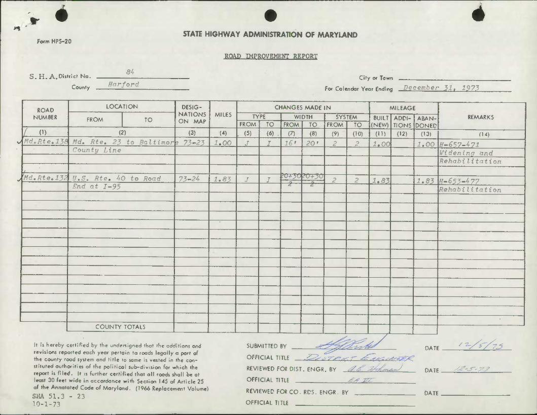
h * Form HPS-20
S.H. A.District No.
4 STATE HIGHWAY ADMINISTRATION OF MARYLAND
ROAD IMPROVEMENT REPORT
S4
County Harford City Of Town
For Colendor Year Ending December 31, 1973
ROAD NUMBER
LOCATION DESIG- NATIONS ON MAP
MILES CHANGES MADE IN MILEAGE
REMARKS FROM TO TYPE WIDTH SYSTEM BUILT (NEV/)
ADDI- TIONS
ABAN- DONED FROM TO FROM TO FROM TO
( H) (2) (3) (4) . (5) (6) , (7) (8) (9) (10) (ID (12) (13) f14) o Md.Rte,138 Md, Rte, 23 to Baltimor ? 73-23 I. 00 J J 16' 20' 2 2 1*00 ^.00 H-657-471
bounty Line Wideninq and RehabiIitat ion
j.
J Md.Rte.132 U.S. Rte, 40 to Road 73-24 1.83 J I IO-LJO 20+30
2 2 1.81 1.83 H.653-477 Snd at 1-95 2 £.
RehabiIitat ion
COUNTY TOTALS
It is hereby certified by the undersigned that the additions and revisions reported each year pertain to roads legally a port of the county road system and title to some is vested In the con- stituted outhorities of the political sub-division for which the report is filed. It is further certified that all roods shall be at least 30 feet wide in accordance with Section 145 of Article 25 of the Annotated Code of Maryland. (1966 Replacement Volume)
SHA 51.3 - 23 10-1-73
SUBMITTED BY
OFFICIAL TITLE
•^0^^y REVIEWED FOR DIST. ENGR. BY 7^ ^/An^J
OFFICIAL TITLE !-=_ REVIEWED FOR CO. RDS. ENGR. BY
OFFICIAL TITLE
DATE
DATE
DATE
-jr-xs
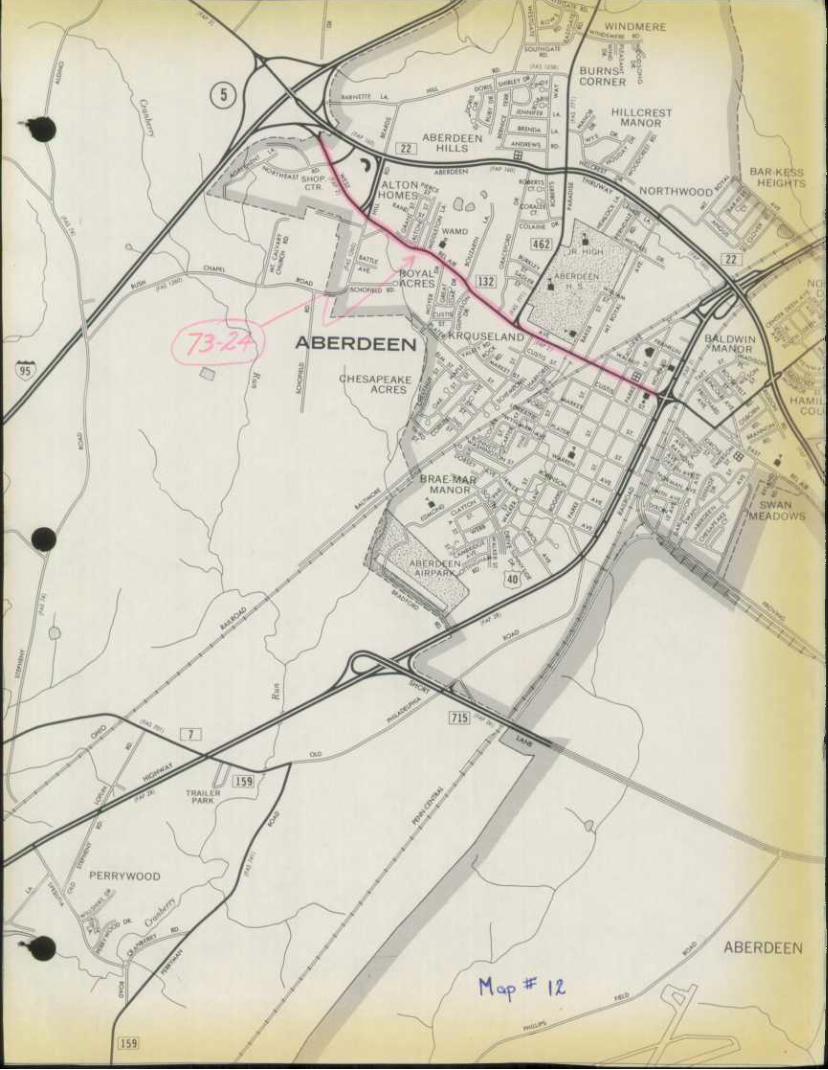
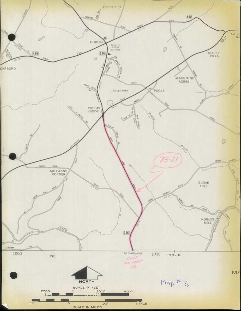
GALL I *• COR|
1010 76°15'00"
2000
NORTH
SCALE IN FEET O 2000 4-000
H^*'^ MA
OS
*aBfe
O 0.5 SCALE IN MILES
1 MILE
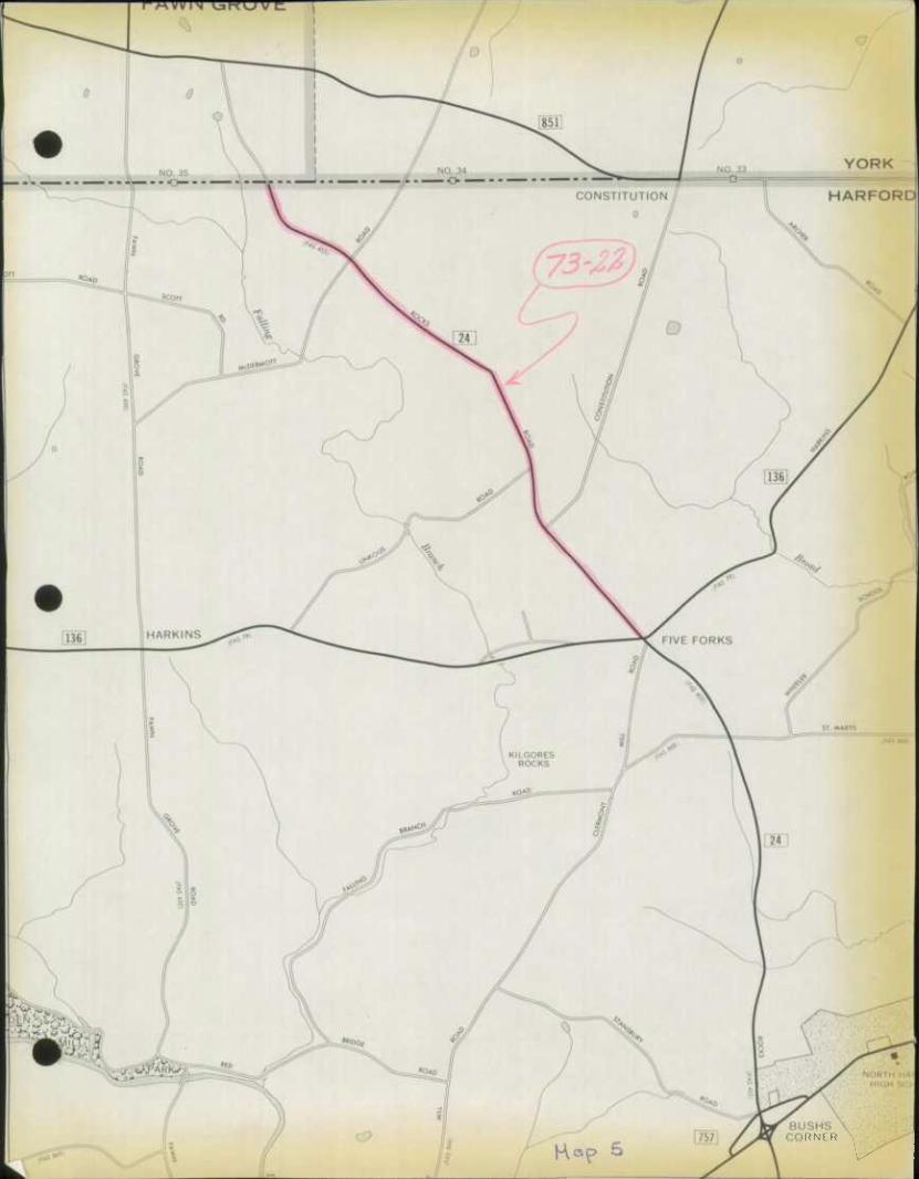
RNER
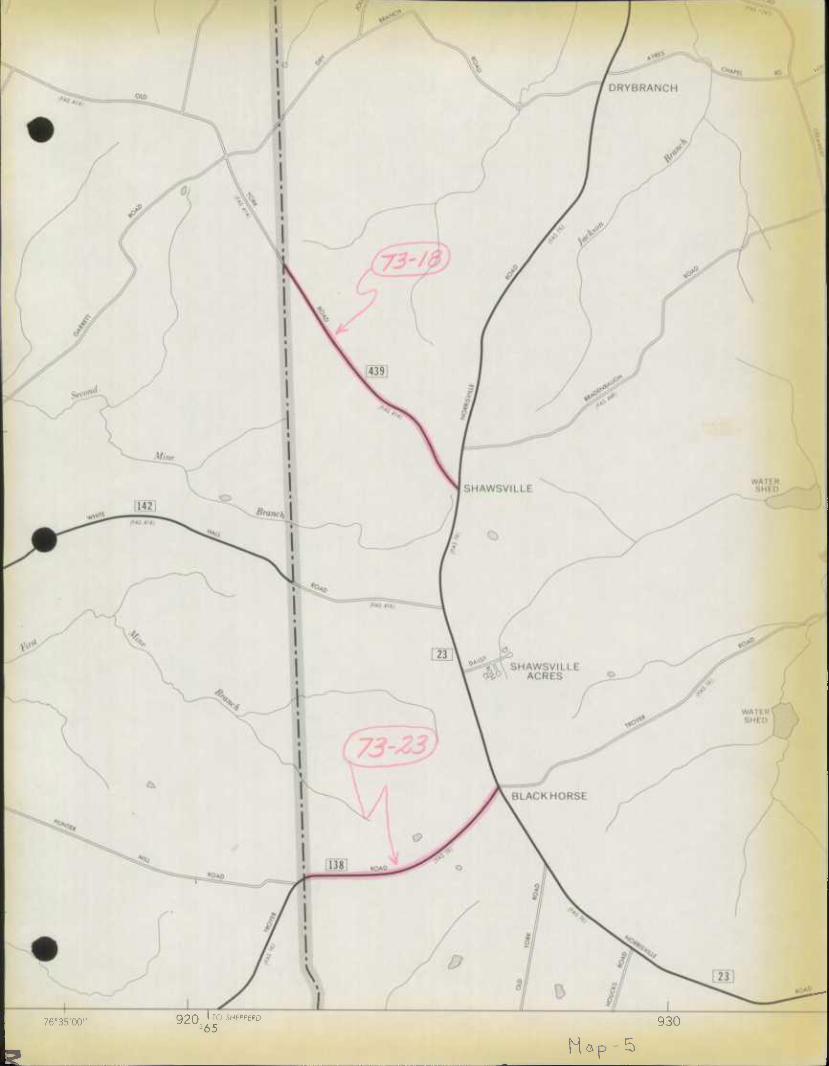
76'35'00 920 ro SHE'>pE''D 365
930
Hap-5
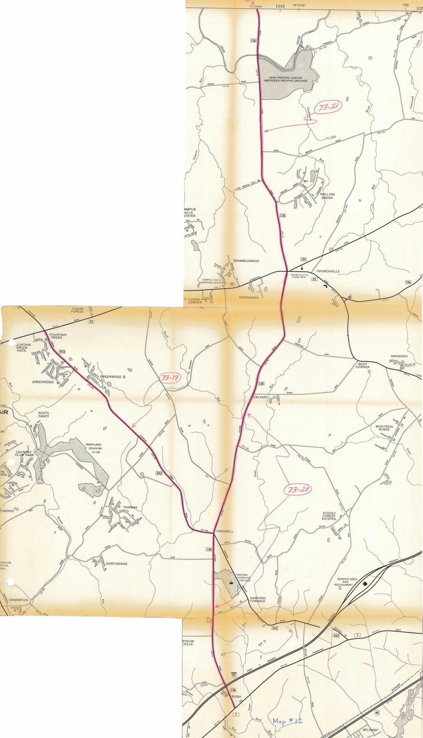
Form HPS-20
S.H.A.Disfricf No.
Coonfy
STATE HIGHWAY ADMINISTRATION OF MARYLAND
ROAD IMPROVEMENT REPORT SHEET 1 of 3
4th City or Town
Harfnrd For Colendar Yeor Ending December 31, 1973
ROAD NUMBER
LOCATION DESIG- NATIONS ON MAP
MILES CHANGES MADE IN MILEAGE
REMARKS FROM TO TYPE WIDTH SYSTEM BUILT (NEV/)
ADDI- TIONS
ABAN- DONED FROM TO FROM TO FROM TO
(1) (2) 0) (4) . (5) (6) , (7) (8) (9) (10) (in (12) (13) (14)
f.n Rd 4?n Rt.. 13? t.n HPad Fnd 1 .1904 0 20 5 3 .19 .19 - Country Club Road Co. 473 to C-D-S 2 .1624 m 0 24.5 5 3 .16 .16 _ (^Ip^Hc+Tino Pniivi-
Gladstone Ct. to C-D-S 3 .0643 _ T 0 24.5 5 3 .06 .06 _ Co. 257 to C-D-S 4 .0314 - 0 24.5 5 3 .03 .03 _ fliiKiiv^n Pniiv"f" Cn. ?S7 tn Head Fnd 5 .2734 _ n 24.5 5 3 .23 .23 _ Millwood Drive Millwood Dr. to Dead End 6 .0075 _ 0 24f5 5 3 .01 .01 Meriweather Drive luS\ Millwood Dr. to C-D-.S 7 .0066 _ n 24.5 5 1 .m .01 ^leriweather Drive (E^ Break to Bernadette Dr. 3 .5032 - 0 24.5 5 3 .51 .51 _ Forest Valley Drive Forest Valley Dr. to CDS 9 .0337 - 0 24.5 5 3 .04 .04 _ rorest Valley Court
Co.Rd. ?33 Dead Fnd t.n Dead Fnd 10 .1774 _ n 24.5 5 3 .13 .13 Ross Road Samantha Dr. to Ross Rd. 11 .0937 - 0 24.5 5 3 .10 .10 _ Melissa Way Forest Valley Dr. to CDS 12 .0234 - 0 24.5 5 3 .03 .03 - Samantha Drive (S) Forest Valley Dr. to CDS 13 .1361 - 0 24.5 5 3 .14 .14 _ Samantha Drive (N) Forest Valley Dr. to CDS 14 .0303 - 0 24.5 5 3 .03 .03 _ Priscilla Court
Co.Rd. 234 Break to Forest Valley Dr 15 .0229 _ 0 24.5 5 3 .02 .02 _ Meadow Road Co.Rd. 727 Break to Bernadette Dr. 16 .4231 - 0 24.5 5 3 .42 .42 - Honeysuckle Drive
Forest Valley Dr. to CDS 17 .0351 - 0 24.5 5 3 .04 .04 _ Adrienne Court Forest Valley Dr. to CDS 13 .0412 - 0 24.5 5 3 .04 .04 - Barbara Court Forest Valley Dr. to CDS 19 .0263 _ 0 24.5 5 3 .03 .03 Deborah Court
Co.Rd. 636 Property Line to End 20 .4337 - o 30.0 5 3 .43 .43 .
Bernadette Drive COUNTY TOTALS 2.7916 y /. -A :—
1.80 2.30
It is hereby certified by the underjlgned that the additions and revisions reported each year pertain lo roads legally a port of the county rood system and title to some is vested in the con- stituted authorities of the political sub-division for which the report is filed. It is further certified that oil roods shall be at least 30 feet wide in accordance with Section 145 of Article 25 of the Annotated Code of Maryland. (1966 Replacement Volume)
SHA 51.3 - 23 10-1-73
SUBMITTED BY
OFFICIAL TITLE
REVIEWED FOR D
OFFICIAL TITLE
ZTnuZTt
ENGR. BY
DATE
DATE
/-3-74
REVIEWED FOR CO. RDS
OFFICIAL TITLE
RDS ENGR. ^QmUIAObi^SL yikmW.^DATE /S-74-
Form HPS-20
S.H. A.District No.
County
STATE HIGHWAY ADMINISTRATION OF MARYLAND
ROAD IMPROVEMENT REPORT SHEET 2 of 3
4th
HarfnrH
City or Town
For Co lender Year Ending Dprpmhpr .31 . iq7T
ROAD NUMBER
LOCATION DESIG- NATIONS ON MAP
MILES CHANGES MADE IN MILEAGE
REMARKS FROM TO TYPE WIDTH SYSTEM BUILT (NEW)
ADDI- TIONS
ABAN- DONED FROM TO FROM TO FROM TO
(1) (2) (3) (4) , (5) (6) , (7) (8) (9) (10) (11) (12) (13) (14) Bernadette Dr. to End 21 .1306 - 0 24,5 5 3 .13 .13 _ Bear Creek Drive Bear Creek Dr. to End 22 .1089 - 0 24.5 5 3 .11 .11 _ Yvette Drive Yvette Dr. to C-D-S 23 .0440 - 0 24.5 5 3 .04 .04 - Petula Court Water Vale Rd. to End 24 .4545 - 0 24.5 5 3 .45 .45 _ Peachtree Road
Brickhouse La. to C-D-s 25 .4660 - 0 24.5 5 3 .47 .47 _ Sturbridqe Road Dead End to Dead End 26 .1392 - 0 24.5 5 3 .14 .14 _ Brickhouse Lane Thomas Run Rd. to Dead Enc 27 .1856 - 0 24.5 5 3 .19 .19 - Spring Valley Drive Spring Valley Dr. to CDS 28 .0549 - 0 24.5 5 3 .05 .05 - Revere Court Dead End to Dead End 29 .4879 - 0 30.0 5 3 .49 .49 _ Gunston Road
Co.Rd. 901 Break to C-D-S 30 .2079 - 0 24.5 5 3 .21 .21 _ Dalewood Drive Dead End to Dead End 31 .1515 - 0 36.0 5 3 .15 .15 - Mauser Road Break to Dead End 32 .4844 _ 0 24.5 5 3 .48 .48 _ Prindle Drive Break to Mailer DHVP 33 .0312 _ 0 24.5 5 3 .03 .03 Cass Drive
Prindle Dr. to C-D-S 34 .1267 - 0 24.5 5 3 .13 .13 ^ Prindle Court Prindle Dr. to Dead End 35 .0255 - 0 24.5 5 3 .03 .03 - Weatherby Road Prindle Dr. to Dead End 36 .0284 - 0 24.5 5 3 .03 .03 _ Winslow Drive Prindle Dr. to C-D-S 37 .0942 - 0 24.5 5 3 .09 .09 _ Forehand Court Red Pump Rd. to Dead End 38 .3101 - 0 24.5 5 3 .31 .31 • Cedarwood Drive Cedarwood Dr. to C-D-S 39 .0721 - 0 24.5 5 3 .07 .07 - Cedarwood Court Cedarwood Dr. to Pearwood 40 .1610 - 0 24.b b 3 .16 .16 - Applewood Drive (S)
COUNTY TOTALS 3.7646 y - / i 3.76 -t_
3.76
It is hereby certified by the undersigned that the additions and revisions reported each year pertain to roads legally a part of the county rood system and title to same is vested in the con- stituted authorities of the political sub-division for which the report is filed. It is further certified that all roods shall be ot least 30 feet wide in accordance with Section 145 of Article 25 of the Annotated Code of Maryland. (1966 Replacement Volume)
SHA 51.3 - 23 10-1-73
SUBMITTED BY
OFFICIAL TITLE
REVIEWED FOR D
OFFICIAL TITLE
d^^f. ^^f^m^r/J^a/:
ENGR. BY
DATE
DATE
/-S-74
REVIEWED FOR CO. RDS. ENGR. B
OFFICIAL TITLE Chl^P Q iga i-S-n
Form HPS-20
S.H. A.District No.
County
STATE HIGHWAY ADMINISTRATION OF MARYLAND
ROAD IMPROVEMENT REPORT SHEET 3 of 3
4th
Harford City or Town
For Calendar Year Ending December 31, 1973
ROAD NUMBER
LOCATION DESIG- NATIONS ON MAP
MILES CHANGES MADE IN MILEAGE
REMARKS FROM TO TYPE WIDTH SYSTEM BUILT (NEW)
ADDI- TIONS
ABAN- DONED FROM TO FROM TO FROM TO
(1) (2) (3) (4) , (5) (6) , (7) (8) (9) CO) (ID (12) (13) (14)
Applewnnd Dr. tn T-n-q 41 .0435 Q 24.5 5 3 ,04 .04 _ Pinewood Court Cedarwood Dr. to C-D-S 42 .0927 - 0 24,5 5 3 .09 .09 _ Poplarwood Court Cedarwood Dr. to Dead End 43 .0937 - 0 24.5 5 3 .09 .09 - Pearwood Drive Cedarwood Dr. to C-D-S 44 .0719 - 0 24.5 5 3 .07 .07 - Applewood Drive (N, Hunt. Rnad tn Rrpak 4^ ???n n 24.5 5 3 .23 23 Tflllu-Hn Driup Tally-Ho Dr. to C-D-S 46 .0535 _ 0 24.5 5 3 ,05 .05
1 fl 1 1 Jr—LLU U\ \ Ysi
Tallv-Ho Place
/ COUNTY TOTALS • 5873 y ^r, ; 57 .57
It Is hereby certified by the undersigned that the additions and revisions reported each year pertain to roods legally a port of the county rood system and title to same is vested in the con- stituted authorities of the political sub-division for which the report is filed. It is further certified that all roods shall be at least 30 feet wide in accordance with Section 145 of Article 25 of the Annotated Code of Maryland. (196« Replacement Volume)
SHA 51.3 - 23 10-1-73
SUBMITTED BY
OFFICIAL TITLE
REVIEWED FOR DIST. ENGR.'BY
OFFICIAL TITLE
REVIEWED FOR CO. Rp
OFFICIAL TITLE
J-S-7^
1-3-1-4-
'Msm
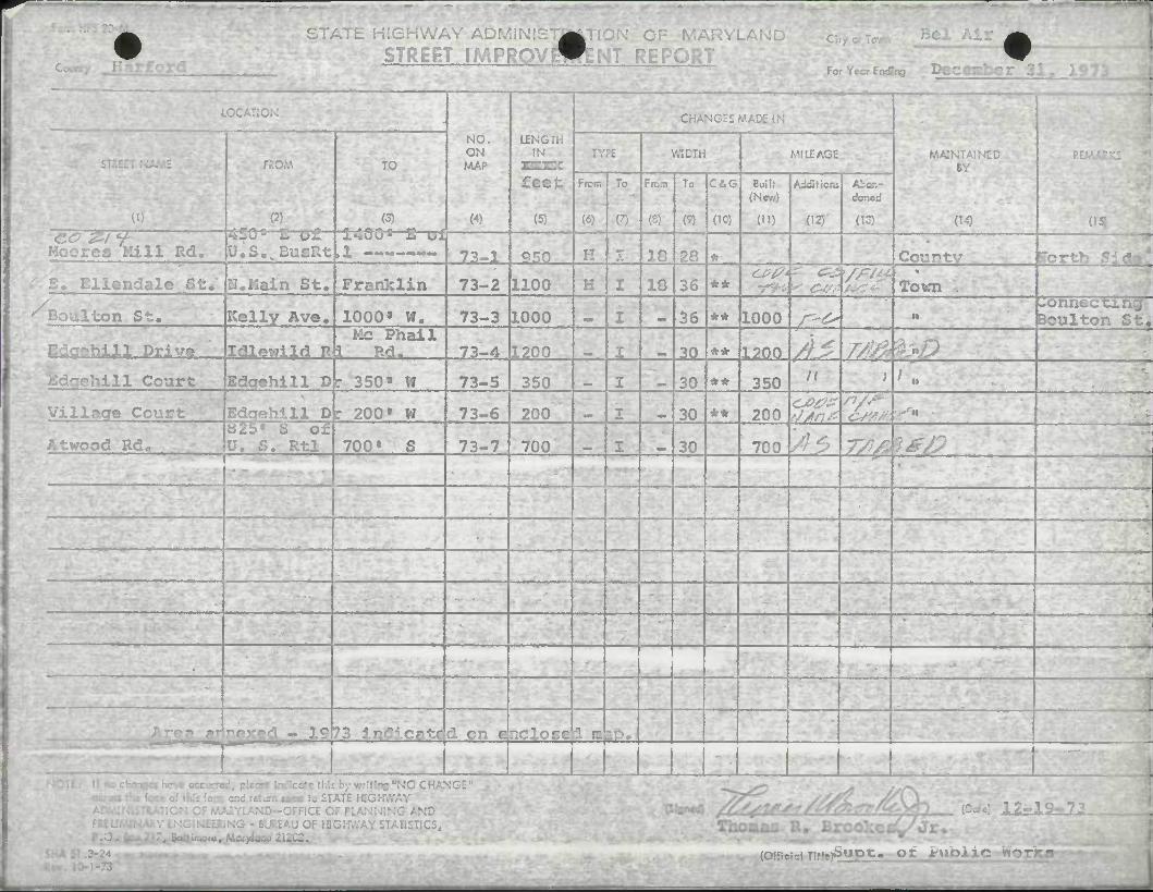
STATE H1SHWAY ADMlN: A
STREET IMPROValFENT REPQR
HI KG:;,
NO. ON
W
LENGTH tN
r:.:~: feet
(5)
MAINTAIN: BY
(14) «
TO
(3)
Vfll MILEAGE
(I)
From
(6)
To
(7)
From
(8)
To CiG
(10)
Bui If (N«/)
CD
Afcor.- izr.zi
03} CO Z~l <+
Hoores Mill Rd. [J.S.wBusRt ,1 — 73-1 550 H I 18 58 * Countv iTorth S:
-. Ellendale St/ N.IIain St. Franklin 73-2 1100 K I 18 36 ** 7-^4^ <^ 1 Town
^Boulton St. Kelly Ave. 1000* W, 73-3 1000 I ||J| 36 ** 1000 f-^ ti ionnecting^ 3oulton St.
ahill Drive Idlewild R Mc Phail
\ Rd« 73-4 1200 ^ 30 ** 1200 A - 7/!/k*D Jfidqehill Court Bdqehlll D : 350* W 73-5 350 I 30 ** 350 K ) ' «
Villaae Court Edcrehill D r 200» W 73-6 200 I 30 ** 200 'fm
Atwood Rd, """"•
625* S of U. S. Rtl 700 • S 73-7 700 I 30 700 AS #£>
•
•"• —1
nexed.- 19 73 indicate d on e r.crccc 3 m aP, 1. _-. •• «^———, - •• -"— "
1
(OH >W ji.Ot i^UDX

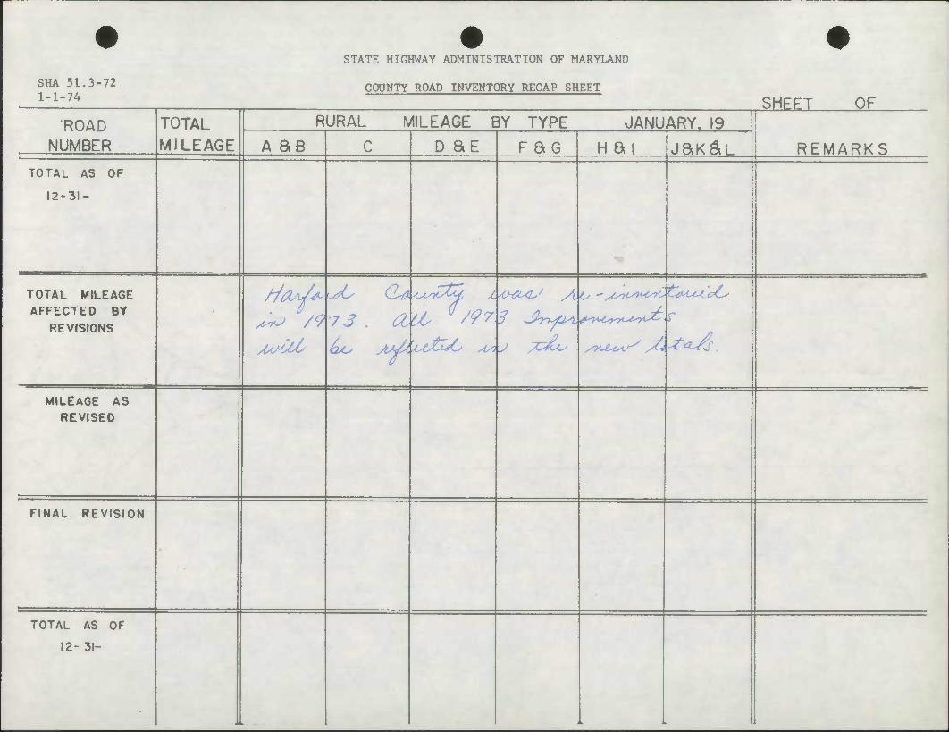
SHA 51.3-72 1-1-74
STATE HIGHWAY ADMINISTRATION OF MARYLAND
COUNTY ROAD INVENTORY RECAP SHEET
SHEET OF ROAD TOTAL
MILEAGE RURAL MILEAGE BY TYPE JANUARY. 19
REM NUMBER A as C D SE F SG H at jaK^L ARKS TOTAL AS OF
12-31-
.
TOTAL MILEAGE AFFECTED BY
REVISIONS
MILEAGE AS REVISED
FINAL REVISION
TOTAL AS OF
12- 31-
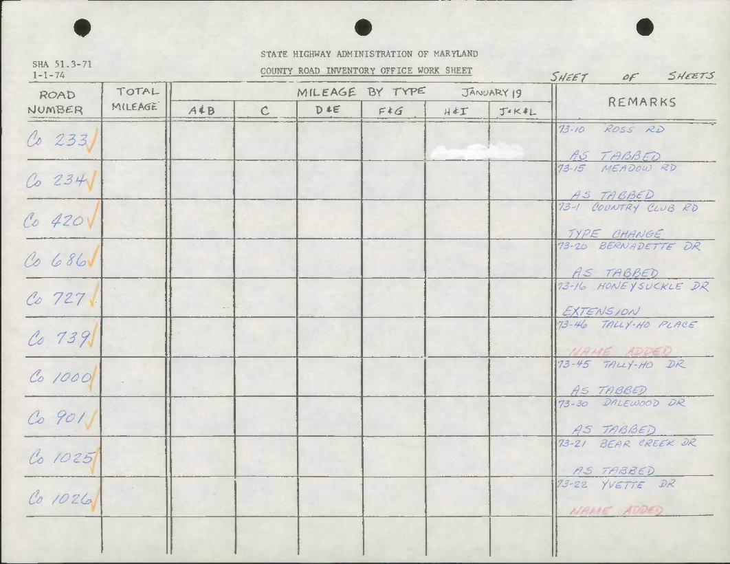
SHA 51,3-71 1-1-74
STATE HIGHWAY ADMINISTRATION OF MARYLAND
COUNTY ROAD INVENTORY OFFICE WORK SHEET Ss/Sfr tf 5^^-rjs
ROAD TOTAU M(LeA<Jt
MILEA6E BV rrpe: jArMCARYig REMARKS
NlUmBCR AiB c D*? P*d M*r T'K^L
^ Z33J /}6 r/9/5/3tr7}
Co 23^ 73-/5' Me/IDooO ^i>
& 4?oj 73-/ OoosorRi CLOS £t>
ryp£ 6HHAJ&£
&> 6? Z(* 1
& 72.7 7J-/6 HOfiJ^ySUCKLE: 2>R
ZAT^AJ-S/OAJ
&> 73 f 73-4C> Ttiuy-s/o rcrfce
& /ooo -
73-¥5 7flu.-/-rto 2>(Z.
&> ?o/ 73-3o X>*LCoOOOl> dfZ.
43 7^/3/3^
&> /OZ5 73-2f d£/m t/ZEiT* ££.
/7>s rrfage'i}
&> /OZG 73-2'z. /i/e rre £*
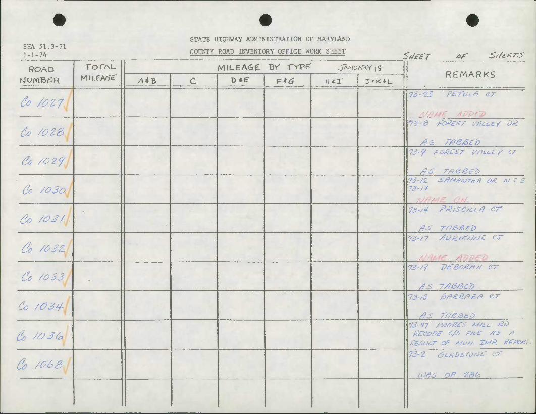
STATE HIGHWAY ADMINISTRATION OF MARYLAND SHA 51.3-71
COUNTY ROAD INVENTORY OFFICE WORK SHEET S//*fr of 5rf*e-rs
ROAD TOTAL- MILEA6E Br TYpc: JA^ARY|9 REMARKS
NlUmBCR AiB c D*f f=*(S M*r T'KtL.
60 /027 73-23 ' FETULA ar
60 /oz& 73-3 FO#£ST MLLCY O*
&> /OZJ 73-9 FO/?eS7 UrfcoC/ C~
Cc /ojaj 73-/3
&> /OS/ 73-/4 p/Zisc/cc/i er
& /OSZ 73-/7 /tDZ/fAj/UZ CT
&> /033 -
73/9 7)£80#F>'/ CT
Co /03^ 73-/8 /3/9£8/:)etf G-T
/?S r/9/3/3E/>
&> /Oft* 73-47 /MM/zes M/tt. ££ g£eoD£ C/S £/t£ /fS s*
Co /0&3 13-2 GLADsToAJir cr
tdrt3 OP Idb
STATE HIGHWAY ADMINISTRATION OF MARYLAND SHA 51.3-71 i i -it. COUNTY ROAD INVENTORY OFFICE WORK SHEET
SfJeff of Srf*£-rs
ROAD TOTAL
MJLCA^t
MILEA60: Br rrpc: jA^ARYig REMARKS NlomBeTR AiB c vie r=*d HtX T'»<*L
do /OG9 73-3 fe-Mtoooo cr
00/9^ or Z37
Co /0 70 73-1 tfueuse/o cr
OO/fS OP /OS
Co /O 7/sj 73-5' Af/LtcoooD o/l
IJ/9S Frier op /o*/-
Ct /& 7ZI •73-C MZ'&uJCrtrrteg. Dg 73-7 (ensr) f (coesr)
A/£o3
Co /073 73-// M^l /SS A COrf ^
fiOrfS OF //Z
C* /oyf •73-24 p£/9C^T^££r £i>
curs OP 8&
Co /o 7S\ -
73-25 S70.Z8&/D&C £b
UJrts Of 37
C* /o7H 13-ZC? BZ/CXHOU^^ LA
Co /0 77J 73-27 SP/e/Aj^ wLtey' <>^,
iOtfs or zsfe
Co /0 7& 73-2& jeevezB- cr
5 OF 138
STATE HIGHWAY ADMINISTRATION OF MARYLAND SHA 51.3-71 i _ i m. COUNTY ROAD INVENTORY OFFICE WORK SHEET SdcfT ef S^/^rs
ROAD TOTAU
M«LeA<Jt MILEA6E BV TYpe: JANUARY |g
REMARKS NlUmBCR AiB c DMT P*6 HtX r'K^L.
d> /o?f\j
&> /OZO IS-3/ M/qUSr/Z fib
A/eco
&> /o?/\j 73-3Z P£//JDL£ D£
U)fis F/ier op 26,/
&> /ofzj 73-33 <J/9S5 J?*.
(h /oU'j. 72-3^ FetAjQce dT
WAS OP 265
Co /OS4 CD ft 3 OP Iks'
& /OS 6^ -
73-3(0 UJ/AJSLOUJ DtZ
UJflS op -z^^
(U /oSGyj 73-37 pO££/ii*JD er
A/SLO
& /oSli 13-38 eeDrfgiOOOD /3/Z
UJ/95 OP 79
Co /ossj 73-3f CZDWOOOD CT
Aseto

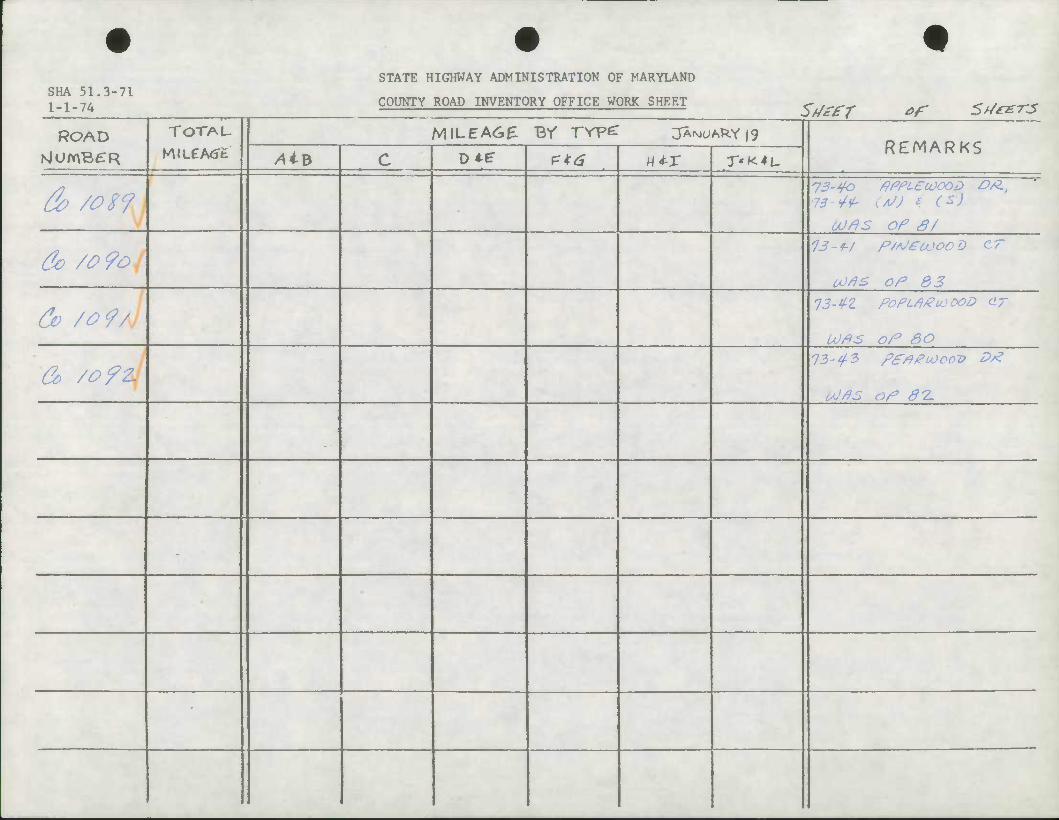
SHA 51.3-71 1-1-74
STATE HIGHWAY ADMINISTRATION OF MARYLAND
COUNTY ROAD INVENTORY OFFICE WORK SHEET S//*fr of 5f/*-er-s ROAD TOTAU MILEA6£ BY TYPZ JA^ARY 19
REMARKS NlUmB^R AiB c D*e- etti utx T'K^L.
& /ogy 73-40 ftPPLEtOOOD OsZ, 73-¥£ (AJ) * (*)
OUfiS OP s/
&> /o?oj 13~i/ p/^'eajoo D cr
oorfs oP 33
do /o9/j 13-tfZ FoPLflgLOOOD cr
LOPS oP SO
& /o?z\ 73-^3 fPrfgiOoov D/Z
(AJPS op 87-
-
-
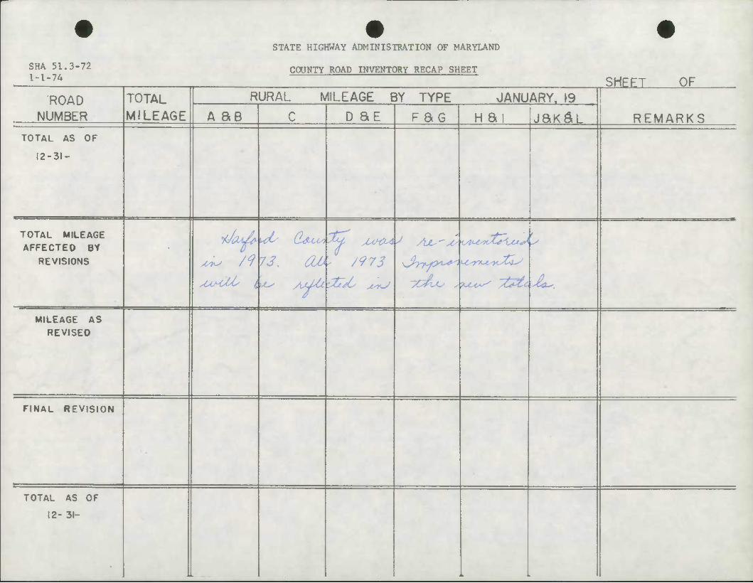
STATE HIGHWAY ADMINISTRATION OF MARYLAND
SHA 51.3-72 1-1-74
COUNTY ROAD INVENTORY RECAP SHEET SHEET OF
ROAD TOTAL MILEAGE
RURAL MILEAGE BY TYPE JANUARY. 19 \
NUMBER A ae C D SE F aG H ai jax^L REMARKS TOTAL AS OF
12-31-
TOTAL MILEAGE AFFECTED Bt
REVISIONS 73.
'%4 MHX*
'- /973
1
yt^Lo siu^c^ /6*Zc Jieu,_
MILEAGE AS REVISED
FINAL REVISION
TOTAL AS OF
12- 31-
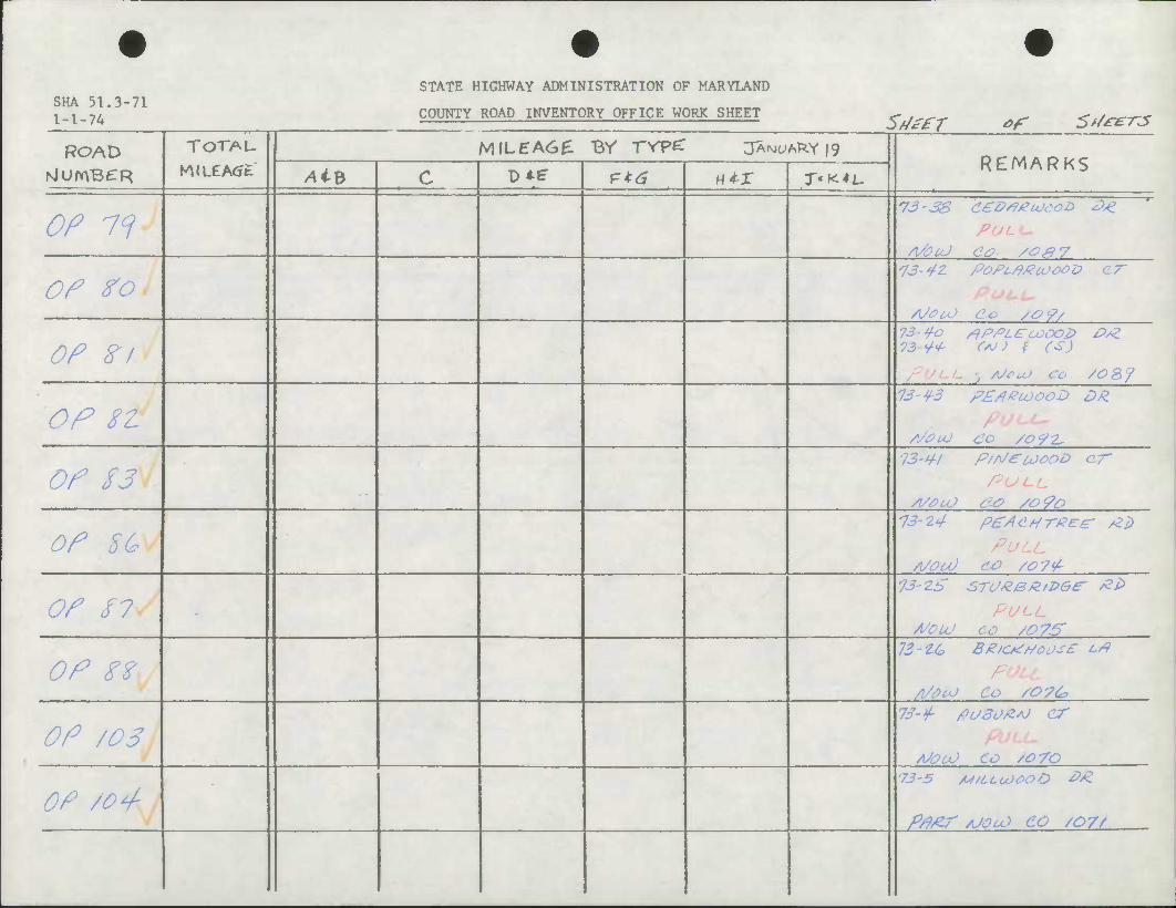
SHA 51.3-71 1 _ 1 _ 7/.
STATE HIGHWAY ADMINISTRATION OF MARYLAND
COUNTY ROAD INVENTORY OFFICE WORK SHEET SfJefT of 5>/es-rjS
ROAD TOTAL
MlLCA<Jfc MIL5A6E Br TYpe: JANUARY 19
REMARKS /4iB c D*e P*^ w*-x T'K*L.
OP 7f PULL-
A/OuJ do /Of} 7
OP fo 73-¥Z Pofcrt/ZcoooD (IT
OP Zl 73 y-o rfPPLEuoooZ> O/Z 73^ C/U) t (S)
•; /jfcO CO ZOSf
OP 8Z 13-^3 P£/iecoooD DR.
OP /J P/rJeu>ooD ar"
PULL.
OP EG 73-24 pgAdHreee- /ZD
PULL
OP /7 - PULL A/OUJ co soys'
OP ?Z 73 ZG B£/C*rtoo-;£ <-#
/l/#cO Co /O?^
OP /03 73->/- /?USO/Z*J cr
A/OcO CO /0 70
OP /Op- 73-5 M/LLuJOOO &£.
P/9/Zr /UOcO CO /07/
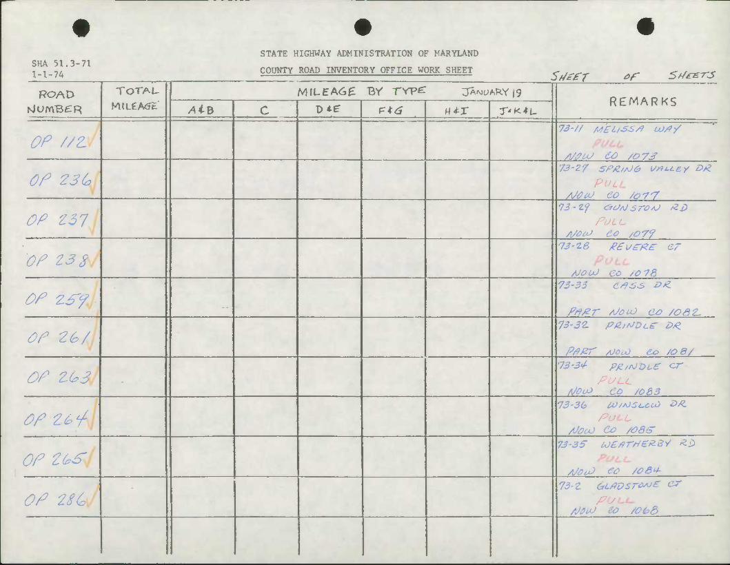
STATE HIGHWAY ADMINISTRATION OF MARYLAND SHA 51.3-71 1 1 -7/. COUNTY ROAD INVENTORY OFFICE WORK SHEET Sz/ffr of 5rf*e-rjs
ROAD TOTAU
MlLCA<Jt M\LEA&£ Br rrpe: jArvjuA^Yig
REMARKS NlUmBCTR AiB c D*?
— • , • .. ,. J— «*r T'K^L-
OP //z 73-// M'£L/S£/} U)/?-/
PULL
Of Z3G 73-27 SPZ/AJ& i>/9u.ey &£
PULL AJOCU CO /o77
OP Z31 •73-zy cnJ/jsroAj AS)
PULL
OP Z3S •73-ze gew^/ze er
AJOUJ CO /0 7&
OP ZSf, •73-33 C*9S,S &*.
Frt#r /OOLO ao /06Z.
OP 2G/ 73-32. P/Z/A/DLS- £>*
Pfi/27' AJO.X) CO /OS/
OP ZQ>3 - PULL A70cO CO /o83
OP Zbi- PULL AJOCO CO /OSS'
OP z&s 73-3S U/ZfiTHeZ-BV *.!>
PULL.
A/OiO CO /OS+
OP 28G 73-z GL#vsrw£ vr
PULL, AJfiuJ do /OO&
4 4 STATE HIGHWAY ADMINISTRATION OF MARYLAND
SHA 51.3-71 1-1-74 COUNTY ROAD INVENTORY OFFICE WORK SHEET S//*fr of 5d*£r-jS
ROAD TOTAU
K\CLeA<Jfc MiLEA6^ BY rrpe: UAN^RY ig
REMARKS NlOrrVBCR Alt C Dip PttS utx T't<*L
Of 2S7 73-3 P£MUJ0Oc> C-T
PULL.
0P37(*J •73-7/. A/O /U*M£
A/^U) ; (ZODcT Act, P)L€S
-
•
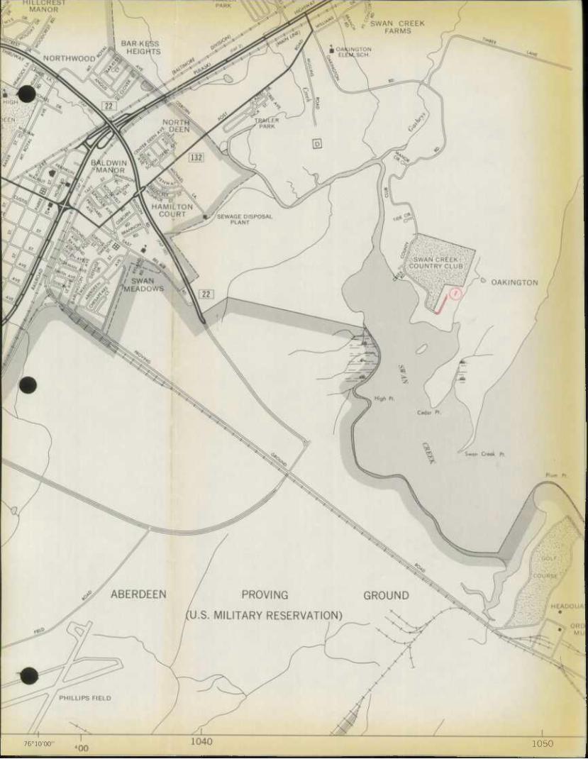
76°10'00 1050
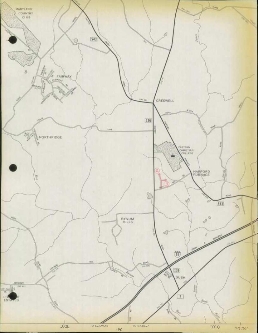
1000 TO BAL TIMORE \ 3 90
TO ROSEDALE 1010 76o15'00"
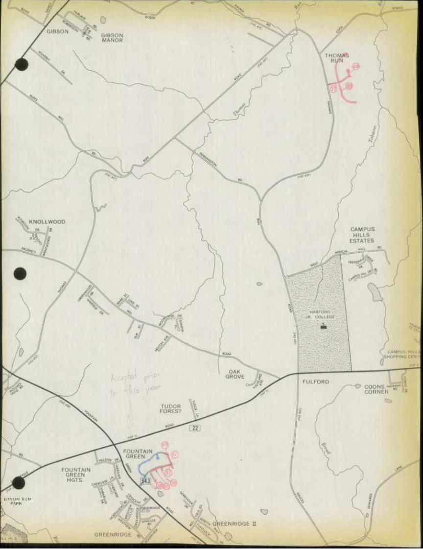
BYNUM RUN PARK
G hi f t N
^•
950 MAP NO.l 1
RIDGECROFT L F0RESTLAKE
BEL) AIR
WATERVALE
ATKISSONN
RESERVOIR
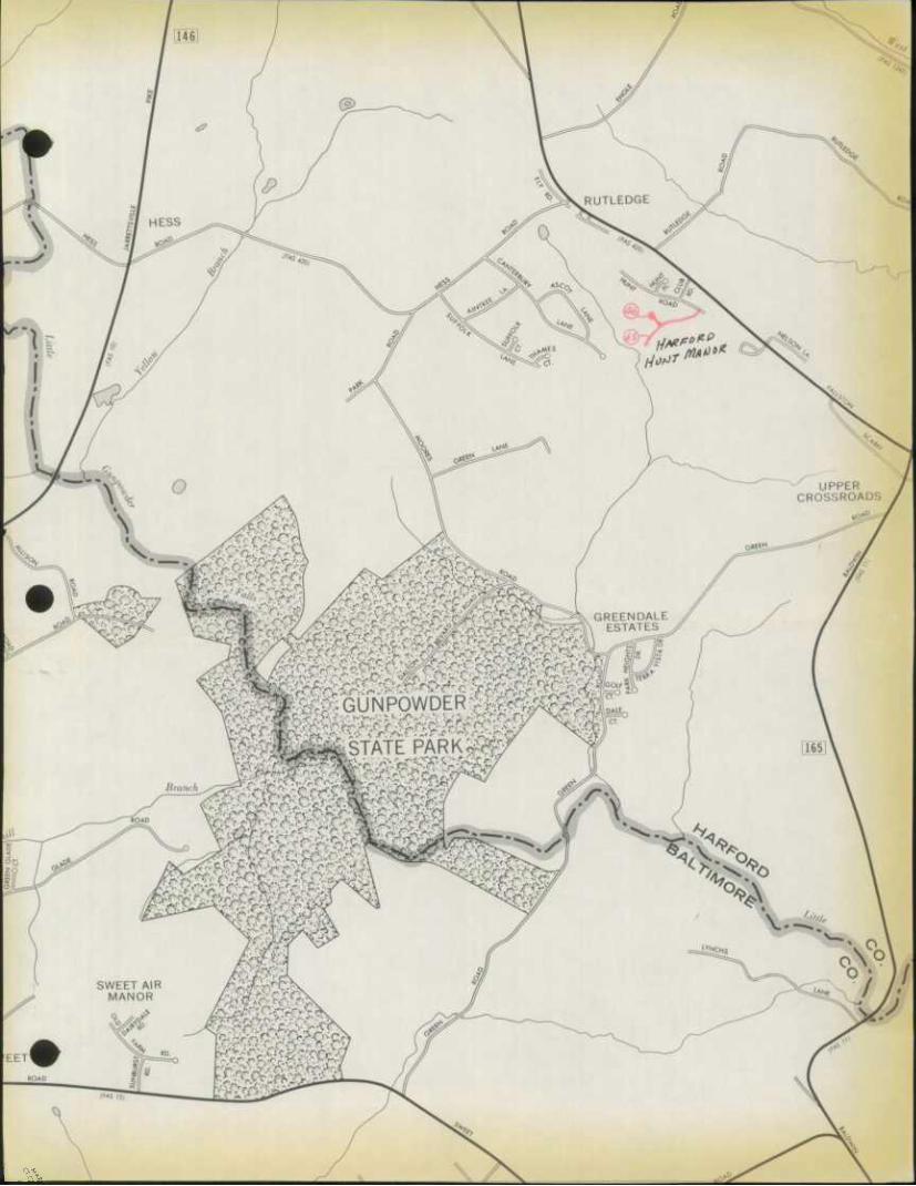

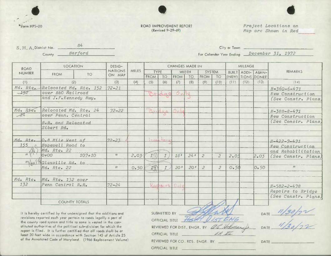
'"form HPS-20 ROAD IMPROVEMENT REPORT (Revised 9-29-69)
Project Locations on Map are Shown in Red
S.H, A.District No.
County
84 City or Town
Harford For Colendar Year Ending December 31, 1972
ROAD LOCATION DESIG-
NATIONS ON MAP
MILES CHANGES MADE IN MILEAGE
REMARKS NUMBER FROM TO TYPE WIDTH SYSTEM BUILT
(NEW) ADDI- TIONS
ABAN- DONED FROM TO FROM TO FROM TO
(1) (2) (3) (4) . (5) (6) (7) (8) (9) (10) (ID (12) (13i (14)
Md. Rte*^. [Relocated Md, Rte, 152 72-21 H-^eo-e-471 -v&r over B&O Railroad New Construction
and J,F,Kennedy Hwy, (See Constr, Plans.
Md, F&<Z Relocated Md, Rte, 24 72-22 H-388-8-471 ^ over Penn, Central New Construction
R,Rm and Relocated (See Constr, Plans, Sibert Rd,
Md. Rfe, n,8 Mile Went of 7P_P^ u 40 0 n All
1H -' Hopeioell Road to New Construction ) 0 Md, Rte, 22 "N and Rehabilitation
w V» 1 0+00 107+10 M 2,03 ^ I 18' 24 > 2 2 2,01 2,03 (See Constr, Plans, ">wrt Glenville Rd. to ^ N Md, Rte, 22 It 0,50 iV _jJ 20' 20' 2 2 0.5$ 0,50 n
Md, Rte, Md, Rte, 132 over 132 Penn Central R,R, 72-24 H-582-2-478
Repairs to Bridge (See Constr, Plans,
COUNTY TOTALS ^s? /
It is hereby certified by the undersigned that the additions and revisions reported each year pertain to roods legally a part of the county rood system and title to same is vested in the con- stituted authorities of the political sub-division for which the report is filed. It is further certified that all roads shall be at least 30 feet wide in accordance witti Section 145 of Article 25 of the Annotated Code of Maryland. (1966 Replacement Volume)
SUBMITTED BY
OFFICIAL TITLE
DATE
REVIEWED FOR DIST. ENGR. BY /^^v^-^c^
OFFICIAL TITLE ^^zr ^ DATE ^t/y ^
REVIEWED FOR CO. RDS. ENGR. BY
OFFICIAL TITLE
DATE
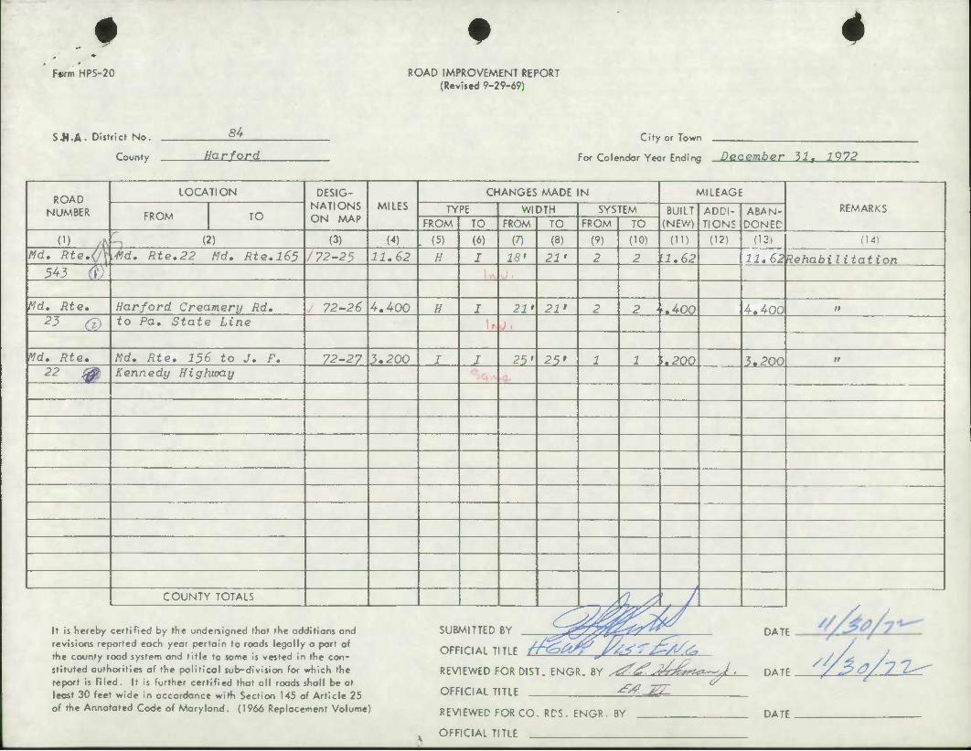
# *
F«rm HPS-20 ROAD IMPROVEMENT REPORT (Revifed 9-29-69)
S-M-A- District No.
County
84 City or Town
Harford For Calendar Year Ending DQCember 111 1972
ROAD NUMBER
LOCATION DESIG- NATIONS ON MAP
MILES CHANGES MADE IN MILEAGE
REMARKS FROM TO
TYPE WIDTH SYSTEM BUILT (NEW)
ADDI- TIONS
ABAN- DONED FROM TO FROM TO FROM TO
(1) (2) (3) (4) . (5) (6) (7) (8) (9) (10) (ID (12) (13) (14)
Md. Rte,(^ •Hd. Rte,22 Md. Rte.l65 i 72-25 11.62 H I 18' 21' 2 2 \1.62 11.6^Rehabilitation 543 rf)
Md, Rte, Harford Creamery Rd. . 72-26 4,400 H I 21' 21' 2 2 \,400 4,400 it
2? G> to Pa. State Line
Md. Rte, Md. Rte. 156 to J. F. 72-27 3,200 I I 25' 25' 1 1 \.200 3,200 n 22 m Kennedy Highway
t
COUNTY TOTALS —rA iJL-^y / y
It is hereby certiRed by the undersigned that the additions and revisions reported each year pertain to roads legally a port of the county road system and title to same is vested in the con- stituted authorities of the political sub-division for which the report is filed. It is further certified that all roads shall be at least 30 feet wide in accordance with Section 145 of Article 25 of the Annotated Code of Maryland. (1966 Replacement Volume)
S SUBMITTED BY _
OFFICIAL TITLE //*£?& /k^ r^t/^
REVIEWED FOR DIST. ENGR. BY ^^ J^^^z^-J
OFFICIAL TITLE -^ ^
REVIEWED FOR CO. RDS. ENGR. BY
OFFICIAL TITLE
DATE
DATE
DATE
^AtA-i^
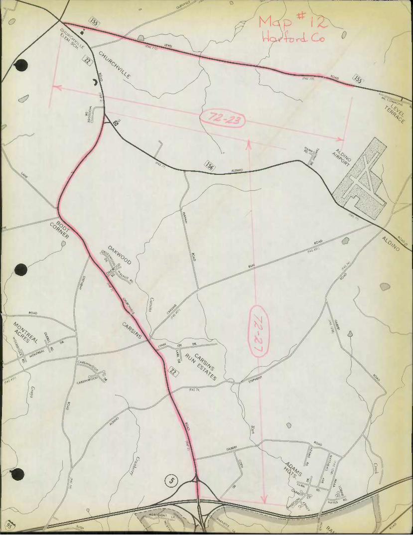
o
•*% ̂
^r
L^ LV ^
^?^>^n.
<?
ALDINO
<?,. ^/
':;*• o 1/ xk-.
#
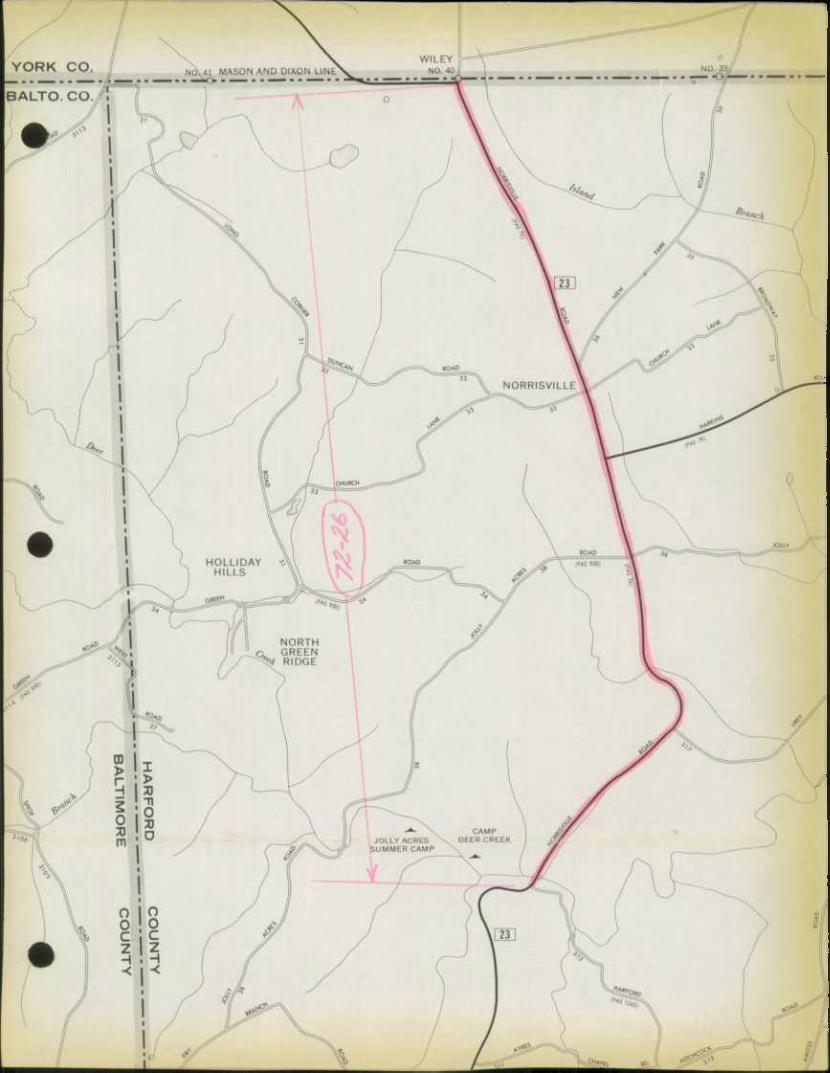
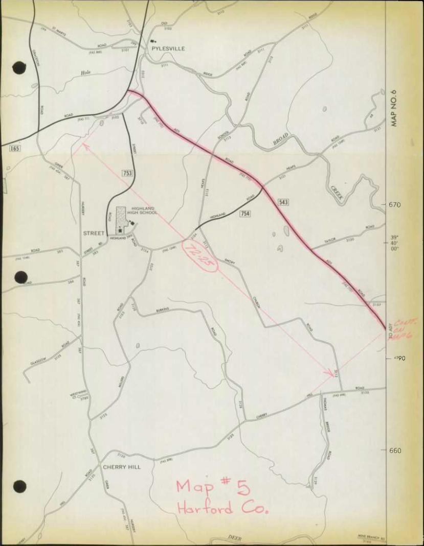
- 670
- "90
660
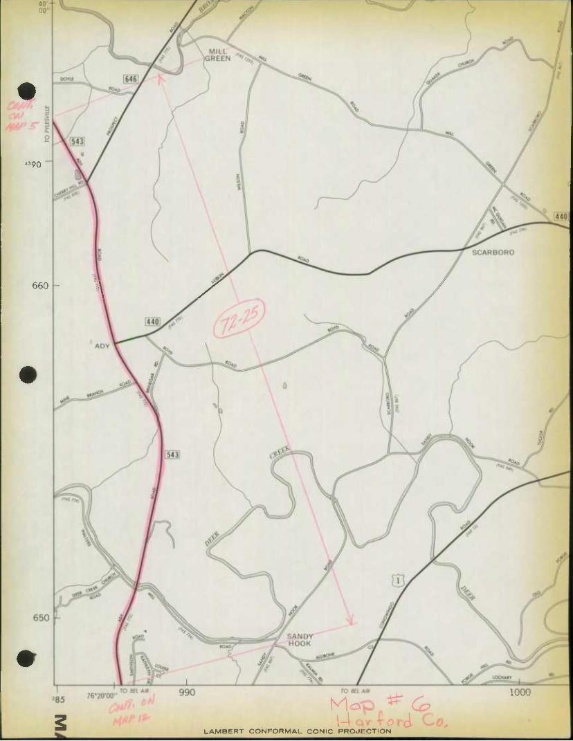
'^O
660 -
Mop * G \4Qrrorci. Co^
LAMBERT CONFORMAL CONIC PROJECTION
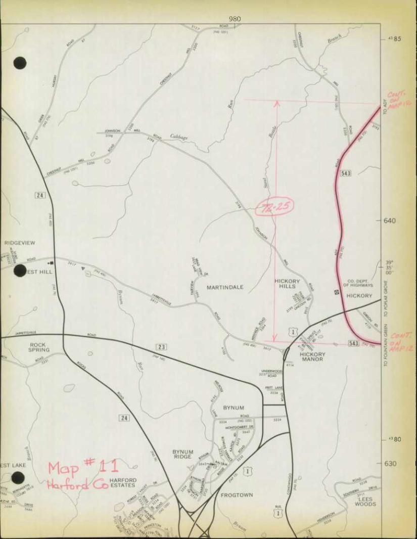
980
"SO
*lFNf BO
3688
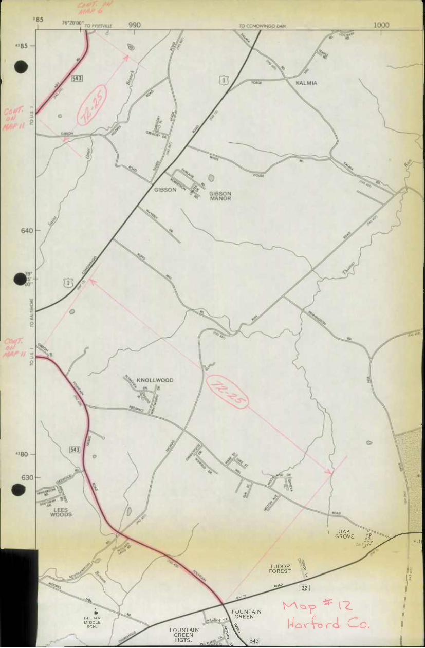
TO CONOWINGO DAM
OAK GROVE //|
^1'
BELAIR MIDDLE
SCH. FOUNTAIN
GREEN HGTS.
FOUNTAIN GREEN
TUDOR FOREST I' ^^ 1 22 |
NA cx-p
Wavtord Co*
^»-
!
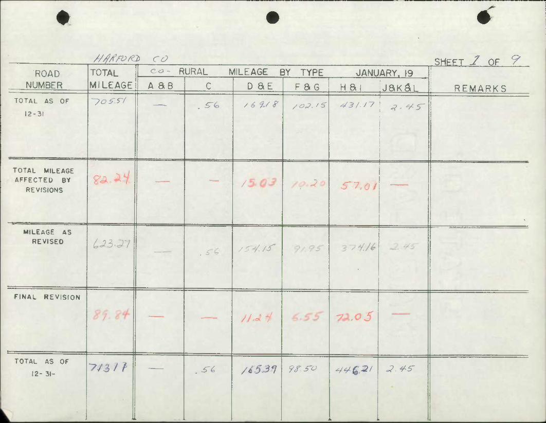
//jAYom CO SHEFT J OF 9 ROAD TOTAL
MILEAGE
RURAL MILEAGE BY TYPE JANUARY. 19 1
REMARKS NUMBER A as C D SE F ao nai jjaK^L TOTAL AS OF
12-31
'-yo^.rf . ^ / 6%/ ? /oj. fS
!
TOTAL MILEAGE AFFECTED BY
REVISIONS ?j.*i — /5.Q3 S"7<0 1
1
\
MILEAGE AS REVISED LJ3-21
. r^ /^4./f '.96- 2 -? */£
FINAL REVISION
. ___ //^y 7l'OS
TOTAL AS OF
12- 31-
k
-7/3/} . ^£ /i531 9r.s'o ^¥£2/ .?. 4-5-
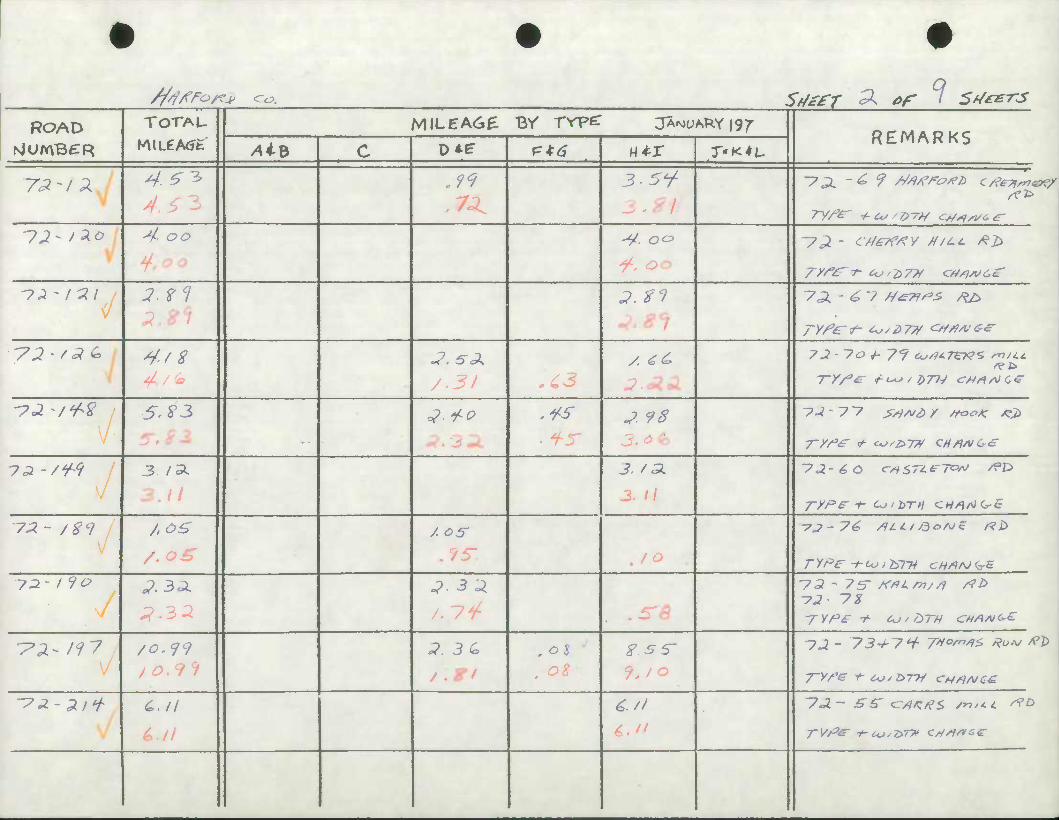
///iATa^ co. SfttfT '^ ar i Sf/ee-rs
ROAD TOTAU MILEA6^ Br rrpe: JA^DAT^Y (97 REMARKS
NjUmBCR /4iB C Di? p*df N^r T'KtL.
7^-/^7 4.5^ 3.5y
12- i*o 4- oo -4^ OO
-72. - c/S£7f/?y H/ci. /?£>
<J 3.2 cl ^. ^f 7 ^ - 6 7 M£7f/*S Kb
TyfG't- t<"i>7# <=***££•
-ri'/aG. 4f8 4 /<o
/. 4C 72 • 7o +- 7*/ oj'HTZK'Z mu.c
l"//3^ t-t-osDJl-S <:»Artec
-73.-/W 5. $3 ^.^^ .^5- J. 98 3. ot
7c3 -/^ 3. /ZL
3.11
3. f 3L
3. II
'73.-£0 cw57Zt-7cw /f»£>
J-yPF-f- Cj'bTH CH4Ai(*-£
~7A- /8<9 /.OS
/.oS 5"
•7J-74, /ILL/ ftofiJ* /?£>
72-f 9o ^.3^ ^.3^
.^a ~7 £ - 7 5" /<*Lryi//j rfb -72 yz
-pz-wy /o.<f9 ;?. 3 6 ,05 f.ss-
~?*-Zt* C./l 72.- SS' <zr/IK#<, mn.L rtb
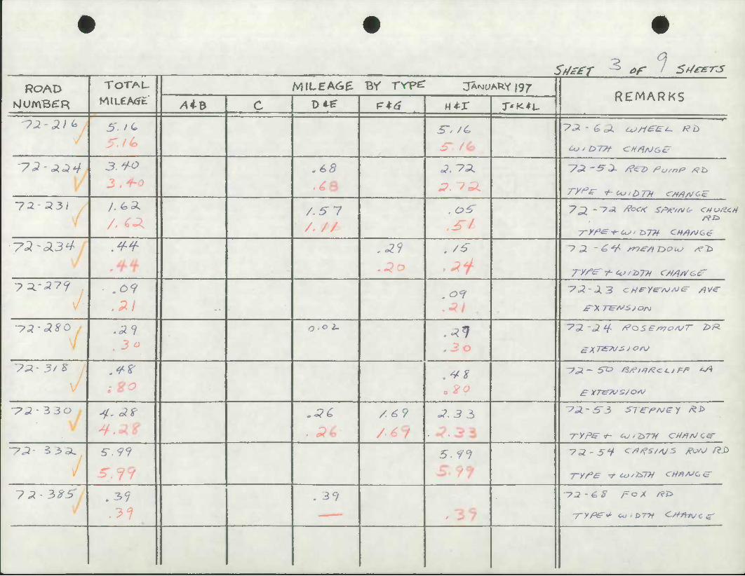
Sfj££-r ^> ef 1 Sf/eers
ROAD TOTAU KMLeA<Jt
MILEA6E Br rrpc: JANUARY jg^ REMARKS
NluraBCR /4iB C Di? p*^ n^r J-'K^L
-72 -2) <*
5'. /6
•72-^^4 3.+0 .65 «>. 7^.
IZL- 231 A 5" 7 .o?
y2-A34 ,-29 . /6 ~? 2. -C*/> ST)*-/) T>Oi*J A'i>
7*-2?9 .09 ,0*?
ysi-JSO
. 3 a
0-0 2- .^1 ,3o
VU - 3/ S .**
"72' 3 Jo 4- ol? .i?^ /.6? ^.3 3 •
•7P- 3>^L 5-.99 5- 9°!
.39 . 39

Sd&r / ^ *9 Sf/^Ts ROAD TOTAU
WLCAtJfc MILEAGE BV TVP^ 3A^AkY|97'
REMARKS NlUmBCR Alb C DiP P*^ H4-X T'K^L.
-73 • 3 7 </ 3 4^ /. aZ
-7^^/' 3 3 3
3.33 3 . o / 31
-72 4*{ I ^3 //iSS Sh
7J -¥5~Z A*?^ A AC
. 4> %
-?£- 5~*JL i?. 33 ^.3 3
3. 3 3
?~? 5 5~9
/f3 TABa ^2)
yj-m ,41 .^7
-?2 • 61?5" ./si
^J- t>9o ,6 3 .6 3
7^-7/7 /• /C
/i)a^ f/tfir OF Ct* /O J 7

^y-rrr -> er ' s^/^-rs ROAD TOTAU MILEA6^ BV TVP^ JAN)UAPIY|97
REMARKS NlUmBCR /UB C 0 4? p*^ wtx T'K-tL
-7^ - -?(* o .ib- . 6 5"
•7^-7?3,
/f^ 7~#BB €2) 7-?- ^ /b//vr co/v^coAfr) /?
?3-yi¥
/fS m/3* 3^z) y2- to* .03
.7 / -?£- Zl^ .34 . 34
yj-FFt ./o
•^<J'9Jr .OS
-
.OS •7-5-/0 ST. rf4*t<l* /*£>
7a- ?3o
i?7
-?£- 93* . 07 -o"?
•?2'9f* ^3 rTIOeer ^
~?2.- 5~ c-^mPui- HIUL5 til
Sf/zfT £> of 16f/*e-rs
ROAD TOTAU MILEA6^ BY TYPe: JANJUAPIY ig?" REMARKS
NjUmBCR /4iB c D*e F*^ H*r T'K^i,
^J- fV^ A1 -/?
~7 2~~? coi~r ^.^Ay<r
/veto /?T>
'-?^CJS(' .34 .^V -72- ^7
-73- f?8 . ^"^ .3^
-ya- 9*9 , ^i~
-73-j-? H*KVftK~b ^T
UJ/IS or3 3«>^
yX - ilo .// .//
-7 j - z 3, /"C/T out c r
-PZ- 99/ ,&r ^3 y
•73-992 JO . /o
-72-99 f
•?* -794 ' . JI
^y^/T ^'f Sf/ezrs
ROAD TOTAU MlLEACtB- By TVPe: JANUARY 197 REMARKS NlUmBCR /4iB C Dif P*tf M^r r«K*L
"7^- ?f r 2/
-pz-fft , /4
-72- 9^7
-?2~91? /2 / ZL
-?2'9f<r . 25" .P5"
-}2~ / t>oo .26 . ^4
-yz-ioo] .
•// / C3
7-2-3 ST T/^eE- Ttif* £>^
^J- /oo3 36
yJ~/oo j / ^ . / 0
-72 foof
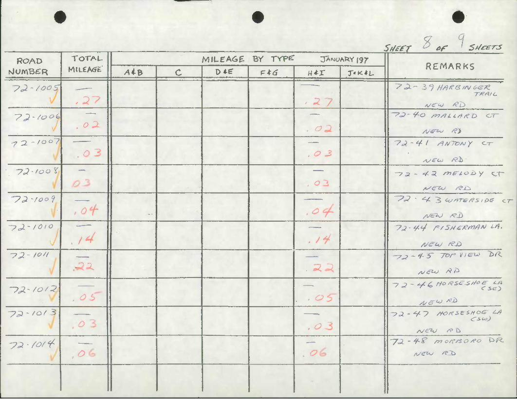
ROAD NiUmBCR
TOTAU Sdti-r % *r * Sf/ezrS
MiLEA6f: Br rrpe: jArotM^Y 197
y4iB D*f p*^ M*r T'K + L REMARKS
^^-/^^s" .2^
' 2-/ooi* oX
•j o. - 'oC>?
O 3
- -27
, O 3
Z* Ji- - 3 ^ ///?/f ^ /A/ ^<27^ T#A>C
A/C^ ^D
•7^-^^ ^ /53 03
'yji -/oof
.of tc^ -^^-/^^
ft 72 - /"'I
./¥
~y^~/o/3 05 • OS' ^c^j *£>
-p^ -/o/ 3 r> 'K
ya' /O/ ^ ,oc> . c?£

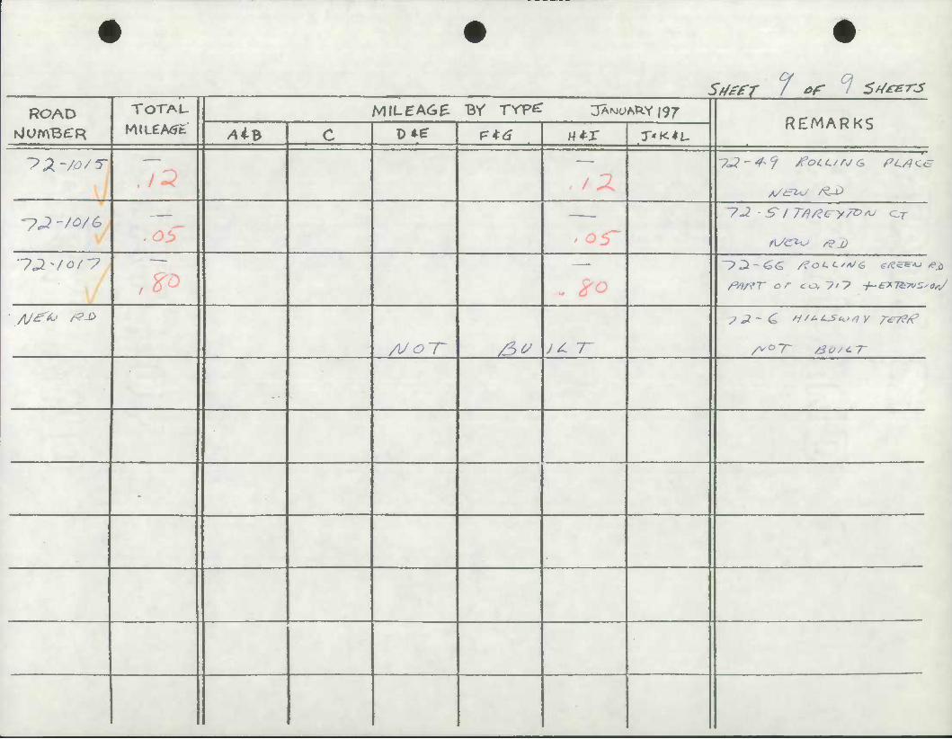
Sdzer i *f * St/mr-J ROAD TOTAU
MlLCA<Jfc MILEA6E BV rrpe: jAMyARY|97
REMARKS rslumBCR /UB c Di? P*d wtx T'K^L-
~>X'/o/r
-p^-ZO/G /AC"
—'—
y^^/of? fstffT or to, 7/7 -t-enT&vS'O
A/Jf*j &-&
/U^T" Sv J^ T
-
•
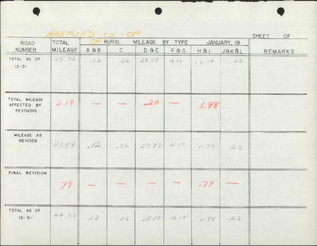
SHEFT OF ROAD TOTAL
MILEAGE
RURAL MILEAGE BY TYPE JANUARY. 19 i
NUMBER A SB c D SE F ac nai jaK^L REMARKS TOTAL AS OF
12-31
- 6. ^ . / 2 . OG 2Z-OZ ^ lo 1
: •
1
TOTAL MILEAGE AFFECTED BY
REVISIONS
3 tZ ~20
^ ^r
MILEAGE AS REVISED
43^ .72. .o£> j-?.?? JL/ /o //, 7^ .^^
FINAL REVISION
71 — — r7?
TOTAL AS OF
12- 31- ^•/-, 3 3 ./2 . & £> jf.PZ ^/, / o // 9^ .^^

*
ROAD TOTAL.
6^
^o
//
Sftife'T of Sf/£zr3 MILEA6£ BV TYpZ JANUARY 197"
/4iB DM? Ptd w*r
.^^
^o
. ^3
.//
T'K^l. REMARKS
/I/O Co CO. P-/ 3~
-?! -.
/v o <•.*> c o. ABB ^ 33
,27 'i7 .11
O'
//
o 5
-7^2-/^ furtive cr
./<? "T7-? - ^y S/<J *>/qr-~ er
5o . ^« -7^?- y -pou/u
/\/Ocs.' /nv/iS ~Wtftft i>£^^<:^

f Form HPS-20 ROAD IMPROVEMENT REPORT
(Revised 9-29-69) Sheet #1 of
5
S.H. A.Disfrict No.
County
4 th City Of Town
Harford For Calendar Year Ending December 31, 1972
ROAD NUMBER
LOCATION DESIG- NATIONS ON MAP
MILES CHANGES MADE IN MILEAGE
REMARKS FROM TO
TYPE WIDTH SYSTEM BUILT (NEV/)
ADDI- TIONS
ABAN- DONED FROM TO FROM TO FROM TO
(1) (2) (3) (4) . (5) (6) (7) (8) (9) (10) (ID (12) (13| (14)
Co.Rd.421 Zo.Rd.420 to Dead End 1 .144( •— I n Tft S 3 .14 .14 William'R Driv^ >, ei 773 :o.Rd.421 to Co.Rd^fl^ 2 .158( I 0 18 5 3 .06 .06 _ Point Concord Rd. Co.Rd.794 :o.Rd.421 to Dead End 3 .0015 mt I 0 18 5 3 .00 .00 _ Branch Road Co.Rd.421 :o.Rd.420 to Dead End 4 .089( — I 0 18 5 3 .09 .09 _ William's Drive Co.Rd.983 "Id.l to Tee Turn 5 .153^ _ I 0 40 s 3 .15 .15 _ Campus Hills Dr. A'^T.O^itr Zo.Rd. 983 to Dead En 1 6 .460 ^ I 0 40 5 3 .05 .05 _ Hillsway Terrace
^ZtT :o.Rd.l80 to Dead End 7 .1831 ^ I 0 24,5 5 3 .18 .18 _ Colt Lane 1?t Dead End To Dead End 8 .2361 _ I 0 24.5 5 3 ,23 ,23 _ Matte Lane
^o.Rd.930 :o.Rd.928 to Co.Rd.92 ) 9 -T^All I 0 24.5 9 3 T?A -?24 _ Princeton Lane :o.Rd.928 Zo.Rd.930 to Co.Rd.92 ) 10 .103C _ I 0 24t5 5 3 ,10 .10 _ St. Francis Rd. CO. *T>.t33 Zo.Rd. 930 to Cul-De-S, icii ^04,c _ T 0 24.5 5 3 ^/lO 'VlQ Georgetown Drive :o.Rd.930 :o.Rd.928 to Co.Rd.92' ) 12 .252S ^ I 0 24,5 5 3 .29 .25 _ Princeton Lane
7ao :o.Rd.930 to Cul-De-Si icia .106S mm I 0 24.5 5 3 .11 .11 ^ Purdue Court Zo.Rd.812 :o.Rd.274 to Tee-Turn 14 .2092 —• I 0 5 3 .21 .21 _ Beechwood Lane
rry Zo.Rd.228 to Dead End 15 .071C _ I 0 24.5 5 3 .07 .07 _ Zydonia Road <??* Zydonia Rd. to C-D-S 16 .5143 ^ I 0 24.5 5 3 .51 ,51 _ A.belia Road 98-1 Zo.Rd-930 to C-D-S 17 .0542 _ T 0 24.5 5 3 .05 .05 _ harvard Court 99/ Vbelia Rd. to C-D-S 18 .064f ^ T o 24.5 5 3 .07 .07 mm Sorbus Court 991 Uaelia Rd. to C-D-S 19 .0974 — I o 24.5 5 3 .10 .10 — ^alus Court 99* \.belia Rd. To C-D-S 20 .0682 _ T 0 24.5 5 3 .07 .07 Erica Court
COUNTY TOTALS !.8016 '.78 2.7R
It is hereby certified by the undersigned thot the additions and revisions reported each year pertain to roads legally a port of the county road system and title to some is vested in the con- stituted authorities of the political Sub-division for which the report is filed. It is further certified that all roods shall be at lecst 30 feet wide in accordance with Section 145 of Article 25 of the Annotated Code of Maryland, (1966 Replacement Volume)
SUBMITTED BY
OFFICIAL TITLE
REVIEWED FOR DIST. ENGR. BY
OFFICIAL TITLE
REVIEWED FOR CO. RCS. ENGR. BY
OFFICIAL TITLE
DATE
DATE
DATE
f Form HPS-20 ROAD IMPROVEMENT REPORT
(Revifed 9-29-69) Sheet #2 of
5
S.H. A,District No.
County
4 th City or Town
Harford For Colendor Year Ending December 31, 1972
ROAD NUMBER
LOCATION DESIG- NATIONS ON MAP
MILES CHANGES MADE IN MILEAGE
REMARKS FROM TO
TYPE WIDTH SYSTEM BUILT (NEW)
ADDI- TIONS
ABAN- DONED FROM TO FROM TO FROM TO
(1) (2) (3) (4) . (5) (6) (7) (8) (9) (10) (ID (12) (13) (14)
f f ^ :o.Rd.227 t-.o Clul-np-.q 21 .107^ T n ?4-S ^ 3 .in .in Brookhnvpn Court ffi :o.Rd.280 to Dead End 22 .1956 _ I 0 24.5 5 3 .20 .20 __ Brookwood Drive
:o-Rd.279 ^t.152 to Brookwood D: -.23 .119^ _ I 0 24.5 5 3 .1? .12 _ Cheyenne Avenue :o.Rd.280 Dead End to Tee Turn 24 .0236 — I 0 24.5 5 3 .02 .02 — Rosemont Drive
^^^ :o.Rd.229 to Dead End 25 .163^ _ I 0 24.5 5 3 ,16 .16 _ Alpine Drive :o.Rd.690 Dead End to Dead End 26 .122C M I 0 24.5 5 3 .1? .12 _ Belvue Drive :o.Rd.559 Co-Rd.2 94 to Dead En^ i 27 .0871 _ T Q 24.S s 3 .09 .09 <;evin Road :o,Rd.760 Dead End to Dead End 28 .1549 _ I 0 24.5 5 3 .16 .16 _ ifork Drive
77 7 breen Rd. to Dead End 29 .1911 _ I 0 24,5 5 3 ,19 .19 H hunting Ridge Ct. :6.Rd.685 Co.Rd.574 to TeeTurn 30 .1064 _ I 0 18 5 3 .11 .11 _ fl/inqfield Drive
m Dead End to Dead End 31 .1156 _ I 0 24.5 5 3 .12 .12 _ Pearlstone Drive Zo.Rd-BBl Co.Rd.737 to Pearlstc )neDr32 .0777 _ I 0 24,5 5 3 ,08 .08 _ Tolkstone Drive
7^9 :o.Rd.582 to TallvHoD^ • 33 .2406 _ I 0 24.5 5 3 .24 .24 _ Tox Road CallyHoDr to Dead End 34 .0227 — I 0 24.5 5 3 .02 .02 _ rally-Ho-Drive
/OO 1 i JS 40 to Brookside Dr 35 .1674 _ I 0 36 5 3 .17 .17 _ Tree Top Drive / c^Ti ireak to Edgewa-her Dr 36 .1642 _ I n 36 5 3 .16 .16 _ 3rookside Drive ^c>o3 Jrookside Dr. to C-D-i 1 37 .0939 _ I 0 36 5 3 .09 .09 _ Watergate Court •«« '/ Jrookside Dr. To Brea} ; 38 .4295 — I 0 36 5 3 .43 .43 — Ddqewater Drive / c o iT 'isherman La to Edge.I ir 39 .2640 — I 0 24.5 5 3 .26 .26 — iarbinqer Trail /c?o fe iarbinqer Trail to C-I i-S 40 .0217 _ I 0 24.5 5 3 .02 .02 Mallard Court
COUNTY TOTALS i.0054 - !.99 2.99
It is hereby certified by the undersigned that the additions and revisions reported each year pertain to roods legally a port of the county road system and title to same is vested in the con- stituted authorities of the political sub-division for which the report is filed. It is further certified that all roads shall be at lecst 30 feet wide in accorcJance with Section 145 of Article 25 of the Annotated Code of Maryland. (1966 Replacement Volume)
SUBMITTED BY
OFFICIAL TITLE
REVIEWED FOR DIST. ENGR. BY
OFFICIAL TITLE
REVIEWED FOR CO. RCS. ENGR. BY
OFFICIAL TITLE
DATE
DATE
DATE

f Form HPS-20 ROAD IMPROVEMENT REPORT
(Revised 9-29-69) Sheet #3 of
5
S.H. A.District No.
County
4tn City or Town
Harford For Colendor Yeor Ending December 31, 1972
ROAD NUMBER
LOCATION DESIG- NATIONS ON MAP
MILES CHANGES MADE IN MILEAGE
REMARKS FROM TO
TYPE WIDTH SYSTEM BUILT (NEW)
ADDI- TIONS
ABAN- DONED FROM TO FROM TO FROM TO
(1) (2) (3) (4) . (5) (6) (7) (8) (9) (10) CD (12) (13) (14)
/CO? HarbingerTr. to C-D-S 41 -026' Mi I 0 24.5 5 3 ,26 .26 _ Antony Court 1 oo$ iarbingerTr- to C-D-S 42 .0317 _ I 0 24.5 5 3 .0? .02 _ Melody Court /oacl Brookside to C-D-S 43 .033C — I 0 24.5 5 3 .03 .03 — Waterside Court /O/O EldgewaterDr to Dead E: id 44 .141^ _ I 0 24,5 5 3 .14 .14 _ Fisherman Lane toti CdgewaterDr to Break 45 .201: _ I 0 36 5 3 .20 .20 — Top View Drive AV 2- Top View Dr. To Break 46 .024J — I 0 36 5 3 .03 .03 Horseshoe Lane(SE )
r ot $ Top View Dr. to Break 47 .0456 - I 0 36 5 3 .05 .05 Horseshoe Lane(SWl) /ofh :o.Rd.320 to Dead End 48 .057£ — I 0 24.5 5 3 .06 .06 — Morboro Drive /Ofi> ho.Rd-320 to Cul-De-S 49 .115' — I 0 24.5 5 3 .12 .12 — Rolling Place
:o.Rd.3l8 Co.Rd.320 to DeadEnd 50 .314C — I 0 24.5 5 3 .31 .31 — Briarcliff Lane /ofd :o.Rd.318 to Cul-De-S 51 .050S _ I 0 24.5 5 3 .05 .05 Tareyton Court
:o.Rd.224 Rt24 to Marywood Sub , 52 .5^5-2 H I 18 31 3 3 _ Red Pump Road Zo.Rd.330 Rt22 to Co.Rd.332 53 .7928 H I 16 20 3 3 _—— _ Stepney Road ""n-Rd.SS? Co.Rd.330 to Grey's
/^s^aaw Run Quarry 54 .5i«C G I 16 20 3 3 __._ ___ _ Carsins Run Rd. C:o-Rd.214 Co.Rd.742 to Bit. SUJ :. 55 .7706 G I 14 20 3 3 ___ ___ _ Carrs Mill Rd. Co.Rd.411 Rt.462 to Co.Rd.394 56 ..8^2 H I 18 20 3 3 — Chapel Road Co.Rd.394 Co.Rd.411 to USRt.40 57 i.4«0C H I 16 20 3 3 — Robinhood Road Co.Rd.512 E. Rt.24 to Co.Rd.52 \ 58 .649C H I 16 33 3 3 ___ _ Hanson Road Co.Rd-512 W. Rt.24 to Box Eldej • Dr.59 .SIS! H I 16 33 3 3 ___ _ Hanson Road
COUNTY TOTALS 1.6656 1.2i 1.2 7
It is hereby certified by the undersigned thot the additions and revisions reported each year pertain to roads legally a port of the county rood system and title to same is vested in the con- stituted authorities of the polifical sub-division for which the report is filed. It is further certified that oil roads shall be at least 30 feet wide in accordance with Section 145 of Article 25 of the Annotated Code of Maryland. (1966 Replacement Volume)
SUBMITTED BY
OFFICIAL TITLE
REVIEWED FOR DIST. ENGR. BY
OFFICIAL TITLE
REVIEWED FOR CO. RDS. ENGR. BY
OFFICIAL TITLE
DATE
DATE
DATE

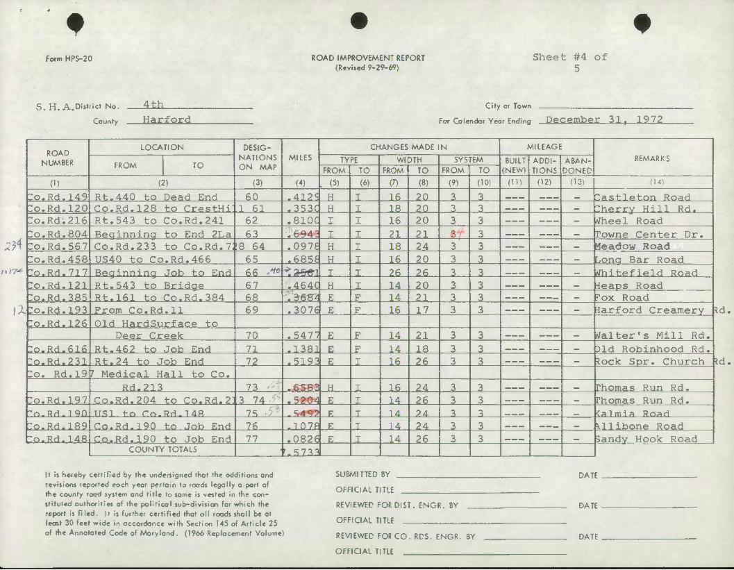
f Form HPS-20 ROAD IMPROVEMENT REPORT
(Reviied 9-29-69) Sheet #4 of
5
S.H. A.DUfrict No.
County
JLitL Harford
City or Town
For Colendor Yeor Ending December 31, 1972
ROAD NUMBER
LOCATION DESIG- NATIONS ON MAP
MILES CHANGES MADE IN MILEAGE
REMARKS FROM TO
TYPE WIDTH SYSTEM BUILT (NEW)
ADDI- TIONS
ABAN- DONED FROM TO FROM TO FROM TO
(1) (2) (3) (4) (5) (6) (7) (8) (9) (10) (H) (12) (13) (14)
:o.Rd-149 Rt.440 to Dead End 60 .412? H I 16 20 3 3 — _ — __ — Zastleton Road :o.Rd.l20 Co.Rd.128 to CrestHi: .1 61 .353C H I 18 20 3 3 ___ _ Zherry Hill Rd. :o.Rd.216 Rt.543 to Co.Rd.241 62 .8ioq I I 16 20 3 3 _ Wheel Road :o.Rd.804 Beainnina to End 2La 63 .6943 I I 21 21 3 3 — —— _•«« _ Towne Center Dr.
2H :o.Rd.567 Co.Rd.233 to Co.Rd.7; 18 64 .0978 H I 18 24 3 3 — ...» _ —— _ Meadow Road :o.Rd.458 US40 to Co.Rd.466 65 .6856 H I 16 20 3 3 ___- _ —— _ Lonq Bar Road
na* :o.Rd.717 Beginning Job to End 66 -^ ^3^fn I I 26 26 3 3 , _ Vhitefield Road :o.Rd.l21 Rt.543 to Bridae 67 .464C H J 14 20 3 3 «._ — «•«..• __ ieaps Road :o.Rd.385 Rt.161 to Co.Rd.384 68 .3684 E F 14 21 3 3 ___ — —— — fox Road
\X :o.Rd.l93 From Co.Rd.ll 69 .3076 E F 16 17 3 3 «— — — —— — -iarford Creamery :o.Rd.l26 Old HardSurface to
Deer Creek 70 .5477 E F 14 21 3 3 ___ — — — — Walter's Mill Rd. :o.Rd-616 Rt.462 to Job End 71 .1381 E F 14 18 3 3 -» —«* —• —_ ^, 31d Robinhood Rd. :o.Rd.231 Rt.24 to Job End 72 .5193 E I 16 26 3 3 ___ ___ mm tock Spr. Church Zo. Rd.19 7 Medical Hall to Co.
Rd.233 73 .6583 H I 16 24 3 3 — —— *.* — ^ Thomas Run Rd. :o.Rd.l97 Co.Rd.204 to Co.Rd-2] 3 74 .5204 E I 14 26 3 3 ___• _.._ wm Thomas Run Rd. "n-BH-iqn TT.qi 4-o rr.,RH#14R 7S • ' -S4<r? V. T 14 24 3 a , , , , , , ^ <almia Rond :o-Rd-]R9 Co.Rd-190 t:o Job End 76 .1078 • T 14 24 3 3 ^m^m^m — — ••
^ Mlibone Road "o.Rd.148 Co.Rd.190 to Job End 77 .0826 E I 14 26 3 3 _ —— vmtmm^ wm 3andy Hook Road
COUNTY TOTALS « '.5733
^d,
It is hereby certified by the undesigned that the additions and revisions reported each year pertain to roads legally a part of the county road system and title to same is vested in the con- stituted authorities of the political sub-division for which the report is filed. It Is further certified that all roads shall beat lecsf 30 feet wide in accordance with Section 145 of Article 25 of the Annotated Code of Maryland. (1966 Replacement Volume)
SUBMITTED BY
OFFICIAL TIT1F
REVIEWED FOR DIST . ENGR. BY
OFFICIAL TITLE
REVIEWED FOR CO. RDS. ENGR. BY
OFFICIAL TITLE
DATE
DATE
DATE
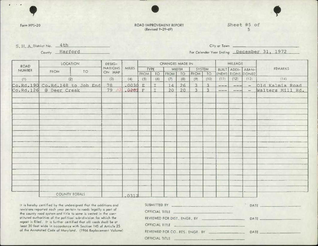
f f Form HPS-20 ROAD IMPROVEMENT REPORT
(Revi.ed 9-29-69) Sheet #5 of
5
S.H. A.District No.
County
4 th City or Town
Harford For Colendor Year Ending December 31 T 1972
ROAD NUMBER
LOCATION DESIG- NATIONS ON MAP
MILES CHANGES MADE IN MILEAGE
REMARKS FROM TO
TYPE WIDTH SYSTEM BUILT (NEV/)
ADDI- TIONS
ABAN- DONED FROM TO FROM TO FROM TO
(1) (2) (3) (4) L (5) (6) (7) (8) (9) (10) (ID (12) (13) (14)
Co.Rd.190 r.o-Rd-]48 to Job End 7R -003f F. T 14 ?fi 3 3 ^m^m^m ^•v^ ^ Old Kalmia Road Co.Rd.126 (D Deer Creek 79 .028'. F I 20 20 3 3 __—. ___ «. Walters Mill Rd.
COUNTY TOTALS .mi?
It is hereby certified by the undersigned that the additions and revisions reported each year pertain to roads legally a part of the county road system and title to same is vested in the con- stituted authorities of the political sub-division for which the report is filed. It Is further certified that all roads shall be at least 30 feet wide in accordance with Section 145 of Article 25 of the Annotated Code of Maryland. (1966 Replacement Volume)
SUBMITTED BY
OFFICIAL TITLE
REVIEWED FOR DIST. ENGR. BY
OFFICIAL TITLE
REVIEWED FOR CO. RDS. ENGR. BY
OFFICIAL TITLE
DATE
DATE
DATE