Embed Size (px)
Citation preview
MARJORIE HARRIS CARR CROSS FLORIDA GREENWAY STATE RECREATION AND CONSERVATION AREA
UNIT MANAGEMENT PLAN
ACQUISITION AND RESTORATION COUNCIL
FINAL DRAFT 2018
Florida Park Service The Florida Park Service is one of the largest park systems in the country with a total of 163 state parks and 11 state trails spanning nearly 800,000 acres, 100 miles of sandy white beach, and more than 1,500 miles of multi-use trails. From swimming and diving in Florida's rivers and springs to birding and fishing or hiking and riding on natural scenic trails, Florida's state parks offer year-round outdoor activities for all ages. The Florida Park Service is the proud recipient of three National Gold Medals for Excellence in Park and Recreation Management, making Florida America’s first three-time Gold Medal winner. Offering opportunities throughout the state, Florida State Parks welcomed more than 31.8 million visitors in 2015–2016.
Mission Statement To provide resource-based recreation while preserving, interpreting, and restoring natural and cultural resources.
Vision The Florida State Park System creates a sense of place and is recognized as containing the best of Florida's diverse natural and cultural heritage sustained for future generations while providing quality and appropriate resource-based recreational oppor-tunities, interpretation, and education that help visitors connect to “The Real Florida.”
Marjorie Harris Carr Cross Florida Greenway State Recreation and Conservation Area Page i Unit Management Plan (2017–2027)
TABLE OF CONTENTS INTRODUCTION AND GENERAL INFORMATION ......................................................................... 1
Background ........................................................................................................................................................................ 1
PURPOSE AND SIGNIFICANCE OF THE PARK ............................................................................... 9
Park Significance .............................................................................................................................................................. 9
PURPOSE, SCOPE, AND REVIEW OF THE PLAN .......................................................................... 10
MANAGEMENT PROGRAM REVIEW ............................................................................................... 12
Management Authority and Responsibility ........................................................................................................ 12
Park Management Goals ............................................................................................................................................. 13
Management Coordination ........................................................................................................................................ 14
Public Participation ...................................................................................................................................................... 15
Preliminary Public Workshops ........................................................................................................................ 15
Public Meetings and Advisory Group Meeting .......................................................................................... 17
Other Designations........................................................................................................................................................ 18
RESOURCE MANAGEMENT COMPONENT .................................................................................... 19
Introduction ..................................................................................................................................................................... 19
Resource Descriptions and Assessment ............................................................................................................... 20
Natural Resources ................................................................................................................................................. 20
Cultural Resources ............................................................................................................................................. 124
Resource Management Program .......................................................................................................................... 142
Management Goals, Objectives, and Actions ........................................................................................... 142
Natural Resource Management..................................................................................................................... 142
Special Management Considerations .......................................................................................................... 148
Cultural Resources Management ................................................................................................................. 153
Resource Management Schedule .................................................................................................................. 155
Land Management Review .............................................................................................................................. 155
LAND USE COMPONENT.................................................................................................................. 157
Introduction .................................................................................................................................................................. 157
CFG Acquisition History ................................................................................................................................... 158
Subleases, Agreements, and Easements .................................................................................................... 159
External Conditions ................................................................................................................................................... 161
Past Uses ................................................................................................................................................................ . 164
Future Land Use and Zoning .......................................................................................................................... 164
Marjorie Harris Carr Cross Florida Greenway State Recreation and Conservation Area Page ii Unit Management Plan (2017–2027)
Current Recreation Use and Visitor Programs ....................................................................................... 164
Property Analysis by County ................................................................................................................................. 166
Citrus County ........................................................................................................................................................ 166
Levy County ........................................................................................................................................................... 177
Marion County...................................................................................................................................................... 186
Putnam County .................................................................................................................................................... 205
Conceptual Land Use Plan ....................................................................................................................................... 216
Potential Uses ....................................................................................................................................................... 216
Proposed Facilities ............................................................................................................................................. 221
Facilities Development ..................................................................................................................................... 222
Other Potential Future Trail/Facilities Developments ....................................................................... 223
Existing Use and Recreational Carrying Capacity ................................................................................. 228
Optimum Boundary ........................................................................................................................................... 229
IMPLEMENTATION COMPONENT ................................................................................................ 239
Management Progress .............................................................................................................................................. 239
Park Administration and Operations ......................................................................................................... 239
Resource Management ..................................................................................................................................... 239
Recreational Facilities and Visitor Services ............................................................................................. 240
Management Plan Implementation ..................................................................................................................... 241
Marjorie Harris Carr Cross Florida Greenway State Recreation and Conservation Area Page iii Unit Management Plan (2017–2027)
List of Tables
Table 1. CFG Western Management Zones, Acreage, and Fire Type ................................................................ 21 Table 2. CFG Central Management Zones, Acreage, and Fire Type ................................................................... 23 Table 3. CFG Eastern Management Zones, Acreage, and Fire Type .................................................................. 26 Table 4. Flooding Frequency Summary for Soils on the CFG............................................................................... 34 Table 5. Hydric Soils Summary for Soils on the CFG ............................................................................................... 34 Table 6. Soil Drainage Class Summary for Soils on the CFG ................................................................................. 34 Table 7. Soil Series Class Summary for the Commonly Occurring Soils on the CFG .................................. 35 Table 8. CFG Community Type, Acreage, and Management ................................................................................. 41 Table 9. Imperiled Species on the CFG .......................................................................................................................... 88 Table 10. Nesting Data on the CFG Dredge Spoil Islands ...................................................................................... 95 Table 11. CFG Large Management Zones and Degree of Infestation ............................................................. 104 Table 12. Inventory of FLEPPC Category I and II Invasive Exotic Plant Species ...................................... 105 Table 13. Cultural Sites Listed in the Florida Master Site File ......................................................................... 127 Table 14. Prescribed Fire Management .................................................................................................................... 144 Table 15. CFG Prescribed Fire History ....................................................................................................................... 145 Table 16. Subleases on the CFG .................................................................................................................................... 159 Table 17. Conservation Lands and Activities within 15 Miles of the CFG ................................................... 162 Table 18. CFG Visitor Estimates (FY 09 to FY 17) ................................................................................................. 165 Table 19. Historic, Current and Projected Population through 2045—Citrus County .......................... 167 Table 20. Population Change—Citrus County ........................................................................................................ 167 Table 21. Population by Age—Citrus County ......................................................................................................... 168 Table 22. Trails and Mileage on the CFG—Citrus County .................................................................................. 170 Table 23. Natural Communities and Acreage on the CFG—Citrus County ................................................. 170 Table 24. Historic, Current and Projected Population through 2045—Levy County............................. 178 Table 25. Population Change—Levy County ........................................................................................................... 178 Table 26. Population by Age—Levy County ............................................................................................................ 178 Table 27. Trails and Mileage on the CFG—Levy County .................................................................................... 181 Table 28. Natural Communities and Acreage on the CFG—Levy County .................................................... 181 Table 29. Historic, Current, and Projected Population through 2045—Marion County ...................... 187 Table 30. Population Change—Marion County ...................................................................................................... 187 Table 31. Population by Age—Marion County ....................................................................................................... 188 Table 32. Roadway Projects—Marion County ........................................................................................................ 189 Table 33. Trails and Mileage on CFG—Marion County ....................................................................................... 190 Table 34. Natural Communities and Acreage on CGF—Marion County ...................................................... 192 Table 35. Historic, Current, and Projected Population through 2045—Putnam County ..................... 206 Table 36. Population Change—Putnam County..................................................................................................... 206 Table 37. Population by Age—Putnam County ...................................................................................................... 207 Table 38. Trails and Mileage on CFG—Putnam County ...................................................................................... 209 Table 39. Natural Communities and Acreage on CFG—Putnam County ..................................................... 209 Table 40. Recreational Carrying Capacity ................................................................................................................ 229 Table 41. Marjorie Harris Carr Cross Florida Greenway State Recreation and Conservation Area 10-Year Implementation Schedule and Cost Estimates Sheet ................................................................................ 242
Marjorie Harris Carr Cross Florida Greenway State Recreation and Conservation Area Page iv Unit Management Plan (2017–2027)
List of Figures
Figure 1. Cross Florida Greenway Vicinity Map 1—West Section ...................................................................... 3 Figure 2. Cross Florida Greenway Vicinity Map 2—Central Section .................................................................. 4 Figure 3. Cross Florida Greenway Vicinity Map 3—East Section ........................................................................ 5 Figure 4. Cross Florida Greenway Reference Map 1—West Section .................................................................. 6 Figure 5. Cross Florida Greenway Reference Map 2—Central Section ............................................................. 7 Figure 6. Cross Florida Greenway Reference Map 3—East Section ................................................................... 8 Figure 7. Citrus County Generalized Existing Land Use ..................................................................................... 175 Figure 8. Citrus County Generalized Future Land Use ........................................................................................ 176 Figure 9. Levy County Generalized Existing Land Use ........................................................................................ 184 Figure 10. Levy County Generalized Future Land Use ........................................................................................ 185 Figure 11. Marion County Generalized Existing Land Use, Page 1 ................................................................. 201 Figure 12. Marion County Generalized Existing Land Use, Page 2 ................................................................. 202 Figure 13. Marion County Generalized Future Land Use, Page 1 ................................................................... 203 Figure 14. Marion County Generalized Future Land Use, Page 2 ................................................................... 204 Figure 15. Putnam County Generalized Existing Land Use ............................................................................... 214 Figure 16. Putnam County Generalized Future Land Use .................................................................................. 215 Figure 17. Cross Florida Greenway Conceptual Land Use Map—West Section ....................................... 225 Figure 18. Cross Florida Greenway Conceptual Land Use Map—Central Section ................................... 226 Figure 19. Cross Florida Greenway Conceptual Land Use Map—East Section ......................................... 227 Figure 20. Cross Florida Greenway Optimum Boundary Map, Page 1 of 7 ................................................ 232 Figure 21. Cross Florida Greenway Optimum Boundary Map, Page 2 of 7 ................................................ 233 Figure 22. Cross Florida Greenway Optimum Boundary Map, Page 3 of 7 ................................................ 234 Figure 23. Cross Florida Greenway Optimum Boundary Map, Page 4 of 7 ................................................ 235 Figure 24. Cross Florida Greenway Optimum Boundary Map, Page 5 of 7 ................................................ 236 Figure 25. Cross Florida Greenway Optimum Boundary Map, Page 6 of 7 ................................................ 237 Figure 26. Cross Florida Greenway Optimum Boundary Map, Page 7 of 7 ................................................ 238

Marjorie Harris Carr Cross Florida Greenway State Recreation and Conservation Area Page v Unit Management Plan (2017–2027)
List of Addenda
Addendum 1. Acquisition History
Addendum 2. References
Addendum 3. Preliminary Public Workshop Summary
Addendum 4. Public Meetings Summary
Addendum 5. Timber Management Analysis
Addendum 6. Advisory Group Meeting Summary Report and Staff Recommendations
Addendum 7. Manatee Management
Addendum 8. Land Management Review
Marjorie Harris Carr Cross Florida Greenway State Recreation and Conservation Area Page 1 Unit Management Plan (2017–2027)
INTRODUCTION AND GENERAL INFORMATION
BACKGROUND
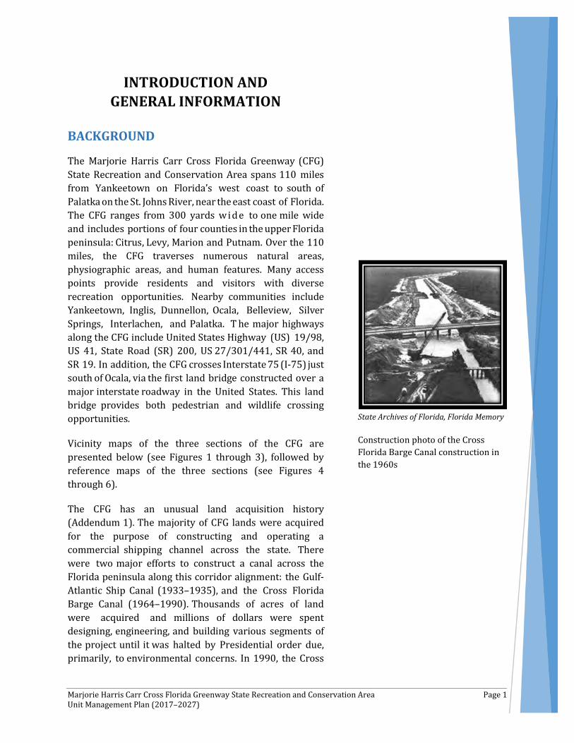
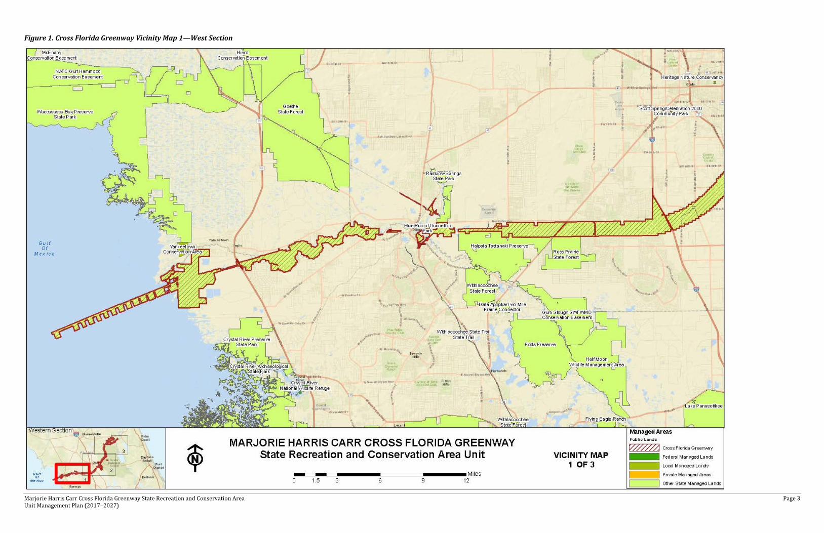
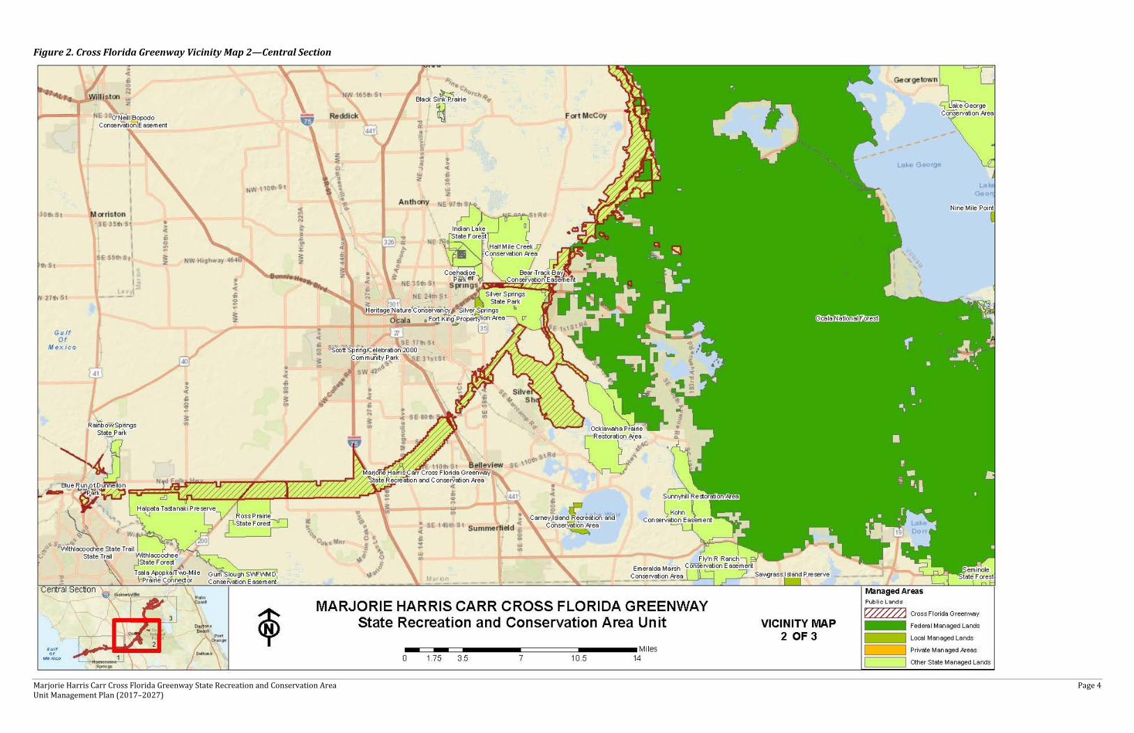
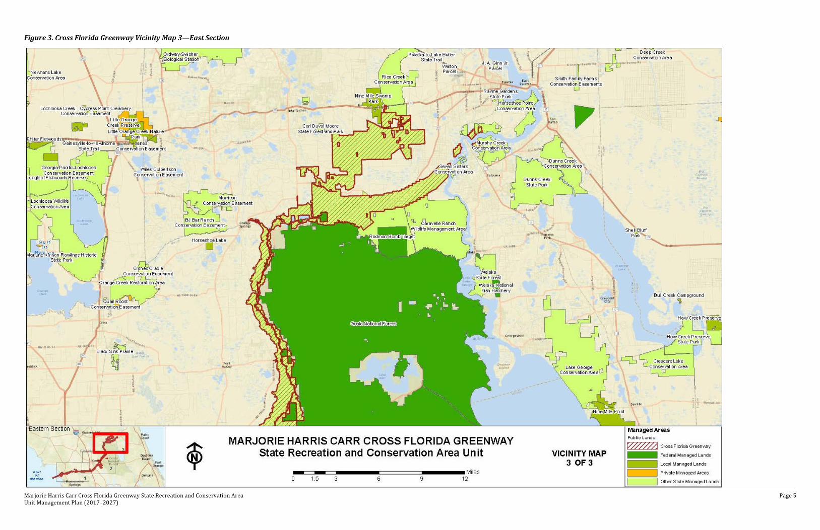
The Marjorie Harris Carr Cross Florida Greenway (CFG) State Recreation and Conservation Area spans 110 miles from Yankeetown on Florida’s west coast to south of Palatka on the St. Johns River, near the east coast of Florida. The CFG ranges from 300 yards wi de to one mile wide and includes portions of four counties in the upper Florida peninsula: Citrus, Levy, Marion and Putnam. Over the 110 miles, the CFG traverses numerous natural areas, physiographic areas, and human features. Many access points provide residents and visitors with diverse recreation opportunities. Nearby communities include Yankeetown, Inglis, Dunnellon, Ocala, Belleview, Silver Springs, Interlachen, and Palatka. T he major highways along the CFG include United States Highway (US) 19/98, US 41, State Road (SR) 200, US 27/301/441, SR 40, and SR 19. In addition, the CFG crosses Interstate 75 (I-75) just south of Ocala, via the first land bridge constructed over a major interstate roadway in the United States. This land bridge provides both pedestrian and wildlife crossing opportunities.
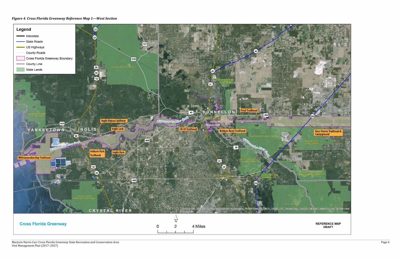
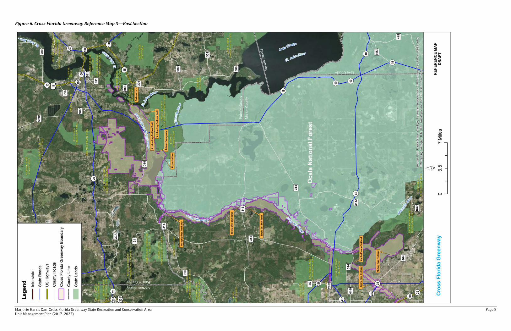
Vicinity maps of the three sections of the CFG are presented below (see Figures 1 through 3), followed by reference maps of the three sections (see Figures 4 through 6).
The CFG has an unusual land acquisition history (Addendum 1). The majority of CFG lands were acquired for the purpose of constructing and operating a commercial shipping channel across the state. There were two major efforts to construct a canal across the Florida peninsula along this corridor alignment: the Gulf-Atlantic Ship Canal (1933–1935), and the Cross Florida Barge Canal (1964–1990). Thousands of acres of land were acquired and millions of dollars were spent designing, engineering, and building various segments of the project until it was halted by Presidential order due, primarily, to environmental concerns. In 1990, the Cross
State Archives of Florida, Florida Memory
Construction photo of the Cross Florida Barge Canal construction in the 1960s
Marjorie Harris Carr Cross Florida Greenway State Recreation and Conservation Area Page 2 Unit Management Plan (2017–2027)
Florida Barge Canal project was de-authorized by Congress and all lands and structures were transferred to the State of Florida for management as a Public Recreation and Conservation Area. In 1991, the Governor and Cabinet of the State of Florida signed a resolution agreeing to the terms of the federal de-authorization bill, thereby officially de-authorizing the Cross Florida Barge Canal project.
Ultimately, this action led to the creation of the Cross Florida Greenway State Recreation and Conservation Area. The Cross Florida Greenway was officially renamed the Marjorie Harris Carr Cross Florida Greenway in honor of Marjorie Harris Carr, who led the fight to stop the Cross Florida Barge Canal project.
The Florida Department of Environmental Protection (DEP), Division of Recreation and Parks (DRP), manages these lands under Lease #4013, dated October 27, 1993. The initial lease for the former canal lands has been amended 20 times through 2006 to include additional lands, mostly acquired with Preservation 2000 and Florida Forever funds. The lease extends 50 years, expiring on October 26, 2043 (Addendum 1). As indicated above, the CFG begins on the west coast of Florida at the Gulf of Mexico within Section 036, Township 16 South and Range 17 East within Citrus County, Florida, extending to Section 38, Township 11 South, Range 26 East in Putnam County, Florida.
The CFG is designated multiple-use in accordance with 253.034(2)a, Florida Statute (F.S.), to provide public outdoor recreation and other park-related uses. There are no legislative or executive directives that constrain the use of this property (see Addendum 2). DRP intends to manage the CFG as such. Other than proposed facilities described in this plan, no other user-oriented facilities are anticipated to be developed and maintained by local governments.
Marjorie Harris Carr Cross Florida Greenway State Recreation and Conservation Area Page 3 Unit Management Plan (2017–2027)
Figure 1. Cross Florida Greenway Vicinity Map 1—West Section
Marjorie Harris Carr Cross Florida Greenway State Recreation and Conservation Area Page 4 Unit Management Plan (2017–2027)
Figure 2. Cross Florida Greenway Vicinity Map 2—Central Section
Marjorie Harris Carr Cross Florida Greenway State Recreation and Conservation Area Page 5 Unit Management Plan (2017–2027)
Figure 3. Cross Florida Greenway Vicinity Map 3—East Section
Marjorie Harris Carr Cross Florida Greenway State Recreation and Conservation Area Page 6 Unit Management Plan (2017–2027)
Figure 4. Cross Florida Greenway Reference Map 1—West Section

Marjorie Harris Carr Cross Florida Greenway State Recreation and Conservation Area Page 7 Unit Management Plan (2017–2027)
Figure 5. Cross Florida Greenway Reference Map 2—Central Section
Marjorie Harris Carr Cross Florida Greenway State Recreation and Conservation Area Page 8 Unit Management Plan (2017–2027)
Figure 6. Cross Florida Greenway Reference Map 3—East Section

Marjorie Harris Carr Cross Florida Greenway State Recreation and Conservation Area Page 9 Unit Management Plan (2017–2027)
PURPOSE AND SIGNIFICANCE OF THE PARK
The CFG was acquired to provide exceptional resource-based public outdoor recreation opportunities and cultural resource-based opportunities to Florida residents and visitors while ensuring the conservation and protection of valuable natural resources, including species and unique systems.
PARK SIGNIFICANCE
The 110-mile long CFG offers outstanding opportunities for a variety of land and water-based activities. The CFG protects exceptional natural areas and provides important strategic ecological connectors for significant north-south and east-west ecological networks.
Assisting with this ecological connection is the CFG land bridge—America’s first land bridge—which spans I-75 just south of Ocala. The land bridge is one of the first multi-use bridges of its kind, landscaped with native vegetation, including longleaf pine, live oak, and sand live oak.
The CFG provides a cross-sectional view of the natural areas of the northern portion of the Florida peninsula. Two of Florida’s top first magnitude springs, Rainbow Springs and Silver Springs, feed into the CFG riverine ecosystems. The CFG offers the potential to serve as a critical ecological connector for the Ocala National Forest/Osceola National Forest/Pinhook Swamp/ Okefenokee Swamp complex on its east end and Chassahowitzka/Crystal River/Lower Suwanee/Big Bend Florida Fish and Wildlife Conservation Commission (FWC) Wildlife Management Area (WMA) complex on its west end.
Upon the de-authorization of the former Cross Florida Barge Canal, the CFG was established to serve as a “superconnector” in the establishment and expansion of a statewide greenways and trails system. This includes non-motorized upland trails and paddling trails, as appropriate.
Marjorie Harris Carr Cross Florida Greenway State
Recreation and Conservation Area
• The Cross Florida Greenway contains America’s first land bridge—which spans I-75 just south of Ocala, Florida. The land bridge is one of the first multi-use bridges of its kind, landscaped with native vegetation, including longleaf pine, live oak, and sand live oak.)
• Approximately 71,000 acres under management
• 254 cultural resource sites • 290+ miles of trails (paved
and unpaved) • 42 miles of Florida National
Scenic Trail (FNST)on the CFG
Marjorie Harris Carr Cross Florida Greenway State Recreation and Conservation Area Page 10 Unit Management Plan (2017–2027)
Further, the FWC indicates that almost 22,000 acres of the CFG are identified as Strategic Habitat Conservation Areas (SHCAs). SHCAs are essential to the enhancement of the long-term protection of many plants, animals, and natural communities that constitute essential components of Florida’s natural diversity. Within the CFG, the FWC does identify much of the Ocklawaha River area, Marshall Swamp/Adams Marsh, and the Ross Prairie area as biodiversity hot spots for seven or more focal species.
Culturally, the CFG is significant given its history of ship/barge canal activities and the unique opportunities it provides to experience the largest de-authorization of a federal civil works project in the United States. Given its original purpose, CFG lands were acquired through a variety of programs. While most of the lands are former ship and barge canal lands, a significant amount of property was acquired with Preservation 2000 and Florida Forever funds. A portion of the CFG was acquired with Greenways and Trails Florida Forever funds and other parcels as part of Etoniah-Cross Florida Greenway, Longleaf Pine Ecosystem and Crystal River-area projects. Some lands were donated, and some areleased from the Felburn Foundation. CFG also manages some St. Johns River Water Management District (SJRWMD) and Southwest Florida Water Management District (SWFWMD) land through various management agreements.
The CFG is classified as a state recreation area in the DRP’s unit classification system. In the management of a state recreation area, a major emphasis is placed on maximizing the recreational potential of the unit. However, preservation of the park’s natural and cultural resources remains important. Depletion of a resource by any recreational activity is not permitted. To realize the park’s recreational potential, the development of appropriate park facilities is undertaken with the goal to provide amenities that are accessible, convenient, and safe; and to support public recreational use or appreciation of the park’s natural, cultural, aesthetic, and educational attributes.
PURPOSE, SCOPE, AND REVIEW OF THE PLAN
This Unit Management Plan (UMP) serves as the basic statement of policy and direction for the management of the
Marjorie Harris Carr Cross Florida Greenway State Recreation and Conservation Area Page 11 Unit Management Plan (2017–2027)
CFG as a unit of Florida's state park system from 2017–2027. It provides information about past usage, conservation acquisition history, and descriptions of the natural and cultural resources found on the CFG. Furthermore, this UMP identifies the goals, objectives, actions, and criteria or standards that guide each aspect of park administration, and sets forth the specific measures that will be implemented to meet management objectives and provide balanced public utilization. The plan is intended to meet the requirements of Sections 253.034 and 259.032, F.S., Chapter 18-2, Florida Administrative Code (FAC), and is intended to be consistent with the State Lands Management Plan. With approval, this management plan will replace the 2007 approved plan. The UMP consists of three interrelated components: Resource Management Component, Land Use Component and Implementation Component.
All development and resource alteration proposed in this UMP is subject to the granting of appropriate permits, easements, licenses, and other required legal instruments. Approval of the UMP does not constitute an exemption from complying with the appropriate local, state, or federal agencies. This plan also is intended to meet the requirements for beach and shore preservation, as defined in Chapter 161, Florida Statutes, and Chapters 62B-33, 62B-36 and 62R49, FAC.
In the development of this UMP, the potential of the park to accommodate secondary management purposes was analyzed. These secondary purposes were considered within the context of the DRP’s statutory responsibilities and the resource needs and values of the park. This analysis considered the park’s natural and cultural resources, management needs, aesthetic values, and visitation and visitor experiences. For the CFG, it was determined that timber management activities for restoration could be accommodated in a manner that would be compatible and not interfere with the primary purpose of resource-based outdoor recreation and conservation. This compatible secondary management purpose is addressed in the Resource Management Component of the plan. Uses such as water resource development projects, water supply projects, stormwater management projects, linear facilities, and sustainable agriculture and forestry (other than those forest management activities specifically identified in this
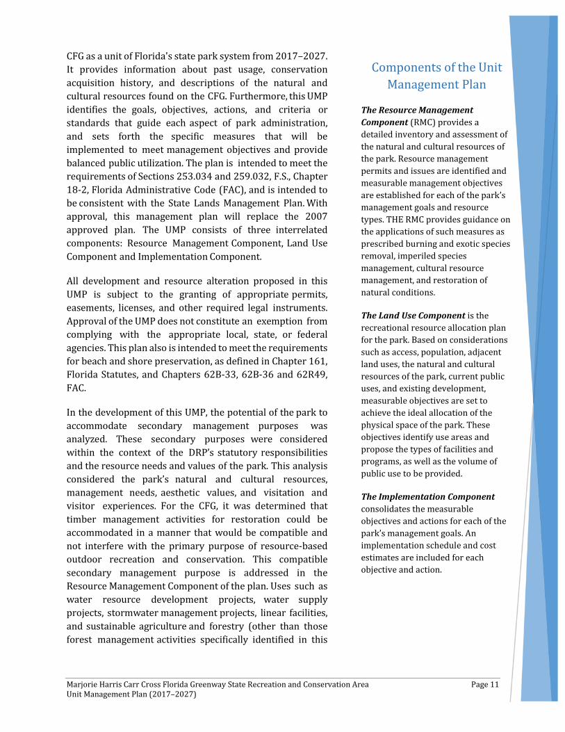
Components of the Unit Management Plan
The Resource Management Component (RMC) provides a detailed inventory and assessment of the natural and cultural resources of the park. Resource management permits and issues are identified and measurable management objectives are established for each of the park’s management goals and resource types. THE RMC provides guidance on the applications of such measures as prescribed burning and exotic species removal, imperiled species management, cultural resource management, and restoration of natural conditions.
The Land Use Component is the recreational resource allocation plan for the park. Based on considerations such as access, population, adjacent land uses, the natural and cultural resources of the park, current public uses, and existing development, measurable objectives are set to achieve the ideal allocation of the physical space of the park. These objectives identify use areas and propose the types of facilities and programs, as well as the volume of public use to be provided.
The Implementation Component consolidates the measurable objectives and actions for each of the park’s management goals. An implementation schedule and cost estimates are included for each objective and action.
Marjorie Harris Carr Cross Florida Greenway State Recreation and Conservation Area Page 12 Unit Management Plan (2017–2027)
plan) are not consistent with this plan or the management purposes of the CFG.
The potential for generating revenue to enhance management a l s o was analyzed. Visitor fees and charges are the principal sources of revenue generated by the park. It was determined that timber management and hunting activities would be appropriate at this park as an additional source of revenue for land management since it is compatible with the park’s primary purpose of resource-based outdoor recreation and conservation.
DRP may provide the services and facilities outlined in this plan either with its own funds and staff, by building partnerships, or through an outsourcing contract. Private contractors may assist with natural resource management and restoration activities or a concessionaire may provide services to park visitors to enhance the visitor experience. For example, a concessionaire could be authorized to sell merchandise and food and to rent recreational equipment for use in the park. A concessionaire also may be authorized to provide specialized services, such as interpretive tours, or overnight accommodations when the required capital investment exceeds that which DRP can elect to incur. Decisions regarding outsourcing, contracting with the private sector, the use of concessions, etc., are made on a case-by-case basis in accordance with the policies set forth in DRP’s Operations Manual (OM).
MANAGEMENT PROGRAM REVIEW
MANAGEMENT AUTHORITY AND RESPONSIBILITY
In accordance with Chapter 258, Florida Statutes, and Chapter 62D-2, Florida Administrative Code, DRP is charged with the responsibility of developing and operating Florida's recreation and parks system. These responsibilities are administered in accordance with the following policy:
It shall be the policy of the Division of Recreation and Parks to promote the state park system for the use, enjoyment, and benefit of the people of Florida and visitors; to acquire typical portions of the original domain of the state which will be accessible to all of the
The Office of Park Planning is responsible for the development of park management plans, such
as this UMP.
Marjorie Harris Carr Cross Florida Greenway State Recreation and Conservation Area Page 13 Unit Management Plan (2017–2027)
people, and of such character as to emblemize the state's natural values; conserve these natural values for all time; administer the development, use and maintenance of these lands and render such public service in so doing, in such a manner as to enable the people of Florida and visitors to enjoy these values without depleting them; to contribute materially to the development of a strong mental, moral, and physical fiber in the people; to provide for perpetual preservation of historic sites and memorials of statewide significance and interpretation of their history to the people; to contribute to the tourist appeal of Florida.
For the purposes of administering the Parks, the DRP is divided into five Districts covering the northwest, northeast, central, southeast, and southwest areas of the state. CFG is located entirely within DRP District 3. Each District Bureau Chief is responsible for the overall development and maintenance of comprehensive multi-purpose outdoor recreation and natural and cultural resource conservation programs for the District. A Park Manager—typically one is assigned per park—is responsible for the day-to-day park operations and reports to applicable District staff.DRP staff in Tallahassee support state parks and District offices.
Many operating procedures are standardized system-wide and are set by internal direction and documented in the DRP’s OM. The OM serves as a guide to provide quality assurance and consistency in Florida State Park operational procedures and provides the DRP with a defined course of action that guides present and future decisions. OM guidance is based on applicable Florida State Statutes, Florida Administrative Codes/Rules, Department directives, and policy and direction of the Division Management Team. The OM covers areas such as personnel management, uniforms and personal appearance, training, signs, communications, fiscal procedures, interpretation, concessions, public use regulations, resource management, law enforcement, protection, safety, and maintenance.
PARK MANAGEMENT GOALS
The following park goals express DRP’s long-term intent in managing the state park:

Marjorie Harris Carr Cross Florida Greenway State Recreation and Conservation Area Page 14 Unit Management Plan (2017–2027)
• Provide administrative support for all park functions. • Protect water quality and quantity in the park,
restore hydrology to the greatest extent feasible, and maintain the restored condition.
• Restore and maintain the natural communities/habitats of the park.
• Maintain, improve, or restore imperiled species populations and habitats in the park.
• Remove exotic and invasive plants and animals from the park and conduct needed maintenance/control.
• Protect, preserve, and maintain the cultural resources of the park.
• Provide public access and recreational opportunities in the park.
• Develop and maintain the capital facilities and infrastructure necessary to meet the goals and objectives of this UMP.
MANAGEMENT COORDINATION
The CFG is managed in accordance with all applicable laws and administrative rules. Included are the federal de-authorization terms and conditions agreed upon by the state of Florida by adoption of the resolution to de-authorize the barge canal project. These terms and conditions include a federal oversight role in the management of the CFG to ensure that the land is maintained as a state park or conservation/recreation area. By doing this, the state agrees to preserve, enhance, interpret, and manage the water and related land resources of the area containing cultural, fish and wildlife, scenic, and recreational values for the benefit and enjoyment of present and future generations of people and the development of outdoor recreation.
Several state agencies that have a major or direct role in the management of the park are discussed in this UMP. The Florida Department of Agriculture and Consumer Services (FDACS), FFS, assists DRP staff in the development of wildfire emergency plans and provides assistance with prescribed burning activities. The FWC provides staff in the enforcement of state laws pertaining to wildlife, freshwater fish and other aquatic life existing within the park. In addition, the FWC aids DRP with wildlife management programs, including imperiled species management. The Division of Historical Resources (DHR) assists staff with the management and protection of archaeological and historical sites.
United States Code (USC) 460tt provides terms and
conditions for the de-authorization of the federal
barge canal project.
Volunteers provide valuable assistance to the
Florida Park Service:
• 38 percent of the DRP workforce is volunteers
• 1.2 million volunteer hours were logged in Florida state parks last year
• The total value of volunteer hours is $28 million per year.

Marjorie Harris Carr Cross Florida Greenway State Recreation and Conservation Area Page 15 Unit Management Plan (2017–2027)
Additionally, given the proximity of the CFG to large federal landholdings, the potential exists to increase partnering opportunities with multiple federal agencies, such as the U.S. Forest Service (USFS). Opportunities may involve the pursuit of an overarching “good neighbor” authority agreement regarding prescribed burning, timber sales, project progress, interpretive signs/information, and recreational items.
Volunteers provide an extension of the DRP work force to accomplish the agency mission. The DRP provides volunteers an opportunity to work in areas such as resource management, and environmental education/ interpretation. In 2014-15, 3,201 volunteers donated approximately 32,997 volunteer hours on the CFG. Volunteers will continue to provide vital assistance in managing the CFG in the future.
Friends groups, also referred to as Citizen Support Organizations (CSOs), provide support to individual parks by volunteering, educating visitors, hosting events, and raising funds for specific park projects. In accordance with its bylaws, the Florida Greenways and Trails Foundation (FGTF) serves as the official overall CSO to the CFG. There are currently 86 friends groups supporting state parks throughout Florida. These groups and the citizens that pledge their time to them play a vital role in supporting Florida's state parks, ensuring that our natural, cultural, recreational, and historical resources are protected for future generations.
PUBLIC PARTICIPATION
Public participation is a process, not a single event. It consists of a series of activities and actions over the lifespan of a project to both inform the public and obtain input from them. Public participation affords stakeholders (those that have an interest or stake in an issue, such as individuals, interest groups, communities) the opportunity to influence decisions that affect their lives. As such, DRP offered multiple opportunities for input throughout the development of this UMP.
Preliminary Public Workshops
Initial public input was solicited by DRP through three preliminary public workshops from December 6-8, 2016. These workshops were held in Inglis, Ocala, and Palatka, Florida. The purpose of these meetings was to gather
Public participation is a hallmark of the Florida Park
Service unit management plan development process.
Marjorie Harris Carr Cross Florida Greenway State Recreation and Conservation Area Page 16 Unit Management Plan (2017–2027)
public input at the beginning of the management planning process. Meeting notices were published in the Florida Administrative Register, Volume 42, Issue 46, included on the Department Internet Calendar, posted in clear view at the park, and promoted locally.
As part of the public outreach during the December 2016 public workshops, an online survey was employed to obtain feedback from the public concerning their use and perceptions of the CFG.
There were 26 respondents who took the survey, and the following is a summary of their responses:
• Almost two-thirds of the respondents were from Putnam County, followed by a mixture of respondents from the other counties.
• An equal number of males and females were reported on the survey (13 male/13 female) and all respondents, except one, reported an age over 40.
• More than 50 percent of the respondents reported travel of more than 10 miles (one way) to the Greenway, with two-thirds of all respondents stating that they visit the Greenway at least once a month.
• The most common reported access points to the Greenway were Rodman Recreation Area (62 percent), Kenwood Recreation Area (37 percent), followed by the Landbridge Trailhead, Santos Trailhead, Eureka, Orange Springs, and St. Johns Loop North Trailhead (all at 25 percent).
• Hiking (60 percent), boating (40 percent), and wildlife watching (40 percent) were the top three reported recreational activities.
• Of the total respondents, 42 percent were satisfied with the current level of recreational opportunities offered on the CFG, while 36 percent were not satisfied.
• 75 percent of respondents had an “Excellent” or “Very Good” opinion of the CFG.
Opportunities also were provided within the survey for respondents to provide general comments. Ten comments were received concerning removing Kirkpatrick Dam and restoring the Ocklawaha River and eight comments were received expressing desires to expand mountain biking

Marjorie Harris Carr Cross Florida Greenway State Recreation and Conservation Area Page 17 Unit Management Plan (2017–2027)
trails within the Greenway. The following comments were expressed once per issue: proper land management, reopening camping at Kenwood Recreation Area, and the desire for more horse trails.
Public Meetings and Advisory Group Meeting
Three public meetings were held to gather recommendations and comments on the Advisory Group draft UMP. These public meetings were conducted from November 14-16, 2017, at three separate locations: Ravine Gardens State Park Auditorium in Palatka, Florida; Marion County Growth Services Training Room in Ocala, Florida; and the Inglis Community Center in Inglis, Florida. Meeting notices were published in the Florida Administrative Register, Volume 43, Issue 214; included on the Department Internet Calendar; posted in clear view at multiple locations at the CFG; and promoted locally. DRP also conducted a three-hour Advisory Group meeting on November 15, 2017, in Marion County. A meeting summary is provided in Addendum 6.
According to public meeting sign-in sheets (Addendum 4), 132 members of the community in total attended the three meetings and 51 individuals provided 152 comments or questions via handwritten note, email, and regular mail. Comments/questions received were centered on the following themes or topics:
• Trail safety and corresponding signage to alleviate the potential for accidents on multi-use and paved trails;
• Trail connectivity within and outside of the CFG to include a potential new bridge; • Facilities and amenities such as adding new trailheads, reopening campgrounds, and
improving restrooms; • Habitat management to include buffers related to vegetation clearing and logging, nuisance
plant management, and nuisance wildlife control; and • Future plans for Rodman Reservoir and/or the restoration of the Ocklawaha River.
The Department has reviewed and considered all comments and, as appropriate, will address them and weigh the merits of incorporating potential changes to future CFG operational plans as practicable given statutory requirements, staffing, and funding levels.
Marjorie Harris Carr Cross Florida Greenway State Recreation and Conservation Area Page 18 Unit Management Plan (2017–2027)
OTHER DESIGNATIONS
The CFG is not located within or adjacent to an Area of Critical State Concern as defined in Section 380.05, F.S., and it is not presently under study for such designation. The park is a component of the Florida Greenways and Trails System, administered by the DRP.
As noted during a review of the eligible nearby conservation areas, many Outstanding Florida Waters (OFWs) are near the CFG. Section 403.061(27), F.S., grants the DEP the power to establish rules that provide for a special category of waterbodies within the state, to be referred to as “Outstanding Florida Waters,” which shall be worthy of special protection because of their natural attributes. In addition to those areas that are OFWs by virtue of being state parks, aquatic preserves, or acquisitions through the state's environmental land acquisition programs, four areas within or contiguous to the CFG are designated as Special Waters OFWs: Ocklawaha, Rainbow River, Silver River, and the Withlacoochee Riverine and Lake System.
“Special Waters” OFWs include 41 of Florida’s
1,700 rivers, lakes, and lake chains, several
estuarine areas, and the Florida Keys.
Marjorie Harris Carr Cross Florida Greenway State Recreation and Conservation Area Page 19 Unit Management Plan (2017–2027)
RESOURCE MANAGEMENT COMPONENT
INTRODUCTION
The DRP, in accordance with Chapter 258, F.S., has implemented resource management programs for preserving the representative examples of natural and cultural resources of statewide significance under its administration. The Resource Management Component (RMC) of this UMP details the CFG’s natural and cultural resources, while also identifying management methods that are consistent with the DEP’s overall mission of ecosystem management.
DRP’s philosophy of resource management is natural systems management. Primary emphasis is placed on restoring and maintaining, to the greatest degree possible, the natural processes that originally shaped the structure, function, and species composition of Florida’s diverse natural communities. Single-species management for imperiled species is appropriate in state parks when the maintenance, recovery, or restoration of a species or population is complicated due to constraints associated with long-term restoration efforts, unnaturally high mortality, or insufficient habitat. Single-species management should be compatible with the maintenance and restoration of natural processes, and should not imperil other native species or seriously compromise park values.
DRP’s management goal for cultural resources is to preserve sites and objects that represent Florida’s cultural periods, significant historic events, or persons. This goal often entails active measures to stabilize, reconstruct, or restore resources, or to rehabilitate them for appropriate public use.
Within the CFG, there are biotic (living) communities, which include all the plant and animal populations living within the greenway. These communities interact with the abiotic (non-living) resources (soil, air, water, and sunlight) to form what is known as an ecosystem. The size of the area involved when defining communities or ecosystems can vary. For instance, given that the CFG
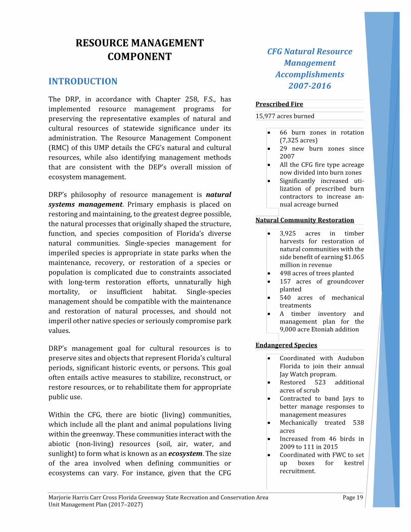
CFG Natural Resource Management
Accomplishments 2007-2016
Prescribed Fire
15,977 acres burned
• 66 burn zones in rotation (7,325 acres)
• 29 new burn zones since 2007
• All the CFG fire type acreage now divided into burn zones
• Significantly increased uti-lization of prescribed burn contractors to increase an-nual acreage burned
Natural Community Restoration
• 3,925 acres in timber harvests for restoration of natural communities with the side benefit of earning $1.065 million in revenue
• 498 acres of trees planted • 157 acres of groundcover
planted • 540 acres of mechanical
treatments • A timber inventory and
management plan for the 9,000 acre Etoniah addition
Endangered Species
• Coordinated with Audubon Florida to join their annual Jay Watch propram.
• Restored 523 additional acres of scrub
• Contracted to band Jays to better manage responses to management measures
• Mechanically treated 538 acres
• Increased from 46 birds in 2009 to 111 in 2015
• Coordinated with FWC to set up boxes for kestrel recruitment.

Marjorie Harris Carr Cross Florida Greenway State Recreation and Conservation Area Page 20 Unit Management Plan (2017–2027)
incorporates a larger ecosystem, management often is affected by conditions and events occurring well beyond park boundaries. Therefore, DRP uses ecosystem management through a resource management evaluation program to assess resource conditions, evaluate management activities, refine management actions, and review local comprehensive plans and development permit applications for park/ecosystem impacts.
RESOURCE DESCRIPTIONS AND ASSESSMENT
Natural Resources
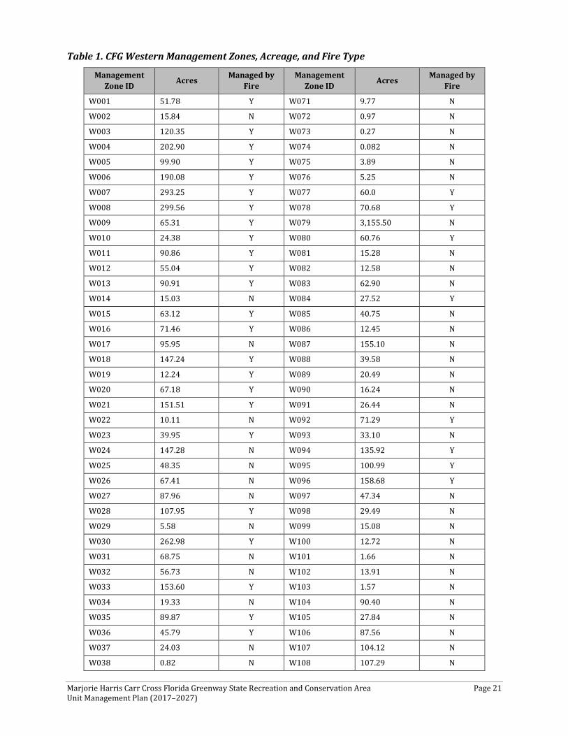
The CFG is 110 miles long and contains 70,640 acres, which are not uniform in the distribution of plant and wildlife species. To assist with the identification of natural resources management activities at the CFG, the entire CFG has been subdivided into the western, central, and eastern sections. Within each of these, the greenway has been further subdivided into 740 management zones that delineate areas on the ground used to reference management activities (see: Management Zones Map). These management zones range in shape and size based on natural community type, burn zone boundaries, and the location of existing roads and natural fire breaks. It is important to note that all burn zones are management zones; however, not all management zones include fire-dependent natural communities.
The westernmost portion of the greenway, which is considered the section from the Gulf of Mexico to SR 200, contains 140 management zones that total 16,088 acres. The largest management zone within the western portion of the CFG is 3,156 acres, while the smallest management zone is 0.001 acre. The average size management zone within the western portion of the CFG is 115 acres. There are seven management zones that exceed 500 acres. Of the 140 management zones, 49 are considered fire dependent (Table 1).
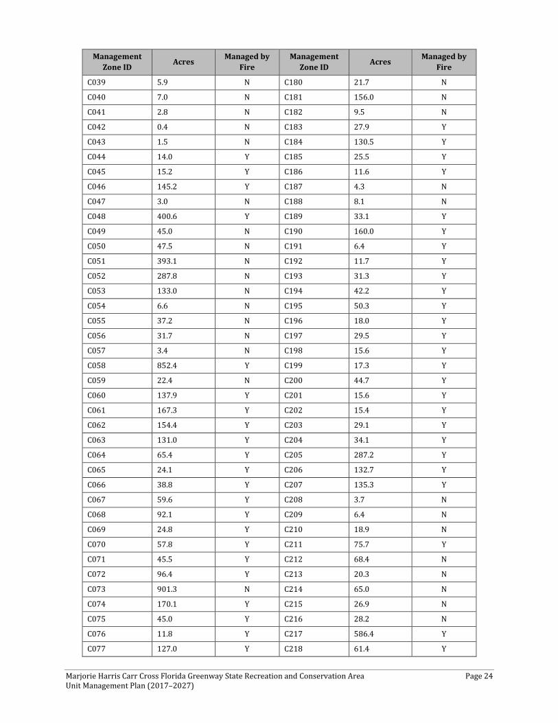
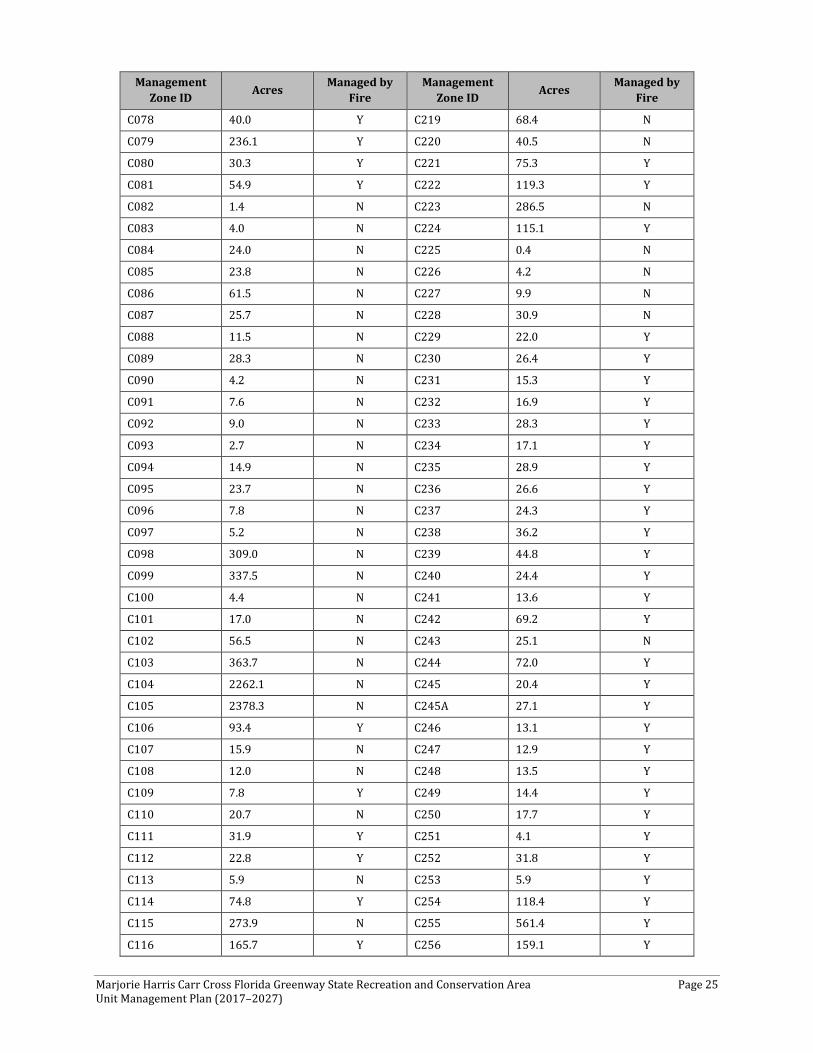
The central portion of the greenway, which is considered the section from SR 200 to CR 316, contains 281 management zones that total 27,270 acres. The largest management zone within the central portion of the CFG is 2,378 acres and the smallest management zone is 0.30 acre. The average size management zone within the central portion of the CFG is 96 acres. There are seven management zones that exceed 500 acres. Of the 281 management zones, 142 are considered fire dependent (Table 2).
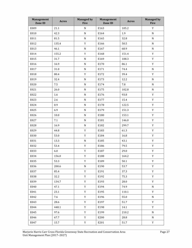
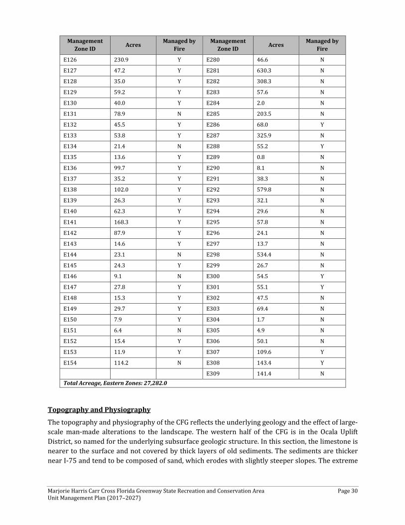
The eastern portion of the greenway, which is considered the section from CR 316 to the St. Johns River, contains 309 management zones that total 27,282 acres. The largest management zone within the eastern portion of the CFG is 2,765 acres and the smallest management zone is 0.005 acre. The average size management zone within the eastern portion of the CFG is 88 acres. There are seven management zones that exceed 500 acres. Of the 309 management zones, 166 are considered fire dependent (Table 3).
Marjorie Harris Carr Cross Florida Greenway State Recreation and Conservation Area Page 21 Unit Management Plan (2017–2027)
Table 1. CFG Western Management Zones, Acreage, and Fire Type
Management Zone ID Acres Managed by
Fire Management
Zone ID Acres Managed by Fire
W001 51.78 Y W071 9.77 N
W002 15.84 N W072 0.97 N
W003 120.35 Y W073 0.27 N
W004 202.90 Y W074 0.082 N
W005 99.90 Y W075 3.89 N
W006 190.08 Y W076 5.25 N
W007 293.25 Y W077 60.0 Y
W008 299.56 Y W078 70.68 Y
W009 65.31 Y W079 3,155.50 N
W010 24.38 Y W080 60.76 Y
W011 90.86 Y W081 15.28 N
W012 55.04 Y W082 12.58 N
W013 90.91 Y W083 62.90 N
W014 15.03 N W084 27.52 Y
W015 63.12 Y W085 40.75 N
W016 71.46 Y W086 12.45 N
W017 95.95 N W087 155.10 N
W018 147.24 Y W088 39.58 N
W019 12.24 Y W089 20.49 N
W020 67.18 Y W090 16.24 N
W021 151.51 Y W091 26.44 N
W022 10.11 N W092 71.29 Y
W023 39.95 Y W093 33.10 N
W024 147.28 N W094 135.92 Y
W025 48.35 N W095 100.99 Y
W026 67.41 N W096 158.68 Y
W027 87.96 N W097 47.34 N
W028 107.95 Y W098 29.49 N
W029 5.58 N W099 15.08 N
W030 262.98 Y W100 12.72 N
W031 68.75 N W101 1.66 N
W032 56.73 N W102 13.91 N
W033 153.60 Y W103 1.57 N
W034 19.33 N W104 90.40 N
W035 89.87 Y W105 27.84 N
W036 45.79 Y W106 87.56 N W037 24.03 N W107 104.12 N
W038 0.82 N W108 107.29 N

Marjorie Harris Carr Cross Florida Greenway State Recreation and Conservation Area Page 22 Unit Management Plan (2017–2027)
Management Zone ID Acres Managed by
Fire Management
Zone ID Acres Managed by Fire
W039 91.08 Y W109 68.33 N
W040 20.22 N W110 43.21 Y
W041 28.45 N W111 27.88 N
W042 9.33 N W112 3.90 N
W043 66.46 N W113 1.58 N
W044 67.20 N W114 5.32 N
W045 8.34 N W115 4.22 N
W046 6.61 N W116 19.68 N
W047 28.44 N W117 11.96 N
W048 0.268 N W118 38.23 N
W049 0.003 N W119 3.58 N
W050 0.001 N W120 3.44 N
W051 2.17 N W121 112.30 N
W052 7.32 N W122 97.82 N
W053 2.30 N W123 133.83 N
W054 8.00 N W124 553.81 Y
W055 68.85 N W125 126.02 Y
W056 55.67 N W126 1,831.33 Y
W057 0.37 N W127 42.26 N
W058 9.41 N W128 46.32 N
W059 3.52 N W129 13.20 N
W060 92.06 Y W130 83.70 N
W061 19.40 N W131 31.94 N
W062 0.93 N W132 84.73 N
W063 0.27 N W133 75.81 N
W064 0.14 N W134 15.80 N
W065 0.88 N W135 1,161.54 N
W066 6.31 N W136 2.62 N
W067 42.43 N W137 11.89 N
W068 0.79 N W138 195.74 N
W069 4.30 N W139 2,272.99 N
W070 1.93 N W140 14.03 N Total Acreage, Western CFG Zones: 16,088

Marjorie Harris Carr Cross Florida Greenway State Recreation and Conservation Area Page 23 Unit Management Plan (2017–2027)
Table 2. CFG Central Management Zones, Acreage, and Fire Type
Management Zone ID Acres Managed by
Fire Management
Zone ID Acres Managed by Fire
C001 3.9 N C142 278.2 Y
C002 12.4 N C143 19.2 N
C003 5.1 N C144 34.8 Y
C004 17.1 N C145 10.4 Y
C005 26.5 N C146 10.5 N
C006 23.0 N C147 34.4 N
C007 225.5 N C148 24.4 Y
C008 65.2 N C149 45.9 Y
C009 71.3 Y C150 1.5 N
C010 181.2 Y C151 3.7 N
C011 113.0 N C152 9.7 N
C012 431.8 Y C153 13.7 N
C013 1481.2 N C154 3.1 N
C014 168.3 N C155 0.3 N
C015 110.1 N C156 30.8 Y
C016 33.8 N C157 37.8 Y
C017 27.3 Y C158 17.3 Y
C018 15.3 N C159 3.5 N
C019 27.9 N C160 12.4 Y
C020 140.5 Y C161 1.9 N
C021 39.7 N C162 15.9 N
C022 42.2 N C163 21.7 N
C023 8.0 N C164 17.8 N
C024 3.4 N C165 7.5 N
C025 96.3 N C166 8.9 N
C026 61.2 N C167 34.7 N
C027 60.7 N C168 466.0 N
C028 0.5 N C169 13.9 Y
C029 21.6 N C170 137.5 Y
C030 2.4 N C171 17.6 N
C031 18.0 N C172 12.1 N
C032 8.6 N C173 2.1 N
C033 3.4 N C174 9.6 Y
C034 1.0 N C175 59.7 Y
C035 5.6 N C176 30.3 Y
C036 4.5 N C177 28.1 N
C037 1.7 N C178 79.0 N
C038 3.1 N C179 25.6 N
Marjorie Harris Carr Cross Florida Greenway State Recreation and Conservation Area Page 24 Unit Management Plan (2017–2027)
Management Zone ID Acres Managed by
Fire Management
Zone ID Acres Managed by Fire
C039 5.9 N C180 21.7 N
C040 7.0 N C181 156.0 N
C041 2.8 N C182 9.5 N
C042 0.4 N C183 27.9 Y
C043 1.5 N C184 130.5 Y
C044 14.0 Y C185 25.5 Y
C045 15.2 Y C186 11.6 Y
C046 145.2 Y C187 4.3 N
C047 3.0 N C188 8.1 N
C048 400.6 Y C189 33.1 Y
C049 45.0 N C190 160.0 Y
C050 47.5 N C191 6.4 Y
C051 393.1 N C192 11.7 Y
C052 287.8 N C193 31.3 Y
C053 133.0 N C194 42.2 Y
C054 6.6 N C195 50.3 Y
C055 37.2 N C196 18.0 Y
C056 31.7 N C197 29.5 Y
C057 3.4 N C198 15.6 Y
C058 852.4 Y C199 17.3 Y
C059 22.4 N C200 44.7 Y
C060 137.9 Y C201 15.6 Y
C061 167.3 Y C202 15.4 Y
C062 154.4 Y C203 29.1 Y
C063 131.0 Y C204 34.1 Y
C064 65.4 Y C205 287.2 Y
C065 24.1 Y C206 132.7 Y
C066 38.8 Y C207 135.3 Y
C067 59.6 Y C208 3.7 N
C068 92.1 Y C209 6.4 N
C069 24.8 Y C210 18.9 N
C070 57.8 Y C211 75.7 Y
C071 45.5 Y C212 68.4 N
C072 96.4 Y C213 20.3 N
C073 901.3 N C214 65.0 N
C074 170.1 Y C215 26.9 N
C075 45.0 Y C216 28.2 N
C076 11.8 Y C217 586.4 Y
C077 127.0 Y C218 61.4 Y
Marjorie Harris Carr Cross Florida Greenway State Recreation and Conservation Area Page 25 Unit Management Plan (2017–2027)
Management Zone ID Acres Managed by
Fire Management
Zone ID Acres Managed by Fire
C078 40.0 Y C219 68.4 N
C079 236.1 Y C220 40.5 N
C080 30.3 Y C221 75.3 Y
C081 54.9 Y C222 119.3 Y
C082 1.4 N C223 286.5 N
C083 4.0 N C224 115.1 Y
C084 24.0 N C225 0.4 N
C085 23.8 N C226 4.2 N
C086 61.5 N C227 9.9 N
C087 25.7 N C228 30.9 N
C088 11.5 N C229 22.0 Y
C089 28.3 N C230 26.4 Y
C090 4.2 N C231 15.3 Y
C091 7.6 N C232 16.9 Y
C092 9.0 N C233 28.3 Y
C093 2.7 N C234 17.1 Y
C094 14.9 N C235 28.9 Y
C095 23.7 N C236 26.6 Y
C096 7.8 N C237 24.3 Y
C097 5.2 N C238 36.2 Y
C098 309.0 N C239 44.8 Y
C099 337.5 N C240 24.4 Y
C100 4.4 N C241 13.6 Y
C101 17.0 N C242 69.2 Y
C102 56.5 N C243 25.1 N
C103 363.7 N C244 72.0 Y
C104 2262.1 N C245 20.4 Y
C105 2378.3 N C245A 27.1 Y
C106 93.4 Y C246 13.1 Y
C107 15.9 N C247 12.9 Y
C108 12.0 N C248 13.5 Y
C109 7.8 Y C249 14.4 Y
C110 20.7 N C250 17.7 Y
C111 31.9 Y C251 4.1 Y
C112 22.8 Y C252 31.8 Y
C113 5.9 N C253 5.9 Y
C114 74.8 Y C254 118.4 Y
C115 273.9 N C255 561.4 Y
C116 165.7 Y C256 159.1 Y

Marjorie Harris Carr Cross Florida Greenway State Recreation and Conservation Area Page 26 Unit Management Plan (2017–2027)
Management Zone ID Acres Managed by
Fire Management
Zone ID Acres Managed by Fire
C117 9.5 N C257 149.4 Y
C118 104.2 Y C258 146.7 Y
C119 468.8 N C259 140.2 Y
C120 47.6 Y C260 12.1 N
C121 30.7 Y C261 301.3 Y
C122 152.3 Y C262 58.9 N
C123 70.3 Y C263 299.7 Y
C124 51.8 Y C264 201.6 Y
C125 67.1 Y C265 212.6 Y
C126 77.4 N C266 394.6 Y
C127 20.2 N C267 186.7 N
C128 57.8 Y C268 46.2 Y
C129 2.1 N C269 12.6 Y
C130 15.4 N C270 14.8 N
C131 0.5 N C271 20.4 N
C132 59.5 N C272 181.1 Y
C133 0.4 N C273 171.5 Y
C134 0.6 N C274 230.5 Y
C135 5.8 N C275 475.4 Y
C136 77.1 N C276 366.9 Y
C137 24.9 Y C277 182.6 Y
C138 61.6 Y C278 107.5 Y
C139 74.7 Y C279 28.9 N
C140 54.1 N C280 17.3 N
C141 37.0 Y C281 11.4 N Total Acreage, Central CFG Zones: 27,269.9
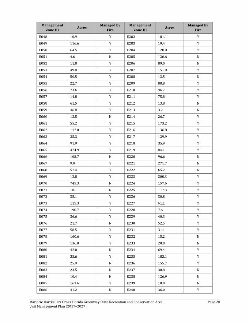
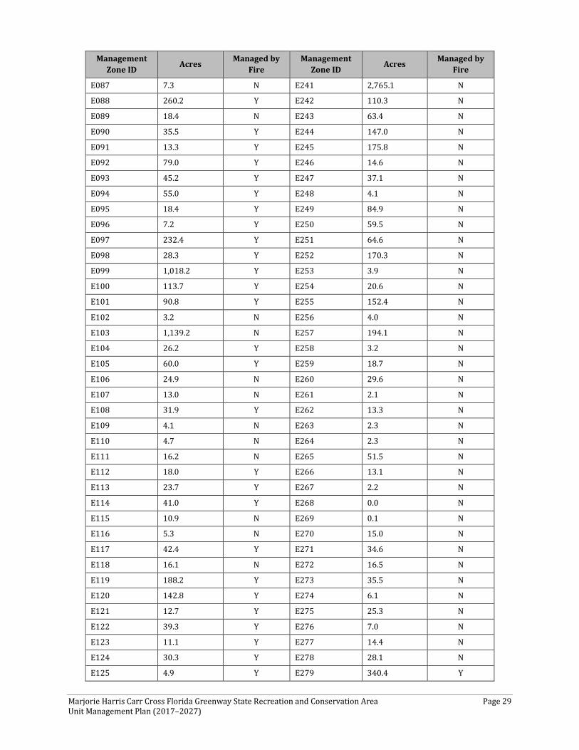
Table 3. CFG Eastern Management Zones, Acreage, and Fire Type
Management Zone ID Acres Managed by
Fire Management
Zone ID Acres Managed by Fire
E001 61.2 N E155 69.1 Y
E002 130.1 N E156 23.4 Y
E003 108.6 N E157 19.1 N
E004 185.7 N E158 11.4 N
E005 5.1 N E159 22.9 N
E006 12.4 Y E160 5.8 N
E007 2.8 N E161 420.1 Y
E008 125.4 Y E162 107.2 Y
Marjorie Harris Carr Cross Florida Greenway State Recreation and Conservation Area Page 27 Unit Management Plan (2017–2027)
Management Zone ID Acres Managed by
Fire Management
Zone ID Acres Managed by Fire
E009 21.1 N E163 105.2 Y
E010 42.3 N E164 1.9 N
E011 81.5 N E165 32.8 N
E012 135.4 Y E166 50.5 N
E013 46.1 N E167 68.9 N
E014 155.2 Y E168 151.4 Y
E015 31.7 N E169 108.3 Y
E016 16.9 N E170 86.1 Y
E017 31.0 N E171 74.4 N
E018 80.4 Y E172 39.4 Y
E019 32.4 N E173 12.2 N
E020 7.5 N E174 7.8 N
E021 26.0 N E175 102.8 N
E022 1.6 N E176 93.8 Y
E023 2.6 N E177 15.4 Y
E024 0.9 N E178 122.5 Y
E025 6.9 N E179 151.3 Y
E026 10.0 N E180 153.1 Y
E027 7.1 N E181 146.0 Y
E028 16.9 N E182 299.7 Y
E029 44.8 Y E183 61.3 Y
E030 53.0 Y E184 16.8 Y
E031 13.3 N E185 43.1 Y
E032 53.4 Y E186 79.5 Y
E033 6.0 Y E187 29.0 Y
E034 156.0 Y E188 164.2 Y
E035 53.3 Y E189 50.1 Y
E036 200.6 N E190 53.7 Y
E037 85.4 Y E191 37.3 Y
E038 32.2 Y E192 75.3 Y
E039 134.7 Y E193 28.0 Y
E040 47.1 Y E194 74.9 N
E041 23.1 Y E195 110.1 Y
E042 7.6 Y E196 55.0 N
E043 28.6 Y E197 51.7 Y
E044 448.1 Y E198 14.1 Y
E045 97.6 Y E199 210.2 N
E046 67.7 Y E200 28.8 N
E047 15.7 Y E201 51.7 Y
Marjorie Harris Carr Cross Florida Greenway State Recreation and Conservation Area Page 28 Unit Management Plan (2017–2027)
Management Zone ID Acres Managed by
Fire Management
Zone ID Acres Managed by Fire
E048 10.9 Y E202 181.1 Y
E049 116.6 Y E203 19.4 Y
E050 64.5 Y E204 128.0 Y
E051 4.6 N E205 126.6 N
E052 11.8 Y E206 89.0 N
E053 49.8 Y E207 151.0 Y
E054 50.5 Y E208 12.5 N
E055 22.7 Y E209 88.8 Y
E056 73.6 Y E210 96.7 Y
E057 14.8 Y E211 75.8 Y
E058 61.5 Y E212 13.8 N
E059 46.8 Y E213 3.2 N
E060 12.5 N E214 26.7 Y
E061 55.2 Y E215 173.2 Y
E062 112.0 Y E216 136.8 Y
E063 35.3 Y E217 129.9 Y
E064 91.9 Y E218 35.9 Y
E065 474.9 Y E219 84.1 Y
E066 105.7 N E220 96.6 N
E067 9.0 Y E221 271.7 N
E068 57.4 Y E222 65.2 N
E069 12.8 Y E223 200.3 Y
E070 745.3 N E224 157.6 Y
E071 10.1 N E225 117.3 Y
E072 35.1 Y E226 30.8 Y
E073 115.3 Y E227 61.1 Y
E074 190.7 Y E228 7.6 Y
E075 36.6 Y E229 40.3 Y
E076 21.7 N E230 52.5 Y
E077 58.5 Y E231 31.1 Y
E078 160.6 Y E232 15.2 N
E079 136.0 Y E233 20.0 N
E080 42.0 N E234 69.4 Y
E081 35.6 Y E235 183.1 Y
E082 25.9 N E236 155.7 Y
E083 23.5 N E237 30.8 N
E084 10.4 N E238 126.9 N
E085 163.6 Y E239 10.0 N
E086 41.2 N E240 36.0 Y
Marjorie Harris Carr Cross Florida Greenway State Recreation and Conservation Area Page 29 Unit Management Plan (2017–2027)
Management Zone ID Acres Managed by
Fire Management
Zone ID Acres Managed by Fire
E087 7.3 N E241 2,765.1 N
E088 260.2 Y E242 110.3 N
E089 18.4 N E243 63.4 N
E090 35.5 Y E244 147.0 N
E091 13.3 Y E245 175.8 N
E092 79.0 Y E246 14.6 N
E093 45.2 Y E247 37.1 N
E094 55.0 Y E248 4.1 N
E095 18.4 Y E249 84.9 N
E096 7.2 Y E250 59.5 N
E097 232.4 Y E251 64.6 N
E098 28.3 Y E252 170.3 N
E099 1,018.2 Y E253 3.9 N
E100 113.7 Y E254 20.6 N
E101 90.8 Y E255 152.4 N
E102 3.2 N E256 4.0 N
E103 1,139.2 N E257 194.1 N
E104 26.2 Y E258 3.2 N
E105 60.0 Y E259 18.7 N
E106 24.9 N E260 29.6 N
E107 13.0 N E261 2.1 N
E108 31.9 Y E262 13.3 N
E109 4.1 N E263 2.3 N
E110 4.7 N E264 2.3 N
E111 16.2 N E265 51.5 N
E112 18.0 Y E266 13.1 N
E113 23.7 Y E267 2.2 N
E114 41.0 Y E268 0.0 N
E115 10.9 N E269 0.1 N
E116 5.3 N E270 15.0 N
E117 42.4 Y E271 34.6 N
E118 16.1 N E272 16.5 N
E119 188.2 Y E273 35.5 N
E120 142.8 Y E274 6.1 N
E121 12.7 Y E275 25.3 N
E122 39.3 Y E276 7.0 N
E123 11.1 Y E277 14.4 N
E124 30.3 Y E278 28.1 N
E125 4.9 Y E279 340.4 Y
Marjorie Harris Carr Cross Florida Greenway State Recreation and Conservation Area Page 30 Unit Management Plan (2017–2027)
Management Zone ID Acres Managed by
Fire Management
Zone ID Acres Managed by Fire
E126 230.9 Y E280 46.6 N
E127 47.2 Y E281 630.3 N
E128 35.0 Y E282 308.3 N
E129 59.2 Y E283 57.6 N
E130 40.0 Y E284 2.0 N
E131 78.9 N E285 203.5 N
E132 45.5 Y E286 68.0 Y
E133 53.8 Y E287 325.9 N
E134 21.4 N E288 55.2 Y
E135 13.6 Y E289 0.8 N
E136 99.7 Y E290 8.1 N
E137 35.2 Y E291 38.3 N
E138 102.0 Y E292 579.8 N
E139 26.3 Y E293 32.1 N
E140 62.3 Y E294 29.6 N
E141 168.3 Y E295 57.8 N
E142 87.9 Y E296 24.1 N
E143 14.6 Y E297 13.7 N
E144 23.1 N E298 534.4 N
E145 24.3 Y E299 26.7 N
E146 9.1 N E300 54.5 Y
E147 27.8 Y E301 55.1 Y
E148 15.3 Y E302 47.5 N
E149 29.7 Y E303 69.4 N
E150 7.9 Y E304 1.7 N
E151 6.4 N E305 4.9 N
E152 15.4 Y E306 50.1 N
E153 11.9 Y E307 109.6 Y
E154 114.2 N E308 143.4 Y
E309 141.4 N Total Acreage, Eastern Zones: 27,282.0
Topography and Physiography
The topography and physiography of the CFG reflects the underlying geology and the effect of large-scale man-made alterations to the landscape. The western half of the CFG is in the Ocala Uplift District, so named for the underlying subsurface geologic structure. In this section, the limestone is nearer to the surface and not covered by thick layers of old sediments. The sediments are thicker near I-75 and tend to be composed of sand, which erodes with slightly steeper slopes. The extreme
Marjorie Harris Carr Cross Florida Greenway State Recreation and Conservation Area Page 31 Unit Management Plan (2017–2027)
western section from the Gulf of Mexico coast to Dunnellon is primarily composed of three physiographic provinces within the Ocala Uplift District (Brooks, 1981).
From the coast to U.S. Highway 19/98 (US 19/98), the area north of the Barge Canal is in the Waccasassa Coastal Strip. This province is a low limestone plain with some rockland upon which has developed a hardwood forest mixed with flatwoods and swamps. The similar Chassahowitzka Coastal Strip occurs on the south side of the canal. It is characterized as a very low coastal strip of limestone rocklands mostly covered by hardwoods and swamps, and some flatwoods. Elevations typically are 10 feet and less (Brooks, 1981). The landscape here has been drastically altered by damming the Withlacoochee River and partially diverting its flow into a canal dredged into the Gulf of Mexico. The topography of the CFG is driven not only by the underlying geology, and the effects of river systems, but also by the hand of man on the landscape. The natural topography of the CFG generally is flat, but the levees along the barge canal can rise 25 feet to 30 feet higher than the natural grade.
Between US 19/98 and the town of Dunnellon is the Waccasassa Flats. Here, thin surficial clastic sediments overlie the limestone, and the elevation is less than 56 feet. Historically, this was flatwoods terrain (Brooks, 1981). Now, CFG property is relatively close to the shores of Lake Rousseau, which affects the hydrology of the area and does not provide much unflooded land for flatwoods in today’s landscape.
The CFG property on the south side of the Withlacoochee River across from Dunnellon is in the Hernando Hammock province. The most characteristic features of the province are the thick, deeply weathered deposits of sand and clayey sand (Brooks, 1981). Typically, the elevation range is 100 feet to 160 feet in the province, but the CFG property is in the river floodplain and does not rise much beyond 50 feet.
From Dunnellon to County Road 484 (CR 484), the CFG is in the Tsala Apopka Basin province. Tsala Apopka is an erosional valley in the limestone terrain of the Ocala Uplift. The surficial sands generally are thin. In some areas, recent freshwater marls and peat have been deposited. The area is a maze of islands, swamps, marshes, and lakes. Flatwoods are typical on the land portions (Brooks, 1981). This portion of the CFG has been altered significantly by the digging of the old Ship Canal, then the Barge Canal. Five dig sites exist in the Tsala Apopka. The dig sites in the canal area can be up to 50 feet above the surrounding landscape and the pits from which material was removed can be another 20 feet lower.
The CFG east of CR 484 to Marshall Swamp is composed of Newberry Sand Hills, Anthony Hills, and Ocala Hills. These provinces are deeply weathered and leached sands that rest directly on the Ocala Limestone. The sediments here are relatively thicker compared to the provinces to the west, and their predominantly sand composition accounts for the hilly landscape. Drainage is primarily internal. Historically, the xeric sandhills were woodland of longleaf pine (Pinus palustris) and turkey oak (Quercus laevis). Elevations generally are between 70 feet and 110 feet on the CFG (Brooks, 1981).
North of Marshall Swamp to the beginnings of Rodman Reservoir, the CFG is predominantly in the Ocklawaha Valley province. Ocklawaha Valley is an erosional valley partially backfilled with older estuarine deposits. A poorly drained flatwoods terrace (elevations about 80 feet) borders the river swamp (Brooks, 1981). The valley consists of relatively broad and flat floodplain.
Marjorie Harris Carr Cross Florida Greenway State Recreation and Conservation Area Page 32 Unit Management Plan (2017–2027)
A few areas—mostly outlying properties to the east of the Ocklawaha River and adjacent to the Ocala National Forest—are in the Central Lake District, and the Lynne Karst province. While this province is known for sandhills over much of its area, the CFG properties are in low-lying local karst areas that are flooded periodically.
The remainder of the CFG property—except for the northernmost extent, a few hundred acres just southeast of Hollister, Florida—is in the St. Johns Offset province. This portion of the St. Johns River Valley is very ancient. It is partially filled with estuarine deposits from when the Atlantic coastline extended this far inland up the St. Johns River. The underlying limestone is very near the surface and contributes to the development of the broad valley. Flatwoods occur on the Pleistocene terraces and a river swamp forest, generally with many cabbage palms (Sabal palmetto), occurs on the floodplain (Brooks, 1981).
Geology
Florida is composed of a large, relatively tectonically stable plateau. The deepest of the underlying basement rocks of the Floridan Plateau lie at least 4,000 feet below the land that comprises the state of Florida. These deep rocks are covered by layers of limestone and dolomite accumulated during the Cretaceous time period, 145 million years ago (mya) to 65 mya, when Florida was surrounded by ocean and covered by a warm sea.
Similar to the Bahama Islands now, Florida was an underwater plateau cut off from the mainland by an ocean current (Gulf Trough) until around 23 mya, when sea levels dropped and Florida emerged from the sea. The Ocala Uplift, a dominant surface feature, was created during this time. The Ocala Uplift is a very important geologic feature in Florida. It stretches all along West Central Florida from Brooksville in the south to Live Oak in the north. It runs parallel to and west of I-75 and is characterized by high, rolling hills.
As the Gulf Trough was closed off, sediments from erosion in the Appalachian Mountains were no longer carried away by ocean currents, and began to deposit on Florida. For the next 23 million years, the limestone of Florida was covered with these sediments, which have themselves eroded, forming Florida’s current topography.
The geology of the CFG west of US 441 is dominated by the Ocala Uplift, and is composed primarily of two formations: the Undifferentiated Quaternary Sediments and the Ocala Limestone. Most of the sediments here are thinner and date, for the most part, from 25 mya to 11,700 years ago, while the underlying Ocala Limestone dates from 56 mya to 34 mya. The underlying geology gives rise to the distinctive topography of the western part of the CFG.
The Undifferentiated Quaternary Sediments are where these sediments exceed 20 feet (6.1 meters) in thickness, and were mapped as discrete units in the geologic map (Scott, 2001). The Ocala Limestone consists of nearly pure limestones and occasional dolostones. It can be subdivided into lower and upper facies. The lower member is composed of a white to cream-colored, fine to medium-grained limestone, and it is not encountered often. The upper facies is a white limestone with fossils and chert commonly occurring throughout (Scott, 2001).
The Ocala Limestone is at or near the surface on the western side of the CFG. In these areas, the Ocala Limestone exhibits extensive karstification. These karst features often have tens of feet (meters) of
Marjorie Harris Carr Cross Florida Greenway State Recreation and Conservation Area Page 33 Unit Management Plan (2017–2027)
relief and may contain disappearing streams and springs within these areas. The permeable, highly transmissive carbonates of the Ocala Limestone form an important part of the Florida Aquifer System (FAS). It is one of the most permeable rock units in the FAS (Miller, 1986).
East of I-75, the CFG is dominated by geologically recent sediments associated with the Ocklawaha River Valley. The underlying limestones are much deeper, with a thicker layer of sediments. Primarily, these sediments are classified in geologic maps as Undifferentiated Quaternary Sediments and Holocene Sediments. Undifferentiated Quaternary Sediments consist of siliciclastic rocks, organics, and freshwater carbonates. Where these sediments exceed 20 feet (6.1 meters) in thickness, they were mapped as discrete units (Scott, 2001). In this area of the CFG, these deposits were created by nearshore sedimentation during times of higher sea levels. They tend to occur farther from the Ocklawaha River (Faulkner, 1973). More recent Holocene Sediments occur nearer to the river and were deposited since the area has been continuously above sea level. They consist of comparatively thin beds of alluvium; freshwater marl; peats and muds in stream and lake bottoms; and some windblown sand deposits (Faulkner, 1973).
There are smaller geologic areas of this portion of the CFG, which are less than 750 acres each. The narrow area between US 441 and Marshall Swamp comprises the Cypresshead Formation, which consists of reddish brown to reddish orange, unconsolidated to poorly consolidated, fine to very coarse grained, clean to clayey sands. Cross bedded sands are common within the formation. The outlying parcels of the CFG that are north of Silver Springs and east of the Ocklawaha River are made up of the Coosawhatchie Formation, which varies from a light gray to olive gray, poorly consolidated, variably clayey and phosphatic sand with few fossils, to an olive gray, poorly to moderately consolidated, slightly sandy, silty clay.
Soils
The CFG is such a large area and crosses so much of the central part of the state that it encompasses many of the soil series mapping units that make up Central Florida (see Addendum 7). There are 146 different Natural Resources Conservation Service (NRCS) soil mapping units identified as being within the CFG. While the NRCS data about individual soil mapping units contain valuable information about the capabilities and limitations of these discrete units, it is difficult to adequately assess the current soil conditions of the CFG because of the drastic man-made alterations to the landscape.
Construction of levees and canals on the far western and eastern sections of the CFG have altered the soils. Soils were excavated, water regimes changed, excavation spoil distributed, and new materials brought in for engineering reasons. In addition, just off the coast, material was dredged up to make a channel and distributed in numerous soil piles, creating new above-ground areas.
In the central canal section, the abandoned dig sites not only disturbed the soil in the actual dig site, but the spoil piles of excavated material cover the archetypal soils near the sites. The hydrology of the soils also has been altered by inundating Lake Rousseau and Rodman Reservoir.
Before the land was obtained to create the Barge Canal or the CFG, various agricultural activities had been practiced throughout the area. Some of these activities date back more than a century. For instance, parts of Marshall Swamp were an active sugar plantation before the Civil War. Also,
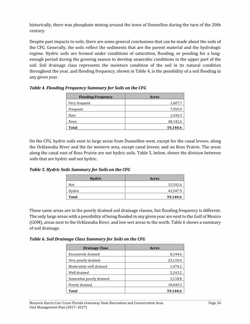
Marjorie Harris Carr Cross Florida Greenway State Recreation and Conservation Area Page 34 Unit Management Plan (2017–2027)
historically, there was phosphate mining around the town of Dunnellon during the turn of the 20th century.
Despite past impacts to soils, there are some general conclusions that can be made about the soils of the CFG. Generally, the soils reflect the sediments that are the parent material and the hydrologic regime. Hydric soils are formed under conditions of saturation, flooding, or ponding for a long-enough period during the growing season to develop anaerobic conditions in the upper part of the soil. Soil drainage class represents the moisture condition of the soil in its natural condition throughout the year, and flooding frequency, shown in Table 4, is the possibility of a soil flooding in any given year.
Table 4. Flooding Frequency Summary for Soils on the CFG
Flooding Frequency Acres Very frequent 1,607.7 Frequent 7,955.9 Rare 1,434.3 None 48,142.6 Total 59,140.6
On the CFG, hydric soils exist in large areas from Dunnellon west, except for the canal levees; along the Ocklawaha River and the far western area, except canal levees; and on Ross Prairie. The areas along the canal east of Ross Prairie are not hydric soils. Table 5, below, shows the division between soils that are hydric and not hydric.
Table 5. Hydric Soils Summary for Soils on the CFG
Hydric Acres Not 15,592.6 Hydric 43,547.9 Total 59,140.6
These same areas are in the poorly drained soil drainage classes, but flooding frequency is different. The only large areas with a possibility of being flooded in any given year are next to the Gulf of Mexico (GOM), areas next to the Ocklawaha River, and low wet areas to the north. Table 6 shows a summary of soil drainage.
Table 6. Soil Drainage Class Summary for Soils on the CFG
Drainage Class Acres Excessively drained 8,144.6 Very poorly drained 23,110.4 Moderately well drained 1,474.2 Well drained 5,243.2 Somewhat poorly drained 3,118.8 Poorly drained 18,049.3 Total 59,140.6
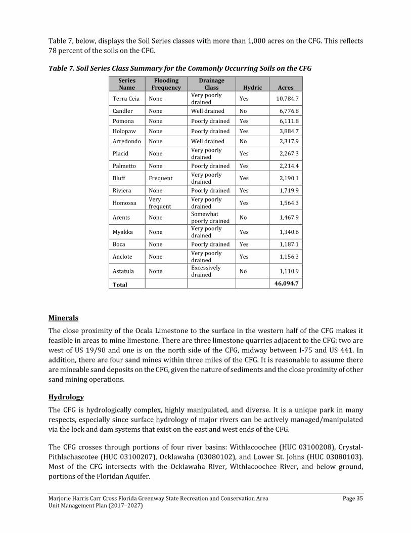
Marjorie Harris Carr Cross Florida Greenway State Recreation and Conservation Area Page 35 Unit Management Plan (2017–2027)
Table 7, below, displays the Soil Series classes with more than 1,000 acres on the CFG. This reflects 78 percent of the soils on the CFG.
Table 7. Soil Series Class Summary for the Commonly Occurring Soils on the CFG Series Name
Flooding Frequency
Drainage Class Hydric Acres
Terra Ceia None Very poorly drained Yes 10,784.7
Candler None Well drained No 6,776.8 Pomona None Poorly drained Yes 6,111.8 Holopaw None Poorly drained Yes 3,884.7 Arredondo None Well drained No 2,317.9
Placid None Very poorly drained Yes 2,267.3
Palmetto None Poorly drained Yes 2,214.4
Bluff Frequent Very poorly drained Yes 2,190.1
Riviera None Poorly drained Yes 1,719.9
Homossa Very frequent
Very poorly drained Yes 1,564.3
Arents None Somewhat poorly drained No 1,467.9
Myakka None Very poorly drained Yes 1,340.6
Boca None Poorly drained Yes 1,187.1
Anclote None Very poorly drained Yes 1,156.3
Astatula None Excessively drained No 1,110.9
Total 46,094.7
Minerals
The close proximity of the Ocala Limestone to the surface in the western half of the CFG makes it feasible in areas to mine limestone. There are three limestone quarries adjacent to the CFG: two are west of US 19/98 and one is on the north side of the CFG, midway between I-75 and US 441. In addition, there are four sand mines within three miles of the CFG. It is reasonable to assume there are mineable sand deposits on the CFG, given the nature of sediments and the close proximity of other sand mining operations.
Hydrology
The CFG is hydrologically complex, highly manipulated, and diverse. It is a unique park in many respects, especially since surface hydrology of major rivers can be actively managed/manipulated via the lock and dam systems that exist on the east and west ends of the CFG.
The CFG crosses through portions of four river basins: Withlacoochee (HUC 03100208), Crystal-Pithlachascotee (HUC 03100207), Ocklawaha (03080102), and Lower St. Johns (HUC 03080103). Most of the CFG intersects with the Ocklawaha River, Withlacoochee River, and below ground, portions of the Floridan Aquifer.
Marjorie Harris Carr Cross Florida Greenway State Recreation and Conservation Area Page 36 Unit Management Plan (2017–2027)
From jurisdictional and management perspectives, the St. Johns River Water Management District (SJRWMD) covers the eastern half of the CFG, while the SWFWMD covers the remaining areas. Florida designates its surface waters into one of five categories, each with a designated use. The majority of the CFG is considered Class III: recreation, propagation, and maintenance of a healthy, well-balanced population of fish and wildlife. At the western end of the CFG, two areas are designated as Class II (shellfish propagation or harvesting).
Construction of the Cross Florida Barge Canal resulted in significant alterations of and impacts to the immediate and adjacent landscape. These land-use actions, which occurred in the mid to latter parts of the 20th Century, have had a lasting effect on aquatic resources throughout the CFG. Despite the degree of immediate impact, portions of the CFG still are characterized by relatively intact aquatic ecosystems. For example, the Cross Florida Barge Canal was cleared and grubbed along its entire alignment, but not dredged upstream of Kenwood. Conversely, the Ocklawaha River still flows along the original channel in most locations.
The Ocklawaha River system arises from the Green Swamp, Lake Apopka and the Harris Chain of Lakes (Lake Griffin, Lake Harris, Little Lake Harris Lake Dora and Lake Beauclair) and flows north, forming the Upper Ocklawaha River. Other aquatic ecosystems that contribute to the headwaters of the Upper Ocklawaha River include Marshall Swamp and Adams Marsh. The CFG encompasses the Ocklawaha River from this point downstream to the Kirkpatrick Dam. The Ocklawaha River flows north, where it is joined by the Silver River from the west near SR 40. The Silver River is a spring-run stream flowing from Silver Springs and it represents the largest tributary of the Ocklawaha River. Orange Creek, Deep Creek, and Camp Branch Creek are other important surface waters that flow into the Ocklawaha River. The Ocklawaha River ultimately flows into the St. Johns River near Satsuma.
Construction of the Cross Florida Barge Canal and other related activities radically changed parts of the Ocklawaha River and associated riparian areas; 7,500 acres of floodplain forest associated with the Ocklawaha River were flooded, along with one second-magnitude (Blue Spring) and 19 third-magnitude springs and associated habitats along the river. The 3,000-acre (relatively intact) Adams Marsh (within Marshall Swamp) is impounded by a perimeter dike about nine miles long. From Silver Springs north to the Eureka Lock, the Ocklawaha River is essentially unaltered. The Eureka Dam and Lock are still in place, but have never been operational. North of Eureka, the Ocklawaha River retains much of its natural characteristics. Approaching Orange Springs, the Ocklawaha River displays more of the characteristics of Rodman Reservoir (also known as Lake Ocklawaha), a consequence of the Kirkpatrick Dam. As the Rodman Reservoir makes its turn to the east, Orange Creek flows in from the west. Farther east, Deep Creek and Sweetwater Creek flow into the reservoir. Much of Sweetwater Creek and its associated riparian areas are found within the CFG. East of the reservoir, the east Barge Canal extends about nine miles to the east-northeast, where it joins the St. Johns River. This part of the canal bisected the Camp Branch Creek, disrupted the natural surface flows, and altered the Cow Heaven Bay Swamp connection with the St. Johns River.
Buckman Lock (still operational) is located within the eastern canal. From this point, CFG landholdings extend about five-miles northeast along the St. Johns River. Historically, the Ocklawaha flowed east-southeast from the location of the Kirkpatrick Dam for approximately nine miles, where it joined the St. Johns River. The flow has been disrupted by the dam and water is released by a spillway into the man-made tailrace and the historical Ocklawaha River channel.
Marjorie Harris Carr Cross Florida Greenway State Recreation and Conservation Area Page 37 Unit Management Plan (2017–2027)
CFG staff maintain the Buckman Lock and Kirkpatrick Dam and Spillway. The Buckman Lock controls access to Rodman Reservoir from the St. Johns River through the east barge canal. The Kirkpatrick Dam spillway controls the level of Rodman Reservoir. Generally, the water level of the reservoir is kept at 18 feet to 20 feet National Geodetic Vertical Datum (NGVD) 1929 level. Drawdown occurs every three to four years, which de-waters approximately 65 percent of the reservoir.
In order to effect environmental restoration and enhancement of the Rodman Reservoir, the CFG will periodically drawdown the Reservoir approximately every 3-4 years for purposes of aquatic weed control and fishery management to enhance the ecological quality of the Reservoir, using St. Johns River Water Management District Consumptive Use General Permit 40C-2.042(10), Florida Administrative Code, established for the purpose of environmental restoration or enhancement projects proposed by the Department. The drawdowns are generally conducted for a 6½ month period between October 1st and April 15th of the following year, as necessary to maintain the ecological health of the Reservoir. Drawdowns are concluded and water level in the Reservoir will be returned to normal pool elevation of 18.0+ feet above mean sea level by approximately April 15th. Drawdown schedules will be set in consultation with the Florida Fish and Wildlife Commission, and a public meeting in advance of a drawdown will be held to inform the public of the intended drawdown. Drawdowns conducted in accordance with this paragraph are not intended to result in a permanent dewatering of the Reservoir, or the restoration of the Ocklawaha River and are intended to continue the general pattern of drawdowns that have been conducted for the Reservoir since 1971.
The Withlacoochee River is the main river system on the western end of the CFG. A small portion of the CFG abuts the Withlacoochee River near Dunnellon, where the Rainbow River, arising from a first-magnitude spring, flows into the river. Downstream of the confluence with the Rainbow River, the Withlacoochee River is dammed. Dam construction was completed in the early 1900’s and resulted in Lake Rousseau (also known as Withlacoochee Backwaters)—a waterbody utilized for generating electric power. Lake Rousseau is no longer used for power generation. Downstream of Lake Rousseau, the CFG borders the south bank of the Withlacoochee River in several places all the way to the Gulf of Mexico.
Current water control structures associated with Lake Rousseau include the Inglis Dam and Spillway, Inglis Lock (as part of the western Barge Canal), and the Inglis Bypass Canal and Spillway. The bypass canal funnels water from Lake Rousseau just east of the lock to a spillway that provides water to the lower reaches of the Withlacoochee River. The Inglis Lock is no longer operational due to its deteriorated condition. The SWFWMD operates the western Barge Canal water control structures (dams and spillways) under a contract with and funding through FDEP. FDEP is currently responsible for maintenance and operation of the Inglis Lock. The Lake Rousseau water level generally is maintained at a fixed elevation of 27.5 NGVD. In times of heavy rainfall, additional water can be released to prevent or minimize localized flooding.
The western Barge Canal is about nine miles long and extends from near the western end of Lake Rousseau into the Gulf of Mexico for about 10.5 miles. The western Barge Canal cuts through the lower reaches of the Withlacoochee River between the Inglis Bypass Spillway and the western end of Lake Rousseau. Inglis Island, formerly bordered on the north side of Lake Rousseau and the Withlacoochee River, was surrounded by water by the canal being cut through on the north side of the land mass.
Marjorie Harris Carr Cross Florida Greenway State Recreation and Conservation Area Page 38 Unit Management Plan (2017–2027)
The CFG is not directly associated with any riverine systems from east of Dunnellon to Marshall Swamp. However, some significant wetlands are present in the Ross Prairie/Halpata Tastanaki Preserve area. Segments of old ship canal diggings also are in the stretch from the Pruitt Trailhead east to I-75.
Water Quality Water quality within the CFG is influenced to a large degree by sources and land uses occurring outside of its boundaries. Water quality is tracked and managed at multiple levels within the state. For example, at the macro-scale, Basin Management Action Plans (BMAPs) have been established across Florida and serve as a "blueprint" for restoring impaired waters by reducing pollutant loadings to meet the allowable loadings established in a Total Maximum Daily Load (TMDL). Individual BMAPs represent a comprehensive set of strategies such as permit limits on wastewater facilities, urban and agricultural best management practices (BMPs), and conservation programs. Within and proximal to the CFG, six BMAPS have been established (Silver Springs, Kings Bay, Lower St. Johns main stem, Silver River, Rainbow Springs, and Rainbow River). Also within this same geographic area, seven impaired waterbodies have been identified (Withlacoochee River, Lake Rousseau Drain, Rainbow River Run, Ocklawaha River above Daisy Creek, Daisy Creek, and Little Orange Creek) and two TMDLs have been established for the St. Johns River above Dunns Creek and Upper Silver River.
At the local scale, FDEP, USGS, and the SJRWMD routinely collect water quality samples in the Ocklawaha River Basin. Water quality at the SR 316 and SR 40 stations in Marion County is considered good according to the SJRWMD’s water quality index. Orange Creek and the Silver River are each monitored near their confluences with the Ocklawaha River. Water quality at both of these monitoring sites is considered good according to the water quality index. Additional water quality information for the Ocklawaha River is available via multiple websites (need to verify and/or update links): and for Orange Creek.
Construction, shoreline alterations, and failing septic tanks contribute sediment, nutrient, and bacteria inputs to Lake Rousseau. Aquatic weed growth within Lake Rousseau is a problem, which is managed primarily via herbicide treatments by FWC. Downstream of Lake Rousseau, the Withlacoochee River has similar pollution sources.
The SJRWMD has several groundwater observation wells located both on and within one mile of the CFG. Selected wells provide daily observations, and the district and the USGS conduct potentiometric readings twice a year. The SJRWMD portion of the CFG has little groundwater development, especially in river areas. Sampling in the Summit Reach area near Ocala shows that nitrates have been steadily increasing over the years. The Ocala area is an important water recharge area for the Floridan Aquifer. The western end of the CFG is in an area generally with an unconfined Floridan Aquifer, except near the Withlacoochee River. Groundwater recharge rates are high, water withdrawal is low, and the level of nitrates in groundwater has increased over time.
Other Supporting Information Starting in the 1970’s, numerous public interest groups have recommended the removal of the Kirkpatrick Dam due to impacts the Rodman Reservoir has had on the Ocklawaha River, its floodplain, and associated ecosystems.
Marjorie Harris Carr Cross Florida Greenway State Recreation and Conservation Area Page 39 Unit Management Plan (2017–2027)
Creation of the Kirkpatrick Dam has caused flooding within a portion of Ocala National Forest. Incidental flooding has been allowed under a special-use permit from the U.S. Department of Agriculture, Forest Service (first issued in 1994). The USFS included conditions about the issuance of the new permit, containing a schedule for the reservoir to be drawn down and the dam to be breached/disabled.
In addition to obvious hydrological disruptions resulting from Barge Canal activities, smaller-scale, but significant, hydrological disruptions are present on the CFG. Roads, planting beds, ditches, and firelines are responsible for many of these other disturbances.
Management Recommendations Managing water levels within Rodman Reservoir follows procedures and protocols established by professionals, such as civil engineers, fisheries and aquatic plant scientists, hydrologists, and geologists. A discussion of the technical aspects of those procedures and protocols is not germaine to this UMP. With respect to other aspects of hydrologic/aquatic resources within the CFG, it is recommended that resource staff continue to follow Florida Silviculture Best Management Practices, as well as agricultural BMPs (research has consistently shown that properly applied BMPs protect water quality). Aspects of land management having an immediate and recurring impact include soil erosion/sedimentation control measures related to dirt roads and firebreaks and proper use of herbicides in aquatic environments.
Natural Communities
Introduction This section of the unit management plan describes and assesses each of the natural communities or land cover found on the CFG. Information on the CFG natural communities was obtained from the 2007-2008 FNAI Natural Communities Survey Report. Land management and restoration is best guided by clear and specific ecological goals and/or desired future conditions. This section describes the desired future condition of each natural community or provides a description of how each community should look in the future. There are many values of identifying a desired future condition. These include: (1) providing a vision of future conditions that can be communicated to staff, stakeholders and the public, (2) guiding conservation and management actions, (3) providing spatial and temporal priorities for management and conservation, and (4) integrating monitoring and adaptive management into natural resource management. This section also discusses the management actions required to bring each community to its desired future condition. Specific management objectives and actions for natural community management, exotic species management, imperiled species management, and restoration are discussed in the Resource Management Program section of this component.
The system of classifying natural communities utilized in this plan was developed by the Florida Natural Areas Inventory (FNAI). Natural Communities are characterized and defined by a combination of physiognomy, vegetation structure and composition, topography, land form, substrate, soil moisture condition, climate, and fire. They are named for their most characteristic biological or physical feature (FNAI and FDEP, 2010). FNAI uses several criteria, including area covered and number of occurrences, to determine the relative rarity and threat to each community type; these are summarized into a global rank and a state rank, the G and S ranks listed for each community, respectively. Table 8 provides the ranking for each vegetative community on the CFG.

Marjorie Harris Carr Cross Florida Greenway State Recreation and Conservation Area Page 40 Unit Management Plan (2017–2027)
When a natural community within a park reaches the ideal future condition, it is considered to be in a “maintenance condition.” Required actions for sustaining a community’s maintenance condition may include maintaining optimal fire return intervals for fire-dependent communities, ongoing control of non-native plant and animal species, maintaining natural hydrological functions (including historic water flows and water quality), preserving a community’s biodiversity and vegetative structure, protecting viable populations of plant and animal species (including those that are imperiled or endemic), and preserving intact ecotones linking natural communities across the landscape.
The CFG extends from the Gulf of Mexico on the west to the St. Johns River on the east, and it crosses four major landscapes, including: Withlacoochee Coastal Lowlands, Ocala Uplands, Ocklawaha River Valley, and the Etoniah Basin.
The key ecological associations for each of these landscapes are:
• Withlacoochee Coastal Lowlands—associations include hydric hammock/tidal marsh/freshwater tidal swamp/wet flatwoods, wet flatwoods/tidal marsh, wet flatwoods/sandhill, and mesic flatwoods/ sandhill.
• Ocala Uplands—associations include sandhill/ scrub/upland pine forest (red oak), sandhill/xeric hammock/wet prairie, and wet flatwoods/mesic flatwoods/depression marsh.
• Ocklawaha River Valley—associations include floodplain swamp/bottomland forest/depression marsh/basin marsh/mesic flatwoods/ wet flatwoods, and scrub/sandhill.
• Etoniah Basin—associations include floodplain swamp/basin swamp/mesic flatwoods/wet flatwoods, and scrub/sandhill.
Outstanding natural systems of the greenway include springs and rivers, lakes, swamps, prairies, freshwater and saltwater marshes, and uplands. Many of the natural communities on the greenway represent a true cross section of natural Florida, with a possible 26 of FNAI's 82 natural communities in the region.
The greenway is home to a variety of wildlife, including indicator species such as the Florida black bear, gopher tortoise, bald eagle, Florida scrub jay, and wood stork. Important black bear corridors exist throughout the greenway. The greenway affords the opportunity to study exotic species throughout its length; to evaluate disturbed hydrologic systems in the canals and river corridors; and to analyze impacts from urban and development pressures—for example, from domestic pets—on the natural systems in the Ocala Upland, and from development pressures on the Ocklawaha and Withlacoochee Rivers.
As illustrated below in Table 8, a total of 64 percent—or 45,663 acres—of the CFG can be classified as natural communities, while 24,868 acres—or 36 percent—can be classified as an altered land cover type. Major natural communities represented based on acreage on the CFG include sandhills, mesic flatwoods, wet flatwoods, scrub, upland mixed forest, and bottomlands. These communities total approximately 50 percent of the CFG acreage, and two-thirds of the natural community coverage on the CFG.
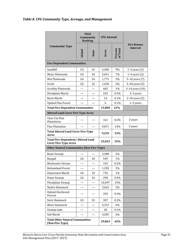
Marjorie Harris Carr Cross Florida Greenway State Recreation and Conservation Area Page 41 Unit Management Plan (2017–2027)
Table 8. CFG Community Type, Acreage, and Management
Community Type
FNAI Community
Ranking CFG Amount
Fire Return Interval
Glob
al
Stat
e
Acre
s
Perc
ent
of T
otal
Fire-Dependent Communities
Sandhill G3 S2 6,408 9% 1–3 years (3)
Mesic Flatwoods G4 S4 5,041 7% 1–4 years (3) Wet Flatwoods G4 S4 1,773 3% 5–10 years (7) Scrub G2 S2 1,630 2% 5–20 years (5)
Scrubby Flatwoods — — 683 1% 3–14 years (10) Floodplain Marsh — — 245 0.3% 2–5 years
Basin Marsh — — 14 0.1% 2–10 years (5) Upland Pine Forest — — 6 0.1% 1–3 years
Total Fire-Dependent Communities 15,800 22%
Altered Land Cover Fire-Type Acres
Clear Cut Pine Plantations — — 161 0.2% 3 years
Pine Plantation — — 9,071 13% 3 years
Total Altered Land Cover Fire-Type Acres 9,232 13%
Total Fire-Dependent/ Altered Land Cover Fire-Type Acres 25,032 35%
Other Natural Communities (Non-Fire Type)
Basin Swamp — — 3,388 5%
Baygall G4 S4 549 1% Blackwater Stream — — 192 0.2% Bottomland Forest — — 1,258 2%
Depression Marsh G4 S4 735 1% Dome Swamp G4 S4 298 0.3%
Floodplain Swamp — — 10,497 15% Hydric Hammock — — 3,663 5% Upland Hardwood Forrest — — 350 0.3%
Xeric Hammock G3 S3 307 0.3% Mesic Hammock — — 4,313 6%
Swamp Lake — — 28 0.1% Salt Marsh — — 4,285 6%
Total Other Natural Communities (Non-Fire Type) 29,863 42%
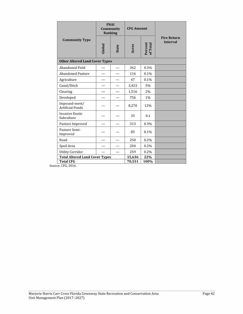
Marjorie Harris Carr Cross Florida Greenway State Recreation and Conservation Area Page 42 Unit Management Plan (2017–2027)
Community Type
FNAI Community
Ranking CFG Amount
Fire Return Interval
Glob
al
Stat
e
Acre
s
Perc
ent
of T
otal
Other Altered Land Cover Types
Abandoned Field — — 362 0.3% Abandoned Pasture — — 116 0.1%
Agriculture — — 47 0.1% Canal/Ditch — — 3,423 5%
Clearing — — 1,516 2% Developed — — 756 1% Impound-ment/ Artificial Ponds — — 8,270 12%
Invasive Exotic Subculture — — 35 0.1
Pasture Improved — — 313 0.3% Pasture Semi-Improved — — 85 0.1%
Road — — 250 0.2% Spoil Area — — 204 0.2%
Utility Corridor — — 259 0.2% Total Altered Land Cover Types 15,636 22% Total CFG 70,531 100%
Source: CFG, 2016.
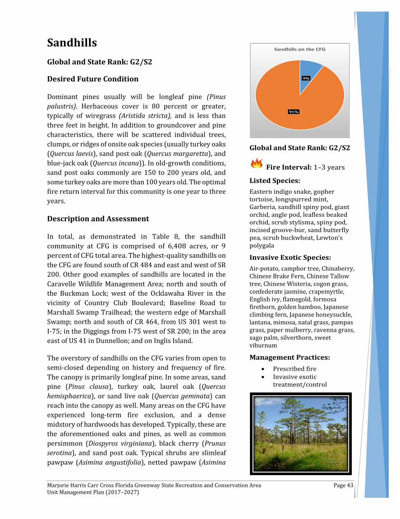
Marjorie Harris Carr Cross Florida Greenway State Recreation and Conservation Area Page 43 Unit Management Plan (2017–2027)
Sandhills Global and State Rank: G2/S2
Desired Future Condition
Dominant pines usually will be longleaf pine (Pinus palustris). Herbaceous cover is 80 percent or greater, typically of wiregrass (Aristida stricta), and is less than three feet in height. In addition to groundcover and pine characteristics, there will be scattered individual trees, clumps, or ridges of onsite oak species (usually turkey oaks (Quercus laevis), sand post oak (Quercus margaretta), and blue-jack oak (Quercus incana)). In old-growth conditions, sand post oaks commonly are 150 to 200 years old, and some turkey oaks are more than 100 years old. The optimal fire return interval for this community is one year to three years.
Description and Assessment
In total, as demonstrated in Table 8, the sandhill community at CFG is comprised of 6,408 acres, or 9 percent of CFG total area. The highest-quality sandhills on the CFG are found south of CR 484 and east and west of SR 200. Other good examples of sandhills are located in the Caravelle Wildlife Management Area; north and south of the Buckman Lock; west of the Ocklawaha River in the vicinity of Country Club Boulevard; Baseline Road to Marshall Swamp Trailhead; the western edge of Marshall Swamp; north and south of CR 464, from US 301 west to I-75; in the Diggings from I-75 west of SR 200; in the area east of US 41 in Dunnellon; and on Inglis Island.
The overstory of sandhills on the CFG varies from open to semi-closed depending on history and frequency of fire. The canopy is primarily longleaf pine. In some areas, sand pine (Pinus clausa), turkey oak, laurel oak (Quercus hemisphaerica), or sand live oak (Quercus geminata) can reach into the canopy as well. Many areas on the CFG have experienced long-term fire exclusion, and a dense midstory of hardwoods has developed. Typically, these are the aforementioned oaks and pines, as well as common persimmon (Diospyros virginiana), black cherry (Prunus serotina), and sand post oak. Typical shrubs are slimleaf pawpaw (Asimina angustifolia), netted pawpaw (Asimina
Air-potato, camphor tree, Chinaberry, Chinese Brake Fern, Chinese Tallow tree, Chinese Wisteria, cogon grass, confederate jasmine, crapemyrtle, English ivy, flamegold, formosa firethorn, golden bamboo, Japanese climbing fern, Japanese honeysuckle, lantana, mimosa, natal grass, pampas grass, paper mulberry, ravenna grass, sago palm, silverthorn, sweet viburnum
Marjorie Harris Carr Cross Florida Greenway State Recreation and Conservation Area Page 44 Unit Management Plan (2017–2027)
reticulata), Michaux's hawthorn (Crataegus michauxii), dwarf huckleberry (Gaylussacia dumosa), sand holly (Ilex ambigua), gopher apple (Licania michauxii), Carolina laurelcherry (Prunus caroliniana), flatwoods plum (Prunus umbellata), Chapman's oak (Quercus chapmanii), bluejack oak (Quercus incana), winged sumac (Rhus copallinum), sassafras (Sassafras albidum), saw palmetto (Serenoa repens), and dwarf live oak (Quercus minima).
A few areas of sandhills on the CFG contain southern red oak (Quercus falcata) and flowering dogwood (Cornus florida). Typically, these species are associated with upland pine forest communities, which represent a similar community that occurs on slightly richer, more clayey soils, (primarily occurring in northern Florida). Only one small area (six acres) is delineated for the upland pine forest (red oak) on the CFG, although a larger area is noted in the historic vegetation map (320 acres). Possible remnants of upland pine forests are within the sandhills west of US 441 and within a ruderal area (historic sandhill) north of CR 464 in the Baseline Road/Marshall Swamp Recreation Trail.
The herbaceous layer of the sandhills at CFG offers a high diversity of species. Grasses include Elliott's bluestem (Andropogon gyrans), splitbeard bluestem (Andropogon ternarius), broomsedge bluestem (Andropogon virginicus), arrowfeather threeawn (Aristida purpurascens), bottlebrush threeawn (Aristida spiciformis), wiregrass, bearded skeletongrass (Gymnopogon ambiguus), pinewoods dropseed (Sporobolus junceus), little bluestem (Schizachyrium scoparium), needleleaf witchgrass (Dichanthelium aciculare), perennial sandgrass (Triplasis americana) and lopsided indian grass (Sorghastrum secundum).
Typical forbs in the Sandhills community include yellow false foxglove (Aureolaria pedicularia var. pectinata), coastalplain honeycomb-head (Balduina angustifolia), oblongleaf twinflower (Dyschoriste oblongifolia), Florida greeneyes (Berlandiera subacaulis), Elliott's milkpea (Galactia elliottii), shortleaf gayfeather (Liatris tenuifolia), skyblue lupine (Lupinus diffusus), sweet goldenrod (Solidago odora), chaffhead (Carphephorus corymbosus), Florida alicia (Chapmannia floridana), devil's grandmother (Elephantopus tomentosus), wild buckwheat (Eriogonum tomentosum), narrowleaf silkgrass (Pityopsis graminifolia), bracken fern (Pteridium aquilinum), manyflower beardtongue (Penstemon multiflorus), Feay's palafox (Palafoxia feayi), sandyfield beaksedge (Rhynchospora megalocarpa), Carolina wild petunia (Ruellia caroliniensis), Piedmont blacksenna (Seymeria pectinata), tread softly (Cnidoscolus stimulosus), silver croton (Croton argyranthemus), pineland croton (Croton linearis), ticktrefoil (Desmodium sp.), whitetop aster (Sericocarpus tortifolius), and camphorweed (Heterotheca subaxillaris). Vines tend to have a patchy distribution and primarily include Virginia creeper (Parthenocissus quinquefolia), earleaf greenbrier (Smilax auriculata), and muscadine (Vitis rotundifolia). In areas where fire has been absent for long periods, ground lichens (Cladina evansii, Cladina subtenuis, and Cladonia leporina) are common.
Fire exclusion and the resulting woody encroachment represent the most prevalent departure from desired future conditions in the sandhills throughout the CFG. Invasive exotic plants and disturbances (historic or routinely recurring) including clearing, ditches and canals (“the Diggings”), forestry operations, agriculture operations to include cattle grazing and watering, roads, off-road vehicle (ORV) trails, firebreaks and development account for most of the remaining impacts.
Two listed animal species—eastern indigo snake (Drymarchon couperi) and gopher tortoise (Gopherus polyphemus)—were observed in the sandhills on CFG during a survey conducted by FNAI
Marjorie Harris Carr Cross Florida Greenway State Recreation and Conservation Area Page 45 Unit Management Plan (2017–2027)
from 2007 to 2008. The following listed plants were identified during the surveys: longspurred mint (Dicerandra cornutissima), garberia (Garberia heterophylla), giant orchid, angle pod, leafless beaked orchid, scrub stylisma, spiny pod, and sandhill spiny pod (Matelea pubiflora).
Invasive plant species observed within the sandhills during these surveys conducted by FNAI were: air-potato (Dioscorea bulbifera), camphor tree (Cinnamomum camphora), Chinaberry (Melia azedarach), Chinese brake fern (Pteris vittata), Chinese tallow tree (Triadica sebifera), Chinese wisteria, cogon grass (Imperata cylindrica), confederate jasmine, crapemyrtle, English ivy, flamegold, formosa firethorn, golden bamboo, Japanese climbing fern, Japanese honeysuckle, lantana, mimosa (Albizia julibrissin), natal grass (Rhynchelytrum repens), pampas grass, paper mulberry, ravenna grass, sago palm, silverthorn, sweet viburnum.
Fire Regime
Frequent ground fires reduce hardwood competition and promote the growth and development of forbs, grasses, and predominant (or preferred) overstory species—longleaf pine. The natural fire frequency for the sandhills is once every one to three years, although some sites may be maintained with fire intervals up to five years. Naturally, fires would ignite principally during the early summer (April to June) when lightning strikes are frequent and fuels are not yet saturated by afternoon rains. Without frequent fires, the sandhills may eventually succeed to xeric hammock.
General Management Measures
Management activities in the sandhills on CFG should focus on prescribed burning, minimizing practices that disturb the soil, and restoring areas that are densely encroached with oaks or sand pines. When conditions allow, prescribed burning alone is the preferred method to reduce woody species abundance in the understory. Roller-chopping, particularly in xeric soil types, can be detrimental to herbaceous species, especially wiregrass. A chemical treatment may be appropriate in some areas of extreme oak encroachment. Hand felling and removal of very dense oaks prior to burning may be most effective and create the least amount of soil disturbance. In many situations, prescribed burning during early summer should provide the greatest benefit in reducing woody species abundance. Diligence in monitoring and controlling invasive exotic plants in the sandhills also is necessary.
During all management activities, every effort should be made to minimize detrimental effects to the gopher tortoise population (and its burrows) and to existing longspurred mint growth.

Marjorie Harris Carr Cross Florida Greenway State Recreation and Conservation Area Page 46 Unit Management Plan (2017–2027)
Scrub Global and State Rank: G2/S2
Desired Future Condition
Dominant species over the vast majority of scrub include sand live oak (Quercus geminata), myrtle oak (Quercus myrtifolia), Chapman’s oak (Quercus chapmanii), saw palmetto (Serenoa repens) and rusty staggerbush (Lyonia ferruginea). Scrub oak canopy will vary in height from three feet to eight feet. There is a variety of oak age classes and heights between different scrub patches. There are scattered openings in the canopy, with bare patches of sand that support many imperiled or endemic plant species; these species are regularly flowering and replenishing their seed banks. Sand pine (Pinus clausa), where present, usually is not dominant in abundance, percent cover, or height. The optimal fire return interval for this community is regionally variable; typically, five years to 20 years when aiming to achieve a mosaic of burned and unburned areas.
Description and Assessment
In total, as shown in Table 8, the scrub communities on the CFG are comprised of 1,630 acres, or 2 percent of the CFG total area. Scrub is centered in Florida, but extends westward on barrier islands to Alabama and Mississippi, and small patches are found northward into southeastern Georgia. In Florida, scrub tends to be distributed in long, narrow ridges parallel to coastlines and is scarce or absent from the limestone-dominated southernmost portion of the state.
The highest-quality scrub on the CFG occurs within the Triangle and the Diggings, within close proximity to I-75. Scrub also occurs in the Caravelle Wildlife Management Area, specifically, north of the Buckman Lock; north of the Rodman Reservoir; and east of Deep Creek. Other areas include the Eureka East Recreation site, in the area north of CR 314, west end of the CFG south of the Withlacoochee River, south of the Ocklawaha River, in the area of I-75 west (the Triangle), and in the Diggings east of SR 200.
, Caesar's weed, Chinese tallow tree, pampas grass
Marjorie Harris Carr Cross Florida Greenway State Recreation and Conservation Area Page 47 Unit Management Plan (2017–2027)
The scrub communities on the CFG typically have an open canopy of sand pine and sand live oak. The subcanopy is moderately dense and includes sand pine, sand live oak, rusty staggerbush, Chapman's oak, laurel oak (Quercus hemisphaerica), and myrtle oak. Shrubs are dense and diverse, but at times can be patchy, with white sand between the patches. Shrubs include the aforementioned overstory species and Florida rosemary (Ceratiola ericoides), garberia (Garberia heterophylla), blue huckleberry (Gaylussacia frondosa var. tomentosa), sand holly (Ilex ambigua), gopher apple (Licania michauxii), rusty staggerbush, fetterbush (Lyonia lucida), scrub wild olive (Osmanthus megacarpus), silk bay (Persea borbonia var. humilis), black cherry (Prunus serotina), turkey oak (Quercus laevis), scrub palmetto (Sabal etonia), saw palmetto, gum bully (Sideroxylon lanuginosum), tough bully (Sideroxylon tenax), sparkleberry (Vaccinium arboreum), Darrow's blueberry (Vaccinium darrowii), shiny blueberry (Vaccinium myrsinites), and deerberry (Vaccinium stamineum).
Herbs are sparse and occur primarily in the open sandy patches. Typically seen are broomsedge bluestem (Andropogon virginicus), bottlebrush threeawn (Aristida spiciformis), coastalplain honeycomb-head (Balduina angustifolia), capillary hairsedge (Bulbostylis ciliatifolia), Florida alicia (Chapmannia floridana), Feay's prairie clover (Dalea feayi), summer farewell (Dalea pinnata), rough hedgehyssop (Gratiola hispida), shortleaf gayfeather (Liatris tenuifolia), prickly pear (Opuntia), wild pennyroyal (Piloblephis rigida), narrowleaf silkgrass (Pityopsis graminifolia), racemed milkwort (Polygala polygama), sandyfield beaksedge (Rhynchospora megalocarpa), sand spike-moss (Selaginella arenicola), and pineland scalypink (Stipulicida setacea). Vines include earleaf greenbrier (Smilax auriculata) and muscadine (Vitis rotundifolia). Ground lichens (Cladonia spp. and Cladina spp.) are present. Fire exclusion and resulting woody encroachment represent the most serious disturbances in the scrub communities on the CFG. Other more-minor disturbances include clearing, forestry operations, ORV trails, firebreaks, and exotic plant introduction.
Listed species occur in the scrub communities of the CFG. Two listed animal species—the Florida Scrub-Jay (Aphelocoma coerulescens) and gopher tortoise (Gopherus polyphemus)—were documented during the 2007 and 2008 FNAI survey. Five listed plants—longspurred mint (Dicerandra cornutissima), garberia (Garberia heterophylla), Chapman’s skeletongrass (Gymnopogon chapmanianus), sand butterfly pea (Centrosema arencicola), and giant orchid (Pteroglossaspis ecristata)—also were documented.
Six invasive plant species were recorded within scrub communities on the CFG: mimosa (Albizia julibrissin), cogon grass (Imperata cylindrica), natal grass (Rhynchelytrum repens), Caesar’s weed (Urena lobate), Chinese tallow (Triadica sebifera) and pampas grass (Cortaderia selloana).
Fire Regime
Oak scrub, which has been the subject of considerable research in the peninsula, is thought to have a range of natural fire return intervals that are considerably shorter (five years to 20 years) than those of sand pine (20 years to 80 years) or rosemary scrub (10 years to 40 years). Sand pine, if present in the area at all, will invade and overtop oak scrub if left unburned for long periods of time.
Marjorie Harris Carr Cross Florida Greenway State Recreation and Conservation Area Page 48 Unit Management Plan (2017–2027)
General Management Measures
The primary management of scrub on the CFG should be guided by habitat requirements of the Florida scrub jay. On a case-by-case basis, some special management considerations may be added to this goal to protect and maintain longspurred mint and the gopher tortoise.
Optimal Florida scrub jay habitat consists of low oak shrubs (three feet to six feet tall) interspersed with numerous patches of exposed sand representing greater than 15 percent of the area. Jays need the bare sandy soil to bury and recover their annual cache of acorns. A mosaic of scrubs with various heights is ideal, but across all scrub in an area where Florida scrub jays reside or are wanted, the general goal should be maintenance of 70 percent of all territories (or potential territories) at an optimal height for Jays of approximately three feet to six feet. The majority of the remaining 30 percent should be in the lower height range (i.e., just burned and re-sprouting scrub vegetation less than four feet in height), with a very small percentage, if any, of the scrub landscape taller than six feet.
Florida scrub jays are permanently territorial and do not abandon a breeding territory except under rare circumstances. To avoid burning all of one territory in one fire, it is important to conduct mosaic burns in occupied territories. A specific Florida scrub jay habitat management plan may be needed to effectively implement and guide the timing and extent of management actions. Effective burning may require low humidity conditions, which presents challenges for the prescribed burner. Mechanical treatments in scrub can be used to facilitate burning under more controlled weather conditions. Mechanical reduction of shrub stature and/or removal of sand pines prior to burning are sometimes needed to reduce fuel levels.
Scrub fire regimes are highly variable, depending on landscape settings. Some older references recommend a fire return interval of 20 years or more; however, more current scientific research suggests most scrubs would have naturally burned more frequently. A return interval between four years and 10 years may be necessary to maintain shrub heights within the range favorable to the Florida scrub jay. Intervals vary depending on site conditions, which will affect vegetation growth rates, and on the ideal vegetation structure.
The invasive exotic plant cogon grass threatens the state-listed longspurred mint in some areas; vigilant treatment and monitoring of cogon grass in these areas will be required to protect this rare mint. In certain locations, the source for this invasive exotic is on adjacent Department of Transportation lands, and, thus, effective treatment will require coordination with that agency.
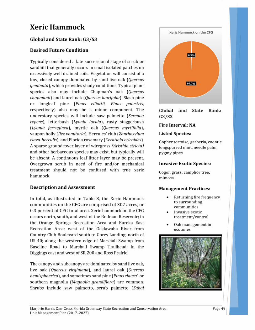
Marjorie Harris Carr Cross Florida Greenway State Recreation and Conservation Area Page 49 Unit Management Plan (2017–2027)
Xeric Hammock Global and State Rank: G3/S3
Desired Future Condition
Typically considered a late successional stage of scrub or sandhill that generally occurs in small isolated patches on excessively well drained soils. Vegetation will consist of a low, closed canopy dominated by sand live oak (Quercus geminata), which provides shady conditions. Typical plant species also may include Chapman’s oak (Quercus chapmanii) and laurel oak (Quercus laurifolia). Slash pine or longleaf pine (Pinus elliottii, Pinus palustris, respectively) also may be a minor component. The understory species will include saw palmetto (Serenoa repens), fetterbush (Lyonia lucida), rusty staggerbush (Lyonia ferruginea), myrtle oak (Quercus myrtifolia), yaupon holly (Ilex vomitoria), Hercules’ club (Zanthoxylum clava-herculis), and Florida rosemary (Ceratiola ericoides). A sparse groundcover layer of wiregrass (Aristida stricta) and other herbaceous species may exist, but typically will be absent. A continuous leaf litter layer may be present. Overgrown scrub in need of fire and/or mechanical treatment should not be confused with true xeric hammock.
Description and Assessment
In total, as illustrated in Table 8, the Xeric Hammock communities on the CFG are comprised of 307 acres, or 0.3 percent of CFG total area. Xeric hammock on the CFG occurs north, south, and west of the Rodman Reservoir; in the Orange Springs Recreation Area and Eureka East Recreation Area; west of the Ocklawaha River from Country Club Boulevard south to Gores Landing; north of US 40; along the western edge of Marshall Swamp from Baseline Road to Marshall Swamp Trailhead; in the Diggings east and west of SR 200 and Ross Prairie.
The canopy and subcanopy are dominated by sand live oak, live oak (Quercus virginiana), and laurel oak (Quercus hemisphaerica), and sometimes sand pine (Pinus clausa) or southern magnolia (Magnolia grandiflora) are common. Shrubs include saw palmetto, scrub palmetto (Sabal
Marjorie Harris Carr Cross Florida Greenway State Recreation and Conservation Area Page 50 Unit Management Plan (2017–2027)
etonia), sparkleberry (Vaccinium arboreum), and deerberry (Vaccinium stamineum).
Herbs are sparse and include witchgrass (Dichanthelium sp.), Elliott's milkpea (Galactia elliottii), gayfeather (Liatris sp.), partridgeberry (Mitchella repens), narrowleaf silkgrass (Pityopsis graminifolia), bracken fern (Pteridium aquilinum), and sandyfield beaksedge (Rhynchospora megalocarpa).
Ground lichens (Cladina evansii and Cladina subtenuis) can be common. A few Spanish moss (Tillandsia usneoides) can be found in the canopy.
Vines are sparse, and include muscadine (Vitis rotundifolia) and earleaf greenbrier (Smilax auriculata).
Primary disturbances that were documented within xeric hammocks on the CFG include clearing, fire suppression, ORV and all-terrain vehicle (ATV) trails, trash dumping, ditching and canal construction, bike trails, and woody encroachment.
Two rare species were documented within the xeric hammock. There is one plant species: garberia, and one animal species: gopher tortoise (Gopherus polyphemus). In addition, three invasive species were noted: cogon grass (Imperata cylindrica), Camphor tree (Cinnamomum camphora), and Mimosa (Albizia julibrissin).
Fire Regime
Xeric hammocks typically develop after 30 or more years of fire exclusion and rarely burn, although occasional ground fires from adjacent uplands may pass through when leaf litter is dry. Catastrophic crown fires can result in reversion of the xeric hammock to sandhill, scrub, or another community type from which the hammock originated.
General Management Measures
Management activities in the xeric hammock communities on the CFG should focus on returning fire frequency to the surrounding natural communities and allowing fires to burn into the edges of the xeric hammock. In some areas, xeric hammock has replaced historic sandhills; in these areas, if restoration to sandhills is desired, mechanical removal of oaks prior to burning may be appropriate. Invasive exotic species monitoring and control also is needed.
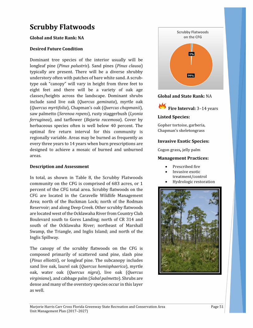
Marjorie Harris Carr Cross Florida Greenway State Recreation and Conservation Area Page 51 Unit Management Plan (2017–2027)
Scrubby Flatwoods Global and State Rank: NA
Desired Future Condition
Dominant tree species of the interior usually will be longleaf pine (Pinus palustris). Sand pines (Pinus clausa) typically are present. There will be a diverse shrubby understory often with patches of bare white sand. A scrub-type oak “canopy” will vary in height from three feet to eight feet and there will be a variety of oak age classes/heights across the landscape. Dominant shrubs include sand live oak (Quercus geminata), myrtle oak (Quercus myrtifolia), Chapman’s oak (Quercus chapmanii), saw palmetto (Serenoa repens), rusty staggerbush (Lyonia ferruginea), and tarflower (Bejaria racemosa). Cover by herbaceous species often is well below 40 percent. The optimal fire return interval for this community is regionally variable. Areas may be burned as frequently as every three years to 14 years when burn prescriptions are designed to achieve a mosaic of burned and unburned areas.
Description and Assessment
In total, as shown in Table 8, the Scrubby Flatwoods community on the CFG is comprised of 683 acres, or 1 percent of the CFG total area. Scrubby flatwoods on the CFG are located in the Caravelle Wildlife Management Area; north of the Buckman Lock; north of the Rodman Reservoir; and along Deep Creek. Other scrubby flatwoods are located west of the Ocklawaha River from Country Club Boulevard south to Gores Landing; north of CR 314 and south of the Ocklawaha River; northeast of Marshall Swamp, the Triangle, and Inglis Island; and north of the Inglis Spillway.
The canopy of the scrubby flatwoods on the CFG is composed primarily of scattered sand pine, slash pine (Pinus elliottii), or longleaf pine. The subcanopy includes sand live oak, laurel oak (Quercus hemisphaerica), myrtle oak, water oak (Quercus nigra), live oak (Quercus virginiana), and cabbage palm (Sabal palmetto). Shrubs are dense and many of the overstory species occur in this layer as well.
Global and State Rank: NA
Fire Interval: 3–14 years
Marjorie Harris Carr Cross Florida Greenway State Recreation and Conservation Area Page 52 Unit Management Plan (2017–2027)
Additional species include tarflower, dwarf huckleberry (Gaylussacia dumosa), blue huckleberry (Gaylussacia frondosa var. tomentosa), sand holly (Ilex ambigua), myrtle dahoon (Ilex cassine var. myrtifolia), gallberry (Ilex glabra), gopher apple (Licania michauxii), rusty staggerbush, coastalplain staggerbush (Lyonia fruticosa), fetterbush (Lyonia lucida), wax myrtle (Myrica cerifera), wild olive (Osmanthus americanus), red bay (Persea borbonia), turkey oak (Quercus laevis), winged sumac (Rhus copallinum), scrub palmetto (Sabal etonia), saw palmetto, sparkleberry (Vaccinium arboreum), Darrow's blueberry (Vaccinium darrowii), shiny blueberry (Vaccinium myrsinites), and deerberry (Vaccinium stamineum).
The herbaceous, epiphyte, and vine strata of the scrubby flatwoods typically are sparse. Herbs include broomsedge bluestem (Andropogon virginicus), bottlebrush threeawn (Aristida spiciformis), wiregrass (Aristida stricta var. beyrichiana), coastalplain chaffhead (Carphephorus corymbosus), vanillaleaf (Carphephorus odoratissimus), Elliott's milkpea (Galactia elliottii), rough hedgehyssop (Gratiola hispida), shortleaf gayfeather (Liatris tenuifolia), narrowleaf silkgrass (Pityopsis graminifolia), bracken fern (Pteridium aquilinum), sandyfield beaksedge (Rhynchospora megalocarpa), sand spike-moss (Selaginella arenicola), sweet goldenrod (Solidago odora), lopsided indian grass (Sorghastrum secundum), and yellow hatpins (Syngonanthus flavidulus). Bartram's air-plant (Tillandsia bartramii), and Spanish moss (Tillandsia usneoides) are common epiphytes. Vines include earleaf greenbrier (Smilax auriculata), saw greenbrier (Smilax bona-nox), sarsaparilla vine (Smilax pumila), and muscadine (Vitis rotundifolia). The ground lichens (Cladina evansii and Cladina subtenuis) are present.
Historical and current disturbances that have impacted scrubby flatwoods include fire exclusion, clearing, forestry operations, ditching and canal construction, off-road trails, trash dumping, and utility corridors.
Three rare species—gopher tortoise (Gopherus polyphemus), garberia (Garberia heterophylla), and Chapman’s skeletongrass (Gymnopogon chapmanianus)—occur within the scrubby flatwoods.
Two invasive species were noted: cogon grass (Imperata cylindrica) and jelly palm (Butia capitata).
Fire Regime
Although scrubby flatwoods occupy a drier environment than the surrounding mesic flatwoods, this community type does not burn as often. Natural fire frequency is three years to 14 years, with most burns occurring during late spring and early summer (April to June).
General Management Measures
Fire return intervals should be frequent enough to maintain shrub heights (less than six feet) within the ranges required by the Florida scrub jay. If necessary to maintain ideal structure, effective fires in scrubby flatwoods should occur during hot, low-humidity conditions.
If embedded within or near to mesic flatwoods, scrubby flatwoods should be allowed to burn along with the mesic flatwoods on a two-year to five-year prescribed fire cycle, primarily during late spring and early summer (April to June). Scrubby flatwoods may not ignite as often as mesic flatwoods due to the relative incombustibility of the oak litter. In areas that have been converted to pine plantations,

Marjorie Harris Carr Cross Florida Greenway State Recreation and Conservation Area Page 53 Unit Management Plan (2017–2027)
thinning and reintroduction of prescribed fire are needed for restoration, and, in some cases, removal of off-site pines and replanting with longleaf pine may be desirable.
Hydrologic alterations, such as ditching and other drainage channels, may be affecting scrubby flatwoods vegetation in a few places. In these areas, restoration of natural hydrology is warranted. Avoiding heavy ground disturbances is important to prevent elimination of the natural groundcover and the establishment of weedy species.
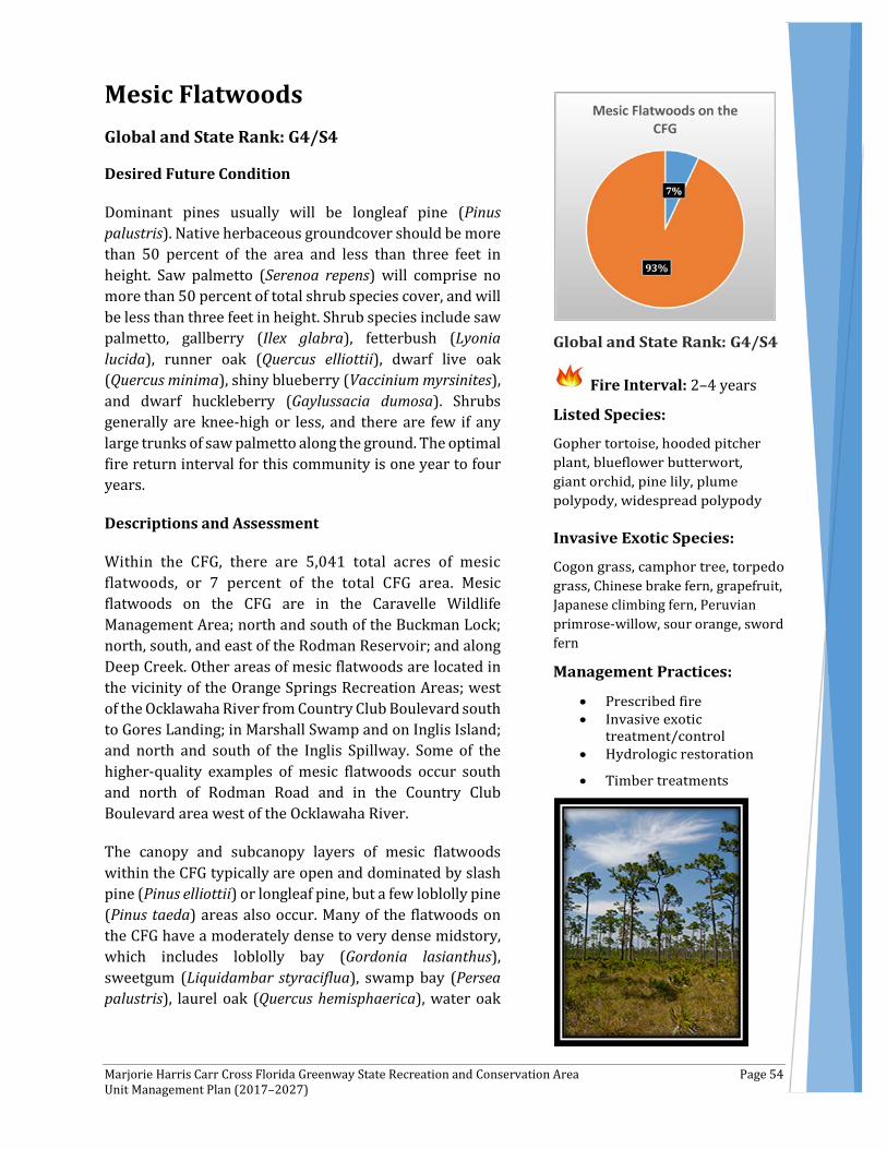
Marjorie Harris Carr Cross Florida Greenway State Recreation and Conservation Area Page 54 Unit Management Plan (2017–2027)
Mesic Flatwoods Global and State Rank: G4/S4
Desired Future Condition
Dominant pines usually will be longleaf pine (Pinus palustris). Native herbaceous groundcover should be more than 50 percent of the area and less than three feet in height. Saw palmetto (Serenoa repens) will comprise no more than 50 percent of total shrub species cover, and will be less than three feet in height. Shrub species include saw palmetto, gallberry (Ilex glabra), fetterbush (Lyonia lucida), runner oak (Quercus elliottii), dwarf live oak (Quercus minima), shiny blueberry (Vaccinium myrsinites), and dwarf huckleberry (Gaylussacia dumosa). Shrubs generally are knee-high or less, and there are few if any large trunks of saw palmetto along the ground. The optimal fire return interval for this community is one year to four years.
Descriptions and Assessment
Within the CFG, there are 5,041 total acres of mesic flatwoods, or 7 percent of the total CFG area. Mesic flatwoods on the CFG are in the Caravelle Wildlife Management Area; north and south of the Buckman Lock; north, south, and east of the Rodman Reservoir; and along Deep Creek. Other areas of mesic flatwoods are located in the vicinity of the Orange Springs Recreation Areas; west of the Ocklawaha River from Country Club Boulevard south to Gores Landing; in Marshall Swamp and on Inglis Island; and north and south of the Inglis Spillway. Some of the higher-quality examples of mesic flatwoods occur south and north of Rodman Road and in the Country Club Boulevard area west of the Ocklawaha River.
The canopy and subcanopy layers of mesic flatwoods within the CFG typically are open and dominated by slash pine (Pinus elliottii) or longleaf pine, but a few loblolly pine (Pinus taeda) areas also occur. Many of the flatwoods on the CFG have a moderately dense to very dense midstory, which includes loblolly bay (Gordonia lasianthus), sweetgum (Liquidambar styraciflua), swamp bay (Persea palustris), laurel oak (Quercus hemisphaerica), water oak
Fire Interval: 2–4 years
, Chinese brake fern grapefruit, Japanese climbing fern, Peruvian primrose-willow sour orange sword fern
Marjorie Harris Carr Cross Florida Greenway State Recreation and Conservation Area Page 55 Unit Management Plan (2017–2027)
(Quercus nigra), live oak (Quercus virginiana) and cabbage palm (Sabal palmetto).
On the CFG, shrubs are dense within many of the mesic flatwoods areas, evidence of long-term fire exclusion and lack of growing-season fires. Typical shrubs include saw palmetto, gallberry, shiny blueberry, fetterbush, huckleberry (Gaylussacia frondosa var. tomentosa), yaupon (Ilex vomitoria), rusty staggerbush (Lyonia ferruginea), wax myrtle (Myrica cerifera), red bay (Persea borbonia), dwarf live oak, dwarf pawpaw (Asimina pygmea), netted pawpaw (Asimina reticulata), scrub palmetto (Sabal etonia), highbush blueberry (Vaccinium corymbosum), Darrow's blueberry (Vaccinium darrowii), shiny blueberry (Vaccinium myrsinites), deerberry (Vaccinium stamineum), and coontie (Zamia pumila).
The herbaceous groundcover typically is dominated by wiregrass (Aristida beyrichiana var. stricta), bracken fern (Pteridium aquilinum), broomsedge bluestem (Andropogon virginicus), bottlebrush wiregrass (Aristida spiciformis), blue maidencane (Amphicarpum muhlenbergianum), switchgrass (Panicum virgatum), and tapered witchgrass (Dichanthelium acuminatum).
Forbs include vanilla leaf (Carphephorus odoratissimus), yankeeweed (Eupatorium compositifolium), slender flattop goldenrod (Euthamia caroliniana), Elliott's milkpea (Galactia elliottii), shortleaf gayfeather (Liatris tenuifolia), narrowleaf silkgrass (Pityopsis graminifolia), orange milkwort (Polygala lutea), blackroot (Pterocaulon pycnostachyum), and pale meadow beauty (Rhexia mariana).
Epiphyte and vine abundances vary. Epiphytes include resurrection fern (Pleopeltis polypodioides var. michauxiana), Bartram's air-plant (Tillandsia bartramii), and Spanish moss (Tillandsia usneoides). Vines are abundant, especially in fire-excluded sites. Peppervine (Nekemias arborea), earleaf greenbrier (Smilax auriculata), saw greenbrier (Smilax bona-nox), cat greenbrier (Smilax glauca), eastern poison ivy (Toxicodendron radicans), and muscadine (Vitis rotundifolia) are common.
Listed species observed within the mesic flatwoods include: gopher tortoise (Gopherus polyphemus), hooded pitcher plant (Sarracenia minor), blueflower butterwort (Pinguicula caerulea), giant orchid (Pteroglossaspis ecristata), lilly plume, and the widespread polypody (Pecluma dispersa). Invasive species observed during the FNAI survey included cogon grass (Imperata cylindrica) camphor tree (Cinnamomum camphora), torpedo grass (Panicum repens), Chinese brake fern (Pteris vittata), grapefruit (Citrus paradisi), Japanese climbing fern (Lygodium japonicum), Peruvian primrose willow (Ludwigia peruviana), sour orange (Citrus aurantium), and sword fern (Nephrolepis cordifolia).
Historical and current disturbances that have impacted mesic flatwoods include fire exclusion, clearing, forestry operations, ditching and canal construction, hydrological alteration, off-road trails, trash dumping, and exotic plant invasion.
Fire Regime
Within mesic flatwood communities, it is important to conduct dormant season fires until heavy fuel loads are diminished enough to conduct growing season fires without undue tree mortality. Mesic flatwoods require application of growing-season fires on a one-year to four-year cycle. Nearly all plants and animals inhabiting this community are adapted to periodic fires; several species depend on fire for their continued existence. Without relatively frequent fires, mesic flatwoods succeed into hardwood-dominated forests, shading out and eliminating the diverse groundcover.

Marjorie Harris Carr Cross Florida Greenway State Recreation and Conservation Area Page 56 Unit Management Plan (2017–2027)
General Management Measures
Implementing prescribed fires on a two-year to four-year cycle is critical for restoration and maintenance of mesic flatwoods. Priority should be given to burning mesic flatwoods with higher-quality groundcover, using frequent growing-season fires to encourage herbaceous species, especially wiregrass, to reproduce naturally. Many of the mesic flatwoods on the CFG have been converted to pine plantations. In these areas, tree thinning also may be needed to open up the canopy and allow more light to reach the ground.
In some areas, ditching and other water control efforts have likely changed the natural hydrology of the mesic flatwoods. Restoration of hydrology may be needed in some of these areas. Restricting the use of heavy machinery to dry periods when the soil is not saturated will help with avoiding unnecessary vegetation and soil disturbances.
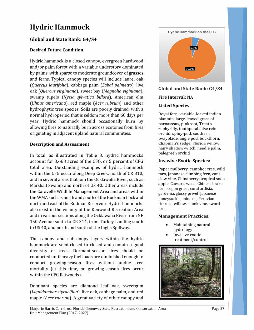
Marjorie Harris Carr Cross Florida Greenway State Recreation and Conservation Area Page 57 Unit Management Plan (2017–2027)
Hydric Hammock Global and State Rank: G4/S4
Desired Future Condition
Hydric hammock is a closed canopy, evergreen hardwood and/or palm forest with a variable understory dominated by palms, with sparse to moderate groundcover of grasses and ferns. Typical canopy species will include laurel oak (Quercus laurifolia), cabbage palm (Sabal palmetto), live oak (Quercus virginiana), sweet bay (Magnolia viginiana), swamp tupelo (Nyssa sylvatica biflora), American elm (Ulmus americana), red maple (Acer rubrum) and other hydrophytic tree species. Soils are poorly drained, with a normal hydroperiod that is seldom more than 60 days per year. Hydric hammock should occasionally burn by allowing fires to naturally burn across ecotones from fires originating in adjacent upland natural communities.
Description and Assessment
In total, as illustrated in Table 8, hydric hammocks account for 3,663 acres of the CFG, or 5 percent of CFG total area. Outstanding examples of hydric hammock within the CFG occur along Deep Creek; north of CR 310; and in several areas that join the Ocklawaha River, such as Marshall Swamp and north of US 40. Other areas include the Caravelle Wildlife Management Area and areas within the WMA such as north and south of the Buckman Lock and north and east of the Rodman Reservoir. Hydric hammocks also exist in the vicinity of the Kenwood Recreation Area and in various sections along the Ocklawaha River from NE 150 Avenue south to CR 314, from Turkey Landing south to US 40, and north and south of the Inglis Spillway.
The canopy and subcanopy layers within the hydric hammock are semi-closed to closed and contain a good diversity of trees. Dormant-season fires should be conducted until heavy fuel loads are diminished enough to conduct growing-season fires without undue tree mortality (at this time, no growing-season fires occur within the CFG flatwoods).
Dominant species are diamond leaf oak, sweetgum (Liquidambar styraciflua), live oak, cabbage palm, and red maple (Acer rubrum). A great variety of other canopy and
Fire Interval: NA
Caesar's weed, Chinese brake fern, cogon grass, coral ardisia, gardenia, glossy privet, Japanese honeysuckle, mimosa, Peruvian rimrose-willow skunk vine, sword fern
Marjorie Harris Carr Cross Florida Greenway State Recreation and Conservation Area Page 58 Unit Management Plan (2017–2027)
small trees can be found, including American hornbeam (Carpinus caroliniana), Atlantic white cedar (Chamaecyparis thyoides), Carolina ash (Fraxinus caroliniana), green ash (Fraxinus pennsylvanica), red cedar (Juniperus virginiana), tulip tree (Liriodendron tulipifera), southern magnolia (Magnolia grandiflora), sweet bay, swamp bay (Persea palustris), slash pine (Pinus elliottii), loblolly pine (Pinus taeda), swamp chestnut oak (Quercus michauxii), swamp dogwood (Cornus foemina), cypress (Taxodium spp.), basswood (Tilia americana), and American elm.
Typical shrubs include Florida hobblebush (Agarista populifolia), common buttonbush (Cephalanthus occidentalis), wax myrtle (Myrica cerifera), bluestem palmetto (Sabal minor), mountain azalea (Rhododendron canescens), highbush blueberry (Vaccinium corymbosum), and cabbage palm.
Herbs can be sparse or patchy, and include variable-leaved indian plantain (Arnoglossum diversifolium), false nettle (Boehmeria cylindrica), clustered sedge (Carex glaucescens), spadeleaf (Centella asiatica), woodoats (Chasmanthium spp.), cypress witchgrass (Dichanthelium dichotomum), whorled marsh pennywort (Hydrocotyle verticillata), needle rush (Juncus roemerianus), redtop panicum (Panicum rigidulum), swamp smartweed (Polygonum hydropiperoides), millet beaksedge (Rhynchospora miliacea), and lizard's tail (Saururus cernuus).
Ferns are diverse and can be abundant. These include cinnamon fern (Osmunda cinnamomea), royal fern (Osmunda regalis), southern wood fern (Dryopteris ludoviciana), southern shield fern (Thelypteris kunthii), marsh fern (Thelypteris palustris var. pubescens), netted chain fern (Woodwardia areolata), and Virginia chain fern (Woodwardia virginica).
Epiphytes can be abundant, and include green fly orchid (Epidendrum conopseum), golden polypody (Phlebodium aureum), resurrection fern (Pleopeltis polypodioides var. michauxiana), Bartram's air-plant (Tillandsia bartramii), and Spanish moss (Tillandsia usneoides).
Vine diversity also is impressive, with climbing hempvine (Mikania scandens), Virginia creeper (Parthenocissus quinquefolia), peppervine (Ampelopsis arborea), rattan vine (Berchemia scandens), crossvine (Bignonia capreolata), trumpet creeper (Campsis radicans), climbing hydrangea (Decumaria barbara), yellow jessamine (Gelsemium sempervirens), earleaf greenbrier (Smilax auriculata), saw greenbrier (Smilax bona-nox), laurel greenbrier (Smilax laurifolia), bristly greenbrier (Smilax tamnoides), poison ivy (Toxicodendron radicans), summer grape (Vitis aestivalis), muscadine (Vitis rotundifolia), and frost grape (Vitis vulpina).
Previous and current disturbances include clearing, forestry operations, ditching and canal construction, hydrological alteration, impoundments, roads and off-road vehicle trails, trash dumping, and introduction of exotic plants.
The rare plants variable-leaved indian plantain, Florida milk pod (Matelea floridana), grass-of-Parnassus (Parnassia grandifolia), and pinkroot (Spigelia loganioides) were observed during the FNAI survey.
The following species of invasive plants occur in the hydric hammocks: paper mulberry (Broussonetia papyrifera), camphor tree (Cinnamomum camphora), wild taro (Colocasia esculenta), Japanese climbing fern (Lygodium japonicum), cat’s claw vine (Macfadyena unguis-cati), Chinaberry (Melia

Marjorie Harris Carr Cross Florida Greenway State Recreation and Conservation Area Page 59 Unit Management Plan (2017–2027)
azedarach), tropical soda apple (Solanum viarum), Caesar's weed (Urena lobata), Chinese brake fern (Pteris vittata), cogon grass (Imperata cylindrica), coral ardisia (Ardisia crenata), gardenia (Gardenia jasminoides), glossy privet (Ligustrum lucidum), Japanese honeysuckle (Lonicera japonica), mimosa (Mimosa pudica), Peruvian primrose-willow (Ludwigia peruviana), skunk vine (Paederia foetida), and sword fern (Nephrolepis cordifolia).
Fire Regime
Hydric hammocks usually are too wet to support fires due to their saturated soils and the sparsity of fine fuels, so they are not considered a pyrogenic natural community.
General Management Measures
Effective management of hydric hammocks primarily consists of maintaining natural hydrology and monitoring and treating invasive/exotic plants.
Feral hogs (Sus scrofa) are causing significant damage to native vegetation. They should be monitored and efforts should be made to control numbers, if needed.

Marjorie Harris Carr Cross Florida Greenway State Recreation and Conservation Area Page 60 Unit Management Plan (2017–2027)
Wet Flatwoods Global and State Rank: G4/S4
Desired Future Condition
Depending on the region of the state, dominant pines usually will be longleaf pine (Pinus palustris), slash pine (Pinus elliottii), pond pine (Pinus serotina), and/or loblolly pine (Pinus taeda). Pond cypress (Taxodium ascendens) may reach the canopy in some locations. The canopy will be open, with pines being widely scattered and of at least three age classes. The subcanopy may include scattered sweetbay (Magnolia virginiana), swamp bay (Persea palustris), and loblolly bay (Gordonia lasianthus). Common shrubs will include fetterbush (Lyonia lucida), large gallberry (Ilex coriacea), titi (Cyrilla racemiflora), and wax myrtle (Myrica cerifera). The optimal fire return interval for this community is five years to 10 years.
Description and Assessment
Wet flatwoods occur on relatively flat, poorly drained, acidic sands overlying an organic hardpan or clay layer. The hardpan substantially reduces the percolation of water, so wet flatwoods can be inundated or saturated for one or more months per year. In total, as shown in Table 8, the wet flatwoods communities accounts for 1,773 acres of the CFG, or 3 percent of CFG total area. Wet flatwoods on the CFG occur in the Caravelle Wildlife Management Area and in areas within the WMA such as north and south of the Buckman Lock and north, west, and east of the Rodman Reservoir. Wet flatwoods also exist in the vicinity of the Kenwood Recreation Area; west of the Ocklawaha River from Country Club Boulevard south to Gores Landing; on the western edge of Marshall Swamp; on Inglis Island; and north and south of the Inglis Spillway.
The vegetative structure of wet flatwoods within the CFG is highly variable from site to site and dependent on fire history, hydroperiod, and land-use history, such as silviculture. The canopy typically is slash pine, longleaf pine, loblolly pine, and pond pine in a few locations. In long-term fire-excluded sites, loblolly bay (Gordonia lasianthus), sweetgum (Liquidambar styraciflua), water oak (Quercus nigra), and swamp bay (Persea palustris) may
Caesar's weed, camphor tree, Chinese brake fern, cogon grass, torpedo grass
Marjorie Harris Carr Cross Florida Greenway State Recreation and Conservation Area Page 61 Unit Management Plan (2017–2027)
reach the canopy and dominate the subcanopy. These species also are found in the shrub layers, as are gallberry (Ilex glabra), saw palmetto (Serenoa repens), fetterbush, dwarf huckleberry (Gaylussacia dumosa), blue huckleberry (Gaylussacia frondosa var. tomentosa), Darrow's blueberry (Vaccinium darrowii), and shiny blueberry (Vaccinium myrsinites).
Due to the dense shrub layer, herbs typically are sparse in wet flatwoods on the CFG, although a few locations have herb cover greater than 50 percent due to recent fires. Typical species in the herb layer are maidencane (Panicum hemitomon), Virginia chain fern (Woodwardia virginica), Carolina redroot (Lachnanthes caroliana), blue maidencane (Amphicarpum muhlenbergianum), purple bluestem (Andropogon glomeratus var. glaucopsis), broomsedge bluestem (Andropogon virginicus), and low panic grasses (Dichanthelium spp.). Spanish moss (Tillandsia usneoides) is found occasionally in the tree canopy.
Vines can be abundant and include yellow jessamine (Gelsemium sempervirens), Virginia creeper (Parthenocissus quinquefolia), earleaf greenbrier (Smilax auriculata), saw greenbrier (Smilax bona-nox), cat greenbrier (Smilax glauca), laurel greenbrier (Smilax laurifolia), and muscadine (Vitis rotundifolia).
The hooded pitcher plant (Sarracenia minor) was documented in wet flatwoods on the CFG, and no exotic species were documented. Historically, wet prairie occurred within wet flatwoods on Inglis Island and south of the Inglis Spillway.
Disturbances noted within wet flatwoods on the CFG include clearing, fire exclusion, woody encroachment, forestry operations, fire-breaks, and ditching and canal construction.
Fire Regime
The natural fire return interval in wet flatwoods is variable, every two to five years. Without relatively frequent fires, wet flatwoods succeed into hardwood-dominated forests whose closed canopy would essentially eliminate the groundcover herbs and shrubs.
General Management Measures
For management purposes, prescribed fires should be applied on a two-year to four-year cycle to reduce woody encroachment, sustain herbaceous species, and aid in fuel reduction for the prevention of catastrophic wildfires. In some areas, mechanical reduction of tall, dense shrubs or the midstory cover may be needed prior to prescribed burning.
Restricting the use of heavy machinery to dry periods when the soil is not saturated will help to avoid unnecessary vegetation disturbances and soil disturbances such as rutting and erosion.
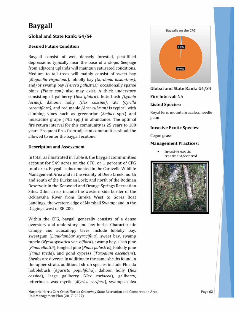
Marjorie Harris Carr Cross Florida Greenway State Recreation and Conservation Area Page 62 Unit Management Plan (2017–2027)
Baygall Global and State Rank: G4/S4
Desired Future Condition
Baygall consist of wet, densely forested, peat-filled depressions typically near the base of a slope. Seepage from adjacent uplands will maintain saturated conditions. Medium to tall trees will mainly consist of sweet bay (Magnolia virginiana), loblolly bay (Gordonia lasianthus), and/or swamp bay (Persea palustris); occasionally sparse pines (Pinus spp.) also may exist. A thick understory consisting of gallberry (Ilex glabra), fetterbush (Lyonia lucida), dahoon holly (Ilex cassine), titi (Cyrilla racemiflora), and red maple (Acer rubrum) is typical, with climbing vines such as greenbriar (Smilax spp.) and muscadine grape (Vitis spp.) in abundance. The optimal fire return interval for this community is 25 years to 100 years. Frequent fires from adjacent communities should be allowed to enter the baygall ecotone.
Description and Assessment
In total, as illustrated in Table 8, the baygall communities account for 549 acres on the CFG, or 1 percent of CFG total area. Baygall is documented in the Caravelle Wildlife Management Area and in the vicinity of Deep Creek; north and south of the Buckman Lock; and north of the Rodman Reservoir in the Kenwood and Orange Springs Recreation Sites. Other areas include the western side border of the Ocklawaha River from Eureka West to Gores Boat Landings; the western edge of Marshall Swamp; and in the Diggings west of SR 200.
Within the CFG, baygall generally consists of a dense overstory and understory and few herbs. Characteristic canopy and subcanopy trees include loblolly bay, sweetgum (Liquidambar styraciflua), sweet bay, swamp tupelo (Nyssa sylvatica var. biflora), swamp bay, slash pine (Pinus elliottii), longleaf pine (Pinus palustris), loblolly pine (Pinus taeda), and pond cypress (Taxodium ascendens). Shrubs are diverse. In addition to the same shrubs found in the upper strata, additional shrub species include Florida hobblebush (Agarista populifolia), dahoon holly (Ilex cassine), large gallberry (Ilex coriacea), gallberry, fetterbush, wax myrtle (Myrica cerifera), swamp azalea
Fire Interval: NA
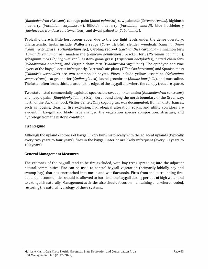
Marjorie Harris Carr Cross Florida Greenway State Recreation and Conservation Area Page 63 Unit Management Plan (2017–2027)
(Rhododendron viscosum), cabbage palm (Sabal palmetto), saw palmetto (Serenoa repens), highbush blueberry (Vaccinium corymbosum), Elliott's blueberry (Vaccinium elliottii), blue huckleberry (Gaylussacia frondosa var. tomentosa), and dwarf palmetto (Sabal minor).
Typically, there is little herbaceous cover due to the low light levels under the dense overstory. Characteristic herbs include Walter's sedge (Carex striata), slender woodoats (Chasmanthium laxum), witchgrass (Dichanthelium sp.), Carolina redroot (Lachnanthes caroliana), cinnamon fern (Osmunda cinnamomea), maidencane (Panicum hemitomon), bracken fern (Pteridium aquilinum), sphagnum moss (Sphagnum spp.), eastern gama grass (Tripsacum dactyloides), netted chain fern (Woodwardia areolata), and Virginia chain fern (Woodwardia virginiana). The epiphytic and vine layers of the baygall occur infrequently. Bartram's air-plant (Tillandsia bartramii) and Spanish moss (Tillandsia usneoides) are two common epiphytes. Vines include yellow jessamine (Gelsemium sempervirens), cat greenbrier (Smilax glauca), laurel greenbrier (Smilax laurifolia), and muscadine. The latter often forms thickets around the edges of the baygall and where the canopy trees are sparse.
Two state-listed commercially exploited species, the sweet pinxter azalea (Rhododendron canescens) and needle palm (Rhapidophyllum hystrix), were found along the north boundary of the Greenway, north of the Buckman Lock Visitor Center. Only cogon grass was documented. Human disturbances, such as logging, clearing, fire exclusion, hydrological alteration, roads, and utility corridors are evident in baygall and likely have changed the vegetation species composition, structure, and hydrology from the historic condition.
Fire Regime
Although the upland ecotones of baygall likely burn historically with the adjacent uplands (typically every two years to four years), fires in the baygall interior are likely infrequent (every 50 years to 100 years).
General Management Measures
The ecotones of the baygall tend to be fire-excluded, with bay trees spreading into the adjacent natural communities. Fire can be used to control baygall vegetation (primarily loblolly bay and swamp bay) that has encroached into mesic and wet flatwoods. Fires from the surrounding fire-dependent communities should be allowed to burn into the baygall during periods of high water and to extinguish naturally. Management activities also should focus on maintaining and, where needed, restoring the natural hydrology of these systems.
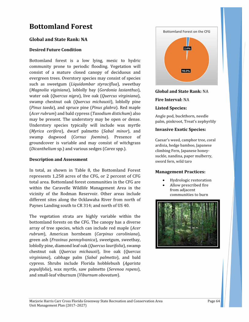
Marjorie Harris Carr Cross Florida Greenway State Recreation and Conservation Area Page 64 Unit Management Plan (2017–2027)
Bottomland Forest Global and State Rank: NA
Desired Future Condition
Bottomland forest is a low lying, mesic to hydric community prone to periodic flooding. Vegetation will consist of a mature closed canopy of deciduous and evergreen trees. Overstory species may consist of species such as sweetgum (Liquidambar styraciflua), sweetbay (Magnolia viginiana), loblolly bay (Gordonia lasianthus), water oak (Quercus nigra), live oak (Quercus virginiana), swamp chestnut oak (Quercus michauxii), loblolly pine (Pinus taeda), and spruce pine (Pinus glabra). Red maple (Acer rubrum) and bald cypress (Taxodium distichum) also may be present. The understory may be open or dense. Understory species typically will include wax myrtle (Myrica cerifera), dwarf palmetto (Sabal minor), and swamp dogwood (Cornus foemina). Presence of groundcover is variable and may consist of witchgrass (Dicanthelium sp.) and various sedges (Carex spp.).
Description and Assessment
In total, as shown in Table 8, the Bottomland Forest represents 1,258 acres of the CFG, or 2 percent of CFG total area. Bottomland forest communities in the CFG are within the Caravelle Wildlife Management Area in the vicinity of the Rodman Reservoir. Other areas include different sites along the Ocklawaha River from north of Paynes Landing south to CR 314; and north of US 40.
The vegetation strata are highly variable within the bottomland forests on the CFG. The canopy has a diverse array of tree species, which can include red maple (Acer rubrum), American hornbeam (Carpinus caroliniana), green ash (Fraxinus pennsylvanica), sweetgum, sweetbay, loblolly pine, diamond leaf oak (Quercus laurifolia), swamp chestnut oak (Quercus michauxii), live oak (Quercus virginiana), cabbage palm (Sabal palmetto), and bald cypress. Shrubs include Florida hobblebush (Agarista populifolia), wax myrtle, saw palmetto (Serenoa repens), and small-leaf viburnum (Viburnum obovatum).
Global and State Rank: NA
Fire Interval: NA
Caesar's weed, camphor tree, coral ardisia, hedge bamboo, Japanese climbing Fern, Japanese honey-suckle, nandina, paper mulberry, sword fern, wild taro
Marjorie Harris Carr Cross Florida Greenway State Recreation and Conservation Area Page 65 Unit Management Plan (2017–2027)
Herbs typically are sparse and can include switchcane (Arundinaria gigantea), longleaf woodoats (Chasmanthium laxum var. sessiliflorum), shiny woodoats (Chasmanthium nitidum), netted chain fern (Woodwardia areolata), and Virginia chain fern (Woodwardia virginiana).
Epiphytes and vines are common and include Spanish moss (Tillandsia usneoides), eastern poison ivy (Toxicodendron radicans), and muscadine (Vitis rotundifolia).
Invasive species found within CFG bottomland forests include: Caesar's weed (Urena lobata), camphor tree (Cinnamomum camphora), coral ardisia (Ardisia crenata), hedge bamboo (Bambusa multiplex), Japanese climbing fern (Lygodium japonicum), Japanese honeysuckle (Lonicera japonica), nandina (Nandina domestica), paper mulberry (Broussonetia papyrifera), sword fern (Nephrolepis cordifolia), wild taro (Colocasia esculenta).
Human disturbances—such as clearing, logging, ditching, impoundment, and artificial pond creation—are evident in some of the bottomland forests. These disturbances likely have changed the vegetation species composition and structure from the historic condition.
Fire Regime
Fire is infrequent or nonexistent in bottomland forests, possibly occurring only during times of extreme drought. Prescribed fires from surrounding communities should be allowed to extinguish naturally at the edges of the bottomland forest to maintain a natural ecotone.
General Management Measures
Management activities in bottomland forest on the CFG could focus on restoring and maintaining the natural hydrologic patterns of the forest and associated wetlands. Prescribed fires from adjacent communities should be allowed to burn into the bottomland forest.
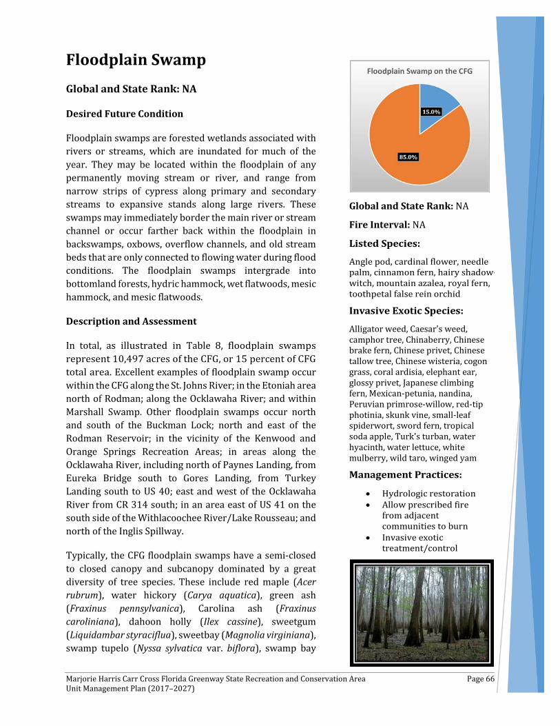
Marjorie Harris Carr Cross Florida Greenway State Recreation and Conservation Area Page 66 Unit Management Plan (2017–2027)
Floodplain Swamp Global and State Rank: NA
Desired Future Condition
Floodplain swamps are forested wetlands associated with rivers or streams, which are inundated for much of the year. They may be located within the floodplain of any permanently moving stream or river, and range from narrow strips of cypress along primary and secondary streams to expansive stands along large rivers. These swamps may immediately border the main river or stream channel or occur farther back within the floodplain in backswamps, oxbows, overflow channels, and old stream beds that are only connected to flowing water during flood conditions. The floodplain swamps intergrade into bottomland forests, hydric hammock, wet flatwoods, mesic hammock, and mesic flatwoods.
Description and Assessment
In total, as illustrated in Table 8, floodplain swamps represent 10,497 acres of the CFG, or 15 percent of CFG total area. Excellent examples of floodplain swamp occur within the CFG along the St. Johns River; in the Etoniah area north of Rodman; along the Ocklawaha River; and within Marshall Swamp. Other floodplain swamps occur north and south of the Buckman Lock; north and east of the Rodman Reservoir; in the vicinity of the Kenwood and Orange Springs Recreation Areas; in areas along the Ocklawaha River, including north of Paynes Landing, from Eureka Bridge south to Gores Landing, from Turkey Landing south to US 40; east and west of the Ocklawaha River from CR 314 south; in an area east of US 41 on the south side of the Withlacoochee River/Lake Rousseau; and north of the Inglis Spillway.
Typically, the CFG floodplain swamps have a semi-closed to closed canopy and subcanopy dominated by a great diversity of tree species. These include red maple (Acer rubrum), water hickory (Carya aquatica), green ash (Fraxinus pennsylvanica), Carolina ash (Fraxinus caroliniana), dahoon holly (Ilex cassine), sweetgum (Liquidambar styraciflua), sweetbay (Magnolia virginiana), swamp tupelo (Nyssa sylvatica var. biflora), swamp bay
Global and State Rank: NA
Fire Interval: NA
Alligator weed, Caesar's weed, camphor tree, Chinaberry, Chinese brake fern, Chinese privet, Chinese tallow tree, Chinese wisteria, cogon grass, coral ardisia, elephant ear, glossy privet, Japanese climbing fern, Mexican-petunia, nandina, Peruvian primrose-willow, red-tip photinia, skunk vine, small-leaf spiderwort, sword fern, tropical soda apple, Turk's turban, water hyacinth, water lettuce, white mulberry, wild taro, winged yam
Marjorie Harris Carr Cross Florida Greenway State Recreation and Conservation Area Page 67 Unit Management Plan (2017–2027)
(Persea palustris), slash pine (Pinus elliottii), loblolly pine (Pinus taeda), diamond leaf oak (Quercus laurifolia), water oak (Quercus nigra), live oak (Quercus virginiana), cabbage palm (Sabal palmetto), coastalplain willow (Salix caroliniana), pond cypress (Taxodium ascendens), bald cypress (Taxodium distichum), and American elm (Ulmus americana). The shrub strata cover varies, ranging from moderate to sparse, and includes many species that occur in the upper layer. Additional species include groundsel tree (Baccharis halimifolia), hackberry (Celtis laevigata), common buttonbush (Cephalanthus occidentalis), swamp dogwood (Cornus foemina), common persimmon (Diospyros virginiana), loblolly bay (Gordonia lasianthus), large gallberry (Ilex coriacea), Virginia willow (Itea virginica), swamp doghobble (Leucothoe racemosa), fetterbush (Lyonia lucida), wax myrtle (Myrica cerifera), eastern hophornbeam (Ostrya virginiana), sawtooth blackberry (Rubus argutus), dwarf palmetto (Sabal minor), and elderberry (Sambucus nigra subsp. canadensis).
The herbaceous layer varies from sparse to dense. Typical herbs include lizard’s tail (Saururus cernuus), false nettle (Boehmeria cylindrica), hairy bedstraw (Galium pilosum), stiff marsh bedstraw (Galium tinctorium), scarlet rosemallow (Hibiscus coccineus), large leaf marsh pennywort (Hydrocotyle bonariensis), whorled marsh pennywort (Hydrocotyle verticillata), and Virginia iris (Iris virginica).
A variety of sedges, beakrushes, and grasses are present, such as giant sedge (Carex gigantea), clustered sedge (Carex glaucescens), warty sedge (Carex verrucosa), spadeleaf (Centella asiatica), narrow fruit horned beaksedge (Rhynchospora inundata), millet beaksedge (Rhynchospora miliacea) slender woodoats (Chasmanthium laxum), longleaf woodoats (Chasmanthium laxum var. sessiliflorum), sawgrass (Cladium jamaicense), and eastern gama grass (Tripsacum dactyloides).
Ferns can be abundant, and the more commonly occurring are netted chain fern (Woodwardia areolata), Virginia chain fern (Woodwardia virginica), royal fern (Osmunda regalis), and marsh fern (Thelypteris palustris var. pubescens).
Both epiphytes and vines are common. Among the epiphytes are Bartram's air-plant (Tillandsia bartramii) and Spanish moss (Tillandsia usneoides). Vines are diverse in numbers of species and include peppervine (Ampelopsis arborea), rattan vine (Berchemia scandens), crossvine (Bignonia capreolata), trumpet creeper (Campsis radicans), climbing hydrangea (Decumaria barbara), yellow jessamine (Gelsemium sempervirens), climbing hempvine (Mikania scandens), Virginia creeper (Parthenocissus quinquefolia), saw greenbrier (Smilax bona-nox), cat greenbrier (Smilax glauca), laurel greenbrier (Smilax laurifolia), coral greenbrier (Smilax walteri), eastern poison ivy (Toxicodendron radicans), muscadine (Vitis rotundifolia), and American wisteria (Wisteria frutescens).
Two state-listed commercially exploited plant species were documented within floodplain swamp communities: cardinal flower (Lobelia cardinalis) and needle palm (Rhapidophyllum hystrix).
Within the floodplain swamp communities, the following invasive plants were documented, including alligator weed (Alternanthera philoxeroides), wild taro (Colocasia esculenta), water hyacinth (Eichhornia crassipes), Japanese climbing fern (Lygodium japonicum), skunkvine (Paederia foetida), Chinese brake fern (Pteris vittata), Chinese tallow tree (Sapium sebiferum), tropical soda apple (Solanum viarum), Caesar’s weed (Urena lobata), Chinaberry (Melia azedarach), Chinese privet (Ligustrum sinense), Chinese wisteria (Wisteria sinensis), Cogon grass (Imperata cylindrica), coral
Marjorie Harris Carr Cross Florida Greenway State Recreation and Conservation Area Page 68 Unit Management Plan (2017–2027)
ardisia (Ardisia crenata), elephant ear (Colocasia esculenta), glossy privet (Ligustrum lucidum), Mexican petunia (Ruellia simplex), nandina (Nandina domestica), Peruvian primrose-willow (Ludwigia peruviana), red-tip photinia (Photinia fraseri), small-leaf spiderwort (Tradescantia fluminensis), sword fern (Nephrolepis cordifolia), Turk's turban (Malvaviscus arboreus), water lettuce (Pistia stratiotes), white mulberry (Morus alba), winged yam (Dioscorea alata).
Feral hogs (Sus scrofa) also are present.
Previous and current disturbances include clearing, forestry operations, ditching and canal construction, hydrological alteration, impoundments, roads and off-road vehicle trails, trash dumping, and introduction of exotic plants and animals.
Fire Regime
Floodplain swamps usually are too wet to support fires. However, fires from surrounding uplands should be allowed to creep into the floodplain swamps to enhance ecotone diversity and to reduce fuel loads, thereby minimizing the chances of catastrophic fires during drought.
General Management Measures
Floodplain swamps provide important wildlife habitat and contribute to the overall water quality of streams and rivers. Historical construction of ditches, canals, and berms has created serious hydrological alterations in some locations. Where needed, the natural hydrology should be restored and maintained. Closure of unnecessary roads and trails to vehicular traffic or redesigns, such as low water crossings, may be warranted in some areas to prevent erosion and interruption of water flow. This also may help abate illegal trash dumping.
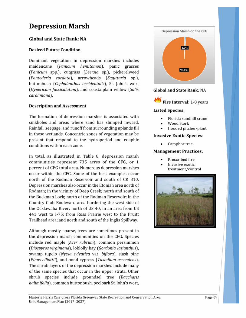
Marjorie Harris Carr Cross Florida Greenway State Recreation and Conservation Area Page 69 Unit Management Plan (2017–2027)
Depression Marsh Global and State Rank: NA
Desired Future Condition
Dominant vegetation in depression marshes includes maidencane (Panicum hemitomon), panic grasses (Panicum spp.), cutgrass (Leersia sp.), pickerelweed (Pontederia cordata), arrowheads (Sagittaria sp.), buttonbush (Cephalanthus occidentalis), St. John’s wort (Hypericum fasciculatum), and coastalplain willow (Salix caroliniana).
Description and Assessment
The formation of depression marshes is associated with sinkholes and areas where sand has slumped inward. Rainfall, seepage, and runoff from surrounding uplands fill in these wetlands. Concentric zones of vegetation may be present that respond to the hydroperiod and edaphic conditions within each zone.
In total, as illustrated in Table 8, depression marsh communities represent 735 acres of the CFG, or 1 percent of CFG total area. Numerous depression marshes occur within the CFG. Some of the best examples occur north of the Rodman Reservoir and south of CR 310. Depression marshes also occur in the Etoniah area north of Rodman; in the vicinity of Deep Creek; north and south of the Buckman Lock; north of the Rodman Reservoir; in the Country Club Boulevard area bordering the west side of the Ocklawaha River; north of US 40; in an area from US 441 west to I-75; from Ross Prairie west to the Pruitt Trailhead area; and north and south of the Inglis Spillway.
Although mostly sparse, trees are sometimes present in the depression marsh communities on the CFG. Species include red maple (Acer rubrum), common persimmon (Diospyros virginiana), loblolly bay (Gordonia lasianthus), swamp tupelo (Nyssa sylvatica var. biflora), slash pine (Pinus elliottii), and pond cypress (Taxodium ascendens). The shrub layers of the depression marshes include many of the same species that occur in the upper strata. Other shrub species include groundsel tree (Baccharis halimifolia), common buttonbush, peelbark St. John's wort,
Global and State Rank: NA
Fire Interval: 1-8 years
Marjorie Harris Carr Cross Florida Greenway State Recreation and Conservation Area Page 70 Unit Management Plan (2017–2027)
fetterbush (Lyonia lucida), wax myrtle (Myrica cerifera), swamp bay (Persea palustris), sand blackberry (Rubus cuneifolius), cabbage palm (Sabal palmetto), and coastalplain willow.
Herbaceous species usually are the dominant vegetational component of depression marshes, and in the CFG, the herbaceous layer of the depression marshes is the most diverse in numbers of species documented. Maidencane and blue maidencane (Amphicarpum muhlenbergianum) are typically dominant. Also common are switchcane (Arundinaria gigantea), carpetgrasses (Axonopus spp.), false nettle (Boehmeria cylindrica), giant sedge (Carex gigantea), clustered sedge (Carex glaucescens), spadeleaf (Centella asiatica), sawgrass (Cladium jamaicense), Baldwin's spikerush (Eleocharis baldwinii), tenangle pipewort (Eriocaulon decangulare), rattlesnake master (Eryngium aquaticum), dogfennel (Eupatorium capillifolium), falsefennel (Eupatorium leptophyllum), southern umbrellasedge (Fuirena scirpoidea), marsh pennywort (Hydrocotyle sp.), Carolina redroot (Lachnanthes caroliana), savannah primrosewillow (Ludwigia virgata), shade mudflower (Micranthemum umbrosum), rosy camphorweed (Pluchea rosea), swamp smartweed (Polygonum hydropiperoides), shortbristle horned beaksedge (Rhynchospora corniculata), fascicled beaksedge (Rhynchospora fascicularis), narrowfruit horned beaksedge (Rhynchospora inundata), sugarcane plumegrass (Saccharum giganteum), grassy arrowhead (Sagittaria graminea), water pimpernel (Samolus ebracteatus), sand cordgrass (Spartina bakeri), Virginia chain fern (Woodwardia virginica), and yellow-eyed grasses (Xyris spp.).
Epiphytes are infrequent and include oak mistletoe (Phoradendron leucarpum) and Spanish moss (Tillandsia usneoides).
Vines include yellow jessamine (Gelsemium sempervirens), Japanese climbing fern (Lygodium japonicum), and earleaf greenbrier (Smilax auriculata).
Numerous disturbances, both from historical and current events, have reshaped some of the depression marshes. Fire exclusion has led to woody encroachment of these normally herb-dominated systems. Hydrological alteration has occurred due to the woody invasion and land-clearing practices in the surrounding natural areas. Roads and ORV trails have provided easy access to the areas and with them has come the introduction of trash dumping, exotic species, and rutting of delicate terrain.
Florida sandhill cranes (Grus canadensis pratensis), wood storks (Mycteria americana), and the hooded pitcher-plant (Sarracenia minor) were observed in depression marshes on the CFG during this survey.
In addition, three invasive exotic species were noted. Two plant species—cogon grass (Imperata cylindrica) and Japanese climbing fern (Lygodium japonicum)—were observed, and one animal species—feral hogs (Sus scrofa)—was documented.
Fire Regime
Depression marshes require frequent, light-intensity fires to reduce woody encroachment and maintain a high herbaceous species component. The natural fire return interval for depression marshes is every one to eight years. For depression marshes encroached by woody species, prescribed burns should be implemented more often (on a one-year to three-year cycle) to reduce

Marjorie Harris Carr Cross Florida Greenway State Recreation and Conservation Area Page 71 Unit Management Plan (2017–2027)
the woody species abundance. In addition, fires from surrounding communities should be allowed to creep into the depression marshes to enhance ecotone diversity and to reduce fuel loads, thereby minimizing the chances of catastrophic fires during drought.
General Management Measures
Decrease woody species abundance with application of prescribed fires, minimize hydrologic and soil disturbances, maintain quality of hydrology, and remove and control invasive/exotic species. Frequent prescribed burns during the early lightning season should aid in decreasing woody species abundance. Unessential roads and ORV trails that border or are within depression marshes should be limited in use to vehicular traffic to minimize soil disturbances.
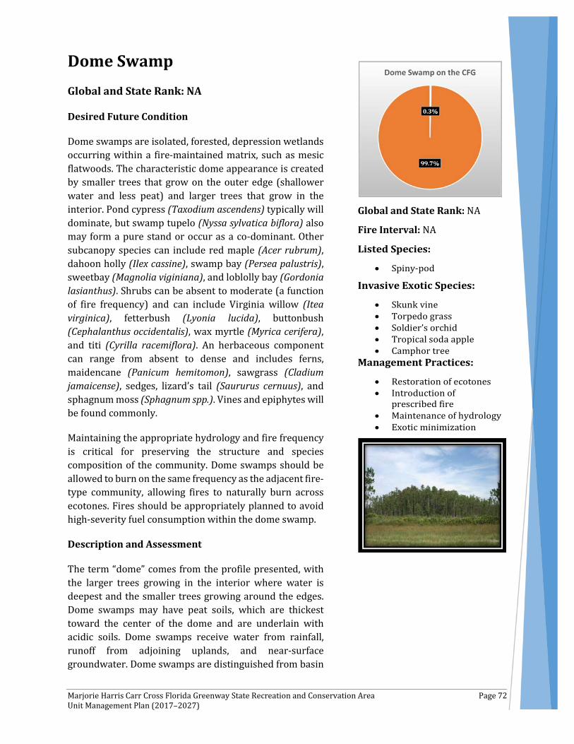
Marjorie Harris Carr Cross Florida Greenway State Recreation and Conservation Area Page 72 Unit Management Plan (2017–2027)
Dome Swamp Global and State Rank: NA
Desired Future Condition
Dome swamps are isolated, forested, depression wetlands occurring within a fire-maintained matrix, such as mesic flatwoods. The characteristic dome appearance is created by smaller trees that grow on the outer edge (shallower water and less peat) and larger trees that grow in the interior. Pond cypress (Taxodium ascendens) typically will dominate, but swamp tupelo (Nyssa sylvatica biflora) also may form a pure stand or occur as a co-dominant. Other subcanopy species can include red maple (Acer rubrum), dahoon holly (Ilex cassine), swamp bay (Persea palustris), sweetbay (Magnolia viginiana), and loblolly bay (Gordonia lasianthus). Shrubs can be absent to moderate (a function of fire frequency) and can include Virginia willow (Itea virginica), fetterbush (Lyonia lucida), buttonbush (Cephalanthus occidentalis), wax myrtle (Myrica cerifera), and titi (Cyrilla racemiflora). An herbaceous component can range from absent to dense and includes ferns, maidencane (Panicum hemitomon), sawgrass (Cladium jamaicense), sedges, lizard’s tail (Saururus cernuus), and sphagnum moss (Sphagnum spp.). Vines and epiphytes will be found commonly.
Maintaining the appropriate hydrology and fire frequency is critical for preserving the structure and species composition of the community. Dome swamps should be allowed to burn on the same frequency as the adjacent fire-type community, allowing fires to naturally burn across ecotones. Fires should be appropriately planned to avoid high-severity fuel consumption within the dome swamp.
Description and Assessment
The term “dome” comes from the profile presented, with the larger trees growing in the interior where water is deepest and the smaller trees growing around the edges. Dome swamps may have peat soils, which are thickest toward the center of the dome and are underlain with acidic soils. Dome swamps receive water from rainfall, runoff from adjoining uplands, and near-surface groundwater. Dome swamps are distinguished from basin
Global and State Rank: NA
Fire Interval: NA
Marjorie Harris Carr Cross Florida Greenway State Recreation and Conservation Area Page 73 Unit Management Plan (2017–2027)
swamps primarily by having a more circular shape, smaller size, and shallower depth. During times of low rainfall, fires may occur more frequently within dome swamps than in the larger, typically deeper, basin swamps.
In total, as presented in Table 8, dome swamps represent 298 acres of the CFG, or 0.3 percent of CFG total area. Within the CFG, dome swamps occur north and south of the Buckman Lock and on Inglis Island.Typically, dome swamps on the CFG have an overstory of pond cypress with longleaf pine (Pinus palustris) and loblolly pine (Pinus taeda) sometimes present. Species in the subcanopy layer include red maple, loblolly bay, and swamp tupelo. Shrubs can be denser than the overstory, and many of the same species that occur in the upper strata also are found in the lower strata. In addition to the aforementioned trees, species documented within the shrub strata in the dome swamps include dahoon holly, cabbage palm (Sabal palmetto), fetterbush, sweetbay, wax myrtle, swamp bay, and saw palmetto (Serenoa repens). The herbaceous layers in dome swamps vary in abundance from site to site, depending on available sunlight. Sawgrass, cinnamon fern (Osmunda cinnamomea), maidencane, beaksedges (Rhynchospora spp.), and Virginia chain fern (Woodwardia virginiana) are common. Vines include laurel greenbrier (Smilax laurifolia), and muscadine (Vitis rotundifolia).
Five exotic plant species—skunk vine (Paederia foetida), torpedo grass (Panicum repens), soldier’s orchid (Zeuxine strateumatica), tropical soda apple (Solanum viarum), and camphor tree (Cinnamomum camphora)—occur within a disturbed dome swamp on Inglis Island. Historical and current disturbances that have impacted dome swamps include fire exclusion, woody encroachment, clearing, forestry operations in surrounding uplands, and exotic plant invasion.
Fire Regime
Fire is essential for the maintenance of dome swamps. Without periodic fire, hardwood invasion and peat accumulation can cause the dome swamp to succeed to a baygall. Fire frequency is greatest at the periphery of a dome swamp, where a normal fire cycle might be as short as three years to five years. Fires may occur as infrequently as every 50 years to 150 years in the interior portions.
General Management Measures
Management activities in dome swamps on the CFG should include restoration of ecotones, introduction of prescribed fire, minimization of hydrologic and soil disturbances, maintenance of hydrology, and eradication of exotic species. Restoration of firebreaks, closure of drainage channels, and closure of unessential roads and vehicular trails that border the dome swamps will help to minimize soil disturbances. Burning around dome swamps during years of normal precipitation (as opposed to drought years) can reduce heavy fuel loads that can facilitate catastrophic fires and resulting muck fires.

Marjorie Harris Carr Cross Florida Greenway State Recreation and Conservation Area Page 74 Unit Management Plan (2017–2027)
Floodplain Marsh Global and State Rank: NA
Desired Future Condition
Floodplain marshes are herbaceous-dominated wetlands associated with rivers. They occur in association with floodplain swamps, basin swamps, and ruderal communities.
Description and Assessment
In total, as shown in Table 8, floodplain marsh represents a total of 245 acres of the CFG, or 0.3 percent of total CFG area. Floodplain marshes within the CFG can be found along the St. Johns River; along Deep Creek; and north and south of the Rodman Reservoir.
Floodplain marshes are mostly herb dominated. Bald cypress (Taxodium distichum) was the only tree species observed when there was an overstory present. Shrubs may be sparse or abundant, depending on the timing of the last fire. Shrubs include groundsel tree (Baccharis halimifolia), common buttonbush (Cephalanthus occidentalis), dahoon holly (Ilex cassine), wax myrtle (Myrica cerifera), elderberry (Sambucus nigra subsp. canadensis), and coastalplain willow (Salix caroliniana).
The herbaceous layer is the dominant feature, primarily including yellow pond-lily (Nuphar advena), maidencane (Panicum hemitomon), scarlet rosemallow (Hibiscus coccineus), swamp dock (Rumex verticillatus), marsh fern (Thelypteris palustris var. pubescens), bulltongue arrowhead (Sagittaria lancifolia), pickerelweed (Pontederia cordata), giant bulrush (Scirpus californicus), and broadleaf cattail (Typha latifolia). Vines are uncommon and when seen include climbing hempvine (Mikania scandens), and Elliott's aster (Symphyotrichum elliottii).
Previous and current disturbances include clearing, ditching and canal construction, creation of impoundments, hydrological alteration, and introduction of exotic plants.
Global and State Rank: NA
Fire Interval: 2–5 years
Marjorie Harris Carr Cross Florida Greenway State Recreation and Conservation Area Page 75 Unit Management Plan (2017–2027)
Two species of invasive exotic plants occur within the floodplain marsh, including water lettuce (Pistia stratiotes) and torpedo grass (Panicum repens).
Two listed bird species were documented within floodplain marsh communities: Florida Sandhill Crane (Grus canadensis pratensis) and White Ibis (Eudocimus albus).
Fire Regime
Floodplain marshes are maintained by fire and hydrology. Under natural conditions, fires burn on a one-year to five-year basis, restricting shrub entry and maintaining the open herbaceous nature of the marshes. When floodplain marshes burn under drought conditions, the underlying peat also can burn.
General Management Measures
Management of the floodplain marshes on the CFG includes restoration of natural hydrology (due to negative impacts stemming from ditching and canal building activities), exotic species monitoring and treatment, and reintroduction of fire. Natural hydrology is crucial for maintaining species diversity and water quality. Fires from surrounding uplands should be allowed to creep into the floodplain marshes to maintain the herb dominance and to keep the woody species from taking over.

Marjorie Harris Carr Cross Florida Greenway State Recreation and Conservation Area Page 76 Unit Management Plan (2017–2027)
Mesic Hammock Global and State Rank: NA
Desired Future Condition
Mesic hammock is a well-developed evergreen hardwood and/or palm forest that can occur, with variation, through much of peninsular Florida. The often-dense canopy typically will be dominated by live oak (Quercus virginiana) with cabbage palm (Sabal palmetto) mixed into the understory. Southern magnolia (Magnolia grandiflora), sweetgum (Liquidambar styraciflua), sugarberry (Celtis laevigata), and pignut hickory (Carya glabra) can be common components in the subcanopy as well. Slash pines (Pinus elliottii) or loblolly pine (Pinus taeda) may be sparsely distributed in the canopy. The shrubby understory may be dense or open, tall or short, and is typically composed of saw palmetto (Serenoa repens), beautyberry (Callicarpa Americana), yaupon (Ilex vomitoria), American holly (Ilex opaca), gallberry (Ilex glabra), common persimmon (Diospyros virginiana) and sparkleberry (Vaccinium arboretum). The groundcover may be sparse and patchy but generally contains panicgrasses (Panicum spp.), switchgrass (Panicum virgatum), sedges, and various ferns and forbs. Abundant vines and epiphytes occur on live oaks, cabbage palms, and other subcanopy trees. Mesic hammocks generally will contain sandy soils with organic materials and may have a thick layer of leaf litter at the surface. Mesic hammocks are rarely inundated and not considered to be fire-adapted communities, so they are typically shielded from fire.
Description and Assessment
In total, as illustrated in Table 8, the mesic hammock communities represent a total of 4,313 acres of the CFG, or 6 percent of total CFG area. High-quality mesic hammocks occur within the CFG south of CR 316 and east of the Ocklawaha River; within the Ross Prairie depression marsh area; and on the western portion of Inglis Island. Mesic hammocks also are located in the Caravelle Wildlife Management Area; in areas such as north of the Buckman Lock; north, south, and east of the Rodman Reservoir; and along Deep Creek. Other areas within mesic hammocks include the vicinity of the Orange Springs Recreation Area;
Global and State Rank: NA
Fire Interval: NA
Marjorie Harris Carr Cross Florida Greenway State Recreation and Conservation Area Page 77 Unit Management Plan (2017–2027)
from north of the Eureka Bridge south to Gores Landing; from Turkey Landing south to US 40; from Forest Corners east to the Ocklawaha River (north of US 40); Marshall Swamp, from Historic Santos Recreation Area west to I-75; in the Diggings (from I-75 west to Pruitt Trailhead); from Dunnellon Baseball Fields and Recreation Complex west to US 41 (south of Withlacoochee River/Lake Rousseau); Inglis Island; and north and south of the Inglis Spillway.
The canopy can be open or closed. The overstory of the mesic hammock is closed to semi-closed, and typical species include live oak, laurel oak (Quercus hemisphaerica), sweet gum, pignut hickory, Southern magnolia, and occasionally loblolly pine. American hornbeam (Carpinus caroliniana), common persimmon (Diospyros virginiana), American holly, Carolina laurelcherry (Prunus caroliniana), black cherry (Prunus serotina), and cabbage palm are among the species that can sometimes be found in the subcanopy. The understory is shrubby and may be dense or open, tall or short. Epiphytes (ferns, orchids, and bromeliads) often are found and may become abundant in undisturbed stands.
Common shrubs include Florida hobblebush (Agarista populifolia), indigobush (Amorpha fruticosa), devil's walkingstick (Aralia spinosa), coral ardisia (Ardisia crenata), woolly pawpaw (Asimina incana), smallflower pawpaw (Asimina parviflora), eastern redbud (Cercis canadensis), hawthorn (Crataegus sp.), upland swampprivet (Forestiera ligustrina), blue huckleberry (Gaylussacia frondosa var. tomentosa), St. Andrew's cross (Hypericum hypericoides), yaupon, wild coffee (Psychotria nervosa), myrsine (Rapanea punctata), Carolina buckthorn (Rhamnus caroliniana), winged sumac (Rhus copallinum), smallflower mock buckthorn (Sageretia minutiflora), saw palmetto (Serenoa repens), gum bully (Sideroxylon lanuginosum), sparkleberry (Vaccinium arboreum), deerberry (Vaccinium stamineum), hog plum (Ximenia americana), and Hercules' club (Zanthoxylum clava-herculis).
The herb layer often is sparse or patchy and consists of various grasses. Typical herbs are woods grass (Oplismenus hirtellus), partridgeberry (Mitchella repens), lender woodoats (Chasmanthium laxum), variable witchgrass (Dichanthelium commutatum), eggleaf witchgrass (Dichanthelium ovale), and bedstraws (Galium spp.).
Epiphytes are common, and include Florida butterfly orchid (Encyclia tampensis), resurrection fern (Pleopeltis polypodioides var. michauxiana), Bartram's air-plant (Tillandsia bartramii), ballmoss (Tillandsia recurvata), and Spanish moss (Tillandsia usneoides).
Vines are diverse and abundant, and include rattan vine (Berchemia scandens), trumpet creeper (Campsis radicans), air-potato (Dioscorea bulbifera), yellow jessamine (Gelsemium sempervirens), cat's claw vine (Macfadyena unguis-cati), Virginia creeper (Parthenocissus quinquefolia), earleaf greenbrier (Smilax auriculata), saw greenbrier (Smilax bona-nox), sarsaparilla vine (Smilax pumila), bristly greenbrier (Smilax tamnoides), eastern poison ivy (Toxicodendron radicans), muscadine (Vitis rotundifolia), and calloose grape (Vitis shuttleworthii).
Four listed plant species were documented within mesic hammocks on CFG: Florida spiny pod (Matelea floridana), anglepod (Matelea gonocarpos), pinewoods dainties (Phyllanthus liebmannianus spp. platylepis), and green-fly orchid (Epidendrum conopseum). One listed animal species, the gopher tortoise (Gopherus polyphemus), was observed in a few areas, indicating some mesic hammocks may be historically more open, grassy mesic flatwoods.
Marjorie Harris Carr Cross Florida Greenway State Recreation and Conservation Area Page 78 Unit Management Plan (2017–2027)
On the CFG, 18 invasive exotic plant species occur in mesic hammocks: mimosa (Albizia julibrissin), coral ardisia (Ardisia crenata), paper mulberry (Broussonetia papyrifera), camphor tree (Cinnamomum camphora), air-potato (Dioscorea bulbifera), cogon grass (Imperata cylindrica), Lantana (Lantana camara), Japanese climbing fern (Lygodium japonicum), cat’s claw vine, Chinaberry (Melia azedarach), heavenly bamboo (Nandina domestica), sword fern (Nephrolepis cordifolia), skunk vine (Paederia foetida), golden bamboo (Phyllostachys aurea), Chinese brake fern (Pteris vittata), tropical soda apple (Solanum viarum), Caesar weed (Urena lobata), and wisteria (Wisteria sinensis).
Mesic hammocks have undergone considerable disturbance from human activities, as these habitats are desirable home, camp, and recreation sites. Past logging, understory clearing, cattle grazing, and introduction of feral hogs have altered natural canopies and disturbed soils. Cattle trample understory plants as they take refuge in shaded oak hammocks, and rooting by hogs causes severe soil disturbance. These activities leave hammocks vulnerable to invasion by a wide variety of exotic invasive plants, which compete with native plants and often become the dominant ground or vine cover.
Fire Regime
Although the mesic hammock generally is not considered a fire-adapted community, some small patches of hammock occurring as islands within marshes or prairies may experience occasional low-intensity ground fires.
General Management Measures
Given that mesic hammocks often are associated with various types of wetlands, either occurring as a matrix with hydric communities or as a transition to uplands, the hammocks may be sensitive to hydrologic alteration in the landscape. More frequent and prolonged flooding will kill most characteristic mesic hammock tree species. Lowered water tables will either shift vegetation to more xeric species or allow intense fires to burn and destroy the hammock, particularly where surrounding uplands have been fire excluded in the past. Placement of firebreaks around areas of the hammock often disrupts the natural ecotone with surrounding pyrogenic communities, leading to invasion of pine-dominated communities with hardwoods. Protection of mesic hammock habitats must, therefore, include limitations on development and grazing, restoration of natural fire regime and hydrology in the overall landscape, and control of invasive species.
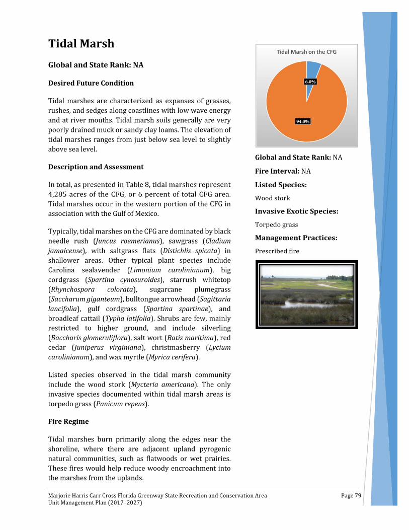
Marjorie Harris Carr Cross Florida Greenway State Recreation and Conservation Area Page 79 Unit Management Plan (2017–2027)
Tidal Marsh Global and State Rank: NA
Desired Future Condition
Tidal marshes are characterized as expanses of grasses, rushes, and sedges along coastlines with low wave energy and at river mouths. Tidal marsh soils generally are very poorly drained muck or sandy clay loams. The elevation of tidal marshes ranges from just below sea level to slightly above sea level.
Description and Assessment
In total, as presented in Table 8, tidal marshes represent 4,285 acres of the CFG, or 6 percent of total CFG area. Tidal marshes occur in the western portion of the CFG in association with the Gulf of Mexico.
Typically, tidal marshes on the CFG are dominated by black needle rush (Juncus roemerianus), sawgrass (Cladium jamaicense), with saltgrass flats (Distichlis spicata) in shallower areas. Other typical plant species include Carolina sealavender (Limonium carolinianum), big cordgrass (Spartina cynosuroides), starrush whitetop (Rhynchospora colorata), sugarcane plumegrass (Saccharum giganteum), bulltongue arrowhead (Sagittaria lancifolia), gulf cordgrass (Spartina spartinae), and broadleaf cattail (Typha latifolia). Shrubs are few, mainly restricted to higher ground, and include silverling (Baccharis glomeruliflora), salt wort (Batis maritima), red cedar (Juniperus virginiana), christmasberry (Lycium carolinianum), and wax myrtle (Myrica cerifera).
Listed species observed in the tidal marsh community include the wood stork (Mycteria americana). The only invasive species documented within tidal marsh areas is torpedo grass (Panicum repens).
Fire Regime
Tidal marshes burn primarily along the edges near the shoreline, where there are adjacent upland pyrogenic natural communities, such as flatwoods or wet prairies. These fires would help reduce woody encroachment into the marshes from the uplands.
Global and State Rank: NA
Fire Interval: NA

Marjorie Harris Carr Cross Florida Greenway State Recreation and Conservation Area Page 80 Unit Management Plan (2017–2027)
General Management Measures
Increasing development pressures along Florida’s coasts represent the largest threat to the tidal marshes. Among the potential problems that could affect the tidal marshes on the CFG are diminishment of the quality and quantity of fresh water inputs, and pollution from offshore sources.
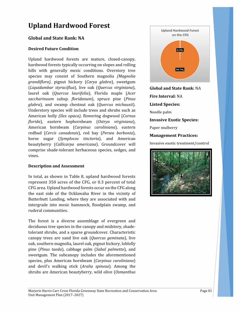
Marjorie Harris Carr Cross Florida Greenway State Recreation and Conservation Area Page 81 Unit Management Plan (2017–2027)
Upland Hardwood Forest Global and State Rank: NA
Desired Future Condition
Upland hardwood forests are mature, closed-canopy, hardwood forests typically occurring on slopes and rolling hills with generally mesic conditions. Overstory tree species may consist of Southern magnolia (Magnolia grandiflora), pignut hickory (Carya glabra), sweetgum (Liquidambar styraciflua), live oak (Quercus virginiana), laurel oak (Quercus laurifolia), Florida maple (Acer saccharinuum subsp. floridanum), spruce pine (Pinus glabra), and swamp chestnut oak (Quercus michauxii). Understory species will include trees and shrubs such as American holly (Ilex opaca), flowering dogwood (Cornus florida), eastern hophornbeam (Ostrya virginiana), American hornbeam (Carpinus caroliniana), eastern redbud (Cercis canadensis), red bay (Persea borbonia), horse sugar (Symplocos tinctoria), and American beautyberry (Callicarpa americana). Groundcover will comprise shade-tolerant herbaceous species, sedges, and vines.
Description and Assessment
In total, as shown in Table 8, upland hardwood forests represent 350 acres of the CFG, or 0.3 percent of total CFG area. Upland hardwood forests occur on the CFG along the east side of the Ocklawaha River in the vicinity of Butterbutt Landing, where they are associated with and intergrade into mesic hammock, floodplain swamp, and ruderal communities.
The forest is a diverse assemblage of evergreen and deciduous tree species in the canopy and midstory, shade-tolerant shrubs, and a sparse groundcover. Characteristic canopy trees are sand live oak (Quercus geminata), live oak, southern magnolia, laurel oak, pignut hickory, loblolly pine (Pinus taeda), cabbage palm (Sabal palmetto), and sweetgum. The subcanopy includes the aforementioned species, plus American hornbeam (Carpinus caroliniana) and devil's walking stick (Aralia spinosa). Among the shrubs are American beautyberry, wild olive (Osmanthus
Global and State Rank: NA
Fire Interval: NA

Marjorie Harris Carr Cross Florida Greenway State Recreation and Conservation Area Page 82 Unit Management Plan (2017–2027)
americana), bluestem palmetto (Sabal minor), dwarf palmetto (Sabal minor), and sparkleberry (Vaccinium arboreum).
Few herbs persist in the dense shade, primarily eggleaf witchgrass (Dichanthelium ovale), woodoats (Chasmanthium laxum), and Caesar weed (Urena lobata). Spanish moss (Tillandsia usneoides) can be found in the canopy.
Vines include yellow jessamine (Gelsemium sempervirens), saw greenbrier (Smilax bona-nox), and muscadine (Vitis rotundifolia).
The needle palm (Rhapidophyllum hystrix) was documented within the CFG upland hardwood forest.
Past logging, clearing, and roads and trails have altered natural canopies and disturbed soils, which likely has encouraged the introduction of invasive species into the hardwood forest at the CFG. Invasive exotics present within upland hardwood forests include the paper mulberry (Broussonetia papyrifera).
Fire Regime
Upland hardwood forests are not pyrogenic. The dense canopy and midstory results in low light and air movement and high relative humidity; thus, fires in adjacent uplands, such as sandhills, extinguish at the edge of the upland hardowood forest under normal moisture conditions. Localized damage to upland hardwood forest as a result of low-intensity, naturally occurring fires that creep into the forest edges from surrounding pyrogenic upland communities appears to be a natural part of the forest dynamics of this community, but fires should rarely, if ever, burn completely through the understory.
General Management Measures
Damage from invasive exotic plants and animals is a common problem in upland hardwood forest on the CFG. Control of these pests is the primary management activity needed. For specific control measures for camphor tree and Caesar weed please refer to the exotic and nuisance species sections.
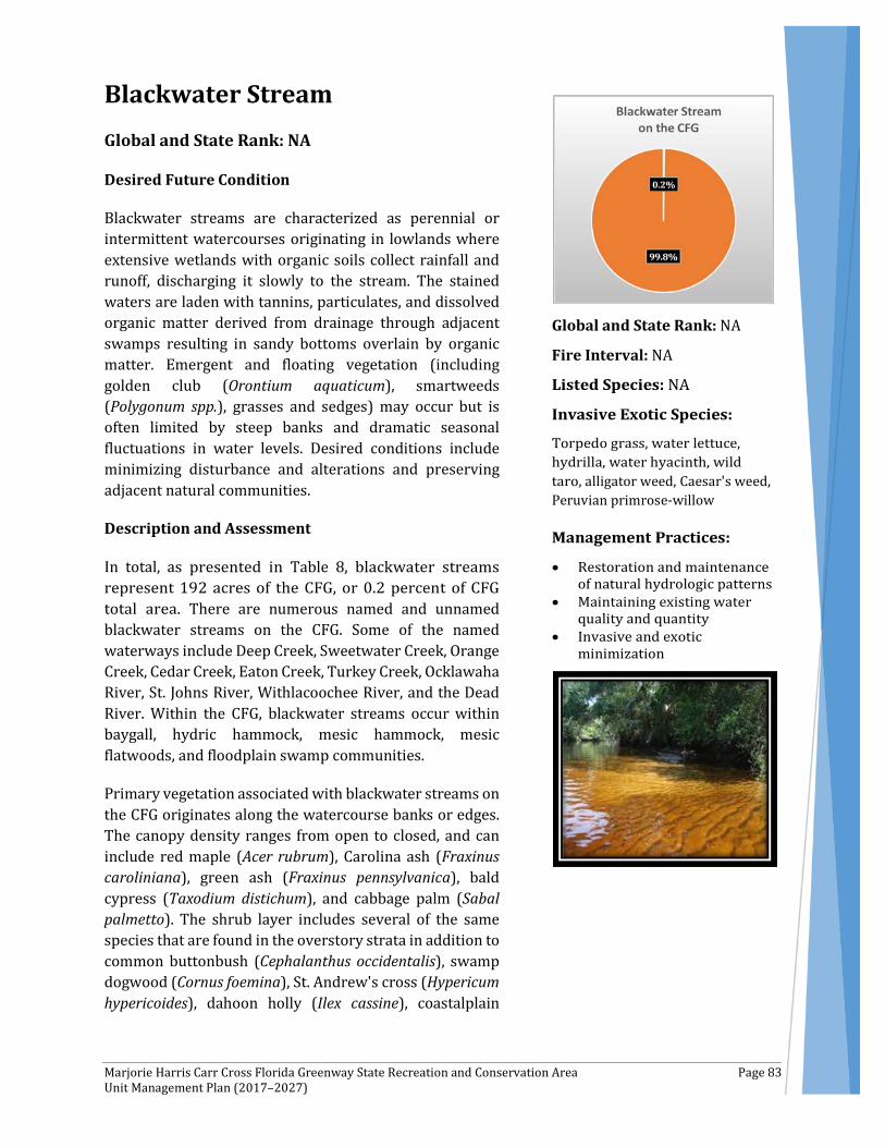
Marjorie Harris Carr Cross Florida Greenway State Recreation and Conservation Area Page 83 Unit Management Plan (2017–2027)
Blackwater Stream Global and State Rank: NA
Desired Future Condition
Blackwater streams are characterized as perennial or intermittent watercourses originating in lowlands where extensive wetlands with organic soils collect rainfall and runoff, discharging it slowly to the stream. The stained waters are laden with tannins, particulates, and dissolved organic matter derived from drainage through adjacent swamps resulting in sandy bottoms overlain by organic matter. Emergent and floating vegetation (including golden club (Orontium aquaticum), smartweeds (Polygonum spp.), grasses and sedges) may occur but is often limited by steep banks and dramatic seasonal fluctuations in water levels. Desired conditions include minimizing disturbance and alterations and preserving adjacent natural communities.
Description and Assessment
In total, as presented in Table 8, blackwater streams represent 192 acres of the CFG, or 0.2 percent of CFG total area. There are numerous named and unnamed blackwater streams on the CFG. Some of the named waterways include Deep Creek, Sweetwater Creek, Orange Creek, Cedar Creek, Eaton Creek, Turkey Creek, Ocklawaha River, St. Johns River, Withlacoochee River, and the Dead River. Within the CFG, blackwater streams occur within baygall, hydric hammock, mesic hammock, mesic flatwoods, and floodplain swamp communities.
Primary vegetation associated with blackwater streams on the CFG originates along the watercourse banks or edges. The canopy density ranges from open to closed, and can include red maple (Acer rubrum), Carolina ash (Fraxinus caroliniana), green ash (Fraxinus pennsylvanica), bald cypress (Taxodium distichum), and cabbage palm (Sabal palmetto). The shrub layer includes several of the same species that are found in the overstory strata in addition to common buttonbush (Cephalanthus occidentalis), swamp dogwood (Cornus foemina), St. Andrew's cross (Hypericum hypericoides), dahoon holly (Ilex cassine), coastalplain
Global and State Rank: NA
Fire Interval: NA
alligator weed Caesar's weedPeruvian primrose-willow

Marjorie Harris Carr Cross Florida Greenway State Recreation and Conservation Area Page 84 Unit Management Plan (2017–2027)
willow (Salix caroliniana), and Gulf Sebastian bush (Sebastiania fruticosa).
Given fluctuating water levels, herbs typically are sparse along these river banks, but more open-canopied sites can support herbaceous groundcover. Species include false nettle (Boehmeria cylindrica), sawgrass (Cladium jamaicense), dogfennel (Eupatorium capillifolium), yellow pond-lily (Nuphar advena), royal fern (Osmunda regalis var. spectabilis), maidencane (Panicum hemitomon), green arrow arum (Peltandra virginica), narrowfruit horned beaksedge (Rhynchospora inundata), bulltongue arrowhead (Sagittaria lancifolia), and southern shield fern (Thelypteris kunthii).
The epiphytic and vine layers of the blackwater streams are infrequent. Bartram's air-plant (Tillandsia bartramii) is the most common epiphyte and sometimes occurs in great profusion, giving trees a “hairy” appearance. Vines include climbing hempvine (Mikania scandens), saw greenbrier (Smilax bona-nox), and eastern poison ivy (Toxicodendron radicans).
Four listed animal species were observed in blackwater streams: limpkin (Aramus guarauna), little blue heron (Egretta caerulea), white ibis (Eudocimus albus), and American alligator (Alligator mississippiensis). Invasive plants documented in and along blackwater streams include torpedo grass (Panicum repens), water lettuce (Pistia stratiotes), hydrilla (Hydrilla verticillata), water hyacinth (Eichhornia crassipes), wild taro (Colocasia esculenta), alligator weed (Alternanthera philoxeroides), Caesar’s weed (Urena lobata) and Peruvian primrose-willow (Ludwigia peruviana).
Human disturbances such as clearing and excavation for the Barge Canal, hydrological alteration, and creation of roads have changed not only the natural course of the larger streams throughout the CFG, but the vegetation species composition, structure, and hydrology from the historic condition as well. More recently created disturbances include trash dumping and exotic plant and animal invasions.
Fire Regime
Fire is not a requirement for blackwater streams. They may function as natural firebreaks when adjacent to flatwoods or other communities that do require fire.
General Management Measures
Pertinent management objectives for blackwater streams on the CFG include restoration and maintenance of natural hydrologic patterns, monitoring and control of invasive exotic plants and animals, and maintaining existing water quality and quantity.
Management of water on public conservation lands today includes continued monitoring of and input into growth management and regulatory processes, with respect to increasing demands for fresh water from local and regional developments, as well as from neighbors across state lines.
Marjorie Harris Carr Cross Florida Greenway State Recreation and Conservation Area Page 85 Unit Management Plan (2017–2027)
Altered Land Cover Types Global and State Rank: NA
Desired Future Condition
Developed Areas
The developed areas within the park will be managed to minimize the effect of the developed areas on adjacent natural areas. Priority invasive plant species (FLEPPC Category I and II species) will be controlled from all developed areas.
Clearcut Pine Plantation
Clearcut pine plantation is an altered community type that resulted from past commercial management. The dominant overstory species found in this type is longleaf pine (Pinus palustris), loblolly pine (Pinus taeda), or slash pine (Pinus elliotti). As an altered forest type, and potentially a candidate for restoration, there is currently no FNAI recommendations on preferred species or stocking levels for this community. Future timber management activities potentially could transition this altered type into another natural community type.
Pine Plantations
These are areas altered by silvicultural activities. These include lands where either: (1) planted pines are having or will have an ongoing detrimental effect on native groundcover, (2) former land-uses that may include intensive management have damaged groundcover to the point where further restoration beyond thinning and burning is required, and/or (3) site preparation techniques such as bedding have severely impacted groundcover. Pine plantations in Florida often are dominated by even-aged loblolly (Pinus taeda), sand pine (Pinus clausa), or slash pine (Pinus elliottii). Dense pine plantations typically have sparse to absent herbaceous vegetation as a result of shading or a cover of deep pine needle duff. These plantations may be very shrubby or vine-dominated or open at ground level. The groundcover in most cases has been severely impacted by mechanical site preparation, such as roller chopping and bedding. However, while perennial grasses such as wiregrass
Global and State Rank: NA
Fire Interval: NA
Marjorie Harris Carr Cross Florida Greenway State Recreation and Conservation Area Page 86 Unit Management Plan (2017–2027)
(Aristidia stricta var. beyrichiana) may be greatly reduced, many components of the native groundcover persist even though the relative abundance is altered. Groundcover can be partially restored by thinning and/or frequent burning, although some planting of perennial grasses such as wiregrass may be required. By thinning and burning, plantations with intact native groundcover can be restored to former natural community understory conditions.
Abandoned Field/ Abandoned Pasture
Old fields, fallow pastures, early successional areas formerly grazed or in agriculture without recent activity to maintain the area as pasture or planted field make up this category. These areas often are dominated by weedy native species (e.g., Rubus spp., Myrica cerifera) and non-native species (e.g., Indigofera hirsuta). In general, old pastures are designated when weedy cover from woody species (Rubus spp., Myrica cerifera, etc) is greater than 20 percent.
Description and Assessment
Much of the CFG has been subjected to significant human-based disturbances that were relatively short-lived and episodic (sea-level ship canal/digging of the barge canal) to disturbances that were more chronic or longer-lasting (forest clearing followed by decades of agriculture.) Approximately 30 percent of the CFG remains altered. In this UMP, the altered areas/landcover types have been included in the community types in which they occur. These areas include clearings, impoundments, a utility corridor, ditches, canals, and developments that enhance the CFG visitor experience, including the visitor center, boardwalks, picnic areas with pavilions, main drive, and parking lots. While some of these altered areas will remain as such, e.g., visitor center and parking lots, CFG staff are charged with the restoration or enhancement of altered areas to the greatest extent practicable given available staffing, funding, and adjacent/nearby land uses.
General Management Measures
The altered areas within the CFG will be managed to remove Florida Exotic Plant Pest Council (FLEPPC) Category I and II priority invasive exotic plant species. Other management measures may include limited restoration efforts designed to minimize the effects of ruderal areas on adjacent natural areas. Cost-effectiveness and consideration of other higher priority restoration projects within the park will determine the extent of restoration measures in ruderal areas. The developed areas within the park will be managed to minimize the effect of the developed areas on adjacent natural areas.
Marjorie Harris Carr Cross Florida Greenway State Recreation and Conservation Area Page 87 Unit Management Plan (2017–2027)
Imperiled Species For the purposes of this management plan, imperiled species are species on Florida’s Threatened and Endangered Species List, in accordance with Rules 68A-27.003 and 68A-27.005, or species protected by designation under the Federal Endangered Species Act. Imperiled species also are those species that are tracked by FNAI as critically imperiled (G1, S1) or imperiled (G2, S2). Federal agencies that share the authority to list species as Endangered and Threatened are the National Oceanic and Atmospheric Administration—National Marine Fisheries Service (NOAA-NMFS) and the U.S. Fish and Wildlife Service (USFWS). The NOAA-NMFS is responsible for the listing of most marine species. The federal list of animals and plants is administered by the USFWS and this list is published in 50 Code of Federal Regulations (CFR) 17 (animals) and 50 CFR 23 (plants).
On November 8, 2010, new threatened species rules approved by the FWC were implemented. All federally listed species that occur in Florida now will be included on Florida’s list as federally designated endangered species or federally designated threatened species. In addition, the state has implemented a listing process to identify species that are not federally listed, but that may be at risk of extinction. These species will be called state designated threatened species. In all, Florida has a total of 57 species that are considered imperiled, in accordance with the Florida’s Imperiled Species Management Plan (ISMP) 2016-2026. For the first time, this plan provides conservation goals and actions to achieve them for Florida’s state-listed species. Further, the document identifies integrated conservation strategies and species-specific actions that could be employed to support populations of threatened and endangered species.
A summary of element and element occurrence status within the CFG was obtained from the FNAI where occurrence status was determined solely by the presence of actual element occurrences within the Biotics database or by intersections of site boundaries with the Florida Breeding Bird Atlas (FBBA) polygons. Table 9, below, provides a list of all known imperiled species within the CFG and identifies their status as defined by various entities. It also identifies the types of management actions that currently are being taken by DRP staff or others and
CFG Imperiled Species Planning Accomplishments
2007-2016
Contracted with FNAI to update surveys of rare plants, including longspurred mint, a federally endangered plant.
Coordinated with the FWC and the Audubon Society to manage the Spoil Islands for listed shorebird species.
Continued ongoing documentation of use of the Buckman Lock and Rodman Reservoir by Florida manatees to migrate between the St. Johns River and the Ocklawaha River/Silver River systems.
Restored 523 acres of Florida scrub jay habitat, for a total of 840 acres out of 1,100 acres of historic habitat. Population increased from 46 birds in 2009 to 111 in 2015.
Installed wildlife cameras in 2009 to capture wildlife usage at all underpasses on the greenway and on the I-75 land bridge.
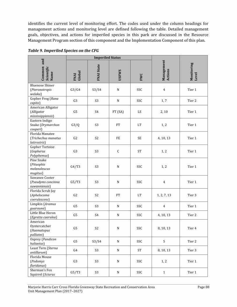
Marjorie Harris Carr Cross Florida Greenway State Recreation and Conservation Area Page 88 Unit Management Plan (2017–2027)
identifies the current level of monitoring effort. The codes used under the column headings for management actions and monitoring level are defined following the table. Detailed management goals, objectives, and actions for imperiled species in this park are discussed in the Resource Management Program section of this component and the Implementation Component of this plan.
Table 9. Imperiled Species on the CFG
Com
mon
and
Sc
ient
ific
Nam
e
Imperiled Status
Man
agem
ent
Acti
ons
Mon
itor
ing
Leve
l
FNAI
Gl
obal
FNAI
Sta
te
USF
WS
FWC
Bluenose Shiner (Pteronotropis welaka)
G3/G4 S3/S4 N SSC 4 Tier 1
Gopher Frog (Rana capito) G3 S3 N SSC 1, 7 Tier 2
American Alligator (Alligator mississippiensis)
G5 S4 FT (SA) LS 2, 10 Tier 1
Eastern Indigo Snake (Drymarchon couperi)
G3/Q S3 FT LT 1, 2 Tier 1
Florida Manatee (Trichechus manatus latirostris)
G2 S2 FE SE 4, 10, 13 Tier 1
Gopher Tortoise (Gopherus Polyphemus)
G3 S3 C ST 1, 2 Tier 1
Pine Snake (Pituophis melanoleucus mugitus)
G4/T3 S3 N SSC 1, 2 Tier 1
Suwanee Cooter (Pseudyms concinna suwanniensis)
G5/T3 S3 N SSC 4 Tier 1
Florida Scrub Jay (Aphelocoma coerulescens)
G2 S2 FT LT 1, 2, 7, 13 Tier 3
Limpkin (Aramus guarauna) G5 S3 N SSC 4 Tier 1
Little Blue Heron (Egretta caerulea) G5 S4 N SSC 4, 10, 13 Tier 2
American Oystercatcher (Haematopus palliates)
G5 S2 N SSC 8, 10, 13 Tier 4
Osprey (Pandicon haliaetus) G5 S3/S4 N SSC 5 Tier 2
Least Tern (Sterna antillarum) G4 S3 N ST 8, 10, 13 Tier 3
Florida Mouse (Podomys floridanus)
G3 S3 N SSC 1, 2 Tier 1
Sherman’s Fox Squirrel (Sciurus G5/T3 S3 N SSC 1 Tier 1
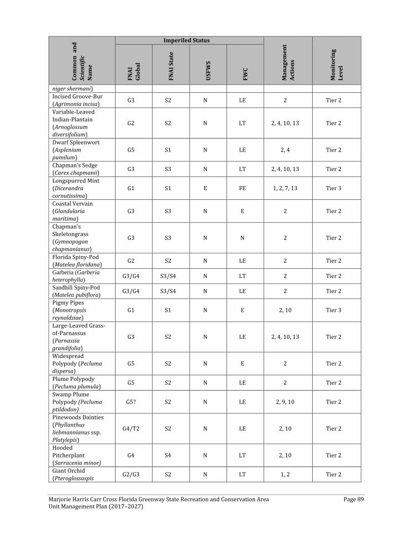
Marjorie Harris Carr Cross Florida Greenway State Recreation and Conservation Area Page 89 Unit Management Plan (2017–2027)
Com
mon
and
Sc
ient
ific
Nam
e
Imperiled Status
Man
agem
ent
Acti
ons
Mon
itor
ing
Leve
l
FNAI
Gl
obal
FNAI
Sta
te
USF
WS
FWC
niger shermani) Incised Groove-Bur (Agrimonia incisa) G3 S2 N LE 2 Tier 2
Variable-Leaved Indian-Plantain (Arnoglossum diversifolium)
G2 S2 N LT 2, 4, 10, 13 Tier 2
Dwarf Spleenwort (Asplenium pumilum)
G5 S1 N LE 2, 4 Tier 2
Chapman’s Sedge (Carex chapmanii) G3 S3 N LT 2, 4, 10, 13 Tier 2
Longspurred Mint (Dicerandra cornutissima)
G1 S1 E FE 1, 2, 7, 13 Tier 3
Coastal Vervain (Glandularia maritima)
G3 S3 N E 2 Tier 2
Chapman’s Skeletongrass (Gymnopogon chapmanianus)
G3 S3 N N 2 Tier 2
Florida Spiny-Pod (Matelea floridana) G2 S2 N LE 2 Tier 2
Garberia (Garberia heterophylla) G3/G4 S3/S4 N LT 2 Tier 2
Sandhill Spiny-Pod (Matelea pubiflora) G3/G4 S3/S4 N LE 2 Tier 2
Pigmy Pipes (Monotropsis reynoldsiae)
G1 S1 N E 2, 10 Tier 3
Large-Leaved Grass-of-Parnassus (Parnassia grandifolia)
G3 S2 N LE 2, 4, 10, 13 Tier 2
Widespread Polypody (Pecluma dispersa)
G5 S2 N E 2 Tier 2
Plume Polypody (Pecluma plumula) G5 S2 N LE 2 Tier 2
Swamp Plume Polypody (Pecluma ptildodon)
G5? S2 N LE 2, 9, 10 Tier 2
Pinewoods Dainties (Phyllanthus liebmannianus ssp. Platylepis)
G4/T2 S2 N LE 2, 10 Tier 2
Hooded Pitcherplant (Sarracenia minor)
G4 S4 N LT 2, 10 Tier 2
Giant Orchid (Pteroglossaspis G2/G3 S2 N LT 1, 2 Tier 2
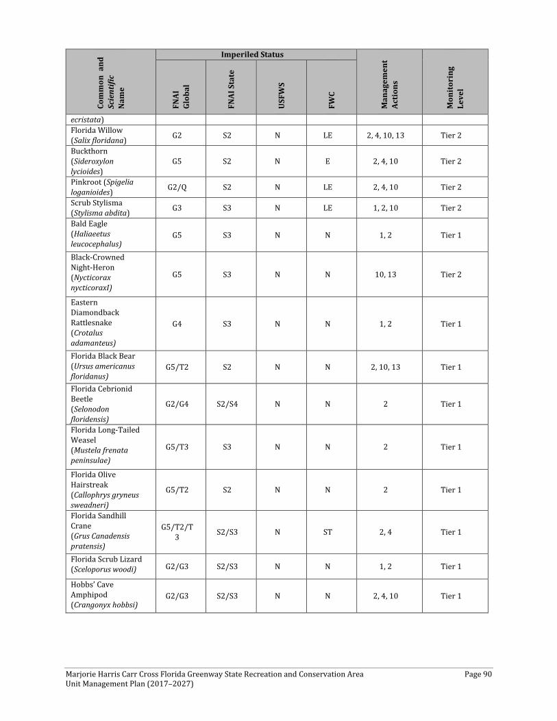
Marjorie Harris Carr Cross Florida Greenway State Recreation and Conservation Area Page 90 Unit Management Plan (2017–2027)
Com
mon
and
Sc
ient
ific
Nam
e
Imperiled Status
Man
agem
ent
Acti
ons
Mon
itor
ing
Leve
l
FNAI
Gl
obal
FNAI
Sta
te
USF
WS
FWC
ecristata) Florida Willow (Salix floridana) G2 S2 N LE 2, 4, 10, 13 Tier 2
Buckthorn (Sideroxylon lycioides)
G5 S2 N E 2, 4, 10 Tier 2
Pinkroot (Spigelia loganioides) G2/Q S2 N LE 2, 4, 10 Tier 2
Scrub Stylisma (Stylisma abdita) G3 S3 N LE 1, 2, 10 Tier 2
Bald Eagle (Haliaeetus leucocephalus)
G5 S3 N N 1, 2 Tier 1
Black-Crowned Night-Heron (Nycticorax nycticoraxI)
G5 S3 N N 10, 13 Tier 2
Eastern Diamondback Rattlesnake (Crotalus adamanteus)
G4 S3 N N 1, 2 Tier 1
Florida Black Bear (Ursus americanus floridanus)
G5/T2 S2 N N 2, 10, 13 Tier 1
Florida Cebrionid Beetle (Selonodon floridensis)
G2/G4 S2/S4 N N 2 Tier 1
Florida Long-Tailed Weasel (Mustela frenata peninsulae)
G5/T3 S3 N N 2 Tier 1
Florida Olive Hairstreak (Callophrys gryneus sweadneri)
G5/T2 S2 N N 2 Tier 1
Florida Sandhill Crane (Grus Canadensis pratensis)
G5/T2/T3 S2/S3 N ST 2, 4 Tier 1
Florida Scrub Lizard (Sceloporus woodi) G2/G3 S2/S3 N N 1, 2 Tier 1
Hobbs’ Cave Amphipod (Crangonyx hobbsi)
G2/G3 S2/S3 N N 2, 4, 10 Tier 1
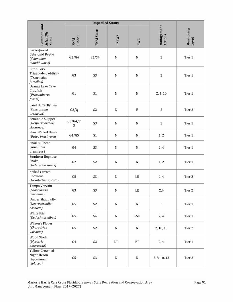
Marjorie Harris Carr Cross Florida Greenway State Recreation and Conservation Area Page 91 Unit Management Plan (2017–2027)
Com
mon
and
Sc
ient
ific
Nam
e
Imperiled Status
Man
agem
ent
Acti
ons
Mon
itor
ing
Leve
l
FNAI
Gl
obal
FNAI
Sta
te
USF
WS
FWC
Large-Jawed Cebrionid Beetle (Selonodon mandibularis)
G2/G4 S2/S4 N N 2 Tier 1
Little-Fork Triaenode Caddisfly (Triaenodes furcellus)
G3 S3 N N 2 Tier 1
Orange Lake Cave Crayfish (Procambarus franzi)
G1 S1 N N 2, 4, 10 Tier 1
Sand Butterfly Pea (Centrosema arenicola)
G2/Q S2 N E 2 Tier 2
Seminole Skipper (Hesperia attalus slossonae)
G3/G4/T3 S3 N N 2 Tier 1
Short-Tailed Hawk (Buteo brachyurus) G4/G5 S1 N N 1, 2 Tier 1
Snail Bullhead (Ameiurus brunneus)
G4 S3 N N 2, 4 Tier 1
Southern Hognose Snake (Heterodon simus)
G2 S2 N N 1, 2 Tier 1
Spiked Crested Coralroot (Hexalectris spicata)
G5 S3 N LE 2, 4 Tier 2
Tampa Vervain (Glandularia tampensis)
G3 S3 N LE 2,4 Tier 2
Umber Shadowfly (Neurocordulia obsolete)
G5 S2 N N 2 Tier 1
White Ibis (Eudocimus albus) G5 S4 N SSC 2, 4 Tier 1
Wilson’s Plover (Charadrius wilsonia)
G5 S2 N N 2, 10, 13 Tier 2
Wood Stork (Mycteria americana)
G4 S2 LT FT 2, 4 Tier 1
Yellow-Crowned Night-Heron (Nyctanassa violacea)
G5 S3 N N 2, 8, 10, 13 Tier 2
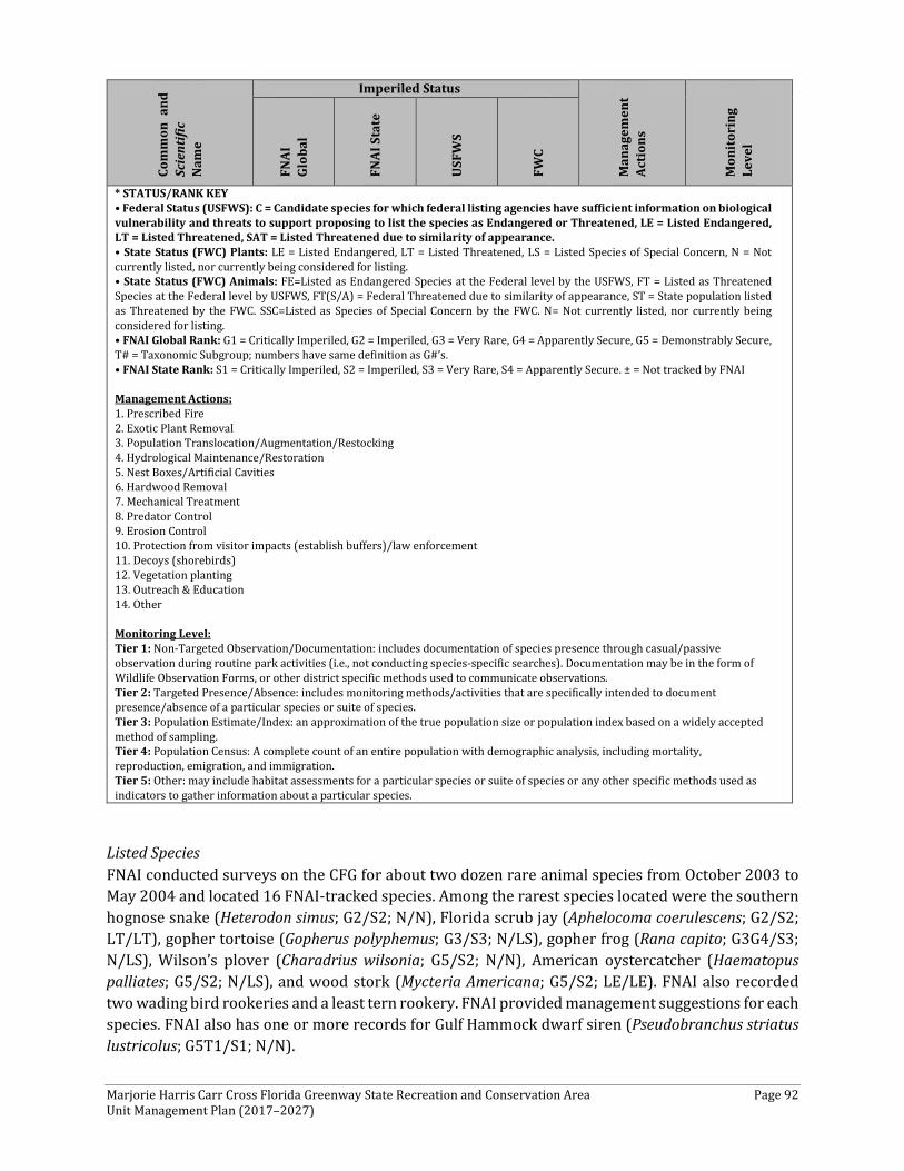
Marjorie Harris Carr Cross Florida Greenway State Recreation and Conservation Area Page 92 Unit Management Plan (2017–2027)
Com
mon
and
Sc
ient
ific
Nam
e
Imperiled Status
Man
agem
ent
Acti
ons
Mon
itor
ing
Leve
l
FNAI
Gl
obal
FNAI
Sta
te
USF
WS
FWC
* STATUS/RANK KEY • Federal Status (USFWS): C = Candidate species for which federal listing agencies have sufficient information on biological vulnerability and threats to support proposing to list the species as Endangered or Threatened, LE = Listed Endangered, LT = Listed Threatened, SAT = Listed Threatened due to similarity of appearance. • State Status (FWC) Plants: LE = Listed Endangered, LT = Listed Threatened, LS = Listed Species of Special Concern, N = Not currently listed, nor currently being considered for listing. • State Status (FWC) Animals: FE=Listed as Endangered Species at the Federal level by the USFWS, FT = Listed as Threatened Species at the Federal level by USFWS, FT(S/A) = Federal Threatened due to similarity of appearance, ST = State population listed as Threatened by the FWC. SSC=Listed as Species of Special Concern by the FWC. N= Not currently listed, nor currently being considered for listing. • FNAI Global Rank: G1 = Critically Imperiled, G2 = Imperiled, G3 = Very Rare, G4 = Apparently Secure, G5 = Demonstrably Secure, T# = Taxonomic Subgroup; numbers have same definition as G#’s. • FNAI State Rank: S1 = Critically Imperiled, S2 = Imperiled, S3 = Very Rare, S4 = Apparently Secure. ± = Not tracked by FNAI Management Actions: 1. Prescribed Fire 2. Exotic Plant Removal 3. Population Translocation/Augmentation/Restocking 4. Hydrological Maintenance/Restoration 5. Nest Boxes/Artificial Cavities 6. Hardwood Removal 7. Mechanical Treatment 8. Predator Control 9. Erosion Control 10. Protection from visitor impacts (establish buffers)/law enforcement 11. Decoys (shorebirds) 12. Vegetation planting 13. Outreach & Education 14. Other Monitoring Level: Tier 1: Non-Targeted Observation/Documentation: includes documentation of species presence through casual/passive observation during routine park activities (i.e., not conducting species-specific searches). Documentation may be in the form of Wildlife Observation Forms, or other district specific methods used to communicate observations. Tier 2: Targeted Presence/Absence: includes monitoring methods/activities that are specifically intended to document presence/absence of a particular species or suite of species. Tier 3: Population Estimate/Index: an approximation of the true population size or population index based on a widely accepted method of sampling. Tier 4: Population Census: A complete count of an entire population with demographic analysis, including mortality, reproduction, emigration, and immigration. Tier 5: Other: may include habitat assessments for a particular species or suite of species or any other specific methods used as indicators to gather information about a particular species.
Listed Species FNAI conducted surveys on the CFG for about two dozen rare animal species from October 2003 to May 2004 and located 16 FNAI-tracked species. Among the rarest species located were the southern hognose snake (Heterodon simus; G2/S2; N/N), Florida scrub jay (Aphelocoma coerulescens; G2/S2; LT/LT), gopher tortoise (Gopherus polyphemus; G3/S3; N/LS), gopher frog (Rana capito; G3G4/S3; N/LS), Wilson’s plover (Charadrius wilsonia; G5/S2; N/N), American oystercatcher (Haematopus palliates; G5/S2; N/LS), and wood stork (Mycteria Americana; G5/S2; LE/LE). FNAI also recorded two wading bird rookeries and a least tern rookery. FNAI provided management suggestions for each species. FNAI also has one or more records for Gulf Hammock dwarf siren (Pseudobranchus striatus lustricolus; G5T1/S1; N/N).
Marjorie Harris Carr Cross Florida Greenway State Recreation and Conservation Area Page 93 Unit Management Plan (2017–2027)
Amphibians The gopher frog is a medium-sized, stocky frog with adults ranging in length from 2.5 inches to 4 inches. Gopher frogs range over most of Florida, with the exception being the Everglades and Florida Keys. Range-wide, they occur in the Southeastern Gulf and Atlantic Coastal Plain from North Carolina to eastern Louisiana. Six gopher frogs were documented during this inventory and all but one was caught in the Diggings east of SR 200. The other was caught in a gopher tortoise burrow 1.24 miles west of SR 200.
Mammals Florida manatees (Trichechus manatus latirostris) are present on the CFG and are known to frequent Rodman Reservoir. In response to manatee mortality caused by the operations of water control structures, manatee protection grates, acoustic detection devices, and pressure sensors were installed on the lock and spillway. There is no access for manatees at the western end of the canal, because the lock is not functional and the spillways are above the water level on the gulf side.
Reptiles Gopher tortoises were primarily located on the western segment of the CFG, west of I-75. Some burrows also were located in the extreme eastern end. As expected, the gopher tortoises were found in disturbed areas with herbaceous groundcover and sandy substrate, including berms and powerline cuts, as well as the open natural communities with well-drained sandy substrates, such as scrub, sandhills, and scrubby flatwoods. Although the population is unknown, it is assumed to be low due to the lack of an abundance of burrows. However, with continuing restoration of sandhills and improvement of habitat for gopher tortoises, populations will likely increase.
The Southern hognose snake is a relatively small but stocky snake and reaches a maximum body length of 15 inches to 20 inches. This species is patchily distributed in Panhandle and peninsular Florida south to the northern edge of Lake Okeechobee. Southern hognose snakes inhabit xeric uplands, such as sandhills, scrub, and xeric hammocks. One adult Southern hognose snake was caught on the east side of Ross Prairie.
Eastern indigo snakes are the longest snakes in North America, reaching nearly 9 feet in length. These snakes are denizens of xeric habitats that encompass various wetland communities. Eastern indigo snakes currently occur patchily throughout Florida and in southern Georgia. Two adult Eastern indigo snakes were documented on the CFG. The first was a female approximately 4.5 feet in length crawling across the northern boundary road, south of Highway 484, and into good-quality sandhill. The second was located on the west side of SR 200 within a dry, open prairie south of the Diggings.
Eastern diamondback rattlesnakes are large, heavy-bodied, pit vipers that can reach 6 feet or more in length. Eastern diamondbacks occur statewide, including in the Keys. Range-wide, they occur in the Southeastern Coastal Plain from North Carolina to extreme eastern Louisiana. One adult snake was observed at the edge of a mesic live oak hammock 0.31 miles east-southeast of the Ross Prairie trailhead.
Birds Florida scrub jay is endemic to the low scrub lands of the Florida peninsula, with the largest populations occurring in Brevard, Highlands, Polk, and Marion counties. Florida scrub jays inhabit
Marjorie Harris Carr Cross Florida Greenway State Recreation and Conservation Area Page 94 Unit Management Plan (2017–2027)
fire-dominated, low oak scrub habitat found on well-drained soils. From the Audobon 2015 Jaywatch survey, the CFG has approximately 111 Florida scrub jays representing 27 families.
Limpkin is a medium-sized wading bird with a long, thick, slightly down-curved bill. Apple snails are an important food item. Range in the United States is chiefly limited to the Florida peninsula. Four limpkins were documented during this inventory. One was foraging at Rodman Reservoir, while three others were documented at Sweetwater Creek. One pair was courting and one individual was foraging.
White ibis is a wading bird with a white body and an orange head. White ibis nest colonies are located near water and they feed on invertebrates, fish, and other small vertebrates. A very large feeding aggregation of more than 100 individuals of multiple age classes was documented on the northeastern side of Rodman Reservoir. Ibis also were observed nesting within a multi-species rookery on Lake Rousseau.
Wood stork is a large, heavy, endangered wading bird. Wood storks are rare to abundant in the peninsula and Big Bend area of Florida, but generally are rare or lacking in the Panhandle and Florida Keys. Two wood storks were documented foraging on Rodman Reservoir. Also, a wood stork was observed by CFG staff in the Sweetwater Creek area just north of the bridge. No rookeries were discovered.
The rookeries noted by FNAI are at the western end of the CFG. A black-crowned night-heron (Nycticorax nycticorax) rookery on Spoil Island 7 supports an estimated 50-75 nesting pairs. FNAI also documented a colony of 75-100 least terns (Sterna antillarum) on the western end of Spoil Island 8. No nests were found, but the terns mobbed human observers, possibly indicating a strong attraction to the area. FNAI also recorded a wading bird rookery with about 100 pairs of nesting birds on a willow island on the eastern end of Lake Rousseau. White ibis occupied one half of the island, and great egrets (Ardea alba), cattle egrets (Bubulcus ibis), little blue herons (Egretta caerulea), and tricolored herons (E. tricolor) occupied the other half. In cooperation with FWC, warning signs were posted in the rookery areas on the Spoil Islands during critical seasons.
Further, the National Audubon Society and Birdlife International have recognized the Citrus County Spoil Islands at the mouth of the CFG and multiple tracts comprising the Big Bend Ecosystem as Globally Significant Important Bird Areas.
In addition to the above-mentioned birds, the American oystercatcher (Haematopus palliatus) and Wilson’s plover (Charadrius wilsonia) have been documented by the Audubon Society as nesting on the islands. There also are more than 35 species of shorebirds that use the area during the non-breeding season. The islands mark the southern end of the area used by the second largest wintering concentration of American oystercatchers in their range.
The FWC has developed a species action plan for beach-nesting birds, including the American oystercatcher. Plan objectives focus on protecting and monitoring nesting sites where oystercatchers are particularly susceptible to direct harm and disturbance. Monitoring is crucial for measuring the effectiveness of conservation efforts and progress toward achieving the plan objectives.
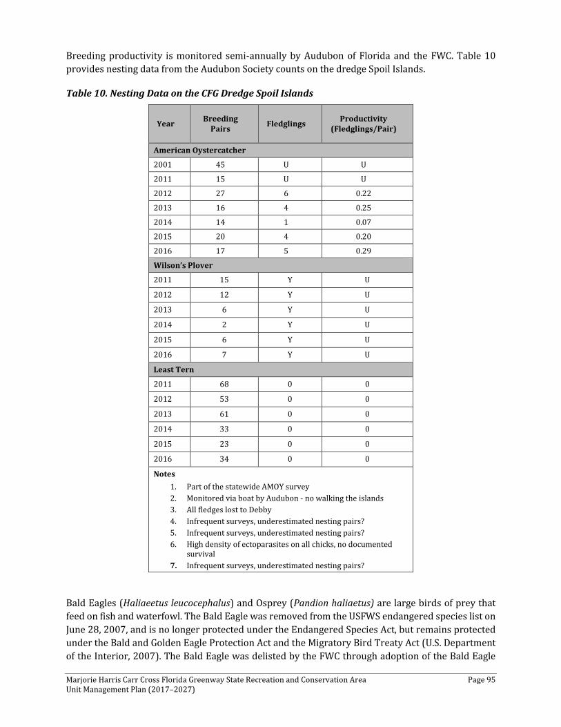
Marjorie Harris Carr Cross Florida Greenway State Recreation and Conservation Area Page 95 Unit Management Plan (2017–2027)
Breeding productivity is monitored semi-annually by Audubon of Florida and the FWC. Table 10 provides nesting data from the Audubon Society counts on the dredge Spoil Islands.
Table 10. Nesting Data on the CFG Dredge Spoil Islands
Year Breeding Pairs Fledglings Productivity
(Fledglings/Pair)
American Oystercatcher
2001 45 U U
2011 15 U U
2012 27 6 0.22
2013 16 4 0.25
2014 14 1 0.07
2015 20 4 0.20
2016 17 5 0.29
Wilson’s Plover
2011 15 Y U
2012 12 Y U
2013 6 Y U
2014 2 Y U
2015 6 Y U
2016 7 Y U
Least Tern
2011 68 0 0
2012 53 0 0
2013 61 0 0
2014 33 0 0
2015 23 0 0
2016 34 0 0
Notes 1. Part of the statewide AMOY survey 2. Monitored via boat by Audubon - no walking the islands 3. All fledges lost to Debby 4. Infrequent surveys, underestimated nesting pairs? 5. Infrequent surveys, underestimated nesting pairs? 6. High density of ectoparasites on all chicks, no documented
survival 7. Infrequent surveys, underestimated nesting pairs?
Bald Eagles (Haliaeetus leucocephalus) and Osprey (Pandion haliaetus) are large birds of prey that feed on fish and waterfowl. The Bald Eagle was removed from the USFWS endangered species list on June 28, 2007, and is no longer protected under the Endangered Species Act, but remains protected under the Bald and Golden Eagle Protection Act and the Migratory Bird Treaty Act (U.S. Department of the Interior, 2007). The Bald Eagle was delisted by the FWC through adoption of the Bald Eagle
Marjorie Harris Carr Cross Florida Greenway State Recreation and Conservation Area Page 96 Unit Management Plan (2017–2027)
Management Plan on April 9, 2008 (FWC, 2008). The FWC Bald Eagle Management Plan recommends maintaining a 660-foot buffer zone, with certain activities allowable between 330 feet and 660 feet of an active nest outside of the nesting season.
Nesting surveys for Ospreys and bald eagles were conducted on Rodman Reservoir, Deep Creek, and Sweetwater Creek. Rookeries are visited at least every two years. osprey platforms in Rodman Reservoir and Lake Rousseau are visited several times during the breeding season, at least biennially. Breeding pairs are gps'd and recorded as well as nest productivity.
The largest concentration of nesting ospreys was observed at Rodman Reservoir, where 34 active nests were documented. During this time, no nests were observed at Lake Rousseau, although an active osprey nest was present on a very tall platform approximately 100 meters downstream of the Lake Rousseau Dam. Two nests were observed at Deep Creek, and one on Sweetwater Creek; all three were active.
Two Bald Eagle nests were documented during spring/winter 2004. One was in Putnam County 0.31 miles northeast of the Buckman Lock and the other in Marion County about 1.86 miles east of the town of Dunnellon. Both nests were in pine trees.
Plants The CFG contains 70,817 acres and spans the state from the Gulf of Mexico to the St. Johns River. In 2008, FNAI mapped the natural communities on the CFG. The CFG harbors excellent examples of Florida’s rapidly disappearing natural communities, including bottomland forest, depression marsh, floodplain swamp, four types of hammocks (hydric, maritime, mesic, and xeric), mesic and wet flatwoods, sandhill, scrub, and upland hardwood forest. These communities provide habitat for a number of FNAI, state, and federally listed plant species.
FNAI completed surveys in July, August, and October 2016 and January, February, March, April, and May 2017. At the completion of the surveys, FNAI prepared the 2017 Assessment of Listed and Rare Plant Species at Marjorie Harris Carr Cross Florida Greenway Levy, Citrus, Marion and Putnam Counties, Florida, which was used to develop this section of the CFG UMP. Results of these surveys include the occurrence of 23 rare plant species listed by the state of Florida, of which 12 are state listed as endangered, 10 are state listed threatened, and the federally listed endangered rare longspurred mint (Dicerandra cornutissima) also was found. Several locations were recorded for five species listed by the state as commercially exploited: Green fly orchid (Epidendrum conopseum), cinnamon fern (Osmunda cinnamomea), royal fern (Osmunda regalis var. spectabilis), needle palm (Rhapidophyllum hystrix), and coontie (Zamia integrifolia [formerly called Z. pumila]).
Populations of dwarf spleenwort (Asplenium pumilum) and Tampa mock vervain (Glandularia tampensis), two species new to the CFG, were found during the current survey. A new population of Chapman’s skeletongrass (Gymnopogon chapmanianus), tracked by FNAI but not listed, also was documented. In addition, new populations were recorded of angle pod (Matelea carolinensis), Florida spiny-pod (Matelea floridana), sandhill spiny-pod (Matelea pubiflora), blueflower butterwort (Pinguicula caerulea), cardinal flower (Lobelia cardinalis), cinnamon fern, royal fern, green fly orchid, coontie, giant orchid (Eulophia ecristata), plume polypody (Pecluma plumula), and swamp plume poypody (Pecluma ptildodon). The known population of scrub stylisma (Stylisma abdita) was determined to be much larger than originally documented. One 15-foot-tall star anise (Illicium
Marjorie Harris Carr Cross Florida Greenway State Recreation and Conservation Area Page 97 Unit Management Plan (2017–2027)
parviflorum; state listed endangered) was found during an invasive exotic plant survey in January 2016; this small tree was near a north boundary and we suspect it may be an introduction from a neighboring yard. The anise was not re-verified during the current survey.
Further, 11 significant botanical sites were identified on the CFG, based on current and earlier surveys (Herring and Schultz 2003, Herring 2005, FNAI 2008, FNAI 2015). These botanically significant sites were determined based on: rarity of a given species, numbers of listed species, numbers of species in general, lack of disturbance, or with lots of disturbance that warrants attention. The 11 sites include: the vicinity of Inglis Canal and west of US 19, Inglis Island, the Diggings scrub & sandhill (from approximately two miles west of SR 200 to just east of I-75), SE 25th Street (west of Santos), Marshall Swamp Trail, Ocklawaha River floodplain, Eureka Dam, Deep Creek, select areas surrounding the Rodman Reservoir, Caravelle Ranch West, and select areas surrounding the Buckman Lock (Herring and Schultz 2003, Herring 2005).
From the western end of the CFG, in Citrus and Levy counties, bordering the Gulf Coast, maritime hammock and mesic hammock that have exposed limestone provide habitat to several rare plant species. Three listed plants—Tampa vervain, spiked crested coralroot (Hexalectris spicata), and angle pod—were documented in maritime hammock in the vicinity of the Inglis Canal. Angle pod and pinewoods dainties (Phyllanthus liebmannianus) were observed in mesic hammock on Inglis Island. Most plants were located immediately adjacent to a jeep trail that runs along the southern end of mesic hammock. A few plants were in the trail; we recommend the trail be gated or closed to prevent excessive foot and vehicular traffic.
Further east in Marion County, within a linear east-west strip of the CFG (approximately beginning with the Diggings west of SR 200 east to I-75), seven listed plants occur in sandhill, scrub, and successional hardwoods that surround and include the Diggings, the site of the slated Cross Florida Barge Canal. Scrub and, to a lesser extent, sandhill harbor the population stronghold of the federal and state listed endangered longspurred mint (Dicerandra cornutissima). State listed commercially exploited garberia (Garberia heterophylla) flourish within this region. The highest quality sandhills are found in this region of the CFG and contain the following rare species: giant orchid, longspurred mint, garberia, scrub stylisma, and sandhill spiny-pod. In the Diggings proper within successional hardwoods, numerous large limestone boulders dot the landscape and are covered with a multitude of fern species forming a fern grotto. State listed plume polypody and swamp plume polypody were found on the limestone boulders that provide an ideal substrate. Sword fern (Nephrolepis cordifolia) poses perhaps the biggest threat to the ferns. A new population of Florida spiny-pod was found in this area on top of the old canal berm.
East of I-75, another fern grotto-like habitat occurs on the east side of SE 25th Street (west of Santos) in Marion County within successional hardwood forest. A series of boulders run parallel, north-south, to SE 25th Street. Plume polypody, swamp plume polypody, and dwarf spleenwort (new species for the CFG) were occasional, common, and rare, respectively, on the limestone boulders. The sword fern is of concern here also.
Continuing northeast, Marshall Swamp Trail and Ocklawaha River floodplain in the Sharpes Ferry area offer high-quality hydric hammock and bottomland forest in which several rare plants are known, such as angle pod, needle palm (Rhapidophyllum hystrix), pinkroot (Spigelia marilandica),
Marjorie Harris Carr Cross Florida Greenway State Recreation and Conservation Area Page 98 Unit Management Plan (2017–2027)
and Treat’s zephyrlily (Zephyranthes rosea). In areas where limestone is exposed, such as Butterbutt Landing, swamp plume polypody occurs.
Eureka Dam, east of the Ocklawaha River, was known to have populations of the rare pigmy pipes (Monotropsis odorata) and giant orchid. Despite repeated searches, neither species has been found in recent years.
In Putnam County, within the Deep Creek site, seven listed and one commercially exploited species were documented within excellent hydric hammock: angle-pod, cardinal flower, Chapman’s sedge (Carex chapmanii), Florida spiny pod, Florida willow (Salix floridana), large-leaved grass-of-parnassus (Parnassia grandifolia), needle palm, and variable leaf Indian plantain (Arnoglossum diversifolium).
Several areas surrounding the Rodman Reservoir in Putnam County have listed or rare plants. A population of Chapman’s skeletongrass (Gymnopogon chapmanianus) and garberia occurs on the scrub island north of the Rodman Reservoir. Populations of hooded pitcher plants (Sarracenia minor) also grow in the vicinity of the Rodman Reservoir and north and south of Rodman Road in mesic flatwoods.
In the Caravelle Ranch West portion of the CFG in Putnam County, five listed species were documented: blue butterwort, Chapman’s skeletongrass, garberia, yellow-flowered butterwort (Pinguicula lutea), and hooded pitcher plant in mesic flatwoods, wet prairie, and scrubby flatwoods.
Several areas surrounding the Buckman Lock had listed plants. Along Rodeheaver Boys Ranch Road and west of the visitor’s center, populations of hooded pitcher plants occur in mesic flatwoods. Garberia occurs north and south of the Buckman Lock canal in sandhill and scrub.
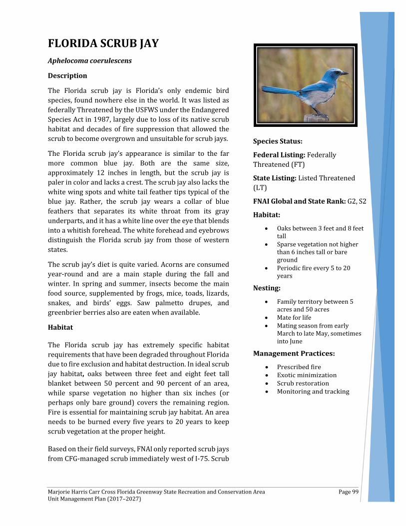
Marjorie Harris Carr Cross Florida Greenway State Recreation and Conservation Area Page 99 Unit Management Plan (2017–2027)
FLORIDA SCRUB JAY Aphelocoma coerulescens
Description
The Florida scrub jay is Florida’s only endemic bird species, found nowhere else in the world. It was listed as federally Threatened by the USFWS under the Endangered Species Act in 1987, largely due to loss of its native scrub habitat and decades of fire suppression that allowed the scrub to become overgrown and unsuitable for scrub jays.
The Florida scrub jay’s appearance is similar to the far more common blue jay. Both are the same size, approximately 12 inches in length, but the scrub jay is paler in color and lacks a crest. The scrub jay also lacks the white wing spots and white tail feather tips typical of the blue jay. Rather, the scrub jay wears a collar of blue feathers that separates its white throat from its gray underparts, and it has a white line over the eye that blends into a whitish forehead. The white forehead and eyebrows distinguish the Florida scrub jay from those of western states.
The scrub jay’s diet is quite varied. Acorns are consumed year-round and are a main staple during the fall and winter. In spring and summer, insects become the main food source, supplemented by frogs, mice, toads, lizards, snakes, and birds' eggs. Saw palmetto drupes, and greenbrier berries also are eaten when available.
Habitat
The Florida scrub jay has extremely specific habitat requirements that have been degraded throughout Florida due to fire exclusion and habitat destruction. In ideal scrub jay habitat, oaks between three feet and eight feet tall blanket between 50 percent and 90 percent of an area, while sparse vegetation no higher than six inches (or perhaps only bare ground) covers the remaining region. Fire is essential for maintaining scrub jay habitat. An area needs to be burned every five years to 20 years to keep scrub vegetation at the proper height.
Based on their field surveys, FNAI only reported scrub jays from CFG-managed scrub immediately west of I-75. Scrub
Species Status:
Federal Listing: Federally Threatened (FT)
State Listing: Listed Threatened (LT)
FNAI Global and State Rank: G2, S2
Habitat:
• Oaks between 3 feet and 8 feet tall
• Sparse vegetation not higher than 6 inches tall or bare ground
• Periodic fire every 5 to 20 years
Nesting:
• Family territory between 5 acres and 50 acres
• Mate for life • Mating season from early
March to late May, sometimes into June

Marjorie Harris Carr Cross Florida Greenway State Recreation and Conservation Area Page 100 Unit Management Plan (2017–2027)
jays also are reported very near the scrub formerly managed by the Florida Coastal Office on the western end of the greenway near Yankeetown.
Reproduction
The family life of scrub jays is unusually complex. A family, which consists of a breeding pair and some of their offspring, establishes its own territory and strongly protects it from other scrub jays. A family's territory may average between five acres and 50 acres, though 25 acres is most common.
The breeding pair, which mate for life, usually are around three or four years of age. Their mating season is short, from early March to late May and sometimes into June.
A nest is built between three feet and 10 feet above ground in one of the scrub oaks. Nests, made of twigs and lined with finer material, are used only once.
The average clutch is three greenish, brown-spotted eggs, which hatch after about 17 days. It also takes about 17 days, on average, for the nestlings to fledge from the time they hatch. The juveniles are distinctive, with a dusky brown head and neck that lasts until their first molt, following the first summer.
Unlike any of Florida's other songbirds, both non-nesting females but particularly males remain part of the family for several years. These hangers-on serve as valuable helpers by defending the family territory and feeding the nestlings and fledglings. However, helpers do not assist in nest building or incubating. Not surprisingly, studies have shown that breeding pairs with helpers raise their young more successfully than do birds without helpers.
Management
The CFG has worked with the FWC to identify and restore scrub communities on the greenway. Restoration of these areas includes the mechanical removal of sand pine and large oaks to allow the return of fire to these communities. Specifically, CFG has restored a total of 840 acres out of 1,100 acres of historic habitat on the CFG. Increase in burning and restoration activities resulted in an increase of scrub jays from 46 birds in 2009 to a total of 111 birds in 2015. Current management activities include the continued coordination with Florida Audubon Society for monitoring and includes contracting with wildlife consultants for trapping and banding of the populations on the Triangle. In fact, the “Triangle” area of the CFG—within Marion County—is designated through the Audubon Society as Jay Watch Site. Additionally, the CFG will continue to coordinate with the Audubon Society, FWC, and private wildlife consultants to complete necessary management and restoration activities on CFG scrub habitat, specifically within the Triangle area.
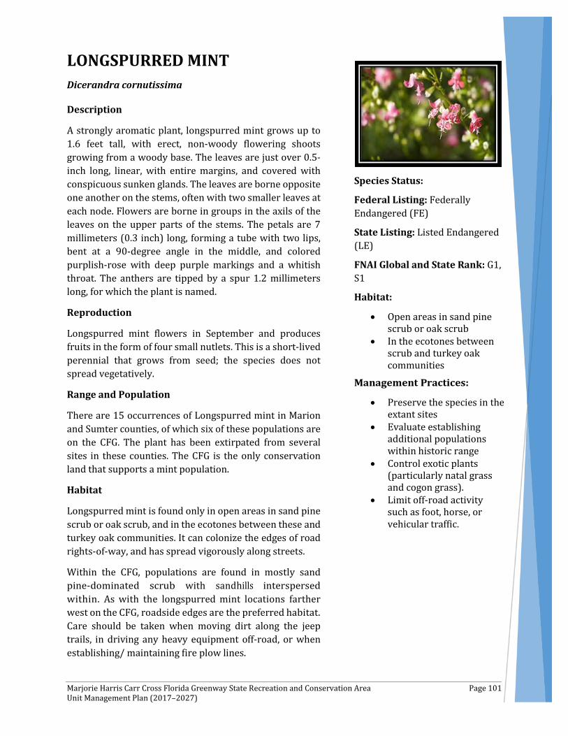
Marjorie Harris Carr Cross Florida Greenway State Recreation and Conservation Area Page 101 Unit Management Plan (2017–2027)
LONGSPURRED MINT Dicerandra cornutissima
Description
A strongly aromatic plant, longspurred mint grows up to 1.6 feet tall, with erect, non-woody flowering shoots growing from a woody base. The leaves are just over 0.5- inch long, linear, with entire margins, and covered with conspicuous sunken glands. The leaves are borne opposite one another on the stems, often with two smaller leaves at each node. Flowers are borne in groups in the axils of the leaves on the upper parts of the stems. The petals are 7 millimeters (0.3 inch) long, forming a tube with two lips, bent at a 90-degree angle in the middle, and colored purplish-rose with deep purple markings and a whitish throat. The anthers are tipped by a spur 1.2 millimeters long, for which the plant is named.
Reproduction
Longspurred mint flowers in September and produces fruits in the form of four small nutlets. This is a short-lived perennial that grows from seed; the species does not spread vegetatively.
Range and Population
There are 15 occurrences of Longspurred mint in Marion and Sumter counties, of which six of these populations are on the CFG. The plant has been extirpated from several sites in these counties. The CFG is the only conservation land that supports a mint population.
Habitat
Longspurred mint is found only in open areas in sand pine scrub or oak scrub, and in the ecotones between these and turkey oak communities. It can colonize the edges of road rights-of-way, and has spread vigorously along streets.
Within the CFG, populations are found in mostly sand pine-dominated scrub with sandhills interspersed within. As with the longspurred mint locations farther west on the CFG, roadside edges are the preferred habitat. Care should be taken when moving dirt along the jeep trails, in driving any heavy equipment off-road, or when establishing/ maintaining fire plow lines.
Species Status:
Federal Listing: Federally Endangered (FE)
State Listing: Listed Endangered (LE)
FNAI Global and State Rank: G1, S1
Habitat:
• Open areas in sand pine scrub or oak scrub
• In the ecotones between scrub and turkey oak communities
• Preserve the species in the extant sites
• Evaluate establishing additional populations within historic range
• Control exotic plants (particularly natal grass and cogon grass).
• Limit off-road activity such as foot, horse, or vehicular traffic.

Marjorie Harris Carr Cross Florida Greenway State Recreation and Conservation Area Page 102 Unit Management Plan (2017–2027)
Occurrences have been observed on the CFG, in a small area between I-75 and SR 200 in scrub and sandhill. The CFG provides critical habitat for this species and contains a significant portion of the known plants. A few known associates observed with longspurred mint include longleaf pine (Pinus palustris), sand pine (Pinus clausa), turkey oak (Quercus laevis), sand live oak (Quercus geminata), myrtle oak (Quercus myrtifolia), Chapman’s oak (Quercus chapmanii), saw palmetto (Serenoa repens), scrub palmetto (Sabal etonia), and a lichen (Cladina evansii). Longspurred mint was not a high-priority target species during the current survey; a more thorough survey, concentrating exclusively on the mint, is scheduled for summer and fall of 2017.
Management and Protection
The species should be preserved in the extant sites, and, to provide greater security, the possibility of establishing additional populations within the historic range should be evaluated. Mild disturbances appear to have little effect and probably stimulate the species by reducing competition.
While it is not known how the mint responds to fire, it does appear to favor open areas as evident from its proliferation along roadsides. Other management needs are to control exotic plants (especially natal grass and cogon grass) and limit off-road activity, such as foot, horse, or vehicular traffic.
Marjorie Harris Carr Cross Florida Greenway State Recreation and Conservation Area Page 103 Unit Management Plan (2017–2027)
Exotic and Nuisance Species
Non-native invasive plant species pose a significant threat to Florida’s natural areas. Florida is particularly vulnerable to non-native invasive species because of its peninsular geography, tropical/subtropical climate, and diverse ecosystems. More than 1.5 million acres of Florida’s public conservation lands have been invaded by alien (exotic, non-native, non-indigenous) plants such as melaleuca (Melaleuca quinquenervia), Brazilian pepper (Schinus terebinthifolius), cogon grass (Imperata cylindrica), and climbing ferns. It is estimated that approximately 1,400 non-native plant species are present in the state, with 124 species currently present in state parks (Adams et al., 2011; FLEPPC, 2011).
In an ecological context, an invasive species is one that is aggressive in growth and expansion of range and tends to dominate other species; its establishment and dominance can cause widespread harm to an ecological system by altering the species composition, susceptibility to fire, and hydrology of an area. The characteristics of some of these species (high rate of growth/reproduction, no natural predators, easily dispersed, able to out-compete native species) make them invasive. Invasions by native and non-native species often follow an alteration to ecosystem function, disruption of the food web, large-scale fragmentation of an ecosystem, and/or disturbance (e.g., clearing, fire, drought, etc.) of an area.
The FWC’s Invasive Plant Management Section (IPMS) is the designated lead entity in Florida responsible for coordinating and funding the statewide control of invasive aquatic and upland plants in public waterways and on public conservation land. The Upland Invasive Exotic Plant Management Program was established in 1997 to address the need for a statewide coordinated approach to the terrestrial (vs. aquatic) invasive exotic plant problem. The Uplands Program (a subsection of IPMS) funds individual exotic plant removal projects statewide on public conservation land. Projects are considered for funding based on recommendations from 11 Regional Invasive Plant Working Groups.
Invasive Exotic Species and Distribution on CFG Given the disturbed nature of a significant portion of the lands and waters of the CFG, the large proportion of
CFG Exotic Invasive Species Planning Accomplishments
2007-2016
According to the FDEP, DRP database, the CFG has a total of 70,531 acres, of which 1,716 acres are considered to be infested with exotic invasive plant species. In all, the infested acres are made up of 4,410 individual points.
All infestations have been treated at least biannually since 2008/2009 and are considered to be in maintenance condition.
Ongoing steps in this successful management process include:
• Continue to manage a systematic upland invasive plant maintenance program.
• Use a combination of Florida Fish and Wildlife Conservation Commission (FWC) and in-house funding to hire contractors and staff to perform invasive species control work.
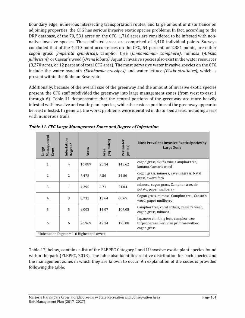
Marjorie Harris Carr Cross Florida Greenway State Recreation and Conservation Area Page 104 Unit Management Plan (2017–2027)
boundary edge, numerous intersecting transportation routes, and large amount of disturbance on adjoining properties, the CFG has serious invasive exotic species problems. In fact, according to the DRP database, of the 70, 531 acres on the CFG, 1,716 acres are considered to be infested with non-native invasive species. These infested areas are comprised of 4,410 individual points. Surveys concluded that of the 4,410-point occurrences on the CFG, 54 percent, or 2,381 points, are either cogon grass (Imperata cylindrica), camphor tree (Cinnamomum camphora), mimosa (Albizia julibrissin), or Caesar’s weed (Urena lobata). Aquatic invasive species also exist in the water resources (8,270 acres, or 12 percent of total CFG area). The most pervasive water invasive species on the CFG include the water hyacinth (Eichhornia crassipes) and water lettuce (Pistia stratiotes), which is present within the Rodman Reservoir.
Additionally, because of the overall size of the greenway and the amount of invasive exotic species present, the CFG staff subdivided the greenway into large management zones (from west to east 1 through 6). Table 11 demonstrates that the central portions of the greenway are more heavily infested with invasive and exotic plant species, while the eastern portions of the greenway appear to be least infested. In general, the worst problems were identified in disturbed areas, including areas with numerous trails.
Table 11. CFG Large Management Zones and Degree of Infestation
Larg
e M
anag
emen
t Zo
ne
Infe
stat
ion
Deg
ree*
Acre
s
Area
(s
q. m
iles)
Peri
met
er
(mile
s) Most Prevalent Invasive Exotic Species by
Large Zone
1 4 16,089 25.14 145.62 cogon grass, skunk vine, Camphor tree, lantana, Caesar’s weed
2 2 5,478 8.56 24.86 cogon grass, mimosa, ravennagrass, Natal grass, sword fern
3 1 4,295 6.71 24.04 mimosa, cogon grass, Camphor tree, air potato, paper mullberry
4 3 8,732 13.64 60.65 Cogon grass, mimosa, Camphor tree, Caesar’s weed, paper mullberry
5 5 9,002 14.07 107.05 Camphor tree, coral ardisia, Caesar’s weed, cogon grass, mimosa
6 6 26,969 42.14 178.08 Japanese climbing fern, camphor tree, torpedograss, Peruvian primrosewillow, cogon grass
*Infestation Degree = 1-6 Highest to Lowest
Table 12, below, contains a list of the FLEPPC Category I and II invasive exotic plant species found within the park (FLEPPC, 2013). The table also identifies relative distribution for each species and the management zones in which they are known to occur. An explanation of the codes is provided following the table.
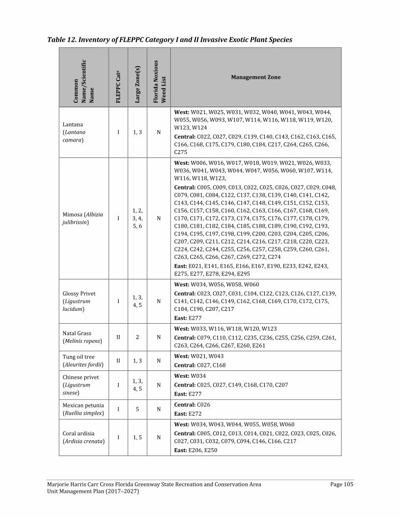
Marjorie Harris Carr Cross Florida Greenway State Recreation and Conservation Area Page 105 Unit Management Plan (2017–2027)
Table 12. Inventory of FLEPPC Category I and II Invasive Exotic Plant Species
Com
mon
N
ame/
Scie
ntifi
c N
ame
FLEP
PC C
ata
Larg
e Zo
ne(s
)
Flor
ida
Noxi
ous
Wee
d Li
st Management Zone
Lantana (Lantana camara)
I 1, 3 N
West: W021, W025, W031, W032, W040, W041, W043, W044, W055, W056, W093, W107, W114, W116, W118, W119, W120, W123, W124 Central: C022, C027, C029, C139, C140, C143, C162, C163, C165, C166, C168, C175, C179, C180, C184, C217, C264, C265, C266, C275
Mimosa (Albizia julibrissin) I
1, 2, 3, 4, 5, 6
N
West: W006, W016, W017, W018, W019, W021, W026, W033, W036, W041, W043, W044, W047, W056, W060, W107, W114, W116, W118, W123, Central: C005, C009, C013, C022, C025, C026, C027, C029, C048, C079, C081, C084, C122, C137, C138, C139, C140, C141, C142, C143, C144, C145, C146, C147, C148, C149, C151, C152, C153, C156, C157, C158, C160, C162, C163, C166, C167, C168, C169, C170, C171, C172, C173, C174, C175, C176, C177, C178, C179, C180, C181, C182, C184, C185, C188, C189, C190, C192, C193, C194, C195, C197, C198, C199, C200, C203, C204, C205, C206, C207, C209, C211, C212, C214, C216, C217, C218, C220, C223, C224, C242, C244, C255, C256, C257, C258, C259, C260, C261, C263, C265, C266, C267, C269, C272, C274 East: E021, E141, E165, E166, E167, E190, E233, E242, E243, E275, E277, E278, E294, E295
Glossy Privet (Ligustrum lucidum)
I 1, 3, 4, 5 N
West: W034, W056, W058, W060 Central: C023, C027, C031, C104, C122, C123, C126, C127, C139, C141, C142, C146, C149, C162, C168, C169, C170, C172, C175, C184, C190, C207, C217 East: E277
Natal Grass (Melinis repens) II 2 N
West: W033, W116, W118, W120, W123 Central: C079, C110, C112, C235, C236, C255, C256, C259, C261, C263, C264, C266, C267, E260, E261
Tung oil tree (Aleurites fordii) II 1, 3 N
West: W021, W043 Central: C027, C168
Chinese privet (Ligustrum sinese)
I 1, 3, 4, 5 N
West: W034 Central: C025, C027, C149, C168, C170, C207 East: E277
Mexican petunia (Ruellia simplex) I 5 N
Central: C026 East: E272
Coral ardisia (Ardisia crenata) I 1, 5 N
West: W034, W043, W044, W055, W058, W060 Central: C005, C012, C013, C014, C021, C022, C023, C025, C026, C027, C031, C032, C079, C094, C146, C166, C217 East: E206, E250
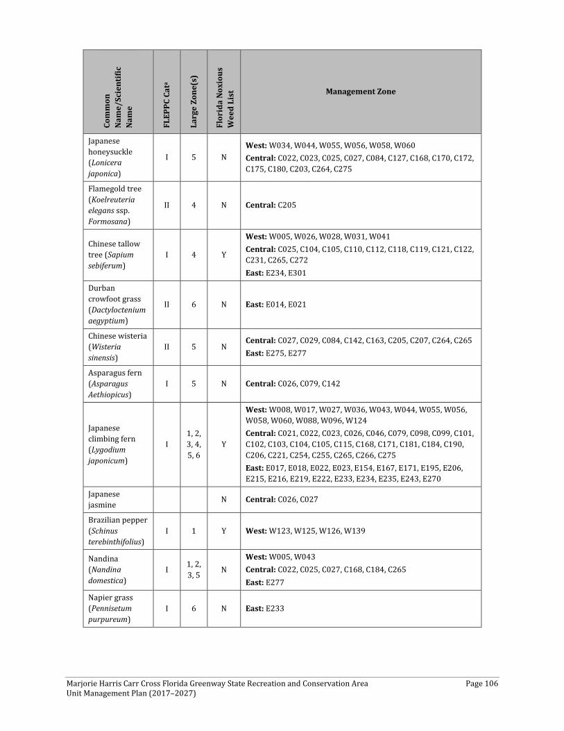
Marjorie Harris Carr Cross Florida Greenway State Recreation and Conservation Area Page 106 Unit Management Plan (2017–2027)
Com
mon
N
ame/
Scie
ntifi
c N
ame
FLEP
PC C
ata
Larg
e Zo
ne(s
)
Flor
ida
Noxi
ous
Wee
d Li
st Management Zone
Japanese honeysuckle (Lonicera japonica)
I 5 N West: W034, W044, W055, W056, W058, W060 Central: C022, C023, C025, C027, C084, C127, C168, C170, C172, C175, C180, C203, C264, C275
Flamegold tree (Koelreuteria elegans ssp. Formosana)
II 4 N Central: C205
Chinese tallow tree (Sapium sebiferum)
I 4 Y
West: W005, W026, W028, W031, W041 Central: C025, C104, C105, C110, C112, C118, C119, C121, C122, C231, C265, C272 East: E234, E301
Durban crowfoot grass (Dactyloctenium aegyptium)
II 6 N East: E014, E021
Chinese wisteria (Wisteria sinensis)
II 5 N Central: C027, C029, C084, C142, C163, C205, C207, C264, C265 East: E275, E277
Asparagus fern (Asparagus Aethiopicus)
I 5 N Central: C026, C079, C142
Japanese climbing fern (Lygodium japonicum)
I 1, 2, 3, 4, 5, 6
Y
West: W008, W017, W027, W036, W043, W044, W055, W056, W058, W060, W088, W096, W124 Central: C021, C022, C023, C026, C046, C079, C098, C099, C101, C102, C103, C104, C105, C115, C168, C171, C181, C184, C190, C206, C221, C254, C255, C265, C266, C275 East: E017, E018, E022, E023, E154, E167, E171, E195, E206, E215, E216, E219, E222, E233, E234, E235, E243, E270
Japanese jasmine N Central: C026, C027
Brazilian pepper (Schinus terebinthifolius)
I 1 Y West: W123, W125, W126, W139
Nandina (Nandina domestica)
I 1, 2, 3, 5 N
West: W005, W043 Central: C022, C025, C027, C168, C184, C265 East: E277
Napier grass (Pennisetum purpureum)
I 6 N East: E233
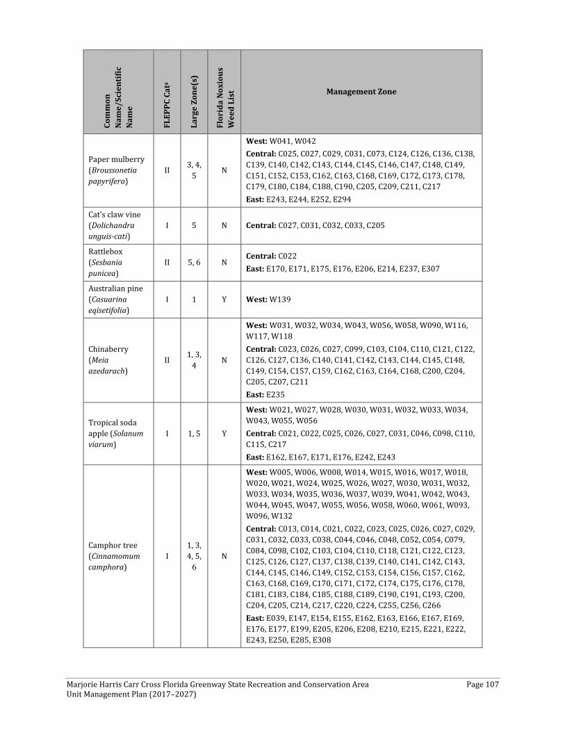
Marjorie Harris Carr Cross Florida Greenway State Recreation and Conservation Area Page 107 Unit Management Plan (2017–2027)
Com
mon
N
ame/
Scie
ntifi
c N
ame
FLEP
PC C
ata
Larg
e Zo
ne(s
)
Flor
ida
Noxi
ous
Wee
d Li
st Management Zone
Paper mulberry (Broussonetia papyrifera)
II 3, 4, 5 N
West: W041, W042 Central: C025, C027, C029, C031, C073, C124, C126, C136, C138, C139, C140, C142, C143, C144, C145, C146, C147, C148, C149, C151, C152, C153, C162, C163, C168, C169, C172, C173, C178, C179, C180, C184, C188, C190, C205, C209, C211, C217 East: E243, E244, E252, E294
Cat’s claw vine (Dolichandra unguis-cati)
I 5 N Central: C027, C031, C032, C033, C205
Rattlebox (Sesbania punicea)
II 5, 6 N Central: C022 East: E170, E171, E175, E176, E206, E214, E237, E307
Australian pine (Casuarina eqisetifolia)
I 1 Y West: W139
Chinaberry (Meia azedarach)
II 1, 3, 4 N
West: W031, W032, W034, W043, W056, W058, W090, W116, W117, W118 Central: C023, C026, C027, C099, C103, C104, C110, C121, C122, C126, C127, C136, C140, C141, C142, C143, C144, C145, C148, C149, C154, C157, C159, C162, C163, C164, C168, C200, C204, C205, C207, C211 East: E235
Tropical soda apple (Solanum viarum)
I 1, 5 Y
West: W021, W027, W028, W030, W031, W032, W033, W034, W043, W055, W056 Central: C021, C022, C025, C026, C027, C031, C046, C098, C110, C115, C217 East: E162, E167, E171, E176, E242, E243
Camphor tree (Cinnamomum camphora)
I 1, 3, 4, 5,
6 N
West: W005, W006, W008, W014, W015, W016, W017, W018, W020, W021, W024, W025, W026, W027, W030, W031, W032, W033, W034, W035, W036, W037, W039, W041, W042, W043, W044, W045, W047, W055, W056, W058, W060, W061, W093, W096, W132 Central: C013, C014, C021, C022, C023, C025, C026, C027, C029, C031, C032, C033, C038, C044, C046, C048, C052, C054, C079, C084, C098, C102, C103, C104, C110, C118, C121, C122, C123, C125, C126, C127, C137, C138, C139, C140, C141, C142, C143, C144, C145, C146, C149, C152, C153, C154, C156, C157, C162, C163, C168, C169, C170, C171, C172, C174, C175, C176, C178, C181, C183, C184, C185, C188, C189, C190, C191, C193, C200, C204, C205, C214, C217, C220, C224, C255, C256, C266 East: E039, E147, E154, E155, E162, E163, E166, E167, E169, E176, E177, E199, E205, E206, E208, E210, E215, E221, E222, E243, E250, E285, E308
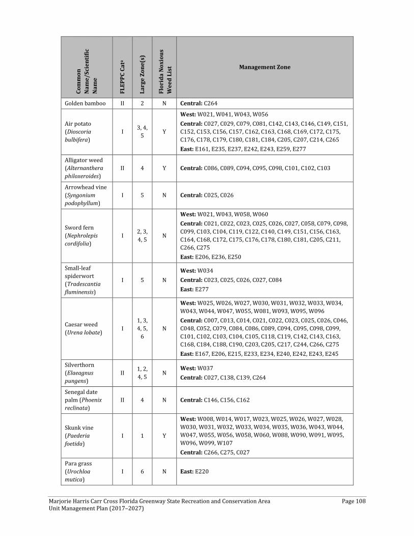
Marjorie Harris Carr Cross Florida Greenway State Recreation and Conservation Area Page 108 Unit Management Plan (2017–2027)
Com
mon
N
ame/
Scie
ntifi
c N
ame
FLEP
PC C
ata
Larg
e Zo
ne(s
)
Flor
ida
Noxi
ous
Wee
d Li
st Management Zone
Golden bamboo II 2 N Central: C264
Air potato (Dioscoria bulbifera)
I 3, 4, 5 Y
West: W021, W041, W043, W056 Central: C027, C029, C079, C081, C142, C143, C146, C149, C151, C152, C153, C156, C157, C162, C163, C168, C169, C172, C175, C176, C178, C179, C180, C181, C184, C205, C207, C214, C265 East: E161, E235, E237, E242, E243, E259, E277
Alligator weed (Alternanthera philoxeroides)
II 4 Y Central: C086, C089, C094, C095, C098, C101, C102, C103
Arrowhead vine (Syngonium podophyllum)
I 5 N Central: C025, C026
Sword fern (Nephrolepis cordifolia)
I 2, 3, 4, 5 N
West: W021, W043, W058, W060 Central: C021, C022, C023, C025, C026, C027, C058, C079, C098, C099, C103, C104, C119, C122, C140, C149, C151, C156, C163, C164, C168, C172, C175, C176, C178, C180, C181, C205, C211, C266, C275 East: E206, E236, E250
Small-leaf spiderwort (Tradescantia fluminensis)
I 5 N West: W034 Central: C023, C025, C026, C027, C084 East: E277
Caesar weed (Urena lobate) I
1, 3, 4, 5,
6 N
West: W025, W026, W027, W030, W031, W032, W033, W034, W043, W044, W047, W055, W081, W093, W095, W096 Central: C007, C013, C014, C021, C022, C023, C025, C026, C046, C048, C052, C079, C084, C086, C089, C094, C095, C098, C099, C101, C102, C103, C104, C105, C118, C119, C142, C143, C163, C168, C184, C188, C190, C203, C205, C217, C244, C266, C275 East: E167, E206, E215, E233, E234, E240, E242, E243, E245
Silverthorn (Elaeagnus pungens)
II 1, 2, 4, 5 N
West: W037 Central: C027, C138, C139, C264
Senegal date palm (Phoenix reclinata)
II 4 N Central: C146, C156, C162
Skunk vine (Paederia foetida)
I 1 Y
West: W008, W014, W017, W023, W025, W026, W027, W028, W030, W031, W032, W033, W034, W035, W036, W043, W044, W047, W055, W056, W058, W060, W088, W090, W091, W095, W096, W099, W107 Central: C266, C275, C027
Para grass (Urochloa mutica)
I 6 N East: E220

Marjorie Harris Carr Cross Florida Greenway State Recreation and Conservation Area Page 109 Unit Management Plan (2017–2027)
Com
mon
N
ame/
Scie
ntifi
c N
ame
FLEP
PC C
ata
Larg
e Zo
ne(s
)
Flor
ida
Noxi
ous
Wee
d Li
st Management Zone
Cogon grass (Imperata cylindrical)
I 1, 2, 3, 4, 5, 6
Y
West: W005, W008, W015, W017, W018, W021, W024, W025, W026, W030, W036, W047, W084, W088, W094, W095, W105, W107, W108, W109, W111, W112, W114, W116, W118, W119, W120, W123, W124, W125, W126, W128, W129, W130, W131, W135 Central: C008, C013, C014, C021, C022, C023, C025, C026, C027, C028, C029, C035, C046, C048, C061, C079, C084, C099, C103, C104, C106, C107, C108, C109, C110, C111, C112, C116, C117, C118, C120, C121, C122, C123, C125, C126, C136, C137, C138, C139, C140, C141, C142, C144, C146, C151, C152, C156, C157, C162, C163, C165, C166, C167, C168, C173, C175, C176, C178, C179, C180, C181, C184, C185, C188, C189, C190, C192, C193, C194, C205, C206, C207, C212, C214, C217, C222, C223, C224, C226, C244, C254, C255, C256, C257, C258, C259, C261, C262, C263, C264, C266, C267, C268, C269, C274, C275, C276 East: E025, E062, E098, E141, E142, E147, E165, E186, E205, E211, E214, E216, E222, E232, E233, E234, E243, E249, E259, E260, E266, E267, E275, E277
Torpedo grass (Panicum repens)
I 1, 4, 6 N
West: W028, W108, W124, W125, W126 Central: C089, C098, C099, C102, C104, C110, C163 East: E012, E014, E020, E022, E023, E036, E056, E062, E064, E065, E068, E070, E074, E075, E077, E092, E099, E120, E136, E138, E166, E167, E182, E195, E204, E205, E206, E212, E215, E216, E217, E219, E221, E222, E226, E234, E235, E236, E242, E308
Winged yam (Dioscorea alata)
I 4, 5 N Central: C143 East: E277
Wild taro (Colocasia esculenta)
I 4, 5, 6 N
West: W106, W109 Central: C021, C022, C025, C026, C058, C079, C084, C086, C094, C095, C098, C099, C101, C102, C103, C168 East: E063, E099, E154, E161, E167, E205, E206, E207, E241, E245, E250, E272, E277, E293, E296
Chinese brake fern (Pteris vittata)
II 2, 5 N
West: W008, W017, W018, W043, W056, W060, W087, W093, W096, W105, W106, W109, W114, W116, W118, W123, W124, W125, W126 Central: C021, C022, C026, C027, C032, C046, C058, C060, C061, C074, C103, C104, C118, C168, C172, C173, C178, C180, C259, C266, C274, C275 East: E062, E219, E223, E236
Elephant ear (Xanthosoma sagittifolium)
II 4, 5 N Central: C026, C084, C122, C142, C168 East: E277
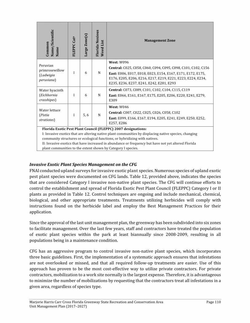
Marjorie Harris Carr Cross Florida Greenway State Recreation and Conservation Area Page 110 Unit Management Plan (2017–2027)
Com
mon
N
ame/
Scie
ntifi
c N
ame
FLEP
PC C
ata
Larg
e Zo
ne(s
)
Flor
ida
Noxi
ous
Wee
d Li
st Management Zone
Peruvian primrosewillow (Ludwigia peruviana)
I 6 N
West: W096 Central: C025, C058, C060, C094, C095, C098, C101, C102, C156 East: E006, E017, E018, E023, E154, E167, E171, E172, E175, E176, E205, E206, E216, E217, E219, E221, E223, E224, E234, E235, E236, E237, E241, E242, E281, E293
Water hyacinth (Eichhornia crasshipes)
I 6 N Central: C073, C089, C101, C102, C104, C115, C119 East: E066, E161, E167, E175, E205, E206, E220, E241, E279, E309
Water lettuce (Pistia stratiotes)
I 5, 6 N
West: W046 Central: C007, C022, C025, C026, C058, C102 East: E099, E166, E167, E194, E205, E241, E249, E250, E252, E257, E286
Florida Exotic Pest Plant Council (FLEPPC) 2007 designations: I: Invasive exotics that are altering native plant communities by displacing native species, changing community structures or ecological functions, or hybridizing with natives. II: Invasive exotics that have increased in abundance or frequency but have not yet altered Florida plant communities to the extent shown by Category I species.
Invasive Exotic Plant Species Management on the CFG FNAI conducted upland surveys for invasive exotic plant species. Numerous species of upland exotic pest plant species were documented on CFG lands. Table 12, provided above, indicates the species that are considered Category I invasive non-native plant species. The CFG will continue efforts to control the establishment and spread of Florida Exotic Pest Plant Council (FLEPPC) Category I or II plants as provided in Table 12. Control techniques are ongoing and include mechanical, chemical, biological, and other appropriate treatments. Treatments utilizing herbicides will comply with instructions found on the herbicide label and employ the Best Management Practices for their application.
Since the approval of the last unit management plan, the greenway has been subdivided into six zones to facilitate management. Over the last few years, staff and contractors have treated the population of exotic plant species within the park at least biannually since 2008-2009, resulting in all populations being in a maintenance condition.
CFG has an aggressive program to control invasive non-native plant species, which incorporates three basic guidelines. First, the implementation of a systematic approach ensures that infestations are not overlooked or missed, and that all required follow-up treatments are easier. Use of this approach has proven to be the most cost-effective way to utilize private contractors. For private contractors, mobilization to a work site normally is the largest expense. Therefore, it is advantageous to minimize the number of mobilizations by requesting that the contractors treat all infestations in a given area, regardless of species type.
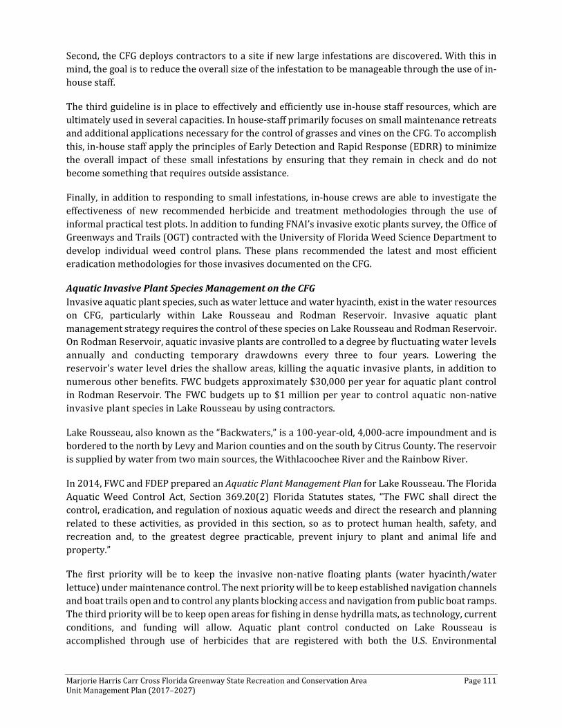
Marjorie Harris Carr Cross Florida Greenway State Recreation and Conservation Area Page 111 Unit Management Plan (2017–2027)
Second, the CFG deploys contractors to a site if new large infestations are discovered. With this in mind, the goal is to reduce the overall size of the infestation to be manageable through the use of in-house staff.
The third guideline is in place to effectively and efficiently use in-house staff resources, which are ultimately used in several capacities. In house-staff primarily focuses on small maintenance retreats and additional applications necessary for the control of grasses and vines on the CFG. To accomplish this, in-house staff apply the principles of Early Detection and Rapid Response (EDRR) to minimize the overall impact of these small infestations by ensuring that they remain in check and do not become something that requires outside assistance.
Finally, in addition to responding to small infestations, in-house crews are able to investigate the effectiveness of new recommended herbicide and treatment methodologies through the use of informal practical test plots. In addition to funding FNAI’s invasive exotic plants survey, the Office of Greenways and Trails (OGT) contracted with the University of Florida Weed Science Department to develop individual weed control plans. These plans recommended the latest and most efficient eradication methodologies for those invasives documented on the CFG.
Aquatic Invasive Plant Species Management on the CFG Invasive aquatic plant species, such as water lettuce and water hyacinth, exist in the water resources on CFG, particularly within Lake Rousseau and Rodman Reservoir. Invasive aquatic plant management strategy requires the control of these species on Lake Rousseau and Rodman Reservoir. On Rodman Reservoir, aquatic invasive plants are controlled to a degree by fluctuating water levels annually and conducting temporary drawdowns every three to four years. Lowering the reservoir's water level dries the shallow areas, killing the aquatic invasive plants, in addition to numerous other benefits. FWC budgets approximately $30,000 per year for aquatic plant control in Rodman Reservoir. The FWC budgets up to $1 million per year to control aquatic non-native invasive plant species in Lake Rousseau by using contractors.
Lake Rousseau, also known as the “Backwaters,” is a 100-year-old, 4,000-acre impoundment and is bordered to the north by Levy and Marion counties and on the south by Citrus County. The reservoir is supplied by water from two main sources, the Withlacoochee River and the Rainbow River.
In 2014, FWC and FDEP prepared an Aquatic Plant Management Plan for Lake Rousseau. The Florida Aquatic Weed Control Act, Section 369.20(2) Florida Statutes states, “The FWC shall direct the control, eradication, and regulation of noxious aquatic weeds and direct the research and planning related to these activities, as provided in this section, so as to protect human health, safety, and recreation and, to the greatest degree practicable, prevent injury to plant and animal life and property.”
The first priority will be to keep the invasive non-native floating plants (water hyacinth/water lettuce) under maintenance control. The next priority will be to keep established navigation channels and boat trails open and to control any plants blocking access and navigation from public boat ramps. The third priority will be to keep open areas for fishing in dense hydrilla mats, as technology, current conditions, and funding will allow. Aquatic plant control conducted on Lake Rousseau is accomplished through use of herbicides that are registered with both the U.S. Environmental
Marjorie Harris Carr Cross Florida Greenway State Recreation and Conservation Area Page 112 Unit Management Plan (2017–2027)
Protection Agency and FDACS for use specifically in water. Prior to all herbicide applications, the lake is surveyed by the FWC aquatic plant biologist.
A maintenance control strategy is used for floating plants at Lake Rousseau. This strategy is one in which plants are controlled on a routine basis to prevent small populations of invasive aquatic plants from expanding into large problems. Maintenance control also prevents aquatic weeds from taking over large areas of the lake, which maintains more of the lake in a condition that will support native plants for fish and wildlife habitat, afford the public better access for recreation, and protect the flood control functions of the system. Frequent small-scale herbicide applications also reduce management costs and herbicide use.
Lake Rousseau also has a well-established bird population, so maintaining a healthy environment for birds on the lake is an important part of FWC’s invasive plant management program. For the past 30-plus years, Lake Rousseau’s bird population and FWC’s Invasive Plant Management program that is designed to conserve or enhance native plant diversity and habitat have coexisted without problem. Species of concern observed on Lake Rousseau include: brown pelicans, Florida sandhill cranes, limpkins, little blue herons, snowy egrets, tricolored herons, white ibis, and wood storks.
An additional challenge in managing aquatic invasives on Lake Rousseau is that bird nesting and the invasive plant growing season overlap. To maintain invasive plants at a reasonable level, some herbicide control will be required near nesting birds, which are found all around Lake Rousseau. As in the past, herbicide applicators will continue to use caution and good judgment while operating near these areas. Lake Rousseau’s herbicide applicators are instructed to: (1) reduce noise by idling boats as much as possible and trying to avoid revving them up to a high rpm around rookery areas, (2) carefully observe bird behavior while applying herbicides, and (3) exit areas adjacent to rookeries immediately if birds leave their nests or an upflight (large numbers of birds exiting a rookery) occurs. If such disturbance occurs, applicators are instructed to return later in the day or during another application time- period when nesting is completed if possible.
The following sections describe the main invasive plant species that comprise up to 54 percent of the infestation on the CFG. These species are described, impacts are noted, then management methodologies are discussed, including treatment options.
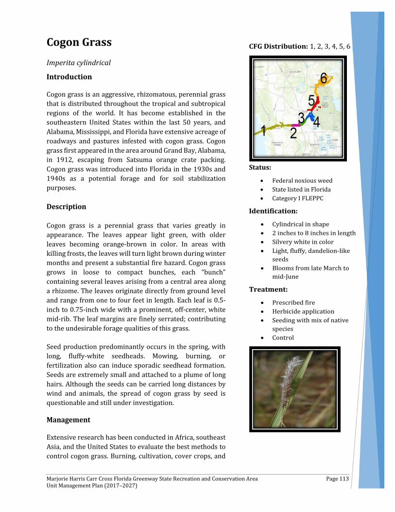
Marjorie Harris Carr Cross Florida Greenway State Recreation and Conservation Area Page 113 Unit Management Plan (2017–2027)
Cogon Grass Imperita cylindrical
Introduction
Cogon grass is an aggressive, rhizomatous, perennial grass that is distributed throughout the tropical and subtropical regions of the world. It has become established in the southeastern United States within the last 50 years, and Alabama, Mississippi, and Florida have extensive acreage of roadways and pastures infested with cogon grass. Cogon grass first appeared in the area around Grand Bay, Alabama, in 1912, escaping from Satsuma orange crate packing. Cogon grass was introduced into Florida in the 1930s and 1940s as a potential forage and for soil stabilization purposes.
Description
Cogon grass is a perennial grass that varies greatly in appearance. The leaves appear light green, with older leaves becoming orange-brown in color. In areas with killing frosts, the leaves will turn light brown during winter months and present a substantial fire hazard. Cogon grass grows in loose to compact bunches, each “bunch” containing several leaves arising from a central area along a rhizome. The leaves originate directly from ground level and range from one to four feet in length. Each leaf is 0.5-inch to 0.75-inch wide with a prominent, off-center, white mid-rib. The leaf margins are finely serrated; contributing to the undesirable forage qualities of this grass.
Seed production predominantly occurs in the spring, with long, fluffy-white seedheads. Mowing, burning, or fertilization also can induce sporadic seedhead formation. Seeds are extremely small and attached to a plume of long hairs. Although the seeds can be carried long distances by wind and animals, the spread of cogon grass by seed is questionable and still under investigation.
Management
Extensive research has been conducted in Africa, southeast Asia, and the United States to evaluate the best methods to control cogon grass. Burning, cultivation, cover crops, and
Status:
• Federal noxious weed • State listed in Florida • Category I FLEPPC

Marjorie Harris Carr Cross Florida Greenway State Recreation and Conservation Area Page 114 Unit Management Plan (2017–2027)
herbicides have been used with varying degrees of effectiveness. To eliminate cogon grass, the rhizomes must be destroyed to avoid regrowth. Cultivation and herbicides have been the two most frequently utilized control strategies. One of the oldest and most successful methods is to deep plow or disk several times during the dry season to desiccate the rhizomes and exhaust the food reserves. It is essential to cut to a depth of at least six inches to ensure that most, if not all, of the rhizomes have been cut. Results from these practices are evident when observing cogon grass growing up to the edge of a cultivated field with no evidence of spread into the field itself.
Although tillage and herbicides will provide some control and suppression of cogon grass, long-term eradication is seldom achieved. It has been shown that an integrated approach that combines burning, tillage (mechanical disturbance), and chemical applications provides the best solution for cogon grass management. Initially, cogon grass should be burned or mowed to remove excess thatch and older leaves. This initiates regrowth from the rhizomes, thereby reducing rhizome biomass. It also allows herbicides to be applied to only actively growing leaves, maximizing herbicide absorption into the plant. Ideally, burning should take place in the summer. A one- to four-month regrowth period has been shown to provide a sufficient level of leaf biomass for herbicide treatment. This targets herbicide applications to be made in the late summer/early fall—approximately one month prior to the average killing frost, depending on the area. If tillage can be incorporated, then a discing treatment directly following a burn is the best approach. This will further deplete the rhizome reserve through dessication and increase the number of shoots per given area. A one- to four-month regrowth period before herbicide treatment also is needed with this approach as well.
When good control of cogon grass has been achieved, it is essential to introduce desirable vegetation as quickly as possible to prevent cogon grass from re-infesting the area. Several species have been shown to colonize rapidly and tolerate the residual effects of imazapyr. A wider range of plant species can be used with glyphosate due to the lack of soil activity. However, cogon grass will eventually begin to re-infest, regardless of control. Therefore, diligence and persistence are essential to remove/treat re-infested areas before this grass regains a foothold.
Education and Outreach
Heightening awareness among land managers will be necessary to reduce the potential movement of cogon grass. In an effort to reduce the introduction of new infestations, preventative measures—including equipment sanitation and off-site material quarantines—should be highlighted through educational programs.
Encouraging proper equipment sanitation practices when operating on infested sites and moving equipment to other locations to prevent spread include:
• Cleaning of radiators, screens, and equipment parts that collect seed or come into contact with the soil and rhizomes
• Inspecting sources of off-site material, including soil, gravel, and mulch, for invasive species
• Establishing central staging areas on a property when equipment and material from off-site are stored or staged to allow easy inspection and monitoring for the introduction of invasives
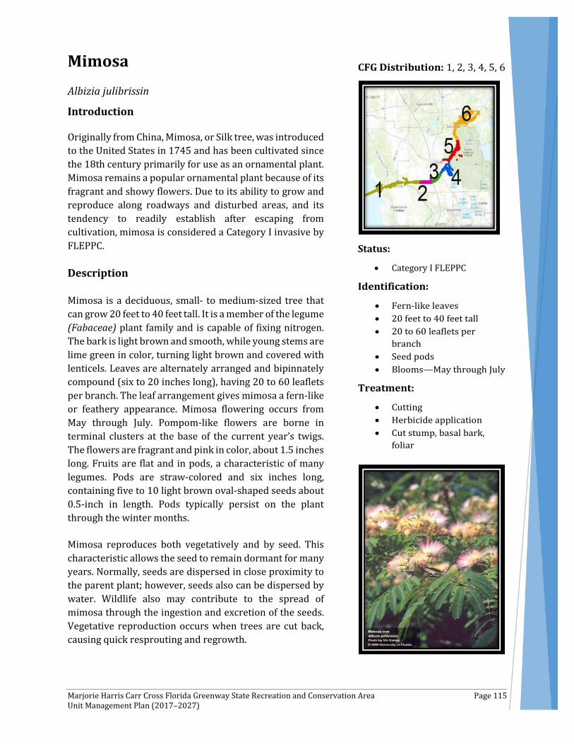
Marjorie Harris Carr Cross Florida Greenway State Recreation and Conservation Area Page 115 Unit Management Plan (2017–2027)
Mimosa Albizia julibrissin
Introduction
Originally from China, Mimosa, or Silk tree, was introduced to the United States in 1745 and has been cultivated since the 18th century primarily for use as an ornamental plant. Mimosa remains a popular ornamental plant because of its fragrant and showy flowers. Due to its ability to grow and reproduce along roadways and disturbed areas, and its tendency to readily establish after escaping from cultivation, mimosa is considered a Category I invasive by FLEPPC.
Description
Mimosa is a deciduous, small- to medium-sized tree that can grow 20 feet to 40 feet tall. It is a member of the legume (Fabaceae) plant family and is capable of fixing nitrogen. The bark is light brown and smooth, while young stems are lime green in color, turning light brown and covered with lenticels. Leaves are alternately arranged and bipinnately compound (six to 20 inches long), having 20 to 60 leaflets per branch. The leaf arrangement gives mimosa a fern-like or feathery appearance. Mimosa flowering occurs from May through July. Pompom-like flowers are borne in terminal clusters at the base of the current year’s twigs. The flowers are fragrant and pink in color, about 1.5 inches long. Fruits are flat and in pods, a characteristic of many legumes. Pods are straw-colored and six inches long, containing five to 10 light brown oval-shaped seeds about 0.5-inch in length. Pods typically persist on the plant through the winter months.
Mimosa reproduces both vegetatively and by seed. This characteristic allows the seed to remain dormant for many years. Normally, seeds are dispersed in close proximity to the parent plant; however, seeds also can be dispersed by water. Wildlife also may contribute to the spread of mimosa through the ingestion and excretion of the seeds. Vegetative reproduction occurs when trees are cut back, causing quick resprouting and regrowth.
Status:
• Category I FLEPPC
Marjorie Harris Carr Cross Florida Greenway State Recreation and Conservation Area Page 116 Unit Management Plan (2017–2027)
Impacts
Mimosa is a strong competitor in open areas or forest edges due to its ability to grow in various soil types, to produce large numbers of seed, and to resprout when cut back or damaged. An opportunist, mimosa will take advantage of disturbed areas, either spreading by seed or germinating in contaminated soil. Mimosa often is seen along roadsides and open vacant lots in urban/suburban areas and can become a problem along banks of waterways, where its seeds are easily transported in water.
Management
The first step in preventive control of mimosa is to limit planting and removal of existing plants within the landscape.
There are many native or non-invasive plants that make excellent alternatives to mimosa. These include serviceberry (Amelanchier arborea), redbud (Cercis canadensis), flowering dogwood (Cornus florida), river birch (Betula nigra), fringe tree (Chionanthus virginicus), American holly (Ilex opaca), and sweetgum (Liquidambar styraciflua).
Mimosa can be controlled using a variety of mechanical controls. Power or manual saws can be used to cut trees at ground level. Control is best achieved by cutting at flowering time before seed production. Cutting is an initial control measure and will require either an herbicidal control or repeated cutting for resprouts. In cases where herbicide use is impractical, girdling can be effective on larger trees. Make a cut through the bark, encircling the base of the tree approximately six inches above the ground, ensuring the cut goes well below the bark. This will kill the top of the tree but the tree may resprout and require a follow-up treatment with an herbicide. Hand pulling will effectively control young seedlings. Plants should be pulled as soon as possible to prevent maturation. The entire root must be removed since broken fragments may resprout.
There are no known biological agents for the control of mimosa.
The cut-stump and basal bark herbicidal methods should be considered when treating individual trees or where the presence of desirable species preclude foliar application. Stump treatments can be used as long as the ground is not frozen. Horizontally cut stems at or near ground level. Basal bark applications are effective throughout the year as long as water is not standing at the time of application.
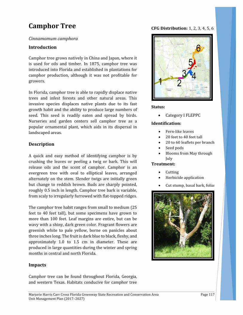
Marjorie Harris Carr Cross Florida Greenway State Recreation and Conservation Area Page 117 Unit Management Plan (2017–2027)
Camphor Tree Cinnamomum camphora
Introduction
Camphor tree grows natively in China and Japan, where it is used for oils and timber. In 1875, camphor tree was introduced into Florida and established in plantations for camphor production, although it was not profitable for growers.
In Florida, camphor tree is able to rapidly displace native trees and infest forests and other natural areas. This invasive species displaces native plants due to its fast growth habit and the ability to produce large numbers of seed. This seed is readily eaten and spread by birds. Nurseries and garden centers sell camphor tree as a popular ornamental plant, which aids in its dispersal in landscaped areas.
Description
A quick and easy method of identifying camphor is by crushing the leaves or peeling a twig or bark. This will release oils and the scent of camphor. Camphor is an evergreen tree with oval to elliptical leaves, arranged alternately on the stem. Slender twigs are initially green but change to reddish brown. Buds are sharply pointed, roughly 0.5 inch in length. Camphor tree bark is variable, from scaly to irregularly furrowed with flat-topped ridges.
The camphor tree habit ranges from small to medium (25 feet to 40 feet tall), but some specimens have grown to more than 100 feet. Leaf margins are entire, but can be wavy with a shiny, dark green color. Fragrant flowers are greenish white to pale yellow, borne on panicles about three inches long. The fruit is dark blue to black, fleshy, and approximately 1.0 to 1.5 cm in diameter. These are produced in large quantities during the winter and spring months in central and north Florida.
Impacts
Camphor tree can be found throughout Florida, Georgia, and western Texas. Habitats conducive for camphor tree
Status:
• Category I FLEPPC
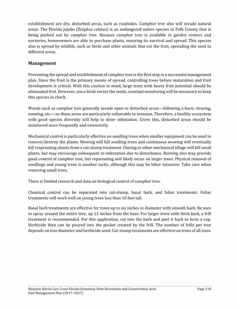
Marjorie Harris Carr Cross Florida Greenway State Recreation and Conservation Area Page 118 Unit Management Plan (2017–2027)
establishment are dry, disturbed areas, such as roadsides. Camphor tree also will invade natural areas. The Florida jujube (Ziziphus celatus) is an endangered native species in Polk County that is being pushed out by camphor tree. Because camphor tree is available in garden centers and nurseries, homeowners are able to purchase plants, ensuring its survival and spread. This species also is spread by wildlife, such as birds and other animals that eat the fruit, spreading the seed to different areas.
Management
Preventing the spread and establishment of camphor tree is the first step in a successful management plan. Since the fruit is the primary means of spread, controlling trees before maturation and fruit development is critical. With this caution in mind, large trees with heavy fruit potential should be eliminated first. However, since birds vector the seeds, constant monitoring will be necessary to keep this species in check.
Weeds such as camphor tree generally invade open or disturbed areas—following a burn, clearing, mowing, etc.—so these areas are particularly vulnerable to invasion. Therefore, a healthy ecosystem with good species diversity will help to deter infestation. Given this, disturbed areas should be monitored more frequently and extensively.
Mechanical control is particularly effective on seedling trees when smaller equipment can be used to remove/destroy the plants. Mowing will kill seedling trees and continuous mowing will eventually kill resprouting shoots from a cut-stump treatment. Discing or other mechanical tillage will kill small plants, but may encourage subsequent re-infestation due to disturbance. Burning also may provide good control of camphor tree, but repsrouting will likely occur on larger trees. Physical removal of seedlings and young trees is another tactic, although this may be labor intensive. Take care when removing small trees.
There is limited research and data on biological control of camphor tree.
Chemical control can be separated into cut-stump, basal bark, and foliar treatments. Foliar treatments will work well on young trees less than 10 feet tall.
Basal bark treatments are effective for trees up to six inches in diameter with smooth bark. Be sure to spray around the entire tree, up 12 inches from the base. For larger trees with thick bark, a frill treatment is recommended. For this application, cut into the bark and peel it back to form a cup. Herbicide then can be poured into the pocket created by the frill. The number of frills per tree depends on tree diameter and herbicide used. Cut-stump treatments are effective on trees of all sizes.

Marjorie Harris Carr Cross Florida Greenway State Recreation and Conservation Area Page 119 Unit Management Plan (2017–2027)
Caesar’s Weed Urena lobata
Introduction
There are many plants in the family Malvaceae that are grown for ornamental purposes, including hibiscus, abutilon, and alcea. Cotton (Gossypium hirsutum) also is in this family. Not only does this plant family contain many ornamentals, but there are also many weedy species, such as malva, malachra, and urena.
Description
Caesar’s weed is an erect shrub that grows up to 10 feet in height. The plant is single stalked, with free-branching stems that comprise a bushy appearance. The leaves are palmately lobed, pubescent with stellate hairs, and four cm to eight cm long. Flowers are borne in axillary clusters, pinkish-violet, about one cm across. Fruit is pubescent with hooked bristles or barbs that cling to clothing or fur. It grows as an annual species in many areas of Florida, but may perennate in south Florida.
Impacts
Caesar’s weed invades disturbed areas, pastures, eroded areas, and perennial crop plantations. The species does not compete well in tall grass and brush lands and does not grow under forest canopies. Caesar’s weed tolerates salt spray, but does not grow in saturated soils. Caesar’s weed grows rapidly and can reach two feet to seven feet tall by the end of the first year.
Management
Take care to prevent seed spread into “clean areas.” The seed of Caesar’s weed clings to clothing; therefore, treat plants before seed set. Avoid treating and then traveling to other areas. Also, avoid driving vehicles through areas of Caesar’s weed. Shade will help to deter growth and limit seedling establishment. Mulches or other groundcover also will prevent seed germination. There are no known biological controls for this species. There is only limited research in the area of chemical control.
Status:
• Florida Noxious Weed List • Category I FLEPPC
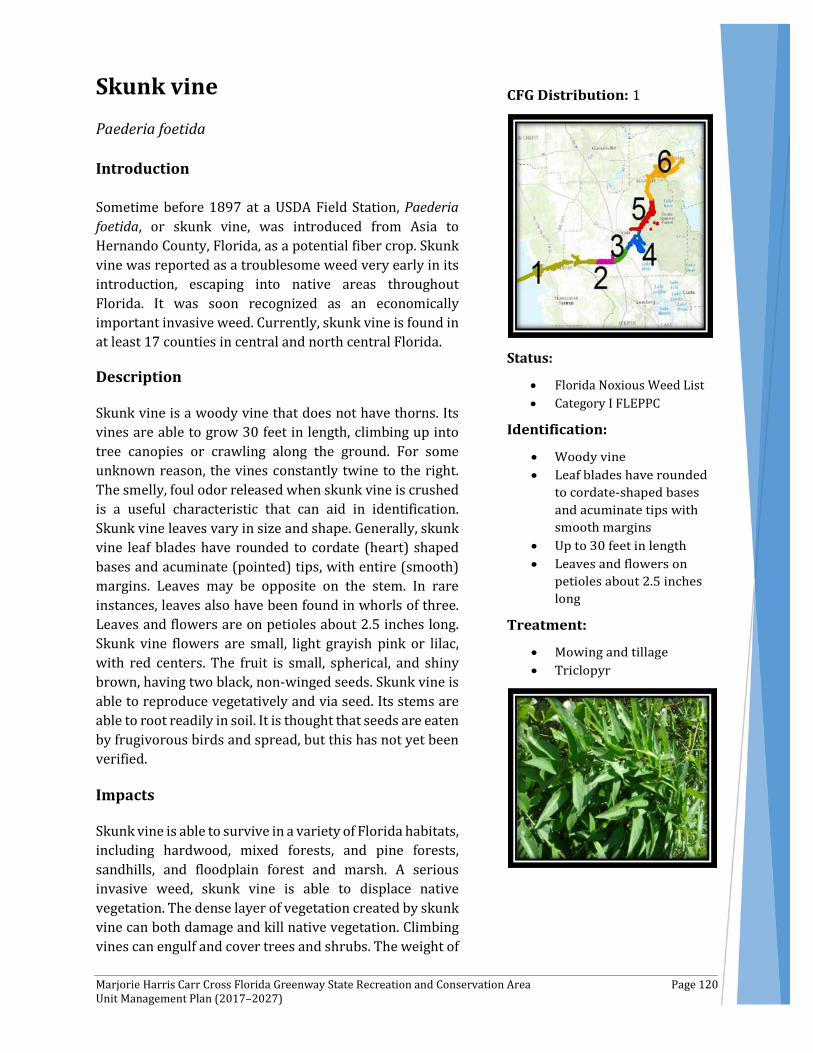
Marjorie Harris Carr Cross Florida Greenway State Recreation and Conservation Area Page 120 Unit Management Plan (2017–2027)
Skunk vine Paederia foetida
Introduction
Sometime before 1897 at a USDA Field Station, Paederia foetida, or skunk vine, was introduced from Asia to Hernando County, Florida, as a potential fiber crop. Skunk vine was reported as a troublesome weed very early in its introduction, escaping into native areas throughout Florida. It was soon recognized as an economically important invasive weed. Currently, skunk vine is found in at least 17 counties in central and north central Florida.
Description
Skunk vine is a woody vine that does not have thorns. Its vines are able to grow 30 feet in length, climbing up into tree canopies or crawling along the ground. For some unknown reason, the vines constantly twine to the right. The smelly, foul odor released when skunk vine is crushed is a useful characteristic that can aid in identification. Skunk vine leaves vary in size and shape. Generally, skunk vine leaf blades have rounded to cordate (heart) shaped bases and acuminate (pointed) tips, with entire (smooth) margins. Leaves may be opposite on the stem. In rare instances, leaves also have been found in whorls of three. Leaves and flowers are on petioles about 2.5 inches long. Skunk vine flowers are small, light grayish pink or lilac, with red centers. The fruit is small, spherical, and shiny brown, having two black, non-winged seeds. Skunk vine is able to reproduce vegetatively and via seed. Its stems are able to root readily in soil. It is thought that seeds are eaten by frugivorous birds and spread, but this has not yet been verified.
Impacts
Skunk vine is able to survive in a variety of Florida habitats, including hardwood, mixed forests, and pine forests, sandhills, and floodplain forest and marsh. A serious invasive weed, skunk vine is able to displace native vegetation. The dense layer of vegetation created by skunk vine can both damage and kill native vegetation. Climbing vines can engulf and cover trees and shrubs. The weight of
Status:
• Florida Noxious Weed List • Category I FLEPPC
Marjorie Harris Carr Cross Florida Greenway State Recreation and Conservation Area Page 121 Unit Management Plan (2017–2027)
the vine mass climbing over vegetation can cause branches or entire trees to break or collapse. Crawling vines can form a dense layer of vegetation, smothering many shrubs and other plants growing in the understory.
Management
Take care when disposing of skunk vine, since it is able to regrow when cut back and produce new plants from stem fragments. Seeds also are able to germinate in brush piles. Prevent the transport of stem fragments and seeds to other locations by ensuring machinery is free of seed and stem fragments. Flooded conditions can decrease the vigor of skunk vine; however, skunk vine can live in marsh-like conditions, able to survive for approximately 190 days under water.
Weeds such as skunk vine generally invade open or disturbed areas—following a burn, clearing mowing, etc.—so these areas are particularly vulnerable to invasion. Therefore, a healthy ecosystem with good species diversity will help to deter infestation.
Mowing and tillage will provide some measure of control, but are impractical in most situations.
There is much hope in biological control agents collected in Japan and Nepal by Agricultural Research Service Entomologists Robert Pemberton and Paul Pratt. Chrysomelid leaf beetles and two sawfly species were found feeding on the leaves of skunk vine. A stem gallmaker and a moth in the Sessiidae family also were found to attack skunk vine by causing the formation of galls on vine stems. The flea beetle (Trachyaphthona sordida) has the greatest potential of all of the biological control agents listed to potentially control skunk vine. Flea beetles damage the host root system by feeding on roots and root hairs, leading to reduced uptake of nutrients and water by the host plant.
Chemical control is one of the most effective means of control for skunk vine, but single applications generally will not provide complete control. This is due to resprouting from rootstocks or root crowns. If skunk vine is growing up into trees or other desirable species, vines should be cut or pulled down to minimize damage to the desirable vegetation. Pulling the vines down without severing them from the root crown will allow the herbicide to move into the root and provide better control. The best time to apply an herbicide is in the spring and summer when skunk vine is actively growing. Be sure to allow adequate time for the plant to regrow from the winter to ensure movement of the herbicide back into the roots. (As plants grow and mature, they begin to move sugars back into the roots.)
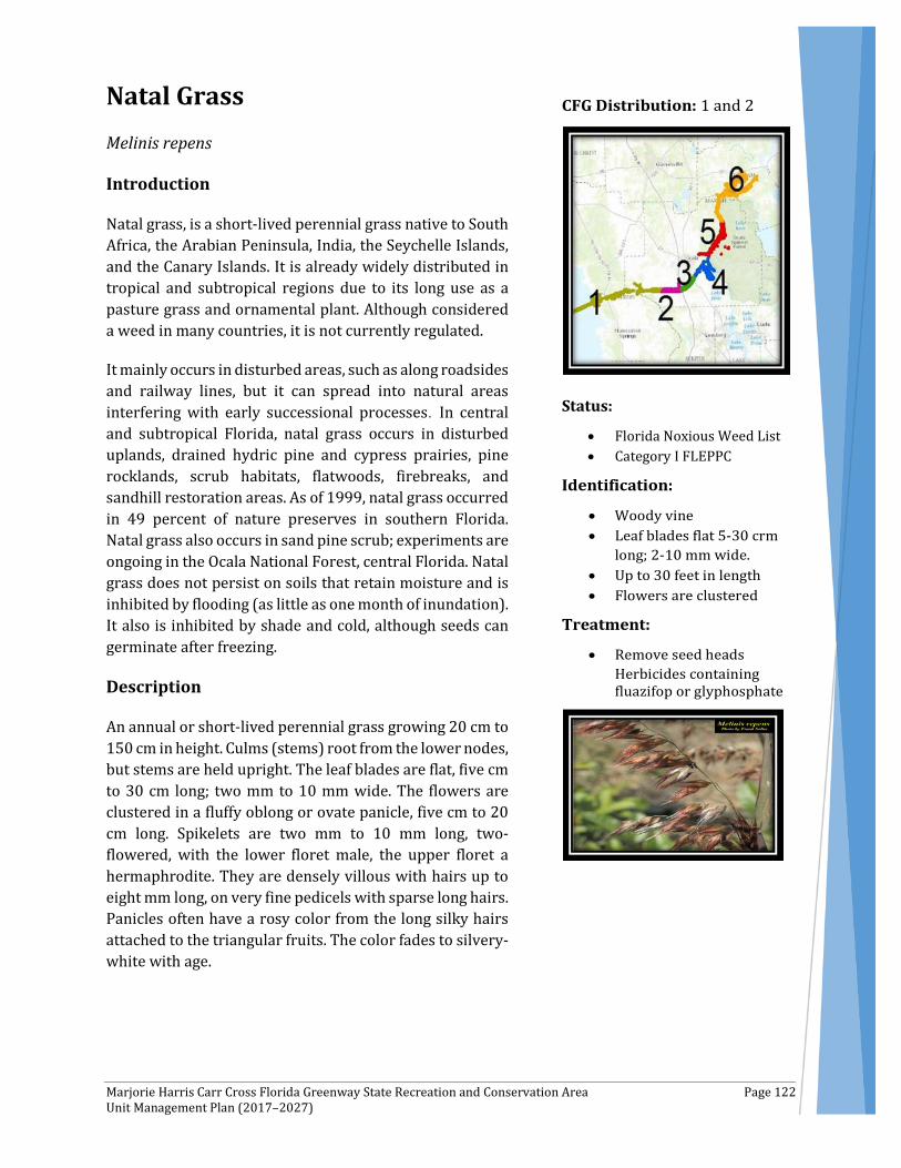
Marjorie Harris Carr Cross Florida Greenway State Recreation and Conservation Area Page 122 Unit Management Plan (2017–2027)
Natal Grass Melinis repens
Introduction
Natal grass, is a short-lived perennial grass native to South Africa, the Arabian Peninsula, India, the Seychelle Islands, and the Canary Islands. It is already widely distributed in tropical and subtropical regions due to its long use as a pasture grass and ornamental plant. Although considered a weed in many countries, it is not currently regulated.
It mainly occurs in disturbed areas, such as along roadsides and railway lines, but it can spread into natural areas interfering with early successional processes. In central and subtropical Florida, natal grass occurs in disturbed uplands, drained hydric pine and cypress prairies, pine rocklands, scrub habitats, flatwoods, firebreaks, and sandhill restoration areas. As of 1999, natal grass occurred in 49 percent of nature preserves in southern Florida. Natal grass also occurs in sand pine scrub; experiments are ongoing in the Ocala National Forest, central Florida. Natal grass does not persist on soils that retain moisture and is inhibited by flooding (as little as one month of inundation). It also is inhibited by shade and cold, although seeds can germinate after freezing.
Description
An annual or short-lived perennial grass growing 20 cm to 150 cm in height. Culms (stems) root from the lower nodes, but stems are held upright. The leaf blades are flat, five cm to 30 cm long; two mm to 10 mm wide. The flowers are clustered in a fluffy oblong or ovate panicle, five cm to 20 cm long. Spikelets are two mm to 10 mm long, two-flowered, with the lower floret male, the upper floret a hermaphrodite. They are densely villous with hairs up to eight mm long, on very fine pedicels with sparse long hairs. Panicles often have a rosy color from the long silky hairs attached to the triangular fruits. The color fades to silvery-white with age.
Status:
• Florida Noxious Weed List • Category I FLEPPC

Marjorie Harris Carr Cross Florida Greenway State Recreation and Conservation Area Page 123 Unit Management Plan (2017–2027)
Impacts
Natal grass establishes and regenerates most successfully on sites that have been mechanically disturbed, including road edges and firelines, but it also can spread from the edges into the interior of undisturbed areas. It can thrive in drained sites, mowed firebreaks, fire-created openings, and mined areas. It can form a monoculture in disturbed areas, reducing native species, particularly graminoids.
Management
Public awareness is important in potentially reducing the purchase of natal grass as a landscape plant. Natal grass is currently controlled mainly through physical/ mechanical and chemical methods both in agricultural systems and natural areas. Preventing seed set reduces local dispersal. It is also important to clean agricultural and landscape equipment when used in infested areas.
Prevent seed-set by removing or cutting grass prior to flowering. Cut out small populations. Fire kills seeds and adult plants. Fire may be ineffective in reducing natal grass if rainfall is abundant after the fire. Cattle and sheep eat natal grass but have not been used to control it. Since seeds are wind-dispersed, removal of seed heads could significantly reduce spread. No biological control is currently available. Herbicides may be used to control natal grass. However, the best control is achieved when plants are sprayed before flowering and seed-set or after germination following a fire.

Marjorie Harris Carr Cross Florida Greenway State Recreation and Conservation Area Page 124 Unit Management Plan (2017–2027)
Nuisance and Exotic Animals Exotic animal species include non-native wildlife species, free-ranging domesticated pets or livestock, and feral animals. Because of the negative impacts to natural systems attributed to exotic animals, the DRP actively removes exotic animals from state parks, with priority being given to those species causing the most ecological damage. A nuisance animal is an individual native animal whose presence or activities create special management problems.
Invasive non-native animal species are not as large an issue on the CFG as invasive plants. An exotic animal species of concern found on the CFG is the feral hog. Having an inherently high reproductive rate, when populations of wild hogs are left unchecked, these voracious omnivores are known to significantly degrade natural communities through foraging activity (rooting). Feral hogs forage in the park’s wetter areas and seasonally in scrub when acorn crops are plentiful. In the eastern region of the CFG, hogs are having negative impacts on wetlands, depression marshes, and listed plants. Feral hogs also are a problem in the western section of the CFG between Pruitt and SR 200. The greenway has an active program of feral hog removal. Park staff and contractors both participate in hog removal as conditions warrant. CFG issues permits for hog trappers in areas where hogs are known to be a problem, such as Putnam County CFG lands, Marshall Swamp, and Inglis Island. The CFG staff also will consult with other regional natural resource managing agencies and private land owners to coordinate wild hog control measures as necessary.
Immigration of feral cats (Felis catus) and dogs (Canis lupus familiaris) from the surrounding residential areas to park lands is an ongoing concern for the protection of natural and cultural resources. Local animal control agencies are contacted for control of these species when needed. Some Rhesus monkeys (Rhesus Macaques) that originated at Silver Springs have spread onto the CFG. Control of these non-native animals is under the authority of the FWC. Coyotes are reportedly common in the eastern region of the CFG; no control methods are being used for this species. Management goals, objectives, and actions for management of invasive exotic plants and exotic and nuisance animals are discussed in the Resource Management Program section of this component.
Cultural Resources
The Cross Florida Barge Canal project was a canal project to connect the Gulf of Mexico and the Atlantic Ocean across Florida for barge traffic. The idea of such a canal was first proposed by Philip II of Spain in 1567. It was repeatedly considered over the years, but found to be economically unviable. Secretary of War John C. Calhoun once again proposed a canal in 1818 in an attempt to solve the losses due to shipwrecks and piracy.
In the 1930s, regional politicians lobbied the federal government to fund canal construction as an economic recovery program, and President Franklin D. Roosevelt allocated emergency funds in 1935. Local opponents of the canal protested that the canal would deplete Florida’s aquifers, and work was stopped one year later.
Work was reauthorized in 1942 as a national defense project, with dams and locks to protect the underground water supply. Support for the project from Washington was sporadic, and funds were never allocated to the USACE for construction. Planning was once again initiated in 1963 with support from President John F. Kennedy, who allocated $1 million dollars for the project. The next year, President
Marjorie Harris Carr Cross Florida Greenway State Recreation and Conservation Area Page 125 Unit Management Plan (2017–2027)
Lyndon B. Johnson set off the explosives that initiated construction. It was hoped, that the canal along with the St. Johns-Indian River Barge Canal, would provide a quicker safer route across Florida by 1971.
Opponents subsequently campaigned against the canal based on environmental concerns and the project stopped again in January 1971. The project was officially cancelled in 1991. The right of way was turned over to the state and officially became the Marjorie Harris Carr Cross Florida Greenway, named in honor of the woman who led opposition to the canal.
This section addresses the cultural resources present in the CFG that may include archaeological sites, historic buildings and structures, cultural landscapes, and collections. The Florida Department of State (FDOS) maintains the master inventory of these resources through the Florida Master Site File (FMSF). State law requires that all state agencies locate, inventory, and evaluate cultural resources that appear to be eligible for listing in the National Register of Historic Places (NRHP). For the purposes of this plan, significant archaeological sites, significant structures, and landscapes mean those cultural resources listed or eligible for listing in the NRHP. The terms “archaeological site,” “historic structure,” or “historic landscape” refer to all resources that are or will become 50 years old during the term of this plan.
Cultural Resources in the CFG
The archaeological sites and other historical resources within the CFG represent the range of Florida’s cultural periods from the Paleoindian period (10,000 B.C.–8,000 B.C.) to the twentieth century and a range of site types as well. Prehistoric artifact scatters to 19th to 20th century railroad corridors to historic standing structures have been identified within the park. However, not all of the resources have been considered by the State Historic Preservation Office (SHPO) to be significant. At the same time, it should be noted that the majority of the archaeological sites in the CFG have not been evaluated by SHPO and the majority of the park has not been subjected to Phase I level cultural resource assessments.
According to the information in the FMSF, seven archaeological sites (8MR1082, 8MR1878, 8MR2357, 8MR3526, 8MR3863, 8MR3865 and 8MR3866), three resource groups (8MR3410, 8MR3563 and 8MR3762)), and a historic bridge (8MR3858) have been determined to be eligible for listing in the National Register of Historic Places. SHPO has determined that insufficient information exists to make a significance determination for three archaeological sites (8MR2549, 8MR2556, and 8MR3925), a linear resource (8CI1223), and a historic structure (8MR1515). All archaeological sites and historic resources in the park are protected; however, the sites listed or eligible for listing in the National Register of Historic Places warrant higher profile monitoring and measures to stabilize and mitigate deterioration and disturbance. Additional information or data relative to any of the sites will be submitted to DHR and the FMSF.
There is a cemetery (8MR3923) on the CFG, which is indicated as abandoned in the FMSF records. SHPO has determined the cemetery to be ineligible for listing in the National Register of Historic Places. The condition of the cemetery will be monitored and access will be maintained for family members of those interred at the cemetery. Finally, there are several archaeological sites recorded as middens, mounds, or burial mounds on the CFG. These sites will be monitored due to potential for human burials/remains at these locations.
Table 13 provides a complete listing by county of the 265 CFG cultural sites listed in the FMSF.

Marjorie Harris Carr Cross Florida Greenway State Recreation and Conservation Area Page 126 Unit Management Plan (2017–2027)
Condition Assessment
The CFG contains 265 sites listed in the FMSF, which includes 85 sites within Citrus County; five sites within Levy County; 162 sites within Marion County; and 13 sites within Putnam County. Given this large number of sites and the limited staff at the CFG, evaluation of the condition of all of these resources has not been completed nor is it anticipated to be completed by the time this plan is adopted. Additional resources through contractors and university researchers should be acquired to assist with this effort.
Condition assessments of these cultural resources must be completed by the authorized CFG staff (who have taken the Archeological Resources Monitoring training). Meetings with the Bureau of Natural and Cultural Resources and Office of Park Planning concluded that prioritization of these sites would be acceptable for the completion of condition assessments. Recommendations were made that the sites be prioritized and condition assessments should only be conducted for the UMP based on the following priority levels:
1. The 11 sites that are listed or eligible for listing on the NRHP 2. Sites in/around areas proposed for development (e.g., new trailheads, trails, etc.) 3. Sites in/around areas immediately accessible by visitors to the park, primarily involving
trailheads
Twenty-three sites that have already been determined “Not Significant” do not require an assessment. The remaining sites (and any sites not assessed from the three priority levels stated above) are listed in the UMP as “Not Assessed” and will be assessed during the 2017-2027 planning period.
Condition assessments should be accomplished using a three-part evaluation scale, expressed as good, fair, and poor. These terms describe the present condition, rather than comparing what exists to the ideal condition. Good describes a condition of structural stability and physical wholeness, where no obvious deterioration other than normal decline occurs. Fair describes a condition in which there is a discernible decline in condition between inspections, and the wholeness or physical integrity is and continues to be threatened by factors other than normal wear. A fair assessment usually is a cause for concern. Poor describes an unstable condition where there is palpable, accelerating decline and physical integrity is being compromised quickly. A resource in poor condition suffers obvious deterioration in physical integrity from year to year. A poor condition suggests immediate action is needed to re-establish physical stability.
Level of Significance
Applying the criteria for listing in the NRHP involves the use of contexts as well as an evaluation of integrity of the site. A cultural resource’s significance derives from its historical, architectural, ethnographic, or archaeological context. Evaluation of cultural resources will result in a designation of NRL (National Register or National Landmark Listed or located in an NR district), NR (National Register eligible), NE (not evaluated), or NS (not significant), as indicated in Table 13.
There are no criteria for use in determining the significance of collections or archival material. Usually, significance of a collection is based on what or whom it may represent. For instance, a collection of furniture from a single family and a particular era in connection with a significant historic site would be considered highly significant. In the same way, a high-quality collection of artifacts from a significant archaeological site would be of important significance. A large herbarium collected from a specific park over many decades could be valuable to resource management efforts. Archival records are most
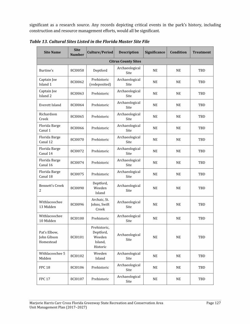
Marjorie Harris Carr Cross Florida Greenway State Recreation and Conservation Area Page 127 Unit Management Plan (2017–2027)
significant as a research source. Any records depicting critical events in the park’s history, including construction and resource management efforts, would all be significant.
Table 13. Cultural Sites Listed in the Florida Master Site File
Site Name Site Number Culture/Period Description Significance Condition Treatment
Citrus County Sites
Burtine’s 8CI0058 Deptford Archaeological Site NE NE TBD
Captain Joe Island 1 8CI0062 Prehistoric
(redeposited) Archaeological
Site NE NE TBD
Captain Joe Island 2 8CI0063 Prehistoric Archaeological
Site NE NE TBD
Everett Island 8CI0064 Prehistoric Archaeological Site NE NE TBD
Richardson Creek 8CI0065 Prehistoric Archaeological
Site NE NE TBD
Florida Barge Canal 1 8CI0066 Prehistoric Archaeological
Site NE NE TBD
Florida Barge Canal 12 8CI0070 Prehistoric Archaeological
Site NE NE TBD
Florida Barge Canal 14 8CI0072 Prehistoric Archaeological
Site NE NE TBD
Florida Barge Canal 16 8CI0074 Prehistoric Archaeological
Site NE NE TBD
Florida Barge Canal 18 8CI0075 Prehistoric Archaeological
Site NE NE TBD
Bennett’s Creek 2 8CI0090
Deptford, Weeden
Island
Archaeological Site NE NE TBD
Withlacoochee 13 Midden 8CI0096
Archaic, St. Johns, Swift
Creek
Archaeological Site NE NE TBD
Withlacoochee 10 Midden 8CI0100 Prehistoric Archaeological
Site NE NE TBD
Pat’s Elbow, John Gibson Homestead
8CI0101
Prehistoric, Deptford, Weeden Island,
Historic
Archaeological Site NE NE TBD
Withlacoochee 5 Midden 8CI0102 Weeden
Island Archaeological
Site NE NE TBD
FPC 18 8CI0106 Prehistoric Archaeological Site NE NE TBD
FPC 17 8CI0107 Prehistoric Archaeological Site NE NE TBD
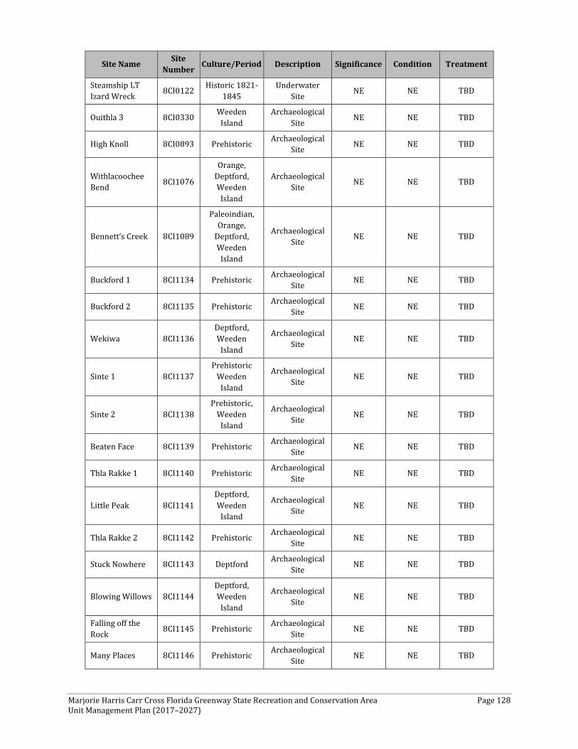
Marjorie Harris Carr Cross Florida Greenway State Recreation and Conservation Area Page 128 Unit Management Plan (2017–2027)
Site Name Site Number Culture/Period Description Significance Condition Treatment
Steamship LT Izard Wreck 8CI0122 Historic 1821-
1845 Underwater
Site NE NE TBD
Ouithla 3 8CI0330 Weeden Island
Archaeological Site NE NE TBD
High Knoll 8CI0893 Prehistoric Archaeological Site NE NE TBD
Withlacoochee Bend 8CI1076
Orange, Deptford, Weeden
Island
Archaeological Site NE NE TBD
Bennett’s Creek 8CI1089
Paleoindian, Orange,
Deptford, Weeden
Island
Archaeological Site NE NE TBD
Buckford 1 8CI1134 Prehistoric Archaeological Site NE NE TBD
Buckford 2 8CI1135 Prehistoric Archaeological Site NE NE TBD
Wekiwa 8CI1136 Deptford, Weeden
Island
Archaeological Site NE NE TBD
Sinte 1 8CI1137 Prehistoric
Weeden Island
Archaeological Site NE NE TBD
Sinte 2 8CI1138 Prehistoric,
Weeden Island
Archaeological Site NE NE TBD
Beaten Face 8CI1139 Prehistoric Archaeological Site NE NE TBD
Thla Rakke 1 8CI1140 Prehistoric Archaeological Site NE NE TBD
Little Peak 8CI1141 Deptford, Weeden
Island
Archaeological Site NE NE TBD
Thla Rakke 2 8CI1142 Prehistoric Archaeological Site NE NE TBD
Stuck Nowhere 8CI1143 Deptford Archaeological Site NE NE TBD
Blowing Willows 8CI1144 Deptford, Weeden
Island
Archaeological Site NE NE TBD
Falling off the Rock 8CI1145 Prehistoric Archaeological
Site NE NE TBD
Many Places 8CI1146 Prehistoric Archaeological Site NE NE TBD

Marjorie Harris Carr Cross Florida Greenway State Recreation and Conservation Area Page 129 Unit Management Plan (2017–2027)
Site Name Site Number Culture/Period Description Significance Condition Treatment
Crunchy Ground 8CI1147 Prehistoric Archaeological Site NE NE TBD
Old Snake’s Path 8CI1148 Prehistoric Archaeological Site NE NE TBD
Berry Cakes 8CI1149 Prehistoric Archaeological Site NE NE TBD
Grandfather Egret’s Pool 8CI1150 Prehistoric Archaeological
Site NE NE TBD
Mother’s Dimple 8CI1151 Prehistoric Archaeological Site NE NE TBD
Moving Dirt 8CI1152 Prehistoric Archaeological Site NE NE TBD
Two Rock Houses 8CI1153 Prehistoric Archaeological
Site NE NE TBD
Crab Warriors 8CI1154 Prehistoric Archaeological Site NE NE TBD
Gossiping Palms 8CI1155 Prehistoric Archaeological Site NE NE TBD
Limus 8CI1156 Prehistoric Archaeological Site NE NE TBD
Terrapin Wipes His Nose 8CI1157 Prehistoric Archaeological
Site NE NE TBD
Weeping Rock 8CI1158 Prehistoric Archaeological Site NE NE TBD
Dying Cedars 8CI1161 Prehistoric Archaeological Site NE NE TBD
Grandma Sits Alone 8CI1162 Prehistoric Archaeological
Site NE NE TBD
Fish Splashers 8CI1163 Prehistoric Archaeological Site NE NE TBD
Fiery Palms 8CI1164 Prehistoric, 19th Century
Archaeological Site NE NE TBD
Rocky Place 8CI1165 Prehistoric Archaeological Site NE NE TBD
Broken Cups 8CI1166 Prehistoric Archaeological Site NE NE TBD
Bird Town 8CI1167 Prehistoric Archaeological Site NE NE TBD
Pond in the Rock 8CI1168 Prehistoric Archaeological Site NE NE TBD
JD’s Site 8CI1169 Weeden Island
Archaeological Site NE NE TBD
Kathy’s 8CI1170 Deptford, Weeden
Island
Archaeological Site NE NE TBD
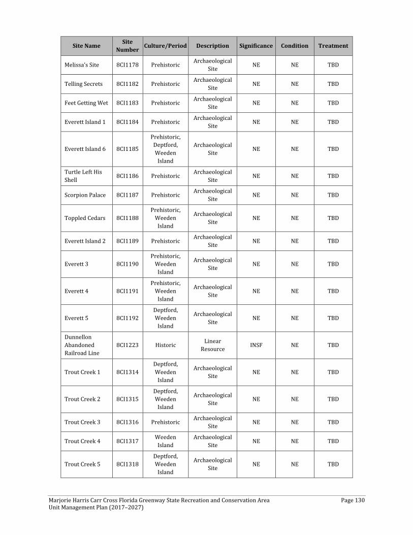
Marjorie Harris Carr Cross Florida Greenway State Recreation and Conservation Area Page 130 Unit Management Plan (2017–2027)
Site Name Site Number Culture/Period Description Significance Condition Treatment
Melissa’s Site 8CI1178 Prehistoric Archaeological Site NE NE TBD
Telling Secrets 8CI1182 Prehistoric Archaeological Site NE NE TBD
Feet Getting Wet 8CI1183 Prehistoric Archaeological Site NE NE TBD
Everett Island 1 8CI1184 Prehistoric Archaeological Site NE NE TBD
Everett Island 6 8CI1185
Prehistoric, Deptford, Weeden
Island
Archaeological Site NE NE TBD
Turtle Left His Shell 8CI1186 Prehistoric Archaeological
Site NE NE TBD
Scorpion Palace 8CI1187 Prehistoric Archaeological Site NE NE TBD
Toppled Cedars 8CI1188 Prehistoric,
Weeden Island
Archaeological Site NE NE TBD
Everett Island 2 8CI1189 Prehistoric Archaeological Site NE NE TBD
Everett 3 8CI1190 Prehistoric,
Weeden Island
Archaeological Site NE NE TBD
Everett 4 8CI1191 Prehistoric,
Weeden Island
Archaeological Site NE NE TBD
Everett 5 8CI1192 Deptford, Weeden
Island
Archaeological Site NE NE TBD
Dunnellon Abandoned Railroad Line
8CI1223 Historic Linear Resource INSF NE TBD
Trout Creek 1 8CI1314 Deptford, Weeden
Island
Archaeological Site NE NE TBD
Trout Creek 2 8CI1315 Deptford, Weeden
Island
Archaeological Site NE NE TBD
Trout Creek 3 8CI1316 Prehistoric Archaeological Site NE NE TBD
Trout Creek 4 8CI1317 Weeden Island
Archaeological Site NE NE TBD
Trout Creek 5 8CI1318 Deptford, Weeden
Island
Archaeological Site NE NE TBD
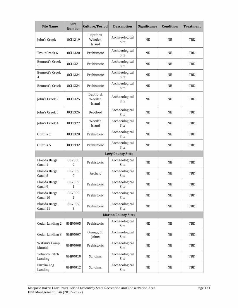
Marjorie Harris Carr Cross Florida Greenway State Recreation and Conservation Area Page 131 Unit Management Plan (2017–2027)
Site Name Site Number Culture/Period Description Significance Condition Treatment
John’s Creek 8CI1319 Deptford, Weeden
Island
Archaeological Site NE NE TBD
Trout Creek 6 8CI1320 Prehistoric Archaeological Site NE NE TBD
Bennett’s Creek 1 8CI1321 Prehistoric Archaeological
Site NE NE TBD
Bennett’s Creek 4 8CI1324 Prehistoric Archaeological
Site NE NE TBD
Bennett’s Creek 8CI1324 Prehistoric Archaeological Site NE NE TBD
John’s Creek 2 8CI1325 Deptford, Weeden
Island
Archaeological Site NE NE TBD
John’s Creek 3 8CI1326 Deptford Archaeological Site NE NE TBD
John’s Creek 4 8CI1327 Weeden Island
Archaeological Site NE NE TBD
Ouithla 1 8CI1328 Prehistoric Archaeological Site NE NE TBD
Ouithla 5 8CI1332 Prehistoric Archaeological Site NE NE TBD
Levy County Sites
Florida Barge Canal 1
8LV0089 Prehistoric Archaeological
Site NE NE TBD
Florida Barge Canal 8
8LV0090 Archaic Archaeological
Site NE NE TBD
Florida Barge Canal 9
8LV0091 Prehistoric Archaeological
Site NE NE TBD
Florida Barge Canal 10
8LV0092 Prehistoric Archaeological
Site NE NE TBD
Florida Barge Canal 11
8LV0093 Prehistoric Archaeological
Site NE NE TBD
Marion County Sites
Cedar Landing 2 8MR0005 Prehistoric Archaeological Site NE NE TBD
Cedar Landing 3 8MR0007 Orange, St. Johns
Archaeological Site NE NE TBD
Watkin’s Camp Mound 8MR0008 Prehistoric Archaeological
Site NE NE TBD
Tobacco Patch Landing 8MR0010 St. Johns Archaeological
Site NE NE TBD
Eureka Log Landing 8MR0012 St. Johns Archaeological
Site NE NE TBD
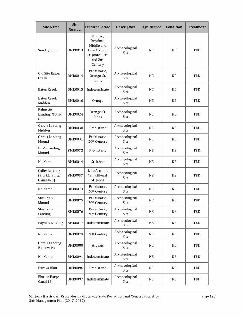
Marjorie Harris Carr Cross Florida Greenway State Recreation and Conservation Area Page 132 Unit Management Plan (2017–2027)
Site Name Site Number Culture/Period Description Significance Condition Treatment
Sunday Bluff 8MR0013
Orange, Deptford,
Middle and Late Archaic, St. Johns, 19th
and 20th Century
Archaeological Site NE NE TBD
Old Site Eaton Creek 8MR0014
Prehistoric, Orange, St.
Johns
Archaeological Site NE NE TBD
Eaton Creek 8MR0015 Indeterminate Archaeological Site NE NE TBD
Eaton Creek Midden 8MR0016 Orange Archaeological
Site NE NE TBD
Palmetto Landing Mound 6
8MR0024 Orange, St. Johns
Archaeological Site NE NE TBD
Gore’s Landing Midden 8MR0030 Prehistoric Archaeological
Site NE NE TBD
Gore’s Landing Mound 8MR0031 Prehistoric,
20th Century Archaeological
Site NE NE TBD
Dek’s Landing Mound 8MR0032 Prehistoric Archaeological
Site NE NE TBD
No Name 8MR0044 St. Johns Archaeological Site NE NE TBD
Colby Landing (Florida Barge Canal #28)
8MR0057 Late Archaic, Transitional,
St. Johns
Archaeological Site NE NE TBD
No Name 8MR0073 Prehistoric, 20th Century
Archaeological Site NE NE TBD
Shell Knoll Mound 8MR0075 Prehistoric,
20th Century Archaeological
Site NE NE TBD
Shell Knoll Landing 8MR0076 Prehistoric,
20th Century Archaeological
Site NE NE TBD
Payne’s Landing 8MR0077 Indeterminate Archaeological Site NE NE TBD
No Name 8MR0079 20th Century Archaeological Site NE NE TBD
Gore’s Landing Borrow Pit 8MR0080 Archaic Archaeological
Site NE NE TBD
No Name 8MR0091 Indeterminate Archaeological Site NE NE TBD
Eureka Bluff 8MR0096 Prehistoric Archaeological Site NE NE TBD
Florida Barge Canal 29 8MR0097 Indeterminate Archaeological
Site NE NE TBD

Marjorie Harris Carr Cross Florida Greenway State Recreation and Conservation Area Page 133 Unit Management Plan (2017–2027)
Site Name Site Number Culture/Period Description Significance Condition Treatment
Ross Prairie 1 8MR0100
Archaic, Deptford, Weeden
Island
Archaeological Site NE NE TBD
Ross Prairie 2 8MR0101 Archaic Archaeological Site NE NE TBD
Ross Prairie 3 8MR0102 Archaic Archaeological Site NE NE TBD
Marion County Farm 8MR0103 Archaic Archaeological
Site NE NE TBD
I 75 A 8MR0104 Archaic, 19th
and 29th Century
Archaeological Site NE NE TBD
I 75 B 8MR0105 Archaic Archaeological Site NE NE TBD
Road 275 8MR0106 Archaic, St. Johns
Archaeological Site NE NE TBD
Near Blue Springs 8MR0107 St. Johns Archaeological
Site NE NE TBD
Orange Springs Ferry Road Mound
8MR0127
Prehistoric, St. Johns, 19th
and 20th Century
Archaeological Site NE NE TBD
MacDonald Tobacco Shed 8MR0133 19th and 20th
Century Archaeological
Site NE NE TBD
New Yarbrough Place 8MR0134 19th and 20th
Century Archaeological
Site NE NE TBD
Double Bridge Mound A 8MR0148
Prehistoric, Orange,
Deptford, St. Johns
Archaeological Site NE NE TBD
Double Bridge Mound B 8MR0149
Prehistoric, Archaic, Deptford
Archaeological Site NE NE TBD
Turtle Egg 8MR0164 St. Johns Archaeological Site NE NE TBD
Oklawaha River Shell Mound II 8MR0224 Orange, St.
Johns Archaeological
Site NE NE TBD
No Name 8MR0231 Prehistoric, Archaic
Archaeological Site NE NE TBD
No Name 8MR0232 Prehistoric, Archaic
Archaeological Site NE NE TBD
USFS 81-60 8MR0247 Prehistoric, Archaic
Archaeological Site NE NE TBD
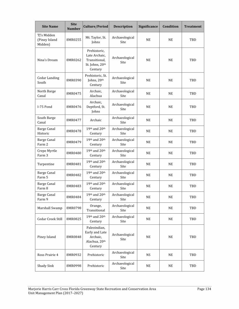
Marjorie Harris Carr Cross Florida Greenway State Recreation and Conservation Area Page 134 Unit Management Plan (2017–2027)
Site Name Site Number Culture/Period Description Significance Condition Treatment
TJ’s Midden (Piney Island Midden)
8MR0255 Mt. Taylor, St. Johns
Archaeological Site NE NE TBD
Nina’s Dream 8MR0262
Prehistoric, Late Archaic, Transitional, St. Johns, 20th
Century
Archaeological Site NE NE TBD
Cedar Landing South 8MR0390
Prehistoric, St. Johns, 20th
Century
Archaeological Site NE NE TBD
North Barge Canal 8MR0475 Archaic,
Alachua Archaeological
Site NE NE TBD
I-75 Pond 8MR0476 Archaic,
Deptford, St. Johns
Archaeological Site NE NE TBD
South Barge Canal 8MR0477 Archaic Archaeological
Site NE NE TBD
Barge Canal Historic 8MR0478 19th and 20th
Century Archaeological
Site NE NE TBD
Barge Canal Farm 2 8MR0479 19th and 20th
Century Archaeological
Site NE NE TBD
Crepe Myrtle Farm 3 8MR0480 19th and 20th
Century Archaeological
Site NE NE TBD
Turpentine 8MR0481 19th and 20th Century
Archaeological Site NE NE TBD
Barge Canal Farm 5 8MR0482 19th and 20th
Century Archaeological
Site NE NE TBD
Barge Canal Farm 8 8MR0483 19th and 20th
Century Archaeological
Site NE NE TBD
Barge Canal Farm 9 8MR0484 19th and 20th
Century Archaeological
Site NE NE TBD
Marshall Swamp 8MR0798 Orange, Transitional
Archaeological Site NE NE TBD
Cedar Creek Still 8MR0825 19th and 20th Century
Archaeological Site NE NE TBD
Piney Island 8MR0848
Paleoindian, Early and Late
Archaic, Alachua, 20th
Century
Archaeological Site NE NE TBD
Ross Prairie 4 8MR0932 Prehistoric Archaeological Site NS NE TBD
Shady Sink 8MR0998 Prehistoric Archaeological Site NE NE TBD

Marjorie Harris Carr Cross Florida Greenway State Recreation and Conservation Area Page 135 Unit Management Plan (2017–2027)
Site Name Site Number Culture/Period Description Significance Condition Treatment
Canal 8MR1007
Paleoindian, Early and Late
Archaic, St. Johns
Archaeological Site NE NE TBD
Franklin 3 8MR1071 Indeterminate Archaeological Site NE NE TBD
Franklin 8 8MR1073 Indeterminate Archaeological Site NE NE TBD
Franklin 15 8MR1082
Prehistoric, Middle and
Late Archaic, Orange, 19th
and 20th Century
Archaeological Site NR NE TBD
F 84 8MR1103 Indeterminate Archaeological Site NE NE TBD
*Ross Prairie A 8MR1119 Unknown Archaeological Site NE NE TBD
*Ross Prairie B 8MR1120 Unknown Archaeological Site NE NE TBD
*Ross Prairie E 8MR1122 Unknown Archaeological Site NE NE TBD
*Ross Prairie F 8MR1123 Unknown Archaeological Site NE NE TBD
*Ross Prairie G 8MR1124 Unknown Archaeological Site NE NE TBD
*Ross Prairie H 8MR1125 Unknown Archaeological Site NE NE TBD
Holy Band of Inspiration #1 8MR1515 Circa 1890 Historic
Structure INSF NE TBD
Butterbutt Landing 8MR1869 Prehistoric Archaeological
Site NE NE TBD
Cactus Flower 8MR1878
Prehistoric, Paleoindian,
Middle Archaic, Achaic, Orange,
Alachua, St. Johns
Archaeological Site NR NE TBD
Turkey Landing 8MR1926 Prehistoric Archaeological Site NE NE TBD
Tuten Creek Mounds 8MR1972
Paleoindian, Archaic, Late
Archaic, Orange, St.
Johns
Archaeological Site NE NE TBD
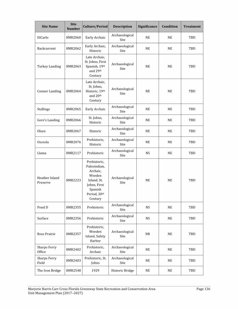
Marjorie Harris Carr Cross Florida Greenway State Recreation and Conservation Area Page 136 Unit Management Plan (2017–2027)
Site Name Site Number Culture/Period Description Significance Condition Treatment
DiCarlo 8MR2060 Early Archaic Archaeological Site NE NE TBD
Backcurrent 8MR2062 Early Archaic, Historic
Archaeological Site NE NE TBD
Turkey Landing 8MR2063
Late Archaic, St. Johns, First Spanish, 19th
and 29th Century
Archaeological Site NE NE TBD
Conner Landing 8MR2064
Late Archaic, St. Johns,
Historic, 19th and 20th Century
Archaeological Site NE NE TBD
Stallings 8MR2065 Early Archaic Archaeological Site NE NE TBD
Gore’s Landing 8MR2066 St. Johns, Historic
Archaeological Site NE NE TBD
Olsen 8MR2067 Historic Archaeological Site NE NE TBD
Osceola 8MR2076 Prehistoric, Historic
Archaeological Site NE NE TBD
Llama 8MR2117 Prehistoric Archaeological Site NS NE TBD
Heather Island Preserve 8MR2223
Prehistoric, Paleoindian,
Archaic, Weeden
Island, St. Johns, First
Spanish Period, 20th
Century
Archaeological Site NE NE TBD
Pond D 8MR2355 Prehistoric Archaeological Site NS NE TBD
Surface 8MR2356 Prehistoric Archaeological Site NS NE TBD
Ross Prairie 8MR2357
Prehistoric, Weeden
Island, Safety Harbor
Archaeological Site NR NE TBD
Sharps Ferry Office 8MR2402 Prehistoric,
Archaic Archaeological
Site NE NE TBD
Sharps Ferry Field 8MR2403 Prehistoric, St.
Johns Archaeological
Site NE NE TBD
The Iron Bridge 8MR2548 1929 Historic Bridge NE NE TBD
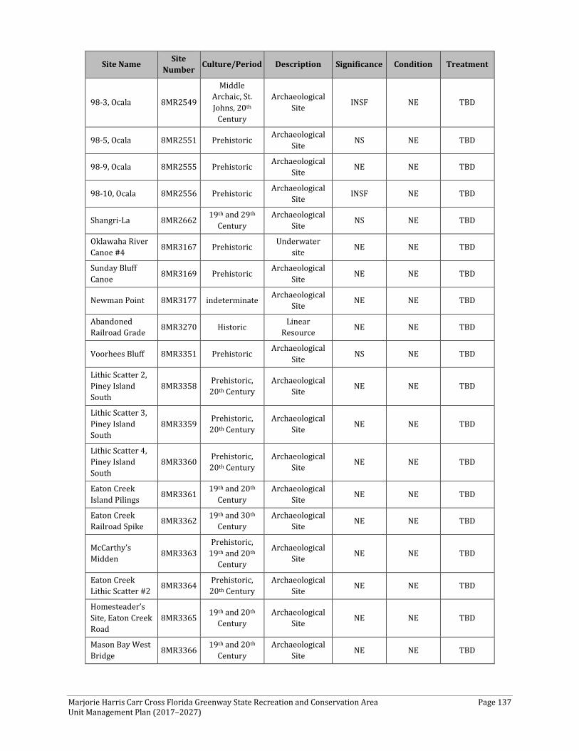
Marjorie Harris Carr Cross Florida Greenway State Recreation and Conservation Area Page 137 Unit Management Plan (2017–2027)
Site Name Site Number Culture/Period Description Significance Condition Treatment
98-3, Ocala 8MR2549
Middle Archaic, St. Johns, 20th
Century
Archaeological Site INSF NE TBD
98-5, Ocala 8MR2551 Prehistoric Archaeological Site NS NE TBD
98-9, Ocala 8MR2555 Prehistoric Archaeological Site NE NE TBD
98-10, Ocala 8MR2556 Prehistoric Archaeological Site INSF NE TBD
Shangri-La 8MR2662 19th and 29th Century
Archaeological Site NS NE TBD
Oklawaha River Canoe #4 8MR3167 Prehistoric Underwater
site NE NE TBD
Sunday Bluff Canoe 8MR3169 Prehistoric Archaeological
Site NE NE TBD
Newman Point 8MR3177 indeterminate Archaeological Site NE NE TBD
Abandoned Railroad Grade 8MR3270 Historic Linear
Resource NE NE TBD
Voorhees Bluff 8MR3351 Prehistoric Archaeological Site NS NE TBD
Lithic Scatter 2, Piney Island South
8MR3358 Prehistoric, 20th Century
Archaeological Site NE NE TBD
Lithic Scatter 3, Piney Island South
8MR3359 Prehistoric, 20th Century
Archaeological Site NE NE TBD
Lithic Scatter 4, Piney Island South
8MR3360 Prehistoric, 20th Century
Archaeological Site NE NE TBD
Eaton Creek Island Pilings 8MR3361 19th and 20th
Century Archaeological
Site NE NE TBD
Eaton Creek Railroad Spike 8MR3362 19th and 30th
Century Archaeological
Site NE NE TBD
McCarthy’s Midden 8MR3363
Prehistoric, 19th and 20th
Century
Archaeological Site NE NE TBD
Eaton Creek Lithic Scatter #2 8MR3364 Prehistoric,
20th Century Archaeological
Site NE NE TBD
Homesteader’s Site, Eaton Creek Road
8MR3365 19th and 20th Century
Archaeological Site NE NE TBD
Mason Bay West Bridge 8MR3366 19th and 20th
Century Archaeological
Site NE NE TBD
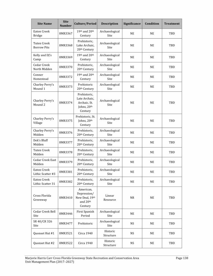
Marjorie Harris Carr Cross Florida Greenway State Recreation and Conservation Area Page 138 Unit Management Plan (2017–2027)
Site Name Site Number Culture/Period Description Significance Condition Treatment
Eaton Creek Bridge 8MR3367 19th and 20th
Century Archaeological
Site NE NE TBD
Tuten Creek Borrow Pits 8MR3368
Prehistoric, Lake Archaic, 20th Century
Archaeological Site NE NE TBD
Kelly and DJ’s Camp 8MR3369 19th and 20th
Century Archaeological
Site NE NE TBD
Cedar Creek North Midden 8MR3370 Prehistoric,
20th Century Archaeological
Site NE NE TBD
Conner Homestead 8MR3372 19th and 20th
Century Archaeological
Site NE NE TBD
Charley Perry’s Mound 1 8MR3373 Prehistoric
20th Century Archaeological
Site NE NE TBD
Charley Perry’s Mound 2 8MR3374
Prehistoric, Late Archaic, Archaic, St. Johns, 20th
Century
Archaeological Site NE NE TBD
Charley Perry’s Village 8MR3375
Prehistoric, St. Johns, 20th
Century
Archaeological Site NE NE TBD
Charley Perry’s Midden 8MR3376 Prehistoric,
20th Century Archaeological
Site NE NE TBD
Dek’s Bluff Midden 8MR3377 Prehistoric,
20th Century Archaeological
Site NE NE TBD
Tuten Creek Midden 8MR3378 Prehistoric,
20th Century Archaeological
Site NE NE TBD
Cedar Creek East Midden 8MR3379 Prehistoric,
20th Century Archaeological
Site NE NE TBD
Eaton Creek Lithic Scatter #3 8MR3381 Prehistoric,
20th Century Archaeological
Site NE NE TBD
Eaton Creek Lithic Scatter 31 8MR3382 Prehistoric,
20th Century Archaeological
Site NE NE TBD
Cross Florida Greenway 8MR3410
American, Depression/
New Deal, 19th and 20th Century
Linear Resource NR NE TBD
Cedar Creek Bell Site 8MR3446 First Spanish
Period Archaeological
Site NE NE TBD
SR 40/CR 326 Site 8MR3477 Prehistoric Archaeological
Site NS NE TBD
Quonset Hut #1 8MR3521 Circa 1940 Historic Structure NS NE TBD
Quonset Hut #2 8MR3522 Circa 1940 Historic Structure NS NE TBD
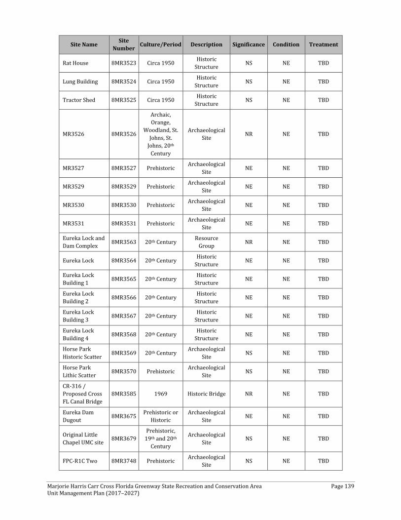
Marjorie Harris Carr Cross Florida Greenway State Recreation and Conservation Area Page 139 Unit Management Plan (2017–2027)
Site Name Site Number Culture/Period Description Significance Condition Treatment
Rat House 8MR3523 Circa 1950 Historic Structure NS NE TBD
Lung Building 8MR3524 Circa 1950 Historic Structure NS NE TBD
Tractor Shed 8MR3525 Circa 1950 Historic Structure NS NE TBD
MR3526 8MR3526
Archaic, Orange,
Woodland, St. Johns, St.
Johns, 20th Century
Archaeological Site NR NE TBD
MR3527 8MR3527 Prehistoric Archaeological Site NE NE TBD
MR3529 8MR3529 Prehistoric Archaeological Site NE NE TBD
MR3530 8MR3530 Prehistoric Archaeological Site NE NE TBD
MR3531 8MR3531 Prehistoric Archaeological Site NE NE TBD
Eureka Lock and Dam Complex 8MR3563 20th Century Resource
Group NR NE TBD
Eureka Lock 8MR3564 20th Century Historic Structure NE NE TBD
Eureka Lock Building 1 8MR3565 20th Century Historic
Structure NE NE TBD
Eureka Lock Building 2 8MR3566 20th Century Historic
Structure NE NE TBD
Eureka Lock Building 3 8MR3567 20th Century Historic
Structure NE NE TBD
Eureka Lock Building 4 8MR3568 20th Century Historic
Structure NE NE TBD
Horse Park Historic Scatter 8MR3569 20th Century Archaeological
Site NS NE TBD
Horse Park Lithic Scatter 8MR3570 Prehistoric Archaeological
Site NS NE TBD
CR-316 / Proposed Cross FL Canal Bridge
8MR3585 1969 Historic Bridge NR NE TBD
Eureka Dam Dugout 8MR3675 Prehistoric or
Historic Archaeological
Site NE NE TBD
Original Little Chapel UMC site 8MR3679
Prehistoric, 19th and 20th
Century
Archaeological Site NS NE TBD
FPC-R1C Two 8MR3748 Prehistoric Archaeological Site NS NE TBD
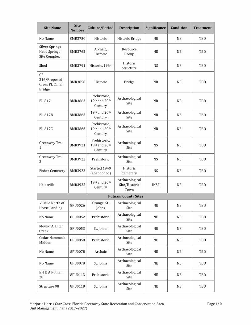
Marjorie Harris Carr Cross Florida Greenway State Recreation and Conservation Area Page 140 Unit Management Plan (2017–2027)
Site Name Site Number Culture/Period Description Significance Condition Treatment
No Name 8MR3750 Historic Historic Bridge NE NE TBD
Silver Springs Head Springs Site Complex
8MR3762 Archaic, Historic
Resource Group NE NE TBD
Shed 8MR3791 Historic, 1964 Historic Structure NS NE TBD
CR 316/Proposed Cross FL Canal Bridge
8MR3858 Historic Bridge NR NE TBD
FL-817 8MR3863 Prehistoric,
19th and 20th Century
Archaeological Site NR NE TBD
FL-817B 8MR3865 19th and 20th Century
Archaeological Site NR NE TBD
FL-817C 8MR3866 Prehistoric,
19th and 20th Century
Archaeological Site NR NE TBD
Greenway Trail 1 8MR3921
Prehistoric, 19th and 20th
Century
Archaeological Site NS NE TBD
Greenway Trail 2 8MR3922 Prehistoric Archaeological
Site NS NE TBD
Fisher Cemetery 8MR3923 Started 1940 (abandoned)
Historic Cemetery NS NE TBD
Heidtville 8MR3925 19th and 20th Century
Archaeological Site/Historic
Town INSF NE TBD
Putnam County Sites
½ Mile North of Horse Landing 8PU0026 Orange, St.
Johns Archaeological
Site NE NE TBD
No Name 8PU0052 Prehistoric Archaeological Site NE NE TBD
Mound A, Ditch Creek 8PU0053 St. Johns Archaeological
Site NE NE TBD
Cedar Hammock Midden 8PU0058 Prehistoric Archaeological
Site NE NE TBD
No Name 8PU0078 Archaic Archaeological Site NE NE TBD
No Name 8PU0078 St. Johns Archaeological Site NE NE TBD
EH & A Putnam 28 8PU0113 Prehistoric Archaeological
Site NE NE TBD
Structure 98 8PU0118 St. Johns Archaeological Site NE NE TBD

Marjorie Harris Carr Cross Florida Greenway State Recreation and Conservation Area Page 141 Unit Management Plan (2017–2027)
Site Name Site Number Culture/Period Description Significance Condition Treatment
No Name 8PU0674 Prehistoric Archaeological Site NE NE TBD
Abandoned Seaboard Coastline
8PU0800 19th and 20th Century
Linear Resource NS NE TBD
PU1568 8PU1568 St. Johns Archaeological Site NS NE TBD
PU1569 8PU1569 Prehistoric Archaeological Site NE NE TBD
Ocala Northern Railroad 8PU1633 20th Century Linear
Resource NE NE TBD
Key:
Significance: NRL = National Register listed; NR = National Register eligible; NE = not evaluated; NS = not significant; INSF = insufficient information
Condition: G = Good; F = Fair; P = Poor; NA = Not accessible; NE = Not evaluated
Treatment: RS = Restoration; RH = Rehabilitation; ST = Stabilization; P = Preservation; R = Removal; TBD = To Be Determined; N/A = Not applicable
Marjorie Harris Carr Cross Florida Greenway State Recreation and Conservation Area Page 142 Unit Management Plan (2017–2027)
RESOURCE MANAGEMENT PROGRAM
Management Goals, Objectives, and Actions
Measurable objectives and actions have been identified for each of DRP’s management goals for the CFG. Please refer to the Implementation Schedule and Cost Estimates in the Implementation Component of this plan for a consolidated spreadsheet of the recommended actions, measures of progress, target year for completion, and estimated costs to fulfill the management goals and objectives of this park.
While DRP utilizes the 10-year management plan to serve as the basic statement of policy and future direction for each park, a number of annual work plans provide more specific guidance for DRP staff to accomplish many of the resource management goals and objectives of the park. Where such detailed planning is appropriate to the character and scale of the park’s natural resources, annual work plans are developed for prescribed fire management, exotic plant management, and imperiled species management. Annual or longer-term work plans are developed for natural community restoration and hydrological restoration. The work plans provide DRP with crucial flexibility in its efforts to generate and implement adaptive resource management practices in the state park system.
The work plans are reviewed and updated annually. Through this process, DRP’s resource management strategies are systematically evaluated to determine their effectiveness. The process and the information collected is used to refine techniques, methodologies, and strategies, and ensures that each park’s prescribed management actions are monitored and reported as required by Chapters 253.034 and 259.037, F.S.
The goals, objectives, and actions identified in this management plan will serve as the basis for developing annual work plans for the park. The 10-year management plan is based on conditions that exist at the time the plan is developed, and the annual work plans provide the flexibility needed to adapt to future conditions as they change during the 10-year management planning cycle. As the park’s annual work plans are implemented through the 10-year cycle, it may become necessary to adjust the management plan’s priority schedules and cost estimates to reflect these changing conditions.
Natural Resource Management
Hydrological Management
Goal: Protect water quality and quantity in the park, restore hydrology to the greatest extent feasible, and maintain the restored condition.
The natural hydrology of most state parks has been impaired prior to acquisition to one degree or another. Florida’s native habitats are precisely adapted to natural drainage patterns and seasonal water level fluctuations. Variations in these factors frequently determine the types of natural communities that occur on a particular site. Even minor changes to natural hydrology can result in the loss of plant and animal species from a landscape. Restoring state park lands to original, natural conditions often depends on returning natural hydrological processes and conditions to the park. This is done primarily by filling or plugging ditches, removing obstructions to surface water “sheet
Marjorie Harris Carr Cross Florida Greenway State Recreation and Conservation Area Page 143 Unit Management Plan (2017–2027)
flow,” installing culverts or low-water crossings on roads, and installing water control structures to manage water levels.
Objective A: Conduct periodic inspections, repairs, and maintenance at the former Cross Florida Barge Canal Water Control Structures to assure existing controls function per Federal Emergency Management Agency (FEMA) guidelines and professional engineer recommendations.
Objective B: Assess and plan future improvements to hydrological conditions and function to approximately 16,700 acres—Etoniah, Marshall Swamp, and Gore’s Landing.
Each of the above properties are examples of altered systems. CFG staff will continue to gather data to determine future improvements to enhance overall hydrologic conditions.
Natural Communities Management
Goal: Restore and maintain the natural communities/ habitats of the park.
As discussed above, DRP practices natural systems management. It is most important to restore and maintain native plant communities, to the greatest extent practical. In most cases, this entails returning fire to its natural role in fire-dependent natural communities. Other methods to implement this goal include large-scale restoration projects, as well as smaller-scale improvements to natural communities. Following are the natural community management objectives and actions recommended for the state park.
To ensure restoration priorities on the CFG, the evaluation should be completed of the overall quality of vegetative communities throughout the greenway for potential restoration. Assessments were based on field evaluations and ranged from poor, fair, good to excellent. The field evaluations also provided prescriptions for future management actions. CFG should coordinate with surrounding landholders, such as the FWC, to assist with both the assessment and identification of restoration priorities on the greenway. Additionally, CFG should work with universities, federal agencies, and non-governmental organizations to gather basic data on natural resources and to help develop planning and evaluation tools.
Prescribed Fire Management Prescribed fire is used to mimic natural lightning-set fires, which are one of the primary natural forces that shaped Florida’s ecosystem. Prescribed burning increases the abundance and health of many wildlife species. Many of Florida’s imperiled species of plants and animals are dependent on periodic fire for their continued existence. Fire-dependent natural communities gradually accumulate flammable vegetation; therefore, prescribed fire reduces wildfire hazards by reducing these wild land fuels.
All prescribed burns in the Florida state park system are conducted with authorization from the FFS. Wildfire suppression activities in the park are coordinated with the FFS.
Objective A: Within 10 years have 25,865 acres of the park maintained within optimal fire return interval.
Action 1: Develop/update annual burn plan.
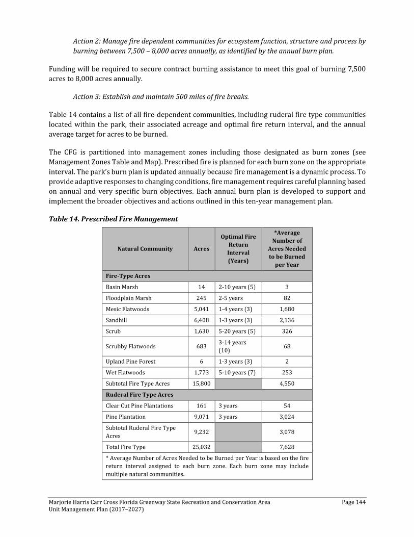
Marjorie Harris Carr Cross Florida Greenway State Recreation and Conservation Area Page 144 Unit Management Plan (2017–2027)
Action 2: Manage fire dependent communities for ecosystem function, structure and process by burning between 7,500 – 8,000 acres annually, as identified by the annual burn plan.
Funding will be required to secure contract burning assistance to meet this goal of burning 7,500 acres to 8,000 acres annually.
Action 3: Establish and maintain 500 miles of fire breaks.
Table 14 contains a list of all fire-dependent communities, including ruderal fire type communities located within the park, their associated acreage and optimal fire return interval, and the annual average target for acres to be burned.
The CFG is partitioned into management zones including those designated as burn zones (see Management Zones Table and Map). Prescribed fire is planned for each burn zone on the appropriate interval. The park’s burn plan is updated annually because fire management is a dynamic process. To provide adaptive responses to changing conditions, fire management requires careful planning based on annual and very specific burn objectives. Each annual burn plan is developed to support and implement the broader objectives and actions outlined in this ten-year management plan.
Table 14. Prescribed Fire Management
Natural Community Acres
Optimal Fire Return
Interval (Years)
*Average Number of
Acres Needed to be Burned
per Year
Fire-Type Acres
Basin Marsh 14 2-10 years (5) 3
Floodplain Marsh 245 2-5 years 82
Mesic Flatwoods 5,041 1-4 years (3) 1,680
Sandhill 6,408 1-3 years (3) 2,136
Scrub 1,630 5-20 years (5) 326
Scrubby Flatwoods 683 3-14 years (10) 68
Upland Pine Forest 6 1-3 years (3) 2
Wet Flatwoods 1,773 5-10 years (7) 253
Subtotal Fire Type Acres 15,800 4,550
Ruderal Fire Type Acres
Clear Cut Pine Plantations 161 3 years 54
Pine Plantation 9,071 3 years 3,024
Subtotal Ruderal Fire Type Acres 9,232 3,078
Total Fire Type 25,032 7,628
* Average Number of Acres Needed to be Burned per Year is based on the fire return interval assigned to each burn zone. Each burn zone may include multiple natural communities.

Marjorie Harris Carr Cross Florida Greenway State Recreation and Conservation Area Page 145 Unit Management Plan (2017–2027)
Fire has historically been a significant force in shaping the natural Florida landscape. The fire management program on the CFG is intended to restore the natural process of fire to the landscape. Upland communities normally are burned in the lightning season during the late spring and summer. However, natural lightning-caused ignitions may occur in any month of the year. In some cases, areas will be burned during the winter season to reduce fuel loads before switching to lightning season burning. Fuel loads, restoration goals, and natural community type will be considered when scheduling prescribed fires.
Table 15 contains a history of acres burned across the greenway and a projection for the year 2016-2017.
Table 15. CFG Prescribed Fire History
FY Acres
1998-99 1,540
1999-00 1474
2000-01 0
2001-02 83
2002-03 2,438 (1,002 contracted + 1,436 in-house)
2003-04 1,297
2004-05 1,208
2005-06 1,763
2006-07 1,559
2007-08 1,638
2008-09 1,152
2009-10 2,639 (584 contracted + 2,055 in-house)
2010-11 1,368
2011-12 0
2012-13 981
2013-14 2,500 (867 contracted + 1,633 in-house)
2014-15 1,640 (651 contracted + 989 in-house)
2015-16 4,059 (3,574 contracted + 485 in-house)
2016-17 6,761 (5,161 contracted + 1,600 in-house)
To track fire management activities, the DRP maintains a statewide burn database. The database allows staff to track various aspects of each park’s fire management program, including individual burn zone histories and fire return intervals, staff training/experience, backlog, if burn objectives have been met, etc. The database also is used for annual burn planning, which allows DRP to document fire management goals and objectives on an annual basis. Each quarter, the database is updated and reports are produced that track progress toward meeting annual burn objectives.
Natural Communities Restoration In some cases, the reintroduction and maintenance of natural processes is not enough to reach the natural community desired future conditions in the park, and active restoration programs are
Marjorie Harris Carr Cross Florida Greenway State Recreation and Conservation Area Page 146 Unit Management Plan (2017–2027)
required. Restoration of altered natural communities to healthy, fully functioning, natural landscapes often requires substantial efforts that may include mechanical treatment of vegetation or soils and reintroduction or augmentation of native plants and animals. For the purposes of this management plan, restoration is defined as the process of assisting the recovery and natural functioning of degraded natural communities to desired future condition, including the re-establishment of biodiversity, ecological processes, vegetation structure, and physical characters.
Examples that would qualify as natural communities’ restoration, requiring annual restoration plans, include large mitigation projects, large-scale hardwood removal and timbering activities, and roller-chopping and other large-scale vegetative modifications. The key concept is that restoration projects will go beyond management activities routinely done as standard operating procedures, such as routine mowing, the reintroduction of fire as a natural process, spot treatments of exotic plants, and small-scale vegetation management.
Natural Communities Improvement Improvements are similar to restoration but on a smaller, less-intense scale. Improvements typically include small-scale vegetative management activities or minor habitat manipulation. Following are the natural community/habitat improvement actions recommended at the park.
Objective: Conduct habitat/natural community restoration activities on 2,555 acres of ruderal communities.
Action 1: Plant 50-100 acres of wiregrass annually in 2,000 acres of old pastures planted in longleaf pine.
Action 2: Replant 555 acres of slash pine in the Etoniah properties.
Imperiled Species Management
Goal: Maintain, improve, or restore imperiled species populations and habitats in the park.
DRP strives to maintain and restore viable populations of imperiled plant and animal species primarily by implementing effective management of natural systems. Single-species management is appropriate in state parks when the maintenance, recovery, or restoration of a species or population is complicated due to constraints associated with long-term restoration efforts, unnaturally high mortality, or insufficient habitat. Single-species management should be compatible with the maintenance and restoration of natural processes, and should not imperil other native species or seriously compromise park values.
In the preparation of this management plan, DRP staff consulted with staff of the FWC’s Imperiled Species Management or that agency’s Regional Biologist and other appropriate federal, state, and local agencies for assistance in developing imperiled animal species management objectives and actions. Data collected by the USFWS, FWC, and FNAI as part of their ongoing research and monitoring programs will be reviewed by park staff periodically to inform management of decisions that may have an impact on imperiled species at the park.
Ongoing inventory and monitoring of imperiled species in the state park system is necessary to meet DRP’s mission. Long-term monitoring also is essential to ensure the effectiveness of resource

Marjorie Harris Carr Cross Florida Greenway State Recreation and Conservation Area Page 147 Unit Management Plan (2017–2027)
management programs. Monitoring efforts must be prioritized so that the data collected provide information that can be used to improve or confirm the effectiveness of management actions on conservation priorities. Monitoring intensity must at least be at a level that provides the minimum data needed to make informed decisions to meet conservation goals. Not all imperiled species require intensive monitoring efforts on a regular interval. Priority must be given to those species that can provide valuable data to guide adaptive management practices. Those species selected for specific management action and those that will provide management guidance through regular monitoring are addressed in the objectives below.
Given the significant effort to restore scrub habitat, efforts should include monitoring and documenting of imperiled species that often inhabit scrub communities. Also, efforts should be focused on coordination with the appropriate federal, state, and local agencies to monitor, document, and research bird species on the Spoil Islands in the western part of the CFG.
Objective A: Update baseline imperiled species occurrence inventory lists for plants and animals with FNAI.
Depending on funding, a full plant survey needs to be conducted at the park to determine presence and location of other listed plant species. In addition, the park has never been fully surveyed for herptofauna, insects, bats, or birds. If funding is available, surveys for these species should be conducted and the species list updated. Surveys for these species are particularly important around wet community types, such as depression marsh, basin swamp, or dome swamp, that are critical for breeding amphibians, but where arthropod control may occur to limit the presence of mosquitoes. District biologists in partnership with FWC may survey for herptofauna. The park will work with district biologists to conduct limited surveys, update the imperiled species lists, and utilize observations to update the arthropod control plan to minimize the impacts of spraying to potentially sensitive species.
Objective B: Monitor and document 3 selected imperiled animal species in the park.
Objective C: Monitor and document 1 selected imperiled plant species in the park.
Objective D: Maintain/improve scrub jay habitat on the CFG.
Action 1: Apply mechanical treatments to 10 percent (100 acres) of CFG scrub jay habitat annually.
Action 2: Band scrub jay population for three to five days annually.
Exotic Species Management
Goal: Remove invasive exotic plants and animals from the park and conduct needed maintenance control.
DRP actively removes invasive exotic plant species from state parks, with priority being given to those causing ecological damage. Removal techniques may include mechanical treatment, herbicides, or biocontrol agents. Over the past few years, CFG has implemented an extremely aggressive program to remove invasive exotic plants from the park. This program has involved treatment of the entire

Marjorie Harris Carr Cross Florida Greenway State Recreation and Conservation Area Page 148 Unit Management Plan (2017–2027)
greenway with biannual treating of at least two large management zones. As a result of this aggressive treatment program, the greenway is in maintenance for invasive exotic plant species. Maintenance condition describes a formerly active infestation that has been treated to the extent that any plants remaining are manageable with existing staff and resources, total area is stable or declining, mature reproducing individuals are absent, and the species poses no significant threat to listed plants or animals.
Objective A: Annually treat approximately 1,716 infested acres of exotic upland plant species in the park.
Action 1: Annually develop/update exotic plant management work plan.
Action 2: Implement annual work plan by treating 1,716 acres in park annually and continuing maintenance and follow-up treatments, as needed.
Therefore, the focus for invasive exotic species management on the CFG should move to individual species management. The four most persistent species are cogon grass, Caesar’s weed, mimosa, and camphor tree. In addition, specific efforts should be focused on skunk vine, which is becoming more pervasive in the western portion of the CFG (Large Management Zone 1). Also, efforts should be given to managing natal grass, which is infringing on the scrub areas throughout the greenway. Natal grass is in the early infestation stage and will be easier to develop an eradication program.
Objective B: Implement control measures on feral hogs in the park.
Special Management Considerations
Timber Management Analysis
On all parcels larger than 1,000 acres, if the DRP determines that timber management does not conflict with the primary management objectives of the land, Florida Statutes Chapters 253 and 259 require:
1) An analysis of the multiple-use potential of the parcel. Such analysis shall include the potential of the parcel to generate revenues to enhance the management of the parcel.
2) An assessment of the feasibility of managing timber resources for conservation and revenue generation purposes through a stewardship ethic that embraces sustainable forest management practices in land management plans.
The CFG spans 110 miles from Yankeetown on Florida’s west coast to south of Palatka on the St. Johns River, near the east coast of Florida. The CFG ranges from 300 yards wi de to one mile wide and includes portions of four counties in the upper Florida peninsula: Citrus, Levy, Marion, and Putnam. Over the 110 miles, the CFG traverses numerous natural, physiographic, and developed areas. The CFG is designated as a multiple-use park. The feasibility of harvesting timber on the CFG during the period covered by this UMP was considered pursuant to the DRP statutory responsibilities to analyze the park’s resource needs and values.
The long-term management goal for forest communities in the state park system is to maintain or re-establish old-growth characteristics to the greatest degree practicable, except in those forest communities specifically managed as early successional. Timber management is utilized for the specific purpose of helping restore or improve current habitat conditions and enhance the overall
Marjorie Harris Carr Cross Florida Greenway State Recreation and Conservation Area Page 149 Unit Management Plan (2017–2027)
integrity of the natural community. Revenue generation from timber management is not the goal, but rather a by-product of taking such actions to help restore/improve target conditions of specific natural communities. In all situations, forest/stand/timber management activities undertaken will adhere to the current Florida Silvicultural Best Management Practices and Florida Forestry Wildlife Best Management Practices for State Imperiled Species.
Many of the natural communities evaluated on the CFG had overstory stocking levels at, or above, the upper limits for corresponding FNAI Reference Sites. A subset of these stands has overstocked conditions in the preferred pine component, while the remainder has overstocked conditions in the non-preferred pine or hardwood components. This overstocked condition makes overstory thinning a potential management tool that should be considered. Activities related to stand improvement, including palmetto and midstory reduction, are needed in many areas.
The Timber Management Analysis found in Addendum 4 provides additional details. This analysis has been evaluated and found to be consistent with the recommendations found in the subject RMC.
Additional Considerations
Spoil Island Management Nesting shorebirds have been identified on Spoil Islands 4 through 7. These include the oystercatcher, which is listed as a species of high conservation concern in the U.S. Shorebird Conservation Plan (Brown et al., 2001). There are approximately 1,500 nesting pairs along the Atlantic and Gulf Coasts of the U.S. (Brown et al., 2005) and the species appears to be declining in the southeastern portion of the range (Davis et al., 2001). In Florida, a statewide survey of oystercatcher nesting conducted in 2001 documented a total of 391 probable breeding pairs (Douglass and Clayton, 2004). A 2010 survey estimated 170 breeding pairs (Brush, 2010), documenting a 56-percent loss. Due to the current population size and trend, oystercatchers have been proposed to be state listed as threatened (FWC, 2011). While recent research has been focused on winter habitat limitations and restoration (Brush et al., 2015), little research has been devoted to understanding or improving breeding productivity and habitat for the oystercatcher population breeding along the Nature Coast.
Within Florida, oystercatchers are breeding at about 50 areas (managed land boundaries, DOD properties, etc.), with greater than 90 percent of the population concentrated on the Gulf Coast. Nesting habitat within the Nature Coast is limited to a few small offshore islands around Cedar Key, the Horseshoe Beach jetties, and on Spoil Islands in Citrus County. The CFG Spoil Islands in Citrus County support the largest concentration of nesting oystercatchers along the Nature Coast Region and the fourth largest concentration in the state. FWC has been intensively monitoring nesting oystercatchers on these islands since 2012, and nesting has been documented on all the Spoil Islands. Reproductive effort is high as the number of nesting pairs at the site has increased from 14 to 22, and most pairs that fail early in the season re-nest. However, annual site productivity is low (average of 0.05 chicks per pair) compared to annual statewide productivity during the same time period (average greater than 0.20 chicks per pair).
Predation of eggs and young has been shown to be the greatest limitation in breeding success of Oystercatchers (Nol, 1989; Morse et al., 2006; Tessler et al., 2007). Semiprecocial young are particularly vulnerable to predation, starvation, and weather events within two weeks of hatching (Colwell et al., 2007; American Oystercatcher Working Group et al., 2012; Schulte, 2012). A high
Marjorie Harris Carr Cross Florida Greenway State Recreation and Conservation Area Page 150 Unit Management Plan (2017–2027)
reproductive effort in an area with low success warrants further investigation to determine what is limiting the reproductive performance of this breeding population of oystercatchers. This information is critical to the management of these sites as oystercatcher breeding areas.
In addition, the Spoil Islands on the CFG are a popular destination for boating and kayaking recreationists. Most of the habitat near the CFG is intertidal oyster rakes that lack beach areas and shade. The Spoil Islands offer inviting areas for boaters and kayakers to land and recreate for long periods of time. During the summer months, human presence on the islands is highest, coinciding with the oystercatcher breeding season; all of the islands have been documented as oystercatcher nesting sites. While some of the islands are managed to minimize disturbance using FWC signs, boats are still able to land on the islands and often remain on the island. Oystercatchers on the CFG are actively incubating or caring for young in a habitat that already has a large number of avian predators and affords little protection from human disturbances. Additionally, unique to the CFG islands is the fact that oystercatchers and their young tend to stay close to the nest location rather than roving or foraging at adjacent areas at low tide, which could lead to increased vulnerability if disturbed.
A study is currently underway to assist with determining the effects of disturbance from humans and predators on oystercatcher productivity on the CFG Spoil Islands. Information from this study will better focus future conservation efforts in the area. The objectives of this study are to use existing data and collect additional field data (2016-2018) to: (1) determine causes of mortality and disturbance (using existing data as well as conducting direct observations and use of remote cameras); (2) estimate annual productivity (2012-2018) with respect to covariates, such as potential sources of disturbance, presence of predators, and food supply; (3) propose management actions to increase annual productivity of oystercatchers nesting on Spoil Islands on the CFG.
Canal Landfill Site Restoration The canal landfill site or “Pedro Landfill” is located at the junction of SR 475B and SR 475 (see Base Map). This landfill was operated as a Class I landfill from the mid-1960s until 1984 and received solid waste generated from surrounding unincorporated areas. During this period, local residents and commercial garbage haulers brought garbage that was disposed of in trenches that were 12 feet to 15 feet deep and 30 feet wide. Initially, this site was operated as a landfill for local residents. After 1974, this landfill had a full-time County staff that operated the landfill continuously until operations ceased in 1984. Although it stated it was closed in 1984, based on information received from the Marion County SWD, it is believed that the site continued to be used illegally by residents and commercial vendors for solid waste disposal from 1984 until 1989. The site then was converted into the Old Canal Greenbox Recycling Center in approximately 1989, and continued to be used for this purpose until approximately 2007.
A closure plan was submitted to the Florida Department of Regulation (DER) in 1985; however, this plan has yet to be implemented. Low levels of synthetic organic compounds have been found in monitoring wells on the site. Site recommendations include continuing the monitoring program. CFG staff would like to reclaim or restore the site to render it safe to be used by wildlife and the public.
Lower Ocklawaha River Shoreline Management The CFG needs shoreline and water management plans for the Lower Ocklawaha River and Rodman Reservoir. The CFG possesses and manages 60+ miles of littoral shoreline ownership along both these waterbodies in the eastern half of the CFG. Both of these areas are bordered by private ownership up
Marjorie Harris Carr Cross Florida Greenway State Recreation and Conservation Area Page 151 Unit Management Plan (2017–2027)
the hill from the water’s edge. Adjacent private landowners have established and maintained numerous encroachments on state-owned lands in these areas, including, but not limited to: vegetation/under brushing/ mowing and even large tree removal in numerous instances. There also are more than 100 illegal docks placed on these state-owned lands without appropriate permits, based on an inventory of these docks by the FDEP Division of State Lands in 2007. Due to the politically charged nature of the Rodman/ Ocklawaha issue, staff need clear and legal guidance in dealing with these issues and protecting the state’s interest and the environment.
The Rodman Reservoir is an approximately 9,000-acre man-made impoundment of the Ocklawaha River that was constructed as part of the former Cross Florida Barge Canal Project. Due to the 48+ year contentious dispute regarding restoration of the Ocklawaha River versus retention of the Rodman Reservoir, there has never been a formal water management plan developed for this reservoir. DRP/CFG management should have and has recurrently asked for the development and implementation of such a plan for the protection of personal property and life downstream from the Kirkpatrick Dam along the St. Johns River. Approximately 400+ properties were shown to be in potential harm’s way if the Kirkpatrick Dam failed and the impounded water in the reservoir flowed downstream in an uncontrolled discharge.
Impoundments and Water Control Structures CFBC construction/development resulted in the construction of towering bridges, locks, and dams. Remnants of the sea-level 1930s ship canal include the deep canal digs and the monolithic concrete bridge stanchions located in the median of US 441. Three large lock structures, H.H. Buckman Lock, Eureka Lock and Dam, and Inglis Lock and Dam, are the most prominent. Although still in place, the Eureka Lock and Dam have never been functional.
CFG staff maintain and operate the Buckman Lock and Kirkpatrick Dam and Spillway. The Buckman Lock controls access to Rodman Reservoir from the St. Johns River through the east barge canal. The Kirkpatrick Dam spillway controls the level of Rodman Reservoir—a 9,000-acre reservoir. In general, the water level of the reservoir is maintained at the 18 feet to 20 feet national geodetic vertical datum (NGVD) level. The water level is drawn down about every three years to about 11 feet to consolidate bottom sediments, enhance the fishery and wildlife habitats, and assist in control of aquatic plants.
Since the 1970s, numerous groups have urged the removal of the Kirkpatrick (formerly Rodman) Dam and restoration of Rodman Reservoir to the Ocklawaha River floodplain because of the impact of the reservoir on the Ocklawaha River floodplain and associated ecosystems. There is resistance to this from other groups, such as sports-fishing related organizations and businesses. The Governor and Cabinet, sitting as the Board of Trustees of the Internal Improvement Trust Fund, have an established policy that the Ocklawaha River should be “partially restored” (see explanation below), with the FDEP as the lead agency. However, the Legislature has not appropriated funds for this purpose. If funds are made available and permits are issued, it is the intent of the FDEP to undertake this restoration. The Ocklawaha and St. Johns Rivers are critical resources to the state of Florida and DEP is committed to their protection. DEP continues to work with the SJRWMD and the FWC to maintain the ecological health and productivity of the water bodies in the St. Johns and Ocklawaha river basins while balancing the recreational benefits for the public.
Marjorie Harris Carr Cross Florida Greenway State Recreation and Conservation Area Page 152 Unit Management Plan (2017–2027)
Kirkpatrick Dam caused the flooding of a portion of Ocala National Forest lands. The flooding and occupying of these lands was allowed under a special permit from the U.S. Department of Agriculture, Forest Service, first issued in 1994. This special permit expired in 2002. FDEP applied for a new permit, but the Forest Service included conditions about the issuance of the new permit, including a schedule for the reservoir to be drawn down and the dam to be breached. The Secretary of the FDEP did not sign the Forest Service permit because the permit(s) from SJRWMD necessary to draw down the reservoir had not been approved.
“Partial restoration,” the restoration alternative selected by the Governor and Cabinet in 1995, is intended to restore river hydrology and floodplain function to near preconstruction conditions through breaching of the dam, with limited removal and/or alteration of structures and alteration of topography. This alternative will retrieve National Forest System lands at the lowest cost while restoring river and floodplain hydrology. The major components of partial restoration are:
1. Drawdown of the reservoir to be accomplished in three phases (three years to drop from 18 feet to four feet NGVD)
2. Limited construction of channel stabilization and erosion control structures in the Ocklawaha River
3. Limited planting of native plant species to provide for erosion control 4. Partial leveling of the exposed barge canal side-cast spoil berms 5. Restoration of the historic Ocklawaha River channel flow by filling the barge canal where it
intersects the river channel 6. Restoration of the historic Deep Creek channel flow by filling the barge canal where it
intersects the creek channel 7. Restoration of the historic Camp Branch floodplain and channel flow by filling the barge canal
where it intersects the creek channel 8. Closure and securing of the Buckman Lock 9. Removal of 2,000 feet of the Kirkpatrick Dam (earthen portion) 10. Partial filling and restoration of the spillway tailrace to natural grade 11. Development and implementation of a cultural resources operating plan
The projected cost for repairs and to bring the Buckman Lock, Kirkpatrick Dam and Spillway, and the Eureka Lock and Dam up to latest standards for operation is $4 million. This estimate is based on the July 2015 inspection report and years of historical data from the Inglis Lock and Dam repair projects and assessment reports. The estimated cost for restoration of the Ocklawaha River is $25.8 million. The yearly operating costs for the dam components and activities and the operating costs for the area after restoration are approximately the same: $198,000 and $234,000, respectively. Snagging for navigation maintenance is expected to increase after river restoration, contributing to almost half of the annual operating cost after restoration.
The Withlacoochee River is the main river system on the western end of the CFG. A small portion of the CFG fronts the Withlacoochee River near Dunnellon, where the Rainbow River, arising from a first-magnitude spring, flows into the river. Downstream of the confluence with the Rainbow River, the Withlacoochee River becomes Lake Rousseau. The Withlacoochee River was dammed in the early 1900s to generate electric power, creating Lake Rousseau. The reservoir is no longer used for power generation. Below Lake Rousseau, the CFG forms the south bank of the Withlacoochee in several places as it flows to the Gulf.
Marjorie Harris Carr Cross Florida Greenway State Recreation and Conservation Area Page 153 Unit Management Plan (2017–2027)
Current water control structures include the Inglis Dam and Spillway at the western end of Lake Rousseau, the Inglis Lock as part of the western barge canal, and the Inglis Bypass Canal and Spillway. The bypass canal funnels water from Lake Rousseau just east of the lock to a spillway that provides water to the lower reaches of the Withlacoochee River. The Inglis Lock is no longer operational due to its deteriorated condition. The Governor and Legislature will decide whether the lock will be made operational or permanently closed. Permanent closure may require deauthorization by Congress. The SWFWMD operates the western barge canal water control dams and spillways under a contract with and funding through DEP; DEP is still currently responsible for the lock. The Lake Rousseau water level generally is at a fixed elevation of 27.5 NGVD. In times of heavy rainfall, additional water can be released to prevent or minimize flooding around Lake Rousseau.
The western barge canal is about nine miles long. It extends from near the western end of Lake Rousseau into the Gulf, where it extends for approximately 10.5 miles. It cuts through the lower reaches of the Withlacoochee River between the Inglis Bypass Spillway and the western end of Lake Rousseau. The coastal wetlands and wet flatwoods were disrupted by construction of the canal. Inglis Island, formerly land bordering the north side of Lake Rousseau and the Withlacoochee River, was surrounded by water by the canal being cut through on the north side of the land mass.
Discussions will continue regarding the impoundments and water control structures, ownership, and future management.
Highway Corridor Management The CFG is is surrounded and split by several miles of roads and highways ranging from two-lane state roads to a six-lane high-speed interstate. The effects of these roads extend far beyond the rights of way. Roads not only have direct mortality effects on wildlife, but they can alter hydrology, hamper prescribed burning efforts, act as corridors for invasive plants and animals, and serve as isolation mechanisms for some wildlife species. Fortunately, these effects are recognized and steps have been taken to mitigate them wherever possible.
To mitigate these effects, the iconic Cross Florida Greenway Land Bridge was erected in 1999-2000. This was the first true land bridge in the United States, modeled after a design used in the Netherlands. Although this has been extremely effective from both a recreational as well as wildlife management perspective, recent discussions have included either the expansion of this land bridge or even the construction of an additional land bridge over I-75. Particularly, given the development of the new paved trail funded by FDOT across the CFG from Ocala to Dunnellon expansion of existing or addition of a second bridge to further enhance ecological and recreational connectivity is needed.
In addition to these land bridge discussions, other discussions have been centered around improved wildlife crossings around other adjacent roadways. This includes an off-grade crossing on US 441, as well as expanded underpasses when two-lane roads are expanded. This will be discussed and coordinated with both state and federal DOT.
Cultural Resources Management
Cultural resources are individually unique, and collectively, very challenging for the public land manager whose goal is to preserve and protect them in perpetuity. DRP is implementing the following goals, objectives, and actions, as funding becomes available, to preserve the cultural resources found on the CFG.
Marjorie Harris Carr Cross Florida Greenway State Recreation and Conservation Area Page 154 Unit Management Plan (2017–2027)
Goal: Protect, preserve, and maintain the cultural resources of the park.
The management of cultural resources often is complicated because these resources are irreplaceable and extremely vulnerable to disturbances. The advice of historical and archaeological experts is required in this effort. All activities related to land clearing, ground-disturbing activities, major repairs or additions to historic structures 50 years old or older, or those structures listed or eligible for listing in the NRHP will be submitted to the DHR for review and comment prior to undertaking the proposed project.
Recommendations from DHR may include, but are not limited to, concurrence of no effect to significant cultural resources for the submitted project, monitoring of project activities by a certified archaeological monitor or qualified professional archaeologist, cultural resource assessment survey by a qualified professional archaeologist, and modifications to the proposed project to avoid or mitigate potential adverse effect. In addition, any demolition or substantial alteration to any historic structure or resource 50 years old or older must be submitted to DHR for consultation and DRP must demonstrate that there is no feasible alternative to removal and must provide a strategy for documentation of the resource. Section 267.016(2)(b), F.S., further requires that DRP consider the reuse of historic buildings in the park in lieu of new construction and must undertake a cost comparison of new development versus rehabilitation of a building before electing to construct a new or replacement building. This comparison must be accomplished with the assistance of DHR.
Objective: Assess and evaluate 30 of 300 recorded cultural resources in the park annually.
Action 1: Complete 300 assessments/evaluations of archaeological sites. Prioritize preservation and stabilization projects.
Action 2: Complete Historic Structures Reports (HSRs) for historic buildings and cultural landscapes. Prioritize stabilization, restoration, and rehabilitation projects.
All recorded cultural sites will be assessed and evaluated within the 10-year period of this management plan. The assessments will include an examination of each site with attention being paid to any threats to the site’s condition, such as natural erosion, damage, looting, construction, animal damage, plant or root damage, or other factors that might cause deterioration of the site. Any preservation and stabilization identified by the assessments/ evaluations will need to be prioritized. Due to the numerous cultural resource sites on the CFG and current staffing limitations, DRP may consider partnering with an archaeology program at a state university to utilize student participation with the assessments.
Objective: Compile reliable documentation for all recorded historic and archaeological sites.
Action 1: Ensure all known sites are recorded or updated in the Florida Master Site File. Would be part of Objective B of having professional archaeologist inventory and assess all known and listed sites.
The potential exists for other unrecorded sites; staff will continue to monitor the park for this possibility and consult with the Bureau of Natural and Cultural Resources and Division of Historic Resources staff. An archaeological resource predictive model was completed for the park in 2010;
Marjorie Harris Carr Cross Florida Greenway State Recreation and Conservation Area Page 155 Unit Management Plan (2017–2027)
while areas of high, medium, and low sensitivity were identified, there weren’t any priority areas noted where a Phase I cultural resources assessment survey should be conducted. A Scope of Collections Statement has been developed and adopted and is available at the park.
Objective: Maintain 263 of 263 cultural resource sites in good condition.
This will be achieved by regular monitoring, site stabilization, and protection from disturbance. The specific sites will be determined after further condition assessments have been conducted.
Objective: Interpret cultural and historical resources on the CFG for the public.
Interpretation on the CFG will be accomplished through a multi-faceted approach with kiosk-based descriptions of the pre-historic to modern history information related to the natural and cultural resources that occur on the CFG. There will be a specific emphasis on the story of the 1930s Great Depression-era sea level Cross Florida Ship Canal that created the numerous large-scale ship canal “diggings” and the later 1960s to 1970s Cross Florida Barge Canal.
Tying both these projects back to the Spanish explorers and the first written record of the desire to find a water route across the Florida peninsula in the 1500s will be critical, as well as well as the political machinations over the following several hundred years. We obtained written permission from the Florida Press to utilize excerpts from the Ditch of Dreams book that chronicles the history of the canal projects and their ultimate transition into the CFG.
Eventual interpretive opportunities will be sought using recent technology with qwerty codes where people can look up various interpretive stories and information with their mobile devices to help expand the long history of this significant piece of Florida and our nation’s history.
Resource Management Schedule
To enhance the resource values, a priority schedule for conducting all management activities, which is based on the purposes for which these lands were acquired, is located in the Implementation Component of this management plan.
Land Management Review
Section 259.036, F.S., established land management review teams to determine whether conservation, preservation, and recreation lands titled in the name of the Board of Trustees are being managed for the purposes for which they were acquired and in accordance with their approved land management plans.
The CFG was subject to a land management review of the entire greenway on January 26, 2010. The review team made the following determinations:
1. The land is being managed for the purpose for which it was acquired.
2. The actual management practices, including public access, complied with the management plan for this site.

Marjorie Harris Carr Cross Florida Greenway State Recreation and Conservation Area Page 156 Unit Management Plan (2017–2027)
On May 26, 2015, a land management review was performed on the eastern portion of the CFG. The review team made the following recommendations:
1. The land is being managed for the purpose for which it was acquired.
2. The actual management practices, including public access, complied with the management plan for this site.
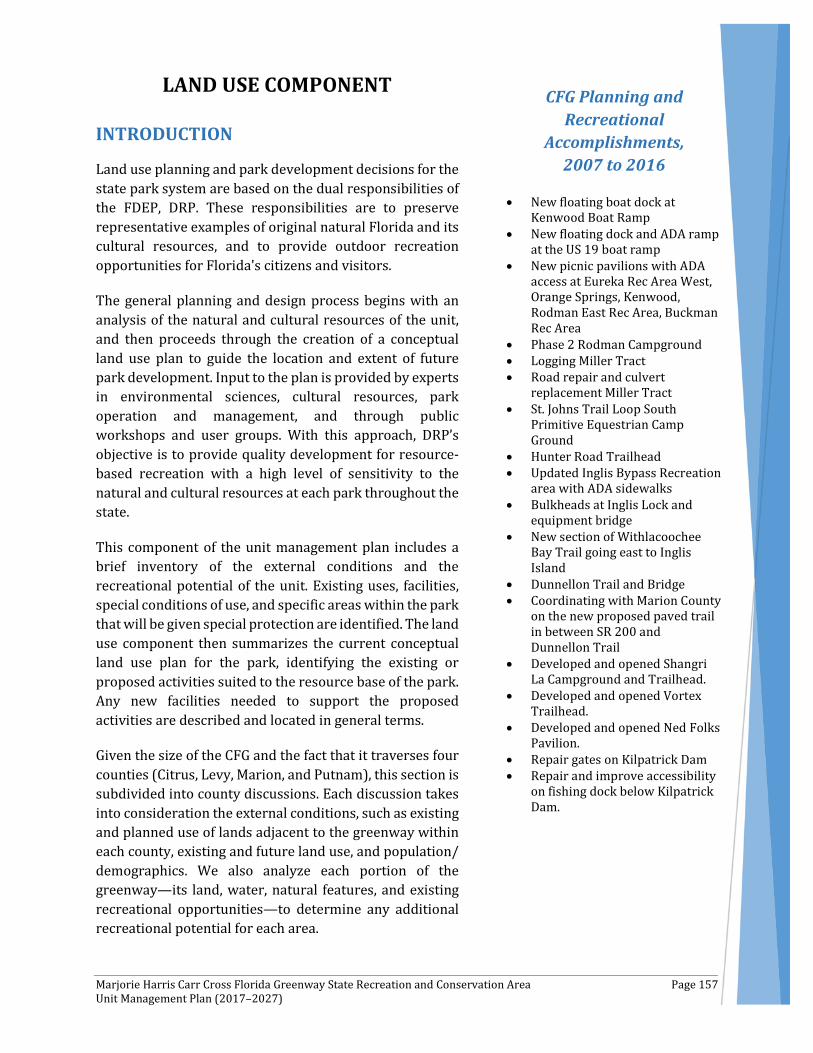
Marjorie Harris Carr Cross Florida Greenway State Recreation and Conservation Area Page 157 Unit Management Plan (2017–2027)
LAND USE COMPONENT
INTRODUCTION
Land use planning and park development decisions for the state park system are based on the dual responsibilities of the FDEP, DRP. These responsibilities are to preserve representative examples of original natural Florida and its cultural resources, and to provide outdoor recreation opportunities for Florida's citizens and visitors.
The general planning and design process begins with an analysis of the natural and cultural resources of the unit, and then proceeds through the creation of a conceptual land use plan to guide the location and extent of future park development. Input to the plan is provided by experts in environmental sciences, cultural resources, park operation and management, and through public workshops and user groups. With this approach, DRP’s objective is to provide quality development for resource-based recreation with a high level of sensitivity to the natural and cultural resources at each park throughout the state.
This component of the unit management plan includes a brief inventory of the external conditions and the recreational potential of the unit. Existing uses, facilities, special conditions of use, and specific areas within the park that will be given special protection are identified. The land use component then summarizes the current conceptual land use plan for the park, identifying the existing or proposed activities suited to the resource base of the park. Any new facilities needed to support the proposed activities are described and located in general terms.
Given the size of the CFG and the fact that it traverses four counties (Citrus, Levy, Marion, and Putnam), this section is subdivided into county discussions. Each discussion takes into consideration the external conditions, such as existing and planned use of lands adjacent to the greenway within each county, existing and future land use, and population/ demographics. We also analyze each portion of the greenway—its land, water, natural features, and existing recreational opportunities—to determine any additional recreational potential for each area.
CFG Planning and Recreational
Accomplishments, 2007 to 2016
• New floating boat dock at Kenwood Boat Ramp
• New floating dock and ADA ramp at the US 19 boat ramp
• New picnic pavilions with ADA access at Eureka Rec Area West, Orange Springs, Kenwood, Rodman East Rec Area, Buckman Rec Area
• Phase 2 Rodman Campground • Logging Miller Tract • Road repair and culvert
replacement Miller Tract • St. Johns Trail Loop South
Primitive Equestrian Camp Ground
• Hunter Road Trailhead • Updated Inglis Bypass Recreation
area with ADA sidewalks • Bulkheads at Inglis Lock and
equipment bridge • New section of Withlacoochee
Bay Trail going east to Inglis Island
• Dunnellon Trail and Bridge • Coordinating with Marion County
on the new proposed paved trail in between SR 200 and Dunnellon Trail
• Developed and opened Shangri La Campground and Trailhead.
• Developed and opened Vortex Trailhead.
• Developed and opened Ned Folks Pavilion.
• Repair gates on Kilpatrick Dam • Repair and improve accessibility
on fishing dock below Kilpatrick Dam.

Marjorie Harris Carr Cross Florida Greenway State Recreation and Conservation Area Page 158 Unit Management Plan (2017–2027)
As indicated previously, for management purposes, the CFG is subdivided into three regions. These include the following:
• Gulf of Mexico to SR 200 • SR 200 to CR 316 • CR 316 to St. Johns River
These are recognized divisions of the CFG, each with individual managers to assist with the overall management of the CFG, which is complex. CFG management provides challenges that are different from any other piece of the Florida State Parks system. For instance, the CFG over the past few years has increasingly utilized contractor labor for burning, timber management, improving wildlife habitat and invasive species removal. By doing this, the CFG has been successful at meeting specified resource management goals and objectives. The CFG would like to continue to utilize contractors in this capacity, and perhaps look at additional uses for this resource.
Additionally, the CFG is unique in the number of special use permitted activities that occur on the greenway. For ease of management of these activities, which totaled 83 last year, as detailed later in this document, the CFG would like to create an on-line permit tracking system. This would further assist with the tracking and management of these types of activities.
CFG Acquisition History
The Board of Trustees of the Internal Improvement Trust Fund of the State of Florida (Trustees) acquired the CFG to create a cross Florida greenway corridor within the right of way of the former Cross Florida Barge Canal. The purpose of this acquisition was so the Trustees could effectively and efficiently protect, conserve, and preserve the natural resources and scenic beauty of Florida, while providing and enhancing compatible public recreational opportunities such as fishing, camping, boating, bicycling, nature study, horseback riding, hiking, hunting, paddling, and other outdoor interests.
On July 26, 1993, the Trustees obtained title to approximately 107 miles of former Cross Florida Barge Canal project right of way, constituting the initial area of the CFG. The Trustees acquired this property through a Quitclaim Deed from the United States of America, acting through then Secretary of the Army, John W. Shannon.
Since the initial 1993 acquisition, the Trustees have purchased more parcels using different land acquisition programs—mainly Preservation 2000 and Florida Forever—and added them to the CFG. Between 1995 and 2011, the Trustees received six donations of parcels from private individuals, local governments, private Trustees, and/or private corporations and added them to the CFG. For more details on the acquisition, see Addendum 1.
Between 1996 and 2011, the OGT entered into multiple management lease agreements with SJRWMD, SWFWMD, and the Felburn Foundation, a private nonprofit corporation. These entities own title to certain lands now managed as a portion of the CFG.
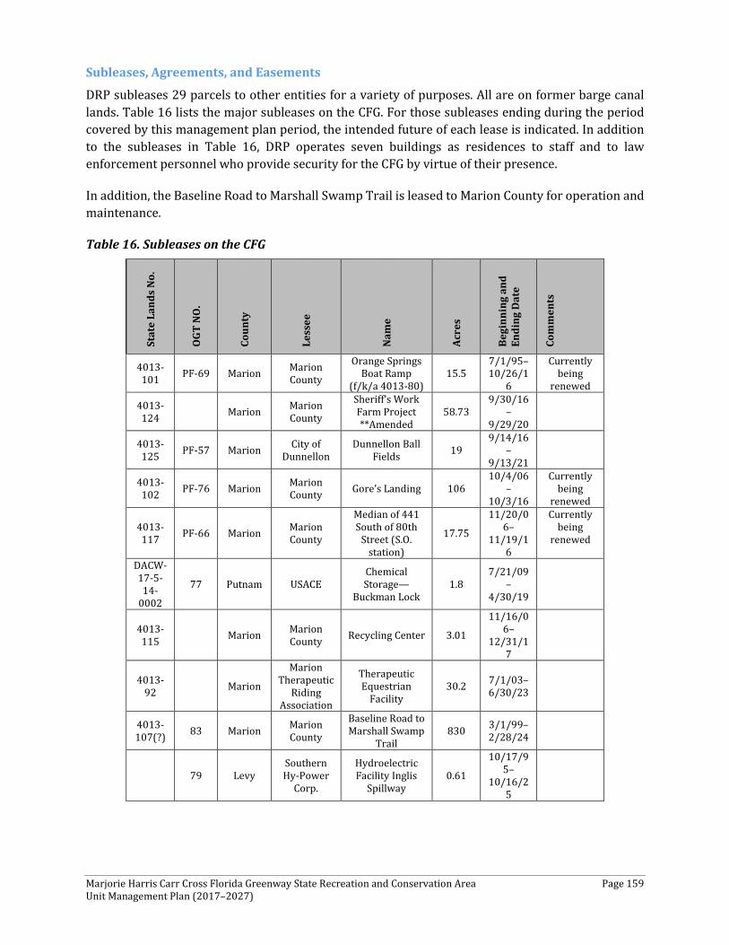
Marjorie Harris Carr Cross Florida Greenway State Recreation and Conservation Area Page 159 Unit Management Plan (2017–2027)
Subleases, Agreements, and Easements
DRP subleases 29 parcels to other entities for a variety of purposes. All are on former barge canal lands. Table 16 lists the major subleases on the CFG. For those subleases ending during the period covered by this management plan period, the intended future of each lease is indicated. In addition to the subleases in Table 16, DRP operates seven buildings as residences to staff and to law enforcement personnel who provide security for the CFG by virtue of their presence.
In addition, the Baseline Road to Marshall Swamp Trail is leased to Marion County for operation and maintenance.
Table 16. Subleases on the CFG
Stat
e La
nds
No.
OGT
NO
.
Coun
ty
Less
ee
Nam
e
Acre
s
Begi
nnin
g an
d En
ding
Dat
e
Com
men
ts
4013-101 PF-69 Marion Marion
County
Orange Springs Boat Ramp
(f/k/a 4013-80) 15.5
7/1/95–10/26/1
6
Currently being
renewed
4013-124
Marion Marion County
Sheriff’s Work Farm Project **Amended
58.73 9/30/16
–9/29/20
4013-125 PF-57 Marion City of
Dunnellon Dunnellon Ball
Fields 19 9/14/16
–9/13/21
4013-102 PF-76 Marion Marion
County Gore’s Landing 106 10/4/06
–10/3/16
Currently being
renewed
4013-117 PF-66 Marion Marion
County
Median of 441 South of 80th
Street (S.O. station)
17.75
11/20/06–
11/19/16
Currently being
renewed
DACW-17-5-14-
0002
77 Putnam USACE Chemical Storage—
Buckman Lock 1.8
7/21/09–
4/30/19
4013-115
Marion Marion County Recycling Center 3.01
11/16/06–
12/31/17
4013-92
Marion
Marion Therapeutic
Riding Association
Therapeutic Equestrian
Facility 30.2 7/1/03–
6/30/23
4013-107(?) 83 Marion Marion
County
Baseline Road to Marshall Swamp
Trail 830 3/1/99–
2/28/24
79 Levy Southern Hy-Power
Corp.
Hydroelectric Facility Inglis
Spillway 0.61
10/17/95–
10/16/25
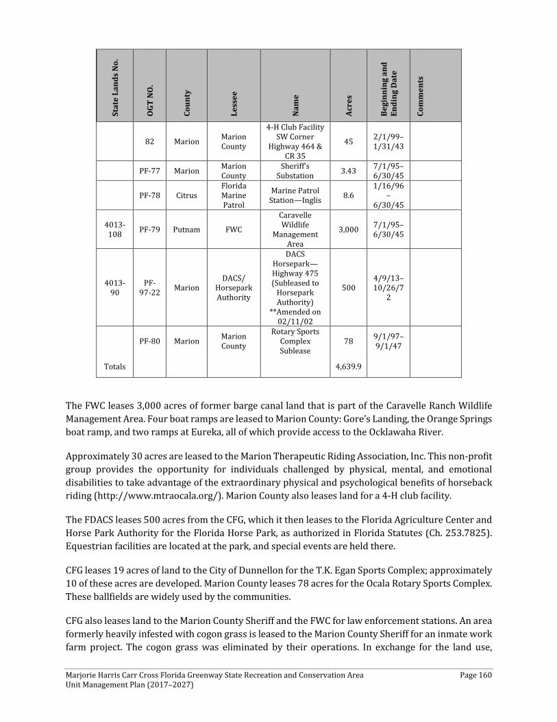
Marjorie Harris Carr Cross Florida Greenway State Recreation and Conservation Area Page 160 Unit Management Plan (2017–2027)
Stat
e La
nds
No.
OGT
NO
.
Coun
ty
Less
ee
Nam
e
Acre
s
Begi
nnin
g an
d En
ding
Dat
e
Com
men
ts
82 Marion Marion County
4-H Club Facility SW Corner
Highway 464 & CR 35
45 2/1/99–1/31/43
PF-77 Marion Marion County
Sheriff’s Substation 3.43 7/1/95–
6/30/45
PF-78 Citrus Florida Marine Patrol
Marine Patrol Station—Inglis 8.6
1/16/96–
6/30/45
4013-108 PF-79 Putnam FWC
Caravelle Wildlife
Management Area
3,000 7/1/95–6/30/45
4013-90
PF-97-22 Marion
DACS/ Horsepark Authority
DACS Horsepark—Highway 475 (Subleased to
Horsepark Authority)
**Amended on 02/11/02
500 4/9/13–10/26/7
2
PF-80 Marion Marion County
Rotary Sports Complex Sublease
78 9/1/97–9/1/47
Totals 4,639.9
The FWC leases 3,000 acres of former barge canal land that is part of the Caravelle Ranch Wildlife Management Area. Four boat ramps are leased to Marion County: Gore’s Landing, the Orange Springs boat ramp, and two ramps at Eureka, all of which provide access to the Ocklawaha River.
Approximately 30 acres are leased to the Marion Therapeutic Riding Association, Inc. This non-profit group provides the opportunity for individuals challenged by physical, mental, and emotional disabilities to take advantage of the extraordinary physical and psychological benefits of horseback riding (http://www.mtraocala.org/). Marion County also leases land for a 4-H club facility.
The FDACS leases 500 acres from the CFG, which it then leases to the Florida Agriculture Center and Horse Park Authority for the Florida Horse Park, as authorized in Florida Statutes (Ch. 253.7825). Equestrian facilities are located at the park, and special events are held there.
CFG leases 19 acres of land to the City of Dunnellon for the T.K. Egan Sports Complex; approximately 10 of these acres are developed. Marion County leases 78 acres for the Ocala Rotary Sports Complex. These ballfields are widely used by the communities.
CFG also leases land to the Marion County Sheriff and the FWC for law enforcement stations. An area formerly heavily infested with cogon grass is leased to the Marion County Sheriff for an inmate work farm project. The cogon grass was eliminated by their operations. In exchange for the land use,
Marjorie Harris Carr Cross Florida Greenway State Recreation and Conservation Area Page 161 Unit Management Plan (2017–2027)
inmate labor is provided to the CFG. The work farm, sports complex, and 4H leases are all located at the intersection of CR 464 and SR 35.
About two acres are leased to the USACE for chemical storage near the Buckman Lock. Less than one acre is leased to Southern Hy-Power Corporation for a hydroelectric facility, which has not yet been permitted or constructed at the Inglis Bypass Spillway.
Three acres are leased to Marion County for use as a recycling staging area. The City of Dunnellon has an easement on CFG land used for a water/wastewater plant. Once a better location is identified for the water/wastewater plant, the easement will be phased out and the lands will be returned to the CFG.
Six parcels managed by the CFG are either leased from other entities or are covered by management agreements. The SWFWMD has an agreement with CFG/DRP that gives the CFG management of 301 acres that help bridge the gap between the City of Dunnellon and SR 200. The Division of Forestry has an agreement with CFG/DRP that provides access to the Ross Prairie Trailhead. In exchange, CFG/DRP includes information at the trailhead about Ross Prairie State Forest. The Felburn Foundation leases 135 acres to CFG/DRP on the western end of the Greenway for use as a trailhead. Felburn Park is a former mining area with water features adjacent to the western barge canal. CFG/DRP also leases space in a chemical storage room at Buckman Lock from the U.S. Army Corps of Engineers. The land the chemical storage room is on is leased by CFG/DRP to the Corps.
EXTERNAL CONDITIONS
An assessment of the conditions that exist beyond the boundaries of the unit is important in identifying any special development problems or opportunities that exist because of the unit's unique setting or environment. This also provides an opportunity to deal systematically with various planning issues, such as location, regional demographics, adjacent land uses, and park interaction with other facilities.
Given that the CFG is more than 110 miles long and traverses four counties (Citrus, Levy, Marion and Putnam), many opportunities exist to analyze the existing and future development activities within each county. Further, this plan briefly analyzes the population and demographic characteristics of the state of Florida, which is highly urbanized. More than 94 percent of Florida’s population lived in metropolitan areas in 2010, and many others lived in small- and medium-sized towns in non-metropolitan counties. Only a small fraction of Florida’s population may be truly classified as rural.
Overall, from 2000 to 2010, Florida has experienced a 17.6-percent population increase to 18.8 million people. Today, Florida is the third most populated state in the nation and its population is projected to reach nearly 24.5 million by 2025 (SCORP, 2013). In addition, Florida’s population is getting older. In 2010, 17.3 percent of Floridians were aged 65 or older, in comparison to the national average of 13 percent. Florida’s mean age of 40.7 was fifth highest in the nation (the national average is 37.2 years), an upward shift compared to the mean age of 38.7 in 2000.
If these current trends continue, the majority of the population increase will concentrate in relatively unpopulated counties adjacent to highly developed metropolitan areas, particularly along the coast.
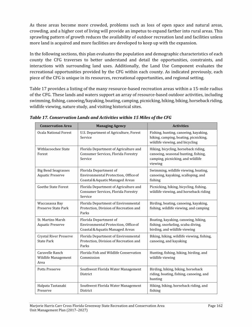
Marjorie Harris Carr Cross Florida Greenway State Recreation and Conservation Area Page 162 Unit Management Plan (2017–2027)
As these areas become more crowded, problems such as loss of open space and natural areas, crowding, and a higher cost of living will provide an impetus to expand farther into rural areas. This sprawling pattern of growth reduces the availability of outdoor recreation land and facilities unless more land is acquired and more facilities are developed to keep up with the expansion.
In the following sections, this plan evaluates the population and demographic characteristics of each county the CFG traverses to better understand and detail the opportunities, constraints, and interactions with surrounding land uses. Additionally, the Land Use Component evaluates the recreational opportunities provided by the CFG within each county. As indicated previously, each piece of the CFG is unique in its resources, recreational opportunities, and regional setting.
Table 17 provides a listing of the many resource-based recreation areas within a 15-mile radius of the CFG. These lands and waters support an array of resource-based outdoor activities, including swimming, fishing, canoeing/kayaking, boating, camping, picnicking, hiking, biking, horseback riding, wildlife viewing, nature study, and visiting historical sites.
Table 17. Conservation Lands and Activities within 15 Miles of the CFG
Conservation Area Managing Agency Activities
Ocala National Forest U.S. Department of Agriculture, Forest Service
Fishing, hunting, canoeing, kayaking, hiking, camping, boating, picnicking, wildlife viewing, and bicycling
Withlacoochee State Forest
Florida Department of Agriculture and Consumer Services, Florida Forestry Service
Hiking, bicycling, horseback riding, canoeing, seasonal hunting, fishing, camping, picnicking, and wildlife viewing
Big Bend Seagrasses Aquatic Preserve
Florida Department of Environmental Protection, Office of Coastal & Aquatic Managed Areas
Swimming, wildlife viewing, boating, canoeing, kayaking, scalloping, and fishing
Goethe State Forest Florida Department of Agriculture and Consumer Services, Florida Forestry Service
Picnicking, hiking, bicycling, fishing, wildlife viewing, and horseback riding
Waccasassa Bay Preserve State Park
Florida Department of Environmental Protection, Division of Recreation and Parks
Birding, boating, canoeing, kayaking, fishing, wildlife viewing, and camping
St. Martins Marsh Aquatic Preserve
Florida Department of Environmental Protection, Office of Coastal & Aquatic Managed Areas
Boating, kayaking, canoeing, hiking, fishing, snorkeling, scuba diving, birding, and wildlife viewing
Crystal River Preserve State Park
Florida Department of Environmental Protection, Division of Recreation and Parks
Biking, hiking, wildlife viewing, fishing, canoeing, and kayaking
Caravelle Ranch Wildlife Management Area
Florida Fish and Wildlife Conservation Commission
Hunting, fishing, hiking, birding, and wildlife viewing
Potts Preserve Southwest Florida Water Management District
Birding, hiking, biking, horseback riding, boating, fishing, canoeing, and hunting
Halpata Tastanaki Preserve
Southwest Florida Water Management District
Hiking, biking, horseback riding, and fishing
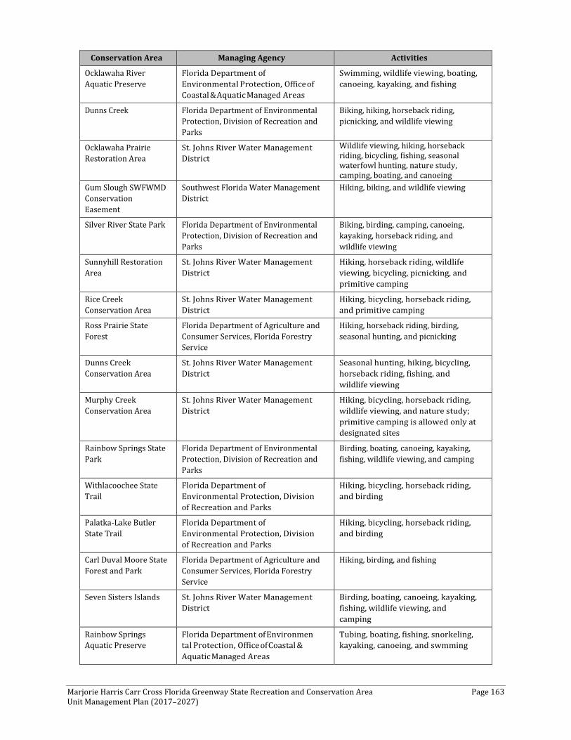
Marjorie Harris Carr Cross Florida Greenway State Recreation and Conservation Area Page 163 Unit Management Plan (2017–2027)
Conservation Area Managing Agency Activities
Ocklawaha River Aquatic Preserve
Florida Department of Environmental Protection, Office of Coastal & Aquatic Managed Areas
Swimming, wildlife viewing, boating, canoeing, kayaking, and fishing
Dunns Creek Florida Department of Environmental Protection, Division of Recreation and Parks
Biking, hiking, horseback riding, picnicking, and wildlife viewing
Ocklawaha Prairie Restoration Area
St. Johns River Water Management District
Wildlife viewing, hiking, horseback riding, bicycling, fishing, seasonal waterfowl hunting, nature study, camping, boating, and canoeing
Gum Slough SWFWMD Conservation Easement
Southwest Florida Water Management District
Hiking, biking, and wildlife viewing
Silver River State Park Florida Department of Environmental Protection, Division of Recreation and Parks
Biking, birding, camping, canoeing, kayaking, horseback riding, and wildlife viewing
Sunnyhill Restoration Area
St. Johns River Water Management District
Hiking, horseback riding, wildlife viewing, bicycling, picnicking, and primitive camping
Rice Creek Conservation Area
St. Johns River Water Management District
Hiking, bicycling, horseback riding, and primitive camping
Ross Prairie State Forest
Florida Department of Agriculture and Consumer Services, Florida Forestry Service
Hiking, horseback riding, birding, seasonal hunting, and picnicking
Dunns Creek Conservation Area
St. Johns River Water Management District
Seasonal hunting, hiking, bicycling, horseback riding, fishing, and wildlife viewing
Murphy Creek Conservation Area
St. Johns River Water Management District
Hiking, bicycling, horseback riding, wildlife viewing, and nature study; primitive camping is allowed only at designated sites
Rainbow Springs State Park
Florida Department of Environmental Protection, Division of Recreation and Parks
Birding, boating, canoeing, kayaking, fishing, wildlife viewing, and camping
Withlacoochee State Trail
Florida Department of Environmental Protection, Division of Recreation and Parks
Hiking, bicycling, horseback riding, and birding
Palatka-Lake Butler State Trail
Florida Department of Environmental Protection, Division of Recreation and Parks
Hiking, bicycling, horseback riding, and birding
Carl Duval Moore State Forest and Park
Florida Department of Agriculture and Consumer Services, Florida Forestry Service
Hiking, birding, and fishing
Seven Sisters Islands St. Johns River Water Management District
Birding, boating, canoeing, kayaking, fishing, wildlife viewing, and camping
Rainbow Springs Aquatic Preserve
Florida Department of Environmen tal Protection, Office of Coastal & Aquatic Managed Areas
Tubing, boating, fishing, snorkeling, kayaking, canoeing, and swmming
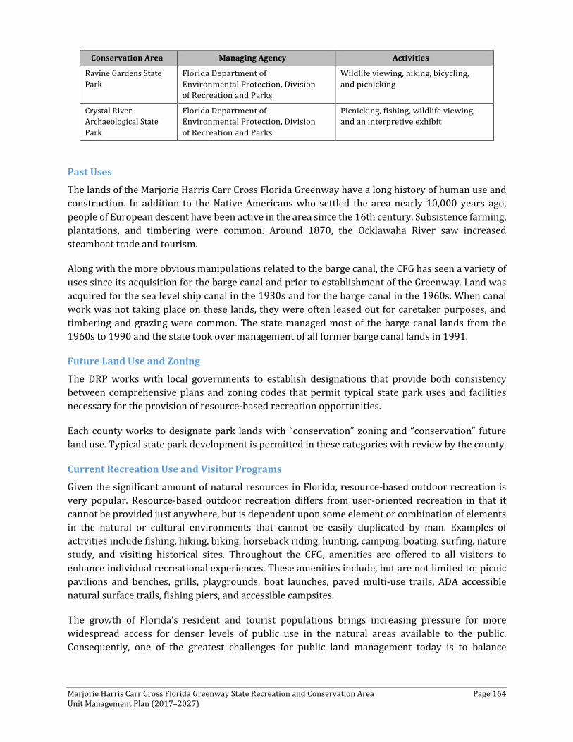
Marjorie Harris Carr Cross Florida Greenway State Recreation and Conservation Area Page 164 Unit Management Plan (2017–2027)
Conservation Area Managing Agency Activities
Ravine Gardens State Park
Florida Department of Environmental Protection, Division of Recreation and Parks
Wildlife viewing, hiking, bicycling, and picnicking
Crystal River Archaeological State Park
Florida Department of Environmental Protection, Division of Recreation and Parks
Picnicking, fishing, wildlife viewing, and an interpretive exhibit
Past Uses
The lands of the Marjorie Harris Carr Cross Florida Greenway have a long history of human use and construction. In addition to the Native Americans who settled the area nearly 10,000 years ago, people of European descent have been active in the area since the 16th century. Subsistence farming, plantations, and timbering were common. Around 1870, the Ocklawaha River saw increased steamboat trade and tourism.
Along with the more obvious manipulations related to the barge canal, the CFG has seen a variety of uses since its acquisition for the barge canal and prior to establishment of the Greenway. Land was acquired for the sea level ship canal in the 1930s and for the barge canal in the 1960s. When canal work was not taking place on these lands, they were often leased out for caretaker purposes, and timbering and grazing were common. The state managed most of the barge canal lands from the 1960s to 1990 and the state took over management of all former barge canal lands in 1991.
Future Land Use and Zoning
The DRP works with local governments to establish designations that provide both consistency between comprehensive plans and zoning codes that permit typical state park uses and facilities necessary for the provision of resource-based recreation opportunities.
Each county works to designate park lands with “conservation” zoning and “conservation” future land use. Typical state park development is permitted in these categories with review by the county.
Current Recreation Use and Visitor Programs
Given the significant amount of natural resources in Florida, resource-based outdoor recreation is very popular. Resource-based outdoor recreation differs from user-oriented recreation in that it cannot be provided just anywhere, but is dependent upon some element or combination of elements in the natural or cultural environments that cannot be easily duplicated by man. Examples of activities include fishing, hiking, biking, horseback riding, hunting, camping, boating, surfing, nature study, and visiting historical sites. Throughout the CFG, amenities are offered to all visitors to enhance individual recreational experiences. These amenities include, but are not limited to: picnic pavilions and benches, grills, playgrounds, boat launches, paved multi-use trails, ADA accessible natural surface trails, fishing piers, and accessible campsites.
The growth of Florida’s resident and tourist populations brings increasing pressure for more widespread access for denser levels of public use in the natural areas available to the public. Consequently, one of the greatest challenges for public land management today is to balance
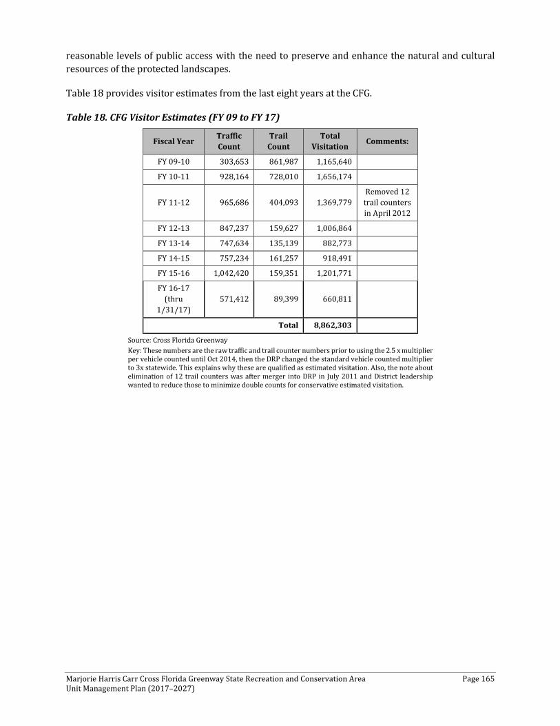
Marjorie Harris Carr Cross Florida Greenway State Recreation and Conservation Area Page 165 Unit Management Plan (2017–2027)
reasonable levels of public access with the need to preserve and enhance the natural and cultural resources of the protected landscapes.
Table 18 provides visitor estimates from the last eight years at the CFG.
Table 18. CFG Visitor Estimates (FY 09 to FY 17)
Fiscal Year Traffic Count
Trail Count
Total Visitation Comments:
FY 09-10 303,653 861,987 1,165,640
FY 10-11 928,164 728,010 1,656,174
FY 11-12 965,686 404,093 1,369,779 Removed 12 trail counters in April 2012
FY 12-13 847,237 159,627 1,006,864
FY 13-14 747,634 135,139 882,773
FY 14-15 757,234 161,257 918,491
FY 15-16 1,042,420 159,351 1,201,771
FY 16-17 (thru
1/31/17) 571,412 89,399 660,811
Total 8,862,303 Source: Cross Florida Greenway Key: These numbers are the raw traffic and trail counter numbers prior to using the 2.5 x multiplier per vehicle counted until Oct 2014, then the DRP changed the standard vehicle counted multiplier to 3x statewide. This explains why these are qualified as estimated visitation. Also, the note about elimination of 12 trail counters was after merger into DRP in July 2011 and District leadership wanted to reduce those to minimize double counts for conservative estimated visitation.
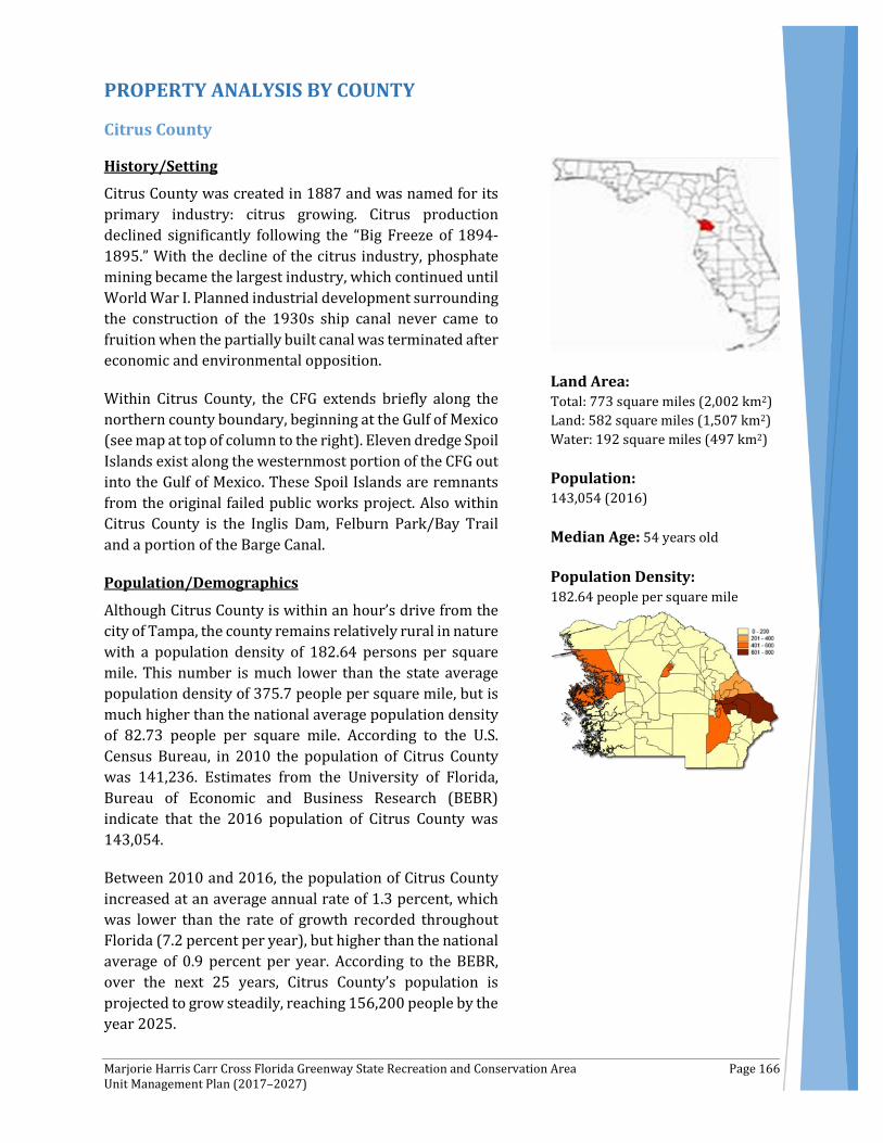
Marjorie Harris Carr Cross Florida Greenway State Recreation and Conservation Area Page 166 Unit Management Plan (2017–2027)
PROPERTY ANALYSIS BY COUNTY
Citrus County
History/Setting
Citrus County was created in 1887 and was named for its primary industry: citrus growing. Citrus production declined significantly following the “Big Freeze of 1894-1895.” With the decline of the citrus industry, phosphate mining became the largest industry, which continued until World War I. Planned industrial development surrounding the construction of the 1930s ship canal never came to fruition when the partially built canal was terminated after economic and environmental opposition.
Within Citrus County, the CFG extends briefly along the northern county boundary, beginning at the Gulf of Mexico (see map at top of column to the right). Eleven dredge Spoil Islands exist along the westernmost portion of the CFG out into the Gulf of Mexico. These Spoil Islands are remnants from the original failed public works project. Also within Citrus County is the Inglis Dam, Felburn Park/Bay Trail and a portion of the Barge Canal.
Population/Demographics
Although Citrus County is within an hour’s drive from the city of Tampa, the county remains relatively rural in nature with a population density of 182.64 persons per square mile. This number is much lower than the state average population density of 375.7 people per square mile, but is much higher than the national average population density of 82.73 people per square mile. According to the U.S. Census Bureau, in 2010 the population of Citrus County was 141,236. Estimates from the University of Florida, Bureau of Economic and Business Research (BEBR) indicate that the 2016 population of Citrus County was 143,054.
Between 2010 and 2016, the population of Citrus County increased at an average annual rate of 1.3 percent, which was lower than the rate of growth recorded throughout Florida (7.2 percent per year), but higher than the national average of 0.9 percent per year. According to the BEBR, over the next 25 years, Citrus County’s population is projected to grow steadily, reaching 156,200 people by the year 2025.
Land Area: Total: 773 square miles (2,002 km2) Land: 582 square miles (1,507 km2) Water: 192 square miles (497 km2) Population: 143,054 (2016) Median Age: 54 years old Population Density: 182.64 people per square mile
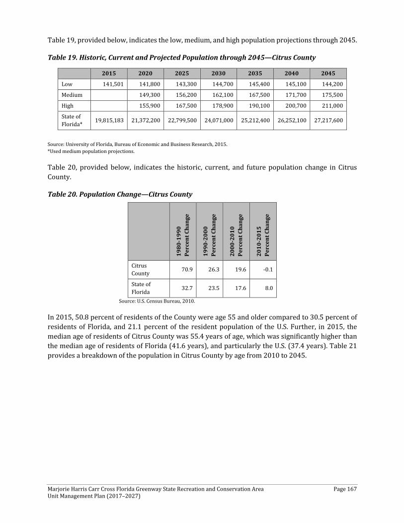
Marjorie Harris Carr Cross Florida Greenway State Recreation and Conservation Area Page 167 Unit Management Plan (2017–2027)
Table 19, provided below, indicates the low, medium, and high population projections through 2045.
Table 19. Historic, Current and Projected Population through 2045—Citrus County
Source: University of Florida, Bureau of Economic and Business Research, 2015. *Used medium population projections.
Table 20, provided below, indicates the historic, current, and future population change in Citrus County.
Table 20. Population Change—Citrus County
1980
-199
0
Perc
ent C
hang
e
1990
-200
0
Perc
ent C
hang
e
2000
-201
0
Perc
ent C
hang
e
2010
-201
5
Perc
ent C
hang
e Citrus County 70.9 26.3 19.6 -0.1
State of Florida 32.7 23.5 17.6 8.0
Source: U.S. Census Bureau, 2010.
In 2015, 50.8 percent of residents of the County were age 55 and older compared to 30.5 percent of residents of Florida, and 21.1 percent of the resident population of the U.S. Further, in 2015, the median age of residents of Citrus County was 55.4 years of age, which was significantly higher than the median age of residents of Florida (41.6 years), and particularly the U.S. (37.4 years). Table 21 provides a breakdown of the population in Citrus County by age from 2010 to 2045.
2015 2020 2025 2030 2035 2040 2045
Low 141,501 141,800 143,300 144,700 145,400 145,100 144,200
Medium 149,300 156,200 162,100 167,500 171,700 175,500
High 155,900 167,500 178,900 190,100 200,700 211,000
State of Florida* 19,815,183 21,372,200 22,799,500 24,071,000 25,212,400 26,252,100 27,217,600
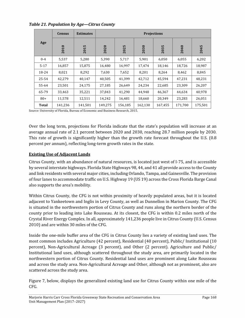
Marjorie Harris Carr Cross Florida Greenway State Recreation and Conservation Area Page 168 Unit Management Plan (2017–2027)
Table 21. Population by Age—Citrus County
Age
Census Estimates Projections
2010
2015
2020
2025
2030
2035
2040
2045
0-4 5,537 5,280 5,390 5,717 5,901 6,050 6,055 6,202
5-17 16,857 15,875 16,480 16,997 17,474 18,146 18,726 18,987
18-24 8,021 8,292 7,630 7,652 8,201 8,264 8,462 8,845
25-54 42,279 40,147 40,505 41,399 42,712 45,594 47,231 48,231
55-64 23,501 24,175 27,185 26,649 24,234 22,685 23,309 26,207
65-79 33,463 35,221 37,843 41,290 44,948 46,367 44,634 40,978
80+ 11,578 12,511 14,242 16,481 18,660 20,349 23,283 26,051
Total 141,236 141,501 149,275 156,185 162,130 167,455 171,700 175,501 Source: University of Florida, Bureau of Economic and Business Research, 2015.
Over the long term, projections for Florida indicate that the state’s population will increase at an average annual rate of 2.1 percent between 2020 and 2030, reaching 28.7 million people by 2030. This rate of growth is significantly higher than the growth rate forecast throughout the U.S. (0.8 percent per annum), reflecting long-term growth rates in the state.
Existing Use of Adjacent Lands
Citrus County, with an abundance of natural resources, is located just west of I-75, and is accessible by several interstate highways. Florida State Highways 98, 44, and 41 all provide access to the County and link residents with several major cities, including Orlando, Tampa, and Gainesville. The provision of four lanes to accommodate traffic on U.S. Highway 19 (US 19) across the Cross Florida Barge Canal also supports the area’s mobility.
Within Citrus County, the CFG is not within proximity of heavily populated areas, but it is located adjacent to Yankeetown and Inglis in Levy County, as well as Dunnellon in Marion County. The CFG is situated in the northwestern portion of Citrus County and runs along the northern border of the county prior to leading into Lake Rousseau. At its closest, the CFG is within 0.2 miles north of the Crystal River Energy Complex. In all, approximately 141,236 people live in Citrus County (U.S. Census 2010) and are within 30 miles of the CFG.
Inside the one-mile buffer area of the CFG in Citrus County lies a variety of existing land uses. The most common includes Agriculture (42 percent), Residential (40 percent), Public/ Institutional (10 percent), Non-Agricultural Acreage (3 percent), and Other (2 percent). Agriculture and Public/ Institutional land uses, although scattered throughout the study area, are primarily located in the northwestern portion of Citrus County. Residential land uses are prominent along Lake Rousseau and across the study area. Non-Agricultural Acreage and Other, although not as prominent, also are scattered across the study area.
Figure 7, below, displays the generalized existing land use for Citrus County within one mile of the CFG.

Marjorie Harris Carr Cross Florida Greenway State Recreation and Conservation Area Page 169 Unit Management Plan (2017–2027)
Planned Use of Adjacent Lands
The northwest portion of Citrus County has many attractive qualities. As indicated earlier, travel to and from this area is easy given the abundant roadway access, as well as waterfront availability. In addition, the relatively pristine land with proximity to the coast makes it attractive for future development.
Although the area adjacent to the CFG has significant limitations for future development, there are some plans for future development within the area. The current comprehensive plan directs growth toward the central portion of the county, from Citrus Springs, south to Homosassa and northwest of Inverness, rather than its outer reaches. Reasons for inland development include the environmental sensitivity of the west coast and its susceptibility to flooding in low-lying areas as experienced during Hermine (2016). Additionally, the infrastructure necessary to support growth and development in this area of the county is not present.
Hollinswood Harbor is an approved development with a subarea plan that contains commercial, industrial, and water-dependent uses. It is planned as a working waterfront with a marina, resort, recreational, residential, industrial, and support education/institution uses incorporated in the Master Plan. Both applications were approved and are reflected within the Citrus County Comprehensive Plan and the Future Land Use Map. Including canal bottom, this project will contain 545 acres and border the north shore of the Barge Canal west of the US 19 bridges. Another possible development includes a boat ramp with a proposed location on the Cross Florida Barge Canal west of US 19. At this time, the infrastructure necessary to support growth and development in this area of the county is not present. Citrus County is a member of the Hernando/Citrus Metropolitan Planning Organization (MPO). Based on a review of the Hernando/Citrus MPO 2040 Long Range Transportation Plan, Citrus County did not have any proposed widening or new alignment roadway projects within the vicinity of the CFG.
Inside the one-mile buffer area of the CFG in Citrus County, some changes can be noticed from existing land use to future land use. These changes include a substantial increase in Residential (57 percent) across most of the CFG area, Industrial (19 percent) in the northwestern portion, Infrastructure (7 percent) primarily focused in the southwestern portion, Mixed Use (7 percent) primarily in the northeastern portion, and Commercial (4 percent) along US 98 in the western portion as well as along CR 488 and US 41. The increase in the Infrastructure future land use is attributed mostly to the County’s land use re-classification of the Crystal River Energy Complex, which was considered as Public/Institutional under existing land use. The most substantial decrease occurs in the Agriculture (4 percent) land use within the CFG study area.
Figure 8, below, displays the generalized future land use for Citrus County within one mile of the CFG.
Property Analysis
As indicated, to better understand and detail the specific recreation resource elements, this plan describes these resources by county. Because effective planning requires a thorough understanding of the unit's natural and cultural resources, this section describes the resource characteristics and existing uses of the property. The unit's recreation resource elements are examined to identify the opportunities and constraints they present for recreational development. Past and present uses are
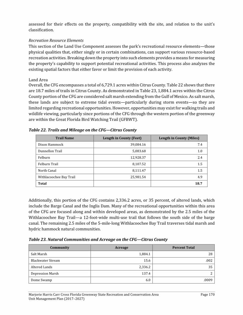
Marjorie Harris Carr Cross Florida Greenway State Recreation and Conservation Area Page 170 Unit Management Plan (2017–2027)
assessed for their effects on the property, compatibility with the site, and relation to the unit's classification.
Recreation Resource Elements This section of the Land Use Component assesses the park’s recreational resource elements—those physical qualities that, either singly or in certain combinations, can support various resource-based recreation activities. Breaking down the property into such elements provides a means for measuring the property's capability to support potential recreational activities. This process also analyzes the existing spatial factors that either favor or limit the provision of each activity.
Land Area Overall, the CFG encompasses a total of 6,729.1 acres within Citrus County. Table 22 shows that there are 18.7 miles of trails in Citrus County. As demonstrated in Table 23, 1,884.1 acres within the Citrus County portion of the CFG are considered salt marsh extending from the Gulf of Mexico. As salt marsh, these lands are subject to extreme tidal events—particularly during storm events—so they are limited regarding recreational opportunities. However, opportunities may exist for walking trails and wildlife viewing, particularly since portions of the CFG through the western portion of the greenway are within the Great Florida Bird Watching Trail (GFBWT).
Table 22. Trails and Mileage on the CFG—Citrus County
Trail Name Length in County (Feet) Length in County (Miles)
Dixon Hammock 39,084.16 7.4
Dunnellon Trail 5,083.68 1.0
Felburn 12,928.37 2.4
Felburn Trail 8,107.52 1.5
North Canal 8,111.47 1.5
Withlacoochee Bay Trail 25,981.54 4.9
Total 18.7
Additionally, this portion of the CFG contains 2,336.2 acres, or 35 percent, of altered lands, which include the Barge Canal and the Inglis Dam. Many of the recreational opportunities within this area of the CFG are focused along and within developed areas, as demonstrated by the 2.5 miles of the Withlacoochee Bay Trail—a 12-foot-wide multi-use trail that follows the south side of the barge canal. The remaining 2.5 miles of the 5-mile-long Withlacoochee Bay Trail traverses tidal marsh and hydric hammock natural communities.
Table 23. Natural Communities and Acreage on the CFG—Citrus County
Community Acreage Percent Total
Salt Marsh 1,884.1 28
Blackwater Stream 15.6 .002
Altered Lands 2,336.2 35
Depression Marsh 137.4 2
Dome Swamp 6.0 .0009
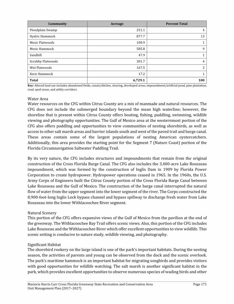
Marjorie Harris Carr Cross Florida Greenway State Recreation and Conservation Area Page 171 Unit Management Plan (2017–2027)
Community Acreage Percent Total
Floodplain Swamp 251.1 4
Hydric Hammock 877.7 13
Mesic Flatwoods 100.9 1
Mesic Hammock 585.8 9
Sandhill 47.9 1
Scrubby Flatwoods 301.7 4
Wet Flatwoods 167.5 2
Xeric Hammock 17.2 1
Total 6,729.1 100 Key: Altered land use includes abandoned fields, canals/ditches, clearing, developed areas, impoundment/artificial pond, pine plantation, road, spoil areas, and utility corridors.
Water Area Water resources on the CFG within Citrus County are a mix of manmade and natural resources. The CFG does not include the submerged boundary beyond the mean high waterline; however, the shoreline that is present within Citrus County offers boating, fishing, paddling, swimming, wildlife viewing and photography opportunities. The Gulf of Mexico area at the westernmost portion of the CFG also offers paddling and opportunities to view communities of nesting shorebirds, as well as access to other salt marsh areas and barrier islands south and west of the paved trail and barge canal. These areas contain some of the largest populations of nesting American oystercatchers. Additionally, this area provides the starting point for the Segment 7 (Nature Coast) portion of the Florida Circumnavigation Saltwater Paddling Trail.
By its very nature, the CFG includes structures and impoundments that remain from the original construction of the Cross Florida Barge Canal. The CFG also includes the 3,400-acre Lake Rousseau impoundment, which was formed by the construction of Inglis Dam in 1909 by Florida Power Corporation to create hydropower. Hydropower operations ceased in 1965. In the 1960s, the U.S. Army Corps of Engineers built the Citrus County portion of the Cross Florida Barge Canal between Lake Rousseau and the Gulf of Mexico. The construction of the barge canal interrupted the natural flow of water from the upper segment into the lower segment of the river. The Corps constructed the 8,900-foot-long Inglis Lock bypass channel and bypass spillway to discharge fresh water from Lake Rousseau into the lower Withlacoochee River segment.
Natural Scenery This portion of the CFG offers expansive views of the Gulf of Mexico from the pavilion at the end of the greenway. The Withlacoochee Bay Trail offers scenic views. Also, this portion of the CFG includes Lake Rousseau and the Withlacoochee River which offer excellent opportunities to view wildlife. This scenic setting is conducive to nature study, wildlife viewing, and photography.
Significant Habitat The shorebird rookery on the large island is one of the park’s important habitats. During the nesting season, the activities of parents and young can be observed from the dock and the scenic overlook. The park’s maritime hammock is an important habitat for migrating songbirds and provides visitors with good opportunities for wildlife watching. The salt marsh is another significant habitat in the park, which provides excellent opportunities to observe numerous species of wading birds and other

Marjorie Harris Carr Cross Florida Greenway State Recreation and Conservation Area Page 172 Unit Management Plan (2017–2027)
avian species, including pelicans, osprey, and bald eagles. The dock and boardwalk provide access to this community and should have interpretive signage placed to inform visitors about the important role that marshes play in marine ecology.
Natural Features The salt marsh and hydric hammock are the most significant natural features in this portion of the CFG. They provide a setting for a variety of recreational activities, including hiking, nature study, wildlife viewing, photography, picnicking, and the interpretation of natural and cultural resources.
Archaeological and Historical Features The previously recorded archaeological sites and historic features in the Citrus County section of the CFG consist exclusively of a variety of prehistoric archaeological sites. There is a recorded steamship wreck just off the coast that dates to the mid-19th century. The nature of several archaeological sites is unclear, but each in its own way offers a good cross section of Central Florida’s prehistoric past.
Assessment of Use All legal boundaries, significant natural features, structures, facilities, roads, and trails existing in the unit are delineated on the base map (see Base Map). Specific uses made of the unit are briefly described in the following sections.
Current Recreation Use and Visitor Programs The following recreational activities occur along the CFG within Citrus County.
The Felburn Park Trailhead, Withlacoochee Bay Trail, and Inglis Dam Recreation Area are recreational resources that are located within the Citrus County portion of the CFG. Also, the dredge Spoil Islands off the shoreline provide excellent bird-watching opportunities.
The Withlacoochee Bay Trail traverses five miles west from the Felburn Park Trailhead to the Gulf of Mexico, along the south shore of the Cross Florida Barge Canal. This multi-purpose trail is 12 feet wide and runs adjacent to the barge canal for the first 2.5 miles, then switching its path to the south side of the "berm" that was created by the canal's excavation. The westernmost 2.5 miles of the trail run through scenic maritime hammock and salt marsh habitats. Bicycling, walking, or inline skating on the paved trail
provide numerous opportunities to observe wildlife along the route. The trail also is one of the two GFBWT locations on the CFG.
Felburn Park is an approximately 140-acre property that is owned by the private non-profit Felburn Foundation and is leased to the state of Florida as part of the CFG. Felburn Park, formerly a limerock mine of approximately 140 acres, features the 40-acre "Phil's Lake," named after Phil Felburn, founder of the Felburn Foundation. Located just east of US 19 on the south side of the barge canal, the park has paved parking, potable water, several picnic pavilions, a small playground, and it provides access to paved trails running east and west along the barge canal. Traveling to the west is the Withlacoochee Bay Trail, which contains multi-use platforms available for picnicking, taking a
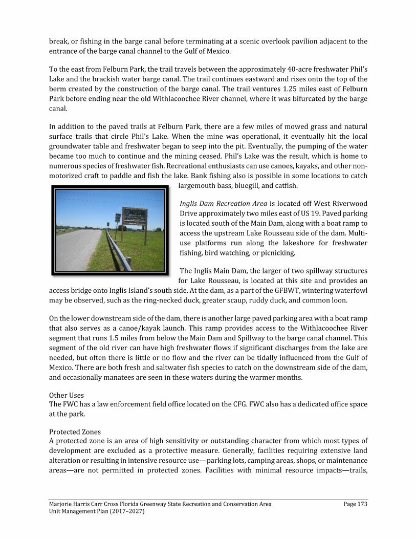
Marjorie Harris Carr Cross Florida Greenway State Recreation and Conservation Area Page 173 Unit Management Plan (2017–2027)
break, or fishing in the barge canal before terminating at a scenic overlook pavilion adjacent to the entrance of the barge canal channel to the Gulf of Mexico.
To the east from Felburn Park, the trail travels between the approximately 40-acre freshwater Phil’s Lake and the brackish water barge canal. The trail continues eastward and rises onto the top of the berm created by the construction of the barge canal. The trail ventures 1.25 miles east of Felburn Park before ending near the old Withlacoochee River channel, where it was bifurcated by the barge canal.
In addition to the paved trails at Felburn Park, there are a few miles of mowed grass and natural surface trails that circle Phil’s Lake. When the mine was operational, it eventually hit the local groundwater table and freshwater began to seep into the pit. Eventually, the pumping of the water became too much to continue and the mining ceased. Phil’s Lake was the result, which is home to numerous species of freshwater fish. Recreational enthusiasts can use canoes, kayaks, and other non-motorized craft to paddle and fish the lake. Bank fishing also is possible in some locations to catch
largemouth bass, bluegill, and catfish.
Inglis Dam Recreation Area is located off West Riverwood Drive approximately two miles east of US 19. Paved parking is located south of the Main Dam, along with a boat ramp to access the upstream Lake Rousseau side of the dam. Multi-use platforms run along the lakeshore for freshwater fishing, bird watching, or picnicking.
The Inglis Main Dam, the larger of two spillway structures for Lake Rousseau, is located at this site and provides an
access bridge onto Inglis Island’s south side. At the dam, as a part of the GFBWT, wintering waterfowl may be observed, such as the ring-necked duck, greater scaup, ruddy duck, and common loon.
On the lower downstream side of the dam, there is another large paved parking area with a boat ramp that also serves as a canoe/kayak launch. This ramp provides access to the Withlacoochee River segment that runs 1.5 miles from below the Main Dam and Spillway to the barge canal channel. This segment of the old river can have high freshwater flows if significant discharges from the lake are needed, but often there is little or no flow and the river can be tidally influenced from the Gulf of Mexico. There are both fresh and saltwater fish species to catch on the downstream side of the dam, and occasionally manatees are seen in these waters during the warmer months.
Other Uses The FWC has a law enforcement field office located on the CFG. FWC also has a dedicated office space at the park.
Protected Zones A protected zone is an area of high sensitivity or outstanding character from which most types of development are excluded as a protective measure. Generally, facilities requiring extensive land alteration or resulting in intensive resource use—parking lots, camping areas, shops, or maintenance areas—are not permitted in protected zones. Facilities with minimal resource impacts—trails,

Marjorie Harris Carr Cross Florida Greenway State Recreation and Conservation Area Page 174 Unit Management Plan (2017–2027)
interpretive signs, and boardwalks—generally are allowed. All decisions involving the use of protected zones are made on a case-by-case basis after careful site planning and analysis.
Although, by definition, the dredge Spoil Islands are not considered to be high-quality natural communities, these areas are used extensively by nesting shorebirds and are being studied through a multi-partnered research operation. The dredge Spoil Islands should be considered as potential protected zones and not incur extensive recreational opportunities.
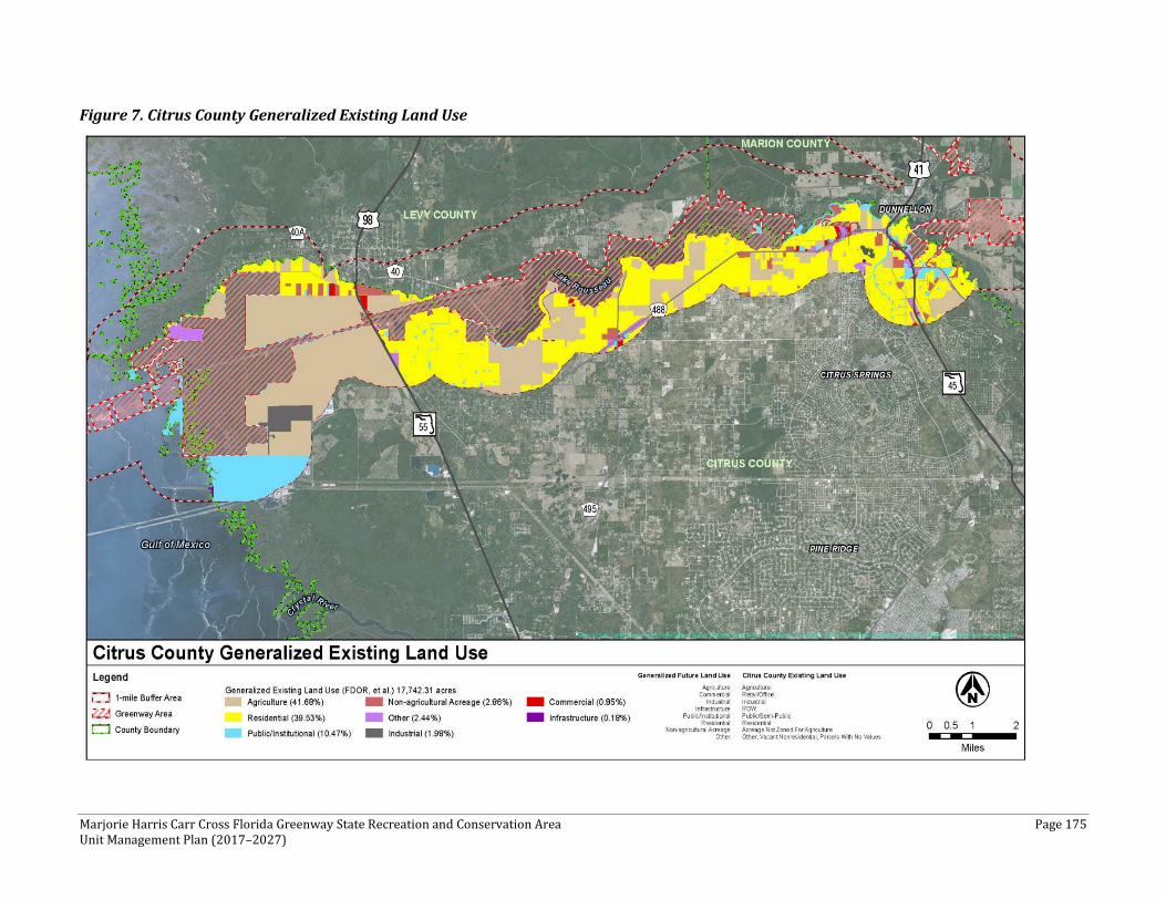
Marjorie Harris Carr Cross Florida Greenway State Recreation and Conservation Area Page 175 Unit Management Plan (2017–2027)
Figure 7. Citrus County Generalized Existing Land Use
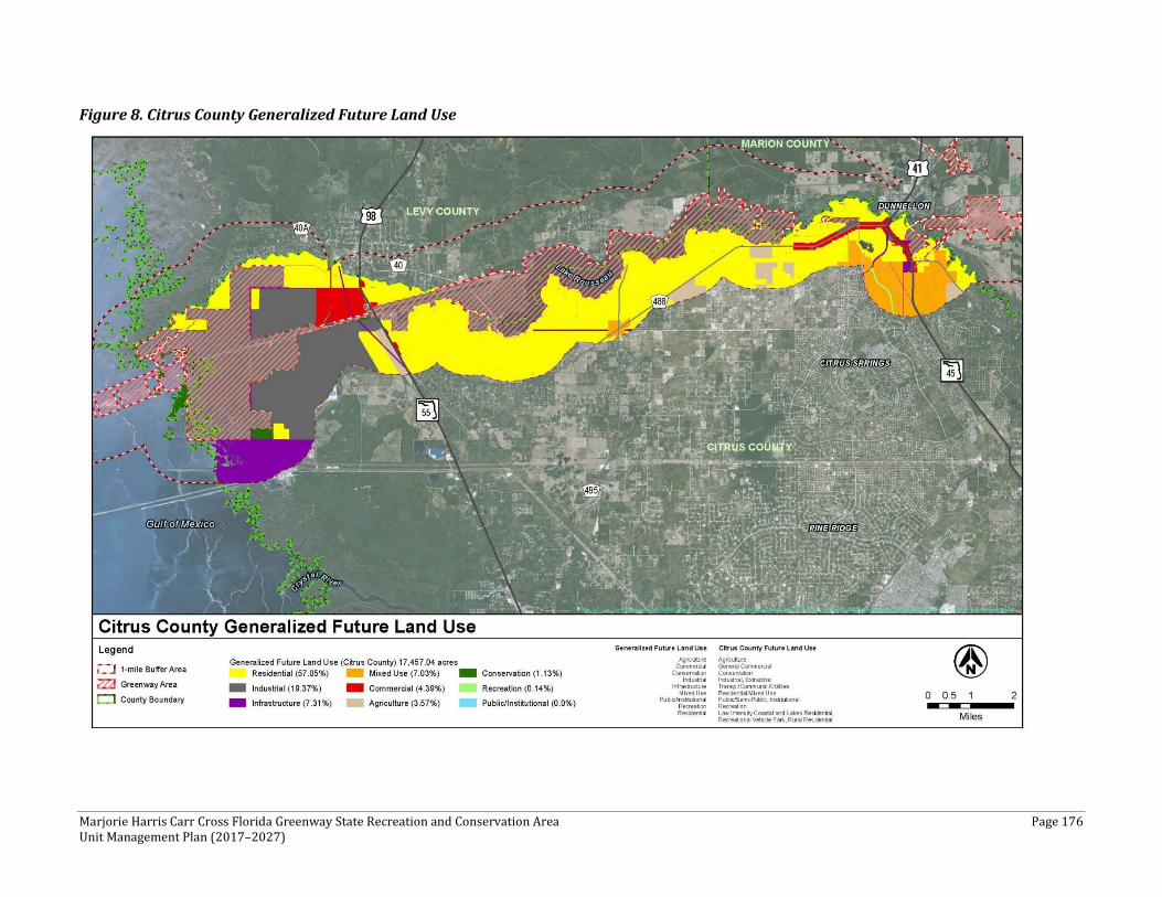
Marjorie Harris Carr Cross Florida Greenway State Recreation and Conservation Area Page 176 Unit Management Plan (2017–2027)
Figure 8. Citrus County Generalized Future Land Use
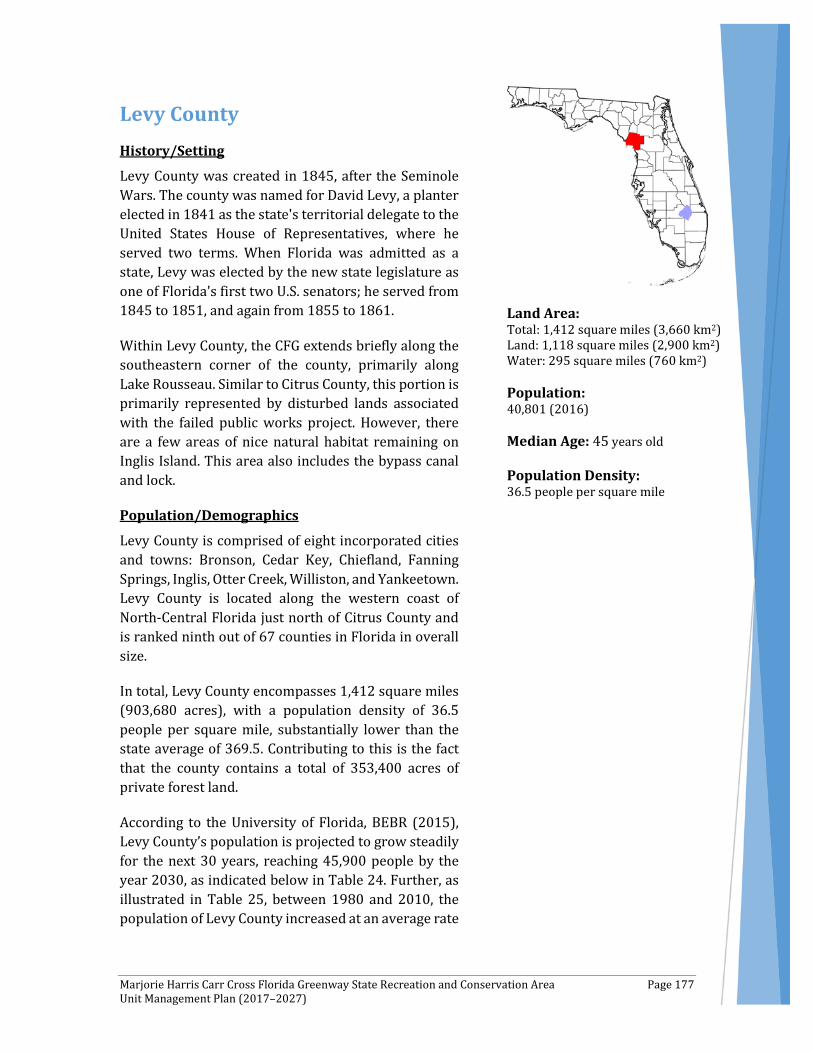
Marjorie Harris Carr Cross Florida Greenway State Recreation and Conservation Area Page 177 Unit Management Plan (2017–2027)
Levy County History/Setting
Levy County was created in 1845, after the Seminole Wars. The county was named for David Levy, a planter elected in 1841 as the state's territorial delegate to the United States House of Representatives, where he served two terms. When Florida was admitted as a state, Levy was elected by the new state legislature as one of Florida's first two U.S. senators; he served from 1845 to 1851, and again from 1855 to 1861.
Within Levy County, the CFG extends briefly along the southeastern corner of the county, primarily along Lake Rousseau. Similar to Citrus County, this portion is primarily represented by disturbed lands associated with the failed public works project. However, there are a few areas of nice natural habitat remaining on Inglis Island. This area also includes the bypass canal and lock.
Population/Demographics
Levy County is comprised of eight incorporated cities and towns: Bronson, Cedar Key, Chiefland, Fanning Springs, Inglis, Otter Creek, Williston, and Yankeetown. Levy County is located along the western coast of North-Central Florida just north of Citrus County and is ranked ninth out of 67 counties in Florida in overall size.
In total, Levy County encompasses 1,412 square miles (903,680 acres), with a population density of 36.5 people per square mile, substantially lower than the state average of 369.5. Contributing to this is the fact that the county contains a total of 353,400 acres of private forest land.
According to the University of Florida, BEBR (2015), Levy County’s population is projected to grow steadily for the next 30 years, reaching 45,900 people by the year 2030, as indicated below in Table 24. Further, as illustrated in Table 25, between 1980 and 2010, the population of Levy County increased at an average rate
Land Area: Total: 1,412 square miles (3,660 km2) Land: 1,118 square miles (2,900 km2) Water: 295 square miles (760 km2) Population: 40,801 (2016) Median Age: 45 years old Population Density: 36.5 people per square mile
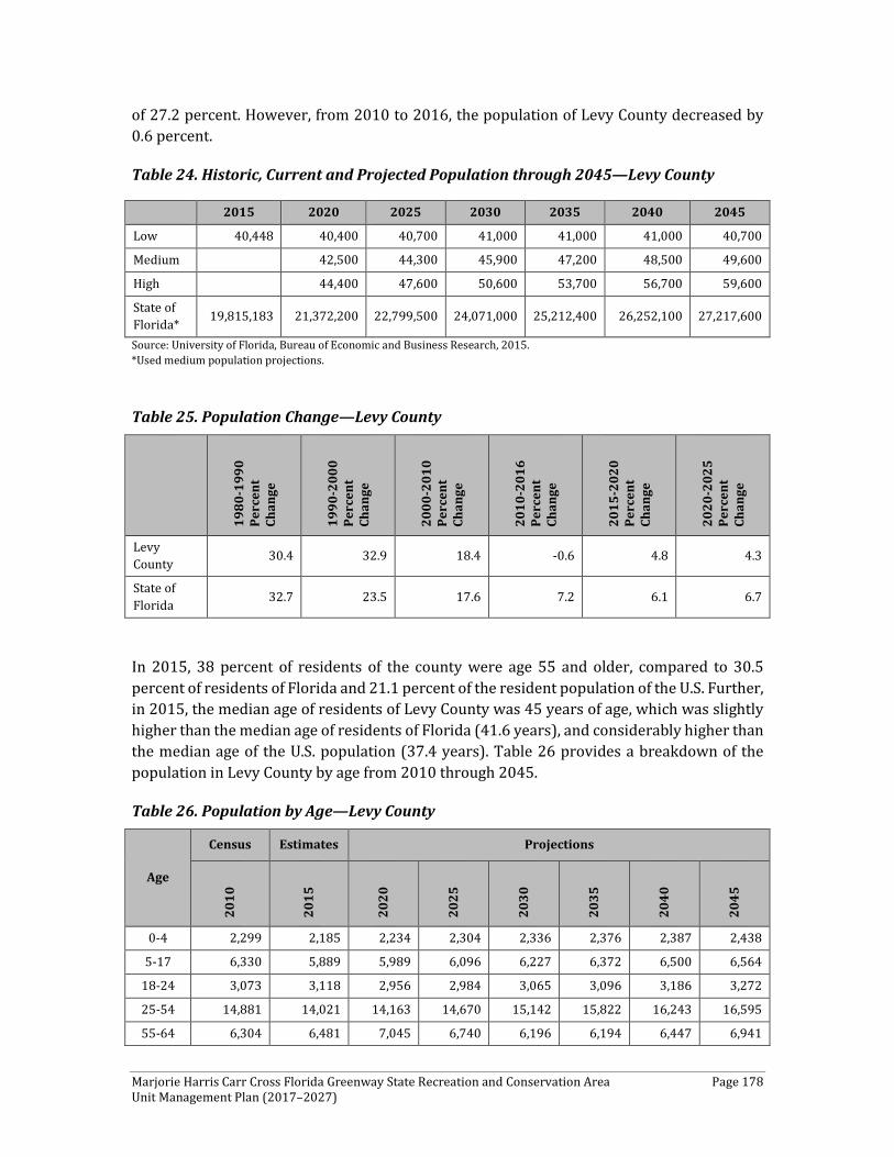
Marjorie Harris Carr Cross Florida Greenway State Recreation and Conservation Area Page 178 Unit Management Plan (2017–2027)
of 27.2 percent. However, from 2010 to 2016, the population of Levy County decreased by 0.6 percent.
Table 24. Historic, Current and Projected Population through 2045—Levy County
Source: University of Florida, Bureau of Economic and Business Research, 2015. *Used medium population projections.
Table 25. Population Change—Levy County
1980
-199
0 Pe
rcen
t Ch
ange
1990
-200
0 Pe
rcen
t Ch
ange
2000
-201
0 Pe
rcen
t Ch
ange
2010
-201
6 Pe
rcen
t Ch
ange
2015
-202
0 Pe
rcen
t Ch
ange
2020
-202
5 Pe
rcen
t Ch
ange
Levy County 30.4 32.9 18.4 -0.6 4.8 4.3
State of Florida 32.7 23.5 17.6 7.2 6.1 6.7
In 2015, 38 percent of residents of the county were age 55 and older, compared to 30.5 percent of residents of Florida and 21.1 percent of the resident population of the U.S. Further, in 2015, the median age of residents of Levy County was 45 years of age, which was slightly higher than the median age of residents of Florida (41.6 years), and considerably higher than the median age of the U.S. population (37.4 years). Table 26 provides a breakdown of the population in Levy County by age from 2010 through 2045.
Table 26. Population by Age—Levy County
Age
Census Estimates Projections
2010
2015
2020
2025
2030
2035
2040
2045
0-4 2,299 2,185 2,234 2,304 2,336 2,376 2,387 2,438
5-17 6,330 5,889 5,989 6,096 6,227 6,372 6,500 6,564
18-24 3,073 3,118 2,956 2,984 3,065 3,096 3,186 3,272
25-54 14,881 14,021 14,163 14,670 15,142 15,822 16,243 16,595
55-64 6,304 6,481 7,045 6,740 6,196 6,194 6,447 6,941
2015 2020 2025 2030 2035 2040 2045
Low 40,448 40,400 40,700 41,000 41,000 41,000 40,700
Medium 42,500 44,300 45,900 47,200 48,500 49,600
High 44,400 47,600 50,600 53,700 56,700 59,600
State of Florida* 19,815,183 21,372,200 22,799,500 24,071,000 25,212,400 26,252,100 27,217,600

Marjorie Harris Carr Cross Florida Greenway State Recreation and Conservation Area Page 179 Unit Management Plan (2017–2027)
Age
Census Estimates Projections
2010
2015
2020
2025
2030
2035
2040
2045
65-79 6,223 6,990 7,998 8,944 9,771 9,736 9,512 9,014
80+ 1,691 1,764 2,120 2,581 3,129 3,645 4,205 4,738
Total 40,801 40,448 42,505 44,319 45,866 47,241 48,480 49,562 Source: University of Florida, Bureau of Economic and Business Research, 2015.
By comparison, over the long term, projections for Florida indicate that the state’s population will increase at an average annual rate of 2.1 percent between 2020 and 2030, reaching 28.7 million people in 2030. This rate of growth is significantly higher than the growth rate forecast for the U.S. (0.8 percent per annum), reflecting long-term growth rates in the state.
Existing Use of Adjacent Lands
Levy County, a coastal county situated along Florida’s Gulf Coast, also is easily accessible. Located west of I-75, Florida State Highways 27, 41, and 98 also provide access to the county and link residents with several major cities, including Gainesville, Ocala, Orlando, and Tampa.
Within Levy County, the CFG is within proximity of some populated areas, including Inglis and Yankeetown. The CFG crosses the southern portion of Levy County. In all, approximately 40,801 people live in Levy County (U.S. Census 2010) and are within 40 miles of the CFG.
Inside the one-mile buffer area of the CFG in Levy County, there are a variety of existing land uses. The most common land uses include Agriculture (49 percent), Residential (30 percent), Public/Institutional (12 percent), Non-Agricultural Acreage (4 percent), and Recreation (2 percent). Agriculture land uses are predominantly west of Inglis in the one-mile buffer area of the CFG. Residential land uses are scattered throughout, with some concentration in the Yankeetown and Inglis areas. Public/Institutional and Non-Agricultural Acreage land uses are predominately within the eastern portion of Yankeetown, with some scattered throughout the CFG area. Recreation land use is limited to the west in Yankeetown.
Figure 9, below, displays the generalized existing land use for Levy County within one mile of the CFG.
Planned Use of Adjacent Lands
Southern Levy County has its fair share of attractive qualities. As indicated earlier, travel to and from this area is easy given the abundant roadway access. Its location along the Gulf of Mexico and Lake Rousseau—as well as its proximity to larger cities—make it attractive for future development.
Overall, Levy County expects a sustained annual population growth rate of at least 2 percent. Most of this growth will be within the unincorporated area, converting approximately 300
Marjorie Harris Carr Cross Florida Greenway State Recreation and Conservation Area Page 180 Unit Management Plan (2017–2027)
acres county-wide per year to residential use. Commercial, industrial, public/quasi-public, recreational, and agricultural uses are expected to change at a rate dependent upon population growth, the overall economy, and government decisions. A review of the 2018-2022 Florida Department of Transportation (FDOT) Five-Year Work Program and Levy County’s website did not identify any proposed widening or new alignment roadway projects within the vicinity of the CFG in Levy County.
Inside the one-mile buffer area of the CFG in Levy County, some changes can be noticed from existing land use to future land use. These changes include a substantial increase in Residential (45 percent) and a decrease of Agriculture (22 percent) land uses. The other most common types of land use include Municipality (21 percent), Mixed Use (4 percent), and Conservation (3 percent). The area experiencing perhaps the most change is the area between the towns of Inglis and Dunnellon north of Lake Rousseau, which has experienced a significant increase in Residential land use and a decrease in Agriculture land use. Municipality land use includes the coastal and some inland portions of Yankeetown around CR 40A. Mixed-Use land use is planned for the area between CR 40 and CR 40A west of Yankeetown School. Conservation areas are primarily in the Inglis area around US 98.
Figure 10, below, displays the generalized future land use for Levy County within one mile of the CFG.
Property Analysis
As indicated previously, in an attempt to better understand and detail the specific recreation resource elements, this plan describes these resources by county. Effective planning requires a thorough understanding of the unit's natural and cultural resources. This section describes the resource characteristics and existing uses of the property. The unit's recreation resource elements are examined to identify the opportunities and constraints they present for recreational development. Past and present uses are assessed for their effects on the property, compatibility with the site, and relation to the unit's classification.
Recreation Resource Elements This section of the Land Use Component assesses the park’s recreational resource elements, those physical qualities that, either singly or in certain combinations, can support various resource-based recreation activities. Breaking down the property into such elements provides a means for measuring the property's capability to support potential recreational activities. This process also analyzes the existing spatial factors that either favor or limit the provision of each activity.
Land Area Overall, Levy County contains approximately 2,262.4 acres—the smallest county traversed by the CFG. Table 27 shows that there are only 12.1 miles of trails in Levy County, in contrast with the more than 200 miles of trails in Marion County. As shown in Table 28, a total of 1,539.4 acres, or 68 percent of land within the CFG boundary in Levy County, is considered altered land use, which includes the Bypass Canal and Lock. The primary land feature within Levy County is Inglis Island, which is approximately 1,200 acres and is located between Inglis
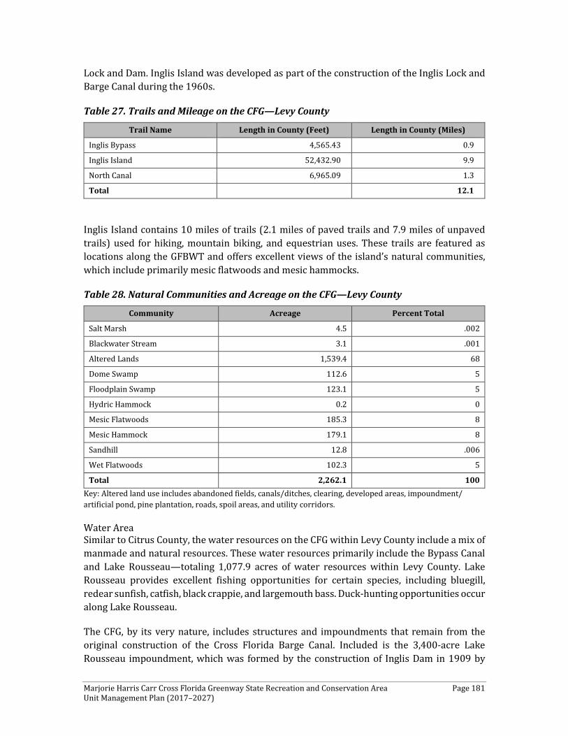
Marjorie Harris Carr Cross Florida Greenway State Recreation and Conservation Area Page 181 Unit Management Plan (2017–2027)
Lock and Dam. Inglis Island was developed as part of the construction of the Inglis Lock and Barge Canal during the 1960s.
Table 27. Trails and Mileage on the CFG—Levy County
Trail Name Length in County (Feet) Length in County (Miles)
Inglis Bypass 4,565.43 0.9
Inglis Island 52,432.90 9.9
North Canal 6,965.09 1.3
Total 12.1
Inglis Island contains 10 miles of trails (2.1 miles of paved trails and 7.9 miles of unpaved trails) used for hiking, mountain biking, and equestrian uses. These trails are featured as locations along the GFBWT and offers excellent views of the island’s natural communities, which include primarily mesic flatwoods and mesic hammocks.
Table 28. Natural Communities and Acreage on the CFG—Levy County
Community Acreage Percent Total
Salt Marsh 4.5 .002
Blackwater Stream 3.1 .001
Altered Lands 1,539.4 68
Dome Swamp 112.6 5
Floodplain Swamp 123.1 5
Hydric Hammock 0.2 0
Mesic Flatwoods 185.3 8
Mesic Hammock 179.1 8
Sandhill 12.8 .006
Wet Flatwoods 102.3 5
Total 2,262.1 100 Key: Altered land use includes abandoned fields, canals/ditches, clearing, developed areas, impoundment/ artificial pond, pine plantation, roads, spoil areas, and utility corridors.
Water Area Similar to Citrus County, the water resources on the CFG within Levy County include a mix of manmade and natural resources. These water resources primarily include the Bypass Canal and Lake Rousseau—totaling 1,077.9 acres of water resources within Levy County. Lake Rousseau provides excellent fishing opportunities for certain species, including bluegill, redear sunfish, catfish, black crappie, and largemouth bass. Duck-hunting opportunities occur along Lake Rousseau.
The CFG, by its very nature, includes structures and impoundments that remain from the original construction of the Cross Florida Barge Canal. Included is the 3,400-acre Lake Rousseau impoundment, which was formed by the construction of Inglis Dam in 1909 by
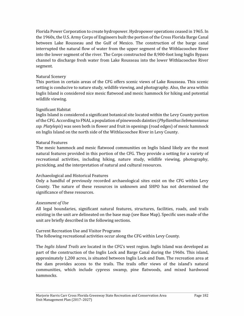
Marjorie Harris Carr Cross Florida Greenway State Recreation and Conservation Area Page 182 Unit Management Plan (2017–2027)
Florida Power Corporation to create hydropower. Hydropower operations ceased in 1965. In the 1960s, the U.S. Army Corps of Engineers built the portion of the Cross Florida Barge Canal between Lake Rousseau and the Gulf of Mexico. The construction of the barge canal interrupted the natural flow of water from the upper segment of the Withlacoochee River into the lower segment of the river. The Corps constructed the 8,900-foot long Inglis Bypass channel to discharge fresh water from Lake Rousseau into the lower Withlacoochee River segment.
Natural Scenery This portion in certain areas of the CFG offers scenic views of Lake Rousseau. This scenic setting is conducive to nature study, wildlife viewing, and photography. Also, the area within Inglis Island is considered nice mesic flatwood and mesic hammock for hiking and potential wildlife viewing.
Significant Habitat Inglis Island is considered a significant botanical site located within the Levy County portion of the CFG. According to FNAI, a population of pinewoods dainties (Phyllanthus liebmannianus ssp. Platylepis) was seen both in flower and fruit in openings (road edges) of mesic hammock on Inglis Island on the north side of the Withlacoochee River in Levy County.
Natural Features The mesic hammock and mesic flatwood communities on Inglis Island likely are the most natural features provided in this portion of the CFG. They provide a setting for a variety of recreational activities, including hiking, nature study, wildlife viewing, photography, picnicking, and the interpretation of natural and cultural resources.
Archaeological and Historical Features Only a handful of previously recorded archaeological sites exist on the CFG within Levy County. The nature of these resources in unknown and SHPO has not determined the significance of these resources.
Assessment of Use All legal boundaries, significant natural features, structures, facilities, roads, and trails existing in the unit are delineated on the base map (see Base Map). Specific uses made of the unit are briefly described in the following sections.
Current Recreation Use and Visitor Programs The following recreational activities occur along the CFG within Levy County.
The Inglis Island Trails are located in the CFG’s west region. Inglis Island was developed as part of the construction of the Inglis Lock and Barge Canal during the 1960s. This island, approximately 1,200 acres, is situated between Inglis Lock and Dam. The recreation area at the dam provides access to the trails. The trails offer views of the island’s natural communities, which include cypress swamp, pine flatwoods, and mixed hardwood hammocks.

Marjorie Harris Carr Cross Florida Greenway State Recreation and Conservation Area Page 183 Unit Management Plan (2017–2027)
Other Uses FWC facility and boat launch provide access to Lake Rousseau.
Protected Zones There are no known protected zones within the Levy County portion of the CFG.
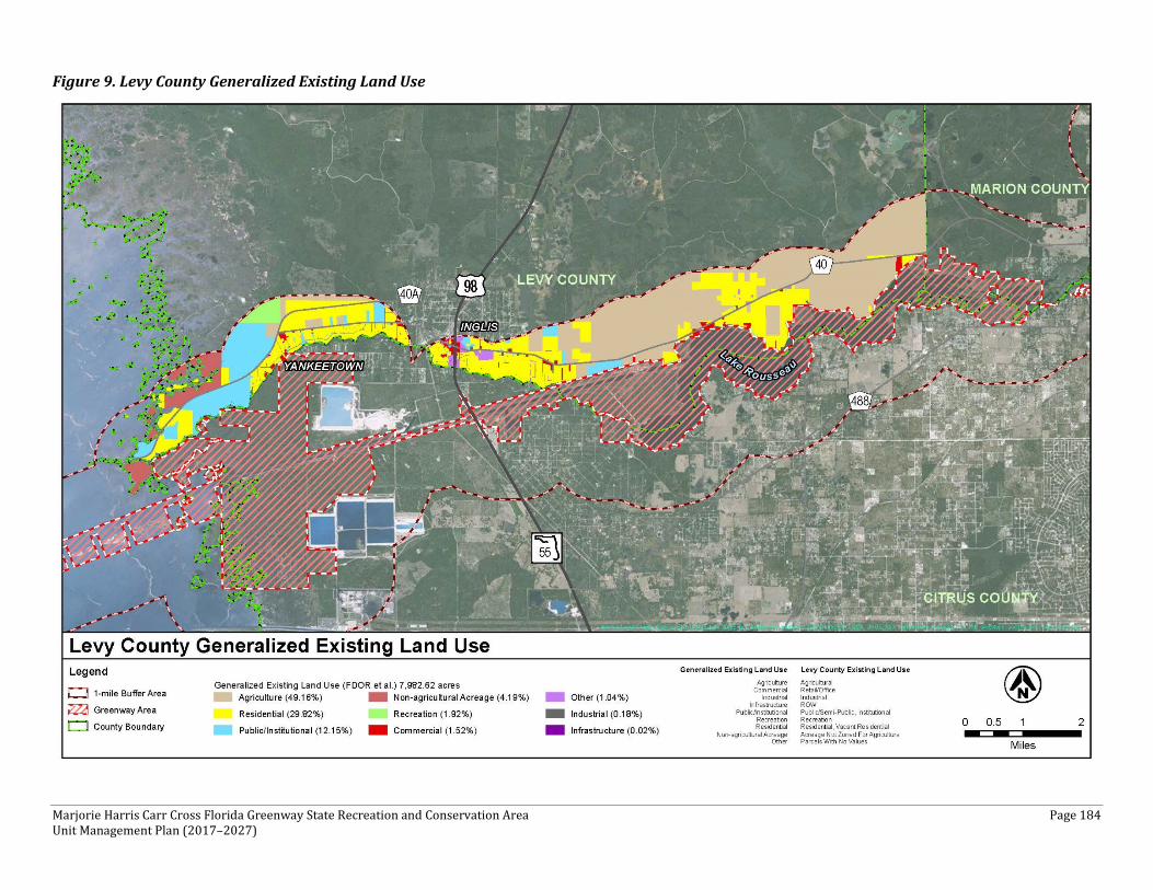
Marjorie Harris Carr Cross Florida Greenway State Recreation and Conservation Area Page 184 Unit Management Plan (2017–2027)
Figure 9. Levy County Generalized Existing Land Use
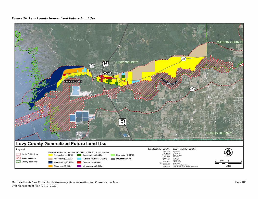
Marjorie Harris Carr Cross Florida Greenway State Recreation and Conservation Area Page 185 Unit Management Plan (2017–2027)
Figure 10. Levy County Generalized Future Land Use
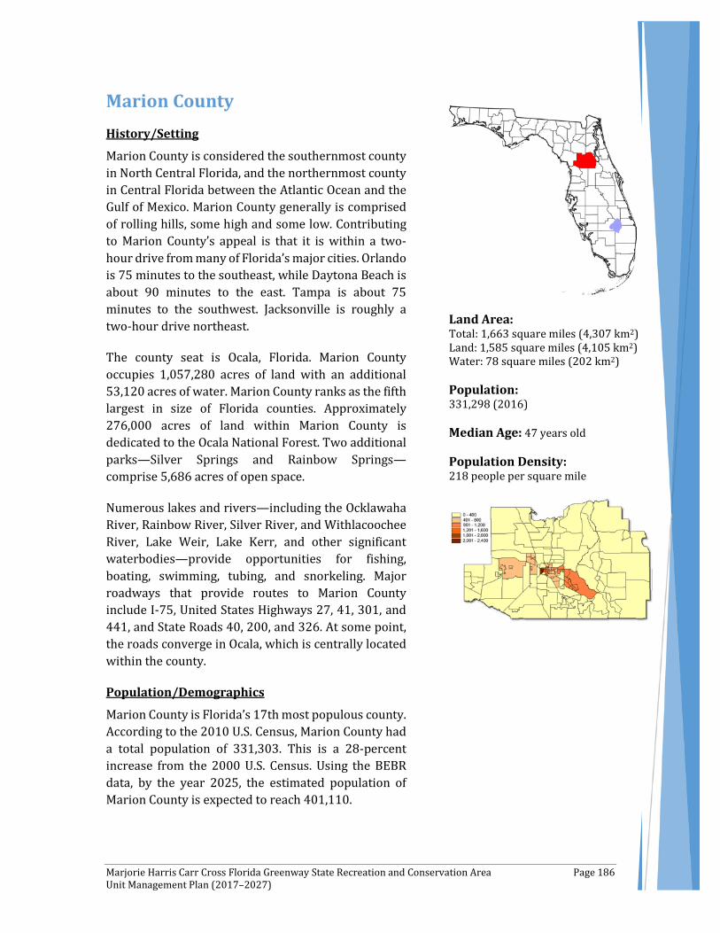
Marjorie Harris Carr Cross Florida Greenway State Recreation and Conservation Area Page 186 Unit Management Plan (2017–2027)
Marion County History/Setting
Marion County is considered the southernmost county in North Central Florida, and the northernmost county in Central Florida between the Atlantic Ocean and the Gulf of Mexico. Marion County generally is comprised of rolling hills, some high and some low. Contributing to Marion County’s appeal is that it is within a two-hour drive from many of Florida’s major cities. Orlando is 75 minutes to the southeast, while Daytona Beach is about 90 minutes to the east. Tampa is about 75 minutes to the southwest. Jacksonville is roughly a two-hour drive northeast.
The county seat is Ocala, Florida. Marion County occupies 1,057,280 acres of land with an additional 53,120 acres of water. Marion County ranks as the fifth largest in size of Florida counties. Approximately 276,000 acres of land within Marion County is dedicated to the Ocala National Forest. Two additional parks—Silver Springs and Rainbow Springs—comprise 5,686 acres of open space.
Numerous lakes and rivers—including the Ocklawaha River, Rainbow River, Silver River, and Withlacoochee River, Lake Weir, Lake Kerr, and other significant waterbodies—provide opportunities for fishing, boating, swimming, tubing, and snorkeling. Major roadways that provide routes to Marion County include I-75, United States Highways 27, 41, 301, and 441, and State Roads 40, 200, and 326. At some point, the roads converge in Ocala, which is centrally located within the county.
Population/Demographics
Marion County is Florida’s 17th most populous county. According to the 2010 U.S. Census, Marion County had a total population of 331,303. This is a 28-percent increase from the 2000 U.S. Census. Using the BEBR data, by the year 2025, the estimated population of Marion County is expected to reach 401,110.
Land Area: Total: 1,663 square miles (4,307 km2) Land: 1,585 square miles (4,105 km2) Water: 78 square miles (202 km2) Population: 331,298 (2016) Median Age: 47 years old Population Density: 218 people per square mile

Marjorie Harris Carr Cross Florida Greenway State Recreation and Conservation Area Page 187 Unit Management Plan (2017–2027)
Table 29, below, provides estimates until the year 2045.
Overall, Marion County is 69 percent urban and 31 percent rural. As such, Marion County represents the most urban county that the CFG traverses. This is demonstrated by a higher population density of 218.2 persons per square mile, which is much lower than the state average population density of 375.7 people per square mile, but is much higher than the national average density of 82.73 people per square mile. As shown in Table 30, between 2010 and 2016, the population of Marion County increased at an average annual rate of 4.4 percent, which was lower than the rate of growth recorded throughout Florida (7.2 percent per year), but higher than the national average of 0.9 percent per year. According to the University of Florida, BEBR (2015), over the next 30 years, Marion County’s population is projected to grow steadily, reaching 495,600 people by the year 2045.
Table 29. Historic, Current, and Projected Population through 2045—Marion County
2015 2020 2025 2030 2035 2040 2045
Low 341,205 352,600 365,600 378,000 388,300 396,800 403,000
Medium 372,300 401,100 427,100 451,400 474,400 495,600
High 387,700 427,600 468,000 509,100 551,200 593,300
State of Florida* 19,815,183 21,372,200 22,799,500 24,071,000 25,212,400 26,252,100 27,217,600
*Used medium population projections. Source: University of Florida, Bureau of Economic and Business Research, 2015.
Table 30. Population Change—Marion County
1980
-199
0 Pe
rcen
t Ch
ange
1990
-200
0 Pe
rcen
t Ch
ange
2000
-201
0 Pe
rcen
t Ch
ange
2010
-201
6 Pe
rcen
t Ch
ange
2015
-202
0 Pe
rcen
t Ch
ange
2020
-202
5 Pe
rcen
t Ch
ange
Marion County 59.1 32.9 28.0 4.4 5.2 5.4
State of Florida 32.7 23.5 17.6 7.2 6.1 6.7
In 2015, 42 percent of residents of Marion County were age 55 and older compared to 30.5 percent of residents of Florida, and 21.1 percent of the resident population of the U.S. Further, in 2015, the median age of residents of Marion County was 47 years old, which was higher than the median age of residents of Florida (41.6 years old), and considerably higher than the median age of residents of the U.S. (37.4 years old). Table 31, below, provides a breakdown of the population in Marion County by age from 2010 to 2045.
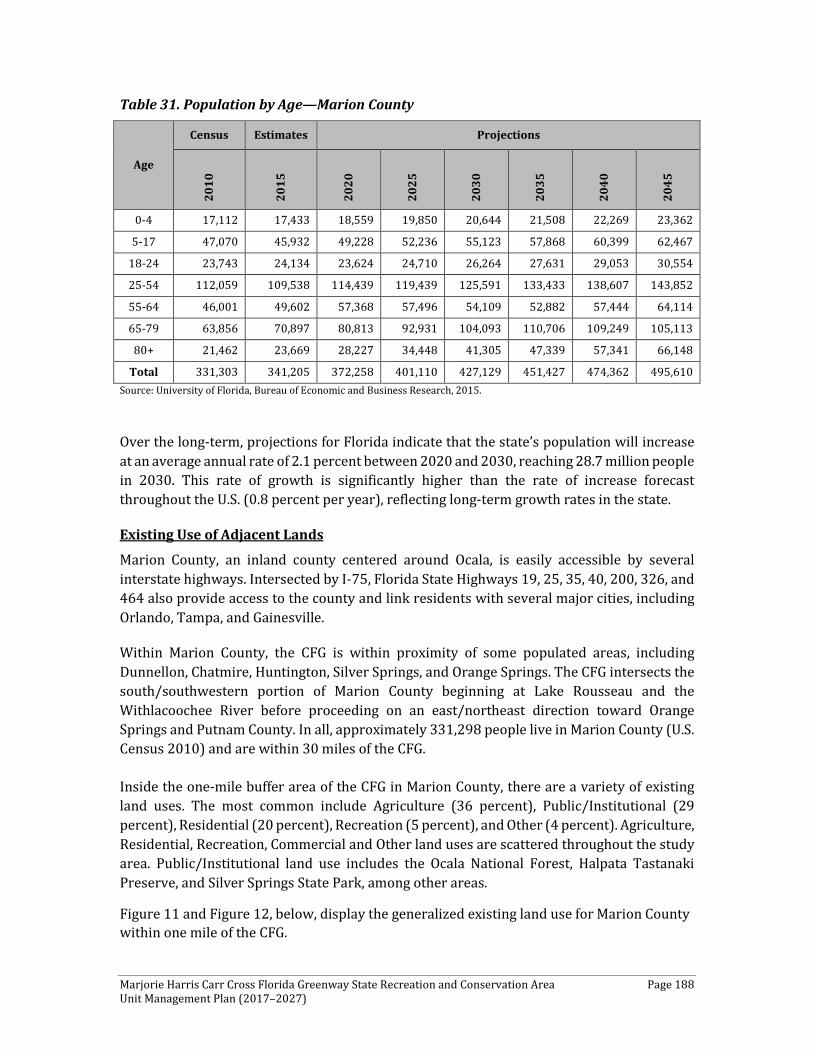
Marjorie Harris Carr Cross Florida Greenway State Recreation and Conservation Area Page 188 Unit Management Plan (2017–2027)
Table 31. Population by Age—Marion County
Age
Census Estimates Projections
2010
2015
2020
2025
2030
2035
2040
2045
0-4 17,112 17,433 18,559 19,850 20,644 21,508 22,269 23,362
5-17 47,070 45,932 49,228 52,236 55,123 57,868 60,399 62,467
18-24 23,743 24,134 23,624 24,710 26,264 27,631 29,053 30,554
25-54 112,059 109,538 114,439 119,439 125,591 133,433 138,607 143,852
55-64 46,001 49,602 57,368 57,496 54,109 52,882 57,444 64,114
65-79 63,856 70,897 80,813 92,931 104,093 110,706 109,249 105,113
80+ 21,462 23,669 28,227 34,448 41,305 47,339 57,341 66,148
Total 331,303 341,205 372,258 401,110 427,129 451,427 474,362 495,610 Source: University of Florida, Bureau of Economic and Business Research, 2015.
Over the long-term, projections for Florida indicate that the state’s population will increase at an average annual rate of 2.1 percent between 2020 and 2030, reaching 28.7 million people in 2030. This rate of growth is significantly higher than the rate of increase forecast throughout the U.S. (0.8 percent per year), reflecting long-term growth rates in the state.
Existing Use of Adjacent Lands
Marion County, an inland county centered around Ocala, is easily accessible by several interstate highways. Intersected by I-75, Florida State Highways 19, 25, 35, 40, 200, 326, and 464 also provide access to the county and link residents with several major cities, including Orlando, Tampa, and Gainesville.
Within Marion County, the CFG is within proximity of some populated areas, including Dunnellon, Chatmire, Huntington, Silver Springs, and Orange Springs. The CFG intersects the south/southwestern portion of Marion County beginning at Lake Rousseau and the Withlacoochee River before proceeding on an east/northeast direction toward Orange Springs and Putnam County. In all, approximately 331,298 people live in Marion County (U.S. Census 2010) and are within 30 miles of the CFG.
Inside the one-mile buffer area of the CFG in Marion County, there are a variety of existing land uses. The most common include Agriculture (36 percent), Public/Institutional (29 percent), Residential (20 percent), Recreation (5 percent), and Other (4 percent). Agriculture, Residential, Recreation, Commercial and Other land uses are scattered throughout the study area. Public/Institutional land use includes the Ocala National Forest, Halpata Tastanaki Preserve, and Silver Springs State Park, among other areas.
Figure 11 and Figure 12, below, display the generalized existing land use for Marion County within one mile of the CFG.

Marjorie Harris Carr Cross Florida Greenway State Recreation and Conservation Area Page 189 Unit Management Plan (2017–2027)
Planned Use of Adjacent Lands
Marion County, composed of rolling hills with an abundance of farmland and forests, has many attractive qualities. As indicated earlier, travel to and from this area is easy given the abundant roadway access. The proximity to both the Gulf of Mexico and the Atlantic coast make it attractive for future development.
The area surrounding the CFG also has some future planned development. West of Dunnellon, just north and south of the CFG along SR 200, there are several planned unit developments (PUDs), including Mixed Use. Per the Marion County Planning Department, to date, this is the only area near the CFG for which new development has been planned. Marion County is a member of the Ocala/Marion County Transportation Planning Organization (TPO). The Ocala/Marion County 2040 Long Range Transportation Plan indicated there are four roadway projects within the vicinity of the CFG in Marion County. These projects are in various phases of project development and details are provided below in Table 32.
Table 32. Roadway Projects—Marion County
Project Name Project Description
Funding Timeframe
SR 200 from Citrus County Line to CR 484
Add 2 lanes (including trail connectivity and wildlife crossing features) 2021-2030
SW 49th Avenue from SW 95th Street to Marion Oaks Trail
Add 2 lanes (including wildlife crossing features) 2018 -2022
SR 40 from NE 60th Court to CR 314
Add 2 lanes (including wildlife crossing features) 2019-2022
SR 35 from SE 92nd Place to CR 464 Add 2 lanes 2016-2018 Source: Ocala/Marion County 2040 Long Range Transportation Plan
It should be noted that CFG staff will coordinate with all entitites to include, at a minimum, double off-grade road crossings for wildlife and recreational connectivity when roads are expanded from two lanes to four lanes or more. This also would include a more comprehensive consideration of impacts and how to best mitigate and/or compensate for those potential impacts during roadway planning, design, and construction.
Inside the one-mile buffer area of the CFG in Marion County, several changes can be noticed from existing land use to future land use. These changes include a substantial increase in Agriculture (44 percent) and Conservation (31 percent). The increase in Conservation is mostly due to the County’s land use re-classification. Areas such as the CFG, Ocala National Forest, Halpata Tastanaki Preserve, and Silver Springs State Park were previously classified as Public/Institutional or Recreation under existing land use and are now classified as Conservation under future land use. Despite PUDs, Residential land use is expected to
Marjorie Harris Carr Cross Florida Greenway State Recreation and Conservation Area Page 190 Unit Management Plan (2017–2027)
decrease (16 percent) across most of the CFG area. Commercial land use increases slightly, including in the areas around SR 200 and US 301.
Figure 13 and Figure 14, below, display the generalized future land use for Marion County within one mile of the CFG.
Property Analysis
As indicated previously, in an attempt to better understand and detail the specific recreation resource elements, this plan describes these resources by county. Effective planning requires a thorough understanding of the unit's natural and cultural resources. This section describes the resource characteristics and existing uses of the property. The unit's recreation resource elements are examined to identify the opportunities and constraints they present for recreational development. Past and present uses are assessed for their effects on the property, compatibility with the site, and relation to the unit's classification.
Recreation Resource Elements This section of the Land Use Component assesses the park’s recreational resource elements, those physical qualities that—either singly or in certain combinations—can support various resource-based recreation activities. Breaking down the property into such elements provides a means for measuring the property's capability to support potential recreational activities. This process also analyzes the existing spatial factors that either favor or limit the provision of each activity.
Land Area Overall, the CFG encompasses 36,594 acres of land within Marion County—the largest amount of land within any county traversed by the CFG. In total, it contains more than 200 miles of trails, as shown in Table 33, vastly out-distancing the trail mileage in the other three counties combined. As illustrated in Table 34, a total of 10,614.7 acres, or 29 percent of land within the CFG boundary in Marion County, is considered altered land use. Land within the Marion County portion of the CFG is dominated by basin swamp, floodplain swamp, hydric hammock, mesic flatwoods, mesic hammock, sandhills, and scrub.
Table 33. Trails and Mileage on CFG—Marion County
Trail Name Length in County (Feet)
Length in County (Miles)
110th Street 2,004.70 0.4
25th Crossing 172.31 0.0
25th Street ER Access 856.87 0.2
49th Avenue 22,188.41 4.2
Anthill 1,212.66 0.2
Backdoor 514.78 0.1
Baseline Park Trail 25,103.05 4.8
Beyond 15,781.85 3.0
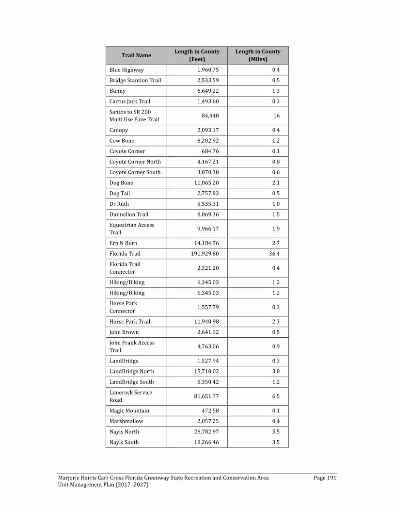
Marjorie Harris Carr Cross Florida Greenway State Recreation and Conservation Area Page 191 Unit Management Plan (2017–2027)
Trail Name Length in County (Feet)
Length in County (Miles)
Blue Highway 1,960.75 0.4
Bridge Stantion Trail 2,533.59 0.5
Bunny 6,649.22 1.3
Cactus Jack Trail 1,493.60 0.3
Santos to SR 200 Multi Use Pave Trail 84,440 16
Canopy 2,093.17 0.4
Cow Bone 6,202.92 1.2
Coyote Corner 684.76 0.1
Coyote Corner North 4,167.21 0.8
Coyote Corner South 3,070.30 0.6
Dog Bone 11,065.20 2.1
Dog Tail 2,757.83 0.5
Dr Ruth 5,535.31 1.0
Dunnellon Trail 8,069.36 1.5
Equestrian Access Trail 9,966.17 1.9
Ern N Burn 14,184.76 2.7
Florida Trail 191,929.80 36.4
Florida Trail Connector 2,321.20 0.4
Hiking/Biking 6,345.03 1.2
Hiking/Biking 6,345.03 1.2
Horse Park Connector 1,557.79 0.3
Horse Park Trail 11,940.98 2.3
John Brown 2,641.92 0.5
John Frank Access Trail 4,763.06 0.9
LandBridge 1,527.94 0.3
LandBridge North 15,710.02 3.0
LandBridge South 6,350.42 1.2
Limerock Service Road 81,651.77 6.5
Magic Mountain 472.58 0.1
Marshmallow 2,057.25 0.4
Nayls North 28,782.97 5.5
Nayls South 18,266.46 3.5
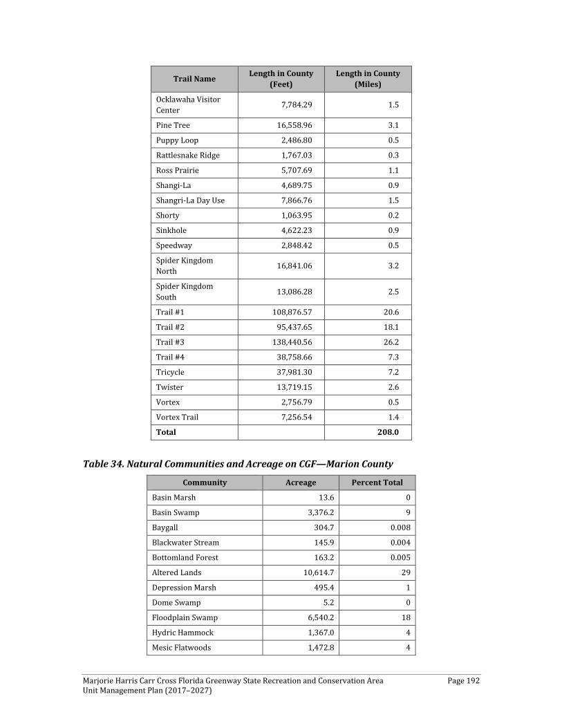
Marjorie Harris Carr Cross Florida Greenway State Recreation and Conservation Area Page 192 Unit Management Plan (2017–2027)
Trail Name Length in County (Feet)
Length in County (Miles)
Ocklawaha Visitor Center 7,784.29 1.5
Pine Tree 16,558.96 3.1
Puppy Loop 2,486.80 0.5
Rattlesnake Ridge 1,767.03 0.3
Ross Prairie 5,707.69 1.1
Shangi-La 4,689.75 0.9
Shangri-La Day Use 7,866.76 1.5
Shorty 1,063.95 0.2
Sinkhole 4,622.23 0.9
Speedway 2,848.42 0.5
Spider Kingdom North 16,841.06 3.2
Spider Kingdom South 13,086.28 2.5
Trail #1 108,876.57 20.6
Trail #2 95,437.65 18.1
Trail #3 138,440.56 26.2
Trail #4 38,758.66 7.3
Tricycle 37,981.30 7.2
Twister 13,719.15 2.6
Vortex 2,756.79 0.5
Vortex Trail 7,256.54 1.4
Total 208.0
Table 34. Natural Communities and Acreage on CGF—Marion County
Community Acreage Percent Total
Basin Marsh 13.6 0
Basin Swamp 3,376.2 9
Baygall 304.7 0.008
Blackwater Stream 145.9 0.004
Bottomland Forest 163.2 0.005
Altered Lands 10,614.7 29
Depression Marsh 495.4 1
Dome Swamp 5.2 0
Floodplain Swamp 6,540.2 18
Hydric Hammock 1,367.0 4
Mesic Flatwoods 1,472.8 4

Marjorie Harris Carr Cross Florida Greenway State Recreation and Conservation Area Page 193 Unit Management Plan (2017–2027)
Community Acreage Percent Total
Mesic Hammock 3,365.1 9
Sandhill 6,203.4 17
Scrub 1,244.0 3
Scrubby Flatwoods 226.7 0.006
Swamp Lake 28.3 0
Upland Hardwood Forest 243.9 0.007
Upland Pine Forest 6.4 0
Wet Flatwoods 588.0 2
Xeric Hammock 189.3 0.005
Total 36,594 100 Key: Altered land use includes abandoned fields, canals/ditches, clearings, developed areas, impoundment/artificial pond, pine plantation, roads, spoil areas, and utility corridors.
The westernmost portion of the CFG within Marion County is dominated by wet flatwoods and floodplain swamp associated with the easternmost portion of Lake Rousseau and impoundment. Moving east across US 41, near Dunnellon, the CFG is characterized by a predominantly altered landscape, with higher-intensity uses such as the Dunnellon Ballfields and the Wastewater Treatment Plant. Higher-intensity land uses should be shifted out of the main CFG corridor.
Further, this area includes the highest number of trails given that there are no major waterbodies. Trails include 1.5 miles of the Dunnellon Trail and the Florida Trail (37 miles within Marion County). The Dunnellon multi-use trail is primarily located along a historic railroad bed that runs along the Rainbow River south of CR 484 and the Blue Run Park and tubers take out. The trailhead is located along Bridges Road on the Marion County side. The trailhead provides access to this popular trail, which provides scenic views of the Withlacoochee River from the trail bridge, which connects Marion and Citrus counties together. The trail bridge was designed to capture the look of the former historic railroad bridges that were built in the late 1800s when phosphate was discovered in Dunnellon and it enjoyed its “Boomtown” days that are still celebrated annually. Throughout this portion of the CFG, consideration should be given to possible interconnectivity with existing surrounding trails.
Continuing east, the CFG begins to traverse higher, drier communities, mostly consisting of sandhills. Of note within this section of the CFG is the historic “Diggings,” which total 2,946.5 acres. This region is dominated by longleaf pine sandhill and sand pine scrub natural communities. These 1930s sea-level ship-to-canal project canal diggings serve as remnants of the former canal project. These features are wide linear areas that were dug out of the landscape to create the canal. Today, these areas exist as reforested, small-scale valleys. However, because the bottoms of "diggings" are comprised of clayey soils that hold moisture, they have become dominated by loblolly pines that prefer wetter areas than longleaf or sand pines. In many areas, they also offer challenging terrain for trail goers.
Marjorie Harris Carr Cross Florida Greenway State Recreation and Conservation Area Page 194 Unit Management Plan (2017–2027)
In addition, this portion of the CFG offers excellent opportunities for wildlife viewing as well as cultural interpretation. Within this section, located along the southern boundary of the CFG along the east side of SR 200 and adjacent to the entrance of Ross Prairie State Forest is the Ross Prairie Trailhead and Campground. Ross Prairie is a unique ecological feature due to the adjacent placement of the high, dry sandhill community (where the trailhead and campground are located) and the ephemeral wetland Ross Prairie (located just north of the public use facilities). Specifically, this area contains 239 acres of depression marsh that serves as a prairie-type landscape within a predominantly longleaf pine forested area of the CFG. Moving west to east, the elevation continues to increase and contains outstanding hardwood live oak hammocks in between Pruitt and SR 200 and oak islands in Ross Prairie. Additionally, this area contains approximately 1,000 acres of scrub immediately west of I-75.
This area has undergone significant restoration activities and contains a number of breeding pairs of scrub jays. CFG has partnered with the Florida Audobon Society to monitor and track scrub jays. This area is considered to be a protected area of the CFG. This area also contains Shangri-La and Pruitt Trailheads. As indicated in Table 33, this section of the CFG contains a significant trail network, including equestrian, hiking, and biking trails. Equestrian trails are predominantly located in the southernmost portion of the CFG, while hiking and biking trails are to the north.
Moving across I-75, equestrian, hiking, and biking trails continue up to the Santos Trailhead and camping area. The Santos Trail is widely recognized for its mountain biking trails and other trail networks—in particular, the winding trails through the rock quarry country, which are a favorite of the mountain bike community. This portion of the CFG begins to move through more populated areas of Marion County and, as such, begins to have more altered/developed types of land uses, with a higher number of road crossings. Baseline Road Trailhead is located within this area, which is a community park with trails and is sub-leased to Marion County for management.
Marshall Swamp is the next portion of the CFG and contains primarily mesic hammock, hydric hammock, and floodplain swamp. Moving from developed to undeveloped land, this area is adjacent to the Ocala National Forest and Silver Springs. Following Marshall Swamp, this area continues along the Ocklawaha River, incorporating floodplain swamp, mesic hammock, and other wet communities until the Marion County boundary. This area along the Ocklawaha River also provides paddling, fishing, and boating opportunities, scenic views, wildlife watching, and interspersed boat landings.
Water Area As indicated previously, the westernmost portion of the CFG within Marion County contains the eastern extent of Lake Rousseau. From Marshall Swamp to the Marion County boundary, the CFG contains the Ocklawaha River and its floodplain.
Natural Scenery In general, the highest quality sandhills are located within the Marion County portion of the CFG. In the western portion of the CFG through Marion County, wildlife viewing opportunities
Marjorie Harris Carr Cross Florida Greenway State Recreation and Conservation Area Page 195 Unit Management Plan (2017–2027)
and scenic views are offered along the Dunnellon multi-use trail. Farther to the east within Marion County, the Ross Prairie area provides excellent examples of unique prairie-type communities within the CFG. This habitat is conducive to wildlife viewing and hiking.
Continuing east within Marion County, the “Diggings” sites—although significantly impacted by previous canal digging activities—continue to provide wildlife viewing opportunities. Additionally, given the historic nature of these sites, they also provide significant cultural interpretation opportunities.
A large portion of the CFG within Marion County contains the Ocklawaha River and its floodplain communities. Within this portion of the CFG, there is little to no development, with only a few adjacent publicly owned lands. As such, this area also provides significant opportunities to view natural scenery and wildlife. Further, Marshall Swamp Trail and Ocklawaha River floodplain in the Sharpes Ferry area offer high-quality hydric hammock and bottomland forest in which several rare plants are known to occur.
Significant Habitat There is a total of 1,244 acres of scrub habitat within this portion of the CFG. This community is a significant habitat given that it is home to the endangered Florida scrub jay This habitat is a primary restoration activity on the CFG. Further, the CFG works closely with the Florida Audobon Society to monitor and count nesting scrub jays. These areas also are considered protected throughout the CFG and offer passive recreational opportunities.
FNAI identified several areas throughout the CFG as significant botanical sites. This includes a linear east/west strip beginning with the Diggings west of SR 200 east to I-75, in which seven listed plants were identified in sandhill, scrub, and successional hardwoods that surround and include the Diggings. Scrub and sandhill (less so) also harbor the population stronghold of the federal and state listed endangered long-spurred mint.
Natural Features Ross Prairie is the most unique natural feature within this section of the CFG. Having the sandhill and wetland prairie systems adjacent to each other helps to provide habitat to a wide range of species. The habitat changes with the seasons and water volume of the prairie; when wet, dozens of waterfowl avian species, wading birds, reptiles, amphibians and mammals can be spotted.
Archaeological and Historical Features The previously recorded archaeological sites and historic features in the Marion County section of the CFG consist of a variety of prehistoric and historic period archaeological sites. These represent an excellent cross section of Central Florida’s prehistoric past. The exact nature of the historic sites is unclear. They represent historic artifact scatters, historic dumps, or possible historic home sites. There are also several historic railway corridors, bridges, and the Eureka Lock and Dam Complex in this section of the park. Florida SHPO has not determined the significance of the vast majority of these sites. Six archaeological sites (8MR1878, 8MR2351, 8MR3863, 8MR3865, and 8MR3866), the Eureka Lock and Dam
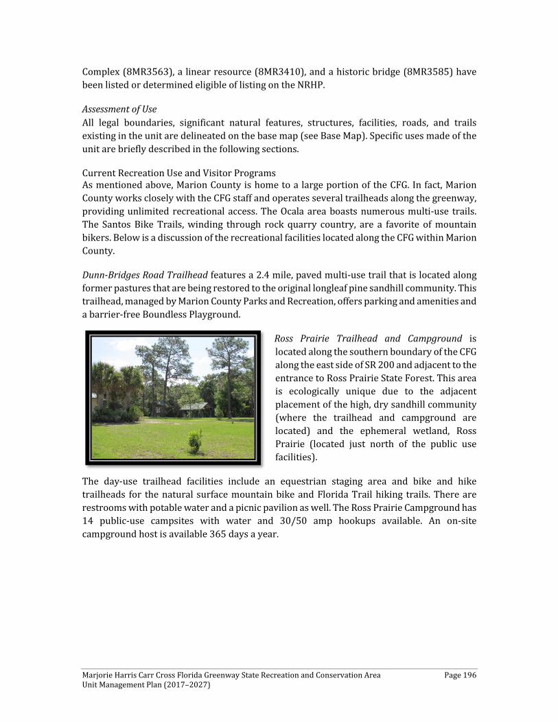
Marjorie Harris Carr Cross Florida Greenway State Recreation and Conservation Area Page 196 Unit Management Plan (2017–2027)
Complex (8MR3563), a linear resource (8MR3410), and a historic bridge (8MR3585) have been listed or determined eligible of listing on the NRHP.
Assessment of Use All legal boundaries, significant natural features, structures, facilities, roads, and trails existing in the unit are delineated on the base map (see Base Map). Specific uses made of the unit are briefly described in the following sections.
Current Recreation Use and Visitor Programs As mentioned above, Marion County is home to a large portion of the CFG. In fact, Marion County works closely with the CFG staff and operates several trailheads along the greenway, providing unlimited recreational access. The Ocala area boasts numerous multi-use trails. The Santos Bike Trails, winding through rock quarry country, are a favorite of mountain bikers. Below is a discussion of the recreational facilities located along the CFG within Marion County.
Dunn-Bridges Road Trailhead features a 2.4 mile, paved multi-use trail that is located along former pastures that are being restored to the original longleaf pine sandhill community. This trailhead, managed by Marion County Parks and Recreation, offers parking and amenities and a barrier-free Boundless Playground.
Ross Prairie Trailhead and Campground is located along the southern boundary of the CFG along the east side of SR 200 and adjacent to the entrance to Ross Prairie State Forest. This area is ecologically unique due to the adjacent placement of the high, dry sandhill community (where the trailhead and campground are located) and the ephemeral wetland, Ross Prairie (located just north of the public use facilities).
The day-use trailhead facilities include an equestrian staging area and bike and hike trailheads for the natural surface mountain bike and Florida Trail hiking trails. There are restrooms with potable water and a picnic pavilion as well. The Ross Prairie Campground has 14 public-use campsites with water and 30/50 amp hookups available. An on-site campground host is available 365 days a year.
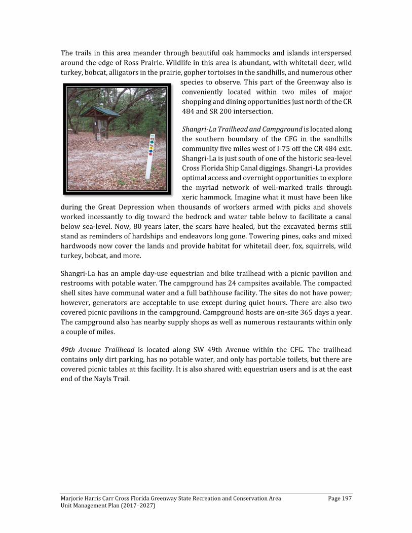
Marjorie Harris Carr Cross Florida Greenway State Recreation and Conservation Area Page 197 Unit Management Plan (2017–2027)
The trails in this area meander through beautiful oak hammocks and islands interspersed around the edge of Ross Prairie. Wildlife in this area is abundant, with whitetail deer, wild turkey, bobcat, alligators in the prairie, gopher tortoises in the sandhills, and numerous other
species to observe. This part of the Greenway also is conveniently located within two miles of major shopping and dining opportunities just north of the CR 484 and SR 200 intersection.
Shangri-La Trailhead and Campground is located along the southern boundary of the CFG in the sandhills community five miles west of I-75 off the CR 484 exit. Shangri-La is just south of one of the historic sea-level Cross Florida Ship Canal diggings. Shangri-La provides optimal access and overnight opportunities to explore the myriad network of well-marked trails through xeric hammock. Imagine what it must have been like
during the Great Depression when thousands of workers armed with picks and shovels worked incessantly to dig toward the bedrock and water table below to facilitate a canal below sea-level. Now, 80 years later, the scars have healed, but the excavated berms still stand as reminders of hardships and endeavors long gone. Towering pines, oaks and mixed hardwoods now cover the lands and provide habitat for whitetail deer, fox, squirrels, wild turkey, bobcat, and more.
Shangri-La has an ample day-use equestrian and bike trailhead with a picnic pavilion and restrooms with potable water. The campground has 24 campsites available. The compacted shell sites have communal water and a full bathhouse facility. The sites do not have power; however, generators are acceptable to use except during quiet hours. There are also two covered picnic pavilions in the campground. Campground hosts are on-site 365 days a year. The campground also has nearby supply shops as well as numerous restaurants within only a couple of miles.
49th Avenue Trailhead is located along SW 49th Avenue within the CFG. The trailhead contains only dirt parking, has no potable water, and only has portable toilets, but there are covered picnic tables at this facility. It is also shared with equestrian users and is at the east end of the Nayls Trail.
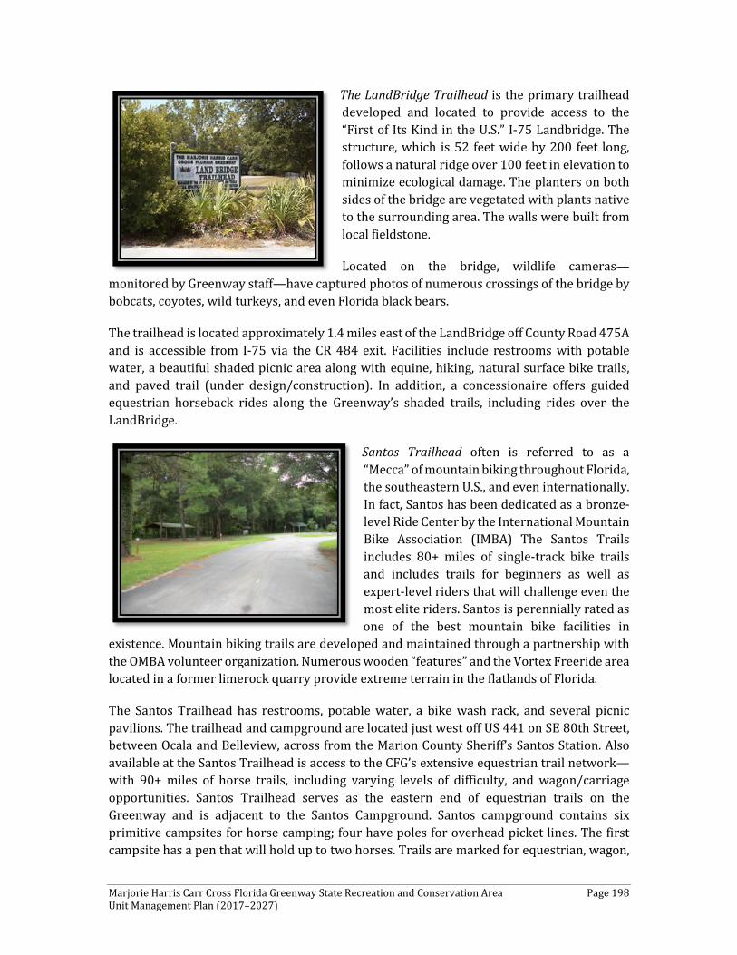
Marjorie Harris Carr Cross Florida Greenway State Recreation and Conservation Area Page 198 Unit Management Plan (2017–2027)
The LandBridge Trailhead is the primary trailhead developed and located to provide access to the “First of Its Kind in the U.S.” I-75 Landbridge. The structure, which is 52 feet wide by 200 feet long, follows a natural ridge over 100 feet in elevation to minimize ecological damage. The planters on both sides of the bridge are vegetated with plants native to the surrounding area. The walls were built from local fieldstone.
Located on the bridge, wildlife cameras—monitored by Greenway staff—have captured photos of numerous crossings of the bridge by bobcats, coyotes, wild turkeys, and even Florida black bears.
The trailhead is located approximately 1.4 miles east of the LandBridge off County Road 475A and is accessible from I-75 via the CR 484 exit. Facilities include restrooms with potable water, a beautiful shaded picnic area along with equine, hiking, natural surface bike trails, and paved trail (under design/construction). In addition, a concessionaire offers guided equestrian horseback rides along the Greenway’s shaded trails, including rides over the LandBridge.
Santos Trailhead often is referred to as a “Mecca” of mountain biking throughout Florida, the southeastern U.S., and even internationally. In fact, Santos has been dedicated as a bronze-level Ride Center by the International Mountain Bike Association (IMBA) The Santos Trails includes 80+ miles of single-track bike trails and includes trails for beginners as well as expert-level riders that will challenge even the most elite riders. Santos is perennially rated as one of the best mountain bike facilities in
existence. Mountain biking trails are developed and maintained through a partnership with the OMBA volunteer organization. Numerous wooden “features” and the Vortex Freeride area located in a former limerock quarry provide extreme terrain in the flatlands of Florida.
The Santos Trailhead has restrooms, potable water, a bike wash rack, and several picnic pavilions. The trailhead and campground are located just west off US 441 on SE 80th Street, between Ocala and Belleview, across from the Marion County Sheriff’s Santos Station. Also available at the Santos Trailhead is access to the CFG’s extensive equestrian trail network—with 90+ miles of horse trails, including varying levels of difficulty, and wagon/carriage opportunities. Santos Trailhead serves as the eastern end of equestrian trails on the Greenway and is adjacent to the Santos Campground. Santos campground contains six primitive campsites for horse camping; four have poles for overhead picket lines. The first campsite has a pen that will hold up to two horses. Trails are marked for equestrian, wagon,
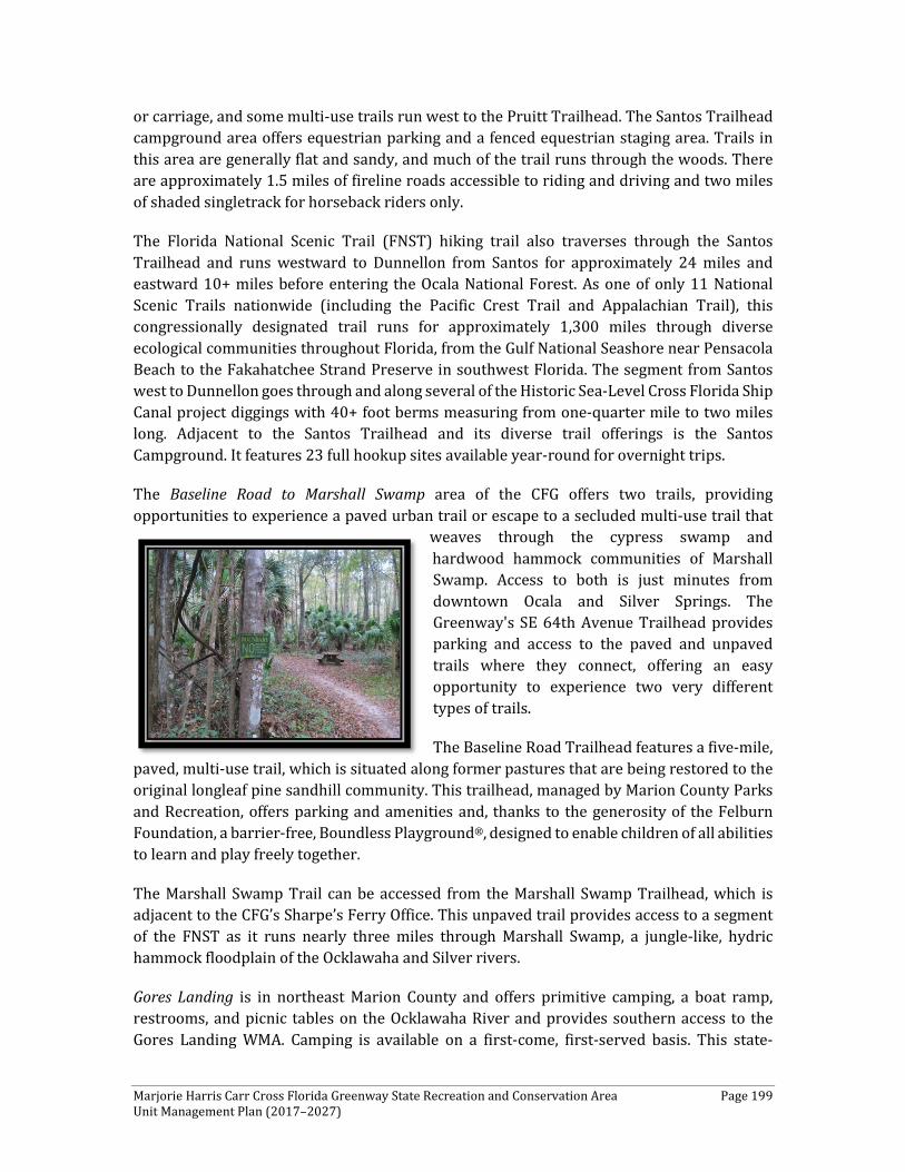
Marjorie Harris Carr Cross Florida Greenway State Recreation and Conservation Area Page 199 Unit Management Plan (2017–2027)
or carriage, and some multi-use trails run west to the Pruitt Trailhead. The Santos Trailhead campground area offers equestrian parking and a fenced equestrian staging area. Trails in this area are generally flat and sandy, and much of the trail runs through the woods. There are approximately 1.5 miles of fireline roads accessible to riding and driving and two miles of shaded singletrack for horseback riders only.
The Florida National Scenic Trail (FNST) hiking trail also traverses through the Santos Trailhead and runs westward to Dunnellon from Santos for approximately 24 miles and eastward 10+ miles before entering the Ocala National Forest. As one of only 11 National Scenic Trails nationwide (including the Pacific Crest Trail and Appalachian Trail), this congressionally designated trail runs for approximately 1,300 miles through diverse ecological communities throughout Florida, from the Gulf National Seashore near Pensacola Beach to the Fakahatchee Strand Preserve in southwest Florida. The segment from Santos west to Dunnellon goes through and along several of the Historic Sea-Level Cross Florida Ship Canal project diggings with 40+ foot berms measuring from one-quarter mile to two miles long. Adjacent to the Santos Trailhead and its diverse trail offerings is the Santos Campground. It features 23 full hookup sites available year-round for overnight trips.
The Baseline Road to Marshall Swamp area of the CFG offers two trails, providing opportunities to experience a paved urban trail or escape to a secluded multi-use trail that
weaves through the cypress swamp and hardwood hammock communities of Marshall Swamp. Access to both is just minutes from downtown Ocala and Silver Springs. The Greenway's SE 64th Avenue Trailhead provides parking and access to the paved and unpaved trails where they connect, offering an easy opportunity to experience two very different types of trails.
The Baseline Road Trailhead features a five-mile, paved, multi-use trail, which is situated along former pastures that are being restored to the original longleaf pine sandhill community. This trailhead, managed by Marion County Parks and Recreation, offers parking and amenities and, thanks to the generosity of the Felburn Foundation, a barrier-free, Boundless Playground®, designed to enable children of all abilities to learn and play freely together.
The Marshall Swamp Trail can be accessed from the Marshall Swamp Trailhead, which is adjacent to the CFG’s Sharpe’s Ferry Office. This unpaved trail provides access to a segment of the FNST as it runs nearly three miles through Marshall Swamp, a jungle-like, hydric hammock floodplain of the Ocklawaha and Silver rivers.
Gores Landing is in northeast Marion County and offers primitive camping, a boat ramp, restrooms, and picnic tables on the Ocklawaha River and provides southern access to the Gores Landing WMA. Camping is available on a first-come, first-served basis. This state-
Marjorie Harris Carr Cross Florida Greenway State Recreation and Conservation Area Page 200 Unit Management Plan (2017–2027)
owned property is leased to the Marion County Board of County Commissioners, who have managed the facility since 1966. In addition to fishing, the Gore’s Landing area offers 52 days of hunting each year, in accordance with WMA regulations and rules per FWC, with the same species sought as at Caravelle.
Eureka East and West Boat Ramps are in northeast Marion County on the Ocklawaha River and both include a boat ramp and picnic pavillion, while Eureka West also contains a fishing dock. This state-owned property is leased to the Marion County Board of County Commissioners, who have managed the facility since 1977.
The Orange Springs Boat Ramp provides paddle and watercraft access to the Ocklawaha River, as well as a picnic pavilion. Marion County has leased the boat ramp from the state since 1993.
Protected Zones There are 15 occurrences of longspurred mint in Marion and Sumter counties, of which six of these populations are on the CFG. The plant has been extirpated from several sites in these counties. The CFG is the only conservation land that supports a mint population. These areas will be considered protected zones. The primary protected area within the Marion County portion of the CFG is the scrub habitat immediately adjacent to I-75. CFG staff have contributed significant resources to the restoration of this area. The total area is 1,088 acres and there are numerous nesting scrub jays within the area.
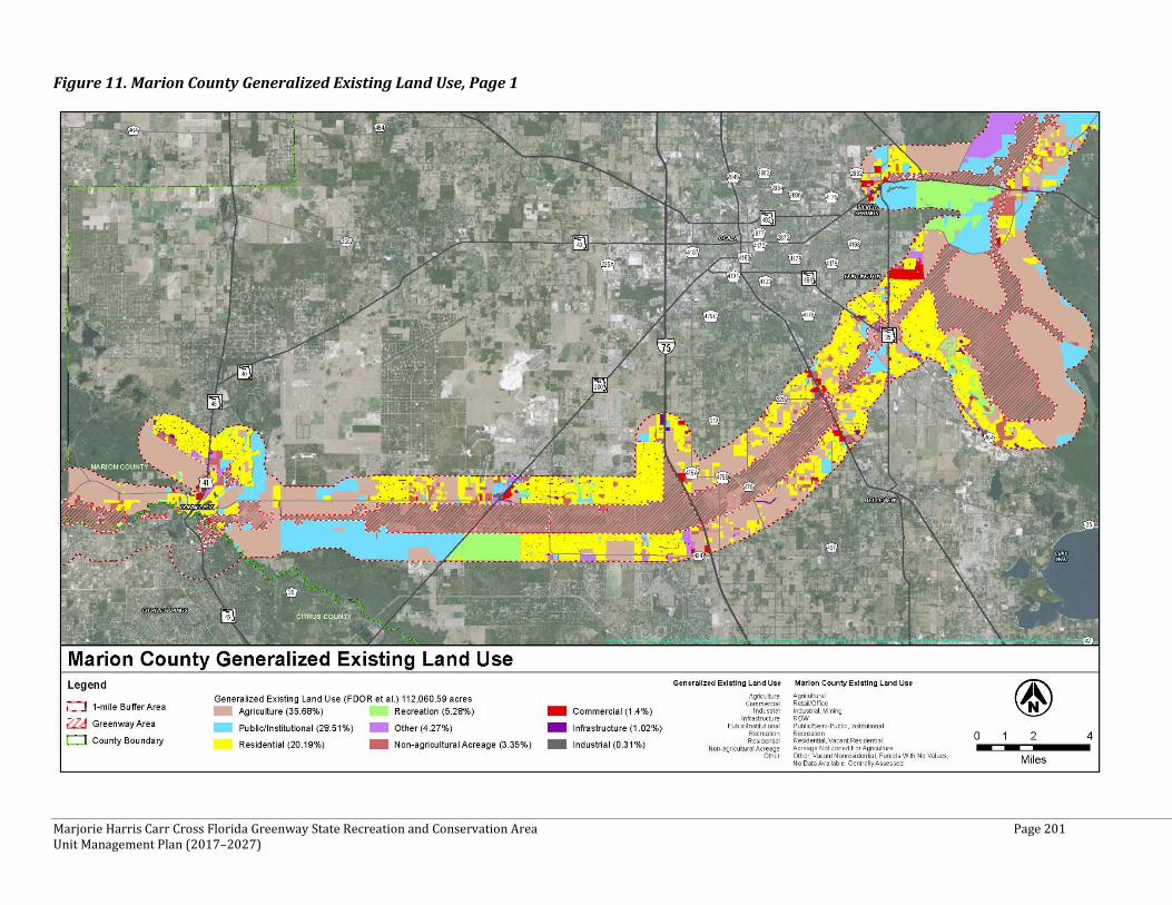
Marjorie Harris Carr Cross Florida Greenway State Recreation and Conservation Area Page 201 Unit Management Plan (2017–2027)
Figure 11. Marion County Generalized Existing Land Use, Page 1
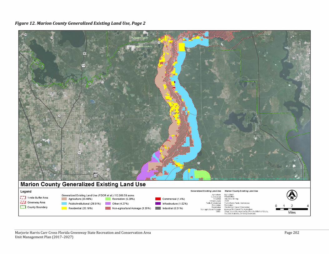
Marjorie Harris Carr Cross Florida Greenway State Recreation and Conservation Area Page 202 Unit Management Plan (2017–2027)
Figure 12. Marion County Generalized Existing Land Use, Page 2
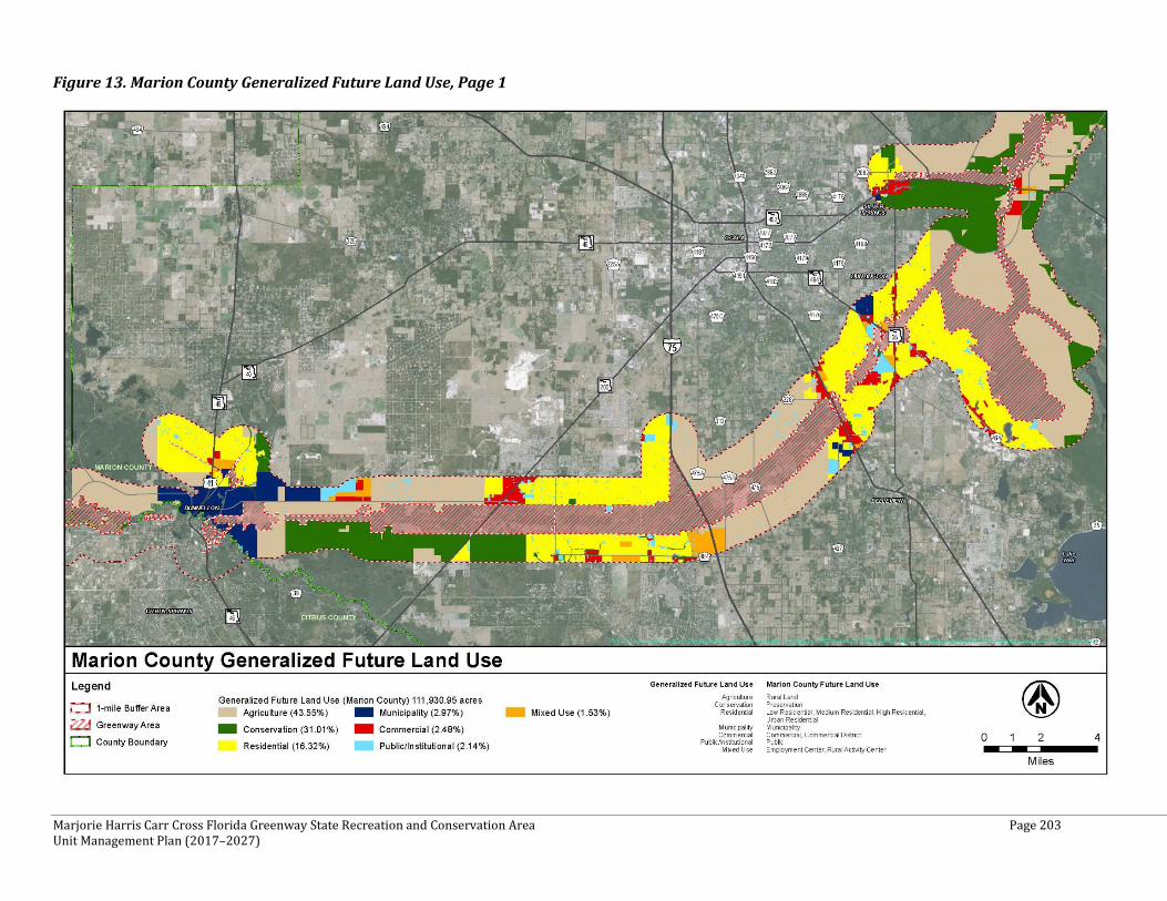
Marjorie Harris Carr Cross Florida Greenway State Recreation and Conservation Area Page 203 Unit Management Plan (2017–2027)
Figure 13. Marion County Generalized Future Land Use, Page 1
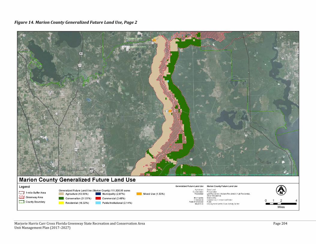
Marjorie Harris Carr Cross Florida Greenway State Recreation and Conservation Area Page 204 Unit Management Plan (2017–2027)
Figure 14. Marion County Generalized Future Land Use, Page 2
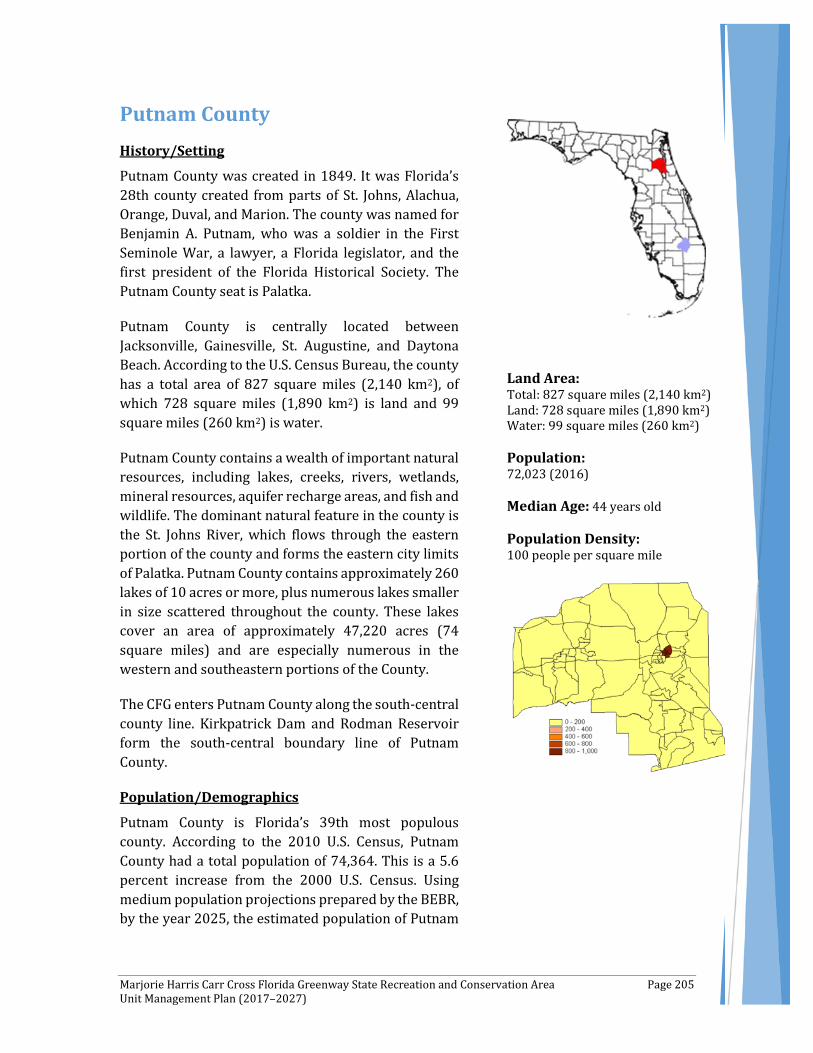
Marjorie Harris Carr Cross Florida Greenway State Recreation and Conservation Area Page 205 Unit Management Plan (2017–2027)
Putnam County History/Setting
Putnam County was created in 1849. It was Florida’s 28th county created from parts of St. Johns, Alachua, Orange, Duval, and Marion. The county was named for Benjamin A. Putnam, who was a soldier in the First Seminole War, a lawyer, a Florida legislator, and the first president of the Florida Historical Society. The Putnam County seat is Palatka.
Putnam County is centrally located between Jacksonville, Gainesville, St. Augustine, and Daytona Beach. According to the U.S. Census Bureau, the county has a total area of 827 square miles (2,140 km2), of which 728 square miles (1,890 km2) is land and 99 square miles (260 km2) is water.
Putnam County contains a wealth of important natural resources, including lakes, creeks, rivers, wetlands, mineral resources, aquifer recharge areas, and fish and wildlife. The dominant natural feature in the county is the St. Johns River, which flows through the eastern portion of the county and forms the eastern city limits of Palatka. Putnam County contains approximately 260 lakes of 10 acres or more, plus numerous lakes smaller in size scattered throughout the county. These lakes cover an area of approximately 47,220 acres (74 square miles) and are especially numerous in the western and southeastern portions of the County.
The CFG enters Putnam County along the south-central county line. Kirkpatrick Dam and Rodman Reservoir form the south-central boundary line of Putnam County.
Population/Demographics
Putnam County is Florida’s 39th most populous county. According to the 2010 U.S. Census, Putnam County had a total population of 74,364. This is a 5.6 percent increase from the 2000 U.S. Census. Using medium population projections prepared by the BEBR, by the year 2025, the estimated population of Putnam
Land Area: Total: 827 square miles (2,140 km2) Land: 728 square miles (1,890 km2) Water: 99 square miles (260 km2) Population: 72,023 (2016) Median Age: 44 years old Population Density: 100 people per square mile
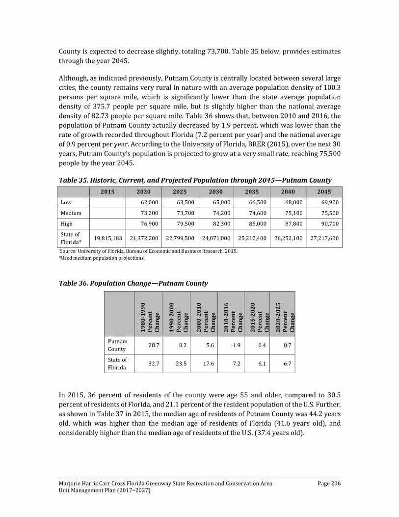
Marjorie Harris Carr Cross Florida Greenway State Recreation and Conservation Area Page 206 Unit Management Plan (2017–2027)
County is expected to decrease slightly, totaling 73,700. Table 35 below, provides estimates through the year 2045.
Although, as indicated previously, Putnam County is centrally located between several large cities, the county remains very rural in nature with an average population density of 100.3 persons per square mile, which is significantly lower than the state average population density of 375.7 people per square mile, but is slightly higher than the national average density of 82.73 people per square mile. Table 36 shows that, between 2010 and 2016, the population of Putnam County actually decreased by 1.9 percent, which was lower than the rate of growth recorded throughout Florida (7.2 percent per year) and the national average of 0.9 percent per year. According to the University of Florida, BRER (2015), over the next 30 years, Putnam County’s population is projected to grow at a very small rate, reaching 75,500 people by the year 2045.
Table 35. Historic, Current, and Projected Population through 2045—Putnam County
Source: University of Florida, Bureau of Economic and Business Research, 2015. *Used medium population projections.
Table 36. Population Change—Putnam County
1980
-199
0 Pe
rcen
t Ch
ange
1990
-200
0 Pe
rcen
t Ch
ange
2000
-201
0 Pe
rcen
t Ch
ange
2010
-201
6 Pe
rcen
t Ch
ange
2015
-202
0 Pe
rcen
t Ch
ange
2020
-202
5 Pe
rcen
t Ch
ange
Putnam County 28.7 8.2 5.6 -1.9 0.4 0.7
State of Florida 32.7 23.5 17.6 7.2 6.1 6.7
In 2015, 36 percent of residents of the county were age 55 and older, compared to 30.5 percent of residents of Florida, and 21.1 percent of the resident population of the U.S. Further, as shown in Table 37 in 2015, the median age of residents of Putnam County was 44.2 years old, which was higher than the median age of residents of Florida (41.6 years old), and considerably higher than the median age of residents of the U.S. (37.4 years old).
2015 2020 2025 2030 2035 2040 2045
Low 62,000 63,500 65,000 66,500 68,000 69,900
Medium 73,200 73,700 74,200 74,600 75,100 75,500
High 76,900 79,500 82,300 85,000 87,800 90,700
State of Florida* 19,815,183 21,372,200 22,799,500 24,071,000 25,212,400 26,252,100 27,217,600
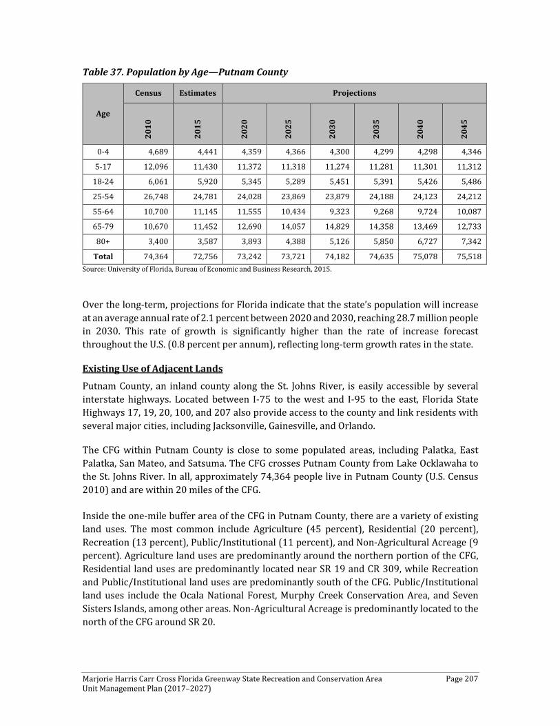
Marjorie Harris Carr Cross Florida Greenway State Recreation and Conservation Area Page 207 Unit Management Plan (2017–2027)
Table 37. Population by Age—Putnam County
Age
Census Estimates Projections
2010
2015
2020
2025
2030
2035
2040
2045
0-4 4,689 4,441 4,359 4,366 4,300 4,299 4,298 4,346
5-17 12,096 11,430 11,372 11,318 11,274 11,281 11,301 11,312
18-24 6,061 5,920 5,345 5,289 5,451 5,391 5,426 5,486
25-54 26,748 24,781 24,028 23,869 23,879 24,188 24,123 24,212
55-64 10,700 11,145 11,555 10,434 9,323 9,268 9,724 10,087
65-79 10,670 11,452 12,690 14,057 14,829 14,358 13,469 12,733
80+ 3,400 3,587 3,893 4,388 5,126 5,850 6,727 7,342
Total 74,364 72,756 73,242 73,721 74,182 74,635 75,078 75,518 Source: University of Florida, Bureau of Economic and Business Research, 2015.
Over the long-term, projections for Florida indicate that the state’s population will increase at an average annual rate of 2.1 percent between 2020 and 2030, reaching 28.7 million people in 2030. This rate of growth is significantly higher than the rate of increase forecast throughout the U.S. (0.8 percent per annum), reflecting long-term growth rates in the state.
Existing Use of Adjacent Lands
Putnam County, an inland county along the St. Johns River, is easily accessible by several interstate highways. Located between I-75 to the west and I-95 to the east, Florida State Highways 17, 19, 20, 100, and 207 also provide access to the county and link residents with several major cities, including Jacksonville, Gainesville, and Orlando.
The CFG within Putnam County is close to some populated areas, including Palatka, East Palatka, San Mateo, and Satsuma. The CFG crosses Putnam County from Lake Ocklawaha to the St. Johns River. In all, approximately 74,364 people live in Putnam County (U.S. Census 2010) and are within 20 miles of the CFG.
Inside the one-mile buffer area of the CFG in Putnam County, there are a variety of existing land uses. The most common include Agriculture (45 percent), Residential (20 percent), Recreation (13 percent), Public/Institutional (11 percent), and Non-Agricultural Acreage (9 percent). Agriculture land uses are predominantly around the northern portion of the CFG, Residential land uses are predominantly located near SR 19 and CR 309, while Recreation and Public/Institutional land uses are predominantly south of the CFG. Public/Institutional land uses include the Ocala National Forest, Murphy Creek Conservation Area, and Seven Sisters Islands, among other areas. Non-Agricultural Acreage is predominantly located to the north of the CFG around SR 20.
Marjorie Harris Carr Cross Florida Greenway State Recreation and Conservation Area Page 208 Unit Management Plan (2017–2027)
Figure 15, below, displays the generalized existing land use for Putnam County within one mile of the CFG.
Planned Use of Adjacent Lands
Putnam County, with an abundance of natural features, also has a variety of appealing qualities. As indicated earlier, travel to and from this area is easy given the abundant roadway access. The convenience of the St. Johns River and its proximity to the Gulf of Mexico make it attractive for future development while being mindful of the threat of inland flooding. A review of the 2018-2022 Florida Department of Transportation Five-Year Work Program and Putnam County’s website did not identify any proposed widening or new alignment roadway projects within the vicinity of the CFG in Putnam County
Inside the one-mile buffer area of the CFG in Putnam County, some changes can be noticed from existing land use to future land use. These changes include a substantial increase in Agriculture (60 percent) and Conservation (33 percent), addition of Mixed Use (4 percent), and a decrease in Residential (2 percent) and Public/Institutional (1 percent). The increase in Conservation is mostly due to the County’s land use re-classification. Areas such as the CFG, Ocala National Forest, Seven Sisters Islands, and Murphy Creek Conservation Area were classified previously as Public/Institutional or Recreation under then-existing land use and are now classified as Conservation under future land use. Given that most of the land surrounding the CFG is Conservation, currently the county does not foresee any significant development occurring within the one-mile buffer of the CFG.
Figure 16, below, displays the generalized future land use for Putnam County within one mile of the CFG.
Property Analysis
As indicated previously, in an attempt to better understand and detail the specific recreation resource elements, this plan details these resources by county. Effective planning requires a thorough understanding of the unit's natural and cultural resources. This section describes the resource characteristics and existing uses of the property. The unit's recreation resource elements are examined to identify the opportunities and constraints they present for recreational development. Past and present uses are assessed for their effects on the property, compatibility with the site, and relation to the unit's classification.
Recreation Resource Elements This section of the Land Use Component assesses the park’s recreational resource elements, those physical qualities that, either singly or in certain combinations, can support various resource-based recreation activities. Breaking down the property into such elements provides a means for measuring the property's capability to support potential recreational activities. This process also analyzes the existing spatial factors that either favor or limit the provision of each activity.
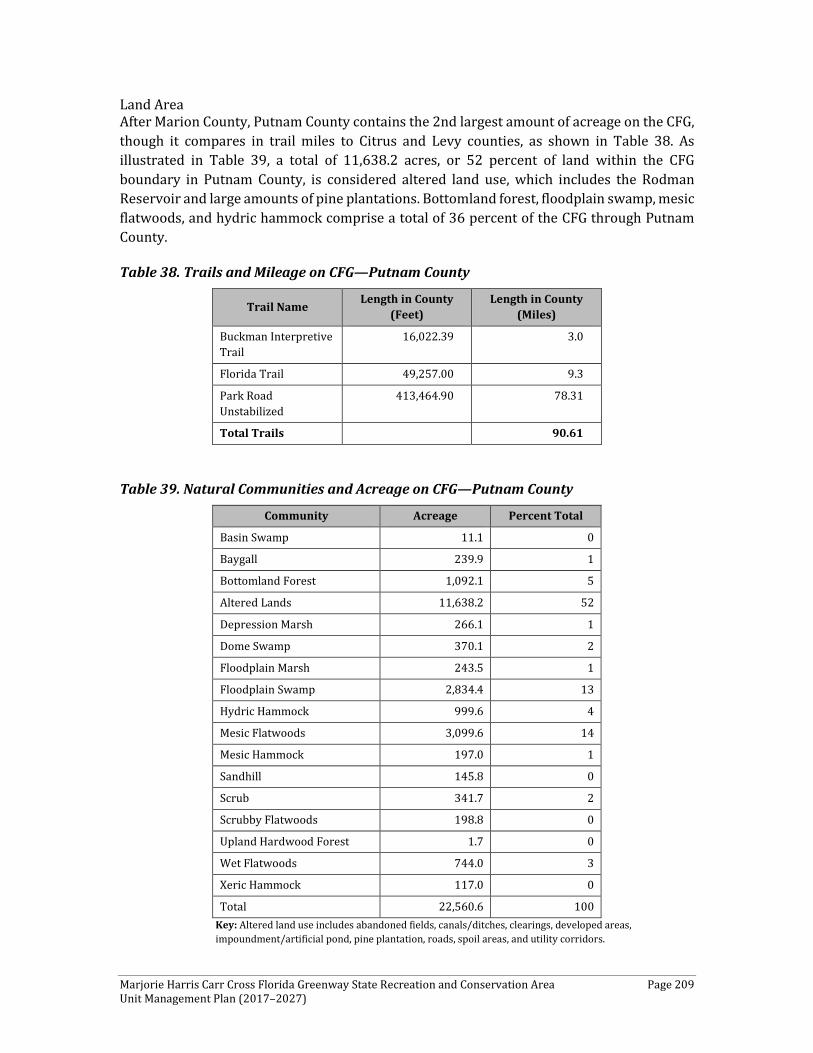
Marjorie Harris Carr Cross Florida Greenway State Recreation and Conservation Area Page 209 Unit Management Plan (2017–2027)
Land Area After Marion County, Putnam County contains the 2nd largest amount of acreage on the CFG, though it compares in trail miles to Citrus and Levy counties, as shown in Table 38. As illustrated in Table 39, a total of 11,638.2 acres, or 52 percent of land within the CFG boundary in Putnam County, is considered altered land use, which includes the Rodman Reservoir and large amounts of pine plantations. Bottomland forest, floodplain swamp, mesic flatwoods, and hydric hammock comprise a total of 36 percent of the CFG through Putnam County.
Table 38. Trails and Mileage on CFG—Putnam County
Trail Name Length in County (Feet)
Length in County (Miles)
Buckman Interpretive Trail
16,022.39 3.0
Florida Trail 49,257.00 9.3
Park Road Unstabilized
413,464.90 78.31
Total Trails 90.61
Table 39. Natural Communities and Acreage on CFG—Putnam County
Community Acreage Percent Total
Basin Swamp 11.1 0
Baygall 239.9 1
Bottomland Forest 1,092.1 5
Altered Lands 11,638.2 52
Depression Marsh 266.1 1
Dome Swamp 370.1 2
Floodplain Marsh 243.5 1
Floodplain Swamp 2,834.4 13
Hydric Hammock 999.6 4
Mesic Flatwoods 3,099.6 14
Mesic Hammock 197.0 1
Sandhill 145.8 0
Scrub 341.7 2
Scrubby Flatwoods 198.8 0
Upland Hardwood Forest 1.7 0
Wet Flatwoods 744.0 3
Xeric Hammock 117.0 0
Total 22,560.6 100 Key: Altered land use includes abandoned fields, canals/ditches, clearings, developed areas, impoundment/artificial pond, pine plantation, roads, spoil areas, and utility corridors.
Marjorie Harris Carr Cross Florida Greenway State Recreation and Conservation Area Page 210 Unit Management Plan (2017–2027)
Outstanding examples of hydric hammock within the CFG occur along Deep Creek, north of Hunter Road, and several areas that join the Ocklawaha River. Other areas include north and south of the Buckman Lock and north and east of the Rodman Reservoir, near the Kenwood Recreation Area.
As stated previously, restoration of scrub habitat is a priority. This portion of the CFG contains 341.7 acres of scrub, of which 157.3 acres are located within the Deep Creek area. This area also contains 106.5 acres of sandhill and approximately 13.0 acres of scrubby flatwoods. One of the most significant examples of quality hydric hammock on the CFG is in the Deep Creek area.
Water Area As the reservoir makes its turn to the east, Orange Creek flows in from the northwest. Farther east, the Deep Creek and Sweetwater Creek complexes flow into the reservoir. Much of the Sweetwater Creek complex is on the CFG. East of the reservoir, the east barge canal extends about nine miles to the east-northeast, where it joins with the St. Johns River. This part of the canal bisected the Camp Branch Creek system and disrupted the natural surficial flows. The Camp Branch Creek system originally flowed south-southeast, connecting the Cow Heaven Bay Swamp to the St. Johns River. Buckman Lock, still operational, is located in the eastern canal. CFG lands continue about five miles northeast along the St. Johns River.
CFG staff maintain and operate the Buckman Lock and Kirkpatrick Dam and Spillway. The Buckman Lock controls water access to Rodman Reservoir from the St. Johns River through the east barge canal. It should also be noted that during storm events, Department of Defense vessels (USCG, COE and USN) use Buckman Lock as a safe harbor. The Kirkpatrick Dam spillway controls the level of Rodman Reservoir. Generally, the water level of the reservoir is kept at the 18 feet to 20 feet national geodetic vertical datum (NGVD) level which is equal to MSL at the dam. The water level is drawn down every three to four years to 11 feet based upon mutual assessment with FWC fisheries and aquatic plant staff. This is completed to consolidate bottom sediments, enhance the fishery and wildlife habitats, and to assist in control of aquatic plants.
Natural Scenery Deep Creek is scenic and provides significant habitat to numerous rare species with its excellent-quality hydric hammock.
Significant Habitat Several areas of significant botanical habitat were identified by FNAI throughout the Putnam County portion of the CFG. These include: Ocklawaha River floodplain, Eureka Dam, Deep Creek, select areas surrounding the Rodman Reservoir, Caravelle Ranch West, and select areas surrounding the Buckman Lock.
Archaeological and Historical Features With the exception of two abandoned rail lines, the previously recorded cultural sites in the Putnam County section of the CFG consist exclusively of a variety of prehistoric archaeological sites. The nature of a number of the archaeological sites is unclear, but each in
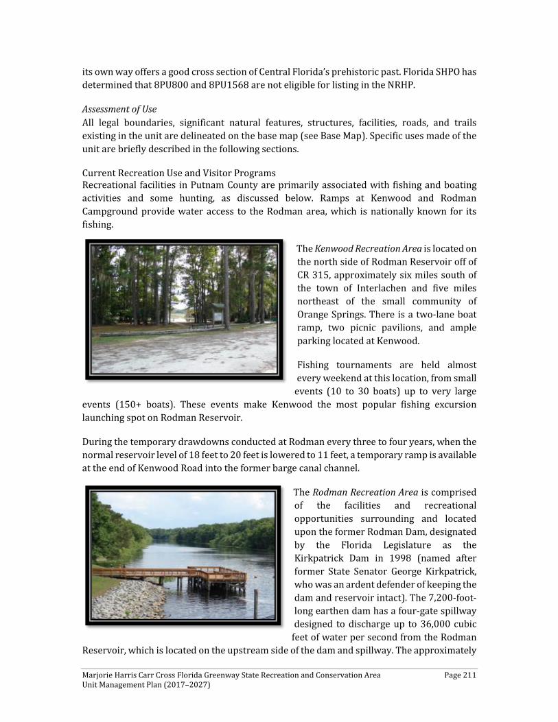
Marjorie Harris Carr Cross Florida Greenway State Recreation and Conservation Area Page 211 Unit Management Plan (2017–2027)
its own way offers a good cross section of Central Florida’s prehistoric past. Florida SHPO has determined that 8PU800 and 8PU1568 are not eligible for listing in the NRHP.
Assessment of Use All legal boundaries, significant natural features, structures, facilities, roads, and trails existing in the unit are delineated on the base map (see Base Map). Specific uses made of the unit are briefly described in the following sections.
Current Recreation Use and Visitor Programs Recreational facilities in Putnam County are primarily associated with fishing and boating activities and some hunting, as discussed below. Ramps at Kenwood and Rodman Campground provide water access to the Rodman area, which is nationally known for its fishing.
The Kenwood Recreation Area is located on the north side of Rodman Reservoir off of CR 315, approximately six miles south of the town of Interlachen and five miles northeast of the small community of Orange Springs. There is a two-lane boat ramp, two picnic pavilions, and ample parking located at Kenwood.
Fishing tournaments are held almost every weekend at this location, from small
events (10 to 30 boats) up to very large events (150+ boats). These events make Kenwood the most popular fishing excursion launching spot on Rodman Reservoir.
During the temporary drawdowns conducted at Rodman every three to four years, when the normal reservoir level of 18 feet to 20 feet is lowered to 11 feet, a temporary ramp is available at the end of Kenwood Road into the former barge canal channel.
The Rodman Recreation Area is comprised of the facilities and recreational opportunities surrounding and located upon the former Rodman Dam, designated by the Florida Legislature as the Kirkpatrick Dam in 1998 (named after former State Senator George Kirkpatrick, who was an ardent defender of keeping the dam and reservoir intact). The 7,200-foot-long earthen dam has a four-gate spillway designed to discharge up to 36,000 cubic
feet of water per second from the Rodman Reservoir, which is located on the upstream side of the dam and spillway. The approximately
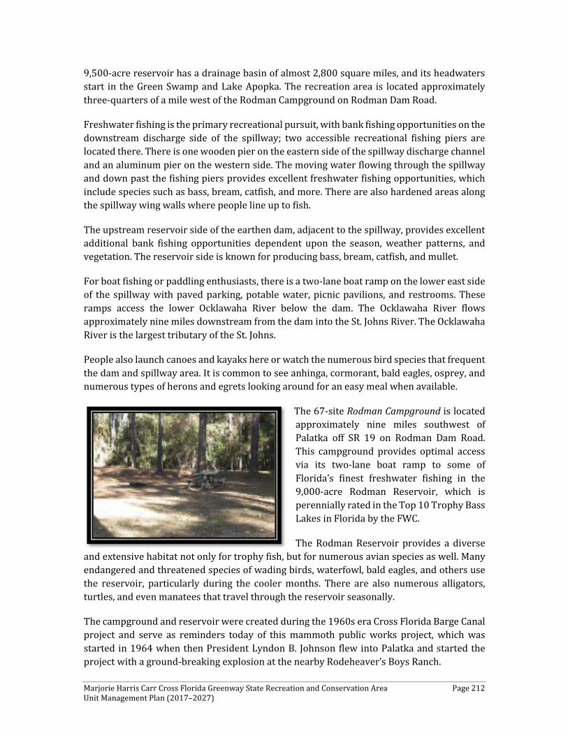
Marjorie Harris Carr Cross Florida Greenway State Recreation and Conservation Area Page 212 Unit Management Plan (2017–2027)
9,500-acre reservoir has a drainage basin of almost 2,800 square miles, and its headwaters start in the Green Swamp and Lake Apopka. The recreation area is located approximately three-quarters of a mile west of the Rodman Campground on Rodman Dam Road.
Freshwater fishing is the primary recreational pursuit, with bank fishing opportunities on the downstream discharge side of the spillway; two accessible recreational fishing piers are located there. There is one wooden pier on the eastern side of the spillway discharge channel and an aluminum pier on the western side. The moving water flowing through the spillway and down past the fishing piers provides excellent freshwater fishing opportunities, which include species such as bass, bream, catfish, and more. There are also hardened areas along the spillway wing walls where people line up to fish.
The upstream reservoir side of the earthen dam, adjacent to the spillway, provides excellent additional bank fishing opportunities dependent upon the season, weather patterns, and vegetation. The reservoir side is known for producing bass, bream, catfish, and mullet.
For boat fishing or paddling enthusiasts, there is a two-lane boat ramp on the lower east side of the spillway with paved parking, potable water, picnic pavilions, and restrooms. These ramps access the lower Ocklawaha River below the dam. The Ocklawaha River flows approximately nine miles downstream from the dam into the St. Johns River. The Ocklawaha River is the largest tributary of the St. Johns.
People also launch canoes and kayaks here or watch the numerous bird species that frequent the dam and spillway area. It is common to see anhinga, cormorant, bald eagles, osprey, and numerous types of herons and egrets looking around for an easy meal when available.
The 67-site Rodman Campground is located approximately nine miles southwest of Palatka off SR 19 on Rodman Dam Road. This campground provides optimal access via its two-lane boat ramp to some of Florida’s finest freshwater fishing in the 9,000-acre Rodman Reservoir, which is perennially rated in the Top 10 Trophy Bass Lakes in Florida by the FWC.
The Rodman Reservoir provides a diverse and extensive habitat not only for trophy fish, but for numerous avian species as well. Many endangered and threatened species of wading birds, waterfowl, bald eagles, and others use the reservoir, particularly during the cooler months. There are also numerous alligators, turtles, and even manatees that travel through the reservoir seasonally.
The campground and reservoir were created during the 1960s era Cross Florida Barge Canal project and serve as reminders today of this mammoth public works project, which was started in 1964 when then President Lyndon B. Johnson flew into Palatka and started the project with a ground-breaking explosion at the nearby Rodeheaver’s Boys Ranch.
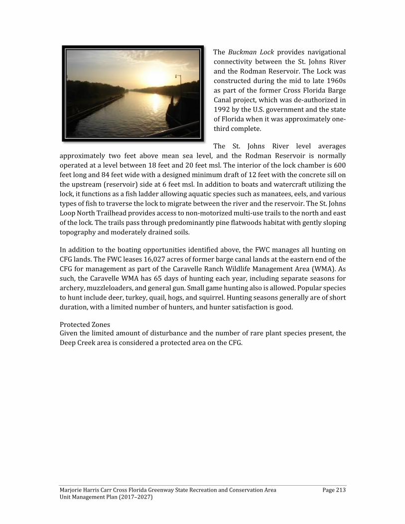
Marjorie Harris Carr Cross Florida Greenway State Recreation and Conservation Area Page 213 Unit Management Plan (2017–2027)
The Buckman Lock provides navigational connectivity between the St. Johns River and the Rodman Reservoir. The Lock was constructed during the mid to late 1960s as part of the former Cross Florida Barge Canal project, which was de-authorized in 1992 by the U.S. government and the state of Florida when it was approximately one-third complete.
The St. Johns River level averages approximately two feet above mean sea level, and the Rodman Reservoir is normally operated at a level between 18 feet and 20 feet msl. The interior of the lock chamber is 600 feet long and 84 feet wide with a designed minimum draft of 12 feet with the concrete sill on the upstream (reservoir) side at 6 feet msl. In addition to boats and watercraft utilizing the lock, it functions as a fish ladder allowing aquatic species such as manatees, eels, and various types of fish to traverse the lock to migrate between the river and the reservoir. The St. Johns Loop North Trailhead provides access to non-motorized multi-use trails to the north and east of the lock. The trails pass through predominantly pine flatwoods habitat with gently sloping topography and moderately drained soils.
In addition to the boating opportunities identified above, the FWC manages all hunting on CFG lands. The FWC leases 16,027 acres of former barge canal lands at the eastern end of the CFG for management as part of the Caravelle Ranch Wildlife Management Area (WMA). As such, the Caravelle WMA has 65 days of hunting each year, including separate seasons for archery, muzzleloaders, and general gun. Small game hunting also is allowed. Popular species to hunt include deer, turkey, quail, hogs, and squirrel. Hunting seasons generally are of short duration, with a limited number of hunters, and hunter satisfaction is good.
Protected Zones Given the limited amount of disturbance and the number of rare plant species present, the Deep Creek area is considered a protected area on the CFG.

Marjorie Harris Carr Cross Florida Greenway State Recreation and Conservation Area Page 214 Unit Management Plan (2017–2027)
Figure 15. Putnam County Generalized Existing Land Use
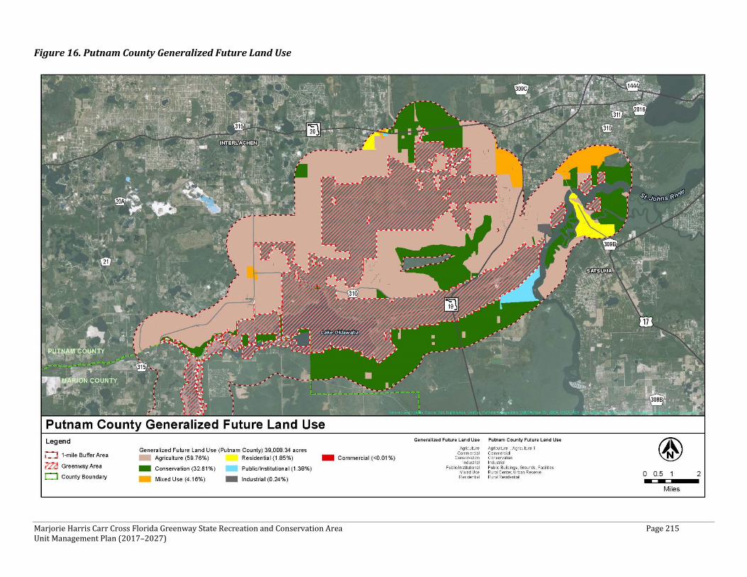
Marjorie Harris Carr Cross Florida Greenway State Recreation and Conservation Area Page 215 Unit Management Plan (2017–2027)
Figure 16. Putnam County Generalized Future Land Use
Marjorie Harris Carr Cross Florida Greenway State Recreation and Conservation Area Page 216 Unit Management Plan (2017–2027)
CONCEPTUAL LAND USE PLAN
The following narrative and Figures 17 through 19, presented below, represent the current conceptual land use proposal for this park. The conceptual land use plan is the long-term, optimal development plan for the park, based on current conditions and knowledge of the park’s resources, landscape, and social setting (see Conceptual Land Use Plan). The conceptual land use plan is modified or amended as new information becomes available regarding the park’s natural and cultural resources or trends in recreational uses to adapt to changing conditions. Additionally, the acquisition of new parkland may provide opportunities for alternative or expanded land uses. The DRP develops a detailed development plan for the park and a site plan for specific facilities based on this conceptual land use plan, as funding becomes available.
During the development of the conceptual land use plan, the DRP assessed the potential impact of proposed uses or development on the park resources and applied that analysis to determine the future physical plan of the park, as well as the scale and character of proposed development. Potential resource impacts also are identified and assessed as part of the site planning process when funding is available for facility development. At that stage, design elements (such as existing topography and vegetation, sewage disposal, and stormwater management) and design constraints (such as imperiled species or cultural site locations) are investigated in greater detail. Municipal sewer connections, advanced wastewater treatment, or best available technology systems are applied for on-site sewage disposal. Creation of impervious surfaces is minimized to the greatest extent feasible to limit the need for stormwater management systems, and all facilities are designed and constructed using best management practices to limit and avoid resource impacts. Federal, state, and local permit and regulatory requirements are addressed during facility development. This includes the design of all new park facilities consistent with the universal access requirements of the Americans with Disabilities Act (ADA). After new facilities are constructed, park staff monitors conditions to ensure that impacts remain within acceptable levels.
Potential Uses
Public Access and Recreational Opportunities
Goal: Provide public access and recreational opportunities in the park.
A. Public Accessibility The CFG is a long linear corridor with a permeable boundary. Access points exist along the extent of the 110-mile long CFG. It is not feasible to control every ingress/egress point along the CFG, resulting in unmonitored access. CFG staff work with adjacent property owners to provide communal access locations. This encourages a “stewardship” philosophy among adjacent landowners towards the CFG. While public access is considered good, unrestrained access can cause management problems and unnecessarily impact the natural resources of the CFG. Given the size and access along the CFG, staff has and will continue to work with emergency responders to develop maps and other locators to increase safety of CFG
Marjorie Harris Carr Cross Florida Greenway State Recreation and Conservation Area Page 217 Unit Management Plan (2017–2027)
visitors. In addition, CFG will continue to work with area developers on public access opportunities.
Due to the extensive management actions required to maintain and restore existing natural communities, the CFG reserves the right to change access points and trails, both existing and planned as they deem appropriate. CFG will continue to engage private businesses along the CFG to encourage the provision of recreation and tourism services. Some objectives related to access for a specified user group are addressed in other sections, such as biking and equestrian.
Objective A1: Maintain the park’s current recreational carrying capacity of 10,000 users per day.
Objective A2: Develop and implement an Interpretive Master Plan.
Objective A3: Update and formalize a policy addressing adjacent landowner access to the CFG.
Objective A4: Review the existing trail network to determine if any need to be closed or realigned for safety, protection of natural resources, or navigability.
Objective A5: Continue to coordinate and seek increased patrol assistance from local and state law enforcement agencies.
B. Education Facilities The CFG offers opportunities to view extensive natural and cultural resources. Opportunities exist to improve the signage and interpretation for these resources throughout the CFG. CFG will work to provide natural, recreational, cultural and historical resources interpretation materials and make them available to visitors. New digital technologies are available to improve the interpretive experience and will be incorporated where appropriate.
Objective B1: Continue to provide natural, recreational, cultural and historical resources interpretation (e.g., signage, checklists, kiosks) where appropriate along the CFG.
Objective B2: Evaluate interpretive opportunities at the lock system and more specifically, the Buckman Lock.
Objective B3: Coordinate with OTIS to update the park’s website to be more user friendly, educational, and interpretive.
Objective B4: Develop interpretive brochures and identify locations for distribution, both within and outside the CFG.
Objective B5: Evaluate opportunities to partner with developers and surrounding land owners to enhance interpretive opportunities through the CFG.
Marjorie Harris Carr Cross Florida Greenway State Recreation and Conservation Area Page 218 Unit Management Plan (2017–2027)
Objective B6: Develop and implement an Interpretive Cultural Master Plan. Consider securing grant funds for this effort in conjunction with surrounding municipalities.
C. Multi-Use Trails Given the boundaries and the limited land availability, CFG staff will seek to utilize multi-use trails where appropriate as opposed to individual use trails. Additional multi-use trails, including crossings, are planned for the CFG. A 16-mile multi-use paved trail was constructed from Santos to SR 200. This trail serves as part of the Heart of Florida Trail System that links together a large network of trails. Crossings are necessary for visitor safety and wildlife. It is imperative that trail safety and corresponding signage to alleviate the potential for accidents be considered when developing multi-use and paved trails. Not all land necessary for some of the listed trails is in public ownership. A combination of land acquisition and private landowner agreements may be necessary to establish future trails.
Objective C1: Working with FDOT and other partners, establish off-grade road crossings where appropriate, including SR 200, US 441 and future expansion of I-75.
Objective C2: Work with the City of Palatka, Putnam County, other state agencies, and public interest groups to improve connectivity to the Water Works Environmental Education Center in Palatka.
Objective C3: Evaluate other opportunities to establish linkages to other publicly-accessible multi-use trails.
Objective C4: Evaluate and assess additional safety measures and corresponding signage along multi-use paved trails throughout the CFG.
Objective C5: Add mile marker signage to multi-use trails in the CFG.
Continue coordination with EMS/LE on-trail reference points. Location reference markers are better when latitude/longitude is incorporated for emergency management services and law enforcement use.
D. Hiking Trails for hiking-only are maintained by the Florida Trail Association (FTA). The CFG contains 43 miles of the FNST. Additional incorporation of the FNST within the CFG also should be considered and encouraged. Linkages to other publicly accessible hiking trails also would be beneficial. Any proposed new hiking trails will be carefully evaluated on a case by case basis. Currently, an extensive network of hiking trails exists throughout the CFG. Given this, the CFG has a limitation placed on the number of trails that can be developed while balancing the maintenance of quality wildlife habitat and ecological function. CFG staff remain committed to working in concert with FTA to maintain the existing hiking trail network. The inclusion of more interpretive materials along the trails is warranted.
Marjorie Harris Carr Cross Florida Greenway State Recreation and Conservation Area Page 219 Unit Management Plan (2017–2027)
Objective D1: Evaluate and update the existing maintenance agreement with FTA, which encourages the responsible use and maintenance of hiking trails.
Objective D2: Encourage relationships with other local groups focused on responsible use and maintenance of hiking, walking, running and interpretive trails.
Objective D3: Evaluate other opportunities to establish linkages to other publicly-accessible hiking trails.
E. Biking Responsible biking on the CFG is necessary to protect the natural resources along the Greenway. The Ocala Mountain Bike Association (OMBA) is active in promoting proper trail usage. Similar efforts by other bike groups should be encouraged where appropriate. Any proposed new biking trails will be carefully evaluated on a case by case basis. Currently, there is an extensive network of biking trails throughout the CFG. Given this, the CFG has a limitation placed on the number of trails that can be developed while balancing the quality wildlife habitat and ecological function. CFG staff remain committed to working in concert with OMBA to maintain and expand the existing biking trail network, where appropriate.
Objective E1: Continue to work with the OMBA to promote responsible use and maintenance of bicycle trails and establish additional natural-surface biking trails across the 110-mile length of the CFG, in upland areas, where feasible.
Objective E2: Evaluate and update as necessary existing agreements with biking associations to formalize the planning and maintenance process for mountain biking facilities along the CFG.
Objective E3: Evaluate other opportunities to establish linkages to other publicly-accessible biking trails.
F. Equestrian As with biking, responsible equestrian usage of trails is essential on the Greenway. CFG staff will work with the Greenway Equestrians group and others to encourage responsible use and maintenance of equestrian trails. CFG staff will continuously evaluate and implement adaptations to existing equestrian trails and equestrian facilities as warranted by changing conditions.
Objective F1: Encourage the further development of the Greenway Equestrians group and other equestrian groups along the CFG to promote responsible use and maintenance of equestrian trails.
Objective F2: Relocate equestrian facilities from Santos Trailhead to the SE corner of SE 25th Avenue and SE 95th Street. Also, evaluate potential expansion and improvement opportunities (e.g., new trailhead, campground, and concessionaire).
Objective F3: Evaluate other opportunities to establish linkages to other publicly-accessible equestrian trails.
Marjorie Harris Carr Cross Florida Greenway State Recreation and Conservation Area Page 220 Unit Management Plan (2017–2027)
Objective F4: Continue to provide assistance to those entities that offer equestrian interaction to physically and emotionally challenged individuals where possible.
G. Paddling Although paddling is a popular sport on the Greenway, no trails are currently designated. CFG will work with paddling groups to establish paddling trails and primitive campgrounds along the paddling routes, as appropriate. It is the Army Corps of Engineers' responsibility to maintain the navigability of the Ocklawaha River. CFG is already working with Marion County and other agencies to remove snags from the river to enhance navigability and will continue these cooperative efforts.
Objective G1: Designate and consider marking a paddling trail on the Ocklawaha River with designated official primitive campsites.
Objective G2: Promote the designation of the Ocklawaha River from SR 40 to Eureka (approximately 15 miles) as a Wild and Scenic River.
Objective G3: Evaluate other opportunities to establish linkages to other publicly accessible paddling trails.
H. Boating Motorized boating is popular on the CFG, especially for fishing.
Objective H1: Pave Kenwood Recreation Area road and parking area, provide restrooms, and provide one or more staff/security residences.
Objective H2: In cooperation with FWC and the Coast Guard, provide channel markers for the original river channel (which serves as the navigation channel in many locations) within Rodman Reservoir, if funds are available. Additional funds are needed to implement and be completed in priority order.
Objective H3: Continue partnerships with local governments in the operation and maintenance of boat launches on the CFG.
Objective H4: Evaluate the opportunity to develop a Guided Historical Interpretive Boat Tour along the greenway canal and lock system.
I. Camping Camping is available in a limited number of areas along the CFG. CFG staff plan to improve and provide additional camping facilities, some in association with other activities, such as paddling along the Ocklawaha River.
Objective I1: Evaluate the need for and resource impact of expansion of current campgrounds (i.e., Santos Campground Loop 2 and Ross Prairie).
Objective I2: Evaluate the need for and resource impact of improvements at Kenwood Recreation Area.
Marjorie Harris Carr Cross Florida Greenway State Recreation and Conservation Area Page 221 Unit Management Plan (2017–2027)
Objective I3: Identify and designate current primitive campground facilities (no vehicle access, minimal facilities) in several locations along the Ocklawaha River (boater friendly, improvement of current facilities), along the proposed natural surface trail corridor connecting Marshall Swamp and Rodman (possibly the same as the boater campsites) and between Pruitt Trailhead and Felburn Park. Lack of ability to have natural surface trails between Silver Springs State Park and Rodman area due to low lying lands. Better to use existing aquatic corridor.
J. Fishing Fishing, especially from boats, is popular along the CFG. The opportunity to provide more land-based fishing access points will be evaluated and implemented, if feasible.
Objective J1: Assess the impacts, desirability, demand for, and cost of installing multi-purpose boardwalks/docks that would allow for non-boat fishing on the CFG.
Objective J2: Establish additional fishing access points at appropriate locations.
K. Hunting The feasibility of providing additional hunting opportunities will be discussed with FWC, which manages all hunts on CFG lands. Care will be taken to ensure that hunting does not unduly detract from other user groups use of the CFG.
Objective K1: Continue cooperation with FWC managing hunts in designated hunting areas on the CFG.
Objective K2: Identify and map designated hunting areas within the CFG.
Proposed Facilities
Capital Facilities and Infrastructure
Goal: Develop and maintain the capital facilities and infrastructure necessary to implement the recommendations of the management plan.
The existing facilities of this state park are appropriate to the natural and cultural resources contained in the park and should be maintained. New construction, as discussed further below, is recommended to improve the quality and safety of the recreational opportunities, to improve the protection of park resources, and to streamline the efficiency of park operations. The following is a summary of improved facilities needed to implement the conceptual land use plan for the CFG.
Objective A: Maintain all public and support facilities in the park.
All capital facilities, trails and roads within the park will be kept in proper condition through the daily or regular work of park staff and/or contracted help.
Marjorie Harris Carr Cross Florida Greenway State Recreation and Conservation Area Page 222 Unit Management Plan (2017–2027)
Objective B: Continue to implement the park’s transition plan to ensure facilities are accessible in accordance with the Americans with Disabilities Act of 1990.
Objective C: Expand maintenance activities as existing facilities are improved and new facilities are developed.
Objective D: Develop a prioritization process for necessary capital improvements on the CFG.
As previously indicated, the CFG is 110 miles long and contains numerous recreational opportunities and facilities and limited resources. As such, it is extremely important that the resources are utilized in an efficient manner. By prioritizing these capital improvement activities, it reduces/minimizes maintenance and repair needs.
Objective E: Evaluate and consider the transfer of operation and management responsibilities for the Kirkpatrick Dam and Buckman Lock to the SJRWMD.
Key factors that will be evaluated include implications for restoration permitting, the results of engineering assessments, estimated maintenance and operation costs, and other management costs/benefits.
Facilities Development
Preliminary cost estimates for these recommended facilities and improvements are provided in the Implementation Component of this plan. These cost estimates are based on the most cost-effective construction standards available at this time. The preliminary estimates are provided to assist DRP in budgeting future park improvements, and may be revised as more information is collected through the planning and design processes.
New facilities and improvements to existing facilities recommended by the plan include:
Eureka Lock Law Enforcement
The Eureka Lock is a heavily disturbed borrow pit with extensive unsanctioned OHV activity. CFG would like to place (up to two) law enforcement residences. Sewer and water hookups are present at the site.
Withlacoochee Bay Trail Road
The CFG strongly desires to pave the Withlacoochee Bay Trail maintenance road. By paving this road, the CFG will significantly minimize its maintenance obligations to be able to more efficiently utilize existing resources.
Relocation of Santos Equestrian Facilities
Relocate equestrian facilities from Santos Trailhead farther south and west along the south side of the CFG corridor to minimize the need for accel/decal lanes. Most of CFG equestrian trails are located along the southern boundary of the greenway. By relocating these facilities, it will ensure the appropriate collocation of like uses. In addition to relocation of the facilities, consideration will be given to expansion and
Marjorie Harris Carr Cross Florida Greenway State Recreation and Conservation Area Page 223 Unit Management Plan (2017–2027)
improvement opportunities (e.g., new trailhead, campground, and concessionaire). Santos Campground Improvements Complete existing Santos Campground development by completing electrical, water, and site improvements on the "second loop" of the campground, which currently is primitive. Install new/improved bathhouse to accommodate expanded campsites. Shangri-La Campground Improvements Improvements include power and water to each site to increase accessibility and use.
Baseline to Santos Paved Trail
A paved multi-use trail is planned from Santos to the Baseline Trailhead. The feasibility of a parallel equestrian trail is being considered. The environmental impact would be low, since the trail would be located on former pasture lands that currently are in restoration phase back to sandhill. The concept study was completed many years ago. The project is in design phase now, and DEP is working with Marion County and FDOT to complete the trail project.
Withlacoochee Bay Trail Phase III
Phase III of the Withlacoochee Bay Trail has been completed, extending the existing trail from Felburn Park along the canal berm to where the Withlacoochee River was bisected by the canal to Inglis Island. The only remaining portion of this project is the construction of the eastward bridge, which will facilitate the connection of the trails on the western portion of the CFG.
Other Potential Future Trail/Facilities Developments
In addition to the abovementioned projects, there are several future projects located either in proximity to or on the CFG that will require DRP/CFG involvement during the planning process. These projects are not listed or included in the Implementation Component.
Dunnellon to Inglis Lock Multi-Use Trail Corridor
The acreage of the CFG along the north and south shores of Lake Rousseau is constrained creating a gap in the CFG trail system. CFG would like to establish a paved connector trail north of Lake Rousseau from Dunnellon to the Inglis Lock, primarily using existing right of way of CR 40. Environmental impact is expected to be minimal, given the trail’s location in a right of way. A trail separated from the road is planned. Anticipated partners include Marion County, Levy County, FDOT, and the Cities of Dunnellon and Inglis.CFG to Nature Coast Multi-Use Connector Trail Corridor
Duke Energy has conveyed a perpetual easement on abandoned railroad right-of-way to the state for the establishment of a 42-mile paved multi-use trail from the north side of Dunnellon to Chiefland through the Goethe State Forest connecting to the Nature Coast State Trail. The paved connector from the CFG to Goethe State Forest to Chiefland and the Nature Coast trail system would greatly expand the opportunities for CFG trail users. In addition to the 53,000-acre Goethe State Forest, visitors could access the Nature Coast State Trail. The state does not own most of the land necessary to make the connection to Goethe; the cooperation of private
Marjorie Harris Carr Cross Florida Greenway State Recreation and Conservation Area Page 224 Unit Management Plan (2017–2027)
landowners likely will be necessary. Because of the potential to link two major equestrian trail systems, accommodations for equestrian use will be made if feasible. Anticipated partners are the City of Dunnellon, FDOT, FFS, and private landowners.
Dunnellon to Pruitt Trailhead Multi-Use Trail Corridor
A multi-use trail corridor is planned to link the Pruitt Trailhead to the ballfields in Dunnellon. Additional land acquisition may be necessary for this trail to be completed. Project may use existing road right-of-way where needed to make connection if other lands are not feasible to acquire.
Ocklawaha Paddling Trail with Camping
The feasibility of establishing a paddling trail on the Ocklawaha River and into Rodman Reservoir will be evaluated. The trail may be established with GPS points and maps, rather than posted signage. If feasible, a system of primitive campsites may be established and designated.
Kenwood Recreation Area Improvements
The existing one-mile plus dirt road at the Kenwood Recreation Area will be paved to the boat ramp. This ramp is heavily used by recreational and tournament fishermen. If feasible, the campground will be reopened if funds and staffing are available for development, staffing O&M and security.
Ocklawaha River Visitor Center and Interpretive Trail Improvements
The Felburn Foundation leases the Ocklawaha Visitor Center located on 2.7 acres on the corner of State Hwy 40 and County Rd 315. The Felburn Foundation will fund all necessary improvements to the interior and exterior of the structure. In addition to these improvements, the Felburn Fondation would erect a kiosk at the trail head with interpretive information regarding the trail to the Ocklawaha River with shared information regarding the public lands trails systems that are found throughout this area. They would also develop and install interpretive trail signs approved by DEP's biologists on the trail to the Ocklawaha River.
US 19 Boat Ramp
CFG has been approached by Citrus County to consider leasing 16 acres of land on the north side of the barge canal just west of US 19 for a boat ramp. This property is isolated from other DEP lands and is somewhat disturbed. The proposed regional boat ramp facility would provide adequate parking to handle the majority of high-use times in the area, such as during scalloping season, major summer holidays, etc. The approved manatee protection plan for Citrus County only allows additional boat ramps to the Gulf on the barge canal. A 30-year lease is planned that will give the county five years to fund, design, permit, and construct the boat ramp, or the lease will be canceled if this project is not pursued further by the county. Anticipated partners include Citrus County and FWC.
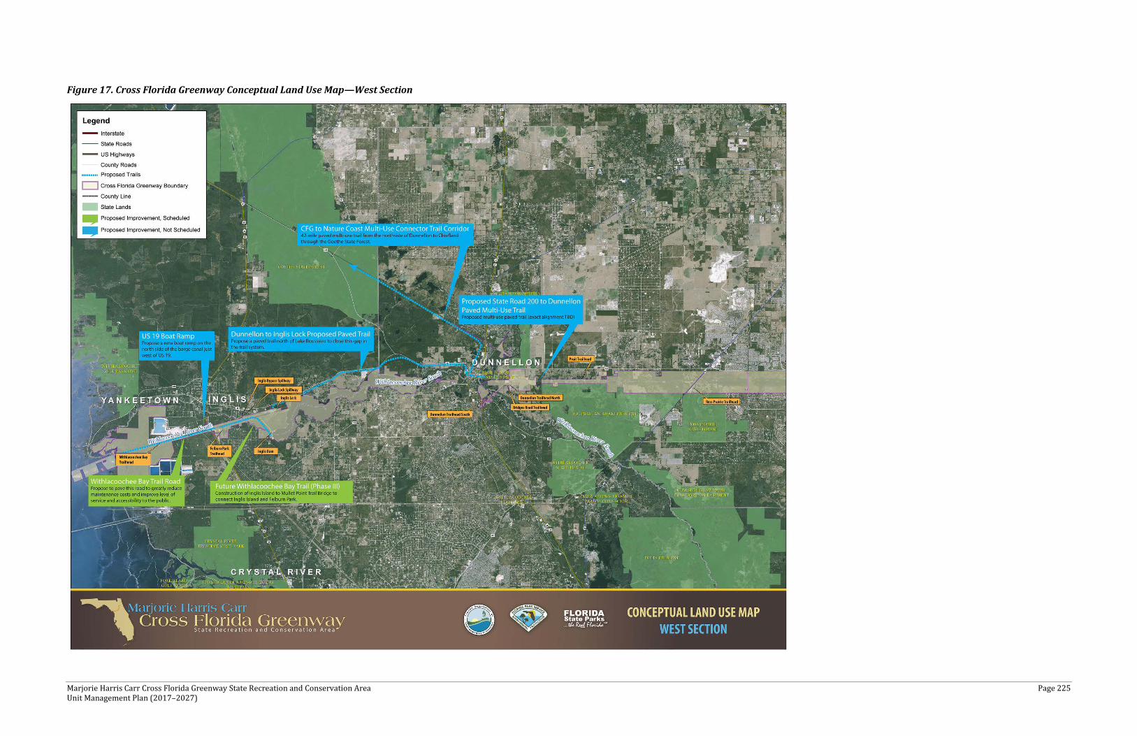
Marjorie Harris Carr Cross Florida Greenway State Recreation and Conservation Area Page 225 Unit Management Plan (2017–2027)
Figure 17. Cross Florida Greenway Conceptual Land Use Map—West Section
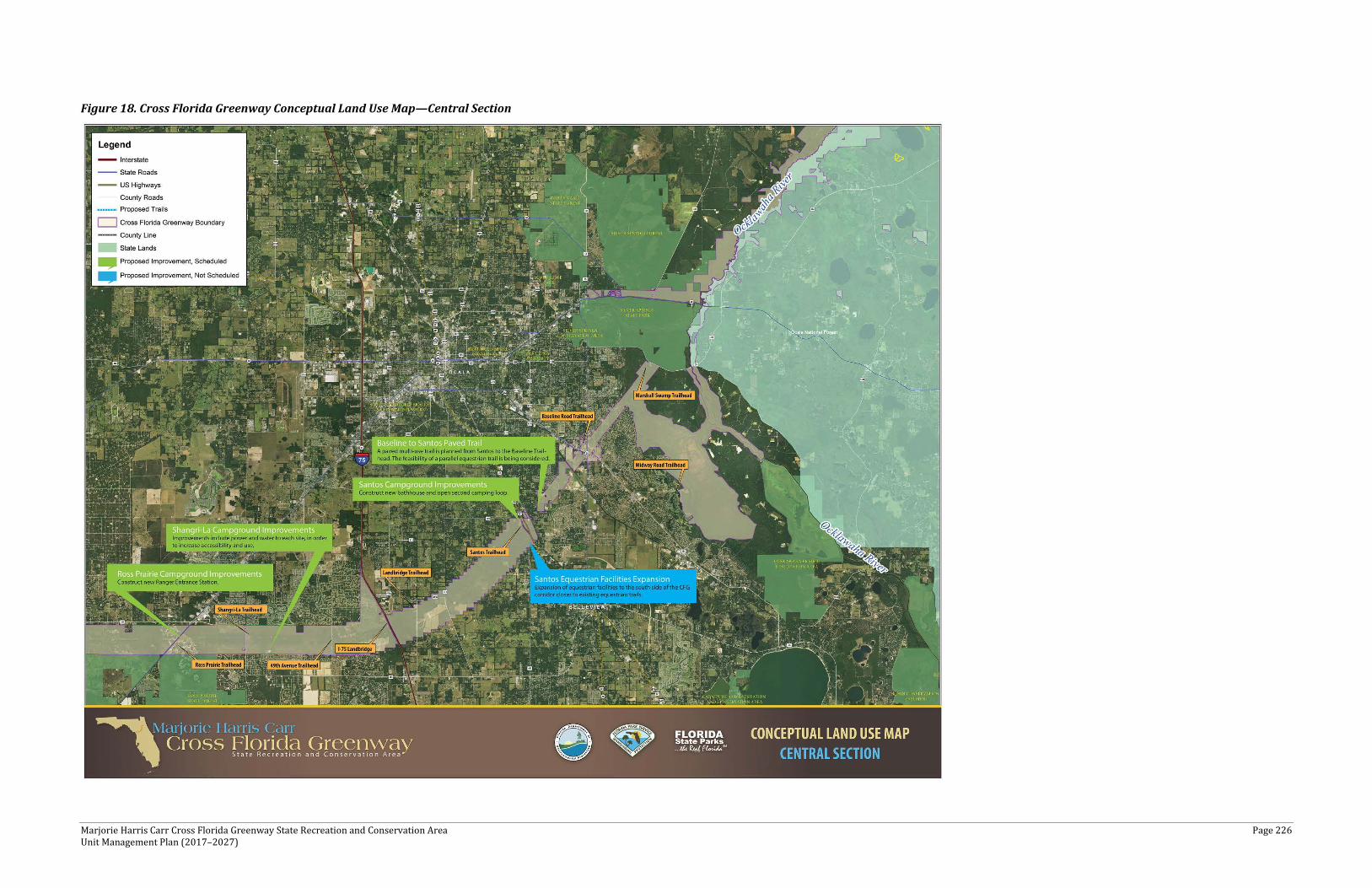
Marjorie Harris Carr Cross Florida Greenway State Recreation and Conservation Area Page 226 Unit Management Plan (2017–2027)
Figure 18. Cross Florida Greenway Conceptual Land Use Map—Central Section

Marjorie Harris Carr Cross Florida Greenway State Recreation and Conservation Area Page 227 Unit Management Plan (2017–2027)
Figure 19. Cross Florida Greenway Conceptual Land Use Map—East Section

Marjorie Harris Carr Cross Florida Greenway State Recreation and Conservation Area Page 228 Unit Management Plan (2017–2027)
Existing Use and Recreational Carrying Capacity
Carrying capacity is an estimate of the number of users a recreation resource or facility can accommodate and still provide a high quality recreational experience and preserve the natural values of the site. The carrying capacity of a unit is determined by identifying the land and water requirements for each recreation activity at the unit, and then applying these requirements to the unit's land and water base. Next, guidelines are applied which estimate the physical capacity of the unit's natural communities to withstand recreational uses without significant degradation. This analysis identifies a range within which the carrying capacity most appropriate to the specific activity, the activity site, and the unit's classification is selected (see Table 40).
The recreational carrying capacity for this park is a preliminary estimate of the number of users the unit could accommodate after the current conceptual development program has been implemented. However, a recreational carrying capacity study should not be used as the sole determining factor for limiting recreational use or access. Rather, a recreational carrying capacity analysis should be used as a tool to evaluate the range of options that are available to help minimize multi-use conflicts, environmental concerns, and other problems associated with overuse and overcrowding. A recreational carrying capacity study can establish a framework for decision making and provide a basis for regulatory action. When developed, the proposed new facilities would increase the unit's carrying capacity, as shown in Table 40.
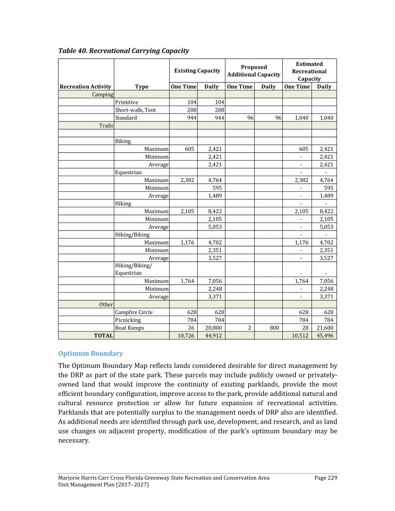
Marjorie Harris Carr Cross Florida Greenway State Recreation and Conservation Area Page 229 Unit Management Plan (2017–2027)
Table 40. Recreational Carrying Capacity
Optimum Boundary
The Optimum Boundary Map reflects lands considered desirable for direct management by the DRP as part of the state park. These parcels may include publicly owned or privately- owned land that would improve the continuity of existing parklands, provide the most efficient boundary configuration, improve access to the park, provide additional natural and cultural resource protection or allow for future expansion of recreational activities. Parklands that are potentially surplus to the management needs of DRP also are identified. As additional needs are identified through park use, development, and research, and as land use changes on adjacent property, modification of the park’s optimum boundary may be necessary.
One Time Daily One Time Daily One Time DailyCamping
Primitive 104 104Short-walk, Tent 208 208Standard 944 944 96 96 1,040 1,040
Trails
BikingMaximum 605 2,421 605 2,421 Minimum 2,421 - 2,421
Average 2,421 - 2,421 Equestrian - -
Maximum 2,382 4,764 2,382 4,764 Minimum 595 - 595
Average 1,489 - 1,489 Hiking - -
Maximum 2,105 8,422 2,105 8,422 Minimum 2,105 - 2,105
Average 5,053 - 5,053 Hiking/Biking - -
Maximum 1,176 4,702 1,176 4,702 Minimum 2,351 - 2,351
Average 3,527 - 3,527 Hiking/Biking/ Equestrian - -
Maximum 1,764 7,056 1,764 7,056 Minimum 2,248 - 2,248
Average 3,371 - 3,371 Other
Campfire Circle 628 628 628 628 Picnicking 784 784 784 784 Boat Ramps 26 20,800 2 800 28 21,600
TOTAL 10,726 44,912 10,512 45,496
Recreation Activity Type
Existing Capacity Proposed Additional Capacity
Estimated Recreational
Capacity
Marjorie Harris Carr Cross Florida Greenway State Recreation and Conservation Area Page 230 Unit Management Plan (2017–2027)
Identification of parcels on the optimum boundary map is intended solely for planning purposes. It is not to be used in conjunction with any regulatory purposes. Any party or governmental entity should not use a property’s identification on the optimum boundary map to reduce or restrict the lawful rights of private landowners. Identification on the map does not empower or suggest that any government entity should impose additional or more restrictive environmental land use or zoning regulations. Identification should not be used as the basis for permit denial or the imposition of permit conditions.
Several parcels have been discussed during the planning process as being necessary to optimize the management of the CFG, as well as enhance connectivity within the CFG. Outlined below are the parcels in priority order that are identified as part of the optimum boundary. CFG staff have identified parcels of property to be obtained by acquisition, also parcels that have been identified as surplus property. It should be noted that even if the parcels recommended as surplus cannot be surplused, consideration should be given to removing these parcels from managed lands. Property acquisition should be considered the most ideal option moving forward. However, parcels designated as acquisition may be considered for exchange upon approval by all parties and would be subject to review and approval by the Board of Trustees.
Property Acquisition
1) Santos Gap 2) FDOT Scrub Triangle keyhole parcel 3) Florida Power and Light Ocklawaha River parcels 4) DECCA—adjacent to west side of I-75 along CFG south boundary 5) Greenberg Properties—north side of Dunnellon Rainbow River area 6) Cannon/Folks – this single landowner gap is the only gap existing in the CFG
corridor between Ocala and Dunnellon that could provide the best connectivity option in this area.
7) USFS parcels along Ocklawaha River between SR 40 and gas pipeline to consolidate and clean up management boundary lines.
8) 40-acre parcel owned by Marion County (Dinkins Parcel) 9) Inholdings along North side of SR 40 between SCR 326 and SR 35

Marjorie Harris Carr Cross Florida Greenway State Recreation and Conservation Area Page 231 Unit Management Plan (2017–2027)
Surplus
1) River Gardens—south side of Lake Rousseau west of Dunnellon 2) Citrus County US 19 boat ramp parcel—surplus in exchange for county paving the
Withlacoochee Bay Trail Road 3) USFS—approximately a dozen inholdings each agency has within CFG/ONF to
improve respective management boundaries 4) SJRWMD—St. Johns River parcels to water management district 5) Ernie Cremer—consolidated perimeter parcel of current state-owned lands to clean
up management boundaries and reduce easements to others 6) Marion County Parks—Independence Park request—east side of SW 49th Avenue
along CFG south boundary 7) 10-acre rectangle and angular parcel within residential area west of SR 35 and north
of CR 464; DSL # CF-714-4116 8) 464 frontage and mobile home park parcels west of SR 35 and north of Rotary
Sportsplex; DSL Surplus # FMLA_177 and CF-714-4111 9) Rainey Inholdings—Rainey Pasture east side of CR 315 and north of SR 40 10) DSL FLMA_184 11) DSL FLMA_171 12) Parcel at the intersection of NE 35th Street and NE 60th Court.
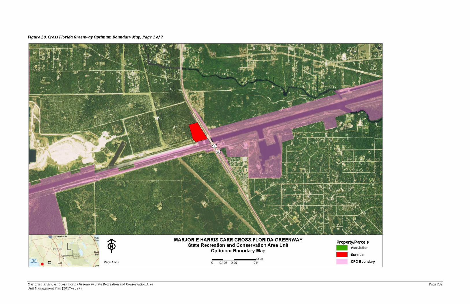
Marjorie Harris Carr Cross Florida Greenway State Recreation and Conservation Area Page 232 Unit Management Plan (2017–2027)
Figure 20. Cross Florida Greenway Optimum Boundary Map, Page 1 of 7
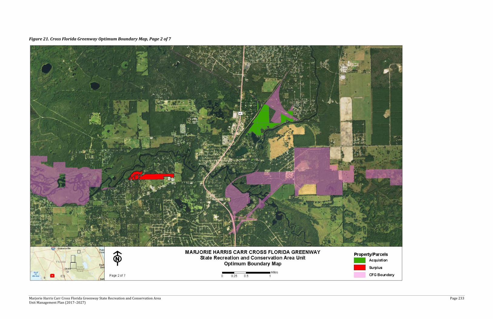
Marjorie Harris Carr Cross Florida Greenway State Recreation and Conservation Area Page 233 Unit Management Plan (2017–2027)
Figure 21. Cross Florida Greenway Optimum Boundary Map, Page 2 of 7
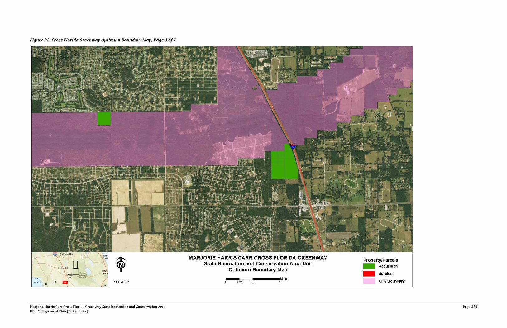
Marjorie Harris Carr Cross Florida Greenway State Recreation and Conservation Area Page 234 Unit Management Plan (2017–2027)
Figure 22. Cross Florida Greenway Optimum Boundary Map, Page 3 of 7
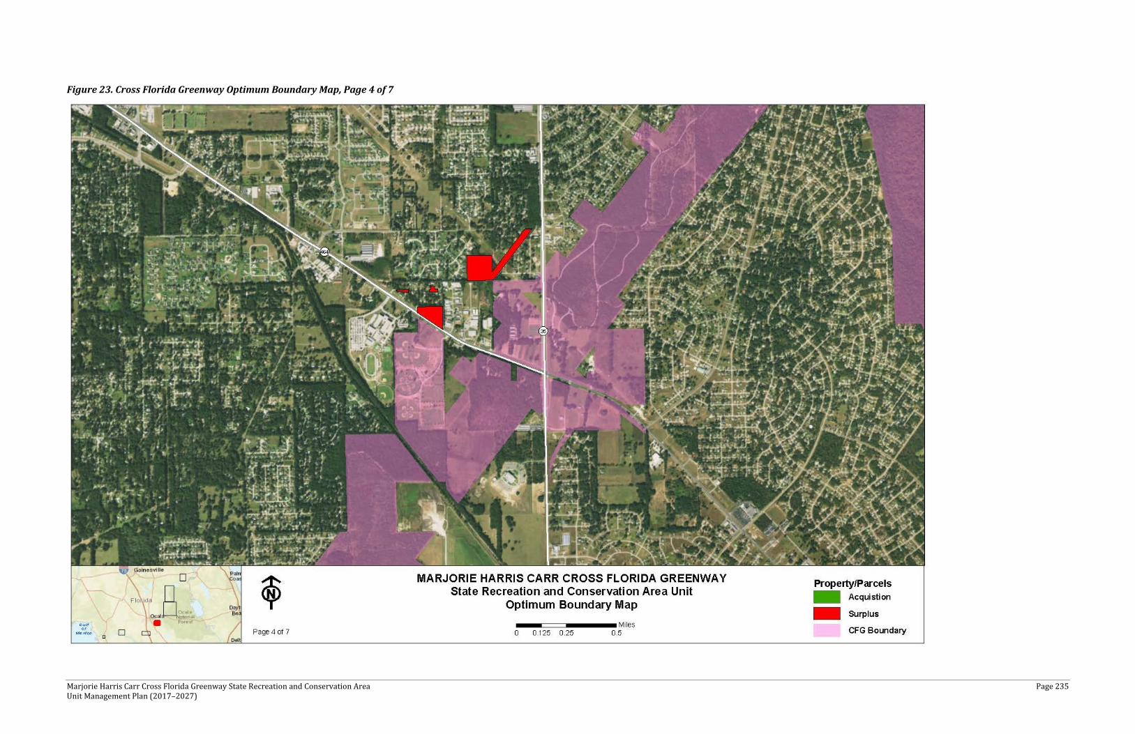
Marjorie Harris Carr Cross Florida Greenway State Recreation and Conservation Area Page 235 Unit Management Plan (2017–2027)
Figure 23. Cross Florida Greenway Optimum Boundary Map, Page 4 of 7
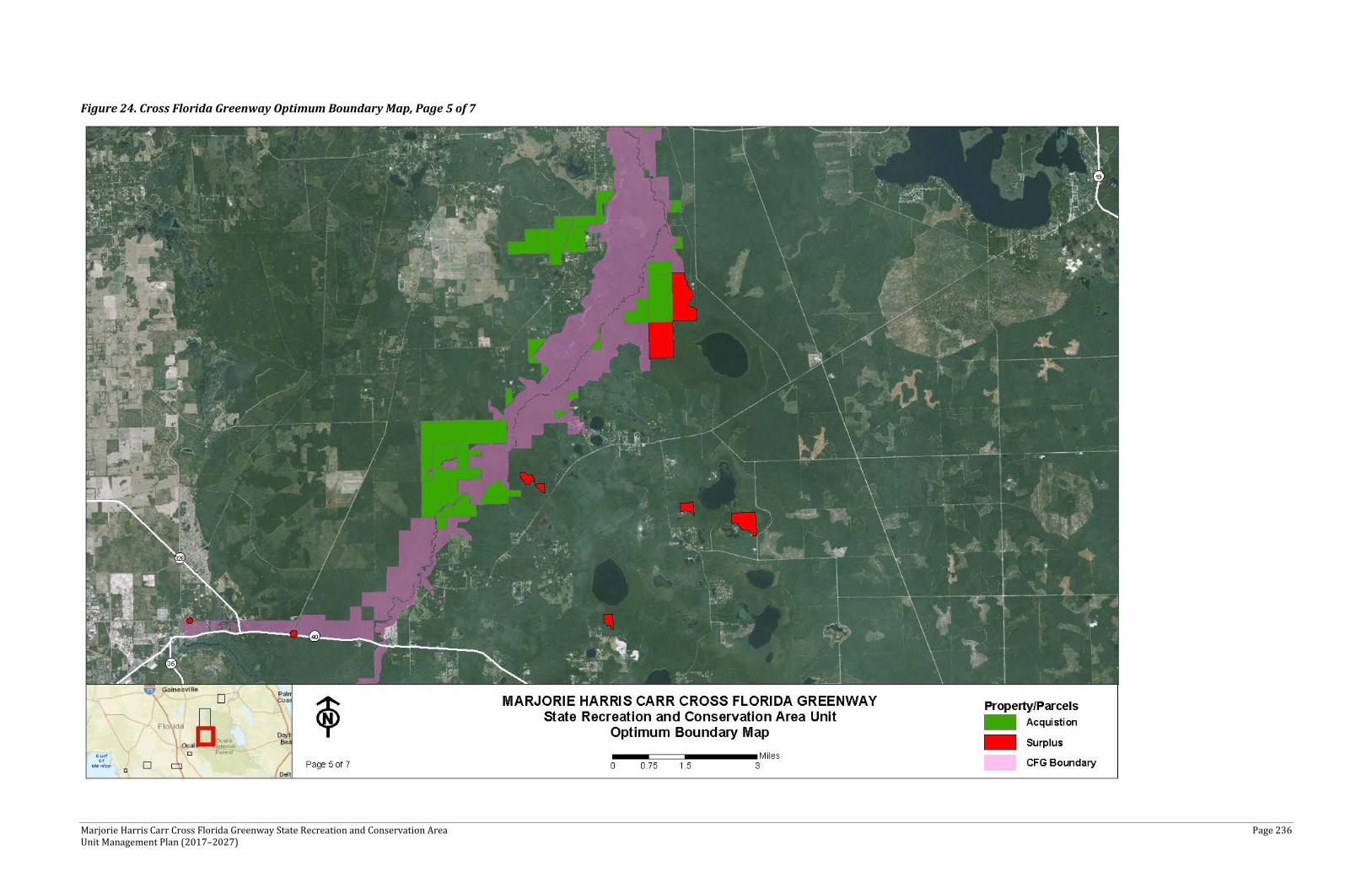
Marjorie Harris Carr Cross Florida Greenway State Recreation and Conservation Area Page 236 Unit Management Plan (2017–2027)
Figure 24. Cross Florida Greenway Optimum Boundary Map, Page 5 of 7
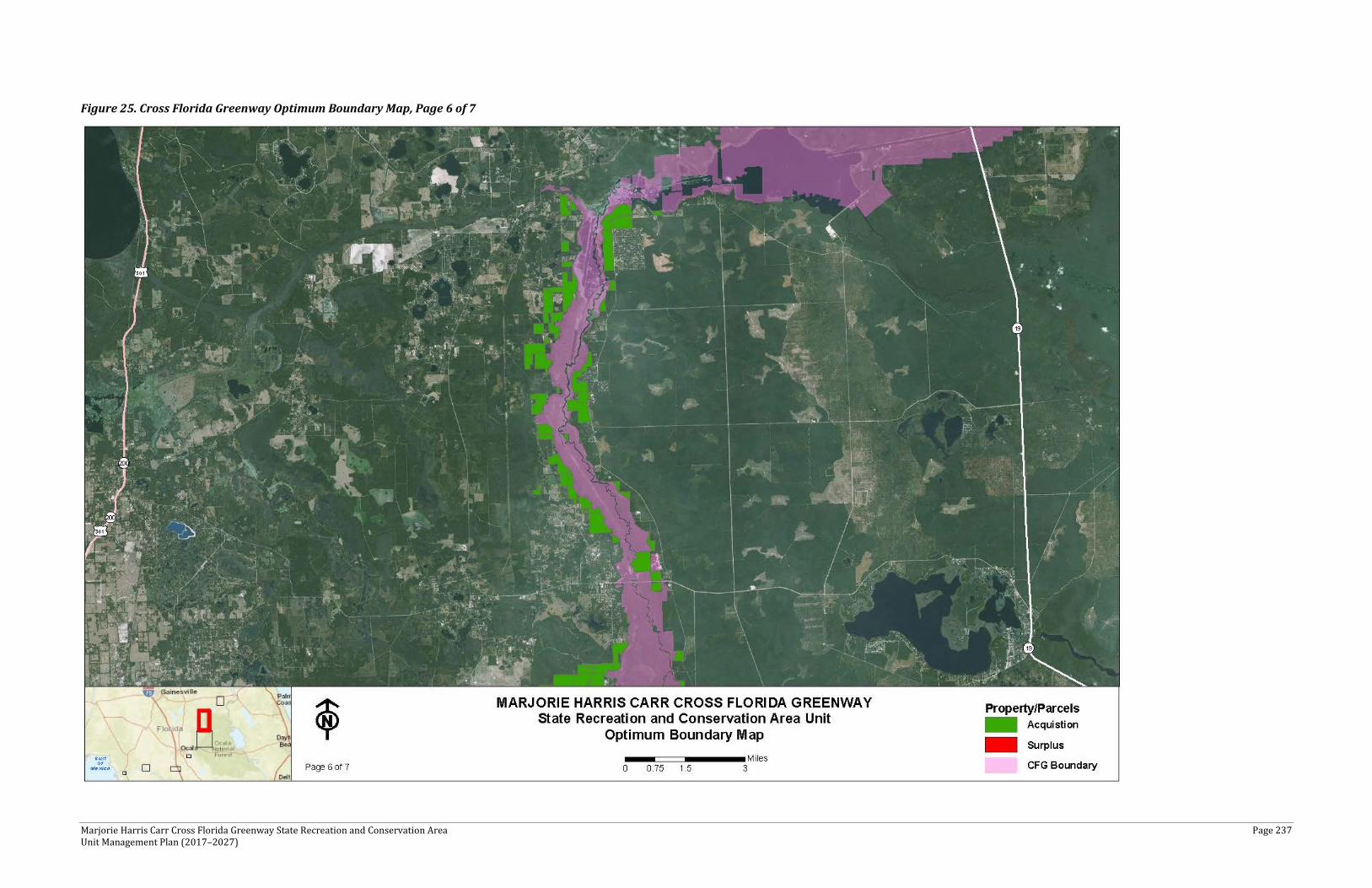
Marjorie Harris Carr Cross Florida Greenway State Recreation and Conservation Area Page 237 Unit Management Plan (2017–2027)
Figure 25. Cross Florida Greenway Optimum Boundary Map, Page 6 of 7
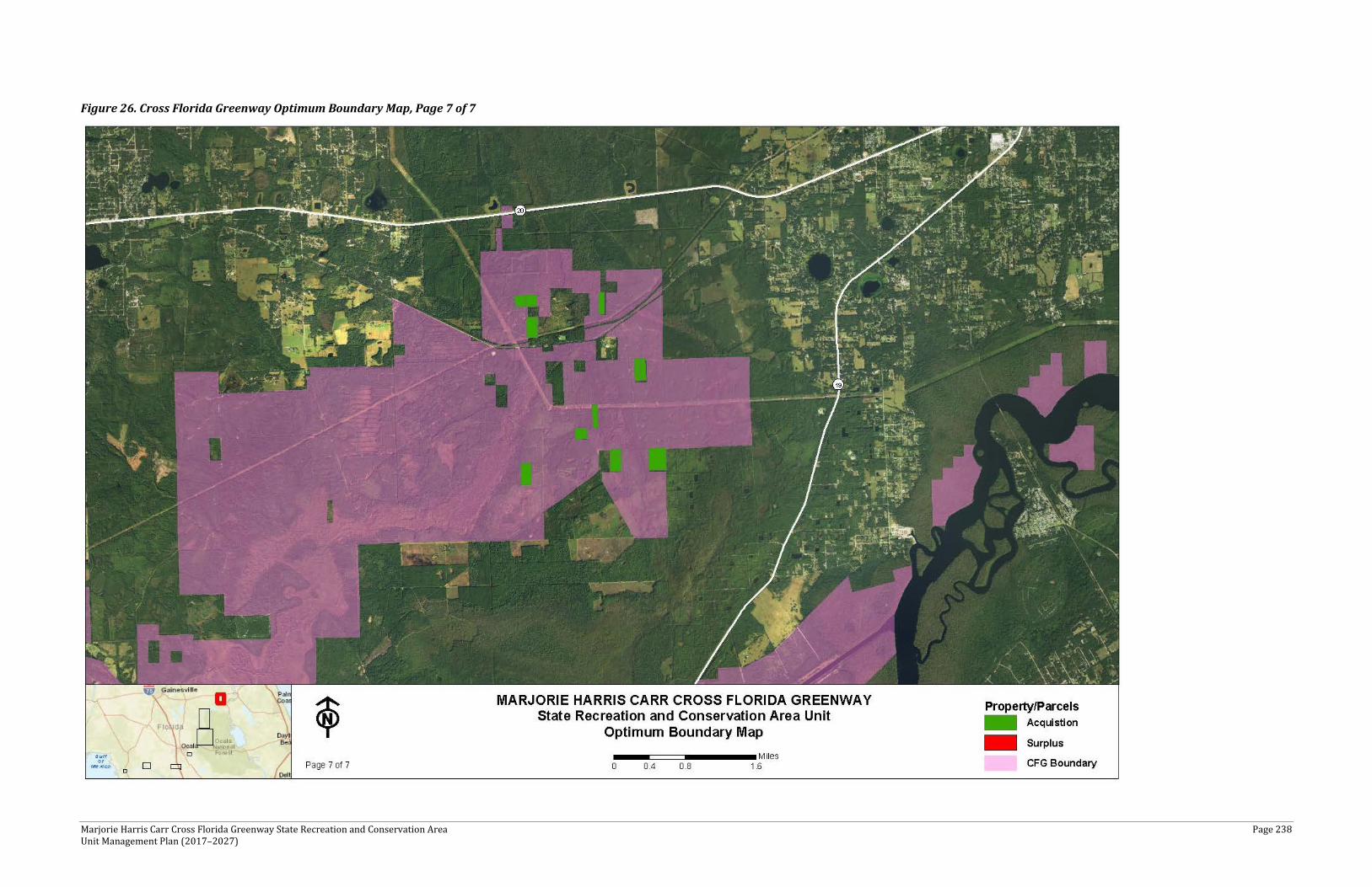
Marjorie Harris Carr Cross Florida Greenway State Recreation and Conservation Area Page 238 Unit Management Plan (2017–2027)
Figure 26. Cross Florida Greenway Optimum Boundary Map, Page 7 of 7

Marjorie Harris Carr Cross Florida Greenway State Recreation and Conservation Area Page 239 Unit Management Plan (2017–2027)
IMPLEMENTATION COMPONENT
The resource management and land use components of this management plan provide a thorough inventory of the park’s natural, cultural, and recreational resources. They outline the park’s management needs and problems, and recommend both short- and long-term objectives and actions to meet those needs. The implementation component addresses the administrative goals for the park and reports on the DRP’s progress toward achieving resource management, operational, and capital improvement goals and objectives since approval of the previous management plan for this park. This component also compiles the management goals, objectives, and actions expressed in the separate parts of this management plan for easy review. Estimated costs for the 10-year period of this plan are provided for each action and objective, and the costs are summarized under standard categories of land management activities.
MANAGEMENT PROGRESS
Since the approval of the last management plan for the CFG in 2007, significant work has been accomplished and progress has been made toward meeting the DRP’s management objectives for the park. These accomplishments fall within three of the five general categories that encompass the mission of the park and the DRP.
Park Administration and Operations
Continued to fulfill the goals of the DRP mission, maintaining infrastructure and meeting visitors’ expectations
Resource Management
Fire
15,977 acres burned on the CFG
• 66 burn zones in rotation (7,325 acres) • 29 new burn zones since 2007

Marjorie Harris Carr Cross Florida Greenway State Recreation and Conservation Area Page 240 Unit Management Plan (2017–2027)
• All the CFG fire type acreage is now divided into burn zones • Utilization of prescribed burn contractors to increase annual acreage
Natural Community Restoration
• 3,925 acres in timber harvests for restoration of natural communities with the side benefit of earning $1.065 million in revenue
• 498 acres of trees planted • 157 acres of groundcover planted • 540 acres of mechanical treatments • A timber inventory and management plan for the 9,000 acre Etoniah addition is
planned
Endangered Species • In 2008, coordinated with Audubon Florida to join their annual Florida scrub jay
Watch propram to monitor the Florida scrub jay population on the CFG Triangle Scrub tract
• Restored 523 additional acres of scrub, for a total of 840 acres out of 1,100 acres of historic scrub restored
• Contracted to band scrub jays for better data collection methods on population and family responses to management actions
• Mechanically treated 538 acres • Increased the Florida scrub jay population from 46 birds in 2009 to 111 in 2015 • Coordinated with FWC to set up boxes for kestrel recruitment • Set up wildlife cameras in 2009 at all the underpasses on the CFG and the Landbridge
to capture wildlife usage
Recreational Facilities and Visitor Services
• Added a new floating boat dock at Kenwood Boat Ramp • Added a new floating boat dock and ADA ramp at the US 19 Boat Ramp • Added new picnic pavilions with ADA access at Eureka Recreation Area West, Orange
Springs, Kenwood, Rodman East Recreation Area, Buckman Recreation Area • Phase 2 Rodman Campground • Logged Miller Tract • Initiated road repair and culvert replacement on the Miller Tract • St. Johns Trail Loop South Primitive Equestrian Campground • Hunter Road Trailhead • Updated Inglis Bypass Recreation Area with ADA sidewalks • Bulkheads at Inglis Lock and equipment bridge • New section of Withlacoochee Bay Trail going east to Inglis Island • Dunnellon Trail and Bridge • Coordinating with Marion County on the proposed new paved trail between SR 200 and
Dunnellon Trail • Developed and opened Shangri La Campground and Trailhead • Developed and opened Vortex Trailhead • Developed and opened Ned Folks Pavilion
Marjorie Harris Carr Cross Florida Greenway State Recreation and Conservation Area Page 241 Unit Management Plan (2017–2027)
MANAGEMENT PLAN IMPLEMENTATION
This management plan is written for a timeframe of 10 years, as required by Section 253.034, Florida Statutes. The 10-Year Implementation Schedule and Cost Estimates (Table 41) summarizes the management goals, objectives, and actions that are recommended for implementation during this period and beyond. Measures are identified for assessing progress toward completing each objective and action. A time frame for completing each objective and action also is provided. Preliminary cost estimates for each action are provided and the estimated total costs to complete each objective are computed. Finally, all costs are consolidated under the following five standard land management categories: Resource Management, Administration and Support, Capital Improvements, Recreation Visitor Services, and Law Enforcement.
Some of the actions identified in the plan can be implemented using existing staff and funding sources based on grants, partnerships, and legislative appropriations. However, as the plan guides long-term management over a period of 10 years, some actions have been identified that may require additional resources. The 10-year Implementation Schedule and Cost Estimates table, therefore, includes both “funded” and “unfunded” needs. It should be noted that the costs associated with each of the five standard land management categories are expected to increase over the 10-year period covered by this plan. The estimate of costs provided herewith is based on the best information available at the time this plan was completed and cannot be considered a final determination of actual costs over the 10-year life of the plan.
The administration of the state park is an ongoing cost that will increase in the future as additional staff, programs, and responsibilities are assigned. These administrative costs include a variety of activities, such as the administration of personnel, the management of vendors and contractors for all the park’s supply and service needs, and the coordination of the park’s Citizen Support Organization, to name a few.A high degree of adaptability and flexibility is necessary for implementation of this management plan to ensure that the Division can adjust to changes in the availability of funds, create improved understanding of the park’s natural and cultural resources, and remain current with changes in statewide land management issues, priorities, and policies.
Statewide priorities for all aspects of land management are evaluated each year as part of the process for developing the Division’s annual legislative budget requests. When preparing these annual requests, the Division considers the needs and priorities of the entire state park system and the projected availability of funding from all sources during the upcoming fiscal year. In addition to annual legislative appropriations, the Division pursues supplemental sources of funds and staff resources wherever possible, including grants, volunteers, and partnerships with other entities. The Division’s ability to accomplish the specific actions identified in the plan will be determined largely by the availability of funds and staff for these purposes, which may vary from year to year. Consequently, the target schedules and estimated costs identified in Table 41 may need to be adjusted during the 10-year management planning cycle.
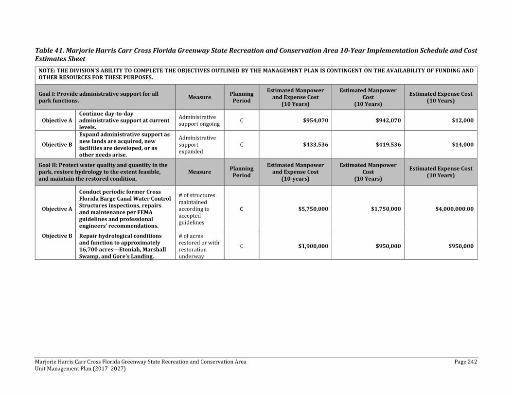
Marjorie Harris Carr Cross Florida Greenway State Recreation and Conservation Area Page 242 Unit Management Plan (2017–2027)
Table 41. Marjorie Harris Carr Cross Florida Greenway State Recreation and Conservation Area 10-Year Implementation Schedule and Cost Estimates Sheet
NOTE: THE DIVISION'S ABILITY TO COMPLETE THE OBJECTIVES OUTLINED BY THE MANAGEMENT PLAN IS CONTINGENT ON THE AVAILABILITY OF FUNDING AND OTHER RESOURCES FOR THESE PURPOSES.
Goal I: Provide administrative support for all park functions. Measure Planning
Period
Estimated Manpower and Expense Cost
(10 Years)
Estimated Manpower Cost
(10 Years)
Estimated Expense Cost (10 Years)
Objective A Continue day-to-day administrative support at current levels.
Administrative support ongoing C $954,070 $942,070 $12,000
Objective B
Expand administrative support as new lands are acquired, new facilities are developed, or as other needs arise.
Administrative support expanded
C $433,536 $419,536 $14,000
Goal II: Protect water quality and quantity in the park, restore hydrology to the extent feasible, and maintain the restored condition.
Measure Planning Period
Estimated Manpower and Expense Cost
(10-years)
Estimated Manpower Cost
(10 Years)
Estimated Expense Cost (10 Years)
Objective A
Conduct periodic former Cross Florida Barge Canal Water Control Structures inspections, repairs and maintenance per FEMA guidelines and professional engineers’ recommendations.
# of structures maintained according to accepted guidelines
C $5,750,000 $1,750,000 $4,000,000.00
Objective B Repair hydrological conditions and function to approximately 16,700 acres—Etoniah, Marshall Swamp, and Gore's Landing.
# of acres restored or with restoration underway
C $1,900,000 $950,000 $950,000
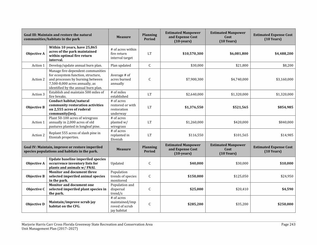
Marjorie Harris Carr Cross Florida Greenway State Recreation and Conservation Area Page 243 Unit Management Plan (2017–2027)
Goal III: Maintain and restore the natural communities/habitats in the park Measure Planning
Period
Estimated Manpower and Expense Cost
(10-years)
Estimated Manpower Cost
(10 Years)
Estimated Expense Cost (10 Years)
Objective A
Within 10 years, have 25,865 acres of the park maintained within optimal fire return interval.
# of acres within fire return interval target
LT $10,570,300 $6,081,800 $4,488,200
Action 1 Develop/update annual burn plan. Plan updated C $30,000 $21,800 $8,200
Action 2
Manage fire-dependent communities for ecosystem function, structure, and processes by burning between 7,500-8,000 acres annually, as identified by the annual burn plan.
Average # of acres burned annually
C $7,900,300 $4,740,000 $3,160,000
Action 3 Establish and maintain 500 miles of fire breaks.
# of miles established LT $2,640,000 $1,320,000 $1,320,000
Objective B
Conduct habitat/natural community restoration activities on 2,555 acres of ruderal community(ies).
# of acres restored or with restoration underway
LT $1,376,550 $521,565 $854,985
Action 1 Plant 50-100 acres of wiregrass annually in 2,000 acres of old pastures planted in longleaf pine.
# of acres planted w/ wiregrass
LT $1,260,000 $420,000 $840,000
Action 2 Replant 555 acres of slash pine in Etoniah properties.
# of acres replanted in Etoniah
LT $116,550 $101,565 $14,985
Goal IV: Maintain, improve or restore imperiled species populations and habitats in the park. Measure Planning
Period
Estimated Manpower and Expense Cost
(10-years)
Estimated Manpower Cost
(10 Years)
Estimated Expense Cost (10 Years)
Objective A Update baseline imperiled species occurrence inventory lists for plants and animals w/ FNAI.
Updated C $40,000 $30,000 $10,000
Objective B Monitor and document three selected imperiled animal species in the park.
Population trends of species monitored
C $150,000 $125,050 $24,950
Objective C Monitor and document one selected imperiled plant species in the park.
Population and dispersal trend/s
C $25,000 $20,410 $4,590
Objective D Maintain/improve scrub jay habitat on the CFG.
# of acres maintained/improved of scrub jay habitat
C $285,200 $35,200 $250,000
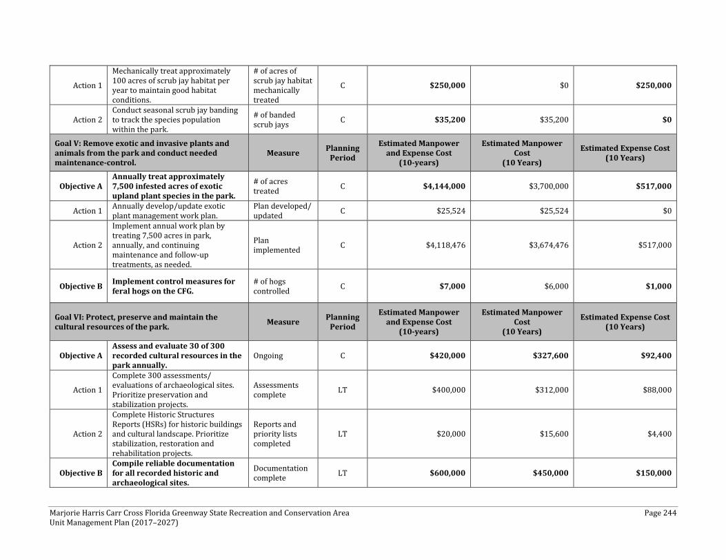
Marjorie Harris Carr Cross Florida Greenway State Recreation and Conservation Area Page 244 Unit Management Plan (2017–2027)
Action 1
Mechanically treat approximately 100 acres of scrub jay habitat per year to maintain good habitat conditions.
# of acres of scrub jay habitat mechanically treated
C $250,000 $0 $250,000
Action 2 Conduct seasonal scrub jay banding to track the species population within the park.
# of banded scrub jays C $35,200 $35,200 $0
Goal V: Remove exotic and invasive plants and animals from the park and conduct needed maintenance-control.
Measure Planning Period
Estimated Manpower and Expense Cost
(10-years)
Estimated Manpower Cost
(10 Years)
Estimated Expense Cost (10 Years)
Objective A Annually treat approximately 7,500 infested acres of exotic upland plant species in the park.
# of acres treated C $4,144,000 $3,700,000 $517,000
Action 1 Annually develop/update exotic plant management work plan.
Plan developed/ updated C $25,524 $25,524 $0
Action 2
Implement annual work plan by treating 7,500 acres in park, annually, and continuing maintenance and follow-up treatments, as needed.
Plan implemented C $4,118,476 $3,674,476 $517,000
Objective B Implement control measures for feral hogs on the CFG.
# of hogs controlled C $7,000 $6,000 $1,000
Goal VI: Protect, preserve and maintain the cultural resources of the park. Measure Planning
Period
Estimated Manpower and Expense Cost
(10-years)
Estimated Manpower Cost
(10 Years)
Estimated Expense Cost (10 Years)
Objective A Assess and evaluate 30 of 300 recorded cultural resources in the park annually.
Ongoing C $420,000 $327,600 $92,400
Action 1
Complete 300 assessments/ evaluations of archaeological sites. Prioritize preservation and stabilization projects.
Assessments complete LT $400,000 $312,000 $88,000
Action 2
Complete Historic Structures Reports (HSRs) for historic buildings and cultural landscape. Prioritize stabilization, restoration and rehabilitation projects.
Reports and priority lists completed
LT $20,000 $15,600 $4,400
Objective B Compile reliable documentation for all recorded historic and archaeological sites.
Documentation complete LT $600,000 $450,000 $150,000
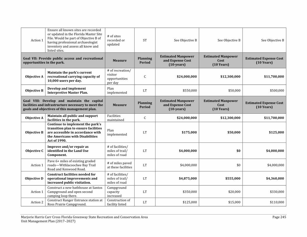
Marjorie Harris Carr Cross Florida Greenway State Recreation and Conservation Area Page 245 Unit Management Plan (2017–2027)
Action 1
Ensure all known sites are recorded or updated in the Florida Master Site File. Would be part of Objective B of having professional archaeologist inventory and assess all know and listed sites.
# of sites recorded or updated
ST See Objective B See Objective B See Objective B
Goal VII: Provide public access and recreational opportunities in the park. Measure Planning
Period
Estimated Manpower and Expense Cost
(10-years)
Estimated Manpower Cost
(10 Years)
Estimated Expense Cost (10 Years)
Objective A Maintain the park's current recreational carrying capacity of 10,000 users per day.
# of recreation/ visitor opportunities per day
C $24,000,000 $12,300,000 $11,700,000
Objective B Develop and implement Interpretive Master Plan.
Plan implemented LT $550,000 $50,000 $500,000
Goal VIII: Develop and maintain the capital facilities and infrastructure necessary to meet the goals and objectives of this management plan.
Measure Planning Period
Estimated Manpower and Expense Cost
(10-years)
Estimated Manpower Cost
(10 Years)
Estimated Expense Cost (10 Years)
Objective A Maintain all public and support facilities in the park.
Facilities maintained C $24,000,000 $12,300,000 $11,700,000
Objective B
Continue to implement the park's transition plan to ensure facilities are accessible in accordance with the Americans with Disabilities Act of 1990.
Plan implemented LT $175,000 $50,000 $125,000
Objective C Improve and/or repair as identified in the Land Use Component.
# of facilities/ miles of trail/ miles of road
LT $4,000,000 $0 $4,000,000
Action 1 Pave 6+ miles of existing graded roads—Withlacoochee Bay Trail Road and Kenwood Road.
# of miles paved at these facilities LT $4,000,000 $0 $4,000,000
Objective D Construct facilities needed for operational improvements and increased public visitation.
# of facilities/ miles of trail/ miles of road
LT $4,875,000 $555,000 $4,360,000
Action 1 Construct a new bathhouse at Santos Campground and open second camping loop there.
Campground capacity increased
LT $350,000 $20,000 $330,000
Action 2 Construct Ranger Entrance station at Ross Prairie Campground.
Construction of facility listed LT $125,000 $15,000 $110,000
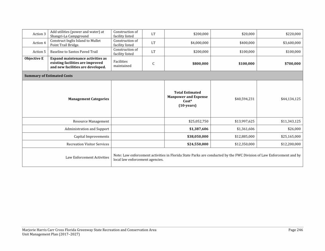
Marjorie Harris Carr Cross Florida Greenway State Recreation and Conservation Area Page 246 Unit Management Plan (2017–2027)
Action 3 Add utilities (power and water) at Shangri-La Campground
Construction of facility listed LT $200,000 $20,000 $220,000
Action 4 Construct Inglis Island to Mullet Point Trail Bridge.
Construction of facility listed LT $4,000,000 $400,000 $3,600,000
Action 5 Baseline to Santos Paved Trail Construction of facility listed LT $200,000 $100,000 $100,000
Objective E Expand maintenance activities as existing facilities are improved and new facilities are developed.
Facilities maintained C $800,000 $100,000 $700,000
Summary of Estimated Costs
Management Categories Total Estimated
Manpower and Expense Cost*
(10-years)
$40,594,231 $44,134,125
Resource Management $25,052,750 $13,997,625 $11,343,125
Administration and Support $1,387,606 $1,361,606 $26,000
Capital Improvements $38,050,000 $12,885,000 $25,165,000
Recreation Visitor Services $24,550,000 $12,350,000 $12,200,000
Law Enforcement Activities Note: Law enforcement activities in Florida State Parks are conducted by the FWC Division of Law Enforcement and by local law enforcement agencies.


