Embed Size (px)
Citation preview

Community Board 6, Borough of Manhattan
A 197-a plan as adopted by the City Planning Commissionand the City Council
TM

City of NewMichael R. Bloomberg, Mayor
Department of City PlanningAmanda M. Burden, FAICP, Director
Spring 2010DCP# 10-04
Community Board 6, Borough of Manhattan
A 197-a plan as adopted by the City Planning Commissionand the City Council

INTRODUCTION
Under Section 197-a of the New York City Charter, community boards may propose plans for the development, growth and improvement of land within their districts. The plans are reviewed in accordance with standards and rules of procedure for 197-a plansplans are reviewed in accordance with standards and rules of procedure for 197 a plans which were developed and adopted by the City Planning Commission. Once approved by the Commission and adopted by the City Council, as submitted or modified, 197-a plans serve as policy guides for subsequent actions by city agencies.
In January 2008, the City Planning Commission approved with modifications the 197-a plan submitted by Manhattan Community Board 6. In March 2008 the City Council modified and adopted the plan as modified by the City Planning Commission.
This report provides information for those interested in the plan’s policies and recommendations. It may also be of interest to other communities considering the 197-a process. The report contains four sections:
1. The City Council resolution, dated March 26, 2008, modifying and adopting the plan as modified and approved by the City Planning Commission.
2. The City Planning Commission report, dated January 28, 2008, approving the plan with modifications.
3. The Community Board’s proposed 197-a plan, as submitted October 2007.
4. A guide to recommendations in the adopted Manhattan CB 6 197-a Plan.

Section 1C CCity Council Resolution
City Council Resolution, dated March 26, 2008, modifying and adopting the 197-a plan as modified and
approved by the City Planning Commission


Section 2C CCity Planning Commission Report
City Planning Commission’s consideration and resolution,dated January 28, 2008, modifying and approving the 197-a plan

CITY PLANNING COMMISSION
January 28, 2008/ Calendar No. 15 N 060273 NPM
IN THE MATTER OF a plan concerning Community District 6, submitted by Community
Board 6, for consideration under the rules for the processing of plans pursuant to Section 197-a
of the New York City Charter. The proposed plan for adoption is called the “197-a Plan for the
Eastern Section of Community District 6.”
BACKGROUND
Manhattan Community Board 6 started its extensive community outreach to develop a 197-a
plan in 2003. On March 3, 2004, in accordance with the City Planning Commission’s adopted
197-a rules, Manhattan Community Board 6 notified the Department of its intent to submit a
197-a plan. After a public hearing and adoption by the Board on June 9, 2004, the plan was
submitted to the Department for preliminary review in June 2004. In response to DCP’s
comments, Community Board 6 submitted a revised plan on August 11, 2005 in accordance with
the City Planning Commission’s Rules for the Processing of Plans Pursuant to Charter Section
197-a (197-a rules). The plan was referred out for public review on April 3, 2006. On October
23, 2007, Community Board 6 re-submitted the plan which included updated information and
some revisions in response to comments by affected City agencies.
PLAN DESCRIPTION
The plan covers the eastern section of Manhattan’s Community Board 6, an area generally
bounded by the East River, East 59th Street, a line 100 feet west of Second Avenue, and East
14th Street. Most of this area is zoned for residential and commercial uses with a mix in the
northern portion and a predominance of residential zoning in the southern part. There are two
areas zoned for central commercial districts, intended for regional office and retail uses: the East
River Science Park (C6-2, east of First Avenue between 28th and 30th streets) and the United
Nations campus and some adjacent areas (C5-2 between 41st and 49th streets). There are
commercial overlays along the avenues which permit local retail uses. Several areas along the
East River are zoned for manufacturing uses (M1-1, M1-5, M2-3, and M3-2).

2 N 060273NPM
The plan is organized into several sections. The “Introduction” includes a statement of the goals
of the plan, a brief description of the Study Area’s history and community character, an overview
of the Community Board’s planning process and the plan’s consistency with city policies and
planning initiatives. The chapters “Development History” and “Community Profile” describe the
historical background of the Study Area and give a detailed analysis of existing conditions
covering population; land use and zoning; urban design and historic resources; streets and
transportation; and open space and waterfront access. The “Recommendations” section provides
proposals to address issues identified in the existing conditions section. Appendices include
additional 197-a plan goals, related Community Board 6 resolutions, and additional
documentation about the need for affordable housing.
Goals
The plan’s primary goals are to (i) increase the amount of useful open space, (ii) improve access
to the waterfront and complete the East River Esplanade, (iii) enhance and reclaim the street
network to restore the street grid and improve transportation systems and access to the
waterfront, (iv) implement land use policies consistent with historical trends in the area, and (v)
preserve significant residential developments and individual buildings. The 197-a plan addresses
ongoing changes in a part of Manhattan that is experiencing substantial transformation and
growth. The major changes currently planned for this area include the rebuilding of portions of
the FDR Drive, the redevelopment of the Bellevue/NYU medical center campus area, the
redevelopment of the Con Edison-Waterside sites south of the United Nations, the construction
of the Second Avenue Subway, the rehabilitation of the United Nations campus, the addition of
ferry terminals, the construction of the Third Water Tunnel, and new residential development.
The substantial redevelopment of this area underscores the importance of planning policies to
guide the future in this part of the city.
Summary of Key Recommendations
To attain these goals, the plan recommends that the City
map contextual districts to maintain the residential character of neighborhoods, map
tower-on-base zoning districts and restrict zoning lot mergers, and eliminate certain
zoning provisions for community facilities in R7 and R8 districts;

3 N 060273NPM
develop a policy to prohibit additional high-density office development east of the
midline between Second and Third avenues;
designate the area from First Avenue to the waterfront and from 14th to 59th streets as a
Special Public Access District that would encourage private contributions for new open
space improvements or affordable housing in exchange for floor area bonuses;
designate the area that includes NYU Medical Center, Bellevue Hospital, the Veterans
Administration Hospital, Hunter College-Brookdale campus; and the East River Science
Park as a Special Hospital Use District;
amend Article I, Chapter 3 of the Zoning Resolution to change accessory parking in R10
districts within the Study Area from up to 20 percent of apartment units to 10 percent;
provide for the needs of the United Nations without significantly displacing or disrupting
surrounding neighborhoods;
restrict height and floor area, remap or reopen street extensions, provide publicly
accessible open space and ground floor retail for new development on the former Con
Edison-Waterside sites;
support the development of affordable housing, public daycare and new public school
facilities in the Study Area;
consider preservation options for Stuyvesant Town / Peter Cooper Village and the
remaining original buildings of the Bellevue Hospital Campus;
complete the waterfront esplanade in the Study Area, provide new open space through
city acquisition or other means, facilitate access to the waterfront in new locations with
nine new pedestrian bridges, support the redesign of sections of the FDR Drive to permit
pedestrian connections to the waterfront, and, if feasible, provide parks on decks above
these sections, encourage the MTA (with DPR and NYCDPT) to consider designing and
mapping park decks above Queens Midtown Tunnel portals, and remap or reopen streets
in superblocks to restore the street grid and public access to the waterfront;
eliminate all parking located directly on the waterfront such as the 23rd Street Skyport
parking facility, the 34th Street parking lot, and the Con Edison parking pier;
and facilitate improvements to the transportation network in the Study Area by
developing intermodal transfer points at key locations along the East River, providing

4 N 060273NPM
additional transfers between planned Second Avenue Subway stops and No. 7 and E / V
lines, and installing traffic calming measures in appropriate locations.
THRESHOLD REVIEW AND DETERMINATION
Pursuant to Section 3.010 of the 197-a rules, Department staff conducted a threshold review of
the plan’s consistency with standards for form, content and sound planning policy. On January
23, 2006 the City Planning Commission determined that the 197-a Plan for the Eastern Section
of Community District 6 complied with threshold standards for form, content and sound planning
policy as set forth in Article 4 of the Rules for Processing 197-a Plans.
A number of the Community Board 6 197-a plan recommendations are for the same area that the
East River Realty Corporation proposes to redevelop and which is subject to several applications
(C 070522 ZMM, C 070523 (A) ZSM, C 070525 ZSM, C 070529 ZMM, N 070530(A) ZRM,
C 070531 (A) ZSM, C 070533 ZSM, C 070534 ZSM) being considered concurrently with this
application. The East River Realty Corporation is proposing to develop office and residential
uses, with ground floor retail, for the former Con Edison-Waterside properties, known as 616
First Avenue, 685 First Avenue and 700/708 First Avenue. The proposal includes several
residential towers, a community facility space, a high density office tower, ground floor retail
along First Avenue, and 4.8 acres of publicly accessible open space.
Since Community Board 6 and East River Realty Corporation had differing recommendations for
the same area, the City Planning Commission, to ensure that both proposals would be afforded
equal treatment in the public review process, decided to consider both proposals at the same time
and invoked Section 7.012 of Rules for the Processing of Plans Pursuant to Charter Section 197-
a. Section 7.012 states that “if the Commission finds that it is unable to vote” within 60 days
after its public hearing on a 197-a plan, “it shall give a written statement of explanation to the
sponsor.” Under this provision, the Commission has extended its time for consideration of other
197-a plans (Red Hook, Greenpoint and Williamsburg) in order to facilitate a better planning
process. The Commission’s decision was conveyed to Community Board 6 in letter dated
October 25, 2006.

5 N 060273NPM
ENVIRONMENTAL REVIEW
This application (N 060273 NPM) was reviewed pursuant to the New York State Environmental
Quality Review Act (SEQRA), and the SEQRA regulations set forth in Volume 6 of the New
York Code of Rules and Regulations, Section 617.00 et. seq. and the City Environmental Quality
Review (CEQR) Rules of Procedure of 1991 and Executive Order No. 91 of 1977. The
designated CEQR number is 06DCP088M. The lead is the City Planning Commission.
After a review of the potential environmental impacts of the proposed action, a Negative
Declaration was issued on March 31, 2006.
PUBLIC REVIEW
On April 3, 2006 the plan was duly referred to Manhattan Community Board 6 and the
Manhattan Borough President for review and comment, in accordance with Article 6 of the Rules
for the Processing of Plans Pursuant to Charter Section 197-a.
COMMUNITY BOARD PUBLIC HEARING
As the sponsor of the “197-a Plan for the Eastern Section of Community District 6” Community
Board 6, in a letter dated June 16, 2006, and pursuant to Section 6.020 of the New York City
Charter, Rules for the Processing of Plans Pursuant to Charter Section 197-a, Community Board
6, waived its public hearing on this application, noting that the full community board had held a
public hearing on the plan on June 9, 2004, and that the plan was approved (see attachment).
BOROUGH PRESIDENT RECOMMENDATION
This application (N 060273 NPM) was considered by the Manhattan Borough President, who
sent a letter on August 9, 2006 stating his support of the plan, observing that the 197-a plan
Study Area’s major existing and planned infrastructure, new development possibilities along the
East River, and an influx of new residents as a result of many new residential buildings
underscore the importance of the 197-a plan which provides “a framework for the consolidation
of these efforts into one overall vision.” The Borough President offered specific comments on
the following aspects of the plan:

6 N 060273NPM
Land Use and Zoning
The 197-a plan articulates bulk, use, and urban design principles for the development of
the former Con Edison First Avenue properties that are shared by all the community’s
elected officials and are evident in CB 6’s recently proposed text and map amendments
for the properties. The 197-a plan will be reviewed in conjunction with the developer’s
rezoning plan for the First Avenue properties, but it is important to recognize that the
Board’s recommendations for the development of the site fit within the context of a larger
vision for the area.
The 197-a plan wisely calls for providing day care facilities and public schools in new
development in the area. It is important that the City plan in advance for the amenities
and neighborhood infrastructure that new development demands. To that end, it may be
advisable to require other types of local infrastructure to be sited as development
proceeds, such as police, fire, and public utility services.
The proposed Public Access District is an innovative way to meet this community’s
specific needs through zoning policy. Through bonuses, the Special District would
channel development energy to create affordable housing and provide access to the
waterfront, two elements that are essential to the preservation and improvement of the
East Side community.
Waterfront and Open Space
The plan’s detailed proposals to complete a waterfront esplanade on the East River would
further stated City policy as well as my office’s priority of ensuring an entirely walkable
rim around the island of Manhattan.
In an area with such a dearth of public parkland, every conceivable possibility for open
space must be explored thoroughly, including the plan’s suggestion for decks over the
Queens Midtown tunnel portals and incorporating parkland into the reconstruction of the
FDR Drive. The City should avoid relying on “publicly accessible private open space” as
mitigation for large-scale development projects, because such space often fails to be truly
public.
Urban Design and Preservation
The plan recommends contextual controls to ensure that development respects the
neighborhood’s existing street walls and its residential character. This recommendation

7 N 060273NPM
echoes calls for contextual zoning that are made in neighborhoods in every corner of the
borough. As the City grows, the Zoning Resolution must evolve to meet the new
challenges that growth presents.
The plan’s goal of maintaining and restoring the City street grid, and its goal of
preserving Peter Cooper Village and Stuyvesant Town, are related. Large superblocks
derive a benefit from demapped streets, which give sites distorted development potential.
In addition to landmarking and the Special Planned Community Preservation District
designation, the City and the 197-a plan proponents should be open to new and creative
policy proposals that could provide public oversight over development on superblocks.
Streets and Transportation
The plan’s recommendations on accessory and public parking garages mirror concerns
that my office has raised about the City’s parking policy. We should make every effort to
encourage mass transit usage over car travel in this area. The City should work generally
to implement comprehensive analysis and reform of its public and accessory parking
garage policies.
CITY PLANNING COMMISSION PUBLIC HEARING
On September 13, 2006 (Calendar No. 2), the City Planning Commission scheduled September
27, 2006 for a public hearing on this application (N060273 NPM). The hearing was duly held on
September 27, 2006 (Calendar No, 16). There were several speakers at that hearing as described
below and the hearing was continued pursuant to Section 7.012 of the Rules For The Processing
of Plans Pursuant to Charter Section 197-a in order to facilitate the concurrent review with the
East River Realty Corporation’s proposed redevelopment of the former Con Edison-Waterside
sites (C 070529ZMM et.al). On November 14, 2007 (Calendar No. 15), the City Planning
Commission scheduled December 5, 2007 for a continued public hearing on this application (N
060273 NPM). The continued public hearing was duly held on December 5, 2007 (Calendar No.
42). There were several speakers at the continued hearing as described below.

8 N 060273NPM
September 27, 2006 (Calendar No. 16)
There were a total of 20 speakers at this public hearing. Of this group, 18 were in favor of the
197-a plan, one speaker opposed the plan, and one speaker did not state a specific position on the
plan.
Those who spoke in favor of the 197-a plan included a number of elected officials including the
Public Advocate; the Manhattan Borough President; New York City Council members for the
2nd, 4th and 5th Council Districts; the State Senator for the 26th District; the State Assemblyperson
for the 74th District; a representative for the U. S. Representative for the 14th District; members
of Community Board 6 and their consultants; and members of local civic groups.
Many of the speakers in favor of the 197-a Plan urged the City and the Commission to respect
the community planning process and ensure that the 197-a plan goals be part of any decision-
making process related to zoning and land use proposals for the area. Many speakers stated that
the 197-a plan should be adopted as a comprehensive framework for future development,
especially for the redevelopment of the Con Ed-Waterside sites, and urged that it be adopted in
advance of any applications for rezoning in the area.
Several speakers spoke in favor of the 197-a plan’s recommendations to prevent high density
office buildings east of Third Avenue, remap streets to restore the street grid and improve public
access to the waterfront, and preserve the largely residential character of the area while meeting
the needs of its important institutions.
Several of the speakers noted the importance of developing permanent affordable housing
opportunities in the area, observing that the area was experiencing a rapid loss of existing
affordable housing units with the privatization of Mitchell Lama developments and the pending
sale of Stuyvesant Town and Peter Cooper Village. Several speakers also stated the importance
of the 197-a plan’s recommendations for developing appropriate neighborhood infrastructure
such as public schools, daycare facilities and ground floor retail establishments that serve local
neighborhood needs.

9 N 060273NPM
A number of speakers noted that Community District 6 has the lowest ratio of open space per
capita of the Manhattan community districts, and applauded the 197-a plan’s recommendations
to improve waterfront access, complete the waterfront esplanade and add new park space through
acquisition or by creating park decks above the FDR Drive in key locations.
A local resident with an interest in youth baseball spoke in opposition to the 197-a plan’s focus
on public acquisition of land for parks, particularly for an expansion of Murphy’s Brother’s
Playground at Avenue C and 18th Street, located near the Con Edison ball fields that are used
exclusively by local baseball and soccer youth leagues. The speaker noted that Con Edison
provides a safe and secure facility, and that he did not want the City to take over this facility.
The East River Realty Corporation’s Director of Development urged the Commission to consider
both the 197-a Plan and the ERRC 197-c application concurrently. He also stated that ERRC’s
representatives have met numerous times with Community Board 6, and that they were confident
that they could resolve outstanding issues to everyone’s satisfaction.
December 5, 2007 (Calendar No. 42)
There were a total of 50 speakers at this public hearing. Of this group, 36 were in favor of the
197-a plan, one speaker opposed the plan, and the remaining speakers did not state a specific
position on the plan.
A member of CB 6, the 197-a plan sponsor, gave an opening presentation, stating that the
Community Board’s 197-a plan planning process formally started in 2003, but had its roots in
numerous Community Board 6 resolutions concerning growth and development in the Study
Area dating back to 1985. The sponsor noted that Community Board 6 is supportive of new
development, provided that new developments fit in with the existing context of the area, and
that the Board hopes that the 197-a plan will provide a framework for future development
activities in the area. The sponsor further noted that the Board had submitted a 197-c
application to the Department that formalized some of the 197-a plan recommendations into a
specific zoning proposal.

10 N 060273NPM
A member of CB 6, the 197-a plan sponsor, observed that while a small portion of Community
District 6 is in the Midtown central business district, most of the district is residential in
character, with a number of institutional uses, including major medical centers and the United
Nations. These institutional uses are primarily located within the 197-a plan Study Area, east of
Second Avenue. The sponsor explained that while the United Nations campus and the adjoining
area is commercially zoned, the Board considers the UN and its related organizations to be
institutional uses. Community Board 6 hopes to retain the largely residential character of the
Study Area and has recommended that high-density commercial office space be prohibited
outside of the Midtown CBD.
A member of CB 6, the 197-a plan sponsor, reiterated that Community District 6 has the lowest
ratio of open space per capita of the Manhattan community districts, and noted that of the
approximately 45 blocks of waterfront in the district, only 18 blocks could be considered to have
a “legitimate” waterfront edge, and that there are only six streets in the district that reach the
waterfront. The sponsor noted that many of the 197-a plan recommendations concern
completing the waterfront esplanade and improving access to the waterfront, including restoring
“missing” streets by reopening or remapping them and providing pedestrian bridges over the
FDR Drive in key locations. The sponsor also noted that the 197-a plan has recommendations
for creating new open space on decks over the Queens Midtown Tunnel portals and portions of
the FDR Drive.
In addition to the plan’s sponsor, those who spoke in favor of the 197-a plan included New York
City Council members for the 2nd, 4th and 5th Council Districts; the State Senators for the 26th and
29th Districts; the State Assemblyman for the 74th District; a representative for the Manhattan
Borough President; a representative for the U.S. Representative for the 14th District; members of
Community Board 6 and their consultants; representatives of local civic groups; and residents of
the area.
Several speakers stated that they believed that the Commission should adopt the 197-a plan in
advance of any proposals for new development in the area, noting that the 197-a plan provides a
framework for appropriate development balanced with consideration of neighborhood

11 N 060273NPM
infrastructure needs. A number of speakers noted that the Board had worked extensively with
community groups and elected officials in their 197-a plan planning process and that the plan
represents a consensus among these groups.
Many of the speakers in favor of the 197-a plan approved of the plan’s recommendations to
restrict height and density for new developments, and encourage new developments to provide
on-site affordable housing, open space (including active open space) and new school and daycare
facilities. Several speakers also urged that streets be remapped to open up superblocks and
restore public access.
A number of speakers approved of the 197-a plan’s recommendations to add new open space and
improve access to the waterfront; at the same time, many speakers urged that existing open space
resources be protected from shadows created by new development.
Many speakers stated that they approved of the 197-a plan’s recommendation to prohibit the
development of commercial office towers in the Study Area and preserve the residential
character of the area, noting that new high-density office development would exacerbate
congested traffic conditions, particularly for areas adjacent to the United Nations.
Several speakers, including the vice-president of the Municipal Art Society, urged that new
developments take steps now to facilitate future access to the waterfront if the FDR Drive is
eventually reconfigured to allow decks and/or pedestrian bridges over the Drive to the waterfront
edge.
A past president of a local youth baseball league expressed opposition to the Board’s
recommendation to incorporate the Con Edison East River plant’s ball fields into Murphy’s
Brother’s Playground, noting that these ball fields cannot accommodate the existing need, and
urged the Board to amend the plan to include recommendations for more athletic facilities,
particularly in conjunction with proposed new development.
There were no other speakers and the hearing was closed.

12 N 060273NPM
WATERFRONT REVITALIZATION PROGRAM CONSISTENCY
This application (N 060273 NPM) was reviewed by the Department of City Planning for
consistency with the policies of the New York City Waterfront Revitalization Program (WRP),
as amended, approved by the New York City Council on October 13, 1999 and by the New York
State Department of State on May 28, 2002, pursuant to the New York State Waterfront
Revitalization and Coastal Resources Act of 1981 (New York State Executive Law, Section 910
et. seq.) The designated WRP number is WRP# 06-013M.
This action was determined to be consistent with the policies of the New York City Waterfront
Revitalization Program. CONSIDERATION
The Commission believes that this application for the 197-a Plan for the Eastern Section of
Community District 6, (N 060273 NPM) as modified, is appropriate.
Since part of the CB 6 197-a Plan covers the same area proposed for rezoning by the East River
Realty Corporation (ERRC) and because both plans propose different views for that area, the
Commission has been guided by the principle that the two plans should be reviewed in parallel
and afforded equal treatment in the public review process. The Commission believes that the
parallel consideration of the two plans has been thorough and that, through this review process,
the Commission has gained a detailed understanding of the two plans, and of the respective view
points of the applicants.
The Commission has carefully reviewed and considered the Manhattan Community Board 6 197-
a Plan as submitted on October 23, 2007. The Commission applauds the Board and its 197-a
Plan Committee for their extensive outreach to residents, businesses and local organizations as
well as city agencies, and for addressing issues raised by affected parties. As a result of this
effort, the plan as modified should result in a useful guide for city policy in keeping with the
purpose and intent of 197-a plans.

13 N 060273NPM
In general, the Commission concurs with the plan’s goals and broad strategies to increase
publicly accessible open space; improve public access to the waterfront; complete the waterfront
esplanade; maintain neighborhood character; enhance public transportation; and preserve
historically significant buildings.
Based upon careful examination of the ERRC proposal and the CB 6 197-a Plan during the
public review process, the Commission has modified both plans to make them more consistent
with each other. The Commission’s consideration of the 197-a plan is set forth below.
Waterfront Improvements
The Commission applauds CB 6’s goals for the improvement and completion of the waterfront
esplanade from East 14th Street to East 59th Street. The Commission enthusiastically supports the
197-a plan’s objectives to provide public access to the waterfront. The city’s shorefront is a vital
resource which should be enjoyed by the public where feasible. New or improved waterside
public spaces provide access for adjacent communities and provide visual relief in densely
developed areas. The enhancement of waterfront open space is particularly important for CD 6
which has the lowest amount of open space per capita of Manhattan community districts.
Access to the 2.5 mile long waterfront on the eastern side of CD 6 is challenging because the
FDR Drive separates upland areas from the shoreline. Portions of the drive, including some
entrance/exit ramps, are elevated in some locations. There are a number of gaps in the waterfront
esplanade. The longest stretch without an esplanade is between East 38th and East 51st streets.
There are two pedestrian bridges (25th Street, 51st Street) and five at-grade crossings (18th, 20th,
23rd, 34th and 37th streets) from the inland to the waterfront.
Waterfront Esplanade
CB 6 advocates for a continuous esplanade along East River waterfront from 14th Street to 59th
Street. The 197-a plan addresses specific segments of the shoreline.
The plan recommends a feasibility study for a park on a deck above FDR Drive between 38th and

14 N 060273NPM
42nd streets; the realignment of the FDR Drive; and shortening or eliminating the 42nd Street
northbound FDR exit ramp. The Commission notes that between 34th and 42nd streets, waterfront
conditions vary. Between 34th and 36th streets, there is a public walkway area which EDC plans
to improve in conjunction with the existing ferry landing there. This area connects to Glick Park
which has a public waterfront esplanade from 36th to 38th Street. The esplanade ends at 38th
Street. The City owns the waterfront platform between 38th and 41st streets which has been used
for parking utility vehicles. Between 38th and 42nd streets, the FDR Drive is at grade and
approximately 100 feet wide with an elevated northbound exit ramp to 42nd Street.
The creation of a waterfront esplanade between 38th and 42nd streets with a deck over the FDR
Drive, stairs or ramp from the deck to the esplanade and the relocation and/or reconfiguration of
the FDR Drive exit ramp would require a number of city, state and federal agency approvals, and
would be subject to a number of contingencies. This would be an extremely long-term effort that
would likely require significant government funding. The Commission believes that the City
should work with appropriate federal and state agencies to explore the feasibility for decking
over of a portion of the FDR Drive, the relocation or reconfiguration of the northbound FDR exit
ramp at 42nd Street, and the creation of a continuous waterfront esplanade between 34th and 42nd
streets. Development on the First Avenue Properties (former Con Edison sites) should be
compatible with, and not preclude future off-site waterfront improvements.
CB 6 recommends that the City study the possibility of a park on a deck above FDR Drive
between 28th and 30th streets in coordination with remapping 29th Street. The Commission
believes that, if the FDR Drive were to be relocated to grade so as to permit a deck above the
drive, the option of a park on a deck above the FDR Drive between 28th and 30th streets should
be studied, within the context of the reconstruction of the FDR Drive by NYSDOT.
The 197-a plan calls for the consideration of a narrow esplanade walkway between 53rd and 63rd
streets on a cantilever on the outboard side of the existing FDR Drive. The Commission believes
that the feasibility of constructing such a walkway should be explored.

15 N 060273NPM
CB 6 recommends that the gates at Waterside Plaza should be reopened so that the existing
waterfront esplanade can be used by the public. The Commission notes that past agreements
between the developer of Waterside Plaza and the City specified that this walkway be open to the
public. Waterside Plaza management has contended that the esplanade has had to be closed
because bulkhead repair work is needed. The Commission believes that the City should pursue
measures to ensure that the waterfront esplanade at Waterside Plaza is publicly accessible. This
issue will be referred to the City’s Law Department for consideration and appropriate action.
The 197-a plan recommends that the heliport at 34th Street should allow a continuous and safe
waterfront esplanade. The 34th Street heliport site currently does not allow for a safe public
walkway at the water’s edge; helicopter activity is too close. The Commission supports safe
pedestrian connections between sections of the esplanade; inland connections are necessary for
areas with uses that preclude direct pedestrian access along the waterfront.
CB 6 calls for the creation of small neighborhood piers for water taxis at 23rd and 42nd Streets.
The Commission agrees that the City should explore the feasibility of creating such piers for
water taxis at these two locations.
The Commission endorses the 197-a plan recommendation that alternatives to relocate all
parking located directly on the waterfront such as the 34th Street lot, the 23rd Street Skyport
parking garage, and the Con Edison parking pier (38th to 41st streets) should be explored. The
relocation of parking from waterfront sites would free up those sites for public enjoyment. The
Commission notes however that the elimination of waterfront parking facilities without
appropriate off-street replacements could affect parking availability for residents and institutions.
The Commission endorses the 197-a plan recommendations to explore with Con Edison,
NYCDOT and NYSDOT opportunities to widen the esplanade between 13th and 15th Streets by
replacing the existing pump with a smaller pump. The Commission also supports 197-a plan
recommendations to improve the area around the 35th Street ferry landing, and to accommodate
pedestrians, joggers, cyclists, and skaters on new esplanades and greenways.

16 N 060273NPM
Streets and Pedestrian Bridges to Waterfront
To provide additional public access to the waterfront, the 197-a plan recommends the remapping
or reopening of certain demapped streets and the addition of pedestrian bridges to cross the FDR
Drive.
CB 6 recommends that public streets be extended toward the waterfront to disperse large-scale
development, create waterfront access and views, limit floor area, ensure height and setback
controls and restore the street grid. The 197-a plan calls for the reopening or remapping of 16th
Street (east of Ave C), 26th, 27th, 29th, 30th, 39th and 40th streets east of First Avenue.
The Commission acknowledges that demapped streets generate FAR because these spaces
become part of the zoning lot. The Commission observes, however, that the demapping of streets
to create large sites can allow for superior site design which is not constrained by the street grid.
Major open spaces may be provided and large floor plate buildings can be accommodated.
Housing complexes such as Stuyvesant Town, Peter Cooper Village, East Midtown Plaza and
Phipps Plaza and institutional uses such as Bellevue Hospital Center and NYU Medical Center
have benefited from the creation of large sites made possible through the use of demapped
streets.
The Commission strongly supports the goal to improve public access to the waterfront but notes
that the extension of public streets toward the waterfront is not always feasible because of
existing development and/or street configurations. In particular, the Commission notes that the
FDR Drive separates all the specified streets from the waterfront. Crossing the Drive, either
above or below, is necessary to reach the water’s edge from these streets or their extensions. The
Commission also notes that the existing conditions for each street vary and the potential for each
street’s connection to the waterfront differ.
Three of the 197-a plan’s proposed streets/extensions (39th, 40th and 29th) are likely to be open
for public access in the near future although they will not be remapped as streets. The former

17 N 060273NPM
39th and 40th streets are part of the proposed development that is subject to several actions
requested by ERRC. The restrictive declaration, entered into in association with the ERRC
applications, provides that these extensions will remain open to the public for pedestrian access
as part of the site’s publicly accessible open space. The new development includes an overlook
esplanade along its eastern edge and does not preclude a connection to the waterfront if the FDR
Drive were reconfigured and if a waterfront esplanade were constructed at this location.
In conjunction with the development of the East River Science Park (ERSP), the extension of
East 29th Street is temporarily closed. After construction is completed, this extension will be
open for vehicular traffic and pedestrians. The special permit for ERSP (C 010712 ZSM)
specifies that open space be provided on the plaza level and integrated with an esplanade situated
along the eastern edge of the site. The plaza level open space would allow for a future pedestrian
connection over the FDR Drive to the waterfront if this section of the FDR Drive is relocated to
grade. Spanning the FDR Drive at this location would be particularly challenging because the
Drive is approximately 175 feet wide; the southbound lanes are above grade; the northbound
lanes are near grade; and there are exit and entrance ramps. There is an existing 20-foot wide
waterfront esplanade east of the FDR Drive at this location.
30th Street is an open street east of First Avenue where it runs into a service road that provides
access to the Bellevue Hospital ambulance emergency room entrance at 28th Street. It also
services the NYU Medical Center. The FDR Drive is approximately 175 feet wide at this
location. There is no esplanade at this location because a restaurant is situated directly on the
water. A walkway that connects portions of the waterfront esplanade is on the western edge of
the restaurant site.
Near First Avenue, Bellevue Hospital buildings are located on the area that would have been an
extension of 27th Street east of First Avenue. Near the FDR Drive, 27th Street serves as hospital
ambulance parking. The FDR Drive is above grade at this location and Waterside Plaza is on the
east side of the FDR Drive; access through Waterside Plaza is provided to a waterfront esplanade
(currently closed – as previously discussed).

18 N 060273NPM
26th Street east of First Avenue is open with Bellevue Hospital on the north side and Hunter
College Brookdale campus on the south side. The FDR Drive is also above grade and Waterside
Plaza is on the east side of the Drive at this location. The existing 25th Street pedestrian bridge,
one block away, already provides access across the FDR Drive to Waterside Plaza.
East of Avenue C, the west portion of 16th Street is open and the east end terminates in a Con
Edison parking lot. The Con Edison ball fields are on the south side of 16th Street. The FDR
Drive is approximately 100 feet wide at this location, and east of the Drive, the existing
waterfront esplanade is quite narrow, about 10 to 15 feet wide.
In light of these diverse conditions and differing possibilities for linkage to the waterfront for the
197-a plan’s specified streets, the Commission supports a more general recommendation than
that made by CB 6 – that, where appropriate and physically feasible, the City should create the
opportunity for public access to the waterfront by allowing pedestrians to use streets or their
extensions that have been remapped, reopened or otherwise made publicly-accessible. The
Commission also notes that, in addition to mapping actions, there are other legal measures to
ensure public access toward the waterfront and/or the preservation of view corridors such as
easements and restrictive declarations. The Commission believes that to preserve and create
waterfront views and facilitate public access to the waterfront, appropriate zoning, land use and
mapping controls as well as urban design and streetscape improvements should be used.
The 197-a plan recommends that new pedestrian bridges should be built over the FDR Drive at
16th, 27th, 29th, 39th, 40th, 41st, 42nd, 48th and 54th streets. The Commission supports the goals of
providing improved public access to the waterfront but notes that new pedestrian bridges must
accommodate a long ADA-compliant ramp; it would be difficult to fit in such a ramp at some
esplanade locations which are very narrow such as the one near East 16th Street. Some locations
currently have no existing esplanade to connect to such as 48th and 54th streets. The need to span
the elevated FDR Drive and/or entrance or exit ramps in some locations such as 39th, 40th and
41st streets makes the construction of a pedestrian bridge difficult and costly. In addition, because
of the expense, pedestrian bridges should be spaced at reasonably appropriate intervals; for

19 N 060273NPM
example, the proposed 27th Street location is only two blocks from the existing 25th Street
pedestrian bridge. The Commission generally supports encouraging new pedestrian bridges and
other means to provide improved public access to the waterfront in appropriate locations based
on engineering feasibility and other criteria.
The 197-a plan recommends making the 25th Street pedestrian bridge handicapped accessible.
Currently this pedestrian bridge has long staircases on both ends. The Commission believes that
NYCDOT and DPR should explore the feasibility of making the 25th Street pedestrian bridge
handicapped accessible.
CB 6 calls for crossings at deck of the Con Edison site from 35th and 36th Streets to East River
Esplanade Park if NYSDOT chooses to tunnel the FDR Drive. The Commission supports
exploring the feasibility of such pedestrian improvements if a tunnel for the FDR Drive is to be
constructed at this location.
Other Open Space Improvements
The Commission supports the 197-a plan recommendation to encourage the MTA (with DPR
and DOT) to consider park decks above the Queens Midtown Tunnel portals as part of the
ongoing Second Avenue Subway Outreach process. The MTA’s operational and security issues
would need to be addressed.
The 197-a plan proposes that the City acquire open space at Con Edison East River Plant for the
expansion of Murphy Brothers Park to include relocated ball fields. The Con Edison fields
between 15th and 16th streets, Avenue C and the FDR Drive are currently utilized by private
leagues for various sports. These fields are located about one block from Murphy Brothers Park,
with a Con Edison parking lot separating the two. The Commission believes that the City
should explore with Con Edison the possible acquisition or lease of open space at the Con Edison
East River plant to supplement Murphy Brothers Park.

20 N 060273NPM
The 197-a plan recommends that the City encourage increased open space mitigation for large-
scale development projects. Given the deficit of publicly-accessible open space in CD 6, the
Commission believes that the City should encourage the inclusion of publicly-accessible open
spaces where feasible and appropriate as part of large new developments.
CB 6 encourages the public acquisition of property for open space in connection with such
developments as Bellevue/East River Science Park Plan; Con Edison Waterfront redevelopment;
and the replacement of Robert Moses Playground. The Commission supports the objective of
creating more public open space in the Study Area but notes that the opportunities for public
acquisition of property for open space in the area are limited and other methods for achieving
open space should continue to be pursued. Therefore the Commission can not support this
specific recommendation but notes that the Bellevue/East River Science Park includes 61,000
square feet of publicly-accessible open space ensured through a special permit and a restrictive
declaration. As part of the ERRC proposal, 4.8 acres of publicly-accessible open space would be
ensured through a General Large Scale Development special permit and a restrictive declaration.
Land Use and Zoning
The 197-a plan has a number of land use and zoning recommendations designed to promote a
mix of residential and commercial uses while maintaining the residential character in the Study
Area. Proposals for specific sites focus on preserving the character of the existing built form.
CB 6 encourages the mapping of contextual zoning districts to maintain residential character of
the area and proposes the mapping of tower-on-a-base zoning districts to maintain street wall
character along avenues and restrict zoning lot mergers where appropriate. CB 6 seeks to prevent
extremely high buildings such as the 980-foot high Trump World Plaza building on First Avenue
between 47th and 48th streets; this building was achieved with the use of a plaza bonus on a
merged zoning lot.
The Study Area is a mix of contextual and non-contextual zoning districts. Many parts of the
area have been rezoned to contextual districts (R7B, R8A, R8B, C1-8A and C1-9A) but there are
still areas with non-contextual districts (R7-2, R8, C1-7, C1-8, C1-9 and R10). There is a large

21 N 060273NPM
area zoned R10 between East 49th and East 59th streets that is primarily residential; Tudor City
is zoned R10. A large area with R8 zoning includes residences and the NYU Bellevue Medical
Center. The area between East 14th and East 23rd streets, occupied by Stuyvesant Town and Peter
Cooper Village, is governed by an R7-2 district. The Commission believes that the Department
could explore mapping contextual zoning districts to maintain residential character and
neighborhood scale in appropriate locations. The Commission also supports tower-on-a-base
zoning districts where appropriate to maintain existing street wall character along avenues.
Tower-on-a-base zoning also limits the potential for zoning lot mergers to result in increased
building height.
The 197-a plan calls for a prohibition of any additional high-density office development east of
the midline between Second and Third avenues. CB 6 aims to protect existing residential
neighborhoods and to prevent the Midtown business district from moving east. Currently there is
a mix of commercial and residential zoning in the area north of 34th Street with 25 percent of the
total floor area occupied by office buildings and 63 percent occupied by residential uses. South
of 34th Street, there is mostly residential zoning; residential uses are 70 percent of the total floor
area. The Commission believes that the encroachment of high-density office development into
existing residential areas should be discouraged and that proposals for new high-density office
development east of the midline between Second and Third Avenue should be carefully
evaluated and should be discouraged where inappropriate such as in predominantly residential
areas. The Commission notes that the ERRC proposed office building between 40th and 41st
streets is located in the northern portion of the 197-a plan Study Area which has a mix of
residential and office buildings. As discussed below, the Commission believes that a commercial
building at 708 First Avenue would be an appropriate use and would be in keeping with the
neighborhood context.
CB 6 proposes the mapping of a Special Hospital Use Zoning District for the area from East 23rd
Street to East 34th Street, between First Avenue and the FDR Drive. The stated intent of this
district would be to provide a comprehensive approach which would anticipate medical center
and hospital needs and eliminate the need for special permits and discretionary approvals. It

22 N 060273NPM
would provide zoning and urban design controls to overlay existing R8 and C6-2 districts.
Currently the existing zoning in this area is mostly R8 with a small C2-5 overlay on one site that
permits local retail and general office use. In 2001, the East River Science Park area between
East 30th and East 28th streets, east of First Avenue, was rezoned to a C6-2 district which allows
commercial development and a special permit was approved to allow a scientific research and
development facility. The Commission notes that the area proposed for the Special Hospital Use
District is largely built out with long-term uses in place. In addition to the East River Science
Park which is under construction, the area includes the NYU medical center, the NYC Office of
the Chief Medical Examiner, the Bellevue Psychiatric Building, the NYC Administration for
Children’s Services, Bellevue Hospital, the NYC DNA Forensics Laboratory, Hunter College’s
Brookdale Campus, the Veteran’s Administration Hospital and a NYC Department of Education
75 Annex. The Commission does not endorse the proposed Special Hospital Use District because
it believes that the existing zoning has allowed institutions to develop in an appropriate fashion
and that discretionary approval processes for new institutional development have allowed
institutions to meet their specific needs through carefully-considered public review procedures.
CB 6 recommends that some of the zoning provisions for community facilities be amended: that
the larger floor area ratio for community facilities in R7 and R8 districts be eliminated; that all
rear yard encroachments in midblock locations be eliminated; and that wide and narrow street
locations be distinguished to allow greater density on wide streets compared to narrow streets.
The Commission notes that some of the objectives of this recommendation were partially
addressed by the DCP-initiated community facility text amendment which was adopted in 2004.
This amendment prohibits the obstruction of required rear yards for most community facilities
(including consulates, ambulatory health care facilities – not hospital-related) located beyond
100 feet of a wide street in residential districts that permit multiple dwellings. The text
amendment excluded hospitals, schools, houses of worship and colleges, recognizing that the
needs of these institutions must be balanced with the needs of residents. Much of CD 6 has been
mapped with contextual zoning districts which eliminated the community facility FAR
advantage. Therefore the Commission does not support the 197-a plan recommendation for
amended community facility zoning.

23 N 060273NPM
The 197-a plan recommends that the area bounded by First Avenue, 59th Street, the waterfront,
and 14th Street be designated as a Special Public Access District which would allow
contributions to a fund for specified open space improvements (either on or off-site) including
new portions of the waterfront esplanade, new park areas, new pedestrian bridges or other
waterfront access improvements. A floor area bonus on any zoning lot would be given for these
elective public open space improvements. An additional bonus would be allowed for the
inclusion of affordable housing which would supersede the underlying FAR bonus provisions.
Although the Commission strongly supports goals to improve public access to the waterfront and
to encourage affordable housing, the Commission does not endorse this recommendation.
Properties in the proposed special district (other than the ERRC First Avenue sites) are already
planned or developed and opportunities for use of a Special Public Access District are therefore
limited. In addition, there are a number of difficulties with a funding commitment for off-site
improvements in the area. The implementation of improvements is subject to multi-agency
approval process beyond developer control and dependent in large measure on other long range
infrastructure improvements such as the rebuilding of the FDR Drive. The scale and complexity
of off-site open space improvements would likely require additional government funding and it
is unlikely that improvements could be implemented within a timeframe for private
development. The Zoning Resolution already includes Inclusionary Housing provisions which
the Department has carefully formulated with the City’s Department of Housing Preservation
and Development and which have been approved by the City Planning Commission and City
Council. For the First Avenue sites, Inclusionary Housing is part of the ERRC’s revised
application, and the large scale plan incorporates 4.8 acres of publicly accessible open space.
The 197-a plan recommends an amendment of Article I, Chapter 3 of the zoning resolution to
reduce the maximum number of permitted accessory residential parking spaces in R10 districts
from up to 20 percent of units to 10 percent. This proposal aims to prevent new residential
developments from illegally converting accessory parking garages to commercial public parking
garages, and to discourage traffic and congestion. While the Commission supports the goal of
reducing traffic volumes and congestion, it does not endorse this recommendation because the
proposed parking regulations raise issues applicable to an area broader than a portion of one

24 N 060273NPM
community district. As part of PlaNYC’s objective to improve air quality, the city is evaluating
traffic congestion reduction options, including the potential for modifications to parking
regulations.
Specific Sites
The CB 6 197-a Plan has recommendations for the United Nations (UN) and UN-related sites;
for the First Avenue (ERRC) properties; and for the East River Science Park.
United Nations
The plan recommends that the needs of the United Nations be provided for without significant
displacement or disruption. The Commission agrees. New York City is privileged to host the UN
and should continue to work to accommodate this extremely important international institution.
The plan recommends that the sale of the three United Nations Development Corporation
(UNDC) buildings to private developers should give priority to UN-related uses. The UNDC, a
public benefit corporation, is responsible for developing offices, residential and other facilities
for UN personnel, UN-related organizations, missions to the UN and visitors to the UN within
the United Nations Development District which is located on the west side of First Avenue
between East 43rd and East 45th streets. One and Two UN Plaza are office towers with office
space for UN agencies and missions and a privately owned hotel. The hotel portions of One and
Two UN Plaza have already been sold; the office and retail space continue to be owned by the
city. Three UN Plaza is a mixed use building that contains the headquarters of the United
Nations Children’s Fund (UNICEF) and apartments for UN and mission staff. Three UN Plaza is
unlikely to be sold because the building reverts to UNICEF ownership upon repayment of bonds
in 2026. The Commission believes that it is premature to determine priorities for the sale of the
UNDC buildings. Any proposed sale of these buildings should be evaluated at the time a
proposal is made in order to determine the extent to which the needs of the UN and related
entities should be accommodated.
The 197-a plan has a number of open space recommendations related to the UN and UN-
associated buildings. A proposal, supported by the Administration, would consolidate UN space

25 N 060273NPM
in a new building on the Robert Moses Playground site at First Avenue between 41st and 42nd
streets. This proposal, on which the UN has not taken a position, would require the state
legislature to authorize the alienation of the Robert Moses Playground site for this UN-related
use. CB 6 proposes that, to mitigate for the closure of Robert Moses Playground, an esplanade
along east edge of the UN and outboard of the FDR Drive with connections to Glick Park at 37th
Street and to the north at 48th Street should be constructed; also that a replacement park should
be created within the immediate community. The 197-a Plan suggests that if the Robert Moses
Playground is utilized by the UN, 685 First Avenue site should be designated for active
recreation (assuming that City Council does not adopt a rezoning plan for this location). The
Commission generally concurs that if Robert Moses Park is developed with a UN or UN-related
building, the city should support the replacement of this park space with appropriate public open
space in the nearby community.
First Avenue Properties
The 197-a plan has a number of recommendations for the former Con Edison properties along
First Avenue between East 35th and East 41st streets (685 First Avenue, 700 First Avenue, 708
First Avenue and 616 First Avenue). The Con Edison facilities have been demolished and the
properties are currently vacant. The East River Realty Company (ERRC) proposes major new
mixed-use development on the First Avenue properties: 5 million square feet with six
predominantly residential towers (approximately 4,200 new dwelling units), one commercial
tower of 1.37 million square feet, and approximately 4.8 acres of publicly-accessible open space.
The Commission recognizes that several provisions and/or recommendations in the ERRC
applications and the CB 6 197-a Plan conflict. Based on its concurrent review of both proposals,
the Commission is modifying aspects of each to be more compatible with the other. The
Commission believes that in determining the appropriate bulk and heights for the development of
the First Avenue Properties sites, the scale and density of existing development near the ERRC
sites, the potential for the provision of substantial publicly accessible on-site open space on the
larger 700/708 parcel, and site planning elements relating to circulation and the placement of
buildings are relevant factors.

26 N 060273NPM
CB 6 believes that new development on the First Avenue Properties should maintain the
neighborhood’s historical and residential character and should respect the scale and importance
of the UN buildings. CB 6 recommends that the bulk on the First Avenue Properties be capped,
as exemplified by Rivergate, Manhattan Place and Horizon buildings which have FARs of
approximately 10 to 10.5. In addition, CB 6 proposes that the extensions of 39th and 40th streets
should either be remapped or reopened to restore the street grid, allow for waterfront public
access and not be used to generate FAR. As an alternative to remapping, CB 6 proposes that
easements be provided on the roadbeds and the extensions should be treated as streets for zoning
purposes and provide pedestrian and vehicular access.
As originally proposed by ERRC, the buildings on the 700/708 First Avenue site could have
achieved an FAR of 12, via use of a plaza bonus. In response to issues raised during the public
review process, the application was modified. The Commission believes that the bulk of the 1.37
million-square foot office building at 708 First Avenue should be reduced (from 12 FAR to 10
FAR on its portion of the 700/708 zoning lot) to be more comparable with commercial densities
in the area. The resulting building could be up to 1.14 million square feet. This FAR
modification is consistent with the 10 to 10.5 FAR favored by CB 6. The Commission is also
reducing the office building’s east/west width from 320 feet to 280 feet to be comparable with
other large commercial buildings in Manhattan. The three residential buildings would remain at
12 FAR, with the increment between 9 and 12 FAR achievable through the inclusionary housing
bonus.
The 197-a plan recommends that the height of buildings on the First Avenue Properties should
be capped at 400 feet to respect the scale of the UN Secretariat building which rises to 503 feet.
New buildings in the area include the 358-foot Rivergate at 34th Street, the 512-foot Corinthian
at 38th Street and the 980-foot Trump World Plaza at 47th Street. The plan also recommends that
the height of a building at 685 First Avenue not cause shadows to be cast on Tudor City parks.
The heights of buildings in the ERRC proposal range from 433 to 721 feet. The Commission
notes that the ERRC proposal EIS analysis found a significant adverse shadow impact for the
ERRC proposal during the December analysis period only, when shadows are longest. The
Tudor City open spaces are already heavily shadowed by other nearby buildings and by the

27 N 060273NPM
Tudor City buildings themselves. The analysis indicates that the shadows on Tudor City open
spaces would not be eliminated unless the building at 685 First Avenue was reduced to only 320
feet in height and if the commercial building at 708 First Avenue was reduced to 360 feet. While
the Commission believes that height reductions on this scale are not appropriate, it thinks that the
height of the 685 First Avenue building should be lowered to be more consistent with the scale
of the surrounding neighborhood. Therefore, the building’s height of 721 feet would be reduced
to approximately 600 feet. Depending on the type of floor plate the developer selects for the
office building at 708 First Avenue, the 688-foot height might be lower because the Commission
is reducing the FAR of this building from 12 FAR to 10 FAR. The Commission believes that the
197-a plan recommendation about building heights should be more general to allow building
envelope flexibility.
The 197-a plan calls for the mapping of tower-on-a-base zoning districts to maintain street wall
character along avenues and restrict zoning lot mergers where appropriate. All the buildings
proposed by ERRC for the First Avenue properties are tower/slab forms rising straight up from
street level. The Commission believes that the massing for the building at 685 First Avenue
should be modified from a sheer-rising tower to a tower-on-base-like building form to reduce
building height, better align with the Tudor City streetwall, improve access to ground floor retail
uses and eliminate the pedestrian unfriendly bi-level open space in front of the building. This
modification would make the 685 First Avenue building more consistent with the 197-a plan
recommendation. The Commission supports tower-on-a-base zoning districts where appropriate
to maintain existing street wall character along avenues. Tower-on-a-base zoning also limits
zoning lot mergers. However, the Commission believes that, in the case of the ERRC proposal,
tall sheer rising towers are appropriate for the 700/708 First Avenue site which is a 277,145-
square foot superblock site with no possible future adjacent development on its east side.
Because the site is near the East River, there is a sense of openness which can accommodate the
towers. The sheer rising buildings permit a large open space on the site and result in more
expansive views through the site to the river than tower-on-a-base buildings.
As mentioned earlier, CB 6 proposes that no new high-density office buildings be constructed
east of the midline between Second and Third Avenues. The ERRC proposed office building at

28 N 060273NPM
708 First Avenue falls within this area. The Commission believes that an office building at this
site is appropriate; there is a mix of commercial, institutional and residential buildings in the
immediate surrounding neighborhood. The 708 First Avenue office building is close to the 42nd
Street corridor and a group of high rise commercial buildings in the C5-2 district to the north.
The Commission endorses the CB 6 197-a Plan’s recommendation that permanent affordable
housing should be encouraged in new developments. As modified, the ERRC development
proposal could generate 611 affordable units, on-site and/or off-site, utilizing an Inclusionary
Housing bonus. The Commission is further modifying the ERRC proposal to encourage the early
provision of affordable housing. CB 6 prefers that the affordable housing be provided on-site.
While the Inclusionary Housing program allows for affordable units to be provided both on-site
and off-site, given the limited number of housing sites in the area and the incentives for on-site
housing created under the 421-a program, it is likely that a number of affordable unites would be
provided on-site.
The 197-a plan recommends that ground floor retail be required on First Avenue to
accommodate the needs of local residents and enhance pedestrian activity. The Commission
generally endorses the inclusion of ground floor retail. However, a requirement that the retail
meet the needs of local residents cannot be “legislated.” ERRC proposes to provide 74,000 gsf of
retail space as part of the total development; all the buildings would include retail space on First
Avenue, but not for the entire First Avenue frontage. The Commission is modifying the ERRC
proposal for 685 First Avenue by increasing the required retail space from 30 to 50 percent of the
First Avenue frontage, a revision more in line with CB 6’s recommendation.
Regarding the extensions of 39th and 40th streets, the Commission believes that because these
extensions are privately owned and are part of ERRC’s proposed General Large Scale
Development (GLSD), FAR generated by these extensions may appropriately be included in the
bulk calculations for the development. The special permit for the general Large Scale
Development Plan does, however, allow the Commission to reduce FAR where appropriate, as in
the case of the 708 First Avenue commercial building. The Commission supports the provision
of publicly-accessible space and view corridors on the extensions of 39th and 40th streets and

29 N 060273NPM
believes that the ERRC restrictive declaration and the General Large Scale Development plan
ensure these provisions for the new development. The extensions, as modified by the
Commission, would be publicly accessible from 6:00 a.m. to 1:00 a.m. To ensure the public
access, the Commission is requiring that no barriers be allowed and that closure is accomplished
only with signage. While the street extensions would not be open 24 hours, this modification
furthers the objective of the 197-a plan to keep the spaces open to the public.
The 197-a plan calls for large easily accessible public space on portions of the First Avenue site.
The Commission generally supports this recommendation. The ERRC proposal would provide
4.8 acres of publicly-accessible open space, including a large plaza with a pavilion; and a 5,500
square foot playground. The Commission, to ensure public activity and amenities, is modifying
the ERRC proposal to require take-out food service at the pavilion; signs stating that no purchase
is necessary to sit at the outdoor tables; and signs indicating public access to the pavilion’s roof
top overlook. The Commission is also adding one public restroom (for a total of four) and
requiring that all public restrooms be directly accessible from the plaza. These modifications
advance the 197-a plan’s goals for public access. The Commission is also modifying the ERRC
proposal to increase the useable playground space from 5,500 square feet to 10,000 square feet
and to require unobstructed views into the playground. Both these revisions further the goals of
the 197-a plan.
The Commission supports CB 6’s recommendation that the development include overlook parks
along the FDR Drive. The ERRC proposal includes an approximately 30 to 40-foot wide
overlook esplanade, integrated within the publicly accessible open space, that stretches for
approximately 735 feet along the eastern edge of the 700/708 First Avenue site and is accessed
from the 39th and 40th street extensions.
The 197-a plan proposes that the First Avenue Properties developer be encouraged to provide an
easement along the eastern edge of the property to better accommodate future off-site waterfront
improvements. The Commission generally supports this recommendation because a publicly-
accessible waterfront esplanade along the river between East 38th and East 42nd streets would
connect to the existing esplanade at Glick Park on the south end and would be a much-needed

30 N 060273NPM
improvement. As previously discussed, implementation of this improvement would be a complex
process. The elevated northbound 42nd Street exit ramp of the FDR Drive would have to be
relocated or reconfigured and a deck or pedestrian bridge would need to be constructed over the
FDR Drive. These long-range improvements would require approvals from city, state and federal
agencies and likely require government funding.
The 197-a plan recommends that a new school facility be provided either on the First Avenue
Properties sites or at some other location within the 197-a plan’s Study Area. The Commission
supports the development of new school facilities where the New York City Department of
Education (DOE) and the New York City School Construction Authority (SCA) finds that there
is a need. The Commission notes that the DOE and SCA have determined that new residential
development in Community School District 2, coupled with projections for increased enrollment
over the next ten years in that school district, will result in overcrowded conditions in existing
school facilities and that a new facility will be needed. The SCA has agreed that a First Avenue
Properties site would be suitable for a PS/IS (grades K-8) program and is working with the First
Avenue Properties developer to plan for a new facility within its development. The ERRC
proposal designates a site on the 616 First Avenue parcel for an approximately 92,000-square
foot school building. The Commission notes that ERRC is modifying its construction schedule to
ensure timely construction of the school building to meet anticipated demand for school seats so
that the school can open in 2012. The school site is part of the ERRC General Large-Scale
Development plan.
East River Science Park
The 197-a plan recommends the implementation the Cooper Eckstut Study for the East River
Science Park (ERSP) for the northern portion of the Bellevue Campus. This study proposes that
the buildings on the south side of 29th Street should be aligned with the ACS building; that
footprints of the buildings should be shifted westward to allow for a wider pedestrian walkway
along the private service road than currently provided; that 29th Street east of First Avenue
should be remapped or reopened; that a pedestrian bridge be constructed over 30th Street to
improve north/south access through the complex, and that the development accommodate the
possible future connection from 29th Street to the waterfront via a deck or pedestrian bridge over

31 N 060273NPM
the FDR Drive.
Some of the 197-a plan objectives are met by that plan. The ERSP rezoning and special permit
applications were approved by the Commission in Fall 2001 and adopted by the City Council on
December 19, 2001. Phase 1 of ERSP has been designed and is under construction (two 16-story
biomedical research buildings, a 6,000 square foot publicly accessible Winter Garden with a café
and restrooms at the plaza level, and a below-grade accessory parking garage). Buildings will be
aligned with the ACS building’s fence line, permitting an unobstructed view corridor on 29th
Street, as recommended in the 197-a plan, although the approved building footprints will not
accommodate a wider pedestrian path along the service road. 29th Street will have sidewalks and
a vehicular turnaround. The street will not be remapped but it will function as a publicly
accessible pedestrian and vehicular way, meeting the 197-a plan objective. The Commission is
modifying the recommendation regarding ERSP to encourage a dialogue between CB 6, EDC,
DCP, and the developers and users of the East River Science Park sites for elements of the ERSP
which have not yet been decided on. For example, CB 6 is particularly concerned about the
pedestrian access across the FDR Drive to the waterfront from the eastern ERSP plaza.
Transportation
The 197-a plan includes a number of transportation recommendations that the Commission
endorses. The Commission supports the CB 6 proposal that the Department of City Planning and
the Department of Transportation continue to work with the community to determine placement
of traffic calming measures at the most appropriate side street locations, including neckdowns,
wider sidewalks, and landscaping treatments. NYCDOT responds to requests for traffic calming
devices by evaluating specific locations as recommended by the community.
The Commission supports the 197-a plan’s endorsement of the identified locations for Second
Avenue subway stations and entrances at 14th, 23rd, 34th, 42nd, and 55th streets. Subject to
financing availability, the Commission supports the consideration of pedestrian transfers via an
underground tunnel from Second Avenue Subway stations to the #7 line at Grand Central
Station; E and V Lines at 53rd Street from the proposed 55th Street station; and an Avenue A

32 N 060273NPM
entrance to the First Avenue station on the L Line.
The 197-a plan calls for the re-routing of buses and the creation or relocation of bus stops to
support new development in the Study Area. The Commission supports an assessment of bus
stop locations, routes and service to accommodate new development and notes that this is
standard NYCT practice. CB 6 recommends that bus stops be located to facilitate intermodal
transfer points for buses, ferries, subways and water taxis at 23rd, 34th and 42nd streets. The
Commission generally supports efforts to facilitate intermodal transfer points at main east/west
connector streets to the waterfront by providing upland connections where feasible and
appropriate. The Commission notes that at 34th Street, intermodal connections have been
achieved with ferry, water taxi, and bus and taxi service. Upland connections to the East River
near 23rd Street are provided with nearby bus stops and at-grade pedestrian and vehicular
crossings at 23rd Street. There are no upland connections at 42nd Street because of the
configuration of the FDR Drive at that location, and currently there are no plans for ferry or
water taxi service there. The UN’s location at 42nd Street raises security issues.
CB 6 calls for the exploration of sites for black car and bus layovers, parking, and rest stops. The
Commission endorses this recommendation assuming that CB 6 will propose specific locations
to DOT. The Commission supports the 197-a plan recommendations that endorse a network of
dedicated and safe bicycle routes and encourage bicycle parking in private garages. PlaNYC
advocates the use of bicycles instead of cars to improve the air quality in the city.
CB 6 calls for the development of uniform standards for security barriers or other security
measures such as landscaping and street furniture. The necessity for private security structures on
public sidewalks must be confirmed first by the Police Department and requires review by an
interagency security structures committee as well as a revocable consent from DOT. Bollards are
now the primary security structure utilized. The Commission recognizes CB 6’s desire for
uniform standards but believes this to be impractical. Therefore the Commission does not
support this 197-a plan recommendation.

33 N 060273NPM
Preservation
The 197-a plan contains some specific recommendations to landmark or utilize other
preservation options for Stuyvesant Town and Peter Cooper Village, as well as for the original
buildings at Bellevue Hospital, such as the former Psychiatric Building, currently housing a
Department of Homeless Services (DHS) men’s shelter and a McKim, Meade and White
building that was renovated by the City in 2001 to house an Agency for Children’s Services
(ACS) intake center and other ACS functions. The ACS building is listed on the National
Register of Historic Places.
The Commission supports the consideration of the original buildings at Bellevue Hospital for
landmark status to preserve the historic character and campus setting of the Bellevue Hospital
campus, noting that the Landmarks Preservation Commission has indicated that the Psychiatric
Building and the ACS building are “eligible as potential landmarks.”
The 197-a plan recommendation for preserving Stuyvesant Town and Peter Cooper Village
suggested several preservation “tools” for preserving the “integrity, built character and urban
design qualities” of these communities, including designation as a NYC landmark, placement on
the National Register of Historic Places, or designation as a Special Planned Community
Preservation District. The Commission defers to the Landmarks Preservation Commission
regarding the eligibility and suitability of Stuyvesant Town and Peter Cooper Village for
landmark status or other historic designation. The Commission encourages the Landmarks
Preservation Commission and CB 6 to enter into a dialogue on issues relating to landmark
designations for the original Bellevue Hospital buildings and for Stuyvesant Town and Peter
Cooper Village.
The Commission does not endorse the recommendation to consider designation of Stuyvesant
Town and Peter Cooper as a Special Planned Community Preservation District. The Commission
notes that the protections of this special district are more rigid than landmark protections,
subjecting all structural alterations to buildings, landscape and topography, even those elements
that do not have architectural significance, to special permit review.

34 N 060273NPM
Housing
The Commission shares the CB 6 197-a plan goal to encourage permanent affordable housing
and discourage the demolition or conversion of affordable housing (i.e. Mitchell-Lama) to
market-rate housing. The Commission notes that the city aims to retain units in the city’s
affordable housing stock, including those in the low-income housing tax credit program, those
developed through the Mitchell-Lama program, and those in the federal Department of Housing
and Urban Development’s (HUD) multi-family programs. HPD and HDC have developed a
refinancing strategy for Mitchell-Lama developments to restructure mortgages and procure funds
for capital improvements, which would be tied to commitments to stay in the program for an
additional 15 years. HPD is also working with HDC to develop a program that would allow
Mitchell-Lama rental developments to convert to cooperatives structured to be affordable to
Mitchell-Lama tenants, with developers continuing to receive tax abatements. HPD is also
working on a series of federal and state legislative proposals to ensure tenant protections and
provide incentives for owners to remain in the program.
The Commission observes that there are limited opportunities for new affordable housing within
Community District 6 and enthusiastically supports the plan’s recommendation to encourage the
development of new low and moderate income housing in new residential developments in
Community District 6 that would be permanently affordable. The Commission notes that the
proposed ERRC development, as modified, could result in 611 affordable housing units using the
Inclusionary Housing program.
Community Facilities
The 197-a plan recommendation about a school is discussed above in the section about the First
Avenue properties.
The Commission supports the 197-a plan recommendation that the Agency for Children’s
Services Division of Child Care and Head Start (CCHS) monitor daycare demand and
availability of slots in Community District 6 and that CCHS promote the construction of day care
facilities in new private office and residential developments. The Commission notes that ACS
and CCHS have indicated to the Commission that they are committed to promoting “partnerships

35 N 060273NPM
with developers and others within the economic development community to assist programs.”
The Commission further notes that the FEIS for ERRC's First Avenue Properties proposal
determined that the project would have a significant adverse impact on publicly funded daycare
in the area. The restrictive declaration entered into in association with the ERRC applications
provides that ERRC will coordinate with the Agency of Children's Services to determine the
appropriate mitigation for this impact.
RESOLUTION
RESOLVED, that the City Planning Commission finds that the action described herein will have
no significant effect on the environment; and be it further
RESOLVED, that the City Planning Commission, in its capacity as the City Coastal
Commission, has reviewed the waterfront aspects of this application and finds that the proposed
action will be consistent with WRP policies, and be it further
RESOLVED, by the City Planning Commission, pursuant to Section 197-a of the New York
City Charter, that the 197-a plan, 197-a Plan for the Eastern Section of Community District 6,
Borough of Manhattan, New York City submitted by Manhattan Community Board 6 on
December 22, 2005 and revised on October 23, 2007, is approved with modifications:
Whereas, approved 197-a plans guide the future actions of public agencies; and
Whereas, approved 197-a plans cannot preclude subsequent actions by the City Planning
Commission and the City Council in their review of possible future applications under other
charter-described processes; and
Whereas, some of the zoning and land use recommendations in this 197-a plan will require
subsequent approval of 197-c zoning map change applications, which have their own defined
review procedures; and

36 N 060273NPM
Whereas, the recommendations and proposals contained in the Recommendations section of the
“Community Board 6 197-a Plan for the Eastern Section of Community District 6,” Borough of
Manhattan, New York City” are hereby replaced and modified as follows:
Note: an asterisk * indicates minor modifications, a double asterisk ** indicates major
modifications.
Waterfront Related Improvements
1. Explore with Con Ed, NYCDOT and NYSDOT opportunities to widen Esplanade between 13th and 15th Streets by replacing the existing pump with a smaller pump.
2. Explore with NYCDOT and DPR the feasibility of making the 25th Street pedestrian
bridge handicapped accessible.* 3. If the FDR Drive is to be relocated to grade, which would permit a deck above the drive,
the option of a park on a deck above the FDR Drive between 28th and 30th streets should be studied, within the context of the reconstruction of the FDR Drive by NYSDOT.*
4. Improve area around 35th Street ferry landing. 5. Explore the feasibility of creating smaller neighborhood piers for water taxis at 23rd and
42nd streets.* 6. Explore the feasibility of constructing a narrow esplanade walkway between 53rd and 63rd
streets on a cantilever on the outboard side of the existing FDR Drive.* 7. Explore alternatives to relocate all parking located directly on the waterfront such as the
34th Street lot, the 23rd Street Skyport parking garage, and the Con Edison Parking pier (38th to 41st streets).
8. Accommodate pedestrians, joggers, cyclists, and skaters on new esplanades and
greenways. 9. The city should work with appropriate federal and state agencies to explore the feasibility
for decking over a portion of the FDR Drive, the relocation or reconfiguration of the northbound FDR exit ramp at 42nd Street, and the creation of a continuous waterfront esplanade between 34th and 42nd streets. Development on the First Avenue Properties (former Con Edison sites) should be compatible with, and not preclude, future off-site waterfront improvements.**

37 N 060273NPM
10. Pursue measures to ensure that the waterfront esplanade at Waterside Plaza is publicly accessible.**
11. Facilitate safe inland pedestrian connections between sections of the waterfront esplanade
for areas with uses that preclude direct pedestrian access along the waterfront.** 12. Encourage new pedestrian bridges and other means to provide improved public access to
the waterfront in appropriate locations based on engineering feasibility and other criteria.**
13. Explore the feasibility of providing pedestrian crossings from 35th or 36th streets to the
East River Esplanade Park if a tunnel for the FDR Drive is to be constructed.** 14. To preserve and create waterfront views and facilitate public access to the waterfront,
appropriate zoning, land use and mapping controls as well as urban design and streetscape improvements should be used.**
15. Where appropriate and physically feasible, create the opportunity for public access to the
waterfront by allowing pedestrians to use streets or their extensions that have been remapped, reopened or otherwise made publicly accessible.**
Other Open Space Improvements
16. Encourage the MTA (with DPR and DOT) to consider park decks above Queens Midtown Tunnel portals as part of the ongoing Second Avenue Subway Outreach process.
17. The city should explore with Con Edison the possible acquisition or lease of open space
at the Con Edison East River plant to supplement Murphy Brothers Park.* 18. Given the deficit of publicly-accessible open space in CD 6, the city should encourage
the inclusion of publicly accessible open spaces where feasible and appropriate as part of large new developments.*
DELETED:
Encourage public acquisition for open space for such developments as Bellevue/East River Science Park Plan; Con Edison Waterfront redevelopment; replacement of Robert Moses Playground.

38 N 060273NPM
Land Use and Zoning
19. Explore mapping contextual zoning districts to maintain neighborhood scale and residential character in appropriate locations.*
20. Support tower-on-the-base zoning districts where appropriate to maintain existing street
wall character along avenues. Tower-on-the-base zoning also limits zoning lot mergers.* 21. Carefully evaluate proposals for high-density office development east of the midline
between Second and Third avenues, and discourage such development where inappropriate, such as in predominantly residential areas.**
DELETED:
Map a Special Hospital Use District (includes Bellevue, NYU, and VA Hospital Medical Centers).
Eliminate zoning preferences for community facilities in the Study Area: eliminate larger
floor area ratio for community facilities in R7 and R8 districts; eliminate all rear yard encroachment in midblock locations; distinguish definitions between wide and narrow street location to allow greater density on wide streets compared to narrow streets.
Designate the area bounded by First Ave., 59th Street, waterfront, and 14th Street as a
Special Public Access District; provide additional floor area bonus on any zoning lots that provides elective public open space improvements either on or off-site; an additional bonus would be allowed for the inclusion of affordable housing which would supersede the underlying FAR bonus provisions.
Amend Article I, Chapter 3 of the zoning resolution to change accessory parking in R10
districts from up to 20% of apartment units to 10%. Specific Sites
United Nations:
22. Provide for needs of UN without significantly displacing or disrupting the surrounding neighborhoods.
23. If Robert Moses Park is developed with a UN or UN-related building, the city should
support the replacement of this park space with appropriate public open space in the nearby community.**
DELETED: Sale of three UNDC buildings to private developers should give priority to UN-related
uses.

39 N 060273NPM
First Avenue Properties: 24. Provide overlook parks along the FDR Drive. 25. Require ground floor retail on First Avenue in order to enhance pedestrian activity.* 26. Provide publicly-accessible space and view corridors on the extensions of 39th and 40th
streets.** 27. Consider the scale and density of existing development near the ERRC sites, the potential
for the provision of substantial publicly accessible on-site open space on the larger 700/708 parcel, and site planning elements relating to circulation and the placement of buildings in determining the appropriate bulk and heights for the development of the First Avenue Properties sites. **
28. Encourage the developer of the First Avenue properties to provide an easement along the
eastern edge of the property so as to not preclude future off-site waterfront improvements.**
29. Include a large, publicly accessible open space in the First Avenue properties
development.** 30. Facilitate the inclusion of an elementary or elementary/intermediate school on the First
Avenue properties site.**
DELETED: 39th and 40th streets (extensions) be remapped.
East River Science Park:
31. Encourage a dialogue between CB 6, EDC, DCP and the developers and users of the East River Science Park sites for elements of the ERSP which have not yet been decided on.**
Transportation
32. Determine (DCP and DOT) placement of traffic calming measures at appropriate side street locations, including neckdowns and wider sidewalks, and creation of landscaping treatment.
33. Endorse the identified locations for Second Avenue subway stations and entrances at 14th,
23rd, 34th, 42nd, and 55th streets.

40 N 060273NPM
34. Encourage MTA to consider providing pedestrian transfers via underground tunnel from Second Avenue subway station stop to: No. 7 line at Grand Central Station and E and V lines at 53rd Street from the proposed 55th Street station.*
35. If resources are available, consider an Avenue A entrance to the First Avenue station on
the L line.* 36. Assess bus stop locations, routes and service to accommodate new development.* 37. Facilitate intermodal transfer points at main east/west connector streets to the waterfront
by providing upland connections where feasible and appropriate.* 38. Explore sites for black car and bus layovers, parking and rest stops, with CB 6 proposing
specific locations.* 39. Endorse a network of dedicated and safe bicycle routes. 40. Encourage bicycle parking in private garages.
DELETED:
Develop uniform standards for security barriers or other security measures (landscaping, street furniture) within the Study Area.
Preservation
41. Encourage LPC and CB 6 to enter into a dialogue on issues relating to landmark designations for the original Bellevue Hospital buildings and for Stuyvesant Town and Peter Cooper Village.**
Housing
42. Encourage permanent affordable housing. 43. Discourage demolition or conversion of affordable housing (i.e. Mitchell Lama) to
market-rate housing. 44. Encourage low and moderate income housing in new developments which would be
permanent and could not be converted to market value.

41 N 060273NPM
Community Facilities
45. Encourage NYC Division for Child Care and Head Start (CCHS) to monitor daycare demand and availability of slots in CD6.
46. Encourage CCHS to promote construction of day care facilities in new private office and
residential development.
The above resolution (N 060273 NPM), duly adopted by the City Planning Commission on
January 28, 2007 (Calendar No. 15), is filed with the Office of the Speaker, City Council, and the
Borough President in accordance with the requirements of Section 197-d of the New York City
Charter.
AMANDA M. BURDEN, AICP, Chair
KENNETH J. KNUCKLES, Esq., Vice Chairman
ANGELA M. BATTAGLIA, IRWIN G. CANTOR, P.E., ANGELA R. CAVALUZZI, R.A.,
ALFRED C. CERULLO, III, BETTY Y. CHEN, MARIA DEL TORO, RICHARD W.
EADDY, NATHAN LEVENTHAL, JOHN MEROLO, KAREN A. PHILLIPS,
Commissioners
Shirley A. McRae, Commissioner, Abstaining

Section 3CCommunity Board’s Proposed 197-a Plan
as submitted October 2007

Community Board 6Borough of ManhattanNew York CityCommunity Board 6Borough of ManhattanNew York CityCommunity Board 6Borough of ManhattanNew York CityCommunity Board 6Borough of ManhattanNew York City
197-A PLAN
FOR
THE EASTERN SECTION OF
COMMUNITY DISTRICT 6Community Board 6Borough of ManhattanNew York CityCommunity Board 6Borough of ManhattanNew York CityBOROUGH OF MANHATTAN
NEW YORK CITYCommunity Board 6Borough of ManhattanNew York City
Community Board 6Borough of ManhattanNew York CityCommunity Board 6Borough of Manhattan
October 2007

197-A PLAN
FOR THE EASTERN SECTION OF COMMUNITY DISTRICT 6
BOROUGH OF MANHATTAN NEW YORK CITY
Manhattan Community Board Six And
East Side Rezoning Alliance
Amended October 2007

CREDITS Manhattan Community Board Six
Carol A. Schacter, Chair Toni Carlina, District Manager
Manhattan Community Board Six, Land Use Committee, 197a Subcommittee
Ellen R. Imbimbo, Committee Chairperson Edward C. Rubin John West Mark Thompson Lou Sepersky
East Side Rezoning Alliance
Irene Peveri, Co-Chair Barry Benepe, Co-Chair
Prepared with the assistance of: Buckhurst Fish & Jacquemart Inc. 115 Fifth Avenue New York, NY 10003 Tel. 212 353-7484 Frank Fish, FAICP, Principal Bonnie Braine, Associate Tom Yardley, Senior Associate Stephanie Cheung, GraphicsWinnie Liu, Graphics

TABLE OF CONTENTS Amended 10/07
CHAPTER 1: INTRODUCTION ........................................................................................... 1
CHAPTER 2: DEVELOPMENT HISTORY................................................................................ 7
CHAPTER 3: COMMUNITY PROFILE ................................................................................. 16
CHAPTER 4: RECOMMENDATIONS.................................................................................. 72
CHAPTER 5: SUGGESTED IMPLEMENTATION..................................................................... 94 APPENDIX A: 197a Plan Goals APPENDIX B: Evidence of Public Participation
Community Board 6 Board Resolutions APPENDIX C: Correspondence APPENDIX D: Documentation of Need for Affordable Housing
A. 197-a Plan for the Eastern Section of Community District 6 ..................................................... 1B. Overview of 197-a Planning Process ...................................................................................... 3C. Goals and Objectives of the 197-a Plan ................................................................................ 3D. Description of The 197-a Study Area ..................................................................................... 5
A. Historical Background ........................................................................................................... 7B. Population and housing trends............................................................................................. 11C. Current Development Trends............................................................................................... 12D. New Development in Planning Stages.................................................................................. 13
A. Land Use ............................................................................................................................ 16B. Zoning................................................................................................................................ 21C. Urban Design and Historic Resources .................................................................................. 27D. Transportation .................................................................................................................... 41E. Open Space and Waterfront Access...................................................................................... 52
A. Land Use and Zoning Recommendations.............................................................................. 72B. Waterfront Esplanade and open space recommendations ..................................................... 78C. Urban Design and Preservation Recommendations............................................................... 84D. Streets and Transportation Recommendations ...................................................................... 90

LIST OF FIGURES Amended 10/07 Figure1: Study Area Boundary Map.................................................................................................. 2 Figure 2: Land Use Map................................................................................................................ 20 Figure 3a: Existing Zoning Map A (South Section of Study Area)....................................................... 23 Figure 3b: Existing Zoning Map B (North Section of Study Area)....................................................... 24 Figure 4: Stuyvesant Square Historic District.................................................................................... 31 Figure 5: Tudor City Historic District ............................................................................................... 32 Figure 6a: Street Grid Map............................................................................................................ 46 Figure 6b: Street Grid Map............................................................................................................ 47 Figure 7: Coastal Zone Map.......................................................................................................... 54 Figure 8a: Parks and Open Space South ........................................................................................ 58 Figure 8b: Parks and Open Space North........................................................................................ 59 Figure 9: East River Waterfront 14th to 30th Street ............................................................................ 65 Figure 10: East River Waterfront 29th to 44th Street .......................................................................... 67 Figure 11: East River Waterfront 43rd to 59th Street .......................................................................... 69 Figure 12a: Midtown Zoning Adjacent to Study Area....................................................................... 75 Figure 12b: Existing Built FAR......................................................................................................... 76 Figure 13: Land Use and Zoning Recommendations ....................................................................... 77 Figure 14: Waterfront and Open Space Recommendations 14th to 35th Streets ................................. 80 Figure 15: Waterfront and Open Space Recommendations 36th to 59th Streets ................................. 81 Figure 16: Queens Midtown Tunnel Portals Concept Plan................................................................ 82 Figure 17: Concept for Active Recreation Space above Queens Midtown Tunnel Portals.................... 83 Figure 18: Urban Design/Preservation Recommendations 14th to 35th Streets ................................... 86 Figure 19: Urban Design/Preservation Recommendations 36th to 59th Streets ................................... 87 Figure 20: Urban Design/Preservation East River Science Park Road Access and Bldg. Footprints
Recommendations ................................................................................................................. 88 Figure 21: Urban Design/Preservation East River Science Park View Corridors and Pedestrian Access
Recommendations ................................................................................................................. 89 Figure 22: Streets and Transportation Recommendations 14th to 35th Streets..................................... 92 Figure 23: Streets and Transportation Recommendations 36th to 59th Streets..................................... 93

LIST OF PHOTOGRAPHS Amended 10/07 Photo 1: View of East River waterfront from 25th Street north to the Queensboro Bridge .................. 28 Photo 2: Waterfront view to looking north from 16th Street to the United Nations ............................. 28 Photo 3: View from Stuyvesant Cove Park looking north and east from 23rd Street ............................ 29 Photo 4: View from Stuyvesant Cove Park looking south and east from 23rd Street ............................ 29 Photo 5: View to Waterside No.1 from across First Avenue at 38th Street .......................................... 38 Photo 6: View to Waterside No. 2. across First Avenue from 39th Street ............................................ 38 Photo 7: FDR Drive Viaduct at Stuyvesant Cove Park ....................................................................... 39 Photo 8: View of Queensboro Bridge looking north toward Sutton Place .......................................... 39 Photo 9: View of Queens Midtown Tunnel entrance plaza and surrounding buildings ....................... 40 Photo 10: View of Queens Midtown Tunnel exit plaza west from 37th Street at First Avenue ............... 40 Photo 11: View east to the elevated FDR Drive 42nd Street off-ramp next to United Nations. .............. 42 Photo 12: View of Queensboro Bridge looking east from 60th Street and Second Avenue. ................. 42 Photo 13: Existing decking with greenspace and trees over tunnel plaza along 37th Street ................ 43 Photo 14: View south alongside Con Edison Parking Pier between 38th and 41st Street ..................... 49 Photo 15: View south of Heliport parking along waterfront at 33rd Street .......................................... 49 Photo 16: View through Stuyvesant Cove Park looking south .......................................................... 60 Photo 17: Southeast view through East River Esplanade (“Glick”) Park............................................. 60 Photo 18: View of Robert Moses Playground and the tunnel ventilation building, looking east to 42nd
Street and First Avenue........................................................................................................... 61 Photo 19: View through John J. Murphy Park northeast to FDR Drive at 18th Street............................ 61 Photo 20: Ballfields, view south from 16th Street within Con Edison East River Plant........................... 62 Photo 21: View into General Douglas MacArthur Playground from 48th Street. ................................ 62 Photo 22: Pedestrian overpass bridge at East 25th Street, view from Waterside Plaza......................... 63 Photo 23: Pedestrian underpass from Glick Park at 37th Street ........................................................ 63 Photo 24: Service road alongside Waterside Plaza, with M-16 bus stop........................................... 66 Photo 25: View south to closed walkway at Waterside Plaza ........................................................... 66 Photo 26: Esplanade north of 30th Street, alongside parking area for Water Club............................ 70 Photo 27: Esplanade veering inland around heliport parking area and under the viaduct ................. 70 Photo 28: Roadway alongside parking pier ending at 41st Street..................................................... 71 LIST OF TABLES Table 1: Population Change in Community District 6 ...................................................................... 11 Table 2a: Elementary and Intermediate Schools within Manhattan CD 6 (CSD 2 in Instructional Region
9) ......................................................................................................................................... 17 Table 2b: Day Care & Head Start Facilities: Capacity per Population Under 5 Years......................... 18 Table 3: Zoning Changes (1981 to the Present) .............................................................................. 21 Table 4: Zoning by Neighborhood................................................................................................. 25 Table 5: New Residential Buildings Since 1966............................................................................... 35

Chapter 1: Introduction Amended 10/07
MANHATTAN COMMUNITY BOARD SIX 197-a PLAN Page 1
CHAPTER 1: INTRODUCTION
A. 197-A PLAN FOR THE EASTERN SECTION OF COMMUNITY DISTRICT 6 This 197-a Plan has been prepared to address the ongoing changes in a part of Manhattan that has experienced many generations of dramatic transformations and growth. This Plan applies to the eastern portion of Community District 6, an extensively developed and diverse area that includes important residential and institutional uses in well-known historic neighborhoods, as well as an important highway (the FDR Drive) and the entrances and exit ramps to the Queens Midtown Tunnel (QMT). The portion of the Study Area south of 48th Street, previously a waterfront industrial district dating back to the 18th century, has been redeveloped over the past several decades with numerous large-scale residential uses, beginning with Tudor City in the 1920s, Stuyvesant Town/Peter Cooper Village in the late 1940s, Kips Bay Houses, Waterside Plaza, Bellevue South Urban Renewal Area housing in the 1960s-1970s, as well as major medical institutions, and the United Nations. The substantial redevelopment of this area underscores the critical importance of planning proposals and policies to guide the future of this part of the City where substantial new developments are currently proposed. The 197-a Plan “Study Area” is defined with particular attention to those areas where these new changes are anticipated. As illustrated in the map (Figure 1) on the following page, the Study Area is bounded by 14th and 59th Streets to the north and south, to the east by the East River waterfront, and to the west by the line 100 feet west of the west side of Second Avenue. The major changes currently planned for this area include the following: rebuilding of portions of the FDR Drive redevelopment of parts of the Bellevue Hospital and NYU Medical Center campus decommissioning and redevelopment of Con Edison Waterside properties on First Avenue
between East 35th and East 41st Streets for high density residential/commercial uses construction of a new UNDC building at Robert Moses Playground site construction of the Second Avenue Subway additional ferry service landings at 34th Street development of the Perlbinder site at 36-37th Streets on Second Avenue
In addition to these large-scale individual projects, the Comprehensive Manhattan Waterfront 197-a Plan, adopted in 1997 by the City Council, makes specific recommendations for the Study Area. This includes the creation of a continuous waterfront esplanade, and improved access to the East River waterfront, which have long been key goals of Community Board 6 and other local groups. Part of the esplanade and improvements have already been implemented with the creation of Stuyvesant Cove Park between East 23rd and 18th Streets. This was a direct result of the Community Board Stuyvesant Cove 197-a Plan, and represents a major step in developing the esplanade. This Plan addresses the completion of the esplanade along the entire waterfront within the entire Community Board 6 waterfront. This is a time of great possibilities for Community District 6 and New York City. Rarely does so much change occur at once in such a concentrated and mature urban place. Both the scale and the intensity of the new projects proposed for this area require an overall vision to coordinate the separate developments in the context of an integrated community plan. Community Board 6 has prepared this 197-a plan as a guide for constructive cooperation among the proponents of these projects on open space, waterfront, transportation, urban design, and related issues.

Community Board 6 197-a Plan
Figure 1: Study Area
0 925 1850 3700 ft
BFJ Buckhurst Fish & Jacquemart Inc.
Stuyvesant Town
Peter CooperVillage
LEGENDPlanned Development
EAST RIVER
Firs
t Ave
nue
Seco
nd A
venu
e
Thir
d A
venu
e
New Ferry Terminal
FDR
Rehabilitation
UnitedNations
Con Edison
Proposed UN Expansion
E55th Street
E42nd Street
E34th Street
E23rd Street
E14th Street
Seco
nd A
venu
eSu
bway
VA Hospital
DNA Lab
East RiverScience Park
BellevueEnlargement(Completed)
New ResidentialConstruction
Page 2
Con EdisonEnlargement/Repowering
New ResidentialConstruction
Con Edison
E59th Street
Esplanade Improvem
ents
Choke Point(at fueling Pier)

Chapter 1: Introduction Amended 10/07
MANHATTAN COMMUNITY BOARD SIX 197-a PLAN Page 3
B. OVERVIEW OF 197-A PLANNING PROCESS Under Chapter 197-a of the City Charter, New York City community boards are empowered to prepare plans for the “development, growth, and improvement” of their communities. Once a plan is approved by the City Planning Commission and the City Council, it serves as a policy guide for subsequent actions by City agencies. Environmental review of land use proposals must also take the Plan into account. This 197-a Plan creates a comprehensive community vision, and addresses specific issues currently facing the community district in the area east of Second Avenue and along the waterfront. (At the close of the 197-a planning process, Community Board 6 will have created a comprehensive set of proposals and policies to provide a future framework for development in the Study Area at this critical point in its history.) Because the Study Area is located directly on the waterfront, this 197-a plan is consistent with the New York City Waterfront Revitalization program, specifically the 1997 Comprehensive Manhattan Waterfront 197-a Plan. In addition, Community Board 6 adopted the Stuyvesant Cove 197-a Plan for the area from 18th to 23rd Streets along the waterfront. That 197-a Plan has already been implemented with the opening of Stuyvesant Cove Park in 2002.
C. GOALS AND OBJECTIVES OF THE 197-A PLAN
This 197-a plan provides a community-based framework, organized as a series of comprehensive proposals and policies, to guide the future of the eastern portion of Community District 6 in relation to new development and other proposed changes to its urban landscape. Based on the collective deliberations and investigations of Community Board 6, in response to the many planning issues that it has considered over the years, the Plan also incorporates the findings and recommendation of various studies undertaken to address these issues, including: the Land Use Issues and Opportunities Report for the East River Repowering Project (2001); planning studies of the East River Science Park within the Bellevue Hospital and NYU Hospital complex; the Con Edison Waterside sites proposed development plan; and other studies relating to urban form, open space, and transportation. The overall goals and objectives addressed in this 197-a Plan are briefly summarized as follows:
Open Space (Parks and Waterfront Access) • Increase the amount of useful, active and passive public open space serving residents, workers
and visitors in Community District 6. With the lowest ratio of public park space per capita of any Manhattan Community District, CD 6 has a serious open space deficiency.
• Explore use of public open space in parks such as Sutton Place Park; create additional
recreational space near St. Vartan Park by decking over Midtown tunnel access areas.
• Improve access to and from the waterfront by creating safer pedestrian crossings and additional pedestrian bridges.
• Create the links to complete the East River Esplanade running through the Study Area,
connecting with the East River Park, to the south, and the promenade extending north of the Queensboro Bridge, to the north.
• Designate the waterfront as a special waterfront use and recreation district. Streets Make the best use of the streets, highways, and riverfront in the Study Area for both its
neighborhoods and for the City at large.

Chapter 1: Introduction Amended 10/07
MANHATTAN COMMUNITY BOARD SIX 197-a PLAN Page 4
Remap streets that have been closed east of First Avenue within the East River Science Park
and the Con Edison Waterside facilities to preserve view corridors, restore the street grid, and provide public access to the waterfront.
Transportation Improve transportation systems serving the Study Area and the City, including new water taxi
service within the Study Area, and new bus stop locations to facilitate inter-modal transfer points between buses, ferries, and water taxis at 23rd, 34th and 42nd Streets.
Examine the incompatibility of the heliport located on the riverfront between 32nd and 33rd
Streets with nearby parks, open space, residential and institutional uses.
Address traffic, parking, and pedestrian safety issues, including the inappropriate location of parking facilities directly on the waterfront rather than under the FDR viaduct.
Address the potential impacts of the construction of the Second Avenue subway within the
Study Area.
Land Use Consistent with historic trends in the area recommend the appropriate mixes of uses
(residential/commercial) to maintain the predominantly residential character of Study Area, while accommodating specialized non-residential uses such as Bellevue/NYU Hospitals and the United Nations.
Define the appropriate land uses for the Con Edison First Avenue Properties, including density
of residential/commercial uses, and open space and waterfront access features.
Develop policy for rezoning that prohibits any additional high-density office development east of the midline between Second and Third Avenues in order to prevent the Midtown CBD from moving further east.
Residential Maintain and encourage new residential uses on the east side of First Avenue consistent with
past C1-9 rezonings in the area including Rivergate, Manhattan Place and Horizon. Encourage the development and retention of affordable housing in the area.
Urban Design Conserve the character of the existing built urban form of the area. This includes preservation
of the Bellevue psychiatric building and redevelopment of the rest of the Bellevue-NYU site as outlined in the East River Science Park study (Cooper Eckstut Plan).
Map contextual districts to maintain residential character in the Study Area.
Preservation Retain buildings and spaces of aesthetic, historic, or cultural significance that enhance the
character of the Study Area neighborhoods. The Community Board supported the designation of Con Edison Waterside No. 1 Power Plant
as a landmark (and possibly Waterside No. 2), and the potential adaptive re-use of this power plant, similar to the conversion of the old Bankside Power Station in London into the Tate

Chapter 1: Introduction Amended 10/07
MANHATTAN COMMUNITY BOARD SIX 197-a PLAN Page 5
Modern Museum in London. These buildings have since been demolished to accommodate the redevelopment of the site.
Consider preservation options for Stuyvesant Town and Peter Cooper Village such as
placement on the National Register of Historic Places, designation as a NYC landmark or a Special Planned Community District.
D. DESCRIPTION OF THE 197-A STUDY AREA The 197-a Study Area is located within the larger Manhattan Community District 6 which is bounded by East 59th Street to East 14th Street, Lexington Avenue to the East River. This Study Area consists of the eastern portion of Community District 6 between the East River and a line 100 feet west of Second Avenue, an area that includes most of the large-scale housing projects and institutional uses developed within the Community District over the past several decades, as well as several major transportation facilities, including the FDR Drive, the Queens Midtown Tunnel, the heliport at 32nd -33rd Streets, and ferry terminal at 34th-35th Streets along the East River. This area has also been the focus of many recent proposals for new development within the Community District. Residential neighborhoods. The Study Area includes older historic Manhattan neighborhoods such as Sutton Place, Beekman Place, and Turtle Bay, as well as the large residential developments of Tudor City, Kips Bay, Waterside Plaza, Phipps Houses, East Midtown Plaza, and Stuyvesant Town/Peter Cooper Village, constructed during the housing boom after World War II. The more recent construction of large apartment towers has added many new residents to the portion of the Study Area in the East 30s and 40s, particularly in the vicinity of the Queens Midtown Tunnel and the United Nations. Office and commercial uses. The west edge of the Study Area borders the commercial portion of Community District 6 along Third and Lexington Avenues, an area that includes five Business Improvement Districts (BIDs): the Grand Central Partnership, the 34th Street Partnership, the new East Midtown Association, the 14th Street/Union Square BID, and the 23rd Street Association. The Study Area itself is mostly residential and institutional in nature, with commercial uses limited to local neighborhood retail, and UN-related office uses. Retail activity along First Avenue from 23rd Street to 48th Street is almost nonexistent. Institutional Uses (Medical and Health Related). Three major medical institutions – New York University (NYU) Medical Center, Bellevue Hospital, and Veterans Administration Hospital - form a corridor of hospital and related uses along First Avenue from 34th Street to 23rd Street. The NYU Medical Center also includes the Rusk Institute of Rehabilitation Medicine, Tisch Hospital, residences, the Medical Science Building, Office of the Chief Medical Examiner, and the David B. Kriser Dental Center. Numerous substance abuse, mental health, and ambulatory care clinics are also located in this area. Located further south between 14th and 18th Streets, surrounding Stuyvesant Square, is another complex of hospital facilities: the four pavilions of the Beth Israel Medical Center Petrie Division, the Hospital for Joint Diseases, and the Strang Cancer Clinic. United Nations and Diplomatic Uses. The buildings that make up the United Nations international headquarters along the East River waterfront from 42nd to 48th Street, define the east side of First Avenue in that area. The Secretariat and Assembly buildings are located in a dramatic setting of open plaza and UN gardens, with expansive views across the river. Offices for the many UN Missions and

Chapter 1: Introduction Amended 10/07
MANHATTAN COMMUNITY BOARD SIX 197-a PLAN Page 6
their workers are located throughout the larger neighborhood, as well as hundreds of diplomatic residences. Transportation Uses. The Study Area includes several major transportation elements connecting it with the larger metropolitan area: the FDR East Side Highway, the Queens Midtown Tunnel (QMT), and the Queensboro Bridge that borders the Community District to the north. The Study Area is dominated by the presence of the FDR Drive, as well as major avenues and busy midtown cross streets that run through the Study Area. A commercial heliport (“Metroport”) located on the East River between 32nd and 33rd Streets, provides commercial heliport service as well as accommodating police and medivac helicopters. A small ferry terminal at 34th to 35th Streets along the East River provides ferry service to Brooklyn, Queens, Upper and Lower Manhattan, via New York Water Taxi. Due to the proximity to Midtown and the increase in residential population over recent years, the issues of traffic congestion, pedestrian safety, and transit safety are crucial. The planned construction of the Second Avenue subway is proposed for 2004-2011, and will result in additional impacts to the area (and eventual benefits) with construction staging and station building in the vicinity of the proposed new stations. Industrial and Power Plant Uses. The Con Edison East River Plant is located at the south end of the Study Area, bounded by the FDR Drive and Avenue C, 14th to 18th Streets. The former facilities of the Con Edison Waterside Power Plant, located on four parcels on the blocks between 35th and 41st Streets along First Avenue, south of the United Nations, were recently demolished. This was after they were approved for sale by New York State Public Service Commission to a private developer for redevelopment with a mix of residential and commercial uses.
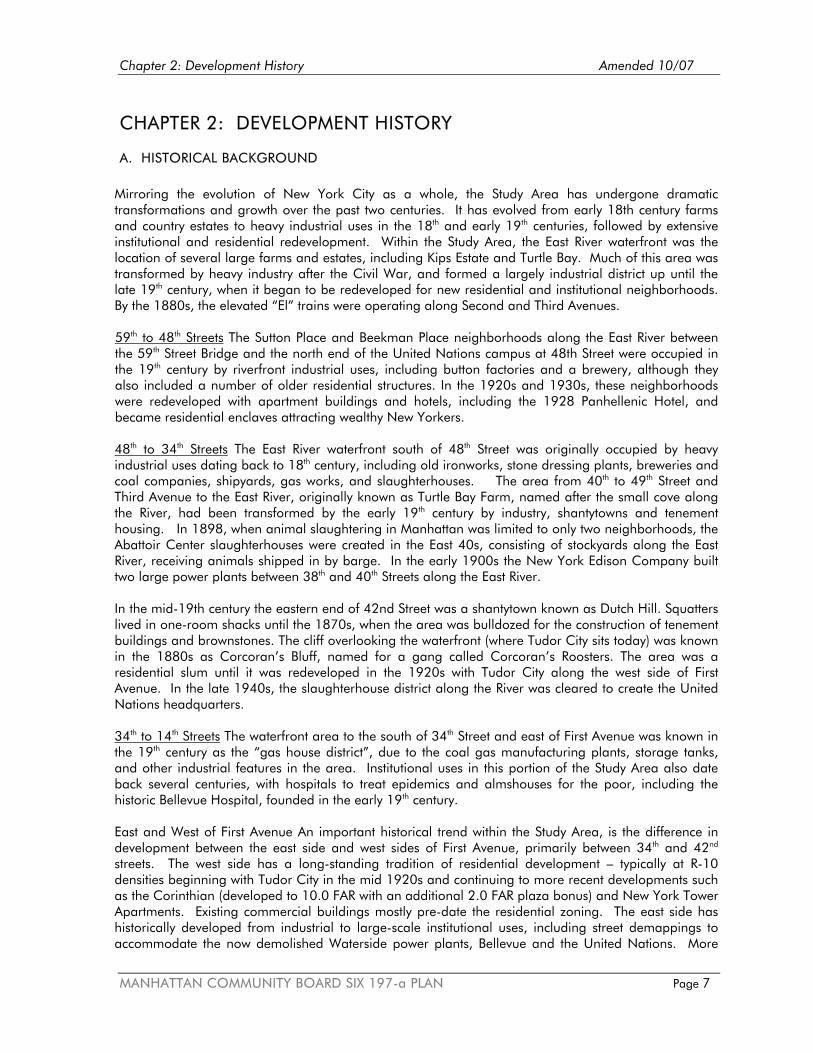
Chapter 2: Development History Amended 10/07
MANHATTAN COMMUNITY BOARD SIX 197-a PLAN Page 7
CHAPTER 2: DEVELOPMENT HISTORY
A. HISTORICAL BACKGROUND Mirroring the evolution of New York City as a whole, the Study Area has undergone dramatic transformations and growth over the past two centuries. It has evolved from early 18th century farms and country estates to heavy industrial uses in the 18th and early 19th centuries, followed by extensive institutional and residential redevelopment. Within the Study Area, the East River waterfront was the location of several large farms and estates, including Kips Estate and Turtle Bay. Much of this area was transformed by heavy industry after the Civil War, and formed a largely industrial district up until the late 19th century, when it began to be redeveloped for new residential and institutional neighborhoods. By the 1880s, the elevated “El” trains were operating along Second and Third Avenues. 59th to 48th Streets The Sutton Place and Beekman Place neighborhoods along the East River between the 59th Street Bridge and the north end of the United Nations campus at 48th Street were occupied in the 19th century by riverfront industrial uses, including button factories and a brewery, although they also included a number of older residential structures. In the 1920s and 1930s, these neighborhoods were redeveloped with apartment buildings and hotels, including the 1928 Panhellenic Hotel, and became residential enclaves attracting wealthy New Yorkers. 48th to 34th Streets The East River waterfront south of 48th Street was originally occupied by heavy industrial uses dating back to 18th century, including old ironworks, stone dressing plants, breweries and coal companies, shipyards, gas works, and slaughterhouses. The area from 40th to 49th Street and Third Avenue to the East River, originally known as Turtle Bay Farm, named after the small cove along the River, had been transformed by the early 19th century by industry, shantytowns and tenement housing. In 1898, when animal slaughtering in Manhattan was limited to only two neighborhoods, the Abattoir Center slaughterhouses were created in the East 40s, consisting of stockyards along the East River, receiving animals shipped in by barge. In the early 1900s the New York Edison Company built two large power plants between 38th and 40th Streets along the East River. In the mid-19th century the eastern end of 42nd Street was a shantytown known as Dutch Hill. Squatters lived in one-room shacks until the 1870s, when the area was bulldozed for the construction of tenement buildings and brownstones. The cliff overlooking the waterfront (where Tudor City sits today) was known in the 1880s as Corcoran’s Bluff, named for a gang called Corcoran’s Roosters. The area was a residential slum until it was redeveloped in the 1920s with Tudor City along the west side of First Avenue. In the late 1940s, the slaughterhouse district along the River was cleared to create the United Nations headquarters. 34th to 14th Streets The waterfront area to the south of 34th Street and east of First Avenue was known in the 19th century as the “gas house district”, due to the coal gas manufacturing plants, storage tanks, and other industrial features in the area. Institutional uses in this portion of the Study Area also date back several centuries, with hospitals to treat epidemics and almshouses for the poor, including the historic Bellevue Hospital, founded in the early 19th century. East and West of First Avenue An important historical trend within the Study Area, is the difference in development between the east side and west sides of First Avenue, primarily between 34th and 42nd streets. The west side has a long-standing tradition of residential development – typically at R-10 densities beginning with Tudor City in the mid 1920s and continuing to more recent developments such as the Corinthian (developed to 10.0 FAR with an additional 2.0 FAR plaza bonus) and New York Tower Apartments. Existing commercial buildings mostly pre-date the residential zoning. The east side has historically developed from industrial to large-scale institutional uses, including street demappings to accommodate the now demolished Waterside power plants, Bellevue and the United Nations. More

Chapter 2: Development History Amended 10/07
MANHATTAN COMMUNITY BOARD SIX 197-a PLAN Page 8
recently on the east side, the City Planning Commission has approved zone changes to C1-9 allowing new residential developments including Rivergate, Manhattan Place and Horizon (typically at about 10.5 FAR). A history of several major features of the Study Area is described as follows: Bellevue Hospital. The site of the present Bellevue Hospital was originally the Belle Vue estate, a farm in the Kips Bay area purchased by the City in 1794 to quarantine victims of the yellow fever epidemic far from the rest of the City. In 1811, the City bought additional land adjoining the Bellevue fever hospital from the Kip Estate, to create a new almshouse buildings and expanding the hospital, renamed the Bellevue Establishment. In 1847, in response to local protests, the almshouses and penitentiary were removed from the hospital grounds, and the facilities were opened for clinical instruction to the medical students. Bellevue Hospital Medical College, established in 1861, included New York University Medical College by 1898. Bellevue Hospital created the world’s first hospital-based ambulance service in 1869, with horse and buggy teams dispatched to emergencies within range of the hospital. The nation’s first school of nursing opened at Bellevue in 1873. Bellevue also created for the nation's first outpatient department, the Bureau of Medical and Surgical Relief for the Outdoor Poor. The nation’s first cardiology clinic opened there in 1911. The present hospital buildings, designed by McKim, Mead & White, were built at First Avenue and 27th Street in 1908 and 1939. Social services uses in the area included shelters for the poor, such as the 25th Street shipping pier converted to an annex for Municipal Lodging House for homeless men. Veterans Administration (VA) Medical Center, a 166-bed facility affiliated with the New York University Medical Center and home to all the Veterans Administration's cardiac and neurosurgical care in the greater metropolitan region, was constructed at First Avenue and 23rd Street in 1951. This VA Medical Center is considered one of the finest of the nation's many veterans' hospitals, and has been cited for its excellence in rehabilitative and prosthetic medicine. It serves approximately 150 in-patients and 4,000 out-patients per week. This hospital is one of many U.S. Veterans Administration hospitals that the federal government is considering closing. If closed, veterans who need care would be sent to the VA hospital in Fort Hamilton, Brooklyn. The NYU Hospitals Center and School of Medicine, located north of Bellevue Hospital in the superblock east of First Avenue between East 30th and 34th Streets, was created in the decades after World War II, when NYU expanded its facilities to include the Medical Science Building and the Henry W. and Albert Berg Institute, the Hall of Research and Alumni Hall, the Clinical Research Center. In 1963 the new University Hospital opened, and the Institute and Department of Environmental Medicine were established the following year. One of the first national cancer centers was established at NYU, renamed the Rita and Stanley H. Kaplan Center in 1975. The NYU Hospitals Center presently includes the following institutions: Tisch Hospital, Post-Graduate Medical School, Skirball Institute of Biomolecular Medicine, the Sackler Graduate School in Biomedical Sciences, the Kaplan Comprehensive Cancer Center, the Nelson Institute of Environmental Medicine, the Rusk Institute. A new cancer care center was recently added to the NYU Hospitals complex, which continues to expand its facilities. Con Edison Power Stations. In the early 20th century, two new power stations (the “Waterside plants”) were constructed south of 42nd Street near the East River, to meet the growing electrical demands on the New York Edison system. Waterside No. 1 at 680 First Avenue between 38th and 39th Streets was constructed in 1902. A larger second station, Waterside No. 2, 708 First Avenue between 39th and 41st Streets, was completed in 1906. By 1913 these two plants were providing electricity to Manhattan, Bronx, Queens, Blackwell’s Island, and Yonkers. A switch house and transformer building on the block along the First Avenue between 40th and 41st Streets were added to the Waterside complex in 1929.

Chapter 2: Development History Amended 10/07
MANHATTAN COMMUNITY BOARD SIX 197-a PLAN Page 9
The facilities at 616 First Avenue, between 35th and 36th Streets, developed by the New York Steam Company in 1929, were subsequently acquired by Con Edison and expanded as the Kips Bay Steam Plant, which was in operation until 1978, and demolished in the early 1990s. In 1984 Con Edison redeveloped the previously occupied residential buildings on the eastern portion of the block between 39th and 40th Streets on the west side of First Avenue (685 First Avenue), with an electrical substation and parking lot. The Con Edison East River Generating Station was built as a coal-burning plant in 1926 along the East River at 14th Street. The 25-cycle East River plant that fed the electric generation system was modernized in 1947 to become a 60-cycle plant. The three coal-burning generators used in the 1950s were later converted to “dual fuel” (fuel oil or natural gas) generators during the late 1960s. Following this conversion, Con Edison installed ten package boilers creating steam for residential and industrial uses in another building in the complex on the south side of East 14th Street, known as the South Steam Station. Through the years, there have been various changes in the plan’s internal equipment as more modern technologies have been installed. As part of this East River Repowering Project, the Waterside plant properties, also known as the First Avenue Properties, were approved by the NYS Public Service Commission for sale to East River Realty LLP for redevelopment with a mix of residential and commercial uses. They were recently demolished. Tudor City. Fred R. French, the real estate developer, purchased old row houses and tenements to the west of First Avenue between East 40th and 44th Streets, and demolished them to create what was then, the largest housing project ever built in mid-Manhattan. The result was the creation of a neighborhood with 12 Tudor-style apartment buildings and hotels (3,000 apartments and 600 hotel rooms), and interior parks in a complex between 40th and 44th Streets and First and Second Avenues. Built on a bluff overlooking the River, the buildings were oriented to the west, to avoid the sights and smells of the slaughterhouses then located along the East River. FDR Drive. Construction of the FDR Drive, which began in 1934, was completed in the 1940s. This highway, as originally planned by Robert Moses (who at the time was arterial coordinator and parks commissioner for New York City), was to feature landscaping and parks between the parkway and East River, although this was not implemented for most of the highway. The creation of the highway eliminated many shorefront amenities, including private docks and waterfront open space. Many sections of the highway were elevated, with highway access roads at grade level. Sections of the highway, including the portion between East 42nd and East 49th Street, are cantilevered (or constructed on piles) over the East River. The United Nations are partially cantilevered over the FDR Drive in this area. Portions of Sutton Place are also built over the highway. Much of the FDR Drive was built on fill or on pile-supported relieving platforms. The section near Bellevue Hospital (between East 23rd Street and East 30th Street) was filled with rubble from bombed British cities that arrived as ballast in wartime ships. Queens Midtown Tunnel. Constructed in 1937-1940, this tunnel connects Long Island City and the Long Island Expressway in Queens with Midtown Manhattan. A ventilation building was built east of First Avenue between 41st and 42nd Streets to allow air change within the tunnel. The tunnel enters Manhattan just south of 42nd Street at the East River, and continues underground along First Avenue until the tunnel exit plaza. The tunnel entrance plaza is located within the Study Area between First and Third avenues between 36th and 37th Streets. Ramps extend north to 41st Street and south to 34th Street. United Nations Headquarters and related institutional uses. The slaughterhouses, waterfront piers, and tenement structures in the area along the East River between 42nd to 48th Streets were cleared in the 1940s for the construction of the UN Headquarters in 1947-52. John D. Rockefeller, Jr. purchased these 18 acres of land along First Avenue and donated it to the United Nations. Designed by architects

Chapter 2: Development History Amended 10/07
MANHATTAN COMMUNITY BOARD SIX 197-a PLAN Page 10
including Le Corbusier, Oscar Niemeyer, and Sven Markelius, the UN headquarters includes a total of 1,269,000 square feet in four buildings: the Secretariat, the Dag Hammarskjold Library, the Conference Building, and the General Assembly Building. A park with sculptures and extensive views of the river was created at the north end of the UN campus between East 46th and East 48th Streets. As part of the development of the UN headquarters, the City added Dag Hammarskjold Plaza on East 47th Street and a tunnel under First Avenue, diverting traffic from the immediate vicinity of the UN. The United Nations Development Corporation (UNDC) has developed several large buildings to serve the UN community in the East 40s: the Millenium UN Plaza Hotel at 44th Street and First Avenue; One and Two United Nations Plaza, two 40-story glass towers across from UN Headquarters on the north side of East 44th Street, with 700,000 square feet of office space for U.N. agencies and missions; Three United Nations Plaza with the headquarters of United Nations Children's Fund and apartments housing UN and mission staff. The surrounding neighborhood includes other international and charity-related uses, as well as many UN missions housed in smaller buildings. The Ford Foundation headquarters building on 42nd Street, a modernist structure with an open glass atrium, was added in 1968. Large Scale Residential Developments have been built in the Study Area since World War II. These include the Stuyvesant Town and Peter Cooper Village residential communities, built by Metropolitan Life Insurance Company in 1943-47 to meet the post-war housing demand, with 51 apartment buildings on 18 acres between 14th and 23rd Streets along the waterfront, east of First Avenue. The residential development of the Study Area continued in the following decades. Kips Bay Towers, designed by I M Pei and constructed in the early 1960s, created 1,118 residential units in two slab buildings on a 7.5-acre site between First and Second Avenues, 30th and 33rd Streets. In the late 1960s, the Bellevue South Urban Renewal Area in the East 20s was redeveloped with the Henry Phipps Plaza Houses (1700 apartments) Nathan Strauss Houses (277 apartments), East Midtown Plaza Apartments (748 units), and Renwick Gardens apartments. Waterside Plaza Houses, built in the early 1970s on a platform along the East River between 25th and 29th Street, created 1,470 apartments in four 40-story towers and 20 townhouses. Since the 1980s, a number of large individual residential buildings have been constructed in the Study Area along First and Second Avenues and between 34th and 40th Streets, including the 53-story Corinthian Apartments at East 37th Street, the 52-story apartment tower at 100 UN Plaza on East 48th Street, the 42-story Horizon at 415 East 37th Street, the 37-story Manhattan Place Condominiums at 630 First Avenue at 36th Street, and the 35-story Rivergate Apartments at 606 First Avenue between 34th and 35th Streets. The most recent and most visibly egregious addition to this East Side urban landscape of residential towers is the 72-story Trump World Plaza at First Avenue and East 48th Street that opened in 2001.

Chapter 2: Development History Amended 10/07
MANHATTAN COMMUNITY BOARD SIX 197-a PLAN Page 11
B. POPULATION AND HOUSING TRENDS As noted in the previous development history description, the residential population of the Study Area expanded dramatically in the second half of the 20th century. Urban renewal housing projects and luxury high rise developments were erected as a result of extensive redevelopment of this formerly industrialized area along the East River. These projects transformed older tenement and industrial areas into areas with high density residential uses. This development trend continued in the subsequent decades, with notable increased population in certain portions of the community district between 1990 and 2000. The Study Area consists of Census Tracts 44.01, 60, 62, 86, 106.01, 106.02, and the portions of Census Tracts 48, 64, 66, 70, 78, 88, 90, 98, 108 that are located 100 feet west of Second Avenue.
Table 1: Population Change in Community District 6 Total Population Manhattan Community District 6 1990 133,748 2000 136,152
Population Increase Community District 6 1990-2000 + 2,404 The overall population growth in the Community District 6 between 1990 and 2000 was 1.8 percent. The highest residential growth rate in the district (24.7 percent) occurred within Census Tract 78, located between First and Third Avenues, East 34th and East 39th Streets. Over half of this census tract falls within the Study Area, and includes several large new apartment buildings (such as Manhattan Place Condos, the Corinthian, New York Towers) that have attracted new residential tenants to the area.

Chapter 2: Development History Amended 10/07
MANHATTAN COMMUNITY BOARD SIX 197-a PLAN Page 12
C. CURRENT DEVELOPMENT TRENDS The following major projects are currently underway in the Study Area: Bellevue Hospital Modernization. Bellevue Hospital has completed a major modernization of some of its existing facilities, including a glass curtain wall installation at the lobby level for its new 207,000-square-foot ambulatory care building. The hospital also renovated the 10th floor of its existing tower to create a new consolidated critical care suite. FDR Highway Reconstruction. The New York State Department of Transportation (NYSDOT) began work for the FDR Drive Reconstruction Project from East 54th to East 63rd Street in Manhattan in December 2002. This project is substantially completed and rehabilitated the 60-year old, three-level tiered FDR Drive structure between East 56th and East 63rd Streets. Work included repaving the at-grade (lower level) portion of the FDR Drive between East 54th and East 56th Streets, safety improvements to correct roadway geometry (including the addition of an acceleration lane to the East 63rd Street entrance), and new drainage, signage, and lighting systems. To accommodate this construction project, NYSDOT constructed a temporary Outboard Detour Roadway (ODR) in the East River adjacent to the portion of the Drive between 56th and 63rd Streets, to replace the FDR Drive travel lanes that will be closed during construction. This has been largely dismantled. NYSDOT also plans to rebuild the FDR Drive viaduct from East 25th Street north to East 42nd Street. In addition to replacing the viaduct and entrance-exit ramps, the project is to provide new grade-separated pedestrian access to the riverfront, a riverfront esplanade and a two-way bicycle lane. Several alternatives are currently being studied, including the construction of a vehicular tunnel along the current FDR Drive right-of-way. Design work for the project is underway and is expected to continue through 2006, with completion scheduled for 2009. Reconstruction of the FDR exit ramp at 42nd Street is also currently being evaluated by NYS DOT. Con Edison East River Repowering Project. In order to replace its Waterside Facilities, Con Edison repowered its East River Generating Station at 14th Street with a new combined cycle steam and electric co-generation facilities. The repowering project included installing new gas turbines, heat recovery steam generators, and gas compressors. A new water treatment plant was constructed at the East River Generating Station that created a reverse osmosis system to produce pure water for steam generation. The project also included the creation of a new “work out facility” for the Con Edison employees transferred from the now demolished Waterside Plant to the East River Plant. The Milan Apartments. A new 32-story 119-unit condominium apartment building was recently completed at East 55th Street and Second Avenue.

Chapter 2: Development History Amended 10/07
MANHATTAN COMMUNITY BOARD SIX 197-a PLAN Page 13
D. NEW DEVELOPMENT IN PLANNING STAGES The trend toward large scale construction, in addition to redevelopment of individual sites, is continuing in the area with the following proposed projects: Development of Con Edison First Avenue Properties. As a result of the Con Edison Repowering project at Con Edison’s East River Plant on 14th Street, the Con Edison Waterside power plant facilities along First Avenue between 35th to 41st Streets has been decommissioned and approved by the NYS Public Service Commission for sale to East River Realty LLP. These four sites collectively total 8.9 acres. The proposed redevelopment of these properties with large scale residential/commercial buildings is being closely reviewed by Community Board 6 not only in terms of the height and bulk of the proposed buildings, but also for open space and access to the waterfront, and the creation of a waterfront esplanade along the East River. New UN Office Tower. The United Nations Development Corporation (UNDC) is planning an office tower for UN office workers in the area, to be located at the site of the Robert Moses Playground, a City park currently used for active recreation. Eventually this building will serve to consolidate UN activities. The construction of the UNDC building at this park site would require the following actions:
o State legislation to alienate parkland and enlarge the UNDC Development District; o State legislation to alienate the Robert Moses Playground, map a new park as replacement
and open space mitigation and dispose of former park; o New park may require acquisition depending on location of parkland (within pierhead line is
owned by New York City, outside pierhead line is owned by New York State and 685 First Avenue is owned by Con Edison and could be mapped as new park);
o Approvals for new park from NYSDEC, Army Corps of Engineers, NYS and NYC WRP; o UNDC process to develop new building (involves NYC DCP and City Council reviews).
As mitigation for this building, the United Nations has proposed creating a new waterfront esplanade from 41st to 51st Streets, to run along the FDR on a pile-supported platform. The esplanade might also include bulges into the river to accommodate a new waterfront park as a replacement for the demapping of Robert Moses Playground. Community Board 6 is evaluating this proposal, and continues to seek an alternate site as an open space replacement for the demapping of Robert Moses Playground. East River Science Park: In early 2001, the Bellevue-NYU Medical campus became the focus for the expansion of the biotechnology sector in New York City. The initial plan was for three new buildings to be used primarily for biotechnology but might also include other facilities such as an NYU library. The Bellevue Psychiatry building (currently housing the homeless men's shelter scheduled to move out late next year) was to be renovated for hospital housing, day care, medical offices. The infrastructure included a deck over a service street. NYU School of Medicine was selected to develop the property, with the NYC Economic Development Corporation acting as facilitator. This plan was approved by the NYC Department of City Planning in November 2001. New York University School of Medicine proposed the creation of the East River Science Park (ERSP) on the north portion of the Bellevue Hospital campus, to include three new biotechnology facility buildings, as well as the renovation of the former Psychiatric Building for clinical and research facilities, resulting in a total of 300,000 square feet of bio-technology lab space. A Request for Proposals (RFP) was recently issued by EDC. The NYU School of Medicine is also proposing to renovate the Psychiatry building as housing for its staff and EDC recently issued a Request for Proposals (RFP).

Chapter 2: Development History Amended 10/07
MANHATTAN COMMUNITY BOARD SIX 197-a PLAN Page 14
In November 2004, New York City Economic Development Corporation (NYCEDC), in conjunction with the New York City Health and Hospitals Corporation, issued a new request for proposals for the development of the East River Science Park site as a state-of-the-art research and development campus. This science park, about 4.5 acres in area, was to include more than 870,000 square feet of floor space for research and development, located between 28th and 30th Streets, First Avenue and FDR Drive. As noted in the RFP, the East River Science Park is planned as the City’s flagship location for companies in the pharmaceutical, biotechnology, bioinformatics, medical device fields as well as for contract research organizations, at a site that is considered the ideal setting in which to bring together New York City's 15 celebrated medical and research centers, numerous life scientists, Nobel laureates, and healthcare and technical practitioners, and attract life science companies to New York City. Community Board 6 agrees with the overall concept of the East River Science Park, but varies as to some of the Plan details. This 197-a Plan presents an opportunity to obtain some improvements to the East River Science Park plan by adding such components as mapping the streets, moving the south boundary of the Science Park, and ensuring Bellevue's beneficial participation. A full description of Community Board 6 views on this project are contained in the Cooper-Eckstut Plan in the Recommendations Chapter (Chapter 4) of this 197-a Plan. Perlbinder Site Development. This is a planned development of apartment building with ground floor retail on the Perlbinder site on the west side of Second Avenue between 36th and 37th Streets and above the exit ramp of the Queens Midtown Tunnel. Upgraded ferry terminal and intermodal transfer facility to be located at 35th Street and the East River. The NYC Economic Development Corporation (EDC) plans to replace the existing 34th Street ferry landing barge with a new 3,300 s.f. ferry terminal at the end of the existing 35th Street pier. The pier will anchor ferry landing slips on two moored barges. In addition to upgrading the 35th Street pier to accommodate the ferry terminal and new public space, EDC site plans includes renovated vehicular areas for taxi/bus access; a canopy structure for pedestrians between 34th and 36th streets, and improvements to the East River Esplanade pedestrian and bikeway between 34th and 36th streets, including waterfront viewing seating, landscape plantings, and lighting. Estimated completion date is the end of 2008. Second Avenue Subway. This long planned new subway line will run under Second Avenue from 125th Street to Lower Manhattan, and include the following new stations with ancillary facilities within Community District 6: 14th Street, 23rd Street, 34th Street, 42nd Street, and 55th Streets. Construction of individual stations is expected to last approximately five years per station, with three years for station excavation, plus two years for completion of stairwells, platforms, finishings. The typical length of each subway construction zone is approximately 5 blocks. The schedule for construction of specific subway stations, and its displacement of residential and commercial units for ancillary facilities, has yet to be established. A large shaft site/spoils removal/construction staging area for the subway construction has been proposed for the west portion of St. Vartan Park. The north end of the cut and cover zone for the 14th Street station would be located just south of Stuyvesant Square Park. As noted in the Supplemental DEIS for the Second Avenue Subway, NYC Transit Authority will work with NYC Department of Parks and Recreation prior to construction to seek to identify appropriate temporary relocation spaces for the displaced park activities, or other appropriate mitigation for parks affected by subway construction. With so little park space available in the Study Area, this displacement of park space - albeit a temporary one - raises concerns for the community. Third Water Tunnel Shaft Sites. Beginning in 2007, the Department of Environmental Protection (DEP) plans to place two shaft tunnels for the water tunnel (Site 32B at East 35th Street between Second Avenue and the Midtown Tunnel approach, in sidewalk and partially in the street, adjacent to St. Vartan Park). Shaft site 33B is to be located at East 59th Street and First Avenue.

Chapter 2: Development History Amended 10/07
MANHATTAN COMMUNITY BOARD SIX 197-a PLAN Page 15
Key Issues for the 197-a Plan The history of extensive development in this area highlights the following critical issues to be addressed by Community Board 6 in this 197-a Plan: a continuously growing residential and working population;
scarcity of high quality open space;
increasing traffic and transit congestion;
pedestrian safety in an area with high traffic density;
urban design and building scale in area with large existing and proposed structures;
the need for connections between segments of the East River waterfront esplanade, and improved
access to the waterfront. In addition, the extensive new projects proposed for the Study Area further underscore the need for the various comprehensive planning tools outlined in this 197-a Plan to help guide the future of this area of Manhattan.

Chapter 3: Community Profile Amended 10/07
MANHATTAN COMMUNITY BOARD SIX 197-a PLAN Page 16
CHAPTER 3: COMMUNITY PROFILE
A. LAND USE As the development history outlined in Chapter 2 indicates, large portions of the Study Area have been extensively redeveloped over the past 50 years, creating the United Nations and related facilities, several major medical institutions, and the large residential developments of Peter Cooper/Stuyvesant Town, Kips Bay Houses, East Midtown Plaza, Waterside Plaza, and Phipps Houses. Older residential areas include the distinctive neighborhoods of Sutton Place, Beekman Place, and Turtle Bay, many with historic district designations, and the 1920s residential complex of Tudor City. Land uses within the Study Area are indicated on the land use map Figure 2 on page 20, and generally described as follows: Residential Uses: While it includes some of the City’s most distinctive residential areas, including Turtle Bay, Beekman Place, and Sutton Place with their older historic buildings and quiet streets, the Study Area is also characterized by high density residential projects built over the past 50 years. In addition to the large scale housing redevelopment following World War II, numerous large apartment towers have been built since the 1960s along First and Second Avenues. Many included small plazas and/or private open space as a public amenity, as part of their zoning bonuses, although many of these spaces have been classified by the Department of City Planning as “marginal”.1 Institutional/International Uses: The Study Area includes the World Headquarters of the United Nations on an 18-acre site consisting of international land that extends from 42nd Street to 48th Street, from First Avenue to the East River, as shown on the map. The United Nations site belongs to all UN member states, and includes its own security force and fire department. New York City local government provides public services, including additional police and fire protection, utilities, telephone, refuse and snow removal. As international territory, UN headquarters are exempt from city and state laws, as well as zoning regulations and local laws. Related institutional and international uses, such as the Ford Foundation and other foundation offices, as well as diplomatic missions, are also located in the vicinity, creating one of the most intensive international and institutional districts in the country. Commercial Retail, Hotels, and Office Uses: Most of the commercial space in the Study Area consists of local neighborhood retail. With the exception of office space and hotels serving the UN and related international institutions, the bulk of office and other commercial space are located west of the Study Area along Third and Lexington Avenues. Educational Uses and Libraries: The Study Area includes numerous religious and educational institutions including public, private, and religious schools. The United Nations International School, providing education for children of UN diplomats and other international residents of the City, is located along the East River waterfront off 25th Street. Public Schools: Community District 6 is located in School District 2. Community School District 2 encompasses Lower Manhattan, Midtown Manhattan (river to river) and the Upper East Side. There are three elementary schools (PS 40, PS 116 and PS 59) located in CD 6, one of these is currently experiencing overcrowded conditions (see Table 2a). The intermediate schools located in CD 6 are MS 104 and MS 255. Both of these schools admit children residing in CSD 2 although MS 255
1 Privately Owned Public Space (2000) Jerold S. Kayden, New York City Department of City Planning, and Municipal Art Society of New York.

Chapter 3: Community Profile Amended 10/07
MANHATTAN COMMUNITY BOARD SIX 197-a PLAN Page 17
also has additional admissions criteria. MS 255 is housed in PS 40. Neither of these intermediate school programs is currently experiencing overcrowded conditions. Since 1990, enrollment in CSD 2 elementary and intermediate schools has increased each year, from 19,019 students in 1990 to 23,153 students in 2003 (including Pre-K enrollment). Both the Department of Education and the Department of City Planning project that enrollment in CSD 2 elementary and intermediate schools will continue to grow over the next ten years. According to the analysis provided in the Con Edison FGEIS, if the Con Edison-Waterside disposition parcels were developed with residential units a significant adverse impact on elementary schools could occur.
Table 2a: Elementary and Intermediate Schools Within Manhattan CD 6 (CSD 2) High Schools Within or adjacent to CD 6 School Enrollment Capacity Over/Under %
Utilization Community School District 2
Elementary PS 40* 319 East 19th
Street 536 591 -55 91%
PS 116 210 East 33rd Street
741 722 19 103
PS 59 228 East 57th Street
317 335 -18 95
Total CSD 2 Elementary and PS/IS
15,066 16,182 -1,116 93
Intermediate MS 104 330 East 21st
Street 1,139 1,226 -87 93
MS 255* 319 East 19th Street
334 335 -1 100
Total CSD 2 Intermediate and IS/HS
6,590 7,773 -1,183 85
Total CSD 2 Includes high school seats for
Eleanor Roosevelt HS, Millenium HS, Baruch College Campus HS, Pace HS, NYC Lab HS, Museum School and School of the Future
24,503 27,414 -2,925 89%
High Schools Located In CD 6
School of the Future (IS/HS) 127 East 22nd Street
672 738 -66 91
Baruch College Campus HS 17 Lexington Avenue
409 300 109 136
High Schools Located Just Outside CD 6
School for the Physical City (IS/HS) 55 East 25th Street
302 560 -258 54

Chapter 3: Community Profile Amended 10/07
MANHATTAN COMMUNITY BOARD SIX 197-a PLAN Page 18
School Enrollment Capacity Over/Under % Utilization
Manhattan High Schools
In 2005-2006, Manhattan consisted of Instructional Regions 9 and 10. Region 10 extends into the Bronx. The enrollment and capacity info here excludes those buildings the Bronx. In addition, some Manhattan Community School Districts have additional high schools located in auxiliary facilities which are not included in these figures (e.g. School of the Future and Baruch College Campus HS).
56,712 64,041 -7,329 89
Source: DOE Utilization Profiles: Enrollment/Capacity/Utilization 2005-2006 Notes: Target capacity and utilization data is shown (assumes reduced class size of 20 children per class for grades K-3). Total for CSD 2 includes elementary, intermediate, special ed and high school seats in CSD 2. * More than one program in this building. Data is for the program. Other programs are usually Special Ed, unless otherwise noted. Day Care-Existing Conditions: According to the Department of City Planning’s Selected Facilities and Program Sites in New York City, 2002-2003, there are 18 day care facilities in CD 6, serving 1,025 children. There are no locational requirements for day care facilities, and many of the day care slots could be filled by children who reside outside of CD 6. According to Census 2000, CD 6 had 4,041 children aged five and under. As shown in Table 2b, CD 6 ranks 9th (out of Manhattan CDs) in the number of children aged 5 and under per day care slot, with approximately four children under the age of 5 for each day care slot available in CD 6.
Table 2b: Day Care & Head Start Facilities: Capacity per Population Under 5 Years CD Population Under 5 Capacity
(# of Slots) Population Under 5 / Capacity =
# of children per slot Ranking
1 1,596 796 2.00 2 2 2,572 796 3.23 6 3 6,975 3,385 2.06 3 4 2,549 752 3.39 7 5 1,184 834 1.42 1 6 4,041 1,025 3.94 9 7 9,521 3,162 3.01 5 8 9,853 4,213 2.34 4 9 6,638 1,283 5.17 11 10 7,894 1,868 4.23 10 11 8,256 2,417 3.42 8 12 14,389 1,665 8.64 12
Sources: U.S. Census Bureau, 2000 Census SF1, DCP Table SF1- P-104: Total Population by 5 Year Age Groups: NYC Community Districts, 2000. DCP, Selected Facilities & Program Sites in NYC, 2003 Edition. The Agency for Child Development (ACD), under the Administration for Children’s Services (ACS), provides vouchers to income-eligible families for public and/or private group day care and for family day care programs. The Con Edison FGEIS identified a significant adverse impact to public group day care facilities if the development parcels include an affordable housing component, such as an 80/20 program. The FGEIS noted that the voucher system could be expected to “spur the development of new private day care facilities to meet the additional needs of the eligible children that may result from an 80/20 Development Program under the Proposed Action. Mitigation for this impact [in consultation with ACS and ACD] could also include one or more of the following:
Provision on site for a day care center; Provision of a suitable location off-site within a reasonable distance; and

Chapter 3: Community Profile Amended 10/07
MANHATTAN COMMUNITY BOARD SIX 197-a PLAN Page 19
Provide for the expansion of an existing facility to mitigate the impact.”2 Medical, Hospital, Science Related Uses: The medical, hospital, research and related uses that line First Avenue between 23rd and 34th Streets include the Veterans Administration Medical Center, Bellevue Hospital, the NYU Hospital Center, the NYU School of Medicine, Arnold and Marie Schwartz Hall of Dental Sciences Tisch Hospital, the Rusk Institute, the Medical Examiners Office, the Kriser Dental Center, and related services and health care facilities. Further to the south, in the vicinity of Stuyvesant Square, the Study Area includes the New York Eye and Ear Hospital, the Hospital for Joint Diseases, and Beth Israel Hospital. Transportation Features: The Study Area includes a complex transportation infrastructure providing local and regional access to and from the east side of Manhattan and Midtown. Major transportation features in the Study Area include a highway, the FDR Drive and its on-ramps and off-ramps, the entrance/exit plaza for the Queens Midtown Tunnel, the emergency egress shaft for Amtrak and the Long Island Rail Road at First Avenue and 33rd Street, a heliport on the East River between 32nd to 33rd Streets, a ferry terminal along the East River between 34th and 35th Streets, and several other major urban transportation features connecting to the rest of the City. The Queensboro Bridge is located at 59th Street at the north end of the Study Area. In addition to these gateway facilities, the Study Area contains a regular grid of streets and avenues accommodating local and through traffic, including a system of bus lines. Subway service is on Lexington Avenue and Park Avenue South, within Community District Six but outside the Study Area, and on 14th Street at the south edge of the Study Area. There are also several subway and rail tunnels passing east-west through the Study Area. These critical points of entry to Manhattan result in the Study Area acting as a conduit for regional commuters, contributing to increasing traffic levels and noise.
The Queens Midtown Tunnel enters Manhattan belowground at East 41st Street, and runs south under First Avenue to the exit and entrance ramps located between Third and First Avenues, 36th to 37th Streets. Tunnel approach and exit streets are located between First and Second Avenues, 34th and 40th Streets. The Tunnel Ventilation Building is located in the block occupied by Robert Moses Playground, between 42nd and 41st Streets on First Avenue.
The FDR (“East River”) Drive runs along the eastern edge of the Study Area, cutting much of it off from the waterfront. However, several sections of the Study Area are decked over the Drive, including the UN campus, and several apartment buildings to the north in the Beekman Place, and Sutton Place neighborhoods.
34th Street Heliport. This commercial heliport located on the East River, with a waterfront landing pad between 32nd-33rd Streets, and parking area on the riverfront at 34th Street, provides commercial heliport service and also accommodates police/medivac helicopters.
The New York Water Taxi Ferry Terminal, located along the riverfront between 34th and 35th Streets, provides water taxi service to Brooklyn, Queens, Upper and Lower Manhattan.
The Queensboro Bridge is located between 59th and 60th Streets east of Second Avenue and extends across the East River linking Manhattan to Queens. The bridge traffic enters and exits Manhattan between First and Second Avenues, with entrance/exit roads running north and south, between First and Second Avenues south to 57th Street, and north to 62nd Street, and a tramway to Roosevelt Island along the north side of the Bridge at 59th Street.
2 FINAL GENERIC ENVIRONMENTAL IMPACT STATEMENT in Case 01-E-0377 - Joint Petition of Consolidated Edison Company of New York, Inc. and FSM East River Associates LLC for Authority under Section 70 of the Public Service Law to Transfer Certain Real Property Located at 616 First Avenue, a Portion of 685 First Avenue, 700 First Avenue and 708 First Avenue and for Related Relief. Chapter 18-Mitigation, p. 18-2.

FIGURE 2: LAND USE MAP
BFJ Buckhurst Fish & Jacquemart Inc.
59th St
14th St
Firs
t Ave
Third
Ave
42nd St
NTS
Community Board 6 197-a Plan
34th St
23th St
Information not available
sour
ce: A
llee
Kin
g R
osen
& F
lem
ing,
Inc.
/ Lot
Info
r 20
01 3
-02
Page 20

Chapter 3: Community Profile Amended 10/07
MANHATTAN COMMUNITY BOARD SIX 197-a PLAN Page 21
B. ZONING History of Zoning Changes Reflecting the changing land uses in the area, large sections of the Study Area in the East 20s, 30s, and 40s have been rezoned over the past several decades, to accommodate the shift from manufacturing uses to residential and commercial districts. These rezonings, shown in Table 3 below, have allowed the transformation of the area with new residential construction at a greater floor area ratio (FAR) than previously permitted. In particular, the remapping of former manufacturing districts with commercial district zoning has permitted higher-density residential uses, and resulted in development of high-rise residential buildings along First and Second Avenues between 34th and 40th Streets, built at an FAR of 12:0, including complexes such as the Corinthian and Highpoint (on the east side of First Avenue, the Rivergate, Manhattan Place and Horizon buildings were built to about 10.5 FAR).
Table 3: Zoning Changes (1981 to the Present)
Year Rezoned Project/ Location Original
Zoning Original FAR New Zoning Maximum FAR
1981 Rivergate: First Ave/34th St
M1-5 C & M 5.0, CF 6.5
C1-9
C 2 R 10.(2 bonus)
1982 First Ave. and 36th Street M1-5 C & M 5.0, CF 6.5
C6-4 C&R 10.0 (2 bonus)
1983 Second Ave. 36th to 49th Streets
C6-4 C & R 10 (12) C1-9 C5-2,
R10
C 2 & R10 (12) C & R 10 (12) R10 (12)
1983 58th and 59th Sts – west of Second Ave.
C6-4 C2-5
C&R 10.0 (2 bonus) C 2
C5-2 C1-5
C&R 10.0 (2 bonus) C 2
1985 Beekman Pl. 49th to 52nd Streets R10 R 10 R8B 4.0
1986 36th to 38th St. First Ave to FDR Drive
M3-2 M1-5 C6-4
M 2 M 5 C & R 10 (12)
C1-9 C 2 R 10 (12)
1986 First Ave. 37th to 40th Streets C6-4 C & R 10 (12) C1-9
C 2 R 10 (12)
1986 35th to 39th Street, Second to Madison Avenue
R7-2 R8 R10
R 0.87 to 3.44 R 0.94 to 6.02 R 10
R8B R9X
R 4 R 9
1987 East Side Rezoning First to Third Ave, 48th to 59th Streets
R7-2, R8 R10 C1-5, C5-2 C6-4
R 3.44, 6.02 R 10 (12) C2, 10 (12)
R8B C1-9
R 4 C 2 C & R 10 (12)
1988 Second Ave. 22nd-23rd St C6-3 R 7.5. C 6, CF 10
C1-9A R 10 (2)
1995 East Side Rezoning 15th to 35th St.
C1-7, C1-9, C2-5 R7-2 R8
C 2, R 6.02 C 2, R 10 (12) C 2 R 0.87 to 3.44 R 10 (12)
R8A, R8B, R7B, C1-8, C1-9, C1-9A
R 6.02, R 4, R 3 C 2, R 7.52 C 2, R 10 (12)
2001 Stuyvesant Cove M2-3 M 2 M1-1 M 1
2001 Bellevue: 28th to 30th Streets
C2-5 R8
C 2 R 0.94 to 6.02
C6-2 R 6.02, C 6, CF 6.5

Chapter 3: Community Profile Amended 10/07
MANHATTAN COMMUNITY BOARD SIX 197-a PLAN Page 22
A study was undertaken in 1985 by Michael Parley and ESRA, the Turtle Bay Rezoning, to review contextual rezoning and R8-B midblock rezoning in the area of the East Side from 48th to 59th Street, from Third Avenue east to the River. This area was rezoned by the City Planning Commission in 1985, although the rezoning did not include the Beekman Place neighborhood that had already been rezoned, and any areas in Midtown Zoning District. The largest rezoning effort came in 1995 when after more than five years of analysis by the East Side Rezoning Alliance (ESRA); the City Planning Commission rezoned large sections of the East Side between 15th and 35th Streets. This rezoning action was intended to preserve the smaller-scale residential character of the mid-blocks and to focus commercial growth along the avenues and designated cross-town streets. One of the zoning tools used to preserve residential scale and character was contextual zoning, which includes height limitations, and street wall requirements ensuring that new development is in keeping with the existing patterns of residential development. Not only has the East Side Rezoning protected the scale of residential neighborhoods, but it has also limited the encroachment of office uses spreading east from Midtown. The East Side Rezoning reflected a joint effort of the local community group (ESRA) and a City agency (NYC Department of City Planning) to allow controlled growth while also protecting the existing residential fabric of the East Side. It also established, on an unprecedented scale, the widespread application of contextual zoning as a tool to preserve and protect and to allow new, compatible uses. Over time various rezonings within the study area have sought to incorporate contextual and smaller scale zones into the area, as shown on Table 3. More recently, in 2001 a portion of the Bellevue Hospital Campus was rezoned to allow the development of 1.5 million square feet of biotechnology space in the area between 28th and 30th Streets. First Avenue and the FDR Drive were also rezoned from R8 (with a C2-5 overlay) to C6-2 to allow commercial development of up to 6.0 to 7.2 FAR with bonus (previous zoning allowed 2.0 FAR). Existing Zoning As illustrated on Figures 3a and 3b, the Study Area contains a variety of zoning districts, including the following residential zones: R7-2, which is the zoning for Stuyvesant Town and Peter Cooper Village; R8, mapped for residential areas in the vicinity of NYU-Bellevue medical complex; R10 mapped north of Beekman Place; R8-B contextual zoning in midblocks between First and Second Avenues.
Commercial zones, such as C5-2 are mapped in the vicinity of the United Nations, and C1-8, C1-8A, C1-7, C1-6A, C1-9, C1-9A are mapped along First and Second Avenues. Densities range from 3.0 Floor Area Ratio (FAR) in the residential midblocks between First and Second Avenues to 10.0 or 12.0 FAR (with a bonus) for isolated areas such as the Rivergate apartment complex. Vestiges of the area’s manufacturing past are also reflected in the zoning: the Con Edison Waterside and East River properties are zoned M3-2 for low density heavy industrial use. Table 4 on the page following the zoning maps provides a list of the different zoning districts within the Study Area, with examples of the neighborhoods where these zones apply. The Study Area also includes two special zoning districts, described as follows: Special United Nations Development District (shaded areas on the map marked “U”), and Special Transit Land Use District (shaded areas on map marked “TA”). These special districts are described in more detail on the pages that follow.

197-a Study Area
Special Purpose Districts:TA Special Transit Land Use DistrictU United Nations Development District
FIGURE 3a: ZONING MAP A
BFJ Buckhurst Fish & Jacquemart Inc.
NTS
Community Board 6 197-a Plan Page 23
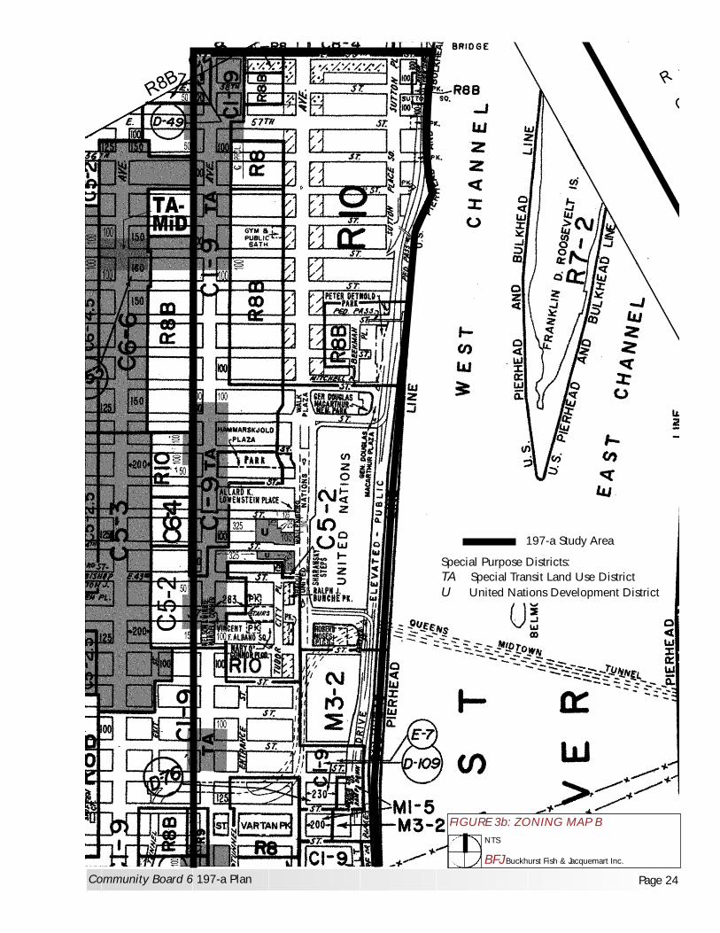
197-a Study Area
Special Purpose Districts:TA Special Transit Land Use DistrictU United Nations Development District
FIGURE 3b: ZONING MAP B
BFJ Buckhurst Fish & Jacquemart Inc.
NTS
Community Board 6 197-a Plan Page 24

Chapter 3: Community Profile Amended 10/07
MANHATTAN COMMUNITY BOARD SIX 197-a PLAN Page 25
Table 4: Zoning by Neighborhood
Zoning District Maximum FAR Uses/Zone Type Neighborhood
R7-2 0.87 to 3.44 residential Medium density apartments Stuyvesant Town R7B 3.0 residential General residence district,
contextual district Midblock apartments
R8 0.94 to 6.02 residential General residence district Kips Bay Apts. R8A 6.02 residential General residence district,
contextual East side of Stuyvesant Sq.
R8B 4.0 residential General residence district, contextual
Midblock, Beekman Place, and between First and Second Ave, 22-20th Streets, 49-55th Streets
R10 10.0 residential (12.0 with bonus)
General residence district Midblock, Sutton Place
C1-8 2.0 commercial, 0.99 to 7.52 residential
Local shopping and services Second Ave., 23rd to 29th, east side
C1-8A 2.0 commercial, 7.52 residential
Local shopping and services, contextual district
Second Ave., 23rd to 33rd, west side
C1-9 2.0 commercial, 10.0 residential (12.0 with bonus)
Local shopping and services Rivergate Apts., Manhattan Place
C1-9A 2.0 commercial, 10.0 residential (12.0 with bonus)
Local shopping and services, contextual district
23rd, First to Second Avenues
C2-7 2.0 commercial, 0.99 to 7.52 residential
Local shopping and services with residential uses
Waterside Houses complex
C5-2 10.0 commercial (12.0 with bonus), 10.0 residential (12.0 with bonus)
Restricted central commercial district
United Nations and surrounding area
C6-2 6.0 commercial (7.2 with bonus), 0.94 to 6.02 residential
General commercial district outside CBD
Northern portion of Bellevue campus
M1-1 1.0 commercial or manufacturing
High performance light manufacturing
Stuyvesant Cove between bulkhead and pierhead
M1-5 5.0 commercial or manufacturing
High performance light manufacturing located mainly in Manhattan CBD
FDR Drive between 36th and 37th Streets
M3-2 2.0 commercial or manufacturing
Low performance heavy manufacturing
Former Con Edison Waterside Plant, now East River Realty Redevelopment Site
In addition to the previously described zoning districts, the Study Area includes a number of zoning overlays and the following two special districts, illustrated on the zoning maps Figures 3a and 3b. Special Zoning Districts
1. “U” Special United Nations Development District: This special use district on the west side of First Avenue from East 43rd to East 45th Streets, opposite the United Nations, was established in 1970 to allow UN-related development, such as housing for personnel, hotels for visitors and delegates, meeting rooms and other facilities in the area surrounding the UN headquarters. Initially the zoning regulations were similar to those of a C5-3 district

Chapter 3: Community Profile Amended 10/07
MANHATTAN COMMUNITY BOARD SIX 197-a PLAN Page 26
(maximum FAR of 15, FAR of 18 with bonus). In 1980, the special district was modified by the City to limit the height of buildings within 200 feet west of First Avenue to below that of the Secretariat building, which is 505 feet high. Subsequent changes added flexibility to the range of uses and transfer of development rights among parcels in the district, but restricted the overall FAR to no more than 15.0. Three large towers have since been built in this area at One UN Plaza (Millenium UN Hotel), Two UN Plaza (housing UN Missions and related offices) and Three UN Plaza.
2. “TA” Special Transit Land Use District: Created in 1974 along Second Avenue in those areas
where subway stations for the new Second Avenue line were anticipated, this special purpose district requires new development or enlargements to provide an easement, if requested by the NYC Transit Authority, for access to the subway underneath, and to provide light and air to the subway beneath. The district is mapped within the Study Area, on both sides of Second Avenue at the following locations, as shown on the zoning map on previous Figures 3a and 3b:
o East 15th to 14th Streets (and south of the Study Area to East 13th Street) o East 23rd Street to 24th Street o East 26th to midblock between East 27th and 28th Streets o East 33rd to East 35th Streets o East 37th to East 38th Street o East 42nd to midblock of East 48th Street o East 53rd Street to 59th Street (and north of the Study Area to East 61st Street)
Proposed Future Rezonings The development of the Robert Moses Playground site for the new UNDC building will require the rezoning of that site, along with the demapping of parkland. As part of the proposed development of the Con Edison First Avenue Properties, rezoning of the specific sites from their current industrial and commercial zoning (M1-5, M3-2, and C1-9) to residential zoning has been proposed to facilitate the development of large-scale mixed use developments.

Chapter 3: Community Profile Amended 10/07
MANHATTAN COMMUNITY BOARD SIX 197-a PLAN Page 27
C. URBAN DESIGN AND HISTORIC RESOURCES
The urban design components of a city neighborhood typically include the size and type of buildings, block and street patterns, streetscapes, landscaping, and dramatic features (tall or historic buildings, bridges, parks, waterfront areas) that define its visual character. The Study Area includes many distinctive urban elements in a densely developed area: the East River waterfront, well known residential enclaves such as Tudor City, Turtle Bay, Beekman Place, and Sutton Place with historic buildings and features, Stuyvesant Square, the United Nations, and other older residential neighborhoods intermixed with more recent apartment towers and superblock housing developments, as well as two massive power plant complexes, several superblocks of hospital facilities, and neighborhood parks. Although the larger residential and institutional developments of the past 50 years dominate portions of the Study Area, older residential neighborhoods characterize much of the area with a different character and scale, and historic value. These many elements combine to create an urban form in the Study Area that is complex and varied, and framed by several historic neighborhoods dating back over a century. The East River Waterfront defines the eastern edge of the Study Area, as illustrated in Photos 1 and 2. The FDR Drive, the Con Edison East River Plant, Stuyvesant Cove Park, the UN School, Waterside Houses, Peter Cooper Village/Stuyvesant Town, NYU Bellevue Medical Center, the former Con Edison Waterside Plant sites, several apartment towers, the UN, and Beekman Place and Sutton Place are all located along the East River in the Study Area, with the Queensboro Bridge bounding the north end of the Study Area at 59th Street.
Stuyvesant Cove Park between 18th and 23rd Streets provides open views of the East River, and the low-rise skylines of Queens and Brooklyn, and the rare urban vista of sky. See photos 3 and 4.
The United Nations with an open plaza and a park cantilevered over the FDR Drive, provides
an open vista of sky and riverfront visible for several blocks along First Avenue.
Sutton Place Park, elevated above the FDR Drive at the south end of Sutton Place at East 54th Street, provides riverfront views looking south over the FDR Drive to the riverfront.
Views to the waterfront are more constrained in many other portions of the Study Area, where views east from along the side streets toward the East River are blocked by the elevated viaduct sections of the FDR Drive, and by large residential buildings and street walls of superblocks along the riverfront.
From East 23rd to 34th Street, the VA Hospital, Bellevue Hospital, NYU Medical Center, and the Hunter College/Brookdale Medical Science buildings line the east side of First Avenue, obstructing many possible views to the waterfront from side streets.

Photo 1: View of East River Waterfront from 25th Street north to the Queensboro Bridge
Photo 2: Waterfront view looking north from 16th Street to the United Nations
MANHATTAN COMMUNITY BOARD SIX 197-A PLAN Page 28

Photo 3: View from Stuyvesant Cove Park looking north and east from 23rd Street
Photo 4: View from Stuyvesant Cove Park looking south and east from 23rd Street
MANHATTAN COMMUNITY BOARD SIX 197-A PLAN Page 29

Chapter 3: Community Profile Amended 10/07
MANHATTAN COMMUNITY BOARD SIX 197-a PLAN Page 30
Historic Neighborhoods and Features
As described in Development History, the history of the Study Area reflects the evolution of Manhattan from 17th and 18th century farms and estates, to the industrialization in the 19th and early 20th centuries, and the intensive redevelopment following World War II to accommodate a growing residential population as well as expanding institutional uses. The area includes several neighborhoods with historic buildings and features: Turtle Bay, including the United Nations and Sutton and Beekman Place neighborhoods, and Tudor City. The United Nations is also a distinctive feature of the area, both architecturally and as an international institution established for world peace and cooperation after World War II. Turtle Bay dates back to 1639 when the Dutch governor gave two Englishmen a land grant of 40 acres along a bay on the East River. Turtle Bay was then a cove along the shoreline that protected ships from winter gales and river currents, and was important to the early commerce of Manhattan.
Picture Credit: Turtle Bay Old & New by Edmund T. Delaney, Barre Publishers, 1965 This picture illustrates Turtle Bay and Blackwell's Island in 1840, at the eastern end of present day 49th Street. In the distance is the Beekman Mansion at the present location of 51st Street and First Avenue. By the early 19th century, shipbuilding had become a thriving industry in the area, and the Turtle Bay wharf area also included several breweries, as well as carpentry shops and mills. Slaughterhouses, cattle pens, and railroad piers were later added along this East River industrial waterfront. The Turtle Bay Gardens Historic District is located just west of the Study Area between 48th and 49th Streets, in the midblock area between Second and Third Avenues.

Chapter 3: Community Profile Amended 10/07
MANHATTAN COMMUNITY BOARD SIX 197-a PLAN Page 31
Stuyvesant Square: The eastern portion of the Stuyvesant Square historic district along Second Avenue between 15th and 17th Streets is within the Study Area. See Figure 4. The Square, laid out in 1846 on land donated to the City by Peter Stuyvesant, is now a park surrounded by an original cast-iron fence. Figure 4: Stuyvesant Square Historic District
The former Society for the Lying-in Hospital, an 1899 classical revival building renovated in 1984 for apartments/ office space, is listed on the NYS and National Historic Registers. Tudor City: consists of 12 buildings on a bluff along the west side of First Avenue from 40th and 44th Streets. The complex incorporates East 41st and 43rd Streets, which end at Tudor City Place, an interior street that spans 42nd Street. When built in 1925-28, the Tudor Revival style buildings were oriented inward to private open spaces, away from First Avenue, then a slaughterhouse district. Tudor City’s 23-story towers form a high streetwall along First Avenue. Tudor City is a designated New York City Historic District, as shown on the Landmarks Preservation Commission Map.

Chapter 3: Community Profile Amended 10/07
MANHATTAN COMMUNITY BOARD SIX 197-a PLAN Page 32
Figure 5: Tudor City Historic District

Chapter 3: Community Profile Amended 10/07
MANHATTAN COMMUNITY BOARD SIX 197-a PLAN Page 33
Beekman Place, located east of First Avenue, is set around a quiet north/south street (Beekman Place) that runs between Mitchell Place and 51st Street. It features several older apartment buildings as well as UN consulates. With the exception of the 26-story Beekman Tower Hotel, a designated New York City Landmark, the building scale in Beekman Place is under 15 stories, with 4-, 5-, 6-story townhouses.
Sutton Place, located east of First Avenue between 53h and 59th Streets, is another residential enclave east of the busier main avenues of the area, with a north/south street, Sutton Place, bisecting the blocks between First Avenue and FDR Drive. Most buildings in Sutton Place do not exceed 20 stories in height, and the neighborhood includes some older townhouses. The United Nations International Headquarters consists of the four UN buildings set in an 18-acre site with a plaza and the UN Gardens Park. The Secretariat building, a 39-story slab of glass, marble and aluminum, at 505 feet is the tallest building at the UN. The 5-story domed General Assembly building, the 6-story Conference building, and the 3-story Dag Hammarskjöld Library complete the UN campus. The large site made available for the construction of the United Nations headquarters in the late 1940s created this unique setting, unusual for a densely developed urban area like Manhattan. Development in the vicinity of the UN along First Avenue has included several large commercial buildings housing office and hotel facilities for UN missions and related offices. These include: One UN Plaza, a 40-story skyscraper with 427 hotel rooms, and office space at 44th Street and First Avenue, looming over the adjacent U.S. Consulate building at 45th Street and First Avenue. Two and Three UN Plaza, 39- and 14-stories high, is located on opposite sides of East 44th Street. Many of these nearby buildings exceed the height of the Secretariat building. The Trump World Tower across First Avenue at East 47th Street at 880 feet in height, is 375 feet higher than the 505-foot Secretariat building. As the world’s tallest residential building, it is visible from considerable distances throughout New York City. The 950,000-square foot United Nations Development Corporation building planned for the block between East 41s to 42nd Streets along First Avenue (a site presently occupied by Robert Moses Playground) is being designed to respect, and not exceed, the height of the Secretariat building. The UN neighborhood also includes Dag Hammarskjold Plaza, a public park located along 47th Street, featuring seating, plantings, and a view to the UN gardens. Historic Buildings and Landmarks In addition to its historic neighborhoods, the Study Area includes many notable individual buildings reflecting its history, including two designated NYC landmarks and a National Register property.
Beekman Tower Hotel/Panhellenic Tower, built 1929, Designated NYC Landmark 1998 Located at the top of what was originally known as Beekman Hill (now Mitchell Place at the northeast corner of First Avenue and 48th Street), the 26-story Beekman Tower Hotel is one of the great Art Deco skyscrapers in Midtown Manhattan. Designed by John Mead Howells in 1927-29 as the Panhellenic Tower, it provided affordable housing for young women who were entering the work force in the 1920s.
314 East 53rd Street is a small 2-story row house located on the south side of 53rd Street
between First and Second Avenues. Constructed in 1866, this building is an example of the wooden vernacular buildings once constructed throughout Manhattan. The mansard roof,

Chapter 3: Community Profile Amended 10/07
MANHATTAN COMMUNITY BOARD SIX 197-a PLAN Page 34
dormers, bracketed wooden cornice and door hood, molded window enframements are features of this rare vernacular wooden building with Second Empire and Italianate details.
NYC ACS Children’s Center Building, listed on National Register of Historic Places
This 1907 building, designed by McKim, Mead & White as part of Bellevue Hospital, was renovated in 2001 for an adaptive reuse as an Emergency Intake Center and Training Academy for the New York City Administration for Children’s Services (ACS).
Other Historic Features The study area includes numerous other buildings with historic value, although many of these are not designated landmarks. The UN Headquarters buildings, a significant example of modernist architecture, are not eligible for designation as landmarks, since they are located on UN international territory and are thereby exempt from local laws and regulations.
United Nations Secretariat Building, built in 1948-50 as a 39-story slab with glass curtain walls, the Secretariat Building, set dramatically against open sky and riverfront, and isolated from other buildings of comparable height and bulk, is one of the more distinctive urban design features of the Study Area.
St. Vartan Cathedral, at the northeast corner of Second Avenue and 34th Street, was built in
1968. Sheathed in limestone, the cathedral forms an L-shaped composition with an elevated entrance court.
Beekman Mansion and Beekman Terrace Apartments at 51st Street and Beekman Place.
Beekman Mansion, a six-story apartment house of Venetian design overlooking the water originally featured an open lawn leading to a Venetian-style dock on the River.
River House 435 East 52nd Street. Built in 1931, this 26-story residential building along the
East River between 52nd and 53rd Street with Georgian-Style-design features a tower with a courtyard palazzo base. Both Beekman Mansion and River House originally included private docks along the river, but those waterfront amenities were removed with the construction of the FDR Drive in 1947-49.
Asser Levy Place Bathhouse was constructed in 1908 as a bathhouse – modeled on the
Roman public baths – for the public. It was later converted to a gym with an outdoor pool. Industrial Features Industrial buildings dating back over a century characterize the First Avenue streetscape from 37th to 41st Streets. Former brewery buildings in this area have been converted to office/medical uses.
The Con Edison Waterside power plants, along the east side of First Avenue between 38th and 41st Streets, were brick structures designed in the Renaissance Revival style, ranging in height from 5 to 8 stories, with large arched window openings, brick and stone detail at the base, and large stacks. Waterside No. 1 at 680 First Avenue between 38th - 39th Streets was constructed in 1902; Waterside No. 2, at 708 First Avenue between 39th - 41st Streets, was added in 1906. They were recently demolished to accommodate redevelopment plans for the site.
The block between 35th and 36th Streets (616 First Avenue) previously occupied by the Kips Bay Steam Generating Station (which was demolished in the late 1970s), and was later used to store fuel oil for the Waterside Power Plant. This block, one of the Con Edison sites proposed for redevelopment along First Avenue, has recently undergone environmental remediation.

Chapter 3: Community Profile Amended 10/07
MANHATTAN COMMUNITY BOARD SIX 197-a PLAN Page 35
The Con Edison lot at 685 First Avenue adjoins the Con Edison substation located just west of it, and is presently used only for parking of vehicles and construction equipment. This site has been recommended as a possible location for a building (Final GEIS for Con Edison First Avenue Properties, January 2004). CB6 has recommended that this site be available for public open space.
Con Edison East River Plant, located along the FDR Drive between 14th and 17th Streets, at
the south end of the Study Area, was recently repowered to accommodate the power demand resulting from the decommissioning of the Waterside Plants on First Avenue.
The former Kips Bay Brewery building at 660 First Avenue, between 37th and 38th Streets, an
industrial building dating back to the 19th century, has been converted to office use.
Transportation Features
The FDR Drive, a 6-lane-wide-highway with elevated viaduct portions, is a dominant visual feature along the eastern edge of the study area north of 18th Street. See Photo 7.
Queens Midtown Tunnel Entrance Plaza between East 36th and East 37th Streets is defined by
tunnel entrances and exits, and surrounded by residential towers that contrast with the open landscape of the tunnel plaza and St. Vartan Park.
The Queensboro Bridge at 59th Street visually defines the north end of the study area.
Urban Design Character Reflecting its complex history, the Study Area is characterized by a diversity of building types and sizes, resulting in a rich variety of architectural styles and scales. Previously a major industrial area along the East Side of Manhattan, the Study Area includes power plant buildings over a century old, as well as many older residential buildings, typically 4- to 5-stories and located along the side streets, contrasting with the large-scale residential and institutional construction of the past 50 years. Building Scale: More recent construction in the Study Area includes a number of high rise apartment towers, many of these over 40 stories. This scale, often dramatically out of character with the existing streetscape, is primarily the result of utilizing the merger of zoning lots. The following individual residential buildings over 35 stories in height in have been built in the Study Area since 1966:
Table 5: New Residential Buildings 1966-2001
Residential Development No. of Stories Year Built Rivergate, 410 East 34th Street 35 1985 300 East 34th Street 36 1974 Manhattan Place 630 First Ave 37 1984 New York Tower 330 East 39th St 38 1980 860-870 UN Plaza 40 1966 Horizon, 415 East 37th Street 42 1989 Dag Hammarskjold, 240 East 47th St 44 1982 Excelsior Apartments, 303 East 57th Street 47 1967 The Sovereign, 425 East 58th Street 48 1971 100 UN Plaza Tower, 327 East 48th Street 52 1986 Corinthian, 330 East 38th Street 55 1987 Trump World Tower, 845 UN Plaza 72 2001

Chapter 3: Community Profile Amended 10/07
MANHATTAN COMMUNITY BOARD SIX 197-a PLAN Page 36
Block Patterns The block pattern of much of the Study Area between First and Second Avenues consists of the typical Manhattan street grid, with the avenues running north and south, and the narrower streets running east-west, creating rectangular shaped blocks, as shown on Figures 6A and 6B. This pattern varies along First Avenue and the FDR Drive, where the curve of the East River shorefront and the FDR Drive creates irregularly shaped blocks between 14th and 34th Streets. A large portion of the Study Area between 14th and 48th Streets includes superblocks that eliminate many east/west streets to form large industrial, institutional and housing developments along First and Second Avenues, as shown on Figures 6A and 6B. Con Edison East River Plant, bounded by 14th Street, Avenue C, and FDR Drive Stuyvesant Town First Avenue to Avenue C, 20th to 14th Streets Peter Cooper Village, First Avenue to Avenue C, 20th to 23rd Streets East Midtown Plaza apartments, 23rd to 25th Streets, First to Second Avenues Waterside Houses, East of FDR Drive and north of UN School, 25th to 29th Streets Kips Bay Houses, First to Second Avenue, 30th to 33rd Streets VA Hospital Medical Center, 23rd to 25th Streets, First Avenue to Asser Levy Place Bellevue Hospital/Hunter College/Brookdale Medical Science Building, and Medical Examiner’s
Office, First Avenue to FDR Drive, 25th to 30th Streets NYU Hospitals Center, First Avenue to FDR Drive, 30th to 34th Streets Former Con Edison Waterside Site now East River Realtly, 38th to 41st Streets, First Avenue to FDR
Drive United Nations Headquarters, UN Plaza/First Avenue to East River, 42nd to 48th Streets
In addition to these superblocks, the traditional street grid pattern in the Study Area is also broken by the Queens Midtown Tunnel entrances and exits, which dominate the block bounded between First and Second Avenues, East 36th and 37th Streets. The Tunnel Approach Streets that provide midblock access routes also interrupt the street pattern, running between First and Second Avenues from 34th to 36th Streets, and 37th to 40th Streets. Two of the Study Area’s older neighborhoods, Beekman Place and Sutton Place, are named for the north/south internal streets that bisect the blocks east of First Avenue, and create quiet interior street corridors, a rarity in Manhattan. Both neighborhoods also include small park areas overlooking the river. Tudor City, a NYC historic district, also includes an interior street, Tudor City Place, with two private parks and Tudor City Gardens. Elsewhere in the Study Area, small parks such as Stuyvesant Square, Augustus St. Gaudens, and Peter’s Field located along Second Avenue between 15th and 21st Streets, Bellevue South Park at 27th Street, St. Vartan Park, Dag Hammarskjöld Plaza and McArthur Plaza along 47th Street, provide much needed open space and interrupt the standard block form. Residential superblocks Many of the large residential developments in the Study Area incorporate open space and plazas, and redefine the street grid in certain areas.
Peter Cooper Village and Stuyvesant Town, two of the largest of the superblocks in the study area between 14th and 23rd Street, First Avenue and the FDR Drive, consist of a total of 51 slab-style buildings set at angles to the street grid, in a larger setting of playgrounds, trees, seating areas, although use of these facilities is mostly limited to their residents. Limited use private roads run through the complex. Twentieth Street divides Peter Cooper from Stuyvesant Town to the south. Other than the UN campus with its open river views from First Avenue, most of the superblocks along First Avenue (as well as the Waterside Houses on the waterfront east of the FDR Drive) block views to the East River from the City.

Chapter 3: Community Profile Amended 10/07
MANHATTAN COMMUNITY BOARD SIX 197-a PLAN Page 37
Medical Superblocks: The large scale institutional features of the NYU-Bellevue medical hospital complex dominate the streetscape along First Avenue from 23rd to 34th Streets, with the Veterans Administration Hospital, Bellevue Hospital, and the NYU Medical Center along the east side of the Avenue. The NYU and Bellevue superblocks are particularly complex, and incorporate several public streets (East 26th and East 29th Streets) that serve as access roads into the medical complex to and from the East River Drive and First Avenue for ambulances and other hospital vehicles, as well as parking. Retail Patterns: Retail patterns in the Study Area vary. First Avenue from 14th to 23rd Streets, which is largely residential in nature, includes many local shops and coffee shops along the west side of the Avenue that enlivens the streetscape with storefronts, and shops. This retail pattern drops off north of 23rd Street, with little retail along First Avenue until 49th Street, due to the presence of hospital facilities and the UN and related buildings. Along Second Avenue north of 23rd Street, a residential neighborhood, street level retail and restaurants are more prevalent. Overall, the retail pattern in the Study Area is limited, in contrast to the more commercially active Third Avenue further west.

Photo 5: View to Waterside No. 1 from across First Avenue at 38th Street
Photo 6: View south along First Avenue to Waterside No. 2
MANHATTAN COMMUNITY BOARD SIX 197-A PLAN Page 38
(now demolished)
(now demolished)
Amended 08/07

Photo 7: FDR Drive viaduct at Stuyvesant Cove Park
Photo 8: View of Queensboro Bridge looking north towards Sutton Place (ODR now dismantled)
MANHATTAN COMMUNITY BOARD SIX 197-A PLAN Page 39

Photo 9: View of Queens Midtown entrance plaza and surrounding buildings
Photo 10: View of Queens Midtown Tunnel exit plaza west from 37th Street at First Avenue
MANHATTAN COMMUNITY BOARD SIX 197-A PLAN Page 40

Chapter 3: Community Profile Amended 10/07
MANHATTAN COMMUNITY BOARD SIX 197-a PLAN Page 41
D. TRANSPORTATION Existing Roadways and Transportation Features The Study Area includes several major transportation features, including two major traffic portals (the Queensboro Bridge and Queens Midtown Tunnel) that bring large numbers of vehicles into the area, as well as the FDR Drive, a highway that links to expressways to the north through the Bronx and the east to Queens and Long Island. FDR Drive: The eastern edge of the Study Area is dominated by the East River (“FDR”) Drive, a 6-lane highway built in the 1930s, with elevated viaduct portions added later. Running along the East River from Lower to Upper Manhattan, it serves as a major transportation corridor for New York City and the region, and carries approximately 175,000 vehicles per day through Lower Manhattan, and approximately 150,000 vehicles per day through midtown Manhattan. The original FDR Drive between East 14th Street and East 42nd Street was later converted from a boulevard to a controlled-access parkway, and new elevated viaducts were constructed in the vicinity of East 18th, 23rd, 34th and 42nd Streets. Several sections of the study area, the eastern portions of the United Nations and the Sutton Place and Beekman Place neighborhoods, are cantilevered over sections of the FDR Drive. Current NYSDOT reconstruction work on the FDR Drive presents an opportunity to improve vehicular access to the community, reduce congestion, and do so in coordination with the redevelopment of Con Edison’s Waterside properties. It is also an opportunity to provide more pedestrian access to the waterfront. Of the various highway ramps and exits within the study area, the northbound FDR Drive exit at 42nd Street and the southbound FDR Drive exit at 15th Street raise a number of issues:
• Northbound exit of FDR Drive at 42nd Street: The exit starts at 36th Street at which point it separates from the FDR Drive and continues at elevation until reaching 42nd Street. The combined effect of the elevated FDR Drive and the 42nd Street exit ramp restricts pedestrian access to the waterfront from 34th Street to 42nd Street.
• Southbound exit of FDR Drive at 15th Street: The FDR Drive exit at 15th Street has been closed off for use by Con Edison since 2001.
The Queensboro Bridge at the north boundary of the Study Area, between 59th and 60th Streets, is one of the most traveled bridges in the world, carrying 200,000 vehicles per day and bringing a large volume of vehicles (including trucks) into the East Side. It marks the beginning of NYS Route 25, which extends 110 miles east to Orient Point, Long Island. The Queens Midtown Tunnel (QMT) enters Manhattan below ground at East 41st Street, and runs under First Avenue south until the Tunnel Exit/Entrance Plaza area between 36th and 37th Streets. The QMT tunnel entrances and exits, as well as tunnel approach and exit streets, are located in the larger surrounding area between First and Second Avenues, 34th and 40th Streets. As the eastern extension of the Long Island Expressway, the QMT carries approximately 80,000 vehicles per day. Substantial traffic congestion occurs at peak hours in the vicinity of the tunnel exits and entrances.

Photo 11: View east to the elevated FDR Drive 42nd Street off-ramp next to United Nations
Photo 12: View of Queensboro Bridge looking east from 60th Street and Second Avenue
MANHATTAN COMMUNITY BOARD SIX 197-A PLAN Page 42

Photo 13: Existing decking with greenspace and trees over tunnel plaza along 37th Street
MANHATTAN COMMUNITY BOARD SIX 197-A PLAN Page 43

Chapter 3: Community Profile Amended 10/07
MANHATTAN COMMUNITY BOARD SIX 197-a PLAN Page 44
Ferry Service and Intermodal Connections NY Watertaxi provides ferry service from 35th Street to and from Queens, Lower Manhattan, and other points. Ferry service connects with M34 bus line eastern terminus. A new ferry landing terminal is currently being planned for this location. Completion is estimated for the end of 2008. Road Network: The Study Area contains two major avenues, First and Second Avenue. Both widen as they approach the Study Area from the north, and accommodate large volumes of traffic entering Manhattan from the Queensboro Bridge and the QMT.
First Avenue, with five traffic lanes and two parking/standing lanes, serves as a northbound arterial and is used as both a through route and by traffic from the QMT. At 41st Street, the central lanes of First Avenue enter a four lane tunnel running to 48th Street, with the remaining surface lanes, renamed UN Plaza, providing local access. Second Avenue serves as a major southbound road and like First Avenue, also contains five lanes of traffic and two parking/standing lanes.
Five major cross-town streets (14th Street, 23rd Street, 34th Street, 42nd Street, and 57th Street) are located in the study area. Interruptions to the Street Grid Throughout the study area, and especially between First Avenue and the FDR Drive, there are a number of superblocks and other features that interrupt the standard street grid. As a result the Manhattan street grid effectively terminates at First Avenue in these areas, creating inefficiencies and forcing larger volumes of traffic through the Study Area. This occurs principally in two areas: the Bellevue-NYU Medical complex between 26th and 34th Streets and the Con Edison Properties between 38th and 41st Streets. Other street interruptions occur in the vicinity of housing complexes in the study area. The main interruptions to the street grid are described as follows, and illustrated on Figures 6a and 6b. Bellevue Hospital/NYU Medical Center: With the development of First Avenue as a medical and institutional corridor, over time a large number of superblocks have been created to accommodate expanding medical facilities. Bellevue South Urban Renewal Area: This includes several large residential superblocks between First and Second Avenue 23rd to 25th Street, and 26th to 28th Street. North of 23rd Street, the street grid interruptions include the following:
o 24th Street ends at Second Avenue, where it enters East Midtown Plaza houses. o 26th Street east of First Avenue is a one-way, restricted access, westbound service road for the
Emergency Medical Services at Bellevue. There is no access for through traffic and no means of connecting to the FDR or the waterfront esplanade.
o 27th Street terminates as a through street at Second Avenue in Henry Phipps Plaza West Houses, although a small private street runs through residential complex and terminates at First Avenue.
o 28th Street also terminates at Second Avenue, although a sidewalk easement runs through the Henry Phipps Plaza Houses to a portion of the active street terminating at First Avenue. It enters Bellevue Campus as a small turnaround, but there is no through access to FDR Drive or waterfront esplanade.
o 30th Street east of First Avenue has been demapped and is now largely occupied with temporary structures erected for the Medical Examiner. Since its closing, EMS vehicles must go to either 23rd Street or 34th Street to access the Emergency Room from the FDR Drive service road.

Chapter 3: Community Profile Amended 10/07
MANHATTAN COMMUNITY BOARD SIX 197-a PLAN Page 45
o 29th Street was demapped east of First Avenue and incorporated as part of the Bellevue Campus, and therefore provides no means of through access.
Peter Cooper Village/Stuyvesant Town: These residential complexes occupy the area east of First Avenue between East 23rd and 14th Street, and include several private roads. Only one public street, 20th Street, runs east west through the area between the two complexes.
o East 15th through 19th Streets end at First Avenue, across from Stuyvesant Town o East 21st and 22nd Streets end at Peter Cooper Village. o Avenues A and B end at 14th Street at Stuyvesant Town.
Queens Midtown Tunnel: Several streets surrounding the Queens Midtown Tunnel entrance have designated turn-only or tunnel-only lanes in order to accommodate tunnel traffic. Tunnel approach streets bisect the blocks between 34th and 40th Streets, First and Second Avenues. In response to security concerns, access to the tunnel approach streets has been restricted, which has forced larger volumes of tunnel-destined traffic onto First and Second Avenues. Con Edison Waterside Properties: The former Con Edison Waterside properties, now East River Realty, occupy the full blocks between 38th and 41st Streets, First Avenue and the FDR Drive, including the street beds of 39th and 40th Streets. Con Edison East River Plant: This power plant complex occupies the area from 14th to 17th Street, Avenue C to the FDR Drive. Fifteenth Street within the complex is closed off, and 16th Street provides limited access into the facility parking area and the ballfields. United Nations Headquarters: UN buildings, plaza and gardens occupy eight acres of international land located between 42nd and 48th Streets, east of First Avenue. The UN campus includes an entrance driveway with security guardhouse, but no public streets. The Study Area’s extensive residential, institutional, and office developments, and the QMT entrances and exits and tunnel approach streets between East 36th and 40th Streets, and the Queensboro Bridge at East 59th Street, have all contributed to traffic congestion and traffic safety issues in the immediate area. Safe, convenient and efficient transportation in the Study Area is critical to the economic vitality and environmental quality of the City.

TRANSPORTATION STREET GRID
37 th
36 th
35 th
34 th
33 rd
30 th
29 th
26 th
25 th
24 th
22 nd
FIR
ST A
VE
23 rd
21 st
20 th
19 th
18 th
17 th
15 th
14 th
WatersidePlazaHouses
UN School
Stuyvesant Town
BellevueHospitalCenter
Hunter College
NYUHospitalsMedicalCenter
Kips BayHouses
Con Edison EastRiver Plant
VAMedicalCenter
Peter Cooper Village
Phipps Plaza
EastMidtownPlazaApts
QMT
TunnelAccess
NY Water Taxi Pier
Heliport
23rd Street Marina
28 th
27 th
SEC
ON
D A
VE
ve A
ve B
Ave
C
FIGURE 6a: STREET GRID MAP (SOUTH)
BFJ Buckhurst Fish & Jacquemart Inc.
NTS
Community Board 6 197-a Plan Page 46
23rd Street Marina

TRANSPORTATION STREET GRID
59 th
54 th
47 th
42 nd
39 th
58 th
57 th
56 th
55 th
53 rd
52 nd
51 st
50 th
49 st
48 th
46 th
45 th
44 st
43 rd
41 st
40 th
38 th
37 th
FIR
ST A
VE
THIR
D A
VE
UnitedNationsHeadquarters
Queensboro Bridge
ConEdisonWatersidePlant
48th Street FDRon ramp
42nd Streetoff-rampFirst Ave TunnelEntrance
SEC
ON
D A
VE
Bridge AccessStreet
Sutto
n Pl
ace
Bee
kman
Plac
e
UN
Pla
za
TunnelAccessStreet
QMT
FIGURE 6b: STREET GRID MAP (NORTH)
BFJ Buckhurst Fish & Jacquemart Inc.
NTS
Community Board 6 197-a Plan Page 47

Chapter 3: Community Profile Amended 10/07
MANHATTAN COMMUNITY BOARD SIX 197-a PLAN Page 48
Parking Facilities
Unenclosed Parking: There is a number of unenclosed parking facilities in the study area, including several parking piers along the waterfront for Con Edison and the heliport, as well as parking located under the FDR viaduct. A parking area is located at 36th and Second Avenue (the site of the proposed Perlbinder residential building). Enclosed Parking: There are approximately 753 off-street parking facilities in the study area. Most of these were constructed as accessory facilities for the many residential buildings, but today they effectively function as public parking garages. The 23rd Street Marina also includes a parking garage. Waterfront Parking Areas Parking adjoining Stuyvesant Cove Park is located under the FDR Drive viaduct. North of Stuyvesant Cove is several parking areas with parking directly along the waterfront, blocking waterfront access and rerouting portions of the waterfront esplanade.
Commuter Buses: The bus “layover” areas on the east side of First Avenue between 38th and 40th Streets are inadequate to accommodate the large numbers of buses. Black Cars: Similar to the situation with the commuter buses, there are no layover areas for black cars resulting in congestion. Sanitation Vehicles: The NYC Department of Sanitation trucks that serve Community District 6 are housed in garages located in Brooklyn. This affects trash pick-up efficiencies when the sanitation fleet is stuck in traffic.
3 New York City Department of City Planning, Transportation Division

Photo 14: View south alongside Con Edison parking pier between 38th and 41st Streets
Photo 15: View south of heliport parking along waterfront at 33rd Street
MANHATTAN COMMUNITY BOARD SIX 197-A PLAN Page 49

Chapter 3: Community Profile Amended 10/07
MANHATTAN COMMUNITY BOARD SIX 197-a PLAN Page 50
Existing Transit Systems The existing transit systems in the Study Area consist of: Bus Routes: a number of intensively used bus lines are routed through the Study Area, due to the proximity to the Midtown Manhattan business district. These include: M15 First Avenue (northbound) buses, M15 Second Avenue (southbound) M14 Cross-town Bus (14th Street) M16 Cross-town Bus on 23rd and 34th Street (to Waterside Houses ) M23 Cross-town Bus (23rd Street) M27/M50 Cross-town Bus (49th and 50th Streets) M34 Cross-town Bus (34th Street), with terminus at East River waterfront M42 Cross-town Bus (42nd Street) M104 Bus (across 42nd Street, and north along Broadway to West 129th Street) M57 Cross-town Bus (57th Street) M31 Cross-town Bus (across 57th Street and along York Avenue north of 57th)
Subways: Although several subway lines run through the Study Area (the E and F lines along East 53rd Street to Queens, the No. 7 line along 42nd Street to Queens), none of these provide service directly to the area, since none have stations within the Study Area. The only subway station in the Study Area is the 14th Street and First Avenue stop for L line to Brooklyn. The main subway line serving the Study Area is the IRT 4, 5, and 6, which is located along Lexington and Park Avenues, west of the study area boundary. The planned Second Avenue Subway will be located within the study area, along Second Avenue. Construction is anticipated to take 14 years. Ferries: NY Waterways provides ferry service to Brooklyn, Queens, Lower Manhattan and New Jersey from its ferry terminal located on the East River between 34th and 35th Streets. Helicopters: The Heliport along the East River between East 32nd and 33rd Streets is run by a private company with flights scheduled throughout the day during business hours. Current and Ongoing and Planned Transportation Projects in Study Area FDR Drive Reconstruction Projects Given the age of the FDR Drive, which dates back to the 1930s, and the large volumes of traffic, numerous upgrades and changes have been necessary to the original design. During the 1990s, NYSDOT reconstructed the elevated section of the FDR Drive between 14th and 34th Streets. More recent work includes the rebuilding of the 48th Street ramp to the northbound FDR Drive. The old ramp was structurally unsound and had therefore been closed in 1987. The new 435-foot elevated ramp, a four-span box-girder bridge, was built north of the existing ramp to allow space for a future pedestrian and bicycle ramp to a waterfront esplanade. Due to their age, the elevated viaducts of the FDR Drive require renovation in many areas, and new renovation projects are being undertaken, as described below: East 54th to East 63rd Street: The New York State Department of Transportation (NYSDOT) began work on the FDR Drive Reconstruction Project for this section of the highway in Manhattan in December 2002, to rehabilitate the three-level tiered FDR Drive structure between East 56th and East 63rd Streets. This has been largely completed. Work included repaving the at-grade (lower level) portion on the FDR Drive between 54th and 56th Streets, safety improvements to correct roadway geometry including

Chapter 3: Community Profile Amended 10/07
MANHATTAN COMMUNITY BOARD SIX 197-a PLAN Page 51
the addition of an acceleration lane at the 63rd Street entrance, and new drainage, signage, and lighting. This 3-level tiered section of the FDR Drive carries northbound traffic on the lower level and southbound traffic on the middle level, with parkland and private gardens built over portions of the highway. To accommodate the traffic disruption due to this construction project, NYSDOT constructed a temporary Outboard Detour Roadway (ODR) in the East River adjacent to the highway to replace the FDR Drive travel lanes that will be closed during construction, as described previously in Chapter 2. This has been largely dismantled. East 25th to East 42nd Street: NYSDOT also plans to rebuild the FDR Drive viaduct from East 25th Street north to East 42nd Street. In addition to replacing the viaduct and entrance-exit ramps, the project is to provide new grade-separated pedestrian access to the riverfront, a riverfront esplanade and a two-way bicycle lane. Several alternatives are currently being studied, including the construction of a vehicular tunnel along the FDR Drive right-of-way. Design work for the project is underway and expected to continue through 2006, with completion of the project currently scheduled for 2009. Proposed Second Avenue Subway Construction MTA New York City Transit is proposing to construct a new subway on Second Avenue, extending from 125th Street to Lower Manhattan, to help improve mobility and reduce crowding on the various transit routes on the East Side of Manhattan including the Lexington Avenue subway. Five stations are planned for the Study Area, to be located along both sides of Second Avenue at 55th Street, 42nd Street, 34th Street, 23rd Street, and 14th Street. Construction of the subway tubes in the Study Area is to be accomplished by tunneling rather than the more disruptive cut and cover method (which involves digging from street level down and planking over the excavation so traffic that can continue over portions of the Avenue). Cut and cover construction will be required for the stations in the Study Area, extending for several blocks along Second Avenue in the vicinity of each of the following stations in the study area: East 55th Street station, East 42nd Street station, East 34th Street station, East 23rd Street station, East 14th Street station.

Chapter 3: Community Profile Amended 10/07
MANHATTAN COMMUNITY BOARD SIX 197-a PLAN Page 52
E. OPEN SPACE AND WATERFRONT ACCESS Community District 6 has the lowest ratio of open space per capita of any community district in Manhattan. This open space deficit is particularly pronounced in the Study Area, where new residential development has increased the area’s population in recent years, and in some instances threatens to eliminate existing open space. Since much of the most valued (and well used) open space is located along or in close proximity to the East River waterfront, access to this waterfront is a major issue for the Study Area. Consistent with its complexity, the Study Area has a variety of open space resources, including two waterfront parks (Stuyvesant Cove Park and Glick Park) that form part of the esplanade along the East River, St. Vartan Park adjacent to the Queens Midtown tunnel entrance plaza, open space areas created as part of the United Nations (the UN Gardens and Dag Hammarskjöld Plaza), various playgrounds and tot lots, small neighborhood parks in Beekman Place and Sutton Place, and interior parks in Tudor City and Phipps Plaza Housing, and a garden at Bellevue Hospital. In addition, the numerous large residential and institutional buildings in the area have created a number of privately-owned open space areas which are accessible to the public, although typically small in size. Much of the Study Area (the blocks located east of First Avenue between 14th and 59th Streets), as indicated on the map on the following page, is located within the New York City Coastal Zone. Any development in the Coastal Zone is subject to consistency review under The New Waterfront Revitalization Program. Waterfront Plans The improvement of public access to the East River waterfront has long been an important goal of Community Board 6 and other local organizations in the Study Area. As early as 1990, Community Board 6 adopted broad policies for waterfront open space and access that were later cited in the 1997 Comprehensive Manhattan Waterfront Plan. The City has developed policies and plans addressing waterfront access throughout the City, and specifically for the east side of Manhattan. These plans have included: A Greenway Plan for New York City, 1993, NYC Department of City Planning (DCP). The Greenway Plan’s goal of creating 350 miles of greenway throughout the City includes the Manhattan Waterfront Greenway, a continuous 32-mile pathway around the borough. Over the last ten years, several City and State agencies have built portions of the Manhattan Greenway and are presently working on connecting the existing portions. The 32-mile borough trail will provide cyclists, joggers and pedestrians with a continuous route that includes over 23 miles of waterfront pathways and will facilitate access to over 1,500 acres of parkland throughout the borough. The latest phase of the Plan seeks to connect existing waterfront segments, create new waterfront pathways and, where necessary, on-street routes to serve as interim links between the waterfront paths in Manhattan. Plan for The Manhattan Waterfront, NYC Comprehensive Waterfront Plan, 1993, NYCDCP. This plan addressed detailed studies of waterfront areas (‘reaches”) in Manhattan and makes specific recommendations for the various reaches. The East Side (Reach 1) includes the Study Area waterfront, and presents recommendations for improved connections to and from the waterfront, esplanade construction, and creation of improved access at specific cross streets, including pedestrian bridges, requiring esplanades in new development or use of City-owned waterfront property. Recommendations of the Comprehensive Waterfront plan for the Study Area included: a new pedestrian overpass at 41st Street a new esplanade between 38th and 41st Street, and an interim link to 42nd Street

Chapter 3: Community Profile Amended 10/07
MANHATTAN COMMUNITY BOARD SIX 197-a PLAN Page 53
conversion of the Pier at 35th Street to public use relocation of Water Club parking lot to an area under the FDR Drive additional ferry terminals along the waterfront an esplanade around the perimeter of the UN School widen the path at the Con Edison facility at 15th Street.
As of this writing, the only recommendation of this plan that has been implemented is the widening of the path at the Con Edison facility at 15th Street. East River Bikeway and Esplanade Master Plan Report, 1996, NYC Economic Development Corporation, describes a continuous bikeway and esplanade running the length of the East River, from the Battery to East 125th Street, and lists plans and concerns for the area from the Battery to East 63rd Street. It divides the East River waterfront from the Battery to East 63rd Street into 10 segments and examines the characteristics, challenges, and possibilities for each one. The Report includes design guidelines for mixed-use paths, on-street bike lanes, and plants and architectural elements along the path. Many of the plans outlined in the East River Bikeway and Esplanade Master Plan Report have been implemented. The New Waterfront Revitalization Program, NYC Department of City Planning, 2002, addresses New York City's waterfront policies and consistency review process for projects located within the New York State coastal zone and requiring a local, state, or federal discretionary action. Local discretionary actions, including those subject to land use (ULURP), environmental (CEQR) and Board of Standards and Appeals (BSA) review procedures, are reviewed for consistency with the WRP policies. A proposed action or project is considered consistent with the WRP when it would not substantially hinder and, where practicable, will advance one or more of the ten WRP policies, dealing with: (1) residential and commercial redevelopment; (2) water-dependent and industrial uses; (3) commercial and recreational boating; (4) coastal ecological systems; (5) water quality; (6) flooding and erosion; (7) solid waste and hazardous substances; (8) public access; (9) scenic resources; and (10) historical/cultural resources. Applicable Coastal Zone policies for development in the Study Area include: Policy 8.1 Preserve, protect, and maintain existing physical, visual and recreational access to the
waterfront; Policy 8.2 Incorporate public access into new public and private development where compatible
with the proposed land use and coastal location; Policy 9.1 Protect and improve visual quality associated with New York City's urban context and
the historic and working waterfront; Policy 10.1 Retain and preserve designated historic resources, and enhance resources significant
to the coastal culture of New York City.

FIGURE 7: COASTAL ZONE MAP
BFJ Buckhurst Fish & Jacquemart Inc.
NTS
Community Board 6 197-a Plan Page 54
Key:Shaded Area: Coastal Zone
Study Area

Chapter 3: Community Profile Amended 10/07
MANHATTAN COMMUNITY BOARD SIX 197-a PLAN Page 55
Stuyvesant Cove 197-a Plan, 1997, Community Board 6: Sponsored by Manhattan Community Board 6 and adopted by the City Council on March 13, 1997, this plan provides a policy framework to guide the creation of public open space along the waterfront between 18th and 23rd Streets, with connections to the East River Park to the south. It was successfully implemented with the creation of the Stuyvesant Cove park. The Comprehensive Manhattan Waterfront 197-a Plan: Manhattan Borough President’s Office, includes a series of site-specific recommendations to guide the future use and improvement of the borough's entire waterfront, identified constraints to waterfront access, and made specific recommendations for improvements to the East River waterfront esplanade from East 14th to East 59th Street, including: UN School to provide an esplanade easement around the school’s perimeter; Clear signage indicating a public waterfront esplanade along the East River; Water Club esplanade, a public amenity required for the Water Club restaurant to remain open
even when yachts are temporarily moored at the restaurant; Move Water Club parking inland under FDR Drive between 30th and 33rd Streets; Map 27th Street between First Avenue and FDR Drive as a public street, and create an overpass to
the FDR Drive at that location; Create a safe access easement along the 34th Street heliport’s perimeter or elsewhere at the site; Reduce the number of helicopter flights at the 34th Street heliport to minimize the noise and safety
impacts to nearby residential, recreational, and hospital uses. East River Science Park (Cooper Eckstut): A plan was developed for the Bellevue Hospital/NYU Medical Center campus to address future improvements with the redevelopment of the hospital complex. These include the re-establishment of 29th Street through the hospital, creation of attractive open spaces, and continuation of north-south pedestrian circulation, and improvements of views and access through the campus between the waterfront and First Avenue. Public Open Space Resources in the Study Area are identified on the map on the next page, and described in the following pages. These resources include:
• Stuyvesant Cove Park, a two-acre waterfront park along the East River between 18th and 23rd Streets, includes seating areas, an environmental education center in a solar-powered building, bike paths and walkways with extensive landscaping, and a fishing area. The park was the result of the 1997 Stuyvesant Cove 197-a Plan by Community Board 6.
• East River Esplanade Park (“Glick Park”), located along the East River between 36th and 38th
Streets, provides seating areas at two levels, with a combination of seat walls and ledges, and trees.
• St. Vartan Park: located between 35th and 36th Streets, First and Second Avenue, features
basketball courts, playground, a wading pool, seating areas, and other recreational facilities. The park is divided by the tunnel entrance street that runs between 34th and 36th Streets between First and Second Avenues.
• Robert Moses Playground: a 1.34-acre park managed by the NYC Department of Parks and
Recreation, is located on the block between First Avenue, the FDR Drive, and 41st and 42nd Streets, and includes the ventilation building for the Queens Midtown Tunnel. It is currently sought as a development site for a new United Nations building. This park and playground area includes active recreational open space, basketball and handball courts, plus benches and a dog run along 42nd Street.

Chapter 3: Community Profile Amended 10/07
MANHATTAN COMMUNITY BOARD SIX 197-a PLAN Page 56
• John J. Murphy Park (“Murphy Brothers Playground”): located at the north of the Con Edison Plant at Avenue C and 17th Street is a public park with a basketball court, a playground and seating area, adjoining the ballfields within the Con Edison Plant.
• Con Edison Ballfields: located along the south side of 16th Street within the Con Edison East
River Plant, and are used by children’s local baseball and soccer teams.
• Dag Hammarskjold Plaza Park: This block-long public space along 47th Street, between Second and First Avenues, has traditionally served as a staging area for demonstrations, and is popular with workers and tourists as a lunch spot. Acquired by the City of New York in 1948, the park was named Dag Hammarskjöld Plaza in 1961. In 1997 the plaza underwent reconstruction, including the planting and dedication of the Katharine Hepburn Garden on the south side of the park. The park was expanded by a half-acre to the north by narrowing the roadway to create an improved visual link to the United Nations. It includes six fountains in the garden area, granite seating walls, and a center promenade with two rows of benches with trees.
• Ralph J. Bunche Park: includes a 0.23 acre seating area with stairway leading down from
Tudor City, along the west side of UN Plaza between 42nd and 43rd Streets, features a Peace Form One, a stainless steel obelisk by Daniel LaRue Johnson, and the Sharanksy Steps.
• United Nations North Gardens: 8 acres of gardens located between 45th and 48th Streets,
between First Avenue and the East River. This area is not City parkland, since it is within UN international territory. These landscaped gardens with riverfront promenade views and sculptures were previously accessible to the public, but have been closed for security reasons for several years.
• Asser Levy Place Bath House, Recreation Center and Park: has 1.83 acres of playground
space and a recreation center with indoor and outdoor pools, gym and exercise room.
• Stuyvesant Square Park: includes 4-acres and a playground between 15th and 17th Streets, Rutherford Place and Livingston Place, bisected by Second Avenue.
• JHS 104 Playground (“Peter’s Field”): This playground adjoining Simon Baruch Junior High
School 104, is used for basketball and other school athletic activities, and is also available to the public.
• Augustus St. Gaudens Playground: a 0.643-acre playground located between 19th and 20th
Street on the east side of Second Avenue, adjoining P.S. 40.
• Bellevue South Playground: This 1.593-acre park located east of the Phipps Plaza West Apartments between 26th and 28th Streets, First and Second Avenues, includes play areas, a basketball court, and an open pathway running east-west through the park along the route of East 27th Street.
• General Douglas MacArthur Playground: located along the FDR Drive between 48th and
49th Streets, behind 860/870 UN Plaza, features a play area with swings, slides, sandbox, sprinkler and water fountain, and chess tables and benches.
• Peter Detmold Park (Beekman Place): a staircase leads down from the end of 51st Street off
Beekman Place, to Peter Detmold Park along the FDR Drive from 49th to 51st Street. The park features seating, a garden and dog run, maintained by the community. A footbridge crosses over the park and FDR Drive connecting to a short esplanade along the River.

Chapter 3: Community Profile Amended 10/07
MANHATTAN COMMUNITY BOARD SIX 197-a PLAN Page 57
• Sutton Place: includes a series of small parks overlooking the East River at the eastern
terminuses of 55th, 56th, 57th and 58th Streets. The park at 57th Street features the Wild Boar statue, a sandbox, and benches with riverfront views.
Privately-owned Public Open Space Resources in 197-A Study Area In addition to public open space areas, the Study Area includes a number of private open spaces accessible to the public; many created to provide zoning bonuses for new residential construction. Some include public amenities such as play areas, fountains, and seating areas. Many are simply small seating areas, with few other public amenities. Many of these existing open spaces in the study area are defined as “marginal”, and provide only a small amount of open space. Waterfront Access and the East River Greenway The completion of the Manhattan Waterfront Greenway within the Study Area is an important goal of the 197-a Plan, and requires the improvement of many links described in the NYC Manhattan Waterfront Greenway Plan. Existing waterfront parks and esplanade areas within the Study Area provide some open space amenities. Due to the area’s complexity, the presence of the FDR Drive, parking areas, and the other facilities that line the waterfront, many sections of the Greenway are interrupted and public access to the waterfront esplanade is limited. The FDR Drive, with elevated viaduct and at-grade highway segments, makes access to the waterfront esplanade difficult and even hazardous for pedestrians, creating physical and visual barriers in many areas. Places where pedestrians can safely cross the FDR Drive in the Study Area are limited to the pedestrian overpass bridges at 25th and 51st Streets, and the pedestrian tunnel providing access underneath the FDR Drive viaduct at 37th Street. Signalized pedestrian crossings are also available under the viaduct at 18th, 20th, 23rd, 34th and 35th Streets, but do not provide the same level of safety as overpass bridges.

FIGURE 8a: PARKS AND OPEN SPACE
BFJ Buckhurst Fish & Jacquemart Inc.
NTS
Community Board 6 197-a Plan Page 58

FIGURE 8b: PARKS AND OPEN SPACE
Community Board 6 197-a Plan Page 59
BFJ Buckhurst Fish & Jacquemart Inc.
NTS

Photo 16: View through Stuyvesant Cove Park looking south
Photo 17: Southeast view through East River Esplanade (““Glick””) Park
MANHATTAN COMMUNITY BOARD SIX 197-A PLAN Page 60

Photo 18: View of Robert Moses Playground and the tunnel ventilation building, looking east to 42nd Street and First Avenue
Photo 19: View through John J. Murphy Park northeast to FDR Drive at 18th Street
MANHATTAN COMMUNITY BOARD SIX 197-A PLAN Page 61

MANHATTAN COMMUNITY BOARD SIX 197-A PLAN
Photo 20: Ballfields, view south from 16th Street within Con Edison East River Plant
Photo 21: View into General Douglas MacArthur Playground from 48th Street
Page 62

Photo 22: Pedestrian overpass bridge at East 25th Street, view from Waterside Plaza
Photo 23: Pedestrian underpass from Glick Park at 37th Street
MANHATTAN COMMUNITY BOARD SIX 197-A PLAN Page 63

Chapter 3: Community Profile Amended 10/07
MANHATTAN COMMUNITY BOARD SIX 197-a PLAN Page 64
The Manhattan Waterfront Greenway begins at Battery Park in Lower Manhattan and runs along the FDR Drive north to the East River Park between Jackson Street and 14th Street. Portions of the East River Greenway have been completed in the Study Area, although many segments still need to be improved and connected, and a number of impediments removed. The completion of this Greenway has been the subject of numerous planning studies, including the Comprehensive Manhattan Waterfront Plan of 1997, which contains overall planning principles and a series of site-specific recommendations to guide the improvement of Manhattan’s entire waterfront, including the East River waterfront from East 14th Street to East 59th Streets in the Study Area, where there are numerous impediments to a continuous waterfront esplanade. The Greenway in the Study Area begins just north of the East River Park and is described below and in the following figures. From 13th to 15th Street, the esplanade heads north of East River Park past the Con Edison pier. This section has been reconstructed to allow a wider path and improved connection between the East River Park and the esplanade, although sections of the path still remain narrow, as illustrated in the photos on the following pages. North of the East River Park and the Con Edison pier, the esplanade proceeds along a waterfront promenade east of the FDR Drive, and connects at 18th Street to Stuyvesant Cove Park and proceeds north to East River Esplanade Park. The path narrows alongside the Con Edison pier building, heading north to 15th Street. North of 15th Street, the esplanade proceeds along a walkway directly along the waterfront, just east of the FDR Drive. This section features a few benches and plantings. North of 16th Street the esplanade widens as it approaches Stuyvesant Cove Park. Vehicle parking in this area is provided under the Viaduct from 18th to 23rd Street. North of Stuyvesant Cove Park at 23rd Street is a gasoline station, parking garage and marina. The Greenway runs inland alongside these facilities, then proceeds north past the UN School. From East 25th Street to East 30th Street, the esplanade runs inland along the service road for the Waterside Plaza Houses and the Water Club restaurant. Waterside Plaza Houses once provided public access to the waterfront via an esplanade around the complex that runs along the river. However, the public access was later sealed off for security reasons and remains closed. See Photos 24 and 25.

FIGURE 9: EAST RIVER WATERFRONT 14thTO 30th STREET
BFJ Buckhurst Fish & Jacquemart Inc.
NTS
Community Board 6 197-a Plan Page 65
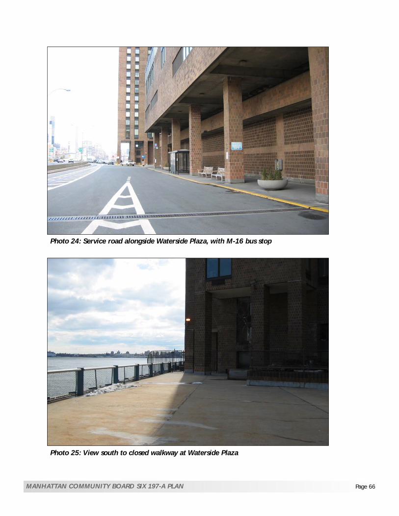
Photo 24: Service road alongside Waterside Plaza, with M-16 bus stop
Photo 25: View south to closed walkway at Waterside Plaza
MANHATTAN COMMUNITY BOARD SIX 197-A PLAN Page 66

FIGURE 10: EAST RIVER WATERFRONT29th TO 44th STREET
BFJ Buckhurst Fish & Jacquemart Inc.
NTS
Community Board 6 197-a Plan Page 67
Robert MosesPlayground

Chapter 3: Community Profile Amended 10/07
MANHATTAN COMMUNITY BOARD SIX 197-a PLAN Page 68
At East 30th Street, the East River Greenway continues along the service road past the Water Club restaurant and its parking lot. The esplanade in this area includes some plantings and benches and abuts the Water Club parking area. The Water Club has a special permit to maintain the waterfront walkway, but overall maintenance has been generally poor. The walkway continues north toward the parking area for the heliport along the River between 32nd to 33rd Streets. This parking area requires the Greenway path to move inland, around the lot and under the viaduct, eliminating the esplanade along the waterfront. The esplanade then loops around the heliport parking area, which is enclosed in chain link fencing, and proceeds under the FDR Drive viaduct to complete the link. Additional parking is also located along the waterfront at 34th Street, north of the heliport. North of this parking area is the NY Water Taxi ferry terminal at 35th Street. North of the ferry terminal, the esplanade proceeds past an old pier, as it heads toward the East River Esplanade Park (also known as “Glick Park”). This pier is planned as the future location of a new ferry terminal that is to replace the existing landing at 35th Street. The East River Esplanade Park (“Glick Park”), located along the waterfront between 36th and 38th Streets, features landscaping and benches. The waterfront esplanade in this area ends at the north end of East River Esplanade Park at 38th Street. North of the esplanade park a roadway runs past the Con Edison parking pier between 38th and 41st Street, utilized by vehicles as well as pedestrians. The Con Edison parking pier cuts off the esplanade at 38th Street, and there is no pedestrian access to the waterfront north of that pier until the 51st Street footbridge crossing the FDR Drive from Sutton Place. No waterfront esplanade exists along the East River between 42nd and 48th Streets, where the UN Headquarters are cantilevered over the at-grade FDR Drive. For security reasons, no public paths are allowed on or along UN property. General Douglas MacArthur Plaza is located along the FDR Drive between 48th and 49th Streets, but provides no access to the waterfront in this area. The 51st Street pedestrian footbridge from Beekman Place at 51st Street, crosses over Peter Detmold Park and FDR Drive, connecting to a waterfront walkway from 51st to 52nd Streets. As with General Douglas MacArthur Plaza, Peter Detmold Park is separated from the waterfront by the FDR Drive. No connections to the waterfront exist north of 52nd Street, and the FDR Drive runs under the eastern end of the Sutton Place neighborhood. Sutton Place Park on Sutton Place South between 53rd and 54th Streets provides views of the East River and FDR Drive, but no access to the waterfront. One Sutton Place Gardens is a private park located on a cantilever over the FDR Drive between 56th and 57th Streets. There has been considerable discussion about lack of public access to this open space area, provided to One Sutton Place in compensation for the taking of private land along the River during the FDR Drive construction. Sutton Place Park at East 57th Street adjoins the private gardens, as shown in the photo. It is one of several Sutton Place public parks at the east ends of 55th, 56th, 57th, 58th Streets, all cantilevered over the FDR Drive.

FIGURE 11: EAST RIVER WATERFRONT43rd TO 59th STREET
BFJ Buckhurst Fish & Jacquemart Inc.
NTS
Community Board 6 197-a Plan Page 69

Photo 26: Esplanade North of 30th Street, alongside parking area for Water Club
Photo 27: Esplanade veering inland around heliport parking area and under the viaduct
MANHATTAN COMMUNITY BOARD SIX 197-A PLAN Page 70

Photo 28: Roadway alongside parking pier ending at 41st Street
MANHATTAN COMMUNITY BOARD SIX 197-A PLAN Page 71

Chapter 4: CB6 197a Recommendations Amended 10/07
72
CHAPTER 4: RECOMMENDATIONS
A. LAND USE AND ZONING RECOMMENDATIONS a. United Nations (See April 2003 CB6 resolution re: 197a Plan):
i. Provide for the needs of United Nations without significantly displacing or disrupting the surrounding neighborhoods.
ii. In the future, it is hoped that there will be no expansion of the United Nations beyond the proposed UNDC building or the existing UN office buildings. The UN Space Needs Study (the “Habib Study”) undertaken by NYCEDC indicated no significant growth in UN office requirements. However, any sale of the three UNDC buildings to private developers should give priority to UN-related uses consistent with the UN mission such as consulates, non-profit UN-related organizations and commercial uses related to the UN.
b. Con Edison Waterside: Con Edison received consent from the Public Service Commission (PSC) to sell four of its sites in May 2004 to East River Realty. As part of the consideration, a GEIS was prepared under SEQRA that analyzed the impact of a concept for the overall plan for the sites rather than a specific project plan for a redevelopment. Community Board 6 provided extensive testimony on the GEIS; and asked the PSC to impose conditions on the disposition of the properties (see CB resolution dated September 2003). Community Board 6 did not support the Generic EIS for the Con Edison Waterside properties, and looks forward to reviewing a full site specific EIS under City Environmental Quality Review (CEQR).
i. The redevelopment of the Con Edison Waterside properties should maintain the history and character of the area and its predominantly residential neighborhoods. The new development should respect the scale and importance of the United Nations buildings.
ii. 39th and 40th Streets in the Con Edison Waterside complex should be remapped or easements provided and the view corridors to the waterfront restored. By remapping or through easements, the street grid would be restored and allow for public access. Furthermore, remapping the street would not allow for floor area generated from the streets and would require building envelopes to be measured from the streets. This would allow development that is in compliance with zoning. Alternatively, easements should be provided in the former roadbeds of 39th and 40th Streets that would be treated as a street for zoning purposes (including FAR, height and setback) and would provide pedestrian and vehicular access.
iii. The bulk of future development should be capped to be consistent with the precedent of previous development north of 34th Street along the east side of First Avenue - as exemplified by the Rivergate, Manhattan Place, and Horizon apartment buildings. The bulk of those buildings average approximately 10.5 FAR, an FAR that was granted by special permit from the City Planning Commission.
c. Bellevue Campus (See October 2001 CB6 resolution): On November 21, 2001, the City Planning Commission approved the development of the East River Science Park, a scientific research facility on the surplus Bellevue Hospital property located between former East 28th and East 30th streets east of First Avenue. The final approved plan provides for three

Chapter 4: CB6 197a Recommendations Amended 10/07
73
individual bio-tech research buildings that would retain the view corridor along former East 29th and East 30th streets from First Avenue. Access to the site, pedestrian and vehicular, would be provided from former East 29th and 30th streets. The revised plan “allows for separation of vehicular and pedestrian circulation” by creating a plaza level at the elevation of First Avenue. The plaza level would consist of main entrances to the buildings; 46,600 square feet of public open space extending from First Avenue to the eastern end of the private service road along the FDR Drive; “allow for future pedestrian connection over the FDR Drive to the waterfront if this section of the FDR Drive is relocated to grade”; and a better north-south connection between NYU School of Medicine and Bellevue Hospital Center at the plaza level through a pedestrian bridge over East 30th Street and via stairs and a ramp on the south side of the project. In view of this plan, and EDC’s recent RFP, CB6 makes the following recommendations as regards zoning for the NYU Medical Center and the overall master plan for the East River Science Park (consistent with ESRA’s 1991 study and as described on Figure 21 and 22):
i. Consider mapping as a Special Hospital Use District (including Bellevue Hospital Center, NYU Medical Center and VA Hospital), as recommended by 1991 ESRA study, to conform to current hospital and hospital-related uses, and provide parameters for additional development. CB6 believes that the existing R-8 zoning is inadequate to cater to the Medical Center and Hospital uses and results in an ad hoc form of planning. This can be seen in the number of discretionary approvals required over the years for the East River Science Park including zoning map changes (from R-8 to C districts) and Section 74-48 special permit applications to allow medical research facilities. As an alternative, the Special Hospital Use District will provide a comprehensive set of zoning and urban design controls – in effect a master plan (similar to the Special Battery Park City District) - that will overlay the existing R-8 zoning and provide greater zoning flexibility, reducing the potential and need for discretionary approvals.
ii. Improve future development of the Bellevue campus by implementing the Cooper Eckstut Study for the East River Science Park (see Figures 20 and 21), for the northern portion of the Bellevue Campus, including the following recommendations which were not incorporated in the final plan as approved by City Planning. It is understood that since the recommendations of this Plan were originally drafted, alterations to the East River Science Park have proceeded including demolition of the laundry building and site preparation for the construction of two new buildings on the south side of 29th Street that will be aligned with the ACS building: The foot prints of Buildings 2 and 3, and the garage located below the plaza (as
approved located along the western edge of the private roadway) should be shifted westwards (see Figure 20). This would allow for a wider pedestrian walkway along the private roadway than currently provided (see Figure 21). CB6 notes that plans for Building 2 are filed and do not allow for a widened pedestrian walkway.
d. Education (See September 2002 CB6 resolution re: Con Ed DGEIS):
i. Community Board 6 strongly encourages the the City’s Division for Child Care and Head Start (CCHS) to monitor day-care demand and availability of slots in CD 6. When reviewing proposals for new child care development, CCHS should encourage the construction of day care facilities in new private office and residential developments.
ii. Community Board 6 acknowledges that the Educational Construction Fund is in the process of planning the redevelopment of P.S. 59 that would increase school capacity from 350 to 760 seats. Community Board 6 also strongly suggests that the redevelopment of the Con Edison site include a feasibility study for location of a new pre-K to Grade 5 school, as suggested by Schools District 2, in view of limited existing school space and the potential influx of new students.
iii. More generally, Community Board 6 recommends the Department of Education conduct a feasibility study for the location of new school construction in the Study Area.
e. Housing (See Sept 2002 CB6 resolution re: Con Ed DGEIS in Appendix C):

Chapter 4: CB6 197a Recommendations Amended 10/07
74
Given the well-documented shortage of affordable housing within the Study Area and CB6 as a whole (see Appendix D for data), CB6 proposes the following:
i. Encourage permanent affordable housing and discourage demolition or conversion to market rates of affordable housing in the Study Area (such as Mitchell Lama).
ii. Encourage low and moderate income housing in new developments in the Study Area. Such housing is to be permanent and cannot be converted to market rate.
f. Community Facilities (See Feb 99 resolution re: Zoning Loopholes in Appendix):
i. Eliminate zoning preferences for community facilities in the Study Area. This is in response to out-of-scale additions to schools and other community facilities, particularly in midblock locations. CB6 believes that the avenues are more appropriate to accommodate larger community facility additions. Larger-scale buildings on the avenues is both consistent with City policy and more appropriate for high traffic-generating uses such as community facilities:
• Eliminate larger floor area ratios for community facilities in R7 and R8 districts; • Eliminate all rear yard encroachments in midblock locations; • Rewrite community facilities definitions to distinguish between wide and narrow street
locations to allow greater density on wide streets compared to narrow streets. g. Central Business District (See April 03 CB6 resolution re 197a Plan in Appendix):
See the Figure 12 NYC zoning map of Midtown Central Business District (MiD).
i. Develop policy for rezoning that prohibits any additional high-density office development east of the midline between Second and Third Avenues in order to:
• Prevent the Midtown central business district from moving further east; • Preserve existing residential neighborhoods; • Encourage additional residential development where possible.
h. Public Access Zoning (See Figures 13, 14 and 15): There are unique accessibility problems in Community District 6 principally created by the presence of the FDR Drive, such as the extreme narrowness of the waterfront sites, the lack of north-south continuity, and obstacles such as parking lots, piers, and the heliport at 34th Street. The existing zoning regulations including plaza bonuses and open space requirements are insufficient to address these conditions, and new development will place an even greater demand on the area’s limited open space resources. Therefore, in order to address these conditions, Community Board 6 recommends the creation of a new Special Public Access District which allows elective contributions to a fund for mapped on-site and off-site public improvements as follows:
i. Designate the area from First Avenue to the waterfront and from 14th to 59th Streets as a Special Public Access District (see Figure 13) to fulfill the public access, recreation and open space needs and water-related uses of Community District 6. See Section B. Waterfront Esplanade and Open Space Recommendations for a description of these improvements and Figures 14 and 15 for a map of the recommended on-site and off-site public improvements. Within the Special District, an additional floor area bonus may be allowed on any zoning lot that provides elective public open space improvements as described on Figures 14 and 15. An additional bonus would be allowed for the inclusion of affordable housing. This bonus mechanism would supersede the underlying FAR bonus provisions.

Com
mun
ity
Boa
rd 6
197-
a Pl
an
Figu
re 1
2a: M
idto
wn
Zon
ing
A
djac
ent
to S
tudy
Are
a
BFJ
Buc
khur
st F
ish
&Ja
cque
mar
t Inc
. Pa
ge 7
5

500Feet
Community Board 6 197-a Plan
Figure 12b: Existing FAR
0 925 1850 3700 ft
BFJ Buckhurst Fish & Jacquemart Inc.
Stuyvesant Town
EAST RIVER
Firs
t Ave
nue
Seco
nd A
venu
e
Thir
d A
venu
e
E55th Street
E42nd Street
E34th Street
E23rd Street
E14th Street
E59th Street
Page 76

Community Board 6197-a Plan
Figure 13: LAND USE AND ZONING 0 600 1200 ft
BFJ Buckhurst Fish & Jacquemart Inc.
Designate CB-6waterfront areaas a SpecialPublic AccessDistrict
eunevAt sri
F
lP
yveLress
A.
AvenueC
Ceu
nev
Aecal
Pnott u
S
49th
51st
14th
23rd
42nd
34th
Page 77
LegendSpecial Public Access District

Chapter 4: CB6 197a Recommendations Amended 10/07
78
B. WATERFRONT ESPLANADE AND OPEN SPACE RECOMMENDATIONS The presence of the FDR Drive along the entire Community Board 6 East River waterfront has created unique conditions including limited public access and visual and physical barriers to the waterfront. To improve public access to the waterfront, the following actions are required: a. Complete Waterfront Esplanade (See April 1989, April 1999 CB6 resolutions re: Land Use
Policy):
i. Explore with Con Edison, NYCDOT and NYSDOT opportunities to widen the Esplanade between 13th and 15th Streets by replacing the existing pump with a smaller pump thereby widening the Con Ed Pier “choke point.”
ii. Construct a new pedestrian bridge over the FDR Drive at 16th Street (See Feb 2001 CB6 resolution re: Con Ed Repowering). It is recognized that pedestrian bridges are costly and would have to be constructed in phases. They also may need approvals from City or State agencies. The priorities are bridges at 39th and 40th Streets. Other bridges are outlined below.
iii. Improve Waterfront Esplanade between 23rd and 42nd Streets: • Explore alternatives to relocate the skyport parking on the pier at 23rd Street; • In coordination with the reconstruction and redesign of the FDR Drive, explore
possibility to provide pedestrian bridges across from Bellevue Hospital to Waterside Houses at 27th and 29th Streets. CB6 encourages the City to coordinate with NYSDOT on the design of the highway at this location to facilitate a pedestrian bridge. This could be achieved if the elevated section of FDR Drive was lowered or relocated to grade;
• Upgrade existing pedestrian bridge at 25th Street to make it handicapped accessible; • Re-open the illegally closed gate allowing waterfront access around Waterside Houses; • Improve area around ferry landing at 35th Street (CB6 supports plan for ferry landing); • Explore alternatives to relocate the waterfront parking at 34th Street and on the Con
Edison parking pier between 38th and 41st Streets; • Create smaller neighborhood piers for water taxis at 23rd and 42nd Streets.
iv. Extend esplanade north from East River Esplanade Park to proposed esplanade at 42nd St:
• Provide crossings at deck of Con Edison site from 35th and 36th Streets to East River Esplanade Park if NYSDOT chooses to tunnel the FDR Drive.
• With the re-alignment of the FDR Drive and the shortening or removal of the 42nd Street ramp, NYC DOT and NYS DOT should explore the feasibility of pedestrian bridges over the FDR Drive at 39th, 40th, and 41st Streets. Amongst the pedestrian bridges recommended in this Plan, these are a priority.1
v. As mitigation for the construction of the proposed new UN tower at Robert Moses Playground2:
• Provide esplanade along east edge of United Nations, outboard of the FDR Drive, with connections to Glick Park at 37th Street and to the north at 48th Street,
• Provide pedestrian access to waterfront at 42nd and 48th Streets via bridges (see Figure 15).
vi. Provide an additional pedestrian bridge over the FDR Drive at 54th Street.
1 Construction of bridges at 39th, 40th and 41st Streets requires agreements from NYCDOT and NYSDOT; an easement on the west side of the Con Ed Waterside property; a re-alignment of the FDR Drive at that location; a shortening or elimination of the 42nd Street northbound FDR exit ramp. 2 UNDC has proposed an esplanade as mitigation for the loss of the Robert Moses Park site and that East River Realty (Con Ed/Waterside) has said they would build an esplanade from 38th to 41st streets.

Chapter 4: CB6 197a Recommendations Amended 10/07
79
vii. Consider providing a narrow esplanade walkway between 53rd and 63rd Streets on a cantilever
on the outboard side of the existing FDR Drive. viii. New esplanade/greenway should accommodate pedestrians, joggers, cyclists, and skaters. b. Open Space: Manhattan Community District 6 has a substantial open space deficit. This will worsen with the proposed construction staging for the Second Avenue Subway in St. Vartan Park, the FDR Drive reconstruction at the East River Esplanade Park, and the increasing amount of new development proposed at such sites as Con Ed Waterside and the Perlbinder building. To address these open space deficits, Community Board 6 makes the following open space recommendations:
i. The City should acquire open space at Con Edison East River Plant for a new expansion of Murphy Brothers Park to include relocated ballfields, as per BFJ January 2001 report (See February 2001 CB6 resolution re: Con Ed Repowering).
ii. Encourage the MTA (with DPR and DOT) to consider designing and mapping park decks above Queens Midtown Tunnel Portals as part of the ongoing Second Avenue Subway Outreach process3 (See Figures 16 and 17).
iii. FDR Drive Reconstruction Opportunities:
• Study the possibility of designing and mapping a park on a deck above FDR Drive
between 38th and 42nd Streets. Construction of a deck requires agreements from NYCDOT and NYSDOT; an easement on the west side of the Con Ed Waterside property; a re-alignment of the FDR Drive at that location; a shortening or elimination of the 42nd Street northbound FDR exit ramp.
• Explore the possibility of designing and mapping a park on a deck above FDR between 28th and 30th Streets in coordination with remapping of 29th Street. This would require the relocation of an elevated section of the FDR to grade as part of the State’s ongoing reconstruction of the FDR. These improvements should also be coordinated with the Bellevue reconstruction, as recommended by City Planning Commission-approved plan for the East River Science Park (see Figures 20 and 21).
iv. Encourage public acquisition for open space for such developments such as the Bellevue/East
River Park Science Park Plan, the replacement of Robert Moses Playground, and the Con Edison Waterside redevelopment.
v. CB6 notes that large-scale projects such as East River Science Park, Con Edison Waterside and
the proposed UNDC building provide open space. However, CB6 encourages increased open space mitigation for large-scale development projects such as Bellevue, Con Edison Waterside, and the proposed UNDC building. In the event that the UN consolidation project seeks to utilize Robert Moses Park and legislative enabling measures are approved, it is recommended that a replacement park be created within the immediate community. This might include designating 685 First Avenue for active recreation assuming the City Council does not adopt a rezoning for redevelopment at this location.
3 The improvement of the existing landscaped area above the Queens Midtown tunnel portal presents an opportunity for decking and a new park.

35 th
34 th
33 rd
30 th
29 th
26 th
25 th
24 th
22 nd
FIR
ST A
VE
AVEN
UE
C
23 rd
21 st
20 th
19 th
18 th
17 th
15 th
14 th
WatersideHouses
UN School
Stuyvesant Town
Bellevue
NYUKips BayHouses
Con Ed
Community Board 6197-a Plan
Figure 14:WATERFRONT ESPLANADE ANDOPEN SPACE 14th to 35th Street
0 600 1200 ft
BFJ Buckhurst Fish & Jacquemart Inc.
Design decks for recreation and map as Parkabove Queens Midtown Tunnel Portals
Design and map as Park area above the rebuiltFDR between 33rd-35th Streets
Design and map as Park area above therebuilt FDR between 28th-30th Streets
Relocate Con EdBallfields withinexpanded MurphyBrothers Park
13 rd
Remove Skyportparking garage
LegendProposed pedestrianbridgeWiden esplanade/ Improve accessNew ParkExisting pedestrian bridge at 25th Street
37 th
36 th
Con Ed
27 th
The Water Club
Heliport
SEC
ON
D A
VE
F D R
Chok
epo
int
Widen esplanadebetween 13th
and 15th Streets
Page 80
Amended 12/05
garage and relocate parking
Encourage MTA to design decks and map as Park above Queens Midtown Tunnel PortalsExplore removal of waterfront parking lot at 34th Street and explore options to relocate parking
Amended 10/07
Recommended pedestrian bridge
Explore removal of Skyport parking

Amended 10/07
building is developed at that location)and the City Council does not adopta rezoning for redevlopment at this location.
pedestrian bridges
Explore removal of Con Edison water-front parking lots at 38th-41st Streets.

Figure 16:Queens Midtown Tunnel PortalsConcept Plan (courtesy of John West)
Community Board 6197-a Plan
0 600 1200 ft
BFJ Buckhurst Fish & Jacquemart Inc.
Existing Conditions
37th Street
Firs
t Ave
nue
37th Street
Firs
t Ave
nue
Deck
Deck
1.
3.*
2.
1. Open triangular portion of theexisting planted area to beavailable for walking, sitting and atot lot.
2. Widen/ landscape sidewalksalong First Avenue and along 37thStreet.
3. Deck above the tunnel exitalong 37th Street to create spacefor active recreation area.
Concept Plan
Page 82
*See over page for illustrative rendering of parkon deck at 37th Street and Second Avenue.

Com
mun
ity
Boa
rd 6
197-
a Pl
an
Figu
re 1
7: I
llust
rati
on o
f C
once
ptPl
an f
or Q
MT
Port
als
(look
ing
wes
t at
37th
Str
eet a
nd S
econ
d A
venu
e)
BFJ
Buc
khur
st F
ish
&Ja
cque
mar
t Inc
. Pa
ge 8
3

Chapter 4: CB6 197a Recommendations Amended 10/07
84
C. URBAN DESIGN AND PRESERVATION RECOMMENDATIONS a. Urban Design/Architecture
i. As an overall policy, Community Board 6 encourages the mapping of contextual zoning districts to maintain residential character of neighborhoods and restrict zoning lot mergers (4/2003 CB 6 Resolution: 197-a Plan).
ii. Map tower-on-the-base zoning districts to maintain existing street wall character along avenues and restrict zoning lot mergers where appropriate (see April 2003 Resolution on 197-a Plan), as occurred with the Trump Building on First Avenue at 48th Street.
b. Remap Demapped Streets within Study Area (see April 2003 CB 6 resolution)
i. Extend public streets to the waterfront in order to: • Disperse large-scale development; • Create waterfront access/views; • Recapture the waterfront for public use with improved access; • Limit FAR, and ensure height and setback controls; • Preserve the Manhattan street grid.
c. Bellevue Recommendations (See October 2001 CB6 resolution)
i. See recommendation A. c. ii. Also see attached Figures 20 and 21, which illustrate the specifics of these design recommendations for the Bellevue Hospital site. It is understood that since the recommendations of this Plan were originally drafted, alterations to the East River Science Park have proceeded including demolition of the laundry building and site preparation for the construction of two new buildings on the south side of 29th Street that will be aligned with the ACS building.
d. Con Edison First Avenue Properties Recommendations See also recommendation A. b.
i. Consider large-scale residential development special permit with the following conditions: • Limit bulk and density; • Extend both 39th and 40th Streets east across the First Avenue Properties site; • Limit height of new development to no more than 400 feet to respect the scale of the
503-foot high UN Secretariat building; • Limit the height of development at 685 First Avenue in order not to cast shadows on
Tudor City Parks. • Create large easily accessible public spaces on portions of the site, as mitigation for
the large-scale development of the First Avenue Properties; • Require ground floor retail on First Avenue to accommodate the needs of local
residents and enhance pedestrian activity along the Avenue; • Provide overlook parks along the FDR Drive; • Complete a continuous esplanade along the East River waterfront from 34th to 42nd
Street.

Chapter 4: CB6 197a Recommendations Amended 10/07
85
e. Landmarking
i. Explore tools for preserving the integrity, built character and urban design qualities of Stuyvesant Town and Peter Cooper Village (see CB 6 Resolution April 1991 and March 2005). Options may include placement on the National Register of Historic Places, or designation as a NYC landmark (see Figure 18). One of the preservation options that may be considered is the designation of Stuyvesant Town and Peter Cooper Village as a Special Planned Community Preservation District. This special zoning district was adopted in 1974 and was designed “to preserve communities which are superior examples of town-planning or large-scale development; to preserve and protect the character and integrity of the communities which by their existing site plan, pedestrian and vehicular circulation systems, balance between buildings and open space arrangement and landscaping add to the quality of urban life; to preserve and protect the variety of neighborhoods and communities that presently exist which contribute greatly to the uniqueness and livability of the city; to maintain and protect the environmental quality that these communities offer to their residents and the city-at-large; and to guide the future development within these areas consistent with the existing character, quality and amenity of the Special District.” The intention is to protect the open space and built character of these historic communities and to protect Stuyvesant Town and Peter Cooper Village from new development. This is especially prescient as both developments were recently sold. (City Planning Commission Report, June 1974)
ii. Consider landmarking remaining original buildings at Bellevue Hospital, such as the
Psychiatric and ACS buildings, as well as other buildings in order to preserve the historic character and campus setting of the hospital.
f. United Nations
i. In the event that a UN consolidation project seeks to utilize Robert Moses Park and legislative enabling measures are approved, it is recommended that a replacement park should be considered in the immediate vicinity as a replacement for the existing playground.
ii. In addition, CB6 supports the fact that UNDC has proposed an esplanade located generally
from 41st to 51st streets and CB6 believes that this is appropriate mitigation for the proposed UN Building.

37 th
36 th
35 th
34 th
33 rd
30 th
29 th
26 th
25 th
24 th
22 nd
FIR
ST A
VE
23 rd
21 st
20 th
19 th
18 th
17 th
15 th
14 th
Waterside Houses
U.N.School
Stuyvesant Town
Bellevue
NYUKips BayHouses
Con EdisonEast River
Plant
Con Ed
Community Board 6197-a Plan
Figure 18:URBAN DESIGN/ PRESERVATION
0 600 1200 ft
BFJ Buckhurst Fish & Jacquemart Inc.
Peter CooperVillage
LegendView Corridor/Street Remapping
ProposedPreservationDistrict
Existing Pedestrian Bridge
FDR
SEC
ON
D A
VE
28 th
27 th
Landmarking originalbuildings at BellevueHospital
Page 86
Amended 12/05Amended 08/07
Re-opening/

/
Amended 08/07
Street Remappingor easement

Figu
re 2
0:U
RBA
N D
ESIG
N/
PRES
ERV
ATI
ON
East
Riv
er S
cien
ce P
ark
Roa
d A
cces
s an
d B
uild
ing
Foot
prin
ts
not t
o sc
ale
Rec
omm
ende
dby
CB
6
sour
ce: C
oope
r Ek
stut
Stu
dy
MA
NH
ATT
AN
CO
MM
UN
ITY
BO
AR
D S
IX 1
97-A
PLA
N
Pa
ge 8
8
BFJ
Buc
khur
st F
ish
&Ja
cque
mar
t Inc
.

Figu
re 2
1:U
RBA
N D
ESIG
N/
PRES
ERV
ATI
ON
East
Riv
er S
cien
ce P
ark
Vie
w
Cor
rido
rs a
nd P
edes
tria
n A
cces
s
not t
o sc
ale
BFJ
Buc
khur
st F
ish
&Ja
cque
mar
t Inc
.
sour
ce: C
oope
r Ek
stut
Stu
dy
MA
NH
ATT
AN
CO
MM
UN
ITY
BO
AR
D S
IX 1
97-A
PLA
N
Pa
ge 8
9

Chapter 4: CB6 197a Recommendations Amended 10/07
90
D. STREETS AND TRANSPORTATION RECOMMENDATIONS a. Streets and Pedestrians (see April 2003 CB 6 resolution):
i. Provide more and improved pedestrian access to the waterfront.
ii. Consistent with CB6 policy of restoring the street grid, reducing superblocks and providing access to the waterfront, the following streets should be remapped or reopened at Con Edison Waterside Properties and the Bellevue/NYU Medical Center campus:
• As a priority remap or re-open 16th Street east of Avenue C, and 27th, 39th and 40th Streets east of First Avenue.
• In the long-term remap or re-open 26th, 29th and 30th Streets (east of First Avenue). • In the case of 39th and 40th Streets, as an alternative to remapping, easements should
be provided in the former roadbeds that would be treated as a street for zoning purposes (including FAR, height and setback) and would provide pedestrian and vehicular access.
iii. In the long-term, CB6 recommends that the Department of City Planning and DOT continue to
work with the community to determine placement of traffic calming measures at the most appropriate side street locations, including neckdowns and wider sidewalks, and creation of landscaping treatment.
iv. Develop uniform standards for security barriers or other security measures (landscaping, street
furniture) within the Study Area. b. Subways (see December 2001, January 2002, May 2002 CB 6 resolutions):
i. Community Board 6 endorses the identified locations for Second Avenue Subway stations and station entrances at 14th, 23rd, 34th, 42nd and 55th Streets.
ii. Provide pedestrian transfer via underground tunnel from Second Avenue Subway station stop
to No. 7 line at Grand Central Station, and from 55th Street station to E and V Lines at 53rd Street Station.
iii. Add an Avenue A entrance to the First Avenue/14th Street station on the L Line.
c. Buses, Taxis and Limousines (see April 2003 CB 6 resolution):
i. Re-route buses and create/relocate bus stops to support new development in Study Area.
ii. Locate bus stops with a view to facilitating intermodal transfer points among buses, ferries, the subway and water taxis at 23rd, 34th and 42nd Streets.
iii. Explore sites for black car and bus layovers, parking and rest stops.
d. Parking (see April 2003 CB 6 resolution):
i. Explore alternatives to relocate all parking located directly on the waterfront such as 34th Street lot, the 23rd St. Skyport parking garage, and the Con Edison parking pier at 38th to 41st Streets.

Chapter 4: CB6 197a Recommendations Amended 10/07
91
ii. CB6 recommends that Article I, Chapter 3 of the Zoning Resolution be amended to change
accessory parking in R10 districts within the Study Area from up to 20% of apartment units to 10%. This will provide a disincentive for new residential developments to illegally convert accessory parking garages to commercial, public parking garages contributing to traffic and congestion in the area.
e. Helicopters, Ferries, and Intermodal Transfer Points (see April 2003 CB 6 resolution):
i. The heliport should allow a continuous and safe waterfront esplanade.
ii. The City’s Waterfront Task Force Development should consider the design of intermodal transfer points between buses, ferries, subway, water taxis at 23rd, 34th and 42nd Streets.
f. FDR Drive:
i. Create pedestrian bridges over the FDR Drive to contribute to pedestrian access to the waterfront.
ii. Study the feasibility of the redesign or elimination of the northbound exit ramp off the FDR
Drive at 42nd Street to allow greater access to the waterfront, improve ferry intermodality and increase security.
g. Bicycles:
i. CB 6 endorses a network of dedicated and safe bicycle routes.
ii. Encourage bicycle parking in private garages within the Study Area.

Re-opening
View Corridor/
Amended 10/07
/

Amended 08/07
Community Board 6197-a Plan
Figure 23:STREETS AND TRANSPORTATION
59 th
54 th
47 th
42 nd
39 th
58 th
57 th
56 th
55 th
53 rd
52 nd
51 st
50 th
49 th
48 th
46 th
45 th
44 st
43 rd
41 st
40 th
38 th
37 th
FIR
ST A
VE
THIR
D A
VE
Provide Waterfront Bicycle Route
Provide Transfer from SecondAvenue Subway to No. 7 Line
Examine possibility of redesign orelimination of northbound exit rampo� FDR Drive at 42nd Street
0 600 1200 ft
BFJ Buckhurst Fish & Jacquemart Inc.
UnitedNations
General Legend
Subway Station
Water Taxi Terminal
Provide Transfer from SecondAvenue Subway to E and V Lines
SEC
ON
D A
VE
F D
R
Page 93
or easement
View Corridor/Street Remapping

Chapter 5: Implementation Amended 8/07
MANHATTAN COMMUNITY BOARD SIX 197-a PLAN Page 94
CHAPTER 5: SUGGESTED IMPLEMENTATION The following four charts suggest responsibility for implementing the recommendations outlined in the preceding chapter.

MANHATTAN COMMUNITY BOARD SIX 197-a PLAN Page 95

MANHATTAN COMMUNITY BOARD SIX 197-a PLAN Page 96

MANHATTAN COMMUNITY BOARD SIX 197-a PLAN Page 97

MANHATTAN COMMUNITY BOARD SIX 197-a PLAN Page 98

MANHATTAN COMMUNITY BOARD SIX 197-a PLAN Page 99
APPENDIX A: 197a Plan Goals According to subsection 4.020b of Section 197a of the New York City Charter: “A plan shall set forth goals, objectives, purposes, policies or recommendations that are within the legal authority of the City to undertake.” The following items are recommendations by Community Board 6 that concern the United Nations. While physically part of New York City, the UN is located on sovereign land which is not technically part of New York City and therefore recommendations concerning the UN are not within the legal authority of the City to undertake. Community Board 6 acknowledges this fact and urges the City to seek ways in which to work cooperatively with the UN achieve the following two goals:
Encourage City’s partnership with UN International School to provide outboard access around the school (while recognizing UNIS security concerns);
Where feasible on UN sovereign land, enable public access to the UN Park (CB 6 resolution
April 1991). Additional items that are beyond the authority of the City include:
Any new buildings within the Special Public Access District should provide waterfront mitigation and maintenance (see previous section A. Land Use and Zoning Recommendations, h. Public Access Zoning, h.i).
Con Edison, East River Generating Station
In the long-term, Con Edison must secure the East River Generating Station. This will allow the City to relocate southbound exit of FDR Drive from 15th Street to 14th Street and re-open 14th Street east of Avenue C, restoring the street grid and public access.
Heliport at 34th Street Community Board 6 supports elimination of the heliport at 34th Street.

Amended 12/05
MANHATTAN COMMUNITY BOARD SIX 197-a PLAN Page 100
APPENDIX B: Evidence of Public Participation
PagePublic Hearing, 197a Plan 1
Scope for 197-a Plan 5
Community Board 6 Board Resolutions Resolution PageMarch 2005 Resolution on Peter Cooper Village and Stuyvesant Town 14June 2004 Resolution on 197-a Plan 16March 2004 Resolution on Waterside Adaptive Reuse 17April 2003 Resolution on 197-a Plan 18September 2002 Resolution on Con Ed DGEIS 19May 2002 Resolution on 14th Street Subway Station 23January 2002 Resolution on Restoration 24January 2002 Resolutions on Subway Alignment at 23, 34 and 42 Streets 25November 2001 Resolution on East River Science Park 28October 2001 Resolution on Bellevue Disposition 31February 2001 Resolution on Con Edison Repowering 33October 2000 Resolution on Con Edison Repowering 35December 1999 Resolution on RFEI from EDC for the redevelopment of Bellevue Hospital Center 36April 1999 Resolution on Land Use Policy 38February 1999 Resolution on Zoning Loopholes 40April 1991 Resolution on ESRA report for CB6 South 42March 1987 Resolution on 421a 44March 1987 Resolution on Inclusionary Housing 46November 1985 Resolution on Bellevue Campus Proposal 48


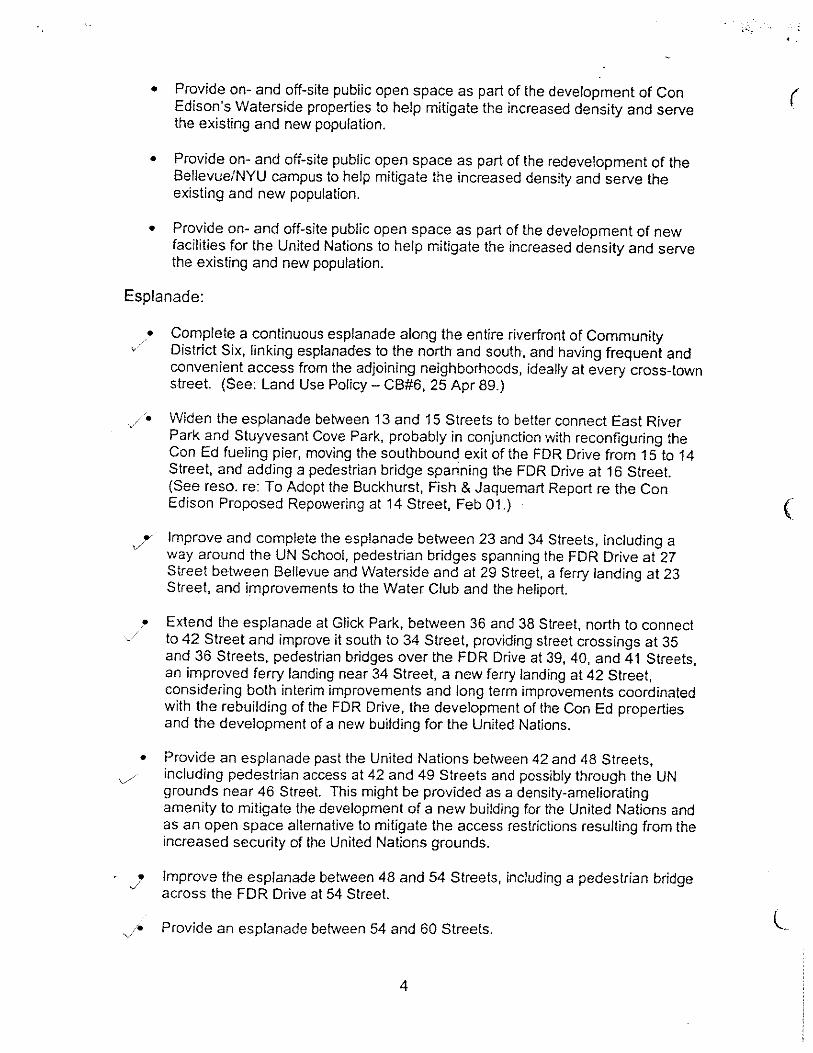


Amended 11/2/05
MANHATTAN COMMUNITY BOARD SIX 197-a PLAN
APPENDIX C: Correspondence Correspondence with City Agencies PageHonorable George Pataki, New York State Governor 1New York City Department of City Planning 2New York City Department of Education 3New York City Department of Mental Health and Hygiene 4New York City Department of Parks and Recreation 6New York City Department of Transportation 9New York City Economic Development Corporation 10New York City Landmarks Preservation Commission 11New York City Transit Authority 12Local Community Groups 13
See following pages for letters and responses received.


MANHATTAN COMMUNITY BOARD SIX 197-a PLAN
APPENDIX D: Documentation of Need for Affordable Housing

MANHATTAN COMMUNITY BOARD SIX 197-a PLAN
Community District 6 Documented Need for Affordable Housing (data summarized by Urbanomics) Indicators of poverty drawn from the 2000 decennial census were analyzed for the Census tracts that make up Community District 6 in order to illustrate the demand for affordable housing in the CD. The results numbers were then compared to the known existing supply of subsidized housing units from both HUD’s low-income housing tax credit (LIHTC) and New York City Housing Authority’s (NYCHA) stock. The difference between the two is an estimate of the unmet need.
Indicators of Poverty in CD 6 Total % Total Population 144,022 Persons in Poverty 11,227 7.8% Retired (65-74) 866 7.7% Elderly (75 and Older) in Poverty 688 6.1% Total Households 88,864 Households in Poverty 6,525 7.3% Families Households 949 1.1% Non-Family Households 5,576 6.3%Rental Households 65,237 More than 50% of income for rent 11,362 17.4% 40-50% of income for rent 3,918 6.0% 31-40% of income for rent 7,563 11.6%
Existing Supply of Subsidized Housing
LIHTC* Housing Units 1,456 NYCHA Housing Units 257 Source: 2000 Census, HPD housing rolls, HUD housing rolls *LIHTC: Low Income Housing Tax Credit According to the 2000 Census, of the 144,022 persons living in Community District 6, 11,227 or 7.8 percent are living in poverty. Of these persons, 1,554 are retirement age, meaning the rest are most likely disabled or working poor. In terms of households, 7.3 percent of the 88,864 households in the CD are considered to be below the poverty level—of these, family households number 949 while non-family households (mainly individuals living alone) number 5,576. Poverty Status is only one way of getting at the need for affordable housing—another key factor is the percentage of income that residents are using for rent. Rent is considered to be not affordable if it is more than 30% of the renter’s income on a national basis. In CD 6, fully 17.4 percent of all renters paid more than half of their incomes for their monthly rent; a roughly equivalent number pay between 30 and 50% each month. In 2000, in terms of households in poverty, there is demand for more than 6,000 affordable units. In terms of what is affordable on a rent to income ratio basis, there is a demand for more than 10,000 affordable apartments. Currently, there are 1,456 subsidized units using HUD’s LIHTC in the Community District and 257 NYCHA apartments meeting. These units meet only a small percentage of the need.

MANHATTAN COMMUNITY BOARD SIX 197-a PLAN
An additional 4,812 units of affordable housing would be required to meet the need of every household in poverty as defined by the federal government. In terms of households expending more than half their income on rent, an additional 9,649 affordable units would be required to fulfill the need.

Section 4Section 4A Guide to Recommendations in Adopted
Manhattan CB 6 197-a Plan

Guide to Recommendations in Adopted Manhattan CB 6 197-a Plan
Recommendations as Adopted by the City Council on March 26, 2008 Notes: Recommendations were approved, modified or deleted by the City Planning Commission on January 28, 2008; and approved, modified or deleted by City Council on March 26, 2008. The wording for some recommendations may have been slightly revised; some recommendations have been combined. ▲ Modification by City Council to CPC modified and approved plan.
Discussion in Consideration portion of Approved CPC Report
CB 6 197-a Plan Recommendations as submitted and modified by CB 6 in September 2007
Waterfront Related Improvements 1. Explore with Con Ed, NYCDOT and NYSDOT opportunities to widen Esplanade between 13th and 15th Streets by replacing the existing pump with a smaller pump.
p. 15 Rec. B a i (p. 78)
2. Encourage NYCDOT and DPR to make the 25th Street pedestrian bridge handicapped accessible. ▲
p. 19 Rec. B a iii (p. 78)
3. If the FDR Drive is to be relocated to grade, which would permit a deck above the drive, the option of a park on a deck above the FDR Drive between 28th and 30th streets should be studied, within the context of the reconstruction of the FDR Drive by NYSDOT.
p. 14 Rec. B b iii (p. 79)
4. Improve area around 35th Street ferry landing.
p. 15 Rec. B a iii (p. 78)
5. Encourage creation of smaller neighborhood piers for water taxis at 23rd and 42nd streets. ▲
p. 15 Rec. B a iii (p. 78)
6. Encourage construction of a narrow esplanade walkway between 53rd and 63rd streets on a cantilever on the outboard side of the existing FDR Drive. ▲
p. 14 Rec. B a vii (p. 79)
7. Explore alternatives to relocate all parking located directly on the waterfront such as the 34th Street lot, the 23rd Street Skyport parking garage, and the Con Edison Parking pier (38th to 41st streets).
p. 15 Rec. B a iii (p. 78) Rec. D d i (p. 90)
8. Accommodate pedestrians, joggers, cyclists, and skaters on new esplanades and greenways.
p. 15 Rec. B a viii (p. 79)
9. The city should work with appropriate federal and state agencies to encourage decking over a portion of the FDR Drive, the relocation or reconfiguration of the northbound FDR exit ramp at 42nd Street, and the creation of a continuous waterfront esplanade between 34th and 42nd streets. Development on the First Avenue Properties (former Con Edison sites) should be compatible with, and not preclude, future off-site waterfront improvements. ▲
p. 14 Rec. B b iii (p. 79)
10. Pursue measures to ensure that the waterfront esplanade at Waterside Plaza is publicly accessible.
p. 15 Rec. B a iii (p. 78)

Recommendations as Adopted by the City Council on March 26, 2008 Notes: Recommendations were approved, modified or deleted by the City Planning Commission on January 28, 2008; and approved, modified or deleted by City Council on March 26, 2008. The wording for some recommendations may have been slightly revised; some recommendations have been combined. ▲ Modification by City Council to CPC modified and approved plan.
Discussion in Consideration portion of Approved CPC Report
CB 6 197-a Plan Recommendations as submitted and modified by CB 6 in September 2007
11. Ensure that the heliport permits safe inland pedestrian connections between adjacent sections of the waterfront esplanade. ▲
p. 15 Rec. D e i (p. 91)
12. Encourage new pedestrian bridges and other means to provide improved public access to the waterfront particularly at 16th, 27th, 29th, 39th, 40th, 41st, 42nd, 48th and 54th streets. ▲
p. 18-19 Rec. B a ii Rec. B a iii Rec. B a v Rec. B a iv Rec. B a vi (p. 78) Rec. D f i (p. 91)
13. Encourage creation of pedestrian crossings from 35th or 36th streets to the East River Esplanade Park if a tunnel for the FDR Drive is to be constructed. ▲
p. 19 Rec. B a iv (p. 78)
14. To preserve and create waterfront views and facilitate public access to the waterfront, appropriate zoning, land use and mapping controls (including remapping demapped streets, if feasible) as well as urban design and streetscape improvements should be used. ▲
p. 18 Rec. A b ii (p. 72) Rec. C b i (p. 84)
15. Where appropriate and physically feasible, create the opportunity for public access to the waterfront by allowing pedestrians to use streets or their extensions that have been remapped, reopened or otherwise made publicly accessible.
p. 18 Rec. A b ii (p. 72) Rec. C b i (p. 84) Rec. C d i (p. 84)
Other Open Space Improvements 16. Encourage the MTA (with DPR and DOT) to consider park decks above Queens Midtown Tunnel portals as part of the ongoing Second Avenue Subway Outreach process.
p. 19 Rec. B b ii (p. 79)
17. Given the deficit of publicly-accessible open space in CD 6, the city should encourage the inclusion of publicly accessible open spaces where feasible and appropriate as part of large new developments. ▲
p. 20 Rec. B b v (p. 79) Rec. C d i (p. 84)
Land Use and Zoning 18. Explore mapping contextual zoning districts to maintain neighborhood scale and residential character in appropriate locations.
p. 21 Rec. C a i (p. 84)

Recommendations as Adopted by the City Council on March 26, 2008 Notes: Recommendations were approved, modified or deleted by the City Planning Commission on January 28, 2008; and approved, modified or deleted by City Council on March 26, 2008. The wording for some recommendations may have been slightly revised; some recommendations have been combined. ▲ Modification by City Council to CPC modified and approved plan.
Discussion in Consideration portion of Approved CPC Report
CB 6 197-a Plan Recommendations as submitted and modified by CB 6 in September 2007
19. Map tower-on-the-base zoning districts to maintain street wall character along avenues and restrict zoning lot mergers where appropriate. ▲
p. 21 Rec. C a ii (p. 84)
20. Carefully evaluate proposals for high-density office development east of the midline between Second and Third avenues, and discourage such development where inappropriate, such as in predominantly residential areas.
p. 21 Rec. A g i (p. 74)
21. Encourage institutional development and community uses that are compatible with the existing scientific, hospital and hospital related uses in the area bounded by 23rd St., First Avenue, 34th St. and the FDR Drive. ▲
p. 21 - 22 Rec. A c i (p. 73)
Specific Sites
United Nations 22. Provide for needs of UN without significantly displacing or disrupting the surrounding neighborhoods.
p. 24 Rec. A a i (p. 72)
23. If Robert Moses Park is developed with a UN or UN-related building, the city should support the replacement of this park space with appropriate public open space in the nearby community, including an esplanade along the east edge of the UN and outboard of the FDR Drive with connections to Glick Park at 37th Street via an esplanade extension of Glick Park between 38th and 41st streets and to the north at 48th Street. If a proposed building is found to have an impact on the existing open space, park space should be provided in the immediate neighborhood as a mitigation. ▲
p. 25 Rec. B a v (p. 78)
First Avenue Properties 24. Provide overlook parks along the FDR Drive.
p. 29 Rec. C d i (p. 84)
25. Require ground floor retail on First Avenue in order to enhance pedestrian activity.
p. 28 Rec. C d i (p. 84)
26. Provide publicly-accessible space and view corridors on the extensions of 39th and 40th streets.
p. 28-29 Rec. C d i (p. 84) Rec. D a ii (p. 90)

Recommendations as Adopted by the City Council on March 26, 2008 Notes: Recommendations were approved, modified or deleted by the City Planning Commission on January 28, 2008; and approved, modified or deleted by City Council on March 26, 2008. The wording for some recommendations may have been slightly revised; some recommendations have been combined. ▲ Modification by City Council to CPC modified and approved plan.
Discussion in Consideration portion of Approved CPC Report
CB 6 197-a Plan Recommendations as submitted and modified by CB 6 in September 2007
27. Consider the scale and density of existing development near the ERRC sites, the potential for shadow impacts on Tudor City parks, and site planning elements to determine the appropriate building placement, bulk and height for the development of the First Avenue Properties sites. ▲
p. 25 Rec. C d i (p. 84) Rec. A b (p. 72)
28. Encourage the developer of the First Avenue properties to provide an easement along the eastern edge of the property so as to not preclude future off-site waterfront improvements.
p. 29 Rec. B b iii (p. 79)
29. Include large, publicly accessible spaces on the site as a mitigation for the large scale development. ▲
p. 29 Rec. C d i (p. 84)
30. Facilitate the inclusion of an elementary or elementary/intermediate school on the First Avenue properties site.
p.30 Rec. A d ii Rec. A d iii (p. 73)
East River Science Park 31. Encourage a dialogue between CB 6, EDC, DCP and the developers and users of the East River Science Park sites for elements of the ERSP which have not yet been decided on.
p. 31 Rec. A c ii (p. 73)
Transportation 32. Determine (DCP and DOT) placement of traffic calming measures at appropriate side street locations, including neckdowns and wider sidewalks, and creation of landscaping treatment.
p. 31 Rec. D a iii (p. 90)
33. Endorse the identified locations for Second Avenue subway stations and entrances at 14th, 23rd, 34th, 42nd, and 55th streets.
p. 31 Rec. D b i (p. 90)
34. Encourage MTA to provide pedestrian transfers via underground tunnel from Second Avenue subway station stop to: No. 7 line at Grand Central Station and E and V lines at 53rd St. from the proposed 55th Street station. ▲
p. 31 Rec. D b ii (p. 90)
35. Encourage the MTA to provide an Avenue A entrance to the First Avenue station on the L line. ▲
pp. 31-32 Rec. D b iii (p. 90)
36. Reroute buses and create/relocate bus stops to support new development in the study area. ▲
p. 32 Rec. D c i (p. 90)
37. Encourage DOT, MTA, and any relevant agency to locate bus stops with a view to facilitating intermodal transfer points among buses, ferries, the subway and water taxis at 23rd, 34th and 42nd streets. ▲
p. 32 Rec. D c ii (p. 90)

Recommendations as Adopted by the City Council on March 26, 2008 Notes: Recommendations were approved, modified or deleted by the City Planning Commission on January 28, 2008; and approved, modified or deleted by City Council on March 26, 2008. The wording for some recommendations may have been slightly revised; some recommendations have been combined. ▲ Modification by City Council to CPC modified and approved plan.
Discussion in Consideration portion of Approved CPC Report
CB 6 197-a Plan Recommendations as submitted and modified by CB 6 in September 2007
38. Explore sites for black car and bus layovers, parking and rest stops, with CB 6 proposing specific locations.
p. 32 Rec. D c iii (p. 90)
39. Endorse a network of dedicated and safe bicycle routes. p. 32 Rec. D g i (p. 91)
40. Encourage bicycle parking in private garages. p. 32 Rec. D g ii (p. 91)
Preservation 41. Consider landmark designations for the original Bellevue Hospital buildings as to preserve the historic character and campus setting of the hospital and consider preserving the integrity of the built character of Stuyvesant Town and Peter Cooper Village which may include landmark designation, designation as a Special Planned Community Preservation District or placement on the National Register of Historic Places. ▲
p. 33 Rec. C e i Rec. C e ii (p. 85)
Housing 42. Encourage permanent affordable housing. p. 34 Rec. A e i
(p. 74) 43. Discourage demolition or conversion of affordable housing (i.e. Mitchell Lama) to market-rate housing.
p. 34 Rec. A e i (p. 74)
44. Encourage low and moderate income housing in new developments which would be permanent and could not be converted to market value.
p. 34 Rec. A e ii (p. 74)
Community Facilities 45. Encourage NYC Division for Child Care and Head Start (CCHS) to monitor daycare demand and availability of slots in CD6.
p. 34 Rec. A d i (p. 73)
46. Encourage CCHS to promote construction of day care facilities in new private office and residential development.
p. 34 Rec. A d i (p. 73)
Deleted Recommendations (no longer included in adopted 197-a plan)
The city should explore with Con Edison the possible acquisition or lease of open space at the Con Edison East River plant to supplement Murphy Brothers Park.
p. 19 Rec. B b i (p. 79)
Encourage public acquisition for open space for such developments as Bellevue/East River Science Park Plan; Con Edison Waterfront redevelopment; replacement of Robert Moses Playground.
p. 20 Rec. B b iv (p. 79)

Recommendations as Adopted by the City Council on March 26, 2008 Notes: Recommendations were approved, modified or deleted by the City Planning Commission on January 28, 2008; and approved, modified or deleted by City Council on March 26, 2008. The wording for some recommendations may have been slightly revised; some recommendations have been combined. ▲ Modification by City Council to CPC modified and approved plan.
Discussion in Consideration portion of Approved CPC Report
CB 6 197-a Plan Recommendations as submitted and modified by CB 6 in September 2007
Map a Special Hospital Use District (includes Bellevue, NYU, and VA Hospital Medical Centers).
p. 21-22 Rec. A c i (p. 73)
Eliminate zoning preferences for community facilities in the Study Area: eliminate larger floor area ratio for community facilities in R7 and R8 districts; eliminate all rear yard encroachment in midblock locations; distinguish definitions between wide and narrow street location to allow greater density on wide streets compared to narrow streets.
p. 22 Rec. A f i (p. 74)
Designate the area bounded by First Ave., 59th Street, waterfront, and 14th Street as a Special Public Access District; provide additional floor area bonus on any zoning lots that provides elective public open space improvements either on or off-site; an additional bonus would be allowed for the inclusion of affordable housing which would supersede the underlying FAR bonus provisions.
p. 23 Rec. A h i (p. 74)
Amend Article I, Chapter 3 of the zoning resolution to change accessory parking in R10 districts from up to 20% of apartment units to 10%.
p. 23-24 Rec. D d ii (p. 91)
Sale of three UNDC buildings to private developers should give priority to UN-related uses.
p. 24 Rec. A a ii (p. 72)
First Avenue Properties: 39th and 40th streets (extensions) be remapped.
p. 28-29 Rec. A b ii (p. 72)
Develop uniform standards for security barriers or other security measures (landscaping, street furniture) within the Study Area.
p. 32 Rec. D a iv (p. 90)


