Embed Size (px)
Citation preview
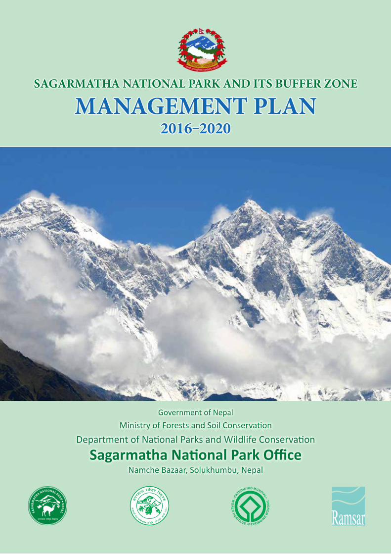
SAGARMATHA NATIONAL PARK AND ITS BUFFER ZONE
MANAGEMENT PLAN2016‒2020
Government of NepalMinistry of Forests and Soil Conservation
Department of National Parks and Wildlife Conservation
Sagarmatha National Park OfficeNamche Bazaar, Solukhumbu, Nepal
Published by : Sagarmatha National Park Office, Namche Bazaar, Solukhumbu, Nepal
Copyright : 2016, SNP- Any reproduction in full or in part of this publication must mention the title and credit the above mentioned publisher as the copyright owner.
Cover Photo : Ganesh Pant, Chief Conservation Officer
Design and Printing : Creative Link Pvt. Ltd., Bagbazaar, Kathmandu, Nepal Telephone: +977-1-4216913
Government of NepalMinistry of Forests and Soil Conservation
Department of National Parks and Wildlife Conservation
Sagarmatha National Park OfficeNamche Bazaar, Solukhumbu, Nepal
SAGARMATHA NATIONAL PARK AND ITS BUFFER ZONE
MANAGEMENT PLAN2016‒2020

G.P.O. Box: 860, Kathmandu, Nepal. Tel. 01-4227926, Fax : 01-4227675www.dnpwc.gov.np
Government of NepalMinistry of Forests and Soil Conservation
Department of National Parks and Wildlife ConservationGovernment of Nepal
Ministry of Forests and Soil Conservatio
n
Department of National Parks and Wildlife Conserva
tion
2037
FOREWORDSagarmatha National Park was established in 1976 with the aim of conserving endangered wildlife species, majestic landscape and local culture of the Khumbu region. In recognition of its superlative natural phenomenon, the park was listed in the World Heritage Site in 1979. The area was opened to the foreigners since 1950. The region got popularity in global community, when Sir Edmund Hillary and Tenzing Norgay Sherpa first climbed the Mt. Everest in 1953. Since then the area has been receiving an increasing number of tourists every year. No doubt, tourism has contributed a lot to flourish the
local economy. However, some management challenges have also evolved simultaneously.
The first management plan of SNP was prepared in 1981 with the view of managing the area systematically. The Plan was reviewed in 1993, and it was felt that it needs a revision, mainly to address the evolving socio-cultural and environmental issues together with the challenges. In this regard, DNPWC with the support from the UNDP/TRPAP prepared an integrated management and tourism plan for SNP for the period of 2007‒2012. However, all the activities prescribed by the plan could not be implemented due to budget constraint, the integrated plan 2007-2012 served as a key guiding document for carrying out conservation and management activities in SNP and its BZ. With the aim of developing an updated plan as far as practicable, DNPWC assigned Mr. Ganesh Pant, Chief Conservation Officer, SNP to update and prepare a management plan for SNP and its BZ for another five years from 2016 to 2020.
This plan is an outcome of rigorous review of previous plans. The plan preparation process also involved intensive literature review, consultation with the stakeholders as well as expert review. I would like to extend my sincere thanks to the reviewers of this plan who provided valuable inputs on its draft. Mr. Ganesh Pant, Chief Conservation Officer, SNP deserves special appreciation for his tireless efforts in leading the process to update and prepare this plan. I would like to thank the DNPWC officials especially the Deputy Director General duo Mr. Gopal Prakash Bhattarai and Dr. Maheshwar Dhakal for their contribution to prepare this plan. I also take this opportunity to thank the Community-based Flood and Glacial Lake Outburst Risk Reduction Project/DHM for the financial assistance to update this plan. Last but not the least, I thank local communities living in Khumbu region including executive committee members of BZMC and BZUC for their continuous support in conservation of SNP.
I hope this plan will be helpful for the conservation and management of SNP and its BZ.
Man Bahadur KhadkaDirector General

Government of NepalMinistry of Forests and Soil Conservation
Department of National Parks and Wildlife ConservationSagarmatha National Park Office
Namche Bazaar, Solukhumbu, Nepal. Tel: 038-540114, Fax : 038-540395Web Page: www.sagarmathanationalpark.gov.np, Email: [email protected], [email protected]
Government of Nepal
Ministry of Forests and Soil Conservatio
n
Department of National Parks and Wildlife Conserva
tion
Sagarmatha National Park Off ce
ACKNOWLEDGEMENTSSagarmatha National Park, a world heritage property since 1979, is an example of superlative and exceptional natural beauty, which is embedded in the vivid mountains, glaciers, deep valleys and majestic peaks including Sagarmatha (Mt. Everest), the world’s highest peak. The park is home to several rare species of wildlife including snow leopard, musk deer and red panda. The area contains the world’s highest ecologically characteristic flora and fauna, intricately blended with the rich Sherpa culture. The intricate linkages of the Sherpa culture with the ecosystem are a major focus of the park, and they form the basis for the sustainable conservation of the natural resources,
which eventually contributes for the wellbeing of the local communities.
Management planning for any protected area is a dynamic process, and we must be prepared to accommodate the changes in the management based on new facts. In this regard, the management plan for SNP and its BZ for the period of 2016‒2020 has given more emphasis on key wildlife and its habitat conservation as a response to the return of snow leopard in the SNP after more than three decades. Likewise, the plan attempts to address the issues associated with the likely impacts of climate change in order to safeguard the natural world heritage property from the vulnerability it faces at present. In addition, the plan intends to introduce cutting-edge technologies in regulating tourism activities as an effort for maintaining delicate balance between conservation and tourism development in the park.
First I would like to express my sincere gratitude to the Director General and the team at DNPWC for entrusting me with the task of reviewing and updating the management plan for SNP and its BZ for the period of 2016‒2020. During the plan preparation process, various institutions, organizations and individuals provided their valuable inputs. In this regard, I would like to thank all the institutions and experts consulted as the key informants for their time and contribution. I would like to extend my sincere thanks to Mr. Gopal Prakash Bhattarai and Dr. Maheshwar Dhakal, Deputy Director Generals, DNPWC for their continuous support and inputs.
I highly acknowledge Mr. Saurav Shrestha for his untiring efforts in plan write-up, Mr. Nawaraj Chapagain for GIS map preparation and Mr. Laxman Prasad Paudyal, Ecologist, DNPWC for collecting primary information through local level consultation. Likewise, I thank Mr. Shahas Man Shrestha for his input in language editing. I am grateful to the distinguished participants of the central-level consultation meeting on the review of the management plan for the SNP and its BZ for the period 2016‒2020 for their constructive comments and suggestions.
Finally, I would like to thank SNP staff together with the BZ Management Committee members as well as the BZ User Committee members, and the local communities for their valuable inputs.
Ganesh PantChief Conservation Officer
g]kfn ;/sf/jg tyf e"–;+/If0f dGqfno
/fli6«o lgs'~h tyf jGohGt' ;+/If0f ljefu-Joj:yfkg zfvf_
kmf]g g+= M
km\ofS; g+=
;+s]t g+= M–kq ;+Vof M– )&@.&# Jo= g+= $^*rnfgL g+= M– !($$
kf]= a= g+= – *^)aa/dxn,sf7df8f}+
Email: [email protected]//: www.dnpwc.gov.np
ldlt M– @)&@.!@.@$
ljifo M– ;u/dfyf /fli6«o lgs'~h tyf dWojtL{ If]qsf] k~rjlif{o Joj:yfkg of]hgf -@)!^–@)@)_ / ;f] sf] k|f/lDes jftfj/0fLo k/LIf0f k|ltj]bg (IEE) :jLs[t ul/Psf] ;DaGwdf .
>L ;u/dfyf /fli6«o lgs'~h sfof{nogfDr], ;f]n'v'Da'
k|:t't ljifodf ;u/dfyf /fli6«o lgs'~h tyf To;sf] dWojtL{ If]qsf] k~rjlif{o Joj:yfkg of]hgf -@)!^–@)@)_ / ;f]xL Joj:yfkg of]hgfsf] k|f/lDes jftfj/0fLo k/LIf0f k|ltj]bg (IEE) :jLs[ltsf] nflu To; sfof{nosf] kq ;+Vof @)&@.&# r=g+= &%# ldlt @)&@.!@.!( sf] kq;fy l6Kk0fL ;lxtsf] kmfO{n k]z x'g cfPsf] .
pk/f]Qmdf pNn]lvt ljifosf] l6Kk0fL kmfO{ndfly sf/jfxL x'Fbf ljZj ;Dkbf dxf;GwLsf] d'Vofnoaf6 xfn ;Dd s'g} ;'emfj k|fKt gePsf] t/ !–@ dlxgf leq k7fpg ;Sg] ;+s]t u/] cg';f/ tfFxfaf6 k|fKt x'g] ;sf/fTds ;'emfjx¿ k|fKt eP kl5 sfof{Gjog ug]{ u/L k]z x'g cfPsf] k|f/lDes jftfj/0fLo k/LIf0f k|ltj]bg / ;u/dfyf /fli6«o lgs'~h tyf To;sf] dWojtL{ If]qsf] k~rjlif{o Joj:yfkg of]hgf -@)!^–@)@)_ ldlt @)&@.!@.@# sf] ljefuLo lg0f{ofg';f/ :jLs[t ul/Psf] x'Fbf :jLs[t k|f/lDes jftfj/0fLo k/LIf0f k|ltj]bg / ;u/dfyf /fli6«o lgs'~h tyf dWojtL{ If]qsf] k~rjlif{o Joj:yfkg of]hgf -@)!^–@)@)_ o;};fy /fvL sfof{Gjogsf] nflu k7fO{Psf] Joxf]/f lg0f{ofg';f/ cg'/f]w 5 .
======================== -lji0f' k|;fb yklnof_ ;xfos Joj:yfkg clws[t
jf]wfy{M>L ;u/dfyf /fli6«o lgs'~h dWojtL{ If]q Joj:yfkg ;ldltgfDr], ;f]n'v'Da' .
$@@)@!^$@@)*%)$@@)(!@$@@&(@^$@@&^&%
g]kfn ;/sf/jg tyf e"–;+/If0f dGqfno
/fli6«o lgs'~h tyf jGohGt' ;+/If0f
ljefu
@)#&
Management Plan for Sagarmatha National Park and its Buffer Zone 2016-2020
EXECUTIVE SUMMARYSagarmatha National Park (SNP), established in 1976 is one of the pioneer protected areas of Nepal. The park was inscribed as world heritage property in 1979 because of its superlative and exceptional natural beauty, which is embedded in the vivid mountains, glaciers, deep valleys and majestic peaks including the world’s highest peak, Mt. Everest. The Gokyo and the associated wetlands, the wetlands of global significance, also lie within Park. The park is a home to some of the endangered wildlife species including snow leopard, musk deer and red panda. The area contains the world’s highest ecologically characteristic flora and fauna, intricately blended with the rich Sherpa culture. The Buffer zone, encompassing the major part of the Chaurikharka VDC to the south as well as the settlements within SNP traditionally considered as village enclaves, was created in 2002. There are nearly 7,800 people living in 1,619 households in buffer zone of the SNP. In order to institutionalize participatory conservation and development practices in the buffer zone, the local communities are organized into 28 Buffer Zone User Groups (BZUGs), three Buffer Zone User Committees (BZUCs) and one Buffer Zone Management Committee (BZMC).
SNP is one of the most popular tourist destinations in Nepal. Tourism is the major source of income, which not only benefits the local communities, but also generates significant amount of revenue for the country. SNP at present faces several challenges which need to be addressed carefully for maintaining the delicate balance between biodiversity conservation, tourism promotion and livelihood enhancement of the local communities. The park protection, management of the key wildlife habitats, sustainable tourism and infrastructure development, garbage management, glacial lake outburst flood risk, and the livelihood enhancement of the local communities have been identified as the major issues of concern. This management plan is expected to address most of these pertinent issues.
The current Management Plan 2016−2020 is the continuation of the previous management plan of the SNP and its BZ developed through numerous interactions and consultation meetings with stakeholders, field works and observations, central and local-level workshops followed by expert review. The plan has been prepared for conservation, management and utilization of the park and its buffer zone resources in scientific and participatory approach with due consideration of its significance as the world heritage property. The objective of SNP and its BZ management is to enhance biodiversity of the park, promote tourism and regulate it where necessary to maintain delicate balance between conservation and tourism, and also support the livelihoods of the local communities through effective management of the natural and cultural heritages. The specific objectives are:
To conserve biodiversity of the park with special focus on nationally protected and globally threatened wildlife species and their habitats in order to maintain ecological functions and processes;
To promote sustainable tourism, and regulate it for maintaining ecological integrity and cultural heritage;
i
Management Plan for Sagarmatha National Park and its Buffer Zone 2016-2020
To enhance community stewardship on biodiversity conservation by increasing awareness and improving livelihood of the people living in the BZ; and
To strengthen institutional capacity through research, capacity building, coordination and collaboration.
The broad thematic areas incorporated in the management plan are protection and conservation of biodiversity, habitat management, tourism and interpretation, BZ management and research, monitoring and capacity building. Special programmes on species conservation have also been formulated focusing on snow leopard, musk deer and red panda. The plan also attempts to manage the park in the face of likely impacts of climate change in order to safeguard the Outstanding Universal Value (OUV) of the Park as well as to enhance the resilience of the local communities living in the BZ. The major programmes outlined in the management plan include park protection, habitat management, basic physical infrastructure construction, tourism promotion, community development, public awareness, monitoring, research and capacity building.
The total budget for the implementation of the plan is estimated to be Rs. 71,45,30,000 (equivalent to 65,55,321 US$) excluding operation costs. The expected government budget of Rs. 19,50,00,000 (equivalent to 17,88,991 US$) for the management of the BZ for the next five years has been included in this total budget. The implementation of the activities prescribed in this plan is expected to enhance the conservation of biodiversity in this region, maintain the OUV of the world heritage site, promote tourism for improvement of the living standard of the local communities, and enrich the capacity of SNP staff and BZ communities. On the other hand, it is estimated that 2,85,800 man days of employment will be generated in this region through implementation of the activities prescribed by the management plan which is expected to contribute for enhnancing the livelihood of the local communities.
ii
Management Plan for Sagarmatha National Park and its Buffer Zone 2016-2020
;f/f+z;g\ !(&^ -la=;+= @)##_ df :yfkgf ePsf] ;u/dfyf /fli6«o lgs'~h g]kfnsf] Pp6f cu|0fL ;+/lIft If]q xf] . ljZjsf] ;jf]{Rr lzv/ ;u/dfyf nufotsf ;'Gb/ lxd>[ªvnf, lxdgbL, dgf]/d pkTosf ;lxtsf] cg'kd k|fs[lts ;f}Gbo{tfn] el/k"0f{ of] /fli6«o lgs'~h ;g\ !(&( df ljZj ;Dkbf ;"rLdf ;"lrs[t ePsf] 5 . To;}u/L cGt/f{li6«o dxTjsf] l;d;f/ If]qsf] ?kdf /fd;f/ ;"rLdf ;"lrs[t uf]Sof] tyf j/k/sf tfnx? o; /fli6«o lgs'~h If]qleq cjl:yt /x]sf] 5 . of] /fli6«o lgs'~h lxpF lrt'jf, s:t'/L d[u, xfa]| nufotsf b'n{e Pj+ dxTjk"0f{ jGohGt'x?sf] af;:yfg klg xf] . o; If]qdf ljZjs} clt pRr kfl/l:yltsLo k|0ffnL cGtu{tsf hLj tyf jg:kltx? kfOG5g h;sf] :yfgLo z]kf{ ;+:s[lt;+u cGof]Gofl>t ;DaGw /xL cfPsf] 5 . ;g\ @))@ -la=;= @)%*_ df rf}/Lvs{ uf=lj=;=sf] clwsf+z e"–efu / lgs'~hsf] rf/lsNnfleq cjl:yt dfgj a:tLx? ;d]6]/ ;u/dfyf /fli6«o lgs'~hsf] dWojtL{ If]q 3f]if0ff ul/Psf] 5 . dWojtL{ If]qleq /x]sf !,^!( 3/w'/Lx?df s/La &,*)) dflg;x? a;f]af; ub{5g\ . dWojtL{ If]qdf ;xeflutfd"ns ;+/If0f / ljsf;sf] cEof;nfO{ ;+:yfut ug{sf] nflu :yfgLo ;d'bfonfO{ @* j6f dWojtL{ If]q pkef]Qmf ;d"xx?df cfj4 u/L tLgj6f dWojtL{ If]q pkef]Qmf ;ldltx? / Pp6f dWojtL{ If]q Joj:yfkg ;ldlt u7g ul/Psf] 5 .
;u/dfyf /fli6«o lgs'~h g]kfnsf] Pp6f k|l;4 ko{6sLo uGtJo xf] . ko{6g Joj;fo o; If]qsf :yfgLo ;d'bfosf] nflu cfDbfgLsf] d'Vo ;|f]t dfq geO{ /fi6«s} nflu pNn]vgLo /fhZjsf] ;|f]tsf] ?kdf /x]sf] 5 . ;u/dfyf /fli6«o lgs'~hdf h}ljs ljljwtf ;+/If0f, ko{6g k|j4{g tyf :yfgLo ;d'bfosf] lhljsf]kfh{gnfO{ ;Gt'lnt ?kdf cufl8 a9fpgsf] nflu ljljw r'gf}ltx? ljBdfg /x]sf 5g\ . pNn]lvt ;Gbe{df lgs'~hsf] ;+/If0f, dxTjk"0f{ jGohGt'xsf] af;:yfg Joj:yfkg, lbuf] ko{6g k|j4{g, cfjZos ef}lts k"jf{wf/x?sf] ljsf;, kmf]xf]/d}nf Joj:yfkg, lxdtfn ljikmf]6gsf] hf]lvd tyf :yfgLo ;d'bfosf] lhljsf]kfh{g ;'wf/nfO{ d'Vo ;jfnx?sf] ?kdf klxrfg ul/Psf] 5 . o; Joj:yfkg of]hgfn] oL clwsf+z ;jfnx?nfO{ ;Daf]wg ug]{ ck]Iff ul/Psf] 5 .
;u/dfyf /fli6«o lgs'~h tyf dWojtL{ If]qsf] Joj:yfkg of]hgf ;g\ @)!^–@)@) lautsf Joj:yfkg of]hgfx?sf] lg/Gt/tf xf] h;nfO{ ;/sf]/jfnfx?;+usf] cGtlq{mof, 5nkmn, :ynut cjnf]sg, pkef]Qmf ;ldlt :t/Lo a}7s ;d]taf6 tof/ ul/Psf] d:of}bfnfO{ lj1x?af6 k'g/fjnf]sg u/fO{ clGtd ?k lbO{Psf] 5 . of] Joj:yfkg of]hgf ;u/dfyf /fli6«o lgs'~h tyf dWojtL{ If]qdf /x]sf ;|f]tx?sf] j}1flgs Pj+ ;xeflutfd'ns k2ltaf6 ;+/If0f, Joj:yfkg / bLuf] pkof]u ug{sf] nflu tof/ ul/Psf] xf] eg] ljZj ;Dkbfsf] ?kdf /x]sf] of] lgs'~hsf] dxTjnfO{ ;d]t of] Joj:yfkg of]hgfdf laz]if Wofg lbOPsf] 5 . ;u/dfyf /fli6«o lgs'~h tyf dWojtL{ If]q Joj:yfkgsf] d'Vo p2]Zo o; If]qsf] k|fs[lts tyf ;f+:s[lts ;Dkbfsf] k|efjsf/L Joj:yfkg dfkm{t h}ljs ljljwtf ;+/If0f, ;+/If0f / ko{6gaLr ;Gt'ng sfod /fVgsf] nflu ko{6g Joj;fo k|j4{g tyf lgodg ub}{ :yfgLo ;d'bfosf] lhljsf]kfh{g ;'wf/ ug{df 6]jf k¥'ofpg' /x]sf] 5 . ;u/dfyf /fli6«o lgs'~h tyf o;sf] dWojtL{ If]qsf] Joj:yfkg of]hgf @)!^–@)@) sf lgDgfg';f/ rf/j6f vf; p2]Zox? /x]sf 5g\\ .
iii
Management Plan for Sagarmatha National Park and its Buffer Zone 2016-2020
kfl/l:yltsLo sfo{ tyf k2lt sfod /fVgsf] nflu lgs'~hdf kfOg] ;+/lIft Pj+ ;+s6fkGg jGohGt' k|hfltx? tyf ltgLx?sf] af;:yfgnfO{ laz]if Wofg lbO{ h}ljs ljljwtf ;+/If0f ug'{ .
kfl/l:yltsLo cI'f0ftf sfod ub}{ ;f+:s[lts ;Dkbfsf] ;+/If0f ;d]t x'g]u/L ko{6g Joj;fo k|j4{g tyf cfjZostf cg';f/ ko{6g Joj;fo;+u ;DalGwt lqmofsnfkx? lgodg ug'{ .
h}ljs ljljwtf ;+/If0fdf :yfgLo ;d'bfonfO{ clek]|l/t ug{sf] nflu dWojtL{ If]qsf afl;Gbfx?sf] ;+/If0f ;DalGw ;r]tgf clej[l4 tyf lhljsf]kfh{g ;'wf/ ug'{ .
cWoog cg';Gwfg, Ifdtf clej[l4, ;dGjo tyf ;xsfo{sf] dfWodaf6 ;u/dfyf /fli6«o lgs'~h tyf dWojtL{ If]qsf] ;+:yfut Ifdtf clej[l4 ug'{ .
Joj:yfkg of]hgfdf ;dfj]z ul/Psf d'Vo laifoa:t'x?df h}ljs ljljwtf ;+/If0f, af;:yfg Joj:yfkg, ko{6g tyf k|s[ltsf] JofVofg, dWojtL{ If]qsf] Joj:yfkg, cWoog cg';Gwfg, cg'udg / Ifdtf clej[l4 /x]sf 5g\ . To;}u/L lxpF lrt'jf, s:t/L d[u / xfa]|nfO{ b[li6ut u/L k|hflt ;+/If0f ljz]if sfo{qmd tof/ ul/Psf] 5 . o; Joj:yfkg of]hgfn] hnjfo' kl/jt{gsf] k|efjsf] ;Gbe{df lgs'~hsf] laz]if k|fs[lts ;f}Gbo{ tyf dxTjdf kg{;Sg] c;/ tyf dWojtL{ If]qsf :yfgLo afl;Gbfx?nfO{ kg{;Sg] c;/ Go"lgs/0f ub}{ lgs'~h tyf dWojtL{ If]qsf] Joj:yfkg ug{sf] nflu ;d]t k|of; u/]sf] 5 . o; Joj:yfkg of]hgfdf ;dflji6 d'Vo d'Vo sfo{qmdx?df lgs'~hsf] ;+/If0f, af;:yfg Joj:yfkg, cfwf/e't ef}lts k"jf{wf/ lgdf{0f, ko{6g k|j4{g, ;fd'bflos ljsf;, hgr]tgf clej[l4, cWoog cg';Gwfg, cg'udg / Ifdtf clej[l4 /x]sf 5g\ .
o; Joj:yfkg of]hgfn] kfFr aif{ calwsf] nflu k|:tfj u/]sf lqmofsnfkx? sfof{Gjog ug{sf nflu tna eQf nufotsf k|zf;lgs vr{ afx]s &! s/f]8 $% nfv #) xhf/ ?k}+of -s/La ^% nfv %% xhf/ #@! cd]l/sL 8n/_ cfjZos kg]{ cg'dfg ul/Psf] 5 . o;df cfufdL kfFr aif{df dWojtL{ If]qsf] Joj:yfkgsf] nflu k|fKt x'g ;Sg] ;/sf/L ah]6 ?= !( s/f]8 %) nfv ?k}+of -s/La !& nfv ** xhf/ ((! cd]l/sL 8n/_ ;dfj]z ul/Psf] 5 . o; Joj:yfkg of]hgfn] k|:tfj u/]sf lqmofsnfkx? sfof{Gjog ePdf ;u/dfyf /fli6«o lgs'~h tyf o;sf] dWojtL{ If]qsf] h}ljs ljljwtf ;+/If0f x'g], ljZj ;Dkbfsf] ?kdf /x]sf] o; lgs'~hsf] laz]if dxTj sfod /xg], :yfgLo afl;Gbfx?sf] lhjg:t/ ;'wf/ x'g] u/L ko{6g k|j4{g x'g] ;fy} ;u/dfyf /fli6«o lgs'~h sfof{nosf sd{rf/Lx? tyf dWojtL{ If]qsf ;d'x ;ldltx?sf] ;+:yfut Ifdtf clej[l4 x'g] ;d]t ck]Iff ul/Psf] 5 . csf]{tkm{ Joj:yfkg of]hgf sfof{Gjogaf6 @,*%,*)) >dlbg /f]huf/L l;h{gf x'g] cg'dfg ul/Psf] 5 h;af6 :yfgLo ;d'bfosf] lhljsf]kfh{g ;'wf/df of]ubfg k'Ug] ck]Iff ul/Psf] 5 .
iv
Management Plan for Sagarmatha National Park and its Buffer Zone 2016-2020
ACRONYMS0C Degree CentigradeAoR Area of ResponsibilityAPPA Appreciative Project Planning and ActionAPU Anti-poaching UnitBZ Buffer ZoneBZMC Buffer Zone Management CommitteeBZUC Buffer Zone User CommitteeBZUG Buffer Zone User GroupCBAPO Community-based Anti-poaching OperationCFUG Community Forest User GroupCITES Convention on International Trade in Endangered species of Wild Flora and Fauna DHM Department of Hydrology and MeteorologyDLSO District Livestock Service OfficeDNPWC Department of National Parks and Wildlife ConservationE EastERFD Eastern Regional Forestry DirectorateFY Fiscal YearGCA Gaurishankar Conservation AreaGIS Geographical Information SystemGLOF Glacial Lake Outburst Floodgm GramGoN Government of NepalGPS Global Positioning Systemha. HectareHQ HeadquartersHRD Human Resource DevelopmentICIMOD International Center for Integrated Mountain Development IOF Institute of ForestryIT Information TechnologyIUCN International Union for Conservation of NatureKBC Khumbu Bijuli CompanyKCA Kanchanjunga Conservation Areakg Kilogramkm Kilometerkm2 Square kilometerLAC Limit of Acceptable ChangeLPG Liquid Petroleum Gasm Meterm3 Cubic meterMAPs Medicinal and Aromatic Plants
v
Management Plan for Sagarmatha National Park and its Buffer Zone 2016-2020
MBNP Makalu Barun National ParkMFSC Ministry of Forests and Soil Conservationmm MillimeterMSL Mean Sea LevelMt. MountainN NorthNAST Nepal Academy of Science and TechnologyNGO Non-governmental OrganizationNMA Nepal Mountaineering AssociationNo. NumberNTFP Non-timber Forest ProductNTNC National Trust for Nature ConservationOUV Outstanding Universal ValueOVI Objectively Verifiable IndicatorPA Protected AreaPDNA Post Disaster Need AssessmentQNP Qomolangma Nature PreserveQty QuantityRIS Ramsar Information SheetRs. RupeesSAARC South Asian Association for Regional CooperationSLIMS Snow Leopard Information Management SystemSMART Spatial Monitoring and Reporting ToolSN Serial NumberSNP Sagarmatha National ParkSPCC Sagarmatha Pollution Control CommitteeSPSS Statistical Package for Social SciencesSWOT Strengths, Weaknesses, Opportunities and ThreatsTAR Tibet Autonomous RegionToT Training of TrainerTRPAP Tourism for Rural Poverty Alleviation ProgrammeUC User CommitteeUG User GroupUNDP United Nations Development ProgrammeUNESCO United Nations Educational, Scientific and Cultural OrganizationUSA United States of AmericaVDC Village Development CommitteeWHC World Heritage ConventionWHS World Heritage SiteWWF World Wide Fund for Nature
vi
Management Plan for Sagarmatha National Park and its Buffer Zone 2016-2020
TABLE OF CONTENTS
EXECUTIVE SUMMARY i
;f/f+z iii
ACRONYMS vTABLE OF CONTENTS viiSAGARMATHA NATIONAL PAK AND ITS BUFFER ZONE AT A GLANCE ixMANAGEMENT PLAN PREPARATION PROCESS x
PART A - EXISTING SITUATION 1Chapter I - Introduction 21.1 Name, Location, Constitution and Extent 21.2 Access 21.3 Statement of Significance 3
Chapter II - Background Information and Attributes 42.1 Boundaries 42.2 Geology and Soil 42.3 Topography and Drainage 52.4 Climate 62.5 Biodiversity Status 6
Chapter III - Past Management and Present Practices 83.1 Conservation History 83.2 Park Protection 83.3 Habitat Management 83.4 Anti-poaching and Intelligence Gathering 93.5 Tourism and Interpretation 93.6 Research and Monitoring 93.7 Human-Wildlife Conflict 93.8 Administration and Organization 103.9 Achievements of Preceding Management Plan 103.10 Strength, Weakness, Opportunity and Threat Analysis 11
PART B - THE PROPOSED MANAGEMENT 12Chapter IV- Vision, Goal and Objectives 134.1 Vision Statement 134.2 Management Goal 134.3 Management Objectives 134.4 Problems in achieving Objectives 13
vii
Management Plan for Sagarmatha National Park and its Buffer Zone 2016-2020
Chapter V - Management Strategies 155.1 Boundaries 155.2 Zonation 155.3 Theme Plans 16
Chapter VI - Research, Monitoring and Capacity Building 216.1 Research 216.2 Monitoring 236.3 Capacity Building 24
Chapter VII - Species Conservation Special Programme 257.1 Snow Leopard Conservation 257.2 Himalayan Musk Deer Conservation 287.3 Red Panda Conservation 31
Chapter VIII - Tourism and Nature Interpretation 338.1 Background 338.2 Tourism Scenario 338.3 Interpretation Facilities 358.4 Issues 358.5 Objectives 358.6 Activities 35
Chapter IX - Special Programme 379.1 Moderating the Climate Change Impact 379.2 Enhancing the World Heritage Value 399.3 Coping with the Impact of Earthquake 409.4 Keeping Everest Region Clean 41
Chapter X - Buffer Zone Management 4310.1 Introduction 4310.2 Past Management and Present Practices 4410.3 Management Strategies 4410.4 Implementation and Mainstreaming Strategy 47
Chapter XI- Activities, Budget and Logical Framework 4811.1 Activities and Budget 4811.2 Logical Framework Analysis 4911.3 Gender Equity and Social Inclusion 49
REFERENCES 50
ANNEXES 52
viii
Management Plan for Sagarmatha National Park and its Buffer Zone 2016-2020
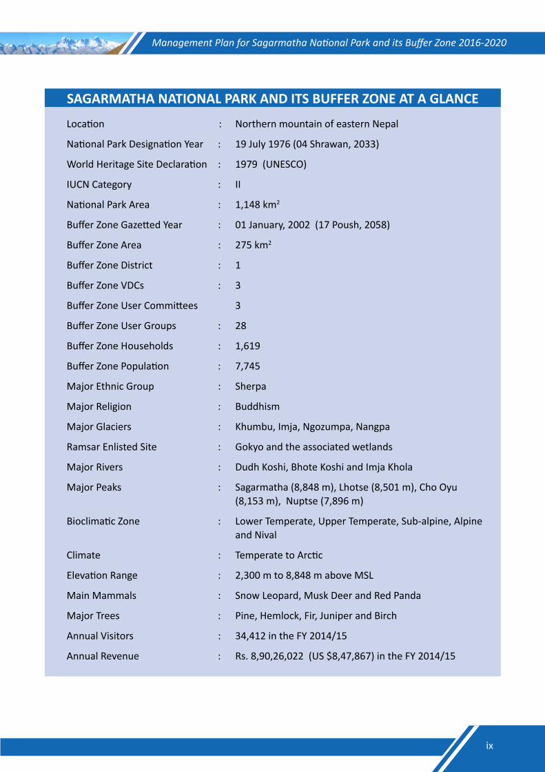
SAGARMATHA NATIONAL PARK AND ITS BUFFER ZONE AT A GLANCE
Location : Northern mountain of eastern Nepal
National Park Designation Year : 19 July 1976 (04 Shrawan, 2033)
World Heritage Site Declaration : 1979 (UNESCO)
IUCN Category : II
National Park Area : 1,148 km2
Buffer Zone Gazetted Year : 01 January, 2002 (17 Poush, 2058)
Buffer Zone Area : 275 km2
Buffer Zone District : 1
Buffer Zone VDCs : 3
Buffer Zone User Committees 3
Buffer Zone User Groups : 28
Buffer Zone Households : 1,619
Buffer Zone Population : 7,745
Major Ethnic Group : Sherpa
Major Religion : Buddhism
Major Glaciers : Khumbu, Imja, Ngozumpa, Nangpa
Ramsar Enlisted Site : Gokyo and the associated wetlands
Major Rivers : Dudh Koshi, Bhote Koshi and Imja Khola
Major Peaks : Sagarmatha (8,848 m), Lhotse (8,501 m), Cho Oyu (8,153 m), Nuptse (7,896 m)
Bioclimatic Zone : Lower Temperate, Upper Temperate, Sub-alpine, Alpine and Nival
Climate : Temperate to Arctic
Elevation Range : 2,300 m to 8,848 m above MSL
Main Mammals : Snow Leopard, Musk Deer and Red Panda
Major Trees : Pine, Hemlock, Fir, Juniper and Birch
Annual Visitors : 34,412 in the FY 2014/15
Annual Revenue : Rs. 8,90,26,022 (US $8,47,867) in the FY 2014/15
ix
Management Plan for Sagarmatha National Park and its Buffer Zone 2016-2020
MANAGEMENT PLAN PREPARATION PROCESSThe Management Plan for SNP and its BZ (2016−2020) is the outcome of the team effort of the individuals representing various organizations and groups. It has been prepared in participatory approach on the basis of the format endorsed by the DNPWC. The plan is based on holistic approach and envisages bottom-up planning process. It has been prepared with the active involvement of the BZ communities, relevant government agencies, NGOs, technicians, social activists, tourism entrepreneurs, community organizations, and other stakeholders. The management plan preparation team was led by the Chief Conservation Officer of SNP to precede the plan formulation process. The team was responsible for coordinating and organizing consultation meetings for management planning as well as preparation of draft management plan for SNP and its BZ. In the course of plan preparation, the team not only went through numerous literature reviews, consultations, meetings, workshops, field works and observations but also collected primary data relevant for the management plan.
The management plan has been divided into two parts: Part A dealing with the existing situation and Part B mentioning about the proposed management. The preparation of the first part of the management plan involved gathering of suggestions and comments from the relevant stakeholders and their subsequent organizations in predesigned management plan format. On the other hand, buffer zone user committees prepared the second part with the facilitation of the park staff. A number of consultation meetings and interaction programmes were conducted at different areas during the course of the plan preparation process. In addition, numerous formal and informal meetings were held as per the requirements. Similarly, a central level sharing workshop was held amongst the officials from the relevant government agencies, conservation partners, donors, professionals, academicians and other stakeholders within the DNPWC premises. The workshop identified the key gaps in the plan, and provided valuable suggestions to fill up these gaps. The comments and suggestions from these meetings and workshops were incorporated in the draft management plan. The draft plan was then sent to the concerned experts for reviewing. The comments, suggestions and constructive criticisms from the experts were subsequently incorporated in the final plan.
x
Management Plan for Sagarmatha National Park and its Buffer Zone 2016-2020
PART A
THE EXISTING
SITUATION
1

Management Plan for Sagarmatha National Park and its Buffer Zone 2016-2020
Chapter I
Introduction1.1. Name, Location, Constitution and Extent1.1.1. NameSagarmatha National Park and its Buffer Zone
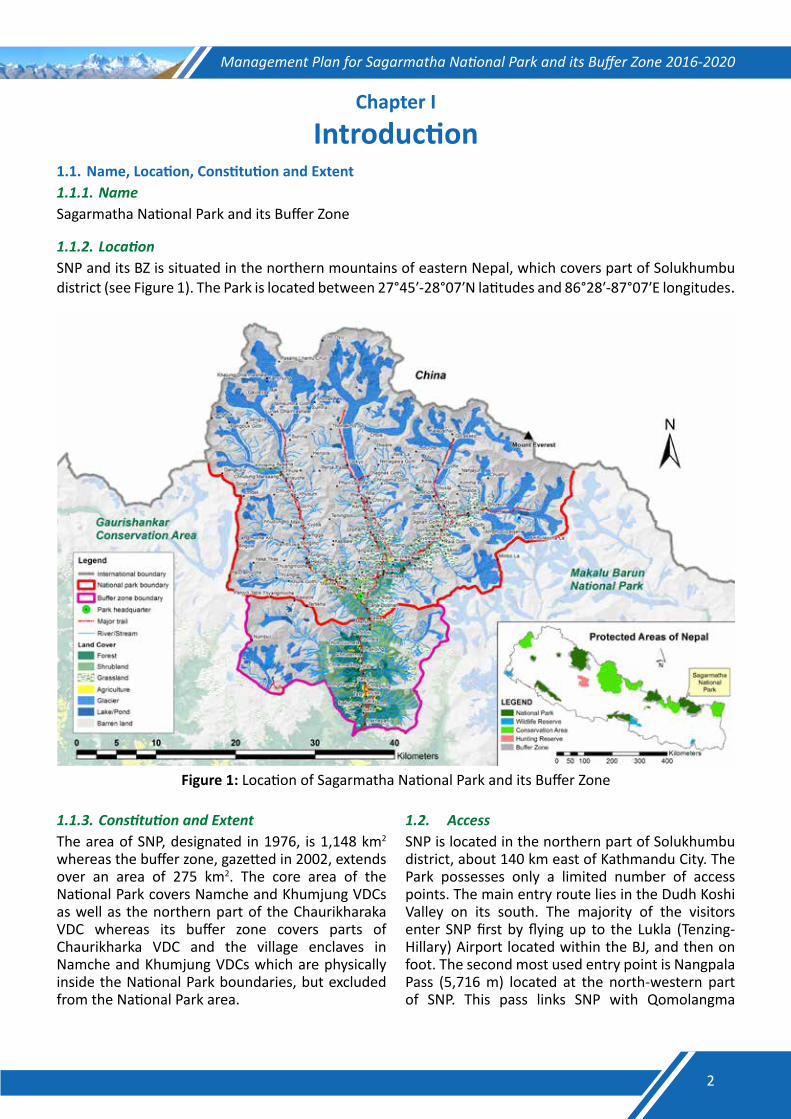
1.1.2.LocationSNP and its BZ is situated in the northern mountains of eastern Nepal, which covers part of Solukhumbu district (see Figure 1). The Park is located between 27°45′-28°07′N latitudes and 86°28′-87°07′E longitudes.
Figure 1: Location of Sagarmatha National Park and its Buffer Zone
1.1.3.ConstitutionandExtentThe area of SNP, designated in 1976, is 1,148 km2 whereas the buffer zone, gazetted in 2002, extends over an area of 275 km2. The core area of the National Park covers Namche and Khumjung VDCs as well as the northern part of the Chaurikharaka VDC whereas its buffer zone covers parts of Chaurikharka VDC and the village enclaves in Namche and Khumjung VDCs which are physically inside the National Park boundaries, but excluded from the National Park area.
1.2. AccessSNP is located in the northern part of Solukhumbu district, about 140 km east of Kathmandu City. The Park possesses only a limited number of access points. The main entry route lies in the Dudh Koshi Valley on its south. The majority of the visitors enter SNP first by flying up to the Lukla (Tenzing-Hillary) Airport located within the BJ, and then on foot. The second most used entry point is Nangpala Pass (5,716 m) located at the north-western part of SNP. This pass links SNP with Qomolangma
2
Management Plan for Sagarmatha National Park and its Buffer Zone 2016-2020
Nature Preserve in Tibet Autonomous Region (TAR) of China. The trans-himalayan traders use this pass, but it is prohibited for tourists. The Tashi Latse Pass links SNP with Rolwaling Valley on the west. This pass is used by a limited number of adventure trekking groups. Occasionally, trekkers and mountaineers cross the Ama Latse Pass at the head of the Imja Glacier that links SNP with Makalu-Barun National Park. Likewise, the BZ on the south can also be accessed through several passes that are not commonly used. The Zatarwa Pass above Lukla links the BZ with the Hinku Valley and the Mera Peak areas. There is also a rarely used route passing through Sengma and Tate villages, and links the BZ with the Upper Junbeshi Valley.
1.3. Statement of SignificanceSNP is of high significance not only to Nepal but also to the whole world. Its status as a National Park has further elevated the international prestige and led to inscription of the area in the list of World Heritage Site (WHS) by the UNESCO for its outstanding universal value for aesthetic and scientific values. The Park was inscribed as a world heritage property in 1979 under the natural category of the UNESCO as it meets criterion (vii)- superlative natural features of exceptional natural beauty in terms of its scenic attractions of the forested hills, grasslands, great
rivers and views of the distant Himalayas. Besides, the UNESCO has also recognized the Park for the rich Sherpa culture.
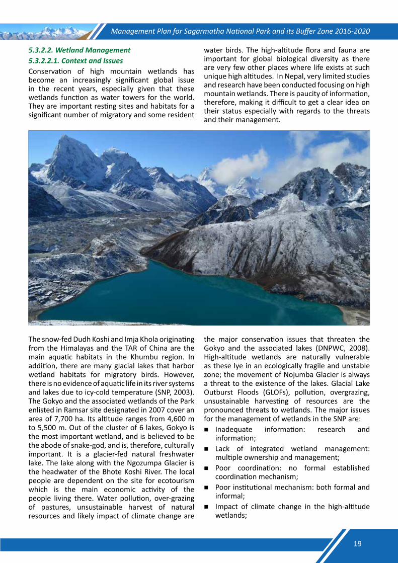
SNP is an ecological unit in the highest region of the world; the area is of important scientific value, and offers unique research opportunities to scientists throughout the world because of its extreme elevation, associated flora and fauna, culture and environment. The high-altitude forests and rangeland environment of the Park are not only of aesthetic value but are vital to the local people of the area as a source of fuel and building material. The glaciers and rivers of the area are important source of water for the people downstream. Gokyo and associated wetlands, the wetlands of international significance, also lie within the Park. The wetlands, with a catchment area of 7,700 ha have been enlisted in Ramsar Site in 2007.
The park is of major religious and cultural significance in Nepal since it abounds in sacred mountains and holy places. The Sherpa people respect their homeland as a sacred hidden valley and refrain from hunting and slaughtering animals. These indigenous belief systems and practices provide important cultural basis for conservation. The Park has become an important destination for international visitors to Nepal.
3
Management Plan for Sagarmatha National Park and its Buffer Zone 2016-2020
Chapter II
Background Information and Attributes2.1. Boundaries2.1.1.LegalBoundariesSNP was gazetted in 04 Shrawan, 2033 (19 July, 1976). The area of the Park is duly notified and demarcated on the ground. The boundaries of the Park as per the gazette notification of the Government of Nepal are as follows: North: Lhotsesaar Himal, Sagarmatha (Mt.
Everest), Nangpla Bhanjyang (Pass) through the Nepal-China (Tibet) border
East: Mingbola Bhanjyang (Pass), Aamphulapsa Bhanjyang (Pass), Chopol Himal and Lhotsesaar Himal
South: Mingbola Bhanjyang (Pass), Kangtaiga Himal, Tamaserku Himal and Pigpheragosaar through Kongderi Himal across the Luka-Namche Trail
West: Pigpheragosaar, Tashilapsa Bhanjyang (Pass), Tangiraagi Himal and Menlungla Bhanjyang (Pass)
The human settlements and the private lands that fall within the above mentioned boundaries, but legally excluded from the area of the National Park are Jorsalle, Taaboth, Ghumbada, Namche Bazaar, Sangboche, Khunde, Khumjung, Taasinga, Fungkithanga, Tangboche, Deboche, Milingo, Thangboche, Taaboche, Mingbo, Raala, Samsho, Wogma, Surowog, Samsochopa, Suroteng, Tubonawogma, Sambur, Jongla, Dugla, Phulungkarpo, Dusa, Lobuche, Gorkchep, Pheriche, Dingboche, Saanja, Bibre, Chukung, Nayarajong, Phortse, Kinar, Thore, Somwog, Naala, Shosung, Gokyo, Longponga, Pangka, Machherama, Luja, Laphama, Dole, Gele, Tongba, Gongla, Mendo, Laaudo, Thamo, Thogde, Paare, Saamde, Thame, Thamegompa, Tengbo, Wotrse, Aarthe, Chule, Sonjo, Jimko, Lunaak and Nangpaighataya.
The buffer zone of the SNP was gazetted on 17 Poush 2058 (01 January, 2002). The enclave settlements and surrounding area of the Park has been declared as BZ. The area under the Chaurikharka VDC excluding the area included in the SNP and the MBNP was declared as BZ of the SNP. Likewise, the settlements which are located inside the SNP are legally excluded from the core area of the Park. The enclave settlements which are part of the BZ of the SNP are Jorsalle, Taaboth, Ghumbada, Namche Bazar, Sangboche, Khunde,
Khumjung, Taasinga, Fungkithanga, Tangboche, Deboche, Milingo, Thangboche, Taaboche, Mingbo, Raala, Samsho, Wogma, Surowog, Samsochopa, Suroteng, Tubonawogma, Sambur, Jongla, Dugla, Phulungkarpo, Dusa, Lobuche, Gorkchep, Pheriche, Dingboche, Saanja, Bibre, Chukung, Nayarajong, Phortse, Kinar, Thore, Somwog, Naala, Shosung, Gokyo, Longponga, Pangka, Machherama, Luja, Laphama, Dole, Gele, Tongba, Gongla, Mendo, Laaudo, Thamo, Thogde, Paare, Saamde, Thame, Thamegompa, Tengbo, Wotrse, Aarthe, Chule, Sonjo, Jimko, Lunaak and Nangpaighataya.
2.1.2.EcologicalBoundariesSNP itself is an ecological unit in the highest region of the world. The Park and its buffer zone (1,423 km2) has landscape continuity with the Makalu Barun National Park and its buffer zone (2,330 km2) to the east, Qomolangma Nature Preserve (35,000 km2) in the TAR of China to the north and the Gaurishankar Conservation Area (2,179 km2) to the west. The combined area of the SNP, the MBNP, the QNP and the GCA is over 40,000 Km2, which forms one of the largest protected area complexes in the high mountain ecosystem. SNP along with its surrounding landscape is, therefore, considered to be an ecologically inclusive.
2.2. Geology and Soil The outstanding features of the Park are its majestic peaks higher than 8,000 m including Sagarmatha (8,848 m), Lhotse (8,501 m) and Cho Oyu (8,188 m). These magnificent mountain peaks have been uplifted by collision of the Eurasian and Indian continental plates about 120 million years ago. The process of continental collision is known to be continuing. As a result, the Himalayas are rising, although very slowly. The Himalayan peaks of the SNP are not only the highest but are among the youngest in the world. The young and steep landscape is subject to erosion and other changes, both gradual and sudden. The upper valleys of the Park are dominated by wider U-shaped valleys of glacial origin while the lower buffer zone area is marked mostly by the river-carved V-shaped valleys.
The soils of SNP and its BZ are mostly of glacial, fluvio-glacial and fluvial origin. Their development is highly influenced by climate that changes with elevation. Inceptisols are found within 2,000-3,000
4
Management Plan for Sagarmatha National Park and its Buffer Zone 2016-2020
m elevation; Inceptisols are young soils with slightly more advanced development with some leaching of the topsoil and weathering of the sub-soil. At around 3,000 m elevation, Spodosol may be found on stable sites under existing or previous coniferous and birch-rhododendron forests of cool sub-alpine zone. On the eroded slopes at higher elevations above 4,500 m, Entisols with a limited profile development, formed on fresh alluvial deposits or actively eroding rocks are common.
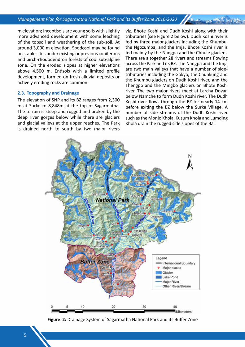
2.3. Topography and DrainageThe elevation of SNP and its BZ ranges from 2,300 m at Surke to 8,848m at the top of Sagarmatha. The terrain is steep and rugged and broken by the deep river gorges below while there are glaciers and glacial valleys at the upper reaches. The Park is drained north to south by two major rivers
viz. Bhote Koshi and Dudh Koshi along with their tributaries (see Figure 2 below). Dudh Koshi river is fed by three major glaciers including the Khumbu, the Ngozumpa, and the Imja. Bhote Koshi river is fed mainly by the Nangpa and the Chhule glaciers. There are altogether 28 rivers and streams flowing across the Park and its BZ. The Nangpa and the Imja are two main valleys that have a number of side-tributaries including the Gokyo, the Chunkung and the Khumbu glaciers on Dudh Koshi river, and the Thengpo and the Mingbo glaciers on Bhote Koshi river. The two major rivers meet at Larcha Dovan below Namche to form Dudh Koshi river. The Dudh Koshi river flows through the BZ for nearly 14 km before exiting the BZ below the Surke Village. A number of side streams of the Dudh Koshi river such as the Monjo Khola, Kusum Khola and Lumding Khola drain the rugged side slopes of the BZ.
Figure 2: Drainage System of Sagarmatha National Park and its Buffer Zone
5
Management Plan for Sagarmatha National Park and its Buffer Zone 2016-2020
2.4. Climate The climatic conditions of the SNP and its BZ are determined by the monsoon. In the summer months (July‒August), the advancing summer monsoon cloud penetrates into the Dudh Koshi Valley carrying moisture. The moist-cloud is forced to lift by the increasingly higher mountain ranges as it advances northwards and precipitates. Seventy to eighty percent of the annual precipitation occurs in the summer (June‒September) with the remainder of the year being relatively dry and cool. The relative humidity remains at 100% even in the upper valleys during the monsoon whereas the humidity rapidly decreases after the monsoon. The climate of the SNP and its BZ, therefore, can be described as generally moist and cool in the summer and cold and dry in the winter.
There are marked variations in the temperature and precipitation influenced by the altitude and seasons in the SNP and its BZ. The mid-summer (June‒July) temperature recorded at the Thamo Village (3,400 m) is above 180C while the minimum temperature falls to minus 60C in January. Light snow begins to fall in the autumn, but the winter-snow accumulation rarely exceeds 1 m in the park, and less so in the lower buffer zone. Gale force winds are common in the higher elevation during the winter months. Most days from October to December remain bright with sunshine and clear blue sky.
The Upper Park area is slightly drier than its BZ as the Park is partially screened from the full force of monsoon by the Kongde and Tamserku Ranges. To the north of the park lies the great Himalayan massif, which allows only a limited amount of moisture to cross its heights into Tibet. Towards the north, the QNP located on the rain shadow, has arid conditions with the annual rainfall of less than 150‒200 mm.
2.5. Biodiversity Status 2.5.1.VegetationForests occupy less than 10 % of the total area of the SNP and its BZ. Forest-cover is found mostly in the lower valley gorges below 3,500 m elevation, and is concentrated in the areas where farming, settlements, and grazing activities are difficult. Cool aspects and inaccessible areas retain more forest-cover as they are protected from fire and heavy harvesting pressure. The most common tree species are Himalayan blue pine (Pinus wallichiana) at the
altitude of 2,800‒3,300 m followed by Himalayan Silver Fir (Abies spectabilis) at 3,000 m - 3,900 m elevation, and tree juniper (Juniperus recurva) in the drier slopes above 3500 m. Hemlock (Tsuga dumosa) is found in the lower valleys below 3,000 m. Intermixed with the large conifers are many broadleaved species such as birch, rhododendron, oak and maple. Birch-rhododendron forests are found between the altitudes of 3,600 m and 4,200 m, mostly on the cold slopes, sometimes mixed with firs.
The forests in SNP and its BZ are extensively used for extracting firewood, fodder, and non-timber forest products. The forests in the Park and its BZ are equally used for grazing livestock and harvesting tree fodder. Grazing seems to have a strong influence on the development of the forests in the Park and its BZ. Continuous grazing and burning can suppress the forest-regeneration, and turn the forest areas into grassy meadows again; when pressures ease, grassland can revert to forests again. However, the selective harvesting of large trees for timber has made the forests increasingly younger. Periodic-fires play an important role in forest structure. Some forest patches in the SNP and its BZ are controlled and protected by the local communities, but planting tree-saplings is not a part of the traditional forest management system in the SNP and its BZ. Reforestation has been in practice since 1988 from the support of the Himalayan Trust, and later promoted by various international organizations in cooperation with the BZ-CFUGs.
Much of the upper elevation landscapes between 3,500 m and 5,000 m altitudes are dominated by shrubs and grass. The dominant shrub species include dwarf juniper (Juniperus wallichiana) and rhododendron species (R. anthopogon, R. lepidotum, R. setosum and R. nivale), which generally occur above 3,500 m and mostly on, cool aspects. Myricaria rosea, Hippophae thibetana and Salix spp. are found along the streams. The snow rhododendron (R. nivale) extends up to 5,000 m. These landscapes are used primarily for livestock grazing and collecting fodder, wild foods, and medicinal and aromatic plants. Livestock-dung is collected from the shrub and grassland areas, and is an important source of organic-manure and fuel. The alpine areas are also becoming increasingly important for tourism. The traditional herding camps (chhu sa) are now being developed in some tourist villages, leading to pressure on the alpine vegetation resources.
6
Management Plan for Sagarmatha National Park and its Buffer Zone 2016-2020
The diverse topography and steep slopes provide a wide range of habitats for many plant and animal species. The terrestrial habitat can be divided into a variety of ecological zones and ecosystem types such as temperate mixed-forests, sub-alpine conifer forests, broadleaved forests, alpine shrubs, grasslands and nival zone. The different forests and rangeland ecosystems support different plants and animal species. So far, a total of 865 species of plants have been recorded. Of these, 62 species are MAPs belonging to 47 genera and 33 families. Six species of MAPs are included under the threatened and protected list of the IUCN, four species belonging to the GoN Protected Category and four species under the CITES appendix II (Gaire, 2006). A study in the SNP and its BZ has recorded 150 mushroom species belonging to 37 families and 65 genera from Lukla (2,480 m above msl) to Pangboche (4,000 m above msl) (Rana and Giri, 2006).
2.5.2.WildlifeSNP and its BZ are rich in floral and faunal diversity owing to its diverse ecological conditions ranging from almost temperate to nival zones. The sub-alpine zone exhibits a higher number of species followed by the lower alpine and temperate zones. The water bodies have cold temperatures and low nutrient contents. This prevents the high-elevation lakes, streams and rivers from supporting a high diversity of aquatic life. Nevertheless,
these ecological zones have become important resting sites and habitats for a significant number of migratory and some resident water birds. The high-altitude flora and fauna are important for global biological diversity as there are very few other places where life exists at such unique high altitudes.
SNP has a comparatively low number of mammalian species as a result of the recent origin of the Himalayas and climatic factors. The main mammals found are snow leopard (Panthera uncia), Himalayan musk deer (Moschus chrysogaster), Himalayan black bear (Selenarctos thibetanus), red panda (Ailurus fulgens), Himalayan tahr (Hemitragus jemlahicus) and wolf (Canis lupus). Many of these mammals are listed as endangered or threatened species. In addition to this, 8 species of reptiles, 7 species of amphibians and 30 species of butterflies have been recorded in the area. The park provides habitat for at least 194 species of birds (Basnet, 2004) including Danphe (Lophophorus impejanus), blood pheasant (Ithaginis cruentus), yellow-billed chough (Pyrrhocorax graculus) and Himalayan griffon (Gyps himalayensis). Out of the 194 bird species recorded in the SNP, 14 are globally significant. The lists of wild animals, wild birds and Herpetofauna recorded in the SNP and its BZ are presented in Annexes II, III and IV, respectively.
7
Management Plan for Sagarmatha National Park and its Buffer Zone 2016-2020
Chapter III
Past Management and Present Practices3.1. Conservation HistoryThe first official commitment to establish the Khumbu Region as a National Park was made by the then Prince Gyanendra at a meeting of the WWF in Bonn, Germany in 1973. A feasibility study for setting up of the park began in 1974 and the groundwork for establishing the Park was initiated in 1975 with technical assistance from the Government of New Zealand. The Mendalpu Hill above the Namche Bazaar was selected as site for the Park Headquarters. Construction of facilities
such as office buildings, staff quarters and outlying guard posts began soon after. The formal declaration of the 1,148 km2 Park took place in June 1976 by announcing its boundaries in the Nepal Gazette. The Himalayan National Park Regulations was introduced in 1979 to provide the legal framework for managing the SNP and other mountain national parks. At the same time, the process of preparing a management plan for the Park was initiated. The Park was inscribed in the UNESCO’s World Heritage Site in 1979 (DNPWC, 2007). The historical summary of the SNP is presented in Table 1 below:
Table 1: Historical summary of Sagarmatha National Park
Year Major Events/Activities1950 Everest region opened for tourism 1953 Sir Edmund Hillary and Tenzing Sherpa climbed the Summit of Mount Everest1974 Feasibility study for the establishment of the Park1975 Initiation of ground work for the establishment of the Park 1976 The SNP established with an area of 1,148 km2 1979 The SNP designated as the World Heritage Site1981 First management plan for the Park prepared 1993 First management plan for the Park reviewed2002 BZ of the SNP declared2004 Management Plan for the BZ of the SNP prepared 2007 Gokyo and the associated lakes declared as Ramsar Site
Management and Tourism Plan for the SNP (2007−2012) prepared and implementedSources: DNPWC, 2007; Garratt, 1981
3.2. Park ProtectionThe illegal activities inside the SNP were prohibited since its establishment in 1976. Regular patrolling effort from the security posts established in the Park was the major activity to ensure the protection of the Park. At the beginning, a unit of the Nepal Army with the strength of 40 individuals was deployed in the Park, and later one company of the Army has been deployed to protect the wildlife species and their habitats in the Park and its BZ. The list of the existing Security Posts in the SNP and its BZ is presented in Annex V.
The protection of the Park has resulted in the increase in wildlife population. The return of snow
leopard in the SNP after almost four decades is an indicator of an effective park management, especially park protection after its establishment. Poaching of musk deer for illegal trade of its musk pod has remained one of the major challenges for the Park management.
3.3. Habitat ManagementIn order to maintain mosaic of suitable habitat in the Park, management of rangelands and wetlands has been in practice as habitat management intervention. The main focus of habitat management in the SNP has been to keep rangelands free from anthropogenic pressure such as unsystematic collection of forest products from
8
Management Plan for Sagarmatha National Park and its Buffer Zone 2016-2020
the Park and unregulated grazing in the rangelands within the Park. The previous plan of the SNP has recommended park zonation to reconcile the conservation needs and fulfillment of the basic requirements of the local communities. However, this could not be fully implemented. On the other hand, garbage management is another important activity under the habit management which not only helps in keeping rangeland and other wildlife habitat clean but also helps in controlling pollution in the wetlands. However, there is always a risk of forest fire as a threat to the wildlife habitats as frequent accidental fire deteriorates the wildlife habitats in the Park.
3.4. Anti-poaching and Intelligence GatheringIntelligence gathering is the first step towards an effective anti-poaching operation. However, the park at present does not have a network of informants for intelligence gathering. In order to control poaching of wildlife species and illegal trade of their body parts, there is a need of informants’ network to collect reliable information regarding the probable wildlife crimes in this area. There were several legal cases filed in the SNP based on the information provided by the local volunteers. Thus, there is a need to form and strengthen informants’ network to obtain reliable information for effective anti-poaching operations.
3.5. Tourism and InterpretationThe SNP is one of the most popular tourist destinations in Nepal. Tourism is the major source of income, which not only benefits the local communities, but also generates significant amount of revenue for the country. Mountaineering and trekking are the major attractions for the visitors in the Everest region. Proximity to the Mt. Everest is a prime factor in the area’s popularity. In 1963, 20 tourists visited the Everest region whereas the number of tourists increased to 3,500 in 1973. In 1980, there were 6,000 tourists. In 2000, the number of tourists who visited the Park peaked at 26,500. However, the number of visitors dropped to 14,000 in 2002 due to political instability in the nation. With improved political situation in 2004, the number of tourists increased to 21,000, and there are slightly more than 30,000 tourists visiting the Park annually in the recent years.
Garbage management is a major challenge in the Park area. In 1988, the Park authority initiated garbage management in Topdanda and Tengboche
areas of the Park through garbage pit construction. Later in 1991, a non-governmental organization, Sagarmatha Pollution Control Committee (SPCC) dedicated to garbage management in the Khumbu region was established and the Park authority has been promoting the SPCC as a local-level conservation partner to keep the Everest region clean. It is a local environmental institution, and has been actively engaged in waste management in the three VDCs viz. Chaurikharka, Namche and Khumjung of the SNP and its BZ. The Ministry of Tourism and Civil Aviation also coordinates with the SPCC to respond for monitoring garbage in the permit-required mountains and the NMA-registered peaks. In direct coordination with the SNP and the local communities, SPCC also manages garbage in the major settlements and along the trekking-trails. This NGO, with permission from the SNP, built some solid waste containers along some trekking-routes (Lukla to Namche, Namche to Tengboche and Namche to Thame).
3.6. Research and MonitoringSNP is among well studied mountain PAs as it has received more attentions from both the national as well as international researchers compared to other mountain PAs in Nepal. However, most of the research results are scattered and results of many research works are not even known to the Park Manager. There is a very limited infrastructure for research in the Park as there are no permanent research stations in the Park except the Ev-K2-CNR/NAST Pyramid Research Laboratory.
3.7 Human-Wildlife ConflictHuman-wildlife conflict is not a pronounced issue in the Park and its BZ. However, there are few reported cases of wildlife damage recorded in the buffer zone. Crop depredation by Himalayan tahr is a management issue in the buffer zone over the period. The Sherpa culture of the Khumbu region is beneficial for wildlife conservation as they believe in non-violence religious value. Thus, killing of wildlife species by the local people is not a common practice in this region. However, crop depredation by Himalayan tahr and livestock killing by leopard are frequently reported. In the recent years, human-wildlife conflict is becoming one of the major hindering factors for maintaining harmonious relationship between the wildlife and the local people and increasing people’s participation in conservation.
9
Management Plan for Sagarmatha National Park and its Buffer Zone 2016-2020
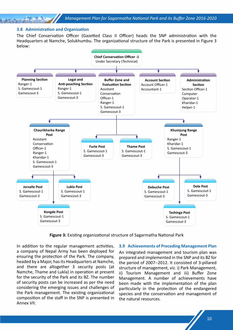
3.8 Administration and OrganizationThe Chief Conservation Officer (Gazetted Class II Officer) heads the SNP administration with the Headquarters at Namche, Solukhumbu. The organizational structure of the Park is presented in Figure 3 below:
Tashinga PostS. Gamescout-1Gamescout-3
Dole PostS. Gamescout-1Gamescout-3
Debuche PostS. Gamescout-1Gamescout-3
Chief Conservation Officer -1Under Secretary (Technical)
Account SectionAccount Officer-1Accountant-1
Legal and Anti-poaching SectionRanger-1S. Gamescout-1Gamescout-3
Buffer Zone and Evaluation Section
Assistant Conservation Officer-1 Ranger-1S. Gamescout-1Gamescout-3
Administration Section
Section Officer-1Computer Operator-1Kharidar-1Helper-1
Planning SectionRanger-1S. Gamescout-1Gamescout-3
Thame PostS. Gamescout-1Gamescout-3
Khumjung Range Post
Ranger-1Kharidar-1S. Gamescout-1Gamescout-3
Chaurikharka Range Post
Assistant Conservation Officer-1Ranger-1Kharidar-1S. Gamescout-1Gamescout-3
Furte PostS. Gamescout-1Gamescout-3
Kongde PostS. Gamescout-1Gamescout-3
Lukla PostS. Gamescout-1Gamescout-3
Jorsalle PostS. Gamescout-1Gamescout-3
Figure 3: Existing organizational structure of Sagarmatha National Park
In addition to the regular management activities, a company of Nepal Army has been deployed for ensuring the protection of the Park. The company, headed by a Major, has its Headquarters at Namche, and there are altogether 3 security posts (at Namche, Thame and Lukla) in operation at present for the security of the Park and its BZ. The number of security posts can be increased as per the need considering the emerging issues and challenges of the Park management. The existing organizational composition of the staff in the SNP is presented in Annex VII.
3.9 Achievements of Preceding Management PlanAn integrated management and tourism plan was prepared and implemented in the SNP and its BZ for the period of 2007−2012. It consisted of 3-pillared structure of management, viz. i) Park Management, ii) Tourism Management and iii) Buffer Zone Management. A number of achievements have been made with the implementation of the plan particularly in the protection of the endangered species and the conservation and management of the natural resources.
10
Management Plan for Sagarmatha National Park and its Buffer Zone 2016-2020
3.10 Strength, Weakness, Oppurtunity and Threat (SWOT) Analysis
3.10.1StrengthsNatural world heritage property which draws
attention of the global community as well for its conservation;
Renowned destination for mountaineering-based tourism;
Substantial revenue from tourism which has been recycled for conservation and development through buffer zone; and
Encouraging partnership with local communities and stakeholders, including national and global conservation organizations.
3.10.2 WeaknessesSite-specific tourism and issues regarding
equitable tourism benefits;Limited access to the Park;Resource dependency of the local people; and
Inadequate number of staff for execution of daily and emergency activities.
3.10.3 OpportunitiesDiversification of eco-tourism and involvement
of the local people in such enterprises;Opportunities for research through collaboration
at different levels;Potential for self sufficiency of the resources
required for conservation from ecotourism.
3.10.4 ThreatsPoaching continues to be a threat as market
value for illegal wildlife parts exists;Unregulated and concentrated tourism;Traditional resource dependency of the local
people;Potential impact of climate change such as glacier
retreat and GLOF on biodiversity conservation and livelihood of the local communities.
11

Management Plan for Sagarmatha National Park and its Buffer Zone 2016-2020
PART B
THEPROPOSED
MANAGEMENT
12

Management Plan for Sagarmatha National Park and its Buffer Zone 2016-2020
Chapter IV
Vision, Goal and Objectives4.1 Vision StatementSagarmatha National Park along with its Buffer Zone is visualized as an area of representative example of biodiversity in the highest point of the world which is managed to enhance the unique biodiversity and maintain outstanding universal value of the area with active community participation that eventually supports for the welfare of human being in perpetuity.
4.2 Management GoalThe goal of Sagarmatha National Park and its Buffer Zone management is to conserve and maintain the biological and cultural values, and scenic beauty of the Park’s landscape for the benefit of the present and future generations primarily as sources of inspiration, recreation, education and glory; and to support livelihoods of the local people in a manner that maintains ecological integrity.
4.3 Management ObjectivesThe main objective of Sagarmatha National Park and its Buffer Zone management is to enhance biodiversity of the Park, promote ecotourism and regulate it where necessary to maintain delicate balance between conservation and tourism needs and also support the livelihoods of the local community through effective management of natural and cultural heritage. The specific objectives are:
4.3.1 To conserve biodiversity with special focus on nationally protected and globally-threatened wildlife species and their habitat in order to maintain ecological functions and processes;
4.3.2 To promote sustainable tourism and regulate it for maintaining ecological integrity and cultural heritage;
4.3.3 To enhance community stewardship on biodiversity conservation by increasing awareness and improving livelihood of the local people; and
4.3.4 To strengthen institutional capacity through research, capacity building, coordination and collaboration.
4.4 Problems in achieving ObjectivesThere are several problems in achieving future desired condition of the Park. Some of the problems that may hinder to attain the above-mentioned objectives are as follows:
Objective1To conserve biodiversity with special focus onnationally protected and globally threatenedwildlife species and their habitats in order tomaintainecologicalfunctionsandprocesses.• Poaching of musk deer for illegal trade of musk
pod;• Biotic pressure from tourism activities in certain
areas of the Park that obstructs maintaining inviolate-area for snow leopard and other wildlife species;
• Inadequate ecological information;• Inadequacy of infrastructure and limited budget
for its maintenance;• Inadequate trans-boundary cooperation with
the TAR of China;• Inadequate budget for carrying out the
protection-activities of the Park;• Inadequacy of linkages between research
findings and management;• Remoteness and limited accessibility to the
Park;• Harsh climatic condition that hinders staff
mobility for patrolling of the Park; • Inadequate number of staff and capacity;• Unregulated grazing in the Park and its BZ;• Traditional resource-dependency of the people
living in the village enclaves inside and around the Park;
• Glacial retreat as an impact of climate change; and
• Inadequate research, monitoring and baseline data on hydrological functions.
Objective2To promote sustainable tourism and regulate itfor maintaining ecological integrity and culturalheritage.• Concentrated and unregulated tourism activities
in the Park;
13
Management Plan for Sagarmatha National Park and its Buffer Zone 2016-2020
• Tourism opportunities not adequately explored in the Buffer Zone;
• Tourism infrastructure not planned well;• Increasing demands for new tourism activities
such as mountain biking, sky-gliding and marathon events;
• Increased disturbance to the wildlife species and their habitats from tourism;
• Lack of separate unit and dedicated staff to look after tourism management;
• Lack of tourism policy to deal with the concentrated tourism inflows in few areas; and
• Inadequate mechanism to manage crowd and garbage.
Objective3To enhance community stewardship onbiodiversityconservationbyincreasingawarenessandimprovinglivelihoodofthelocalpeople.• Inadequate conservation awareness programme
and illiteracy of the people living around Park;• Crop damage and livestock depredation by wild
animals; • Inadequate livelihood opportunities for the
local people living in the off-route settlements;
• Release of budget for buffer zone program generally not in time;
• Free grazing and dependency of the local people in the Park for resources; and
• Increasing populations of predators and prey.
Objective4To strengthen institutional capacity throughresearch, capacity building, coordination andcollaboration.• Inadequate collaboration with the concerned
universities and research institutions;• Lack of plan for continuation of research
activities as well as initiation of new research;• Lack of research prioritization;• Inadequate linkages between research and
management needs;• Limited budget for ecological monitoring and
research;• Lack of adaptive management;• Lack of clear policy for Human Resource
Development (HRD);• Insufficient incentives, rewards, amenities and
welfare for staff motivation.
14
Management Plan for Sagarmatha National Park and its Buffer Zone 2016-2020
Chapter V
Management Strategies5.1. Boundaries5.1.1. LegalSagarmatha National Park (1,148 km2) and its Buffer Zone (275 km2) was declared according to the National Parks and Wildlife Conservation Act, 1973. The boundaries of Sagarmatha National Park and its Buffer Zone is well defined and duly notified with the publication in Nepal Gazette. The area of the Park is well demarcated on ground with natural features such as rivers, ridges and other land features. The land in the periphery of the Park as well as the village enclaves inside the National Park comprises the buffer zone.
5.1.2. AdministrativeThe core area of SNP lies within Namche and Khumjung VDCs as well as the northern part of Chaurikharka VDC of the Solukhumbu district. There are several village enclaves inside the National Park Boundary but these settlements are excluded from the National Park.
5.1.3. EcologicalSNP itself is an ecological unit in the highest region of the world. The Park and its Buffer Zone (1,423 km2) has a landscape continuity with the Makalu Barun National Park and its Buffer Zone (2,330 km2) on the east, Qomolangma Nature
Preserve (35,000 km2) in Tibet on the north and the Gaurishankar Conservation Area (2,179 km2) on the west. The combined area of the SNP, MBNP, QNP and GCA is over 40,000 Km2, which forms one of the largest protected area complexes in the high mountain ecosystem. Therefore, SNP along with the surrounding landscape is considered to be ecologically inclusive and needs cooperation between Nepal and China to conserve biodiversity at trans-boundary landscape-level.
5.2. ZonationSNP does not have an effective land use zoning system in place. The enclave settlements are not zoned and mapped, creating difficulty in protecting public lands. Similarly, there is a lack of policies or zoning system for development of tourism infrastructure in the Park. In order to harmonize the conflicting objectives and maximize the efforts to protect, maintain and enhance the wildlife habitats as well as the management of visitors in the sensitive environment in effective way, the following zones have been proposed:
5.2.1. ManagementFacilityZoneThis is the zone inside the Park occupied by the infrastructures developed for office and accommodation for the Park staff and army personnel. It comprises the area occupied by security and the Park posts (Army and National Park) established and operated in the Park.
15
Management Plan for Sagarmatha National Park and its Buffer Zone 2016-2020
5.2.2. UtilityZoneThis is an area of the Park allocated for limited recreational activities for the visitors along with nature interpretation services for conservation awareness. There are few tourism infrastructures developed inside the Park, including the visitor center and museum at Namche. The main objective of managing this zone is to regulate tourism in the core area to minimize the disturbance to the wildlife species and their habitats and to enhance visitors’ satisfaction through providing wilderness experience.
5.2.3. CoreZoneThe area of the National Park except the area allocated for management facilities, tourism routes and public right for way, falls under the Core Zone (see also Table 2 below). The key objective of this zone i s to provide the suitable habitats for wildlife and to encourage research and science-based management intervention.
Table 2: Management Zones of Sagarmatha National ParkSN Name of the Zone Brief description of the zone1 Management Facility Zone Area occupied by the infrastructure developed for the management
of the Park2 Utility Zone Facilities developed for regulated tourism and public right for way3 Core Zone Area of the national park except the area occupied by management
facilities, tourism routes and public right for way
5.3. Theme PlansOf the five broad thematic areas, two thematic areas, viz. i) park protection and conservation of biodiversity, and ii) habitat management have been covered in this chapter. The remaining three have been dealt in separate chapters.
5.3.1. ProtectionandConservationofBiodiversity5.3.1.1.ParkProtection5.3.1.1.1.ContextandIssuesSNP has witnessed several challenges in its history of four decades in park protection. The concept of protection was started with the establishment of the
SNP in 1976 whereas the Government has deployed Nepalese Army for park protection. There are park security posts (National Park, Army and combined) in 9 different locations in the core and the buffer zone of the Park. Park security is regarded as a pre-requisite for the successful management of the SNP as control of illegal activities is mandatory before taking any management intervention. Therefore, emphasis has been given on strengthening the park protection system through a good network of strategically located park security posts, improved basic facilities at security posts, effective and reliable communication facilities and dedicated staff for regular patrolling of the Park.
16
Management Plan for Sagarmatha National Park and its Buffer Zone 2016-2020
5.3.1.1.2.ActivitiesIn order to ensure protection of the Park, regular patrolling of the Park is essential as there is no shortcut to ‘Boots on ground’ for effective protection of the Park. Thus, the plan suggests the strengthening of existing practices related to park patrolling. The following strategies and activities have been recommended to enhance the effectiveness of park protection:Establish five security posts (at Jorsalle,
Chheplung, Kongde, Phungithanga and Dole) to cover the gap areas and define and demarcate the Area of Responsibility (AoR) of each security post;
Continue regular patrolling of the Park by the Park Staff and the Army deployed in the Park Security Posts to ensure that there are no illegal activities in their respective AoR;
Maintain regular foot patrolling in the accessible areas, and change the time and route of patrolling randomly;
Sweep the area from the respective posts once in a month, and carefully observe for the trap set for musk deer and other wildlife species;
Conduct camping and sweeping operation by a joint team from the Headquarters once in three months;
Provide field-gear and equipment suitable for the operation in the high-altitude areas;
Initiate the use of cutting-edge technologies such as Conservation Drone to monitor key species and their habitat in the park; and
Initiate real time SMART patrolling in the SNP.
5.3.1.2.Anti-poachingandIntelligenceGathering5.3.1.2.1.ContextandIssuesPoaching of musk deer is one of the serious issues of concern for SNP management. Likewise, likelihood of retaliatory killing or poaching of snow leopard and other wildlife species in the SNP and its BZ could not be ignored. However, the Park does not have a network of informants for intelligence gathering at present. Thus, there is a need of developing a network of informants and strengthening their capacity for regularly gathering intelligence as well as keeping eye on the suspicious persons and their activities.
5.3.1.2.2.ActivitiesForm and institutionalize Anti-poaching Unit
(APU) and intelligence network;
Initiate long-term surveillance of the suspicious persons, areas and their activities;
Institutionalize Community-based Anti-poaching Operation (CBAPO);
Build capacity of informants to ensure that our approach of intelligence gathering is not detrimental;
Encourage and mobilize eco-clubs, students and local clubs against poaching and other illegal activities; and
Strengthen trans-boundary cooperation with the TAR of China.
5.3.1.3.WildlifeHealthManagement5.3.1.3.1.ContextandIssuesFrequent interaction between the wild animals and the domestic livestock is obvious while sharing the same rangelands or waterholes by both as there are a number of villages in and around the Park. Besides, the wild animals may come in contact with the domestic livestock while straying out of the core area. Since there is the risk of transferring disease from the livestock to the wild animals and vice versa, health monitoring and surveillance for the wild animal diseases should be done regularly. Besides, regular and timely immunization of the domestic livestock around the Park against the major diseases is needed to prevent disease outbreak.
5.3.1.3.2.ActivitiesSince medical treatment of the free-ranging animals requires lots of investments and is not possible in many cases, it would be wise to give emphasis on preventive measures. The strategies to be followed for wildlife health management in the SNP are: Immunize livestock against endemic diseases
within the enclave settlements and in the buffer zone;
17
Management Plan for Sagarmatha National Park and its Buffer Zone 2016-2020
Coordinate with District Livestock Service Office (DLSO) and seek their support whenever required;
Support to establish a community based veterinary center with materials required in medical emergencies;
Build the capacity of frontline staff to recognize, record and report disease or poor health condition of the wild animals or plants;
Report and document mortality of the wild animals immediately after they come to notice to any staff as part of disease surveillance strategy; and
Initiate the postmortem of the dead wild animals with the support from veterinary office.
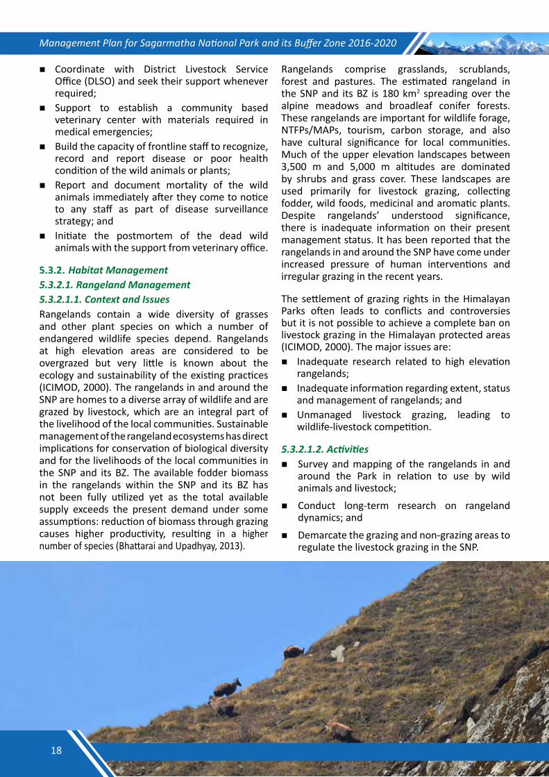
5.3.2. HabitatManagement5.3.2.1.RangelandManagement5.3.2.1.1.ContextandIssuesRangelands contain a wide diversity of grasses and other plant species on which a number of endangered wildlife species depend. Rangelands at high elevation areas are considered to be overgrazed but very little is known about the ecology and sustainability of the existing practices (ICIMOD, 2000). The rangelands in and around the SNP are homes to a diverse array of wildlife and are grazed by livestock, which are an integral part of the livelihood of the local communities. Sustainable management of the rangeland ecosystems has direct implications for conservation of biological diversity and for the livelihoods of the local communities in the SNP and its BZ. The available fodder biomass in the rangelands within the SNP and its BZ has not been fully utilized yet as the total available supply exceeds the present demand under some assumptions: reduction of biomass through grazing causes higher productivity, resulting in a higher number of species (Bhattarai and Upadhyay, 2013).
Rangelands comprise grasslands, scrublands, forest and pastures. The estimated rangeland in the SNP and its BZ is 180 km2 spreading over the alpine meadows and broadleaf conifer forests. These rangelands are important for wildlife forage, NTFPs/MAPs, tourism, carbon storage, and also have cultural significance for local communities. Much of the upper elevation landscapes between 3,500 m and 5,000 m altitudes are dominated by shrubs and grass cover. These landscapes are used primarily for livestock grazing, collecting fodder, wild foods, medicinal and aromatic plants. Despite rangelands’ understood significance, there is inadequate information on their present management status. It has been reported that the rangelands in and around the SNP have come under increased pressure of human interventions and irregular grazing in the recent years.
The settlement of grazing rights in the Himalayan Parks often leads to conflicts and controversies but it is not possible to achieve a complete ban on livestock grazing in the Himalayan protected areas (ICIMOD, 2000). The major issues are: Inadequate research related to high elevation
rangelands; Inadequate information regarding extent, status
and management of rangelands; andUnmanaged livestock grazing, leading to
wildlife-livestock competition.
5.3.2.1.2.Activities Survey and mapping of the rangelands in and
around the Park in relation to use by wild animals and livestock;
Conduct long-term research on rangeland dynamics; and
Demarcate the grazing and non-grazing areas to regulate the livestock grazing in the SNP.
18
Management Plan for Sagarmatha National Park and its Buffer Zone 2016-2020
5.3.2.2.WetlandManagement5.3.2.2.1.ContextandIssuesConservation of high mountain wetlands has become an increasingly significant global issue in the recent years, especially given that these wetlands function as water towers for the world. They are important resting sites and habitats for a significant number of migratory and some resident
water birds. The high-altitude flora and fauna are important for global biological diversity as there are very few other places where life exists at such unique high altitudes. In Nepal, very limited studies and research have been conducted focusing on high mountain wetlands. There is paucity of information, therefore, making it difficult to get a clear idea on their status especially with regards to the threats and their management.
The snow-fed Dudh Koshi and Imja Khola originating from the Himalayas and the TAR of China are the main aquatic habitats in the Khumbu region. In addition, there are many glacial lakes that harbor wetland habitats for migratory birds. However, there is no evidence of aquatic life in its river systems and lakes due to icy-cold temperature (SNP, 2003). The Gokyo and the associated wetlands of the Park enlisted in Ramsar site designated in 2007 cover an area of 7,700 ha. Its altitude ranges from 4,600 m to 5,500 m. Out of the cluster of 6 lakes, Gokyo is the most important wetland, and is believed to be the abode of snake-god, and is, therefore, culturally important. It is a glacier-fed natural freshwater lake. The lake along with the Ngozumpa Glacier is the headwater of the Bhote Koshi River. The local people are dependent on the site for ecotourism which is the main economic activity of the people living there. Water pollution, over-grazing of pastures, unsustainable harvest of natural resources and likely impact of climate change are
the major conservation issues that threaten the Gokyo and the associated lakes (DNPWC, 2008). High-altitude wetlands are naturally vulnerable as these lye in an ecologically fragile and unstable zone; the movement of Nojumba Glacier is always a threat to the existence of the lakes. Glacial Lake Outburst Floods (GLOFs), pollution, overgrazing, unsustainable harvesting of resources are the pronounced threats to wetlands. The major issues for the management of wetlands in the SNP are: Inadequate information: research and
information;Lack of integrated wetland management:
multiple ownership and management; Poor coordination: no formal established
coordination mechanism;Poor institutional mechanism: both formal and
informal; Impact of climate change in the high-altitude
wetlands;
19
Management Plan for Sagarmatha National Park and its Buffer Zone 2016-2020
Pollution in the high-altitude wetlands;Overgrazing and unsustainable harvesting of the
resources including the NTFPs in the catchment areas; and
Garbage and sewage left by the visitors because of unregulated tourism.
5.3.2.2.2.ActivitiesPrepare inventory of wetlands and conduct
assessment for water quality;Conduct regular monitoring of the Gokyo and
the associated lakes in order to keep the lake and surroundings free from pollution (see also Table 3);
Fill up the Ramsar Information Sheet (RIS) of
the Gokyo and the associated lakes every year, and report to the Ramsar Secretariat at every six years;
Update the Site Management Plan of the Gokyo and the associated lakes, and implement it with active participation of the local communities;
Strengthen awareness programs for conservation of the wetlands;
Conduct trainings on the alternative income-generation activities so as to reduce the dependency of the local people on wetlands;
Educate the local people, especially the children on the importance of wetlands for the human-being, and conduct interactions and meetings amongst the stakeholders on conservation of wetlands regularly.
Table 3: Priority areas of action for the management and proper use of the Gokyo and the associated lakesAt strategic-level
1. Adopt zoning system of the lake area at the sub-catchment scale;2. Promote sustainable wetland eco-tourism; 3. Raise community awareness regarding value of the Himalayan wetlands;4. Promote the use of non-wood energy; and 5. Facilitate action research and monitoring.
At site-level6. Take actions to control pollution of the Gokyo Lake;7. Manage the overgrazing on the pastures;8. Put legal and social sanctions on the unsustainable harvest of the natural resources;9. Take legal and social actions against encroachment; and10. Study the impact of climate change in the area.
Source: DNPWC, 2008
5.3.2.3.FireManagement5.3.2.3.1.ContextandIssuesForest fire is another threat to the Park biodiversity as the Park and its surroundings are popular for pine forests. Pines are fire prone species, so forest fire occasionally occurs and creates severe impacts in the forests. The local BZUCs are closely working with the Park Authority to control the forest fire. The trend shows that fire incidents have increased in the SNP mostly in the hot summer seasons. The main objective of fire management in the SNP is to prevent accidental fire so as to avoid the adverse effects of fire on the wildlife species and their habitats.
5.3.2.3.2.ActivitiesSince there is no strategy for fire management in the SNP at present, the following strategies are prescribed in this plan: Identify fire-prone areas using the topographical
map based on satellite imagery analysis or using the web-based fire-mapping software, and manage accordingly for fire prevention;
Conduct trainings on fire-fighting techniques both to the Park Staff and the local people; and
Raise awareness on fire prevention and forest fire control.
20
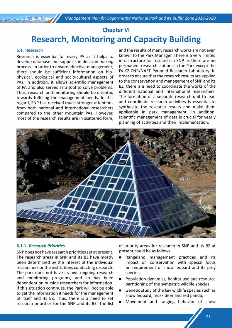
Management Plan for Sagarmatha National Park and its Buffer Zone 2016-2020
Chapter VI
Research, Monitoring and Capacity Building6.1. ResearchResearch is essential for every PA as it helps to develop database and supports in decision making process. In order to ensure effective management, there should be sufficient information on bio-physical, ecological and socio-cultural aspects of PAs. In addition, it allows scientific management of PA and also serves as a tool to solve problems. Thus, research and monitoring should be oriented towards fulfilling the management needs. In this regard, SNP has received much stronger attentions from both national and international researchers compared to the other mountain PAs. However, most of the research results are in scattered form,
and the results of many research works are not even known to the Park Manager. There is a very limited infrastructure for research in SNP as there are no permanent research stations in the Park except the Ev-K2-CNR/NAST Pyramid Research Laboratory. In order to ensure that the research results are applied to the conservation and management of SNP and its BZ, there is a need to coordinate the works of the different national and international researchers. The formation of a separate research unit to lead and coordinate research activities is essential to synthesize the research results and make them applicable in park management. In addition, scientific management of data is crucial for yearly planning of activities and their implementation.
6.1.1. ResearchPrioritiesSNP does not have research priorities set at present. The research areas in SNP and its BZ have mostly been determined by the interest of the individual researchers or the institutions conducting research. The park does not have its own ongoing research and monitoring programs, and so has been dependent on outside researchers for information. If this situation continues, the Park will not be able to get the information it needs for the management of itself and its BZ. Thus, there is a need to set research priorities for the SNP and its BZ. The list
of priority areas for research in SNP and its BZ at present could be as follows:Rangeland management practices and its
impact on conservation with special focus on requirement of snow leopard and its prey species;
Population dynamics, habitat use and resource partitioning of the sympatric wildlife species;
Genetic study of the key wildlife species such as snow leopard, musk deer and red panda;
Movement and ranging behavior of snow
21
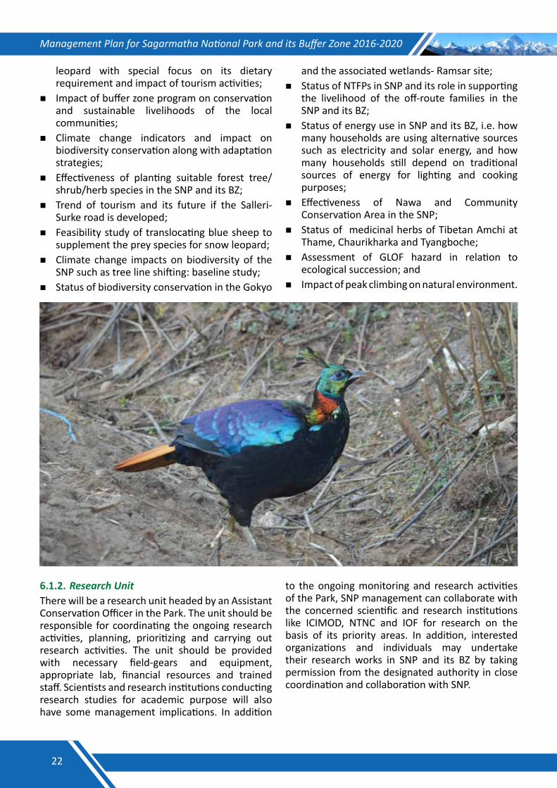
Management Plan for Sagarmatha National Park and its Buffer Zone 2016-2020
leopard with special focus on its dietary requirement and impact of tourism activities;
Impact of buffer zone program on conservation and sustainable livelihoods of the local communities;
Climate change indicators and impact on biodiversity conservation along with adaptation strategies;
Effectiveness of planting suitable forest tree/shrub/herb species in the SNP and its BZ;
Trend of tourism and its future if the Salleri-Surke road is developed;
Feasibility study of translocating blue sheep to supplement the prey species for snow leopard;
Climate change impacts on biodiversity of the SNP such as tree line shifting: baseline study;
Status of biodiversity conservation in the Gokyo
and the associated wetlands- Ramsar site;Status of NTFPs in SNP and its role in supporting
the livelihood of the off-route families in the SNP and its BZ;
Status of energy use in SNP and its BZ, i.e. how many households are using alternative sources such as electricity and solar energy, and how many households still depend on traditional sources of energy for lighting and cooking purposes;
Effectiveness of Nawa and Community Conservation Area in the SNP;
Status of medicinal herbs of Tibetan Amchi at Thame, Chaurikharka and Tyangboche;
Assessment of GLOF hazard in relation to ecological succession; and
Impact of peak climbing on natural environment.
6.1.2. ResearchUnitThere will be a research unit headed by an Assistant Conservation Officer in the Park. The unit should be responsible for coordinating the ongoing research activities, planning, prioritizing and carrying out research activities. The unit should be provided with necessary field-gears and equipment, appropriate lab, financial resources and trained staff. Scientists and research institutions conducting research studies for academic purpose will also have some management implications. In addition
to the ongoing monitoring and research activities of the Park, SNP management can collaborate with the concerned scientific and research institutions like ICIMOD, NTNC and IOF for research on the basis of its priority areas. In addition, interested organizations and individuals may undertake their research works in SNP and its BZ by taking permission from the designated authority in close coordination and collaboration with SNP.
22
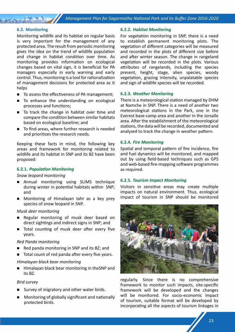
Management Plan for Sagarmatha National Park and its Buffer Zone 2016-2020
6.2. Monitoring Monitoring wildlife and its habitat on regular basis is very important for the management of any protected area. The result from periodic monitoring gives the idea on the trend of wildlife population and change in habitat condition over time. As monitoring provides information on ecological changes based on vital sign, it is beneficial for PA managers especially in early warning and early control. Thus, monitoring is a tool for rationalization of management decisions for protected area as it helpsTo assess the effectiveness of PA management;To enhance the understanding on ecological
processes and functions;To track the change in habitat over time and
compare the condition between similar habitats based on ecological baseline; and
To find areas, where further research is needed and prioritizes the research needs.
Keeping these facts in mind, the following key areas and framework for monitoring related to wildlife and its habitat in SNP and its BZ have been proposed:
6.2.1. PopulationMonitoringSnow leopard monitoringAnnual monitoring using SLIMS technique
during winter in potential habitats within SNP; and
Monitoring of Himalayan tahr as a key prey species of snow leopard in SNP.
Musk deer monitoringRegular monitoring of musk deer based on
direct sightings and indirect signs in SNP; and Total counting of musk deer after every five
years. Red Panda monitoringRed panda monitoring in SNP and its BZ; and Total count of red panda after every five years.Himalayan black bear monitoringHimalayan black bear monitoring in theSNP and
its BZ.
Bird survey
Survey of migratory and other water birds.
Monitoring of globally significant and nationally protected birds.
6.2.2. HabitatMonitoringFor vegetation monitoring in SNP, there is a need to establish permanent monitoring plots. The vegetation of different categories will be measured and recorded in the plots of different size before and after winter season. The change in rangeland vegetation will be recorded in the plots. Various attributes of rangelands, including the species present, height, stage, alien species, woody vegetation, grazing intensity, unpalatable species and sign of wildlife species will be recorded.
6.2.3. WeatherMonitoringThere is a meteorological station managed by DHM at Namche in SNP. There is a need of another two meteorological stations in the Park, one in the Everest base-camp area and another in the Jorsalle area. After the establishment of the meteorological stations, the data will be recorded, documented and analyzed to track the change in weather pattern.
6.2.4. FireMonitoringSpatial and temporal pattern of fire incidence, fire and fuel dynamics will be monitored, and mapped out by using field-based techniques such as GPS and web-based fire-mapping software programmes as required.
6.2.5. TourismImpactMonitoringVisitors in sensitive areas may create multiple impacts on natural environment. Thus, ecological impact of tourism in SNP should be monitored
regularly. Since there is no comprehensive framework to monitor such impacts, site-specific framework will be developed and the changes will be monitored. For socio-economic impact of tourism, suitable format will be developed by incorporating all the aspects of tourism linkages in
23
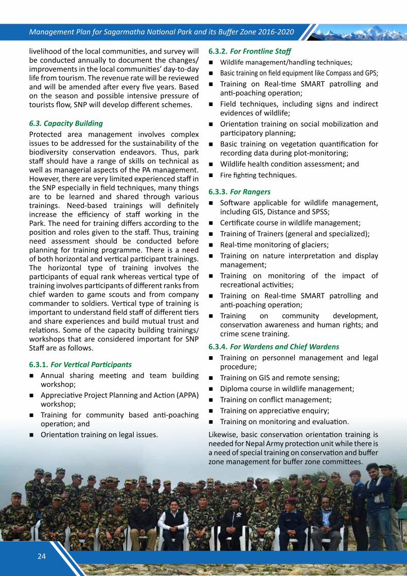
Management Plan for Sagarmatha National Park and its Buffer Zone 2016-2020
livelihood of the local communities, and survey will be conducted annually to document the changes/improvements in the local communities’ day-to-day life from tourism. The revenue rate will be reviewed and will be amended after every five years. Based on the season and possible intensive pressure of tourists flow, SNP will develop different schemes.
6.3.CapacityBuildingProtected area management involves complex issues to be addressed for the sustainability of the biodiversity conservation endeavors. Thus, park staff should have a range of skills on technical as well as managerial aspects of the PA management. However, there are very limited experienced staff in the SNP especially in field techniques, many things are to be learned and shared through various trainings. Need-based trainings will definitely increase the efficiency of staff working in the Park. The need for training differs according to the position and roles given to the staff. Thus, training need assessment should be conducted before planning for training programme. There is a need of both horizontal and vertical participant trainings. The horizontal type of training involves the participants of equal rank whereas vertical type of training involves participants of different ranks from chief warden to game scouts and from company commander to soldiers. Vertical type of training is important to understand field staff of different tiers and share experiences and build mutual trust and relations. Some of the capacity building trainings/workshops that are considered important for SNP Staff are as follows.
6.3.1. ForVerticalParticipantsAnnual sharing meeting and team building
workshop;Appreciative Project Planning and Action (APPA)
workshop; Training for community based anti-poaching
operation; andOrientation training on legal issues.
6.3.2. ForFrontlineStaffWildlife management/handling techniques;Basic training on field equipment like Compass and GPS;Training on Real-time SMART patrolling and
anti-poaching operation;Field techniques, including signs and indirect
evidences of wildlife; Orientation training on social mobilization and
participatory planning;Basic training on vegetation quantification for
recording data during plot-monitoring;Wildlife health condition assessment; andFire fighting techniques.
6.3.3. ForRangersSoftware applicable for wildlife management,
including GIS, Distance and SPSS;Certificate course in wildlife management;Training of Trainers (general and specialized);Real-time monitoring of glaciers;Training on nature interpretation and display
management;Training on monitoring of the impact of
recreational activities;Training on Real-time SMART patrolling and
anti-poaching operation;Training on community development,
conservation awareness and human rights; and crime scene training.
6.3.4. ForWardensandChiefWardensTraining on personnel management and legal
procedure;Training on GIS and remote sensing;Diploma course in wildlife management;Training on conflict management; Training on appreciative enquiry;Training on monitoring and evaluation. Likewise, basic conservation orientation training is needed for Nepal Army protection unit while there is a need of special training on conservation and buffer zone management for buffer zone committees.
24
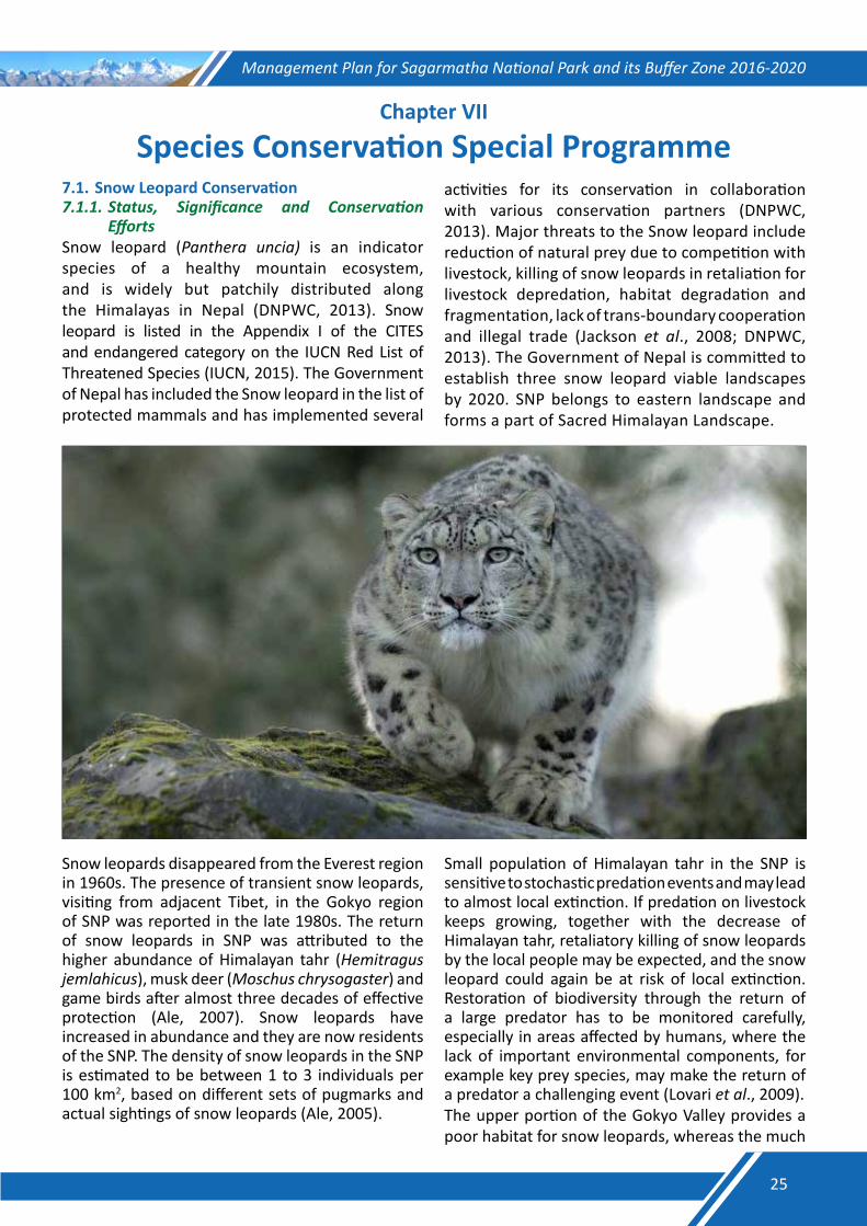
Management Plan for Sagarmatha National Park and its Buffer Zone 2016-2020
Chapter VII
Species Conservation Special Programme7.1. Snow Leopard Conservation 7.1.1.Status, Significance and Conservation
EffortsSnow leopard (Panthera uncia) is an indicator species of a healthy mountain ecosystem, and is widely but patchily distributed along the Himalayas in Nepal (DNPWC, 2013). Snow leopard is listed in the Appendix I of the CITES and endangered category on the IUCN Red List of Threatened Species (IUCN, 2015). The Government of Nepal has included the Snow leopard in the list of protected mammals and has implemented several
activities for its conservation in collaboration with various conservation partners (DNPWC, 2013). Major threats to the Snow leopard include reduction of natural prey due to competition with livestock, killing of snow leopards in retaliation for livestock depredation, habitat degradation and fragmentation, lack of trans-boundary cooperation and illegal trade (Jackson et al., 2008; DNPWC, 2013). The Government of Nepal is committed to establish three snow leopard viable landscapes by 2020. SNP belongs to eastern landscape and forms a part of Sacred Himalayan Landscape.
Snow leopards disappeared from the Everest region in 1960s. The presence of transient snow leopards, visiting from adjacent Tibet, in the Gokyo region of SNP was reported in the late 1980s. The return of snow leopards in SNP was attributed to the higher abundance of Himalayan tahr (Hemitragus jemlahicus), musk deer (Moschus chrysogaster) and game birds after almost three decades of effective protection (Ale, 2007). Snow leopards have increased in abundance and they are now residents of the SNP. The density of snow leopards in the SNP is estimated to be between 1 to 3 individuals per 100 km2, based on different sets of pugmarks and actual sightings of snow leopards (Ale, 2005).
Small population of Himalayan tahr in the SNP is sensitive to stochastic predation events and may lead to almost local extinction. If predation on livestock keeps growing, together with the decrease of Himalayan tahr, retaliatory killing of snow leopards by the local people may be expected, and the snow leopard could again be at risk of local extinction. Restoration of biodiversity through the return of a large predator has to be monitored carefully, especially in areas affected by humans, where the lack of important environmental components, for example key prey species, may make the return of a predator a challenging event (Lovari et al., 2009).The upper portion of the Gokyo Valley provides a poor habitat for snow leopards, whereas the much
25
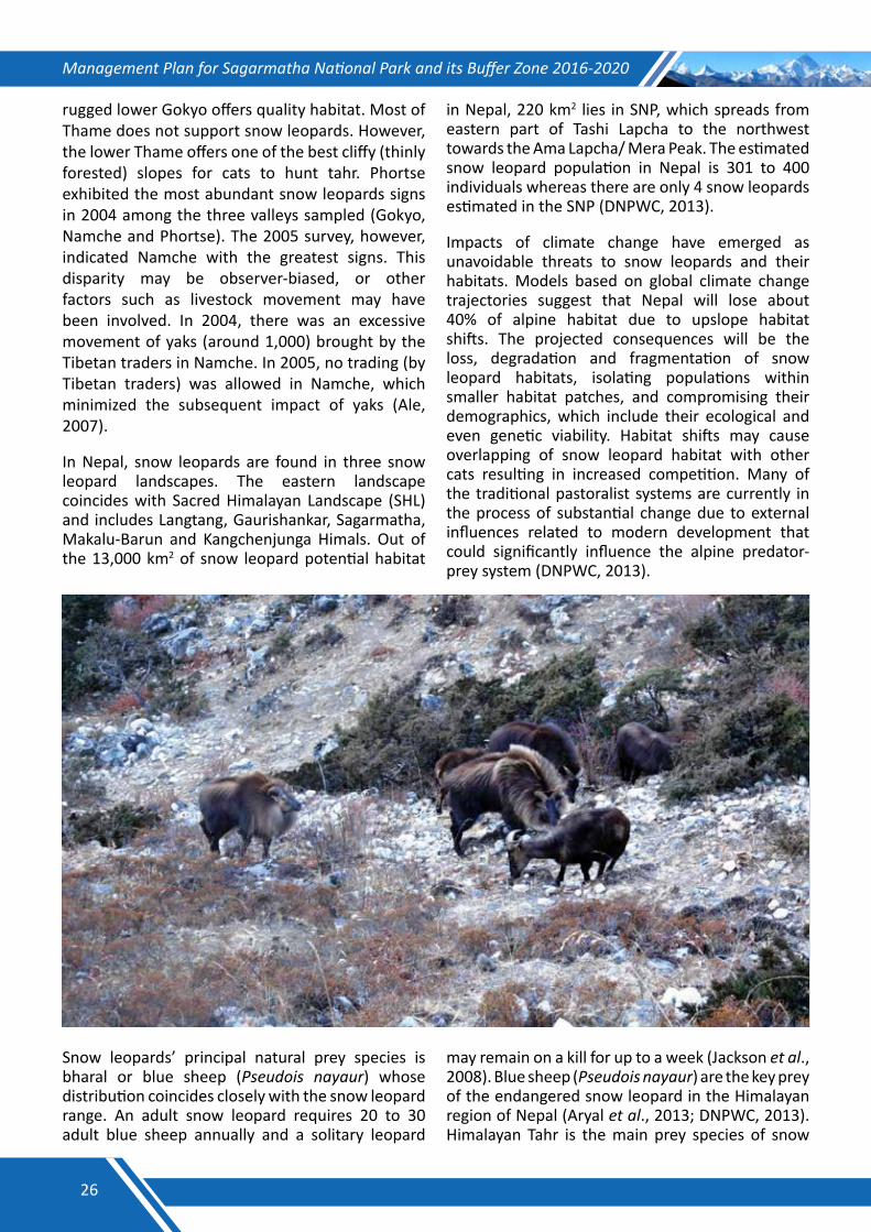
Management Plan for Sagarmatha National Park and its Buffer Zone 2016-2020
rugged lower Gokyo offers quality habitat. Most of Thame does not support snow leopards. However, the lower Thame offers one of the best cliffy (thinly forested) slopes for cats to hunt tahr. Phortse exhibited the most abundant snow leopards signs in 2004 among the three valleys sampled (Gokyo, Namche and Phortse). The 2005 survey, however, indicated Namche with the greatest signs. This disparity may be observer-biased, or other factors such as livestock movement may have been involved. In 2004, there was an excessive movement of yaks (around 1,000) brought by the Tibetan traders in Namche. In 2005, no trading (by Tibetan traders) was allowed in Namche, which minimized the subsequent impact of yaks (Ale, 2007).
In Nepal, snow leopards are found in three snow leopard landscapes. The eastern landscape coincides with Sacred Himalayan Landscape (SHL) and includes Langtang, Gaurishankar, Sagarmatha, Makalu-Barun and Kangchenjunga Himals. Out of the 13,000 km2 of snow leopard potential habitat
in Nepal, 220 km2 lies in SNP, which spreads from eastern part of Tashi Lapcha to the northwest towards the Ama Lapcha/ Mera Peak. The estimated snow leopard population in Nepal is 301 to 400 individuals whereas there are only 4 snow leopards estimated in the SNP (DNPWC, 2013).
Impacts of climate change have emerged as unavoidable threats to snow leopards and their habitats. Models based on global climate change trajectories suggest that Nepal will lose about 40% of alpine habitat due to upslope habitat shifts. The projected consequences will be the loss, degradation and fragmentation of snow leopard habitats, isolating populations within smaller habitat patches, and compromising their demographics, which include their ecological and even genetic viability. Habitat shifts may cause overlapping of snow leopard habitat with other cats resulting in increased competition. Many of the traditional pastoralist systems are currently in the process of substantial change due to external influences related to modern development that could significantly influence the alpine predator-prey system (DNPWC, 2013).
Snow leopards’ principal natural prey species is bharal or blue sheep (Pseudois nayaur) whose distribution coincides closely with the snow leopard range. An adult snow leopard requires 20 to 30 adult blue sheep annually and a solitary leopard
may remain on a kill for up to a week (Jackson et al., 2008). Blue sheep (Pseudois nayaur) are the key prey of the endangered snow leopard in the Himalayan region of Nepal (Aryal et al., 2013; DNPWC, 2013). Himalayan Tahr is the main prey species of snow
26
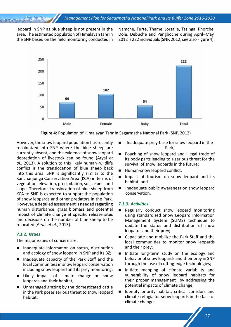
Management Plan for Sagarmatha National Park and its Buffer Zone 2016-2020
leopard in SNP as blue sheep is not present in the area. The estimated population of Himalayan tahr in the SNP based on the field monitoring conducted in
Namche, Furte, Thame, Jorsalle, Tasinga, Phorche, Dole, Debuche and Pangboche during April−May, 2012 is 222 individuals (SNP, 2012, see also Figure 4).
Figure 4: Population of Himalayan Tahr in Sagarmatha National Park (SNP, 2012)
However, the snow leopard population has recently recolonized into SNP where the blue sheep are currently absent, and the evidence of snow leopard depredation of livestock can be found (Aryal et al., 2013). A solution to this likely human–wildlife conflict is the translocation of blue sheep back into this area. SNP is significantly similar to the Kanchanjunga Conservation Area (KCA) in terms of vegetation, elevation, precipitation, soil, aspect and slope. Therefore, translocation of blue sheep from KCA to SNP is expected to support the population of snow leopards and other predators in the Park. However, a detailed assessment is needed regarding human disturbance, grass biomass and potential impact of climate change at specific release sites and decisions on the number of blue sheep to be relocated (Aryal et al., 2013).
7.1.2. IssuesThe major issues of concern are:
Inadequate information on status, distribution and ecology of snow leopard in SNP and its BZ;
Inadequate capacity of the Park Staff and the local communities in snow leopard conservation including snow leopard and its prey monitoring;
Likely impact of climate change on snow leopards and their habitat;
Unmanaged grazing by the domesticated cattle in the Park poses serious threat to snow leopard habitat;
Inadequate prey-base for snow leopard in the Park;
Poaching of snow leopard and illegal trade of its body parts leading to a serious threat for the survival of snow leopards in the future;
Human-snow leopard conflict; Impact of tourism on snow leopard and its
habitat; and Inadequate public awareness on snow leopard
conservation.
7.1.3.ActivitiesRegularly conduct snow leopard monitoring
using standardized Snow Leopard Information Management System (SLIMS) technique to update the status and distribution of snow leopards and their prey;
Capacitate and mobilize the Park Staff and the local communities to monitor snow leopards and their prey;
Initiate long-term study on the ecology and behavior of snow leopards and their prey in SNP through the use of cutting-edge technologies;
Initiate mapping of climate variability and vulnerability of snow leopard habitats for their proper management by addressing the potential impacts of climate change;
Identify priority habitat, critical corridors and climate-refugia for snow leopards in the face of climate change;
27
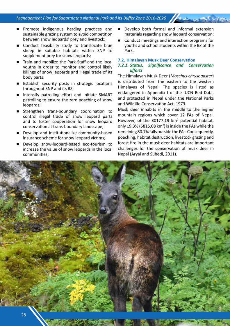
Management Plan for Sagarmatha National Park and its Buffer Zone 2016-2020
Promote indigenous herding practices and sustainable grazing system to avoid competition between snow leopards’ prey and livestock;
Conduct feasibility study to translocate blue sheep in suitable habitats within SNP to supplement prey for snow leopards;
Train and mobilize the Park Staff and the local youths in order to monitor and control likely killings of snow leopards and illegal trade of its body parts;
Establish security posts in strategic locations throughout SNP and its BZ;
Intensify patrolling effort and initiate SMART patrolling to ensure the zero poaching of snow leopards;
Strengthen trans-boundary coordination to control illegal trade of snow leopard parts and to foster cooperation for snow leopard conservation at trans-boundary landscape;
Develop and institutionalize community-based insurance scheme for snow leopard victims;
Develop snow-leopard-based eco-tourism to increase the value of snow leopards in the local communities;
Develop both formal and informal extension materials regarding snow leopard conservation;
Conduct meetings and interaction programs for youths and school students within the BZ of the Park.
7.2. Himalayan Musk Deer Conservation 7.2.1.Status, Significance and Conservation
EffortsThe Himalayan Musk Deer (Moschus chrysogaster) is distributed from the eastern to the western Himalayas of Nepal. The species is listed as endangered in Appendix I of the IUCN Red Data, and protected in Nepal under the National Parks and Wildlife Conservation Act, 1973.Musk deer inhabits in the middle to the higher mountain regions which cover 12 PAs of Nepal. However, of the 30177.19 km2 potential habitat, only 19.3% (5815.08 km2) is inside the PAs while the remaining 80.7% falls outside the PAs. Consequently, poaching, habitat destruction, livestock grazing and forest fire in the musk deer habitats are important challenges for the conservation of musk deer in Nepal (Aryal and Subedi, 2011).
28
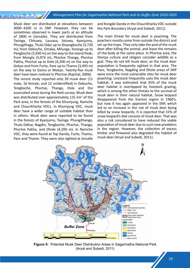
Management Plan for Sagarmatha National Park and its Buffer Zone 2016-2020
Musk deer are distributed at elevations between 3000−4200 m in SNP. However, they can be sometimes observed in lower parts at an altitude of 2800 m (Jorsalle). They are distributed from Tasinga, Chhuwa, Lausasa, Seluwa, Kyanjuma, Phungithaga, Thulo Odar up to Shyangboche (3,720 m); from Debuche, Omaka, Milunga, Yaranga up to Pangboche (3,930 m) on the way to the Island Peak; from Mongla (3,973 m), Phortse Thanga, Phortse Pakha, Phortse up to Dole (4,200 m) on the way to Gokyo and from Furte, Pare up to Thamo (3,493 m) on the way to Gomo or Mokyo. Twenty-five musk deer have been noticed in Phortse (Rajchal, 2006).The recent study reported only 39 musk deer (11 male, 16 female, and 12 unidentified) in Debuche, Tengboche, Phortse, Thanga, Dole and the associated areas during the field survey. Musk deer was distributed over approximately 131 km2 of the Park area, in the forests of the Khumjung, Namche and Chaurikharka VDCs. In Khumjung VDC, musk deer have a wider range of suitable habitat than in others. Musk deer were reported to be found in the forests of Kyanjuma, Tasinga, Phungithanga, Thulo Odhar, Nagdin, Tengboche, Phortse, Thanga, Phortse Pakha, and Dhole (4,200 m). In Namche VDC, they were found at Top Danda, Furte, Thamo, Pare and Thame. They were also sighted at Jorsalle
and Kongde Danda in the Chaurikharka VDC outside the Park Boundary (Aryal and Subedi, 2011).
The main threat for musk deer is poaching. The poachers mostly come from outside the district and set up the traps. They only take the pod of the musk deer after killing the animal, and leave the remains of the body at the same place. In Phortse area, the Sherpa culture and religion consider wildlife as a god. They do not kill musk deer, so the musk deer population is frequently sighted in that area. The Pare, Tengboche, Nagding and Dhole areas of SNP were once the most vulnerable sites for musk deer poaching. Livestock frequently uses the musk deer habitat; it was estimated that 35% of the musk deer habitat is overlapped by livestock grazing, which is among the other threats to the survival of musk deer in their natural habitat. Snow leopard disappeared from the Everest region in 1960’s, but now it has again appeared in the SNP, which led to an increase in the risk of musk deer being killed by snow leopards. It is reported that 31% of snow leopard’s diet consists of musk deer. That was also a risk considered to have reduced the viable population of musk deer due to such new predators in the region. However, the collection of excess timber and firewood also degraded the habitat of musk deer (Aryal and Subedi, 2011).
Figure 5: Potential Musk Deer Distribution Areas in Sagarmatha National Park (Aryal and Subedi, 2011)
29
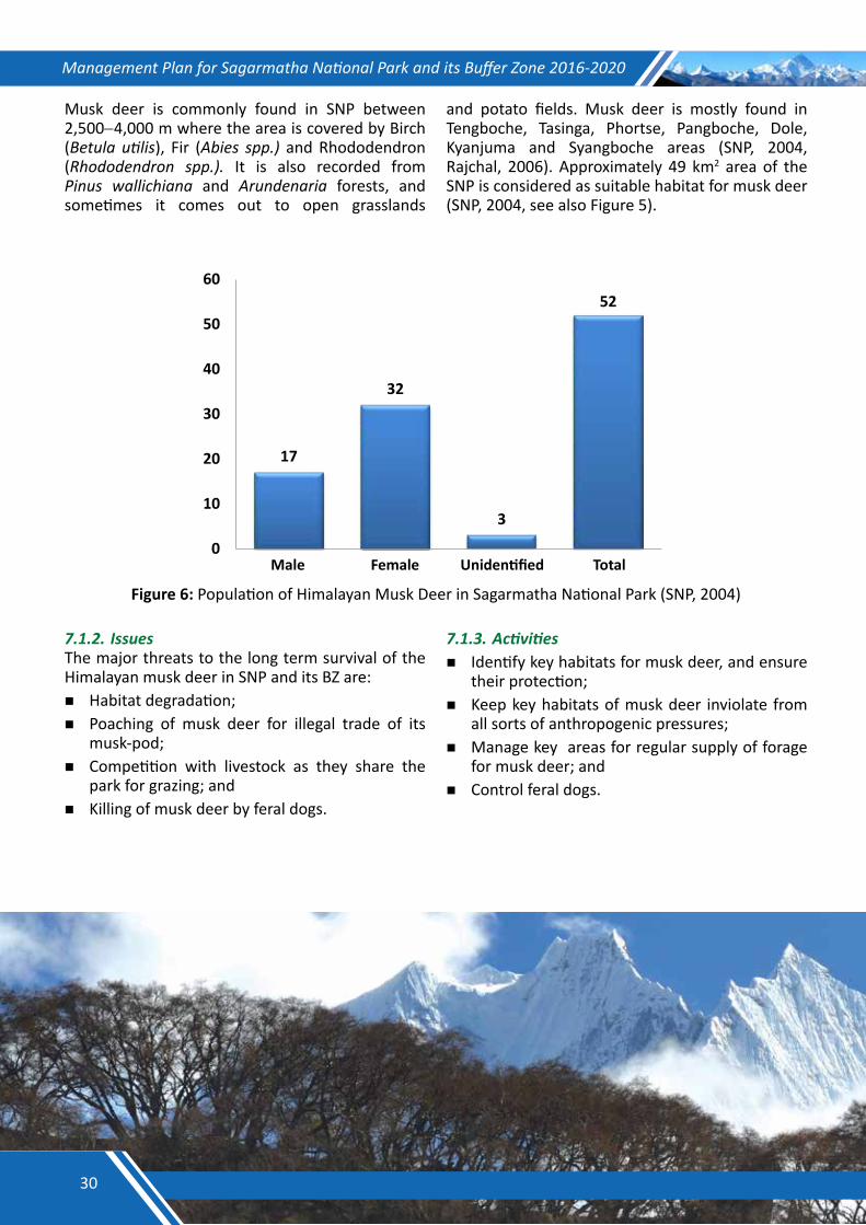
Management Plan for Sagarmatha National Park and its Buffer Zone 2016-2020
Musk deer is commonly found in SNP between 2,500−4,000 m where the area is covered by Birch (Betula utilis), Fir (Abies spp.) and Rhododendron (Rhododendron spp.). It is also recorded from Pinus wallichiana and Arundenaria forests, and sometimes it comes out to open grasslands
and potato fields. Musk deer is mostly found in Tengboche, Tasinga, Phortse, Pangboche, Dole, Kyanjuma and Syangboche areas (SNP, 2004, Rajchal, 2006). Approximately 49 km2 area of the SNP is considered as suitable habitat for musk deer (SNP, 2004, see also Figure 5).
17
32
3
52
0
10
20
30
40
50
60
Male Female Unidentified Total
Figure 6: Population of Himalayan Musk Deer in Sagarmatha National Park (SNP, 2004)
7.1.2. IssuesThe major threats to the long term survival of the Himalayan musk deer in SNP and its BZ are:Habitat degradation;Poaching of musk deer for illegal trade of its
musk-pod;Competition with livestock as they share the
park for grazing; andKilling of musk deer by feral dogs.
7.1.3. Activities Identify key habitats for musk deer, and ensure
their protection;Keep key habitats of musk deer inviolate from
all sorts of anthropogenic pressures;Manage key areas for regular supply of forage
for musk deer; andControl feral dogs.
30
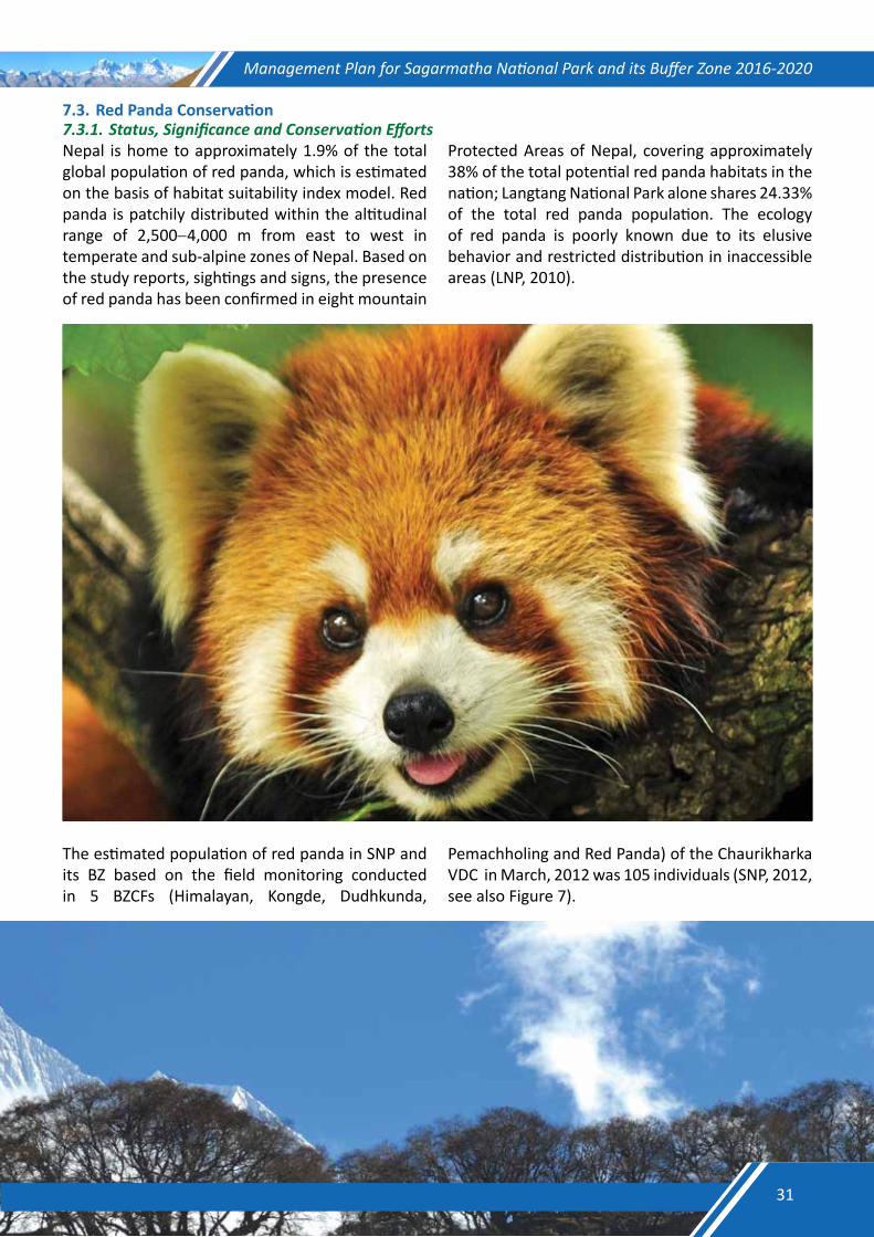
Management Plan for Sagarmatha National Park and its Buffer Zone 2016-2020
7.3. Red Panda Conservation 7.3.1.Status,SignificanceandConservationEffortsNepal is home to approximately 1.9% of the total global population of red panda, which is estimated on the basis of habitat suitability index model. Red panda is patchily distributed within the altitudinal range of 2,500−4,000 m from east to west in temperate and sub-alpine zones of Nepal. Based on the study reports, sightings and signs, the presence of red panda has been confirmed in eight mountain
Protected Areas of Nepal, covering approximately 38% of the total potential red panda habitats in the nation; Langtang National Park alone shares 24.33% of the total red panda population. The ecology of red panda is poorly known due to its elusive behavior and restricted distribution in inaccessible areas (LNP, 2010).
The estimated population of red panda in SNP and its BZ based on the field monitoring conducted in 5 BZCFs (Himalayan, Kongde, Dudhkunda,
Pemachholing and Red Panda) of the Chaurikharka VDC in March, 2012 was 105 individuals (SNP, 2012, see also Figure 7).
31
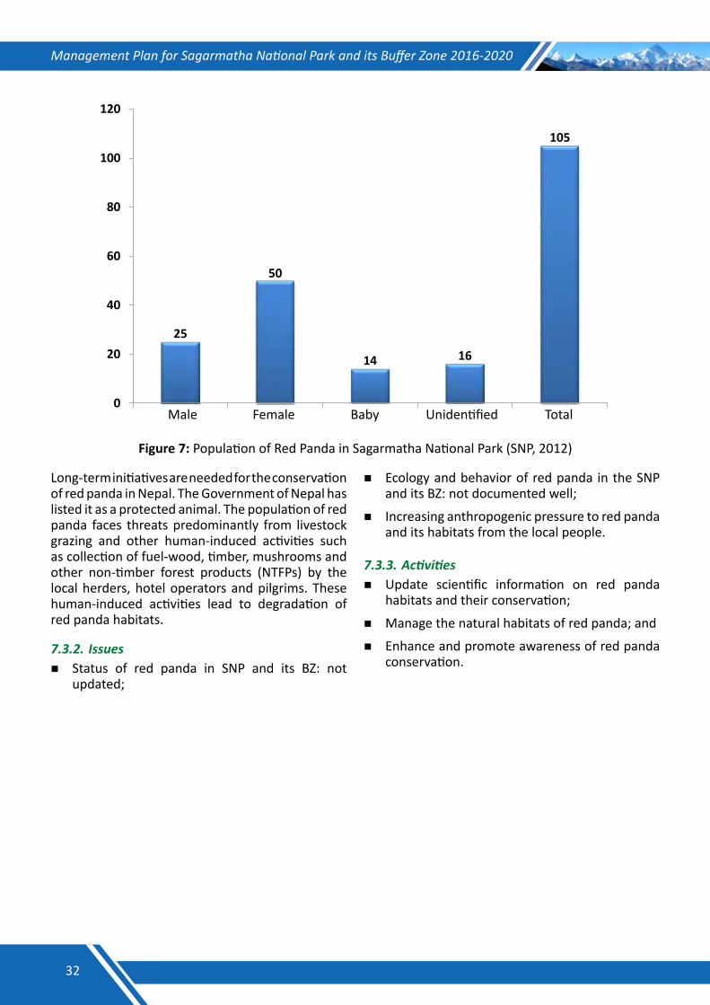
Management Plan for Sagarmatha National Park and its Buffer Zone 2016-2020
25
50
14
16
105
0
20
40
60
80
100
120
Male Female Baby Unidentified Total
Figure 7: Population of Red Panda in Sagarmatha National Park (SNP, 2012)
Long-term initiatives are needed for the conservation of red panda in Nepal. The Government of Nepal has listed it as a protected animal. The population of red panda faces threats predominantly from livestock grazing and other human-induced activities such as collection of fuel-wood, timber, mushrooms and other non-timber forest products (NTFPs) by the local herders, hotel operators and pilgrims. These human-induced activities lead to degradation of red panda habitats.
7.3.2. Issues Status of red panda in SNP and its BZ: not
updated;
Ecology and behavior of red panda in the SNP and its BZ: not documented well;
Increasing anthropogenic pressure to red panda and its habitats from the local people.
7.3.3. ActivitiesUpdate scientific information on red panda
habitats and their conservation;
Manage the natural habitats of red panda; and
Enhance and promote awareness of red panda conservation.
32
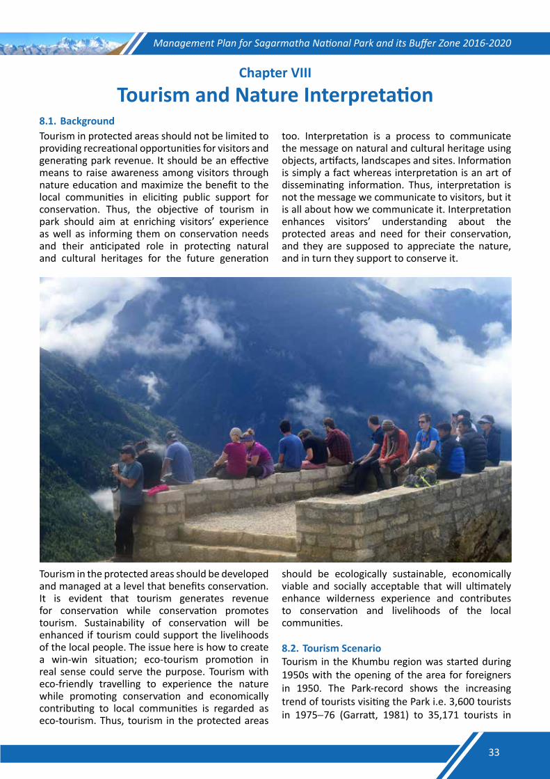
Management Plan for Sagarmatha National Park and its Buffer Zone 2016-2020
Chapter VIII
Tourism and Nature Interpretation8.1. BackgroundTourism in protected areas should not be limited to providing recreational opportunities for visitors and generating park revenue. It should be an effective means to raise awareness among visitors through nature education and maximize the benefit to the local communities in eliciting public support for conservation. Thus, the objective of tourism in park should aim at enriching visitors’ experience as well as informing them on conservation needs and their anticipated role in protecting natural and cultural heritages for the future generation
too. Interpretation is a process to communicate the message on natural and cultural heritage using objects, artifacts, landscapes and sites. Information is simply a fact whereas interpretation is an art of disseminating information. Thus, interpretation is not the message we communicate to visitors, but it is all about how we communicate it. Interpretation enhances visitors’ understanding about the protected areas and need for their conservation, and they are supposed to appreciate the nature, and in turn they support to conserve it.
Tourism in the protected areas should be developed and managed at a level that benefits conservation. It is evident that tourism generates revenue for conservation while conservation promotes tourism. Sustainability of conservation will be enhanced if tourism could support the livelihoods of the local people. The issue here is how to create a win-win situation; eco-tourism promotion in real sense could serve the purpose. Tourism with eco-friendly travelling to experience the nature while promoting conservation and economically contributing to local communities is regarded as eco-tourism. Thus, tourism in the protected areas
should be ecologically sustainable, economically viable and socially acceptable that will ultimately enhance wilderness experience and contributes to conservation and livelihoods of the local communities.
8.2. Tourism ScenarioTourism in the Khumbu region was started during 1950s with the opening of the area for foreigners in 1950. The Park-record shows the increasing trend of tourists visiting the Park i.e. 3,600 tourists in 1975−76 (Garratt, 1981) to 35,171 tourists in
33
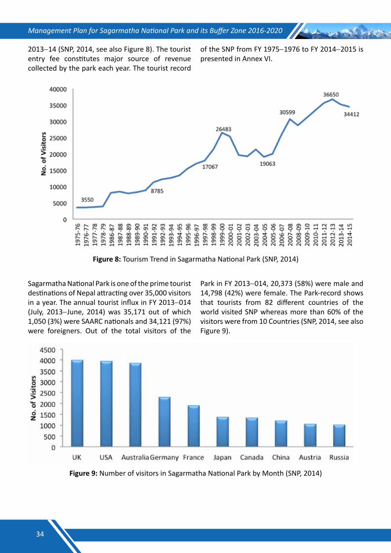
Management Plan for Sagarmatha National Park and its Buffer Zone 2016-2020
2013−14 (SNP, 2014, see also Figure 8). The tourist entry fee constitutes major source of revenue collected by the park each year. The tourist record
of the SNP from FY 1975−1976 to FY 2014−2015 is presented in Annex VI.
Figure 8: Tourism Trend in Sagarmatha National Park (SNP, 2014)
Sagarmatha National Park is one of the prime tourist destinations of Nepal attracting over 35,000 visitors in a year. The annual tourist influx in FY 2013−014 (July, 2013−June, 2014) was 35,171 out of which 1,050 (3%) were SAARC nationals and 34,121 (97%) were foreigners. Out of the total visitors of the
Park in FY 2013−014, 20,373 (58%) were male and 14,798 (42%) were female. The Park-record shows that tourists from 82 different countries of the world visited SNP whereas more than 60% of the visitors were from 10 Countries (SNP, 2014, see also Figure 9).
Figure 9: Number of visitors in Sagarmatha National Park by Month (SNP, 2014)
34
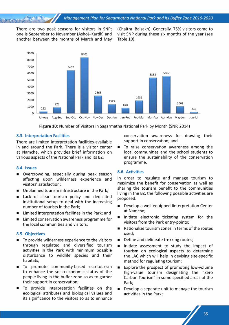
Management Plan for Sagarmatha National Park and its Buffer Zone 2016-2020
There are two peak seasons for visitors in SNP; one is September to November (Ashoj−Kartik) and another between the months of March and May
(Chaitra−Baisakh). Generally, 75% visitors come to visit SNP during these six months of the year (see Table 10).
292 923
6462
8401
2665
1375 858
1931
5362 5602
1062
238
0
1000
2000
3000
4000
5000
6000
7000
8000
9000
Jul-Aug Aug-Sep Sep-Oct Oct-Nov Nov-Dec Dec-Jan Jan-Feb Feb-Mar Mar-Apr Apr-May May-Jun Jun-Jul
Figure 10: Number of Visitors in Sagarmatha National Park by Month (SNP, 2014)
8.3. Interpretation Facilities There are limited interpretation facilities available in and around the Park. There is a visitor center at Namche, which provides brief information on various aspects of the National Park and its BZ.
8.4. IssuesOvercrowding, especially during peak season
affecting upon wilderness experience and visitors’ satisfaction;
Unplanned tourism infrastructure in the Park; Lack of clear tourism policy and dedicated
institutional setup to deal with the increasing number of tourists in the Park;
Limited interpretation facilities in the Park; andLimited conservation awareness programme for
the local communities and visitors.
8.5. Objectives To provide wilderness experience to the visitors
through regulated and diversified tourism activities in the Park with minimum possible disturbance to wildlife species and their habitats;
To promote community-based eco-tourism to enhance the socio-economic status of the people living in the buffer zone so as to garner their support in conservation;
To provide interpretation facilities on the ecological attributes and biological values and its significance to the visitors so as to enhance
conservation awareness for drawing their support in conservation; and
To raise conservation awareness among the local communities and the school students to ensure the sustainability of the conservation programme.
8.6. ActivitiesIn order to regulate and manage tourism to maximize the benefit for conservation as well as sharing the tourism benefit to the communities living in the BZ, the following possible activities are proposed:
Develop a well-equipped Iinterpretation Center at Namche;
Initiate electronic ticketing system for the visitors from the Park entry-points;
Rationalize tourism zones in terms of the routes used;
Define and delineate trekking routes; Initiate assessment to study the impact of
tourism on ecological aspects to determine the LAC which will help in devising site-specific method for regulating tourism;
Explore the prospect of promoting low-volume high-value tourism designating the “Zero Carbon Tourism” in some specified areas of the Park;
Develop a separate unit to manage the tourism activities in the Park;
35
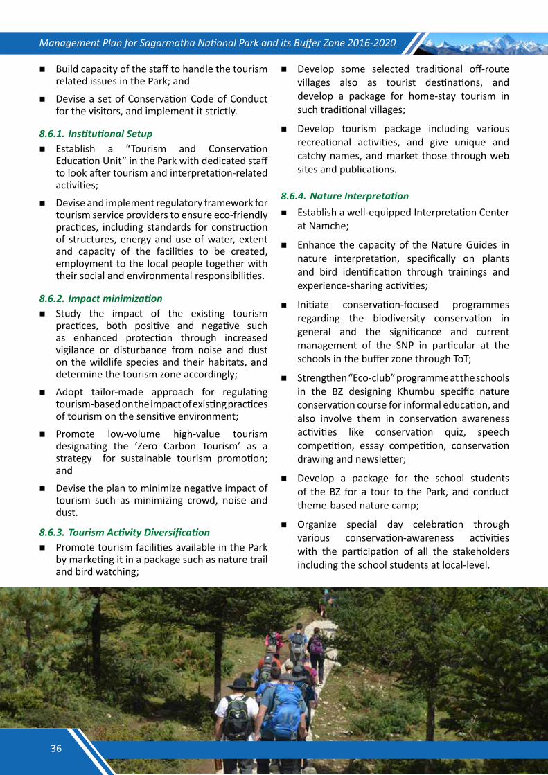
Management Plan for Sagarmatha National Park and its Buffer Zone 2016-2020
Build capacity of the staff to handle the tourism related issues in the Park; and
Devise a set of Conservation Code of Conduct for the visitors, and implement it strictly.
8.6.1.InstitutionalSetup Establish a “Tourism and Conservation
Education Unit” in the Park with dedicated staff to look after tourism and interpretation-related activities;
Devise and implement regulatory framework for tourism service providers to ensure eco-friendly practices, including standards for construction of structures, energy and use of water, extent and capacity of the facilities to be created, employment to the local people together with their social and environmental responsibilities.
8.6.2.Impactminimization Study the impact of the existing tourism
practices, both positive and negative such as enhanced protection through increased vigilance or disturbance from noise and dust on the wildlife species and their habitats, and determine the tourism zone accordingly;
Adopt tailor-made approach for regulating tourism-based on the impact of existing practices of tourism on the sensitive environment;
Promote low-volume high-value tourism designating the ‘Zero Carbon Tourism’ as a strategy for sustainable tourism promotion; and
Devise the plan to minimize negative impact of tourism such as minimizing crowd, noise and dust.
8.6.3.TourismActivityDiversification Promote tourism facilities available in the Park
by marketing it in a package such as nature trail and bird watching;
Develop some selected traditional off-route villages also as tourist destinations, and develop a package for home-stay tourism in such traditional villages;
Develop tourism package including various recreational activities, and give unique and catchy names, and market those through web sites and publications.
8.6.4.NatureInterpretation Establish a well-equipped Interpretation Center
at Namche;
Enhance the capacity of the Nature Guides in nature interpretation, specifically on plants and bird identification through trainings and experience-sharing activities;
Initiate conservation-focused programmes regarding the biodiversity conservation in general and the significance and current management of the SNP in particular at the schools in the buffer zone through ToT;
Strengthen “Eco-club” programme at the schools in the BZ designing Khumbu specific nature conservation course for informal education, and also involve them in conservation awareness activities like conservation quiz, speech competition, essay competition, conservation drawing and newsletter;
Develop a package for the school students of the BZ for a tour to the Park, and conduct theme-based nature camp;
Organize special day celebration through various conservation-awareness activities with the participation of all the stakeholders including the school students at local-level.
36
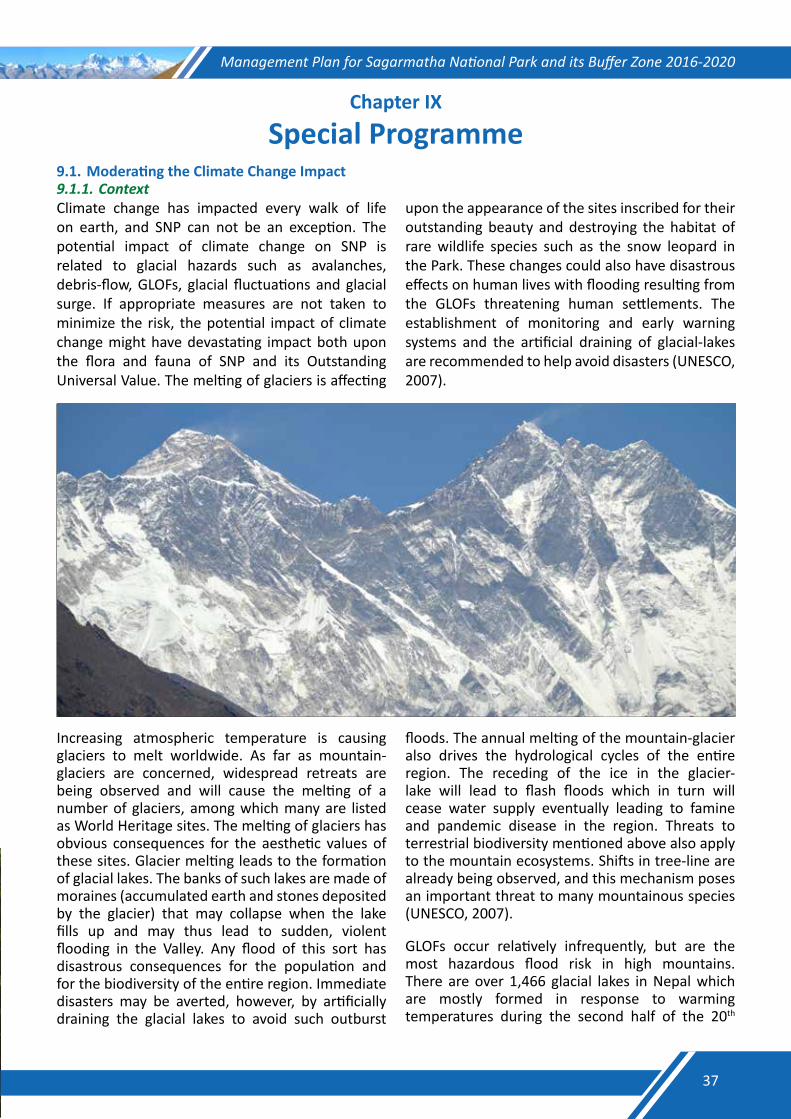
Management Plan for Sagarmatha National Park and its Buffer Zone 2016-2020
Chapter IX
Special Programme9.1. Moderating the Climate Change Impact9.1.1.ContextClimate change has impacted every walk of life on earth, and SNP can not be an exception. The potential impact of climate change on SNP is related to glacial hazards such as avalanches, debris-flow, GLOFs, glacial fluctuations and glacial surge. If appropriate measures are not taken to minimize the risk, the potential impact of climate change might have devastating impact both upon the flora and fauna of SNP and its Outstanding Universal Value. The melting of glaciers is affecting
upon the appearance of the sites inscribed for their outstanding beauty and destroying the habitat of rare wildlife species such as the snow leopard in the Park. These changes could also have disastrous effects on human lives with flooding resulting from the GLOFs threatening human settlements. The establishment of monitoring and early warning systems and the artificial draining of glacial-lakes are recommended to help avoid disasters (UNESCO, 2007).
Increasing atmospheric temperature is causing glaciers to melt worldwide. As far as mountain-glaciers are concerned, widespread retreats are being observed and will cause the melting of a number of glaciers, among which many are listed as World Heritage sites. The melting of glaciers has obvious consequences for the aesthetic values of these sites. Glacier melting leads to the formation of glacial lakes. The banks of such lakes are made of moraines (accumulated earth and stones deposited by the glacier) that may collapse when the lake fills up and may thus lead to sudden, violent flooding in the Valley. Any flood of this sort has disastrous consequences for the population and for the biodiversity of the entire region. Immediate disasters may be averted, however, by artificially draining the glacial lakes to avoid such outburst
floods. The annual melting of the mountain-glacier also drives the hydrological cycles of the entire region. The receding of the ice in the glacier-lake will lead to flash floods which in turn will cease water supply eventually leading to famine and pandemic disease in the region. Threats to terrestrial biodiversity mentioned above also apply to the mountain ecosystems. Shifts in tree-line are already being observed, and this mechanism poses an important threat to many mountainous species (UNESCO, 2007).
GLOFs occur relatively infrequently, but are the most hazardous flood risk in high mountains. There are over 1,466 glacial lakes in Nepal which are mostly formed in response to warming temperatures during the second half of the 20th
37

Management Plan for Sagarmatha National Park and its Buffer Zone 2016-2020
century. As the glaciers retreat, lakes start to form and fill up behind natural moraine or ice dams, when the water volume reaches a certain critical level beyond which the lakes can breach suddenly, leading to a discharge of huge volumes of water and debris. These sudden discharges are known as GLOFs. The studies have shown that there are 21 potentially dangerous glacial lakes in Nepal. GLOFs have been recorded 14 times in the Nepalese Himalayas, most recently in 2004. These outbursts had devastating consequences as in the case of Dig Cho in 1985 and Tam Pokhari in 1998 as a result of the large volume of discharged water and debris resulting in the destruction of downstream farmland, infrastructure, and villages (Bajracharya and Mool, 2009; ICIMOD, 2011)
In Sagarmatha region of Nepal, air temperatures had been rising by 1°C since 1970s, leading to 30% decrease in the snow and ice cover and turning a 4,000 m high glacier on the Mt. Everest into a lake. GLOFs are now much more frequent, creating serious risks for human populations and having implications for the water supply in South Asia and the flow of major rivers such as the Ganges, Indus and Brahmaputra (UNESCO, 2007). Recent climate changes have had a significant impact on the high-mountain glacial environment. These floods, usually of large magnitude, can severely affect upon fragile mountain ecosystems and their limited economic activities. The Imja Lake located at an altitude of 5,010 m in SNP is the largest and potentially most dangerous glacial lake in this region. The peak outburst flow of the Imja Lake is estimated to be 5,463 m3 per second. The peak discharge attenuates to about 2000 m3 per second at the boundary of the BZ at about 45 km from the outburst site. A GLOF vulnerability rating map has been prepared and an assessment of vulnerable settlements has also been carried out in this region, which is useful for developing plans for early warning systems and implementing management plans in the region (Bajracharya et al., 2007; Bajracharya and Mool, 2009).
After the Chhubung GLOF in the Rolwaling Valley, the mitigation work of lowering the level of the Tsho Rolpa Lake by 3 m was undertaken in 1998, and completed in 2000. After the successful implementation of Tsho Rolpa Lake lowering, the Imja Lake in Solukhumbu District was identified for reducing GLOF risk through artificial controlled drainage system. The CFGORRP/DHM Project has
been developed in line with the National Adaptation Programme of Action (NAPA) which was endorsed by the Government of Nepal in September 2010. The NAPA represents the most recent effort to assess and prioritize the most immediate climate change risks faced by Nepal. The CFGORRP/DHM addresses the objectives outlined in the NAPA Profile 3 “Community-based Disaster Management for Facilitating Climate Adaptation” and the NAPA Profile 4 “GLOF Monitoring and Disaster Risk Reduction”. The Imja Lake is among the 6 glacial lakes identified during the NAPA process as being the most “critical”, i.e. at most immediate risk of bursting (MoE, 2010).
9.1.2. IssuesThe major issues of concern in the face of likely impact of climate change in SNP and its BZ are:The melting of glaciers around the Himalayas in
the Everest region is affecting the appearance of the site inscribed for its outstanding universal value;
Destroying the habitat of endangered wildlife species such as the snow leopard, musk deer and red panda; and
Disastrous effects of flooding resulting from GLOFs on human lives, threatening human settlements downstream.
9.1.3. ActivitiesEstablishment of monitoring and early warning systems and the artificial draining of glacial lakes are the tested interventions in order to reduce the risk of GLOFs. Thus, the following activities are recommended in order to minimize the likely risks of GLOFs in the SNP and its BZ:
Initiate monitoring the most dangerous glacial lakes of the region regularly to assess changes that could possibly cause GLOF events;
Lower water level of the Imja Lake, the largest and potentially most dangerous glacial lake in the Khumbu region to reduce the potential GLOF risk through artificial channel construction;
Install automated early warning systems to increase the coping capacity of the local communities in the case of GLOF disasters;
Establish evacuation centres to facilitate the local communities in the affected areas in the case of GLOF disasters;
Support to institutionalize the Disaster Risk Management Committee.
38
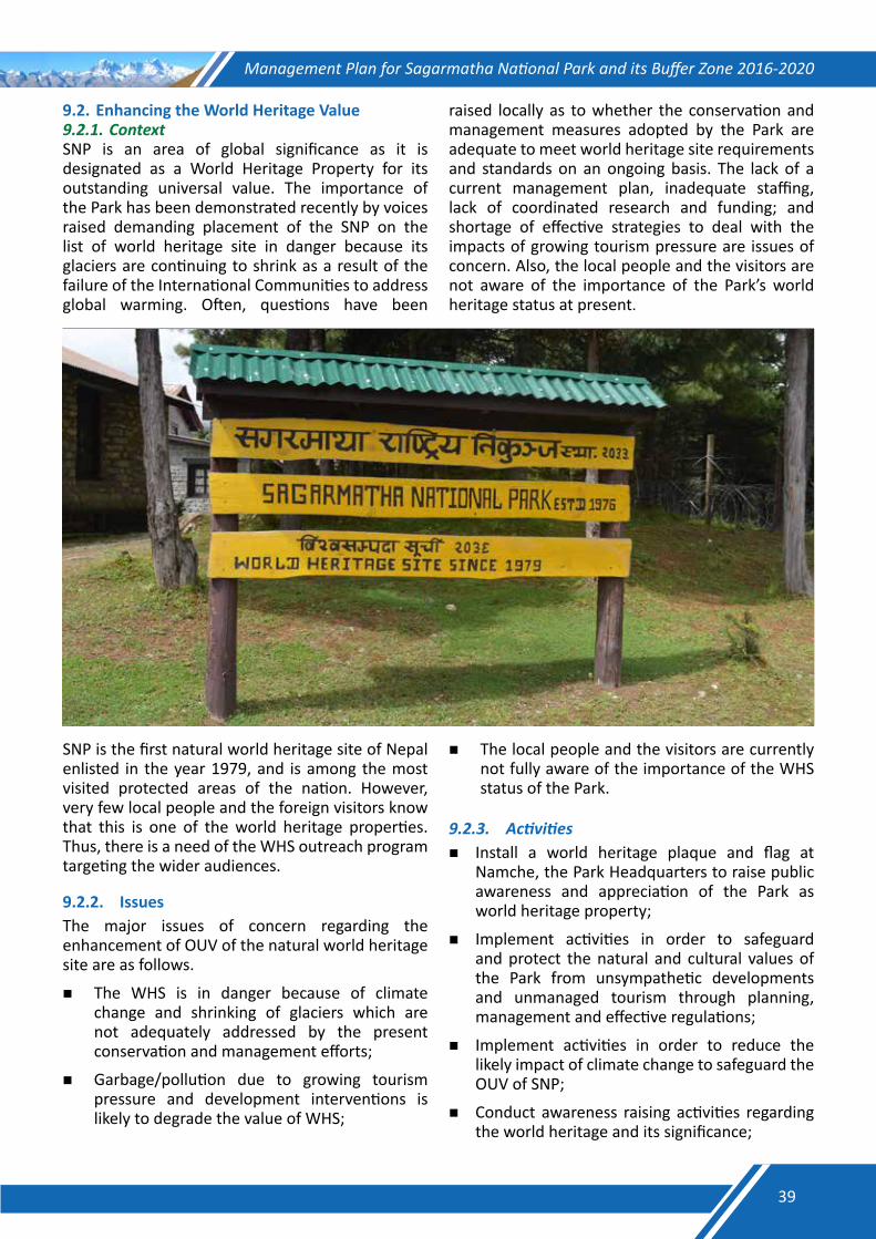
Management Plan for Sagarmatha National Park and its Buffer Zone 2016-2020
9.2. Enhancing the World Heritage Value9.2.1.ContextSNP is an area of global significance as it is designated as a World Heritage Property for its outstanding universal value. The importance of the Park has been demonstrated recently by voices raised demanding placement of the SNP on the list of world heritage site in danger because its glaciers are continuing to shrink as a result of the failure of the International Communities to address global warming. Often, questions have been
raised locally as to whether the conservation and management measures adopted by the Park are adequate to meet world heritage site requirements and standards on an ongoing basis. The lack of a current management plan, inadequate staffing, lack of coordinated research and funding; and shortage of effective strategies to deal with the impacts of growing tourism pressure are issues of concern. Also, the local people and the visitors are not aware of the importance of the Park’s world heritage status at present.
SNP is the first natural world heritage site of Nepal enlisted in the year 1979, and is among the most visited protected areas of the nation. However, very few local people and the foreign visitors know that this is one of the world heritage properties. Thus, there is a need of the WHS outreach program targeting the wider audiences.
9.2.2. IssuesThe major issues of concern regarding the enhancement of OUV of the natural world heritage site are as follows.
The WHS is in danger because of climate change and shrinking of glaciers which are not adequately addressed by the present conservation and management efforts;
Garbage/pollution due to growing tourism pressure and development interventions is likely to degrade the value of WHS;
The local people and the visitors are currently not fully aware of the importance of the WHS status of the Park.
9.2.3. Activities Install a world heritage plaque and flag at
Namche, the Park Headquarters to raise public awareness and appreciation of the Park as world heritage property;
Implement activities in order to safeguard and protect the natural and cultural values of the Park from unsympathetic developments and unmanaged tourism through planning, management and effective regulations;
Implement activities in order to reduce the likely impact of climate change to safeguard the OUV of SNP;
Conduct awareness raising activities regarding the world heritage and its significance;
39
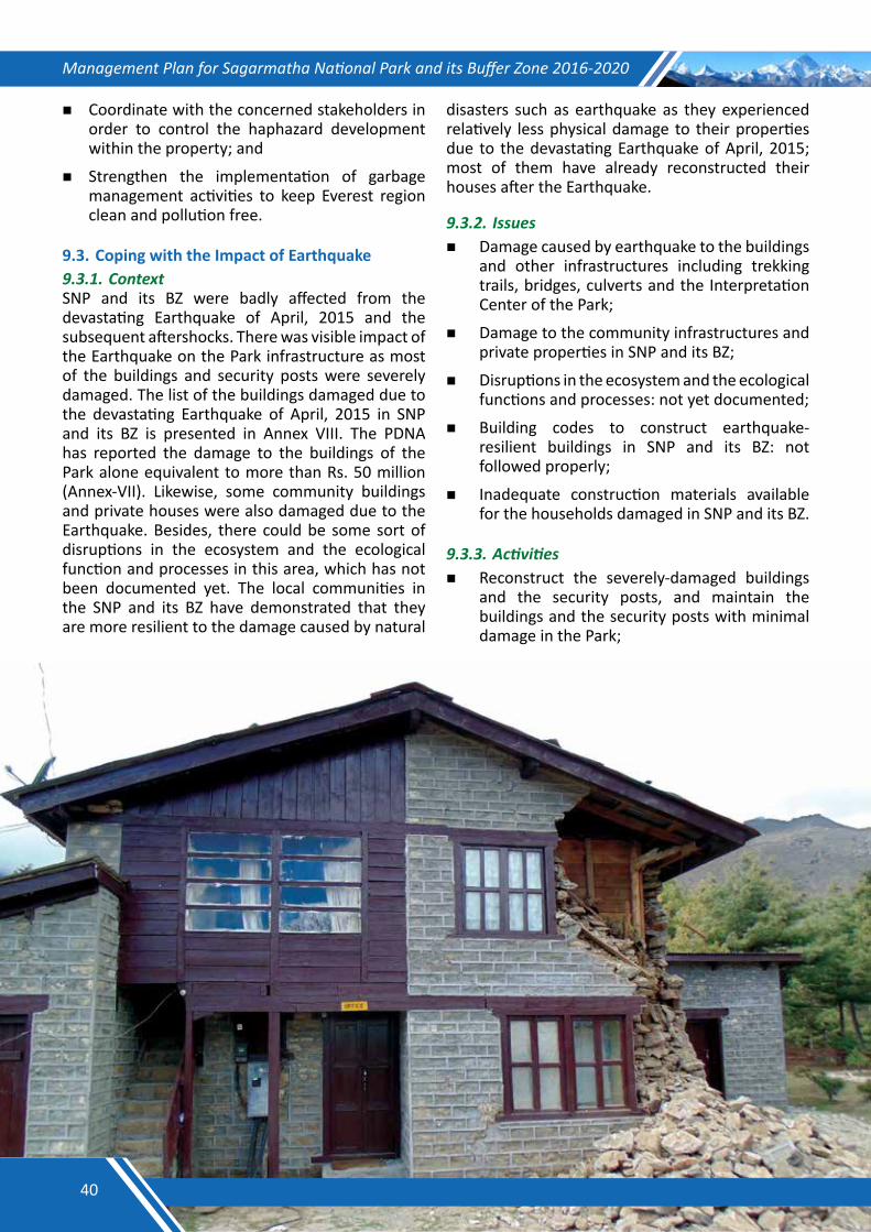
Management Plan for Sagarmatha National Park and its Buffer Zone 2016-2020
Coordinate with the concerned stakeholders in order to control the haphazard development within the property; and
Strengthen the implementation of garbage management activities to keep Everest region clean and pollution free.
9.3. Coping with the Impact of Earthquake 9.3.1.ContextSNP and its BZ were badly affected from the devastating Earthquake of April, 2015 and the subsequent aftershocks. There was visible impact of the Earthquake on the Park infrastructure as most of the buildings and security posts were severely damaged. The list of the buildings damaged due to the devastating Earthquake of April, 2015 in SNP and its BZ is presented in Annex VIII. The PDNA has reported the damage to the buildings of the Park alone equivalent to more than Rs. 50 million (Annex-VII). Likewise, some community buildings and private houses were also damaged due to the Earthquake. Besides, there could be some sort of disruptions in the ecosystem and the ecological function and processes in this area, which has not been documented yet. The local communities in the SNP and its BZ have demonstrated that they are more resilient to the damage caused by natural
disasters such as earthquake as they experienced relatively less physical damage to their properties due to the devastating Earthquake of April, 2015; most of them have already reconstructed their houses after the Earthquake.
9.3.2.Issues Damage caused by earthquake to the buildings
and other infrastructures including trekking trails, bridges, culverts and the Interpretation Center of the Park;
Damage to the community infrastructures and private properties in SNP and its BZ;
Disruptions in the ecosystem and the ecological functions and processes: not yet documented;
Building codes to construct earthquake-resilient buildings in SNP and its BZ: not followed properly;
Inadequate construction materials available for the households damaged in SNP and its BZ.
9.3.3.Activities Reconstruct the severely-damaged buildings
and the security posts, and maintain the buildings and the security posts with minimal damage in the Park;
40
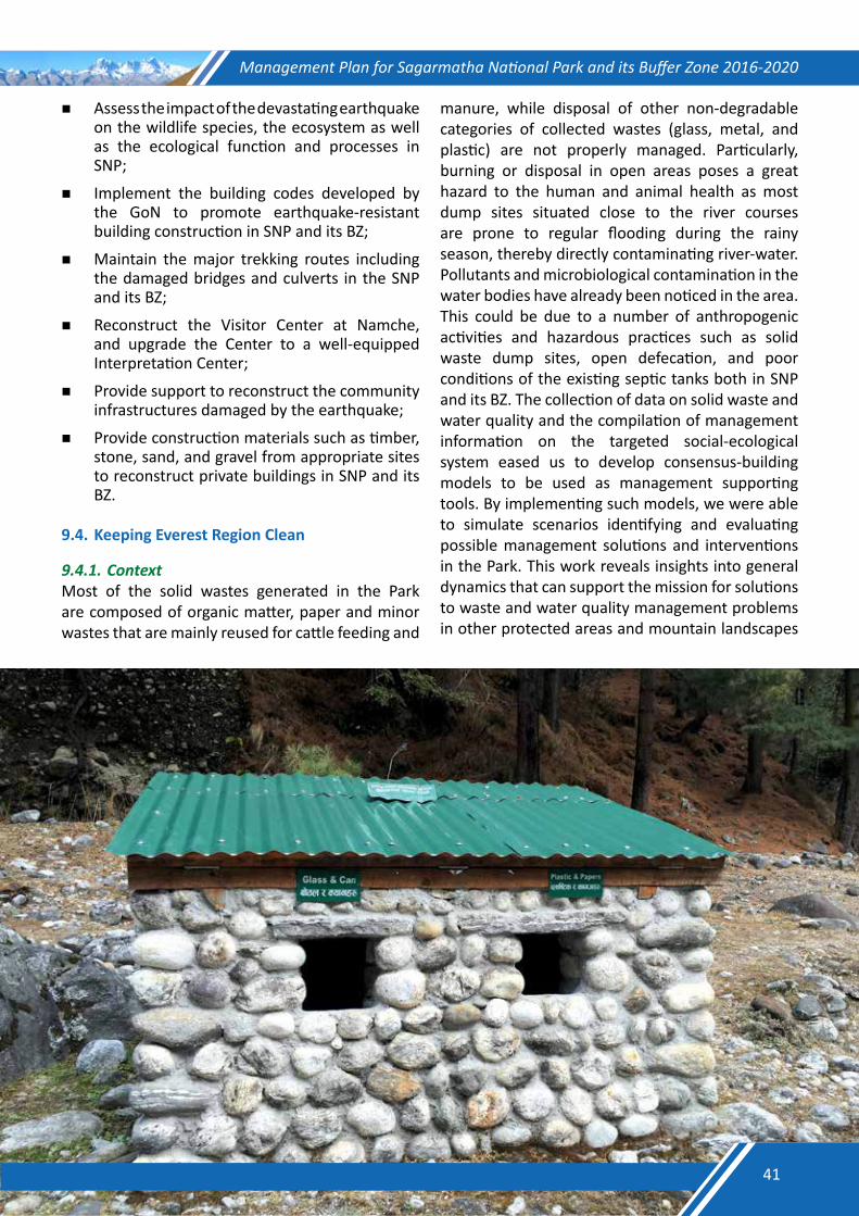
Management Plan for Sagarmatha National Park and its Buffer Zone 2016-2020
Assess the impact of the devastating earthquake on the wildlife species, the ecosystem as well as the ecological function and processes in SNP;
Implement the building codes developed by the GoN to promote earthquake-resistant building construction in SNP and its BZ;
Maintain the major trekking routes including the damaged bridges and culverts in the SNP and its BZ;
Reconstruct the Visitor Center at Namche, and upgrade the Center to a well-equipped Interpretation Center;
Provide support to reconstruct the community infrastructures damaged by the earthquake;
Provide construction materials such as timber, stone, sand, and gravel from appropriate sites to reconstruct private buildings in SNP and its BZ.
9.4. Keeping Everest Region Clean
9.4.1.ContextMost of the solid wastes generated in the Park are composed of organic matter, paper and minor wastes that are mainly reused for cattle feeding and
manure, while disposal of other non-degradable categories of collected wastes (glass, metal, and plastic) are not properly managed. Particularly, burning or disposal in open areas poses a great hazard to the human and animal health as most dump sites situated close to the river courses are prone to regular flooding during the rainy season, thereby directly contaminating river-water. Pollutants and microbiological contamination in the water bodies have already been noticed in the area. This could be due to a number of anthropogenic activities and hazardous practices such as solid waste dump sites, open defecation, and poor conditions of the existing septic tanks both in SNP and its BZ. The collection of data on solid waste and water quality and the compilation of management information on the targeted social-ecological system eased us to develop consensus-building models to be used as management supporting tools. By implementing such models, we were able to simulate scenarios identifying and evaluating possible management solutions and interventions in the Park. This work reveals insights into general dynamics that can support the mission for solutions to waste and water quality management problems in other protected areas and mountain landscapes
41
Management Plan for Sagarmatha National Park and its Buffer Zone 2016-2020
where traditional livelihood and land use patterns are changing under the influence of a growing population, changing consumption patterns, and international tourism (Manfred et al., 2010).
Active litter collection in the Everest Region was started by the different cleaning expeditions and groups whereas SNP introduced regulations to prevent pollution. Sagarmatha Pollution Control Committee (SPCC) was formed in 1990, which continues to play a role in managing waste in SNP and its BZ. Despite these measures, the waste management problem including crashed helicopter and aircrafts is growing in the region. The collection of waste by a single organization without involvement of the local communities and stakeholders is unlikely to be effective in the long-run.
The pollution problem is now no longer confined to solid waste. The water sources along the major trails are being contaminated from improper affluent discharge, human waste, and garbage dumping. Sewerage and toilet waste can be found piped into the nearby streams and rivers. The Park will actively participate in the task of controlling various forms of pollution, and will attempt to make the control system more sustainable by involving the local people with support from the other stakeholders. Similarly, it will focus on reducing waste generation and proper disposal systems.
9.4.2.IssuesGarbage management is an ongoing challenge
to keep the Everest region clean despite several initiatives already in place;
Several point and non-point sources of pollution exists in the region;
Inadequate knowledge on proper disposal and recycling of the solid waste among the stakeholders;
Inadequacy of coordinated effort to address the issue of garbage and pollution in the Everest region;
Lack of guidelines for properly managing the garbage; and
Inadequacy of the fund required for maintaining sanitation in the Everest region;
9.4.3.ActivitiesSupport SPCC to institutionalize it as the source
of expertise;Mobilize and involve the local communities and
organizations in garbage collection, recycling, and destruction;
Manage garbage with special focus on reducing production, recycling, and destruction by prohibiting the use of polluting items such as plastic bags and glass bottles;
Ensure that large settlements in the Park and its BZ have proper sanitation infrastructures including storm water drains, toilets, incinerators, collection and recycling systems;
Develop a Community-based Museum and Information Center on garbage management in order to demonstrate proper techniques of garbage disposal and recycling techniques to the stakeholders;
Develop standard sets of sanitation guidelines for all the hotels/lodges and restaurants to construct proper toilets with leak proof septic tanks and waste water soakage pits so as to prevent contamination;
Encourage establishment of high quality hygienic “user-pay” toilets and bath-room facilities in the private lands along the main trekking routes;
Develop a joint financing mechanism for pollution control and management;
Coordinate with the Department of Tourism, Nepal Tourism Board and other stakeholders to monitor the waste management practices by the tourism entrepreneurs in SNP and its BZ; and
Explore the sources of sustainable financing for garbage management in the Everest region.
42
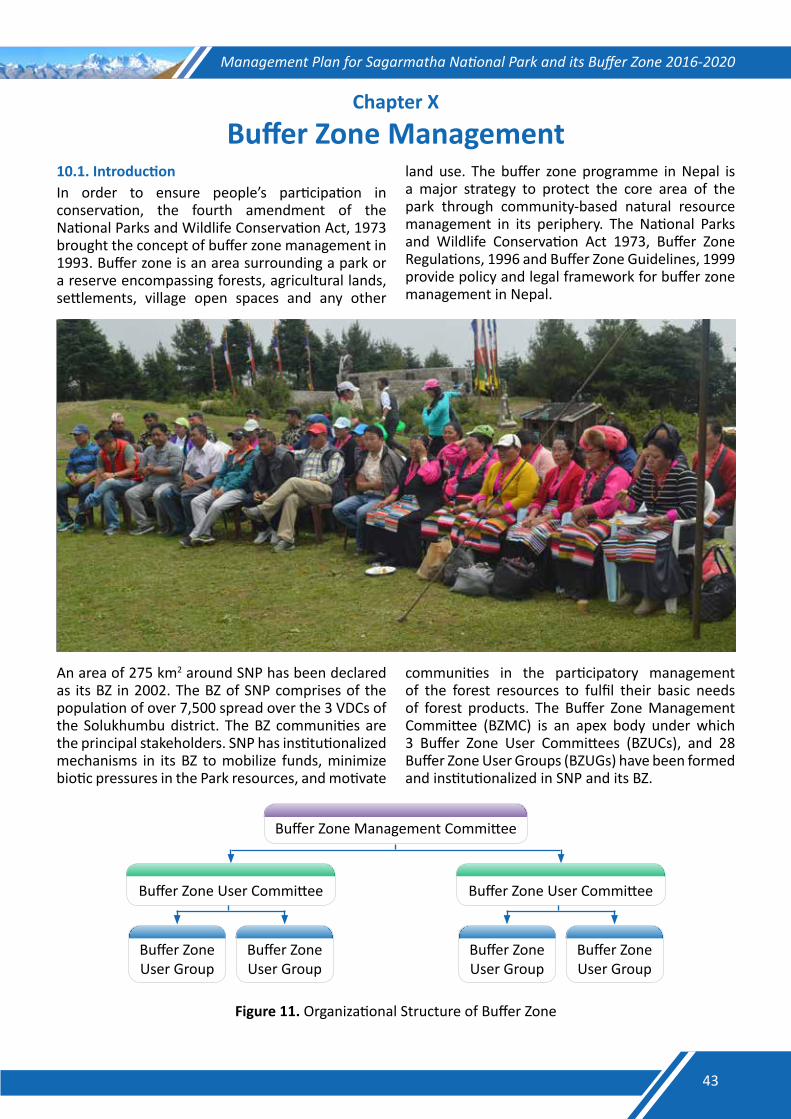
Management Plan for Sagarmatha National Park and its Buffer Zone 2016-2020
Chapter X
Buffer Zone Management10.1. Introduction In order to ensure people’s participation in conservation, the fourth amendment of the National Parks and Wildlife Conservation Act, 1973 brought the concept of buffer zone management in 1993. Buffer zone is an area surrounding a park or a reserve encompassing forests, agricultural lands, settlements, village open spaces and any other
land use. The buffer zone programme in Nepal is a major strategy to protect the core area of the park through community-based natural resource management in its periphery. The National Parks and Wildlife Conservation Act 1973, Buffer Zone Regulations, 1996 and Buffer Zone Guidelines, 1999 provide policy and legal framework for buffer zone management in Nepal.
An area of 275 km2 around SNP has been declared as its BZ in 2002. The BZ of SNP comprises of the population of over 7,500 spread over the 3 VDCs of the Solukhumbu district. The BZ communities are the principal stakeholders. SNP has institutionalized mechanisms in its BZ to mobilize funds, minimize biotic pressures in the Park resources, and motivate
communities in the participatory management of the forest resources to fulfil their basic needs of forest products. The Buffer Zone Management Committee (BZMC) is an apex body under which 3 Buffer Zone User Committees (BZUCs), and 28 Buffer Zone User Groups (BZUGs) have been formed and institutionalized in SNP and its BZ.
Buffer Zone Management Committee
Buffer Zone User Committee Buffer Zone User Committee
Buffer Zone User Group
Buffer Zone User Group
Buffer Zone User Group
Buffer Zone User Group
Figure 11. Organizational Structure of Buffer Zone
43
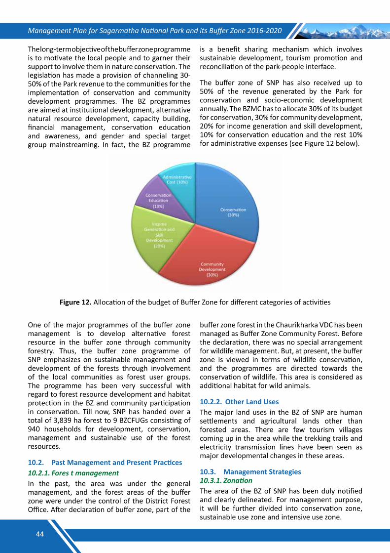
Management Plan for Sagarmatha National Park and its Buffer Zone 2016-2020
The long-term objective of the buffer zone programme is to motivate the local people and to garner their support to involve them in nature conservation. The legislation has made a provision of channeling 30-50% of the Park revenue to the communities for the implementation of conservation and community development programmes. The BZ programmes are aimed at institutional development, alternative natural resource development, capacity building, financial management, conservation education and awareness, and gender and special target group mainstreaming. In fact, the BZ programme
is a benefit sharing mechanism which involves sustainable development, tourism promotion and reconciliation of the park-people interface.
The buffer zone of SNP has also received up to 50% of the revenue generated by the Park for conservation and socio-economic development annually. The BZMC has to allocate 30% of its budget for conservation, 30% for community development, 20% for income generation and skill development, 10% for conservation education and the rest 10% for administrative expenses (see Figure 12 below).
Figure 12. Allocation of the budget of Buffer Zone for different categories of activities
One of the major programmes of the buffer zone management is to develop alternative forest resource in the buffer zone through community forestry. Thus, the buffer zone programme of SNP emphasizes on sustainable management and development of the forests through involvement of the local communities as forest user groups. The programme has been very successful with regard to forest resource development and habitat protection in the BZ and community participation in conservation. Till now, SNP has handed over a total of 3,839 ha forest to 9 BZCFUGs consisting of 940 households for development, conservation, management and sustainable use of the forest resources.
10.2. Past Management and Present Practices 10.2.1.ForestmanagementIn the past, the area was under the general management, and the forest areas of the buffer zone were under the control of the District Forest Office. After declaration of buffer zone, part of the
buffer zone forest in the Chaurikharka VDC has been managed as Buffer Zone Community Forest. Before the declaration, there was no special arrangement for wildlife management. But, at present, the buffer zone is viewed in terms of wildlife conservation, and the programmes are directed towards the conservation of wildlife. This area is considered as additional habitat for wild animals.
10.2.2. Other Land Uses The major land uses in the BZ of SNP are human settlements and agricultural lands other than forested areas. There are few tourism villages coming up in the area while the trekking trails and electricity transmission lines have been seen as major developmental changes in these areas.
10.3. Management Strategies 10.3.1.ZonationThe area of the BZ of SNP has been duly notified and clearly delineated. For management purpose, it will be further divided into conservation zone, sustainable use zone and intensive use zone.
44
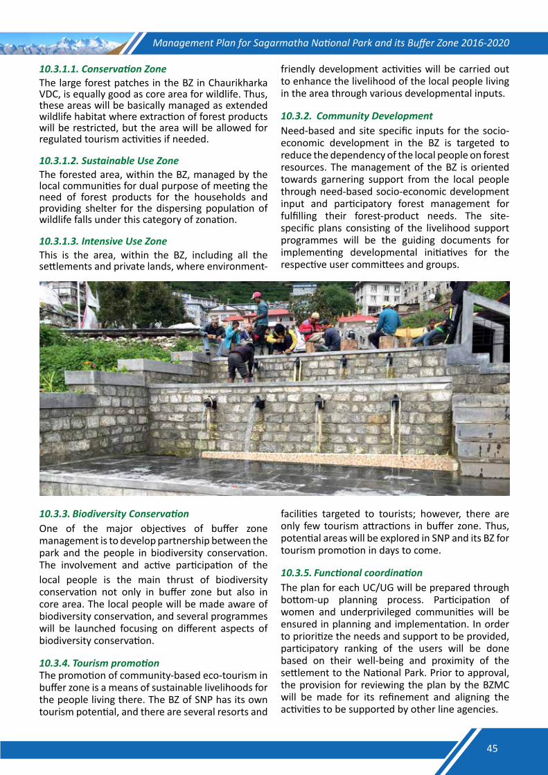
Management Plan for Sagarmatha National Park and its Buffer Zone 2016-2020
10.3.1.1.ConservationZoneThe large forest patches in the BZ in Chaurikharka VDC, is equally good as core area for wildlife. Thus, these areas will be basically managed as extended wildlife habitat where extraction of forest products will be restricted, but the area will be allowed for regulated tourism activities if needed.
10.3.1.2.SustainableUseZoneThe forested area, within the BZ, managed by the local communities for dual purpose of meeting the need of forest products for the households and providing shelter for the dispersing population of wildlife falls under this category of zonation.
10.3.1.3.IntensiveUseZoneThis is the area, within the BZ, including all the settlements and private lands, where environment-
friendly development activities will be carried out to enhance the livelihood of the local people living in the area through various developmental inputs.
10.3.2.CommunityDevelopmentNeed-based and site specific inputs for the socio-economic development in the BZ is targeted to reduce the dependency of the local people on forest resources. The management of the BZ is oriented towards garnering support from the local people through need-based socio-economic development input and participatory forest management for fulfilling their forest-product needs. The site-specific plans consisting of the livelihood support programmes will be the guiding documents for implementing developmental initiatives for the respective user committees and groups.
10.3.3.BiodiversityConservationOne of the major objectives of buffer zone management is to develop partnership between the park and the people in biodiversity conservation. The involvement and active participation of thelocal people is the main thrust of biodiversity conservation not only in buffer zone but also in core area. The local people will be made aware of biodiversity conservation, and several programmes will be launched focusing on different aspects of biodiversity conservation.
10.3.4.TourismpromotionThe promotion of community-based eco-tourism in buffer zone is a means of sustainable livelihoods for the people living there. The BZ of SNP has its own tourism potential, and there are several resorts and
facilities targeted to tourists; however, there are only few tourism attractions in buffer zone. Thus, potential areas will be explored in SNP and its BZ for tourism promotion in days to come.
10.3.5.FunctionalcoordinationThe plan for each UC/UG will be prepared through bottom-up planning process. Participation of women and underprivileged communities will be ensured in planning and implementation. In order to prioritize the needs and support to be provided, participatory ranking of the users will be done based on their well-being and proximity of the settlement to the National Park. Prior to approval, the provision for reviewing the plan by the BZMC will be made for its refinement and aligning the activities to be supported by other line agencies.
45
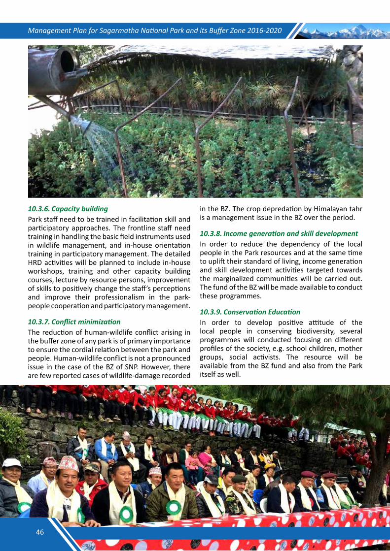
Management Plan for Sagarmatha National Park and its Buffer Zone 2016-2020
10.3.6.CapacitybuildingPark staff need to be trained in facilitation skill and participatory approaches. The frontline staff need training in handling the basic field instruments used in wildlife management, and in-house orientation training in participatory management. The detailed HRD activities will be planned to include in-house workshops, training and other capacity building courses, lecture by resource persons, improvement of skills to positively change the staff’s perceptions and improve their professionalism in the park-people cooperation and participatory management.
10.3.7.ConflictminimizationThe reduction of human-wildlife conflict arising in the buffer zone of any park is of primary importance to ensure the cordial relation between the park and people. Human-wildlife conflict is not a pronounced issue in the case of the BZ of SNP. However, there are few reported cases of wildlife-damage recorded
in the BZ. The crop depredation by Himalayan tahr is a management issue in the BZ over the period.
10.3.8.IncomegenerationandskilldevelopmentIn order to reduce the dependency of the local people in the Park resources and at the same time to uplift their standard of living, income generation and skill development activities targeted towards the marginalized communities will be carried out. The fund of the BZ will be made available to conduct these programmes.
10.3.9.ConservationEducationIn order to develop positive attitude of the local people in conserving biodiversity, several programmes will conducted focusing on different profiles of the society, e.g. school children, mother groups, social activists. The resource will be available from the BZ fund and also from the Park itself as well.
46
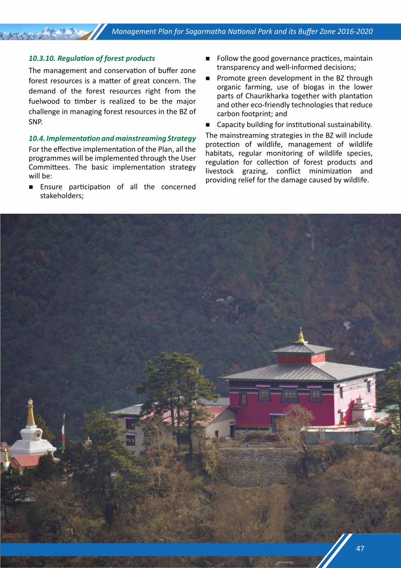
Management Plan for Sagarmatha National Park and its Buffer Zone 2016-2020
10.3.10.RegulationofforestproductsThe management and conservation of buffer zone forest resources is a matter of great concern. The demand of the forest resources right from the fuelwood to timber is realized to be the major challenge in managing forest resources in the BZ of SNP.
10.4.ImplementationandmainstreamingStrategyFor the effective implementation of the Plan, all the programmes will be implemented through the User Committees. The basic implementation strategy will be:Ensure participation of all the concerned
stakeholders;
Follow the good governance practices, maintain transparency and well-informed decisions;
Promote green development in the BZ through organic farming, use of biogas in the lower parts of Chaurikharka together with plantation and other eco-friendly technologies that reduce carbon footprint; and
Capacity building for institutional sustainability.The mainstreaming strategies in the BZ will include protection of wildlife, management of wildlife habitats, regular monitoring of wildlife species, regulation for collection of forest products and livestock grazing, conflict minimization and providing relief for the damage caused by wildlife.
47
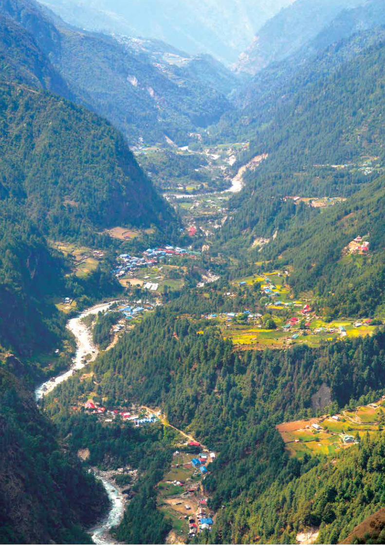
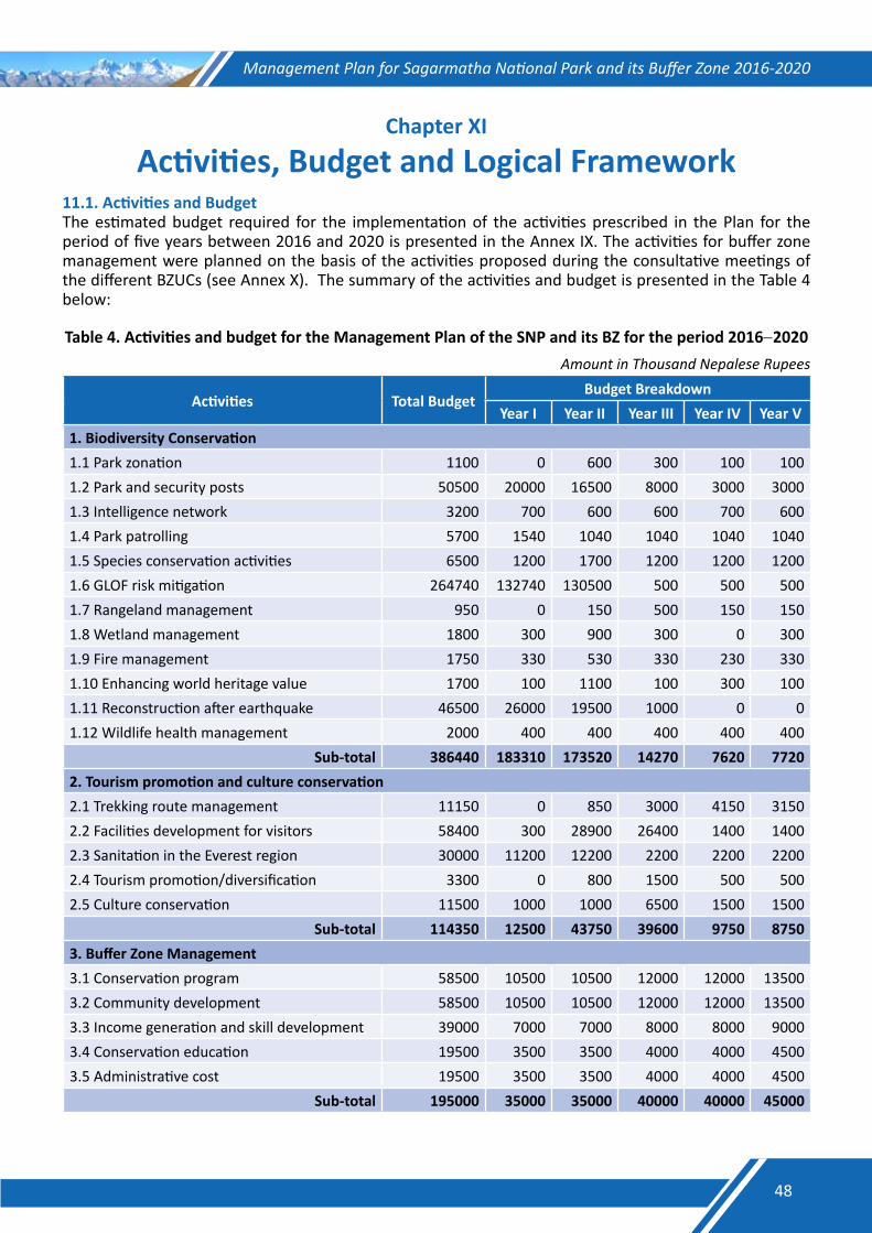
Management Plan for Sagarmatha National Park and its Buffer Zone 2016-2020
Chapter XI
Activities, Budget and Logical Framework11.1. Activities and BudgetThe estimated budget required for the implementation of the activities prescribed in the Plan for the period of five years between 2016 and 2020 is presented in the Annex IX. The activities for buffer zone management were planned on the basis of the activities proposed during the consultative meetings of the different BZUCs (see Annex X). The summary of the activities and budget is presented in the Table 4 below:
Table 4. Activities and budget for the Management Plan of the SNP and its BZ for the period 2016−2020 Amount in Thousand Nepalese Rupees
Activities Total Budget Budget Breakdown
Year I Year II Year III Year IV Year V1. Biodiversity Conservation1.1 Park zonation 1100 0 600 300 100 1001.2 Park and security posts 50500 20000 16500 8000 3000 30001.3 Intelligence network 3200 700 600 600 700 6001.4 Park patrolling 5700 1540 1040 1040 1040 10401.5 Species conservation activities 6500 1200 1700 1200 1200 12001.6 GLOF risk mitigation 264740 132740 130500 500 500 5001.7 Rangeland management 950 0 150 500 150 1501.8 Wetland management 1800 300 900 300 0 3001.9 Fire management 1750 330 530 330 230 3301.10 Enhancing world heritage value 1700 100 1100 100 300 1001.11 Reconstruction after earthquake 46500 26000 19500 1000 0 01.12 Wildlife health management 2000 400 400 400 400 400
Sub-total 386440 183310 173520 14270 7620 77202. Tourism promotion and culture conservation 2.1 Trekking route management 11150 0 850 3000 4150 31502.2 Facilities development for visitors 58400 300 28900 26400 1400 14002.3 Sanitation in the Everest region 30000 11200 12200 2200 2200 22002.4 Tourism promotion/diversification 3300 0 800 1500 500 5002.5 Culture conservation 11500 1000 1000 6500 1500 1500
Sub-total 114350 12500 43750 39600 9750 87503. Buffer Zone Management3.1 Conservation program 58500 10500 10500 12000 12000 135003.2 Community development 58500 10500 10500 12000 12000 135003.3 Income generation and skill development 39000 7000 7000 8000 8000 90003.4 Conservation education 19500 3500 3500 4000 4000 45003.5 Administrative cost 19500 3500 3500 4000 4000 4500
Sub-total 195000 35000 35000 40000 40000 45000
48
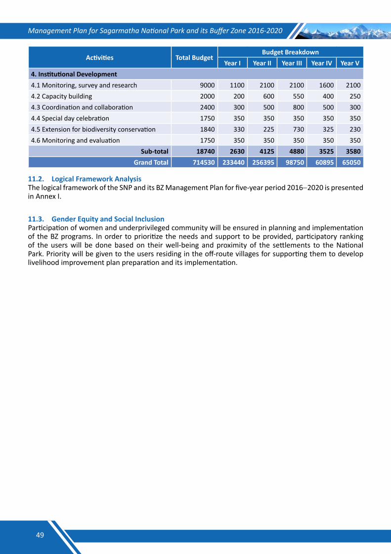
Management Plan for Sagarmatha National Park and its Buffer Zone 2016-2020
Activities Total Budget Budget Breakdown
Year I Year II Year III Year IV Year V4. Institutional Development4.1 Monitoring, survey and research 9000 1100 2100 2100 1600 21004.2 Capacity building 2000 200 600 550 400 2504.3 Coordination and collaboration 2400 300 500 800 500 3004.4 Special day celebration 1750 350 350 350 350 3504.5 Extension for biodiversity conservation 1840 330 225 730 325 2304.6 Monitoring and evaluation 1750 350 350 350 350 350
Sub-total 18740 2630 4125 4880 3525 3580Grand Total 714530 233440 256395 98750 60895 65050
11.2. Logical Framework AnalysisThe logical framework of the SNP and its BZ Management Plan for five-year period 2016−2020 is presented in Annex I.
11.3. Gender Equity and Social Inclusion Participation of women and underprivileged community will be ensured in planning and implementation of the BZ programs. In order to prioritize the needs and support to be provided, participatory ranking of the users will be done based on their well-being and proximity of the settlements to the National Park. Priority will be given to the users residing in the off-route villages for supporting them to develop livelihood improvement plan preparation and its implementation.
49
Management Plan for Sagarmatha National Park and its Buffer Zone 2016-2020
REFERENCES1. ALE, S. B. 2005. Have snow leopards made a comeback to the Everest region of Nepal? .
Progress report for the International Snow Leopard Trust
2. ALE, S. B. 2007. Ecology of the Snow Leopard and the Himalayan Tahr in Sagarmatha (Mt. Everest) National Park, Nepal. University of Illinois, Chicago, USA.
3. ARYAL, A., BRUNTONA, D. & RAUBENHEIMERA, D. 2013. Habitat assessment for the translocation of blue sheep to maintain a viable snow leopard population in the Mt Everest Region, Nepal. Zoology and Ecology, DOI:10.1080/21658005.2013.765634.
4. ARYAL, A. & SUBEDI, A. 2011. The Conservation and Potential Habitat of the Himalayan Musk Deer (Moschus chrysogaster) in the Protected Areas of Nepal International Journal of Conservation Science 2, 127-141.
5. BAJRACHARYA, B., SHRESTHA, A. B. & RAJBHANDARI, L. 2007. Glacial Lake Outburst Floods in the Sagarmatha Region : Hazard Assessment Using GIS and Hydrodynamic Modeling. Mountain Research and Development 27, 336-344.
6. BAJRACHARYA, S. R. & MOOL, P. 2009. Glaciers, glacial lakes and glacial lake outburst floods in the Mount Everest region, Nepal. Annals of Glaciology 50, 81-86.
7. BASNET, S. 2004. Birds of Sagarmatha: List of Birds in Sagarmatha National Park. WWF Nepal Program and Bird Conservation Nepal, Kathmandu, Nepal.
8. BHATTARAI, K. R. & UPADHYAY, T. P. 2013. Rangeland Management in Sagarmatha (Mount Everest) National Park and Buffer Zone, Nepal: An Ecological Perspective. Mountain Research and Development 33, 19-28.
9. DNPWC 2007. Sagarmatha National Park Management and Tourism Plan 2007-2012. Department of National Parks and Wildlife Conservation, Kathmandu, Nepal.
10. DNPWC 2008. Site Management Plan of the Gokyo and Associated Wetlands - Ramsar Site. Department of National Parks and Wildlife Conservation, Kathmandu, Nepal.
11. DNPWC 2013. Snow Leopard Conservation Action Plan for Nepal 2005-2015 (Revised 2012). Department of National Parks and Wildlife Conservation, Kathmandu, Nepal.
12. GAIRE, D. 2006. Status, distribution, conservation and use value of medical and aromatic plants (MAPs) in Sagarmatha National Park. Department of National Parks and Wildlife Conservation/ Tourism for Rural Poverty Alleviation.
13. GARRATT, K. J. 1981. Sagarmatha National Park Management Plan. National Parks and Wildlife Conservation Office, Kathmandu, Nepal.
14. ICIMOD 2000. Grassland Ecology and Management in Protected Areas of Nepal- Technical and Status Papers on Grasslands of Mountain Protected Areas. International Center for Integrated Mountain Development, Kathmandu, Nepal.
15. ICIMOD 2011. Glacial lakes and glacial lake outburst floods in Nepal. International Center for Integrated Mountain Development, Kathmandu, Nepal.
16. IUCN. 2015. The IUCN Red List of Threatened Species. Version 2015-4. [Online]. Available: http://www.iucnredlist.org/ Accessed on 20 January, 2016.
50
Management Plan for Sagarmatha National Park and its Buffer Zone 2016-2020
17. JACKSON, R., MALLON, D., MCCARTHY, T., CHUNDAWAY, R. A. & HABIB, B. 2008. Panthera uncia. The IUCN Red List of Threatened Species 2008: e.T22732A9381126. [Online]. Available: http://dx.doi.org/10.2305/IUCN.UK.2008.RLTS.T22732A9381126.en Accessed on 20 January, 2016.
18. LNP 2010. Red Panda Conservation Action Plan for Langtang National Park and Buffer Zone Nepal 2010-2014. Department of National Parks and Wildlife Conservation/ Langtang National Park.
19. LOVARI, S., BOESI, R., MINDER, I., MUCCI, N., RANDI, E., DEMATTEIS, A. & ALE, S. B. 2009. Restoring a keystone predator may endanger a prey species in a human-altered ecosystem: the return of the snow leopard to Sagarmatha National Park. Animal Conservation 12, 559-570.
20. MANFRED, E. C., FLURY, B., VIVIANO, G., THAKURI, S., KHANAL, S. N., JHA, P. K., MASKEY, R. K., KAYASTHA, R. B., KAFLE, K. R., BHOCHHIBHOYA, S., GHIMIRE, N. P., SHRESTHA, B. B., CHAUDHARY, G., GIANNINO, F., CARTENÌ, F., MAZZOLENI, S. & SALERNO, F. 2010. Solid Waste and Water Quality Management Models for Sagarmatha National Park and Buffer Zone, Nepal: Implementation of a Participatory Modeling Framework. Mountain Research and Development 30, 127-142.
21. RAJCHAL, R. 2006. Population Status, Distribution, Management, Threats and Mitigation Measures of Himalayan Musk Deer (Moschus chrysogaster) in Sagarmatha National Park. Department of National Parks and Wildlife Conservation, Kathmandu, Nepal.
22. RANA, P. & GIRI, A. 2006. Mushroom diversity in the Sagarmatha National Park and its Buffer Zone Area. Banko Jankari 16, 17-24.
23. SNP 2003. Sagarmatha National Park Buffer Zone Mangement Plan 2003-2007. Sagarmatha National Park Office, Namche Bazaar, Solukhumbu, Nepal.
24. SNP 2004. Monitoring of the Himalayan Musk Deer in Sagarmatha National Park. Department of National Parks and Wildlife Conservation/ Sagarmatha National Park, Namche, Solukhumbu, Nepal.
25. SNP 2012. Sagarmatha National Park Annual Progress Report Fiscal Year 2011-2012. Sagarmatha National Park Office, Namche Bazaar, Solukhumbu, Nepal.
26. SNP 2014. Sagrmatha National Park Annual Progress Report Fiscal Year 2013-2014. Sagarmatha National Park Office, Namche Bazaar, Solukhumbu, Nepal.
27. SNP 2015. Sagarmatha National Park Annual Progress Report Fiscal Year 2014-2015. Sagarmatha National Park Office, Namche Bazaar, Solukhumbu, Nepal.
28. UNESCO 2007. Climate Change and World Heritage: Report on predicting and managing the impacts of climate change on World Heritage and Strategy to assist States Parties to implement appropriate management responses. United Nations Educational Scientific and Cultural Organization/ World Heritage Centre.
51
Management Plan for Sagarmatha National Park and its Buffer Zone 2016-2020
ANNEXES
52
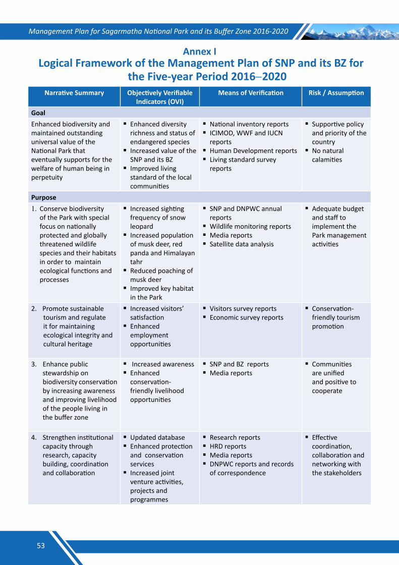
Management Plan for Sagarmatha National Park and its Buffer Zone 2016-2020
Annex I Logical Framework of the Management Plan of SNP and its BZ for
the Five-year Period 2016−2020Narrative Summary Objectively Verifiable
Indicators (OVI)Means of Verification Risk / Assumption
GoalEnhanced biodiversity and maintained outstanding universal value of the National Park that eventually supports for the welfare of human being in perpetuity
Enhanced diversity richness and status of endangered species
Increased value of the SNP and its BZ
Improved living standard of the local communities
National inventory reportsICIMOD, WWF and IUCN
reportsHuman Development reportsLiving standard survey
reports
Supportive policy and priority of the country
No natural calamities
Purpose1. Conserve biodiversity
of the Park with special focus on nationally protected and globally threatened wildlife species and their habitats in order to maintain ecological functions and processes
Increased sighting frequency of snow leopard
Increased population of musk deer, red panda and Himalayan tahr
Reduced poaching of musk deer
Improved key habitat in the Park
SNP and DNPWC annual reports
Wildlife monitoring reports Media reports Satellite data analysis
Adequate budget and staff to implement the Park management activities
2. Promote sustainable tourism and regulate it for maintaining ecological integrity and cultural heritage
Increased visitors’ satisfaction
Enhanced employment opportunities
Visitors survey reportsEconomic survey reports
Conservation- friendly tourism promotion
3. Enhance public stewardship on biodiversity conservation by increasing awareness and improving livelihood of the people living in the buffer zone
Increased awareness Enhanced
conservation-friendly livelihood opportunities
SNP and BZ reportsMedia reports
Communities are unified and positive to cooperate
4. Strengthen institutional capacity through research, capacity building, coordination and collaboration
Updated databaseEnhanced protection
and conservation services
Increased joint venture activities, projects and programmes
Research reports HRD reports Media reportsDNPWC reports and records
of correspondence
Effective coordination, collaboration and networking with the stakeholders
53
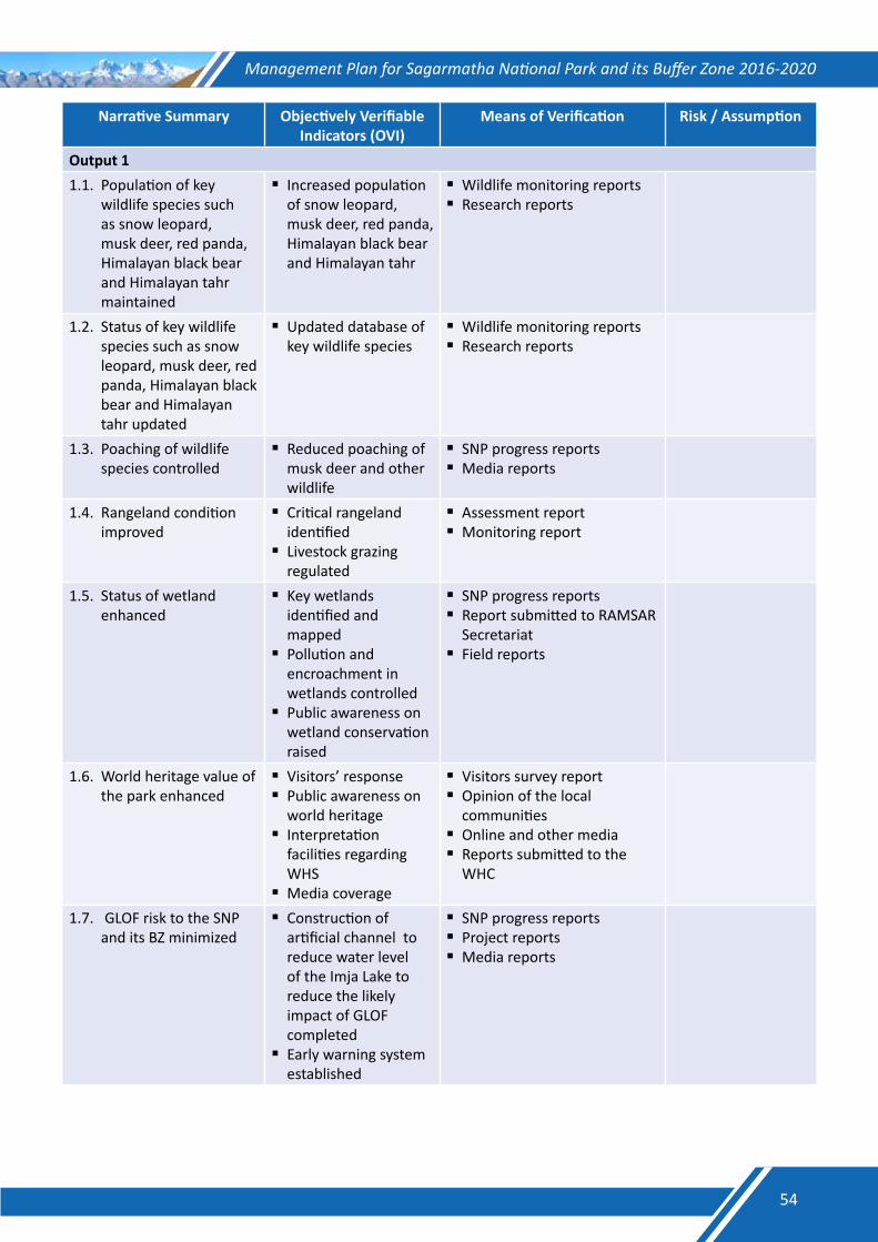
Management Plan for Sagarmatha National Park and its Buffer Zone 2016-2020
Narrative Summary Objectively Verifiable Indicators (OVI)
Means of Verification Risk / Assumption
Output 11.1. Population of key
wildlife species such as snow leopard, musk deer, red panda, Himalayan black bear and Himalayan tahr maintained
Increased population of snow leopard, musk deer, red panda, Himalayan black bear and Himalayan tahr
Wildlife monitoring reportsResearch reports
1.2. Status of key wildlife species such as snow leopard, musk deer, red panda, Himalayan black bear and Himalayan tahr updated
Updated database of key wildlife species
Wildlife monitoring reportsResearch reports
1.3. Poaching of wildlife species controlled
Reduced poaching of musk deer and other wildlife
SNP progress reportsMedia reports
1.4. Rangeland condition improved
Critical rangeland identified
Livestock grazing regulated
Assessment reportMonitoring report
1.5. Status of wetland enhanced
Key wetlands identified and mapped
Pollution and encroachment in wetlands controlled
Public awareness on wetland conservation raised
SNP progress reportsReport submitted to RAMSAR
SecretariatField reports
1.6. World heritage value of the park enhanced
Visitors’ responsePublic awareness on
world heritageInterpretation
facilities regarding WHS
Media coverage
Visitors survey reportOpinion of the local
communitiesOnline and other mediaReports submitted to the
WHC
1.7. GLOF risk to the SNP and its BZ minimized
Construction of artificial channel to reduce water level of the Imja Lake to reduce the likely impact of GLOF completed
Early warning system established
SNP progress reportsProject reportsMedia reports
54
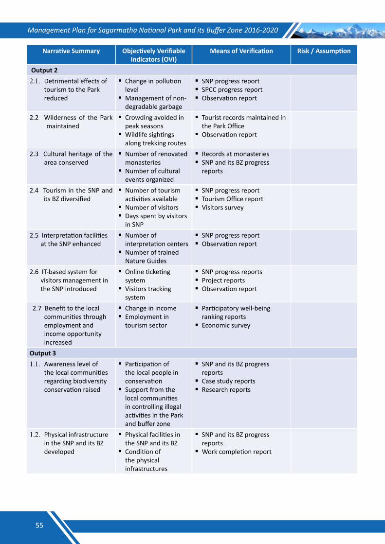
Management Plan for Sagarmatha National Park and its Buffer Zone 2016-2020
Narrative Summary Objectively Verifiable Indicators (OVI)
Means of Verification Risk / Assumption
Output 22.1. Detrimental effects of
tourism to the Park reduced
Change in pollution level
Management of non-degradable garbage
SNP progress reportSPCC progress reportObservation report
2.2 Wilderness of the Park maintained
Crowding avoided in peak seasons
Wildlife sightings along trekking routes
Tourist records maintained in the Park Office
Observation report
2.3 Cultural heritage of the area conserved
Number of renovated monasteries
Number of cultural events organized
Records at monasteriesSNP and its BZ progress
reports
2.4 Tourism in the SNP and its BZ diversified
Number of tourism activities available
Number of visitorsDays spent by visitors
in SNP
SNP progress reportTourism Office report Visitors survey
2.5 Interpretation facilities at the SNP enhanced
Number of interpretation centers
Number of trained Nature Guides
SNP progress reportObservation report
2.6 IT-based system for visitors management in the SNP introduced
Online ticketing system
Visitors tracking system
SNP progress reportsProject reportsObservation report
2.7 Benefit to the local communities through employment and income opportunity increased
Change in incomeEmployment in
tourism sector
Participatory well-being ranking reports
Economic survey
Output 31.1. Awareness level of
the local communities regarding biodiversity conservation raised
Participation of the local people in conservation
Support from the local communities in controlling illegal activities in the Park and buffer zone
SNP and its BZ progress reports
Case study reportsResearch reports
1.2. Physical infrastructure in the SNP and its BZ developed
Physical facilities in the SNP and its BZ
Condition of the physical infrastructures
SNP and its BZ progress reports
Work completion report
55
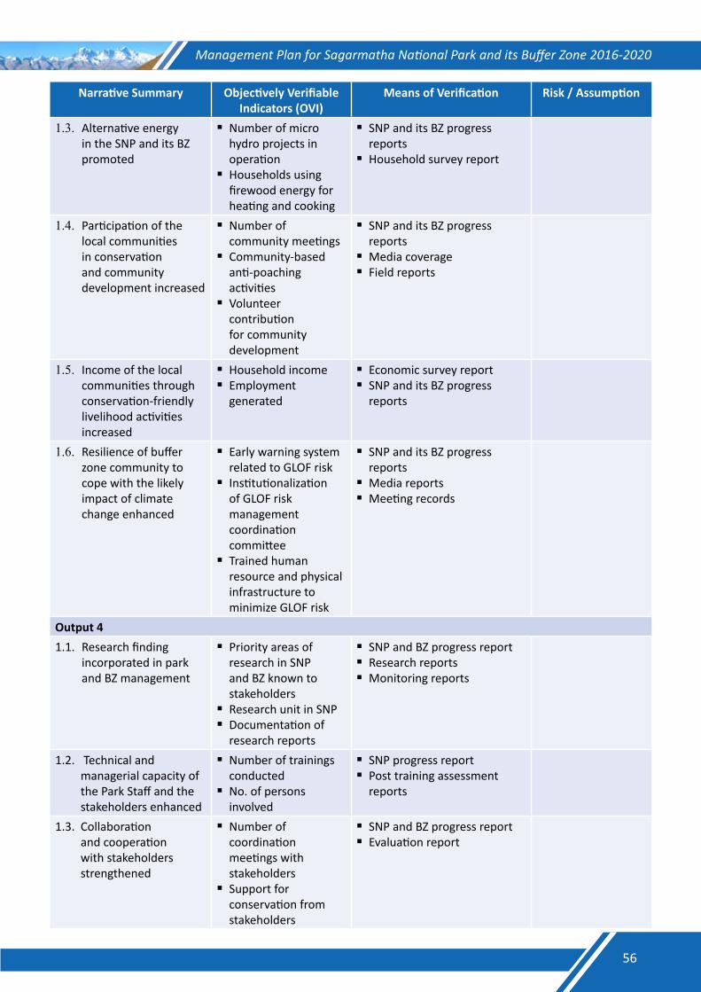
Management Plan for Sagarmatha National Park and its Buffer Zone 2016-2020
Narrative Summary Objectively Verifiable Indicators (OVI)
Means of Verification Risk / Assumption
1.3. Alternative energy in the SNP and its BZ promoted
Number of micro hydro projects in operation
Households using firewood energy for heating and cooking
SNP and its BZ progress reports
Household survey report
1.4. Participation of the local communities in conservation and community development increased
Number of community meetings
Community-based anti-poaching activities
Volunteer contribution for community development
SNP and its BZ progress reports
Media coverageField reports
1.5. Income of the local communities through conservation-friendly livelihood activities increased
Household incomeEmployment
generated
Economic survey reportSNP and its BZ progress
reports
1.6. Resilience of buffer zone community to cope with the likely impact of climate change enhanced
Early warning system related to GLOF risk
Institutionalization of GLOF risk management coordination committee
Trained human resource and physical infrastructure to minimize GLOF risk
SNP and its BZ progress reports
Media reportsMeeting records
Output 41.1. Research finding
incorporated in park and BZ management
Priority areas of research in SNP and BZ known to stakeholders
Research unit in SNPDocumentation of
research reports
SNP and BZ progress reportResearch reportsMonitoring reports
1.2. Technical and managerial capacity of the Park Staff and the stakeholders enhanced
Number of trainings conducted
No. of persons involved
SNP progress reportPost training assessment
reports
1.3. Collaboration and cooperation with stakeholders strengthened
Number of coordination meetings with stakeholders
Support for conservation from stakeholders
SNP and BZ progress reportEvaluation report
56
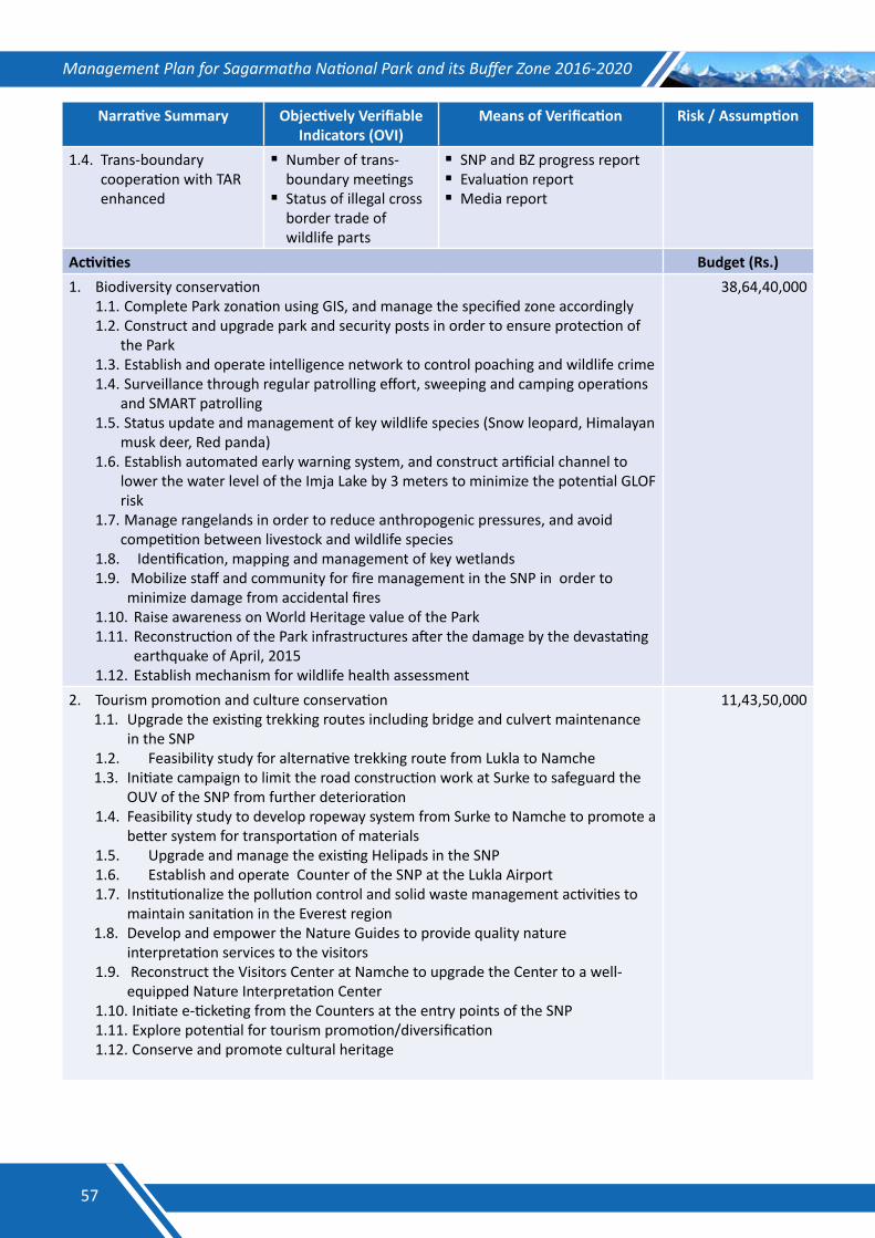
Management Plan for Sagarmatha National Park and its Buffer Zone 2016-2020
Narrative Summary Objectively Verifiable Indicators (OVI)
Means of Verification Risk / Assumption
1.4. Trans-boundary cooperation with TAR enhanced
Number of trans- boundary meetings
Status of illegal cross border trade of wildlife parts
SNP and BZ progress reportEvaluation reportMedia report
Activities Budget (Rs.)1. Biodiversity conservation
1.1. Complete Park zonation using GIS, and manage the specified zone accordingly1.2. Construct and upgrade park and security posts in order to ensure protection of
the Park1.3. Establish and operate intelligence network to control poaching and wildlife crime1.4. Surveillance through regular patrolling effort, sweeping and camping operations
and SMART patrolling1.5. Status update and management of key wildlife species (Snow leopard, Himalayan
musk deer, Red panda)1.6. Establish automated early warning system, and construct artificial channel to
lower the water level of the Imja Lake by 3 meters to minimize the potential GLOF risk
1.7. Manage rangelands in order to reduce anthropogenic pressures, and avoid competition between livestock and wildlife species
1.8. Identification, mapping and management of key wetlands 1.9. Mobilize staff and community for fire management in the SNP in order to
minimize damage from accidental fires1.10. Raise awareness on World Heritage value of the Park1.11. Reconstruction of the Park infrastructures after the damage by the devastating
earthquake of April, 20151.12. Establish mechanism for wildlife health assessment
38,64,40,000
2. Tourism promotion and culture conservation1.1. Upgrade the existing trekking routes including bridge and culvert maintenance
in the SNP 1.2. Feasibility study for alternative trekking route from Lukla to Namche1.3. Initiate campaign to limit the road construction work at Surke to safeguard the
OUV of the SNP from further deterioration1.4. Feasibility study to develop ropeway system from Surke to Namche to promote a
better system for transportation of materials1.5. Upgrade and manage the existing Helipads in the SNP1.6. Establish and operate Counter of the SNP at the Lukla Airport1.7. Institutionalize the pollution control and solid waste management activities to
maintain sanitation in the Everest region1.8. Develop and empower the Nature Guides to provide quality nature
interpretation services to the visitors1.9. Reconstruct the Visitors Center at Namche to upgrade the Center to a well-
equipped Nature Interpretation Center1.10. Initiate e-ticketing from the Counters at the entry points of the SNP1.11. Explore potential for tourism promotion/diversification1.12. Conserve and promote cultural heritage
11,43,50,000
57
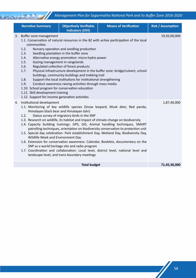
Management Plan for Sagarmatha National Park and its Buffer Zone 2016-2020
Narrative Summary Objectively Verifiable Indicators (OVI)
Means of Verification Risk / Assumption
3. Buffer zone management1.1. Conservation of natural resources in the BZ with active participation of the local
communities1.2. Nursery operation and seedling production1.3. Seedling plantation in the buffer zone1.4. Alternative energy promotion: micro-hydro power1.5. Gazing management in rangelands1.6. Regulated collection of forest products1.7. Physical infrastructure development in the buffer zone: bridge/culvert, school
buildings, community buildings and trekking trail 1.8. Support the local institutions for institutional strengthening 1.9. Conduct awareness raising activities through mass media1.10. School program for conservation education1.11. Skill development training1.12. Support for income generation activities
19,50,00,000
4. Institutional development1.1. Monitoring of key wildlife species (Snow leopard, Musk deer, Red panda,
Himalayan black bear and Himalayan tahr)1.2. Status survey of migratory birds in the SNP1.3. Research on wildlife, its habitat and impact of climate change on biodiversity1.4. Capacity building trainings: GPS, GIS, Animal handling techniques, SMART
patrolling techniques, orientation on biodiversity conservation to protection unit1.5. Special day celebration- Park establishment Day, Wetland Day, Biodiversity Day,
Wildlife Week and Environment Day1.6. Extension for conservation awareness: Calendar, Booklets, documentary on the
SNP as a world heritage site and radio program1.7. Coordination and collaboration: Local level, district level, national level and
landscape level, and trans-boundary meetings
1,87,40,000
Total budget 71,45,30,000
58
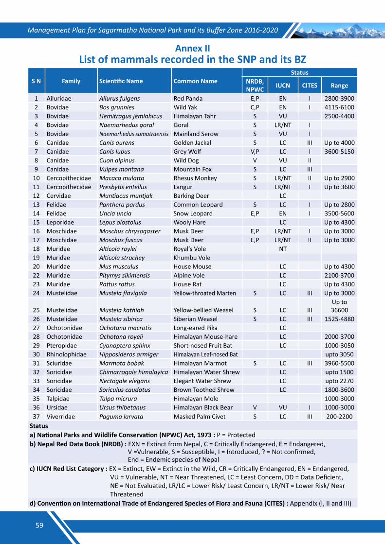
Management Plan for Sagarmatha National Park and its Buffer Zone 2016-2020
Annex IIList of mammals recorded in the SNP and its BZ
S N Family Scientific Name Common NameStatus
NRDB, NPWC IUCN CITES Range
1 Ailuridae Ailurus fulgens Red Panda E,P EN I 2800-39002 Bovidae Bos grunnies Wild Yak C,P EN I 4115-61003 Bovidae Hemitragus jemlahicus Himalayan Tahr S VU 2500-44004 Bovidae Naemorhedus goral Goral S LR/NT I 5 Bovidae Naemorhedus sumatraensis Mainland Serow S VU I 6 Canidae Canis aurens Golden Jackal S LC III Up to 40007 Canidae Canis lupus Grey Wolf V,P LC I 3600-51508 Canidae Cuon alpinus Wild Dog V VU II 9 Canidae Vulpes montana Mountain Fox S LC III
10 Cercopithecidae Macaca mulatta Rhesus Monkey S LR/NT II Up to 290011 Cercopithecidae Presbytis entellus Langur S LR/NT I Up to 360012 Cervidae Muntiacus muntjak Barking Deer LC 13 Felidae Panthera pardus Common Leopard S LC I Up to 280014 Felidae Uncia uncia Snow Leopard E,P EN I 3500-560015 Leporidae Lepus oiostolus Wooly Hare LC Up to 430016 Moschidae Moschus chrysogaster Musk Deer E,P LR/NT I Up to 300017 Moschidae Moschus fuscus Musk Deer E,P LR/NT II Up to 300018 Muridae Alticola roylei Royal’s Vole NT 19 Muridae Alticola strachey Khumbu Vole 20 Muridae Mus musculus House Mouse LC Up to 430022 Muridae Pitymys sikimensis Alpine Vole LC 2100-370023 Muridae Rattus rattus House Rat LC Up to 430024 Mustelidae Mustela flavigula Yellow-throated Marten S LC III Up to 3000
25 Mustelidae Mustela kathiah Yellow-bellied Weasel S LC IIIUp to 36600
26 Mustelidae Mustela sibirica Siberian Weasel S LC III 1525-488027 Ochotonidae Ochotana macrotis Long-eared Pika LC 28 Ochotonidae Ochotana royeli Himalayan Mouse-hare LC 2000-370029 Pteropidae Cyanoptera sphinx Short-nosed Fruit Bat LC 1000-305030 Rhinolophidae Hipposideros armiger Himalayan Leaf-nosed Bat upto 305031 Sciuridae Marmota bobak Himalayan Marmot S LC III 3960-550032 Soricidae Chimarrogale himalayica Himalayan Water Shrew LC upto 150033 Soricidae Nectogale elegans Elegant Water Shrew LC upto 227034 Soricidae Soriculus caudatus Brown Toothed Shrew LC 1800-360035 Talpidae Talpa micrura Himalayan Mole 1000-300036 Ursidae Ursus thibetanus Himalayan Black Bear V VU I 1000-300037 Viverridae Paguma larvata Masked Palm Civet S LC III 200-2200
Statusa) National Parks and Wildlife Conservation (NPWC) Act, 1973 : P = Protectedb) Nepal Red Data Book (NRDB) : EXN = Extinct from Nepal, C = Critically Endangered, E = Endangered, V =Vulnerable, S = Susceptible, I = Introduced, ? = Not confirmed, End = Endemic species of Nepalc) IUCN Red List Category : EX = Extinct, EW = Extinct in the Wild, CR = Critically Endangered, EN = Endangered, VU = Vulnerable, NT = Near Threatened, LC = Least Concern, DD = Data Deficient, NE = Not Evaluated, LR/LC = Lower Risk/ Least Concern, LR/NT = Lower Risk/ Near Threatenedd) Convention on International Trade of Endangered Species of Flora and Fauna (CITES) : Appendix (I, II and III)
59
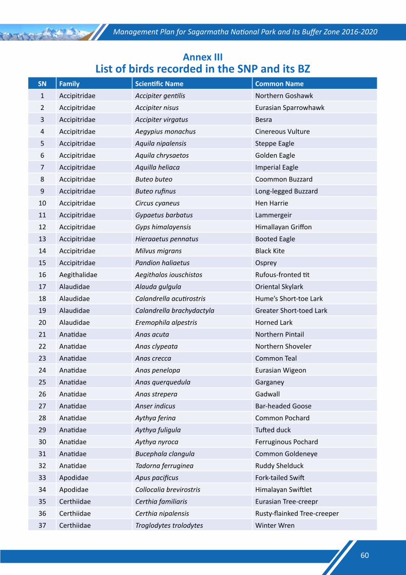
Management Plan for Sagarmatha National Park and its Buffer Zone 2016-2020
Annex IIIList of birds recorded in the SNP and its BZ
SN Family Scientific Name Common Name
1 Accipitridae Accipiter gentilis Northern Goshawk
2 Accipitridae Accipiter nisus Eurasian Sparrowhawk
3 Accipitridae Accipiter virgatus Besra
4 Accipitridae Aegypius monachus Cinereous Vulture
5 Accipitridae Aquila nipalensis Steppe Eagle
6 Accipitridae Aquila chrysaetos Golden Eagle
7 Accipitridae Aquilla heliaca Imperial Eagle
8 Accipitridae Buteo buteo Coommon Buzzard
9 Accipitridae Buteo rufinus Long-legged Buzzard
10 Accipitridae Circus cyaneus Hen Harrie
11 Accipitridae Gypaetus barbatus Lammergeir
12 Accipitridae Gyps himalayensis Himallayan Griffon
13 Accipitridae Hieraaetus pennatus Booted Eagle
14 Accipitridae Milvus migrans Black Kite
15 Accipitridae Pandion haliaetus Osprey
16 Aegithalidae Aegithalos iouschistos Rufous-fronted tit
17 Alaudidae Alauda gulgula Oriental Skylark
18 Alaudidae Calandrella acutirostris Hume’s Short-toe Lark
19 Alaudidae Calandrella brachydactyla Greater Short-toed Lark
20 Alaudidae Eremophila alpestris Horned Lark
21 Anatidae Anas acuta Northern Pintail
22 Anatidae Anas clypeata Northern Shoveler
23 Anatidae Anas crecca Common Teal
24 Anatidae Anas penelopa Eurasian Wigeon
25 Anatidae Anas querquedula Garganey
26 Anatidae Anas strepera Gadwall
27 Anatidae Anser indicus Bar-headed Goose
28 Anatidae Aythya ferina Common Pochard
29 Anatidae Aythya fuligula Tufted duck
30 Anatidae Aythya nyroca Ferruginous Pochard
31 Anatidae Bucephala clangula Common Goldeneye
32 Anatidae Tadorna ferruginea Ruddy Shelduck
33 Apodidae Apus pacificus Fork-tailed Swift
34 Apodidae Collocalia brevirostris Himalayan Swiftlet
35 Certhiidae Certhia familiaris Eurasian Tree-creepr
36 Certhiidae Certhia nipalensis Rusty-flainked Tree-creeper
37 Certhiidae Troglodytes trolodytes Winter Wren
60
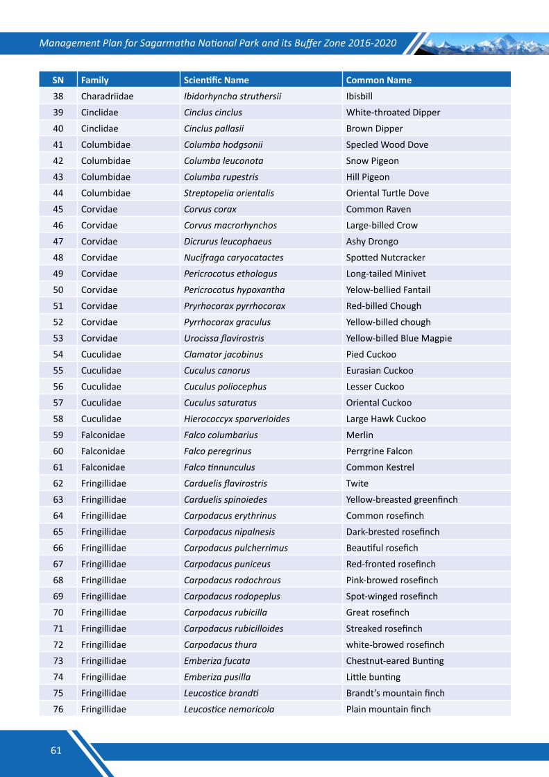
Management Plan for Sagarmatha National Park and its Buffer Zone 2016-2020
SN Family Scientific Name Common Name
38 Charadriidae Ibidorhyncha struthersii Ibisbill
39 Cinclidae Cinclus cinclus White-throated Dipper
40 Cinclidae Cinclus pallasii Brown Dipper
41 Columbidae Columba hodgsonii Specled Wood Dove
42 Columbidae Columba leuconota Snow Pigeon
43 Columbidae Columba rupestris Hill Pigeon
44 Columbidae Streptopelia orientalis Oriental Turtle Dove
45 Corvidae Corvus corax Common Raven
46 Corvidae Corvus macrorhynchos Large-billed Crow
47 Corvidae Dicrurus leucophaeus Ashy Drongo
48 Corvidae Nucifraga caryocatactes Spotted Nutcracker
49 Corvidae Pericrocotus ethologus Long-tailed Minivet
50 Corvidae Pericrocotus hypoxantha Yelow-bellied Fantail
51 Corvidae Pryrhocorax pyrrhocorax Red-billed Chough
52 Corvidae Pyrrhocorax graculus Yellow-billed chough
53 Corvidae Urocissa flavirostris Yellow-billed Blue Magpie
54 Cuculidae Clamator jacobinus Pied Cuckoo
55 Cuculidae Cuculus canorus Eurasian Cuckoo
56 Cuculidae Cuculus poliocephus Lesser Cuckoo
57 Cuculidae Cuculus saturatus Oriental Cuckoo
58 Cuculidae Hierococcyx sparverioides Large Hawk Cuckoo
59 Falconidae Falco columbarius Merlin
60 Falconidae Falco peregrinus Perrgrine Falcon
61 Falconidae Falco tinnunculus Common Kestrel
62 Fringillidae Carduelis flavirostris Twite
63 Fringillidae Carduelis spinoiedes Yellow-breasted greenfinch
64 Fringillidae Carpodacus erythrinus Common rosefinch
65 Fringillidae Carpodacus nipalnesis Dark-brested rosefinch
66 Fringillidae Carpodacus pulcherrimus Beautiful rosefich
67 Fringillidae Carpodacus puniceus Red-fronted rosefinch
68 Fringillidae Carpodacus rodochrous Pink-browed rosefinch
69 Fringillidae Carpodacus rodopeplus Spot-winged rosefinch
70 Fringillidae Carpodacus rubicilla Great rosefinch
71 Fringillidae Carpodacus rubicilloides Streaked rosefinch
72 Fringillidae Carpodacus thura white-browed rosefinch
73 Fringillidae Emberiza fucata Chestnut-eared Bunting
74 Fringillidae Emberiza pusilla Little bunting
75 Fringillidae Leucostice brandti Brandt’s mountain finch
76 Fringillidae Leucostice nemoricola Plain mountain finch
61
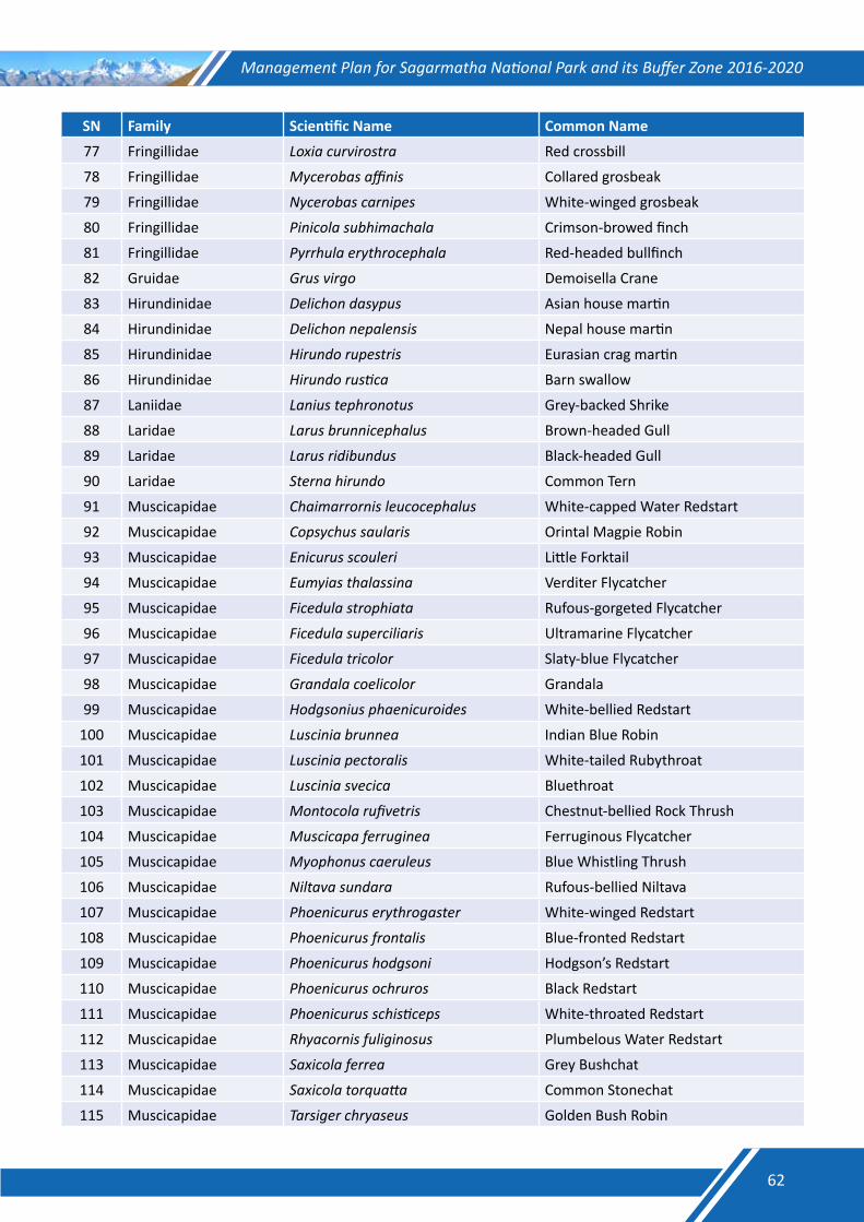
Management Plan for Sagarmatha National Park and its Buffer Zone 2016-2020
SN Family Scientific Name Common Name
77 Fringillidae Loxia curvirostra Red crossbill
78 Fringillidae Mycerobas affinis Collared grosbeak
79 Fringillidae Nycerobas carnipes White-winged grosbeak
80 Fringillidae Pinicola subhimachala Crimson-browed finch
81 Fringillidae Pyrrhula erythrocephala Red-headed bullfinch
82 Gruidae Grus virgo Demoisella Crane
83 Hirundinidae Delichon dasypus Asian house martin
84 Hirundinidae Delichon nepalensis Nepal house martin
85 Hirundinidae Hirundo rupestris Eurasian crag martin
86 Hirundinidae Hirundo rustica Barn swallow
87 Laniidae Lanius tephronotus Grey-backed Shrike
88 Laridae Larus brunnicephalus Brown-headed Gull
89 Laridae Larus ridibundus Black-headed Gull
90 Laridae Sterna hirundo Common Tern
91 Muscicapidae Chaimarrornis leucocephalus White-capped Water Redstart
92 Muscicapidae Copsychus saularis Orintal Magpie Robin
93 Muscicapidae Enicurus scouleri Little Forktail
94 Muscicapidae Eumyias thalassina Verditer Flycatcher
95 Muscicapidae Ficedula strophiata Rufous-gorgeted Flycatcher
96 Muscicapidae Ficedula superciliaris Ultramarine Flycatcher
97 Muscicapidae Ficedula tricolor Slaty-blue Flycatcher
98 Muscicapidae Grandala coelicolor Grandala
99 Muscicapidae Hodgsonius phaenicuroides White-bellied Redstart
100 Muscicapidae Luscinia brunnea Indian Blue Robin
101 Muscicapidae Luscinia pectoralis White-tailed Rubythroat
102 Muscicapidae Luscinia svecica Bluethroat
103 Muscicapidae Montocola rufivetris Chestnut-bellied Rock Thrush
104 Muscicapidae Muscicapa ferruginea Ferruginous Flycatcher
105 Muscicapidae Myophonus caeruleus Blue Whistling Thrush
106 Muscicapidae Niltava sundara Rufous-bellied Niltava
107 Muscicapidae Phoenicurus erythrogaster White-winged Redstart
108 Muscicapidae Phoenicurus frontalis Blue-fronted Redstart
109 Muscicapidae Phoenicurus hodgsoni Hodgson’s Redstart
110 Muscicapidae Phoenicurus ochruros Black Redstart
111 Muscicapidae Phoenicurus schisticeps White-throated Redstart
112 Muscicapidae Rhyacornis fuliginosus Plumbelous Water Redstart
113 Muscicapidae Saxicola ferrea Grey Bushchat
114 Muscicapidae Saxicola torquatta Common Stonechat
115 Muscicapidae Tarsiger chryaseus Golden Bush Robin
62
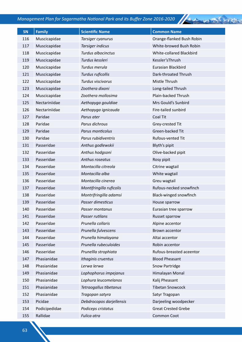
Management Plan for Sagarmatha National Park and its Buffer Zone 2016-2020
SN Family Scientific Name Common Name
116 Muscicapidae Tarsiger cyanurus Orange-flanked Bush Robin
117 Muscicapidae Tarsiger indicus White-browed Bush Robin
118 Muscicapidae Turdus albocinctus White-collared Blackbird
119 Muscicapidae Turdus kessleri Kessler’sThrush
120 Muscicapidae Turdus merula Eurasian Blackbird
121 Muscicapidae Turdus ruficollis Dark-throated Thrush
122 Muscicapidae Turdus viscivorus Mistle Thrush
123 Muscicapidae Zoothera dixoni Long-tailed Thrush
124 Muscicapidae Zoothera mollosima Plain-backed Thrush
125 Nectariniidae Aethopyga gouldiae Mrs Gould’s Sunbird
126 Nectariniidae Aethopyga ignicauda Fire-tailed sunbird
127 Paridae Parus ater Coal Tit
128 Paridae Parus dichrous Grey-crested Tit
129 Paridae Parus monticolus Green-backed Tit
130 Paridae Parus rubidiventris Rufous-vented Tit
131 Passeridae Anthus godlewskii Blyth’s pipit
132 Passeridae Anthus hodgsoni Olive-backed pipit
133 Passeridae Anthus roseatus Rosy pipit
134 Passeridae Montacilla citreola Citrine wagtail
135 Passeridae Montacilla alba White wagtail
136 Passeridae Montacilla cinerea Greu wagtail
137 Passeridae Montifringilla ruficolis Rufous-necked snowfinch
138 Passeridae Montrifringilla adamsi Black-winged snowfinch
139 Passeridae Passer dimesticus House sparrow
140 Passeridae Passer montanus Eurasian tree sparrow
141 Passeridae Passer rutilans Russet sparrow
142 Passeridae Prunella collaris Alpine accentor
143 Passeridae Prunella fulvescens Brown accentor
144 Passeridae Prunella himalayana Altai accentor
145 Passeridae Prunella rubeculoides Robin accentor
146 Passeridae Prunellla strophiata Rufous-breasted aceentor
147 Phasianidae Ithaginis cruentus Blood Pheasant
148 Phasianidae Lerwa lerwa Snow Partridge
149 Phasianidae Lophophorus impejanus Himalayan Monal
150 Phasianidae Lophura leucomelanos Kalij Pheasant
151 Phasianidae Tetraogallus tibetanus Tibetan Snowcock
152 Phasianidae Tragopan satyra Satyr Tragopan
153 Picidae Debdrocopos darjellensis Darjeeling woodpecker
154 Podicipedidae Podiceps cristatus Great Crested Grebe
155 Rallidae Fulica atra Common Coot
63
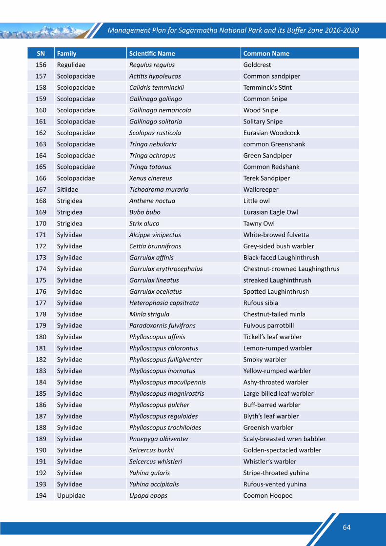
Management Plan for Sagarmatha National Park and its Buffer Zone 2016-2020
SN Family Scientific Name Common Name
156 Regulidae Regulus regulus Goldcrest
157 Scolopacidae Actitis hypoleucos Common sandpiper
158 Scolopacidae Calidris temminckii Temminck’s Stint
159 Scolopacidae Gallinago gallingo Common Snipe
160 Scolopacidae Gallinago nemoricola Wood Snipe
161 Scolopacidae Gallinago solitaria Solitary Snipe
162 Scolopacidae Scolopax rusticola Eurasian Woodcock
163 Scolopacidae Tringa nebularia common Greenshank
164 Scolopacidae Tringa ochropus Green Sandpiper
165 Scolopacidae Tringa totanus Common Redshank
166 Scolopacidae Xenus cinereus Terek Sandpiper
167 Sitiidae Tichodroma muraria Wallcreeper
168 Strigidea Anthene noctua Little owl
169 Strigidea Bubo bubo Eurasian Eagle Owl
170 Strigidea Strix aluco Tawny Owl
171 Sylviidae Alcippe vinipectus White-browed fulvetta
172 Sylviidae Cettia brunnifrons Grey-sided bush warbler
173 Sylviidae Garrulax affinis Black-faced Laughinthrush
174 Sylviidae Garrulax erythrocephalus Chestnut-crowned Laughingthrus
175 Sylviidae Garrulax lineatus streaked Laughinthrush
176 Sylviidae Garrulax ocellatus Spotted Laughinthrush
177 Sylviidae Heterophasia capsitrata Rufous sibia
178 Sylviidae Minla strigula Chestnut-tailed minla
179 Sylviidae Paradoxornis fulvifrons Fulvous parrotbill
180 Sylviidae Phylloscopus affinis Tickell’s leaf warbler
181 Sylviidae Phylloscopus chlorontus Lemon-rumped warbler
182 Sylviidae Phylloscopus fulligiventer Smoky warbler
183 Sylviidae Phylloscopus inornatus Yellow-rumped warbler
184 Sylviidae Phylloscopus maculipennis Ashy-throated warbler
185 Sylviidae Phylloscopus magnirostris Large-billed leaf warbler
186 Sylviidae Phylloscopus pulcher Buff-barred warbler
187 Sylviidae Phylloscopus reguloides Blyth’s leaf warbler
188 Sylviidae Phylloscopus trochiloides Greenish warbler
189 Sylviidae Pnoepyga albiventer Scaly-breasted wren babbler
190 Sylviidae Seicercus burkii Golden-spectacled warbler
191 Sylviidae Seicercus whistleri Whistler’s warbler
192 Sylviidae Yuhina gularis Stripe-throated yuhina
193 Sylviidae Yuhina occipitalis Rufous-vented yuhina
194 Upupidae Upapa epops Coomon Hoopoe
64
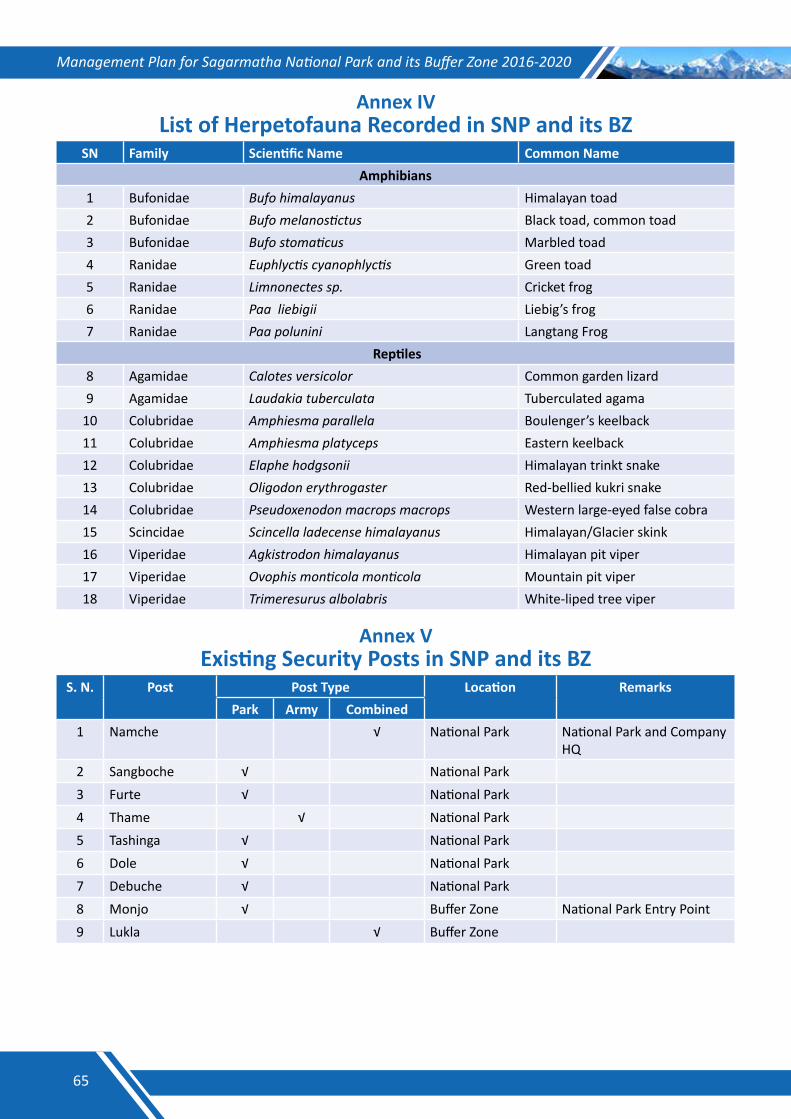
Management Plan for Sagarmatha National Park and its Buffer Zone 2016-2020
Annex IVList of Herpetofauna Recorded in SNP and its BZ
SN Family Scientific Name Common NameAmphibians
1 Bufonidae Bufo himalayanus Himalayan toad2 Bufonidae Bufo melanostictus Black toad, common toad3 Bufonidae Bufo stomaticus Marbled toad4 Ranidae Euphlyctis cyanophlyctis Green toad5 Ranidae Limnonectes sp. Cricket frog6 Ranidae Paa liebigii Liebig’s frog7 Ranidae Paa polunini Langtang Frog
Reptiles8 Agamidae Calotes versicolor Common garden lizard9 Agamidae Laudakia tuberculata Tuberculated agama
10 Colubridae Amphiesma parallela Boulenger’s keelback11 Colubridae Amphiesma platyceps Eastern keelback12 Colubridae Elaphe hodgsonii Himalayan trinkt snake13 Colubridae Oligodon erythrogaster Red-bellied kukri snake14 Colubridae Pseudoxenodon macrops macrops Western large-eyed false cobra15 Scincidae Scincella ladecense himalayanus Himalayan/Glacier skink16 Viperidae Agkistrodon himalayanus Himalayan pit viper17 Viperidae Ovophis monticola monticola Mountain pit viper18 Viperidae Trimeresurus albolabris White-liped tree viper
Annex VExisting Security Posts in SNP and its BZ
S. N. Post Post Type Location RemarksPark Army Combined
1 Namche √ National Park National Park and Company HQ
2 Sangboche √ National Park3 Furte √ National Park4 Thame √ National Park5 Tashinga √ National Park6 Dole √ National Park7 Debuche √ National Park8 Monjo √ Buffer Zone National Park Entry Point9 Lukla √ Buffer Zone
65
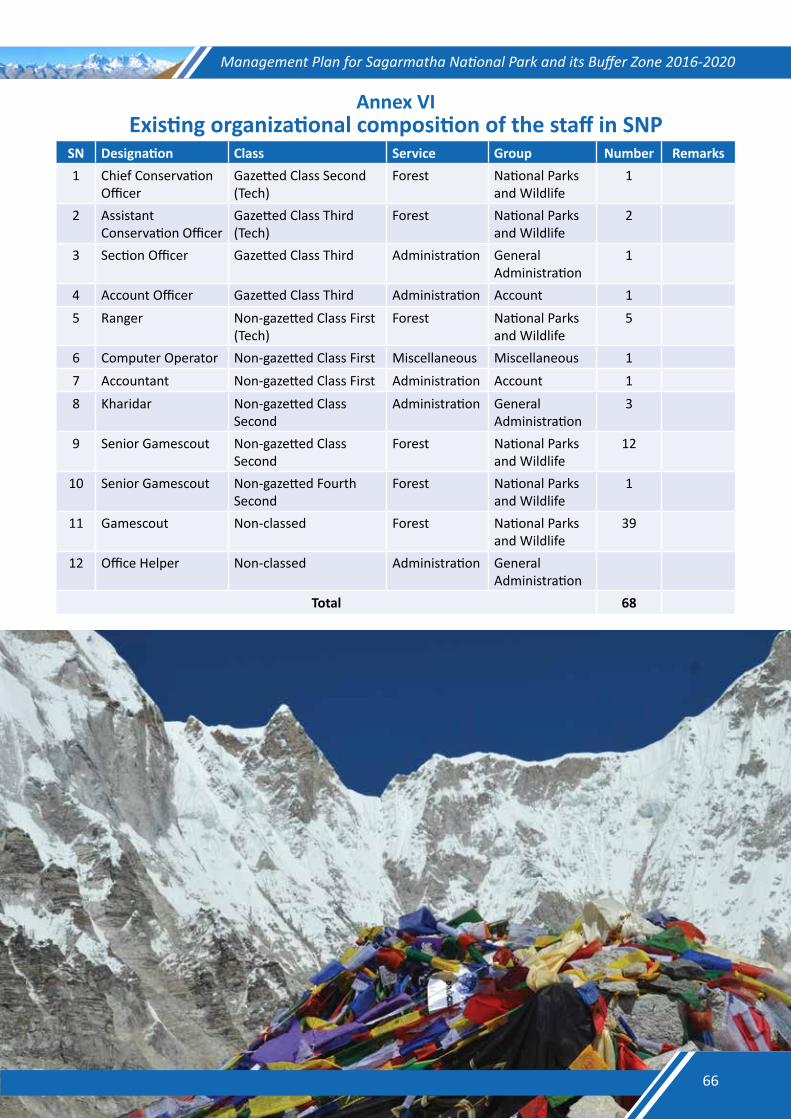
Management Plan for Sagarmatha National Park and its Buffer Zone 2016-2020
Annex VIExisting organizational composition of the staff in SNP
SN Designation Class Service Group Number Remarks1 Chief Conservation
OfficerGazetted Class Second (Tech)
Forest National Parks and Wildlife
1
2 Assistant Conservation Officer
Gazetted Class Third (Tech)
Forest National Parks and Wildlife
2
3 Section Officer Gazetted Class Third Administration General Administration
1
4 Account Officer Gazetted Class Third Administration Account 15 Ranger Non-gazetted Class First
(Tech)Forest National Parks
and Wildlife5
6 Computer Operator Non-gazetted Class First Miscellaneous Miscellaneous 17 Accountant Non-gazetted Class First Administration Account 18 Kharidar Non-gazetted Class
SecondAdministration General
Administration3
9 Senior Gamescout Non-gazetted Class Second
Forest National Parks and Wildlife
12
10 Senior Gamescout Non-gazetted Fourth Second
Forest National Parks and Wildlife
1
11 Gamescout Non-classed Forest National Parks and Wildlife
39
12 Office Helper Non-classed Administration General Administration
Total 68
66
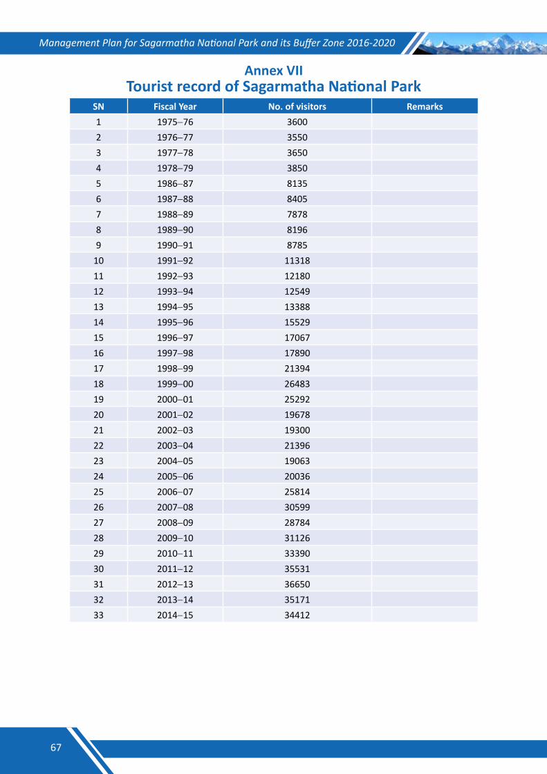
Management Plan for Sagarmatha National Park and its Buffer Zone 2016-2020
Annex VIITourist record of Sagarmatha National Park
SN Fiscal Year No. of visitors Remarks1 1975−76 3600 2 1976−77 3550 3 1977−78 3650 4 1978−79 3850 5 1986−87 8135 6 1987−88 8405 7 1988−89 7878 8 1989−90 8196 9 1990−91 8785
10 1991−92 11318 11 1992−93 12180 12 1993−94 12549 13 1994−95 13388 14 1995−96 15529 15 1996−97 17067 16 1997−98 17890 17 1998−99 21394 18 1999−00 26483 19 2000−01 25292 20 2001−02 19678 21 2002−03 19300 22 2003−04 21396 23 2004−05 19063 24 2005−06 20036 25 2006−07 25814 26 2007−08 30599 27 2008−09 28784 28 2009−10 31126 29 2010−11 33390 30 2011−12 35531 31 2012−13 36650 32 2013−14 35171 33 2014−15 34412
67
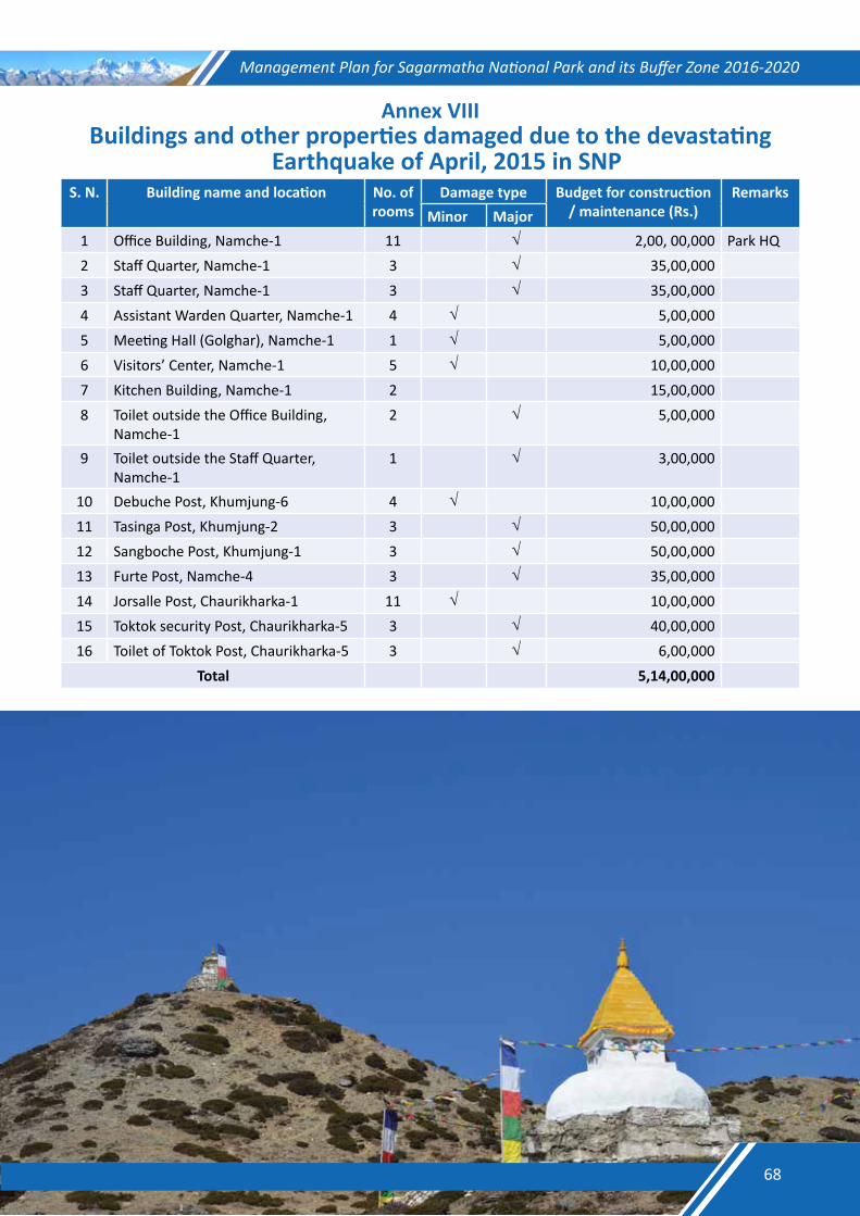
Management Plan for Sagarmatha National Park and its Buffer Zone 2016-2020
Annex VIIIBuildings and other properties damaged due to the devastating
Earthquake of April, 2015 in SNP S. N. Building name and location No. of
roomsDamage type Budget for construction
/ maintenance (Rs.)Remarks
Minor Major1 Office Building, Namche-1 11 √ 2,00, 00,000 Park HQ2 Staff Quarter, Namche-1 3 √ 35,00,0003 Staff Quarter, Namche-1 3 √ 35,00,0004 Assistant Warden Quarter, Namche-1 4 √ 5,00,0005 Meeting Hall (Golghar), Namche-1 1 √ 5,00,0006 Visitors’ Center, Namche-1 5 √ 10,00,0007 Kitchen Building, Namche-1 2 15,00,0008 Toilet outside the Office Building,
Namche-12 √ 5,00,000
9 Toilet outside the Staff Quarter, Namche-1
1 √ 3,00,000
10 Debuche Post, Khumjung-6 4 √ 10,00,00011 Tasinga Post, Khumjung-2 3 √ 50,00,00012 Sangboche Post, Khumjung-1 3 √ 50,00,00013 Furte Post, Namche-4 3 √ 35,00,00014 Jorsalle Post, Chaurikharka-1 11 √ 10,00,00015 Toktok security Post, Chaurikharka-5 3 √ 40,00,00016 Toilet of Toktok Post, Chaurikharka-5 3 √ 6,00,000
Total 5,14,00,000
68
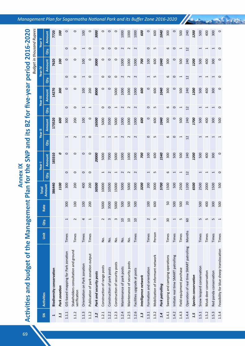
Management Plan for Sagarmatha National Park and its Buffer Zone 2016-2020An
nex
IXAc
tiviti
es a
nd b
udge
t of t
he M
anag
emen
t Pla
n fo
r the
SN
P an
d its
BZ
for fi
ve-y
ear p
erio
d 20
16-2
020
Budg
et in
thou
sand
Rup
ees
SNAc
tiviti
esU
nit
Qty
.Ra
teTo
tal
Amou
ntYe
ar I
Year
IIYe
ar II
IYe
ar IV
Year
V
Qty
.Am
ount
Qty
.Am
ount
Qty
.Am
ount
Qty
.Am
ount
Qty
.Am
ount
1Bi
odiv
ersi
ty c
onse
rvati
on
3864
40
1833
10
1735
20
1427
0
7620
77
20
1.1
Parkzo
natio
n
1100
0
60
0
300
10
0
100
1.1.
1GI
S-ba
sed
map
ping
for P
ark
zona
tion
Tim
es
130
030
00
01
300
00
00
00
1.1.
2St
akeh
olde
rs c
onsu
ltatio
n an
d gr
ound
ve
rifica
tion
Tim
es
210
020
00
02
200
00
00
00
1.1.
3O
rient
ation
on
Park
zona
tion
Tim
es
410
040
00
01
100
110
01
100
110
0
1.1.
2Pu
blic
ation
of p
ark
zona
tion
outp
utTi
mes
1
200
200
00
00
120
00
00
0
1.2
Parkand
securitypo
sts
50
500
20
000
16
500
80
00
3000
30
00
1.2.
1Co
nstr
uctio
n of
rang
e po
sts
No.
250
0010
000
150
001
5000
00
00
00
1.2.
2Co
nstr
uctio
n of
par
k po
sts
No.
335
0010
500
270
001
3500
00
00
00
1.2.
3Co
nstr
uctio
n of
secu
rity
post
sN
o.3
5000
1500
01
5000
150
001
5000
00
00
1.2.
4M
aint
enan
ce o
f par
k po
sts
No.
1050
050
002
1000
210
002
1000
210
002
1000
1.2.
5M
aint
enan
ce o
f sec
urity
pos
tsN
o.10
500
5000
210
002
1000
210
002
1000
210
00
1.2.
6Fa
ciliti
es u
pgra
de a
t pos
tsTi
mes
10
500
5000
210
002
1000
210
002
1000
210
00
1.3
Intellige
ncene
twork
32
00
700
60
0
600
70
0
600
1.3.
1Fo
rmati
on a
nd o
rient
ation
Tim
es
210
020
01
100
00
00
110
00
0
1.3.
2M
obili
zatio
n of
info
rman
t net
wor
kPe
rson
560
030
005
600
560
05
600
560
05
600
1.4
Parkpatrolling
57
00
1540
10
40
1040
10
40
1040
1.4.
1Sw
eepi
ng a
nd c
ampi
ng o
pera
tions
Tim
es
3050
1500
630
06
300
630
06
300
630
0
1.4.
2In
itiat
e re
al ti
me
SMAR
T pa
trol
ling
Tim
es
150
050
01
500
00
00
00
00
1.4.
3Fi
eld
equi
pmen
t pur
chas
eTi
mes
5
500
2500
150
01
500
150
01
500
150
0
1.4.
4O
pera
tion
of re
al ti
me
SMAR
T pa
trol
ling
Mon
ths
6020
1200
1224
012
240
1224
012
240
1224
0
1.5
Speciesc
onservati
on
65
00
1200
17
00
1200
12
00
1200
1.5.
1Sn
ow le
opar
d co
nser
vatio
nTi
mes
5
500
2500
150
01
500
150
01
500
150
0
1.5.
2M
usk
deer
con
serv
ation
Tim
es
540
020
001
400
140
01
400
140
01
400
1.5.
3Re
d pa
nda
cons
erva
tion
Tim
es
530
015
001
300
130
01
300
130
01
300
1.5.
4Fe
asib
ility
for b
lue
shee
p tr
anslo
catio
nTi
mes
1
500
500
00
150
00
00
00
0
69
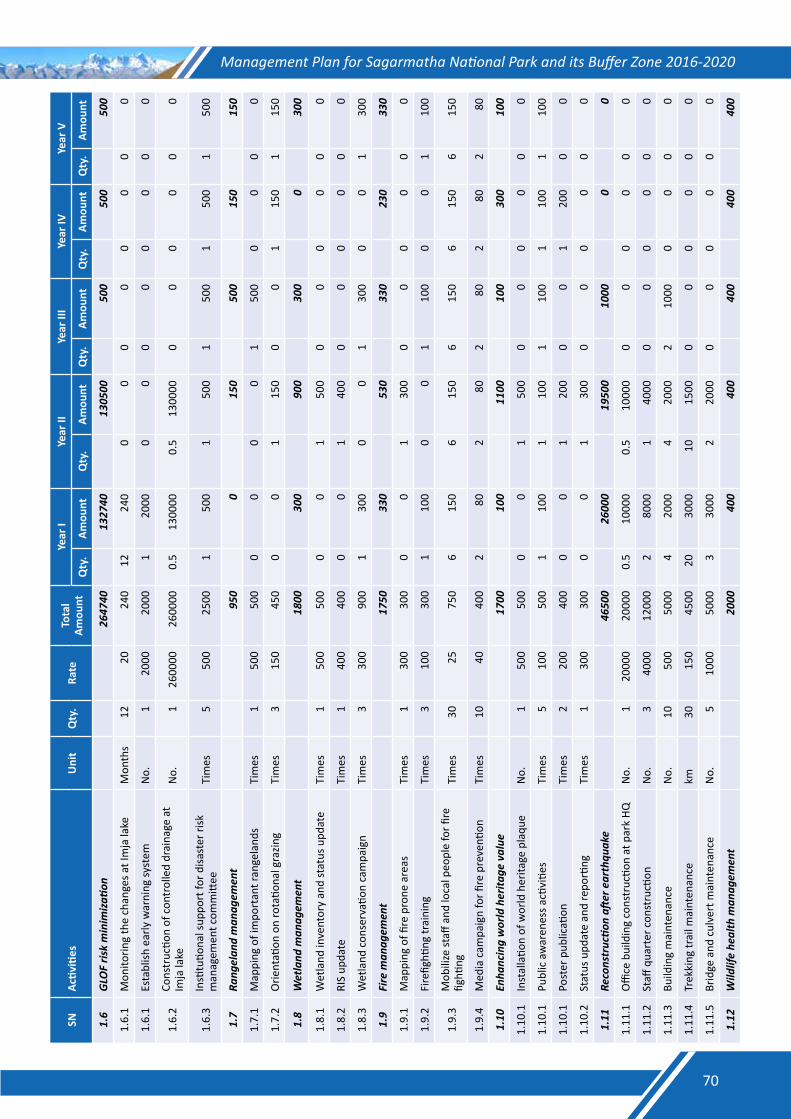
Management Plan for Sagarmatha National Park and its Buffer Zone 2016-2020SN
Activ
ities
Uni
tQ
ty.
Rate
Tota
l Am
ount
Year
IYe
ar II
Year
III
Year
IVYe
ar V
Qty
.Am
ount
Qty
.Am
ount
Qty
.Am
ount
Qty
.Am
ount
Qty
.Am
ount
1.6
GLO
Fris
kminim
izatio
n
2647
40
1327
40
1305
00
500
50
0
500
1.6.
1M
onito
ring
the
chan
ges a
t Im
ja la
keM
onth
s12
2024
012
240
00
00
00
00
1.6.
1Es
tabl
ish e
arly
war
ning
syst
emN
o.1
2000
2000
120
000
00
00
00
0
1.6.
2Co
nstr
uctio
n of
con
trol
led
drai
nage
at
Imja
lake
No.
126
0000
2600
000.
513
0000
0.5
1300
000
00
00
0
1.6.
3In
stitu
tiona
l sup
port
for d
isast
er ri
sk
man
agem
ent c
omm
ittee
Tim
es
550
025
001
500
150
01
500
150
01
500
1.7
Rang
elan
dman
agem
ent
95
0
0
150
50
0
150
15
0
1.7.
1M
appi
ng o
f im
port
ant r
ange
land
sTi
mes
1
500
500
00
00
150
00
00
0
1.7.
2O
rient
ation
on
rota
tiona
l gra
zing
Tim
es
315
045
00
01
150
00
115
01
150
1.8
Wetland
man
agem
ent
18
00
300
90
0
300
0
30
0
1.8.
1W
etla
nd in
vent
ory
and
stat
us u
pdat
eTi
mes
1
500
500
00
150
00
00
00
0
1.8.
2RI
S up
date
Tim
es
140
040
00
01
400
00
00
00
1.8.
3W
etla
nd c
onse
rvati
on c
ampa
ign
Tim
es
330
090
01
300
00
130
00
01
300
1.9
Firem
anag
emen
t
1750
33
0
530
33
0
230
33
0
1.9.
1M
appi
ng o
f fire
pro
ne a
reas
Tim
es
130
030
00
01
300
00
00
00
1.9.
2Fi
refig
hting
trai
ning
Tim
es
310
030
01
100
00
110
00
01
100
1.9.
3M
obili
ze st
aff a
nd lo
cal p
eopl
e fo
r fire
fig
hting
Tim
es
3025
750
615
06
150
615
06
150
615
0
1.9.
4M
edia
cam
paig
n fo
r fire
pre
venti
onTi
mes
10
4040
02
802
802
802
802
80
1.10
Enha
ncingworldherita
gevalue
17
00
100
11
00
100
30
0
100
1.10
.1In
stal
latio
n of
wor
ld h
erita
ge p
laqu
eN
o.1
500
500
00
150
00
00
00
0
1.10
.1Pu
blic
aw
aren
ess a
ctivi
ties
Tim
es
510
050
01
100
110
01
100
110
01
100
1.10
.1Po
ster
pub
licati
onTi
mes
2
200
400
00
120
00
01
200
00
1.10
.2St
atus
upd
ate
and
repo
rting
Tim
es
130
030
00
01
300
00
00
00
1.11
Reconstructio
naft
erearthqu
ake
46
500
26
000
19
500
10
00
0
0
1.11
.1O
ffice
bui
ldin
g co
nstr
uctio
n at
par
k HQ
No.
120
000
2000
00.
510
000
0.5
1000
00
00
00
0
1.11
.2St
aff q
uart
er c
onst
ructi
onN
o.3
4000
1200
02
8000
140
000
00
00
0
1.11
.3Bu
ildin
g m
aint
enan
ceN
o.10
500
5000
420
004
2000
210
000
00
0
1.11
.4Tr
ekki
ng tr
ail m
aint
enan
cekm
3015
045
0020
3000
1015
000
00
00
0
1.11
.5Br
idge
and
cul
vert
mai
nten
ance
No.
510
0050
003
3000
220
000
00
00
0
1.12
Wild
lifehe
althm
anag
emen
t
2000
40
0
400
40
0
400
40
0
70
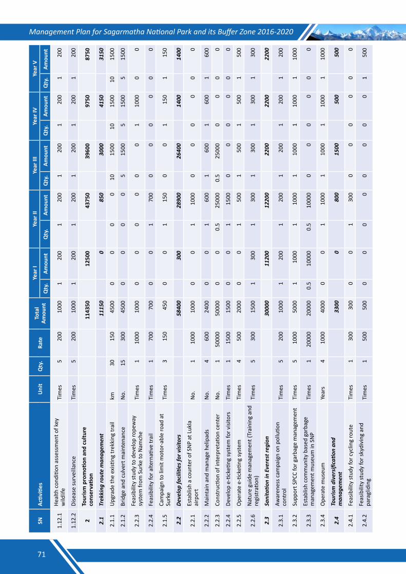
Management Plan for Sagarmatha National Park and its Buffer Zone 2016-2020SN
Activ
ities
Uni
tQ
ty.
Rate
Tota
l Am
ount
Year
IYe
ar II
Year
III
Year
IVYe
ar V
Qty
.Am
ount
Qty
.Am
ount
Qty
.Am
ount
Qty
.Am
ount
Qty
.Am
ount
1.12
.1He
alth
con
ditio
n as
sess
men
t of k
ey
wild
life
Tim
es
520
010
001
200
120
01
200
120
01
200
1.12
.2Di
seas
e su
rvei
llanc
eTi
mes
5
200
1000
120
01
200
120
01
200
120
0
2To
uris
m p
rom
otion
and
cul
ture
co
nser
vatio
n
1143
50
1250
0
4375
0
3960
0
9750
87
50
2.1
Trekking
routeman
agem
ent
11
150
0
85
0
3000
41
50
3150
2.1.
1U
pgra
de th
e ex
isting
trek
king
trai
lkm
3015
045
000
00
010
1500
1015
0010
1500
2.1.
2Br
idge
and
cul
vert
mai
nten
ance
No.
1530
045
000
00
05
1500
515
005
1500
2.2.
3Fe
asib
ility
stud
y to
dev
elop
rope
way
sy
stem
from
Sur
ke to
Nam
che
Tim
es
110
0010
000
00
00
01
1000
00
2.2.
4Fe
asib
ility
for a
ltern
ative
trai
lTi
mes
1
700
700
00
170
00
00
00
0
2.1.
5Ca
mpa
ign
to li
mit
mot
or-a
ble
road
at
Surk
eTi
mes
3
150
450
00
115
00
01
150
115
0
2.2
Developfaciliti
esfo
rvisito
rs
5840
0
300
28
900
26
400
14
00
1400
2.2.
1Es
tabl
ish a
cou
nter
of S
NP
at L
ukla
ai
rpor
tN
o.1
1000
1000
00
110
000
00
00
0
2.2.
2M
aint
ain
and
man
age
helip
ads
No.
460
024
000
01
600
160
01
600
160
0
2.2.
3Co
nstr
uctio
n of
inte
rpre
tatio
n ce
nter
N
o.1
5000
050
000
00
0.5
2500
00.
525
000
00
00
2.2.
4De
velo
p e-
ticke
ting
syst
em fo
r visi
tors
Tim
es
115
0015
000
01
1500
00
00
00
2.2.
5O
pera
te e
-tick
eting
syst
emTi
mes
4
500
2000
00
150
01
500
150
01
500
2.2.
6N
atur
e gu
ide
man
agem
ent (
Trai
ning
and
re
gist
ratio
n)Ti
mes
5
300
1500
130
01
300
130
01
300
130
0
2.3
Sanitatio
ninEverestre
gion
30
000
11
200
12
200
22
00
2200
22
00
2.3.
1Aw
aren
ess c
ampa
ign
on p
ollu
tion
cont
rol
Tim
es
520
010
001
200
120
01
200
120
01
200
2.3.
2Su
ppor
t SPC
C fo
r gar
bage
man
agem
ent
Tim
es
510
0050
001
1000
110
001
1000
110
001
1000
2.3.
3Es
tabl
ish c
omm
unity
bas
ed g
arba
ge
man
agem
ent m
useu
m in
SN
PTi
mes
1
2000
020
000
0.5
1000
00.
510
000
00
00
00
2.3.
4O
pera
te m
useu
mYe
ars
410
0040
000
01
1000
110
001
1000
110
00
2.4
Tourismdiversificati
onand
man
agem
ent
33
00
0
800
15
00
500
50
0
2.4.
1Fe
asib
ility
stud
y fo
r cyc
ling
rout
e Ti
mes
1
300
300
00
130
00
00
00
0
2.4.
2Fe
asib
ility
stud
y fo
r sky
divi
ng a
nd
para
glid
ing
Tim
es
150
050
00
00
00
00
01
500
71
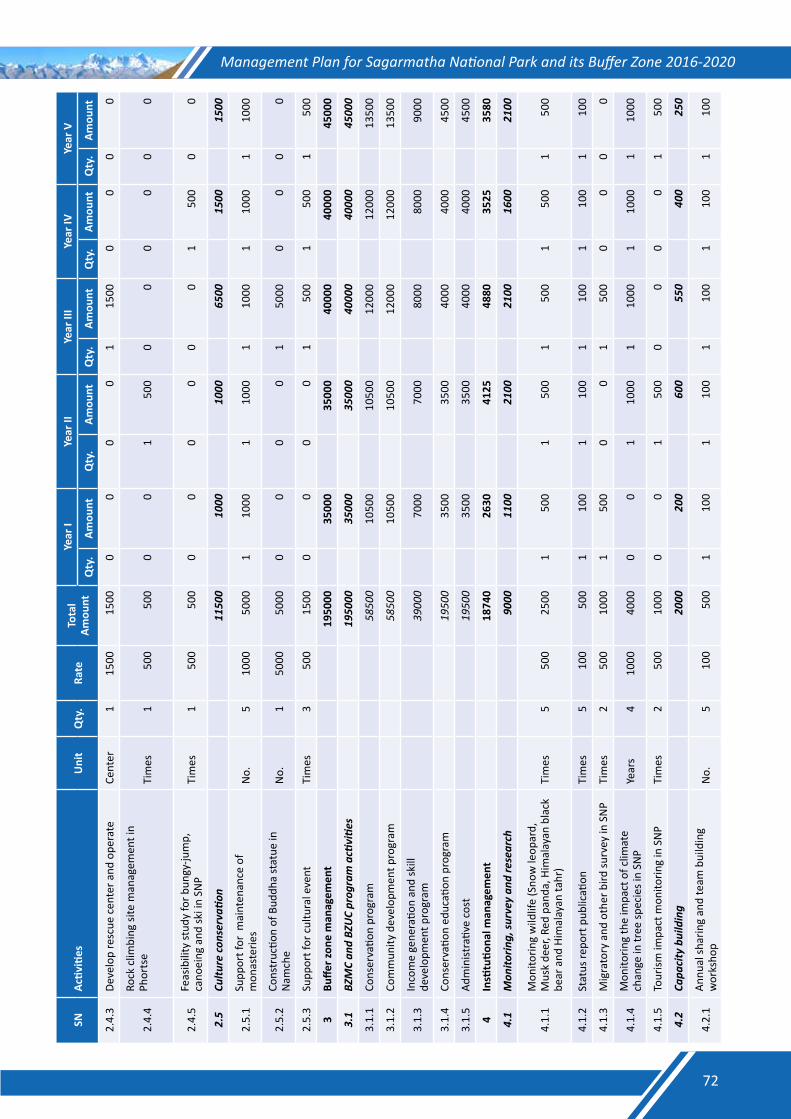
Management Plan for Sagarmatha National Park and its Buffer Zone 2016-2020SN
Activ
ities
Uni
tQ
ty.
Rate
Tota
l Am
ount
Year
IYe
ar II
Year
III
Year
IVYe
ar V
Qty
.Am
ount
Qty
.Am
ount
Qty
.Am
ount
Qty
.Am
ount
Qty
.Am
ount
2.4.
3De
velo
p re
scue
cen
ter a
nd o
pera
teCe
nter
115
0015
000
00
01
1500
00
00
2.4.
4Ro
ck c
limbi
ng si
te m
anag
emen
t in
Phor
tse
Tim
es
150
050
00
01
500
00
00
00
2.4.
5Fe
asib
ility
stud
y fo
r bun
gy-ju
mp,
ca
noei
ng a
nd sk
i in
SNP
Tim
es
150
050
00
00
00
01
500
00
2.5
Cultu
reco
nserva
tion
11
500
10
00
1000
65
00
1500
15
00
2.5.
1Su
ppor
t for
mai
nten
ance
of
mon
aste
ries
No.
510
0050
001
1000
110
001
1000
110
001
1000
2.5.
2Co
nstr
uctio
n of
Bud
dha
stat
ue in
N
amch
eN
o.1
5000
5000
00
00
150
000
00
0
2.5.
3Su
ppor
t for
cul
tura
l eve
ntTi
mes
3
500
1500
00
00
150
01
500
150
0
3Bu
ffer z
one
man
agem
ent
19
5000
35
000
35
000
40
000
40
000
45
000
3.1
BZMCan
dBZ
UCprog
ramacti
vitie
s
1950
00
3500
0
3500
0
4000
0
4000
0
4500
0
3.1.
1Co
nser
vatio
n pr
ogra
m
5850
0
1050
0
1050
0
1200
0
1200
0
1350
0
3.1.
2Co
mm
unity
dev
elop
men
t pro
gram
58
500
10
500
10
500
12
000
12
000
13
500
3.1.
3In
com
e ge
nera
tion
and
skill
de
velo
pmen
t pro
gram
39
000
70
00
7000
80
00
8000
90
00
3.1.
4Co
nser
vatio
n ed
ucati
on p
rogr
am
1950
0
3500
35
00
4000
40
00
4500
3.1.
5Ad
min
istra
tive
cost
19
500
35
00
3500
40
00
4000
45
00
4In
stitu
tiona
l man
agem
ent
18
740
26
30
4125
48
80
3525
35
80
4.1
Mon
itorin
g,su
rveyand
research
90
00
1100
21
00
2100
16
00
2100
4.1.
1M
onito
ring
wild
life
(Sno
w le
opar
d,
Mus
k de
er, R
ed p
anda
, Him
alay
an b
lack
be
ar a
nd H
imal
ayan
tahr
) Ti
mes
5
500
2500
150
01
500
150
01
500
150
0
4.1.
2St
atus
repo
rt p
ublic
ation
Tim
es
510
050
01
100
110
01
100
110
01
100
4.1.
3M
igra
tory
and
oth
er b
ird su
rvey
in S
NP
Tim
es
250
010
001
500
00
150
00
00
0
4.1.
4M
onito
ring
the
impa
ct o
f clim
ate
chan
ge in
tree
spec
ies i
n SN
PYe
ars
410
0040
000
01
1000
110
001
1000
110
00
4.1.
5To
urism
impa
ct m
onito
ring
in S
NP
Tim
es
250
010
000
01
500
00
00
150
0
4.2
Capa
citybuilding
20
00
200
60
0
550
40
0
250
4.2.
1An
nual
shar
ing
and
team
bui
ldin
g w
orks
hop
No.
510
050
01
100
110
01
100
110
01
100
72
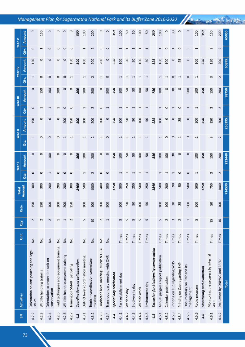
Management Plan for Sagarmatha National Park and its Buffer Zone 2016-2020SN
Activ
ities
Uni
tQ
ty.
Rate
Tota
l Am
ount
Year
IYe
ar II
Year
III
Year
IVYe
ar V
Qty
.Am
ount
Qty
.Am
ount
Qty
.Am
ount
Qty
.Am
ount
Qty
.Am
ount
4.2.
2O
rient
ation
on
anti-
poac
hing
and
lega
l iss
ues
No.
215
030
00
01
150
00
115
00
0
4.2.
3W
ildlif
e ha
ndlin
g tr
aini
ngN
o.2
150
300
00
00
115
00
01
150
4.2.
4O
rient
ation
to p
rote
ction
uni
t on
cons
erva
tion
No.
210
020
01
100
00
110
00
00
0
4.2.
5Fi
eld
tech
niqu
es a
nd e
quip
men
t tra
inin
gN
o.1
200
200
00
00
120
00
00
0
4.2.
6W
ildlif
e he
alth
ass
essm
ent t
rain
ing
No.
120
020
00
01
200
00
00
00
4.2.
7Tr
aini
ng o
n SM
ART
patr
ollin
gN
o.2
150
300
00
115
00
01
150
00
4.3
Coordina
tionan
dcolla
boratio
n
2400
30
0
500
80
0
500
30
0
4.3.
1Di
stric
t lev
el c
oord
inati
on m
eetin
gN
o.5
100
500
110
01
100
110
01
100
110
0
4.3.
2To
urism
coo
rdin
ation
com
mitt
ee
mee
ting
No.
1010
010
002
200
220
02
200
220
02
200
4.3.
3La
ndsc
ape
leve
l mee
ting-
MBN
P &
GCA
No.
220
040
00
01
200
00
120
00
0
4.3.
4Tr
ans-
boun
dary
mee
ting
with
QN
RN
o.1
500
500
00
00
150
00
00
0
4.4
Speciald
ayce
lebrati
on
1750
35
0
350
35
0
350
35
0
4.4.
1Pa
rk e
stab
lishm
ent d
ayTi
mes
5
100
500
110
01
100
110
01
100
110
0
4.4.
2W
etla
nd d
ayTi
mes
5
5025
01
501
501
501
501
50
4.4.
3Bi
odiv
ersit
y da
yTi
mes
5
5025
01
501
501
501
501
50
4.4.
4W
ildlif
e w
eek
Tim
es
510
050
01
100
110
01
100
110
01
100
4.4.
5En
viro
nmen
t day
Tim
es
550
250
150
150
150
150
150
4.5
Extensionforb
iodiversity
conserva
tion
18
40
330
22
5
730
32
5
230
4.5.
1An
nual
pro
gres
s rep
ort p
ublic
ation
Tim
es
510
050
01
100
110
01
100
110
01
100
4.5.
2Ca
lend
ar p
ublic
ation
Tim
es
210
020
01
100
00
00
110
00
0
4.5.
3Pr
intin
g on
cup
rega
rdin
g W
HSTi
mes
3
3090
130
00
130
00
130
4.5.
4Pr
intin
g on
Cap
rega
rdin
g SN
PTi
mes
2
2550
00
125
00
125
00
4.5.
5Do
cum
enta
ry o
n SN
P an
d its
m
anag
emen
tTi
mes
1
500
500
00
00
150
00
00
0
4.5.
6Ra
dio
prog
ram
Tim
es
510
050
01
100
110
01
100
110
01
100
4.6
Mon
itorin
gan
devalua
tion
17
50
350
35
0
350
35
0
350
4.6.
1M
onito
ring
the
prog
ress
by
inte
rnal
te
amTi
mes
15
5075
03
150
315
03
150
315
03
150
4.6.
2Ev
alua
tion
by D
NPW
C an
d ER
FDTi
mes
10
100
1000
220
02
200
220
02
200
220
0
Tota
l
7145
30
2334
40
2563
95
9875
0
6089
5
6505
0
73
Management Plan for Sagarmatha National Park and its Buffer Zone 2016-2020
Annex XList of the activities proposed during the consultative meetings of the BZUCs a. NamcheBufferZoneUserCommittee7. Identification of cycling trail and initiate cycling in buffer zone as a tourism activity;2. Managing skydiving and paragliding in buffer zone;3. Introducing adventurous activities such as bungee jumping, jeep lining, canoeing, skiing, kayaking etc;4. Establishment and operation of ropeway from Surke to Namche for goods and materials transportation;5. Establishment and operation of cable car for tourists from Namche to Kongde;6. Construction of rock climbing and ice climbing training site in buffer zone;7. Establishment of Tea shop in Topdanda by Buffer Zone User Committee;8. Upgrading museum at Sagarmatha National Park, Namche;9. Establishment of rescue center in Namche;10. Establishment of local mini-grid integrating all micro-hydro projects in Namche, Khumjung and Chaurikharka
VDCs;11. Construction of micro-hydro project in Thesyo khola and Mulpani of Namche;12. Electrification of every settlements within Namche VDC;13. Construction and operation of aged care facility in Thesyo village;14. Construction of drinking water facility in every settlements of Namche VDC;15. Maintenance and reconstruction of trekking trails;16. Nursery operation and seedling production in Phurte and plantation in suitable sites;17. Protection of plantation area through boundary wall and fencing construction;18. Construction of play ground in Thamichowa area;19. Construction of picnic spot in Thesyo area;20. Extension of telephone line in every settlements of Namche VDC;21. Construction of necessary towers in Namche for strengthened communication facility;22. Training on agriculture, livestock management and other skill development; 23. Construction of trekking route from Thame to Rolwaling through Tashilapcha pass;24. Construction of Potter shelter in Nangpala;25. Construction of Buddha Statue in suitable site in Namche; 26. Construction and operation of tourist lodge with 40 bed capacity in Namche;27. Construction of green house for promoting agriculture;28. Construction of staff quarter in Namche and29. Alternative energy promotion in Namche.
b. KhumbiYulhaBufferZoneUserCommittee7. Maintenance and reconstruction of trekking trails;2. Soil conservation activities in Khumjung, Ward No. 2 to 7;3. Nursery operation, seedling production and plantation;4. Construction of drinking water supply facility in Khumjung, Ward No. 1 to 5;5. Construction of waste water and sewage management canal in Khumjung, ward No. 1 to 5;6. Construction of Helipads in every major settlements of Khumjung VDC;7. Electrification in every settlements in Khumjung VDC;8. Develop master plan of Khumjung vDC9. Placement of notice boards in public places;10. Identification of cycling trail and initiate cycling in Khumjung;11. Construction of public toilet;12. Provide support to Khumbu Bijuli Company (KBC) for expanding electricity facility in Khumjung;13. Construction of community buiding for Khumjung Youth Club;14. Extension of telephone line in every settlements of Khumjung VDC;
74
Management Plan for Sagarmatha National Park and its Buffer Zone 2016-2020
15. Construction of towers as per need for the effective communication facility in Khumjung VDC;16. Construction of micro-hydro in Gokyo, Thaknak, Dole, Pheriche, Dingboche and Pangboche;17. Construction of mini-grid in Namche, Khumjung and Chaurikharka VDC and integrating every micro-hydro in
this mini-grid;18. Establishment of Khumbu climbing center;19. Construction of Phortse-Thaknak bridge;20. Construction of Chukung bridge;21. Construction of waste water and sewage management canal in Khumjung-7, Dingboche;22. Upgrade micro-hydro in Phortse;23. Maintenance and reconstruction of monasteries in Khumjung;24. Construction of community building in Khunde an Pangboche;25. Construction of boundary wall and fencing in plantation are;26. Construction of training site for rock climbing and ice climbing;27. Conservation of Sherpa culture;28. Establishment and operation of drinking water company in private land;29. Establishment and operation of furniture industry in appropriate private land;30. Continuation of three hotels operated by Sagarmatha National Park;31. Construction of green house for promoting agriculture;32. Soil erosion control in Khumjung-2, Dole;33. Construction of play ground in Khunde;34. Construction and operation of rescue center in Khumjung;35. Construction of trekking trail in Tauche View Point;36. Construction of indoor swimming pool in Khumjung;37. Construction of staff quarter in Khumjung;38. Alternative energy promotion and39. Identification and promotion of adventurous tourism activities in Khumjung.
c. ChaurukharkaBufferZoneUserCommittee7. Construction of drinking water facility in Chaurikharka- 2;2. Stone paving around Chhorten in Chaurikharka-2;3. Maintenance of trekking trail in Chaurikharka-2;4. Establishment of revolving fund for income generation activities;5. Construction of improved water turbine in Chaurikharka-2, 4, 7 and 9;6. Management of Maane in Chaurikharka-2, 3, 5 and 9;7. Support to Buffer Zone User Groups for office management;8. Support for community forest management;9. Support for biogas plant construction in Chaurikharka- 3 and 6;10. Maintenance of community building in Chaurikharka- 1, 5 and 6;11. Construction of community building in Chaurikharka- 4, 5 and 6;12. Nature trail management in Chaurikhraka- 1, 5 and 6;13. Construction of Teachers’ quarter in Chaurikharka- 1 and 6;14. Maintenance and reconstruction of trekking trail;15. Construction of swimming pool and nature garden;16. Soil erosion control activities in Chaurikharka- 1 to 9;17. Construction of community building in Chaurikharaka- 4, 5 and 6;18. Construction of drinking water facility in Chaurikharka- 3, 4, 6, 7 and 9;19. Strengthening capacity for fire prevention and control;20. Exploring and marketing of new tourism sites in Chaurikharka VDC;21. Construction of view tower and other infrastructure for eco-tourism promotion in Chaurikharka;22. Construction of skiing and climbing center in Lungding ;
75
Management Plan for Sagarmatha National Park and its Buffer Zone 2016-2020
23. Training on Amchi- Traditional Tibetan Health Care;24. Establishment of depot for kerosene and Liquid Petroleum Gas (LPG);25. Conservation awareness through mass media;26. Construction of infrastructure for ice training in Thadokoshi;27. Conservation and management of Raniban;28. Nursery operation, seedling production and plantation;29. Construction of iron bridge in Chaurikharka- 4, , 7 and 8;30. Construction of drinking water facility in Chaurikharka- 1 and 4;31. Construction of waste water and sewage canal in Chaurikharka- 1 and 8;32. Construction of public toilets;33. Construction of tourist park;34. Construction of rock climbing site;35. Construction of badminton hall;36. Construction of park in Jopake;37. Management of Triveni temple;38. Management of museum;39. Identification of cycling trail and initiate cycling in Chaurikharka;40. Stone paving in trekking trail;41. Conservation of Nagthan in Chaurikharka- 5;42. Construction of micro-hydro in Chaurikharka- 1, 4, 5 and 9;43. Identification and conservation of Red Panda zone;44. Training on home stay tourism management;45. Training on house wiring and plumbing;46. Support for health posts management;47. Support for police post construction;48. Construction of RCC bridge in Chaurikharka-7;49. Construction of suspension bridge in Chauikharka- 4 and 7;50. Support for school building construction in Chaurikharka-9;51. Construction of trekking trail in Abrek Dudhkunda;52. Construction of hydropower in Lumding khola;53. Construction of evacuation center in Muse;54. Construction of Pashang Lhamu gate in Lukla;55. Exposure visits to other protected areas of the country and abroad;56. School program for Sherpa language teaching;57. Initiate adventurous activities such as bungee jump and jeep lining;58. Initiate rafting and canoeing from Larcha Dovan to Ghat;59. Construction and operation of cable car in Dudhkunda and Kongde;60. Construction and operation of rope way from Surke to Namche for goods and materials transportation;61. Construction of fire control room;62. Support for biogas promotion and LPG and kerosene depot;63. Promotion of steel and iron furniture as a substitute to wood in the area;64. Promote organic vegetable farming and support for marketing it;65. Training on livestock husbandry;66. Training on food processing;67. Support for green house construction;68. Support for Pashang Lhamu Museum construction;69. Construction and management of Tenzing-Hillary park;70. Construction of grain storage center;71. Establishment of Non-timber Forest Products processing center and72. Establishment of multi-purpose nursery.
76
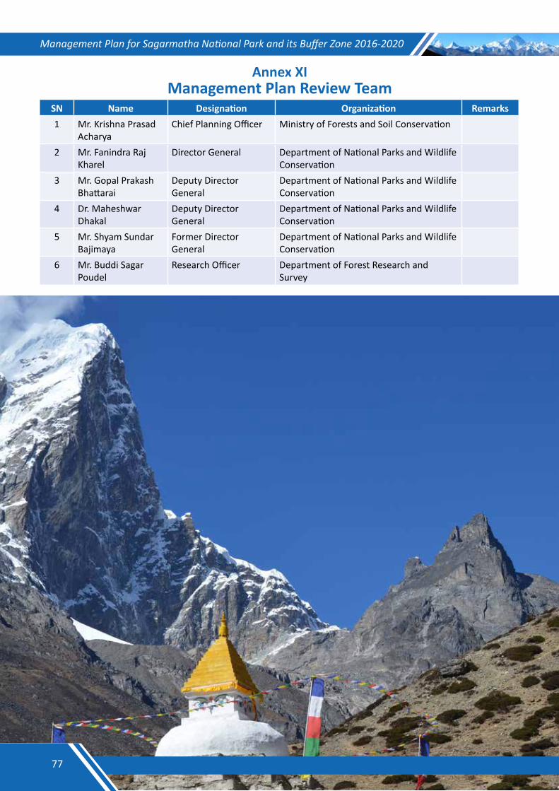
Management Plan for Sagarmatha National Park and its Buffer Zone 2016-2020
Annex XIManagement Plan Review Team
SN Name Designation Organization Remarks1 Mr. Krishna Prasad
AcharyaChief Planning Officer Ministry of Forests and Soil Conservation
2 Mr. Fanindra Raj Kharel
Director General Department of National Parks and Wildlife Conservation
3 Mr. Gopal Prakash Bhattarai
Deputy Director General
Department of National Parks and Wildlife Conservation
4 Dr. Maheshwar Dhakal
Deputy Director General
Department of National Parks and Wildlife Conservation
5 Mr. Shyam Sundar Bajimaya
Former Director General
Department of National Parks and Wildlife Conservation
6 Mr. Buddi Sagar Poudel
Research Officer Department of Forest Research and Survey
77
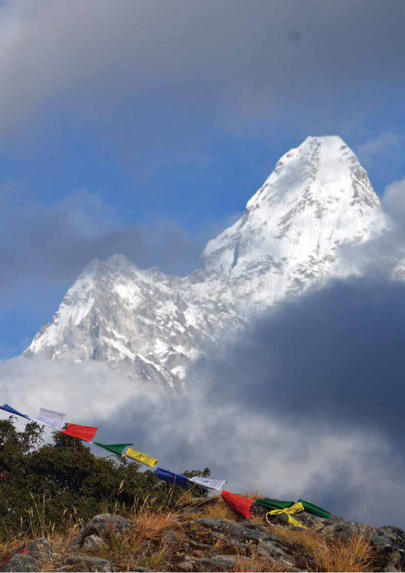
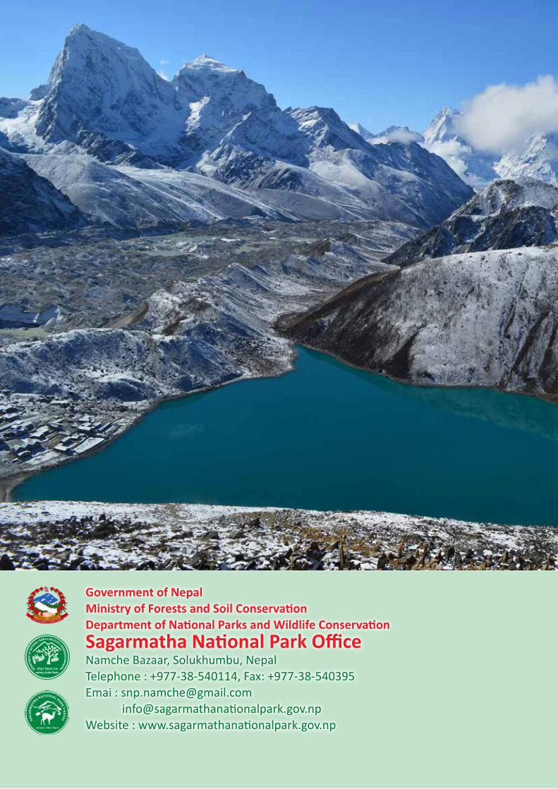
Government of NepalMinistry of Forests and Soil ConservationDepartment of National Parks and Wildlife ConservationSagarmatha National Park Office Namche Bazaar, Solukhumbu, NepalTelephone : +977-38-540114, Fax: +977-38-540395Emai : [email protected] [email protected] Website : www.sagarmathanationalpark.gov.np


