Embed Size (px)
Citation preview
MAMMOTH GEOLOGICAL LTD.
Box 5250, Port Hardy, B.C. VON 2PO Phone : (604) 949-5197 Fax : (604) 949-5197
-----_I
GEOLOGICAL 9119VT'i S'?Ai'iCH " . .
ASSESShCENT f!<Q,:,:is
DATE EECCiVFD
--_-.--- i , .I C E C 3 .
DFi^ - 7 E;,: ' OFTHE
AL4RIC PROPERTY
Osoyoos Mining Division McNulty Creek, B.C.
By: R.Tim Hennebeny, P.Geo. December 1. 1996
-2-
SUMMARY
The Alaric property lies within the Osoyoos Mining Division, west of Summerland. The property is being explored as a potential source of granite dimension stone, for both structural stone and polished stone.
The property was acquired as part of an on-going exploration and assessment program of the southern interior plutons. A preliminary examination located a potential quarry site, a series of regularly spaced benches of granite. The stone has an appealing hue and texture on the split face. Polished sections show the stone has an appealing texture and exhibits few flaws on the finished surface. The hue is an dark pink.
Based on these preliminary observations, a staged three phase exploration program is recommended as outlined below:
Phase I Phase 11 Phase 111
$3,623 $18.371 $43.183
TOTAL BUDGET $65.176
Phase I will consist of mapping and sampling of the claims at an estimated cost of $3.623.
Phase I1 will consist of both boulder and "outcrop" testing to produce small test blocks for split stone and tile. A preliminary marketing suxvey will also be completed at a total phase cost of $18.371.
Phase 111. the pre-production bulk test, will include test quarrying of several rough quarry blocks, approximately 2.4m by 1.8m by 1.8m (8 ft. X 6 ft. X 6 ft) each. Phase 111 is estimated to cost $43.183.
The initial prospecting and mapping program completed on the Alaric property cost $975.
-3-
TABLE OF CONTENTS
INTRODUCTION ....................................................... LOCATION, ACCESS ................................................................................. CLAIM HOLDINGS ............................................................................. REGIONAL GEOLOGY ..........................................................................
Omenica Crystalline Belt.. .................................................. Intermontane Belt ................................................ Coast Plutonic Belt .................................................................
Osprey Lake Batholith ......................................................... PRELIMINARY PROPERTY GEOLOGY ..............................................
Dark Pink Granite ......................................................................... MARKETING ... ............................................ ............. DISCUSSION ............................................................ CONCLUSIONS AND RECOMMENDATIONS .............. REFERENCES .......................................................... STATEMENT OF QUALIFICATIONS ...................................................................................... 20 STATEMENT OF COST ......................................................................................................... 2 1 COST ESTIMATES ............................................................................................ SAMPLE DESCRIPTIONS ...................................... ............................ .....
LIST OF FIGURES
1. Property Location ........................................................................... .............. 5 2. Claim Location ................................................................................ .............. 7 3. Simplified Geology of Southern Interior ............................................ .............. 9 4. Southern Interior Granite Osprey Lake Batholith ........................................................... 11 5. Property Geology ........................................................................................................... 13
-4-
INTRODUCTION
The purpose of this report is to document the observations made of the granite on the Alaric property. A preliminary examination was made on October 15. 1995. This consisted of pros- pecting and mapping along the logging road system traversing the claim and sampling, Recommendations for further exploration have also been presented.
The term granite is a generic term in the dimension stone industry used to describe any intrusive igneous rock. In this instance, the stone on the Alaric property is actually a granite.
The Alaric property was acquired as part of a regional exploration program and assessment of the southern interior plutons. This program was initiated as a result of the on-going dimen- sion stone initiative of the British Columbia Geological Survey Branch (White, 1985: White and Hora. 1988: Page, 1991: Hora and Hancock, 1992 and 1994). The opening of two granite fabri- cating plants in the Lower Mainland, combined with the up-surge in the use of structural (or masonry) granite has lead to increased demand and a search for local source.
The standard exploration program for each of these dimension stone properties consists of prospecting and mapping followed by small scale quarry testing of boulders, finally followed by a large scale bulk test of the identified quarry site.
Some of the granites of the southern interior yield large 100-1000 ton boulders, ideal sites to complete small scale tests of the stone for both polished and structural stone. These boulder testing programs of small scale test quarrying, combined with marketing tests, yield a good assessment of the stone potential of each property.
The boulder testing programs entail the actual quarrying of a few of the boulders into 5-20 ton blocks. These blocks are then supplied to local processors for completion of market tests. At least 500-1000 tons has to be supplied to allow the stone to be tested in the market place. which essentially means the stone is used on a few jobs sites, especially for structural stone.
The final phase involves actual test quarrying of 1000-2000 tons from the planned quarry site to establish the consistency of color, texture and structure. This stone will again be put into the market place to complete marketing analysis, before a final production decision is made.
Mammoth Geological Ltd.
Southern Interior Dimension Stone Project
West Southern Interior Property Locations
DRAWN n x R.T~,,, H ~ . ~ ~ ~ ~ ~ I , ~ . ~ ,.> SCAI,I< : 1:1.000.111111
I>ATE: N n v r ~ n l ~ r l - I V Y 5 l:l~;L.ltl;: I
S urnme (f rlmd
-6-
LOCATION, ACCESS
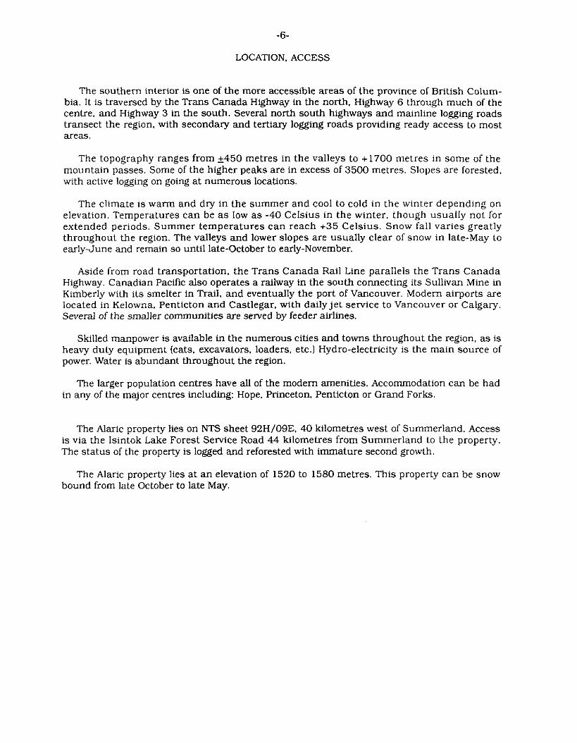
The southern interior is one of the more accessible areas of the province of British Colum- bia. It is traversed by the Trans Canada Highway in the north. Highway 6 through much of the centre, and Highway 3 in the south. Several north south highways and mainline logging roads transect the region, with secondary and tertiary logging roads providing ready access to most areas.
The topography ranges from 5450 metres in the valleys to + 1700 metres in some of the mountain passes. Some of the higher peaks are in excess of 3500 metres. Slopes are forested, with active logging on going at numerous locations.
The climate is warm and dry in the summer and cool to cold in the winter depending on elevation. Temperatures can be as low as -40 Celsius in the winter. though usually not for extended periods. Summer temperatures can reach +35 Celsius. Snow fall varies greatly throughout the region. The valleys and lower slopes are usually clear of snow in late-May to early-June and remain so until late-October to early-November.
Aside from road transportation, the Trans Canada Rail Line parallels the Trans Canada Highway. Canadian Pacific also operates a railway in the south connecting its Sullivan Mine in Kimberly with its smelter in Trail, and eventually the port of Vancouver. Modem airports are located in Kelowna. Penticton and Castlegar. with daily je t service to Vancouver or Calgary. Several of the smaller communities are served by feeder airlines.
Skilled manpower is available in the numerous cities and towns throughout the region, as is heavy duty equipment (cats. excavators, loaders, etc.) Hydro-electricity is the main source of power. Water is abundant throughout the region.
The larger population centres have all of the modem amenities. Accommodation can be had in any of the major centres including: Hope, Princeton, Penticton or Grand Forks.
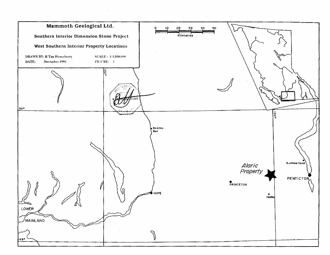
The Alaric property lies on NTS sheet 92H/09E. 40 kilometres west of Summerland. Access is via the lsintok Lake Forest Service Road 44 kilometres from Summerland to the property. The status of the property is logged and reforested with immature second growth.
The Alaric property lies a t an elevation of 1520 to 1580 metres. This property can be snow bound from late October to late May.
I
I f
i
0 I 2 3
Kilornetres
DRAWN BY: RTHenneberry SCALE : I : 50,000 DATE :
From claim sheet(s): FIGURE : 2
9 2 H /09E
1 Mammoth Geological Ltd.
I Alaric Property I CLAIM LOCATION
-8-
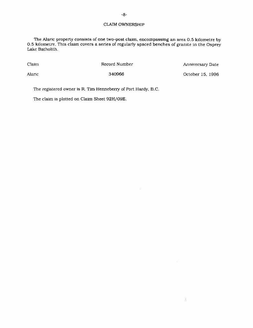
CLAIM OWNERSHIP
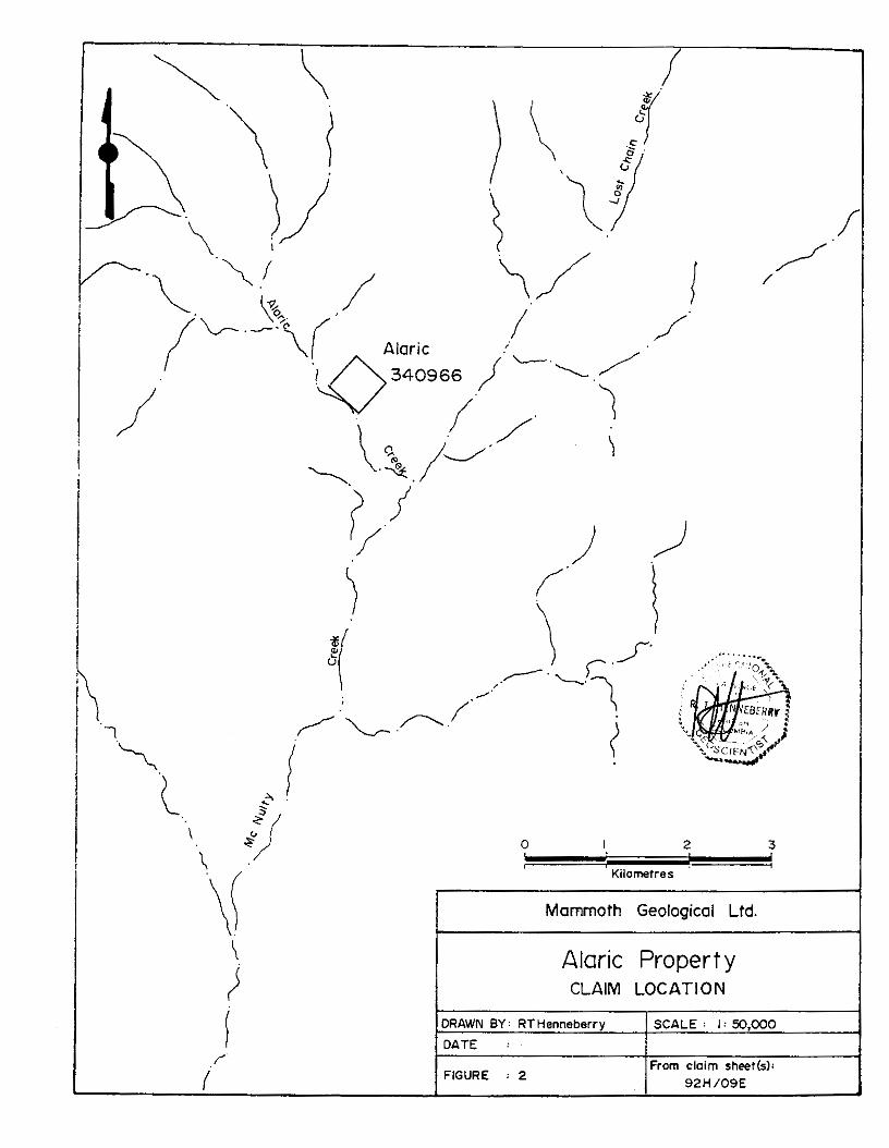
The Alaric property consists of one two-post claim, encompassing an area 0.5 kilometre by 0.5 kilometre. This claim covers a series of regularly spaced benches of granite in the Osprey Lake Batholith.
Claim
A l X i C
Record Number
340966
The registered owner is R. Tim Hemeberry of Port Hardy, B.C.
The claim is plotted on Claim Sheet 92H/09E.
Anniversary Date
October 15. 1996
-._I. -- I- ---- -- - .- --- ~ - - -_ .____ __ ~. - .- _ _ . ~~
~ ~ - - - _ _ -
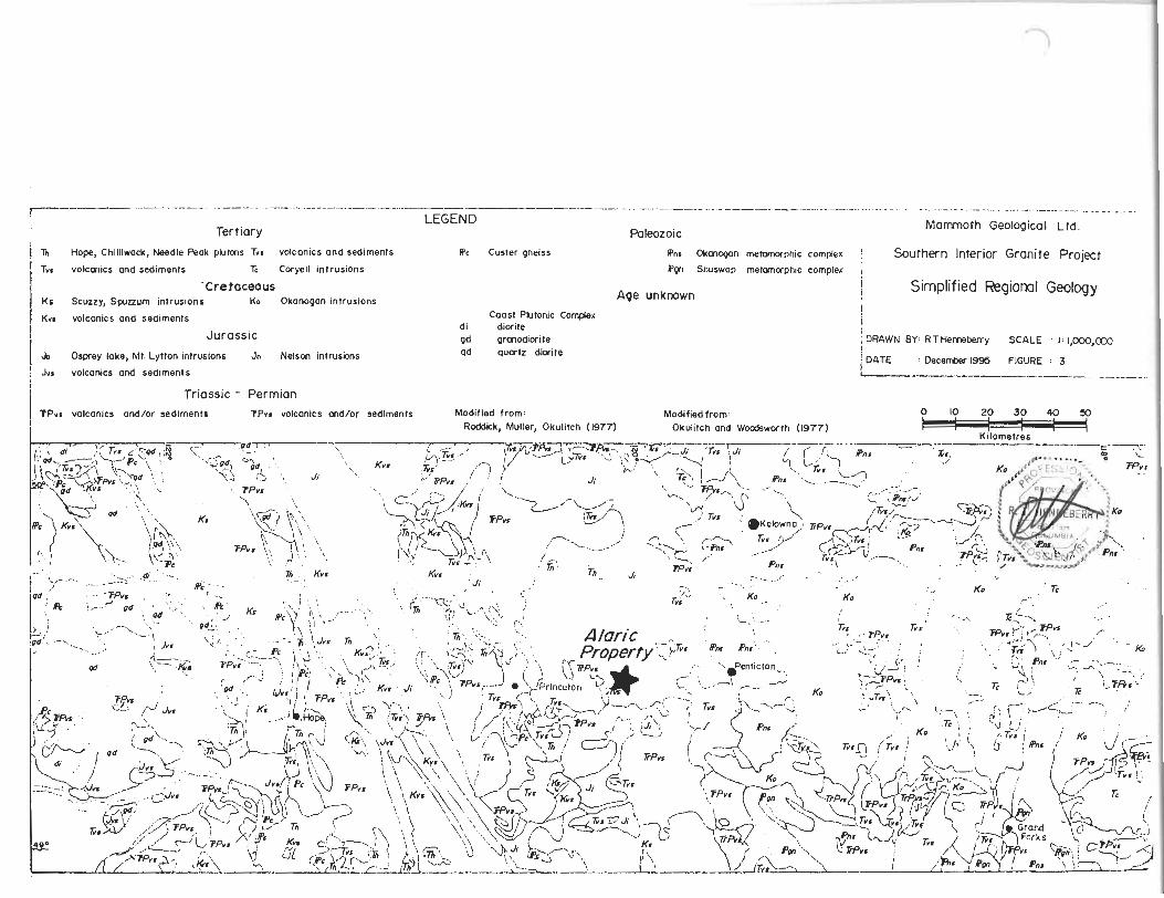
Mammoth Geological Ltd. LEGEND
Tertiary Paleozoic i 1 Ti Hope, Chilliwock, Needle Peok plutms Twr volcanics and sediments RC Custer gneiss Rnr Okoncwn metomcxphic complex ! Southern Interior Granite Project
volconics and sediments E Coryell intrusions Ron Shuswop metamcwphic complex
-Cretaceous i Simplified Regional Geology Scuzzy, Sprnum intrusions KO Okonogon intrusions Age unknown j
I K n volconics ond sediments
Jurassic JO Osprey lake, Mt. Lytton intrusions Jn Nelson intrusions
: Jwr volcanics and sediments
Triassic - Permian
! Coost Plutonic Complex
di diorite gd gronodiorite ad quortz diorite
I i f ;DRAWN BY: RTHemeberry SCALE : I:I,ooO,~ f I DATE : ~ c e r t w 1 9 ~ FIGURE : 3 I ---.-__
I TPWS volcanics and/or sediments VPvt volcanlcs and/or sediments Modifled from: Modified from: Roddick, Muller, Okulitch (1977) Okulitch ond Woodsworth (1977) i
-10-
REGIONAL GEOLOGY
The geology of the southern interior of British Columbia is characterized by three major tectonic belts; the volcano-sedimentary Intermontane belt sandwiched between the plutonic Omenica Crystalline belt on the east and the Coast Plutonic belt on the west. (McMillan. 1990).
The Omenica belt consists of a basement of the Paleozoic Okanogan and Shuswap meta- morphic complexes. Remnants of volcanic and/or sedimentary sequences of Permian through to Triassic age outcrop throughout the belt. These rocks are then intruded by a series of plu- tonic events, concentrated in the Jurassic (Nelson intrusions), Cretaceous (Okanogan intru- sions) and Tertiary (Coryell intrusionsl. Outliers of Tertiary mafic volcanics and related sedi- ments outcrop throughout the map area. (Okulitch and Woodsworth, 1977).
The Intermontane belt is comprised of a series of accreted volcano-sedimentary terranes ranging in age from Permian to Triassic. These rocks are intruded by large Jurassic batholiths, including the Mt. Lytton and Osprey Lake batholiths. Tertiary outliers of mafic volcanics and sediments outcrop locally within the belt. (Roddick. Muller and Okulitch, 1979).
The Coast belt consists of intrusive rocks of many ages. including gneissic metamorphic assemblages as well as dioritic,. quartz dioritic and granodioritic intrusions. Triassic and Juras- sic volcano-sedimentary assemblages outcrop through the eastern margin of the belt. Two distinct plutonic events have been recognized near the eastern boundary: a Cretaceous event (Scuzzy intrusions) and a Tertiary event (Chilliwack and related intrusions). Local felsic Tertiary outliers are also mapped in the belt. (Roddick, Muller and Okulitch. 19791.
Historic dimension stone exploration and development has been undertaken within the plutonic rocks in all three belts. Southern interior dimension stone activity was concentrated in the early part of the century. essentially ceasing until a rejuvenation in the late 1980s.
Omenka Crystalline belt Dimension stone targets in this belt include the Nelson, Okanogan and Coryell intrusions.
Historic production was concentrated in the Nelson and Coryell intrusions. Present production is concentrated in the Okanogan intrusions, though exploration and development is being undertaken in all three intrusive groups.
The Nelson intrusions outcrop to the east of the present map area. Cairnes (19341 de- scribed these intrusions as massive, generally moderately foliated, medium grey weathering, medium- to coarse-grained, equigranular. hornblende-biotite granodiorite, quartz diorite and granite. The intrusions were quarried at three locations on Kootenay Lake with only limited success, due primarily to knots and sulfides.
Though the Okanogan intrusions historically received little attention for dimension stone. most of the present production from the southern interior is concentrated within these plutons. These intrusions outcrop throughout the eastem half of the present map area. The Okanogan intrusions are predominantly massive, light grey weathering, medium- to coarse-grained, equigranular to porphyritic, unfoliated to weakly foliated, fresh biotite granodiorite and granite (Templeman-Kluit. 1989).
The Coryell intrusions outcrop in a confined area on the eastern side of the present map area. As with the Nelson intrusions, these intrusions were quarried in the early part of the century. with little present exploration taking place. Most of the early quarrying was completed for structural stone for railway bridges and abutments. These intrusions are alkalic to calc- alkalic. high level, pink and buff syenite and quartz monzonite and trachytic pink feldspar porphyry dykes (Templeman-Kluit, 19891.
-12-
Intermontane belt The dimension stone targets in this belt are the Jurassic batholiths. No historic exploration
or development has been undertaken in these rocks. Recent exploration has been confined to the Osprey Lake batholith.
The Osprey Lake intrusion outcrops through the centre of the map area, lying west of Okanogan Lake. Recently, very limited production has taken place within the intrusion. The body is described as a coarse-grained, porphyritic, pink-red granite (Rce. 1960).
Coast Plutonic belt The Scuzzy and Chilliwack intrusions are the main dimension stone targets within this belt,
along with some of the quartz dioritic intrusions. Limited historic exploration and development has taken place in these rocks. Present quarry production is sourced from several of the Chil- liwack intrusions.
The main body of undifferentiated quartz diorite outcrops on the western boundary of the map area. The intrusion is described as a medium-grained, quartz diorite. with 10% mafic minerals, with hornblende slightly more abundant than biotite IRoddick, 1965).
The Scuzzy intrusions outcrop along the western boundary of the Coast belt. Surprisingly, no exploration or development for dimension stone is documented, though there has been mention of "granite" in the area of Spuzzum being used for bridges and abutments for the railway lines in the Fraser Canyon. The stone is described as massive granodiorite. with coarse-grained quartz and feldspar and much finer grained biotite. (Monger, 1970).
The ChUwack intrusions outcrop in a confined area on the western side of the map area. Though no historic exploration or development has been documented. these intrusions are presently being quarried at three locations, the Needle Peak pluton in the north. the Hope pluton in the centre and the Chilliwack batholith in the south. These intrusions are generally massive in outcrop and range in composition from granite to granodiorite (Monger. 1970).
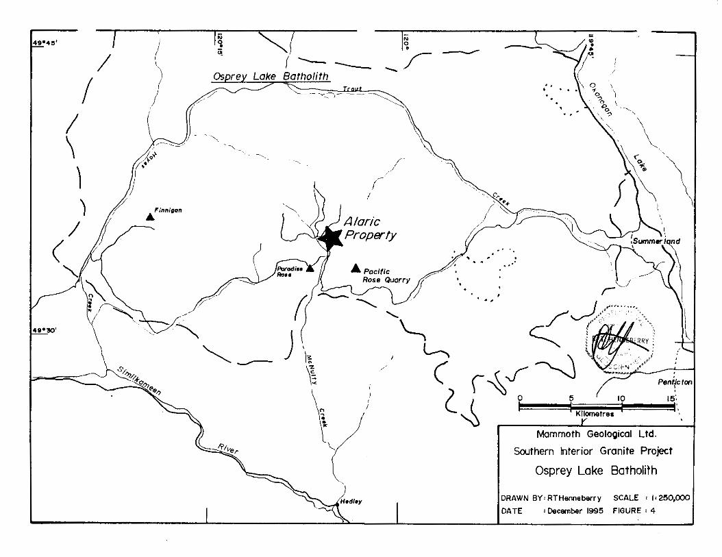
Osprey Lake Batholith The Osprey Lake Batholith lies on the eastern side of Okanogan Lake, outcropping in an
area between Summerland on the eastern contact and Princeton, southwest of the western contact (Monger, 1989). The stone is described as a coarse-grained. porphyritic, pink-red gran- ite (Rice. 1960).
Exploration and/or development for dimension stone has been undertaken at two sites near the south-central contact of the pluton at McNulty Creek, with limited boulder production undertaken at the Pacific Rose site by Pacific Granistone in 1992-1993.
Pacific Rose The stone is described as a medium- to coarse-grained, pink, two feldspar granite. The
granite outcrops form an elongate. east-west ridge with bare rock ledges. faces and a granite boulder field on the lower part of the slope. Pacific Granistone produced a number of blocks from some of the boulders, producing polished slabs. (Hora and Hancock. 1994).
Pacific Pearl This stone. similar but lighter in color than the Pacific Rose. is best described as a medium-
to coarse-grained, pink and white quartz syenite. Large boulders and massive outcrops form a northeast elongate hill. A test site was not opened in this property. (Hora and Hancock. 1994).
LEGEND
Jurassic OSPREY LAgE BATHOLITH
- Porphyritic light pink granite Pg
0 Boulder Creek Road
-_ - ---- a Outcrop 0 Sample location
100 foot contour interval
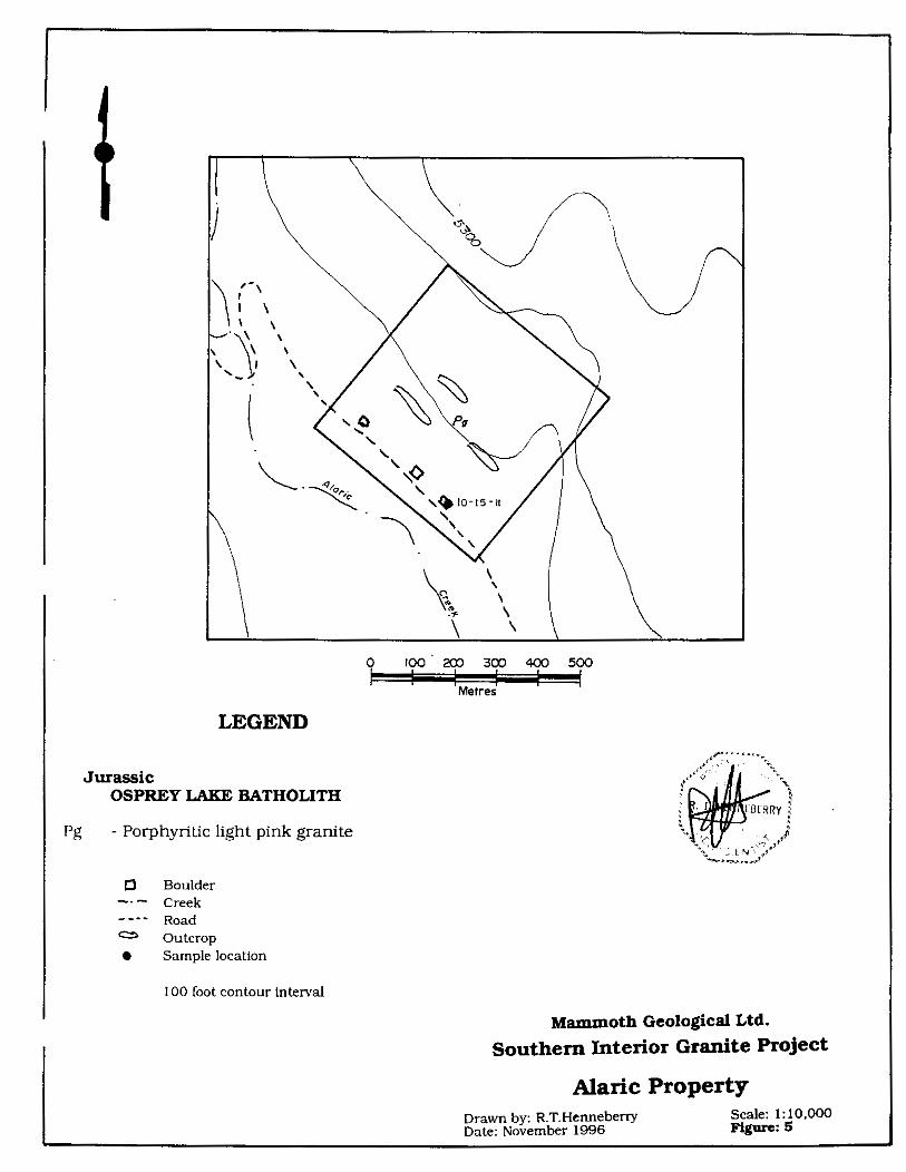
Drawn by: R.T.Henneberry Scale: 1:10,000 Date: November 1996 Figure: 5
Mammoth Geological Ltd. Southern Interior Granite Project
Alaric Property
- 14-
PRELIMINARY PROPERTY GEOLOGY
The Alaric property is underlain by the Jurassic Osprey Lake Batholith. The stone outcrops as a series of regularly spaced benches on the north slope of Alaric Creek valley, a n east flow- ing tributary of McNulty Creek. The benches are the main target area for dimension stone.
Prospecting and preliminary mapping and sampling was undertaken. The mapping was confined to the preliminary examination of the benches and the numerous boulders (which are almost like felsenmeer) lying on the benches. Samples were taken from one of the benches.
Access to the Alaric property is good. The lsintok Lake Forest Service Road provides access to the bench area. The property has been logged and replanted, with immature second growth.
Dark Pink Granite The stone of interest is best described as a dark pink, medium- to coarse-grained granite.
The constituents are: 40% dark pink, anhedral to subhedral (7-10mml K-feldspar. 30% cream white. anhedral (5-7mm) plagioclase. 25%-30% glassy grey, anhedral (5- 10mml quartz and 0%-1% black, anhedral (1-3mm) mafics. The sample takes agood polish. These is strong micro-fracturing, both across crystals and interstitially. No sulfides were noted. The stone casts a good even dark pink hue on natural break.
The stone has a clean, fresh appearance on natural break. The stone seems to weather well on glacial or long exposed faces, as no rusting or other deleterious substances were noted. No sulfides were noted in any of the samples, or on the weathered surfaces of any outcrops. Few xenoliths were noted in the outcrop exposures.
The stone is massive on the individual benches in outcrop, with one location identified where sustained quarry block production may be possible. The site consists of the regularly spaced bench outcrop adjacent to the existing logging road.
The property was staked as a potential source for dimension stone, both polished and struc- tural.
-15-
MARKETING
Marketing carries almost an equal importance to geology for any industrial mineral proper- ty. The two key aspects of marketing for the southern interior dimension stone project are: acceptability of the stone in the marketplace and transportation of the stone from quarry to fabrication orjob site.
The marketing assessment of southern interior granite is a three step process. After the property has been acquired and prospected, resulting in the identification of a potential quarry site. a small (20 to 50 ton) amount of the desired end product, in this instance 4 inch squared split face granite, is produced. This stone is then shown to end users. namely masons and landscapers. for opinions and general comments. The most important function of this phase of the marketing is to get some of the end users to agree to try the stone on a few job sites.
The second step is to produce a small volume, 500 to 1000 tons, of either 5 ton block if the mason will make the 4 inch squared split face himself or desires other end products, or 4 inch squared split face to be supplied to a few job sites. This will provide frank opinions of the stone and allow the initial compilation of a photo portfolio for future marketing and eventual sales.
A few of the 5 ton blocks can be sent to fabricators, who will give an initial assessment of the polished potential of the stone after cutting and polishing it. A small volume of the desired end product. likely tile and slab, will be available to distribute to projected end users. namely marble and granite shops.
Transportation is straight forward for this southern interior property. Road accessibility will allow Super "B" Trains direct access to the quarry site. The blocks can easily be delivered to Lower Mainland fabricators and/or port.
The third stage in the marketing process is to establish the quarry bench and produce a bulk test of 5 and 20 ton block in the range of 1000 to 2000 tons. The 5 ton block is supplied to the masons, again to show the stone is consistent in color, texture and grain. The 20 ton block is supplied to fabricators to produce the end products for distribution to potential pur- chasers. Purchasers of 20 ton block for polished dimension stone will demand to see the quarry site and actual quarry bench before they will consider block purchases. They want to verify consistency of color, grain and texture and ensure sufficient reserves are in place for continued supply.
The marketing program cannot be initiated until the boulder testing program commences to provide sufficient material. As such, no marketing has been undertaken on the Alaric property to date.
-16-
DISCUSSION
The dark pink granite of the Alaric property is interesting. The polished appearance is at- tractive, with an even hue. The polished surface is smooth with little pitting. The hue looks especially attractive on the split face. This stone should compete favourably with Cascade Coral. with the even texture and hue giving this stone a definite advantage in the lower Main- land marketplace.
The massive. regularly fractured nature of the bench outcrop suggests structural compe- tency and somewhat simplified quarrying. The lack of xenoliths, rusting and other deleterious substances further enhance the property's potential. Road access to the ridge is already in place.
Based on the preliminary results to date, the Alaric property warrants further work. The first stage of the proposed program will entail rudimentary geological mapping and initial boulder testing. Boulders should be split into 5 ton block. then into 4 inch split face for struc- tural stone testing. The purpose is to complete a detailed marketing assessment.
The polished stone potential of this granite should also be assessed by having one of the blocks cut into slab or tile.
A successful conclusion to this phase will result in a larger testing program. where a n actual quarry bench will be established, yielding 10-20 rough [twenty ton) quarry blocks. These blocks will be fabricated into either split face and or polished slabs and tiles, leading to a de- tailed market assessment.
A production decision can be made at the conclusion of this phase.
-17-
CONCLUSIONS AND RECOMMENDATIONS
The Alaric property was identified and staked as par t of the regional exploration and as- sessment program of the southern interior plutons. The dark pink granite from this property is projected to have use as both structural stone and polished dimension stone.
Exploration to date has been minimal with only preliminary prospecting completed. One potential quarry site has been preliminarily located.
Initial tests suggest the stone has potential as structural stone and possibly as polished stone. warranting further exploration.
The next stage of exploration is a program of rudimentary geological mapping, combined with a boulder testing program. Several of the boulders will be cut into first 5 ton block, then 4 inch split face for market assessments. The estimated cost of this phase is $2 1.993.
Upon successful completion of the boulder testing program, a bulk testing program in the order of 1000-2000 tons is recommended. This program will establish a quarry bench on the property and provide initial 20 ton quarry blocks for further testing and market analysis. Cost estimate of this stage is $43.183.
Successful completion of the second phase will result in a positive production decision
The initial prospecting and mapping program on the Alaric property cost $975
-18-
REFERENCES
Cairnes,C.E. (1934). Slocan Mining Camp, British Columbia. Geological Survey of Canada Memoir 173.
Carr.G.F. (1955). The Granite Industry in Canada. Department of Mines and Technical Sur- veys, Ottawa, Number 846, pp.158-181.
H0ra.Z.D. and Hancock.K.D. (1992). Some New Dimension Stone Properties in British Colum- bia. British Columbia Ministry of Energy. Mines and Petroleum Resources. Exploration in Brit- ish Columbia 1992. pp. 107-116.
H0ra.Z.D. and Hanc0ck.K.D. (1994). Some New Dimension Stone Properties in British Colum- bia 11. Ministry of Energy, Mines and Petroleum Resources Geological Fieldwork 1994. Paper 1995-1. pp.365-369.
McMil1an.W.J. (1990). Overview of the tectonic evolution and setting of mineral deposits in the Canadian Cordillera. Ore Deposits, Tectonics and Metallogeny in the Canadian Cordillera. Geological Association of Canada Short Course Notes.
M0nger.J.W.H. ( 1970). Hope Map-Area, West Half (92H W1/2), British Columbia. Geological Survey of Canada Paper 69-47.
M0nger.J.W.H. (1989). Geology. Hope, British Columbia. Geological Survey of Canada Map 41- 1989, Sheet 1. Scale 1:250,000.
0kulitch.A.V and Woodsworth,G.J. (1977). Kootenay River. Geological Survey of Canada Open File 481.
Page.J.W. ( 1991). Dimension Stone Aerial Photograph Study of Southwestern British Colum- bia. British Columbia Ministry of Energy. Mines and Petroleum Resources Open File 1991-20.
Parks.W.A. ( 1917). Report on the Building and Ornamental Stones of Canada. Canadian Department of Mines, Report 452, Volume V. pp.65-124.
Rice.H.M.A. (1960). Geology and Mineral Deposits of the Princeton Map-Area. British Colum- bia. Geological Survey of Canada Memoir 243.
R0ddick.J.A. (1965). Vancouver North, Coquitlam and Pitt Lake Map-Areas, British Columbia. Geological Survey of Canada Memoir 335.
R0ddick.J.A. Mul1er.J.E. and 0kulitch.A.V. (1979). Fraser River, British Columbia - Washing- ton. Sheet 92. Geological Survey of Canada Map 1386A.
Templeman-K1uit.D.J. (1989). Geology, Penticton, British Columbia. Geological Survey of Canada Map 1736A.
White,G.V. (1985). Dimension Stone Quarries in British Columbia. British Columbia Ministry of Energy. Mines and Petroleum Resources, Exploration in British Columbia, 1985. pp.B20- B30.
White.G.V. and Hora.2.D. (1988). British Columbia Dimension Stone. British Columbia Minis- try of Energy. Mines and Petroleum Resources Information Circular 1988-6.
-19-
STATEMENT OF QUALIFICATIONS
I . R.Tim Henneberxy. am the principle of Mammoth Geological Ltd.. a geological consulting firm with offices a t 9250 Camarvon Road, Port Hardy. B.C. The mailing address is Box 5250. Port Hardy, B.C. VON 2PO
I earned a Bachelor of Science Degree majoring in geology from Dalhousie University. graduating in May 1980.
I have practiced my profession continuously since graduation.
I am registered with the Association of Professional Engineers and Geoscientists in the Province of British Columbia as a Professional Geoscientist. I am also a Fellow of the Geological Association of Canada.
I staked and prospected the Alaric property on October 15. 1995. I am the registered owner of the Alaric mineral claim (#3409661.
This report may be used for any purpose normal to the business of Mammoth Geological Ltd.. provided no part is used in such a manner to convey a meaning different than that set out in the whole.
day of in the Town of Port Hardy. British i $+
Dated this Columbia.
I
-20-
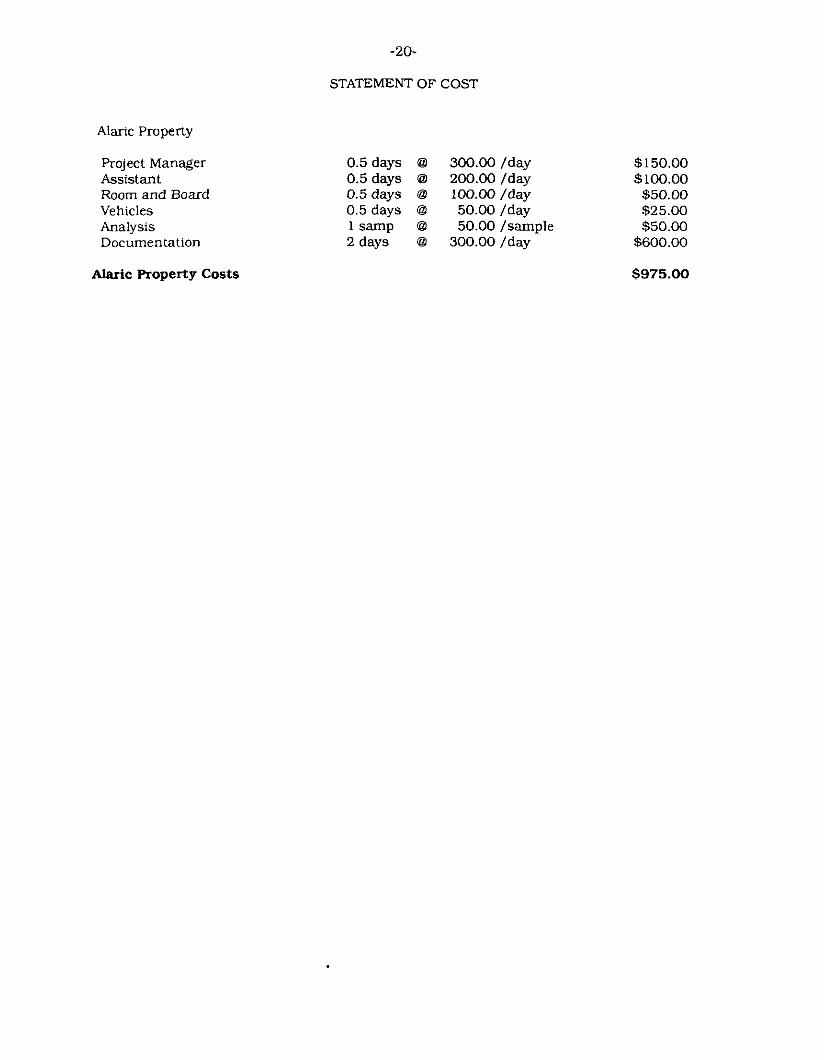
STATEMENT OF COST
Alaric Property
Project Manager Assistant Room and Board Vehicles Analysis Documentation
Alaric Roperty Costs
0.5 days @ 300.00 /day 0.5 days @ 200.00 /day 0.5days @ lOQ.OO/day 0.5 days @ 50.00 /day 1 samp @ 50.00 /sample 2days @ 300.00/day
$150.00 $100.00 $50.00 $25.00 $50.00
$600.00
$975.00
-21-
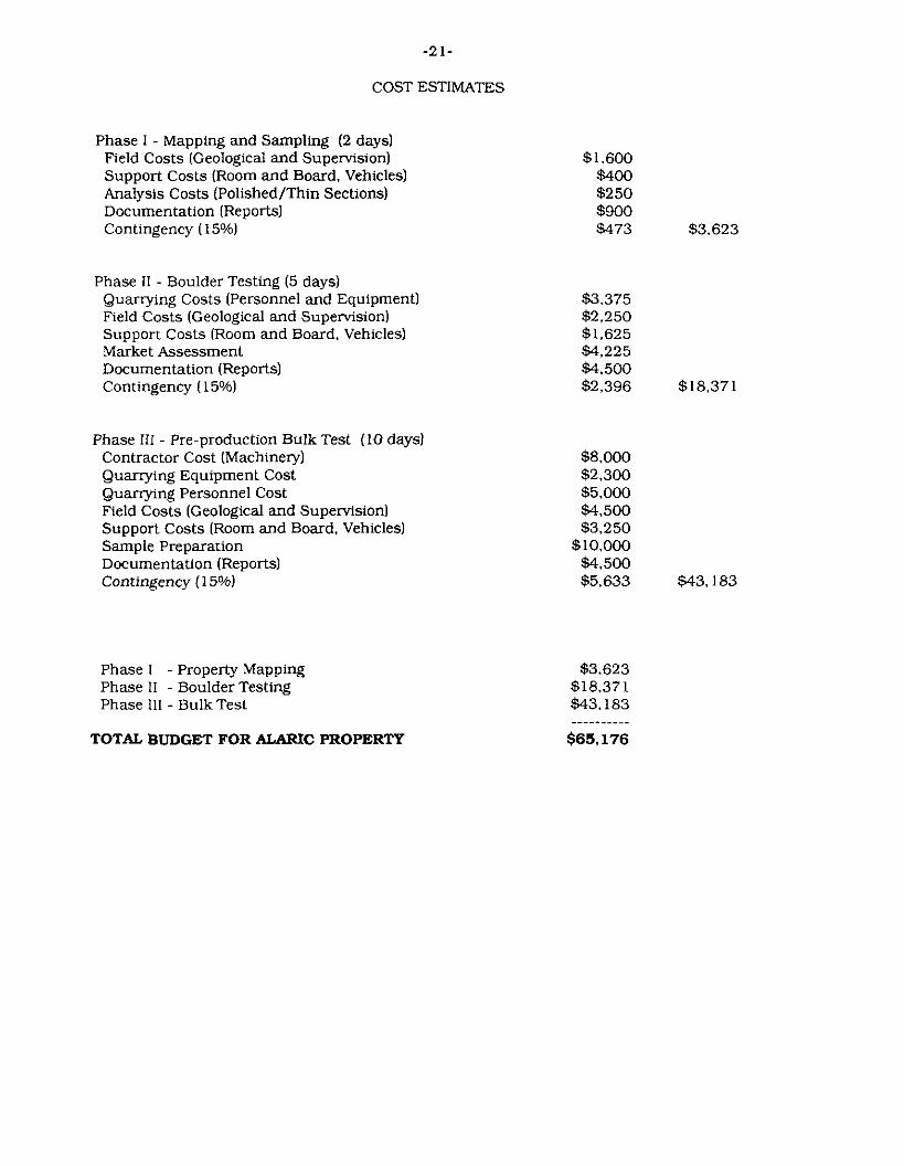
COST ESTIMATES
Phase I - Mapping and Sampling (2 days) Field Costs (Geological and Supervision1 Support Costs (Room and Board, Vehicles) Analysis Costs (Polished/Thin Sections) Documentation (Reports) Contingency (1 5%)
Phase II - Boulder Testing (5 days1 Quarrying Costs (Personnel and Equipment) Field Costs (Geological and Supervision) Support Costs (Room and Board, Vehicles) Market Assessment Documentation (Reports) Contingency (1 5%)
Phase I11 - Pre-production Bulk Test (10 days) Contractor Cost (Machinery) Quarrying Equipment Cost Quarrying Personnel Cost Field Costs (Geological and Supervision) Support Costs (Room and Board, Vehicles) Sample Preparation Docurnentation (Reports) Contingency ( 15%)
Phase 1 - Property Mapping Phase II - Boulder Testing Phase I l l - Bulk Test
TOTAL BUDGET FOR ALARIC PROPERTY
$1.600 $400 $250 $900 $473 $3.623
$3.375 $2,250 $1,625 $4,225 $4.500 $2,396 $18,371
$8.000 $2.300 $5.000 $4.500 $3.250
$10.000 $4.500 $5.633 $43,183
$3,623 $18.371 $43.183
$65,176
-
-22-
SAMPLE DESCFUPTIONS
Sample 10-15-11 - The stone of interest is best described as a dark pink, medium- to coarse-grained granite. The constituents are: 40% dark pink. anhedral to subhedral (7-10mm) K-feldspar. 30% cream white, anhedral (5-7mm) plagioclase. 25%-30% glassy grey. anhedral 15-10mm) quartz and 0%- 1% black. anhedral (1-3mm) mafics. The sample takes a good polish. These is strong micro-fracturing, both across crystals and interstitially. No sulfides were noted. The stone casts a good even dark pink hue on natural break.
The sample came from a felsenmeer boulders on the lowermost bench. These felsenmeer boulders ranged in size to in excess of 500 tons.
The stone in the outcropping is similar. The outcrop shows no signs of rusting or other deleterious materials. Few xenoliths were noted. The benches range in thickness from 2-5 metres, likely mirroring the sheet- ing. The benches are for the most part covered with overburden and felsenmeer, making an accurate description of the vertical fracture pat- terns difficult. The size of the felsenmeer boulders suggest they are widely space, however.
Based on the size of these boulders, blocks in excess of 100-200 tons should be quarriable.
Outcrop -


