Embed Size (px)
Citation preview

Final Draft
TOWN OF JERUSALEMLOCAL WATERFRONTREVITALIZATION STRATEGY
Prepared for the Town of JerusalemOctober 15, 2014
i
TOWN OF JERUSALEM / YATES COUNTY
ACKNOWLEDGEMENTS
The Keuka Lake Revitalization Strategy has been developed in cooperation with the New York State Department of State with funds provided under Title 11 of the NYS Environmental Protection Fund.
Project Advisory Committee
Funding Partners
Town of Jerusalem
Keuka College
The Finger Lakes Museum
New York State Department of State
JC Smith, Resident
Michael Steppe, Co-Chair, Resident, Town of Jerusalem Board Member, Business Owner
Amy Storey, Keuka College
Dave Sweet, Resident, Keuka College
Jack Wheeler, Resident, Town of Jerusalem Planning Board, Marina Owner
Bebette Yunis, Private Developer, Keuka College, Keuka Lake Association
Rolf Zerges, Resident, The Finger Lakes Museum, Penn Yan Vision 2020
Ex Officio
Shawna Bonshak, Yates County Planning
Amy DeGaetano, NYS Department of State
Don Naetzker, Project Manager
Planning Consultants
Ingalls Planning & Design
in association with Trowbridge Wolf Michaels Landscape Architects
ii
WATERFRONT REVITALIZATION STRATEGY
CONTENTSIntroduction and Waterfront Revitalization Area 1
Inventory and Analysis 3
Community Vision 23
Recommended Projects 29
Implementation 45
Appendix 49
FIGURESFigure 1: Transportation and Revitalization Area Map 2
Figure 2: Land Use Map 4
Figure 3: Existing Zoning Map 5
Figure 4: Agricultural District Map 7
Figure 5: Water -Based Access & Uses 12
Figure 6: NYSDEC Public Access Map 14
Figure 7: Topography Map 16
Figure 8: Hydrography Map 18
Figure 9: Highly Erodable Soils 19
Figure 10: Sewer District Map 20
Figure 11: Water District Map 21
Figure 12: Waterfront Area Top Three 25
Figure 13: Waterfront Area Issues & Opportunities 26
Figure 14: Waterfront Area Assets & Vision Words 27
Figure 15: Keuka Park Landing Schematic 33
Figure 16: Branchport Route 54A Streetscape 34
Figure 17: Central Avenue Cross-Section 35
Figure 18: Kinney Corner Entrance Schematic 36
Figure 19: West Lake Road Cross-Section 37
Figure 20: Sugar Creek Eco-Park Concept 38
Figure 21: Keuka College Expansion Project 40
Figure 22: Keuka Park Improvements 42
Figure 23: Recommended Projects Map 43
1
TOWN OF JERUSALEM / YATES COUNTY
SECTION 1: INTRODUCTION & WATERFRONT REVITALIZATION AREA BOUNDARY
Section 1INTRODUCTION AND WATER-FRONT REVITALIZATION AREA
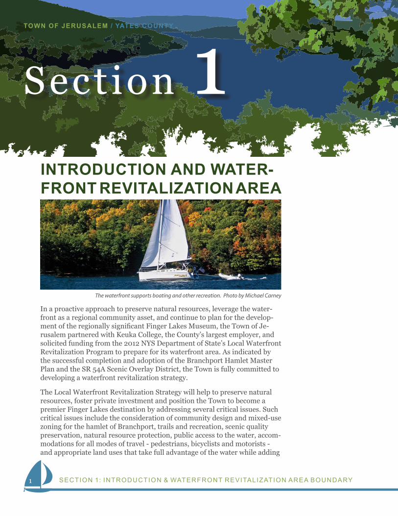
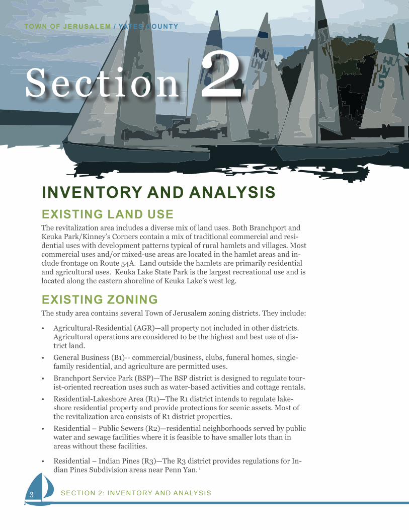
In a proactive approach to preserve natural resources, leverage the water-front as a regional community asset, and continue to plan for the develop-ment of the regionally significant Finger Lakes Museum, the Town of Je-rusalem partnered with Keuka College, the County’s largest employer, and solicited funding from the 2012 NYS Department of State’s Local Waterfront Revitalization Program to prepare for its waterfront area. As indicated by the successful completion and adoption of the Branchport Hamlet Master Plan and the SR 54A Scenic Overlay District, the Town is fully committed to developing a waterfront revitalization strategy.
The Local Waterfront Revitalization Strategy will help to preserve natural resources, foster private investment and position the Town to become a premier Finger Lakes destination by addressing several critical issues. Such critical issues include the consideration of community design and mixed-use zoning for the hamlet of Branchport, trails and recreation, scenic quality preservation, natural resource protection, public access to the water, accom-modations for all modes of travel - pedestrians, bicyclists and motorists - and appropriate land uses that take full advantage of the water while adding
The waterfront supports boating and other recreation. Photo by Michael Carney
2
WATERFRONT REVITALIZATION STRATEGY
®Town of JerusalemTransportation NetworkPrepared August 2006
0 1 2Miles
VIN
E R
OA
D
E. SHERMAN
ES
PE
RA
NZA
RO
AD
CO
RW
IN R
OA
D
STEVER HILL ROAD
ITAL
Y FR
IEND R
OAD
PE
PP
ER
RO
AD
SCO
TTR
OAD
BA
RN
ES
RO
AD
EAST
BLU
FF
DR
IVE
WILLETT ROAD
SKYL
INE
DR
IVE
PAR
KE
R R
OA
D
WO
OD
S
RO
AD
AYE
RS
RO
AD
TINNEY ROAD
KE
EC
H R
OA
D
EAST
BLU
FF D
RIV
E
WE
ST
BLU
FF D
RI V
E
SKY
LIN
E D
RIV
E
HILL
ROAD
COMSTOCKROAD
W. LIGHTNINGROAD
NORTHRUP
HILL R
D
W. SHERMAN HOLLOW ROAD
CHAMPLIN
SH
AN
TY P
L AIN
S
ROAD
FRIEND
RO
AD
HOUSE ROAD
COUN
TY
YATE
SVIL
LE
ROAD SUTTO
N R
OAD
CO
ATE
S
RO
AD
SIDWHITE ROAD
WILLIAMSROAD
HOLLOW ROAD
ADAMS ROAD
WAGERHILLROAD
MA
RTI
NR
OAD
HEMLOCK
MORRISONROAD
ARM
STR
ON
G
RO
AD
ITALY HILL ROAD
PULTENEY ROAD
EAST VALLEY
ROAD
CULVER HILL ROAD
BROWNHILL
ROAD
MERRITT HILLROAD
LAKE
RO
AD
WES
T
TINNEY ROAD
CHURCHROAD
TOM
CA
MP
BE
LL R
OA
D
ROAD
GU
YANO
GA
RO
AD
Keuk
aLa
ke
Wes
tBr
anch
Keuk
aLa
ke
East
Bran
ch
BELKNAP
YODER ROAD
[À
[À
[À
[
FRIEND HILLRD
ROAD
186 North Water StreetRochester, NY 14604
Map 10
Legend
Town Boundary
State Roads
County Roads
Town Roads
Branchport
PennYan
Guyanoga
Friend
KeukaPark
ë
ë
p|
p|
p|
ë
Marinas
Boat Launches
Keuka Lake
Outlet
Kinneys Corners
Revitalization BoundaryRevitalization Boundary
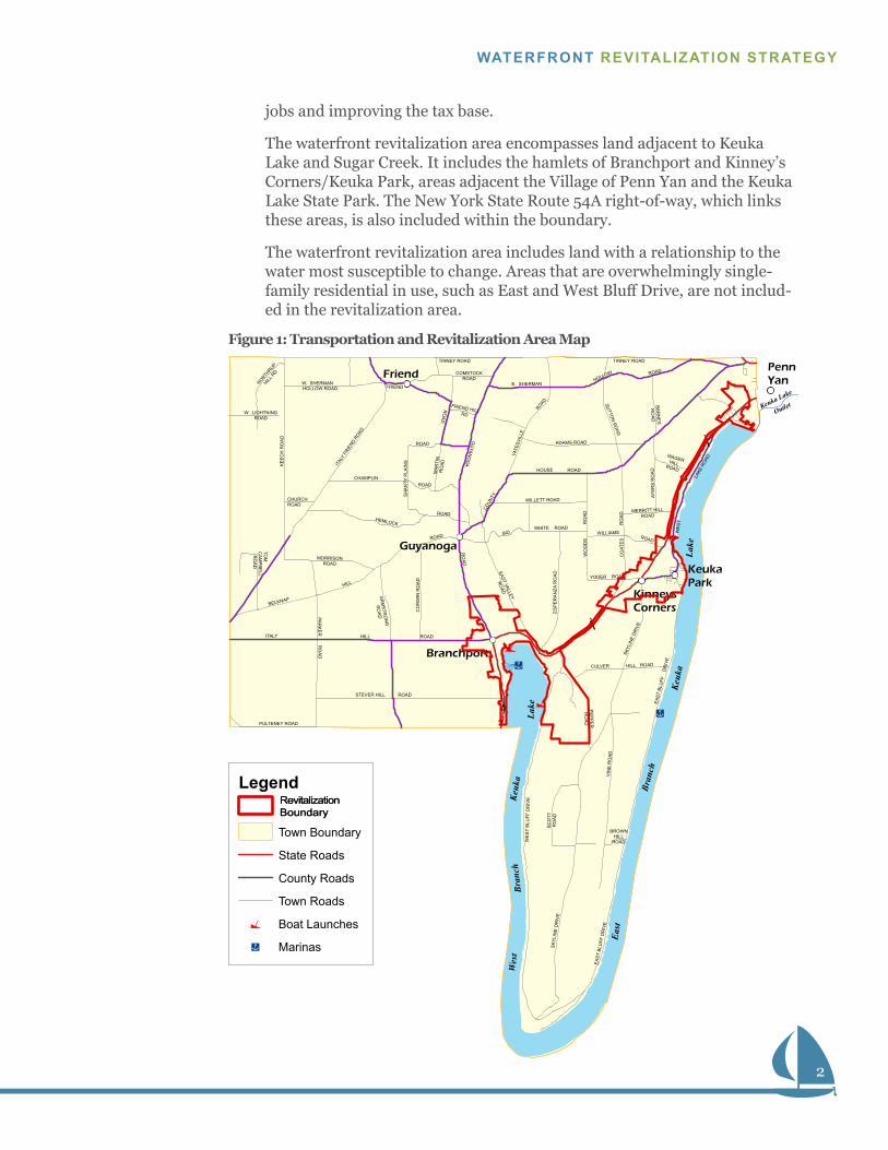
Figure 1: Transportation and Revitalization Area Map
jobs and improving the tax base.
The waterfront revitalization area encompasses land adjacent to Keuka Lake and Sugar Creek. It includes the hamlets of Branchport and Kinney’s Corners/Keuka Park, areas adjacent the Village of Penn Yan and the Keuka Lake State Park. The New York State Route 54A right-of-way, which links these areas, is also included within the boundary.
The waterfront revitalization area includes land with a relationship to the water most susceptible to change. Areas that are overwhelmingly single-family residential in use, such as East and West Bluff Drive, are not includ-ed in the revitalization area.
3
TOWN OF JERUSALEM / YATES COUNTY
SECTION 2: INVENTORY AND ANALYSIS
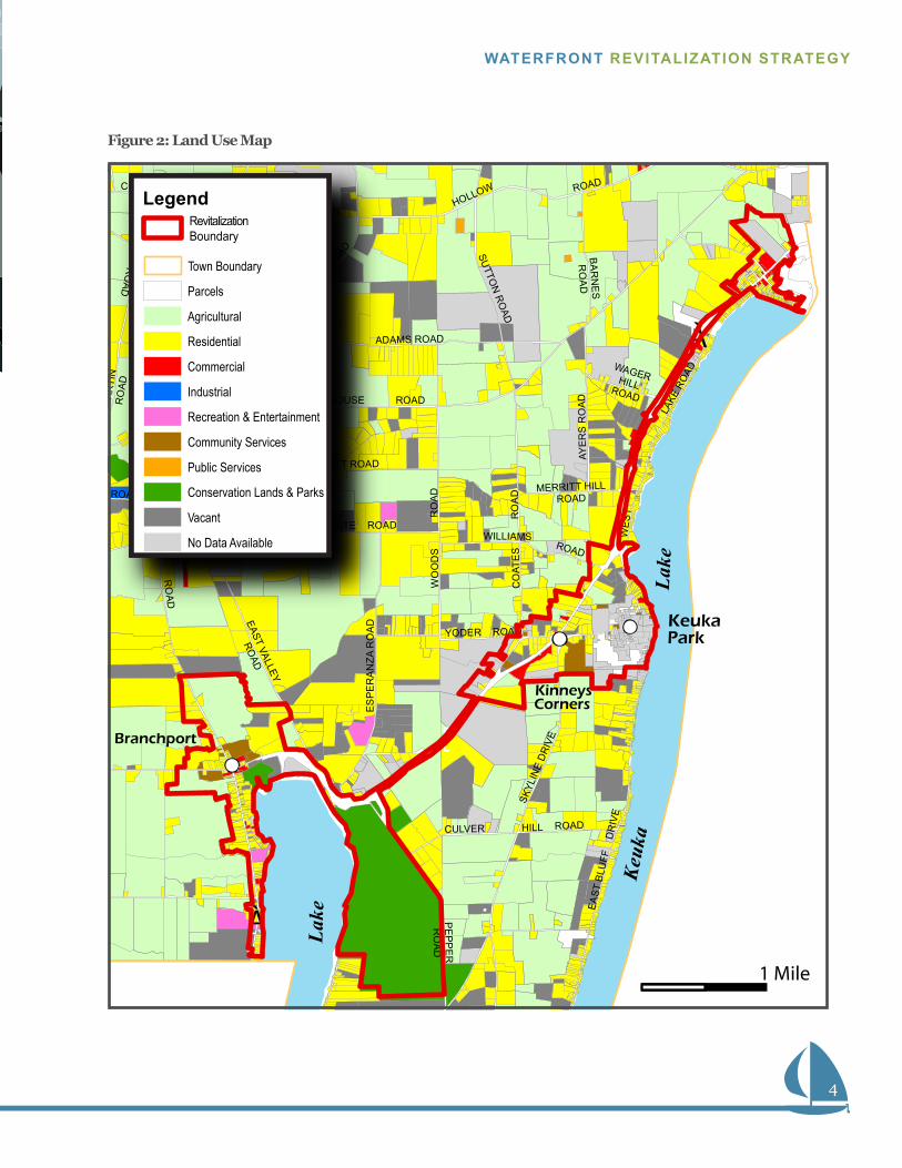
Section 2INVENTORY AND ANALYSISEXISTING LAND USEThe revitalization area includes a diverse mix of land uses. Both Branchport and Keuka Park/Kinney’s Corners contain a mix of traditional commercial and resi-dential uses with development patterns typical of rural hamlets and villages. Most commercial uses and/or mixed-use areas are located in the hamlet areas and in-clude frontage on Route 54A. Land outside the hamlets are primarily residential and agricultural uses. Keuka Lake State Park is the largest recreational use and is located along the eastern shoreline of Keuka Lake’s west leg.
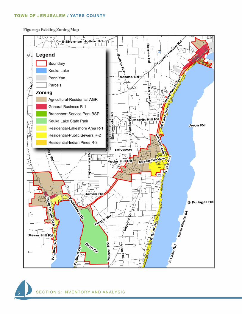
EXISTING ZONINGThe study area contains several Town of Jerusalem zoning districts. They include:
• Agricultural-Residential (AGR)—all property not included in other districts. Agricultural operations are considered to be the highest and best use of dis-trict land.
• General Business (B1)-- commercial/business, clubs, funeral homes, single-family residential, and agriculture are permitted uses.
• Branchport Service Park (BSP)—The BSP district is designed to regulate tour-ist-oriented recreation uses such as water-based activities and cottage rentals.
• Residential-Lakeshore Area (R1)—The R1 district intends to regulate lake-shore residential property and provide protections for scenic assets. Most of the revitalization area consists of R1 district properties.
• Residential – Public Sewers (R2)—residential neighborhoods served by public water and sewage facilities where it is feasible to have smaller lots than in areas without these facilities.
• Residential – Indian Pines (R3)—The R3 district provides regulations for In-dian Pines Subdivision areas near Penn Yan. 1
4
WATERFRONT REVITALIZATION STRATEGY
Figure 2: Land Use Map
D
E. SHERMAN
ES
PE
RA
NZA
RO
AD
PE
PP
ER
RO
AD
BA
RN
ES
RO
AD
EAST
BLU
FF
DR
IVE
WILLETT ROAD
SKYL
INE
DR
IVE
WO
OD
S
RO
AD
AYE
RS
RO
AD
TINNEY ROAD
D
COMSTOCKROAD
RO
AD
HOUSE ROAD
COUN
TY
YATE
SVIL
LE
ROAD SUTTO
N R
OAD
CO
ATE
S
RO
AD
SIDWHITE ROAD
WILLIAMSROAD
HOLLOW ROAD
ADAMS ROAD
WAGERHILLROAD
MA
RTI
NR
OAD
ROAD
EAST VALLEY
ROAD
CULVER HILL ROAD
MERRITT HILLROAD
LAKE
RO
AD
WES
T
TINNEY ROAD
ROAD
GU
YANO
GA
RO
AD
Lake
Keuk
aLa
keYODER ROAD
[À
[
[À
FRIEND HILLRD
Branchport
KeukaPark
Kinneys Corners
Legend
Town Boundary
Parcels
Agricultural
Residential
Commercial
Industrial
Recreation & Entertainment
Community Services
Public Services
Conservation Lands & Parks
Vacant
No Data Available
Revitalization Boundary
1 Mile
5
TOWN OF JERUSALEM / YATES COUNTY
SECTION 2: INVENTORY AND ANALYSIS
Sta
te R
oute
54A
Gu
yan
og
a R
d
E B
luff
Dr
E L
ake
Rd
Sky
line
Dr
County H
ouse R
d
Adams Rd
Co
ate
s R
d
Sta
te R
ou
te 5
4
E V
alley Rd
W L
ake
Rd
Sid White Rd
Pep
per
Rd
Willett Rd
Esp
era
nza
Rd
W B
luff
Dr
Su
tton R
d
Ayers
RdY
ates
ville
Rd
Bluff Dr
E Sherman Hollow Rd Ba
rnes R
d
Fingar Rd
Vin
e Rd
Co
un
ty H
ou
se W
oo
ds R
d
Ba
ck R
d
Merritt Hill Rd
Cen
tral Ave
Stever Hill Rd
Yoder Hill Rd
G Fullagar Rd
Lak
e A
ve
James Rd
Assembly Ave
Esperanza D
r
Driveway
Eastw
oo
ds R
d
Avon Rd
Sta
te Ro
ute
54A
W L
ake
Rd
E V
alley R
d
LegendBoundary
Keuka Lake
Agricultural-Residential AGR
Zoning
General Business B-1
Branchport Service Park BSP
Keuka Lake State Park
Residential-Lakeshore Area R-1
Residential-Public Sewers R-2
Residential-Indian Pines R-3
Penn Yan
Parcels
5
TOWN OF JERUSALEM / YATES COUNTY
Figure 3: Existing Zoning Map
6
WATERFRONT REVITALIZATION STRATEGY
6
WATERFRONT REVITALIZATION STRATEGY
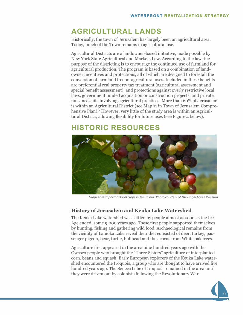
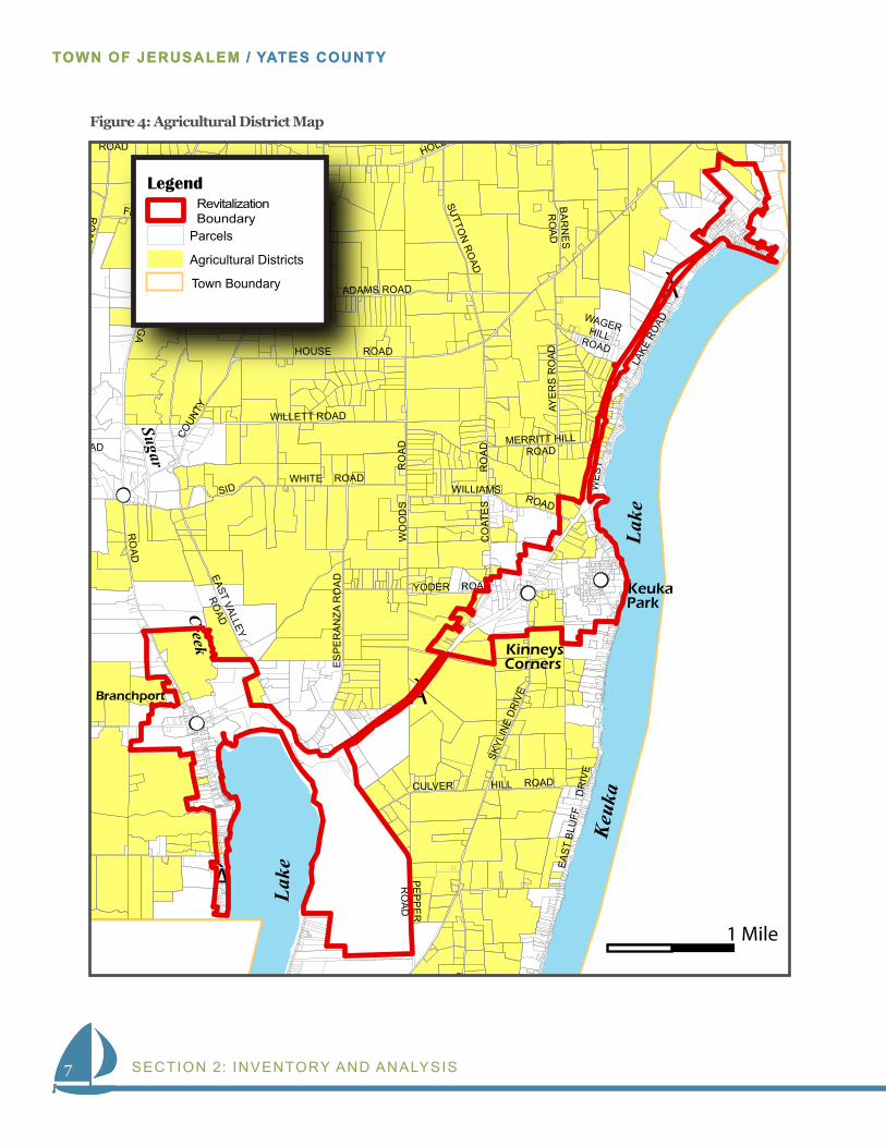
AGRICULTURAL LANDSHistorically, the town of Jerusalem has largely been an agricultural area. Today, much of the Town remains in agricultural use.
Agricultural Districts are a landowner-based initiative, made possible by New York State Agricultural and Markets Law. According to the law, the purpose of the districting is to encourage the continued use of farmland for agricultural production. The program is based on a combination of land-owner incentives and protections, all of which are designed to forestall the conversion of farmland to non-agricultural uses. Included in these benefits are preferential real property tax treatment (agricultural assessment and special benefit assessment), and protections against overly restrictive local laws, government funded acquisition or construction projects, and private nuisance suits involving agricultural practices. More than 60% of Jerusalem is within an Agricultural District (see Map 11 in Town of Jerusalem Compre-hensive Plan).2 However, very little of the study area is within an Agricul-tural District, allowing flexibility for future uses (see Figure 4 below).
HISTORIC RESOURCES
History of Jerusalem and Keuka Lake WatershedThe Keuka Lake watershed was settled by people almost as soon as the Ice Age ended, some 9,000 years ago. These first people supported themselves by hunting, fishing and gathering wild food. Archaeological remains from the vicinity of Lamoka Lake reveal their diet consisted of deer, turkey, pas-senger pigeon, bear, turtle, bullhead and the acorns from White oak trees.
Agriculture first appeared in the area nine hundred years ago with the Owasco people who brought the “Three Sisters” agriculture of interplanted corn, beans and squash. Early European explorers of the Keuka Lake water-shed encountered the Iroquois, a group who are thought to have arrived five hundred years ago. The Seneca tribe of Iroquois remained in the area until they were driven out by colonists following the Revolutionary War.
Grapes are important local crops in Jerusalem. Photo courtesy of The Finger Lakes Museum.
7
TOWN OF JERUSALEM / YATES COUNTY
SECTION 2: INVENTORY AND ANALYSIS7
TOWN OF JERUSALEM / YATES COUNTY
AD
E. SHERMAN
ES
PE
RA
NZA
RO
AD
PE
PP
ER
RO
AD
BA
RN
ES
RO
AD
EAST
BLU
FF
DR
IVE
WILLETT ROAD
SKYL
INE
DR
IVE
WO
OD
S
RO
AD
AYE
RS
RO
AD
COMSTOCKROAD
RO
AD
HOUSE ROAD
COUN
TY
YATE
SVIL
LE
ROAD SUTTO
N R
OAD
CO
ATE
S
RO
AD
SIDWHITE ROAD
WILLIAMSROAD
HOLLOW ROAD
ADAMS ROAD
WAGERHILLROADRO
AD
EAST VALLEY
ROAD
CULVER HILL ROAD
MERRITT HILLROAD
LAKE
RO
AD
WES
T
OAD
GU
YANO
GA
RO
AD
Lake
Keuk
aLa
ke
YODER ROAD
[À
[À
[À
FRIEND HILLRD
Sugar
Creek
KeukaPark
Kinneys Corners
Legend
Town Boundary
Parcels
Agricultural Districts
Revitalization Boundary
1 Mile
Branchport
Figure 4: Agricultural District Map
8
WATERFRONT REVITALIZATION STRATEGY
8
WATERFRONT REVITALIZATION STRATEGY
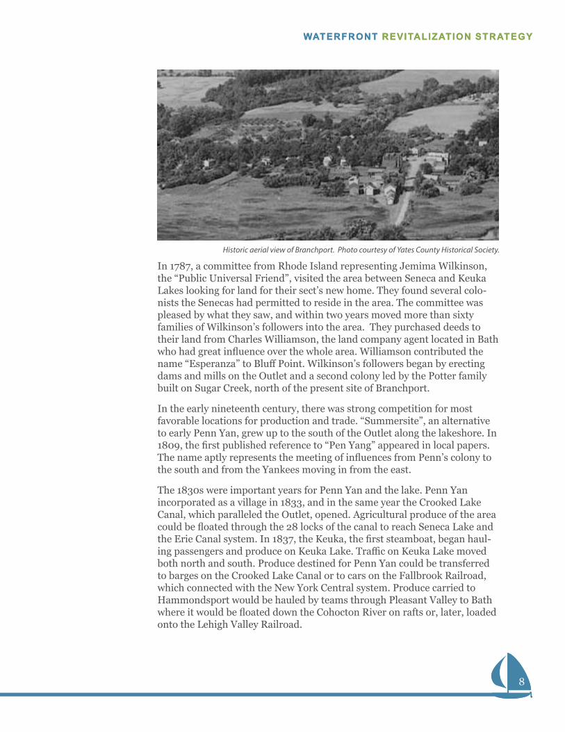
In 1787, a committee from Rhode Island representing Jemima Wilkinson, the “Public Universal Friend”, visited the area between Seneca and Keuka Lakes looking for land for their sect’s new home. They found several colo-nists the Senecas had permitted to reside in the area. The committee was pleased by what they saw, and within two years moved more than sixty families of Wilkinson’s followers into the area. They purchased deeds to their land from Charles Williamson, the land company agent located in Bath who had great influence over the whole area. Williamson contributed the name “Esperanza” to Bluff Point. Wilkinson’s followers began by erecting dams and mills on the Outlet and a second colony led by the Potter family built on Sugar Creek, north of the present site of Branchport.
In the early nineteenth century, there was strong competition for most favorable locations for production and trade. “Summersite”, an alternative to early Penn Yan, grew up to the south of the Outlet along the lakeshore. In 1809, the first published reference to “Pen Yang” appeared in local papers. The name aptly represents the meeting of influences from Penn’s colony to the south and from the Yankees moving in from the east.
The 1830s were important years for Penn Yan and the lake. Penn Yan incorporated as a village in 1833, and in the same year the Crooked Lake Canal, which paralleled the Outlet, opened. Agricultural produce of the area could be floated through the 28 locks of the canal to reach Seneca Lake and the Erie Canal system. In 1837, the Keuka, the first steamboat, began haul-ing passengers and produce on Keuka Lake. Traffic on Keuka Lake moved both north and south. Produce destined for Penn Yan could be transferred to barges on the Crooked Lake Canal or to cars on the Fallbrook Railroad, which connected with the New York Central system. Produce carried to Hammondsport would be hauled by teams through Pleasant Valley to Bath where it would be floated down the Cohocton River on rafts or, later, loaded onto the Lehigh Valley Railroad.
Historic aerial view of Branchport. Photo courtesy of Yates County Historical Society.
9
TOWN OF JERUSALEM / YATES COUNTY
SECTION 2: INVENTORY AND ANALYSIS9
TOWN OF JERUSALEM / YATES COUNTY
The steamboats were crucial for moving agricultural produce to market, and after the Keuka, a series of steamships followed including: Steuben, George R. Young, Keuka, Yates, Lulu, Urbana, Farley Holmes, William L. Halsey, West Branch, Mary Bell, and the Cricket. Docks and piers were built in Penn Yan, Branchport and Hammondsport to move the produce from lake to land transport. Large icehouses at the ports stored ice cut from the lake used to cool shipments to distant markets. Several steamboats ran into the 1920s for tours and excursions, but automobiles and good roads replaced them for other purposes.
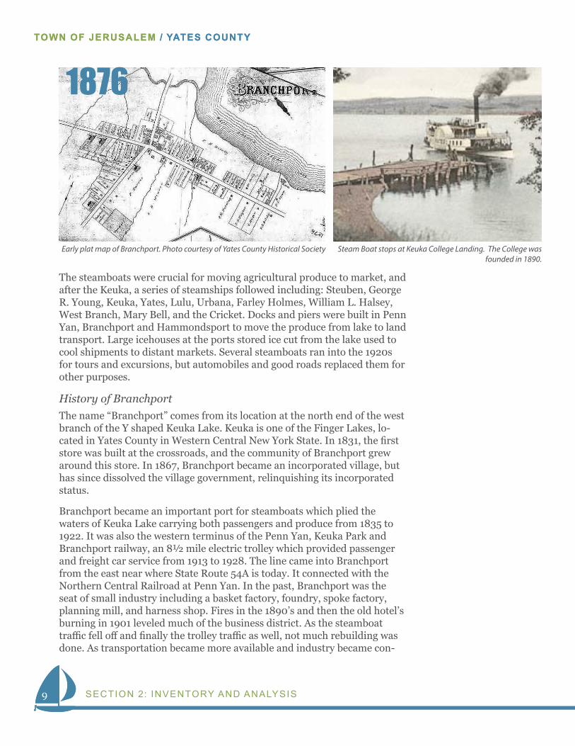
History of BranchportThe name “Branchport” comes from its location at the north end of the west branch of the Y shaped Keuka Lake. Keuka is one of the Finger Lakes, lo-cated in Yates County in Western Central New York State. In 1831, the first store was built at the crossroads, and the community of Branchport grew around this store. In 1867, Branchport became an incorporated village, but has since dissolved the village government, relinquishing its incorporated status.
Branchport became an important port for steamboats which plied the waters of Keuka Lake carrying both passengers and produce from 1835 to 1922. It was also the western terminus of the Penn Yan, Keuka Park and Branchport railway, an 8½ mile electric trolley which provided passenger and freight car service from 1913 to 1928. The line came into Branchport from the east near where State Route 54A is today. It connected with the Northern Central Railroad at Penn Yan. In the past, Branchport was the seat of small industry including a basket factory, foundry, spoke factory, planning mill, and harness shop. Fires in the 1890’s and then the old hotel’s burning in 1901 leveled much of the business district. As the steamboat traffic fell off and finally the trolley traffic as well, not much rebuilding was done. As transportation became more available and industry became con-
Early plat map of Branchport. Photo courtesy of Yates County Historical Society Steam Boat stops at Keuka College Landing. The College was founded in 1890.
1876
10
WATERFRONT REVITALIZATION STRATEGY
10
WATERFRONT REVITALIZATION STRATEGY
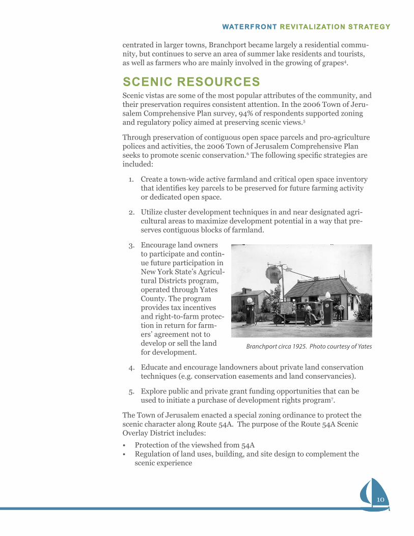
centrated in larger towns, Branchport became largely a residential commu-nity, but continues to serve an area of summer lake residents and tourists, as well as farmers who are mainly involved in the growing of grapes4.
SCENIC RESOURCESScenic vistas are some of the most popular attributes of the community, and their preservation requires consistent attention. In the 2006 Town of Jeru-salem Comprehensive Plan survey, 94% of respondents supported zoning and regulatory policy aimed at preserving scenic views.5
Through preservation of contiguous open space parcels and pro-agriculture polices and activities, the 2006 Town of Jerusalem Comprehensive Plan seeks to promote scenic conservation.6 The following specific strategies are included:
1. Create a town-wide active farmland and critical open space inventory that identifies key parcels to be preserved for future farming activity or dedicated open space.
2. Utilize cluster development techniques in and near designated agri-cultural areas to maximize development potential in a way that pre-serves contiguous blocks of farmland.
3. Encourage land owners to participate and contin-ue future participation in New York State’s Agricul-tural Districts program, operated through Yates County. The program provides tax incentives and right-to-farm protec-tion in return for farm-ers’ agreement not to develop or sell the land for development.
4. Educate and encourage landowners about private land conservation techniques (e.g. conservation easements and land conservancies).
5. Explore public and private grant funding opportunities that can be used to initiate a purchase of development rights program7.
The Town of Jerusalem enacted a special zoning ordinance to protect the scenic character along Route 54A. The purpose of the Route 54A Scenic Overlay District includes:
• Protection of the viewshed from 54A• Regulation of land uses, building, and site design to complement the
scenic experience
Branchport circa 1925. Photo courtesy of Yates
11
TOWN OF JERUSALEM / YATES COUNTY
SECTION 2: INVENTORY AND ANALYSIS11
TOWN OF JERUSALEM / YATES COUNTY
• Ensure development reflects the vision in the 2006 Comprehensive Plan8
Further, the New York State Agriculture and Markets Law protects farm-land, and indirectly has the effect of protecting scenic views.
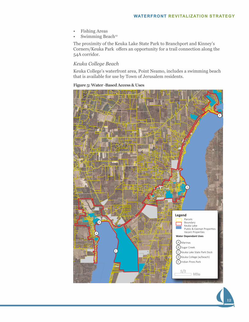
WATER USE The water bodies of Keuka Lake and Sugar Creek are vital to life in Jerusa-lem. Within the study area, a private marina offers marine services. Basin Park Marina, located south of Branchport on West Lake Road (54A), offers more than 100 boat slips, transient docking, cottage rental, restrooms, and showers9. East Bluff Harbor is located on East Bluff Drive and offers 22 slips, boat rentals and storage. The Harbor Club and North Country Kayak and Canoe Rentals, also on West Lake Road (54A), contribute to the offering in the waterfront area.
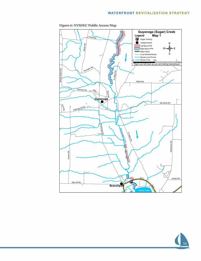
Public AccessSugar CreekNYSDEC maintains a boat launch on Sugar Creek (i.e. Guyanoga Creek). The site accommodates float-off and float-on launching of boats on trailers. A gravel ramp is available for cartop and small trailered boats.10 Further, the launch accommodates 6 cars and trailers.11 Sugar Creek also offers public fishing areas (see Open Space, Public Access and Recreational Resources).
Keuka Lake State ParkKeuka Lake State Park, operated by New York State Office of Parks, Recre-ation & Historic Preservation (NYSOPRHP) offers significant public access to Keuka Lake. The park, located at 3560 Pepper Road, lies just east of Branchport. Keuka Lake State Park offers:
• Boat Launches—uitable for watercraft on trailers• Boat Docks—additional marine amenities include waste pump-out sta-
tions and showers• Boat Slips
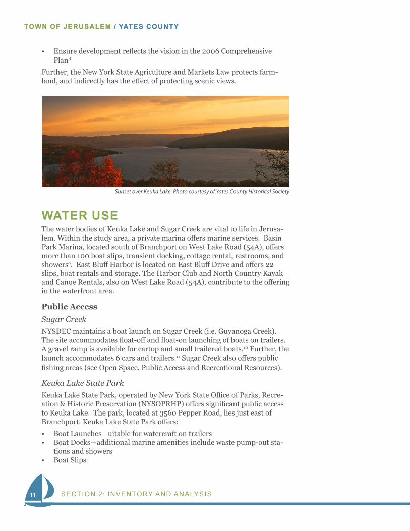
Sunset over Keuka Lake. Photo courtesy of Yates County Historical Society
12
WATERFRONT REVITALIZATION STRATEGY
12
WATERFRONT REVITALIZATION STRATEGY
• Fishing Areas• Swimming Beach12
The proximity of the Keuka Lake State Park to Branchport and Kinney’s Corners/Keuka Park offers an opportunity for a trail connection along the 54A corridor.
Keuka College BeachKeuka College’s waterfront area, Point Neamo, includes a swimming beach that is available for use by Town of Jerusalem residents.
Legend
Mile1/2
Parcels Boundary Keuka Lake Public & Exempt Properties Vacant Properties
Marinas
Sugar Creek
Keuka Lake State Park Dock
Keuka College (w/beach)
Indian Pines Park
B
A
D
C
E
Water Dependant Uses
A
B
C
D
E
Figure 5: Water -Based Access & Uses
13
TOWN OF JERUSALEM / YATES COUNTY
SECTION 2: INVENTORY AND ANALYSIS13
TOWN OF JERUSALEM / YATES COUNTY
OPEN SPACE AND RECREATIONAL RE-SOURCESAccording to the community survey conducted for the 2006 Comprehensive Plan, open space, public access, and recreational resources are very impor-tant to residents.13
Keuka Lake State ParkKeuka Lake State Park, operated by NYSOPRHP offers significant public access, open space, and recreational resources to the community. In addi-tion to the public access to the water (see Water Access) the park offers the following activities:
• 132 Campsites –capacity for tents, trailers, and electrified sites• Hiking• Hunting –seasonal Deer and Duck• Cross Country Skiing• Pavilions, Picnic Tables• Playgrounds14
Currently, Keuka Lake State Park offers little or no pedestrian or bicycle accesibility to Branchport. An opportunity for a trail linking the areas may exist along the waterfront.
Sugar CreekSugar Creek offers fishing access to the community. Sugar Creek supports a small annual migration of wild rainbow trout, a desirable species of fish.15 Public fishing rights, permanent easements purchased by NYSDEC from private land owners, are maintained along Sugar Creek, immediately south of 54A.16
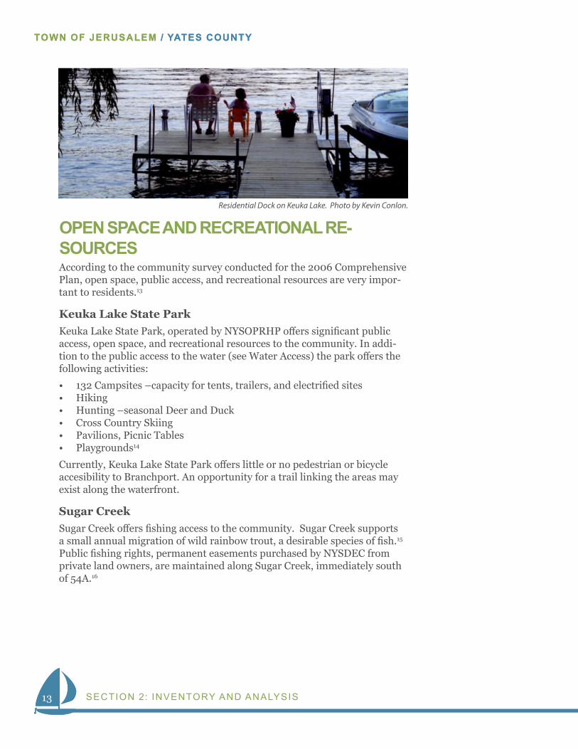
Residential Dock on Keuka Lake. Photo by Kevin Conlon.
14
WATERFRONT REVITALIZATION STRATEGY
14
WATERFRONT REVITALIZATION STRATEGY
54 A
54 A
Guyanoga R
d E Valley Rd
Cor
win
Rd
Sid White Rd
Esp
eran
za R
d
Willett Rd
Italy Hill Rd
County House Rd
Hemlock Rd
Mar
tin R
d
Adams Rd
Champlin Rd
Back Rd
Sha
nty
Pla
ins
Rd
Yate
sville
Rd
Belknap Hill Rd
Friend Rd
Alley
James Rd
Lynn Rd
Driveway
E Va
lley
Rd
Driveway
Guyanoga
Branchport
Guyanoga C
reek
Keuka Lake
j
j
Guyanoga (Sugar) CreekMap 1
0 10.5Miles
*Right and left bank as you are looking downstream
LegendAngler Parking
Village/Hamlet
Left Bank PFRRight Bank PFRMajor RoadLocal Streets/RoadsStreams and PondsjStream Flow
Figure 6: NYSDEC Public Access Map
15
TOWN OF JERUSALEM / YATES COUNTY
SECTION 2: INVENTORY AND ANALYSIS15
TOWN OF JERUSALEM / YATES COUNTY
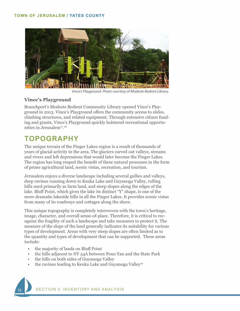
Vince’s PlaygroundBranchport’s Modeste Bedient Community Library opened Vince’s Play-ground in 2013. Vince’s Playground offers the community access to slides, climbing structures, and related equipment. Through extensive citizen fund-ing and grants, Vince’s Playground quickly bolstered recreational opportu-nities in Jerusalem17.18
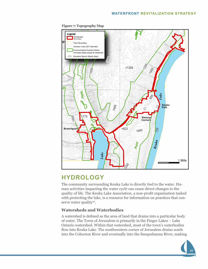
TOPOGRAPHYThe unique terrain of the Finger Lakes region is a result of thousands of years of glacial activity in the area. The glaciers carved out valleys, streams and rivers and left depressions that would later become the Finger Lakes. The region has long reaped the benefit of these natural processes in the form of prime agricultural land, scenic vistas, recreation, and tourism.
Jerusalem enjoys a diverse landscape including several gullies and valleys, deep ravines running down to Keuka Lake and Guyanoga Valley, rolling hills used primarily as farm land, and steep slopes along the edges of the lake. Bluff Point, which gives the lake its distinct “Y” shape, is one of the more dramatic lakeside hills in all the Finger Lakes. It provides scenic vistas from many of its roadways and cottages along the shore.
This unique topography is completely interwoven with the town’s heritage, image, character, and overall sense-of-place. Therefore, it is critical to rec-ognize the fragility of such a landscape and take measures to protect it. The measure of the slope of the land generally indicates its suitability for various types of development. Areas with very steep slopes are often limited as to the quantity and types of development that can be supported. These areas include:
• the majority of lands on Bluff Point• the hills adjacent to NY 54A between Penn Yan and the State Park• the hills on both sides of Guyanoga Valley• the ravines leading to Keuka Lake and Guyanoga Valley19
Vince’s Playground. Photo courtesy of Modeste Bedient Library.
16
WATERFRONT REVITALIZATION STRATEGY
16
WATERFRONT REVITALIZATION STRATEGY
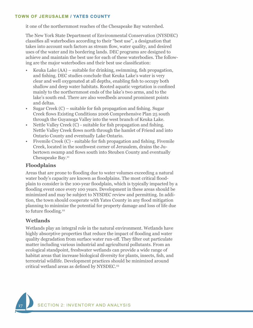
HYDROLOGYThe community surrounding Keuka Lake is directly tied to the water. Hu-man activities impacting the water cycle can cause direct changes to the quality of life. The Keuka Lake Association, a non-profit organization tasked with protecting the lake, is a resource for information on practices that con-serve water quality20.
Watersheds and WaterbodiesA watershed is defined as the area of land that drains into a particular body of water. The Town of Jerusalem is primarily in the Finger Lakes – Lake Ontario watershed. Within that watershed, most of the town’s waterbodies flow into Keuka Lake. The southwestern corner of Jerusalem drains south into the Cohocton River and eventually into the Susquehanna River, making
Point
Guyanoga
Valley
Gully
1000 720
+775
10001
0
1200
+823
100012
00
1400
1000
1200
800
+1394
Branchport
Friend
KeukaPark
Kinneys Corners
Lake
Keuk
aLa
ke
Revitalization Boundary
Legend
Town Boundary
Contour Lines (20' Intervals)
Environmental Overlay District(includes steep slopes & wetlands)
+775 Elevation Bench Marks (feet)
1 Mile
Figure 7: Topography Map
17
TOWN OF JERUSALEM / YATES COUNTY
SECTION 2: INVENTORY AND ANALYSIS17
TOWN OF JERUSALEM / YATES COUNTY
it one of the northernmost reaches of the Chesapeake Bay watershed.
The New York State Department of Environmental Conservation (NYSDEC) classifies all waterbodies according to their “best use”, a designation that takes into account such factors as stream flow, water quality, and desired uses of the water and its bordering lands. DEC programs are designed to achieve and maintain the best use for each of these waterbodies. The follow-ing are the major waterbodies and their best use classification:
• Keuka Lake (AA) – suitable for drinking, swimming, fish propagation, and fishing. DEC studies conclude that Keuka Lake’s water is very clear and well oxygenated at all depths, enabling fish to occupy both shallow and deep water habitats. Rooted aquatic vegetation is confined mainly to the northernmost ends of the lake’s two arms, and to the lake’s south end. There are also weedbeds around prominent points and deltas.
• Sugar Creek (C) – suitable for fish propagation and fishing. Sugar Creek flows Existing Conditions 2006 Comprehensive Plan 25 south through the Guyanoga Valley into the west branch of Keuka Lake.
• Nettle Valley Creek (C) - suitable for fish propagation and fishing. Nettle Valley Creek flows north through the hamlet of Friend and into Ontario County and eventually Lake Ontario.
• Fivemile Creek (C) - suitable for fish propagation and fishing. Fivemile Creek, located in the southwest corner of Jerusalem, drains the Ju-bertown swamp and flows south into Steuben County and eventually Chesapeake Bay.21
FloodplainsAreas that are prone to flooding due to water volumes exceeding a natural water body’s capacity are known as floodplains. The most critical flood-plain to consider is the 100-year floodplain, which is typically impacted by a flooding event once every 100 years. Development in these areas should be minimized and may be subject to NYSDEC review and permitting. In addi-tion, the town should cooperate with Yates County in any flood mitigation planning to minimize the potential for property damage and loss of life due to future flooding.22
WetlandsWetlands play an integral role in the natural environment. Wetlands have highly absorptive properties that reduce the impact of flooding and water quality degradation from surface water run-off. They filter out particulate matter including various industrial and agricultural pollutants. From an ecological standpoint, freshwater wetlands can provide a wide range of habitat areas that increase biological diversity for plants, insects, fish, and terrestrial wildlife. Development practices should be minimized around critical wetland areas as defined by NYSDEC.23
18
WATERFRONT REVITALIZATION STRATEGY
18
WATERFRONT REVITALIZATION STRATEGY
1 Mile
Revitalization Boundary
Town Boundary
Hydrography
DEC Wetlands
Finger Lakes/Lake Ontario Watershed
Legend
Figure 8: Hydrography Map
19
TOWN OF JERUSALEM / YATES COUNTY
SECTION 2: INVENTORY AND ANALYSIS19
TOWN OF JERUSALEM / YATES COUNTY
E. SHERMAN
ES
PE
RA
NZA
RO
AD
PE
PP
ER
RO
AD
BA
RN
ES
RO
AD
EAST
BLU
FF
DR
IVE
WILLETT ROAD
SKYL
INE
DR
IVE
WO
OD
S
RO
AD
AYE
RS
RO
AD
AD
ROAD
ROAD
RO
AD
HOUSE ROAD
COUN
TY
YATE
SVIL
LE
ROAD SUTTO
N R
OAD
CO
ATE
S
RO
AD
SIDWHITE ROAD
WILLIAMSROAD
HOLLO
ADAMS ROAD
WAGERHILLROAD
MA
RTI
NR
OAD
ROAD
EAST VALLEY
ROAD
CULVER HILL ROAD
MERRITT HILLROAD
LAKE
RO
AD
WES
T
ROAD
GU
YANO
GA
RO
AD
Lake
Keuk
aLa
ke
YODER ROAD
[À
[À
[
FRIEND HILLRD
Branchport
KeukaPark
Kinneys Corners
Legend
Town Boundary
Parcels
Highly Erodable Soils
Revitalization Boundary
1 Mile
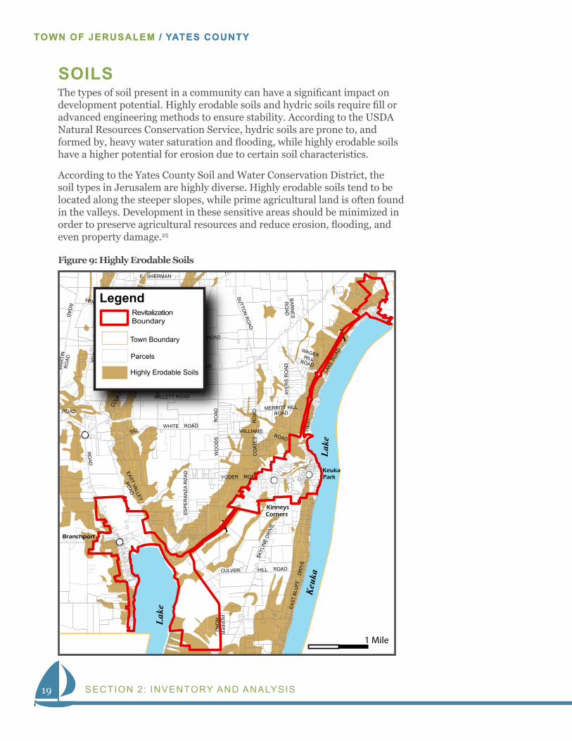
Figure 9: Highly Erodable Soils
SOILSThe types of soil present in a community can have a significant impact on development potential. Highly erodable soils and hydric soils require fill or advanced engineering methods to ensure stability. According to the USDA Natural Resources Conservation Service, hydric soils are prone to, and formed by, heavy water saturation and flooding, while highly erodable soils have a higher potential for erosion due to certain soil characteristics.
According to the Yates County Soil and Water Conservation District, the soil types in Jerusalem are highly diverse. Highly erodable soils tend to be located along the steeper slopes, while prime agricultural land is often found in the valleys. Development in these sensitive areas should be minimized in order to preserve agricultural resources and reduce erosion, flooding, and even property damage.25
20
WATERFRONT REVITALIZATION STRATEGY
20
WATERFRONT REVITALIZATION STRATEGY
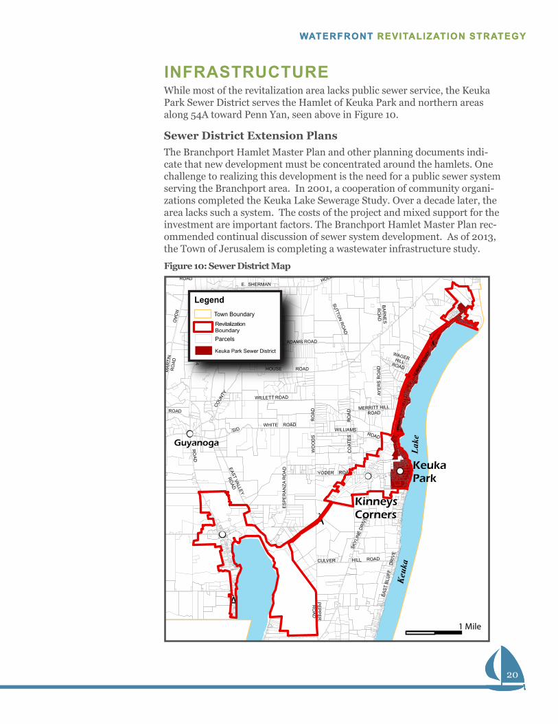
INFRASTRUCTUREWhile most of the revitalization area lacks public sewer service, the Keuka Park Sewer District serves the Hamlet of Keuka Park and northern areas along 54A toward Penn Yan, seen above in Figure 10.
Sewer District Extension PlansThe Branchport Hamlet Master Plan and other planning documents indi-cate that new development must be concentrated around the hamlets. One challenge to realizing this development is the need for a public sewer system serving the Branchport area. In 2001, a cooperation of community organi-zations completed the Keuka Lake Sewerage Study. Over a decade later, the area lacks such a system. The costs of the project and mixed support for the investment are important factors. The Branchport Hamlet Master Plan rec-ommended continual discussion of sewer system development. As of 2013, the Town of Jerusalem is completing a wastewater infrastructure study.
D
E. SHERMANE
SP
ER
AN
ZA R
OA
D
PE
PP
ER
RO
AD
BA
RN
ES
RO
AD
EAST
BLU
FF
DR
IVE
WILLETT ROAD
SKYL
INE
DR
IVE
WO
OD
S
RO
AD
AYE
RS
RO
AD
AD
COMSTOCKROAD
ROADR
OAD
HOUSE ROAD
COUN
TY
YATE
SVIL
LE
ROAD SUTTO
N R
OAD
CO
ATE
S
RO
AD
SIDWHITE ROAD
WILLIAMSROAD
HOLLOW ROA
ADAMS ROAD
WAGERHILLROAD
MA
RTI
NR
OAD
ROAD
EAST VALLEY
ROAD
CULVER HILL ROAD
MERRITT HILLROAD
LAKE
RO
AD
WES
T
ROAD
GU
YANO
GA
RO
AD
Keuk
aLa
ke
YODER ROAD
[À
[À
[À
FRIEND HILLRD
Guyanoga
KeukaPark
Corners
LegendTown Boundary
Parcels
Keuka Park Sewer District
Revitalization Boundary
1 Mile
Kinneys
Figure 10: Sewer District Map
21
TOWN OF JERUSALEM / YATES COUNTY
SECTION 2: INVENTORY AND ANALYSIS
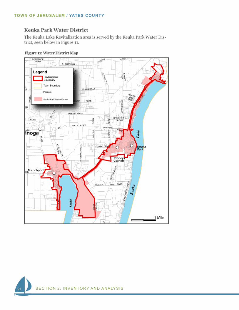
Keuka Park Water DistrictThe Keuka Lake Revitalization area is served by the Keuka Park Water Dis-trict, seen below in Figure 11.
RO
AD
E. SHERMAN
ES
PE
RA
NZA
RO
AD
PE
PP
ER
RO
AD
BA
RN
ES
RO
AD
EAST
BLU
FF
DR
IVE
WILLETT ROADSK
YLIN
E D
RIV
E
WO
OD
S
RO
AD
AYE
RS
RO
AD
ROAD
COMSTOCKROAD
ROAD
RO
AD
HOUSE ROAD
COUN
TY
YATE
SVIL
LE
ROAD SUTTO
N R
OAD
CO
ATE
S
RO
AD
SIDWHITE ROAD
WILLIAMSROAD
HOLLOW ROAD
ADAMS ROAD
WAGERHILLROAD
MA
RTI
NR
OAD
ROAD
EAST VALLEY
ROAD
CULVER HILL ROAD
MERRITT HILLROAD
AKE
ROAD
WES
T
ROAD
GU
YANO
GA
RO
AD
Lake
Keuk
aLa
ke
h
YODER ROAD
[À
[
[À
FRIEND HILLRD
ROAD
Branchport
Guyanoga
Friend
KeukaPark
Kinneys Corners
Legend
Town Boundary
Parcels
Keuka Park Water District
Revitalization Boundary
1 Mile
Figure 11: Water District Map
22
WATERFRONT REVITALIZATION STRATEGY
Water QualityKeuka Lake water quality has been well monitored by the Keuka Lake As-sociation, the Cornell Cooperative Extension and the NYS Department of Environmental Conservation. In general, the lake is very healthy and trend-ing even cleaner. Based on Phosphorus and Chlorophyll loadings, and on Secchi Disk testing, the Lake is considered Oligotrophic. Historically, the primary threats to water quality have been non-point sources of agricultural run-off, failing residential septic systems, and erosion. High standards for residential septic systems and a strict inter-municipal enforcement program has likely reduced that impact, resulting in lower trends for Phosphorus and Chlorophyll. The Keuka Lake Association continues to monitor water qual-ity and is implementing programs to address these non-point sources. Be-cause of the control structures that regulate the water level of Keuka Lake, there is seldom flooding or erosion of the lakeshore. Flooding does occur during storm events on tributaries and the Lake outlet, causing erosion of those tributaries and sediment loading of the Lake.
Navigation & DredgingBoating on Keuka Lake is regulated by NYS Boating Law. No additional local speed limit or noise ordinances have been enacted to date, although there is a uniform docking law that has been adopted by all Keuka Lake mu-nicipalities. Enforcement is generally performed by the Yates County and Steuben County Sheriff’s offices. Navigation aids within the Town of Jeru-salem’s waterfront area are limited to two locally maintained buoys marking the channel to the Branchport marina basin. The Lake is primarily used by recreational boaters with limited navigational issues. No known areas of dredging exist within the Town of Jerusalem’s waterfront area. The en-trance channel to the Branchport marina area appears to have been dredged in the past, but no recent evidence of silting exists. The recently approved Branchport Hamlet Plan included discussion about exploring dredging at the Sugar Creek outlet.

23
TOWN OF JERUSALEM / YATES COUNTY
SECTION 3: COMMUNITY VISION23
TOWN OF JERUSALEM / YATES COUNTY
Section 3COMMUNITY VISIONSHARING IDEAS - A COMMUNITY WORKSHOP
On November 19, 2013 community members assembled at Jerusalem Town Hall for a collaborative meeting. More than 50 people came together to learn about the Revitalization Strategy and share input. The meeting fo-cused on collecting community input through an Image Preference Survey (IPS) and a Vision & Discovery Session. In addition, the event provided a forum for informal community dialogue regarding the current and future conditions of the Town of Jerusalem.
Image Preference SurveyFollowing the adage, “a picture is worth a thousand words”, images of build-ings, streets, and public spaces convey informa tion more effectively than text. The superiority of images over text makes Image Preference Surveys (IPS) effective for identify ing community preferences. The IPS consisted of a 30-image slideshow presentation. Attendees viewed pictures of rural areas, hamlets, commercial corridors, and more. Each image included scenes of
Breakout groups identified issues, opportunities, and assets in the community.
24
WATERFRONT REVITALIZATION STRATEGY
24
WATERFRONT REVITALIZATION STRATEGY
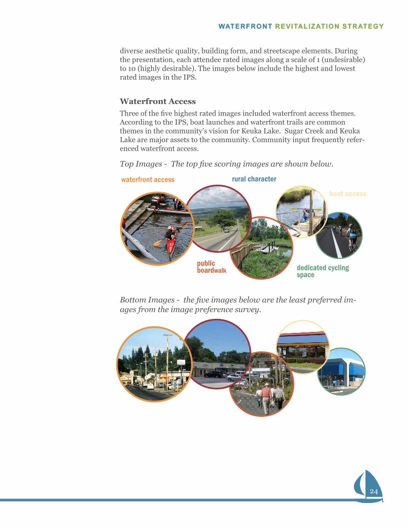
diverse aesthetic quality, building form, and streetscape elements. During the presentation, each attendee rated images along a scale of 1 (undesir able) to 10 (highly desirable). The images below include the high est and lowest rated images in the IPS.
Waterfront AccessThree of the five highest rated images included waterfront access themes. According to the IPS, boat launches and waterfront trails are common themes in the community’s vision for Keuka Lake. Sugar Creek and Keuka Lake are major assets to the community. Community input frequently refer-enced waterfront access.
Top Images - The top five scoring images are shown below.
Bottom Images - the five images below are the least preferred im-ages from the image preference survey.
waterfront access rural character
public boardwalk
boat access
dedicated cycling space
25
TOWN OF JERUSALEM / YATES COUNTY
SECTION 3: COMMUNITY VISION
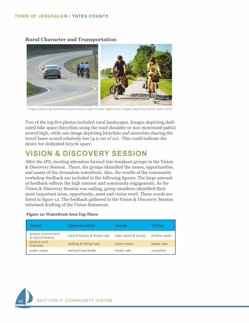
Rural Character and Transportation
Two of the top five photos included rural landscapes. Images depicting dedi-cated bike space (bicyclists using the road shoulder or non-motorized paths) scored high, while one image depicting bicyclists and motorists sharing the travel lanes scored relatively low (4.9 out of 10). This could indicate the desire for dedicated bicycle space.
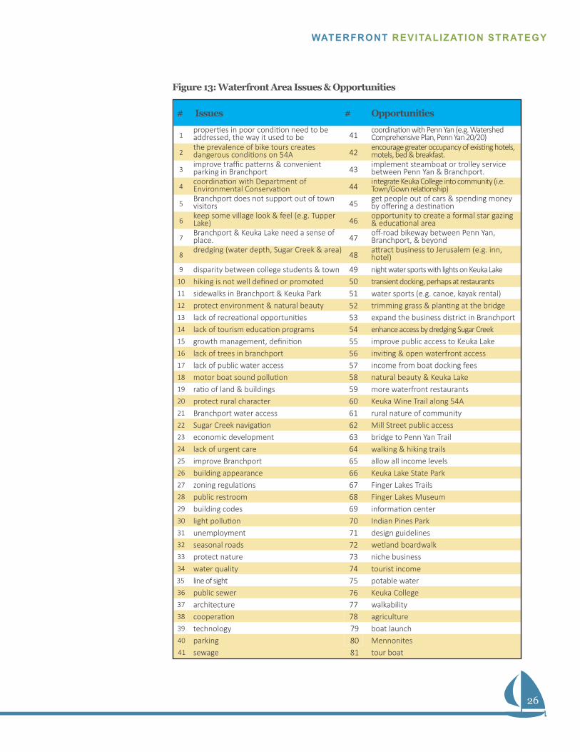
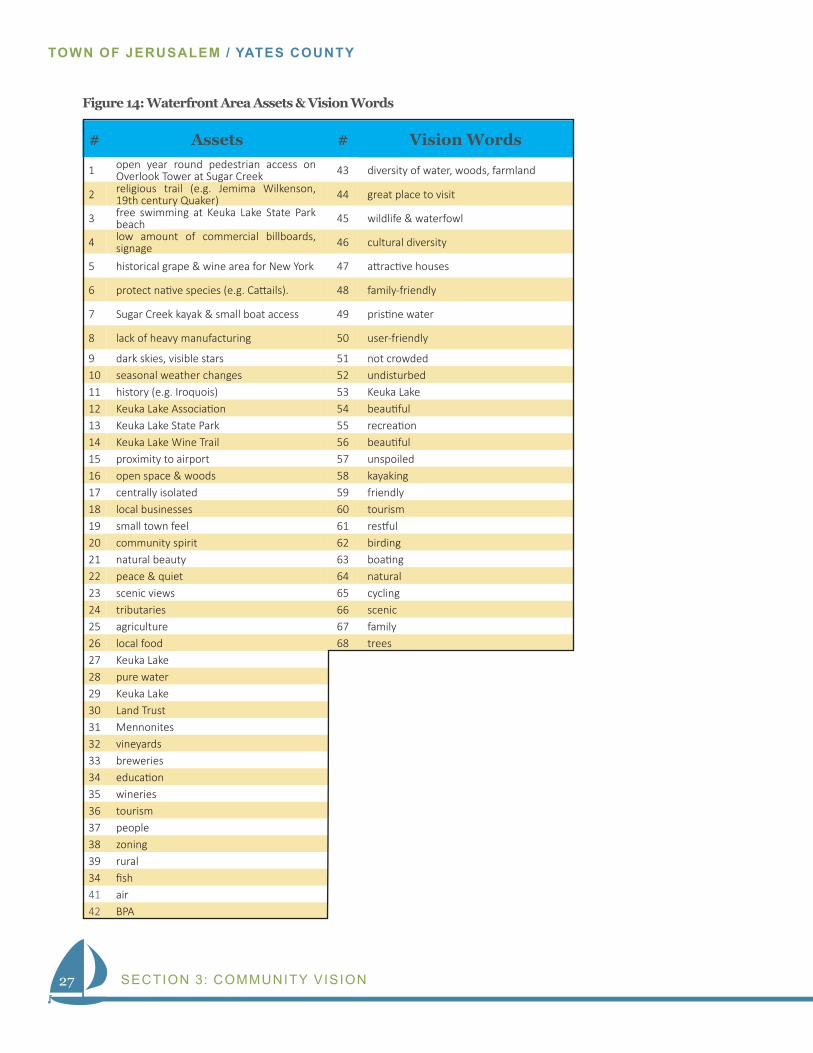
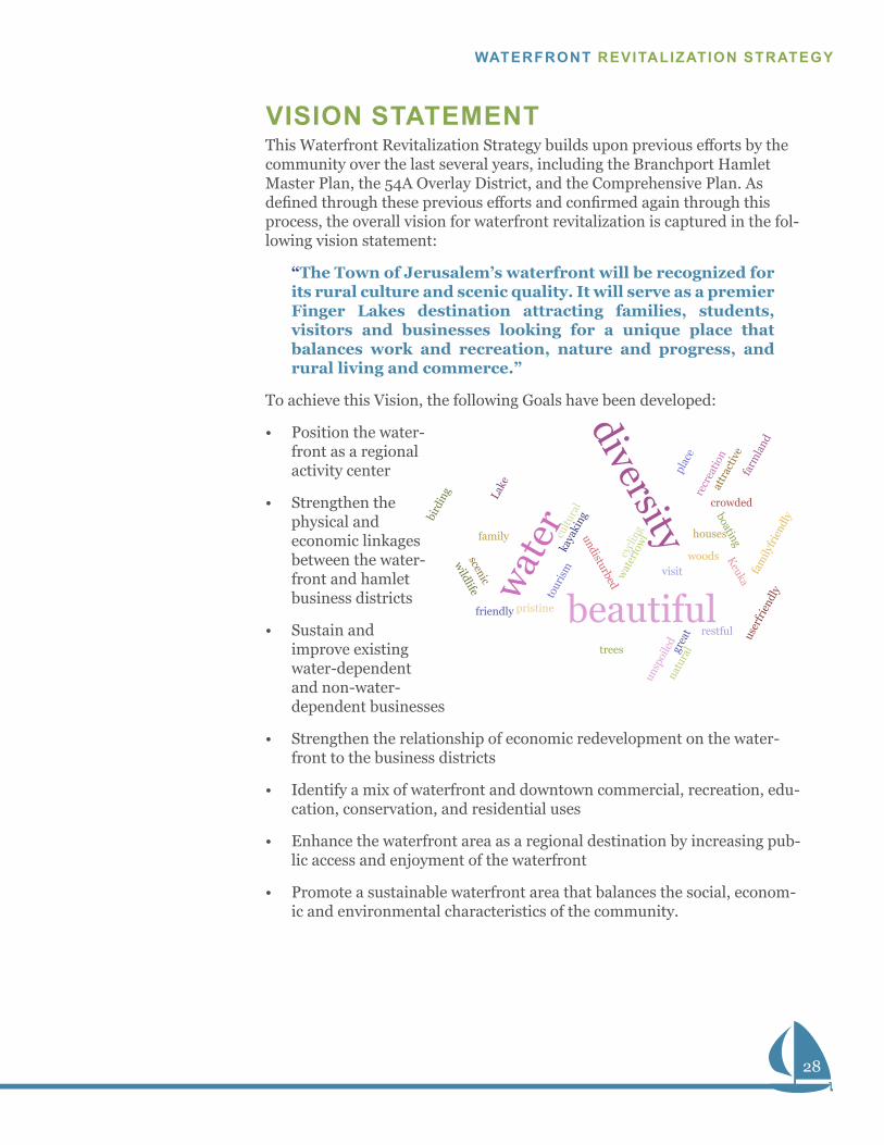
VISION & DISCOVERY SESSIONAfter the IPS, meeting attendees formed into breakout groups in the Vision & Discovery Session. There, the groups identified the issues, opportunities, and assets of the Jerusalem waterfront. Also, the results of the community workshop feedback are included in the following figures. The large amount of feedback reflects the high interest and community engagement. As the Vision & Discovery Session was ending, group members identified their most important issue, opportunity, asset and vision word. These words are listed in figure 12. The feedback gathered in the Vision & Discovery Session informed drafting of the Vision Statement.
Images depicting dedicated bicycle space (right) scored higher than images depicting shared space (left).
Issues Opportunities Assets Vision
protect environment & natural beauty natural beauty & Keuka Lake open space & woods pristine water
protect rural character walking & hiking trails scenic views Keuka Lake
public sewer wetland boardwalk Keuka Lake unspoiled
Figure 12: Waterfront Area Top Three
26
WATERFRONT REVITALIZATION STRATEGY
# Issues # Opportunities
1properties in poor condition need to be addressed, the way it used to be 41
coordination with Penn Yan (e.g. Watershed Comprehensive Plan, Penn Yan 20/20)
2the prevalence of bike tours creates dangerous conditions on 54A 42
encourage greater occupancy of existing hotels, motels, bed & breakfast.
3improve traffic patterns & convenient parking in Branchport 43
implement steamboat or trolley service between Penn Yan & Branchport.
4coordination with Department of Environmental Conservation 44
integrate Keuka College into community (i.e. Town/Gown relationship)
5Branchport does not support out of town visitors 45
get people out of cars & spending money by offering a destination
6keep some village look & feel (e.g. Tupper Lake) 46
opportunity to create a formal star gazing & educational area
7Branchport & Keuka Lake need a sense of place. 47
off-road bikeway between Penn Yan, Branchport, & beyond
8dredging (water depth, Sugar Creek & area)
48attract business to Jerusalem (e.g. inn, hotel)
9 disparity between college students & town 49 night water sports with lights on Keuka Lake10 hiking is not well defined or promoted 50 transient docking, perhaps at restaurants 11 sidewalks in Branchport & Keuka Park 51 water sports (e.g. canoe, kayak rental) 12 protect environment & natural beauty 52 trimming grass & planting at the bridge13 lack of recreational opportunities 53 expand the business district in Branchport14 lack of tourism education programs 54 enhance access by dredging Sugar Creek15 growth management, definition 55 improve public access to Keuka Lake16 lack of trees in branchport 56 inviting & open waterfront access17 lack of public water access 57 income from boat docking fees18 motor boat sound pollution 58 natural beauty & Keuka Lake19 ratio of land & buildings 59 more waterfront restaurants20 protect rural character 60 Keuka Wine Trail along 54A21 Branchport water access 61 rural nature of community22 Sugar Creek navigation 62 Mill Street public access23 economic development 63 bridge to Penn Yan Trail24 lack of urgent care 64 walking & hiking trails25 improve Branchport 65 allow all income levels26 building appearance 66 Keuka Lake State Park27 zoning regulations 67 Finger Lakes Trails28 public restroom 68 Finger Lakes Museum29 building codes 69 information center30 light pollution 70 Indian Pines Park31 unemployment 71 design guidelines32 seasonal roads 72 wetland boardwalk33 protect nature 73 niche business34 water quality 74 tourist income
35 line of sight 75 potable water36 public sewer 76 Keuka College37 architecture 77 walkability 38 cooperation 78 agriculture39 technology 79 boat launch
40 parking 80 Mennonites41 sewage 81 tour boat
Figure 13: Waterfront Area Issues & Opportunities
27
TOWN OF JERUSALEM / YATES COUNTY
SECTION 3: COMMUNITY VISION
# Assets # Vision Words
1 open year round pedestrian access on Overlook Tower at Sugar Creek 43 diversity of water, woods, farmland
2 religious trail (e.g. Jemima Wilkenson, 19th century Quaker) 44 great place to visit
3 free swimming at Keuka Lake State Park beach 45 wildlife & waterfowl
4 low amount of commercial billboards, signage 46 cultural diversity
5 historical grape & wine area for New York 47 attractive houses
6 protect native species (e.g. Cattails). 48 family-friendly
7 Sugar Creek kayak & small boat access 49 pristine water
8 lack of heavy manufacturing 50 user-friendly
9 dark skies, visible stars 51 not crowded10 seasonal weather changes 52 undisturbed11 history (e.g. Iroquois) 53 Keuka Lake12 Keuka Lake Association 54 beautiful 13 Keuka Lake State Park 55 recreation14 Keuka Lake Wine Trail 56 beautiful 15 proximity to airport 57 unspoiled16 open space & woods 58 kayaking17 centrally isolated 59 friendly18 local businesses 60 tourism19 small town feel 61 restful20 community spirit 62 birding21 natural beauty 63 boating22 peace & quiet 64 natural23 scenic views 65 cycling24 tributaries 66 scenic25 agriculture 67 family26 local food 68 trees27 Keuka Lake28 pure water29 Keuka Lake30 Land Trust31 Mennonites32 vineyards33 breweries34 education35 wineries36 tourism37 people38 zoning39 rural34 fish41 air 42 BPA
Figure 14: Waterfront Area Assets & Vision Words
28
WATERFRONT REVITALIZATION STRATEGY
VISION STATEMENTThis Waterfront Revitalization Strategy builds upon previous efforts by the community over the last several years, including the Branchport Hamlet Master Plan, the 54A Overlay District, and the Comprehensive Plan. As defined through these previous efforts and confirmed again through this process, the overall vision for waterfront revitalization is captured in the fol-lowing vision statement:
“The Town of Jerusalem’s waterfront will be recognized for its rural culture and scenic quality. It will serve as a premier Finger Lakes destination attracting families, students, visitors and businesses looking for a unique place that balances work and recreation, nature and progress, and rural living and commerce.”
To achieve this Vision, the following Goals have been developed:
• Position the water-front as a regional activity center
• Strengthen the physical and economic linkages between the water-front and hamlet business districts
• Sustain and improve existing water-dependent and non-water-dependent businesses
• Strengthen the relationship of economic redevelopment on the water-front to the business districts
• Identify a mix of waterfront and downtown commercial, recreation, edu-cation, conservation, and residential uses
• Enhance the waterfront area as a regional destination by increasing pub-lic access and enjoyment of the waterfront
• Promote a sustainable waterfront area that balances the social, econom-ic and environmental characteristics of the community.
trees
fam
ilyfr
iend
ly
user
frie
ndly
undisturbed
recr
eatio
n
unsp
oile
d
kaya
king
friendly
tour
ism
restful
bird
ing
boating
natu
ral
cycl
ing
scenic
family
grea
tpl
ace
visit
wildlife
wat
erfo
wlcu
ltura
l
attr
activ
e
houses
pristine
crowded
Keuka
Lake
farm
land
woods
diversity
wat
er
beautiful
29
TOWN OF JERUSALEM / YATES COUNTY
SECTION 4: RECOMMENDED PROJECTS
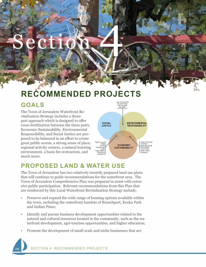
Section 4RECOMMENDED PROJECTSGOALSThe Town of Jerusalem Waterfront Re-vitalization Strategy includes a three-part approach which is designed to offer cross-fertilization between the three parts. Economic Sustainability, Environmental Responsibility, and Social Justice are pro-posed to be balanced in an effort to create great public access, a strong sense of place, regional activity centers, a natural learning environment, a basis for ecotourism, and much more.
PROPOSED LAND & WATER USEThe Town of Jerusalem has two relatively recently prepared land use plans that will continue to guide recommendations for the waterfront area. The Town of Jerusalem Comprehensive Plan was prepared in 2006 with exten-sive public participation. Relevant recommendations from this Plan that are reinforced by this Local Waterfront Revitalization Strategy include:
• Preserve and expand the wide range of housing options available within the town, including the waterfront hamlets of Branchport, Keuka Park and Indian Pines;
• Identify and pursue business development opportunities related to the natural and cultural resources located in the community, such as the wa-terfront development, agri-tourism opportunities, and higher education;
• Promote the development of small-scale and niche businesses that are
30
WATERFRONT REVITALIZATION STRATEGY
suitable to a rural lakeside community;
• Maintain, and enhance when necessary, the public infrastructure neces-sary to sustain the desired level of development within the town – in-cluding public sewer and water for the hamlet areas;
• Develop trails and linkages that interconnect park facilities, waterfront and existing trail systems both in the town and in neighboring munici-palities;
• Identify key bicycling and walking routes within the town, recognizing that these routes may have on and off-road components;
• Increase public access to Keuka Lake for passive recreational activities that will not have lasting negative impacts on the quality of life of resi-dents or on the natural condition of the lake;
• Highlight existing, and work towards increasing, the number of public boat launches at Keuka Lake. Identify additional entry points for non-motorized boats and watercraft;
• Future Mixed-use Areas – promote appropriate types of uses for the mixed-use areas of the Town as identified on the Comprehensive Plans’ Future Land Use Map, including:
• Mixed-use structures that are vertically organized to have retail on the first floor and residential and office space on the upper floors;
• Hamlet-scaled residential development, town-homes, patio homes and senior housing facilities;
• Retail and service providers such as corner stores, coffee shops, ca-fes, restaurants, daily goods providers, crafts and other niche retail;
• Home-based businesses; and
• Motel, hotels, inns and bed & breakfasts.
The Branchport Hamlet Master Plan was prepared in 2012 and includes many land and water use recommendations that are reinforced by this Local Waterfront Revitalization Strategy. The Plan includes detailed recommen-dations to: develop a committee or organization to oversee the implementa-tion of the Hamlet Plan; improve the streetscape character; partner with Keuka College; develop gateway treatments; offer public parking; create a mixed-use zoning district; create a façade improvement program; develop design guidelines; offer public parks; create a property improvement pro-gram; prepare a voluntary historic preservation program; develop trail connections; promote shuttle transportation; provide Finger Lakes Museum support; increase public access; develop transient docking; enhance envi-ronmental conditions; facilitate new housing opportunity; encourage retail/commercial recruitment; support economic development; and utilize green infrastructure.
31
TOWN OF JERUSALEM / YATES COUNTY
SECTION 4: RECOMMENDED PROJECTS
PROJECT LIST The following projects are recommended in order to progress Revitalization Strategy goals and land & water use recommendations.
Zoning1. Hamlet Center District: Develop a new mixed-use zoning district for the
Branchport, Kinney Corners, Keuka Park and Indian Pines areas, consis-tent with the Comprehensive Plan, Branchport Hamlet Plan and LWRS Recommendations. The Town of Jerusalem should create a District that includes provisions to forward the following:
• Performance and Form Based;
• Design Guidelines including standards for the design review process for development or redevelopment in the zone;
• Encourage density of housing and appropriate mixed-uses;
• Emphasis on water-dependent & water enhanced uses on the water-front;
• Complete streets that prioritize right-of-ways for public realm, pe-destrian circulation, bicycle circulation, vehicular circulation, eco-nomic development, social interaction, and parking.
• Zoning Boundaries to be generally according to the future land use map of the 2006 Town of Jerusalem Comprehensive Plan;
Draft District language is in the appendix. This language should be modified as necessary to meet the needs of the Town and its residents.
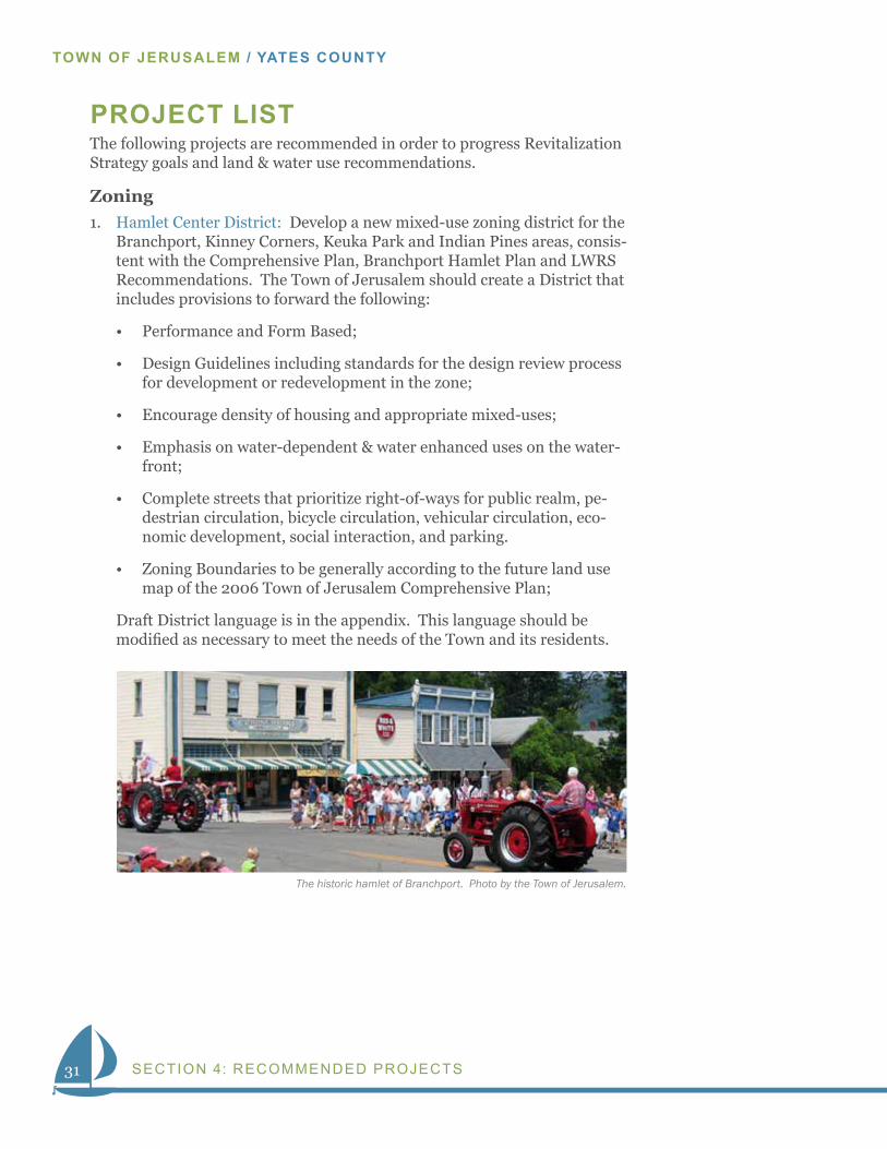
The historic hamlet of Branchport. Photo by the Town of Jerusalem.
32
WATERFRONT REVITALIZATION STRATEGY
Visitor Information & Communications2. Visitor Tools & Guide: Create a communications plan and support-
ing collateral aimed at visitors and residents to communicate the ease of public access to the water, access to visitor services, interpretation & transportation services. Promotions shall include, among possible other items: Hard Collateral; Web Sites; Facebook Pages; and Blog-ging. Implementation partners may include the Yates County Chamber of Commerce; Keuka College Programs; the Keuka Wine Trail; FLEDC; Yates County Bed Tax Funding; and I Love NY.
Public Access & Boat Launch Program3. Branchport Harbor (Existing Marina Area): Continue to support sea-
sonal slips, transient boating, boat launching, a water-taxi landing, and hand carry launches. Additionally, incorporate interpretation, directory signage, visitor information, a “Blue Trail” trailhead, public parking, charter fishing businesses, cruise boats, a “yellow bike” program, and appropriately scaled retail/food services.
4. Sugar Creek Landing: Develop an expanded service waterfront land-ing to include a small boat launch; transient docking; a research ves-sel dock; and a water taxi landing. Work with NYS DEC and others to provide channel navigation aids and to insure adequate depth for small boats and a water taxi.
5. The Finger Lakes Museum Creekside Center: Support a kayak, canoe, skiff & wherry center at the Finger Lake Museum’s Discovery Campus. Include a dock, hand-carry boat storage, a boat livery, boating instruc-tion, interpretation, a trailhead, lodging, and camping.
6. Keuka Lake State Park Landing: Enhance the transient boating, hand-carry boating and boat lunching at Keuka Lake State Park including a potential modified fee structure for residents, improved hand-carry boat launch, improved transient docks, a water taxi landing, expanded overnight docking for campers, visitor information, improved restroom facilities, and a waterfront promenade. Consider allowing food vendors and other concessions.
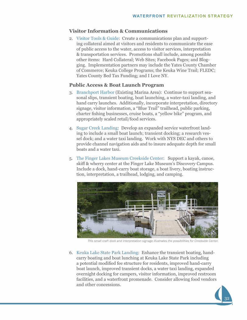
This small craft dock and interpretation signage illustrates the possibilities for Creekside Center.
33
TOWN OF JERUSALEM / YATES COUNTY
SECTION 4: RECOMMENDED PROJECTS
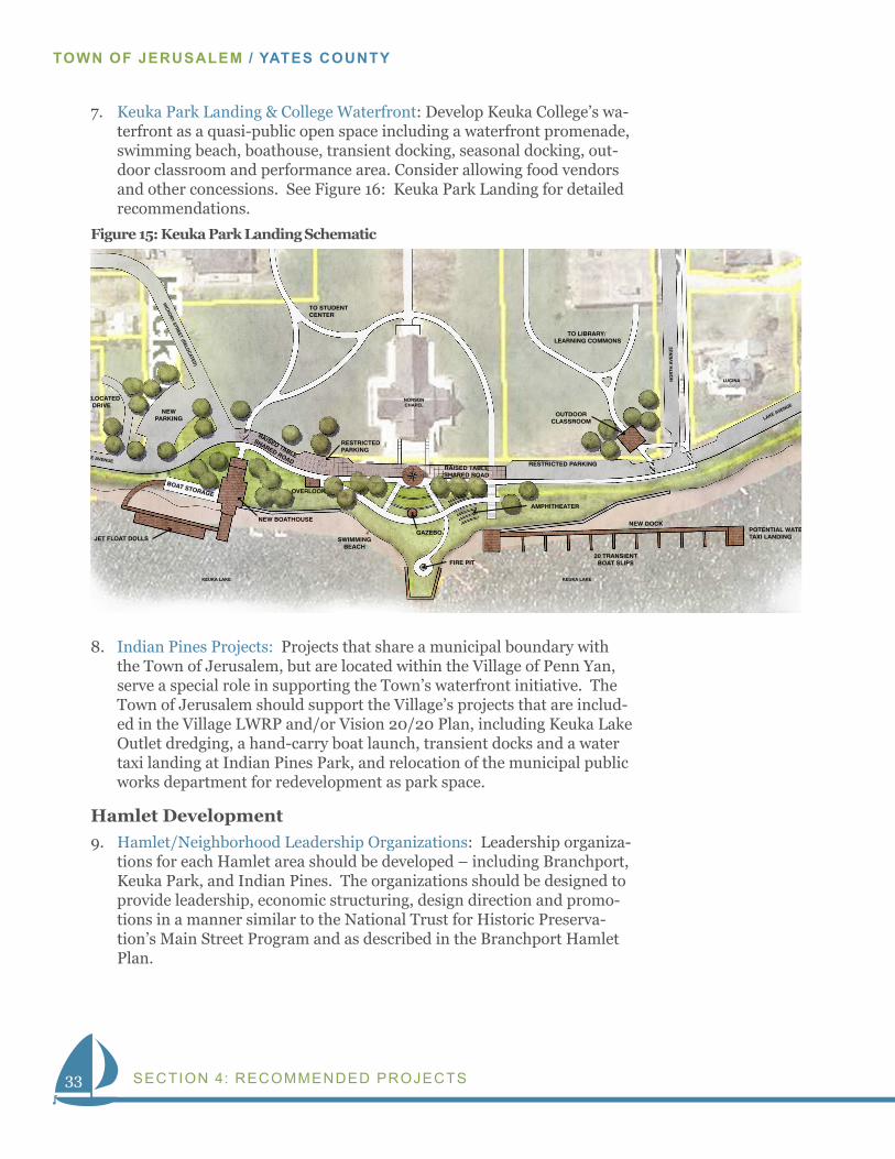
7. Keuka Park Landing & College Waterfront: Develop Keuka College’s wa-terfront as a quasi-public open space including a waterfront promenade, swimming beach, boathouse, transient docking, seasonal docking, out-door classroom and performance area. Consider allowing food vendors and other concessions. See Figure 16: Keuka Park Landing for detailed recommendations.
8. Indian Pines Projects: Projects that share a municipal boundary with the Town of Jerusalem, but are located within the Village of Penn Yan, serve a special role in supporting the Town’s waterfront initiative. The Town of Jerusalem should support the Village’s projects that are includ-ed in the Village LWRP and/or Vision 20/20 Plan, including Keuka Lake Outlet dredging, a hand-carry boat launch, transient docks and a water taxi landing at Indian Pines Park, and relocation of the municipal public works department for redevelopment as park space.
Hamlet Development9. Hamlet/Neighborhood Leadership Organizations: Leadership organiza-
tions for each Hamlet area should be developed – including Branchport, Keuka Park, and Indian Pines. The organizations should be designed to provide leadership, economic structuring, design direction and promo-tions in a manner similar to the National Trust for Historic Preserva-tion’s Main Street Program and as described in the Branchport Hamlet Plan.
June 9, 2014 Town of Jerusalem Waterfront Revitalization Strategy
Keuka Park Landing Schematic
0 40 80
OUTDOORCLASSROOM
TO LIBRARY/ LEARNING COMMONS
RESTRICTED PARKING
RESTRICTEDPARKING
TO STUDENT CENTER
RAISED TABLESHARED ROAD
RAISED TABLE
SHARED ROAD
NEW DOCK
20 TRANSIENTBOAT SLIPS
POTENTIAL WATERTAXI LANDING
AMPHITHEATER
FIRE PIT
SWIMMINGBEACH
GAZEBO
OVERLOOK
RELOCATEDDRIVE
NEWPARKING
JET FLOAT DOLLS
BOAT STORAGE
NEW BOATHOUSE
LAKE AVENUE
LAKE AVENUE
HIC
KOR
Y STREET (R
ELOC
ATED)
LUCINA
KEUKA LAKE KEUKA LAKE
NORSONCHAPEL
NO
RTH
AV
EN
UE
Figure 15: Keuka Park Landing Schematic
34
WATERFRONT REVITALIZATION STRATEGY
Mat
chlin
e
Mat
chlin
e
Gas StationBranchportHardware
Mercantile
BranchportFire Department
BranchportLibrary
Entrance to Museum Mid-block Crosswalks Sidewalk / Creek TrailConnection
On-street Parking
Hamlet Gateway(welcome sign / natural landscape)
Street Trees - 40’ O.C. TYP
200-20 40
June 9, 2014
Branchport Route 54A Streetscape SchematicT o w n o f J e r u s a l e m W a t e r f r o n t R e v i t a l i z a t i o n S t r a t e g y
A
A’
B
B’
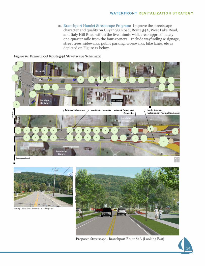
10. Branchport Hamlet Streetscape Program: Improve the streetscape character and quality on Guyanoga Road, Route 54A, West Lake Road, and Italy Hill Road within the five minute walk area (approximately one-quarter mile from the four-corners. Include wayfinding & signage, street trees, sidewalks, public parking, crosswalks, bike lanes, etc as depicted on Figure 17 below.
Figure 16: Branchport Route 54A Streetscape Schematic
Proposed Streetscape - (Looking East)Branchport Route 54A
Existing - (Looking East)Branchport Route 54A
35
TOWN OF JERUSALEM / YATES COUNTY
SECTION 4: RECOMMENDED PROJECTS
11. Branchport Area Sewer, Water, Electric, Gas & Internet Infrastructure: Develop a full complement of public infrastructure to attract and ac-commodate new development or redevelopment. Sewer infrastructure should be developed consistent with the findings of the Sewer Feasibility Study currently being undertaken.
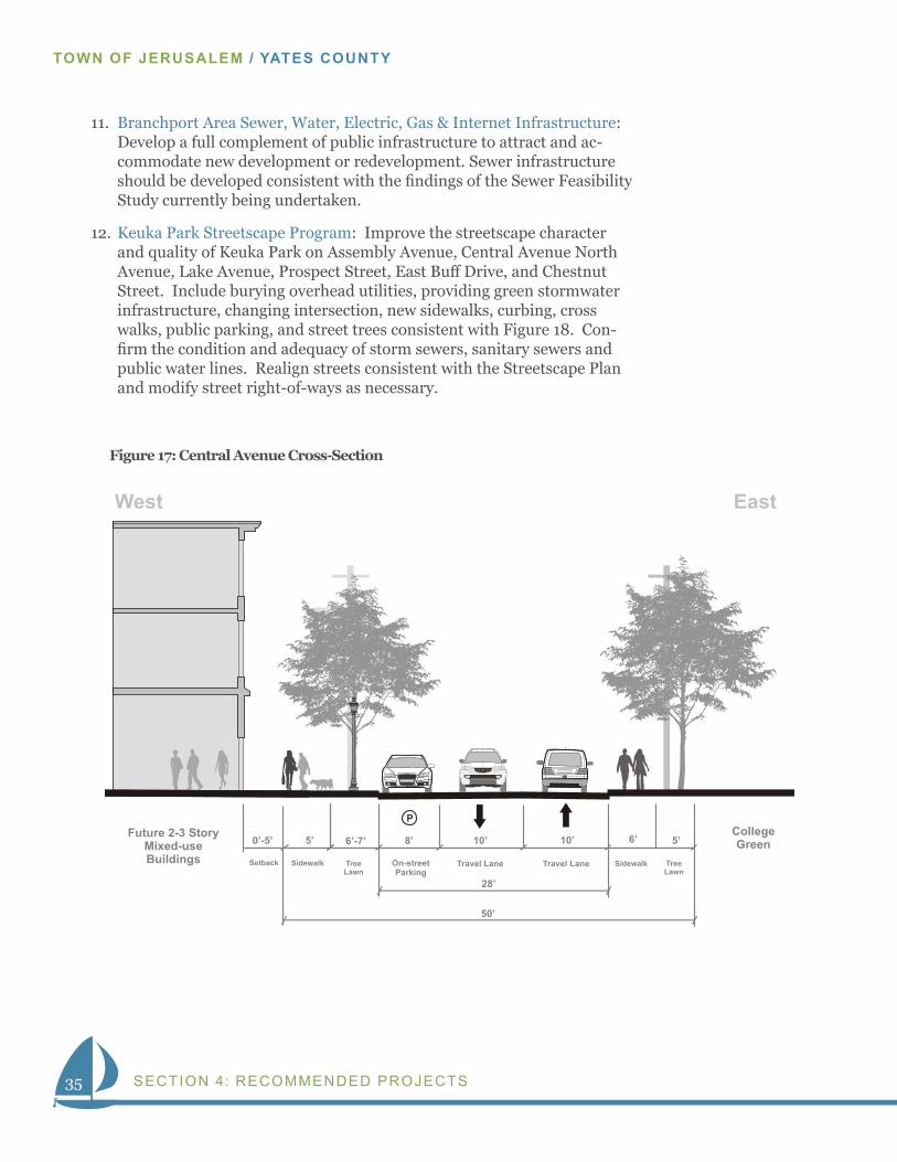
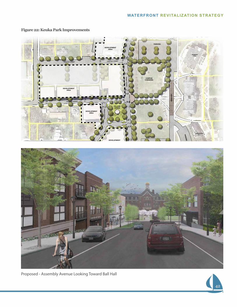
12. Keuka Park Streetscape Program: Improve the streetscape character and quality of Keuka Park on Assembly Avenue, Central Avenue North Avenue, Lake Avenue, Prospect Street, East Buff Drive, and Chestnut Street. Include burying overhead utilities, providing green stormwater infrastructure, changing intersection, new sidewalks, curbing, cross walks, public parking, and street trees consistent with Figure 18. Con-firm the condition and adequacy of storm sewers, sanitary sewers and public water lines. Realign streets consistent with the Streetscape Plan and modify street right-of-ways as necessary.
June 9, 2014
Keuka Park SchematicsT o w n o f J e r u s a l e m W a t e r f r o n t R e v i t a l i z a t i o n S t r a t e g y
North of Assembly Avenue - Looking North
On-street
Parking
Travel Lane
10’
10’
28’
(Approximate Right-of-way)
50’
College
Green
Travel Lane
6’
8’
Tree
Lawn
6’-7’
5’
Sidewalk
Tree
Lawn
Sidewalk
P
5’
May 5, 2014
Setback
West
Future 2-3 Story
Mixed-use
Buildings
0’-5’
Town of Jerusalem Waterfront Revitalization Strategy
Central Avenue Cross-section
North of Assembly Avenue - Looking North
East
54A EntranceCentral Avenue Cross-section
0 40 80
MONUMENTALKEUKA COLLEGE SIGN
MONUMENTALKEUKA COLLEGE SIGN
DIRECTIONAL SIGN TO KEUKA COLLEGE & ATHLETIC COMPLEX
LANDSCAPEDROUNDABOUT
NYS RT 54A
ATHLETIC COMPLEX
TO KEUKA PARK/
KEUKA COLLEGE
SKYLINE DRIVE
ASSEMBLY AVENUE
NYS RT 54A
Looking East Toward Ball Hall
Assembly Avenue Simulation
Figure 17: Central Avenue Cross-Section
36
WATERFRONT REVITALIZATION STRATEGY
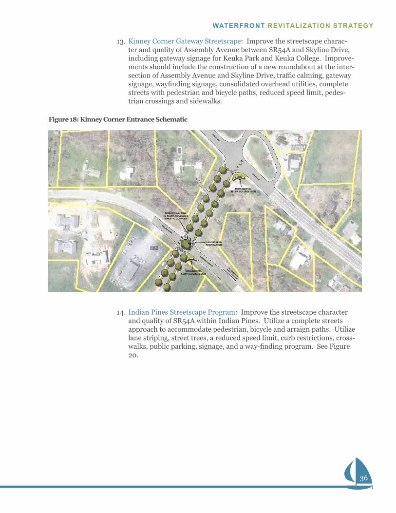
13. Kinney Corner Gateway Streetscape: Improve the streetscape charac-ter and quality of Assembly Avenue between SR54A and Skyline Drive, including gateway signage for Keuka Park and Keuka College. Improve-ments should include the construction of a new roundabout at the inter-section of Assembly Avenue and Skyline Drive, traffic calming, gateway signage, wayfinding signage, consolidated overhead utilities, complete streets with pedestrian and bicycle paths, reduced speed limit, pedes-trian crossings and sidewalks.
14. Indian Pines Streetscape Program: Improve the streetscape character and quality of SR54A within Indian Pines. Utilize a complete streets approach to accommodate pedestrian, bicycle and arraign paths. Utilize lane striping, street trees, a reduced speed limit, curb restrictions, cross-walks, public parking, signage, and a way-finding program. See Figure 20.
June 9, 2014 Town of Jerusalem Waterfront Revitalization Strategy
Keuka Park NYS RT 54A Entrance Schematic
0 40 80
MONUMENTALKEUKA COLLEGE SIGN
MONUMENTALKEUKA COLLEGE SIGN
DIRECTIONAL SIGN TO KEUKA COLLEGE & ATHLETIC COMPLEX
LANDSCAPEDROUNDABOUT
NYS RT 54A
ATHLETIC COMPLEX
TO KEUKA PARK/
KEUKA COLLEGE
SKYLINE DRIVE
ASSEMBLY AVENUE
NYS RT 54A
Figure 18: Kinney Corner Entrance Schematic
37
TOWN OF JERUSALEM / YATES COUNTY
SECTION 4: RECOMMENDED PROJECTS
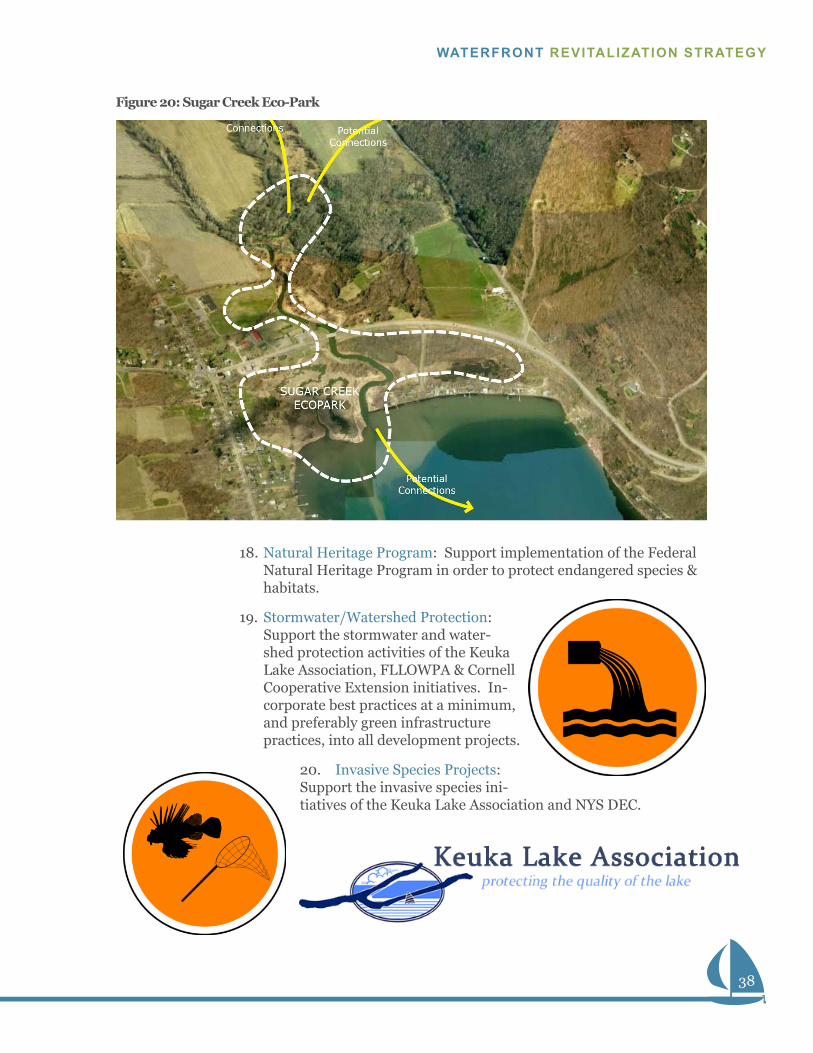
Parks & Conservation15. Sugar Creek Eco-Park: Work with municipal and community-based
organizations in protecting and enhancing natural resources and envi-ronmental characteristics in the Branchport Hamlet area, including both sides of Sugar Creek, the Finger Lakes Museum property, the (wetland conservancy property), Camp Good Days Property and associated public lands (see Figure 21: Sugar Creek Eco-Park)
• Part 1: Develop a wetland boardwalk at the north-west end of the Lake that incorporates the existing viewing platform, adds interpretation, provides a trailheads, constructs new trails, and enhances existing trails.
• Part 2: Habitat enhancement, including elimination of invasive plants, restoration of native plant species, Osprey towers, songbird habitat and the protection of Soft Shell Turtle habitat.
• Part 3: Create infrastructure for adventure experiences and overnights, including camping areas, campfire rings, interpretive areas, etc.
16. Keuka Lake State Park: Encourage NYS to update its master plan to in-clude a potential Finger Lakes Museum, habitat enhancement, potential new overnight options (camping & cabins), an improved waterfront, and expanded interpretation, among potential other amenities and conser-vation measures.
17. Finger Lakes Land Trust Bluff Protection Program: Support the Finger Lakes Land Trust in efforts to protect the agriculture, habitat and visual character of the Bluff, including support for funding, easement acqui-sition, legal closings & maintenance endowments. Include efforts to protect the USA Field with some sort of agreement or easement.
On-street
Parking
14’
14’
44’
(Approximate Right-of-way)
94’-104’
Shared-use
Travel Lane
6’
8’
Tree
Lawn
6’-8’
5’
Sidewalk
Tree
Lawn
Sidewalk
P
6’-8’
North
Town of Jerusalem Waterfront Revitalization Strategy
West Lake Road Cross-section
Near - Ritchey Boulevard Looking North/East
South
Shared-use
Travel Lane
On-street
Parking
8’
P
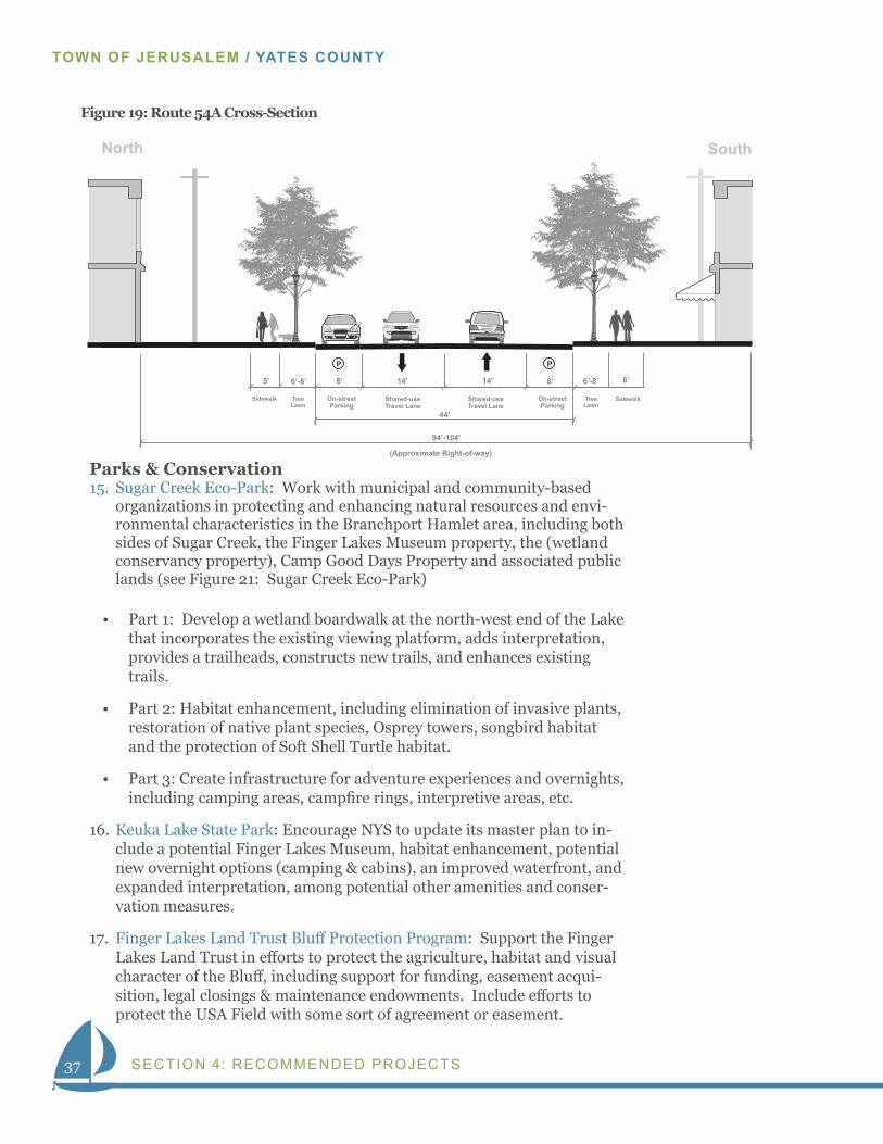
Figure 19: Route 54A Cross-Section
38
WATERFRONT REVITALIZATION STRATEGY
18. Natural Heritage Program: Support implementation of the Federal Natural Heritage Program in order to protect endangered species & habitats.
19. Stormwater/Watershed Protection: Support the stormwater and water-shed protection activities of the Keuka Lake Association, FLLOWPA & Cornell Cooperative Extension initiatives. In-corporate best practices at a minimum, and preferably green infrastructure practices, into all development projects.
20. Invasive Species Projects: Support the invasive species ini-tiatives of the Keuka Lake Association and NYS DEC.
Figure 20: Sugar Creek Eco-Park
39
TOWN OF JERUSALEM / YATES COUNTY
SECTION 4: RECOMMENDED PROJECTS
21. Finger Lakes Regional Sustainability Plan: Support the implementation of The Finger Lakes Regional Sustainability Plan by establishing a liai-son between the Jerusalem Sustainability Committee and the Genesee/Finger Lakes Regional Planning Council.
Transportation & Infrastructure22. SR 54A Multi-Use Trail: Develop a multi-use trail along the south side
of State Route 54A connecting Branchport, Keuka Lake State Park, including the potential for an off-road trolley that could shuttle visitors to the Hamlet, Park and proposed Finger Lakes Museum. Extend the trail to add Kinney Corner’s, Keuka Park and Indian Pines/Penn Yan as future phases.
23. Yates County Public Transportation Study: Develop a public transporta-tion system regionally that would connect Penn Yan to regional links in Canandaigua, Geneva, Bath, Naples and Watkins Glen. Develop a local public transportation system connecting Penn Yan to Keuka Park and Branchport. Design the local system to be tourist friendly (fun, themed, accessible & affordable).
24. Bike & Hiking Trail System Master Plan: Support the implementa-tion of the Genesee Transportation Council’s Regional Trails Initiative, including the following trails: Keuka Lake Outlet Trail; Finger Lakes Trail; Penn Central Trail – Yates County Section; Outlet Trail Extension – Seneca St. to Keuka Lake Waterfront; Lehigh Valley Trail Penn Central to Lehigh Valley Rail Trail Stanley to Naples. Add new regional trails to the proposed initiative including: a new trail from Penn Yan to Keuka Park to Branchport and then to the FLT; a Bluff Loop; a Guyanoga Val-ley Trail to Middlesex; and bike lanes on SR54A.
25. Fiber-Optic Facilities: Support the implementation of Yates County’s fiber optic system.
Institutions & Facilities26. The Finger Lakes Museum Discovery Campus: Continued site develop-
ment, land acquisition, habitat enhancement, trail development, inter-pretive work, boating center, water taxi landing and research vessel slip for the Museum’s Branchport Hamlet campus.
27. Keuka College Start-up New York Program: Support the establishment of an economic development partnership program (Keuka College, New York State, and private sector). The program is expected to begin in Penn Yan’s Keuka Business Park and expand to include the College’s Keuka Park Campus.
28. Keuka College Improvement & Expansion Program: Support the im-plementation of Keuka College’ Master Plan including new buildings; building renovations, new recreation & sports fields; the development of a mixed-use College-town (Keuka Commons); medical services; digital technology facilities, an improved waterfront and general site and cam-pus improvements.
40
WATERFRONT REVITALIZATION STRATEGY
29. Finger Lakes Coastal Rowing: Support a regional rowing program on Keuka Lake that provides local rowing & boating education, competition, training and fitness programs.
Private Sector Development30. Marketing & Business Recruitment Plan: Create Business Recruitment
Plans to target desired businesses within the Hamlet Districts. Man-aged the Plans through cooperative effort by the Hamlet Orgs, FLEDC, the Town of Jerusalem, Yates County Chamber of Commerce and Keuka College.
• Wine, beer, agriculture, local goods & Lake themed businesses;
• Lodging alternatives, dining alternatives, shopping alternatives, and other tourism based services;
• Convenience goods for local residents and visitors; and
• Outdoor outfitting services and retail.
31. Branchport Business & Housing Development Program: Encourage pri-vate sector enhancement of existing businesses and construction of new infill development. Build with medium density and varied housing types. Target businesses based on the Recruitment Plan.
32. Branchport Farmer’s Market: Grow the existing market in size, calendar and activity.
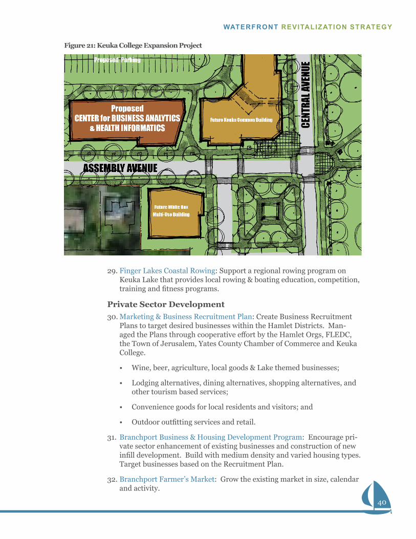
Figure 21: Keuka College Expansion Project
41
TOWN OF JERUSALEM / YATES COUNTY
SECTION 4: RECOMMENDED PROJECTS
33. Keuka College “Commons” Project: Mixed-use development on Keuka College property to include public retail components (bookstore, coffee shop, food), college academic spaces, potential office space and residen-tial (student housing or apartments).
34. Keuka College Business Analytics & Health Informatics Program: Sup-port high tech, computing and/or health related businesses develop-ment in partnership with Keuka College.
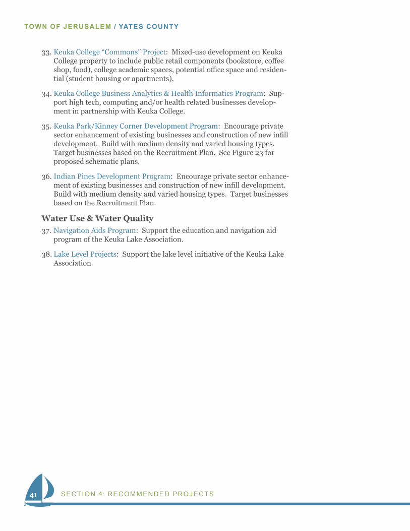
35. Keuka Park/Kinney Corner Development Program: Encourage private sector enhancement of existing businesses and construction of new infill development. Build with medium density and varied housing types. Target businesses based on the Recruitment Plan. See Figure 23 for proposed schematic plans.
36. Indian Pines Development Program: Encourage private sector enhance-ment of existing businesses and construction of new infill development. Build with medium density and varied housing types. Target businesses based on the Recruitment Plan.
Water Use & Water Quality 37. Navigation Aids Program: Support the education and navigation aid
program of the Keuka Lake Association.
38. Lake Level Projects: Support the lake level initiative of the Keuka Lake Association.
42
WATERFRONT REVITALIZATION STRATEGY
June 9, 2014 Town of Jerusalem Waterfront Revitalization Strategy
Keuka Park Streetscape Schematic
0 40 80
DEVELOPMENTAREA
DEVELOPMENTAREA
DEVELOPMENTAREA
DEVELOPMENTAREA
PARKING
HEGEMANHALL
CHESTNUT STREET
CE
NTR
AL
AVE
NU
E
EA
ST
BLU
FF D
RIV
E
PRO
SPEC
T ST
REET
CEDAR STREET
PR
OS
PE
CT
STR
EE
T
CHESTNUT STREET
ASSEMBLY AVENUE
BALLHALL
HARRINGTONHALL
CAMPUSCOMMONS
VILLAGEGREEN
CAMPUS SPINE
PARKING
DR
OP-
OFF
PAR
KIN
G
June 9, 2014
Keuka Park SchematicsT o w n o f J e r u s a l e m W a t e r f r o n t R e v i t a l i z a t i o n S t r a t e g y
North of Assembly Avenue - Looking North
On-street
Parking
Travel Lane
10’
10’
28’
(Approximate Right-of-way)
50’
College
Green
Travel Lane
6’
8’
Tree
Lawn
6’-7’
5’
Sidewalk
Tree
Lawn
Sidewalk
P
5’
May 5, 2014
Setback
West
Future 2-3 Story
Mixed-use
Buildings
0’-5’
Town of Jerusalem Waterfront Revitalization Strategy
Central Avenue Cross-section
North of Assembly Avenue - Looking North
East
54A EntranceCentral Avenue Cross-section
0 40 80
MONUMENTALKEUKA COLLEGE SIGN
MONUMENTALKEUKA COLLEGE SIGN
DIRECTIONAL SIGN TO KEUKA COLLEGE & ATHLETIC COMPLEX
LANDSCAPEDROUNDABOUT
NYS RT 54A
ATHLETIC COMPLEX
TO KEUKA PARK/
KEUKA COLLEGE
SKYLINE DRIVE
ASSEMBLY AVENUE
NYS RT 54A
Looking East Toward Ball Hall
Assembly Avenue Simulation
Figure 22: Keuka Park Improvements
Proposed - Assembly Avenue Looking Toward Ball Hall
43
TOWN OF JERUSALEM / YATES COUNTY
SECTION 4: RECOMMENDED PROJECTS
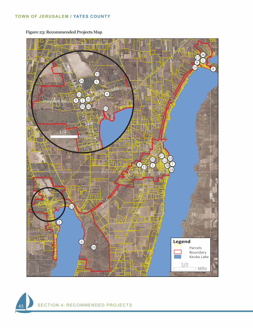
Figure 23: Recommended Projects Map
1 Mile
Legend Parcels Boundary Keuka Lake
LAKE
Mile1/4
Mile1/2
6
1
1
31 32
1
3
4
5
7
8
99999
9
11
9
10
12
13
14
15
15
16
22
26
27
28
33
34
35
36
Italy Hill Rd
27
44
WATERFRONT REVITALIZATION STRATEGY
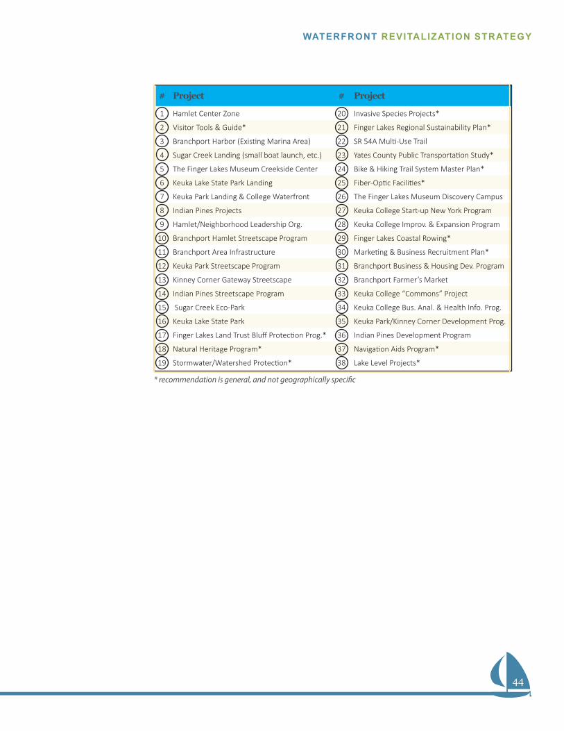
# Project # Project
1 Hamlet Center Zone 20 Invasive Species Projects*
2 Visitor Tools & Guide* 21 Finger Lakes Regional Sustainability Plan*
3 Branchport Harbor (Existing Marina Area) 22 SR 54A Multi-Use Trail
4 Sugar Creek Landing (small boat launch, etc.) 23 Yates County Public Transportation Study*
5 The Finger Lakes Museum Creekside Center 24 Bike & Hiking Trail System Master Plan*
6 Keuka Lake State Park Landing 25 Fiber-Optic Facilities*
7 Keuka Park Landing & College Waterfront 26 The Finger Lakes Museum Discovery Campus
8 Indian Pines Projects 27 Keuka College Start-up New York Program
9 Hamlet/Neighborhood Leadership Org. 28 Keuka College Improv. & Expansion Program
10 Branchport Hamlet Streetscape Program 29 Finger Lakes Coastal Rowing*
11 Branchport Area Infrastructure 30 Marketing & Business Recruitment Plan*
12 Keuka Park Streetscape Program 31 Branchport Business & Housing Dev. Program
13 Kinney Corner Gateway Streetscape 32 Branchport Farmer’s Market
14 Indian Pines Streetscape Program 33 Keuka College “Commons” Project
15 Sugar Creek Eco-Park 34 Keuka College Bus. Anal. & Health Info. Prog.
16 Keuka Lake State Park 35 Keuka Park/Kinney Corner Development Prog.
17 Finger Lakes Land Trust Bluff Protection Prog.* 36 Indian Pines Development Program
18 Natural Heritage Program* 37 Navigation Aids Program*
19 Stormwater/Watershed Protection* 38 Lake Level Projects*
* recommendation is general, and not geographically specific
45
TOWN OF JERUSALEM / YATES COUNTY
SECTION 5: IMPLEMENTATION
TOWN OF JERUSALEM / YATES COUNTY
Section 5IMPLEMENTATION PRIORITIESTo achieve the vision of a revitalized waterfront, leaders and community members must work to execute many incremental projects. Without intentional implementation, the vision for the waterfront cannot be achieved. The Town of Jerusalem and the Project Advisory Committee should partner to implement the Waterfront Revitalization Plan. To begin the implementation phase, the town board must formally adopt the plan.
To aid project implementation, the tables on the following pages organize the recommended policies and projects. The table includes cost estimates and technical resources for each project, when evident. The col-umns on the right include circle symbols with fill levels. The circles illustrate the degree of responsibility each organization maintains for the project. Planning level costs and potential funding sources are listed under each project. See appendix for acronyms.
Leadership Champions:
• Town of Jerusalem
• FLEDC/Yates County
• Keuka College
• Hamlet Leadership Organizations (including Keuka College & The Finger Lakes Museum)
Implementation Priorities:
• Hamlet Zoning (see page 31 for description)
• Sugar Creek Landing (see page 32 for description)
• Keuka Park Landing & College Waterfront (see page 33 for description)
• Hamlet/Neighborhood Leadership Organizations (see page 33 for description)
• Branchport Streetscape Project (see page 34 for description)
• Keuka Park Streetscape (see page 35 for description)
• Sugar Creek Eco-Park (see page 37 for description)
• Keuka College “Commons” Project (see page 41 for description)
• Keuka College Center for Business Analytics & Health Informatics (see page 41 for description)
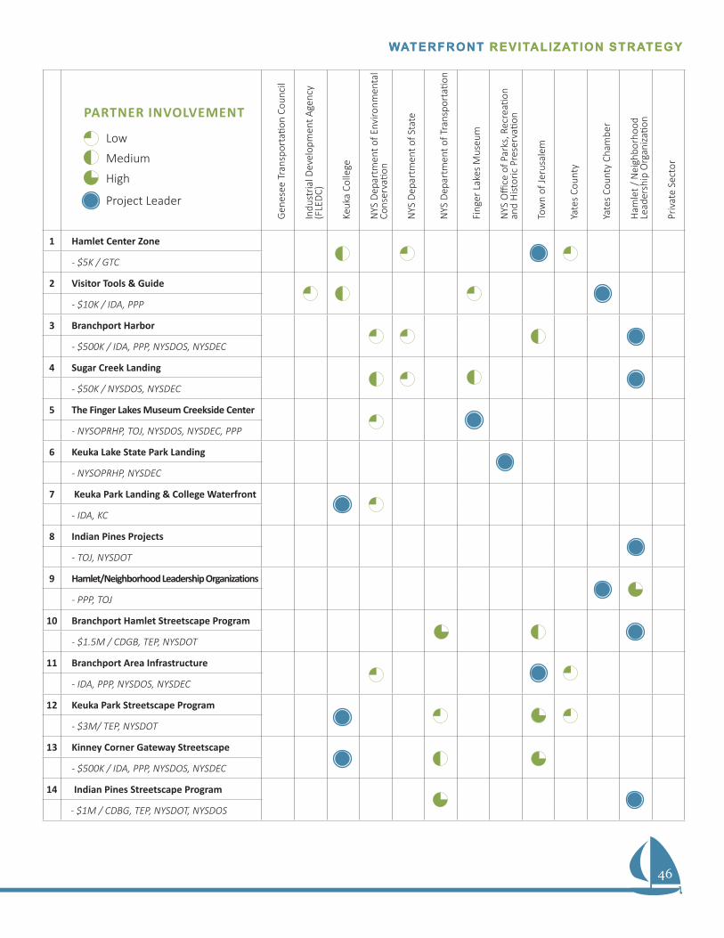
46
WATERFRONT REVITALIZATION STRATEGYWATERFRONT REVITALIZATION STRATEGY
Gen
esee
Tra
nspo
rtati
on C
ounc
il
Indu
stria
l Dev
elop
men
t Age
ncy
(FLE
DC)
Keuk
a Co
llege
NYS
Dep
artm
ent o
f Env
ironm
enta
l Co
nser
vatio
n
NYS
Dep
artm
ent o
f Sta
te
NYS
Dep
artm
ent o
f Tra
nspo
rtati
on
Fing
er L
akes
Mus
eum
NYS
Offi
ce o
f Par
ks, R
ecre
ation
an
d H
istor
ic P
rese
rvati
on
Tow
n of
Jeru
sale
m
Yate
s Co
unty
Yate
s Co
unty
Cha
mbe
r
Ham
let /
Nei
ghbo
rhoo
d
Lead
ersh
ip O
rgan
izatio
n
Priv
ate
Sect
or
1 Hamlet Center Zone
- $5K / GTC
2 Visitor Tools & Guide
- $10K / IDA, PPP
3 Branchport Harbor
- $500K / IDA, PPP, NYSDOS, NYSDEC
4 Sugar Creek Landing
- $50K / NYSDOS, NYSDEC
5 The Finger Lakes Museum Creekside Center
- NYSOPRHP, TOJ, NYSDOS, NYSDEC, PPP
6 Keuka Lake State Park Landing
- NYSOPRHP, NYSDEC
7 Keuka Park Landing & College Waterfront
- IDA, KC
8 Indian Pines Projects
- TOJ, NYSDOT
9 Hamlet/Neighborhood Leadership Organizations
- PPP, TOJ
10 Branchport Hamlet Streetscape Program
- $1.5M / CDGB, TEP, NYSDOT
11 Branchport Area Infrastructure
- IDA, PPP, NYSDOS, NYSDEC
12 Keuka Park Streetscape Program
- $3M/ TEP, NYSDOT
13 Kinney Corner Gateway Streetscape
- $500K / IDA, PPP, NYSDOS, NYSDEC
14 Indian Pines Streetscape Program
- $1M / CDBG, TEP, NYSDOT, NYSDOS
Low
PARTNER INVOLVEMENT
Project Leader
Medium
High
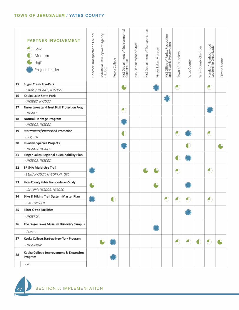
47
TOWN OF JERUSALEM / YATES COUNTY
SECTION 5: IMPLEMENTATION47
Gen
esee
Tra
nspo
rtati
on C
ounc
il
Indu
stria
l Dev
elop
men
t Age
ncy
(FLE
DC)
Keuk
a Co
llege
NYS
Dep
artm
ent o
f Env
ironm
enta
l Co
nser
vatio
n
NYS
Dep
artm
ent o
f Sta
te
NYS
Dep
artm
ent o
f Tra
nspo
rtati
on
Fing
er L
akes
Mus
eum
NYS
Offi
ce o
f Par
ks, R
ecre
ation
an
d H
istor
ic P
rese
rvati
on
Tow
n of
Jeru
sale
m
Yate
s Co
unty
Yate
s Co
unty
Cha
mbe
r
Ham
let /
Nei
ghbo
rhoo
d
Lead
ersh
ip O
rgan
izatio
n
Priv
ate
Sect
or
15 Sugar Creek Eco-Park
- $100K / NYSDEC, NYSDOS
16 Keuka Lake State Park
- NYSDEC, NYSDOS
17 Finger Lakes Land Trust Bluff Protection Prog.
- NYSDEC
18 Natural Heritage Program
- NYSDOS, NYSDEC
19 Stormwater/Watershed Protection
- PPP, TOJ
20 Invasive Species Projects
- NYSDOS, NYSDEC
21 Finger Lakes Regional Sustainability Plan
- NYSDOS, NYSDEC
22 SR 54A Multi-Use Trail
- $1M/ NYSDOT, NYSOPRHP, GTC
23 Yates County Public Transportation Study
- IDA, PPP, NYSDOS, NYSDEC
24 Bike & Hiking Trail System Master Plan
- GTC, NYSDOT
25 Fiber-Optic Facilities
- NYSERDA
26 The Finger Lakes Museum Discovery Campus
- Private
27 Keuka College Start-up New York Program
- NYSOPRHP
28 Keuka College Improvement & Expansion Program
- KC
Low
PARTNER INVOLVEMENT
Project Leader
Medium
High
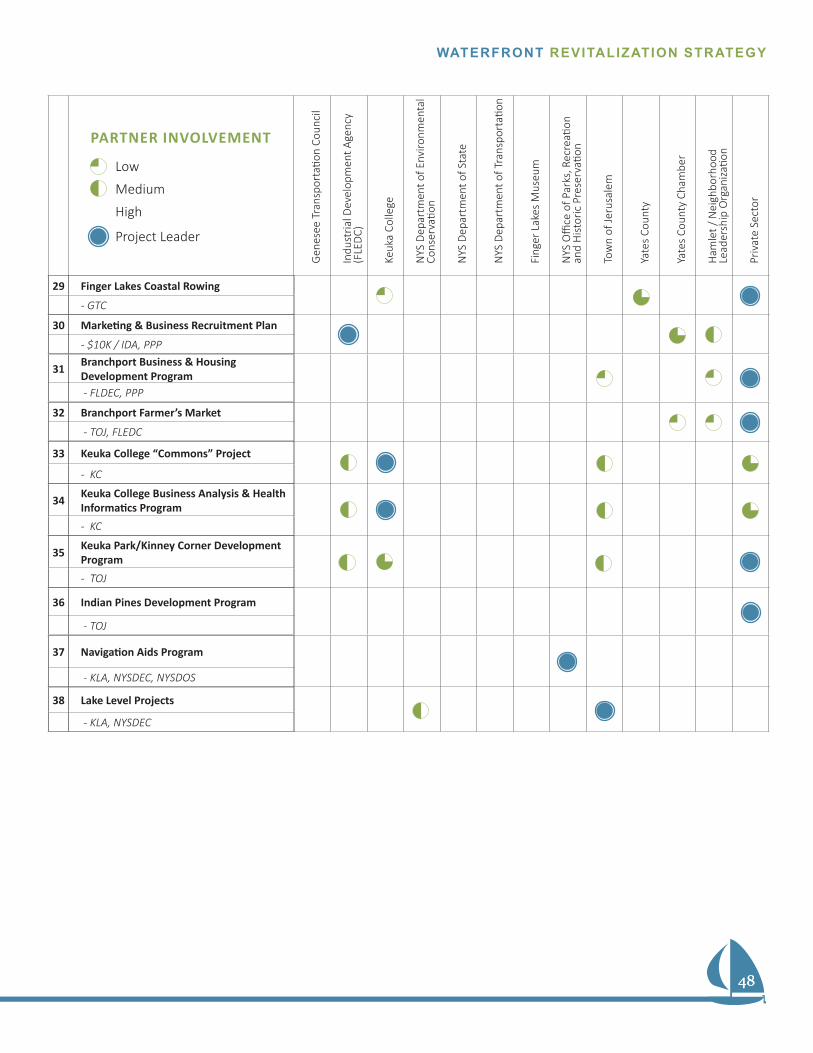
48
WATERFRONT REVITALIZATION STRATEGY
48
Gen
esee
Tra
nspo
rtati
on C
ounc
il
Indu
stria
l Dev
elop
men
t Age
ncy
(FLE
DC)
Keuk
a Co
llege
NYS
Dep
artm
ent o
f Env
ironm
enta
l Co
nser
vatio
n
NYS
Dep
artm
ent o
f Sta
te
NYS
Dep
artm
ent o
f Tra
nspo
rtati
on
Fing
er L
akes
Mus
eum
NYS
Offi
ce o
f Par
ks, R
ecre
ation
an
d H
istor
ic P
rese
rvati
on
Tow
n of
Jeru
sale
m
Yate
s Co
unty
Yate
s Co
unty
Cha
mbe
r
Ham
let /
Nei
ghbo
rhoo
d
Lead
ersh
ip O
rgan
izatio
n
Priv
ate
Sect
or
29 Finger Lakes Coastal Rowing
- GTC
30 Marketing & Business Recruitment Plan
- $10K / IDA, PPP
31 Branchport Business & Housing Development Program - FLDEC, PPP
32 Branchport Farmer’s Market
- TOJ, FLEDC
33 Keuka College “Commons” Project
- KC
34 Keuka College Business Analysis & Health Informatics Program- KC
35 Keuka Park/Kinney Corner Development Program- TOJ
36 Indian Pines Development Program
- TOJ
37 Navigation Aids Program
- KLA, NYSDEC, NYSDOS
38 Lake Level Projects
- KLA, NYSDEC
Low
PARTNER INVOLVEMENT
Project Leader
Medium
High
49
TOWN OF JERUSALEM / YATES COUNTY
APPENDIX
TOWN OF JERUSALEM / YATES COUNTY
49
TOWN OF JERUSALEM / YATES COUNTY
Section 6APPENDIX
ENDNOTES
1 Town of Jerusalem, NY. Zoning Code
2 Clark Patterson Associates. (2006). Town of Jerusalem Comprehensive Plan. In Process Overview, pg. 6. Retrieved December 4, 2013
3 Genesee/Finger Lakes Regional Planning Council. (2009, March). Keuka Lake Wa-tershed Land Use Planning Guide: An Intermunicipal Action Strategy. Retrieved December 11, 2013
4 Town of Jerusalem. (2012). Branchport Hamlet Master Plan. In Agriculture. Pg 29. Retrieved December 4, 2013
5 Clark Patterson Associates. (2006). Town of Jerusalem Comprehensive Plan. In Process Overview, pg. 6. Retrieved December 4, 2013
6 Clark Patterson Associates. (2006). Town of Jerusalem Comprehensive Plan. In Farmland & Open Space Strategies, pg. 38. Retrieved December 4, 2013
7 Clark Patterson Associates. (2006). Town of Jerusalem Comprehensive Plan. In Farmland & Open Space Measures, pg. 39. Retrieved December 4, 2013
8 Jerusalem, Ny., Zoning Ordinance 160-XX- Route 54A Scenic Overlay District
9 Basin Park Marina LLC. (2013.). About Us, Rental Pricing, Slips & Dockage. In Ba-sin Park Marina. Retrieved December 12, 2013, from www.basinparkmarina.com
10 Clark Patterson Associates. (2006). Town of Jerusalem Comprehensive Plan. In Public Access to Keuka Lake, pg. 29. Retrieved December 4, 2013
11 NYSDEC Bureau of Fisheries. (2013). Yates County, DEC Region 8. In Boat Launch Sites for Yates County. Retrieved December 4, 2013, from www.dec.ny.gov/outdoor/23854.html
50
WATERFRONT REVITALIZATION STRATEGYWATERFRONT REVITALIZATION STRATEGY
50
WATERFRONT REVITALIZATION STRATEGY
12 New York State Office of Parks, Recreation, and Historic Preservation.. Keuka Lake State Park Amenities. Retrieved December 4, 2013, from nysparks.com/parks/67/amenities-activities.aspx
13 Clark Patterson Associates. (2006). Town of Jerusalem Comprehensive Plan. In Process Overview, pg. 6. Retrieved December 4, 2013
14 New York State Office of Parks, Recreation, and Historic Preservation.. Keuka Lake State Park Amenities. Retrieved December 4, 2013, from nysparks.com/parks/67/amenities-activities.aspx.
15 New York State Department of Environmental Conservation.. Public Fishing Rights Maps - Guyanoga Creek. Retrieved December 4, 2013, from www.dec.ny.gov/docs/fish_ma-rine_pdf/pfrgyanogack.pdf
16 New York State Department of Environmental Conservation.. Public Fishing Rights Maps - Guyanoga Creek. Retrieved December 4, 2013, from www.dec.ny.gov/docs/fish_ma-rine_pdf/pfrgyanogack.pdf
17 Vince’s Playground. (2013). In Facebook. Retrieved December 4, 2013 , from www.facebook.com/VincesPlayground
18 Mosich, J. (2013.). Playground News. In Modeste Bedient Memorial Library. Re-trieved December 11, 2013, from http://www.branchportlibrary.org/?page_id=10
19 Clark Patterson Associates. (2006). Town of Jerusalem Comprehensive Plan. In Topography, pg. 25. Retrieved December 4, 2013
20 Keuka Lake Association. (2013). Retrieved December 12, 2013, from http://www.keukalakeassociation.org/
21 Clark Patterson Associates. (2006). Town of Jerusalem Comprehensive Plan. In Watersheds and Waterbodies, pg. 24. Retrieved December 4, 2013
22 Clark Patterson Associates. (2006). Town of Jerusalem Comprehensive Plan. In Floodplains, pg. 25. Retrieved December 4, 2013
23 Clark Patterson Associates. (2006). Town of Jerusalem Comprehensive Plan. In Wetlands, pg. 24. Retrieved December 4, 2013
24 Clark Patterson Associates. (2006). Town of Jerusalem Comprehensive Plan. In Topography, pg. 25. Retrieved December 4, 2013
25 Clark Patterson Associates. (2006). Town of Jerusalem Comprehensive Plan. In Soils, pg. 26. Retrieved December 4, 2013
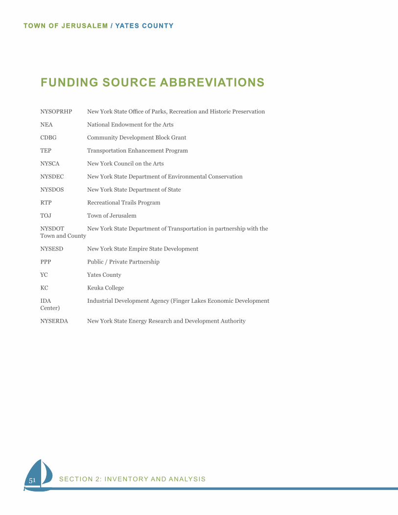
51
TOWN OF JERUSALEM / YATES COUNTY
SECTION 2: INVENTORY AND ANALYSIS51
TOWN OF JERUSALEM / YATES COUNTY
FUNDING SOURCE ABBREVIATIONS
NYSOPRHP New York State Office of Parks, Recreation and Historic Preservation
NEA National Endowment for the Arts
CDBG Community Development Block Grant
TEP Transportation Enhancement Program
NYSCA New York Council on the Arts
NYSDEC New York State Department of Environmental Conservation
NYSDOS New York State Department of State
RTP Recreational Trails Program
TOJ Town of Jerusalem
NYSDOT New York State Department of Transportation in partnership with the Town and County
NYSESD New York State Empire State Development
PPP Public / Private Partnership
YC Yates County
KC Keuka College
IDA Industrial Development Agency (Finger Lakes Economic Development Center)
NYSERDA New York State Energy Research and Development Authority
Town of Jerusalem
Draft – Ham let Center Distr ic t P a g e | 1
§ 160-XX. Hamlet Center District (HC)
A. Purpose and Intent
Consistent with the 2006 Town of Jerusalem Comprehensive Plan, the intent of the Hamlet Center Zoning District is to promote the historic character and scale of the Branchport and Kinney’s Corners hamlet areas, typified by a traditional village development pattern, including buildings of a modest size and scale, laid out with a defined pattern of streets, alleys, and driveways, while allowing a limited range of residential, commercial, and public uses. The District permits small-scale mixed-use developments, interspersed with residential uses, in a traditional neighborhood form within a residential setting. Retail uses are limited to the ground floor, with building massing provided close to the frontage, reflective of traditional village settings. An emphasis is on the achievement of a pedestrian scale on the reuse and preservation of existing buildings, particularly historic structures, and on achieving limited infill development that complements and is compatible with adjacent land uses.
B. Design Principles
The primary objective of the HC District is to promote traditional, hamlet-style design. New buildings should relate to the historical and architectural character of these hamlet areas as well as enhance the streetscape and unique aesthetic qualities that currently exist. Specifically, the design principles for the HC District are to:
(1) Provide a limited mix of housing and small business opportunities in the hamlets.
(2) Encourage infill development and the reutilization of existing buildings,
particularly those with historic or architectural significance.
(3) Allow buildings by the sidewalk and street edge (building line), especially in
Branchport and the Keuka Park area.
(4) Promote pedestrian activity through a safe and walkable environment.
(5) Create tree-lined streets that are aesthetically pleasing.
(6) Provide alleys, where needed, as a means for adequate access to parking areas.
(7) Minimize the visual impact of the automobile by focusing site design on the central
role of buildings, landscaping, open space, and other amenities.
(8) Create an interconnected street system for pedestrian, bicycle, and motor vehicle
traffic.
(9) Encourage the development of both on-street parking and shared parking between
nearby uses.
(10) Provide diverse housing options.
(11) Protect important natural and historic features.
C. Location of Districts
As per § 160-8, the location of the HC Districts is shown on the map entitled "Zoning Map,
Town of Jerusalem," adopted by the Town Board.
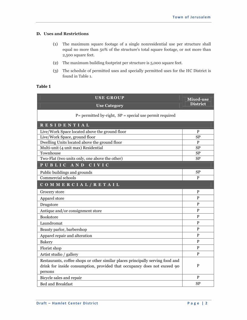
Town of Jerusalem
Draft – Ham let Center Distr ic t P a g e | 2
D. Uses and Restrictions
(1) The maximum square footage of a single nonresidential use per structure shall
equal no more than 50% of the structure's total square footage, or not more than
2,500 square feet.
(2) The maximum building footprint per structure is 5,000 square feet.
(3) The schedule of permitted uses and specially permitted uses for the HC District is
found in Table 1.
Table 1
USE GROUP Mixed-use District Use Category
P= permitted by-right, SP = special use permit required
R E S I D E N T I A L
Live/Work Space located above the ground floor P
Live/Work Space, ground floor SP
Dwelling Units located above the ground floor P
Multi-unit (4 unit max) Residential SP
Townhouse SP
Two-Flat (two units only, one above the other) SP
P U B L I C A N D C I V I C
Public buildings and grounds SP
Commercial schools P
C O M M E R C I A L / R E T A I L
Grocery store P
Apparel store P
Drugstore P
Antique and/or consignment store P
Bookstore P
Laundromat P
Beauty parlor, barbershop P
Apparel repair and alteration P
Bakery P
Florist shop P
Artist studio / gallery P
Restaurants, coffee shops or other similar places principally serving food and
drink for inside consumption, provided that occupancy does not exceed 90
persons
P
Bicycle sales and repair P
Bed and Breakfast SP
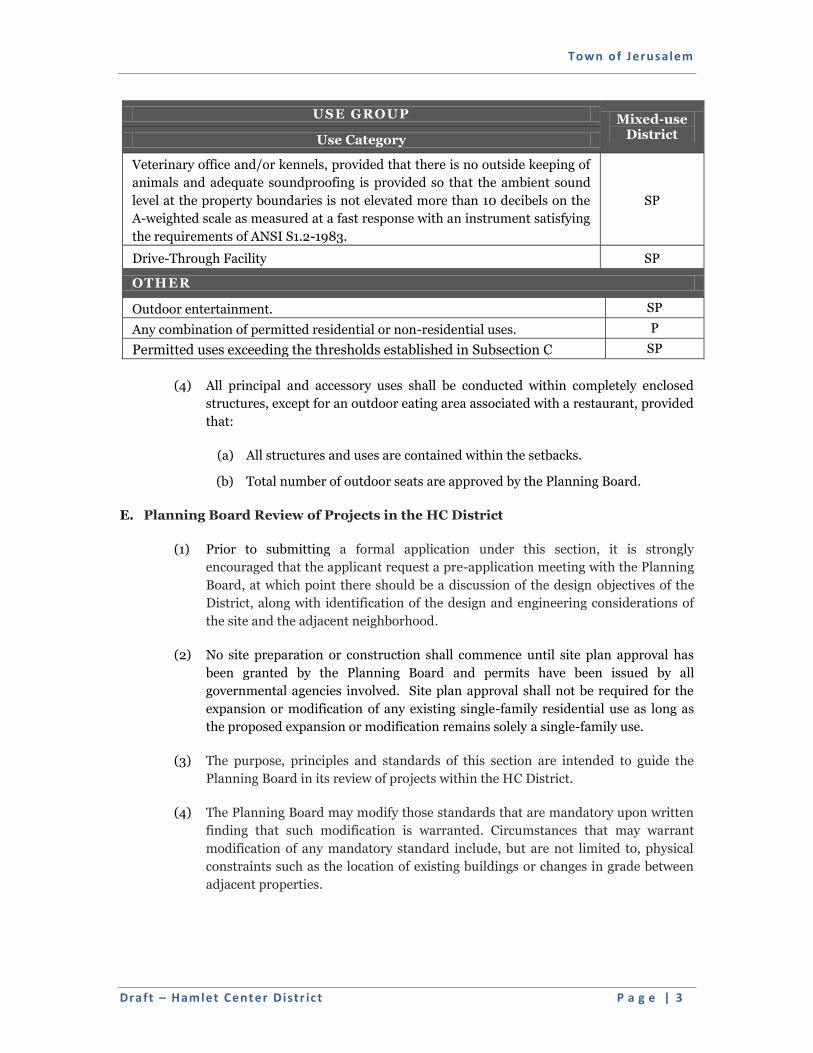
Town of Jerusalem
Draft – Ham let Center Distr ic t P a g e | 3
USE GROUP Mixed-use District Use Category
Veterinary office and/or kennels, provided that there is no outside keeping of
animals and adequate soundproofing is provided so that the ambient sound
level at the property boundaries is not elevated more than 10 decibels on the
A-weighted scale as measured at a fast response with an instrument satisfying
the requirements of ANSI S1.2-1983.
SP
Drive-Through Facility SP
OTHER
Outdoor entertainment. SP
Any combination of permitted residential or non-residential uses. P
Permitted uses exceeding the thresholds established in Subsection C SP
(4) All principal and accessory uses shall be conducted within completely enclosed
structures, except for an outdoor eating area associated with a restaurant, provided
that:
(a) All structures and uses are contained within the setbacks.
(b) Total number of outdoor seats are approved by the Planning Board.
E. Planning Board Review of Projects in the HC District
(1) Prior to submitting a formal application under this section, it is strongly
encouraged that the applicant request a pre-application meeting with the Planning
Board, at which point there should be a discussion of the design objectives of the
District, along with identification of the design and engineering considerations of
the site and the adjacent neighborhood.
(2) No site preparation or construction shall commence until site plan approval has
been granted by the Planning Board and permits have been issued by all
governmental agencies involved. Site plan approval shall not be required for the
expansion or modification of any existing single-family residential use as long as
the proposed expansion or modification remains solely a single-family use.
(3) The purpose, principles and standards of this section are intended to guide the
Planning Board in its review of projects within the HC District.
(4) The Planning Board may modify those standards that are mandatory upon written
finding that such modification is warranted. Circumstances that may warrant
modification of any mandatory standard include, but are not limited to, physical
constraints such as the location of existing buildings or changes in grade between
adjacent properties.
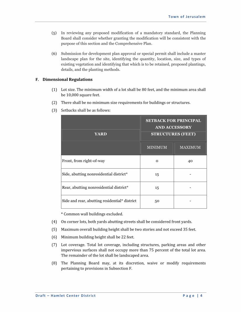
Town of Jerusalem
Draft – Ham let Center Distr ic t P a g e | 4
(5) In reviewing any proposed modification of a mandatory standard, the Planning
Board shall consider whether granting the modification will be consistent with the
purpose of this section and the Comprehensive Plan.
(6) Submission for development plan approval or special permit shall include a master
landscape plan for the site, identifying the quantity, location, size, and types of
existing vegetation and identifying that which is to be retained, proposed plantings,
details, and the planting methods.
F. Dimensional Regulations
(1) Lot size. The minimum width of a lot shall be 80 feet, and the minimum area shall
be 10,000 square feet.
(2) There shall be no minimum size requirements for buildings or structures.
(3) Setbacks shall be as follows:
YARD
SETBACK FOR PRINCIPAL
AND ACCESSORY
STRUCTURES (FEET)
MINIMUM MAXIMUM
Front, from right-of-way 0 40
Side, abutting nonresidential district* 15 -
Rear, abutting nonresidential district* 15 -
Side and rear, abutting residential* district 50 -
* Common wall buildings excluded.
(4) On corner lots, both yards abutting streets shall be considered front yards.
(5) Maximum overall building height shall be two stories and not exceed 35 feet.
(6) Minimum building height shall be 22 feet.
(7) Lot coverage. Total lot coverage, including structures, parking areas and other
impervious surfaces shall not occupy more than 75 percent of the total lot area.
The remainder of the lot shall be landscaped area.
(8) The Planning Board may, at its discretion, waive or modify requirements
pertaining to provisions in Subsection F.
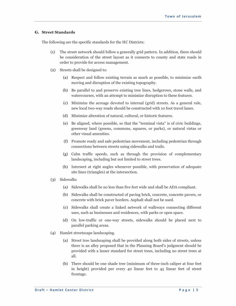
Town of Jerusalem
Draft – Ham let Center Distr ic t P a g e | 5
G. Street Standards
The following are the specific standards for the HC Districts:
(1) The street network should follow a generally grid pattern. In addition, there should
be consideration of the street layout as it connects to county and state roads in
order to provide for access management.
(2) Streets shall be designed to:
(a) Respect and follow existing terrain as much as possible, to minimize earth
moving and disruption of the existing topography.
(b) Be parallel to and preserve existing tree lines, hedgerows, stone walls, and
watercourses, with an attempt to minimize disruption to these features.
(c) Minimize the acreage devoted to internal (grid) streets. As a general rule,
new local two-way roads should be constructed with 10 foot travel lanes.
(d) Minimize alteration of natural, cultural, or historic features.
(e) Be aligned, where possible, so that the "terminal vista" is of civic buildings,
greenway land (greens, commons, squares, or parks), or natural vistas or
other visual amenities.
(f) Promote ready and safe pedestrian movement, including pedestrian through
connections between streets using sidewalks and trails.
(g) Calm traffic speeds, such as through the provision of complementary
landscaping, including but not limited to street trees.
(h) Intersect at right angles whenever possible, with preservation of adequate
site lines (triangles) at the intersection.
(3) Sidewalks
(a) Sidewalks shall be no less than five feet wide and shall be ADA compliant.
(b) Sidewalks shall be constructed of paving brick, concrete, concrete pavers, or
concrete with brick paver borders. Asphalt shall not be used.
(c) Sidewalks shall create a linked network of walkways connecting different
uses, such as businesses and residences, with parks or open space.
(d) On low-traffic or one-way streets, sidewalks should be placed next to
parallel parking areas.
(4) Hamlet streetscape landscaping.
(a) Street tree landscaping shall be provided along both sides of streets, unless
there is an alley proposed that in the Planning Board's judgment should be
provided with a lesser standard for street trees, including no street trees at
all.
(b) There should be one shade tree (minimum of three-inch caliper at four feet
in height) provided per every 40 linear feet to 45 linear feet of street
frontage.
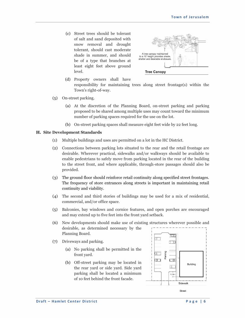
Town of Jerusalem
Draft – Ham let Center Distr ic t P a g e | 6
(c) Street trees should be tolerant
of salt and sand deposited with
snow removal and drought
tolerant, should cast moderate
shade in summer, and should
be of a type that branches at
least eight feet above ground
level.
(d) Property owners shall have
responsibility for maintaining trees along street frontage(s) within the
Town's right-of-way.
(5) On-street parking.
(a) At the discretion of the Planning Board, on-street parking and parking
proposed to be shared among multiple uses may count toward the minimum
number of parking spaces required for the use on the lot.
(b) On-street parking spaces shall measure eight feet wide by 22 feet long.
H. Site Development Standards
(1) Multiple buildings and uses are permitted on a lot in the HC District.
(2) Connections between parking lots situated to the rear and the retail frontage are
desirable. Wherever practical, sidewalks and/or walkways should be available to
enable pedestrians to safely move from parking located in the rear of the building
to the street front, and where applicable, through-store passages should also be
provided.
(3) The ground floor should reinforce retail continuity along specified street frontages.
The frequency of store entrances along streets is important in maintaining retail
continuity and viability.
(4) The second and third stories of buildings may be used for a mix of residential,
commercial, and/or office space.
(5) Balconies, bay windows and cornice features, and open porches are encouraged
and may extend up to five feet into the front yard setback.
(6) New developments should make use of existing structures wherever possible and
desirable, as determined necessary by the
Planning Board.
(7) Driveways and parking.
(a) No parking shall be permitted in the
front yard.
(b) Off-street parking may be located in
the rear yard or side yard. Side yard
parking shall be located a minimum
of 10 feet behind the front facade.
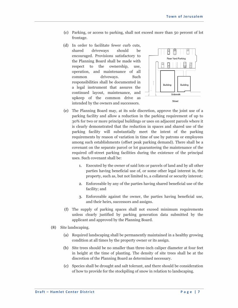
Town of Jerusalem
Draft – Ham let Center Distr ic t P a g e | 7
(c) Parking, or access to parking, shall not exceed more than 50 percent of lot
frontage.
(d) In order to facilitate fewer curb cuts,
shared driveways should be
encouraged. Provisions satisfactory to
the Planning Board shall be made with
respect to the ownership, use,
operation, and maintenance of all
common driveways. Such
responsibilities shall be documented in
a legal instrument that assures the
continued layout, maintenance, and
upkeep of the common drive as
intended by the owners and successors.
(e) The Planning Board may, at its sole discretion, approve the joint use of a
parking facility and allow a reduction in the parking requirement of up to
30% for two or more principal buildings or uses on adjacent parcels where it
is clearly demonstrated that the reduction in spaces and shared use of the
parking facility will substantially meet the intent of the parking
requirements by reason of variation in time of use by patrons or employees
among such establishments (offset peak parking demand). There shall be a
covenant on the separate parcel or lot guaranteeing the maintenance of the
required off-street parking facilities during the existence of the principal
uses. Such covenant shall be:
1. Executed by the owner of said lots or parcels of land and by all other
parties having beneficial use of, or some other legal interest in, the
property, such as, but not limited to, a collateral or security interest;
2. Enforceable by any of the parties having shared beneficial use of the
facility; and
3. Enforceable against the owner, the parties having beneficial use,
and their heirs, successors and assigns.
(f) The supply of parking spaces shall not exceed minimum requirements
unless clearly justified by parking generation data submitted by the
applicant and approved by the Planning Board.
(8) Site landscaping.
(a) Required landscaping shall be permanently maintained in a healthy growing
condition at all times by the property owner or its assign.
(b) Site trees should be no smaller than three-inch caliper diameter at four feet
in height at the time of planting. The density of site trees shall be at the
discretion of the Planning Board as determined necessary.
(c) Species shall be drought and salt tolerant, and there should be consideration
of how to provide for the stockpiling of snow in relation to landscaping.
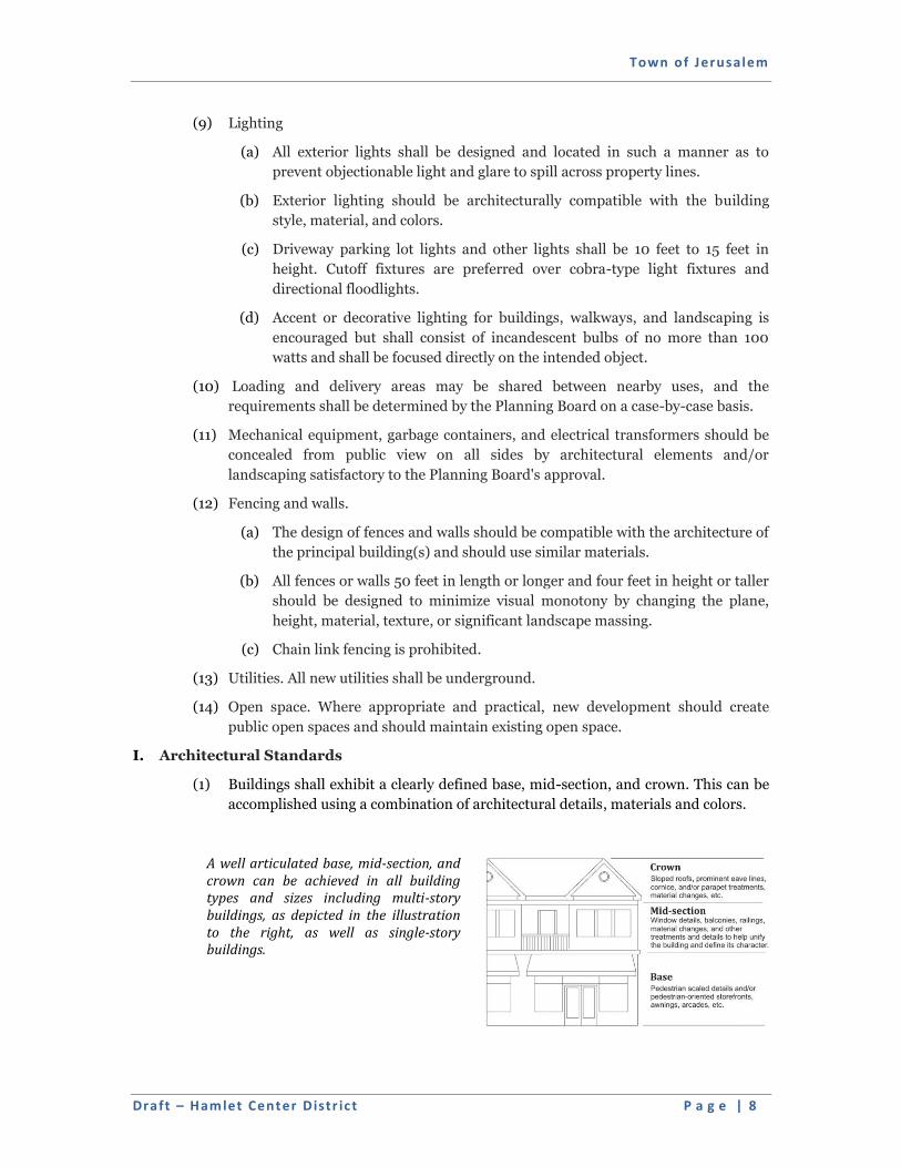
Town of Jerusalem
Draft – Ham let Center Distr ic t P a g e | 8
(9) Lighting
(a) All exterior lights shall be designed and located in such a manner as to
prevent objectionable light and glare to spill across property lines.
(b) Exterior lighting should be architecturally compatible with the building
style, material, and colors.
(c) Driveway parking lot lights and other lights shall be 10 feet to 15 feet in
height. Cutoff fixtures are preferred over cobra-type light fixtures and
directional floodlights.
(d) Accent or decorative lighting for buildings, walkways, and landscaping is
encouraged but shall consist of incandescent bulbs of no more than 100
watts and shall be focused directly on the intended object.
(10) Loading and delivery areas may be shared between nearby uses, and the
requirements shall be determined by the Planning Board on a case-by-case basis.
(11) Mechanical equipment, garbage containers, and electrical transformers should be
concealed from public view on all sides by architectural elements and/or
landscaping satisfactory to the Planning Board's approval.
(12) Fencing and walls.
(a) The design of fences and walls should be compatible with the architecture of
the principal building(s) and should use similar materials.
(b) All fences or walls 50 feet in length or longer and four feet in height or taller
should be designed to minimize visual monotony by changing the plane,
height, material, texture, or significant landscape massing.
(c) Chain link fencing is prohibited.
(13) Utilities. All new utilities shall be underground.
(14) Open space. Where appropriate and practical, new development should create
public open spaces and should maintain existing open space.
I. Architectural Standards
(1) Buildings shall exhibit a clearly defined base, mid-section, and crown. This can be
accomplished using a combination of architectural details, materials and colors.
A well articulated base, mid-section, and crown can be achieved in all building types and sizes including multi-story buildings, as depicted in the illustration to the right, as well as single-story buildings.
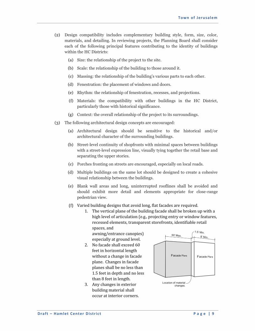
Town of Jerusalem
Draft – Ham let Center Distr ic t P a g e | 9
(2) Design compatibility includes complementary building style, form, size, color,
materials, and detailing. In reviewing projects, the Planning Board shall consider
each of the following principal features contributing to the identity of buildings
within the HC Districts:
(a) Size: the relationship of the project to the site.
(b) Scale: the relationship of the building to those around it.
(c) Massing: the relationship of the building's various parts to each other.
(d) Fenestration: the placement of windows and doors.
(e) Rhythm: the relationship of fenestration, recesses, and projections.
(f) Materials: the compatibility with other buildings in the HC District,
particularly those with historical significance.
(g) Context: the overall relationship of the project to its surroundings.
(3) The following architectural design concepts are encouraged:
(a) Architectural design should be sensitive to the historical and/or
architectural character of the surrounding buildings.
(b) Street-level continuity of shopfronts with minimal spaces between buildings
with a street-level expression line, visually tying together the retail base and
separating the upper stories.
(c) Porches fronting on streets are encouraged, especially on local roads.
(d) Multiple buildings on the same lot should be designed to create a cohesive
visual relationship between the buildings.
(e) Blank wall areas and long, uninterrupted rooflines shall be avoided and
should exhibit more detail and elements appropriate for close-range
pedestrian view.
(f) Varied building designs that avoid long, flat facades are required.
1. The vertical plane of the building facade shall be broken up with a
high level of articulation (e.g., projecting entry or window features,
recessed elements, transparent storefronts, identifiable retail
spaces, and
awning/entrance canopies)
especially at ground level.
2. No facade shall exceed 60
feet in horizontal length
without a change in facade
plane. Changes in facade
planes shall be no less than
1.5 feet in depth and no less
than 8 feet in length.
3. Any changes in exterior
building material shall
occur at interior corners.
Town of Jerusalem
Draft – Ham let Center Distr ic t P a g e | 10
(g) All sides of a building may have an impact on its surroundings and should
be considered for treatment with an architectural finish. Architectural
features, materials, windows, and articulation of a facade of a building
should be continued on all sides visible from a street or public parking
areas.
(h) Facade colors should be low-reflectance colors. High-intensity colors,
metallic colors, black, or fluorescent colors should not be used. Building
trim and accent areas may feature brighter colors.
(i) The scale of a building should be compatible with the surrounding
buildings.
(j) Pitched roofs with gables/dormers or symmetrically shaped parapet roofs
are encouraged.
(k) Considerations should be given to the height of cornice line or other
expression lines.
1. Where awnings are proposed, the use of canvas-type awnings on
buildings is recommended to provide protection from sun, wind,
and rain and to improve the aesthetics of the building exterior.
Awnings should be placed at a pedestrian scale, at a height of not
more than 10 feet above ground level.
2. Exterior finish materials should include:
a. Facades: brick, stone, stucco, wood, and wood shingles.
b. Roofs: shall be pitched; materials of construction may
include shingles, wood, imitation wood asphalt; imitation
slate; metal, aluminum (Kynar), copper, terne, zinc
(standing seam or batten seam); architectural-style asphalt
shingles.
c. Exterior building materials on the primary structure should
not include smooth-faced concrete block, tilt-up concrete
panels, or prefabricated steel panels, highly reflective,
shiny, or mirrorlike materials, mill-finish (noncolored)
aluminum metal windows or door frames; exposed,
unfinished foundation walls; exposed plywood or particle
board; and unplastered, exposed concrete masonry blocks.
Concrete block should be limited to only the rear wall of a
building.
(l) Windows:
1. Windows should be greater in height than width or at least of equal
proportion.
2. Mirrored, reflective, or darkly tinted glass, all-glass walls, or
exterior roll-down security gates shall not be permitted.


