Embed Size (px)
Citation preview
S 162QUEBEC GEOLOGICAL LEXICON
LEXIQUE GEOLOGIQUE
QUEBEC
GEOLOGICAL LEXICON
PREFACE
Le Comité de Nomenclature géologique du Québec a décidé de rendre dis-
ponible une premiêre liste provisoire des noms stratigraphiques du Québec.
Cette liste provient essentiellement d'un travail exécuté, en 1970, par
le Dr. F.F. Osborne, à la demande du Ministére des Richesses naturelles du
Québec. Elle ne représente qu'une ébauche qui servira de document de base
pour l'établissement de listes subséquentes, plus completes, qui seront mises
annuellement à la disposition du public.
De récents tableaux de formations ont été ajoutés au travail original
afin d'en faciliter sa compréhension et son utilisation.
Cette liste provisoire est présentée dans la langue de l'auteur mais à
l'avenir un lexique bilingue sera distribué aussitôt qu'il sera disponible.
Février, 1975
Yvon Globensky
Comité de Nomenclature Géologique
du Québec.
A geological lexicon of proper names in Quebec
F. Fitz Osborne
The purpose of this work is to provide a lexicon of the proper
names used to designate rock units and some other geological features
in Quebec. Some of the names are here described in terms similar to
or identical with those of the original proposer of the name. For
others, however, a more critical discussion is presented, and several
usages are compared. It is suggested that some names are not useful
and should be abandoned. No effort has been made to cite all references
to a name, but the compiler has made an effort to give representative
mentions with a choice of places of citation in order that a reference
may be available although the collection of material on Quebec geology
be incomplete.
Unlike many such compilations, the references belonging to an
entry are here given completely to include the title of an article.
This has made it possible to use direct quotations or slight modifica-
tions of them to refer to a feature. "This area" or similar phrase
should be understood to refer to the area mentioned in the title of
the citation. Two exceptions are to be noted. "Geology of Canada (1863)"
is used as an abbreviated reference to the 1000 page compendium of the
geology of Quebec and Ontario. Similarly, "Geology of Quebec (19410"
refers to vol. II, of G.R. 20 of the Quebec Department of Mines.
2
Most of the entries concern folds, faults,or formations in Quebec,
but a few names were first applied in nearby provinces or states. For
example, the names used for the principal divisions of the rocks of
St. Lawrence Lowlands, derive from localities in New York and are listed
here'but for a critical discussion of them the reader must look in
other publications such as U.S.G.S. Bulletin 896 or in the correlation
charts of the Geological Society of America. Names belonging to standard
sections in Europe are mentioned in references to some Phanerozoic units,
but such names do not appear as headings for separate entries.
During the research for the preparation of the lexicon, it was
found that the same name had been used for different features in adjacent
map areas or regions, but more commonly different names have been used
by different authors for one features in the same or nearby areas.
Folds and faults pose a problem particularly where an area has sparse
exposure. How is an "inferred fault" correlated with an "assumed fault"?
It is obvious that many such names have only nonce status, but this is
not obvious in many references.
It has not proved possible to recognize all nonce names even for
stratigraphic units, and it is probable that some such names have been
given the status of formations. Some names are indicated as "nonce
names", and others of somewhat similar status are recommended "only
for local use".
3
Many of the names in this lexicon are those of stratigraphic units,
and some of these are a century or more old. Old names were not subject
to the restrictions that have been more recently recommended. Logan, for
example, was able to refer to the same rocks as a formation, group, series
and system. It is logical to believe that the first three terms were used
informally and in their standard and dictionary meaning rather than as
technical designations. In 1901, following the principles of 1881, a
committee of the International Congress suggested a scheme involving, for
rocks, zone, stage, series, system but with series reserved for rocks
belonging to an epoch. Since 1901, many variants of the scheme have
been proposed both at several times and in various countries, where standing
committees report periodically. The suggestions usually formulated as a
code are inconsistent and contradictory if several codes be compared,
however, bed, lentil, member, formation, group, supergroup, system are
commonly recognized as lithostratigraphic units in English speaking
countries with in some codes series or sub—series included. If usage
in some other countries including France be compared with the foregoing
even wider diversities can be seen. A charge of misuse of a term such as
"series" for "group" implies only a departure from an arbitrary usage.
The codes have been strongly influenced by their architects, who
in many instances have been palaeontologists, despite the fact that
stratigraphy can be independent of palaeontology. The experience with
well defined rock units with indentifiable fossils has determined to a
considerable extent the framework or philosophy of classification.
4
Thus biostratigraphy has been given unmerited weight in stratigraphic
classification. A paper, which was published in U.S.A. in 1956 had
the title "Paleontology, basis of practical geochronology," deplores
the use of the term "biostratigraphy" and states "so-called stratigra-
phical nomenclature now in vogue is confused and over-refined". The
workers in Pleistocene geology were particularly incensed with some
proposed rules in the American code, and, after discussions, some
modifications of the code were to be allowed for Pleistocene strati-
graphy.
The application of the code to Precambrian rocks has been
suggested, but this application is beset by some difficulties despite
the fact that biostratigraphy is not a complication. The principal
difficulty arises because of the great duration of Precambrian as
compared with Phanerozoic time. It is not impossible that a Precambrian
epoch, if such were recognized, would exceed a Phanerozoic era in
duration. Most stratigraphers have but little interest in metamorphic
and pyrogenic rocks, and hence most codes dismiss such rocks summarily
with a statement that the same principles should be applied in Phanero-
zoic and Precambrian rocks.
Taking into account the factors involved in Quebec geology including
the predominance of Precambrian rocks, the difference in use of terms
in France and in English speaking countries, and the long use of some
names, it is reasonable to conclude that the provisions of the code are
of restricted usefulness and some of them can be disregarded. Conside-
ration of the geology of Quebec lead to the conclusion that some system
is desirable, but the over refinements of the code make its application
unrealistic.
5
The literature of Quebec shows examples of unhappy use of proper
names. Various causes can be assigned. One of the most common errors
is a result of disregarding names used earlier for a unit, another is
the failure to determine the limits of an earlier name. Finally for
Phanerozoic rocks there is confusion between time and rock terms.
With the preponderance of Precambrian and other metamorphic
rocks, in Quebec, it is essential that most mapped units be litholo-
gical, that is the rock stratigraphic units are of paramount signifi-
cance. The basic unit is the formation which is defined stratigra-
phically as a mappable and distinctive lithologic unit. Unfortunately
what is meant by lithology or at least the standards of precision
in the use of names are not specified. One can cite a formation bearing
the name grit, but the rocks are siltstones, some limestones are
calcareous siltstones. Even more obvious errors are formations which
are referred to as sandstones and are found to be tuff. However,
such an error in no way invalidates the formation name of the unit.
In a measure some confusion can be avoided by using a proper
name together with a term denoting a textural peculiarity or the
geological mode of occurrence. Thus one could use names such as;
plutonites, stock, boss, batholith, massif, gneiss, pluton, or as a
last resort rock or rocks. Such a practice can be applied to higher
stratigraphie units. Series, for example, is used fairly commonly
in igneous petrology, and the name cannot logically be eliminated
despite a dictum in any code.
6
It is suggested that in Quebec, rock stratigraphie names are the
serviceable ones and that bed, lentil, member, formation,group, super-
group, series, system be used. In some codes the rocks belonging to
an epoch are defined as a series. There is no reason why the converse
should be accepted especially for Precambrian rocks.
Some mappable units do not fit into the above category. "Sequence"
is one such unit for which various formal uses have been proposed but
not accepted. It is a term that should be used sparingly if at all.
"Complex" is another term. It can be used for a unit with such diversity
of bedded units that interpretation is difficult. It can be used for a
mappable unit consisting of sedimentary or metamorphic rocks with in-
truded rocks or for a unit of great structural complexity. Some units
can be referred to as olistostrome, mélange, or chaos depending on
their origin. Like "sequence" and "complex" these names should be used
only with adequate explanation of the user's meaning.
The rise since 1950 of methods of using isotope ratios in minerals
and rocks has led to several changes in the philosophy of correlation
particularly for Precambrian rocks. Unfortunately the "numbers", a
term used half disparagingly to designate the age in years, are subject
to adjustment and diverse interpretations. However, time,stratigraphic
or chronostratigraphic schemes have been evolved. Such schemes suffer
from the weakness that the dates are likely to be of "an event" whose
nature is not certainly known but is in many instances assumed to be an
orogeny. Using these dates as a framework a classification of lithologic,
viz. lithostratigraphic units is built up. As a result a scheme is
arrived at that is essentially similar to the schemes in use, in Canada
for half a century. It is difficult to see how "Aphebian" is preferable
to "Early Proterozoic" as a time term.
-6-
7
Geological Survey of Canada Map 4, 1965, bears the title "Tectonic
Map of the Canadian Shield" but has the time stratigraphic table of 64-17
report by Stockwell which he uses to classify some lithostratigraphic
units. The principal emphasis on the map is on rocks affected by diffe-
rent orogenies. The map is based on principles very similar to those
used by A. Holmes, and Allen and Reedman have proposed "Orogenic belts"
and "orogenic assemblages" for the rock units involved. These terms
are part of a tectonostratigraphic classification. The introduction of
these terms can cause confusion and until the interpretation is clarified
their use should be avoided.
-7-
8
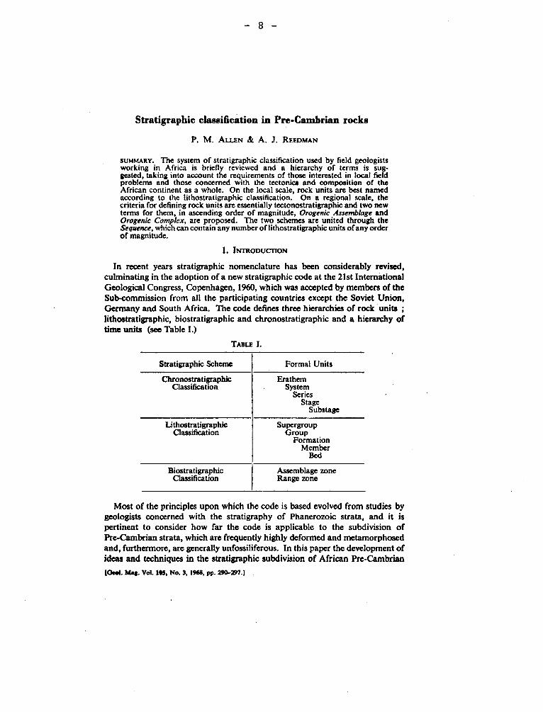
Stratigraphie classification in Pre-Cambrian rocks
P. M. ALLEN & A. J. REEDMAN
SUMMARY. The system of stratigraphic classification used by field geologists working in Africa is briefly reviewed and a hierarchy of terms is sug-gested, taking into account the requirements of those interested in local field problems and those concerned with the tectonics and composition of the African continent as a whole. On the local scale, rock units are best named according to the lithostratigraphic classification. On a regional scale, the criteria for defining rock units are essentially tectonostratigraphic and two new terms for them, in ascending order of magnitude, Orogenic Assemblage and Orogenic Complex, are proposed. The two schemes are united through the Sequence, which can contain any number of lithostratigraphic units of any order of magnitude.
I. INTRODUCTION
In recent years stratigraphic nomenclature has been considerably revised, culminating in the adoption of a new stratigraphie code at the 21st International Geological Congress, Copenhagen, 1960, which was accepted by members of the Sub-commission from all the participating countries except the Soviet Union, Germany and South Africa. The code defines three hierarchies of rock units ; lithostratigraphic, biostratigraphic and chronostratigraphic and a hierarchy of time units (see Table I.)
TABLE I.
Stratigraphie Scheme Formal Units
Chronostratigraphic Classification
Erathem System
Series Stage
Substage
Lithostratigraphic Classification
Supergroup Group
Formation Member
Bed
Biostratigraphic Classification
Assemblage zone Range zone
Most of the principles upon which the code is based evolved from studies by geologists concerned with the stratigraphy of Phanerozoic strata, and it is pertinent to consider how far the code is applicable to the subdivision of Pre-Cambrian strata, which are frequently highly deformed and metamorphosed and, furthermore, are generally unfossiliferous. In this paper the development of ideas and techniques in the stratigraphie subdivision of African Pre-Cambrian
[Geol. Mai. Vol. IRS, No. 3, 1968, pp. 294.297.1
— 9 —
Stratigraphie classification in Pre-Cambrian rocks 291
terrains and the relevance of the stratigraphic code to such problems is examined. Some proposals are made for a revised terminology.
2. STRATIGRAPHIC TERMINOLOGY CURRENTLY IN USE FOR THE PRE-CAMBRIAN
OF AFRICA AND ITS RELATION TO THE STRATIGRAPHIC CODE
Cahen & Snelling (1966) recently discussed the methods used in the strati-graphic classification of Pre-Cambrian strata and the problem of stratigraphic terminology. They pointed out that the paucity of organic remains in Pre-Cambrian rocks usually excludes the possibility of dividing the rocks into biostratigraphic units or of tracing time-parallel surfaces by palaeontological correlation—the principal method for establishing the inter-regional identity of chronostratigraphic units in Phanerozoic strata. Eventually, they suggested, age determinations using radio-active isotopes may form the basis for a chrono-stratigraphie classification of the Pre-Cambrian, but to the field geologist in Africa the most useful scheme for classification is a naturalistic one, using lithostratigraphic criteria on a local scale and tectonostratigraphic criteria on a regional and international scale.
The stratigraphic terminology adopted by early workers in the subdivision of Pre-Cambrian rocks over much of Africa has become, since the acceptance of the Stratigraphie Code of 1961, inappropriate to the stratigraphie units it describes. The pioneer workers on many of the African Geological Surveys found that the territories with which they were concerned were underlain by high-grade metamorphic rocks, intrusive rocks and areas of less highly metamorphosed and deformed sedimentary and volcanic rocks. The high-grade metamorphic rocks were assumed to be " Archaean " and were often named the Basement Complex (e.g. Somalia, Nigeria, Rhodesia, Uganda), Basement System (Kenya) or Primitive System (Southern Africa). The less metamorphosed strata were subdivided on the basis of their unconformable relationship with the " Basement Complex ", their contrasting lithologies, their degree of metamorphism and discontinuity of outcrop. In most places the units recognized were named
. according to the nomenclature proposed at the International Geological Congress at Bologna (1881), the terms System, Series and Stage being adopted. With systematic mapping, areas of structural and metamorphic contrast within the high grade metamorphic terrains were recognized, and the Basement Complexes were subdivided. For example, the Basement Complex of Tanzania was renamed, in part, the Dodoma System, and in Sierra Leone the Kasila System was identi-fied. In French-speaking territories a similar hierarchy of terms was applied.
The chronostratographic terms System, Series and Stage have often been used in Africa for heterogeneous, and sometimes diachronous groups of strata. Series and Stages were usually erected using lithological criteria and should, therefore, be renamed according to the lithostratigraphic hierarchy of terms, Supergroup, Group, Formation, Member and Bed. Larger units, however,
22
— 10 —
292 P. M. Allen and A. J. Reedman—
have been recognized using criteria which are not strictly lithostratigraphic, but according to Cahen & Snelling (1966) are more correctly defined at tectono-stratigraphic. These units, which include most of the " Systems " in the African Pre-Cambrian, are usually bounded by major unconformities. Cahen & Snelling (1966) find it convenient to drop the term " System " for these tectonostrati-graphic units and to add the suffix " an " to a local name. For example, they refer to the Karagwe Ankole System of Uganda as the Karagwe-Ankolean.
Unconformities have always been regarded as important boundaries of rock strata. In Britain and western Europe, Phanerozoic rocks were divided initially into Systems bounded by unconformities, but when the Catastrophists' theory that unconformities were world-wide was shown, by means of the correlation of fossiliferous strata, to be incorrect, these internationally accepted Systems ceased to be natural groupings of strata except in their type areas, but were retained as fundamental chronostratigraphic units. The role of the unconformity in the definition of formal stratigraphic units then became somewhat uncertain, but subsequent work by Sloss, Krumbein & Dapples (1949), Wheeler (1958, 1959), Sloss (1963) and others has served to clarify its position and it was due to Wheeler (1958) that the body of strata bounded above and below by uncon-formities was defined as a Sequence. Wheeler's (1959) thesis is that the Sequence is a natural rock unit independent of the lithostratigraphic, chronostratigraphic or biostratigraphic classifications, though it is generally divisible into a number of lithostratigraphic units which may consist of anything from a single Formation to a number of Groups. In Pre-Cambrian rocks it is the most widely mapped unit, for in Africa most " Systems " that have been defined conform to this definition of a Sequence, and according to Sloss (1963) so also do the " Series " in the Pre-Cambrian of North America.
3. REGIONAL SUBDIVISION OF PRE-CAMBRIAN TERRAINS
The most successful schemes used in the large-scale subdivision of African Pre-Cambrian terrains are those based on the work of Holmes (1951), who outlined and applied a two-part method for attacking the problems of Pre-Cambrian sequence and correlation in southern and central Africa. His method consisted of :—
(i) Subdivision of the Pre-Cambrian terrain into a number of orogenic belts, each the product of an orogenic cycle. The sequence of the cycles was determined at intersections of belts.
(ii) Dating of these cycles by age determinations using radioactive isotopes. Holmes took his inspiration from Sederholm, who believed that mountain-
building in Archaean times was a cyclic phenomenon restricted on each occasion to long, relatively narrow zones of the crust. Thus, all Pre-Cambrian terrains have an ingrained pattern of successive orogenic belts, and each continent appears
Stratigraphie classification in Pre-Cambrian rocks 293
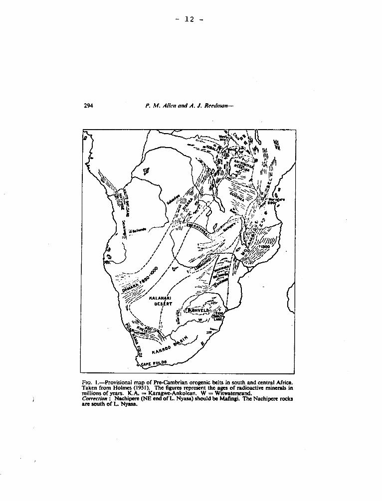
to be an integration of many such belts. Holmes was able to divide the Pre-Cambrian outcrops of southern and central Africa into a large number of orogenic belts (Fig. 1), each of which is characterized by its internal structural conformity. Subsequent work by many geologists including Quennell & Haldemann (1961), Harpum (1961), Nicolaysen (1962) and Cahen & Snelling (1966), has proved the utility of Holmes' method and provided more detailed information on the extent of many of the orogenic belts defined.
In applying the concept of the orogenic belt as the product of an orogenic cycle to the subdivision of Pre-Cambrian terrains it is suggested that two new strati-graphical terms are required. The suggested terms are the Orogenic Complex and the Orogenic Assemblage, defined as follows :—
The Orogenic Complex consists, with the exception of the post-orogenic intrusive rocks, of the complete suite of rocks of the orogenic belt.
The Orogenic Assemblage consists of the pre-orogenic, syn-orogenic and post-orogenic sedimentary and volcanic rocks produced during a single orogenic cycle.
Ideally the orogenic belt contains the variously metamorphosed and folded sedimentary and volcanic rocks which filled the geosyncline, the syn-orogenic intrusive and granitized rocks, the post-orogenic sediments derived from the rising mountain chain and the refoliated basement of the geosyncline. All of these units grouped together constitute the Orogenic Complex. In areas of deep erosion the only element of the belt remaining may be the refoliated basement, which itself may be part of an Orogenic Complex formed during an earlier orogenic cycle.
All the sedimentary and volcanic rocks formed during a single orogenic cycle are assigned to the Orogenic Assemblage which is, therefore, a part of the Orogenic Complex. Both the debris which accumulated in the geosyncline prior to orogenesis, and the fluvial molasse formed at the end of orogenesis by the erosion and weathering of the folded and metamorphosed geosynclinal rocks, are included in Orogenic Assemblage.
The terms " Assemblage " and " Complex " in ascending order of magnitude were proposed first as lithostratigraphic units greater than Group by Rodgers & McConnell (1959), but they were accepted by neither the American Commission of Stratigraphic Nomenclature nor the International Subcommittee on Strati-graphic Terminology. Instead, the term Supergroup was accepted as the only lithostratigraphic unit larger than Group by the American Commission, and later gained international favour (e.g. Stratigraphical Code Sub-Committee, Geological Society of London, 1967, p. 80). Complex, however, was accepted in another sense by the American Commission of Stratigraphic Nomenclature of 1961 and defined as a " mass of rock ... composed of diverse types of any class or classes or ... characterized by highly complicated structure ...". The term can be used for groups of volcanic rocks and intrusive igneous rocks as well
d fi
' %
J M
17_:----
.s^`;../~%i/ /~i ~., ..~ i
/ --1.. / - i
i:-.~ i:
` 7' i p~ / /"~ /~ ~~i P'//
/ / ̀„ / __ - ~~%~/~/ /7-
~/~/ KALAN~RI i ~ ~ ~ ~ OES RT / ~ ~~~
~ Ÿ ~~I1l~U0NYELN Î /► N. ̀ ` s
`
~~, ~ S
y`\~̀ , if 1# / ft ii
• ^ K
/4apOO
xj i/i///l(/t!
~
~
?jb///%/i
/i rU/ r
cAPE F0 os
— 12 —
294 P. M. Allen and A. J. Reeduun--
~
Flo. 1.—Provisional map of Pre-Cambrian orogenic belts in south and central Africa. Taken from Holmes (1951). The figures represent the apes of radioactive minerals in millions of years. K.A. = Karagwe-Ankolean. W = Witwatersrand. Correction • Nachipere (NE end of L. Nyasa) should be Mafingi. The Nachipere rocks are south of L. Nyasa.
— 13 —
Stratigraphie classification in Pre-Cambrian rocks 295
as metamorphic rocks : thus one can refer to the Scottish Tertiary Volcanic Complex, the Bushveld Complex, or, in Anglesey, the Mona Complex. The definition also fits the requirements of a unit composed of all the rocks in an orogen, but in order to avoid ambiguity the term can be qualified to Orogenic Complex. It is clear from its definition that the term Orogenic Complex unites diverse classes of rocks with gross structural conformity. For this reason it is considered that post-orogenic intrusives, which are often geographically within the orogenic belt, but structurally discordant, cannot be included in the Orogenic Complex.
Orogenic Assemblage is a conceptual term, depending, for its application, on the recognition of an orogenic belt and the identification of sedimentary and volcanic material formed in the orogenic zone during a specific cycle. The lateral limits of the Orogenic Assemblage may be difficult to define. For example, in orogens which have not been reduced by erosion it is possible to trace forma-tions in the orogcn laterally into the foreland, a good example of this being the so called " Katangan " (Cahen & Snelling, 1966). In such a case it is not possible to be precise about the lateral limit of an Orogenic Assemblage : it might coincide with a sedimentary facies change and thus be at the boundary between two purely lithostratigraphic units, or it might coincide with the limit of folding. In more deeply eroded belts where the remnants of the Orogenic Assemblage are likely to be highly metamorphosed and deformed it is not always possible to trace the strata onto the foreland, and the lateral limits of it have to be confined either to the limits of outcrop or to structural discontinuities.
The rocks deposited on the stable cratons are not included in the Orogenic Assemblage. Any craton is built up of the orogenic belts of previous eras ; the sediments laid down upon it may subsequently form the floor of a geosyncline and be incorporated into an Orogenic Complex. They will not, however, properly form a part of the Orogenic Assemblage. Many of the ancient cratons, however, have remained relatively stable to the present day and the sediments deposited upon them during their long period of stability remain as scattered tabular successions, the older successions frequently being covered by a blanket of more recent sediments. The cratonic successions can be subdivided into lithostrati-graphic units and often into Sequences and should be named accordingly.
The Orogenic Assemblage is defined so as to include both the pre-orogenic and post-orogenic sediments of a particular cycle. Detailed sedimentological and geochronological studies may be necessary in order to recognize the post-orogenic sediments of a particular cycle, but where this is possible the Orogenic Assemblage will contain at least two Sequences. The lateral extent of a named Sequence depends on the extent of its bounding unconformities. It may be possible to trace a Sequence which forms a part of an Orogenic Assemblage onto the craton bounding the orogenic belt. However, as has been explained by Sloss (1963, p. 110), extra-cratonic Sequences, which are controlled by orogenic events within the geosyncline, bear no necessary relationship to the cratonic Sequences,
- 14 -
296 P. M. Allen and A. J. Reedman—
and unless the bounding unconformitics can be traced continuously through the foreland into the orogen, the cratonic and extracratonic Sequences must be named differently.
4. CONCLUSIONS
Most of the stratigraphic subdivisions recognized and named in the Pre-Cambrian successions of Africa arc likely to be diachronous and, therefore, the chronostratigraphic terms System, Series, etc., should not be applied to them. Where units are recognized on lithological criteria alone they should be named according to the hierarchy of lithostratigraphic units proposed in the International Stratigraphie Code (I.G.C., 1961). Unconformity-bounded successions are termed Sequences, and arc the most generally recognizable natural groupings of rock strata in the Pre-Cambrian except in highly metamorphosed terrains. A Sequence consists of an unspecified number of lithostratigraphic units though it is not itself a lithostratigraphic unit. Even the products of the highest grades of regional metamorphism can be assigned on the basis of structural investigation to a particular Orogenic Complex which, it is suggested, is the largest rock stratigraphie unit distinguishable in Pre-Cambrian terrains. The two principal components of the Orogenic Complex are the refoliated basement, which itself may be attributable to an Orogenic Complex of an older orogenic cycle, and the Orogenic Assemblage, which ideally contains at least two Sequences.
Ultimately, it is to be hoped that a chronostratigraphic scheme cnn be erected for Pre-Cambrian strata. The above scheme, which is justified by its proven practicability in the field and has been intuitively employed by geologists in Africa for at least a decade, is also compatible with this aim. The data for chronostratigraphic correlation in the absence of organic remains is at present drawn mainly from the radioactive dating of events within an orogenic cycle, and so a division of Pre-Cambrian strata into stratigraphic units which combines local lithostratigraphic units into larger tcctonostratigraphic units is highly appropriate.
ACKNOWLEDGMENTS. This paper is published with the permission of the Director of the Institute of Geological Sciences. We would like to thank our colleagues in the Leeds office of the Institute of Geological Sciences, and the Department of Earth Sciences at Leeds University for discussion, and Dr. J. E. Hepworth for help with the manuscript.
REVERENCES
CAHEN, L. & SNELLING, N. J. 1966. The Geochronology of Equatorial Africa. North Holland Publishing Co., Amsterdam.
Code of Stratigraphie Nomenclature. 1961. American Commission on Stratigraphie Nomenclature. Bull. Am. Ass. Petrol. Geol., 43, 645-665.
HAgrtni, J. R. 1960. The concept of the geological cycle and its application to problems of Pre-Cambrian geology. 21st Int. Geol. Congr., Copenhagen, 1960. Pt. 9, 201-6.
- 15 -
Siraligraphic classification in Pre-Cambrian rocks 297
HOLMES, A. 1951. The sequence of Pre-Cambrian orogenic belts in south and central Africa. 18,!, Int. Geol. Congr., London, 1948. Pt. 14, 254-269.
NICOLAYSFN, L. O. 1962. Stratigraphie interpretation of age measurements in Southern Africa, pp. 568-598 in Petrographic Studies: A volume in honour of A. F. Buddiugton. Geological Society of America, New York.
QUENNELI., A. M. & HALDEMANN, E. G. 1960. On the subdivision of the Pre-Cambrian. 21st lot. Geol. Congr., Copenhagen, 1960. Pt. 9, 170-7.
RODGERS, J. & MCCoNNELL, R. B. 1959. The need for rock•stratigraphic units larger than Group. Bull. Am. Ass. Petrol. Geol., 43, 1971-5.
SLoss, L. L. 1963. Sequences in the cratonic interior of North America. Bull. geol. Soc. Am., 74, 93-114.
— KRunuu?IN, W. C. & DAPPLES, E. C. 1949. integrated lacks analysis, in Longwell, Chester, R., Chairman. Sedimentary facies in geological history. Men,. geol. Soc. Am., 39, 91-124.
Stratigraphie Classification and Terminology. 1961. 21st Int. Geol. Congr., Copenhagen, 1960. Pt. 25.
The Stratigraphie Code. 1967. Rept. of the Stratigraphical Code Sub-Committee. Proc. geol. Soc. Lond., No. 1638, 75-87. (Ed. George T. N. et al.).
WHEELER, H. E. 1958. Time-Strati phy. Bull. Am. Ass. Petrol. Geol., 32, 1047-1063. —1959. Unconformity-bounded units in stratigraphy. Bull. Am. Ass. Petrol. Geol.,
43, 1975-7. OVERSEAS AND MINERAL SURVEYS,
harming OP GEOLOGICAL SCIENCES, 5 PRINCE'S GArE,
LONDON S. W. 7.
- 16 -
212 Correspondence
STRATIGRAPHIC CLASSIFICATION IN PRECAMBRIAN ROCKS SIR,—Dr. Allen's and Dr. Reedman's proposal (Geol. Mag., 105, (3), 296-297,
1968) that the term 'orogenic complex' should be given to 'the complete suite of rocks of the orogenic belt' (p.293) will be welcomed by geologists working in the African metamorphic Precambrian terrains. It will be the more readily accepted since there is a terminological gap to be filled and because its necessity has been tacitly understood, or as the authors say 'the scheme has been intuitively employed by geologists in Africa for at least a decade'. Sutton & Watson (1951), in one of the fundamental texts of 'base-ment' geology from which much African work derives, referred to the Scourlan and Laxfordian 'complexes'. But as the authors have pointed out 'complex' can be used for diverse groups of rocks and it would seem that the term lacks that degree of particularity which something as impressive as the suite of rocks united in orogenesis demands of the imagination. To add the qualifying 'orogenic' to 'complex' overcomes this objection.
The term then approximately replaces the semi-geographical 'The Something (or Some-where) orogenic belt' or the etymologically dubious 'Somethingides'. For practical pur-poses it would seem to be equivalent to the adjectival form ('Somewherean') advocated by Cahen & Snelling (1966 p.21) but to have additional advantages.
One might wish, however, that the authors had gone further in giving examples of the usage they advocated. They might have tried out 'Laxfordian orogenic complex', or Macdonald's 'Watian orogenic complex' or 'the Kibaran orogenic complex'. One may ask whether these examples are acceptable and more meaningful than the adjectival form. This writer thinks these examples are in fact acceptable and probably more meaningful than 'Laxfordian', 'Watian' or 'Kibaran'. Again, if we attempt to add 'orogenic complex' to Clifford's 'Damaran' we find that it is inapplicable and hence heightens the meaning of 'Damaran' which, of course, Clifford (1967) referred to in full as the 'Damaran episode', although on Holmes' early map (reproduced facsimile com-plete with the original mistake as Allen & Recdman's Fig.l) it was an 'orogenic belt'. And to settle for a 'Mozambique orogenic complex' might save the words Mozambique and Moiambiquian from degenerating into uselessness through the acquisition of various shades of meaning (orogcny? thermal event? epeirogenic event? geosyncline?).
I conclude, therefore, that 'orogenic complex' is an acceptable, useful term, only pleading that it should be remembered that the giving of a name does not necessarily imply that the suite of rocks referred to is any better understood than before it acquired its cognomen. In referring, for example, to the 'Mozambique orogenic complex' there is some danger in giving the impression that it is a well-defined, tightly knit group of rocks whose general character over a large area is well understood. This would be quite mis-leading. The usefulness of the term 'orogenic complex' would to some extent depend on the realization that it is mainly applicable to still abstruse metamorphic complexes. It would, for example, be inappropriate to refer to the Caledonian orogenic complex (of Europe).
While it would seem that 'orogenic complex' will be welcomed, the writers' second term 'orogenic assemblage' finds a less ready response. The present writer agrees with the authors' own verdict that it is a 'conceptual term' (p.295) and in attempting to apply it in practice he is at a loss to find a suitable example. It is indeed very difficult to visualize circumstances in which 'orogenic complex' might be used as a term for a complicated mass of diverse rocks characterized by gross structural conformity in which it would be possible to recognize those components which would allow the further distinction of an 'orogenic assemblage' in the sense visualized by the authors. Experience suggests that it is as much as cart be expected that the 'orogenic complex' should be recognized, or. in less complex terrains, that conventional lithostratigraphic units should be discerned: Conversely it is to be supposed that if the 'detailed sedimentological and geochrono-logical studies (which) may be necessary in order to recognize the post-orogenic sedi-ments of a particular cycle' (p.295) were successfully carried out there would be no need to use the proposed terms, but to employ the established lithostratigraphic ones.
The authors are probably right in saying that the 'Sequence' is the most widely mapped unit in the Pre-Cambrian of Africa, but here again no potential example of two Sequences adding up to an Orogenic Assemblage comes to mind.
These objections, however, should not be allowed to prevent the term 'Orogenic Com-plex' which they advocated from being given serious consideration.
(Geol. Mag. Vol. 106,1969, pp. 212-213)
— 17 —
Correspondence 213
REFERENCES
CAHEN, L. & SNELLING, N. J. 1966. The Geochronology of equatorial Africa. North Holland Publishing Co., Amsterdam.
CLIFFORD, T. N. 1967. The Damaran episode in the Upper Proterozoic—Lower Palaeozoic structural history of southern Africa. Spec. Pap. geol. Soc. Am., 92.
HEPWORTH, J. V. & MACDONALD, R. 1966. Orogenic belts of the northern Uganda basement. Nature, Lond., 210, 726-727.
HOLMES, A. The sequence of Pre-Cambrian orogonic belts In south and central Africa. Intern. Geol. Congr., 18th, London, 1948. Pt. 14, 254-269.
SUTTON, J. & WATSON, J. 1951. The pre-Torridonian metamorphic history of the Loch Torridon and Scourie areas in the north-west Highlands, and its bearing in the chronological classification of the Lewislan. Q. J! geol. Soc. Loud., 106, 241-308.
JOHN VORD HEPWORTH. INSTITUTE OF GEOLOGICAL SCIENCES,
PHOTOGEOLOGICAL UNIT, 5, PRINCES GATE, LONDON, S.W.7.
19th November, 1968.
SIR,—Dr. Hepworth's comments on our proposals concerning stratigraphie nomen-clature arc most welcome. In view of Dr. Hepworth's long experience in studying and interpreting the complex stratigraphy and tectonics of orogenic belts in East Africa, his conclusion that the term 'orogenic complex' is an acceptable and useful term is encouraging.
We disagree with Dr. Hepworth that it would be inappropriate to refer to the Cale-donian Orogenic Complex (of Europe). This is, perhaps, not as necessary as with the older belts, but Phanerozoic orogens are just as readily divisible into 'orogenic com-plexes', 'orogenic assemblages' and 'sequences' as those in the Pre-Cambrian.
Dr. Hepworth finds the term 'orogenic assemblage' less useful than 'orogenic complex' and believes the term to have little practical application. We agree that the term 'orogenic assemblage' has disadvantages as a formal stratigraphie unit, the main one being that its definition is not based on purely objective criteria as are those of the •'orogenie complex' and the 'sequence'. As we originally stressed, it is a conceptual term. For this reason it could be argued that 'orogenic assemblage' should remain a convenient descriptive term for a part of the 'orogenic complex', the terms 'sequence' and 'orogenic complex' being the formal tectonostratigraphic units. However. whether used formally or informally, we believe the term to be a useful one in grouping together 'sequences', and two examples from areas where we have ourselves undertaken field mapping are given below.
Prof. W. Q. Kennedy first recognised the presence of an orogenic belt along the coast of West Africa and suggested that it was Pan-African in age (i.e. t 550 m.y.). Later work has proved its extent from the Rio de Oro southwards to Liberia. It has no single name: Sougy (1962) suggested the Mauritanides for the northern part, which he believed to be Hercynian, and Allen (in press) suggested Rokelides for the southern part, which is Pan-African in age. Perhaps the term Rokel Orogenic Complex might be adopted for it. Excluding the intrusive rocks, the complex consists of three components: the refoliated basement of south-west Rio de Oro represented by the Kasila Group in Sierra Leone, the folded and metamorphosed geosynclinal rocks, a few examples of which are the Serié de Faleme in Senegal, the Seri de M'Bout in Mauritania and the Rokel River Group in Sierra Leone; and finally the molasse, which lies unconformably on the geosynclinal rocks. Examples of the latter are the Taban Formation in Sierra Leone and Guinea and its prob-able correlative, the Serié de Youkounkoun, also in Guinea. In our definition both the geosynclinal rocks and the molasse comprise the 'orogenic assemblage': thus, taking Sierra Leone as an example, the Rokel River Group and the Taban Formation belong to it. They are separated by an uneonformity and are, therefore, representative of two sequences.
- 18 -
Table II
Time-Stratigraphic Classification and Nomenclature for the Canadian Shield Showing Standard MM Horizons for Orogenic Micas
Determined by the Potassium-Argon Method
(Letters in parenthesis are suggested symbols for geological or tectonic maps. )
EON ERA SUB-ERA K-AR AGE (m.y.) and OROGENY
600
PROTEROZOIC( Q )
HADRYNIAN (HO
NEOHELIKIAN (HS ")
MM 880
GRENVILLE (Q)
1280 i HELIIUAN OK) MM
PALAEOHELIKIAN(FK' )
ELSONIAN (8)
MM 1640
APHEBIAN (/d)
HUDSONIAN (H)
MM 2390
ARCHAEAN (A)
KENORAN (K)
Stockwell, ch., 1964, G.S.C. Paper 64-17 (Part II)
Ulukan
Equalulik
Athabasca
Et-Then
- 19 -
Precambrian Time and Rock Units Of the Canadian Shield
C.H. Stockwell (G.S.C. paper 64-17)
TYPE OROGENY M M in m.y.
ROCK-STRATIGRAPHIC UNITS In any one category not necessarily contemporaneous nor in order of age
600
Double Mer
Chatham-Grenville stock
880 GRENVILLE
wake= Granite, adamellite and anorthosite
Martin
Dubawnt
Sims
Chukotat
Upper Keweenawan
Lower and Upper Coppermine River
IRO
Duluth, Muskox, Logan, Lackner, and Caldwell intrusions Lower and Middle Kewenawan
Hornby Bay
1280 ELSONIAN
HF
i',3
â7J
A
1640 HUDSONIAN Kaminis and other
Huronian
Animiki (e)
Kaniapiskau
Povungnituk
Belcher
Great Slave
Snare
granites, Sudbury irruptive.
Epworth
Nonacho
Tazin
Hurwitz
Chantry
Great Island Nipissing diabase
Cross Lake
Killarney, Doloro and other granites
Seal
Echo Bay - Cameron Bay
Goulburn Grenville Matachewan diabase
San Antonio
2390
KENORAN Algoman, Giants Range, Prosperous, and other granites
Knife Lake r
--Saganaga Granite
Keewatin - Coutchiching
Sickle, Missi
Kisseynew, ..-,~
lliff Lake Granite
Wasekman, Kisseynew, Amisk
Timiskaming
Abitibi, Pontiac
Ridout Windigokan
Rice Lake Seine
Yellowknife
- 20 -
ABBEVILLE FAULT ZONE
"It includes two parallel east-west-trending bands of schist occuring
adjacent to the north share of the west end of Pelletier Lake. It is 30 to
50 feet wide, and dips 75 to 80 degrees north".
Wilson, M.E., .1962, Rouyn-Beauchastel map-areas, Quebec: Canada, Geol
Surv., Mem, 315, p. 40.
ABIJEVIS SYNCLINE
This syncline trends slightly north of west across the northern part
of the Cléricy and La Pause map-areas. Dips are 70oto 900, and the plunge
is not known.
Ambrose, J.W., 1950, Cléricy and La Pause Map-areas, Quebec: Geol. Surv.
Can., Mem, 233, p. 30.
ABITIBI GROUP, SERIES, (Wilmarth, 1-9). Archean
M.E. Wilson (1912, p. 275) gives a table of formations for Kewagama
Lake map-area with a part:
Cobalt series (Huronian)
Granite and gneiss (Laurentian?)
Igneous contact
Pontiac group (Huronian?)
Abitibi group (Keewatin?)
He points out (p. 276) that the Abitibi group is made up of grey
or greenish gray meta-lavas rather than the green of the Keewatin (?) greenstone
cropping out to the south. In the final report on the same area he (Wilson
1913, p. 42) lists Pontiac series and Abitibi volcanics as series of the Abi-
- 2'1 -
t\ibi group (Keewatin ?). The Abitibi group was this considered a synonym for
Keewatin. The Abitibi volcanics or Abitibi volcanic complex was treated as
a series, a series at that time being part of a group. However by 1920 the
name was obsolescent.
In 1942, Wilson (p. 57) wrote: "The Keewatin volcanics, for which
the local name Abitibi series is proposed, ...". He changed this defini-
tion in 1943. Essentially a similar definition equating the Abitibi Series
to the whole of the complex of metasedimentary and metavolcanic rocks older
than the Temiskaming Series was offered in 1956 (Wilson. pp. 1412-1413).
In 1962 another usage was suggested in the report on the Rouyn-Beau-
chastel map-areas (Wilson, 1962, p. 7). In this report Wilson equates Abitibi-
Group to (Keewatin) and restricts it to volcanic rocks. It is in this area
essentially Blake River volcanics
The term Abitibi Series has never become current in Quebec, and
diverse usages even by Wilson the proposer of the name, have made its
meaning unclear. The term does no more than the corresponding Keewatin
names and in its final (1962) sense is less precise than Blake River.
Wilson, M.E. 1912, Kewagama Lake map-area, Pontiac and Abitibi,
Quebec: Geol. Surv. Can., Summ. Rept. 1911, pp. 276-277.
Wilson. M.E. 1913, Kewagama Lake map-area: Geol. Surv. Can. Mem. 39,
p. 42.
Wilson, 1942, Structural features of the Keewatin volcanic rocks of
western Quebec: Geol. Soc. Am., Bull. v. 53, p. 56.
Wilson, M.E., 1943, The Early Precambrian Succession in western
Quebec: Roy. Soc. Can., Tr. vol. 37, Soc. IV p. 134.
- 22 -
Wilson, M.E., 1956, Early Precambrian rocks of the Timiskaming
region, Quebec and Ontario, Canada: Geol. Soc. Am., Bull. v. 67, pp. 1412-1413.
Wilson, M.E. 1962, Rouyn-Boischatel map-areas, Quebec: Geol. Surv.
Can., Mem. 315, p.7.
ABNER DOLOMITE
This name is from Abner lake in the Bones lake area and was given
by geologists working for Fenimore Iron Mines Limited. Fram Abner lake the
dolomite formation may be traced almost continuously to the northwestern
part of the Harveng Lake area (Bérard, 1958).
The Abner dolomite overlies conformably the Chioak. The contact
is marked by a thin interlayering of dolomite and biotite-chlorite schists.
The estimated thickness of the formation is 400 feet.
The dolomite is dark grey, buff, or brown on fresh surfaces and buff
on weathered surfaces.
Sauvé, Pierre; Bergeron, Robert; 1965, Gerido Lake-Thevenet Lake
Area, New Quebec: Quebec Dept. of Nat. Res., G.R. No. 104, p. 9.
ACADIA-ACADIAN
Acadia, which is the name for Nova Scotia, Prince Edward Island,
and part of New Brunswick, has been used for several things in geology.
I- Acadian Region
Successive editions of "Geology and Economic Minerals of Canada",
show changes in the use of the term for the geological region. In 1926
it is given a co-ordinate position with Appalachian, thus "The Appalachian
and Acadian regions include all of Canada ...". (p. 83). In 1947, the
same publication has (p. 28): "The Appalachian region of Canada sometimes
- 23 -
called the Appalachian-Acadian region comprises...".
II- Acadian Series, Epoch. (Wilmarth -1-11) Cambrian
Dawson in 1867 proposed Acadian for the Paradoxides-bearing beds of
New Brunswick and the name was extended to beds with that trilobite in
North America. It then became an epoch of the Middle Cambrian. The British
term "Menevian" was used for some of these rocks prior to 1880.
Dawson, J.W., 1868, On recent geological discoveries in the Acadian
Provinces of British North America: Am. Assn. Adv. Sci., Pr. v. 18, p. 118.
III- Acadian Orogeny, Disturbance, Revolution.
J.W. Dawson recognized that a great orogenic event had occurred in
Acadia, but it was H.S. Williams who, in 1895, gave the name Acadian, to this
event. Although, it is difficult to separate the effects of this orogeny
from others unless Silurian or Devonian rocks are involved, the Acadian was
an extremely significant event with folding accompanied by granitic intru-
sions. The intrusives in general are mesozone types and are post kinematic.
The event shows some diversity in date from locality to locality.
Boucot et. al (196+) have set Upper Emsian as the time of the "first
intense phase". Dinely and Williams (1968) believe that they can recog-
nize three divisions: "A", Early Devonian, "Be', is middle Late, and
nCn is Late Devonian. Rodgers (1967) with some hesitation suggests that
deformation continued into Carboniferous. Shickshockian (a.v.) is a
junior synonym for Acadian.
Boucot, A.J. et. al., 1964, Reconnaissance bedrock geology of the
Presque Isle Quadrangle, Maine: Maine Geol. Bury. Quadrangle Mapping
Series 2, pp. 93-99.
— 24 —
Dineley, D.L. and Williams, B.P.J., 1968, The Devonian continental
rocks of the lower Restigouche River, Quebec: Can. Jour. Earth Soc., v. 5,
pp. 952-953.
Rodgers, John, 1967, Chronology of the tectonic movements in the
Appalachian region of eastern North America: Am. Jour. Sci., v. 267, p. 1+17.
IV- Acadian Geosyncline, Acadic Geosyncline.
Schuchert has used Acadic Geosyncline for the trough lying southeast
of the New Brunswick Geanticline.
ADAN AC FAULT.
"It is the zone of crumpled, schistose rock and quartz veins about
50 feet wide that lies along the Timiskaming-Pontiac contact. The Adanac
shaft was sunk on zones of fissile graphitic schist and veins of quartz stri-
king east-west and dipping 60°N. - "
Wilson, M.E., 1962, Rouyn-Beauchastel map-areas, Quebec: Canada, Geol.
Surv., Mem, 315, p. 41-1+2.
ALBANEL GROUP Proterozoic
Wahl proposed this name in 1947 (Quebec Dept. Mines, P.R. 211, p. 8)
but later used Upper Albanel and Lower Albanel Formations for the same rocks
and assigned them to Mistassini Group.
ALBERTVILLE ANTICLINE
This anticline, which trends northeast across the north western part
of the Causapscal map-area, Gaspéj brings Silurian rocks to the surface on
the west side of the area. Some dips on the northwest side of the fold
are as much as 650. Plunge is northeast.
- 25 -
Stearn, C.W., 1965, Causapscal Area, Matapedia and Matane Counties:
Quebec, Dept of Nat. Res., G.R. 117, p. 35.
ALDERMAC SYENITE PORPHYRY
Aldermac syenite porphyry in western Beauchastel township forms a
mass about 1 miles in lenght from north to south, and a mile in width. It
has been studied in details by H.C. Gunning. The body is not a single in-
trusive, but is composed of a large number of more or less regular dyke-
like masses of widely varying though related composition.
Cooke, H.C., James, W.F., Mawdsley, J.B., 1931, Geology and Ore
Deposits of Rouyn-Harricanaw Region, Quebec: Canada Geol. Surv., Mem. 166,
p. 112-113.
Gunning, H.C., 1927, Syenite porphyry of Boischatel Township, Quebec:
Canada Geol. Surv., Bulletin No 46, p. 31.
ALGONKIAN, PERIOD, SYSTEM Proterozoic(s)
This term came into use in the United States about 1890 for Precambrian
clastic sedimentary rocks. With the realization that even the oldest Precam-
brian system has clastic sedimentary rocks the term was later restricted by
most writers to post-Archean rocks.
Algonkian has not been extensively used in Quebec or Ontario. Americans
writing on Canadian topics have used Algonkian, but, in Canada, Proterozoic has
been preferred to it.
AMOS ANTICLINE.
"In the northwest corner of Landrienne Township, about one mile from
the north boundary and 1 miles from the west boundary, a single determina-
tion was obtained, yielding a strike of north 80 degrees east, top facing
north. This, coupled with the determination south of Amos, indicates that
an anticlinal axis passes through or near the town of Amos, presumably in a
direction more or less parallel to the known axes. It may be termed the Amos
anticline."
Cooke, H.C., James, W.F., Mawdsley, J.B., 1931, Geology and Ore Deposits
of Rouyn-Harricanaw-Region, Quebec:: Canada, Geol. Surv, Mem, 166, p. 92.
AMULET ANTICLINE
"The Amulet rhYolite and rhyolite breccia with the overlying Amulet
Hills andesite have been folded into 5 minor anticlines, all part of the
larger Amulet anticline. The minor anticlines have a plunge to the east-
ward of 20 to 25 degrees and dips on their limbs up to 45 degrees".
Wilson, M.E., 1949, Nbranda District, Quebec: Canada, Geol. Surv.,
Mem 229, p. 50.
ANSE SAINT JEAN GRANODIORITE
The Anse Saint Jean Granodiorite is distinguished easily from both
the syenite and quartz monzonite by its greater tenor (20%) of dark minerals.
It crops out over an area of more than 10 square miles between the villages
of l'Anse Saint Jean and Petit Saguenay. The contact with the surrounding
rocks is sharp and regular.
- 27 -
The granodiorite is a homogeneous, massive, coarse-grained rock
containing globular masses of ferromagnesians cm. in diameter, and
scattered feldspar phenocrysts 2 to 3 cm. long. It is composed of quartz,
abundant antiperthitic plagioclase, a minor amount of perthite, hypersthe-
ne, augite and many grains of apatite and opaque oxides.
Rondot, Jehan., 1966, Geology of l'Anse Saint Jean Area, Chicoutimi
and Charlevoix Counties: Quebec, Dept. of Nat. Res., P.R. No. 556, p. 6.
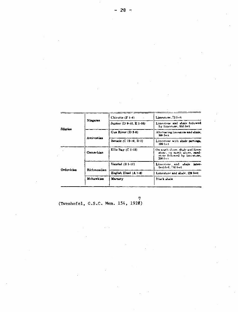
ANTICOSTI GROUP, SERIES, ANTICOSTIAN Silurian
Elkanah Billings after a study of fossils collected in Anticosti
by Richardson proposed (3857, p. 255) Anticosti Group for the beds included
in Richardson's C, D, E, F divisions. This was a proper procedure, but
Billings and later Logan (Geology of Canada, 1863, p. 298) correlated the
Anticosti Group with Medina, Clinton and Niagara of the New York section
and, in an attempt to use it as a series designation, a conflict developed
with the Niagara. Twenhofel (1927, p. 38) resolved part of this difficulty
by restricting Anticosti to the Becsie and Gun River Formations. In the
Silurian correlation chart (1942) the Becsie and most of the Gun River are
assigned to the Albion Series.
Billings, Elkanah, 1857, Report for year 1856, Can. Geol. Surv.,
Rept. of Prog. 1853-56, p. 255.
Twenhofel, W.H., 1927, Geology of Anticosti Island: Can. Geol.
Surv., Mem. 154, p. 38.
Swartz, C.K., et al., 1942, Correlation of the Silurian formations
of North America; Geol. Soc. Am., Bull. v. 53, pp. 533-538.
Bottow, T.E., 1961, Ordivician and Silurian formations of Anticosti
Island Quebec: Can. Geol. Surv. Paper 61-26
- 28 -
Silurian
Niagaran Chirotte (F 1-4)
• Limestone. 73 fiat
Jupiter (D 9-10, E I-10) Limestone and shale followed by limestone, 453 feet
Antieoetian
Gun River (D 2-8) Alternating limestone and shale. 30t. feet
Beescie (C 12-14, D 1) Limestone with shale partings. 199 feet
Ordovician
Camaehian Ellis Bay (C 1-12) On south s)orr, ,.hale anti lime
atone; on north abort., sand-stone followed by limestone, 200 feet
Richmondian
Yauréal (B 1-11) Lirni- tone and shale inter- bedded, 7:10 feet
English Head (A 1-4) Limestone and shale, 228 fret
Mohawkian Maeaaty Black shale
7 (Twenhofel, G.S.C. Mem. 154, 192$)
5.
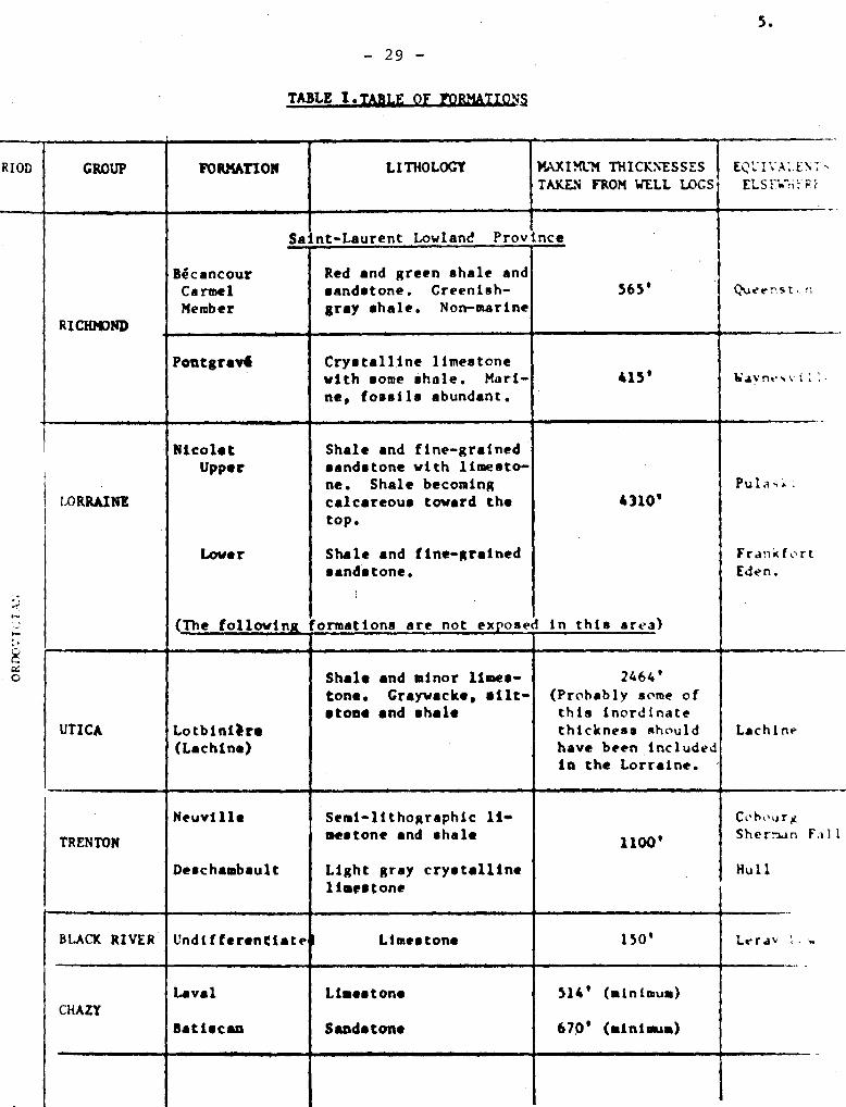
- 29 -
TABLE I .TABLE OF FORMATION
. f ~
RIOD GROUP FORMATION LITHOLOGY MAXIMUM THICKNESSES TAKEN FROM WELL LOGS ELS::w'.i: r.F
, Bécancour Carmel Member
RICHMOND
Saint-Laurent Lowland Province
Red and green shale and sandstone. Greenish- gray shale. Non-marine
565' Nernst. n
Pontgrav4 Crystalline limestone with some shale. Mari-ne, fossils abundant.
415' Way n.•, v i :
•
LORRAINE
Shale and fine-grained sandstone with limesto-ne. Shale becoming calcareous toward the top.
Shale and fine-grained sandstone.
1 (The followingjormations are not expose
Nicolet Upper
Lower
Pula,.:
4310'
Frankfort Eden.
in this area)
UTICA Lotbinira (Lachine)
Shale and minor limes-tone. Craywacke, silt-stone and shale
2464' (Probably some of this inordinate thickness should have been included in the Lorraine.
Lachine
TRENTON
Neuville
Deschambault
Semi-lithographic li- mestone and shale
Light gray crystalline limestone
Cabourg Sherman Fall
Hull
1100'
-4
BLACK RIVER Undiffertntiate
•
Laval CHAZY
Batiecan
d Limestone
Limestone
Sandstone
150'
514' (minimum)
670' (minimum)
Lerav
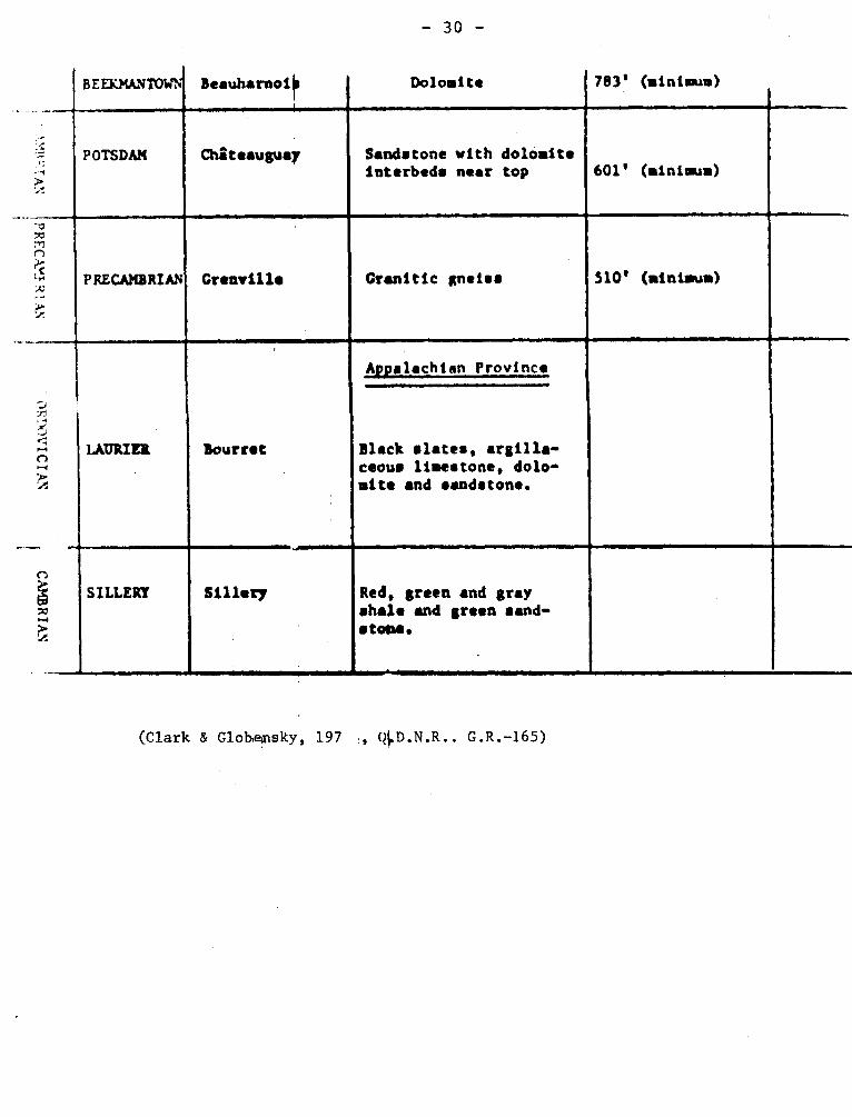
- 30 -
BEE}MANTOW Beauharnoij Dolomite 783' (minimum)
POTSDAN
â interbeds Chateauguay
,
Sandstone with dolomite near top
I
601' (minimum)
1 -p m rn
S m
r
i r
PRECAMBRIAN Grenville Granitic gneiss
4
510' (minimum)
a
~
~
as â
1
.. En
OR
' .k-WIC
I Afi
CA
KB
RI A
\
Bourret
Appalachian Province
Black slates, argilla-ceous limestone, dolo-mite and sandstone.
Sillery Red, green and gray shale and green sand-stone.
(Clark & Globepisky, 197 :, G.R.-165)
- 31 -
ANTICOSTI SEQUENCE Ordovician-Silurian
Twenhofel has used this term for the Ordovician and Silurian Rocks
exposed on Anticosti island.
Twenhofel, W.H., 1921, Faunal and sediment variation in the Anti-
costi sequence: Can. Geol. Surv., Bull. No. 33, pp. 1-14.
APPALACHIAN
The Appalachian mountain ranges, Appalachian region, or equivalent
terms are common in North American conversation. In general, it is recogni-
zed that the Appalachians extends through Newfoundland, the maritime provin-
ces, part of Quebec, and New England to Alabama. The name has been used for
several things geological, but there is no formal use of the name as a
stratigraphic name. "Appalachian rocks" is simply a condensed reference to
"rocks of the Appalachian region".
I- Appalachian Orogeny, Revolution. (Wilmarth -1-61) Paleozoic
Deformation in Quebec towards the end of the Paleozoic is hard to
prove. (Geology of Quebec, p. 1944, p. 485). As pointed out by Woodward,
the Appalachian Highlands have been the site of several orogenies. He
therefore proposed "Alleghany"for the youngest Paleozoic orogeny.
Osborne, F. Fitz, 1967, Appalachian region of Quebec: Some aspects
of its divisions and geology: Roy. Soc. Can., Special Pub. No. 10, pp. 18-24.
Woodward, H.P., 1957, Chronology of Appalachian folding: Am. Assn.
Pet. Geol., Bull. v. 41, p. 2322.
Woodward, H.P., 1957, Structural elements of northeastern Appalachians:
Am. Assn. Pet. Geol. Bull. 41, p. 1440.
II- Appalachian Geosyncline - Appalachian Foreland.
- 32 -
Although study in the Appalachian region by James Hall gave him the
ideas that led to the geosynclinal concept the name was given only later. The
foreland of the Appalachian folded zone is in the Appalachian plateau.
III- Appalachian Glacier (System of Glaciers).
Chalmers (1890) gave the name Appalachian Glacier or System of
Glaciers to an ice sheet or sheets that he inferred existed on upland
Appalachian areas northeast of Etchemin river prior to the development
of the Laurentide or Labradorean ice. That local accumulations of ice
formed on the higher parts of the Appalachian uplands is acceptable,
however, the evidence put forward by Chalmers is not valid and his name
is regarded as obsolete.
Chalmers, Robt., 1890, Glaciation of the Cordillera and the
Laurentide: Am. Geol. vo. 6, p. 325.
Chalmers, Robt., 1898, Surface Geology and auriferous deposits
of south-eastern Quebec: Geol. Surv. Can., Ann. Rept. v. X, pp. 39-1+2, J.
McGerrigle, H.W., 1952, Pleistocene glaciation of Gaspé Peninsula:
Roy. Soc. Can., Tr. 41+, sect. IV, pp. 37-51.
ARCHIAC LAKE (THRUST) FAULT.
"The Archiac Lake (Léopard Lake area) strike fault is one of the main
faults of the area. It runs from north of Désery lake, to the eastern limit
of the Léopard Lake area, a distance of about 26 miles. The schistosity of
the shear zones commonly dips 65° to 85° eastward".
Sauvé. Pierre., Bergeron, Robert., 1965, Gerido Lake-Thévenet Lake Area,
New Quebec: Quebec Dept. of Nat. Res., G.R. No. 101+, p. 79-80.
- 33 -
ARMAGH GROUP (Wilmarth -2-19) Cambrian
I-
Armagh is composed of green, red, and gray gritty sandstones inter-
bedded with colored slates and white siltstones. The group is lithologi-
cally similar to a part of the Sillery Group except that near Quebec the red
sandstones are not so abundant as in the Armagh.
Although diagnostic fossils have not been found, the formation is
assigned to the Cambrian. Hubert (1967, p. 37) has stated that the source
of the sediments was a crystalline terrane southeast of the site of deposi-
tion. He infers that the group was deposited on an unstable shelf.
Beland, Jacques, 1957, St. Magloire and Rosaire-St-Pamphile areas,
Electoral Districts of Dorchester, Bellechasse, Montmagny and L'Islet:
Quebec Dept. of Mines, G.R. 76, 11-13, First published note P.R. 279, pp. 3,4+,
1952.
Hubert, Claude, 1967, Tectonic of part of the Sillery Formation in
the Chaudiére-Matap6dia segment of the Quebec Appalachians: Roy. Soc. Can.,
Special Pub. 10, p. 37.
ARNOLD RIVER FORMATION Paleozoic
A small part of the Arnold River Formation was considered by
Selwyn and Dawson (1884) and by Ells (1887) as granitic rock of "Silurian"
(now Ordovician) age. Ells as did Dresser later mapped most of these rocks
as Precambrian and described the rocks as "hard feldspathic schists of Hu-
ronian aspect". Hitchcock and Huntington (1874) described similar rocks in
northern Maine as gneisses, and regarded them as "altered Paleozoic rocks".
The reconnaissance survey by Hurley and Thompson (1950) in Maine threw fur-
ther light on the character of these gneisses. This formation is in the
- 34 -
southern part of the map-area, close to and along the International Boundary.
In Quebec, the formation underlies about 75 square miles in two areas separa-
ted by the Araignées (Spider) Lake granite. It occurs in Woburn, Louise,
and Ditchfield townships, and is best exposed near the junction of Arnold
river and Morin brook. The main mass of the Arnold Formation is homogeneous,
dark gray, fine-to medium-grained metasandstone. Quartz, feldspar and bio-
tite can be identified with the naked eye. Foliation, the most widespread
structural element of the formation, generally is parallel to the regional
foliation. It increase from barely apparent to well developed going west-
ward.
The formation to crop out across a width of 20 miles. This suggests
that the formation probably is some thousands of feet thick, even though
numerous minor folds are know on the eastern side.
Marleau, R.A., 1968, Woburn-East Megantic-Armstrong Area, Frontenac
and Beauce Counties: Quebec Dept. of Nat. Res., G.R. No. 131, p. 9-13.
Dresser, J.A., 1908, Accent dicovery of gold near lake Megantic,
Quebec: Can., Geol. Surv. pub. 1028, p. 7.
ASCOT FORMATION Ordovician (?)
" Ascot Formation " was introduced to designate
the assemblage of metamorphosed volcanic and sedimentary rocks that cons-
titutes the bedrock of Stoke mountains and have their optimum development
in Ascot township. The volcanic sequence of this assemblage is probably
equivalent to the Weedon Schists (g.v.). The lower member of the Ascot
Formation is acidic metapyroclastic rocks, meta-rhyolites, and sericite
schists with some metavolcanic rocks of intermediate and basis composition.
Hematite cherts were encountered on the margin of chlorite schists and
- 35 -
greenstones in the city of Sherbrooke. Sandstone interstratified with
beds of microconglomerate occur on the margin of the greenstones west of
Lennoxville and northeast of Sherbrooke. In the upper part of the Ascot
stratigraphic sequence, a member composed of chert, siltstone, sandstone
and thin-bedded rocks has been recognized. Structural observation shows
that phyllites occupy the upper part of the Ascot Formation,
St. Julien, P., Lamarche, R.Y., 1965, Geology of Sherbrooke Area,
Sherbrooke County: Quebec Dept. of Nat. Res., P.R. No. 530, p. 4-8.
ASHUANIPI COMPLEX SERIES (Gneiss and Schist) Archean
This term was used by workers of the Iron Ore Company of Canada
in 19+7 or earlier to designate biotite, hornblende, garnetiferous and
granitic gneisses as well as granitic intrusive rocks. The rocks are
assigned to the Archean and are on the west side of the trough observed
to be beneath the Proterozoic rocks.
Dimroth has used "Wheeler" for an Archean complex on the east
side of the Labrador Trough.
ASSELIN FORMATION Middle (?) Silurian
It crops out poorly. Near Auclair lake, it has a high content of
lime in the form of cement for the arenites and as limestone beds. The
high solubility of calcite cement under surficial weathering, and the
consequent disintegration of the arenites, is probably the reason why the
Asselin Formation is found in valley bottoms.
Lespérance, P.J., Greiner, H.R., 1969, Squatec-Cabano Area, Rimouski,
Rivi4re du Loup and Témiscouata Counties: Quebec Dept. of Nat. Res., G.R.
No. 128, p. 52-51.
-36 -
AUGER LAKE CONGLOMERATE
Graywacke and conglomerate form a small outcrop extending
northeast through the west end of Auger Lake. The conglomerates
have rounded pebbles, among which two of coarse anorthosite were
recognized. It is said to be Temiscamian.
Longley, W.W., 1951, Bachelor Lake Area, Abitibi-East County:
Quebec Dept. Mines, G.R. No. 47, p. 7, 14.
AWANTJISH FORMATION Lower Silurian
Béland gave the name to fossiliferous gray-green shales and
siltstones with some red siltstone cropping out two miles south of
St. Cléophas in Awantjish Township. The formation is about 90 feet
thick at the type locality, but southwest of this, it is 2,500 feet
thick and is seen to overlie Cabano Formation conformably. It passes
into Val Brillant Formation by interdigitation.
The fossils indicate a range from C1 to C5 of Upper Llandoverian,
however, at the type locality only younger beds are known.
Béland, Jacques, 1960, Rimouski-Matapedia area: Quebec Dept.
Mines, P.R. 430, p. 3.
Lajoie, J., Lespérance, P.J., and Béland, J., 1968, Silurian
Stratigraphy and paleogeography of Matapedia-Témiscouata region, Quebec:
Am. Assn. Pet. Geol., Bull. v. 52, p. 628.
AYLMER FORMATION (Wilmarth -1-98) Chazy
Raymond (1905, p. 362) gave this name to sandstones and shales
cropping out near the town of Aylmer, which is a short distance west
- 37 -
of Hull. He considered that the formation, which is upper Chazy, to be
sufficiently distinctive in lithology and fauna to merit the name. It
is of diverse thickness and is developed best along Ottawa valley. Raymond
(1913, p. 140) states that limestones of the Aylmer Formation are thick
at Montreal but thin westward. In Geology of Quebec (1944, p. 182) the
formation is stated to occur only in the Aylmer-Hull district.
A.E. Wilson (1937m p. 46) has substituted tha names "Rockcliffe" and
St-Martin for Aylmer Formation. "Rockcliffe Formation" is, however, not used
in Quebec except for rocks in the vicinity of Hull.
Raymond, P.E., 1905, The fauna of the Chazy limestone: Am. Jour. Sci.
v. 20, p.362 .
Raymond, P.E., 1913, Ordovician of Montreal and Ottawa: Geol. Surv.
Can., Int. Cong. 1913, Guide Book 3, p.140.
Wilson, A.E., 1937, Erosional intervals indicated by contacts in the
vicinity of Ottawa, Roy. Soc. Can., Tn; v. 31, Sect. IV, p. 46.
AZOIC ERA Precambrian
In "Geology of Quebec" (1863, p. 20) "Azoic" or "azoic" is used as
a synonym for Precambrian. It was divided into two divisions, - actually
the first divisions proposed for Azoic rocks anywhere , Laurentian and Hu-
ronian.
BACHELOR LAKE GRANITE Precambrian
This granite is so poorly exposed that the outcrop area can be
shown only approximately. Good exposures on the south shore of Bachelor
lake show a medium- to coarse-grained rock of fresh appearance with 25
- 38 -
per cent quartz, with potassic feldspar and albite. It is surmised that
this granite was related to the metallic mineral deposits southwest of
the lake.
Longley, W.W., 1951, Bachelor Lake Area, Abitibi-East County:
Quebec Dept. of Mines, G.R. No. 47, p. 21.
BAGAMAC FAULT.
A zone of schistosity and fracturing can be seen at intervals for nearly
2 miles, from the Nipissing Central Railway on the west to the eastern out-
skirts of Rouyn townsite. The amount of displacement of this fault has not
been determined, but the width of the zone of schistosity and the difference
in the rocks on opposite sides of the fault indicate that the movement was
considerable.
Wilson, M.E., 1949, Noranda District, Quebec: Canada, Dept. of Mines
and Resources, Mem, 229, p. 54-55.
BAIE-DES-MOUTONS-SYENITE
Davies has given this name to a medium- to fine-grained
syenite to quartz syenite with a circular outcrop, partly covered
by water, about fifteen miles diameter. The body is heterogeneous,
and, although the walls are steep, layers dip inward with decrea-
sing inclination towards the center.
Davies, Raymond, 1965, Baie-des-Moutons area, Duplessis
county: Quebec Dept. Nat. Res., P.R. 543, p. 7.
BARDEY (MAN) LAKE ZONE (Of Shickshock Group) Lower Paleozoic
- 39 -
Rocks of this zone are similar to those of Bivé Brook except
that they are generally finer grained. Colour banding is rare; this
and the fineness of grain makes bedding particularly difficult to
recognize. In the one outcrop in which bedding was recognized with
certainty it is parallel to schistosity. The relatively rare quartz
veins are generally less than one inch thick and one foot long, and
they are parallel to the foliation. Scattered small veins of
feldspar or pegmatitic feldspar and quartz also occur.
Mattinson, C.R., 1964, Mount Logan Area, Matane and Gaspé-North
Counties: Quebec Dept. of Nat. Res., G.R. No. 118, p. 38-39.
BARRAUTE (PLUG) GRANITE Precambrian
The intrusive is about 7,000 feet long and 5,000 feet wide.
The rock is a porphyritic albite granite in which the phenocrysts of
quartz and feldspar reach nearly half an inch diameter.
McDougall, David J., 1965, Southeast quarter of Barraute
Township: Quebec Dept. of Nat. Res., G.R. No. 114, p. 10.
BARRY LAKE GNEISS Precambrian
Light, grey, coarse-grained gneiss underlies the greater part of
Barry, Bailly, Lacroix, and Coursol townships. The rock is composed of
diverse proportions of quartz, biotite, and oligoclase or andesine feldspar.
Hornblende is locally abundant constituent and may take the place of biotite.
The feldspar is only slightly altered, chiefly to epidote and zoisite, and
in general the rock has a fresh appearance. Although commonly referred to
as granite gneiss, the rock in several occurrences would be described as
oligoclase-granite gneiss.
40 -
Milner, R.L., 1943, Barry Lake Area, Abitibi County and Abitibi
Territory: Quebec Dept. of Mines, G.R. No. 14, p. 11-12.
BASCON (MEM) BROOK ZONE (of Shickshock Group) Lower Paleozoic
Rooks of this zone are mainly white mica schists, but some limestones
are exposed at places along Bascon Brook. The principal minerals of the
schists are white mica, quartz, and albite; lesser ones are chlorite, epi-
dote, titanite, magnetite, and pyrite. In some of the schists, quartz and
feldspar are arranged in minute segregation layers parallel to the schisto-
sity. Many such layers trace out complex recumbent folds with dimensions of
the order of 1-2 cm. The axial planes and long limbs of these minute folds
are parallel to the schistosity of the rock as a whole.
Mattinson, C.R., 1964, Mount Logan Area, Matane and Gaspe-North
Counties, Quebec Dept. of Nat. Res., G.R. no. 118, p. 43-44.
BAS DE STE-ROSE FAULT
There is no visible evidence in the Beloeil sheet for the existence of
the Bas de Ste-Rose fault. This fault is projected from its known position
in the Laval area eastward into the Beloeil area, first, because the dislo-
cation involved along this fault in the Laval area was so great as to demand
some such extension, and second, because evidence from water-wells concerning
the distribution of the red Queenston beds indicates a disruption of the
western margin of the Queenston, into the area of Queenston rocks. It strikes
eastwest,
Clark, T.H., 1944, Structure and stratigraphy in the vicinity of Montreal:
Roy. Soc. Can., Tn. 38, Sec. IV, p. 31.
- 41 -
BASSWOOD CREEK FORMATION (Wilmarth -1-124) U. Canadian
In "Geology of Canada" (1863, pp. 844-847) Logan gives a section of
the "Phillipsburgh Series" (g.v.), a part of the Quebec Group. The section
is within what was later termed the Philipsburg slice. Basswood Creek is the
uppermost of four formations assigned to Upper CanadianiClark (1934, p. 5-7)
published the name, but the brief description is from Geology of Quebec (1944,
p. 400) and is by Clark and McGerrigle. The formation, which is made up of
dark grey shales with dark limestone, is about 70 feet thick and is not known
to have fossils.
Clark, T.H., 1934, Structure and stratigraphy of southern Quebec,
Geol. Soc. Am., Bull. v. 45, pp. 6-7.
BEACONSFIELD MEMBER Chazy
Hoffman proposed this name for greenish shales, shaly limestones,
and gray limestones in the Pointe Claire Quarry, St. Charles Road, Bea-
consfield. Neither the base nor summit of the 65 foot section is exposed.
The member is characterized by Rostricellula plena and makes up part of
the upper Laval Formation of the Chazy.
Hoffman, H.J., 1963, Ordovician Chazy Group in Southern Quebec:
Am. Assn. Pet. Geol., v. 63, p. 281.
BEATTIE FAULT
"It branches away from the Porcupine - Destor fault 4,000 feet west of
the Beattie shaft. It has been traced east for a distance of 4 miles. The
fault zone has a width of 400 to 600 feet. It dips 75° to 80° north."
Graham, R.Bruce., 1954, Parts of Hebecourt, Duparquet and Destor Townships,
Abitibi-West County: Quebec, Dept. of Mines, G.R. No. 61, p. 34.
- 42 -
BEATTIE SYENITE PORPHYRY Precambrian
The Beattie Mine vicinity was mapped by O'Neill (1933) and it was
recognized that the then known ore bodies were associated with a stock of
syenite to quartz syenite. Two varieties, a syenite porphyry and a bosto-
nite porphyry, were mapped. Both rocks are essentially leucocratic with
an obvious trachytic fabric in the bostonite, which name is unsuitable for
the rock. Davidson and Banfield (194 4) used Beattie Syenite Porphyry for
both rocks.
O'Neill, J.J., The Beattie Gold Mine, Duparquet Township: Quebec
Bur. Mines, Ann. Rept. 1932, pt. C., pp. 15-17.
Davidson, S. and Banfield, A.F., 1944, Geology of the Beattie
Gold Mine, Duparquet, Quebec: Econ. Geol. v. 39, pp. 537-538.
BEAUHARNOIS FORMATION
This name was used as early as 1863 by Chapman, but it is generally
considered, that the 1913 description by Raymond marks the formal proposal
of the use of the name for the upper part of the Beekmantown Group. The
formation consists of dolomites and sandy dolomites in the vicinity of Mon-
treal. The formation includes some shales in a section of more than 1,000
feet shown in a well north of Montreal, but it is appreciably thinner at
other localities and is not recognized in exposures east of St. Maurice River.
Clark, T.H., 1952, Montreal Area: Que. Dept. of Mines, G.R. 46,
pp. 29-34.
BECANCOUR RIVER
Richmond Group Ordovician
B6cancour River Formation is the name proposed by Clark for the
red shales and sandstones that have been consistently referred to
as Queenston, Carmel River member is the lower 53 feet of the section
on Nicolet river and is greenish-grey shales or sandstones. The for-
mation which is without fossils, is between 1,000 and 1,500 feet thick
along the syncline in which it crops out.
Clark, T.H., 1964, Yamaska-Aston area: Quebec Dept. Nat. Res.,
G.R. 102, pp. 8-16.
BECSIE (RIVER) FORMATION Silurian
The very fossiliferous lower part of the Silurian section on
Anticosti island bearing Richardson-Logan designation C.12 to D-1 was
named the Becsie River Formation by Schuchert and Twenhofel. The name
was changed,perhaps by inadvertance, to Becsie. The formation consists
of above 200 feet of gray to redsish gray limestone with shale partings.
Schuchert, C., Twenhofel, W.H., 1010, Ordovicic -Siluric Section
of the Mingan and Anticosti Islands, Gulf of Saint-Lawrence, Geol. Soc.
Am., Bull., vol. 21, p. 695.
BEDFORD FORMATION Ordovician
Ami proposed this name for calcareous beds believed to be
about the age of the Levis Formation. No type section is given.
Confusion with' Bedford limestone used for building is another reason
for abandonning this name. See Corey limestone
Ami, H.M., 1900, Synopsis of the Geology of Canada: Roy. Soc.
Canada, Proc. and Trans., 2nd ser., vol. 6, sec. 1+, p. 200.
BEEKMANTOWN GROUP (FORMATION) Ordovician
This name has been used both as a group and formation designation
since about 1900 and is equivalent to the Calciferous of older writers.
Logan (1863, p. 20) for example, lists Calciferous as equivalent to Levis
- 4s4 -
and together with Chazy as making up the "Lower Silurian" Quebec Group.
Canadian has been used for essentially the same beds or interval, but its
use in this sense is not necessary for it can be confused with a geogra-
phical reference.
Near Montreal the lowlands facies of the Beekmantown is divided
into the Theresa and Beauharnois Formations.
BEETZ LAKE ANTICLINE.
This symmetrical anticline trends northwesterly and plunges southeast
at an undetermined angle. Its axial plane is vertical in the vicinity of
Lac de l'Est but dips approximately 70° west in its southern part. The axis
crosses the southern limit of the area one mile east of Napoléon lake.
Grenier, Paul-E., 1957, Beetz Lake Area, Electoral District of Saguenay:
Quebec; Department of Mines, G.R. No. 73, p. 53-54.
BELAND ANTICLINE.
The position of the axis of this anticline,,which is south of the
Bonnécamp syncline, was determined by the type and distribution of debris.
Silurian rocks are exposed along its axis.
McGerrigle, H.W., 1959, Madeleine River Area, Electoral District of
Gaspé North: Quebec, Dept of Mines, G.R. No. 11, p. 41.
BRIMS FOR1dA.TION
Beekmantown
Ordovician
Cady (1945, P. 550) gave this name to orange-buff-weathering
limestone interbedded with snow-white limestone occurring in thickness up
- 45 -
to 700 feet in foreland or foreland-fault slices in Vermont. The forma-
tion was assigned by Cady to Chazy, but both Clark (1964, p . 11) and Kay
(1958, p. 79) assign the formation to the Beekmantown in discussing the
occurrence near St. Dominique.
Cady (1960, p. 573) agreed with the conclusion set forth by
Kay (1958, p. 79) that the Beldens Formation is the eastern facies of the
Bridport Dolomite and is to be considered Beekman town rather than Chazy,
and Cady and Zen (1960, p. 728-739) suggested that the Burchards, Weybridge,
Beldens, and Bridport are members of the Chipman Formation. In the Hubert
wells, Quebec (Clark, 1955) core from immediately below the sandy beds of the
Laval Formation shows cuttings of an alabaster-like dolomitic limestone, idem
tical in lithology and stratigraphie position with the Beldens formation of
the St. Dominique area. There the Beldens formation has been estimated to be
about 275 feet thick.
Cady, W.M., 1945, Stratigraphy and structure of west central
Vermont: Geol. Soc. Am., Bull. v. 56, p. 550.
Clark, T.H., 1964, St. Hyacinthe area (West Half): Quebec
Dept. Nat. Bee., G.R. 101, p. 11-16.
Kay, G.M., 1958, Ordovician Highgate Springs sequence of
Vermont and Quebec and Ordovician classification: Am. Jour. Sci., v. 256,
pp. 78-80.
Cady, W.M., 1960, Stratigraphie and tectonic relationships
in Northern Vermont and Southern Quebec: Geol. Soc. Am., Bull. v. 71,
p. 573.
Kay, G.M., 1958, Ordovician Highgate Springs sequence of
Vermont and Quebec and Ordovician classification: Am. Jour. Soi., v. 256,
p. 79.

-4G -
Cady, !.Y., and Zen, $-An., 1960, Stratigraphie relationships
of the Lower Ordovician Chipman Formation in west-central Vermont: la. Jour.
Soi., v. 258, pp. 728-739.
Clark, T.H., 1955, St. Jean-Beleeil Area, Iberville, St. Jean,
Hapierville-Iaprairie, Renville, Chambly, St. Hyacinthe and Verchéres Counties:
Quebec Dept. of mes, G.B. No. 66, p. 10.
BELL RIVER COMPLEX (ANORTHOSITE)
The name was given by Freeman (1939) to rocks grading from meta-
anorthosite to meta-pyroxenite cropping out along Bell River. He gives a
section of about 20,000 feet, but in adequate exposures render the interpre-
tation suspect. The layered part of the complex with both assymetrical and
symmetrical layers have been described by Black (Freeman and Black, 1944)
The plagioclase is between An50 to An67 but is associated with
clinozoisite and epidote which suggests that the original composition was
calcic than An67. The high calcity is characteristic of the stratiform
bodies. The so-called Chibougamau anorthosite is a probable correlative
of this complex if both are not a part is of one body introduced before
folding of the adjacent metavolcanics.
Freeman, B.C., 1939, The Bell River Complex, northwestern Quebec,
Jour. Geol. v. 47, pp. 27-46.
Freeman, B.C., and Black, J.M.. 1944, The Opoaka River Area, Abitibi
Territory: Quebec, Dept. of Mines, G.R. No. 16, pp. 8-13
BENNETT Cambrian (?)
Bennett is an insignificant hamlet six miles west of Black Lake.
-47-
Bennett Quartzite (Wilmarth -1-161)
Knox states that the name was given because of the good exposures
on the hill slopes around Bennett. It is much crumpled whitish gray to
greenish gray quartzite. The associated schists are "hard, solid, and
compact", a feature which distinguishes them from the schists of L'Islet.
Formation (1.v.)0 Knox assigns it to Precambrian.
Knox, J.K., (1917), Southwestern part of Thetford-Black Lake Mining
District (Coleraine Sheet): Geol. Surv. Can., Summ. Rept. 1916, p. 233-234.
II- Bennett Schist (Group) Cambrian (?)
Most workers after Knox have used Bennett for rocks so lithologically
unlike the description by Knox that the name must be regarded as that of
another formation. For example, Cooke (1937) states that sericite schist,
and chlorite schist are common constituents of the formation, which also
has some limestone. Tolman (1936), Cooke (1937), Béland (1957), have con-
sidered that the Bennett is metamorphosed Caldwell with, for Cooke (1954)6)
some Oak Hill (Sweetsburg) and for Béland some Rosaire and Armagh.
The evidence available in 1969 shows that the Bennett is a metamor-
phic facies developed on predominantely clastic rocks of several formations.
The name should be abandoned in the larger sense because Sutton has
priority.
Knox, J.K., 1917, loc. cit., Tolman, Carl., 1936, Lake Etche-
min Map-area, Quebec: Geol. Surv. Can., Mem. 199, pp. 56.
Cooke, H.C., 1937, Thetford, Disraeli, rind Eastern half of
Warwick map-areas, Quebec: Geol. Surv. Can., Mem. 211, pp. 10-13.
Cooke, H.C., 1954, The Green Mountains anticlinorium in
Quebec: Geol. Assn. Can. Pr. v. 6, Pt. 11, p. 43.
-48—
Béland, Jacques, 1957, St. Magloire and Rosaire - St-Pamphile
areas: Quebec Dept. Mines, G.R. 76, p. 10. Geology of Quebec, 1944, G.R.
20, p. 340, p. 377.
BERRY MOUNTAIN SYNCLINE
It is a somewhat basin-like fold, subcircular in surface plan, the
axis of which runs slightly south of west in the central part of the area.
The fold plunges west, except in the southwestern part of the area where
the axis appears to be approximately horizontal. It is part of the syncli-
norium which extends along the axis of the peninsula, and corresponds in
position to the Central belt,
Carbonneau, C., 1959, Richard-Gravier Area, Gaspé Peninsula:
Quebec Dept. of Mines, G.R. No. 90, p. 13.
BERTIN LAKE FAULT.
A fault southeast of Bertin Lake separates a "block" with predominant
basalts from one on its northeast with arkoses and conglomerate.
Dimroth, Erich, 1964, Geology of Romanet Lake Area, New Quebec: Quebec,
Dept. of Nat. Res., P.R. No. 523, p. 11-12.
BETHOULAT LAKE PLUTONIC SERIES (Neale)
BETHOULAT LAKE SERIES (BERARD) Precambrian
Anorthosite, pyroxene amphibole diorite, granite, augengneiss, etc...
have been grouped together as possibly comagmatic rocks by Neale (1965,
p. 22) who proposed the name in an unpublished thesis presented in 1922.
Neale, E.R.W., 1965, Bethoulat Lake Area, Mistassini Territory:
Quebec Dept. Nat. Res., G.R. 112, p. 22.
-49 -
Berard, Jean, 1965, Toco-Temiscamie Area, Mistassini Territory, Quebec
Dept. Nat. Res., G.R. 113, pp. 18-22.
BILLY LAKE QUARTZ PORPHYRY Precambrian
Longley has called an extensively altered rock showing what he
believes are phenocrysts of opalescent quartz the Billy Lake Quartz
Porphyry. The outcrop is mostly north of Billy lake but extends
across the eastern limit of the map area. The feldspars, apparently
both potassic and plagioclase, have been converted to scaly alteration
'products, and the rock shows evidence of shearing.
Longley, W.W., 1951, Bachelor Lake Area, Abitibi-East County:
Quebec Dept. of Mines, G.R. no. 47, p. 20.
BIRDSEYE LIMESTONE Lower Ordovician
This term was in use for a limestone above the Beekmantown Sandstone
of New York and thus included Chazy Limestone. In "Geology of Canada" (1863,
p. 137) ten feet of limestone between the Chazy Limestone below and the
Lowville Limestone above is assigned to the Birdseye. At present, Birdseye
is considered the middle formation (Lowville) of a Black River Group.
The Birdseye is a dark, commonly somewhat shaly, limestone with the small
white spots, which give it is name. The spots are sections of corals.
The name has not been used formally for a formation in a geological
publication since 1904. It has some use as a descriptive term.
BIVE (TAG) BROOK ZONE (of Shickshock Group). Lower Paleozoic
These metasedimentary rocks are typically grey to black on fresh
-50-
surface. The weathered surface is some shade of brown. Granularity ranges
from medium to aphanitic. Apart from a very few outcrops all these rocks
show one dominant S-plane here called foliation. The foliation results
from the coincident orientation of one or more of the planar elements,
including fissility, platy mineral aligment (schistosity), colour layering,
and fine lamination apparently due to metamorphic segregation. Bedding is
revealed at a few places by coarse colour layering, grain gradation, inter-
layering of fine and coarse layers, and interlayering of different litho-
logies.
Mattison, C.R., 1964, Mount Logan Area, Matane and Gaspé-North
Counties: Quebec Dept. of Nat. Res., G.R. No. 118, p. 34-38.
BLAKE RIVER VOLCANICS, GROUP Archaean
The Blake River Volcanics or Group include formations assigned to the
Cadillac Belt by Gunning (1937, p. 6, p. 11). The group consists of 700 feet
of volcanis on the north limb of the syncline south of Malartic lake, but the
thickness is greater to the northwest, becoming 6,000 feet in 20 miles. Some
metasedimentary rocks are intercalated in the volcanics.
On the map for the Cadillac area, Gunning (loc. cit.) divided the
group into three parts: cropping out on the north, the lower half of the group
is greenstones; a thin middle part consists of rhyolite derivatives, and an
upper part consists of tuff and agglomerate. For the Cléricy map area Ambrose
(1941, p. 14-18) suggests a minimum thickness of 20,000 feet and uses a four-
fold division of the group.
Baragar (1968) has presented results of sampling of two sections of the
group. One involves about 40,000 feet of strata and extends across the Ontario
border south of the Porcupine-Destor fault. The other section of 12,500 feet
-51 -
is north of the fault in Quebec. The longer section is believed to show syste-
matic variation in composition in rocks altered at a low grade. The analyses
show that the rocks are mostly of the composition of andesites and basalts.
Gunning, H.C., 1937, Cadillac Area, Quebec: Canada Geol. Surv., Mem. 206,
p. 6, p. 11.
Gunning, H.C., Ambrose, J.W., 1939, The Timiskaming-Keewatin Problem in
the Rouyn-Harricanaw Region, North-Western Quebec: Roy. Soc. of Canada, Third
Series, Section IV, Tn. volume XXXIII, 1939, p. 27.
Ambrose, J.W., 1941, Cléricy and La Pause Map-Areas, Quebec: Canada
Geol. Surv., Mem. 233, pp. 14-18.
Baragar, W.R.A., 1968, Major element geochemistry of the Noranda belt,
Quebec-Ontario: Can. Jour. Earth Sci., 5, p. 773-790.
BOLTON LAVAS Ordovician
(Wilmarth -1-230) Clark (1934) suggested that certain altered basic
lavas of the Mansonville map-area are younger than the Magog Shales
with which they are associated and gave to these rocks and to some
meta-gabbros and serpentinites the name "Bolton igneous series". In
1936, he and Fairbairn used for them the designation "igneous group".
Ambrose (1942) and Fortier (1963) were able to demonstrate that the
lavas are interbedded with the Ordovician rocks, but Cooke (1948, 1950) re-
asseverated the conclusions of Clark. Ambrose (1957) showed the
untenability of the Clark-Cooke interpretation.
It is difficult to relate plutonic and effusive rocks so that Bolton
can well be eliminated as a stratigraphie name. The meta-lavas are most
easily designated by the name of the sequence in which they occur.
Clark, T.H., 1934, Structure and stratigraphy of southern Quebec:
-52-
Geol. Soc. Am., Bull. 45, p. 12, p. 19.
Clark, T.H. and Fairbairn, H.W., 1936, The Bolton igneous group of
southern Quebec: Royal Soc. Can., Tn. vol. 30, Sec. IV, v. 30, p. 13-18.
Ambrose, J.W., 1942, Mansonville Map-area: Geol. Surv. Can., Paper 42.1,
Fortier, Y.O., 1946, Geology of Orford Map-area: Stanford University
thesis, p. 128.
Cooke, H.C., 1948, Age of the Bolton lavas, Memphremagog district,
Quebec: Royal. Soc. Can. Tn. 42, Sec. IV, pp. 17-27.
Cooke, H.C., 1950, Geology of a southwestern part of the Eastern
Townships of Quebec: Geol. Surv. Can., Mem. 257, pp. 79-99.
Ambrose, J.W., 1957, The age of the Bolton lavas, Memphremagog district,
Quebec: Nat. Can. 84, pp. 161-170.
BONNECAMP SYNCLINE.
This syncline, which trends north of east, is characterized by folds
on a smaller scale than those of the Champou syncline and Bald Mountain
anticline. It has localized folds associated with some cross-folds. The
dome structure on the north side of Needle mountain is a result of a crosse
fold.
McGerrigle, H.W., 1959, Madeleine River Area, Electoral District of Gaspé
North: Quebec, Dept. of Mines, G.R. No. 11, p. 40.
BONSECOURS FORMATION Cambrian (?)
Osberg proposed Bonsecours Formation for 500 to 2000 feet of
grey and green phyllite or locally red slate occurring in an area about
Knowlton and Richmond. The beds are considered equivalent to parts of the
Oak Hill Group.
- 5 3 -
Osberg, P.H., 1965, Structural geology of the Knowlton-
Richmond area, Quebec: Geol. Soc. Am., Bull. v. 76, p. 226.
BOULDER BAY QUARTZITE
Proterozoic
See T6miscamie Formation.
BOULEAUX POINT SEQUENCE - CALC-ARGILLITIC SEQUENCE Precambrian
This formation, composed of argillites, sandstones, quartzites,
and limestone, overlies the stromatolitic limestones. The argillites
and gray, brown weathering limestones, in beds varying from some inches
to one foot in thickness predominate in the lower portion of this for-
mation. The higher portion of the formation consists of dark gray
quartzites (beds between 2 inches and one foot thick) of argillite,
calcareous sandstone and limestone. Quartzite and argillite predo-
minate in the upper portion of the formation.
Dimroth, Erick, 1966, Geology of Dunphy Lake Area, New Quebec
Territory: Quebec Dept. of Nat. Res., P.R. No. 557, p. 1 , 6.
BOURGAULT LAKE SYNCLINE
This Syncline, which is the most obvious of those of the Harveng
Lake area, plunges 20° southeastward. Its western limb dips moderately to
steeply east, and the eastern limb is overturned with most dips 50° to 80°
east.
Sauvé., Pierre and Bergeron, Robert., 1965, Gerido Lake-Thérenet Lake
Area, New Quebec: Quebec, Dept. of Mines, G.R. No. 104, p. 85
-54—
BOURLAMAQUE GRANODIORITE
The Bourlamaque granodiorite is a mass about 6 miles from
north to south. It lies chiefly in Bourlamaque township but also extends
north into Senneville and Pascalis, and east into Louvicourt townships.
The body is a coarse-grained rock, pink to grey, granitic in texture
and distinguished in most localities by large, opalescent eyes of quartz.
Cooke, H.C., James, W.F,, Mawdsley, J.b., 1931, Geology and Ore Deposits
of Rouyn-Harricanaw Region Quebec: Canada, Geol. Surv,, Mem, 166, p. 133.
BOUZAN LAKE FAULT
"This thrust fault is the eastward continuation of one recognized in
the Granada area along the contact between the Temiscamian conglomerates and
the Keewatin tuffs". This fault was later considered part of the Cadillac -
Lac Bouzan system (a.v.)
Hawley, J.E., 1933, McWatters Mine Gold Belt, East-Rouyn and Joannès
Townships, Annual Report of the Quebec Bureau of Mines for the Calendar Year
1933, Part C, p. 25-26.
BOWES FAULT.
"It lies along the south boundary of the McWa ters syncline at its
western wedge-shaped end. Its dip is steep to the north"
Wilson, M.E., 1962, Rouyn-Beauchastel Map-Areas, Quebec: Canada, Geol.
Surv., Mem, 315, p. 41
- 5 5 -
BRANDON ANORTHOSITE
In the western half of Brandon, there are three important areas of
anorthosite which occur interbanded with the nearly horizontal gneisses of
this district. Anorthosite has the appearance of an interstratified mass.
Adams, Frank D., 1896, Report on the geology of a portion of the
Laurentian Area lying to the North of the Island of Montreal: Ottawa Geol.
Surv. of Canada, Ann. Rept. VIII, 1895, J., p. 126
BRIEN ANORTHOSITE GABBRO Precambrian
Anorthosic gabbros and their altered varieties underlie about five
square miles in the central part of Brien township, north of the Hart-
Jaune fault. The peaks in the western part of the massif are made up
of dark massive anorthositic and gabbroic rocks, and rocks of the slopes to
the south are hornblende-plagioclase gneisses. Mineralogical and textural
changes can be followed from the massive, coroitic, anorthositic gabbro
to the hornblende 'plagioclase gneisses. The degree of deformation increases
gradually southward.
Kish, Leslie, 1968, Hart-Jaune River Area, Saguenay County: Quebec
Dept. of Nat. Res., G.R. No. 132, p. 61-63.
BRISTOL SERIES Precambrian
M.E. Wilson (1924) gave the name to metasedimentary and possibly
metavolcanic rocks cropping out in a small area in Bristol township, Quebec.
Sabourin (1965) in re-mapping the area confirmed the presence of limestone
and quartzite but presented the opinion that"meta-rhyolites and meta-ande-
sites"are derived from sedimentary rocks, perhaps calcareous siltstones.
-56-
The view presented by Wilson that the rocks are a facies
of the Grenville Series is reasonable.
Wilson, M.E., 1924, Arnprior-Quyon and Maniwaki Areas, Ontario and
Quebec: Canada Geol. Surv., Mem. 136, pp. 23-28.
Sabourin, R.J.E., 1965, Bristol-Masham Area, Pontiac and Gatineau
County: Quebec Dept. of Nat. Res., G.R. 110, pp. 14-15.
BROADBACK SERIES
H.C. Cooke (1914, p. 337) used this name for metasedimentary rocks
overlying metavolcanic rocks along Broadback river. Cooke states that, if
the conglomerates at the base of the series are not repeated, their thick-
ness is about 1000 feet. He records granite pebbles and cross-bedding in
the conglomerates. Shaw (1940) has used the name, but adds little to the
data on the series. Gillett (1966) is of the opinion that in the Assinica
Lake Areas. The conglomerates are near the top of the Group.
Cooke, H.C., 1914, An exploration of the headwaters of the Broadback
or Little Nottaway river, northwestern Quebec Can. Geol. Surv. Summ. Rept,
1912 p. 339
Shaw, George, 1940, Assinica Lake Quebec: Can. Geol. Surv. Paper
40-20 Mishagomish Lake Quebec: Geol. Surv. Paper 40-21
Gillett, L.B., 1966, Geology of Lake Assinica Area, Abitibi Terri-
tory: Quebec, Dept. Nat. Res. P.R. 550
BROCK SERIES Archean
Cooke (1919) used this name for a the metasedimentary rocks that
-57-
cross Brock river above its junction with Chibougamau river. The unit
there has a "basal" conglomerate very poorly exposed but showing 30 per
cent hornblende granite pebbles. Alteration products of grits and sandy
shales are found.
This name cannot be considered current. Workers in adjacent areas
and even in the original region have used Opimeska or other names.
Cooke, H.C., 1919, Some stratigraphie and structural features of the
pre-Cambrian of northern Quebec: Jour. Geol. v. 27, pp. 191-193.
BROUGHTON SERIES (facies of "Serpentine belt") Paleozoic (?)
The Broughton series consist of serpentine, soapstone, and
greenstone schists. They are the rocks containing, and adjacent to,
the asbestos and talc deposits of Robertson, East Broughton, and
Broughton, and of several isolated locations in the vicinity. This
"series" is softer than the Thetford series(q.v.). The term serves no
useful purpose.
Dresser, J.A., 1910, Serpentine Belt of Southern Quebec:
Canada Geol. Surv., Summ. Rept., 1909, p. 190.
BRUNET LAKE FAULT.
"It is probably a high-angle reverse one like the Archiac Lake fault and
other major longitudinal faults of the area. Its displacement is large near
Brunet lake, but could be small in the Gerido Lake area. The fault possibly
extends southward and joins the Archiac Lake fault." It strikes northerly.
Sauvé, Pierre., Bergeron, Robert., 1965, Gerido Lake-Thévenet Lake Area,
New Quebec: Quebec, Dept. of Mines, G.R. No. 104, p. 78
-58-
BUNKER SLATES Paleozoic
Clark (1934, p. 11-12) published this name proposed by Kerr for
dark slates in the area east of Memphremagog lake. A tentative age of
Lower Cambrian was assigned to these rocks. However, their precise loca-
tion has not been published,and the formation name is best regarded as
abandoned.
Clark, T.H., 1934, Structure and stratigraphy of southern Quebec:
Geol. Soc. Am., Bull., v. 45, pp. 11-12.
BUNKER THRUST, BUNKER UNDERTHRUST
Kerr concluded that a fault extending across the southern part of
Memphremagog lake and along Massawippi lake is an underthrust although the
arguments in support of the concluded have not been published by Clark
(off. cit., p. 15) who mentioned the fault. Doll (1951, p. 52) states that
its southwestward prolongation in Vermont is the Ware Creek thrust which is
believed to have a displacement of 4000 feet.
Doll, C.G., 1951, The Memphremagog quadrangle and the southeastern
portion of the Irasburg quadrangle, Vermont: Vermont Geol. Surv., Bull. No. 3,
p. 52.
CADILLAC SEDIMENTS GROUP
Gunning (1937, pp. 8-11),in the Cadillac area, used
Cadillac Sediments for graywackes with sane iron formation and
conglomerate lying between Blake River Volcanics on the north
and the "Cadillac belt" on the south. In 1939, Gunning and
Ambrose use Cadillac Group for the 5,000 feet or more of meta-
sedimentary rock occupying the trough of the regional syncline.
-59 -
They record more varieties of rock than reported by Gunning
and also point out the irregularity of distribution of varieties.
Wilson (1956, p. 148) inclines to the opinion that the Cadillac
Groups belongs to the Timiskaming Series.
Gunning, H.C., 1937, Cadillac Area, Quebec: Canada Geol.
Surv., Mem. 206, p. 8-11.
Gunning, H.C., Ambrose, J.W., 1939, The Timiskaming-
Keewatin Problem in the Rouyn-Harricanaw Region, North-Western
Quebec: Roy. Soc. of Canada, Third Series, Section IV, vol. XXXIII,
1939, p. 30-31.
Wilson, M.E., 1956, Early Precambrian Rocks of the Timis-
kaming Region, Quebec and Ont., Can. Bull. of the Geol. Soc. of
America, vol. 67, p. 1409.
CADILLAC BREAK FAULT CADILLAC - LAC BOUZAN FAULT CADILLAC - LARDER_LAKE FAULT
Gunning and Ambrose (1939, p. 35) proposed the name Cadillac
Break for the fault causing east-west striking shearing in the Rouyn-
Harricanaw region. M.E. Wilson (1943, p. 123) in an area to the west
referred to the fault as the Cadillac - Lac Bouzan fault zone. Hawley
(1934, p. 26) had given the name Bouzan Lake fault in the McWatters
area and recognized its extension westward into the Granada area.
Finally, M.E. Wilson uses the name Cadillac - Larder Lake fault.
Gunning, H.C., and Ambrose J.W., 1939, The Timiskaming-
Keewatin Problem in the Rouyn-Harricanaw Region, North-Western Quebec:
Roy. Soc. Can., Tn. v. 33, p. 35.
-60—
Wilson, M.E., 1962, Rouyn-Beauchastel Map-Areas, Quebec:
Canada Geol. Surv., Mem. 315, p. 40-41.
Hawley, J.E., 1934, McWatters Mine gold belt, East-Rouyn and
Joannis: Annual Rept. of the Quebec Bureau of Mines for the Calendar
Year 1933, p. 26.
Wilson, M.E., 1943, The Early Precambrian succession in
Western Quebec: Roy. Soc. Can., Proc. 1943, Third ser., Vol. XXXVII,
sec. IV, p. 123.
CADILLAC - LARDER LAKE FAULT.
"The fault is indicated by a zone of rusty westhering ankerite - talc -
chlorite schist from 100 to 500 feet wide cut by numerous veins of quartz.
The fault plane dips about 70° N, and in places, as is usual with thrust faults,
occur where an overturned anticline has been thrust over an adjacent syncline;
in other places, however, the structure is more complex".
Wilson, M.E., 1962, Rouyn-Beauchastel Map-Areas, Quebec: Canada, Geol.
Surv., Mem 315, p. 40.
CAIRNSIDE MEMBER (0f Châteauguay Formation). Cambrian
The rocks of this member are typically exposed for a few miles
southeast of Cairnside corners. The type section is to be seen along
the road going southeast from Cairnside. It is nearly pure orthoquart-
zite with siliceous, or rarely dolomitic cement.
Clark, T.H., 1966, Chateauguay Area, Chateauguay, Huntingdon,
Beauharnois, Napierville and St. Jean Counties: Quebec Dept. of Nat.
Res., G.R. No. 122, p. 20-29.
- 61 -
CAIRNSIDE AND SAINT-ANTOINE-ABBE FOLDS.
"The peculiar distribution of the Cairnside beds between Cairnside
and Saint-Antoine-Abbé invites the suggestion that these beds have been
folded into synclinal forms."
This structure is so poorly defined that it can be disregarded.
Clark, T.H., 1966, Châteauguay Area, Châteauguay, Huntingdon, Beauharnois,
Napierville and St. Jean Counties: Quebec, Dept. of Nat. Res., G.R. No. 122, p. 46
CALCIFEROUS Lower Ordovician
This a term used with group, sandrock, sandstone, or formation for beds
between the Potsdam Sandstone and the Lowville (Birdseye) Limestone. It is
essentially the old name for beds now termed Beekmantown. In "Geology of
Canada" (1863, p. 110) it is pointed out that in Quebec the beds are dolomite
rather than principally sandstone. The Lévis Formation was early assigned to
the same age as the Calciferous. This term is mentioned only rarely after 1904.
CALDWELL SERIES (GROUP) (Wilmarth -1-316) Cambrian-Ordovician (?)
B.R. MacKay gave the name Caldwell to sedimentary and volcanic
rocks from the brook that enters Chaudiére river 5i miles downstream
from Beauceville. The brook is known as "Colway", "Calway"or"Guillaume"brook.
The series has dirty sandstones, basic lavas and tuffs, and green, grey, and
red shales. The pink to red marble described from this series is partly
if not entirely metasomatic.
Tolman (1936) in the Lake Etchemin area has three divisions.
III - Impure quartzites and minor quantity of interbedded
coloured slates.
62 -
II - Basic volcanic rocks, including some closely related grey,
green, and red slate.
I - Mica and chlorite schists and impure quartzites.
It is very doubtful whether this sequence can be found elsewhere, but
lithologically equivalent rocks can be recognized from Memphremagog
lake to Temiscouata lake on the southeast side of Sutton axis.
The Caldwell series is not dated. MacKay inferred, perhaps by
analogy with Sillery formation, that the formation is Cambrian. It is
generally agreed that the Caldwell is older than the Beauceville Series,
and the latter has shown by graptolites to be Middle Ordovician.
In the Ste. Justine area, Gorman encountered graptolites of
the age of the shales near Magog. The lithology of the exposures near
the fossil locality is essentially that of the local Caldwell but
Gorman has shown it as Beauceville. The possibility nevertheless
remains that some or all rocks Caldwell series are Ordovician rather
than Cambrian.
With the realization that the group is but loosely dated, it
seems to be advisable that the name be replaced by formation names as
better dated sections are found.
MacKay, B.R., 1921, Beauceville Map-area, Quebec: Geol. Surv.
Can., Mem. 127, pp. 12-20.
Tolman, Carl, 1934, Lake Etchemin Map-area: Geol. Surv. Can.,
Mem. 199, pp. 4-9.
Gorman, W.A., 1955, Geology of Ste. Justine Map-area: McGill
University thesis.
-63 -
Geology of Quebec: G.R. 20, pp. 340-341, p. 406, p. 427.
Caldwell Thrust
H.C. Cooke (1954) has used this name for a hypothetical fault presumed
to have brought quartzites of the Caldwell Group over rocks of the Oak Hill
Group.
Cooke, H.C. (1959), The Green Mountain anticlinorium in Quebec:
Geol. Ass. Can.; PR. 6, Pt. 2, p. 42.
CALL MILL SLATE Cambrian (?)
This hard dark gray to dark blue gray slate can form a much as 100
feet of bed overlying the Tibbit Hill Schist but it can also be absent.
This is the oldest metasedimentary formation of the Oak Hill Group.
Clark, T.H., 1936, A lower Cambrian Series from Southern Quebec:
Roy. Can. Inst., v. 21, Pt. 1, pp. 138.
CAMPBELL LAKE FAULT.
"It crosses the northern half of the area. A highly-sheared zone in
basic volcanic rock reveals the presence of the fault in the southern part
of the Opemiska Copper property. For the most part, however, the fault is
hidden under a thick cover of sand".
Archibald, G.M., 1960, Southwest quarter of Levy township, Electoral
District of Abitibi-East: Quebec, Dept. of Nat. Res., P.R. No. 419, p. 7.
CANADIAN SHIELD
This term was introduced by Ed. Suess for the area of Precambrian
rocks cropping out around Hudson Bay. Canadian Protaxis, Northern Pro-

-64 -
tais, and Precambrian Shield have been used. Archaean Nuclear Area and
some similar terms are outmoded.
CANIAPISKAU SERIES
Named by James and Gill (1929), in an unpublished report, this large
geological unit contains the major part of the formations of the Labrador geo-
syncline. The Caniapiskau series lie unconformably along the southwestern bor-
der of the geosyncline on the crystalline basement rocks of the Early Precam-
brian. To the northeast, it is in contact with an important series of schists
containing massive lavas and basic to intermediate intrusions to which was
given the name "Nachikopi Series". See Kaniapiskau.
Gilbert, J.E., 1953, Northern Quebec, A new mining area, A study of
the territory between Eastmain river and Ungava Bay: Quebec Dept. of Mines,
G.R. No. 56, p. 14.
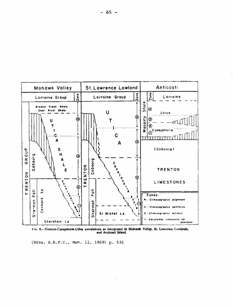
— 65 —
Mohawk Volley St. Lawrence Lowland Anticosti
Lorraine Group ei
No Lorraine Group
u
o N
C1
L
N v 0 2
o
N
67)
O
0
I ertCanojoharie
_Lorraine
Utica
il)Ili'l'J. ii11'nJ11~I r
.
L ..
~ f 1
TR
EN
TO
N G
RO
UP
Atwater Creek Abele
Deer River Shelf
-- — — — — — —
11 11
1/1
1
Co
bo
urg
40
.11 1
• I
,
A
o
o
C7
9 ~
p
. ._
__p
-4 C
=
D n
rn r•
(Cobourg)
TRENTON
LIMESTONES CWc
1—
Sh
er m
an
Fa
ll
h r, i
s
• h•.
i:::!; o
— — — — — le i
91, Michel La.
— — — _ _ .-. _.
Zones:
4.- Cllmoeoproptue pygmoeue
1- Cllmaeo0raplue spinlhrue
i - Climnnnyrnplue minima,
1, - Cerynoldee colloularte var amerleono
l'lo. 9.—Trenton-Canajoharie-Utica correlations as Interpreted In Mohawk Valley, St. Lawrence Lowlands, and Anticosti Island.
(Riva, A.A.P.C., Mem. 12, 1969) p. 532
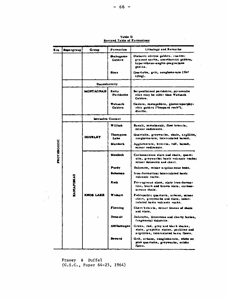
- 66 -
Tabla U Revised Table of formations
Era Group formation Lilkology and Remarks Supergroup
I3IO
Z O
NE
,LOtd
I
akabogasno Gabbro
Sims
Diabasic olivine ;abbro, coarse-gramsd norits, anorthositic'abbrs. bype r stke ns Nugite -pla gioc laid gneiss.
Quartalte, grit. conglomerate (flat lying) .
Unconfo rm l ty -
AdOWTAGNAIS Ratty Peridotits
Wakuack Gabbro
Ssrpentinised psridotite; pyroasnite ails may be older than Wskuack Gabbro.
Gaobro. metagabbro. ilotn*roporpky- ritic gabbro („leopard rock"). dio rite .
/straw* Contact
d
DOVIIILZT
WiUbob
Thompson Lake
Murdoch
Basalt, metabasait. flow brsccla. minor sediments.
Quartsite. greywache. shale. argWite conglomerate. intercalated basalt.
Agglomerate. breccia. tuff. basalt. minor sediments.
KNOB LAZE
.
Nesihek
Psrdy
Soketeas
Roth
Mlshart
Fleming
Denault
Attikamagen
Seward
Carbonaceous slats and shale. rams sits. greywacks; basic volcanic reeler minor dolomite and chart.
Dolomite, minor argUlacsoss beds.
Iron-for/runes; latercalated basic volcanic rocks.
ferruginous slats. slaty iron-forms-tien, black sad brow* slats. carbss-acsous shale.
feldspathic quartait*, arose. miner chart, greywacke and slate, later-calatsd basic volcanic rocks.
Chart br*ccia, minor lemmas of shale and slat*.
Dolomite. limestone and ebony facia*, fragmental dolomite.
Green. red. grey and black shales. slate, graphitic slates, pbyUites and argilites. Intercalated basic flews.
Grit, 'rhos*. cesalotnerate, white or pink gwrtail*. grsywacks, acidic flows.
Fravey & Duffel (G.S.C., Paper 64-25, 1964)
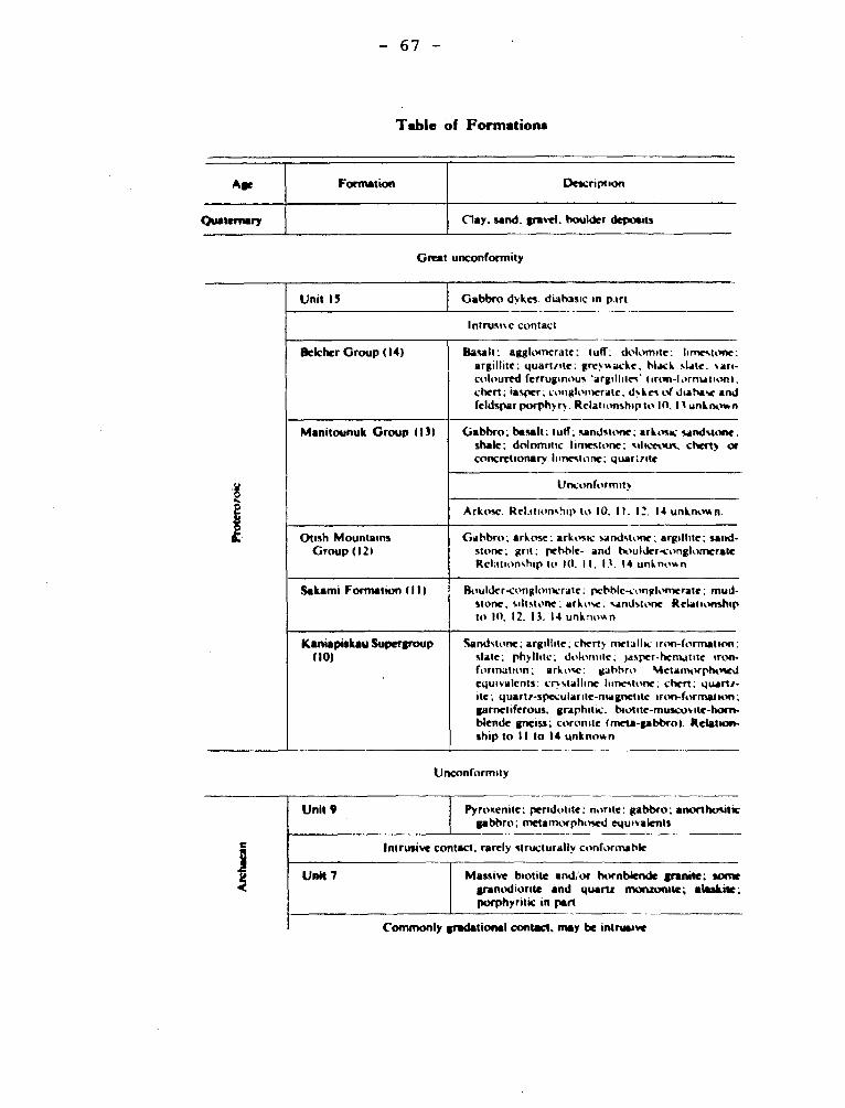
Gabbro dykes. diabasic in part Unit 15
Intrusive contact
Belcher Group (14) Basalt: agglomerate: tuff; dolomite: limestone: argillite: quartzite: greywacke; black slate: sari-coloured ferruginous 'argil lites' (inwt-formation I. chert; Jasper, conglomerate. dyke of di iasc and feldspar porphyry. Relationship to 10.11 unknown
Manitounuk Group 113) Gabbro; basalt; tuff; sandstone; arkosic sandstone: shale; dolomitic Iimestone: siliceous. chesty or concretionary limestone; quartzite
Unconformntv
Arkose. Relationship to 10. I1. 12. 14 unknown.
Otish Mountains Gabbro; arkose; arkosic sandstone; argillite; sand- Group (121 stone; grit; pebble- and boulder-conglonerate
Relationship to 10. II, 13. 14 unknown
Sakami Formation (I l l Bouldcr•conglonxratc; pebble-conglomerate: mud-stone; ciltstone; arkose: sandstone. Relationship to IO. 12. 13. 14 unknown
Kaniapiskau Supergroup Sandstone; argillite: cherty metallic iron-formation: (10) slate; phyllrte: dolomite; jasper•hematne iron-
formation; arkosc: gabbro Metamorphosed equivalents: crystalline limestone: chers: quartz-ite; quartz-speculante-magnetite iron-formation: garnetiferous. graphitic. biome-muscovite-horn-blende gneiss; coronae (meta-gabbro). Relation-ship to 11 to 14 unknown
- 67 -
Table of Formations
Age
Formation
Description
Quaternary
Clay. sand. gravel. boulder deposits
Great unconformity
Unconformity
Unit 9
Pyrosenite; peridotite; nor,te; gabbro; anorthos.itic gabbro; metamorphosed equivalents
Intrusive contact, rarely structurally conformable
Unit 7
Massive biotite and,'or hornblende granite: some granodiorite and quartz monzonite; alaskite; porphyrine in part
Commonly gradational contact. may be intrusive
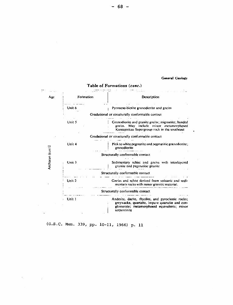
— 68 —
General Geology
Table of Formations (conc.)
Agc Formation Description
•
Unit 6 Pyroxene-biotite granodiorite and gneiss
Gradational or structurally conformable contact
Granodiorite and granite gneiss; migmatite; banded gneiss. May include minor metamorphosed Kaniapiskau Supergroup rock in the southeast
Gradational or structurally conformable contact
Pink to white pegmatite and pegmatitic granodiorite; granodiorite
Unit 5
Unit 4
Structurally conformable contact
Sedimentary schist and gneiss with interlaycred granite and pegmatitic granite
Structurally conformable contact
Gneiss and schist derived from volcanic and sedi-mentary rocks with minor granitic material.
Structurally conformable contact
Andesite, dacite, rhyolite, and pyroclastic rocks; grcywacke, quartzite, impure quartzite and con-glomerate; metamorphosed equivalents; minor serpentinite
(G.S.C. Mem. 339, pp. 10-11, 1966) p. 11
Unit 3
Unit 2
Unit 1
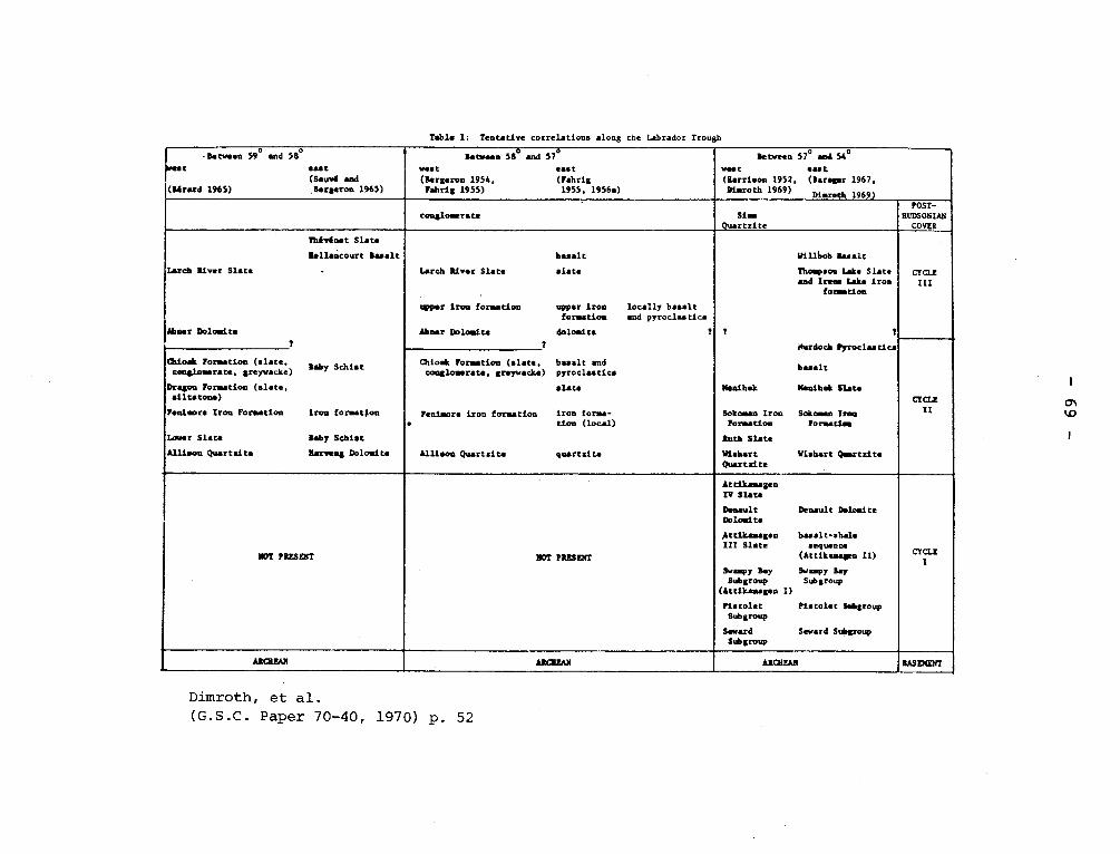
Table I: Tentative correlations along the Labrador Trough
• Between 59° and 58° t oast
I". (Sauv6 and (Shard 1965) .Bergeron 1965)
iatwen 58b and 57° vest east (Bergeron 1954, (Fahrig Fahrig 1955) 1955, 1956a)
Between 57° and 54°
welt east (Harrison 1952, (Baragar 1967. Disroth 1969)
Mmrstb 1969)
conglomerate Si.. Quartzite
POST- HUDSONIAN
COVER
TAAvdnet Slate
Nellancourt basalt
Lerch liver Slate •
Abner Doloaita t
basalt
Larch River Slate slate
upper iron Somation upper iron formation
Abner Doloulta dolomite t
locally basalt and pymoclas tics
t
Nillbob Basalt
Thompson fake Slat. and Irene Lake iron
formation
t t
'lorded' Pyroclastlu
basalt
Manihek Manibek Slate
Sokomsn Iron Sokoman lieu Formation Formation.
Ruth Slate
Wishart Wishart Quartzite Quartzite
CYCLE Iii
CYCLE II
Cbioak Formation (slate, Baby Schist
conglomerate, greyvacke)
Dragon Formation (slate, siltstone)
Fenimore Iron Formation iron formation
Lower Slate Baby Schist
Allison Quartzite Hartung Dolomite
Chioak Formation (slate, basalt and ma conglomerate, greywacke) pyroclastics
slate
Fenimore iron formation iron forma- • tien (local)
Allison Quartzite quartzite
NOT PRESENT NOT PRESENT
Attikamagen
CYCLE I
IV Slate
Denault Denault Dolomite Dolomite
Attikamagen basalt-shale III Slate sequence
(Attikamagen II)
Sway Bay Swampy Bay Subgroup Subgroup
(Attikamagen I)
Pistolet Pistolet Subgroup Subgroup
Seward Seward Subgroup Subgroup
ARCNFAN AROMAS ARCHEAN BASEMENT
Dimroth, et al. (G.S.C. Paper 70-40, 1970) p. 52
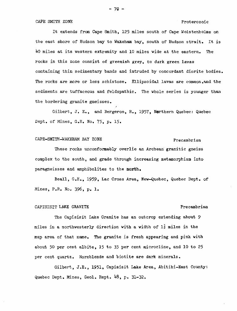
-70-
CAPE SMITH ZONE Proterozoic
It extends from Cape Smith, 125 miles south of Cape Wolstenh olme on
the east shore of Hudson bay to Wakeham bay, south of Hudson strait. It is
40 miles at its western extremity and 10 miles wide at the eastern. The
rocks in this zone consist of greenish grey, to dark green lavas
containing thin sedimentary bands and intruded by concordant diorite bodies.
The rocks are more or less schistose. Ellipsoidal lavas are common,s.nd the
sediments are tuffaceous and feldspathic. The whole series is younger than
the bordering granite gneisses.
Gilbert, J. E., and Bergeron, R., 1957, Northern Quebec: Quebec
Dept. of Mines, G.R. No. 75, p. 15.
CAPE-SMITH-WAKEHAM BAY ZONE Precambrian
These rocks unconformably overlie an Archean granitic gneiss
complex to the south, and grade through increasing metamorphism into
paragneisses and amphibolites to the north.
Beall, G.H., 1959, Lac Cross Area, New-Quebec, Quebec Dept. of
Mines, P.R. No. 396, p. 1.
CAPISISIT LAKE GRANITE Precambrian
The Capisisit Lake Granite has an outcrop extending about 9
miles in a northwesterly direction with a width of 1; miles in the
map area of that name. The granite is fresh appearing and pink with
about 50 per cent albite, 15 to 35 per cent microcline, and 10 to 25
per cent quartz. Hornblende and biotite are dark minerals.
Gilbert, J.E., 1951, Capisisit Lake Area, Abitibi-East County:
Quebec Dept. Mines, Geol. Rept. 48, p. 31-32.
-71-
CARMEL RIVER MEMBER Richmond Group (Ordovician)
Clark used this name for 53 feet of non fossiliferous gray green
shale and sandstone forming the lowest 53 feet of the Bécancour River
Formation on the section on Nicolet river.
Clark, T.H., 1964, Yamaska-Aston area: Quebec Dept. Nat. Res.,
G.R. 102, p. 9.
CASTIGNON-OTELNUK FAULT SYSTEM
"It consists of two branches south of Castignon lake: one separating
red beds and dolomitic quartzite; the other separating the limestone-dolomite
sequence.from slates of formation 10. Both are steep thrust faults with move-
ment to the south. The limestone-dolomite sequence in between forms a narrow
syncline plunging northeast and overturned to the southeast."
Dimroth, Erich, 1965, Geology of Otelnuk Lake Area, New Quebec Territory:
Quebec, Dept. of Nat'. Res., P.R. No. 532, p. 18-19.
CAUGHNAWA GA MEMBER Chazy
Clark introduced this name in 1944 (p. 29) for a member of
the Laval Formation. In a final report (1952) on the area Caughnawaga
is used only as a geographic reference. The limestone quarries there
have long been operated, for example, the stone for the upper locks of
the Lachine canal were quarried from there.
Clark, T.H., 1944, Structure and stratigraphy in the vici-
nity of Montreal: Roy. Soc. Can., Tn. 38, Sect. IV., p. 29.
Clark, T.H., 1952, Montreal area, Laval and Lachine map
areas: Quebec Dept. of Mines, G.R. 46, p. 37.
- 72 -
CAUSAPSCAL ANTICLINE
"The Lake Branch Formation and the middle band of the York River
Formation are on the south limb of the westward plunging, asymmetrical
CAUSAPSCAL ANTICLINE. The fold dies out on the eastern border of the
town of Causapscal. It has a steep southern limb, overturned as much
as 15°on Chasseurs brook, and a gentle northern limb which is faulted
and involved in minor cross-folding. The southern limb is also cut by
faults of small displacement and minor folds".
Stearn, C.W., 1965, Causapscal Area, Matapédia and Matane Counties:
Quebec, Dept. of Nat. Res, G.R. No. 117, p. 35.
CAWATOSE BASIN Précambrian
The Cawatose basin is roughly indicated by the shape of Cawatose
lake, the elliptical outline of which is a reflection of the structure
of the underlying gneisses. The basin is about nine miles long and se-
ven miles wide, with its long axis trending N. 60°E. It was mapped in
detail, which established the arcuate arrangement of the gneiss es and
the concentric trends and inward dips of the schistosity and foliation.
The lineation shows a tendency to converge inward to form a line of fo-
cus three miles long, trending N. 60°E.
Wahl, G. William., Osborne, F.F., 1950, Cawatose Map-Area, Pontiac
County: Quebec, Dept. of Mines, G.R. No. 4I, p. 13.
CEDAR RAPIDS GRANITE Precambrian
The Cedar Rapids granite, which projects for 2 or 3 miles into the
map-area at its northwest corner, is massive, medium- to coarse-grained,
- 73 -
and grey to pink. It is composed chiefly of sodic plagioclase and quartz,
with lesser amounts of orthoclase, microcline, and biotite. The rock can
be classed as a biotite granite.
Longley, W.W., 1946, Tonnancourt-Holmes Map-Area, Abitibi County:
Quebec Dept. of Mines, G.R. No. 24, p. 13.
CENTRAL -DUPARQUET FAULT.
The point where this fault branches away from the Porcupine-Destor
Fault is at the southeast corner of the town of Duparquet, at the junction
of the Duparquet - La Sarre roads. It has an easterly strike and appears
to dip to the south at a steep angle. Good exposures of the fault zone can
be seen in the eastern part of Duparquet township. No displacements along
this fault could be determined. However, if the northeasterly foliation of
the rocks between shears within the fault zone is an expression of fracture
cleavage, it is probable that the relative movement was north side towards
the east. This fault dies out by "horse tailing" to the east in Destor
Township.
Graham, R. Bruce, 1954, Parts of Hebecourt, Duparquet and Destor
Townships, Abitibi-West County: Quebec, Dept. of Mines, G.R. No. 61, p. 35
CHADBOURNE SERIES Precambrian
The Chadbourne Series consists chiefly of andesite is many of
them of the massive type. It includes thin but persistent dacite flows
exhibiting exceptionally good flow top and flow base structures. The
chief feature of the series, however, is the widespread occurrence, in
scattered pods and lenses, of rhyolitic flow and tuffaceous material.
— 74 —
This is useful only as a local name.
Conolly, H.J., Hart, R.C., 1936, Structural Geology of the
Osisko Lake Area, Quebec: Canadian Inst. Mining and Metallurgy Trans.,
v. 39, p. 11.
CHADBOURNE ORE BODY BRECCIA
The Chadbourne ore deposit includes all of the Chadbourne breccia that
has been sufficiently mineralized with gold to warrant mining for flux and
for the gold that it contains.
The fragments of the breccia consist of whatever rock was originally
present at the time the brecciation occured. This, except were intrusions
of diorite or syenite porphyry are brecciated, consists of rhyolite at and
south of the shaft and andesite to the north.
Wilson, M.E., 191 9, Noranda District, Quebec: Canada, Geol. Surv.,
Mem, 229, p. 97.
CHALEUR(S)(BAY)GROUP,SERIES, Silurian
Although the Silurian section on the north shore of Chaleurs Bay
was one of the first in Canada to be examined by Logan, the designation
"Chaleur Group" was not given until 1900 by Ami (1900, p. 201+) who forma-
lized the geographic reference to the locality found in the writings of
E. Billings. Chaleur,(s) Bay series or group have been used by several
authors but these names seen to be less useful than the Ami form. The
form with the terminal "s) is more correct but "Chaleur" is the form pro-
posed by Ami.
-- 75
Ami, H.M., 1900, Synopsis of the geology of Canada: Roy. Soc. Can.
Tn. v. 6, p. 204.
Burk, C.F., 1964, Silurian stratigraphy of Gaspé Peninsula, Quebec:
Am. Assn. Pet. Geol. v. 48, p. 451.
CHAMBLY-FORTIERVILLE SYNCLINE
The dominating structural feature of this area is the syncline whose
axis passes approximately along the line of Huron river and also through
Chambly. One hundred miles farther northeast it passes through Fortierville.
Because of the general low dips, the syncline cannot be seen easily. Its
axis trends northeast.
Clark, T.H., 1955, St. Jean-Beloeil Area, Iberville, St-Jean,
Napierville-Laprairie, Rouville, Chambly, St. Hyacinthe and Verchéres
Counties: Quebec Dept. of Mines, G.R. No. 66, p. 48.
Clark, T.H,, 1964, Upton Area, Bagot, Drummond, Richelieu, Saint-
Hyacinthe and Yamaska Counties: Dept. of Mines, G.R. No. 100, p. 22.
CHAMPLAIN
The lake has given its name to a period and to a marine flooding.
I- CHAMPLAIN, CHAMPLANIAN, CHAMPLAINIC. Period, System, Group, Division.
E. Emmons introduced in 1842 Champlain Group for the formations
Potsdam to Lower Silurian in New York. In this use the name had priority
over Ordovician but,despite attempts to substitute it for Ordovician as
recently as 1924 when Schuchert in the textbook of historical geology used
Champlainian to the exclusion of Ordovician, this use is now abandoned.
II- CHAMPLAINIAN EPOCH SERIES.
Authors have used CHAMPLAINIAN for Mohawhian and Chazy of Middle
Ordovician.
- 76 -
III- CHAMPLAIN CLAY (SEA) (EPOQUE).
C.H. Hitchcock in 1861 in the Geology of Vermont (vol. 1, p. 156)
proposed Champlain Clay for the fassiliferous unconsolidated deposits
occurring along Champlain and St. Lawrence valleys at elevations less than
1000 feet. Although there was reluctance on the part of Logan and J.W. Dawson
to accept the name, Champlain gained currency, and Hitchcock's two divisions
the older and deeper Leda Clay and the younger and shallower Saxicava Sand
were recognized in many places. Hochelagan Formation was suggested as a sub-stitute by Woudworth in 1905.
IV- CHAMPLAIN FAULT
Authors have used Champlain fault if the segment of the St. Lawrence
and Champlain fault (q.v.) in the United States is referred to.
V- CHAMPLAIN PERIOD
The use by several authors of Champlain for a period of the Tertiary
or Quaternary can be found prior to 1900, but Ami has listed it as a period
(Ami, 1900, p. 224) although not as a system (p. 188).
Ami, H.M., 1900, Synopsis of the Geology of Canada, Roy. Soc. Can.,
Tn. v. 6, Pt. IV, p. 224.
CHARLETON FORMATION Ordovician
See Vauréal Formation.
CHATEAUGUAY FORMATION Cambrian
Lying unconformably upon the Covey Hill beds is a series of
sandstones and dolomites here named the Châteauguay Formation, covered
disconformably by the dolomite beds of the Beauharnois Formation of
Beekmantown age. The Châteauguay Formation is made up of 2 members,
the Cairnside and the Ruisseau Norton. The Cairnside consists of
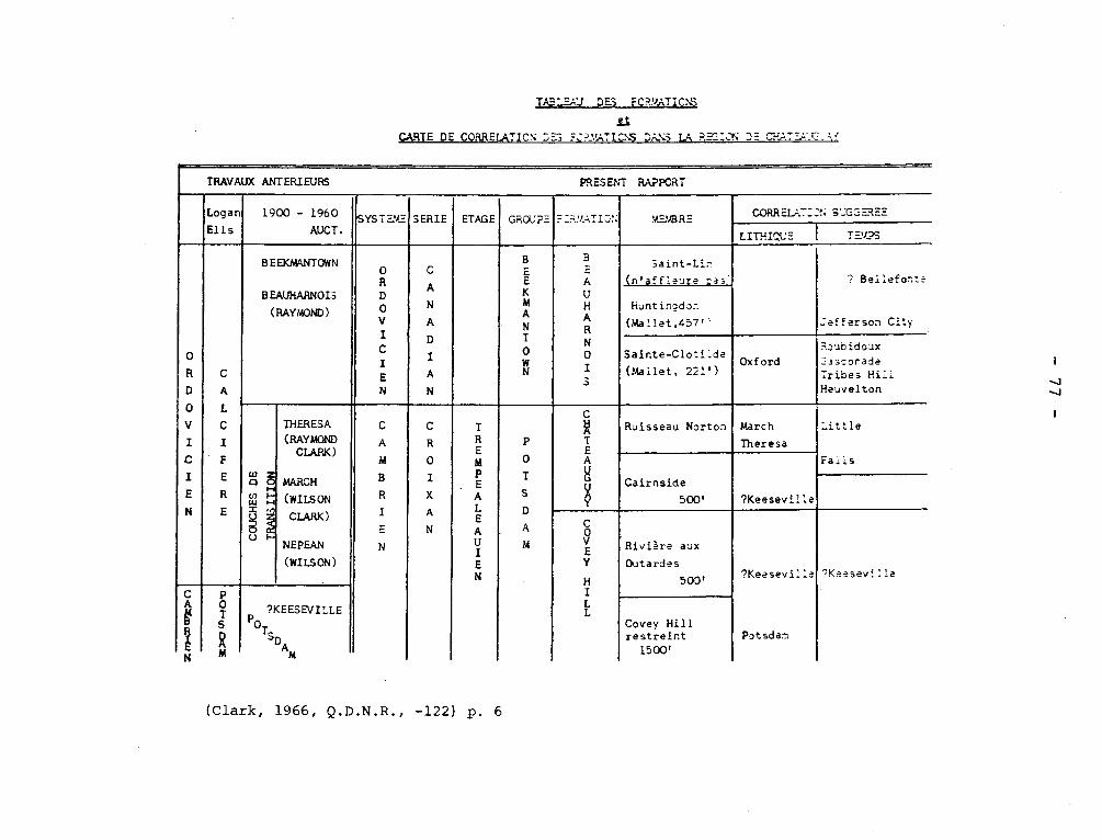
TABLEAU DES FCR.'a nTIC:S ~
CARTE DE CORRELATION DE3 = C?_':,TICtS DANS LA R= -.N D= CH.;T_=..!_ _.-.'
TRAVAUX ANTERIEURS PRESENT RAPPORT
Logan
Ells
1900 - 1960
AUCT. SYSTEM" SERIE ETAGE GîtU r=
-
-_r-::,TZ~': StE. ~RE CORRcL; --C: S GG~E
LITHIQUE T - ~~S `,
C A
N A
D I A
N
B E E K M
N T 0 W N
H E A U H
N 0 I
'
Saint-Li, (n'affleure was' ? Bellefonte
ef.'erson City Huntingdon
(M a'.1et,457 "
Sainte-Clotilde (Mallet, 221')
Oxford 3oubidoux Gasconade Tribes Hill Heuvelton
CO
UC
HE
S D
E
G 1
y: .
I ~
z
6 ~
~z
x
~~;
,6
C
R O
I X A
N
T
É M P E
É A A . Î E N
P O
T S
D
A
M
A 500'
Cy A
É A
^ Ruisseau Norton March
Theresa
Little
Falls
Cairnside ?Keeseville
C 0
É Y
H I L L
Rivure aux Outardes
500' ?Keeseville
Potsdam
?Keeseville
Covey Hill restreint 1500'
(Clark, 1966, Q.D.N.R., -122) p. 6
- 78 -
crossbedded orthoquartzite with siliceous cement, thick-bedded and
poorly provided with fossils in its lower part, and showing abundant
trails and tracks, together with Lingulepis_ acuminata in its upper
part.
Clark, T.H., 1966, Châteauguay Area, Châteauguay, Huntingdon,
Beauharnois, Napierville and St. Jean Counties: Quebec Dept. of Nat.
Res., G.R. no. 122, p. 19.
CHATHAM GRENVILLE STOCK
The Chatham--Grenville stock is the youngest Precambrian formation
recognized in the Lachute sheet. It is composed of syenite and granite
of a type petrographically distinct from the other intrusives because
of the presence of xenotime as an accessory mineral and of alkaline
amphiboles and pyroxenes in some facies.
Osborne, F.F., 1938, Lachute Map-Area, General and Economic
Geology, Québec Bureau of Mines, U. 19-20.
CHATTE RIVER LIMESTONES Silurian
This is intended as a nonce name for limestone encountered
along the river in Gaspé and considered by Logan as being the age of the
Guelph Formation.
Ami, H.M., 1900, Synopsis of the Geology of Canada: Roy.
Soc. Canada, Trans., 2nd ser., vcl.. 6, sec. 4, p. 204.
CRAZY SERIES (GROUP)
The Chazy Group has been mapped for more than a century in Canada:
Logan (1863, pp. 123-135) devotes a chapter to the Chazy Formation. Near
Montreal, the Chazy limestones have been referred to particularly because
of their use for buildings.

- 79 -
In general, the term has been used for rocks of the shelf facies
that is those commonly composed of coarser elastics or calcareous rocks,
and the series has been considered by some writers as the upper part of
the Lower Ordovician but probably by most as the basal part of the Middre
Ordovician.
The formations of this group are found in the St. Lawrence Lowlands
both in the main part and on the Mingan islands. See Rockcliffe, Aylmer,
Laval, St. Martin, Ste-Thérése, Mingan.
The stratigraphy of the group derived from well logs has been pre-
sented by Roliff. The stratigraphy has also been discussed by Hofmann, and
Roliff point out that the apparent anomaly of the thickness of the Chazy
rocks near Trois-Rivières is a result of logging some Chazy as Potsdam.
Hofmann is inclined to the view that the contact between Chazy
and Beekmantown is in the Pamelia dolomite. Furthermore, as shown in his
paper (1963, Fig. 9), he believes that the Laval Formation includes beds
correlative with the Crown Point and Day Point of New York, that is Lower
and Middle Chazy, rather than Upper Chazy as most workers had contended.
Elkanah Billings suggested that the graptolites of the Levis Formation
are of Beekmantown-Chazy age, and this view accepted in dating the Deepkill
Formation of New York. The matter has not yet been decided, but at present
the view is that the Levis beds contain correlatives of both Beekmantown and
Chazy Formations of the shelly facies.
Hofmann, H.J., 1963, Ordovician Chazy Group in Southern Quebec:
Am. Assn. Pet. Geol., v. 63, pp. 270-301.
Roliff, W.A., 1967, A stratigraphic analysis of the subsurface
data relating to the Chazy Group in the St. Lawrence Lowland of Eastern
Canada: Can. Jour. Earth Sel., v. 4, pp. 579-595.

- 80 -
Kay, Marshall, 1962, Classification of Ordovician Chazyan shelly
and graptolitic sequences from central Nevada: Geol. Soc. Am., Bull. v. 73,
pp. 1421-1430.
CHERTSEY FACIES (of MORIN ANORTHOSITE) Precambrian
Cataclastic deformation was particularly intense in the Morin
anorthosite near the village of Chertsey from which Adams named the
Chertsey facies. The Chertsey facies has, near the type locality, s
planes that dip westward at a low angle. The same granulation is
imposed on other formations such as Grenville gneisses, quartzite, and
orthogneisses, and the foliation is parallel to that developed in the
anorthosite. In the Chertsey facies, which is commonly deep blue-green,
the granulation is extreme. Mafic minerals are drawn out to the dimen-
sions of the blade of a table knife with an exceedingly marked lineation
trending almost north-south. Under the microscope, the plagioclase is
seen to be reduced to a fine mosaic with somewhat sutured outlines.
Potassic feldspar and possibly quartz are present as grains intersti-
tial to the plagioclase.
Osborne, F.F., 1949, Coronite, labradorite, anorthosite, and
dykes of andesine,anorthosite,New Glasgow, P.Q., Roy. Soc. Canada Trans.,
Sec. 4, v. 43, p. 104.
Chibougamau is the name of a large lake and a mining district northeast
of lake St. John.
I. CHIBOUGAMAU COMPLEX.
Tolman (1931) introduced this term for granitic and more basic rocks
intrusive into metavolcanic and metasedimentary Archean rocks. Although
Chibougamau complex is mentioned in "Geology of Quebec" (1944, p. 134), the

- 81 -
term has not gained widespread use. Insted "Chibougamau anorthosite" has
be used for the stratiform body with associated gabbros as well as to some
rocks developed by reaction between the meta-anorthosite and younger granitic
rocks.
Tolman, Carl., 1932, An early pre-Cambrian sedimentary series in Northern
Quebec: Jour. Geol., vol. 1L0, p. 356.
II. CHIBOUGAMAU SERIES
Conglomerates and other clastic sedimentary had been mentioned as
overlying unconformably the gneisses and granitic rocks at many localities
in the Chibougamau district for many years. They had been considered equi-
valent to the Cobalt of the Témiscamingue Lake region. Mawdsley and Norman
(1935, p. 4+3) proposed "Chibougamau series" for the conglomerates, arkoses,
and grits and suggested that an unconformity may occur in the series but not
much significance is to be attached to it. The conglomerates are the most
spectacular part of the series and are characterized by boulders up to two
feet long in a dark and poorly sorted matrix. No striae have been certainly
recognized on the boulders, which are of graywacke, greenstone, and granitic
rocks, but not of anorthosite. It has been suggested that the conglomerates
are tillites.
It is difficult to arrive at an estimate of the thickness of this
series. Gilbert (1958, p. 21) in the Bignell area has measured a section
of 555 feet, which he states represents most of the beds. His section is:
Boulder conglomerate 300 feet
Massive arkose
10 feet
Bedded arkose and graywacke
15 feet
- 82 -
Greenish-gray slaty argillite 10 feet
Gray and pink arkose (few boulders) 100 feet
Pebble conglomerate 40 feet
Laminated graywacke 30 feet
Basal Boulder conglomerate 50 feet
Thicker sections have been encountind elsewhere.
Mawdsley, J,B., and Norman G.W.H. (1935) Chibougamau Lake Map-area,
Quebec: Geol. Surv. Can., Mem. lt55, p.43.
Gilbert, J,E., 1958, Bignell Area, Mistassini and Abitibi-East and
Roberval Electoral Districts: Quebec, Dept of Mines, G.R. 79, P. 21.
CHIBOUGAMAU LAKE COMPLEX
This complex which is exposed in a small part of the north-
western part of Rinfret township, is composed of "diorite" and
"quartz diorite" and is on the northwest side of the complex of
anorthosite and gabbro. The term is poorly chosen because of other
use of Chibougamau (g.v.) and should be abandoned.
Allard, G.O., 1967, Northwest quarter of Rinfret township,
Abitibi-East and Roberval counties: Quebec Dept. of Nat. Res., P.R.
567, p. 8.
CHICOTTE FORMATION Silurian
This name (Schuchert and Twenhofel, 1910) was given to 75 feet .of
limestone that had been referred to as "F" formation of Anticosti island
by Richardson and as 4, 1 to 4, by Logan. It is crinoidal and coralline
and according to Twenhofel (1927, p. 17) is the only limestone on the
island that has been extensively recrystallized. The change has been
- 83 -
considered part of the diagenetic stagé and has destroyed many fossils.
The formation is considered Niagaran.
Schuchert, C., Twenhofel, W.H., 1910, Ordovicic-Siluric section
of the Mingan and Anticosti Islands, Gulf of Saint Lawrence: Geol. Soc.
Am. Bull., vol. 21, p. 715.
Twenhofel, W.H., 1927, Geology of Anticosti Island: Can. Geol.
Surv., Mem. 154, p. 17.
CHUKOTAT GROUP Precambrian
This name has been given to conglomerates, sedimentary breccias,
cherty beds with pillowed lavas now metamorphosed to minerals of the epi-
dote group. The whole is cut by sills of basic and near ultrabasic rocks,
which have been altered with the formation of serpentine and chlorite.
This group is believed to overlie granites and diabase intrusive
in the Povungnituk Group, which in turn, is believed to overlie the Archean
rocks unconformably.
Bergeron, Robt., 1959, Povungnituk Mountains Region, New Quebec:
Quebec Dept. of Mines, P.R. 392, pp. 2-3.
CLERICY GRANODIORITE
It underlies an area about 1 mile wide with a long axis of seven miles
trending north 30 degrees westlt lies mainly in the southwest corner of
Clericy township, but extends some distance into Joanne on the south and
Dufresnoy on the west. Like the western part of the Dufault mass, it is
made up of both dioritic and granitic rocks. The diorite part forms a
band with a maximum width of 1 mile along the western side of the body,
extending from the north end of lake Savard southwest for nearly 4 miles.
- 84 -
The remainder of the body is for the most part a reddish granite of normal
appearance, but toward the south end it is white.
Cooke, H.C., James, W.F., Mawdsley, J.B., 1931, Geology and ore
deposits of the Rouyn-Harricanaw Region, Quebec: Canada Geol. Surv.,
Mem. 166, p. 126-127.
COMETIQUE LAKE STOCK
The effects of the Cometique Lake stock are self-evident. There
was a westward push, well shown in the attitude of the gabbro-sediments
complex west of the stock. The stock is mostly a medium grained biotite
granite.
Claveau, Jacques, 1949, Wakeham Lake Area, Saguenay County:
Quebec, Dept. of Mines. G.R., No. 37, p. 42, p. 50.
CONWEST BAY CHERTY IRON FORMATION Proterozoic
200 feet of cherty iron formation overlies the cherty iron
carbonate member in the section exposed northeast of Trout point.
Chert is the predominant constituent of the rock, although the com-
position varies considerably from bottom to top. The lower beds
contain some iron carbonate and are gradational into the underlying
member. The upper beds are characterized by disseminated magnetite
and varying amounts of jasper, which appears as flecks and granules
along the beds. The fresh rocks is light brown to reddish-brown, but
weathered surfaces are commonly covered by a limonitic film.
Neilson, James M., 1953, Albanel Area, Mistassini Territory:
Quebec Dept. of Mines, G.R. No. 53, p. 22.
85 -
COOM LAKE INTRUSIVES Proterozoic
Wahl (1953, p. 19) proposed the name for basic intrusive rocks which
can be seen chilled against the "c" member of the Témiscamie Formation of the
Mistassini Series in the eastern part of the Témiscamie River Area.
The rocks have an ophitic texture with more than 50% dark mineral, now
represented by hornblende and chloritized biotite. The much clouded plagiocla-
se is andesine. Both diorite and gabbro have been used as field names for
these rocks.
Wahl, W.G., 1953, Témiscamie River Area, Mistassini Territory: Quebec
Dept. of Mines, G.R. 53, pp. 19-20.
Neilson, J.M., 1966, Takwa River Area, Mistassini Territory: Quebec
Dept. of Nat. Res., G.R. 124, p. 37-39.
COREY LIMESTONE (FORMATION) (Wilmarth -1-521) Upper Beekmantown
This limestone is noteworthy for its purity and is commonly
referred to as "Bedford" when the stone is destined for commercial use
(Goudge, 1935, pp. 218-218). The stone, which is a fine-grained light
bluish and white weathering, is division C1 at Logan's Philipsburg Series
(1.v.) and is 275 feet thick of which 250 feet is very high-calcium.
Goudge, M.F., 1935, Limestone of Canada, Part III: Canada, Mines
Branch, No. 755, pp. 218-221.
Geology of Quebec, 1944, p. 396.
CORNER-OF-THE-BEACH Middle (?) Cambrian
Charles Schuchert discovered Cambrian fossils in thin bedded
limestones and shales along Murphy River, a mile and a half west of Coin-
- 86 -
CRANBOURNE SERIES (Formation) (Wilmarth -1-94) Upper Silurian
Tolman (1936) gave the name to a folded and locally schistose limestone
and shale cropping out in an area 1* by 4 miles near St. Odilon-de-Cranbourne.
The thickness of the formation is unknown. Fossils studied T.H. Clark sug-
gested to him an Oriskany-Helderberg age. However, A.J. Boucot in his com-
prehensive examination of the Silurian and Devonian rocks of the north Appa-
lachians has visited the locality, and new collections made by him suggest an
Early Ludlow age. With present knowledge, this unit should rank as a formation.
Tolman, Carl, 1936, Lake Etchemin Map-area, Quebec: Geol. Surv. Can.,
Mem. 199, pp. 14-16.
Naylor, R.S., Boucot. A.J., 1965, Origin and distribution of rocks of
Ludlow age (Late Silurian) in the northern Appalachians: Am. Jour. Sci. v. 263,
p. 159.
CROCHET (HOOK) LAKE BASIN
The few sills west of Crochet lake and Léopard lake dip gently to
moderately east and most are right-side-up. East of the eastward dipping
sills are the Crochet Lake basin and the Gerido Lake-Léopard Lake complex
syncline. The lavas in the central part of the basin forms a plateau ri-
sing higher than the country for miles around. The surrounding sedimenta-
ry rocks dip gently to moderately under the lavas, except on the northeast
side where they are in part sheared and possibly faulted. The plunge at
the south side of the basin is about l0°north; the plunge to the south at
the northern side is slightly steeper.
Sauvé, Pierre., Bergeron, Robert., 1965, Gerido Lake Thévenet Lake
Area, New Quebec:: Quebec, Dept. of Nat. Res., G.R. No. 104, p. 77.
- 87 -
du-Banc on Baie de Malbaie, Gaspé. Other collections of fossils were
made by C.H. Kindle, who suggested that the formation is Lower or Middle
Cambrian. Most of the trilobites of the fauna were new in 1942, but in
1969 a study of them by palaeontologists of the Geological Survey suggests
a late Middle Cambrian age.
Kindle, C.H., 1942, A Lower (?) Cambrian fauna from Eastern
Gaspé, Quebec: Am. Jour. Sci., vol. 240, pp. 633-641.
COVEY HILL FORMATION (Including Riviére aux Outardes Member). Cambrian(?)
This formation, the oldest in the Châteauguay area, is composed
of many varieties of white, gray, or reddish immature orthoquartzite. It
underlies all of Covey hill and outcrops in a few isolated patches to the north.
Southward, beyond the International border, it stretches as far as the lower
slopes of Lyon mountain in the Adirondacks. This is one of the 3 local for-
mations which were earlier included under the term "Postdam sandstone".
The dips are low, 10 to 2° in general, and on the hillside slopeto
the north, Covey Hill beds are exposed discontinuously over the surface.
Clark, T.H., 1966, Châteauguay Area, Châteauguay, Huntingdon, Beau-
harnois, Napierville and St. Jean Counties: Quebec Dept. of Nat. Res.,
G.R. no. 122, p. 8-19.
COVEY HILL SYNCLINE.
"The Covey Hill beds are disposed in a wide-open syncline the axis of
which plunges west-southwest." This structure is very poorly defined and
without exposures,' its axis is hard to fix.
Clark, T.H., 1966, Châteauguay Area, Châteauguay Huntingdon, Beauharnois,
Napierville and St. Jean Counties: Quebec, Dept. of Nat. Res. G.R. No. 122, p. 16.
- 88 -
DASSERAT SYNCLINE
The axis of in overturned fold in the Keewatin metavolcanic rocks
passes through the south end of Dasserat lake and near the south end of
Uwass lake. The axial plane strikes N75°W and dips 70° north.
Cooke, H.C., James, W.F., Mawdsley, J.B., 1931, Geology and Ore
Deposits of Rouyn-Harricanaw Region Quebec: Can. Geol. Surv., Memoir 166,
p. 88.
DAUVERSIERE STOCK
This roughly-circular granitic body underlies approximately 60
square miles in the central part of La Dauversiére township. It is
well exposed along the shores of the chain of lakes and of their nu-
merous islands. The stock is essentially a biotite granite, generally
pink, and rarely grey in colour, medium to coarse in grain and, as a
rule, hypidiomorphic-granular in texture.
Imbault, P,E., 1959, Queylus Area, Abitibi-East and Roberval Electoral
Districts: Quebec, Dept. of Mines, G.R. No. 83, p. 18-21.
DAVIDSON CREEK FAULT.
Described by Cooke, James and Mawdsley, its exact age is difficult to
establish. It follows Davidson Creek and the Kinojevis river southwest into
Vallet lake, and differs from the other major faults in cutting across, ra-
ther than paralleling, the strata through the greater part of its course.
It dips probably steeply northwest.
- &9 -
Hawley, J.E., 1933, McWatters Mine Gold Belt, East Rouyn and Joannès
Townships: Quebec, Annual Report of the Quebec, Bureau of Mines for the
Calendar Year 1933, Part C. p. 29.
Gunning and Ambrose considor that the southeast side mouved northeast
and downward relative to the northwest side.
Gunning, H.C. and Ambrose, J.W., 1939, The Timiskaming-Keewatin
to /the Rouyn Harricanaw region North-western Quebec: Roy. Soc. Can., Tn.
v. 33, p. 38
DAVY LAKE BRECCIA (igneous) Precambrian
Along the eastern shore of Davy Lake and at the point of outlet
of a small lake a mile and a half northwest of it, blocks of gabbro in a
matrix of gabbro were encountered.
Claveau, Jacques, 1949, Wakeham Lake Area, Saguenay County:
Quebec Dept. of Mines, G.R. No. 37, p. 28-29.
DEEPKILL SHALE Lower Ordovician
Ruedemann measured and described the lithology and fauna of beds
of shale and sandy and calcareous shales in New York State about the
turn of this century. His study of the fauna was based on Hall's
studies at Lévis, and his dating was based on Elkanah Billing's deter-
mination of the age of the Lévis Formation. His original publication
bore the title "The graptolite (Levis) facies of the Beekmantown for-
mation in Rennselaer Co., N.Y."Many of the American citation omit"(Lévis)".
- 90-
Deepkill has been used in Quebec for Lower Ordovician rocks of
the graptolite facies. Levis has priority and would serve better, the
section at Lévis being more complete than at Deepkill.
DELSON FAULT
The Delson fault in the St. Jean sheet is the prolongation of that
fault in the Lachine map-area. The vertical displacement in the vicinity
of Menard Corner, where the Rosemont member of the Montreal formation is
brought against the upper part of the Utica, is of the order of 800 feet.
It strikes northwest.
Clark, T.H., 1955, St. Jean - Beloeil Area, Iberville, St. Jean,
Napierville-Laprairie, Rouville, Chambly, St. Hyacinthe and Verchéres
Counties: Quebec Dept. of Mines, G.R. No. 66, p. 51-52.
. DEMIN LAKE SYNCLINE
"From structural determinations in the volcanics around Washusk and
Ogima lakes and around the south end of Dasserat lake, Cooke concluded that
an axis of synclinal folding passes through the south end of Dasserat lake
and across the south end 6f Uwass (Demin) lake. It trends slightly north
of west."
Robinson, W.G., 1948, Part of Northwest Quarter of Beauchastel Townships,
Rouyn-Noranda County: Quebec, Dept., of Mines , G.R.No. 30, p. 12-14.
DERBUEL BLOCK.
"The Derbuel block forms a wide southeast-trending, syncline, whcih
continues into the areas farther east, northeast and north. Flat open folds
trending north and east-northeast are present in this block in the Romaned
- 91 -
Lake area, but are not conspicuous in this area. The style of the structure
of these zones and blocks is clearly a function of the facies of the rocks."
Dimroth, Erich, 1965, Geology of Otelnuk Lake Area, New Quebec, Territory:
Quebec, Department of Natural Resources, P.R. No. 532, p. 19.
DESCHAMBAULT FORMATION Trenton Group
Clark (1959) proposed this name for lower but not the lowest
beds of the Trenton Group. Clark has described these limestones as
light gray and fragmental. This is true for many of the exposures
particularly in quarries because this is one of the parts of the Trenton
yielding high calcium limestone between Montreal and Quebec city. However,
in addition to the calcarenites, calcilutites occur and there are also
some shaly and cherty beds. Clark considers that the fauna justifies
correlation with the Hull Formation. This formation mane includes beds
assigned to the Mile End Formation.
Clark, T.H., 1959, Stratigraphy of the Trenton Group, St.
Lawrence Lowland, Quebec: Geol. Assn. Can., Pr. v. 11, p. 16.
DESTOR BREAK -
"Destor" break" is the wide zone of heavily sheared rocks, between the
outcrops of sediments and the northward facing lavas on the ridge north of
Beattie railway. Topographically, it is marked by a persistent swamp, and
is evidently a fault-zone of considerable importance."
Bannerman, H.M., 1940, Lépine Lake Area, Destor Township, Abitibi County:
Quebec,;Dept, of Mines, G.R. NO. 4, p. 20.

- 9.2 -
NOTES
1475
TABLE I. Table of formations* for the Grondines map-area
System Series Group Formations
Members Zones
Thickness (ft)
Stratigraphie equivalents in
New York—Ontario
Utica Lotbiniere Formation 450 Utica Delisle Member
• (137 m)
O h T Neuville Formation
r Grondines Member 250 Cobourg
d a r Rafinesquina deltoidea zone
Cryptolithus lorettensls zone (76 m)
m e St-Casimir Member 184 Sherman Fall o
v p n
(56 m)
1 t Deschambault Formation 85 Hull i
c a o
(26 m)
i
a
i
n
n Ste-Anne Formation Rockland
Black Leray Formation 5 Coboconk n River (1.5 m)
*Adopted from Clark et al. 1969.
(Globensky & Jauffred, 1971, Can. Journ. Eath. Scie. Vol. 8, No. 11) p. 1475
- 93 -
DISRAELI SERIES, FORMATION Ordovician
Burton (1931) gave the name Disraeli Series to conglomerate,
graywacke, quartzite, and slate occurring in the vicinity of Lake Aylmer.
Duquette (1961) made a more complete examination of the rocks and showed
that the quartzites of Burton are, at least, in part, acidic tuffs. The
structural relationships are complex and the estimates of thickness, from
10,000 to 21,000 are probably excessive but very uncertain.
Burton dated the formation Silurian (?), but Cooke suggested an
Ordovician age. Duquette suggests a correlation with the Magog Formation
(a.v.) and with part of the Beauceville Group .
Burton, F.R,, 1931, Vicinity of Lake Aylmer, Eastern Townships:
Que. Bur. of Mines, Ann. Rept. 1930D., pp. 111-118.
Duquette, Gilles, 1961, Geology of Weedon Lake area and its vicinity,
Wolfe and Compton Counties: Université Laval, thèse pour Doctorat, pp. 20-33.
DIXVILLE FAULT.
This large fault has been recognized in the southern part of Coaticook
map-area. South of it the quartzite beds strike a few degrees east or west
of north, dip steeply east, but face west, whereas north of it the beds have
normal north-northeast strikes, dip steeply west, and face east. It would
seem that the beds south of the fault must have been shifted westward, rela-
tive to those on the north, a distance of at least ten miles, so that the beds
south of the fault correspond to those lying east of the slate in the central
part of the syncline north and northeast of the fault. Throughout its course
this fault is marked by a prominent valley, in most places 200 feet deep.
Cooke, H.C., 1957, Coaticook-Malvina Area, Electoral Districts of
Stanstead and Complex: Quebec, Dept. of Mines, G.R. No. 69, p. 16-17.
- 9.4 -
DONCHESTJR FAULT.
The Donchester fault branches from the Porcupine-Destor fault
6,000 feet west of the Donchester shaft. It strikes easterly, parallel to
the Beattie fault and dips vertically to steeply north. The shear zone has
a width of 100 to 300 feet.
Graham, R. Bruce., 1954, Parts of Hebecourt, Duparquet and Destor
Townships, Abitibi-West County: Quebec, Dept. of Mines, G.R. No. 61, p. 35.
DORE LAKE COMPLEX
This name has been proposed by Allard for a stratiform body
of anorthosite, gabbro, and related and derivative rocks. The complex
is considered to be 12,000 feet thick. This name is likely to be
confused with Doré Conglomerate and Doré Series of western Ontario.
The term is also essentially a synonym of Chibougamau Complex (q.v.).
Allard, G.O., 1967, Northwest quarter of Rinfret township,
Abitibi-East and Roberval counties: Quebec Dept. of Nat. Res., P.R.
567, p. 3.
DORE LAKE (MCKENZIE NARROWS?) FAULT Precambrian
This fault is apparently the same as the McKenzie Narrows fault.
See McKenzie Narrows Fault.
Allard, G., 1960, South Half of McKenzie Township, Abitibi-East
Electoral District, Part II, South Half of Southeast Quarter: Quebec
Dept. of Mines, G.R. No. 95, p. 58.
DUFAULT GRANODIORITE, Lake Dufault Laccolith. Precambrian.
It underlies an area of about 10 square miles bordering the north
- 95 -
part of Dufault lake, Dufresnoy township. It is of interest, because of
its unusual differentiation. The mass is made up of two separate bodies
of intrusive rock with dioritic to dioritic facies. The western body ex-
tends from the western margin of the mass to the middle of Dufault lake.
The eastern body underlies the eastern half of the lake, and extends north
half a mile beyond the centre line of Dufresnoy township. It is made up
of a series of sills or laccoliths piled one upon the other. The oldest is
that which now occupies the centre of the mass. It has differentiated into
diorite, aplite, and graphic granite.
Cooke, H.C., 1930, the compound laccolith of Lake Dufault, Quebec:
Roy. Soc. Can., Tn. 24, Sec. IV, pp. 89-98,
DUFAULT ANTICLINE
"The Dufault anticline is a very broad, open fold involving all the
lavas between the north end of Dufault lake and the Timiskaming boundary on
the south. It trends north-west and dips southeast.
Cooke, H.C., James, W.F., Mawdsley, J.B., 1931, Geology and Ore Deposits
of Rouyn-Harricanaw Region, Quebec: Can., Geol. Survey, Memôir 166, p. 85.
DULEY (LAKE) SERIES, MARBLE, FORMATION Precambrian
Gill et al (1937) proposed Duley Lake Series for crystalline li-
mestone, garnet cyanite schist, and metamorphosed iron formation in an area
near the height-of-land southwest of the Wapussakatoo mountains. It was
believed that this series is older than the Wapussakatoo Series. The
prospecting for iron ores caused a revised classification to be evolved
as reported by Gastil and Knowles (1960). Duley Marble has formation
status and is made up of granular white dolcmite with silicates. The iron
- 96 -
formations were assigned to a new Wabush Lake Iron Formation. Later Duley
Marble, Wapussakatoo Quartzite, and Wabush Lake Iron Formation were assigned
to a Gagnon Group.
Gill, J.E., Bannerman, H.M., and Tolman, C., 1937, Wapussakatoo
Mountains, Labrador: Geol. Soc. Am., Bull. v. 48, pp. 572-573.
Gastil, G., and Knowles, D.-M., 1960, Geology of the Wabush Lake
Area, southwestern Labrador and eastern Quebec, Canada: Geol. Soc. Am.,
Bull. v. 71, p. 1247.
Clarke, P,J., 1967, Gras Lake-Felix Lake Area, Saguenay County:
Quebec Dept. Nat. Res., G.R. 129, pp. 29-30.
DUNHAM DOLOMITE Lower Cambrian
The Dunham Dolomite of the Oak Hill Group is,in the Lacolle
area, 40 to 150 feet of dark gray or gray finely crystalline dolomite.
The weathered surfaces are beige to dark brown, and such surfaces show
rounded grains of quartz. Robt. Harvie (1915, p. 99) had traced the do-
lomite through Sweetsburg and Dunham into the United States where he noted
that the formation is much thicker than in Quebec. Clark (1934, p. 7)
correlated the Dunham with the Milton Dolomite but the mapping in Vermont
(Shaw, 1958, p. 527) shows that the Dunham is older than the Milton, and
the use of Dunham has been extended into Vermont, where the formation is
from 25 to more than 2,800 feet thick.
The formation has yielded few and poorly preserved fossils in
Quebec but a more extensive faunal list is available for Vermont.
Clark, T.H., 1934, Structure and stratigraphy of southern
Quebec: Geol. Soc. Am., Bull. v. 45, fig. 3, p. 7.
Clark, T.H., 1936, A Lower Cambrian Series from Southern
Quebec: Roy. Can. Inst., v. 21, Pt. 1, pp. 146-147.
- 97 -
Harvie, Robt., 1915, Brome and Missisquoi Counties, Quebec:
Can. Geol. Surv., Ann. Rept., 1914, p. 99.
Booth, V.H,, 1950, Structure and Stratigraphy of the Oak Hill
Succession in Vermont: Geol. Soc. Am., Bull., v. 61, pp. 1149-1151.
Shaw, A.B., 1958, Stratigraphy and structure of the Albans area,
northwestern Vermont: Geol. Soc. Am., Bull. v. 69, pp. 525-528.
Cady, W.M., 1960, Stratigraphy and geotectonic relationships in
northern Vermont and Southern Quebec: Geol. Soc. Am., Bull. v. 71, p. 571-572.
DUNLOP INTRUSIVE Precambrian
A body of granitic rock which, in the Kitchigama area to the west,
Longley has named the Dunlop intrusive, extends into the present map-area
as an elongated tongue along the north side of the hills of Mount Laurier
ridge. Longley found that this body of rock is more basic, having the com-
position of diorite, on the southern side than on the northern side, where
the rock is a typical hornblende granite. He concluded that it has the form
of a sill, with bottom toward the south, and that it was intruded before, or
during the early stages of, the post-Keewatin folding, which would make it
earlier than the other granitic intrusives of the area.
Auger, P,E., 1942, Olga-Mattagami Area, Abitibi Territory: Quebec
Dept. of Mines, G.R. No. 10, p. 12.
Longley, W.W., 1941, Kitchigama Area, Abitibi Territory: Quebec Bur.
Mines, G.R. No. 12.
DUNMORE QUARTZITE Lower (?) Cambrian
Cooke has proposed this hybrid name, derived from Dunham
Dolomite and Scottsmore Quartzite for dolomitic sandstones supposed
- 98 -
to be equivalent to the two formations. The term is neither necessary
nor desirable.
Cooke, H.C., 1954, The Green Mountain Anticlinorium in Quebec:
Geol. Assn. Can., Pr. v. 5, Pt. 2, p. 40.
DUNPHY RIVER PINK STROMATOLITIC LIMESTONE Precambrian
This formation is well exposed at the northern shore of Dunphy river
near the western boundary of the area. The pink color of the limestone is
produced by a little hematite dust, occurring finely dispersed in the limestone.
The pink color vanishes during the recrystallization of the rock. The metamor-
phic equivalents of this limestone are therefore either gray or gray and red
mottled. The limestone contains a few sand grains ( 1 mm. diameter) at the
western boundary of the area, where it is also interlayered with thin beds of
a dark red siltstone. The proportion of this psammitic material decreases to
the east.
Dimroth, Erich, 1966, Geology of Dunphy Lake Area, New Quebec Territory:
Quebec Dept. of Nat. Res., P.R. No. 557, P. 5-6.
DUPARQUET SEDIMENTS Precambrian
Several patches of sedimentary rock of "Temiscamian type" outcropping
in the country north east of Lépine lake are similar lithologically
and structurally to the more extensive band occuring farther west of the
map-area, along the east-west centre-line of Destor and Duparquet townships.
They consist mainly of beds of coarse conglomerate, quartzite, and arkose,
and differ from one another only in the relative amounts of the various
sedimentary materials of which they are composed.
Bannerman, H.M., 1940, Lépine Lake Area, Destor Township, Abitibi
County: Quebec, Bureau of Mines, G.R. No. 4, p. 12-15.
- 99 -
DU PARQUET LAKE SYNCLINE
"It appears to have a vertical plunge. Its axis extends from the south
shore of Hébécourt lake to the south shore of the northwest arm of Duparquet
lake. From there it trends southeast through Duparquet lake to the south boun-
dary-of the map-area. The south limb dips vertically, local observations indi-
cating slight overturning. The tops are to the north. The north limb has a
vertical dip and tops face south, Dips around the nose of the syncline are
vertical."
Graham, R. Bruce., 1954, Parts of Hébécourt, Duparquet and Destor Townships,
Abitibi-West county: Québec, Dept. of Mines, G.R. No. 61, p. 33.
DUPRAT ANTICLINE
This northwest trending anticline has been traced along range VII of
Duprat township and appears to extend southwesterly into the Montbrey map_-
area. The axis follows the main rhyolite belt in page V. The fold plunges
south to southwest with a nose in the vicinity of Sablonnière lake. On the
crest of the anticline, the formations are nearly horizontal, but on the limbs
they have steep dips.
Hogg, W.A., Dugas, J., 1965, East half of Montbray Township, Rouyn-
Noranda County: Quebec, Dept. of Nat. Resources, G.R. No. 115, p. 24.
DUPRAT, TWIN LAKE, AND OLIER LAKE SYENITE PORPHYRIES
The Duprat porphyry is a triangular mass about 1 mile long and mile
wide at the base, lying about 2 miles west-southwest of the centre of the township.
The Twin lake mass is an oval body of about the same size, just south of
Twin lake in the northwestern part of Beauchastel township.
-100-
The Lake Olier porphyry lies between Olier and Renaud Lakes, in south-
western Beauchastel.
Cooke, H.C., James, W.F., Mawdsley, J.B., 1931, Geology and Ore
Deposits of Rouyn-Harricanaw Region, Quebec: Canada Geol. Surv., Mem. 166, p. 113.
DUQUESNE FAULT.
It branches away from the Porcupine-Destor fault 3,000 feet east of
the power line. It consists of numerous well developed shear zones in the
younger volcaniés. The zones vary in width, but rarely ezceed 200 feet and
dip 80° south. It splits in the western part of lot 34, range west of Maca-
mic road. One branch strikes east and the other N. 600E. The latter branch
is probably represented in the Lépine lake area by the northeasterly trending
shear parallel to the south boundary of the southern body of ultrabasic rock
in range Y.
Graham, R. Bruce., 1954, Parts of Hebecourt, Duparquet and Destor Townships,'
Abitibi-West County: Quebec, Dept. of Mines, G.R. No. 61, p. 36,
EAST BRANCH POND FORMATION Ordovician
St. Julien has given this name to clastic rocks having an aggregate
thickness of more than 4,000 feet near East Branch Pond, which is six miles
north of the town of Magog. The beds with conglomerates near the base are
tightly folded and overlie the rocks of the Magog Group. The upper beds are
largely meta-pelites and appear to underlie the Glenbrooke Group.
Fossils, unfortunately not definitely datable, are found at several
localities may be Upper Ordovician or Silurian.
This formation shows some characteristics in common with the Sherbrooke
Formation.
- 101 -
Lamarche, R.Y., 1962, Etudes des conglomerate de la Région de
Orford-Sherbrooke: Université Laval, Thèse, pp. 23-32.
St. Julien, Pierre, 1963, Géologie de la Région d'Orford-Sherbrooke:
Université Laval, Thèse pour Doctorat, pp. 160-178.
EAU-JAUNE COMPLEX (IGNEOUS)
This complex is made up of diorite to quartz diorite facies and
underlies approximately 10 square miles at the southwestern part of
the area and is exposed mainly on islands in Eau-Jaune and Irene lakes.
The boundaries of this intrusion are very indefinite, especially on
the east where it appears to marge with a broad contact zone of meta-
morphosed volcanics.
Holmes, Stanley W., 1959, Fancamp-Hauy Area, Abitibi-East Elec-
toral District: Quebec Dept. of Mines, G.R., No. 84+, p. 11.
ELLIS BAY Ordovician (?)
Richardson division C is made up of arenaceous and calcareous shales
grading upward into argillaceous limestone and finally into limestone with
shale interbeds. He assigned the formation a thickness of 306 feet. Schu-
chert and Twenhofel (1910, p. 695) called the lower 200 to 300 feet of the
"C" division Ellis Bay Formation. Twenhofel's statement that Richardson"s
zones, C-1 to C-12, are limits of the formation is in error for Richardson
did not use numbers. The numbers appear in "Geology of Canada" (1863, pp.
298-300) as headings for statements of the measured section, thus "6" refers
to 40 feet of concealed beds.
The age of the beds has been the subject for controversy. Schuchert
and Twenhofel (off. cit. p. 700) assigned them to a position above the Rich-
mond but below the Silurian and they proposed Gamache Series (q.v.) This
-102 -
was not accepted by authors and the beds were assigned to Richmond. In 1969
(Ayrton, et al.) faunal evidence was adduced that at least part of this for-
mation is Silurian and assigned it to the lower Llandovery.
Richardson, James, 1857, Report for year 1856: Can. Geol. Surv., Rept.
of Progress 1853-1856, pp. 214-217.
Schuchert, C., Twenhofel, W.H., 1910, Ordovicic-Siluric Section of the
Mingan and Anticosti Islands, Gulf of Saint Lawrence, Geol. Soc. Am. Bull.,
vol. 21, p. 695.
Twenhofel, W.H., 1927, Geology of Anticosti Island: Can. Geol. Surv.
Mem. 154, p. 23.
Ayrton, W.G. et al., 1969, Lower Llandovery of the Northern Appala-
chians and adjacent regions: Geol. Soc. Am. Bull. 80, p. 462.
ENGLISH HEAD FORMATION
The first significant observations on the geology of Anticosti
island were based on work done in 1956 on the shores by Richardson
(1857, pp. 191-238) who assigned letters to formations later named by
others. His results together with Billing's examination of the fossils
were summarized in Geology of Canada (1863, pp. 220-224, pp. 298-309).
Formation "A" cropping out along the northeast side of the island, con-
sists of about 250 feet of grey and reddish limestone with greenish
shales and was later called English Head by Schuchert and Twenhofel
(1910, p. 695), who suggested that it belongs to the Richmond of the Upper
Ordovician. Deep drilling shows that the English Head thickens going
southward and may be as much as 1,600 feet of limestone, shaly limestone,
and shale (Roliff, 1968, p. 34).
-103-
Richardson, James, 1857, Report for year 1856: Can. Geol. Surv.,
Rept. of Progress 1853, 1856, pp. 191-238.
Schuchert, C., Twenhofel, W.H., 1910, Ordovicic-Siluric section
of the Mingan and Anticosti Islands, Gulf of Saint-Lawrence, Geol. Soc.
Am. Bull., vol. 21, p. 695.
Twenhofel, W.H., 1927, Geology of Anticosti Island: Can. Geol.
Surv., Mem. 151+, p. 22.
Roliff, W.A., 1968, Oil and gas exploration - Anticosti island,
Quebec: Geol. Assn. Can., Pr. v. 19, p. 31+.
EOZOIC ERA Precambrian
After his work on the Eozoon canadense,which is now recognized as
non-biogenic, J.W. Dawson felt that the term "Azoic" used for Precambrian
period was improper. He proposed (1868) to replace it by Eozoic which he
applied to a period embracing a Laurentian System divided into three parts
and a Huronian System divided int two parts.
Dawson, J.W., 1880, Lecture notes on geology and outline of the geology
of Canada: Montreal, Dawson Bros., pp. 54-55.
ESCUMINAC (Wilmarth -1-699) Upper Devonian
Ami (1900, p. 208) proposed "Scauminac Formation" for the sandstones
bearing the well known Upper Devonian flora and fauna. The name was indexed as
"Acauminac Formation" in the United Geological Survey Bulletin 896, and this has
contributed to the fact that its priority over Escuminac Formation was not noted.
"Escuminac beds" was used by E.M. Kindle for the rocks of the same 370 feet sec-
tion of greenish shales, sandy shales, and sandstones with 16 feet of red sandsto-
ne at the summit. The formation is Upper Devonian (Frasnian) and is overlain by
- 104 -
the Bonaventure Formation. The underlying formation is the Fleurant, which is
45 to 60 feet of conglomerate. The Fleurant Conglomerate has been combined with
the Escuminac Formation to form the Miguasha Group by Dineley and Williams. This
group does not seem to be justified.
Ami, Henry M. (1900), Synopsis of the geology of Canada: Roy. Soc.
Can. Tr. VI, Sec. IV, p. 208.
Kindle, E.M. (1930), Stratigraphie relations of the Upper Devonian
beds and the Bonaventure Conglomerate, at Escuminac Bay, Quebec: Geol. Surv. Can.,
Summ. Rept. 1928, C., p. 84.
Williams, B.P. and Dineley, D.L., 1966, Studies on the Devonian strata
of Chaleur Bay, Québec: Maritime Sediments, vol. 2, No. 1, p. 8.
Alcock, F.J. has used "Escuminac Dolorite" for basic dykes believed to
be Lower Devonian found near Bay of Chaleur.
Alcock, F.J., 1935, Geology of Chaleur Bay Region; Geol. Surv. Can.,
Mem. 183, p. 73.
- EUSTIS ANTICLINE -
The Eustis Mine is on the axis of the Eustis anticline. This fold is
overturned northwest and plunges southeast.
St-Julien, P., Lamarche, R.Y., 19b5, Geology of Sherbrooke Area, Sherbrooke
County: Quebec, Dept of Nat. Res., P.R. No. 530, p. 12.
EUSTIS PORPHYRY
Vibert Douglas (1941) gave the names Eustis and Suffield to two sills
which he considered intrusive into the Ordovician rocks of the vicinity of
the mines of those names.
- 105 -
Further work has shown that the rocks are not intrusive but are parts
of the Ascot Formation ((.v.)
Vibert Douglas., G., 1941, Eustis Mine Area, Ascot Township: Quebec,
Bur. Mines, G.R. 8, p. 16-18.
EUSTIS-MOULTON HILL SERIES
Pillowed meta-andesites, mica and chlorite schist, meta-rhyolite,
and graphitic slates near Eustis and Aldermac Mines were assigned to this
series. These and other rocks were later assigned to the Ascot Group (2.v.).
Hawley, J.E., Fritzsche, K.W., Clark, A.R., and Honeyman, K.G.,
1945, The Aldermac Moulton Hill deposit: Can. Inst. Min. Met., Tr. v. 48,
p. 372.
FABIE LAKE RHYOLITE Precambrian
Porphyritic rhyolite is found as an oval-shaped mass north of Fabie
lake. The phenocrysts are composed of glassy quartz and feldspar. The
groundmass is very fine. The rock weathers reddish or pink, somewhat like a
red granite, and is massive throughout. The rock was mapped formerly on
the Duparquet sheet (1933) as granite.
Porphyritic rhyolite of Fabie lake is made up of phenocrysts of
quartz, potash feldspar and plagioclase feldspar with minor accessory minerals
in a base of fine grains of quartz and feldspar.
Hogg, W.A., Dugas, J., 1965, East half of Montbray Township, Rouyn-
Noranda County: Quebec Dept. of Nat. Res., G.R. No. 115, p. 13.
FABRE (SERIES) (MEMBER) (Wilmarth -1-713) Huronian
Robt. Harvie (1911) proposed Fabre Series for Lower Huronian. It is
made up of "schistose conglomerate", "Schistose quartzite" and "Graywacke"
- 106 -
and is overlain by the middle Huronian "Cobalt Series", the lowest unit of
which is "rounded conglomerate". The only exposures that are certainly to
be attributed to the Fabre Series are in Fabre township at the south of
Temiscaaingue lake and are few in number. They are mostly siltstones and
are similar to those of the Cobalt in the vicinity. Although, the contact
of the siltstone (graywacke of Harvie) and the overlying conglomerate is
"stepped", as described by Harvie, the Cobalt Series, now Gowganda Forma-
tion, could be a tillite or fluxoturbidite. No substantial unconformity is
indicated.
The interpretation of the stratigraphie position of the few exposures
is diverse: Harvie made the beds a major division of the Huronian; Mauffette
(1953) considered the beds as part of the Bruce Series, and the most recent
worker Robert (1963), has reduced the unit to the status of a member of the
Gowganda Formation.
Harvie, Robt., 1911, Geology of a portion of Fabre township, Pontiac
County; Quebec Dept. of Col., Mines, Fisheries, 1911, 33 pp. Map 1911., mar-
ginal notes.
Mauffette, Pierre, 1953, Part of Fabre township, Temiscamingue County:
Quebec Dept. of Mines, R.P. 274.
Robert, J.L., 1963, Géologie de la région du lac Kipawa, Comté de
Témiscamingue: Université Laval, Thèse de Doctorat, pp. 133-136.
FAMINE SERIES (GROUP) (Wilmarth -1-720) Devonian
In "Geology of Canada" Logan (1863, p. 427-428) states that along the
Chaudière, the Quebec Group is bounded on the south by Upper Silurian rocks.
The Quebec Group at this place is what became Caldwell Croup, and part of
— 107 —
the Silurian of Logan became Beauceville Group. Logan recognized the fossi-
liferous beds along Famine river and assigned them to the Upper Silurian,
which then included some beds now considered Devonian.
B.R. MacKay (1921) proposed Famine Series for the fossiliferous rocks,
but in the French edition of his report, (1923, p. 20, p. 34) both Série de
Famine and Série de la Famine River appear. The rocks are limestone which
are rubbly and very shaly with calcareous slates above. MacKay considered
the Famine Series to be relatively thin and shows it on the map as only in
a narrow zone, the outcrop of a tightly folded syncline. However, Gorman
(1955) shows that the Famine "formation" consisting of lenses of conglomerate
and the fossiliferous limestone is the base of a thick sequence with sandy
shales in the upper part.
The fossils indicate an Onondagan age.
This name does not merit group or series status but may be used as a
local formational name for the basal part of the St. Juste Group.
MacKay, B.R., 1921, Beauceville map area, Quebec: Geol. Surv. Can.
Mem. 127, p. 12, p. 31. French edition 1923.
Gorman, W.A., 1955, St. Georges-St. Zacharie area: Quebec Dept. Mines,
P.R. 314, p. 4.
FARNHAM (SLATES AND LIMESTONE)(FORMATION) (SERIES) Ordovician
(Wilmarth -1-722)
Logan recognized fossils in the limestone lens included in shales near
Farnham and had difficulty in assigning the beds a position relative to the
Quebec Group.
The legend for Map 571 accompany the report by Ells (1896) has under
- 108 -
"East of St. Lawrence and Champlain Fault" "Farnham black slates and limes-
tone". Another unit bracketed with it is "black and grey graptolitic slates
of Memphremagog lake". The two are shown as equivalent to the Trenton and
Black River west of the fault. The Farnham as defined had the status of a
formation, and it was so termed by Young (1906). However, Dresser (1911)
called "Farnham Graphitic Argillite and Limestone Conglomerate" a series as
did Harvie (1912), who also places the Magog graptolitic rocks in the unit.
Finally in the "Geology of Quebec" Farnham Series is made to contain
diverse formations apparently as a chronostratigraphy designation for mid-
Ordovician argillaceous rocks. Some younger formations are included.
Farnham has priority over many names that have been proposed, however,
it is no longer shown as a formation at its type locality, and it is unser-
viceable as a chronostratigraphic term, so it should be abandoned.
Logan, W.E.., 1863, Geology of Canada, p. 239.
Ells, R.W., 1896, Report on a portion of the province of Ouebec•
Geol. Surv. Rept. VLL, p. 17J.
Young, G.A., 1906, Geology and Petrography of Mount Yamaska: Geol.
Surv. Can., Summ. Rept. XVI, p. 10H.
Dresser, J.A., 1911, Serpentine belt of southern Quebec: Geol. Surv.
Can., Summ. Rept. 1910, pp. 210-211.
Harvie, Robt., 1912, Geology of Orford Map Area, Quebec,
Geol. Surv. Can., Summ. Rept. 1911, p. 288.
Dresser, J.A. and Denis, T.C., 1944, Geology of Quebec: G.R. 20,
p. 353, p. 401, p. 406.
109 -
FERLAND LAKE GRANITE Precambrian
Ten square miles in the northwest corner of the map-area is under-
lain by reddish to grayish coarse-grained granite. The distinctive feature
of the rock is the large size of the feldspar crystals in comparison to
the remaining minerals. In some exposures, the feldspars are lath-shaped
and have a preferred orientation parallel to the contact of the granite.
Cooper, Gerald, E., 1957, Johan Beetz-Area, Electoral District of
Saguenay: Quebec Dept. of Mines, G.R. No. 74, p. 37-38.
FIEDMONT GRANODIORITE Precambrian
In ranges 1, 11, and 111, Courville township, three outcrops of gra-
nodiorite project through the clays, and may possibly be parts of a single
continuous mass, with a possible diameter of 2 miles. The rock is medium-
grained (1 to 2 mm.), light grey or pinkish, and rather badly altered. It
is composed of some 20% of quartz, about the same amount of biotite, and
the rest feldspar, Ab85 An15 with accessory apatite and zircon. The felds-
par is largely converted to a mat of white mica and zoisite".
Cooke, H.C., James, W.F., Mawdesley, J.B., 1931, Geology and ore
deposits of Rouyn-Harricanaw Region, Quebec: Canada Geol. Surv., Mem. 166,
p. 134.
FIGUERY GRANODIORITE Precambrian
On the south shore of Figuery lake, Figuery township, is a body of
granodiorite whose exposed length is somewhat less than a mile, and whose
width is less than one-quarter mile, to the east, within a distance of 3 ,
- 110 -
miles, are two outcrops of similar rock. The granodiorite is pink or
reddish, rather coarse grained (3 mm.) and in places is sheared in an east
west direction, parallel to its strike.
Cooke, H.C., James, W.F., Mawdsley, J.B., 1931, Geology and ore
deposits of Rouyn-Harricanaw Region, Quebec: Canada Geol. Surv., Mem. 166,
p. 133.
FLAVRIAN GRANITE Precambrian
FLAVRIAN LAKE GRANITE (ALASKITE)
Cooke, James, and Mawdsley use the first quoted name for an
outcrop of about 25 square miles in southern Duprat and northern
Beauchastel townships. They call it a granodiorite, but Wilson places
the rock under the heading "albite granite" and calls it "Flavrian
Lake Granite".
Cooke, H.C,, James, W.F., Mawdsley, J.B., 1931, Geology and
Ore Deposits of Rouyn-Harricanaw Region, Quebec: Canada Geol. Surv.,
Mem. 166, p. 127.
Wilson, M.E., 1949, Noranda District, Quebec: Canada Geol.
Surv., Mem. 229, p. 34-36.
FLEURANT CONGLOMERATE (Wilmarth -1-742) Upper Devonian
This boulder and pebble conglomerate is 45-60 feet thick and is
beneath the Escuminac Formation and together with it is the Miguasha Group
(g•v•)• Schuchert (1927) quotes J.M. Clarke to the effect that the conglomerate
is of glacial origin, but more recent workers do not subscribe to this view.
Kindle, E.M., 1930, Stratigraphic relations of the Upper Devonian
— 111 —
beds, and the Bonaventure Conglomerate at Escuminac Bay, Quebec: Geol. Surv.
Can., Summ. Rept., 1928C, p. 84C.
Schuchert, Charles, 1927, Winters in the Upper Devonian of New York
and Acadia: Am. Jour. Sci. vol. 13, p. 126.
Dineley, D.L. and Williams, B.P.J., 1968, The Devonian continental
rocks of the lower Restigouche River, Quebec: Can. Jour. Earth Sci., vol. 5,
P. 950.
FONTAINE FORMATION Trenton
Fontaine Quarry is on Rivière du Lard and about midway between the
roads from St. Louis and to St. Narcisse. Radnor Forge is near the nor-
thern road. Okulitch has described the section as affording one of the
better exposed contacts between Black River and lower Trenton. Clark
(1959, p. 16) has called the lower eight feet of Trenton the Fontaine
Formation. This unit underlies the Deschambault Formation.
Okulitch, V.J., 1939, Black River Group in the region between Mon-
treal and Quebec: Am. Jour. Sci., v. 237, p. 90.
Clark, T.H., 1959, Stratigraphy of the Trenton Group, St. Lawrence
Lowland, Quebec: Geol. Assn. Can., Pr., v. 11, p. 16.
FORTIN SERIES Lower
The term Fortin series is introduced for 5,000 to 7,000 feet of
dark gray shaly limestone and shaly slates with sandstones occupying a
stratigraphical position roughly equivalent to that of the York Lake
series. In eastern to central Gasp& this series is restricted to the
southern side of the St. John River anticlinal structure, whereas the
York Lake series is recognized only to the north of this fold. But
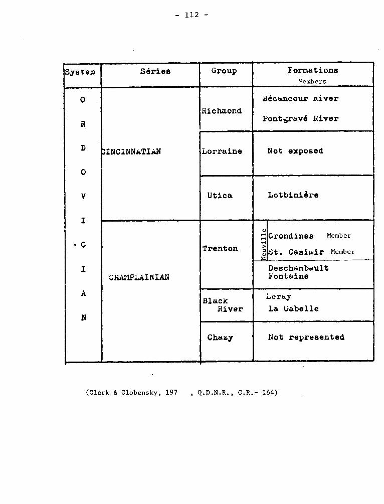
- 112 -
System Séries
'4
Group
_.
Formations Members
0
D
V
I
• C
I
A
N
0
:INCINNATIAN
—
Richmond
Béct.ncour hiver
Pontgr*vé River
Lorraine Not exposed
Utica Lotbiniére
CiiAMPLAINIAN
—
Trenton
- 4) 71
e z
Grondines Member
St. Casimir Member
Deschambault fontaine
Black River
Leray
La Gabelle
Chazy Not represented
(Clark & Globensky, 197 , Q.D.N.R., G.R.- 164)
- 113 -
both series intervene, in part at least, between the Grande Gréve and
the York River. The series becomes more and more sandy and appears to
grade both laterally and vertically into the York River type of
sandstones and shales. Fossils suggest an early Devonian age for at least part of the series.
McGerrigle, H.W., 1946, A revision of the Gaspé Devonian: Royal
Soc. Canada Trans., sec. 4, v. 40, p. 47-49.
McGerrigle, H.W., 1950, The geology of eastern Gaspé: Quebec
Dept. of Mines, G.R. 35, p. 52.
Boucot, A.J., Cumming, A.L., and Jaeger, H., 1967, Contribution
to age of the Gaspé Sandstone and Gaspé Limestone: Can. Geol. Surv.,
Paper 67-25, pp. 1-2.
FOURNIERE SEDIMENTS Precambrian
The Fourniére sediments lie south of the Cadillac belt. They
are fine-grained, bedded, grey strata resembling the greywacke of the
Cadillac sediments and consisting of argillaceous, arkosic, and quart-
zitic greywacke, locally converted to mica schist and rarely, to chlo-
rite and hornblende schist. There are no coarse-grained beds, the coar-
sest observed being a gritty, impure quartzite. Later these beds were
assigned to the Kewagama Group.
Gunning, H.C., 1934, Cadillac Area: Canada Geol. Survey, Mem. 206,
p. 19.
FRANCE LAKE GRANITE
Precambrian
This medium-grained, jointed but otherwise massive, granite underlies
about 20 square miles in the southwestern part of the map-area. It is well
exposed along the shores of France, Eva, and Ida lakes, and along Ida river.
- 114 -
It forms a stock apparently entirely surrounded by Keewatin-type volcanic
and sedimentary rocks with which it is in intrusive contact except along its
eastern margin and southwest of Ida lake where the contact is believed to be
marked by faults. In hand specimen, it is medium-grained, light-grey to pink
with feldspar, quartz and biotite as the essential constituents.
Gilbert, J.E., 1958, Bignell Area, Mistassini and Abitibi Territories,
Abitibi East and Roverval Electoral Districts: Quebec Dept. of Mines, G.R.
No. 79, p. 19.
GAGNE BROOK SERIES Paleozoic
Burton used this name for crenulated green paragneiss, garnetiferous
gneisses, quartzites and slates cropping out near Aylmer Lake. He noted
that many parts of the formation showed two intersecting s surface and in-
ferred that they have been twice deformed. Burton considered the rocks
to be Sillery correlatives, and Clark (in Cooke 1937) suggests that the
rocks are correlative of the Caldwell Group, although Burton does not mention
the presence of metavolcanics.
The unit has no stratigraphie value higher than formation and may be
abandoned.
Burton, F.R., 1931, Vicinity of Lake Aylmer, Eastern Townships:
Quebec Bur. Mines, Ann. Rept. 1930, D, 109-111.
Cooke, H.C., 1937, Thetford Disraeli, and eastern half of Warwick
map-areas, Quebec: Can. Geol. Surv., Mem. 211, p. 38.
GAGNON GROUP Precambrian
Gagnon Group has been used for metamorphic rocks including Duley
Marble, Wapussakatoo Quartzite, Wabush Lake Iron Formation.
- 115 -
The sequence has been considered the metamorphosed equivalents of
the lower part of the Knob Lake Group.
Clarke, P.J., 1967, Gras Lake - Felix Lake Area: Saguenay County:
Quebec Dept. of Nat. Res., G.R. 129, p. 28.
GAINSMOOR FAULT.
This fault strikes northeast and is normally clean cut but locally, a
breccia is found along it.
Auger, P.E., 1952, Belleterre Area, Guillet Township: Quebec, Dept. of
Mines, G.R. No. 55, p. 30-31.
GALET BEDS Trenton Group
About 15 feet of rubbly limestone underlies shales assigned to
Gloucester at Chute aux Galets on the Shipshaw river. Sinclair, as
had McGerrigle, correlates these with Cobourg.
Sinclair, G.W., 1953, Middle Ordovician beds in the Saguenay
valley, Quebec: Am. Jour. Sci., v. 251, pp. 847-848.
GAMACHE SERIES, GAMACHIAN STAGE Ordovician(?)
Schuchert and Twenhofel (1910, p. 700) gave the series name to
beds made up of Ellis Bay Formation (q.v.) on Anticosti island because
the fauna did not resemble any other then known in North America. It
was considered to be older than Silurian but younger than Richmond of
the Ordovician. This view has not been universally accepted: authors
have referred the series to the Richmond, and Ulrich has considered it
Silurian, although he has also referred the Richmond to Silurian.
- 116 -
In the correlation chart for Ordovician (Twenhofel, 1954) Gama-
chian is listed as the uppermost stage of the Cincinnatian Series of the
Ordovician. Kay (1960, p. 31) mentions the Gamachian Stage with a com-
ment concerning the difficulty of placing the fauna but does not include
it in the tabular summary of the Cincinnatian Series. As noted under Ellis Bay Formation, the formation may be partly Silurian.
Schuchert, C., TVenhofel, W.H., 1910, Ordovicic-Siluric Section
of the Mingan and Anticosti Islands, Gulf of Saint Lawrence, Geol. Soc.
Am., Bull., vol. 21, p. 700.
Twenhofel, W.H., et al., 1954, Correlation of the Ordovician
formations of North America: Geol. Soc. Am., Bull. vol. 65, Chart 2,
Column 6.
Kay, G.M., 1960, Classification of the Ordovician System in
North America: Int. Geol. Cong. XXI, pt. VII, pp. 31-32.
GARDEN ISLAND LAKE GROUP (sediments) Precambrian
It consists of well-bedded interstratified graywacke, phyllitic
silty slate,and tuffaceous beds. These are the western extension of the
"Garden Island Lake Sediments" of Bell and Bell (1932, p. 75) in Vauquelin
and Pershing townships. It is more than 1,000' thick near the east end
of range IX where outcrops show well-developed graded bedding which indica-
tes that the unit faces southward and strikes northwest. The main members,
which may be observed are medium-grained, slightly, schistose, greenish-gray beds
of subgraywacke separated by thin argillaceous beds or partings.
Bell, L.V., and Bell, A.M., 1932, Bell River headwaters area: Quebec
Bur. Mines, 1931, p. 75B.
Sharpe, John I., 1968, Louvicourt Township, Abitibi-East County:
Quebec Dept. of Nat. Res., G.R. No. 135, p. 11.
- 117 -
GASPE
The peninsula has given its name to several geological entities.
I- Gaspé Glacier
In "Geology of Quebec" (1944, p. 518), Gaspé glacier is spoken of as
having its gathering ground in the Shickshock highlands. This is the only
formal use of this term encountered. McGerrigle (1952) in the discussion
of glaciation in Gaspé does not mention the term, but names two local ice
caps. One is "Tabletops" and the other is "Béland - Upper York River".
McGerrigle, H.W., 1952, Pleistocene glaciation of Gaspé Péninsula:
Roy. Soc. Can., Tr. v. 46, Sect. IV, pp. 37-51
II- GASPE (LIMESTONES) LIMESTONE SERIES, GROUP (Wilmarth 1-805)
Logan in "Geology of Canada" 1863, (pp. 390-394) used Gaspé Limestones
as a series name for rocks that he considered "Middle and Upper Silurian, "of
has stratigraphic schema some rocks correlated with the Hel.derberg of New
York. Later a general agreement was achieved that the Grand Grève, Cape Bon
Ami, and St. Alban limestones are in modern usage Devonian. The three forma-
tions according to McGerrigle (1950, p. 49) are together about 2800 feet along
the coast in eastern Gaspé and about 12000 feet in the interior of the penin-
sula. The lowest formation is the St. Alban and is greenish, greyish shales,
shaly and limestone with some red shale. The higher formations have more car-
bonate, but both are silicous with silt or chert.
Doubt has been expressed recently whether the St. Alban Formation is De-
vonian, but with this reservation, the limestone are Lower Devonian.
Logan, W.E., 1863, Geology of Canada, pp. 390-394.
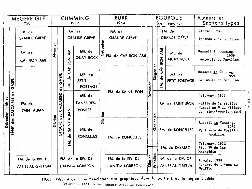
McGERRIG LE 1950
GUMMING 1959
BURK 1964
BOURQUE (ce mémoire)
Auteurs et Sections types
_ D
évo
nie
n In
féri
eur
'SÉR
IE' des
CA
L CA
IRE
S de
GA
SPÉ
FM. de
GRANDE GRÈVE
Silu
rien
D
évon
ien
GR
OU
PE d
es C
AL
CA
IRES
de
GA
SPÉ
FM. de
GRANDE GRÈVE
L
Silu
r ien
;
Dév
onie
n
FM. de
GRANDE GRÈVE
-E ° p
Sie
gen
ien
FM. de
GRANDE GREVE
Clarke, 190G
Péninsule de Forillon
FM. de
CAP BON AMI
FM.
de C
AP
BO
N
AM
I
MB. de
QUAY ROCK FM. de CAP BON AMI
FM.
de
CA
P B
ON
A
MI
MB. de
QUAY ROCK
Russell in G„,~„-iing, 1959
Péninsule de Forillon
FM. de
SAINT ALBAN
MB. de
PETIT
PORTAGE FM. de SAINT-LEON
MB. de
PETIT PORTAGE
Russell in Cu-oing, 1959
Péninsule de Forillon
FM.
de
S AIN
T-A
LBA
N
MB. de
l'ANSE-DES-
ROSIERS c m c e 4) 0
FM. de SAINT -LÉON
Crickmay, 1932 .
Vallée de la rivière Humqui au N du Village de Saint-Léon-le-Grand
MB. de
RONCELLES FM. de RONCELLES
FM. de RONCELLES
Russell in Cumming, 1959
Péninsule de Forillon (modifié)
FM. de SAYABEC Crickmay, 1932 Rive SW du lac Matapédia
Silu
r ien
c
— -o E
FM. de la RIV. DE
L'ANSE-AU-GRIFFON
FM. de la RIV. DE
l'ANSE-AU-GRIFFON
FM. de la RIV. DE
L'ANSE-AU-GRIFFON
FM. de l a RIV. DE
L'ANSE-AU-GRIFFON Kindle, 1938 Rivière de l'Anse-au- Griffon
FIG.3 Résumé de la nomenclature stratigraphique dons la portie E de la région étudiée (Bourque, 1969, M.Sc. thesis Univ. de Montréal)
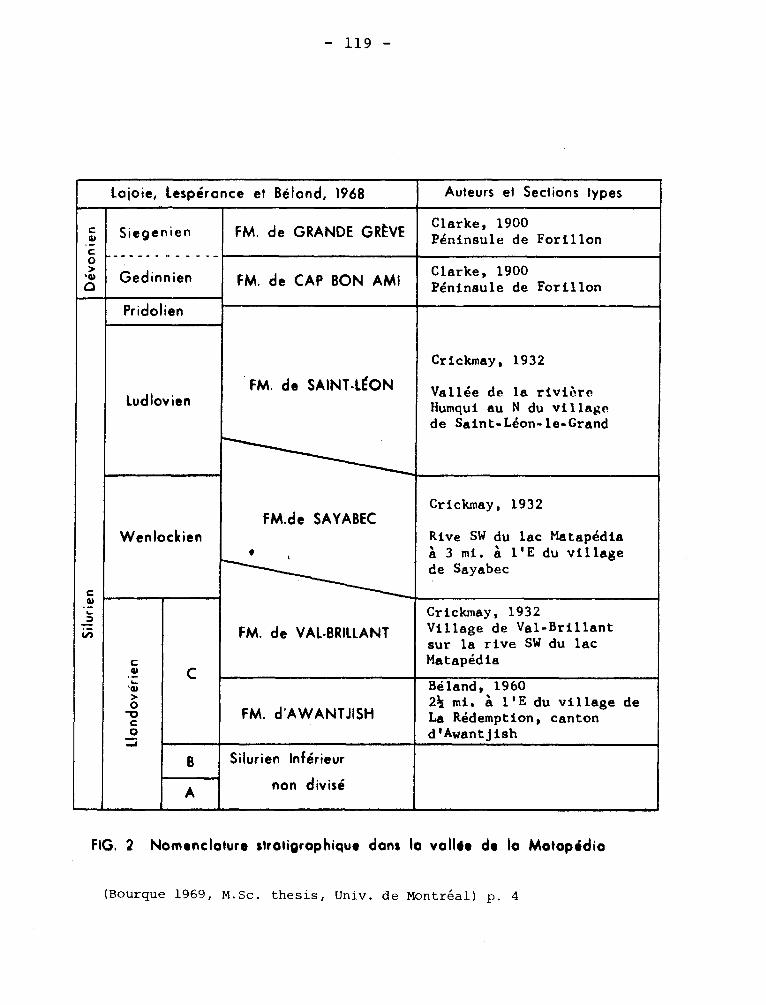
- 119 -
lojoie, lespéronce et Bélond, 1968 Auteurs et Sections types
Dévo
nie
n
1
Siegenien
Gedinnien
FM. de GRANDE GRÈVE Clarke, 1900 Péninsule de Forillon
FM. de CAP BON AMI Clarke, 1900 Péninsule de Forillon
c
in
Pridolien
FM. de SAINT-LEON
Crickmay, 1932
Vallée de la rivière Humqui au N du village de Saint-Léon-le-Grand
ludlovien
Wenlockien FM.de SAYABEC
•
Crickmay, 1932
Rive SW du lac Matapédia â 3 mi. â l'E du village de Sayabec
c w •t >
o
C
FM. de VAL-BRILLANT
Crickmay, 1932 Village de Val-Brillant sur la rive SW du lac Matapédia
FM. d'AWANTJISH
Béland, 1960 21/2 mi. A l'E du village de La Rédemption, canton d'Awantjish
g Silurien Inférieur
non divisé A
FIG. 2 Nomenclature stratigraphique dans la valide de la Motapidia
(Bourque 1969, M.Sc. thesis, Univ. de Montréal) p. 4
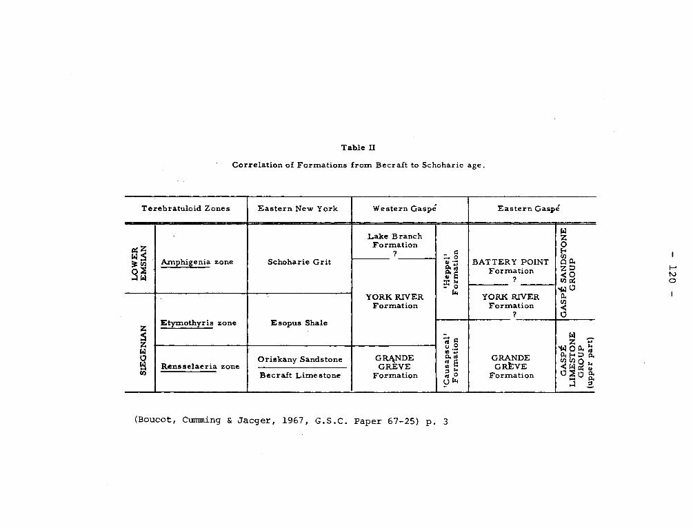
Table II
Correlation of Formations from Becraft to Schoharie age.
Terebratuloid Zones Eastern New York Western Gaspé Eastern Gaspé
LO
WE
R
EM
SIA
N
Amphigenia zone Schoharie Grit
Lake Branch Formation
'Hep
pel'
F
orm
ati
on
BATTERY POINT Formation
GA
SPÉ
SA
ND
ST
ON
E
GR
OU
P
YORK RIVER Formation
YORK RIVER Formation
SIE
GE
NIA
N Etymothyris zone Esopus Shale
'Cau
sap
scal'
F
orm
at i
on
GRANDE GRÈVE
Formation GA
SP
É
LIM
ES
TO
NE
G
RO
UP
(u
pper
part
)
Rensselaeria zone Oriskany Sandstone GRANDE
GREVE Formation Bec raft Limestone
(Boucot, Cumming & Jacger, 1967, G.S.C. Paper 67-25) p. 3
- 121 -
Table I
Devonian
Dawson
Dawson
Logan
1861
1862
1863
û °: 3 12
w o. a.
o u ° Dawson 1871
V Ells 1884
0 ° Schuchert 1900 N
cn Clarke 1913
w - - - Williams (with Breger) 1916
Alcock 1926 (D
Bailejr 1928
° Jones 1931 V
Parks 1931 4)
bU a b
Alcock
Allan
1935
1935
w --- Jones 1936
o Kindle 1938
o. --- Cooper 1942
° b u -- - Dorf & Cooper 1943
col Fritz 1944
â McGerrigle 1946
McGerrigle I950
This Report 1963
& Jacger, 1967, G.S.C. Paper 67-25) p. 2
Devonian
~ ►.
Pu
bli
she
d o
pin
ions
reg
ard
ing
the
ag
e o
f t h
e Y
or k
Riv
er
and
'Hep
pel'
Fo
rmat
ion
s
(Boucot, Cumming

— 122 —
TABLE I. TABLE OF FORMATIONS, }IATAPEDIA-TFIIISCOC.`.Ia Re•.GIJ:;, QU .EEC
SOUTHWEST CENTER NORTHEAST
TYPE. STANDARD TEMISCOUATA BAES LAC DES MF
LAC PRI~~~ _ MATAPEDIA
z Q _ z o >
LO
WE
R
GE
DIN
NIA
N
ILI
ô
HE
LDE R
B ER
GIA
N
Xi
CAP
BON AMI
Fm.
---
CAP
BON AMI
Fm.
--- _~_---^ ?
?
~~ ~~ SKALIAN
MT
WIS
SIC
K G
P
LAC CROCHE
—~ Fm l ? ?
Z
<(
_
Cn
LUDLOVIAN
UP
PE
R
CA
YU
GA
N
ST LEON Fm.
L. SAUVAGESSE LAC DES
BAIES Mm. 4121
ST. LEON
~~•1eeC
Fm.
,Q
Fn1 /... F' F
~
Zj
ST LÉON Fm.
SAYABEC Fm.
VAL BRILLANT Fm.
/SAYABEC Frn
..:_l p 0
z
Q
Q
Z
ROB TAILLE ASSELIN Fm. ii..A- , ,
WENLOCKIAN
L LA
ND
OV
ER
IAN
n
UP
PE
R
o POINTE
f AUX }
TREMBLES , Fm. t4
-1 — ^
LAC Lt RAYMOND
û Fm.
AWA.NTJISH Fm.*
4/O~
,~ JQ~
LO
WE
R
AL
EX
AN
DR
IAN
LAC z
,CASTOR < Z. MM. a
D a
) a)
A -
W
LO
WER
!MID
DL
E
CABANO Fm. CABANO Fm.
Jp̀~~v
~et- 4/
O "
l !!e 1/ f/
CAMBRIAN AND / OR ORDOVICIAN L.L.B.,1966
*The undivided Lower Silurian of northeastern district refers to rocks underlying Awantjish and over-lying Ordovician (Lac Raymond-Cahanol. Then rocks were grouped together because of large-scale mapping in that area (Lac Prime East).
(Lajoie, Lespérance and Béland, A.A.C.G. Vol. 52. No. 4, 1963)
— 123 —
248 LE GROUPE DE QUgREC ET LE GROUPE DE GASPÉ
Tableau des formations
Pléistocène et Récent
Argile, sable et gravier.
Révolution acadienne.
Siluro-
Dévonien
Intrusifs Granite h oligoclase.
nrndirn i Gabbro.
Contact d'intrusif.
Gr.
Lak
e A
ylm
er,
St.
Fra
ncis
.
siltstones interstratifiés d'ardoise noire (St. Francis supérieur).
Groupe Calcaires Impurs. (Lake Aylmer et St. Francis inférieur).
de Lits de hase: quartzites, dolomies et ardoises.
Gaspé. Lentilles de conglomérat de base.
Révo ution taconique.
Cambra
Ordo- vicien.
Intrusifs taconi-
Granite h albite.
ques. Granite h albite porphyritique.
Contact d'intrusif.
Groupe
fS
chis
tes
de
Wee
do
n.
Schistes quartzifères h séricite et rhyolites porphyritiques.
de Roches vertes.
Québec. Schistes h structure oeillée et conglomérats
d'écrasement.
Schistes quartzifères à séricite et roches volcaniques acides fracturées.
Roches métavolcaniques de composition inter-médiaire avec quelques roches vertes.
Ls N ATIItALIaTi CA]fADIDN,
(Duquette, 1959, Nat. CAn. vol. LXXXVI(xxx 3ieme serie) No. 11, p. 248
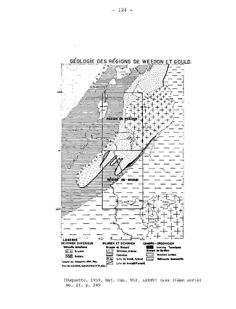
.c..lrt/ ..t eMp.n..laa t M 14.1.00 p..MLMO, tiaµNQ 1N.
%.(UNDE DEVONIEN SUPÉRIEUR
Wrestle Acndlses Granite
L3 (lobate lo ol
.~ ,,( ,i
~t o ° _ y ~ ,^
, ~ 'o . o •
~~ ,69; ..i
«'
•. ime 41•1
itl~~ .~ri
16/9» . . 70 • •
•. DE-- 00Wuo- — ---
• 1•u=
n. ,r'
SILURIEN Grgtpe H
t• i~ I Lit. de boaapAaMia alU,tlC)
ET DEVONIEN CAlABR0—ORDOVICIEN de Gaspi um Granites T000nituos Sl)tslono, ordoloa Groups de CV 140C
Coke'', Isosdon *chiefs Llts b boaod..Arbna) Q lUdltnams I►omewIlla
~o ~ , ̀ 1
,14'11 WBARD.
— 124 —
GÉOLOGIE DES RÉGIONS DE WEEDON ET GOULD.
,1
•.. an EOON J —
L.KC
,s; -~+ +~.++~-~•+~!-~~ a ~
~ ~ 1. 'li
~~
—t4+
+ ~+ ~~~! ~
~: d ;:~::C- :WE ~ -f .±
1 + ~
~—~fECDON 1f 1
• ~ '• ."• ~
.j+~-~+'+~'_ _.
*V. _~:F~++:,+
• ~
+ + •
.bA• I ~
.♦ /'°.~ '. • . • , 1. •, • l~.l
(Duquette, 1959, Nat. Can. Vol. LXXXVI (xxx 3ième serie) No. 11. p. 249
~

- 125 -
McGerrigle, H.W., 1950, The geology of Eastern Gaspé: Quebec Dept.
of Mines, G.R. 35, pp. 49-73.
III- GASPE (SANDSTONES) SANDSTONE SERIES, GROUP (Wilmarth -1-805).
Logan (22. cit. p. 394-402) reported about 7000 feet of
drab and grey relatively soft sandstones overlie the Gaspé Limestones. These
rocks have divided into several formations and traced over much of Gaspé.
Plant and animal fossils have been believed to support a Middle Devonian
age (McGerrigle, 1950, off. cit. p. 84-85), but the age has been questioned
and it is possible that Gaspé Sandstones are Lower Devonian (Boucot et al.
1967). Take in Ap. 2, Ap. 3 Boucot, A.J., Cumming, L.M., Jaeger, H., 1967, Contribution to the
age of the Gaspé sandstone and Gaspé limestone: Geol. Surv. Can. paper
67-25, pp. 1-27.
IV- GASPE SERIES, GROUP, SUPERGROUP. (Wilmarth 1-805) Paleozoic
Logan used Gaspé Series for Gaspé Limestones and Gaspé Sandstones
together with the Bonaventure Formation. Since 1863, the term has been
used only little; perhaps because the Gaspé Limestones and Gaspé Sandstones
have themselves a stratigraphic hierarchial position higher than formation
Furthermore, even in the original discussion of Gaspé Series, the Bonaventure
Formation seems to have an anomalous position.
As an alternative to abandoning the term, it is suggested that Gaspé
Supergroup be used for the formations younger than those of Quebec Supergroup
and older than the Acadian Orogeny. Duquette (1959) has used Gaspé Group
in this sense for rocks in the Eastern Townships.
Duquette, Gilles, 1959, Le Groupe de Quebec et le Groupe de Gaspé
prés du lac Weedon: Nat. Can., v. 86, p. 243-263.
- 126 -
The divisions of the Gaspé Sandstones has presented some
difficulties, most of which has been summarized by McGerrigle, who
divides the group into five units:
5. Malbaie Formation - Characterized by conglomerate zone;
includes sandstones, some shales, and very occa-
sional limestones 2000 feet
4. Battery Point Formation - Greenish-grey, coarse, feld-
spathic (red to brown feldspars), often pebbly
sandstones; some conglomerates and shales; red
beds toward the top 5000-7000 feet
3. York River Formation - Greenish-grey, fine to coarse,
feldspathic (grey feldspars) sandstones, common,
soft, green shale 1000-6000 feet
2. Fortin Series - Dark shaly slates with interbeds to inter-
zones of dark shaly limestones and of sandstones and
conglomerates. This series probably is a facies re-
ferrable to the general horizon of the York Lake. It
is known only on the south side of the Saint-Jean
(John) River anticline 0-5000 ± feet
1. York Lake Series - Interbedded sandstones of York River type
and limestones of Grande Grave type, with shaly lime-
stones, conglomerate, and quartzose sandstone. This
series marks a transition from the Grande Grave to the
York River. It is known only on the north side of the
Saint-Jean (John) River anticline, and it is not recog-
nized everywhere in this more northern area 0-4000 ± feet
- 12.7 -
This section differs from that offered in Geology of Quebec (1944, p. 300)
not only the thicknesses assigned to the formations but also in introduction
of the Fortin Series between the York Lake Series and the York River Forma-
tion.
McGerrigle points out that the Battery Point Formation includes
the beds measured by Logan and called Gaspé Sandstone.
V- GASPE SYNCLINORIUM
The several folds in the Gaspé Supergroup have made the use of Gaspé Syncli-
norium logical (McGerrigle, 1950, op. cit. p. 154). However, this major structu-
re continues far to the south of Gaspé and is known to extend into the United
States along Connecticut river valley, hence, Duquette (1959, at. cit. p. 243)
and Marleau (1959) used Gaspé-Connecticut River Synclinorium for the feature as
a whole. Cady (1960) has used "Connecticut Valley-Gaspé synclinorium" for the
same structure.
Marleau, R.A., 1959, Age Relations in the Lake Megantic Range, southern
Quebec: Geol. Assn. Canada, Pr. v. 11, p. 129.
Cady, W.M,, 1960, Stratigraphie and geotectonic relationships in
northern Vermont and southern Quebec: Geol. Soc. Am. Bull. v. 71, p. 535
also Plate 1.
GAUVIN ANDESITES Lower Devonian
The rocks that predominate in Maria mountain consist of latite in
the southern part and oligoclase andesite in the northeastern part, parti-
cularly along Maria brook. The latter consists of reddish to greenish
grey, porphyritic rocks with interbedded, amygdaloidal and tuffaceous rocks.
Under the microscope, the rock is found to consist of phenocrysts of oligo-
- 128 -
clase-andesine in a groundmass composed essentially of a host of microlites
of feldspar in black glass. (Lower Devonian).
Alcock, F.J., 1935, Geology of Chaleur Bay Region: Canada Geol.
Surv., Mem. 183, p. 72.
GEORGIA (GEORGIAN) Cambrian (?)
The village Georgia in Vermont yielded fossils that were once
considered to be middle Cambrian age, but investigations after 1891
proved them to be early Cambrian. Georgian is now a synonym for and
preferable to Waucoban as a designation for the Lower Cambrian Series.
The formations belonging to the original Georgian included some of seve-
ral ages but are mostly of slates and shales. The usage of the name in nor-
thern Vermont and to as less extent in southern Quebec is complex, and
the tracing of the changes of interpretation would demand a long account.
Howell (1929) has given a summary of part of the history, and writings
of T.S. Hunt and C.D. Walcott give other parts.
The name has been but little used in Quebec. The legend for 571
of the Geological Survey of Canada has "Lower Cambrian, Olenellus Zone,
Lower Pbtsdam of Billings, Georgia Series of Walcott." Clark (1934, p. 8)
refers to "the so-called Georgia slate formation" in the Rosenberg slice
and assigns the rocks to the Ordovician. Cady (1960, p. 572) slates that
Morses Line Slate is the present designation for Georgia slate, and the
slate can be traced from Vermont into the Rosenberg slice a, mapped by
Clark. It is probably Ordovician.
The name "Georgian" oan be appropriately retained for the Epoch
or Series, but as it has been used in Quebec, Georgia Formation should be
abandoned..
- 129 -
Howell, B.F., 1929, The Cambrian Paradoxides beds of Northwestern
Vermont: Vermont, 16th Rept. of the State Geologist, 1927-28, pp. 249-273.
Clark, T.H., 1934, The structure and Stratigraphy of southern
Quebec: Geol. Soc. Am, Bull. v. 45, p. 8.
Cady, W.M., 1960, Stratigraphie and geoteetonic relationships in
northern Vermont and southern Quebec: Geol. Soc. Am. Bull. v. 71, p. 572.
GERIDO LAKE-LEOPARD LAKE COMPLEX SYNCLINE
The structure is complex in detail. It is formed by two synclines
which plunge 20°-40° southward in the Gerido Lake area. In the northern
part of the Léopard Lake area, the eastern limb of the western syncline is
cut off by an eastward dipping, high-angle, reverse, longitudinal fault and
disappears. The eastern syncline is a nice example of tight fold with a high-
ly sheared, attenuated, overturned limb. The western limb takes up three-
fourths of the width of the syncline. It contains many shear zones, but unde-
formed pillow lavas are abundant. Their tops are to the east,.,and they dip 45°-
70° eastward. The eastern limb is highly sheared, the schistasity dips mainly
650-80° east, or about the same as the bedding in the sedimentary rocks immedia-
tely east.of the lavas. Pillows are easily recognized, but most are too deformed
for top determination. The axial plane of the fold cannot be located accurately,
but coincides roughly with the western limit of extensive shearing.
Sauvé, Pierre., and Bergeron, Robert., 1965, Gerido Lake - Thévenet Lake
Area New Quebec: Quebec, Dept of Nat. Res., G.R. No. 104, p. 77.
GERIDO LAKE - LIVAUDIERE - LAKE ANTICLINE
"This structure is anticlinal but may be complicated by faulting. On
- 130 -
the east side, the dips range mainly from 60° to 75 east, with some as low
as 40°, and, on the west side. They range from 75° east to vertical. The
anticline can be traced as far north as the widest part of Gerido lake, but
may extend farther north toward the northwest corner of the Gerido Lake area".
It trends northwest -
Sauvé. Pierre, Bergeron, Robert., 1965, Gerido Lake - Thévenet, Lake Area,
New Quebec: Quebec Dept, of Nat. Res., G.R. no. 104, p. 78.
GILMAN QUARTZITE
This formation, which is 2000 feet or more thick, is the thickness
of the Oak Hill Group and is perhaps the hardest to define: the name quartzite
is open to misinterpretation. The formation contains more mudstones and silt-
stones than highly silicious quartzites, and on slight metamorphism, slates
and phyllites develop. The geologist accustomed to mapping tuffs gains the
impression that the greenish to grayish beds are tuffaceous, but no volcanic
detritus can be recognized.
Osberg (1965, p. 226) has restricted the formation in mapping to a
wedge from a feather edge to 400 feet thick of gray and white mottled quartzite
in the Knowlton-Richmond area. The rest of the formation he assigned to Bonse-
cours Formation. Booth (1950, p. 148-149) showed the discontinuity and diver-
sity of the units in Vermont, where this formation has long been considered to
be in part equivalent to the Cheshire Quartzite (Clark 1931).
The Gilman has been dated as Lower Cambrian based on poorly
preserved Kutorgina, and is the oldest dated formation of the Oak Hill Group.
Clark, T.H., (1931) The lowest Cambrian of southern Quebec: Geol.
Soc. Am. Bull, v. 42, p. 226
— 131 —
Clark, T.H., 1936, A Lower Cambrian Series from Southern Quebec:
Roy. Can. Inst., v. 21, Pt. 1, pp. 144-146.
Osberg, P.H., 1965, Structural geology of the Knowlton-Richmond
Area, Quebec: Geol. Soc. Am., Bull. v. 76, p. 226.
Booth, V.H., 1950, Structure and Stratigraphy of the Oak Hill
Succession in Vermont: Geol. Soc. Am., Bull. v. 61, pp. 148-149.
GLENWOOD SERIES Precambrian
The Glenwood Series presents a variety of pillowed and massive
andesites, the latter material becoming in places exceptionally coarse-
grained.
This can be used as a local name.
Conolly, H.J., Hart, R.C., 1936, Structural Geology of the Osisko
Lake Area, Quebec: Canadian Inst. Mining and Metallurgy, Trans., v. 39, p. 11.
GOLDVUE QUARTZ DIORITE-GABBRO Precambrian
In the western part of Duverny Township, this rock forms a lenticu-
lar mass of carbonate rich diorite and metadiabase.
Weber, W.W., 1951, La Morandiére and Parts of Duverny, Landrienne
and Barraute Townships, Abitibi-East County: Quebec Dept. of Mines, P.R.
No. 255, p. 11.
GOWGANDA FORMATION Huronian
The name Gowganda was given by Collins, (1917, p. 10, p. 63) to
the rocks called "Upper Slate Conglomerate"by Logan. The thickness of
the formation is up to 3,000 feet but it is locally absent. It is made
- 132 -
up of clastic rocks with spectacular conglomerates. In the Onaping
map-area Collins did not separate banded cherty quartzites" and "white quart-
zites" occurring above the Lorrain from that formation on the map but does
so in the table of formations. Collins then shows Cobalt Series as inclu-
ding in ascending order, Gowganda Formation, Lorrain Formation, Banded
Cherty Quartzite, and Upper White Quartzite. More recent usage tends to
place the last two mentioned units in the Lorrain.
Thomson (1957, p. 41) has proposed to divide the Gowganda formation
of the Cobalt district into a lower unit, the Coleman Formation, which is
conglomerate, bedded graywacke, and quartzite and has a maximum thickness of
1,000 feet, and Firstbrook Formation which is about 750 feet of bedded
graywacke.
These new formations have not been described from Quebec.
Collins, W.H., 1917, Onaping Map-area: Can. Geol. Surv., Mem. 95,
p. 10, p. 63.
Thomson, Robt., 1957, The Proterozoic of the Cobalt Area: Roy. Soc.
Can., Spec. Paper No. 2, pp. 40-41.
GRANADA GREYWACKE (rocks of the Timiskaming Series) Precambrian
The Granada graywacke band consists mainly of well-bedded graywacke
with here and there beds of conglomerate cropping out near Granada post
office. In places as in the West McWatters property, local folds are
present, but determinations of tops from change of grain and cross-bedding
show that in the main the top of the band is to the north. The change
from conglomerate to greywacke takes place by a gradual increase in the
number of greywacke beds and a decrease in those of conglomerate. On
its north side the graywacke, except near the McWatters mine where it is

- 133 -
overlain by the McWatters volcanic adjoins the Cadillac-Bouzan Lake fault.
The dip of the greywacke averages about 65 to the north and its thickness
after correction for local folding is about 2,000 feet. In the northern
area of the Timiskaming Series, the relationship of the two formations
is reversed and the conglomerate is on the north side and the greywacke
band is on the south.
Wilson, M.E., 1943, The Early Precambrian succession in western
Quebec: Roy. Soc. Canada Trans., ser. 3, v. 37, sec. 4, p. 126-127.
GRANADA CONGLOMERATE Precambrian
The conglomerate of the south belt occurs predominantly in a
band from 1 to 1 miles wide near Granada Mine. Troughout most of
this band the rock is almost wholly conglomerate with only thin beds
of laminated greywacke in places, but in the eastern part of the
Southeast Rouyn area the proportion of greywacke increases. It is
also noteworthy that the width of the conglomeratic band in this
locality and eastward in Joanne Township decreases greatly. The
conglomerate consists of abundant pebbles and boulders of greywacke,
granite, andesite, rhyolite, iron formation, and other rocks up to 5
feet in diameter. Wilson assigns this to the Timiskaming.
Wilson, M.E., 1943, The Early Precambrian succession in Western
Quebec: Roy. Soc. Canada, Trans., ser. 3, y. 37, sec. 4, p. 126-127.
GRANBY slice Paleozoic
T.H. Clark (1934) gave the name Granby Slice to a terrane
bouni3d on the southeast by the Philipsburg thrust and on the northwest
by Logan's Line. He, as had all previous workers, recognized that
- 134 -
sandstones, siltstones, and shales of the Sillery Formation are a very
large part of the slice.
Some writers have used Granby as a synonym for Sillery, but
the name serves no useful purpose.
Clark, T.H., 1934, Structure and stratigraphy of southern
Quebec: Geol. Soc. Am., Bull. v. 45, p. 8.
GRENVILLE
Grenville is a village and township north of Ottawa river, 60 miles
northwest of Montreal.
1- Grenville limestone band. - During his investigation of the crystalline
rocks of the upland north of St. Lawrence river, Logan and his co-workers had
the habit of referring to the individual outcrops of limestone layers by a
geographic name. Grenville was one such name in use by 1847.
II- Grenville Series (Wilmarth -1-877) - By 1963, Logan had come to use Gren-
ville as a group name for all the limestone bands. At the same time it was
recognized that other rocks such as quartzite and some gneisses were closely
related to the limestones and were assimilated to the name (Geology of Canada,
1863, p. 839). Also the conformable bodies of granitic and other gneisses were
assigned a place in a stratigraphic section, and the whole was referred to a
Laurentian System. For thirty years the use of Grenville was inconsistent, but
with the work of Adams (1895) the name became better defined. It was used es-
sentially for highly crystalline metasedimentary rocks but with some meta-volca-
nic rocks. This definition is satisfactory for western Quebec. However the
outcrop area of the Grenville Series is only a small fraction of the Grenville
Subprovince.
- 135 -
Logan, W.E., 1863, Geology of Canada, p. 839.
Adams, F.D., 1896, Geology of a portion of the Laurentian area lying
to the north of the island of Montreal: Geol. Surv. Can., Ann. Rept. VIII, 1895
p. 11-14 J.
Thomson, J.E., 1956, The Grenville problem: Roy. Soc. Can., Spec.
Pub. No. 1, Univ. of Toronto Press.
III- Grenville Gneisses - Some authors have used this term for orthogneisses
as well as paragneisses. It is an unnecessary term and tends to cause misun-
derstanding. "Gneisses of the Grenville Province" can be used to designate
the rocks.
IV- Grenville (Subprovince) (Province) - M.E. Wilson (in Thomson, 1956, oa.cit.,
p. 98) has stated that in 1922 he assigned the eastern part of the Canadian
Shield to a St. Lawrence Province which was in turn divided into a Timiskaming
Subprovince and a Grenville Subprovince. These names were not published until
1939 and were based on continuity of exposures of lithologic units. J.E. Gill
(1949) and J.T. Wilson (1949) presented the results of studies of the Canadian
Shield at the same time and proposed that Grenville Province be used for what
was essentially Grenville Subprovince. Both Gill and J.T. Wilson used the trends
of the structures to establish the divisions, although Wilson supplemented the
information with data from geophysics.
The rise of the potassium-argon method of mineral dating and the
interest in tectonic maps led to the use of designations such as tectonic pro-
vince, orogenic belt, orogenic province. and mineral date province for units
of which Grenville Province was one. The Grenville Province shows dates that
cluster about 950 X 106 years, and this date is, by some authors, made part of
the definition of Grenville Province.
— 136 —
It is suggested that the attempt to retain Grenville Subprovince in
the sense of M.E. Wilson as a lithostratigraphic unit be abandoned, and that
Grenville Province be used for the lithostratigraphic, mineral date, and tectonic
division.
Wilson, M.E., 1941, Anniversar y Volume: Geol. Soc. Am., p. 274.
Gill,J.E., 1949, Natural divisions of the Canadian Shield: Roy.
Soc. Can., Tr. 43, Sect. IV, pp. 61-69.
Wilson, J.T., 1949, Some major structures of the Canadian Shield:
Can. Inst. Min. and Met., Bull. No. 450, pp. 543-554.
Stockwell, C.H., 1962, A tectonic map of the Canadian Shield:
Roy. Soc. Can., Spec. Pub. N. 4, pp. 6-15.
V- Grenville Front (or Fault Zone). - H.C. Cooke (1947) tentatively suggested
that the boundary between the Grenville Subprovince and the Timiskaming
Subprovince is a fault for which the trace is determined by joining the
Murray fault near Sudbury, Ontario, to the fault that had been inferred by
Norman to exist near Mistassini Lake. The suggested throughgoing fault
passed across geologically mapped areas in Quebec and ,although faults were
found, one accordant with the suggestion does not exist. On the "Tectonic
map of Canada", (Derry et al. 1950) the locus of the hypothetical fault is
shown as "Grenville Front of Fault zone". The results of a substantial
amount of mapping in Quebec has established that the Grenville Front is a
zone of transition in which the grade and crystallinity of the metamorphic
rocks increase going from northwest to southeast.
Cooke, H.C., 1947, The Canadian Shield: Geology and Economic
Minerals of Canada, Ed. III, p. 20.
Derry, D.R., et al., 1950, Tectonic Map of Canada.
- 137 -
VI- Grenville Orogeny - (Grenvillian Orogeny) - Grenville Thermal Event.
The potassium-argon ages from the Grenville Province tend to
cluster about 950 X 106 years. Although the reality of the dates is
unquestioned, the interpretation is a subject for debate. Evidence from
other radiometric dates shows that at least some rocks in the province were
deformed long before this. (Krogh and Davis, 1969). In fact it is not
possible to point to any part of the province as certainly having been
first deformed about 109 years ago. The date may be that of a thermal
event. Grenville Orogeny (Stockwell, 1962, off. cit. p. 7), or Grenvillian
Orogeny (Geol. Bury. Can. Map 1251A is probably a misnomer because the dates
refer to an event, which is improbably that of an orogeny.
Krogh, T.E. and Davis, G.L., 1969, Geochronology of the Grenville
Province: Carnegie Inst. Yearbook 67, pp. 222-230.
GRONDINES FORMATION Trenton
Clark proposed that if the Upper Trenton limestones of the
Grondines.-Neuville area be separated from the middle Trenton that
Grondines be used for the formation. These beds would be Cobourg
equivalent. See Neuville Formation.
Clark, T.H., 1959, Stratigraphy of the Trenton Group, St.
Lawrence Lowland, Quebec: Geol. Assn. Can., Pr., v. 11, p. 18.
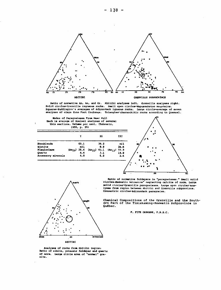
Ab 10 30 30 70 10 30 30 70 W An
1955, p.
I
Hornblende 65.1 Biotite nil Plagioclase (An29) 26.4 Quartz 4.4 Accessory minerals 4.0
Modes of Paragneisses From Near Hull Each is average of Rosiwal analyses of several
thin sections. V01e10.e per cent. (Sabourin, 35)
39.2 nil
8.8 26.6 (An23) 43.1 (An12) 55.9
3.1 14.8
5.8 2.6
30
- 138 -
ABITIBI
GRENVILLE SUBPR17VINCt
Ratio of normative Ab, An, and Or. Abitibi analyses left. Grenville analyses right. Solid circles-Grenville ingneous rocks. Small open circles-Napussakatoo mountains. Squares-Buddington's averages of Adirondack igneous rocks. Large circle-average of seven analyses of clays from Fort Coulonge. Triangles-charnockitic rocks according to Quensel.
Ratio of normative feldspars in "paragneisses." Small solid circles-Keewatin volcanics" neglecting calcite of norm. Large solid circles-Grenville paragneisses. Large open circles-ana-lyses from region between Abitibi and Grenville subprovince. Concentric circles-Adirondack paragneiss.
Chemical Compositions of the Grenville and the South-ern Part of the Timiskaming-Keewatin Subprovince in Québec.
F. FITZ OSBORNE, F.R.S.C.
30 *abscise'
ABITIBI
Analyses of rocks from Abitibi regions Ratio of albite, potassic feldspar and quartz of norm. Large circle area of "normal" gra- nite.
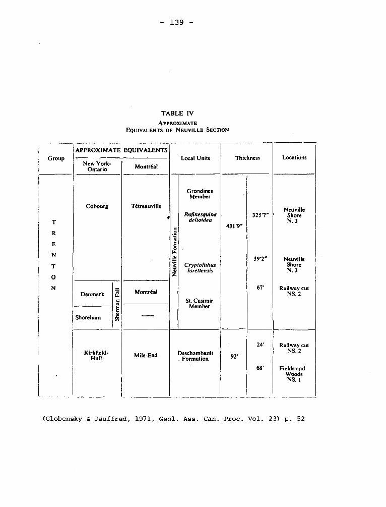
431'9"
92'
New York-Ontario Montréal
Neuville Shore N. 3
Railway cut NS. 2
Neu
v ill
e F
orm
atio
n
APPROXIMATE EQUIVALENTS Local Units Thickness Locations
Cobourg Tétreauville
Grondines Member
Ra/inesquina deltoidea
Neuville Shore N. 3
Denmark
She r
man
Fal
l
Shoreham
Kirkfield- Hull
•
Montréal
Mile-End
325'7"
39'2"
67'
Cryptolithus lorettensis
St. Casimir Member
Deschambault Formation
24' Railway cut NS. 2
68' Fields and Woods NS. 1
Group
T
R
E
N
T
O
N
- 139 -
TABLE IV
APPROXIMATE
EQUIVALENTS OF NEUVILLE SECTION
(Globensky & Jauffred, 1971, Geol. Ass. Can. Proc. Vol. 23) p. 52
- 140, -
GULL LAKE ANORTHOSITE Precambrian
The outcrop of basic rock and anorthosite is 10 by 6 miles
and is south of Gull Lake in the Dalhousie mountains. The anorthosite
has been much altered and is cut by many dikes and irregular masses
of quartz-diorite. This is part of the Bell River Complex.
Freeman, B.C., 1939, The Bell River Complex, northwestern
Quebec: Jour. Geology, v. 47, p. 28.
GUN RIVER FORMATION Silurian
The 300 feet of gray limestone with shale interbeds that was
designated D2 to D8 of the Richardson-Logan scheme for Anticosti island
was called Gun River by Schuchert and Twenhofel. Together with the
Becsie it makes up the revised Anticosti Group of the lower Silurian or,
according to some authors, the Anticostian Series. Twenhofel, (1927,
p. 20) modified the definition semewhat by assigning about 60 feet of
limestone west of Jupiter river to the overlying Jupiter Formation.
Schuchert, C., Twenhofel, W.H., 1919, Ordovicic-Siluric section
of the Mingan and Anticosti Islands, Gulf of Saint Lawrence, Geol. Soc.
Am. Bull., v. 21, p. 700.
Twenhofel, W.H., 1927, Geology of Anticosti Island: Can. Geol.
Surv., Mem. 154, p. 26.
GWILLIM LAKE FAULT.
The existence of this northeasterly-striking fault was first
recognized in Levy township where it appears to be related to the ore-
bearing structures of Opemiska Copper Mines. Direct evidence for the
presence of this major fault in the map-area is lacking. It can only
- 141 -
be said that its assumed location coincides with a drift-covered region
north and west of Noora lake. It strikes northeast and dips southwest.
Duquette, Gilles., Mathieu, Arthur., 1966, Geology of the Northeast
Quarter of McKenzie Township, Abitibi-East County: Quebec, Dept. of Nat.
Res., P.R. No. 551, p. 10-11
HARRICANAW SERIES, (Wilmarth -1-914) Precambrian
T.L. Tanton gave the name to less than 100 feet of sheared conglome-
rate, arkose, and greywacke forming a single exposure on Authier river,
Disson Tshp., Quebec. Tanton states that the beds contain debris of and
overlie unconformably iron formation of the Abitibi Group. The name
is no longer current.
Tanton, T.L., 1919, The Harricanaw-Turgeon Basin, Northern Quebec:
Geol. Surv. Can., Mem. 109, pp. 39-40.
HART-JAUNE FAULT Precambrian
The most important single structural feature of the area is the
Hart-Jaune fault, which extends from the outlet of Hart-Jaune river
northeasterly 28 miles across the area. It separates the granulite-
grade rocks of the upland to the south from the amphibolite-grade
gneisses to the north. It caused an uplift of the igneous
and metamorphic rocks of the upland to the level of amphibolite-grade
gneisses. It dips southwest.
Kish, Leslie, 1968, Hart-Jaune River Area, Saguenay County:
Quebec Dept. of Nat. Res., G.R. No. 132, p. 88-89.
- 142 -
HARVENG DOLOMITIC SCHISTS AND DOLOMITES
The name Harveng is tentatively given to this formation after the
area in which it was first observed. Although the formation is highly
folded and its base not exposed, its thickness apparently exceeds 700
feet. The formation consists of dolomitic shales grading downward into
sandy and massive dolomite. It outcrops within a small antielinorium
striking north-northwest in the northeast corner of the Harveng Lake area.
Sauvé, Pierre., Bergeron, Robert., 1965, Gerido Lake-Thévenet Lake
Area, New Quebec: Quebec, Dept. of Nat. Res., G.R. No. 104+, p. 12
HASTINGS CREEK LIMESTONE Ordovician
The 260 feet of white, dove gray, and dark gray limestones
making up the lower part of division B2 and the whole of B1 of Logans
Philipsburg section have been called Hasting Creek by McGerrigle.
McGerrigle, H.W., 1931, Three geological formations in
northwestern Vermont: Rept. of State Geol., 17th, 1929-30, 185.
HAVELOCK BRECCIA
This breccia, which has a circular outcrop about 500 feet across, is
14 miles south of Havelock, and is considered to be the filling of a diatre-
me. The country rock is sandstone of the Covey Hill Member of the Covey Hill
Formation, which is Cambrian. The breccia contains blocks large enough to sup-
port small quarries of Trenton limestone.
Clark, T.H., 1966, Châteauguay Area, Châteauguay Auntingdon, Beauharnois,
- 143 -
Napierville and St. Jean Counties: Quebec, Department of Nat. Res., G.R. No. 122,
p. 47.
HAVELOCK FAULT.
This fault which strikes N 20°E with east side downthrown, crosses the
Chateauguay area. Clark surmises that the fault extends southward into New
York. The displacement is not readily determinable but is probably between
800 and 1500-feet.
Clark, T.H., 1966, Chateauguay Area: Quebec Dept. Nat. Res. G.R. 122, pp.
43-44.
HAVRE-AUX-MAISONS FORMATION
The two members of the Havre-aux-Maisons formation are different
in age. The Cap Addle member, which is Lower Windsor, includes basaltic
lava flows, with some andesitic and rhyolitic types, as well as tuffs and
agglomerates. The latter rocks are interbedded with conglomerates,
sandstones, siltstones, partly fossiliferous limestones and calcareous
shales, and non-fossiliferous red and greyish green argillites. In
places, this assemblage contains fairly regular beds of gypsum.
Sanschagrin, Roland, 1964, Magdalen Islands: Quebec Dept. of
Nat. Res., G.R. No. 106, p. 14.
HELLANCOURT (VOLCANIC) FORMATION Precambrian
These volcanics are named after Hellancourt Lake (east half, Gerido
Lake area), where the formation has been studied in greatest detail. Most,
if not all, of the volcanic rocks of the area probably belong to the Hallan-

- 144 -
court formation. It is between 1+,000 and 5,000 feet thick on the western
limb of the syncline near Hellancourt Lake, where shearing is rather mild
or missing, but is much thinner, owing to intense shearing, on the eastern
limb of the fold. The bulk of the formation is made up of pillow and massi
ve flows of meta-basalt. Minor agglomerates occur and some of the coarser-
grained rocks may be meta-diabase sills.
Sauvé, Pierre., Bergeron, Robert., 1965, Gerido Lake-Thévenet Lake
Area, New Quebec: Quebec, Dept. of Nat. Res., G.R. No. 101 , p. 23-31.
HIGHGATE FORMATION Lower Ordovician
This formation of the St. Albans eync].inoriu was named in
Vermont bat extends northward into Quebec. The formation bau slates
and carbonate rook and is from the fossils considered Lower Ordovician.
The name is but rarely used in Quebec.
HIGHGATE SPRINGS (SERIES) SEQUENCE
Logan recognized that the exposures of some rocks occurring
sparingly in Quebec were better exposed in Vermont than in Quebec. McGerrigle
(1931, p. 179) proposed that the beds extending from Chazy to Trenton be cal-
led Highgate Springs Series. Kay (1958, p. 65) refers to the same rocks as a
sequence and describes the formations at St. Dominique and St. Pie in Quebec.
Clark (1964) in describing the same rocks does not refer to the work of Kay
nor to the Highgate Springs Sequence.
Kay lists with thicknesses the formations found at the type loca-
lity. These are in ascending order with thicknesses in brackets. Belden's
Fm. (150 ft) Carman Ss. (120 ft). The Beldens was considered Chazy but is
probably Beekmantown,and the Hortonville is Trenton.

- 145 -
McGerrigle, H.W., 1931, Three geological formations in north-
western VermontL Rept. of State Geol. 17th, 1929-30, pp. 181-184.
Kay, G.M., 1958, Ordovician Highgate Springs Sequence fo Vermont
and Quebec and Ordovician classification: Am. Jour. Sci., v. 256, pp. 68-73.
Clark, T.H., 1964, St. Hyacinthe Area (West Half): Quebec Dept.
Nat. Res., G.R. 101, pp. 10-32.
HOCHELAGAN FORMATION (STAGE) Pleistocene
This term was proposed by Woodworth as a tribute to the Pleistocene
studies made at Montreal and as a substitute for Champlain. It was to
apply to both the marine deposits and to the stage.
The term did not pass into common use.
Woodworth, J.B., 1905, Ancient Water levels of the Champlain and
Hudson valleys (N.Y.): N.Y. State Mus., Bull. 84, pp. 20b-222.
HOLMES GNEISS Precambrian
Biotite-quartz diorite gneiss underlies most of Holmes township and
extends as a band with a width decreasing from 6 miles to 31 miles, across
Cuvillier. Near the central part of the latter township, its continuity is
interrupted by the southerly trending strip of greenstone about half a mile
wide. The rock is medium-grained and light gray. The dip of the gneissic
structure is steeper in the southern part of the body than in the northern
part. Typical specimens of the gneiss contain calcic oligoclase (50%),
quartz (30%) and biotite (10%).
Longley, W.W., 1946, Tonnancourt-Holmes Map-Area, Abitibi County:
Quebec Dept. of Mines, G.R. No. 24, p. 12.
- 146 -
HONORAT GROUP ORDOVICIAN
The Honorat group occupies roughly the south-central quarter of
the area, comprising mainly the drainage area of Garin brook. It is
bordered on the north by the Matapedia group, and on the south by the
Chaleurs Bay group. The name is taken from the township in which most
of the best exposures are found. The geological structure within the
group is complex, and it was not found possible to work out the strati-
graphic sequence. Likewise, the thickness of the group is unknown,
though it must be great, possibly as much as 14,000 feet. The bulk of
the group is dark grey non-calcareous to very slightly calcareous mudstone
or argillite and siltstone. In some places the rock is dark olive-grey,
and in many places lighter coloured, commonly calcareous laminae and
beds up to about 3 inches thick occur. It has no fossils.
Skidmore, W.B., 1965, Honorat-Reboul Area, Bonaventure County:
Quebec Dept. of Nat. Res., G.R. No. 107, p. 8-9.
HUB LAKE SYÉNITE
The Hub Lake syenite forms a mass about l miles in diameter, to the
south and southwest of Hub lake near the centre of Montbray township. The
rock near the centre of the mass is a rather ordinary variety of syenite of
coarse, granitic texture. It consists largely of finely twinned pink albite
with a well-developed zonal texture. Smaller quantities of orthoclase and
hornblende are present, and a very little quartz. In addition to these prin-
cipal minerals, epidote, titanite, zircon, and apatite occur as accessories.
Cooke, H.C., James, W.F., Mawdsley, J.B., 1931, Geology and Ore Depostis
of Rouyn-Harricanaw-Region, Quebec: Canada, Geol. Surv., Mem, 166, p. 111.
- 147 -
HULL LIMESTONE (FORMATION) Trenton Group
The name Hull was given by Raymond (1914, p. 348) to the 100 feet
of limestone with the "Crinoid fauna". The beds are commonly thin bedded
with prominent shale partings. Despite the fact that the beds are reaso-
nably distinctive, the name has not been used in Quebec other than in the
part along Ottawa valley. Deschambault Formation is presumably the equi-
valent of at least part of the Hull. At Hull the formation is above the Rockland and beneath Sherman Fall beds.
Raymond, P.E., 1914, The Trenton Group in Ontario and Quebec: Can.
Geol. Surv. Summ. Rept. 1912, p. 348.
HUDSON RIVER SHALES Ordovician
Divers combinations of Hudson or Hudson River with stratigraphic or
petrographic names have appeared since 1840. Mostly the names designate
gray shales or shales and sandstones or their metamorphosed equivalents ran-
ging in age from Cambrian to Silurian. However, the name has been used for
beds of late Middle to Late Ordovician. In Quebec, particularly among
writers of the latter part of the 18th century, the name is used more or
less as a synonym for Lorraine. This, however, is not invariably the case.
The name is of historical interest.
IBERVILLE FORMATION Middle Ordovician
Clark (1934, p. 4) shows Iberville formation as occupying the
northeast quarter of the Lacolle map area. This formation is in the fore-
land and is with the underlying Stony Point formation considered to have a
thickness in excess of 2,000 feet. In "Geology of Quebec" (1944, p. 267) the
Stony Point is referred to as "Stony Creek". The Iberville is assigned to
Utica. The best published description is by Hawley (1957, pp. 63-68) who
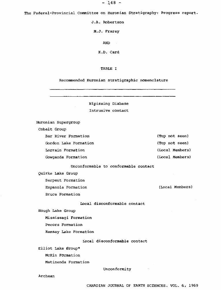
- 148 -
The Federal-Provincial Committee on Huronian Stratigraphy: Progress report.
J.A. Robertson
M.J. Frarey
AND
K.D. Card
TABLE I
Recommended Huronian stratigraphic nomenclature
Nipissing Diabase
Intrusive contact
Huronian Supergroup
Cobalt Group
Bar River Formation
Gordon Lake Formation
Lorrain Formation
Gowganda Formation
Unconformable to conformable contact
Quirke Lake Group
Serpent Formation
Espanola Formation
Bruce Formation
Local disconformable contact
Hough Lake Group
Mississagi Formation
Pecors Formation
Ramsay Lake Formation
Local disconformable contact
Elliot Lake Group*
McKin Formation
Matinenda Formation
Unconformity
Archean
(Top not seen)
(Top not seen)
(Local Members)
(Local Members)
(Local Members)
CANADIAN JOURNAL OF EARTH SCIENCES. VOL. 6, 1969
— L49 --
described the formation from Vermont as consisting in the lower part of cal-
careous and non-calcareous shale, with beds of dolomite and in the upper
part of rhythmically alternating interbeds of non-calcareous shale and lami-
nated dolomitic siltstone.
Hawley (1957, p. 63) suggests that the Senigon well (Clark
and Strachan, 1955, pp. 687-688) is in the Iberville, although the collar of
the hole is within the outcrop of Stony Point. The descriptions of the litho-
logy are inadequate to pass judgement on Hawley's statement.
Clark, T.H., 1934, Structure and stratigraphy of southern Quebec:
Geol. Soc. Am., Bull. v. 45, p. 1+.
Hawley, David, 1957, Ordovician shales and submarine slide brec-
cias of northern Champlain valley in Vermont: Geol. Soc. Am., Bull. v. 68,
pp. 63-68.
Clark, T.H., and Strachan, I., 1955, Log of the Senigon well,
southern Quebec: Geol. Soc. Am. Bull., v. 66, pp. 685-693.
INCOGNITO boulders
Boulders occurring on the south shore of Matapedia lake have
boulders and cobbles of Schickshock Formation in a matrix with Middle
Silurian fossils. No exposure is known.
011erenshaw, N.C., 1967, Cuoq-Langis Area, Matane and Matapedia
counties: Quebec Dept. Nat. Res., G.R. 121, pp. 96-102.
INDICATOR LAKE SERIES Proterozoic
This is apparently a synonym for Pépeshquasati or Otish Mountains Group.
It is described as extending 100 miles northeast of Mistassini lake.
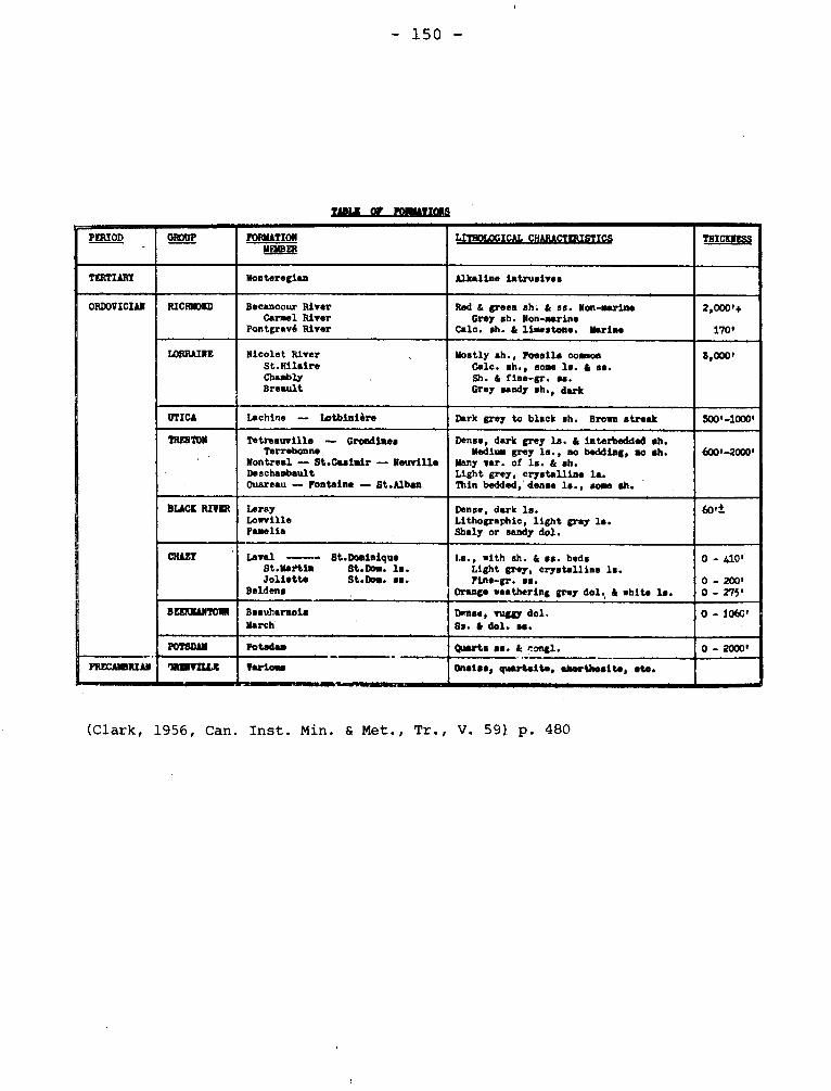
- 150 -
IA= OF FORMATIONS
PERIOD GROUP FORMATION LITMOLOGICAL CHARACTERISTICS THICKNESS MEMBER
TERTIARY Monteregian Alkaline intrusives
ORDOVICIAN RICHMOND Becancour River Carmel River
Pontgravé River
Red & green eh. & as. Non-marine Grey sh. Non-marine
Calc. sh. & limestone. Marine
2,000'+
170'
LORRAINE Nicolet River St.Hilaire ChembIy Breault
Mostly eh., Fossils common Calc. sh., some ls. & ss. Sh. & fine-gr. se. Grey sandy eh., dark
5,000'
UTICA Lachine — Lotbinière Dark grey to black eh. Brown streak 500'-1000'
TRENTON
• Tetreauville — Grondiaes
Terrebonne Montreal -- St.Casimir — Neuville Deschambault Ouareau — Fontaine — St.Alban
Dense, dark grey Is. & interbedded sh. Medium grey le., no bedding, no ah.
Many var. of ls. & sh. Light grey, crystalline la. Thin bedded,'denee le., some ah.
600'-2000'
BLACK RIVER Leray Lowville Pamelia
Dense, dark le. Lithographic, light gray Is. Shaly or sandy dol.
60't
CRAZY Is., with sh. & se. beds Light grey, crystalline Is. Fine-gr. se.
Orange weathering grey dol., & whig la.
0 - 410'
0 - 200' 0 - 275'
Leval Bt.Dominique St.Martin $t.Dom. la. Joliette St.Dom. es.
Hoidens
BEEKMANTOIN Beauharmois March
Dense, vuggy dol. Ss. & dol. se.
0 - i06C'
POTSDAM Potsdam Quarts es. & congl. 0 - 2000'
PRECAMBRIAN 7RINVELI.R Various Oasiss, quartaite, dartlasite, site.
(Clark, 1956, Can. Inst. Min. & Met., Tr., V. 591 p. 480
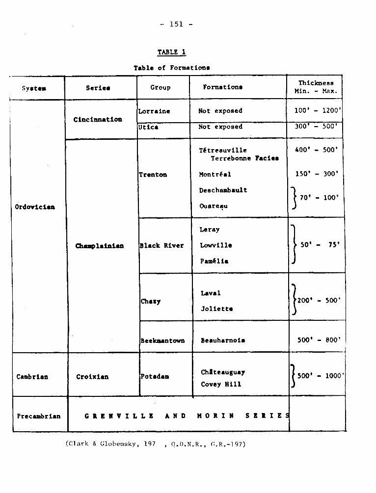
- 151 -
TABLE 1
Table of Formations
System Series Group Formations Thickness Min. - Max.
Cincinnation
-4
Lorraine Not exposed 100' - 1200'
Utica Not exposed ' 300' - 500'
Ordovician
Champlainian
Trenton
Tétreauville Terrebonne Facies
Montréal
Deschambault
Ouareau
400' - 500'
150' - 300'
70' - 100'
Black River
Leray
Lowville
Pamélia
50' - 75'
Chasy Laval
Joliette 200' - 500'
Beekmantown Beauharnois 500' - 800'
Cambrian Croixian Potsdam
t
Châteauguay
Covey Hill 500' - 1000'
Precambrian
4
GRENVILLE AND MORIN SERIES
(Clark & Glohensky, 197 , Q.D.N.R., f;.R.-197)
- 152 -
Robinson, W.G. 1956, Grenville of New Quebec: Roy Soc. Can., Spec.
Pub. No. 2, p. 17.
JEAN VENNE GRANITE
Precambrian
The Jean Venne granite is medium-grained and dark grey to chocolate
brown. It differs from all other crystalline rocks of the district in that
it shows little or no evidence of shearing.
Coté, P.E., 1960, Chertsey Area, Joliette, Montcalm and Terrebonne
Electoral Districts: Quebec Dept. of Mines, G.R. No. 93, p. 19-20.
JOLIETTE MEMBER Chazy
Clark (1956, p. 278) has given this name to massive sandstone
beds forming the base of the Laval Formation at Joliette.
Clark, T.H., 1956, Oil and gas in the St. Lawrence Lowland of
Quebec: Can. Inst. Min. and Met., Tr., V. 59, p. 278 (Bull. p. 480).
JOSSELIN GNEISS Precambrian
The Josselin gneiss underlies a strip adjacent to the southern
boundary of the area. It extends eastward across Holmes and Cuvillier town-
ships as a band increasing in width to about one and 3/4 miles. The gneiss
is cut by many dykes, chiefly of pegmatite and aplite. The rock is medium-
to fine-grained in texture and grey to pink in colour. It has a well-deve-
loped schistose structure and in places has a definite banded appearance.
Longley, W.W., 1946, Tonnancourt-Holmes Map-Area, Abitibi County:
Quebec Dept. of Mines, G.R. No. 24, p. 12.
- 153 -
JUPITER (RIVER) FORMATION Silurian
Beds designated D9, D10, and E1_10 in the Richardson-Logan
scheme for Anticosti island were named Jupiter River by Schuchert
and Twenhofel. The "River"was omitted from 1928. The lower part
of the section which is about 650 feet, is made up of limestone
and shales passing upward into limestone beds. Fossils are abundant.
The beds in the Silurian Correlation chart (Swartz et al) are shown
as "Niagaran Series".
Schuchert, C., Twenhofel, W.H., 1910, Ordovicic-Siluric
Section of the Mingan and Anticosti Islands, Gulf of Saint Lawrence:
Geol. Soc. Am., Bull., vol. 21, p. 713.
Swartz, C.K., et al., 1942, Correlation of the Silurian
formations of North America: Geol. Soc. Am., Bull. v. 53, pp. 533-536.
KALLIO SLATE Proterozoic
The upper part of the "C" member or the Upper slate member of the
Temiscamie Formation (g.v.) as defined by Wahl (1953) was referred to
Kallio Formation by Quirke, Goldich, and Krueger (1960) following the
suggestion in an unpublished thesis by Neilson. However in 1966 Neilson
reverts to the usage suggested by Wahl and assigns the argillites and
graywacke with pyrite and graphite to the Témiscamie Formation.
Wahl, W.G., 1953, Témiscamie River Area: Quebec Dept. of Mines,
G.R. 54, p. 6.
Quirke, T.T., Jr., Goldich, S.S., and Krueger, H.W., 1960, Composi-
tion and age of the Témiscamie Iron Formation, Mistassini Territory, Quebec,
Canada: Econ. Geol. vol. 55, pp. 316-317.
- 154 -
Neilson, J.M., 1966, Takwa River Area, Mistassini Territory: Quebec
Dept. Nat. Res., G.R. 124, p. 37.
KASTASAKAU COMPLEX Precambrian
This is a nonce name used by Neilson (1950, p. 4) for granitic and
syenitic gneisses and plutonic textured analogues southeast of Temiscamie
river.
In the area described the complex is southwest of the inferred site
of the Mistassini Fault and hence is in the Grenville Province.
Neilson, J.N., 1950, Temiscamie Mountains Area, Mistassini Territory:
Quebec Dept. of Mines, P.R. 238, p. 4.
KEEWATIN
Two different localities have given their names to geological features.
One locality is a district on the west side of Hudson Bay north of the 60th
parallel and is in the Northwest Territories, whereas, the locality for
"Keewatin greenstones" is in the Lake of the Woods districts, Ontario, very
close to the Manitoba boundary.
I- KEEWATIN GLACIER Pleistocene
J.B. Tyrell named a centre of ice accumulation northwest of Hudson Bay
from the local district viz. Keewatin. It has been inferred (Geology of
Quebec, 1944, p. 494) that the deposits of till from the western sheet merged
with those from a Labrador sheet near the western boundary of Quebec. Some
tills have been given the name Keewatin.
II- KEEWATIN Archean
Logan as well as some later workers assigned most of the rocks of
- 155 -
the Canadian Shield to one or other of two units, one being Laurentian or
the older, the other being the Huronian. While mapping in western Ontario,
A.C. Lawson found meta-lavas and some intrusive rocks of similar composition
such as had been assigned to the Huronian. He was not satisfied with the
accepted interpretation of their relationships to other rocks called
Huronian and to some crystalline rocks considered Laurentian. He, therefore,
introduced Keewatin for the formation and considered it "Huronian (7)".
By 1904, it was realized that the Keewatin is distinct from the Huronian
but an international committee at that time placed it above Laurentian.
Until about 1912 there was considerable confusion, and the name Keewatin
can be found applied to a formation, a series, a group, a system,or complex.
One can find lower Huronian as a synonym, and such terms a Lower Keewatin
crept into print.
In Quebec, little confusion of usage was encountered because little
work was done on Archean rocks prior to 1912, and Abitibi was used as a
name for rocks lithologically similar to Keewatin.
The present status of the name is uncertain: it is likely to be in
the form "The Keewatin" and is at the least a period or system name.
III- KEEWATIN-TYPE
Archean
Keewatin-type is used in the same way as Temiscamian-type (1.v.)
for metavolcanic rocks of Archean-like aspect.
KENSINGTON SYENITE (stock) Precambrian
Syenite in the north-central part of Kensington township forms an
outcrop about seven miles from east to west and a little more than three
miles in its maximum north-south dimension. The rock is coarse-grained
and is nowhere gneissic. In the western part of the stock, the rock is
- 156 -
pink and low in dark minerals; in the central part it is grey. The
Kensington syenite contains potassic feldspar. Biotite is the common
ferromagnesian constituent, but hornblende also present in some facies
of the rock. Most of the rock has quartz visible to the naked eye.
Aubert de la Rue, E., 1953, Kensington area, Gatineau and
Labelle Counties: Quebec Dept. Mines, Geol. Rept. 50, p. 19-21.
KEWAGAMA GROUP Precambrian
This name was give to metasedimentary rocks forming a
group separating the Malartic Volcanics below from the Blake River
Volcanics above. The group is from 1,000 to 3,000 feet thick and
may be as much as 10,000 feet thick near Clayhill rapids on Kinojevis
river. Most of the group is made up of slightly metamorphosed sand-
grade rocks described as varieties of graywacke. Conglomerates occur
in zones from 200 to 1,200 feet thick. This group includes the
Fourniére sediments of the Cadillac area and the Cléricy band of
sediments. Norman (1942, p. 97) is of the opinion that the Kewagama
group overlies Blake River.
Gunning, H.C., Ambrose, J.W., 1939, The Timiskaming-
Keewatin Problem in the Rouyn-Harricanaw Region, North-Western Quebec,
Roy. Soc. of Canada, Third Series, Section IV, Tn., volume XXXIII, 1939,
p. 23-24.
Norman, G.W.H., 1972, The Cadillac Synclinal belt of north-western
Quebec; Roy. Soc. Can. Tr. 36, Sec IV, p. 97
THE KIEKKIEK LAKE FAULT
Not much is known about the bearing of this fault on mineral
- 157 -
depositicn. The rocks north of it are intensely carbonatized over a
large area on the north shore of Kiekiek Lake. The Decoeur-Bousquet
showing lies along a shear that may be subsidiary to the main fault.
Greenstone is in places highly pyritic around the west end of the
lake and is intruded by small bodies of quartz syenite. The fault may
continue a long way under drift in the depression west of the lake, but
has not been proved to do so.
Gunning, H.C., 1941, Bousquet-Joannes Area, Quebec: Canada
Geol. Surv., p. 52-53.
KITCHIGAMA GRANITE
The outcrop of a small batholith or stock of granite extends southward
fram the central part of Kitchigama lake. It has a known diameter of about
five miles, but it may be much more extensive than this. Southeast of this
body, about six miles southwest of Maclvor lake, there are several exposures
of a similar granite in a ridge which has a northwest trend. The rock is
medium-grained, massive, and fresh in appearance. In general, it is pink,
but in places it is grey.
Longley, W.W., 1943, Kitchigama Lake Area, Abitibi Territory: Quebec
Dept. of Mines, G.R. No. 12, p. 19-20.
LABRADOREAN, LABRADOR.
Labrador Peninsula is that part of mainland North America northeast of
a line joining the southern tip of James Bay to lake St. John. It is not
coincident with the political division.
I- LABRADORIAN SERIES, EPOCH, LABRADOR SE1IES.
Labradorian Series was proposed by Logan for the Upper Laurentian, which
- 158 -
is made up of anorthosites and related rocks, and was used briefly prior to
1870 but was superseded by Norian proposed by Hunt. There is no evidence
that, as stated in U.S.G.S., Bull. 896, p. 1125, the term was used for the
whole of the Laurentian.
Hunt, T.S., 1875, Chemical and Geological Essays,ppp. 278-281., James
R. Osgood and Company, Boston.
II- LABRADOR FORMATION. (Wilmarth -1-1125). Pleistocene
This name has been used for till deposited by ice of the Labradorean
glacier. Obsolete.
Ami, H.W., 1900, Synopsis of the geology of Canada: Roy. Soc. Can.
Tn. v. 6, Sect. IV, p. 222.
III- LABRADOR ICE DIVIDE.
The "Atlas of Canada" (1957) Map 15, shows the position of the ice
divide in the Labrador Peninsula.
IV- LABRADOREAN, LABRADORIAN - GLACIER.
Although G.M. Dawson had proposed Laurentide Glacier (1.v.) for a
complex of ice sheets developed on the Canadian Shield, Tyrrel (1898, p. 150)
published the name Labradorean for a glacier or ice cap resting on the Labra-
dor Peninsula. One receives the impression that the name was in use, perhaps
informally, in 1898. As commented on under Laurentide Glacier, the Labra-
dorean despite objections is peculiarly suitable for use in Quebec.
Tyrrell; J.B., 1898, Glaciation of north central Canada: Jour. Geol.
v. 6, p. 150.
V- LABRADOR GEOSYNCLINE, TROUGH. RANGE
In the July 1895 issue of the Scottish Geographical Magazine, Robert
Bell presents an account of the geology of Labrador Peninsula, and a map at
a scale of 1" equals 50 miles based largely on work by him and by A.P. Low.
- 159 -
This is the first delineation on a coloured map of the Labrador Trough, which
is a 50 mile wide band from Leaf lake to Sand Girt Lake. The legend shows
the rocks coloured as "Cambrian Strata" "apparently equivalent to the Animikie
and Nipigon Series of Lake Superior".
A patch of rocks belonging to the"Huronian System" is shown at the sou-
thern end of the band. The rocks are pyroclastics.
The increase in interest in the Proterozoic rocks because of the iron
ore deposits in them resulted in the common use of Labrador Trough for the
basin containing the rocks and, by extension, the formations contained within
the trough. Labrador Geosyncline is also used in almost identical sense.
Cooke (1931) inferred a Labrador Range on the site of the Labrador Trough.
Bell, Robt., 1895, The Labrador Peninsula (with map) - The Scottish
Geographical Magazine for July 1895, pp. 335-361.
Cooke, H.C., 1931, Studies of the Physiography of the Canadian Shield:
Roy. Soc. Can. Tr. 25 Sect. IV, P. 139
Cooke, H.C. 1933, Land and sea on the Canadian Shield in Precambrian
time: Am. Jour. Sci., v. 26, p. 473 (This may be first published reference
using the name "Labrador Trough".)
VI- LABRADOR PENEPLAIN.
H.C. Cooke has used Labrador Peneplain for the paleopeneplane
of the Labrador peninsula.
Cooke, H.C., 1929, Studies of the physiography of the Canadian Shield; Roy. Soc. Can., Tn. 23, Sect. IV, p. 92.
VII- LABRADOR SERIES Lower Cambrian
This name was used by Schuchert and Dunbar for about 2,600 feet
of Lower Cambrian beds overlying crystalline rocks on the northwest side
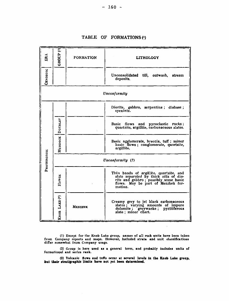
— 160 —
TABLE OF FORMATIONS (9
CEN
OZO
IC i
ER
A`
iGR
OUP
(2)
FORMATION LITHOLOGY
Unconsolidated till, outwash, stream deposits.
Unconformity
Diorite, gabbro, serpentine ; diabase ; syeninte.
a 0 A
Basic flows and pyroclastic rocks ; quartzite, argillite, carbonaceous slates.
o
m o o cc a R
Basic agglomerate, breccia, tuff ; minor basic flows ; conglomerate, quartzite, argillite.
N O x P 0
Unconformity (?)
a a
o x
Thin bands of argillite, quartzite, and slate separated by thick sills of dio- rite and gabbro ; possibly some basic flows. May be part of Menihek for- mation.
W
a
1-1 cc 0 z
MEN HEX
Creamy grey to jet black carbonaceous slates ; varying amounts of impure dolomite ; greywacke ; pyritiferous slate ; minor chert.
(1) Except for the Knob Lake group, names of all rock units have been taken from Company reports and maps. However, Included strata and unit classifications differ somewhat from Company usage.
(2) Group is here used as a general term, and probably includes units of formational and series rank.
(3) Volcanic flows and tuffs occur at several levels in the Knob Lake group, but their stratigraphie limits have not yet been determined.
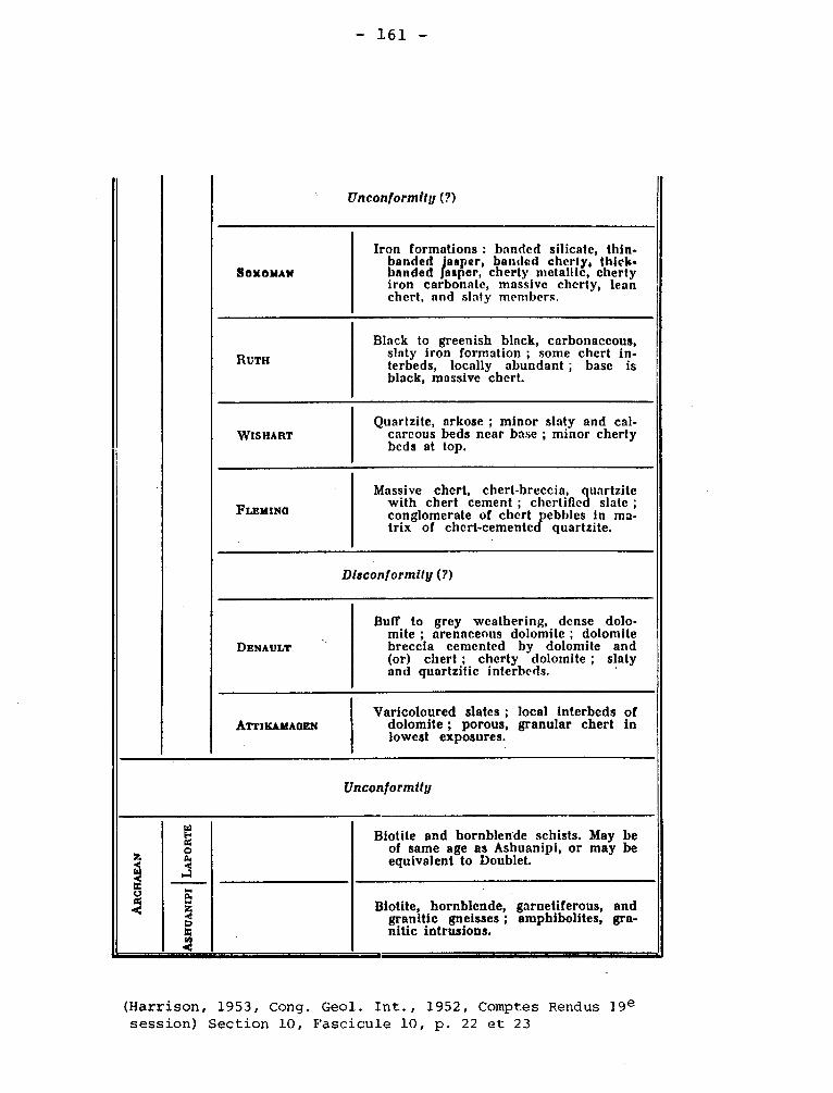
S O 1t AMAl1
Iron formations : banded silicate, thin-banded jasper, banded cherty, thick-banded Jasper, cherty metallic, cherty iron carbonate, massive cherty, lean chert, and slaty members.
VÿISHART Quartzite, arkose ; minor slaty and cal-
careous beds near base ; minor cherty beds at top.
FLEIiINQ
Massive chert, chert-breccia, quartzite with chert cement ; chertifted slate ; conglomerate of chert pebbles in ma-trix of chert-cemented quartzite.
DENAULT
Buff to grey weathering, dense dolo-mite ; arenaceous dolomite ; dolomite breccia cemented by dolomite and (or) chert ; cherty dolomite ; slaty and quartzitic interbeds.
ATTIKAMA(iEN Varicoloured slates ; local interbeds of
dolomite ; porous, granular chert in lowest exposures.
[Inconformity (?)
Black to greenish black, carbonaceous, slaty iron formation ; some chert in-terbeds, locally abundant ; base is black, massive chert.
Disconformily (?)
Uncon f ormiiy
Biotite and hornblende schists. May be of same age as Ashuanipi, or may be equivalent to Doublet.
Biotite, hornblende, garnetiferous, and granitic gneisses ; amphibolites, gra-nitic intrusions.
RUTH
— 161 —
(Harrison, 1953, Cong. Geol. Int., 1952, Comptes Rendus 19e session) Section 10, Fascicule 10, p. 22 et 23
- 162 -
of the Strait of Belle Isle. They divide the part on the mainland into
the lower Bradore Formation with a thickness of 225 of reddish arkosic
sandstone and conglomerate. The succeeding Forteau Formation is about
185 feet thick and contains limestones and Archaeocyathus reefs.
Logan (1863, p. 97) cites the lower formation as Potsdam.
The abundant fossils indicate a Lower Cambrian age.
The name Labrador Series should be abandoned.
Schuchert, C., Dunbar, C.O., Stratigraphy of western Newfoundland:
Geol. Soc. Am., Mem. 1., p. 17-18.
LABYRINTH LAKE GRANITE
An outcrop of granite a little more than one mile long and less than
4 mile wide occurs on the northeast shore of Labyrinth lake, Dasserat town-
ship. It is in contact, on the north, with a large dyke or sill of quartz
diorite, and its texture and composition suggest that the two are magmati-
cally related. The granite is coarse in texture, with an average grain of about
3 mm. It contains 30 to 40% of quartz, some 5% of hornblende in elongated
crystals, now largely chlorite, 2 or 3 % of magnetite in large grains, and
the remainder chiefly albite, (An20). The albite is much altered to carbonate.
Cooke, H.C., James, W.F., Mawdsley, J.B., 1931, Geology and Ore Deposits
of Rouyn-Harricanaw Region, Quebec: Quebec: Canada Geol. Surv., Mem. 166, p. 129.
LAC GILMAN FORMATION
South of and overlying the Lac Waconichi Formation is a two-mile-
thick and easterly-running band of mafic lava flows for which the forma-
tional name of "Lac Gilman" is proposed. The lavas are of various shades
of green, and range in composition from andesitic to basaltic, but they
- 163 -
have been metamorphosed to the green schist facies. As a rule, the rock
from the upper Part and the extreme bottom of a flow is very fine-grained
but the rest of the rock is somewhat coarser.
Duquette, Gilles and Mathieu, Arthur, 1966, Geology of the Northeast
Quarter of McKenzie Township, Abitibi-East County: Quebec Dept. of Nat.
Res., P.R. No. 551, p. 5.
LACHINE FORMATION Ordovician
It is now commonly recognized that the Utica Shale is not of one age
at every locality. Defined properly as a formation viz as lithological unit,
it can be traced from its type locality in New York through southern Quebec to
Anticosti island with its surprisingly uniform lithology of black or deep
brown calcareous shales. However, the fauna is not the same and it is possible
to divide the unit into biostratigraphic units.
Unfortunately, in instances, these units have been given the status of
formations. Lachine Formation has been assigned near Montreal as the sole for-
mation to the Utica Group by Clark (1952).
Near Montreal this formation is about 300 feet thick, but beds of the
same age in regions west or southwest of Montreal are much thicker than this.
It is logical to regard names such as this as geographical rather than
stratigraphic. The name refers to Utica Shale in the Montreal Area.
Clark, T.H., 1944, Structure and stratigraphy in the vicinity of Montreal:
Roy. Soc. Can., tn. v. 38, Sec. IV, p. 29.
Clark. T.H., 1952, Montreal area, Laval and Lachine map-areas: Quebec
Dept. of Mines, G.R. 46, pp. 77-80.
Lacolle Conglomerate (Wilmarth -1-1126) Ordovician
- 164 -
Lacolle Conglomerate, which contains pebbles and boulders up to 6 feet
across of Lower and Middle Ordovician formations, crops out west of Tracy
Brook fault near the Quebec-New York border as a local formation. "Late
St-Michel or early Rosemont age " was suggested by Clark.
Clark, T.H., McGerrigle, H.W., 1936, Lacolle conglomerate a new
Ordovician Formation in southern Quebec: Geol. Soc. Am., Bull. v. 47, pp. 665-
674.
Clark, T.H. 1955, St-Jean - Beloeil area; Que. Dept. Mines, G.R. 66, p. 14
LACORNE BATHOLITH
Hornblende monzonite, hornblende granodiorite, and biotite-hornblende
granodiorite assigned to the Lacorne batholith occur in sparse outcrops in
the southwest quarter of the Lacorne map-area. Rocks of the Lacorne batho-
lith are presumed to underlie the whole of the map-area south and west of
this line. All of these rocks, with the exception of the biotite granodio-
rite, are coarse - to medium-grained, faintly pink to grey on fresh surfaces,
and light grey on weathered surface.
Jones, Richard E., 1964, Northwest quarter of Fiedmont Township, Abitibi-
East County: Quebec Dept. of Nat. Res., G.R. No. 108, p. 16-19.
LAC RAYMOND FORMATION Lower Silurian
It crops out discontinuously both north and south of the upper part
of Touladi river that flows into Biencourt lake. In both places, it is
composed of mudstone, with minor interbeds of other rocks. Mudstone
is gray to dark grey, green to greenish gray weathering, dense, poorly
cleaved and massive. The greenish weathering is characteristic of the forma-
tion. See also Pointe-aux-Trembles Formation, Lac Castor Formation. Fossils
show an Upper Ludlow age.
- 165 -
Lespérance, P.J., Greiner, H.R., 1969, Squatec-Cabano Area, Rimouski,
Riviére du Loup and Témiscouata Counties: Quebec Dept. of Nat. Res., G.R.
no. 128, p. 40-43.
LAC WACONICHI FORMATION
This name was proposed by Duquette and Mathieu for fragmental
volcanic rocks believed to underly conformably the greenschists of the
Lac Gilman Formation in Mckenzie, Blaiklock, Richardson,and•Bignell
Townships, Abitibi East county. The formation is composed of generally
acidic rocks and is, if in unfaulted section, about 42,000 feet thick.
Duquette, G., and Mathieu, A., Northeast quarter of Mckenzie
Township, Abitibi-East county: Quebec Dept. of Min. Res., P.R. 551,:p. 4.
LAFLAMME FAULT.
This important zone of faulting striking between N. 20°E. and N. 30°E
across the north central part of the map-area. It is about 4,000 feet wide.
McDougall, David, J., 1965, Southeast Quarter of Barraute Township,
Abitibi-East County: Quebec Dept. of Nat. Res., G.R. No. 114, p. 14
LAKE BLONDEAU FORMATION
The formational name "lac Blondeau" is here used for the first time to
designate a synclinal belt of dominantly pyroclastic rocks occupying the
central and southern parts of the map-area. This formation, approximately
5,000 feet thick, consists mostly of siltstone, sandstone, and conglomerate
believed to be derived from volcanic material. A few basic lava flows are
present in the formation.
— 166 —
In P.R. 551, Duquette and Mathieu designate the fragmental rocks as
tuff, lapilli, and agglomerate.
Duquette, Gilles, 1964, Geology of the Northwest Quarter of Roy
Township, Abitibi-East County: Quebec Dept. of Nat. Res., P.R. No. 513,
p. 4-9
LAKE EVANS SERIES KEEWATIN
H.C. Cooke (1914) used this name for metavolcanic rocks near Broadback
River, Quebec. Aside from areas in the immediate vicinity, the term is of no
use and has been abandoned.
Cooke, H.C., 1914, An exploration of the headwaters of the Broadback or
Little Nottaway river, northwestern Quebec: Can. Geol. Surv. Summ. Rept. 1912
p. 339.
LAKEFIELD ANORTHOSITE Precambrian
This is 4i miles long and 1 mile wide. The anorthosite of the
peripheral portions is fine-grained, foliated, very poor in bisilicates
and weathers white. In the inner part of the area, it is more massive
and appears on the whole to be rather rich in iron magnesia minerals,
which vary in amount from place to place, often giving to the rock an
irregularly banded structure.
Adams, Frank D., 1896, Report on the geology of a portion of
the Laurentian Area lying to the North of the Island of Montreal:
Canada Geol. Surv., Ann. Rept. VIII, 1895, p. 117-118J
LAKE ROBERTSON GRANITE
Lake Robertson almost bisects a mass of granite which extends
- 167 -
across it in a northwesterly direction, with a total length of 9 miles
and width of 4g miles. The granite is light pink to white, rather
coarse-grained, and commonly porphyritic with quartz phenocrysts up to
an inch in diameter.
Cooke, H.C., James, W.F., Mawdsley, J.B., 1931, Geology and Ore
Deposits of Rouyn-Harricanaw Region, Quebec: Canada Geol. Surv,, Mem. 166,
p. 132-133.
LA MOTTE ANTICLINE
This anticline is developed between the Clericy syncline on the south
and the Okikeska - Destor syncline on the north. The west and of this an-
ticline lies between the fork of the Duparquet - Destor band of sediments.
As in the case of the Okikeska syncline, its eastward course is roughly de-
fined by scattered observations. The eastward of these was found in range
VI, La Motte Township, ki miles from the northern and 3i miles from the
eastern boundary. At this point, a flow strikes north 12 degrees west, and
faces east, suggesting that it lies directly upon the axis of the anticline.
Cooke, H.C., James, W.F., Mawdsley, J.B., 1931, Geology and Ore Deposits
of Rouyn-Harricanaw Region, Quebec: Canada, Geol Surv., Mem 166, p. 92.
LA MOTTE - LA CORNE GRANITE
The La Motte - La Corne intrusive underlies an area some 33 miles long
and 10 to 12 miles wide, chiefly in Preissac, La Motte, and La Corne townships.
West of it there are some small granite bodies in La Pause township which are
probably offshoots of the main mass. To the east, in Fiedmont, Courville, and
Pascalis townships, there are some large, poorly exposed masses which may also
be offshoots of the same underlying body. It exhibits the same range of rock
- 168 -
types as the great southern batholith, namely, granite, pegmatite, augite, sye-
nite, and porphyritic syenite, and also some still more basic, which are here-
after termed amphibolite.
Cooke, H.C., James, W.F., Mawdsley, J.B., 1931, Geology and Ore Deposits
of Rouyn-Harricanaw Region, Quebec: Canada Geol. Surv., Mem. 166, p. 136-139,
LANDRIENNE (QUARTZ, DIORITE-GABBRO-PERIDOTITE) - Complex Precambrian
The outline of the Landrienne gabbro-peridotite complex has
been extended into the eastern part of Landrienne township on the basis
of information supplied by recent geomagnetic surveys.
The main intrusive mass of the complex is a greenish-grey gabbro.
It is intruded by quartz and feldspar porphyry and multiple peridotite dykes.
Weber, W.W., 1951, La Morandiére and Parts of Duverny, Landrienne
and Barraute Townships, Abitibi-East County: Quebec Dept. of Mines, P.R. No.
255, p. 11-12, also: Amos-Barraute area: Quebec Dept. of Nat. Res., G.R. 109,
pp. 18-20.
LA PAUSE SYENITES
In La Pause township, there are three small masses of syenite, arranged
approximately on a line running north-northwest from La Pause Lake. A fourth
body of similar composition occurs on the centre line of Bousquet township
about 1 3/4 miles from the north boundary. The rocks have the general appearance
of quartz-augite syenites, but, owing to the presence of a considerable amount-
calcic feldspar with the acid plagioclase and microcline, are augite-quartz
monzonites. The rock is pink with a grain up to 4 mm.
Cooke, H.C., James, W.F., Mawdsley, J.B., 1931, Geology and Ore Deposits
of Rouyn-Harricanaw Region, Quebec: Canada, Geol. Surv., Mem. 166, p. 117.
- 169 -
LA REINE GRANITE
The La Reine granite underlies an area about 6 miles from east to
west in the extreme northwest corner of the region under consideration.
It outcrops on the north shore of Abitibi Lake, and extends northward
into La Reine township beyond the limits of the accompanying map. The
rock of the amin area is light grey to pink, medium to coarse in grain,
and somewhat gneissic in texture. The rock is made up of about 25%
of quartz, perhaps l% of biotite, and the remainder mostly albite or
albite-oligoclase, with a little interstitial microcline. Apatite,
titanite, and zircon are accessory.
Cooke, H.C., James, W.F., Mawdsley, J.B., 1931, Geology and Ore
Deposits of Rouyn-Harricanaw Region, Quebec, Canada Geol. Surv.,
Mem. 166, p. 131-132.
LARCH RIVER FORMATION Proterozoic
Greywackes and possible subgreywackes are interbedded with minor
slates or argillites in the southwest corner of the Gerido Lake and
Léopard areas. They are part of a group of rocks termed Larch River
Formation by geologists of Fenimore Iron Mines Ltd. The formation is
poorly exposed and highly sheared in the Gerido Lake area, but is well
exposed and generally well preserved in the Léopard Lake area. The
argillites and slates are aphanitic and dark grey to greenish grey.
The greywackes and possible subgreywackes are, in part, of lighter
colour. Dark quartz grains, 1 to 2 mm. in diameter, are visible to
the naked eye.
Bérard (1959) uses the name Larch Formation and gives detailed
description of the beds.
- 170 -
Sauvé, Pierre, and Bergeron, Robert, 1965, Gerido Lake-Thèvenet Lake
Areas, New Quebec: Quebec Dept. of Nat. Res., G.R. no. 104, p.11.
Bérard, Jean, 1959, Géologie de la Région du Lac aux Feuilles,
Nouveau-Québec: Univ. Laval, Thèse pour doctorat, p. 192-200.
LA RESURRECTION FORMATION Silurian (?)
A sequence about 2,400 feet thick, overlying the Robitaille Formation
near La Résurrection and consisting of a monotonous succession of green to
gray, massive, volcanic sandstones and siltstones, with some 100 feet of
orthoquartzite at the top, is called the La Résurrection Formation. Probably
it is Lower Ludlow,Sandstone, the most abundant rock type, is commonly fine
grained but ranges from very fine to coarse. It has not yielded fossils.
Lespérance, P.J., Greiner, H.R., 1969, Squatec-Cabano Area, Rimouski,
Rivière du Loup and Témiscouata Counties: Quebec Dept. of Nat. Res., G.R.
no. 128, p. 55-56.
LA SARRE AND GUYENNE HORNBLENDE SYENITES Precambrian
Two bodies of rather basic intrusive occur at the extreme northern
edge of the region under discussion, and extend northward beyond it. The
La Sarre mass is 8 miles o long, measured along the northern boundary of the
map-area, and has a maximum width, within the mapped area of 3 miles. It
lies mainly in the township of La Sarre and Royal-Rousillon. The Guyenne
mass underlies an area of about the same size farther to the east, mainly
in Languedoc and Guyenne townships.
Cooke, H.C., James, W.F., Mawdsley, J.B., 1931, Geology and Ore
Deposits of Rouyn-Harricanaw Region, Quebec: Canada, Geol. Surv., Mem.
166, p. 130-131.
- 171 -
LAURENTIDN, LAURENTIDE, LAWRENCIAN.
Several spellings of names can be found but all derive ultimately
from the name of the river and gulf.
LAURENTIDE
F.X. Garneau (1845, p. 179) gave the name Laurentides to the chain
of hills parallel to the river and containing the divide between the rivers
flowing to St. Lawrence and Hudson Bay. Logan (1863, p. 2, pp. 5-7) exten-
ded the term and emphasized the complexity of the ranges in the region. He
showed that the unit extended far west of the Canada of 1863 and reached the
Artic ocean. With this definition the term assumed the sense now reserved
for "Canadian Shield". Few have used the name so broadly and there has been
a justifiable tendency to restrict its use to designating the higher parts
of the Canadian Shield bordering the St. Lawrence Lowlands or St. Lawrence
River.
Garneau, F.X. 1845, Histoire du Canada: v. 1, p. 179.
Logan, W.E., 1863, Geology of Canada: p. 2, pp. 5-7.
II- Lawrentine (mountain) system.
Jules Marcou (1858) gave this form to the low range of hills
forming the dividing ridge between the rivers flowing the Hudson Bay and
those flowing southeast or south.Laurentine is found in a French 1855 version
of this paper.
Marcou, Jules, 1858, Sketch of the geological classification of
Mountains of part of North America: p. 72, privately printed. Zurich, ZÛrcher
and Furrer. A French edition was published in 1855.
- 172 -
III- LAURENTIAN SERIES, SYSTEM. Precambrian
Logan (1854, p. 7) decided that "Metamorphic series" was inappropriate
for crystalline rocks in the uplands between St. Jerome and Quebec City and
substituted "Laurentian" for "Metamorphic". Logan used formation,series,
and system interchangeably for these rocks, but there is no doubt that he
considered the rocks a stratigraphie unit because in 1850 all layered,
gneissic, or schistose rocks were believed to be altered sediments.
During the exploration of Ottawa river below Témiscamingue lake, Logan
observed that rocks that would be now recognized as paragneisses together
with crystalline limestones and quartzites are more prevalent on the south
part of the section than on the north. He recognized a lower Laurentian,
later to be known as Fundamental gneiss, or Ottawa gneiss (Hunt, 1878) com-
posed largely of "orthoclase gneiss" and an upper Laurentian or Grenville
division.
The two-fold division was soon modified. Mapping northeast of
Grenville township encountered the massif of anorthosite now known as the
Morin. The anorthosite massif cuts off the extension of the limestone bands
and, with the belief that the anorthosite was metasedimentary, an upper
division was introduced. This was called upper Laurentian and the Grenville
division was combined with the Fundamental gneiss to form a new lower
Laurentian or, less commonly, a middle Laurentian.
The name anorthosite having been proposed in 1855, the rocks were
termed anorthosite gneiss or labradorite gneiss, and the stratigraphie desi-
gnation was Labrador Series or Labradorian. In Canada, the last form was
commoner in Canada until Norian was proposed by Hunt in 1870. Before 1880,
however, the pyrogenic origin of anorthosite was recognized, and by 1895,
- 173 -
adequate proof of this contention was forthcoming so the Laurentian System
lost its upper division. With the reversion to the original twofold divi-
sion, Laurentian system gradually became less significant and with the reali-
zation that many of the gneisses of the Laurentian were intrusive rocks and
therefore perhaps younger than adjacent paragneisses, the term underwent an
interval where its use was confused. Ells (1897, p. 124) wrote: "Laurentian
non-sedimentary, Basal or Fundamental Gneiss (Ottawa gneiss) representing in
altered form the original crust of the earth, and the lowest known series of
rocks; without evidence of sedimentary origin".
The definition offered by Ells is so different from Logan's as to be
essentially new. An committee of geologists from Canada and U.S.A. studied
the field relationships and proposed a classification in which "Laurentian"
was used for post-Keewatin or granitic rocks, but A.C. Lawson dissented and
proposed that Laurentian be placed above Ontarian, which included Keewatin
and Coutchiching. With the recognition of the Temiskaming Series, pebbles
in its conglomerates were ascribed to a Laurentian granite, which was belie-
ved to cut the Keewatin rocks. Some workers have suggested that Laurentian
granite is younger rather than older than Temiskaming.
With the confusion attached to the term, Laurentian has no useful
place in formal stratigraphic nomenclature in Quebec. An informal use is
possible in the sense of "rocks of the Laurentides" as such the term is
essentially the same as "rocks of the Grenville subprovince".
Logan, W.E., 1854, On the geology of the north shore of the
St. Lawrence etc: Geol. Surv. Can., Rept. of Progress 1852-53, p. 7.
Ells, R.W., 1897, Notes on the Archaen of Eastern Canada: Roy. Soc.
Can. Tr. v. 3, sect. IV, p. 124.
Osborne, F. Fitz, 1956, The Grenville region of Quebec: Roy. Soc.
Can., Spec. Pub. No. 1, pp. 4-7.
Laurentian —4- - 174.—
IV- LAURENTIAN, LAURENTIDE.
(Physiographic). - Several descriptive names have been given to
the region underlain by rocks of the Grenville Subprovince. It is hardly
serviceable to trace all the usages and assign them to authors. Appa-
rently G.M. Dawson in 1897 was the first to suggest that the Canadian
Shield has topographic features of a peneplain. A.W.G. Wilson (1903)
amplified the concept and, although he described modifications of the
original features, he used Laurentian peneplain for the surface of the
whole of the shield.
The terms Laurentian Uplands, Laurentian Highlands, Laurentian
plateau, Laurentian tableland, were used for the more restricted regions.
The arcuate contact of the older rocks against those of the St. Law-
rence Lowlands is a scarp, segments of which have been given local names.
The Atlas of Canada, Map. 10, shows the Laurentian Scarp west of St. Mau-
rice river and Laurentide Scarp east of it. Kindle and Burling (1915)
have referred to the same feature as Laurentian Plateau scarp.
Wilson, A.W.G., 1903, The Laurentian Peneplain: Jour. Geol. v. 11,
pp. 616-659.
Kindle, E.M., and Burling, L.D., 1915, Structural relations of the
Pre-Cambrian and Paleozoic rocks north of the Ottawa and St. Lawrence
valleys: Geol. Surv. Can., Mus. Bull. No. 18, p. 12.
V- LAURENTIAN PLATEAU FAULT.
Kindle and Burling (1913) postulated a throughgoing fault separating
the Canadian Shield from the St. Lawrence Lowlands between Hull and Quebec
City. The fault does not exist.
Kindle, E.M., and Burling, L.D., (1913) 21).,. cit.
- 175 - Laurentian -5-
VI- LAURENTIDE GLACIER, (CENTRE), (GLACIER SYSTEM).
G.M. Dawson (1890, p. 162) suggested Laurentide Glacier for the ice
centering on the Canadian Shield during the Pleistocene epoque. Chalmers
(1890, p. 325) suggested Laurentide Glacier System,Chalmers in 1898 (p. 43 .)
used "the Laurentide or Labradorean Ice" being thus unwilling to choose
between the terms. In "Geology of Quebec", 1944, p. 442, Labradorean (q.v.)
is used to the exclusion of Laurentide.
Flint (1943) has proposed to use Laurentide for a large sheet and to
consider the Labrador and Keewatin centers low domes on the ice sheet.
For Quebec, Labradorean is preferable to Laurentide: the glacial map of
1967 shows the radial disposition of striae and eskers in Labrador peninsula.
Dawson, G.M., 1890, On the glaciation of the northern part of the
Cordillera, with an attempt to correlate the events of the Glacial Period
in the Cordillera and Great Plains: Am. Geol. v. 6, p. 162. - Chalmers,
same volume, p. 324.
Chalmers, Robt., 1898, Surface geology and auriferous deposits of
south-eastern Quebec: Geol. Surv. Can., Sunna. Rept. X, p. 42J.
Flint, R.F., 1943, Growth of North American ice sheet during the
Wisconsin age: Geol. Soc. Am. Bull., v. 54, p. 328-, p. 322.
VII- LAURENTIAN RIVÉE (PRE-GLACIAL).
In Geology of Quebec (1944) p. 488, Fig. 32 shows a hypothetical
east flowing pre-glacial system. It is shown as flowing along the Trent
River valley and tributaries extend into lakes Erie, Michigan, and Superior.
VIII- LAWRENCIAN LOWLANDS.
Ami introduced this synonym for St. Lawrence Lowlands in 1900. Obsolete.
Ami, H.W., 1900, Synopsis of the geology of Canada: Roy. Soc. Can.,
Tr. VI, Sect. IV, p. 222.
- 176 -
LAURENTIAN CHANNEL OR TROUGH LAURENTIAN 6.
See "Saint Lawrence Submarine Trough". This feature, which
was discussed by Shepard, separates the Grand Banks from the Scotian
Shelf and extends beneath the estuary of St. Lawrence river to near
the mouth of Saguenay river. Hachey, Lancier, and Bailey (1956) have
discussed its role, in maintaining the Gaspé Current.
Hachey, H.B., Lausier, L., Bailey, W.B., 1956, Oceanographic
features of submarine topography: Roy. Soc. Can., Tr. 50, Oceanograr-
phic Committee, p. 68.
LAVAL FORMATION Chazy
Clark (1944, p. 29) gave this name to the formation representing
the Chazy Group in the vicinity of Montreal. He, at that time, divided the
formation into two members, the Ste-Thérèse (1.v.) and the Caughnawaga, which
latter name has now disappeared from use in this sense. Later Clark (1952,
p. 43) used the name St. Martin (g.v.), which has been proposed by Wilson
for the upper part of the Aylmer Formation, the high calcium limestones occur-
ring near Montreal. He however, reduced the formation to a member, and fi-
nally Hofmann (1963, p. 271) reduced it to the status of a lithofacies of the
Laval Formation. At the same time Hofmann introduced the name Beaconfield
(g v.) for the Rostricellula plena beds at the top of the Laval Formation, and
suggested that the Chazy-Black River contact is within rather than at the base
of the Pamelia Dolomite.
The Laval Formation is about 280 feet thick at Montreal and is
shales, shaly limestones and dolomites, and calcarenites. The Chazy of the
- 177 -
THE APPROPRIATION OF THE NAME LAURENTIAN BY THE CANADIAN GEOLOGISTS
by. M.R. WADSWORTH.
(ABSTRACT.)
The name Laurentian was given by Mr. Edward Desor in 1850 to some marine deposits
in Maine, on the St.Lawrence River, and Lakes Champlain and Ontario. Mr. Desor's
paper was first read before this Society and published in the Proceedings (III, 357-
358). With this application the term Laurentian was quite frequently employed by
Mr. Desor,(Proc. Bost. Soc. Nat. His., 1851, IV, 29,33; Bull. Soc. Geol. France,
1851 (2), VIII, 420-423; IX, 94-96; Am. Jour. Sci. 1852 (2), XIV, 49-59); and it
seems to have passed into current use amongst geologists, especially between 1850
sand 1857. In 1854 Sir William Logan appropriated the name to designate the Canadian
rocks which he had heretofore called the "Metamorphic Series." Logan's action
appears to have been unjustifiable and needless. Needless, because the rocks to
which he gave the name Laurentian were the equivalents of the Azoic of Foster and
Whitney. It is to be remembered that the term Huronian was not employed until
1855, and this formation was for many years thereafter regarded as Paleozoic. Un-
justifiable, because the name Laurentian was in current use for a different forma-
tion; to which another name had to be given later on on account of Logan's action,
thus further complicating the synonymy. Injustifiable, because Logan knew of
Desor's application of the term and had employed it in the same manner himself
(Report of Progress Geol. Survey, Canada, 1850-51, p.8). The complications growing
out of the deprivation of Desor by Logan of the credit belonging to the former are,
first, the use of the name Laurentian in geological literature with two different
meanings; secondly, the naming of Desor's Laurentian, Champlain, by Prof. C.H.
Hitchcock, and thus giving the term Champlain two distinct significations in geo-
logical literature.
So far as the writer is aware, but one American geologist has ever protested
against the injustice done Desor by the Canadian geologists (Amer. Jour. Sci. 1857,
(2), XXIII, 305-314).
The following literature offers a somewhat curious commentary upon the preceding
described action of Logan. "The crystalline limestones of Canada, with those of New
York and the New England States, may be divided into four classes, belonging to as
many different geological periods. The first and most ancient occur in that system
of rocks, named by Mr. Logan the Laurentian Series, which extending from Labrador to
Lake Huron, forms the northern boundary of the Silurian System of Canada and the
United States". (T. Sterry Hunt, Am. Jour. Sci. 1854,(2), XVIII, 193).
"It was therefore proposed to give the older group a distinctive name, and inas-
much as these rocks form the hills on the north side of the St. Lawrence, to which
Mr. Garneau, the Canadian historian, had already given the geographical name of
Laurentides. the distinctive appelation of Laurentian proposed by the present writer
(Dr. Hunt) was applied to them in the Report of the Geological Survey of Canada
for 1852 (page 9) which was published in 1854" (T. Sterry Hunt, Azoic Rocks, Part I.
p. 72T Sec, Geol, Surv. Penn. E.)
"In 1854 the writer (Dr. Hunt) in concert with Logan proposed for the ancient
crystalline rocks of the Laurentide Mountains ....the name of Laurentian." (T. Sterry
Hunt, Proc. Am. Assoc. Adv. Sci., 1879, XXVIII, 283).
(From the Proceedings of the Boston Society of Natural History, Vol. XXI, January 5,
1881).
- 178 -
vicinity of Montreal has long been believed to only the upper part (Valcour)
of the Chazy of New York, but Hofmann presents evidence that older beds,
Day Point and Crown Point are present.
Clark, T.H., 1944, Structure and stratigraphy in the vicinity
of Montreal: Roy. Soc. Can., Tn. 38, Sect. IV, p. 29
Clark, T.H., 1952, Montreal area, Laval and Lachine map areas:
Quebec Dept. of Mines, G.R. 46, pp. 39-45.
Hofmann, H.J., 1963, Ordovician Chazy Group in Southern Quebec:
Am. AsSn. Pet. Geol., v. 63, p. 271
LECLERCVILLE SHALE Cincinnatian
The type section for this formation is along Grande Rivière du
Chéne. The formation consists of light-grey and dark-grey siliceous
shales in thin beds. Buff weathering beds and concretions are absent.
Clark states the formation is 1,000 feet thick and is underlain
by Utica Shales viz the Lotbiniére Shale. He assigns the formation
to the Lorraine.
However, in 1948, he included this formation within the Cryptolithus
zone (Breault member) of the Nicolet River Formation rather than placing
it below it as done in 1947. Of two reports published in 1964, that, the
Yamaska-Aston area states that the Breault member follows the Utica Shale
and that of the Upton area mentions it only as a possible component of
the St. Germain Complex.
Clark, T.H., 1947, The St. Lawrence Lowlands south of St. Lawrence
river: Quebec Dept. of Mines, P.R. 204, p. 5, 7.
Clark, T.H., 1948, Portneuf map-area, Portneuf and Lotbiniére
counties: Quebec Dept. of Mines, P.R. 225, pp. 4-5.
- 179 -
LEPINE LAKE FAULT.
It branches away from the Porcupine - Destor fault 4,000 feet east of
the centre line of Duparquet township. The course of the fault is marked by
a valley along which local bodies of quartz-feldspar porphyry are exposed.
Dips of schistosity along the south branch vary from vertical to 60° north
while on the north branch they are vertical.
Graham, R. Bruce., 1954, Parts of Hebecourt, Duparquet and Destor
Townships, Abitibi-West County: Quebec, Dept. of Mines, G.R. No. 61, p. 35.
LEPINE LAKE SYNCLINE
"The north limb of this syncline is overturned; the formations dip
75° to 80° north and tops are south. Towards the south, as the axis of
the fold is approached, the dips range through vertical to sleeply south.
On the south limb of the syncline the beds face north. Dips increase pro-
gressively from 15° north near the axis of the syncline to vertical near
the contact of the sedimentary rocks with the underlying volcanic formations."
However, evidence to indicate the direction of plunge of the Lépine
Lake syncline is scanty. The presence of upper arkose beds towards the west,
and of scattered conglomerate outliers beyond the eastern termination of the
main band, suggests that there is a general plunge towards the west. -
Graham, R. Bruce, 1954, Parts of Hebecourt, Duparquet and Destar
Townships, Abitibi-West County: Québec, Dept. of Mines, G.R. No. 61, p.
32-33.
LERAY FORMATION Black River Group
The upper formation of the black River Group is 40 feet thick
- 180 -
at Ottawa and thins eastward towards Quebec. It is a dark gray or brown
rubbly and locally cherty limestone in thin beds. Coral heads are common.
Okulitch, V.J., 1939, The Black River Group in the region
between Montreal and Quebec: Am. Jour. Sci., v. 237, pp. 81-93.
Clark, T.H., 1952, Montreal Area: Quebec Dept. of Mines, G.R. 1+6,
pp. 46-57.
LESS1PS SYNCLINE
The Siluro-Devonian and Ordovician formations do not have the same tectonic
style, but Robert (1967, p. 11) believes that, as a whole, a large and open
syncline plunges slightly to the southwest and trends northeast.
Robert, Jean-Louis, 1967, Geology of Lesseps Creek Area, Gaspé-North County:
Quebec, Dept. of Nat. Res., P.R. No. 562, p. 11.
LEVIS FORMATION Lower and Middle Ordovician
By 1863 Logan had postulated the presence of a thrust fault (Logan's
Line) at Quebec and had separated and named two principal formations assigned
to the Quebec Group on the southeast side of the fault. These were Levis
Formation below and Sillery above. Lauzon Formation between the two forma-
tions was set up by Richardson, and this name was used by Logan, 1866.
In "Geology of Canada" (1863, pp. 227-231i), Logan lists the beds of
the Levis Formation under 17 headings. The accompanying text suggests that
the section is on Orleans Island, but the section cannot be recognized now
because it is composite with some beds not exposed on the island. In the
light of further developments the Orleans section was poorly chosen and in
effect has not been used. The type section became that studied by Raymond
in the cities of Levis and Lauzon.
- 181 -
The Levis formation consists of dark grey clayey siltstones, which
weather buff and alternate with lighter weathering siltstones in very thin
layers. Some dolomitic siltstones are found and some beds are massive
enough to suggest dolomite.
Some sandy beds occur but these are not abundant and are mostly in
the lower part of the formation. Shales either black or grey do not occur
in force and "Levis Shale" is a misnomer. At Levis, the upper part of the
section has red clayey siltstones, at some places alternating with green
siltstones, and at some localities away from Quebec red siltstones occur
throughout the formation.
Limestone conglomerates are abundant throughout the formation but are
not restricted to it. These conglomerates grade along strike into calcare-
nites or calcareous sandstones and are extremely lenticular. Some faults
were postulated on the hypothesis that the conglomerates are continuous, but
these faults do not exist.
Raymond's measured section is 600 feet, and further discovery of
fossil shows that another 400 feet can be added to the section.
Hall was of the opinion that the Levis Formation was of the age of the
Hudson River Group, but Billings showed that the formation was of the age of
the Beekmantown (Calciferous) and the Chazy. Hall and most subsequent workers
accepted this determination or at least the Beekmantown (Canadian) age which
was the basis for the dating of the Deepkill Formation.
The correlation between the carbonate beds and the shale-silt beds is
incomplete. It is uncertain whether the lower beds are to be assigned to the
Tremadoc of Great Britain, and whether the beds are Cambrian or Ordovician.
There is no question that Arenig beds are found in abundance but the presence
of Llanvirn is subject to a difference of opinion.

- 182 -
Raymond, P.E., 1914, The succession of faunas at Lévis, P.Q.: Am. Jour.
Sci., v. 38, pp. 523-530.
Billings, Elkanah, 1860, On some new species of fossils from the
limestone near Point Levis opposite Quebec: Can. Nat. and Geol., v. 5, pp. 301-
323.
Osborne, F. Fitz, 1956, Geology near Quebec City: Nat. Can. v. 27, pp. 181-
188. (For bibliography).
LICHEN LAKE GRANITE Precambrian
This rock forms a batholith and has abundant opalescent quartz. The
feldspar which is altered is gray which gives the overall color of the
rock.
Longley, W.W., 1951, Bachelor Lake Area, Abitibi-East County: Quebec
Dept. of Mines, Geol. Rept. 47, p. 16-17.
L'ISLET FORMATION (Wilmarth -1-1191) Lower Paleozoic
No type section is cited for this formation, which is named from
L'Islet county. Dresser states that it consists of grey schists and
grey quartzites in some exposures the two rocks are intimately inter-
layed. Map 34A of the Geological Survey of Canada shows it cropping
out as a band 5 miles wide between Pohenagamuk Formation and Sillery
Formation.
Dresser considered that the formation is lower Sillery,and Knox has
mapped Sillery and L'Islet in the Thetford-Black Lake area. and assigned
them to Cambrian above Bennett Quartzite, which he assigns to Precambrian.
In Geology of Quebec, the formation is assigned to Ordovician.
- 183 -
The lack of a type section with consequent uncertainty of the litho-
logy and the structural relationships to other formations makes this
name unserviceable.
Dresser, J.A., 1912, Reconnaissance along the National Transconti-
nental Railway in southern Quebec: Geol. Surv. Can., Mem. 35, pp. 20-25.
Knox, J.K., 1917, Southwestern part of Thetford-Black Lake mining
district (Coleraine sheet): Geol. Surv. Can., Summ. Rept., 1916, p. 233.
Dresser, J.A., Denis, T.C., 1944, Geology of Quebec, G.R. 20, p. 339,
346, 388.
LOIS LAKE FAULT.
It lies along the north boundary of the area mapped in Duparquet
township. It is believed to be the continuation of a westerly trending
shear zone of considerable magnitude which passes through Lois lake. It
is marked by a belt of vertically-dipping schists which has a width up to
1,500 feet within the map-area and an additional 1,000 to 2,000 feet beyond
its northern limit. Reconnaissance immediatly north of the map-area indica-
tes that this fault has related northeasterly-trending shears which branch
away from it.
Graham, R. Bruce., 1954, Parts of Hebecourt, Duparquet and Destor
Townships, Abitibi-West County: Quebec, Dept. Of Mines, G.R. No. 61, p. 36.
LORRAIN
This is the name of a township in Ontario west of Témiscamingue lake.
I- LORRAIN (ARKOSES) (SANDSTONES) (QUARTZITES) (FORMATION) (SERIES) (GROUP)
The intensive geological exploration following the discovery in 1903 of
- 184 -
silver at Cobalt led to the naming of some rock units in a very informal way.
Miller referred to Cobalt and Lorrain units as essentially coordinate units.
However, in 1911, Miller, at the same time as Harvie (see Fabre Series), for-
malized the names using Lorrain Series for Upper Huronian and Cobalt for
Lower, whereas, Harvie used Fabre Series for Lower Huronian making Cobalt
Middle Huronian.
Lorrain Formation is restricted in its occurrence in Quebec to an area
close to Ontario and upper units of the formation found in Ontario are not
recognized.
II- LORRAIN GRANITE
Miller called a massive granite underlying the Cobalt Group rocks,
Lorrain granite. It was according to his account less strongly layered
than the typical Laurentian. The term is only of local use and only
casual references to it can be found in writings on Quebec geology.
LORRAINE GROUP Upper Ordovician
This term derives from a locality in New York and dates from 18+2.
Its use spread into Ontario and Quebec; in some citations Hudson Forma-
tion, or Hudson River Formation refers to these rocks. Logan (Geology
of Canada, 1863, p. 198) uses the spelling "Loraine".
Lorraine is a lithologic unit, and, as such, it is generally grey
shales or mudstones, dolomitic or calcareous mudstones or siltstones,
with some sandstones. There has been a tendency to introduce biostra-
tigraphic divisions, and some confusion has resulted. This tendency
has been deplored by Fisher (1956).
The two studies by Foerste are the basis of most of the subsequent
work on this group in Quebec and Ontario. The group is Eden and Maysville
age.

- 185 -
Fisher, D.W., 1956, Intricacy of applied stratigraphic nomenclature:
Jour. Geol. v. 64, pp. 619-621.
Foerste, A.F., 1916, Upper Ordovician formations of Ontario and
Quebec: Can. Geol. Surv., Mem. 83, p. 279.
Foerste, A.F., 1924, Upper Ordovician faunas of Ontario and Quebec:
Can. Geol. Surv., Mem. 138, p. 255.
LOTBINIERE SHALE
Clark, 1964, has used this name for thin-bedded carbonaceous shale
with, at 10 to 20 foot intervals, buff or orange weathering dolomitic inter-
beds a few inches thick cropping out on the south side of St. Lawrence river.
The beds are locally disturbed by tectonism, and he does not give a thick-
ness for them in the Upton area. He points out that the Utica Shales of the
St. Jean-Beloeil area resemble these shales but do not have the orange wea-
thering beds. The formation is assigned to Utica, but particularly its upper
part has not the typical Utica lithology.
Clark, T.H., 1964, Upton Area: Quebec Dept. Nat. Res., G.R. 100,
p. 11.
Clark, T.H., 1964, St.Jean-Beloeil Area: Quebec Dept. Mines_,
G.R. 66, p. 20
LOWER ALBANEL FORMATION Proterozoic
Wahl (1953) proposed this name for 5000 to 8000 feet of dolomites, sandy
dolomites, with minor clastic beds cropping out in the vicinity of Mistassini
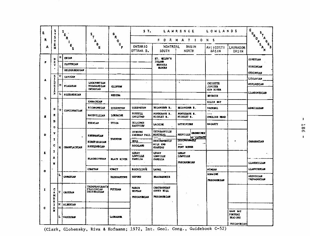
E
R
A
T
T A
E
S
R '
ES
S
T
6E
G
RO
BP
E R S T. LAWRENCE LOWLANDS Eu
S T
OP A6
EA ÂN ES
FORMAT I OHS
ONTARIO OTTAWA B.
MONTREAL SOUTH
BASIN NORTH
ANiICO_STI BASIN BASIN
p
A
L
O
L
O
~ . <
n„r+ H ERIAN ST. MIEN'S
ISIAIm BRECCIA
BLOCKS
CIVETIAN
SIECIIIAN '
CEDINNIAN
L ûLSTERIAId
HEIDERBERGIAN
S U, R
 N
U CAYUGAN ~LL'DLOVIAN
?1 NIAGARAN LOCKPORT TONAWANDIAN MARIAN
CId1<TON ~ CHI MITE
JUPITER GUN RIVER
t7ENIACüIAN
Li.AtiDOVEAIAN L ALEZAIRDRL#N ~~ BECSCTE
O
R
0
C
I A
N
U CINCINNATiAN
CAMACIIIAN ELLIS MY
ASNCILLIAI RICHMONDIAN QUEENSTON QUEENSTON BECARCOUR R. BECANCORi R. VAUREAL
MAYSVILLIAN LORRAINE RUSSELL GRLSBAD
POZ\TGRAVE R. NICOLE? R.
PONTGRAVE R. NICOLET R. ENGLISH HEAD
GRADORAN
•
—
D EDEIRAN UTICA
.
BILLINGS EASTVIEW LACFIINE .
LOTBINIERE MACASTY
I
CHAMPLAINLW
S~
X.IRRFIEIDIAN
ROCRIA>~IDIAN
CO BOURG SHERMAN FALL ;:-
TETP.EAUVILiZ MONTREAL
I NEILIEi~~INES W
•
MILE END OUAREAU
i5'l'.GSIMIR SRERI'011 HULL DES CHAR MOLT -ITSWIFIfiln
- PONT RODCE ROCIC1Al07
DLACRRIVERAN BLACK RIVER
LERAY ICE/VILLE PANE LIA
LERAY LOWVILLE PAMEL2A
IZRAY
PRECAMBRIAN
LWVILIZ
LLANDEIIiAN
LLANVIRNIAN CHAZYAN •CHAZY ROCRCLIFFE LAVAL MINCAN
L CANADIAN BEEIORANTOBN OXFORD BEAUW1RIgIS
ROMAINE
PRECAMBRIAN
ARLNIGIAtI TRLMADOCIAN
I
C
C A
H B R I A N
U CROIXAN
TREMPFaULGD•N F RAN COhIAN DRESBACHIAN
POTSDAM MARCH NE
PRECAMBRIAN
CHATEAUGOA! COVEY HILL
PRECAMBRIAN
• • H ALBERTAN
L WADCOBAN LABRADOR
HAWK BAY FORTEAU BRAD ORE
PRECAM BRIAI¢ h
(Clark, Globensky, Riva & Hofmann; 1972, Int. .Geol. Cong., Guidebook C-52)
- 187 -
lake, and forming part of the Mistassini group (a.v.). Wahl divided this unit
into four members lettered from "a" to "d" Neilson mapping in the adjacent
Albanel map area did not divide the formation into members.
Wahl, W.G., 1953, Temiscamie River Area, Mistassini Territory: Quebec
Dept. of Mines, G.R. 54, pp. 11-14.
LOWVILLE FORMATION Black River Group
Despite some differences in the use of this name in the United
States and the early use of the term in Canada, Lowville has been consis-
tently used for the middle formation of the Black River Group. The Low-
ville is a limestone of dark grey color with at many locality a "birdseye"
structure. The formation is 30 feet at Ottawa, 17 feet at Pointe Claire, but thins
eastward where it is only a very few thick near St. Marc.
Okulitch, V.J., 1939, The Black River Group in the region between
Montreal and Quebec: Am. Jour. Sci., v. 237, pp. 81-93.
Clark, T.H., 1952, Montreal Area: Quebec Dept. of Mines, G.R. 46,
pp. 46-57.
LUCIE LAKE INTRUSIVE LENS - ANORTHOSITE. Precambrian
An anorthositic lens of about 8 square miles lies north of Lucie
lake in the southeast corner of the area. The lens is elongated east-
west and is surrounded by metamorphic rocks of the Manicouagan upland.
The rock of the Lucie Lake lens is commonly anorthositic gabbro, but
this grades irregularly to coarse anorthosite and to medium-coarse dark
gabbro. The gabbroic facies is more abundant towards the northeast.
Kish, Leslie, 1968, Hart-Jaune River Area, Saguenay County:
Quebec Dept. of Nat. Res., G.R. No. 132, p. 63-64.
- 188 -
LUKE HILL LIMESTONE Ordovician
This formation consisting of 160 feet of bluish gray, thin-
bedded limestone was mapped by Logan as B3 of the Philipsburg Series
(q.v.) and named by McGerrigle. The formation is Beekmantown.
McGerrigle, H.W., 1931, Three geological formations in
northwestern Vermont: Rept. of State Geol., 17th., 1929-30, pp. 184-185.
MACASTEY SHALE, MACASTY SHALE, MACASTI
Logan in the "Geology of Canada" (1863, p. 220) suggests that
Jacques Cartier Passage between Mingan and Anticosti islands is un-
derlain by 1700 feet of Black River, Trenton, and Utica beds. He
mentions loose blocks of black shale on the north shore of Anticosti.
What was apparently a geographic reference to these occurrences by
Foerste (1924, p. 2) has been taken as a proposal of a formation name.
Foerste used the form Macastey, but Twenhofel (1927, p. 22) who pre-
sented the definitive discussion of the geology of the island used the
form Macasty.
Roliff (1968, p. 34) gives the result of drilling on Anticosti
island, and it shows a diverse thickness, normally less than 300 feet,
from hole to hole. Roliff suggests either a Trenton or a post-Trenton
uplift or both.
Riva, (1969) has assigned the faunas to a Canajoharie, Lower
Utica, and Upper Utica'bf the graptolite sequence.
The Macasty Shale is on Anticosti underlain by about 1,000 feet
of limestone and shale. The formation is nowhere exposed.
Foerste, A.F., 1924, Upper Ordovician faunas of Ontario and Quebec:
Can. Geol. Surv., Mem. 138, p. 2.
- 189 -
Twenhofel, W.H., 1927, Geology of Anticosti Island: Can. Geol. Surv.,
Mem. 154, p. 22.
Roliff, W.A., 1968, Oil and gas exploration - Anticosti island,
Quebec: Geol. Assn. Can., Pr. v. 19, p. 34.
Riva, John, 1969 Middle and Upper Ordovician graptolite faunas of St. Lawrence
Lowlands and of Anticosti Island; A.A.C.G., Memoir 12, p. 539.
MC KENZIE NARROWS FAULT.
This fault was recognized in the Chibougamau Lake area to the southwest,
and thrusting to the northwest was postulated (Mawdsley and Norman, 1935). There
is no clear evidence that this fault extends into the Bignell area. However, it
could form the southeastern contact of the Chibougamau series as it does in the
Chibougamau Lake area. See Doré Lake Fault.
Gilbert. J.E., 1958, Bignell Area, Mistassini and Abitibi Territories
Abitibi-East and Roberval Electoral Districts: Quebec, Dept. of Mines, G.R. No.
79, p. 29.
(McKENZIE — Boul Fake fault.)
Bee Thompson Creek Fault. This name was used apparently in
error by H.E. Wilson (1943) for a fault named by Hawley {1933).
MCLACHLIN-BOOTH SYNCLINE
The axis of this north trending, major syncline extends from the southern
border of the area at Booth lake northward beyond Gordon lake , in the northern
part of the area.
- 190 -
Lyall, H.B., 1959, Preliminary Report on McLachlin-Booth Area, Temiscamingue
Electoral District: Quebec, Dept. of Mines, P.R. No. 391-. p. 9-10.
MCWATTERS GROUP
The rocks of this group which were mapped by Hawley (1934) as
"conglomerate agglomerate" assigned to Keewatin, occur in a belt about
four miles long and up to ; mile wide on the south side of the Cadillac-
Bouzan Lake fault at McWatters. They consist mainly of andesite tuff, and
pyroclastic andesite breccia separated into two bands for almost the entire
length of the belt by conglomerate and greywacke in a zone 300-1,000 feet
wide. The average dip of the McWatters group is about 70 north, and the
maximum thickness after correction for duplication by minor folding is
about 1,500 feet.
Hawley, J.E., 1934, McWatters Gold Mine belt, East-Rouyn
and Joannes: Quebec Bur. Mines, 1933, Pt. C.
Wilson, M.E., 1943, The Early Precambrian succession in western
Quebec: Royal Soc. Canada Trans., ser. 3, v. 34, sec. 4, p. 128-129.
MCWAT'W'ENS FAULT.
The McWatters fault lies along the conglomerate-andesite contact
in the south limb of the McWatters syncline and apparently provided the
channelway along which the gold of the mine was deposited.
Wilson, M.E., 1962, Rouyn-Beauchastel map-areas, Quebec: Canada,
Geol. Surv., Mem, 315, p. 42.
- 191 -
MAGOG Middle Ordovician
The name which is applied to a town on the north end of Memphremagog
lake as well as to political divisions and physical features in the region,
is a diminutive of the name for the lake.
I. Magog Formation- (Wilmarth -1-1267). Ami (1900) proposed the name
without designation of a type locality and without a description of the beds
other than stating that black shales contain graptolites, He suggested that
the formation is similar to the Farnham, and both are "akin" to the Normanskill
shales of New York.
Clark (1934) used "Magog slates" for some rocks he had referred to
the Memphremagog Series in an unpublished report on the Mansonville area to
the Geological Survey of Canada.
Magog is not given as a formation name in "Geology of Quebec", 1944,
but "Memphremagog" apparently refers to this formation, which is assigned to
the upper part of a Farnham Series.
Fortier (1946) has used Magog Formation for some slates, siltstones,
sandstones, as well as other rocks in the Orford map area. St. Julien (1963)
has given descriptions and a schematic section of over 6000 feet for the Magog
Formation in the Orford-Sherbrooke area.
Cooke (1950) assigned the Magog beds to the Beauceville Group, although
he admitted the priority of the name Magog.
Ami, Henry , 1900, Synopsis of the geology of Canada: Royal Soc. Can.,
Tr., v. 6, Sec. III., p. 200.
Clark, T.H., 1934, Structure and stratigraphy of southern Quebec:
Geol. Soc. Am., Bull. 45, p. 11.
Dresser and Denis, (1944), Geology of Quebec: Dept. Mines, Quebec:
G.R. 20, p. 401.
- 192 -
Fortier, Y.O., 1946, Geology of the Orford Map-area: Stanford
University thesis, pp. 75-103.
St. Julien, Pierre, 1963,Géologie de la région d'Orford-Sherbrooke,
Québec; Université Laval, Thèse, pp. 118-144.
Cooke, H.C., (1950), Geology of a southwestern part of the Eastern
Townships of Quebec: Geol. Surv. Can., Mem. 257, P. 33.
II. Magog Conglomerate- Dresser (1925) proposed this name for some
conglomerates believed to be associated with the Magog Formation and to mark
its base. Richardson (1929) has correlated it with the Irasburg Conglomerate
of Vermont. As shown by Morin (1954), many conglomerates of the northern
Appalachians in Quebec are intraformational and many, including some cited
by Dresser, are not at the postulated stratigraphic position.
It is logical that this use of Magog be discontinued.
Dresser, J.A. 1925, The Magog Conglomerate, a horizon marker in the
"Quebec Group": Roy. Soc. Can., Tn, 19, Sec. IV, p. 115-121.
Richardson, C.H., 1929, The petrography of the Irasburg Conglomerate,
Vermont: Rept. of State Geologist 16, pp. 107-118.
Morin, Marcel, 1954, Conglomerates in the northern Appalachian region:
Université Laval, These, pp. 1-74.
III. Magog Shale zone- Ruedemann divided the Ordovician rocks of
New York into 19 graptolite zones. Of these, Zone 10 is given the name
Magog Shale and placed between Normanskill Shale with zones 8 and 9 and
Canajoharie Shale with zones numbered 11 to 15. The fauna of the Magog
- 193 -
Shale is that of the well known Castle Brook locality, and ias the summary
by H.C. Cooke (22.. cit. pp. 46-48) shows,most authors have considered the
beds of Trenton age.
Berry (1962) as an outcome of study of the graptolite sequence in
Texas, became interested in the fauna of the Castle Brook locality and collec-
ted fossils there in 1959 as well as studying some collected from other nearby
localities by St. Julien (22,. cit. pp. 11+8-150). Berry, as had earlier inves-
tigators, recognized two zones but concluded that both zones are of the age of
the Normanskill formation of New York.
Riva (1968) has suggested that Berry has placed undue emphasis on
the Texas faunas and would consider that the "Magog fauna" is partly the
age of the Normanskill but is partly younger of "upper Magog age".
Ruedemann, Rudolf, 1919, Graptolites of Ordovician slate belt of
New York: N.Y. State Mus., Bull. 227-228, p. 125.
Berry, W.B.N., 1962, On the Magog, Quebec, graptolites: Am. Jour. Sci.,
v. 260, pp. 11+2-1118.
Riva, John, 1968, Graptolite faunas from the Middle Ordovician of the
Gaspé north shore: Nat. Can. 95, pp. 1394-1398.
IV. Magog Trough* Kay (1937) has used Magog Trough as a substitute
for the name Levis channel which was proposed by Ulrich and Schvchert in the
basin of sedimentation east of the Quebec Barrier. He proposed the change
because Levis is the name of a formation within the trough but the same
objection, if indeed it is a logical objection, applies to the name Magog.
Kay, G.M., 1937, Stratigraphy of the Trenton Group: Geol. Soc. Am.,
Bull. v. 48, p. 290.
- 194 -
Ulrich, E.O. and Schuchert, C. (1902), Paleozoic seas and barriers
in eastern North America: N.Y. State Mus., Bull. 52.
MALARTIC VOLCANICS, GROUP Archean
Gunning and Ambrose (1939) presented a sumnpi.ry of the
Archean geology of the Rouyn-Harricanaw region and divided the
rocks into four principal units; in descending order these are:
Cadillac Group, Blake River Group, Kewagama Group, and Malartic
Group. They believe that these are disposed in a syncline whose
axis trends east-west.
The Malartic Group is well exposed in Malartic township
and consists of metavolcanic rocks including pillowed flows, massi-
ve flows, pyroclastic rocks, mostly of andesitic and basaltic com-
positions but including some acidic lavas. Some beds of metase-
dimentary rocks are present; one bed of conglomerate is 400 feet
thick. The base of the lavas has not been recognized but their
minimum thickness is estimated at 10,400 feet.
The group crops out only on the north side of the synclinal
structure and the validity of the interpretation has been questioned
by Norman and by Wilson. Norman has suggested that the Blake River
and the Malartic Groups are the same,and the apparent syncline is
partly a result of faults.
Wilson, (1943, p. 135) agrees with some conclusions set
forth by Norman and suggests the possibility that the Keewagama belt
(Group) Malartic Volcanics, and Cadillac sediments as well as the
Blake River volcanics may be but parts of Abitibi Series, for which
he suggests a thickness of 29,000 feet.
- 195 -
Gunning, H.C., 1937, Cadillac Area, Quebec: Canada Geol.
Surv., Mem. 206, p. 4.
Gunning, H.C., Ambrose, J.W., 1939, The Timiskaming-Keewatin
Problem in the Rouyn-Harricanaw Region, North-Western Quebec, Roy. Soc.
of Canada, Third Series, Section IV, volume XXXIII, 1939, p. 20.
Norman, G.W.H., 1942, The Cadillac Syncline Belt of North-
Western Quebec: Roy. Soc. Can. Proc., Third Series, vol. XXXVI, sec. IV,
P. 89-98.
Wilson, M.E., 1943, The Early Precambrian succession in
Western Quebec: Roy. Soc. Can. Trans., 1943, Third Serie, Vol. XXXVII,
sec. IV, p. 135.
Gunning, H.C. and Ambrose J.W., Malartic Area, Quebec: Can.
Geol. Surv.: Mem. 222, p. 8. This gives a measured section in range VI
& VII. Malartic of 7600feet of this group.
MALARTIC GRANODIORITE
A peculiar porphyritic granite outcrops on the points and islands
along the south shore of La Motte lake, Malartic township, over a distance
of about 5 miles. Though equigranular in places, it is commonly porphy-
ritic, with phenocrysts of quartz and feldspar in a blackish or dark green
groundmass. The rock is extensively altered and is locally strongly
sheared.
Cooke, H.C., James, W.F., Mawdsley, J.B., 1931, Geology and Ore
Deposits of Rouyn-Harricanaw Region, Quebec: Canada Geol. Surv., Mem. 166,
p. 134.
- 196 -
MALARTIC "BREAK"
The break came into existence early in the sequence of events. As a
fault zone of major proportions, it provided the channelway for the magmas
of peridotite, diorite and, to a large extent, porphyry. From the distribu-
tion of the deposits it is obvious that it also served as the major channel-
way for the gold-bearing solutions.
Eakins, P.R., 1962, Geological settings of the gold deposits of Malartic
District, Abitibi-East County: Quebec, Dept. of Nat. Res. G.R. N o. 99, p. 113
MALBAIE CONGLOMERATE (FORMATION) Lower (?) Devonian
Conglomerates, which are conformable with the Gaspé Sandstones,
crop out along and inland from the north flank of Baie de Malbaie in eastern
Gaspé. Kindle has proposed Malbaie Conglomerate for these rocks. McGerrigle
(1950, p. 50) gives a thickness of 2000 feet to this formation. The forma-
tion has been considered Middle Devonian, by most recent workers, but it,
like other formations of the Gaspé Sandstones, is probably Lower Devonian.
Kindle, C.H., 1936, A geological map of southeastern Gaspé:
Eastern Geologist, No. 1, Mimeographed, no pagination.
McGerrigle, H.W., 1950, The Geology of Eastern Gaspé: Quebec
Dept. of Mines, G.R. 35, p. 40-92.
Boucot, A.J., et al., 1967, Contributions to the age of the
Gaspé Sandstone and Gaspé Limestone: Can. Geol. Surv., Paper 67-25, pp. 1-3.
MALBAIE SYNCLINE
"Secondary folds are present within this structure, Most dips on the
southern limb of the syncline are steeper than these on the north limb and
- 197,-
in some sections the beds on the southern limb are overturned. Thus, the
fold is not only asymmetrical in general but in some sections it is overtur-
ned to the north. Some thrusting appears to be associated with the overtur-
ning". The trend of the axis is northwest.
McGerrigle, H.W., 1950, The Geology of Eastern Gaspé: Quebec, Dept. of
Mines, G.R. No. 35, p. 106.
MANICOUAGAN1UPLAND METAMORPHIC COMPLEX Precambrian
Rocks are either homogeneous or layered and vary in composition
from silica-and alumina-rich felsic rocks to pyroxenite. They have
anhydrous mineral assemblages, and, because of the absence of platy
minerals, the schistosity is generally poorly marked except in the
sillimanite and graphite bearing varieties.
Kish, Leslie, 1968, Hart-Jaune River Area, Saguenay County:
Quebec Dept. of Nat. Res., G.R. No. 132-, p. 8-9.
MANITOUNU(C)K FORMATION, GROUP, SERIES Proterozoic
Bell (1879, p. 13C) gave the name to some an altered sedimentary rocks
from the chain of islands on the east side of Hudson Bay. According to him
the formation consists of limestones, some sandstones and quartzites, shales,
and amygdaloidal volcanic rocks. Low (1903, p. 80D), in a table, places the
450 feet of the Manitouck (Proterozoic) Series above most of the beds and below
the "diabase capping". Bell (1895, p. 351) had called the beds below the Mani-
tounuck "Intermediate Formation".
C.K. Leith (1910, p. 232) visited the area and, being unaware of the two
names proposed by Bell, proposed Richmond Group for the clastic beds forming
- 198 -
the lower part of the Proterozoic section with Nastopoka Group for an upper
part. Unfortunately it is almost impossible to relate the names given by Leith
and Bell.
This name has priority and Manitounuk Group should be used for the Prote-
rozoic rocks on the east side of Hudson Bay.
Bell, Robert., 1879, Report on the exploration of the east coast of Hudson
Bay, 1877: Can. Geol. Surv. Rept of Prog. 1877-78, p. 17C.
Bell, Robert., 1895, Labrador Peninsula: Scottish. Geog. Maq. July 1895,
p. 351, Low, A.P. 1903, Exploration of the east Coast of Hudson Bay: Can. Geol.
Surv. Ann. Rept., XIII, p. 80D.
Leith, C.K., 1910, An Algonkian Basin in Hudson Bay, a comparison with the
Lake Superior Basin: Econ. Geol., V., pp. 232-233
Stevenson, T.M., 1969, A geological reconnaissance of Leaf Bay map-area,
New Quebec and Northwest Territories: Can. Geol. Surv. Mem 356, p. 44.
MANNEVILLE FAULT
The eastern extension of the Manneville fault has been followed by
Latulippe (1953) to the east limit of Lacorne township. It is a cross fault
striking in a northeast direction.
Jones, Richard E., 1964, Northwest quarter of Fiedmont Township, Abitibi-
East County: Quebec, Dept. of Nat. Res., G.R. No. 108, p. 21.
MANSONVILLE SLATE (Wilmarth =1-1289) Lower Proterozoic
Mansonville Slate (or Series)- The name was used for a series in
unpublished reports on work done in the Mansonville area by T.H. Clark in
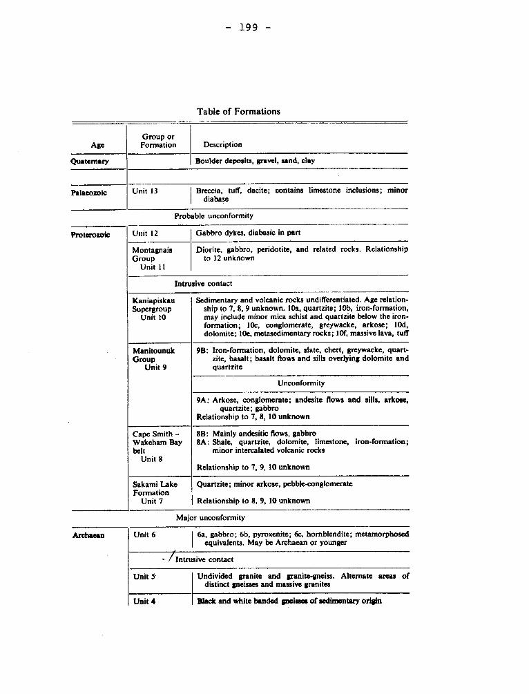
Age Description Group or Formation
Boulder deposits, gravel, sand, clay Quatemary
Palaeozoic Breccia, tuff. dacite; contains limestone inclusions; minor diabase
Unit 13
Proterozoic Unit 12 Gabbro dykes, diabasic in part
Montagnais Group
Unit 11
Diorite. gabbro, peridotite, and related rocks. Relationship to 12 unknown
Intrusive contact
Sedimentary and volcanic rocks undifferentiated. Age relation-ship to 7, 8, 9 unknown. 10a, quartzite; 10b, iron-formation, may include minor mica schist and quartzite below the iron-formation; 10c, conglomerate, greywacke, arkose; 1Od, dolomite; 10e, metasedimentary rocks; 10f, massive lava, tuff
Kaniapiskau Supergroup
Unit 10
9B: Iron-formation, dolomite, slate, chert, greywacke, quart-zite, basalt; basalt flows and sills overlying dolomite and quartzite
Manitounuk Group
Unit 9
Unconfomiity
9A: Arkose, conglomerate; andesite flows and sills, arkose, quartzite; gabbro
Relationship to 7, 8, 10 unknown
8B: Mainly andesitic flows, gabbro 8A: Shale, quartzite, dolomite, limestone, iron-formation;
minor intercalated volcanic rocks
Relationship to 7, 9, 10 unknown
Cape Smith — Wakeham Bay belt
Unit 8
Sakami Lake Formation
Unit 7
Quartzite; minor arkose, pebble-conglomerate
Relationship to 8, 9, 10 unknown
— 199 —
Table of Formations
Probable unconformity
Major unconformity
Archaean Unit 6 6a, gabbro; 6b, pyroxenite; 6c, homblendite; metamorphosed equivalents. May be Archaean or younger
- / Intrusive contact
Unit 5 Undivided granite and granite-gneiss. Alternate areas of distinct gneisses and massive granites
Unit 4 Black and white banded gneissa of sedimentary origin
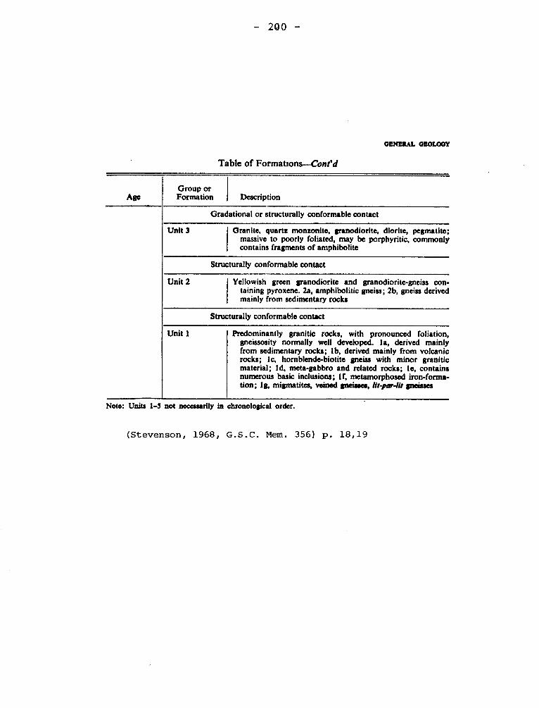
-- 200 —
GENERAL GEOLOGY
Table of Formations—Cont'd
Group or Axe Formation
Description
Gradational or structurally conformable contact
Unit 3
Granite, quartz monsonite, granodiorite, diorite, pegmatite; massive to poorly foliated, may be porphyritic, commonly contains fragments of amphibolite
Structurally conformable contact
Unit 2
Yellowish green granodiorite and granodiorite-gneiss con-taining pyroxene. 2a, amphibolitic gneiss; 2b, gneiss derived mainly from sedimentary rocks
Structurally conformable contact
Unit I
Predominantly granitic rocks, with pronounced foliation, gneissosity normally well developed. la, derived mainly from sedimentary rocks; lb, derived mainly from volcanic rocks; lc, hornblende-biotite gneiss with minor granitic material; Id, meta-gabbro and related rocks; le, contains numerous basic inclusions; lf, metamorphosed iron-forma-tion; Ig, migmatites, veined 'misses, lit-par-Ilt gneisses
Note: Units 1-5 not necessarily in chronological order.
(Stevenson, 1968, G.S.C. Mem. 356) p. 18,19
- 201 -
1930-31. It consists of slates and quartzites according to the paper (Clark,
1934) in which the name was published and was there referred to as a formation.
Ambrose and later Fortier added to it or described other members so that the
designation as slate is shown to be inappropriate. Cooke (1950) assigned the
rocks to the Caldwell Group. St. Julien (1963) following a suggestion by
Fortier, shows that the Mansonville Formation becomes more homogeneous if the
distinctive beds called "Brampton rocks" be considered a formation separate
from the Mansonville.
No fossils have been recognized as belonging to this formation. It is
Cambrian or Lower Ordovician or both.
Clark, T.H., 1934, Structure and stratigraphy of southern Quebec:
Geol. Soc. Am., Bull. v. 45, p. 11.
Ambrose, J.W., 1942, Preliminary map of Mansonville Map-area: Geol. Surv.
Can., Paper 42.1.
Fortier, Y.O., 1946, Geology of the Orford Map-area in the eastern
townships of the Province of Quebec, Canada: Stanford University thesis.
pp. 61-69.
Cooke, H.C., 1950, Geology of a southwestern part of the Eastern Townships
of Quebec: Geol. Surv. Can., Mem. 257, p. 5.
St. Julien, Pierre, 1963, Géologie de la région d'Orford-Sherbrooke,
Quebec: Université Laval, Thèse, pp. 50-65.
MANSVILLE PHASE (of Oak Hill Group)
Cambrian (?)
Clark (1934, p. 11) uses "Mansville Phase" for a part of the
Oak Hill outcrop in which the thickness of the whole group above the
Tibbit Hill is reduced to less than one tenth of the normal. He favors
the hypothesis that the thinning is a result of metamorphism. Eakins
- 202 -
(1963, p. 1) proffers the same explanation with the more specific infor-
mation that the formation is thinned along the limbs of the Richford-Sutton
syncline. Because the fabric of the deformed rock does not show evidence
of ten-fold thinning, the plausibility of a depositional thinning must be
considered.
Clark, T.H., 1934, Structure and stratigraphy of southern Quebec:
Geol. Soc. Am, Bull. v. 45, p. 11.
Eakins, P.R., 1960, Sutton Map Area: Can. Geol. Surv., Paper 63-34,
p. 1.
MARIA LATITE Lower Devonian (?)
The southwestern part of Maria mountain in ranges II and III, Maria
township, consists of latite in the form of a volcanic neck and associated
flows. The rocks are pinkish and fine grained minerals with the exception
of small patches of limonite.
Aleock, F.J., 1935, Geology of Chaleur Bay Region, Canada Geol.
Surv., Mem. 183, p. 72-73.
MARCH FORMATION Cambrian (?)
These beds, in the vicinity of Ottawa, were named by A.E. Wilson,
and consist of alternating gray sandstone and sandy dolomite or blue-gray
dolomite, all weathering dark rusty brown. The sand grains are large, ge-
nerally rounded, and commonly loosely cemented. Some of the thick dolomite
beds contain pockets, 1 inch to 3 inches in diameter, filled with large
crystals of pink or white calcite. The formation represents a transition
from the Nepean sandstone to the Oxford dolomite, the sand content being most
evident at the base.
- 203 -
Clark, T.H., 1966, Châteauguay Area, Châteauguay, Huntingdon,
Beauharnois, Napierville and St. Jean counties: Quebec Dept. of Nat. Res.,
G.R. no. 122, p. 20.
MARSAC LAKE SYNCLINE.
Marsac Lake Syncline is a well defined structure extending to a locality
seven miles south of Kipawa lake where it seems to dominated by a northwest
trending structure.
Robert, Jean-Louis., 1963, Geology of Kipawa Lake Area, Témiscamingue
County: Quebec, Dept. of Nat. Res., P.R. No. 502, p. 7.
MARSOUIN SERIES Ordovician
J.W. Dawson (1896) was apparently the first to use this name for the
Diplograptus and Nemagraptus beds at Marsoui, Griffon Cove, and White River,
Gaspé. Riva (1968) has shown the complexity of the graptolitic faunas. Lap-
worth (1886) has used Marsouin River Zone. Jones (193+) mapped the Marsoui
area and used no formation or series name but referred the shales, limestones,
chert, and conglomerate to Middle and Lower Ordovician.
This name for a formation or series can no longer be considered valid.
Dawson, J.W., 1896, Additional notes on fossil sponges and other orga-
nic remains from the Quebec Group at Little Métis on the lower St. Lawrence:
Roy. Soc. Can., Tn. v. 2, Sec. IV, p. 93.
Riva, John, 1968, Graptolite faunas from the Middle Ordovician of the
Gaspé North Shore: Nat. Can., v. 95, pp. 1381-138+.
Lapworth, Chas., 1886, Preliminary report on some graptolites etc.:
- 204 -
Roy. Soc. Can., Tn. v. 4, pp. 169-171.
Jones, L.W., 1934, Marsoui Map-area, Gaspé Peninsula: Quebec Bur. Mines,
Ann. Rept., 1933, D, pp. 20-29.
MATAGAMI SERIES Archeozoic
J. Austen Bancroft (1913) gave this name to metasedimentary rocks
cropping out along part of the east arm of Matagami lake. The series has
a well marked conglomerate. Bancroft assigned it to Huronian (4), but more
recent 'Torkers have considered it Archean. Cooke (1919) has described several
sequences of Archean metasedimentary rocks using names like Pontiac, Broadback,
Brock, Mattagami, Nemenjish, and Lucky Strike and expressed the belief that
they are post Keewatin. With the exception of Pontiac (q.v.) these names are
of use only locally.
Cooke has recorded a pebble of anorthosite in the Matagami of the Lucky
Strike area, and it is significant that boulders of the meta-anorthosite of
Chibougamau have been found in rocks correlated with the Nemenjish Series.
Bancroft used the spelling "Matagami", but Cooke and "Geology of Quebec"
use "Mattagami". Since 1926, Mattagami Series, now Formation, has been used for
Lower Cretaceous rocks of the Hudson Bay Lowlands, in Ontario.
Bancroft, J.A., 1913,... Headwaters of Harricanaw and Nottaway Rivers...:
Quebec, Dept. Col. Mines, and FIsheries, Rept on Mining Op. 1912, p. 150, 157.
Cooke, H.C., 1919, Some stratigraphic and structural features of pre-Cambrian
of northern Quebec: Jour. Geol. v. 27, pp. 266-266.
- 205 -
MATANE SERIES, SHALE, FORMATION Ordovician
J.W. Dawson (1889, p. 33) refers to the Matane Series as older
than the "Marsouin River Zone" and as a lower part of the Quebec Group.
Ruedemann (1937) refers to the Matane Shale as the country rock of that
Anisograptid fauna, which was the first described from North America.
Geology of Quebec (1944, p. 295) cites Matane Shales and Cape Rosier beds
as parts of the Quebec Group. I.W. Jones (cited as I.W. Johnson by Ruede-
mann, 1937, p. 62) collected the fauna from Cape Rosier, and the identity
of its fauna to that of the Matane Shale was commented on. The same rocks
have been referred to by Bulman (1950) as "Dictyonema shales".
The emphasis has been almost entirely on the fauna, which is of
the age of the Tremadoc in Britain, so that the lithologic units have not
been established. The term should be abandoned or a definition with a
standard section should be set up.
Dawson, J.W., 1889, On new species of fossil sponges from the
Siluro-Cambrian at Little Métis etc.: Roy. Sco. Can., Tn. v. IV, p. 33.
Ruedemann, Rudolf, 1937, A new North American graptolite fauna:
Am. Jour. Sci., v. 33, p. 57-62.
Bulman, O.M.B., 1950, Graptolites from the Dictyonema shales of
Quebec: Q.J. Geol. Soc. London, v. 106, pp. 63-99.
MATANE RIVER GROUP Lower Paleozoic
011erenshaw (1967) has proposed Matane River Group for unsubdivided
Quebec Supergroup. Its relationship to the Shickshock Group has not been
determined.
- 206 -
This term can cause only confusion. See Matane Series.
011erenshaw, N.C., 1967, Cuoq-Langis Area: Matane and Matapedia
Counties: Quebec Dept. of Nat. Res., G.R. 121, pp. 18-27.
MATAGAMI GNEISS Precambrian
Freeman (1938, p. 685) gave this name to gneisses, mostly gray,
with hornblende biotite oligoclase (An15), and quartz. Some of the varie-
ties no calls quartz diorite. Freeman suggests that the gneisses are mig-
matites. See Matagami.
The name should be abandoned.
Freeman, B.C., 1938, Replacement shells around batholiths in the
Waswanipi district, Northwestern Quebec: Jour. Geol. vol. 46, pp. 685-691.
MEACH LAKE PSEUDOCONGLOMERATE,CONGLOMERATE Precambrian
Mawdsley (1930) gave the name Meach Lake Conglomerate to irregular
bodies of brecciated and metasomatised fragments of quartz syenite rocks en-
closed within the same kind of rock. He considered the bodies to be conglo-
merates and probably Huronian. Béland'(1952)showed that the rocks are a re-
sult of the brecciation induced by emanations derived from parts of the
containing rock.
Mawdsley, J.B., 1930, The Meach Lake Conglomerate. A conglomerate
of Huronian age occurring within the Grenville Sub-Province: Roy. Soc. Can.,
Tr. 24, Sect. IV, pp. 99-117.
- 207 -
Béland, René., 1952, Le pseudo-conglomérat du lac Meach: Nat. Can.,
78, p. 361-366.
MELBOURNE LIMESTONE - (Wilmarth -2-232) - Cambrian
Cooke (1954) gave the name Melbourne, from the locality
on St. Francis river, to black limestones which he considered transitional
into and stratigraphically above Sweetsburg Formation. Logan and Ells had
observed the limestones and Dresser (1906) has presented a map showing the
"dolomites" intercalated with the slates which were later referred to the
Sweetsburg Formation as well as the black limestone.'.He also pointed out
that the now discredited fossils (Bryozoa), which had been described by
Dawson in 1879 and were supposed to indicate an Ordovician age, were in the
"dolomite". Osberg (1965) presented a detailed structural map of the belt
showing the structural relationship of the limestone.
Cooke, H.C., 1954, The Green Mountain Anticlinorium in
Quebec: Geol. Assn. Can., Pr. v. 6, pt. 2, p. 41.
Dresser, J.A., 1906, Igneous rocks of the Eastern Townships
of Quebec: Geol. Soc. Am., Bull. v. 17, P1. 68, p. 507.
Osberg, P.H., 1958, Structural Geology of the Knowlton-
Richmond area, Quebec: Geol. Soc. Am., Bull. v. 76, Pl. 1.
MEMPHREMAGOG FORMATION, SLATE, GROUP, COMPLES Paleozoic.
In "Geology of Quebec." (1944, p. 401) Memphrémagog Formation is
considered to be in the upper part of the Farnham Series, which is assigned
to Middle Ordovician. Clark (1934, p. 11) has used"Memphrémagog complex"as
a heading in a publication but has given no description of it.
— 208 —
Richardson introduced in 1906 the name for slates in Vermont. In 1924
he raised the formation to a group to include Montpelier and Northfield Slates.
These are now believed to be Silurian rather than Ordovician, In light of these
observation Memphrémagog should be dropped from use in Quebec.
Clark, T.H., 1934, Structure and stratigraphy of southern Quebec: Geol.
Soc. Am. v. 45, p. 11.
MEMPHREMAGOG, GLACIAL LAKE.
C.H. Hitchcock used this name for a glacial lake.
Hitchcock, C.H., 1908, Glacial Lake Memphremagog: Geol. Soc. Am. Bull.
v. 18, pp. 641-642.
MIGUASHA GROUP Upper Devonian
Williams and Dineley (1966) proposed that the Fleurant Conglomerate
and the Escuminac Formation be referred to the Miguasha Group. The locality
Miguasha is that famous for its fossil fish. This group name is not necessa-
ry•
Williams, B.P., and Dineley, D.L., 1966, Studies of the Devonian
Strata of Chaleur Bay, Quebec: Maritime Sediments, v. 2, No. 1, p. 8.
MILDALE GABBRO Precambrian
"On the Middle property, a small gabbroic mass is exposed on the
last ledge of outcrops on lot 50, range V, Duverny township. Mottled
greenish-grey diorite, very similar to the New Goldvue quartz diorite,
was encountered in drill holes. It has been assumed that the
two occurrences above are facies of one intrusive mass.
- 209 -
Weber, W.W., 1951, La Morandiére and Parts of Duverny, Landrienne
and Barraute Townships, Abitibi-East County: Quebec Dept. of Mines, P.R.
No. 255, p. 11.
MILE END FORMATION Trenton Group
This name was proposed without description in 1944 by T.H. Clark
for 25 feet of beds overlying the Leray Formation. The description of the
formation was given in 1952 when the sections in the quarries in the north-
eastern part of Montreal were given. The formation is thin bedded and has
both coarse and fine grained limestone. Clark (1952, p. 62) suggests a
correlation with the Hull Formation of Raymond, which beds were once known
as the "Crinoid beds". In later publications this formation is assimilated
to the Deschambault Formation.
Clark, T.H., 1952, Montreal area: Quebec Dept. of Mines, G.R. 46,
pp. 62-64.
MILL CREEK FAULT.
The Mill Creek Fault strikes northeasterly and a valley trending in
that direction is its trace. Diamond drill holes show it is about 60 feet
thick.
Auger, P.E., 1952, Belleterre Area, Guillet Township: Quebec, Dept. of
Mines, G.R. No. 55, p. 29.
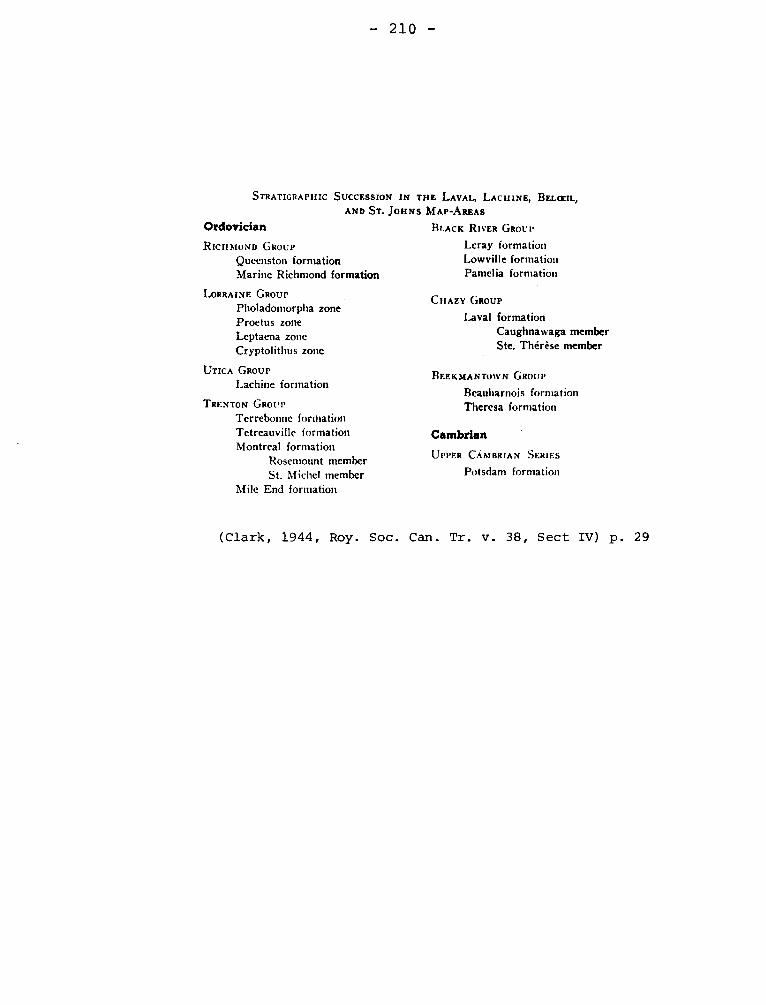
- 210 -
STRATIGRAPHIC SUCCESSION IN THE LAVAI., LACHINE, BELCBIL, AND ST. JOHNS MAP-AREAS
Ordovician
BLACK RIVER GROUP
RICHMOND GROUP Leray formation
Qucenston formation Lowville formation
Marine Richmond formation Pamelia formation
LORRAINE GROUP Pholadomorpha zone Proetus zone Leptaena zone Cryptolithus zone
UTICA GROUP Lachine formation
TRENTON GROUP
Terrebonne formation Tetreauville formation Montreal formation
Rosemount member St. Michel member
Mile End formation
CHAZY GROUP
Laval formation Caughnawaga member Ste. Thérèse member
BEEKMANTO1VN GROUP
Beauharnois formation Theresa formation
Cambrian
UPPER CAMBRIAN SERIES
Potsdam formation
(Clark, 1944, Roy. Soc. Can. Tr. v. 38, Sect IV) p. 29
- 211 -
MILLENARY EVENTS Precambrian
Millenary was introduced for the event that caused the potassium-
argon dates clustering around 950 X 106 years ago. It is equivalent to
Grenville Thermal Event (q.v.).
Osborne, F. Fitz, 1961, Millenary a name for geological events of
about 1000 mega-years ago: Nat. Can. V. 86, pp. 31-32.
MINGAN FORMATION Chazy
The "Geology of Canada" records the investigations carried out on
Mingan islands prior to 1863. In it the essential characteristics and ages
of formations that would be named in 1910 by Schuchert and Twenhofel are
given. No continuous exposed section has been recognized for Mingan for-
mation (Twenhofel, 1938, p. 23). A composite section gives less than 150
feet of calcarenite, and sublithographic limestone with minor shale and
sandstone.
The fossils indicate a Chazy age, but the fauna has some Black
River aspects.
Six drill holes on Anticosti island penetrated this formation.
In five of the holes the thickness is of the order of 600 feet, but in the
sixth hole, viz that at Carleton point, the formation does not appear.
Roliff (1968, p. 34) suggests that the absence of the Mingan Formation at
Carleton Point is a result of uplift and erosion at the end of Chazy time.
Schuchert, C., Twenhofel, W.H., 1910, Ordovicic-Siluric Section of
- 212 -
the Mingan and Anticosti Islands, Gulf of Saint-Lawrence, Geol. Soc. Am.,
Bull., vol. 21, p. 688.
Twenhofel, W.H., 1938, Geology and paleontology of'the Mingan islands,
Quebec: Geol. Soc. Am., Sp. Paper, No. 11, p. 23.
Roliff, W.A., 1968, Oil and gas exploration - Anticosti island,
Québec: Geol. Assn. Can., Pr., v. 19, pp. 31-36.
MISTASSINI
Largest lake in Labrador Peninsula
I- MISTASSINI GROUP (FORMATION) (SERIES). Proterozoic
It is probable that the limestones in the vicinity of Mistassini were
known prior to 1855, but the first geologist to note the limestone was
Richardson in 1870 (Richardson, 1872, p. 295), who described the black li-
mestones with chert near the Hudson's Bay Company Post. He found "an ortho-
ceratite and an obscure coral" neither of which could be determined. The
Cryptozoons of the limestone were not mentioned. Selwyn on page 8 of the
report cited comments on the similarity of the rocks to those of the Quebec
Group. Exploration by McOyat and by Low showed the wide distribution of the
limestone, but no formal designation appears to have been given until 1900
when Ami (1900, p. 197) used "Mistassini Formation" and considered the rocks
Cambrian in the modern sense. "Cambrian limestone" had earlier been used to
designate the formations, but it was used with the understanding that it im-
plied correlation with rocks now considered Upper Huronian. Barlow, on the
map accompanying the Chibougamau report of 1911 of the Quebec Dept. of Colo-
nization, Mines and Fisheries, states his opinion that the limestones are
Ordovician, possibly Chazy.
In Geology of Quebec (1944, p. 247) the several suggested dates for
- 213 -
"Mistassini Lake Sediments" are mentioned, by no conclusion is stated, however,
by this time the Proterozoic age for the rocks had come to be largely accepted.
The Mistassini Series was divided into three formations by Wahl. (1953,6).
These are, in ascending order: Lower Albanel Formation consisting of four
members, largely coloured dolomites, with a total thickness of 7000 feet;
Upper Albanel Formation with about 2000 feet of grey dolomite and sandy dolomite in
two members; and the Témiscamiscamie Formation with three members. Neilson
(1953, 7) used essentially the same divisions in the Albanel area but could
not separate some of the members mapped by Wahl. In a report on the Takwa
area Neilson (1966, p. 9) places Pépeshquasati Formation (q.v.) and Rivière
Chéno Formation below the Lower Albanel in the Mistassini Group.
Richardson, Jas., 1872, Country north of Lake St. John: Geol. Surv.
Can. Rept. of Prog. 1870-71, p. 295.
Ami, H.W., 1900, Synopsis of the geology of Canada: Roy. Soc. Can.,
Tn. v. 6, Sec. IV, p. 147.
Wahl, W.G., 1953, Témiscamie River Area, Mistassini Territory: Quebec
Dept. Mines, G.R. 54, p. 6.
Neilson, J.M., 1953, Albanel Area, Mistassini Territory: Quebec Dept.
Mines, G.R. 53, p. 7.
Neilson, J.M., 1966, Takwa River Area, Mistassini Territory: Quebec
Dept. Nat. Res., p. 9.
II- MISTASSINI FAULT
Norman (1936) suggested that a fault intervened between the Mistassini
Group and the rocks of the Grenville Subprovince and this fault or zone of
faulting extended to Lake Huron. He suggested that it might be later than
the Penokean folding and diffidently that it is "perhaps the first effect of
the Appalachian orogeny". Authors (Wilson 1949) have referred to this zone
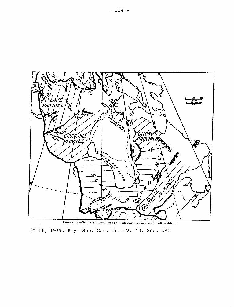
- 214 -
FIGURE 3. --Structural provinces and .uicprtuvinces in the Canadian shield.
(Gill, 1949, Roy. Soc. Can. Tr., V. 43, Sec. IV)
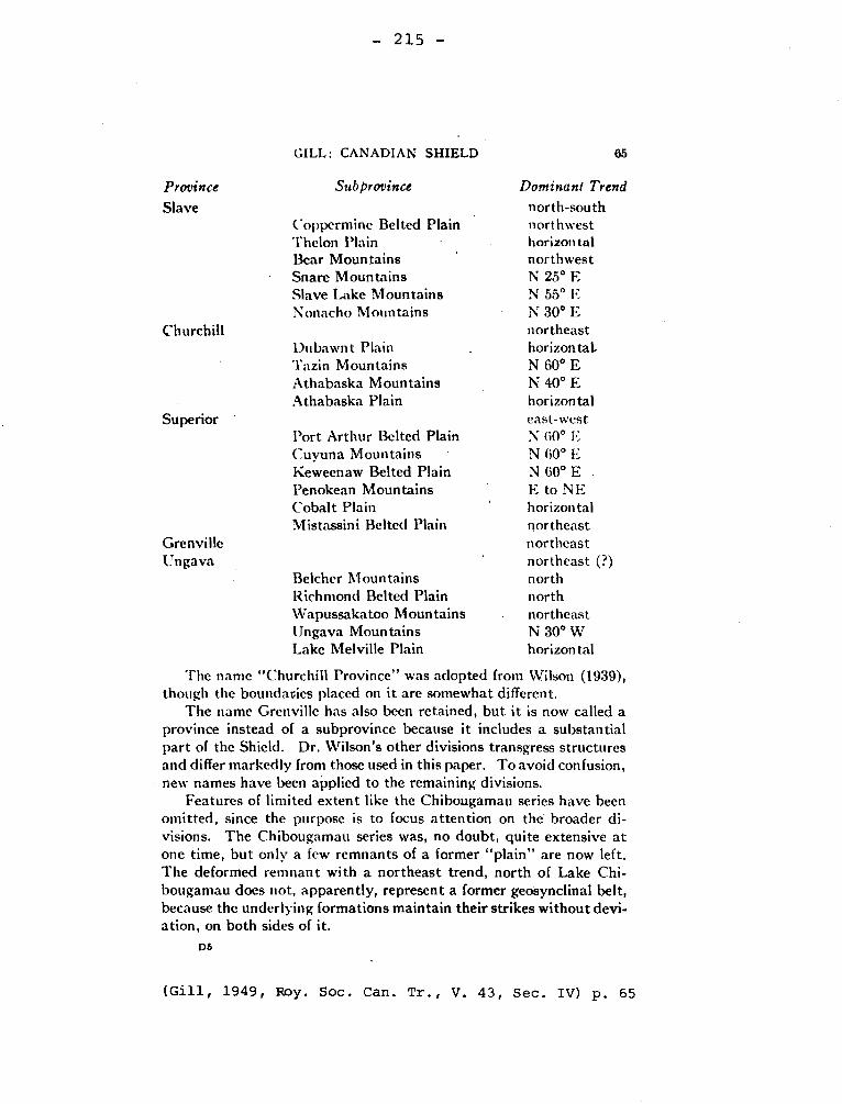
— 215 —
GILL: CANADIAN SHIELD 65
Province Sub province Dominant Trend
Slave north-south Coppermine Belted Plain northwest Thelon Plain horizontal Bear Mountains northwest Snare Mountains N 25° E Slave Lake Mountains N 55° E Nonacho Mountains N 30° E
Churchill northeast Dubawnt Plain horizontaL Tazin Mountains N 60° E Athabaska Mountains N 40° E Athabaska Plain horizontal
Superior east-west Port Arthur Belted Plain N 60° E Cuyuna Mountains N 60° E Keweenaw Belted Plain N 60° E . Penokean Mountains E to NE Cobalt Plain horizontal Mistassini Belted Plain northeast
Grenville northeast Ungava northeast (?)
Belcher Mountains north Richmond Belted Plain north Wapussakatoo Mountains northeast Ungava Mountains N 30° W Lake Melville Plain horizontal
The name "Churchill Province" was adopted from Wilson (1939), though the boundaries placed on it are somewhat different.
The name Grenville has also been retained, but it is now called a province instead of a subprovince because it includes a substantial part of the Shield. Dr. Wilson's other divisions transgress structures and differ markedly from those used in this paper. To avoid confusion, new names have been applied to the remaining divisions.
Features of limited extent like the Chibougamau series have been omitted, since the purpose is to focus attention on the broader di-visions. The Chibougamau series was, no doubt, quite extensive at one time, but only a few remnants of a former "plain" are now left. The deformed remnant with a northeast trend, north of Lake Chi-bougamau does not, apparently, represent a former geosynclinal belt, because the underlying formations maintain their strikes without devi-ation, on both sides of it.
DS
(Gill, 1949, Roy. Soc. Can. Tr., V. 43, Sec. IV) p. 65
— 216 —
as that of the Huron-Mistassini fault. It is the same as the Grenville or
the Grenville Front fault (q.v.) and a more appropriate name.
Norman, G.W.H., 1936, The northeast trend of late Precambrian tectonic
features in the Chibougamau district, Quebec: Roy. Soc. Can. Tn. vol. 39,
Sect. IV, pp. 119-128.
Norman, G.W.H., 1940, Thrust faulting of Grenville gneisses northwest-
ward against the Mistassini Series of Mistassini lake Quebec: Jour. Geol.
1,, 48, pp. 512-525.
Wilson, J.I., 1949, Some major structures of the Canadian Shield. Can.
Inst. Min. Met, Tr, 52, p. 239.
III- MISTASSINI BELTED PLAIN.
Gill (1949,p. 65) has given this name to a structural subprovince
of the Superior Province of the Canadian Shield.
The term is of doubtful use fulness.
Gill, J.E., 1949, Natural divisions of the Canadian Shield: Roy. Soc.
Can., Tr. v. 43, Sec. IV, p. 65
MISTAWAK BATHOLITH
Rocks of the Mistawak batholith, which consists mainly of coarse-
grained gray, biotitic to leucocratic granodiorite, occupy a large por-
tion of the east and northeast parts of the area. Other varieties of
rocks include a medium-grained biotite granodiorite of apparently younger
age, ubiquitous dikes of pink'aplite, rare pegmatites, and, in lot 4+8 of
range V, a coarse-grained muscovite granodiorite.
Bozach, Ronald, 1967, Geology of the south half of Perron
Township, Abitibi-West County: Quebec Dept. of Nat. Res., P.R. No. 561,
p. 9-10.
- 217
MONT ALEXANDER SYNCLINE
"The Malbaie syncline is succeeded to the south, in the southwestern
part of the area, by the Mount Alexander syncline. The anticline which should
intervene between these two down-folds is cut out almost completely by faul-
ting".
McGerrigle, H.W., 1950, The Geology of Eastern Gaspé: Quebec, G.R. No. 35,
p. 112.
MONTEREGIAN HILLS PETROGRAPHICAL PROVINCE.
The group of hills cored by igneous rocks intrusive into the sedimentary
rocks of the St-Lawrence Lowlands, near Montreal were- referred to as the
"Montreal System" by Marcou (1855-p.7-8). According to Adams (1903, p. 242),
Sterry Hunt in 1860 referred to the same group of hills as the Montreal
Group, although the reference cited does not give this name.
Adams (1903,) in the discussion introducing his paper is somewhat incon-
sistent. The introduction shows that the definition was intented to be topo-
graphic. However, the term is applied to the petrographic province charac-
terized by the distinctive alkaline rocks. Monteregian Hills Petrographical
Province has given way to Monteregian Province of some authors; or simply
Monteregian Hills.
The post-Lower Devonian age for the intrusive rocks has been accepted,
but until 1935 the age was normally considered to be late Paleozoic. Osborne
suggested that the rocks are substantially younger because of the absence of
- 218 -
pleochroic halos around radioactive nuclei. The Mesozoic age has now been
confirmed by several methods.
Marcou, Jules., 1855, Esquisse d'une classification des montagnes d'une
partie de l'Amérique du Nord: Ann. des Mines, Paris, v. VII, p. 7.
Adams, F.D., 1903, The Monteregian Hills, a Canadian petrographical
province: Jour. Geol. v. 11, pp. 239-282.
Geology of Quebec, 1944, p. 455-482.
MONTREAL
I- MONTREAL SYSTEM
Marcou (1855) used this term to designate the Monteregian Hills (g.v.)
Marcou, J.; 1855, Esquisse d'une classification des chaines de montagnes
d'une partie de l'Amérique du Nord: Annales des Mines, Paris, v. VII, p. 7.
II- MONTREAL, FORMATION, SAXICAVA SAND.
In the atlas accompanying Geology of Canada, 1863, Map VI shows the
distribution of superficial deposits between Lake Superior and Gaspé. In
Quebec, two units are shown. The upper one has, St. Maurice and Sorel sand,
Montreal Saxicava sand, Upper Sand of Beauport.
Apart from one reference to this map (Ami, 1900) no use of "Montreal"
in this context can be found.
Ami, H.W., 1900, On the geology of the principal cities in Eastern
Canada: Roy. Soc. Can., Pré v. 6, Sec IV, p. 163.
- 219 -
III4 MONTREAL, LIMESTONE, FORMATION.
References to Montreal limestone or limestones can be found particularly
in older writings, e.q. Logan in 1847, but they can be considered but casual
use and are generally in a context where emphasis is placed on the commercial
use of the stone. The beds so referred to are Chazy, Black River, and Trenton.
They are essentially the same range as beds of the "Ottawa limestone" (î.v.),
and are the Trenton Series of J.W. Dawson, (1880, p. 58).
Clark (1944 and 1952) has made a formal proposal that about 370 feet of
Trenton limestone in the Montreal district be referred to a Montreal Formation,
which he states is equivalent to Sherman Fall. The Montreal consists of a
lower Saint-Michel member less than 120 feet thick and an upper member, Rose-
mont, which is 250 feet thick. According to Clark the distinction is based
on fossils.
Dawson, J.W., (1880) Lecture Notes on Geology; Montreal Dawson Brothers,
96 pp.
Clark, T.H., 1952, Montreal area, Laval and Lachine map-areas: Quebec,
Dept. of Mines, G.R. 46, p. 65.
MOOSE CREEK FAULT.
It crosses the granite gneiss in tunnel section No. 1. The rocks are
cut with a red, epidote-bearing pegmatite. It strikes northeasterly.
Morin, Marcel., 1956, Labrievelle Area, Saguenay County: Quebec,
Dept. of Mines, P.R. No. 333, p.7.
- 220 -
MOOSE LAKE GRANITE
The Moose Lake granite is a mass about 2 miles long and mile wide
in the southern part of Hébécourt township. The northern part of the body
is not well exposed. The composition of the rock varies a good deal, and
tends to be more basic near the margins. The more acid varieties are pink
or light grey rocks of granitic texture with an average grain of 3 to 4 mm.
The more basic varieties are darker in colour, and differ from the acidic
facies in their greater content of chlorite.
Cooke, H.C., James, W.F., Mawdsley, J.B., 1931, Geology and Ore
Deposits of Rouyn-Harricanaw Region, Quebec: Canada Geol. Surv., Mem. 1b6,
p. 128-129.
MOOSE LAKE GRANITE Precambrian
The Moose Lake granite crops out in an area two miles long and mile
wide in the southern part of Hébécourt township. The composition of the rock
is diverse. The more acidic rocks are pink or light grey, coarse with gra-
nitic fabric and an average grain of three to four mm. They are made up of
about 25% of quartz, 70% of albite, more or less altered to white mica, zoi-
site, et., and 5% of chlorite probably secondary after hornblende. The more
basic (marginal) facies, is darker.
Cooke, H.C., James, W.F., Mawdsley, J.B., 1931, Geology and Ore Deposits
of Rouyn-Harrioanaw Region, Quebec: Canada Geol. Surv., Mem. 166, p. 128-129.
MORGAN CORNERS DOLOMITE Ordovician
This is the upper part of the A3 division of the Philipsburg
Series (q.v.) of Logan and consists of dolomite. The formation was named
by McGerrigle and assigned to Beekmantown.
- 221 -
McGerrigle, H.W., 1931, Three geological formations in
northwestern Vermont: Rept. of State Geol., 17th., 1929-30, p. 185.
MORIN ANORTHOSITE, MORIN SERIES Precambrian
This rock is composed principally and in places almost entirely of
plagioclase feldspar, more calcic than oligoclase, but often varied conside-
rably in structure from place to place, being schistose, coarse, or fine.
The Morin Series includes anorthosites and rocks, mostly with hypers-
théne and augite, believed to be comagmatic with the anorthosite.
Adams, Frank D., 1896, Report on the geology of a portion of the
Laurentian Area lying to the North of the Island of Montreal, Canada Geol.
Bury., pp. 91-118.
MORIN SERIES
Adams, in mapping the area north of Montreal, gave the name Morin Series,
from the township of that name, to the complex of rock, including gabJro and
anorthosite, found in this area.
Osborne, F.F., 1936, Sainte-Agathe - Saint-Joseph Map Area: Quebec
Bureau of Mines, Part C, p. 63.
MOUNTAIN HOUSE WHARF LIMESTONE Devonian
A few acres of a blue gray limestone are found at a cove on
the west side of Memphremagog lake about 4 miles north of the Vermont
border. The thickness of the limestone is not known but the beds have
yielded collections of fossils which are considered to support an early
Middle Devonian (Eifel) age.
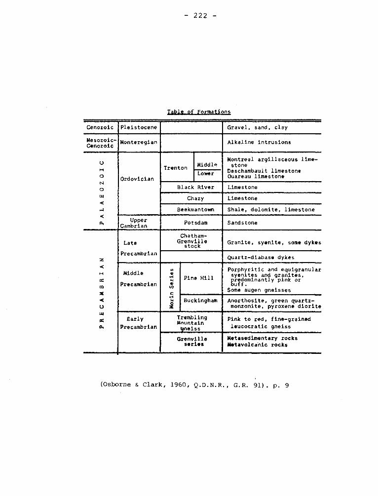
- 222 -
Table of Formations
Cenozoic Pleistocene Gravel, sand, clay
Mesozoic- Cenozoic
Monteregian Alkaline intrusions
PALAEOZ
OIC
_
,
Ordovician
Trenton Middle
Montreal argillaceous lime-stone
Deschambault limestone Ouareau limestone Lower
Black River Limestone
Chazy Limestone
Beekmantown Shale, dolomite, limestone
Upper Cambrian
Potsdam Sandstone
PRECA
MBRIA
N
Late
Precambrian
Chatham- Grenville
stock Granite. syenite, some dykes
Quartz-diabase dykes
Middle
Precambrian
Morin Series
Pine Hill
Porphyritic and equigranular syenites and granites, predominantly pink or buff.
Some augen gneisses
Buckingham Anorthosite, green quartz-monzonite, pyroxene diorite
Early
Precambrian
Trembling Mountain gneiss
Pink to red. fine-grained leucocratic gneiss
Grenville series
Metasedimentary rocks Metavolcanic rocks
(Osborne & Clark, 1960, Q.D.N.R., G.R. 91). p. 9
- 223 -
Boucot, A.J., and Drapeau, G., 1968, Siluro-Devonian rock of
Lake Memphremagog etc..: Quebec Dept. Nat. Res., Special Paper 1, pp. 12-13.
MOUNT AYLMER GRANITE Devonian (?)
Burton (1932, p. 101) referred to this granite as that of the St. Gérard
area. It crops out in an area 6 by 4i miles and is a medium-grained gray with
oligoclase, microcline, biotite, and muscovite. Cooke (1937, p. 75) has used
the name Mount Aylmer Granite as has also Duquette (1961, pp. 171-173).
Burton, F.R., 1932, Commercial Granites of Quebec, Part 1, South of
St. Lawrence river: Quebec Bur. of Mines, Ann. Rept. 1931, Pt. D, p. 101.
Cooke, H.C, 1937, Thetford, Disraeli and Eastern Half of Warwick Map-
Areas, Quebec: Canada Geol. Surv., Mem. 211, p. 75.
Duquette, G., 1961, Geology of the Weedon Lake area and its vicinity,
Wolfe and Compton Counties, Quebec: Universite Laval, thése pour doctorat,
pp. 171-173.
MOUNT ORFORD AND BALDFACE Paleozoic
MOUNTAIN COMPLEX -
Coarse-grained to fine-grained gabbro and diorite make up
most of these hills. A quartz bearing facies of unknown origin forms
irregular masses within the complex.
St-Julien, P., 1961, Fraser Lake Area, Shefford and Stanstead
Counties: Quebec Dept. of Mines, P.R. No. 439, p. 8.
MT. WRIGHT SYNCLINE
"The structure of the Mt. Wright area is very complex. One of
the largest and best exposed structures is the Mt. Wright syncline, a
- 224 -
northeast-plunging fold whose axial plane dips northwest. In the
southern part of the area, the folding is seen to be complex. Here,
the structures have a dominant northwest trend, and many folds are
overturned northeast. A less pronounced, and possibly older, northeast
structural trend may be observed locally".
Murphy, Daniel L., 1959, Mount Wright Area, Saguenay Electoral
District: Quebec Dept. of Mines, P.R. No. 380, p. 6.
MUD LAKE FAULT.
Mud Lake Fault crops out at the bottom of the lake. It is a vertical
shear zone about 100 feet thick. Its strike is N60°E.
Auger, P.E., 1952, Belleterre Area, Guillet Township: Quebec, Dept. of
Mines, G.R. No. 55, p. 29.
MURPHY CREEK FORMATION Upper Cambrian
The Cambrian fauna of the one inch beds of grey limestone
separated by beds of shaly limestone cropping out along Murphy River in
Eastern Gaspé was found by Kindle,but the name was first published by
Alcock. Kindle used Murphy's Creek.
Alcook, F.J., 1935, Geology of Chaleur Bay Region: Can.
Geol. Surv., Mem. 183, pp. 12-13.
Kindle, C.H., 1936, A geological map of southeastern Gaspé:
Eastern Geologist, No. 1, Mimeographed, no pagination.
McGerrigle, H.W., 1950, The Geology of Eastern Gaspé:
Quebec Dept. of Mines, G.R. 35, pp. 25-26.
- 225 -
MUSCOCHO STOCK
The Muscocho stock, some 10 square miles in extent, is situated
near Muscocho lake. Outcrops are abundant along the southwestern shores
of the lake and in low hills one mile south of the northern arm of the
lake. The rock is a medium-grained pinkish-grey granodiorite. It is
very uniform in composition, and consists of 40 to 50% albite-oligoclase,
10 to 15% hornblende, and 25 to 30% quartz. The Muscocho stock displays
two well developed sets of steeply dipping joints, one of which strikes
northwest and the other, to the northeast.
Holmes, Stanley W., 1959, Fancamp-Hauy Area, Abitibi-East, Electoral
District: Quebec Dept. of Mines, G.R. No. 84, p. 9-10.
MYSTIC FORMATION OR CONGLOMERATE (Wilmarth -1-1455)
Logan used Stanbridge Conglomerates (g.v.) for certain beds which he
assigned to division D1 of the Philipsburg Series, "Stanbridge Centre" having
been changed to "Mystic", Ells uses "Mystic and Bedford limestones and slates"
for a unit on the Montreal sheet (# 571) of the Eastern Townships map. He
places it in the Chazy below the Trenton, which is represented by the Farnham
limestone. These beds are now called Mystic and Stanbridge Formations.
T.H. Clark, (1934) and Clark and McGerrigle (1944) used Mystic Conglomerate
for a formation beneath the Stanbridge Shale, but they assign it only a thick-
ness of 75 feet rather than the 300 of Logan's tabular summary. They consider
it to Chazy, but G.A. Cooper tentatively suggests that it is Trenton, and it
is so indicated on the correlation chart for the Ordovician.
Clark, T.H., 1934, Structure and stratigraphy of southern Quebec: Geol.
Soc. Am., v. 45, pp. 6,7.
- 226 -
Clark, T.H. and McGerrigle, H.W., 1944, Geology of Quebec, pp. 400-401.
Cooper, G.A.,(1954) in Correlation of the Ordovician formations of North
America: Geol. Soc. Am., Bull. v. 65, p. 278 and chart.
NAPIERVILLE SYNCLINE
In the southwestern part of the St. Jean sheet, rocks of Chazy,
Black River, and Trenton ages are disposed in a syncline whose axis trends
northeast-southwest. Farther south, in the Lacolle sheet, this axis
passes close to the village of Napierville (4 miles south of the St. Jean
map border).
Clark, T.H., 1955, St. Jean-Beloeil Area, Iberville, St. Jean,
Napierville-Laprairie, Rouville, Chambly, St. Hyacinthe and Verchéres
Counties: Dept. of Mines, G.R. No. 66, p. 50.
NASTAPOKA GROUP Proterozoic
A.P. Low (1903, p. 14 D.D.) used "Nastapoka group" for the half-mile
thick sequence of sedimentary and igneous rocks of the Nastapoka Islands.
Unaware of proposals by Low and Bell, Leith (1910, p. 232) proposed the
same name for the same rocks. Low makes only casual mention of Manitounuck
Formation (g.v.) but (1903, p. 80 D) apparently considered it a part of the
Nastapoka Group. The group consists of iron formation rocks, basaltic flows,
limestone, and quartzite. The limestone and dolomite have algal structures.
Bell called these rocks lower Cambrian as was customary at that time.
Low suggests (1903, pp. 15-16 D) that the rocks are unmetamorphosed equivalents
of the Laurentian and Huronian formations. Leith suggests a correlation with
Animikie of Lake Superior region.
- 227 -
The lithologically similar rocks of Belcher Islands, N.W.T., have been
assigned to the Belcher Series but precise correlation is a matter of doubt
(Young, 1922, p. 17 E)
Low, A.P. (1903), Geology and physical characters of Nastapoka Islands,
Hudson Bay: Can, Geol. Surv, Ann. Rept. XIII,p. 14 DD.
Bell, Robert., 1879, Report on the exploration of the east coast of
Hudson Bay, 1877: Can. Geol. Surv. Rept of Prog. 1877-78, p. 17C
Bell, Robert., 1895, Labrador Peninsule Scottish. Geog. Mag. July 1895,
P. 351.
Leith, C.K., 1910, An Algonkian Basin in Hudson Bay, a comparison with
the Lake Superior Basin: Econ. Geol. V, pp. 232-233.
Low, A.P., 1903, Exploration of the east Coast of Hudson Bay: Can,
Geol. Surv., Ann, Rept. , XIII, p. 80 D.
Young, G.A., 1922, Iron bearing rocks of Belcher Islands, Hudson Bay:
Can. Geol. Surv., Summ. Rept. 1921, p. 17 E.
NAYLOR LEDGE FORMATION Ordovician
McGerrigle gave this name to the upper 30 feet of division
B2 of Loganfs section of the Philipsburg Series (a.v.), of Beekmantown
age.
McGerrigle, H.W., 1931, Three geological formations in
northwestern Vermont: Vermont, Rept. of State Geol., 17th., 1229-30,
p. 185.
- 228 -
NELSON LAKE GRANITE
The Nelson Lake granite forms a mass about a mile in diameter
on the east side of Nelson lake in the southeast quarter of Montbray
township. It is a light-coloured, very coarse-grained albite granite
with albite crystals up to 3 mm. and quartz crystals up to 6 mm. in
diameter. It is composed of about 30% quartz, some of which shows wavy
extinction; b5% albite, Ab95An5 somewhat altered to calcite, epidote,
and white mica; and about 5% of chlorite. Magnetite, pyrite, and apa-
tite are accessory.
Cooke, H.C., James, W.F., Mawdsley, J.B., 1931, Geology and Ore
Deposits of Rouyn-Harricanaw Region, Quebec: Canada Geol. Surv., Mem.
166, p. 129.
NEMENJISH SERIES Archean
Cooke (1919, p. 188) named the Nemenjish Series from a locality on the
north shore of the lake of that name. The series is described as garnetife-
rous and non-garnetiferous mica gneisses with hornblende gneisses. Cooke
regards the rocks as northern equivalent of the Grenville Series. He (1919,
p. 269) apparently considers the garnets as having pecular value in correla-
tion, but the modern development of facies petrography would make garnets of
minor significance.
Cooke regarded this series as pre-anorthosite. He did not distinguish
between the dominai bodies of the Grenville subprovince and the stratiform
bodies. However, rocks of the lithology of the Nemenjish have conglomerates
with boulders of Chibougamau anorthosite in the Dollier - Charon area not far
- 229 -
from the type locality. This term should be abandoned.
Cooke, H.C., 1914, Some stratigraphic and structural features of the
pre-Cambrian of northern Quebec: Jour. Geol. v. 27, p. 188.
NEUVILLE FORMATION Trenton
Clark has used this name for the middle and upper Trenton of the Gron-
dines Neuville area with the suggestion that if it is desirable to divide
the Trenton that Neuville be used for the lower division that is the Sherman
Fall equivalent. The beds are grey rubbly limestones.
Clark does not give the correlation of this formation with the 193 feet
of Rafinesquina deltoidea and the 117 feet of Prasopora zones. (Raymond 1914)
Clark, T.H., 1959, Stratigraphy of the Trenton Group, St. Lawrence
Lowland, Quebec: Geol. Assn. Can., Pr., v. 11, p. 18.
Raymond, P.E., 1914, The Trenton Group in Ontario and Quebec: Can.
Geol. Surv., Summ. Rept., 1912, pp. 342-343.
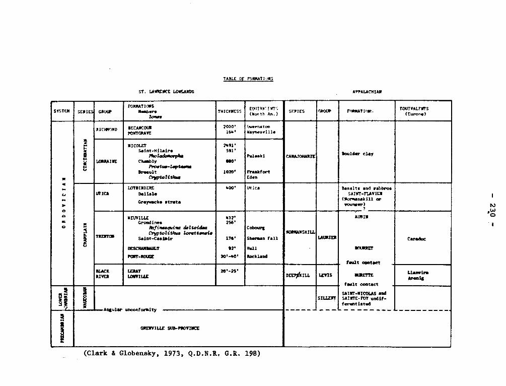
TADLE OF roRRAT10mS
ST. LAWRENCE LOWLANDS
APPALACHIAN
SYSTEM SERIES GROUP FORMATIONS
Members Lows
(North THICKNESS
EOJIVALINT> Ain.)
SERIES O.ROUP FnRMATIow, EQUIVALENTS (Furore)
=
r„ u « N.
CI
m o
CIN
CIM
NAtI
AM
RICHM7ND RECANCOUR PONTGRAVE
2000' 16r'
(.oueenston Nsynesrille
CANAJOHARIE boulder clay
LORRAINE
NICOLE, Saint-Hilaire
PholodJ.vrphs Chasbly
Proetlr-Lapta im Ar.sult
C riptol{that
2491' S91'
NO'
1020'
Pulaski
Frankfort Eden
a
T
UTICA LOTBIMIERE
0.11.1t
Grayuackt strata
400' Utica dasalts and gabbros SAINT -MARIE'
(Natwanskill oe younger) 0
iCryptolithrs
NEUV I LLE Grondins
lk;finesorina deltofdaa lorsttwvis
Saint-Casimir
DESCMAIIM1LT
PAT-ROUGE
432' 2S6'
176'
92'
30'-s0'
o --
Cobourg
Shaman Fall
Hull
Rockland
NORMANSKILL
•
LAS
AUIII N
BOURRET
fault contact
Carob=
!LACK RIVER
IERAT LMIVILLE
20'-2S' DEEPAILL LEVIS
4
MURETTE
fault contact
L Lrs
5 g g s e S
3
â Angular
I
CREIIVILLE
SILLERT SAINT-NICOLAS and SAINTE-FOY un - fer.ntiattddif
• unoonforaity
SUR-PROVINCE
(Clark & Globensky, 1973, Q.D.N.R. G.R. 198)
- 231 -
NEWBEC BRECCIA Precambrian
On the Newbec property, northeast of the shaft, and in a triangular-
shaped area about i mile long and 2,000 feet wide extending from the shaft
westward to the Macamic highway and southward to the Lake Dufault granodio-
rite, there are outcrops of a breccia composed of angular to round fragments
of rhyolite, andesite, and quartz diorite. The composition of the breccia
and the size of the fragments vary greatly in different parts of these areas.
At places northwest of the shaft, porphyritic rhyolite appears to form the
matrix around fragments of diorite and andesite. The origin of this breccia
has not been established. Is it a diatreme filling?
Wilson, M.E., 1941, Noranda District, Quebec: Canada Geol. Surv.,
Mem. 229, p. 43-45.
NICOBI LAKE GRANITE
It consists of white feldspar, between 4 and 6 hornblende,
between 5 and 15% quartz, from 0 to 1% biotite, from 0 to 4% chlorite and accessory amounts of epidote, sphene and in places, magnetite. The
hornblende is in well-formed, long, individual prisms. The quartz con-
tent appears to decrease northward.
Remick, J.H., 1959, Margry-Prévert Area, Abitibi-East Electoral
District: Quebec Dept. of Mines, P.R. No. 394, pe 8-9.
NICOLET RIVER FORMATION Cincinnatian
The basic studies of the stratigraphy and fauna of the Lorraine
Formation were by Foerste, who divided the beds exposed on Nicolet River
into four zones based on the fossils. His zones were called from the
- 232 -
top downward: Pholadomorpha, Proetus, Leptaena, and Trinucleus. Clark
gave names to the divisions thus the zone of Pholadromorpha was called
the St. Hilaire member with a thickness of 539 feet. The Chambly member
is made up of the Proetus zone with a thickness of 287 feet and part of
the Leptaena zone 569 feet thick. The Breault member is 962 feet thick
and is the Cryptolithus zone and the rest of the Leptaena zone.
The unit consists of shales and sandy or silty shales commonly
grey and non petroliferous.
This formation is commonly considered equivalent to the Frankfort
and Pulaski and including both Edenian and Maysville stages.
Foerste, A.F., 1916, Upper Ordovician Formations in Ontario and
Quebec: Canada, Geol. Surv., Mem. 83, pp. 14-65.
Foerste, A.F., 1924, Upper Ordovician Faunas of Ontario and Quebec:
Canada Geol. Surv., Mem. 138, p. 255.
Clark, T.H., 1947, St. Lawrence Lowlands south of St. Lawrence river:
Quebec Dept. of Mines, P.R. 204, pp. 5-9.
Clark, T.H., 1964, Yamaka-Aston area: Quebec Dept. Nat. Res., G.R.
102, pp. 32-62.
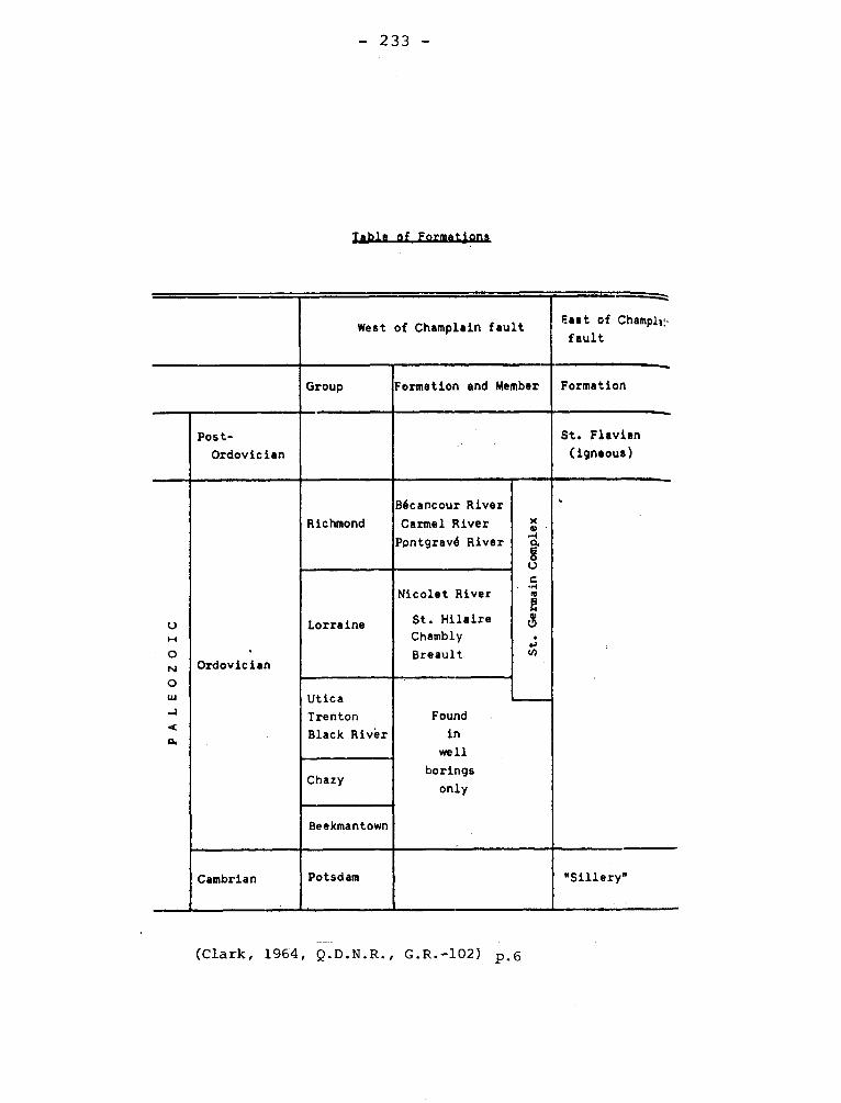
- 233 -
Table of Formations
West of Champlain fault East of Champlii.•
fault
Group Formation and Member Formation
Post-
Ordovician
St. Flavien
(igneous)
{ PALEOZOIC
Ordovician
Richmond
Bécancour River
Carmel River
Ppntgravé River St. Germain Complex
'
Lorraine
Nicolet River
St. Hilaire
Chambly
Breault
Utica
Trenton
Black River
Found
in
well
borings
only Chazy
Beekmantown
Cambrian
1
Potsdam "Sillery"
-
(Clark, 1964, Q.D.N.R., G.R.-102) p.6
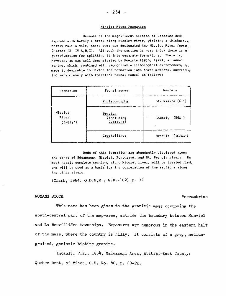
- 234 -
Nicolet River Formation
Because of the magnificent section of Lorraine beds
exposed with hardly a break along Nicolet river, yielding a thickness cf
nearly half a mile, these beds are designated the Nicolet River format:;.
(Plates IB, IV A,B,C). Although the section is very thick there is no justification for splitting it into separate formations. There is, however, as was 'well demonstrated by Foerste (1916; 1924), a faunal zoning, which, combined with recognizable lithological differences, has
made it desirable to divide the formation into three members, corresponc•
ing very closely with Foerste's faunal zones, as follows:
Formation Faunal zones Members
Nicolet
River
(2+91+')
Pholadomorpha St-Hilaire (61')
Proetus Chambly (860') (including
Leotaena)
Crvotolithus Breault (1020.')
Beds of this formation are abundantly displayed along
the banks of Bécancour, Nicolet, Pontgravé, and St. Francis rivers. The
most nearly complete section, along Nicolet river, will be treated first,
and will be used as a basis for the correlation of the sections along
the other rivers.
(Clark, 1964, Q.D.N.R., G.R.-102) p. 32
NOMANS STOCK
Precambrian
This name has been given to the granitic mass occupying the
south—central part of the map—area, astride the boundary between Monviel
and La Rouvilliére townships. Exposures are numerous in the eastern half
of the mass, where the country is hilly. It consists of a grey, medium—
grained, gneissic biotite granite.
Imbault, P.E., 1954, Maicasagi Area, Abitibi—East County:
Quebec Dept. of Mines, G.R. No. 60, p. 20-22.
- 235 -
NORANDA ANTICLINE
"From the Hêré Creek syncline southward to the Horne Creek fault, the
attitudes of flow contacts and these of stratified tuff show the strike to
be northwesterly; and the dips to the northeast at angles of 600 to vertical,
The volcanic rocks in this part of the area, therefore, form the north limb
of an anticline".
Wilson, M.E., 1949, Noranda District, Quebec: Canada, Geol. Surv., Mem,
224, p. 50.
NORANDA LAKE GRANITE
A band of granite some 300 feet wide is found on the south shore
of Noranda lake, Rouyn Township, bordering the north side of the band of
quartz diorite that runs east through Rouyn village. The granite is light
to dark grey, medium-grained (1.5 mm), and highly siliceous.
Cooke, H.C., James, W.F., Mawdsley, J.B., 1931, Geology and Ore
Deposits of Rouyn-Harricanaw Region, Quebec: Canada Geol. Bury., Mem. 166,
p. 128.
NORIAN SERIES Precambrian
This term was introduced in 1870 by T.S. Hunt to replace Upper
Laurentian. It was applied to the plagioclase bearing rocks ranging
from gabbro to anorthosite at a time when these rocks were believed to
be metasedimentary. The igneous origin of the rocks was recognized soon
after the introduction of the term, which derived from norite introduced
- 236 -
by Jens Esmark in 1823. This term is not in use.
Hunt, T.S., 1870, On norite or labradorite rock: Am. Jour. Sci,
vol. 49, p. 180. Hunt cites this as first mention in his "Chemical and
geological essays" p. 279.
NORMANSKILL SHALE Middle Ordovician
This formation name was proposed for shales, grits, and cherts
from a locality south of Albany in New York by R. Ruedemann. He
used the graptolite fauna in the definition and did not indicate
either the lithologies or the type sections with reasonable precision.
Furthermore, Ruedemann as well as other workers have assigned the Nor-
manskill to several positions in the Middle Ordovician.
Ruedemann himself has examined many collections of graptolites
from Quebec and assigned the containing beds to the Normanskill. In
some cases the faunas are not those believed to belong to the original
Normanskill. At present the use of local names is indicated for forma-
tions in Quebec, and the graptolite fauna should be given. In general,
Normanskill has implied Middle Ordovician age, perhaps Black River to
Lowest Trenton, of the rocks belonging to the shale facies.
NORMETAL SCHIST Precambrian
A belt about 700 feet wide consisting largely of schist extends
N 65 W from the mine and constitutes the country rock of the Nonmetal
ore body. A narrow band of siliceous agglomerate was the locus of mine-
ral deposition. The dominant rocks of the Nonmetal schist are fine-
grained sericite and chlorite schists. The sericite schists are more
- 237 --
prevalent in the southwestern part of the band near the Normetal ore
body, and chlorite schists prevail to the northeast.
Tolman, Carl, 1952, Normetal Mine Area, Abitibi-West County:
Quebec Dept. of Mines, G.R. No. 311, p. 6-8.
NORTH GRAND -PABOS FAULT.
This west-striking (?) fault, so named by Ayrton because it is seen along
North Grand-Pabos river can be traced easily westward on aerial
photographs to the Honorat West area where it was first recognized by Skidmore
(1958). It extends as far west as Nouvelle river in southwest Gaspé and has a
total known length of approximately 85 miles. To the east, it strikes out to
sea at Petit-Pabos bay, approximately 1+ miles east of Chandler.
Ayrton, W.G., 1964, Chandler - Port -Daniel Area, Bonaventure and Gaspé-
South Counties: Quebec Dept. of Nat. Res., G.R. No. 120, p. 68-69.
NORTH LAMELEE HILL (SYNCLINE) Precambrian
This structure is interpreted as an overturned isoclinal syncline
with a northward dipping axial plane, which has been refolded about a
north-south synclinal axis. The lower bed of the sequence have been remo-
ved by erosion, but one oxide member containing as much as 30% magnetite
and specularite remains.
Phillips, L.S,, 1959, Peppler Lake Area (East Half), Saguenay Elec-
toral District, Quebec, P.R. No. 1+01, p. 10.
- 238 -
NOUVELLE DACITES Devonian
North of Chaleur Bay and east a finely crystalline rock characterized
by a brownish colour and rusty, limonitic pits crops out. The rock
is a fine-grained dacite which in thin section is seen to contain biotite in
some specimens and hornblende in others. Most of the original ferromagnesian
minerals have been converted to chlorite, quartz, and brownish iron oxides.
There are in some specimens phenocrysts of plagioclase and less commonly,
some of quartz and orthoclase.
Alcock, F.J., 1935, Geology of Chaleur Bay Region-Canada, Geol. Surv.,
Mem. 183, p. 73
I-
OAK HILL
Oak Hill Slice. -The Oak Hill Slice is bounded on the east by the Brome
Thrust and on the west by the Oak Hill Thrust and involves about 4000 feet of
beds.
Clark, T.H., 1934, Structure and stratigraphy of southern Quebec: Geol.
Soc. Am., Bull. v. 45, p.9.
II- Oak Hill Thrust. -Clark (op. cit. p. 9) has given this name to a fault
of unknown attitude separating the Oak Hill from the Rosenberg and Philipsburg
slices. This is presumably the Cowansville fault named by Harvie, who was one
of the first to recognize the presence of numerous fault slices in the Appala-
chian region.
III- Oak Hill Series (Group) (Sequence) - Cambrian (?)
Clark (1934, op. cit., p. 6) listed several formations as belonging to the Oak
Hill Series of Cambrian age but he placed Tibbitt Hill Schist in the Precam-
— 239 —
brian. In 1936 he added the latter to the Oak Hill series, and the list of
formations is, from oldest to youngest, Tibbitt Hill Schist, Pinnacle Gray-
wacke, White Brook Dolomite, West Sutton Slate, Gilman Quartzite, Dunham Do-
lomite, Oak Hill Slate, Scottsmore Quartzite, Sweetsburg Slate. Not only is
the Gilman Quartzite the thicknest formation of the group, but also it has
brachiopods identified as Kutorgina which is considered diagnostic of Lower
Cambrian. This is the oldest formation of the group dated by fossils.
Formation of the Oak Hill Group can be traced northward: Tibbitt Hill
Schist can be seen near Chaudière river. To the south the lower part of the
Group can be recognized in Vermont. Booth (1950) has provided very good discus-
sion accompanied by the best descriptions of the lithology for the "succession".
Harvie, Robt., 1915, Brome and Missisquoi Counties, Quebec: Can. Geol.
Surv. Sum. Rept. 1919, p. 99.
Kay (1951) states that the Oak Hill Group belongs to the Champlain belt,
but Logan assigned the beds to what is now called the Quebec Supergroup.
Clark, T.H., 1936, A Lower Cambrian series from southern Quebec: Roy.
Can. Inst., Tr. v. 71, pp. 135-151.
Booth, V.H., 1950, Stratigraphy and structure of the Oak Hill succession
in Vermont: Geol. Soc. Am., Bull. v. 61, pp. 1131-1168.
Kay, G.M., 1951, North American Geosynclines: Geol. Soc. Am., Mem. 4+8,
p. 50.
IV- OAK HILL SLATE Lower Cambrian
The section at Oak Hill shows a hard gray siltstone overlying
the Dunham Dolomite but this formation, which is less than 25 feet thick,
is absent in many sections elsewhere. Booth (1950, p. 1151) correlates
- 240 -
this slate with the Parker Slate in Vermont.
Clark, T.H., 1936, A Lower Cambrian Series from Southern Quebec:
Roy. Can. Inst., v. 21, Pt. 1, p. 148.
Booth, V.H., 1950, Structure and Stratigraphy of the Oak Hill
Succession in Vermont: Geol. Soc. Am., Bull., v. 61, p. 1151.
O'BRIEN STOCK
The O Brien stock is a composite body consisting of albite granite
with porphyritic phases containing phenocrysts of feldspar or quartz or of
bol,ü these minerals. It has a maximum length of 3,500 feet and an
average width of 1,500 feet. Small dykes and offshoots from thestock
occur in the surrounding volcanic rocks. In general, the specimens exa-
mined are pink and medium to medium-coarse grained.
Graham, R. Bruce, 1957, Southwest part of Lesueur Township,
Electoral District of Abitibi-East: Quebec Dept. of Mines, G.R. No. 72,
P. 9-10.
OKIKESKA -
This is a lake in Figaery and la Motte Townships about 10 miles
south of Amos.
Okikeska Series Precambrian
Bain gave the name Okikeska Series to 1+000 to 6000 feet of carbona-
ceous slate, cross-bedded sandstone, silicated limestone, and "graywacke
gneiss" which he considered to underlie Keewatin volcanics. The composi-
tion of the meta-lavas becomes more acidic upward viz. away from the Oki-
keska series.
- 241 -
The name is valid as defined and proposed, but it has not been
used.
Bain, G.W., 1925, Pre-Keewatin sediments of the upper Harricana
basin, Quebec: Jour. Geol. v. 33, p. 728.
Okikeska syncline
Cooke, H.C. et al. use Okikeska syncline for an ill defined structure
inferred to pass through the lake.
Cooke, H.C., Jame, W.F., Mawdsley, J.B., 1931, Geology and ore
deposits of Rouyn Harricanaw region, Quebec: Geol. Surv. Can., Mem. 166,
pp. 91-92.
OLGA QUARTZ DIORITE Ptecambrian
Freeman (1938), has given this name to a 2 to 3 mm. grained aggregate
of 65 per cent oligoclase (An20), 25 per cent quartz.
Later workers have used granite, quartz monzonite, oligoclase granite,
for this rock. The name serves no useful purpose. See Matagami Gneiss.
Freeman, B.C., 1938, Replacement shells around batholiths in the Was-
wanipi district, Worthwestern Quebec: Jour. Geol., vol. 46, pp. 691-695.
Claveau, Jacques, 1951, Iserhoff River Area, Abitibi East County:
Quebec, Dept. of Mines. G.R. 49, p. 31.
- 24.2 -
Claveau, Jacques, 1953, Waswanipi Lake Area (West Half), Abitibi East
County: Quebec, Dept. of Mines. G.R. 58, pp. 14-16.
ONSLOW SYENITE Precambrian
M.E. Wilson (1924) gave the name to a pink, fine- to medium-grained
syenite to quartz syenite cropping out mostly north of Fardley escarpment
in Onslow Township. The body is noteworthy as the host of the ore body of
the Moss Mine, which until 1918 was the largest exploited molybdenite body
in the world. Osborne mapped the complex in. 1941, and some of his results
are incorporated in a report by Sabourin (1965). Osborne favors the view
that the Onslow Syenite is a facies of the Wakefield Syenite. This syenite
has some features in common with the Chatham-Grenville stock but is pre-
quartz diabase rather than post-quartz diabase.
Wilson, M.E., 1924, Arnprior,QYYon and Maniwaki Areas, Ontario and
Quebec: Canada Geol. Surv., Mem. 136, p. 40.
Sabourin, R.J.E., 1965, Bristol-Masham Area, Pontiac and Gatineau
Counties: Quebec Dept. of Nat. Res., G.R. 110, p. 24.
OPEMISCA (SEKIES) (Wilmarth - 1- 1553) Archean
This name was given by Tolman (1931, p. 232) to about 10,000 feet of
clastic and immature metasedimentary rocks conformably contained within
Abitibi volcanics at a time when there was uncertainty whether a thick meta-
sedimentary rocks older than any part of the tuetavolcanic rocks assigned to
the Keewatin existed.
With the present knowledge, this name, like Matagami Series, and
Nemenjish Series, serves only for local use and means only a thick sequence
largely of metasedimentary rocks inferred to be Archean.
- 243 -
Tolman, Carl., 1931, Opemiska Series: Geol. Soc. Am., Bull. 42,
p. 232 (abs).
Tolman, Carl., 1932, An early pre-Cambrian sedimentary series in
Northern Quebec: Jour. Geol. v. 40, p. 355.
Dresser, J.A., Denis T.C., 1944, Geology of Quebec., vol. 2., G.R.
20., p. 127.
OPEMISCA GRANITE
Tolman (1932, og. cit. p. 356) uses this name for rocks from syenite
to diorite cropping out near Opemisca lake. Analyses are given in "Geology
of Quebec" (19+4, p. 137) He includes this in Chibougamau Complex (i•v)
OSISKO LAKE RHYOLITES Precambrian
The Osisko Lake Rhyolites consist of flows, agglomerate and tuff
to a thickness of over 2,000 feet.
This is useful as a local name.
Conolly, H.J., Hart, R.C., 1936, Structural Geology of the Osisko
Lake Area, Quebec: Canada Inst. Mining and Metallurgy, Trans., v. 39, p. 11.
OTISH MOUNTAINS.
These mountains are near the height - of - land in Chicoutimi County,
130 miles northwest of Manicouagan - 5.
I. OTISH MOUNTAINS GROUP Proterozoic.
The name was first published by Bergéron (1957, p. 120)
This group in the East Peribonca River area is represented by two main
divisions: the lower one has a pebble conglomerate grading upward into
white quartzite with gray and red mudstones and some red sandstones for
ming thin beds in grey sandstones with dolomitic cement; the lowest 50 to
- 244 -
100 feet of the upper division is a red subarkose with white interbeds and
white spots, which are caused by decolorized spheres less the two inches in
diameter. Above this are red medium - to coarse - grained subarkoses with some
siltstones and conglomerates. The thickness has not been determined but is
probably between 7000 and 9000 feet.
The cross-bedding suggests that the currents depositing the sands moved
northwesterly.
The Otish Mountains is apparently on the continuation of the structure
containing the Mistassini Group, and the Otish Mountain Group has been ten-
tatively correlated in part or in whole with the Pepeshquasati Group. It is
probably the same as Indicator Lake Series mentioned by Robinson (1956, p. 16)
Bergêron, Robert., 1957, Late Precambrian rocks of the north shore of
St. Lawrence river and of the Mistassini and Otish Mountains areas, Quebec:
Roy. Soc. Can., Spec. Pub. No. 2, p. 129.
Chown, E.H., 1965, The East Peribonca River area, Chicoutimi county:
Quebec, Dept of Nat. Res., FR.:.535, p. 4+,5.
Robinson, W.G., 1956, Grenville of New Quebec: Roy. Soc. Can., Spec.
Pub. No. 1, p. 17,
II. OTISH MOUNTAINS GABBRO
Proterozoic.
Chown (1965 op,. cit. p. 6) has used this name for rocks intrusive into
the sedimentary rocks of the Otish Mountains Group.
This name can be confused with that for the group and should be abandoned.
OTTAUQUECHEE FORMATION (Wilmarth -1-1575) - Cambrian
This formation name was proposed in 1927 for a black phyllite
or slate with thin layers of fine-grained sandstone cropping out in Vermont
- 245 -
On tracing northward, it appears to pass into the Sweetsburg Formation (1.v.)
of the Oak Hill Group. The Lower Cambrian assignment of the Sweetsburg has
been questioned: the formation is perhaps Middle Cambrian.
Osberg, P.H., 1965, Structural geology of the Knowlton-Richmond
area, Quebec: Geol. Soc. Am., Bull. v. 76, p. 226.
OTTAWA
The river, city, and county have given names to geological and to
topographic features. Many of the names after being suggested, appear to have
passed from use.
I- OTTAWA GNEISS (Wilmarth -1-1575) Precambrian
The lower part of the Laurentian System was referred to as Fundamen-
tal Gneiss or equivalent expression, but Ottawa Gneiss or Gneisses or Formation
or Series came into use before 1878. It was mentioned in that year by T.S. Hunt
and also by ARC_Selwyn in a report dated 1878 but issued 1879.
The name is not useful now and may be properly abandoned.
Hunt, T.S., 1878, Special report on the trap dykes and Azoic rocks
of southeastern Pennsylvania: Pt. 1, Second geological survey of Pennsylvania,
p. 155E.
II- OTTAWA MOUNTAINS GRANITE.
M.E. Wilson has used Ottawa Mountain on an equivocal way. He has
applied the name to a belt of granitic gneisses cropping out between the Temis-
kaming and Grenville subprovinces of the Superior Province of the Canadian Shield.
He inferred that the gneisses were the core of a mountain range. The use of
"Ottawa Mountains granite"suggests a formation. The relationship of these rocks
- 24.6 -
to the Ottawa gneiss is not clear.
Wilson, M.E., 1956, F.rly Precambrian rocks of the Timiskaming region,
Quebec and Ontario, Canada: Geol. Soc. Am. Bull. v. 67, p. 1414.
III- OTTAWA - ST. LAWRENCE LOWLAND.
Miss Wilson (1946) has used this name for a "basin" underlying 7,900
square miles of the St. Lawrence Lowlands. The lowland is mostly in Ontario
but some is in New York and a part is in Quebec west of Montreal.
Wilson, A.E., 1946, Geology of the Ottawa - St. Lawrence Lowland: Can.
Geol. Surv. Mem. 241, p. 7. Also, fig. 3.
IV- OTTAWA FORMATION, MEGAGROUP. Middle Ordovician
A.E. Wilson has used Ottawa Formation for the Trenton and Black River
beds in the Ottawa - St. Lawrence Lowland in marginal notes to Geological
Survey of Canada maps 414 A and 852 A as well as in Memoir 241 (1946, p. 9,
p. 21). The beds are mostly limestone' with the exception of shale partings
and the lower part of the Black River and aggregate 690 to 700 feet.
Miss Wilson's use of formation for a sequence of rocks which have been
assigned to two groups raises a vexing problem in nomenclature. 'Ottawa Formation"
would seem to serve little purpose, but Ottawa Limestones might prove of use
as an economic designation.
Swann and Willman (1961, p. 478) have proposed "Ottawa Limestone Mega-
groups" for the same beds. Megagroup seems to be unnecessary and "Trenton-
Black River Limestones or Groups" will serves the purpose.
Wilson, A.E., 1946, op. cit. p. 7, p. 29.
Swann, D.H. and Willian, H.B., 1961, Megagroups in Illinois: Am. Assn.
Pet. Geol., Bull. v. 61, p. 478.
- 247 - OTTMAN FAULT
It branches from the Porcupine - Destor fault 4,000 feet west of
the centre line of Duparquet township. It strikes easterly and dies
out in Destor township in a series of northeasterly trending horse-
tails. On the Ottman group the brecciated, schistose zone has an ave-
rage width of 70 feet and dips 80° north.
Graham, R. Bruce., 1954, Parts of Hebecourt, Duparquet and Destor
Townships, Abitibi-West County: Quebec, Dept. of Mines, G.R. No. 61,
p. 35
OUAREAU (transition beds) Formation Trenton
Okylitch (1939, pp. 83, 85, 86) referred to 19 feet of thin-bedded
dark bluish limestone occurring between the typical Leray and the Lower
Trenton on Ouareau river four miles west of Joliette as Ouareau Formation
or transition beds because the fauna shows elements characteristic of both
the underlying and overlying formations. Clark (1959, p. 16) calls these
beds Oureau Formation and correlates them with part of the Hull Formation.
At the same time he suggests that they may be equivalent to the ten feet
of unfossiliferous limestone overlying Leray at Montreal.
Okylitch, V.J., 1939, Black River Group in the region between
Montreal and Quebec: Am. Jour. Sci., v. 237, pp. 83, 85, 86.
Clark, T.H., 1959, Stratigraphy of the Trenton Group, St. Lawrence
Lowland, Quebec: Geol. Assn. Can., Pr. v. 11, p. 16.
PACHI (GROUP) Member Proterozoic
Woodcock (1960) applied this name to 100 feet of andesitic flows
- 248 -
with 500 or more feet of arkose and arkosic quartzite forming the lower
part of the Proterozoic section on Richmond Gulf. In view of the fact
that he seems to have been unaware of Young's modification of Richmond
Group as proposed by Leith , confusion results. The problem may be
resolved by reducing the Pachi Group to Pachi member and restricting
it to the andesites.
Woodcock, J.R., Geology of the Richmond Gulf area, New Quebec:
Geol. Assn. Can., Pr. v. 12, pp. 21-39.
PALMAROLLE GRANODIORITE
It underlies an area about 17 miles long and 4 to 12 miles wide,
mainly in the townships of Palmarolle and Poularies. The mass is here
termed granodiorite rather than granite because dioritic types appear
around its margins, as in the Dufault mass. The central parts of the
intrusive consist of a rather coarse-grained (3-4 mm.) white, or light
grey granite of very uniform composition. It contains a large proportion
of quartz, and the remainder consists of about equal parts of feldspar
and ferromagnesian minerals.
Cooke, H.C., James, W.F., Mawdsley, J.B., 1931, Geology and Ore
Deposits of Rouyn-Harricanaw Region, Quebec: Canada Geol. Surv., Mem. 166,
p. 129-130.
PAMELIA FORMATION Black River (?)
This formation with a type locality in New York underlies the
Lowville Formation of the Black River Group. In southern Quebec it is
16 feet of dolomitic rubbly limestone. On the Ouareau river, the thickness
is about 8 feet.
- 249 -
The formation was originally assigned to the Chazy but in Canada,
Raymond in 1911-1913, assigned it to Black River. Clark and Okulitch fol-
lowed Raymond, however, Hoffman places the contact between Chazy and
Black River within the limit of the formation.
Okulitch, V.J., 1939, Black River Group in the region between
Montreal and Quebec: Am. Jour. Sci., v. 237, P. 94.
Hofmann, H.J., 1963, Ordovician Chazy Group in southern Quebec:
Am. Assn. Pet. Geol. v. 63, pp. 285-889.
PAPASKWASATI, PAPACHOUESATI,
See PEPSHQUASATI
PASCALIS-TIBLEMONT GRANODIORITE Precambrian
This intrusive mass, which extends far to the north of Vauquelin
Township, where it consists mainly of albitic granite, but with basic
differentiates. In places the rock is considerably sheared and is a gra-
nité or quartz monzonite and a more basic dioritic rock.
Tolman, Carl, 1940, West Part of Vauquelin Township, Abitibi County:
Quebec Dept. of Mines, G.R. No. 6, p. 8.
PATTEN RIVER PLUTON
The bulk of the Patten River pluton is in the west part of the
map-area. Only 2 facies of the pluton outcrop in this region: a massive,
homogeneous medium-to coarse-grained variety occurs in the central part,
and in the southeast a more leucocratic variety parallels the border of
the intrusion.
Bozach, Ronald, 1967, Geology of the South Half of Perron Township,
Abitibi West County: Quebec Dept. of Nat. Res., P.R. No. 561, p. 1l.
— 250 — PAULINE LAKE STOCK
The Pauline Lake stock, which is a coarse-grained pink granite, has
strikingly forced a large portion of the gabbro-sediments complex aside, pushing
it northward and eastward. The northward push is well illustrated in the shape
of the sills and sedimentary beds which terminate against the northern border
of the stock, and the eastward push by the deflection of the numerous sills and
the abnormally steep dips east of the stock.
Claveau, Jacques, 1949, Wakeham Lake Area, Saguenay County: Quebec
Dept. of Mines, G.R. No. 37, p. 43, p. 50.
PELLETIER LAKE FAULT.
The Pelletier Lake fault zone strikes east and northeast beneath
and beyond the south bay of Pelletier Lake. The maximum thickness of
the carbonatized schist along the fault is 100 feet. It dips steeply
north.
Wilson, M.E,, 1962, Rouyn-Beauchastel map-areas, Quebec: Canada,
Geol. Surv., Mem. 315, p. 40.
PENTECOTE GRANITE Precambrian
Masses of granite, which Faessler considers to be of one age, occur
at Steamship point, near the church at Pentecote, and Charles cove, two
miles below Pentecote, a well as on the east side of des Homards bay. It
is possible that the granitic masses near Shelter Bay, which are mapped as
part of the Morin series, belong to this group. At Steamship
point, this granite intrudes rocks of the Grenville series and the granitic
- 251 -
gneiss; in the other localities mentioned, it intrudes anorthosite. The
contacts are everywhere very definite and are marked by a clearly exposed
zone of contact breccia. The granites in these several occurrences resemble
one another very closely in that they are red, coarse-grained, and in
places faintly gneissic.
Faessler, Carl, 1942, Sept-Iles Area North Shore of St. Lawrence,
Saguenay County: Quebec Dept. of Mines, G.R. No. 11, p. 18-19.
PEPESHQUASATI (FORMATION), GROUP, SANDSTONE. Proterozoic
The original form of the formational name is Papaskwasatiti, but the
spelling has been changed to the French form.
Neilson proposed the name in 1951 in the preliminary report on the
Takwa River area when he referred to the rocks as "Papaskwasati Group". In
The final report (1966) on the area the rocks are called "Papaskwasati Sandstone
Formation", and the formation is assigned to the Mistassini Group. This
assignment is accepted by Chown (1960, p. 7). In 1963 Neilson presented a
paper in which the classification follows that given by Quirke, Goldich, and
Kreger (1960), and the unit is considered a group older than but coordinate
with the Mistassini Group.
The group called a formation in the Papachouesati River area (Chown 1960)
is 500 to 1000 feet thick there and can be divided into three parts:
Dirty sandstone passing into "graywacke"
Sandstone 10% feldspar,some shale.
Conglomerate with pebbles of
vitreous quartzite to one inch diameter (bottom)
Neilson says the sandstone of the Takwa River area is light green to buff
- 252 -
and has 75% of quartz grains 1 to 3 mm diameter.
The question of the rank of the Pepeshquasati is debatable. In views of
the extent of the outcrop, 1/3 of the map area, found by Chown without other
formations recognized as belonging to the Mistassini Group it seems advisable
to consider it a group. Also Neilson and others have recognized the resemblan-
ce to the beds of the "Chibougamau Series", and with the postulated position
for the Pepeshquasati in the Mistassini Group, the Chibougamau Series would be
older than the Mistassini Group, a conclusion that is possibly true but is
unverified. Furthermore, some work, mostly unpublished, suggests an uncon-
formity between the sandstones of the Pepeshquasati and the overlying Rivière
Chéno Formation. The unconformity may mark the base of the Mistassini Group.
In the Hippocampe Lake area Hashimoto (1961) has mapped 250 square miles
underlain by sandstones, arkosic sandstones, and purple mudstones, which he
refers to as Monts Otish Group. In the area to the east, Chown refers similar
rocks to the Pépeshquasati Formation of the Mistassini Group or, in brackets,
"Monts Otish Group".
Neilson, J.M., 1966, Takwa River Area, Mistassini Territory: Quebec,
Dept of Nat. Res., G.R. 124, p. 25. (1951, P.R. 254, p. 6)
Chown, E.H., 1960, Papachovesati River Area, Mistassini Territory: Quebec
Dept. Mines, P.R. 1 15, p. 7.
Neilson, J.M.. 1963, Lake Albanel iron range, Northern Quebec: C.I.M.M.,
Bull. v. 56, pp. 35-41. (In. v. 66, pp. 21-27)
Hashimoto, T., 1961, Hippocampe Lake Area, Mistassini Territory: Quebec,
Dept, of Mines, P.R. 1 38, p. 2.
Chown, E.H., 1961, Shigami Mountains Area, Mistassini, Territory: Quebec,
Dept. of Mines, P.R. 440, p. 3.
- 253 -
PERIODS AND SYSTEMS
In Geology of Canada (1863) p. 20, Logan has a table in the chapter with
the title "Geological Nomenclature". In this table he lists the Paleozoic pe-
riods corresponding to rocks in Canada East and Canada West and gives them the
names derived from localities in Britain. An examination of the table shows
that the series included within the divisions have North American names, but
the assignment of series to periods and the periods are not those now used.
CARBONIFEROUS.
20. Bonaventure formation.
Devonian
19. Portage and Cheming group. 18. Hamilton formation 17. Corniferous " 16. Oriskany
Upper Helderberg group.
Upper Silurian
15. Lower Helderberg group. 14. Onondaga formation.
Middle Silurian
13. Guelph formation. 12. Niagara " 11. Clinton "
Anticosti group. 10. Medina
Lower Silurian
9. Hudson River formation. 8. Utica 7. Trenton 6. Birdseye and Black River Formation. 5. Chazy = Sillery? 4• Calciferous = Lévis 3. Potsdam group.
Azoic 2. Huronian series. 1. Laurentian system.
Quebec group.
- 254 -
"Silurian" includes not only series so assigned now but also part of
the Devonian and at least part of the Ordovician. Cambrian is not mentioned
in "Geology of Canada" (1863) but Billings in the first number of Canadian
Naturalist and Geologist had used the term as early as 1856 for Potsdam and
Huronian. The use of Cambrian for Proterozoic rocks such as those of Mistas-
sini Series and the Labrador Trough continued until somewhat after 1895.
In 1880 A.R.C. Selwyn (p. 5) in commenting on the work in New Brunswick
on Bailey, Matthew, and Ells gives his views on nomenclature.
"The term Cambro-silurian, is used for the formations constituting the Trenton group, viz., Bird's Eye, Black River and Trenton limestones, Utica slates, Lorraine or Hudson River shales; while in the term Cam-brian are included the Chazy, Calciferous, Quebec group, Potsdam, St. John and Menevian groups, down to the summit of the Huronian."
A pasted in revision places Chazy in the Cambro-Silurian.
By 1905 Cambro-Silurian had been generally superseded by Ordovician,
and the timetable assumed its present form. This does not mean that no ad-
justments have taken place. The boundaries of systems have been modified
and rocks transferred from one period to another. The upper and lower limits
of the Ordovician, for example, have been adjusted, and even for these, agree-
ment is not complete.
The Taconic System of Emmons was like the system of Werner not of impor-
tance in the official or semi official publications, but Marcou published papers
on aspects of Quebec geology and used this system. As an example of these, a
synoptic table published in 1889 is given below.
Marcou, Jules, 1889, Canadian Geological Classification for the Province
of Quebec.
UP
PE
R T
AC
ON
IC
i
MID
DLE
TA
CO
NIC
TACONIC SERIES
- 255 -
STRATIGRAPHY OF THE PROVINCE OF QUEBEC. MARCOU
Break. Unconformity.
Silurian system. Some patches of Silurian Deposits exist from Mem- phremagog to Gaspe.
Break. Unconformity.
Cambrian UTICA, from Rouse's Point to St. John Lake. or Fourth zone of graptolites.
Champlain TRENTON, including Chazy and Calciferous. System.
Break. r Unconformity, at Chazy Beauharnois.
POTSDAM.
Break. overturn of all the strata and strong unconformity.
CITADEL HILL AND QUEBEC CITY OR SWANTON SLATES.
Third zone of graptolites and colonies.
POINTE LEVIS AND PHILLIPSBURGH. Second zone of graptolites with compound grap-tolites. Colonies.
GEORGIA, from Highgate (Vermont) to St. Denis, Bic Harbor, etc.; first zone of graptolites. Olenellus belt.
ST. ALBANS, much developed on the Chaudiére river and around Actonvale and Richmond.
The changes in use of names as sketched above show how a modern worker can
inadvertantly misrepresent a writer's opinions. For example, Logan (1863, p. 932)
places Gaspé Limestone in a lower Helderberg group, Alch is to 'der Silurian" in
his system. The lower-ifelderberg group in now conained- Lower-Oevonian and the
change from Silurian to Devonian represents no modification of Lawn's views.
Billings, Elkanah, 1857, European and American Formations, distribution...:

- 256 -
Can. Nat. and Geol. v. 1, p. 19.
Selwyn, A.R.C., 1880, Report of Progress 1878-79; Geol. Surv. Can., p. 5.
Marcou, Jules, 1889, Canadian Geological Classification for the Province of
Québec: Boston. Soc. Nat. Hist., Pr. v. 24, p. 79.
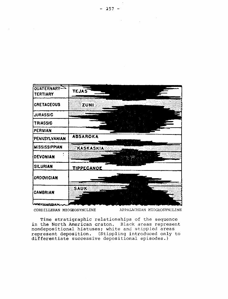
- 257 -
_.._
............................ .... .
QUATERNARY
CRETACEOUS
TERTIARY ........._,
............................ . .......•. ... ZUNI::
JURASSIC
TRIASSIC
PERMIAN
PENNSYLVANIAN ABSAROKA
MISSISSIPPIAN
DEVONIAN
,
~ ~~~~' ~ ~ f~
SILURIAN ►• ORDOVICIAN
~ ~ee~ioara~ao ...
CAMBRIAN ::::~::::::::~:::::..:~.~.:.::
..:......... ........... ~.
CORDILLERAN MIOGEOSYNCLINE APPALACHIAN MIOGEOSYNCLINE
Time stratigraphic relationships of the sequence in the North American craton. Black areas represent nondepositional hiatuses; white and stippled areas represent deposition. (Stippling introduced only to differentiate successive depositional episodes.)
Ulukan
Equalulik
Athabasca
Et-Then
— [5d -
Precambrian Time and Rock Units of the Canadian Shield
C.H. Stockwell (G.S.C. paper 64-17)
TYPE OROGENY M M in m.y.
ROCK-STRATIGRAPHIC UNITS In any one category not necessarily contemporaneous nor in order of age
600
880 GRENVILLE
1280 ?, ELSOI7IAN
PRO
TE
RC
IC
HUDSONIAN 1640
Granite, adamellite and anorthosite
Martin
Dubawnt
Sims
Chukotat
Double Mer
Chatham-Grenville stock
Wakeham
Kaminis and other
Huronian
Animiki
Kaniapiskau
Povungnituk
Belcher
Great Slave
Snare
Echo Bay - Cameron Bay
Goulburn
granites, Sudbury irruptive.
Epworth
Nonacho
Tazin
Hurwitz
Chantry
Great Island Nipissing diabase
Cross Lake
San Antonio
Grenville Matachewan diabase
Killarney, Doloro and other granites
Seal
Upper Keweenawan
Lower and Upper Coppermine River
Duluth, Muskox, Logan, Lackner, and Coldwell intrusions Lower and Middle Kewenawan
Hornby Bay
2390-----. KENORAN Algoman, Giants Range, Prosperous, and other granites
Knife Lake ..-.
Sickle, Kisseynew, Mi s s i
Timiskaming Ridout Windigokan
Rice Lake 'Saganaga Granite Cliff Lake Granite Seine
Keewatin - Coutchiching
Wasekman, Kisseynew, Amisk Abitibi,
Pontiac
Yellowknife
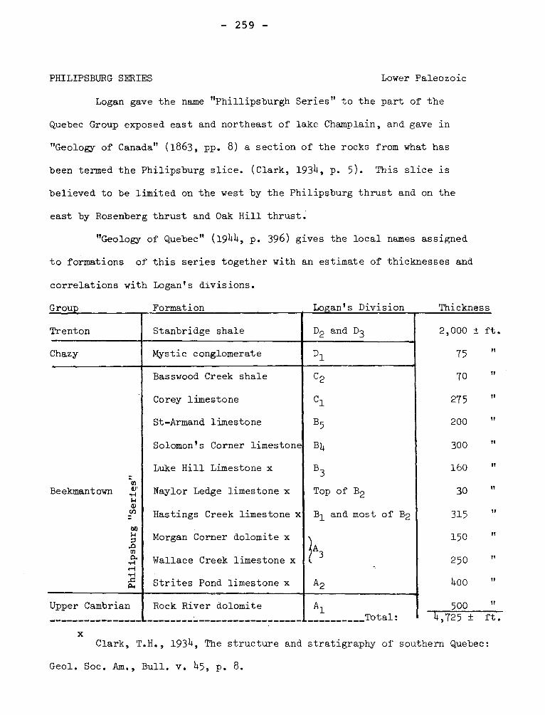
P hil
ips b
urg
"Ser
ies"
Beekmantown
- 259 -
PHILIPSBURG SERIES Lower Paleozoic
Logan gave the name "Phillipsburgh Series" to the part of the
Quebec Group exposed east and northeast of lake Champlain, and gave in
"Geology of Canada" (1863, pp. 8) a section of the rocks from what has
been termed the Philipsburg slice. (Clark, 1934, p. 5). This slice is
believed to be limited on the west by the Philipsburg thrust and on the
east by Rosenberg thrust and Oak Hill thrust.
"Geology of Quebec" (1944, p. 396) gives the local names assigned
to formations of this series together with an estimate of thicknesses and
correlations with Logan's divisions.
Group Formation , Logan's Division Thickness
2,000 ± ft.
75
TI
Trenton Stanbridge shale D2 and D3
Mystic conglomerate Chazy D1
Basswood Creek shale
Corey limestone
St-Armand limestone
Solomon's Corner limestone
Luke Hill Limestone x
Naylor Ledge limestone x
Hastings Creek limestone x
Morgan Corner dolomite x
Wallace Creek limestone x
Strites Pond limestone x
C2
Cl
B5
134
B3
Top of B2
B1 and most of B2
3
A2
Rock River dolomite Upper Cambrian
x
A1 Total: 4,725 ± ft.
70
275
200
300
160
30
315
150
250
400
500
tI
It
TI
,'
"
"
,,
It
it
11
If
Clark, T.H., 1934, The structure and stratigraphy of southern Quebec:
Geol. Soc. Am., Bull. v. 45, p. 8.
- 26Q -
Formations marked with asterisk named by H.W. McGerrigle (1931),
other formation names published by T.H. Clark (1934).
The commercial characteristics of the limestones and marbles of the
Philipsburg Series has been given by Goudge (1935).
McGerrigle, H.W., 1931, Three geological series in northwestern
Vermont: Vermont, Rept. of State Geologist, 17th, 1929-30, pp. 184-186.
Clark, T.H., 1934, The structure and stratigraphy of southern Quebec:
Geol. 3oc. Am., Bull. v. 45, p. 8.
Goudge, M.F., 1935, Limestones of Canada, Part III: Canada Mines
Branch, No. 755, pp. 206-225.
PHILLIPS LAKE FAULT
"A thrust fault with a large displacement is clearly present east of
Phillips lake in the Freneuse Lake area. This fault must pass
about 3/4 mile east of the north of Gelinas lake. There is a narrow valley
from there to Rachel lake and the fault possibly extends to that lake or
even farther south".
Sauvé, Pierre, Bergeron, Robert., 1965, Gerido Lake-Thévenet Lake Area,
New Quebec: Quebec Dept. of Nat. Res., G.R. No. 104, p. 81.
PILLAR SANDSTONES Canadian
Although Logan had used Pillar Sandstones prior to 1860, in a
way that suggested he intended it to be considered a formation, in
"Geology of Canada" (1863), the name does not appear. In its original
sense it was applied to sandstones occurring with shales and siltstones
on the north coast of Gaspé. The rocks resembled those to which Sillery
- 261 -
was applied in 1855, the formation being regarded as Silurian. Ells
(1883, pp. 24-26) refrains from using ''Pillar sandstones" in a formal
way.
McGerrigle (1954) in the discussion of the Tourelle area mentions
no formal name but in another publication suggests "Tourelle Sandstone".
Fossils show that the formation is the age of the Lévis Formation of the
Quebec Group.
Ells, R.W., 1883, Report on the geological formations in the Gaspé
Peninsula: Ann. Rept. 1882, pp. 24-26, DD.
McGerrigle, H.W., 1954, The Tourelle and Courcelette areas: Quebec
Dept. of Mines, G.R. 62, pp. 30-32.
McGerrigle, H.W., 1954, An outline of the geology of Gaspé Penin-
sula: Can. Min. Jour., y. 75, p. 60.
PINNACE GRAYWACKE Cambrian (7)
The Call Mill Slate or Tibbit Hill Schist of the Oak Hill Group is
overlain by the Pinnacle Graywacke of Clark (1936, pp. 141-143). This
rock is essentially a sandstone locally with some feldspar and a clay
cement less than 20 per cent of the rock. Inclined bedding is common
and local layers rich in magnetite, fossil black sands, are found. The
formation is as much as 400 feet thick in the Sutton Map area and south-
ward in Vermont, however, near Richmond, Osberg (1965, p. 226) assigns
the three formations, Call Mill Slate, Pinnacle Graywacke, and White
Brook Dolomite, a thickness from 10 to 600 feet. Booth (1950) records
the presence of pebble and boulder conglomerates in this formation in
Vermont. Boulders include granite and quartz syenite.
Clark, T.H., 1936, A Lower Cambrian Series from Southern Quebec:
- 262 -
Roy. Can. Inst., v. 21, Pt. 1, pp. 141-143.
Osberg, P.H., 1965, Structural geology of the Knowlton-Richmond
Area, Quebec: Geol. Soc. Am., Bull. v. 76, p. 226.
Booth, V.H., 1950, Structure and Stratigraphy of the Oak Hill
Succession in Vermont: Geol. Soc. Am., Bull., v. 61, pp. 1141-1142.
PINNACLE MOUNTAIN ANTICLINE
Eakins has given this name to a northeast trending anticline in the
Sutton Map area. The anticline was called "Enosberg Falls" by Cady and Tibbitt
Hill by Richard (1965), The Cambridge Syncline separates this structure from
Sutton Axis. Essentially the same syncline has been called Sutton-Richford.
Eakins, P.R., 1963, Sutton Map Area: Can. Geol. Surv., Paper 63-34,
p. 1.
Cady, W.M., 1960, Stratigraphic and geotectonic relationships in northern
Vermont and southern Quebec: Geol. Soc. Am., Bull., v. 71, P1. 1.
POHENAGAMUK (POHENEGAMUK) FORMATION Ordovicain (?)
(Wilmarth -1-1690)
Dressler (1912) gave the name Pohenagamuk, on the map accompanying the
report "Pohenagamuk", to graphitic grey slates, calcareous slates, conglomerates
and feldspathic quartzites cropping out in a band lying along and partly across
the Maine border in Temiscouata and Kamouraska counties. Few details were given
on the formation, and on very feeble evidence it was considered Middle Ordovician.
In "Geology of Quebec" page 354, the spelling of the formation name is Pohénéga-
- 263 -
muk and the belief is stated that it is part of the Farnham Series. The name has
priority over "Beauceville Series", but has not had general acceptance. It may
be of use locally.
Dressler, J.A., 1912, Reconnaissance along the National Transcontinental
Railway in southern Quebec: Geol. Surv. Can., Mem. 35, p. 25
POINTE-AUX-TREMBLES FORMATION Lower Silurian
It is made up of volcanic sandstones, conglomeratic sandstones, rare
lava flows and even rarer tuffs. There are complete gradations from sandstones
to conglomerates. The color of the rocks ranges from gray to green, and in
places is dark gray. The material composing the formation is exclusively
volcanic detritus, which has been slightly reworked by the sea. The Lake
Castor member is 2,000 feet of conglomerate near the lake of that name.
Lespérance, P.J., Greiner, H.R., 1969, Squatec-Cabano Area, Rimouski,
Riviére du Loup and Témiscouata Counties: Quebec Dept. of Nat. Res., G.R.
no. 128, p. 35-4O.
PONTGRAVE RIVER SHALES Richmond
Foerste recognized in Quebec a section of about 150 feet of green
calcareous shale as the lower Richmond and correlated it with the
Waynesville of Ohio. Clark (1947, p. 7) has called these beds the
Pontgravé River Formation. However, Belyea (1952, p. 26) extends
the limits of the formation slightly downward to give a section of
220 feet. This limit is petrographic and is based on the lower
limit of calcareous siltstones.
Foerste, A.F., 1916, Upper Ordovician Formations in Ontario
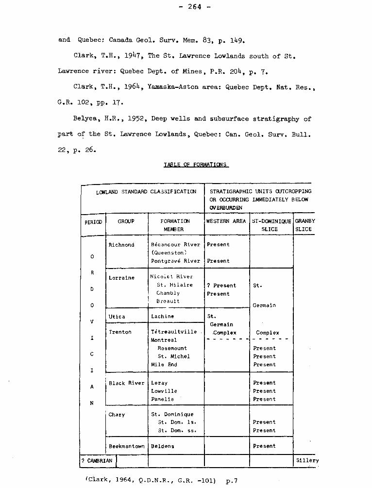
- 264 -
and Quebec: Canada Geol. Surv. Mem. 83, p. 149.
Clark, T.H., 1947, The St. Lawrence Lowlands south of St.
Lawrence river: Quebec Dept. of Mines, P.R. 2011, p. 7.
Clark, T.H., 1964, Yamaska-Aston area: Quebec Dept. Nat. Res.,
G.R. 102, pp. 17.
Belyea, H.R., 1952, Deep wells and subsurface stratigraphy of
part of the St. Lawrence Lowlands, Quebec: Can. Geol. Surv. Bull.
22, p. 26.
TABLE OF FORMATIONS
LOWLAND STANDARD CLASSIFICATICN STRATIGRAPHIC UNITS OUTCROPPING
OR OCCURRING IMMEDIATELY BELOW
OVERBURDEN
PERIOD GROUP FORMATION
MEMBER
WESTERN AREA ST-DOMINIQUE
SLICE
GRANBY
SLICE
0
R
D
0
V
I
C
I
A
N
Richmond Bécancour River
(Queenston)
Pontgravé River
Present
Present
Lorraine Nicoiet River
St. Hilaire
Chambly
Breault
? Present
Present
St.
Germain
Complex
Present
Present
Present
Utica Lachine St.
Germain
Complex Trenton Tétreaultville
Montreal
Rosemount
St. Michel
Mile End
Black River Leray
Lowville
Pamelia
Present
Present
Present
Chazy St. Dominique
St. Dom. Is.
St. Dom. ss.
Present
Present
Beekmantown Beldens Present
? CAMBRIAN Siller
(Clark, 1964, Q.D.N.R., G.R. —101) p.7
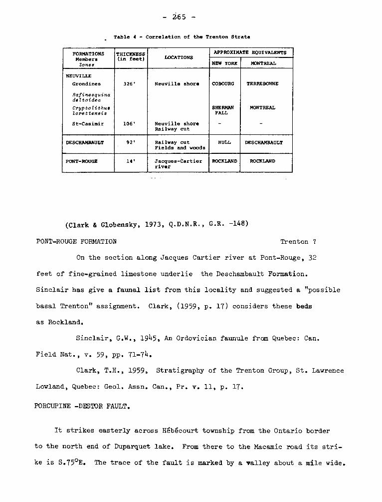
- 265 -
Table 4 - Correlation of the Trenton Strata
FORMATIONS Members
Zones
THICKNESS (in feet) LOCATIONS
APPROXIMATE EQUIVALENTS
NEW YORK MONTREAL
NEUVILLE
Grondines 326' Neuville shore COBOURG TERREBONNE
Rafinesquina deltoidea
Cryptolithue lorettensis
SHERMAN FALL
MONTREAL
St-Casimir 106' Neuville shore - - Railway cut
DESCHAMBAULT 92' Railway cut HULL DESCHAMBAULT Fields and woods
PONT-ROUGE 14' Jacques-Cartier river
ROCKLAND ROCKLAND
(Clark & Globensky, 1973, Q.D.N.R., G.R. -148)
PONT-ROUGE FORMATION Trenton ?
On the section along Jacques Cartier river at Pont-Rouge, 32
feet of fine-grained limestone underlie the Deschambault Formation.
Sinclair has give a faunal list from this locality and suggested a "possible
basal Trenton" assignment. Clark, (1959, p. 17) considers these beds
as Rockland.
Sinclair, G.W., 1945, An Ordovician faunule from Quebec: Can.
Field Nat., v. 59, pp. 71-74+.
Clark, T.H., 1959, Stratigraphy of the Trenton Group, St. Lawrence
Lowland, Quebec: Geol. Assn. Can., Pr. v. 11, p. 17.
PORCUPINE -DESTOR FAULT.
It strikes easterly across Hébécourt township from the Ontario border
to the north end of Duparquet lake. From there to the Macamic road its stri-
ke is S.75°E. The trace of the fault is marked by a valley about a mile wide.
- 266 -
The shear zone is 50 to 250 feet wide and is made up of carbonatized chlorite,
talc and sericite schists, locally bleached and silicified and in places con-
taining green mica. The dip varies from 50° to 80° south,
Graham, R. Bruce., 1954, Parts of Hebecourt, Duparquet and Destor
Townships, Abitibi-West County: Quebec, Dept. of Mines, G.R. No. 61, p. 34
PORT-DANIEL FORMATION Lower Paleozoic
This formation, named after Port-Daniel township, is the middle
formation of the Maquereau Group and is unconformably overlain by the
Newport and in fault contact with the Chandler. It is especially well
exposed at Maquereau Point and along North Port-Daniel and West Grand-
Pabos rivers. It is heterogeneous and believed to be more than 18,000
feet thick. Graywackes quartzites, conglomerates and volcanics occur
in it. More than half of the area underlain by the Port-Daniel Forma-
tion shows well-foliated, dark green, quartzose graywackes.
Ayrton, W.G., 1967, Chandler-Port-Daniel Area, Bonaventure and
Gaspé-South Counties: Quebec Dept. of Nat. Res., G.R. No. 120, p. 13.
PORT - DANIEL FAULT.
This long curving fault bounds the southwestern and western limit of
the Maquereau Group in Port-Daniel township and marks the contact with the
Mictaw Group and the North Port-Daniel River complex. The fault dips verti-
cally where observed, but a strong northeasterly-dipping foliation in the
southern basal(?) Mictaw conglomerate suggests that possibly the Maquereau
Group may have been thrust southwestward over the conglomerate.
Ayrton, W.G., 1967, Chandler-Port-Daniel Area, Bonaventure and Gaspé-
- 267 -
South Counties: Quebec Dept. of Nat. Res., G.R. No. 120, p. 66-67.
POTSDAM SANDSTONE (GROUP) Cambrian
Potsdam has been in use as a formational name in New York since
1838. Although it was used to designate a group it is now commonly
considered a formation. It is commonly recognized as the oldest Phane-
rozoic formation on the stable shelf east of Frontenac axis, but this
is not strictly true. It consists of sandstones commonly with well
rounded grains of quartz and siliceous cement, but calcareous cements
and arkosic and conglomeratic beds are found. The beds show shallow
water features such as ripple marks, rain impact marks, and cross-
bedding and are the result of the transportation of weathered products
derived from Precambrian rocks.
The Potsdam sandstone is stated to extend as far east as
St. Maurice river in Quebec, but the exposures along the river are
younger than the Potsdam at Montreal. The age assigned to the Potsdam
is commonly Upper Cambrian,but Nepean has been used for similar beds
in Ontario with the suggestion that the rocks are possibly Ordovician.
POULARIES ANTICLINE
"It is situated southwest of the Privet tuff where nearly all the lavas
are dark-coloured "basalts" and "andesites", with which a very distinctive,
light-coloured rhyolite is interbanded. Its strike is thus closely determi-
ned as north 74+ degrees west".
Cooke, H.C., James, W.F., Mawdsley, J.B., 1931, Geology and Ore Deposits
of Rouyn-Harricanaw Region, Quebec: Canada, Geol, Surv. Mem, 166, p. 90
- 268 -
POWNGNITUK GROUP Precambrian
Povungnituk group lies unconformably on the Archean rocks. This
group is made up of sedimentary and volcanic rocks that were invaded,
before being folded, by a great number of gabbroic sills, as well as by
some of an ultrabasic nature. These latter are now serpentinites. All
of these rocks are fairly well deformed and metamorphosed.
BERGERON, Robert, 1959, Povungnituk Range Area, New Quebec:
Quebec Dept. of Mines, P.R. No. 392, p. 2.
POWELL GRANITE
It is a mass about 3 miles long and mile to 1 mile wide in the
northwest quarter of Rouyn township. It is bounded on the south by the
extension of the Horne Creek fault. It is a rather fine-grained, light
grey or pinkish rock, with a tendency to porphyritic texture.
Cooke, H.C., James, W.F., Mawdsley, J.B., 1931, Geology and Ore
Deposits of Rouyn-Harricanaw Region, Quebec: Canada, Geol. Surv., Mem. 166,
p. 128.
Wilson, M.E., 1949, Noranda District, Quebec: Canada Geol. Surv.,
Mem. 229, p. 33-34.
PREISSAC SYENITES (GRANITE) Precambrian
In the northwestern corner of Preissac township a few small bodies of
porphyric syenite intrude the metamorphosed sediments. They are petrographi-
cally similar to the small masses already described in the north-eastern part
of Clericy township. Norman described a biotite-garnet microcline albite
granite under this name.
— 2b9 —
Cooke, H.C., James, W.F., Mawdsley, J.B., 1931, Geology and ORe Deposits
of Rouyn-Harricanaw Region, Quebec: Canada, Geol. Surv. Mem. 166, p. 117.
Norman, G.W.H., 1945, Molybdenite deposits and pegmatites in the
Pressiac - Lacorne area: Abitibi County, Quebec: Econ. Geol. v. 40, p. 4.
PRIVAT SYNCLINE
"Its strike is north 53 degrees west; at the extreme south end, the
strike swings east to north 70 degrees west."
Cooke, H.C., James, W.F., Mawdsley, J.B., 1931, Geology and Ore Deposits
of Rouyn-Harricanaw Region: Canada, Geol. Surv. Mines, Mem, 166, p. 90.
PROTAXIS
Protaxis can be found preceded by different names such as Archean,
Precambrian, Laurentian, or Northern. It was in most contexts synonymous
with Canadian or Precambrian Shield. The term is no longer in use but may
be found in publications prior to 1910.
QUEBEC
Quebec, both province and city, has been used for several geological
features.
I- QUEBEC GROUP (SUPERGROUP) Cambrian and Ordovician
After the founding of the Geological Survey of Canada in 18+2, Logan
began the study of the geology of Gaspé where he found shales and sandstones
as well as other clastic rocks that he recognized as belonging to a major
stratigraphic unit. References to localities using phrases like "Quebec
- 270 -
formations" appearing before 1860 can not be interpreted as proposal of strati-
graphic names. The "Esquisse Geologique du Canada" of 1855 by Logan and
Hunt has references to the Quebec formation of the city and Levis and a
statement that the Sillery and Quebec formations in Gaspé are overlain by
700 meters of Upper Silurian limestone. A paper published in 1861 (Logan)
contains unequivocal evidence of the intention to use Quebec Group.
In "Geology of Canada" (1863) Quebec Group is used as a heading for
a chapter, and the group is stated to consist of the Levis and Sillery for-
mations. Quebec Formation is not mentioned.
Selwyn, Logan's successor, was opposed to the concept of the Quebec
Group and presented (1882) a now largely discredited interpretation of the
geology of the Eastern Townships. Ells (1889) suggested that Quebec Group
be dropped, although Ami among others urged retention of the term.
The development of interpretations of sedimentary rocks and studies
made largely since 1940 show the desirability of retaining Quebec Group
and indeed changing its status to Supergroup. It is the designation for
the Paleozoic clastic rocks formed in orthogeosynclinal environment before
the Taconic Orogeny and occurring in the Appalachian Province. The name
is historically justified and nothing is gained by substituting another
name or using "complex".
Logan, W.E., 1861, Considerations relating to the Quebec Group,
and the copper-bearing rocks of Lake Superior: Can. Nat. and Geol. v. 6,
pp. 199-207.
Selwyn, A.R.C., 1882, The Quebec Group in Geology • goy. Soc.
Can. Tn. v. 1, pt. IV, pp. 1-13.
Ells, R.W., 1889, Second Report on the geology of a portion of the
- 271 -
province of Quebec: Can. Geol. Surv. Summ. Rept. 1887-1888, vol. 3, pt. 2,
p. 6K.
II- QUEBEC FORMATION, QUEBEC CITY FORMATION. Middle Ordovician
Logan and Hunt in "Esquisse Géologique du Canada" (1855) suggested
Quebec Formation and Sillery Formation for rocks in and near Quebec city.
It is possible that Quebec Formation was intentionally superseded by
Quebec Group because no mention is found of Quebec Formation until 1890.
At that time the rocks of Quebec city,having been recognized as younger
than the Levis Formation, were given the name Quebec by Ami. (1900, p. 141),
who used it first in a paper read before the Geological Society of America.
He states that its fauna enables it to be equated to "Hudson River Formation",
"Utica-Lorraine", "Utica-Trenton", and "Utica" of American Geologists (Ami,
1900, op. cit. p. 142).
Raymond (1912, p. 356) used without comment Quebec City for the same
formation. He lists a fauna collected from the conglomerates of this for-
mation and dates it as lower Trenton.
Since 1965 graptolites from several localities in Upper Town Quebec
have been collected and have yielded a fauna permitting correlation with
the Normanskill Formation of New York. With this determination, according
to current opinion, the beds are older than Trenton.
Ami, H.W., 1900, On the geology of the principal cities in eastern
Canada: Roy. Soc. Can., Tn. v. 6, Sec. IV, p. 141.
Raymond, P.E., 1912, Paleontological Division, Invertebrate, "Report":
Can. Geol. Surv. Summ. Rept. 1911, p. 356.
- 2.72 -
III- QUEBEC BARRIER (Axis ).
Logan's interpretation of the stratigraphic and structural relationships
near Quebec led him to the view that the loci of deposition of formations of
the lowlands were separated from those of the Appalachians by a barrier. This
view was elaborated by Ulrich and Schuchert (1902) and troughs and barriers
were for a time the vogue. The Quebec Barrier, which is northwest of the
Green Mountain Barrier and separated from it by the Levis Channel has approxi-
mately the position of Logan's Line. This is apparently the Quebec axis of
Kay (1942, p. 1605). See Vermont-nuebec barrier.
Ulrich, E.O., and Schuchert, C., 1902, Paleozoic seas and barriers in
Eastern North America: N.Y. State Mus. Bull. 52, p. 639.
Kay, G.M., 1942, Development of the Northern Allegheny Synclinorium
and adjacent regions: Geol. Soc. Am., Bull. v. 53, pp. 1644-46.
IV- QUEBEC GEOSYNCLINE.
In 1913, F.D. Adams (1915, p. 52) gave the first description of a
Precambrian geosyncline. This structure was supposed to trend parallel to
St. Lawrence river and to contain Proterozoic rocks. According to Adams
it is separated from the northern belt (now Temiscaming subprovince by a
zone of intrusive granitic rocks.
Schuchert (1924, p. 149) used "Quebec Geosyncline" for a structure in
the same position but inferentially older than that described by Adams. He
states that the Ontaric Trough developed from it in Proterozoic time. The
term is obsolete.
Adams, F.D., 1915, Problems of the Canadian Shield, the Archaeozoic:
Problems of American Geology, Yale University Press, p. 52.
Schuchert, Charles, 1924, Historical Geology: 2nd Ed., Wiley, p. 149.
- 273 -
V- QUEBEC DISTURBANCE.
Kay (1937, p. 290) has proposed that "Quebec Disturbance" be substi-
tuted for "Green Mountain Disturbance" and "Vermont Disturbance". This dis-
turbance affected the "Quebec Barrier" (g.v.) in Middle (?) Ordovician time.
Kay, G.M., 1937, Stratigraphy of the Trenton Group: Geol. Soc. of Am.,
Bull. 48, p. 290.
VI- QUEBECAN SUBSTAGE. - of Wisconsin Stage.
In 1941 Leighton proposed that the Wisconsin deposits of the upper
Mississippi Valley be assigned Hudsonian, Quebecan, and Manitoban substages.
In 1933 he withdrew these names and submitted, again, in descending order,
Mankato, Cary, Tazewell, and Iona.
Leighton, M.M., 1931, The Peorian loess and the classification of
glacial drifts sheets in the Mississippi Valley: Jour. Geol. v. 39, pp. 52-53.
Leighton, M.M., 1933, The naming of the subdivisions of Wisconsin
Glacial age: Science, v. 77, p. 168.
VII- QUEBEC BASIN
Belyea (1952, p. 1) has used this term to designate the St. Lawrence
Lowlands in Quebec and east of the Beauharnois Anticline which extends
from St. Jerome towards the Adirondacks.
Belyea, H.R., 1952, Deep wells and sub-surface stratigraphy of
part of the St. Lawrence Lowlands, Quebec: Can. Geol. Surv., Bull. 22, p. 1.
QUEBEC - COPPER ANTICLINE
"It is clearly indicated by the trend of the contacts of the Amulet
rhyolite belt. This southeastward striking anticline is situated in the
- 274 -
northwestern part of Waite map-area. The contact of the rhyolite and the
overlying andesite is not exposed on the axis of the fold, but the rhyolite
is known to dip under the andesite at an angle of about 30°. Quebec - Copper
anticline is interrupted to the eastward by the Dufresnay belt of dioritic
rocks."
Wilson, M.E., 1949, Noranda, District, Quebec: Canada, Geol. Bury.
Memoir, 229, p. 119.
RACHEL LAKE STRUCTURAL COMPLEX.
"The main structural characteristics are a disordered map-pattern,
irregular but steep plunges of the fold axes, intense shearing, and flexed
axial planes of folds. The direction of plunges of minor fold axes vary
from north to east but average N. 500 - 650".
Sauvé, Pierre., Bergeron, Robert., 1965, Gerido Lake-Thévenet Lake Area,
New Quebec: Quebec, Dept. of Nat. Res., G.R. No. 104, p. 81-82.
RAUDIN FAULT.
It bounds the northern limit of the Maquereau Group and forms the
southern boundary of the Silurian graben. It is named after Raudin town-
ship. Two spectacular zones of tectonic breccia are exposed along the
fault:one is along West Grand-Pabos river in Raudin township, and the other is
in the hills approximately 2 miles northwest of Chandler. It strikes eas-
terly.
Aryton, W.G., 1967, Chandler, Port-Daniel Area, Bonaventure and Gaspé-
South: Quebec Dept. of Nat. Res., G.R. No. 120, p. 67-68.
- 275 -
RAUDOT LAKE MASSIF Precambrian
Rocks of this massif are variably altered and deformed, the
intensity increasing from south to north across three miles. The
slight changes in alteration are noticeable only in thin-sections,
and are marked by transformation of the olivine to pale bluish green
amphibole. In the more altered rock the feldspar is light gray and
the mafic mineral forms very fine-grained clusters.
Kish, Leslie, 1968, Hart-Jaune River Area, Saguenay County:
Quebec Dept. of Nat. Res., G.R. No. 132, p. 56-61.
REDOUTE LIMESTONE (boulder) Cambrian
Marcou gave this name to a massive light gray limestone forming the
core of the prominent hill 1,000 feet south of St. Joseph Church in Lauzon.
He made extensive collections of fossils from it and it was later shown to
a block. Rasetti gave it the number 32 and described Upper Cambrian trilo-
bites from it. The immediately overlying siltstones of the Levis Formation
has Caryocaris, Clonograptus, and Bryograptus.
Marcou gives the following table:
Calciferous (Lower Silurian)
Georgia Slate (Lower Silurian)
(St. Albans Group b)
a)
A
; Blue schistose marl in conglomerate and limestone -
Compound graptolites .
Citadel, City of Quebec, Point Levi.
of limestone.
(;:i_
Green and brown slates with large lenticular masses
Gilmour Wharf, Harlake, Redoute.
Sillery and Chaudière red slate and Sandstone.
- 276 -
Marcou, Jules, 1862, Taconic and Lower Silurian rocks of Vermont and
Canada: Boston Soc. Nat. Hist., vol. 8, p. 239, p. 21+8.
Rasetti, Franco, 1945, Description supplémentaire de trois genres de
trilobites cambriens: Nat. Can., v. 72, pp. 118-119.
RICHFORD-SUTTON SYNCLINE
Eakins has used this term instead of "Cambridge Syncline"
proposed by Cady for the synclinal axis northwest of Sutton Axis.
The double name has no advantage over Cambridge.
Eakins, P.R., 1963, Sutton Map Area: Can. Geol. Surv., Paper
63-314, p. 1.
Cady, W.M., 1960, Stratigraphic and geotectonic relationships
in northern Vermont and southern Quebec: Geol. Soc. Am., Bull., v. 71,
P1. 1.
RICHMOND BEL.lrl) PLAIN
Precambrian
Gill gave this name to the arcuate subprovince lying east of
Richmond Gulf, Hudson Bay, and he considers it a part of Ungava Province.
The presumably equivalent rocks cropping out in Belcher islands are
termed Belcher Mountains.
Gill, J.E., June 1949, Natural Divisions of the Canadian Shield,
Transactions of the Royal Society of Canada, Volume XLIII, Series III,
Section four, p. 65.
RICHMOND GULF. GROUP Proterozoic
G.A. Young (1921, p. 16 E) gave this name to the rocks termed Richmond
Group by Leith (1910, p. 232).The formation is probably about 2500 feet thick
- 277 -
and consists of sandstones, arkoses, shales and grits with considerable section
of basic volcanics. Low believed that a fault separates'this group from the
overlying Nastapoka Group, but Leith is of the opinion it is an unconformity
It is stated that the Richmond Gulf and Nastapoka rest in places on the old
granites or gneisses.
The precise relationship of these rocks to the Belcher Series and the
South Hopewell Group (q.v.) remains unknown.
Young, G.A., 1922, Iron bearing rocks of Belcher Islands, Hudson Bay:
Can., Geol. Surv., Summ. Rept. 1921, Part E, p. 16.
Leith, C.K,, 1910, An Algonkian Basin in Hudson Bay, a comparison with
the Lake Superior Basin: Econ. Geol. V., pp. 232-233.
RICHMOND GULF FORMATION Proterozoic
Woodcock seems to have been unaware of Young's use of Richmond
Gulf Group (1.v.) and proposed a formation of the same name. He also
proposed Pachi as a name for a group below Richmond Gulf Formation. It
is suggested that Pachi be reserved for a member consisting of andesitic
flows and sills separating the lower arkoses from the upper arkoses and
conglomerates having an aggregate thickness of 1,500 feet.
Woodcock, J.R., 1960, Geology of the Richmond Gulf area, New
Quebec: Geol. Assn. Can., Pr. v. 12, pp. 29-32.
• .N- RIVIERE CHENO FORMATION Proterozoic
Neilson (1966, p. 27) has proposed this name for sandstones, conglome-
rates, and dolomitic clastic rocks which overlie either the Pépeshquasati
sandstone or Archaean gneisses in the region northeast of Mistassini Lake.
- 278 -
He assigns it to the Mistassini Group.
Neilson, J.M., 1966, Takwa River Area, Mistassini Territory: Quebec
Dept. Nat. Res., G.R. 12I, 27. (The first mention of the formation name
was in P.R. 254 (1950) .
ROBERVAL FORMATION (Granite) Precambrian
Dresser, 1916, gave the name Roberval to massive coarse - to medium -
grained granite with some gneiss varieties intrusive into Grenville, Laurentian,
and Saguenay formations in the Lake St. John district.
Dresser, J.A., 1916, Geological structure of the basin of Lake St. John,
Quebec: Roy. Soc. Can., vol. 10, Sect. IV, p. 127.
Dresser, J.A., 1916, Part of the District of Lake St. John, Quebec: Can,
Geol. Surv., Mem 92, p. 21.
ROBITAILLE FORMATION Middle Silurian
The base of the type section of the Robitaille Formation is a
few hundred feet to the west of the Squatec-Cabano road, and the section
extends from there southeastward. Outcrops are numerous but discontinuous.
Siltstone (red and massive), siltstone(green) quartzite, siltstone (gray)
limestone (gray) and sandstone (gray), are found.
Lespérance, P.J., Greiner, H.R., 1969, Squatec-Cabano Area,
Rimouski, Rivière-du-Loup and Témiscouata Counties, nuebec Dept. of Nat.
Res., G.R. No. 128, p. 46-52.
ROCKCLIFFE FORMATION Chazy
Ells recognized that the Chazy west of Ottawa had a lower sandy
- 279 -
and shaly part with an overlying thinner limy part. Raymond called the
two parts Aylmer Formation (q.v.) . A.E. Wilson recognized the predomi-
mance of clastic rocks and proposed Rockcliffe for the shaly sandy part.
For the upper and more calcareous part she proposed St. Martin for Cap
St. Martin in Quebec. The work of Hofmann showed that the St. Martin
is a lithofacies of the Laval Formation and has diverse stratigraphic
positions. With these observations, it is logical to abandon Rockcliffe
and continue the use of Aylmer in Quebec.
Wilson, A.E., 1937, Erosional intervals indicated by contacts
in the vicinity of Ottawa, Canada: Roy. Soc. Can., Tn. 31, p. 46. Also:
Geol. Surv. Can., Mem. 241, pp. 17-21.
Hofmann, H.J., 1963, Ordovician Chazy Group in Southern Quebec:
Am. Assn. Pet. Geol., v. 63, p. 278.
This name has been used by Deland for beds on the north side of Ottawa river between Carillon and Grenville.
Deland A.N. 1964 North bank of Ottawa river between Carillon and Grenville; Argenteuil County; Que. Dept. of Nat. Res. P.R. 528, pp. 7-9.
ROCK RIVER FORMATION (Wilmarth -1-1833) Upper Cambrian
McGerrigle (1931, p. 184) gave the name Rock River to the 500 feet
of dark grey and yellowish grey dolomites with some limestones that
Logan assigned to the lower division0 A1,of the Philipsburg Series (1.v.).
McGerrigle, H.W., 1931, Three geological series in northwestern
Vermont: Vermont, 17th Rept. of the State Geologist, 1929-30, p. 184.
ROMAINE FORMATION Beekmantown
Schuchert and Twenhofel (1910, p. 686) named these, the lowest
- 280 -
Ordovician beds recognized by Logan on the Mingan islands. The forma-
tion on the islands is about 260 feet of dolomites and dolomitic shales
with some sandstones (Twenhofel, 1938, p. 15). The formation is Beekman-
town.
Roliff has given data on this formation from the subsurface of
Anticosti island. There it has the same lithology as on the Mingan islands,
but its thickness is in excess of 1,000 feet.
Schuchert, C., Twenhofel, W.H., 1910, Ordovicic-Siluric Section of
the Mingan and Anticosti Islands, Gulf of Saint-Lawrence: Geol. Soc. Am.,
Bull., vol. 21, p. 686.
Twenhofel, W.H., 1938, Geology and paleontology of the Mingan islands,
Quebec: Geol. Soc. Am., Sp. Paper, No. 11, p. 15.
Roliff, W.A., 1968, Oil and gas exploration - Anticosti island, Que-
bec: Geol. Assn. Can., Pr. v. 19, pp. 31-36.
ROMANET LAKE ANTICLINORIUM
"It is very complicated structurally. Complex folds with northwesterly
trends predominate and folds in north-south and east-west directions are su-
perposed on them".
Dimroth, Erich., 1966, Geology of Dunphy Lake Area, New Quebec Territory:
Quebec, Dept. of Nat. Res., P.R. No. 557, p. 14+.
ROSAIRE GROUP (Wilmarth -2-314) Cambrian
Béland (1952, 1957) has given this name to white, grey, black and buff
- 2.81 -
quartzites with subordinate interbedded colored slates cropping out near the
village of Notre-Dame du Rosaire, Montmagny.
This formation is assigned to the Cambrian, and Bgland states that it
is equivalent to part of L'Islet Group (1.v.). He considers (1957, p. 14)
the rocks were deposited in a shallow stable basin. A diagram by Hubert (1967,
p. 38) suggests that the Rosaire and Caldwell were laid down in a eugeosyncline.
Béland, Jacques, 1957, St. Magloire and Rosaire-St. Pamphile areas,
Electoral Districts of Dorchester, Bellechasse, Montmagny and L'Islet: Quebec
Dept. of Mines, G.R. 76, 13-15, First published note P.R. 279, p. 38.
Hubert, Claude, 1967, Tectonic of part of the Sillery Formation in the
Chaudiére-Matapédia segment of the Quebec Appalachians: Roy. Soc. Can., Special
Publ. 10, p. 38.
ROSEMOUNT MEMBER Trenton Group
This name was proposed for the upper part of the Montreal For-
mation at Montreal and is named from the ward in Montreal. Although the
name was proposed by Clark as early as 191 1, a reasonably complete des-
cription was published by Clark in 1952 (pp. 67-75). It is described as
250 to 360 feet of thin bedded limestone with substantial amounts of
shale. It is easily eroded and thick continuous sections are not exposed.
The Rosemount Member contains beds with abundant Prasopora and are
probably the equivalent of Sherman Fall.
Clark, T.H., 1952, Montreal area: Quebec Dept. of Mines, G.R. 46,
pp. 67-75.
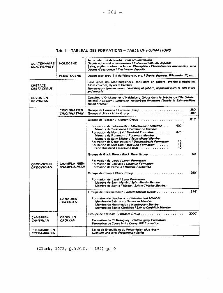
— 282 —
Tab. 1 — TABLEAU DES FORMATIONS — TABLE OF FORMATIONS
QUATERNAIRE QUATERNARY
HOLOCENE Accumulations de tourbe / Peat accumulations Dépôts éoliens et alluvionnaires / Eolian and alluvial deposits Sable, argiles marines de la mer Champlain I Champlain Sea marine clay, sand Dépôts d'eau douce / Freshwater deposits
PLEISTOCENE Dépôts glaciaires. Till du Wisconsin, etc. / Glacial deposits. Wisconsin till, etc.
CRETACE CRETACEOUS
Série ignée des Montérégiennes, consistant en gabbro, syénite â néphéline, filons-couches, dykes et brèches. Mon teregian igneous series, consisting of gabbro, nepheline syenite, sills dikes, and breccia.
DEVON IEN DEVONIAN
Calcaires d'Oriskany et d'Helderberg (blocs dans la brèche de l'fle Sainte-Hélène) /Oriskany limestone, Helderberg limestone (blocks in Sainte-Hélène Island breccial
ORDOVICIEN ORDOVICIAN
CINCINNATIEN CINCINNATIAN
Groupe de Lorraine / Lorraine Group 350' Groupe d'Utica / Utica Group 400'
CHAMPLAINIEN CHAMPLAINIAN
Groupe de Trenton / Trenton Group 812' •
Formation de Tétreauville / Tétreauville Formation ... 400' Membre de Terebonne / Terrebonne Member
Formation de Montréal / Montréal Formation 375' Membre de Rosemont / Rosemont Member Membre de Saint-Michel / Saint-Michel Member
Formation de Deschambault / Deschambault Formation 15' Formation de Mile End / Mile End Formation 12' Lits de Rockland I Rockland beds 10'
Groupe de Black River / Black River Group 50'
Formation de Leray / Leray Formation Formation de Lowville / Lowville Formation Formation de Pamelia / Pamelia Formation
Groupe de Chazy / Chazy Group 280'
Formation de Laval / Laval Formation Membre de Saint-Martin / Saint-Martin Member Membre de Sainte-Thérèse I Sainte-Thérèse Member
CANADIEN CANADIAN
Groupe de Beekmantown / Beekmantown Group 814'
Formation de Beauharnois / Beauharnois Member Membre de Saint-Lin /Saint-Lin Member Membre de Huntingdon / Huntingdon Member Membre de Sainte-Clothilde / Sainte-Clothilde Member
CAMBRIEN CAMBRIAN
CROIXIEN CROIXAN
Groupe de Potsdam I Potsdam Group 2000'
Formation de Châteauguay / Châteauguay Formation Formation de Covey Hill / Covey Hill Formation
PRECAMBRIEN PRECAMBRIAN
Séries de Grenville et du Précambrien plus récent Grenville and later Precambrian Series
•
(Clark, 1972, Q.D.N.R. — 152) p. 9

- 283 -
ROUGEMONT LAKE SYNCLINE
"This syncline is steep but is not overturned. It plunges south in its
northern part, has a nearly horizontal axis in the southern part of the Gerido
Lake area, and plunges about 300 south in the Léopard Lake area."
Sauvé, Pierre, Bergeron, Robert., 1965, Gerido Lake-Thévenet Lake Area,
New Quebec: Quebec, Dept. of Nat. Res., G.R. No. 104, p. 80.
ROUYN LAKE SYNCLINE
"The Rouyn Lake syncline, which lies along the northern margin of the
south-east Rouyn map-area, is composed of Abitibi andesite overlain by cher-
ty Timiskaming greywacke. The attitude of pillows in the andesite and of gre-
ded bedding in the greywacke show that the syncline is slightly overturned
toward the south".
Wilson, M.E., 1962, Rouyn-Beauchastel map-areas, Quebec: Canada, Geol.
Surv. Mem, 315, p. 39.
ROUYN LAKE SEDIMENTS Precambrian
The Rouyn Lake Sediments outcrop at the extremities of Osisko Lake
Area, and little is known about it.
This term seems of minor use.
Conolly, H.J., Hart, R.C., 1936, Structural Geology of the Osisko
Lake Area, Quebec: Canadian Inst. Mining and Metallurgy Trans., v. 39, p. 11.
ROUYN-MERGER FAULT.
The Rouyn-Merger fault lies on the same contact as the McWatters
- 284 -
(q.v.) and may be its continuation.
Wilson, M.E., 1962, Rouyn-Beauchastel map-areas, Quebec: Canada,
Geol. Surv., Mem, 315, p. 42.
RUISSEAU ALLEN BRECCIA
Clark (1966, p. 1+8, 49) has given a description of a possible ring
brecciated structure one mile north of Havelock. Blocks of lower Ordovi-
cian sandstone are in a paste composed of fragments of the same rock. The
reconstructed ring is 150 feet diameter, and it is possibly the outcrop of the
filling of a cylindrical diatreme.
Clark, T.H., 1966, Châteauguay Area, Châteauguay, Huntingdon, Beauharnois,
Napierville and St. Jean Counties: Quebec, Dept. of Nat. Res., G.R. No. 122,
p. 48-50.
RUISSEAU NORTON SYNCLINE
"This fold, complicated by faulting, is considered to be the northernmost
expression of the Havelock fault. It is matched to the east and west by distri-
bution indicating anticlines with axes trending'and plunging NNE."
Clark, T.H., 1966, Châteauguay Area, Châteauguay, Huntingdon, Beauharnois,
Napierville and St. Jean Counties: Quebec, Dept. of Nat. Res. G.R. No. 122, p. 46,
RUPERT FORMATION Quaternary
This term was apparently introduced by Ami for till depouited by :ice:
from the Keewatin center on the west side of Hudson Bay. The till Supposedly
deposited by ice from the Labrador centre is called Labrador Formation by Ami.
- 285 -
Ami, H.W., 1900, Synopsis of the geology of Canada: Roy. Soc. Can., Tn.
v. 6,• Sect. IV, p. 222.
SAGARD DIORITIC PLUG Precambrian
A small hill of diorite overlooks the Deschénes river valley two
miles south-southeast of Sagard. The rock, here exposed over a quarter
of a mile, is composed of about 30% mafic minerals, and feldspar rocks
up to 1 cm. long.
Rondot, Jehan, 1966, Geology of ltAnse Saint-Jean Area, Chicou-
timi and Charlevoix Counties: Quebec Dept. of Nat. Res., P.R. No. 556,
p. 6-7.
SAGUENAY(FORMATION)ANORTHOSITE Precambrian
The extensive areas of anorthosite and related rocks have long been
known and have been referred to informally as the Lake St. John anorthosite
or the Saguenay anorthosite. It was not until 1916 that Dresser proposed
Saguenay Formation for the anorthosite.
Dresser, J.A., 1916, Geological structure of the basin of Lake St. John,
Quebec: Roy. Soc. Can., vol. 10, Sect. IV, p. 126,
Dresser, J.A., 1916, Part of the District of Lake St. John, Quebec: Can,
Geol. Surv., Mem 92, p. 21,
SAGUENAY TRENCH (Graben)
The publications by Dresser cited above contain reference to the trench
bounded by faults.
- 286 -
ST. ALBAN FORMATION Trenton?
This name was applied to five feet of dark limestone overlying
Leray Limestone on Ste. Anne river. The beds contain fragments of
Dalmonella, from which Clark is inclined to infer a Trenton Age. The
name is already in use and should be abandoned.
Clark, T.H., 1959, Stratigraphy of the Trenton Group,
St. Lawrence Lowland, Quebec: Geol. Assn. Can., Pr. v. 11, p. 16.
ST. ARMAND LIMESTONE (Wilmarth -1-1870) Upper Beekmantown
This 200 feet of yellow-grey weathering, black, argillaceous
limestones with shale interbeds is part of the Philipsburg Series (9..v.).
Cady (1960) has pointed out the similarity, except for the amount
of dolomite, between the St. Armand and Corey Limestones and the Beldens of
Vermont.
Geology of Quebec, 1944, pp. 399-400.
Cady, W.M., 1960, Stratigraphic and tectonic relationships in
northern Vermont and southern Quebec: Geol. Soc. Am., Bull. v. 71, p. 573.
ST. BARNABE FAULT
It is one of the major faults affecting the lowland south of the
St. Lawrence. Striking about north-northeast, it passes west of St.
Hyacinthe and east of St. Barnabé, presumably dying out within the
Beloeil map-area on the south and the Upton area to the north. In
the vicinity of St. Barnabé, the displacement with the downdrop on
the west is of the order of about 1,100 feet.
Clark, T.H., 1955, St. Jean-Beloeil Area, Iberville, St. Jean,
- 287 -
Napierville-Laprairie, Rouville, Chambly, St. Hyacinthe and Verchéres
Counties: Quebec Dept. of Mines, G.R. no. 66, p. 53.
Clark, T.H,, 1964, Upton Area, Bagot, Drummond, Richelieu,
St. Hyacinthe and Yamaska Counties: Quebec Dept. of Mines, G.R. No. 100,
p. 23.
ST. CASIMIR FORMATION Trenton
Clark gave this name to 180-190 feet of limestone in
the region of Neuville Grondines. The formation is commonly thin
bedded and limestones of crystalline aspect are common in the
section of heterogeneous limestones. The formation is apparently
to be correlated with the Hull Formation and is more closely related
to the Deschambault than the succeeding Neuville Formation. The
formation has not been recognized southwest of St. Maurice river.
Clark, T.H., 1959, Stratigraphy of the Trenton Group,
St. Lawrence Lowland, Quebec: Geol. Assn. Can., Pr., v. 11, p. 17.
SAINT-DIDACE GRANITE
In the district south-east of St.Didace, the granite also
appears to break through the gneiss. The granite beyond the eastern
limit of the sheet is cut by a small area of anorthosite, so that if
the anorthosite intrusions within the map are of the same age, the
granite was intruded before them.
Adams, Frank D., 1896, Report on the geology of a portion of
the Laurentian Area lying to the North of the Island of Montreal: Canada
Geol. Surv., Ann. Rept. VIII, 1895, J., p. 29-30.
- 288 -
SAINT-DIDACE GRANITE Precambrian
The Saint-Didace granite is an orthomagmatic intrusive rock, at
least in the circumscribed masses. The uniformity of the rock preludes
the metamorphism of the gneisses as the mode of origin. Furthermore,
swarms of paragneiss and granulite inclusions are observed at the center
of the masses, as well as at the periphery. The most remarkable swarm is
located exactly at the center of a straight line drawn through Saint-
Gabriel and Saint-Edmond.
Béland, René, 1967, Saint-Gabriel de Brandon Area, Joliette and
Maskinongé Counties: Quebec Dept. of Nat. Res., G.R. No. 133, p. 11-11+.
ST. DOMINIQUE FORMATION
This name for a formation of the Chazy Group was first published
by Belyea (1952, p. 12) but was proposed by Clark for, at St. Pie,110
feet of calcareous sandstones overlain by 230 feet of gray dolomite,
dolomitic limestone, and sandy limestone in the St. Dominique Fault
slice east of St. Hyacinthe. Clark comments that the sandstone member
may be prove to be the equivalent of the St. Thérése Member and the
limestone of the St. Martin Member of the Laval Formation. Kay in
19+5 suggested that the sandstones are to be correlated with the Carman
Formation and the limestones with the Youngman, but in 1958, he follows
Clark's use of St. Dominique Formation. Hoffman considers that the
sandstone member is equivalent to lower Laval.
Belyea, H.R., 1952, Deep wells and subsurface stratigraphy of
part of the St. Lawrence Lowlands, Quebec: Can. Geol. Surv., Bull. 22,
p. 12.
Clark, T.H., 1961 , St. Hyacinthe area (west half): Quebec Dept.
- 289 -
Nat. Res., G.R. 101, pp. 16-25.
Kay, G.M., 1958, Ordovician Highgate Springs Sequence of Vermont
and Quebec and Ordovician classification: Am. Jour. Sci., v. 256, pp. 82-85.
Hoffman, H.J., 1963, Ordovician Chazy Group in Southern Quebec:
A.A.P.G., Bull. 63, p. 276.
ST. DOMINIQUE FAULT
ST. DOMINIQUE FAULT SLICE
T.H. Clark in 1947 gave the name St. Dominique Fault slice to the
crescentic outcrop of Lower Paleozoic formations lying in front of Logan's
Line east of St. Hyacinthe. He inferred that the block composed of limes-
tone was brought into contact with the surrounding shales as a result of
movement associated with those along the Champlain Fault. Kay (1958) relates
the structural unit to fault bounded units to the south and, in general, con-
curs in and amplifies Clark's explanation. Kumarapeli suggests that the
St. Dominique is a normal rather than a thrust fault. He does not cite the
work by Kay concerning the relationship to other structures, a relationship
that obviously weakens his contention.
Clark, T.H., 1947, St. Lawrence Lowlands: Quebec Dept. of Mines,
Map No. 642, in P.R. 204.
Kay, G.M., 1958, Ordovician Highgate Springs Sequence of Vermont
and Quebec and Ordovician classification: Am. Jour. Sc. v. 256, pp. 65-66.
Kumarapeli, P.S., 1969, St. Dominique fault: a new interpretation:
Can. Jour. Earth Sc., v. 6, p. 775-780.
ST. FLAVIEN FORMATION Paleozoic
Logan and later workers have described dyke-like and stratiform
I-
- 290 -
bodies of basic igneous rocks occurring close to Logan's Line, but on
the Appalachian side. Dresser (1906) has provided the most adequate
summary of the information on these and other igneous rocks. Some of
the bodies are dykes, and of these some are related to the Monteregian
Hills intrusives. Other bodies are subalkaline, commonly of an albite-
rich igneous rock, and are in places amygdaloidal or in a very few places
pillowed. Some of the bodies are probably lavas but others are intru-
sive. Dresser (1910, p. 516) mentions the body at St. Flavien as being
a dyke and one of the largest bodies. Clark (1948, p. 3) uses the name
"St. Flavien Basic Eruptive", suggesting an effusive origin. This was
later changed (196+) to "igneous series:' At Drummondville the basic
rocks are lavas and are interbedded with shales carrying fossils of the age
of the Normanskill Formation in New York.
Dresser, J.D., 1906, Igneous rocks of the Eastern Townshipsoof
Quebec: Geol. Soc. Am., Bull. v. 17, pp. 491-522.
Clark, T.H., 1948, Yamaska-Aston Area: Quebec Dept. of Nat. Res.,
G.R. 102, p. 69 (PR. 225, p. 3).
Riva, John, 1966, New assemblages of Middle Ordovician graptoli-
tes from the Appalachian region, Quebec: Nat. Can., v. 93, p. 156.
ST. FRANCIS - ST. FRANCiOIS
This river flows northwest across part of the eastern townships
to enter St. Pierre lake.
St.Francis Thrust.
Cooke (1950, p. 13) has given this name to a thrust fault
believed to strike northeast through Fitch Bay of Memphremagog lake,
through lake Massawippi, and near Lennoxville. He tentatively suggests
- 291 -
that the Weedow Thrust (1.v.) is its continuation. Although faults
may be present along this line, the evidence indicates that a throughgoing
thrust is not present.
Cooke, H.C., 1950, Geology of a southwestern part of the Eastern
townships of Quebec: Geol. Surv. Can., Mem. 257, pp. 13-14, 114-115.
II- St. Francis Fault Slice.
H.C. Cooke (op. cit. pp. 13-14), has named the an 18 miles wide
area southeast of the hypothetical St. Francis Thrust, St. Francis Fault
Slice. The region is synclinal and is underlain by rocks of the Gaspé
Supergroup and is part of the Gaspé-Connecticut- Valley Synclinorium
III- ST. FRANCIS (ST. FRANOIS) SERIES (GROUP) Silurian (7) Devonian
(W.S.K - 319)
T.H. Clark in Cooke (1937, pp. 37-42) proposed St. Francis series
for a rather heterogeneous lithologic unit cropping out in what was later
to be termed the St. Francis Fault Slice. Some volcanics, some sandstones,
calcareous and argillaceous and silty beds were found, and on insubstantial
evidence the beds were referred to the Ordovician. Since 1950, evidence
summarized by Cady, 1960, shows that the group is a part of the Gaspé
Supergroup and is in part if not entirely Devonian.
Clarke, T.H., in Cooke H.D., 1937, Thetford, Disraeli and eastern
half of Warwick map-areas, Quebec: Geol. Surv. Can., Mem. 211, pp. 37-42.
Cady, W.M., 1960, Stratigraphy and geotectonic relationships in
northern Vermont and southern Quebec: Geol. Soc. Am., Bull. v. 71, p. 575.
- 292 -
ST. GERMAIN COMPLEX
This unit is, according to the proposer of the name ÇClark), a
nience that serves to group rocks that can not now easily be assigned to
other formations. Clark has suggested that this unit is tectonic and in-
volves formations of the foreland facies close to Logan's Line. Clark
believes that the formations involved are principally Utica and Lorraine
with some Trenton. However, at some lacalities, rocks already mapped as
St. Germain have yielded fossils similar to those of the Normanskill and at
one locality Levis. See Stanbridge Complex.
It is possible that at some localities, the complex is not en-
tirely the result of the proximity to the main faults.
Clark, T.H., 1964, Upton area, Bagot, Drummond, Richelieu,
St. Hyacinthe and Yamaska counties: Quebec Dept. Nat. Res., G.R. 100,
pp. 10-19.
conve-
ST. JEAN DE MATHA ANORTHOSITE
About mile south-west of the village of St. Jean de Matha, the
road running toward the River l'Assomption, large exposures of garnetife-
fous quartzose gneiss are succeeded by others of anorthosite. The latter
rock is exposed for a width of about one hundred yards along the road and
is succeeded by drift. It shows considerable variation in size of grain,
weathers white, and is without foliation. When examined under the micros-
cope, it is found to be a typical anorthosite composed almost entirely of
plagioclase. The iron-magnesia constituent is augite. Biotite and apatite,
both in very small quantities, with a little titaniferous iron ore and
pyrite complete the list of constituents. The rock has undergone a certain
amount of granulation.
- 293 -
Adams, Frank D., 1896, Report on the geology of a portion of the
Laurentian Area lying to the North of the Island of Montreal: Canada
Geol. Surv.,Ann.Rept. VIII, 1895, J., p. 125.
ST. .7ERO !E AITOPTIiOSITE
The anorthosite or gabbro, as it should more properly be called,
is best seen in the large exposures on either side of the Canadian Pacific
railway track a few hundreds yards south of the railway station at St.
Jérôme. Here the rock is fine-grained, usually foliated in structure,
and weathers brownish-gray.
Adams, Frank D., 1896, Report on the geology of a portion of the
Laurentian Area lying to the North of the Island of Montreal: Canada Geol.
Surv., Attn. Rept. VIII, 1895, J., p. 118
SAINTE-JULIENNE FAULT
It crosses the eastern edge of the area a half mile north of fault
Saint-Lin. It is quite definitely located to the east of the area, being marked
by a "prominent escarpment that runs at about 25° through Sainte-Julienne and
Bissonnette". (Clark, 1954). To the east, this fault marks the contact between
Precambrian and Paleozoic rocks. In the present area, however, its trace is
more hypothetical. It strike would be northeasterly.
Osborne, F.F., Clark. T.H., 1960, New Glasgow-St-Lin Area, Electoral
Districts of Montcalm, Terrebonne and l'Assomption: Quebec Dept. of Mines,
G.R. No. 91.
ST. JUSTE GROUP (W-S-K-H-320) Silurian (?) Devonian (?)
Béland introduced the name St. Juste Group in 1952 for dark grey
- 294 -
to black "slates" and gray sandstones, the latter at some localities being
calcareous. Volcanic detritus is found in some clastic rocks. Beds are
from z inch to a foot thick, and the rocks as a whole resemble those of
part of the Beauceville Series at the type locality. Indeed MacKay and
Tolman mapped some of this group as Beauceville. The St. Juste slates
are somewhat"softer"than those of the Beauceville Series.
The age of part of this group near St.Georges has been established
as Middle Devonian, but the complexity of the structure prevents an adequa-
te determination of stratigraphy and Silurian beds may be involved else-
where. The relationships of formations and the names to be applied in the
Gaspé Supergroup (1.v.) are discussed elsewhere.
Béland, Jacques, 1957, St. Magloire and Rosaire-St.Pamphile
areas, Quebec: Dept. Mines, G.R. 76, p. 24+, also see: P.R. 279, p. 6-7.
1952.
ST. LAURENT, ST. LAWRENCE.
United States Geological Survey Bulletin 896 (pp. 1878-1880) lists
some uses of this name or variants of it. It is used for a Hamilton li-
mestone in Missouri, for Upper Cambrian limestone and dolomite in the
midwest United Stated in addition to its use as a Pleistocene stage or
terrane.
With the many uses of this term and "Laurentian" it is advisable
to avoid any increase in names involving them.
I- ST. LAWRENCE AND CHAMPLAIN FAULT.
Logan described the "dislocation" which he supposed separated the
- 295 -
Appalachian rocks from those of the St. Lawrence Lowlands and Canadian
Shield in 1860, but he did not give it a name. The cumbersome name
evolved prior to 1890, but a tendency grew to use"Logan's Line"for the
outcrop of the fault plane or the fault zone and to use "Logan's Fault"
for the fault itself.
The studies of the fault zone since 1950 show that no single fault
can be recognized, but that the belt is composed of slices bounded by
faults and even more complex sedimentary-tectonic structures.
Logan's Fault, or Logan Fault or Logan Fault Zone, can be used
to describe the "dislocation".
Clark, T.H., 1951, New Light on Logan's Line: Roy. Soc. Can., Tn.
v. 4+5, pp. 11-22.
II- ST. LAWRENCE LOWLANDS.
This is the accepted designation for the region lying between
Logan's Line and the edge of the Canadian Shield in Quebec and adjacent
parts of Ontario and New York. The division is defined here geologi-
cally, but other definitions based on topography result in extending the
boundaries to cover the margins of the limiting geological divisions.
Furthermore, much of the lowlands is mantled by deposits of the Champlain
Sea.
III- ST. LAWRENCE PLAIN.
This is essentially the older name for the lowlands based on the
definition by topography. The name is obsolete.
IV- ST. LAWRENCE LOWLAND.
"The St. Lawrence Lowland comprises that part of New York State north-
- 296 -
ward from the Adirondack upland and the Tug Hill Plateau to the St. Lawrence
River, and from Lake Ontario eastward to the international boundary north of
Malone, roughly 25 by 120 miles, or approximately 3,000 square miles in area."
This division overlaps the Ottawa-St. Lawrence Lowland (q.v.).
MacClintock, P., and Stewart, D.P., 1965, Pleistocene Geology of
St. Lawrence Lowland: New York State Museum and Science Service, Bull.
No. 394+, p. 1.
V- ST. LAWRENCIAN TERRANE.
This modification of the term Lawrencian or Laurentian of Desor
was suggested to avoid conflict with Laurentian of Logan. It has priority
over but has been superseded by Champlain (g.v.).
VI- ST. LAWRENCE PLATFORM.
Poole (1967, p. 15) has divided part of the Grenville subprovince
and its extension beneath the St. Lawrence Lowlands into an eastern and
western division. There were the cratonic parts of the Precambrian over-
lapped by Paleozoic beds.
This is not an essential use for overburdened "St. Lawrence".
Poole, W.H., 1967, Tectonic evolution of the Appalachian region
of Canada: Geol. Assn. of Canada, Special Paper No. 4+, p. 15.
V- GLACIAL LAKE ST. LAWRENCE.
Goldthwait (1932, p. 60) used Upham's (1895, pp. 78) name for
the body of fresh water occupying the Ontario basin, the Champlain basin,
and parts of the St. Lawrence Lowlands after the draining of Lake Iroquois
but before the incursion of the Champlain sea. The use of the
- 297 -
has been far from consistent and synonyms for it as well as other defini-
tions are found.
Goldthwait, J.W., 1932, The St. Lawrence Lowland (sic): Geological
Survey of Canada - Manuscript.
Upham, Warren, 1895, Late-glacial or Champlain subsidence and
reelevation of St. Lawrence River Basin: Minn. Geol. and Nat. Hist. Surv.,
Ann. Rept 23, p. 178.
VI- SAINT LAWRENCE SUBMARINE TROUGH.
F.P. Shepard (1931, p. 854) has summarized the data on the Saint
Lawrence (Cabot Strait) Submarine Trough, which according to his interpretation
extends seaward from the mouth of Saguenay river and is the result of
glaciation. An alternative interpretation is that it is a graben. See
Laurentian Channel.
Shephard, E.P., 1931, The Saint Lawrence (Cabot Strait) Submarine
Trough: Geol. Soc. Am., Bull., v. 42, pp. 853-864.
VII- ST. LAWRENCE ICE LOBE
Coleman (1922, p. 12) has used this name for a part of the Labrador
ice sheet, which he believed was deflected to pass seaward along the St.
Lawrence valley.
Coleman, A.P., 1922, Physiography and glacial geology of Gaspé
Peninsula, Quebec: Can. Geol. Surv, Bull. No. 34, p. 12, p.2
ST. LUC FORMATION Silurian (?)
W.A. Gorman (1954) shows as 4a, 4b, 4d of map 1037, conglomerates,
Slates and quartzites, which crop out in an area 8 miles long and l miles
- 298 -
wide extending beyond the map. In an unpublished thesis (1958) he gives a
section of the formation southeast of St. Luc and in the Ste. Justine area.
ST. LUC FORMATION - SECTION ON LOTS 5-6-7, RANGE 9. WARE TOWNSHIP
Feet
7. Slate, grey-green and red. 50 +
6. Quartz sandstone, dark-grey, impure, grading downward into strongly
cross-bedded light-brown, white or lighy-grey pure quartz sandstone.
Minor interbeds of slate and lenses of conglomerate. 600
5. Slate, light-grey, minor red slate and siltstone. Fossiliferous. 100
4. Pebble conglomerate, green, with interbeds of quartz sandstone
and slate grading down to a dark-green boulder conglomerate. 100
3. Slate, grey; minor interbeds of siltstone. Up to 50
2. Boulder conglomerate, massive, polymictic. 100
1. Acidic flows, minor interbedded tuffs. 0-500
1,500+
The acidic lavas are albitic and resemble some belonging to the underlying
Beauceville Group. The lavas are missing at some localities and the polymictic
boulder conglomerate rests directly on bevelled edges of Beauceville Group.
The fossils in the slate are molds of brachiopods and are not diagnostic.
The age of the formation is not fixed because adjacent formations of the Gaspé
Supergroup are lithologically dissimilar. Similarity to the Glenbrooke suggests
a late Silurian age.
Gorman, W.A., 1954, Ste. Justine area, Montmagny, Bellechasse and Dorchester
counties: Quebec Dept. of Mines, P.R. No. 297, p. 2.
SAINT MARC LIMESTONE
St. Marc has been used as a commercial name for high-calcium limestone
- 299 -
quarried near St. Marc des Carrières. It is reasonable to reserve this name
for its commercial application.
Goudge, M.F., 1933, Canadian Limestones for building purposes: Canada
Mines Br., Pub. 733, p. 1 2.
STE-MARGUERITE VOLCANIC ROCKS Paleozoic'
Volcanic rocks crop out in a belt near the northern boundary of
the Fortin Formation. They are well exposed on a knoll about k mile south
of the village of Ste-Marguerite. The band of volcanic rocks enters the
area from the east near the headwaters of Creux brook and forms cliffs
along both sides of this stream. The volcanic rock is dark greenish to
bluish grey, dark grey weathering andesite. Some of the andesite is
compact but much is vesicular and amygdaloidal.
Stearn, C.W., 1965, Causapscal Area, Matapedia and Matame
Counties: Quebec Dept. of Nat. Res., G.R., No. 117, p. 32-33,
SAINT-MAURICE FAULT
It is called by this name because of its magnitude and geographical
relationship to the Saint-Maurice river. It has been mapped over a length
of at least 100 miles and may be as much as 200 miles long. The general
attitude of this fault is N15°E, but between the point where it leaves the
Saint-Maurice 10 miles south of La Tuque and the southern part of the
present area, it follows a large easterly convex arc. The strike of NL5°E
which the fault has in the present area, is therefore, characteristic only
of the lower part of this arc. Pseudotachylite from this fault gave a K/Ar
age of 900 x 106 years.
Philpotts, A.R., 1967, Belleau-Desaulniers Area, Saint-Maurice
- 300 -
Maskinongé and Laviolette Counties: Quebec Deot. of Nat. Res., G.R. No. 127,
p. 42-45.
ST. MAURICE SAND Quaternary
This name was used by Logan in "Geology of Canada" (1863) for
extensive deposits of Saxicava Sand. Not now current.
Ami, H.M., 1900, Synopsis of the Geology of Canada: Roy. Soc.
Canada, Proc. and Trans. 2nd ser., vol. 6, sect. 4, p. 225.
SAINT-MICHEL Trenton Group
About 100 feet of beds of fine-grained limestone of crystalline aspect
interbedded with shales is exposed in the quarry by National Quarries Company,
Côte St. Michel. With possibly 20 additional feet this is considered the
lower part of the Montreal Formation. The limestones locally have Cryptolithus
tesselatus, which according to Clark is the guide fossil for this member.
Clark, T.H., 1952, Montreal area: Quebec Dept. of Mines, G.R. 46,
pp• 65-67.
ST. MICHEL MONZONITE
Monzonitic rocks occur in the igneous complex in the southeast
corner of the area, and in 3 separate bodies in the northwest quarter.
The monzonites are green (color index of 10-20) and weather
white to light buff. They consist of feldspar, quartz, pyroxene, amphi-
bole, magnetite and rare biotite, in grain from 2 to 5.
Schryver, Kees, 1966, Geology of Saint-Michel-des-Saints (West)
Area, Joliette, Berthier and Maskinongé Counties: Quebec Dept. of Nat.
Res., P.R. No. 552, p. 4-10.
- 301 -
SAINT-PIE FAULT
This probable strike fault crosses the western edge of St-Pie hill,
where the dark grey Trenton limestone has been brought against the Beldens
dolomite, St-Dominique sandstone, St-Dominique limestone, the Black River
beds, and possibly the lower part of the Trenton limestone. It strikes
northerly.
Clark, T.H., 1964, St-Hyacinthe Area (West Half), Bagot, St-Hyacinthe
and Shefford Counties: Quebec Dept. of Nat. Res., G.R. No. 101, p. 45.
SAINT-RENE-GOUPIL FAULT
It is a zone of excessive shearing and displacement marked by
numerous thick calcite veins most of them one foot or more thick. This
zone be recognized along Petite Matane river and as far southwest as
Johnson creek, where it apparently truncates a wide unit of the Kamouraska
facies. It strikes northeasterly.
011erenshaw, N.C., 1967, Cuoq-Langis Area, Matane and Matapédia
Counties: Quebec Dept. of Nat. Res., G.R. No. 121, p. 14+2.
SAINTE-SOPHIE FAULT
It is presumed to mark the Precambrian-Paleozoic contact from the
southwestern corner of the map to Sainte-Sophie. It strikes northeast and
dips southwest.
Osborne, F.F., Clark, T.H., 1960, New Glasgow-St-Lin Area, Electoral
Districts of Montcalm, Terrebonne and l'Assomption: Quebec Dept. of Mines,
G.R. No. 91, p. 33.

302 -
STE-THERESE MEMBER Chazy
Clark used this name for the lower 42 feet of Chazy section
(Laval Formation) in the Mallet well near Ste-Thérése north of Montreal.
The member there consists largely of sandstone with shale and some li-
mestones. The Ste-Thérése Member is perhaps equivalent to part of the
Aylmer Formation. In his discussion of the Chazy, Hofmann suggests a
division into lower, middle, and upper parts for the Laval Formation and
he postulates a Lower Chazy age for this part of the Laval Formation.
Clark, T.H., 1944, Structure and stratigraphy in the vicinity
of Montreal: Roy. Soc. Can., Tn. 38, Sect. IV, p. 29.
Clark, T.H., 1952, Montreal area, Laval and Lachine map areas:
Quebec Dept. of Mines, G.R. 46, p. 40.
Hofmann: H.J., 1963, Ordovician Chazy Group in Southern Quebec:
Am. Assn. Pet. Geol., v. 63, p. 291.
SALINIC DISTURBANCE Silurian
A disturbance between the Taconic and Acadian orogenies named from
the Salina Group of New York. The date is different (Siegenian) in
eastern Gaspé from that in Western Gaspé (Emsian).
Boucot, A.J., 1962, Appalachian Siluro-Devonian; Some aspects of the
Variscan fold belt; Manchester University Press, pp. 156 and 161.
SALMON-HOLE BROOK BEDS Silurian (?)
Rocks believed to be of Silurian age were found in 1934 along
Salmon-hole brook, in the northeastern corner of Galt township. Vol-
canics are overlain by a 7-foot band of conglomerate containing pebbles of
quartz, quartzite, and volcanic material. The conglomerate grades quickly
- 303 -
to a greenish-grey sandstone, and, in a thickness of thirty feet, grades
upward to calcareous sandstone, arenaceous limestone, and then massive,
light grey to almost white, crystalline limestone containing abundant
fossils. A short distance farther up the stream, the limestones are of
the dark grey type more characteristic of the Devonian.
McGerrigle, H.W., 1950, The Geology of Eastern Gaspé, Quebec; Dept. of Mines, G.R. No. 35, p. 38.
SALMON-HOLE BROOK BEDS Silurian
Salmnon-hole brook, 3,520 feet above crossing of Galt and Gaspé
Bay South township line, seven feet of conglomerate grading through
sandstones to white limestone with fossils are found. The fossils indi-
cate a late Silurian age.
Jones, I.W., 1935, Darmouth River Map-Area, Gaspé Péninsula:
Québec Bureau of Mines, Ann. Rept. 1934, Part D, p. 27.
SAM GUNNER GROUP Precambrian
This term has been used for metasedimentary and metavolcanic rocks
of the Superior Province northeast of Mistassini Lake, The term is perhaps
justified in local mapping but should not be applied in an extensive area.
Quirke, T.T., Jr., Goldich, S.S., and Krueger, H.W., 1960, Composi-
tion and age of the Témiscamie Iron Formation, Mistassini Territory, Quebec,
Canada: Jour. Econ. Geol., v. 55, pp. 312-315.
SAVANNE RIVER FAULT.
It is continuation of faults mapped by Eade et al. (1959) to the
north. Its topographic expression is a deep linear valley,Exposures of
- 304 -
granite and gabbro near this fault are strongly sheared. It strikes north-
east and dips southwest.
Chown, E.H., 1961, Geology of Boivin Lake Area, Chicoutimi County:
Quebec, Dept. of Nat. Res., P.R. No. 520, p. 9.
SCAUMINAC FORMATION Upper Devonian
Ami, (1900, p. 208) proposed this name for Upper Devonian beds
carrying fossil fish outcropping on the west end of Chaleurs Bay. Parks
(1931, p. 795) proposed Scaumenac "Fish beds" for the same rocks. See
Escuminac.
Ami, H.W., 1900, Synopsis of the geology of Canada: Roy. Soc.
Can., Tn. VI, Sect. IV, p. 208.
Parks, W.A., 1931, Geology of the Gaspé Peninsula: Geol. Soc.
Am., Bull. v. 42, p. 787, p. 795.
SCOTTSMORE QUARTZITE Lower (?) Cambrian
This formation is above the Oak Hill Slate, but elsewhere it
overlies Dunham Dolomite. The omission of the Oak Hill in same sections
lends support to the view that erosion followed the deposition of the
Oak Hill and hence that the Dunham Dolomite and the Scottsmore Quartzite
are distinct formations. Cook has used the hybrid name Dunmore (1.v.)
for the formation consisting both of dolomite and sandstone.
At most localities the Scottsmore is a dolomitic sandstone with
cross bedding and is less than 25 feet thick. Conglomerates containing boul-
ders of underlying formations are found at some places.
Clark, T.H., 1936, A Lower Cambrian Series from Southern Quebec:
Roy. Can. Inst., v. 21, Pt. 1, pp. 148-149.
- 305 -
SEBOOMOOK TORMATION Devonian (?)
This formation was named and dated in Maine, and it has only
been recognized recently in Quebec. Perkins proposed the name for
dark bluish slate with,at some places,interbeds of sandstone. The
best Quebec exposures of this formation are on lot 7, Range VII of Woburn
Township and of dark gray slates and fine-grained sandstones. This
formation includes at least part of the Compton Formation (.1.v.), It
is presumably equivalent to the Cold Stream of the Moose River Group
in Maine.
The formation has not yielded fossils in Quebec but Pavlides
et al. (1964) date it as lower Devonian (Gedinnian and Siegenian) with
some possibility of Silurian beds being present.
Marleau, R.A., 1968, Woburn-East Megantic-Armstrong Area,
Frontenac and Beauce Counties: Quebec Dept. of Nat. Res., G.R. No. 131,
p. 13-16.
Pavlides, L., Menscher, E., Naylor, R.S., and Boucot, A.J., 1964,
Outline of the stratigraphy and tectonic features of northeastern Maine:
U.S. Geol. Surv., Prof. P. 501-C, p. 33.
SENATOR-ROUYN-FAULT
The Senator-Rouyn fault strikes northwest, dips 40 to 60 degrees
northeast and occurs almost entirely in diorite. The ore in the Senator-
Rouyn occured where the fault changes strike abruptly. This relationship
suggests that the fault has been folded in places.
Wilson, M.E., 1962, Rouyn-Beauchastel map-areas, Quebec 8. Canada,
Geol. Surv., Mem. 315, p. 40.
- 306 -
SERPENTINE SERIES Paleozoic
The serpentinized ultrabasic rocks of the Appalachian region
in Quebec have been referred to in several ways and assigned to diffe-
rent formations. In addition, Serpentine Belt has been used as a
name for one poorly defined division of the region. A tendency has
grown up to use the term for complexes of granite, gabbro, diorite,
quartz, syenite, pyroxenite, peridotite and serpentinite. A few
workers have included greenstones, obviously metavolcanic with the
intrusive rocks.
The term has no precise use and should be abandoned, but
can be used in a non-technical sence.
Burton, F.R., 1931, Vicinity of Lake Aylmer, Eastern Townships:
Quebec Bur. Mines, Ann. Rept., 1930, D. pp. 107-109.
SHERBROOKE ANTICLINE
This major anticlinal structure overturned to the northwest and plunging
southeast at an angle of about 1L0 degrees, is formed by the beds of the Ascot
Formation. It is called "Sherbrooke anticline" because Sherbrooke lies on
its axis. This anticlinal structure is bounded to the northwest by a thrust
fault, which separates it from the Sherbrooke anticline, and to the southeast
by rocks of the St. Francis Group.
St-Julien, P., Lamarche, R.Y., 1965, Geology of Sherbrooke Area, Sherbrooke
County: Quebec, Dept. of Nat. Res., P.R. No. 530, p. 12.
SHERBROOKE GROUP, FORMATION Upper Ordovician (?)
Cooke proposed this name for conglomerates, grits, and slates of
- 307 -
the vicinity of Magog Lake south of Sherbrooke. He recognized that the
group overlies unconformably the rocks referred by him the Beauceville,
but not finding fossils he referred these beds to the Silurian.
More detailed mapping, largely by St. Julien but also by Lamarche,
made necessary a redefinition of the group, and at the same time it was reduced
in rank to a formation. The northeast plunging syncline at the type locality
southwest of Sherbrooke was recognized by Cooke, but he did not observe that
to the northeast the fold bifurcated,and he, therefore, included beds belonging
to the Magog Group in the Sherbrooke. The formation is about 1700 feet thick
and consists of poorly sorted conglomerates at the base. These conglomerates
are 150 to 500 thick and are followed by gritty and sandy beds with about
1,000 feet of silt and shale at the top.
The conglomerate is polymictic and pebbles of the older metasedimentary
formations are found. Albite granites, granophyre, albite porphyries are not
rare as cobbles, and picotite was confirmed among detrital minerals.
The lower beds are fossiliferous, and much material was collected for
study. Unfortunately the fossils are fragmentary or not diagnostic. Bryo-
zoans and pelecypods suggest an upper Ordovician age which is neither contra-
dicted nor confirmed by brachiopods and gastropods.
Cooke, H.C., 1950, Geology of the southwestern part of the Eastern
Townships of Quebec: Can. Geol. Surv., Mem. 257, pp. 44-52.
Lamarche, R.Y., 1962, Etudes des conglomerate de la Région Orford-
Sherbrooke: Université Laval, Thèse, pp. 10-21.
St. Julien, Pierre, 1963, Géologie de la Région d'Orford-Sherbrooke:
Université Laval, Thèse pour Doctorat, pp. 152-159.
- 308 -
SHERMAN FALL Trenton Group
Raymond (1914, p. 348) used the name Trenton Formation to designate
100 to 200 feet of limestones with shales bearing the Prasopora simulatrix
fauna. He (1914, p. 342) mentions 117 feet as the thickness of the Prasopora
zone at Neuville. It is probable that the 250 feet of massive limestone making
up the Rosemount member are correlatives of the restricted Trenton of Raymond.
Kay in 1929 published the name Sherman Fall for the beds referred by
Raymond in the restricted sense of Trenton. In 1937 he proposed that two
members be recognized, the lower or Shoreham member being characterized by
Cryptolithus tesselatus and the upper member or Denmark which embraces most of
the Sherman Fall Formation. The distribution of fossils is not the same as
that of the Montreal Formation.
Sherman Fall is of greater use in Ontario than in Quebec.
Raymond, P.E., 1914, The Trenton Group in Ontario and Quebec: Can.
Geol. Surv. Summ. Rept. 1912, pp. 342, 348.
Kay, G.M., 1937, Stratigraphy of the Trenton Group: Geol Soc. Am.
v. 48, pp. 264-268.
SHICKSHOCK Lower Paleozoic
The well defined mountain chain in Gaspesia has given its name
to a stratigraphic unit and has been mooted as a designation for an oro-
genic event.
I- Shickshock Formation, (Series, Group). Wilmarth -1-1986.
Crickmay (1932) gave the name Schickshock Formation to arkosic
quartzites with intercalated volcanic rocks and designated a type section
at Matapedia lake. He considered it younger than the Quebec Group. In
— 3O9 —
the "Geology of Quebec" (1944) the unit is called a series, Mattinson
(1964) and 011erenshaw (1967) have used the term group for the rocks, and
011erenshaw has assigned the rocks to two facies: on the west slightly
metamorphosed arkoses with subordinate volcanics form the "Lake Matapedia
facies"; and eastward the sequence dominated by more metamorphosed volca-
nics is the "Duvivier facies".
There is no obvious stratigraphic reason for making these rocks
a unit of higher rank than formation. The age is still a matter for debate:
011erenshaw (1967, pp. 12-18), has summarized the views of earlier workers,
and the balance of probability seems to indicate a Cambrian or Ordovician
age. 011erenshaw places the "group" in the "Quebec Complex" which is
"Quebec Supergroup".
Crickmay, G.W., 1932, Evidence of Taconic Orogeny in Matapedia valley,
Quebec: Am. Jour. Sci., v. 24, p. 373.
Dresser, J.A., Denis, T.C., 1944, Geology of Quebec: p. 295.
Mattinson, C.R., 1964, Mount Logan area, Matane and Gaspé-North
Counties: Quebec Dept. Nat. Res., G.R. 13, p. 23.
011erenshaw, N.C., 1964, Cuoq-Largis area, Matane and Matapedia
Counties: Quebec Dept. of Nat. Res., G.R. 117, pp. 1-192.
II- Shickshockian Orogeny, Disturbance, Folding Deformation.
Geology and economic minerals of Canada, 1947, p. 133, states
"At the close of the Lower Devonian epoch and continuing into Middle
Devonian time earth movements again affected much of the Canadian
Appalachian region. This deformation, known as the Shickshockian dis-
turbance was accompanied by the intrusion of large masses of granite
and associated rocks.... The Shickshockian deformation like the Taconic
- 310 -
resulted from thrusts from the southeast, which produced folding and
overthrust faulting". Shickshockian in this usage is a junior synonym
for Acadian. Authors have urged that "Acadian" be abandoned on the
grounds that Acadian is an epoch of the Cambrian. The same argument can
be urged against Shickshockian.
Geology and Economic Minerals of Canada, 1947, Geol. Surv. Can.,
Econ. Geol. Ser. No. 1, p. 133.
SHIPSHAW BEDS Trenton Group
60 feet of thin bedded limestone with thick partings of shale
yielded fossils suggesting Late Sherman Fall date.
Sinclair, G.W., 1953, Middle Ordovician beds in the Saguenay
valley, Quebec: Am. Jour. Sci., v. 251, pp. 847-849.
SILLERY FORMATION Cambrian
The eventful history of the term Sillery, which was proposed by Logan
and Hunt in 1855, has been summarized by Melihercsik (1954). Bigsby in 1827
assigned the anthraxolitic sandstones with shales to the Carboniferous, and Logan and
Hunt considered them Silurian. Marcou had reservations about the age as early
as 1860, but it was not until 1889 that Ells placed the sandstones and silts-
tones below the Levis Formation and in the Cambrian. Some later writers consi-
dered the formation the downward continuation of the Levis and assigned it to
the Ordovician.
The small pebble conglomerates, dirty sandstones, and red, green, and
black shales or siltstones were considered diagnostic for the Sillery Formation,
and beds, particularly if they did not have the characteristic Levis graptolites
- 311 -
were referred-to the Sillery so that at many localities, Sillery became a syno-
nym for Quebec Group.
In 1938, Ulrich and Cooper stated that Acrothele pretiosa, which is
found in the Sillery Formation near Quebec, is Botsfordia pretiosa and is indi-
cative of a Lower Cambrian age. Whether or not the Botsfordia can extend into
Middle or even Upper Cambrian is still a matter for debate. Rasetti (1946,
p. 699) proposed that Charny Formation be used for the beds containing Botsfordia
to replace Sillery. Further study shows that Charny is not distinctively defined
and it is proposed that Sillery be raised to a group. Botsfordia is found in
several of these groups. The formations are St. Nicolas, Breakeyville, and
Ste. Foy.
Melihercsik, S., 1954, A history of the formation names in the Quebec Group
with special reference to the Charny Formation: Can. Nat. v. 81, pp. 165-180.
Ulrich, E.O., and Cooper, G.A., 1938, Ozarkian and Canadian brachiopods:
Geol. Soc. Am., Spec. Paper, No. 13, p. 45.
Rasetti, Franco, 1946, Cambrian and Early Ordovician stratigraphy of the
lower St. Lawrence Valley: Geol. Soc. Am., Bull., v. 57, p. 699.
SIMARD BEDS Trenton Group
A section of about 60 feet of gray to blue gray limestone in the
Simard region north of Ste Anne has been constructed from poor exposures.
The fauna is considered correlative of that at Paquette Rapids of the
Ottawa Valley section.
Sinclair, G.W., 1953, Middle Ordovician beds in the Saguenay
valley, Quebec: Am Jour. Sci., v. 251, pp. 844-847.
SIROIS FORMATION Silurian
The Sirois formation includes probably all the Silurian rocks of
- 322 -
the northern half of the area. It overlies the White Head along both
sides of the St. John River anticline, except where it is faulted out on
the south side. In addition, it is partly exposed on two anticlines far-
ther northwest. It is best exposed along St. Jean river and St. Jean Sud
river. There is a clear lithologic distinction between the upper and lower
parts of the formation, which merit description as separate members. Burk,
working farther eastwards on the St. John River anticline, recognized 2
separate formations, using the name Sirois for the upper formation, and the
name Laforce for the lower. Skidmore, prefers to regard the whole sequence as
a single formation, partly because of the practical difficulty of mapping the
2 divisions separately, and partly because of a suggestion that the lower
division thins rapidly towards the west in the present area, and may wedge
out completely. An attempt has, nevertheless, been made to map in the con-
tact, and Burks name Laforce is retained for the lower member.
Skidmore, W.B., 1965, Castonguay-Mourier Area, Gaspé-North, Gaspé-
South and Bonaventure Counties: Quebec Dept. of Nat. Res., G.R. No. 105,
p. 25.
Burk, C.F., Jr., 1964, Silurian stratigraphy of Gaspé Peninsula:
Am. Assn. Pet. Geol., v. 48, p. 448.
SISCOE GRANODIORITE Precambrian
The north part of Siscoe island, De Montigny lake, is occupied by a
basic granodiorite or quartz diorite, that resembles the Bourlamaque grano-
diorite in containing eyes of opalescent quartz though otherwise it is much
darker and more basic. The grain varies from fine to very coarse.
Cooke, H.C., James, W.F., Mawdsley, J.B., 1931, Geology and Ore
Deposits of Rouyn-Harricanaw Region, Quebec: Canada Geol. Surv., Mem. 166,
p. 133.
- 313 -
SLADEN FAULT.
It extends from the western end of the 6anadian Malartic stock,
eastward along the Sladen fault breccia zone to the East Main ore zo-
ne shear, where it turns and continues along the contact between the
graywacke and the talc-chlorite schist of the Greenstone Belt. It
appears to feather out into several small faults at the eastern end
of the East Main ore zone. It strikes northeasterly.
Eakins, P.R., 1962, Geological Settings of the gold deposits of
Malartic District, Abitibi-East County: Quebee, Dept. of Nat. Res., G.R.
No.99, p. 50.
SMOKY CREEK FAULT
This fault can be traced for at least 44 miles by inference from
the nature of the topography. Striking southeasterly, it follows the
courses of Mouilleuse river up to Flavrian lake in Duprat township and of
Kinojevis river in Vaudray township.
Hogg, W.A., Dugas, J., 1965, East half of Montbray Township, Rouyn,
Noranda County: Quebec Dept. of Nat. Res., G.R. No. 115, p. 25.
SOLOMONS CORNER LIMESTONE (FORMATION) (Wilmarth -1-2025) Upper Beekmantown
This is a formation of the Philipsburg Series (l.v.) and consists of
about 300 feet of black limestone with shale interbeds. The weathered surface
is yellowish-gray. The fauna of this and the succeeding St-Armand Limestone
show an Upper Beekmantown age.
Geology of Quebec, 1944, p. 399.
- 314 -
SOMA ANTICLINE, Sequence - - Precambrian
The Soma anticlinal structure has been traced through disconti-
nuous exposures from the northwest corner of the map sheet southeasterly
to the eastern limits of the map in the central partof range V, La Moran-
diére Township.
On the flanks of this structure, a sequence of basic volcanic rocks,
estimated to have a thickness between 12,000 and 16,000 feet, underlies the
greater part of the northern sector.
Along the southern flank of the anticline rock outcrops are sparse.
In Duverny Township, pillowed basaltic lavas, interbedded with narrow,
fine-grained, massive basic lavas extend across lots 32 to 36, range VII,
on the Southvue property. It trends N-W.
Weber, W.W., 1951, La Morandiére and Parts of Duverny, Landrienne
and Barraute Townships, Abitibi-East County: Quebec Dept. of Mines, P.R.
No. 255, P. 4-5.
SOREL SAND Quaternary
The Atlas accompanying "Geology of Canada" (1863) has a map showing the
distribution of superficial deposits. The Montreal Saxicava (sand) formation,
the Beauport sands and gravels, the Macoma sands, the St. Maurice and Sorel
sands, are shown as a unit overlying Leda Clay.
Ami, A.M., 1900, Synopsis of the Geology of Canada, Roy. Soc. Canada,
Proc. and Trans., 2nd ser. vol. 6, sect. 4, p. 225.
SOUART STOCK Precambrian
It crops out in a few places on the extreme western side of the map-
area, near the surveyed county-line. The rock is a light coloured, coarse-
- 315 -
grained granite, slightly gneissic in structure, and as a rule it is much
weathered. The feldspar,albite-oligoclase, is altered to an aggregate of
sericite and calcite , and the biotite is partly altered to chlorite. The
shape of the mass could not be determined, but its nature and location
suggest that it is an off-shoot of the Barry Lake gneiss, and as such it
may be of interest to prospectors.
Milner, R.L., 1943, Barry Lake Area, Abitibi- County and Abitibi
Territory: Quebec Dept. of Mines, G.R., No. 11+, p. 13.
SOUTH HOPEWELL GROUP (FORMATION) Proterozoic.
From 80 to 21+0 feet of sedimentary rock overlain by diabase sill and
basalt flow have been given the name South Hopewell Group. The beds consist
of slate, chert, iron formation, quartzite and are possibly correlatives of
the Kipalu Formation of the Belcher Group. Although only 25 miles separates
the Nastapoka Islands from the Hopewell Island chain,correlation with the
Nastopako Group is unsure.
This unit should not be of higher rank than formation.
Lee, S.M., 1965, Inussuaq - Pointe Normand area, New Quebec: Quebec,
Dept. of Nat. Res., G.R. 119, p. 69.
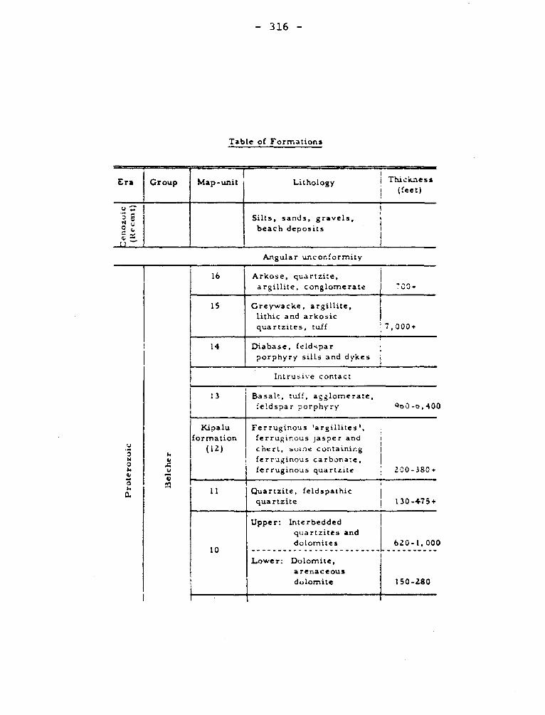
— 316 —
Table of Formations
Era Group Map-unit Lithology
r et
Thickness (feet)
v e.
N e 0 i
t1
Silts, sands, gravels, beach deposits
Angular unconformity
16
Arkose, quartzite, argillite, conglomerate 700•
15 Greywacke, argillite, lithic and arkosic quartzites, tuff 7,000+
14
Diabase, feldspar porphyry sills and dykes
Intrusive contact
13
Basalt, tuff, agglomerate, feldspar porphyry Qo0-0,400
Kipalu formation
(12)
Ferruginous 'argillites', ferruginous Jasper and cherl, suL:' e containing ferruginous carbonate, ferruginous quartzite
Upper: Interbedded quartzites and dolomites
Lower: Dolomite, arenaceous dolomite
11
10
200-380+
620-1,000
150-280
Quartzite, feldspathic quartzite
130-475+
Prote
rozo
ic
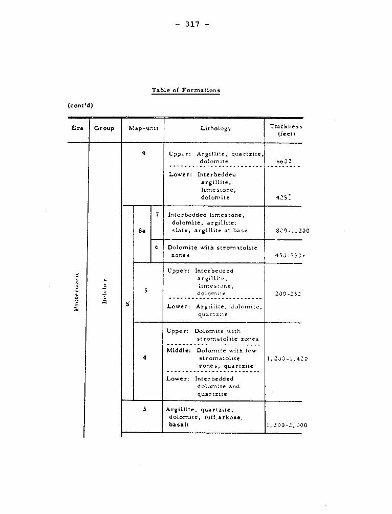
0
0
- 317 -
Table of Formations
(cont'd)
Era Group Map-unit ' Lithology 7hickr.ess (feet)
- N z +•
`' .44
c•
,,
-
9 C'ppt r: Argillite, quartzite, dolomite
Lower: Interbeddeu
argillite,
limestone, dolomite
oo3!
425 _
8
8a
7 Interbedded limestone,
dolomite, argillite; slate, argillite at base 800-1,2
6 Dolomite with stromatolite zones 45J-553
S
Upper: Interbedded argillite,
limestone, dolo""' e
Lower: Argiilite, dolomite,
quartzite
200 -23J
4
Upper: Dolomite with
stromatolite zones
Middle: Dolomite with few
stromatolite zones, quartzite
Lower: Interbedded dolomite and
quartzite
1,2J0-1,4:
3 Argillite, quartzite, dolomite, tuff, arkose, basalt 1,200-2,3C
30
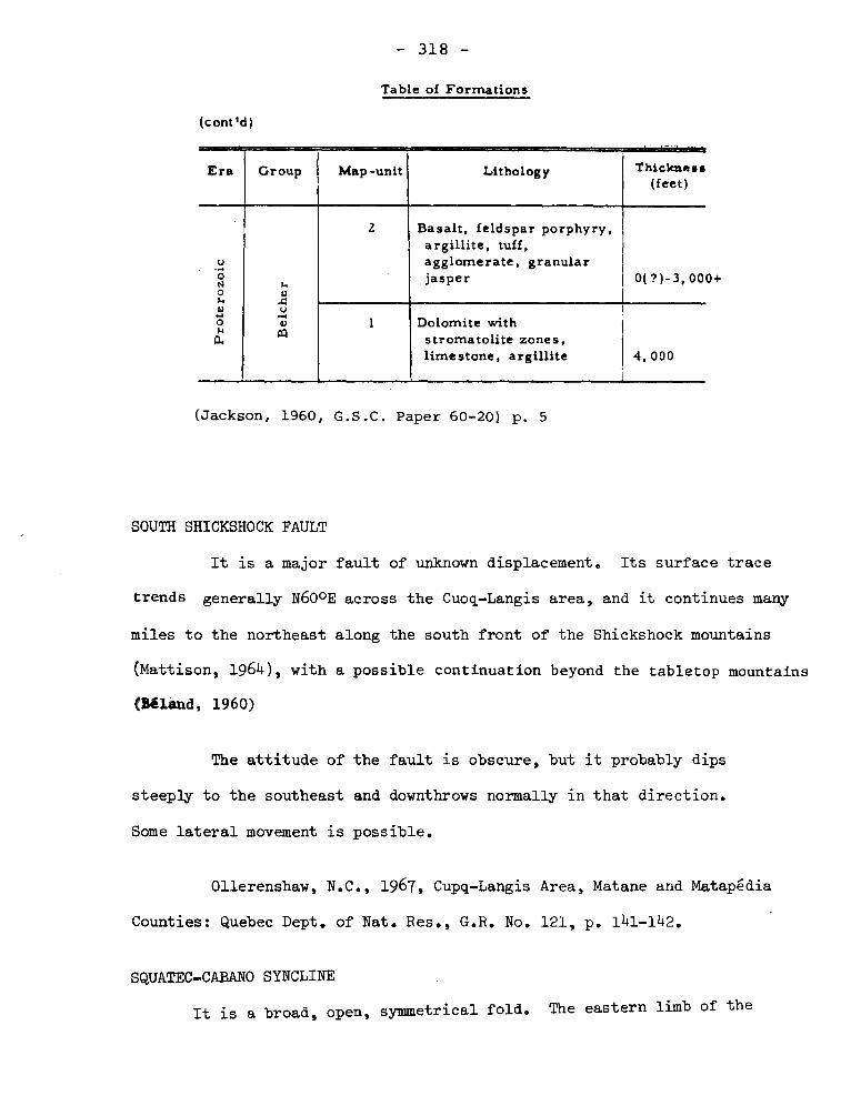
- 318 -
Table of Formations
(c ont'd )
Era Group Map-unit
-- -- Lithology
-= -r.--tea Thickness
(feet)
Pro
ter o
zoic
Bel
che
r
l Basalt, feldspar porphyry, argillite, tuff, agglomerate, granular jasper 0( ?)-3, 00E
1 Dolomite with stromatolite zones, limestone, argillite 4, 000
(Jackson, 1960, G.S.C. Paper 60-20) p. 5
SOUTH SHICKSHOCK FAULT
It is a major fault of unknown displacement. Its surface trace
trends generally N600E across the Cuoq-Langis area, and it continues many
miles to the northeast along the south front of the Shickshock mountains
(Mattison, 1964), with a possible continuation beyond the tabletop mountains
(Béland, 1960)
The attitude of the fault is obscure, but it probably dips
steeply to the southeast and downthrows normally in that direction.
Some lateral movement is possible.
011erenshaw, N.C., 1967, Cupq-Langis Area, Matane and Matapédia
Counties: Quebec Dept. of Nat. Res., G.R. No. 121, p. 141-142.
SQUATEC-CABANO SYNCLINE
It is a broad, open, symmetrical fold. The eastern limb of the
- 319 -
syncline, particularly in its southern part, is thinner than the western
limb, by an average of 2,000 feet horizontally. This thinning, indicates
that the axial plane of the fold dips west. The deepest section of the
fold (i.e., the point of 0 plunge) is between the two arms of Croche Lake
and both extremities plunge approximately 11° toward this deepest section.
Lespgrance, P.J., Greiner, H.R., 1969, Squatec-Cabano Area, Rimouski,
Rivière du Loup and Tgmiscouata Counties: Quebec Dept. of Nat. Res., G.R.
no. 128, p. 95-97.
STADACONA FAULT.
The Stadacona fault strikes northeast to east-northeast. Its dip
is 70 degrees NW in its western part and nearly vertical eastward, where
its strike is more easterly. A lamprophyre dyke associated with the fault
cuts diagonally across the veins of quartz and the schistosity, yet is
itself displaced at an acute angle to the veins for 8 feet in one place.
These relationships indicate that some displacement along the fault has
occured since vein deposition.
Wilson, M.E., 1962, Rouyn-Beauchastel map-areas, Quebec: Canada, Geol.
Surv. Mem, 315, p. 4+0.
STADACONA SYNCLINE
"The Stadacona syncline consists wholly of Abitibi volcanic rocks with
steep dips and tops continuously to the north as far as the Rouyn Lake syncli-
ne in the eastern part and the Horna Creek fault in the western part of the
Rouyn-Beauchastel area".
Its axis trends easterly.
- 320 -
Wilson, M.E., 1962, Rouyn - Beauchastel map-areas, Quebec: Canada, Geol.
Surv., Mem 315, p. 39.
STANBRIDGE Ordovician
Stanbridge is a village and a township north of Missisquoi Bay, Lake
Champlain.
I- Stanbridge Conglomerates - Logan (1863) described conglomerates under this
name as part of the "Philipsburgh" section. He designated it as Division Dl.
He stated that blocks of dark limestone are abundant and tightly packed with
a carbonate paste. Ells (1889) has used the same term for these rocks. Mystic
conglomerate (1.v.) of Clark is essentially a junior synonym for this formation.
Logan, W.E., 1863, Geology of Canada: p. 852.
Ells, R.W., 1888, Second report on the geology of a portion of the
Quebec: Geol. Surv. Can: Sum. Rept. III, p. 39K.
II- Stanbridge shale or slate - (Wilmarth -1-2052) - Logan's divisions D2 and D3
of the Philipsburg section (Logan, op. cit. pp. 845-846) consisting of shales
and calcareous shales and were assigned a thickness of 2500 feet measured above
the Stanbridge Conglomerates. Clark called these beds Stanbridge Slates in 1934,
but in the Geology of Quebec, the same beds are called shale. They are consi-
dered to be part of Farnham Slate and to be Middle and Upper Ordovician. A list.'
of graptolites from an unstated locality suggests that some beds as young or
younger than the Normanskill are present.
P.R. Eakins in 1962 showed part of the area occupied by Logan's D2 and D3
divisions as St. Germain Complex and suggests that the rocks are of the ages of
the Trenton, Utica, and Lorraine (;r0111)::. Ilowevcr, Riva ,:howed that graptolitc:,
from Rioux quarry near Cowansville are D zone of L6vis Nbrmation. On a map
(Eakins, 1964) published in 1964, the region is mapped as underlain by Stanbridge.
- 321 -
Clark, T.H., 1934, Structure and stratigraphy of southern Quebec:
Geol. Soc. Am., Bull. 45, p. 8.
Eakins, P.R., 1962, Guide Book, New England Intercollegiate Geological
Conference, Montréal, p. 82.
Riva, John, 1966, Upper Lévis graptolites from Cowansville, southern
Quebec: Jour. Pal., v. 40, pp. 220-21.
Eakins, P.R., 1964, Sutton Map Area: Geol. Surv. Can. Paper 63-34, p. 2.
III- Stanbridge Complex - In the preceding section on the shale and slate,
Eakins4 is noticed as applying both St. Germain and Stanbridge to the same
rocks. Although a complex can be considered a stratigraphie unit because it
is mappable, the definition offers some difficulty. Thus, the Eakins' opinion
that the Stanbridge involves only rocks of the lowlands facies is shown to be in
error as a result of the age of the fossils described by Riva.
Clark and Eakins have suggested that two complexes be recognized, however,
this solution seems unsatisfactory because of the difficulty of distinguishing
the two where they are in contact. Furthermore, parts of the St. Germain
Complex as mapped involve beds of the same age as those of the Stanbridge Complex.
Clark, T.H. and Eakins, P.R., 1969, in studies of Appalachian geology:
Stratigraphy and structure of the Sutton area of southern Quebec, p..167. In-
terscience Publishers, New York.
STANSTEAD GRANITE Paleozoic
Although this term has been used in contexts suggesting it is
a stratigraphie name, in most references it is used to refer to the medium-
grained gray granite exploited near Stanstead or as a group name for gray
commercial "granites' from the Eastern Townships.
- 322 -
STELLA LAKE SYNCLINE
This north-northeast-trending syncline, which is between Stella and
Pillow lakes,is overturned northwest so its axial plane dips southeast. It
could be the northeastward extension of a sinous, east-trending synclinal map-
ped by Imbault (1959) in the Queylus area to the west".
Neale, E.R.W,, 1959, Dollier-Charron Area, Abitibi-East and Roberval
Electoral Districts: Quebec, Dept. of Mines, G.R. No. 82, p. 35.
STEWART LAKE DOME
The Stewart Lake dome was the only fold identified with certainty.
It is inclined to the northeast. Many minor folds complicate the southeast
end.
Gélinas, Léopold, 1960, Gabriel Lake Area (East Part) and the
Fort Chimo Area (West part ) New Quebec: Quebec, P.R. No. 407, p. 8-9
STOCKWELL FAULT
It is of more limited extent and may even die out within the Chateauguay
map-area. As with the Havelock break no direct evidence has been recognized
except a slight tendency for the joints to depart from the normal NW-SE strike.
The Stockwell fault is, therefore, a hypothetical break,
but nonetheless highly probable. The vertical dislocation would be the same as
that of the Havelock fault where the two faults meet, decreasing westward possi-
bly to zero within a mile or two of the southwestern corner of this map-area.
Clark, T.H., 1966, Châteauguay Area, Châteauguay, Huntingdon, Beauharnois,
Napierville and St. Jean Counties: Quebec Dept. of Nat. Res., G.R. no. 122, p. 4+5.
- 323 -
STOKE GRANITE Paleozoic
This name was given to a granitic body (hypothetical) contri-
buting boulders to the Weedon conglomerate.
Douglas, G.W., 1941, Eustis Min.-Area, Ascot townships: Quebec
Dept. of Mines, G.R. 8, pp. 17-18.
STONY POINT FORMATION Middle Ordovician
Ruedemann named this shale in 1921 and considered it to be of
Trenton age. Clark (1934, p. 4) introduced the formation name in Quebec in
the Lacolle map-area where he stated that this formation underlies the Utica
equivalent for which he proposed Iberville (g.v.),The descriptions by Hawley
(1957, pp. 58-62) for region in northern Vermont are the best published.
The shale part of the Senigon Well (Clark and Strachan, 1955, p. 688) are
presumably in this formation. The formation is apparently 1,200 feet or
more thick, and its lower part is Trenton age but most of it is younger than
this.
Clark, T.H., 1934, Structure and stratigraphy of southern
Quebec: Geol. Soc. Am., Bull., v. 45, p. 4.
Hawley, David, 1957, Ordovician shales and submarine slide
breccias of northern Champlain valley in Vermont: Geol. Soc. Am., Bull.
v. 68, pp. 58-62.
Clark, T.H., and Strachan, I., 1955, Log of the Senigon Well,
southern Quebec: Geol. Soc. Am. Bull., v. 66, p. 688.
STRANGWAY GRANITE Precambrian
The eastern end of the Strangway batholith enters the western part
of the map-area in Laas township and extends eastward as a blunt lobe to
occupy also the southwestern quarter of Tonnancourt township. Its eastern
- 324 -
boundary is four to five miles east of Bell River. The rock is medium-
grained and is from pink to gray. In general, it is massive, but locally
the structure is somewhat gneissoid. In hand specimen, hornblende and
biotite are conspicuous, each making up 15 to 20% of the rock.
Longley, W.W., 1946, Tonnancourt-Holmes Map-Area, Abitibi County:
Quebec Dept. of Mines, G.R. No. 21+, p. 12.
SUTTON
Sutton is the name for a mountain or mountain range, a village, and a
townships in the southern part of the Eastern Townships.
I- SUTTON, GROUP, SERIES. (Wilmarth -1-2091 )
The rocks on the prolongation of the Green Mountain anticlinorium into
Quebec underlie the Sutton Mountains in Quebec and have been referred to by
many names in addition to "Green Mountain Gneiss" as used in the Veromont
from 181 5 or Green Mountain Series as used by Hunt (1871). Other names were
more current in Canada. Geology of Quebec (1944, p. 31 0) lists: Altered
Quebec Group, Schists and Gneisses of Sutton Mountain, Crystalline Schist
Series, Sericite Schists, Hydromica Schists, and Rocks of the Sutton Mountain
Anticline. To these must be added Sutton Mountain Gneiss or Gneisses, Sutton
Mountain Series, Sutton Series, Sutton Group.
In Geology of Quebec (1944, pp. 372-378), Sutton Series is considered to
have two parts: Early Volcanics is the older, but investigations since 1950
have shown that the divisions includes metavolcanic rocks with several strati-
graphic positions. The upper division is composed of paragneisses and para-
schists and includes Bennett Schist (1.v.).
These rocks have been assigned to both Precambrian and Cambrian as well
- 325 -
as to Ordovician. However, the rocks are metamorphic and the original forma-
tions were of diverse ages. As such the name Sutton Group has a local value.
Logan, W.E., 1863, Geology of Canada, p. 251.
Hunt, T.S., 1871, Geognosy of the Appalachians and the Origin of crys-
talline rocks: pre-print Am. Assn. Adv. Sci., pp. 7-8.
Dresser, J.A., 1911, Serpentine belt of southern Quebec: Geol. Surv. Can.
Summ. Rept. 1910, p. 210.
Cooke, H.C., 1954, The Green Mountains "Anticlinorium" in Quebec: Geol.
Assn. Can., Pr. v. 6, pt. II, p. 47.
II- SUTTON, Anticline, Anticlinorium Syncline, Axis, Geanticline.
The structural interpretation of the region near Sutton mountain is essential
to the understanding of the geology of an extensive tract in the southern part of
the Eastern Townships. Logan (1849 , p. 52) mentions that the mountain is bet-
ween two anticlines and therefore might be expected to have a synclinal structure
although such an interpretation does not match all the relationships observed or
inferred. Logans perplexity is expressed again in Geology of Canada (1863, p. 251)
and as stated by Ells (1887, P• 33J) "a double inverted synclinal" would be re-
quired. Selwyn (1882) developed the hypothesis that the structure is anticlinal
and in an illustration shows the intriguing structure referred to by Ells would
be two synclines with axial planes overturned towards each other. Ells and most
later workers accepted the Selwyn interpretation, but H.C. Cooke (1954, loc. cit.)
says that the "true structure" of the schists at Sutton is synclinal.
Logan, W.E., 1849, south side of St. Lawrence: Geol. Surv. Can. Rept.
Prog. 1847-1848, p. 52.
- 326 -
Ells, R.W., 1887, Geology of a portion of the Eastern Townships: Geol.
Surv. Can. Summ. Rept. 11, p. 33J.
Selwyn, A.R.C., 1882, The Quebec Group in Geol: Roy. Soc. Can. Tn., v. 1,
pp. 1-13. especially folded diagram.
SUTTON ANTICLINE
"It is the main structural feature of the Appalachian uplands. The
anticlinal structure is a broad arch plunging about 15° northeasterly over
most of the St. Magloire area. Near the west boundary of that area it plun-
ges about 10° southwesterly. The crest of this anticline is quite irregular
and, here and there, it rolls into a series of minor folds. This anticlinal
structure as actually based on schistosily and may not necessarily be that of
the bedding."
Béland, Jacques., 1957, St-Magloire and Rosaire - St. Pamphile Areas,
Electoral Districts of Dorchester, Bellechasse, Montmagny and l'Islet: Quebec,
Dept. of Mines, G.R. No. 76, p. 31-32.
The logical procedure is to abandon Sutton as a structural term and use
the Vermont nomenclature of Green Mountain Anticlinorium and Green Mountain
Axial Anticlines (Cady, 1960). Clark and Eakins (1968) use Sutton Mountain
Axis for this anticline.
Cady, W.M., 1960, Stratigraphy and geotectonic relationships in northern
Vermont and southern Quebec: Geol. Soc. Am. Bull. v. 71, Plate 1.
- 327 -
Clark, T.H., and Eakins, P.R., 1968, The stratigraphy and structure of the
Sutton area of southern Quebec: in "Studies of Appalachian Geology" p. 164.
III- SUTTON FAULT SLICE
Cooke (1950, p. 16) has proposed this name for a thrust slice between
the Oak Hill Slice on the west and the Beauceville Slice on the east. On
the west the Brome thrust as named by Clark is the boundary whereas on the
east it is the Caldwell thrust (Cooke 1954, op. cit. p. 45).
This is probably best regarded as a nonce name.
Cooke, H.C., 1950, Geology of a southwestern part of the Eastern
Townships of Quebec: Geol. Surv. Can. Mem. 257.
SWANTON Lower Paleozoic
This name has been used for several things in Vermont, but J.B. Berry
used the name from 1868 for a thick sequence of slates. Marcou (1885)
suggested correlations with rocks at Quebec City. He gave the following
table (p. 224):
Upper Swanton: Quebec Group of the city and citadel of Quebec, Charlesbourg,
and Montmorency Falls.
Lower Swanton: Ferry Road Pointe Levis, Ste Anne River, Gros Maule.
Phillipsburg or Point Levis Group.
Marcou, Jules, 1885, The Taconic system and its position in strati-
graphic geology: Am. Acad. Arts and Sci., Pr. 12, p. 224.
SWEETSBURG SLATE Lower (?) Cambrian
This formation of the Oak Hill Group is stated by Clark to have
- 328 -
a thickness of 250 to 300 feet and is composed of a bluish gray to black
"slate" which breaks into wedge shaped blocks. Thin beds of white siltstone
or fine sandstone give the exposure a striped appearance and the rusting
of porphyroblasts of pyrite makesmany of the joint surfaces brown. Osberg
describes the formation in the Knowlton-Richmond area as a quartz muscovite
phyllite with some layers of quartz muscovite chlorite phyllite, the whole
formation having a thickness of 1050-1300 feet.
Although Clark has assigned all the Oak Hill Group to the Lower
Cambrian, it is possible that this part is Middle Cambrian, the evidence for
this conclusion is derived from studies in Vermont.
Clark. T.H., 1936, A Lower Cambrian Series from Southern Quebec:
Roy. Can. Inst., v. 21, pp. 14+9-150.
Osberg, P.H., 1965, Structural geology of the Knowlton-Richmond
Area, Quebec: Geol. Soc. Am., Bull. v. 76, p. 226.
SWEETSBURG SLATE (Wilmarth -1-2098) Cambrian
This is one of the formations of the upper part of the Oak Hill Group
Clark (1934) in proposing the name suggests that the gray phyllite or slate
with thin layers of fine-grained sandstone have an approximate thickness of
300 feet near the type locality. Osberg (1965) estimates, in the Knowlton-
Richmond area, that the Sweetsburg, Scotsmore, and Dunham Formations have a
combined thickness of 1050 to 1300 feet. He shows the numerous occurrences
of gray limestone within the formation particularly near Richmond. Cooke
(1954) has called the same limestone Melbourne (g.v.) but refers to it as
black.
- 329 -
Clark, T.H., 1934, Structure and stratigraphy of Southern Quebec: Geol.
Soc. Am. Bull., v. 45, p. 6.
Osberg, P.H., 1958, Structural Geology of the Knowlton-Richmond area:
Geol. Soc. Am., Bull. v. 76, p. 226.
TACHE LAKE FAULT
This fault was recognized in the Chibougamau Lake area to the southwest,
and thrusting to the northwest was apparent (Mawdsley and Norman, 1935).
Gilbert, J.E., 1958, Bignell Area, Mistassini and Abitibi Terri-
tories, Abitibi-East and Roberval Electoral Districts: Quebec Dept. of Mines,
G.R. No. 79, p. 29.
TACONIC Paleozoic
The Taconic Mountain range along the east side of Hudson River
valley has given its name to many things geological including what is
probably the most acrimonious controversy of American geology. Taconic or
Taconian has been applied to series, epoque, group, system, period, for-
mation, klippe, or allochthon as well as to an orogeny or disturbance; and
the mere tracing of the usages would demand a long essay: United States
Geological Survey Bulletin 1171+ is a lexicon of some "Taconic stratigraphic
names" and is a publication of 95 pages. Some usages even by one worker
have changed with time. Fortunately, for Quebec most references are to
Taconic orogeny or disturbance.
I- Taconic Orogeny, (Disturbance Revolution, Folding) Wilmarth -1-2107) -
"Taconian" is used in the same sense by authors including Schuchert
- 330 -
and Rodgers (1967) but has no advantage over Taconic in referring to the
orogenic event. Very diverse opinions have been expressed concerning the
extent and even the reality of a Taconic Orogeny within the Appalachian
belt in Quebec. An extreme view has been expressed by Clark (1921), who
tried to show that in Quebec there is little stratigraphie evidence for
an orogeny. Abstracts of papers by A. Keith published in 1935 and 1937
support a similar conclusion, but Crickmay (1932) demonstrated that the
stratigraphie evidence for an orogeny is clear along the Matapedia valley.
Reconsideration of older information and data gathered between 1930 and
1969 lead to the conclusion that a very significant orogeny occurred
(Pavlides, Boucot, and Skidmore, 1968: Rodgers 1967). The possibility is
envisaged that the orogeny was in pulses perhaps from late Middle Ordo-
vician through Early Silurian, and that the unconformities may represent
different times at different localities. In addition to unconformities
some authors have suggested that chaotic structures, presumably the result
of sliding of beds downslope, are indicative of orogeny.
Clark. T.H., 1921, A review of the evidence for a Taconic Revolu-
tion: Boston Soc. Nat. Hist., Pr. v. 36, pp. 135-163.
Crickmay, G.W., 1932, Evidence of Taconic Orogeny in Matapedia
valley, Quebec: Am. Jour. Sci., v. 24, pp. 3b8-386..
Rodgers, John, 1967, Chronology of tectonic movements in the
Appalachian region of eastern North America: Am. Jour. Sc. v. 265,
pp. 412-415.
Pavlides, L., Boucot, A.J., and Skidmore, W.B., 1968, Stratigraphie
evidence for the Taconic Orogeny in the northern Appalachians: Studies in
Appalachian Geology, Interscience Publishers, pp. 61-82.
- 331 -
'l'AKWA INTRUSIVE COMPLEX Precambrian
This is a local name used to describe gneisses, mostly granitic,
and acidic plutonic bodies in the region, northeast of Mistassini Lake.
Biotite from a grey to pink granite gneiss from northwest of Sam Gunner
lake gave a potassium-argon age of 1.60 X 10⁹ years and a rubidium-strontium
age of 1.67 X 10⁹ years. The significance of these dates is not known.
This name is not necessary and there is some confusion in its use.
Neale, in an unpublished thesis used Toqueco (Takwa) for rocks referred to
as Sam Gunner Group (g.v.).
Quirke, T.T., Jr., Goldich, S.S., and Krueger, H.W., 1960, Composi-
tion and age of the Témiscamie Iron Formation, Mistassini Territory, Quebec,
Canada: Jour. Econ. Geol., v. 55, p. 311+, p. 320-21.
TALON FORMATION (Wilmarth -1-2112) Paleozoic
Dresser (1912, p. 29) gave the name to diabase, péridotite,and pyroxenite
in Talon Township. He included some greenstones of the Caldwell Group. The
term is no longer current.
Dresser, J.A., 1912, Reconnaissance along the National Transcontinental
Railway in southern Quebec: Geol. Surv. Can., Mem. 35, pp. 29-31.
TAMAGODI (SEDIMENTS) SANDSTONES Paleozoic
Unusual sandstones outcrop in 3 localities along the middle section
of Tamagodi river. Several poor outcrops about 13 miles downstream from
Chantepleure brook consist of fine-to medium-grained, locally coarse- to
very-coarse-grained, calcareous, quartz sandstones. They are medium to
slightly greenish gray where fresh and weather brownish gray. Beds are
- 332 -
probably very thick or massive. Sorting is locally poor and numerous
small, scattered, gray slate fragments occur. Some fragments are identi-
fiable as derived from the Shickshock Group.
011erenshaw, N.C., 1967, Cuoq-Langis Area, Matane and Matapedia
Counties: Quebec Dept. of Nat. Res., G.R. No. 721, p. 27-30.
TEMISCOUATA - PETIT BIENCOURT LAKES FAULT
This fault probably joins the fault in the La Résurrection area,
although its trace is covered by Pleistocene and Recent deposits south
of Témiscouata lake. The topographic expression of this fault east of
Sauvagesse lake and north of Bédard lake is a well-marked absequent fault
line scarp, but elsewhere the fault is not marked topographically. It is
interpreted as a normal fault with a 650 western dip. It has a minimum
throw of 7,400 or 7,800' depending on the interpretation adopted.
Lespérance, P.J., Greiner, H.R., 1969, Squatec-Cabano Area,
Rimouski, Rivière du Loup and Témiscouata Counties: Quebec Dept. of Nat.
Res., G.R. No. 128, p. 93-95.
TEMISCAMIE FORMATION Proterozoic
Wahl (1947, 1953) proposed Témiscamie as the name of a group, later
reduced to a formation, part of the Mistassini Group (1.v.). The "a" or
lower member consists of 35 feet of quartzite overlain by 50 feet of black
slate. The quartzite locally has boulders of dolomite, quartzite and chert,
and this facies is probably equivalent to the Boulder Bay Quartzite named in
an unpublished report by Neilson but mentioned by Quirke, Goldich, and
Krueger (1960, p. 316). According to Wahl, the "b" or iron formation unit
is 620 feet thick, but Quirke, Goldich, and Krueger give 700 feet and divide
- 333 -
it into 6 units, whereas Wahl divided into two. The Quirke, Goldich, and
Krueger divisions are:
Upper sideritic chert, oolites, little minnesotaite. 300 4- ft
Magnetite iron silicate, chert stilpnomelane, minnesotaite. 100 ± ft
Upper argillite, ankerite, siderite and minnesotaite. 5 to 45 ft
Magnetite chert, magnetite, hematite. 73 to 195 ft
Lower sideritic chert, siderite, stilpnomelane. 20 to 100 ft
Lower argillite black, thin-bedded, micaceous. 9 to 40 ft
The "c" member of the Témiscamie Formation is black or gray slate. This
member was called Kallio Formation (1.v.) by Neilson.
Since about 1940, the Témiscamie Formation and the Mistassini Group have
been assigned to the Proterozoic and considered contemporaneous or approximately
so with the iron formations and related rocks of the Labrador Trough. The lower
argillite has yielded a K/Ar age (Quirke, Goldich, and Krueger, 1960, p. 321)
of 1.29 X 10⁹ years but the material was poor and the significance of the age
uncertain.
Wahl, W.G., 1953, Témiscamie River Area, Mistassini Territory: Quebec
Dept. of Mines, G.R. 54, pp. 16-18. (Témiscamie Group is referred to in
P.R. 211, p. 8, 1947).
Quirke, T.T. Jr., Goldich, S.S., and Krueger, H.W., Composition and
age of the Temiscamie Iron Formation, Mistassini Territory, Quebec, Canada:
Econ. Geol., vol. 55, pp. 311-326.
TEMISCAMIE VALLEY FAULT ZONE
The Témiscamie River valley is the locus of a fault zone that here separates
the Superior and Grenville provinces. Its topographic expression is the valley
- 334 -
in which the thick Têmiscamie Valley outwash deposit is located. The only evi-
dence bearing on the dip of the Têmiscamie Valley fault zone is the dip of the
shear planes and slickensided surfaces in outcrops along Têmiscamie river.
These structures dip 45° to 750 southeast and east-southeast, suggesting that
the fault plane (or group of planes) dips southeast at moderate to steep angles.
Neale, E.R.W., 1965, Bêthoulat Lake Area, Mistassini Territory, Quebec
Dept. of Nat. Res., G.R. no. 112, p. 42-46.
Temiskaming, Timiskaming, Temiscamian, Témiscamingue, Témiscaming.
uTemiskaming" with diverse spelling has been applied to a lake separating
Ontario and Quebec, to a county in Quebec, and to a district in Ontario.
I- Timiskaming Subprovince,
M.E. Wilson used Timiskaming to designate the part of the St. Lawrence
Province of the Canadian Shield northwest of the Grenville Subprovince
J.T. Wilson, and J.E. Gill in 1949 presented schemes for the tectonic strati-
graphic divisions of the shield and substituted Superior Province for the
region essentially that of M.E. Wilson's Timiskaming Subprovince.
a) Wilson, M.E., 1941, Pre-Cambrian: Geol. Soc. Am. Fiftieth Anniversary
Volume: p. 274.
b) Gill, J.E., 1949, Natural Divisions of the Canadian Shield: Roy. Soc.
Can., Tr. 43, Sect. IV, pp. 61-69.
c) Wilson, J.T., 1949, Some major structures of the Canadian Shield:
Can. Inst. Min. and Met., Bull. No. 450, pp. 543-554 and Transaction pp. 231-242.
II- Timiskaming lineament.
J.T. Wilson has given this name to faults extending through Temiscamingue
- 335 -
Lake to Porcupine, Ontario, and forming the northeast limit of a hypothetical
Cobalt graben.
Wilson, J.T. , 1949, 22,. cit. p. 238.
III- TEMISKAMING SERIES (GROUP) Archean
W.G. Miller (1911) proposed that metaconglomerates and other metasedimen-
tary rocks occurring near Témiscamingue lake and west of it be referred to
a Temiskaming Series Ito separate them from a less metamorphosed group of beds,
the conglomerates of which he proposed to designate Cobalt. Almost from the time
of its proposal the Temiskaming Series has been the subject of disagreement,
and the scope and spelling of the name has been changed. A.P. Coleman in publi-
cations soon after the proposal of the name used the form "Temiscaming", and
in Geology of Quebec (194+) only "Temiscamian" is used. Publications by the
Geological Survey of Canada and by Ontario Department of Mines of Canada have
"Timiskaming".
Some workers, have placed "Temiskaming Series" within a "Temiscaming Group".
Most workers now agree that Temiskaming is pre-Huronian and is part of the
Archean, but this is practically the limit of agreement.
If Temiskaming Series is to apply to a single stratigraphic unit, it can
be above or below or between metavolcanic rocks. Authors have described the
series in all these positions, but because of the original description it is
generally placed above metavolcanics. However, if two or more sequences of
metasedimentary rocks have been referred to a Temiskaming Series, the problem
is more complex and of course the use of Temiskaming as a series name becomes
improper for at least one sequence . Workers assigned altered conglomerates,
dirty sandstones and siltstones to Temiskaming without regard for their strati-
- 336 -
graphic position. Some writers have attempted to retain Timiskaming as a
system of the upper part of the Archean by assigning lavas to a Temiskaming
Series or System and using "Temiskaming sedimentary rocks" and "Temiskaming
volcanics". Similarly Keewatin volcanics and Keewatin sedimentary rocks
are used for a Keewatin series or system.
M.E. Wilson (1962), whose experience with these rocks extends over many
years, has,in the Rouyn-Beauchastel areas, Quebec, indicated the occurrence in
force of Temiskaming rocks,although some workers have given other names to the
same units. He suggests that the rocks are unconformably above metalavas and
some rocks intrusive into lavas as well as above the Pontiac Group of meta-
sedimentary rocks. If the implied correlation with the type locality can be
maintained this is a correct use of the term, but if not local names for
rock units would be preferable.
Miller, W.G., 1911, Notes on the Cobalt Mining Area: Eng. and Mining
Jour. v. 92, pp. 647-648.
Wilson, M.E., 1962, Rouyn-Beauchastel Map-areas, Quebec: Geol. Sirv.
Can. Mem. 315, p. 7, pp. 19-25.
IV- Temiscamian-type.
In "Geology of Quebec" (1944) the phases Temiscamian-type rocks and
Keewatin-type rocks occur frequently. The use of these names in 1944 as
well as since is a result of the problems and uncertainties regarding the
use of the stratigraphic terms. The meaning attached to Temiscamian- type
rocks is that metamorphosed clastic rocks particularly conglomerates, dirty
sandstones (graywackes), and siltstones resemble those ascribed to the
Temiskaming Series and being "Archaen-like" (Geology of Quebec, 1944,
- 337 -
pp. 52-53), are considered to be Early Precambrian. Similarly "Keewatin-
type rocks" are metamorphosed volcanic, flows, tuffs, and agglomerates.
The "type" terms art lithofacies terms and are legitimate but they
are not stratigraphic terms in a restricted sense. Their use does avoid
giving local names in separate areas.
V- TIMISKAMING SYNCLINORIUM.
"The south limb of the Timiskaming synclinorium includes a maximum
thickness of about 11,000 feet of basal conglomerate passing transitionally
upward to the north into greywacke. The synclinorium also possibly includes
the wide belt of Pontiac rocks that unconformably underlies the Timiskaming
basal conglomerate.
Wilson, M.E., 1962, Rouyn-Beauchastel mpa-areas, Quebec: Canada, Geol,
Surv., Mem. 315, p. 39,
TERREBONNE (FORMATION MEMBER) FACIES Trenton Group
This name was proposed for thin bedded dark limestones believed
to be the highest formation of the Trenton Group. The name was first
published in 1944 by Clark and the description of the formation in 1952,
but subsequently it was found that the beds assigned to this formation
are lentils with the Tetreaville Formation and hence the formation is
reduced to a member.
Clark, T.H., 1952, Montreal area: Quebec Dept. of Mines,
G.R. 16, p. 74.
TETAGOUCHE SERIES Middle Ordovician
The Tetagouche series is characteristically developed along
Tetagouche river, New Brunswick. The part of it whose age is defi-
- 338 -
nitely known, consists of black slates which outcrop on the north
bank of the Tetagouche immediately to the west of the railway bridge.
Volcanics called Fournier Group are associated with the Mictaw.
The rocks have yielded a graptolite fauna of Middle Ordovician age.
The formation is not ordinarily mapped in Quebec, where Mictaw
Group is only slightly younger than the Tetagouche.
Alcock, F.J., 1935, Geology of Chaleur Bay Region: Canada Geol.
Surv., Mem. 183, p. 15-18.
THERESA FORMATION Beekmantown Group
This is the lower part of the Beekmantown Group. The beds consist
of sandstones and dolomitic sandstones and is in Quebec of variable but
inconsequential thickness. It is possibly equivalent to the March Formation
of the Ottawa district.
Clark, T.H., 1952, Montreal Area: Quebec Dept. of Mines, G.R. 46,
p. 25.
THETFORD SERIES Paleozoic
The rocks of the Thetford Series consisting of; peridotite and serpentine,
pyroxenite, gabbro, diabase, granite, make up the greater part of the"serpentine
belt". They extend southwesterly from Broughton mountain in the township of
Broughton, through Thetford, Coleraine, Ireland, Wolfestown, and Garthby to
Big Ham mountain. Note this use of "serpentine belt".
This name is abandoned. See Broughton Series.
Dresser, J.A., 1910, Serpentine belt of Southern Quebec: Canada Geol.
Surv., Summ. Rept. 1909, p. 188.
THEVENET FORMATION Precambrian
The Thévenet formation overlies the Hellancourt volcanics. It is
- 339 -
definitely recognized only in the core of the syncline southwest of Thé-
venet Lake, but may be present east of Rachel lake (Thévenet Lake area).
The top of the formation is not exposed but its thickness exceeds 2,000
feet. The formation consists of zones of massive argillites and quart-
zites or of both interbedded. The argillites are usually dark grey, well
indurated, thickly bedded and, in many places, well laminated. The essen-
tial minerals are quartz and feldspar in angular silt-sized grains with interstitial
stitial chlorite sericite, and biotite.
Sauvé, Pierre, Bergeron, Robert, 1965, Gerido Lake - Thévenet Lake
Area, New Quebec: Quebec Dept. of Nat. Res., G.R. No. 104+, p. 32-33.
THIRD LAKE FAULT
This fault extends southeasterly from the northern part of Larocque
township across York river, Third lake, and Saint-Jean (John) river to ex-
tend almost through the township of York. The downthrown side is on the
northeast. The amount of displacement evidently is variable and probably
is at its greatest where the fault crosses York river, and is estimated
to be 3,000 feet.
McGerrigle, H.W., 1950, The Geology of Eastern Gaspé: Quebec, Dept.
of Mines, G.R. No. 35, p. 107.
THOMPSON CREEK FAULT
Following the depression occupied by Thompson creek from its mouth on the
Kinojevis river, this fault may be traced west and a little south to near sur-
vey-tag 48 on the Rouyn centre-line. This fault appears to be of a thrust type,

- 340 -
dipping steeply north. Wilson (1943, p. 123) present evidence that this fault
is continuous with the Bouzan Lake fault and part of the Cadillac break.
uses McKenzie as a name for it or McKenzie - Bouzan Lake.
Hawley, J.E., 1933, McWatters Mine Gold Belt, East Rouyn and Joannes
Townships: Quebec Bureau of Mines, Part C, p. 26.
Wilson, M.E., 1943, The Early Precambrian succession in western Quebec:
Roy. Soc. Can. Tr. 37, Sect. IV, p. 123.
TIBBIT HILL FORMATION, SCHIST, GREENSTONE Cambrian (?)
Clark (1936, p. 137) gave a brief description of the Tibbit Hill
Schist, which he had referred to briefly in 1934, The type locality is
west of Brome Lake in the Sutton Map Area, but the formation can be traced
southward and northeastward from there.
The rocks are commonly chlorite, albite, epidote schists, or locally
phyllites, with relic amygdules and knots with epidote and quartz. The bulk
composition is that of andesites and basalts, although at a very few localities,
rhyolites can be found. At many localities glistening porphyroblasts of
magnetite are scattered through the rock.
In 193+ (p. 10) Clark assigned this formation to Precambrian, but in
1936 (p. 136) he placed it in the Oak Hill Series and considered it Lower
Cambrian. The base of the Tibbit Hill has not been recognized. See "Waterloo
Lavas". Clark, T.H., 1934, Structure and stratigraphy of southern Quebec:
Geol. Soc. Am., Bull. v. 4+5, p. 10.
Clark, T.H., 1936, A Lower Cambrian Series from Southern Quebec:
Roy. Can. Inst. v. 21, Pt. 1, pp. 137-138.

II-
- 341 -
I- TOMIFOBIA SERIES Silurian or Devonian
Clark (1934, p. 10) published this name,which was originally
proposed by F.A. Kerr, who mapped the eastern part of the Memphremagog
area in Quebec. The formation or series consists of dark gray slates
with some dark limestones and resembles the Magog group. Clark consi-
dered that the rocks were dated by graptolites, but as stated by Cady
(1960, p. 556) the "graptolites" are probably non-biogenic. The more
recent view is that the beds are perhaps in part Silurian but certainly
in part Devonian, as shown by the discovery of fossil plants. The same
rocks have been assigned to the St. Francis Group.
Clark, T.H., 1934, Structure and stratigraphy of Southern Quebec:
Geol. Soc. Am., Bull., vol. 45, No. 1, pp. 10.
Cady, W.M., 1960, Stratigraphy and geotectonic relationships in
northern Vermont and southern Quebec: Geol. Soc. Am., Bull. v. 71, p. 556.
Cooke, H.C., 1957, Coaticook-Malvina area, electoral districts of
Stanstead and Compton: Quebec Dept. of Mines, G.R. 69, pp. 9-11.
TOMIFOBIA SLICE
Clark (off. cit. p. 4) has used this name for a fault slice
lying east of the Bunker Thrust in the Memphremagog area. Although the
fault may exist, the slice is composed of rocks of the Gaspé Supergroup.
This slice is the same as St. Francis Fault Slice (g.v.).-
TONNANCOURT QUARTZ MONZONITE Precambrian
An irregular stock of granite rock crops out in the southeastern corner
of Tonnancourt township. Its eastern margin lies at and closely follows the
eastern boundary of the township, and, after reaching its maximum north-south
- 342 -
width of rather more than 3 miles, it wedges out at a point about 4; miles
west of the township lines. The rock is massive, medium-grained, light gray
to pink, and is characterized by an abundance of quartz. Some of the quartz
is in euhedral grains. In many places, there is an unusually well developed,
closely spaced, sheet-joints in this rock.
Longley, W.W., 1946, Tonnancourt-Holmes Map-Area, Abitibi County:
Quebec Dept. of Mines, G.R. No. 24, p. 14.
TOULADI FORMATION Lower Devonian
It includes limestones, sandstones, and conglomerates of the
beds of the Temiscouata Formation. Its maximum thickness is 350 feet
only one half or less of which is exposed.
Lespérance, P.J., Greiner, H.R., 1969, Squatec-Cabano Area,
Rimouski, Riviére du Loup and Témiscouata Counties: Quebec Dept. of Nat.
Res., G.R. No. 128, p. 77-82.
TOURELLE SANDSTONE Canadian
McGerrigle gave this name to sandstones, black shales, red and
green shales, with limestone conglomerates occurring adjacent to St.
Lawrence river in Gaspé peninsula. Graptolites have shown that this
formation is the age of the Levis Group or the Deepkill Shales of
New York. The anglicized form of the name "Pillar" was used by Logan,
and the formation was correlated with the Sillery for a time.
McGerrigle, H.W., 1954, The Tourelle and Courcelette areas:
Quebec Dept. of Mines, G.R. 62, pp. 30-32.
McGerrigle, H.W., 1954, An outline of the geology of Gaspé
Peninsula: Can. Min. Jour., v. 75, p. 60.
- 343 -
TRACY BROOK FAULT
This fault which strikes N20°E was named in the Lacolle map area.
As mapped in the St. Jean area, it is merely a northward extrapolation
of the structure in the Lacolle map-sheet to the south. It is shown on the
St. Jean sheet as terminating against the Delson fault, though there is
it must be said no visible evidence of its presence within the St. Jean
area. It strikes northeast. See Lacolle Conglomerate.
Clark, T.H., 1934, Structure and stratigraphy of southern Quebec:
Geol. Soc. Am., Bull. 45, p. 14.
Clark, T.H., 1955, St. Jean-Beloeil Area, Iberville, St. Jean,
Napierville-Laprairie, Rouville, Chambly, St. Hyacinthe and Verchres
Counties: Quebec Dept. of Mines, G.R. No. 66, p. 51.
TREMBLAY BEDS
Middle Ordovician
At a locality three miles northwest of Ste Anne, which is on
Saguenay river, seven feet of limestone contain possible Lowville fossils.
Sinclair, G.W., 1953, Middle Ordovician beds in the Saguenay
valley, Quebec:Am. Jour. Sci., v. 251, p. 44.
TREMBLING LAKE CRYSTALLINE LIMESTONE
Precambrian
A heavy band of limestone runs through Trembling Lake, which lies
immediately west of Trembling Mountain, being exposed on the islands in
the lake as well as it its outlet.
Adams, Frank D., 1896, Report on the geology of a portion of the
Laurentian Area lying to the North of the Island of Montreal: Canada Geol.
Surv., Ann. Rept. VIII, 1895, J. p. 22.
- 344 -
TREMBLING MOUNTAIN GNEISS Precambrian
This gneiss is rather fine in grain, and has a distinct though not
very striking foliation, marked by the presence of a series of thin, inter-
rupted black lines, seen on surfaces broken at right angles to the folia-
tion. On large weathered surface a slight variation in size of grain can
occasionally be seen in thin bands parallel to the foliation, and at long
intervals, thin bands of a black pyroxenic amphibolite are met with. The
gneiss Las a pale reddish colour when fresh, and weathers brownish-gray.
Adams, Frank D., 1896, Report on the geology of a portion of the
Laurentian Area lying to the North of the Island of Montreal: Canada Geol.
Surv., Ann. Rept. VIII, 1895, J. p. 42.
TRENTON LIMESTONE, GROUP, SERIES
The name Trenton is derived from Trenton Falls, New York, and has
been used as a stratigraphic term since 1842. Since then the name has
been used in various ways to an extent that many apparent inconsistencies
have developed. The name in its formation form, viz as Trenton Limestone,
is probably the most serviceable of the several uses. Goudge (1935, p. 19)
gives a good summary of the Trenton as a source of commercial limestone
and describes its lithology. Belyea (1952, pp. 17-21), in a discussion of
the deep wells of part of Quebec, describes the Trenton limestones as two
principal lithologic units viz. formations, although using the term Trenton
succession to describe them. It is obvious then that Trenton is a useful
name for the limestone in a general sense and to change or abandon it would
result in confusion.
In "Geology of Canada" (1863, p. 136) Logan refers the Birdseye and
Black River Formation and the Trenton Formation to the Trenton Group. J.W.
— 345 —
Dawson (1880, 58) in his geology notes lists Trenton Series as containing
Chazy, Black River, and Trenton Limestones. This was the Montreal Limestone
of Logan's usage prior to 1863.
By 1900, the Trenton Formation was regarded as distinct from the
underlying Black River Limestone, but later some doubts arose concerning
its upper limit. For example, in "Geology of Quebec" (194+4, p. 263) it is
stated that the Utica Shale should be considered part of the Trenton. This
problem does not rise if the Trenton is restricted to use as a lithostrati-
graphic unit.
A history of the studies of the Trenton Group has been given by Kay
(1937) and, particularly for Quebec, by Clark (1959). As pointed out by
both authors the original designations by Raymond were derived from prominent fos-
sils in beds in Ontario. The beds are listed in Table I.
d. Rafinegquina deltoidea and Hormotoma beds
c. Prasopora beds
b. Crinoid beds
a. Dalmanella beds
In 1914, the biologically identified beds were given geographic names
and treated more or less as formations. The term Trenton was applied to the
Prasopora beds, which beds were later to designated as Sherman Fall. Rockland
was introduced for the Dalmanella beds and Hull for the Crinoid beds.
Parks (1931, p. 23D) used the fossils to describe zones in the Trenton
exposed on the Oureau and Assomption rivers near Joliette. His composite
section is:
Rafinesquina deltoidea zone 70 feet
Prasopora simulatrix zone 105 feet
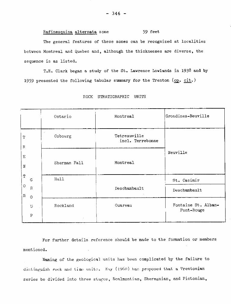
- 346 -
Rafinesquina alternata zone 59 feet
The general features of these zones can be recognized at localities
between Montreal and Quebec and, although the thicknesses are diverse, the
sequence is as listed.
T.H. Clark began a study of the St. Lawrence Lowlands in 1938 and by
1959 presented the following tabular summary for the Trenton (off. cit.)
ROCK STRATIGRAPHIC UNITS
Ontario Montreal Grondines-Neuville
T
R
E
N
T G
O R
N 0
U
P
Cobourg Tetreauville incl. Terrebonne
Neuville
Sherman Fall Montreal
Hull
Deschambault
St. Casimir
Deschambault
Rockland Ouareau Fontaine St. Alban-Pont-Rouge
For further details reference should be made to the formation or members
mentioned.
Naming of the geological units has been complicated by the failure to
distinguish rock and time unit::. Kay ( 196O ) has proposed that a Trentonian
series be divided into three stages, Nealmontian, Shermanian, and Pictonian,
- 347 -
the last being the youngest.
Goudge, M.F., 1935, Limestones of Canada, Pt. 3: Canada Mines Branch,
Pub. No. 755, pp. 19.
Belyea, H.R., 1952, Deep wells and subsurface stratigraphy of part of
the St. Lawrence Lowlands, Quebec: Can. Geol. Surv., Bull. 22, pp. 17-21.
Dawson, J.W., 1880, Lecture notes on geology: Dawson Bros., Montreal, p. 58
Kay, G.M., 1937, Stratigraphy of the Trenton Group: Geol. Soc. Am.,
v. 48, pp. 237-241.
Clark, T.H., 1959, Stratigraphy of the Trenton Group, St. Lawrence
Lowland, Quebec: Geol. Assn. Can., Pr. 11, pp. 13-21.
Parks, W.A., 1931, Natural gas in the St. Lawrence valley, Quebec:
Que. Bur. Mines, Ann. Rept. 1930, Pt. D., p. 23.
Kay, G.M., 1960, Classification of the Ordovician system in North
America: Int. Geol. Cong. XXI, Pt. VII, p. 32.
TRIVIO GROUP Precambrian
It consists of heterogeneous beds of volcanic and sedimentary
material which lie along the top of the volcanic pile. The rocks are not
well exposed but the main members appear to be discontinuous beds of tuffa-
ceous sedimentary rock, graywacke, arkose, graphitic phyllite, conglomerate,
tuff, chert and lava. There is a possibility that a regional fault zone
extends along the south edge of the group, separating it from the Pontiac
rocks to the south.
Sharpe, John I., 1968, Louvicourt Township, Abitibi-East County:
Quebec Dept. of Nat. Res., G.R. No. 135, p. 11-12.
TURGEON LAKE GRANITE Precambrian
It underlies approximately .55 square miles in the western half
- 348 -
of the map-area and extends beyond the western limit of the area. Two small
bodies are exposed along the coast. At Johan Beetz, biotite granite extends
from Mine bay to a point 22 miles northwest of the village. It is divided
into two parts by a band of quartzite and schist, which outcrops east of
the village. The second mass extends westward along the coast from the
mouth of Corneille river to about 1 mile east of Appititatte bay, a distance
of four miles. It has a maximum exposed width of one mile.
Cooper, Gerald, E., 1957, Johan Beetz-Area, Electoral District of
Sagtenay: Quebec Dept. of Mines, G.R. No. 7I, p. 39-41.
UNGAVA MOUNTAINS
Gill has used this name for the folded rocks forming part of the
Labrador Trough. He places it within the Churchill-Ungava Province.
Gill, J.E., 1949,. Natural Divisions of the Canadian Shield,
Transactions of the Royal Society of Canada, Volume XLIII, Series III,
Section four, p. 65.
UNISON GRANODIORITE (W-2- 379) Precambrian
An outcrop of "quartz diorite" near Ynison mine in Dubyison is hp.may
indicate a the presence of a small body of granodiorite.
Cooke, H.C., James, W.F., and Mawdsley, J.B., 1931, Geology and Ore Deposits
of Rouyn-Harricanaw Region, Quebec.Canada, Geol. Survey, Mem, 166, p. 133.
UPPER ALBANEL FORMATION Proterozoic
Wahl (1953) assigns two members to this formation of the Mistassini Group
(a..). The lower member, "e" is 700 feet thick and consists of sandy dolo-
mite and dolomitic sandstone with crossbedding. It passes gradationally upward
- 349 -
into "f" member, which is 1300 feet of fine-grained dark gray dolomite and ar-
gillaceous dolomite.
Lesperance in a manuscript dated 1965 notes the presence of Cryptozoon in
"e" and "f" member, but believes that at least some of the structures reported
from "d" member of Lower Albanel Formation are concretions.
Wahl, W.G., 1953, Temiscamie River Area, Mistassini Territory: Quebec
Dept. of Mines, G.R. 54, pp. 14+-15.
UTICA SHALE (GROUP) Ordovician
From its type locality in New York, this formation can be traced
into Quebec and Ontario, where the name has been used consistently for
more than a century to designate a dark carbonaceous shale separating a
limestone formation (Trenton) from a shale formation (Lorraine). The
proper use of this name for a lithostratigraphic unit has been shown by
Fisher (1956, p. 620) who demonstrates that the formation is not of one age
from locality to locality.
Clark has used the name for a group, although in the Montreal
area the group has only the Lachine Formation. Other formations consi-
dered Utica are Iberville, Lotbiniére, Stony Point. Clark appears to
vacillate between the lithostratigraphic interpretation and a biostrati-
graphic use of the name. However, Riva (1968) states his view unequivo-
cally. "In the Mohawk valley and in parts of the St. Lawrence lowlands,
the Utica and Canajoharie shales are actually biostratigraphic units that
can be separated only on the basis of their strikingly dissimilar grapto-
lite content". Riva has given zonal names: Corynoides calicularis var.
americana for the lower zone of the Canajoharie followed upward by a
- 350 -
Climacograptus minimus zone. The Utica has a lower zone of Climacograptus
spiniferus followed by a zone of Climacograptus pygmaeus.
Gloucester has been used in part and locally for shales of Utica
aspect and Billings Formation is 300 feet of black shale equivalent to
Gloucester and part of Collingwood (Wilson, 1946, p. 8).
Utica has been used, therefore, both in its lithostratigraphic
significance and in a biostratigraphic sense. The context may help
to determine the use. The formation is assigned to the Mohawkian by some
workers but to the Cincinnatian by others.
Utica Shale (Group) -2-
Fisher, D.W., 1956, Intricacy of applied stratigraphic nomenclature:
Jour. Geol. v. 64, p. 620.
Riva, John, 1968, Graptolite faunas from the Middle Ordovician of
the Gasp. north shore: Nat. Can., V. 95, p. 1396.
Wilson, A.E., 1946, Geology of the Ottawa-St. Lawrence lowland, Ontario
and Quebec: Can. Geol. Surv., Mem. 2141, p. 8.
VAIL SLATE MEMBER (of Sweetsburg Formation) Cambrian
Clark (1936, p. 150) gave this name to a member consisting of
thinly layered darker and lighter gray mudstone. He assigned it to the
upper part of the Sweetsburg Slate, but in 1934, he had given it forma-
tional status.
The formation has not yielded fossils.
Clark, T.H., 1934, Structure and stratigraphy of southern Quebec:
Geol. Soc. Am., Bull. v. 45, p. 10.
- 351 -
Clark, T.H., 1936, A Lower Cambrian Series from Southern Quebec:
Roy. Can. Inst., v. 21, Pt. 1, p. 150.
VAUREAL FORMATION -VAURIAL Ordovician
Division "B" of Richardson overlies the English Head Formation (1.v.)
on Anticosti and was assigned a thickness of 730 feet with gray and reddish
gray limestones and some shaly beds. Schuchert and Twenhofel (1910, p. 695)
named the beds of "B" division Charleton Formation, but in 1920 Twenhofel
changed the name to Vaurial(Vauréal)because Charleton point is not underlain by
division "B". He (1927, p. 23) states that this formation is 541 feet
thick on Vaur6a1 river. This formation, like the English Head thickens
southward and may be 1,600 feet thick or even more.
The similarity of the Vauréal to the English Head has been generally
recognized and both are considered Richmond.
Richardson, James, 1857, Report for year 1856: Can. Geol. Surv.,
Rept. of Progress 1853-1856, pp. 210-211.
Schuchert, C., Twenhofel, W.H., 1910, Ordovicic-Siluric Section of
the Mingan and Anticosti Islands, Gulf of Saint. Lawrence, Geol. Soc. Am.,
Bull., vol. 21, p. 695.
Twenhofel, W.H., 1927, Geology of Anticosti Island: Can. Geol. Surv.
Mem. 154, p. 23.
Roliff, W.A., 1968, Oil and gas exploration - Anticosti island,
Quebec: Geol. Assn. Can., Pr. v. 19, p. 34.
VAUZE CREEK-WAITE LAKE FAULT ZONE
In the northern part of the district, a depression largely filled
- 352 -
with clay extends across Waite and Newbec map-areas by way of Waite Lake
and the lower part of the valley of Vauze Creek. North of this depresssion,
to the east of the Dufresnoy diorite belt, siliceous rhyolite, underlain to
the west by alternating belts of rhyolite and andesite, is present. All
these lavas strike northwesterly and dip northeast.
Wilson, M.E., 1949, Noraada District, Quebec: Canada, Geol. Surv.,
Mem, 229, p. 51.
VENTURES TYPE GABBRO Precambrian
Duquette and Mathieu have used this name for a coarsed-grained
to medium-grained aggregates of hornblende and plagioclase occurring at
the tops of ultrabasic sills. They point out the similarity of this
rock to that forming the country of ore shoots at Opemiska Copper Mines.
Duquette, G., and Mathieu, A., Northeast quarter of Mckenzie
Township, Abitibi-East County: Quebec Dept. of Min. Res., P.R. 551, p. 7-8.
VEHNEUIL STOCK Precambrian
The two southernmost bays on the western boundary of the map-area are
parts of Verneuil lake. In the more northern bay, there is a low reef of
light grey, medium-grained, massive biotite granite.
This holocrystalline, equigranular rock consists of plagioclase (4+0%),
microcline (25%), quartz (20%), biotite (10%), and epidote (5%) with some
sphene.
Imbault, P.E., 1959, Queylus Area, Abitibi-East and Roberval, Electoral
Districts: Quebec Dept. of Mines, G.R. No. 83, p. 21.
Holmes, Stanley W., 1959, Fancamp-Hauy Area, Abitibi-East, Electoral
- 353 -
District: Quebec Dept. of Mines, G.R. No. 84, p. 10.
VIGNON (WINDSOR) LAKE ZONE (of Shickshock Group) Lower Paleozoic
Most of the rocks of this zone are similar to those of Bardey (Man)
Lake. They are medium to fine grained, dark grey on fresh surfaces and
brownish grey on weathered surfaces. Bedding is apparent in an outcrop
southwest of Côté Lake, Foliation like that of the Bardey Lake zone is
everywhere present and presumably is generally parallel to the now oblite-
rated bedding. Metavolcanic rocks are adjacent to this zone or .interbedded
with its rocks.
Mattinson, C.R,, 1964, Mount Logan Area, Matane and Gaspé-North
Counties: Quebec Dept. of Nat. Res., G.R. No. 118, p. 39-43.
WABASSEE GROUP Precambrian
It underlies half of the area and is made up of thick flows of
light-colored pillowed feldspathic lavas and contrasting dark mafic lavas.
Abundant exposures of the feldspathic varieties are found along the Allard
river and in the vicinity of Wabassee lake in Daniel township. Excellent
exposures of the mafic varieties are scoured by wave and sand abrasion on
the islands and shores of Matagami lake.
Sharpe, John I., 1968, Geology and Sulfide Deposits of the Matagami
Area, Abitibi-East County: Quebec Dept. of Nat. Res., G.R. No. 137, p. 17.
WACONICHI LAKE FAULT
It branches from the Mistassini Lake fault near the outlet of
Waconichi lake and extends southwestward beyond the western limit of
the map-area, closely paralleling the south side of Waconichi lake.
Its general strike is S. 60° W., and its dip is 75o south. The only
- 354 -
evidence that this fault may extend east of the Mistassini Lake fault
is a small shear zone, also with northeast strike, in gneiss about
5,000 feet southwest of the northeast corner of the area.
Gilbert 9 J.E., 1958, Bignell Area, Mistassini and Abitibi Territories Abitibi-East and Roberval electoral districts: Quebec, Dept. of Mines,
G.R. No. 79, p. 30-31.
WAITE ANTICLINE
"In the rock ridge southwest of the Waite - Ackerman - Montgomery Mine
the eastward dipping Amulet rhyolite belt extends to the east about 1 mile.
An anticline (Waite) is therefore present in this locality. The approximate
average eastward plunge of this anticline is estimated to be about 30 degrees."
Wilson, M.E., 1949, Noranda District, Quebec: Canada, Geol. Surv. Mem.
229 - p. 49-50.
WAITE HILLS FAULT.
Northeast of Beaver Hill, this fault extends northwest across
Waite Hills. It strikes northeasterly.
Wilson, M.E., 1949, Noranda, District, Quebec: Canada, Geol. Surv.,
Mem, 229, p. 52.
WAKEHAM LAKE, SEDIMENTS, SERIES, LAC WAKEHAM SERIES, WAKEHAM SERIES.
Claveau (1948) used the term Wakeham Lake sediments for quartzites,
and slates. He did not use the name in the table of formations and hence the
name was informal. Beland who served as assistant to Claveau in 1943,
355 -
in mapping the Wakeham Lake area, used both Wakeham Lake Series (1950,
p. 291) and Wakeham Series (1950, p. 294).
The quartzites, and schists of most of the series are less
strongly crystalline than the rocks of similar composition in the Grenville
Series, however near the borders of the sedimentary sequence, the grade is
higher,and the rocks have been assigned to the Grenville. Beland has sug-
gested that the Wakeham Lake Syncline is a southeastern extension of La-
brador Trough.
Claveau, Jacques, 1949, Wakeham Lake area, Saguenay County: Quebec
Dept. of Mines, Geol. Rept. 37, p. 24-25.
Béland, René, 1950, Le synclinal du Lac Wakeham et la Fosse du
Labrador: Nat. Can., vol. 77, p. 291-294.
WALLACE CREEK
Ordovician
This name is applied to 200 to 250 feet of interbedded
thin layers of shaly limestone and thicker limestone equivalent to
the lower part of Logants A3 division of the Philipsburg Series (q.v.).
McGerrigle, H.W., 1931, Three geological formations in
northwestern Vermont: Rept. of State Geol., 17th., 1929-30, p. 185.
WAPUSSAKATOO MOUNTAINS
This range of hills lies mostly northeast and east of the divide
between the streams flowing to the Hamilton River and those flowing to
St. Lawrence River.
I- WAPUSSAKATOO SERIES
This name was given (Gill et al., 1937) to quartzites, "mica
- 356 -
gneisses" and schists, and recrystallized iron formation. With the
development of the area the series was reduced to a formation known as
the Wapussakatoo Quartzite and made part of the Gagnon Group.
The quartzites are derived from sandstones or cherts or both.
Gill, J.E., 1937, Bannerman, H.M., and Tolman, C., 1937, Wapussa-
katoo Mountains, Labrador: Geol. Soc. Am., Bull. v. 48, pp. 573-575.
Gastil, G., and Knowles, D.M., 1960, Geology of the Wabush Lake
Area, southwestern Labrador and eastern Quebec, Canada: Geol. Soc. Am.,
Vull. v. 71, p. 1247.
Clarke, P.J., 1967, Gras Lake-Felix Lake Area, Saguenay County:
Quebec Dept. Nat. Res., G.R. 129, pp. 30-32.
II- WAPUSSAKAT00 MOUNTAINS.
Gill has used this term for one of the "natural divisions" of
the Canadian Shield. The term has tectonic but not physiographic
significance. Some uncertainty exists as to the classification of this
unit: Gill (1949, p. 65) makes it a subprovince of the Ungava Province
and also (p. 68) a subprovince of the Churchill-Ungava Province.
Gill, J.E., 1949, Natural Divisions of the Canadian Shield:
Roy. Soc. Can., Tn. 43, Sec. IV, pp. 61-69.
WASA LAKE FAULT.
The Wasa Lake fault extends from western Beauchastel township eastward
across the eastern part of the Wasa Lake, the northwestern part of the Wakeko,
the southern part of the Wingait, and the southwestern part of the Horne Fault
properties. Its dip is about 60 degrees N.
- 357 -
Wilson, M.E., 1962, Rouyn-Beauchastel, map-areas, Quebec: Canada, Geol.
Bury. Mem, 315, p. 40.
WASWANIPI GRANITE Precambrian
Longley (1951, p. 16) named the granite that extended into the
west central and northwestern part of the Bachelor Lake map area, but
Gilbert (1951, p. 32-33) has given the best description of the rocks,
which occupy most of the southern third of the Capisisit Lake area. The
rock is a medium-to coarse-grained leucocratic granite with one third
to two thirds albite, scene of which is contained poikilitically in micro-
cline. Extensive areas show a cataclastic texture with development of
augen of plagioclase.
Imbault refers to the equivalent of the Waswanipi Granite in the
Maicasagi Area as "Southern Granite'. Undoubtedly this is intended as
a nonce name.
Langley, H.W., 1951, Bachelor Lake Area, Abitibi-East County:
Quebec Dept. of Mines, G.R. 47, pp. 16-17.
Gilbert, J.E., 1951, Capisisit Lake Area, Abitibi-East County:
Quebec Dept. of Mines, G.R. 48, pp. 32-34.
Imbault, P,E., 1954, Maicasagi Area, Abitibi-East County:
Quebec Dept. of Mines, G.R. 60, pp. 22-25.
WATERLOO LAVAS Paleozoic
Cooke gave this name to lavas of undetermined stratigraphie
position outcropping as a band up to 4i miles wide and extending north-
westerly close to the town of Waterloo. The rocks were largely basaltic
and andesitic although acidic lavas are found. Cooke favors slightly
the possibility that the lavas are Bolton (1.v.), but the evidence
- 358 -
indicates that they are, largely if not entirely Tibbit Hill (spelled
Tibbet by Cooke) Schist.
Cooke, H.C., 1950, Geology of a southwestern part of the
Eastern Townships of Quebec: Can. Geol. Surv., Mem. 257, p. 20, p. 93-9h.
WEEDON SCHISTS, SERIES Paleozoic
Burton (1931, p. 111) gave this name to deformed but recognizably
metavolcanic rocks near Aylmer lake. The chlorite schists are equivalent
to basalts and andesites but much more acidic lavas were also present.
Duquette (1961) has made a comprehensive study of the rocks in the Weedon
Lake area and has called them "Weedon Schists Formation". He has recognized
crystal tuffs, agglomerates, cherty beds, tuff, greenstones, and a variety
of crush conglomerate. In the Weedon Lake area Duquette believes that the
formation may be as much as 12,800 feet thick, but it thins both northward and
southward.
The age of the rocks has been debated. Logan considered the formation
the age of the Quebec Group; Selwyn in 1882 considered them Keweenawan; Ells
in 1884 assigned them to Huronian; and Dresser, 1906, and Bancroft, 1913,
noted their similarities to rocks assigned to the Precambrian in Pennsylvania.
Burton suggested that the formation could be the same as volcanics
west of Aylmer lake, and Cooke later correlated these with the Caldwell
Group. Clark assigned part of these rocks to the base of the St. Francis
Group and, like Burton, considered them Middle Ordovician. Still later
Cooke assigned at least some of them to the Sherbrooke Group, which he
considered Silurian.
Although, Duquette suggests the possibility of a late Ordovician age,
the correlation and age of the formation is not known. The presence of abun-
- 359 -
dant acidic pyroclastics, erroneously interpreted by some workers as intru-
sive rocks, makes this formation different from the Caldwell.
Burton, F.R., 1931, Vicinity of Lake Aylmer, Eastern Townships:
Quebec Bur. of Mines, Ann. Rept., 1930D, pp. 111-114.
Duquette, Gilles, 1961, Geology of Weedon Lake area and its vicinity:
Université Laval, These pour Doctorat, pp. 33-70.
Duquette, Gilles, 1959, Le Groupe de Québec et le Groupe de Gaspé
prés du Lac Weedon, Nat. Can. v. 30, pp. 247-252.
WEEDON (THRUST) FAULT
Burton (1931, p. 125) recognized the thrust fault crossing the
Aylmer Lake area, but he did not name it. He refers to "the fault",
"the overthrust fault" in his report. Cooke and others have suggested
southwest extensions of it. It is believed to postdate Acadian folding.
Hawley et al. ,in the discussion of the Moulton Hill ore deposit,use the
term "Weedon Type of faulting". By this they mean a pre-ore fault with
overthrusting to the northwest.
Burton, F.R., 1931, Vicinity of Lake Aylmer, Eastern Townships:
Quebec Bur. of Mines, Ann. Rept. 1930-D, p. 125.
Hawley, J.E., Fritzsche, K.W., Clark, A.R., and Honeyman, K.G.,
1945, The Aldermac Moulton Hill Deposit, Eastern Townships, Quebec;
Can. Inst. Min. & Met., Tr. v. 48, p. 383.
WEEDON PORPHYRY Paleozoic
Vibert Douglas has used this name for intrusive rocks near Weedon
mine with the implication that it is equivalent to the Stoke granite.
Although he has named the Eustis and Suffield sills there is grave doubt
- 360 -
whether the units are intrusive (Hawley et+. al.). The use of these names
is inadvisable.
Vibert Douglas, G., 1941, Eustis Mine Area, Ascot Township: Quebec
Bur. Mines, G.R. 8, p. 17.
Hawley, J.E., Fritzsche, K.W., Clark, A.R., and Honeyman, K.G., 1945,
The Aldermac Moulton Hill Deposit, Eastern Townships, Quebec: Can. Inst.
Min. & Met., Tn. v. 48, pp. 373-374.
WEIR FORMATION Lower Silurian
It is a thin wedge of Lower Silurian strata conformably beneath the
Clemville Formation. The unit crops out only along the headwaters of Mictaw
brook and "La Grande-Fourche" brook (local name). The Weir Formation which
is on Mictaw Brook 2180 feet thick is made up of dark-green siltstones, lo-
cally interbedded with quartz-pebble conglomerate, reddish gray arkosic
sandstones, and minor silty limestone. The green siltstones are characte-
ristically well bedded and locally calcareous and fossiliferous. The
interbedded conglomerates are up to 1 foot thick and contain subangular
pebbles of jasper and milky quartz set in a dark green graywacke matrix;
minor amounts of smaller white-weathering feldspar grains are present.
This formation is, if not the oldest, among the oldest Silurian
in Gaspé. It is according to brachiopods lower to upper Llandovery.
Ayrton, W.G., 1967, Chandler-Port-Daniel Area, Bonaventure and
Gaspé-South Counties: Quebec Dept. of Nat. Res,, G.R. no. 120, p. 36-39.
WEIR BROOK ZONE (of Shickshock Group) Lower Paleozoic
The Weir Brook zone extends northeastward from Bieil brook 11 miles
to Bauvas (Behrend) brook with a maximum width of about one mile. Most of
- 361 -
the rocks are metasedimentary, but there is considerable metavolcanic ma-
terial as well as sills of albitic diorite and albitic quartz diorite.
Mattinson, C.R., 1964, Mount Logan Area, Matane and Gaspé-North
Counties: Quebec Dept. of Nat. Res., G.R. No. 118, p. 44-46.
WEST SUTTON SLATE Cambrian
The West Sutton Slate of the Oak Hill Group is from 40 to 100
feet thick at most localities but exceptionally it reaches 250 feet. It
is a mudstone or siltstone or their metamorphic equivalents at most loca-
lities. It s outstanding characteristic is the presence of iron oxide
minerals, particularly hematite. At some localities the lower part of
the formation has been used as an iron ore but at most places hematite contri-
butes to the red colour or purplish cast of the rocks. Parts of the
formation may be dark gray. Osberg (1965, p. 226) includes this unit in
Bonsecours Formation.
Clark, T.H., 1936, A Lower Cambrian Series from Southern
Quebec: Roy. Can. Inst., v. 21, Pt. 1, pp. 143-144.
Osberg, P.H., 1965, Structural Geology of the Knowlton-Richmond
Area, Quebec: Geol. Soc. Am., Bull. v. 76, p. 226.
WHEELER COMPLEX Precambrian
Granitoid gneisses, amphibolites, and related rocks occurring east
of Labrador Trough are given this name which corresponds to Ashuanipi
Complex west of it.
Dimroth, Erich, 1968, The evolution of the central segment of
the Labrador Geosyncline: N. Jb. Geol. Palaont. Abh., v. 132, pp. 26-27.
WHITE BROOK DOLOMITE
This is the lower dolomite of the Oak Hill Group and is from 20 to 75
- 362 -
feet thick in the Sutton map-area. The rock, which is composed of minute
crystals of white or gray to pale pink dolomite with in places enough sand
grains to be a dolomitic sandstones, weathers dun to chololate brown. It
is intersected by irregularly bounded masses of high calcium rock, which
although, being similar in fabric to the dolomite, weathers gray.
Clark, T.H., 1936, A Lower Cambrian Series from Southern Quebec. Roy.
Can. Inst., v. 21, Pt. 1, p. 143.
WIACHUN SILL Proterozoic
Woodcock uses this name to a much altered basic sill two hundred
feet thick that cuts the Richmond Gulf Group.
Woodcock, J.R., 1960, Geology of the Richmond Gulf area, New
Quebec: Geol. Assn. Can., Pr. v. 12, pp. 34.
WILSON GRANITE Precambrian
The northeastern corner of Cuvillier township is underlain by
gneissic granite, part of a body of such rock that extends to the east
and north for a considerable distance. It has been described by Longley
as a "gneissic hornblende-biotite granite" although owing to the absence
of potash feldspars, it can be appropriately termed an albite granite.
The rock usually exhibits a gneissic structure. It is medium- to fine-
grained in texture and is light pink in most outcrops. It is composed
essentially of quartz, albitic plagioclase, and microcline, with small
amounts of hornblende and biotite.
Longley, W.W., 1946, Tonnancourt-Holmes Map-Area, Abitibi County:
Quebec Dept. of Mines, G.R. No. 24, p. 12.
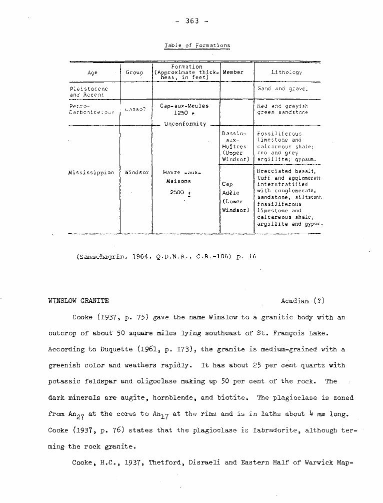
- 363 -
Table of Formations
Age Group Formation
(Approximate thick- ness, in feet)
Member Lithology
Pleistocene and Recent
Sand and grave?
Pe::•.o- Carboniteoas
"n5°?Cap-aux-Meules 1250 +
Unconformity
Red and greyish green sandstone
Mississippian Windsor
Bassin- aux-
Huîtres (Upper Windsor)
Fossiliferous limestone and calcareous shale; red and grey argillite; gypsum.
Havre -aux-
Maisons
2500 + -
Cap
Adèle
(Lower
Windsor)
Brecciated basalt, tuff and agglomerate interstratified with conglomerate, sandstone, siltstone
fossiliferous limestone and calcareous shale, argillite and gypsur..
(Sanschagrin, 1964, Q.D.N.R., G.R.-106) p. 16
WINSLOW GRANITE
Acadian (?)
Cooke (1937, p. 75) gave the name Winslow to a granitic body with an
outcrop of about 50 square miles lying southeast of St. François Lake.
According to Duquette (1961, p. 173), the granite is medium-grained with a
greenish color and weathers rapidly. It has about 25 per cent quartz with
potassic feldspar and oligoclase making up 50 per cent of the rock. The
dark minerals are augite, hornblende, and biotite. The plagioclase is zoned
from An~7 at the cores to An17 at the rims and is in laths about 4 mm long.
Cooke (1937, p. 76) states that the plagioclase is labradorite, although ter-
ming the rock granite.
Cooke, H.C., 1937, Thetford, Disraeli and Eastern Half of Warwick Map-
- 364 -
Areas, Quebec: Canada Geol. Surv., Mem. 211, p. 75-76.
Duquette, Gilles, 1961, Geology of the Weedon Lake area and its vicinity,
Wolfe and Compton Counties, Quebec: Université Laval, Thése pour doctorat,
pp. 173-178.
LEE U
.â •~• 4 ~.; .: •! •1• •-.'' ••••,„*. • . ~ 0,,r,.,.•,. t
.~►•
41111 11,.'• ,+ •• ' ~,r. ,`~ • .1 ~• •+ • s- y __ •
I • • . • . : ~ I, 4: •
.. .̀~,~; I .. . . • • •̀ ~
f' a
. . . , . .
•
+ t 4, .
.
•
4 •
•
..
• t,
~ l , t •


