Embed Size (px)
Citation preview
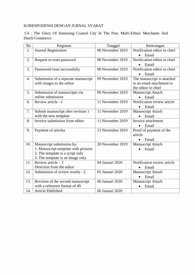
KORESPODENSI DENGAN JURNAL SYARAT
No Kegiatan Tanggal Keterangan
1. Journal Registration 08 November 2019 Notification editor in chief
2. Request to reset password 08 November 2019 Notification editor in chief
3. Passsword reset successfully 08 November 2019 Notification editor in chief
4. Submission of a separate manuscript
with images to the editor
09 November 2019 The manuscript is attached
to an email attachment to
the editor in chief
5. Submission of manuscripts via
online submission
09 November 2019 Manuscript Attach
6. Review article - 1 11 November 2019 Notification review article
7. Submit manuscript after revision 1
with the new template
11 November 2019 Manuscript Attach
8. Invoice submission from editor 11 November 2019 Invoice attachment
9. Payment of articles 13 November 2019 Proof of payment of the
article
10. Manuscript submission by:
1. Manuscript template with pictures
2. The template is a script only
3. The template is an image only
28 November 2019 Manuscript Attach
11. Review article – 2
Direction from the editor
04 Januari 2020 Notification review article
12. Submission of review results - 2 05 Januari 2020 Manuscript Attach
13. Revision of the second manuscript
with a reference format of 49
06 Januari 2020 Manuscript Attach
14. Article Published 06 Januari 2020
C4 : The Glory Of Semarang Coastal City In The Past, Multi-Ethnic Merchants And
Dutch Commerce

1. Journal Registration
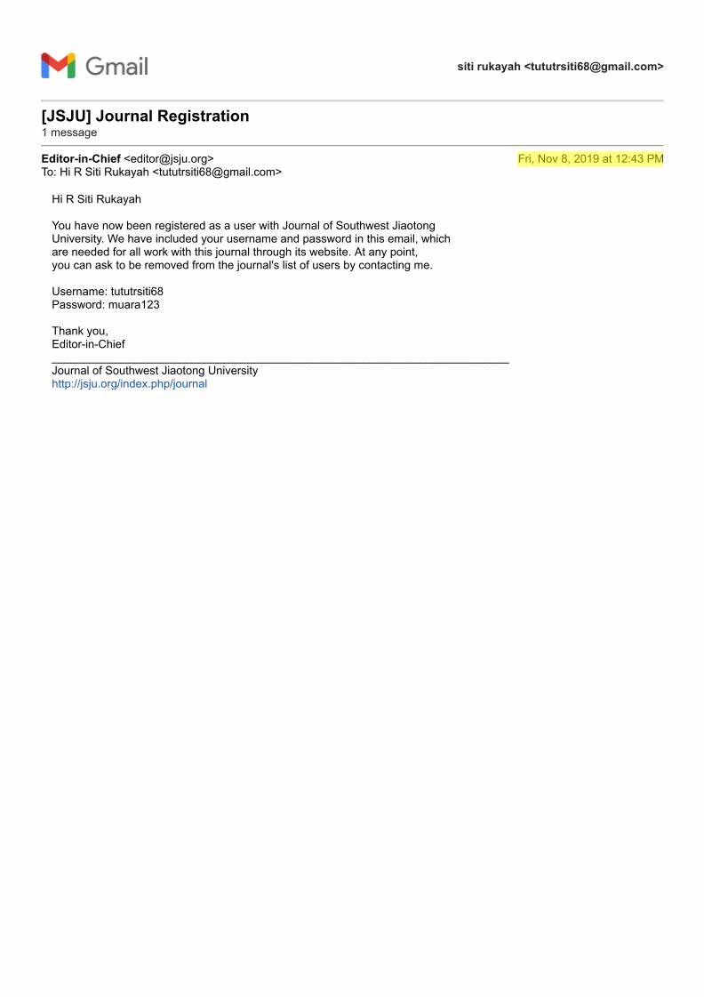
siti rukayah <[email protected]>
[JSJU] Journal Registration 1 message
Editor-in-Chief <[email protected]> Fri, Nov 8, 2019 at 12:43 PMTo: Hi R Siti Rukayah <[email protected]>
Hi R Siti Rukayah
You have now been registered as a user with Journal of Southwest Jiaotong University. We have included your username and password in this email, whichare needed for all work with this journal through its website. At any point, you can ask to be removed from the journal's list of users by contacting me.
Username: tututrsiti68 Password: muara123
Thank you, Editor-in-Chief ________________________________________________________________________ Journal of Southwest Jiaotong University http://jsju.org/index.php/journal

2. Request to reset password
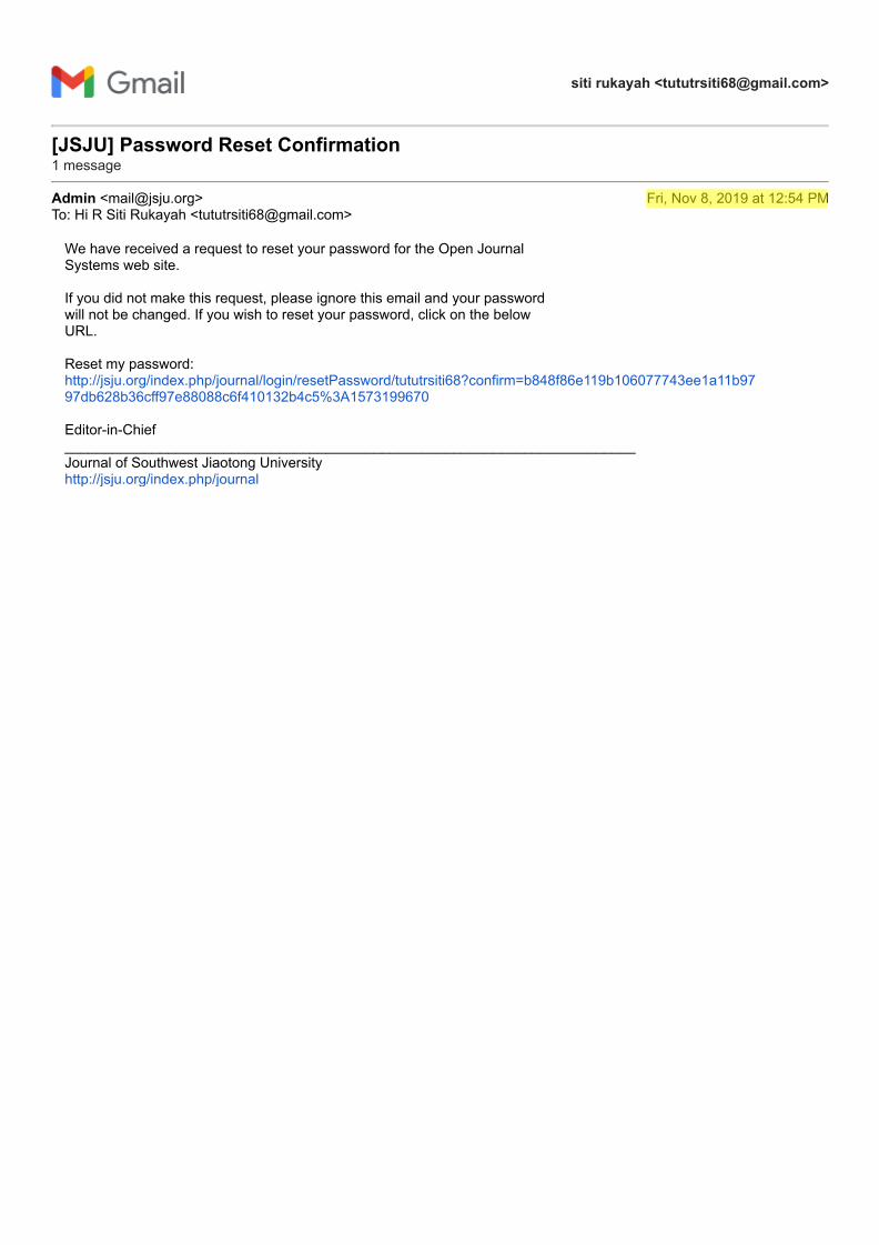
siti rukayah <[email protected]>
[JSJU] Password Reset Confirmation 1 message
Admin <[email protected]> Fri, Nov 8, 2019 at 12:54 PMTo: Hi R Siti Rukayah <[email protected]>
We have received a request to reset your password for the Open Journal Systems web site.
If you did not make this request, please ignore this email and your password will not be changed. If you wish to reset your password, click on the below URL.
Reset my password: http://jsju.org/index.php/journal/login/resetPassword/tututrsiti68?confirm=b848f86e119b106077743ee1a11b9797db628b36cff97e88088c6f410132b4c5%3A1573199670
Editor-in-Chief ________________________________________________________________________ Journal of Southwest Jiaotong University http://jsju.org/index.php/journal

3. Passsword reset successfully
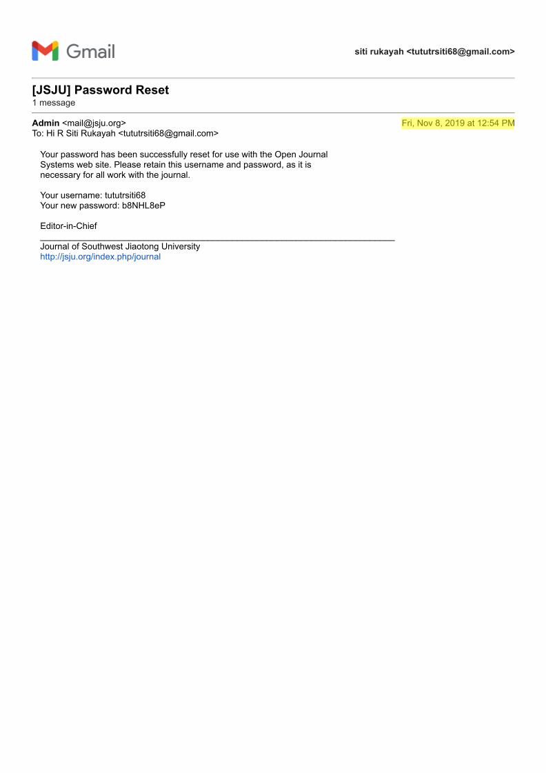
siti rukayah <[email protected]>
[JSJU] Password Reset 1 message
Admin <[email protected]> Fri, Nov 8, 2019 at 12:54 PMTo: Hi R Siti Rukayah <[email protected]>
Your password has been successfully reset for use with the Open Journal Systems web site. Please retain this username and password, as it is necessary for all work with the journal.
Your username: tututrsiti68 Your new password: b8NHL8eP
Editor-in-Chief ________________________________________________________________________ Journal of Southwest Jiaotong University http://jsju.org/index.php/journal

4. Submission of a separate manuscript with
images to the editor
siti rukayah <[email protected]>
manuscript and picture
siti rukayah <[email protected]> Sat, Nov 9, 2019 at 9:52 PMTo: [email protected]: [email protected]
Dear Editor in ChiefAttached the manuscript: paper separately with picture( I change my email from [email protected] to [email protected])
Many thanks for your kindness
Best Regards,Dr.R.Siti Rukayah
-- Vice Head of Ph.D. ProgramArchitecture and Urban Design Department ArchitectureUniversitas DiponegoroSemarang- Indonesia
2 attachments
paper only 8 nov 2019.docx 189K
picture only 8 nov 2019.docx 4557K

5. Submission of manuscripts via online
submission
siti rukayah <[email protected]>
manuscript for Jiatong Journal siti rukayah <[email protected]> Sat, Nov 9, 2019 at 10:02 PMTo: [email protected]
Dear Editor in ChiefI really sorry, I sent my manuscript using online submission because I follow the instruction from the journal template.
Attached the manuscript: paper separately with picture( I change my email from [email protected] to [email protected])
Many thanks for your kindness
Best Regards,Dr.R.Siti Rukayah
-- Vice Head of PhD ProgramArchitecture and Urban Design Department ArchitectureUniversitas DiponegoroSemarang- Indonesia
2 attachments
paper only 8 nov 2019.docx 189K
picture only 8 nov 2019.docx 4557K
ISSN - 0258-2724 西南交通大学学报 第 _ 卷 第 _ 期
2018 年 4 月
DOI: 10. 3969/j.
issn. 0258-
2724.2018.___
JOURNAL OF SOUTHWEST
JIAOTONG UNIVERSITY Vol.__ No._
Apr. 2018
Category.
Please select from the approved list of the journal categories
THE GLORY OF SEMARANG COASTAL CITY IN THE PAST ,
MULTI ETNIC MERCHANTS AND DUTCH COMMERCE
R.Siti Rukayah1,*, Muhammad Abdullah2
aArchitecture Departement, Diponegoro University
Jl. Prof. Soedarto, Tembalang, Semarang, Indonesia, [email protected], [email protected] b Indonesian literature, Diponegoro University
Jl. Prof. Soedarto, Tembalang, Semarang, Indonesia, [email protected]
Abstract The Image of the City Lynch describes how individuals perceive and recall features in urban spaces.
Lynch's approach is categorized in paths, nodes, edges, districts, and landmarks - give shape to
individuals' mental representation of the city. Recently, to test that theory on a large-scale city requires
high accuracy to understand a city. So, it requires tools such as computational techniques using the GIS
system. The city of the 14-18 century was not as complicated as Lynch had done in the 1960s. How to
reveal the image of the city? The Image of the city in the past has not been explored yet. To explore the
glory of Semarang city, Central Java, Indonesia, as Venetia van Java, sugar industry in Asia, and has the
first railway track in Indonesia, can still using hand drawing sketch to reconstruct the image of an old
city. Old data such as map, photography, and video are integrated to reconstruct the Image of the City in
the past. Recently, the name of port of Semarang, Tanjung Emas -cape of gold- implies the glory of
Semarang. The Semarang seaport played an important role in the pre-colonial and colonial eras. The
architecture building heritage at the two-river estuary of the Semarang coast uncover the history of
naming the ‘cape of Gold". The river as transportation lines and trains as the path is important as a tool to
evaluate the city transportation facilities for urban planners, watershed services, and urban conservation.
Keywords: river transportation, rail train, Semarang, Colonial, multi-ethnic.
摘要
关键词:
I. INTRODUCTION In 1960, Kevin Lynch published The Image
of the City [1], one of the most influential
theories in the formation of city images. City
image research continues to grow, along with the
development of the city. At present, the city is
developing very rapidly into a metropolitan city
that has a big scale that requires presentation and
tools to test the image of the city using a
computational approach [2].
Meanwhile, the extent and complexity of
cities in the past are not yet complicated
compared to cities in the present. Therefore, the
use of city image theory to reveal the
representation of city image in the past is still a
research opportunity, especially in historic areas.
First author et al. / Journal of Southwest Jiaotong University/ Vol.__ No._Apr. 2018
2
Coastal city has become the focus of research
today since the issue of coastal disasters such as
rising seawater, land subsidence. [3]. The disaster
requires handling, especially in historic areas. [4].
Some historic coastal areas emerged due to the
development of trade since prehistoric times in
the Southeast Asian region. The Asian region has
attracted the presence of traders from Arab-Persia
to the archipelago in addition to traders from
India and China. [5]. The location of Indonesia
attracted for explorers of the world to trade or
transit even for stopover [6].
The trace of the settlement of the traders from
around the world is the multi-ethnic architectural
heritage that scattered along the coast in
Indonesia, especially in Java. In Semarang city,
Central Java, Indonesia, the multi-ethnic
settlement become an embryo for city
development. In the Dutch colonial period, they
created a city resemble the Netherland that using
canals for transportation. The Semarang city well
known as the venetie van Java.
They choosing Semarang because the position
precisely in the central of Java. So, the ports on
the north coast of Java played an essential role as
the political and economic power base of the
Dutch East Indies company. The heart and
politics of the Dutch in controlling crop yields.
To brought some crops from interior Java they
built the first railroad route in Indonesia. The
development of sugarcane and coffee gave rise
Asian conglomerate in its era
However, the remaining area of the past glory
is now partially lost due to geological disasters
on the North coast of Java that occurred since the
8th century. [7]. Sedimentation, rob, and land
subsidence caused heritage areas to be
submerged in water. Some big cities like Jakarta,
Surabaya, and Semarang are predicted to sink
[8][9]–[12]. This paper aims to uncover the glory
of the city of Semarang in the past and reveal that
cultural heritage at risk.
The city of Semarang based on maps in 1719
and 1800 consisting of three districts, namely the
Malay village area, the old downtown area in
Kanjengan, and the colonial fortress area.
Semarang Map Semarang in 1719 put as a
reference. The area of Semarang city was around
500 x 600 meters or about 30 hectares.
Historical record of the foreign sailor, Tome
Pires, when he arrived in Semarang a century
after the arrival of Cheng Ho, witnessed that
Semarang was already a city lead by Muslim
rulers who were the vassals of the Sultanate of
Demak. The population was around 3000 people.
That port has three junks and 4 or 5 boats. The
commercial commodities produced are mainly
rice and other food ingredients. [13] .
Semarang's history is inseparable from
geological problems. This can be seen from the
transfer of port location. In the 8th century AD,
Semarang was still a group of islands with a
coastline located in the Pragotat region (now
known as bergota hill). [14]. History records that
Admiral Cheng Ho's fleet leaned on the port of
Simongan in 1405. [15][16]. In the 14th century,
the coastline was in the Kampung Melayu region
now or precisely in the Sleko region. [17]. Port
traces as a landing places for foreign traders
recently disappear, but the name of the place still
refers the meaning of a landing place. [18]–[20]
The Dutch government moved the port from
Simongan to the Semarang river in the Boom
Lama area, which has been operating since 1743.
This port also experienced siltation so that in
1870, the government dig a channel to the east of
the river mouth, which was named new canal
/Moeara Baroe 'Havenkanaal [21]
The Semarang city position on the central
Java has become one of the mainstay cities in the
VOC's trading strategy. This region is located
right in the middle of the coast and connecting to
Kartasura, the capital of Sunan (Lombard, 2000:
59). The old port near Malay village di
Semarang river estuary experienced siltation.
However, to expedite trading activities, the Dutch
government built a new canal to the new port.
The siltation still process, so that port also
experienced silting until the Dutch government
made the modern port in Tanjung Emas port-
cape of gold.
The name of the Tanjung Emas are strategic
research materials to uncover the glory of
Semarang in the past along two river estuary.
Although the existence of the old building
experienced a geological disaster, nevertheless,
the colonial government archives about the area
are complete. Old data such as images, photos,
maps, and videos during the Dutch colonial era,
could be used to reconstruct the Semarang city
image. The study of transportation use and its
role in trade is one aspect of economic
archeology. [22].
Based on historical archives, architectural
heritage, and grounded research , the research
from an architectural and urban design
perspective will use an architectural and city
historic approach and analysis using hand
drawing sketches. This method have an
advantage comparing to using mockups to
reconstruct the city in the past that usually used
by archeologists [23].
3
The image of the city using mockups is less
able to be captured because of the city scale
factor and the materials of mockups. The image
of the city using the computational system has
weaknesses because all objects are equally
dominant. Displaying the image of the city by
using a hand-drawn sketch will be able to give
emphasis to the desired area and obscure the less
dominant picture. [24]. A picture is worth more
than a thousand words. Images are often the
language that often captures messages and
meanings compared to written and spoken
languages. [25]
II. METHODS The old data about architectural building
heritage along the Semarang river and new canal
area were detected from old map, drawings/
photographs [31] Maps and photos are obtained
from kitlv, tropen museum and atlas mutual
heritage. The old map are taken from 1695, 1719,
1875, 1880, 1888, 1892. Map of the first railroad
network in Indonesia in Semarang and the map
on 1907 became a tool for analyzing industrial
networks from the interior to the river estuary
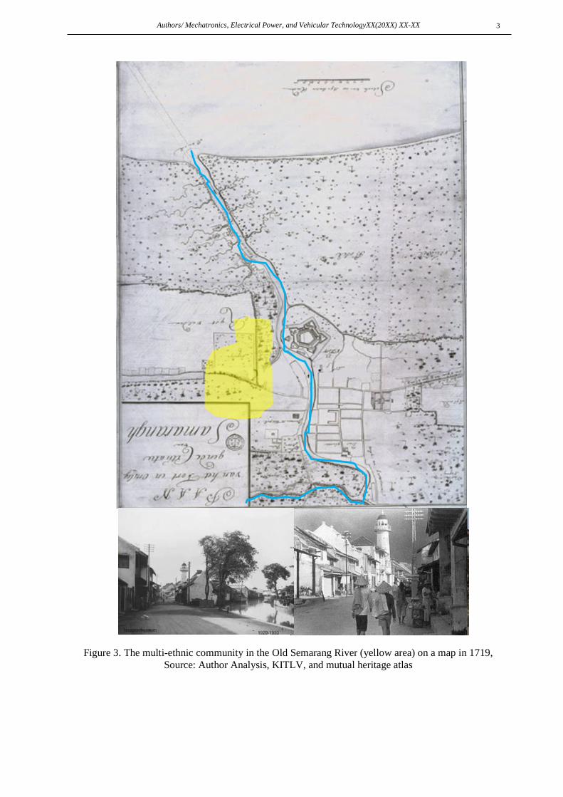
Along the Semarang River estuary, there are
the port as a transit point and residing traders
from various regions such as Handramut, Arabic,
Chinese, Malay, Banjar, Bugis, etc. [26] and they
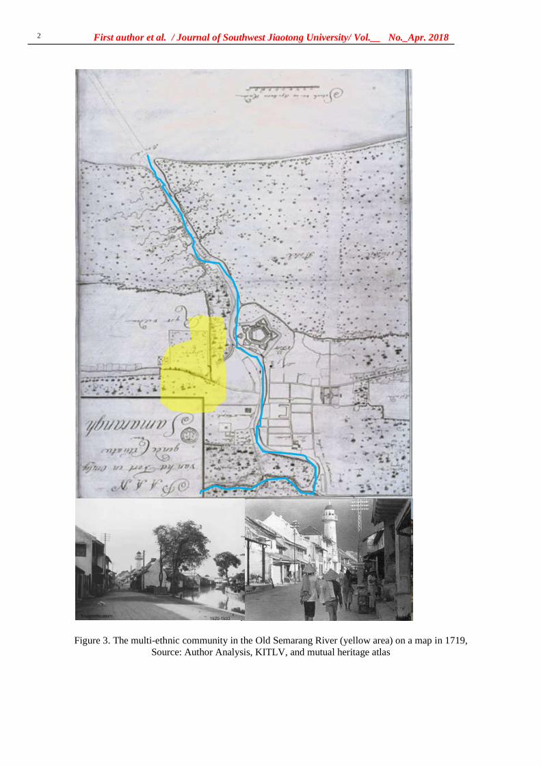
left a multi-ethnic village [27], [28] [29].
According to Rukayah [18] the area are
dominated by ethnic Arabs and Chinese traders.
Meanwhile, along the new canal estuary, they
are several buildings reveal the triumph of the
VOC (Vereeniging Ost-Indische Company) trade
in 1678 [30].
. The historical approach by reading maps
and images is essential in historical research
because pictures provide more stories than
narratives. [32]. Meanwhile, local data before the
arrival of Dutch colonialism was minimal.
Therefore it requires reading the toponym of the
place name to reveal the building and function of
the place at the time [33]
The analysis is using a hand drawing sketch
using ancient aerial photographs in the two river
estuary [34].
Reconstructing the city image of Semarang in
the past will be analyzed based on the path, edge ,
district, nodes, and landmarks [1].
III. RESULTS AND DISCUSSION The path element became the first
element to reconstruct the image of Semarang
city in the past because the river was the only
transportation route. Based on photos and maps
from 1917, the canal has length of 1180 meters
and a width of 23 meters. [35]. The file elements
that are very prominent formed the city image of
Semarang in the past are:
A. Paths
Paths is a channel that observers or visitors
usually pass through, the relationship between the
road and the environment that is regulated is
interrelated [1]
The nickname of the city of Semarang as a
venetie van Java indicated the role of the canals
as a transport route at that time. The traces of
transport in the pre-colonial were at river
Semarang. The old port lied in Darat village Old
Boom. Darat (Javanesse) and Boom (Dutch)
toponym refer that the place had a function as a
port. A Chinese traveler, Ong Tai Hae, who had
visited Semarang in 1783, said that the port of
Semarang was attended by many merchant
ships.The ship was small that sailed to
Pedamaran near the square Semarang The
location of the Old Boom is very strategically
located close to the Pedamaran market close to
the city center. [36]
The construction of a new port canal, named
Nieuwe Havenkanaal, in 1872. The port plays a
vital role as a gateway for the export-import of
products from the interior such as sugar, coffee,
indigo, and so on. The port increasingly
developed as the largest port and port city in
Central Java [37]. The Haven Kanaal port was
seen integrated with the railroad network of the
Kemidjen station in Tambaksari and the city
center (see Semarang Map 1875) to
Vorstenlanden -Surakarta, and Yogyakarta [21].
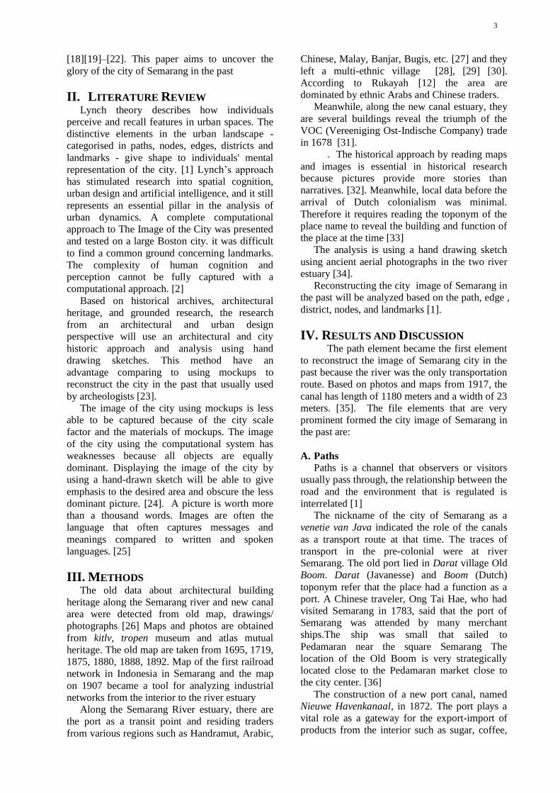
B. Landmarks
Landmarks are points that are considered
necessary to observers. they are easy to identify
because the shapes are clear and easy to
remember and have the advantage of spatial
location. People understand a city, from artifacts
[1]. According to Masitha & Heston, [38]
buildings as one of the elements that forming the
image of the city, especially in historic area.
Transforming the city's image without erasing the
potential image of the city itself [39]. Culture in
general can contribute significantly to designing
cities [40].
From several theories about the image of the
city above, people who live or settle in the area
usually describe the part or place that is most
easily recognized or has its characteristics. One
of them is a heritage building that illustrates the
features of the culture of the city itself.
First author et al. / Journal of Southwest Jiaotong University/ Vol.__ No._Apr. 2018
4
The results of the hand drawing sketch
capture the image of the city of captured that the
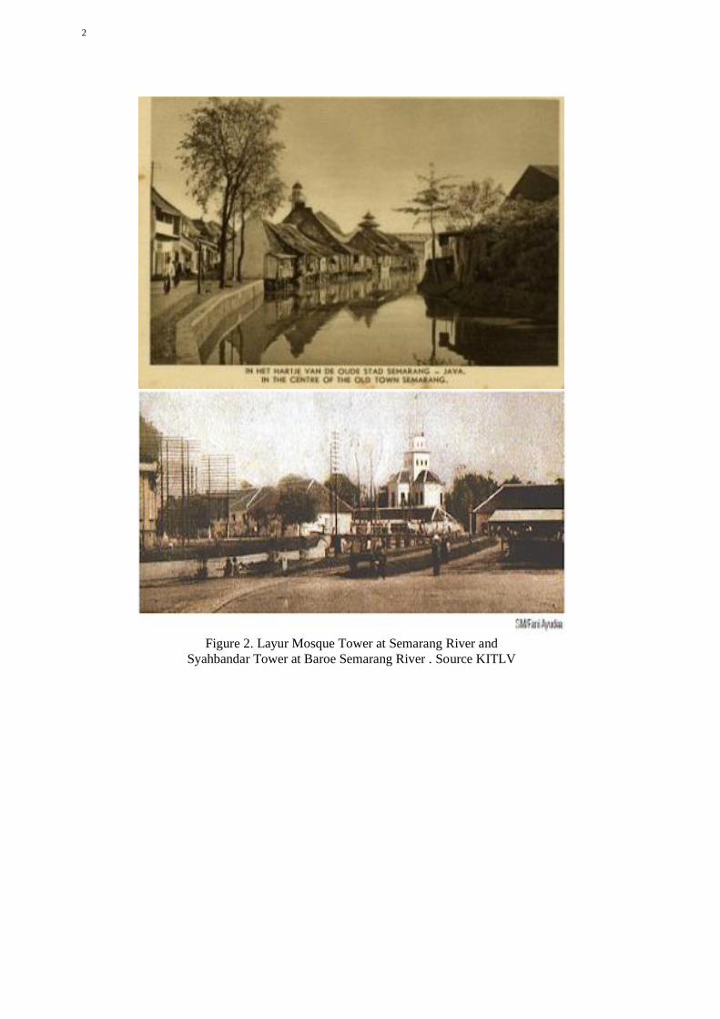
Layur Mosque (early 18th century) become the
landmark at Semarang river. Whereas, the
Menara Syahbandar / Menara Sleko (uitkijk).
1877 became the landmarks in new canal. The
meeting point area of the two rivers marked by
the presence of the Layur Tower Mosque and
Sleko Tower became the city gate to Semarang at
the time. The Layur Mosque has once functioned
as a lighthouse tower. Meanwhile, the Sleko
Tower functions as a small port that was
equipped as a viewing tower to regulate loading
and unloading of small traders and to oversee the
pier and be able to see around the city from the
top of the tower.
C. Edges
Edges are a barrier although sometimes there
is a place to enter. It is also the end of a better
district if continuity is clearly visible. Likewise
the boundary function must be clear; divide or
unite. [1]
At the Semarang river estuary, there could be
said to represent an example of multi-cultural
Trade City in Southeast Asia, which is formed
from power trading activities Javanese, Malay,
Chinese, and Arabic [42]. They were migrants
who traded (trading partners) before the arrival of
the Dutch in the early 17th century [43]. [29] [44].
By using the visual image in, the characteristics
of various architectural building heritage are
spread along the river, such as the Banjar
community, Javanese house, Arab house,
Chinese house, Indis house, and Melayu house.
Ethnic Arabs and Chinese dominate trade
activities. This can be seen from the architecture
of the building in the main corridor of the Melayu
village [27], [28]. It can be concluded that
Semarang river estuary has a Multi-Ethnic
Merchant character
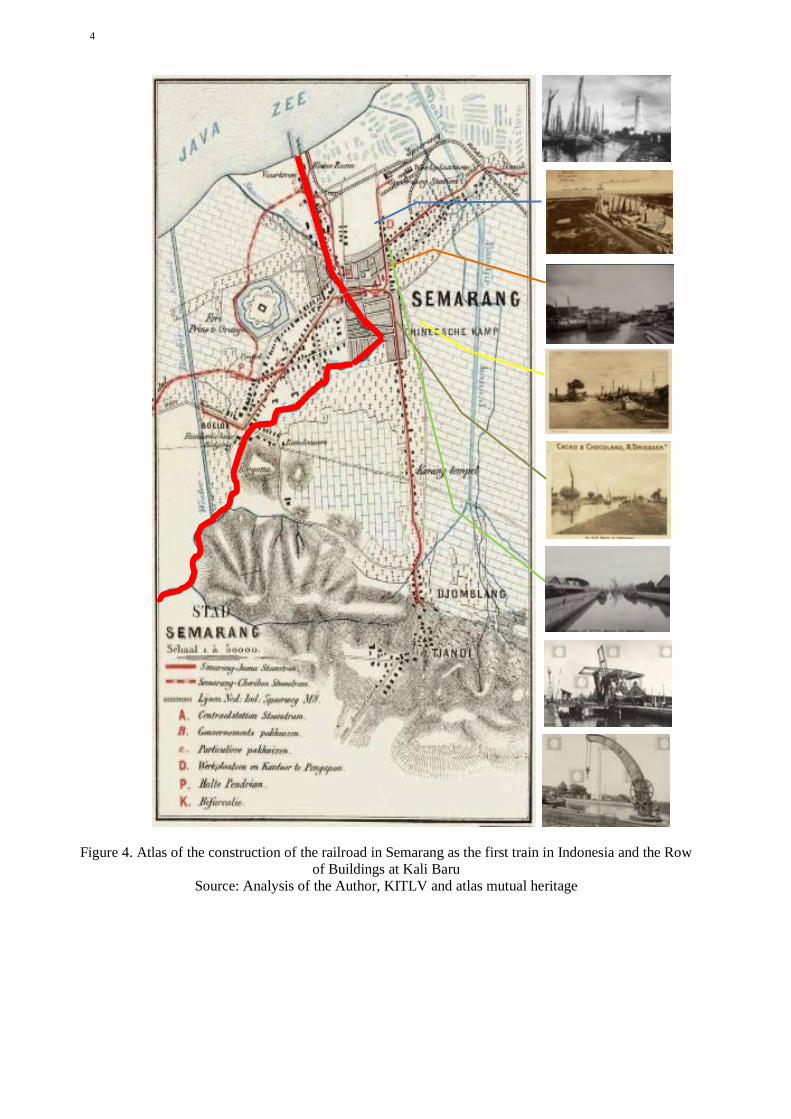
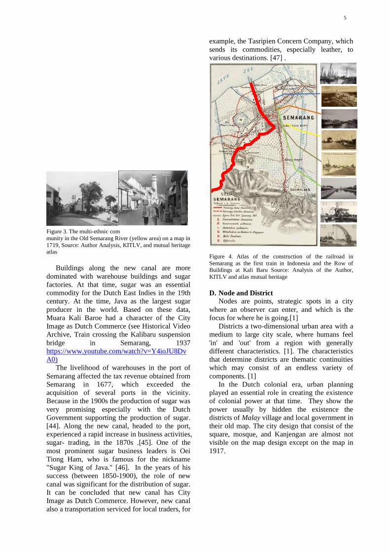
Buildings along the new canal are more
dominated with warehouse buildings and sugar
factories. At that time, sugar was an essential
commodity for the Dutch East Indies in the 19th
century. At the time, Java as the largest sugar
producer in the world. Based on these data,
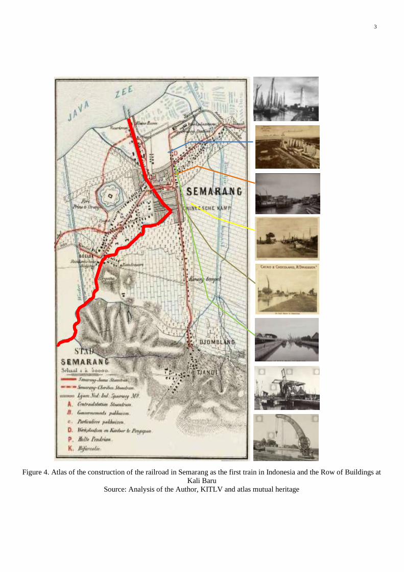
Muara Kali Baroe had a character of the City
Image as Dutch Commerce (see Historical Video
Archive, Train crossing the Kalibaru suspension
bridge in Semarang, 1937
https://www.youtube.com/watch?v=Y4ioJU8Dv
A0)
The livelihood of warehouses in the port of
Semarang affected the tax revenue obtained from
Semarang in 1677, which exceeded the
acquisition of several ports in the vicinity.
Because in the 1900s the production of sugar was
very promising especially with the Dutch
Government supporting the production of sugar.
[45]. Along the new canal, headed to the port,
experienced a rapid increase in business activities,
sugar- trading, in the 1870s .[46]. One of the
most prominent sugar business leaders is Oei
Tiong Ham, who is famous for the nickname
"Sugar King of Java." [47]. In the years of his
success (between 1850-1900), the role of new
canal was significant for the distribution of sugar.
It can be concluded that new canal has City
Image as Dutch Commerce. However, new canal
also a transportation serviced for local traders, for
example, the Tasripien Concern Company, which
sends its commodities, especially leather, to
various destinations. [48] .
D. Node and District
Nodes are points, strategic spots in a city
where an observer can enter, and which is the
focus for where he is going.[1]
Districts a two-dimensional urban area with a
medium to large city scale, where humans feel
'in' and 'out' from a region with generally
different characteristics. [1]. The characteristics
that determine districts are thematic continuities
which may consist of an endless variety of
components. [1]
In the Dutch colonial era, urban planning
played an essential role in creating the existence
of colonial power at that time. They show the
power usually by hidden the existence the
districts of Malay village and local government in
their old map. The city design that consist of the
square, mosque, and Kanjengan are almost not
visible on the map design except on the map in
1917.
The presence of Malay villages since the 14th
century, the local government in the 15th century,
and the colonial government in the old fortress
town of the 17th century formed a triangle
district connected to two Semarang river estuary.
The Dutch colonial government set the Dutch
fortress at the meeting point of the two estuaries
of the Semarang river and the new cana. The
fortress area becomes a node. The area of this
node becomes the gateway to the Dutch colonial
fortress to/from the harbor. The name of gateway
area is Sleko, means the city gate. The area
characterized by the presence of tower Sleko.
E. The Golden Cape
The symptom of coastal geological disaster
always occurred until today . The sedimentation
process, causes the siltation of the Semarang
5
river estuary. (Krisprantono, 2013; Supriyono,
2007 and still continuing until the Semarang city
government built and developed the Tanjung
Emas Port in Semarang in 1982.
Apparently, it was not wrong to give the
name of the golden cape because Semarang had a
glory from the port of Mataram era, Cheng Ho's
landing period, the pre-colonial period and the
colonial period.
.
IV. CONCLUSION Using the hand drawing sketch can be
concluded that:
1.the driving force of economic activity in the
port in old river estuary is the local economy and
ethnic muti traders. This can be seen from the
presence of the architectural building heritages
that indicate multi -ethnic[1].
2. the architectural building heritage in the
new canal estuary indicates the commercial
offices, warehouses, and train stations that
connect the port with the interior area in Java,
making the image of the estuary area as the
center of Dutch commerce.
The hand drawing sketch of the glory of the
city in the past displaying the image by give
emphasis to the desired area and obscure the less
dominant picture. [24]. A hand drawing sketch
of the city is worth more than a thousand words.
The city images are often the language that often
captures messages and meanings compared to
written and spoken languages. [25]
Using the image of the city theory, the Layur
Mosque Tower was found as the landmark of the
old river estuary. The Syahbandar (the head of
port) Tower at the new canal estuary (Kali Baroe)
and the sugar warehouses owned by Oei Tiong
Ham (one of the Asian conglomerates of his era)
as the shaper of the image of the new canal. The
meeting point of two estuaries becomes a node
with the nickname Sleko (Dutch), which means
the city gate.The image of the glory of Semarang
lost due to the problem of land subsidence. Urban
planning in the past, based on the river as
transportation, resulted in the architecture and
spatial structure of Semarang city had an identity
as a multi-ethnic port city (14th century) and
17th-century industrial port cities. Understanding
the problems, opportunities and use city planing
in the past [41] for reference for urban planning
in the future.
V. RECOMMENDATION The problem of land subsidence and rob has
eliminated the image of the river estuary of
Semarang as a multi-ethnic nature port with the
dominance multi etnic merchants (14th century)
and modern port in the Dutch Colonial era with
the character of an industrial city (17th century).
However, the history of the naming “cape of gold”
uncover the image of Semarang city with the
river and railway transportation in that port. The
malfunction of that transportation lines due to
geological disasters such as rob and land
subsidence, as well as the constructions of the
post roads at 18th-century need to revitalization
by government.
ACKNOWLEDGMENT Researchers would like to thank the research and
community service institutions of Universitas
Diponegoro, and the Ministry of Research and
Technology for providing grants for Higher
Education Applied Research in 2019 No. 101-
138 / UN7.P4.3 / PP 2019. Researchers would
like to thank the Semarang City Spatial Planning
Office and the Central Java Marine Service for
providing data assistance on Semarang river
activities
REFERENCES
[1] K. Lynch, The image of the city, vol.
11. MIT press, 1960.
[2] G. Filomena, J. A. Verstegen, E.
Manley, and K. Lynch, “A
computational approach to ‘ The
Image of the City ,’” Cities, vol. 89,
no. December 2018, pp. 14–25, 2019.
[3] D. Sarah and E. Soebowo, “Land
subsidence threats and its management
in the North Coast of Java Land
subsidence threats and its management
in the North Coast of Java,” in Global
Colloquium on GeoSciences and
Engineering 2017, 2018.
[4] L. A. Reeder-myers, “Cultural
Heritage at Risk in the Twenty- First
Century : A Vulnerability Assessment
of Coastal Archaeological Sites in the
United States,” J. Ofisl. Coast.
Archaeol., no. June 2015, pp. 1–10,
2015.
[5] Z. Ramli and N. H. S. N. A. Rahman,
“Aktiviti Perdagangan Pedagang
Arab-Parsi di Semenanjung Tanah
Melayu Berdasarkan Sumber Asing
dan Data Arkeologi,” vol. 2, pp. 147–
175, 2009.
[6] A. E. I. Wahby, “The Architecture of
the Early Mosques and Shrines of
Java : Influences of the Arab
First author et al. / Journal of Southwest Jiaotong University/ Vol.__ No._Apr. 2018
6
Merchants in the 15th and 16th
Centuries ?,” vol. 1, pp. 1–205, 2007.
[7] R. Van Bemmelen, “Geology of
Indonesia Vol-IA General.”
Government Printing Office, 1948.
[8] N. Colbran, “Will jakarta be the next
atlantis? Excessive groundwater use
resulting from a failing piped water
network,” 5/1 Law, Environmental
Development Journal, vol. 5. pp. 20–
37, 2009.
[9] S. P.Hadi, “In Search for Sustainable
Coastal Management : A Case Study
of Semarang , Indonesia,” in IOP Conf.
Series: Earth and Environmental
Science 55 (2017) 012054, 2017.
[10] M. Gumilar, I. Abidin, H. Z. Sidiq, T.
P. Andreas, H. Maiyudi, R. Gamal,
“Mapping And Evaluating The Impact
Of Land Subsidence In Semarang
( Indonesia ),” Indones. J. Geospatial,
vol. 2, no. 2, pp. 26–41, 2013.
[11] F. Kuehn, Æ. D. Albiol, Æ. G.
Cooksley, and A. H. Æ. D.
Murdohardono, “Detection of land
subsidence in Semarang , Indonesia ,
using stable points network ( SPN )
technique,” pp. 909–921, 2010.
[12] E. Chaussard, F. Amelung, and H. Z.
Abidin, “Sinking Cities In Indonesia :
Space-Geodetic Evidence Of The
Rates And Spatial Distribution Of
Land Subsidence,” vol. 2011, no.
September 2011, pp. 19–23, 2012.
[13] A. Cortesao, The Suma Oriental of
Tome Pires: An Account of the East,
from the Red Sea to Japan, Written in
Malacca and India in 1512-1515.
London: Hakluyt Society Series, 1944.
[14] S. Maziyah, “Kondisi Jawa Tengah
pada Abad VIII sampai Abad XV M,”
Humanika, vol. 15, 2012.
[15] L. T. Joe, Riwayat Semarang:Dari
Djamannya Sam Po Sampe
Terhapoesnya Konkoan. Semarang:
Boekhandel Ho Kim Yoe, 1933.
[16] K. Yuanzhi, Cheng Ho Muslim
Tionghoa. Misteri Perjalanan
Muhibah di Nusantara. Yayasan
Pustaka Obor Indonesia., 2000.
[17] J. Tio, Kota Semarang dalam
Kenangan. Semarang., 2004.
[18] R. Rukayah, D. R. Puguh, E. S. Susilo,
and M. S. Indraswara, “Local Wisdom
of the Native Settlement as A Main
Gate in the Northern Axis of Javanese
City Center in Semarang,” IOP Conf.
Ser. Earth Environ. Sci., vol. 152, no.
1, 2018.
[19] R. S. Rukayah, E. S. Susilo, and M.
Abdullah, “Exploring The Position of
Old Semarang Sea Prt : Based on
Javanese City Pattern,” in 3rd
International Conference on Tropical
and Coastal Region Eco Development
2017, 2018, pp. 0–8.
[20] R. S. Rukayah, E. S. Susilo, and M.
Abdullah, Semarang Kota Pesisir
Lama. Yogyakarta: Tekno Sain, 2018.
[21] “De locomotief: Samarangsch
Handels- en advertentie-blad,” 17-
Feb-1869.
[22] H. Prihatmoko, “Transportasi Air
Dalam Perdagangan Pada Masa Jawa
Kuno Di Jawa Timur,” Forum Arkeol.,
vol. 27, no. 3, pp. 155–174, 2014.
[23] I. Andrisijanti, “Pengembangan Maket
Pusat-Pusat Pemerintahan,” vol. 1, no.
1, pp. 1–29, 2015.
[24] S. Devanny, “Peran Sketsa Tangan
Dalam Profesi Arsitek Studi Banding
antara Sketsa Leonardo da Vinci dan
Frank Gehry,” Universitas Indonesia,
2010.
[25] C. J. Pole, Seeing Is Believing ?
Approaches To Edited By, vol. 7. 2004.
[26] D. Susanto, “Tradisi Seni Lisan
Sebagai Strategi Dakwah di Kalangan
Kaum Habib (Studi Kasus di
Kampung Melayu Kota Semarang).”
Fakultas Dakwah dan Komunikasi
IAIN Walisongo Semarang, 2014.
[27] R. S. Rukayah, D. R. Puguh, and
Endang Sri Susilo, “Local Wisdom of
The Native Settlement as A Main Gate
in The Northern Axis of Javanese City
Center In Semarang Local Wisdom of
The Native Settlement as A Main Gate
in The Northern Axis of Javanese City
Center In Semarang,” 2018.
[28] R. S. Rukayah, E. S. Susilo, M.
Abdullah, and S. Saputro, “Exploring
The Position Of Old Semarang Sea
Port: Based on Javanese City Pattern,”
7
IOP Conf. Ser. Earth Environ. Sci.,
vol. 116, no. 1, pp. 0–8, 2018.
[29] T. Madiasworo, “Revitalisasi Nilai-
Nilai Kearifan Lokal Kampung
Melayu Semarang,” Local Wisdom,
vol. 1, pp. 10–18, 2009.
[30] S. Wibowo, “Sejarah Perkembangan
Kota Semarang ( Jawa Tengah ) di
Masa Lalu dan Dampak Kehadiran
Polutan Nitrat Pada Airtanah di Masa
Kini History of the past development
of the Semarang city ( Central Java )
and its impact on nitrat pollutants
presence in the ground,” Ris. Geol.
dan Pertamb., vol. 23, no. 1, pp. 25–
36, 2013.
[31] Kuntowijoyo, Metodologi Sejarah.
Tiara Wacana Yogya, 1994.
[32] C. J. Pole, Seeing is believing?:
Approaches to visual research.
Citeseer, 2004.
[33] I. Adrisijanti, “Arkeologi Perkotaan
Mataram Islam,” Penerbit Jendela
Yogyakarta, 2000.
[34] B. Brommer, E. Budihardjo, A. B.
Montens, S. Setiadi, A. Sidharta, and
A. Siswanto, Semarang. Nederland:
Asia Maior, 1995.
[35] L. T. Joe, Riwajat Semarang:(dari
djamannja sam poo sampre
terhapoesnja kongkoan). Ho Kim Yoe,
1933.
[36] A. Budiman, Semarang Riwajatmoe
Doeloe. Semarang: Tanjung Sari, 1978.
[37] I. Dewi and R. Sari, “Kota Lama
Semarang ” Situs Sejarah Yang
Terpinggirkan ‘ Old City Of
Semarang ’ The Abandoned Historical
Site,” Berk. Arkeol., vol. 32, no. 2, pp.
195–208, 2012.
[38] A. I. Masitha and Y. P. Heston,
“Rekognisi Bangunan dan Citra Kota,”
Semin. Nas. SCAN #6 "Finding Fifth
Elem. After Water, Earth, Wind. Fire”
Local Wisdom Cult. Sustain., no. 21
Mei 2015, pp. 259–270, 2015.
[39] H. Zhu, J. Qian, and Y. Gao,
“Globalization and the production of
city image in Guangzhou’s metro
station advertisements,” Cities, vol. 28,
no. 3, pp. 221–229, 2011.
[40] A. L. Müller, “Voices in the city. On
the role of arts, artists and urban space
for a just city,” Cities, vol. 91, no.
September 2017, pp. 49–57, 2019.
[41] E. H. Chapman and K. Lynch, “The
Image of the City,” J. Aesthet. Art
Crit., vol. 21, no. 1, p. 91, 1962.
[42] B. N. Prabowo and B. I. Harsritanto,
“Kota Lama Semarang Menuju Status
Pusaka Dunia Unesco: Apa Itu Status
World Heritage?,” Modul, vol. 18, no.
1, p. 51, 2018.
[43] A. Febbiyana and D. Suwandono,
“Penurunan Kampung Melayu Sebagai
Kawasan Cagar Budaya Kota
Semarang The Declining Vitality of
Kampung Melayu as the Heritage
Area in The City of Semarang,” vol. 2,
no. 4, 2016.
[44] D. Susanto, “Pola strategi dakwah
komunitas habaib di kampung melayu
semarang,” vol. 14, no. 1, pp. 159–185,
2014.
[45] L. T. Ling, “Raja Gula Oei Tiong
Ham,” vol. 11, no. 3, p. 312, 1979.
[46] Y. Kunio, “Oei Tiong Ham Concern :
The First Business Empire of
Southeast Asia Introduction,” vol. 27,
no. 2, pp. 137–155, 1989.
[47] S. Claudine, “Oei Tiong Ham
Concern : The First Business Empire
of Southeast Asia,” Archipel, vol. 41,
no. 1, pp. 201–203, 1991.
[48] R. Tarigan, “Kajian Historis dan
Morfologi Kampung – Kampung di
Sekitar Jalan Jagalan dan Jalan
Petudungan Semarang,” 2015.
参考文:

First author et al. / Journal of Southwest Jiaotong University/ Vol.__ No._Apr. 2018
2
I hereby confirm that the manuscript was prepared in accordance with the instructions
for authors of scientific publications, and that the content of this manuscript, or most of
it, was not published in the journal indicated, and the manuscript was not submitted for
publication elsewhere.
11 / 7 / 2019
Signature of the Corresponding author Date
√
ISSN - 0258-2724 西南交通大学学报 第 _ 卷 第 _ 期
2018 年 4 月
DOI: 10. 3969/j.
issn. 0258-
2724.2018.___
JOURNAL OF SOUTHWEST
JIAOTONG UNIVERSITY Vol.__ No._
Apr. 2018
Copyright Agreement
Manuscript title: THE GLORY OF SEMARANG COASTAL CITY IN THE PAST MULTI ETNIC
MERCHANTS AND DUTCH COMMERCE
Full names of all authors: R.Siti Rukayah, Muhammad Abdullah
Full name and address of the corresponding author:
R.Siti Rukayah
Telephone: 08122812825 Fax: _________________ Email: [email protected]
License Agreement
(1) Authors own all the copyright rights for the paper.
(2) Submitted manuscript is an original paper.
(3) Authors hereby grant the Issues of Journal of SWJTU with an exclusive, royalty-free, worldwide license to email the paper to all who will ask for it.
(4) All authors have made a significant contribution to the research and are ready to assume joint responsibility for the paper.
(5) All authors have seen and approved the manuscript in the final form as it is submitted for publication.
(6) This manuscript has not been published and also has neither been submitted nor considered for publication elsewhere
(7) The text, illustrations and any other materials, included into the manuscript, do not infringe any existing intellectual property rights or other rights of any person or entity.
(8) The editors of the Issues of Journal of SWJTU, its personnel or the Editorial Board members accept no responsibility for the quality of the idea expressed in this publication.
I am the Corresponding author and have full authority to enter into this agreement.
Full name, affiliation and position: R. Siti Rukayah, Architecture Departement, Diponegoro University, Vice Head of PhD Program Architecture and Urban Design Departement of
Architecture
Signature: Date: 7 November 2019

ISSN - 0258-2724 西南交通大学学报 第 _ 卷 第 _ 期
2018 年 4 月
DOI: 10. 3969/j.
issn. 0258-
2724.2018.___
JOURNAL OF SOUTHWEST
JIAOTONG UNIVERSITY Vol.__ No._
Apr. 2018
Category. Please select from the approved list of the journal categories
THE GLORY OF SEMARANG COASTAL CITY IN THE PAST,
MULTI ETNIC MERCHANTS AND DUTCH COMMERCE
R.Siti Rukayah1,*, Muhammad Abdullah2
aArchitecture Departement, Diponegoro University
Jl. Prof. Soedarto, Tembalang, Semarang, Indonesia, [email protected] b Indonesian literature, Diponegoro University
Jl. Prof. Soedarto, Tembalang, Semarang, Indonesia, [email protected]
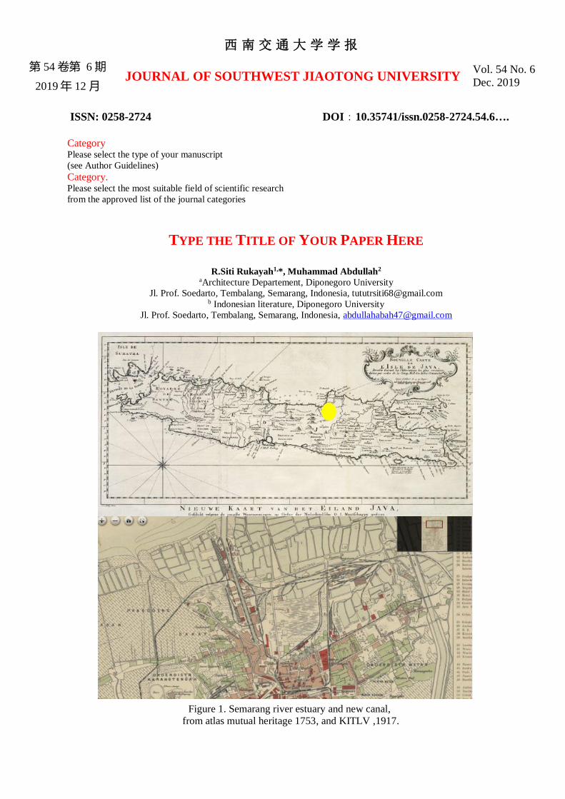
Figure 1. Semarang river estuary and new canal,
from atlas mutual heritage 1753, and KITLV ,1917.

1
Figure 2. Layur Mosque Tower at Semarang River and
Syahbandar Tower at New Canal . Source :KITLV
First author et al. / Journal of Southwest Jiaotong University/ Vol.__ No._Apr. 2018
2
Figure 3. The multi-ethnic community in the Old Semarang River (yellow area) on a map in 1719,
Source: Author Analysis, KITLV, and mutual heritage atlas
3
Figure 4. Atlas of the construction of the railroad in Semarang as the first train in Indonesia and the Row of Buildings at
Kali Baru
Source: Analysis of the Author, KITLV and atlas mutual heritage

First author et al. / Journal of Southwest Jiaotong University/ Vol.__ No._Apr. 2018
4
Figure 5. The city of Semarang at that time was based on overlapping sketch maps of 1695 on maps of 1719 and 1800.
the town consists of three districts namely the Malay kampong area, the old downtown area in Kanjengan and the
colonial fortress area.
Source : KITLV
5
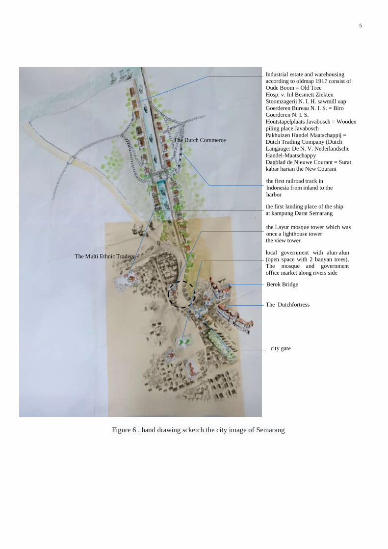
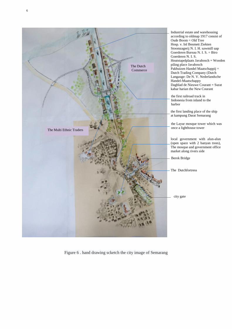
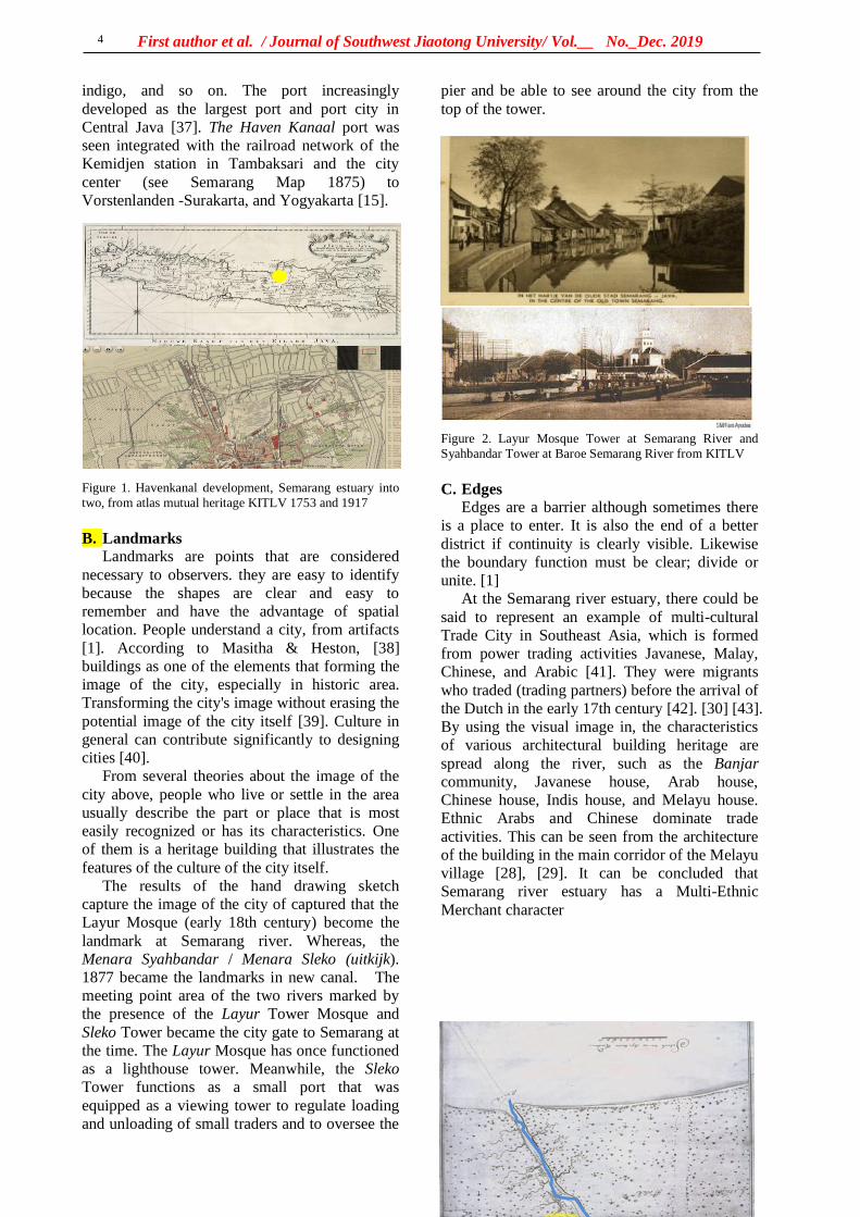
Figure 6 . hand drawing scketch the city image of Semarang
the view tower
the first landing place of the ship
at kampung Darat Semarang
local government with alun-alun
(open space with 2 banyan trees), The mosque and government
office market along rivers side
Industrial estate and warehousing
according to oldmap 1917 consist of Oude Boom = Old Tree
Hosp. v. Inl Besmett Ziekten
Stoomzagerij N. I. H. sawmill uap
Goerderen Bureau N. I. S. = Biro Goerderen N. I. S.
Houtstapelplaats Javabosch = Wooden
piling place Javabosch
Pakhuizen Handel Maatschappij = Dutch Trading Company (Dutch
Langauge: De N. V. Nederlandsche
Handel-Maatschappy
Dagblad de Nieuwe Courant = Surat kabar harian the New Courant
the first railroad track in
Indonesia from inland to the
harbor
the Layur mosque tower which was
once a lighthouse tower
Berok Bridge
The Dutchfortress
city gate
The Dutch Commerce
The Multi Ethnic Traders

6. Review article - 1

siti rukayah <[email protected]>
manuscript and picture
[email protected] <[email protected]> Mon, Nov 11, 2019 at 12:57 AMTo: siti rukayah <[email protected]>Cc: [email protected]
Dear Dr.R.Siti Rukayah
1. Our editorial team has slightly updated the article template. See http://jsju.org/JournalTemplate.docx. See http://jsju.org/index.php/journal/about/submissions#authorGuidelines Please revise the article on the new template. 2. The English language of the paper needs academic editing and proofreading. We recommend that the authors use the academic text editing service for the scientific articles, but not just proofreading. Please use the AmericanEnglish option. We recommend the use of large, trusted companies with editors having a Ph.D. degree. You should also attach an editing certificate or use our editorial office services (EUR 200). Articles, that are not edited by native English speakers, are not allowed for publication. The editorial team provides academic proofreading servicesfor the authors at additional cost -250 eur. There will be 500 euros in total (English academic editing and Article Publication Charges). 3. Acceptance Letter will be emailed to the author within 3-5 days after the payment has been credited to our bank account.
If you have any questions, please do not hesitate to contact us via [email protected].
Sincerely yours, Editorial Office of Journal of Southwest Jiaotong University[Quoted text hidden]
7. Submit manuscript after revision 1
with the new template
siti rukayah <[email protected]>
manuscript and picture
siti rukayah <[email protected]> Mon, Nov 11, 2019 at 2:54 PMTo: [email protected]
Dear editor in chief
1. herewith attached the editing manuscript using the new template2. I need assistance from the editorial team academic for proofreading services, English academic editing, and Article Publication Charges (according to your previous email 500 euros in total )3. Please send me the Bank account for the payment.
Journal_Template_2019_the picture only 11 nov 2...
Journal_Template_2019_the manuscrip + picture 1...
Journal_Template_2019_the manuscrip only 11 nov...hank you for your kindness[Quoted text hidden]-- Vice Head of PhD Program[Quoted text hidden]
西南交通大学学报
第 54 卷第 6 期
2019年 12 月 JOURNAL OF SOUTHWEST JIAOTONG UNIVERSITY
Vol. 54 No. 6
Dec. 2019
ISSN: 0258-2724 DOI:10.35741/issn.0258-2724.54.6….
Category Please select the type of your manuscript
(see Author Guidelines)
Category. Please select the most suitable field of scientific research
from the approved list of the journal categories
TYPE THE TITLE OF YOUR PAPER HERE
R.Siti Rukayah1,*, Muhammad Abdullah2
aArchitecture Departement, Diponegoro University
Jl. Prof. Soedarto, Tembalang, Semarang, Indonesia, [email protected] b Indonesian literature, Diponegoro University
Jl. Prof. Soedarto, Tembalang, Semarang, Indonesia, [email protected]
Figure 1. Semarang river estuary and new canal,
from atlas mutual heritage 1753, and KITLV ,1917.
2
Figure 2. Layur Mosque Tower at Semarang River and
Syahbandar Tower at Baroe Semarang River . Source KITLV
Authors/ Mechatronics, Electrical Power, and Vehicular TechnologyXX(20XX) XX-XX
3
Figure 3. The multi-ethnic community in the Old Semarang River (yellow area) on a map in 1719,
Source: Author Analysis, KITLV, and mutual heritage atlas
4
Figure 4. Atlas of the construction of the railroad in Semarang as the first train in Indonesia and the Row
of Buildings at Kali Baru
Source: Analysis of the Author, KITLV and atlas mutual heritage
Authors/ Mechatronics, Electrical Power, and Vehicular TechnologyXX(20XX) XX-XX
5
Figure 5. The city of Semarang at that time was based on overlapping sketch maps of 1695 on maps of
1719 and 1800. the town consists of three districts namely the Malay kampong area, the old downtown
area in Kanjengan and the colonial fort area.
Source : KITLV
6
Figure 6 . hand drawing scketch the city image of Semarang
the first landing place of the ship at kampung Darat Semarang
local government with alun-alun
(open space with 2 banyan trees),
The mosque and government office
market along rivers side
Industrial estate and warehousing
according to oldmap 1917 consist of
Oude Boom = Old Tree Hosp. v. Inl Besmett Ziekten
Stoomzagerij N. I. H. sawmill uap
Goerderen Bureau N. I. S. = Biro
Goerderen N. I. S. Houtstapelplaats Javabosch = Wooden
piling place Javabosch
Pakhuizen Handel Maatschappij =
Dutch Trading Company (Dutch Langauge: De N. V. Nederlandsche
Handel-Maatschappy
Dagblad de Nieuwe Courant = Surat
kabar harian the New Courant the first railroad track in Indonesia from inland to the
harbor
the Layur mosque tower which was
once a lighthouse tower
Berok Bridge
The Dutchfortress
city gate
The Multi Ethnic Traders
The Dutch Commerce
Authors/ Mechatronics, Electrical Power, and Vehicular TechnologyXX(20XX) XX-XX
7
running text. This makes it easier to edit your
text and format your equations before publication.
Remember to save your math equations as
editable text and not as images in case changes
need to be made before publication.
A. Terminology
Stay consistent with the terms you use.
Generally, short forms can be used once the full
term has been introduced:
• full terms versus acronyms (e.g.,
deoxyribonucleic acid versus DNA);
• English names versus Greek letters (e.g.,
alpha versus α); and
• species names versus short forms (e.g.,
Staphylococcus aureus versus S. aureus).
One way to ensure consistency is to use standard
scientific terminology. You can refer to the
following resources, but if you are not sure which
guidelines are preferred, check with your target
journal.
• For gene classification, use GeneCards, The
Mouse Genome Informatics Database, and/or
genenames.org.
• For chemical nomenclature, refer to the
International Union of Pure and Applied
Chemistry (IUPAC) Compendium of Chemical
Terminology (the Gold Book) and the IUPAC–
IUB Combined Commission on Biochemical
Nomenclature.
• For marine species names, use the World
Register of Marine Species (WoRMS) or the
European Register of Marine Species (ERMS).
Italics must be used correctly for scientific
terminology.
• Species names, which are usually in Greek
or Latin, are italicized (e.g., Staphylococcus
aureus).
• Genes are italicized, but proteins are not.
B. References
It is recommended to format Bibliographic
References using a reference manager, i.e.
Mendeley Endnotes or References in Harvard
style. The list of references should be arranged in
the order in which the sources are presented in
the paper (numbered citations). References
should be taken over the past five years. The
recommended minimum number of references is
20 entries. Before submitting the manuscript,
please check each citation in the text against the
References and vice-versa to ensure that they
match exactly. It is important to format the
references properly because all references will be
linked electronically as completely as possible to
the papers cited.
References should not include unpublished
source materials.
General guidelines should be observed for
formatting the text of the article. References to
Wikipedia, personal blogs or non-scientific
websites are not taken into account. Primary
References should make 80% of the cited sources,
at least 10 references. References should be taken
over the past five years. The recommended
minimum volume of references is 20 entries. At
least 70% of sources in References should
contain DOI indices. Be sure to verify the
correctness of the names of authors, pages and
titles of journals in the paper lists at
http://www.crossref.org/ (there is a search engine
box in the center on the page – copy the source
title into it and verify the correctness of the
References).
There are two types of references, i.e.
References to electronic resources and
First author et al. / Journal of Southwest Jiaotong University/ Vol.__ No._Dec. 2019
8
References to non-electronic resources. Examples
of specific referencing by two types are given
below:
• Book: AUTHOR, Title. No. of Edition,
Editor, City, State or Country: Publishing
house, year, Pages. [1]
• Part of a book: AUTHOR, “Title”, in Book,
edition, editor, City, State or Country:
Publishing house, year, Pages. [2]
• Periodicals: AUTHOR, “Title”, Journal,
volume (issue), pages, month, year. [3], [4],
[5]
• Proceedings of the Conferences: Author,
“Title”, in Conference, year, pages. [6]
• Unpublished papers: Author, “Title”,
presented at the Conference/ name of the
event, City, State or Country, year. [7]
• Patent/Standard: Author, “Title”, Patent
number, day of the month, year. [8]
• Technical report: Author, “Title”, Company,
City, State or Country, Tech. Rep. No.,
month, year. [9]
References to electronic resources must
necessarily be accompanied by three types of
information: 1) protocol or department; 2) the
place where you can find the given unit; and 3)
the link to the source. An example of the correct
referencing for electronic resources is given
below:
• Book: AUTHOR. (year, day of the month)
Title. (edition) [Type of information carrier].
volume (issue). Access: site/path/file. [10]
• Periodicals: AUTHOR. (year, month) Title.
Journal. [Type of information carrier].
volume (issue), pages. Access: site/path/file.
[11]
• Papers presented at the Conferences:
AUTHOR. (year) Title. Presented at the
Conference (title). [Type of information
carrier]. Access: site/path/file. [12]
• Reports and Guidelines: AUTHOR. (year)
Title. Company. City, State or Country.
[Type of information carrier]. Access:
site/path/file. [13]
• Patent/Standard: Author. (year) Title, Patent
number. [8]
• Technical report: Author. (year) Title.
Company, City, State or Country, Tech. Rep.
No. [9]
•
C. Title bar, Running title, and Hyperlink
It is not allowed to use the upper and lower
running title, including pagination. All hypertext
references and all bookmarks to sections will be
removed from paper. If you need to refer to an e-
mail address or URL in your paper, you should
type the address or URL in full in Regular font
II. CONCLUSION The Editors ask authors not to change the
formatting and style of the plan, which is
presented in this template. If you have any
questions regarding the submission of the articles,
please visit the main page of the journal or
contact the secretariat by e-mail.
ACKNOWLEDGMENT The guidelines for citing electronic
information as offered here are in modified
illustration of the adaptation by the International
Standards Organization (ISO) documentation
system and the American Psychological
Association style (APA), which is set out in the
section Information for IEEE Transactions,
Journals and Letters to Editor.
REFERENCES
[1] Zaharia, R. M. &Grundey, D. (2011).
Corporate Social Responsibility in the
Context of Financial Crisis: A Comparison
between Romania and Lithuania. Amfiteatru
Economic, 13(29), pp. 195-206.
[2] SEIDMAN, S. (2012) Contested
knowledge. 5th ed. Hoboken, New Jersey:
Wiley-Blackwell.
[3] LIGHT, G., COX, R. and CALKIN, S.
(2009) Learning and teaching in higher
education: the reflective professional. 2nd
ed. London: Sage.
[4] SHAW, R. et al. (2011) Management
essentials for doctors. Cambridge:
Cambridge University Press.
[5] SCHAEFFER, N.C, and PRESSER S.
(2003) The science of asking questions.
Annual Review of Sociology, 29 (1), pp. 65-
88.
[6] TUCKMAN, A. (2009) Labour, skills and
training. In: LEVITT, R. et al. (eds.) There
organised National Health Service. 7th ed.
Cheltenham: Stanley Thornes, pp. 135-155.
[7] MAIMON, D. and BROWNING, C.R.
(2012) Adolescents’ violent victimization in
the neighbourhood: situational and
contextual determinants. British journal of
criminology, 52 (4), pp. 808-833.
[8] STAMM, M.C. et al. (2013) Information
forensics: an overview of the first decade.
9
IEEE Access, 1. Available from
http://www.ieee.org/IEEEAccess. [9] CHAN, T.M. (2011) Three problems
about dynamic convex hulls. In: Proceedings
of the 27th Annual Symposium on
Computational Geometry, Paris, June 2011.
New York: ACM, pp. 27-37.
[10] Environment Act 2005 (c. 25). London:
The Stationery Office.
[11] BRITISH STANDARDS INSTITUTE
(2008) BS ISO 8178-2: Reciprocating
internal combustion engines – exhaust
emission measurement. London: British
Standards Institute.
[12] FENG, W. (2010) Remote service
provision for connected homes. Unpublished
thesis (PhD.), De Montfort University.
[13] NHS (2012) Mobile phone safety.
[Online] NHS. Available from:
http://www.nhs.co.uk/conditions/Mobile-
phone-safety/Pages/Introduction.aspx
[Accessed 08/08/12].
[14] KESNER, R.P. (2002) Memory
neurobiology. In: RAMACHANDRAN, V.S.
(ed.) Encyclopedia of the human brain, Vol.
2. San Diego: Academic Press, pp. 783-796.
参考文:
西南交通大学学报
第 54 卷第 6 期
2019年 12 月 JOURNAL OF SOUTHWEST JIAOTONG UNIVERSITY
Vol. 54 No. 6
Dec. 2019
ISSN: 0258-2724 DOI:10.35741/issn.0258-2724.54.6….
Category Please select the type of your manuscript
(see Author Guidelines)
Category. Please select the most suitable field of scientific research
from the approved list of the journal categories
THE GLORY OF SEMARANG COASTAL CITY IN THE PAST,
MULTI ETNIC MERCHANTS AND DUTCH COMMERCE
R.Siti Rukayah 1a,*, Muhammad Abdullah2
aArchitecture Departement, Diponegoro University
Jl. Prof. Soedarto, Tembalang, Semarang, Indonesia, [email protected] b Indonesian literature, Diponegoro University
Jl. Prof. Soedarto, Tembalang, Semarang, Indonesia, [email protected]
Abstract The Image of the City describes how individuals perceive and recall features in urban spaces.
Recently, computational techniques using to test that theory on a large-scale city. But, the old city in the
14-18 century was not as complicated as today. How to reveal the image of the old city? Based on hand
drawing sketch technique enabling to uncover the image city in the past. Old data such as map,
photography, and video are integrated to reconstruct the Image of the City. Semarang city, Central Java,
Indonesia, well known as Venetia van Java, as sugar industry in Asia, and as the city that has the first
railway track in Indonesia. We illustrate the old building in the port- along the two river estuaries and the
meeting point of the rivers. Our method allows to improve individual perceive in urban space that cannot
to use to uncover the condition in the past and to substitute computational technique that present only the
block mass building so cannot expose the detailed. The result reveal that the name of Semarang port in
river estuary, Tanjung Emas -cape of the gold- implies the glory of Semarang played important role in the
pre-colonial and colonial eras comparing to another city port in Java. New research results as a tool to
evaluate the city transportation facilities for urban planners, watershed services that no longer use in the
present day. Urban planning along the river in the past also can be revitalized for tourism purposes.
Keywords: river transportation, rail train, Semarang, Colonial, multi-ethnic.
摘要
关键词:
I. INTRODUCTION In 1960, Kevin Lynch published The Image of
the City [1], one of the most influential theories
in the formation of city images. City image
research continues to grow, along with the
development of the city. At present, the city is
developing very rapidly into a metropolitan city
that has a big scale that requires presentation and
tools to test the image of the city using a
computational approach [2].
First author et al. / Journal of Southwest Jiaotong University/ Vol.__ No._Dec. 2019
2
Meanwhile, the extent and complexity of
cities in the past are not yet complicated
compared to cities in the present. Therefore, the
use of city image theory to reveal the
representation of city image in the past is still a
research opportunity, especially in historic areas.
Coastal city has become the focus of research
today since the issue of coastal disasters such as
rising seawater, land subsidence. [3]. The disaster
requires handling, especially in historic areas. [4].
Some historic coastal areas emerged due to the
development of trade since prehistoric times in
the Southeast Asian region. The Asian region has
attracted the presence of traders from Arab-Persia
to the archipelago in addition to traders from
India and China. [5]. The location of Indonesia
attracted for explorers of the world to trade or
transit even for stopover [6].
The trace of the settlement of the traders from
around the world is the multi-ethnic architectural
heritage that scattered along the coast in
Indonesia, especially in Java. In Semarang city,
Central Java, Indonesia, the multi-ethnic
settlement become an embryo for city
development. In the Dutch colonial period, they
created a city resemble the Netherland that using
canals for transportation. The Semarang city well
known as the venetie van Java.
They choosing Semarang because the position
precisely in the central of Java. So, the ports on
the north coast of Java played an essential role as
the political and economic power base of the
Dutch East Indies Company. The heart and
politics of the Dutch in controlling crop yields.
To bring some crops from interior Java they built
the first railroad route in Indonesia. The
development of sugarcane and coffee gave rise
Asian conglomerate in its era
The city of Semarang based on maps in 1719
and 1800 consisting of three districts, namely the
Malay village area, the old downtown area in
Kanjengan, and the colonial fortress area.
Semarang Map Semarang in 1719 put as a
reference. The area of Semarang city was around
500 x 600 meters or about 30 hectares.
Historical record of the foreign sailor, Tome
Pires, when he arrived in Semarang a century
after the arrival of Cheng Ho, witnessed that
Semarang was already a city lead by Muslim
rulers who were the vassals of the Sultanate of
Demak. The population was around 3000 people.
That port has three junks and 4 or 5 boats. The
commercial commodities produced are mainly
rice and other food ingredients. [7] .
Semarang's history is inseparable from
geological problems. This can be seen from the
transfer of port location. In the 8th century AD,
Semarang was still a group of islands with a
coastline located in the Pragotat region (now
known as bergota hill). [8]. History records that
Admiral Cheng Ho's fleet leaned on the port of
Simongan in 1405. [9][10]. In the 14th century,
the coastline was in the Kampung Melayu region
now or precisely in the Sleko region. [11]. Port
traces as a landing places for foreign traders
recently disappear, but the name of the place still
refers the meaning of a landing place. [12]–[14]
The Dutch government moved the port from
Simongan to the Semarang river in the Boom
Lama area, which has been operating since 1743.
This port also experienced siltation so that in
1870, the government dig a channel to the east of
the river mouth, which was named new canal
/Moeara Baroe 'Havenkanaal [15]
The Semarang city position on the central
Java has become one of the mainstay cities in the
VOC's trading strategy. This region is located
right in the middle of the coast and connecting to
Kartasura, the capital of Sunan (Lombard, 2000:
59). The old port near Malay village di Semarang
river estuary experienced siltation. However, to
expedite trading activities, the Dutch government
built a new canal to the new port. The siltation
still process, so that port also experienced silting
until the Dutch government made the modern
port in Tanjung Emas port-cape of gold.
The symptom of coastal geological disaster
always occurred until today . The sedimentation
process, causes the siltation of the Semarang
river estuary. (Krisprantono, 2013; Supriyono,
2007 and still continuing until the Semarang city
government built and developed the Tanjung
Emas Port in Semarang in 1982.
The name of the Tanjung Emas are strategic
research materials to uncover the glory of
Semarang in the past along two river estuary.
Although the existence of the old building
experienced a geological disaster, nevertheless,
the colonial government archives about the area
are complete. Old data such as images, photos,
maps, and videos during the Dutch colonial era,
could be used to reconstruct the Semarang city
image. The study of transportation use and its
role in trade is one aspect of economic
archeology. [16].
II.RESEARCH AIM The remaining area of the past glory is now
partially lost due to geological disasters on the
North coast of Java that occurred since the 8th
century. [17]. Sedimentation, rob, and land
subsidence caused heritage areas to be
submerged in water. Some big cities like Jakarta,
Surabaya, and Semarang are predicted to sink
3
[18][19]–[22]. This paper aims to uncover the
glory of the city of Semarang in the past
II. LITERATURE REVIEW Lynch theory describes how individuals
perceive and recall features in urban spaces. The
distinctive elements in the urban landscape -
categorised in paths, nodes, edges, districts and
landmarks - give shape to individuals' mental
representation of the city. [1] Lynch’s approach
has stimulated research into spatial cognition,
urban design and artificial intelligence, and it still
represents an essential pillar in the analysis of
urban dynamics. A complete computational
approach to The Image of the City was presented
and tested on a large Boston city. it was difficult
to find a common ground concerning landmarks.
The complexity of human cognition and
perception cannot be fully captured with a
computational approach. [2]
Based on historical archives, architectural
heritage, and grounded research, the research
from an architectural and urban design
perspective will use an architectural and city
historic approach and analysis using hand
drawing sketches. This method have an
advantage comparing to using mockups to
reconstruct the city in the past that usually used
by archeologists [23].
The image of the city using mockups is less
able to be captured because of the city scale
factor and the materials of mockups. The image
of the city using the computational system has
weaknesses because all objects are equally
dominant. Displaying the image of the city by
using a hand-drawn sketch will be able to give
emphasis to the desired area and obscure the less
dominant picture. [24]. A picture is worth more
than a thousand words. Images are often the
language that often captures messages and
meanings compared to written and spoken
languages. [25]
III. METHODS The old data about architectural building
heritage along the Semarang river and new canal
area were detected from old map, drawings/
photographs [26] Maps and photos are obtained
from kitlv, tropen museum and atlas mutual
heritage. The old map are taken from 1695, 1719,
1875, 1880, 1888, 1892. Map of the first railroad
network in Indonesia in Semarang and the map
on 1907 became a tool for analyzing industrial
networks from the interior to the river estuary
Along the Semarang River estuary, there are
the port as a transit point and residing traders
from various regions such as Handramut, Arabic,
Chinese, Malay, Banjar, Bugis, etc. [27] and they
left a multi-ethnic village [28], [29] [30].
According to Rukayah [12] the area are
dominated by ethnic Arabs and Chinese traders.
Meanwhile, along the new canal estuary, they
are several buildings reveal the triumph of the
VOC (Vereeniging Ost-Indische Company) trade
in 1678 [31].
. The historical approach by reading maps
and images is essential in historical research
because pictures provide more stories than
narratives. [32]. Meanwhile, local data before the
arrival of Dutch colonialism was minimal.
Therefore it requires reading the toponym of the
place name to reveal the building and function of
the place at the time [33]
The analysis is using a hand drawing sketch
using ancient aerial photographs in the two river
estuary [34].
Reconstructing the city image of Semarang in
the past will be analyzed based on the path, edge ,
district, nodes, and landmarks [1].
IV. RESULTS AND DISCUSSION The path element became the first element
to reconstruct the image of Semarang city in the
past because the river was the only transportation
route. Based on photos and maps from 1917, the
canal has length of 1180 meters and a width of 23
meters. [35]. The file elements that are very
prominent formed the city image of Semarang in
the past are:
A. Paths
Paths is a channel that observers or visitors
usually pass through, the relationship between the
road and the environment that is regulated is
interrelated [1]
The nickname of the city of Semarang as a
venetie van Java indicated the role of the canals
as a transport route at that time. The traces of
transport in the pre-colonial were at river
Semarang. The old port lied in Darat village Old
Boom. Darat (Javanesse) and Boom (Dutch)
toponym refer that the place had a function as a
port. A Chinese traveler, Ong Tai Hae, who had
visited Semarang in 1783, said that the port of
Semarang was attended by many merchant
ships.The ship was small that sailed to
Pedamaran near the square Semarang The
location of the Old Boom is very strategically
located close to the Pedamaran market close to
the city center. [36]
The construction of a new port canal, named
Nieuwe Havenkanaal, in 1872. The port plays a
vital role as a gateway for the export-import of
products from the interior such as sugar, coffee,
First author et al. / Journal of Southwest Jiaotong University/ Vol.__ No._Dec. 2019
4
indigo, and so on. The port increasingly
developed as the largest port and port city in
Central Java [37]. The Haven Kanaal port was
seen integrated with the railroad network of the
Kemidjen station in Tambaksari and the city
center (see Semarang Map 1875) to
Vorstenlanden -Surakarta, and Yogyakarta [15].
Figure 1. Havenkanal development, Semarang estuary into
two, from atlas mutual heritage KITLV 1753 and 1917
B. Landmarks
Landmarks are points that are considered
necessary to observers. they are easy to identify
because the shapes are clear and easy to
remember and have the advantage of spatial
location. People understand a city, from artifacts
[1]. According to Masitha & Heston, [38]
buildings as one of the elements that forming the
image of the city, especially in historic area.
Transforming the city's image without erasing the
potential image of the city itself [39]. Culture in
general can contribute significantly to designing
cities [40].
From several theories about the image of the
city above, people who live or settle in the area
usually describe the part or place that is most
easily recognized or has its characteristics. One
of them is a heritage building that illustrates the
features of the culture of the city itself.
The results of the hand drawing sketch
capture the image of the city of captured that the
Layur Mosque (early 18th century) become the
landmark at Semarang river. Whereas, the
Menara Syahbandar / Menara Sleko (uitkijk).
1877 became the landmarks in new canal. The
meeting point area of the two rivers marked by
the presence of the Layur Tower Mosque and
Sleko Tower became the city gate to Semarang at
the time. The Layur Mosque has once functioned
as a lighthouse tower. Meanwhile, the Sleko
Tower functions as a small port that was
equipped as a viewing tower to regulate loading
and unloading of small traders and to oversee the
pier and be able to see around the city from the
top of the tower.
Figure 2. Layur Mosque Tower at Semarang River and
Syahbandar Tower at Baroe Semarang River from KITLV
C. Edges
Edges are a barrier although sometimes there
is a place to enter. It is also the end of a better
district if continuity is clearly visible. Likewise
the boundary function must be clear; divide or
unite. [1]
At the Semarang river estuary, there could be
said to represent an example of multi-cultural
Trade City in Southeast Asia, which is formed
from power trading activities Javanese, Malay,
Chinese, and Arabic [41]. They were migrants
who traded (trading partners) before the arrival of
the Dutch in the early 17th century [42]. [30] [43].
By using the visual image in, the characteristics
of various architectural building heritage are
spread along the river, such as the Banjar
community, Javanese house, Arab house,
Chinese house, Indis house, and Melayu house.
Ethnic Arabs and Chinese dominate trade
activities. This can be seen from the architecture
of the building in the main corridor of the Melayu
village [28], [29]. It can be concluded that
Semarang river estuary has a Multi-Ethnic
Merchant character
5
Figure 3. The multi-ethnic com
munity in the Old Semarang River (yellow area) on a map in
1719, Source: Author Analysis, KITLV, and mutual heritage atlas
Buildings along the new canal are more
dominated with warehouse buildings and sugar
factories. At that time, sugar was an essential
commodity for the Dutch East Indies in the 19th
century. At the time, Java as the largest sugar
producer in the world. Based on these data,
Muara Kali Baroe had a character of the City
Image as Dutch Commerce (see Historical Video
Archive, Train crossing the Kalibaru suspension
bridge in Semarang, 1937
https://www.youtube.com/watch?v=Y4ioJU8Dv
A0)
The livelihood of warehouses in the port of
Semarang affected the tax revenue obtained from
Semarang in 1677, which exceeded the
acquisition of several ports in the vicinity.
Because in the 1900s the production of sugar was
very promising especially with the Dutch
Government supporting the production of sugar.
[44]. Along the new canal, headed to the port,
experienced a rapid increase in business activities,
sugar- trading, in the 1870s .[45]. One of the
most prominent sugar business leaders is Oei
Tiong Ham, who is famous for the nickname
"Sugar King of Java." [46]. In the years of his
success (between 1850-1900), the role of new
canal was significant for the distribution of sugar.
It can be concluded that new canal has City
Image as Dutch Commerce. However, new canal
also a transportation serviced for local traders, for
example, the Tasripien Concern Company, which
sends its commodities, especially leather, to
various destinations. [47] .
Figure 4. Atlas of the construction of the railroad in
Semarang as the first train in Indonesia and the Row of Buildings at Kali Baru Source: Analysis of the Author,
KITLV and atlas mutual heritage
D. Node and District
Nodes are points, strategic spots in a city
where an observer can enter, and which is the
focus for where he is going.[1]
Districts a two-dimensional urban area with a
medium to large city scale, where humans feel
'in' and 'out' from a region with generally
different characteristics. [1]. The characteristics
that determine districts are thematic continuities
which may consist of an endless variety of
components. [1]
In the Dutch colonial era, urban planning
played an essential role in creating the existence
of colonial power at that time. They show the
power usually by hidden the existence the
districts of Malay village and local government in
their old map. The city design that consist of the
square, mosque, and Kanjengan are almost not
visible on the map design except on the map in
1917.
First author et al. / Journal of Southwest Jiaotong University/ Vol.__ No._Dec. 2019
6
Figure 5. The city of Semarang at that time was based on
overlapping sketch maps of 1695 on maps of 1719 and 1800. the town consists of three districts namely the Malay
kampong area, the old downtown area in Kanjengan and the
colonial fort area.
Figure 6. Industrial estate and warehousing according to old map
1917 consist of , Source: Analysis of the Author
The presence of Malay villages since the 14th
century, the local government in the 15th century,
and the colonial government in the old fortress
town of the 17th century formed a triangle
district connected to two Semarang river estuary.
The Dutch colonial government set the Dutch
fortress at the meeting point of the two estuaries
of the Semarang river and the new cana. The
fortress area becomes a node. The area of this
node becomes the gateway to the Dutch colonial
fortress to/from the harbor. The name of gateway
area is Sleko, means the city gate. The area
characterized by the presence of tower Sleko.
V. CONCLUSION Using the hand drawing sketch can be
concluded that:
1. The driving force of economic activity in
the port in old river estuary is the local economy
and ethnic muti traders. This can be seen from
the presence of the architectural building
heritages that indicate multi -ethnic[1].
2. The architectural building heritage in the
new canal estuary indicates the commercial
offices, warehouses, and train stations that
connect the port with the interior area in Java,
making the image of the estuary area as the
center of Dutch commerce.
The hand drawing sketch of the glory of the
city in the past displaying the image by give
emphasis to the desired area and obscure the less
dominant picture. [24]. A hand drawing sketch
of the city is worth more than a thousand words.
The city images using hand drawing sketch
captures messages and meanings that Semarang
in the past was a big city and has economic
activity lead by multi ethnic traders and then by
Dutch commerce. Picture send message more
compared to written and spoken languages. [25]
Apparently, it was not wrong to give the name
of the golden cape because Semarang had a glory
from the port of Mataram era, Cheng Ho's
landing period, the pre-colonial period and the
colonial period.
Using the image of the city theory, the Layur
Mosque Tower was found as the landmark of the
old river estuary. The Syahbandar (the head of
port) as the tower at the new canal estuary (Kali
Baroe) and the sugar warehouses owned by Oei
Tiong Ham (one of the Asian conglomerates of
his era) as the shaper of the image of the new
canal. The meeting point of two estuaries
becomes a node with the nickname Sleko (Dutch),
which means the city gate.The image of the glory
of Semarang lost due to the problem of land
subsidence.
Urban planning in the past, based on the river
as transportation, resulted in the architecture and
the first landing place of the ship at kampung Darat Semarang
local government with alun-alun (open
space with 2 banyan trees), The mosque and government office market along
rivers side
Oude Boom = Old Tree Hosp. v. Inl Besmett Ziekten Stoomzagerij N. I. H. sawmill uap
Goerderen Bureau N. I. S. = Biro Goerderen N. I. S.
Houtstapelplaats Javabosch = Wooden piling place Javabosch
Pakhuizen Handel Maatschappij =
Dutch Trading Company (Dutch
Langauge: De N. V. Nederlandsche Handel-Maatschappy
Dagblad de Nieuwe Courant = Surat kabar harian the New Courant
the first railroad track in Indonesia from inland to the harbor
the Layur mosque tower which was once a lighthouse tower
Berok Bridge
The Dutchfortress
city gate
The Dutch
Commerce
The Multi Ethnic Traders
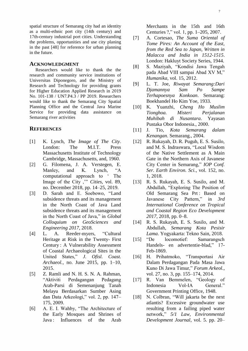
7
spatial structure of Semarang city had an identity
as a multi-ethnic port city (14th century) and
17th-century industrial port cities. Understanding
the problems, opportunities and use city planing
in the past [48] for reference for urban planning
in the future.
ACKNOWLEDGMENT Researchers would like to thank the the
research and community service institutions of
Universitas Diponegoro, and the Ministry of
Research and Technology for providing grants
for Higher Education Applied Research in 2019
No. 101-138 / UN7.P4.3 / PP 2019. Researchers
would like to thank the Semarang City Spatial
Planning Office and the Central Java Marine
Service for providing data assistance on
Semarang river activities
REFERENCES
[1] K. Lynch, The Image of The City.
London: The M.I.T. Press
Massachusetts Institute of Technology
Cambridge, Massachusetts, and, 1960.
[2] G. Filomena, J. A. Verstegen, E.
Manley, and K. Lynch, “A
computational approach to ‘ The
Image of the City ,’” Cities, vol. 89,
no. December 2018, pp. 14–25, 2019.
[3] D. Sarah and E. Soebowo, “Land
subsidence threats and its management
in the North Coast of Java Land
subsidence threats and its management
in the North Coast of Java,” in Global
Colloquium on GeoSciences and
Engineering 2017, 2018.
[4] L. A. Reeder-myers, “Cultural
Heritage at Risk in the Twenty- First
Century : A Vulnerability Assessment
of Coastal Archaeological Sites in the
United States,” J. Ofisl. Coast.
Archaeol., no. June 2015, pp. 1–10,
2015.
[5] Z. Ramli and N. H. S. N. A. Rahman,
“Aktiviti Perdagangan Pedagang
Arab-Parsi di Semenanjung Tanah
Melayu Berdasarkan Sumber Asing
dan Data Arkeologi,” vol. 2, pp. 147–
175, 2009.
[6] A. E. I. Wahby, “The Architecture of
the Early Mosques and Shrines of
Java : Influences of the Arab
Merchants in the 15th and 16th
Centuries ?,” vol. 1, pp. 1–205, 2007.
[7] A. Cortesao, The Suma Oriental of
Tome Pires: An Account of the East,
from the Red Sea to Japan, Written in
Malacca and India in 1512-1515.
London: Hakluyt Society Series, 1944.
[8] S. Maziyah, “Kondisi Jawa Tengah
pada Abad VIII sampai Abad XV M,”
Humanika, vol. 15, 2012.
[9] L. T. Joe, Riwayat Semarang:Dari
Djamannya Sam Po Sampe
Terhapoesnya Konkoan. Semarang:
Boekhandel Ho Kim Yoe, 1933.
[10] K. Yuanzhi, Cheng Ho Muslim
Tionghoa. Misteri Perjalanan
Muhibah di Nusantara. Yayasan
Pustaka Obor Indonesia., 2000.
[11] J. Tio, Kota Semarang dalam
Kenangan. Semarang., 2004.
[12] R. Rukayah, D. R. Puguh, E. S. Susilo,
and M. S. Indraswara, “Local Wisdom
of the Native Settlement as A Main
Gate in the Northern Axis of Javanese
City Center in Semarang,” IOP Conf.
Ser. Earth Environ. Sci., vol. 152, no.
1, 2018.
[13] R. S. Rukayah, E. S. Susilo, and M.
Abdullah, “Exploring The Position of
Old Semarang Sea Prt : Based on
Javanese City Pattern,” in 3rd
International Conference on Tropical
and Coastal Region Eco Development
2017, 2018, pp. 0–8.
[14] R. S. Rukayah, E. S. Susilo, and M.
Abdullah, Semarang Kota Pesisir
Lama. Yogyakarta: Tekno Sain, 2018.
[15] “De locomotief: Samarangsch
Handels- en advertentie-blad,” 17-
Feb-1869.
[16] H. Prihatmoko, “Transportasi Air
Dalam Perdagangan Pada Masa Jawa
Kuno Di Jawa Timur,” Forum Arkeol.,
vol. 27, no. 3, pp. 155–174, 2014.
[17] R. Van Bemmelen, “Geology of
Indonesia Vol-IA General.”
Government Printing Office, 1948.
[18] N. Colbran, “Will jakarta be the next
atlantis? Excessive groundwater use
resulting from a failing piped water
network,” 5/1 Law, Environmental
Development Journal, vol. 5. pp. 20–
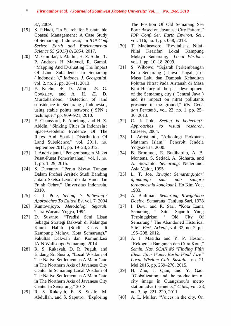
First author et al. / Journal of Southwest Jiaotong University/ Vol.__ No._Dec. 2019
8
37, 2009.
[19] S. P.Hadi, “In Search for Sustainable
Coastal Management : A Case Study
of Semarang , Indonesia,” in IOP Conf.
Series: Earth and Environmental
Science 55 (2017) 012054, 2017.
[20] M. Gumilar, I. Abidin, H. Z. Sidiq, T.
P. Andreas, H. Maiyudi, R. Gamal,
“Mapping And Evaluating The Impact
Of Land Subsidence In Semarang
( Indonesia ),” Indones. J. Geospatial,
vol. 2, no. 2, pp. 26–41, 2013.
[21] F. Kuehn, Æ. D. Albiol, Æ. G.
Cooksley, and A. H. Æ. D.
Murdohardono, “Detection of land
subsidence in Semarang , Indonesia ,
using stable points network ( SPN )
technique,” pp. 909–921, 2010.
[22] E. Chaussard, F. Amelung, and H. Z.
Abidin, “Sinking Cities In Indonesia :
Space-Geodetic Evidence Of The
Rates And Spatial Distribution Of
Land Subsidence,” vol. 2011, no.
September 2011, pp. 19–23, 2012.
[23] I. Andrisijanti, “Pengembangan Maket
Pusat-Pusat Pemerintahan,” vol. 1, no.
1, pp. 1–29, 2015.
[24] S. Devanny, “Peran Sketsa Tangan
Dalam Profesi Arsitek Studi Banding
antara Sketsa Leonardo da Vinci dan
Frank Gehry,” Universitas Indonesia,
2010.
[25] C. J. Pole, Seeing Is Believing ?
Approaches To Edited By, vol. 7. 2004.
[26] Kuntowijoyo, Metodologi Sejarah.
Tiara Wacana Yogya, 1994.
[27] D. Susanto, “Tradisi Seni Lisan
Sebagai Strategi Dakwah di Kalangan
Kaum Habib (Studi Kasus di
Kampung Melayu Kota Semarang).”
Fakultas Dakwah dan Komunikasi
IAIN Walisongo Semarang, 2014.
[28] R. S. Rukayah, D. R. Puguh, and
Endang Sri Susilo, “Local Wisdom of
The Native Settlement as A Main Gate
in The Northern Axis of Javanese City
Center In Semarang Local Wisdom of
The Native Settlement as A Main Gate
in The Northern Axis of Javanese City
Center In Semarang,” 2018.
[29] R. S. Rukayah, E. S. Susilo, M.
Abdullah, and S. Saputro, “Exploring
The Position Of Old Semarang Sea
Port: Based on Javanese City Pattern,”
IOP Conf. Ser. Earth Environ. Sci.,
vol. 116, no. 1, pp. 0–8, 2018.
[30] T. Madiasworo, “Revitalisasi Nilai-
Nilai Kearifan Lokal Kampung
Melayu Semarang,” Local Wisdom,
vol. 1, pp. 10–18, 2009.
[31] S. Wibowo, “Sejarah Perkembangan
Kota Semarang ( Jawa Tengah ) di
Masa Lalu dan Dampak Kehadiran
Polutan Nitrat Pada Airtanah di Masa
Kini History of the past development
of the Semarang city ( Central Java )
and its impact on nitrat pollutants
presence in the ground,” Ris. Geol.
dan Pertamb., vol. 23, no. 1, pp. 25–
36, 2013.
[32] C. J. Pole, Seeing is believing?:
Approaches to visual research.
Citeseer, 2004.
[33] I. Adrisijanti, “Arkeologi Perkotaan
Mataram Islam,” Penerbit Jendela
Yogyakarta, 2000.
[34] B. Brommer, E. Budihardjo, A. B.
Montens, S. Setiadi, A. Sidharta, and
A. Siswanto, Semarang. Nederland:
Asia Maior, 1995.
[35] L. T. Joe, Riwajat Semarang:(dari
djamannja sam poo sampre
terhapoesnja kongkoan). Ho Kim Yoe,
1933.
[36] A. Budiman, Semarang Riwajatmoe
Doeloe. Semarang: Tanjung Sari, 1978.
[37] I. Dewi and R. Sari, “Kota Lama
Semarang ” Situs Sejarah Yang
Terpinggirkan ‘ Old City Of
Semarang ’ The Abandoned Historical
Site,” Berk. Arkeol., vol. 32, no. 2, pp.
195–208, 2012.
[38] A. I. Masitha and Y. P. Heston,
“Rekognisi Bangunan dan Citra Kota,”
Semin. Nas. SCAN #6 "Finding Fifth
Elem. After Water, Earth, Wind. Fire”
Local Wisdom Cult. Sustain., no. 21
Mei 2015, pp. 259–270, 2015.
[39] H. Zhu, J. Qian, and Y. Gao,
“Globalization and the production of
city image in Guangzhou’s metro
station advertisements,” Cities, vol. 28,
no. 3, pp. 221–229, 2011.
[40] A. L. Müller, “Voices in the city. On
9
the role of arts, artists and urban space
for a just city,” Cities, vol. 91, no.
September 2017, pp. 49–57, 2019.
[41] B. N. Prabowo and B. I. Harsritanto,
“Kota Lama Semarang Menuju Status
Pusaka Dunia Unesco: Apa Itu Status
World Heritage?,” Modul, vol. 18, no.
1, p. 51, 2018.
[42] A. Febbiyana and D. Suwandono,
“Penurunan Kampung Melayu Sebagai
Kawasan Cagar Budaya Kota
Semarang The Declining Vitality of
Kampung Melayu as the Heritage
Area in The City of Semarang,” vol. 2,
no. 4, 2016.
[43] D. Susanto, “Pola strategi dakwah
komunitas habaib di kampung melayu
semarang,” vol. 14, no. 1, pp. 159–185,
2014.
[44] L. T. Ling, “Raja Gula Oei Tiong
Ham,” vol. 11, no. 3, p. 312, 1979.
[45] Y. Kunio, “Oei Tiong Ham Concern :
The First Business Empire of
Southeast Asia Introduction,” vol. 27,
no. 2, pp. 137–155, 1989.
[46] S. Claudine, “Oei Tiong Ham
Concern : The First Business Empire
of Southeast Asia,” Archipel, vol. 41,
no. 1, pp. 201–203, 1991.
[47] R. Tarigan, “Kajian Historis dan
Morfologi Kampung – Kampung di
Sekitar Jalan Jagalan dan Jalan
Petudungan Semarang,” 2015.
[48] E. H. Chapman and K. Lynch, “The
Image of the City,” J. Aesthet. Art
Crit., vol. 21, no. 1, p. 91, 1962.
参考文:
西南交通大学学报
第 54 卷第 6 期
2019年 12 月 JOURNAL OF SOUTHWEST JIAOTONG UNIVERSITY
Vol. 54 No. 6
Dec. 2019
COVER LETTER
Title of the manuscript
THE GLORY OF SEMARANG COASTAL CITY IN THE PAST, MULTI ETNIC MERCHANTS AND DUTCH COMMERCE Abstract
The Image of the City describes how individuals perceive and recall features in urban
spaces. Recently, computational techniques using to test that theory on a large-scale city.
But, the old city in the 14-18 century was not as complicated as today. How to reveal the
image of the old city? Based on hand drawing sketch technique enabling to uncover the
image city in the past. Old data such as map, photography, and video are integrated to
reconstruct the Image of the City. Semarang city, Central Java, Indonesia, well known as
Venetia van Java, as sugar industry in Asia, and as the city that has the first railway track
in Indonesia. We illustrate the old building in the port- along the two river estuaries and
the meeting point of the rivers. Our method allows to improve individual perceive in
urban space that cannot to use to uncover the condition in the past and to substitute
computational technique that present only the block mass building so cannot expose the
detailed. The result reveal that the name of Semarang port in river estuary, Tanjung Emas
-cape of the gold- implies the glory of Semarang played important role in the pre-colonial
and colonial eras comparing to another city port in Java. New research results as a tool to
evaluate the city transportation facilities for urban planners, watershed services that no
longer use in the present day. Urban planning along the river in the past also can be
revitalized for tourism purposes..
Keywords river transportation, rail train , Semarang, Colonial, multi-ethnic
Type of manuscript (please specify):
Regular article
Review article
Brief report
Short communication
Research note
Full name and address of the Corresponding author
Telephone# 08122812825
Fax#

First author et al. / Journal of Southwest Jiaotong University/ Vol.__ No._Dec. 2019
2
I hereby confirm that the manuscript was prepared in accordance with the instructions
for authors of scientific publications, and that the content of this manuscript, or most of
it, was not published in the journal indicated, and the manuscript was not submitted for
publication elsewhere.
11 / 7 / 2019
Signature of the Corresponding author Date
First author et al. / Journal of Southwest Jiaotong University/ Vol.__ No._Dec. 2019
3
Copyright Agreement
Manuscript title: THE GLORY OF SEMARANG COASTAL CITY IN THE PAST MULTI ETNIC
MERCHANTS AND DUTCH COMMERCE
Full names of all authors: R.Siti Rukayah, Muhammad Abdullah
Full name and address of the corresponding author:
R.Siti Rukayah
Telephone: 08122812825 Fax: _________________ Email: [email protected], [email protected]
License Agreement
(1) Authors own all the copyright rights for the paper.
(2) Submitted manuscript is an original paper.
(3) Authors hereby grant the Issues of Journal of SWJTU with an exclusive, royalty-free, worldwide license to email the paper to all who will ask for it.
(4) All authors have made a significant contribution to the research and are ready to assume joint responsibility for the paper.
(5) All authors have seen and approved the manuscript in the final form as it is submitted for publication.
(6) This manuscript has not been published and also has neither been submitted nor considered for publication elsewhere
(7) The text, illustrations and any other materials, included into the manuscript, do not infringe any existing intellectual property rights or other rights of any person or entity.
(8) The editors of the Issues of Journal of SWJTU, its personnel or the Editorial Board members accept no responsibility for the quality of the idea expressed in this publication.
I am the Corresponding author and have full authority to enter into this agreement.
Full name, affiliation and position: R. Siti Rukayah, Architecture Departement, Diponegoro University, Vice Head of PhD Program Architecture and Urban Design Departement of Architecture
Signature: Date: 7 November 2019

西南交通大学学报
第 54 卷第 6 期
2019年 12 月 JOURNAL OF SOUTHWEST JIAOTONG UNIVERSITY
Vol. 54 No. 6
Dec. 2019
ISSN: 0258-2724 DOI:10.35741/issn.0258-2724.54.6….
Category Please select the type of your manuscript
(see Author Guidelines)
Category. Please select the most suitable field of scientific research
from the approved list of the journal categories
THE GLORY OF SEMARANG COASTAL CITY IN THE PAST,
MULTI ETNIC MERCHANTS AND DUTCH COMMERCE
R.Siti Rukayah 1a,*, Muhammad Abdullah2
aArchitecture Departement, Diponegoro University
Jl. Prof. Soedarto, Tembalang, Semarang, Indonesia, [email protected] b Indonesian literature, Diponegoro University
Jl. Prof. Soedarto, Tembalang, Semarang, Indonesia, [email protected]
Abstract The Image of the City describes how individuals perceive and recall features in urban spaces.
Recently, computational techniques using to test that theory on a large-scale city. But, the old city in the
14-18 century was not as complicated as today. How to reveal the image of the old city? Based on hand
drawing sketch technique enabling to uncover the image city in the past. Old data such as map,
photography, and video are integrated to reconstruct the Image of the City. Semarang city, Central Java,
Indonesia, well known as Venetia van Java, as sugar industry in Asia, and as the city that has the first
railway track in Indonesia. We illustrate the old building in the port- along the two river estuaries and the
meeting point of the rivers. Our method allows to improve individual perceive in urban space that cannot
to use to uncover the condition in the past and to substitute computational technique that present only the
block mass building so cannot expose the detailed. The result reveal that the name of Semarang port in
river estuary, Tanjung Emas -cape of the gold- implies the glory of Semarang played important role in the
pre-colonial and colonial eras comparing to another city port in Java. New research results as a tool to
evaluate the city transportation facilities for urban planners, watershed services that no longer use in the
present day. Urban planning along the river in the past also can be revitalized for tourism purposes.
Keywords: river transportation, rail train, Semarang, Colonial, multi-ethnic.
摘要
关键词:
I. INTRODUCTION In 1960, Kevin Lynch published The Image of
the City [1], one of the most influential theories
in the formation of city images. City image
research continues to grow, along with the
development of the city. At present, the city is

First author et al. / Journal of Southwest Jiaotong University/ Vol.__ No._Dec. 2019
2
developing very rapidly into a metropolitan city
that has a big scale that requires presentation and
tools to test the image of the city using a
computational approach [2].
Meanwhile, the extent and complexity of
cities in the past are not yet complicated
compared to cities in the present. Therefore, the
use of city image theory to reveal the
representation of city image in the past is still a
research opportunity, especially in historic areas.
Coastal city has become the focus of research
today since the issue of coastal disasters such as
rising seawater, land subsidence. [3]. The disaster
requires handling, especially in historic areas. [4].
Some historic coastal areas emerged due to the
development of trade since prehistoric times in
the Southeast Asian region. The Asian region has
attracted the presence of traders from Arab-Persia
to the archipelago in addition to traders from
India and China. [5]. The location of Indonesia
attracted for explorers of the world to trade or
transit even for stopover [6].
The trace of the settlement of the traders from
around the world is the multi-ethnic architectural
heritage that scattered along the coast in
Indonesia, especially in Java. In Semarang city,
Central Java, Indonesia, the multi-ethnic
settlement become an embryo for city
development. In the Dutch colonial period, they
created a city resemble the Netherland that using
canals for transportation. The Semarang city well
known as the venetie van Java.
They choosing Semarang because the position
precisely in the central of Java. So, the ports on
the north coast of Java played an essential role as
the political and economic power base of the
Dutch East Indies Company. The heart and
politics of the Dutch in controlling crop yields.
To bring some crops from interior Java they built
the first railroad route in Indonesia. The
development of sugarcane and coffee gave rise
Asian conglomerate in its era
The city of Semarang based on maps in 1719
and 1800 consisting of three districts, namely the
Malay village area, the old downtown area in
Kanjengan, and the colonial fortress area.
Semarang Map Semarang in 1719 put as a
reference. The area of Semarang city was around
500 x 600 meters or about 30 hectares.
Historical record of the foreign sailor, Tome
Pires, when he arrived in Semarang a century
after the arrival of Cheng Ho, witnessed that
Semarang was already a city lead by Muslim
rulers who were the vassals of the Sultanate of
Demak. The population was around 3000 people.
That port has three junks and 4 or 5 boats. The
commercial commodities produced are mainly
rice and other food ingredients. [7] .
Semarang's history is inseparable from
geological problems. This can be seen from the
transfer of port location. In the 8th century AD,
Semarang was still a group of islands with a
coastline located in the Pragotat region (now
known as bergota hill). [8]. History records that
Admiral Cheng Ho's fleet leaned on the port of
Simongan in 1405. [9][10]. In the 14th century,
the coastline was in the Kampung Melayu region
now or precisely in the Sleko region. [11]. Port
traces as a landing places for foreign traders
recently disappear, but the name of the place still
refers the meaning of a landing place. [12]–[14]
The Dutch government moved the port from
Simongan to the Semarang river in the Boom
Lama area, which has been operating since 1743.
This port also experienced siltation so that in
1870, the government dig a channel to the east of
the river mouth, which was named new canal
/Moeara Baroe 'Havenkanaal [15]
The Semarang city position on the central
Java has become one of the mainstay cities in the
VOC's trading strategy. This region is located
right in the middle of the coast and connecting to
Kartasura, the capital of Sunan (Lombard, 2000:
59). The old port near Malay village di Semarang
river estuary experienced siltation. However, to
expedite trading activities, the Dutch government
built a new canal to the new port. The siltation
still process, so that port also experienced silting
until the Dutch government made the modern
port in Tanjung Emas port-cape of gold.
The symptom of coastal geological disaster
always occurred until today . The sedimentation
process, causes the siltation of the Semarang
river estuary. (Krisprantono, 2013; Supriyono,
2007 and still continuing until the Semarang city
government built and developed the Tanjung
Emas Port in Semarang in 1982.
The name of the Tanjung Emas are strategic
research materials to uncover the glory of
Semarang in the past along two river estuary.
Although the existence of the old building
experienced a geological disaster, nevertheless,
the colonial government archives about the area
are complete. Old data such as images, photos,
maps, and videos during the Dutch colonial era,
could be used to reconstruct the Semarang city
image. The study of transportation use and its
role in trade is one aspect of economic
archeology. [16].
II.RESEARCH AIM The remaining area of the past glory is now
partially lost due to geological disasters on the

3
North coast of Java that occurred since the 8th
century. [17]. Sedimentation, rob, and land
subsidence caused heritage areas to be
submerged in water. Some big cities like Jakarta,
Surabaya, and Semarang are predicted to sink
[18][19]–[22]. This paper aims to uncover the
glory of the city of Semarang in the past
II. LITERATURE REVIEW Lynch theory describes how individuals
perceive and recall features in urban spaces. The
distinctive elements in the urban landscape -
categorised in paths, nodes, edges, districts and
landmarks - give shape to individuals' mental
representation of the city. [1] Lynch’s approach
has stimulated research into spatial cognition,
urban design and artificial intelligence, and it still
represents an essential pillar in the analysis of
urban dynamics. A complete computational
approach to The Image of the City was presented
and tested on a large Boston city. it was difficult
to find a common ground concerning landmarks.
The complexity of human cognition and
perception cannot be fully captured with a
computational approach. [2]
Based on historical archives, architectural
heritage, and grounded research, the research
from an architectural and urban design
perspective will use an architectural and city
historic approach and analysis using hand
drawing sketches. This method have an
advantage comparing to using mockups to
reconstruct the city in the past that usually used
by archeologists [23].
The image of the city using mockups is less
able to be captured because of the city scale
factor and the materials of mockups. The image
of the city using the computational system has
weaknesses because all objects are equally
dominant. Displaying the image of the city by
using a hand-drawn sketch will be able to give
emphasis to the desired area and obscure the less
dominant picture. [24]. A picture is worth more
than a thousand words. Images are often the
language that often captures messages and
meanings compared to written and spoken
languages. [25]
III. METHODS The old data about architectural building
heritage along the Semarang river and new canal
area were detected from old map, drawings/
photographs [26] Maps and photos are obtained
from kitlv, tropen museum and atlas mutual
heritage. The old map are taken from 1695, 1719,
1875, 1880, 1888, 1892. Map of the first railroad
network in Indonesia in Semarang and the map
on 1907 became a tool for analyzing industrial
networks from the interior to the river estuary
Along the Semarang River estuary, there are
the port as a transit point and residing traders
from various regions such as Handramut, Arabic,
Chinese, Malay, Banjar, Bugis, etc. [27] and they
left a multi-ethnic village [28], [29] [30].
According to Rukayah [12] the area are
dominated by ethnic Arabs and Chinese traders.
Meanwhile, along the new canal estuary, they
are several buildings reveal the triumph of the
VOC (Vereeniging Ost-Indische Company) trade
in 1678 [31].
. The historical approach by reading maps
and images is essential in historical research
because pictures provide more stories than
narratives. [32]. Meanwhile, local data before the
arrival of Dutch colonialism was minimal.
Therefore it requires reading the toponym of the
place name to reveal the building and function of
the place at the time [33]
The analysis is using a hand drawing sketch
using ancient aerial photographs in the two river
estuary [34].
Reconstructing the city image of Semarang in
the past will be analyzed based on the path, edge ,
district, nodes, and landmarks [1].
IV. RESULTS AND DISCUSSION The path element became the first element
to reconstruct the image of Semarang city in the
past because the river was the only transportation
route. Based on photos and maps from 1917, the
canal has length of 1180 meters and a width of 23
meters. [35]. The file elements that are very
prominent formed the city image of Semarang in
the past are:
A. Paths
Paths is a channel that observers or visitors
usually pass through, the relationship between the
road and the environment that is regulated is
interrelated [1]
The nickname of the city of Semarang as a
venetie van Java indicated the role of the canals
as a transport route at that time. The traces of
transport in the pre-colonial were at river
Semarang. The old port lied in Darat village Old
Boom. Darat (Javanesse) and Boom (Dutch)
toponym refer that the place had a function as a
port. A Chinese traveler, Ong Tai Hae, who had
visited Semarang in 1783, said that the port of
Semarang was attended by many merchant
ships.The ship was small that sailed to
Pedamaran near the square Semarang The
location of the Old Boom is very strategically

First author et al. / Journal of Southwest Jiaotong University/ Vol.__ No._Dec. 2019
4
located close to the Pedamaran market close to
the city center. [36]
The construction of a new port canal, named
Nieuwe Havenkanaal, in 1872. The port plays a
vital role as a gateway for the export-import of
products from the interior such as sugar, coffee,
indigo, and so on. The port increasingly
developed as the largest port and port city in
Central Java [37]. The Haven Kanaal port was
seen integrated with the railroad network of the
Kemidjen station in Tambaksari and the city
center (see Semarang Map 1875) to
Vorstenlanden -Surakarta, and Yogyakarta [15].
B. Landmarks
Landmarks are points that are considered
necessary to observers. they are easy to identify
because the shapes are clear and easy to
remember and have the advantage of spatial
location. People understand a city, from artifacts
[1]. According to Masitha & Heston, [38]
buildings as one of the elements that forming the
image of the city, especially in historic area.
Transforming the city's image without erasing the
potential image of the city itself [39]. Culture in
general can contribute significantly to designing
cities [40].
From several theories about the image of the
city above, people who live or settle in the area
usually describe the part or place that is most
easily recognized or has its characteristics. One
of them is a heritage building that illustrates the
features of the culture of the city itself.
The results of the hand drawing sketch
capture the image of the city of captured that the
Layur Mosque (early 18th century) become the
landmark at Semarang river. Whereas, the
Menara Syahbandar / Menara Sleko (uitkijk).
1877 became the landmarks in new canal. The
meeting point area of the two rivers marked by
the presence of the Layur Tower Mosque and
Sleko Tower became the city gate to Semarang at
the time. The Layur Mosque has once functioned
as a lighthouse tower. Meanwhile, the Sleko
Tower functions as a small port that was
equipped as a viewing tower to regulate loading
and unloading of small traders and to oversee the
pier and be able to see around the city from the
top of the tower.
C. Edges
Edges are a barrier although sometimes there
is a place to enter. It is also the end of a better
district if continuity is clearly visible. Likewise
the boundary function must be clear; divide or
unite. [1]
At the Semarang river estuary, there could be
said to represent an example of multi-cultural
Trade City in Southeast Asia, which is formed
from power trading activities Javanese, Malay,
Chinese, and Arabic [41]. They were migrants
who traded (trading partners) before the arrival of
the Dutch in the early 17th century [42]. [30] [43].
By using the visual image in, the characteristics
of various architectural building heritage are
spread along the river, such as the Banjar
community, Javanese house, Arab house,
Chinese house, Indis house, and Melayu house.
Ethnic Arabs and Chinese dominate trade
activities. This can be seen from the architecture
of the building in the main corridor of the Melayu
village [28], [29]. It can be concluded that
Semarang river estuary has a Multi-Ethnic
Merchant character
Buildings along the new canal are more
dominated with warehouse buildings and sugar
factories. At that time, sugar was an essential
commodity for the Dutch East Indies in the 19th
century. At the time, Java as the largest sugar
producer in the world. Based on these data,
Muara Kali Baroe had a character of the City
Image as Dutch Commerce (see Historical Video
Archive, Train crossing the Kalibaru suspension
bridge in Semarang, 1937
https://www.youtube.com/watch?v=Y4ioJU8Dv
A0)
The livelihood of warehouses in the port of
Semarang affected the tax revenue obtained from
Semarang in 1677, which exceeded the
acquisition of several ports in the vicinity.
Because in the 1900s the production of sugar was
very promising especially with the Dutch
Government supporting the production of sugar.
[44]. Along the new canal, headed to the port,
experienced a rapid increase in business activities,
sugar- trading, in the 1870s .[45]. One of the
most prominent sugar business leaders is Oei
Tiong Ham, who is famous for the nickname
"Sugar King of Java." [46]. In the years of his
success (between 1850-1900), the role of new
canal was significant for the distribution of sugar.
It can be concluded that new canal has City
Image as Dutch Commerce. However, new canal
also a transportation serviced for local traders, for
example, the Tasripien Concern Company, which
sends its commodities, especially leather, to
various destinations. [47] .
D. Node and District
Nodes are points, strategic spots in a city
where an observer can enter, and which is the
focus for where he is going.[1]
5
Districts a two-dimensional urban area with a
medium to large city scale, where humans feel
'in' and 'out' from a region with generally
different characteristics. [1]. The characteristics
that determine districts are thematic continuities
which may consist of an endless variety of
components. [1]
In the Dutch colonial era, urban planning
played an essential role in creating the existence
of colonial power at that time. They show the
power usually by hidden the existence the
districts of Malay village and local government in
their old map. The city design that consist of the
square, mosque, and Kanjengan are almost not
visible on the map design except on the map in
1917.
The presence of Malay villages since the 14th
century, the local government in the 15th century,
and the colonial government in the old fortress
town of the 17th century formed a triangle
district connected to two Semarang river estuary.
The Dutch colonial government set the Dutch
fortress at the meeting point of the two estuaries
of the Semarang river and the new cana. The
fortress area becomes a node. The area of this
node becomes the gateway to the Dutch colonial
fortress to/from the harbor. The name of gateway
area is Sleko, means the city gate. The area
characterized by the presence of tower Sleko.
V. CONCLUSION Using the hand drawing sketch can be
concluded that:
1. The driving force of economic activity in
the port in old river estuary is the local economy
and ethnic muti traders. This can be seen from
the presence of the architectural building
heritages that indicate multi -ethnic[1].
2. The architectural building heritage in the
new canal estuary indicates the commercial
offices, warehouses, and train stations that
connect the port with the interior area in Java,
making the image of the estuary area as the
center of Dutch commerce.
The hand drawing sketch of the glory of the
city in the past displaying the image by give
emphasis to the desired area and obscure the less
dominant picture. [24]. A hand drawing sketch
of the city is worth more than a thousand words.
The city images using hand drawing sketch
captures messages and meanings that Semarang
in the past was a big city and has economyc
activity lead by multi ethnic traders and then by
Dutch commerce. Picture send message more
compared to written and spoken languages. [25]
Apparently, it was not wrong to give the name
of the golden cape because Semarang had a glory
from the port of Mataram era, Cheng Ho's
landing period, the pre-colonial period and the
colonial period.
Using the image of the city theory, the Layur
Mosque Tower was found as the landmark of the
old river estuary. The Syahbandar (the head of
port) as the tower at the new canal estuary (Kali
Baroe) and the sugar warehouses owned by Oei
Tiong Ham (one of the Asian conglomerates of
his era) as the shaper of the image of the new
canal. The meeting point of two estuaries
becomes a node with the nickname Sleko (Dutch),
which means the city gate.The image of the glory
of Semarang lost due to the problem of land
subsidence.
Urban planning in the past, based on the river
as transportation, resulted in the architecture and
spatial structure of Semarang city had an identity
as a multi-ethnic port city (14th century) and
17th-century industrial port cities. Understanding
the problems, opportunities and use city planing
in the past [48] for reference for urban planning
in the future.
ACKNOWLEDGMENT Researchers would like to thank the the
research and community service institutions of
Universitas Diponegoro, and the Ministry of
Research and Technology for providing grants
for Higher Education Applied Research in 2019
No. 101-138 / UN7.P4.3 / PP 2019. Researchers
would like to thank the Semarang City Spatial
Planning Office and the Central Java Marine
Service for providing data assistance on
Semarang river activities
REFERENCES
[1] K. Lynch, The Image of The City.
London: The M.I.T. Press
Massachusetts Institute of Technology
Cambridge, Massachusetts, and, 1960. [2] G. Filomena, J. A. Verstegen, E.
Manley, and K. Lynch, “A
computational approach to ‘ The
Image of the City ,’” Cities, vol. 89,
no. December 2018, pp. 14–25, 2019.
[3] D. Sarah and E. Soebowo, “Land
subsidence threats and its management
in the North Coast of Java Land
subsidence threats and its management

First author et al. / Journal of Southwest Jiaotong University/ Vol.__ No._Dec. 2019
6
in the North Coast of Java,” in Global
Colloquium on GeoSciences and
Engineering 2017, 2018.
[4] L. A. Reeder-myers, “Cultural
Heritage at Risk in the Twenty- First
Century : A Vulnerability Assessment
of Coastal Archaeological Sites in the
United States,” J. Ofisl. Coast.
Archaeol., no. June 2015, pp. 1–10,
2015.
[5] Z. Ramli and N. H. S. N. A. Rahman,
“Aktiviti Perdagangan Pedagang
Arab-Parsi di Semenanjung Tanah
Melayu Berdasarkan Sumber Asing
dan Data Arkeologi,” vol. 2, pp. 147–
175, 2009.
[6] A. E. I. Wahby, “The Architecture of
the Early Mosques and Shrines of
Java : Influences of the Arab
Merchants in the 15th and 16th
Centuries ?,” vol. 1, pp. 1–205, 2007.
[7] A. Cortesao, The Suma Oriental of
Tome Pires: An Account of the East,
from the Red Sea to Japan, Written in
Malacca and India in 1512-1515.
London: Hakluyt Society Series, 1944.
[8] S. Maziyah, “Kondisi Jawa Tengah
pada Abad VIII sampai Abad XV M,”
Humanika, vol. 15, 2012.
[9] L. T. Joe, Riwayat Semarang:Dari
Djamannya Sam Po Sampe
Terhapoesnya Konkoan. Semarang:
Boekhandel Ho Kim Yoe, 1933.
[10] K. Yuanzhi, Cheng Ho Muslim
Tionghoa. Misteri Perjalanan
Muhibah di Nusantara. Yayasan
Pustaka Obor Indonesia., 2000.
[11] J. Tio, Kota Semarang dalam
Kenangan. Semarang., 2004.
[12] R. Rukayah, D. R. Puguh, E. S. Susilo,
and M. S. Indraswara, “Local Wisdom
of the Native Settlement as A Main
Gate in the Northern Axis of Javanese
City Center in Semarang,” IOP Conf.
Ser. Earth Environ. Sci., vol. 152, no.
1, 2018.
[13] R. S. Rukayah, E. S. Susilo, and M.
Abdullah, “Exploring The Position of
Old Semarang Sea Prt : Based on
Javanese City Pattern,” in 3rd
International Conference on Tropical
and Coastal Region Eco Development
2017, 2018, pp. 0–8.
[14] R. S. Rukayah, E. S. Susilo, and M.
Abdullah, Semarang Kota Pesisir
Lama. Yogyakarta: Tekno Sain, 2018.
[15] “De locomotief: Samarangsch
Handels- en advertentie-blad,” 17-
Feb-1869.
[16] H. Prihatmoko, “Transportasi Air
Dalam Perdagangan Pada Masa Jawa
Kuno Di Jawa Timur,” Forum Arkeol.,
vol. 27, no. 3, pp. 155–174, 2014.
[17] R. Van Bemmelen, “Geology of
Indonesia Vol-IA General.”
Government Printing Office, 1948.
[18] N. Colbran, “Will jakarta be the next
atlantis? Excessive groundwater use
resulting from a failing piped water
network,” 5/1 Law, Environmental
Development Journal, vol. 5. pp. 20–
37, 2009.
[19] S. P.Hadi, “In Search for Sustainable
Coastal Management : A Case Study
of Semarang , Indonesia,” in IOP Conf.
Series: Earth and Environmental
Science 55 (2017) 012054, 2017.
[20] M. Gumilar, I. Abidin, H. Z. Sidiq, T.
P. Andreas, H. Maiyudi, R. Gamal,
“Mapping And Evaluating The Impact
Of Land Subsidence In Semarang
( Indonesia ),” Indones. J. Geospatial,
vol. 2, no. 2, pp. 26–41, 2013.
[21] F. Kuehn, Æ. D. Albiol, Æ. G.
Cooksley, and A. H. Æ. D.
Murdohardono, “Detection of land
subsidence in Semarang , Indonesia ,
using stable points network ( SPN )
technique,” pp. 909–921, 2010.
[22] E. Chaussard, F. Amelung, and H. Z.
Abidin, “Sinking Cities In Indonesia :
Space-Geodetic Evidence Of The
Rates And Spatial Distribution Of
Land Subsidence,” vol. 2011, no.
September 2011, pp. 19–23, 2012.
[23] I. Andrisijanti, “Pengembangan Maket
Pusat-Pusat Pemerintahan,” vol. 1, no.
1, pp. 1–29, 2015.
[24] S. Devanny, “Peran Sketsa Tangan
Dalam Profesi Arsitek Studi Banding
antara Sketsa Leonardo da Vinci dan
Frank Gehry,” Universitas Indonesia,
2010.
[25] C. J. Pole, Seeing Is Believing ?

7
Approaches To Edited By, vol. 7. 2004.
[26] Kuntowijoyo, Metodologi Sejarah.
Tiara Wacana Yogya, 1994.
[27] D. Susanto, “Tradisi Seni Lisan
Sebagai Strategi Dakwah di Kalangan
Kaum Habib (Studi Kasus di
Kampung Melayu Kota Semarang).”
Fakultas Dakwah dan Komunikasi
IAIN Walisongo Semarang, 2014.
[28] R. S. Rukayah, D. R. Puguh, and
Endang Sri Susilo, “Local Wisdom of
The Native Settlement as A Main Gate
in The Northern Axis of Javanese City
Center In Semarang Local Wisdom of
The Native Settlement as A Main Gate
in The Northern Axis of Javanese City
Center In Semarang,” 2018.
[29] R. S. Rukayah, E. S. Susilo, M.
Abdullah, and S. Saputro, “Exploring
The Position Of Old Semarang Sea
Port: Based on Javanese City Pattern,”
IOP Conf. Ser. Earth Environ. Sci.,
vol. 116, no. 1, pp. 0–8, 2018.
[30] T. Madiasworo, “Revitalisasi Nilai-
Nilai Kearifan Lokal Kampung
Melayu Semarang,” Local Wisdom,
vol. 1, pp. 10–18, 2009.
[31] S. Wibowo, “Sejarah Perkembangan
Kota Semarang ( Jawa Tengah ) di
Masa Lalu dan Dampak Kehadiran
Polutan Nitrat Pada Airtanah di Masa
Kini History of the past development
of the Semarang city ( Central Java )
and its impact on nitrat pollutants
presence in the ground,” Ris. Geol.
dan Pertamb., vol. 23, no. 1, pp. 25–
36, 2013.
[32] C. J. Pole, Seeing is believing?:
Approaches to visual research.
Citeseer, 2004.
[33] I. Adrisijanti, “Arkeologi Perkotaan
Mataram Islam,” Penerbit Jendela
Yogyakarta, 2000.
[34] B. Brommer, E. Budihardjo, A. B.
Montens, S. Setiadi, A. Sidharta, and
A. Siswanto, Semarang. Nederland:
Asia Maior, 1995.
[35] L. T. Joe, Riwajat Semarang:(dari
djamannja sam poo sampre
terhapoesnja kongkoan). Ho Kim Yoe,
1933.
[36] A. Budiman, Semarang Riwajatmoe
Doeloe. Semarang: Tanjung Sari, 1978.
[37] I. Dewi and R. Sari, “Kota Lama
Semarang ” Situs Sejarah Yang
Terpinggirkan ‘ Old City Of
Semarang ’ The Abandoned Historical
Site,” Berk. Arkeol., vol. 32, no. 2, pp.
195–208, 2012.
[38] A. I. Masitha and Y. P. Heston,
“Rekognisi Bangunan dan Citra Kota,”
Semin. Nas. SCAN #6 "Finding Fifth
Elem. After Water, Earth, Wind. Fire”
Local Wisdom Cult. Sustain., no. 21
Mei 2015, pp. 259–270, 2015.
[39] H. Zhu, J. Qian, and Y. Gao,
“Globalization and the production of
city image in Guangzhou’s metro
station advertisements,” Cities, vol. 28,
no. 3, pp. 221–229, 2011.
[40] A. L. Müller, “Voices in the city. On
the role of arts, artists and urban space
for a just city,” Cities, vol. 91, no.
September 2017, pp. 49–57, 2019.
[41] B. N. Prabowo and B. I. Harsritanto,
“Kota Lama Semarang Menuju Status
Pusaka Dunia Unesco: Apa Itu Status
World Heritage?,” Modul, vol. 18, no.
1, p. 51, 2018.
[42] A. Febbiyana and D. Suwandono,
“Penurunan Kampung Melayu Sebagai
Kawasan Cagar Budaya Kota
Semarang The Declining Vitality of
Kampung Melayu as the Heritage
Area in The City of Semarang,” vol. 2,
no. 4, 2016.
[43] D. Susanto, “Pola strategi dakwah
komunitas habaib di kampung melayu
semarang,” vol. 14, no. 1, pp. 159–185,
2014.
[44] L. T. Ling, “Raja Gula Oei Tiong
Ham,” vol. 11, no. 3, p. 312, 1979.
[45] Y. Kunio, “Oei Tiong Ham Concern :
The First Business Empire of
Southeast Asia Introduction,” vol. 27,
no. 2, pp. 137–155, 1989.
[46] S. Claudine, “Oei Tiong Ham
Concern : The First Business Empire
of Southeast Asia,” Archipel, vol. 41,
no. 1, pp. 201–203, 1991.
[47] R. Tarigan, “Kajian Historis dan
Morfologi Kampung – Kampung di
Sekitar Jalan Jagalan dan Jalan
Petudungan Semarang,” 2015.

First author et al. / Journal of Southwest Jiaotong University/ Vol.__ No._Dec. 2019
8
[48] E. H. Chapman and K. Lynch, “The
Image of the City,” J. Aesthet. Art
Crit., vol. 21, no. 1, p. 91, 1962.
参考文:

西南交通大学学报
第 54 卷第 6 期
2019年 12 月 JOURNAL OF SOUTHWEST JIAOTONG UNIVERSITY
Vol. 54 No. 6
Dec. 2019
COVER LETTER
Title of the manuscript
THE GLORY OF SEMARANG COASTAL CITY IN THE PAST MULTI ETNIC MERCHANTS AND DUTCH COMMERCE Abstract
Abstract The Image of the City Lynch describes how individuals perceive and recall
features in urban spaces. Lynch's approach is categorized in paths, nodes, edges, districts,
and landmarks - give shape to individuals' mental representation of the city. Recently, to
test that theory on a large scale city requires high accuracy to understand a city. So, it
requires tools such as computational techniques using the GIS system. The city of the 14-
18 century was not as complicated as Lynch had done in the 1960s. How to reveal the
image of the city? The Image of the city in the past has not been explored yet. To explore
the glory of Semarang city, Central Java, Indonesia, as Venetia van Java, sugar industry in
Asia, and has the first railway track in Indonesia, can still using hand drawing sketch to
reconstruct the image of an old city. Old data such as map, photography, and video are
integrated to reconstruct the Image of the City in the past. Recently, the name of port of
Semarang, Tanjung Emas -cape of gold- implies the glory of Semarang. The Semarang
seaport played an important role in the pre-colonial and colonial eras. The architecture
building heritage at the two river estuary of the Semarang coast uncover the history of
naming the ‘cape of Gold". The river as transportation lines and trains as the path is
important as a tool to evaluate the city transportation facilities for urban planners,
watershed services, and urban conservation.
Keywords river transportation, rail train , Semarang, Colonial, multi-ethnic
Type of manuscript (please specify):
Regular article
Review article
Brief report
Short communication
Research note
Full name and address of the Corresponding author
Telephone# 08122812825
Fax#
Email [email protected]

First author et al. / Journal of Southwest Jiaotong University/ Vol.__ No._Dec. 2019
2
I hereby confirm that the manuscript was prepared in accordance with the instructions
for authors of scientific publications, and that the content of this manuscript, or most of
it, was not published in the journal indicated, and the manuscript was not submitted for
publication elsewhere.
11 / 7 / 2019
Signature of the Corresponding author Date
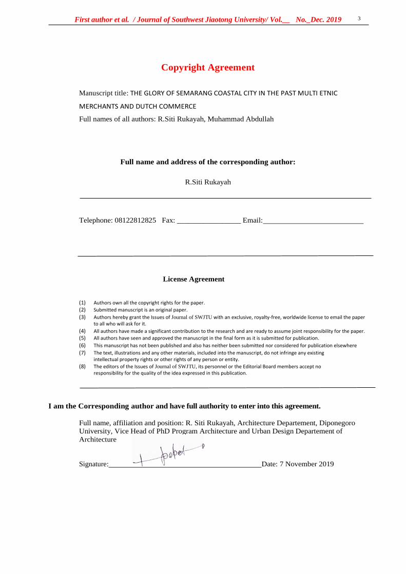
First author et al. / Journal of Southwest Jiaotong University/ Vol.__ No._Dec. 2019
3
Copyright Agreement
Manuscript title: THE GLORY OF SEMARANG COASTAL CITY IN THE PAST MULTI ETNIC
MERCHANTS AND DUTCH COMMERCE
Full names of all authors: R.Siti Rukayah, Muhammad Abdullah
Full name and address of the corresponding author:
R.Siti Rukayah
Telephone: 08122812825 Fax: _________________ Email:
License Agreement
(1) Authors own all the copyright rights for the paper.
(2) Submitted manuscript is an original paper.
(3) Authors hereby grant the Issues of Journal of SWJTU with an exclusive, royalty-free, worldwide license to email the paper to all who will ask for it.
(4) All authors have made a significant contribution to the research and are ready to assume joint responsibility for the paper.
(5) All authors have seen and approved the manuscript in the final form as it is submitted for publication.
(6) This manuscript has not been published and also has neither been submitted nor considered for publication elsewhere
(7) The text, illustrations and any other materials, included into the manuscript, do not infringe any existing intellectual property rights or other rights of any person or entity.
(8) The editors of the Issues of Journal of SWJTU, its personnel or the Editorial Board members accept no responsibility for the quality of the idea expressed in this publication.
I am the Corresponding author and have full authority to enter into this agreement.
Full name, affiliation and position: R. Siti Rukayah, Architecture Departement, Diponegoro University, Vice Head of PhD Program Architecture and Urban Design Departement of
Architecture
Signature: Date: 7 November 2019

8. Invoice submission from editor
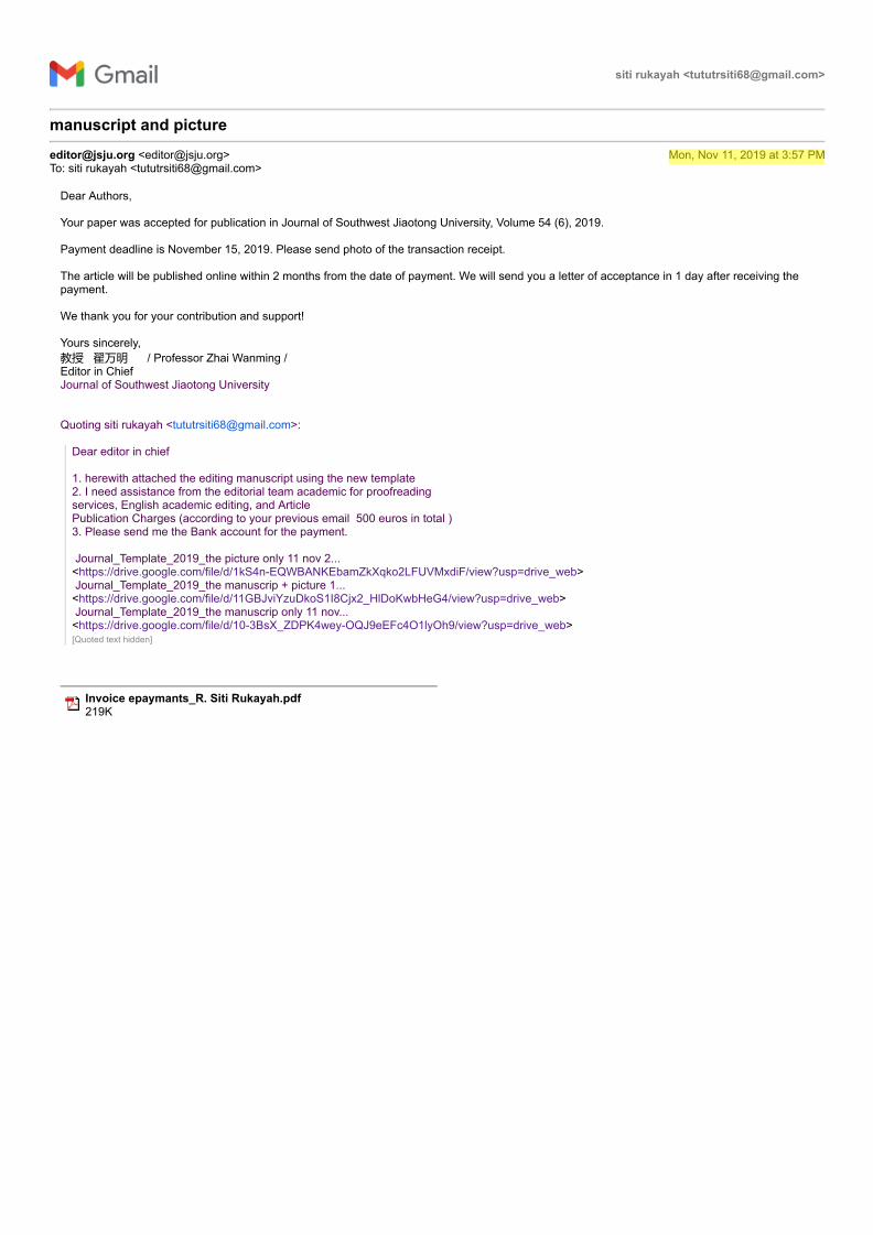
siti rukayah <[email protected]>
manuscript and picture
[email protected] <[email protected]> Mon, Nov 11, 2019 at 3:57 PMTo: siti rukayah <[email protected]>
Dear Authors,
Your paper was accepted for publication in Journal of Southwest Jiaotong University, Volume 54 (6), 2019.
Payment deadline is November 15, 2019. Please send photo of the transaction receipt.
The article will be published online within 2 months from the date of payment. We will send you a letter of acceptance in 1 day after receiving thepayment.
We thank you for your contribution and support!
Yours sincerely, 教授 翟万明 / Professor Zhai Wanming / Editor in Chief Journal of Southwest Jiaotong University
Quoting siti rukayah <[email protected]>:
Dear editor in chief 1. herewith attached the editing manuscript using the new template 2. I need assistance from the editorial team academic for proofreading services, English academic editing, and Article Publication Charges (according to your previous email 500 euros in total ) 3. Please send me the Bank account for the payment. Journal_Template_2019_the picture only 11 nov 2... <https://drive.google.com/file/d/1kS4n-EQWBANKEbamZkXqko2LFUVMxdiF/view?usp=drive_web> Journal_Template_2019_the manuscrip + picture 1... <https://drive.google.com/file/d/11GBJviYzuDkoS1I8Cjx2_HlDoKwbHeG4/view?usp=drive_web> Journal_Template_2019_the manuscrip only 11 nov... <https://drive.google.com/file/d/10-3BsX_ZDPK4wey-OQJ9eEFc4O1lyOh9/view?usp=drive_web>[Quoted text hidden]
Invoice epaymants_R. Siti Rukayah.pdf 219K
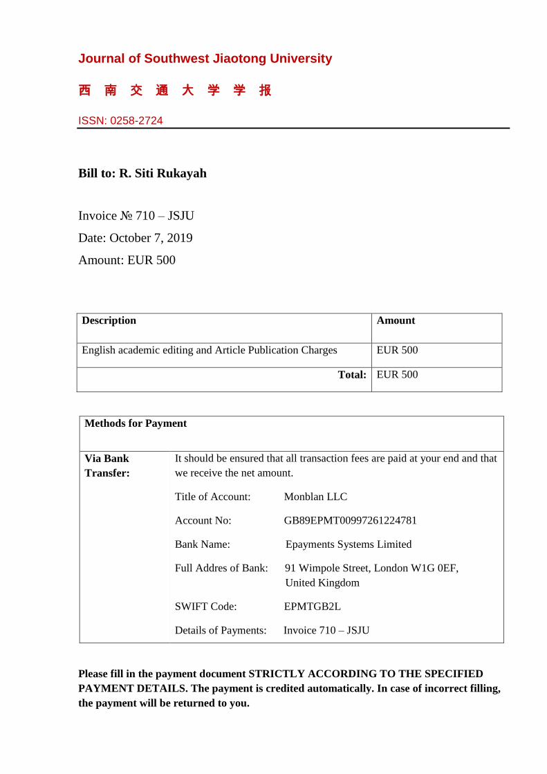
Journal of Southwest Jiaotong University
西 南 交 通 大 学 学 报
ISSN: 0258-2724
Bill to: R. Siti Rukayah
Invoice № 710 – JSJU
Date: October 7, 2019
Amount: EUR 500
Description Amount
English academic editing and Article Publication Charges EUR 500
Total: EUR 500
Methods for Payment
Via Bank
Transfer:
It should be ensured that all transaction fees are paid at your end and that
we receive the net amount.
Title of Account: Monblan LLC
Account No: GB89EPMT00997261224781
Bank Name: Epayments Systems Limited
Full Addres of Bank: 91 Wimpole Street, London W1G 0EF,
United Kingdom
SWIFT Code: EPMTGB2L
Details of Payments: Invoice 710 – JSJU
Please fill in the payment document STRICTLY ACCORDING TO THE SPECIFIED
PAYMENT DETAILS. The payment is credited automatically. In case of incorrect filling,
the payment will be returned to you.

9. Payment of articles
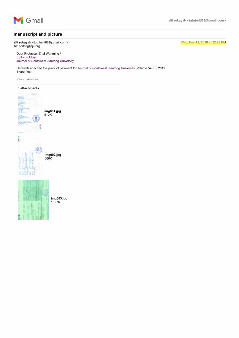
siti rukayah <[email protected]>
manuscript and picture
siti rukayah <[email protected]> Wed, Nov 13, 2019 at 12:28 PMTo: [email protected]
Dear Professor Zhai Wanming / Editor in Chief Journal of Southwest Jiaotong University
Herewith attached the proof of payment for Journal of Southwest Jiaotong University Volume 54 (6), 2019Thank You
[Quoted text hidden]
3 attachments
img001.jpg 512K
img002.jpg 566K
img003.jpg 1827K
10. Manuscript submission by:
1. Manuscript template with pictures
2. The template is a script only
3. The template is an image only
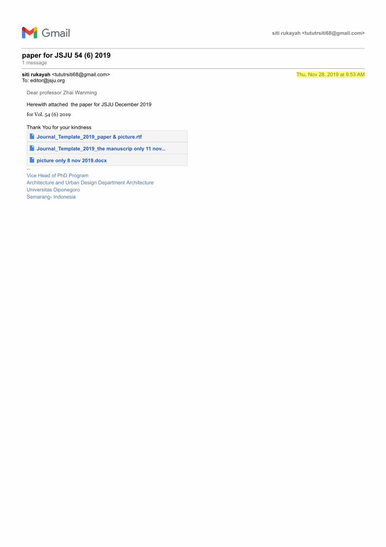
siti rukayah <[email protected]>
paper for JSJU 54 (6) 2019 1 message
siti rukayah <[email protected]> Thu, Nov 28, 2019 at 9:53 AMTo: [email protected]
Dear professor Zhai Wanming
Herewith attached the paper for JSJU December 2019
for Vol. 54 (6) 2019
Thank You for your kindness
Journal_Template_2019_paper & picture.rtf
Journal_Template_2019_the manuscrip only 11 nov...
picture only 8 nov 2019.docx-- Vice Head of PhD ProgramArchitecture and Urban Design Department ArchitectureUniversitas DiponegoroSemarang- Indonesia
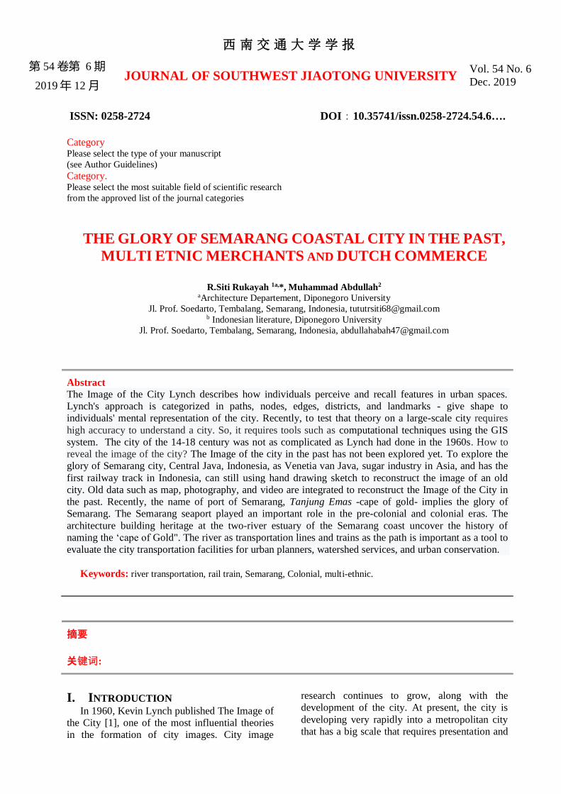
西南交通大学学报
第 54 卷第 6 期
2019年 12 月 JOURNAL OF SOUTHWEST JIAOTONG UNIVERSITY
Vol. 54 No. 6
Dec. 2019
ISSN: 0258-2724 DOI:10.35741/issn.0258-2724.54.6….
Category Please select the type of your manuscript
(see Author Guidelines)
Category. Please select the most suitable field of scientific research
from the approved list of the journal categories
THE GLORY OF SEMARANG COASTAL CITY IN THE PAST,
MULTI ETNIC MERCHANTS AND DUTCH COMMERCE
R.Siti Rukayah 1a,*, Muhammad Abdullah2
aArchitecture Departement, Diponegoro University
Jl. Prof. Soedarto, Tembalang, Semarang, Indonesia, [email protected] b Indonesian literature, Diponegoro University
Jl. Prof. Soedarto, Tembalang, Semarang, Indonesia, [email protected]
Abstract The Image of the City Lynch describes how individuals perceive and recall features in urban spaces.
Lynch's approach is categorized in paths, nodes, edges, districts, and landmarks - give shape to
individuals' mental representation of the city. Recently, to test that theory on a large-scale city requires
high accuracy to understand a city. So, it requires tools such as computational techniques using the GIS
system. The city of the 14-18 century was not as complicated as Lynch had done in the 1960s. How to
reveal the image of the city? The Image of the city in the past has not been explored yet. To explore the
glory of Semarang city, Central Java, Indonesia, as Venetia van Java, sugar industry in Asia, and has the
first railway track in Indonesia, can still using hand drawing sketch to reconstruct the image of an old
city. Old data such as map, photography, and video are integrated to reconstruct the Image of the City in
the past. Recently, the name of port of Semarang, Tanjung Emas -cape of gold- implies the glory of
Semarang. The Semarang seaport played an important role in the pre-colonial and colonial eras. The
architecture building heritage at the two-river estuary of the Semarang coast uncover the history of
naming the ‘cape of Gold". The river as transportation lines and trains as the path is important as a tool to
evaluate the city transportation facilities for urban planners, watershed services, and urban conservation.
Keywords: river transportation, rail train, Semarang, Colonial, multi-ethnic.
摘要
关键词:
I. INTRODUCTION In 1960, Kevin Lynch published The Image of
the City [1], one of the most influential theories
in the formation of city images. City image
research continues to grow, along with the
development of the city. At present, the city is
developing very rapidly into a metropolitan city
that has a big scale that requires presentation and
First author et al. / Journal of Southwest Jiaotong University/ Vol.__ No._Dec. 2019
2
tools to test the image of the city using a
computational approach [2].
Meanwhile, the extent and complexity of
cities in the past are not yet complicated
compared to cities in the present. Therefore, the
use of city image theory to reveal the
representation of city image in the past is still a
research opportunity, especially in historic areas.
Coastal city has become the focus of research
today since the issue of coastal disasters such as
rising seawater, land subsidence. [3]. The disaster
requires handling, especially in historic areas. [4].
Some historic coastal areas emerged due to the
development of trade since prehistoric times in
the Southeast Asian region. The Asian region has
attracted the presence of traders from Arab-Persia
to the archipelago in addition to traders from
India and China. [5]. The location of Indonesia
attracted for explorers of the world to trade or
transit even for stopover [6].
The trace of the settlement of the traders from
around the world is the multi-ethnic architectural
heritage that scattered along the coast in
Indonesia, especially in Java. In Semarang city,
Central Java, Indonesia, the multi-ethnic
settlement become an embryo for city
development. In the Dutch colonial period, they
created a city resemble the Netherland that using
canals for transportation. The Semarang city well
known as the venetie van Java.
They choosing Semarang because the position
precisely in the central of Java. So, the ports on
the north coast of Java played an essential role as
the political and economic power base of the
Dutch East Indies Company. The heart and
politics of the Dutch in controlling crop yields.
To bring some crops from interior Java they built
the first railroad route in Indonesia. The
development of sugarcane and coffee gave rise
Asian conglomerate in its era
However, the remaining area of the past glory
is now partially lost due to geological disasters
on the North coast of Java that occurred since the
8th century. [7]. Sedimentation, rob, and land
subsidence caused heritage areas to be
submerged in water. Some big cities like Jakarta,
Surabaya, and Semarang are predicted to sink
[8][9]–[12]. This paper aims to uncover the glory
of the city of Semarang in the past and reveal that
cultural heritage at risk.
The city of Semarang based on maps in 1719
and 1800 consisting of three districts, namely the
Malay village area, the old downtown area in
Kanjengan, and the colonial fortress area.
Semarang Map Semarang in 1719 put as a
reference. The area of Semarang city was around
500 x 600 meters or about 30 hectares.
Historical record of the foreign sailor, Tome
Pires, when he arrived in Semarang a century
after the arrival of Cheng Ho, witnessed that
Semarang was already a city lead by Muslim
rulers who were the vassals of the Sultanate of
Demak. The population was around 3000 people.
That port has three junks and 4 or 5 boats. The
commercial commodities produced are mainly
rice and other food ingredients. [13] .
Semarang's history is inseparable from
geological problems. This can be seen from the
transfer of port location. In the 8th century AD,
Semarang was still a group of islands with a
coastline located in the Pragotat region (now
known as bergota hill). [14]. History records that
Admiral Cheng Ho's fleet leaned on the port of
Simongan in 1405. [15][16]. In the 14th century,
the coastline was in the Kampung Melayu region
now or precisely in the Sleko region. [17]. Port
traces as a landing places for foreign traders
recently disappear, but the name of the place still
refers the meaning of a landing place. [18]–[20]
The Dutch government moved the port from
Simongan to the Semarang river in the Boom
Lama area, which has been operating since 1743.
This port also experienced siltation so that in
1870, the government dig a channel to the east of
the river mouth, which was named new canal
/Moeara Baroe 'Havenkanaal [21]
The Semarang city position on the central
Java has become one of the mainstay cities in the
VOC's trading strategy. This region is located
right in the middle of the coast and connecting to
Kartasura, the capital of Sunan (Lombard, 2000:
59). The old port near Malay village di Semarang
river estuary experienced siltation. However, to
expedite trading activities, the Dutch government
built a new canal to the new port. The siltation
still process, so that port also experienced silting
until the Dutch government made the modern
port in Tanjung Emas port-cape of gold.
The name of the Tanjung Emas are strategic
research materials to uncover the glory of
Semarang in the past along two river estuary.
Although the existence of the old building
experienced a geological disaster, nevertheless,
the colonial government archives about the area
are complete. Old data such as images, photos,
maps, and videos during the Dutch colonial era,
could be used to reconstruct the Semarang city
image. The study of transportation use and its
role in trade is one aspect of economic
archeology. [22].
Based on historical archives, architectural
heritage, and grounded research, the research
from an architectural and urban design
perspective will use an architectural and city
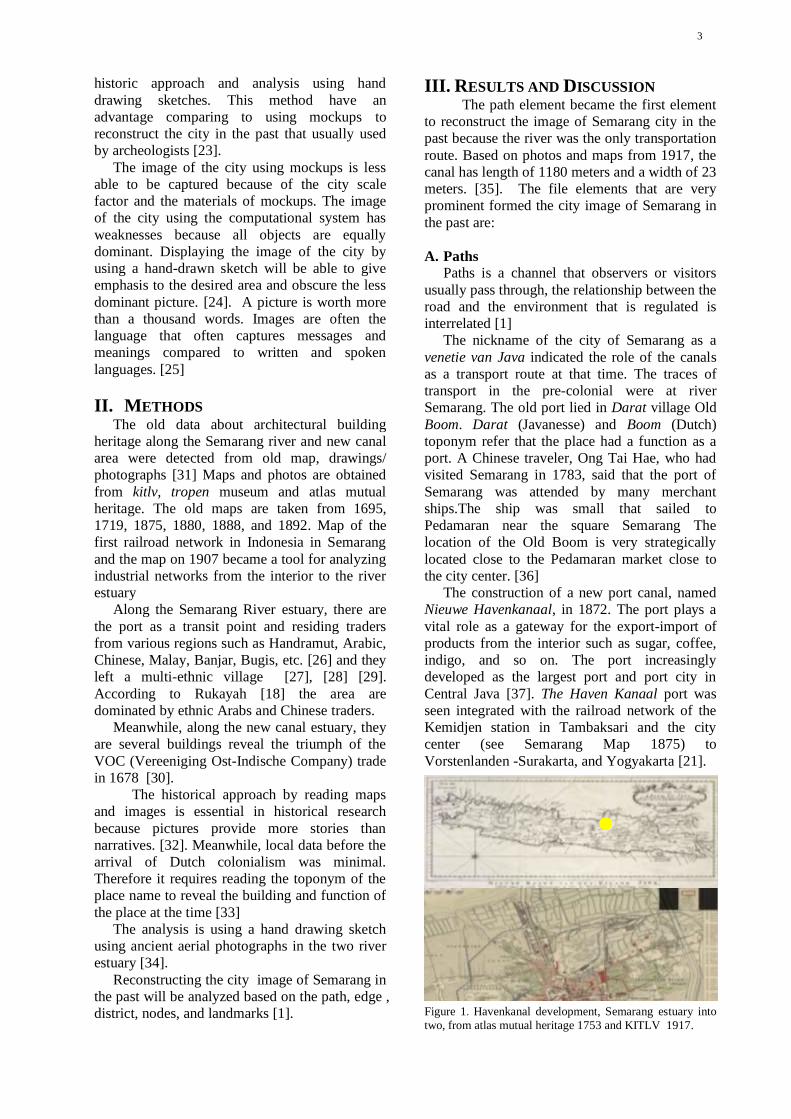
3
historic approach and analysis using hand
drawing sketches. This method have an
advantage comparing to using mockups to
reconstruct the city in the past that usually used
by archeologists [23].
The image of the city using mockups is less
able to be captured because of the city scale
factor and the materials of mockups. The image
of the city using the computational system has
weaknesses because all objects are equally
dominant. Displaying the image of the city by
using a hand-drawn sketch will be able to give
emphasis to the desired area and obscure the less
dominant picture. [24]. A picture is worth more
than a thousand words. Images are often the
language that often captures messages and
meanings compared to written and spoken
languages. [25]
II. METHODS The old data about architectural building
heritage along the Semarang river and new canal
area were detected from old map, drawings/
photographs [31] Maps and photos are obtained
from kitlv, tropen museum and atlas mutual
heritage. The old maps are taken from 1695,
1719, 1875, 1880, 1888, and 1892. Map of the
first railroad network in Indonesia in Semarang
and the map on 1907 became a tool for analyzing
industrial networks from the interior to the river
estuary
Along the Semarang River estuary, there are
the port as a transit point and residing traders
from various regions such as Handramut, Arabic,
Chinese, Malay, Banjar, Bugis, etc. [26] and they
left a multi-ethnic village [27], [28] [29].
According to Rukayah [18] the area are
dominated by ethnic Arabs and Chinese traders.
Meanwhile, along the new canal estuary, they
are several buildings reveal the triumph of the
VOC (Vereeniging Ost-Indische Company) trade
in 1678 [30].
The historical approach by reading maps
and images is essential in historical research
because pictures provide more stories than
narratives. [32]. Meanwhile, local data before the
arrival of Dutch colonialism was minimal.
Therefore it requires reading the toponym of the
place name to reveal the building and function of
the place at the time [33]
The analysis is using a hand drawing sketch
using ancient aerial photographs in the two river
estuary [34].
Reconstructing the city image of Semarang in
the past will be analyzed based on the path, edge ,
district, nodes, and landmarks [1].
III. RESULTS AND DISCUSSION The path element became the first element
to reconstruct the image of Semarang city in the
past because the river was the only transportation
route. Based on photos and maps from 1917, the
canal has length of 1180 meters and a width of 23
meters. [35]. The file elements that are very
prominent formed the city image of Semarang in
the past are:
A. Paths
Paths is a channel that observers or visitors
usually pass through, the relationship between the
road and the environment that is regulated is
interrelated [1]
The nickname of the city of Semarang as a
venetie van Java indicated the role of the canals
as a transport route at that time. The traces of
transport in the pre-colonial were at river
Semarang. The old port lied in Darat village Old
Boom. Darat (Javanesse) and Boom (Dutch)
toponym refer that the place had a function as a
port. A Chinese traveler, Ong Tai Hae, who had
visited Semarang in 1783, said that the port of
Semarang was attended by many merchant
ships.The ship was small that sailed to
Pedamaran near the square Semarang The
location of the Old Boom is very strategically
located close to the Pedamaran market close to
the city center. [36]
The construction of a new port canal, named
Nieuwe Havenkanaal, in 1872. The port plays a
vital role as a gateway for the export-import of
products from the interior such as sugar, coffee,
indigo, and so on. The port increasingly
developed as the largest port and port city in
Central Java [37]. The Haven Kanaal port was
seen integrated with the railroad network of the
Kemidjen station in Tambaksari and the city
center (see Semarang Map 1875) to
Vorstenlanden -Surakarta, and Yogyakarta [21].
Figure 1. Havenkanal development, Semarang estuary into
two, from atlas mutual heritage 1753 and KITLV 1917.
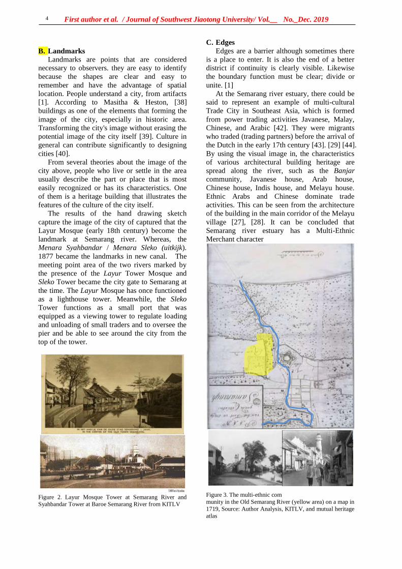
First author et al. / Journal of Southwest Jiaotong University/ Vol.__ No._Dec. 2019
4
B. Landmarks
Landmarks are points that are considered
necessary to observers. they are easy to identify
because the shapes are clear and easy to
remember and have the advantage of spatial
location. People understand a city, from artifacts
[1]. According to Masitha & Heston, [38]
buildings as one of the elements that forming the
image of the city, especially in historic area.
Transforming the city's image without erasing the
potential image of the city itself [39]. Culture in
general can contribute significantly to designing
cities [40].
From several theories about the image of the
city above, people who live or settle in the area
usually describe the part or place that is most
easily recognized or has its characteristics. One
of them is a heritage building that illustrates the
features of the culture of the city itself.
The results of the hand drawing sketch
capture the image of the city of captured that the
Layur Mosque (early 18th century) become the
landmark at Semarang river. Whereas, the
Menara Syahbandar / Menara Sleko (uitkijk).
1877 became the landmarks in new canal. The
meeting point area of the two rivers marked by
the presence of the Layur Tower Mosque and
Sleko Tower became the city gate to Semarang at
the time. The Layur Mosque has once functioned
as a lighthouse tower. Meanwhile, the Sleko
Tower functions as a small port that was
equipped as a viewing tower to regulate loading
and unloading of small traders and to oversee the
pier and be able to see around the city from the
top of the tower.
Figure 2. Layur Mosque Tower at Semarang River and
Syahbandar Tower at Baroe Semarang River from KITLV
C. Edges
Edges are a barrier although sometimes there
is a place to enter. It is also the end of a better
district if continuity is clearly visible. Likewise
the boundary function must be clear; divide or
unite. [1]
At the Semarang river estuary, there could be
said to represent an example of multi-cultural
Trade City in Southeast Asia, which is formed
from power trading activities Javanese, Malay,
Chinese, and Arabic [42]. They were migrants
who traded (trading partners) before the arrival of
the Dutch in the early 17th century [43]. [29] [44].
By using the visual image in, the characteristics
of various architectural building heritage are
spread along the river, such as the Banjar
community, Javanese house, Arab house,
Chinese house, Indis house, and Melayu house.
Ethnic Arabs and Chinese dominate trade
activities. This can be seen from the architecture
of the building in the main corridor of the Melayu
village [27], [28]. It can be concluded that
Semarang river estuary has a Multi-Ethnic
Merchant character
Figure 3. The multi-ethnic com
munity in the Old Semarang River (yellow area) on a map in
1719, Source: Author Analysis, KITLV, and mutual heritage
atlas
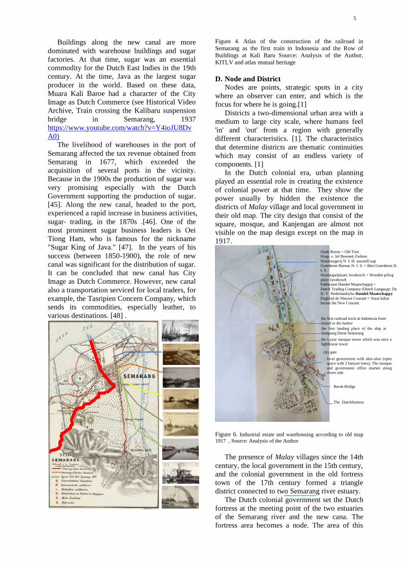
5
Buildings along the new canal are more
dominated with warehouse buildings and sugar
factories. At that time, sugar was an essential
commodity for the Dutch East Indies in the 19th
century. At the time, Java as the largest sugar
producer in the world. Based on these data,
Muara Kali Baroe had a character of the City
Image as Dutch Commerce (see Historical Video
Archive, Train crossing the Kalibaru suspension
bridge in Semarang, 1937
https://www.youtube.com/watch?v=Y4ioJU8Dv
A0)
The livelihood of warehouses in the port of
Semarang affected the tax revenue obtained from
Semarang in 1677, which exceeded the
acquisition of several ports in the vicinity.
Because in the 1900s the production of sugar was
very promising especially with the Dutch
Government supporting the production of sugar.
[45]. Along the new canal, headed to the port,
experienced a rapid increase in business activities,
sugar- trading, in the 1870s .[46]. One of the
most prominent sugar business leaders is Oei
Tiong Ham, who is famous for the nickname
"Sugar King of Java." [47]. In the years of his
success (between 1850-1900), the role of new
canal was significant for the distribution of sugar.
It can be concluded that new canal has City
Image as Dutch Commerce. However, new canal
also a transportation serviced for local traders, for
example, the Tasripien Concern Company, which
sends its commodities, especially leather, to
various destinations. [48] .
Figure 4. Atlas of the construction of the railroad in
Semarang as the first train in Indonesia and the Row of
Buildings at Kali Baru Source: Analysis of the Author,
KITLV and atlas mutual heritage
D. Node and District
Nodes are points, strategic spots in a city
where an observer can enter, and which is the
focus for where he is going.[1]
Districts a two-dimensional urban area with a
medium to large city scale, where humans feel
'in' and 'out' from a region with generally
different characteristics. [1]. The characteristics
that determine districts are thematic continuities
which may consist of an endless variety of
components. [1]
In the Dutch colonial era, urban planning
played an essential role in creating the existence
of colonial power at that time. They show the
power usually by hidden the existence the
districts of Malay village and local government in
their old map. The city design that consist of the
square, mosque, and Kanjengan are almost not
visible on the map design except on the map in
1917.
Figure 6. Industrial estate and warehousing according to old map
1917 , Source: Analysis of the Author
The presence of Malay villages since the 14th
century, the local government in the 15th century,
and the colonial government in the old fortress
town of the 17th century formed a triangle
district connected to two Semarang river estuary.
The Dutch colonial government set the Dutch
fortress at the meeting point of the two estuaries
of the Semarang river and the new cana. The
fortress area becomes a node. The area of this
the first landing place of the ship at kampung Darat Semarang
local government with alun-alun (open space with 2 banyan trees), The mosque
and government office market along rivers side
Oude Boom = Old Tree Hosp. v. Inl Besmett Ziekten
Stoomzagerij N. I. H. sawmill uap Goerderen Bureau N. I. S. = Biro Goerderen N.
I. S. Houtstapelplaats Javabosch = Wooden piling
place Javabosch Pakhuizen Handel Maatschappij =
Dutch Trading Company (Dutch Langauge: De N. V. Nederlandsche Handel-Maatschappy
Dagblad de Nieuwe Courant = Surat kabar harian the New Courant
the first railroad track in Indonesia from
inland to the harbor
the Layur mosque tower which was once a lighthouse tower
Berok Bridge
The Dutchfortress
city gate
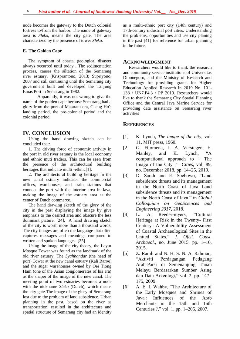
First author et al. / Journal of Southwest Jiaotong University/ Vol.__ No._Dec. 2019
6
node becomes the gateway to the Dutch colonial
fortress to/from the harbor. The name of gateway
area is Sleko, means the city gate. The area
characterized by the presence of tower Sleko.
E. The Golden Cape
The symptom of coastal geological disaster
always occurred until today . The sedimentation
process, causes the siltation of the Semarang
river estuary. (Krisprantono, 2013; Supriyono,
2007 and still continuing until the Semarang city
government built and developed the Tanjung
Emas Port in Semarang in 1982.
Apparently, it was not wrong to give the
name of the golden cape because Semarang had a
glory from the port of Mataram era, Cheng Ho's
landing period, the pre-colonial period and the
colonial period.
IV. CONCLUSION Using the hand drawing sketch can be
concluded that:
1. The driving force of economic activity in
the port in old river estuary is the local economy
and ethnic muti traders. This can be seen from
the presence of the architectural building
heritages that indicate multi -ethnic[1].
2. The architectural building heritage in the
new canal estuary indicates the commercial
offices, warehouses, and train stations that
connect the port with the interior area in Java,
making the image of the estuary area as the
center of Dutch commerce.
The hand drawing sketch of the glory of the
city in the past displaying the image by give
emphasis to the desired area and obscure the less
dominant picture. [24]. A hand drawing sketch
of the city is worth more than a thousand words.
The city images are often the language that often
captures messages and meanings compared to
written and spoken languages. [25]
Using the image of the city theory, the Layur
Mosque Tower was found as the landmark of the
old river estuary. The Syahbandar (the head of
port) Tower at the new canal estuary (Kali Baroe)
and the sugar warehouses owned by Oei Tiong
Ham (one of the Asian conglomerates of his era)
as the shaper of the image of the new canal. The
meeting point of two estuaries becomes a node
with the nickname Sleko (Dutch), which means
the city gate.The image of the glory of Semarang
lost due to the problem of land subsidence. Urban
planning in the past, based on the river as
transportation, resulted in the architecture and
spatial structure of Semarang city had an identity
as a multi-ethnic port city (14th century) and
17th-century industrial port cities. Understanding
the problems, opportunities and use city planing
in the past [41] for reference for urban planning
in the future.
ACKNOWLEDGMENT Researchers would like to thank the research
and community service institutions of Universitas
Diponegoro, and the Ministry of Research and
Technology for providing grants for Higher
Education Applied Research in 2019 No. 101-
138 / UN7.P4.3 / PP 2019. Researchers would
like to thank the Semarang City Spatial Planning
Office and the Central Java Marine Service for
providing data assistance on Semarang river
activities
REFERENCES
[1] K. Lynch, The image of the city, vol.
11. MIT press, 1960.
[2] G. Filomena, J. A. Verstegen, E.
Manley, and K. Lynch, “A
computational approach to ‘ The
Image of the City ,’” Cities, vol. 89,
no. December 2018, pp. 14–25, 2019.
[3] D. Sarah and E. Soebowo, “Land
subsidence threats and its management
in the North Coast of Java Land
subsidence threats and its management
in the North Coast of Java,” in Global
Colloquium on GeoSciences and
Engineering 2017, 2018.
[4] L. A. Reeder-myers, “Cultural
Heritage at Risk in the Twenty- First
Century : A Vulnerability Assessment
of Coastal Archaeological Sites in the
United States,” J. Ofisl. Coast.
Archaeol., no. June 2015, pp. 1–10,
2015.
[5] Z. Ramli and N. H. S. N. A. Rahman,
“Aktiviti Perdagangan Pedagang
Arab-Parsi di Semenanjung Tanah
Melayu Berdasarkan Sumber Asing
dan Data Arkeologi,” vol. 2, pp. 147–
175, 2009.
[6] A. E. I. Wahby, “The Architecture of
the Early Mosques and Shrines of
Java : Influences of the Arab
Merchants in the 15th and 16th
Centuries ?,” vol. 1, pp. 1–205, 2007.
7
[7] R. Van Bemmelen, “Geology of
Indonesia Vol-IA General.”
Government Printing Office, 1948.
[8] N. Colbran, “Will jakarta be the next
atlantis? Excessive groundwater use
resulting from a failing piped water
network,” 5/1 Law, Environmental
Development Journal, vol. 5. pp. 20–
37, 2009.
[9] S. P.Hadi, “In Search for Sustainable
Coastal Management : A Case Study
of Semarang , Indonesia,” in IOP Conf.
Series: Earth and Environmental
Science 55 (2017) 012054, 2017.
[10] M. Gumilar, I. Abidin, H. Z. Sidiq, T.
P. Andreas, H. Maiyudi, R. Gamal,
“Mapping And Evaluating The Impact
Of Land Subsidence In Semarang
( Indonesia ),” Indones. J. Geospatial,
vol. 2, no. 2, pp. 26–41, 2013.
[11] F. Kuehn, Æ. D. Albiol, Æ. G.
Cooksley, and A. H. Æ. D.
Murdohardono, “Detection of land
subsidence in Semarang , Indonesia ,
using stable points network ( SPN )
technique,” pp. 909–921, 2010.
[12] E. Chaussard, F. Amelung, and H. Z.
Abidin, “Sinking Cities In Indonesia :
Space-Geodetic Evidence Of The
Rates And Spatial Distribution Of
Land Subsidence,” vol. 2011, no.
September 2011, pp. 19–23, 2012.
[13] A. Cortesao, The Suma Oriental of
Tome Pires: An Account of the East,
from the Red Sea to Japan, Written in
Malacca and India in 1512-1515.
London: Hakluyt Society Series, 1944.
[14] S. Maziyah, “Kondisi Jawa Tengah
pada Abad VIII sampai Abad XV M,”
Humanika, vol. 15, 2012.
[15] L. T. Joe, Riwayat Semarang:Dari
Djamannya Sam Po Sampe
Terhapoesnya Konkoan. Semarang:
Boekhandel Ho Kim Yoe, 1933.
[16] K. Yuanzhi, Cheng Ho Muslim
Tionghoa. Misteri Perjalanan
Muhibah di Nusantara. Yayasan
Pustaka Obor Indonesia., 2000.
[17] J. Tio, Kota Semarang dalam
Kenangan. Semarang., 2004.
[18] R. Rukayah, D. R. Puguh, E. S. Susilo,
and M. S. Indraswara, “Local Wisdom
of the Native Settlement as A Main
Gate in the Northern Axis of Javanese
City Center in Semarang,” IOP Conf.
Ser. Earth Environ. Sci., vol. 152, no.
1, 2018.
[19] R. S. Rukayah, E. S. Susilo, and M.
Abdullah, “Exploring The Position of
Old Semarang Sea Prt : Based on
Javanese City Pattern,” in 3rd
International Conference on Tropical
and Coastal Region Eco Development
2017, 2018, pp. 0–8.
[20] R. S. Rukayah, E. S. Susilo, and M.
Abdullah, Semarang Kota Pesisir
Lama. Yogyakarta: Tekno Sain, 2018.
[21] “De locomotief: Samarangsch
Handels- en advertentie-blad,” 17-
Feb-1869.
[22] H. Prihatmoko, “Transportasi Air
Dalam Perdagangan Pada Masa Jawa
Kuno Di Jawa Timur,” Forum Arkeol.,
vol. 27, no. 3, pp. 155–174, 2014.
[23] I. Andrisijanti, “Pengembangan Maket
Pusat-Pusat Pemerintahan,” vol. 1, no.
1, pp. 1–29, 2015.
[24] S. Devanny, “Peran Sketsa Tangan
Dalam Profesi Arsitek Studi Banding
antara Sketsa Leonardo da Vinci dan
Frank Gehry,” Universitas Indonesia,
2010.
[25] C. J. Pole, Seeing Is Believing ?
Approaches To Edited By, vol. 7. 2004.
[26] D. Susanto, “Tradisi Seni Lisan
Sebagai Strategi Dakwah di Kalangan
Kaum Habib (Studi Kasus di
Kampung Melayu Kota Semarang).”
Fakultas Dakwah dan Komunikasi
IAIN Walisongo Semarang, 2014.
[27] R. S. Rukayah, D. R. Puguh, and
Endang Sri Susilo, “Local Wisdom of
The Native Settlement as A Main Gate
in The Northern Axis of Javanese City
Center In Semarang Local Wisdom of
The Native Settlement as A Main Gate
in The Northern Axis of Javanese City
Center In Semarang,” 2018.
[28] R. S. Rukayah, E. S. Susilo, M.
Abdullah, and S. Saputro, “Exploring
The Position Of Old Semarang Sea
Port: Based on Javanese City Pattern,”
IOP Conf. Ser. Earth Environ. Sci.,
vol. 116, no. 1, pp. 0–8, 2018.
First author et al. / Journal of Southwest Jiaotong University/ Vol.__ No._Dec. 2019
8
[29] T. Madiasworo, “Revitalisasi Nilai-
Nilai Kearifan Lokal Kampung
Melayu Semarang,” Local Wisdom,
vol. 1, pp. 10–18, 2009.
[30] S. Wibowo, “Sejarah Perkembangan
Kota Semarang ( Jawa Tengah ) di
Masa Lalu dan Dampak Kehadiran
Polutan Nitrat Pada Airtanah di Masa
Kini History of the past development
of the Semarang city ( Central Java )
and its impact on nitrat pollutants
presence in the ground,” Ris. Geol.
dan Pertamb., vol. 23, no. 1, pp. 25–
36, 2013.
[31] Kuntowijoyo, Metodologi Sejarah.
Tiara Wacana Yogya, 1994.
[32] C. J. Pole, Seeing is believing?:
Approaches to visual research.
Citeseer, 2004.
[33] I. Adrisijanti, “Arkeologi Perkotaan
Mataram Islam,” Penerbit Jendela
Yogyakarta, 2000.
[34] B. Brommer, E. Budihardjo, A. B.
Montens, S. Setiadi, A. Sidharta, and
A. Siswanto, Semarang. Nederland:
Asia Maior, 1995.
[35] L. T. Joe, Riwajat Semarang:(dari
djamannja sam poo sampre
terhapoesnja kongkoan). Ho Kim Yoe,
1933.
[36] A. Budiman, Semarang Riwajatmoe
Doeloe. Semarang: Tanjung Sari, 1978.
[37] I. Dewi and R. Sari, “Kota Lama
Semarang ” Situs Sejarah Yang
Terpinggirkan ‘ Old City Of
Semarang ’ The Abandoned Historical
Site,” Berk. Arkeol., vol. 32, no. 2, pp.
195–208, 2012.
[38] A. I. Masitha and Y. P. Heston,
“Rekognisi Bangunan dan Citra Kota,”
Semin. Nas. SCAN #6 "Finding Fifth
Elem. After Water, Earth, Wind. Fire”
Local Wisdom Cult. Sustain., no. 21
Mei 2015, pp. 259–270, 2015.
[39] H. Zhu, J. Qian, and Y. Gao,
“Globalization and the production of
city image in Guangzhou’s metro
station advertisements,” Cities, vol. 28,
no. 3, pp. 221–229, 2011.
[40] A. L. Müller, “Voices in the city. On
the role of arts, artists and urban space
for a just city,” Cities, vol. 91, no.
September 2017, pp. 49–57, 2019.
[41] E. H. Chapman and K. Lynch, “The
Image of the City,” J. Aesthet. Art
Crit., vol. 21, no. 1, p. 91, 1962.
[42] B. N. Prabowo and B. I. Harsritanto,
“Kota Lama Semarang Menuju Status
Pusaka Dunia Unesco: Apa Itu Status
World Heritage?,” Modul, vol. 18, no.
1, p. 51, 2018.
[43] A. Febbiyana and D. Suwandono,
“Penurunan Kampung Melayu Sebagai
Kawasan Cagar Budaya Kota
Semarang The Declining Vitality of
Kampung Melayu as the Heritage
Area in The City of Semarang,” vol. 2,
no. 4, 2016.
[44] D. Susanto, “Pola strategi dakwah
komunitas habaib di kampung melayu
semarang,” vol. 14, no. 1, pp. 159–185,
2014.
[45] L. T. Ling, “Raja Gula Oei Tiong
Ham,” vol. 11, no. 3, p. 312, 1979.
[46] Y. Kunio, “Oei Tiong Ham Concern :
The First Business Empire of
Southeast Asia Introduction,” vol. 27,
no. 2, pp. 137–155, 1989.
[47] S. Claudine, “Oei Tiong Ham
Concern : The First Business Empire
of Southeast Asia,” Archipel, vol. 41,
no. 1, pp. 201–203, 1991.
[48] R. Tarigan, “Kajian Historis dan
Morfologi Kampung – Kampung di
Sekitar Jalan Jagalan dan Jalan
Petudungan Semarang,” 2015.
参考文:

西南交通大学学报
第 54 卷第 6 期
2019年 12 月 JOURNAL OF SOUTHWEST JIAOTONG UNIVERSITY
Vol. 54 No. 6
Dec. 2019
COVER LETTER
Title of the manuscript
THE GLORY OF SEMARANG COASTAL CITY IN THE PAST, MULTI ETNIC MERCHANTS AND DUTCH COMMERCE Abstract
Abstract The Image of the City Lynch describes how individuals perceive and recall
features in urban spaces. Lynch's approach is categorized in paths, nodes, edges, districts,
and landmarks - give shape to individuals' mental representation of the city. Recently, to
test that theory on a large scale city requires high accuracy to understand a city. So, it
requires tools such as computational techniques using the GIS system. The city of the 14-
18 century was not as complicated as Lynch had done in the 1960s. How to reveal the
image of the city? The Image of the city in the past has not been explored yet. To explore
the glory of Semarang city, Central Java, Indonesia, as Venetia van Java, sugar industry in
Asia, and has the first railway track in Indonesia, can still using hand drawing sketch to
reconstruct the image of an old city. Old data such as map, photography, and video are
integrated to reconstruct the Image of the City in the past. Recently, the name of port of
Semarang, Tanjung Emas -cape of gold- implies the glory of Semarang. The Semarang
seaport played an important role in the pre-colonial and colonial eras. The architecture
building heritage at the two-river estuary of the Semarang coast uncover the history of
naming the ‘cape of Gold". The river as transportation lines and trains as the path is
important as a tool to evaluate the city transportation facilities for urban planners,
watershed services, and urban conservation.
Keywords river transportation, rail train , Semarang, Colonial, multi-ethnic
Type of manuscript (please specify):
Regular article
Review article
Brief report
Short communication
Research note
Full name and address of the Corresponding author
Telephone# 08122812825
Fax#
Email [email protected]

First author et al. / Journal of Southwest Jiaotong University/ Vol.__ No._Dec. 2019
2
I hereby confirm that the manuscript was prepared in accordance with the instructions
for authors of scientific publications, and that the content of this manuscript, or most of
it, was not published in the journal indicated, and the manuscript was not submitted for
publication elsewhere.
11 / 7 / 2019
Signature of the Corresponding author Date
First author et al. / Journal of Southwest Jiaotong University/ Vol.__ No._Dec. 2019
3
Copyright Agreement
Manuscript title: THE GLORY OF SEMARANG COASTAL CITY IN THE PAST MULTI ETNIC
MERCHANTS AND DUTCH COMMERCE
Full names of all authors: R.Siti Rukayah, Muhammad Abdullah
Full name and address of the corresponding author:
R.Siti Rukayah
Telephone: 08122812825 Fax: _________________ Email:
License Agreement
(1) Authors own all the copyright rights for the paper.
(2) Submitted manuscript is an original paper.
(3) Authors hereby grant the Issues of Journal of SWJTU with an exclusive, royalty-free, worldwide license to email the paper to all who will ask for it.
(4) All authors have made a significant contribution to the research and are ready to assume joint responsibility for the paper.
(5) All authors have seen and approved the manuscript in the final form as it is submitted for publication.
(6) This manuscript has not been published and also has neither been submitted nor considered for publication elsewhere
(7) The text, illustrations and any other materials, included into the manuscript, do not infringe any existing intellectual property rights or other rights of any person or entity.
(8) The editors of the Issues of Journal of SWJTU, its personnel or the Editorial Board members accept no responsibility for the quality of the idea expressed in this publication.
I am the Corresponding author and have full authority to enter into this agreement.
Full name, affiliation and position: R. Siti Rukayah, Architecture Departement, Diponegoro University, Vice Head of PhD Program Architecture and Urban Design Departement of
Architecture
Signature: Date: 7 November 2019
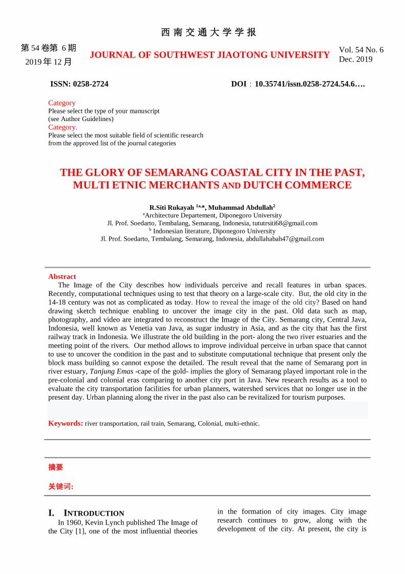
西南交通大学学报
第 54 卷第 6 期
2019年 12 月 JOURNAL OF SOUTHWEST JIAOTONG UNIVERSITY
Vol. 54 No. 6
Dec. 2019
ISSN: 0258-2724 DOI:10.35741/issn.0258-2724.54.6….
Category Please select the type of your manuscript
(see Author Guidelines)
Category. Please select the most suitable field of scientific research
from the approved list of the journal categories
THE GLORY OF SEMARANG COASTAL CITY IN THE PAST,
MULTI ETNIC MERCHANTS AND DUTCH COMMERCE
R.Siti Rukayah 1a,*, Muhammad Abdullah2
aArchitecture Departement, Diponegoro University
Jl. Prof. Soedarto, Tembalang, Semarang, Indonesia, [email protected] b Indonesian literature, Diponegoro University
Jl. Prof. Soedarto, Tembalang, Semarang, Indonesia, [email protected]
Abstract The Image of the City describes how individuals perceive and recall features in urban spaces.
Recently, computational techniques using to test that theory on a large-scale city. But, the old city in the
14-18 century was not as complicated as today. How to reveal the image of the old city? Based on hand
drawing sketch technique enabling to uncover the image city in the past. Old data such as map,
photography, and video are integrated to reconstruct the Image of the City. Semarang city, Central Java,
Indonesia, well known as Venetia van Java, as sugar industry in Asia, and as the city that has the first
railway track in Indonesia. We illustrate the old building in the port- along the two river estuaries and the
meeting point of the rivers. Our method allows to improve individual perceive in urban space that cannot
to use to uncover the condition in the past and to substitute computational technique that present only the
block mass building so cannot expose the detailed. The result reveal that the name of Semarang port in
river estuary, Tanjung Emas -cape of the gold- implies the glory of Semarang played important role in the
pre-colonial and colonial eras comparing to another city port in Java. New research results as a tool to
evaluate the city transportation facilities for urban planners, watershed services that no longer use in the
present day. Urban planning along the river in the past also can be revitalized for tourism purposes.
Keywords: river transportation, rail train, Semarang, Colonial, multi-ethnic.
摘要
关键词:
I. INTRODUCTION In 1960, Kevin Lynch published The Image of
the City [1], one of the most influential theories
in the formation of city images. City image
research continues to grow, along with the
development of the city. At present, the city is
First author et al. / Journal of Southwest Jiaotong University/ Vol.__ No._Dec. 2019
2
developing very rapidly into a metropolitan city
that has a big scale that requires presentation and
tools to test the image of the city using a
computational approach [2].
Meanwhile, the extent and complexity of
cities in the past are not yet complicated
compared to cities in the present. Therefore, the
use of city image theory to reveal the
representation of city image in the past is still a
research opportunity, especially in historic areas.
Coastal city has become the focus of research
today since the issue of coastal disasters such as
rising seawater, land subsidence. [3]. The disaster
requires handling, especially in historic areas. [4].
Some historic coastal areas emerged due to the
development of trade since prehistoric times in
the Southeast Asian region. The Asian region has
attracted the presence of traders from Arab-Persia
to the archipelago in addition to traders from
India and China. [5]. The location of Indonesia
attracted for explorers of the world to trade or
transit even for stopover [6].
The trace of the settlement of the traders from
around the world is the multi-ethnic architectural
heritage that scattered along the coast in
Indonesia, especially in Java. In Semarang city,
Central Java, Indonesia, the multi-ethnic
settlement become an embryo for city
development. In the Dutch colonial period, they
created a city resemble the Netherland that using
canals for transportation. The Semarang city well
known as the venetie van Java.
They choosing Semarang because the position
precisely in the central of Java. So, the ports on
the north coast of Java played an essential role as
the political and economic power base of the
Dutch East Indies Company. The heart and
politics of the Dutch in controlling crop yields.
To bring some crops from interior Java they built
the first railroad route in Indonesia. The
development of sugarcane and coffee gave rise
Asian conglomerate in its era
The city of Semarang based on maps in 1719
and 1800 consisting of three districts, namely the
Malay village area, the old downtown area in
Kanjengan, and the colonial fortress area.
Semarang Map Semarang in 1719 put as a
reference. The area of Semarang city was around
500 x 600 meters or about 30 hectares.
Historical record of the foreign sailor, Tome
Pires, when he arrived in Semarang a century
after the arrival of Cheng Ho, witnessed that
Semarang was already a city lead by Muslim
rulers who were the vassals of the Sultanate of
Demak. The population was around 3000 people.
That port has three junks and 4 or 5 boats. The
commercial commodities produced are mainly
rice and other food ingredients. [7] .
Semarang's history is inseparable from
geological problems. This can be seen from the
transfer of port location. In the 8th century AD,
Semarang was still a group of islands with a
coastline located in the Pragotat region (now
known as bergota hill). [8]. History records that
Admiral Cheng Ho's fleet leaned on the port of
Simongan in 1405. [9][10]. In the 14th century,
the coastline was in the Kampung Melayu region
now or precisely in the Sleko region. [11]. Port
traces as a landing places for foreign traders
recently disappear, but the name of the place still
refers the meaning of a landing place. [12]–[14]
The Dutch government moved the port from
Simongan to the Semarang river in the Boom
Lama area, which has been operating since 1743.
This port also experienced siltation so that in
1870, the government dig a channel to the east of
the river mouth, which was named new canal
/Moeara Baroe 'Havenkanaal [15]
The Semarang city position on the central
Java has become one of the mainstay cities in the
VOC's trading strategy. This region is located
right in the middle of the coast and connecting to
Kartasura, the capital of Sunan (Lombard, 2000:
59). The old port near Malay village di Semarang
river estuary experienced siltation. However, to
expedite trading activities, the Dutch government
built a new canal to the new port. The siltation
still process, so that port also experienced silting
until the Dutch government made the modern
port in Tanjung Emas port-cape of gold.
The symptom of coastal geological disaster
always occurred until today . The sedimentation
process, causes the siltation of the Semarang
river estuary. (Krisprantono, 2013; Supriyono,
2007 and still continuing until the Semarang city
government built and developed the Tanjung
Emas Port in Semarang in 1982.
The name of the Tanjung Emas are strategic
research materials to uncover the glory of
Semarang in the past along two river estuary.
Although the existence of the old building
experienced a geological disaster, nevertheless,
the colonial government archives about the area
are complete. Old data such as images, photos,
maps, and videos during the Dutch colonial era,
could be used to reconstruct the Semarang city
image. The study of transportation use and its
role in trade is one aspect of economic
archeology. [16].
II.RESEARCH AIM The remaining area of the past glory is now
partially lost due to geological disasters on the
3
North coast of Java that occurred since the 8th
century. [17]. Sedimentation, rob, and land
subsidence caused heritage areas to be
submerged in water. Some big cities like Jakarta,
Surabaya, and Semarang are predicted to sink
[18][19]–[22]. This paper aims to uncover the
glory of the city of Semarang in the past
II. LITERATURE REVIEW Lynch theory describes how individuals
perceive and recall features in urban spaces. The
distinctive elements in the urban landscape -
categorised in paths, nodes, edges, districts and
landmarks - give shape to individuals' mental
representation of the city. [1] Lynch’s approach
has stimulated research into spatial cognition,
urban design and artificial intelligence, and it still
represents an essential pillar in the analysis of
urban dynamics. A complete computational
approach to The Image of the City was presented
and tested on a large Boston city. it was difficult
to find a common ground concerning landmarks.
The complexity of human cognition and
perception cannot be fully captured with a
computational approach. [2]
Based on historical archives, architectural
heritage, and grounded research, the research
from an architectural and urban design
perspective will use an architectural and city
historic approach and analysis using hand
drawing sketches. This method have an
advantage comparing to using mockups to
reconstruct the city in the past that usually used
by archeologists [23].
The image of the city using mockups is less
able to be captured because of the city scale
factor and the materials of mockups. The image
of the city using the computational system has
weaknesses because all objects are equally
dominant. Displaying the image of the city by
using a hand-drawn sketch will be able to give
emphasis to the desired area and obscure the less
dominant picture. [24]. A picture is worth more
than a thousand words. Images are often the
language that often captures messages and
meanings compared to written and spoken
languages. [25]
III. METHODS The old data about architectural building
heritage along the Semarang river and new canal
area were detected from old map, drawings/
photographs [26] Maps and photos are obtained
from kitlv, tropen museum and atlas mutual
heritage. The old map are taken from 1695, 1719,
1875, 1880, 1888, 1892. Map of the first railroad
network in Indonesia in Semarang and the map
on 1907 became a tool for analyzing industrial
networks from the interior to the river estuary
Along the Semarang River estuary, there are
the port as a transit point and residing traders
from various regions such as Handramut, Arabic,
Chinese, Malay, Banjar, Bugis, etc. [27] and they
left a multi-ethnic village [28], [29] [30].
According to Rukayah [12] the area are
dominated by ethnic Arabs and Chinese traders.
Meanwhile, along the new canal estuary, they
are several buildings reveal the triumph of the
VOC (Vereeniging Ost-Indische Company) trade
in 1678 [31].
. The historical approach by reading maps
and images is essential in historical research
because pictures provide more stories than
narratives. [32]. Meanwhile, local data before the
arrival of Dutch colonialism was minimal.
Therefore it requires reading the toponym of the
place name to reveal the building and function of
the place at the time [33]
The analysis is using a hand drawing sketch
using ancient aerial photographs in the two river
estuary [34].
Reconstructing the city image of Semarang in
the past will be analyzed based on the path, edge ,
district, nodes, and landmarks [1].
IV. RESULTS AND DISCUSSION The path element became the first element
to reconstruct the image of Semarang city in the
past because the river was the only transportation
route. Based on photos and maps from 1917, the
canal has length of 1180 meters and a width of 23
meters. [35]. The file elements that are very
prominent formed the city image of Semarang in
the past are:
A. Paths
Paths is a channel that observers or visitors
usually pass through, the relationship between the
road and the environment that is regulated is
interrelated [1]
The nickname of the city of Semarang as a
venetie van Java indicated the role of the canals
as a transport route at that time. The traces of
transport in the pre-colonial were at river
Semarang. The old port lied in Darat village Old
Boom. Darat (Javanesse) and Boom (Dutch)
toponym refer that the place had a function as a
port. A Chinese traveler, Ong Tai Hae, who had
visited Semarang in 1783, said that the port of
Semarang was attended by many merchant
ships.The ship was small that sailed to
Pedamaran near the square Semarang The
location of the Old Boom is very strategically
First author et al. / Journal of Southwest Jiaotong University/ Vol.__ No._Dec. 2019
4
located close to the Pedamaran market close to
the city center. [36]
The construction of a new port canal, named
Nieuwe Havenkanaal, in 1872. The port plays a
vital role as a gateway for the export-import of
products from the interior such as sugar, coffee,
indigo, and so on. The port increasingly
developed as the largest port and port city in
Central Java [37]. The Haven Kanaal port was
seen integrated with the railroad network of the
Kemidjen station in Tambaksari and the city
center (see Semarang Map 1875) to
Vorstenlanden -Surakarta, and Yogyakarta [15].
B. Landmarks
Landmarks are points that are considered
necessary to observers. they are easy to identify
because the shapes are clear and easy to
remember and have the advantage of spatial
location. People understand a city, from artifacts
[1]. According to Masitha & Heston, [38]
buildings as one of the elements that forming the
image of the city, especially in historic area.
Transforming the city's image without erasing the
potential image of the city itself [39]. Culture in
general can contribute significantly to designing
cities [40].
From several theories about the image of the
city above, people who live or settle in the area
usually describe the part or place that is most
easily recognized or has its characteristics. One
of them is a heritage building that illustrates the
features of the culture of the city itself.
The results of the hand drawing sketch
capture the image of the city of captured that the
Layur Mosque (early 18th century) become the
landmark at Semarang river. Whereas, the
Menara Syahbandar / Menara Sleko (uitkijk).
1877 became the landmarks in new canal. The
meeting point area of the two rivers marked by
the presence of the Layur Tower Mosque and
Sleko Tower became the city gate to Semarang at
the time. The Layur Mosque has once functioned
as a lighthouse tower. Meanwhile, the Sleko
Tower functions as a small port that was
equipped as a viewing tower to regulate loading
and unloading of small traders and to oversee the
pier and be able to see around the city from the
top of the tower.
C. Edges
Edges are a barrier although sometimes there
is a place to enter. It is also the end of a better
district if continuity is clearly visible. Likewise
the boundary function must be clear; divide or
unite. [1]
At the Semarang river estuary, there could be
said to represent an example of multi-cultural
Trade City in Southeast Asia, which is formed
from power trading activities Javanese, Malay,
Chinese, and Arabic [41]. They were migrants
who traded (trading partners) before the arrival of
the Dutch in the early 17th century [42]. [30] [43].
By using the visual image in, the characteristics
of various architectural building heritage are
spread along the river, such as the Banjar
community, Javanese house, Arab house,
Chinese house, Indis house, and Melayu house.
Ethnic Arabs and Chinese dominate trade
activities. This can be seen from the architecture
of the building in the main corridor of the Melayu
village [28], [29]. It can be concluded that
Semarang river estuary has a Multi-Ethnic
Merchant character
Buildings along the new canal are more
dominated with warehouse buildings and sugar
factories. At that time, sugar was an essential
commodity for the Dutch East Indies in the 19th
century. At the time, Java as the largest sugar
producer in the world. Based on these data,
Muara Kali Baroe had a character of the City
Image as Dutch Commerce (see Historical Video
Archive, Train crossing the Kalibaru suspension
bridge in Semarang, 1937
https://www.youtube.com/watch?v=Y4ioJU8Dv
A0)
The livelihood of warehouses in the port of
Semarang affected the tax revenue obtained from
Semarang in 1677, which exceeded the
acquisition of several ports in the vicinity.
Because in the 1900s the production of sugar was
very promising especially with the Dutch
Government supporting the production of sugar.
[44]. Along the new canal, headed to the port,
experienced a rapid increase in business activities,
sugar- trading, in the 1870s .[45]. One of the
most prominent sugar business leaders is Oei
Tiong Ham, who is famous for the nickname
"Sugar King of Java." [46]. In the years of his
success (between 1850-1900), the role of new
canal was significant for the distribution of sugar.
It can be concluded that new canal has City
Image as Dutch Commerce. However, new canal
also a transportation serviced for local traders, for
example, the Tasripien Concern Company, which
sends its commodities, especially leather, to
various destinations. [47] .
D. Node and District
Nodes are points, strategic spots in a city
where an observer can enter, and which is the
focus for where he is going.[1]

5
Districts a two-dimensional urban area with a
medium to large city scale, where humans feel
'in' and 'out' from a region with generally
different characteristics. [1]. The characteristics
that determine districts are thematic continuities
which may consist of an endless variety of
components. [1]
In the Dutch colonial era, urban planning
played an essential role in creating the existence
of colonial power at that time. They show the
power usually by hidden the existence the
districts of Malay village and local government in
their old map. The city design that consist of the
square, mosque, and Kanjengan are almost not
visible on the map design except on the map in
1917.
The presence of Malay villages since the 14th
century, the local government in the 15th century,
and the colonial government in the old fortress
town of the 17th century formed a triangle
district connected to two Semarang river estuary.
The Dutch colonial government set the Dutch
fortress at the meeting point of the two estuaries
of the Semarang river and the new cana. The
fortress area becomes a node. The area of this
node becomes the gateway to the Dutch colonial
fortress to/from the harbor. The name of gateway
area is Sleko, means the city gate. The area
characterized by the presence of tower Sleko.
V. CONCLUSION Using the hand drawing sketch can be
concluded that:
1. The driving force of economic activity in
the port in old river estuary is the local economy
and ethnic muti traders. This can be seen from
the presence of the architectural building
heritages that indicate multi -ethnic[1].
2. The architectural building heritage in the
new canal estuary indicates the commercial
offices, warehouses, and train stations that
connect the port with the interior area in Java,
making the image of the estuary area as the
center of Dutch commerce.
The hand drawing sketch of the glory of the
city in the past displaying the image by give
emphasis to the desired area and obscure the less
dominant picture. [24]. A hand drawing sketch
of the city is worth more than a thousand words.
The city images using hand drawing sketch
captures messages and meanings that Semarang
in the past was a big city and has economyc
activity lead by multi ethnic traders and then by
Dutch commerce. Picture send message more
compared to written and spoken languages. [25]
Apparently, it was not wrong to give the name
of the golden cape because Semarang had a glory
from the port of Mataram era, Cheng Ho's
landing period, the pre-colonial period and the
colonial period.
Using the image of the city theory, the Layur
Mosque Tower was found as the landmark of the
old river estuary. The Syahbandar (the head of
port) as the tower at the new canal estuary (Kali
Baroe) and the sugar warehouses owned by Oei
Tiong Ham (one of the Asian conglomerates of
his era) as the shaper of the image of the new
canal. The meeting point of two estuaries
becomes a node with the nickname Sleko (Dutch),
which means the city gate.The image of the glory
of Semarang lost due to the problem of land
subsidence.
Urban planning in the past, based on the river
as transportation, resulted in the architecture and
spatial structure of Semarang city had an identity
as a multi-ethnic port city (14th century) and
17th-century industrial port cities. Understanding
the problems, opportunities and use city planing
in the past [48] for reference for urban planning
in the future.
ACKNOWLEDGMENT Researchers would like to thank the the
research and community service institutions of
Universitas Diponegoro, and the Ministry of
Research and Technology for providing grants
for Higher Education Applied Research in 2019
No. 101-138 / UN7.P4.3 / PP 2019. Researchers
would like to thank the Semarang City Spatial
Planning Office and the Central Java Marine
Service for providing data assistance on
Semarang river activities
REFERENCES
[1] K. Lynch, The Image of The City.
London: The M.I.T. Press
Massachusetts Institute of Technology
Cambridge, Massachusetts, and, 1960. [2] G. Filomena, J. A. Verstegen, E.
Manley, and K. Lynch, “A
computational approach to ‘ The
Image of the City ,’” Cities, vol. 89,
no. December 2018, pp. 14–25, 2019.
[3] D. Sarah and E. Soebowo, “Land
subsidence threats and its management
in the North Coast of Java Land
subsidence threats and its management
First author et al. / Journal of Southwest Jiaotong University/ Vol.__ No._Dec. 2019
6
in the North Coast of Java,” in Global
Colloquium on GeoSciences and
Engineering 2017, 2018.
[4] L. A. Reeder-myers, “Cultural
Heritage at Risk in the Twenty- First
Century : A Vulnerability Assessment
of Coastal Archaeological Sites in the
United States,” J. Ofisl. Coast.
Archaeol., no. June 2015, pp. 1–10,
2015.
[5] Z. Ramli and N. H. S. N. A. Rahman,
“Aktiviti Perdagangan Pedagang
Arab-Parsi di Semenanjung Tanah
Melayu Berdasarkan Sumber Asing
dan Data Arkeologi,” vol. 2, pp. 147–
175, 2009.
[6] A. E. I. Wahby, “The Architecture of
the Early Mosques and Shrines of
Java : Influences of the Arab
Merchants in the 15th and 16th
Centuries ?,” vol. 1, pp. 1–205, 2007.
[7] A. Cortesao, The Suma Oriental of
Tome Pires: An Account of the East,
from the Red Sea to Japan, Written in
Malacca and India in 1512-1515.
London: Hakluyt Society Series, 1944.
[8] S. Maziyah, “Kondisi Jawa Tengah
pada Abad VIII sampai Abad XV M,”
Humanika, vol. 15, 2012.
[9] L. T. Joe, Riwayat Semarang:Dari
Djamannya Sam Po Sampe
Terhapoesnya Konkoan. Semarang:
Boekhandel Ho Kim Yoe, 1933.
[10] K. Yuanzhi, Cheng Ho Muslim
Tionghoa. Misteri Perjalanan
Muhibah di Nusantara. Yayasan
Pustaka Obor Indonesia., 2000.
[11] J. Tio, Kota Semarang dalam
Kenangan. Semarang., 2004.
[12] R. Rukayah, D. R. Puguh, E. S. Susilo,
and M. S. Indraswara, “Local Wisdom
of the Native Settlement as A Main
Gate in the Northern Axis of Javanese
City Center in Semarang,” IOP Conf.
Ser. Earth Environ. Sci., vol. 152, no.
1, 2018.
[13] R. S. Rukayah, E. S. Susilo, and M.
Abdullah, “Exploring The Position of
Old Semarang Sea Prt : Based on
Javanese City Pattern,” in 3rd
International Conference on Tropical
and Coastal Region Eco Development
2017, 2018, pp. 0–8.
[14] R. S. Rukayah, E. S. Susilo, and M.
Abdullah, Semarang Kota Pesisir
Lama. Yogyakarta: Tekno Sain, 2018.
[15] “De locomotief: Samarangsch
Handels- en advertentie-blad,” 17-
Feb-1869.
[16] H. Prihatmoko, “Transportasi Air
Dalam Perdagangan Pada Masa Jawa
Kuno Di Jawa Timur,” Forum Arkeol.,
vol. 27, no. 3, pp. 155–174, 2014.
[17] R. Van Bemmelen, “Geology of
Indonesia Vol-IA General.”
Government Printing Office, 1948.
[18] N. Colbran, “Will jakarta be the next
atlantis? Excessive groundwater use
resulting from a failing piped water
network,” 5/1 Law, Environmental
Development Journal, vol. 5. pp. 20–
37, 2009.
[19] S. P.Hadi, “In Search for Sustainable
Coastal Management : A Case Study
of Semarang , Indonesia,” in IOP Conf.
Series: Earth and Environmental
Science 55 (2017) 012054, 2017.
[20] M. Gumilar, I. Abidin, H. Z. Sidiq, T.
P. Andreas, H. Maiyudi, R. Gamal,
“Mapping And Evaluating The Impact
Of Land Subsidence In Semarang
( Indonesia ),” Indones. J. Geospatial,
vol. 2, no. 2, pp. 26–41, 2013.
[21] F. Kuehn, Æ. D. Albiol, Æ. G.
Cooksley, and A. H. Æ. D.
Murdohardono, “Detection of land
subsidence in Semarang , Indonesia ,
using stable points network ( SPN )
technique,” pp. 909–921, 2010.
[22] E. Chaussard, F. Amelung, and H. Z.
Abidin, “Sinking Cities In Indonesia :
Space-Geodetic Evidence Of The
Rates And Spatial Distribution Of
Land Subsidence,” vol. 2011, no.
September 2011, pp. 19–23, 2012.
[23] I. Andrisijanti, “Pengembangan Maket
Pusat-Pusat Pemerintahan,” vol. 1, no.
1, pp. 1–29, 2015.
[24] S. Devanny, “Peran Sketsa Tangan
Dalam Profesi Arsitek Studi Banding
antara Sketsa Leonardo da Vinci dan
Frank Gehry,” Universitas Indonesia,
2010.
[25] C. J. Pole, Seeing Is Believing ?
7
Approaches To Edited By, vol. 7. 2004.
[26] Kuntowijoyo, Metodologi Sejarah.
Tiara Wacana Yogya, 1994.
[27] D. Susanto, “Tradisi Seni Lisan
Sebagai Strategi Dakwah di Kalangan
Kaum Habib (Studi Kasus di
Kampung Melayu Kota Semarang).”
Fakultas Dakwah dan Komunikasi
IAIN Walisongo Semarang, 2014.
[28] R. S. Rukayah, D. R. Puguh, and
Endang Sri Susilo, “Local Wisdom of
The Native Settlement as A Main Gate
in The Northern Axis of Javanese City
Center In Semarang Local Wisdom of
The Native Settlement as A Main Gate
in The Northern Axis of Javanese City
Center In Semarang,” 2018.
[29] R. S. Rukayah, E. S. Susilo, M.
Abdullah, and S. Saputro, “Exploring
The Position Of Old Semarang Sea
Port: Based on Javanese City Pattern,”
IOP Conf. Ser. Earth Environ. Sci.,
vol. 116, no. 1, pp. 0–8, 2018.
[30] T. Madiasworo, “Revitalisasi Nilai-
Nilai Kearifan Lokal Kampung
Melayu Semarang,” Local Wisdom,
vol. 1, pp. 10–18, 2009.
[31] S. Wibowo, “Sejarah Perkembangan
Kota Semarang ( Jawa Tengah ) di
Masa Lalu dan Dampak Kehadiran
Polutan Nitrat Pada Airtanah di Masa
Kini History of the past development
of the Semarang city ( Central Java )
and its impact on nitrat pollutants
presence in the ground,” Ris. Geol.
dan Pertamb., vol. 23, no. 1, pp. 25–
36, 2013.
[32] C. J. Pole, Seeing is believing?:
Approaches to visual research.
Citeseer, 2004.
[33] I. Adrisijanti, “Arkeologi Perkotaan
Mataram Islam,” Penerbit Jendela
Yogyakarta, 2000.
[34] B. Brommer, E. Budihardjo, A. B.
Montens, S. Setiadi, A. Sidharta, and
A. Siswanto, Semarang. Nederland:
Asia Maior, 1995.
[35] L. T. Joe, Riwajat Semarang:(dari
djamannja sam poo sampre
terhapoesnja kongkoan). Ho Kim Yoe,
1933.
[36] A. Budiman, Semarang Riwajatmoe
Doeloe. Semarang: Tanjung Sari, 1978.
[37] I. Dewi and R. Sari, “Kota Lama
Semarang ” Situs Sejarah Yang
Terpinggirkan ‘ Old City Of
Semarang ’ The Abandoned Historical
Site,” Berk. Arkeol., vol. 32, no. 2, pp.
195–208, 2012.
[38] A. I. Masitha and Y. P. Heston,
“Rekognisi Bangunan dan Citra Kota,”
Semin. Nas. SCAN #6 "Finding Fifth
Elem. After Water, Earth, Wind. Fire”
Local Wisdom Cult. Sustain., no. 21
Mei 2015, pp. 259–270, 2015.
[39] H. Zhu, J. Qian, and Y. Gao,
“Globalization and the production of
city image in Guangzhou’s metro
station advertisements,” Cities, vol. 28,
no. 3, pp. 221–229, 2011.
[40] A. L. Müller, “Voices in the city. On
the role of arts, artists and urban space
for a just city,” Cities, vol. 91, no.
September 2017, pp. 49–57, 2019.
[41] B. N. Prabowo and B. I. Harsritanto,
“Kota Lama Semarang Menuju Status
Pusaka Dunia Unesco: Apa Itu Status
World Heritage?,” Modul, vol. 18, no.
1, p. 51, 2018.
[42] A. Febbiyana and D. Suwandono,
“Penurunan Kampung Melayu Sebagai
Kawasan Cagar Budaya Kota
Semarang The Declining Vitality of
Kampung Melayu as the Heritage
Area in The City of Semarang,” vol. 2,
no. 4, 2016.
[43] D. Susanto, “Pola strategi dakwah
komunitas habaib di kampung melayu
semarang,” vol. 14, no. 1, pp. 159–185,
2014.
[44] L. T. Ling, “Raja Gula Oei Tiong
Ham,” vol. 11, no. 3, p. 312, 1979.
[45] Y. Kunio, “Oei Tiong Ham Concern :
The First Business Empire of
Southeast Asia Introduction,” vol. 27,
no. 2, pp. 137–155, 1989.
[46] S. Claudine, “Oei Tiong Ham
Concern : The First Business Empire
of Southeast Asia,” Archipel, vol. 41,
no. 1, pp. 201–203, 1991.
[47] R. Tarigan, “Kajian Historis dan
Morfologi Kampung – Kampung di
Sekitar Jalan Jagalan dan Jalan
Petudungan Semarang,” 2015.

First author et al. / Journal of Southwest Jiaotong University/ Vol.__ No._Dec. 2019
8
[48] E. H. Chapman and K. Lynch, “The
Image of the City,” J. Aesthet. Art
Crit., vol. 21, no. 1, p. 91, 1962.
参考文:
西南交通大学学报
第 54 卷第 6 期
2019年 12 月 JOURNAL OF SOUTHWEST JIAOTONG UNIVERSITY
Vol. 54 No. 6
Dec. 2019
COVER LETTER
Title of the manuscript
THE GLORY OF SEMARANG COASTAL CITY IN THE PAST MULTI ETNIC MERCHANTS AND DUTCH COMMERCE Abstract
Abstract The Image of the City Lynch describes how individuals perceive and recall
features in urban spaces. Lynch's approach is categorized in paths, nodes, edges, districts,
and landmarks - give shape to individuals' mental representation of the city. Recently, to
test that theory on a large scale city requires high accuracy to understand a city. So, it
requires tools such as computational techniques using the GIS system. The city of the 14-
18 century was not as complicated as Lynch had done in the 1960s. How to reveal the
image of the city? The Image of the city in the past has not been explored yet. To explore
the glory of Semarang city, Central Java, Indonesia, as Venetia van Java, sugar industry in
Asia, and has the first railway track in Indonesia, can still using hand drawing sketch to
reconstruct the image of an old city. Old data such as map, photography, and video are
integrated to reconstruct the Image of the City in the past. Recently, the name of port of
Semarang, Tanjung Emas -cape of gold- implies the glory of Semarang. The Semarang
seaport played an important role in the pre-colonial and colonial eras. The architecture
building heritage at the two river estuary of the Semarang coast uncover the history of
naming the ‘cape of Gold". The river as transportation lines and trains as the path is
important as a tool to evaluate the city transportation facilities for urban planners,
watershed services, and urban conservation.
Keywords river transportation, rail train , Semarang, Colonial, multi-ethnic
Type of manuscript (please specify):
Regular article
Review article
Brief report
Short communication
Research note
Full name and address of the Corresponding author
Telephone# 08122812825
Fax#
Email [email protected]

First author et al. / Journal of Southwest Jiaotong University/ Vol.__ No._Dec. 2019
2
I hereby confirm that the manuscript was prepared in accordance with the instructions
for authors of scientific publications, and that the content of this manuscript, or most of
it, was not published in the journal indicated, and the manuscript was not submitted for
publication elsewhere.
11 / 7 / 2019
Signature of the Corresponding author Date

First author et al. / Journal of Southwest Jiaotong University/ Vol.__ No._Dec. 2019
3
Copyright Agreement
Manuscript title: THE GLORY OF SEMARANG COASTAL CITY IN THE PAST MULTI ETNIC
MERCHANTS AND DUTCH COMMERCE
Full names of all authors: R.Siti Rukayah, Muhammad Abdullah
Full name and address of the corresponding author:
R.Siti Rukayah
Telephone: 08122812825 Fax: _________________ Email:
License Agreement
(1) Authors own all the copyright rights for the paper.
(2) Submitted manuscript is an original paper.
(3) Authors hereby grant the Issues of Journal of SWJTU with an exclusive, royalty-free, worldwide license to email the paper to all who will ask for it.
(4) All authors have made a significant contribution to the research and are ready to assume joint responsibility for the paper.
(5) All authors have seen and approved the manuscript in the final form as it is submitted for publication.
(6) This manuscript has not been published and also has neither been submitted nor considered for publication elsewhere
(7) The text, illustrations and any other materials, included into the manuscript, do not infringe any existing intellectual property rights or other rights of any person or entity.
(8) The editors of the Issues of Journal of SWJTU, its personnel or the Editorial Board members accept no responsibility for the quality of the idea expressed in this publication.
I am the Corresponding author and have full authority to enter into this agreement.
Full name, affiliation and position: R. Siti Rukayah, Architecture Departement, Diponegoro University, Vice Head of PhD Program Architecture and Urban Design Departement of
Architecture
Signature: Date: 7 November 2019
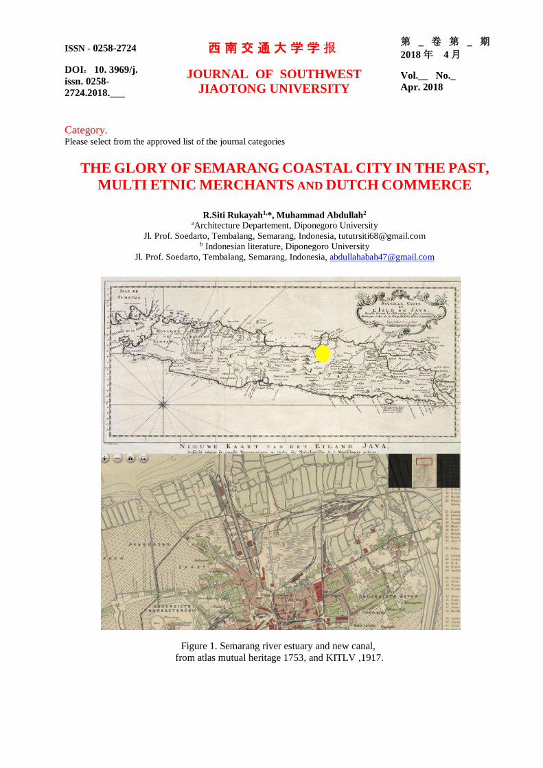
ISSN - 0258-2724 西南交通大学学报 第 _ 卷 第 _ 期
2018 年 4 月
DOI: 10. 3969/j.
issn. 0258-
2724.2018.___
JOURNAL OF SOUTHWEST
JIAOTONG UNIVERSITY Vol.__ No._
Apr. 2018
Category. Please select from the approved list of the journal categories
THE GLORY OF SEMARANG COASTAL CITY IN THE PAST,
MULTI ETNIC MERCHANTS AND DUTCH COMMERCE
R.Siti Rukayah1,*, Muhammad Abdullah2
aArchitecture Departement, Diponegoro University
Jl. Prof. Soedarto, Tembalang, Semarang, Indonesia, [email protected] b Indonesian literature, Diponegoro University
Jl. Prof. Soedarto, Tembalang, Semarang, Indonesia, [email protected]
Figure 1. Semarang river estuary and new canal,
from atlas mutual heritage 1753, and KITLV ,1917.

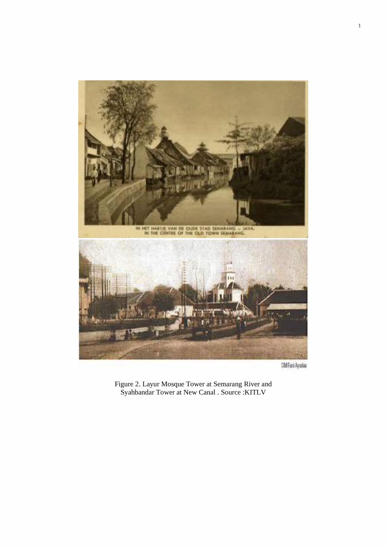
1
Figure 2. Layur Mosque Tower at Semarang River and
Syahbandar Tower at New Canal . Source :KITLV

First author et al. / Journal of Southwest Jiaotong University/ Vol.__ No._Apr. 2018
2
Figure 3. The multi-ethnic community in the Old Semarang River (yellow area) on a map in 1719,
Source: Author Analysis, KITLV, and mutual heritage atlas

3
Figure 4. Atlas of the construction of the railroad in Semarang as the first train in Indonesia and the Row of Buildings at
Kali Baru
Source: Analysis of the Author, KITLV and atlas mutual heritage
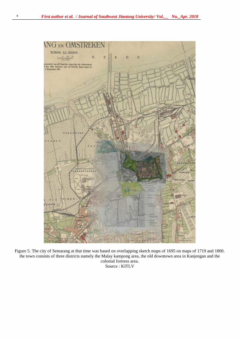
First author et al. / Journal of Southwest Jiaotong University/ Vol.__ No._Apr. 2018
4
Figure 5. The city of Semarang at that time was based on overlapping sketch maps of 1695 on maps of 1719 and 1800.
the town consists of three districts namely the Malay kampong area, the old downtown area in Kanjengan and the
colonial fortress area.
Source : KITLV

5
Figure 6 . hand drawing scketch the city image of Semarang
the view tower
the first landing place of the ship
at kampung Darat Semarang
local government with alun-alun
(open space with 2 banyan trees), The mosque and government
office market along rivers side
Industrial estate and warehousing
according to oldmap 1917 consist of Oude Boom = Old Tree
Hosp. v. Inl Besmett Ziekten
Stoomzagerij N. I. H. sawmill uap
Goerderen Bureau N. I. S. = Biro Goerderen N. I. S.
Houtstapelplaats Javabosch = Wooden
piling place Javabosch
Pakhuizen Handel Maatschappij = Dutch Trading Company (Dutch
Langauge: De N. V. Nederlandsche
Handel-Maatschappy
Dagblad de Nieuwe Courant = Surat kabar harian the New Courant
the first railroad track in
Indonesia from inland to the
harbor
the Layur mosque tower which was
once a lighthouse tower
Berok Bridge
The Dutchfortress
city gate
The Dutch Commerce
The Multi Ethnic Traders

11. Review article – 2
Direction from the editor

siti rukayah <[email protected]>
URGENT!
[email protected] <[email protected]> Sat, Jan 4, 2020 at 4:00 PMTo: [email protected]: [email protected]
Dear authors, please answer the editor's questions immediately. Regards!
THE GLORY OF SEMARANG COASTAL CITY IN THE PAST.doc 3334K
西南交通大学学报
第 54 卷 第 6 期
2019年 12 月 JOURNAL OF SOUTHWEST JIAOTONG UNIVERSITY
Vol. 54 No. 6
Dec. 2019
ISSN: 0258-2724 DOI:10.35741/issn.0258-2724.54.6….
Research Article
Architecture
THE GLORY OF SEMARANG COASTAL CITY IN THE PAST, MULTI-
ETHNIC MERCHANTS AND DUTCH COMMERCE
过去,多民族贸易和荷兰商业中三宝垄沿海城市的荣耀
R. Siti Rukayah a, *, Muhammad Abdullah b
a Architecture Departement, Diponegoro University
Jl. Prof. Soedarto, Tembalang, Semarang, Indonesia, [email protected] b Indonesian Literature, Diponegoro University
Jl. Prof. Soedarto, Tembalang, Semarang, Indonesia, [email protected]
Abstract In The Image of the City, Lynch describes how individuals perceive and recall features in urban
spaces. Lynch's approach is categorized by paths, nodes, edges, districts, and landmarks – giving shape to
individuals' mental representation of the city. Recently, to test that theory on a large-scale city requires
high accuracy to understand a city. So, it requires tools such as computational techniques using the GIS
system. The cities of the 14th-18th centuries were not as complicated as the ones Lynch was dealing with
in the 1960s. How do you reveal the image of the city? The image of the city in the past had not been
explored yet. To explore the glory of Semarang city, Central Java, Indonesia, as Venetia van Java, which
has the sugar industry in Asia, and the first railway track in Indonesia, you can still use hand-drawn
sketches to reconstruct the image of the old city. Old data such as maps, photographs, and videos are
integrated to reconstruct the image of the city in the past. Recently, the name of port of Semarang,
Tanjung Emas – cape of gold – implies the glory of Semarang. The Semarang seaport played an
important role in the pre-colonial and colonial eras. The architectural heritage at the two-river estuary of
the Semarang coast uncovers the history of naming it the ‘cape of gold’. The river serves as roads and
train lines, as the path is important as a tool to evaluate the city transportation facilities for urban
planners, watershed services, and urban conservation.
Keywords: River Transportation, Rail Train, Semarang, Colonial, Multi-Ethnic
摘要 在《城市形象》中,林奇描述了人们如何感知和回忆城市空间中的特征。林奇的方法按路径
,节点,边缘,地区和地标分类-塑造了个人对城市的心理表现。最近,要在一个大型城市上测试
该理论,需要很高的准确度才能理解一个城市。因此,它需要使用地理信息系统系统的工具,例
如计算技术。 14至 18世纪的城市并不像林奇在 1960年代处理的城市那样复杂。您如何展现城市
Rukayah and Abdullah / Journal of Southwest Jiaotong University/ Vol.54 No.6 Dec. 2019 2
形象?过去尚未探索过这座城市的形象。要探索印度尼西亚中爪哇省三宝垄市的荣耀,就像拥有
亚洲制糖业和印度尼西亚第一条铁路轨道的威尼斯范爪哇一样,您仍然可以使用手绘草图来重建
旧城区的图像。整合了诸如地图,照片和视频之类的旧数据,以重建过去的城市形象。最近,三
宝垄港口的名字丹戎·埃玛斯(金角)象征着三宝垄的荣耀。三宝垄海港在前殖民时代和殖民时代
起着重要作用。三宝垄海岸两河口的建筑遗产揭示了将其命名为“金海角”的历史。河流充当道
路和火车线,因为这条道路对于评估城市规划者,分水岭服务和城市保护区的城市交通设施至关
重要。
关键词: 内河运输,铁路,三宝垄,殖民地,多民族
I. INTRODUCTION In 1960, Kevin Lynch published The Image of
the City [1], one of the most influential theories
in the formation of city images. City image
research continues to grow, along with the
development of the city. At present, the city is
developing very rapidly into a metropolitan city
of a large scale that requires presentation and
tools to test the image of the city using a
computational approach [2].
Meanwhile, the extent and complexity of
cities in the past are not that complicated
compared to cities in the present. Therefore, the
use of city image theory to reveal the
representation of a city image in the past is still a
research opportunity, especially in historic areas.
Coastal cities have become the focus of
research today because of the issue of coastal
disasters, such as rising seawater and land
subsidence [3]. The disasters require handling,
especially in historic areas [4]. Some historic
coastal areas emerged due to the development of
trade since prehistoric times in the Southeast
Asian region. The Asian region has attracted the
presence of traders from Arab-Persia to the
archipelago in addition to traders from India and
China [5]. The location of Indonesia attracted
explorers of the world to trade or transit even for
a stopover [6].
The trace of the settlement of the traders from
around the world is the multi-ethnic architectural
heritage that is scattered along the coast of
Indonesia, especially in Java. In Semarang city,
Central Java, Indonesia, the multi-ethnic
settlement become an embryo for city
development. In the Dutch colonial period, they
created a city to resemble the Netherlands using
canals for transportation. Semarang city is well
known as the Venetia van Java.
They chose Semarang because of its position
precisely in the centre of Java. So, the ports on
the north coast of Java played an essential role as
the political and economic power base of the
Dutch East Indies Company. It was the heart and
politics of the Dutch in controlling crop yields.
To bring some crops from interior Java, they built
the first railroad route in Indonesia. The
development of sugarcane and coffee gave rise to
the Asian conglomerate in its era.
However, the remaining area of the past glory
is now partially lost due to geological disasters
on the North coast of Java that have occurred
since the 8th century [7]. Sedimentation and land
subsidence have caused heritage areas to become
submerged in water. Some big cities such as
Jakarta, Surabaya, and Semarang are also
predicted to sink [8], [9], [10], [11], [12]. This
paper aims to uncover the glory of the city of
Semarang in the past and reveal that its cultural
heritage is at risk.
The city of Semarang, based on maps from
1719 and 1800, consisted of three districts,
namely the Malay village area, the old downtown
area in Kanjengan, and the colonial fortress area.
Semarang Map Semarang in 1719 put this as a
reference. The area of Semarang city was around
500 by 600 meters, or about 30 hectares. There is
a historical record that the foreign sailor, Tome
Pires, when he arrived in Semarang a century
after the arrival of Cheng Ho, witnessed that
Semarang was already a city led by Muslim
rulers who were the vassals of the Sultanate of
Demak. The population was around 3000 people.
That port had three junks and four or five boats.
The commercial commodities produced were
mainly rice and other food ingredients [13].
Semarang's history is inseparable from its
geological problems. This can be seen from the
transfer of the port location. In the 8th century,
Semarang was still a group of islands with a
coastline located in the Pragotat region (now
known as Bergota Hill) [14]. History records that
Admiral Cheng Ho's fleet landed at the port of
Simongan in 1405 [15], [16]. In the 14th century,
3
the coastline was in what is now the Kampung
Melayu region, or precisely in the Sleko region
[17]. Port traces as a landing places for foreign
traders recently disappear, but the name of the
place still refers to its meaning of a landing place
[18], [19], [20].
The Dutch government moved the port from
Simongan to the Semarang river in the Boom
Lama area, which has been operating since 1743.
This port also experienced siltation so that, in
1870, the government dug a channel to the east of
the river mouth, which was named New
Canal/Moeara Baroe 'Havenkanaal [21].
Semarang city in central Java has become one
of the mainstay cities in the VOC's trading
strategy. This region is located right in the middle
of the coast and is connected to Kartasura, the
capital of Sunan (Lombard, 2000: 59). The old
port near the Malay village on the Semarang river
estuary is experienced in siltation. However, to
expedite trading activities, the Dutch government
built a new canal to the new port. The siltation
still processes, so that port also experienced
silting until the Dutch government made the
modern port in Tanjung Emas port-cape of gold.
The name of the Tanjung Emas is a strategic
topic to research to uncover the glory of
Semarang in the past along the two-river estuary.
Although the existence of the old building
experienced a geological disaster, nevertheless,
the colonial government archives about the area
are complete. Old data such as images, photos,
maps, and videos made during the Dutch colonial
era could be used to reconstruct the Semarang
city image. The study of transportation use and
its role in trade is one aspect of economic
archeology [22].
Based on historical archives, architectural
heritage, and grounded research, the research
from an architectural and urban design
perspective will use an architectural and city
historic approach and analysis using hand-drawn
sketches. This method has an advantage
compared to using mock-ups to reconstruct the
city in the past, which is the method that is
usually used by archaeologists [23].
The image of the city using mock ups is less
easily captured because of the scale of the city
model and the materials used. The image of the
city using the computational system has
weaknesses because all objects are equally
dominant. Displaying the image of the city by
using a hand-drawn sketch will allow us to give
emphasis to the desired area and obscure the less
dominant picture [24]. A picture is worth more
than a thousand words. Images are often the
language that often captures messages and
meanings compared to written and spoken
languages [25].
II. METHODS The old data about architectural building
heritage along the Semarang river and new canal
area were detected from old map, drawings/
photographs [29] Maps and photos are obtained
from kitlv, tropen museum and atlas mutual
heritage. The old maps are taken from 1695,
1719, 1875, 1880, 1888, and 1892. Map of the
first railroad network in Indonesia in Semarang
and the map on 1907 became a tool for analyzing
industrial networks from the interior to the river
estuary
Along the Semarang River estuary, there are
the port as a transit point and residing traders
from various regions such as Handramut, Arabic,
Chinese, Malay, Banjar, Bugis, etc. [26] and they
left a multi-ethnic village [27], [28]. According to
Rukayah [18] the area are dominated by ethnic
Arabs and Chinese traders.
Meanwhile, along the new canal estuary, they
are several buildings reveal the triumph of the
VOC (Vereeniging Ost-Indische Company) trade
in 1678 [28].
The historical approach of reading maps and
images is essential in historical research because
pictures provide more stories than narratives [30].
Meanwhile, local data before the arrival of Dutch
colonialism was minimal. Therefore, it requires
reading the toponym of the place name to reveal
the building and function of the place at the time
[30].
The analysis is done using hand-drawn
sketches and ancient aerial photographs of the
two-river estuary [31].
Reconstructing the city image of Semarang in
the past will be analyzed based on the paths,
edges, districts, nodes, and landmarks [1].
III. RESULTS AND DISCUSSION The path element became the first element to
reconstruct the image of Semarang city in the
past because the river was the only transportation
route. Based on photos and maps from 1917, the
canal was 1,180 meters long and 23 meters wide
[32]. The file elements that are very prominent
and formed the city image of Semarang in the
past are:
A. Paths
Paths are channels that observers or visitors
usually pass through – the relationship between
the road and the environment that is regulated is
interrelated [1].
The nickname of the city of Semarang was
Venetia van Java, indicating the role of the canals
Commented [П1]: Publication data of the source are required
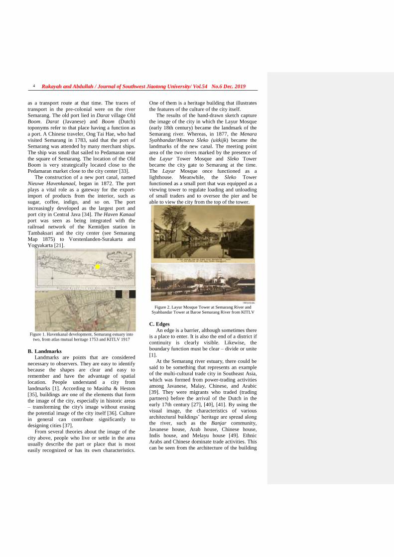
Rukayah and Abdullah / Journal of Southwest Jiaotong University/ Vol.54 No.6 Dec. 2019
4
as a transport route at that time. The traces of
transport in the pre-colonial were on the river
Semarang. The old port lied in Darat village Old
Boom. Darat (Javanese) and Boom (Dutch)
toponyms refer to that place having a function as
a port. A Chinese traveler, Ong Tai Hae, who had
visited Semarang in 1783, said that the port of
Semarang was attended by many merchant ships.
The ship was small that sailed to Pedamaran near
the square of Semarang. The location of the Old
Boom is very strategically located close to the
Pedamaran market close to the city center [33].
The construction of a new port canal, named
Nieuwe Havenkanaal, began in 1872. The port
plays a vital role as a gateway for the export-
import of products from the interior, such as
sugar, coffee, indigo, and so on. The port
increasingly developed as the largest port and
port city in Central Java [34]. The Haven Kanaal
port was seen as being integrated with the
railroad network of the Kemidjen station in
Tambaksari and the city center (see Semarang
Map 1875) to Vorstenlanden-Surakarta and
Yogyakarta [21].
Figure 1. Havenkanal development, Semarang estuary into
two, from atlas mutual heritage 1753 and KITLV 1917
B. Landmarks
Landmarks are points that are considered
necessary to observers. They are easy to identify
because the shapes are clear and easy to
remember and have the advantage of spatial
location. People understand a city from
landmarks [1]. According to Masitha & Heston
[35], buildings are one of the elements that form
the image of the city, especially in historic areas
– transforming the city's image without erasing
the potential image of the city itself [36]. Culture
in general can contribute significantly to
designing cities [37].
From several theories about the image of the
city above, people who live or settle in the area
usually describe the part or place that is most
easily recognized or has its own characteristics.
One of them is a heritage building that illustrates
the features of the culture of the city itself.
The results of the hand-drawn sketch capture
the image of the city in which the Layur Mosque
(early 18th century) became the landmark of the
Semarang river. Whereas, in 1877, the Menara
Syahbandar/Menara Sleko (uitkijk) became the
landmarks of the new canal. The meeting point
area of the two rivers marked by the presence of
the Layur Tower Mosque and Sleko Tower
became the city gate to Semarang at the time.
The Layur Mosque once functioned as a
lighthouse. Meanwhile, the Sleko Tower
functioned as a small port that was equipped as a
viewing tower to regulate loading and unloading
of small traders and to oversee the pier and be
able to view the city from the top of the tower.
Figure 2. Layur Mosque Tower at Semarang River and
Syahbandar Tower at Baroe Semarang River from KITLV
C. Edges
An edge is a barrier, although sometimes there
is a place to enter. It is also the end of a district if
continuity is clearly visible. Likewise, the
boundary function must be clear – divide or unite
[1].
At the Semarang river estuary, there could be
said to be something that represents an example
of the multi-cultural trade city in Southeast Asia,
which was formed from power-trading activities
among Javanese, Malay, Chinese, and Arabic
[39]. They were migrants who traded (trading
partners) before the arrival of the Dutch in the
early 17th century [27], [40], [41]. By using the
visual image, the characteristics of various
architectural buildings’ heritage are spread along
the river, such as the Banjar community,
Javanese house, Arab house, Chinese house,
Indis house, and Melayu house [49]. Ethnic
Arabs and Chinese dominate trade activities. This
can be seen from the architecture of the building
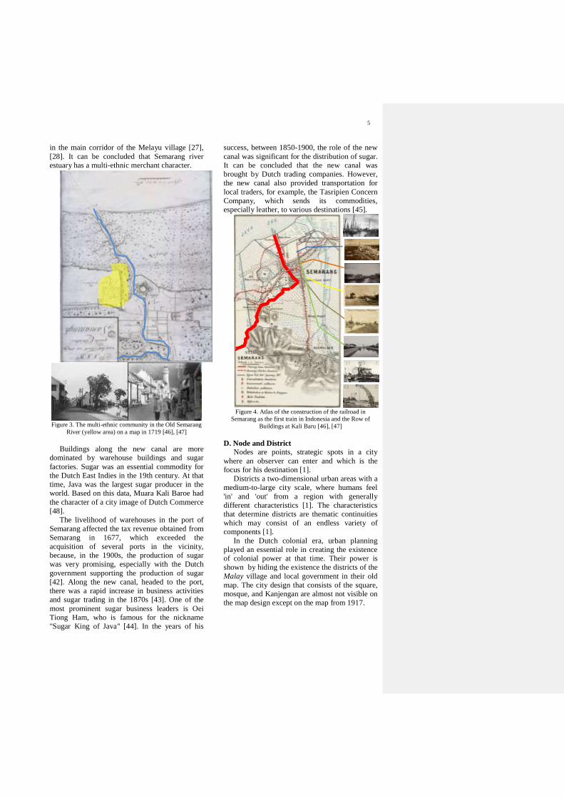
5
in the main corridor of the Melayu village [27],
[28]. It can be concluded that Semarang river
estuary has a multi-ethnic merchant character.
Figure 3. The multi-ethnic community in the Old Semarang
River (yellow area) on a map in 1719 [46], [47]
Buildings along the new canal are more
dominated by warehouse buildings and sugar
factories. Sugar was an essential commodity for
the Dutch East Indies in the 19th century. At that
time, Java was the largest sugar producer in the
world. Based on this data, Muara Kali Baroe had
the character of a city image of Dutch Commerce
[48].
The livelihood of warehouses in the port of
Semarang affected the tax revenue obtained from
Semarang in 1677, which exceeded the
acquisition of several ports in the vicinity,
because, in the 1900s, the production of sugar
was very promising, especially with the Dutch
government supporting the production of sugar
[42]. Along the new canal, headed to the port,
there was a rapid increase in business activities
and sugar trading in the 1870s [43]. One of the
most prominent sugar business leaders is Oei
Tiong Ham, who is famous for the nickname
"Sugar King of Java" [44]. In the years of his
success, between 1850-1900, the role of the new
canal was significant for the distribution of sugar.
It can be concluded that the new canal was
brought by Dutch trading companies. However,
the new canal also provided transportation for
local traders, for example, the Tasripien Concern
Company, which sends its commodities,
especially leather, to various destinations [45].
Figure 4. Atlas of the construction of the railroad in
Semarang as the first train in Indonesia and the Row of
Buildings at Kali Baru [46], [47]
D. Node and District
Nodes are points, strategic spots in a city
where an observer can enter and which is the
focus for his destination [1].
Districts a two-dimensional urban areas with a
medium-to-large city scale, where humans feel
'in' and 'out' from a region with generally
different characteristics [1]. The characteristics
that determine districts are thematic continuities
which may consist of an endless variety of
components [1].
In the Dutch colonial era, urban planning
played an essential role in creating the existence
of colonial power at that time. Their power is
shown by hiding the existence the districts of the
Malay village and local government in their old
map. The city design that consists of the square,
mosque, and Kanjengan are almost not visible on
the map design except on the map from 1917.
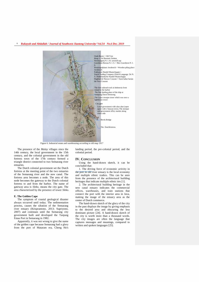
Rukayah and Abdullah / Journal of Southwest Jiaotong University/ Vol.54 No.6 Dec. 2019
6
Figure 6. Industrial estate and warehousing according to old map 1917
The presence of the Malay villages since the
14th century, the local government in the 15th
century, and the colonial government in the old
fortress town of the 17th century formed a
triangle district connected to two Semarang river
estuaries.
The Dutch colonial government set the Dutch
fortress at the meeting point of the two estuaries
of the Semarang river and the new canal. The
fortress area becomes a node. The area of this
node becomes the gateway to the Dutch colonial
fortress to and from the harbor. The name of
gateway area is Sleko, means the city gate. The
area characterized by the presence of tower Sleko.
E. The Golden Cape
The symptom of coastal geological disaster
always occurred until today. The sedimentation
process, causes the siltation of the Semarang
river estuary (Krisprantono, 2013; Supriyono,
2007) and continues until the Semarang city
government built and developed the Tanjung
Emas Port in Semarang in 1982.
Apparently, it was not wrong to give the name
of the golden cape because Semarang had a glory
from the port of Mataram era, Cheng Ho's
landing period, the pre-colonial period, and the
colonial period.
IV. CONCLUSION Using the hand-drawn sketch, it can be
concluded that:
1. The driving force of economic activity in
the port in old river estuary is the local economy
and multiple ethnic traders. This can be seen
from the presence of the architectural building
heritages that indicate multiple ethnic ties [1].
2. The architectural building heritage in the
new canal estuary indicates the commercial
offices, warehouses, and train stations that
connect the port with the interior area in Java,
making the image of the estuary area as the
center of Dutch commerce.
The hand-drawn sketch of the glory of the city
in the past displays the image by giving emphasis
to the desired area and obscuring the less
dominant picture [24]. A hand-drawn sketch of
the city is worth more than a thousand words.
The city images are often the language that
captures messages and meanings, compared to
written and spoken languages [25].
The first landing place of the ship at
kampung Darat Semarang
Local government with alun-alun (open space with 2 banyan trees), The mosque
and government office market along
rivers side
Oude Boom = Old Tree
Hosp. v. Inl Besmett Ziekten
Stoomzagerij N. I. H. sawmill uap
Goerderen Bureau N. I. S. = Biro Goerderen N. I.
S.
Houtstapelplaats Javabosch = Wooden piling place
Javabosch
Pakhuizen Handel Maatschappij =
Dutch Trading Company (Dutch Langauge: De N.
V. Nederlandsche Handel-Maatschappy
Dagblad de Nieuwe Courant = Surat kabar harian
the New Courant
The first railroad track in Indonesia from
inland to the harbor
The Layur mosque tower which was once a
lighthouse tower
Berok Bridge
The Dutchfortress
City gate
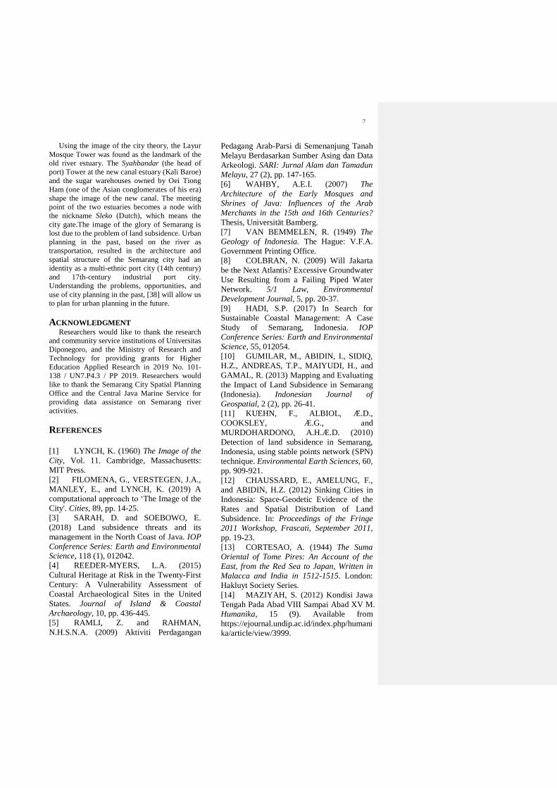
7
Using the image of the city theory, the Layur
Mosque Tower was found as the landmark of the
old river estuary. The Syahbandar (the head of
port) Tower at the new canal estuary (Kali Baroe)
and the sugar warehouses owned by Oei Tiong
Ham (one of the Asian conglomerates of his era)
shape the image of the new canal. The meeting
point of the two estuaries becomes a node with
the nickname Sleko (Dutch), which means the
city gate.The image of the glory of Semarang is
lost due to the problem of land subsidence. Urban
planning in the past, based on the river as
transportation, resulted in the architecture and
spatial structure of the Semarang city had an
identity as a multi-ethnic port city (14th century)
and 17th-century industrial port city.
Understanding the problems, opportunities, and
use of city planning in the past, [38] will allow us
to plan for urban planning in the future.
ACKNOWLEDGMENT Researchers would like to thank the research
and community service institutions of Universitas
Diponegoro, and the Ministry of Research and
Technology for providing grants for Higher
Education Applied Research in 2019 No. 101-
138 / UN7.P4.3 / PP 2019. Researchers would
like to thank the Semarang City Spatial Planning
Office and the Central Java Marine Service for
providing data assistance on Semarang river
activities.
REFERENCES
[1] LYNCH, K. (1960) The Image of the
City, Vol. 11. Cambridge, Massachusetts:
MIT Press.
[2] FILOMENA, G., VERSTEGEN, J.A.,
MANLEY, E., and LYNCH, K. (2019) A
computational approach to ‘The Image of the
City'. Cities, 89, pp. 14-25.
[3] SARAH, D. and SOEBOWO, E.
(2018) Land subsidence threats and its
management in the North Coast of Java. IOP
Conference Series: Earth and Environmental Science, 118 (1), 012042.
[4] REEDER-MYERS, L.A. (2015)
Cultural Heritage at Risk in the Twenty-First
Century: A Vulnerability Assessment of
Coastal Archaeological Sites in the United
States. Journal of Island & Coastal
Archaeology, 10, pp. 436-445.
[5] RAMLI, Z. and RAHMAN,
N.H.S.N.A. (2009) Aktiviti Perdagangan
Pedagang Arab-Parsi di Semenanjung Tanah
Melayu Berdasarkan Sumber Asing dan Data
Arkeologi. SARI: Jurnal Alam dan Tamadun
Melayu, 27 (2), pp. 147-165.
[6] WAHBY, A.E.I. (2007) The
Architecture of the Early Mosques and
Shrines of Java: Influences of the Arab
Merchants in the 15th and 16th Centuries?
Thesis, Universität Bamberg.
[7] VAN BEMMELEN, R. (1949) The
Geology of Indonesia. The Hague: V.F.A.
Government Printing Office.
[8] COLBRAN, N. (2009) Will Jakarta
be the Next Atlantis? Excessive Groundwater
Use Resulting from a Failing Piped Water
Network. 5/1 Law, Environmental
Development Journal, 5, pp. 20-37.
[9] HADI, S.P. (2017) In Search for
Sustainable Coastal Management: A Case
Study of Semarang, Indonesia. IOP
Conference Series: Earth and Environmental
Science, 55, 012054.
[10] GUMILAR, M., ABIDIN, I., SIDIQ,
H.Z., ANDREAS, T.P., MAIYUDI, H., and
GAMAL, R. (2013) Mapping and Evaluating
the Impact of Land Subsidence in Semarang
(Indonesia). Indonesian Journal of
Geospatial, 2 (2), pp. 26-41.
[11] KUEHN, F., ALBIOL, Æ.D.,
COOKSLEY, Æ.G., and
MURDOHARDONO, A.H.Æ.D. (2010)
Detection of land subsidence in Semarang,
Indonesia, using stable points network (SPN)
technique. Environmental Earth Sciences, 60,
pp. 909-921.
[12] CHAUSSARD, E., AMELUNG, F.,
and ABIDIN, H.Z. (2012) Sinking Cities in
Indonesia: Space-Geodetic Evidence of the
Rates and Spatial Distribution of Land
Subsidence. In: Proceedings of the Fringe
2011 Workshop, Frascati, September 2011,
pp. 19-23.
[13] CORTESAO, A. (1944) The Suma
Oriental of Tome Pires: An Account of the
East, from the Red Sea to Japan, Written in
Malacca and India in 1512-1515. London:
Hakluyt Society Series.
[14] MAZIYAH, S. (2012) Kondisi Jawa
Tengah Pada Abad VIII Sampai Abad XV M.
Humanika, 15 (9). Available from
https://ejournal.undip.ac.id/index.php/humani
ka/article/view/3999.
Rukayah and Abdullah / Journal of Southwest Jiaotong University/ Vol.54 No.6 Dec. 2019
8
[15] JOE, L.T. (1933) Riwayat Semarang:
Dari Djamannya Sam Po Sampe
Terhapoesnya Konkoan. Semarang:
Boekhandel Ho Kim Yoe.
[16] YUANZHI, K. (2000) Cheng Ho
Muslim Tionghoa. Misteri Perjalanan
Muhibah di Nusantara. Jakarta: Yayasan
Pustaka Obor Indonesia.
[17] TIO, J. (2004) Kota Semarang Dalam
Kenangan. Semarang.
[18] RUKAYAH, R., PUGUH, D.R.,
SUSILO, E.S., and INDRASWARA, M.S.
(2018) Local Wisdom of the Native
Settlement as a Main Gate in the Northern
Axis of Javanese City Center in Semarang.
IOP Conference Series: Earth and
Environmental Science, 152 (1), 012032.
[19] RUKAYAH, R.S., SUSILO, E.S.,
ABDULLAH, M., and SAPUTRO, S. (2018)
Exploring the Position of Old Semarang Sea
Port: Based on Javanese City Pattern. IOP
Conference Series: Earth and Environmental
Science, 116 (1), 012036.
[20] RUKAYAH, R.S., SUSILO, E.S.,
and ABDULLAH, M. (2018) Semarang Kota
Pesisir Lama. Yogyakarta: Tekno Sain.
[21] De locomotief: Samarangsch
Handels- en advertentie-blad. (1869)
Semarang.
[22] PRIHATMOKO, H. (2014)
Transportasi Air Dalam Perdagangan Pada
Masa Jawa Kuno Di Jawa Timur. Forum
Arkeologi, 27 (3), pp. 155-174.
[23] ANDRISIJANTI, I. (2015)
Pengembangan Maket Pusat-Pusat
Pemerintahan. 1 (1), pp. 1-29.
[24] DEVANNY, S. (2010) Peran Sketsa
Tangan Dalam Profesi Arsitek Studi Banding
Antara Sketsa Leonardo da Vinci dan Frank
Gehry. Universitas Indonesia.
[25] POLE, C. (2004) Seeing Is Believing?
Approaches to Visual Research. JAI Press.
[26] SUSANTO, D. (2014) Tradisi Seni
Lisan Sebagai Strategi Dakwah di Kalangan
Kaum Habib (Studi Kasus di Kampung
Melayu Kota Semarang). Fakultas Dakwah
dan Komunikasi, IAIN Walisongo Semarang.
[27] MADIASWORO, T. (2009)
Revitalisasi Nilai-Nilai Kearifan Lokal
Kampung Melayu Semarang. Local Wisdom,
1, pp. 10-18.
[28] WIBAWA, S. (2013) History of the
past development of the Semarang
city(Central Java) and its impact on nitrat
pollutants presence in the groundwater today.
Indonesian Journal of Geology and Mining,
23 (1), pp. 25-36.
[29] KUNTOWIJOYO. (1994)
Metodologi Sejarah. Yogyakarta: Tiara
Wacana Yogya.
[30] ADRISIJANTI, I. (2000) Arkeologi
Perkotaan Mataram Islam. Yogyakarta:
Penerbit Jendela.
[31] BROMMER, B., SIDHARTA, A.,
BUDIHARDJO, E., SISWANTO, A.,
MONTENS, A.B., SOEWARNO, SETIADI,
S., and STEVENS, T. (1995) Semarang
Beeld van Een Stad. Purmerend: Asia Maior.
[32] LIEM, T.J. (1933) Riwajat Semarang
(Dari Djamannja Sam Poo sampe
terhapoesnja Kongkoan). Semarang:
Boekhandel Ho Kim Yoe.
[33] BUDIMAN, A. (1978) Semarang
Riwajatmoe Doeloe. Semarang: Tanjung Sari.
[34] RETNO SARI, I.D. (2012) “Kota
Lama Semarang” Situs Sejarah Yang
Terpinggirkan. Berkala Arkeologi, 32 (2), pp.
195-208.
[35] MASITHA, A.I. and HESTON, Y.P.
(2015) Rekognisi Bangunan dan Citra Kota.
In: Semin. Nas. SCAN #6 "Finding Fifth
Elem. After Water, Earth, Wind. Fire” Local
Wisdom Cult. Sustain., Yogyakarta, May
2015, pp. 259-270.
[36] ZHU, H., QIAN, J., and GAO, Y.
(2011) Globalization and the production of
city image in Guangzhou’s metro station
advertisements. Cities, 28 (3), pp. 221-229.
[37] MÜLLER, A.L. (2019) Voices in the
city. On the role of arts, artists and urban
space for a just city. Cities, 91, pp. 49-57.
[38] CHAPMAN, E.H. and LYNCH, K.
(1962) The Image of the City. The Journal of
Aesthetics and Art Criticism, 21 (1), 91.
[39] PRABOWO, B.N. and
HARSRITANTO, B.I. (2018) Kota Lama
Semarang Menuju Status Pusaka Dunia
UNESCO: Apa ITU Status World Heritage?
Modul, 18 (1), pp. 51-53.
[40] FEBBIYANA, A. and
SUWANDONO, D. (2016) The Declining
Vitality of Kampung Melayu as the Heritage
Area in The City of Semarang. Ruang, 2 (4),
pp. 341-348.
9
[41] SUSANTO, D. (2014) Pola strategi
dakwah komunitas habaib di kampung
melayu semarang. Dimas, 14 (1), pp. 159-
185.
[42] LING, L.T. (1979) Raja Gula Oei
Tiong Ham. Penerbit Liem Tjwan Ling.
[43] KUNIO, Y. (1989) Oei Tiong Ham
Concern: The First Business Empire of
Southeast Asia Introduction. Southeast Asian
Studies, 27 (2), pp. 137-155.
[44] CLAUDINE, S. (1991) Oei Tiong
Ham Concern: The First Business Empire of
Southeast Asia. Archipel, 41 (1), pp. 201-203.
[45] TARIGAN, R. (2015) Kajian Historis
dan Morfologi Kampung – Kampung di
Sekitar Jalan Jagalan dan Jalan Petudungan
Semarang.
[46] KITLV (2014) [Online] Available from:
https://www.kitlv.nl [Accessed 15/08/19].
[47] Atlas of Mutual Heritage. [Online]
Available from:
http://www.atlasofmutualheritage.nl
[Accessed 25/09/19].
[48] Historical Video Archive, Train
Crossing the Kalibaru Suspension Bridge in
Semarang, 1937. [Online] Available from:
https://www.youtube.com/watch?v=Y4ioJU8
DvA0 [Accessed 25/09/19].
[49] SASONGKO, G., HUNGA, I.A.R.,
JULANA, A.S.N., WAHYUDI, Y., LELIAK,
P., and HURUTA, A.D. (2019) Public policy
for housing development: a case study on
housing development in Semarang Regency
– Indonesia. Insights into Regional
Development, 1 (3), pp. 280-300.
参考文:
[1] 林奇(K. LYNCH)(1960年)《城市
形象》,第 1 期。 11.马萨诸塞州剑桥:
麻省理工学院出版社。
[2] FILOMENA,G.,VERSTEGEN,J.A.,
MANLEY,E. 和 LYNCH,K.(2019)一
种计算方法,用于“城市形象”。城市,89,
第 14-25页。
[3] SARAH , D. 和 SOEBOWO , E.
(2018)爪哇岛北海岸的地面沉降威胁及
其管理。眼压会议系列:地球与环境科学,
118 (1),012042。
[4] REEDER-MYERS,L.A.(2015)二十
一世纪的文化遗产面临风险:美国沿海考
古遗址的脆弱性评估。岛与海岸考古学报,
10,第 436-445页。
[5] Z. RAMLI 和 N.H.S.N.A. RAHMAN。
(2009)交易商交易活动在阿拉伯 - 波斯
马来半岛据国外资料和考古资料。莎莉
(莎丽):《法律杂志》,27 (2),第
147-165页。
[6] WAHBY,A.E.I。(2007)爪哇早期
清真寺和神社的建筑:15 和 16 世纪阿拉
伯商人的影响?论文,班贝格大学。
[7] VAN BEMMELEN,R.(1949)印度
尼西亚地质。海牙:V.F.A.政府印刷局。
[8] COLBRAN,N.(2009)雅加达会成为
下一个亚特兰蒂斯吗?自来水管网失灵导
致地下水过多使用。 5/1 法律,《环境发
展杂志》,5,第 20-37页。
[9] HADI,S.P.(2017)寻求可持续的沿
海管理:印度尼西亚三宝垄的案例研究。
眼压会议系列:地球与环境科学,55,
012054。
[10] GUMILAR , M. , ABIDIN , I. ,
SIDIQ , H.Z. , ANDREAS , T.P. ,
MAIYUDI,H. 和 GAMAL,R.(2013)
绘制和评估三宝垄(印度尼西亚)土地沉
降的影响。印度尼西亚地理空间杂志,2
(2),第 26-41页。
[11] KUEHN , F. , ALBIOL , D.D. ,
COOKSLEY , G.G. 和
MURDOHARDONO , A.H.D. D. 。
(2010)使用稳定点网络(SPN)技术检
测印度尼西亚三宝垄的地面沉降。环境地
球科学,60,第 909-921页。
[12] E. CHAUSSARD,F。AMELUNG 和
H.Z. ABIDIN。(2012)印尼的沉没城
Rukayah and Abdullah / Journal of Southwest Jiaotong University/ Vol.54 No.6 Dec. 2019
10
市:土地沉降速率和空间分布的空间大地
证据。在:《艺穗节 2011 研讨会论文
集》,弗拉斯卡蒂,2011 年 9 月,第 19-
23页。
[13] CORTESAO,A。(1944 年)东方之
书的一些东方:从红海到日本的东方记述,
于 1512 年至 1515 年在马六甲和印度发表。
伦敦:哈克卢伊特社会丛刊。
[14] MAZIYAH,S。(2012)八世纪至十
五世纪中爪哇的状况中号 . 曼尼卡,15
( 9 ) 。 可 从https://ejournal.undip.ac.id/index.php/humani
ka/article/view/3999获取。
[15] JOE,L.T. (1933)三宝垄历史:从
他的三宝桑佩到孔古安。三宝垄:何金
Yo书店。
[16] YUANZI,K.(2000)成浩·穆斯林·
廷加。群岛旅行的奥秘。雅加达:亚亚桑
·普斯塔卡·奥博尔印度尼西亚。
[17] TIO,J.(2004 年)哥打三宝垄达兰·
克南甘。三宝垄
[18] RUKAYAH,R.,PUGUH,D.R.,
SUSILO,E.S. 和 INDRASWARA,M.S.
(2018)在三宝垄的爪哇市中心北轴作为
本地大门的本地居民的当地智慧。眼压会
议系列:地球与环境科学,152(1),
012032。
[19] RUKAYAH,R.S.,SUSILO,E.S.,
ABDULLAH , M. 和 SAPUTRO , S.
(2018)探索三宝垄旧港口的位置:基于
爪哇城市模式。眼压会议系列:地球与环
境科学,116(1),012036。
[20] RUKAYAH,R.S.,SUSILO,E.S. 和
ABDULLAH,M.(2018)三宝垄·哥打佩
西西尔喇嘛。日惹:泰克诺·塞恩。
[21] 机车:萨马兰奇商业和广告杂志。
(1869年)三宝垄。
[22] PRIHATMOKO,H.(2014 年)《达
西航空达拉姆·帕达冈甘·帕达·马萨·贾瓦·
库纳迪·贾瓦·蒂穆尔》。考古论坛,27
(3),第 155-174页。
[23] ANDRISIJANTI,I。(2015)政府中
心样机开发。 1(1),第 1-29页。
[24] DEVANNY,S.(2010)手绘草图在
莱昂纳多·达·芬奇与弗兰克·盖里的素描
之间的比较研究建筑师行业中的作用。印
度尼西亚大学。
[25] POLE,C。(2004)眼见为实?视觉
研究方法。贾出版社。
[26] SUSANTO,D。(2014 年)口头艺
术传统,社会上的大瓦战略,哈比布·卡
苏斯案例研究,甘榜,三宝垄市马来语)。
IAIN Walisongo 三宝垄的大华与传播学院。
[27] MADIASWORO,T。(2009 年)振
兴甘榜美拉宇三宝垄的当地智慧价值观。
地方智慧,1,第 10-18页。
[28] WIBAWA,S.(2013)三宝垄市(中
爪哇省)过去的发展历史及其对当今地下
水中硝酸盐污染物存在的影响。印尼地质
与采矿杂志,23(1),第 25-36页。
[29] KUNTOWIJOYO。(1994)历史方法
论。日惹:Tiara Wacana Yogya。
[30] ADRISIJANTI,I。(2000)马塔兰
的城市考古伊斯兰教。日惹:佩内比特·
詹德拉。
[31] B. BROMMER,B. SIDHARTA,A.,
BUDIHARDJO,E.,SISWANTO,A.,
MONTENS , A.B. , SOEWARNO ,
SETIADI,S. 和 STEVENS,T.(1995)
三宝垄贝恩·范·恩·斯塔德。Purmerend:
亚洲马约尔。
11
[32] LIEM,T.J。(1933 年)里瓦贾特三
宝垄(来自 Djamannja Sam Poo 的载脂蛋
白祝福刚果人)。三宝垄:何金哟书店。
[33] BUDIMAN,A.(1978)三宝垄里瓦
贾特莫·杜洛。三宝垄:丹绒纱丽。
[34] 里德诺·萨里(2012)“哥打喇嘛三宝
垄” 被边缘化的历史遗迹。考古学周期性,
32(2),第 195-208页。
[35] MASITHA,A.I。和 赫斯顿(YS)
(2015)班古南·丹·库塔。在:研讨会。
娜斯扫描#6“寻找第五个元素。在水,地,
风,火之后”,当地智慧文化的持续发展。
日惹,2015年 5月,第 259-270页。
[36] 朱华,钱剑,高高(2011)全球化与
广州地铁站广告中城市形象的产生。城市
28(3),第 221-229页。
[37] MÜLLER,A.L.(2019)城市中的声
音。论艺术,艺术家和城市空间对于一个
公正城市的作用。城市,91,第 49-57 页。
[38] CHAPMAN,E.H。和 LYNCH,K.
(1962)《城市形象》。美学与艺术批评
杂志,21(1),91。
[39] PRABOWO , B.N 。 和 B.I.
HARSRITANTO (2018)亚庇三宝菜单地
位普萨卡杜尼亚联合国教科文组织:阿帕
ITU 地位世界遗产?模数,18(1),第
51-53页。
[40] FEBBIYANA,A. 和 SUWANDONO,
D.(2016)甘榜梅拉尤的活力正在下降,
它是三宝垄市的遗产地区。空间篇,2
(4),第 341-348页。
[41] SUSANTO,D。(2014 年),《三
宝垄》(三宝垄马来村哈拜卜社区的
dakwah 策略模式)。迪马斯,14(1),
第 159-185页。
[42] LING L.T. (1979)拉贾·古拉·大钟。
出版社廉哲玲。
[43] KUNIO,Y.( 1989)《大江油火
腿》:东南亚第一个商业帝国。东南亚研
究,27(2), 第 137-155页。
[44] CLAUDINE,S.(1991)《大钟汉
经》:东南亚第一商业帝国。档案,41
(1),第 201-203页。
[45] TARIGAN,R.(2015)甘榜的卡吉·
希斯托里斯(甘榜历史博物馆)– 惹兰贾
加兰周围的甘榜惹兰贾加兰和惹兰·彼得
杜甘三宝垄。
[46] 基尔特(2014)[在线]可从以下网站
获得:https://www.kitlv.nl [访问日期:
19/08/15]。
[47] 共同遗产地图集。[在线]可从以下网
站 获 得 :
http://www.atlasofmutualheritage.nl [访问时
间:19/09/25]。
[48] 历史视频档案,火车穿越三宝垄的卡
利巴鲁悬索桥,1937 年。[在线]可从以下
网 址 获 得 :
https://www.youtube.com/watch?v=Y4ioJU8
DvA0 [19/09/25访问]。
[49] G. SASONGKO,HUNGA,I.A.R.,
JULANA , A.S.N. , WAHYUDI , Y. ,
LELIAK,P. 和 A.D. HURUTA(2019)住
房发展公共政策:印度尼西亚三宝垄住房
发展案例研究。 《洞察区域发展》,1
(3),第 280-300页。
12. Submission of review results – 2

siti rukayah <[email protected]>
URGENT!
siti rukayah <[email protected]> Mon, Jan 6, 2020 at 9:42 AMTo: [email protected]
Dear Professor Zhai Wanming Herewith our revision about the manuscript. Just information, the total number of the reference are 49 . It didn't appear in references in Englishformat but appear in Chinese version. We try to edited it in Mendeley system but didn't work .
Thank you for your kindness
Best regardsDr.R.Siti Rukayah
[Quoted text hidden]
THE GLORY OF SEMARANG COASTAL CITY IN THE PAST.doc 3317K

13. Revision of the second manuscript with
a reference format of 49
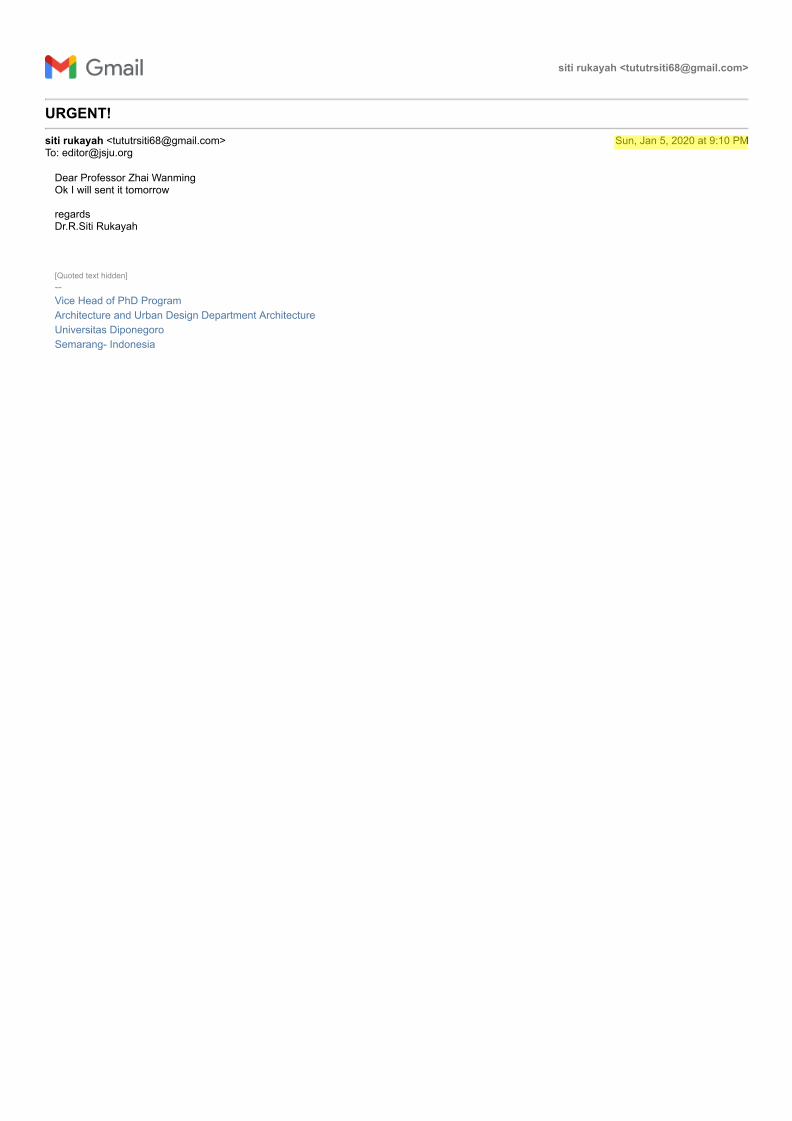
siti rukayah <[email protected]>
URGENT!
siti rukayah <[email protected]> Sun, Jan 5, 2020 at 9:10 PMTo: [email protected]
Dear Professor Zhai WanmingOk I will sent it tomorrow
regardsDr.R.Siti Rukayah
[Quoted text hidden]-- Vice Head of PhD ProgramArchitecture and Urban Design Department ArchitectureUniversitas DiponegoroSemarang- Indonesia
西南交通大学学报
第 54 卷 第 6 期
2019年 12 月 JOURNAL OF SOUTHWEST JIAOTONG UNIVERSITY
Vol. 54 No. 6
Dec. 2019
ISSN: 0258-2724 DOI:10.35741/issn.0258-2724.54.6….
Research Article
Architecture
THE GLORY OF SEMARANG COASTAL CITY IN THE PAST, MULTI-
ETHNIC MERCHANTS AND DUTCH COMMERCE
过去,多民族贸易和荷兰商业中三宝垄沿海城市的荣耀
R. Siti Rukayah a, *, Muhammad Abdullah b
a Architecture Departement, Diponegoro University
Jl. Prof. Soedarto, Tembalang, Semarang, Indonesia, [email protected] b Indonesian Literature, Diponegoro University
Jl. Prof. Soedarto, Tembalang, Semarang, Indonesia, [email protected]
Abstract In The Image of the City, Lynch describes how individuals perceive and recall features in urban
spaces. Lynch's approach is categorized by paths, nodes, edges, districts, and landmarks – giving shape to
individuals' mental representation of the city. Recently, to test that theory on a large-scale city requires
high accuracy to understand a city. So, it requires tools such as computational techniques using the GIS
system. The cities of the 14th-18th centuries were not as complicated as the ones Lynch was dealing with
in the 1960s. How do you reveal the image of the city? The image of the city in the past had not been
explored yet. To explore the glory of Semarang city, Central Java, Indonesia, as Venetia van Java, which
has the sugar industry in Asia, and the first railway track in Indonesia, you can still use hand-drawn
sketches to reconstruct the image of the old city. Old data such as maps, photographs, and videos are
integrated to reconstruct the image of the city in the past. Recently, the name of port of Semarang,
Tanjung Emas – cape of gold – implies the glory of Semarang. The Semarang seaport played an
important role in the pre-colonial and colonial eras. The architectural heritage at the two-river estuary of
the Semarang coast uncovers the history of naming it the ‘cape of gold’. The river serves as roads and
train lines, as the path is important as a tool to evaluate the city transportation facilities for urban
planners, watershed services, and urban conservation.
Keywords: River Transportation, Rail Train, Semarang, Colonial, Multi-Ethnic
摘要 在《城市形象》中,林奇描述了人们如何感知和回忆城市空间中的特征。林奇的方法按路径
,节点,边缘,地区和地标分类-塑造了个人对城市的心理表现。最近,要在一个大型城市上测试
该理论,需要很高的准确度才能理解一个城市。因此,它需要使用地理信息系统系统的工具,例
如计算技术。 14至 18世纪的城市并不像林奇在 1960年代处理的城市那样复杂。您如何展现城市
Rukayah and Abdullah / Journal of Southwest Jiaotong University/ Vol.54 No.6 Dec. 2019 2
形象?过去尚未探索过这座城市的形象。要探索印度尼西亚中爪哇省三宝垄市的荣耀,就像拥有
亚洲制糖业和印度尼西亚第一条铁路轨道的威尼斯范爪哇一样,您仍然可以使用手绘草图来重建
旧城区的图像。整合了诸如地图,照片和视频之类的旧数据,以重建过去的城市形象。最近,三
宝垄港口的名字丹戎·埃玛斯(金角)象征着三宝垄的荣耀。三宝垄海港在前殖民时代和殖民时代
起着重要作用。三宝垄海岸两河口的建筑遗产揭示了将其命名为“金海角”的历史。河流充当道
路和火车线,因为这条道路对于评估城市规划者,分水岭服务和城市保护区的城市交通设施至关
重要。
关键词: 内河运输,铁路,三宝垄,殖民地,多民族
I. INTRODUCTION In 1960, Kevin Lynch published The Image of
the City [1], one of the most influential theories
in the formation of city images. City image
research continues to grow, along with the
development of the city. At present, the city is
developing very rapidly into a metropolitan city
of a large scale that requires presentation and
tools to test the image of the city using a
computational approach [2].
Meanwhile, the extent and complexity of
cities in the past are not that complicated
compared to cities in the present. Therefore, the
use of city image theory to reveal the
representation of a city image in the past is still a
research opportunity, especially in historic areas.
Coastal cities have become the focus of
research today because of the issue of coastal
disasters, such as rising seawater and land
subsidence [3]. The disasters require handling,
especially in historic areas [4]. Some historic
coastal areas emerged due to the development of
trade since prehistoric times in the Southeast
Asian region. The Asian region has attracted the
presence of traders from Arab-Persia to the
archipelago in addition to traders from India and
China [5]. The location of Indonesia attracted
explorers of the world to trade or transit even for
a stopover [6].
The trace of the settlement of the traders from
around the world is the multi-ethnic architectural
heritage that is scattered along the coast of
Indonesia, especially in Java. In Semarang city,
Central Java, Indonesia, the multi-ethnic
settlement become an embryo for city
development. In the Dutch colonial period, they
created a city to resemble the Netherlands using
canals for transportation. Semarang city is well
known as the Venetia van Java.
They chose Semarang because of its position
precisely in the centre of Java. So, the ports on
the north coast of Java played an essential role as
the political and economic power base of the
Dutch East Indies Company. It was the heart and
politics of the Dutch in controlling crop yields.
To bring some crops from interior Java, they built
the first railroad route in Indonesia. The
development of sugarcane and coffee gave rise to
the Asian conglomerate in its era.
However, the remaining area of the past glory
is now partially lost due to geological disasters
on the North coast of Java that have occurred
since the 8th century [7]. Sedimentation and land
subsidence have caused heritage areas to become
submerged in water. Some big cities such as
Jakarta, Surabaya, and Semarang are also
predicted to sink [8], [9], [10], [11], [12]. This
paper aims to uncover the glory of the city of
Semarang in the past and reveal that its cultural
heritage is at risk.
The city of Semarang, based on maps from
1719 and 1800, consisted of three districts,
namely the Malay village area, the old downtown
area in Kanjengan, and the colonial fortress area.
Semarang Map Semarang in 1719 put this as a
reference. The area of Semarang city was around
500 by 600 meters, or about 30 hectares. There is
a historical record that the foreign sailor, Tome
Pires, when he arrived in Semarang a century
after the arrival of Cheng Ho, witnessed that
Semarang was already a city led by Muslim
rulers who were the vassals of the Sultanate of
Demak. The population was around 3000 people.
That port had three junks and four or five boats.
The commercial commodities produced were
mainly rice and other food ingredients [13].
Semarang's history is inseparable from its
geological problems. This can be seen from the
transfer of the port location. In the 8th century,
Semarang was still a group of islands with a
coastline located in the Pragota region (now
known as Bergota Hill) [14]. History records that
Admiral Cheng Ho's fleet landed at the port of
Simongan in 1405 [15], [16]. In the 14th century,
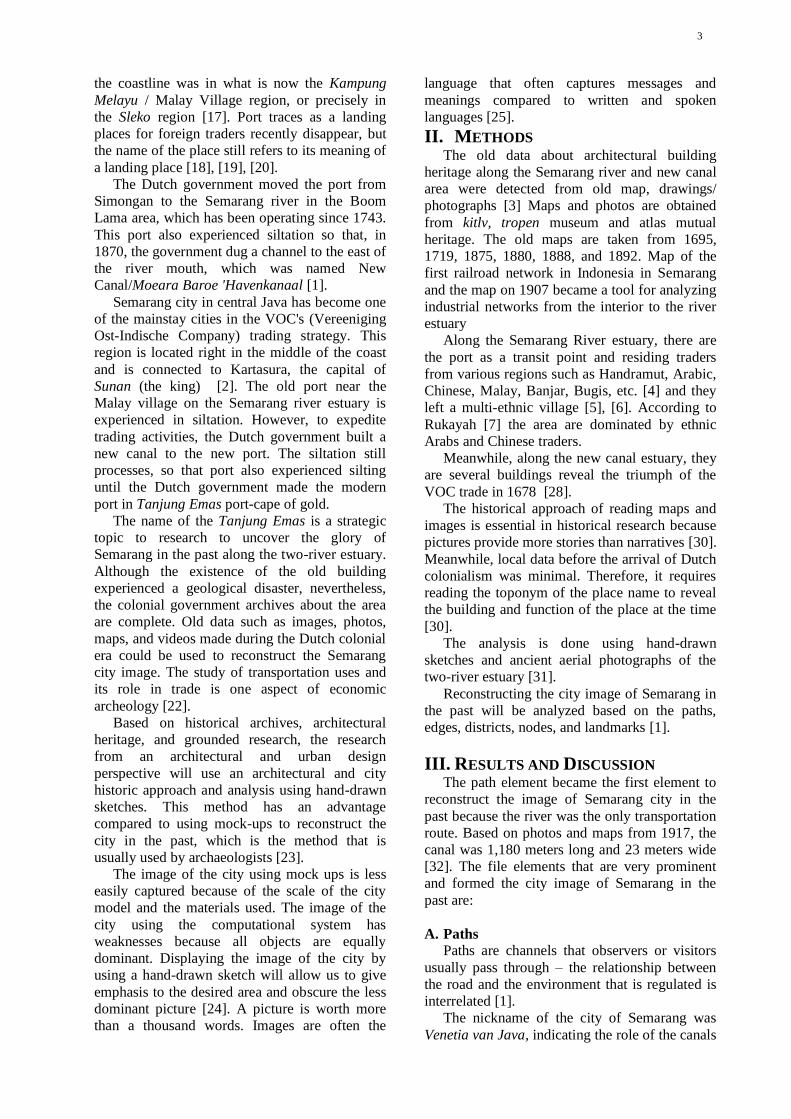
3
the coastline was in what is now the Kampung
Melayu / Malay Village region, or precisely in
the Sleko region [17]. Port traces as a landing
places for foreign traders recently disappear, but
the name of the place still refers to its meaning of
a landing place [18], [19], [20].
The Dutch government moved the port from
Simongan to the Semarang river in the Boom
Lama area, which has been operating since 1743.
This port also experienced siltation so that, in
1870, the government dug a channel to the east of
the river mouth, which was named New
Canal/Moeara Baroe 'Havenkanaal [1].
Semarang city in central Java has become one
of the mainstay cities in the VOC's (Vereeniging
Ost-Indische Company) trading strategy. This
region is located right in the middle of the coast
and is connected to Kartasura, the capital of
Sunan (the king) [2]. The old port near the
Malay village on the Semarang river estuary is
experienced in siltation. However, to expedite
trading activities, the Dutch government built a
new canal to the new port. The siltation still
processes, so that port also experienced silting
until the Dutch government made the modern
port in Tanjung Emas port-cape of gold.
The name of the Tanjung Emas is a strategic
topic to research to uncover the glory of
Semarang in the past along the two-river estuary.
Although the existence of the old building
experienced a geological disaster, nevertheless,
the colonial government archives about the area
are complete. Old data such as images, photos,
maps, and videos made during the Dutch colonial
era could be used to reconstruct the Semarang
city image. The study of transportation uses and
its role in trade is one aspect of economic
archeology [22].
Based on historical archives, architectural
heritage, and grounded research, the research
from an architectural and urban design
perspective will use an architectural and city
historic approach and analysis using hand-drawn
sketches. This method has an advantage
compared to using mock-ups to reconstruct the
city in the past, which is the method that is
usually used by archaeologists [23].
The image of the city using mock ups is less
easily captured because of the scale of the city
model and the materials used. The image of the
city using the computational system has
weaknesses because all objects are equally
dominant. Displaying the image of the city by
using a hand-drawn sketch will allow us to give
emphasis to the desired area and obscure the less
dominant picture [24]. A picture is worth more
than a thousand words. Images are often the
language that often captures messages and
meanings compared to written and spoken
languages [25].
II. METHODS The old data about architectural building
heritage along the Semarang river and new canal
area were detected from old map, drawings/
photographs [3] Maps and photos are obtained
from kitlv, tropen museum and atlas mutual
heritage. The old maps are taken from 1695,
1719, 1875, 1880, 1888, and 1892. Map of the
first railroad network in Indonesia in Semarang
and the map on 1907 became a tool for analyzing
industrial networks from the interior to the river
estuary
Along the Semarang River estuary, there are
the port as a transit point and residing traders
from various regions such as Handramut, Arabic,
Chinese, Malay, Banjar, Bugis, etc. [4] and they
left a multi-ethnic village [5], [6]. According to
Rukayah [7] the area are dominated by ethnic
Arabs and Chinese traders.
Meanwhile, along the new canal estuary, they
are several buildings reveal the triumph of the
VOC trade in 1678 [28].
The historical approach of reading maps and
images is essential in historical research because
pictures provide more stories than narratives [30].
Meanwhile, local data before the arrival of Dutch
colonialism was minimal. Therefore, it requires
reading the toponym of the place name to reveal
the building and function of the place at the time
[30].
The analysis is done using hand-drawn
sketches and ancient aerial photographs of the
two-river estuary [31].
Reconstructing the city image of Semarang in
the past will be analyzed based on the paths,
edges, districts, nodes, and landmarks [1].
III. RESULTS AND DISCUSSION The path element became the first element to
reconstruct the image of Semarang city in the
past because the river was the only transportation
route. Based on photos and maps from 1917, the
canal was 1,180 meters long and 23 meters wide
[32]. The file elements that are very prominent
and formed the city image of Semarang in the
past are:
A. Paths
Paths are channels that observers or visitors
usually pass through – the relationship between
the road and the environment that is regulated is
interrelated [1].
The nickname of the city of Semarang was
Venetia van Java, indicating the role of the canals
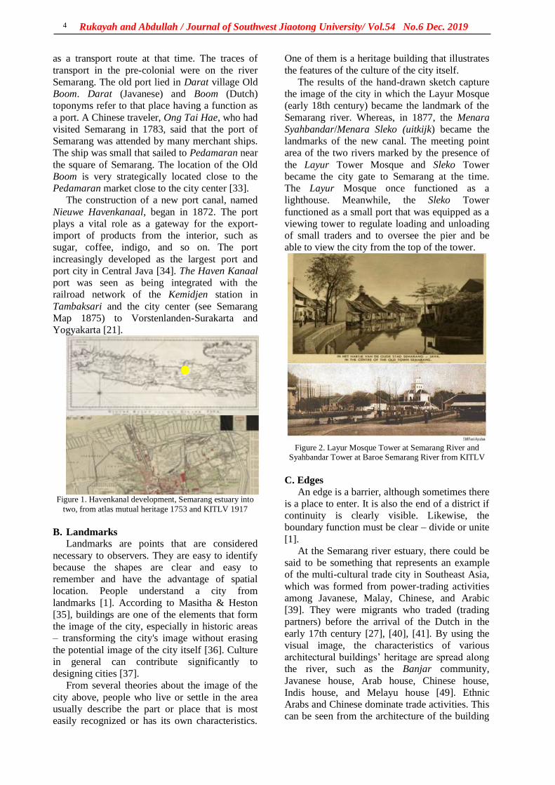
Rukayah and Abdullah / Journal of Southwest Jiaotong University/ Vol.54 No.6 Dec. 2019
4
as a transport route at that time. The traces of
transport in the pre-colonial were on the river
Semarang. The old port lied in Darat village Old
Boom. Darat (Javanese) and Boom (Dutch)
toponyms refer to that place having a function as
a port. A Chinese traveler, Ong Tai Hae, who had
visited Semarang in 1783, said that the port of
Semarang was attended by many merchant ships.
The ship was small that sailed to Pedamaran near
the square of Semarang. The location of the Old
Boom is very strategically located close to the
Pedamaran market close to the city center [33].
The construction of a new port canal, named
Nieuwe Havenkanaal, began in 1872. The port
plays a vital role as a gateway for the export-
import of products from the interior, such as
sugar, coffee, indigo, and so on. The port
increasingly developed as the largest port and
port city in Central Java [34]. The Haven Kanaal
port was seen as being integrated with the
railroad network of the Kemidjen station in
Tambaksari and the city center (see Semarang
Map 1875) to Vorstenlanden-Surakarta and
Yogyakarta [21].
Figure 1. Havenkanal development, Semarang estuary into
two, from atlas mutual heritage 1753 and KITLV 1917
B. Landmarks
Landmarks are points that are considered
necessary to observers. They are easy to identify
because the shapes are clear and easy to
remember and have the advantage of spatial
location. People understand a city from
landmarks [1]. According to Masitha & Heston
[35], buildings are one of the elements that form
the image of the city, especially in historic areas
– transforming the city's image without erasing
the potential image of the city itself [36]. Culture
in general can contribute significantly to
designing cities [37].
From several theories about the image of the
city above, people who live or settle in the area
usually describe the part or place that is most
easily recognized or has its own characteristics.
One of them is a heritage building that illustrates
the features of the culture of the city itself.
The results of the hand-drawn sketch capture
the image of the city in which the Layur Mosque
(early 18th century) became the landmark of the
Semarang river. Whereas, in 1877, the Menara
Syahbandar/Menara Sleko (uitkijk) became the
landmarks of the new canal. The meeting point
area of the two rivers marked by the presence of
the Layur Tower Mosque and Sleko Tower
became the city gate to Semarang at the time.
The Layur Mosque once functioned as a
lighthouse. Meanwhile, the Sleko Tower
functioned as a small port that was equipped as a
viewing tower to regulate loading and unloading
of small traders and to oversee the pier and be
able to view the city from the top of the tower.
Figure 2. Layur Mosque Tower at Semarang River and
Syahbandar Tower at Baroe Semarang River from KITLV
C. Edges
An edge is a barrier, although sometimes there
is a place to enter. It is also the end of a district if
continuity is clearly visible. Likewise, the
boundary function must be clear – divide or unite
[1].
At the Semarang river estuary, there could be
said to be something that represents an example
of the multi-cultural trade city in Southeast Asia,
which was formed from power-trading activities
among Javanese, Malay, Chinese, and Arabic
[39]. They were migrants who traded (trading
partners) before the arrival of the Dutch in the
early 17th century [27], [40], [41]. By using the
visual image, the characteristics of various
architectural buildings’ heritage are spread along
the river, such as the Banjar community,
Javanese house, Arab house, Chinese house,
Indis house, and Melayu house [49]. Ethnic
Arabs and Chinese dominate trade activities. This
can be seen from the architecture of the building
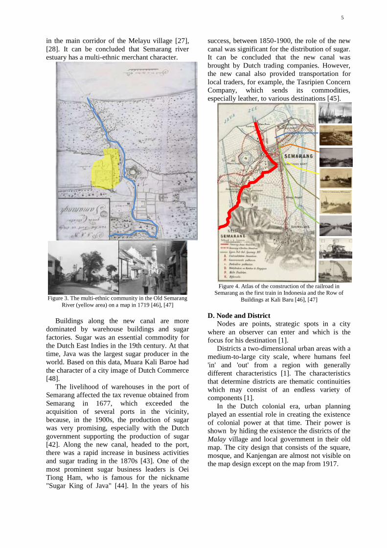
5
in the main corridor of the Melayu village [27],
[28]. It can be concluded that Semarang river
estuary has a multi-ethnic merchant character.
Figure 3. The multi-ethnic community in the Old Semarang
River (yellow area) on a map in 1719 [46], [47]
Buildings along the new canal are more
dominated by warehouse buildings and sugar
factories. Sugar was an essential commodity for
the Dutch East Indies in the 19th century. At that
time, Java was the largest sugar producer in the
world. Based on this data, Muara Kali Baroe had
the character of a city image of Dutch Commerce
[48].
The livelihood of warehouses in the port of
Semarang affected the tax revenue obtained from
Semarang in 1677, which exceeded the
acquisition of several ports in the vicinity,
because, in the 1900s, the production of sugar
was very promising, especially with the Dutch
government supporting the production of sugar
[42]. Along the new canal, headed to the port,
there was a rapid increase in business activities
and sugar trading in the 1870s [43]. One of the
most prominent sugar business leaders is Oei
Tiong Ham, who is famous for the nickname
"Sugar King of Java" [44]. In the years of his
success, between 1850-1900, the role of the new
canal was significant for the distribution of sugar.
It can be concluded that the new canal was
brought by Dutch trading companies. However,
the new canal also provided transportation for
local traders, for example, the Tasripien Concern
Company, which sends its commodities,
especially leather, to various destinations [45].
Figure 4. Atlas of the construction of the railroad in
Semarang as the first train in Indonesia and the Row of
Buildings at Kali Baru [46], [47]
D. Node and District
Nodes are points, strategic spots in a city
where an observer can enter and which is the
focus for his destination [1].
Districts a two-dimensional urban areas with a
medium-to-large city scale, where humans feel
'in' and 'out' from a region with generally
different characteristics [1]. The characteristics
that determine districts are thematic continuities
which may consist of an endless variety of
components [1].
In the Dutch colonial era, urban planning
played an essential role in creating the existence
of colonial power at that time. Their power is
shown by hiding the existence the districts of the
Malay village and local government in their old
map. The city design that consists of the square,
mosque, and Kanjengan are almost not visible on
the map design except on the map from 1917.

Rukayah and Abdullah / Journal of Southwest Jiaotong University/ Vol.54 No.6 Dec. 2019
6
Figure 6. Industrial estate and warehousing according to old map 1917
The presence of the Malay villages since the
14th century, the local government in the 15th
century, and the colonial government in the old
fortress town of the 17th century formed a
triangle district connected to two Semarang river
estuaries.
The Dutch colonial government set the Dutch
fortress at the meeting point of the two estuaries
of the Semarang river and the new canal. The
fortress area becomes a node. The area of this
node becomes the gateway to the Dutch colonial
fortress to and from the harbor. The name of
gateway area is Sleko, means the city gate. The
area characterized by the presence of tower Sleko.
E. The Golden Cape
The symptom of coastal geological disaster
always occurred until today. The sedimentation
process, causes the siltation of the Semarang
river estuary (Krisprantono, 2013; Supriyono,
2007) and continues until the Semarang city
government built and developed the Tanjung
Emas Port in Semarang in 1982.
Apparently, it was not wrong to give the name
of the golden cape because Semarang had a glory
from the port of Mataram era, Cheng Ho's
landing period, the pre-colonial period, and the
colonial period.
IV. CONCLUSION Using the hand-drawn sketch, it can be
concluded that:
1. The driving force of economic activity in
the port in old river estuary is the local economy
and multiple ethnic traders. This can be seen
from the presence of the architectural building
heritages that indicate multiple ethnic ties [1].
2. The architectural building heritage in the
new canal estuary indicates the commercial
offices, warehouses, and train stations that
connect the port with the interior area in Java,
making the image of the estuary area as the
center of Dutch commerce.
The hand-drawn sketch of the glory of the city
in the past displays the image by giving emphasis
to the desired area and obscuring the less
dominant picture [24]. A hand-drawn sketch of
the city is worth more than a thousand words.
The city images are often the language that
captures messages and meanings, compared to
written and spoken languages [25].
The first landing place of the ship at
kampung Darat Semarang
Local government with alun-alun (open space with 2 banyan trees), The mosque
and government office market along
rivers side
Oude Boom = Old Tree
Hosp. v. Inl Besmett Ziekten
Stoomzagerij N. I. H. sawmill uap
Goerderen Bureau N. I. S. = Biro Goerderen N. I.
S.
Houtstapelplaats Javabosch = Wooden piling place
Javabosch
Pakhuizen Handel Maatschappij =
Dutch Trading Company (Dutch Langauge: De N.
V. Nederlandsche Handel-Maatschappy
Dagblad de Nieuwe Courant = Surat kabar harian
the New Courant
The first railroad track in Indonesia from
inland to the harbor
The Layur mosque tower which was once a
lighthouse tower
Berok Bridge
The Dutchfortress
City gate
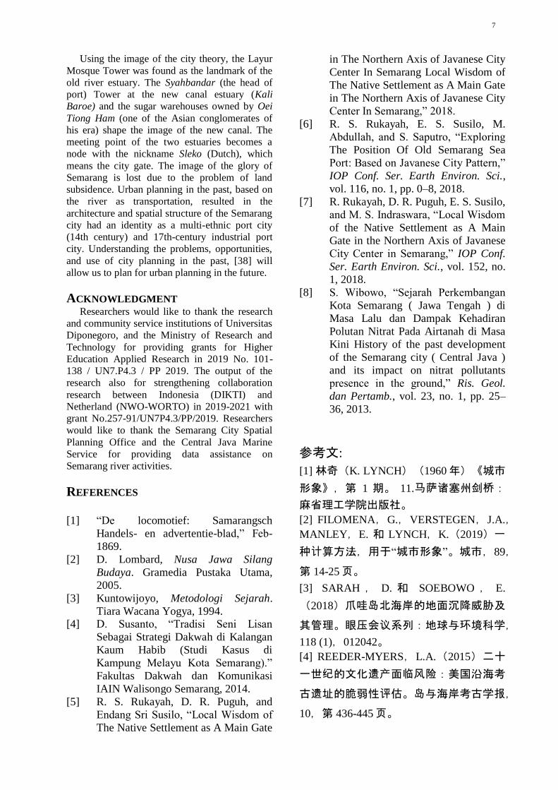
7
Using the image of the city theory, the Layur
Mosque Tower was found as the landmark of the
old river estuary. The Syahbandar (the head of
port) Tower at the new canal estuary (Kali
Baroe) and the sugar warehouses owned by Oei
Tiong Ham (one of the Asian conglomerates of
his era) shape the image of the new canal. The
meeting point of the two estuaries becomes a
node with the nickname Sleko (Dutch), which
means the city gate. The image of the glory of
Semarang is lost due to the problem of land
subsidence. Urban planning in the past, based on
the river as transportation, resulted in the
architecture and spatial structure of the Semarang
city had an identity as a multi-ethnic port city
(14th century) and 17th-century industrial port
city. Understanding the problems, opportunities,
and use of city planning in the past, [38] will
allow us to plan for urban planning in the future.
ACKNOWLEDGMENT Researchers would like to thank the research
and community service institutions of Universitas
Diponegoro, and the Ministry of Research and
Technology for providing grants for Higher
Education Applied Research in 2019 No. 101-
138 / UN7.P4.3 / PP 2019. The output of the
research also for strengthening collaboration
research between Indonesia (DIKTI) and
Netherland (NWO-WORTO) in 2019-2021 with
grant No.257-91/UN7P4.3/PP/2019. Researchers
would like to thank the Semarang City Spatial
Planning Office and the Central Java Marine
Service for providing data assistance on
Semarang river activities.
REFERENCES
[1] “De locomotief: Samarangsch
Handels- en advertentie-blad,” Feb-
1869.
[2] D. Lombard, Nusa Jawa Silang
Budaya. Gramedia Pustaka Utama,
2005.
[3] Kuntowijoyo, Metodologi Sejarah.
Tiara Wacana Yogya, 1994. [4] D. Susanto, “Tradisi Seni Lisan
Sebagai Strategi Dakwah di Kalangan
Kaum Habib (Studi Kasus di
Kampung Melayu Kota Semarang).”
Fakultas Dakwah dan Komunikasi
IAIN Walisongo Semarang, 2014.
[5] R. S. Rukayah, D. R. Puguh, and
Endang Sri Susilo, “Local Wisdom of
The Native Settlement as A Main Gate
in The Northern Axis of Javanese City
Center In Semarang Local Wisdom of
The Native Settlement as A Main Gate
in The Northern Axis of Javanese City
Center In Semarang,” 2018.
[6] R. S. Rukayah, E. S. Susilo, M.
Abdullah, and S. Saputro, “Exploring
The Position Of Old Semarang Sea
Port: Based on Javanese City Pattern,”
IOP Conf. Ser. Earth Environ. Sci.,
vol. 116, no. 1, pp. 0–8, 2018.
[7] R. Rukayah, D. R. Puguh, E. S. Susilo,
and M. S. Indraswara, “Local Wisdom
of the Native Settlement as A Main
Gate in the Northern Axis of Javanese
City Center in Semarang,” IOP Conf.
Ser. Earth Environ. Sci., vol. 152, no.
1, 2018.
[8] S. Wibowo, “Sejarah Perkembangan
Kota Semarang ( Jawa Tengah ) di
Masa Lalu dan Dampak Kehadiran
Polutan Nitrat Pada Airtanah di Masa
Kini History of the past development
of the Semarang city ( Central Java )
and its impact on nitrat pollutants
presence in the ground,” Ris. Geol.
dan Pertamb., vol. 23, no. 1, pp. 25–
36, 2013.
参考文:
[1] 林奇(K. LYNCH)(1960年)《城市
形象》,第 1 期。 11.马萨诸塞州剑桥:
麻省理工学院出版社。
[2] FILOMENA,G.,VERSTEGEN,J.A.,
MANLEY,E. 和 LYNCH,K.(2019)一
种计算方法,用于“城市形象”。城市,89,
第 14-25页。
[3] SARAH , D. 和 SOEBOWO , E.
(2018)爪哇岛北海岸的地面沉降威胁及
其管理。眼压会议系列:地球与环境科学,
118 (1),012042。
[4] REEDER-MYERS,L.A.(2015)二十
一世纪的文化遗产面临风险:美国沿海考
古遗址的脆弱性评估。岛与海岸考古学报,
10,第 436-445页。
Rukayah and Abdullah / Journal of Southwest Jiaotong University/ Vol.54 No.6 Dec. 2019
8
[5] Z. RAMLI 和 N.H.S.N.A. RAHMAN。
(2009)交易商交易活动在阿拉伯 - 波斯
马来半岛据国外资料和考古资料。莎莉
(莎丽):《法律杂志》,27 (2),第
147-165页。
[6] WAHBY,A.E.I。(2007)爪哇早期
清真寺和神社的建筑:15 和 16 世纪阿拉
伯商人的影响?论文,班贝格大学。
[7] VAN BEMMELEN,R.(1949)印度
尼西亚地质。海牙:V.F.A.政府印刷局。
[8] COLBRAN,N.(2009)雅加达会成为
下一个亚特兰蒂斯吗?自来水管网失灵导
致地下水过多使用。 5/1 法律,《环境发
展杂志》,5,第 20-37页。
[9] HADI,S.P.(2017)寻求可持续的沿
海管理:印度尼西亚三宝垄的案例研究。
眼压会议系列:地球与环境科学,55,
012054。
[10] GUMILAR , M. , ABIDIN , I. ,
SIDIQ , H.Z. , ANDREAS , T.P. ,
MAIYUDI,H. 和 GAMAL,R.(2013)
绘制和评估三宝垄(印度尼西亚)土地沉
降的影响。印度尼西亚地理空间杂志,2
(2),第 26-41页。
[11] KUEHN , F. , ALBIOL , D.D. ,
COOKSLEY , G.G. 和
MURDOHARDONO , A.H.D. D. 。
(2010)使用稳定点网络(SPN)技术检
测印度尼西亚三宝垄的地面沉降。环境地
球科学,60,第 909-921页。
[12] E. CHAUSSARD,F。AMELUNG 和
H.Z. ABIDIN。(2012)印尼的沉没城
市:土地沉降速率和空间分布的空间大地
证据。在:《艺穗节 2011 研讨会论文
集》,弗拉斯卡蒂,2011 年 9 月,第 19-
23页。
[13] CORTESAO,A。(1944 年)东方之
书的一些东方:从红海到日本的东方记述,
于 1512 年至 1515 年在马六甲和印度发表。
伦敦:哈克卢伊特社会丛刊。
[14] MAZIYAH,S。(2012)八世纪至十
五世纪中爪哇的状况中号 . 曼尼卡,15
( 9 ) 。 可 从https://ejournal.undip.ac.id/index.php/humani
ka/article/view/3999获取。
[15] JOE,L.T. (1933)三宝垄历史:从
他的三宝桑佩到孔古安。三宝垄:何金
Yo书店。
[16] YUANZI,K.(2000)成浩·穆斯林·
廷加。群岛旅行的奥秘。雅加达:亚亚桑
·普斯塔卡·奥博尔印度尼西亚。
[17] TIO,J.(2004 年)哥打三宝垄达兰·
克南甘。三宝垄
[18] RUKAYAH,R.,PUGUH,D.R.,
SUSILO,E.S. 和 INDRASWARA,M.S.
(2018)在三宝垄的爪哇市中心北轴作为
本地大门的本地居民的当地智慧。眼压会
议系列:地球与环境科学,152(1),
012032。
[19] RUKAYAH,R.S.,SUSILO,E.S.,
ABDULLAH , M. 和 SAPUTRO , S.
(2018)探索三宝垄旧港口的位置:基于
爪哇城市模式。眼压会议系列:地球与环
境科学,116(1),012036。
[20] RUKAYAH,R.S.,SUSILO,E.S. 和
ABDULLAH,M.(2018)三宝垄·哥打佩
西西尔喇嘛。日惹:泰克诺·塞恩。
[21] 机车:萨马兰奇商业和广告杂志。
(1869年)三宝垄。
[22] PRIHATMOKO,H.(2014 年)《达
西航空达拉姆·帕达冈甘·帕达·马萨·贾瓦·
库纳迪 ·贾瓦 ·蒂穆尔》。考古论坛,27
(3),第 155-174页。
[23] ANDRISIJANTI,I。(2015)政府中
心样机开发。 1(1),第 1-29页。
9
[24] DEVANNY,S.(2010)手绘草图在
莱昂纳多·达·芬奇与弗兰克·盖里的素描
之间的比较研究建筑师行业中的作用。印
度尼西亚大学。
[25] POLE,C。(2004)眼见为实?视觉
研究方法。贾出版社。
[26] SUSANTO,D。(2014 年)口头艺
术传统,社会上的大瓦战略,哈比布·卡
苏斯案例研究,甘榜,三宝垄市马来语)。
IAIN Walisongo 三宝垄的大华与传播学院。
[27] MADIASWORO,T。(2009 年)振
兴甘榜美拉宇三宝垄的当地智慧价值观。
地方智慧,1,第 10-18页。
[28] WIBAWA,S.(2013)三宝垄市(中
爪哇省)过去的发展历史及其对当今地下
水中硝酸盐污染物存在的影响。印尼地质
与采矿杂志,23(1),第 25-36页。
[29] KUNTOWIJOYO。(1994)历史方法
论。日惹:Tiara Wacana Yogya。
[30] ADRISIJANTI, I。(2000)马塔兰
的城市考古伊斯兰教。日惹:佩内比特·
詹德拉。
[31] B. BROMMER,B. SIDHARTA,A.,
BUDIHARDJO,E.,SISWANTO,A.,
MONTENS , A.B. , SOEWARNO ,
SETIADI,S. 和 STEVENS,T.(1995)
三宝垄贝恩·范·恩·斯塔德。Purmerend:
亚洲马约尔。
[32] LIEM,T.J。(1933 年)里瓦贾特三
宝垄(来自 Djamannja Sam Poo 的载脂蛋
白祝福刚果人)。三宝垄:何金哟书店。
[33] BUDIMAN,A.(1978)三宝垄里瓦
贾特莫·杜洛。三宝垄:丹绒纱丽。
[34] 里德诺·萨里(2012)“哥打喇嘛三宝
垄” 被边缘化的历史遗迹。考古学周期性,
32(2),第 195-208页。
[35] MASITHA,A.I。和 赫斯顿(YS)
(2015)班古南·丹·库塔。在:研讨会。
娜斯扫描#6“寻找第五个元素。在水,地,
风,火之后”,当地智慧文化的持续发展。
日惹,2015年 5月,第 259-270页。
[36] 朱华,钱剑,高高(2011)全球化与
广州地铁站广告中城市形象的产生。城市
28(3),第 221-229页。
[37] MÜLLER,A.L.(2019)城市中的声
音。论艺术,艺术家和城市空间对于一个
公正城市的作用。城市,91,第 49-57 页。
[38] CHAPMAN,E.H。和 LYNCH,K.
(1962)《城市形象》。美学与艺术批评
杂志,21(1),91。
[39] PRABOWO , B.N 。 和 B.I.
HARSRITANTO (2018)亚庇三宝菜单地
位普萨卡杜尼亚联合国教科文组织:阿帕
ITU 地位世界遗产?模数,18(1),第
51-53页。
[40] FEBBIYANA,A. 和 SUWANDONO,
D.(2016)甘榜梅拉尤的活力正在下降,
它是三宝垄市的遗产地区。空间篇,2
(4),第 341-348页。
[41] SUSANTO,D。(2014 年),《三
宝垄》(三宝垄马来村哈拜卜社区的
dakwah 策略模式)。迪马斯,14(1),
第 159-185页。
[42] LING L.T. (1979)拉贾·古拉·大钟。
出版社廉哲玲。
[43] KUNIO,Y.( 1989)《大江油火
腿》:东南亚第一个商业帝国。东南亚研
究,27(2), 第 137-155页。
[44] CLAUDINE,S.(1991)《大钟汉
经》:东南亚第一商业帝国。档案,41
(1),第 201-203页。
[45] TARIGAN,R.(2015)甘榜的卡吉·
希斯托里斯(甘榜历史博物馆)– 惹兰贾
Rukayah and Abdullah / Journal of Southwest Jiaotong University/ Vol.54 No.6 Dec. 2019
10
加兰周围的甘榜惹兰贾加兰和惹兰·彼得
杜甘三宝垄。
[46] 基尔特(2014)[在线]可从以下网站
获得:https://www.kitlv.nl [访问日期:
19/08/15]。
[47] 共同遗产地图集。[在线]可从以下网
站 获 得 :
http://www.atlasofmutualheritage.nl [访问时
间:19/09/25]。
[48] 历史视频档案,火车穿越三宝垄的卡
利巴鲁悬索桥,1937 年。[在线]可从以下
网 址 获 得 :
https://www.youtube.com/watch?v=Y4ioJU8
DvA0 [19/09/25访问]。
[49] G. SASONGKO,HUNGA,I.A.R.,
JULANA , A.S.N. , WAHYUDI , Y. ,
LELIAK,P. 和 A.D. HURUTA(2019)住
房发展公共政策:印度尼西亚三宝垄住房
发展案例研究。 《洞察区域发展》,1
(3),第 280-300页。

1


