Embed Size (px)
Citation preview
Published in Science of The Total Environment 357, issues 1-3, 54-73, 2006which should be used for any reference to this work
1
Karst groundwater protection: First application of a Pan-European
Approach to vulnerability, hazard and risk mapping in the
Sierra de Lıbar (Southern Spain)
Bartolome Andreo a,*, Nico Goldscheider b, Inaki Vadillo a, Jesus Marıa Vıas a,
Christoph Neukum c, Michael Sinreich b, Pablo Jimenez a, Julia Brechenmacher c,
Francisco Carrasco a, Heinz Hotzl c, Marıa Jesus Perles a, Francois Zwahlen b
aGroup of Hydrogeology, Faculty of Science, University of Malaga, Campus de Teatinos, E-29071 Malaga, SpainbCentre of Hydrogeology, University of Neuchatel, 11 rue Emile-Argand, CH-2007 Neuchatel, SwitzerlandcDepartment of Applied Geology, University of Karlsruhe, Kaiserstrasse, 12, D-76128 Karlsruhe, Germany
Abstract
The European COST action 620 proposed a comprehensive approach to karst groundwater protection, comprising methods of
intrinsic and specific vulnerability mapping, validation of vulnerability maps, hazard and risk mapping. This paper presents the first
application of all components of this Pan-European Approach to the Sierra de Lıbar, a karst hydrogeology system in Andalusia,
Spain. The intrinsic vulnerability maps take into account the hydrogeological characteristics of the area but are independent from
specific contaminant properties. Two specific vulnerability maps were prepared for faecal coliforms and BTEX. These maps take
into account the specific properties of these two groups of contaminants and their interaction with the karst hydrogeological system.
The vulnerability assessment was validated by means of tracing tests, hydrological, hydrochemical and isotope methods. The
hazard map shows the localization of potential contamination sources resulting from human activities, and evaluates those
according to their dangerousness. The risk of groundwater contamination depends on the hazards and the vulnerability of the
aquifer system. The risk map for the Sierra de Lıbar was thus created by overlaying the hazard and vulnerability maps.
Keywords: Karst; Sierra de Lıbar; Pan-European Approach; Intrinsic vulnerability; Specific vulnerability; Risk assessment
* Corresponding author. Tel.: +34 95 213 20 04; fax: +34 95 213
20 00.
E-mail address: [email protected] (B. Andreo).
1. Introduction
1.1. Background
Groundwater is a natural drinking water resource
often subjected to severe human impact. Strategies are
2
required to preserve optimum groundwater quality,
and so management of this vital natural resource has
become a worldwide priority. In the last years, the
international scientific community has shown great
interest on this topic and, thus, many works focused
on environmental management for groundwater pro-
tection (Adams and Foster, 1992; Drew and Hotzl,
1999; Arnaud, 2001; Morris, 2001; Eliasson et al.,
2003; Gerth and Forstner, 2004).
After the definition of vulnerability to contamina-
tion given by Albinet and Margat (1970), many
methods have been proposed for vulnerability map-
ping. Vrba and Zaporozec (1994) and Gogu and
Dassargues (2000) provide an overview of the most
current methods.
Groundwater from karst aquifers is among the
most important resources of drinking water supply
of the worldwide population. In Europe, carbonate
terrains occupy 35% of the land surface, and in
some countries, karst water contributes 50% to the
total drinking water supply. In some regions, it is the
only available freshwater resource (COST 65, 1995).
At the same time, karst aquifers are particularly vul-
nerable to contamination. Due to thin soils, flow
concentration in the epikarst, and point recharge via
swallow holes, contaminants can easily reach the
groundwater, where they may be transported rapidly
in karst conduits over large distances. The residence
times of contaminants are often short, and processes
of contaminant attenuation therefore often do not
work effectively in karst systems. Therefore, karst
aquifers need special protection. However, most of
the previously available methods of vulnerability
mapping do not consider the special characteristics
of karst systems. The EPIK method was the first
method specifically dedicated to karst (Doerfliger
and Zwahlen, 1998). It is now used for source pro-
tection zoning in karst aquifer systems in Switzerland.
The acronym stands for the four factors that are
considered: Epikarst, Protective cover, Infiltration
conditions and Karst network development. However,
there are some drawbacks in this method limiting its
applicability under different climatic and hydrogeolo-
gical settings.
Therefore, the European Commission set up the
COST Action 620 on bvulnerability and risk mapping
for the protection of carbonate (karst) aquifersQ.COST stands for Cooperation in Science and Tech-
nology. 51 delegates from 15 European countries
contributed to this action, which begun 1997 and
finished 2003 (Zwahlen, 2004). The project was
given additional impetus by the European Water
Framework Directive (2000), which is intended to
provide a common framework for water resource
policy and management.
COST 620 distinguished two main concepts of
groundwater vulnerability, following the definitions
proposed by Vrba and Zaporozec (1994): intrinsic
and specific vulnerability. Intrinsic vulnerability takes
into account the hydrogeological characteristics of an
area but is independent of the nature of the contami-
nants. Specific vulnerability additionally takes into
account the properties of a particular contaminant
(or group of contaminants) and its relationship to the
hydrogeological system (Daly et al., 2002; Zwahlen,
2004). COST 620 consisted of three Working Groups.
Group 1 proposed a conceptual framework for intrin-
sic vulnerability mapping. Based on this framework,
several individual methods were developed, which
allow for flexible application under different hydro-
geological conditions and data availability. Group 2
developed a conceptual framework and method of
specific vulnerability mapping. Group 3 proposed a
procedure for hazard mapping and outlined a frame-
work for risk assessment. COST 620 also proposed
methods to validate vulnerability maps.
Different elements of this Pan-European Approach
were applied in twelve test sites all over Europe.
However, the Sierra de Lıbar (Fig. 1) is the only test
site where all elements were applied during coopera-
tion between research groups from the Universities of
Malaga (Spain), Karlsruhe (Germany) and Neuchatel
(Switzerland).
1.2. Test site characteristics
The Sierra de Lıbar covers a surface area of 103
km2 and is located between the provinces of Malaga
and Cadiz in Andalucıa, Southern Spain (Fig. 1). The
area is characterized by high seasonal rainfall, with a
mean annual precipitation of over 1500 mm. The test
site is formed of Jurassic dolomites and limestones,
and Cretaceous marls and marly limestones (Martın-
Algarra, 1987). Jurassic rocks form a large anticline
(N40E), whilst Cretaceous rocks remained in the syn-
clines and tectonic grabens. This fold structure was
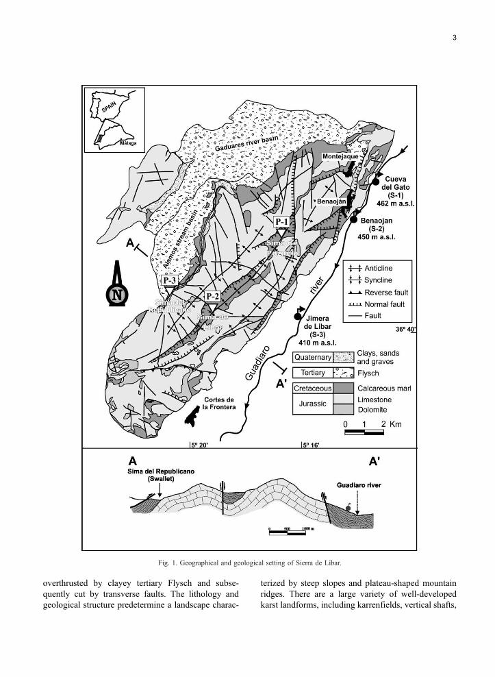
Fig. 1. Geographical and geological setting of Sierra de Lıbar.
3
overthrusted by clayey tertiary Flysch and subse-
quently cut by transverse faults. The lithology and
geological structure predetermine a landscape charac-
terized by steep slopes and plateau-shaped mountain
ridges. There are a large variety of well-developed
karst landforms, including karrenfields, vertical shafts,
4
and cave systems. Poljes developed in the synclines,
where Cretaceous marls outcrop. Rainfall often gen-
erates surface flow on the polje floors, which are
drained by swallow holes (Delannoy, 1987). The
karst aquifer is formed of Jurassic rocks with a total
thickness of over 400 m. The aquifer system drains
via karst springs on its S and E borders, towards the
Guadiaro River. The discharge rates and hydrochemi-
cal composition of these karst springs react rapidly on
precipitation events (Sanchez et al., 1998, Jimenez et
al., in press). Soils are largely absent on limestone and
dolomite outcrops, while the marly polje floors are
covered by soils.
2. Overview of the Pan-European Approach
proposed by COST Action 620
The Pan-European Approach to vulnerability, haz-
ard and risk mapping proposed by COST Action 620
is based on an origin-pathway-target model, which
applies for both resource and source protection. The
origin is the assumed place of release of a contami-
nant. The pathway is the flow path of a contaminant
from its origin, through the system, to the point that
has to be protected. For resource protection, the path-
way consists of the downward passage through the
layers overlying aquifer; for source protection it also
includes the lateral passage in the aquifer. The target is
the water that has to be protected. For resource pro-
tection it is the groundwater in the aquifer, for source
protection it is the water in a well or spring (Gold-
scheider, 2004a). Hazards are potential sources of
contamination resulting from human activities, mainly
at the land surface (De Ketelaere et al., 2004). The risk
of groundwater contamination thus depends on the
hazard (origin), the vulnerability of the system (path-
way) and the potential consequences of a contamina-
tion event, i.e., its impact on the groundwater resource
or source (target) (Daly et al., 2004).
In the case of an accidental contamination event,
there are three practical questions to be answered
(Brouyere, 2004): How long does it take until the
contamination reaches the target (groundwater re-
source or source), at which concentration will the
target be contaminated, and for how long will the
contamination last? The Pan-European Approach
mainly considers the first two aspects, i.e., the
transit time of a contaminant from the origin to
the target, and the concentration decline along its
pathways.
The conceptual framework for intrinsic groundwa-
ter vulnerability mapping proposed by COST Action
620 considers four factors: overlying layers (O), flow
concentration (C), precipitation regime (P) and karst
network development (K). Resource vulnerability
maps are prepared by a combination of the O, C,
and P factors. For source vulnerability mapping, the
K factor needs to be considered additionally (Daly et
al., 2002; Goldscheider and Popescu, 2004). Several
individual methods can be used within this conceptual
framework, dependent on the hydrogeological frame-
work, and the available time, data and financial
resources. Two of these methods were tested in the
Sierra de Lıbar: the PI method (Goldscheider et al.,
2000), and the COP method (Vıas et al., 2002, 2004).
COST Action 620 also proposed different methods
to validate vulnerability maps, including the interpre-
tation of spring hydrographs and chemographs, the
use of natural and artificial tracers, and modeling
(Neale, 2004). Some of these methods where applied
in the test site in order to validate the two intrinsic
vulnerability maps.
Intrinsic vulnerability methods do not consider the
large variety of specific contaminant types and con-
tamination scenarios. A specific vulnerability assess-
ment is indicated if a particular contaminant is
identified posing a threat to groundwater quality
allowing its individual behavior to be incorporated
into groundwater vulnerability studies. Specific atten-
uation processes, such as sorption, biodegradation or
chemical transformation, influence contaminant fate
and transport in the subsurface. Contaminants are thus
subjected to retardation and degradation effects,
which lead to increased protection values compared
to intrinsic vulnerability. The effectiveness of specific
attenuation processes depends both on the character-
istics of the subsurface and on the nature of the
contaminant concerned. For carbonate environments,
typical karst phenomena also need to be considered,
such as the bypassing of strata by preferential conduit
flow.
The COSTAction 620 concept considers a specific
weighting factor (S factor) to be required in order to
incorporate the additional specific attenuation pro-
cesses into vulnerability assessment (Sinreich et al.,
5
2004a). A standard procedure was established in order
to allow qualitative S factor evaluation for different
hydrogeological settings and various kinds of contam-
inant (Sinreich et al., 2004b). Specific attenuation
assessment results can then be used complementary
to any intrinsic vulnerability method.
In the context of groundwater contamination, a
hazard is defined as a potential source of contamina-
tion resulting from human activities taking place
mainly at the land surface. The hazards have been
classified according to the type of land use (infra-
structural, industrial and agricultural development).
A hazard assessment considers the potential degree
of harmfulness for each type of hazard and is deter-
mined by the toxicity and quantity of harmful sub-
stances as well as the likelihood of a contamination
event.
Several definitions of risk to groundwater have
been introduced in the technical literature. The defi-
nition of groundwater contamination risk proposed by
Morris and Foster (2000) bas the probability that
groundwater in the aquifer will become contaminated
to an unacceptable level by activities on the immedi-
ately overlaying land-surfaceQ has been adopted with-
in the framework of the COST Action 620. This
approach uses the interaction between the infiltrating
contaminant load and the vulnerability of the aquifer
at the location concerned. The risk assessment fol-
lowed in the Sierra de Lıbar test site describes the
impact intensity from a potential contamination load
at the surface. Considering the intrinsic vulnerability
and the hazard assessment scheme with their defini-
tions, the risk definition in this assessment scheme can
be described as the risk to groundwater pollution from
each hazard when its contamination load is released.
The risk maps therefore show the risk to groundwater
pollution of each mapped hazard in the sense of
resource protection. Thus, the groundwater and the
characteristics of the saturated zone of the aquifer are
not included in the risk assessment.
3. Intrinsic vulnerability mapping
3.1. PI method
The PI method of vulnerability mapping was de-
veloped prior to the Pan-European Approach and uses
the same conceptual model and factors, but a slightly
different nomenclature (Goldscheider et al., 2000).
COST 620 proposes this method as one possibility
of intrinsic resource vulnerability mapping, mainly if
detailed data are available. The method is applicable
for all types of aquifers and provides specific meth-
odological tools for karst. The protection factor p is
assessed as the product of two factors (1): protective
cover (P) and (2): infiltration conditions (I):
p ¼ Pd I : ð1Þ
A high protection factor corresponds to a low
vulnerability and vice versa. The P factor describes
the protective function of all layers between the
ground surface and the groundwater table: soil, sub-
soil, non-karst rock, and unsaturated karst rock (i.e.,
the boverlying layersQ of the Pan-European Ap-
proach). It is calculated using a modified version of
a method proposed by Holting et al. (1995) and
divided into five classes; from P=1 for a very low
degree of protection to P=5 for very thick and pro-
tective overlying layers.
The I factor (infiltration conditions) describes the
degree to which the protective cover is bypassed as a
result of surface and shallow subsurface flow in the
catchment of swallow holes (i.e., bflow concentrationQof the Pan-European Approach). The I factor takes
into account the soil properties controlling runoff
generation, the vegetation, the slope gradient and the
position of a given point inside or outside the catch-
ment of a sinking stream. It ranges between 0.0
(swallow holes, sinking streams, and steep slopes
generating surface runoff towards these) and 1.0 (dif-
fuse infiltration and percolation).
The PI method was first applied in a test site in the
Swabian Alb, Germany (unpublished diploma works
by Markus Klute and Sebastian Sturm; Goldscheider,
2005). Brechenmacher (unpublished diploma work)
applied it in the Sierra de Lıbar (Fig. 2).
The evaluation scheme for the P factor uses a
subfactor for the degree of fracturing and epikarst
development. This subfactor is zero in case of strong-
ly developed epikarst, i.e., bare karrenfields connected
with vertical shafts. As this situation occurs frequently
in the Sierra de Lıbar, vulnerability was classified as
dvery highT on large areas, independent from the
thickness of the unsaturated karstic bedrock. dVeryhighT vulnerability was also assigned to areas inside
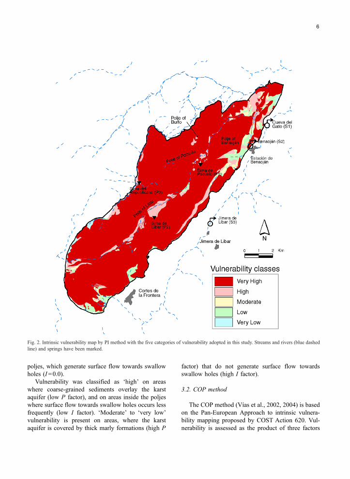
Fig. 2. Intrinsic vulnerability map by PI method with the five categories of vulnerability adopted in this study. Streams and rivers (blue dashed
line) and springs have been marked.
6
poljes, which generate surface flow towards swallow
holes (I =0.0).
Vulnerability was classified as dhighT on areas
where coarse-grained sediments overlay the karst
aquifer (low P factor), and on areas inside the poljes
where surface flow towards swallow holes occurs less
frequently (low I factor). dModerateT to dvery lowTvulnerability is present on areas, where the karst
aquifer is covered by thick marly formations (high P
factor) that do not generate surface flow towards
swallow holes (high I factor).
3.2. COP method
The COP method (Vıas et al., 2002, 2004) is based
on the Pan-European Approach to intrinsic vulnera-
bility mapping proposed by COST Action 620. Vul-
nerability is assessed as the product of three factors
7
(2): Concentration of flow (C), Overlying layers (O)
and Precipitation (P). As the method is made for
resource protection, the karst network development
inside the aquifer is not considered.
COP ¼ Cd Od P: ð2Þ
The O factor refers to the protection of the unsat-
urated zone of the aquifer against a contaminant event.
It indicates the capability of the unsaturated zone to
filter out or attenuate contamination and thus reduce its
adverse effects. The C and P factors are used as
modifiers that correct the degree of protection provid-
ed by the overlying layers (O factor). The C factor
takes into account the surface conditions that control
water flowing towards zones of rapid infiltration,
which have less capacity to attenuate contamination.
The P factor considers influence of precipitation, both
quantity and intensity, on the transport of contami-
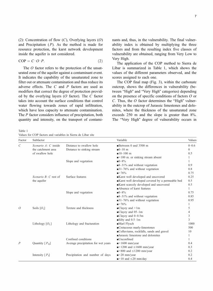
Table 1
Values for COP factors and variables in Sierra de Lıbar site
Factor Subfactor
C Scenario A: C inside
the catchment area
of swallow hole
Distance to swallow hole
Distance to sinking stream
Slope and vegetation
Scenario B: C rest of
the aquifer
Surface features
Slope and vegetation
O Soils [Os] Texture and thickness
Lithology [OL] Lithology and fracturation
Confined conditions
P Quantity [ PQ] Average precipitation for wet years
Intensity [ PI] Precipitation and number of days
nants and, thus, in the vulnerability. The final vulner-
ability index is obtained by multiplying the three
factors and from the resulting index five classes of
vulnerability are obtained, ranging from Very Low to
Very High.
The application of the COP method to Sierra de
Lıbar is summarized in Table 1, which shows the
values of the different parameters observed, and the
scores assigned to each one.
The COP final map (Fig. 3), within the carbonate
outcrop, shows the differences in vulnerability (be-
tween bHighQ and bVery HighQ categories) dependingon the presence of specific conditions of factors O or
C. Thus, the O factor determines the bHighQ vulner-ability in the outcrop of Jurassic limestones and dolo-
mites, where the thickness of the unsaturated zone
exceeds 250 m and the slope is greater than 8%.
The bVery HighQ degree of vulnerability occurs in
Variable Values
nBetween 0 and 3500 m 0–0.6
n0–10 m 0
n10–100 m 0.5
nN100 m. or sinking stream absent 1
n0–8% 1
n8–31% and without vegetation 0.9
n31–76% and without vegetation 0.8
nN76% 0.75
nKarst well developed and uncovered 0.25
nKarst well developed covered by a permeable bed 0.5
nKarst scarcely developed and uncovered 0.5
nAbsence of karst features 1
n0–8% 0.75
n8–31% and without vegetation 0.85
n31–76% and without vegetation 0.95
nN76% 1
nClayey and N1m 5
nClayey and 05–1m 4
nClayey and 0–0.5m 3
nSilty and 0.5–1m 3
nMarl Flysch 1000
nCretaceous marly-limestones 500
nColluviums, rockfalls, sands and gravel 10
nJurassic limestone and dolomites 1
nUnconfined 1
nN1600 mm/year 0.4
nN1200 and V1600 mm/year 0.3
nN800 and V1200 mm/year 0.2
nN20 mm/year 0.2
nN10 and V20 mm/day 0.4
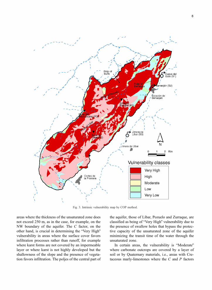
Fig. 3. Intrinsic vulnerability map by COP method.
8
areas where the thickness of the unsaturated zone does
not exceed 250 m, as in the case, for example, on the
NW boundary of the aquifer. The C factor, on the
other hand, is crucial in determining the bVery HighQvulnerability in areas where the surface cover favors
infiltration processes rather than runoff, for example
where karst forms are not covered by an impermeable
layer or where karst is not highly developed but the
shallowness of the slope and the presence of vegeta-
tion favors infiltration. The poljes of the central part of
the aquifer, those of Lıbar, Pozuelo and Zurraque, are
classified as being of bVery HighQ vulnerability due to
the presence of swallow holes that bypass the protec-
tive capacity of the unsaturated zone of the aquifer
minimizing the transit time of the water through the
unsaturated zone.
In certain areas, the vulnerability is bModerateQwhere carbonate outcrops are covered by a layer of
soil or by Quaternary materials, i.e., areas with Cre-
taceous marly-limestones where the C and P factors
9
(because of the shallow slope and the high intensity,
respectively) reduce the potential attenuation capabil-
ity assigned to the unsaturated zone by the O factor.
The bLowQ and bVery LowQ vulnerability areas
correspond to the outcrops of Cretaceous marly-lime-
stones, beyond the poljes, and of marly Flysch, where
the low permeability of the surface cover and the
gradient of the slope favors runoff towards the exter-
nal part of the aquifer.
3.3. Comparison between the two intrinsic vulnera-
bility maps
Both methods classify large areas as zones of
elevated vulnerability, which is consistent, as large
parts of the test site are characterized by bare karren-
fields and abundant vertical shafts. However, the PI
method classifies all these areas as zones of dveryhighT vulnerability, because P=0 in case of extreme
epikarst development. In contrast, the COP method
differentiates between zones of dhighT and dvery highTvulnerability, dependent on the thickness of the un-
saturated zone.
Both methods classify swallow holes and areas
generating runoff toward sinking streams as zones of
dvery highT vulnerability. This is a consequence of thekarst-specific factors I (infiltration conditions) and C
(flow concentration), which describe the degree to
which the overlying layers are bypassed by surface
flow in the catchment of swallow holes. According to
both methods, vulnerability is dvery lowT to
dmoderateT on areas where the aquifer is covered by
thick formations of low permeability (high values for
P and O), which do not generate surface flow towards
the karst aquifer (high values for I and C).
Only the COP method allows taking into account
the precipitation regime of this test site, which is
characterized by high annual precipitation and high
rainfall intensities.
3.4. Validation of the intrinsic vulnerability maps
Tracer tests can be used to validate a groundwater
vulnerability assessment, as they allow observing the
transit time and concentration decline of a potential
contaminant from the injection point (origin) to a
sampling point (target). Conservative tracers can be
used to validate intrinsic vulnerability; reactive tracers
allow validating specific vulnerability. For validating
a source vulnerability map, the tracer breakthrough
should be observed at the spring or well. For resource
vulnerability, it should be observed at the basis of the
unsaturated zone, which is, however, often not possi-
ble. Tracer tests allow for validation at certain points
only, while large surfaces cannot be validated with
this method (Goldscheider et al., 2001, Goldscheider,
2004b).
A multi-tracer test was done in the test site in order
to validate the intrinsic vulnerability maps (Andreo et
al., 2004). Three fluorescent dyes (Eosine, Uranine,
Sulforhodamine B) were injected into three swallow
holes (P-1, P-2 and P-3 in Fig. 4) during a period of
high-flow conditions. All karst spring in the area were
sampled in order to observe the possible tracer break-
through. Strictly spoken, the set up of this experiment
applies for the validation of a source vulnerability
map (sampling at the springs), while the PI and
COP map show the vulnerability of the groundwater
resource. Nevertheless, the tracer test gave useful
information on the vulnerability of the aquifer system:
all tracers reappeared at one or several karst springs
between 3 and 5 days after the injection. The maximal
linear flow velocities, calculated from the time of first
tracer detection, range between 77 and 119 m/h. These
results confirm the dvery highT groundwater vulnera-bility in all areas within the poljes that generate
surface runoff towards swallow holes. The tracer test
also showed that a contaminant release in the catch-
ment of the swallow holes P-1 and P-2 would threaten
springs S-1, S-2 and S-3, whilst contamination in P-3
would only affect spring S-4.
Spring hydrographs and natural tracers can also be
used to validate a vulnerability assessment. In contrast
to artificial tracer tests, these methods cannot be used
to check the vulnerability at specific points, but pro-
vide information on the global response of the aquifer
system on external impacts. Fast and strong hydraulic,
hydrochemical and isotopic reactions on hydrologic
events indicate high vulnerability (Bakalowicz, 2004,
Kralik and Mudry, 2004).
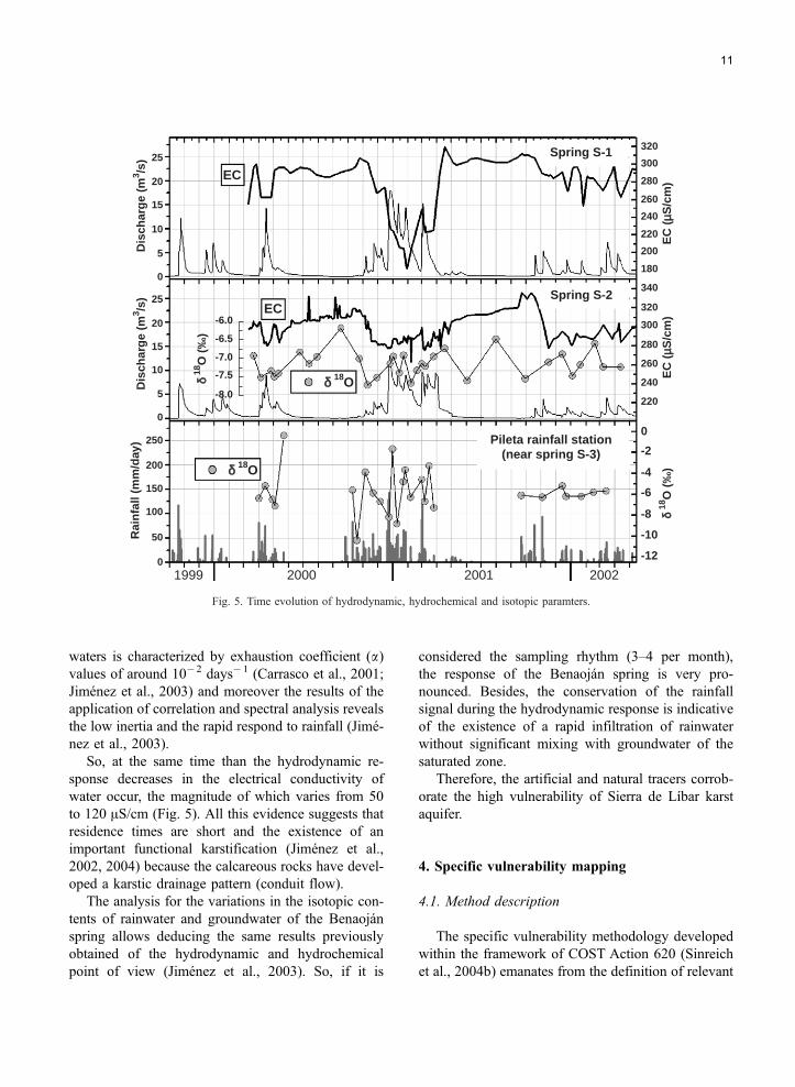
In the Sierra de Lıbar, the variations of discharge
rate (Q), electrical conductivity (EC) and isotopic
composition (d18O) of the spring and rainwater
were used to validate vulnerability. The Gato and
Benaojan springs (S-1 and S-2) served as main sam-
pling points.
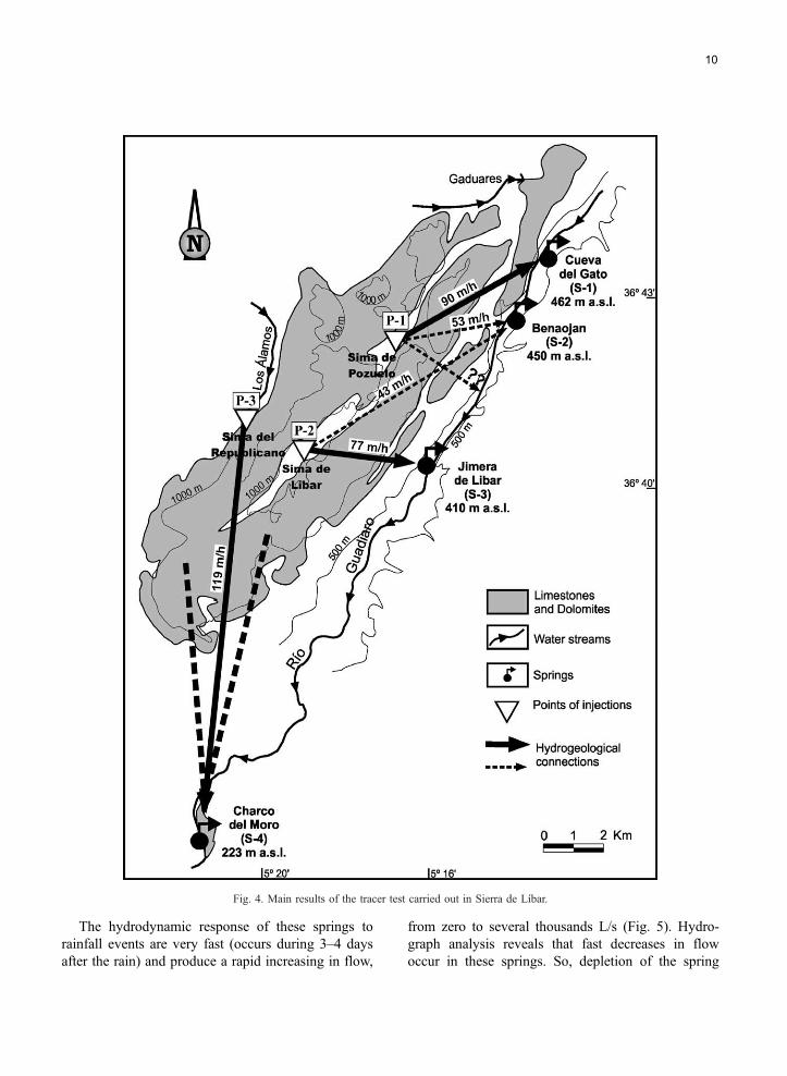
Fig. 4. Main results of the tracer test carried out in Sierra de Lıbar.
10
The hydrodynamic response of these springs to
rainfall events are very fast (occurs during 3–4 days
after the rain) and produce a rapid increasing in flow,
from zero to several thousands L/s (Fig. 5). Hydro-
graph analysis reveals that fast decreases in flow
occur in these springs. So, depletion of the spring
25
20
15
10
5
0
25
20
15
10
5
0
250
200
150
100
50
0
Rai
nfa
ll (m
m/d
ay)
Dis
char
ge
(m3 /s
)D
isch
arg
e (m
3 /s)
EC
(µµS
/cm
)E
C (
µS/c
m)
δ 18
O (
‰)
0
-2
-4
-6
-8
-10
-12
320
300
280
260
240
220
200
180
340
320
300
280
260
240
220
-6.0
-6.5
-7.0
-7.5
-8.0
δ 18
O (
‰)
δ 18O
δ 18O
EC
EC
1999 2000 2001 2002
Pileta rainfall station(near spring S-3)
Spring S-2
Spring S-1
Fig. 5. Time evolution of hydrodynamic, hydrochemical and isotopic paramters.
11
waters is characterized by exhaustion coefficient (a)values of around 10�2 days�1 (Carrasco et al., 2001;
Jimenez et al., 2003) and moreover the results of the
application of correlation and spectral analysis reveals
the low inertia and the rapid respond to rainfall (Jime-
nez et al., 2003).
So, at the same time than the hydrodynamic re-
sponse decreases in the electrical conductivity of
water occur, the magnitude of which varies from 50
to 120 AS/cm (Fig. 5). All this evidence suggests that
residence times are short and the existence of an
important functional karstification (Jimenez et al.,
2002, 2004) because the calcareous rocks have devel-
oped a karstic drainage pattern (conduit flow).
The analysis for the variations in the isotopic con-
tents of rainwater and groundwater of the Benaojan
spring allows deducing the same results previously
obtained of the hydrodynamic and hydrochemical
point of view (Jimenez et al., 2003). So, if it is
considered the sampling rhythm (3–4 per month),
the response of the Benaojan spring is very pro-
nounced. Besides, the conservation of the rainfall
signal during the hydrodynamic response is indicative
of the existence of a rapid infiltration of rainwater
without significant mixing with groundwater of the
saturated zone.
Therefore, the artificial and natural tracers corrob-
orate the high vulnerability of Sierra de Lıbar karst
aquifer.
4. Specific vulnerability mapping
4.1. Method description
The specific vulnerability methodology developed
within the framework of COST Action 620 (Sinreich
et al., 2004b) emanates from the definition of relevant
12
contaminant types, for which an assessment is indi-
cated. Two groups were selected for specific vulner-
ability mapping in Sierra de Lıbar considered being
the main potential contaminants in the catchment:
microbial and hydrocarbon contaminants. Microbial
contaminants (faecal coliforms) may derive from
urban sewage leakage and livestock farming. In the
study area, they may be released as diffuse contami-
nation in the course of manure application or as point
contamination next to villages and cattle or sheep
farms. Hydrocarbon contaminants, especially aromat-
ic hydrocarbons (BTEX), may derive from the petrol
station and from oil-fuel and petrol tanks for private
and agricultural purposes. Also mountain roads con-
stitute a noteworthy BTEX hazard.
Both contaminant types have drastically differing
physical and chemical characteristics and are thus
assumed to show significant distinctions in transport
behavior. However, only specific attenuation process-
es are diverse, whereas hydrodynamic flow character-
istics represent a uniform basis for any contaminant
transport. The proposed method thus evaluates a spe-
cific weighting factor (S) to be linked to the results of
an intrinsic vulnerability assessment. The S factor
deduces from input data concerning layer properties
and contaminant properties. These data allow qualita-
tively estimating the effectiveness of relevant process-
es that may cause retardation and degradation of
contaminant concentration by using a sequence of
empirical matrices. For example, the process capacity
of a certain layer depends on its thickness and on
associated key properties, including clay content, or-
ganic matter content, pH value, temperature etc. In
general, specific attenuation processes may become
effective if they are favored by both layer composition
and contaminant properties. Nonetheless, process ef-
fectiveness may be reduced due to the bypass of
protective layers by preferential drain in karst features.
Consequently, the index value, which is assigned to
the S factor, is restricted according to the rate of
diffuse flow in each layer.
The assessment provides a specific attenuation
index for the sum of all layers at each point of the
catchment. Associated specific attenuation classes
may range from dvery lowT (e.g., in case of uncovered
karst) up to dhighT where the karst is maybe overlain
by topsoil and/or other protective cover. For the Sierra
de Lıbar, results of the specific attenuation assessment
were linked to the intrinsic vulnerability map derived
using the COP method. In doing so, specific attenu-
ation classes were combined with the O factor of the
COP method. More precisely, specific attenuation
classes enhance the score of the O factor, since spe-
cific attenuation is an additional protective effect of
the overlying layers. The so modified O factor (Omod)
is then multiplied with the C factor and P factor in
analogous manner to intrinsic vulnerability assess-
ment using the COP method in order to obtain specific
vulnerability classes (3):
COP ¼ Cd Omodd P: ð3Þ
Input data that is needed for the contaminant-spe-
cific assessment derived either from literature (con-
taminant properties) or were estimated based on field
observations or on reference values (layer composi-
tion). Layer thickness distribution was directly
adopted from existing databases. For the rate of dif-
fuse flow estimation, a uniform range was assigned to
each layer taking into account the geological and
geomorphologic features of the outcrops and the hy-
drodynamic and hydrochemical characteristics of
groundwater (Jimenez et al., 2003).
4.2. Comparison between intrinsic and specific vul-
nerability maps
Faecal coliforms may suffer retardation and degra-
dation in the subsurface by sorption, physical filtering
and die off. These processes can mainly be assigned to
the clayey topsoil layer and the marls of the non-karst
rock. However, where fast preferential flow is favored
due to conductive macropores, soil cracks or enlarged
fissures none of these attenuation processes can be
assumed as a major mechanism of contaminant con-
centration lowering.
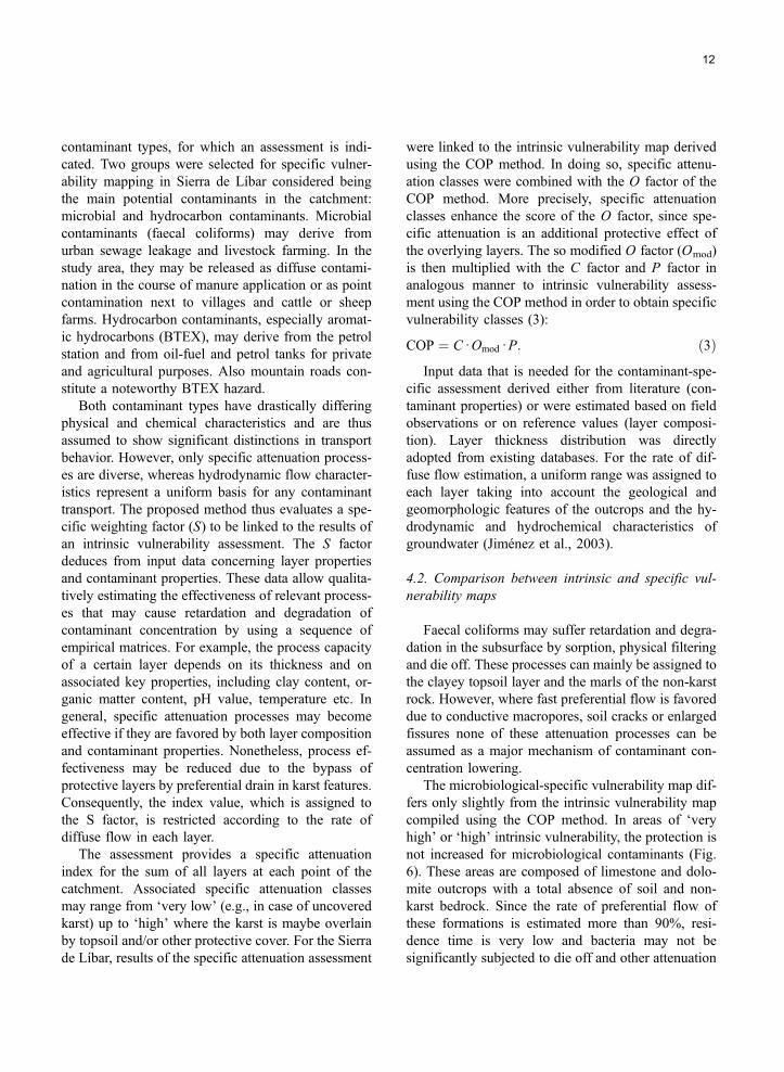
The microbiological-specific vulnerability map dif-
fers only slightly from the intrinsic vulnerability map
compiled using the COP method. In areas of dveryhighT or dhighT intrinsic vulnerability, the protection is
not increased for microbiological contaminants (Fig.
6). These areas are composed of limestone and dolo-
mite outcrops with a total absence of soil and non-
karst bedrock. Since the rate of preferential flow of
these formations is estimated more than 90%, resi-
dence time is very low and bacteria may not be
significantly subjected to die off and other attenuation
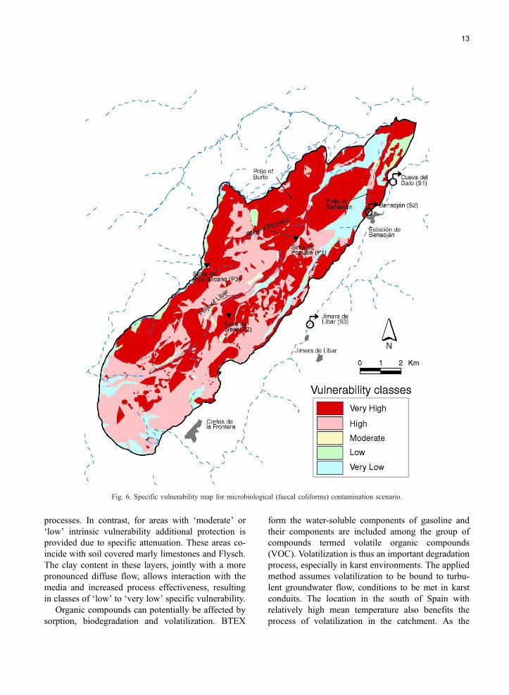
Fig. 6. Specific vulnerability map for microbiological (faecal coliforms) contamination scenario.
13
processes. In contrast, for areas with dmoderateT or
dlowT intrinsic vulnerability additional protection is
provided due to specific attenuation. These areas co-
incide with soil covered marly limestones and Flysch.
The clay content in these layers, jointly with a more
pronounced diffuse flow, allows interaction with the
media and increased process effectiveness, resulting
in classes of dlowT to dvery lowT specific vulnerability.Organic compounds can potentially be affected by
sorption, biodegradation and volatilization. BTEX
form the water-soluble components of gasoline and
their components are included among the group of
compounds termed volatile organic compounds
(VOC). Volatilization is thus an important degradation
process, especially in karst environments. The applied
method assumes volatilization to be bound to turbu-
lent groundwater flow, conditions to be met in karst
conduits. The location in the south of Spain with
relatively high mean temperature also benefits the
process of volatilization in the catchment. As the
14
BTEX group generally is not very prone to adsorp-
tion, this process is omitted for the vulnerability as-
sessment. Finally, BTEX could be microbiologically
degraded with the involvement of organic matter.
Since even the topsoil layer contains only little organ-
ic matter, biodegradation is also a process regarded as
not significant for BTEX attenuation in Sierra de
Lıbar.
The BTEX-specific vulnerability map (Fig. 7) is
significantly different to the COP intrinsic vulnerabil-
Fig. 7. Specific vulnerability map for aromatic hy
ity map indicating an overall higher protection to-
wards BTEX than towards conservatively behaving
contaminants. BTEX reach a high specific attenuation
where the unsaturated zone is relatively thick, whereas
the topsoil lost its prominent role for specific attenu-
ation in that situation. Therefore, nearly everywhere in
the catchment, vulnerability decreased at least by one
grade. The majority of surfaces, assigned to dveryhighT or dhighT intrinsic vulnerability, have changed
to classes of dhighT and dmoderateT vulnerability. Only
drocarbons (BTEX) contamination scenario.
15
the poljes in the central part of the catchment maintain
their dvery highT vulnerability values, due to the lower
depth to the groundwater resource in these parts of the
aquifer.
5. Hazard mapping
The hazard estimation concept as proposed by
COST Action 620 considers three factors which con-
trol the degree of harmfulness of each hazard (4). First
a weighting factor (H) defined by the type of hazard
concerning the toxicity as well as the properties re-
garding solubility and mobility of the pollutant is to
be assessed. The ranking factor (Qn) enables the
comparison between hazards of the same type by
the estimation of the relative quantity that can be
released. Finally the reduction factor (Rf) includes
the likelihood of a contamination event to occur
with respect to the specific hazard, incorporating fac-
tors like technical status or level of maintenance. The
hazard index is calculated as follows:
HI ¼ Hd Qnd Rf ð4Þ
where HI=Hazard index, H =Weighting factor, Qn=
Ranking factor, Rf =Reduction factor.
The Hazard assessment in the Sierra de Lıbar starts
with the identification of all relevant hazards using the
hazard inventory list proposed by the COST Action
620 (De Ketelaere et al., 2004). According to this list
all weighting values were acquired, whereas infra-
structural information was mostly delivered by topo-
graphic maps. The ranking procedure as well as the
estimation of the reduction factors was done by field
investigations as site-specific information is mostly
best determinable in surveying processes. Unfortu-
nately exact values in terms of quantity and the factors
leading to a reduction of a certain hazard are rarely
available. Therefore estimations including contamina-
tion potential size and age of infrastructural installa-
tions are often the only possible basis for hazard
assessment. In the Sierra de Lıbar the factors Qn and
Rf were estimated in this manner, as more precise
possibilities were not available.
The following hazards were identified in the test
site: urbanization with leaking sewer pipes and sewer
systems, houses and villages without sewer systems,
waste water discharge into surface watercourses, gar-
bage dump, gasoline station, road unsecured, railway
line, railway tunnel unsecured, railway station, grave-
yard, food industry, animal barn and feedlot.
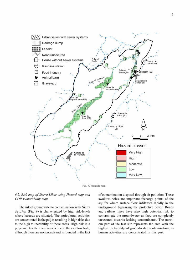
As the main part of the test site is uninhabited the
hazards are concentrated on the three villages that are
situated in the northern part of the test site, which
hosts most of the industrial activities and small farms.
The two largest poljes in the central part of the Sierra
de Lıbar are used as feedlots for cattle, sheep, horses
and pigs (Fig. 8).
The Hazard Index classification ranges between
very low and low. This reflects only a small portion
of the possible bandwidth from very low to very high
but the rural characteristic of the test site seems to be
well described.
6. Risk mapping
6.1. Risk assessment
Coming back to the idea of the origin-pathway-
target model, risk assessment should describe not
only the effect but also the consequences of a con-
tamination to the target. In relation to groundwater
protection, the groundwater is defined as the target in
the sense of resource protection. In this case vulner-
ability mapping considers only the starts with the
hazards to the groundwater and ends up with the
potential impact of pollutants on the target. In this
study only the impact intensity is considered whereas
risk sensitivity (Hotzl, 2004) was surrender, because
crucial data for risk sensitivity assessment of the
complex karst aquifer of Sierra de Lıbar are not yet
available.
Risk intensity assessment logically includes all
activities that consider the possible origins of contam-
inations and all processes that can lead to a reduction
of the contaminations along the pathways to the tar-
get. The points of potential contamination release are
determined within the hazard assessment where all
possible origins of contamination and the likelihood
of its release are considered. The processes that lead to
a reduction of the contamination along the pathway
are considered within the intrinsic vulnerability map.
Simple matrix relations are used to combine the haz-
ard and vulnerability classifications to attain the risk
assessment.
Urbanisation with sewer systems
Garbage dump
Feedlot
Road unsecured
House without sewer systems
Gasoline station
Food industry
Animal barn
Graveyard
Polje ofBurfo
Polje of Pozuelo
Sima dePozuelo (P1)
Polje of
Cueva delGato (S1)
Benaoján (S2)
Estación deBenaoján
Jimera deLíbar (S3)
Jimera de Líbar
Benaoján
Hazard classes
Very High
N
High
Moderate
Low
Very Low
0 1 2 Km
Cortes dela Frontera
Sima deLíbar (P2)
Polje of L
íbar
Sima delRepublicano (P3)
Fig. 8. Hazards map.
16
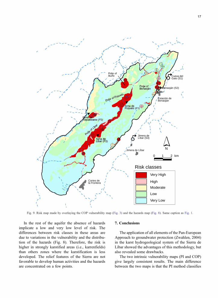
6.2. Risk map of Sierra Lıbar using Hazard map and
COP vulnerability map
The risk of groundwater to contamination in theSierra
de Lıbar (Fig. 9) is characterized by high risk-levels
where hazards are situated. The agricultural activities
are concentrated in the poljes resulting in high risks due
to the high vulnerability of these areas. High risk in a
polje and its catchment area is due to the swallow hole,
although there are no hazards and is founded in the fact
of contamination disposal through air pollution. These
swallow holes are important recharge points of the
aquifer where surface flow infiltrates rapidly in the
underground bypassing the protective cover. Roads
and railway lines have also high potential risk to
contaminate the groundwater as they are completely
unsecured towards leaking contaminants. The north-
ern part of the test site represents the area with the
highest probability of groundwater contamination, as
human activities are concentrated in this part.
Very High
High
Moderate
Low
Very Low
Risk classes
0 1
N
Jimera deLíbar (S3)
Benaojan
Benaojan (S2)
Cueva delGato (S1)
Estacion de
Jimera de Líbar
2 km
Cortes de la Frontera
Polje ofBurfo
í
í
Fig. 9. Risk map made by overlaying the COP vulnerability map (Fig. 3) and the hazards map (Fig. 8). Same caption as Fig. 1.
17
In the rest of the aquifer the absence of hazards
implicate a low and very low level of risk. The
differences between risk classes in these areas are
due to variations in the vulnerability and the distribu-
tion of the hazards (Fig. 8). Therefore, the risk is
higher in strongly karstified areas (i.e., karrenfields)
than others zones where the karstification is less
developed. The relief features of the Sierra are not
favorable to develop human activities and the hazards
are concentrated on a few points.
7. Conclusions
The application of all elements of the Pan-European
Approach to groundwater protection (Zwahlen, 2004)
in the karst hydrogeological system of the Sierra de
Lıbar showed the advantages of this methodology, but
also revealed some drawbacks.
The two intrinsic vulnerability maps (PI and COP)
give largely consistent results. The main difference
between the two maps is that the PI method classifies
18
all areas made of bare karrenfields as zones of dveryhighT vulnerability, while the COP method differenti-
ates these areas into zones of dhighT and dvery highTvulnerability, dependent on the thickness of the un-
saturated zone. Both methods classify swallow holes
and areas generating surface runoff toward sinking
streams as zones of dvery highT vulnerability. Both
methods assign a dvery lowT to dmoderateT vulnerabil-ity to areas where the karst aquifer is covered by
formations of low permeability, which do not generate
lateral flow towards sinking streams.
Compared to previously existing methods of vul-
nerability mapping, this is a significant progress.
Comparative application of previous methods in
karst areas often resulted in contradictory and incon-
sistent results (Gogu and Dassargues, 2000, Gold-
scheider, 2005). There are two main recharge types
in karst areas: autogenic recharge, i.e., infiltration
through soil and epikarst, and allogenic recharge,
i.e., surface flow sinking into the karst aquifer via
swallow holes (Ford and Williams, 1989). Most pre-
vious methods fail in areas of allogenic recharge:
Areas made of thick impervious formations are often
classified as zones of low vulnerability, even if they
generate surface runoff towards swallow holes. In
contrast, the PI and COP method are applicable for
areas of both autogenic and allogenic recharge.
A major drawback of vulnerability mapping is the
difficulty to validate vulnerability. COST Action 620
outlined some possibilities how this could be done.
The vulnerability maps for the Sierra de Lıbar were
validated both in a global way (hydrograph analysis,
natural tracers and isotopes) and for selected points
(artificial tracers). This validation, although incom-
plete, confirmed both the globally high vulnerability
of the karst aquifer system and the extreme vulnera-
bility in the at the swallow holes and in their surface
catchment areas.
The specific vulnerability maps of Sierra de Lıbar
for faecal coliforms and aromatic hydrocarbons
(BTEX) illustrate the different behaviors of the par-
ticular contaminants, which are associated to land
use in this catchment. This is due to the different
contaminant properties and their interaction with the
individual layers. Low residence times due to pref-
erential conduit flow inhibit microorganisms to be
significantly subjected to degradation between land
surface and karst groundwater table. Thus, additional
specific attenuation is very poor for faecal coliforms
and the specific map resembles to the intrinsic vul-
nerability map compiled using the COP method. On
the other hand, specific vulnerability to BTEX is
significantly decreased in practically the whole
area, due to the importance of contaminant degrada-
tion by volatilization. The Sierra de Lıbar application
showed that for special purposes it could be worth-
while to produce contaminant-specific vulnerability
maps. The user may benefit from the comparability
of these maps since they are based on the same
intrinsic vulnerability module.
In large parts of the Sierra de Lıbar, hazards are
absent because extreme karstification (bare karren-
fields) makes land use impossible. Most settlements
and agricultural activities, and the resulting hazards,
consequently focus on the polje floors. According to
the COST 620 methodology, these hazards are rela-
tively harmless. However, as some of these hazards
are located on areas that frequently generate surface
flow towards swallow holes, i.e., highly vulnerable
areas, the risk of groundwater contamination is ele-
vated in these zones. It is also possible to combine a
hazard map with a specific vulnerability map, in
order to produce a risk map showing the risk of
groundwater to be contaminated by a specific sub-
stance, e.g., the risk of microbial groundwater con-
tamination. However, this was not yet done in the test
site.
The results of the tracer test, together with the
vulnerability, hazard and risk maps could serve as a
scientific basis for sustainable land use planning and
groundwater management in the Sierra de Lıbar. For
example: The intrinsic vulnerability map together with
the results from the tracer test could be used as a basis
to delineate protection zones for the karst springs. The
risk map shows the zones where the groundwater is at
risk to be contaminated by human activities. Action
should be taken in these zones.
Acknowledgements
The authors are grateful to all participants of COST
Action 620 for the good cooperation and many valu-
able discussions and to the European Commission for
funding this action. This work is a contribution to the
Spanish–German Integrated Action HA2002-0128.
19
The Hydrogeology Group of the University of Malaga
was supported by projects from the Spanish Ministry
of Research and Science (PB98-1397, REN2002-
01797/HID and REN2003-01580/HID) and the Re-
search Groups of the Junta de Andalucıa (RNM-308
and HUM 776).
References
Adams B, Foster SSD. Land-surface zoning for groundwater pro-
tection. J Inst Water Environ Manag 1992;6:312–20.
Albinet M, Margat J. Cartographie de la vulnerabilite a la pollution
des nappes dTeau souterraine. Bull Bur Rech Geol Min
1970;3(4):13–22.
Andreo B, Vadillo I, Carrasco F, Neukum C, Jimenez P, Gold-
scheider N, et al. Precisiones sobre el funcionamiento hidrodi-
namico y la vulnerabilidad a la contaminacion del acuıfero
karstico de la Sierra de Lıbar (provincias de Malaga y Cadiz,
Sur de Espana) a partir de un ensayo de trazadores. Rev Soc
Geol Esp 2004;17(3–4):187–97.
Arnaud C. Groundwater protecting—catchment protection and reg-
ulation. Houille Blanche 2001;1:81–3.
Bakalowicz M. Hydraulics and spring hydrographs. In: Zwahlen F,
editor. Vulnerability and risk mapping for the protection of
carbonate (karst) aquifers, EUR 20912. Brussels7 European
Commission, Directorate-General XII Science, Research and
Development; 2004. p. 132.
Brouyere S. A quantitative point of view of the concept of vulner-
ability. In: Zwahlen F, editor. Vulnerability and risk mapping for
the protection of carbonate (karst) aquifers, EUR 20912.
Brussels7 European Commission, Directorate-General XII
Science, Research and Development; 2004. p. 10–5.
Carrasco F, Jimenez P, Andreo B, Lopez-Chicano M, Marın A,
Linan C, et al. Estudio comparativo preliminar del funciona-
miento hidrogeologico de varios acuıferos carbonatados de la
Cordillera Betica. Hidrogeol Rec Hidra 2001;23:381–91.
COST 65. Hydrogeological aspects of groundwater protection in
karstic areas, EUR 16547. Brussels7 European Commission,
Directorate-General XII Science, Research and Development;
1995. p. 446.
Daly D, Dassargues A, Drew D, Dunne S, Goldscheider N, Neale S,
et al. Main concepts of the European Approach for (karst)
groundwater vulnerability assessment and mapping. Hydrogeol
J 2002;10:340–5.
Daly D, Hotzl H, De Ketelaere D. Risk definition. In: Zwahlen F,
editor. Vulnerability and risk mapping for the protection of
carbonate (karst) aquifers, EUR 20912. Brussels7 European
Commission, Directorate-General XII Science Research and
Development; 2004. p. 106–7.
De Ketelaere D, Hotzl H, Neukum C, Civita M, Sappa G. Hazard
analysis and mapping. In: Zwahlen F, editor. Vulnerability and
risk mapping for the protection of carbonate (karst) aquifers,
EUR 20912. Brussels7 European Commission, Directorate-Gen-
eral XII Science, Research and Development; 2004. p. 86–105.
Delannoy JJ. Reconocimiento biofısico de espacios naturales de
Andalucıa Servicio de Publicaciones de la Junta de Andalucia,
Sevilla. 50 pp.
Doerfliger N, Zwahlen F. Groundwater vulnerability mapping in
karstic regions (EPIK)—application to groundwater protection
zones. Practical guide. Bern7 Swiss Agency for the Environment
Forests and Landscape (SAEFL); 1998. 56 pp.
Drew D, Hotzl H, editors. Karst hydrogeology and human activities.
Impacts, consequences and implications, vol. 20. International
Contributions to Hydrogeology (IAH). Rotterdam7 Balkema;
1999. 322 pp.
Eliasson A, Rinaldi FM, Linde N. Multicriteria decision aid in
supporting decisions related to groundwater protection. Environ
Manag 2003;32(5):589–601.
European Water Directive. COM 2000/60/EC Directive of the
European Parliament and of the Council of 23 October 2000
establishing a framework for Community action in the field of
water policy. Official Journal L. Brussels7 European Commis-
sion; 2000. (22/12/2000), 73 pp.
Gerth J, Forstner U. Long-term forecast: key to groundwater pro-
tection. Environ Sci Pollut Res Int 2004;11(1):49–56.
Ford DC, Williams P. Karst geomorphology and hydrology. Win-
chester, Massachusetts7 Unwin Hyman; 1989. 601 pp.
Gogu RC, Dassargues A. Current trends and future challenges in
groundwater vulnerability assessment using overly and index
methods. Environ Geol 2000;39(6):549–59.
Goldscheider N. The concept of groundwater vulnerability. In:
Zwahlen F, editor. Vulnerability and risk mapping for the pro-
tection of carbonate (karst) aquifers, EUR 20912. Brussels7
European Commission, Directorate-General XII Science, Re-
search and Development; 2004a. p. 5–9.
Goldscheider N. Artificial tracers. In: Zwahlen F, editor. Vulnera-
bility and risk mapping for the protection of carbonate (karst)
aquifers, EUR 20912. Brussels7 European Commission, Direc-
torate-General XII Science, Research and Development; 2004b.
p. 135–6.
Goldscheider N. Karst groundwater vulnerability mapping: applica-
tion of a new method in the Swabian Alb, Germany. Hydrogeol
J 2005;13(4):555–64.
Goldscheider N, Popescu N. The European approach. In: Zwahlen
F, editor. Vulnerability and risk mapping for the protection of
carbonate (karst) aquifers, EUR 20912. Brussels7 European
Commission, Directorate-General XII Science, Research and
Development; 2004. p. 17–21.
Goldscheider N, Klute M, Sturm S, Hotzl H. The PI method: a GIS-
based approach to mapping groundwater vulnerability with
special consideration of karst aquifers. Z Angew Geol 2000;
46(3):157–66.
Goldscheider N, Hotzl H, Fries W, Jordan P. Validation of a
vulnerability map (EPIK) with tracer tests. In: Mudry J, Zwah-
len F, Seventh conference on limestone hydrology and fissured
media, (Sci Tech Environ Mem), 20–22 September 2001,
Besancon, France; 2001. p. 167–70.
Holting B, Haertle T, Hohberger KH, Nachtigall KH, Villinger
E, Weinzierl W, et al. Konzept zur Ermittlung der Schutz-
funktion der Grundwasseruberdeckung. Geol Jahrb 1995;C63:
5–24.
20
Hotzl H. Risk assessment concept. In: Zwahlen F, editor. Vulnera-
bility and risk mapping for the protection of carbonate (karst)
aquifers, EUR 20912. Brussels7 European Commission, Direc-
torate-General XII Science, Research and Development; 2004.
p. 64–7.
Jimenez P, Carrasco F, Andreo B, Duran JJ, Lopez-Geta JA. Car-
acterizacion de acuıferos carbonaticos del sur de Espana a partir
de su respuesta hidrodinamica. In: Carrasco F, Duran JJ, Andreo
B, editors. Second Nerja Cave Geol Symp Karst and Environ-
ment, 20–23 October 2002, Nerja, Espana; 2002. p. 105–13.
Jimenez P, Andreo B, Carrasco F., Analisis de la descarga del sector
nororiental de la Unidad Hidrogeologica de Lıbar (Provincias de
Malaga y Cadiz, Sur de Espana). Jornadas Luso-Espanolas As
Aguas Subterraneas no sul da Penınsula Iberica, 2003, Faro,
Portugal, 107–16.
Kralik M, Mudry J. Natural tracers. In: Zwahlen F, editor. Vulner-
ability and risk mapping for the protection of carbonate (karst)
aquifers, EUR 20912. Brussels7 European Commission, Direc-
torate–General XII Science, Research and Development; 2004.
p. 133–4.
Martın-Algarra A. Evolucion geologica alpina del contacto entre las
Zonas Internas y las Zonas Externas de la Cordillera Betica
(Sector Occidental). Thesis, Faculty of Science, University of
Granada, 1987, 1171 pp.
Morris BL. Practical implications of the use of groundwater-protec-
tion tools in water-supply risk assessment. J Chart Inst Water
Environ Manag 2001;15(4):265–70.
Morris BL, Foster SSD. Cryptosporidium contamination hazard
assessment and risk management for British groundwater
sources. Water Sci Technol 2000;41(7):67–77.
Neale S. Demonstrating the reliability of our maps. In: Zwahlen F,
editor. Vulnerability and risk mapping for the protection of
carbonate (karst) aquifers, EUR 20912. Brussels7 European
Commission, Directorate-General XII Science, Research and
Development; 2004. p. 131–2.
Sinreich M, Kozel R, Mudry J. Conceptual model for specific
vulnerability assessment. In: Zwahlen F, editor. Vulnerability
and risk mapping for the protection of carbonate (karst) aquifers,
EUR 20912. Brussels7 European Commission, Directorate-Gen-
eral XII Science, Research and Development; 2004a. p. 64–7.
Sinreich M, Kozel R, Mudry J. Specific vulnerability method. In:
Zwahlen F, editor. Vulnerability and risk mapping for the pro-
tection of carbonate (karst) aquifers, EUR 20912. Brussels7
European Commission, Directorate-General XII Science, Re-
search and Development; 2004b. p. 67–82.
Sanchez A, Varela M, Arenillas M, Gutierrez F. Las unidades
hidrogeologicas de las Sierras de Lıbar y Grazalema. Madrid7
Martınez del Olmo; 1998. 60 pp.
Vıas JM, Andreo B, Perles MJ, Carrasco F, Vadillo I, Jimenez P.
Preliminary proposal of a method for vulnerability mapping in
carbonate aquifers. In: Carrasco F, Duran JJ, Andreo B, editors.
Second Nerja Cave Geol Symp Karst and Environment, 20–23
October 2002, Nerja, Espana; 2002. p. 75–83.
Vıas JM, Andreo B, Perles MJ, Carrasco F, Vadillo I, Jimenez P.
The COP method. In: Zwahlen F, editor. Vulnerability and risk
mapping for the protection of carbonate (karst) aquifers, EUR
20912. Brussels7 European Commission, Directorate-General
XII Science, Research and Development; 2004. p. 163–71.
Vrba J, Zaporozec A, editors. Guidebook on mapping groundwater
vulnerability, vol. 16. International contributions to hydrogeol-
ogy (IAH). Hannover7 Verlag Heinz Heise; 1994. 131 pp.
Zwahlen F, editor. Vulnerability and risk mapping for the protection
of carbonate (karst) aquifers, EUR 20912. Brussels7 European
Commission, Directorate-General XII Science, Research and
Development; 2004. 297 pp.