Embed Size (px)
Citation preview

Journal of Structural Geology 28 (2006) 2023e2037www.elsevier.com/locate/jsg
Inversion tectonics in central Alborz, Iran
Andrea Zanchi a,*, Fabrizio Berra b, Massimo Mattei c, Mohammad R. Ghassemi d, Jafar Sabouri d
a Dipartimento di Scienze dell’Ambiente e del Territorio, Universita degli studi di MilanodBicocca, Piazza della Scienza 1, 20126 Milan, Italyb Dipartimento di Scienze della Terra ‘‘A. Desio’’, Universita degli studi di Milano, Via Mangiagalli 34, 20133 Milan, Italy
c Dipartimento di Scienze Geologiche, Universita Roma Tre, Largo San Leonardo Murialdo 1, 00146 Rome, Italyd Geological Survey of Iran, Azadi Square, Meraj Avenue, 13185-1494 Tehran, Iran
Received 31 March 2005; received in revised form 13 June 2006; accepted 23 June 2006
Available online 5 October 2006
Abstract
Structural analyses carried out in the southern-central Alborz (Iran) have shown that the evolution of this belt has been strongly conditionedby the inversion of pre-existent extensional faults. Inversion tectonics has been identified especially in the southern part of the belt, and it isrelated to the reactivation of grabens formed in the foreland of the Late Triassic Eo-Cimmerian orogen, resulting from the accretion of the Ira-nian block to Eurasia. Three main associations of structuresdactive during the late Cenozoicdhave been distinguished: (1) EeW thrust faultsand folds followed by the activation of (2) EeW right-lateral strike-slip faults associated to large ENEeWSW trending en echelon folds, andfinally (3) ESEeWNW to SEeNW thrust faults and left-lateral strike-slip faults inverting in some cases previous EeW right-lateral faults. Cen-tral Alborz is strongly controlled by the geometry of pre-existing tectonic discontinuities, which are responsible for strain partitioning betweenstrike-slip and reverse faults during convergence. These results provide new insights on the style and evolution of this complex intracontinentalbelt, which can be considered a significant example of transpressive tectonics.� 2006 Elsevier Ltd. All rights reserved.
Keywords: Tectonic inversion; Fault analysis; Paleostress; Central Alborz; Cimmerian orogeny; Iran
1. Introduction
Inversion tectonics plays a fundamental role in the evolu-tion of mountain belts (Trumpy, 1980; Lemoine et al., 1986;Gillcrist et al., 1987; Butler, 1989; Coward, 1994; Tavarnelli,1999; Turner and Williams, 2004), especially in the externalpart of the orogens and in intracontinental belts (Lavilleet al., 1977; Letouzey, 1990; Sawaf et al., 1993; Searle,1994; Song, 1997).
The Alborz mountain chain extends for several hundreds ofkilometres between the Caspian Sea and the Iranian Plateau(Fig. 1) and represents a key-area to test the role of inversiontectonics. The belt is the result of different tectonic events:from the Late Triassic Cimmerian orogeny, resulting fromthe collision of the Iranian block with Eurasia, to the present
* Corresponding author. Tel.: þ39 02 6448 2859; fax: þ39 02 6448 2895.
E-mail address: [email protected] (A. Zanchi).
0191-8141/$ - see front matter � 2006 Elsevier Ltd. All rights reserved.
doi:10.1016/j.jsg.2006.06.020
day stage of intracontinental deformation related to the con-vergence between the Arabian and Eurasian plates. Importantlarge-scale features of the belt consist in the lack of an axialmetamorphic zone and in the absence of deep crustal roots(crustal thickness is 35 km, according to Tatar et al., 2002),which is apparently in contrast with the present day elevationof the belt (several summits over 4000 m) which was achievedsince Late Miocene (Axen et al., 2001).
As observed by Gansser and Huber (1962), the main faultsof the belt still show a normal separation which suggests theoccurrence of ‘‘anomalous’’ tectonic contacts possibly relatedto partial inversion or weak reactivation of pre-existing normalfaults. In addition, the recent Cenozoic evolution has been ex-plained as the result of strain partitioning between left-lateralstrike-slip and thrust faults, parallel to the belt (Jackson et al.,2002; Allen et al., 2003a,b), possibly related to the reactivationof previous faults.
Our field observations support the occurrence of inversionphenomena, which can strongly condition the tectonic style

2024 A. Zanchi et al. / Journal of Structural Geology 28 (2006) 2023e2037
Fig. 1. General tectonic map of North Iran and of the South Caspian region. Modified from Brunet et al. (2003).
of this mountain chain. The aim of this paper is to describe indetail the structural setting and evolution of the Shahrestanakregion located in the southern part of the central Alborz in thelight of inversion tectonics and to test its possible occurrencealong a NeS transect from Teheran to Chalus. Our work seeksto understand how the complex present-day pattern of defor-mation is conditioned by the structural framework inheritedfrom the ancient history of the belt.
2. The Cimmerian orogeny
The oldest compressional event recorded in the area is theCimmerian orogeny, which affected the Eurasian margin fromTurkey to Thailand. It was chiefly caused by the early Mesozoiccollision of several microplates detached from Gondwana. Ac-cording to palaeogeographic reconstructions (Stocklin, 1974;
Davoudzadeh and Schmidt, 1984; Sengor, 1984; Stampfliet al., 1991; Saidi et al., 1997; Besse et al., 1998; Gaetaniet al., 2000; Stampfli and Borel, 2002), the Iranian microplatewas the first block to collide with Eurasia during Middle-LateTriassic forming the Eo-Cimmerian orogen. This event is re-corded by a low-angle regional angular unconformity (Stocklin,1974; Jenny and Stampfli, 1978) along the northern margin ofthe Iranian plate, sealed by the Upper Triassic-Jurassic Shem-shak Formation (Assereto, 1966a; Seyed-Emami, 2003). APermo-Triassic accretionary-subduction complex marking thePaleotethys suture between the Turan and the Iranian platehas been recognized in the Mashad and Torbatjam regions tothe east (Alavi, 1991; Ruttner, 1993). Alavi (1996) tentativelytraces the Paleotethys suture westward across the Gorgan re-gion to the Talesh mountains (western Alborz), where meta-morphic nappes (Clark et al., 1975; Geological Survey of

2025A. Zanchi et al. / Journal of Structural Geology 28 (2006) 2023e2037
Iran, 1998) are unconformably covered by the Shemshak For-mation. The record of the Eo-Cimmerian orogeny is less evi-dent in the central part of the Alborz. The Upper Triassicsuccession is almost continuous (Ghasemi-Nejad et al., 2004)and is marked by a sudden change in sedimentation, from shal-low sea carbonates to silicilastic sandstones, suggesting thatcentral Alborz was located south of the main suture zone andthen behaved as a stable foreland region during the collision.
3. Geological setting of the central Alborz
3.1. Stratigraphic framework
The stratigraphic succession of the central Alborz (Assereto,1966b; Alavi, 1991) spans the whole Phanerozoic and it isabout 11 to 13 km thick. The Precambrian and Cambrian suc-cession (3000e3500 m thick) is represented by coastal sand-stones and dolostones, with continental deposits (eolian?) inthe Early Cambrian. Ordovician and Silurian are poorly repre-sented, whereas the DevonianeMiddle Triassic succession iswell developed (1300e1500 m) and consists of predominantlyshallow marine carbonates intercalated with basaltic lava flows,evolving to a widespread carbonate platform sedimentation inthe Triassic (Elika Formation). The latest Precambrian to Mid-dle Triassic succession is unconformably covered by the Shem-shak Formation, up to 4000 m thick, deposited after docking ofthe Iran microplate to the Eurasian margin. The age of the baseof the Shemshak Formation is diachronous, being Late Triassicin the central Alborz and Early to Middle Jurassic to the north
toward the Caspian Sea (Clark et al., 1975; Geological Surveyof Iran, 1992; Seyed-Emami, 2003; Ghasemi-Nejad et al.,2004; Fursich et al., 2005). The formation consists of continen-tal sandstones, shale and coal passing upward to shallow ma-rine deposits blanketing the Eo-Cimmerian orogen and itsforeland. The Eo-Cimmerian unconformity is particularly evi-dent in the Shemshak area, where the basal beds of the forma-tion lie directly on the Permo-Carboniferous units.
The shallow water Upper JurassiceCretaceous carbonatesuccession (400e600 m), which is irregularly preserved and lo-cally folded (Guest et al., 2006), is unconformably covered bythe Palaeocene Fajan continental conglomerates, up to 300 mthick. They are succeeded by the Eocene volcanic and volcani-clastic complex of the Karaj Formation, more than 3000 mthick. The Karaj Formation records the activation, in an exten-sional regime, of an intracontinental volcanic arc related tonorthward subduction along the Zagros suture (Alavi, 1996).
The Miocene succession (up to 200 m thick) consists ofcoastal fine-grained terrigenous units with evaporites andlimestones. Continental Plio-Quaternary uplifted and de-formed conglomerates are widespread, especially along thefrontal parts of the belt.
3.2. Tectonic setting
The present-day tectonic framework of central Alborz ischaracterized by WNWeESE and EeW trending high-anglefaults parallel to the belt (Fig. 2), showing both right- andleft-lateral strike-slip motions as well as oblique to dip-slip
Fig. 2. Tectonic map of the Central Alborz, modified from Allen et al. (2003a). The box refers to the main study area.

2026 A. Zanchi et al. / Journal of Structural Geology 28 (2006) 2023e2037
movements (Allen et al., 2003a,b), often with a normal com-ponent of separation (Gansser and Huber, 1962). The mainfaults generally dip symmetrically inward from the southernand northern parts of the range. Spacing between the faultsranges from 10 to 20 km. Compressive deformation has beenactive since Oligocene (Allen et al., 2003a) and active faultsoccur along the southern part of the belt (Bachmanov et al.,2004), as well as along the Caspian coast. An older com-pression is testified by folded Cretaceous limestones sealed byflat-lying Eocene volcanics (Guest et al., 2006).
The oldest Precambrian and Cambrian units are exposed inthe axial part of the belt between the Kojour fault to the northand the Kandevan thrust to the south and are slightly de-formed, showing gentle folds. Most of these faults are high-angle reverse or right-lateral strike-slip faults and are nowseismically inactive (Jackson et al., 2002). The Kandevanthrust, a 200 km long fault parallel to the belt, stacks theShemshak Formation on the Eocene volcanics. North of theKojour fault, Jurassic to Cretaceous successions are displacedby minor reverse faults and extend up to the active N-vergingKhazar thrust which runs parallel to the Caspian coast. Southof the Kandevan thrust, previous authors describe one of themost important piece of evidence of crustal shortening in cen-tral Alborz, the Shahrestanak klippe (Fig. 3), as an allochtho-nous tectonic unit possibly related to the Kandevan thrust(Assereto, 1966b; Alavi, 1996; Allen et al., 2003a). The Pre-cambrian and Palaeozoic units are here uplifted again south-ward between the Taleghan and the Shahrestanak-Maygoonfaults and are stacked southward on the Tertiary successions(Guest et al., 2006).
Right-lateral strike-slip motions along ESEeWNW faultshave been related to a NeS compression active during theMiocene (Allen et al., 2003a). A dextral transpression is alsosuggested by the en-echelon arrangement of the main foldsof the area, consisting of large ENEeWSW trending open an-ticlines oblique to the main faults, such as the ones locatedeast of Karur and north of Zaigun (Fig. 3) which expose theCambrian and Precambrian successions. Axen et al. (2001)also recognized important dextral faults displacing Early Ter-tiary plutons. These faults, including also the KandevanThrust, are intruded by the 7 Ma old Alam Kuh granite andare thus older.
An inversion in the sense of motion along longitudinalfaults from right-lateral to left-lateral has been related to a ma-jor reorganization in plates configuration (Allen et al., 2002).One of the major active structure absorbing oblique conver-gence is the Astaneh-Firuzkuh-Mosha fault system. A left-lateral offset of about 30 km has been estimated along theMosha Fault (Allen et al., 2003a), forming a transpressionalwedge between Teheran and Karaj (Guest et al., 2006). TheEeW trending North Teheran and Qazvin faults, located inthe southern frontal part of the belt along the western contin-uation of the Mosha Fault, are characterized by reversemotion, and show clear evidence of recent tectonic activity(De Martini et al., 1998; Jackson et al., 2002; Allen et al.,2003a; Bachmanov et al., 2004; Ashtari et al., 2005). TheAlborz still represents a region of strong active deformation
between the more stable Iranian Plateau and the Eurasian plateto the north. NeS shortening across central Alborz has beenevaluated to 5 � 2 mm/yr using GPS measurements (Vernantet al., 2004).
4. The Shahrestanak ‘‘klippe’’
In the southern part of central Alborz an isolated, 30 kmlong and 5 to 2 km wide, EeW oriented ridge, composed ofthe Permo-Triassic carbonates of the Ruteh and Elika Forma-tions, outcrops between the villages of Shahrestanak and La-lun (Fig. 3). This structure, known as the ‘‘Shahrestanakklippe’’, was interpreted as an isolated thrust sheet by Assereto(1966b), and has since been considered as the most importantevidence of severe crustal shortening in the Alborz (Alavi,1996). In this interpretation, mainly based on the high topo-graphical relief of the structure and on the complex tectonicrelationships with the surrounding units, previous authors in-terpreted the ‘‘Shahrestanak klippe’’ as the relict of an al-lochthonous thrust sheet rooting in the Kandevan Thrust(Assereto, 1966b).
The ‘‘Shahrestanak klippe’’ is mainly formed by the Trias-sic platform carbonates of the Elika Formation. The Permianunits of the Dorud and Ruteh Formations outcrop at the coreof two ENEeWSW oriented anticlines, along the southernpart of the ridge. Both the northern and the southern bound-aries of the graben show variable stratigraphic separationsalong the strike, and their geometry is complicated by second-ary strike-slip faults (Fig. 4).
The steep (>70�) EeW trending border faults of the‘‘klippe’’ dip inward the axis of the structure. The trace ofthe faults cross a young topographic relief characterized byhigh crests and deeply dissected valleys, giving a sinuousfault trace despite the straight geometry of the structures.To the north, the boundary fault separates the Triassic car-bonates of the Elika Formation in the hanging wall, fromCambrian to Upper Palaeozoic sequences in the footwall,generally with a normal stratigraphic throw in the westernpart. Eastward the border faults of the structure became ver-tical, due to more intensive strike-slip reactivations (Fig. 5).The Elika Formation is in contact eastward with the Shem-shak formation along a high angle fault, showing a reversestratigraphic throw. The fault at the southeastern border ofthe klippe separates the Permo-Triassic Ruteh and Elika For-mations in the hanging wall from the Lower Palaeozoic toPrecambrian successions in the footwall (Fig. 4). Towardthe west the geometry of the southern boundary of the‘‘klippe’’ is more complex. North of Maygoon, the high an-gle normal fault, which bounds the ‘‘klippe’’ to the south, isclearly sealed by Palaeocene conglomerates which overlieboth the hanging wall and the footwall (Fig. 6). This evi-dence clearly proves a pre-Palaeocene age of the ‘‘Shahresta-nak klippe’’ bounding faults. At the western tip of thestructure, the Palaeocene conglomerates and the overlyingKaraj Formation are intensively folded and partially detachedfrom the Elika Formation which is stacked southward on theMiocene red beds.

s.
20
27
A.
Zanchi
etal.
/Journal
ofStructural
Geology
28(2006)
2023e2037
Fig. 3. Simplified geological map of the Shahrestanak area, from Assereto (1966b) and our own observation
2028 A. Zanchi et al. / Journal of Structural Geology 28 (2006) 2023e2037
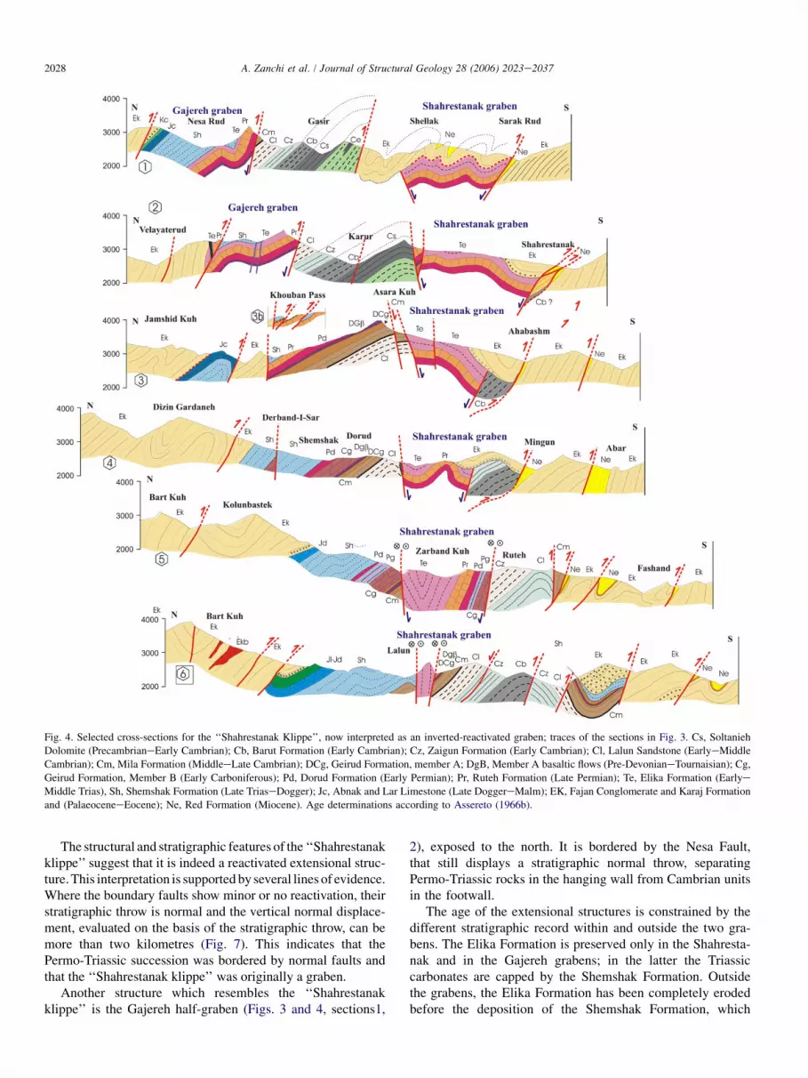
Fig. 4. Selected cross-sections for the ‘‘Shahrestanak Klippe’’, now interpreted as an inverted-reactivated graben; traces of the sections in Fig. 3. Cs, Soltanieh
Dolomite (PrecambrianeEarly Cambrian); Cb, Barut Formation (Early Cambrian); Cz, Zaigun Formation (Early Cambrian); Cl, Lalun Sandstone (EarlyeMiddle
Cambrian); Cm, Mila Formation (MiddleeLate Cambrian); DCg, Geirud Formation, member A; DgB, Member A basaltic flows (Pre-DevonianeTournaisian); Cg,
Geirud Formation, Member B (Early Carboniferous); Pd, Dorud Formation (Early Permian); Pr, Ruteh Formation (Late Permian); Te, Elika Formation (Earlye
Middle Trias), Sh, Shemshak Formation (Late TriaseDogger); Jc, Abnak and Lar Limestone (Late DoggereMalm); EK, Fajan Conglomerate and Karaj Formation
and (PalaeoceneeEocene); Ne, Red Formation (Miocene). Age determinations according to Assereto (1966b).
The structural and stratigraphic features of the ‘‘Shahrestanakklippe’’ suggest that it is indeed a reactivated extensional struc-ture. This interpretation is supported by several lines of evidence.Where the boundary faults show minor or no reactivation, theirstratigraphic throw is normal and the vertical normal displace-ment, evaluated on the basis of the stratigraphic throw, can bemore than two kilometres (Fig. 7). This indicates that thePermo-Triassic succession was bordered by normal faults andthat the ‘‘Shahrestanak klippe’’ was originally a graben.
Another structure which resembles the ‘‘Shahrestanakklippe’’ is the Gajereh half-graben (Figs. 3 and 4, sections1,
2), exposed to the north. It is bordered by the Nesa Fault,that still displays a stratigraphic normal throw, separatingPermo-Triassic rocks in the hanging wall from Cambrian unitsin the footwall.
The age of the extensional structures is constrained by thedifferent stratigraphic record within and outside the two gra-bens. The Elika Formation is preserved only in the Shahresta-nak and in the Gajereh grabens; in the latter the Triassiccarbonates are capped by the Shemshak Formation. Outsidethe grabens, the Elika Formation has been completely erodedbefore the deposition of the Shemshak Formation, which

2029A. Zanchi et al. / Journal of Structural Geology 28 (2006) 2023e2037
Fig. 5. View of the eastern closure of the Shahrestanak graben, here bordered north and south by vertical strike-slip faults, Lalun Village site Lalun 1; symbols as in
previous figures.
covers with a low-angle unconformity Permian or Carbonifer-ous units. This suggests that the Shemshak Formation sealed anexisting horst and graben setting. In other part of the belt, syn-sedimentary normal faults and neptunian dikes with an EeWpresent-day trend have been recognized in the Shemshak For-mation (Barrier et al., 2004), suggesting that extensional tec-tonics persisted during its deposition. Fursich et al. (2005)suggested that the upper part of the Shemshak Formation ofthe eastern Alborz was deposited in an extensional basin.
Therefore, the normal faulting event occurred after the de-position of the Elika Formation, which does not show evidenceof syn-depositional tectonics. This indicates a Middle-Late
Triassic age for the extensional event forming the Shahrestanakgraben and the Gajereh half-graben, which likely represent thefaraway response to the Eo-Cimmerian orogeny active alongthe northern margin of the present-day Alborz belt (Fig. 8).
The complex history of inversion and reactivation of thegraben occurring during the formation of the present-daybelt is described in detail in the next section.
5. Structural analysis around the Shahrestanak graben
Detailed structural analyses have been performed in the re-gion of the Shahrestanak graben located around the Shemshak
Fig. 6. View of the western side of the Djadje Rud just north of the village of Maygoon. The normal fault between the Lalun and the Ruteh Formation is sealed by
the Fajan Conglomerate and by the Karaj Fm; symbols as in previous figures.

2030 A. Zanchi et al. / Journal of Structural Geology 28 (2006) 2023e2037
Fig. 7. Separation diagram for the border faults of the Shahretsanak and Gajereh grabens. Reference points are shown in Fig. 3.
ski-resort and along the Karaj-Chalus road in the central partof the chain. We focused on the analysis of the main faultsand folds reported in published geological maps (Assereto,1966b; Geological Survey of Iran, 1991, 1997) in order to
reconstruct the kinematics of the main faults, to understandtheir geometrical relationships, and their evolution duringthe structuration of the central Alborz. Folds have been alsoanalysed in order to define their relationships with the general
Fig. 8. Tentative sketch of the relationships between the Shahrestanak and Gajereh grabens and the Cimmerides.

2031A. Zanchi et al. / Journal of Structural Geology 28 (2006) 2023e2037
fault kinematics. About 1000 mesoscopic tectonic structureswere measured in the area. Several kinds of mesoscopic tec-tonic structures have been analysed, including striated andnot striated faults, folds, axial plane foliations (slaty and stylo-litic cleavages) and mylonitic foliations with S-C structuresalong the main thrust faults. As most of the faults show poly-phase movements, a relative chronology has been established,according to cross-cutting relationships among fractures and/or striations, their relationships with the main stratigraphic un-conformities, and reactivations of previously formed planes.
Fault populations measured in several sites were used forpalaeostress reconstructions. We used the direct inversionINVD (Angelier, 1990) and the stress tensor research throughiterative procedures R4DT (Angelier, 1984) for palaeostressreconstruction with striated fault populations, choosing foreach site the best fitting solution.
Palaeostress analyses are known to be good tools to unravelthe structural evolution of mountain chains, especially in thecase of brittle deformation (Chang et al., 2003). Moreover, pa-laeostress reconstruction helps to constrain the kinematic com-patibility among different fault sets when fault populations arecomplex and allows to differentiate polyphase fault associa-tions. This technique eventually describes stress variations
across regions of complex deformation, as in the case of thestudy area, where block rotations along vertical axes can belikely associated to strike-slip fault activity.
Table 1 contains all the results for stress tensor determina-tions, which include the adopted numerical method (R for it-erative procedure and I for direct inversion), faults number(N), ratio 4 between the differences of the principal stress ei-genvalues, (s2 � s3)/(s1 � s3), average (av) and maximum(M) angle between computed shear stress and slip vector(ANG), average (av) and maximum (M) value for the qualityestimator parameter (RUP) for solutions obtained with INVD.We generally accepted numerical solutions for average andmaximum value of ANG respectively of 10e12� and 20e22� and average and maximum value of RUP of 35 and 55.For complex and polyphase fault populations, we consideredlarger deviations and solutions obtained with less than 8 faults,which must be considered as a broad indication of the palaeo-stress state.
Folds have been described measuring the attitude variationsof bedding, axes, hinge lines, axial plane cleavage and of axialsurface.
Three main associations of compressive structures havebeen identified. The Eo-Cimmerian extension is not
Table 1
Information on stress tensor determinations in the Central Alborz
Site Method No. of
data
s1 s2 s3 Ratio ANG RUP Fm.
plunge/dip plunge/dip plunge/dip 4 av (�) M (�) av (%) M (%)
Thrust stacking and foldingGazir-A (17) R 12 181/15 273/04 016/74 0.44 16 26 Karaj (Eo) Fig. 9a
Khouban2A (2) R 14 190/13 099/03 356/76 0.511 7 22 Ruteh (M-Per) Fig. 9a
Khouban-3A1 (3) R 5 023/04 114/08 265/81 0.32 11 19 Tiz Kuh (Cre) Fig. 9a
Khouban-3A2 (3) R 16 201/13 052/75 293/07 0.15 7 17 Tiz Kuh (Cre) Fig. 9a
Khouban-4A (4) R 4 196/26 015/64 106/00 0.41 2 5 Shemshak
(L TreM Ju)
Fig. 9a
Right-lateral transpression
Lalun1 (5) R 8 294/11 186/58 031/30 0.25 13 24 Elika (EeM Tr) Fig. 9b
Ruteh (6) R 8 336/25 098/49 231/30 0.45 6 15 Zaigun (Cam) Fig. 9b
Kohestan-1 (9) R 16 317/03 053/62 225/27 0.046 13 29 Ruteh (M Per) Fig. 9b
Kohestan-2 (10) I 7 315/03 217/71 046/19 0.29 18 39 45 65 Ruteh (M Per) Fig. 9b
Geirud (13) R 14 324/20 201/56 064/26 0.08 5 12 Mila (Cam) Fig. 9b
Dorud-2 (14b) R 14 123/17 239/56 023/29 0.85 11 35 Dorud (E Per) Fig. 9b
Dorud-1 (14a) R 8 128/15 259/67 034/16 0.06 10 21 Dorud (E Per) Fig. 9b
Karur-A(16) R 8 145/05 002/83 235/04 0.001 12 19 Elika (EeM Tr) Fig. 9b
Gazir-B (17) I 4 155/11 063/10 292/75 0.17 7 12 28 37 Karaj (Eo) Fig. 9b
Khouban-1 R 7 143/15 025/61 240/24 0.001 8 19 Karaj (Eo) Fig. 9b
Left-lateral transpression
Khouban-2B (2) R 14 190/13 099/03 356/76 0.51 7 22 Ruteh (M Per) Fig. 10
Khouban-3C (3) R 7 251/11 128/71 345/15 0.12 18 40 Tiz Kuh (Cre) Fig. 10
Khouban-4B (4) R 10 245/28 147/14 033/58 0.25 11 24 Tiz Kuh (Cre) Fig. 10
Fashand (7) R 6 049/03 319/04 177/84 0.55 7 14 Karaj (Eo) Fig. 10
Sharistanak (15) R 6 030/12 299/01 203/78 0.57 5 8 Karaj (Eo) Fig. 10
Unam (8) R 9 053/02 323/07 159/82 0.64 6 13 Karaj (Eo) Fig. 10
Afjah (18) R 11 028/28 120/04 217/62 0.93 21 39 Karaj (Eo) Fig. 10
Bafkijan (19) R 8 209/13 317/74 111/33 0.56 8 16 Karaj (Eo) Fig. 10
Ira (20) R 5 223/66 042/24 132/00 0.27 10 19 Karaj (Eo)eL Pleist Fig. 10
The following indications are reported: name of site; inversion method: I (INVD), R (R4DT); number of data used for stress tensor determination; plunge/dip of the
main stress axes s1, s2, s3 (s1 > s2 > s3); ratio 4: (s2 � s3)/(s1 � s3); average value av (�) and maximum value M (�) of ANG; average value av (%) and max-
imum value M (%) of RUP; name of the formation (Fm); reference figure.

2032 A. Zanchi et al. / Journal of Structural Geology 28 (2006) 2023e2037
documented by mesoscopic structures, due to strong overprint-ing during the Cenozoic compression.
5.1. EeW reverse faults and folds
The oldest compressive structures recognized in southern-central Alborz are EeW trending folds and north-dipping re-verse faults (Fig. 9). Structures related to this event forma small imbricate thrust fan exposed south of the KoubanPass, causing the tectonic repetition of the ironstone beds atthe top of the Ruteh Formation (Fig. 4, section 3b). Faultsare low-angle dip-slip thrusts. Similar faults are representedby conjugate thrust and strike-slip faults in the limestones ofthe Cretaceous Tiz Kuh Formation along the splays formingthe eastern continuation of the Taleghan Fault. The main foldsaffecting the Ruteh Formation, at the axial part of the ‘‘Shah-restanak graben’’, can be related to this event, as suggested bycross-cutting relationships with subsequent right-lateral strike-slip faults. Mesoscopic EeW thrust faults with dip-slip motionoccur along the Gazir fault, which stacks Cambrian units uponthe Eocene volcanics.
5.2. EeW dextral faults (dextral transpression)
The most important tectonic structures recognized in thisarea are EeW trending dextral strike-slip faults which occurespecially along the borders of the Eo-Cimmerian grabens(Fig. 9). Most of the main faults of the area show right-lateralcinematic indicators, which record this important tectonicevent recognized in the whole Alborz belt (Axen et al.,2001; Allen et al., 2003a; Guest et al., 2006). EeW orientedright-lateral strike-slip faults overprint the northern boundaryfault of the ‘‘Shahrestanak graben’’ from the Gazir valley east-ward to Lalun. A strong reactivation with a right-lateral senseof movement can be observed everywhere with an almost hor-izontal slip vector. This suggests that the normal offset, whichin some part exceeds 2 km, has been mostly achieved duringprevious extension when the graben formed.
Dextral and high-angle NNEeSSW reverse faults clearlyoverprint previous EeW folds within the Shahrestanak grabenin the deep gorge south of Shemshak. Dextral faults are oftenassociated with minor NNWeSSE to NeS trending left-lateralstrike-slip faults which suggest a NWeSE compression ina strike-slip regime. ENEeWSW en echelon normal faultsalso occur within the Elika Formation in the Sahhrestanak gra-ben, also suggesting dextral shearing (Fig. 3). In several siteshigh-angle reverse and dextral reverse faults are subordinatelyassociated to pure strike-slip faults indicating a transpressiveregime also at the mesoscopic scale. The importance of thedextral transpression is also enhanced by the occurrence ofcurved en echelon WNWeESE trending folds that are geo-metrically consistent with EeW right-lateral fault parallel tothe main trend of the belt. These folds are evident in the east-ern part of the klippe, where the Cambrian and the Eocenebeds are strongly deformed and uplifted.
Palaeostress tensors obtained for this stage are the most re-liable and consistent within the whole analysed fault
populations, indicating a NWeSE compression in a strike-slip tectonic regime.
5.3. EeW left-lateral strike-slip and NEeSW thrustfaults
These structures consist of ESEeWNW to SEeNW ori-ented thrust faults with dip-slip motion occurring in the south-ern part of the study region (Fig. 10). This stage, which is theyoungest deformational event in the Alborz belt, is also respon-sible for the inversion of the shear sense along some of theEeW strike-slip faults, from right- to left-lateral. This phenom-enon has been described in terms of transpressive inversionwhich has been related, as in our case, to the reactivationof pre-existent shear zones (Allen et al., 2001). The mostimportant structure related to this stage is the Shahrestanak-Maygoon-Afjah fault, a branch of the Mosha thrust. Thispure dip-slip thrust fault stacks southwards the Cambrianunitsdforming the southern shoulder of the Shahrestanakgrabendon Miocene beds (Figs. 4, 7, 9). We interpret this faultas a deep shortcut propagating from the southern boundaryfault of the Shahrestanak graben. This thrust forms a restrainingbend of the active Mosha Fault (Guest et al., 2006). West of thevillage of Ira, the Mosha fault becomes a vertical left-lateralstrike-slip fault, locally forming a releasing bend associatedto normal faults (Fig. 9). The fault plane, which is well exposedalong an artificial trench, displaces recent alluvial depositscovered by red palaeosoils with a vertical offset of at least5 m. Faults are sealed by a recent soil.
Striations indicating left-lateral motions along EeW trend-ing previous right-lateral faults were observed along some ofthe northern faults of the Shahrestanak graben (Karur16,Fig. 9) and in the Shemshak area close to the Khouban Passalong a splay of the Thalegan Fault. Overprinting relationshipsconfirm that this stage is the most recent one. The EeWbranch of the Mosha Fault joins the seismically active NorthTeheran Fault, whereas the Maygoon-Shahrestanak-Afjahbranch seems less active. S-vergent NEeSW folds formed inthe Eocene Karaj Formation along the Shahrestanak-May-goon-Afjah thrust can be related to this event. These foldsshow a strong asymmetry and a shorter wavelength than theones related to the dextral transpression. They are well ex-posed around Fashand and west of Shellak, where the Eocenevolcanics are clearly detached from the Triassic substratum.
The obtained palaeostress tensor solutions suggest a purecompressional regime related to NWeSE reverse faults aswell as a strike-slip regime with a permutation between the in-termediate and minimum axis. The horizontal projection of s1
is close to the present-day direction of maximum shortening(N30�E) obtained by Vernant et al. (2004) from geodetic data.
5.4. Tectonic inversion of the Shahrestanak Graben
Structural data indicate that central Alborz is characterizedby different episodes of transpressive deformation since Oligo-cene, that postdate older events. Field evidence in the areaaround Shemshak has shown the occurrence of old extensional

Fig. 9. Examples of fault populations and folds for the NeS to NNWeSSE compression (white arrows) and for the dextral transpression (black arrows) with pa-
laeostress determinations from fault inversion. Schmidt’s projection lower hemisphere. Thin lines are faults, black dots represent striations with relative sense of
motion, triangles are poles to axial plane cleavage and axial surfaces, large dots are poles to bedding planes. Convergent black arrows represent the horizontal
projection of the s1 axis obtained by stress tensor determinations of good quality; grey arrows refer to stress directions deduced through geometrical criteria.
s1, s2, s3 axes (s1 > s2 > s3) are respectively represented by five-, four- and three-point stars. Complete results are given in Table 1.

2034 A. Zanchi et al. / Journal of Structural Geology 28 (2006) 2023e2037
Fig. 10. Palaeostress determinations from fault inversion for the NEeSW compression.
structures that were activated after the deposition of the ElikahFormation and before the end of the deposition of the Shem-shak Formation Fig. 11(1). Grabens formed during the Eo-Cimmerian orogeny within the stable foreland of the Iranianblock, possibly due to peripheral bulging of the stable area lo-cated south of the main collision zone.
The evaluated throw of the border faults of the graben exceedsthe stratigraphic separation between the units sealed by theShemshak Formation (Elika Formation to upper Geirud Forma-tion) that is surely less than 1 km. This can be explained invokinga partial reactivation of the normal faults before and during thedeposition of the PalaeoceneeEocene beds, which show signif-icant thickness variations across the area due to syn-sedimentarytectonic activity Fig. 11(2). During Cenozoic, normal faults havebeen reactivated as strike-slip or high-angle reverse faults.
The first deformational event formed EeW trending tight toisoclinal folds with steep axial planes within the Shahrestanak
and Gajereh grabens, interpreted as buttressing structurescausing a plain strain deformation with vertical extension(Gillcrist et al., 1987; Butler, 1989) in response to the obstaclecreated by pre-existent high-angle normal faults which are un-suitable to thrust propagation. These folds are crossed by dex-tral strike-slip faults reactivating the northern border faults ofthe Shahrestanak and Gajereh grabens. Such faults stronglyoverprint the border faults of the Shahrestanak Graben be-tween Ruteh and Lalun (Fig. 7).
The most recent and active tectonics (Allen et al., 2003a)are characterized by a NEeSW compression causing an inver-sion of the sense of motion of longitudinal faults from right- toleft-lateral and the associated activation of ESEeWSW thrustfaults. During this event shortcut thrust planes developedalong the Maigoon-Shahrestanak branch of the Mosha thrustsouth of the Shahrestanak graben. These deep faults, branch-ing from the north-dipping normal faults bounding the

2035A. Zanchi et al. / Journal of Structural Geology 28 (2006) 2023e2037
southern part of the graben, form small ‘‘floating horses’’(Gillcrist et al., 1987) of Cambrian to Precambrian rocks,which are stacked along the palaeo-graben shoulders abovethe Tertiary successions. In this case, an apparent offset of sev-eral kilometres is shown between the Cambrian and the Mio-cene; if we assume that the exhumation of the graben shoulderoccurred during extension, the throw is reduced to a maximumof 1 to 2 km, resulting from the Cenozoic inversion (Fig. 7).
6. Tectonic implications for the central Alborz
Different structural models have been presented for theAlborz. Alavi (1996) presents a model in which the belt is
Fig. 11. Evolution of the Shahrestanak structure during Mesozoic and Tertiary.
(1) early Late Triassic, when grabens formed in the Cimmerian foreland due to
peripheral bulging; (2) sealing of the grabens after the deposition of the Shem-
shak and of the Eocene volcanics; (3) Neogene-Quaternary inversion, enhanc-
ing strain partitioning along pre-existent normal faults.
interpreted as an antiformal stack affected by extensional de-tachments on its Caspian side. According to Allen et al.(2003a), vertical right-lateral strike-slip fault characterize thecentral part of the Alborz mountain belt, whereas imbricatethrusts and complex triangle zones formed in the externalzones, with the ‘‘Sharestanak klippe’’ resting on the top ofthe thrust pile. NeS shortening at the longitude of Teheranis evaluated to about 30 km. Guest et al. (2006), basing on de-tailed mapping, emphasize the importance of unconformitiesand of pre-Late Cenozoic tectonics, obtaining a shorteningof about 50e55 km across the belt, considering also foldingand strike-slip components.
We present a regional cross section of the central Alborz(Fig. 12), based on structural and geological observationsalong the Karaj-Chalus road and on detailed analysis in theShahrestanak region. Our reconstruction indicates that mostof the shortening across the belt is achieved along its frontalparts, as suggested by thrust activity around Teheran andrecent tectonic activity along the Kazar fault to the north(Berberian et al., 1992; Vernant et al., 2004; Ashtari et al.,2005). High-angle and vertical faults dominate the axialzone of the belt, showing reverse motions and subsequentright-lateral motions. In the case of the Kojour, Dashbandand Kandevan Faults the throw is reverse, whereas a normalstratigraphic separation is evident along the N- and S-axialfaults and Nesa fault and across the Shahrestanak Graben.The Thalegan fault has a complex development showingleft-lateral motions (Guest et al., 2006); around Gajereh, thestratigraphic separation is reverse, as folded Cretaceous bedsare stacked on the Eocene units, whereas along the section itshows a normal separation. Due to strong thickness variationsof the Eocene volcanics across the structure, this fault waspossibly active as a normal fault during the deposition of theEocene volcanics.
According to our interpretation, most of the internal part ofthe central Alborz is characterized by high angle faults associ-ated to the reactivation and inversion of previous normal faultsin a transpressive regime which can account for most of the‘‘anomalous’’ contacts. Complex inversion of the Eo-Cimme-rian extensional faults can explain the uplift of Precambrianand Palaeozoic units along the Fashand branch of the Moshafault and their juxtaposition with the Permo-Triassic units inthe Shahrestanak graben. A similar scenario can help to ex-plain the uplift of the Precambrian basement in the KaharMountains to the west.
7. Conclusions
Central Alborz is a significant example of a transpressivebelt dominated by strain partitioning between distinct strike-slip and thrust faults which result from inversion and reactiva-tion of pre-existing structures inherited from the long andcomplex evolution of this segment of the AlpineeHimalayanorogenic system. Structural data and stratigraphic constraintsdemonstrate that the general structure of the Southern CentralAlborz is strongly controlled by the geometry of pre-existingzones of weakness, which mainly consist of extensional faults

2036 A. Zanchi et al. / Journal of Structural Geology 28 (2006) 2023e2037
Fig. 12. Interpretative geological section across the central Alborz; trace in Fig. 2.
related to the pre-Neogene evolution of the area. In the Shah-restanak and Gajere grabens stratigraphic evidence testifiesthat these extensional structures were formed during the Eo-Cimmerian orogeny. The tectonic history of the southern cen-tral Alborz can be extrapolated also to other parts of the belt,where some of the main faults still stack young units aboveolder ones. Reactivation of normal faults in other parts ofthe Alborz are not necessarily related to the Cimmerian exten-sion only, but can be linked to other extensional events predat-ing the Neogene compression. The existence of differentextensional episodes is also suggested by important thicknesschanges across the whole Phanerozoic stratigraphy. The recon-naissance of these extensional structures can also explain thepresence of strongly uplifted portions of the Palaeozoic andpre-Palaeozoic basement along the southern margin of thebelt, without forcing the occurrence of isolated thrust sheetsmoving from a long distance.
Fault analyses and palaeostress reconstruction suggest thatextensional structures in the central Alborz have been reacti-vated during different tectonic stages which are consistent inthe whole study area. A NeS compression activating EeWthrust and forming EeW folds evolves into a right-lateraltranspression during Late Miocene, which is related toa NWeSE direction of maximum compression. This stage isfollowed by a second transpressive event that is still active.Pre-existent structures have been inverted as EeW trendingstrike-slip or NWeSE high-angle reverse faults, dependingon their attitude. Pre-existing discontinuities thus controlledthe partitioning of strain along faults parallel to the trend ofthe belt, in response to an oblique convergence, as shown bythe present-day evolution of the belt, where both left-lateraland reverse faults are active.
The tectonic framework of the belt is thus characterized bypositive flower structures, which contributed to the high topo-graphic relief of the chain and to its rapid uplift since the Mio-cene. Uplift has been favoured by inversion as a consequenceof buttressing related to high-angle pre-existent discontinu-ities, and to the formation of positive flower structures relatedto oblique reactivation of pre-existing normal faults, without
necessarily implying important shortening and thickening ofthe basement. Dry climatic conditions, persisting during thelatest Cenozoic in the southern part of the belt, favoured thepreservation of the topographic relief, which suddenly de-creases towards the rainy Caspian side of the belt.
Acknowledgements
This work was funded by the MEBE project (proposal 02-26, Meso-Cenozoic evolution of the Alborz mountain range,Iran) in collaboration with the Geological Survey of Iran andby MIUR40% 2004. Dr. A. Saidi and his colleagues of GSIare warmly thanked for continuous help and assistance. Thesoftware for faults analysis was provided by J. Angelier. Wethank G.I. Alsop and especially M.B. Allen for their helpfulreviews. Comments by the editors were also appreciated.
References
Alavi, M., 1991. Sedimentary and structural characteristics of the Paleo-Tethys
remnants in northeastern Iran. Geological Society of American Bulletin
103, 983e992.
Alavi, M., 1996. Tectonostratigraphic synthesis and structural style of the Al-
borz Mountain System in Iran. Journal of Geodynamics 21/1, 1e33.
Allen, M.B., Alsop, G.I., Zhemchuzhnikov, V.G., 2001. Dome and basin re-
folding and transpressive inversion along the Karatau Fault System, south-
ern Kazakstan. Journal of the Geological Society, London 158, 83e95.
Allen, M.B., Jones, S., Ismail-zadeh, A., Simmons, M., Anderson, L., 2002.
Onset of subduction as the cause of rapid Pliocene-Quaternary subsidence
in the South Caspian basin. Geology v. 30 (9), 775e778.
Allen, M.B., Ghassemi, M.R., Shahrabi, M., Qorashib, M., 2003a. Accommo-
dation of late Cenozoic oblique shortening in the Alborz range, northern
Iran. Journal of Structural Geology 25, 659e672.
Allen, M.B., Vincent, S.J., Alsop, G.I., Ismail-zadeh, I., Flecker, R., 2003b.
Late Cenozoic deformation in the South Caspian region: effects of a rigid
basement block within a collision zone. Tectonophysics 366, 223e239.
Angelier, J., 1984. Tectonic analysis of fault slip data sets. Journal of Geophys-
ical. Research 89, 5835e5848.
Angelier, J., 1990. Inversion of field data in fault tectonics to obtain the re-
gional stress-III. A new rapid direct inversion method by analytical means.
Geophysical Journal International 103/1, 363e376.

2037A. Zanchi et al. / Journal of Structural Geology 28 (2006) 2023e2037
Ashtari, M., Hatzfeld, D., Kamalian, N., 2005. Microseismicity in the region
of Tehran. Tectonophysics 395, 193e208.
Assereto, R., 1966a. The Jurassic Shemshak Formation in central Alborz
(Iran). Rivista Italiana di Paleontologia e Stratigrafia 72, 1133e1182.
Assereto, R., 1966b. Explanatory notes on the geological map of upper Djad-
jerud and Lar valleys (Central Alborz, Iran). In: Serie G., pubblicazione,
232. Istituto di Geologia, Universita di Milano, Milano, Italy.
Axen, G.J., Lam, P.S., Grove, M., Stockli, D.F., Hassanzadeh, J., 2001. Exhu-
mation of the west-central Alborz Mountains, Iran, Caspian subsidence,
and collision-related tectonics. Geology 29/6, 559e562.
Bachmanov, D.M., Trifonov, V.G., Hessami, Kh.T., Kozhurin, A.I.,
Ivanova, T.P., Rogozhin, E.A., Hademi, M.C., Jamali, F.H., 2004. Active
faults in the Zagros and central Iran. Tectonophysics 380, 221e241.
Barrier, E., Brunet, M.F., Saidi, A., Shahidi, A., 2004. Tectonic evolution of
Alborz since Mesozoic. GeoArabia 9/1, 46e47.
Berberian, M., Qorashi, M., Jackson, J.A., Priestley, K., Wallace, T., 1992. The
Rudbar-Tarom earthquake of 20 June 1990 in NW Persia: preliminary field
and seismological observations, and its tectonic significance. Bulletin of
the Seismological Society of America 82, 1726e1755.
Besse, J., Torcq, F., Gallet, Y., Ricou, L.E., Krystyn, L., Saidi, A., 1998.
Late Permian to Late Triassic palaeomagnetic data from Iran: constraints
on the migration of the Iranian block through the Tethyan Ocean and
initial destruction of Pangaea. Geophysical Journal International 135, 77e92.
Butler, R.W., 1989. The influence of pre-existing basin structure on thrust sys-
tem evolution in the Western Alps. In: Cooper, M.A., Williams, G.D.
(Eds.), Inversion Tectonics. Geological Society, London, Special Publica-
tion 44, pp. 105e122.
Chang, C.P., Chang, T.Y., Angelier, J., Kao, H., Lee, J.C., Yu, S.B., 2003.
Strain and stress field in Taiwan oblique convergent system: constraints
from GPS observation and tectonic data. Earth and Planetary Science
Letters 214, 115e127.
Clark, G.C., Davies, R.G., Hamzepour, G., Jones, C.R., 1975. Explanatory text
of the Bandar-e-Pahlavi quadrangle map, 1:250,000. Geological Survey of
Iran, Tehran, Iran. pp.198.
Coward, M., 1994. Inversion tectonics. In: Hancock, P.L. (Ed.), Continental
Tectonics. Pergamon, Oxford, pp. 289e304.
Davoudzadeh, M., Schmidt, K., 1984. A review of the Mesozoic paleogeogra-
phy and palaeotectonic evolution of Iran. Neues Jahrbuch fur Geologie und
Palaeontologie. Abhandlungen 168, 2/3. 182-207.
De Martini, P.M., Hessami, K., Pantosti, D., D’Addezio, G., Alinaghi, H., Gha-
fory-Ashtiani, G., 1998. A geologic contribution to the evaluation of the
seismic potential of the Kahrizak fault (Tehran, Iran). Tectonophysics
287, 187e199.
Fursich, F.T., Wilmsen, M., Seyed-Emami, K., Cecca, F., Majidifard, R., 2005.
The upper Shemshak Formation (Toarcian-Aalenian) of the Eastern Alborz
(Iran): Biota and palaeoenvironments during a transgressive-regressive cy-
cle. Facies 51, 365e384.
Gaetani, M., Arche, A., Kiersnowski, H., Chuvachov, B., Crasquin, S.,
Sandulescu, M., Seghedi, A., Zagorchev, I., Poisson, A., Hirsch, F.,
Vaslet, D., Le Metour, J., Ziegler, M., Abbate, E., Ait-Brahim, L.,
Barrier, E., Bouaziz, S., Bergerat, F., Brunet, M.F., Cadet, J.P.,
Stephenson, R., Guezou, J.C., Jabaloy, A., Lepvrier, C., Rimmele, G.,
2000. Wordian paleogeographic map. In: Dercourt, J., Gaetani, M.,
Vrielynck, B., Barrier, E., Biju-duval, B., Brunet, M.F., Cadet, J.P.,
Crasquin, S., Sandulescu, M. (Eds.), Peri-Tethys Atlas and Explanatory
Notes, Map 3. CCGM/CGMW, Paris, pp. 19e25.
Gansser, A., Huber, H., 1962. Geological observations in the central Elburz,
Iran. Schweizerische Mineralogische und Petrographische Mitteilungen
42, 583e630.
Geological Survey of Iran, 1991. Amol. Geological Survey of Iran, Tehran,
scale 1:250,000.
Geological Survey of Iran, 1992. Tehran. Geological survey of Iran, Tehran,
scale 1:100,000.
Geological Survey of Iran, 1997. Mazar Abad. Geological Survey of Iran,
Tehran, scale 1:100,000.
Geological Survey of Iran, 1998. Gorgan. Geological Survey of Iran, Tehran,
scale 1:100,000.
Ghasemi-Nejad, E., Agha-Nabati, A., Dabiri, O., 2004. Late Triassic dinofla-
gellate cysts from the base of the Shemshak Group in north of Alborz
Mountains, Iran. Review of Palaeobotany and Palynology 132, 207e217.
Gillcrist, R., Coward, M., Mugnier, J.L., 1987. Structural inversion and its con-
trols; examples from the alpine foreland and the French Alps. Geodina-
mica Acta 1, 5e33.
Guest, B., Axen, G.J., Lam, P.S., Hassanzadeh, J., 2006. Late Cenozoic
shortening in the west-central Alborz Mountains, northern Iran, by com-
bined conjugate strike-slip and thin-skinned deformation. Geosphere 2/1,
35e52.
Jackson, J., Priestley, K., Allen, M.B., Berberian, M., 2002. Active tectonics of
the South Caspian Basin. Geophysical Journal International 148, 214e245.
Jenny, J., Stampfli, G., 1978. Lithostratigraphie du Permien de l’Elbourz ori-
ental en Iran. Eclogae geologicae Helveticae 71, 551e580.
Laville, E., Lesage, J.L., Seguret, M., 1977. Geometrie cinematique (dynami-
que)de la tectonique atlasique sur le versant surd du Haut Atlas marocain.
Apercu sur les tectoniques hercynniennes et tardi-hercyniennes. Bulletin
de la Societe Geologique de France 19/3, 527e539.
Lemoine, M., Bas, T., Arnaud-Vanneau, A., Arnaud, H., Dumont, T.,
Gidon, M., Bourbon, M., de Graciansky, O.C., Rudkiewicz, J.L.,
Tricart, P., 1986. The continental margins of the Mesozoic Tethys in the
western Alps. Marine and Petroleum Geology 3, 178e199.
Letouzey, J., 1990. Fault reactivation, inversion and fold-thrust belt. In:
Letouzey, J. (Ed.), Petroleum and Tectonics in Mobile Belts. Editions
Technip, Paris, pp. 153e160.
Ruttner, A.W., 1993. Southern borderland of Triassic Laurasia in north-east
Iran. Geologische Rundschau 82, 110e120.
Saidi, A., Brunet, M.F., Ricou, L.E., 1997. Continental accretion of the Iran
Block to Eurasia as seen from Late Palaeozoic to early Cretaceous subsi-
dence curves. Geodinamica Acta 10, 189e208.
Sawaf, T., Al-Saad, D., Gebran, A., Barazangi, M., Best, J.A., Chaimov, T.,
1993. Stratigraphy and structure of eastern Syria across the Euphrates de-
pression. Tectonophysics 220, 267e281.
Searle, M., 1994. Structure of the Palmyride Fold Belt, Syria. Geological So-
ciety of America Bulletin 106, 1332e1350.
Seyed-Emami, K., 2003. Triassic in Iran. Facies 48, 95e106.
Sengor, A.M.C., 1984. The Cimmeride orogenic system and the tectonics of
Eurasia. Geological Society of America Special Publication 195, 82 pp.
Song, T., 1997. Inversion styles in the Songliao basin (Northeast China) and
estimation of the degree of inversion. Tectonophysics 283, 173e188.
Stampfli, G.M., Marcoux, J., Baud, A., 1991. Tethyan margins in space and
time. Palaeogeography, Palaeoclimatology. Palaeoecology 87, 373e409.
Stampfli, G.M., Borel, G.D., 2002. A plate tectonic model for the Palaeozoic
and Mesozoic constrained by dynamic plate boundaries and restored syn-
thetic oceanic isochrones. Earth Planetary Sciences Letters 196, 17e33.
Stocklin, J., 1974. Possible ancient continental margins in Iran. In: Burk, C.A.,
Drake, C.L. (Eds.), The Geology of Continental Margins. Springer, Berlin,
pp. 873e887.
Tatar, M., Hatzfeld, D., Martinod, J., Walpersdorf, A., Ghafori-Ashtiany, M.,
Chery, J., 2002. The present-day deformation of the central Zagros
from GPS measurements. Geophysical Research Letters 29 (19), 1927,
doi:10.1029/2002GL015427.
Tavarnelli, E., 1999. Normal faults in thrust sheets: pre-orogenic extension,
post-orogenic extension, or both? Journal of Structural Geology 21,
1011e1018.
Trumpy, R., 1980. An outline of the geology of Switzerland. 26th International
Congress, section G10, 104 pp.
Turner, J.P., Williams, G.A., 2004. Sedimentary basin inversion and intra-plate
shortening. Earth-Science Reviews 65, 277e304.
Vernant, P., Nilforoushan, F., Chery, J., Bayer, R., Djamour, Y., Masson, F.,
Nankali, H., Ritz, J.-F., Sedighi, M., Tavakoli, F., 2004. Deciphering obli-
que shortening of central Alborz in Iran using geodetic data. Earth and
Planetary Science Letters 223, 177e185.


![Rule inversion [1972]](https://img.dokumen.tips/doc/110x75/631b669ea906b217b90671ab/rule-inversion-1972.jpg)


