Embed Size (px)
Citation preview
31
1 INTRODUCTION
The crew on board of a vessel is responsible to ensure a safe and efficient voyage today. In contrast to such a conventionally manned vessel, however, an unmanned and autonomous vessel’s navigation system has to decide independently on how to react to unfavourable weather conditions and how to avoid collisions. A respective concept is developed in the collaborative research project Maritime Unmanned Navigation through Intelligence in Networks (MUNIN) using an integrated approach of weather routeing and collision avoidance to enable unmanned and autonomous shipping on deep‐sea routes.
It envisions a dry bulk carrier which shall be operating unmanned and autonomously on the deep‐sea legs of a port to port voyage only. The reason for choosing this specific vessel type as a case for this project is that comparatively little manual cargo care is required and that voyages are oftentimes long with less tight schedules. These facts favour the implementation of slow steaming concepts which add
to the holistic sustainability approach of the MUNIN concept (Rødseth & Burmeister 2013).
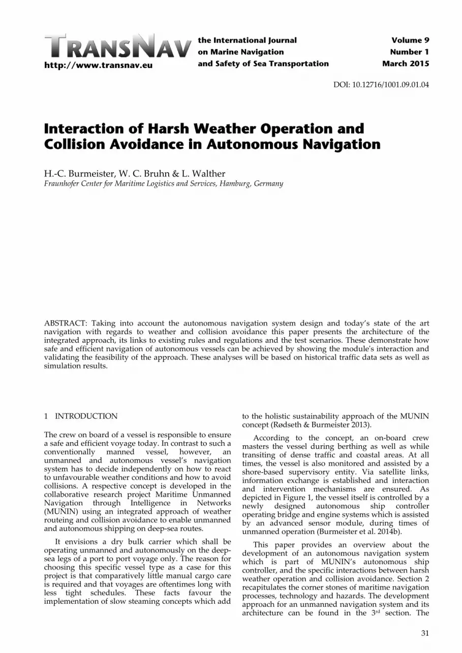
According to the concept, an on‐board crew masters the vessel during berthing as well as while transiting of dense traffic and coastal areas. At all times, the vessel is also monitored and assisted by a shore‐based supervisory entity. Via satellite links, information exchange is established and interaction and intervention mechanisms are ensured. As depicted in Figure 1, the vessel itself is controlled by a newly designed autonomous ship controller operating bridge and engine systems which is assisted by an advanced sensor module, during times of unmanned operation (Burmeister et al. 2014b).
This paper provides an overview about the development of an autonomous navigation system which is part of MUNIN’s autonomous ship controller, and the specific interactions between harsh weather operation and collision avoidance. Section 2 recapitulates the corner stones of maritime navigation processes, technology and hazards. The development approach for an unmanned navigation system and its architecture can be found in the 3rd section. The
Interaction of Harsh Weather Operation and Collision Avoidance in Autonomous Navigation
H.‐C. Burmeister, W. C. Bruhn & L. Walther Fraunhofer Center for Maritime Logistics and Services, Hamburg, Germany
ABSTRACT: Taking into account the autonomous navigation system design and today’s state of the art navigation with regards to weather and collision avoidance this paper presents the architecture of the integrated approach, its links to existing rules and regulations and the test scenarios. These demonstrate how safe and efficient navigation of autonomous vessels can be achieved by showing the moduleʹs interaction and validating the feasibility of the approach. These analyses will be based on historical traffic data sets as well as simulation results.
http://www.transnav.eu
the International Journal
on Marine Navigation
and Safety of Sea Transportation
Volume 9
Number 1
March 2015
DOI: 10.12716/1001.09.01.04
32
system’s modules for weather routeing and collision avoidance are described in detail in the subsequent sections 4 and 5 and followed by the conclusion in the 6th section.
Figure 1. The MUNIN modules
2 SHIP NAVIGATION
2.1 The navigational process
Navigation can be described as the process or activity of accurately ascertaining one’s position and planning and following a route (Oxford Dictionaries 2014). In order to be able to do so, mankind has developed ever‐more precise instruments such as sextants, chronometers, gyro compasses as well as radio and satellite navigation devices which, along with many other inventions, lead the way for modern‐day integrated bridge systems. Especially the vast technological advancements which could be achieved within the most recent decades have resulted in a considerable decline in bridge manning requirements. Many tasks are now carried out more effectively, precisely and reliably by today’s automated bridge equipment than ever before. The task of the officer of the watch (OOW) on present‐day merchant vessels is thus to be characterised by his function as a system integrator and final decision maker (Hetherington et al. 2006).
In governing the process of navigation, the OOW must continuously consolidate information from various sources and evaluate the present condition of the vessel and the conditions of its surrounding. This subjective perception then provides the basis for decision‐making in the context of safe and efficient ship handling.
In the course of developing a concept for an autonomous navigation system for deep‐sea voyages within the MUNIN project, the present navigational processes have been recorded, mapped and adapted to meet the requirements imposed by the project’s overall framework. A thorough analysis has been conducted with regards to technology availability, information requirements, legal framework, work flow and responsibilities. Based on the fundamentals of present‐day marine navigation, specific tasks have been identified and classified to be redesigned. As a vessel is a complex system, a large number of interconnected requirements and dependencies have to be accounted for during the process redesign. This approach is used due to the intention of minimizing the necessary process‐related and legal adjustments when introducing an autonomous navigation system (Bruhn 2013).
2.2 Current technology
State of the art Integrated Navigation Systems (INS) which are presently installed on merchant vessels are designed in compliance with the resolution MSC.252 (83) adopted by the International Maritime Organization (IMO).
Such a system’s purpose is to enhance the safety of navigation by providing combined and augmented functions to avoid geographic, traffic and environmental hazards by integration of information from various source systems (IMO 2007a), such as Electronic Chart Display and Information System (ECDIS), radar, Automated Radar Plotting Aid (ARPA), Automatic Identification System (AIS), Global Navigation Satellite System (GNSS), speed log and echo sounder. This supports the bridge team in effectively conducting navigational tasks prior to and throughout the voyage. Multifunctional work stations display integrated information and provide functions such as route planning and monitoring as well as manual and/or automatic navigation control functions and an alert management system. Generally, an INS does not necessarily provide functions which would not be available on conventional stand‐alone bridge equipment. Thus, the actual benefit to the OOW is mainly limited to a holistic user interface approach which improves accessibility of functions and information of bridge equipment (Hetherington 2006).
The installation of INS technology on board typically also comprises advanced track control devices. In contrast to conventional auto pilots, which provide heading control only, these appliances are capable of guiding vessels along pre‐planned tracks over ground (Berking & Huth 2010). Depending on input data regarding the vessel’s geographic position, its heading and speed, track control systems are designed to lead vessels on either straight or curved routes along a sequence of waypoints. Considering the limitations of manoeuvrability of the vessel, course changes are conducted automatically as well as compensation for drift and leeway. Doing so, manually set turning radii and turning rates are observed within certain degrees of tolerance. Further, track pilot systems must be capable to adapt to changing steering characteristics of the vessel due to different weather, speed and loading conditions (IMO 1998). In conclusion of this review of existing navigation technology it must be stated that for the purpose of autonomous maritime routeing neither INS nor track control technology is suited to account to an adequate degree for external factors such as weather and traffic.
Additionally to the above mentioned navigational appliances, meteorological assistance systems are employed on a large number of vessels to support the bridge team in the task of passage planning. These systems provide optimised routes with regards to fuel efficiency, voyage duration and the principles of safe navigation under the forecasted environmental conditions along the track. Numerical calculations are based on short‐ and medium term meteorological data of up to 10 days in grid‐format. Various national and international meteorological services produce local and/or global maritime weather predictions, also including predictions of wave and swell conditions. These forecasts are composed of observations from

33
respective satellites, stations, buoys as well as of vessels (Bott 2012). Typically, meteorological assistance systems use several sources to combine models and improve route optimisation results. The offered services ensure shore‐based routeing, all‐time availability and digital data exchange. Additionally to environmental forecasts, the optimisation algorithms also use specifications of the vessel as input. This includes constructional data such as the main particulars as well as variable data such as the loading conditions. The quality of the route optimisation very much depends on the consideration of all relevant parameters. The most‐widespread systems in use are: Bon Voyage by AWT, Inc. Seaware by StormGeo AS VVOS by Jeppesen, Inc. SPOS by MeteoGroup, Ltd.
All of the examined systems are designed as stand‐alone applications without any connections to e.g. the vessel’s cargo computer or sensor system. Inclusion of variable data such as draught, trim, wind and wave characteristics is only partly possible and depends on additional sensors or manual input. This data is imperatively required for continuously calculating the vessel’s resonances, roll motion and damping and assessing its seaworthiness. Further, routeing restrictions due to traffic regulations and/or geographic constraints are not included in all route optimisation systems. A direct import of optimised routes into the vessel’s ECDIS isn’t always possible either (Walther et al. 2014).
This analysis of four leading weather routeing systems concludes that the available capabilities are presently insufficient for the purpose of unmanned and autonomous shipping.
2.3 Main navigational hazards
Shipping accidents in general pose a threat to maritime safety and to the marine environment. Thus, prevention of accidents is imperative to autonomous navigation systems as much as it is to conventional bridge teams. Based on maritime accident statistics and analyses, two essential tasks have been identified as key enabler for autonomous deep‐sea navigation. These are: Weather routeing and Collision avoidance.
Studies imply that the yearly number of vessels lost remains rather steady in a range between app. 110 and 170 in recent years. Almost every second of these losses is to be accounted to foundering, which is defined as: “sinking due to rough weather, leaks, breaking in two, etc., but not due to other categories such as collisions […]” (Arendt at al. 2010). This leads to the conclusion that navigation in challenging sea states poses a major threat to the safety of deep‐sea shipping.
Analysing the primary causes of vessel casualties, only 2% of foundering accidents originate in collision situations. (Pike et al. 2013) Consequences are usually less severe but still can result in a constructive or economic total loss. Further, collisions are ranked second highest cause of serious vessel incidents which
are not attributed to harsh weather conditions or machinery failures following grounding accidents (Mandryk 2011). But as grounding is to be considered an unlikely hazard scenario under deep‐sea conditions, collision avoidance is identified as the other main task for the autonomous navigation system. Such systems are expected to operate alongside with conventionally manned vessels and thus must respect the International Convention on the International Regulations for Preventing Collisions at Sea (COLREG) to the same full extend. Furthermore, research estimates that 65‐95% of shipping accidents are to be attributed to human error. Low safe manning standards, high workloads and night watches lead to crew fatigue, increasing the risk of collision. (Sanquist 1992 & Rothblum n.d.). Thus, also misbehaviour or negligence of other vessels must be taken into account.
The total number of global maritime collision situations can only be assessed roughly. According to e.g. the German Federal Bureau of Maritime Casualty Investigation, collision accidents sum up to annual numbers up to 154 cases under its jurisdiction only (BSU 2013). Thus, the number of worldwide collision cases must be expected to be considerably higher. Further, the number of near miss situations are not documented but are also estimated to be significant.
3 AUTONOMOUS NAVIGATION
3.1 Process redesign
Shifting from conventional to autonomous navigation must be based on a review of manned bridge procedures. Parasuraman et al. 2000 proposes a four‐stage model of human information processing which consists of the following function classes: Information acquisition, Information analysis, Decision and action selection as well as Action implementation.
For the purpose of designing an autonomous navigation system, the principle level of autonomy which shall be achieved for these function classes by such kind of system must be defined. It is the aim of the MUNIN project to design a deep‐sea navigation system which is able to autonomously navigate a vessel safely and efficiently along a predefined voyage plan with respect to weather and traffic conditions. According to the often cited levels of automation defined by Sheridan 2011, the autonomous navigation system must at least reach level 7, which means that it “executes automatically [and] then necessarily informs the human” to ensure that the vessel can still be safely operated even in case of possible communication drop‐outs during critical situations (Rødseth et al. 2013). While this level is already achieved for the functional class of action implementation by state‐of‐the‐art track pilots, it is not the case for the other functions. Yet, shifting from manned to unmanned operation of merchant vessels inherits certain elementary challenges. While the approach towards more autonomous information acquisition is described in Bruhn et al. 2014, a thorough analysis of the available information and
34
decision‐making process is necessary to design the functional framework of the autonomous navigation system correctly and to determine which processes require such high degrees of autonomy.
Nowadays, the structures on board as well as connections to shore‐based stakeholders are tailored for on‐board crews. As a consequence, redesign of bridge processes has been approached in such a way to ease compliance with existing standards as far as possible. Being also dedicated to the proposition to contribute to the enhancement of safety in shipping, the initial point for the redesign of the navigation process is to be found in today’s conventional and manned shipping.
Consecutively, the identified and classified bridge tasks are then being adopted to meet the requirements of autonomous navigation and grouped into activities which are either related to (Bruhn 2013): Voyage planning, Look‐out, Bridge watch, Manoeuvring, Communication, Administration or Emergencies.
These general activities are then particularised into individual work processes to be assigned to individual modules of the vessel’s autonomous navigation system. While some activities, such as voyage planning and administration will be transferred to shore‐based entities, others imperatively must remain on board. This concerns all activities for in‐situ information gathering and processing. Under the proposition that an autonomous navigation system would have reliable information about the condition of the vessel and the situation in its surrounding, the processes of deep‐sea navigation can be performed by the system.
3.2 Autonomous navigation system architecture
The autonomous navigation system ensures that the vessel “follows a predefined voyage plan, but with a certain degree of freedom to adjust the route in accordance with legislation and good seamanship autonomously, e.g., due to an arising collision situation or significant weather changes” (Burmeister et al. 2014b). Hereby, it relies on the data provided by an INS or an even more advanced separate sensor module, like MUNIN’s Advanced Sensor Module (ASM) as described in Bruhn et al. 2014.
The autonomous navigation system itself consists of two main application modules, which ensure safety with regards to the two main hazards as identified in paragraph 2.3, namely the: Weather routeing module and the Collision avoidance module.
The former module ensures safe operation by avoiding unfavourable weather conditions (strategic routeing) and reducing negative impacts of environmental forces (Walther et al. 2014). The latter ensures operation in compliance with COLREGs (Burmeister & Bruhn 2014).
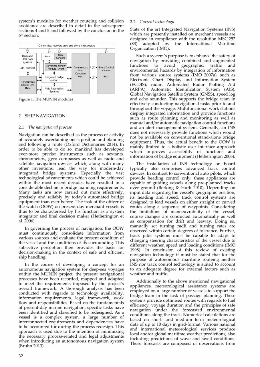
The autonomous navigation system does generally not execute commands directly, but updates the waypoint list and uses state‐of‐the‐art track pilots for controlling rudder and engine. However, in certain critical situations, like operations in harsh weather or close encounter situations, the track pilot is bypassed and direct commands are given to avoid unnecessary delays in resolving the critical situations due to restrictions of the track pilot’s operational envelope. Figure 2 provides an overview about the system’s architecture and module interaction.
Figure 2. Autonomous navigation system architecture
However, collision avoidance and weather routeing can’t be resolved independently of each other as this might result in contrary commands and thus safety‐critical situations. For this reason, the individual decisions made by the two modules need to be balanced by the overall autonomous navigation system, before being passed to the track pilot. The way this is achieved is dependent on the prevailing circumstances of the vessel. Of certain interest are hereby situations, where collision risks occur during harsh weather operations. In case of an immediate danger by other vessels, the collision avoidance service consults the operational weather routeing service, if certain limits must be respected, but in case it can’t resolve the situation, the weather restrictions are neglected, as the risk of collision is higher prioritized in that case. However, if no immediate danger is present, the collision avoidance service operates under tight restrictions from the operational routeing service to avoid replacing the risk of collision by a risk of foundering (see Table 2).
Table 2. Prioritisation of commands _______________________________________________ Situation No harsh weather Harsh weather _______________________________________________ No Risk of Strategic Weather Operational Weather Collision Routeing Routeing Risk of Normal Collision Collision Avoidance Collision Avoidance Control Control limited by Weather Routeing Restrictions Immediate Manoeuvre‐of‐the‐ Maneuver‐of‐the‐ Danger last‐second control last‐second control consulting weather routeing restrictions _______________________________________________
35
4 WEATHER ROUTEING MODULE
4.1 Requirements
The working hypothesis of the autonomous navigation system is, that it “can autonomously navigate a ship safely and efficiently along a predefined voyage plan with respect to weather and traffic conditions” (Krüger et al. 2014). On manned vessels, the bridge team is required to ensure a proper planning before commencing a voyage and to take any factor into account which potentially might compromise the safety of the vessel (IMO 2007b). This includes environmental factors such as wind, current and sea state. Typically, this voyage plan is produced by the navigational officer and verified by the master.
Yet still, the final routeing decisions are made by the vessel’s master. To bear in mind this key fact is even more crucial when a vessel is actually navigating under harsh weather conditions. High wind loads and rough sea states from unfavourable angles of encounter can provoke heavy ship responses. Resulting rolling and slamming motions can cause cargo to shift, endanger safe stability and hull integrity and even lead to capsizing. To assist navigators in their routeing decisions, IMO has published principles which represent the guidelines for watch‐keeping officers in terms of how to react to adverse weather situations. This document defines general minimum safety requirements for avoiding potentially perilous environmental conditions and is valid for all types of merchant vessels (IMO 2007c). The phenomena, which the weather routeing module of a deep‐sea navigation system is to obviate, are: Surf‐riding and broaching‐to, Reduction of intact stability when riding a wave
crest amidships, Synchronous rolling motion and Parametric roll motion.
Development of an autonomous deep‐sea navigation system in compliance with the IMO routeing guidelines (IMO 2007c) requires a weather routeing module with the two main objectives of: optimising the voyage plan based on the vesselʹs
hydrodynamics with regard to fuel efficiency for a given weather forecast and
maintaining the effects of sea state and wind on ship responses (all 6 degrees of freedom) below defined safety levels.
These objectives align with the test hypotheses for development of prototypes in the context of the MUNIN project (Krüger 2014). Further, it is of the utmost importance for an autonomous weather routeing module to be fit to the specific characteristics of the vessel which it serves. This allows to adequately respect fixed and variable parameters such as hull form, propulsion system, displacement, draught and trim during the continuous navigation process.
4.2 Approach
In the previous paragraph it has been outlined that it is important to distinguish between strategic and operational weather routeing. While the former intends to avoid unfavourable weather conditions in
the first place, the latter one aims to minimize the negative effects of such.
Strategic routeing decisions are made based on detailed weather forecasts from shore‐based services. Very much like existing services, whose approaches can be found in various publications (Adegeest 2008, Böttner 2007 & Shao et al. 2014), the autonomous navigation system optimises the vessel’s route with regards to passage duration, arrival time and/or fuel consumption. Under close consideration of the vessel’s safety and given routeing restrictions, specifications about course and speed of the vessel are given for each individual route leg. This path‐finding problem is solved by employing the A* algorithm (Walther et al. 2014).
In case navigation in harsh weather conditions cannot be avoided, the autonomous navigation system takes suitable measures to minimise the negative impacts of environmental forces. This is necessary as unfavourable wind loads, wave lengths, wave heights or angles of encounter can cause large roll angles and accelerations, slamming, loss of stability, shift of cargo or even capsizing. For an autonomous navigation system to prevent such an occurrence, input of reliable real‐time data from local meteorological observations, made by the before‐mentioned advanced sensor system are required. A variety of on‐board sensors provide information about prevailing wind characteristics, precipitations, atmospheric pressure and humidity. Sea state characteristics and ocean surface current are obtained by processing radar and camera imagery while motion and stress sensors installed at critical positions allow to closely monitor induced responses of the vessel. This data is collected, evaluated and processed to produce a thorough perception of the environmental conditions in the proximity of the vessel. As a result, critical areas are identified according to safety requirements and also visualised in a polar plot. In combination with the vessel’s specific characteristics and routeing restrictions, the autonomous navigation system determines an optimised route within those set boundaries.
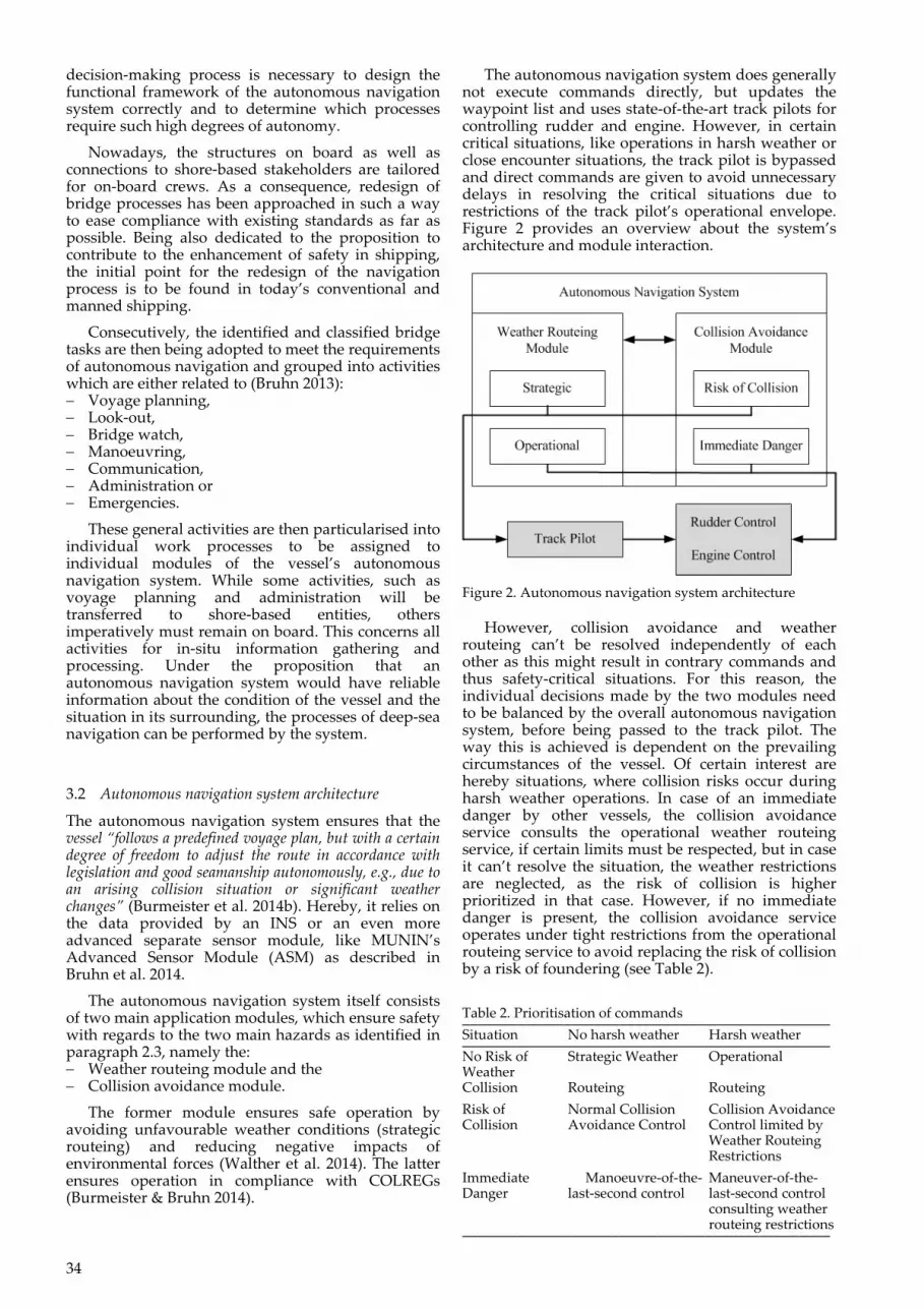
The architecture of the autonomous navigation system’s weather routeing module combines the tasks of strategic and operational routeing. Figure 3 illustrates the relevant input and output data.
Figure 3. Overview of the weather routeing module’s inputs and outputs

36
For conducting its continuous route optimisation, the autonomous navigation system requires static information about the vessel’s characteristics and the applicable safety requirements. This, in combination with voyage related information such as the vessel’s loading condition, draught, trim, centre of gravity, metacentric height, ETD, ETA and routeing restrictions represent the basis for computing the responses of the vessel to severe environmental conditions. From its hull geometry and actual stability parameters, a hydrodynamic model is derived. This accounts for resistance of the vessel and allows calculating its interaction with the surrounding environment.
As mentioned before, strategic routeing depends on meteorological forecasts as input for route optimisation while operational routeing uses local real‐time sensor data. This data stream can be divided into ship conditions and environmental conditions. The former defines the pose of the vessel, namely its position and rotation and consists of velocities and accelerations in all six degrees of freedom. The environmental conditions, however, cover meteorological as well as oceanographic information of which wave characteristics are the most significant one. Further, it must of course be mentioned that routeing restrictions are not only based on guidance given by e.g. IMO but can also be set by a human operator, if required.
The results of the weather routeing process conducted by the autonomous navigation system are threefold. Firstly, a documentation records the data received from all sources as well as the computed outputs. Theses consist secondly of an optimised voyage plan, containing route waypoints, speed profiles and estimated fuel consumption from strategic routeing, based on the available forecasts. Thirdly, the operational routeing provides immediate measures in commanding certain a certain course and speed for the vessel under given harsh weather conditions.
4.3 Validation
The implementations of the strategic and operational weather routeing module are tested by: running of different scenarios in a ship handling
simulation environment and comparing results with those occurred tracks and
other tools.
Testing of the strategic weather routeing module is conducted by verification of calculations as well as by validation of its route optimisation results. Tracks are being calculated from the western entrance of the English Channel to North America as well as another one to South America and vice versa. In either case, typically great circle navigation would be used and not many deviations must be made due to restrictions by e.g. landmasses. Comparison of calculation results for both directions of the same route differ only insignificantly. These variations can be attributed to the weather forecast data which provides more details for the first 72 hours and allows for the use of data resolution of 0.25° compared to 1.00° for the remaining passage time. These optimisation results are then compared with recorded tracks from that
region. In both cases, high wind speeds and high wave height areas are avoided and tailwinds are favoured. Greater disparities can be found only in those route legs where different data resolutions have been used. Thus, the overall results of the strategic weather routeing module are satisfactorily while especially implementation of a smoothing algorithm presents potential for further improvement.
As the operational weather routeing module deals with the immediate environmental conditions at the vessel’s position, a test scenario of a much smaller area is required compared to testing of the strategic weather routeing module. An eight‐shaped route is defined for the vessel to follow to ascertain that the vessel will face various angles of encounter of rough sea state which is set from easterly directions (see figure 4). A pre‐defined cross‐track error as well as minimum and maximum speed profiles ensure that deviations from the voyage plan are limited. As a test result, the outlined track is followed rather precise on most route legs, yet the voyage speed is adjusted. Especially on long route legs on which waves from abeam are encountered, the vessel cannot avoid critical areas for parametric rolling only by speed reduction. When track deviation reaches the maximum allowance, the course is altered, leading the vessel to cross against the sea along the track. Due to the eight‐like shape of the pre‐defined track, most encounter situations re‐occur and lead to similar measures by the operational weather routeing module as well as to comparable behaviour of the vessel. With regards to the validity of the results, it must of course be mentioned that validation of the harsh weather control in a ship handling simulation environment only allows to test the principle functionalities of the approach, but does not replace the need of an in‐situ‐test as correct harsh weather responses are only to a certain degree covered by ship handling simulators available.
Figure 4. Validation run of the operational weather routeing
37
5 COLLISION AVOIDANCE MODULE
5.1 Requirements
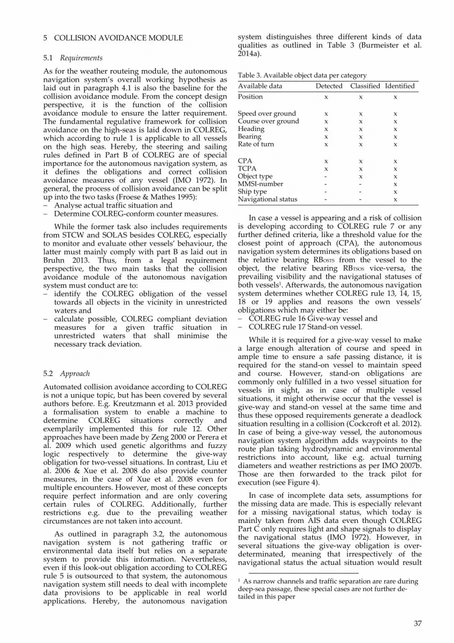
As for the weather routeing module, the autonomous navigation system’s overall working hypothesis as laid out in paragraph 4.1 is also the baseline for the collision avoidance module. From the concept design perspective, it is the function of the collision avoidance module to ensure the latter requirement. The fundamental regulative framework for collision avoidance on the high‐seas is laid down in COLREG, which according to rule 1 is applicable to all vessels on the high seas. Hereby, the steering and sailing rules defined in Part B of COLREG are of special importance for the autonomous navigation system, as it defines the obligations and correct collision avoidance measures of any vessel (IMO 1972). In general, the process of collision avoidance can be split up into the two tasks (Froese & Mathes 1995): Analyse actual traffic situation and Determine COLREG‐conform counter measures.
While the former task also includes requirements from STCW and SOLAS besides COLREG, especially to monitor and evaluate other vessels’ behaviour, the latter must mainly comply with part B as laid out in Bruhn 2013. Thus, from a legal requirement perspective, the two main tasks that the collision avoidance module of the autonomous navigation system must conduct are to: identify the COLREG obligation of the vessel
towards all objects in the vicinity in unrestricted waters and
calculate possible, COLREG compliant deviation measures for a given traffic situation in unrestricted waters that shall minimise the necessary track deviation.
5.2 Approach
Automated collision avoidance according to COLREG is not a unique topic, but has been covered by several authors before. E.g. Kreutzmann et al. 2013 provided a formalisation system to enable a machine to determine COLREG situations correctly and exemplarily implemented this for rule 12. Other approaches have been made by Zeng 2000 or Perera et al. 2009 which used genetic algorithms and fuzzy logic respectively to determine the give‐way obligation for two‐vessel situations. In contrast, Liu et al. 2006 & Xue et al. 2008 do also provide counter measures, in the case of Xue et al. 2008 even for multiple encounters. However, most of these concepts require perfect information and are only covering certain rules of COLREG. Additionally, further restrictions e.g. due to the prevailing weather circumstances are not taken into account.
As outlined in paragraph 3.2, the autonomous navigation system is not gathering traffic or environmental data itself but relies on a separate system to provide this information. Nevertheless, even if this look‐out obligation according to COLREG rule 5 is outsourced to that system, the autonomous navigation system still needs to deal with incomplete data provisions to be applicable in real world applications. Hereby, the autonomous navigation
system distinguishes three different kinds of data qualities as outlined in Table 3 (Burmeister et al. 2014a).
Table 3. Available object data per category _______________________________________________ Available data Detected Classified Identified _______________________________________________ Position x x x
Speed over ground x x x Course over ground x x x Heading x x x Bearing x x x Rate of turn x x x
CPA x x x TCPA x x x Object type ‐ x x MMSI‐number ‐ ‐ x Ship type ‐ ‐ x Navigational status ‐ ‐ x _______________________________________________
In case a vessel is appearing and a risk of collision is developing according to COLREG rule 7 or any further defined criteria, like a threshold value for the closest point of approach (CPA), the autonomous navigation system determines its obligations based on the relative bearing RBOSTS from the vessel to the object, the relative bearing RBTSOS vice‐versa, the prevailing visibility and the navigational statuses of both vessels1. Afterwards, the autonomous navigation system determines whether COLREG rule 13, 14, 15, 18 or 19 applies and reasons the own vessels’ obligations which may either be: COLREG rule 16 Give‐way vessel and COLREG rule 17 Stand‐on vessel.
While it is required for a give‐way vessel to make a large enough alteration of course and speed in ample time to ensure a safe passing distance, it is required for the stand‐on vessel to maintain speed and course. However, stand‐on obligations are commonly only fulfilled in a two vessel situation for vessels in sight, as in case of multiple vessel situations, it might otherwise occur that the vessel is give‐way and stand‐on vessel at the same time and thus these opposed requirements generate a deadlock situation resulting in a collision (Cockcroft et al. 2012). In case of being a give‐way vessel, the autonomous navigation system algorithm adds waypoints to the route plan taking hydrodynamic and environmental restrictions into account, like e.g. actual turning diameters and weather restrictions as per IMO 2007b. Those are then forwarded to the track pilot for execution (see Figure 4).
In case of incomplete data sets, assumptions for the missing data are made. This is especially relevant for a missing navigational status, which today is mainly taken from AIS data even though COLREG Part C only requires light and shape signals to display the navigational status (IMO 1972). However, in several situations the give‐way obligation is over‐determinated, meaning that irrespectively of the navigational status the actual situation would result
1 As narrow channels and traffic separation are rare during deep‐sea passage, these special cases are not further de‐tailed in this paper
38
in a give‐way obligation of the vessel by a subordinate rule as well, thus an assumption of the navigational status is not necessarily increasing the uncertainty (Burmeister & Bruhn 2014).
Figure 4. Decision tree for the collision avoidance module
Additionally, the autonomous navigation system also monitors the immediate danger criteria and initiates the manoeuvre of the last second as required by rule 17. Hereby, the autonomous navigation system uses hydrodynamic track predictions based on fast time simulation methods as described in Benedict et al. 2014 to determine the final moment until which the vessel itself can resolve the collision situation. Of course, according to COLREG rule 17 the moment the give‐way vessel alone can no longer avoid the collision shall be used as an criteria, but as this is difficult to predict, one may also use this moment instead (Cockcroft et al. 2012). For executing the manoeuvre, the track pilot is bypassed by the autonomous navigation system and direct commands are send to engine and rudder control. Hereby, the two derivatives of Bow Crossing Distance (BC) and CPA are important:
T TT T
T
d BC α , vBC α , v
dα
(1)
'T T'
T TT
d CPA α , vCPA α , v
dα (2)
with T as course over ground and vT as speed over ground. Depending on the type of encounter situation, the algebraic sign of BC’ or CPA’ determines what rudder command is given. A similar approach will be taken regarding the engine command. However, in case of harsh weather, a subordinate smoothing procedure tries to reduce the
risk of foundering. After initiation, the direct control is executed until the situation is resolved.
Along with the normal risk of collision handling, the immediate danger handling has been implemented within the MUNIN ship handling simulation test‐bed environment. Besides the described two‐vessel‐situation‐handling, this also includes additional routines to ensure multiple‐encounter‐handling.
5.3 Validation
Validating the feasibility of the collision avoidance module is a threefold activity: Internal legal logic test, Historical data test and Real‐time ship handling simulation test.
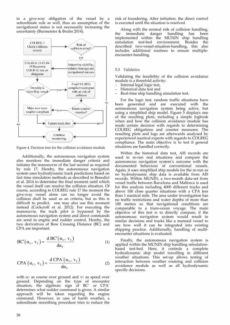
For the logic test, random traffic situations have been generated and are executed with the autonomous navigation system being active, but using a simplified ship model. Figure 5 displays one of the resulting plots, including a simple logbook when and how the collision avoidance module has made certain decision with regards to determining COLREG obligations and counter measures. The resulting plots and logs are afterwards analysed by experienced nautical experts with regards to COLREG compliance. The main objective is to test if general situations are handled correctly.
Within the historical data test, AIS records are used to re‐run real situations and compare the autonomous navigation system’s outcome with the documented behaviour of conventional vessels. Again, it uses simplified ship models for the re‐run as no hydrodynamic ship data is available from AIS records. Within MUNIN, a two‐month data‐set from vessel traffic between Barcelona and Mallorca is used for this analysis including 4000 different tracks and above 100 close quarter situations with a CPA less than 1 nautical mile. The area under investigation has no traffic restrictions and water depths of more than 100 metres so that navigational conditions are comparable to a trans‐ocean voyage. The main objective of this test is to directly compare, if the autonomous navigation system would result in similar decisions and tracks like a manned vessel to see how well it can be integrated into existing shipping practice. Additionally, handling of multi‐encounter situations is evaluated.
Finally, the autonomous navigation system is applied within the MUNIN ship handling simulation‐based test‐bed. Here, it controls a complete hydrodynamic ship model travelling in different weather situations. This set‐up allows testing of interaction between weather routeing and collision avoidance module as well as all hydrodynamic specific decisions.
39
Figure 5. Test plot of collision avoidance module
6 CONCLUSION
This paper has presented an integrated concept for a maritime autonomous navigation system with regards to weather routeing and collision avoidance as well as a validation approach. From the first internal tests it can be concluded that the developed operational weather routeing module performs according to its purpose. Nevertheless, it must be mentioned that due to the rather general character of the IMO guidelines (IMO 2007c) potentially hazardous situations might develop even under conditions which would be considered safe. Thus, the developed tool represents a good basis but also requires further enhancement. With regards to the collision avoidance module, the first tests resulted in acceptable situation handling, given the fact that COLREG itself allows for a certain degree of interpretation.
Besides its application on a potential unmanned ship, the autonomous navigation system also provides a generic approach which can be augmented to a nautical assistance or even monitoring tool to improve situational awareness of the officer of the watch. Thus, it holds the potential to further decrease human errors and to improve safety at seas.
ACKNOWLEDGEMENTS
The research leading to these results has received funding from the European Union’s Seventh Framework Programme under the agreement SCP2‐GA‐2012‐314286.
REFERENCES
Arendt, F. et al. 2010. Shipping statistics yearbook 2010: Shipping market, shipbuilding, ports and sea canals. Bremen, ISL
Benedict, K. Kirchhoff, M. Gluch, M. Fischer, S. Schaub, M. Baldauf, M. Klaes, S. 2014. Simulation Augmented Manoeuvring Design and Monitoring – a New Method for Advanced Ship Handling. In TransNav, the International Journal on Marine Navigation and Safety of Sea Transportation Volume 2(3): 131‐141.
Berking, B. Huth, W. (eds) 2010. Handbuch Nautik. Navigatorische Schiffsführung. Hamburg: DVV Media Group
Bott A. 2012. Synoptische Meteorologie. Methoden der Wetteranalyse und –prognose. Heidelberg/Dordrecht/London/New York: Springer
Brown, A.J. 2002. Collision scenarios and probabilistic collision damage. In Marine Structures Volume 15: 335‐364.
Bruhn, W.‐C. (ed.) 2013. MUNIN Deliverable D5.2:Process Map for autonomous Navigation (Available from MUNIN project on request).
Bruhn, W.‐C. Burmeister, H.C. Long, M.T. Moræus, J.A. 2014. Conducting look‐out on an unmanned vessel: Introduction to the advanced sensor module for MUNIN’s autonomous dry bulk carrier. In Proceedings of International Symposium Information on Ships—ISIS 2014: 04‐05.
BSH 2011. INT 1 Symbols, Abbreviations, Terms used on Charts. Hamburg/Rostock: Bundesamt für Seeschifffahrt und Hydrographie.
BSU 2013. Annual Report 2013 (Online) Available: http://www.bsu‐bund.de/SharedDocs/pdf/DE/Jahresstatistik/Jahresbericht_2013.pdf?__blob=publicationFile [Accessed 13.01.2015]
Burmeister, H.‐C. Bruhn, W.C 2014a. Designing an autonomous collision avoidance controller respecting COLREG S. In Ehlers, B.E. Asbjørnslett, Ø.J. Rødseth, T.E. Berg (eds), Maritime‐Port Technology and Development 2015: 83‐88, London: Taylor & Francis Group.
Burmeister, H.C. Bruhn, W.C. Rødseth, T.E. Porathe, T. 2014b. Autonomous Unmanned Merchant Vessel and its Contribution towards the e‐Navigation Implementation: The MUNIN Perspective. In International Journal of e‐Navigation and Maritime Economy Volume 1: 01‐13.
Cockcroft, A.N. Lameijer, J.N.F. 2012. A Guide to the Collision Avoidance Rules International Regulations for Preventing Collisions at Sea (Seventh Edition). Oxford: Butterworth‐Heinemann
Hetherington, C. Flin, R. Mearns, K. 2006. Safety in shipping: The human element. In Journal of Safety Research Volume 37: 401‐411.
IMO 1972. Convention on the International Regulations for Preventing Collisions at Sea (COLREG)
IMO 1998. Resolution MSC.74(69) Annex2. Adoption of new and amended performance standards for track control systems. London: International Maritime Organization
IMO 2007a. Resolution MSC.252(83). Adoption of the revised performance standards for integrated navigation systems (INS). London: International Maritime Organization
IMO 2007b. SOLAS ‐ Chapter V ‐ Safety of Navigation ‐ Regulation 34 – Safe Navigation and Avoidance of dangerous situations. London: International Maritime Organization
IMO 2007c. MSC.1/Circ.1228 Revised Guidance to the Master for avoiding dangerous situations in adverse weather and sea conditions. London: International Maritime Organization
Kreutzmann, A. Wolter, D. Dylla, F. Lee, J.H. 2013. Towards Safe Navigation Rules. In TransNav, the International Journal on Marine Navigation and Safety of Sea Transportation Volume 7(2): 161‐168
Krüger, C.‐M. (ed.) 2014. MUNIN Deliverable D.8.1: Test environment set‐up description (Available from MUNIN project on request).
40
Liu, Y. Du, X. Yang, S. 2006. The Design of a Fuzzy‐Neural Network for Ship Collision Avoidance. In Advances in Machine Learning and Cybernetics Lecture Notes in Computer Science Volume 3930: 804‐812. Berlin/ Heidelberg: Springer
Mandryk, W. 2011. Marine Casualty Profiles. (Online) Available: www.imsf.info/documents/2011/Wally%20Mandryk %20‐%20Lloyds%20List%20Intelligence%20‐%20
Shipping%20Casualty%20Profiles.pdf . [Accessed 12.01.2015].
Oxford Dictionaries 2014. [Online]. Available: http://www.oxforddictionaries.com/definition/english/navigation. [Accessed 14.10.2014].
Parasuraman, R. Sheridan, T.B. Wickens, C.D. 2000. A Model for Types and Levels of Human Interaction with Automation. In IEEE Transactions on Systems, Man and Cybernetics, Part A: Systems and Humans Volume 30(3): 286 ‐ 297
Perera, L.P. Carvalho, J.P. Guedes Soares, C. 2009. Autonomous guidance and navigation based on the COLREGs Rules and regulations of collision avoidance. In Guedes Soares C. & Parunov J. (eds), Proc. Of the International Workshop “Adavanced Ship Design for Pollution Prevention”: 205‐216. London: Taylor & Francis Group
Pike, K. et al. 2013. 15 Years of Shipping Accidents: A review for WWF. Southampton: Southampton Solent University
Rødseth, Ø.J. Burmeister, H.‐C. 2012. Developments toward the unmanned ship, In Proceedings of International Symposium Information on Ships – ISIS 201. Hamburg, Germany, August 30‐31, 2012.
Rødseth, Ø.J. Kvamstad, B. Porathe, T. Burmeister, H.‐C. 2013. Communication Architecture for an Unmanned Merchant Ship. OCEANS ‐ Bergen, 2013 MTS/IEEE. http://dx.doi.org/10.1109/OCEANS‐Bergen.2013.6608075. [Accessed 07.2014].
Rothblum, A.M. (n.d.). Human Error and Marine Safety. USCG. http://www.bowles‐langley.com/wp‐content/files_mf/humanerrorandmarinesafety26.pdf .[Accessed 28.02.2013].
Sanquist, T. F. 1992. Human Factors in Maritime Applications: A New Opportunity for Multi‐Modal Transportation Research. In Proceedings of the Human Factors 36th Annual Meeting‐1992: 1123‐1127. Sage Publications.
Sheridan, T.B. 2011. Adaptive Automation, Level of Automation, Allocation Authority, Supervisory Control, and Adaptive Control: Distinctions and Modes of Adaptation. In IEEE Transactions on Systems, Man and Cybernetics, Part A: Systems and Humans Volume 41(4): 662 – 667.
Walther, L. Burmeister, H.‐C. Bruhn, W. 2014. Safe and efficient autonomous navigation with regards to weather. In Bertram V. (ed.), 13th International Conference on Computer and IT‐Applications in the Maritime Industries Redworth, 12‐14 May 2014: 303‐317. Hamburg: Technische Universität Hamburg‐Harburg.
Xue, Y. Lee, B.S. Han, D. 2008. Automatic collision avoidance of ships. In Journal of Engineering for the Maritime Environment Volume 223(1): 33‐46.
Zeng, X. Masanori, I. Shimizu, E. 2000. Collision Avoidance of Moving Obstacles for Ship with Genetic Algorithm. In 6th International Workshop on Advanced Motion Control: 513‐518.


