Embed Size (px)
Citation preview
1
In Quest of Global Radio Occultation Mission for Meteorology beyond 2011
Chen-Joe Fong,§,* Nick L. Yen,§ Chung-Huei Chu,§ Chun-Chieh Hsiao,§ Shan-Kuo Yang,§ Yao-Chang Lin,§
Shao-Shing Chen,§ Yuei-An Liou,# and Sien Chi¥,‡ §National Space Organization (NSPO), Hsin-Chu, Taiwan 30077
#Center for Space and Remote Sensing Research, National Central University, Chung-Li, Taiwan 32001 * ¥Department of Photonics & Institute of Electro-Optical Engineering, National Chiao-Tung University, Hsin-Chu, Taiwan
30010 ‡ Department of Electrical Engineering, Yuan-Ze University, Chung-Li, Taiwan 32003
*+886-3-578-4208 x 9202 *[email protected]
Abstract—The FORMOSAT-3/COSMIC mission consisting of six satellites is the world’s first demonstration of near real-time operational GPS Radio Occultation (RO) constellation mission. The success of the mission expected to operate through 2011 has initiated a new era for operational GPS RO soundings. The World Meteorological Organization had recommended continuing RO observations operationally and urges planning for a complementary follow-on mission. The follow-on mission will be a new constellation of 12 to 18 satellites equipped with the GNSS RO payload and collect over 9000 soundings per day. This higher density of sounding profiles will be useful for global and mesoscale models, and also severe weather forecasting. The follow-on mission will establish international standards so that future RO missions deployed by any country can be used together for operations and research. In this paper, we present the state-of-the-art achievements and the results of the current mission; as well as the follow-on mission planning progress. 1 2
TABLE OF CONTENTS
1. INTRODUCTION................................................................ 1 2. FORMOSAT-3 MISSION STATUS ...................................... 2 3. STATE-OF-THE-ART SCIENCE RESULTS AND APPLICATIONS..................................................................... 2 4. FORMOSAT-3 FOLLOW-ON MISSION PLANNING............ 4 5. CONCLUSION ................................................................... 4 ACKNOWLEDGMENTS ......................................................... 5 REFERENCES ....................................................................... 5 BIOGRAPHY ......................................................................... 6
1. INTRODUCTION The FORMOSAT-3 mission, also known as COSMIC, Constellation Observing System for Meteorology, Ionosphere, and Climate, is a constellation of 6 satellites, each of which is equipped with GPS Occultation Receiver (GOX), Tri-Band Beacon (TBB), and Tiny Ionospheric Photometer (TIP). The FORMOSAT-3 is the world’s first demonstration of a near real-time operational GPS RO
1 1978-1-4244-2622-5/09/$25.00 ©2009 IEEE. 2IEEEAC paper#1400, Final Version 3, Updated December 8, 2008
constellation mission. The FORMOSAT-3 mission was expected to provide about 2500 GPS radio occultation remote sensing soundings per day in near real time, it will produces vertical profiles of temperature, pressure, refractivity, and water vapor in neutral atmosphere, and electron density in the ionosphere with global coverage at various alttitudes [1,2]. Currently the retrieved RO weather data (1,800 to 2,200 per day on the average) by the six satellites were assimilated into the Numerical Weather Prediction (NWP) model by many major weather forecast centers and research institutes for real-time weather predictions and cyclone/typhoon/hurricane forecasts.
The FORMOSAT-3 is regarded as the most accurate, precise and stable thermometer in space for measuring global and regional climate change by the science community [2]. Through 2-year mission operations the assessments have shown that the GPS RO data from FORMOSAT-3 are of better quality than those from the previous missions, e.g., the proof-of-concept GPS/MET, CHAMP, and SAC-C missions, and the RO sounding provides accurate temperature information for the high troposphere and the lower stratosphere domains, where radiometric sounding is less accurate, and useful humidity information for the lower troposphere [2].
The World Meteorological Organization (WMO) had recommended continuing RO observations operationally and urges planning for a complementary follow-on mission [3]. The WMO also calls for the international collaboration to form global constellation for RO soundings with high number of small satellites in support of the Societal Benefit Areas (SBA) of the Global Earth Observation System of Systems (GEOSS) including weather and climate [3]. The FORMOSAT-3 follow-on/COSMIC-II mission with a new constellation of 12 to 18 satellites is planned to be complementary to the current FORMOSAT-3 mission whose mission life ends in year 2011 [3]. In this paper, we present the FORMOSAT-3 program status; mission overview, the state-of-the-art science results and applications; and the follow-on mission planning progress.
2
2. FORMOSAT-3 MISSION STATUS Spacecraft Constellation Deployment Status
The FORMOSAT-3 satellites were successfully launched into the same orbit plane of the designated 516 km altitude on 15 April 2006. The final constellation configuration has six orbit planes at 700 to 800 km altitude with 30-degree separation for evenly distributed global coverage. All six FORMOSAT-3 satellites are currently maintained in a satisfactory state-of-health at final mission orbit except that spacecraft flight model number 2 (FM2) has a power shortage issue and spacecraft number 3 (FM3) currently is at an orbit of 711 km due to a solar array mechanism issue [4-7]. The other five satellites have reached their final mission orbit since the end of November 2007. By taking the advantage of nodal precession, the FORMOSAT-3 mission has verified a “proof-of-concept” of a novel way of performing constellation deployment, and this approach has dramatically reduced the spacecraft propellant mass and the complexity of the spacecraft propulsion and attitude control subsystem design [5]. We will continue to use this design philosophy for the follow-on atmospheric RO remote-sensing systems design.
Operations Challenge of FM6 67-Days-Outage Event
The spacecraft number 6 (FM6) lost its communication on 8 Sep. 2007 (UTC 251). There was no telemetry indicated the spacecraft problem prior to the FM6 outage event. Many emergency recovery attempts had been tried but failed by the operations team. After 67 days the FM6 was resumed contact and recovered back on its own after a computer master reset event occurred at the South Atlantic Anomaly (SAA) region. The FM6 transmitter’s RF spectrum looked normal with no sign of degradation and all the spacecraft subsystems were checked to be in good health status. The FM6 started to provide data again on the next day. After the root cause analysis and verification were performed, two possible root causes were identified: (1) intermittent hardware failure of the Field Programmable Gate Array (FPGA) inside Mission Interface Unit (MIU), or (2) intermittent short circuitry of the Pin Grid Matrix related to the thermal effect. Science data from FM6 after contact was resumed are looking good and are provided to users from CDAAC3 (COSMIC Data Analysis and Archive Center) and TACC4 (Taiwan Analysis Center for COSMIC) [4].
Over Three Million GPS RO Soundings Events
All six satellites have generated a total of more than 2,500 RO data per day. However, only 60 to75 percent of the RO data received today could be retrieved into useful near-real-time atmosphere profiles for numerical weather prediction. The retrieved RO data have been used to study atmospheric and ionospheric structures and total electron content (TEC),
2 3 CDAAC website, http://cosmic-io.cosmic.ucar.edu/cdaac/index.html [cited 15 Oct. 2008] 4 TACC website, http://tacc.cwb.gov.tw/en/index.htm [cited 15 Oct. 2008].
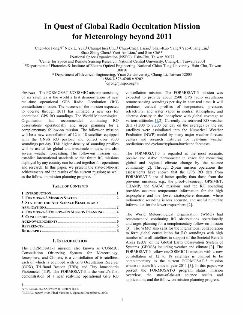
and assimilated into numerical atmospheric and space weather predictions models to improve the accuracy of prediction. Currently we have collected over three million RO sounding data (1,394,650 for atmosphere and 1,609,853 for ionosphere) profiles as of 31 October 2008 as shown in Figure 1 [4-6].
(A)
(B) Figure1 – Number of daily occultation events for (A) atmospheric and (B) ionospheric profiles since launch as of 31 October 2008.
3. STATE-OF-THE-ART SCIENCE RESULTS AND APPLICATIONS
We highlight below some of the state-of-the-art science results and applications.
Detection of Atmospheric Boundary Layer
An open loop technique implemented on FORMOSAT-3 mission has assured most of the occultation measurements to penetrate to altitudes as low as 1 km above the earth’s surface. We have shown that about 70 to 90 percent of the soundings reach to alttitude within 1 km above the surface on a global basis [2]. With this technique the FORMOSAT-3 constellation mission for the first time can detect, provide and monitor the global atmospheric boundary layer (ABL) depth information, especially the top height of ABL, which is an important parameter for understanding transport processes in the lower troposphere, and for weather prediction and climate monitoring [8].
Data Assimilation and Hurricane Forecasts Impacts
The raw data and processed GPS RO data products were disseminated to the international community in near-real-
3
time (< 3 hr) via TACC and CDAAC starting in August 2006 by the joint effort between NSPO and UCAR. Several global weather operational centers (e.g., ECMWF, NCEP, UKMO and Météo France) and Taiwan’s CWB have started to use the FORMOSAT-3 data for operational use and have reported positive impacts on Hurricane (e.g., Ernesto-2006), Cyclones, and Typhoon (e.g., Shanshan-2006, Bilis-2006, Krosa-2007, Kalmaegi-2008, Jangmi-2008) forecasts and encouraging results after evaluation [9]. Research groups have also been performing experiments to assess the impact of FORMOSAT-3 data on global/regional weather analysis and forecast including tropical rainfall and cyclone predictions.
Model Errors Identification in Antarctica
Due to the lack of weather stations in Antarctica, there is relatively less weather data in this area. This provides a great opportunity to FORMOSAT-3 for model verification of this area. It was found the region forecast model over the Antarctica was colder than actual and the scientists have begun to make the temperature correction based on the addition of the data from FORMOSAT-3 occultation measurements [10]. The data collected have been used to construct the temperature profile of Antarctica through the stratosphere. These are the first continuous profiles of temperature structure over Antarctic winter. Scientists have found the vertex effect of ozone depletion [11].
Ionospheric Space Weather Achievement
The ionospheric RO data are inverted into vertical electron density profiles and TEC along GPS-FORMOSAT-3/COSMIC radio links. These data, together with the complementary secondary payloads (TIP and TBB) data, are valuable for the generation of ionospheric tomography, scintillation region imaging, evaluation of ionospheric models, and use in space weather data assimilation systems. The global three-dimensional (3D) ionospheric electron density observed by FORMOSAT-3 has shown a prominent four-peaked wave-like longitudinal enhancement in the equatorial ionization anomaly (EIA) [12]. The RO data have also demonstrated evidence on the low-latitude ionospheric plasma cave theory, which improves the understanding of the ionospheric dynamics and is beneficial to evaluating the ionospheric effects to the space environment and their effects on space communications [13].
Atmospheric and Ionospheric 3D Global Database
The FORMOSAT-3/COSMIC radio occultation data from CDAAC and TACC have been applied to a variety of research areas in meteorology, climate, and space weather. The 3D ionospheric and atmospheric structure can be reconstructed up to 800 km by using the globally distributed sounding measurements. The global ionospheric density distribution, atmospheric temperature and pressure structures can be obtained by cumulating monthly occultation observations and taking the median value in
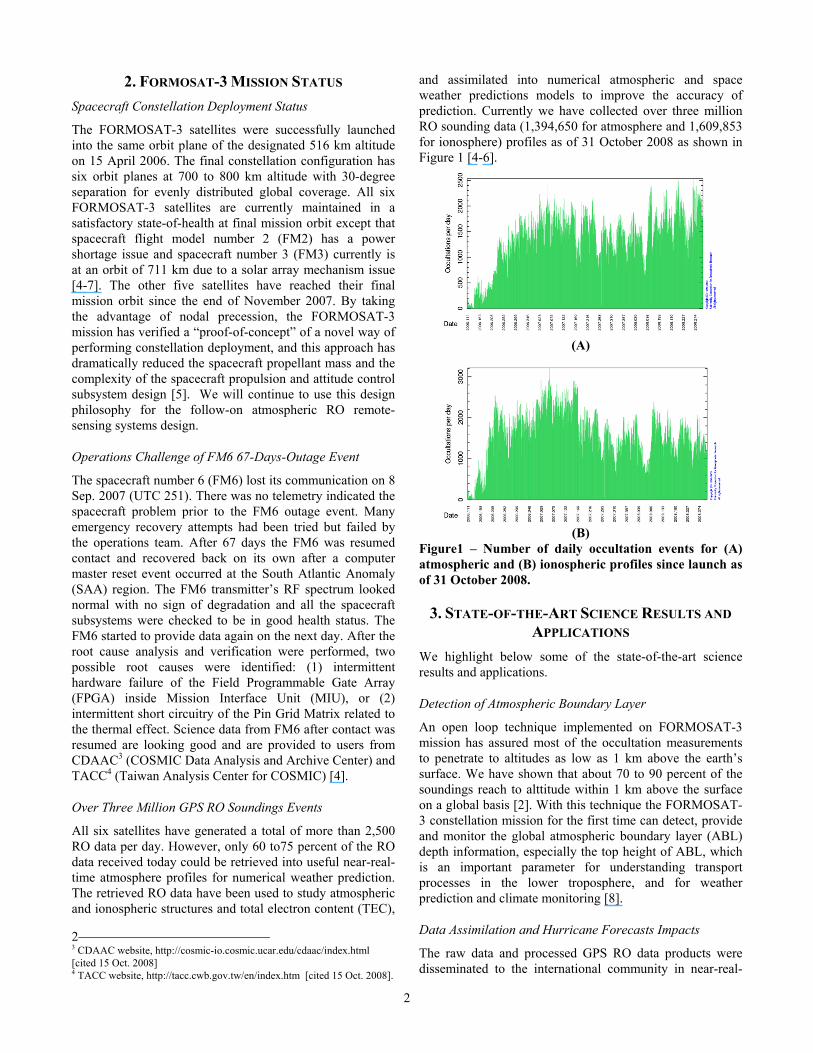
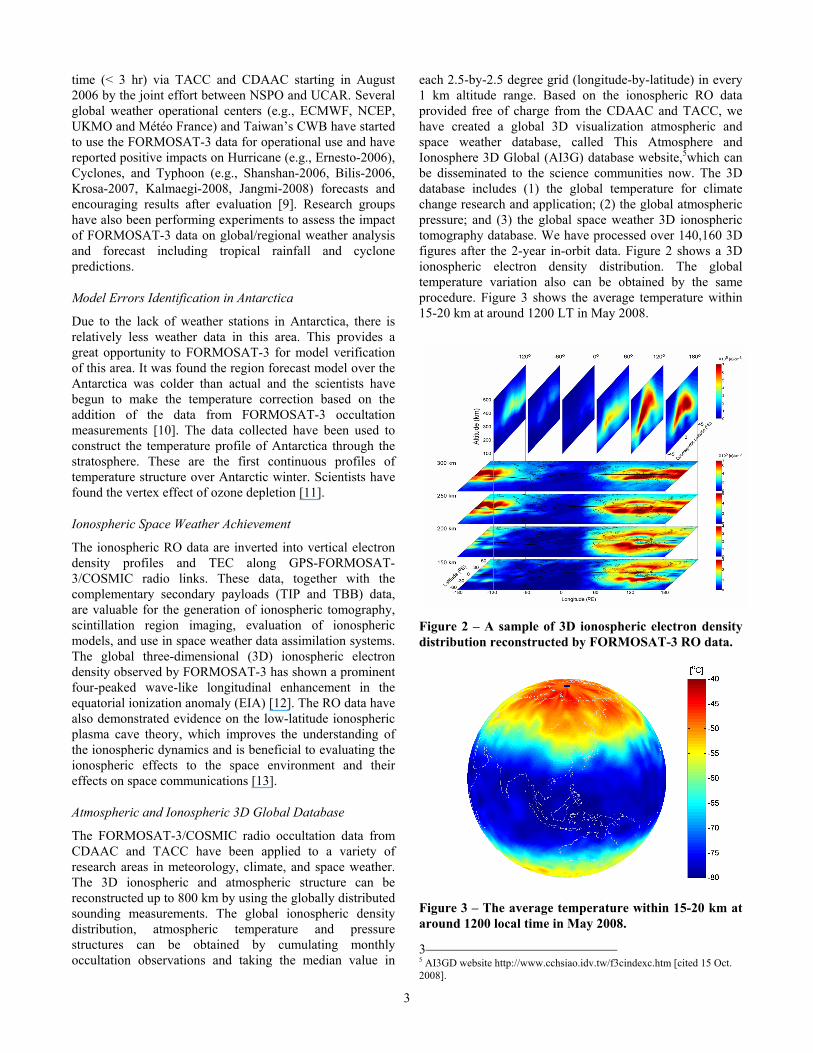
each 2.5-by-2.5 degree grid (longitude-by-latitude) in every 1 km altitude range. Based on the ionospheric RO data provided free of charge from the CDAAC and TACC, we have created a global 3D visualization atmospheric and space weather database, called This Atmosphere and Ionosphere 3D Global (AI3G) database website,5which can be disseminated to the science communities now. The 3D database includes (1) the global temperature for climate change research and application; (2) the global atmospheric pressure; and (3) the global space weather 3D ionospheric tomography database. We have processed over 140,160 3D figures after the 2-year in-orbit data. Figure 2 shows a 3D ionospheric electron density distribution. The global temperature variation also can be obtained by the same procedure. Figure 3 shows the average temperature within 15-20 km at around 1200 LT in May 2008.
Figure 2 – A sample of 3D ionospheric electron density distribution reconstructed by FORMOSAT-3 RO data. Figure 3 – The average temperature within 15-20 km at around 1200 local time in May 2008.
3 5 AI3GD website http://www.cchsiao.idv.tw/f3cindexc.htm [cited 15 Oct. 2008].
4
4. FORMOSAT-3 FOLLOW-ON MISSION PLANNING
The FORMOSAT-3 data have continuously shown their advantages on the data collection over the polar region, the improvement on the forecasting accuracy, and the correction to regional models. The goal of the FORMOSAT-3 follow-on mission is to continuously carry on the achievement of the FORMOSAT-3 project to an operational stage, which will reliably provide 9,000 to 20,000 soundings per day. There are two options for the constellation: 12 satellites and 18 satellites. This higher density of sounding profiles will be useful for global and mesoscale models, and also severe weather forecasting. Figure 4 shows the follow-on mission constellation configuration. For orbit plane 1, we need one launch to deliver 4 (or 6) satellites to high inclination angle (72o). For orbit plane 2, we need another launch to deliver 4 (or 6) satellites to high inclination angle (72o). The orbit plane 2 and orbit plane 1 are separated by 90 deg at the equator. For orbit plane 3, we need the other launch to deliver 4 satellites to low inclination angle (24o).
Figure 4 – The FORMOSAT-3 follow-on constellation with 12 satellites. In each option, the satellite will be put in an injection orbit and each satellite will be raised to its mission orbit based on constellation deployment plan. Each satellite will carry a GNSS RO receiver capable of processing GPS and Galileo signals, with a goal of processing additional GLONASS signal. The RO data will be down-linked to ground stations, potentially using NOAA’s stations, and then forwarding it to data processing centers, potentially the current FORMOSAT-3’s data processing center, TACC and CDAAC. The data will be further processed and assimilated into the weather forecasting model. The data latency is planned to be better than one hour.
In Figure 5 we show the occultation point distribution with 12-satellite constellation. The measurements obtained by orbit planes 1 and 2 are marked in blue dots and the measurements from orbit plane 3 are marked as pink ones. One can see how low inclination satellites supplement the measurements at low latitudes. The calculation shows the
system can provide ~9,000 profiles per day. In other words, the spatial resolution of the RO soundings is improved from 550 km x 550 km of current mission to 250 km x 250 km [5,14].
Figure 5 – Daily occultation point distribution with 12-satellite constellation for the FORMOSAT-3 follow-on mission.
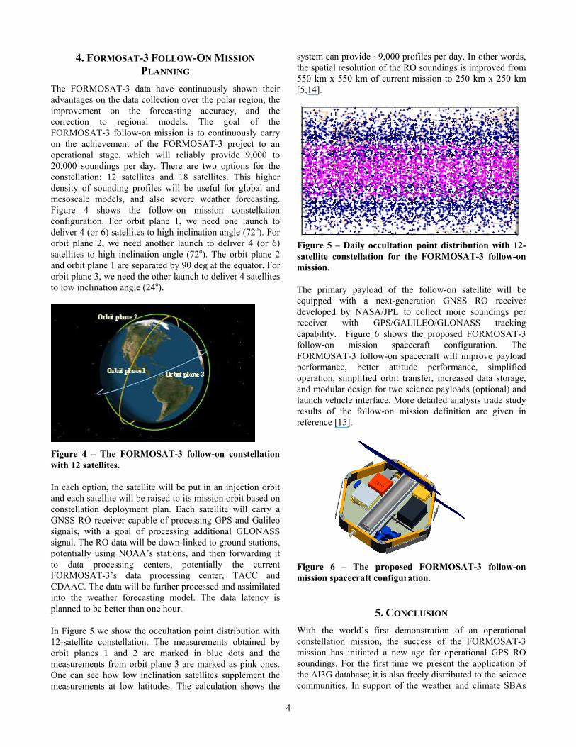
The primary payload of the follow-on satellite will be equipped with a next-generation GNSS RO receiver developed by NASA/JPL to collect more soundings per receiver with GPS/GALILEO/GLONASS tracking capability. Figure 6 shows the proposed FORMOSAT-3 follow-on mission spacecraft configuration. The FORMOSAT-3 follow-on spacecraft will improve payload performance, better attitude performance, simplified operation, simplified orbit transfer, increased data storage, and modular design for two science payloads (optional) and launch vehicle interface. More detailed analysis trade study results of the follow-on mission definition are given in reference [15].
Figure 6 – The proposed FORMOSAT-3 follow-on mission spacecraft configuration.
5. CONCLUSION With the world’s first demonstration of an operational constellation mission, the success of the FORMOSAT-3 mission has initiated a new age for operational GPS RO soundings. For the first time we present the application of the AI3G database; it is also freely distributed to the science communities. In support of the weather and climate SBAs
5
of the GEOSS, the proposed follow-on mission will continue to impact global weather monitoring and prediction and enter into an operational stage for global weather monitoring and prediction.
ACKNOWLEDGMENTS The authors wish to thank the contributions of the FORMOSAT-3/COSMIC program team, the mission operation team, the flight operation team, the ground operation team, the constellation deployment team, the anomaly resolution team, the Taiwan science teams, and the cooperation with NSC, CWB, NSF, UCAR, NCAR, JPL/NASA, NRL, USAF, NOAA and Orbital.
REFERENCES [1] Y.-A. Liou, A. G. Pavelyev, S.-F. Liu, A. A. Pavelyev,
N. Yen, C.-Y. Huang, and C.-J. Fong, “FORMOSAT-3 GPS Radio Occultation Mission: Preliminary Results,” IEEE Trans. Geosci. Remote Sensing, 45, 3813-3826, Nov. 2007.
[2] R. A. Anthes, P. A. Bernhardt, Y. Chen, L. Cucurull, K. F. Dymond, D. Ector, S, B. Healy, S.-P. Ho, D. C. Hunt, Y.-H. Kuo, H. Liu, K. Manning, C. McCormick, T. K. Mehan, W. J. Randel, C. Rocken, W. S. Schreiner, S. V. Sokolovskiy, S. Syndergaard, D. C. Thompson, K. E. Trenberth, T. K. Wee, N. L. Yen, and Z. Zeng, “The COSMIC/FORMOSAT-3 Mission: Early Results,” Bull. Am. Meteoro. Soc., 89, 313-333, Mar. 2008.
[3] “Final Report of the Workshop on the Redesign and Optimization of the Spacebased Global Observing System,” ETSAT/SUP3/Doc. 5(1), Appendix A, WMO Headquarters, Geneva, 21-22 June 2007.
[4] C.-J. Fong, N. Yen, V. Chu, C.-Y. Huang, S. Chi, S.-S. Chen, Y. A. Liou and, Y. H. Kuo, “FORMOSAT-3/COSMIC Spacecraft Constellation System, Mission Results, and Prospect for Follow-on Mission,” Terr. Atmos. Ocean. Sci., 20, Jan. 2007.
[5] C.-J. Fong, S.-K. Yang, C.-H. Chu, C.-Y. Huang, J.-J. Yeh, C.-T. Lin, T.-C. Kuo, T.-Y. Liu, N. Yen, S. S. Chen, Y.-H. Kuo, Y.-A. Liou, and S. Chi, “Constellation Deployment for FORMOSAT-3/COSMIC Mission,” IEEE Trans. Geosci. Remote Sens., 46, Nov. 2008.
[6] C.-J. Fong, N. Yen, V. Chu, E. Yang, C.-Y. Huang, S. S. Chen, Y.-A. Liou, and S. Chi, “Constellation Challenges and Contributions of Taiwan Weather Monitoring Satellites,” 2008 IEEE Aerospace Conference Proceedings, Mar. 1-8, 2008.
[7] C.-J. Fong, S.-K. Yang, V. Chu, J. Yeh, T. Lin, T.-C. Kuo, T.-Y. Liu, N. Yen, S.-S. Chen, C.-Y. Huang, Y.-H. Kuo, Y.-A. Liou, and S. Chi, “FORMOSAT-3/COSMIC Constellation Spacecraft System Performance: After One Year in Orbit,” IEEE Trans. Geosci. Remote Sens., 46, Nov. 2008.
[8] S. Sokolovskiy, Y.-H. Kuo, C. Rocken, W. S. Schreiner, D. Hunt, and R. A. Anthes, “Monitoring the atmospheric boundary layer by GPS radio occultation signals recorded in the open-loop mode,” Geo. Res. Lett., VOL. 33, L12813.1-4, Jul. 2006.
[9] Y.-H. Kuo, T. Iwabuchi, H. Liu, W. Wang, X. Fang, Z. Ma, Y.-R. Guo, C.-T. Terng, and J.-S. Hong, " The Impact of FORMOSAT-3/COSMIC GPS RO Data on Typhoon Prediction,” 4th Asian Space Conference and 2008 FORMOSAT-3/COSMIC Data Users Workshop, Taipei, Taiwan, October 1-3, 2008,.
[10] K. W. Manning and Y.-H. Kuo, “Using COSMIC refractivity profiles in an evaluation of Antarctic forecast models,” First Formosat-3/COSMIC Data Users Workshop, Boulder, CO., 16 - 18 Oct. 2006.
[11] K. Y. Wang, and S.-C. Lin, “First continuous GPS soundings of temperature structure over Antarctic winter from FORMOSAT-3/ COSMIC constellation,” Geophys. Res. Lett.,Vol. 34, L12805, June 2007.
[12] Lin, C. H., Wang, W. B., Hagan, M. E., Hsiao, C. C., Immel, T. J., Hsu, M. L., Liu, J. Y., Paxton, L. J., Fang, T. W., and Liu, C. H., “Plausible effect of atmospheric tides on the equatorial ionosphere observed by the FORMOSAT-3/COSMIC: Three-dimensional electron density structures,” Geophys. Res. Lett., vol. 34, L11112, June 2007.
[13] Lin, C. H., C. C. Hsiao, J. Y. Liu, and C. H. Liu, “Longitudinal structure of the equatorial ionosphere: Time evolutions of the four-peaked EIA structures,” Jour. Geophys. Res., Vol. 112, A12305, December 2007.
[14] C.-H. Vicky Chu, N. Yen, C.-C. Hsiao, C.-J. Fong, S.-K. Eddy Yang, T.-Y. Liu, M. Lin, and J.-J. Miau, “Earth Observations with Orbiting Thermometers – Prospective FORMOSAT-3/COSMIC Follow-On Mission”, Small Sat. Conf. 2008, SSC008-II-02, Logan, Utah, 11-14 Aug. 2008.
[15] C.-J. Fong, N. Yen, V. Chu, C.-C. Hsiao, Y.-C. Lin, Y.-A. Liou, and S. Chi, “Space-based Global Weather Monitoring System – FORMOSAT-3/COSMIC Constellation and its Follow-On Mission,” AIAA Journal of Spacecraft and Rockets, Submitted for publication, 2009.
6
BIOGRAPHY Chen-Joe Fong (S’04–M’08) received his BSEE and MSEE degree in Electro-physics and Electro-Optical Engineering from National Chiao-Tung University (NCTU), Taiwan, in 1983 and 1985, respectively. He is a Ph.D. candidate in NCTU and also the FORMOSAT-3 program Systems Engineering Manager of National
Space Organization (NSPO), Taiwan. During the FORMOSAT-3/COSMIC mission operation phase he is a spacecraft lead and responsible for the anomaly resolution team. He joined NSPO since 1993 and later acted as satellite Integration & Test (I&T) project manager of ROCSAT-1 program and I&T division director. From 1987 to 1993 he worked at Center for Measurement Standards (CMS) as a Microwave Lab head and systems engineer in Center for Aviation and Space Technology (CAST) of Industrial Technology Research Institute (ITRI) for ROCSAT-1 program. His current research interests include incoherent time domain pump fiber Raman amplifier, optical soliton, GPS radio occultation, systems engineering, mission simulation. He is a member of IEEE, AIAA, OSA, AASRC and Phi Tau Phi.
Nick L. Yen obtained his MS degree in Mechanical Engineering from Oregon State University in 1980. He is with the National Space Organization, Hsinchu, Taiwan, in 2004 as the Deputy Program Director and soon became the Program Director of FORMOSAT-3/COSMIC Program. He was with the Space Systems /
Loral (SS/L), Palo Alto, CA, from 1992 to 2003. He held many key positions in SSL, including SUPERBIRD Senior System Engineer, MBSAT Antenna Subsystem Manager, Control Mechanisms Department Manager, Launch Integration and Launch Operation Department Manager, and Europe*Star Deputy Executive Director. Before that, he was with Ford Aerospace Corporation (former SS/L), Palo Alto, from 1986 to 1992, where he was primarily an Antenna Design Engineer and Antenna Project Manager. Ford Aerospace Corporation was acquired by Loral Corporation and became SS/L in 1992. He was with RCA, East Windsor, NJ, in 1985 as an Antenna Design/Analysis Engineer. He was also with Ford Aerospace Corporation from 1981 to 1984, after the graduate school from Oregon State University, as an Antenna Design/Analysis Engineer. His current research interests include front-to-end process, systems engineering, and FORMOSAT-3 Follow-On constellation mission.
Chung-Huei (Vicky) Chu has a BS degree in atmospheric sciences from National Taiwan University and a MS degree in meteorology from Penn State University. Currently She is the FORMOSAT-3/COSMIC Mission Operations Manager. She has worked on FORMOSAT series satellite programs since 1994, she spent 1 year in the development of
science data processing, 5 years in the flight operations and ground operations, 6 years in mission analysis and system engineering.
Chun-Chieh Hsiao received the M.S. degree in institute of physics from Fu-Jen University, Taipei, Taiwan, and the Phd. degree in institute of space science from the National Central University, Chung-Li, Taiwan. He is currently the FORMOSAT-3/COSMIC scientific researcher and data manager of National Space Organization, Hsinchu, Taiwan. He published 6 journal
papers related to FORMOSAT-3/COSMIC atmospheric and ionospheric observation from 2007. He further developed the FORMOSAT-3/COSMIC visualize global 3-dimensional database in 2008.
Shan-Kuo (Eddy) Yang received his MS degree in Engineering Science from National Cheng-Kung University in 1987. He joined National Space Organization (NSPO), Taiwan in 1993. He was in charge of End-To-End Test between ground segment and space segment and in
charge of the communication infrastructure setup and interphase test between SOCC and the remote ground stations during FORMOSAT-3 I&T phase. He is currently the Deputy Operation Director of FORMOSAT-3 Mission Operation Team. His current interests include GPS radio occultation for the FORMOSAT-3 follow-on mission, satellite simulator, mission planning and scheduling, and long term trending development.
7
Yao-Chang (Mark) Lin received the B.S. degree in Mechanical engineering from Chung Yuan Christian University, Chungli City, Taiwan, in 1980 and the M.S. degree in aeronautics and astronautics engineering from National Cheng Kung University, Tainan city, Taiwan, in 1987. He had serviced in Air Force for
eleven years and had been an instructor in AF Academic School for five years. Indeed he is an expert of aircraft overhaul and maintenance. Since worked in NSPO, he was a project manager of Satellite AIT Facility construction and made it. He has been the chief staff of FORMOSAT-3 Program Management Office for five years to fulfill and complete this program. So far he is working for the plan of FORMOSAT-3 follow-on mission.
Shao-Shing Chen, received the B.E. degree from Chung Cheng Institute of Technology, Tashi, Taiwan, The MBA degree from the National Chengchi University, Taipei, Taiwan, and the Ph.D. degree from the Oklahoma State University, Stillwater. He is currently the Deputy Director General with the National Space Organization (NSPO),
Hsinchu, Taiwan The FORMOSAT-3/COSMIC program is under his supervision. Prior to NSPO, he was the Deputy Director with the National Precision Instrument Development Center. He was also with Chung-Shan Institute of Science and Technology, Longtan Township, where he served as the Director of the Planning Division, the Section Head of International Cooperation, a QC Engineer, a Reliability Engineer, and QA Planning Officer. He has a 30-year aerospace engineering work experience and is the author of numerous articles.
Yuei-An Liou (S’91–M’96–SM’01) received the B.S. degree in electrical engineering from National Sun Yat-Sen University, Kaohsiung, Taiwan, the M.S.E. degree in electrical engineering (EE), the M.S. degree in atmospheric and space sciences, and the Ph.D. degree in EE and atmospheric, oceanic, and space sciences from the University of
Michigan, Ann Arbor, in 1987, 1992, 1994, and 1996, respectively. From 1989 to 1990, he was a research assistant with the Robotics Laboratory, National Taiwan University. He joined the faculty of the Center for Space and Remote Sensing Research (CSRSR), Institute of Space Sciences, and Department of Electrical Engineering, all at the National Central University (NCU) in 1996, 1997, and
2005. He served as Science Research Division Director, National Space Organization (NSPO), Taiwan in 2005. In August 2006, he became a Chair Professor and Dean of College of Electrical Engineering and Computer Science, Ching Yun University. He is now a Director of CSRSR. His current research activities include GPS meteorology and ionosphere, remote sensing of the atmosphere and land surface, land surface processes modeling, and application of neural networks and fuzzy systems in inversion problems. He has over 60 referral papers and more than 130 international conference papers. He is a member of AGU, AMS, and IAHS. He is a senior member of the IEEE. He is an Honorary Life Member of The Korean Society of Remote Sensing.
Sien Chi received his BSEE degree from the National Taiwan University and his MSEE degree from the National Chiao-Tung University (NCTU), Taiwan, in 1959 and 1961, respectively. He received his PhD in electrophysics from the
Polytechnic Institute of Brooklyn, NY, in 1971 and he joined the faculty of NCTU, where he is currently a professor of electro-optical engineering. From 1972 to 1973 he chaired the Department of Electrophysics; from 1973 to 1977 he directed the Institute of Electronics; from 1977 to 1978 he was a resident visitor at Bell Lab.,
Holmdel, NJ; from 1985 to 1988 he was the principal advisor with the Hua-Eng Wires and Cables Company,Taiwan; from 1988 to 1990 directed the Institute of Electro-Optical Engineering, and from 1998 to 2001 he was the NCTU vice president. He was the symposium chair of the International Symposium of Optoelectronics in Computers, Communications and Control in 1992, which was coorganized by NCTU and SPIE. From 1993 to 1996 he received the Distinguished Research Award sponsored by the National Science Council (NSC). Since 1996 he has been the Chair Professor of the Foundation for Advancement of Outstanding Scholarship. His research interests are optical fiber communications, optical solitons and optical fiber amplifiers. He is a fellow of OSA and the Photonics Society of Chinese-Americans.

8


