Embed Size (px)
Citation preview

M. Oujidi & M. Et-Touhami (eds.): LE PERMIEN ET LE TRIAS DU MAROC:
Actes de La Premiere Reunion du Groupe Marocain du Permien et du Trias HILAL IMPRESSION, Oujda 2000 pp. 165-183
Implications of a comparison of the stratigraphy and depositional environments of the Argana (Morocco) and Fundy (Nova Scotia, Canada) Permian-Jurassic basins
Paul E. OLSEN, Dennis V. KENT, Sarah J. FOWELL, Roy W. SCHLISCHE, Martha 0. WITHJACK & Peter M. LETOURNEAU
PREMIERE REUNION
OUGROUPE MAROCAIN
DUPERMIEN ETDUTRIAS
I Oujda 28 au 30
Novembre 1997
Abstract. - The Argana rift basin of Morocco and the Fundy rift basin of the Maritime Provinces of Eastern Canada are on the conjugate margins of the central Atlantic Ocean. In the Late Triassic and Early Jurassic these basins lie at similar paleolatitudes within the same great rift system. A comparison of the depositional- and tectono-stratigraphy reveal strong similarities, much greater that those shared between the Fundy basin and other rifts in eastern North America. Both the Argana and Fundy basins are comprised of four, mostly unconformity-bound, tectonostratigraphic sequences (TS I-IV) probably controlled by pulses of extension: TS I, is Permian in age and the depositional facies of the Argana basin looks more humid than the age equivalent in the Fundy basin and the latter may not be a rift sequence; TS II, is early Late Triassic (Carnian) in age and is the most humid looking facies in both basins; TS Ill, is late Late Triassic (Norian and Rhaetian) in age and is much more arid in both basins with abundant aeolianites and evaporites; TS IV, is latest Triassic and earliest Jurassic (late Rhaetian - early Hettangian) and shows an increase in the range of variability in climate-sensitive facies - its basal part contains the Triassic-Jurassic boundary an overlying basalt flow sequence and additional fluvial and lacustrine strata on top. The dramatic similarity in both facies and sequence stratigraphy between the Argana and Fundy basins, at least during the Triassic, argues for similar tectonic control, restricted to that latitudinal swath of Pangea, as well as similar paleoclimate.
Key words.- Tectono-stratigraphy, Depositional environments, Argana basin (Morocco), Fundy basin (Canada), Permian, Triassic, Jurassic
Resume. - Implications d'une comparaison de Ia stratigraphie et des environnements de depots des bassins permo-jurassiques d'Argana (Maroc) et du Fundy (Nouvelle-Ecosse, Canada) Le bassin d' Argana au Maroc et le bassin de. Fundy des provinces maritimes du Canada, de type rift, sont les marges conjuguees de l'ocean Atlantique central. Au Trias superieur -debut Jurassique, ces bassins se trouvaient a des paleolatitudes similaires dans le meme systeme de rift. Une comparaison de Ia sedimentologie et Ia tectono-stratigraphie des deux

166 P E Olsen et at ..
bassins revele de grandes similarites, beaucoup plus grandes que celles existantes entre le bassin de Fundy et les autres rifts de l'est de !'Amerique du Nord. Les bassins d'Argana et du Fundy comprennent quatre sequences tectono-stratigraphiques (TS I-IV). Ia plupart du temps limitees par des discordances et qui sont controlees par des pousses en extension: TS I, d'age permien, les facies de depot du bassin d'Argana paraissent plus humides que leurs equivalents dans le bassin de Fundy qui ne sont probablement pas une sequence de rift; TS II, d'age triasique inferieur (Carnian), enregistre les facies les plus humides pour les deux bassins; TS Ill, d'age triasique superieur tardif (Norien et Rhetien). est beaucoup plus aride dans les deux bassins avec des eolianites et des evaporites en abondance; TS IV, d'age triasique a debut jurassique (Rhetien tardif - debut Hettangian). montre une augmentation de l'intervalle de variabilite des facies sensibles au climat. sa partie basale contient Ia limite Trias-Jurassique surmontee par des coulees basaltiques et des couches supplementaires fluviatiles et lacustres au sommet. La tres grande similarite des facies et des sequences stratigraphiques entre les bassins d'Argana et du Fundy, au moins durant le Trias, plaide en faveur d'un controle tectonique similaire, limite a une bande latitudinale du Pangea, mais aussi a des paleoclimats similaires.
Mots cles. - Tectono-stratigraphie, Environments de depot, d'Argana (Maroc), Fundy (Canada), Permien, Trias, Jurassique
1. Introduction
Of the numerous Central Atlantic Margin (CAM) rift basins that developed during the initial rifting of Pangea (e.g., Olsen, 1997), the Argana and Fundy basins provide an especially useful comparison because they
developed on nearly opposite sides of the Atlantic continental conjugate margins and within a relatively narrow latitudinal swath (fig. 1 ). This paper outlines the remarkable overall similarities and highlights the
A CAMRIFT BASINS
• Outcropping CAM Rift Strata
• Subsurface CAM Rift Strata
+
Possible TriassicJurassic basins
0 Ian 400
Tecton.ostratigraphy of the Argana and Fundy Permian-Jurassic basins 167
important differences of the stratigraphy and environments of the two basins in an effort to separate regional from local controls on the evolution of the basins' stratigraphic section.
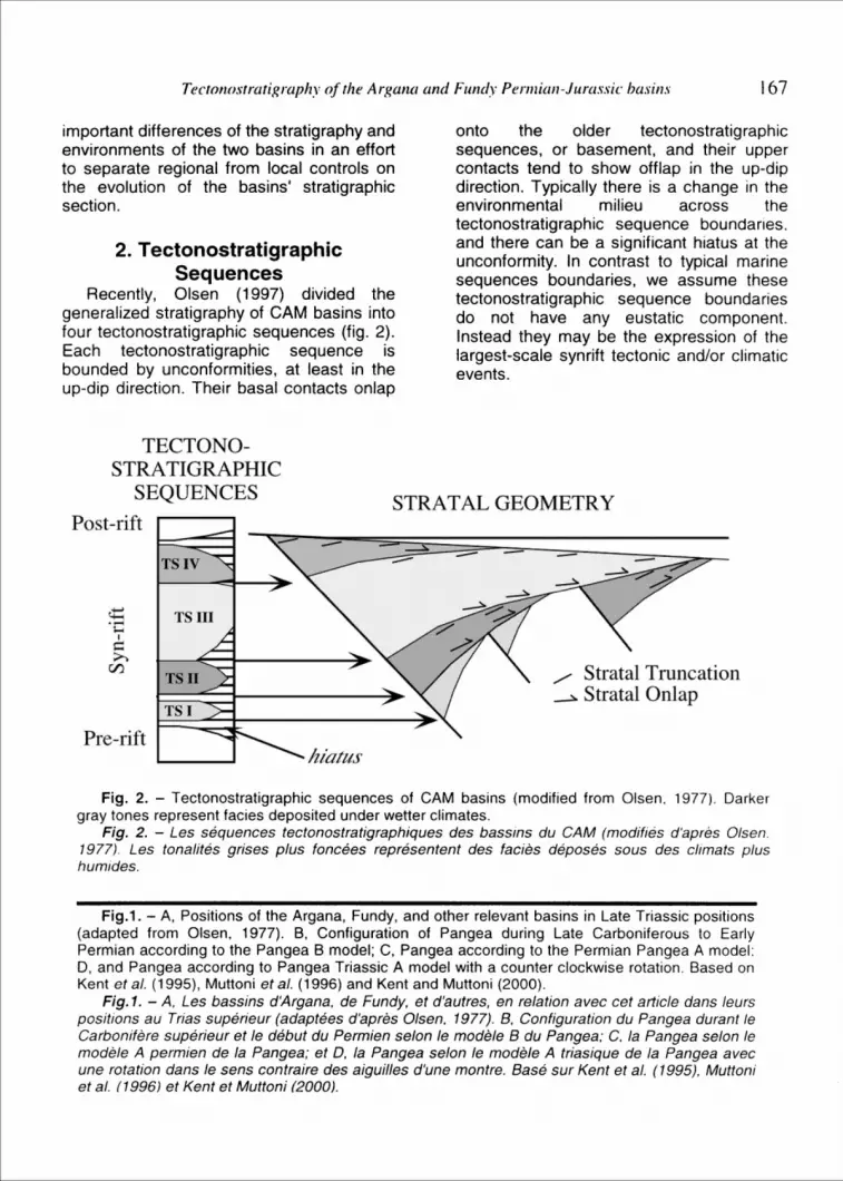
2. Tectonostratigraphic Sequences
Recently, Olsen (1997) divided the generalized stratigraphy of CAM basins into four tectonostratigraphic sequences (fig. 2). Each tectonostratigraphic sequence is bounded by unconformities, at least in the up-dip direction. Their basal contacts onlap
onto the older tectonostratigraphic sequences, or basement, and their upper contacts tend to show offlap in the up-dip direction. Typically there is a change in the environmental milieu across the tectonostratigraphic sequence boundaries. and there can be a significant hiatus at the unconformity. In contrast to typical marine sequences boundaries, we assume these tectonostratigraphic sequence boundaries do not have any eustatic component. Instead they may be the expression of the largest-scale synrift tectonic and/or climatic events.
TECTONOSTRATIGRAPHIC
SEQUENCES STRATAL GEOMETRY Post-rift
Pre-rift
/ Stratal Truncation ~ Stratal Onlap
Fig. 2. - Tectonostratigraphic sequences of CAM basins (modified from Olsen. 1977). Darker gray tones represent facies deposited under wetter climates.
Fig. 2. - Les sequences tectonostratigraphiques des bassins du CAM (modifies d'apres Olsen. 1977). Les tonalites grises plus foncees representent des facies deposes sous des climats plus humides.
Fig.1. - A, Positions of the Argana, Fundy, and other relevant basins in Late Triassic positions (adapted from Olsen, 1977). 8, Configuration of Pangea during Late Carboniferous to Early Permian according to the Pangea B model; C, Pangea according to the Permian Pangea A model: D, and Pangea according to Pangea Triassic A model with a counter clockwise rotation. Based on Kent eta/. (1995), Muttoni eta/. (1996) and Kent and Muttoni (2000).
Fig. 1. - A. Les bassins d'Argana, de Fundy, et d'autres, en relation avec cet article dans leurs positions au Trias superieur (adaptees d'apres Olsen, 1977). 8, Configuration du Pangea durant Je Carbonifere superieur et /e debut du Permien se/on /e modele 8 du Pangea; C. Ia Pangea selon le modele A permien de Ia Pangea; et D. Ia Pangea se/on /e modele A triasique de Ia Pangea avec une rotation dans /e sens contraire des aiguilles d'une montre. Base sur Kent eta/. (1995), Muttoni eta/. {1996) et Kent et Muttoni (2000).

168 P E Olsen eta/.,
This scheme for tectonostratigraphic subdivisions of CAM basins was strongly influenced by new insights gained by the authors during field work in Morocco during 1992, 1994, and 1999 and from the literature, especially Tixeront (1973). The tectonostratigraphic sequences for the Argana and Fundy basin are shown in Figure 3, which summarizes a major revision of the stratigraphy of the Fundy basin (Olsen eta/., 2000) and a modification of the tectonostratigraphy of the Argana basin presented by Olsen (1997). Below we compare and contrast the four tectonostratigraphic sequences in the Argana and Fundy basins.
3. Tectonostratigraphic Sequence I (TS I)
The lkakern Formation (Brown, 1980; T1 of Tixeront, 1973) and Honeycomb Point Formation (Nadon and Middleton, 1984) comprise TS I in the Argana and Fundy basins respectively (fig. 3). When Olsen (1997) first placed these units in TS I of the these basins, the tectonostratigraphic unit was assumed to be Middle Triassic (Anisian) in age, based on admittedly scant and contradictory data. However, descriptions of undoubted examples of the hammer-headed amphibian Dip/ocaulus from the lkakern Formation (Jalil and Dutuit, 1996), as well as our preliminary paleomagnetic data from the Honeycomb Point Formation, showing reversed polarity and shallow inclinations, suggest a Permian age (Kent eta/., 2000).
Although there is evidence of deposition of the lkakern Formation in an extensional basin setting (Medina, 1991), no such evidence has been described for the Honeycomb Point Formation. In fact, the latter is almost lithologically identical to the apparently coeval Cap aux Meules Formation (Brisbois, 1981; Tanczyk, 1988) of the non-rift Magdalen basin in the Gulf of St. Lawrence, Canada (350 km to the northeast), which seems to have developed
as a very broad sag. The Honeycomb Point Formation could just be an outlier of the Cap aux Meules Formation, fortuitously preserved within the Fundy rift oasin. This needs to be tested by a search for faultrelated growth features in the Honeycomb Point Formation itself.
The strata of TS I in the Argana and Fundy basins show considerable differences in apparent climati(.; milieu. The lkakern Formation consists of a generally fining up package with relatively dense bioturbation by burrows and roots, and evidence of eolian deposits is lacking (A. Tourani, pers comm., 1999), suggesting a relatively humid environment. The Honeycomb Point Formation, on the other hand, does not seem to fine upward, bioturbation is relatively less common, and eolian sandstones are very prominent upward, suggesting a much more arid environment. This relatively dramatic difference in climatic milieu contrasts with the three succeeding pairs of TriassicJurassic tectonostratigraphic sequences, which are very similar to each other.
4. Tectonostratigraphic Sequence II
TS II overlies TS I unconformably in both the Argana and Fundy basins. Outcrops of the angular unconformity are present in both basins (Tixeront, 1973; Olsen, 1997). In the Argana basin TS II is comprised of the Timesgadiouine Formation (Brown, 1980; T 3-5 of Tixeront, 1973) wh1ch consists of fluvial and lacustrine clastic rocks with an especially well developed cyclical lacustrine sequence in the lower part of the lrohaline Member (T5) (fig. 3). The outcropping strata of TS II in the Fundy basin belongs to the Wolfville Formation (revised, fig. 3), which is nearly entirely fluvial. However, subsurface data (Withjack et a/., 1995) suggest that there are lacustrine equivalents to the Wolfville deeper within the basin as long suggested by Brown (Wade eta/., 1996).

HEITANGIAN
NORIAN
CARNIAN
Tectonostratigraphy of the Argana and Fundy Permian-Jurassic basins
Fundy Basin
~.Ill ~ <.ig
1 :scots Bay MI>~::S ~
TSIV ~ North Mountain
Basalt
~ ~"Partridge Islandmb!'
~ "White TSIII Watermb!' ! ·a
<:>
"'iied = ~~ Headmb." . . ..
'" • •• "• o, 1~o¢ •,
, ~o~; 'o '<> • •• <>' ~
~ ·,o;•. o.o ;. •· "Evangeline :::.: :o· .. : ·0:·\:c::~ mb. J:l
TSII etal!' ~ ·"·· ~ 1::::: ~.·f~:oE' .I ''Economy
~~ :;'~:~ ::.~ ~ :~ mb!'
~
~
m
15002500
2000
1000
1500
1000
500
500
Argana Basin
Argana Basalt (f3t)
Hasseine Mb.(t8)
169
NORIAN
?
CARNIAN
Honeycomb PERMIAN? TSI PointFm • PERMIAN
• ·" ~ •• ". o, too.· •
• 00°~ "o ',' '• <>'"
0
Fig. 3. - Tectonostratigraphy and age of the Argana and Fundy basins (modified from Olsen, 1977 and based on Tixeront, 1973; Brown, 1980; A'it Chayeb et al., 1998; and Olsen et al., 2000). Note that the members of the Fundy basin are presently informal units requiring formal definition (i. e., Olsen eta/., 2000), with the exception of the Scots Bay Member, which is from Tanner (1996). and the use of the Blomidon is informally redefined to include the Red Head beds previously regarded as part of the Wolfville Formation (see Olsen eta/., 2000).
Fig. 3. - Tectonostratigraphie et age des bassins d'Argana et de Fundy (modifies d'apres Olsen, 1977 et bases sur Tixeront, 1973; Brown, 1980; Ai1 Chayeb eta/., 1998; et Olsen eta/., 2000). Notez que les membres du bassin de Fundy sont actuellement des unites informelles necessistants une definition formelle (c.-i1-d., Olsen eta/., 2000), exception faite du membre de Scots Bay defini par Tanner (1996), de plus, /'utilisation du Blomidon est informellement redefinie pour inc/ure les Red Head beds prea/ablement consideres comme une partie de Ia formation de Wolfville (voir Olsen eta/., 2000).
Biostratigraphically, the Timesgadiouine and the Wolfville formations are very similar. Both units contain relatively abundant vertebrate remains indicating inclusion in the Economian (revised) and
Sanfordian Land Vertebrate Age (L VA) faunachrons of Huber et a/. (1993) and Lucas and Huber (2000). Most notably, in both basins, the lower part of TS II produces capitosaurs (Aglegal and

170 P E Olsen et at ..
"Economy" members), and the upper part produces metoposaur amphibians (lrohaline and "Evangeline" members) (Jalil, 1996; Baird, 1986; Olsen et a/., 1989). The Economian and Sanfordian LVA are thought to correlate with the Julian and Tuvalian of the Carnian (Huber et a/., 1993; Olsen et at.. 2000), a correlation supported by palynoflorules from both basins (Fowell, 1994).
In the Fundy basin, the oldest strata of the Wolfville Formation ("Economy member") has two known beds of eolian sandstone, in what is otherwise an intensely bioturbated sandstone and clast-supported conglomerate (Skilliter, 1996; Olsen 1997). The bulk of the Wolfville ("Evangeline member" and equivalents), lacks eolian deposits, but continues the pattern of intensely bioturbated sandstone and clastsupported conglomerate with weakly to moderately developed soil caliches suggesting deposition in semi-humid environments (Olsen, 1997; Tanner, 1996). Although, the lacustrine strata of the Timesgadiouine Formation of ·the Argana basin, have abundant desiccation features in the shallow-water portions of sedimentary cycles . they lack evaporites or the sandpatch fabric characteristics of more arid lacustrine deposits. Thus, the overall relatively humid climatic milieu of the Timesgadiouine and Wolfville Formation appear to be very similar.
5. Tectonostratigraphic Sequence Ill (TS Ill)
An angular unconformity at least locally separates TS II and TS Ill in the Argana and Fundy basins. In the Argana basin. the upper Timesgadiouine Formation truncated by a gentle angular unconformity (<5°: fig. 4)), at least locally (Tixeront, 1973; Olsen, 1997}, and then overlain by the Bigoudine Formation of TS Ill (Brown, 1980; T 6-8 of Tixeront, 1973. Similarly, in some areas of the Fundy basin, a profound angular unconformity (-90°) separates the Wolfville Formation of TS II from the Blomidon Formation (redefined) of TS Ill (fig. 4). In other areas there may be a gentle angular unconformity, or none at all. but existing outcrops do not permit resolution of this uncertainty.
Remarkably similar sequences characterize TS Ill in the Argana and Fundy basins. In both basins, the basal unit of TS Ill, Tadrat Ouadou Member (Argana) and "Red Head member" (Fundy). are comprised of fluvial conglomerate and sandstone and prominent eolian sandstones (Olsen. 1997; Benaouiss, 1999: Hubert and Mertz. 1984). In both cases. the eolian strata are interbedded with laterally continuous red mudstones that become dominant upward into the succeeding members. These are cyclical red, evaporite-
Fig. 4. - Sketches and photographs of the TS II - TS Ill unconformity in the Argana and Fundy basins: A, Location map (p.i., Pinnacle Island of the Five Islands chain; I.e., Lower Economy and Carrs Brook area), both Colchester County, Nova Scotia; B, Field sketch map of tidal outcrop of TS II- TS Ill unconformity, south side of Pinnacle Island; C, Map based on aerial photographs and field reconnaissance of the tidal outcrops in the Lower Economy and Carrs Brook area showing the pre-rift and TS II- TS Ill unconformities (land geology from Donohoe and Wallace, 1982); D, key for A-C; E-F. Photograph and sketch of the Timesgadiouwine (TS II) - Bigoudine (TS Ill) unconformity (from Olsen, 1997).
Fig. 4. - Croquis et photographies de Ia discordance TS II - TS Ill dans les bassins d'Argana et de Fundy: A, carte de localisation du Colchester County, Nova Scotia (p.i., ile du Pinacle, l'une des cinq iles; I.e., Ia region de Lower Economy et Carrs Brook); B, croquis de terrain de Ia carte de l'affleurement a maree basse de Ia discordance TS II - TS Ill, au sud de l'i/e de Pinacle: C. carte basee sur les photographies aeriennes et Ia reconnaissance de terrain des affleurements a marr:~e basse de Ia region de Lower Economy et Carrs Brook montrant les discordances du pre-rift et du TS II - TS Ill (geologie de terrain d'apres Donohoe et Wallace, 1982); D, legende pour A-C; E-F. Photographie et croquis de Ia discordance de Timesgadiouwine (TS II) - Bigoudine (TS Ill) (d'apres Olsen, 1997).

Tectonostratigraphy of the Argana and Fundy Permian-Jurassic: basins
Atlantic Ocean
75km
Carbonoferous Parrsboro Fm.
TS-11- Carjx>niferous ~ Large Fault unconfonmty 11 • 11
-=<:.,~-. Form lines of "--<":::~ strata
171

172 P E Olsen et a/ ..
bearing, mudstones and sandstones with a characteristic style of sequences termed sand-patch cycles (Smoot and Olsen, 1988; Olsen eta/., 1989; Olsen, 1997; Tourani et a/., 1999). The main lithological differences
between the two TS Ill sequences in the two basins, are in the lower Bigoudine Formation. The Tadrat Ouadou Member contains at least some interbeds of halite.
3
Jurassic
_j Triassic
2
1 -2
color
.. black
.. darkgray
.. green or light gray or purple
0
~ ;:::: red ..... - 00 u
3
2
1
0 ~ -u
;:::: .,... 00
North Mountain Basalt
Fig. 5. - Comparison of boundary sections, lower TS IV, in the Argana and Fundy basins with sample positions. The position of the Triassic-Jurassic boundary is based on the samples shown in bold (frorri Fowell.and Traverse, 1995; and Fowell, pers. comm., 2000).
Fig. 5. - Comparaison de Ia limite des sections, base du TS IV, dans les bassins d'Argana et de Fundy avec le positionnement des echantillons. La position de Ia limite Trias-Jurassique est basee sur les echantillons indiques en gras (d'apres Fowe/1 et Traverse, 1995; et Fowe/1, comm. pers., 2000).

Tectonostratigraphy of the Argana and Fundy Permian-Jurassic basins 173
The overlying Sidi Mansour and lower Hasseine members have several laterally continuous gray and black shale beds. Neither of these are known from the homotaxial portions of the Fundy basin ("Red Head" and lower "White Water members") (fig. 3). However, the bulk of the Hasseine and "White Water" members are nearly identical in facies.
The age of the Bigoudine Formation is relatively poorly constrained. Only indeterminate fragments of vertebrates (fish, metoposaurs, phytosaurs), ostracodes and conchostracans have been found, indicating only a Late Triassic age for most of the formation. Gray and black units in the Sidi Mansour and lower Hasseine members have produced a number of palynological assemblages, some being dated as Carnian (Tourani eta/., 2000) and some as Norian (Fowell, pers. comm.; Olsen, 1997). Detailed descriptions of these assemblages have not been published and it is unclear whether the different assignments reflect real differences in age or differences in interpretation. Very preliminary and incomplete paleomagnetic study of the lower Bigoudine Formation, does allow for the lower part of the formation to be older than the lower Blomidon Formation. The age of the uppermost Bigoudine is earliest Jurassic as constrained by palynology (Fowell, pers. comm.; Olsen, 1997), but we regard the palyniferous beds as belonging toTS IV.
Better age control is available for the Blomidon Formation, which has produced the procolophonid Hypsognathus (Sues et a/., 2000), and track assemblages (Olsen et a/., 1989; Olsen et a/., 2000), indicating inclusion of nearly all of the Formation in the Cliftonian LVA, which conventionally indicates a middle Norian through Rhaetian age (Huber et a/., 1993; Lucas and Huber, 2000). The top of the formation ("Partridge Island member") is Early Jurassic, again based on palynology (Fowell et a/., 1994; Fowell and Traverse, 1995) (fig. 5).
Kent and Olsen (2000) described the magnetostratigraphy of the entire Blomidon Formation based on continuous core (Getty Mines GAV 77-3) and this allows detailed
correlation with the Newark basin (fig. 6), confirming the paleontological correlations. Some part of at least one polarity zone (E22r) and possible parts of upper E22n or lower E23n are missing from the upper part of the Blomidon core suggesting a minor hiatus. This may be evidence for ct'l
unconformity between TS Ill and TS IV 1n
the upper Blomidon Formation and suggests placement of the beds of the uppermost "White Water member" and the "Partridge Island member" in TS IV. Likewise we believe that the uppermost Bigoudine Formation belongs in TS IV, although there is no known physical evidence for an unconformity. Indeed. the exposed strata could be sufficiently downdip to be within the zone of the correlative conformity (as in most of the exposed Newark basin). We stress that the TriassicJurassic boundary is represented in the upper Blomidon, and there is no evidence that the unconformity is within the boundary section.
6. Tectonostratigraphic SequenceiV(TSIV)
TS IV consists of the uppermost portions of the Bigoudine and Blomidon formations which is succeeded by basalt flows and overlying minor carbonates and red clastic rocks (fig. 3). The uppermost Bigoudine and Blomidon formations (upper "White Water"' and "Partridge Island members") both begin with sand-patch-bearing red mudstones and sandstone, but within a few meters of the overlying basalts are a very distinctive suite of thin red, gray and black mudstone beds (fig. 5), which are generally palyniferous (barring local metamorphism from the basalt) and contain the Triassic-Jurassic boundary. They are termed the "Partridge Island member" in the Fundy basin. A parallel nomenclatural designation might be useful for the homotaxial portion of the Bigoudine Formation.
The Argana Basalt (j3t of Tixeront. 1973) and the North Mountain Basalt conformably overlie the uppermost Bigoudine and Blomidon formations in the Argana and

174 P E Olsen et al ..
260--------------------------~--------~~~~ fiJMostly Fluvial D Mostly Lacustrine • Deep-Water • Coals Lacustrine
!;! Marine e Evaporites a Eolian Ss. • Basalts * Radiometric Date
Norian
Carnian
Fig. 6. - Time and geography matrix for selected CAM basins in North America and Morocco. The gray curved lines represent lines of equal paleolatitude fixed by the Newark basin paleomagnetic record. Note that the Argana basin "present latitude" is given within as if still attached to the North American plate and with present day North American coordinates. Note that polarity zones shown as bars spanning half a column are represented by only one sample with that polarity. Data from Kent and Olsen (1997, 2000) and LeTourneau (1999).
Fig. 6. - Matrice temporelle et geographique pour des bassins choisis de Ia CAM en Amerique du Nord et au Maroc. Les /ignes courbes grises representent des /ignes de paleolatitude egale fixees par /'enregistrement paleomagnetique du bassin de Newark. Notez que /e bassin d'Argana "latitude actuelle" est represente comme s'il etait toujours attache a Ia plaque nord-americaine et avec les coordonnees actuelles de /'Amerique du Nord. Notez que des zones de polarite montrees comme barres enjambant Ia moitie d'une co/onne sont representees par seulement un echantillon avec cette polarite. Donnees de Kent et d'Oisen (1997, 2000) et de LeTourneau (1999).

Tec:tonostratigraphy of the Argana and Fundy Permian-Jurassic basins 175
Fundy basins, respectively (fig. 2). Both basalt formations consists of two major flows and several thin interbedded and overlying flows which have, for the most part high-titanium, quartz-normative type tholeiitic chemistry (Puffer, 1992, pers. comm., 2000; Pe Piper et a/., 1992; Dostal and Greenough (1992); Bertrand (1982); An Chayeb et a/. (1998). The North Mountain Basalt has yielded U-Pb ages of 202±1 Ma, in good agreement with other Eastern North American basalts (Hodych and Dunning, 1992). The Argana Basalt has not yet to be dated by more modern methods, but has produced a K/Ar date of 196±17 Ma (Manspeizer et a/., 1978), with the large errors probably due to alteration. This age is consistent with the ages of the eastern North American basalts as well as similar basalts from Morocco (Sebai eta/., 1991 ).
Overlying the basalt flow formations in both basins are thin carbonate-dominated units succeeded by predominately red clastic rocks. In the Argana basin, the Ameskroud Formation (t9) (Hofmann et a/., 1998; Tourani eta/., 2000), contains a basal carbonate and black shale sequence, followed by predominately red and brown mudstones and sandstones with a few thin gray beds (Tixeront, 1973). In the Fundy basin, the McCoy Brook Formation contains a basal carbonate-rich sequence of two white, green, purple, and red lake level cycles (Scots Bay Member) (De Wet and Hubert, 1989; Tanner, 1996) and overlying predominately red clastic rocks, including some very local eolian sandstones (Hubert and Mertz, 1984). These produce a relatively rich vertebrate assemblages (Olsen et a/., 1987), comprising the type Wassonian LVA of Hettangian and possibly younger age (Lucas and Huber, 2000). Strata of TS IV are unconformably overlain by post-rift Early Jurassic conglomerates and marine strata in the Argana basin, and Quaternary strata in the Fundy basin
7. Implications of the Comparison
Placing the Argana and Fundy basin sections into a geography by time matrix with other CAM basin sections, calibrated by the Newark basin standard time scale (Kent and Olsen, 1999; Olsen and Kent, 1999), helps separate the regional from local patterns (fig. 6). Perhaps the most dramatic regional pattern, described in detail elsewhere (Olsen, 1997: Olsen and Kent, 1999; Kent and Olsen, 2000), is the strong arid-to-the-north trend, coupled with an overall increase in aridity through the Late Triassic (Olsen, 1997: Olsen and Kent. 1999; Kent and Olsen, 2000). Particularly important is the relative similarity between the paleoclimatically significant coeval facies between the latitudinally close Argana and Fundy basin, and the dissimilarity to coeval strata farther south, which were deposited under more humid climate conditions. During the Late Triassic, the outline of the eastern North American plate was oriented azimuthially not too different than today, although it was obviously located much further south (fig. 1 ). In the reconstruction of Kent et a/ .. (1995) (fig. 1 ), the Argana basin was located only two degrees south of the Fundy basin, even though separated by about r degrees of longitude. There is now considerable evidence that the Argana and Fundy basins translated north through the Late Triassic through a strong latitudinal climate gradient, not appreciably different than that seen today in Africa north of the equator (Kent and Olsen, 2000). As the basins drifted north they passed through successively more arid climate belts. Therefore, the large change in climatesensitive facies from relatively humid to arid across the TS I! - TS Ill unconformity in both basins reflects the significant duration of the hiatus, during which the basins moved northward, into the arid belt. In addition, the apparent greater wetness indicated by the lower Bigoudine Formation (i.e., the gray and black shales), could be explained by the slightly more southern position of the Argana basin relative to the Fundy, and by the slightly older age of the lower Bigoudine Formation relative to the lower Blomidon, or both.

176 P E Olsen et at ..
The synchronous change to more humid conditions in TS IV over all of the CAM basins (Olsen, 1997), however, clearly requires a different kind of hypothesis. This is because, at a minimum, the basins south of Europe and Greenland should have been getting more arid as Pangea continued its northward drift. The fact that the climate trend is reversed requires a widening of the humid belts in the latest Triassic and earliest Jurassic (Rhaetian - Hettangian). This still occurred within the context of a prominent trend to more arid facies towards the north within North America (Hubert and Mertz, 1984; LeTourneau and Huber, 2000). However, this more humid episode is not reflected globally, with very large regions (e.g. southern Africa, western United States) behaving as might be expected from nearly constant zonality (e.g. southern Africa, western United States). One hypothesis that would explain this pattern would be an increase in humidity related to the invasion of marine waters into much of the northern CAM rifting zone, giving a more proximal source of moisture for the northeast trade winds. Evidence for this within CAM basins includes the distribution of salt in various other basins in Morocco, where it is relatively well constrained in age and stratigraphically (Et Touhami, 2000). This would have affected the more southern CAM basins, including the Fundy and Argana basins, but the effect would not likely have extended far beyond the rifting zone.
Early TS IV time was also one of extreme biological turnover, and may be linked to the apparent climate change. In this hypothesis, the absence of correlative climate change elsewhere could reflect the brevity of the episode and a concomitant lack of temporal resolution outside the CAM basins. A bolide impact (Olsen et at., 1987; Fowell et at., 1994; Olsen, 1997), massive volcanism (i.e., Central Atlantic Margin Province, CAMP; Courtillot, 1996; Marzoli et at., 1999; Olsen, 1999), and sea level changes (Hallam, 1990; Hallam and Wignall, 1997) have been proposed as an origin of the mass extinction at the TriassicJurassic boundary. However, because the
climate change began before the mass extinctions, a single bolide impact or the biotic changes themselves cannot be the cause of the increase in apparent wetness in the CAM basins.
An additional possibility for the origin of the apparent increase in wetness within TS IV could be an increase in basin asymmetry, caused by an increase in extension rate, itself linked to the origin of the CAMP basalts (Schlische and Olsen, 1990). In this view all the apparent indicators of humidity would increase because of sediment and water focusing along the axis in a relatively more asymmetrical rift. It is not very obvious how to discriminate this hypothesis from one of real climate change. However, evaporites decrease and bioturbation increases in even the most shallow-water deposits in the more southern CAM basins (e.g., Newark basin), but increase into TS IV in Moroccan basins. These changes occurred at the same time as the amplitude of lake-level cyclicity increased in TSIV. This argues that increased overall humidity during TS IV time, perhaps related to the entry of marine waters in the more northern rifts, is at least part of the explanation.
A different kind of explanation is needed again for the observed differences between the Argana and Fundy representatives of TS I, which clearly do not fit into any simple pattern as seen in the Triassic-Jurassic strata. The difference between TS I in the two basins could be due to either an increase in the climatic gradient or to apparent non-zonal climate change caused by plate movement from a Pangea B (fig. 1 B) to a to Pangea A (fig. 1 C-D) configuration. An enhanced climatic gradient in the Permian, relative to the Late Triassic could be due to an real climatic change or could be due to the rotation of Pangea (Pangea A configuration) clockwise in the Permian. This would dramatically increase the basins' separation in latitude from about 2° (Late Triassic) to over 6° (Permian), but without a change in the actual distance between them (fig. 1 C, D) or the actual climate gradient. We favor this rotation model because paleomagnetic

Tectonostratigraphy of the Argana and Fundy Permian-Jurassic basins 177
results from the Honeycomb Point and Cap aux Meules Fm. does suggest a relative counter clockwise rotation for North America, from the Permian into the Triassic. Paleomagnetic data (currently under study) is needed from the lkakern Formation to resolve whether Pangea A or B was in place by . the median Permian, and to test the rotation hypothesis. Alternately, the Honeycomb Point and Cap aux Meules formations might not the same age as the lkakern, given the lack of biostratigraphic control, although the Permain age of the Cap aux Meules Formation is not in doubt, which leaves the same basic problem.
A distinctive feature of TS II - IV in the Argana and Fundy basins is their similar overall depositional stratigraphies. Each has a fluvial or very shallow water lacustrine base, a lacustrine middle and a very shallow water lacustrine or fluvial top (fig. 7) corresponding to what Schlische and Olsen (1990) calls a "tripartite sequence" common to many rifts (Lambiase, 1990). The "basin" filling model of Schlische and Olsen (1990) explains this tripartite sequence as a consequence of the evolving geometry of the sediment surface and basin outlet that need not invoke any changes in extension rate or climate. However, a pulse of extension could produce the same result (Olsen, 1997).
For a continental basin, a single pulse of extension, in the absence of other extensional pulses, would follow the basic "basin filling model "outlined by Schlische and Olsen (1989) and elaborated on by Contreras et at., (1997) as follows. The onset of extension creates a half graben. If there is sufficient sediment supply, initially a fluvial sequence is deposited basin-wide, because the depositional surface remains at the lowest outlet of the basin. As the basin widens through time so does the sediment surface, and without a compensatory increase in total sediment flux, the accumulation rate declines and the basin becomes hydrologically closed with an onset of rapidly deepening lacustrine conditions. As sedimentation continues, the basin floor widens and eventually, without any increase in the volume of water entering
the basin, the water depth must decline as well. As subsidence decreases during the waning phase of the extensional pulse, the basin fills to its lowest outlet, leading eventually to basin-wide fluvial conditions and to erosion along the axis of the basin as the basin outlet itself is eroded.
In CAM basins, with the possible exception of TS I and TS IV, the full tripartite sequence was generally not realized within each tectonostratigraphic sequence. Olsen (1997) and Schlische (2000) ascribe the ongm of Tectonostratigraphic Sequences II - IV to significant pulses of extension spread over 30 million years. Each pulse increased basin asymmetry. Erosion occurred on exposed previously deposited syn-rift strata in the hanging wall, while focusing of sediment and water occurred towards the depositional axis of the basin resulting in a very rapid onset of lacustrine conditions. Thus, each pulse of extension would produce a single tripartite sequence with TS Ill and IV each having a truncated basal fluvial portion. In this scenario, unconformities between TS II and Ill and between TS Ill and IV in the Argana and Fundy basins are a result of reduced deposition, non-deposition, and/or erosion during the waning phases of each of the major pulses or during the time between pulses.
A striking similarity between the Argana and Fundy basins that differentiates them from some of the more southern CAM basins, such as the Newark basin, is the relatively long hiatus between TS II and TS Ill that omits all or most of the Conewagian LVA in the Argana and Fundy basins (fig. 6). This difference could be due to the much greater amount of postrift erosion in the Newark basin compared to the Argana and Fundy basins. The present-day surface of deeply eroded basins, such as the Newark basin, places outcrops (and cores) closer to the expected position of the correlative conformities of the tectonostratigraphic sequence boundaries. Because of the offlapping nature of the older strata and the onlapping form of the younger strata, a much more complete section would be

178 P E Olsen et a/.,
present at or close to the surface in the basins with deeper postrift erosion. A prediction of this hypothesis is that the duration of the hiatus represented by the TS II -TS Ill unconformity should greatly decrease towards the interior of the basins, which are accessible only by drilling and geophysics. A similar explanation can be
used for the TS Ill - TS IV hiatus in the Fundy basin. This may not be true for the TS I - TS II unconformity, because the tectonic regime in which TS I was deposited in the two basins may have been completely different.
average climate Fundy Basin . water depth> dry we>
~! F FL SL DL +E -E -W+W 5:=!
Age Argana Basin Explanation
tectonic climatic
Ma >-~ . 1 ··~~ -~~ 200 - ~ ~ !::: e<>ts a • &$ ··"?,~
~ ~ ~ TS IV ~North Mt. Bst. ~
=- r-B~. ~ ~ l_.,~ Water Mb. IS 1\ •
TSIII l "•• ~ ~ .... ~.~ ~ ... u..~Mb- ~ 1 '~ ' Fundy-- ( I\
~!!!!!! Argana ::::::::
210 -
215 -
220-
I I I I I I I I I I I I I I I I 225 -I I I I I I I I I I I I I I I I I I I I I I I I
1---.....-----r--il I I I I I I I
TSII~.=~ ~ ~ ~ 1-----1 ~ --I ,. ••••••
, Economy Mb. ~ , "•• :
230 -
235 -
240 -
245 -
250 --1--1---1
255 -I TSI
260 -
Honeycomb PointFm.
:~
Waning Ameskroud extensiOnal
Fm. (t9) pulse
IJrA.-r,.,·g..,.lan..,.a:-Biis:::t-'7(n.(:l1t") ---1 TS IV ~~\~~~~~~{ pulse
Hasseine Mb.(t8)
TSm Waning ExtensiOnal Pulse
Sidi Mansour (17) '- Waning t-....a.:;Ta::dr::..:&::.l Oua==do:::.u.>..:(T'-"6)'--'----1 ref~~S!Onal
1 Irohalen Mb. :f 2j (tS) TSII .§ ·g Aglegal & E-4 .... Tanamert Mb. t3-t4
,~ Tourbihine Mb.
Initiation of extensional pulse 8? up-dip bypassmg
Waning ExtensiOnal Pulse
Initiation of extensional
I pulse
Rotation of Pangea counterclockwise?
~~escence
erosion?
Or Extension with erosion ?
African-
More humid climate regionally
Basins in arid climate zone
Basins drift north from a more humid to a more arid zone
Relatively humid chmate
Basins come to lie within same narrow climate zone
- (t2) E 1--------1 TS I
~ Ait Driss Mb. (tl)
North American suture NE-SW? each basin in
different Pre-rift in North climate belt America?

Tectonostratigraphy of the Arganaand Fundy Permian-Jurassic basins 179
One consequence of this view of these tectonostratigraphic sequences is that the fluvial and eolian strata at the base of TS Ill (e.g., Red Head beds in the Fundy basin) are marginal facies of more basinward lacustrine strata and should not be the same age either throughout a single basin or between basins, such as the Argana and Fundy, and it should be nearly or completely absent at the basin depocenter. This is different from the upward shallowing pattern in TS II - IV, which does reflect a historical change in the hydrological basin as a consequence of basin widening and filling.
It is important to note that the comparison between the Argana and Fundy basins and their component tectonostratigraphic sequences forces a distinction to be made between arid and humid facies developing under different climate milieus and fluvial versus lacustrine conditions deposited under different hydrologic conditions in the basin. The two are not interdependent . Thus, we have relatively arid fluvial and eolian strata (Tadrat Ouadou and Red Head members of TS Ill), relatively arid lacustrine strata (Sidi Mansour, Hasseine, and "White Water" members), relatively humid fluvial strata (parts of the Aglegal and lrohaline members and Wolfville Formation of TS II), and relatively humid lacustrine strata (lower lrohaline Member and seismically imaged strata of Wolfville Formation). Thus, the combinations of various facies produced in the stratigraphic evolution of the Argana
and Fundy basins reflect the interplay of tectonics as (extensional pulses), which created accommodation space, the evolution of that space because of sediment infilling, and changes in climate controlled by plate motion and true global change (fig. 7).
Acknowledgments We are grateful for support of this
research (to PEO) from the Lamont-Doherty Earth Observatory Climate Center and the US National Science Foundation (EAR-98-04851) to DVK and PEO and (EAR-9814475) to PEO and Hans Sues (Royal Ontario Museum). We especially thank the LDEO Climate Center for funding the most recent fieldwork (1999) in Morocco and ONAREP for logistical support during that visit. I warmly thank Mohammed Et Touhami, Mrabet, El Mosta"ine, Ait Brahim (of ONAREP), Driss Ouarhache, Naima Benaouiss, and Abdel llah Tourani for stimulating discussions on Moroccan rifts and as well as pleasant company during the visit of PEO and RWS. We are especially grateful to Mohammed Et Touhami for coordinating the 1999 field work. Previous field work (1994) to Morocco was supported by the US National Science Foundation (ATM 93-17227) of PEO and DVK. We thank Neil Shubin, Annika Johansson, Philip Huber, and Driss Nabil, for their help during that visit, and Hans Sues for discussions on the vertebrate faunas.
Fig. 7. -Qualitative conceptual diagram showing the main influences on the development of the Argana and Fundy basins. Ages are largely based on correlation with the Newark basin. Water depth for TS II of Fundy basin based interpretation of seismic lines. Abbreviations under water depth and climate are: F, fluvial; FL, fluvial and shallow water lacustrine; SL, shallow lacustrine; DL, deep, perennial lake; +E, arid with abundant eolianites; -E, less arid with rare eolianites; -W; slightly humid with much bioturbation; +W, more humid. Note that these classes are meant to reflect the average state. We have not attempted to show high-frequency fluctuations between extremes.
Fig. 7. - Diagramme conceptuel qualitatif montrant les principales influences sur le developpement des bassins d'Argana et de Fundy. Les ages sont en grande partie bases sur Ia correlation avec le bassin de Newark. La profondeur de l'eau pour Ia TS II du bassin de Fundy est basee sw /'interpretation des /ignes sismiques. Les abreviations concernant Ia profondeur de l'eau et le climat sont: F. fluviatile; FL. fluviale et lacustre peu profond; SL, lacustre peu profond; DL, lac profond, permanent; +E, aride avec eolianites abondantes; - E, moins aride avec eolianites rares; - W; legerement humide avec beaucoup de bioturbation; +W, plus humide. Notez que ces classes sont destinees a refleter l'etat moyen. Nous n'avons pas essaye de montrer des fluctuations a haute frequence entre les extremites.

180 P E Olsen et al.,
References
A'it Chayeb E H, Youbi N, El Boukhari A, Bouabdelli M, Amrhar M (1998). Le volcanisme permian et mesozoique inferieur du bassin d'Argana (Haut-Atlas occidental, Maroc); un magmatisme intraplaque associe a l'ouverture de !'Atlantique central. Journal of African Earth Sciences, vol. 26, pp. 499 -519.
Baird D (1986). Middle Triassic herpetofauna in Nova Scotia. Friends of the Newark Newsletter no 5, pp. 10.
Benaouiss N (1999). lndicateurs d'aridite dans le Trias superier du Haut Atlas Marocain. In: Abstracts, Deuxieme Reunion du Group Marocain du Permian et du Trias, Marrakech, Faculte des Science Semlalia, Marrakech, pp. 4.
Bertrand H, Dostal, J, Dupuy C (1982). Geochemistry of early Mesozoic tholeiites from Morocco. Earth Planet. Sci. Lett. vol. 58, pp. 225 - 239.
Brisbois D (1981 ). Lithostratigraphie des strates Permo-Carboniferes de l'archlipel des lies de Ia Madeleine, Ministere de I'Energie et des Ressources, DPV-796, 48 p.
Brown R H (1980). Triassic rocks of the Argana Valley, southern Morocco, and their structural implications. Bull. Amer. Assoc. Petrol. Geol., vol. 64, pp. 988- 1003.
Contreras J, Scholz, C H, King, G C P (1997). A model of rift basin evolution constrained by first order stratigraphic observations. Jour. Geophys. Res., vol. 102, pp. 7673-7690.
Courtillot V, Jaeger J J, Yang Z, Feraud G, Hofmann C (1996). The influence of continental flood basalts on mass extinctions; where do we stand? In: Ryder G, Fastovsky D, Gartner S. (eds) The Cretaceous-Tertiary Event and Other Catastrophes in Earth History. Geological Society of America Special Paper 307, pp. 513- 525.
De Wet C C, Hubert J F (1989). The Scots Bay Formation, Nova Scotia, Canada, a Jurassic carbonate lake with silica-rich hydrothermal springs. Sedimentology, vol. 36, pp. 857-873.
Donohoe H V, Wallace P I (1982). Geological map of the Cobequid Highlands. Nova Scotia Department of Mines and Energy, Map 82-8.
Dostal J, Greenough J D (1992). Geochemistry and petrogenesis of the early Mesozoic North Mountain Basalts of Nova Scotia,
Canada. In: Puffer J H, Ragland P C (eds) Eastern North American Mesozoic magmatism. Geological Society of America Special Paper 268, pp. 149 - 159.
Et Touhami M (2000). Lithostratigraphy and depositional environments of Lower Mesozoic evaporites and associated red beds, Khemisset Basin, northwestern Morocco. Zentralblatt fur Geologie und Palaontologie, Teil I, vol. 1998, pp. 1193 -1216.
Fowell S J (1994). Palynology of Triassic/ Jurassic boundary sections from the Newark Supergroup of eastern North America; implications for catastrophic extinction scenarios. Ph.D. Thesis, Columbia University, 154 p.
Fowell S J, Cornet B, Olsen P E (1994). Geologically rapid Late Triassic extinctions: Palynological evidence from the Newark Supergroup. In: Klein G D (ed) Pangaea: Paleoclimate, Tectonics and Sedimentation During Accretion, Zenith and Break-up of a Supercontinent. Geological Society of America Special Paper 288, pp. 197 - 206.
Fowell S J, Traverse A (1995). Palynology and age of the upper Blomidon Formation, Fundy Basin, Nova Scotia. Review of Palaeobotany and Palynology, vol. 86, pp. 211 - 233.
Hallam A (1990). The end-Triassic mass extinction event. In: Sharpton V L, Ward P D (eds) Global catastrophes in Earth history; an interdisciplinary conference on impacts, volcanism, and mass mortality. Geological Society of America Special Paper 247, pp. 577-583.
Hallam A, Wignall P B (1997). Mass extinctions and their aftermath. Oxford University Press. New York, 320 p.
Hodych J P, Dunning G R (1992). Did the Manicouagan impact trigger end-of-Triassic extinctions? Geology, vol. 20, pp. 51 -54.
Hofmann A, Tourani A, Gaupp R (1998). Cyclostratigraphic evolution of Triassic to Lower Jurassic continental red beds in a riftbasin setting (Argana Valley, Western Morocco). In: Bachmann G H, Lerche I, and Friedman G. (eds) Epicontinental Triassic International Symposium, Abstracts, Hallesches Jahrbuch fOr Geowissenschaften, B, Geologie, Palaeontology, Minerologie, vol. 5, pp. 88 -89.

Tectonostratigraphy of the Argana and Fundy Permian-Jurassic basins 181
Huber P, Lucas S G, Hunt A P (1993). Vertebrate biochronology of the Newark Supergroup Triassic, eastern North America. New Mexico Museum of Natural History and Science Bulletin, no 3, pp. 179 - 186.
Hubert J F, Mertz K A (1984). Eolian sandstones of the Upper Triassic-Lower Jurassic red beds of the Fundy basin, Nova Scotia. Journal of Sedimentary Petrology, vol. 54, pp. 798-810.
Jalil N (1996). Les Vertebras permiens et triassiques de Ia Formation d'Argana (Haut Atlas occidental): liste faunique prelinaire et implications stratigraphiques. In: Medina F (ed) Le Pernien et le Trias du Maroc: etat des connasissances. Editions PUMAG, Marrakech, pp. 227 - 250.
Jalil N, Dutuit J M (1996). Permian captorhinid reptiles from the Argana Formation, Morocco. Paleontology, vol. 39, pp. 907 -918.
Kent D V, Muttoni G (2000). Variability in late Paleozoic and early Mesozoic paleogeography. In: LeTourneau PM, Olsen P E (eds) Aspects of Triasssic-Jurassic Geoscience, Columbia University Press, in press.
Kent D V, Olsen P E (1999). Astronomically tuned geomagnetic polarity time scale for the Late Triasssic, Jour. Geophys. Res., vol. 104, pp. 12,831- 12,841.
Kent D V, Olsen P E (2000). Paleomagnetic stratigraphy of the Triassic-Jurassic Blomidon Formation in the Fundy Basin: Implications for early Mesozoic tropical climate gradients, Magnetic polarity stratigraphy and paleolatitude of the Triassic-Jurassic Blomidon Formation in the Fundy basin (Canada): implications for early Mesozoic tropical climate gradients. Earth Planet. Sci. Lett., vol. 179, pp. 311 - 324.
Kent D V, Olsen P E, LeTourneau P M (2000). The Honeycomb Point Formation: a postorogenic Permian age sequence in New Brunswick, Canada., in preparation.
Kent D V, Olsen P E, Witte W K (1995). Late Triassic-Early Jurassic geomagnetic polarity and paleolatitudes from drill cores in the Newark rift basin (Eastern North America). Jour. Geophys. Res., vol. 100 (B8), pp. 14,965 - 14,998.
Kent D V, Olsen, P. E (1997). Magnetostratigraphy and paleopoles from the Late Triassic Dan River-Danville basin: interbasin correlation of continental sediments and a test of the tectonic coherence of Newark rift basins in eastern
North America. Geol. Soc. Amer. Bull., vol. 109, pp. 366-377.
Lambiase J J (1990). A model for tectonic control of lacustrine stratigraphic sequences in continental rift basins. In: Katz B J (ed) Lacustrine basin exploration; case studies and modern analogs. AAPG Memoir 50. pp. 265-276.
LeTourneau P M (1999). Depositional History and Tectonic Evolution of Late Triassic Age Rifts of the U. S. Central Atlantic Margin: Results of an Integrated Stratigraphic, Structural, and Pa:·Jomagnetic Analysis of the Taylorsville and Richmond Basins. Ph.D. thesis, New York, Columbia University, 294 p.
LeTourneau P M, Huber P (2000). Lower Jurassic Eolian Sandstones, Pomperaug Rift Basin (Newark Supergroup), Southbury, Connecticut, U.S.A. Sedimentology, in press.
Lucas S G, Huber P (2000). Vertebrate biostratigraphy and biochronology of ·· the non-marine Triassic. In: LeTourneau P M. Olsen P E (eds) Aspects of Triassic-Jurassic Geoscience, Columbia University Press., in press.
Manspeizer W, Puffer J H, Cousminer H L (1978). Separation of Morocco and eastern North America: a Triassic Liassic stratigraphic record. Geological Society of America Bulletin, vol. 89, pp. 901-920.
Marzoli A, Renne P R, Piccirillo E M, Ernesto M, Bellieni G, De Min A (1999). Extensive 200-million-year-old continental flood basalts of the Central J\tlanifc Magmatic Province. Science, vol. 284, pp. 616 - 618.
Medina F (1991 ). Superimposed extensional tectonics in the Argana Triassic formations (Morocco), related to the early rifting of the central Atlantic. Geol. Mag., vol. 128, pp. 525 -536.
Muttoni, G, Kent D V, Channell, J E T (1996). Evolution of Pangea; paleomagnetic constraints from the Southern Alps. Italy. Earth Planet. Sci. Lett., vol. 140, pp. 97 -112.
Nadon G C, Middleton G V (1984). The stratigraphy and sedimentology of the Fundy Group (Triassic). of the St. Martins area, New Brunswick. Can. Jour. Earth Sci .. vol. 22, pp. 1183- 1203.
Olsen P E (1997). Stratigraphic record of the early Mesozoic breakup of Pangea in the Laurasia-Gondwana rift system. Ann. Rev. Earth Planet. Sci., vol. 25, pp. 337- 401.

182 P E Olsen et a/.,
Olsen P E (1999). Giant Lava Flows, Mass Extinctions, and Mantle Plumes. Science, vol. 284, pp. 604 - 605.
Olsen P E, Kent D V, Fowell S J, Schlische R. W, Withjack M 0, LeTourneau P M (2000). Stratigraphy and depositional environments of the Argana (Morocco). and Fundy (Nova Scotia, Canada). Permian-Jurassic basins: implications of the conjugate Atlantic margin comparison. in preparation.
Olsen P E, Kent, D V (1999). Long-period Milankovitch cycles from the Late Triassic and Early Jurassic of eastern North America and their implications for the calibration of the early Mesozoic time scale and the longterm behavior of the planets. Phil. Trans. Roy. Soc. Land. (series A), vol. 357, pp. 1761 - 1787.
Olsen P E, Schlische R W, Gore P J W (and others) (1989). Field Guide to the Tectonics, stratigraphy, sedimentology, and paleontology of the Newark Supergroup, eastern North America. International Geological Congress, Guidebooks for Field Trips T351, 174 p. .
Olsen P E, Shubin N H, Anders, P E (1987). New Early Jurassic tetrapod assemblages constrain Triassic-Jurassic tetrapod extinction event. Science, vol. 237, pp. 1025 - 1029.
Pe Piper G, Jansa L F, Lambert R St. J {1992). Early Mesozoic magmatism of the Eastern Canadian margin; petrogenetic and tectonic significance. In: Puffer J H, Ragland P C (eds.). Eastern North American Mesozoic magmatism, Geol. Soc. Amer. Spec. Paper 268, pp. 13 - 36.
Puffer J H (1992). Eastern North American flood basalts in the context of the incipient breakup of Pangea. In: Puffer J H, Ragland PC (eds) Eastern North American Mesozoic magmatism. Geol. Soc. Amer. Spec. Paper 268), pp. 95 - 118.
Schlische R W, Olsen P E (1990). Quantitative filling models for continental extensional basins with applications to the early Mesozoic rifts of eastern North America. Jour. Geol., vol. 98, pp. 135- 155.
Sebai A, Feraud G, Bertrand H, Hanes J (1991 ). (Super 40) Ar/ (super 39) Ar dating and geochemistry of tholeiitic magmatism related to the early opening of the Central Atlantic Rift. Earth Planet. Sci. Lett., vol. 104, pp. 455 -472.
Skilliter C (1996). The sedimentology of Triassic fluvial and aeolian deposits of Carrs Brook, Colchester County, Nova Scotia. B.Sc. Thesis, Saint Mary's University, Halifax, Nova Scotia, 62 p.
Smoot J, Olsen P E (1988). Massive mudstones in basin analysis and paleoclimatic interpretation of the Newark Supergroup. In: Manspeizer W (ed) Triassic-Jurassic Rifting and the opening of the Atlantic Ocean, Elsevier, Amsterdam, pp. 249-274.
Sues H D, Olsen P E, Scott D M, Spencer P S (2000). Cranial osteology of Hypsognathus fenneri, a latest Triassic procolophonid reptile from the Newark Supergroup of eastern North America. Jour. Vert. Paleo., val. 20, pp. 275 - 384.
Tanczyk E I (1988). Paleomagnetic investigations on the lies de Ia Madeleine, Gulf of St. Lawrence. Geol. Surv. Canada, Paper 88-1 B, pp. 79 - 89.
Tanner L H {1996). Formal definition of the Lower Jurassic McCoy Brook Formation, Fundy rift basin, eastern Canada. Atlantic Geology, vol. 32, pp. 127- 136.
Tanner L H (2000). Record of Triassic-Jurassic paleoclimate and basin evolution in the paleosols of the Fundy rift basin, eastern Canada. In: LeTourneau P M, Olsen P E (eds) Aspects of Triasssic-Jurassic Geoscience, Columbia University Press, in press.
Tixeront M {1973). Lithostratigraphie et mineralisations cupriferes et uraniferes stratiformes syngenetiques et familieres des formations detritiques permo-triasiques du couloir d'Argana, Haut Atlas occidental (Maroc). Notes et Mem. Serv. Geol. Maroc, vol. 249, pp. 147- 177.
Tourani A, Lund J J, Benaoiss N, Gaup R {2000). Stratigraphy of Triassic syn-riftdeposition in Western Morocco. Zentralblatt fur Geologie und Palaontologie, Teil I, vol. 1998, pp. 1193- 1216.
Wade J A, Brown DE Traverse A, Fensome R A {1996). The Triassic-Jurassic Fundy Basin. Eastern Canada; regional setting, stratigraphy and hydrocarbon potential. Atlantic Geology, vol. 32, pp. 189- 231.
Withjack M 0. Olsen P E, Schlische R W (1995). Tectonic evolution of the Fundy rift basin, Canada: evidence of extension and shortening during passive margin development. Tectonics, vol. 14, pp. 390 -405.

Tectonostratigraphy of the Argana and Fundy Permian-Jurassic basins 183
Author' addresses Paul E. Olsen1, Dennis V. Kent1,2, Sarah J. Fowen1,3, Roy W. Schlische2, Martha 0. Withjack2, Peter M. LeTourneau 1
1 Lamont-Doherty Earth Observatory of Columbia University, Palisades, New York, 10964, USA.
2Department of Geological Sciences, Rutgers University, Piscataway, NJ 08854-8066, USA, 3Department of Geology and Geophysics, University of Alaska Fairbanks, Fairbanks Alaska 99775-5780, USA. Correspondence should be addressed toP. Olsen ([email protected])