Embed Size (px)
Citation preview
PLEASE SCROLL DOWN FOR ARTICLE
This article was downloaded by: [Negi, G. C. S.]On: 21 September 2010Access details: Access Details: [subscription number 926768349]Publisher RoutledgeInforma Ltd Registered in England and Wales Registered Number: 1072954 Registered office: Mortimer House, 37-41 Mortimer Street, London W1T 3JH, UK
Journal of Environmental Planning and ManagementPublication details, including instructions for authors and subscription information:http://www.informaworld.com/smpp/title~content=t713429786
Impact assessment of a hydroelectric project on the flora in the WesternHimalayan region based on vegetation analysis and socio-economic studiesShradha Panwara; Devendra K. Agrawala; Girish C. S. Negia; Khilendra S. Kanwala; Vertika Sharmaa;Mahendra S. Lodhia; Jitendra Singha; Vishwapati Bhatta
a Environmental Assessment and Management Div., G B Pant Institute of Himalayan Environment andDevelopment, Almora, Uttarakhand, India
First published on: 06 August 2010
To cite this Article Panwar, Shradha , Agrawal, Devendra K. , Negi, Girish C. S. , Kanwal, Khilendra S. , Sharma, Vertika ,Lodhi, Mahendra S. , Singh, Jitendra and Bhatt, Vishwapati(2010) 'Impact assessment of a hydroelectric project on theflora in the Western Himalayan region based on vegetation analysis and socio-economic studies', Journal ofEnvironmental Planning and Management, 53: 7, 907 — 923, First published on: 06 August 2010 (iFirst)To link to this Article: DOI: 10.1080/09640568.2010.490060URL: http://dx.doi.org/10.1080/09640568.2010.490060
Full terms and conditions of use: http://www.informaworld.com/terms-and-conditions-of-access.pdf
This article may be used for research, teaching and private study purposes. Any substantial orsystematic reproduction, re-distribution, re-selling, loan or sub-licensing, systematic supply ordistribution in any form to anyone is expressly forbidden.
The publisher does not give any warranty express or implied or make any representation that the contentswill be complete or accurate or up to date. The accuracy of any instructions, formulae and drug dosesshould be independently verified with primary sources. The publisher shall not be liable for any loss,actions, claims, proceedings, demand or costs or damages whatsoever or howsoever caused arising directlyor indirectly in connection with or arising out of the use of this material.
Impact assessment of a hydroelectric project on the flora in the Western
Himalayan region based on vegetation analysis and socio-economic
studies
Shradha Panwar, Devendra K. Agrawal, Girish C.S. Negi*, Khilendra S. Kanwal,Vertika Sharma, Mahendra S. Lodhi, Jitendra Singh and Vishwapati Bhatt
Environmental Assessment and Management Div., G B Pant Institute of Himalayan Environmentand Development, Kosi Katarmal, Almora, Uttarakhand 263643, India
(Received 10 March 2008; final version received 8 February 2010)
This study provides an overview of the impacts of a proposed hydroelectricpower project in the Western Himalayan region in India, using a primarydatabase on floristic diversity and vegetation analysis. The remote sensing datarevealed that in the submergence zone only mixed deciduous forest thatoccupies 807.5 ha area and has a wood biomass volume of 4,027,503 m3 islikely to be lost due to impoundment. A total of 165 plant species found in thesubmergence zone also occur in the influence and free draining catchment areaof the project. In the influence zone of the project area only one tree species(Acer oblongum) is found under conservation threat category, which is alsopresent in the free draining catchment of the project. The project affectedpopulation (6716 people) residing in the submergence and influence zonedepend upon the surrounding forests for fuel wood, fodder, wild edibles etc.,and most likely they will settle in the nearby areas, thus mounting morepressure on residual forests of the influence zone for various forest products.Further, from the vegetation analysis it is evident that several tree species (e.g.Lannea coromandelica, Terminalia alata, T. bellerica etc.), may face morepressure from exploitation as they provide a number of useful products andare represented in lower numbers in the forests of the project area. Tocompensate for the loss of various goods and services provided by theforests falling in the submergence zone and to offset the increased pressureof the project affected families on the forests of influence zone, abiodiversity management plan is suggested incorporating socio-economicconsiderations.
Keywords: conservation status; community dependence; hydropower potential;forest type; environmental impacts; submergence zone, Western Himalaya
1. Introduction
The preliminary assessment made by the Central Electricity Authority (CEA), theGovernment of India, reveals that the hydroelectric potential of the country is148,700 MW at 60% load factor. Out of this, only 21.56% hydro-potential hasbeen developed, of which 9.6% is under construction and 68.84% is yet to be
*Corresponding author. Email: [email protected]
Journal of Environmental Planning and Management
Vol. 53, No. 7, October 2010, 907–923
ISSN 0964-0568 print/ISSN 1360-0559 online
� 2010 University of Newcastle upon Tyne
DOI: 10.1080/09640568.2010.490060
http://www.informaworld.com
Downloaded By: [Negi, G. C. S.] At: 05:47 21 September 2010
developed (CEA 2010). India currently generates approximately 64% of itselectricity from conventional thermal power plants and approximately 23.53%from hydroelectric plants, which are mainly located in the states of Jammu &Kashmir, Himachal Pradesh, Uttarakhand and the eight northeastern states(Arunanchal Pradesh, Sikkim, Nagaland, Assam, Manipur, Tripura, Mizoram,Meghalaya) of the Indian Himalayan Region (IHR) (CEA 2010). The newlycreated Uttarakhand state in the mountainous tracts of the Western Himalaya inIndia has vigorously highlighted hydropower as a major source of revenue to thestate due to major glacial fed rivers originating from the snow clad mountains ofthis region. Of the identified capacity of hydropower in Uttarakhand (18,175MW), so far only 16.65% has been developed, 11.14% capacity is underdevelopment, and the remaining 72.21% capacity is yet to be developed (CEA2010). The neighbouring Himachal Pradesh state is much ahead in this respectwhere approximately 55% capacity is either developed or under construction. Thepower sector policy of the Uttarakhand state therefore emphasises the importanceof developing hydroelectricity because of the abundant water resources potentialand the cheaper generation cost.
The IHR covers a total area of approximately 533,604 sq km and presents awealth of biodiversity, where flora and fauna vary extensively withclimatic variability. The IHR as a whole supports nearly 50% of the totalflowering plants in India, of which 30% of the flora is endemic to the region(Khoshoo 1992). The occurrence of approximately 18,440 plant species in varioushabitats (Singh and Hajra 1997), 1748 medicinal plants, 675 wild edible plants,118 aromatic plants, 155 rare plants and 275 fodder plant species justifies thediversity and uniqueness of IHR (Samant et al. 2007). A number of studiescarried out in the Himalayan region focusing on development interventionsreflect that the unscientific exploitation of resources is leading to increasingenvironmental degradation (Action Plan for Himalaya 1992). Reduced denseforest cover (Singh et al. 1985, FSI 2001), accelerated soil erosion andincreased silting of water bodies (Valdiya 1985, Negi 2002), replacement anddisappearance of species (Singh et al. 1984) and loss of biodiversity in the IHR(Samant et al. 2007) are some of the bad environmental impacts. Thesubmergence of forests due to hydroelectric projects can be a serious threat tothe biodiversity of the region (Nair and Balasubramanyam 1985, Mohanty andMathew 1987, Anonymous 1988, Balakrishnan and Abraham 1988, Panwar et al.1990, Dixit 1997). However, in order to achieve the national priorities,the development of hydroelectric projects is essential (Altinbilek 2002), and thereis a need to evolve strategies for reducing the bad environmental effects of suchprojects.
In India, the identification of the impact of a hydroelectric project (HEP) hasbeen mainly confined to broad level qualitative assessment (Biswas 1978, Mohantyand Mathew 1987). The site-specific environmental impacts are often underestimatedand generalised. Further, perceptions of the local people in identifying those impactsand incorporation in the management planning have been rarely made. The purposeof this study is to assess the impacts on floristic diversity and vegetation due to aproposed Lakhwar hydroelectric project (HEP) in the Western Himalayan region inIndia, involving field-level primary surveys and a RS-GIS technique with the majoraim of noting suitable interventions for a biodiversity management plan in theproject area.
908 S. Panwar et al.
Downloaded By: [Negi, G. C. S.] At: 05:47 21 September 2010
2. Study area
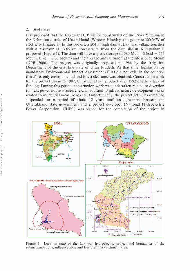
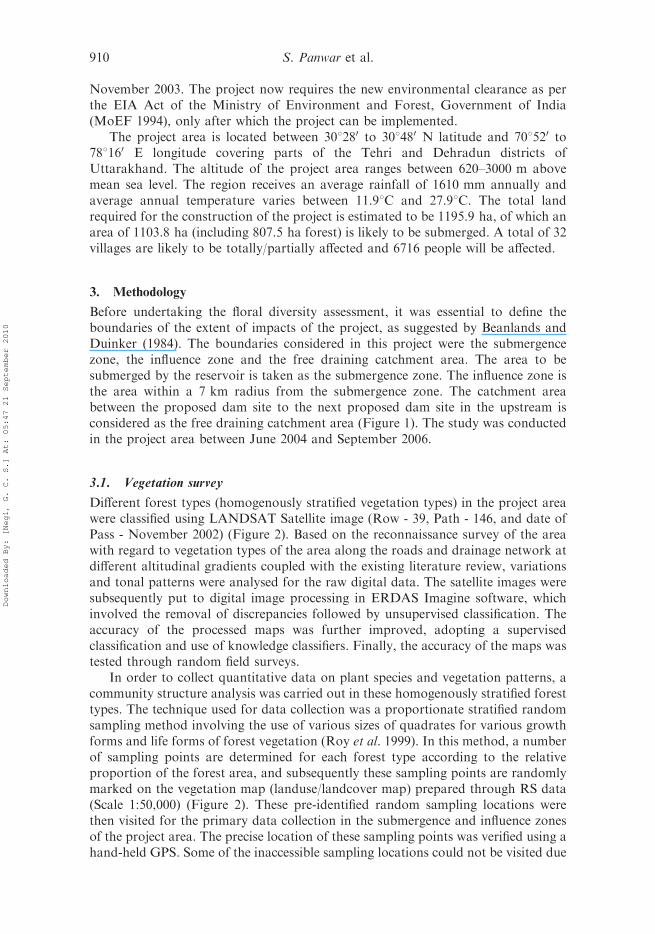
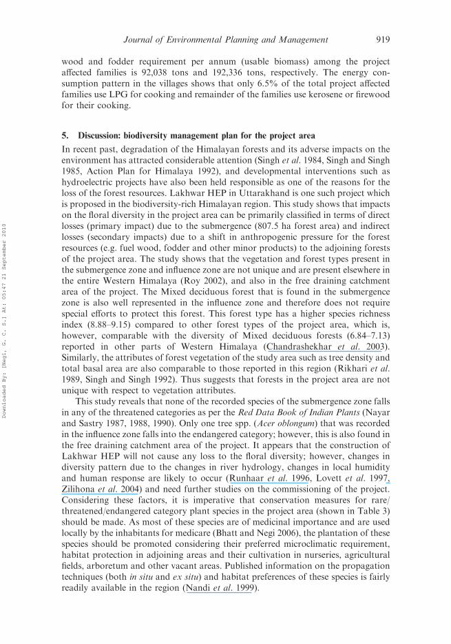
It is proposed that the Lakhwar HEP will be constructed on the River Yamuna inthe Dehradun district of Uttarakhand (Western Himalaya) to generate 300 MW ofelectricity (Figure 1). In this project, a 204 m high dam at Lakhwar village togetherwith a reservoir at 13.65 km downstream from the dam site at Katapathar isproposed (Figure 1). The dam will have a gross storage of 580 Mcum (Dead ¼ 247Mcum, Live ¼ 3 33 Mcum) and the average annual runoff at the site is 3756 Mcum(DPR 2006). The project was originally proposed in 1986 by the IrrigationDepartment of the erstwhile state of Uttar Pradesh. At that time, legislation formandatory Environmental Impact Assessment (EIA) did not exist in the country,therefore, only environmental and forest clearance was obtained. Construction workfor the project began in 1987, but it could not proceed after 1992 due to a lack offunding. During this period, construction work was undertaken related to diversiontunnels, power house structure, etc. in addition to infrastructure development worksrelated to residential areas, roads etc. Unfortunately, the project activities remainedsuspended for a period of about 12 years until an agreement between theUttarakhand state government and a project developer (National HydroelectricPower Corporation, NHPC) was signed for the completion of the project in
Figure 1. Location map of the Lakhwar hydroelectric project and boundaries of thesubmergence zone, influence zone and free draining catchment area.
Journal of Environmental Planning and Management 909
Downloaded By: [Negi, G. C. S.] At: 05:47 21 September 2010
November 2003. The project now requires the new environmental clearance as perthe EIA Act of the Ministry of Environment and Forest, Government of India(MoEF 1994), only after which the project can be implemented.
The project area is located between 308280 to 308480 N latitude and 708520 to788160 E longitude covering parts of the Tehri and Dehradun districts ofUttarakhand. The altitude of the project area ranges between 620–3000 m abovemean sea level. The region receives an average rainfall of 1610 mm annually andaverage annual temperature varies between 11.98C and 27.98C. The total landrequired for the construction of the project is estimated to be 1195.9 ha, of which anarea of 1103.8 ha (including 807.5 ha forest) is likely to be submerged. A total of 32villages are likely to be totally/partially affected and 6716 people will be affected.
3. Methodology
Before undertaking the floral diversity assessment, it was essential to define theboundaries of the extent of impacts of the project, as suggested by Beanlands andDuinker (1984). The boundaries considered in this project were the submergencezone, the influence zone and the free draining catchment area. The area to besubmerged by the reservoir is taken as the submergence zone. The influence zone isthe area within a 7 km radius from the submergence zone. The catchment areabetween the proposed dam site to the next proposed dam site in the upstream isconsidered as the free draining catchment area (Figure 1). The study was conductedin the project area between June 2004 and September 2006.
3.1. Vegetation survey
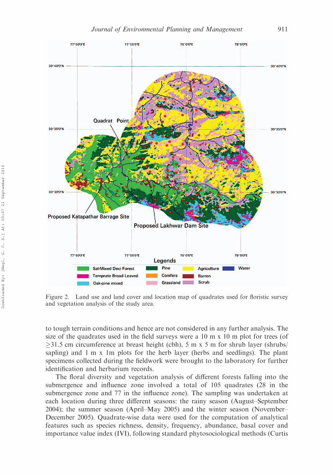
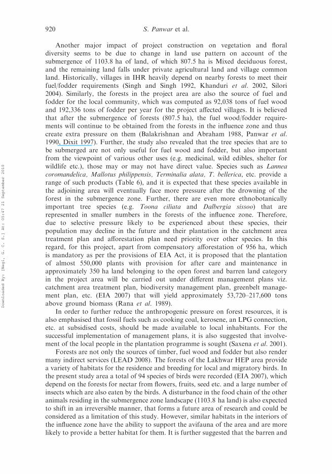
Different forest types (homogenously stratified vegetation types) in the project areawere classified using LANDSAT Satellite image (Row - 39, Path - 146, and date ofPass - November 2002) (Figure 2). Based on the reconnaissance survey of the areawith regard to vegetation types of the area along the roads and drainage network atdifferent altitudinal gradients coupled with the existing literature review, variationsand tonal patterns were analysed for the raw digital data. The satellite images weresubsequently put to digital image processing in ERDAS Imagine software, whichinvolved the removal of discrepancies followed by unsupervised classification. Theaccuracy of the processed maps was further improved, adopting a supervisedclassification and use of knowledge classifiers. Finally, the accuracy of the maps wastested through random field surveys.
In order to collect quantitative data on plant species and vegetation patterns, acommunity structure analysis was carried out in these homogenously stratified foresttypes. The technique used for data collection was a proportionate stratified randomsampling method involving the use of various sizes of quadrates for various growthforms and life forms of forest vegetation (Roy et al. 1999). In this method, a numberof sampling points are determined for each forest type according to the relativeproportion of the forest area, and subsequently these sampling points are randomlymarked on the vegetation map (landuse/landcover map) prepared through RS data(Scale 1:50,000) (Figure 2). These pre-identified random sampling locations werethen visited for the primary data collection in the submergence and influence zonesof the project area. The precise location of these sampling points was verified using ahand-held GPS. Some of the inaccessible sampling locations could not be visited due
910 S. Panwar et al.
Downloaded By: [Negi, G. C. S.] At: 05:47 21 September 2010
to tough terrain conditions and hence are not considered in any further analysis. Thesize of the quadrates used in the field surveys were a 10 m x 10 m plot for trees (of�31.5 cm circumference at breast height (cbh), 5 m x 5 m for shrub layer (shrubs/sapling) and 1 m x 1m plots for the herb layer (herbs and seedlings). The plantspecimens collected during the fieldwork were brought to the laboratory for furtheridentification and herbarium records.
The floral diversity and vegetation analysis of different forests falling into thesubmergence and influence zone involved a total of 105 quadrates (28 in thesubmergence zone and 77 in the influence zone). The sampling was undertaken ateach location during three different seasons: the rainy season (August–September2004); the summer season (April–May 2005) and the winter season (November–December 2005). Quadrate-wise data were used for the computation of analyticalfeatures such as species richness, density, frequency, abundance, basal cover andimportance value index (IVI), following standard phytosociological methods (Curtis
Figure 2. Land use and land cover and location map of quadrates used for floristic surveyand vegetation analysis of the study area.
Journal of Environmental Planning and Management 911
Downloaded By: [Negi, G. C. S.] At: 05:47 21 September 2010
and McIntosh 1950). Circumference at breast height (cbh) at 1.37 m from theground of all the trees with 431.5 cm in each quadrate was measured and recordedfor each species. The IVI for the tree species was determined as the sum of therelative density, relative frequency and relative dominance (Curtis 1959). The treespecies diversity was determined by using Shannon-Weinner information function(H’) (Shannon and Weinner 1963). Concentration of dominance was measured bySimpson’s index (Simpson 1949). Species richness (Margalef 1957) and Evennessindex (Hill 1973) were also calculated based on the density of the species recorded.
For the estimation of wood volume, Volume Table (containing volume data) forthe different tree species was obtained from the Forest Department of theGovernment of Uttarakhand. In this case, where the tree cbh measured by us waslarger or smaller than that given in the Volume Table, wood volume was estimatedthrough regression equations established between cbh classes and the correspondingwood volume.
As the impacts due to the proposed HEP were likely to be confined mainly to thesubmergence and influence zones of the project, sampling plots (quadrates) were laidout only in these respective zones to collect the floral diversity and vegetation data.In the free draining catchment area the study of such quadrates was not undertaken.However, to determine the floral diversity in the entire free draining catchment areaof the project, an inventory of floral species was made based on rapid taxonomicsurveys in the project area during different seasons and an examination of a numberof authentic records and published literature (Kanjilal 1928, Gaur 1999, Kumar andBhatt 2006) and Working Plans of the Forest Division (Singh 1997, Varshneya 2000)pertaining to the project area.
3.2. Ethnobotanical and resource use survey
To understand the multiple uses of the tree flora present in the study area, a door-to-door survey was carried out among the 648 project affected families in the 32 villagesusing an open-ended questionnaire. Detailed information of household size,livestock size and composition, fuel wood and fodder consumption and sourcesfrom which these resources came were obtained through questionnaire surveys.Multiple uses of each of the tree species (e.g. medicinal value, timber, fuel wood,fodder etc.) revealed by the people questioned were also listed.
Based on the baseline data collected from floral inventories, forest vegetation andsocio-economic surveys, possible impacts on vegetation have been identified in thecase of the execution of Lakhwar HEP and appropriate conservation andmanagement strategies are suggested.
4. Results
4.1. Forest type
Vegetation analysis using remote sensing image classification revealed that the totalforest cover in the free draining catchment area are of Lakhwar HEP is 35,398.7 ha,and it constitutes only 1.39% of the total forest area of Uttarakhand (Roy 2002).The major forest types in the free draining catchment zone based on Champion andSeth (1968) were identified as: (i) Pine (Himalayan subtropical Pine forest-9/C1a); (ii)Oak-Pine mixed (Himalayan subtropical Pine forest-9/C1b); (iii) Temperate broadleaved forest (Lower Western Himalayan temperate forest-12/CI); (iv) Mixed
912 S. Panwar et al.
Downloaded By: [Negi, G. C. S.] At: 05:47 21 September 2010
deciduous forest (Tropical moist deciduous forest-I/3-C); and (v) Coniferous forest(Western mixed coniferous forest-12/C1d). The influence zone is occupied by Pineforest, Oak-Pine mixed, Mixed deciduous forest, Temperate broad leaved forest andConiferous forest. In the submergence zone of the project only Mixed deciduousforest was found. Details of the forest types and area in each forest corresponding toChampion and Seth (1968) classification are given in Table 1.
4.2. Floral diversity
Based on the rapid floral survey conducted in the free draining catchment area are ofthe project, a total of 535 plant species (151 trees, 97 shrubs, 227 herbs and grasses)belonging to 134 families and 328 genera are reported (Table 2). Based on theprimary quadrate survey in the influence zone, a total of 284 species belonging to 108families and 213 genera are present. Out of the 284 species, 219 are angiosperm(monocots and dicots) and the remaining 65 species are gymnosperm and lowergroup plants. In the submergence zone, a total of only 165 species belonging to 76families and 131 genera are recorded, of which 129 are angiosperms, one species isgymnosperm and the remaining are pteridophytes and lower group plants. It isevident from the foregoing that as the submergence zone constitutes only 1.3% ofthe project area; however, the floral diversity in the zone is very good, amounting to30.3% (165 species out of the total of 535 species) of the total species of the area.Therefore, it is necessary to understand the distribution pattern and the conservationstatus of the species of submergence zone in the adjoining area. It is also observedthat the dicot group of plants is the most dominant among the three study zones ofthe project.
4.3. Conservation status
As per the Red Data Book of Indian Plants (Nayar and Sastry 1987, 1988, 1990), atotal of seven species fall under different categories of conservation status in theentire free draining catchment area of the project (Table 3). Of these, five species are
Table 1. Different forest types and extent of each forest types in the project area.
Satellite basedvegetationcover type
Vegetation type as perChampion and Sethclassification (1968)
Area (ha)
Catchmentzone
Influencezone
Submergencezone
Pine forest Himalayan subtropicalpine forest-9/C1a
10,354.69 8,917.46 –
Oak-pine mixed forest Himalayan subtropicalpine forest-9/C1b
10,168.28 2,960.41 –
Temperate broadleavedforest
Lower WesternHimalayan temperateforest-12/C1
8,676.45 1830.7 –
Sal mixed deciduousforest
Tropical moist deciduousforest-I/3C
4,459.23 7,464.75 807.455
Conifer Western mixed coniferousforest-12/C1d
1740 90.91 –
Total 35,398.65 21,264.23 807.455
Journal of Environmental Planning and Management 913
Downloaded By: [Negi, G. C. S.] At: 05:47 21 September 2010
Table2.
Distributionofplantgroupsbyfamily,generaandspeciesin
thestudyareaoftheLakhwarhydroelectric
project
(listofplants
availablefrom
theauthors).
S.No.
Group
Submergence
zone*
Influence
zone*
Freedrainingcatchment**
Families
Genera
Species
Families
Genera
Species
Families
Genera
Species
1Monocots
48
94
13
17
12
40
64
2Dicots
50
97
120
68
155
202
84
239
401
3Gymnosperms
11
11
24
36
94
Pteridophytes
11
49
13
22
913
22
5Bryophytes
99
13
99
13
99
13
6Algae
11
15
18
11
15
18
11
15
18
7Lichen
00
06
68
66
8Total
76
131
165
108
213
284
134
328
535
Notes:*Basedontheprimary
quadrate
sampling.
**Basedontherapid
visualsurvey
coupledwithreview
ofavailable
published
literature.
914 S. Panwar et al.
Downloaded By: [Negi, G. C. S.] At: 05:47 21 September 2010
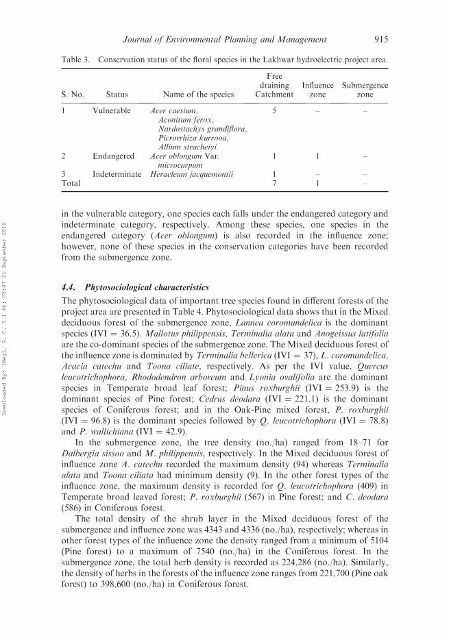
in the vulnerable category, one species each falls under the endangered category andindeterminate category, respectively. Among these species, one species in theendangered category (Acer oblongum) is also recorded in the influence zone;however, none of these species in the conservation categories have been recordedfrom the submergence zone.
4.4. Phytosociological characteristics
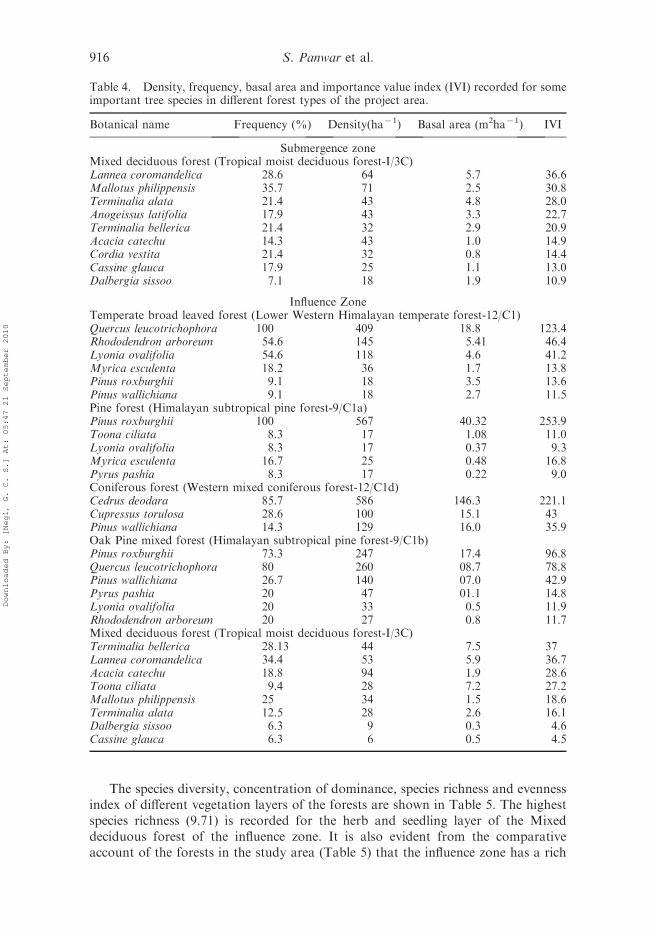
The phytosociological data of important tree species found in different forests of theproject area are presented in Table 4. Phytosociological data shows that in the Mixeddeciduous forest of the submergence zone, Lannea coromandelica is the dominantspecies (IVI ¼ 36.5). Mallotus philippensis, Terminalia alata and Anogeissus latifoliaare the co-dominant species of the submergence zone. The Mixed deciduous forest ofthe influence zone is dominated by Terminalia bellerica (IVI ¼ 37), L. coromandelica,Acacia catechu and Toona ciliate, respectively. As per the IVI value, Quercusleucotrichophora, Rhododendron arboreum and Lyonia ovalifolia are the dominantspecies in Temperate broad leaf forest; Pinus roxburghii (IVI ¼ 253.9) is thedominant species of Pine forest; Cedrus deodara (IVI ¼ 221.1) is the dominantspecies of Coniferous forest; and in the Oak-Pine mixed forest, P. roxburghii(IVI ¼ 96.8) is the dominant species followed by Q. leucotrichophora (IVI ¼ 78.8)and P. wallichiana (IVI ¼ 42.9).
In the submergence zone, the tree density (no./ha) ranged from 18–71 forDalbergia sissoo and M. philippensis, respectively. In the Mixed deciduous forest ofinfluence zone A. catechu recorded the maximum density (94) whereas Terminaliaalata and Toona ciliata had minimum density (9). In the other forest types of theinfluence zone, the maximum density is recorded for Q. leucotrichophora (409) inTemperate broad leaved forest; P. roxburghii (567) in Pine forest; and C. deodara(586) in Coniferous forest.
The total density of the shrub layer in the Mixed deciduous forest of thesubmergence and influence zone was 4343 and 4336 (no./ha), respectively; whereas inother forest types of the influence zone the density ranged from a minimum of 5104(Pine forest) to a maximum of 7540 (no./ha) in the Coniferous forest. In thesubmergence zone, the total herb density is recorded as 224,286 (no./ha). Similarly,the density of herbs in the forests of the influence zone ranges from 221,700 (Pine oakforest) to 398,600 (no./ha) in Coniferous forest.
Table 3. Conservation status of the floral species in the Lakhwar hydroelectric project area.
S. No. Status Name of the species
Freedraining
CatchmentInfluencezone
Submergencezone
1 Vulnerable Acer caesium,Aconitum ferox,Nardostachys grandiflora,Picrorrhiza kurrooa,Allium stracheiyi
5 – –
2 Endangered Acer oblongum Var.microcarpum
1 1 –
3 Indeterminate Heracleum jacquemontii 1 – –Total 7 1 –
Journal of Environmental Planning and Management 915
Downloaded By: [Negi, G. C. S.] At: 05:47 21 September 2010
The species diversity, concentration of dominance, species richness and evennessindex of different vegetation layers of the forests are shown in Table 5. The highestspecies richness (9.71) is recorded for the herb and seedling layer of the Mixeddeciduous forest of the influence zone. It is also evident from the comparativeaccount of the forests in the study area (Table 5) that the influence zone has a rich
Table 4. Density, frequency, basal area and importance value index (IVI) recorded for someimportant tree species in different forest types of the project area.
Botanical name Frequency (%) Density(ha71) Basal area (m2ha71) IVI
Submergence zoneMixed deciduous forest (Tropical moist deciduous forest-I/3C)Lannea coromandelica 28.6 64 5.7 36.6Mallotus philippensis 35.7 71 2.5 30.8Terminalia alata 21.4 43 4.8 28.0Anogeissus latifolia 17.9 43 3.3 22.7Terminalia bellerica 21.4 32 2.9 20.9Acacia catechu 14.3 43 1.0 14.9Cordia vestita 21.4 32 0.8 14.4Cassine glauca 17.9 25 1.1 13.0Dalbergia sissoo 7.1 18 1.9 10.9
Influence ZoneTemperate broad leaved forest (Lower Western Himalayan temperate forest-12/C1)Quercus leucotrichophora 100 409 18.8 123.4Rhododendron arboreum 54.6 145 5.41 46.4Lyonia ovalifolia 54.6 118 4.6 41.2Myrica esculenta 18.2 36 1.7 13.8Pinus roxburghii 9.1 18 3.5 13.6Pinus wallichiana 9.1 18 2.7 11.5Pine forest (Himalayan subtropical pine forest-9/C1a)Pinus roxburghii 100 567 40.32 253.9Toona ciliata 8.3 17 1.08 11.0Lyonia ovalifolia 8.3 17 0.37 9.3Myrica esculenta 16.7 25 0.48 16.8Pyrus pashia 8.3 17 0.22 9.0Coniferous forest (Western mixed coniferous forest-12/C1d)Cedrus deodara 85.7 586 146.3 221.1Cupressus torulosa 28.6 100 15.1 43Pinus wallichiana 14.3 129 16.0 35.9Oak Pine mixed forest (Himalayan subtropical pine forest-9/C1b)Pinus roxburghii 73.3 247 17.4 96.8Quercus leucotrichophora 80 260 08.7 78.8Pinus wallichiana 26.7 140 07.0 42.9Pyrus pashia 20 47 01.1 14.8Lyonia ovalifolia 20 33 0.5 11.9Rhododendron arboreum 20 27 0.8 11.7Mixed deciduous forest (Tropical moist deciduous forest-I/3C)Terminalia bellerica 28.13 44 7.5 37Lannea coromandelica 34.4 53 5.9 36.7Acacia catechu 18.8 94 1.9 28.6Toona ciliata 9.4 28 7.2 27.2Mallotus philippensis 25 34 1.5 18.6Terminalia alata 12.5 28 2.6 16.1Dalbergia sissoo 6.3 9 0.3 4.6Cassine glauca 6.3 6 0.5 4.5
916 S. Panwar et al.
Downloaded By: [Negi, G. C. S.] At: 05:47 21 September 2010
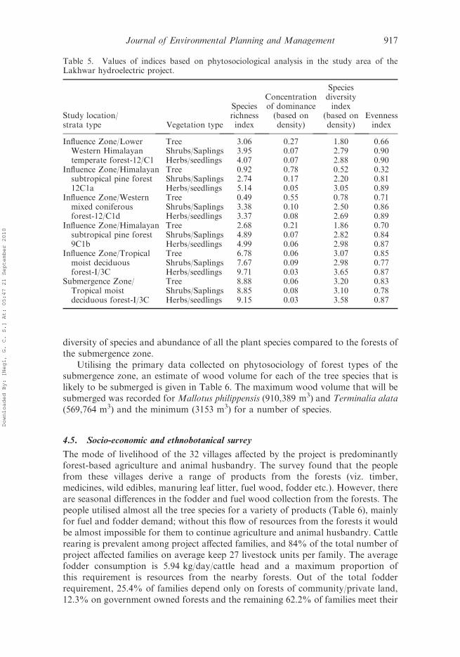
diversity of species and abundance of all the plant species compared to the forests ofthe submergence zone.
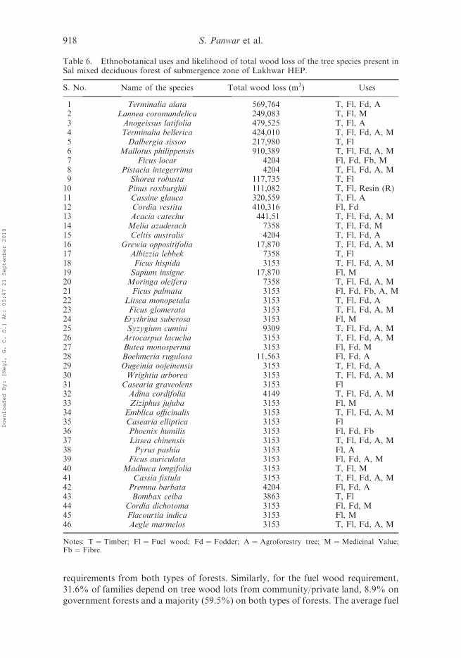
Utilising the primary data collected on phytosociology of forest types of thesubmergence zone, an estimate of wood volume for each of the tree species that islikely to be submerged is given in Table 6. The maximum wood volume that will besubmerged was recorded for Mallotus philippensis (910,389 m3) and Terminalia alata(569,764 m3) and the minimum (3153 m3) for a number of species.
4.5. Socio-economic and ethnobotanical survey
The mode of livelihood of the 32 villages affected by the project is predominantlyforest-based agriculture and animal husbandry. The survey found that the peoplefrom these villages derive a range of products from the forests (viz. timber,medicines, wild edibles, manuring leaf litter, fuel wood, fodder etc.). However, thereare seasonal differences in the fodder and fuel wood collection from the forests. Thepeople utilised almost all the tree species for a variety of products (Table 6), mainlyfor fuel and fodder demand; without this flow of resources from the forests it wouldbe almost impossible for them to continue agriculture and animal husbandry. Cattlerearing is prevalent among project affected families, and 84% of the total number ofproject affected families on average keep 27 livestock units per family. The averagefodder consumption is 5.94 kg/day/cattle head and a maximum proportion ofthis requirement is resources from the nearby forests. Out of the total fodderrequirement, 25.4% of families depend only on forests of community/private land,12.3% on government owned forests and the remaining 62.2% of families meet their
Table 5. Values of indices based on phytosociological analysis in the study area of theLakhwar hydroelectric project.
Study location/strata type Vegetation type
Speciesrichnessindex
Concentrationof dominance(based ondensity)
Speciesdiversityindex
(based ondensity)
Evennessindex
Influence Zone/LowerWestern Himalayantemperate forest-12/C1
Tree 3.06 0.27 1.80 0.66Shrubs/Saplings 3.95 0.07 2.79 0.90Herbs/seedlings 4.07 0.07 2.88 0.90
Influence Zone/Himalayansubtropical pine forest12C1a
Tree 0.92 0.78 0.52 0.32Shrubs/Saplings 2.74 0.17 2.20 0.81Herbs/seedlings 5.14 0.05 3.05 0.89
Influence Zone/Westernmixed coniferousforest-12/C1d
Tree 0.49 0.55 0.78 0.71Shrubs/Saplings 3.38 0.10 2.50 0.86Herbs/seedlings 3.37 0.08 2.69 0.89
Influence Zone/Himalayansubtropical pine forest9C1b
Tree 2.68 0.21 1.86 0.70Shrubs/Saplings 4.89 0.07 2.82 0.84Herbs/seedlings 4.99 0.06 2.98 0.87
Influence Zone/Tropicalmoist deciduousforest-I/3C
Tree 6.78 0.06 3.07 0.85Shrubs/Saplings 7.67 0.09 2.98 0.77Herbs/seedlings 9.71 0.03 3.65 0.87
Submergence Zone/Tropical moistdeciduous forest-I/3C
Tree 8.88 0.06 3.20 0.83Shrubs/Saplings 8.85 0.08 3.10 0.78Herbs/seedlings 9.15 0.03 3.58 0.87
Journal of Environmental Planning and Management 917
Downloaded By: [Negi, G. C. S.] At: 05:47 21 September 2010
requirements from both types of forests. Similarly, for the fuel wood requirement,31.6% of families depend on tree wood lots from community/private land, 8.9% ongovernment forests and a majority (59.5%) on both types of forests. The average fuel
Table 6. Ethnobotanical uses and likelihood of total wood loss of the tree species present inSal mixed deciduous forest of submergence zone of Lakhwar HEP.
S. No. Name of the species Total wood loss (m3) Uses
1 Terminalia alata 569,764 T, Fl, Fd, A2 Lannea coromandelica 249,083 T, Fl, M3 Anogeissus latifolia 479,525 T, Fl, A4 Terminalia bellerica 424,010 T, Fl, Fd, A, M5 Dalbergia sissoo 217,980 T, Fl6 Mallotus philippensis 910,389 T, Fl, Fd, A, M7 Ficus locar 4204 Fl, Fd, Fb, M8 Pistacia integerrima 4204 T, Fl, Fd, A, M9 Shorea robusta 117,735 T, Fl10 Pinus roxburghii 111,082 T, Fl, Resin (R)11 Cassine glauca 320,559 T, Fl, A12 Cordia vestita 410,316 Fl, Fd13 Acacia catechu 441,51 T, Fl, Fd, A, M14 Melia azaderach 7358 T, Fl, Fd, M15 Celtis australis 4204 T, Fl, Fd, A16 Grewia oppositifolia 17,870 T, Fl, Fd, A, M17 Albizzia lebbek 7358 T, Fl18 Ficus hispida 3153 T, Fl, Fd, A, M19 Sapium insigne 17,870 Fl, M20 Moringa oleifera 7358 T, Fl, Fd, A, M21 Ficus palmata 3153 Fl, Fd, Fb, A, M22 Litsea monopetala 3153 T, Fl, Fd, A23 Ficus glomerata 3153 T, Fl, Fd, A, M24 Erythrina suberosa 3153 Fl, M25 Syzygium cumini 9309 T, Fl, Fd, A, M26 Artocarpus lacucha 3153 T, Fl, Fd, A, M27 Butea monosperma 3153 Fl, Fd, M28 Boehmeria rugulosa 11,563 Fl, Fd, A29 Ougeinia oojeinensis 3153 T, Fl, Fd, A30 Wrightia arborea 3153 T, Fl, Fd, A, M31 Casearia graveolens 3153 Fl32 Adina cordifolia 4149 T, Fl, Fd, A, M33 Ziziphus jujuba 3153 Fl, M34 Emblica officinalis 3153 T, Fl, Fd, A, M35 Casearia elliptica 3153 Fl36 Phoenix humilis 3153 Fl, Fd, Fb37 Litsea chinensis 3153 T, Fl, Fd, A, M38 Pyrus pashia 3153 Fl, A39 Ficus auriculata 3153 Fl, Fd, A, M40 Madhuca longifolia 3153 T, Fl, M41 Cassia fistula 3153 T, Fl, Fd, A, M42 Premna barbata 4204 Fl, Fd, A43 Bombax ceiba 3863 T, Fl44 Cordia dichotoma 3153 Fl, Fd, M45 Flacourtia indica 3153 Fl, M46 Aegle marmelos 3153 T, Fl, Fd, A, M
Notes: T ¼ Timber; Fl ¼ Fuel wood; Fd ¼ Fodder; A ¼ Agroforestry tree; M ¼ Medicinal Value;Fb ¼ Fibre.
918 S. Panwar et al.
Downloaded By: [Negi, G. C. S.] At: 05:47 21 September 2010
wood and fodder requirement per annum (usable biomass) among the projectaffected families is 92,038 tons and 192,336 tons, respectively. The energy con-sumption pattern in the villages shows that only 6.5% of the total project affectedfamilies use LPG for cooking and remainder of the families use kerosene or firewoodfor their cooking.
5. Discussion: biodiversity management plan for the project area
In recent past, degradation of the Himalayan forests and its adverse impacts on theenvironment has attracted considerable attention (Singh et al. 1984, Singh and Singh1985, Action Plan for Himalaya 1992), and developmental interventions such ashydroelectric projects have also been held responsible as one of the reasons for theloss of the forest resources. Lakhwar HEP in Uttarakhand is one such project whichis proposed in the biodiversity-rich Himalayan region. This study shows that impactson the floral diversity in the project area can be primarily classified in terms of directlosses (primary impact) due to the submergence (807.5 ha forest area) and indirectlosses (secondary impacts) due to a shift in anthropogenic pressure for the forestresources (e.g. fuel wood, fodder and other minor products) to the adjoining forestsof the project area. The study shows that the vegetation and forest types present inthe submergence zone and influence zone are not unique and are present elsewhere inthe entire Western Himalaya (Roy 2002), and also in the free draining catchmentarea of the project. The Mixed deciduous forest that is found in the submergencezone is also well represented in the influence zone and therefore does not requirespecial efforts to protect this forest. This forest type has a higher species richnessindex (8.88–9.15) compared to other forest types of the project area, which is,however, comparable with the diversity of Mixed deciduous forests (6.84–7.13)reported in other parts of Western Himalaya (Chandrashekhar et al. 2003).Similarly, the attributes of forest vegetation of the study area such as tree density andtotal basal area are also comparable to those reported in this region (Rikhari et al.1989, Singh and Singh 1992). Thus suggests that forests in the project area are notunique with respect to vegetation attributes.
This study reveals that none of the recorded species of the submergence zone fallsin any of the threatened categories as per the Red Data Book of Indian Plants (Nayarand Sastry 1987, 1988, 1990). Only one tree spp. (Acer oblongum) that was recordedin the influence zone falls into the endangered category; however, this is also found inthe free draining catchment area of the project. It appears that the construction ofLakhwar HEP will not cause any loss to the floral diversity; however, changes indiversity pattern due to the changes in river hydrology, changes in local humidityand human response are likely to occur (Runhaar et al. 1996, Lovett et al. 1997,Zilihona et al. 2004) and need further studies on the commissioning of the project.Considering these factors, it is imperative that conservation measures for rare/threatened/endangered category plant species in the project area (shown in Table 3)should be made. As most of these species are of medicinal importance and are usedlocally by the inhabitants for medicare (Bhatt and Negi 2006), the plantation of thesespecies should be promoted considering their preferred microclimatic requirement,habitat protection in adjoining areas and their cultivation in nurseries, agriculturalfields, arboretum and other vacant areas. Published information on the propagationtechniques (both in situ and ex situ) and habitat preferences of these species is fairlyreadily available in the region (Nandi et al. 1999).
Journal of Environmental Planning and Management 919
Downloaded By: [Negi, G. C. S.] At: 05:47 21 September 2010
Another major impact of project construction on vegetation and floraldiversity seems to be due to change in land use pattern on account of thesubmergence of 1103.8 ha of land, of which 807.5 ha is Mixed deciduous forest,and the remaining land falls under private agricultural land and village commonland. Historically, villages in IHR heavily depend on nearby forests to meet theirfuel/fodder requirements (Singh and Singh 1992, Khanduri et al. 2002, Silori2004). Similarly, the forests in the project area are also the source of fuel andfodder for the local community, which was computed as 92,038 tons of fuel woodand 192,336 tons of fodder per year for the project affected villages. It is believedthat after the submergence of forests (807.5 ha), the fuel wood/fodder require-ments will continue to be obtained from the forests in the influence zone and thuscreate extra pressure on them (Balakrishnan and Abraham 1988, Panwar et al.1990, Dixit 1997). Further, the study also revealed that the tree species that are tobe submerged are not only useful for fuel wood and fodder, but also importantfrom the viewpoint of various other uses (e.g. medicinal, wild edibles, shelter forwildlife etc.), those may or may not have direct value. Species such as Lanneacoromandelica, Mallotus philippensis, Terminalia alata, T. bellerica, etc. provide arange of such products (Table 6), and it is expected that these species available inthe adjoining area will eventually face more pressure after the drowning of theforest in the submergence zone. Further, there are even more ethnobotanicallyimportant tree species (e.g. Toona ciliata and Dalbergia sissoo) that arerepresented in smaller numbers in the forests of the influence zone. Therefore,due to selective pressure likely to be experienced about these species, theirpopulation may decline in the future and their plantation in the catchment areatreatment plan and afforestation plan need priority over other species. In thisregard, for this project, apart from compensatory afforestation of 956 ha, whichis mandatory as per the provisions of EIA Act, it is proposed that the plantationof almost 550,000 plants with provision for after care and maintenance inapproximately 350 ha land belonging to the open forest and barren land categoryin the project area will be carried out under different management plans viz.catchment area treatment plan, biodiversity management plan, greenbelt manage-ment plan, etc. (EIA 2007) that will yield approximately 53,720–217,600 tonsabove ground biomass (Rana et al. 1989).
In order to further reduce the anthropogenic pressure on forest resources, it isalso emphasised that fossil fuels such as cooking coal, kerosene, an LPG connection,etc. at subsidised costs, should be made available to local inhabitants. For thesuccessful implementation of management plans, it is also suggested that involve-ment of the local people in the plantation programme is sought (Saxena et al. 2001).
Forests are not only the sources of timber, fuel wood and fodder but also rendermany indirect services (LEAD 2008). The forests of the Lakhwar HEP area providea variety of habitats for the residence and breeding for local and migratory birds. Inthe present study area a total of 94 species of birds were recorded (EIA 2007), whichdepend on the forests for nectar from flowers, fruits, seed etc. and a large number ofinsects which are also eaten by the birds. A disturbance in the food chain of the otheranimals residing in the submergence zone landscape (1103.8 ha land) is also expectedto shift in an irreversible manner, that forms a future area of research and could beconsidered as a limitation of this study. However, similar habitats in the interiors ofthe influence zone have the ability to support the avifauna of the area and are morelikely to provide a better habitat for them. It is further suggested that the barren and
920 S. Panwar et al.
Downloaded By: [Negi, G. C. S.] At: 05:47 21 September 2010
scrub land of the influence zone of the project area be strengthened by undertakingextensive plantation of mostly shrubs and fruit bearing plants such that they enhancethe food availability for local fauna of the project area.
Conclusions
In the Western Himalayan region, forests and water constitute the richest resourcesamongst other resources. Both these resources are vital for human survival and havebeen playing a pivotal role in the subsistence living of the people in the region.However, it is imperative to utilise the water resources for electricity generation tomeet the concurrent goals of socio-economic development of the state. This studyhighlights the impacts of a proposed hydropower project in the mountainous part ofUttarakhand state in Western Himalaya on the floral diversity and vegetationpatterns. It has been found that although the floral diversity and forest types presentin the submergence and influence zone of the project are well represented in the freedraining catchment of the project, there is still a likelihood of enhanced pressure ofthe extraction of forest resources (e.g. fuel wood, fodder etc.) on the forests of theinfluence zone, and a few ethnobotanically important species will face furtherexploitation. Several medicinal plants found in the free draining catchment area alsorequire attention for conservation and reproduction. Therefore, in the biodiversitymanagement plan, the planting of these species needs to be given more priority.Further, the inclusion of a socio-economic survey provides more insight into thedependence of project affected families on the forests for a variety of products andshould be an essential component in the EIA exercise.
Acknowledgements
The authors wish to express sincere thanks to M/s National Hydroelectric Power CorporationLtd., Faridabad, India for providing the opportunity to work on EIA/EMP studies of theproposed project. Several officials of NHPC provided greater insight to the project and theauthors thank them all, in particular Ers Ramesh Chandra, ED (Uttarakhand) and B.D.Saraf, GM (Planning), Drs (Mrs) Usha Bhatt and V.K. Bahuguna, Chief (Env), and Er K.D.Sah, Chief Engineer (I/c) for their valuable support in undertaking the assignment. Specialthanks are due to the Director, G B Pant Institute of Himalayan Environment andDevelopment for his continued support and encouragement during the course of the study.Finally, the authors wish to thank all their colleagues who directly or indirectly rendered helpfrom time to time.
References
Action Plan for Himalaya, 1992. Almora: G B Pant Institute of Himalayan Environment andDevelopment. Himavikas Occasional Pub. No.2.
Altinbilek, D., 2002. The role of dams in development. Water resource research, 18, 9–24.Anonymous, 1988. The national forest policy. New Delhi: Ministry of Environment and
Forests, Government of India.Balakrishnan, M. and Abraham, N.P., 1988. A study of probable impacts of the proposed
Manathody hydroelectric project on forest habitat and wildlife in Wynad, Kerela. FinalProject Report. Trivendrum: Department of Zoology, University of Kerala.
Beanlands, G.E. and Duinker, P.N., 1984. An ecological framework for environmental impactassessment. Journal of environment management, 18, 267–277.
Bhatt, V.P. and Negi, G.C.S., 2006. Ethnobotanical plants resources of Jaunsari tribe ofGarhwal Himalaya,Uttaranchal. Indian journal of traditional knowledge, 5 (3), 331–335.
Biswas, A.K., 1978. Environmental implications of water development for developingcountries. Water supply and management, 2, 283–297.
Journal of Environmental Planning and Management 921
Downloaded By: [Negi, G. C. S.] At: 05:47 21 September 2010
CEA, 2010. State of hydroelectric potential development [online]. Central Electricity Authority.Available from: http://www.cea.nic.in [Accessed 31 January 2010].
Chandrashekhar, M.B., Singh, S., and Roy, P.S., 2003. Geospatial modeling techniques forrapid assessment of phytodiversity at landscape level in Western Himalaya, HimachalPradesh. Current science, 84, 663–670.
Champion, H.G. and Seth, S.K., 1968. A revised survey of forest type of India. Delhi: Managerof Publications.
Curtis, J.T., 1959. The vegetation of Wisconsin, an ordination of plant communities. Madison:University Wisconsin Press.
Curtis, J.T. and McIntosh, R.P., 1950. The interrelations of certain analytic and syntheticphytosociological characters. Ecology, 31, 434–455.
DPR, 2006. Detailed project report of Lakhwar Vyasi hydroelectric power project. Faridabad,India: National Hydroelectric Power Corporation.
Dixit, A.M., 1997. Ecological evaluation of dry tropical forest vegetation: an approach toenvironmental impact assessment. Journal of tropical ecology, 38 (1), 87–99.
EIA, 2007. Comprehensive EIA/EMP study of Lakhwar hydroelectric project. Kosi-KatarmalAlmora, India: G B Pant Institute of Himalayan Environment and Development.
FSI, 2001. State forest report. Dehradun, India: Forest Survey of India, Ministry ofEnvironment and Forest.
Gaur, R.D., 1999. Flora of District Garhwal with ethonobotanical notes. Srinagar Garhwal,India: Transmedia Publication.
Hill, M.O., 1973. Diversity and evenness: a unifying notation and its consequences. Ecology,54, 427–432.
Kanjilal, U., 1928. Forest flora of Chakrata, Dehradun and Saharanpur forest divisions, Unitedprovinces. 3rd ed. New Connaught Place, Dehradun: Bishen Singh Mahendra Pal Singh.
Khanduri, V.P., et al., 2002. Forest composition in relation to socio-economic status ofpeople at three high altitudinal villages of a part of Garhwal Himalayas. The Indianforester, 130 (10), 1186–1200.
Khoshoo, T.N., 1992. Plant diversity in the Himalaya: conservation and utilization. II PanditGovind Ballabh Pant Memorial Lecture. Kosi Katarmal Almora: G B Pant Institute ofHimalayan Environment and Development.
Kumar, M. and Bhatt, V.P., 2006. Plant biodiversity and conservation of forests in foot hillsof Garhwal Himalaya. Lyonia, 11 (2), 43–59.
LEAD, 2008. Valuation of ecosystem services and forest governance: a scoping study fromUttarakhand. R. Semwal, A. Tiwari, G.C.S. Negi, R. Thadari, P. Phartiyal (Eds. &Research contributors) and M. Verma, S. Joshi, G. Godbole and A. Singh (Researchcontributors). New Delhi, India: LEAD.
Lovett, J.C., et al., 1997. Assessment of the impact of the Lower Kihansi Hydropower Projecton the forests of Kihansi Gorge, Tanzania. Biodiversity and conservation, 6, 915–933.
Margalef, D.R., 1957. Information theory in ecology. Memorias de la Real Academia deCiencias y Artes de Barcelona, 23, 378–449.
MoEF, 1994. The Environment Impact Assessment Notification. S.O.60 (E). New Delhi, India:Ministry of Environment and Forest, Government of India.
Mohanty, R.P. and Matthew, T., 1987. Some investigations relating to environmental impactsof a water resource project. Journal of environment management, 24, 315–336.
Nair, P.V. and Balasubramanyam, K., 1985. Long-term environmental and ecological impactof multi-purpose river valley project in Idukki, Periyar and Silent Valley. Kerala ForestResearch Institute. Research Report No. , 26, 1–75.
Nandi, S.K., Kumar, A., and Palni, L.M.S., 1999. Role of plant tissue culture in biodiversityconservation and economic development. Current science, 77, 1229–1231.
Nayar, M.P. and Sastry, A.R.K., 1987. Red data book of Indian plants. Howrah, India: BSI.Nayar, M.P. and Sastry, A.R.K., 1988. Red data book of Indian plants. Howrah, India: BSI.Nayar, M.P. and Sastry, A.R.K., 1990. Red data book of Indian plants. Howrah, India: BSI.Negi, G.C.S., 2002. Hydrological research in the Indian Himalayan Mountains: soil and water
conservation. Current Science, 83, 974–980.Panwar, H.S., et al., 1990. A study of impacts of Bodhghat hydel project upon wildlife and
related human aspects with special references to wild buffalo conservation in Bastar.Dehradun, India: Wildlife Institute of India.
922 S. Panwar et al.
Downloaded By: [Negi, G. C. S.] At: 05:47 21 September 2010
Rana, B.S., Singh, S.P., and Singh, R.P., 1989. Biomass and net primary productivity inCentral Himalaya forests along an altitudinal gradient. Forest ecology and management,27, 199–218.
Rikhari, H.C., Chandra, R., and Singh, S.P., 1989. Pattern of species distribution andcommunity characters along a moisture gradient within an oak zone of KumaunHimalaya. Proceedings of the Indian National Science Academy, 55B, 431–438.
Roy, P.S., 2002. Biodiversity characterization at landscape level in Western Himalayas Indiausing satellite remote sensing and geographic information. Dehradun, India: Indian Instituteof Remote Sensing.
Roy, P.S., et al., 1999. DOS–DBT user manual, Indian Institute of Remote Sensing (NRSA).Dehradun, India: Department of Space, Government of India.
Runhaar, J., Van Gool, C.R., and Groen, C.L.G., 1996. Impact of hydrological changes onnature conservation areas in the Netherlands. Biological conservation, 76, 269–276.
Samant, S.S., Butola, J.S., and Sharma, A., 2007. Assessment of diversity, distribution,conservation status and preparation of management plan for medicinal plants in thecatchment area of Parbati hydroelectric project stage-III in northwestern Himalaya.Journal of mountain science, 4 (1), 034–056.
Saxena, K.G., et al., 2001. Integrated natural resource management: approaches and lessonsfrom the Himalaya. Conservation ecology, 5 (2), 14.
Shannon, C.E. and Weinner, W.C., 1963. The mathematical theory of communities. Urbana:University of Illinois Press.
Silori, C.S., 2004. Fuelwood collection and consumption pattern in the buffer zone of NandaDevi biosphere reserve, western Himalaya, India. The Indian forester, 130 (10), 1186–1200.
Simpson, E.H., 1949. Measurement of diversity. Nature, 163, 688.Singh, D.K. and Hajra, P.K., 1997. Floristic diversity. In: Gujral G.S. and Sharma V., eds.
Biodiversity status in the Himalaya. New Delhi: British Council, 23–38.Singh, G., 1997. Management plan for Chakrata forest division. Uttar Pradesh, India: Yamuna
Circle.Singh, J.S. and Singh, S.P., 1985. Man and environment: the central Himalayan case.
Biological Memoirs, 11 (1), 47–59.Singh, J.S. and Singh, S.P., 1992. Forests of Himalaya: structure, functioning and impact of
man. Nainital, India: Gyanodaya Prakashan.Singh, J.S., Rawat, Y.S., and Chaturvedi, O.P., 1984. Replacement of oak forest with pine in
the Himalayas affects the nitrogen cycle. Nature, 54–56.Singh, J.S., Tiwari, A.K., and Saxena, A.K., 1985. Himalayan forest: a net source of carbon
for the atmosphere. Environmental conservation, 12, 67–69.Valdiya, K.S., 1985. Accelerated erosion and landslide-prone zones in the central Himalayan
region. In: J.S. Singh, ed. Environmental regeneration in Himalaya: concepts and strategies.Nainital: Central Himalayan Environmental Association and Gyanodaya Prakashan,312–380.
Varshneya, S.R.K., 2000. Management plan for Mussoorie forest division. Uttar Pradesh,India: Yamuna Circle.
Zilihona, I.J.E., Niemela, J., and Nummelin, M., 2004. Effects of a hydropower plant onColeopteran diversity and abundance in the Udzungwa Mountains, Tanzania. Biodiversityand conservation, 13, 1453–1464.
Journal of Environmental Planning and Management 923
Downloaded By: [Negi, G. C. S.] At: 05:47 21 September 2010