Embed Size (px)
Citation preview
Identification & characterization of volcanoes
The project was aimed at charac-
terizing and identifying the source of pyroclastic flow deposits within Metro Manila, Laguna, and Rizal ar-eas using geochemical analysis.
Some of the activities conducted
were: 1) sample collection in Laguna, Rizal and Batangas done from 3–10 March 2004; 2) X-Ray Fluorescence (XRF) analysis of individual pumice and whole rock samples taken from dif-ferent pyroclastic flow deposits sampled in Metro Manila, Rizal and Laguna; 3) Laser ablation-inductively coupled plasma mass spectrometer (LA-ICP-MS) analysis of pumices from the Metro Manila pyroclastic flow deposit with both analyses done at the Michigan State University (MSU); and 4) poster presentation at the Fall Meeting of the American Geophysical Union (AGU).
At least 165 clasts in 30 pyroclas-
tic flow deposit sites and 12 core samples archived at the Philippine Institute of Volcanology and Seis-mology (PHIVOLCS) were sampled. A total of 23 pumice clasts from 3 outcrops and 3 cores were analyzed using XRF and LA-ICP-MS. Results of the geochemical analyses of sam-ples is incorporated in the graduate thesis which is expected by June 2005. The results of the project can be basis for future refinement of the haz-ards map for Metro Manila and vicin-ity.
Volcano-hydrologic and lahar studies
This long-term program was de-
signed to mitigate lahar and flood hazards during and after major vol-canic eruptions since they pose threat to communities adjacent to lahar channels. The devastation wrought by the eruption of Pinatubo Volcano in 1991 and the subsequent lahars ini-tiated the National Lahar Mapping
Program in 1992 and since that time, the main objective of the program is to produce lahar and flood hazards maps not only for Pinatubo but for all the other active and potentially active volcanoes of the Philippines. The program was subsequently re-named Volcano-Hydrologic and Lahar Stud-ies Program in 2004.
For 2004, the main output of the
program is the generation of the GIS-based 2004 Revised Lahar and Flood Hazards Maps for the major river sys-tems draining from Pinatubo Volcano –O’Donnell-Tarlac (N), Sacobia-Bamban (NE), Pasig-Potrero (SE) (Figure 17), Sto-Tomas-Marella, and Bucao-Balin Baquero. In general, hazards boundaries were mainly con-fined within constructed diking sys-tems and were significantly reduced in size and magnitude reflecting the reduced hazards as reflected in the field. In consideration of the role of diking systems to confinement of lahar flows and flooding, mainte-nance of these dikes is highly recom-mended. The hazards reflected in the maps did not considered scenarios posed by future eruptions or any lake breakouts. The 2004 revised maps are being utilized for lahar hazards as-sessment and certification. The maps were disseminated and distributed to regional and local disaster coordinat-ing agencies and local government units (LGUs) to aid in their respec-tive disaster management and devel-opment plans.
The Lahar Team continued to
conduct emergency lahar and flood investigations during passage of ty-phoons in the Pinatubo area: 1) Tropical Storm Julian from 13-15 July 2004, 2) Typhoon Marce & Chaba from 20-24 August 2004 that directly affected Central Luzon, and 3) Ty-phoon Yoyong from 30 November to 04 December 2004. No lahars oc-curred but significant flooding were experienced in low-lying areas based on the observations in the field.
Mapping and Paleoseismology of Active Faults
This is a continuing project of
the Philippine Institute of Volcanol-ogy and Seismology in collaboration with the University of Kyoto which aims to produce updated active fault maps and paleoseismic database for major faults.
For the year 2004, the project
concentrated on the Philippine Fault Zone and splays in Central Luzon. Activities include 1) trenching along the San Jose and Digdig Faults 2) de-tailed mapping and 3) collection and processing of materials for C14 dat-ing. The study generated eight (8) 1:50,000 scale maps covering San Manuel, San Jose and Digdig Faults. The results will be used as inputs for planning, land zonation, policy-formulation, risk-estimation and earthquake hazards/risk assessment.
Kinematic analysis of Central Luzon structures
The project is aimed at augment-
ing the neotectonic data on faults in central Luzon and to generate kine-matic data on structures in central Luzon. For 2004, the project focused on the East Zambales fault (EZF), which is an active fault that extends from the Lingayen Gulf (Pangasinan) to Pampanga. Highlights include mapping of the EZF’s active fault traces and a more accurate and reli-able assessment of the kinematics that is based on qualitative and quantita-tive evidence gathered. In addition, we now have a clearer picture of the segmentation pattern of the EZF based on geometric, structural, and geologic criteria.
The strip maps and neotectonic
and structural data generated would be useful in understanding the distri-bution of deformation in central and northern Luzon and in elucidating the kinematic relationship of the EZF
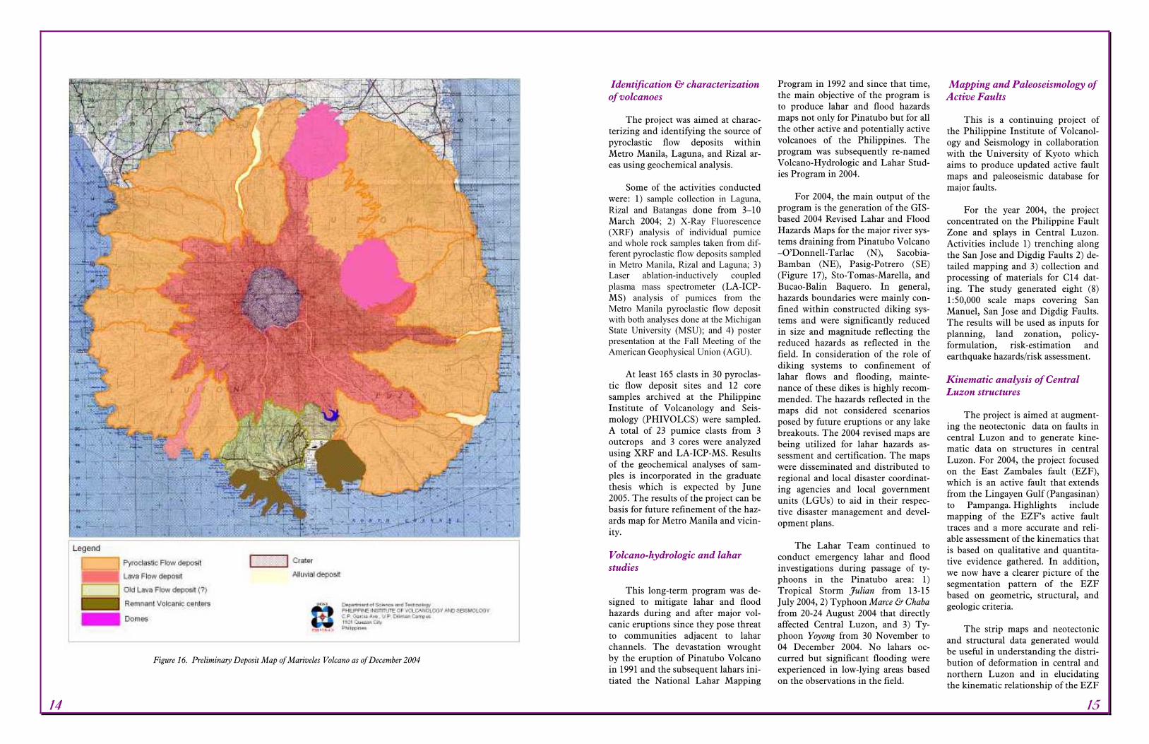
Figure 16. Preliminary Deposit Map of Mariveles Volcano as of December 2004
14 15
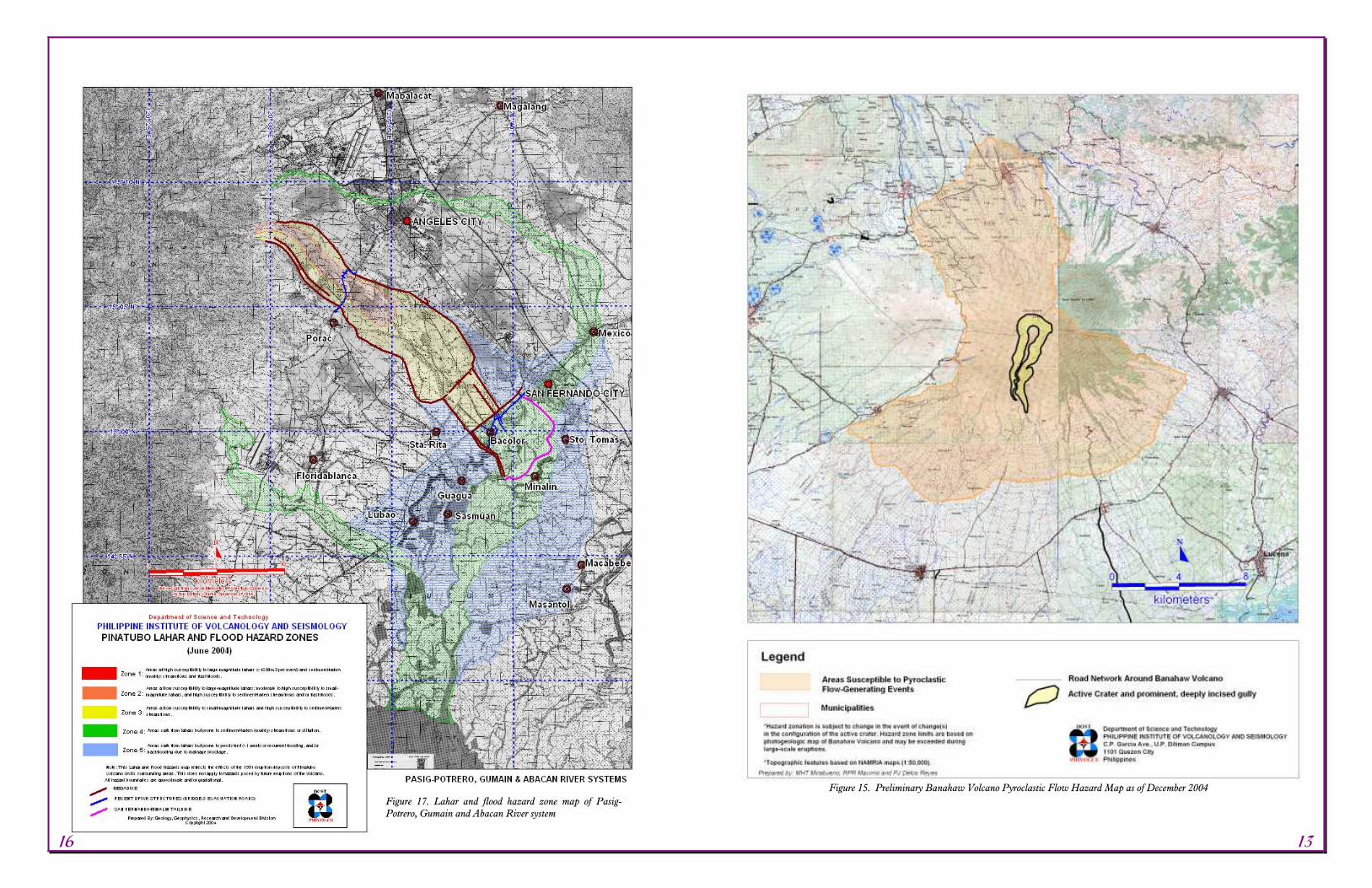
Figure 17. Lahar and flood hazard zone map of Pasig-Potrero, Gumain and Abacan River system
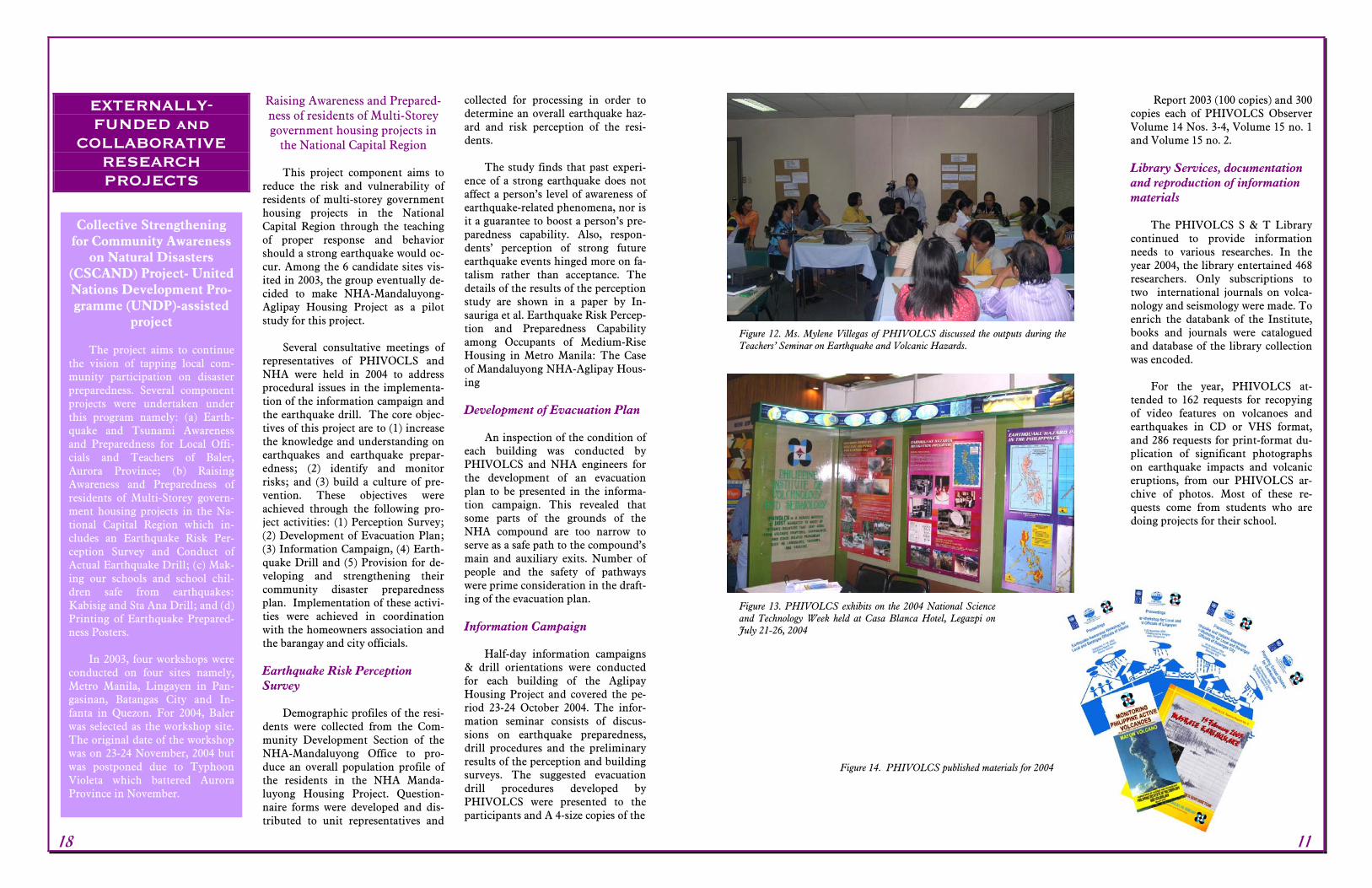
Figure 15. Preliminary Banahaw Volcano Pyroclastic Flow Hazard Map as of December 2004
16 13

INTERNALLY-FUNDED RESEARCH
PROJECTS
Gas Geochemistry of Active Vol-canoes
In year 2004, the frequency of
measurement of S02 emission rate us-ing Correlation Spectrometer or COSPEC was maintained at Mayon Volcano because its status remained hoisted at Alert Level 2. From Janu-ary through December, Sulfur Diox-ide (SO2) flux output persistently re-mained at high levels with values of up to more than 2,500 t/d in June. Sulfur Dioxide (SO2) flux output showed values of >2,000 t/d until early October then decreased to 651 t/d by 15 October 2004. Since then, the SO2 flux output showed values of less than 1,000 t/d until 31 December 2004.
Studies on Water wells and Springs around Mayon Volcano
The water level and/or flow rate
of reference wells and water springs located around Mayon Volcano were periodically measured. But data re-vealed no definite correlation be-tween the on-going volcanic activity to the fluctuations of ground water level.
High Density and wide coverage Seismic Network
The project was focused on in-
creasing the number of remote seis-mic stations established around active volcanoes showing signs of unusual activity such as Mayon and Taal. Ad-ditional remote seismic stations were established around Mayon Volcano between January and June 2004. These consist of Canaway, Manito, Masarawag and Upper Mayon Rest-
house. At Taal, one analog seismo-graph was installed inside the Main Crater Lake to augment the three re-mote seismic stations established un-der the Phase IIB JICA-PHIVOLCS Project.
The establishment of the above
seismic stations at Mayon and Taal, augmented the existing networks of both volcanoes for quality seismic data acquisition leading to the accu-rate location of volcanic earthquakes. The seismic activities of both volca-noes were closely monitored and oc-casionally evaluated all throughout. The project is vital in issuing short and long-term eruption forecasts.
Ground Deformation Studies of Active Volcanoes Mayon Volcano
The electronic tiltmeter located
at the northwest upper slope (Buang) and at MHRO showed a mild and slow positive changes in ground tilts, probably related to new magma intru-sion. Precise leveling surveys con-ducted from May to June and Sep-tember confirmed this finding. Dur-ing the September precise leveling survey, a maximum vertical dis-placement of 5 mm (Buang Line) was detected. Taal Volcano
Precise leveling survey conducted
in November 2004 at Taal Volcano showed an inflation of about 5 mm along Calauit line. Data from meas-urements made at Pira-piraso, the 1965 –1977 Mount Tabaro Eruption Site and Alas-as leveling lines were considered baseline as most of the leveling lines reference points were newly re-established.
Geologic hazards mapping of ac-tive & potentially active volca-noes
The long term goal of this pro-
gram is to identify potential volcanic hazards and generate volcano-geologic maps not only for active vol-canoes in the Philippines but also for the potentially active volcanoes. The deliverables for 2004 are deposit and hazard maps for Banahaw (Figure 15) and Mariveles (Figure 16) volcanoes. Hazards maps prepared will be useful for disaster mitigation and response agencies, land use planning, and guide for policy formulation. Digiti-zation of data using MapInfo facili-tates the updating of hazard maps and easy reproduction.
Some of the activities for the pro-
ject included: 1) digitization of 1:50,000 scale topographic sheets cov-ering Mariveles and Banahaw using MapInfo; 2) hazards analyses and in-terpretation using topographic maps, Landsat 7, and SRTM images, and in-tegration of published data; and 3) volcanic hazard delineation.
Pyroclastic flow, lava flow and
lahar/flooding hazard zones were de-lineated for Banahaw Volcano based on the approximate extent of the his-torical deposits (Figure 15). Delinea-tion of extent for the Mariveles de-posits revealed that they were prod-ucts of explosive and effusive erup-tions as suggested by pyroclastic flow and lava flow deposits. Deposits of pyroclastic flows are far-reaching compared to lava flows.
Other non-targeted accomplish-
ments were: 1) deployment as QRT on the Pinatubo Lake discoloration (January, 2004) with corresponding geologic and geochemical reports; and 2) hazard map of Babuyan Claro.
with the other faults in the region such as the Philippine fault zone (PFZ) and the Valley fault system (VFS). These would lead to under-standing of plate kinematics and ge-ometry of subducting plates and their boundaries, and the style, nature and distribution in space and time of some of the deformation resulting from plate interactions in the Philip-pines. In addition, this project will generate geoscientific data germane to seismic hazard and risk assessment for the central Luzon growth area. In 2005, mapping of the central Luzon structures will continue along the EZF to gather more field evidence.
GPS studies in Southern Leyte
Global Positioning System (GPS)
is a powerful tool in the measurement of crustal deformation and can be used eventually towards the develop-ment of a more comprehensive pro-gram on the evaluation of seismic hazards and risks, an essential com-ponent of earthquake disaster mitiga-tion projects. For 2004, GPS stations were established in Southern Leyte. By expanding the GPS network in this area, the following issues can be resolved: 1) extent of crustal deforma-tion in the overlap zone of the Phil-ippine Fault in the southern end of Leyte, 2) slip rates of the Philippine Fault in this region can be quantified and 3) if indeed this segment has the same behavior as the Masbate seg-ment, the creeping component as well as the movement absorbed by rupture during important earthquakes can be estimated. With these objectives, the GPS team got initial GPS readings from campaign done in November. The results from these readings would hopefully give a quantitative estimates of the slip rates of the Phil-ippine Fault in the Visayas. To com-plement/enhance the existing GPS networks, it is being proposed that construction of another network north of Masbate(Sibuyan-Ragay-Bondoc areas) and expansion of
Southern Leyte network to include the areas in northern Mindanao be included next year.
Tsunami Hazards Awareness and Preparedness Project for Metro Manila
This study aims to identify and
assess the perception and prepared-ness level of the local government units (LGU) of the cities and munici-palities along the coastline of Manila Bay in dealing with tsunamis spawned by offshore or far field earthquakes. The project covered the cities of Las Piñas, Parañaque, Pasay, Manila, Malabon the town of Navo-tas. The research undertakings identi-fies the action taken by LGUs’ on improving their disaster mitigation program and assess the capabilities of government agencies involved in dis-aster management. The key infor-mant survey also provides an oppor-tunity to the Institute’s research team to build communication linkages with the local government offices at the forefront of disaster mitigation. Among the key officials interviewed were the heads and staff of the Social Welfare Development, Health, and Engineering, Disaster Coordinating Councils, Protective Services such as the police and fire fighting services.
Earthquake Risk Perception Study: Laoag City
The Earthquake Risk Perception
Study: Laoag City was undertaken to determine and evaluate the level of earthquake hazards awareness and preparedness of the current barangay officials of Laoag City. It is hoped that the results could be used by the local officials in their Disaster Pre-paredness Plan and for PHIVOLCS to be able to come up with informa-tion campaigns that are most appro-priate for the stakeholders. Key in-formant survey/interview were con-ducted last October 12-14 and De-cember 16-18, 2004. Out of the 80
barangays, 58 (72.5%) were utilized for this study. Most of the respon-dents agree that hazards are caused by nature although they also acknowl-edged that calamities are results of people’s activity. Typhoon, flooding and drought were identified as the top three hazards that frequently af-fect their area and followed closely by earthquake. Hence, preparedness measures undertaken by the respon-dents are geared toward typhoon and flooding. Also, most of the respon-dents do not conduct regular earth-quake drill but they conduct aware-ness and preparedness activities for barangay officials. Seminar or info drive/dissemination was suggested as a means for PHIVOLCS to increase their earthquake awareness and pre-paredness.
R&D Projects
12 17
EXTERNALLY-FUNDED and
COLLABORATIVE RESEARCH PROJECTS
Raising Awareness and Prepared-ness of residents of Multi-Storey government housing projects in
the National Capital Region This project component aims to
reduce the risk and vulnerability of residents of multi-storey government housing projects in the National Capital Region through the teaching of proper response and behavior should a strong earthquake would oc-cur. Among the 6 candidate sites vis-ited in 2003, the group eventually de-cided to make NHA-Mandaluyong-Aglipay Housing Project as a pilot study for this project.
Several consultative meetings of
representatives of PHIVOCLS and NHA were held in 2004 to address procedural issues in the implementa-tion of the information campaign and the earthquake drill. The core objec-tives of this project are to (1) increase the knowledge and understanding on earthquakes and earthquake prepar-edness; (2) identify and monitor risks; and (3) build a culture of pre-vention. These objectives were achieved through the following pro-ject activities: (1) Perception Survey; (2) Development of Evacuation Plan; (3) Information Campaign, (4) Earth-quake Drill and (5) Provision for de-veloping and strengthening their community disaster preparedness plan. Implementation of these activi-ties were achieved in coordination with the homeowners association and the barangay and city officials.
Earthquake Risk Perception Survey
Demographic profiles of the resi-
dents were collected from the Com-munity Development Section of the NHA-Mandaluyong Office to pro-duce an overall population profile of the residents in the NHA Manda-luyong Housing Project. Question-naire forms were developed and dis-tributed to unit representatives and
collected for processing in order to determine an overall earthquake haz-ard and risk perception of the resi-dents.
The study finds that past experi-
ence of a strong earthquake does not affect a person’s level of awareness of earthquake-related phenomena, nor is it a guarantee to boost a person’s pre-paredness capability. Also, respon-dents’ perception of strong future earthquake events hinged more on fa-talism rather than acceptance. The details of the results of the perception study are shown in a paper by In-sauriga et al. Earthquake Risk Percep-tion and Preparedness Capability among Occupants of Medium-Rise Housing in Metro Manila: The Case of Mandaluyong NHA-Aglipay Hous-ing
Development of Evacuation Plan
An inspection of the condition of
each building was conducted by PHIVOLCS and NHA engineers for the development of an evacuation plan to be presented in the informa-tion campaign. This revealed that some parts of the grounds of the NHA compound are too narrow to serve as a safe path to the compound’s main and auxiliary exits. Number of people and the safety of pathways were prime consideration in the draft-ing of the evacuation plan.
Information Campaign
Half-day information campaigns
& drill orientations were conducted for each building of the Aglipay Housing Project and covered the pe-riod 23-24 October 2004. The infor-mation seminar consists of discus-sions on earthquake preparedness, drill procedures and the preliminary results of the perception and building surveys. The suggested evacuation drill procedures developed by PHIVOLCS were presented to the participants and A 4-size copies of the
Report 2003 (100 copies) and 300 copies each of PHIVOLCS Observer Volume 14 Nos. 3-4, Volume 15 no. 1 and Volume 15 no. 2.
Library Services, documentation and reproduction of information materials
The PHIVOLCS S & T Library
continued to provide information needs to various researches. In the year 2004, the library entertained 468 researchers. Only subscriptions to two international journals on volca-nology and seismology were made. To enrich the databank of the Institute, books and journals were catalogued and database of the library collection was encoded.
For the year, PHIVOLCS at-
tended to 162 requests for recopying of video features on volcanoes and earthquakes in CD or VHS format, and 286 requests for print-format du-plication of significant photographs on earthquake impacts and volcanic eruptions, from our PHIVOLCS ar-chive of photos. Most of these re-quests come from students who are doing projects for their school.
Collective Strengthening for Community Awareness
on Natural Disasters (CSCAND) Project- United Nations Development Pro-gramme (UNDP)-assisted
project The project aims to continue
the vision of tapping local com-munity participation on disaster preparedness. Several component projects were undertaken under this program namely: (a) Earth-quake and Tsunami Awareness and Preparedness for Local Offi-cials and Teachers of Baler, Aurora Province; (b) Raising Awareness and Preparedness of residents of Multi-Storey govern-ment housing projects in the Na-tional Capital Region which in-cludes an Earthquake Risk Per-ception Survey and Conduct of Actual Earthquake Drill; (c) Mak-ing our schools and school chil-dren safe from earthquakes: Kabisig and Sta Ana Drill; and (d) Printing of Earthquake Prepared-ness Posters.
In 2003, four workshops were
conducted on four sites namely, Metro Manila, Lingayen in Pan-gasinan, Batangas City and In-fanta in Quezon. For 2004, Baler was selected as the workshop site. The original date of the workshop was on 23-24 November, 2004 but was postponed due to Typhoon Violeta which battered Aurora Province in November.
Figure 14. PHIVOLCS published materials for 2004
Figure 13. PHIVOLCS exhibits on the 2004 National Science and Technology Week held at Casa Blanca Hotel, Legazpi on July 21-26, 2004
Figure 12. Ms. Mylene Villegas of PHIVOLCS discussed the outputs during the Teachers’ Seminar on Earthquake and Volcanic Hazards.
18 11
Seminars/Trainings/ Workshops on Disaster Preparedness: Semi-nar-Workshop for Teachers
A seminar-workshop entitled,
Teachers’ Seminar on Earthquake and Volcanic Hazards was held at the PHIVOLCS Receiving Room on May 26-28, 2004. Thirty two (32) Science and Technology I (high school level) teachers from Metro Manila partici-pated in the seminar-workshop. The workshop was organized to (1) famil-iarize the participants on the defini-
tions, concepts and processes of natu-ral hazards especially those of earth-quakes and volcanic eruptions; and (2) suggest and introduce different methods of teaching natural hazards to high school teachers. The seminar aimed to simplify these earthquake and volcano concepts so that they can be easily taught by high school teach-ers to their students (Figure 12).
Exhibits For the year 2004, two major ex-
hibits were put up: (1) National Sci-ence and Technology Week Exhibit (NSTW) at the Casa Blanca Hotel, Legazpi on 21-26 July 2004 and (2) Permanent Exhibit at Sinait Seismic Station in Ilocos Sur. The exhibit package for Baguio Seismic Station was prepared and finished is ready and awaiting installation. The exhibit group of PHIVOLCS also refurbished the display set at Taal Volcano Buco Station and started the repair and renovation of the Earthquake Simula-tor. In addition, PHHIVOLCS at-tended to 12 requests to use and set up our mobile exhibit set (Figure 13).
Publications
The PHIVOLCS Publication
group produced and printed the fol-lowing new materials: (a) Monitoring Active Volcanoes: Mayon Volcano, 300 copies; (b) PHIVOLCS Special report No. 5- 15 February 2003 Mas-bate Earthquake, 250 copies; (c) Pro-ceedings: Earthquake Awareness Workshop for Local and Barangay Officials of Infanta, 120 copies; (d) Proceedings: Earthquake Awareness Seminar-Workshop for Local and School Officials of Lingayen, 120 copies; (e) Proceedings: Earthquake and Volcano Awareness Seminar-Workshop for Local and Barangay Officials of Batangas City, 120 copies; and (f) Proceedings: Preparing School Children for Earthquakes- Bago Ban-tay Elementary School, 120 copies (Figure 14).
Aside from these, the following
materials were reprinted: (1) Earth-quake and Earthquake Hazards Flyer (300 copies); (2) PHIVOLCS Flyer (300 copies); and (3) What to do be-fore, during and after an earthquake Flyer (300 copies). As a regular un-dertaking, the publication group also produced the PHIVOLCS Annual
evacuation plan were distributed for comments. As an exercise, the par-ticipants were instructed to partici-pate in a building watching exercise
Building Watching Exercise
Half-day hands-on exercise was
conducted for the participants on 23 October for buildings 1 and 2 (AM and PM) and 24 October (Figure 18) for building 3 residents (Table 2). The participants and the workshop organizers were divided into five groups, each with assigned floors and sections of the building grounds. The main task of each group is to identify risk elements in their assigned areas and report their findings in a plenary session. Each group is assisted by a PHIVOLCS representative whose role is not to control the outcome of the exercise but to foster the learning of risk identification. Most of these groups identified and articulated the following as high-risk elements within their assigned area: (a) Some objects inside each housing unit are not fastened or secured properly which may fall or topple if a large
earthquake occurs (e.g. cabinets, ceil-ing fans, television sets, statues in al-tars); (b)Balconies leading to emer-gency exits have been blocked by ap-pliances such as gas stoves and wash-ing machines; (c) Hanging objects such as television antennas, bicycles, strollers, unsecured air-conditioning units are precariously situated outside grilled windows; (d) Cabinets have been built along corridors which may topple and block the way of residents
during an evacuation; (e) Some resi-dents have utilized their doors as for a variety store; and (f) Old furniture, appliances and makeshift tables oc-cupy a significant space along the cor-ridors of the buildings and may hin-der ;
This exercise allowed the partici-
pants to apply in a meaningful and authentic environment the basic con-cepts of preparedness which was lec-tured earlier. The results of this exer-cise provided participants the capac-ity to view their present surroundings and even predict possible outcomes in the event of a large earthquake. The plenary session also provided an ave-nue to negotiate among the partici-pants corrective measures for these problems.
Earthquake Drill
Various activities were conducted
before and during the earthquake drill which was set on 13 November 2004 which include a final pre-drill activity, a mini exhibit, video presen-tation, development of NHA informa-tion kit.
A Final pre-drill activity was
conducted. Two days before the ac-tual earthquake drill, PHIVOLCS representatives went to a unit by unit confirmation of participation to the drill activity in order to determine the number of residents who will par-ticipate. In order to reinforce the in-formation, a mini-exhibit was estab-lished to mainly showcase informa-tion on hazards and earthquake pre-paredness. This exhibit consisted of: (1) Four PHIVOLCS posters on earthquake hazards; (2) Three posters showing photos of previous project activities for each building (informa-tion campaign, building watching ex-ercise, etc.); and (3) One poster show-ing the earthquake evacuation plan.
Kits were distributed to partici-
pants of the activity and consisted of
Table 1. PHIVOLCS LECTURES FOR 2004
Regions Field Stations
No. of lec-tures at-tended/ Station
Total no. of lec-tures
/Region
National Capital Region Main Office, UP Campus
Diliman Q.C. 125 125
Region I Ilocos Pasuquin Seismic Station
Santa Seismic Station 6 1
7
Region II Cagayan Valley Callao Seismic Station Basco Seismic Station
3 0
3
Cordillera Administrative Region Baguio Seismic Station 21 21
Region III Central Luzon Palayan Seismic Station 1 1
Region IV Southern Tagalog
Guinyangan Seismic Station Lucban Seismic Station
Puerto Princesa Seismic Sta-tion
Tagaytay Seismic Station Puerto Galera Seismic Sta-
tion
5 0 2
32 0
39
Region V Bicol Masbate Seismic Station 18 18
Region VI Western Visayas Antique Seismic Station Kalibo Seismic Station Roxas Seismic Station
6 7 11
24
Region VII Central Visayas Lapu-Lapu Seismic Station
Sibulan Seismic Station Tagbilaran Seismic Station
0 4 3
7
Region VIII Eastern Visayas Palo Seismic Station 14 14
Region IX Western Mindanao Dipolog Seismic Station
Zamboanga Seismic Station 1 3
4
Region X Northern Mindanao Davao City Seismic Station
Cagayan Seismic Station 1 6
7
Region XI Southern Mindanao General Santos City Seismic
Station 1 1
Region XII Central Mindanao Kidapawan Seismic Station 5 5
Region XIII Caraga Bislig Seismic Station
Surigao Seismic Station 3 5
8
Autonomous Region of Muslim Mindanao
Cotabato Seismic Sta-tion
7 7
TOTAL 291 291
Table 2. List of numbers of participants on the building
watching exercise
Number of Participants
Date Building Resi-
dents Others
23 Oc-tober 2004 AM
Building 1
43 unit repre-senta-tives
11 PHIVOLCS
5 NHA
PM Building 2
39 unit repre-senta-tives
11 PHIVOLCS
1 NHA
24 Oc-tober 2004
Building 3
33 unit repre-senta-tives
10 PHIVOLCS
1 NHA
Figure 18. Engr. Angelito Lanuza of PHIVOLCS identifying some risk areas in one of the residents in the NHA Aglipay.
10 19
the following: (a) A laminated copy of the earthquake evacuation plan tailor-made for each floor of each building; (b) A heavy glossy paper board ver-sion of the PHIVOLCS earthquake preparedness poster; and (c) Tsunami stickers from the International Tsu-nami Information Center (ITIC).
On the morning of 13 November,
2004, final instructions on the earth-quake evacuation procedures were given to the residents and they were asked to return to their respective housing units. Drill sirens were stra-tegically deployed and were operated at nearly the same time for nearly a minute. Participants of the drill im-plemented the evacuation procedure and converged along the main road at the two exits of building compound.
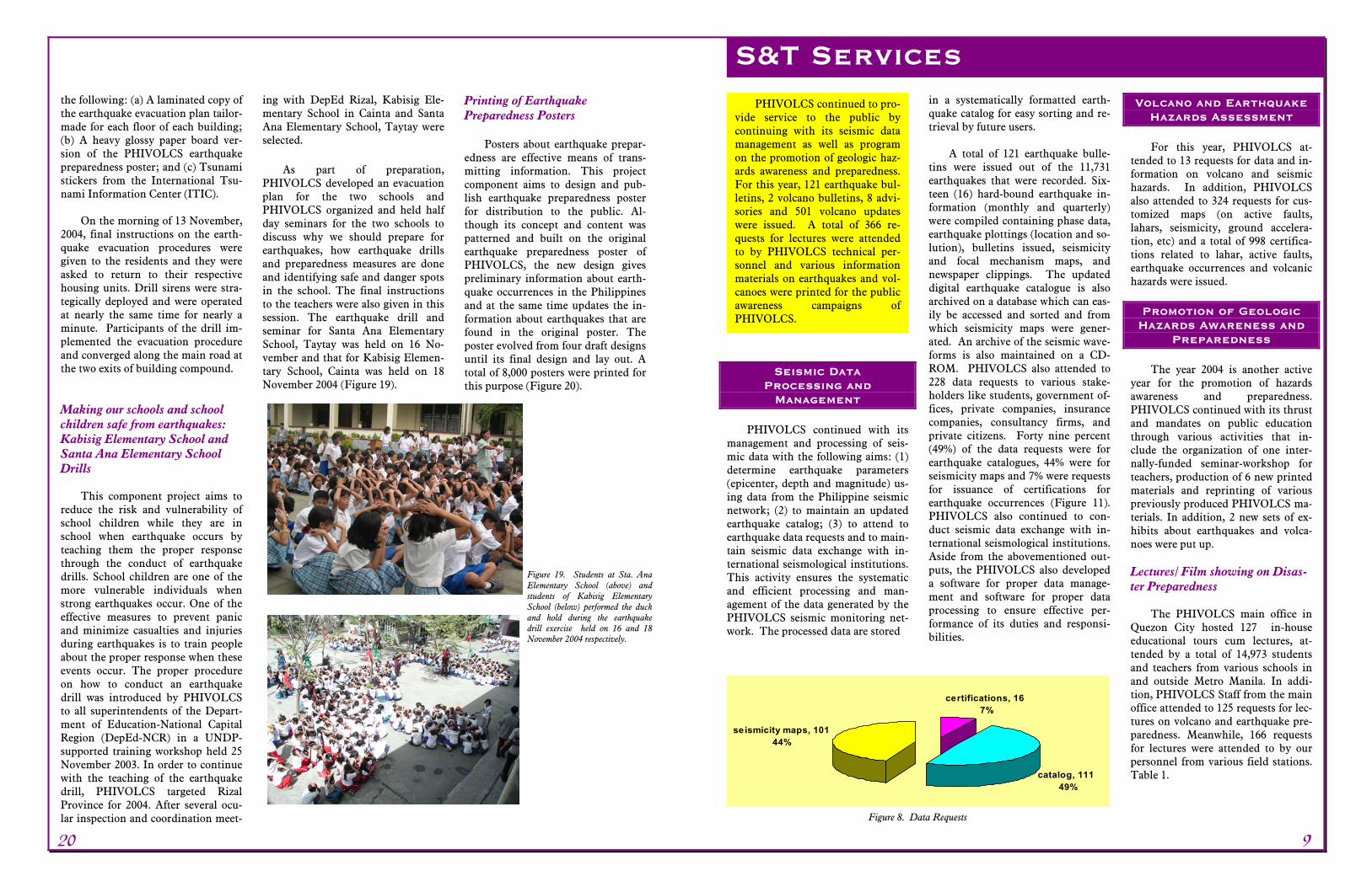
Making our schools and school children safe from earthquakes: Kabisig Elementary School and Santa Ana Elementary School Drills
This component project aims to
reduce the risk and vulnerability of school children while they are in school when earthquake occurs by teaching them the proper response through the conduct of earthquake drills. School children are one of the more vulnerable individuals when strong earthquakes occur. One of the effective measures to prevent panic and minimize casualties and injuries during earthquakes is to train people about the proper response when these events occur. The proper procedure on how to conduct an earthquake drill was introduced by PHIVOLCS to all superintendents of the Depart-ment of Education-National Capital Region (DepEd-NCR) in a UNDP-supported training workshop held 25 November 2003. In order to continue with the teaching of the earthquake drill, PHIVOLCS targeted Rizal Province for 2004. After several ocu-lar inspection and coordination meet-
ing with DepEd Rizal, Kabisig Ele-mentary School in Cainta and Santa Ana Elementary School, Taytay were selected.
As part of preparation,
PHIVOLCS developed an evacuation plan for the two schools and PHIVOLCS organized and held half day seminars for the two schools to discuss why we should prepare for earthquakes, how earthquake drills and preparedness measures are done and identifying safe and danger spots in the school. The final instructions to the teachers were also given in this session. The earthquake drill and seminar for Santa Ana Elementary School, Taytay was held on 16 No-vember and that for Kabisig Elemen-tary School, Cainta was held on 18 November 2004 (Figure 19).
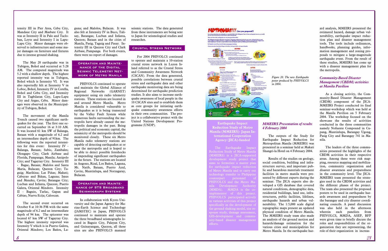
Printing of Earthquake Preparedness Posters
Posters about earthquake prepar-edness are effective means of trans-mitting information. This project component aims to design and pub-lish earthquake preparedness poster for distribution to the public. Al-though its concept and content was patterned and built on the original earthquake preparedness poster of PHIVOLCS, the new design gives preliminary information about earth-quake occurrences in the Philippines and at the same time updates the in-formation about earthquakes that are found in the original poster. The poster evolved from four draft designs until its final design and lay out. A total of 8,000 posters were printed for this purpose (Figure 20).
Seismic Data Processing and
Management PHIVOLCS continued with its
management and processing of seis-mic data with the following aims: (1) determine earthquake parameters (epicenter, depth and magnitude) us-ing data from the Philippine seismic network; (2) to maintain an updated earthquake catalog; (3) to attend to earthquake data requests and to main-tain seismic data exchange with in-ternational seismological institutions. This activity ensures the systematic and efficient processing and man-agement of the data generated by the PHIVOLCS seismic monitoring net-work. The processed data are stored
in a systematically formatted earth-quake catalog for easy sorting and re-trieval by future users.
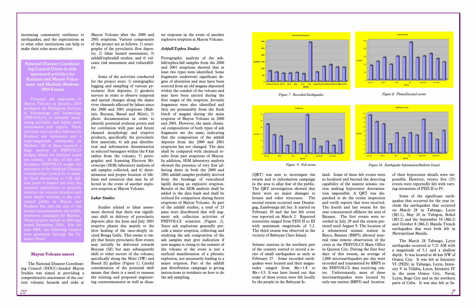
A total of 121 earthquake bulle-
tins were issued out of the 11,731 earthquakes that were recorded. Six-teen (16) hard-bound earthquake in-formation (monthly and quarterly) were compiled containing phase data, earthquake plottings (location and so-lution), bulletins issued, seismicity and focal mechanism maps, and newspaper clippings. The updated digital earthquake catalogue is also archived on a database which can eas-ily be accessed and sorted and from which seismicity maps were gener-ated. An archive of the seismic wave-forms is also maintained on a CD-ROM. PHIVOLCS also attended to 228 data requests to various stake-holders like students, government of-fices, private companies, insurance companies, consultancy firms, and private citizens. Forty nine percent (49%) of the data requests were for earthquake catalogues, 44% were for seismicity maps and 7% were requests for issuance of certifications for earthquake occurrences (Figure 11). PHIVOLCS also continued to con-duct seismic data exchange with in-ternational seismological institutions. Aside from the abovementioned out-puts, the PHIVOLCS also developed a software for proper data manage-ment and software for proper data processing to ensure effective per-formance of its duties and responsi-bilities.
Volcano and Earthquake Hazards Assessment For this year, PHIVOLCS at-
tended to 13 requests for data and in-formation on volcano and seismic hazards. In addition, PHIVOLCS also attended to 324 requests for cus-tomized maps (on active faults, lahars, seismicity, ground accelera-tion, etc) and a total of 998 certifica-tions related to lahar, active faults, earthquake occurrences and volcanic hazards were issued.
Promotion of Geologic Hazards Awareness and
Preparedness The year 2004 is another active
year for the promotion of hazards awareness and preparedness. PHIVOLCS continued with its thrust and mandates on public education through various activities that in-clude the organization of one inter-nally-funded seminar-workshop for teachers, production of 6 new printed materials and reprinting of various previously produced PHIVOLCS ma-terials. In addition, 2 new sets of ex-hibits about earthquakes and volca-noes were put up.
Lectures/ Film showing on Disas-ter Preparedness
The PHIVOLCS main office in
Quezon City hosted 127 in-house educational tours cum lectures, at-tended by a total of 14,973 students and teachers from various schools in and outside Metro Manila. In addi-tion, PHIVOLCS Staff from the main office attended to 125 requests for lec-tures on volcano and earthquake pre-paredness. Meanwhile, 166 requests for lectures were attended to by our personnel from various field stations. Table 1.
Figure 19. Students at Sta. Ana Elementary School (above) and students of Kabisig Elementary School (below) performed the duck and hold during the earthquake drill exercise held on 16 and 18 November 2004 respectively.
S&T Services PHIVOLCS continued to pro-
vide service to the public by continuing with its seismic data management as well as program on the promotion of geologic haz-ards awareness and preparedness. For this year, 121 earthquake bul-letins, 2 volcano bulletins, 8 advi-sories and 501 volcano updates were issued. A total of 366 re-quests for lectures were attended to by PHIVOLCS technical per-sonnel and various information materials on earthquakes and vol-canoes were printed for the public awareness campaigns of PHIVOLCS.
catalog, 111 49%
certifications, 16 7%
seismicity maps, 101 44%
Figure 8. Data Requests
20 9
tensity III in Pier Area, Cebu City, Mandaue City and Masbate City. It was at Intensity II in Palo and Taclo-ban, Leyte and Intensity I in Lapu-Lapu City. Minor damages were ob-served to infrastructure and some ma-jor damages on furniture and fixtures due to intense ground shaking.
The May 20 earthquake was in
Tubigon, Bohol and occurred at 5:28 AM. The computed magnitude was 5.2 with a shallow depth. The highest reported intensity was in Tubigon, Bohol which is Intensity VI. It was also reportedly felt at Intensity V in Loboc, Bohol, Intensity IV in Corella, Bohol and Cebu City, and Intensity III in Tagbilaran City, Lapu-Lapu City and Argao, Cebu. Minor dam-ages were observed in the Municipal-ity of Tubigon, Bohol.
The movement of the Manila
Trench caused two significant earth-quakes for the year. The first one oc-curred on September 16 at 3:10 AM. It was located 61 km SW of Balanga, Bataan with a magnitude of 6.2 and an intermediate depth of 91km. The following were the reported intensi-ties for this event: Intensity IV - Balanga, Bataan; Subic, Zambales; Olongapo City; Clark Airbase and Florida, Pampanga; Manila; Antipolo City; and Tagaytay City. Intensity III - Bagac, Bataan; Malolos and Santa Maria, Bulacan; Quezon City; Ta-guig; Marikina; Las Piñas; Makati; Cabuyao and Biñan, Laguna; Imus and Mendez, Cavite; Batangas City; Lucban and Infanta, Quezon; Puerto Galera, Oriental Mindoro. Intensity II - Baguio, Tarlac, Gapan and Cabiao, Nueva Ecija; Caloocan.
The second event occurred on
October 8 at 10:36 PM with the same magnitude of 6.2 and an intermediate depth of 94 km. The epicenter was located 67 km SW of Tagaytay City. The highest intensity reported was Intensity V which is in Puerto Galera, Oriental Mindoro; Los Baños, La-
guna; and Malolos, Bulacan. It was also felt at Intensity IV in Buco, Tali-say, Batangas; Lucban and Infanta, Quezon; Bataan and in the cities of Manila, Pasig, Taguig and Pasay. In-tensity III in Quezon City and Clark Airbase, Pampanga. For both events, there were no report of damages.
Operation and Mainte-nance of the Digital
Seismic Telemetry Net-work of Metro Manila
PHIVOLCS continued to operate
and maintain the Global Alliance of Regional Networks (GARNET) equipment using six radio telemetry stations. These stations are located in and around Metro Manila. Metro Manila is considered vulnerable to earthquakes as it is being transected by the Valley Fault System while numerous faults surrounding the me-tropolis have already caused the me-tropolis damages in the past. Being the political and economic capital, the seismicity of the metropolis should be monitored closely. These six Metro Manila radio telemetry stations are capable of detecting earthquakes at or near the metropolis and is hoped to be able to detect possible foreshocks of impending significant earthquakes in the future. The stations are located in Angono, Rizal, Los Baños, Laguna, Mt. Natib, Bataan, Puerto Azul, Cavite, Muntinlupa, and Norzagaray, Bulacan.
Operation and Mainte-
nance of STS Broadband Seismograph Systems In collaboration with Kyoto Uni-
versity and the Japan Agency for Ma-rine-Earth Science and Technology (JAMSTEC) in Japan, PHIVOLCS continued to maintain and operate the three broadband seismographs lo-cated in Baguio City, Palayan City, and Guinayangan, Quezon, all these sites are also PHIVOLCS manned
seismic stations. The data generated from these instruments are being sent to Japan for seismological studies and researches.
Crustal Stress Network
For 2004 PHIVOLCS continued
to operate and maintain a 10-station crustal stress network in Luzon Is-land referred to as the Crustal Stress and Community Awareness Network (CSCAN). From the data generated, possible correlations between crustal stress and earthquake data and other earthquake monitoring data are being determined for earthquake prediction studies. It also aims to increase earth-quake awareness of local people in the 10 CSCAN sites and to establish them as core groups for initiating earth-quake community awareness efforts in their own communities. The pro-ject is a collaborative project with the United Nations Development Pro-gramme (UNDP).
MMEIRS Presentation of results 4 February 2004
The outputs of the Study for
Earthquake Impact Reduction for Metropolitan Manila (MMEIRS) was presented in a seminar held at Makati Shangri-la Hotel on 4 February 2004.
Results of the studies on geology,
social condition, building and infra-structure survey, and important pub-lic and hazardous materials treatment facilities in metro manila were pre-sented by different experts during the seminar. The JICA experts also de-veloped a GIS database that covered natural conditions, demographic data, residential buildings, land use, infra-structures, public facilities, lifelines, earthquake hazards and urban vul-nerability. The 1:5,000 scale digital topographic maps present an updated physical condition of Metro Manila. The MMEIRS study team also made an analysis of the ground motion and hazards/damage estimation for the various cities and municipalities for Metro Manila. In the earthquake haz-
ard analysis, MMEIRS presented the estimated hazard, damage urban vul-nerability, earthquake impact reduc-tion plan and disaster management tools. The tools include ordinances, handbooks, planning guides, infor-mation management and zoning pro-posals to mitigate a large-magnitude earthquake event. From the result of these studies, MMEIRS has come up with a disaster management plan for the metropolis.
Community-Based Disaster Management (CBDM) activities at Manila Pavilion
As a closing activity, the Com-
munity-Based Disaster Management (CBDM) component of the JICA-MMEIRS Project conducted its final seminar-workshop which was held at the Manila Pavilion on 5 February 2004. The workshop focused on the showcase the results of activities conducted in the three communities namely Nofuente Compound in Cu-pang, Muntinlupa, Barangay Ugong, Pasig City and Barangay 741 in Ma-nila.
The leaders of the three commu-
nities presented the highlights of the CBDM activities in their respective areas. Among these were risk map-ping, resource mapping and mobiliza-tion, community organization and disaster awareness and preparedness in the community level. The JICA-MMEIRS team presented the strate-gies used in the CBDM activities and the different phases of the project. The team also presented the proposed posters to be used in earthquake haz-ards awareness and preparedness by the barangay and city disaster coordi-nating councils. A panel discussion was also held in the afternoon wherein each panelists from PHIVOLCS, MMDA, ASEP, BFP were given time to briefly discuss the roles and responsibilities of the or-ganization they are representing, the role of their organization in increas-
Earthquake Impact Reduction Study of Metro
Manila (MMEIRS)- Japan In-ternational Cooperation Agency (JICA)-funded The Earthquake Impact
Reduction Study of Metro Manila (MMEIRS) is a JICA-supported development study project that aims to formulate a master plan for earthquake impact reduction of Metro Manila and to carry out technology transfer to Philippine counterpart personnel of PHIVOLCS and the Metro Ma-nila Development Authority (MMDA). MMDA is the co-implementor of this project. PHIVOLCS participated actively in various activities of this project specifically in the development of the ground shaking model, site re-sponse study, damage assessment, GIS-development and commu-nity-based disaster management efforts.
Figure 20. The new Earthquake poster produced by PHIVOLCS in 2004.
8 21
increasing community resilience to earthquakes, and the expectations as to what other institutions can help to make their roles more effective.
Mayon Volcano unrest The National Disaster Coordinat-
ing Council (NDCC)-funded Mayon Studies was aimed at providing a comprehensive assessment of the cur-rent volcanic hazards and risks at
Mayon Volcano after the 2000 and 2001 eruptions. Various components of the project are as follows: 1) strati-graphy of the pyroclastic flow depos-its; 2) lahar hazard assessment; 3) ashfall/tephrafall studies; and 4) vol-canic risk assessment and vulnerabil-ity.
Some of the activities conducted
for the project were: 1) stratigraphic logging and sampling of various py-roclastic flow deposits; 2) geodetic surveys in order to observe temporal and spatial changes along the major river channels affected by lahars since the 2000 and 2001 eruptions (Mab-init, Buyuan, Basud and Miisi); 3) photo documentation in order to identify potential avulsion points and for correlation with past and future channel morphology and eruptive products, specifically the pyroclastic flow materials; 4) ash pan distribu-tion and information dissemination in selected barangays within the 8 km radius from the volcano; 5) petro-graphic and Scanning Electron Mi-croscope (SEM) laboratory analyses of ash samples collected, and 6) deter-mination and proper location of life-lines and resources that may be af-fected in the event of another explo-sive eruption at Mayon Volcano. Lahar Studies
Studies related to lahar assess-
ment showed that there was signifi-cant shift in delivery of pyroclastic deposits after the June and July 2001 eruptive phases due mainly to the slow healing of the once-deeply in-cised Bonga Gully. This seems to im-ply that future pyroclastic flow events may initially be delivered towards Buyuan (SE) but may subsequently shift to other sectors of the volcano, specifically along the Miisi (SW) and Basud (E) gullies (Figure 1). Careful consideration of the potential shift means that there is a need to reassess the existing and proposed engineer-ing countermeasures as well as disas-
ter response in the event of another explosive eruption at Mayon Volcano. Ashfall/Tephra Studies
Petrographic analysis of the ash-fall/tephra-fall samples from the 2000 and 2001 eruptions showed that at least two types were identified. Some fragments underwent significant de-gree of alteration and may have been sourced from an old magma deposited within the conduit of the volcano and may have been ejected during the first stages of the eruption. Juvenile fragments were also identified and they are presumably from the fresh batch of magma during the main eruption of Mayon Volcano in 2000 and 2001. However, the main chemi-cal compositions of both types of ash fragments are the same, indicating that the composition of the ashfall deposits from the 2000 and 2001 eruptions has not changed. The data shall be compared with chemical re-sults from past eruptions of Mayon. In addition, SEM laboratory analysis showed the presence of very fine ad-hering dusts in both the 2000 and 2001 ashfall samples probably derived from the breakage of vesiculated lapilli during an explosive eruption. Results of the SEM analysis shall be added to the data bank and shall be utilized for comparison during future eruptions of Mayon Volcano. As part of the ashfall studies, a total of 23 pans were distributed that will aug-ment ash collection activities of PHIVOLCS scientists (Figure 2). Since ash explosions generally pre-cede a major eruption, collecting and studying the ash composition of the ash samples may give indication if new magma is rising to the summit of the volcano or the event is just a surficial manifestation of a phreatic explosion, not necessarily leading to a major eruption. Part of the ashfall pan distribution campaign is giving instructions to residents on how to do the ash sampling.
(QRT) was sent to investigate the swarm and to information campaign in the area to allay fear of the public. The QRT investigation showed that there were no major damages to houses and other structures. The second swarm occurred near Dumin-gag, Zamboanga del Sur. It started on February 20 and the last felt event was reported on March 2. Reported intensities ranged from PEIS II to III with maximum magnitude of 5.2. The third swarm was observed in the vicinity of Babuyan Claro Island.
Seismic stations in the northern part of the country started to record a se-ries of small earthquakes as early as February 27. Some recorded earth-quakes were located and their magni-tudes ranged from Ms=1.8 to Ms=3.5. It was later found out that some of these events were felt locally by the people in the Babuyan Is-
land. Some of these felt events were so localized and beyond the detecting capability of the nearest seismic sta-tion making hypocenter determina-tion impossible. A QRT was dis-patched to do the ocular inspection and verify reports that were received. The fourth and last swarm for the year concentrated offshore the area of Batanes. The first events were re-corded in July 29 and the swarm per-sisted until August 9. The location of a telemetered seismic station in Basco, Batanes (BBPS) allowed near-real time remote observation of the crisis at the PHIVOLCS Main Office in Quezon City. During the first four days of this swarm, an average of 1,000 microearthquakes per day were recorded and transmitted by BBPS to the PHIVOLCS data receiving cen-ter. Unfortunately, most of these microearthquakes were located by only one station (BBPS) and location
of their hypocenter details were im-possible. However, twenty five (25) events were reportedly felt with vary-ing intensities of PEIS II to IV.
Some of the significant earth-quakes that occurred for the year in-clude the earthquakes that occurred on March 28 in Tabango, Leyte (M5.1), May 20 in Tubigon, Bohol (M5.2) and the September 16 (M6.2) and October 8 (M6.2) Manila Trench earthquakes that were both felt in Metropolitan Manila.
The March 28 Tabango, Leyte earthquake occurred at 7:21 AM with a magnitude of 5.1 and a shallow depth. It was located at 46 km NW of Ormoc City. It was felt at Intensity VI (PEIS) in Tabango, Leyte, Inten-sity V in Villaba, Leyte, Intensity IV in the areas Ormoc City, Naval, Leyte, Bogo City and in the northern parts of Cebu. It was also felt at In-
National Disaster Coordinat-ing Council Grant-in-Aid-
sponsored activities for Kanlaon and Mayon Volca-noes and Masbate Masbate
2004 Forum Frequent ash explosions in
Mayon Volcano in January, 2003 prompted the Philippine Institute of Volcanology and Seismology (PHIVOLCS) to intensify moni-toring activities, and deploy more instruments and experts. These activities were quickly followed by Kanlaon ash explosions and a large-magnitude earthquake in Masbate. All of these required a large portion of PHIVOLCS budget, which the Institute could not sustain. In lieu of this pre-dicament, PHIVOLCS sought the assistance of the National Disaster Coordinating Council for a calam-ity fund amounting to 5.28 mil-lion pesos to finance not only the required expenditure to properly monitor the volcanic situation and issue timely warning to the con-cerned public in Mayon and Kanlaon but also the cost of the needed documentation and public awareness campaigns for Masbate. These projects started in 2003 and ended December, 2004. For the year 2004, the following outputs were generated through the Ca-lamity Fund:
769667
580 597 645557
2870
681
10871222
1037 1019
0
500
1000
1500
2000
2500
3000
number
January February March April May June July AugustSeptem berOctoberNovem berDecem ber
Month
Recorded Earthquakes
Figure 7. Recorded Earthquakes
22
1413
6
9
7
29
11
5
9
6
10
0
5
10
15
20
25
30
num ber
January March May July September November
Month
Felt Events
Figure 9. Felt events
90
115
140
97
147 143
235
139149
164
132
111
0
50
100
150
200
250
number
January March May July September November
Month
Plotted Events
Figure 8. Plotted/located events
17
1413
4
9
7
98
15
9
6
10
0
2
4
6
8
10
12
14
16
18
num ber
January March May July September November
Month
Bulletins Issued
Figure 10. Earthquake Information/Bulletin Issued
22 7
targets of this section are the 1) de-termination of earthquake parameters (hypocenter, magnitude) using data from the Philippine Seismic Net-work; 2) maintenance of updated earthquake catalogue and production of seismicity maps; 3) provision of earthquake data to various stake-holders; and 4) maintenance of seis-mic data exchange with international seismological institutions.
Guided by the abovementioned
targets, the Section’s outputs in-cluded the 1) determination of earth-quake parameters, 2) production of earthquake catalogues, 3) assistance to public request for earthquake data, and 4) data exchange with interna-tional organizations. A total of 11,731 earthquakes were recorded (Figure 6, 7) of which 1,662 were located (Figure 8). For year 2004, there were 141 events felt by the populace (Fig-ure 9). A total of 121 earthquake in-formation/bulletins were issued (Fig-ure 10). Lastly, the section continued its efforts in exchanging seismic data with other national and international seismological institutions such as the NEIC, JMA, ISC and CTBTO. Aside from the abovementioned outputs, the Section also developed software and several routines for proper data management and more efficient automated data processing to ensure effective performance of its duties and responsibilities.
Seismic Swarms
Four (4) different areas in the
country experienced seismic swarms for the year 2004. The first swarm was offshore in the vicinity of Anini-y, Antique. The swarm possibly started in October 2003 and culmi-nated in a series of felt earthquakes from January 11-22, alarming the public. The located earthquakes had magnitudes that ranged from Ms=2.4 to Ms=4.2 while the felt events were felt at intensities from PEIS II to PEIS V. A Quick Response Team
Stratigraphic studies Field survey was focused at Bu-
yuan and Mabinit Gullies because they represent the most complete stratigraphy of the 2000-2001 erup-tion. The thickest measured 2000 de-posit that formed at the banks of the gullies was as much as 30 meters. In contrast, most of the pyroclastic flows deposited at the base of the gullies were already eroded by lahars. What remained were thin (0.3m) overbank deposits overlying the 2000 deposit. The low preservation potential of the 2001 deposits was mainly due to the high erosion rates prevailing at Bu-yuan and Mabinit due to steep slope and high infiltration rates of the de-posits.
The 2000 deposits consist of
varying flow units;1) block-and-ash unit composed of large juvenile basal-tic andesite cauliflower bombs and minor lava blocks, 2) pinkish gray block-and ash unit in fines-depleted matrix, and 3) lithic-rich block-and-ash unit consisting of lithic andesite, juvenile bombs and small old reddish scoria. Component and grain size analyses suggest that the 2000 depos-its were produced by alternating eruption column collapse and col-lapse of over-steepened ramparts that formed from lava fountaining and ag-glutination. Stratigraphic studies of the pyroclastic flow deposits can pro-vide a clue to the approximate volume of deposits that can be emplaced by a particular event as viewed during the eruptive events in 2000 and 2001. The correlation of visual observation, stratigraphic study of the emplaced deposits, and the seismic signatures of the pyroclastic flow events ob-served in the field is being done in order to identify some form of cali-bration for the said events. Risk Assessment studies
A GIS database was prepared as a
tool for risk assessment at Mayon
Figure 5. The new PHIVOLCS Sinait Seismic Station
Figure 3. Recorded Earthquakes
Figure 6. Seismicity of the Philippines for year 2004
Figure 21. With slow healing of the once deeply incised notch along the Bonga Gully, avul-sion/delivery of future eruptive deposits towards east along the watershed area of Basud Channel (direction indicated by red arrow) and towards the southwest along Miisi (direction indicated by blue arrow) Channel.
Figure 22. Distribution of ash collection pans in Mayon Volcano and vicinity. A total of 23 pans are now emplaced since the campaign was initiated October 2003. (Landsat image used courtesy of HIGP-University of Hawaii)
6 23
Volcano. Both graphic and tabular data were collected from each mu-nicipalities and concerned govern-ment agencies. Most of the informa-tion were in paper format. They were subsequently processed and inte-grated into the GIS database. Popula-tion centers were identified using sta-tistical data from the National Statis-tics Office (NSO) and population density map was created. Overlaying these data with the existing hazard maps would show risk areas. Various elements-at-risks such as infrastruc-ture and lifeline were identified and plotted using a handheld GPS and basic GIS data manipulation. Significance/Impact of accomplishments
The results of the four compo-
nents of the Mayon Studies can be utilized for Disaster Management, Disaster Response/Community Pre-paredness, and lastly, for Long-term Land Use Planning. When hazard prone areas are identified through hazard maps, the local and national government agencies tasked to pro-vide structural countermeasures may be better prepared and proper priori-tization may be done considering the present fiscal crisis. Furthermore, the output of the studies may be utilized for prioritization of preparation for emergencies (non-structural) related to impending eruption and subse-quent lahars.
Kanlaon Studies
Ashfall/Tephra Studies
Characterization of ashfall depos-
its of Kanlaon Volcano is one of the main objectives of the project under the Calamity Fund Program for the year 2004.
Samples obtained from the field
during episodes of unrest in 2003 were analyzed using several tech-niques. The first one is that all sam-
ples were mounted on a glass slide. The primary aim of this method is to separate/identify juvenile fragments from lithic fragments using binocular microscope. Presence of juvenile fragments may indicate that new ma-terials are about to get erupted and there has been magma involved in the current state of the volcano’s unrest. The second technique that was used is the Scanning Electron Microscopy (SEM). This method aims to provide image of each of the particles of ash from the bulk sample. SEM image presents the morphology of the indi-vidual grains. Morphology of ashfall deposits may point to the kind of eruption that may occur in the future. Ashfall deposits are best placed into two broad genetic categories: mag-matic and phreatomagmatic. Ashes from magmatic eruptions are formed when expanding gases in the magma form a froth that loses its coherence as it approaches the ground surface. During phreatomagmatic eruptions, the magma is chilled and fractured on contact with ground or surface wa-ters, resulting in violent steam erup-tions. Lastly, the samples were ana-lyzed using petrographic microscope. This method further suggests whether fresh magma is playing a vi-tal role in the volcanic unrest. The presence of certain minerals in the samples can tell if the volcano is about to erupt new batch of magma.
Three samples from Kanlaon
Volcano have been analyzed using these techniques. Megascopically, these samples do not have any signifi-cant difference. The color of the sam-ples was from gray to dark gray, and it shows an almost uniform grain size. With the aid of binocular microscope, the samples showed very variable composition. Most of the grains were coated with very fine adhering dust that makes it difficult to tell whether the fragment is juvenile or lithic. Fur-ther analyses suggest that these are not juvenile fragments, but rather lithic fragments from an old magma
residing within the conduit of the volcano. This is supported by the SEM images that were taken on each of the samples. Petrography of the samples showed that the mineral as-semblages present have undergone considerable alterations. Most of the minerals in the samples show re-sorbed textures. Bounding edges of the minerals were slowly being al-tered by clay minerals or calcite. These kinds of alteration should not be observed if the samples are rela-tively fresh, therefore the unrest in 2003 can be attributed to phreatic ac-tivity or episode of the volcano.
A future study of the samples in-
cludes the analysis of major and trace elements of the ash samples from Kanlaon Volcano with the use of the newly acquired X-Ray Fluorescence machine.
Volcanic Risk Assessment
The concept of risk involves a)
the existence of danger or hazard; and b) the existence of human and non-human elements being affected by the hazard itself or its consequence. If there exists a relationship between these two factors then there is a risk that can be discussed. There is data on hazard and volcanic deposit extent of Kanlaon Volcano available in PHIVOLCS, delineation of which is mapped using the NAMRIA 1:50,000 topographic maps and the boundary maps from the local planning offices. The map information were digitally converted and maintained using the Canvas software. The other type of data needed for the risk assessment is the socio-economic data, which is found in the Negros Occidental Pro-vincial Socio-Economic Profile. These data include population and infrastructure like roads, bridges, etc. Almost all of these profiles are in tabular form listed per municipality. There exists a georeferenced layer of the municipal boundaries, which
Seismic Observation and Network Maintenance
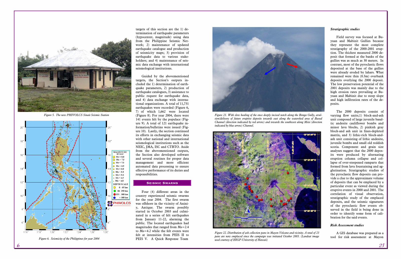
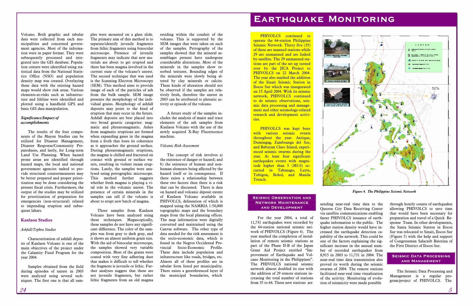
and Development For the year 2004, a total of
11,731 earthquakes were recorded by the 64-station national seismic net-work of PHIVOLCS (Figure 4). The year marked the completion of instal-lation of remote seismic stations as part of the Phase II-B of the Japan Grant Aid Project entitled “Im-provement of Earthquake and Vol-cano Monitoring in the Philippines”. The PHIVOLCS national seismic network almost doubled its size with the addition of 29 remote stations in-creasing the total number of stations from 35 to 64. These new stations are
sending near-real time data to the Quezon City Data Receiving Center via satellite communications enabling faster PHIVOLCS issuance of earth-quake information to the public. The higher station density would have in-creased the earthquake detection ca-pability of the network. This could be one of the factors explaining the sig-nificant increase in the annual num-ber of recorded earthquakes from 8,915 in 2003 to 11,731 in 2004. The near-real time data transmission also proved its worth during the seismic swarms of 2004. The remote stations facilitated near-real time visualization of the activity. Monitoring of evolu-tion of seismicity were made possible
through hourly counts of earthquakes allowing PHIVOLCS to save time that would have been necessary for preparation and travel of a Quick Re- sponse Team. In other developments, the Santa Seismic Station in Ilocos Sur was relocated to Sinait, Ilocos Sur (Figure 5) with the help and support of Congressman Salacnib Baterina of the First District of Ilocos Sur. Seismic Data Processing
and Management The Seismic Data Processing and
Management is a regular pro-gram/project of PHIVOLCS. The
Earthquake Monitoring
Figure 4. The Philippine Seismic Network
24 5
PHIVOLCS continued to operate the 64-station Philippine Seismic Network. Thirty five (35) of these are manned stations while 29 are unmanned and are linked by satellite. The 29 unmanned sta-tions are part of the set up turned over by the JICA Project to PHIVOLCS on 22 March 2004. The year also marked the addition of the Sinait Seismic Station in Ilocos Sur which was inaugurated on 15 April 2004. With its seismic network, PHIVOLCS continued to do seismic observations, seis-mic data processing and manage-ment and other seismology-related research and development activi-ties.
PHIVOLCS was kept busy
with various seismic events throughout the year. Antique, Dumingag, Zamboanga del Sur, and Babuyan Claro Island, experi-enced seismic swarms during the year. At least four significant earthquakes events with magni-tude higher than 5 (M5.0) oc-curred in Tabanago, Leyte, Tubigon, Bohol, and Manila Trench.
Pinatubo Volcano Pinatubo Volcano was quiet
throughout 2004. Volcanic earth-quakes rarely occurred and steam emission from the summit caldera was not observed. No significant lahar flow event was also detected or reported.
Water discoloration of Pinatubo Cra-ter Lake
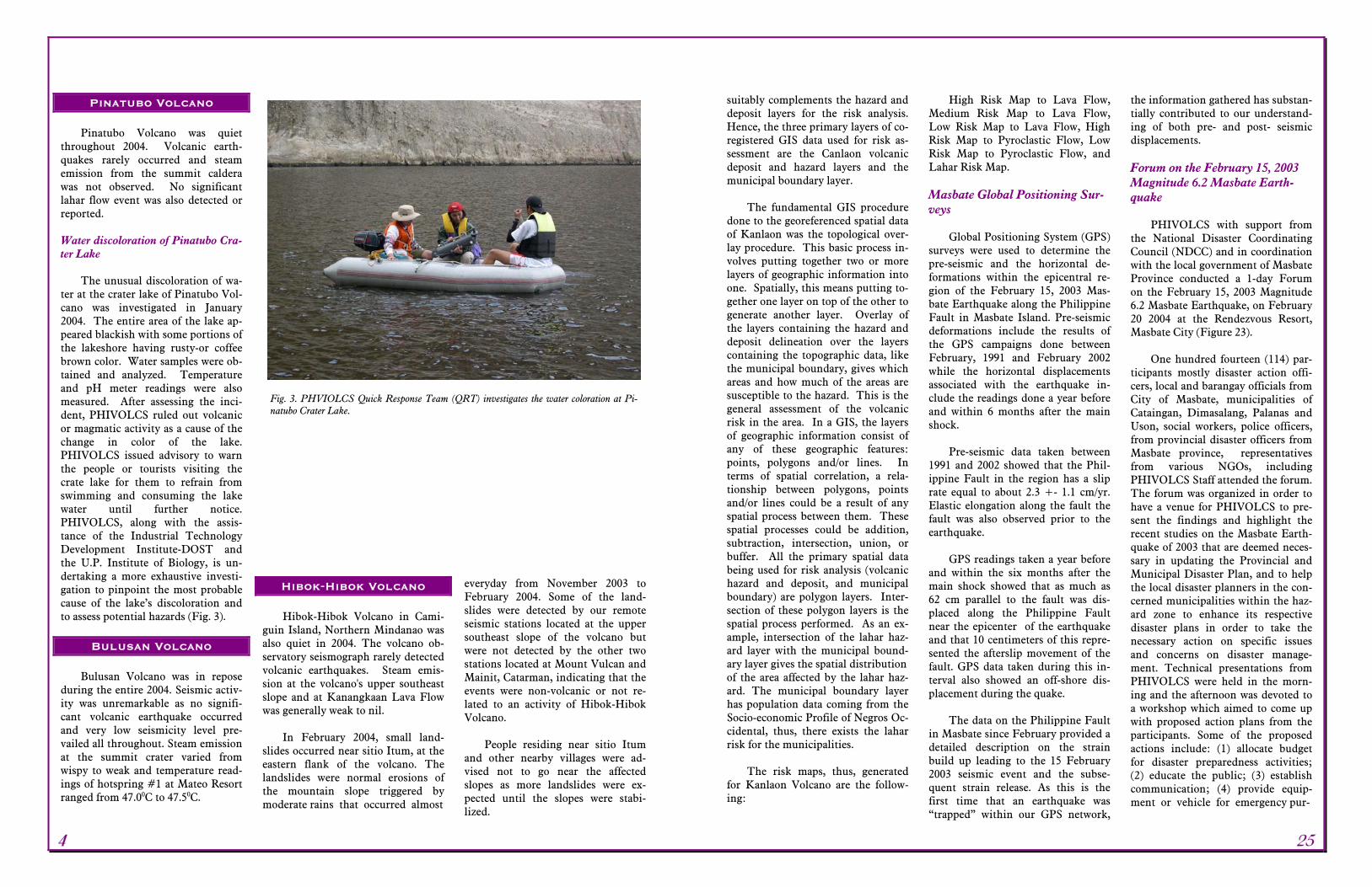
The unusual discoloration of wa-
ter at the crater lake of Pinatubo Vol-cano was investigated in January 2004. The entire area of the lake ap-peared blackish with some portions of the lakeshore having rusty-or coffee brown color. Water samples were ob-tained and analyzed. Temperature and pH meter readings were also measured. After assessing the inci-dent, PHIVOLCS ruled out volcanic or magmatic activity as a cause of the change in color of the lake. PHIVOLCS issued advisory to warn the people or tourists visiting the crate lake for them to refrain from swimming and consuming the lake water until further notice. PHIVOLCS, along with the assis-tance of the Industrial Technology Development Institute-DOST and the U.P. Institute of Biology, is un-dertaking a more exhaustive investi-gation to pinpoint the most probable cause of the lake’s discoloration and to assess potential hazards (Fig. 3).
Bulusan Volcano
Bulusan Volcano was in repose
during the entire 2004. Seismic activ-ity was unremarkable as no signifi-cant volcanic earthquake occurred and very low seismicity level pre-vailed all throughout. Steam emission at the summit crater varied from wispy to weak and temperature read-ings of hotspring #1 at Mateo Resort ranged from 47.00C to 47.50C.
Hibok-Hibok Volcano Hibok-Hibok Volcano in Cami-
guin Island, Northern Mindanao was also quiet in 2004. The volcano ob-servatory seismograph rarely detected volcanic earthquakes. Steam emis-sion at the volcano's upper southeast slope and at Kanangkaan Lava Flow was generally weak to nil.
In February 2004, small land-
slides occurred near sitio Itum, at the eastern flank of the volcano. The landslides were normal erosions of the mountain slope triggered by moderate rains that occurred almost
everyday from November 2003 to February 2004. Some of the land-slides were detected by our remote seismic stations located at the upper southeast slope of the volcano but were not detected by the other two stations located at Mount Vulcan and Mainit, Catarman, indicating that the events were non-volcanic or not re-lated to an activity of Hibok-Hibok Volcano.
People residing near sitio Itum
and other nearby villages were ad-vised not to go near the affected slopes as more landslides were ex-pected until the slopes were stabi-lized.
suitably complements the hazard and deposit layers for the risk analysis. Hence, the three primary layers of co-registered GIS data used for risk as-sessment are the Canlaon volcanic deposit and hazard layers and the municipal boundary layer.
The fundamental GIS procedure
done to the georeferenced spatial data of Kanlaon was the topological over-lay procedure. This basic process in-volves putting together two or more layers of geographic information into one. Spatially, this means putting to-gether one layer on top of the other to generate another layer. Overlay of the layers containing the hazard and deposit delineation over the layers containing the topographic data, like the municipal boundary, gives which areas and how much of the areas are susceptible to the hazard. This is the general assessment of the volcanic risk in the area. In a GIS, the layers of geographic information consist of any of these geographic features: points, polygons and/or lines. In terms of spatial correlation, a rela-tionship between polygons, points and/or lines could be a result of any spatial process between them. These spatial processes could be addition, subtraction, intersection, union, or buffer. All the primary spatial data being used for risk analysis (volcanic hazard and deposit, and municipal boundary) are polygon layers. Inter-section of these polygon layers is the spatial process performed. As an ex-ample, intersection of the lahar haz-ard layer with the municipal bound-ary layer gives the spatial distribution of the area affected by the lahar haz-ard. The municipal boundary layer has population data coming from the Socio-economic Profile of Negros Oc-cidental, thus, there exists the lahar risk for the municipalities.
The risk maps, thus, generated
for Kanlaon Volcano are the follow-ing:
High Risk Map to Lava Flow, Medium Risk Map to Lava Flow, Low Risk Map to Lava Flow, High Risk Map to Pyroclastic Flow, Low Risk Map to Pyroclastic Flow, and Lahar Risk Map.
Masbate Global Positioning Sur-veys
Global Positioning System (GPS)
surveys were used to determine the pre-seismic and the horizontal de-formations within the epicentral re-gion of the February 15, 2003 Mas-bate Earthquake along the Philippine Fault in Masbate Island. Pre-seismic deformations include the results of the GPS campaigns done between February, 1991 and February 2002 while the horizontal displacements associated with the earthquake in-clude the readings done a year before and within 6 months after the main shock.
Pre-seismic data taken between
1991 and 2002 showed that the Phil-ippine Fault in the region has a slip rate equal to about 2.3 +- 1.1 cm/yr. Elastic elongation along the fault the fault was also observed prior to the earthquake.
GPS readings taken a year before
and within the six months after the main shock showed that as much as 62 cm parallel to the fault was dis-placed along the Philippine Fault near the epicenter of the earthquake and that 10 centimeters of this repre-sented the afterslip movement of the fault. GPS data taken during this in-terval also showed an off-shore dis-placement during the quake.
The data on the Philippine Fault
in Masbate since February provided a detailed description on the strain build up leading to the 15 February 2003 seismic event and the subse-quent strain release. As this is the first time that an earthquake was “trapped” within our GPS network,
the information gathered has substan-tially contributed to our understand-ing of both pre- and post- seismic displacements.
Forum on the February 15, 2003 Magnitude 6.2 Masbate Earth-quake
PHIVOLCS with support from
the National Disaster Coordinating Council (NDCC) and in coordination with the local government of Masbate Province conducted a 1-day Forum on the February 15, 2003 Magnitude 6.2 Masbate Earthquake, on February 20 2004 at the Rendezvous Resort, Masbate City (Figure 23).
One hundred fourteen (114) par-
ticipants mostly disaster action offi-cers, local and barangay officials from City of Masbate, municipalities of Cataingan, Dimasalang, Palanas and Uson, social workers, police officers, from provincial disaster officers from Masbate province, representatives from various NGOs, including PHIVOLCS Staff attended the forum. The forum was organized in order to have a venue for PHIVOLCS to pre-sent the findings and highlight the recent studies on the Masbate Earth-quake of 2003 that are deemed neces-sary in updating the Provincial and Municipal Disaster Plan, and to help the local disaster planners in the con-cerned municipalities within the haz-ard zone to enhance its respective disaster plans in order to take the necessary action on specific issues and concerns on disaster manage-ment. Technical presentations from PHIVOLCS were held in the morn-ing and the afternoon was devoted to a workshop which aimed to come up with proposed action plans from the participants. Some of the proposed actions include: (1) allocate budget for disaster preparedness activities; (2) educate the public; (3) establish communication; (4) provide equip-ment or vehicle for emergency pur-
Fig. 3. PHVIOLCS Quick Response Team (QRT) investigates the water coloration at Pi-natubo Crater Lake.
4 25
pose; and (5) organize or execute a workable disaster management plan.
In addition, a PHIVOLCS-
Masbate City School Heads/Teachers Meeting was held on 19 February 2004 at the Masbate National Com-prehensive High School. More than 100 educators attended the meeting which aimed to (1) strengthen the partnership of PHIVOLCS and teachers in enhancing or developing awareness on earthquake and earth-quake hazards among school chil-dren; (2) sustain information cam-paigns on hazards awareness and earthquake preparedness which PHIVOLCS initiated right after the 15 February 2002 Masbate Earth-quake and (3) explore joint/collaborative activities with Masbate City School Heads/Teachers in preparing school children for earthquakes.
Taal Global Positioning System Network: PHIVOLCS-Indiana
University/UNAVCO Collaborative Project
Dual Frequency Network
The dual frequency GPS network
at Taal consisted of three (3) continu-ous recording sites – TVST at Pira-piraso and KAYT at Kaygabok, Taal Volcano Island and TGYT at Tagay-tay Seismic Station, Tagaytay City. Data are transmitted via Free Wave radio to the PHIVOLCS Main Office in Quezon City and on the UNAVCO facility in Boulder, Colorado, USA for processing. Data are processed rela-tive to KAYT along with the data from a reference station (usually PIMO of the Manila Observatory in Quezon City). Significant results from the dual frequency GPS data processing (figures 3 and 4) showed the following: (a) A rapid inflation began in early July 2004 that caused 40 mm of lengthening of the KAYT-TVST line; and (b) The inflation trend somewhat leveled off by the end of November 2004.
Single Frequency Network The single frequency network
originally consisted of twelve (12) sta-tions located in strategic places within and the surrounding areas of Volcano Island. Due to theft and vandalism, the number of operating single frequency GPS sites by De-cember 2004 was reduced to three (3) stations transmitting a modest vol-ume of data and two other stations working but delivering insufficient data. However, the current volcanic unrest of Taal Volcano necessitated the rejuvenation of the network. From December 17-29, 2004, GPS stations not properly working were reactivated and a few others rehabili-tated. By the end of 2004, nine (9) se-lected stations are working properly; two (2) stations perceived to be sus-ceptible to theft and vandalism were left untouched and one (1) is sus-pected to be having a hardware prob-lem.
AIRSAR Project on Parker Vol-cano (Modeling Lake Breakout using TOPSAR DEM: A Case Study of Parker Crater Lake-PCASTRD)
This project is a component of a
multi-agency Program entitled: Ac-quisition and Exploitation of AIRSAR and MASTER Datasets for Applications in Food Security, Envi-ronment Management and Natural Hazards Monitoring. The main objec-tive is to assess hazards of volcanic crater lakes, particularly, lake break-out in Parker Volcano using the AIRSAR data set. Project duration is from September 2003 to September 2004. Main output of the project in-clude processed image of AIRSAR data covering Parker Volcano in which relevant information to crater lake research could be ex-tracted/derived from such as meas-urement of the channel width, chan-nel bank height, slope of banks and channel depth.
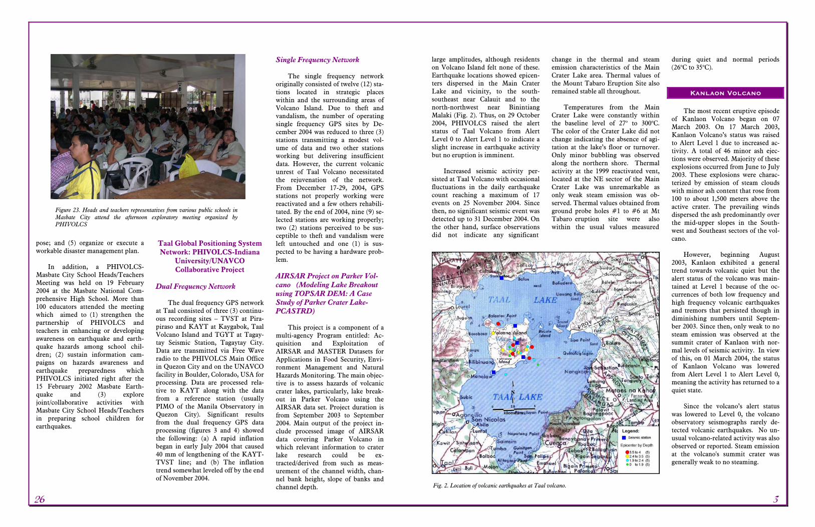
large amplitudes, although residents on Volcano Island felt none of these. Earthquake locations showed epicen-ters dispersed in the Main Crater Lake and vicinity, to the south-southeast near Calauit and to the north-northwest near Binintiang Malaki (Fig. 2). Thus, on 29 October 2004, PHIVOLCS raised the alert status of Taal Volcano from Alert Level 0 to Alert Level 1 to indicate a slight increase in earthquake activity but no eruption is imminent.
Increased seismic activity per-
sisted at Taal Volcano with occasional fluctuations in the daily earthquake count reaching a maximum of 17 events on 25 November 2004. Since then, no significant seismic event was detected up to 31 December 2004. On the other hand, surface observations did not indicate any significant
change in the thermal and steam emission characteristics of the Main Crater Lake area. Thermal values of the Mount Tabaro Eruption Site also remained stable all throughout.
Temperatures from the Main
Crater Lake were constantly within the baseline level of 27o to 300oC. The color of the Crater Lake did not change indicating the absence of agi-tation at the lake’s floor or turnover. Only minor bubbling was observed along the northern shore. Thermal activity at the 1999 reactivated vent, located at the NE sector of the Main Crater Lake was unremarkable as only weak steam emission was ob-served. Thermal values obtained from ground probe holes #1 to #6 at Mt Tabaro eruption site were also within the usual values measured
during quiet and normal periods (26oC to 35oC).
Kanlaon Volcano
The most recent eruptive episode
of Kanlaon Volcano began on 07 March 2003. On 17 March 2003, Kanlaon Volcano’s status was raised to Alert Level 1 due to increased ac-tivity. A total of 46 minor ash ejec-tions were observed. Majority of these explosions occurred from June to July 2003. These explosions were charac-terized by emission of steam clouds with minor ash content that rose from 100 to about 1,500 meters above the active crater. The prevailing winds dispersed the ash predominantly over the mid-upper slopes in the South-west and Southeast sectors of the vol-cano.
However, beginning August
2003, Kanlaon exhibited a general trend towards volcanic quiet but the alert status of the volcano was main-tained at Level 1 because of the oc-currences of both low frequency and high frequency volcanic earthquakes and tremors that persisted though in diminishing numbers until Septem-ber 2003. Since then, only weak to no steam emission was observed at the summit crater of Kanlaon with nor-mal levels of seismic activity. In view of this, on 01 March 2004, the status of Kanlaon Volcano was lowered from Alert Level 1 to Alert Level 0, meaning the activity has returned to a quiet state.
Since the volcano’s alert status
was lowered to Level 0, the volcano observatory seismographs rarely de-tected volcanic earthquakes. No un-usual volcano-related activity was also observed or reported. Steam emission at the volcano's summit crater was generally weak to no steaming.
Figure 23. Heads and teachers representatives from various public schools in Masbate City attend the afternoon exploratory meeting organized by PHIVOLCS
Fig. 2. Location of volcanic earthquakes at Taal volcano.
26 3
Mayon Volcano Mayon Volcano’s unrest, which
began on 30 January 2003 continued to prevail throughout 2004. From January to May, no significant in-crease in the volcano’s activity was observed until after a brief but sud-den burst of gases from the crater was observed on 04 June 2004. An explo-sion from the crater on 22 July 2004 followed this event. The explosion deposited traces of ash at Barangays Baligang, Amtic and Tambo of Ligao town at the NW side of the volcano. This event was recorded as an explo-sion type seismic signal signifying a sudden release of pressure. No sig-nificant increase in the volcano’s seismicity level was noted prior to the explosion although the sulfur dioxide emission rate was measured at 1,988 tonnes per day – a value way above the normal level. Alert Level 2 was raised on 11 October 2003 and was re-iterated on 4 June 2004 to remind the public of ongoing activity and re-minded people to strictly observe the 6-km radius Permanent Danger Zone around the volcano.
The presence of crater glow, in-
flated slopes and above normal seis-
micity and SO2 gas output persis-tently indicate Mayon’s unstable condition. PHIVOLCS continues to maintain the status of Mayon at Alert Level 2 and reiterates that entry into
the 6-kilometer radius Permanent Danger Zone is strictly prohibited especially within the Southeast sector where volcanic flows, falling and roll-ing debris maybe produced from a possible explosion.
Taal Volcano
The increased earthquake activity
of Taal Volcano began on 23 Septem-ber 2004 when the volcano’s seismic network started detecting occurrences of significant volcanic earthquakes. Since then, the number of volcanic earthquakes detected increased to a maximum of 13 events on 15 October. Some of these quakes were instru-mentally recorded with relatively
Fig. 1. Additional seismic stations at Mayon Volcano.
Development and Opera-tion of Management In-
formation System The Management Information
System (MIS) Core Group was estab-lished to provide the institute with fast, reliable network and internet connection and develop and imple-ment software systems. For the year 2004, a prototype intranet system, which will facilitate transport of in-formation digitally among the differ-ent sections of the institute, was de-signed. The system can be used as an electronic bulletin board using dy-namic, database driven web applica-tion. Two softwares were installed and configured by the MIS: (1) Hu-man Resource Management Informa-tion System (HRMIS), developed by Science and Technology Information Institute (STII), is expected to facili-tate automated updating of the per-sonnel data of the institute; and 2) Project Management Information System (PROMIS) which will facili-tate the making of new project pro-posals for funding. Aside from these, the MIS group developed the beta version of the payroll and DTR sys-tem which will automate the wage computations and checking of atten-dance including overtime pay. The year also saw a more improved and updated web site of PHIVOLCS which will continue to deliver rele-vant, useful and up to date volcanic and earthquake information to the public.
GIS Laboratory Develop-ment and Maintenance
for Disaster Mitigation Applications
An R & D project designed to
create a GIS-based digital database of Taal Volcano and vicinity was devel-oped to serve as repository of easily accessible data on vulnerable ele-ments around Taal Volcano. This project will also aid in faster identifi-
cation and assessment of risk in-volved should Taal Volcano erupt and as a tool for disaster mitigation and management planning down to Barangay Level. For 2004, this pro-ject generated a technical report on volcanic risk assessment using GIS database, Taal Volcano regional risk maps and Taal Volcano GIS database.
The X-Ray Fluorescence
Laboratory The newly established XRF
Laboratory consists of three (3) sec-tions: (1) rock preparation laboratory, where big chunks of rock samples are processed into smaller chips, and fi-nally to powder form; (2) the fusion laboratory, where glass beads, pellets and water samples are prepared; and (3) the Main XRF laboratory which houses the X-Ray Fluorescence Spec-trometer where analysis is done.
The facilities became available
for operation during second quarter of 2004.. Two (2) personnel from PHIVOLCS were sent to the SHIMADZU Factory in Japan for one-week training on operations of the spectrometer. In-house training was also conducted in June 2004 at-tended by PHIVOLCS personnel in-terested in using the XRF laboratory.. The main topics of discussion in-cluded the use of fusion machine, briquette press, and XRF spectrome-ter, and sample runs using ash and water were done to demonstrate how the machines work.
Production of glass beads or
fused disks and pellets shall be done in 2005, Standard reference materials were provided by the Michigan State University through Dr. Thomas A. Vogel. with other programs of the In-stitute.
The equipment available in the XRF lab are the following:
Retsch Model BB200 Jaw
Crusher and Rock Splitter with hardened and durable steel ribbed jaws.
Retsch Model RS100 Vibration
Mill with W-Carbide sample ves-sel for pulverizing rocks to fine powder with final fineness of 40 microns.
CLAISSE Bead Fusion Machine
FLUXY-10 for preparation of glass beads and fusion disks
Briquette Press (air-actuated,
manually controlled 25-ton labo-ratory press) for preparation of pellets
SHIMADZU X-ray Fluorescence
Spectrometer Model XRF 1800 Other accessory equipments are:
SHIMADZU Analytical Balance Model AWE-220, SHIMADZU Top-Loading Balance Model BW series, Ultrasonic Cleaner, Dis-tilling Apparatus, and Drying Oven.
The year 2004 was again a busy and fruitful year for PHIVOLCS in its surveillance of Mayon, Taal, Kanlaon, Pinatubo, Bulusan and Hibok-Hibok. Three of these volca-noes were closely monitored, namely; Mayon, Kanlaon and Taal because they showed signs of unrest during the year.
Mayon Volcano’s status in Al-bay was maintained at Alert Level 2 throughout 2004 as it con-tinued to show signs of unrest high-lighted by a small ash explosion on 22 July. The explosion did not, how-ever, cause any significant damage. Activity of Kanlaon Volcano in Negros Island continued to wane
to quiet condition so that its status was lowered to Alert Level 0 last 01 March 2004.
Beginning on 23 September 2004, Taal Volcano showed in-creased earthquake activity, which persisted through the remaining months of 2004. To accurately monitor the activities of Mayon and Taal, additional seismic stations were established (Fig. 1). Repair or maintenance/replacement of equip-ment for the newly established seis-mic stations in the other six (6) monitored active volcanoes were also conducted to ensure continuity in its surveillance operations.
Volcano Monitoring Technical Support Services
2 27
PHIVOLCS continued to pro-vide opportunities for its personnel to pursue graduate degrees, attend for-eign and local seminars and trainings to meet the demand for technical ex-pertise and keep abreast of latest development in the field of volcanology and seismology. Tables 3 and 4 are
the list of PHIVOLCS personnel with doctorate and MS degrees. Tables 5 is the listings of PHIVOLCS personnel pursuing advanced degrees. Tables 6 and 7 are the list of trainings and seminars availed of by PHIVOLCS officials and staff for the year 2004.
Early in 2004, PHIVOLCS con-structed and installed four unmanned seismic stations at 1) Ipil, Zamboanga del Sur, 2) Mati, Davao Oriental, 3) Mount Musuan, Bukidnon, and 4) Butuan, Agusan del Norte. The es-tablishment of these four stations marked the completion of the JICA Project: Improvement of the Earth-quake and Volcano Monitoring Net-work in the Philippines (Phase II), which started in July 2002. The pro-ject, funded by the Japanese Govern-ment through the Japan International Cooperation Agency (JICA), was turned over on March 22, 2004 by the JICA Deputy Resident Representative Hirohiko Takata to Department Of Science and Technology Secretary Estrella F. Alabastro and PHIVOLCS Director Renato U. Solidum, Jr.
The JICA Phase II project greatly
enhanced PHIVOLCS’ seismic and volcano monitoring systems. With the addition of twenty-nine (29) un-manned seismic observation points with satellite communication to the thirty-five (35) existing manned seismic stations, the national seismic observation network now consists of 64 stations. The project likewise es-tablished two new volcano observa-tion points for Parker and Matutum Volcanoes in Mindanao and volcano array observation networks (seismic and geodetic) at the six most active volcanoes currently being monitored, namely: Pinatubo, Taal, Mayon, Bu-lusan, Kanlaon and Hibok-hibok Volcanoes
The project also installed the Sat-
ellite Hub Data Communication Sys-tem at PHIVOLCS Head Office in Quezon City and a mirror site in Ta-gaytay City Seismic Station. Thirty (30) sets of Quick Response Mobile Monitoring Systems were also pro-vided to PHIVOLCS.
The provision of high-technology
equipment increases PHIVOLCS earthquake detection and volcano
monitoring capability resulting to prompt dissemination of earthquake and volcano information and warning to the public. The improved resolu-tion of seismic data leads to better understanding of the country’s seis-micity. It will also help in a deeper, intelligent assessment and more in-tensive evaluation of impending vol-canic and seismic upheavals and ac-curate forecasts.
PHIVOLCS is now appropriately
equipped and ready in terms of equipment for doing higher-level re-searches in the field of seismology and volcanology to make the Philip-pines a country safer from earth-quakes and volcanic eruptions in the future.
The Alert level status of Kanlaon
Volcano was lowered on March 1, 2004 from Level 1 to Level 0 - the volcano has returned to a quiet state. For Mayon Volcano, Alert Level 2 has been maintained since October 2003 because of persistent crater glow, above background sulfur diox-ide gas emission rate and volcanic earthquake occurrences. Alert Level 2 was reiterated on June 4, 2004 due to the occurrence of a minor explo-sion, which suggests that unrest at Mayon is continuing through spo-radic low level degassing. PHIVOLCS issued advisories warn-ing the public on increased earth-quake activity and to stay away from the established danger zones. For 2004, PHIVOLCS monitored eight active volcanoes and issued 501 vol-cano bulletins and updates.
Two moderate earthquakes oc-
curred during the year, both of which had a magnitude of 6.2. The first one occurred on September 16, 2004 with the epicenter located at 61 kms southwest of Balanga, Bataan with the maximum intensity of IV felt in the nearby provinces including Metro Manila. The second earthquake struck on October 8, 2004 and was lo-
cated 67 kms southwest of Tagaytay City and was also felt in Metro Ma-nila and nearby provinces with a maximum intensity of V. Both earthquakes had intermediate focal depths and caused no damage in the areas affected. For 2004, the national seismic network recorded 11,529 earthquake events, 1,575 of which were determined and plotted. Only 141 were felt events and PHIVOLCS issued 116 earthquake bulletins. Eight (8) advisories and warnings, re-lated to volcanic activity, earth-quakes, swarms and tsunami, were is-sued during the year.
A series of low to moderate inten-
sity earthquakes ranging from Inten-sity II-IV were felt in the town of An-ini-y, Antique on January 2004 caus-ing minor damages on houses, land-slides and affected ground water sys-tems. PHIVOLCS installed tempo-rary seismic monitoring equipment around the affected area and con-ducted several information dissemi-nation campaigns to allay the fear of the public in cooperation with the re-gional offices of DOST and Office of Civil Defense.
On February 2004, a swarm of
earthquakes with magnitude equal to or less than 5.0 clustered approxi-mately 55 kilometers southwest of Dipolog City. The epicenters of the earthquakes were located and felt in Pagadian City and neighboring towns. The swarm however, did not incur any significant damages.
Aerial and onsite surveys were conducted at Smith and Babuyan Claro Volcanoes in Babuyan Island, Cagayan Province on February 2004 to investigate the reported series of earthquakes that were located and felt in the southern shore of Babuyan Is-land.
Human Resources Highlights
28 1
Table 4. PHIVOLCS Personnel with MS Degree
Name Degree/Course Year
Obtained School Attended
Ma. Mylene M. Villegas MS in Geology 1997 Arizona State University, Tempe, Arizona, USA
Rowena B. Quiambao MS in Integrated Map and Geo-information Production.
1997 International Aerospace Survey and Geophysics Science (ITC) Enschede, The Netherlands
Esmeralda L. Banganan MS in Materials Science Eng'g 1997 University of the Philippines, Diliman, Q.C.
Nemesio M. Canete Master in Public Administration 1996 Leyte Normal University, Leyte
Sheila I. Insauriga Master in Public Administration 1999 University of Sto. Tomas, Espana, Manila
Ramil B. Atando Master in Public Management 1999 University of the Philippines, Visayas, Iloilo City
Nanette V.A. Melosantos Master in Public Management 2001 University of Sto. Tomas, Espana, Manila
Rebecca E. Valenzuela Master in Business Administration 2002 Wesleyan University, Taft Avenue, Manila
Ma. Hannah T. Mirabueno MS in Geology 2002 University of Canterbury, Christchurch, New Zealand
Perla J. Delos Reyes MS in Geology 2004 University of Canterbury, Christchurch, New Zealand
Table 3. PHIVOLCS Personnel with PhD Degree
Name Degree/Course Year
Obtained School Attended
Renato U. Solidum, Jr. Ph D in Earth Sciences 2002 University of California, San Diego, California, USA
Emmanuel G. Ramos Ph D in Geophysics 1994 Indiana University, Indiana, USA
Ernesto G. Corpuz Ph D in Geology 1992 University of Canterbury, Christchurch, New Zealand
Bartolome C. Bautista DSc in Earth and Planetary Sciences 1999 Kyoto University, Kyoto, Japan
Baby Jane T. Punongbayan Ph D in Geophysics 2001 Louis Pasteur University, Strasbourg, France
Rolly E. Rimando Ph D in Geology 2001 State University of New York, Binghamton, USA
Norman M. Tungol Ph D in Engineering Geology 2002 University of Canterbury, Christchurch, New Zealand
Teresito C. Bacolcol Ph D in Geology 2003 Perrie et Marie Curie, Universite, Paris, France
Arturo S. Daag Ph D in Applied Geomorphology 2003 Utrecht University ITC, The Netherlands
Glenda M. Besana DSc. in Earth and Planetary Science 1998 Kyoto University, Kyoto, Japan
Jessie A. Daligdig DSc. in Earth and Planetary Science 1997 Kyoto University, Kyoto, Japan
Ma. Leonila P. Bautista DSc. in Earth and Planetary Science 1999 Kyoto University, Kyoto, Japan
Table 6. Foreign trainings, seminars and conferences attended by PHIVOLCS staff.
Title of Activity Name of Participant/s Venue Duration
Training on Operation and Maintenance Tech-nique for Spread Spectrum Telemetry Systems
Ramses A. Velerio Jose Joel D. Marilla
Japan 15 January to 7 February
Guest Research Scientist Ernesto G. Corpuz Japan 14-20 March
International Symposium on Slow Slip Events at Plate Subduction Zone Ma. Isabel T. Abigania Japan 16-18 March
GTC: on Volcanology and Sabo Engineering Allan R. Loza Japan 16 March to 12 September
Training on XRF Ma. Hannah T. Mirabueno Nora R. Campita Japan 18-24 April
First 3CD Coordination Workshop and 2004 Cluster Cities Project meeting Renato U. Solidum, Jr. Germany 24-29 June
2004 ITSU-Tsunami Training Program Ishmael C. Narag Honolulu, Hawaii 9-27 August
32nd International Geological Congress Ernesto G. Corpuz Florence, Italy 18-28 August
23rd International Twelve-Week Course on Aseismic Design and Construction Rhommel N. Grutas
Skopje, Rep. of Macedonia
28 August to 28 November
International Training Course on Seismology, Seismic Data Analysis, Hazard Assessment and Risk Mitigation
Reynaldo A. Antioquia Potsdam, Germany
19 September to 24 October
GTC: on Seismology, Earthquake Engineering and Disaster Mitigation
Melchor P. Lasala Tokyo, Japan 20 September 2004 to 10 September 2005
14th United Nations/International Astronautical Federation (UN/IAF) 55th IAF Congress
Norman M. Tungol Vancouver, Canada
2-8 October
5th Asian Seismological Commission (ASC) General Assembly
Ma. Leonila P. Bautista Jeffrey S. Perez
Yerevan, Armenia Oct.18-21, 2004 Oct. 4-21, 2004
Operations and Maintenance of CTBTO Equipment
Alex. C. Cabrera Austria 11-15 October
Counterpart Training Program on Seismology (Seismic Data Processing)
Esmeralda L. Banganan Japan 14 October 2004 to 12 March 2005
Int'l Training Program for Seismic Design of Structures
Roberto B. Tiglao Taipei, Taiwan 25-29 October
First Beijing Haidan Forum on Earthquake Preparedness and Disaster Mitigation
Renato U. Solidum, Jr. Beijing, China 1-3 November
Field Workshop for Volcanic Hazard Mitigation Ma. Isabel T. Abigania Tsukuba, Japan 7-14 December
29
Table 5. List of PHIVOLCS Employees who are pursuing graduate degrees.
Name Degree/Course University
Teodorico A. Sandoval MS in Geology University of the Philippines, U.P. Campus, Diliman, Quezon City
Dante S. Soneja MS in Computer Science University of the Philippines,U.P. Campus, Diliman, Quezon City
Felomina F. Cayabyab MS in Community Development University of the Philippines, U.P. Campus, Diliman, Quezon City
Marilou V. Del Rosario MS in Public Administration. Polytechnic University of the Philippines, Sta. Mesa, Manila
Arnold A. Villar MS in Information Technology STI College, Cubao, Quezon City
Mon Pierre Menguito MS in Remote Sensing University of the Philippines, U.P. Campus, Diliman, Quezon City
Celestino Saquilon MS in Environmental Science University of the Philippines, U.P. Campus, Diliman, Quezon City
Ma. Isabel Abigania MS in Geology University of the Philippines, U.P. Campus, Diliman, Quezon City
Ronaldo A. Arboleda MS in Environmental Science University of the Philippines, U.P. Campus, Diliman, Quezon City
Kathleen R. Papiona MS in Geology Tokyo Institute of Technology, Tokyo, Japan
Janette S. Manahan MS in Seismology Kyoto University, Kyoto, Japan
Ma. Carmencita B. Arpa MS in Geological Sciences Michigan State University, Michigan, USA
Ma. Antonia V. Bornas MS in Earth and Planetary Science Hokkaido University, Sapporo, Japan
Winchelle G. Sevilla Ph D in Geology Pennsylvania State University, Pennsylvania, USA
Table 7. Local trainings, seminars, and conferences attended by PHIVOLCS staff.
Title of Activity Name of Participant/s Venue Duration
JICA-MMEIRS Seminar
Arturo S. Daag Jessie A. Daligdig* Bartolome C. Bautista Ma. Leonila P. Bautista* Baby Jane T. Punongbayan Angelito G. Lanuza Esmeralda L. Banganan Kathleen L. Papiona Janila B. Deocampo Erlinton B. Olavere Ishmael C. Narag Roberto B. Tiglao Myla D. Panol
Norman M. Tungol Rolly E. Rimando Regina B. Quiambao Benjamin H. Santos Paolo D. Reniva Sheila I. Insauriga Ma. Lynn P. Melosantos Celestino S. Saquilon Mylene M. Villegas Narciso F. Diongzon Perla J. Delos Reyes Arnold A. Villar Teresito C. Bacolcol
Makati Shangri-la Hotel
4 February
Seminar on Community Based Earthquake Disaster Management
Mylene M. Villegas Bartolome C Bautista Ma. Leonila P. Bautista* Babyjane T. Punongbayan Myleen E. Carlos Norman M. Tungol Erlinton B. Olavere Janila B. Deocampo
Roberto B. Tiglao Sheila I. Insauriga Ma. Lynn P. Melosantos Myla D. Panol Regina B. Quiambao Celestino S. Saquilon Dido V. Javier Paolo D. Reniva
Manila Pavilion
5 February
DOST Human Resource Information System
Filomena C. Perez Ma. Rosemarie J. Bautista Marlon R. Lumanog
DOST, Bicu-tan
11 February
Phil-Japan Symposium on Grid Computing/ Technology
Maricel R. Lendio Melchor P. Lasala
Narciso F. Diongzon Edgardo S. Balbuena
Convergent Technologies Center, Ateneo de Manila, Q.C.
16 February
Forum on the February 15, 2003 Masbate Earthquake
Renato A. Arante Bartolome C Bautista Jessie A. Daligdig* Ronald Dela Cruz Ester B. Garrido Melcario D. Pagtalunan
Myla D. Panol Kathleen L. Papiona Babyjane T. Punongbayan Leni R. Torrevillas Norman M. Tungol Ma. Mylene M. Villegas
Rendezvous Resort, Mas-bate City
20 February
2004 EqTAP Metro Manila Case Study (MMCS)
Renato U. Solidum, Jr. Teresito C. Bacolcol Bartolome C. Bautista Ma. Leonila P. Bautista* Artuto A. Daag Jessie A. Daligdig* Sheila I. Insauriga Dindo V. Javier Angelito G. Lanuza Ma. Lynn P. Melosantos
Ishmael C. Narag Regina B. Quiambao Babyjane T. Punongbayan Rolly E. Rimando Norman M. Tungol Arnold A. Villar Mylene M. Villegas Perla J. Delos Reyes Myla D. Panol
Dusit Hotel Nikko, Makati City
4 March
30
Highlights 1 Volcano Monitoring 2 Earthquake Monitoring 5 S&T Services 9 R&D Projects 12 Technical Support Services 27 Human Resources 28 Financial Resources 32
Table of Contents
Table7. continued…
Title Of Activity Name of Participant/s Venue Duration
Voters Education Forum for Government Employees
Delfin C. Garcia Filomena C. Perez
Narciso F. Diongzon Celestino S. Saquilon
Bureau of Soil, Elliptical Road, Q.C.
30 March
Forum on the Overview, Structure and Require-ments of Electronic New Gov't. Acctng. System
Alfredito D. Aguilar Emma C. Paguiligan Marissa S. Manalo
Josephine C. Factora Monsita O. Olavere Katherine V. Veracruz
COA, Batasan Hills, Q.C.
20 May
Preparing and Document-ing a Quality Management System
Marilou V. Del Rosario Narciso F. Diongzon Myla D. Panol
MIRDC, Bicutan Taguig, MM
23-25 June
Experiment on Suspended Load of fine sediments (lahar)
Norman M. Tungol Arturo S. Daag
Napindan Hydraulic Control, Makati City
16 June to 1 July
Orientation on Taxpayer's Registration Rebecca E. Valenzuela
BIR, RDO South, Q.C. 16 July
Urban Flood Mitigation
Arturo S. Daag Naga City 23 Aug. to 3 Sept.
Phil. Open Source Conference
Edgardo S. Balbuena Shangri-la Hotel, EDSA Plaza
17-19 August
Product Awareness Seminar and Exhibit
Charlita L. Mariano Katherine V. Veracruz
3M Innovation Center Osmeña Ave. Makati City
11 August
Job Analysis
Nanette V.A. Melosantos Monsita O. Olavere Paolo D. Reniva Benjamin H. Santos Charlita L. Mariano
Leah M. Pinca Edgardo S. Balbuena Enrico A. Mangao
PHIVOLCS, Auditorium
11 August 12 August 13 August
Human Resource Mgt. Information System
Filomena C. Perez Ma. Rosemarie J. Bautista
Maribel A. Breboneria Edgardo S. Balbuena
STII, Bicutan, Taguig, MM
Project Management Information System
Narciso F. Diongzon Edgardo S. Balbuena
STII, Bicutan, Taguig, MM
25 November
GTC: Volcanology and Volcanic Sabo Engineering
Bella S. Tubianosa Ramses A. Valerio Juan M. Cordon, Jr. Paul Karson B. Alanis
Sesinando G. Manlangit Jose Joel D. Marilla Allan R. Loza
Sulu Hotel, Quezon City
6-10 December
31
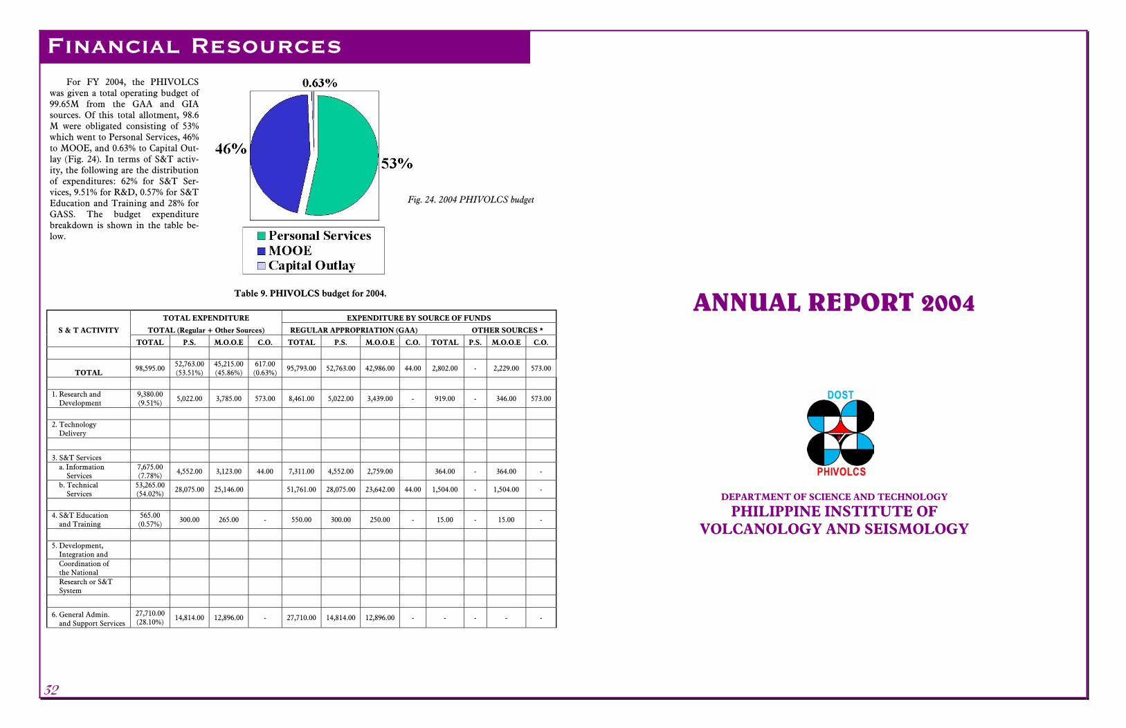
For FY 2004, the PHIVOLCS was given a total operating budget of 99.65M from the GAA and GIA sources. Of this total allotment, 98.6 M were obligated consisting of 53% which went to Personal Services, 46% to MOOE, and 0.63% to Capital Out-lay (Fig. 24). In terms of S&T activ-ity, the following are the distribution of expenditures: 62% for S&T Ser-vices, 9.51% for R&D, 0.57% for S&T Education and Training and 28% for GASS. The budget expenditure breakdown is shown in the table be-low.
32
ANNUAL REPORT 2004
DEPARTMENT OF SCIENCE AND TECHNOLOGY
PHILIPPINE INSTITUTE OF VOLCANOLOGY AND SEISMOLOGY
Table 9. PHIVOLCS budget for 2004.
TOTAL EXPENDITURE EXPENDITURE BY SOURCE OF FUNDS
S & T ACTIVITY TOTAL (Regular + Other Sources) REGULAR APPROPRIATION (GAA) OTHER SOURCES *
TOTAL P.S. M.O.O.E C.O. TOTAL P.S. M.O.O.E C.O. TOTAL P.S. M.O.O.E C.O.
TOTAL 98,595.00
52,763.00 (53.51%)
45,215.00 (45.86%)
617.00 (0.63%)
95,793.00 52,763.00 42,986.00 44.00 2,802.00 - 2,229.00 573.00
1. Research and Development
9,380.00 (9.51%)
5,022.00 3,785.00 573.00 8,461.00 5,022.00 3,439.00 - 919.00 - 346.00 573.00
2. Technology Delivery
3. S&T Services a. Information Services
7,675.00 (7.78%) 4,552.00 3,123.00 44.00 7,311.00 4,552.00 2,759.00 364.00 - 364.00 -
b. Technical Services
53,265.00 (54.02%) 28,075.00 25,146.00 51,761.00 28,075.00 23,642.00 44.00 1,504.00 - 1,504.00 -
4. S&T Education and Training
565.00 (0.57%)
300.00 265.00 - 550.00 300.00 250.00 - 15.00 - 15.00 -
5. Development, Integration and
Coordination of the National
Research or S&T System
6. General Admin. and Support Services
27,710.00 (28.10%)
14,814.00 12,896.00 - 27,710.00 14,814.00 12,896.00 - - - - -
Financial Resources
Fig. 24. 2004 PHIVOLCS budget


