Embed Size (px)
Citation preview
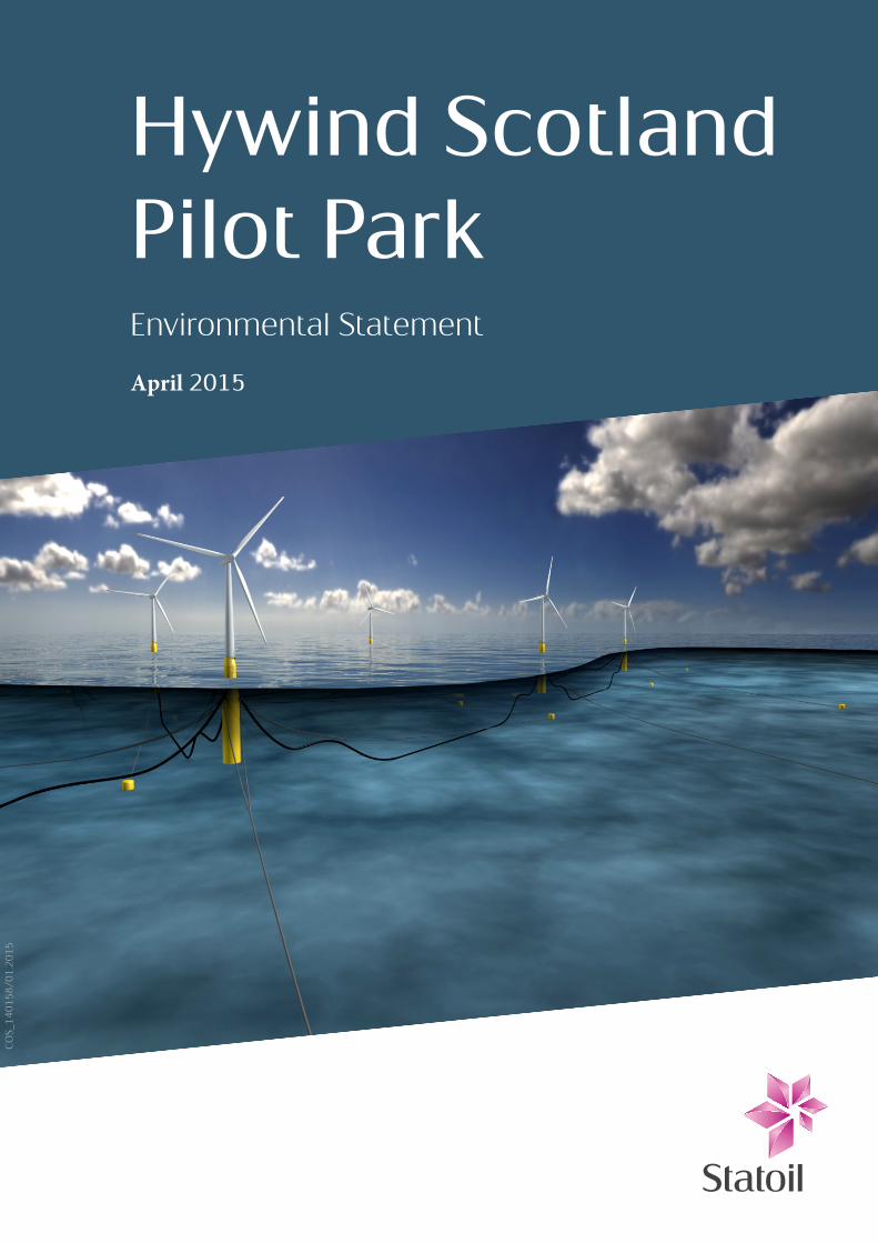
Hywind Scotland Pilot ParkEnvironmental Statement
April 2015
COS_140158/01.2015

Table of Contents
FOREWORD XI
ACCOMPANYING CD DOCUMENT INDEX XII
ACRONYMS XIV
GLOSSARY XVIII
1 INTRODUCTION 1-1
1.1 Introduction to Hywind (Scotland) Limited (HSL) 1-1 1.2 Background to the Project 1-1 1.3 Overview of the Project 1-1 1.4 Consenting strategy 1-4 1.5 Consideration of design options 1-5 1.6 Data gaps and uncertainties 1-6 1.7 Contributors to the EIA 1-6
2 POLICY AND LEGISLATION FRAMEWORK 2-1
2.1 The need for renewable energy 2-1 2.2 Energy and climate change policy 2-1 2.3 Marine planning framework (policy, consenting and licensing) 2-1
2.3.1 Marine (Scotland) Act 2010 and the Marine and Coastal Access Act 2009 2-1 2.3.2 Marine policy statement - UK 2-2 2.3.3 Marine and terrestrial interface 2-2
2.4 Environmental Impact Assessment legislation 2-3 2.5 Nature conservation (including HRA and European Protected Species) 2-3
2.5.1 Habitats and Birds Directives 2-3 2.6 Guidance and best practice 2-4 2.7 References 2-4
3 SITE SELECTION AND CONSIDERATION OF ALTERNATIVES 3-1
3.1 Background to the Project 3-1 3.2 Site evaluation 3-1 3.3 Project design 3-2
3.3.1 Project design process 3-2 3.3.2 Turbine deployment area 3-2 3.3.3 Export cable 3-3 3.3.4 Cable landfall 3-3 3.3.5 Onshore cable and switchgear yard 3-3
Hywind Scotland Pilot Park Project – Environmental Statement Assignment Number: A100142-S35 Document Number: A-100142-S35-EIAS-001 i

3.3.6 Inshore assembly area 3-3 3.4 Mitigation through site selection and consideration of alternatives 3-4
4 PROJECT DESCRIPTION 4-1
4.1 Introduction 4-1 4.2 Project timescale 4-1 4.3 Hywind Scotland Pilot Park Project components included in this EIA – offshore 4-2
4.3.1 Hywind Scotland WTG Units 4-2 4.3.2 WTG Unit layout and moorings 4-4 4.3.3 Inter-array and export cables 4-5 4.3.4 Appearance of WTG Units 4-6 4.3.5 Lighting and navigational marking 4-7 4.3.6 WTG Unit ballast 4-7 4.3.7 Antifouling and corrosion 4-7 4.3.8 Power requirements 4-7 4.3.9 WTG transformers 4-7
4.4 Construction phase – offshore 4-7 4.4.1 Pilot Park mooring system installation 4-7 4.4.2 WTG Unit mooring 4-8 4.4.3 Fabrication, storage and installation of power cables 4-8 4.4.4 Cable landfall 4-9 4.4.5 Commissioning of WTG Units 4-9
4.5 Operational phase – offshore 4-10 4.5.1 Lubricants and liquids 4-10 4.5.2 Maintenance activities 4-11
4.6 Decommissioning phase – offshore 4-11 4.7 Design Envelope for offshore Project components 4-11 4.8 Other Hywind Scotland Pilot Park Project components 4-15
4.8.1 Pre-assembly activities 4-15 4.8.2 Assembly of WTG Units 4-15 4.8.3 Transport to Pilot Park 4-16 4.8.4 Onshore project 4-16
5 ENVIRONMENTAL OVERVIEW 5-1
5.1 Introduction 5-1 5.2 Physical characteristics 5-1
5.2.1 Offshore 5-1 5.2.2 Landfall 5-1
5.3 Biological characteristics 5-2 5.3.1 Seabed 5-2 5.3.2 Fish 5-2 5.3.3 Birds 5-3 5.3.4 Marine mammals 5-3
5.4 Protected sites and species 5-3 5.5 Socio-economic activities 5-4
5.5.1 Fisheries 5-4 5.5.2 Shipping 5-4 5.5.3 Oil and Gas 5-4 5.5.4 Other activities 5-5
6 ENVIRONMENTAL IMPACT ASSESSMENT (EIA) METHODOLOGY 6-1
6.1 Introduction 6-1 6.2 Approach to EIA 6-1
6.2.1 EIA Process 6-1 6.2.2 Scoping 6-1
Hywind Scotland Pilot Park Project – Environmental Statement Assignment Number: A100142-S35 Document Number: A-100142-S35-EIAS-001 ii

6.2.3 Scoped out topics 6-2 6.3 Assessment of impact 6-3
6.3.1 Overview of approach for assessing impact significance 6-3 6.3.2 Sensitivity/value 6-4 6.3.3 Magnitude of effects 6-4 6.3.4 Level of impact 6-4 6.3.5 Deviations from standard approach 6-5 6.3.6 Mitigation 6-5
6.4 Design Envelope 6-5 6.5 Cumulative and in-combination impacts 6-6 6.6 Decommissioning impacts 6-6 6.7 References 6-11
7 STAKEHOLDER ENGAGEMENT 7-1
7.1 Background 7-1 7.2 Scoping overview and consultation 7-1
7.2.1 Background 7-1 7.2.2 Pre-scoping 7-2 7.2.3 EIA Screening 7-3 7.2.4 EIA Scoping 7-3
7.3 Consultation with local community 7-3 7.4 Consultation with Regulator and their advisors 7-4 7.5 Consultation beyond application submission 7-4 7.6 References 7-5
8 PHYSICAL ENVIRONMENT 8-1
8.1 Introduction 8-1 8.2 Legislative context and relevant guidance 8-2 8.3 Scoping and consultation 8-3 8.4 Baseline description 8-3
8.4.1 Introduction 8-3 8.4.2 Designated features 8-6 8.4.3 Bathymetry 8-8 8.4.4 Wind 8-8 8.4.5 Wave 8-10 8.4.6 Current 8-10 8.4.7 Water levels 8-12 8.4.8 Seabed sediment and geology 8-12 8.4.9 Coastal description 8-16 8.4.10 Water quality 8-16 8.4.11 Data gaps and uncertainties 8-18
8.5 Impact assessment 8-18 8.5.1 Overview 8-18 8.5.2 Assessment criteria 8-18 8.5.3 Design Envelope 8-20
8.6 Impacts during construction and installation 8-20 8.6.1 Effects on the coast at the cable landfall 8-20 8.6.2 Effects on the Scottish Water outfall 8-21
8.7 Impacts during operation and maintenance 8-21 8.7.1 Effects on the coast at the cable landfall 8-21 8.7.2 Introduction of scour within the Pilot Park 8-22
8.8 Potential variances in environmental impacts (based on Design Envelope) 8-22 8.9 Cumulative and in-combination impacts 8-22
8.9.1 Introduction 8-22 8.9.2 Potential cumulative and in-combination impacts during construction and installation, operation and maintenance 8-23 8.9.3 Mitigation requirements for potential cumulative and in-combination impacts 8-23
8.10 Monitoring 8-23 Hywind Scotland Pilot Park Project – Environmental Statement Assignment Number: A100142-S35 Document Number: A-100142-S35-EIAS-001 iii

8.11 References 8-23
9 BENTHIC AND INTERTIDAL ECOLOGY 9-1
9.1 Introduction 9-1 9.2 Legislative context and relevant guidance 9-2
9.2.1 European Habitats Directive 9-2 9.2.2 Marine and Coastal Access Act (2009) and Marine (Scotland) Act (2010) 9-3 9.2.3 Priority Marine Features 9-3 9.2.4 UK Biodiversity Action Plan 9-4 9.2.5 Convention for the Protection of the Marine Environment of the North East Atlantic 9-4
9.3 Scoping and consultation 9-5 9.4 Baseline description 9-6
9.4.1 Introduction 9-6 9.4.2 Subtidal water depths and sediments 9-7 9.4.3 Subtidal species and biotopes 9-8 9.4.4 Intertidal habitats, species and biotopes 9-15 9.4.5 Habitats and species of conservation importance 9-20 9.4.6 Sediment quality and contamination 9-24
9.5 Data gaps and uncertainties 9-29 9.6 Impact assessment 9-29
9.6.1 Overview 9-29 9.6.2 Assessment criteria 9-30 9.6.3 Design Envelope 9-31
9.7 Impacts during construction and installation 9-32 9.7.1 Direct loss of, and disturbance to, seabed and intertidal habitats and communities 9-32 9.7.2 Introduction of marine non-native species 9-37 9.7.3 Pollution of the water and sediment environment through the disturbance of existing contaminated sediments 9-38
9.8 Impacts during operation and maintenance 9-39 9.8.1 Direct loss of, and disturbance to, seabed and intertidal habitats and communities 9-39 9.8.2 Colonisation of infrastructure in the water column and on the seabed 9-39 9.8.3 Protection of benthic habitats within the Pilot Park due to restricted trawling 9-40 9.8.4 Effects of EMF and heat generated by active power cables on benthic invertebrates 9-41
9.9 Potential variances in environmental impacts (based on Design Envelope) 9-43 9.10 Cumulative and in-combination impacts 9-43
9.10.1 Introduction 9-43 9.10.2 Potential cumulative impacts during construction and installation, operation and maintenance 9-44 9.10.3 Potential in-combination impacts during construction and installation 9-44 9.10.4 Potential in-combination impacts during operation and maintenance 9-44 9.10.5 Mitigation requirements for potential cumulative and in-combination impacts 9-45
9.11 Habitats Regulations Appraisal 9-45 9.12 Monitoring 9-45 9.13 References 9-45
10 FISH AND SHELLFISH ECOLOGY 10-1
10.1 Introduction 10-1 10.2 Legislative context and relevant guidance 10-2 10.3 Scoping and consultation 10-3 10.4 Baseline description 10-4
10.4.1 Introduction 10-4 10.4.2 Benthic environment 10-4 10.4.3 Pelagic fish species 10-5 10.4.4 Demersal fish species 10-8 10.4.5 Elasmobranch species 10-12 10.4.6 Diadromous migratory species 10-15 10.4.7 Shellfish species 10-18 10.4.8 Data gaps and uncertainties 10-18
10.5 Impact assessment 10-20 10.5.1 Overview 10-20
Hywind Scotland Pilot Park Project – Environmental Statement Assignment Number: A100142-S35 Document Number: A-100142-S35-EIAS-001 iv

10.5.2 Assessment criteria 10-20 10.5.3 Design Envelope 10-22 10.5.4 Data gaps and uncertainties 10-22
10.6 Impacts during construction and installation 10-22 10.6.1 Noise 10-22 10.6.2 Loss of spawning and nursery grounds 10-24
10.7 Impacts during operation and maintenance 10-25 10.7.1 Noise 10-25 10.7.2 Heating effects 10-26 10.7.3 Electromagnetic effects (EMF) 10-27 10.7.4 Entanglement risk 10-29 10.7.5 Fish aggregating potential of development 10-29
10.8 Potential variances in environmental impacts (based on Design Envelope) 10-29 10.9 Cumulative and in-combination impacts 10-29
10.9.1 Introduction 10-29 10.9.2 Potential cumulative and in-combination impacts during construction and installation 10-30 10.9.3 Potential cumulative and in-combination impacts during operation and maintenance 10-30 10.9.4 Mitigation requirements for potential cumulative and in-combination impacts 10-30
10.10 Habitats Regulations Appraisal 10-30 10.11 Wildlife licensing 10-31 10.12 Monitoring 10-31 10.13 References 10-31
11 ORNITHOLOGY 11-1
11.1 Introduction 11-1 11.2 Legislative framework and policy context 11-2 11.3 Scoping and consultation 11-3 11.4 Baseline description 11-4
11.4.1 Introduction 11-4 11.4.2 Regional populations 11-9 11.4.3 Vulnerability to impacts 11-10 11.4.4 Nature conservation value 11-11 11.4.5 Species accounts 11-12 11.4.6 Data gaps and uncertainties 11-22
11.5 Impact assessment 11-23 11.5.1 Overview 11-23 11.5.2 Assessment criteria 11-24 11.5.3 Design envelope 11-25 11.5.4 Data gaps and uncertainties 11-26
11.6 Impacts during construction and installation 11-26 11.6.1 Vessel disturbance 11-26 11.6.2 Accidental release of contaminants 11-28
11.7 Impacts during operation and maintenance 11-29 11.7.1 Vessel disturbance 11-29 11.7.2 Accidental release of contaminants 11-29 11.7.3 Displacement by structures 11-30 11.7.4 Collision risk 11-32 11.7.5 Barrier effect 11-34 11.7.6 Indirect effects on seabird prey 11-36
11.8 Potential variances in environmental impacts 11-36 11.9 Cumulative and in-combination impacts 11-36
11.9.1 Potential cumulative and in-combination impacts during construction and installation 11-37 11.9.2 Potential cumulative and in-combination impacts during operation and maintenance 11-37 11.9.3 Mitigation requirements for potential cumulative and in-combination impacts 11-42
11.10 Habitats Regulations Appraisal 11-42 11.11 Monitoring 11-43 11.12 References 11-43
12 MARINE MAMMAL ECOLOGY 12-1
Hywind Scotland Pilot Park Project – Environmental Statement Assignment Number: A100142-S35 Document Number: A-100142-S35-EIAS-001 v

12.1 Introduction 12-1 12.2 Legislative context and relevant guidance 12-2 12.3 Scoping and consultation 12-3 12.4 Baseline description 12-4
12.4.1 Introduction 12-4 12.4.2 Most commonly occurring mysticetes (baleen whales) and odontocetes (toothed whales and dolphins) 12-4 12.4.3 Other mysticetes and odontocetes 12-7 12.4.4 Pinnipeds (seals) 12-8 12.4.5 Data gaps and uncertainties 12-10
12.5 Impact assessment 12-12 12.5.1 Overview 12-12 12.5.2 Assessment criteria 12-13 12.5.3 Design Envelope 12-14 12.5.4 Data gaps and uncertainties 12-15
12.6 Impacts during construction and installation 12-15 12.6.1 Underwater noise 12-15 12.6.2 Physical disturbance due to vessel presence near seal haul outs 12-19 12.6.3 Corkscrew injury 12-19 12.6.4 Marine mammal entanglement 12-19 12.6.5 Pollution due to leaks and spills from vessels 12-20
12.7 Impacts during operation and maintenance 12-21 12.7.1 Underwater noise 12-21 12.7.2 Physical disturbance due to vessel presence near seal haul outs 12-23 12.7.3 Corkscrew injury 12-23 12.7.4 Marine mammal entanglement 12-24 12.7.5 Pollution due to leaks and spills from vessels and WTG Units 12-25
12.8 Potential variances in environmental impacts (based on Design Envelope) 12-25 12.9 Cumulative and in-combination impacts 12-25
12.9.1 Introduction 12-25 12.9.2 Potential cumulative and in-combination impacts during construction and installation 12-26 12.9.3 Potential cumulative and in-combination impacts during operation and maintenance 12-26 12.9.4 Mitigation requirements for potential cumulative and in-combination impacts 12-26
12.10 Habitats Regulations Appraisal 12-26 12.11 European Protected Species (EPS) licensing 12-26 12.12 Monitoring 12-27 12.13 References 12-27
13 AVIATION AND RADAR 13-1
13.1 Introduction 13-1 13.2 Relevant guidance 13-2 13.3 Scoping and consultation 13-2 13.4 Baseline description 13-4 13.5 Impact assessment 13-5
13.5.1 Overview 13-5 13.5.2 Assessment criteria 13-5 13.5.3 Design Envelope 13-6 13.5.4 Data gaps and uncertainties 13-7
13.6 Impacts during construction and installation 13-7 13.6.1 Radar interference 13-7 13.6.2 Proximity of main helicopter routes 13-7
13.7 Impacts during operation and maintenance 13-7 13.7.1 Radar interference – Buchan military air defence radar 13-7 13.7.2 Radar interference – Allanshill civil en-route radar 13-8 13.7.3 Radar interference – Perwinnes civil en-route radar 13-9 13.7.4 Proximity of main helicopter routes 13-9
13.8 Potential variances in environmental impacts (based on Design Envelope) 13-10 13.9 Cumulative and in-combination impacts 13-10 13.10 Monitoring 13-10
Hywind Scotland Pilot Park Project – Environmental Statement Assignment Number: A100142-S35 Document Number: A-100142-S35-EIAS-001 vi

13.11 References 13-10
14 COMMERCIAL FISHERIES 14-1
14.1 Introduction 14-1 14.2 Legislative context and relevant guidance 14-2 14.3 Scoping and consultation 14-2 14.4 Baseline description 14-3
14.4.1 Introduction 14-3 14.4.2 Data gaps and uncertainties 14-3 14.4.3 Fishing activity overview 14-4 14.4.4 Description of individual fisheries 14-9 14.4.5 Key ports and vessel numbers 14-23 14.4.6 Salmon and sea trout fishery 14-23 14.4.7 Aquaculture 14-25
14.5 Impact assessment 14-25 14.5.1 Overview 14-25 14.5.2 Assessment criteria 14-25 14.5.3 Design Envelope 14-26 14.5.4 Data gaps and uncertainties 14-27
14.6 Impacts during construction and installation 14-27 14.6.1 Loss of access to fishing grounds 14-27
14.7 Impacts during operation and maintenance 14-29 14.7.1 Loss of access to fishing grounds 14-29
14.8 Potential variances in environmental impacts (based on Design Envelope) 14-29 14.9 Cumulative and in-combination impacts 14-29
14.9.1 Potential cumulative and in-combination impacts during construction and installation 14-30 14.9.2 Potential cumulative and in-combination impacts during operation and maintenance 14-30 14.9.3 Mitigation requirements for potential cumulative and in-combination impacts 14-30
14.10 Long term initiatives 14-30 14.11 References 14-30
15 SHIPPING AND NAVIGATION 15-1
15.1 Introduction 15-1 15.2 Legislative context and relevant guidance 15-2 15.3 Scoping and consultation 15-2 15.4 Baseline description 15-3
15.4.1 Introduction 15-3 15.4.2 Existing environment 15-4 15.4.3 Metocean data 15-5 15.4.4 Maritime traffic survey 15-5 15.4.5 Fishing vessel activity 15-9 15.4.6 Recreational vessel activity 15-13 15.4.7 Export cable route review 15-13 15.4.8 Maritime incidents 15-16 15.4.9 Emergency response overview 15-16 15.4.10 Data gaps and uncertainties 15-16
15.5 Impact assessment 15-16 15.5.1 Overview 15-16 15.5.2 Assessment criteria 15-17 15.5.3 Design Envelope 15-18 15.5.4 Mitigation measures 15-19
15.6 Impacts during construction and installation 15-20 15.6.1 Work vessel collision with other vessel 15-20
15.7 Impacts during operation and maintenance 15-21 15.7.1 Powered vessel collision with WTG Unit 15-21 15.7.2 Drifting vessel collision with WTG Unit 15-24
Hywind Scotland Pilot Park Project – Environmental Statement Assignment Number: A100142-S35 Document Number: A-100142-S35-EIAS-001 vii

15.7.3 Vessel-to-vessel collision due to avoidance of site or work vessels 15-25 15.7.4 Fishing interaction with midwater mooring lines, power cables and anchors 15-26 15.7.5 Fishing interaction with export cable 15-27 15.7.6 Vessel anchor interaction with subsea equipment 15-28 15.7.7 WTG Unit total loss of station 15-30
15.8 Potential variances in environmental impacts (based on Design Envelope) 15-31 15.9 Cumulative and in-combination impacts 15-31 15.10 Monitoring 15-31 15.11 References 15-31
16 MARINE HISTORIC ENVIRONMENT 16-1
16.1 Introduction 16-1 16.2 Legislative context and relevant guidance 16-6 16.3 International / EU legislation and policy 16-6
16.3.1 UK legislation and policy 16-6 16.3.2 Scottish legislation and policy 16-6 16.3.3 Codes of practice, professional guidance and standards 16-7
16.4 Scoping and consultation 16-8 16.5 Baseline description 16-9
16.5.1 Introduction 16-9 16.5.2 Shipwrecks 16-9 16.5.3 Aviation losses 16-10 16.5.4 Unexploded ordnance 16-10 16.5.5 Geophysical anomalies 16-10 16.5.6 Submerged landscapes 16-10 16.5.7 Data gaps and uncertainties 16-11
16.6 Impact assessment 16-11 16.6.1 Overview 16-11 16.6.2 Assessment criteria 16-11 16.6.3 Design Envelope 16-14
16.7 Impacts during construction and installation 16-15 16.7.1 Potential direct damage to or destruction of known marine cultural heritage 16-15 16.7.2 Potential direct damage or destruction to unknown marine cultural heritage 16-19
16.8 Impacts during operation and maintenance 16-22 16.8.1 Potential direct damage to or destruction of marine cultural heritage 16-22
16.9 Potential variances in environmental impacts (based on Design Envelope) 16-22 16.10 Cumulative and in-combination impacts 16-22 16.11 Monitoring 16-22 16.12 References 16-22
17 OTHER SEA USERS 17-1
17.1 Introduction 17-1 17.2 Scoping and consultation 17-1 17.3 Baseline description 17-2
17.3.1 Introduction 17-2 17.3.2 Oil and gas activities 17-2 17.3.3 Submarine cables 17-3 17.3.4 Unexploded ordnance (UXO) 17-5 17.3.5 Disposal sites 17-5 17.3.6 Data gaps and uncertainties 17-5
17.4 Impact assessment 17-5 17.4.1 Overview 17-5 17.4.2 Proximity to the BP Forties Pipeline 17-6 17.4.3 Assessment criteria 17-7 17.4.4 Design Envelope 17-7
17.5 Impacts during construction and installation 17-8 17.5.1 Impacts on cables 17-8
Hywind Scotland Pilot Park Project – Environmental Statement Assignment Number: A100142-S35 Document Number: A-100142-S35-EIAS-001 viii

17.5.2 Inadvertent detonation with consequent damage to equipment or injury to personnel from interaction with UXO 17-9 17.6 Impacts during operation and maintenance 17-9
17.6.1 Impacts on other cables 17-9 17.6.2 Impacts from proposed cables 17-10 17.6.3 Inadvertent detonation with consequent damage to equipment or injury to personnel from interaction with UXO 17-10
17.7 Potential variances in environmental impacts (based on Design Envelope) 17-11 17.8 Cumulative and in-combination impacts 17-11
17.8.1 Mitigation requirements for potential cumulative and in-combination impacts 17-11 17.9 Monitoring 17-12 17.10 References 17-12
18 SOCIO-ECONOMICS 18-1
18.1 Introduction 18-1 18.2 Impact assessment 18-2
18.2.1 Overview 18-2 18.2.2 Impacts 18-2 18.2.3 Potential socio-economic impacts beyond the Hywind Project 18-4
19 SEASCAPE, LANDSCAPE AND VISUAL IMPACT ASSESSMENT 19-1
19.1 Introduction 19-1 19.2 Relevant guidance 19-2 19.3 Scoping and consultation 19-3 19.4 Baseline description 19-3
19.4.1 Introduction 19-3 19.4.2 Seascape character types 19-4 19.4.3 Landscape Character Types (LCTs) 19-14 19.4.4 Landscape designations 19-15 19.4.5 Viewpoints 19-16 19.4.6 Sequential routes 19-20 19.4.7 Valued Views 19-21 19.4.8 Settlements 19-21 19.4.9 Data gaps and uncertainties 19-21
19.5 Impact assessment 19-21 19.5.1 Overview 19-21 19.5.2 Assessment criteria 19-22 19.5.3 Design Envelope 19-31
19.6 Impacts during construction and installation 19-31 19.6.1 Seascape, landscape, and visual Impacts 19-31
19.7 Impacts during operation and maintenance 19-31 19.7.1 Impacts on seascape 19-31 19.7.2 Impacts on landscape 19-35 19.7.3 Visual impacts 19-40
19.8 Potential variances in environmental impacts 19-70 19.9 Cumulative and in-combination impacts 19-70 19.10 References 19-70
20 POTENTIAL HYDROCARBON AND CHEMICAL SPILL 20-1
20.1 Introduction 20-1 20.2 Legislative framework and relevant guidance 20-1 20.3 Scoping and consultation 20-2 20.4 Baseline description 20-2 20.5 Impact assessment 20-2
20.5.1 Overview 20-2 20.5.2 Assessment criteria 20-3
Hywind Scotland Pilot Park Project – Environmental Statement Assignment Number: A100142-S35 Document Number: A-100142-S35-EIAS-001 ix

20.5.3 Design Envelope 20-5 20.5.4 Data gaps and uncertainties 20-5
20.6 Impacts during all phases (construction and operation) 20-5 20.6.1 Oil spills from vessels 20-5 20.6.2 Loss of diesel associated with diesel generators 20-7 20.6.3 Leak of fluid associated with WTG Units 20-7 20.6.4 Total loss of inventory from HDD borehole 20-8
20.7 Potential variances in environmental impacts (based on Design Envelope) 20-9 20.8 Cumulative and in-combination impacts 20-9 20.9 Monitoring 20-9 20.10 References 20-9
21 ENVIRONMENTAL MANAGEMENT AND MONITORING 21-1
21.1 Introduction 21-1 21.2 Environmental management system 21-1
21.2.1 Safety and sustainability policies 21-1 21.2.2 Our approach to sustainability 21-2 21.2.3 The Statoil management system 21-2 21.2.4 Technical standards 21-3 21.2.5 Performance monitoring 21-3
21.3 Environmental management 21-3 21.3.1 Environmental commitments 21-4
21.4 Environmental monitoring 21-10 21.5 Interface with contractors 21-10 21.6 Environmental awareness and training 21-10 21.7 Summary 21-10
Hywind Scotland Pilot Park Project – Environmental Statement Assignment Number: A100142-S35 Document Number: A-100142-S35-EIAS-001 x

FOREWORD Statoil developed and deployed the world’s first full-scale floating wind turbine (2.3 MW), installed off the west coast of Norway, in 2009. The concept, called Hywind, combines known technologies in a completely new setting and opens up the possibility for capturing wind energy in deep-water environments. Statoil expect floating wind turbines to have a potential for significant cost reductions compared to fixed turbines, as well as giving higher flexibility in turbine placement. The concept builds on Statoil’s long experience and competence as a developer and operator of offshore oil and gas installations. The Hywind Demo prototype off the Norwegian west coast has now been demonstrated and verified through five years of operation.
Having successfully completed technical testing of the Hywind floating wind concept, the next step towards building large commercial parks is to scale up and optimise the substructure design. The Hywind Scotland Pilot Park is intended to demonstrate that the costs can be significantly reduced, and validate the concept for developing large scale commercial parks. The Pilot Park will include five 6 MW wind turbines which will be placed off the east coast of Scotland, approximately 30 km from Peterhead in Aberdeenshire.
The technical potential for floating offshore wind globally is substantially higher than for fixed structures - almost unlimited in size. Several developers acknowledge this and are involved in floating wind demos around the world. Commercial feasibility and competitiveness for full scale floating wind farms are expected after 2020 on the most promising locations in northern part of UK, US, and Japan.
Hywind Scotland Pilot Park Project – Environmental Statement Assignment Number: A100142-S35 Document Number: A-100142-S35-EIAS-001-001 xi
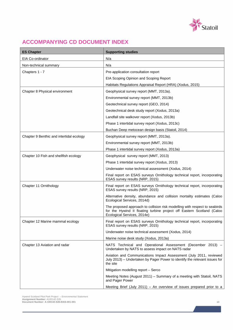
ACCOMPANYING CD DOCUMENT INDEX ES Chapter Supporting studies
EIA Co-ordinator N/a
Non-technical summary N/a
Chapters 1 - 7 Pre-application consultation report
EIA Scoping Opinion and Scoping Report
Habitats Regulations Appraisal Report (HRA) (Xodus, 2015)
Chapter 8 Physical environment Geophysical survey report (MMT, 2013a).
Environmental survey report (MMT, 2013b)
Geotechnical survey report (GEO, 2014)
Geotechnical desk study report (Xodus, 2013a)
Landfall site walkover report (Xodus, 2013b)
Phase 1 intertidal survey report (Xodus, 2013c)
Buchan Deep metocean design basis (Statoil, 2014)
Chapter 9 Benthic and intertidal ecology Geophysical survey report (MMT, 2013a).
Environmental survey report (MMT, 2013b)
Phase 1 intertidal survey report (Xodus, 2013a)
Chapter 10 Fish and shellfish ecology Geophysical survey report (MMT, 2013)
Phase 1 intertidal survey report (Xodus, 2013)
Underwater noise technical assessment (Xodus, 2014)
Final report on ESAS surveys Ornithology technical report, incorporating ESAS survey results (NRP, 2015)
Chapter 11 Ornithology Final report on ESAS surveys Ornithology technical report, incorporating ESAS survey results (NRP, 2015)
Alternative density, abundance and collision mortality estimates (Caloo Ecological Services, 2014d)
The proposed approach to collision risk modelling with respect to seabirds for the Hywind II floating turbine project off Eastern Scotland (Caloo Ecological Services, 2014e)
Chapter 12 Marine mammal ecology Final report on ESAS surveys Ornithology technical report, incorporating ESAS survey results (NRP, 2015)
Underwater noise technical assessment (Xodus, 2014)
Marine noise desk study (Xodus, 2013a)
Chapter 13 Aviation and radar NATS Technical and Operational Assessment (December 2013) – Undertaken by NATS to assess impact on NATS radar
Aviation and Communications Impact Assessment (July 2011, reviewed July 2013) – Undertaken by Pager Power to identify the relevant issues for the site
Mitigation modelling report – Serco
Meeting Notes (August 2011) – Summary of a meeting with Statoil, NATS and Pager Power
Meeting Brief (July 2011) – An overview of issues prepared prior to a
Hywind Scotland Pilot Park Project – Environmental Statement Assignment Number: A100142-S35 Document Number: A-100142-S35-EIAS-001-001 xii

ES Chapter Supporting studies
meeting with NATS
Chapter 14 Commercial fisheries Navigation Risk Assessment Hywind Scotland Pilot Park Project (Anatec, 2014)
Chapter 15 Shipping and navigation Navigation Risk Assessment Hywind Scotland Pilot Park Project (Anatec, 2014)
Preliminary hazard analysis (Anatec, 2013)
Draft emergency response cooperation plan (ERCoP)
Chapter 16 Marine historic environment Hywind Marine Historic Environment Baseline Report (ORCA Marine and SULA Diving, 2014)
Marine Survey Report: Hywind Offshore Windfarm; Statoil Doc. No. ST13828-Hywind OW (MMT, 2013)
Hywind Scotland Soil Investigation 2014, North Sea. British Sector Anchoring of Floating Wind Turbines and Cable Route. Unpublished Preliminary Client Report 3.0, Rev.01, 02/05/2014 (GEO, 2014)
Unexploded Ordnance Desk Based Study with Risk Assessment. Ordtek Ltd. Statoil Doc. No. C178-OTK-S-CA-0002 (Ordtek, 2014)
Chapter 17 Other sea users Unexploded ordnance desk based study with risk assessment (Ordtek, 2014)
Chapter 18 Socio economics, tourism and recreation
Assessment of socio-economic indicators and impacts (Optimat, 2014)
Chapter 19 Seascape, landscape and visual impact assessment
SLVIA impact assessment methodology (Horner and Maclennan, 2014)
Chapter 20 Hydrocarbon and chemical spill Navigation Risk Assessment Hywind Scotland Pilot Park Project (Anatec, 2014)
Chapter 21 Environmental management and monitoring
None
Chapter 22 Concluding statement None
Hywind Scotland Pilot Park Project – Environmental Statement Assignment Number: A100142-S35 Document Number: A-100142-S35-EIAS-001-001 xiii

ACRONYMS % Percent £ Great Britain Pound Sterling AC Alternating Current AD Air Defence ADCP Acoustic Doppler Current Profiler AfL Agreement for Lease AIS Automatic Identification System ALARP As low as is reasonably practicable AREG Aberdeen Renewable Energy Group ASA Allmennaksjeselskap (translated as public limited company) ATBA Area to be Avoided BGS British Geological Survey BH Bore hole BIFA Buchan Inshore Fishermen’s Association BMAPA British Marine Aggregate Producers Association BOWL Beatrice Offshore Windfarm Ltd BP British Petroleum BPI Burial Protection Index BS British Standard BT British Telecommunications BWCU Bund Water Control Unit CAA Civil Aviation Authority CAP Civil Aviation Publication CD Compact Disc Cefas Centre for Environment, Fisheries and Aquaculture Science CITES Convention on International Trade in Endangered Species of Wild Fauna and Flora CLR Contaminated Land Report CMS Construction Method Statement CNS Central North Sea CODA Cetacean Offshore Distribution and Abundance CPT Cone Penetration Testing CSO Combined Sewer Overflow dB Decibel DECC Department of Energy and Climate Change DEFRA Department for Environment, Food and Rural Affairs DETR Department of the Environment, Transport and the Regions DfT Department for Transport DNV Det Norske Veritas DP Decommissioning Programme DSA Development Search Area DSFB District Salmon Fisheries Board DTI Department of Trade and Industry EC European Council EEC European Economic Community EIA Environmental Impact Assessment EMF Electromagnetic Field EMP Environmental Management Plan EOWFL European Offshore Wind Deployment Centre EP Extreme Pressure EPS European Protected Species ERCOP Emergency Response Cooperation Plan ERRV Emergency Response and Rescue Vessels Hywind Scotland Pilot Park Project – Environmental Statement Assignment Number: A100142-S35 Document Number: A-100142-S35-EIAS-001-001 xiv

ES Environmental Statement ESAS European Seabirds at Sea EU European Union FEED Front End Engineering Design FLOWW Fishing Liaison with Offshore Wind and Wet Renewables FPSO Floating Production, Storage and Offloading Vessel FSA Formal Safety Assessment GCR Geological Conservation Review GIS Geographical Information System GT Gross tonnage GWh Gigawatt hour ha Hectare HDD Horizontal Directionally Drilled HGV Heavy Goods Vehicle HM Her Majesty’s HRA Habitats Regulations Appraisal HSE Health and Safety Executive HSL Hywind (Scotland) Limited HVDC High Voltage Direct Current Hz Hertz IALA International Association of Marine Aids ICES International Council for the Exploration of the Sea IfA Institute for Archaeologists IMO International Maritime Organisation ISQGs Interim Marine Sediment Quality Guidelines IUCN International Union for Conservation of Nature JNCC Joint Nature Conservation Committee kg Kilograms kg/m Kilograms per metre km Kilometre km2 Kilometres squared kV Kilovolt LAT Lowest Astronomical Tide LSE Likely Significant Effect LV Low voltage m Metres M Million m/s Metres per second m2 Metres squared m3 Metres cubed MAIB Marine Accident Investigation Branch MarLIN Marine Life Information Network MARPOL International Convention for the Prevention of Pollution from Ships MBES Multibeam Echo Sounder MCA Maritime and Coastguard Agency MDA Managed Defence Area MEHRA Marine Environmental High Risk Area MGN Marine Guidance Notice MHWS Mean High Water Springs mm Millimetres MMMU Marine Mammal Management Units MOD Ministry of Defence MORL Moray Offshore Renewables Ltd MPA Marine Protected Area Hywind Scotland Pilot Park Project – Environmental Statement Assignment Number: A100142-S35 Document Number: A-100142-S35-EIAS-001-001 xv

MPS Marine Policy Statement MRT Multi-radar Tracker MSL Mean Sea Level MS-LOT Marine Scotland License and Operations Team MW Megawatt MWh Megawatt hour MWL Mean Water Level NaOH Sodium Hydroxide NATS National Air Traffic Service NES LBAP North East Scotland Local Biodiversity Action Plan NLB Northern Lighthouse Board nm Nautical miles nm2 Nautical miles squared NOAA National Oceanic and Atmospheric Administration NOC National Oceanographic Centre NRA Navigational Risk Assessment NRIP National Renewables Infrastructure Plan NRP Natural Research Projects NTS Non-technical Summary ORCA Orkney Research Centre for Archaeology OREI Offshore Renewable Energy Installations OSPAR Oslo/Paris convention (for the Protection of the Marine Environment of the North-East
Atlantic) PA Position Approximate PAN Planning Advice Note PBR Potential Biological Removal PEL Probable Effect Levels PEMP Project Environmental Monitoring Programme PHA Preliminary Hazard Analysis PL Pipeline PMF Priority Marine Features PPE Personal Protective Equipment PPG Pollution Prevention Guidelines PSV Platform Supply Vessel Q1 (also 1Q) First quarter Q2 Second quarter Q3 Third quarter RAF Royal Air Force RBMP River Basin Management Plan RCAHMS Royal Commission on the Ancient and Historic Monuments of Scotland RNA Rotor – Nacelle Assembly RNLI Royal National Lifeboat Institution ROC Renewables Obligation Certificate ROV Remotely Operated Vehicle RPM Rotations Per Minute RRH Remote Radar Head RYA Royal Yachting Association SAC Special Area of Conservation SAR Search and Rescue SBP Sub Bottom Profiler SCANS Small Cetacean Abundance in the North Sea (SCANS-I) / Small Cetaceans in the
European Atlantic and North Sea (SCANS-II) SCOS Special Committee on Seals SEA Strategic Environmental Assessment Hywind Scotland Pilot Park Project – Environmental Statement Assignment Number: A100142-S35 Document Number: A-100142-S35-EIAS-001-001 xvi

SEL Sound Exposure Level SEPA Scottish Environment Protection Agency SFF Scottish Fishermen’s Federation SMS Safety Management System SNCB Statutory Nature Conservation Body SNH Scottish Natural Heritage SOPEP Shipboard Oil Pollution Emergency Plan SPA Special Protection Area SPP Scottish Planning Policy SSE Scottish and Southern Energy SSS Side Scan Sonar SSSI Site of Special Scientific Interest SWL Statoil Wind Limited TCE The Crown Estate TEL Threshold Effect Levels TPS Tactical Transportable Radar UK United Kingdom UKBAP UK Biodiversity Action Plan UKHO United Kingdom Hydrographic Office UNCLOS The United Nations Convention of the Law of the Sea UPS Uninterruptible Power Supply US United States UXO Unexploded Ordnance VMS Vessel Monitoring System WFD Water Framework Directive WTG Wind Turbine Generator WWI First World War WWII Second World War
Hywind Scotland Pilot Park Project – Environmental Statement Assignment Number: A100142-S35 Document Number: A-100142-S35-EIAS-001-001 xvii
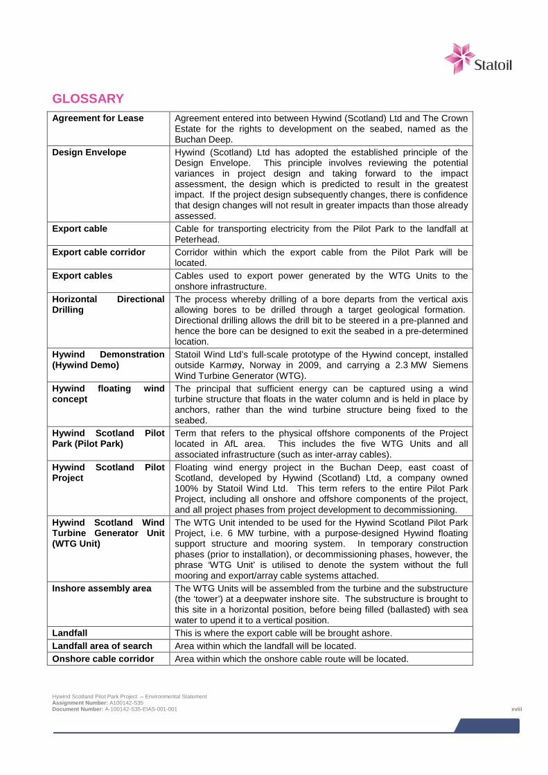
GLOSSARY Agreement for Lease Agreement entered into between Hywind (Scotland) Ltd and The Crown
Estate for the rights to development on the seabed, named as the Buchan Deep.
Design Envelope Hywind (Scotland) Ltd has adopted the established principle of the Design Envelope. This principle involves reviewing the potential variances in project design and taking forward to the impact assessment, the design which is predicted to result in the greatest impact. If the project design subsequently changes, there is confidence that design changes will not result in greater impacts than those already assessed.
Export cable Cable for transporting electricity from the Pilot Park to the landfall at Peterhead.
Export cable corridor Corridor within which the export cable from the Pilot Park will be located.
Export cables Cables used to export power generated by the WTG Units to the onshore infrastructure.
Horizontal Directional Drilling
The process whereby drilling of a bore departs from the vertical axis allowing bores to be drilled through a target geological formation. Directional drilling allows the drill bit to be steered in a pre-planned and hence the bore can be designed to exit the seabed in a pre-determined location.
Hywind Demonstration (Hywind Demo)
Statoil Wind Ltd’s full-scale prototype of the Hywind concept, installed outside Karmøy, Norway in 2009, and carrying a 2.3 MW Siemens Wind Turbine Generator (WTG).
Hywind floating wind concept
The principal that sufficient energy can be captured using a wind turbine structure that floats in the water column and is held in place by anchors, rather than the wind turbine structure being fixed to the seabed.
Hywind Scotland Pilot Park (Pilot Park)
Term that refers to the physical offshore components of the Project located in AfL area. This includes the five WTG Units and all associated infrastructure (such as inter-array cables).
Hywind Scotland Pilot Project
Floating wind energy project in the Buchan Deep, east coast of Scotland, developed by Hywind (Scotland) Ltd, a company owned 100% by Statoil Wind Ltd. This term refers to the entire Pilot Park Project, including all onshore and offshore components of the project, and all project phases from project development to decommissioning.
Hywind Scotland Wind Turbine Generator Unit (WTG Unit)
The WTG Unit intended to be used for the Hywind Scotland Pilot Park Project, i.e. 6 MW turbine, with a purpose-designed Hywind floating support structure and mooring system. In temporary construction phases (prior to installation), or decommissioning phases, however, the phrase ‘WTG Unit’ is utilised to denote the system without the full mooring and export/array cable systems attached.
Inshore assembly area The WTG Units will be assembled from the turbine and the substructure (the ‘tower’) at a deepwater inshore site. The substructure is brought to this site in a horizontal position, before being filled (ballasted) with sea water to upend it to a vertical position.
Landfall This is where the export cable will be brought ashore. Landfall area of search Area within which the landfall will be located. Onshore cable corridor Area within which the onshore cable route will be located.
Hywind Scotland Pilot Park Project – Environmental Statement Assignment Number: A100142-S35 Document Number: A-100142-S35-EIAS-001-001 xviii
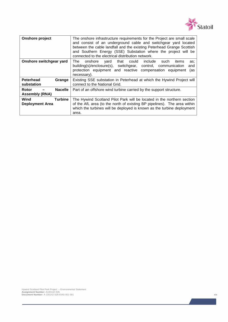
Onshore project The onshore infrastructure requirements for the Project are small scale
and consist of an underground cable and switchgear yard located between the cable landfall and the existing Peterhead Grange Scottish and Southern Energy (SSE) Substation where the project will be connected to the electrical distribution network.
Onshore switchgear yard The onshore yard that could include such items as; building(s)/enclosure(s), switchgear, control, communication and protection equipment and reactive compensation equipment (as necessary).
Peterhead Grange substation
Existing SSE substation in Peterhead at which the Hywind Project will connect to the National Grid.
Rotor – Nacelle Assembly (RNA)
Part of an offshore wind turbine carried by the support structure.
Wind Turbine Deployment Area
The Hywind Scotland Pilot Park will be located in the northern section of the AfL area (to the north of existing BP pipelines). The area within which the turbines will be deployed is known as the turbine deployment area.
Hywind Scotland Pilot Park Project – Environmental Statement Assignment Number: A100142-S35 Document Number: A-100142-S35-EIAS-001-001 xix
1 INTRODUCTION
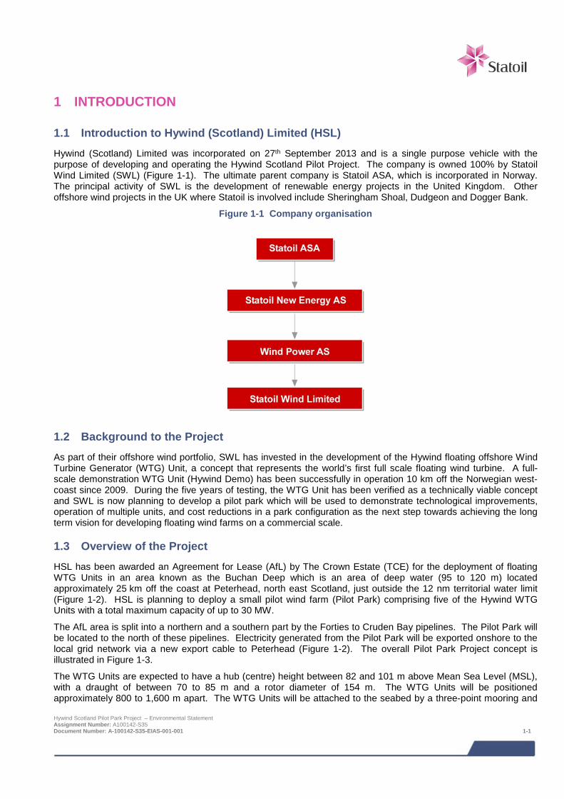
1.1 Introduction to Hywind (Scotland) Limited (HSL) Hywind (Scotland) Limited was incorporated on 27th September 2013 and is a single purpose vehicle with the purpose of developing and operating the Hywind Scotland Pilot Project. The company is owned 100% by Statoil Wind Limited (SWL) (Figure 1-1). The ultimate parent company is Statoil ASA, which is incorporated in Norway. The principal activity of SWL is the development of renewable energy projects in the United Kingdom. Other offshore wind projects in the UK where Statoil is involved include Sheringham Shoal, Dudgeon and Dogger Bank.
Figure 1-1 Company organisation
1.2 Background to the Project As part of their offshore wind portfolio, SWL has invested in the development of the Hywind floating offshore Wind Turbine Generator (WTG) Unit, a concept that represents the world’s first full scale floating wind turbine. A full-scale demonstration WTG Unit (Hywind Demo) has been successfully in operation 10 km off the Norwegian west-coast since 2009. During the five years of testing, the WTG Unit has been verified as a technically viable concept and SWL is now planning to develop a pilot park which will be used to demonstrate technological improvements, operation of multiple units, and cost reductions in a park configuration as the next step towards achieving the long term vision for developing floating wind farms on a commercial scale.
1.3 Overview of the Project HSL has been awarded an Agreement for Lease (AfL) by The Crown Estate (TCE) for the deployment of floating WTG Units in an area known as the Buchan Deep which is an area of deep water (95 to 120 m) located approximately 25 km off the coast at Peterhead, north east Scotland, just outside the 12 nm territorial water limit (Figure 1-2). HSL is planning to deploy a small pilot wind farm (Pilot Park) comprising five of the Hywind WTG Units with a total maximum capacity of up to 30 MW.
The AfL area is split into a northern and a southern part by the Forties to Cruden Bay pipelines. The Pilot Park will be located to the north of these pipelines. Electricity generated from the Pilot Park will be exported onshore to the local grid network via a new export cable to Peterhead (Figure 1-2). The overall Pilot Park Project concept is illustrated in Figure 1-3.
The WTG Units are expected to have a hub (centre) height between 82 and 101 m above Mean Sea Level (MSL), with a draught of between 70 to 85 m and a rotor diameter of 154 m. The WTG Units will be positioned approximately 800 to 1,600 m apart. The WTG Units will be attached to the seabed by a three-point mooring and Hywind Scotland Pilot Park Project – Environmental Statement Assignment Number: A100142-S35 Document Number: A-100142-S35-EIAS-001-001 1-1

anchoring system. Three anchors will be required per WTG Unit. The radius of the mooring system will be between 600 to 1,200 m.
The WTG Units will be connected by inter-array cables which may require anchoring in some locations. The export cable, which will transport electricity from the park to the shore at Peterhead, is likely to be buried. Both the inter-array and export cable will have 33 kV transfer voltage. The export cable is planned to come ashore at Peterhead and connect to the local distribution network at Peterhead Grange Substation. Statoil is responsible for all Project infrastructure up to and including the onshore switchgear yard. Beyond this point connection to the grid will be the responsibility of SSE.
In addition to the proposed AfL area and associated onshore and offshore infrastructure, the Hywind Scotland Pilot Park Project will use a deep water inshore area on the west coast of Norway, to assemble the WTG Units prior to installation. Once assembled, the WTG Units will be towed in an upright position from the assembly point to the turbine deployment area in the Buchan Deep.
HSL aims to begin onshore construction in 2015 / 2016 followed by offshore installation in 2016 / 2017. This will allow for final commissioning of the Pilot Park in 2017.
Hywind Scotland Pilot Park Project – Environmental Statement Assignment Number: A100142-S35 Document Number: A-100142-S35-EIAS-001-001 1-2
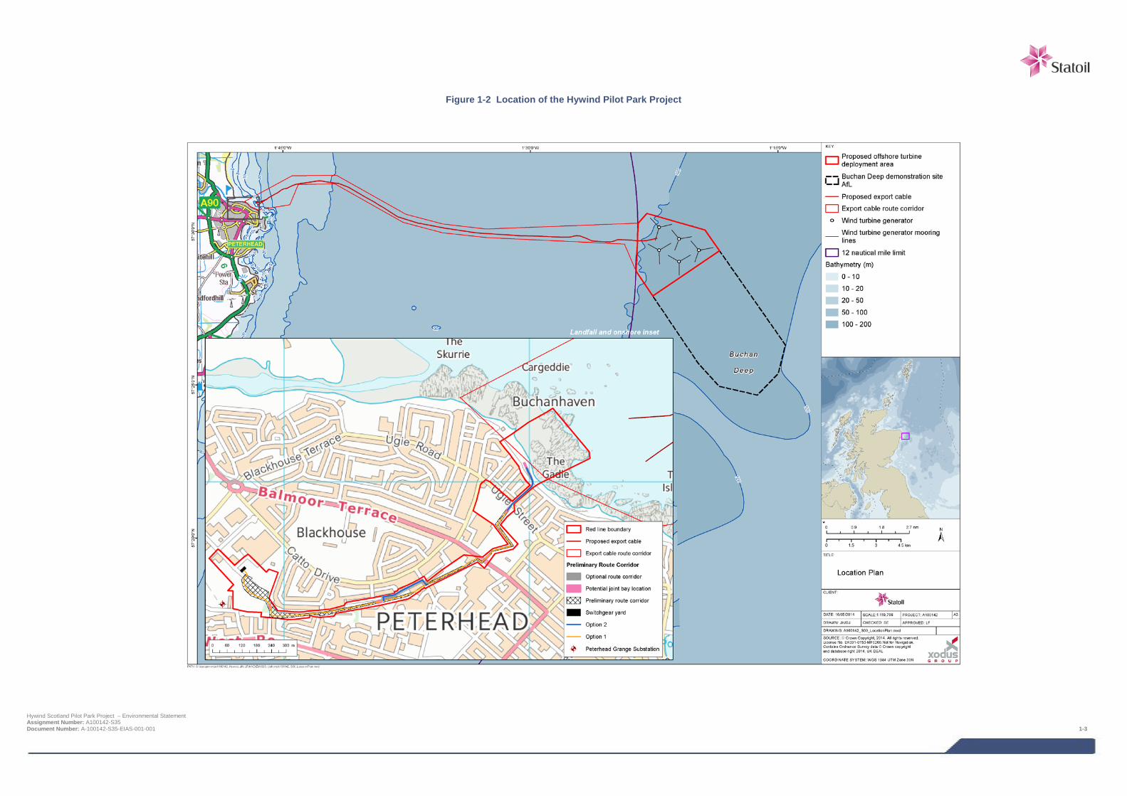
Figure 1-2 Location of the Hywind Pilot Park Project
Hywind Scotland Pilot Park Project – Environmental Statement Assignment Number: A100142-S35 Document Number: A-100142-S35-EIAS-001-001 1-3
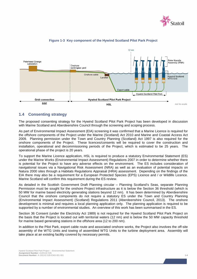
Figure 1-3 Key component of the Hywind Scotland Pilot Park Project
1.4 Consenting strategy The proposed consenting strategy for the Hywind Scotland Pilot Park Project has been developed in discussion with Marine Scotland and Aberdeenshire Council through the screening and scoping process.
As part of Environmental Impact Assessment (EIA) screening it was confirmed that a Marine Licence is required for the offshore components of the Project under the Marine (Scotland) Act 2010 and Marine and Coastal Access Act 2009. Planning permission under the Town and Country Planning (Scotland) Act 1997 is also required for the onshore components of the Project. These licences/consents will be required to cover the construction and installation, operational and decommissioning periods of the Project, which is estimated to be 25 years. The operational phase of the project is 20 years.
To support the Marine Licence application, HSL is required to produce a statutory Environmental Statement (ES) under the Marine Works (Environmental Impact Assessment) Regulations 2007 in order to determine whether there is potential for the Project to have any adverse effects on the environment. The ES includes consideration of navigational issues via a Navigational Risk Assessment (NRA) as well as an evaluation of potential impacts on Natura 2000 sites through a Habitats Regulations Appraisal (HRA) assessment. Depending on the findings of the EIA there may also be a requirement for a European Protected Species (EPS) Licence and / or Wildlife Licence. Marine Scotland will confirm this requirement during the ES review.
As detailed in the Scottish Government Draft Planning circular – Planning Scotland’s Seas, separate Planning Permission must be sought for the onshore Project infrastructure as it is below the Section 36 threshold (which is 50 MW for marine based electricity generating stations beyond 12 nm). It has been determined by Aberdeenshire Council that the onshore components do not require a statutory ES under the Town and Country Planning (Environmental Impact Assessment) (Scotland) Regulations 2011 (Aberdeenshire Council, 2013). The onshore development is minimal and requires a local planning application only. The planning application is required to be supported by a number of environmental studies. An overview of this work has been summarised in the ES.
Section 36 Consent (under the Electricity Act 1989) is not required for the Hywind Scotland Pilot Park Project on the basis that the Project is located out with territorial waters (12 nm) and is below the 50 MW capacity threshold for marine based generating stations in the offshore area (12 to 200 nm).
In addition to the Pilot Park, export cable route and associated onshore works, the Project also involves the off-site assembly of the WTG Units and towing of assembled WTG Units to the turbine deployment area. Assembly will take place at an existing facility covered by necessary permits.
Hywind Scotland Pilot Park Project – Environmental Statement Assignment Number: A100142-S35 Document Number: A-100142-S35-EIAS-001-001 1-4

Once the Project is granted relevant Marine Licences the Department of Energy and Climate Change (DECC) will request production of a Decommissioning Programme (DP) which must be approved prior to the commencement of installation. This is a requirement under the Energy Act 2013.
Table 1-1 provides a list of the consent applications and the Project assets covered by each application.
Table 1-1 Marine consent applications
Works Consent and duration Description Determining
authority
Parts of the Project outside 12 nm (the WTG Units, moorings, inter-array cables and part of the export cable outside 12 nm)
Marine Licence Under Section 6 of the Marine and Coastal Access Act 2009
20 years
Consent under a Marine Licence covers the deposit of any substance or object within the UK marine licensing areas (beyond 12 nm in Scotland) either on the sea or on or under the seabed. This covers the following areas of the Project:
> WTG Unit anchors and moorings, inter-array cables and export cable.
Scottish Ministers (through Marine Scotland)
Parts of the Project within 12 nm below Mean High Water Springs (MHWS) (the export cable)
Marine Licence under Section 16 of the Marine (Scotland) Act 2010
20 years
Consent under a Marine Licence covers construction and deposit of structures below Mean High Water Springs (MHWS) and out to 12 nm. This covers the following areas of the Project:
> The deposit of objects under the seabed, e.g. cable to shore with open trench or directionally drilled cable landfalls / boreholes.
Scottish Ministers (through Marine Scotland)
The WTG Units, moorings, inter-array cables and export cable
Energy Act 2013
Once the development is granted relevant Marine Licences the Department of Energy and Climate Change (DECC) will request production of a Decommissioning Programme (DP) which must be approved prior to the commencement of installation.
Department for Energy and Climate Change (DECC)
Onshore cable routing from MLWS and additional electrical infrastructure at the onshore switchgear yard
Planning permission under Section 28 of the Town and Country Planning (Scotland) Act 1997
20 years
Planning permission for the development of any area of land is required under Section 28. This covers the following areas of the Project:
> The onshore cable routing and additional electrical infrastructure at the onshore switchgear yard.
Aberdeenshire Council
1.5 Consideration of design options Throughout the EIA process the Design Envelope (previously known as Rochdale Envelope) approach has been used to assess the project design which could result in the greatest potential environmental impacts. Whilst this approach results in a conservative impact assessment; care must be taken to ensure the impacts predicted to arise from the project are not over estimated, such that they are unlikely to ever occur, and therefore undermine the EIA process.
The Design Envelope provides essential flexibility to enable projects to take full advantage of on-going improvements in technology, infrastructure and installation techniques, and for this Project, will allow HSL to move towards their goal of future development of larger scale commercial floating offshore wind farms. To commit to a detailed development design at consent application stage would also prevent the Project benefiting from the lessons learned from other work being done in the offshore wind industry, including the continued testing of the Hywind Demo. Hywind Scotland is more matured at this stage compared to what is the case for many other offshore wind projects. The Design Envelope therefore describes less variability in the technical options than other similar projects. Where a base case solution exists for the project, the impacts of that is assessed in addition to the Project design which would result in the greatest environmental impact. Full details of this approach are provided in Chapter 6.
Hywind Scotland Pilot Park Project – Environmental Statement Assignment Number: A100142-S35 Document Number: A-100142-S35-EIAS-001-001 1-5
1.6 Data gaps and uncertainties The North Sea has been extensively investigated by numerous researchers, meaning that this EIA has been able to draw on an extensive amount of published data. This bank of published data has been supplemented by a field survey programme and studies undertaken on behalf of HSL to collect Project specific baseline data.
The EIA process aims to identify and characterise potential impacts using information on the current status of the environment as a basis. As potential impacts are predicted based on currently available project and environmental information, there is some uncertainty in predictions. Impact predictions are based on Project specific surveys and the most up to date scientific knowledge and data analysis techniques currently available.
Where uncertainty in baseline information or impact characterisation remains, this is acknowledged within this ES and an indication of its scale is provided. Data gaps and uncertainties detailed are typical of those facing offshore projects and are not considered to be critical in assessing the broad range of impacts associated with the Hywind Scotland Pilot Park Project.
1.7 Contributors to the EIA The final EIA scope has involved the study of a number of different topics. The results of these studies are summarised in Chapters 8 to 20 of the ES. In addition all supporting studies are provided on a CD located inside the front cover of the ES. All supporting studies relevant to each ES chapter are summarised at the beginning of each chapter. The ES structure is detailed in Figure 1-4 and a full list of ES contributors and ES supporting studies is provided in Table 1-2.
Table 1-2 ES contributors and supporting studies to the ES
ES Chapter Contributors Supporting studies
EIA Co-ordinator Xodus N/a
Non-technical summary Xodus N/a
Chapters 1 - 7 Xodus
HSL
Pre-application consultation report
EIA Scoping Opinion and Scoping Report
Habitats Regulations Appraisal Report (HRA) (Xodus, 2015)
Chapter 8 Physical environment Xodus – author Geophysical survey report (MMT, 2013a).
Environmental survey report (MMT, 2013b)
Geotechnical survey report (GEO, 2014)
Geotechnical desk study report (Xodus, 2013a)
Landfall site walkover report (Xodus, 2013b)
Phase 1 intertidal survey report (Xodus, 2013c)
Buchan Deep metocean design basis (Statoil, 2014)
Chapter 9 Benthic and intertidal ecology
Xodus – author
MMT – benthic survey
Geophysical survey report (MMT, 2013a).
Environmental survey report (MMT, 2013b)
Phase 1 intertidal survey report (Xodus, 2013a)
Chapter 10 Fish and shellfish ecology
Xodus – author Geophysical survey report (MMT, 2013)
Phase 1 intertidal survey report (Xodus, 2013)
Underwater noise technical assessment (Xodus, 2014)
Final report on ESAS surveys Ornithology technical report, incorporating ESAS survey results (NRP, 2015)
Hywind Scotland Pilot Park Project – Environmental Statement Assignment Number: A100142-S35 Document Number: A-100142-S35-EIAS-001-001 1-6
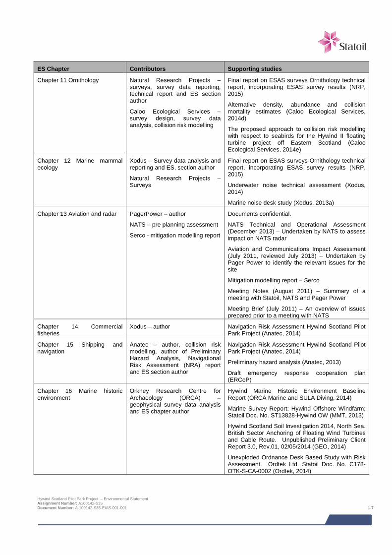
ES Chapter Contributors Supporting studies
Chapter 11 Ornithology Natural Research Projects – surveys, survey data reporting, technical report and ES section author
Caloo Ecological Services – survey design, survey data analysis, collision risk modelling
Final report on ESAS surveys Ornithology technical report, incorporating ESAS survey results (NRP, 2015)
Alternative density, abundance and collision mortality estimates (Caloo Ecological Services, 2014d)
The proposed approach to collision risk modelling with respect to seabirds for the Hywind II floating turbine project off Eastern Scotland (Caloo Ecological Services, 2014e)
Chapter 12 Marine mammal ecology
Xodus – Survey data analysis and reporting and ES, section author
Natural Research Projects – Surveys
Final report on ESAS surveys Ornithology technical report, incorporating ESAS survey results (NRP, 2015)
Underwater noise technical assessment (Xodus, 2014)
Marine noise desk study (Xodus, 2013a)
Chapter 13 Aviation and radar PagerPower – author
NATS – pre planning assessment
Serco - mitigation modelling report
Documents confidential.
NATS Technical and Operational Assessment (December 2013) – Undertaken by NATS to assess impact on NATS radar
Aviation and Communications Impact Assessment (July 2011, reviewed July 2013) – Undertaken by Pager Power to identify the relevant issues for the site
Mitigation modelling report – Serco
Meeting Notes (August 2011) – Summary of a meeting with Statoil, NATS and Pager Power
Meeting Brief (July 2011) – An overview of issues prepared prior to a meeting with NATS
Chapter 14 Commercial fisheries
Xodus – author Navigation Risk Assessment Hywind Scotland Pilot Park Project (Anatec, 2014)
Chapter 15 Shipping and navigation
Anatec – author, collision risk modelling, author of Preliminary Hazard Analysis, Navigational Risk Assessment (NRA) report and ES section author
Navigation Risk Assessment Hywind Scotland Pilot Park Project (Anatec, 2014)
Preliminary hazard analysis (Anatec, 2013)
Draft emergency response cooperation plan (ERCoP)
Chapter 16 Marine historic environment
Orkney Research Centre for Archaeology (ORCA) – geophysical survey data analysis and ES chapter author
Hywind Marine Historic Environment Baseline Report (ORCA Marine and SULA Diving, 2014)
Marine Survey Report: Hywind Offshore Windfarm; Statoil Doc. No. ST13828-Hywind OW (MMT, 2013)
Hywind Scotland Soil Investigation 2014, North Sea. British Sector Anchoring of Floating Wind Turbines and Cable Route. Unpublished Preliminary Client Report 3.0, Rev.01, 02/05/2014 (GEO, 2014)
Unexploded Ordnance Desk Based Study with Risk Assessment. Ordtek Ltd. Statoil Doc. No. C178-OTK-S-CA-0002 (Ordtek, 2014)
Hywind Scotland Pilot Park Project – Environmental Statement Assignment Number: A100142-S35 Document Number: A-100142-S35-EIAS-001-001 1-7

ES Chapter Contributors Supporting studies
Chapter 17 Other sea users Xodus – author Unexploded ordnance desk based study with risk assessment (Ordtek, 2014)
Chapter 18 Socio economics Optimat – author Assessment of socio-economic indicators and impacts (Optimat, 2014)
Chapter 19 Seascape, landscape and visual impact assessment
Horner and Maclennan – author
Envision - photomontages
SLVIA impact assessment methodology (Horner and Maclennan, 2014)
Chapter 20 Potential hydrocarbon and chemical spill
Xodus – author Navigation Risk Assessment Hywind Scotland Pilot Park Project (Anatec, 2014)
Chapter 21 Environmental management and monitoring
Xodus – author None
Chapter 22 Concluding statement
Xodus – author None
Hywind Scotland Pilot Park Project – Environmental Statement Assignment Number: A100142-S35 Document Number: A-100142-S35-EIAS-001-001 1-8
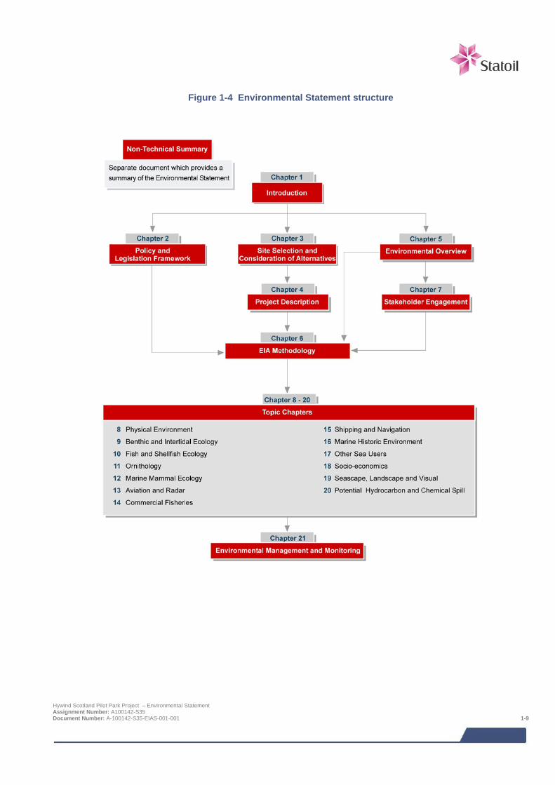
Figure 1-4 Environmental Statement structure
Hywind Scotland Pilot Park Project – Environmental Statement Assignment Number: A100142-S35 Document Number: A-100142-S35-EIAS-001-001 1-9

2 POLICY AND LEGISLATION FRAMEWORK This chapter provides a summary and overview of the international, UK, Scottish, regional and local planning policies and guidance which are directly relevant to the Hywind Scotland Pilot Park Project.
2.1 The need for renewable energy The UK has committed to sourcing 15% of its total energy needs from renewable sources by 2020 under the 2009 Directive on Renewable Energy (2009/28/EC) including electricity, heat and transport. The UK and Scottish Governments have also made legally binding commitments through the Climate Change Act 2008 and the Climate Change (Scotland) Act 2009.
There are four key drivers for the shift in energy production to low carbon sources, including renewable energy, in the UK and Scotland which are:
> The need to tackle climate change;
> The need to secure energy supply;
> The need for new energy infrastructure; and
> The need to maximise economic opportunities.
2.2 Energy and climate change policy The challenges of climate change, energy supply and security of supply are driving policy on renewable energy developments. There are now a significant number of national and international policies, strategies and regulations relating to climate change and the development of renewable energy in Europe, the UK and Scotland. The Hywind Scotland Pilot Park Project is designed as a significant step towards developing a full commercial scale floating wind turbine development. This will allow SWL to test and further develop the technology, including installation methods, WTG Unit design and design of the moorings and anchors. The Project will contribute up to 30 MW installed capacity from wind energy and will make a contribution to achieving these policy aims. The lessons learned in developing the Pilot Park can then be applied to developing a commercial scale project which will further contribute to achieving relevant International, European, UK and Scottish policy aims including for example:
> Kyoto protocol;
> EU Renewable Energy Directive (2009/28/EC);
> UK Climate Change Act 2008;
> The Climate Change (Scotland) Act 2009;
> The Scottish Government’s 2020 Routemap for Renewable Energy in Scotland; and
> Scotland’s Offshore Wind Route Map 2013.
2.3 Marine planning framework (policy, consenting and licensing)
2.3.1 Marine (Scotland) Act 2010 and the Marine and Coastal Access Act 2009 The Marine (Scotland) Act 2010 created a new legislative and management framework for the marine environment within Scottish territorial waters (0 to 12 nm). This follows the UK Marine and Coastal Access Act 2009 under which Scottish Ministers have devolved authority for marine planning and conservation powers in the offshore region (12 to 200 nm).
Under these Acts the Scottish Government is required to prepare a National Marine Plan for Scottish territorial waters and the offshore zone. The National Marine Plan is being developed to clarify the overall objectives and policy framework for the management and sustainable development of Scotland's marine environment. The Draft Hywind Scotland Pilot Park Project – Environmental Statement Assignment Number: A100142-S35 Document Number: A-100142-S35-EIAS-001-001 2-1
National Marine Plan was published for consultation in July 2013. Consultation on the draft plan was held from 25th July to 13th November 2013. An independent investigation of the plan commenced in May 2014 and in July 2014 30 new Marine Protected Areas were designated under the Plan to conserve rare or representative habitats and species.
The Scottish Government may also choose to prepare Regional Marine Plans. Boundaries for the Regional Marine Plans are in the process of being formulated. These are expected to be finalised in line with the publication of the National Marine Plan. Thereafter, the regional marine plan preparation process will be undertaken.
2.3.2 Marine policy statement - UK The UK Marine Policy Statement (MPS) applies to all UK waters and has been adopted by the UK Government, the Scottish Government, the Welsh Assembly Government and the Northern Ireland Executive. The function of the MPS is to provide the framework for preparing Marine Plans and taking decisions affecting the marine environment. All national and regional marine plans must be in conformity with the MPS.
The objectives of the MPS are to:
> Promote sustainable economic development; enable the UK’s move towards a low-carbon economy, in order to mitigate the causes of climate change and ocean acidification and adapt to their effects;
> Ensure a sustainable marine environment which promotes healthy, functioning marine ecosystems and protects marine habitats, species and our heritage assets; and
> Contribute to the societal benefits of the marine area, including the sustainable use of marine resources to address local social and economic issues.
The MPS emphasises the importance of renewable energy and recognises the importance of considering marine renewable projects in marine planning, stating that "Contributing to securing the UK's energy objectives, while protecting the environment, will be a priority for marine planning".
2.3.3 Marine and terrestrial interface Although this ES focuses specifically on the offshore Project infrastructure, the Scottish Government (2013) is trying to ensure that there is consistency and mutual support in the specific development proposals in marine and terrestrial plans which affect each other, and that the terrestrial and marine authorities and developers should consult early on in the process. To this effect, the Scottish Government issued a Draft Planning circular ‘The relationship between the statutory land use planning system and marine planning and licensing‘ in July 2013. Legally, the jurisdiction of marine and terrestrial authorised overlap between the low and high water marks. There has been on-going consultation with Marine Scotland and Aberdeenshire Council to ensure the consent applications meet the requirements of both authorities.
Aberdeenshire Council determined that a Statutory ES under the Town and Country Planning (Environmental Impact Assessment) (Scotland) Regulations 2011 was not required for the Project and have only requested specific environmental studies to support the planning application. The scope of the environmental studies required to support the onshore planning application has been agreed with Aberdeenshire Council through a series of meetings held with the Statoil project team and Xodus EIA team throughout the EIA. The following topics have been studied:
> Terrestrial ecology;
> Contaminated land;
> Flood risk and surface water drainage;
> Landscape;
> Onshore traffic and transport; and
> Onshore noise.
Hywind Scotland Pilot Park Project – Environmental Statement Assignment Number: A100142-S35 Document Number: A-100142-S35-EIAS-001-001 2-2
2.4 Environmental Impact Assessment legislation Requirements for EIA are defined in the EIA Directive (85/337/EEC as amended by 97/11/EC) which has been transposed into Scottish law. The purpose of the EIA Directive is to ensure that the potential effects of a project on the environment are taken into consideration before development consent is granted. If a development is deemed to have potential to have a significant effect on the environment by virtue of its scale, size and location, then an EIA is required. The results of which must be provided by the developer to the decision maker in the form of an ES. The competent authority cannot grant consent for an EIA development without taking into account an ES.
The Directive is legally transposed into Scottish law via statutory instruments known as Regulations. The following Regulations are applicable to the offshore aspects of the Project:
> Marine Works (Environmental Impact Assessment) Regulations (2007) as amended;
o These Regulations are relevant to those elements of the Project which require a Marine Licence under the Marine (Scotland) Act 2010 and the Marine and Coastal Access Action 2010, i.e. the WTG Units, moorings, inter-array cables and export cable to shore;
This ES has been produced in accordance with the regulations listed above.
2.5 Nature conservation (including HRA and European Protected Species)
2.5.1 Habitats and Birds Directives The European Habitats Directive (92/43/EEC) and Birds Directive (79/409/EEC) are transposed into Scottish Law in the terrestrial environment and out to 12 nm by the Conservation (Natural Habitats, &c.) Regulations 1994 (as amended) and into UK law for territorial waters beyond 12 nm by the Offshore Marine Conservation (Natural Habitats, &c.) Regulations 2007 (as amended). The Conservation of Habitats and Species Regulations 2010 do not apply to this Project on the basis that the Project does not require consent under Sections 36 of the Electricity Act 1989.
European sites protected under this legislation include Special Protected Areas (SPA), Special Area of Conservation (SAC) and RAMSAR sites where they overlap an SAC or SPA. The European Habitats Directive (92/43/EEC) aims to promote the maintenance of biodiversity by requiring EU Member States to maintain or restore representative natural habitats and wild species at a favourable conservation status, through the introduction of robust protection for those habitats and species of European importance.
As part of these protection measures, Member States are required to undertake assessments to determine whether a plan or project is likely to have an adverse effect on the integrity of a European site. This process of Habitats Regulations Appraisal (HRA) is discussed in more detail below.
Habitats Regulations Appraisal and Appropriate Assessment
HRA is an iterative process which aims to determine likely significant effects and if necessary assess adverse impacts on the integrity of European sites.
Appropriate Assessment is one stage of this process. A competent authority shall make an Appropriate Assessment of the implications for a site in view of that site’s conservation objectives, before deciding to undertake or give any consent, permission or other authorisation for, a plan or project which:
> Is likely to have a significant effect on a European site in the UK (either alone or in combination with other plans or projects); and
> Is not directly connected with or necessary to the management of the site.
The need for Appropriate Assessment extends to plans or projects out with the boundary of the site in order to determine their implications for the interests protected within the site. Competent authorities need to identify the qualifying interests and the conservation objectives for each European site involved in an Appropriate Assessment. There are a number of Natura 2000 sites in proximity to the Project which have been considered during the EIA.
Hywind Scotland Pilot Park Project – Environmental Statement Assignment Number: A100142-S35 Document Number: A-100142-S35-EIAS-001-001 2-3

An HRA report has been prepared by HSL to accompany the ES and the consent applications and is provided on the supporting documents CD accompanying this ES. Data gathered as part of the EIA surveys and studies has been used to inform the HRA and provide the information that is used to undertake the assessment. The requirement for an Appropriate Assessment will be determined by the competent authority (Marine Scotland), following assessment of the information presented in this ES and the HRA report submitted alongside the consent applications. The HRA report contains sufficient information to enable the competent authority to carry out an Appropriate Assessment should it determine that one is required.
European Protected Species and Wildlife licensing requirements
For any European Protected Species (EPS), Regulation 39 of the Conservation (Natural Habitats, &c.) Regulations 1994 which apply out to 12 nm and the Offshore Marine Conservation (Natural Habitats, &c.) Regulations 2007 (as amended) which apply beyond 12 nm makes it an offence to deliberately or recklessly capture, kill, injure, harass or disturb any such animal. Whilst the injury offence is related to acts against one or more animals, the disturbance offence differs depending on location; out to 12 nm the offence covered by the Conservation (Natural Habitats, &c.) Regulations 1994 is to disturbance any EPS individual, whereas the offence beyond 12 nm covered by the Offshore Marine Conservation (Natural Habitats, &c.) Regulations 2007 is related to disturbance of a significant group of EPS. An EPS Licence is required for any activity that might result in injury to, or disturbance of, an EPS. Deliberate harm to any EPS is not anticipated as part of the Project; however, inadvertent or accidental disturbance may occur if project activities take place in the presence of an EPS.
Basking sharks are protected under Schedule 5 of the Wildlife and Countryside Act (1981 as amended) which prohibits the killing, injuring or taking by any method of those wild animals listed on Schedule 5 of the Act. The Nature Conservation (Scotland) Act 2004, Part 3 and Schedule 6 make amendments to the Wildlife and Countryside Act (1981 as amended), strengthening the legal protection for threatened species to include ‘reckless’ acts. The Act makes it an offence to intentionally or recklessly disturb basking sharks.
Licensing requirements under the Wildlife and Countryside Act (1981 as amended) are similar to those for European Protected Species (EPS) protected under Annex IV of the Habitats Directive. Marine Scotland will determine specific licensing requirements, based on the information contained in this Environmental Statement, as part of the application determination.
2.6 Guidance and best practice Current best practice guidelines for EIA methodologies and licensing for offshore renewables projects have been developed from UK Rounds 1, 2 and 3 offshore wind developments. Also of relevance to this Project is the Draft Marine Scotland Licensing and Consents Manual 2012 (Marine Scotland 2012). Relevant guidance and best practice applying to specific EIA topics is identified in Chapters 8 to 20.
2.7 References Marine Scotland (2012). Marine Scotland Licensing and Consents Manual. Covering Marine Renewables and Offshore Wind Energy Development.
Scottish Government (2013). Draft Planning Circular: Planning Scotland Sea’s: The relationship between the statutory land use planning system and marine planning and licensing. July 2013.
Hywind Scotland Pilot Park Project – Environmental Statement Assignment Number: A100142-S35 Document Number: A-100142-S35-EIAS-001-001 2-4
3 SITE SELECTION AND CONSIDERATION OF ALTERNATIVES
3.1 Background to the Project The Hywind concept has been demonstrated and verified through five years of operation of the Hywind Demo prototype. This was the world’s first full-scale floating wind turbine (2.3 MW), installed off the island of Karmøy, Norway, in 2009. The prototype has performed beyond expectations. It has produced around 40 GWh since the start, and in this period survived waves up to 20 m and wind speed in excess of 40 m/s. The capacity factor1 in 2011 was as high as 50%.
The Hywind concept combines known technologies in a completely new setting and opens up the possibility for capturing wind energy in deep-water environments. It is building on Statoil’s long experience and competence as a developer and operator of offshore oil and gas installations. Hywind has been designed as a slender cylinder structure, chosen as the most feasible and economical concept for a floating wind turbine. Statoil's proprietary Hywind-specific pitch motion controller is integrated with the turbine’s control system and mitigates excessive motions of the structure. This eliminates the loss of energy due to aerodynamic or hydrodynamic movements, and maximises the power output from the turbine. The structure is ballast-stabilised and anchored to the seabed. The mooring system consists of mooring lines attached to anchors suited to the seabed conditions on site.
Having successfully completed technical testing of the Hywind floating wind concept, the next step towards building large commercial parks are to up-scale and optimise the substructure design, and to test out the technology in a small park with several units. The Hywind Scotland Pilot Park Project will utilise a higher capacity turbine, with a more optimised substructure design. A pilot park with several units will be used to test out how the floater motions of the units in a park are affected by wake effects, and will demonstrate that the technology also works in a park configuration. Furthermore, it will demonstrate that the costs can be reduced significantly, and sufficiently to make the technology cost-effective in large scale commercial parks in the longer term.
Statoil's principal goals with a pilot park is to utilise the experience and learning from the Hywind Demo to improve the design and bring the costs down in a larger scale development. The effect of performing repeated activities within construction and installation is important for the estimation of scope and duration in larger wind parks. Cost-efficiency is obtained by combining the effects of large scale serial production with a low amount of mobilisation work and efficient use of transport and installation vessels. The pilot park could also open up new opportunities for suppliers to participate in the future floating offshore wind industry and participate in lowering costs in future commercial scale floating wind parks.
Statoil’s initial plans for the Hywind Scotland Pilot Park Project began in 2009. However, the Project was put on hold in April 2012 due to uncertainty with regard to whether enhanced support for floating wind could be offered under the Renewables Obligation Certificates (ROCs) by the Scottish Government. Clarifications of the specific level of financial support from ROCs for floating wind were delayed several times during 2012 compared to the timelines that were initially indicated. However, in December 2012 the Scottish Government launched a consultation on support for “innovative offshore wind generation in Scottish waters” (i.e. floating wind), proposing a support level of between 2.5 – 3.5 ROC/MWh for projects up to 30 MW. The project organisation was mobilised again during spring 2013 to follow up on this initiative. The Scottish Government announced their decision in June 2013, when a support level of 3.5 ROC was confirmed. In April 2014 a separate ROC-band for floating wind (3.5 ROC) and grace period of 18 months (after 1st April 2017) was (following EU approval) finally approved in Parliament. Statoil had initially pursued parallel Hywind Pilot Park initiatives both in Maine (US) and Scotland, to ensure optionality in the early phase. The project in Maine was halted for different reasons in 2013.
3.2 Site evaluation The evaluation of potential sites for the Hywind Scotland Pilot Park began back in 2009. Identification of a suitable location for development of the Project was influenced by a number of factors including:
> Water depth – the WTG Units require, in general, water depths of more than 90 m;
1 Capacity factor is a measure of how often an electricity generation plant runs for a specific period of time. It indicates how much electricity a generator actually produces relative to the maximum it could achieve. Hywind Scotland Pilot Park Project – Environmental Statement Assignment Number: A100142-S35 Document Number: A-100142-S35-EIAS-001-001 3-1

> Proximity to the grid – due to the relatively small scale of the Pilot Park (30 MW) potential development sites
need to be close to the coast to facilitate export of power in a cost-effective way to the electric distribution grid without offshore sub-station and transformation;
> Access to sheltered inshore deep water areas for WTG Unit assembly;
> Proximity to deep water navigation route – once assembled the WTG Units are towed in an upright position to the Pilot Park site. Therefore the navigation route between the inshore assembly area and Pilot Park site must be of sufficient water depth to accommodate the unit’s towing draft; and
> Suitable seabed conditions – an even seabed, with sufficient soil above bedrock is preferred, although not required, for the ease of installation.
SWL identified two locations in Scottish waters which met all or most of the criteria above. These potentially viable locations included an area in The Minch off Stornoway and the Buchan Deep off Peterhead. Identification of these areas was supported by high level constraint mapping and initial consultations with statutory consultees and some local stakeholders. Feedback from the conservation bodies at this early stage suggested that the risk to consenting may be less for the Buchan Deep location due to it being further offshore with less environmental sensitivity. The Buchan Deep site also offered better availability of grid connections and was therefore selected as the preferred development location.
SWL then carried out more detailed constraints mapping and stakeholder engagement for an area of search within the Buchan Deep to identify a preferred area for development. In 2011, SWL was awarded an Exclusivity Agreement by TCE for the deployment of floating WTG Units in an area of deep water (95 m to 120 m) located towards the southern end of the Buchan Deep, approximately 25 km east of Peterhead. An AfL was then awarded in 2013, and is illustrated in Figure 1-2.
Initial site assessment focused on the evaluation of offshore constraints for the turbine deployment area. Once a suitable offshore location for the Project was identified further work was undertaken to identify the preferred export cable route, cable landfall and onshore grid connection. The constraints were interrogated in a Geographical Information System (GIS) which has formed the basis of Project design to the current time.
3.3 Project design
3.3.1 Project design process Having secured an Exclusivity Agreement for the Buchan Deep, HSL commenced an initial design phase (Concept Design) to evaluate engineering options and alternatives for the Project. This work was completed in October 2014. The following engineering and design work has or will be initiated:
> Substructure and Mooring System: Front End Engineering Design (FEED) was awarded in July 2014. Final FEED report by January 2015. Detail design/engineering commenced in February 2015.
> WTG: ITT issued in June 2014. Contract was awarded to Siemens in December 2014.
> Tower: Design studies issued in October 2014. Detailed design commenced in February 2015.
During these design phases there has been or will be further refinement and optimisation of the offshore and onshore aspects of the Project. Each component is discussed below, including details of the options that are still being considered at the time of ES compilation.
3.3.2 Turbine deployment area The AfL area is split into two parts by the Forties Pipelines operated by BP. It was decided early on that the Pilot Park would be located either north or south of the pipelines. One governing factor for this decision was the minimum distance required between the Pilot Park and the pipeline, which should be maintained throughout the development area. A number of factors contributed to the decision to locate the Pilot Park to the north of the pipelines. Despite the area to the north of the pipelines having less energy output potential, the following factors were key in the decisions to go to the north of the pipelines:
Hywind Scotland Pilot Park Project – Environmental Statement Assignment Number: A100142-S35 Document Number: A-100142-S35-EIAS-001-001 3-2

> Location of the Pilot Park to the north of the pipeline avoided crossing the BP pipeline as the export cable could
exit the AfL area at the north west corner;
> Within the AfL area Sabellaria spinulosa reefs (common name Ross worm) were recorded; however in the area to the north of the pipeline the extent and quality of the reefs is considerably less than the extent and quality of reef located to the south of the pipeline; and
> The soil conditions for suction anchors is considered to be of more beneficial character north of the pipelines. Also from a geohazard point of view the area north of the pipeline was preferred.
3.3.3 Export cable The export cable will transport electricity from the Pilot Park to a landfall located along the coast at Peterhead. The cable route will be located within the cable corridor illustrated in Figure 1-2 which was based on a near direct route between the Pilot Park and landfall. The length of the export cable corridor will be 25 km to 35 km depending on the final location of the WTG Units, mooring configuration and arrangement of the inter-array cables. The proposed route curves near Peterhead to avoid disposal areas near the landfall. The outlet of the River Ugie and Buchanhaven Harbour limited the landfall area to the north.
Both geophysical and geotechnical surveys were conducted along the cable route and within the Pilot Park area to optimise the best route with least amount of obstructions. The detailed cable route was influenced by several factors from the surveys. Some of these factors included: avoiding boulders, debris, and seabed features such as sand waves and ripples, Sabellaria and potential UXOs. The soil conditions were also considered for trenching and cable routing through bedrock areas was avoided where possible.
3.3.4 Cable landfall During the conceptual phase, initial site investigations and engineering identified two potential cable landfall options:
> A Horizontal Directionally Drilled (HDD) landfall from Barclay Park; or
> A surface laid trench from Gadle Braes Promenade.
Engineering and geotechnical investigations are still on-going in order to select the final cable landfall (however, the HDD option is the base case). Therefore the Planning and Marine Licence applications submitted include both landfall options, which are described in more detail in the project description (Chapter 4).
3.3.5 Onshore cable and switchgear yard The SSE substation at Peterhead Grange substation was selected because this is a connection point (substation) where both 33 kV and 132 kV are available. This availability of 132 kV and 132 kV/33 kV transformers enables the project to connect at 33 kV and without having to strengthening the regional 33 kV distribution system.
As part of the Project there is a need for electrical infrastructure to be provided in an onshore switchgear yard which will be located along the onshore cable route as close to the grid connection point at the Peterhead Grange Substation. The preferred location for the switchgear yard is at the Balmoor Industrial Estate. This site was selected as it is an area that is available for industrial use and it is located between the Peterhead Grange substation and the coastline. Industrial locations/storage areas between Ugie Street and Wilson Street were also evaluated, but rejected as these locations require more construction work in Peterhead streets.
3.3.6 Inshore assembly area The key aspect of the Project that has yet to be decided is the location of the deepwater inshore assembly area. This is an important aspect of the Project and allows for assembly of the WTG Units in a sheltered inshore environment, rather than this taking place at the offshore site. Following this the assembled WTG Units will be towed to the Project site. Two oil and gas operation sites on the west coast of Norway between Bergen and Stavanger have been identified as being suitable, with deep water very close inshore. The selection of the inshore assembly area is expected to take place Q4 2015. Hywind Scotland Pilot Park Project – Environmental Statement Assignment Number: A100142-S35 Document Number: A-100142-S35-EIAS-001-001 3-3

3.4 Mitigation through site selection and consideration of alternatives Given the detailed deliberation that has been offered to the site selection process, the present Project design is considered to be the most appropriate solution available. It should be noted that mitigation has been applied where possible to this process through avoidance of specific sensitive receptors and the application of techniques for dealing with remaining constraints. Detailed mitigation relating to specific receptors is outlined in individual ES chapters (Chapters 8 to 20).
Hywind Scotland Pilot Park Project – Environmental Statement Assignment Number: A100142-S35 Document Number: A-100142-S35-EIAS-001-001 3-4
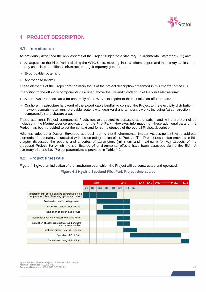
4 PROJECT DESCRIPTION
4.1 Introduction As previously described the only aspects of the Project subject to a statutory Environmental Statement (ES) are:
> All aspects of the Pilot Park including the WTG Units, mooring lines, anchors, export and inter-array cables and any associated additional infrastructure e.g. temporary generators;
> Export cable route; and
> Approach to landfall.
These elements of the Project are the main focus of the project description presented in this chapter of the ES.
In addition to the offshore components described above the Hywind Scotland Pilot Park will also require:
> A deep water inshore area for assembly of the WTG Units prior to their installation offshore; and
> Onshore infrastructure landward of the export cable landfall to connect the Project to the electricity distribution network comprising an onshore cable route, switchgear yard and temporary works including (a) construction compound(s) and storage areas.
These additional Project components / activities are subject to separate authorisation and will therefore not be included in the Marine Licence application for the Pilot Park. However, information on these additional parts of the Project has been provided to set the context and for completeness of the overall Project description.
HSL has adopted a Design Envelope approach during the Environmental Impact Assessment (EIA) to address elements of uncertainty associated with the on-going design of the Project. The Project description provided in this chapter discusses the options and a series of parameters (minimum and maximum) for key aspects of the proposed Project, for which the significance of environmental effects have been assessed during the EIA. A summary of these key Project parameters is provided in Table 4-2.
4.2 Project timescale Figure 4-1 gives an indication of the timeframe over which the Project will be constructed and operated.
Figure 4-1 Hywind Scotland Pilot Park Project time scales
Hywind Scotland Pilot Park Project – Environmental Statement Assignment Number: A100142-S35 Document Number: A-100142-S35-EIAS-001-001 4-1
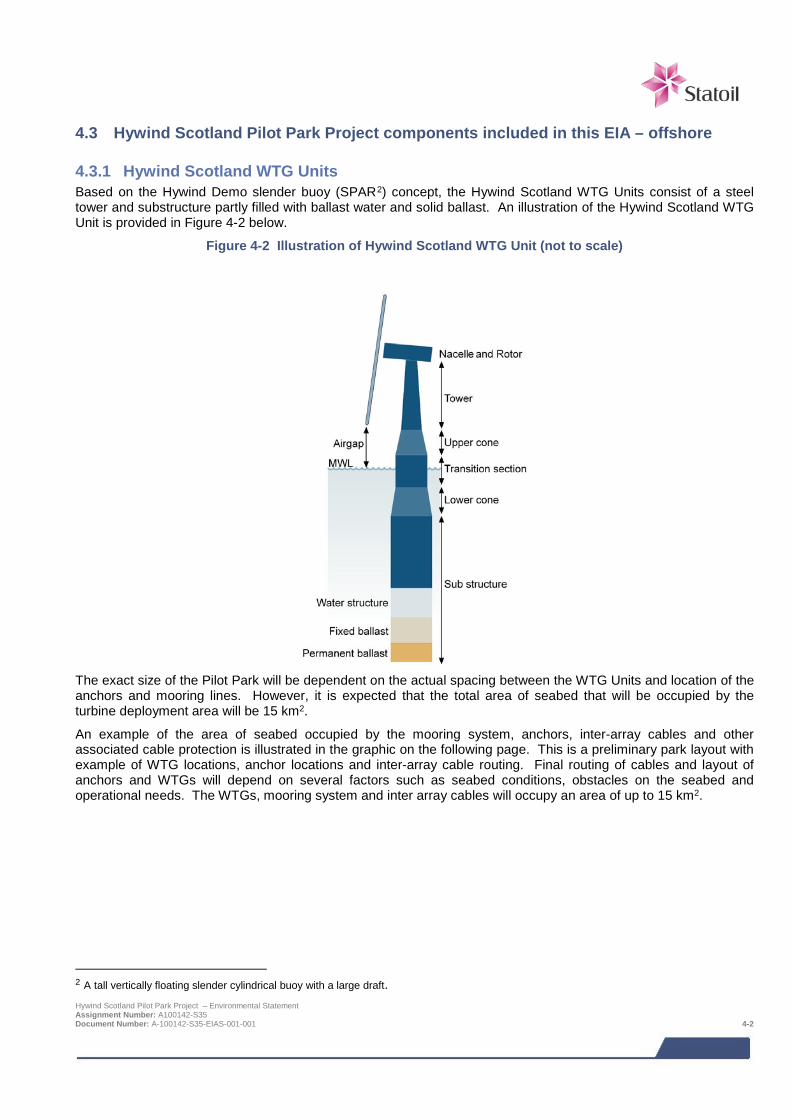
4.3 Hywind Scotland Pilot Park Project components included in this EIA – offshore
4.3.1 Hywind Scotland WTG Units Based on the Hywind Demo slender buoy (SPAR2) concept, the Hywind Scotland WTG Units consist of a steel tower and substructure partly filled with ballast water and solid ballast. An illustration of the Hywind Scotland WTG Unit is provided in Figure 4-2 below.
Figure 4-2 Illustration of Hywind Scotland WTG Unit (not to scale)
The exact size of the Pilot Park will be dependent on the actual spacing between the WTG Units and location of the anchors and mooring lines. However, it is expected that the total area of seabed that will be occupied by the turbine deployment area will be 15 km2.
An example of the area of seabed occupied by the mooring system, anchors, inter-array cables and other associated cable protection is illustrated in the graphic on the following page. This is a preliminary park layout with example of WTG locations, anchor locations and inter-array cable routing. Final routing of cables and layout of anchors and WTGs will depend on several factors such as seabed conditions, obstacles on the seabed and operational needs. The WTGs, mooring system and inter array cables will occupy an area of up to 15 km2.
2 A tall vertically floating slender cylindrical buoy with a large draft. Hywind Scotland Pilot Park Project – Environmental Statement Assignment Number: A100142-S35 Document Number: A-100142-S35-EIAS-001-001 4-2
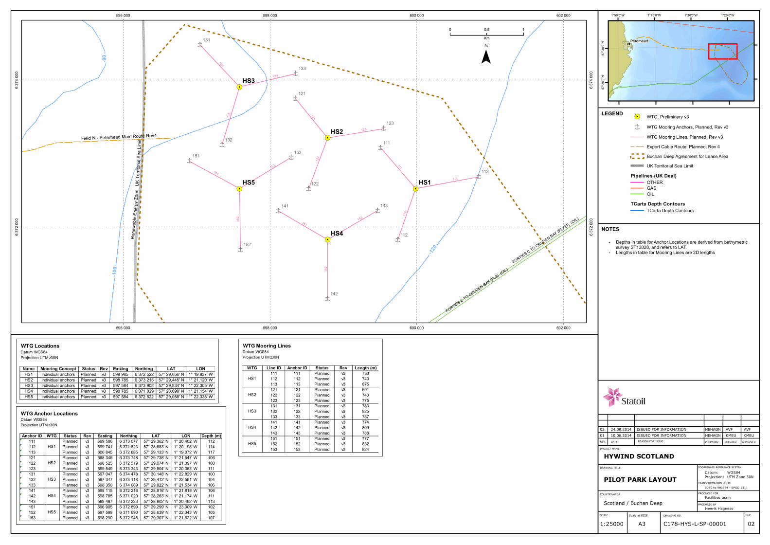
Î
Î
Î
Î
Î
Î
Î
Î
Î
Î Î
Î
Î Î
Î
!.
!.
!.
!.
!.
152
153151
142
143141
112
113
111
122
123
121
132
133
131
HS5HS5
HS4HS4
HS3HS3
HS2HS2
HS1HS1 113
152
132
153
142
111
143
133
131
151
112
123
141
122
121
Field N - Peterhead Main Route Rev4UK
Terr it
orial
Sea L
imit
Ren e
wable
Ene
rgy Zo
ne
FORTIES C TO CRUDEN BAY (PL8) (OIL)
FORTIES C TO CRUDEN BAY (PL721) (OIL)
-120
-100
-90
596 000
596 000
598 000
598 000
600 000
600 000
602 000
602 000
6 372
000
6 372
000
6 374
000
6 374
000
¯0 10,5
Km
!. WTG, Preliminary v3
Î WTG Mooring Anchors, Planned, Rev v3WTG Mooring Lines, Planned, Rev v3Export Cable Route, Planned, Rev 4Buchan Deep Agreement for Lease AreaUK Territorial Sea Limit
Pipelines (UK Deal)OTHERGASOIL
TCarta Depth ContoursTCarta Depth Contours
Peterhead
1°20'0"W1°30'0"W1°40'0"W1°50'0"W
57°3
0'0"N
57°2
5'0"N
LEGEND
NOTES
Depths in table for Anchor Locations are derived from bathymetricsurvey ST13828, and refers to LAT.Lengths in table for Mooring Lines are 2D lengths
--
REV. DATE REASON FOR ISSUE PREPARED APPROVEDCHECKED
COORDINATE REFERENCE SYSTEM
PROJECT NAME
DRAWING TITLE
DRAWING NO.SCALE Scale at SIZE REV.
C178-HYS-L-SP-00001 02A31:25000
TRANSFORMATION USED:ED50 to WGS84 - EPSG 1311
COUNTRY/AREA
Scotland / Buchan DeepPRODUCED FOR
Facilities teamPRODUCED BY
Henrik Hagness
HYWIND SCOTLAND
PILOT PARK LAYOUTDatum:Projection:
WGS84UTM Zone 30N
01 10.06.2014 ISSUED FOR INFORMATION HEHAGN KMEU KMEU02 24.09.2014 ISSUED FOR INFORMATION HEHAGN AVF AVF
WTG LocationsDatum WGS84Projection UTM z30N
Name Mooring Concept Status Rev Easting Northing LAT LONHS1 Individual anchors Planned v3 599 985 6 372 522 57° 29,056' N 1° 19,937' WHS2 Individual anchors Planned v3 598 785 6 373 215 57° 29,445' N 1° 21,120' WHS3 Individual anchors Planned v3 597 584 6 373 908 57° 29,834' N 1° 22,305' WHS4 Individual anchors Planned v3 598 785 6 371 829 57° 28,699' N 1° 21,154' WHS5 Individual anchors Planned v3 597 584 6 372 522 57° 29,088' N 1° 22,338' W
WTG Anchor LocationsDatum WGS84Projection UTM z30N
Anchor ID WTG Status Rev Easting Northing LAT LON Depth (m)111 Planned v3 599 506 6 373 077 57° 29,362' N 1° 20,402' W 112112 Planned v3 599 741 6 371 823 57° 28,683' N 1° 20,198' W 114113 Planned v3 600 845 6 372 685 57° 29,133' N 1° 19,072' W 117121 Planned v3 598 346 6 373 748 57° 29,738' N 1° 21,547' W 106122 Planned v3 598 525 6 372 519 57° 29,074' N 1° 21,397' W 108123 Planned v3 599 549 6 373 343 57° 29,504' N 1° 20,353' W 111131 Planned v3 597 047 6 374 478 57° 30,148' N 1° 22,829' W 100132 Planned v3 597 347 6 373 118 57° 29,412' N 1° 22,561' W 104133 Planned v3 598 350 6 374 089 57° 29,922' N 1° 21,534' W 106141 Planned v3 598 115 6 372 216 57° 28,916' N 1° 21,815' W 106142 Planned v3 598 785 6 371 020 57° 28,263' N 1° 21,174' W 111143 Planned v3 599 467 6 372 223 57° 28,902' N 1° 20,462' W 113151 Planned v3 596 905 6 372 899 57° 29,299' N 1° 23,009' W 102152 Planned v3 597 599 6 371 690 57° 28,639' N 1° 22,343' W 105153 Planned v3 598 290 6 372 946 57° 29,307' N 1° 21,622' W 107
HS5
HS3
HS2
HS1
HS4
WTG Mooring LinesDatum WGS84Projection UTM z30N
WTG Line ID Anchor ID Status Rev Length (m)111 111 Planned v3 733112 112 Planned v3 740113 113 Planned v3 875121 121 Planned v3 691122 122 Planned v3 743123 123 Planned v3 775131 131 Planned v3 783132 132 Planned v3 825133 133 Planned v3 787141 141 Planned v3 774142 142 Planned v3 809143 143 Planned v3 788151 151 Planned v3 777152 152 Planned v3 832153 153 Planned v3 824
HS3
HS2
HS1
HS4
HS5
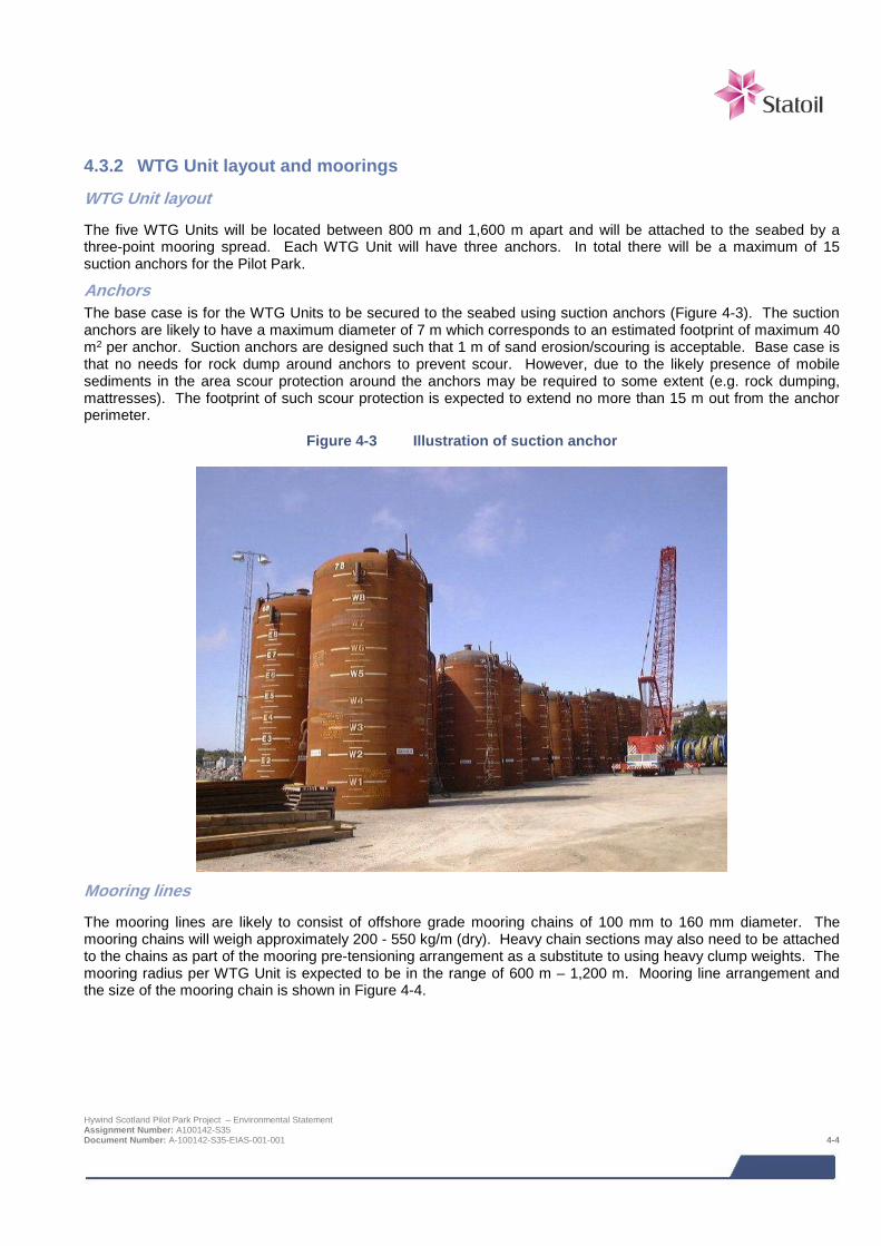
4.3.2 WTG Unit layout and moorings
WTG Unit layout
The five WTG Units will be located between 800 m and 1,600 m apart and will be attached to the seabed by a three-point mooring spread. Each WTG Unit will have three anchors. In total there will be a maximum of 15 suction anchors for the Pilot Park.
Anchors The base case is for the WTG Units to be secured to the seabed using suction anchors (Figure 4-3). The suction anchors are likely to have a maximum diameter of 7 m which corresponds to an estimated footprint of maximum 40 m2 per anchor. Suction anchors are designed such that 1 m of sand erosion/scouring is acceptable. Base case is that no needs for rock dump around anchors to prevent scour. However, due to the likely presence of mobile sediments in the area scour protection around the anchors may be required to some extent (e.g. rock dumping, mattresses). The footprint of such scour protection is expected to extend no more than 15 m out from the anchor perimeter.
Figure 4-3 Illustration of suction anchor
Mooring lines
The mooring lines are likely to consist of offshore grade mooring chains of 100 mm to 160 mm diameter. The mooring chains will weigh approximately 200 - 550 kg/m (dry). Heavy chain sections may also need to be attached to the chains as part of the mooring pre-tensioning arrangement as a substitute to using heavy clump weights. The mooring radius per WTG Unit is expected to be in the range of 600 m – 1,200 m. Mooring line arrangement and the size of the mooring chain is shown in Figure 4-4.
Hywind Scotland Pilot Park Project – Environmental Statement Assignment Number: A100142-S35 Document Number: A-100142-S35-EIAS-001-001 4-4
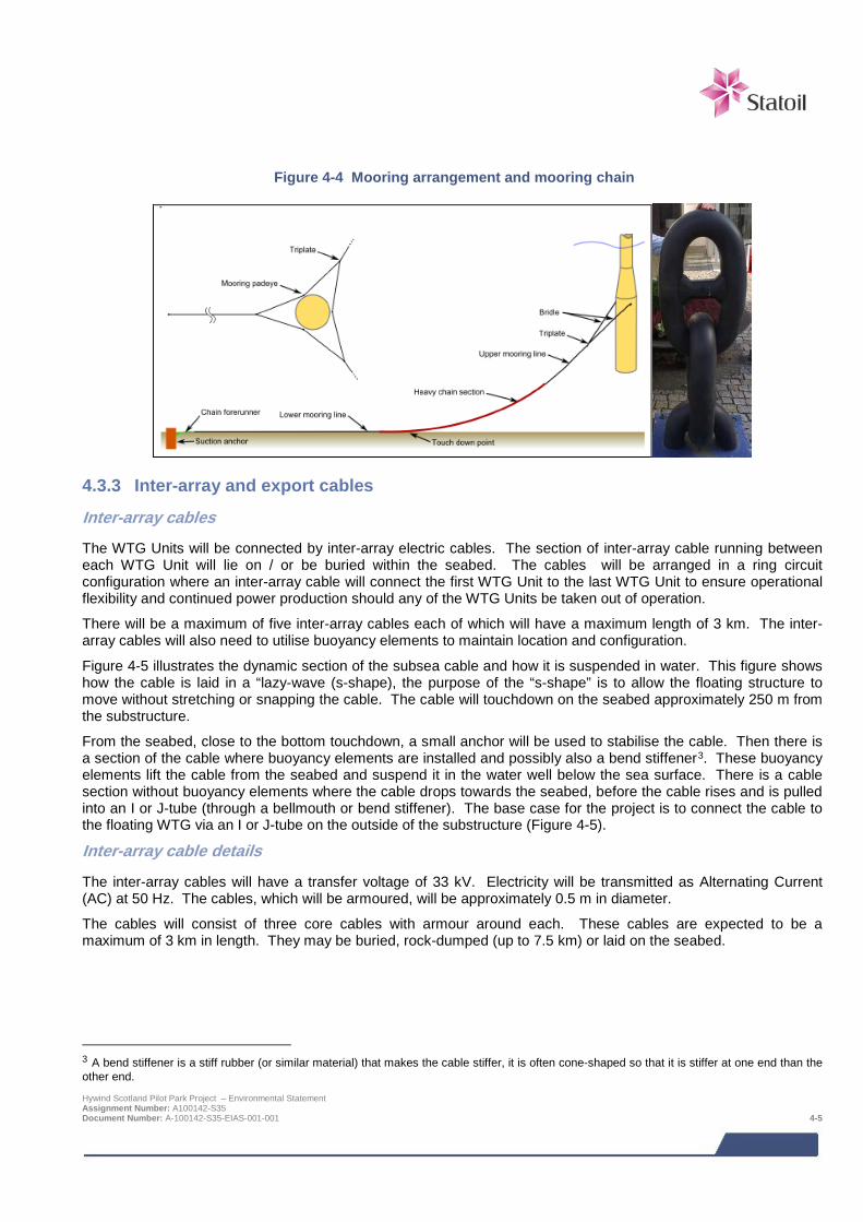
Figure 4-4 Mooring arrangement and mooring chain
4.3.3 Inter-array and export cables
Inter-array cables
The WTG Units will be connected by inter-array electric cables. The section of inter-array cable running between each WTG Unit will lie on / or be buried within the seabed. The cables will be arranged in a ring circuit configuration where an inter-array cable will connect the first WTG Unit to the last WTG Unit to ensure operational flexibility and continued power production should any of the WTG Units be taken out of operation.
There will be a maximum of five inter-array cables each of which will have a maximum length of 3 km. The inter-array cables will also need to utilise buoyancy elements to maintain location and configuration.
Figure 4-5 illustrates the dynamic section of the subsea cable and how it is suspended in water. This figure shows how the cable is laid in a “lazy-wave (s-shape), the purpose of the “s-shape” is to allow the floating structure to move without stretching or snapping the cable. The cable will touchdown on the seabed approximately 250 m from the substructure.
From the seabed, close to the bottom touchdown, a small anchor will be used to stabilise the cable. Then there is a section of the cable where buoyancy elements are installed and possibly also a bend stiffener3. These buoyancy elements lift the cable from the seabed and suspend it in the water well below the sea surface. There is a cable section without buoyancy elements where the cable drops towards the seabed, before the cable rises and is pulled into an I or J-tube (through a bellmouth or bend stiffener). The base case for the project is to connect the cable to the floating WTG via an I or J-tube on the outside of the substructure (Figure 4-5).
Inter-array cable details
The inter-array cables will have a transfer voltage of 33 kV. Electricity will be transmitted as Alternating Current (AC) at 50 Hz. The cables, which will be armoured, will be approximately 0.5 m in diameter.
The cables will consist of three core cables with armour around each. These cables are expected to be a maximum of 3 km in length. They may be buried, rock-dumped (up to 7.5 km) or laid on the seabed.
3 A bend stiffener is a stiff rubber (or similar material) that makes the cable stiffer, it is often cone-shaped so that it is stiffer at one end than the other end. Hywind Scotland Pilot Park Project – Environmental Statement Assignment Number: A100142-S35 Document Number: A-100142-S35-EIAS-001-001 4-5
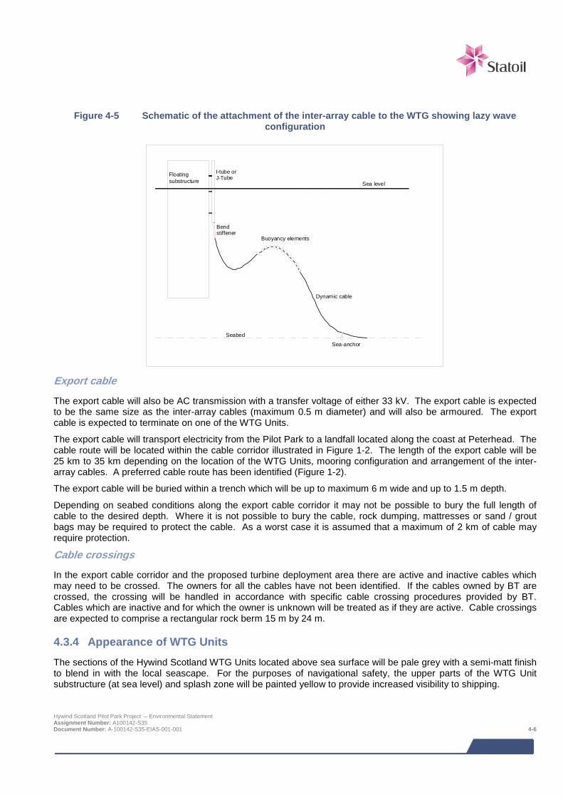
Figure 4-5 Schematic of the attachment of the inter-array cable to the WTG showing lazy wave configuration
Seabed
Sea-anchor
Buoyancy elements
Floating substructure
I-tube or J-Tube
Sea level
Bend stiffener
Dynamic cable
Export cable
The export cable will also be AC transmission with a transfer voltage of either 33 kV. The export cable is expected to be the same size as the inter-array cables (maximum 0.5 m diameter) and will also be armoured. The export cable is expected to terminate on one of the WTG Units.
The export cable will transport electricity from the Pilot Park to a landfall located along the coast at Peterhead. The cable route will be located within the cable corridor illustrated in Figure 1-2. The length of the export cable will be 25 km to 35 km depending on the location of the WTG Units, mooring configuration and arrangement of the inter-array cables. A preferred cable route has been identified (Figure 1-2).
The export cable will be buried within a trench which will be up to maximum 6 m wide and up to 1.5 m depth.
Depending on seabed conditions along the export cable corridor it may not be possible to bury the full length of cable to the desired depth. Where it is not possible to bury the cable, rock dumping, mattresses or sand / grout bags may be required to protect the cable. As a worst case it is assumed that a maximum of 2 km of cable may require protection.
Cable crossings
In the export cable corridor and the proposed turbine deployment area there are active and inactive cables which may need to be crossed. The owners for all the cables have not been identified. If the cables owned by BT are crossed, the crossing will be handled in accordance with specific cable crossing procedures provided by BT. Cables which are inactive and for which the owner is unknown will be treated as if they are active. Cable crossings are expected to comprise a rectangular rock berm 15 m by 24 m.
4.3.4 Appearance of WTG Units The sections of the Hywind Scotland WTG Units located above sea surface will be pale grey with a semi-matt finish to blend in with the local seascape. For the purposes of navigational safety, the upper parts of the WTG Unit substructure (at sea level) and splash zone will be painted yellow to provide increased visibility to shipping.
Hywind Scotland Pilot Park Project – Environmental Statement Assignment Number: A100142-S35 Document Number: A-100142-S35-EIAS-001-001 4-6

4.3.5 Lighting and navigational marking Each of the WTG Units will be equipped with navigational lights for marine operations and aviation that will automatically turn on in the dark. All navigation aids and aviation lighting will be installed in accordance with MGN371, advice from Northern Lighthouse Board (NLB) and guidance from NATS provided during consultation. The Pilot Park will also be marked on navigation charts.
4.3.6 WTG Unit ballast Each WTG Unit contains one internal ballast tank that will contain both solid ballast (some of which may be permanent) and ballast water.
Solid ballast will consist of high density aggregate e.g. high density concrete, slurry of iron ore or equivalent. The total ballast required for each WTG Unit is approximately 8,000 tons which would be split between a solid part and water. The percentage split and type of ballast material is subject to further design optimisation.
The ballast water will typically be dosed with lye, NaOH, giving a pH value above 10.5.
4.3.7 Antifouling and corrosion The corrosion protection of the external underwater substructure shall be a combination of cathodic protection and coating and follow standard offshore standards and guidance. Protection may vary between different parts of the structure. It may also be necessary to coat the internal welds located above the ballast water. Corrosion protection, including extent of coating, will be subject to further detail design.
4.3.8 Power requirements During hook-up and offshore commissioning a small portable diesel generator may be required, e.g. to provide power to WTG systems, cranes and tools. This will be located on the WTG Units and is most likely to be positioned on the access platform (above sea level). Alternatively, it could be placed inside the substructure. Once operational, the WTG Units will generate their own power and during low wind periods will draw power as required from the onshore grid through the export cable. The WTG Units also have their own emergency power supply based on battery powered UPS’s, but if grid connection is lost for a prolonged period of time (e.g. damaged export cable), a portable diesel generator may be required to be installed on the WTG Units.
4.3.9 WTG transformers Depending on the WTG supplier, the WTG Unit transformer may be a liquid filled transformer. The transformer fluid will be bio-degradable with a high fire point4 that is suitable for offshore wind farms.
4.4 Construction phase – offshore
4.4.1 Pilot Park mooring system installation It is anticipated that the mooring system consisting of suction anchors and mooring chains will be pre-installed prior to inter-array cable installation and towing of the preassembled WTG Units to the site.
The method to pre-install suction anchors (base case mooring system) would be for the anchors to be lowered into the water, together with the lower mooring chain, from an offshore construction vessel onto the seabed using a crane. An ROV would be deployed to monitor touchdown on the seabed. Once touchdown is complete, suction pumps will be activated to create a minor vacuum within the anchors and force them into their installed positions. Once the anchors are installed the lower mooring system comprising between 150 m and 600 m of mooring line will be laid and later lowered to the seabed with a subsea retrieval system.
4 Temperature at which a substance ignites. Hywind Scotland Pilot Park Project – Environmental Statement Assignment Number: A100142-S35 Document Number: A-100142-S35-EIAS-001-001 4-7
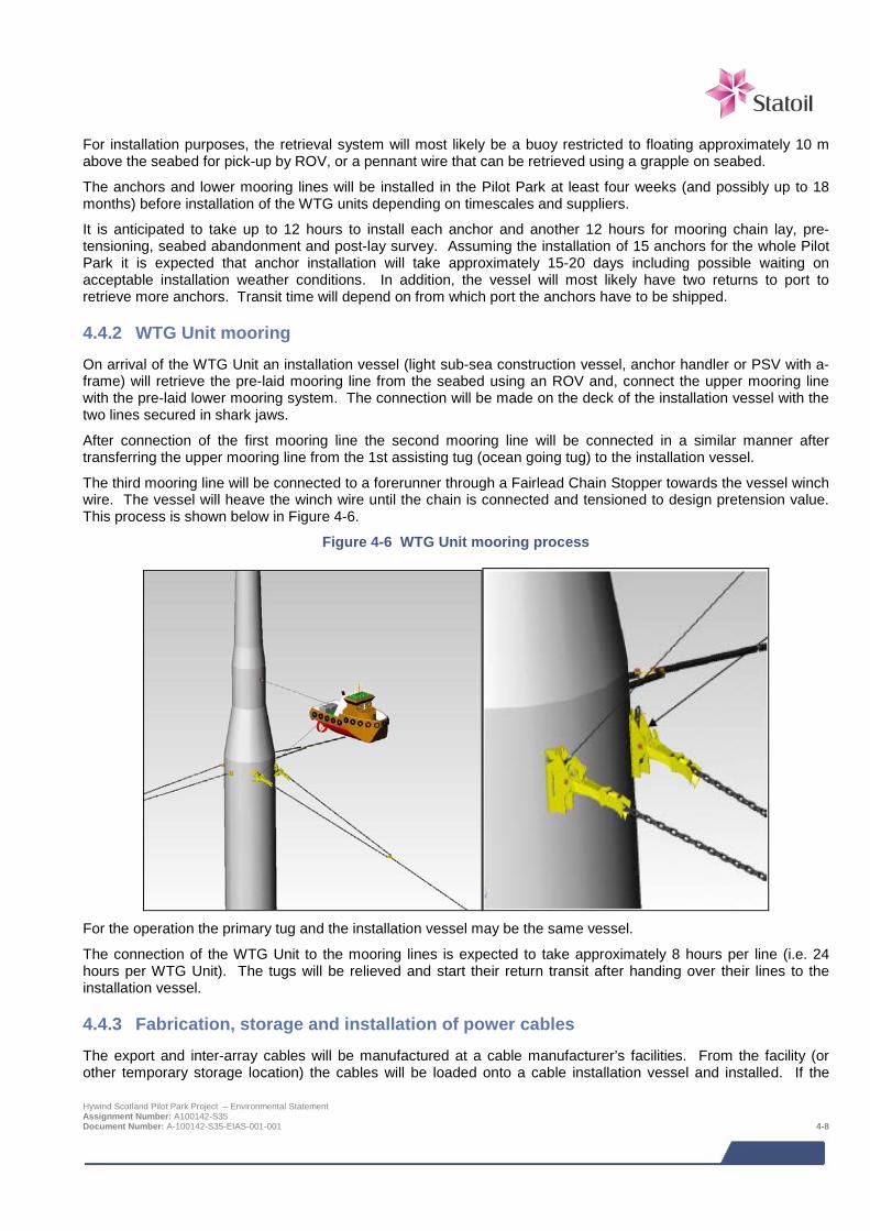
For installation purposes, the retrieval system will most likely be a buoy restricted to floating approximately 10 m above the seabed for pick-up by ROV, or a pennant wire that can be retrieved using a grapple on seabed.
The anchors and lower mooring lines will be installed in the Pilot Park at least four weeks (and possibly up to 18 months) before installation of the WTG units depending on timescales and suppliers.
It is anticipated to take up to 12 hours to install each anchor and another 12 hours for mooring chain lay, pre-tensioning, seabed abandonment and post-lay survey. Assuming the installation of 15 anchors for the whole Pilot Park it is expected that anchor installation will take approximately 15-20 days including possible waiting on acceptable installation weather conditions. In addition, the vessel will most likely have two returns to port to retrieve more anchors. Transit time will depend on from which port the anchors have to be shipped.
4.4.2 WTG Unit mooring On arrival of the WTG Unit an installation vessel (light sub-sea construction vessel, anchor handler or PSV with a-frame) will retrieve the pre-laid mooring line from the seabed using an ROV and, connect the upper mooring line with the pre-laid lower mooring system. The connection will be made on the deck of the installation vessel with the two lines secured in shark jaws.
After connection of the first mooring line the second mooring line will be connected in a similar manner after transferring the upper mooring line from the 1st assisting tug (ocean going tug) to the installation vessel.
The third mooring line will be connected to a forerunner through a Fairlead Chain Stopper towards the vessel winch wire. The vessel will heave the winch wire until the chain is connected and tensioned to design pretension value. This process is shown below in Figure 4-6.
Figure 4-6 WTG Unit mooring process
For the operation the primary tug and the installation vessel may be the same vessel.
The connection of the WTG Unit to the mooring lines is expected to take approximately 8 hours per line (i.e. 24 hours per WTG Unit). The tugs will be relieved and start their return transit after handing over their lines to the installation vessel.
4.4.3 Fabrication, storage and installation of power cables The export and inter-array cables will be manufactured at a cable manufacturer’s facilities. From the facility (or other temporary storage location) the cables will be loaded onto a cable installation vessel and installed. If the Hywind Scotland Pilot Park Project – Environmental Statement Assignment Number: A100142-S35 Document Number: A-100142-S35-EIAS-001-001 4-8

cables are to be stored after manufacturing it is anticipated that this will be done onshore at the manufacturer’s facility or floating on a barge at a floating storage site.
The inter-array cables will be installed from an installation vessel with a cable carousel and will be wet stored5 with a retrieval system prior to connection to the moored WTG Units. The retrieval system will be a submerged buoy just above the seabed with an approximate footprint of 5 m by 5 m.
It is anticipated that the export cable will be installed before the WTG Units are moored in the Pilot Park. The export cable will, most likely, be laid in a seaward direction from the landfall to the turbine deployment area. The end of the cable will be wet-stored with a retrieval system, possibly consisting of a buoy on the sea surface or just above the seabed.
The static parts of the export cable will be buried using a vessel with specialist cable burial equipment such as jet trenchers and mechanical trenchers. The final method of cable installation will depend on seabed conditions along the export cable route. The cable may be wet stored on the seabed for up to 18 months prior to connection.
Normal cable laying speed is 4 - 6 km/24 hours. Expected export cable laying duration is therefore expected to be 5 - 8 days. Trenching may take 8 - 12 days without problems. If an alternative protection method will be mobilised, this will be a separate campaign most likely using a different type of vessel. The overall duration of export cable installation is therefore expected to last 2 to 3 weeks subject to no operational problems.
Installation of the inter-array cables could take between 10 and 15 days.
4.4.4 Cable landfall The cable landfall will be located north of Peterhead harbour and there are currently two options for the location and method of the installation of the cable landfall (see Figure 1-2):
> Option 1 (base case) - Horizontal Directional Drilling (HDD) from Barclay Park; and
> Option 2 - Surface laid trench from Gadle Braes Promenade.
Although the majority of the activities associated with each of these options will take place onshore, both options include some activities which take place below the Mean High Water Spring (MHWS) mark and therefore need to be licenced under the Marine (Scotland) Act 2010.
The HDD cable landfall, although primarily an onshore activity, does include excavation of rock beneath the seabed. The profile of the drilled hole is based on an exit point approximately 10 m below Lowest Astronomical Tide (LAT). At seabed breakthrough it is anticipated that a small amount of rock (approximately 4 m3) and drilling fluid will be discharged.
Surface laid landfall will involve the installation of the cable across the foreshore in a surface laid duct which will be weighted down with clump weights and concrete mattresses. The cable duct will be approximately 400 mm in diameter and the concrete mattresses assumed to occupy an area of up to 4 m wide.
A full description of the cable landfall installation activities is provided in Section 4.8.
4.4.5 Commissioning of WTG Units Commissioning will be performed inshore after assembly to as large extent as practicable possible. However some final commissioning of the WTG Units will be required offshore. This will take place after the mooring lines and inter-array cables have been connected, and after the export cable has been hooked up and connected, prior to livening up the system to start testing. The duration of these activities and the amount of commissioning that will be required will, to some extent, depend on choice of WTG supplier.
5 Cable end will be protected so that it can be stored underwater until connected to a WTG Unit. Hywind Scotland Pilot Park Project – Environmental Statement Assignment Number: A100142-S35 Document Number: A-100142-S35-EIAS-001-001 4-9

4.5 Operational phase – offshore The Pilot Park is expected to generate 75 - 150 GWh/year (depending upon the WTG selected). The WTG Unit substructure, moorings and cables will be designed for an operational lifetime of at least 20 years. After the operational period, the Pilot Park could be decommissioned, replaced or continue to operate, subject to appropriate consent(s).
The WTG Units will be connected to shore by fibre optic communication in the export cable bundle. This will ensure communication with the WTG Units and data transfer so that the WTG Units can be remotely controlled and monitored via the control and monitoring system(s). The onshore control room will either be co-located with other Statoil facilities or with a third party.
During normal operations the WTG Units will shut down according to pre-defined rules and algorithms related to wind speeds and error alarms. Manual control is available and will be used when needed (e.g. during service and maintenance). Operating modes are indicated in Table 4-1 below.
Table 4-1 Typical Project operating modes
Operating mode Rotor – Nacelle Assembly (RNA) and blade conditions
Wind speed at which WTG Units will standstill (due to low wind) 3 - 4 m/s
Capacity 6 MW
Blade conditions when WTG Units are in standstill (due to low wind)
RNA in idling position. Blades will be pitched out of the wind (feather position), unlocked and free to idle. RNA yaw function is deactivated so that rotor is not necessarily turned up against the wind. Idle speed will not be very appreciable.
Wind speed at which WTG Units will operate 3 - 25 m/s (However, pending decision on WTG supplier, it may be possible to operate at higher wind speeds than 25 m/s)
Blade conditions when WTG Units are operational
RNA will be positioned against the wind and the rotor will be steadily working 4-13 RPM, depending upon wind speed and WTG supplier/model.
Wind speed at which WTG Units will shut down
The WTG units will typically shut down at speeds greater than 25m/s. However, it may be possible to increase the operational wind speed upper limit.
Blade conditions when WTG Units are shut down (due to high wind speeds)
Blades will be pitched out of the wind, unlocked and free to idle. RNA yaw function is activated so the rotor is turned in a favourable position towards the wind. Idle speed is slow, but may be noticeable.
Blade conditions when WTG Units are in standstill (due to maintenance)
Blades will be pitched and RNA yaw function is deactivated. Rotor will be locked before entering the hub, and blades shall be locked if maintenance work is done to blades/pitch system.
4.5.1 Lubricants and liquids The WTG Units may contain moderate quantities of liquids in the auxiliary and electrical systems. As this is dependent on the actual turbine selected, the following fluids and indicative quantities (per WTG Unit) may or may not apply:
> Hydraulic fluid for pitch actuators, brakes and locks:
o Typically < 1 m3 o Usually a high quality 32 grade synthetic or mineral based hydraulic oil.
> Coolant for generator and converters and transformer:
o Quantity dependent on type of turbine; typically around 1 m3
o Usually a 30/70 water/glycol mixture, as arctic conditions do not apply. Hywind Scotland Pilot Park Project – Environmental Statement Assignment Number: A100142-S35 Document Number: A-100142-S35-EIAS-001-001 4-10
> Transformer liquid (Synthetic ester):
o Typically 2 m3
> Small oil quantities in self-contained units, e.g. yaw gears:
o Rarely amounts to a total of more than 0.1-0.2 m3
o Usually a 320 grade synthetic or mineral based EP/gear oil
Lubricants and liquids (including hydrocarbons) associated with the temporary diesel generators will also be present at those times when the generators are installed on the WTG Units. Replacement of consumable liquids (e.g. fuel) associated with these temporary generators will be undertaken by vessel.
4.5.2 Maintenance activities Maintenance and inspection activities will be performed after the WTG Unit in question has been shut down. Boarding of the units will most likely be undertaken by boat, but helicopter could potentially be an option. Transfer of personnel by boat will be via the boat landing and ladders on the substructure, while the use of helicopter will hoist personnel directly onto the nacelle.
The WTG Units are expected to be serviced on an annual basis using crew transfer vessels and standard tools. It is assumed that the duration of servicing activities will be approximately 50 and 70 hours per year. Oil change will be performed at planned intervals for different systems (typical intervals is two to five years).
Inspections of inter-array and export cables, moorings and substructure will normally be performed at intervals of one to four years using vessels with Remotely Operated Vehicles (ROVs). To allow for adequate inspection, biofouling may also have to be removed from the substructure, cables and mooring lines.
In addition to scheduled services it is assumed that the WTG Units on average will require ten unforeseen visits per unit per year for corrective actions. Frequency of these corrective services will vary over the life time of the Project but in total for the 5 turbines could range 25 to 100 days per year.
Exchange of large components could occur and equipment failures may (in extreme events) require a new nacelle, blade or rotor. The WTG Units can be disconnected and towed to shore to allow more efficient working in sheltered waters if offshore lifts are hindered by waiting on weather. Offshore lifts would require a crane vessel, while the tow-in solution is foreseen to require tug boat(s), anchor handling vessel(s) and a crane vessel/barge. The Pilot Park will continue to operate in the situation where a WTG Unit has been removed.
4.6 Decommissioning phase – offshore Decommissioning of the floating WTG Units will follow the same relative sequence as construction, but will occur in reverse. The mooring lines will be disconnected and removed (to an extent which is practically and environmentally sound). The WTG Units will be towed back to a near shore location where they will be dismantled. Every attempt will be made to remove all deposits that have not been buried.
4.7 Design Envelope for offshore Project components Table 4-2 below provides a summary of the key parameters comprising the Design Envelope for the offshore components of the Hywind Scotland Pilot Park Project. These components are located within the ‘Project area which is defined as the proposed offshore turbine deployment area and the export cable corridor. The term ‘Project area’ is referenced throughout the topic specific impact assessments. The project component parameters provide the basis for the specific Design Envelope parameters to be assessed as part of the impact assessment for the individual EIA topics.
Hywind Scotland Pilot Park Project – Environmental Statement Assignment Number: A100142-S35 Document Number: A-100142-S35-EIAS-001-001 4-11
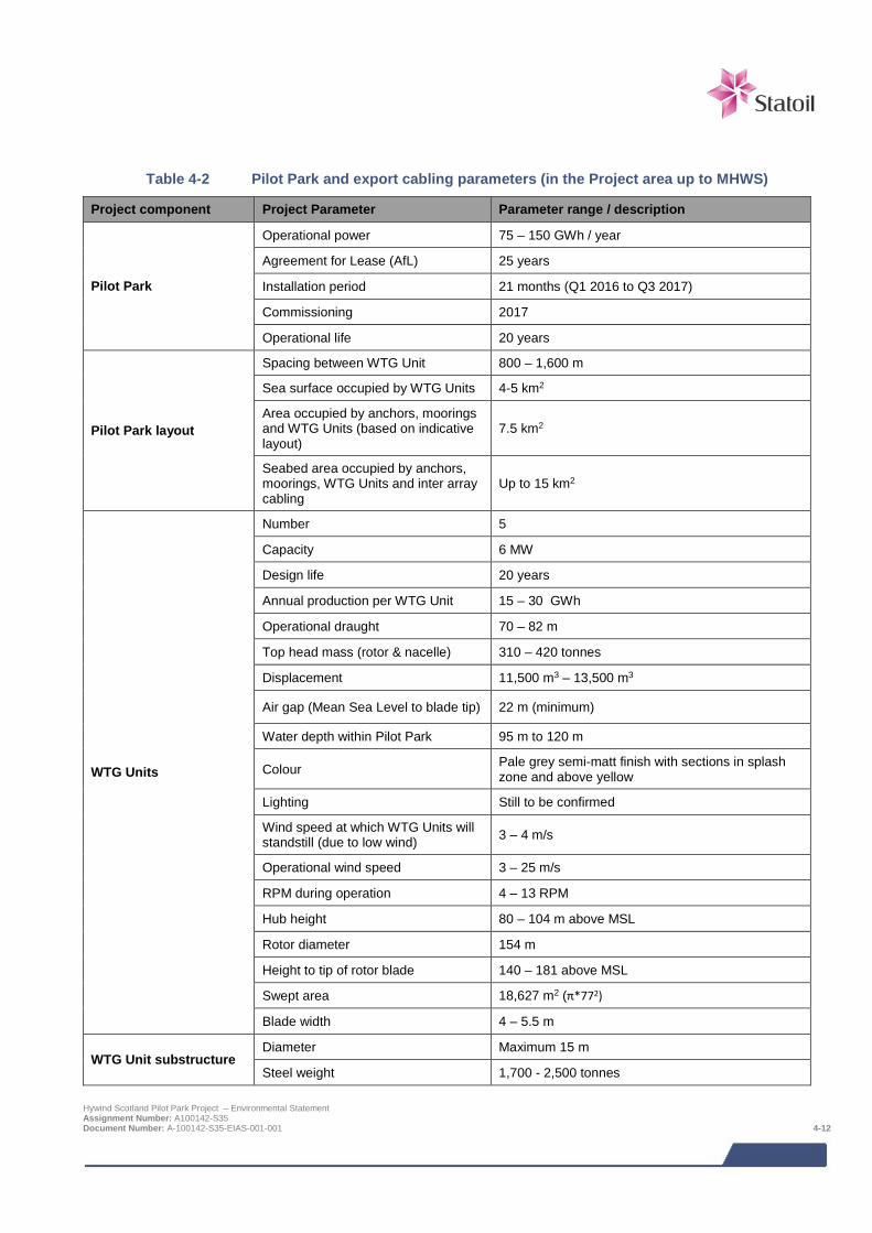
Table 4-2 Pilot Park and export cabling parameters (in the Project area up to MHWS)
Project component Project Parameter Parameter range / description
Pilot Park
Operational power 75 – 150 GWh / year
Agreement for Lease (AfL) 25 years
Installation period 21 months (Q1 2016 to Q3 2017)
Commissioning 2017
Operational life 20 years
Pilot Park layout
Spacing between WTG Unit 800 – 1,600 m
Sea surface occupied by WTG Units 4-5 km2
Area occupied by anchors, moorings and WTG Units (based on indicative layout)
7.5 km2
Seabed area occupied by anchors, moorings, WTG Units and inter array cabling
Up to 15 km2
WTG Units
Number 5
Capacity 6 MW
Design life 20 years
Annual production per WTG Unit 15 – 30 GWh
Operational draught 70 – 82 m
Top head mass (rotor & nacelle) 310 – 420 tonnes
Displacement 11,500 m3 – 13,500 m3
Air gap (Mean Sea Level to blade tip) 22 m (minimum)
Water depth within Pilot Park 95 m to 120 m
Colour Pale grey semi-matt finish with sections in splash zone and above yellow
Lighting Still to be confirmed
Wind speed at which WTG Units will standstill (due to low wind) 3 – 4 m/s
Operational wind speed 3 – 25 m/s
RPM during operation 4 – 13 RPM
Hub height 80 – 104 m above MSL
Rotor diameter 154 m
Height to tip of rotor blade 140 – 181 above MSL
Swept area 18,627 m2 (π*772)
Blade width 4 – 5.5 m
WTG Unit substructure Diameter Maximum 15 m
Steel weight 1,700 - 2,500 tonnes
Hywind Scotland Pilot Park Project – Environmental Statement Assignment Number: A100142-S35 Document Number: A-100142-S35-EIAS-001-001 4-12
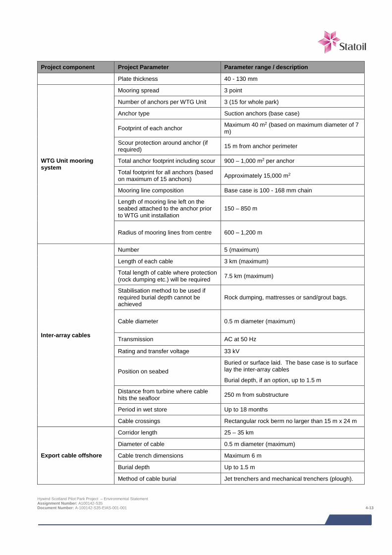
Project component Project Parameter Parameter range / description
Plate thickness 40 - 130 mm
WTG Unit mooring system
Mooring spread 3 point
Number of anchors per WTG Unit 3 (15 for whole park)
Anchor type Suction anchors (base case)
Footprint of each anchor Maximum 40 m2 (based on maximum diameter of 7 m)
Scour protection around anchor (if required) 15 m from anchor perimeter
Total anchor footprint including scour 900 – 1,000 m2 per anchor
Total footprint for all anchors (based on maximum of 15 anchors) Approximately 15,000 m2
Mooring line composition Base case is 100 - 168 mm chain
Length of mooring line left on the seabed attached to the anchor prior to WTG unit installation
150 – 850 m
Radius of mooring lines from centre 600 – 1,200 m
Inter-array cables
Number 5 (maximum)
Length of each cable 3 km (maximum)
Total length of cable where protection (rock dumping etc.) will be required 7.5 km (maximum)
Stabilisation method to be used if required burial depth cannot be achieved
Rock dumping, mattresses or sand/grout bags.
Cable diameter 0.5 m diameter (maximum)
Transmission AC at 50 Hz
Rating and transfer voltage 33 kV
Position on seabed Buried or surface laid. The base case is to surface lay the inter-array cables
Burial depth, if an option, up to 1.5 m
Distance from turbine where cable hits the seafloor 250 m from substructure
Period in wet store Up to 18 months
Cable crossings Rectangular rock berm no larger than 15 m x 24 m
Export cable offshore
Corridor length 25 – 35 km
Diameter of cable 0.5 m diameter (maximum)
Cable trench dimensions Maximum 6 m
Burial depth Up to 1.5 m
Method of cable burial Jet trenchers and mechanical trenchers (plough).
Hywind Scotland Pilot Park Project – Environmental Statement Assignment Number: A100142-S35 Document Number: A-100142-S35-EIAS-001-001 4-13
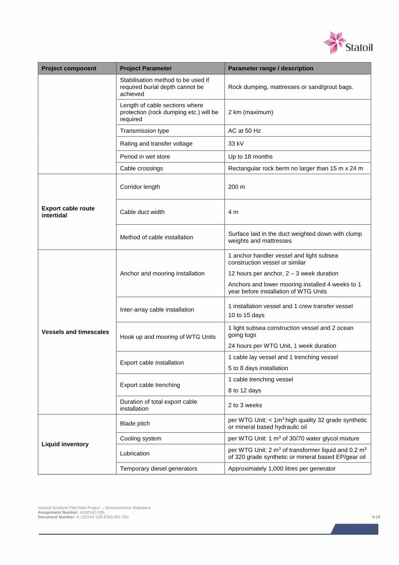
Project component Project Parameter Parameter range / description
Stabilisation method to be used if required burial depth cannot be achieved
Rock dumping, mattresses or sand/grout bags.
Length of cable sections where protection (rock dumping etc.) will be required
2 km (maximum)
Transmission type AC at 50 Hz
Rating and transfer voltage 33 kV
Period in wet store Up to 18 months
Cable crossings Rectangular rock berm no larger than 15 m x 24 m
Export cable route intertidal
Corridor length 200 m
Cable duct width 4 m
Method of cable installation Surface laid in the duct weighted down with clump weights and mattresses
Vessels and timescales
Anchor and mooring installation
1 anchor handler vessel and light subsea construction vessel or similar
12 hours per anchor, 2 – 3 week duration
Anchors and lower mooring installed 4 weeks to 1 year before installation of WTG Units
Inter-array cable installation 1 installation vessel and 1 crew transfer vessel 10 to 15 days
Hook up and mooring of WTG Units 1 light subsea construction vessel and 2 ocean going tugs
24 hours per WTG Unit, 1 week duration
Export cable installation 1 cable lay vessel and 1 trenching vessel
5 to 8 days installation
Export cable trenching 1 cable trenching vessel
8 to 12 days
Duration of total export cable installation 2 to 3 weeks
Liquid inventory
Blade pitch per WTG Unit: < 1m3 high quality 32 grade synthetic or mineral based hydraulic oil
Cooling system per WTG Unit: 1 m3 of 30/70 water glycol mixture
Lubrication per WTG Unit: 2 m3 of transformer liquid and 0.2 m3 of 320 grade synthetic or mineral based EP/gear oil
Temporary diesel generators Approximately 1,000 litres per generator
Hywind Scotland Pilot Park Project – Environmental Statement Assignment Number: A100142-S35 Document Number: A-100142-S35-EIAS-001-001 4-14
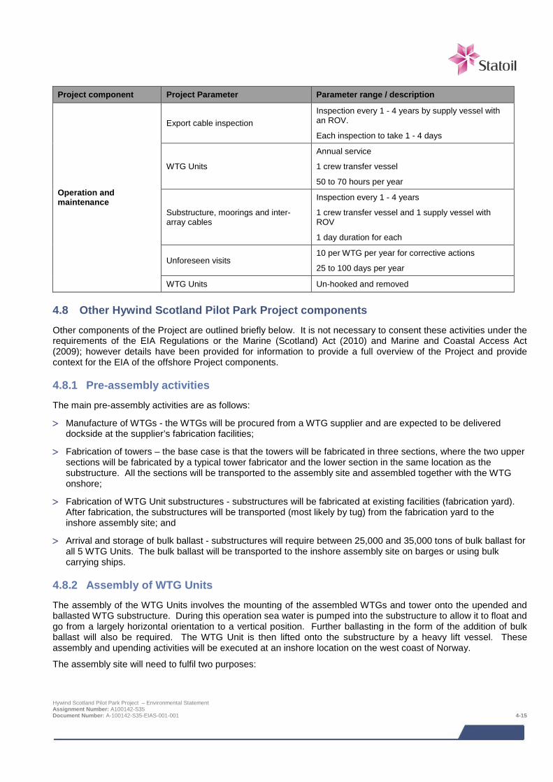
Project component Project Parameter Parameter range / description
Operation and maintenance
Export cable inspection Inspection every 1 - 4 years by supply vessel with an ROV.
Each inspection to take 1 - 4 days
WTG Units
Annual service
1 crew transfer vessel
50 to 70 hours per year
Substructure, moorings and inter-array cables
Inspection every 1 - 4 years
1 crew transfer vessel and 1 supply vessel with ROV
1 day duration for each
Unforeseen visits 10 per WTG per year for corrective actions
25 to 100 days per year
WTG Units Un-hooked and removed
4.8 Other Hywind Scotland Pilot Park Project components Other components of the Project are outlined briefly below. It is not necessary to consent these activities under the requirements of the EIA Regulations or the Marine (Scotland) Act (2010) and Marine and Coastal Access Act (2009); however details have been provided for information to provide a full overview of the Project and provide context for the EIA of the offshore Project components.
4.8.1 Pre-assembly activities The main pre-assembly activities are as follows:
> Manufacture of WTGs - the WTGs will be procured from a WTG supplier and are expected to be delivered dockside at the supplier’s fabrication facilities;
> Fabrication of towers – the base case is that the towers will be fabricated in three sections, where the two upper sections will be fabricated by a typical tower fabricator and the lower section in the same location as the substructure. All the sections will be transported to the assembly site and assembled together with the WTG onshore;
> Fabrication of WTG Unit substructures - substructures will be fabricated at existing facilities (fabrication yard). After fabrication, the substructures will be transported (most likely by tug) from the fabrication yard to the inshore assembly site; and
> Arrival and storage of bulk ballast - substructures will require between 25,000 and 35,000 tons of bulk ballast for all 5 WTG Units. The bulk ballast will be transported to the inshore assembly site on barges or using bulk carrying ships.
4.8.2 Assembly of WTG Units The assembly of the WTG Units involves the mounting of the assembled WTGs and tower onto the upended and ballasted WTG substructure. During this operation sea water is pumped into the substructure to allow it to float and go from a largely horizontal orientation to a vertical position. Further ballasting in the form of the addition of bulk ballast will also be required. The WTG Unit is then lifted onto the substructure by a heavy lift vessel. These assembly and upending activities will be executed at an inshore location on the west coast of Norway.
The assembly site will need to fulfil two purposes:
Hywind Scotland Pilot Park Project – Environmental Statement Assignment Number: A100142-S35 Document Number: A-100142-S35-EIAS-001-001 4-15

> Act as an onshore support base for operations including provision of storage facilities for WTG components,
tower components, mooring system components, WTG substructures and bulk ballast. It will also need to house contractor facilities including accommodation and cranes.
> Provide an inshore floating storage area for fabricated, but not yet upended (and ballasted) WTG substructures.
Estimated timescale for activities at the assembly site are:
> Storage of fabricated sub-structures at assembly site (onshore staging site) prior to assembly = up to 6 months.
> Upending ballasting and assembly of WTG Units = up to 60 days; and
> Length of time assembled WTG Units to remain at assembly site prior to towing = 1 to 8 weeks to finalise commissioning.
4.8.3 Transport to Pilot Park After assembly at the deep water inshore location the WTG Units will be transported to the Pilot Park for installation and final commissioning. WTG Units will most probably be towed to site at the operational draught of approximately 76-80 m. Towing speed is likely to be between 2.5 - 3.5 knots.
4.8.4 Onshore project This section of the project description provides an overview of the proposed onshore activities associated with the Project. The onshore infrastructure requirements for the Project are small scale and consist of an underground cable and switchgear yard located between the cable landfall and the existing Peterhead Grange Scottish and Southern Energy (SSE) Substation where the project will be connected to the electrical distribution network. The onshore components are located within ‘brownfield’ sites; are summarised below and illustrated in Figure 4-7:
> Cable landfall (landfall location and method of bringing cable ashore) of which there are currently two options;
> Cable route; and
> Switchgear yard.
Cable landfall
There are currently two options for the location and method of the installation of the cable landfall:
> Option 1 – Base case - Horizontal Directional Drilling (HDD) from Barclay Park; and
> Option 2 - Surface laid trench from Gadle Braes Promenade.
Any equipment to be used in the construction of the landfall site will be transported to site with the use of low loading Heavy Goods Vehicles (HGVs). If overwater operations are required these will be conducted from a cable laying vessel and possibly also a shallow supply vessel.
It is anticipated that cable landfall installation will take place between the months of May and September. Following installation, routine inspections and repair would take place throughout the project operational phase, particularly for the surface laid option.
Cable Landfall Option 1 Horizontal Directional Drilling (HDD) from Barclay Park
HDD landfall installation involves the positioning of a drilling rig and other HDD units on land. A drilling technique is then employed allowing cables and/or ducts to be installed beneath obstructions. The proposed compound location for the HDD equipment is within Barclay Park and its location illustrated in Figure 4-7.
Barclay Park has enough flat land to house the drilling rig and all associated compounds/storage. During the drilling operation and cable installation the Project will aim to reduce use of and impact on the football pitch as reasonably as possible. The area around Barclay Park provides good access routes to the site and the location ties in well with the onshore cable routes. The location of the park also means the drilled borehole can be directed out to sea without going under any private land. Hywind Scotland Pilot Park Project – Environmental Statement Assignment Number: A100142-S35 Document Number: A-100142-S35-EIAS-001-001 4-16
Figure 4-7 Overview of onshore infrastructure
Hywind Scotland Pilot Park Project – Environmental Statement Assignment Number: A100142-S35 Document Number: A-100142-S35-EIAS-001-001 4-17
A number of additional temporary works may be required:
> Use of the football pitch to store strung ducting;
> Widening the entrance to the park; and
> Construction of a temporary access road in the park.
The topsoil on site will be stripped back and stored to prepare the temporary works area. The site will be reinstated once HDD operations are completed and the cable construction area installed.
The profile of the drilled borehole is based on an exit point approximately 10 m below Lowest Astronomical Tide (LAT). At the seaward end of the borehole the exit point will be located in an area were the rock face is assumed to be covered by approximately 1 m of sand which may temporarily be removed and prepared for cable installation. The total length of the borehole will be approximately 700 m or less and the diameter approximately 500 mm. The exit point will be approximately 22 m lower than the entry point. The drilling profile will clear road services and the sea wall foundations.
Directional drilling is carried out using a drilling fluid, typically bentonite, to lubricate the drilling process. All drill cuttings and associated drilling fluids are inert. Much of the equipment present on the site is to manage the drill fluid and cuttings which are returned to shore. Drill cuttings returned to shore will be recycled or disposed of subject to consultation with the Scottish Environment Protection Agency (SEPA). Some drilling fluid / cuttings will be lost to sea at the offshore end of the borehole during seabed break through.
Once drilling is started it is a continuous process and a 24 hour a day operation is required. Noise from the drilling rig and ancillary equipment will be kept below levels set under the conditions of consent for daytime and night time activity. For safety reasons the HDD compound will be lit during the hours of darkness. The floodlights will be designed to minimise lighting spread.
A fuel tank will be required for the HDD operation. Appropriate procedures will be in place to ensure safety and minimal risk of pollution at all times whilst refuelling HDD equipment.
The HDD and cable pulling activities are planned to be performed between May and September. The drilling (reaming) period itself is very much dependent on ground and weather conditions.
Both the supply vessel and cable laying vessel will be fixed in position by spuds or anchors during operations. Diver support may also be required.
Potential damage/impact to the existing seawall from HDD will be prevented by ensuring that the drill profile is at an oblique angle and at a sufficient distance from the seawall to provide clearance below the wall.
Cable Landfall Option 2 surface laid trench from Gadle Braes Promenade
The location of the site for the surface laid trench is influenced by the onshore cable route and the width of the promenade. The width of the grass verge at the proposed location Figure 4-7 is approximately 17 m and drops 2.4 m. Under this option the cable will be installed in a surface laid duct which will be weighted down with clump weights and concrete mattresses. The cable duct will be approximately 400 mm in diameter and the concrete mattresses assumed to occupy and area of up to 4 m wide. The export cable will be connected to the onshore cable in a cable jointing pit immediately behind the sea wall.
There may be a requirement to construct an additional access ramp to facilitate access to the promenade. Access to the offshore trenching area will require a barge and use of the local harbour.
A storage area for equipment may be required to be installed on public land at the Gadle Braes promenade and in Barclay Park.
Surface laid installation activities will only take place during daylight hours and is expected to be performed during the summer season. The installation period will very much depend on ground and weather conditions.
Breaking through the sea wall is required in order to insert the duct. To prevent further damage to the seawall that flanks the opening, temporary protection may be used to limit exposure to the coast. The wall may also need to be propped up or the ground shored up to limit the risk of the wall collapsing.
Hywind Scotland Pilot Park Project – Environmental Statement Assignment Number: A100142-S35 Document Number: A-100142-S35-EIAS-001-001 4-18

Jointing bays
For both cable landfall options jointing bays will be installed to enable connection of the marine (export) cable with the onshore cable. Jointing bays are usually concrete-lined structures, accessed through a manhole cover and are expected will be 1.5 m deep, 2 m wide and 3 m long.
The precise location of the jointing bays is not yet known, but it is anticipated that for the HDD option there will be up to 4 jointing bays located at the landfall at Barclay Park, close to the bowling green, along Ravenscraig Road and adjacent to the cemetery. For the surface laid option there will be a jointing bay close to the landfall at Gadle Braes promenade.
Cable route
The onshore cable route (Figure 4-7) will extend landward from the proposed landfall to the point of connection to the grid at Peterhead Grange SSE Substation and is not expected to be more than 3 km in length.
Once the cable has been brought ashore, the preferred method of installation will be to install the cable within the existing road network (or other non-‘green-field’ areas) using open trench cable burial techniques. It is anticipated that trenches will be approximately 800 mm wide and 1,500 mm deep.
A temporary compound/storage area will be required along the cable route. It is expected that this area will be approximately 65 m wide and 75 m long. Installation is expected to take approximately 36 weeks and will take place mainly during daylight hours. For operations where swift execution is desirable, for example crossing of heavily trafficked roads or where utilities need to be disconnected, 24 hour construction or night only construction may be implemented.
Switchgear yard
As part of the Project there will be a need for electrical infrastructure to be provided in an onshore switchgear yard which will be located along the onshore cable route. The preferred location for the onshore switchgear yard is close to the Peterhead Grange Substation in the Balmoor Industrial Site (Figure 4-7).
The overall footprint of the switchgear yard will be less than 3,500 m2 and the main building less than 8 m in height.
A storage/laydown area, less than 1,000 m2, will be required for the duration of the construction and will be contained within the switchgear yard footprint. Construction of the yard is expected to take between 4 – 10 months and construction activities will take place during daylight hours only.
Hywind Scotland Pilot Park Project – Environmental Statement Assignment Number: A100142-S35 Document Number: A-100142-S35-EIAS-001-001 4-19
5 ENVIRONMENTAL OVERVIEW
5.1 Introduction This chapter provides an overview of the environment in which the Project will be developed. More detailed descriptions of specific aspects of the environment are detailed in the individual topic-specific chapters of the ES (Chapters 8 - 20).
5.2 Physical characteristics
5.2.1 Offshore In terms of climate, winds in the region generally predominate from the southerly quarter although weather from the north northeast is not infrequent. The wave climate in the AfL area is dominated by waves from the north (with a significant swell component originating in the Norwegian Sea) and to a lesser extent from the south. Mean wave heights peak in winter around January, but extreme waves are likely from October to March. The majority of significant wave heights at the site are less than 4 m.
The main axis of tidal flow is aligned south to north parallel to the coastline, flooding to the south and ebbing to the north. The tidal range at the AfL area is approximately 2.4 m at springs and 1.6 m at neaps. Tidal streams attain a maximum spring speed at the surface of approximately 1.3 m/s (2.5 knots), speeds reducing with depth in close proximity to the seabed.
The AfL area is situated in the Buchan Deep in the northern North Sea, approximately 25 km due east of Peterhead. Within the AfL area water depths range between approximately 98 m and 117 m, becoming deeper from north to south. Along the export cable corridor between the AfL area and landfall in Peterhead, the seabed shelves very gradually to a depth of 20 m less than 1 km from the landfall, after which the seabed gradient becomes steeper towards the shore.
The seabed within the turbine deployment area comprises mega-rippled silty sand and gravel, overlain with scattered boulders. This same seabed type extends west along the deeper offshore end of the export cable corridor, although the mega-ripples become smaller and fewer towards the coast. Approximately 5 km from landfall, the frequency of boulders and till on the seabed increases towards the shore, until within approximately 1 km of landfall (and water depths of less than 20 m) the seabed consists almost entirely of outcropping bedrock.
Sediment sampling and analysis for hydrocarbons, metals and tributyltin indicates that there are no areas of contamination present in the AfL area or along the cable export route. However, the export cable corridor passes close to three dredge disposal sites, approximately 3 km from shore. Recent Marine Scotland monitoring data indicate that although sediments in the disposal sites do slightly exceed some of the guidance/standards for arsenic and organotins, such residual contamination is not significant.
5.2.2 Landfall The coastline within the landfall area comprises rocky cliffs and sand dunes. The cliffs to the south of Peterhead are composed of granite, and are extremely resilient to marine erosion and provide little input of beach material.
Around Peterhead the net littoral drift direction is variable, as northward wave-induced drift is generally cancelled-out by southward tidal currents.
The shoreline at the cable landfall site is a rocky shelf with pockets of coarse gravel/cobbles/boulders that extends out from the base of a concrete seawall.
Hywind Scotland Pilot Park Project – Environmental Statement Assignment Number: A100142-S35 Document Number: A-100142-S35-EIAS-001-001 5-1
5.3 Biological characteristics
5.3.1 Seabed Video surveys of the AfL area in the Buchan Deep recorded the biotope “circalittoral fine sand”, characterised by a poorly developed epifauna with sparse hermit crabs and brittle stars (Ophiura sp.), as well as hydroids and anemones on the scattered cobbles. The main infaunal species here were the polychaetes Scoloplos armiger, Spiophanes bombyx and Owenia fusiformis, the brittle stars Amphiura filiformis and Ophiura affinis and the burrowing sea urchins Spatangus sp. and Echinocyamus pusillus.
The occasional patches of boulders and mixed sediment supported a raised diversity of epifaunal species including shrimps, sponges, sessile cnidarians and occasional aggregations of sandy tubes of the polychaete Sabellaria spinulosa. S. spinulosa coverage on the seabed in these locations was low, patchy and small in extent. These areas were classified as the biotope “Offshore circalittoral mixed sediment” and are not likely to qualify as Annex I biogenic reef structures. However, small S. spinulosa aggregations corresponding to possible Annex I S. spinulosa reef were found across the offshore end of the export cable route, approximately 21 km from landfall, and also at one smaller location approximately 8 km from landfall.
Within 2.5 km of the landfall, the seabed within the cable corridor changes from the predominantly sandy sedimentary environment with occasional boulders found offshore to one that is a mosaic of boulders and sand. The boulders support epifaunal encrusting communities characterised by hydroids, bryozoans and soft corals, and in this part of the cable route become sufficiently numerous to qualify as patchy Annex I stony reef habitat. Within 1 km of landfall, outcropping rock platforms and boulders with kelp and seaweed-dominated biotopes become dominant (Annex I rocky reef), and continue into the intertidal zone.
At landfall, the cable route crosses a roughly 200 m-wide intertidal zone which consists of a patchwork of rocky and stony reef habitat with rock pools, moderately exposed or exposed to wave action and characterised by seaweeds and barnacles.
5.3.2 Fish With regard to fish, the principal pelagic species found in the region are typical of the wider North Sea and include herring, sprat and mackerel. Mackerel and herring are commercially exploited in the AfL area and sprat and herring play an important ecological role as principal prey items for several larger fish species, marine birds and mammals. There appear to be no known recent records of basking shark in the area.
Demersal species found in the region include cod, haddock, whiting, plaice, lemon sole, anglerfish ling, European hake, Norway pout, saithe, spotted ray, common skate, spurdog and tope.
Species spawning in the Buchan Deep area and along the cable route include sandeel, cod, whiting, plaice and European lobster. The Project area is also an important nursery ground for sandeel, cod, haddock, whiting, lemon sole, anglerfish, ling, European hake, spurdog, tope, common skate, spotted ray and saithe, with the exception of saithe offshore nursery grounds which do not occur within the Buchan Deep area.
According to commercial landings data, the shellfish species present in the area along the cable route include veined squid, brown crab, velvet crab, king scallop, Norway lobster and the European lobster.
Several diadromous species are expected to transit the AfL area on an occasional basis including Atlantic salmon, sea trout, European eel, river lamprey and sea lamprey. None have nursery or breeding areas directly within the turbine deployment area or cable corridor, but some may regularly cross the area as part of their migration and/or transit adjacent areas as part of their foraging or breeding activity. Nearby rivers that may be used by some of these species include the Rivers Spey, Ugie and Dee.
Hywind Scotland Pilot Park Project – Environmental Statement Assignment Number: A100142-S35 Document Number: A-100142-S35-EIAS-001-001 5-2
5.3.3 Birds Much of the coastline of this region of the North Sea is colonised by seabirds, often in numbers that are of national or international importance. From the coast of the Moray Firth south to the Ythan Estuary and the Sands of Forvie, cliff habitat supports breeding colonies of seabird including common guillemot, black-legged kittiwake, razorbill, puffin, northern fulmar, gannet, herring gull and shag.
The Hywind Scotland Pilot Park Interim Report on ESAS Surveys identified Great black-backed gulls, razorbills, guillemots, gannets and puffins to be present within the Project area.
5.3.4 Marine mammals The northeast Scotland region is comparatively rich in cetaceans (whales, dolphins and porpoises), with eight out of 26 species of the UK cetacean fauna recorded regularly since 1980. The most common species in nearshore waters (within 60 km of the coast) are the harbour porpoise and bottlenose dolphin, then minke whale and white-beaked dolphin. Atlantic white-sided dolphin, killer whale and long-finned pilot whale occur mainly offshore, with Risso’s dolphin recorded most often in the Pentland Firth north to Orkney. The Moray Firth is of national importance for its bottlenose dolphin population. Other cetacean species recorded in the vicinity of the Project area include humpback whale, fin whale and common dolphin.
Survey work conducted in the Project area over 12 months between June 2013 and May 2014 recorded four species of cetacean: minke whale, harbour porpoise, white-beaked dolphin and Risso’s dolphin. The harbour porpoise dominated observations, accounting for 70% of sightings.
Grey and harbour seals are both resident in Scottish waters, and are the two species most likely to be sighted in the vicinity of the Project area. Both species use coastal sites for breeding/pupping and hauling out, and feed in inshore and offshore waters. Under the Marine Scotland Act, Marine Scotland has designated 194 coastal sites around Scotland as seal haul-out sites. No such sites occur within the vicinity of the Project.
Nevertheless, grey seals were the third most common marine mammal observed during the marine mammal surveys run over the period June 2013 to May 2014, with 38 animals being sighted at a rate of 0.293 animals per hour and 0.091 animals per km. Grey seals were most often individually or in small groups, and were observed during most survey months.
Harbour seals were the second least sighted marine mammal during survey work; four individuals were observed at an encounter rate of 0.031 animals per hour and 0.002 animals per km.
5.4 Protected sites and species Offshore, there are currently no offshore Special Areas of Conservation (SACs) designated under the EU Habitats Directive within 150 km of the Project. Also, there are no Marine Protected Areas (MPAs) designated under the Marine (Scotland) Act 2010 in the close vicinity of the Project area. The nearest is the Turbot Bank MPA, located approximately 18 km to the east of the turbine deployment area and is designated for the protection of sandeels. The AfL area does; however, overlap with an MPA Area of Search, the Southern Trench MPA search location, which is a 25 km-wide area off the southern coast of the outer Moray Firth between Cullen and almost as far south as Peterhead. The chief biological features for protection here are the deep shelf waters (to ~200 m) and the hydrographic fronts that converge here concentrating nutrients and productivity, burrowed mud habitat, and minke whale and white-beaked dolphin concentrations. This search location also overlaps the marine part of the Troup, Pennan and Lion’s Heads Special Protection Area (SPA) used by cliff-nesting seabirds.
On the coast between Portnockie on the Grampian coast of the Moray Firth and Aberdeen to the south, there are two SACs, four SPAs, one Ramsar wetland site and eleven Special Sites of Scientific Interest. The key features for protection at all of these sites relate mainly to seabirds, waders and wildfowl together with cliff, fen and wetland habitats and geomorphological features including sand dunes and shingle.
Hywind Scotland Pilot Park Project – Environmental Statement Assignment Number: A100142-S35 Document Number: A-100142-S35-EIAS-001-001 5-3
5.5 Socio-economic activities
5.5.1 Fisheries Peterhead, Aberdeen and Fraserburgh are the nearest commercial UK fishing ports to the Project area. Peterhead is the UK’s largest commercial fishing port reporting landings of 105 thousand tonnes in 2012 worth £113.5 million. Based on 2012 statistics, Fraserburgh employs the largest number of people full time (797). Fish processing in Fraserburgh and Peterhead collectively supports around 3,000 jobs.
On average, 72% of the vessels from Peterhead and 47% from Fraserburgh have fished in the wider area in or around the AfL area and export cable corridor. Catches from this wider area are frequently landed at the main ports of Peterhead, Fraserburgh and Aberdeen, and also on occasion at several smaller ports in the region including Boddam, Port Errol, Macduff, Gardenstown, Whitehills and Rosehearty.
Shellfish, demersal and pelagic fisheries all operate in the wider area around the AfL area and export cable corridor. The demersal and pelagic fisheries are more important further offshore, particularly where there is overlap with the Buchan Deeps; fishing here is predominantly demersal trawling for whitefish such as haddock, and pelagic trawling for herring and mackerel, generating high landings values relative to effort. The principal fishing activities in the inshore areas are scallop, crab and lobster, and the line fisheries (i.e. mackerel).
Rivers on the northeast coast of Scotland have nationally and internationally important populations of salmon and sea trout. Both species support commercial and recreational fisheries of importance to the Scottish economy. The principal salmon and sea trout fisheries are rod and line (including catch and release), fixed engine (bag netting) and net and coble. The proposed export cable landfall is located within the jurisdiction of the Ugie District Salmon Fisheries Board; the River Ugie meets the sea just to the north of Peterhead, but in comparison to other north east Scotland rivers, such as the Spey, it does not support a large fishery.
5.5.2 Shipping The nearest port is located at Peterhead, which is a major supply base for the offshore oil and gas industry and the most important fishing port in the UK for white and pelagic species. The port also handles tankers, general cargo ships and cruise liners, and has a marina for pleasure craft.
Aberdeen Port is located approximately 50 km to the southwest of the AfL area. It is the principal commercial port serving the northeast of Scotland with approximately 7,800 ship arrivals in 2013 handling approximately 4.9 million tonnes of cargo. It is the most important base for the North Sea oil and gas industry in northwest Europe. In addition there are regular shipping services to Orkney, Shetland and Scandinavia via ferry services for passengers and cargo. The Port also has a large fish market.
According to a specially commissioned shipping study, based on automatic identification system (AIS) data, the turbine deployment area has moderate vessel traffic levels. High levels of traffic to the west and northwest of the AfL area are associated with traffic bound to or from busy ports such as Aberdeen and Peterhead, and traffic passing north and south off the east coast of Scotland. On average 3-4 vessels per day transited through the turbine deployment area over the four month-long surveys conducted over 2013 to 2014. The maximum number of vessels per day ranged from 7-11. Most of these were cargo or oil services vessels.
5.5.3 Oil and Gas The Project lies within oil and gas licensing Quadrant 19 although few blocks within Quadrant 19 are currently licensed. The closest oil and gas activity to the Project is the Nexen-operated Buzzard oil field, approximately 40 km to the north west of the AfL area. The AfL area is split into northern and southern parts by the BP-operated Forties field crude oil pipelines which transport hydrocarbon from over 50 offshore fields and terminate at the Cruden Bay pumping station 35 km north of Aberdeen. To the north of Peterhead, St Fergus is a landing point for several offshore gas pipelines, the closest of which passes approximately 5 km north of the export cable corridor and AfL area.
Hywind Scotland Pilot Park Project – Environmental Statement Assignment Number: A100142-S35 Document Number: A-100142-S35-EIAS-001-001 5-4

5.5.4 Other activities There are several existing submarine cables in the vicinity of the Project. These include an active fibre optic cable owned by BP, which runs parallel to the BP Forties to Cruden pipelines that pass through the AfL area. In addition several inactive cables either pass through the AfL area or cross the proposed export cable route and a proposed High Voltage Direct Current interconnector cable between Peterhead and Norway crosses the proposed export cable route.
There are three dredge spoil disposal sites adjacent to the export cable corridor and approximately 3 km offshore. Of these, two remain open (‘North Buchan Ness’ and ‘Peterhead’) and over the past 13 years these have been used for the deposition of dredged harbour material from Peterhead and Boddam Harbours.
There are no designated military practice and exercise areas in the immediate vicinity of the AfL area.
Hywind Scotland Pilot Park Project – Environmental Statement Assignment Number: A100142-S35 Document Number: A-100142-S35-EIAS-001-001 5-5
6 ENVIRONMENTAL IMPACT ASSESSMENT (EIA) METHODOLOGY
6.1 Introduction This chapter of the Environmental Statement (ES) describes the Environmental Impact Assessment (EIA) methodology. The approach described meets the requirements of the EIA Regulations.
6.2 Approach to EIA
6.2.1 EIA Process EIA is the process of systematic identification of the potential impacts that a development could have on the environment. The process involves developing a detailed understanding of both the Project e.g. proposed installation, operation and decommissioning activities, and the environment within which the project will be located.
The potential impacts of the Project are evaluated to determine how the Project could affect the environment and the significance of those effects. Impacts are considered in a cumulative manner as well as in isolation.
Where potential impacts are likely to be significant, specific measures will need to be taken either directly or through the design, construction, operation and decommissioning of the Project to reduce or remove such effects (mitigation measures). The EIA process also requires the identification of measures to monitor the predicted impacts of the Project.
The overall EIA process is delivered through a number of clearly defined stages, namely screening, scoping, the environmental assessment, planning and monitoring. These are illustrated in Figure 6-1.
For the purposes of this Project, the Marine Licence application is supported by the EIA, the Navigational Risk Assessment (NRA) and the Habitat Regulations Appraisal (HRA), as shown in Figure 6-1.
The EIA considers all phases of the Project from initial WTG Unit assembly followed by construction and installation through to decommissioning.
The EIA has not addressed impacts associated with the potential repowering of the Project. Repowering would be subject to a new lease and consent application and therefore falls out with the scope of this EIA. Also, as previously stated, the onshore components of the Project are subject to a separate Planning Application.
6.2.2 Scoping The EIA Scoping Document (and accompanying navigational preliminary hazard analysis (PHA)) formed HSL’s written request to the Marine Scotland Licensing Operations Team, for their opinion as to the scope of the EIA and information to be provided in the ES for the Project. The EIA Scoping Report and PHA were submitted to Marine Scotland in October 2013.
Scoping Opinions were issued by Aberdeenshire Council and Marine Scotland on 6th November 2013 and 24th March 2014 respectively. Following receipt of the EIA Scoping Opinions all issues raised were reviewed and implications for the overall Project and EIA considered. All issues raised in the Scoping Opinions were discussed with Marine Scotland during the EIA.
The EIA Scoping Document, PHA and EIA Scoping Opinion can be found on the supporting studies CD that can be found inside the front cover of the ES.
Baseline surveys undertaken to inform scoping and the EIA include:
> Oceanographic surveys;
> Benthic and geophysical surveys;
> Phase I intertidal biotope mapping survey; and
Hywind Scotland Pilot Park Project – Environmental Statement Assignment Number: A100142-S35 Document Number: A-100142-S35-EIAS-001-001 6-1
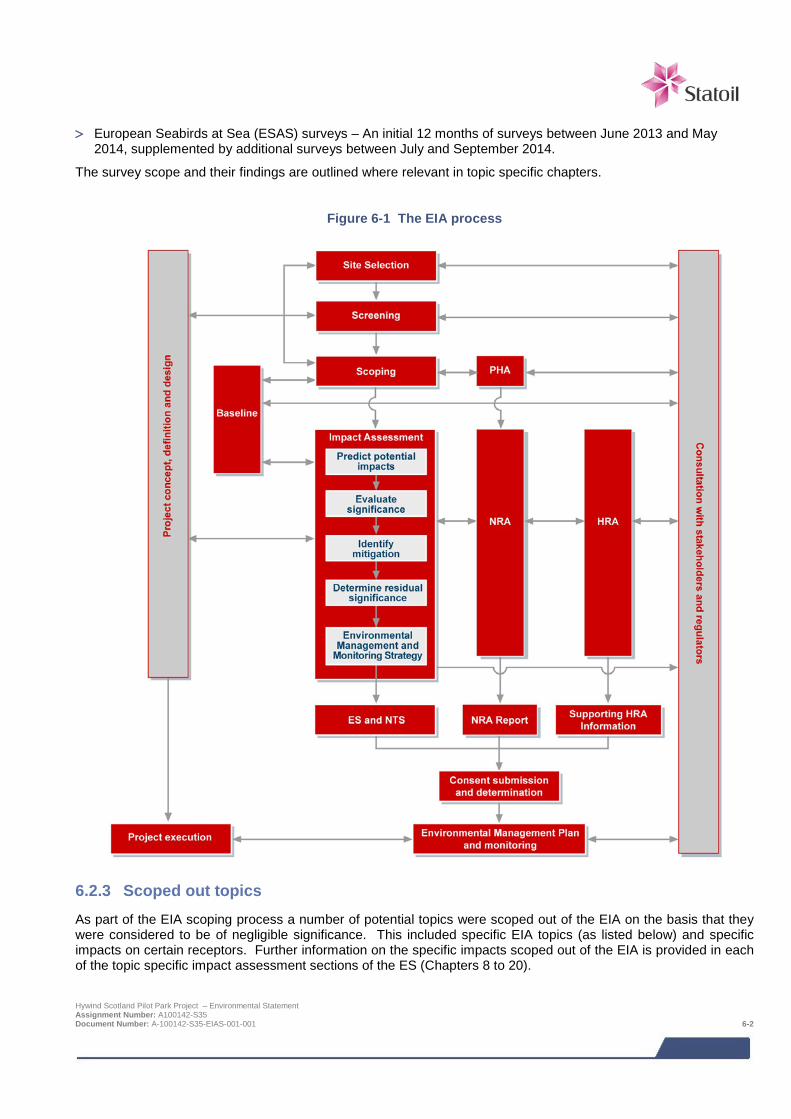
> European Seabirds at Sea (ESAS) surveys – An initial 12 months of surveys between June 2013 and May
2014, supplemented by additional surveys between July and September 2014.
The survey scope and their findings are outlined where relevant in topic specific chapters.
Figure 6-1 The EIA process
6.2.3 Scoped out topics As part of the EIA scoping process a number of potential topics were scoped out of the EIA on the basis that they were considered to be of negligible significance. This included specific EIA topics (as listed below) and specific impacts on certain receptors. Further information on the specific impacts scoped out of the EIA is provided in each of the topic specific impact assessment sections of the ES (Chapters 8 to 20).
Hywind Scotland Pilot Park Project – Environmental Statement Assignment Number: A100142-S35 Document Number: A-100142-S35-EIAS-001-001 6-2
Topics scoped out of the EIA included:
> Air quality – vessels will have a very localised impact and atmospheric emissions will rapidly dispersed.
> Climate – key driver behind the rationale for developing offshore renewables not an impact assessment issue.
6.3 Assessment of impact
6.3.1 Overview of approach for assessing impact significance The EIA Regulations require that the EIA should consider the likely significant environmental impacts. The decision process related to defining whether or not a project is likely to significantly impact the environment is the core principal of the EIA process. The regulations themselves do not provide a specific definition of "significance". However the methods used for identifying and assessing impacts should be transparent and verifiable.
The method detailed here has been developed by reference to the principals and guidance provided by SNH in their handbook on EIA (SNH, 2009), the MarLIN species and ecosystem sensitivities guidelines (Tyler-Walters et al., 2001) and the Chartered Institute of Ecology and Environmental Management (CIEEM) guidelines for marine impact assessment (IEEM, 2010).
EIA provides an assessment of potential impacts as a result of the effects of a project on receptors in the environment. The terms effect and impact are different and one drives the other. Effects are measurable physical changes in the environment (e.g. volume, time and area) arising from project activities.
An impact considers the response of a receptor to an effect. Impacts can be classified as direct or indirect, beneficial or adverse.
The relationship between effects and impacts is not always straightforward. For example, a secondary effect may result in both a direct and indirect impact on a single receptor. There may be circumstances where a receptor is not sensitive to a particular effect and thus there will be no impact.
For each effect, the assessment identifies receptors sensitive to that effect and implements a systematic approach to understand the level of impact. The process considers the following:
> Sensitivity/value of a receptor;
> Magnitude of effect;
> Determination and qualification of the level of impact of and effect or change on a receptor, considering the probability that it will occur, the spatial and temporal extent and the importance of the impact. If the level of impact is determined as moderate, major or severe, it is considered a significant impact.
Once the level of potential impact has been assessed it is possible to identify measures that can be taken to mitigate impacts through design or operational measures. This process also identifies aspects of the proposed project that may require monitoring.
For some environmental effects, for example noise, significance criteria are standard or numerically based. For other effects, for which no applicable limits, standards or guideline values exist, a more qualitative approach is required. This involves assessing significance using professional judgement.
Despite the assessment of impact significance being a subjective process, a defined methodology, outlined below, is used to make the assessment as objective as possible and consistent across different topics. As the environmental factors under consideration can vary considerably depending on what is being assessed, there is likely to be some variation in this process in particular for this Project which has the potential to effect biological, physical and socio-economic environments.
Hywind Scotland Pilot Park Project – Environmental Statement Assignment Number: A100142-S35 Document Number: A-100142-S35-EIAS-001-001 6-3
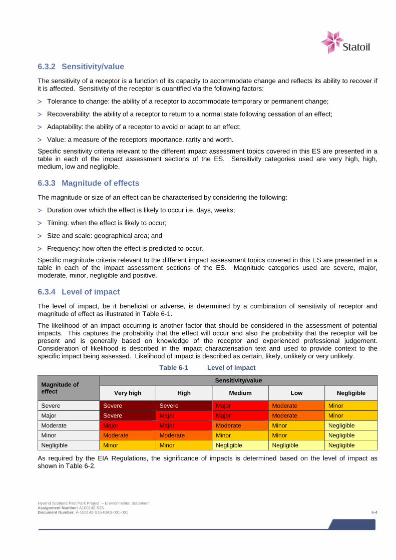
6.3.2 Sensitivity/value The sensitivity of a receptor is a function of its capacity to accommodate change and reflects its ability to recover if it is affected. Sensitivity of the receptor is quantified via the following factors:
> Tolerance to change: the ability of a receptor to accommodate temporary or permanent change;
> Recoverability: the ability of a receptor to return to a normal state following cessation of an effect;
> Adaptability: the ability of a receptor to avoid or adapt to an effect;
> Value: a measure of the receptors importance, rarity and worth.
Specific sensitivity criteria relevant to the different impact assessment topics covered in this ES are presented in a table in each of the impact assessment sections of the ES. Sensitivity categories used are very high, high, medium, low and negligible.
6.3.3 Magnitude of effects The magnitude or size of an effect can be characterised by considering the following:
> Duration over which the effect is likely to occur i.e. days, weeks;
> Timing: when the effect is likely to occur;
> Size and scale: geographical area; and
> Frequency: how often the effect is predicted to occur.
Specific magnitude criteria relevant to the different impact assessment topics covered in this ES are presented in a table in each of the impact assessment sections of the ES. Magnitude categories used are severe, major, moderate, minor, negligible and positive.
6.3.4 Level of impact The level of impact, be it beneficial or adverse, is determined by a combination of sensitivity of receptor and magnitude of effect as illustrated in Table 6-1.
The likelihood of an impact occurring is another factor that should be considered in the assessment of potential impacts. This captures the probability that the effect will occur and also the probability that the receptor will be present and is generally based on knowledge of the receptor and experienced professional judgement. Consideration of likelihood is described in the impact characterisation text and used to provide context to the specific impact being assessed. Likelihood of impact is described as certain, likely, unlikely or very unlikely.
Table 6-1 Level of impact
Magnitude of effect
Sensitivity/value
Very high High Medium Low Negligible
Severe Severe Severe Major Moderate Minor Major Severe Major Major Moderate Minor Moderate Major Major Moderate Minor Negligible Minor Moderate Moderate Minor Minor Negligible Negligible Minor Minor Negligible Negligible Negligible
As required by the EIA Regulations, the significance of impacts is determined based on the level of impact as shown in Table 6-2.
Hywind Scotland Pilot Park Project – Environmental Statement Assignment Number: A100142-S35 Document Number: A-100142-S35-EIAS-001-001 6-4

Table 6-2 Definitions for impact significance
Level of impact Impact significance
Severe
Significant impact under EIA Regulations Major
Moderate
Minor Insignificant impact under EIA Regulations
Negligible
6.3.5 Deviations from standard approach Some topic specific impact assessments have used a process which has deviated from the standard approach e.g. due to specific guidance / practices endorsed by professional accreditation organisations and consultees. Xodus has worked with each of the specialists to ensure, where possible, that a consistent approach between topics has been used in the assessment of potentially significant impacts. The following topics have adopted a process which deviates from the standard approach:
> Shipping and navigation – agreed in consultation with the MCA and DECC in line with IMO’s Formal Safety Assessment (FSA) process;
> Marine historic environment – agreed with Historic Scotland and in line with statutory guidance;
> Seascape, landscape and visual – agreed with JNCC, SNH, Marine Scotland and Aberdeenshire Council and in line with best practice methodologies and policy and landscape and seascape characterisation guidance;
> Hydrocarbon and chemical spills; and
> Socio-economic.
6.3.6 Mitigation Where potentially significant impacts (i.e. those ranked as being of moderate impact level or higher) are identified mitigation measures have been considered. The intention is that such measures should remove, reduce or manage the impacts to a point where the resulting residual significance is at an acceptable or insignificant level. Mitigation is also proposed in some instances to ensure impacts that are predicted to be insignificant remain so.
6.4 Design Envelope HSL has adopted the established principle of the Design Envelope for the purpose of preserving essential flexibility within some major elements of the Project (see also Section 1.5). This approach assesses the Project design options that could result in the greatest potential environmental, as established through relevant case law6 and has been endorsed by the Scottish Government7. These case precedents have established a custom and practice that has evolved in relation to Projects where the final design is not available at the consent application stage. This approach has been confirmed by the courts as enabling the legal requirements of the relevant EIA Regulations to be complied with and will not give rise to a likely significant effect on the environment which has not been assessed.
6 R v Rochdale MBC ex parte Milne (No 1) and R v Rochdale MBC ex parte Tew [1999] and R v Rochdale MBC ex parte Milne (No 2) [2000]. 7 Letter from the Scottish Government to Heads of Planning dated 22 November 2007. Hywind Scotland Pilot Park Project – Environmental Statement Assignment Number: A100142-S35 Document Number: A-100142-S35-EIAS-001-001 6-5

Hywind Scotland is more matured at this stage compared to what is the case for many other offshore wind projects. The Design Envelope therefore describes less variability in the technical options than other similar projects. Where a base case solution exists for the project, the impacts of that is assessed in addition to the project design which would result in the greatest environmental impact.
To demonstrate the care and thoroughness with which the flexibility in the Project design has been assessed in the EIA, Chapter 4 Project Description summarises the potential development envelope (i.e. Design Envelope) which has been assessed, whilst also presenting the details of what is the alternative and/or most likely Project option.
Each EIA study has given careful consideration to the range of potential impacts that may result from the proposed Project options. To this end each technical chapter throughout this ES (Chapters 8 to 20) includes definition of the Project options that result in the greatest impact for that particular assessment.
6.5 Cumulative and in-combination impacts The consideration of potential cumulative and in-combination impacts is an important stage in the EIA process as combined incremental impacts pose a threat to sensitive receptors. Cumulative impacts are impacts caused by planned, consented and operational offshore wind farms. In-combination impacts are impacts as a result of offshore wind farms (and their associated activities) combined with impacts from other marine activities or users of the sea.
Cumulative and in-combination impacts have been considered throughout the EIA process and have been considered for all phases of the Project. Statoil has, in consultation with Marine Scotland, identified a list of other projects, which together with the Hywind Pilot Park Project may result in potential cumulative or in-combination impacts. These projects and associated project details are provided in Table 6-3. The location of these projects is shown in Figure 6-2.
The general principle for the cumulative impact assessment was to consider only those projects that were at EIA scoping stage (i.e. for which an EIA Scoping Report and requests for a EIA Scoping Opinion have been submitted) and beyond (as of June 2014). However there were other projects which were very close to submitting their EIA Scoping Reports and/or directly relevant to the proposed Project and Marine Scotland advised that these should also be included in the cumulative impact assessment.
Details of the projects to be considered for the cumulative impact assessment were provided to all EIA study leads. The study leads then considered which of these projects could result in potential cumulative impacts with the Project. This decision was based on the results of the specific impact assessment together with the expert judgement of the specialist consultant undertaking the impact assessment.
Inevitably the assessment of these ‘future projects’ is dependent upon the level of information available on those projects at the time of undertaking the cumulative assessment. Due to the fact there were different levels of detail available for different projects, the cumulative impact assessment has been undertaking qualitatively. Sufficient data was not available in the public domain to allow a fully quantified cumulative impact assessment.
Each technical ES chapter contains a sub section which identifies the projects which are relevant on a cumulative basis and an assessment of the relevant cumulative impacts.
6.6 Decommissioning impacts The EIA Regulations, as stated above, require the EIA process to assess impacts from decommissioning activities. Each EIA specialist has considered the potential impacts as a result of the proposed decommissioning activities (based on the high level detail available at the present time) and in general, the same conclusion has been drawn by all specialists; the impacts are broadly similar to those identified for the construction and installation phase of the Project. For the parts of the export cable which will be buried, and are expected to be left in situ, the impacts will be synonymous with those during the operational phase of the Project. No additional impact mechanisms have been identified. It was therefore not deemed necessary to discuss in detail impacts associated with decommissioning in each technical chapter of the ES. In addition, it should be noted that when the Project nears the decommissioning phase and once more detail is available on the specific activities associated with decommissioning further, more detailed assessment of environmental impacts will be undertaken as part of the Decommissioning Programme.
Hywind Scotland Pilot Park Project – Environmental Statement Assignment Number: A100142-S35 Document Number: A-100142-S35-EIAS-001-001 6-6
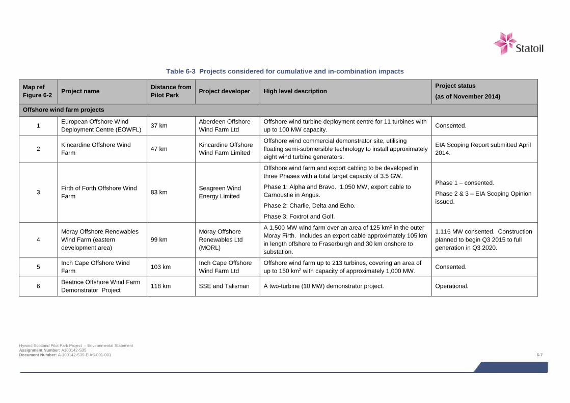
Table 6-3 Projects considered for cumulative and in-combination impacts
Map ref Figure 6-2 Project name Distance from
Pilot Park Project developer High level description Project status
(as of November 2014)
Offshore wind farm projects
1 European Offshore Wind Deployment Centre (EOWFL) 37 km
Aberdeen Offshore Wind Farm Ltd
Offshore wind turbine deployment centre for 11 turbines with up to 100 MW capacity. Consented.
2 Kincardine Offshore Wind Farm 47 km Kincardine Offshore
Wind Farm Limited
Offshore wind commercial demonstrator site, utilising floating semi-submersible technology to install approximately eight wind turbine generators.
EIA Scoping Report submitted April 2014.
3 Firth of Forth Offshore Wind Farm 83 km
Seagreen Wind Energy Limited
Offshore wind farm and export cabling to be developed in three Phases with a total target capacity of 3.5 GW.
Phase 1: Alpha and Bravo. 1,050 MW, export cable to Carnoustie in Angus.
Phase 2: Charlie, Delta and Echo.
Phase 3: Foxtrot and Golf.
Phase 1 – consented.
Phase 2 & 3 – EIA Scoping Opinion issued.
4 Moray Offshore Renewables Wind Farm (eastern development area)
99 km Moray Offshore Renewables Ltd (MORL)
A 1,500 MW wind farm over an area of 125 km2 in the outer Moray Firth. Includes an export cable approximately 105 km in length offshore to Fraserburgh and 30 km onshore to substation.
1.116 MW consented. Construction planned to begin Q3 2015 to full generation in Q3 2020.
5 Inch Cape Offshore Wind Farm
103 km Inch Cape Offshore Wind Farm Ltd
Offshore wind farm up to 213 turbines, covering an area of up to 150 km2 with capacity of approximately 1,000 MW.
Consented.
6 Beatrice Offshore Wind Farm Demonstrator Project
118 km SSE and Talisman A two-turbine (10 MW) demonstrator project. Operational.
Hywind Scotland Pilot Park Project – Environmental Statement Assignment Number: A100142-S35 Document Number: A-100142-S35-EIAS-001-001 6-7
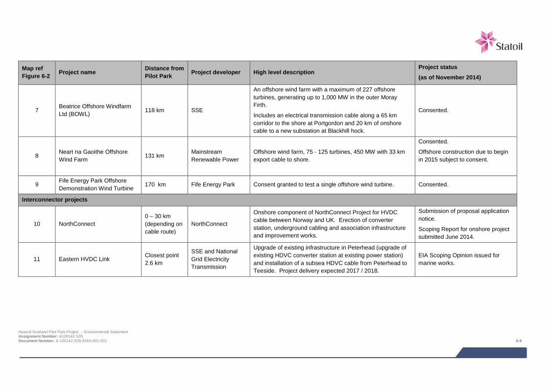
Map ref Figure 6-2 Project name Distance from
Pilot Park Project developer High level description Project status
(as of November 2014)
7 Beatrice Offshore Windfarm Ltd (BOWL) 118 km SSE
An offshore wind farm with a maximum of 227 offshore turbines, generating up to 1,000 MW in the outer Moray Firth.
Includes an electrical transmission cable along a 65 km corridor to the shore at Portgordon and 20 km of onshore cable to a new substation at Blackhill hock.
Consented.
8 Neart na Gaoithe Offshore Wind Farm 131 km
Mainstream Renewable Power
Offshore wind farm, 75 - 125 turbines, 450 MW with 33 km export cable to shore.
Consented.
Offshore construction due to begin in 2015 subject to consent.
9 Fife Energy Park Offshore Demonstration Wind Turbine
170 km Fife Energy Park Consent granted to test a single offshore wind turbine. Consented.
Interconnector projects
10 NorthConnect 0 – 30 km (depending on cable route)
NorthConnect
Onshore component of NorthConnect Project for HVDC cable between Norway and UK. Erection of converter station, underground cabling and association infrastructure and improvement works.
Submission of proposal application notice.
Scoping Report for onshore project submitted June 2014.
11 Eastern HVDC Link Closest point 2.6 km
SSE and National Grid Electricity Transmission
Upgrade of existing infrastructure in Peterhead (upgrade of existing HDVC converter station at existing power station) and installation of a subsea HDVC cable from Peterhead to Teeside. Project delivery expected 2017 / 2018.
EIA Scoping Opinion issued for marine works.
Hywind Scotland Pilot Park Project – Environmental Statement Assignment Number: A100142-S35 Document Number: A-100142-S35-EIAS-001-001 6-8
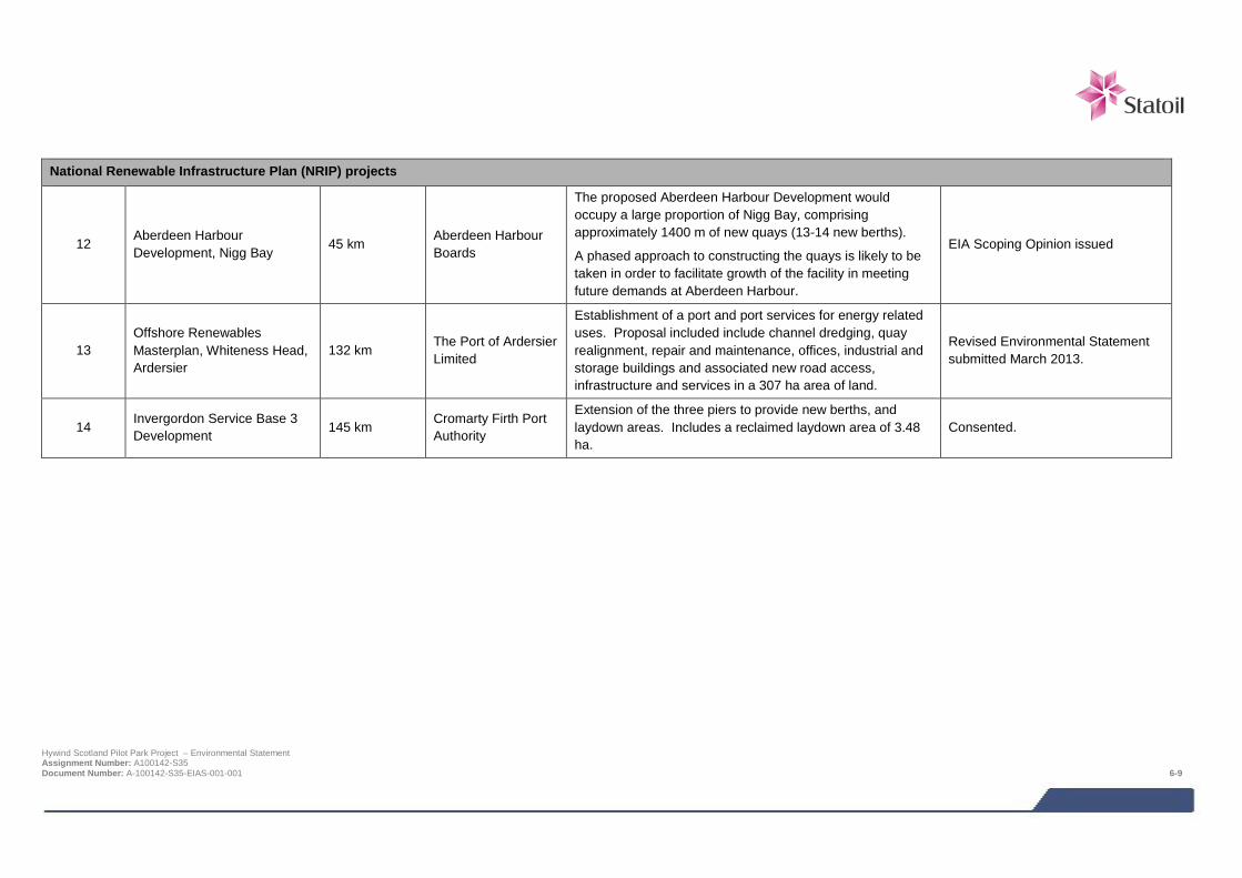
National Renewable Infrastructure Plan (NRIP) projects
12 Aberdeen Harbour Development, Nigg Bay
45 km Aberdeen Harbour Boards
The proposed Aberdeen Harbour Development would occupy a large proportion of Nigg Bay, comprising approximately 1400 m of new quays (13-14 new berths).
A phased approach to constructing the quays is likely to be taken in order to facilitate growth of the facility in meeting future demands at Aberdeen Harbour.
EIA Scoping Opinion issued
13 Offshore Renewables Masterplan, Whiteness Head, Ardersier
132 km The Port of Ardersier Limited
Establishment of a port and port services for energy related uses. Proposal included include channel dredging, quay realignment, repair and maintenance, offices, industrial and storage buildings and associated new road access, infrastructure and services in a 307 ha area of land.
Revised Environmental Statement submitted March 2013.
14 Invergordon Service Base 3 Development 145 km Cromarty Firth Port
Authority
Extension of the three piers to provide new berths, and laydown areas. Includes a reclaimed laydown area of 3.48 ha.
Consented.
Hywind Scotland Pilot Park Project – Environmental Statement Assignment Number: A100142-S35 Document Number: A-100142-S35-EIAS-001-001 6-9
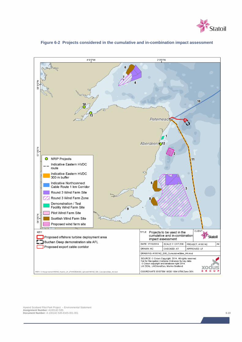
Figure 6-2 Projects considered in the cumulative and in-combination impact assessment
Hywind Scotland Pilot Park Project – Environmental Statement Assignment Number: A100142-S35 Document Number: A-100142-S35-EIAS-001-001 6-10

6.7 References IEEM (2010). Guidelines for Ecological Impact Assessment in Britain and Ireland, Marine and Coastal. August 2010. Final Version 5.
Scottish Natural Heritage (2009). A handbook on environmental impact assessment; Guidance for Competent Authorities, Consultees and others involved in the Environmental Impact Assessment Process in Scotland. 3rd Edition.
Tyler-Walters H., Hiscock K., Lear D.B. & Jackson A. (2001). Identifying species and ecosystems sensitivities. Final report to the Department of Environment, Food and Rural Affairs from the Marine Life Information Network (MarLIN), Marine Biological Association of the United Kingdom, Plymouth. Contract CW0826.
Hywind Scotland Pilot Park Project – Environmental Statement Assignment Number: A100142-S35 Document Number: A-100142-S35-EIAS-001-001 6-11

7 STAKEHOLDER ENGAGEMENT
7.1 Background There are a number of directives and policies dealing with consultation procedures for large infrastructure projects such as a marine renewable energy development. HSL has undertaken consultation in accordance with the relevant procedures, guidance and policies. In addition, from the commencement of the Project, HSL has been advocates of early consultation, maintaining full and open communications with stakeholders and other interested parties.
Following submission of the application, formal consultation is also undertaken on the Environmental Statement (ES) with statutory consultees and the public.
Further to this HSL recognise the importance of early consultation that continues throughout the Project in order to integrate public and stakeholder concerns and opinions into the Project decision making process. Consequently, consultation with both statutory and non-statutory stakeholders has been an integral aspect of the Environmental Impact Assessment (EIA) process since the initial days of the Project. The primary aim of the consultation process is to facilitate two way communications about the Project to all relevant stakeholders. This allows any initial environmental concerns to be identified at an early stage and to be adequately addressed during the EIA process.
HSL is committed to the highest environmental standards and best practice throughout the entire Project lifecycle and will, with necessary adaptions specific to Scottish regulations, administrative set-up and culture, base the stakeholder engagement for the Hywind Scotland Pilot Park Project on experiences gained from similar HSL offshore renewables Projects. These include Sheringham Shoal and Dudgeon offshore wind Projects off the coast of Norfolk, England and other international projects.
This Chapter of the ES describes the overall consultation process that was undertaken for the Project. Detailed information on topic specific consultation is included in study specific sections throughout the ES.
7.2 Scoping overview and consultation
7.2.1 Background To ensure effective stakeholder engagement, HSL, together with Xodus, has prepared a ‘Stakeholder Management Plan’ and ‘Stakeholder Database’. Both are live documents and will be updated during the Project to incorporate any changes in conditions, strategy, stakeholder roles or interactions.
For successful stakeholder engagement it is essential that:
> The groups and individuals interested in or affected by the Project are identified;
> Information issued is accurate, understandable, issued at the appropriate time and does not overwhelm recipients;
> Dialogue is held between those affected by the decisions and those responsible for making the decisions;
> The information provided by the public and consultees are incorporated within the final decision making process and final decision; and
> Feedback is provided to all consultees including the public explaining the actions taken and how the final decision has been influenced by the process.
An overview of the Hywind Scotland Pilot Park Project stakeholder engagement strategy is presented in Figure 7-1.
Hywind Scotland Pilot Park Project – Environmental Statement Assignment Number: A100142-S35 Document Number: A-100142-S35-EIAS-001-001 7-1
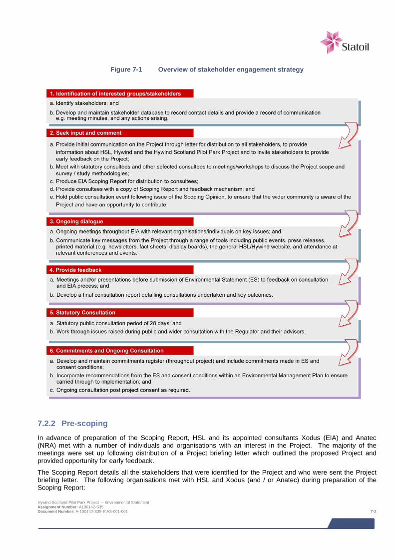
Figure 7-1 Overview of stakeholder engagement strategy
7.2.2 Pre-scoping In advance of preparation of the Scoping Report, HSL and its appointed consultants Xodus (EIA) and Anatec (NRA) met with a number of individuals and organisations with an interest in the Project. The majority of the meetings were set up following distribution of a Project briefing letter which outlined the proposed Project and provided opportunity for early feedback.
The Scoping Report details all the stakeholders that were identified for the Project and who were sent the Project briefing letter. The following organisations met with HSL and Xodus (and / or Anatec) during preparation of the Scoping Report: Hywind Scotland Pilot Park Project – Environmental Statement Assignment Number: A100142-S35 Document Number: A-100142-S35-EIAS-001-001 7-2
> Aberdeenshire Council;
> Buchan Inshore Fishermen’s Association (BIFA);
> Joint Nature Conservation Committee (JNCC);
> Ministry for Energy, Enterprise and Tourism and the Energy Division;
> Maritime and Coastguard Agency (MCA);
> Marine Scotland;
> Northern Lighthouse Board (NLB);
> National Oceanographic Centre (NOC);
> Peterhead Port Authority;
> Royal Yachting Association (RYA);
> Scottish Fishermen’s Federation (SFF);
> Scottish Natural Heritage (SNH);
> The Crown Estate (TCE); and
> Whale and Dolphin Conservation Society.
7.2.3 EIA Screening Screening is the process for determining whether or not a Project requires an EIA in accordance with relevant EIA Regulations. Developers can request for the Regulator in this case Marine Scotland for the offshore components of the Project and Aberdeenshire Council for the onshore components of the Project) to provide a screening opinion as to whether or not an EIA is required. Screening responses for the Hywind Scotland Pilot Park Project were issued on 14th August 2013 (Marine Scotland) and 19th July 2013 (Aberdeenshire Council).
7.2.4 EIA Scoping Under EIA Regulations, the ES should describe the likely significant effects of the proposed project on the environment. Scoping of potential issues associated with physical and operational aspects of the project provides a basis for ensuring that the assessment is appropriately limited to issues of genuine potential significance. Under EIA Regulations, the developer of a project requiring EIA may before submitting their formal application ask the Regulator, to state in writing their opinion as to the information to be provided in the ES.
In October 2013 HSL requested a formal EIA Scoping Opinion from the Scottish Ministers by submitting a EIA Scoping Report (and accompanying navigational Preliminary Hazard Analysis (PHA)) for the Project to Marine Scotland and Aberdeenshire Council.
A formal EIA Scoping Opinion was received from Marine Scotland on 17th March 2014. It details the views of the statutory consultees and what they deem necessary for consideration by the EIA and reported in the ES. As well as statutory consultees, the EIA Scoping Report was also distributed to a number of non-statutory bodies. In addition, confirmed was received from Aberdeenshire Council that as the Project is within the threshold of local development that a full EIA for the onshore Project was not required. Studies to address the environmental implications of the onshore Project have been undertaken to support the planning application. These studies are summarised in the ES (Chapter 21).
Following receipt of the EIA Scoping Opinion each issue raised (of which there were over 200) was reviewed and implications to the overall Project, as well as the EIA, considered. Where appropriate, further meetings and discussions were held, generally on a topic specific basis, throughout the EIA. These were necessary in order to refine the scope of EIA studies being undertaken, based on the EIA Scoping Opinion received and / or results of EIA studies as they became available. This on-going consultation was an important aspect in ensuring the EIA addressed all issues required in the appropriate manner.
7.3 Consultation with local community The purpose of the public consultation was to ensure that the wider community was aware of the proposals and had an opportunity to comment. Public consultation was undertaken at key stages within the EIA and NRA processes and met the requirements of the legislation.
Hywind Scotland Pilot Park Project – Environmental Statement Assignment Number: A100142-S35 Document Number: A-100142-S35-EIAS-001-001 7-3
Under the Marine Licensing (Pre-application Consultation) (Scotland) Regulations 20138, from 6th April 2014, prospective applicants for marine licences for certain activities are required to carry out a public pre-application consultation. Applications affected are those activities with the potential to have significant impacts upon the environment, local communities and other legitimate uses of the sea. The purpose of the new requirements is to allow local communities, environmental groups and other interested parties to comment upon proposed marine developments at an early stage - before an application is submitted to the Marine Scotland Licensing Operations Team.
The Regulations prescribe the marine licensable activities that are subject to pre-application consultation and, in combination with the Marine (Scotland) Act 2010, set out the nature of the pre-application process (Marine Scotland, 2013).
A public consultation event was held in Peterhead in May 2014, in the form of a public display and question and answer sessions with the Hywind project team. A post event report was submitted to Marine Scotland on the 20th June 2014 (Hywind (Scotland) Ltd, 2014 (included on the accompanying CD)).
Prior to the event notices were included in the local press and in addition, invitations to the event were sent out to key stakeholders six weeks prior to the event. The event consisted of a series of mounted boards giving background to and details of the project design (as known at the time). Members of the public were able to attend the informal drop in sessions throughout the afternoon and early evening and had the opportunity to speak to members of the Project team and the environmental consultants. Visitors were also invited to leave comments and fill out a questionnaire. The results from this event have been documented and used to inform elements of the Project design, EIA and consent applications.
For the NRA consultation has been undertaken with the Marine and Coastguard Agency (MCA) and other shipping, navigation, recreational sailing and fishing interests that navigate through and within the Project area. Consultation has included a number of meetings and a Hazard Review Workshop with the MCA and other stakeholders. Through this process shipping and navigation features within the Project area and potential risks related to the Project have been identified. This information has been used to inform the risk assessment undertaken as part of the NRA.
Further events and consultation will be considered as the Project progresses, during which it may be appropriate to consider alternative means of broader public consultation including press releases, printed material (e.g. newsletters, fact sheets, display boards) and through the HSL/Hywind website.
7.4 Consultation with Regulator and their advisors HSL has attended regular meetings with both Marine Scotland (and Aberdeenshire Council) in order to keep them directly informed and up to date with progress of the Project. Meetings have included:
> Project consenting strategy;
> General EIA and HRA updates; and
> Consultation on EIA and HRA methodologies.
As outlined in Section 2.3.3 the onshore project has not been included in the scope of the EIA as advised by Aberdeenshire Council. Consultation related to the onshore project has been undertaken separately with Aberdeenshire Council.
7.5 Consultation beyond application submission Consultation will continue beyond the submission of the application. Assuming successful award of Project consent, licence condition implementation, including the development of appropriate environmental monitoring protocols, will require continuing engagement and consultation with the Regulators and their statutory consultees. In addition, HSL will continue its communications with the local community and wider public to keep them informed of the Project process and key milestones.
8 The legislation came into force on 1st January 2014 and applies to all relevant marine licence applications submitted to MS-LOT on or after 6 April 2014. Hywind Scotland Pilot Park Project – Environmental Statement Assignment Number: A100142-S35 Document Number: A-100142-S35-EIAS-001-001 7-4

7.6 References Marine Scotland (2013). Guidance on Marine Licensable Activities subject to Pre-Application Consultation. December 2013.
Hywind (Scotland) Ltd (2014). Pre-application Consultation Report.
Hywind Scotland Pilot Park Project – Environmental Statement Assignment Number: A100142-S35 Document Number: A-100142-S35-EIAS-001-001 7-5
8 PHYSICAL ENVIRONMENT Characterisation of the existing physical environment and sediment processes is based on both existing and site-specific survey data. The turbine deployment area and majority of the export cable corridor are characterised by thick sediment cover. The deep water at the turbine deployment area means that wave action is unlikely to influence scour. The coast at the cable landfall is comprised of irregular basement rock, with mobile cobbles and boulders lying towards the west of the potential landfall site.
The base case for cable landfall is installation via HDD; however the option of cable installation via a surface trench has been assessed as this would result in greater impacts compared with the HDD option. Through scoping, it was identified that the physical environment may be affected as a result of:
• Effects on the coast at the export cable landfall;
• Effects on the Scottish Water outfall; and
• Introduction of scour within the Pilot Park.
The coastal environment at the cable landfall is considered to be tolerable to change, due to its irregular rocky nature, and mobile cobbles and boulders, therefore the sensitivity of the rocky shore and seabed is considered to be low. Any changes are expected to be of short duration and minor magnitude.
The beach at the cable landfall has a seawall for shore protection and the Buchanhaven combined sewer overflow (CSO) discharge pipe is located within the cable landfall footprint. This existing infrastructure could be impacted should the cable be installed across the beach (rather than via HDD). HSL will ensure any necessary measures are taken to protect the seawall and outfall during cable installation.
There is potential for some limited areas of scour around suction anchors and if required scour protection will be installed over an area of not more than 15 m from the edge of each anchor. The impacts of this are assessed as relevant in other chapters of the ES e.g. benthic ecology.
8.1 Introduction This section assesses the impacts of the Project on the physical environment. A number of different specialists have contributed to this assessment:
> MMT – seabed survey, video footage analysis, biotope mapping, seabed survey reporting;
> GEO – geotechnical survey, soil analysis, survey reporting;
> Statoil – metocean design basis; and
> Xodus – landfall site walkover, geotechnical evaluation, geotechnical desk study report, phase 1 intertidal survey report, baseline description, impact assessment and ES chapter write up.
Table 8-1 provides a list of the supporting studies which relate to the physical environment impact assessment. All supporting studies are provided on the accompanying CD.
Hywind Scotland Pilot Park Project – Environmental Statement Assignment Number: A100142-S35 Document Number: A-100142-S35-EIAS-001-002 8-1
Table 8-1 Supporting studies
Details of study
Geophysical survey report (MMT, 2013a)
Environmental survey report (MMT, 2013b)
Geotechnical survey report (GEO, 2014)
Geotechnical desk study report (Xodus, 2013a)
Landfall site walkover report (Xodus, 2013b)
Phase 1 intertidal survey report (Xodus, 2013c)
Buchan Deep metocean design basis (Statoil, 2014)
The focus of this physical environment assessment is to assess potential impacts on physical processes and sediment dynamics in the proposed turbine deployment area, the export cable route and cable landfall site as shown in Figure 8-1.
The following areas are referred to in this impact assessment:
> Project area (see Figure 1-2), which comprises:
o Proposed offshore turbine deployment area: and
o Export cable corridor and landfall.
> Study area – area shown on Figure 8-1, which incorporates the proposed turbine deployment area and the export cable corridor. None of the impacts in this chapter are predicted to extend beyond the Project area, as impacts to currents, waves and sediment transport which often create the need for a wider study area were deemed negligible during scoping.
> Survey area – area outlined in Figure 8-1, which incorporates the proposed turbine deployment area and the export cable corridor.
8.2 Legislative context and relevant guidance The EIA Regulations stipulate a requirement to assess the impacts of a project on water quality and sediment. The Water Environment and Water Services (Scotland) Act 2003, which implements the Water Framework Directive (WFD), should also be considered, with respect to River Basin Management Plans (RBMP) coastal water bodies. Information on current WFD RBMP status is summarised from the SEPA River Basin Management Plan information sheets (SEPA, 2009).
There are no specific legislative controls relevant to the scope of the physical environment impact assessment. However there is specific guidance relevant in addition to the EIA guidance published by Marine Scotland and SNH:
> Offshore Wind Farms. Guidance Note for Environmental Impact Assessment in Respect of FEPA and CPA Requirements. (Cefas, 2004);
> Guidelines for data acquisition to support marine environmental assessments of offshore renewable energy projects (Cefas, 2012);
> Assessment of the Significance of Changes to the Inshore Wave Regime as a consequence of an Offshore Wind Array (Cefas, 2005);
> Coastal Process Modelling for Offshore Windfarm Environmental Impact Assessment (COWRIE, 2009);
> Review of Cabling Techniques and Environmental Effects applicable to the Offshore Windfarm Industry (BERR 2008); and
Hywind Scotland Pilot Park Project – Environmental Statement Assignment Number: A100142-S35 Document Number: A-100142-S35-EIAS-001-002 8-2
> Potential effects of offshore wind developments on coastal processes. (ABPmer and Metoc for DTI (now
DECC) 2002).
The Cefas guidelines highlight that direct impacts on hydrodynamics and sediment dynamics should be considered, along with secondary effects including water and benthic ecology (Chapter 9).
8.3 Scoping and consultation The bullets below summarise the key issues raised in the Scoping Opinion relevant to the physical environment impact assessment:
> Concerns on impacts to the adjacent water body, so the ES should assess the significance of such alterations and discuss the implications of these with respect to shoreline and seabed morphology, and wider ecosystem health in line with River Basin Management Plan (RBMP) objectives.
> Concern regarding the cable route and the Southern Trench MPA search area. This will need to be considered and effective mitigation proposed if significant impacts are anticipated.
> Concern regarding changes to local bathymetry arising from open trenches or rock armour can impact the quality of the wave resource available for surfing.
Table 8-2 summarises all consultation activities carried out relevant to the physical environment.
Table 8-2 Consultation activities undertaken in relation to the physical environment
Date Stakeholder Consultation undertaken
May 2013 Marine Scotland (MS-LOT and Marine Scotland Science) and statutory consultees
Pre-scoping meeting including discussion on proposed scope of marine physical environment impact assessment
October 2013 Marine Scotland, statutory consultees and non-statutory consultees (including SEPA, Surfers Against Sewage, and the Scottish Surfing Federation)
Request for EIA Scoping Opinion for Marine Scotland and statutory consultees and request for comment from non-statutory consultees
January 2014 Marine Scotland, JNCC and SNH
Submission of the MMT environmental survey report for comment
February 2014 Marine Scotland Report on EIA progress including feedback on MMT Environmental Survey Report
March 2014 Marine Scotland, statutory consultees and non-statutory consultees
Receipt of response to Scoping Opinion, including comments on the MMT environmental survey report
May 2014 Marine Scotland, SNH, JNCC Meeting at which Statoil response to comments from JNCC, SNH and Marine Scotland Science were presented
May 2014 Local stakeholders Public event in Peterhead to collate information opinions on EIA scope
8.4 Baseline description
8.4.1 Introduction As part of the desk based study for the assessment of impacts in relation to the physical environment, baseline data and information have also been collected from the following sources:
> Barne, J.H., Robson, C.F., Kaznowska, S.S., Doody, J.P. & Davidson, N.C. (1996). Coasts and seas of the United Kingdom Region 3 North-east Scotland: Cape Wrath to St. Cyrus. JNCC Coastal Directories Series, Peterborough.
Hywind Scotland Pilot Park Project – Environmental Statement Assignment Number: A100142-S35 Document Number: A-100142-S35-EIAS-001-002 8-3
> Ramsay, D.L. & Brampton, A.H. (2000). Coastal Cells in Scotland: Cell 2 – Fife Ness to Cairnbulg Point.
Scottish Natural Heritage Research, Survey and Monitoring Report No 144. 2000.
> SNH Interactive Map (SNH, 2014).
> Scottish Marine SEA (Scottish Executive, 2007).
> UK HSE (2002), Environmental considerations, Offshore Technology Report 2001/010, ISBN 0 7176 2379 3.
In addition to the available published literature, field surveys have been undertaken that provide input to the physical environment impact assessment. Their location and coverage have been summarised in Figure 8-1, and survey objectives and data gathered are described below:
> HSL appointed MMT to conduct a geophysical baseline survey of the Project area (MMT, 2013a). The geophysical survey was used to acquire high quality seabed and sub-seabed data from side scan sonar, sub-bottom profiler, magnetometer and multibeam backscatter equipment, to characterise the Project site shallow geology, bathymetry, seabed sediment distribution and properties and detection of seabed features and seabed obstructions. The survey was also used to detect the possible occurrence of benthic habitats and species of known conservation importance.
> Following on from the geophysical survey, HSL appointed MMT to conduct an environmental survey of the Project area (MMT, 2014b). This survey used a combination of remote video/stills photography; grab sampling and bedload sampling, developed from the geophysical survey outputs from which seabed and suspended bedload characteristics within the Project area could be described. Particle size analysis was carried out on the sediment grabs.
> To inform Project engineering, HSL appointed GEO to conduct a geotechnical survey to provide information for anchoring of the WTG units and on the soil conditions along the cable route. Numerous boreholes and core penetration tests were carried out along the cable route and AfL area and analysed to determine soil characteristics such as cohesiveness and shear strength.
> HSL have deployed an acoustic doppler current profiler (ADCP) to measure currents within the proposed AfL area for 12 months from November 2013, to collect data on current, waves, water level and turbidity. Some of these data were available to inform the impact assessment.
> In August 2013 Statoil commissioned Xodus to undertake an intertidal Phase 1 biotope mapping survey of the landfall area at Peterhead (Xodus, 2013c), along with a geophysical walkover survey of potential landfall options (Xodus, 2013b), and a geological desk study of the offshore conditions (Xodus, 2013a).
Hywind Scotland Pilot Park Project – Environmental Statement Assignment Number: A100142-S35 Document Number: A-100142-S35-EIAS-001-002 8-4
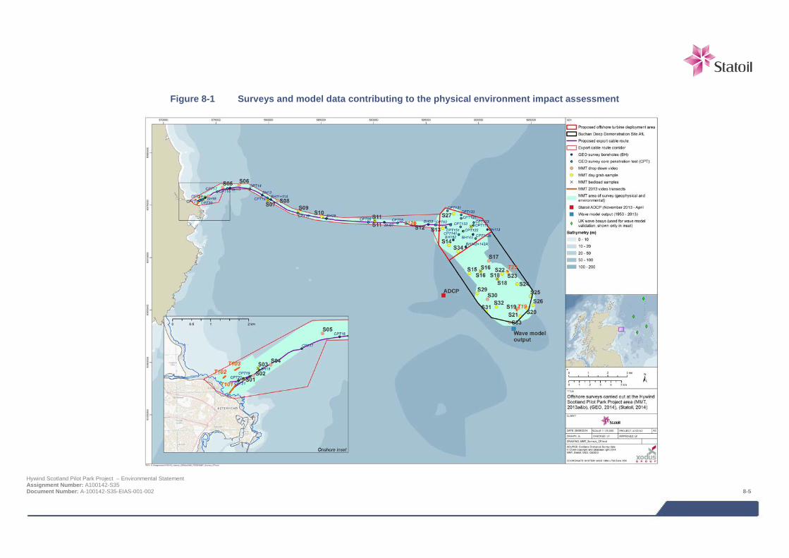
Figure 8-1 Surveys and model data contributing to the physical environment impact assessment
Hywind Scotland Pilot Park Project – Environmental Statement Assignment Number: A100142-S35 Document Number: A-100142-S35-EIAS-001-002 8-5

8.4.2 Designated features Numerous statutory and non-statutory designated sites in the vicinity of the Project area relevant to this assessment are detailed in Table 8-3 and shown in Figure 8-2. Many of these sites are outside the Study area of the Project, but have been shown to give context for the kinds of features along the length of coast, and to demonstrate the distance these sites are from the Project.
Table 8-3 Designated or sensitive sites within the vicinity of the Project and of relevance to the physical environment
Site Name Designation Reason for site designation / relevance Distance to landfall (km)
Ugie Estuary to Buchan Ness (Peterhead)
River Basin Management Plan (RBMP) water body
Listed for chemical and biological water quality Project is within RBMP
Bullers of Buchan Coast SSSI, GCR Listed for mixed geomorphology and supralittoral rock (coast), the Bullers of Buchan site is a comparatively small area which contains a range of rocky coastal forms that have developed in igneous rock, including numerous geos, caves, arches, stacks, shore platforms, skerries and isolated islands, including the 60 m deep, enclosed sea inlet of The Pot.
6 km south
Loch of Strathbeg SSSI, GCR, Listed for mixed geomorphology, the extensive and varied dune morphology of Strathbeg is of outstanding geomorphological interest.
13 km north
Collieston to Whinnyfold Coast
SSSI, GCR Listed for mixed structural and metamorphic geology 14 km south
Buchan Ness to Collieston Coast
SAC, SPA Listed for supralittoral rock (coast) vegetated sea cliffs. The SPA is listed for six species of bird, but presented here because vegetated cliffs provide unique habitat for breeding.
4 km south
Southern Trench MPA (proposed) Listed for burrowed mud seabed habitat alongside other marine mammal and geological features.
2 km north-east
Peterhead (Lido) bathing water
Bathing Water Bacterial water quality monitoring for public health 3 km south
Cruden Bay bathing water
Bathing Water Bacterial water quality monitoring for public health 10 km south
Sandford Bay None Given here because is a known surf spot. 5 km south
Cruden Bay None Given here because is a known surf spot. 10 km south
Hywind Scotland Pilot Park Project – Environmental Statement Assignment Number: A100142-S35 Document Number: A-100142-S35-EIAS-001-002 8-6
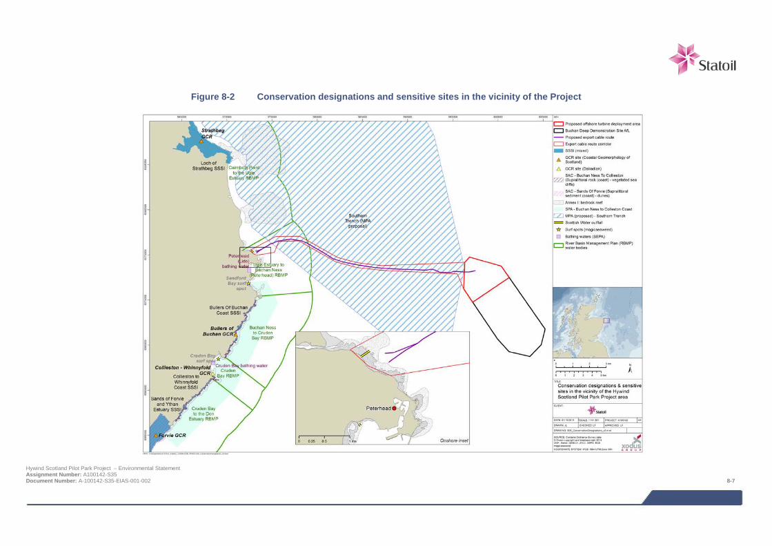
Figure 8-2 Conservation designations and sensitive sites in the vicinity of the Project
Hywind Scotland Pilot Park Project – Environmental Statement Assignment Number: A100142-S35 Document Number: A-100142-S35-EIAS-001-002 8-7
8.4.3 Bathymetry The Project is located in the northern North Sea, on the continental shelf of north-west Europe as the waters shallow out south of the Shetland Isles. East of Peterhead the sea floor slopes from the coast to 60 m depth by about 5 km offshore, and north to Ratteray Head and south towards Aberdeen the 60 m contour is reached about 10 km offshore. Further offshore, several narrow and relatively deep (>100 m) troughs occur, the nearest being 17.5 km offshore.
The Agreement for Lease (AfL) area is situated in the Buchan Deep, approximately 25 km due east of Peterhead, with water depths between 95 to 120 m, becoming deeper from north-west to south-east. The geophysical and environmental survey covered an area of 73 km2 within both the AfL and the export cable corridor (MMT, 2013a, b). See Figure 8-4 for an overview of bathymetry in the AfL area, turbine deployment area and the export cable route corridor.
From the geophysical and environment surveys undertaken, water depths along the cable export corridor range between approximately 100 m at the turbine deployment area to 0 m at the landfall point. Within this, the seabed shoaled very gradually from the turbine deployment area to a depth of 20 m at less than 1 km from the landfall, after which the seabed gradient becomes steeper towards the shore. The general inclination of the sea floor along the cable route ranges between 0 and 3º. Near the cable landfall, the slope increases and reaches a maximum of just above 15º. In general, an inclination above 8º is only observed very close to the landing point.
8.4.4 Wind The strength of the winds and the frequency of certain wind directions show considerable variation, although winds are predominantly from the south and west (Ramsay & Brampton, 2000), as shown in Figure 8-3.
Figure 8-3 Wind rose for 1-hour average wind speed 10 m above sea level for the period 1958 – 2010 at Buchan Deep (Statoil, 2014)
Hywind Scotland Pilot Park Project – Environmental Statement Assignment Number: A100142-S35 Document Number: A-100142-S35-EIAS-001-002 8-8
Figure 8-4 Surveyed and charted bathymetry
Hywind Scotland Pilot Park Project – Environmental Statement Assignment Number: A100142-S35 Document Number: A-100142-S35-EIAS-001-002 8-9
8.4.5 Wave In UK waters, the wave climate is strongly seasonal: mean wave heights peak around January, but extreme waves are likely from October to March. The proximity of the Project to the east coast of Scotland means it is largely sheltered to waves propagating from the west. Long term (+50 years) modelled wave data at the Buchan Deep site (Statoil, 2014) confirm this, showing that the wave climate at the site is dominated by waves from the north and south-west (Figure 8-5), although locally generated wind waves are present from all directions. The majority of significant wave heights are less than 4 m.
Figure 8-5 All-year wave rose at Buchan Deep for the period 1958 – 2010 (Statoil, 2014)
The wave rose in Figure 8-5 can be supplemented by the joint frequency distribution of significant wave height and the spectral peak period from the metocean report (Statoil, 2014), which shows that the sea state is dominated by waves having a period of between 4 to 8 seconds, and significant heights of less than 2 m. Extreme wave conditions deduced for engineering design are shown in Table 8-4.
Table 8-4 Design wave heights for selected return periods (Statoil, 2014)
Return period Significant wave height (m) Wave period (s)
1 15.2 11.2
10 17.8 12.2
50 19.7 12.8
100 20.5 13.1
8.4.6 Current Tides in the North Sea are predominantly semi-diurnal. The principal tidal wave enters from the north, moves south and reflects off the southern coast of the North Sea basin.
Hywind Scotland Pilot Park Project – Environmental Statement Assignment Number: A100142-S35 Document Number: A-100142-S35-EIAS-001-002 8-10
Around the coast of Aberdeenshire, the flood tidal flow follows the coastline from the Moray Firth around Cairnbulg Point, at which point it meets a southerly flowing stream from offshore. The resulting flood tide runs south, parallel to the coastline. The flood and ebb tides in the region of the Project are strongly rectilinear, with the ebb tide flowing parallel to the coastline towards the north (Figure 8-6). At Peterhead, tidal currents attain a maximum speed of approximately 1.3 m/s (2.5 knots) during springs (UKHO, 2013).
Site specific measurements have been recorded at the Buchan Deep with an acoustic doppler current profiler (ADCP) in water depth of approximately 107 m (as located in Figure 8-1). At time of ES compilation, 4 months of data was available. The measurement programme is ongoing and will continue until November 2014 making a full year of recorded current data. Figure 8-6 shows a selection of measured current roses varying with water depth, which clearly show the dominant shore-parallel north-south flood ebb current pattern throughout the water column, with currents reducing as expected towards the seabed.
Table 8-5 shows some summary statistics of the ADCP data collected to date.
Figure 8-6 Measured current roses at the Buchan Deep site, November 2013 – February 2014 (Statoil, 2014)
(a) Current rose at 25 m depth below surface (b) Current rose at 40 m depth below surface
(c) Current rose at 60 m depth below surface (d) Current rose at 90 m depth below surface
Hywind Scotland Pilot Park Project – Environmental Statement Assignment Number: A100142-S35 Document Number: A-100142-S35-EIAS-001-002 8-11
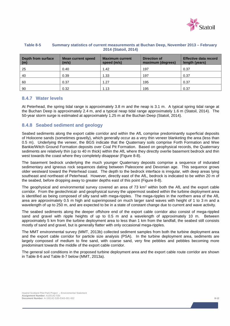
Table 8-5 Summary statistics of current measurements at Buchan Deep, November 2013 – February 2014 (Statoil, 2014)
Depth from surface (m)
Mean current speed (m/s)
Maximum current speed (m/s)
Direction of maximum (degrees)
Effective data record length (years)
25 0.40 1.42 197 0.37
40 0.39 1.33 197 0.37
60 0.37 1.27 195 0.37
90 0.32 1.13 195 0.37
8.4.7 Water levels At Peterhead, the spring tidal range is approximately 3.8 m and the neap is 3.1 m. A typical spring tidal range at the Buchan Deep is approximately 2.4 m, and a typical neap tidal range approximately 1.6 m (Statoil, 2014). The 50-year storm surge is estimated at approximately 1.25 m at the Buchan Deep (Statoil, 2014).
8.4.8 Seabed sediment and geology Seabed sediments along the export cable corridor and within the AfL comprise predominantly superficial deposits of Holocene sands (sometimes gravelly), which generally occur as a very thin veneer blanketing the area (less than 0.5 m). Underlying the veneer, the BGS indicate that the Quaternary soils comprise Forth Formation and Wee Bankie/Witch Ground Formation deposits over Coal Pit Formation. Based on geophysical records, the Quaternary sediments are relatively thin (up to 40 m thick) within the AfL where they directly overlie basement bedrock and thin west towards the coast where they completely disappear (Figure 8-8).
The basement bedrock underlying the much younger Quaternary deposits comprise a sequence of indurated sedimentary and igneous rock sequences dating between Paleocene and Devonian age. This sequence grows older westward toward the Peterhead coast. The depth to the bedrock interface is irregular, with deep areas lying southeast and northeast of Peterhead. However, directly east of the AfL, bedrock is indicated to be within 20 m of the seabed, before dropping away to greater depths east of this point (Figure 8-8).
The geophysical and environmental survey covered an area of 73 km2 within both the AfL and the export cable corridor. From the geotechnical- and geophysical survey the uppermost seabed within the turbine deployment area is identified as being composed of silty sand with mega-ripples. The mega-ripples in the northern area of the AfL area are approximately 0.5 m high and superimposed on much larger sand waves with height of 1 to 3 m and a wavelength of up to 250 m, and are expected to be in a state of constant change due to current and wave activity.
The seabed sediments along the deeper offshore end of the export cable corridor also consist of mega-rippled sand and gravel with ripple heights of up to 0.5 m and a wavelength of approximately 10 m. Between approximately 5 km from the turbine deployment area to less than 1 km from the landfall, the seabed still consists mostly of sand and gravel, but is generally flatter with only occasional mega-ripples.
The MMT environmental survey (MMT, 2013b) collected sediment samples from both the turbine deployment area and the export cable corridor for particle size analysis (PSA). In the turbine deployment area, sediments are largely composed of medium to fine sand, with coarse sand, very fine pebbles and pebbles becoming more predominant towards the middle of the export cable corridor.
The general soil conditions in the proposed turbine deployment area and the export cable route corridor are shown in Table 8-6 and Table 8-7 below (MMT, 2013a).
Hywind Scotland Pilot Park Project – Environmental Statement Assignment Number: A100142-S35 Document Number: A-100142-S35-EIAS-001-002 8-12
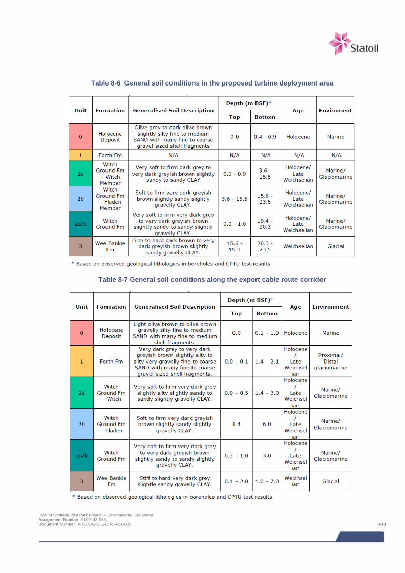
Table 8-6 General soil conditions in the proposed turbine deployment area
Table 8-7 General soil conditions along the export cable route corridor
Hywind Scotland Pilot Park Project – Environmental Statement Assignment Number: A100142-S35 Document Number: A-100142-S35-EIAS-001-002 8-13
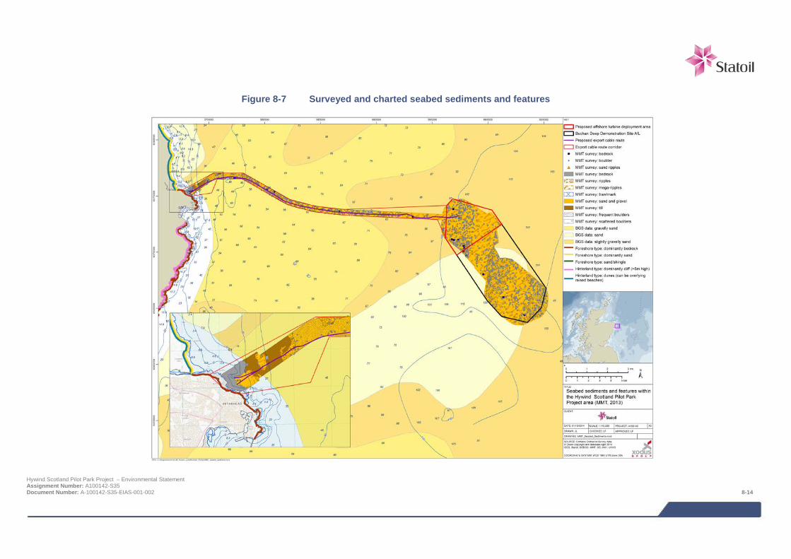
Figure 8-7 Surveyed and charted seabed sediments and features
Hywind Scotland Pilot Park Project – Environmental Statement Assignment Number: A100142-S35 Document Number: A-100142-S35-EIAS-001-002 8-14
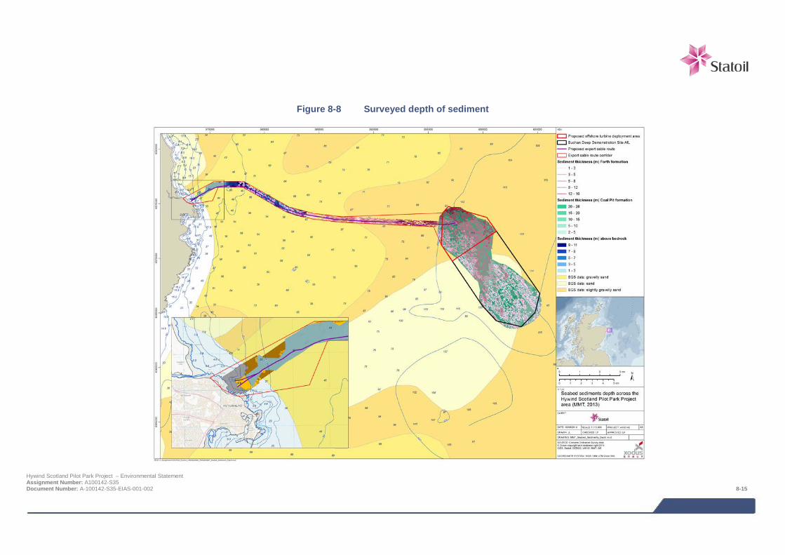
Figure 8-8 Surveyed depth of sediment
Hywind Scotland Pilot Park Project – Environmental Statement Assignment Number: A100142-S35 Document Number: A-100142-S35-EIAS-001-002 8-15
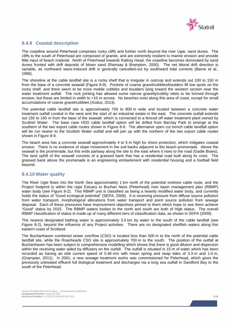
8.4.9 Coastal description The coastline around Peterhead comprises rocky cliffs and further north beyond the river Ugie, sand dunes. The cliffs to the south of Peterhead are composed of granite, and are extremely resilient to marine erosion and provide little input of beach material. North of Peterhead towards Rattray Head, the coastline becomes dominated by sand dunes fronted with drift deposits of blown sand (Ramsay & Brampton, 2000). The net littoral drift direction is variable, as northward wave-induced drift is generally cancelled-out by southward tidal currents (Barne et al., 1996).
The shoreline at the cable landfall site is a rocky shelf that is irregular in outcrop and extends out 100 to 150 m from the base of a concrete seawall (Figure 8-9). Pockets of coarse gravel/cobbles/boulders fill low spots on the rocky shelf, and there seem to be more mobile cobbles and boulders lying toward the western section near the water treatment outfall. The rock jointing has allowed some narrow gravelly/cobbly inlets to be formed through erosion, but these are limited in width to <10 m across. No beaches exist along this area of coast, except for small accumulations of coarse gravel/cobbles (Xodus, 2013).
The potential cable landfall site is approximately 700 to 800 m wide and located between a concrete water treatment outfall conduit in the west and the start of an industrial estate in the east. The concrete outfall extends out 150 to 160 m from the base of the seawall, which is connected to a fenced off water treatment plant owned by Scottish Water. The base case HDD cable landfall option will be drilled from Barclay Park to emerge at the southern of the two export cable routes shown in Figure 8-9. The alternative open cut trench cable landfall option will be run nearer to the Scottish Water outfall and will join up with the northern of the two export cable routes shown in Figure 8-9.
The beach area has a concrete seawall approximately 4 to 5 m high for shore protection, which mitigates coastal erosion. There is no evidence of slope movement in the soil banks adjacent to the beach promenade. Above the seawall is the promenade, but this ends partway along the site to the east where it rises to the road (Gadle Braes). The land uphill of the seawall consists of a grassed bank that has a residential road built along its crest. The grassed bank above the promenade is an engineering embankment with residential housing and a football field beyond.
8.4.10 Water quality The River Ugie flows into the North Sea approximately 1 km north of the potential onshore cable route, and the Project footprint is within the Ugie Estuary to Buchan Ness (Peterhead) river basin management plan (RBMP) water body (see Figure 8-2). This RBMP unit is classified as being a heavily modified water body, and currently holds the status of “Good ecological potential” (SEPA, 2009). It is receiving pressure from diffuse source pollution from water transport, morphological alterations from water transport and point source pollution from sewage disposal. Each of these pressures have improvement objectives pinned to them which hope to see them achieve “Good” status by 2015. The RBMP waters bodies to the north and south are both of High status. The overall RBMP classification of status is made up of many different tiers of classification data, as shown in SEPA (2009).
The nearest designated bathing water is approximately 3.5 km by water to the south of the cable landfall (see Figure 8-2), beyond the influence of any Project activities. There are no designated shellfish waters along this eastern coast of Scotland.
The Buchanhaven combined sewer overflow (CSO) is located less than 500 m to the north of the potential cable landfall site, while the Roanheads CSO site is approximately 700 m to the south. The position of the outfall at Buchanhaven has been subject to comprehensive modelling which shows that there is good dilution and dispersion within the receiving water aided by diffusers on the outfall. The outfall is situated in 15 m of water which has been recorded as having an ebb current speed of 0.46 m/s with mean spring and neap tides of 3.3 m and 1.6 m, (Grampian, 2011). In 2001, a new sewage treatment works was commissioned for Peterhead, which gives the previously untreated effluent full biological treatment and discharges via a long sea outfall in Sandford Bay to the south of the Peterhead.
Hywind Scotland Pilot Park Project – Environmental Statement Assignment Number: A100142-S35 Document Number: A-100142-S35-EIAS-001-002 8-16
Figure 8-9 Plan view of cable landfall location for Hywind Scotland Pilot Park Project
Hywind Scotland Pilot Park Project – Environmental Statement Assignment Number: A100142-S35 Document Number: A-100142-S35-EIAS-001-002 8-17
8.4.11 Data gaps and uncertainties Publications and data relevant to the region have been reviewed which, when combined with the site-specific surveys, provide a comprehensive baseline of the physical process and sediment dynamics of the Project and surrounding area.
8.5 Impact assessment
8.5.1 Overview Following establishment of the baseline conditions in the Project area, and an understanding of the Project activities it is possible to assess the potential impacts from the Project. The range of impacts that have been considered is based on impacts identified during EIA Scoping and any further potential impacts that have been highlighted as the EIA has progressed. The impacts assessed are summarised below. It should be noted that not all impacts will be relevant to all phases of the Project.
> Physical effects on the coast at the export cable landfall;
> Effects on the Scottish Water outfall; and
> Introduction of scour within the Pilot Park during operation and maintenance.
The following impacts were scoped out of the assessment during EIA Scoping:
> Changes to wave climate;
> Changes to local currents; and
> Changes to sediment transport and morphology.
The assessment of impacts on the physical environment is a desk based assessment utilising Project specific survey information on the nature of the seabed and metocean conditions.
8.5.2 Assessment criteria The EIA process and methodology are described in detail in Chapter 6. Specific criteria relating to the physical environment have been developed for ‘sensitivity of receptor’ and ‘magnitude of impact’ as detailed in Table 8-8 and Table 8-9 respectively.
The sensitivity of receptor and magnitude of effect are then combined to determine the level of impact and presented alongside a qualitative understanding of likelihood (using the criteria detailed in Chapter 6). The definitions for level of impact and how they relate to significance are presented in Chapter 6, Table 6-1 and Table 6-2.
Hywind Scotland Pilot Park Project – Environmental Statement Assignment Number: A100142-S35 Document Number: A-100142-S35-EIAS-001-002 8-18

Table 8-8 Criteria for sensitivity / value of the physical environment
Sensitivity / value Definition
Very high
Sensitivity: The physical environment has very little ability to absorb change without fundamentally altering its present character.
Value: Receptor of international importance (e.g. United Nations Educational, Scientific and Cultural Organisation (UNESCO) World Heritage Site (WHS)).
High
Sensitivity: The physical environment has little ability to absorb change without substantially altering its present character.
Value: Receptor of national importance (e.g. Site of Special Scientific Interest (SSSI), Geological Conservation Review (GCR) site).
Medium Sensitivity: The physical environment has moderate capacity to absorb change without much alteration of its present character.
Value: Receptor of regional importance.
Low Sensitivity: The physical environment is tolerant of change with only minor detriment to its present character.
Value: Receptor of local importance.
Negligible Sensitivity: The physical environment is tolerant of change without perceptible detriment to its present character.
Value: No particular importance.
Note:
Value is presented as a component of sensitivity to allow a judgement to be made according to either a receptor’s sensitivity to a particular effect or its value under, for example, international, national, or regional legislation. Value should therefore be applied inherently when considering the sensitivity of a receptor to a particular effect. Definitions in this table may not be appropriate for all receptors or effects, for example there may be a receptor with some tolerance to accommodate an effect (low sensitivity) but it might be designated under regional legislation (medium sensitivity). In such cases expert judgement is used to determine the most appropriate sensitivity ranking and this is explained through the narrative of the assessment.
Table 8-9 Criteria for magnitude of effect
Magnitude of effect Definition
Severe Effect is widespread, or occurs over a prolonged duration, or at a high frequency (e.g. repeated or continuous effect), resulting in extensive permanent changes to baseline conditions.
Major Effect is over a large scale or spatial extent, or occurs over the long term, or at a medium-high frequency, resulting in extensive temporary change or some permanent change to baseline conditions.
Moderate Effect is localised (confined to project footprint and immediate locality), or occurs for a short duration, or at a medium frequency, resulting in temporary changes or limited permanent changes to baseline conditions.
Minor Detectable disturbance or change to baseline levels and no long term noticeable effects above the level of natural variation experienced in the Project area.
Negligible An imperceptible change to the baseline condition of the physical environment.
Note:
Magnitude of effect is presented as a variety of parameters including duration, timing, size and scale, and frequency. Definitions in this table may not be appropriate for all effects, for example there may be an effect which is over a very small area (minor or moderate) but is repeated a large number of times during a particular phase of the project (major or severe). In such cases expert judgement is used to determine the most appropriate magnitude ranking and this is explained through the narrative of the assessment.
Hywind Scotland Pilot Park Project – Environmental Statement Assignment Number: A100142-S35 Document Number: A-100142-S35-EIAS-001-002 8-19

8.5.3 Design Envelope This assessment considers the Project parameters which are predicted to result in the greatest environmental impact. This approach ensures that impacts of a greater adverse significance would not arise should any other development scenario be taken forward in the final scheme design. With regards to the assessment of physical environment impacts the assessment comprises:
> WTG Unit anchoring systems which will include mooring lines present on the seabed (150 – 850 m of mooring line per anchor and a maximum of 15 anchors for the whole Pilot Park);
> Scour protection around the anchors which could be required over an area of up to 15 m beyond the edge of each anchor;
> Up to 5 inter array cables 3 km in length, giving a total length of 15 km, of which up to 7.5 km may be protected with rock;
> An export cable of up to 35 km in length and requiring rock protection along approximately 2 km of its length. The rock protection would occupy a 6 m wide corridor;
> Four cable crossings, each requiring 360 m2 of rock protection; and
> Cable landfall installation as a surface laid cable across the foreshore requiring a working corridor of 6 m wide (base case is HDD).
The impacts from potential alternative development options are addressed in Section 8.8.
8.6 Impacts during construction and installation
8.6.1 Effects on the coast at the cable landfall The base case for the cable landfall is HDD which would avoid effects on the coast at the cable landfall; however, if the open trench methodology is used, installing the export cable by surface laid trench will require the cable to be installed in a surface laid duct which will be weighted down with clump weights and concrete mattresses. The cable duct will be approximately 400 mm in diameter and the concrete mattresses assumed to be up to 4 m wide. The subsea cable will be connected to the onshore cable in an underground cable jointing pit immediately behind the seawall. A mechanical digger will be used to break through the seawall and level out the foreshore as far as possible. Rock nets may be used to even out the surface before the duct is laid. The seawall and promenade will be reinstated following installation.
To prevent damage to the seawall that flanks the opening, temporary protection may be used to limit exposure to the coast. The wall may also need to be propped up or the ground shored up to limit the risk of the wall collapsing. It is proposed that works would be undertaken in the summer months to reduce the impact from storms i.e. downtime or potential damage.
Assessment of impact significance
Export cable installation by surface laid trench has the potential to affect beach morphology. The coastal environment at the cable landfall is considered to be tolerable to change, due to its inherently dynamic nature, therefore the sensitivity of the rocky shore and seabed is considered to be low. Any changes are expected to be of short duration and minor magnitude. This results in an overall level of impact of negligible and not significant. In the event the cable is installed in an open trench across the shore this impact is certain to occur.
Sensitivity / value Magnitude of effect Level of impact
Low Minor Negligible
Impact significance – NOT SIGNIFICANT
Hywind Scotland Pilot Park Project – Environmental Statement Assignment Number: A100142-S35 Document Number: A-100142-S35-EIAS-001-002 8-20
MITIGATION
Although no significant impact has been identified, in the event an HDD solution should not be feasible, the following mitigation measures are proposed to ensure this remains the case:
> Ensure suitable measures are in place to protect the seawall during export cable installation.
8.6.2 Effects on the Scottish Water outfall The base case for the cable landfall is HDD which would avoid any potential effects on the Scottish Water outfall; however, if the open trench methodology is used potential impacts are predicted. The exact cable landfall location is not yet known, but the Buchanhaven combined sewer overflow (CSO) discharge pipe is located within the cable landfall footprint and has the potential to be affected by installation works from the mechanical digger and trenching. It may be necessary to protect the outfall during installation, so there may be a short-term impact on the outfall while any protection works are carried out, but there will be no significant long-term impact.
Assessment of impact significance
The Buchanhaven CSO is located between 300 – 500 m of the possible cable landfall sites. The CSO has been designed and located to provide optimum dilution and dispersion of any overflow wastewater which cannot be passed to the Peterhead STW during extreme rainfall events, and is an infrastructure asset serving the local community, so is considered to be of medium sensitivity. However, the magnitude of any effect is considered to be negligible, since HSL have been in discussion with Scottish Water to ensure suitable consideration and protection is given to the outfall during cable construction works. The overall level of impact is negligible and not considered. In the event the cable is installed in an open trench across the shore this impact is likely to occur.
Sensitivity / value Magnitude of effect Level of impact
Medium Negligible Negligible
Impact significance – NOT SIGNIFICANT
MITIGATION
Although no significant impact has been identified, in the event an HDD solution should not be feasible, the following mitigation measures are proposed to ensure this remains the case:
> Ensure suitable measures are put in place to protect the Scottish Water outfall during export cable installation.
8.7 Impacts during operation and maintenance
8.7.1 Effects on the coast at the cable landfall Once the cable is installed, there are not expected to be any impacts from the long term presence of the export cable at the landfall. However, it is possible the concrete mattresses will form a new raised ridge along the seabed and up the shore, but given the existing irregular shelf of basement rock and mobile cobbles and boulders lying toward the western section of the landfall, any modification is considered to be of no consequence.
Hywind Scotland Pilot Park Project – Environmental Statement Assignment Number: A100142-S35 Document Number: A-100142-S35-EIAS-001-002 8-21
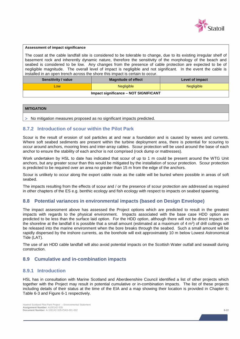
Assessment of impact significance
The coast at the cable landfall site is considered to be tolerable to change, due to its existing irregular shelf of basement rock and inherently dynamic nature, therefore the sensitivity of the morphology of the beach and seabed is considered to be low. Any changes from the presence of cable protection are expected to be of negligible magnitude. The overall level of impact is negligible and not significant. In the event the cable is installed in an open trench across the shore this impact is certain to occur.
Sensitivity / value Magnitude of effect Level of impact
Low Negligible Negligible
Impact significance – NOT SIGNIFICANT
MITIGATION
> No mitigation measures proposed as no significant impacts predicted.
8.7.2 Introduction of scour within the Pilot Park
Scour is the result of erosion of soil particles at and near a foundation and is caused by waves and currents. Where soft seabed sediments are present within the turbine deployment area, there is potential for scouring to occur around anchors, mooring lines and inter-array cables. Scour protection will be used around the base of each anchor to ensure the stability of each anchor is not comprised (rock dump or mattresses).
Work undertaken by HSL to date has indicated that scour of up to 1 m could be present around the WTG Unit anchors, but any greater scour than this would be mitigated by the installation of scour protection. Scour protection is predicted to be required over an area no greater than 15 m from the edge of the anchors.
Scour is unlikely to occur along the export cable route as the cable will be buried where possible in areas of soft seabed.
The impacts resulting from the effects of scour and / or the presence of scour protection are addressed as required in other chapters of the ES e.g. benthic ecology and fish ecology with respect to impacts on seabed spawning.
8.8 Potential variances in environmental impacts (based on Design Envelope) The impact assessment above has assessed the Project options which are predicted to result in the greatest impacts with regards to the physical environment. Impacts associated with the base case HDD option are predicted to be less than the surface laid option. For the HDD option, although there will not be direct impacts on the shoreline at the landfall it is possible that a small amount (estimated at a maximum of 4 m3) of drill cuttings will be released into the marine environment when the bore breaks through the seabed. Such a small amount will be rapidly dispersed by the inshore currents, as the borehole will exit approximately 10 m below Lowest Astronomical Tide (LAT).
The use of an HDD cable landfall will also avoid potential impacts on the Scottish Water outfall and seawall during construction.
8.9 Cumulative and in-combination impacts
8.9.1 Introduction HSL has in consultation with Marine Scotland and Aberdeenshire Council identified a list of other projects which together with the Project may result in potential cumulative or in-combination impacts. The list of these projects including details of their status at the time of the EIA and a map showing their location is provided in Chapter 6; Table 6-3 and Figure 6-1 respectively.
Hywind Scotland Pilot Park Project – Environmental Statement Assignment Number: A100142-S35 Document Number: A-100142-S35-EIAS-001-002 8-22
The consideration of which projects could result in potential cumulative or in-combination impacts is based on the results of the project specific impact assessment together with the expert judgement of the specialist consultant.
As outlined in the preceding physical environment impact assessments, all of the impacts likely to affect the physical processes and sediment dynamics will be confined to within the immediate area of the turbine deployment area and the export cable corridor. This implies that cumulative impacts might only be expected if other planned projects were to overlap directly with this Project. The only other planned project that has a direct overlap with the Hywind export cable route is the NorthConnect cable interconnector between Peterhead and Norway (see Figure 6-1).
8.9.2 Potential cumulative and in-combination impacts during construction and installation, operation and maintenance
Cumulative impacts are impacts on the physical environment caused by planned and consented offshore wind farms. There are no cumulative impacts predicted during operation and installation, construction and maintenance.
In-combination impacts are impacts on the physical environment as a result of offshore wind farms (and their associated activities) combined with impacts from other marine activities or users if the sea. There are no in-combination impacts predicted during operation and installation, construction and maintenance. The only potential overlapping project is the NorthConnect cable which overlaps with the Hywind export cable route offshore. The only predicted impacts from the Hywind cable installation are very localised around the beach landfall, which is geographically removed from the NorthConnect landfall.
8.9.3 Mitigation requirements for potential cumulative and in-combination impacts No mitigation is proposed over and above the Project-specific mitigation.
8.10 Monitoring No monitoring of the physical environment is proposed as the HDD option is the base case.
8.11 References Barne, J.H., Robson, C.F., Kaznowska, S.S., Doody, J.P. & Davidson, N.C. (1996). Coasts and seas of the United Kingdom Region 3 North-east Scotland: Cape Wrath to St. Cyrus. JNCC Coastal Directories Series, Peterborough
BERR (2008). Review of Cabling Techniques and Environmental Effects applicable to the Offshore Wind Farm Industry. Technical Report. January 2008.
Cefas (2004). Offshore Wind Farms. Guidance Note for Environmental Impact Assessment in Respect of FEPA and CPA Requirements. Version 2. June 2004.
Cefas (2005) Assessment of the Significance of Changes to the Inshore Wave Regime as a consequence of an Offshore Wind Array.
Cefas (2012). Guidelines for data acquisition to support marine environmental assessments of offshore renewable energy projects. Contract Report ME5403 – Module 15. 2012.
COWRIE (2009). Coastal Process Modelling for Offshore Wind Farm Environmental Impact Assessment: Best Practise Guide. September 2009.
DECC (2002). Potential effects of offshore wind developments on coastal processes. Report number ETSU W/35/00596/00/REP URN 02/1336. Prepared by ABPmer and Metoc for DTI (now DECC).
Det Norske Veritas (DNV) (2011). Design of Offshore Wind Turbine Structures. Offshore Standard DNV-OS-J101, 138pp.
GEO (2014). Hywind Scotland Soil Investigation 2014, North Sea. British Sector, Anchoring of Floating Wind Turbines and Cable Route. GEO. May 2014.
Hywind Scotland Pilot Park Project – Environmental Statement Assignment Number: A100142-S35 Document Number: A-100142-S35-EIAS-001-002 8-23
Grampian (2011). Leachate Treatment KeldaWater Services (Grampian) Ltd Peterhead Sewage Treatment Works Burnhaven, Peterhead – Permit Application. 28/10/11.
MMT (2013a). Marine survey report. Hywind Offshore windfarm. Geophysical Survey Peterhead, Scotland July –August 2013. MMT Doc No:101462-STO-MMT-SUR-REP-ST13828. Statoil Doc. No. ST13828-Hywind OW
MMT (2013b). Environmental survey report. Hywind Offshore windfarm. Environmental survey Peterhead, Scotland August – September 2013. MMT Doc No:101462-STO-MMT-SUR-REP-ENVIRON. Statoil Doc. No. ST13828 Benthic Report.
Ramsay, D.L. & Brampton, A.H. (2000). Coastal Cells in Scotland: Cell 2 – Fife Ness to Cairnbulg Point. Scottish Natural Heritage Research, Survey and Monitoring Report No 144. 2000.
Scottish Executive (2007). Scottish Marine SEA: Environmental Report Section C SEA Assessment: Chapter C2: Geology, Seabed Sediments and Sediment Transport. March 2007. URL http://www.scotland.gov.uk/Resource/Doc/1086/0048539.pdf [Accessed August 2014].
SEPA (2009). RBMP Water body information sheet for water body 200131 in North East Scotland. SEPA. 2009.
SNH Interactive Map (2014). http://gateway.snh.gov.uk/sitelink/index.jsp [Accessed August 2014].
Statoil (2014). Hywind Buchan Deep Metocean Design Basis. Revision 2. May 2014. Document number: RE2014-002.
Sumer, B.M. & Fredsøe, J., (2001). Wave scour around a large vertical circular cylinder. J. Waterway, Port, Coastal, and Ocean Engineering. May/June 2001.
UK HSE (2002). Environmental considerations, Offshore Technology Report 2001/010, ISBN 0 7176 2379 3. URL: http://www.hse.gov.uk/research/otohtm/2001/oto01010.htm.
UKHO (2013). North Sea Pilot (West). NP 54. 9th Edition.
Xodus (2013a). Geotechnical Support Services – Hywind Scotland Offshore Pilot Park: Geotechnical Desk Study Report. Document number: A-100142-S01-REPT-001.
Xodus (2013b). Geotechnical Support Services – Hywind Scotland Offshore Pilot Park: Landfall Site Walkover – Geotechnical Evaluation. Document number: A-100142-S01-TECH-001.
Xodus (2013c). Hywind Scotland Pilot Park Project, Phase 1 Intertidal Survey Report. Document number: A-100142-S00-REPT-009.
Wiberg, P. L., Sherwood, C.R., (2008). Calculating wave-generated bottom orbital velocities from surface-wave parameters. Computers & Geosciences 34 (2008) 1243–1262.
Hywind Scotland Pilot Park Project – Environmental Statement Assignment Number: A100142-S35 Document Number: A-100142-S35-EIAS-001-002 8-24
9 BENTHIC AND INTERTIDAL ECOLOGY Characterisation of the existing benthic environment is based on both existing and site-specific survey data. Through scoping, it was identified that the benthic environment may be affected as a result of:
• Long-term and temporary disturbance of the seabed;
• Changes in scouring and sedimentation patterns;
• The introduction of new substrata;
• The potential introduction of non-native species; and
• Pollution of the benthic environment through disturbance of sediment-bound contamination.
Overall, although benthic survey work identified the presence of Sabellaria biogenic reef in parts of the wider AfL area, the best areas for these were in the southernmost parts of the AfL area, away from the proposed turbine deployment area. Any biogenic reef present in the northern half of the AfL area where the wind turbines are being sited is very sparsely distributed, covers very small areas, and is rated as being of low reef potential and based on the indicative turbine layout proposed will not be impacted. Similarly small isolated patches are also present at intervals along the export cable route, mainly in the deeper offshore half. Where possible the cable has been routed to minimise impacts on areas of Sabellaria.
The seabed and biotopes in the surveyed area are a mixture of sediments (with boulders), and stony or rocky reef for which no particular conservation value has been highlighted. At the cable landfall and through the intertidal, rocky biotopes dominate, again with no particularly sensitive biological or habitat features identified.
The proposed cable route passes through the southern extremities of the proposed Southern Trench nature conservation MPA, however, there are no MPA specific benthic features of interest present in this section and therefore impacts on the proposed MPA benthic features are not anticipated. The export cable route also passes adjacent to an area of seabed disposal sites, however there are is no significant pollution in the area that could be disturbed from cable installation activities.
Against this background, impacts are assessed as not significant and there is one slight positive impact that may emerge through the lifetime of the Project as a result of changes to species and habitat diversity resulting from a reduction of trawling in the wind turbine deployment area.
Once the location of the inshore assembly site has been chosen and the vessels required for Project installation, operations and maintenance contracted, a full risk assessment of the potential for the introduction of non-native marine species will be undertaken and any required mitigation identified to ensure no significant impacts.
The location of the inshore turbine assembly area will be on the Norwegian west coast, and as that is within the North Sea containing more or less the same species, the risk of alien invasive species introductions to the east coast of Scotland is minimal. When the vessels required for the Project are contracted, risks for introduction of non-native marine species will be evaluated and mitigation measures implemented as appropriate.
9.1 Introduction This chapter assesses the impacts of the Project on benthic and intertidal ecology. A number of different specialists have contributed to this assessment:
> MMT (a Swedish high resolution marine survey company) - seabed survey, video footage analysis, biotope mapping and seabed survey reporting; and
> Xodus - Phase 1 intertidal survey, baseline description, impact assessment and ES chapter write up.
Table 9-1 provides a list of the supporting studies which relate to the benthic and intertidal ecology impact assessment. Supporting studies are provided on the accompanying CD.
Hywind Scotland Pilot Park Project – Environmental Statement Assignment Number: A100142-S35 Document Number: A-100142-S35-EIAS-001-003 9-1
Table 9-1 Supporting studies
Details of study
Geophysical survey report (MMT, 2013a).
Environmental survey report (MMT, 2013b)
Phase 1 intertidal survey report (Xodus, 2013a)
The impacts associated with the benthic and intertidal ecology will be limited to the area within which the Project could directly impact the seabed i.e. potential maximum physical footprint for direct impacts from the proposed Project activities and adjacent seabed for indirect impacts. The focus of this benthic and intertidal assessment is therefore the turbine deployment area and the export cable route. Where appropriate a larger impact area has been considered e.g. in relation to the potential introduction of native marine species.
The following areas are referred to in this impact assessment:
> Project area (see Figure 9-1), which comprises:
o Proposed offshore turbine deployment area: and
o Export cable corridor and landfall.
> Survey area – benthic survey work was carried out in an offshore survey area defined by the boundary of the Buchan Deep Area for Lease (within which the proposed turbine deployment area is sited), together with an export cable corridor linking this to the landfall site immediately to the north of Peterhead (Figure 9-1). At Peterhead, an intertidal benthic survey was also undertaken along approximately 1,500 m of shoreline.
9.2 Legislative context and relevant guidance An integral aspect of the assessment of potential impacts on benthic and intertidal ecology is the identification of habitats and species of conservation importance in the Project area and assessment of potential impacts on these. There are a number of different statutes and guidance that are relevant in this regard. These are listed below and their relevance to the benthic and intertidal ecology impact assessment described. In addition, in order to provide context to the habitats and species that are subsequently described in the baseline description, a list of the species and habitats relevant to the different legislation and guidance, that could potentially be present in the Project area has been provided.
> EU Habitats Directive (Directive 92/43/EEC) and associated habitats regulations;
o The Habitats (Scotland) Regulations 1994 (as amended) implements species protection requirements of the Habitats Directive in Scotland, on land and in inshore waters (within 12 nm);
o Offshore Marine Conservation (Natural Habitats &c.) Regulations 2007 (as amended) implements the requirements of the Habitats Directive in the UK offshore marine area (beyond 12 nm);
> Marine (Scotland) Act 2010 and Marine and Coastal Access Act (2010);
> UK Biodiversity Action Plan (UKBAP) – the UK Governments Response to the Convention on Biological Diversity (CBD), which the UK signed up to in 1992 in Rio de Janeiro; and
> The Convention for the Protection of the Marine Environment of the North East Atlantic (known as the OSPAR Convention).
9.2.1 European Habitats Directive The EU Habitats Directive lists 13 marine habitats and 8 marine species in Annexes I and II respectively. To meet the requirements outlined in Article 3 of the Habitats Directive, Special Areas of Conservation (SACs) have been designated in UK offshore and Territorial Waters to contribute to the European network of important high-quality conservation sites that will make a significant contribution to conserving these species and habitats outlined in the Directive. Of those benthic and intertidal habitats listed in Annex I of the Directive, there are three that have the potential to occur in the vicinity of the turbine deployment Project: Hywind Scotland Pilot Park Project – Environmental Statement Assignment Number: A100142-S35 Document Number: A-100142-S35-EIAS-001-003 9-2
> Sandbanks which are slightly covered by sea water all the time;
> Large shallow inlets and bays; and
> Reefs (rocky and biogenic).
There are currently no designated or identified offshore SACs for the presence of benthic or intertidal habitats or species within 150 km of the Project. There is a coastal SAC located to the south of Peterhead (the Buchan Ness to Collieston SAC). However, this site is designated for vegetated sea cliffs of the Atlantic and Baltic coasts and not any of the benthic or intertidal habitats listed above.
9.2.2 Marine and Coastal Access Act (2009) and Marine (Scotland) Act (2010) The Marine (Scotland) Act 2010 has established new powers to designate Marine Protected Areas (MPAs) in Scottish Territorial Waters, including those for nature conservation. In addition, the Marine and Coastal Access Act (2009) sets out new powers for the UK Government to designate MPAs in UK offshore waters, within which there are provisions for the Scottish Ministers to designate MPAs in offshore waters adjacent to Scotland. There are no designated MPAs for the presence of benthic or intertidal habitats or species within the vicinity of the project. The nearest is the Turbot Bank MPA which is located approximately 18 km to the east of the turbine deployment area and is designated for the protection of sandeels. The Project will not impact this protected area.
In addition to designated MPAs, SNH has submitted a proposal to Marine Scotland in July 2014 for the Southern Trench nature conservation MPA. The cable route passes through this proposed area and pending a decision by Marine Scotland on whether to consult on this proposal, it may become a material consideration in the licencing process for the Project. Potential impacts on this proposed MPA are therefore considered.
9.2.3 Priority Marine Features Scottish Natural Heritage (SNH) and the Joint Nature Conservation Committee (JNCC) have been working with Marine Scotland to develop a priority list of marine habitats and species in Scotland's seas, known as Priority Marine Features (PMFs). The list has been developed to help deliver Marine Scotland's vision for marine nature conservation outlined in the Marine Nature Conservation Strategy, acting as a focused list of marine habitats and species to help target future conservation work in Scotland (SNH, 2014). During 2013, Marine Scotland ran a consultation on the recommended list of PMFs (Marine Scotland, 2013). Of these PMFs, the following benthic and intertidal species and habitats have been previously recorded in the vicinity or have the potential to occur in the Project area. The Scoping Opinion received from Marine Scotland made specific reference to consideration of PMFs that could be present in the Project area.
> Blue mussel beds; > Offshore subtidal sands and gravels;
> Burrowed mud; > Burrowing sea anemone Arachnanthus sarsi;
> Flame shell beds; > Pink sea fingers Alcyonium hibernicum;
> Horse mussel beds; > White cluster anemone Parazoanthus anguicomus;
> Inshore deep mud with burrowing heart urchins; > Northern feather star Leptometra celtica;
> Intertidal mudflats; > Fan mussel Atrina fragilis;
> Offshore deep sea muds; > Heart cockle Glossus humanus;
> Low or variable salinity habitats; > Ocean quahog Arctica islandica; and
> Native oyster Ostrea edulis; > Sandeels (Ammodytes marinus and A. tobianus).
> Kelp and seaweed communities on sublittoral sediment;
Hywind Scotland Pilot Park Project – Environmental Statement Assignment Number: A100142-S35 Document Number: A-100142-S35-EIAS-001-003 9-3
9.2.4 UK Biodiversity Action Plan The current list of UK Biodiversity Action Plan (UKBAP) priority habitats was published following a two year review of the BAP process1 and priorities (Maddock, 2008), and there have been subsequent updates to some descriptions in 2010 and 2011. The North East Scotland Local Biodiversity Action Plan (NES LBAP) for Marine Habitats (2013), currently under review, identifies four sets of marine habitats as a top priority alongside a number of benthic marine species, of which those with the potential to occur or have been previously recorded in the vicinity of the Project:
Estuarine and intertidal habitats;
> Marine habitats (open sea water, mud habitats in deep water, sublittoral sands and gravels/inshore sublittoral sediment);
> Horse mussel Modiolus modiolus;
> Tall seapen Funiculina quadrangularis;
> Northern stone crab Lithodes maia; and
> Spiny lobster Palinurus elephas.
Additional UKBAP benthic and intertidal habitats and species that been previously recorded in the vicinity or have the potential to occur in the Project area include:
> Pink sea-fan Eunicella verrucosa;
> Brown alga Fucus distichus;
> Kaleidoscope jellyfish Haliclystus auricula;
> Stalked jellyfish Lucernariopsis campanulata;
> Native oyster Ostrea edulis; and
> Sabellaria spinulosa reefs (commonly known as Ross worm).
9.2.5 Convention for the Protection of the Marine Environment of the North East Atlantic The Convention for the Protection of the Marine Environment of the North East Atlantic (known as the OSPAR Convention) is the mechanism by which 15 governments of Western Europe work together to protect the marine environment of the North East Atlantic. In 2003, the UK government committed to establishing a well-managed, ecologically coherent network of Marine Protected Areas (known as the OSPAR MPA commitment). Marine SACs designated under the European Habitats Directive have been submitted as the UK’s initial contribution to the OSPAR network. A list of marine habitats and species considered to be under threat or in decline within the north-east Atlantic has been produced by OSPAR (OSPAR, 2008) and a number of the marine habitats and species on the list may also be present in the vicinity or have the potential to occur in the Project area:
> Ocean quahog Arctica islandica; > Modiolus modiolus beds;
> Dog whelk Nucella lapillus; > Ostrea edulis beds;
> Flat oyster Ostrea edulis; > Sabellaria spinulosa reefs; and
> Intertidal Mytilus edulis beds on mixed and sandy sediments
> Sea-pen and burrowing megafauna communities
> Intertidal mudflats;
1 Most work which was previously carried out under the UKBAP is now focussed in the four devolved countries and the UKBAP partnership no longer operates. However many of the tools developed under UKBAP remain of use, including background information about the lists of priority habitats and species. Hywind Scotland Pilot Park Project – Environmental Statement Assignment Number: A100142-S35 Document Number: A-100142-S35-EIAS-001-003 9-4
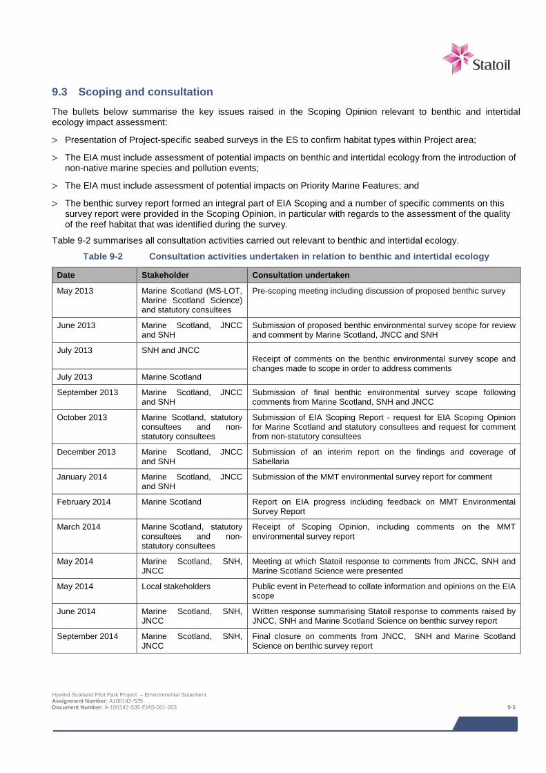
9.3 Scoping and consultation The bullets below summarise the key issues raised in the Scoping Opinion relevant to benthic and intertidal ecology impact assessment:
> Presentation of Project-specific seabed surveys in the ES to confirm habitat types within Project area;
> The EIA must include assessment of potential impacts on benthic and intertidal ecology from the introduction of non-native marine species and pollution events;
> The EIA must include assessment of potential impacts on Priority Marine Features; and
> The benthic survey report formed an integral part of EIA Scoping and a number of specific comments on this survey report were provided in the Scoping Opinion, in particular with regards to the assessment of the quality of the reef habitat that was identified during the survey.
Table 9-2 summarises all consultation activities carried out relevant to benthic and intertidal ecology.
Table 9-2 Consultation activities undertaken in relation to benthic and intertidal ecology
Date Stakeholder Consultation undertaken
May 2013 Marine Scotland (MS-LOT, Marine Scotland Science) and statutory consultees
Pre-scoping meeting including discussion of proposed benthic survey
June 2013 Marine Scotland, JNCC and SNH
Submission of proposed benthic environmental survey scope for review and comment by Marine Scotland, JNCC and SNH
July 2013 SNH and JNCC Receipt of comments on the benthic environmental survey scope and changes made to scope in order to address comments
July 2013 Marine Scotland
September 2013 Marine Scotland, JNCC and SNH
Submission of final benthic environmental survey scope following comments from Marine Scotland, SNH and JNCC
October 2013 Marine Scotland, statutory consultees and non-statutory consultees
Submission of EIA Scoping Report - request for EIA Scoping Opinion for Marine Scotland and statutory consultees and request for comment from non-statutory consultees
December 2013 Marine Scotland, JNCC and SNH
Submission of an interim report on the findings and coverage of Sabellaria
January 2014 Marine Scotland, JNCC and SNH
Submission of the MMT environmental survey report for comment
February 2014 Marine Scotland Report on EIA progress including feedback on MMT Environmental Survey Report
March 2014 Marine Scotland, statutory consultees and non-statutory consultees
Receipt of Scoping Opinion, including comments on the MMT environmental survey report
May 2014 Marine Scotland, SNH, JNCC
Meeting at which Statoil response to comments from JNCC, SNH and Marine Scotland Science were presented
May 2014 Local stakeholders Public event in Peterhead to collate information and opinions on the EIA scope
June 2014 Marine Scotland, SNH, JNCC
Written response summarising Statoil response to comments raised by JNCC, SNH and Marine Scotland Science on benthic survey report
September 2014 Marine Scotland, SNH, JNCC
Final closure on comments from JNCC, SNH and Marine Scotland Science on benthic survey report
Hywind Scotland Pilot Park Project – Environmental Statement Assignment Number: A100142-S35 Document Number: A-100142-S35-EIAS-001-003 9-5
9.4 Baseline description
9.4.1 Introduction To inform the impact assessment and the scope of the Project geophysical and environmental seabed survey, a desk-based review of existing data sources was conducted. The ultimate aim of this exercise was, in association with significant local experience of the area, to provide details of the habitats and species present in the Project development area and wider region, including any of conservation concern. This review relied on a number of published data sources, including:
> British Geological Survey (BGS) seabed sediment data;
> Biological analyses of underwater video from proposed marine protected areas, renewable energy sites and spoil grounds around Scotland (Moore, 2014);
> Marine Scotland Interactive (Marine Scotland, 2014);
> Scottish Marine SEA (Scottish Executive, 2007); and
> UKSeaMap interactive map (JNCC, 2010a).
In addition to the available published literature surveys have been undertaken in and around the Project area which also inform the baseline description. These surveys are described below and their geographical coverage illustrated in Figure 9-3.
Marine Scotland surveys - To support the development of renewable energy in the Scottish waters, the Scottish Government, through Marine Scotland, conducted a number of seabed surveys around the Hwyind Scotland Pilot Park area. Analysis of the footage and photographs obtained during a 2013 survey was reported by Moore (2014) and the footage taken available to download from the Marine Scotland Website (Marine Scotland, 2014) and view through Google Earth. Footage from an earlier cruise by Marine Scotland during 2010 has not been reported by Marine Scotland; however this footage was made available to HSL for use in this EIA.
HSL commissioned seabed survey – HSL commissioned MMT to conduct a geophysical and environmental baseline survey of the Project area (MMT, 2013; a, b). The environmental survey approach was a combination of remote video/stills photography and grab sampling, developed from the geophysical survey outputs from which the habitats and species within the Project development area could be described using the biotope classification system of Connor et al., (2004). The survey comprised of the following:
> A drop down video and photographic survey to note seabed type (substratum), features and the epibenthic biotopes present. This approach was used over the whole of the survey area.
> A grab survey to sample infaunal community types in the sediments and to determine the baseline sediment particle size distribution; this was conducted within the whole of the survey area. Grab samples were also collected along the export cable corridor to determine the levels of sediment contamination by metals and hydrocarbons.
HSL commissioned intertidal survey – HSL commissioned Xodus to undertake an intertidal Phase 1 biotope mapping survey of the cable landfall area at Peterhead (Xodus, 2013a). This survey was undertaken in August 2013 and conducted in accordance with the marine intertidal Phase 1 biotope mapping survey methodology as described by Wyn et al., (2000).
The following sections provide a summary of the baseline of the offshore, inshore and intertidal Project areas, initially a regional context is provided followed by an overview of the relevant survey data. Final conclusions on habitats and species of conservation importance are then provided.
Hywind Scotland Pilot Park Project – Environmental Statement Assignment Number: A100142-S35 Document Number: A-100142-S35-EIAS-001-003 9-6
9.4.2 Subtidal water depths and sediments
Regional context
The British Geological Survey (BGS) data exists on the seabed sediments in the central North Sea. These data indicate the seabed sediments surrounding the turbine deployment area as being composed of sand, gravelly sand and muddy sand (Figure 9-1).
In addition, there are a number of wide scale sediment and habitat mapping programmes that have been conducted in UK, one of which is the JNCC UKSeaMap programme that provides an overview of the habitats likely to be present in areas of the North Sea and northern Scotland (JNCC, 2010a), building upon previous datasets on sediment and habitats distribution from the MESH (Mapping European Seabed Habitats) programme. This programme predicts seabed habitats of deep circalittoral sandy mud within the turbine deployment area, progressing westwards from deep circalittoral, to circalittoral coarse sediment and infralittoral coarse sediment along the export cable corridor towards Peterhead (Figure 9-2).
Site-specific details
As previously described there are a number of different surveys that contribute to the description of the baseline characteristics in the Project area.
The seabed within the Project area was surveyed in 2013 by Marine Scotland (Figure 9-3) and described by Moore (2014) as rippled fine sand with a low mud content. At the deeper stations the proportion of mud tended to increase while the degree of sediment rippling decreased, particularly within areas with patches of cobbles. Unpublished data reviewed from the previous 2010 Marine Scotland survey work also confirmed this. These surveys did not however provide comprehensive coverage of the whole Project area and therefore the Project-specific surveys commissioned by HSL are the most useful in providing an overview of the seabed habitats throughout the entire Project area.
The Project-specific geophysical and environmental survey covered an area of 73 km2 within both the AfL area and the export cable corridor. From the geophysical and environment surveys undertaken (MMT, 2013a, b) water depths in the turbine deployment area range between approximately 98 m and 117 m, becoming deeper from north to south. The seabed within the turbine deployment area comprises sand and gravel with mega-ripples, apart from some areas of scattered boulders mostly in the south western corner. The mega-ripples in the northern wind farm site area are approximately 0.5 m high and superimposed on much larger sand waves with height of 1 to 3 m and a wavelength of up to 250 m.
Water depths along the cable export corridor range between approximately 100 m at the turbine deployment to 0 m at the landfall point. Within this, the seabed shelves very gradually from the turbine deployment area to a depth of 20 m, less than 1 km from the landfall, after which the seabed gradient becomes steeper towards the shore. The seabed sediments along the deeper offshore end of the export cable corridor also consist of mega-rippled sand and gravel with ripple heights of up to 0.5 m and a wavelength of approximately 10 m. Between approximately 5 km from the turbine deployment area to a depth of 20 m less than 1 km from the landfall, the seabed still consists mostly of sand and gravel, but is generally flatter with only occasional mega-ripples. Rocky outcrops and boulders are identified within this middle section of the export cable route corridor. From approximately 2.5 km to the landfall the seabed changes composition to bedrock. The most common seabed features along the export route corridor are ripples, mega ripples, trawl marks and boulders (both scattered and frequent).
The MMT environmental survey collected sediment samples from both the turbine deployment area and the export cable corridor for particle size analysis (PSA) (MMT, 2013b). In the turbine deployment area, sediments are largely composed of medium to fine sand, with coarse sand, very fine pebbles and pebbles becoming more predominant towards the middle of the export cable corridor. The total organic matter (%) was low both within the northern wind farm area and along the export cable route corridor where it ranged from 0.75 to 2.1%.
Hywind Scotland Pilot Park Project – Environmental Statement Assignment Number: A100142-S35 Document Number: A-100142-S35-EIAS-001-003 9-7
9.4.3 Subtidal species and biotopes
Regional context
Infaunal (animals that burrow into and live in seabed sediments) community distribution in the wider North Sea is relatively well described over broad scales due to historical surveys (e.g. Basford et al., 1990; Künitzer et al.,1992; Eleftheriou & Basford, 1989). Künitzer et al., (1992) assign the seabed around the wider Project area to group IVa which is typified by the species Ophelia borealis, Exogone hebes, Spiophanes bombyx and Polycirrus sp.
Similarly benthic epifaunal (animals that live on the surface of a seabed) communities in the North Sea are relatively well described over broad scales due to information recovered during fishing trawls and recent photographic surveys (DECC, 2009). Shallower waters off the Buchan Coast have been described as being typified by the presence of sponges; while deeper (<100 m), finer sediments contain tunicates and the shrimp Spirontocaris lilljeborgi (DECC, 2009). From the predictive habitat mapping reported under UKSeaMap (see Section 9.4.2 above) the biotope “circalittoral sandy mud” is described as a cohesive sandy mud off wave-exposed coasts with weak tidal streams, which can be characterised by super-abundant Amphiura filiformis with Mysella bidentata and Abra nitida.
This community occurs in muddy sands in moderately deep water. This community is also characterised by the sipunculid Thysanocardia procera, the polychaetes Nephtys incisa and Pholoe sp., the horseshoe worm Phoronis sp, with cirratulids also common in some areas. Other taxa such as Nephtys hombergii, Echinocardium cordatum, Nucula nitidosa, Callianassa subterranea and Eudorella truncatula may also occur in offshore examples of this biotope (JNCC, 2013).
A survey carried out by the DTI in the Outer Moray Firth (DTI, 2004) found that the macrofauna was relatively uniform, with species characteristic of fine, stable sands. The dominant taxa included the polychaetes Galathowenia oculata and Peresiella clymenoides, the amphipods Ampelisca tenuicornis and Harpinia antennaria and the burrowing sea urchin Echinocyamus pusillus.
It is also worth noting that the proposed cable route passes through the southern extremities of the proposed Southern Trench nature conservation MPA (Figure 9-1). SNH submitted its proposal for consideration of this MPA to Marine Scotland in July 2014. The proposed MPA has benthic interests in the Southern Trench underwater valley feature in the Moray Firth (burrowed mud habitat), and the waters off Fraserburgh produce frontal zones with strong horizontal gradients in surface and/or bottom temperatures. There are no specific benthic features of interest in the area of the MPA which overlaps the Project export cable route and therefore there is no further consideration of impacts on the proposed MPA with regards to benthic and intertidal ecology.
Site-specific details
The above information provides a summary of what is present in surrounding waters and provides for an initial, crude assessment of what may be present in the Project area and the export cable corridor. However, it is only site-specific surveys that can confirm what benthic infaunal and epifaunal communities are present, and the results of these are described herein.
The Marine Scotland footage collection from the 2013 cruise in the Buchan Deeps was analysed and reported by Moore (2014). All video stations were assigned the biotope “circalittoral fine sand” (SS.SSa.CFiSa). Moore (2014) reported poor visibility which limited the precision of faunal identification, however despite this was still able to conclude little visual evidence of an infaunal community apart from sparse emergent tubes and small holes. In addition, the epifauna was described as being poorly developed, consisting of sparse hermit crabs and brittle stars (Ophiura sp.), as well as clumps of hydroids and possibly contracted anemones on the scattered cobbles. These data do not provide a comprehensive analysis of subtidal species and biotopes in the Project area, therefore the biotopes across the Project area have been defined and described based on the commissioned survey work (MMT, 2013a, b). Images and descriptions of the biotopes recorded are presented in Figure 9-4 and Figure 9-5. The biotope codes presented in the main text can be referenced against the figure in order to determine their geographical distribution and full biotope descriptions are provided in Table 9-3.
Hywind Scotland Pilot Park Project – Environmental Statement Assignment Number: A100142-S35 Document Number: A-100142-S35-EIAS-001-003 9-8
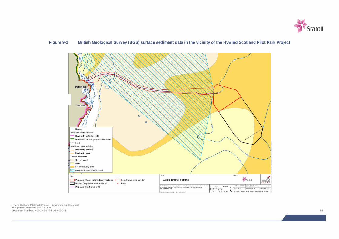
Figure 9-1 British Geological Survey (BGS) surface sediment data in the vicinity of the Hywind Scotland Pilot Park Project
Hywind Scotland Pilot Park Project – Environmental Statement Assignment Number: A100142-S35 Document Number: A-100142-S35-EIAS-001-003 9-9
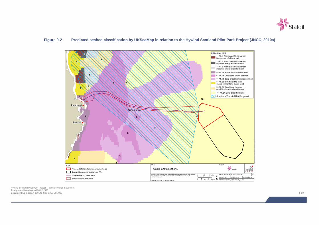
Figure 9-2 Predicted seabed classification by UKSeaMap in relation to the Hywind Scotland Pilot Park Project (JNCC, 2010a)
Hywind Scotland Pilot Park Project – Environmental Statement Assignment Number: A100142-S35 Document Number: A-100142-S35-EIAS-001-003 9-10
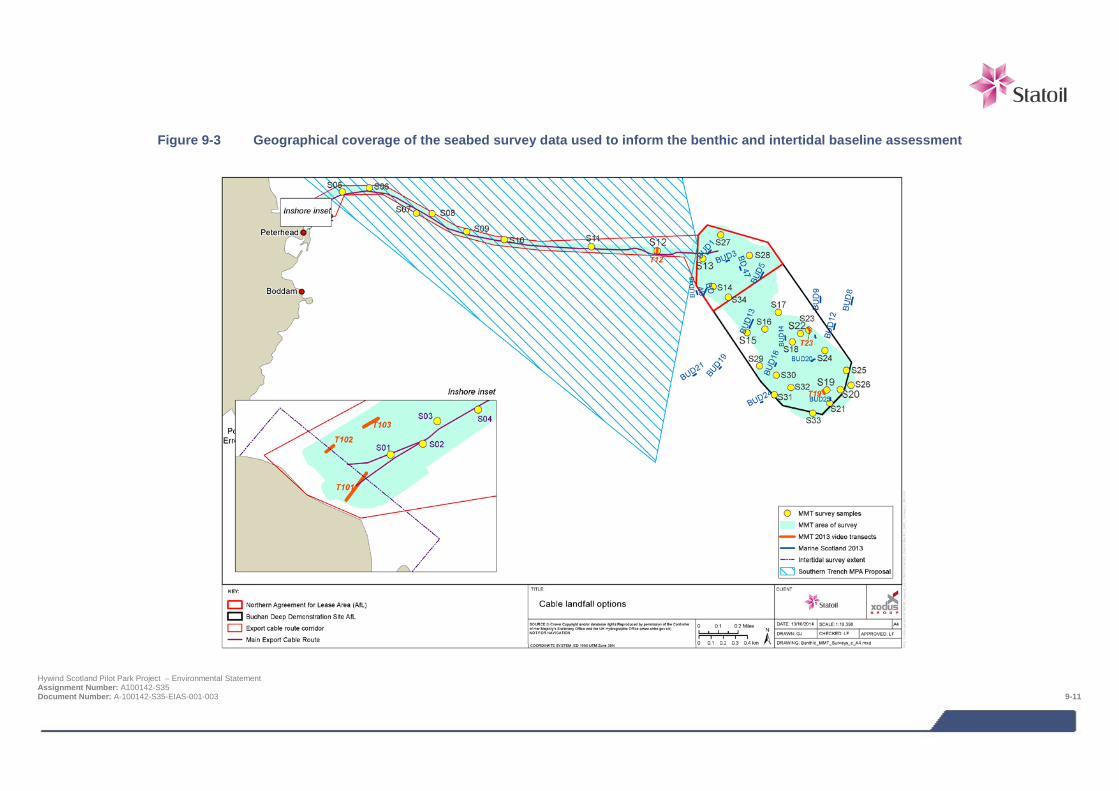
Figure 9-3 Geographical coverage of the seabed survey data used to inform the benthic and intertidal baseline assessment
Hywind Scotland Pilot Park Project – Environmental Statement Assignment Number: A100142-S35 Document Number: A-100142-S35-EIAS-001-003 9-11

Table 9-3 List of biotopes recorded in the seabed and intertidal environmental surveys
Biotope code Biotope description (reference Figure 9-4 and Figure 9-5 for geographical distribution of each biotope)
Biotopes identified during offshore survey
CR.MCR.CSab.Sspi.ByB Sabellaria spinulosa with bryozoans turf and barnacles on silty turbid circalittoral rock
CR.MCR.EcCr.FaAlCr.Flu Flustra foliacea on slightly scoured silty circalittoral rock
CR.MCR.EcCr.FaAlCr.Sec Alcyonium digitatum with Securiflustra securifrons on tide-swept moderately wave-exposed circalittoral rock
IR.HIR High energy infralittoral rock
IR.HIR.KFaR.FoR.Dic Foliose red seaweeds with dense D. dichotoma a/o D. membranacea on exposed low infralittoral rock
IR.HIR.KfaR.LhypR Laminaria hyperborea with dense foliose red seaweeds on exposed infralittoral rock
IR.HIR.KfaR.LhypR.Ft Laminaria hyperborea forest with dense foliose red seaweeds on exposed upper infralittoral rock
IR.MIR.KR.Lhyp.GzFt Grazed Laminaria hyperborea forest with coralline crusts on upper infralittoral rock
SS.SBR.PoR.SspiMx Sabellaria spinulosa on stable circalittoral mixed sediment
SS.SMx.CMx.FluHyd Flustra foliacea and Hydrallmania falcata on tide-swept circalittoral mixed sediment
SS.SMx.OMx Offshore circalittoral mixed sediment
SS.SMx.OMx.PoVen Polychaete-rich deep Venus community in offshore mixed sediments
SS.SSa.CFiSa Circalittoral fine sand
SS.SSa.IFiSa Infralittoral fine sand
SS.SSa.IFiSa.IMoSa Infralittoral mobile clean sand with sparse fauna
SS.SBR.PoR.SspiMx Sabellaria spinulosa on stable circalittoral mixed sediment
SS.SSa.OSa Offshore circalittoral sand
SS.SMx.OMx Offshore circalittoral mixed sediment
Biotopes identified during intertidal survey
LR.FLR.Lic.Ver Verrucaria maura on littoral fringe rock
LR.FLR.Lic Lichens or small green algae on supralittoral rock
LS.LCS.Sh.BarSh Barren littoral shingle
LS Littoral sediments
LR.HLR.MusB.Sem.Sem Semibalanus balanoides, Patella vulgata and Littorina spp. on exposed to moderately exposed or vertical sheltered eulittoral rock
LR.HLR.MusB.Sem.FvesR Semibalanus balanoides, Fucus vesiculosus and red seaweeds on exposed to moderately exposed eulittoral rock
LR.HLR.MusB.Sem.LitX Semibalanus balanoides and Littorina spp. on exposed to moderately exposed eulittoral boulders and cobbles
Hywind Scotland Pilot Park Project – Environmental Statement Assignment Number: A100142-S35 Document Number: A-100142-S35-EIAS-001-003 9-12
Biotope code Biotope description (reference Figure 9-4 and Figure 9-5
for geographical distribution of each biotope)
LR.HLR.MusB.MytB Mytilus edulis and barnacles on very exposed eulittoral rock
LR.MLR.BF.Fser.R Fucus serratus and red seaweeds on moderately exposed lower eulittoral rock
LR.LLR.F.FSpi.FS Fucus spiralis on full salinity moderately exposed to very sheltered upper eulittoral rock
LR.LLR.F.Asc.X Ascophyllum nodosum on full salinity mid eulittoral mixed substrata
LR.MLR.BF.PelB Pelvetia canaliculata and barnacles on moderately exposed littoral fringe rock
IR.MIR.KR.Ldig.Ldig Laminaria digitata on moderately exposed sublittoral fringe bedrock
LR.FLR.Eph.EphX Ephemeral green and red seaweeds on variable salinity and/or disturbed eulittoral mixed substrata
LR.FLR.Eph Ephemeral green or red seaweeds (freshwater of sand-influenced)
LR.FLR.Eph.EntPor Porphyra purpurea and Enteromorpha spp. on sand –scoured mid or lower eulittoral rock
LR.FLR.Rkp.Cor.Cor Coralline crusts and Corallina officinalis in shallow eulittoral rockpools
Multivariate analysis of the macrofaunal data from all grab samples indicated a continuous gradient of change in species composition from cable landfall to the offshore turbine deployment area, with a tendency for adjacent stations to be grouped together. Overall this analysis identified four groups of stations, listed below with the corresponding:
> Group A (Stations S01 and S03, closest inshore in shallow patchy sand in 20-30 m water depth);
> Group B (Stations S07 and S09 over the main extent of the cable route in 60-70 m);
> Group C (Station S011 on its own, also in the main part of the cable route in 70-80 m); and
> Group D (Stations S13-S16, S18, S20-24, S26-S29, S31, S32 and S34, all within the turbine deployment area in 90-120 m).
Export cable corridor
MMT (2013b) described the bedrock seabed at the cable landfall, in the shallower parts as being covered with the large kelp (Laminaria hyperborea) and different species of red seaweed. The habitats present were classified as the biotopes “Laminaria hyperborea with dense foliose red seaweed on exposed infralittoral rock” (IR.HIR.KFaR.LhypR) and “Faunal and algal crusts on exposed to moderately wave-exposed circalittoral rock” (CR.MCR.EcCr.FaAlCr).
At depths greater than 12 m, MMT (2013b) reported that the abundance of kelp declined and seabed turned into habitat, “Foliose red seaweed with dense Dictyota dichtoma and/or Dictyopteris membranacea on exposed lower infralittoral rock” (IR.HIR.KFaR.FoR.Dic). MMT (2013b) determined that all of the bedrock areas around the landfall had the potential to be identified as Annex I “Bedrock reef”. Further details are provided on the assessment of this habitat in the subsection entitled “Species and Habitats of Conservation Importance” below. The patches of sand amongst the bedrock, were sampled by grab and subsequent analysis confirmed there were few animals present in the sediment (biotopes “Infralittoral fine sand” (SS.SSa.IFiSa) and “Infralittoral mobile clean sand with sparse fauna” (SS.SSa.IFiSa.IMoSa)). The infauna at Stations S01 and S03 within this shallow inshore end of the cable route was very sparse both in terms of numbers of species and abundance, and characterised by the bivalve mollusc Angulus fabula and the polychaete Nephtys longosetosa (classified as Group A).
Hywind Scotland Pilot Park Project – Environmental Statement Assignment Number: A100142-S35 Document Number: A-100142-S35-EIAS-001-003 9-13
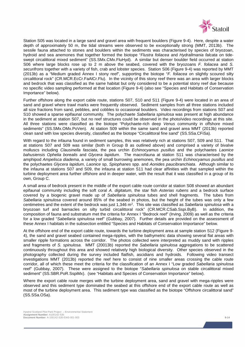
Station S05 was located in a large sand and gravel area with frequent boulders (Figure 9-4). Here, despite a water depth of approximately 50 m, the tidal streams were observed to be exceptionally strong (MMT, 2013b). The sessile fauna attached to stones and boulders within the sediments was characterised by species of bryozoan, hydroid and sea anemones that together formed the biotope “Flustra foliacea and Hydrallmania falcata on tide-swept circalittoral mixed sediment” (SS.SMx.CMx.FluHyd). A similar but denser boulder field occurred at station S06 where large blocks rose up to 2 m above the seabed, covered with the bryozoans F. foliacea and S. securifrons together with a variety of fish, crab and lobster species. Station S06 (Figure 9-4) was reported by MMT (2013b) as a “Medium graded Annex I stony reef”, supporting the biotope “F. foliacea on slightly scoured silty circalittoral rock” (CR.MCR.EcCr.FaAlCr.Flu). In the vicinity of this stony reef there was an area with larger blocks and bedrock that was classified as the same habitat but only considered to be a potential stony reef due because no specific video sampling performed at that location (Figure 9-4) (also see “Species and Habitats of Conservation Importance” below).
Further offshore along the export cable route, stations S07, S10 and S11 (Figure 9-4) were located in an area of sand and gravel where trawl marks were frequently observed. Sediment samples from all three stations included all size fractions from sand, pebbles, and cobbles to occasional boulders. Video recordings from stations S07 and S10 showed a sparse epifaunal community. The polychaete Sabellaria spinulosa was present at high abundance in the sediment at station S07, but no reef structures could be observed in the photo/video recordings at this site. All three stations were classified as the biotope “Polychaete-rich deep Venus community in offshore mixed sediments” (SS.SMx.OMx.PoVen). At station S09 within the same sand and gravel area MMT (2013b) reported clean sand with low species diversity, classified as the biotope “Circalittoral fine sand” (SS.SSa.CFiSa).
With regard to the infauna found in sediment samples, this was relatively rich at stations S07, S09 and S11. That at stations S07 and S09 was similar (both in Group B as outlined above) and comprised a variety of bivalve molluscs including Clausinella fasciata, the pea urchin Echinocyamus pusillus and the polychaetes Laonice bahusiensis Ophelia borealis and Glycera lapidum. The macrofauna at station S11 was characterised by the amphipod Ampelisca diadema, a variety of small burrowing anemones, the pea urchin Echinocyamus pusillus and the polychaetes Glycera lapidum, Laonice sp, Spiophanes spp. and Aonides paucibranchiata. Although similar to the infauna at stations S07 and S09, the infauna at station S11 had clear affinities with that sampled within the turbine deployment area further offshore and in deeper water, with the result that it was classified in a group of its own, Group C.
A small area of bedrock present in the middle of the export cable route corridor at station S08 showed an abundant epifaunal community including the soft coral A. digitatum, the star fish Asterias rubens and a bedrock surface covered by a biogenic gravel made up of Sabellaria spinulosa tubes and shell fragments. The tubes from Sabellaria spinulosa covered around 85% of the seabed in photos, but the height of the tubes was only a few centimetres and the extent of the bedrock was just 1,346 m2. This site was classified as Sabellaria spinulosa with a bryozoan turf and barnacles on silty turbid circalittoral rock” (CR.MCR.CSab.Sspi.ByB). In addition, the composition of fauna and substratum met the criteria for Annex I “Bedrock reef” (Irving, 2009) as well as the criteria for a low graded “Sabellaria spinulosa reef” (Gubbay, 2007). Further details are provided on the assessment of these Annex I habitats in the subsection entitled “Species and Habitats of Conservation Importance” below.
At the offshore end of the export cable route, towards the turbine deployment area at sample station S12 (Figure 9-4), the sand and gravel seabed contained mega-ripples, with the bathymetric data showing several flat areas with smaller ripple formations across the corridor. The photos collected were interpreted as muddy sand with ripples and fragments of S. spinulosa. MMT (20013b) reported the Sabellaria spinulosa aggregations to be scattered continuously throughout this area and showed relatively high biological diversity. Other species observed in the photography collected during the survey included flatfish, ascidians and hydroids. Following video transect investigations MMT (2013b) reported the reef here to consist of nine smaller areas crossing the cable route corridor, all of which these meet the criteria for the classification of an Annex I “Low graded Sabellaria spinulosa reef” (Gubbay, 2007). These were assigned to the biotope “Sabellaria spinulosa on stable circalittoral mixed sediment” (SS.SBR.PoR.SspiMx). (see “Habitats and Species of Conservation Importance” below).
Where the export cable route merges with the turbine deployment area, sand and gravel with mega-ripples were observed and this sediment type dominated the seabed at this offshore end of the export cable route as well as most of the turbine deployment area. This sediment type was classified as the biotope “Offshore circalittoral sand” (SS.SSa.OSa).
Hywind Scotland Pilot Park Project – Environmental Statement Assignment Number: A100142-S35 Document Number: A-100142-S35-EIAS-001-003 9-14
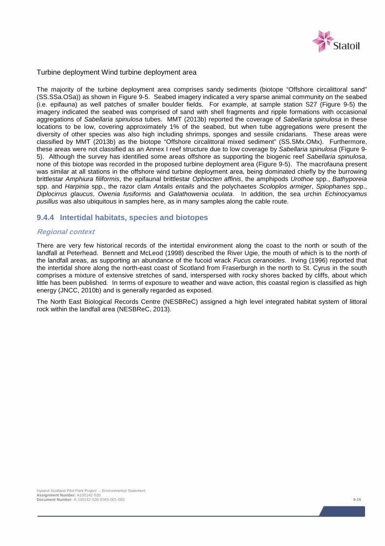
Turbine deployment Wind turbine deployment area The majority of the turbine deployment area comprises sandy sediments (biotope “Offshore circalittoral sand” (SS.SSa.OSa)) as shown in Figure 9-5. Seabed imagery indicated a very sparse animal community on the seabed (i.e. epifauna) as well patches of smaller boulder fields. For example, at sample station S27 (Figure 9-5) the imagery indicated the seabed was comprised of sand with shell fragments and ripple formations with occasional aggregations of Sabellaria spinulosa tubes. MMT (2013b) reported the coverage of Sabellaria spinulosa in these locations to be low, covering approximately 1% of the seabed, but when tube aggregations were present the diversity of other species was also high including shrimps, sponges and sessile cnidarians. These areas were classified by MMT (2013b) as the biotope “Offshore circalittoral mixed sediment” (SS.SMx.OMx). Furthermore, these areas were not classified as an Annex I reef structure due to low coverage by Sabellaria spinulosa (Figure 9-5). Although the survey has identified some areas offshore as supporting the biogenic reef Sabellaria spinulosa, none of this biotope was recorded in the proposed turbine deployment area (Figure 9-5). The macrofauna present was similar at all stations in the offshore wind turbine deployment area, being dominated chiefly by the burrowing brittlestar Amphiura filiformis, the epifaunal brittlestar Ophiocten affinis, the amphipods Urothoe spp., Bathyporeia spp. and Harpinia spp., the razor clam Antalis entails and the polychaetes Scoloplos armiger, Spiophanes spp., Diplocirrus glaucus, Owenia fusiformis and Galathowenia oculata. In addition, the sea urchin Echinocyamus pusillus was also ubiquitous in samples here, as in many samples along the cable route.
9.4.4 Intertidal habitats, species and biotopes
Regional context
There are very few historical records of the intertidal environment along the coast to the north or south of the landfall at Peterhead. Bennett and McLeod (1998) described the River Ugie, the mouth of which is to the north of the landfall areas, as supporting an abundance of the fucoid wrack Fucus ceranoides. Irving (1996) reported that the intertidal shore along the north-east coast of Scotland from Fraserburgh in the north to St. Cyrus in the south comprises a mixture of extensive stretches of sand, interspersed with rocky shores backed by cliffs, about which little has been published. In terms of exposure to weather and wave action, this coastal region is classified as high energy (JNCC, 2010b) and is generally regarded as exposed.
The North East Biological Records Centre (NESBReC) assigned a high level integrated habitat system of littoral rock within the landfall area (NESBReC, 2013).
Hywind Scotland Pilot Park Project – Environmental Statement Assignment Number: A100142-S35 Document Number: A-100142-S35-EIAS-001-003 9-15
Figure 9-4 Overview of environmental sample sites and habitat classifications within the export cable route (MMT, 2013b)
Hywind Scotland Pilot Park Project – Environmental Statement Assignment Number: A100142-S35 Document Number: A-100142-S35-EIAS-001-003 9-16

Figure 9-5 Overview of environmental sample sites and habitat classifications within the turbine deployment area (MMT, 2013b)
Hywind Scotland Pilot Park Project – Environmental Statement Assignment Number: A100142-S35 Document Number: A-100142-S35-EIAS-001-003 9-17
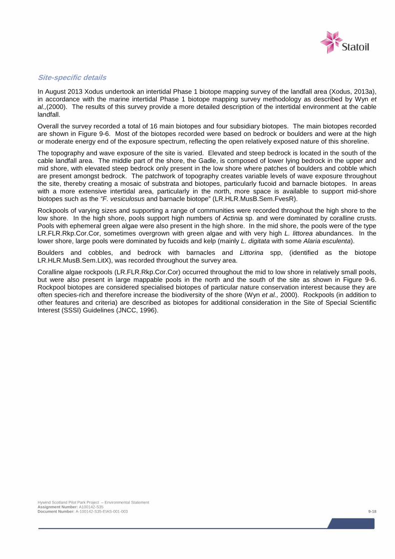
Site-specific details
In August 2013 Xodus undertook an intertidal Phase 1 biotope mapping survey of the landfall area (Xodus, 2013a), in accordance with the marine intertidal Phase 1 biotope mapping survey methodology as described by Wyn et al.,(2000). The results of this survey provide a more detailed description of the intertidal environment at the cable landfall.
Overall the survey recorded a total of 16 main biotopes and four subsidiary biotopes. The main biotopes recorded are shown in Figure 9-6. Most of the biotopes recorded were based on bedrock or boulders and were at the high or moderate energy end of the exposure spectrum, reflecting the open relatively exposed nature of this shoreline.
The topography and wave exposure of the site is varied. Elevated and steep bedrock is located in the south of the cable landfall area. The middle part of the shore, the Gadle, is composed of lower lying bedrock in the upper and mid shore, with elevated steep bedrock only present in the low shore where patches of boulders and cobble which are present amongst bedrock. The patchwork of topography creates variable levels of wave exposure throughout the site, thereby creating a mosaic of substrata and biotopes, particularly fucoid and barnacle biotopes. In areas with a more extensive intertidal area, particularly in the north, more space is available to support mid-shore biotopes such as the “F. vesiculosus and barnacle biotope” (LR.HLR.MusB.Sem.FvesR).
Rockpools of varying sizes and supporting a range of communities were recorded throughout the high shore to the low shore. In the high shore, pools support high numbers of Actinia sp. and were dominated by coralline crusts. Pools with ephemeral green algae were also present in the high shore. In the mid shore, the pools were of the type LR.FLR.Rkp.Cor.Cor, sometimes overgrown with green algae and with very high L. littorea abundances. In the lower shore, large pools were dominated by fucoids and kelp (mainly L. digitata with some Alaria esculenta).
Boulders and cobbles, and bedrock with barnacles and Littorina spp, (identified as the biotope LR.HLR.MusB.Sem.LitX), was recorded throughout the survey area.
Coralline algae rockpools (LR.FLR.Rkp.Cor.Cor) occurred throughout the mid to low shore in relatively small pools, but were also present in large mappable pools in the north and the south of the site as shown in Figure 9-6. Rockpool biotopes are considered specialised biotopes of particular nature conservation interest because they are often species-rich and therefore increase the biodiversity of the shore (Wyn et al., 2000). Rockpools (in addition to other features and criteria) are described as biotopes for additional consideration in the Site of Special Scientific Interest (SSSI) Guidelines (JNCC, 1996).
Hywind Scotland Pilot Park Project – Environmental Statement Assignment Number: A100142-S35 Document Number: A-100142-S35-EIAS-001-003 9-18
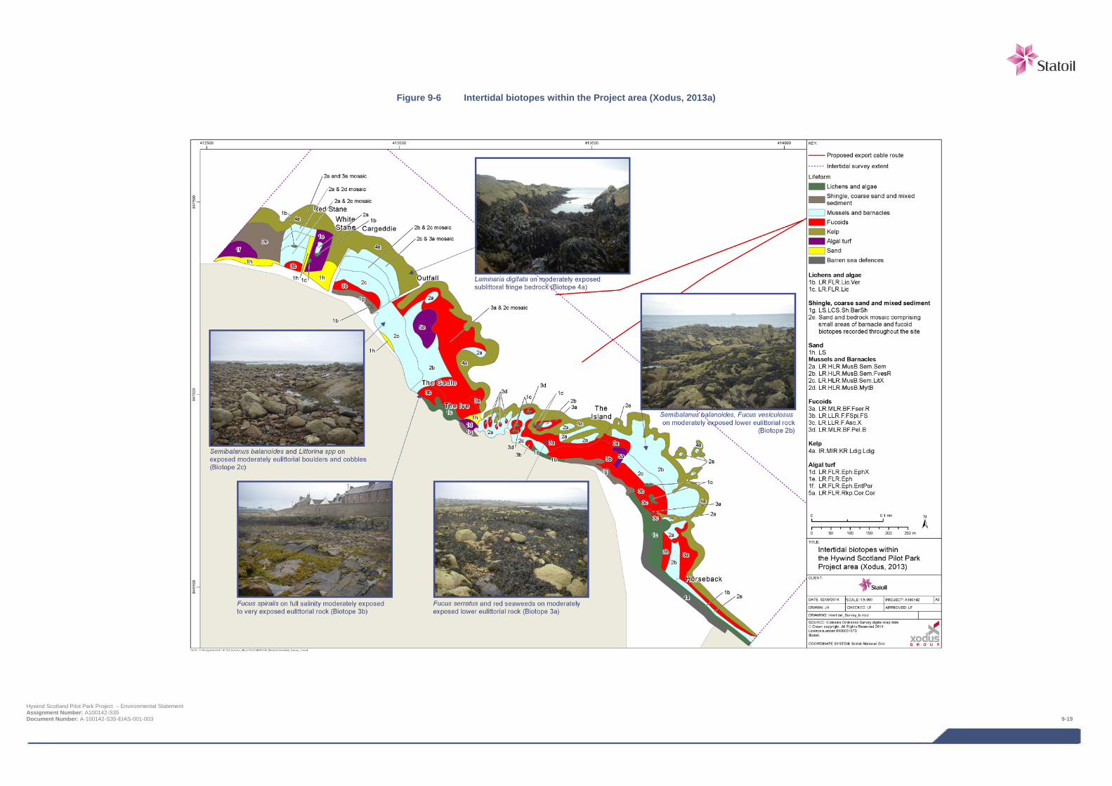
Figure 9-6 Intertidal biotopes within the Project area (Xodus, 2013a)
Hywind Scotland Pilot Park Project – Environmental Statement Assignment Number: A100142-S35 Document Number: A-100142-S35-EIAS-001-003 9-19
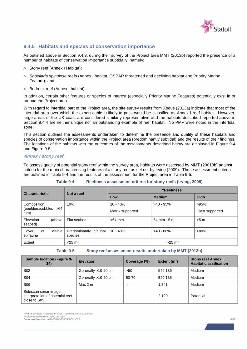
9.4.5 Habitats and species of conservation importance As outlined above in Section 9.4.3, during their survey of the Project area MMT (2013b) reported the presence of a number of habitats of conservation importance subtidally, namely:
> Stony reef (Annex I Habitat);
> Sabellaria spinulosa reefs (Annex I habitat, OSPAR threatened and declining habitat and Priority Marine Feature); and
> Bedrock reef (Annex I habitat).
In addition, certain other features or species of interest (especially Priority Marine Features) potentially exist in or around the Project area.
With regard to intertidal part of the Project area, the site survey results from Xodus (2013a) indicate that most of the intertidal area over which the export cable is likely to pass would be classified as Annex I reef habitat. However, large areas of the UK coast are considered similarly representative and the habitats described reported above in Section 9.4.4 are neither unique nor an outstanding example of reef habitat. No PMF were noted in the intertidal zone.
This section outlines the assessments undertaken to determine the presence and quality of these habitats and species of conservation importance within the Project area (predominantly subtidal) and the results of their findings. The locations of the habitats with the outcomes of the assessments described below are displayed in Figure 9-4 and Figure 9-5.
Annex I stony reef
To assess quality of potential stony reef within the survey area, habitats were assessed by MMT (20013b) against criteria for the main characterising features of a stony reef as set out by Irving (2009). These assessment criteria are outlined in Table 9-4 and the results of the assessment for the Project area in Table 9-5.
Table 9-4 Reefiness assessment criteria for stony reefs (Irving, 2009)
Characteristic Not a reef “Reefiness”
Low Medium High
Composition (boulders/cobbles >64 mm)
10% 10 - 40%
Matrix supported
>40 - 95% >95%
Clast supported
Elevation (above seabed)
Flat seabed <64 mm 64 mm - 5 m >5 m
Cover of visible epifauna
Predominantly infaunal species
10 - 40% >40 - 80% >80%
Extent <25 m2 >25 m2
Table 9-5 Stony reef assessment results undertaken by MMT (2013b)
Sample location (Figure 9-34) Elevation Coverage (%) Extent (m2) Stony reef Annex I
Habitat classification
S02 Generally >10-20 cm >50 549,136 Medium
S04 Generally >10-20 cm 50-70 549,136 Medium
S06 Max 2 m - 1,341 Medium
Sidescan sonar image interpretation of potential reef close to S05
- - 2,120 Potential
Hywind Scotland Pilot Park Project – Environmental Statement Assignment Number: A100142-S35 Document Number: A-100142-S35-EIAS-001-003 9-20
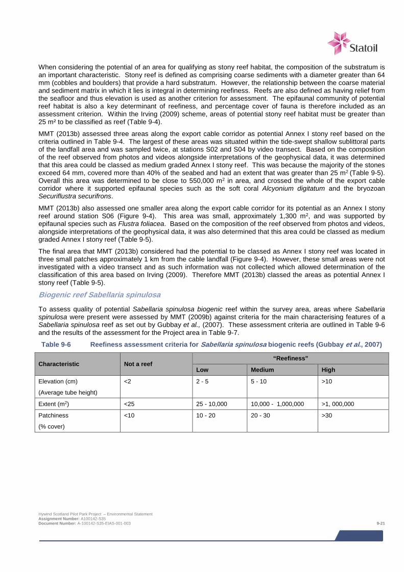
When considering the potential of an area for qualifying as stony reef habitat, the composition of the substratum is an important characteristic. Stony reef is defined as comprising coarse sediments with a diameter greater than 64 mm (cobbles and boulders) that provide a hard substratum. However, the relationship between the coarse material and sediment matrix in which it lies is integral in determining reefiness. Reefs are also defined as having relief from the seafloor and thus elevation is used as another criterion for assessment. The epifaunal community of potential reef habitat is also a key determinant of reefiness, and percentage cover of fauna is therefore included as an assessment criterion. Within the Irving (2009) scheme, areas of potential stony reef habitat must be greater than 25 m² to be classified as reef (Table 9-4).
MMT (2013b) assessed three areas along the export cable corridor as potential Annex I stony reef based on the criteria outlined in Table 9-4. The largest of these areas was situated within the tide-swept shallow sublittoral parts of the landfall area and was sampled twice, at stations S02 and S04 by video transect. Based on the composition of the reef observed from photos and videos alongside interpretations of the geophysical data, it was determined that this area could be classed as medium graded Annex I stony reef. This was because the majority of the stones exceed 64 mm, covered more than 40% of the seabed and had an extent that was greater than 25 m2 (Table 9-5). Overall this area was determined to be close to 550,000 m2 in area, and crossed the whole of the export cable corridor where it supported epifaunal species such as the soft coral Alcyonium digitatum and the bryozoan Securiflustra securifrons.
MMT (2013b) also assessed one smaller area along the export cable corridor for its potential as an Annex I stony reef around station S06 (Figure 9-4). This area was small, approximately 1,300 m2, and was supported by epifaunal species such as Flustra foliacea. Based on the composition of the reef observed from photos and videos, alongside interpretations of the geophysical data, it was also determined that this area could be classed as medium graded Annex I stony reef (Table 9-5).
The final area that MMT (2013b) considered had the potential to be classed as Annex I stony reef was located in three small patches approximately 1 km from the cable landfall (Figure 9-4). However, these small areas were not investigated with a video transect and as such information was not collected which allowed determination of the classification of this area based on Irving (2009). Therefore MMT (2013b) classed the areas as potential Annex I stony reef (Table 9-5).
Biogenic reef Sabellaria spinulosa
To assess quality of potential Sabellaria spinulosa biogenic reef within the survey area, areas where Sabellaria spinulosa were present were assessed by MMT (2009b) against criteria for the main characterising features of a Sabellaria spinulosa reef as set out by Gubbay et al., (2007). These assessment criteria are outlined in Table 9-6 and the results of the assessment for the Project area in Table 9-7.
Table 9-6 Reefiness assessment criteria for Sabellaria spinulosa biogenic reefs (Gubbay et al., 2007)
Characteristic Not a reef “Reefiness”
Low Medium High
Elevation (cm)
(Average tube height)
<2 2 - 5 5 - 10 >10
Extent (m2) <25 25 - 10,000 10,000 - 1,000,000 >1, 000,000
Patchiness
(% cover)
<10 10 - 20 20 - 30 >30
Hywind Scotland Pilot Park Project – Environmental Statement Assignment Number: A100142-S35 Document Number: A-100142-S35-EIAS-001-003 9-21
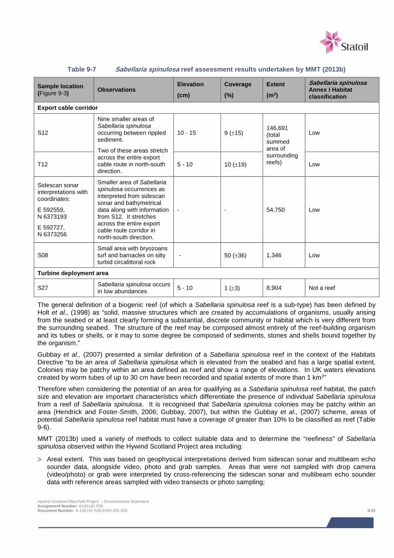
Table 9-7 Sabellaria spinulosa reef assessment results undertaken by MMT (2013b)
Sample location (Figure 9-3) Observations
Elevation
(cm)
Coverage
(%)
Extent
(m2)
Sabellaria spinulosa Annex I Habitat classification
Export cable corridor
S12
Nine smaller areas of Sabellaria spinulosa occurring between rippled sediment.
Two of these areas stretch across the entire export cable route in north-south direction.
10 - 15 9 (±15) 146,691 (total summed area of surrounding reefs)
Low
T12 5 - 10 10 (±19) Low
Sidescan sonar interpretations with coordinates:
E 592559, N 6373193
E 592727, N 6373256
Smaller area of Sabellaria spinulosa occurrences as interpreted from sidescan sonar and bathymetrical data along with information from S12. It stretches across the entire export cable route corridor in north-south direction.
- - 54,750 Low
S08 Small area with bryozoans turf and barnacles on silty turbid circalittoral rock
- 50 (±36) 1,346 Low
Turbine deployment area
S27 Sabellaria spinulosa occurs in low abundances 5 - 10 1 (±3) 8,904 Not a reef
The general definition of a biogenic reef (of which a Sabellaria spinulosa reef is a sub-type) has been defined by Holt et al., (1998) as “solid, massive structures which are created by accumulations of organisms, usually arising from the seabed or at least clearly forming a substantial, discrete community or habitat which is very different from the surrounding seabed. The structure of the reef may be composed almost entirely of the reef-building organism and its tubes or shells, or it may to some degree be composed of sediments, stones and shells bound together by the organism.”
Gubbay et al., (2007) presented a similar definition of a Sabellaria spinulosa reef in the context of the Habitats Directive “to be an area of Sabellaria spinulosa which is elevated from the seabed and has a large spatial extent. Colonies may be patchy within an area defined as reef and show a range of elevations. In UK waters elevations created by worm tubes of up to 30 cm have been recorded and spatial extents of more than 1 km2”
Therefore when considering the potential of an area for qualifying as a Sabellaria spinulosa reef habitat, the patch size and elevation are important characteristics which differentiate the presence of individual Sabellaria spinulosa from a reef of Sabellaria spinulosa. It is recognised that Sabellaria spinulosa colonies may be patchy within an area (Hendrick and Foster-Smith, 2006; Gubbay, 2007), but within the Gubbay et al., (2007) scheme, areas of potential Sabellaria spinulosa reef habitat must have a coverage of greater than 10% to be classified as reef (Table 9-6).
MMT (2013b) used a variety of methods to collect suitable data and to determine the “reefiness” of Sabellaria spinulosa observed within the Hywind Scotland Project area including:
> Areal extent. This was based on geophysical interpretations derived from sidescan sonar and multibeam echo sounder data, alongside video, photo and grab samples. Areas that were not sampled with drop camera (video/photo) or grab were interpreted by cross-referencing the sidescan sonar and multibeam echo sounder data with reference areas sampled with video transects or photo sampling;
Hywind Scotland Pilot Park Project – Environmental Statement Assignment Number: A100142-S35 Document Number: A-100142-S35-EIAS-001-003 9-22
> Patchiness. This was assessed by analysing the photo replicates (10) from each site. The Sabellaria spinulosa
present in the images was digitally outlined and the percentage cover was quantified; and
> The elevation of the Sabellaria spinulosa tubes above the seabed was determined through the analyses of seabed imagery (video/photo).
Within the export cable survey corridor, MMT (2013b) investigated three separate occurrences of Sabellaria spinulosa and their potential to qualify as an Annex I Sabellaria spinulosa reef based on the criteria outlined in Table 9-6. Two of these areas were located in the final 2 km of the export cable corridor on approach to the turbine deployment area at or close to sample station S12 (Figure 9-3). MMT (2013b) assessed the two separate areas within this region, although imagery (video/stills) data was only collected from one of the areas (around S12). However, the imagery (video/stills) information from station S12/T12 was used, alongside the interpreted and sidescan and bathymetric data, to inform the assessment of the other area. MMT (2013b) reported that around S12 the elevation of the reef structures varied as did the density. Patches of these aggregations had a high seabed coverage, which can be seen in some photos reaching almost 50%. However, the average of all the sites was around 10%. The extent of the reef was checked by performing a video transect (T12) across the whole corridor (Figure 9-3). The reef was reported by MMT (2013b) to consist of nine smaller areas, some crossing the cable route corridor, all of which meet the criteria for the classification of a low graded Sabellaria spinulosa reef (Table 9-6).
Similarly the additional area of Sabellaria spinulosa reef in this region investigated from the side scan sonar was also determined by MMT (2013b) to meet the criteria for the classification of a low graded Sabellaria spinulosa reef (Table 9-7). This reef stretched over the whole of the entire export cable route corridor in the north-south direction (Figure 9-4).
The other location, along the export cable corridor, at which the presence of Sabellaria spinulosa was investigated for its potential to be an Annex I Sabellaria spinulosa reef was around station S08 in the middle of the export cable corridor (Figure 9-4). MMT (2013b) described a small area of bedrock at this location to be covered by a high density of biogenic gravel made up of Sabellaria spinulosa tubes and shell fragments. It was reported that tubes from Sabellaria spinulosa covered around 85% of the seabed in photos but that the height of the tubes was only a few centimetres and the extent of the bedrock was quite limited. Therefore MMT (2013b) determined that this small area met the criteria for the classification of a low graded Sabellaria spinulosa reef (Table 9-7).
Within the whole of the offshore survey area comprising not only the proposed turbine deployment area, but wider AfL area, the main areas of Sabellaria spinulosa reef were observed to the centre and to the south, well to the south of the proposed turbine deployment area. Although smaller discrete aggregations of Sabellaria spinulosa were observed as being present in a few patches in the turbine deployment area, especially in the southwestern corner, interpretations by MMT (2013b) of geophysical data and the imagery (video/stills) indicated that none of these areas were considered by to constitute an Annex I Sabellaria spinulosa reef, based on the criteria outlined in (Table 9-6). The locations of these Annex I Sabellaria spinulosa reefs are displayed in Figure 9-5.
As outlined in Section 9.2 above, reefs of Sabellaria spinulosa are not only Annex I habitats but they are also listed as a UKBAP Priority Marine Feature habitat and also an OSPAR threatened and declining habitat.
Annex I bedrock reef
Compared to stony and Sabellaria spinulosa Annex I reefs, there are no specific criteria which have been defined to determine if an area could potentially constitute an Annex I bedrock reef. However, the EU directives interpretation manual (EUR 28, 2013) defines reefs as “Reef can be either biogenic concretions or of geogenic origin. They are hard compact substrata on solid and soft bottoms, which arise from the sea floor in the sublittoral and littoral zone. Reefs may support a zonation of benthic communities of algae and animal species as well as concretions and corallogenic concretions.”
With this definition in mind, bedrock reefs are considered to be those areas that are composed of hard bedrock substrata, larger than 25 m2 in area, which support benthic communities of animals and algae.
MMT (2013b) identified a number of areas along the export cable corridor that could constitute an Annex I bedrock reef. These areas are displayed in Figure 9-4. The main area identified is over 360,000 m2 and located at the cable landfall. It is associated with the biotopes Laminaria hyperborea forest with dense foliose red seaweeds on exposed upper infralittoral rock (IR.HIR.KfaR.LhypR.Ft), foliose red seaweeds with dense D. dichotoma and/or D.
Hywind Scotland Pilot Park Project – Environmental Statement Assignment Number: A100142-S35 Document Number: A-100142-S35-EIAS-001-003 9-23
membranacea on exposed low infralittoral2 rock (IR.HIR.KFaR.FoR.Dic) and Laminaria hyperborea with dense foliose red seaweeds on exposed infralittoral rock (R.HIR.KfaR.LhypR). However, large areas of the UK coast are considered similarly representative and the habitats described here are neither unique nor an outstanding example of reef habitat.
The only other area identified by MMT (2013b) as an Annex I bedrock reef is the small area at station S08 in the middle of the export cable corridor (Figure 9-4). Here a small area of bedrock covering 1,300 m2 had an abundant epifaunal community which included soft coral A. digitatum and the starfish Asterias rubens but also a high density of biogenic gravel made up of Sabellaria spinulosa tubes and shell fragments
Priority Marine Features
In addition to the Annex I habitat types that are described above, a draft list of PMFs including those for which MPAs have been or will be designated under the Marine (Scotland) Act 2010 has been drawn up and circulated for consultation. There are currently no MPAs designated in the vicinity of the proposed project.
The fact that the export cable route crosses the Southern Trench area of search (as a possible MPA) as defined by SNH has been outlined above. The single benthic feature cited for this area is the habitat and Priority Marine Feature ‘Burrowed Mud’. However, as described above, the area of Burrowed Mud within this search area is away to the north in the deep waters off Fraserburgh and Banff, and therefore is remote from the Project area. In the survey work undertaken by MMT (2013b), no burrowed mud was encountered in the export cable route, or in the turbine deployment area. This finding is consistent with the results from the video and image sampling made by Marine Scotland during a cruise to the Buchan Deep in 2010 (Xodus, 2013b).
Three species listed among the PMFs were encountered during the benthic survey; Raitt’s sandeel Ammodytes marinus, the lesser sandeel Ammodytes tobianus and the ocean quahog, Arctica islandica (a type of clam). One specimen of A. marinus was found in a grab sample at station S09 and one specimen of A. tobianus was found at station S03. Both sites are situated in areas of fine sand on the export cable route. The ocean quahog was found in one grab sample at station S25 in the southeastern part of the AfL area, well outside the proposed turbine deployment area. The ocean quahog is listed by the OSPAR commission as a species that is threatened or under decline (OSPAR, 2008) and A. marinus is listed on the UKBAP species list.
9.4.6 Sediment quality and contamination On approach to Peterhead the export cable corridor passes three dredge disposal sites, approximately 3 km from shore (Chapter 19 Other Sea Users); the open ‘North Buchan Ness’ and ‘Peterhead’ and the closed ‘middle Buchan Ness (Figure 9-7). The two open sites have been the location for the deposition of dredged harbour bed material from Peterhead and/or Boddam Harbour within the last 13 years (Walker pers. comm. Marine Scotland, 2013). It is thus expected that the material disposed at these sites could potentially comprise sediments with elevated levels metals and hydrocarbons, relative to background levels.
In order to determine the sediment quality and contamination levels along the export cable route, the environmental survey conducted by MMT (2013b) undertook chemical analysis of sediment grab samples within the export cable corridor. Due to seabed conditions at two sample stations nearest to the disposal sites (S05 and S06 – Figure 9-7), sediment samples could not be obtained; therefore the nearest station to the disposal site at which samples were taken and analysed were stations S03 and S07, located approximately 1.9 and 2.1 km respectively from the nearest disposal site.
Therefore, to gain as clear an understanding as possible on the contamination levels along the export cable corridor, data from monitoring surveys of the North Buchan Ness and Peterhead disposal sites were obtained from Marine Scotland (Rose, Marine Scotland, pers comm, 2014). Marine Scotland was unable to supply monitoring data or reports for the closed Middle Buchan Ness disposal site.
The combined data from the MMT (2013b) environmental survey alongside that obtained from Marine Scotland is presented here to provide a baseline for the contamination levels of sediments along the Hywind Scotland export cable route.
2 Shallow sublittoral, where biota is dominated by algae Hywind Scotland Pilot Park Project – Environmental Statement Assignment Number: A100142-S35 Document Number: A-100142-S35-EIAS-001-003 9-24
The context of the contaminants detected within the sediments of the Hywind Scotland export cable route and nearby disposal sites have been established through the use of recognised guidelines and action levels. These are:
> Canadian Sediment Quality Guidelines for the Protection of Aquatic Life (Canadian Council of Ministers of the Environment 2002); and
> Cefas Action Levels for the disposal of dredged material (Cefas, 2014).
The Canadian Sediment Quality Guidelines involved the derivation of Interim marine Sediment Quality Guidelines (ISQGs) or Threshold Effect Levels (TEL) and Probable Effect Levels (PEL) (CCME, 2002). These values are not statutory standards and were designated specifically for Canada, but in the absence of suitable alternatives it has become commonplace for these guidelines to be used by regulatory and statutory bodies in the UK, and elsewhere, as part of a ‘weight of evidence’ approach.
It should also be noted that they were designed specifically for Canada and based on the protection of pristine environments and therefore considered a more precautionary suite of sediment quality criteria. The use of these standards within impact assessments for offshore wind farm projects is widely used and accepted.
Selected Canadian guidelines are presented in Table 9-8, and comprise two assessment levels. The lower level is referred to as the TEL and represents the concentration below which adverse biological effects are expected to occur only rarely (in some sensitive species for example). The higher level, the PEL, defines a concentration above which adverse effects may be expected in a wider range of organisms.
The Cefas Action Levels are used as part of a ‘weight of evidence’ approach to assessing the suitability of material for disposal at sea, but are not themselves statutory standards. The majority of the materials assessed against these standards arise from dredging activities, but Action Levels can be used to assist in the determination of any contamination present in sediments in the vicinity of the Project. The Cefas guidance indicates that, in general, contaminant levels below Action Level 1 are not considered to be of concern and are, therefore, likely to be approved for disposal at sea. Material with contaminant levels above Action Level 2 are generally considered to be unsuitable for disposal at sea (Table 9-9). Dredged material with contaminant levels between Action Levels 1 and 2 requires further consideration and testing before a decision can be made.
Hywind Scotland Pilot Park Project – Environmental Statement Assignment Number: A100142-S35 Document Number: A-100142-S35-EIAS-001-003 9-25
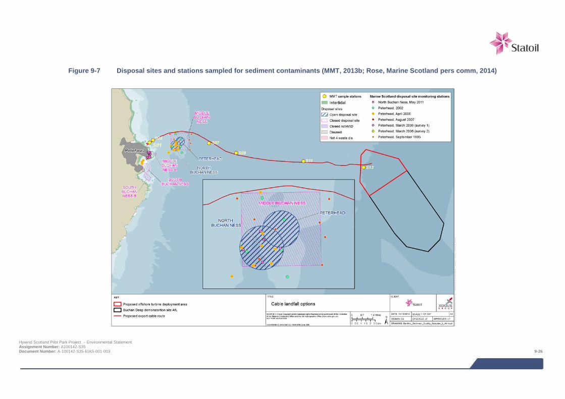
Figure 9-7 Disposal sites and stations sampled for sediment contaminants (MMT, 2013b; Rose, Marine Scotland pers comm, 2014)
Hywind Scotland Pilot Park Project – Environmental Statement Assignment Number: A100142-S35 Document Number: A-100142-S35-EIAS-001-003 9-26
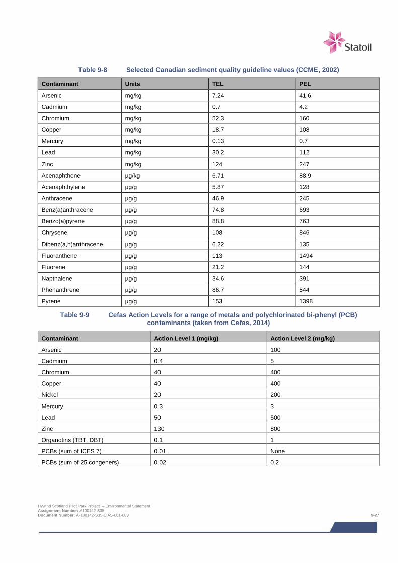
Table 9-8 Selected Canadian sediment quality guideline values (CCME, 2002)
Contaminant Units TEL PEL
Arsenic mg/kg 7.24 41.6
Cadmium mg/kg 0.7 4.2
Chromium mg/kg 52.3 160
Copper mg/kg 18.7 108
Mercury mg/kg 0.13 0.7
Lead mg/kg 30.2 112
Zinc mg/kg 124 247
Acenaphthene µg/kg 6.71 88.9
Acenaphthylene µg/g 5.87 128
Anthracene µg/g 46.9 245
Benz(a)anthracene µg/g 74.8 693
Benzo(a)pyrene µg/g 88.8 763
Chrysene µg/g 108 846
Dibenz(a,h)anthracene µg/g 6.22 135
Fluoranthene µg/g 113 1494
Fluorene µg/g 21.2 144
Napthalene µg/g 34.6 391
Phenanthrene µg/g 86.7 544
Pyrene µg/g 153 1398
Table 9-9 Cefas Action Levels for a range of metals and polychlorinated bi-phenyl (PCB) contaminants (taken from Cefas, 2014)
Contaminant Action Level 1 (mg/kg) Action Level 2 (mg/kg)
Arsenic 20 100
Cadmium 0.4 5
Chromium 40 400
Copper 40 400
Nickel 20 200
Mercury 0.3 3
Lead 50 500
Zinc 130 800
Organotins (TBT, DBT) 0.1 1
PCBs (sum of ICES 7) 0.01 None
PCBs (sum of 25 congeners) 0.02 0.2
Hywind Scotland Pilot Park Project – Environmental Statement Assignment Number: A100142-S35 Document Number: A-100142-S35-EIAS-001-003 9-27
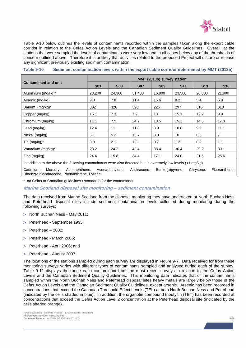
Table 9-10 below outlines the levels of contaminants recorded within the samples taken along the export cable corridor in relation to the Cefas Action Levels and the Canadian Sediment Quality Guidelines. Overall, at the stations that were sampled the levels of contaminants were very low and in all cases below any of the thresholds of concern outlined above. Therefore it is unlikely that activities related to the proposed Project will disturb or release any significant previously existing sediment contamination.
Table 9-10 Sediment contamination levels within the export cable corridor determined by MMT (2013b)
Contaminant and unit MMT (2013b) survey station
S01 S03 S07 S09 S11 S13 S16
Aluminium (mg/kg)* 23,200 24,300 31,400 16,800 23,500 20,600 21,800
Arsenic (mg/kg) 9.8 7.8 11.4 15.6 8.2 5.4 6.8
Barium (mg/kg)* 302 326 390 225 297 316 310
Copper (mg/kg) 15.1 7.3 7.2 13 15.1 12.2 9.9
Chromium (mg/kg) 11.1 7.9 24.2 10.5 15.3 14.5 17.3
Lead (mg/kg) 12.4 11 11.8 8.9 10.8 9.9 11.1
Nickel (mg/kg) 6.1 5.2 13.7 8.3 10 6.6 7
Tin (mg/kg)* 3.8 2.1 1.3 0.7 1.2 0.9 1.1
Vanadium (mg/kg)* 28.2 24.2 43.4 38.4 36.4 29.2 30.1
Zinc (mg/kg) 24.4 15.8 34.4 17.1 24.0 21.5 25.6
In addition to the above the following contaminants were also detected but in extremely low levels (<1 mg/kg)
Cadmium, Mercury, Acenaphthene, Acenaphthylene, Anthracene, Benzo(a)pyrene, Chrysene, Fluoranthene, Dibenz(a,h)anthracene, Phenanthrene, Pyrene
* no Cefas or Canadian guidelines / standards for the contaminant
Marine Scotland disposal site monitoring – sediment contamination
The data received from Marine Scotland from the disposal monitoring they have undertaken at North Buchan Ness and Peterhead disposal sites include sediment contamination levels collected during monitoring during the following surveys:
> North Buchan Ness - May 2011;
> Peterhead - September 1995;
> Peterhead – 2002;
> Peterhead - March 2006;
> Peterhead - April 2006; and
> Peterhead - August 2007.
The locations of the stations sampled during each survey are displayed in Figure 9-7. Data received for from these monitoring surveys varies with different types of contaminants sampled and analysed during each of the survey. Table 9-11 displays the range each contaminant from the most recent surveys in relation to the Cefas Action Levels and the Canadian Sediment Quality Guidelines. This monitoring data indicates that of the contaminants sampled within the North Buchan Ness and Peterhead disposal sites heavy metals are largely below those of the Cefas Action Levels and the Canadian Sediment Quality Guidelines, except arsenic. Arsenic has been recorded in concentrations that exceed the Canadian Threshold Effect Levels (TEL) at both North Buchan Ness and Peterhead (indicated by the cells shaded in blue). In addition, the organotin compound tributyltin (TBT) has been recorded at concentrations that exceed the Cefas Action Level 2 concentration at the Peterhead disposal site (indicated by the cells shaded orange). Hywind Scotland Pilot Park Project – Environmental Statement Assignment Number: A100142-S35 Document Number: A-100142-S35-EIAS-001-003 9-28
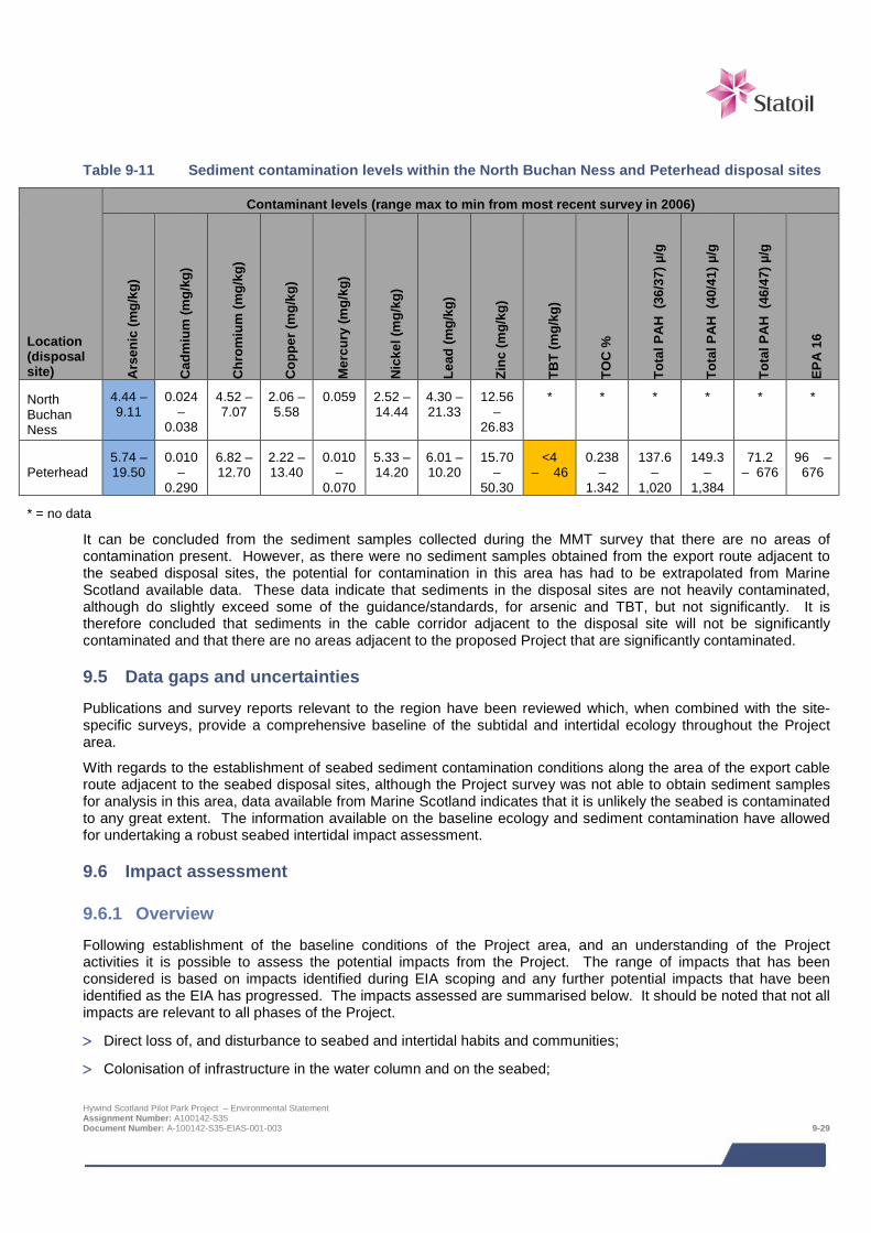
Table 9-11 Sediment contamination levels within the North Buchan Ness and Peterhead disposal sites
Location (disposal site)
Contaminant levels (range max to min from most recent survey in 2006)
Ars
enic
(mg/
kg)
Cad
miu
m (m
g/kg
)
Chr
omiu
m (m
g/kg
)
Cop
per (
mg/
kg)
Mer
cury
(mg/
kg)
Nic
kel (
mg/
kg)
Lead
(mg/
kg)
Zinc
(mg/
kg)
TBT
(mg/
kg)
TOC
%
Tota
l PA
H (
36/3
7) µ
/g
Tota
l PA
H (
40/4
1) µ
/g
Tota
l PA
H (
46/4
7) µ
/g
EPA
16
North Buchan Ness
4.44 – 9.11
0.024 –
0.038
4.52 – 7.07
2.06 – 5.58
0.059 2.52 – 14.44
4.30 – 21.33
12.56 –
26.83
* * * * * *
Peterhead 5.74 – 19.50
0.010 –
0.290
6.82 – 12.70
2.22 – 13.40
0.010 –
0.070
5.33 – 14.20
6.01 – 10.20
15.70 –
50.30
<4 – 46
0.238 –
1.342
137.6 –
1,020
149.3 –
1,384
71.2 – 676
96 – 676
* = no data
It can be concluded from the sediment samples collected during the MMT survey that there are no areas of contamination present. However, as there were no sediment samples obtained from the export route adjacent to the seabed disposal sites, the potential for contamination in this area has had to be extrapolated from Marine Scotland available data. These data indicate that sediments in the disposal sites are not heavily contaminated, although do slightly exceed some of the guidance/standards, for arsenic and TBT, but not significantly. It is therefore concluded that sediments in the cable corridor adjacent to the disposal site will not be significantly contaminated and that there are no areas adjacent to the proposed Project that are significantly contaminated.
9.5 Data gaps and uncertainties Publications and survey reports relevant to the region have been reviewed which, when combined with the site-specific surveys, provide a comprehensive baseline of the subtidal and intertidal ecology throughout the Project area.
With regards to the establishment of seabed sediment contamination conditions along the area of the export cable route adjacent to the seabed disposal sites, although the Project survey was not able to obtain sediment samples for analysis in this area, data available from Marine Scotland indicates that it is unlikely the seabed is contaminated to any great extent. The information available on the baseline ecology and sediment contamination have allowed for undertaking a robust seabed intertidal impact assessment.
9.6 Impact assessment
9.6.1 Overview Following establishment of the baseline conditions of the Project area, and an understanding of the Project activities it is possible to assess the potential impacts from the Project. The range of impacts that has been considered is based on impacts identified during EIA scoping and any further potential impacts that have been identified as the EIA has progressed. The impacts assessed are summarised below. It should be noted that not all impacts are relevant to all phases of the Project.
> Direct loss of, and disturbance to seabed and intertidal habits and communities;
> Colonisation of infrastructure in the water column and on the seabed;
Hywind Scotland Pilot Park Project – Environmental Statement Assignment Number: A100142-S35 Document Number: A-100142-S35-EIAS-001-003 9-29
> Protection of benthic habitats in the turbine deployment area, due to restricted trawling;
> Introduction of marine non-native marine species;
> Effects of EMF and heat generated by active power cables on benthic invertebrates; and
> Pollution of water and sediment environment through the disturbance of existing contaminated sediments.
It is worth noting that the potential impacts related to water and sediment quality presented within the EIA Scoping Report (Statoil, 2013) have been incorporated into the scope of this chapter.
The following impacts were scoped out of the assessment:
> Indirect effects on seabed habitats and communities due to changes in sediment transport / scouring, based on the findings of the physical processes and sediment dynamics impact assessment (Chapter 8);
> Pollution due to leaks and spills from the vessels / WTG Units; and
> Pollution of sediment and water column from planned release from WTG Unit ballast.
The assessment of impacts on benthic and intertidal ecology is a desk based assessment utilising Project specific survey data. No other specialist studies have been required to inform the impact assessment.
9.6.2 Assessment criteria The EIA process and methodology are described in detail in Chapter 6. Specific criteria relating to benthic and intertidal ecology have been developed for ‘sensitivity of receptor’ and ‘magnitude of effect’ as detailed in Table 9-12 and Table 9-13 respectively.
The sensitivity of receptor and magnitude of effect are then combined to determine the level of impact and presented alongside a qualitative understanding of likelihood (using the criteria in Chapter 6). The definitions for level of impact are presented in Chapter 6, Table 6-1 and Table 6-2.
Table 9-12 Definitions for sensitivity / value for benthic and intertidal ecology
Sensitivity /value Definition
Very high
Sensitivity: Receptor with no capacity to accommodate a particular effect with no ability to recover or adapt.
Value: Receptor of very high importance or rarity, such as those designated under international legislation (e.g. EU Habitats Directive), those that form qualifying interests of internationally designated sites, a high density of numerous Priority Marine Feature species or habitats, habitats that comprise an internationally important proportion of that habitat, or receptors that are internationally recognised as globally threatened (e.g. IUCN red list).
High
Sensitivity: Receptor with a very low capacity to accommodate a particular effect with low recoverability or adaptability.
Value: Receptor of high importance or rarity, such as those designated under national legislation, those that form qualifying interests of nationally designated sites, a moderate density of numerous Priority Marine Feature species or habitats, habitats that comprise a nationally important proportion of that habitat, or receptors which contribute to an international site but which are not listed as qualifying interests.
Medium
Sensitivity: Receptor has a low capacity to accommodate a particular effect with some potential for recovery or adaption.
Value: Receptor of medium importance or rarity, such as those which are designated under regional initiatives, presence of Annex I habitats or Annex II species of the European Habitats Directive, species present in regionally important numbers, species/assemblages which contribute to a national site but which are not listed as qualifying interests, species occurring within international/national sites but are not crucial to the integrity of the site, species listed as priority species in the UKBAP, or one or more Priority Marine Feature species or habitats.
Hywind Scotland Pilot Park Project – Environmental Statement Assignment Number: A100142-S35 Document Number: A-100142-S35-EIAS-001-003 9-30

Sensitivity /value Definition
Low
Sensitivity: Receptor has some tolerance to accommodate a particular effect or will be able to recover or adapt.
Value: Receptor which is reasonably common throughout the UK, no features that would meet the criteria for sites of local value but nevertheless has some biodiversity value, and any other receptor of local conservation interest (e.g. LBAP species).
Negligible
Sensitivity: Receptor is generally tolerant and can accommodate a particular effect without the need to recover or adapt.
Value: Receptor of very low importance, such as those which are generally abundant around the UK with no specific local value and no identified conservation concern.
Note:
Value is presented as a component of sensitivity to allow a judgement to be made according to either a receptor’s sensitivity to a particular effect or its value under, for example, international, national, or regional legislation. Value should therefore be applied inherently when considering the sensitivity of a receptor to a particular effect. Definitions in this table may not be appropriate for all receptors or effects, for example there may be a receptor with some tolerance to accommodate an effect (low sensitivity) but it might be designated under regional legislation (medium sensitivity). In such cases expert judgement is used to determine the most appropriate sensitivity ranking and this is explained through the narrative of the assessment.
Table 9-13 Definitions for magnitude of effect
Magnitude of effect Definition
Severe Effect is widespread, or occurs over a prolonged duration, or at a high frequency (e.g. repeated or continuous effect), resulting in extensive permanent changes to baseline conditions (defined here as change in several pre-existing biotope types due to particular effect in question).
Major Effect is over a large scale or spatial extent, or occurs long term, or at a medium-high frequency, resulting in extensive temporary change or some permanent change to baseline conditions (defined here as change in some pre-existing biotope types due to particular effect in question).
Moderate Effect is localised (confined to project footprint and immediate locality), or occurs for a short duration, or at a medium frequency, resulting in temporary changes or limited permanent changes to baseline conditions (defined here as change in at least one pre-existing biotope type due to particular effect in question).
Minor Detectable disturbance or change to baseline levels but no long term noticeable effects above the level of natural variation experienced in the area. Overall biotope distribution remains as per baseline.
Negligible Imperceptible changes to baseline conditions.
Note:
Magnitude of effect is presented as a variety of parameters including duration, timing, size and scale, and frequency. Definitions in this table may not be appropriate for all effects, for example there may be an effect which is over a very small area (minor or moderate) but is repeated a large number of times during a particular phase of the project (major or severe). In such cases expert judgement is used to determine the most appropriate magnitude ranking and this is explained through the narrative of the assessment.
9.6.3 Design Envelope This assessment considers the Project parameters which are predicted to result in the greatest environmental impact. This approach ensures that impacts of a greater adverse significance would not arise should any other development scenario be taken forward in the final scheme design. With regards to the assessment of impacts on benthic and intertidal ecology, the assessment has considered the maximum amount of infrastructure that could be located on the seabed, this comprises:
Hywind Scotland Pilot Park Project – Environmental Statement Assignment Number: A100142-S35 Document Number: A-100142-S35-EIAS-001-003 9-31
> WTG Unit anchoring systems which will include anchor chains present on the seabed (150 - 850 m of mooring
line per anchor and a maximum of 15 anchors for the whole Pilot Park);
> Scour protection around the anchors which could be required over an area of up to 15 m beyond the edge of each anchor;
> Inter array cables (five cables, each 3 km long) of which it is assumed there could be up to 7.5 km in total which could be protected with rock;
> An export cable of up to 35 km in length and requiring rock protection along approximately 2 km of its length. The rock protection would occupy a 6 m wide corridor;
> Four cable crossings, each requiring 360 m2 of rock protection; and
> Cable landfall installation as a surface laid cable across the foreshore requiring a working corridor of 6 m wide (base case is HDD).
The impacts from potential alternative development options are addressed in Section 9.9.
9.7 Impacts during construction and installation The placement of WTG anchors and cables on the seabed will be likely to impact on the benthic species and habitats present both directly within the actual project footprint, and indirectly through the disturbance and re-suspension of benthic sediments.
In addition, impacts to the seabed may potentially occur through the disturbance and release of any existing contamination by construction activities within surficial sediments, and through the introduction of non-native marine species via vessel fouling or ballast tank discharges.
9.7.1 Direct loss of, and disturbance to, seabed and intertidal habitats and communities Individuals of sessile species present on the seabed on which infrastructure such as anchors and cables will be placed would potentially be damaged or lost, although more mobile species, including some of the shellfish, may be able to move away from affected areas during the installation process. The placement of the turbine anchors and cables on the seabed will also exclude the seabed habitats directly beneath from use by species found in the region. During construction and installation, impacts to the benthic environment can be summarised as follows:
> Direct physical loss of benthic species and habitat beneath the project footprint;
> Localised change of benthic habitat, through introduction of novel substrata (note that although initiated at the construction stage, this impact has a time element to it and has been assessed in Section 9.9 Impacts during operation and maintenance);
> Wider but temporary disturbance through the suspension and re-settlement of sediments.
Some of the impacts during construction and installation activities will persist through the operational phase of the Project whilst other construction and installation impacts will be temporary. The footprint area for each aspect of construction and installation resulting in seabed disturbance is estimated in Table 9-14 and Table 9-15.
Subtidal
From Table 9-14 and Table 9-15, it can be seen that the total footprint area of the Hywind Project subtidally is estimated as being 0.275 km2, and that associated sediment re-suspension and re-settlement will affect a peripheral area around this estimated to be 1.068 km2.
In terms of the benthic species and habitats affected, the WTG anchors, associated scour protection and inter-array cabling will be confined to the northern area of the AfL area, avoiding the areas of greatest Sabellaria spinulosa abundance and reef areas to the south of the BP pipelines (Figure 9-5). As shown in survey work (MMT, 2013b) the seabed in the northern area of the AfL consists of rippled sand with shell fragments and a sparse epifauna generally, with an infauna characterised by the polychaetes Scoloplos armiger, Spiophanes bombyx and Owenia fusiformis, the brittle stars Amphiura filiformis and Ophiocten affinis and the burrowing sea urchin Hywind Scotland Pilot Park Project – Environmental Statement Assignment Number: A100142-S35 Document Number: A-100142-S35-EIAS-001-003 9-32
Echinocyamus pusillus. However, patches of boulders and mixed sediment are sometimes also present, for example at sample station S27, with a raised diversity of epifaunal species including shrimps, sponges, sessile cnidarians and occasional aggregations of Sabellaria spinulosa tubes. MMT (2013b) reported the coverage of Sabellaria spinulosa within the turbine deployment area to be low, covering approximately 1% of the seabed, with only one or two patches present representing less than 9,000 m2 in extent. These areas were classified by MMT (2013b) as the biotope “Offshore circalittoral mixed sediment” (SS.SMx.OMx) and were not classified as Annex I reef structures due to the low coverage by S. spinulosa. In addition, it can be seen that the planned placement of the WTG Units and their anchor systems will avoid these small isolated areas of Sabellaria tube aggregation (Figure 9-5).
The ocean quahog Arctica islandica was found in one grab sample at station S25 in the southeastern part of the AfL area, well outside the proposed turbine deployment area in the northern half of the AfL area. This is indicative of a sparse occurrence for this feature in the general area.
Table 9-14 Footprint of long-term benthic disturbance
Area of seabed on which project infrastructure will be installed Area
Subtidal
WTG Unit anchor installation 600 m2
Anchor chains (15), each approximately 800 m in length on average of which approximately 500 m may lie on the seabed. Each may have lateral movement of up to 2 m.
15,000 m2
Inter-array cabling installation (3 km cable for each of 5 WTG Units; up to 7.5 km could be protected with rock (6 m wide rock dump protection)
45,000 m2
Inter-array cabling anchors (one for each cable; 5 x 32 m2) 480 m2
Export cabling installation (35 km cable; trenched and buried) 210,000 m2
Export cabling protection (up to 2 km to have 6 m wide rock dump protection).
Note that this either will be on top of the footprint for trenching calculated above where insufficient burial has been achieved, or will be in place of burial where the seabed is rocky. Therefore changes in the relative proportions of burial to rock dump will not change the overall footprint calculated above.
0 m2
(but will result in 12,000 m2 of new rocky substrata)
Construction of cable crossings (4 crossings, each 360 m2 of rock dump) 1,440 m2
Subtidal long-term disturbance total (m2) 272,520 m2
Subtidal long-term disturbance total (km2) 0.273 km2
Intertidal
Export cable landfall and beach excavation (200 m length by 4 m wide, plus 3 m working corridor either side)
2,000 m2
Intertidal long-term disturbance total (m2) 2,000 m2
Intertidal long-term disturbance total (km2) 0.002 km2
Total area of seabed disturbance (subtidal and intertidal) (km2) 0.275 km2
Hywind Scotland Pilot Park Project – Environmental Statement Assignment Number: A100142-S35 Document Number: A-100142-S35-EIAS-001-003 9-33
Table 9-15 Footprint of temporary benthic disturbance
Area of seabed adjacent to Project infrastructure that will be disturbed during installation Area
Wet storage of mooring lines prior to WTG installation (one year) 1,260 m2
Wet storage of inter-array cables prior to full installation (up to 18 months) 8,750 m2
Sediment re-suspension and re-settlement in 10 m wide band (1) around anchors (533 m2 around each of 15 anchors)
7,995 m2
Sediment re-suspension and re-settlement in 10 m band either side of inter-array cabling (17.5 km total length, and assuming no overlaps with other disturbed seabed areas)
350,000 m2
Sediment re-suspension and re-settlement in 10 m band either side of export cable (35 km total length, and assumes sediment present for full length of cable route)
700,000 m2
Subtidal temporary disturbance total (m2) 1,068,005 m2
Subtidal temporary disturbance total (km2) 1.068 km2
Note (1) assumption made that sediment present throughout entire project area – from baseline description we know this is not the case (e.g. there is stony reef present along some areas of the cable route) and therefore this can be assumed to represent the greatest environmental impact
The export cable route will extend from the turbine deployment area, crossing the following main biotopes in sequence (see Figure 9-4):
> “Offshore circalittoral sand” (SS.SSa.OSa) for approximately 3.5 km (within this, around station S12, the cable corridor is traversed at intervals by nine small areas totalling 146,691 m2 of low-potential Annex I Sabellaria spinulosa reef, and one further area of 54,750 m2, both assigned to the biotope “Sabellaria spinulosa on stable circalittoral mixed sediment” (SS.SBR.PoR.SspiMx));
> “Polychaete-rich deep Venus community in offshore mixed sediments” (SS.SMx.OMx.PoVen), for approximately 13 km (within which are dotted small patches of “Offshore circalittoral sand” (SS.SSa.OSa) and “Circalittoral fine sand” (SS.SSa.CFiSa);
> “Circalittoral fine sand” (SS.SSa.CFiSa) for approximately 2 km;
> “Flustra foliacea and Hydrallmania falcata on tide-swept circalittoral mixed sediment” (SS.SMx.CMx.FluHyd) for 3 km (within this biotope area, there was one very small area of low-potential Annex I Sabellaria spinulosa reef at station S08 (1,346 m2) assigned to the biotope “Sabellaria spinulosa with bryozoans turf and barnacles on silty turbid circalittoral rock” (CR.MCR.CSab.Sspi.ByB);
> A mosaic over 1.5 km of stony reef (medium Annex I potential) mixed with areas of mobile clean sand:
o “Infralittoral mobile clean sand with sparse fauna” (SS.SSa.IFiSa.IMoSa) with a very sparse infaunal community;
o Alcyonium digitatum with Securiflustra securifrons on tide-swept moderately wave-exposed circalittoral rock (CR.MCR.EcCr.FaAlCr.Sec);
> And within 1 km of the landfall, a more jumbled mosaic of rocky platforms (Annex I rocky and stony reef) with kelp-dominated biotopes:
o “Laminaria hyperborea with dense foliose red seaweed on exposed infralittoral rock” (IR.HIR.KFaR.LhypR);
o Laminaria hyperborea forest with dense foliose red seaweeds on exposed upper infralittoral rock (IR.HIR.KfaR.LhypR.Ft);
o Grazed Laminaria hyperborea forest with coralline crusts on upper infralittoral rock (IR.MIR.KR.Lhyp.GzFt).
The areas of Sabellaria spinulosa observed at the offshore end of the export cable route, although classified as “low” in terms of reef potential by MMT (2013b) on the basis of their small area, are considered here as though Hywind Scotland Pilot Park Project – Environmental Statement Assignment Number: A100142-S35 Document Number: A-100142-S35-EIAS-001-003 9-34
qualifying as Annex I biogenic reef. Most of these patches of Sabellaria spinulosa on mixed sediment in the vicinity of station S12 were mapped as occupying the northern half of the cable corridor (Figure 9-4), although some traverse the cable corridor entirely, and would thus be bisected by its installation. This in itself is not expected to cause any significant impact on the Sabellaria habitat remaining to either side, since this species often develops its reef habit in small patches over various substrata in any case (Jackson & Hiscock, 2008). In addition, the cable at this point is being routed along the southern edge of the corridor and will thus entirely avoid the majority of reef patches observed. Likewise, the cable route within the corridor will also miss the small patch of Sabellaria reef noted at station S08 (Figure 9-4). With regard to other Priority Marine Features potentially occurring in the vicinity, single specimens of the sandeels Ammodytes marinus and A. tobianus were observed in the sandy sediments along the pipeline route. Numbers therefore appear to be low in the area, but a full assessment for these PMF fish species is given in Chapter 10.
The cable will also cross areas of stony and rocky reef, since such features occupy a large proportion of the corridor (over its full width) towards the landfall. This will therefore span several different biotopes, none of which are listed under any categories of conservation importance (other than qualifying as rocky or stony reef). The cable will be installed through a combination of trenching and burial to a depth of 1.5 m where possible, or will be protected beneath an installed 6 m wide berm of rock where burial is not achievable. It is therefore likely that the cable will be buried for the most part in the offshore sedimentary biotopes, and that in the stony or rocky biotopes closer to shore it will have a protection of rock dump material. This is likely to result in the loss of sessile species present in the area on which the rock dump material is placed (such as kelp and other seaweeds), in a 6 m wide belt. However, none of the biotopes or species observed have been identified as being of specific conservation concern (e.g. in terms of the Habitats Directive or the list of Scottish Priority Marine Features), and it is likely that any species mortality within this narrow swathe will be insignificant in relation to the natural cycles of mortality and re-growth occurring to either side. Further, it is likely that species from the same biotopes to either side will start to colonise the cable rock protection and become established on it over a number of years. In terms of the temporary impacts, these are divided into the impacts associated with storing the WTG anchor mooring chains and inter-array cables on the seabed beneath the turbine locations, and the impacts associated with sediment plumes raised during construction and installation activities.
For the former, the chains and cables to be stored will take up an area of approximately 1,000 m2 occupied by the biotope “Offshore circalittoral sand” (SS.SSa.OSa), within which occasional small patches of “Offshore circalittoral mixed sediment” (SS.SMx.OMx) were observed. As outlined earlier in this section, although these patches supported Sabellaria spinulosa, both the extent and cover of this species were too low for these areas to be classified as Annex I reef structures. The area occupied by the lines and cables will be small in relation to the size of this biotope in the Hywind Project area and the wider North Sea, in addition to which there is little of conservation interest in the immediate area that could be affected specifically. Also, installing lines and cables on the seabed surface is not likely to significantly affect infaunal communities living within the sediments beneath.
Potential creation of sediment plumes around the periphery of the project footprint during construction and installation has the potential to cause temporarily increased sedimentation rates in the vicinity, with consequent smothering and damage to benthic species e.g. damage to respiratory and feeding structures, as the sediments re-settle to the seabed (see Gubbay, 2003, for a review). The impact of sediment re-suspension and re-settlement on benthic species is related to their ability to clear particles from their feeding and respiratory surfaces (e.g. Rogers, 1990). In Table 9-22, based on the whole project seabed footprint, it is estimated that such impacts might affect up to approximately 1 km2. However, it is expected that this type of impact will be restricted on the whole to areas where sedimentary habitats and biotopes occur, i.e. predominantly within the turbine deployment area, and along the export cable route to a point approximately 2.5 km from landfall beyond which the habitat is mainly stony or rocky (Figures 9-7 and 9-8). The infaunal communities that dominate within the sedimentary environment in the project are by their nature not likely to be significantly affected by temporary fluctuations in ambient sedimentation rates. In relation to epifaunal species, the main concern in the project area is likely to be with the reef-building polychaete Sabellaria spinulosa. However, Jackson & Hiscock (2008) indicate that evidence points towards this species having very little sensitivity to smothering or to increases in sedimentation rates, and that its recoverability potential from such impacts is very high. Since the area affected is very localised around the edge of the Project footprint, any impacts are likely to be minor and will have good potential for rapid recovery due to the adaptability of the species present.
Hywind Scotland Pilot Park Project – Environmental Statement Assignment Number: A100142-S35 Document Number: A-100142-S35-EIAS-001-003 9-35
Assessment of impact significance
The anchoring of the turbines and placement of scour protection and inter-array cables in the turbine deployment area, and the installation of the export cable to Peterhead, will result in a direct long-term footprint of only a very limited area of seabed, less than 0.3 km2 and a larger but still localised area of peripheral temporary disturbance during construction amounting to just over 1 km2. Although very small areas of potential low-graded Annex I biogenic reef could be affected together with patches of rocky and stony reef, the great majority of this area is occupied by biotopes of no specific conservation concern which are present on a wider scale throughout this area of the North Sea. It should also be noted that the seabed in this area (at water depths of over 50 m) is already impacted by seabed trawling fishing gear (evident from seabed surveys). The much larger areas of potential Sabellaria reef noted in survey work to the south of the Project area will be avoided; the decision was made early in the process to actively avoid these areas of potential reef. In addition no Priority Marine Features appear to have a significant presence here. On this basis, the subtidal habitats and species potentially affected by the Project are considered to be of medium sensitivity to disturbance/loss; the magnitude of effect as justified above is considered minor resulting in a level of impact of minor and not significant. This impact is certain to occur.
Sensitivity / value Magnitude of effect Level of impact
Medium Minor Minor
Impact significance - NOT SIGNIFICANT
MITIGATION (subtidal)
> No mitigation measures have been identified for this impact as it was concluded that the impact was not significant, although it should be noted that the proposed export cable has been routed to minimise impact on areas of Sabellaria.
Intertidal
At landfall, the exact route of the cable has not been determined; however, the likely biotopes to be crossed will include the following (biotope dimensions cannot be given, but the overall distance of the shore crossing will be a maximum of 200 m):
> Lower shore:
o “Laminaria digitata on moderately exposed sublittoral fringe bedrock” (IR.MIR.KR.Ldig.Ldig);
o “Fucus serratus and red seaweeds on moderately exposed lower eulittoral rock” (LR.MLR.BF.Fser.R).
> Mid shore:
o “Fucus vesiculosus and barnacle biotope” (LR.HLR.MusB.Sem.FvesR);
o “Semibalanus balanoides and Littorina spp. on exposed to moderately exposed eulittoral boulders and cobbles” (LR.HLR.MusB.Sem.LitX);
> Upper shore:
o “Verrucaria maura on littoral fringe rock” (LR.FLR.Lic.Ver);
o “Fucus spiralis on full salinity moderately exposed to very sheltered upper eulittoral rock” (LR.LLR.F.FSpi.FS).
In the intertidal zone, the cable if surface laid and not installed through a horizontally drilled duct, will be laid in a 4 m wide duct across foreshore over a distance of 200 m, weighted down with clump weights and mattresses. In addition, there will be a 3 m wide access and working area to either side; thus the footprint here will be approximately 2,000 m2. This construction will cross several different biotopes, up the shore, none of which are listed under any categories of conservation importance (other than qualifying as rocky or stony reef) therefore Hywind Scotland Pilot Park Project – Environmental Statement Assignment Number: A100142-S35 Document Number: A-100142-S35-EIAS-001-003 9-36
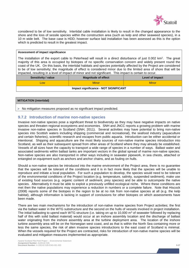
considered to be of low sensitivity. Intertidal cable installation is likely to result in the changed appearance to the shore and the loss of sessile species within the construction area (such as kelp and other seaweed species), in a 10 m wide belt. The base case is HDD; however surface laid installation has been assessed as this is the option which is predicted to result in the greatest impact.
Assessment of impact significance
The installation of the export cable to Peterhead will result in a direct disturbance of just 0.002 km2. The great majority of this area is occupied by biotopes of no specific conservation concern and widely present round the coast of the UK. On this basis, the intertidal habitats and species potentially affected by the Project are considered to be of low sensitivity; the magnitude of effect is considered minor due to the limited area of shore that will be impacted, resulting in a level of impact of minor and not significant. This impact is certain to occur.
Sensitivity / value Magnitude of effect Level of impact
Low Minor Minor
Impact significance - NOT SIGNIFICANT
MITIGATION (intertidal)
> No mitigation measures proposed as no significant impact predicted.
9.7.2 Introduction of marine non-native species Invasive non-native species pose a significant threat to biodiversity as they may have negative impacts on native species and threaten regional ecosystems and economies. SNH and JNCC reports a growing problem with marine invasive non-native species in Scotland (SNH, 2011). Several activities may have potential to bring non-native species into Scottish waters including shipping (commercial and recreational), the seafood industry (aquaculture and certain fisheries), scientific research and escapes from public aquaria. Introduction can be either accidental or intentional. Shipping and aquaculture are the most likely sources of non-native marine species introduction into Scotland, as well as their subsequent spread from other areas of Scotland where they may already be established. Vessels of all sizes have the capacity to transport a wide range of species in a number of ways. Ballast water and associated sediments within ballast tanks are important vectors in the global spread of marine non-native species. Non-native species are also transported in other ways including in seawater pipework, in sea chests, attached or entangled on equipment such as anchors and anchor chains, and as fouling on hulls.
Should a non-native species be introduced into the marine environment of the Project area, there is no guarantee that the species will be tolerant of the conditions and it is in fact more likely that the species will be unable to reproduce and initiate a local population. For such a population to develop, the species would need to be tolerant of the environmental conditions of the Project location (e.g. temperature, salinity, suspended sediment), make use of existing food sources (e.g. organic content of sediment, prey species) and be able to outcompete the native species. Alternatively it must be able to exploit a previously unfilled ecological niche. Where these conditions are met then the native populations may experience a reduction in numbers or a complete failure. Note that Hiscock (2008) reports some of the biotopes in the region to be at no risk from non-native species at all (e.g. the kelp habitat), although information is lacking in support of conclusions for other biotopes on which assessments have been made.
There are two main mechanisms for the introduction of non-native marine species from Project activities; the first via the ballast water in the WTG substructure and the second on the hulls of vessels involved in project installation. The initial ballasting to upend each WTG structure (i.e. taking on up to 10,000 m3 of seawater followed by replacing half of this with solid ballast material) would occur at an inshore assembly location and the discharge of ballast water originating from the inshore assembly area at the turbine deployment area. The location of the inshore turbine assembly area will be on the Norwegian west coast, and as that is within the North Sea containing more or less the same species, the risk of alien invasive species introductions to the east coast of Scotland is minimal. When the vessels required for the Project are contracted, risks for introduction of non-native marine species will be evaluated and mitigation measures implemented as appropriate. Hywind Scotland Pilot Park Project – Environmental Statement Assignment Number: A100142-S35 Document Number: A-100142-S35-EIAS-001-003 9-37

MITIGATION
Mitigation measures will be implemented to ensure any risks associated with the introduction of non-native marine species will be minimised so as not to result in any significant impact:
> All vessels involved in all stages of the project will adhere to all relevant guidance (including the IMO guidelines) regarding ballast water and transfer of non-native marine species.
Assessment of residual impact significance The introduction of non-native marine species could impact an area not only directly adjacent to the Project area but areas wider afield, as any introduced species could travel with water currents until reaching an environment in which it could become established. Based on the knowledge of the Project area and wider seabed and coastal environments this area of the North Sea, the sensitivity of the receptor is considered to be medium. The impact magnitude is considered to be negligible. The overall consequence ranking is therefore negligible. The impact is therefore not significant. This impact is considered very unlikely to occur, since all vessels involved in all stages of the Project will be managed to adhere to all relevant guidance regarding ballast water and the transfer of non-native marine species.
Sensitivity / value Magnitude of effect Level of impact
Medium Negligible Negligible
Impact significance – NOT SIGNIFICANT
9.7.3 Pollution of the water and sediment environment through the disturbance of existing contaminated sediments
The release of contamination that may be present in sediments during device and cable installation may cause potentially detrimental effects on species (and habitats) that are sensitive to contamination. This impact relates to the subtidal environment only; the beachfront at Peterhead supports little sediment and has no history of industrial activity likely to have caused any significant persistent contamination.
Based on the data available no areas of contaminated sediment have been observed or are expected in the Project area. The export cable does pass adjacent to three dredge disposal sites at approximately 3 km from the shore and analysis of dredge disposal at these sites indicates slightly elevated levels of arsenic and TBT (above recognised standards / guidance). Although the disposal sites retain levels of hydrocarbon and metal contamination slightly above background levels, these sites will not be directly disturbed by cable installation activities, and it is not likely that such activities will cause any contaminant release that could affect benthic species and habitats locally or damage the wider environment.
Assessment of impact significance
As previously described the sensitivity of the Project area seabed habitats is considered medium. Given that no contamination has been observed within the Project footprint, and that there is no prospect of construction activities disturbing any areas of contamination, the magnitude of effect is considered to be negligible. The level of impact is therefore negligible and not significant. This impact is unlikely to occur.
Sensitivity / value Magnitude of effect Level of impact
Medium Negligible Negligible
Impact significance – NOT SIGNIFICANT
Hywind Scotland Pilot Park Project – Environmental Statement Assignment Number: A100142-S35 Document Number: A-100142-S35-EIAS-001-003 9-38
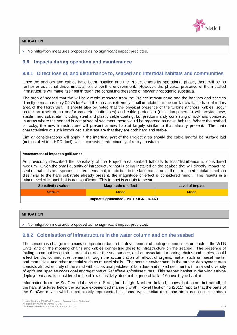
MITIGATION
> No mitigation measures proposed as no significant impact predicted.
9.8 Impacts during operation and maintenance
9.8.1 Direct loss of, and disturbance to, seabed and intertidal habitats and communities Once the anchors and cables have been installed and the Project enters its operational phase, there will be no further or additional direct impacts to the benthic environment. However, the physical presence of the installed infrastructure will make itself felt through the continuing presence of new/anthropogenic substrata.
The area of seabed that the will be directly impacted from the Project infrastructure and the habitats and species directly beneath is only 0.275 km2 and this area is extremely small in relation to the similar available habitat in this area of the North Sea. It should also be noted that the physical presence of the turbine anchors, cables, scour protection (rock dump and/or concrete mattresses) and cable protection (rock dump berms) will provide new, stable, hard substrata including steel and plastic cable-coating, but predominantly consisting of rock and concrete. In areas where the seabed is comprised of sediment these would be regarded as novel habitat. Where the seabed is rocky, the new infrastructure will present a new habitat largely similar to that already present. The main characteristics of such introduced substrata are that they are both hard and stable.
Similar considerations will apply in the intertidal part of the Project area should the cable landfall be surface laid (not installed in a HDD duct), which consists predominantly of rocky substrata.
Assessment of impact significance
As previously described the sensitivity of the Project area seabed habitats to loss/disturbance is considered medium. Given the small quantity of infrastructure that is being installed on the seabed that will directly impact the seabed habitats and species located beneath it, in addition to the fact that some of the introduced habitat is not too dissimilar to the hard substrate already present, the magnitude of effect is considered minor. This results in a minor level of impact that is not significant. This impact is certain to occur.
Sensitivity / value Magnitude of effect Level of impact
Medium Minor Minor
Impact significance – NOT SIGNIFICANT
MITIGATION
> No mitigation measures proposed as no significant impact predicted.
9.8.2 Colonisation of infrastructure in the water column and on the seabed The concern is change in species composition due to the development of fouling communities on each of the WTG Units, and on the mooring chains and cables connecting these to infrastructure on the seabed. The presence of fouling communities on structures at or near the sea surface, and on associated mooring chains and cables, could affect benthic communities beneath through the accumulation of fall-out of organic matter such as faecal matter and mortalities, and other material such as mussel shells. The benthic environment in the turbine deployment area consists almost entirely of the sand with occasional patches of boulders and mixed sediment with a raised diversity of epifaunal species occasional aggregations of Sabellaria spinulosa tubes. This seabed habitat in the wind turbine deployment area is considered to be of low sensitivity, due to the general lack of Annex 1 type habitat.
Information from the SeaGen tidal device in Strangford Lough, Northern Ireland, shows that some, but not all, of the hard structures below the surface experienced marine growth. Royal Haskoning (2011) reports that the parts of the SeaGen device which most closely represented a seabed type habitat (the shoe structures on the seabed) Hywind Scotland Pilot Park Project – Environmental Statement Assignment Number: A100142-S35 Document Number: A-100142-S35-EIAS-001-003 9-39
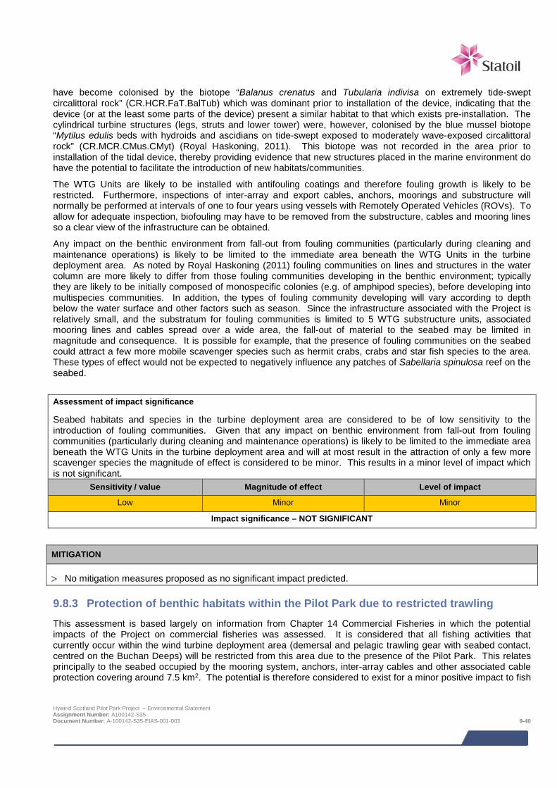
have become colonised by the biotope “Balanus crenatus and Tubularia indivisa on extremely tide-swept circalittoral rock” (CR.HCR.FaT.BalTub) which was dominant prior to installation of the device, indicating that the device (or at the least some parts of the device) present a similar habitat to that which exists pre-installation. The cylindrical turbine structures (legs, struts and lower tower) were, however, colonised by the blue mussel biotope “Mytilus edulis beds with hydroids and ascidians on tide-swept exposed to moderately wave-exposed circalittoral rock” (CR.MCR.CMus.CMyt) (Royal Haskoning, 2011). This biotope was not recorded in the area prior to installation of the tidal device, thereby providing evidence that new structures placed in the marine environment do have the potential to facilitate the introduction of new habitats/communities.
The WTG Units are likely to be installed with antifouling coatings and therefore fouling growth is likely to be restricted. Furthermore, inspections of inter-array and export cables, anchors, moorings and substructure will normally be performed at intervals of one to four years using vessels with Remotely Operated Vehicles (ROVs). To allow for adequate inspection, biofouling may have to be removed from the substructure, cables and mooring lines so a clear view of the infrastructure can be obtained.
Any impact on the benthic environment from fall-out from fouling communities (particularly during cleaning and maintenance operations) is likely to be limited to the immediate area beneath the WTG Units in the turbine deployment area. As noted by Royal Haskoning (2011) fouling communities on lines and structures in the water column are more likely to differ from those fouling communities developing in the benthic environment; typically they are likely to be initially composed of monospecific colonies (e.g. of amphipod species), before developing into multispecies communities. In addition, the types of fouling community developing will vary according to depth below the water surface and other factors such as season. Since the infrastructure associated with the Project is relatively small, and the substratum for fouling communities is limited to 5 WTG substructure units, associated mooring lines and cables spread over a wide area, the fall-out of material to the seabed may be limited in magnitude and consequence. It is possible for example, that the presence of fouling communities on the seabed could attract a few more mobile scavenger species such as hermit crabs, crabs and star fish species to the area. These types of effect would not be expected to negatively influence any patches of Sabellaria spinulosa reef on the seabed.
Assessment of impact significance
Seabed habitats and species in the turbine deployment area are considered to be of low sensitivity to the introduction of fouling communities. Given that any impact on benthic environment from fall-out from fouling communities (particularly during cleaning and maintenance operations) is likely to be limited to the immediate area beneath the WTG Units in the turbine deployment area and will at most result in the attraction of only a few more scavenger species the magnitude of effect is considered to be minor. This results in a minor level of impact which is not significant.
Sensitivity / value Magnitude of effect Level of impact
Low Minor Minor
Impact significance – NOT SIGNIFICANT
MITIGATION
> No mitigation measures proposed as no significant impact predicted.
9.8.3 Protection of benthic habitats within the Pilot Park due to restricted trawling This assessment is based largely on information from Chapter 14 Commercial Fisheries in which the potential impacts of the Project on commercial fisheries was assessed. It is considered that all fishing activities that currently occur within the wind turbine deployment area (demersal and pelagic trawling gear with seabed contact, centred on the Buchan Deeps) will be restricted from this area due to the presence of the Pilot Park. This relates principally to the seabed occupied by the mooring system, anchors, inter-array cables and other associated cable protection covering around 7.5 km2. The potential is therefore considered to exist for a minor positive impact to fish
Hywind Scotland Pilot Park Project – Environmental Statement Assignment Number: A100142-S35 Document Number: A-100142-S35-EIAS-001-003 9-40
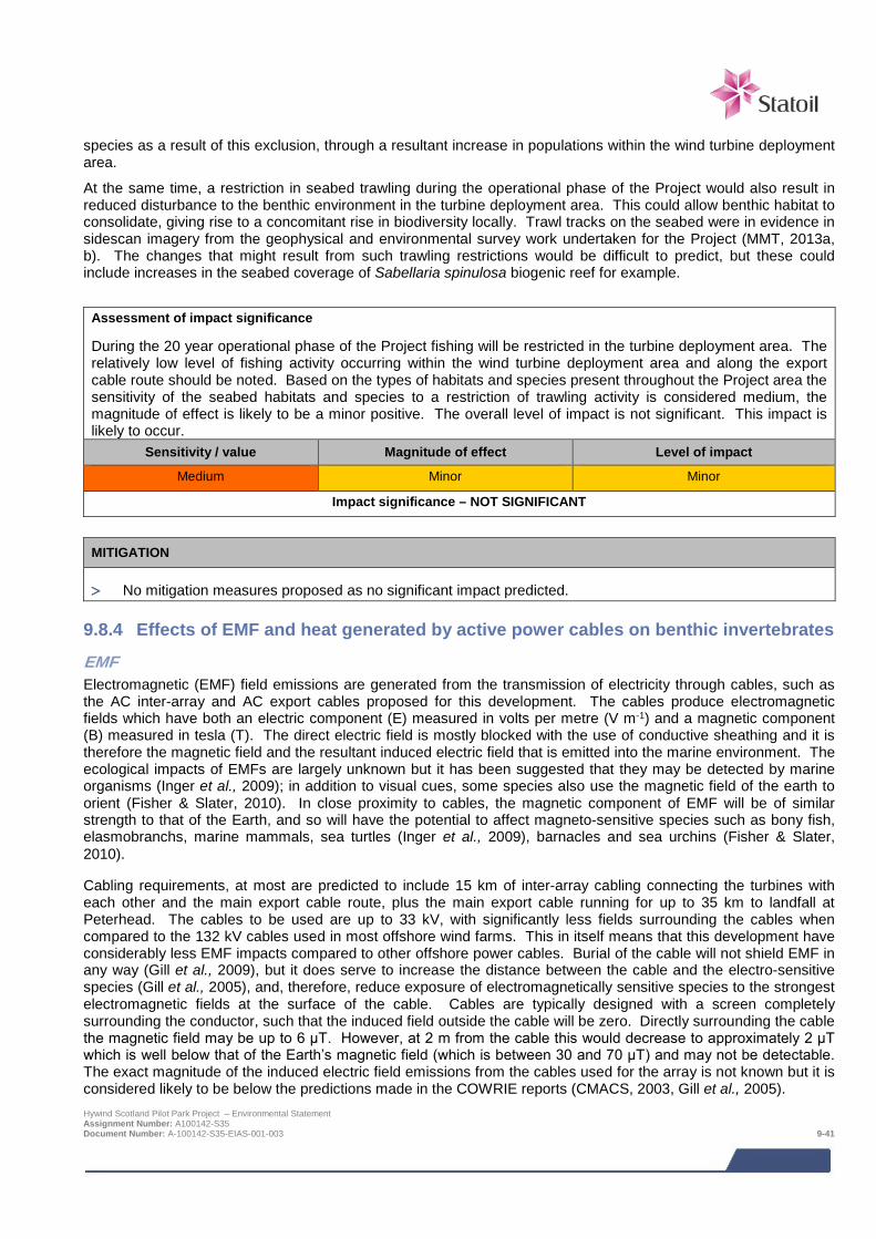
species as a result of this exclusion, through a resultant increase in populations within the wind turbine deployment area.
At the same time, a restriction in seabed trawling during the operational phase of the Project would also result in reduced disturbance to the benthic environment in the turbine deployment area. This could allow benthic habitat to consolidate, giving rise to a concomitant rise in biodiversity locally. Trawl tracks on the seabed were in evidence in sidescan imagery from the geophysical and environmental survey work undertaken for the Project (MMT, 2013a, b). The changes that might result from such trawling restrictions would be difficult to predict, but these could include increases in the seabed coverage of Sabellaria spinulosa biogenic reef for example.
Assessment of impact significance
During the 20 year operational phase of the Project fishing will be restricted in the turbine deployment area. The relatively low level of fishing activity occurring within the wind turbine deployment area and along the export cable route should be noted. Based on the types of habitats and species present throughout the Project area the sensitivity of the seabed habitats and species to a restriction of trawling activity is considered medium, the magnitude of effect is likely to be a minor positive. The overall level of impact is not significant. This impact is likely to occur.
Sensitivity / value Magnitude of effect Level of impact
Medium Minor Minor
Impact significance – NOT SIGNIFICANT
MITIGATION
> No mitigation measures proposed as no significant impact predicted.
9.8.4 Effects of EMF and heat generated by active power cables on benthic invertebrates
EMF Electromagnetic (EMF) field emissions are generated from the transmission of electricity through cables, such as the AC inter-array and AC export cables proposed for this development. The cables produce electromagnetic fields which have both an electric component (E) measured in volts per metre (V m-1) and a magnetic component (B) measured in tesla (T). The direct electric field is mostly blocked with the use of conductive sheathing and it is therefore the magnetic field and the resultant induced electric field that is emitted into the marine environment. The ecological impacts of EMFs are largely unknown but it has been suggested that they may be detected by marine organisms (Inger et al., 2009); in addition to visual cues, some species also use the magnetic field of the earth to orient (Fisher & Slater, 2010). In close proximity to cables, the magnetic component of EMF will be of similar strength to that of the Earth, and so will have the potential to affect magneto-sensitive species such as bony fish, elasmobranchs, marine mammals, sea turtles (Inger et al., 2009), barnacles and sea urchins (Fisher & Slater, 2010).
Cabling requirements, at most are predicted to include 15 km of inter-array cabling connecting the turbines with each other and the main export cable route, plus the main export cable running for up to 35 km to landfall at Peterhead. The cables to be used are up to 33 kV, with significantly less fields surrounding the cables when compared to the 132 kV cables used in most offshore wind farms. This in itself means that this development have considerably less EMF impacts compared to other offshore power cables. Burial of the cable will not shield EMF in any way (Gill et al., 2009), but it does serve to increase the distance between the cable and the electro-sensitive species (Gill et al., 2005), and, therefore, reduce exposure of electromagnetically sensitive species to the strongest electromagnetic fields at the surface of the cable. Cables are typically designed with a screen completely surrounding the conductor, such that the induced field outside the cable will be zero. Directly surrounding the cable the magnetic field may be up to 6 μT. However, at 2 m from the cable this would decrease to approximately 2 μT which is well below that of the Earth’s magnetic field (which is between 30 and 70 μT) and may not be detectable. The exact magnitude of the induced electric field emissions from the cables used for the array is not known but it is considered likely to be below the predictions made in the COWRIE reports (CMACS, 2003, Gill et al., 2005). Hywind Scotland Pilot Park Project – Environmental Statement Assignment Number: A100142-S35 Document Number: A-100142-S35-EIAS-001-003 9-41
Benthic and demersal species are more likely to be vulnerable to the potential barrier effects of the EMF than pelagic species, as their lifestyle brings them into closer contact with the seabed cables. The species most sensitive to the EMF and most likely to be attracted or repelled by the electrical fields generated by submarine cables are the electrosensitive elasmobranchs, a species group which is dealt with in Chapter 10 (fish ecology). The spiny lobster Panulirus argus has been demonstrated to use a magnetic map for navigation (Boles & Lohmann, 2003); however, it is uncertain if other crustaceans including commercially important Nephrops and edible crab are able to respond to magnetic fields in this way.
However, other benthic species are potentially still vulnerable. Bochert & Zettler (2004) report the outcome of experimental analysis on several benthic species (including a number of crustaceans) exposed to static magnetic fields of 3.7 mT for an extended period of time. These results obtained no differences in survival rates between the experimental and control populations. Similarly, the mussel Mytilus edulis exposed to static magnetic fields for three months did not demonstrate recordable changes. Bochert & Zettler (2004) conclude that the static magnetic fields of power cable transmissions do not appear to influence the orientation, movement or physiology of benthic species. In addition, even under the influence of anthropogenic fields, no negative impacts have been observed in crustaceans; for example, no ill effects were detected in western rock lobster Panulirus cygnus after electromagnetic tags emitting a 31 kHz signal were attached (Jernakoff, 1987). Although there are studies that demonstrate some species may be susceptible (e.g. Rosario & Martin, 2010), the Marine Renewable SEA does not list any specific benthic species as having demonstrated a response to EMF. Species monitoring at the Robin Rigg wind farm observed no significant difference in the distribution of electrosensitive species along the cable route corridor after two years of operational monitoring, although it was noted that the survey station may have been too far from the corridor to observe an effect (Malcolm et al., 2013).
Assessment of impact significance As previously described the seabed habitats and species in the Project area are considered potentially to be of medium sensitivity to EMF. The evidence presented above from a literature review of potential EMF impacts in benthic species indicates that recordable changes are not expected, the magnitude of effect is therefore considered negligible. The level of impact is negligible and not significant. This impact is likely to occur.
Sensitivity / value Magnitude of effect Level of impact
Medium Negligible Negligible
Impact significance – NOT SIGNIFICANT
MITIGATION
> No mitigation measures proposed as no significant impact predicated.
Heat
It is possible that the heat released by subsea cables has the potential to increase the temperature in the surrounding sediments and water (Boehlert & Gill, 2010). However, field studies are very limited and experiments carried out until now are not exhaustive, so it is not clear to what extent heat dissipation could affect benthic communities (Boehlert and Gill, 2010).
Published theoretical calculations of heating by operational buried cables are consistent in their predictions of a temperature rise in the surrounding sediment. The one field study carried out so far, at the Nysted wind farm, did not provide conclusive results (Meißner et al., 2007). The rise in temperature did not exceed 1.4°C in 20 cm depth above a 166 MW cable. In addition it was not possible to establish a correlation between temperature increase and power transmitted due to lack of data. Furthermore, the coarse sediment of the study location allowed for increased heat loss through the interstitial water than would be the case in fine sands or mud.
Important factors determining the degree of temperature rise are cable characteristics (type of cable), transmission rate and characteristics of the surrounding environment (thermal conductivity, thermal resistance of the sediment etc.). In general, heat dissipation due to transmission losses can be expected to be more significant for AC cables than for HVDC cables at equal transmission rates (OSPAR, 2009a).
Hywind Scotland Pilot Park Project – Environmental Statement Assignment Number: A100142-S35 Document Number: A-100142-S35-EIAS-001-003 9-42
Non-buried cables installed on the sea floor are unlikely to heat up the surrounding water as the water itself washes away most of the dissipated heat; however, the water/cable interface can be warmer than the surrounding water (Worzyk, 2009).
For the Project, the export cable will be armoured and buried to a depth of 1.5 m where possible and protected elsewhere which will limit the rise in sediment temperature, minimise harm to macrofauna, and limit change to benthic communities and processes. The inter-array cables will be suspended in the water column with armour protection.
Assessment of impact significance
As previously described the seabed habitats and species in the Project area are considered to be of medium sensitivity to heat. The magnitude of effect is considered negligible in view of the low number and small spatial extent of the cables associated with the Project. The overall level of impact is negligible and not significant. This impact is likely to occur.
Sensitivity / value Magnitude of effect Level of impact
Medium Negligible Negligible
Impact significance – NOT SIGNIFICANT
MITIGATION
> No mitigation measures proposed as no significant impact predicted.
9.9 Potential variances in environmental impacts (based on Design Envelope) The impact assessment above has assessed the Project options which are predicted to result in the greatest impacts with regards to benthic and intertidal ecology.
Predicted impacts associated with the base case HDD option are predicted to be less than the surface laid option; and therefore this is the option assessed in the impact assessment even though it is less likely to be adopted than HDD. The assessment has considered all potential impacts on the seabed and intertidal habitats and species based on the maximum Project infrastructure that could be installed on the seabed. Should the cable at the landfall be installed though a HDD duct, then the impacts predicted presented above with regards to the intertidal area would be avoided. For the HDD option, a small amount (estimated at a maximum of 4 m3) of drill cuttings will be released into the marine environment when the bore breaks through the seabed at approximately 10 m below Lowest Astronomical Tide (LAT). Such a small amount will be rapidly dispersed by wave and tidal action in this relatively exposed location.
Other minor variances in the area of seabed impact will be dependent on the final Project requirements with regards to such issues as final export cable route, final rock protection requirements for cables and cable crossings and scour protection around the anchors. These will be defined as part of the detailed design.
9.10 Cumulative and in-combination impacts
9.10.1 Introduction HSL has, in consultation with Marine Scotland and Aberdeenshire Council, identified a list of other projects which together with the Project may result in potential cumulative or in-combination impacts. The list of these projects including details of their status at the time of the EIA and a map showing their location is provided in Chapter 6; Table 6-3 and Figure 6-1 respectively.
The consideration of which projects could result in potential cumulative or in-combination impacts is based on the results of the project-specific impact assessment together with the expert judgement of the specialist consultant. Having considered the information presently available in the public domain on the projects for which there is a potential for cumulative or in-combination impacts, the only project which is considered to have the potential to
Hywind Scotland Pilot Park Project – Environmental Statement Assignment Number: A100142-S35 Document Number: A-100142-S35-EIAS-001-003 9-43
result in in-combination impacts from a benthic and intertidal ecology perspective is the NorthConnect cable interconnector. No projects were identified which are considered to have the potential to result in cumulative impacts.
The following sections summarise the nature of the potential cumulative and in-combination impacts for each Project phase.
As outlined in the preceding benthic ecology impact assessments, all of the impacts likely to affect the benthic environment will be confined to within the immediate area of the Project and its export cable corridor. This means, in one sense that cumulative or in-combination impacts might only be expected if other planned projects were to overlap directly with this Project. Cumulative or in-combination impacts could also arise from widely separated projects if they were having impacts on similar benthic features or biotopes. The difficulty with this latter concept; however, is that there are insufficient data on the occurrence, distribution and coverage of individual features or biotopes within the UKCS to support an assessment for other projects.
9.10.2 Potential cumulative impacts during construction and installation, operation and maintenance
Cumulative impacts are impacts on benthic and intertidal ecology caused by planned and consented offshore wind farms. There are no cumulative impacts predicted during construction and installation, operation and maintenance.
9.10.3 Potential in-combination impacts during construction and installation In-combination impacts are impacts on benthic and intertidal ecology as a result of offshore wind farms (and their associated activities) combined with impacts from other marine activities or users of the sea.
The main impact with any potential for in-combination effects at the construction and installation phase is:
> Direct loss of, and disturbance to, seabed and intertidal habitats and communities (both ‘direct physical loss of benthic species and habitat beneath the project footprint’, and ‘wider but temporary disturbance through the suspension and re-settlement of sediments’).
The route for the NorthConnect interconnector project indicated in Figure 6-1 suggests that it may cross the Hywind export cable route at a point where the benthic biotope is either “Polychaete-rich deep Venus community in offshore mixed sediments” (SS.SMx.OMx.PoVen), or “Flustra foliacea and Hydrallmania falcata on tide-swept circalittoral mixed sediment” (SS.SMx.CMx.FluHyd). Neither biotope is of particular conservation significance. This crossing would involve the installation of protection for the Hywind export cable underneath, a suitable ‘bridge’ or bridges to enable the NorthConnect cables to pass over the Hywind cable, and protection over the top of the NorthConnect cable. All this would be most likely achieved using a combination of concrete mattresses and/or rock dump, and each crossing point would cover a similar area to each of the four cable crossings being constructed for the Hywind cable (i.e. approximately 360 m2).
As outlined in Section 9.7.1 the proposed Project installation avoids interaction with features or biotopes of conservation significance in the close vicinity, except for where the cable export route crosses some small patches of potential Sabellaria reef just outside the turbine deployment area. This means that in relation to the NorthConnect interconnector route, the in-combination effects of the HSL Project will mostly relate to areas of predominantly sandy or mixed sediment habitat which will be small in relation to the large areas of similar habitat in this part of the central North Sea. In relation to sensitive habitat features present in the Project area as a whole such as Sabellaria reef, for which much larger and better examples are known to occur elsewhere in the region, this also means that any additive or cumulative impact resulting from the HSL Project is also likely to be minor and not significant.
9.10.4 Potential in-combination impacts during operation and maintenance As outlined in Section 9.8.1 assessing benthic impacts at the same project phase, the physical presence of the installed infrastructure will make itself felt through the continuing presence of novel or anthropogenic substrata on the seabed. The impacts with potential for cumulative effects in the operation and maintenance phase will therefore be based around any additional novel hard substrata introduced by NorthConnect that would overlap with or add to that occupied by the Hywind Pilot Park export pipeline route. Hywind Scotland Pilot Park Project – Environmental Statement Assignment Number: A100142-S35 Document Number: A-100142-S35-EIAS-001-003 9-44
There would be no overlaps or synergies associated with fouling communities developing on WTG Units, moorings and cables in the water column, since these are several kilometres from the point where any interaction with the NorthConnect cable route is indicated as occurring. Also, like the Hywind export cable, the NorthConnect interconnector will be an entirely benthic feature with a mixture of sections that are protected either by burial beneath sediments, or beneath a narrow berm of carefully laid rock material. Given the small quantity of infrastructure being installed on the seabed by both projects, and the relative absence of benthic habitats and species of identified conservation importance in the Project area and area of overlap (particularly Sabellaria reef), the receptor sensitivity is defined as medium. However, as the colonising species are likely to be the same as already found in the Hywind Project area, and again because of the small quantity of infrastructure being installed on the seabed the magnitude of effect is considered to be minor, giving an overall consequence of minor and not significant.
9.10.5 Mitigation requirements for potential cumulative and in-combination impacts Based on the assessment above no mitigation is required over and above any Project specific mitigation proposed.
9.11 Habitats Regulations Appraisal The impact assessment presented here and HRA screening indicate that the Project will not have Likely Significant Effects (LSE) on the qualifying interests of any SACs designated for the presence of benthic or intertidal habitats.
9.12 Monitoring Based on the results of the impact assessment no requirement for benthic monitoring is identified.
9.13 References Basford, D., Eleftheriou, A. and Raffaelli, D. (1990). The infauna and epifauna of the northern North Sea. Netherlands Journal of Sea Research, 25, 165-173.
Bennett, T.L. & McLeod, C.R. (1998). East Scotland (Duncansby Head to Dunbar) (MNCR Sector 4). In: Marine Nature Conservation Review. Benthic marine ecosystems of Great Britain and the north-east Atlantic, ed. by K. Hiscock, 123–154. Peterborough, Joint Nature Conservation Committee. (Coasts and seas of the United Kingdom. MNCR series)
Bochert, R. & Zettler, M.L. (2004). Long-term exposure of several marine benthic animals to static magnetic fields. Bioelectromagnetics 25: 498-502.
Boles, L. and Lohmann, K. (2003). True navigation and magnetic maps in spiny lobsters Nature 421 60-63.
CCME (2002). Canadian sediment quality guidelines for the protection of aquatic life: Summary tables. Update In: Canadian environmental quality guidelines, 1999, Canadian Council of Ministers of the Environment, Winnipeg.
Cefas (2014). Cefas Action Levels for the disposal of dredged material. http://www.cefas.defra.gov.uk/media/562541/cefas%20action%20levels.pdf [Accessed 1st June 2014].
CMACS (2003). A baseline assessment of electromagnetic fields generated by off-shore wind farm cables. Collaborative Offshore Wind Energy Research into the Envi-ronment (COWRIE) Report EMF-01-2002 66.
Connor, D.W., Allen, J.H., Golding, N., Howell, K.I., Lieberknecht, L.M., Northen, K.O. & Reker, J.B. (2004). The Marine Habitat Classification for Britain and Ireland Version 04.05. JNCC, Peterborough. ISBN 1 861 07561 8.
DECC (2009) UK Offshore Energy Strategic Environmental Assessment. Future Leasing for Offshore Wind Farms and Licensing for Offshore Oil & Gas and Gas Storage.
DTI (2004). SEA 5. Environmental Report. Available online at: http://www.offshore-sea.org.uk/consultations/SEA_5. Accessed July 2013.
Eleftheriou A & D.J. Basford (1989). The macrobenthic infauna of the offshore northern North Sea. Journal of Marine Biological Association UK 69. 123- 143.
Hywind Scotland Pilot Park Project – Environmental Statement Assignment Number: A100142-S35 Document Number: A-100142-S35-EIAS-001-003 9-45
EUR 28 (2013) Interpretation Manual of European Union Habitats. April 2013 European Commission.
Fisher, C. & Slater, M. (2010). Effects of electromagnetic fields on marine species: A literature review. Available online at http://www.oregonwave.org/wp-content/uploads/1-Effects-of-electromagnetic-fields-on-marine-species-A-literature-review.pdf.
Gill, A., Gloyne-Phillips, I., Neal, K. J. and Kimber, J. A. (2005). The potential effects of electromagnetic fields generated by sub-sea power cables associated with offshore wind farm developments on electrically and magnetically sensitive marine organisms – a review. COWRIE 1.5 ELECTROMAGNETIC FIELDS REVIEW. Available from: http://www.thecrownestate.co.uk/media/554189/2005-07%20Cowrie%201.5%20electromagnetic%20fields%20review.pdf [accessed 06/06/2014].
Gill, A., Huang, Y., Gloyne-Philips, I., Metcalfe, J., Quayle, V., Spencer, J. and Wearmouth, V. (2009). COWRIE 2.0 Electromagnetic Fields (EMF) Phase 2: EMF-sensitive fish response to EM emissions from sub-sea electricity cables of the type used by the offshore renewable energy industry. Commissioned by COWRIE Ltd (project reference COWRIE-EMF-1-06).
Gubbay, S. (2003). Marine aggregate extraction and biodiversity. Information, issues and gaps in understanding. Report to the Joint Marine Programme of the Wildlife Trusts and WWF-UK.
Gubbay, S. (2007). Defining and managing Sabellaria spinulosa reefs: Report of an inter-agency workshop Report of an inter-agency workshop: Joint Nature Conservation Committee, 2007.
Hendrick, V.J and Foster-Smith, R.L. (2006). Sabellaria spinulosa reef: a scoring system for evaluating ‘reefiness’ in the context of the Habitats Directive. Journal of the Marine Biological Association UK, 86, 665-677.
Hiscock, K. (2008). Laminaria hyperborea forest with a faunal cushion (sponges and polyclinids) and foliose red seaweeds on very exposed upper infralittoral rock. Marine Life Information Network: Biology and Sensitivity Key Information Sub-programme [on-line]. Plymouth: Marine Biological Association of the United Kingdom. Available online at http://www.marlin.ac.uk/habitatsensitivity.php?habitatid=44&code=2004.
Holt T J, Rees E I, Hawkins S J, Seed R. (1998). Biogenic Reefs (volume IX). An overview of dynamic and sensitivity characteristics for conservation management of marine SACs: UK Marine SACs Project, 1998.
Inger, R., Attrill, M.J., Bearhop, S., Broderick, A.C., Grecian, W.J., Hodgson, D.J., Mills, C., Sheehan, E., Votier, S.C., Witt, M.J. & Godley, B.J. (2009). Marine renewable energy: potential benefits to biodiversity? An urgent call for research. Journal of Applied Ecology. 46(6), 1145-1153.
Irving, R. (2009). The identification of the main characteristics of stony reef habitats under the Habitats Directive. Summary report of an inter-agency workshop 26-27 March 2008. Peterborough: JNCC Report No.432, 2009. ISSN 0963-8091.
Irving, R.A. (1996). Chapter 4.2. The seabed. In: Coasts and seas of the United Kingdom. Region 3 North-east Scotland: Cape Wrath to St. Cyrus, ed. by J.H. Barne, C.F. Robson, S.S. Kaznowska, J.P. Doody & N.C. Davidson, 65-68. Peterborough, Joint Nature Conservation Committee (Coastal Directories Series.).
Jackson, A. & Hiscock, K. (2008). Sabellaria spinulosa. Ross worm. Marine Life Information Network: Biology and Sensitivity Key Information Sub-programme [on-line]. Plymouth: Marine Biological Association of the United Kingdom [cited 02/07/2014]. Available from: http://www.marlin.ac.uk/specieshabitats.php?speciesID=4278.
Jernakoff, P. (1987). An Electromagnetic Tracking System for use in Shallow Water. Journal of Experimental Marine Biology and Ecology. 113, 1-8.
JNCC (1996). Guidelines for selection of biological SSSIs: intertidal marine habitats and saline lagoons. Peterborough.
JNCC (2010a). UKSeaMap Interactive Map - predictive mapping of seabed habitats http://jncc.defra.gov.uk/page-2117.
JNCC (2010b). UKSeaMap Interactive Map – energy at seabed http://jncc.defra.gov.uk/page-5534.
JNCC (2013). JNCC Marine Habitat Classifications – Biotopes. http://www.jncc.gov.uk/marine/biotopes/biotope.aspx?biotope=JNCCMNCR00000786 [Accessed 10th July 2013].
Hywind Scotland Pilot Park Project – Environmental Statement Assignment Number: A100142-S35 Document Number: A-100142-S35-EIAS-001-003 9-46
Künitzer A., Basford D., Craeymeersch J.A., Dewarumez J. M., J Dörjes J., Duineveld G.C.A., Eleftheriou A., Heip C., Herman P., Kingston P., Niermann U., Rachor E., Rumohr H., & de Wild P.A.J. (1992). The benthic infauna of the North Sea: species distribution and assemblages. ICES Journal of Marine Science. 49 127-143.
Maddock, A. (2008). UK Biodiversity Action Plan; Priority Habitat Descriptions. BRIG (ed. Ant Maddock) 2008 (Updated December 2011).
Malcolm F., Lancaster A. and Walker J. (2013). Analysis of Marine Ecology Monitoring Plan Data from the Robin Rigg Offshore Wind Farm, Scotland (Operational Year 2). Technical Report Chapter 4: Non-migratory Fish and Electrosensitive Fish. Report: 1012206. Final Issue: 06/09/2013.
Marine Scotland (2013). Planning Scotland’s Seas. Consultation on Priority Marine Features. 23 Jul 2013.
Marine Scotland (2014). Marine Scotland Interactive. Available athttp://www.scotland.gov.uk/Topics/marine/science/MSInteractive [Accessed 13th May 2013].
Meißner, K., Bockhold, J. & Sordyl, H. (2007). Problem Kabelwärme? – Vorstellung der Ergebnisse von Feldmessungen der Meeresbodentemperatur im Bereich der elektrischen Kabel im dänischen Offshore-Windpark Nysted Havmøllepark (Dänemark). In: Meeresumwelt-Symposium 2006. Hrsg. Bundesamt für Seeschiffahrt und Hydrographie, Hamburg: 153-161. Cited in OSPAR (2009a).
MMT (2013a). Marine survey report. Hywind Offshore windfarm. Geophysical Survey Peterhead, Scotland July –August 2013. MMT Doc No:101462-STO-MMT-SUR-REP-ST13828. Statoil Doc. No. ST13828-Hywind OW.
MMT (2013b). Environmental survey report. Hywind Offshore windfarm. Environmental survey Peterhead, Scotland August – September 2013. MMT Doc No:101462-STO-MMT-SUR-REP-ENVIRON. Statoil Doc. No. ST13828 Benthic Report.
Moore, C.G. (2014). Biological analyses of underwater video from proposed marine protected areas, renewable energy sites and spoil grounds around Scotland. Scottish Natural Heritage Commissioned Report No. 746.
NESBReC (2013) Designated species records within Peterhead. 14th August 2013. Reference m:\requests\consultants\20130813_xodus_peterhead.doc.
OSPAR (2008). OSPAR List of Threatened and/or Declining Species and Habitats (Reference Number: 2008-6). Available online at http://jncc.defra.gov.uk/pdf/08-06e_OSPAR%20List%20species%20and%20habitats.pdf [Accessed 1st May 2014].
OSPAR (2009a). Assessment of the environmental impacts of cables. Biodiversity Series ISBN 978-1-906840-77-8. Publication Number: 437/2009. Available online from: http://qsr2010.ospar.org/media/assessments/p00437_Cables.pdf [Accessed 01/06/2014].
Rogers C.S. (1990). Reponses of coral reefs and reef organisms to sedimentation. Marine Ecology Progress Series, 62, 185 – 202.
Rosario, J.C & Martin, E.R. (2010). Behavioral Changes in Freshwater Crab, Barytelphusa cunicularis after Exposure to Low Frequency Electromagnetic Fields. World Journal of Fish and Marine Sciences. 2.6, 488-492.
Royal Haskoning (2011). SeaGen Environmental Monitoring Programme. Final Report. MCT, 16th January 2011, 9S8562/R/303719/Edin.
Scottish Executive (2007). Scottish Marine SEA: Environmental Report Section C SEA Assessment: Chapter C6 Benthic Ecology. Available online at http://www.seaenergyscotland.net/public_docs/ER_C6_BenthicEcology_Final.pdf.
SNH (2011). Marine non-native species. Available online at http://www.snh.gov.uk/land-and-sea/managing-coasts-and-sea/marine-nonnatives/ [Accessed 04/11/11].
SNH (2014). Priority Marine Features (PMFs) in Scotland's seas http://www.snh.gov.uk/protecting-scotlands-nature/safeguarding-biodiversity/priority-marine-features/.
Worzyk, T. (2009). Submarine Power Cables: Design, Installation, Repair, Environmental Aspects. Springer Science & Business Media, 11 Aug 2009 - Technology & Engineering - 313 pages.
Hywind Scotland Pilot Park Project – Environmental Statement Assignment Number: A100142-S35 Document Number: A-100142-S35-EIAS-001-003 9-47

Wyn, G., Brazier, P., Birch, K., Bunker, A., Cooke, A., Jones, M., Lough, N., McMath, A. & Roberts, S. (2000) Handbook for Marine Intertidal Phase 1 Biotope Mapping Survey. Countryside Council for Wales, Bangor. ISBN 1 86169 144 0.
Xodus (2013a). Hywind Scotland Pilot Park Project, Phase 1 Intertidal Survey Report. Report from Xodus Group to Statoil ASA. Report no A-100142-S00-REPT-009.
Xodus (2013b). Hywind Scotland Pilot Park Project EIA Scoping Report. Report from Xodus Group to Statoil Wind Limited. Report no A-100142-S00-REPT-001.
Hywind Scotland Pilot Park Project – Environmental Statement Assignment Number: A100142-S35 Document Number: A-100142-S35-EIAS-001-003 9-48
10 FISH AND SHELLFISH ECOLOGY Published research and Project specific surveys of large fish indicate the presence of the following marine fish in the Project area and surrounding waters:
• Breeding - spawning grounds for demersal species (herring, sandeel and Nephrops) and spawning areas for pelagic species (cod, plaice and whiting);
• Recruitment and growth of early life-history stages – intensive nursery grounds for whiting, herring, and saithe, and less intensive nursery grounds for a number of other species;
• Migratory pathways - for salmon, sea trout, European eel and sea and river lampreys; and
• Shellfish dominate the inshore part of the export cable corridor.
Due to the close proximity of the cable export corridor to the River Ugie and the presence of protected populations of Atlantic salmon and river lamprey along the east coast of Scotland, migratory species are expected to transit the inshore areas of the export cable corridor.
The impact assessment has concluded there will be no significant impacts from noise, heat or electromagnetic fields generated by the project. Neither will there be any entanglement risk to basking sharks from the turbine mooring system and inter array cables. It is recognised that there may be some limited disturbance to seabed spawning species (e.g. herring, sandeel and Nephrops) during construction and installation, however the areas impacted are very small and will not result in any significant impacts.
The long term presence of the Project could result of changes to species and habitat diversity resulting from the fish aggregating potential in the wind turbine deployment area.
10.1 Introduction This section assesses the impacts of the Project on fish and shellfish ecology. To quantify spatial and temporal variation, fish populations are described both at the local level and at the wider regional (North Sea) level in order to provide context to the baseline. Key stages in the life cycle of both commercial and non-commercial species, such as spawning and the juvenile nursery stages, are given particular prominence. By characterising the existing environment the potential ecological impacts arising from the development can be identified and assessed.
A number of different specialists have contributed to this assessment:
> MMT - seabed survey, video footage analysis, biotope mapping, seabed survey reporting;
> Natural Research Projects (NRP) – European Seabirds at Sea (ESAS) surveys (which included observations for large fish i.e. basking sharks); and
> Xodus – Phase 1 intertidal survey, underwater noise technical assessment, baseline description, impact assessment and ES chapter write up.
Table 10-1 provides a list of the supporting studies which relate to the fish and shellfish ecology impact assessment. Supporting studies are provided on the accompanying CD.
Table 10-1 Supporting studies
Details of study
Seabird and marine mammal site surveys (NRP, 2015)
Geophysical survey report (MMT, 2013)
Phase 1 intertidal survey report (Xodus, 2013)
Underwater noise technical assessment (Xodus, 2014)
To gain a better overall understanding of the baseline and potential impacts associated with fish and shellfish ecology; consideration should be also given to the following Environmental Statement (ES) chapters: Hywind Scotland Pilot Park Project – Environmental Statement Assignment Number: A100142-S35 Document Number: A-100142-S35-EIAS-001-004 10-1

> Benthic ecology (Chapter 9); and
> Commercial fisheries (Chapter 14).
The focus of the impact assessment is potential impacts on fish ecology using the Project area and adjacent waters. The area over which an impact may occur can vary significantly between species based on their ecology and the range over which their populations can be found. Therefore, potential impacts have been set in the context of a wider study area over which the fish encountered in the Project area are thought to range (e.g. spawning grounds, migration routes).
The following areas are referred to in this impact assessment:
> Project area (see Figure 1-2 in the introduction chapter), which comprises:
o Proposed offshore turbine deployment area; and
o Export cable corridor and landfall.
10.2 Legislative context and relevant guidance An integral aspect of the assessment of potential impacts on fish and shellfish ecology is the identification of habitats and species of conservation importance in the Project area and assessment of potential impacts on these. There are a number of different statutes and guidance that are relevant in this regard. These are listed below:
> The Habitats Regulations 1994 (as amended in Scotland) and the Offshore Marine Conservation (Natural Habitats, &c.) Regulations 2007 which implement species protection requirements of the EU Habitats Directive (92/43/EEC) in Scotland, on land, inshore and offshore waters;
> Wildlife and Countryside Act 1981;
> The Nature Conservation (Scotland) Act 2004;
> Marine (Scotland) Act 2010;
> UK Biodiversity Action Plan (UKBAP); UK Governments response to the convention on Biological Diversity (CBD), which the UK signed up to in 1992 in Rio de Janeiro; and
> Fish ecology impact assessment guidance.
Under the Habitats Regulations, fish species listed in Annex II of the European Union (EU) Habitats Directive which are native to the UK should be conserved through the designation of Special Areas of Conservation (SACs). Atlantic salmon and lampreys (including sea, river and brook lampreys) are considered native to the UK. Atlantic salmon are afforded protection via a number of SACs in the north east of Scotland (Section 10.4.6). Atlantic salmon are also included Schedule 4 of the Habitats Regulations as animals which may not be captured or killed in certain ways.
Basking sharks are protected under Schedule 5 of the Wildlife and Countryside Act (1981 as amended) which prohibits the killing, injuring or taking by any method of those wild animals listed on Schedule 5 of the Act. The Nature Conservation (Scotland) Act 2004, Part 3 and Schedule 6 make amendments to the Wildlife and Countryside Act (1981 as amended), strengthening the legal protection for threatened species to include ‘reckless’ acts. The Act makes it an offence to intentionally or recklessly disturb basking sharks.
A draft list of Priority Marine Features (PMF) in inshore waters adjacent to Scotland, including those for which future Marine Protected Areas (MPA) will be designated under the Marine (Scotland) Act 2010, has recently been drawn up and circulated for consultation (Scottish Natural Heritage, 2011). The list, which is provisional and may be subject to future revision, includes a number of fish species that may be present in the Project area, such as those detailed in Table 10-4, Table 10-5, Table 10-6, and Table 10-7.
In addition to the legislative protection detailed above:
Hywind Scotland Pilot Park Project – Environmental Statement Assignment Number: A100142-S35 Document Number: A-100142-S35-EIAS-001-004 10-2
> The UK Biodiversity Action Plan (UKBAP) identifies a list of species of conservation concern in response to the Convention on Biological Diversity1. There are a number of sea fish species listed in the UKBAP that have the potential to be present in the Project area as detailed in Table 10-4, Table 10-5, Table 10-6 and Table 10-7.
> The International Union for Conservation of Nature (IUCN) has compiled a Red list of threatened species that are facing a high risk of global extinction. The list (IUCN, 2014) includes fish species that are potentially or known to present in the Project area and identifies their conservation status, as detailed in Table 10-4, Table 10-5, Table 10-6, and Table 10-7.
> A list of marine habitats and species considered to be under threat or in decline within the north-east Atlantic has been produced by OSPAR (2008). A number of fish species on the list may be present in the Project area, as detailed in Table 10-5, Table 10-6 and Table 10-7.
Whilst providing no specific legal protection, inclusion on these lists ensures due consideration in impact assessments.
The guidelines developed by the Centre for Environment Fisheries and Aquaculture (Cefas) (2004) for undertaking EIA in support of licensing of offshore wind farm developments are largely applicable2. The Cefas (2004) guidance states that there is potential for the construction, development and use of offshore wind farms to impact fish resources, and it details a number of factors an EIA should take into account when assessing impacts on those resources. The guidance states that the EIA should present information that describes fish resources within the Project site and in the wider area. The presence and relative importance of fish resources should be described and assessed.
10.3 Scoping and consultation The bullets below summarise the key issues raised in the Scoping Opinion relevant to fish and shellfish ecology impact assessment:
> JNCC and SNH do not consider that the proposals will have an impact on migratory fish species which are a qualifying interest of freshwater Special Areas of Conservation (SACs) – Atlantic salmon, sea lamprey and river lamprey;
> JNCC and SNH note that elasmobranchs3 may need consideration, including those listed by OSPAR and under the Wildlife and Countryside Act. The impact assessment for elasmobranchs should include consideration of the impacts of electro-magnetic fields (EMF). The potential for some fish species to be affected by EMFs emitted by cable subsea cables should be considered and mitigation suggested with regard to the export cable and landfall;
> MS-LOT recommends that HSL apply for a basking shark licence, which may be required to allow possible disturbance to basking sharks during construction and operation; and
> Marine Scotland Science state that due to the design of this project further investigation is warranted to investigate:
o entanglement issues relating to cabling and anchoring chains in the water column in relation to basking sharks; and
o EMF effects from mid-water cabling especially and include the kind of shrouding/sheathing that will be used to dampen EMF/e fields that the cable produces.
Table 10-2 summarises all consultation activities carried out relevant to fish and shellfish ecology.
1 Most work that was previously carried out under the UKBAP is now focused in the four devolved countries and the UKBAP partnership no longer operates. However many of the tools developed under UKBAP remain in use, including background information about the lists of priority habitats and species. 2 This guidance was developed under the Food and Environment Protection Act 1985 (FEPA) and the Coast Protection Act 1949 (CPA) and although of the Marine Licence has replaced the FEPA and CPA licences, the Cefas (2004) guidance is still considered to be applicable. 3 The term elasmobranch refers to the sharks, skates and rays – cartilaginous fishes. These animals have a skeleton made of cartilage rather than bone. Hywind Scotland Pilot Park Project – Environmental Statement Assignment Number: A100142-S35 Document Number: A-100142-S35-EIAS-001-004 10-3
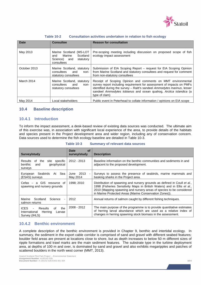
Table 10-2 Consultation activities undertaken in relation to fish ecology Date Consultee Reason for consultation
May 2013 Marine Scotland (MS-LOT and Marine Scotland Science) and statutory consultees
Pre-scoping meeting including discussion on proposed scope of fish ecology impact assessment
October 2013 Marine Scotland, statutory consultees and non- statutory consultees
Submission of EIA Scoping Report – request for EIA Scoping Opinion from Marine Scotland and statutory consultees and request for comment from non-statutory consultees
March 2014 Marine Scotland, statutory consultees and non- statutory consultees
Receipt of Scoping Opinion and comments on MMT environmental survey report including requirement for assessment of impacts on PMFs identified during the survey – Raitt’s sandeel Ammodytes marinus, lesser sandeel Ammodytes tobianus and ocean quahog, Arctica islandica (a type of clam)
May 2014 Local stakeholders Public event in Peterhead to collate information / opinions on EIA scope
10.4 Baseline description
10.4.1 Introduction To inform the impact assessment, a desk-based review of existing data sources was conducted. The ultimate aim of this exercise was, in association with significant local experience of the area, to provide details of the habitats and species present in the Project development area and wider region, including any of conservation concern. Data sources used to determine the fish ecology baseline are detailed in Table 10-3.
Table 10-3 Summary of relevant data sources
Survey/study Date of survey/study Description
Results of the site specific benthic and geophysical surveys
2012 - 2013 Baseline information on the benthic communities and sediments in and adjacent to the proposed development.
European Seabirds At Sea (ESAS) surveys
June 2013 -May 2014
Surveys to assess the presence of seabirds, marine mammals and basking sharks in the Project area.
Cefas – a GIS resource of spawning and nursery grounds
1998; 2010 Distribution of spawning and nursery grounds as defined in Coull et al., 1998 (Fisheries Sensitivity Maps in British Waters) and in Ellis et al., 2010 (Mapping spawning and nursery areas of species to be considered in Marine Protected Areas (Marine Conservation Zones)).
Marine Scotland Science - salmon returns
2012 Annual returns of salmon caught by different fishing techniques.
ICES - Results of the International Herring Larvae Survey (IHLS)
2008 - 2012 The main purpose of the programme is to provide quantitative estimates of herring larval abundance which are used as a relative index of changes in herring spawning stock biomass in the assessment.
10.4.2 Benthic environment A complete description of the benthic environment is provided in Chapter 9, benthic and intertidal ecology. In summary, the sediment in the export cable corridor is comprised of sand and gravel with different seabed features; boulder field areas are present at locations close to shore, but as depth increases to below 50 m different sizes of ripple formations and trawl marks are the main sediment features. The substrate type in the turbine deployment area, at depths of 100 m and over, is dominated by sand and gravel and also exhibits megaripples and patches of scattered boulders in the north west corner (MMT, 2013). Hywind Scotland Pilot Park Project – Environmental Statement Assignment Number: A100142-S35 Document Number: A-100142-S35-EIAS-001-004 10-4
10.4.3 Pelagic fish species Pelagic fish inhabit the water column including the near surface. Their distribution and abundance is strongly affected by hydrographic conditions and can vary significantly from year to year. The principal pelagic species found in the region are typical of the wider North Sea and include herring C. harengus, sprat Sprattus sprattus and mackerel Scomber scombrus.
Mackerel and herring are commercially exploited in the Project area (see Chapter 14: commercial fisheries for details) and sprat and herring play an important ecological role as principal prey items for several larger fish species, marine birds and mammals.
Table 10-4 details the key pelagic species, their conservation status and seasonality of spawning activity.
Pelagic spawning and nursery areas
Data from Coull et al., (1998) and Ellis et al., (2012) indicate that herring spawn off the northeast coast of Scotland (Figure 10-1). Herring spawning areas coincide with both the turbine deployment area and the export cable corridor. The Project area does not coincide with spawning areas for mackerel and sprat.
Data from Coull et al., (1998) and Ellis et al., (2012) further indicate that herring, sprat and mackerel nursery areas are found in the Project area as shown in Figure 10-1. Coull et al., (1998) found sprat to be ubiquitous across the region during nursery periods; however, data for specific nursery periods are not readily available as “nursery grounds for most fish species are dynamic features of life history” (Cefas, 2001).
The International Herring Larvae Survey (IHLS) show that there is herring larvae in the vicinity of the turbine deployment area and export cable corridor. The highest concentrations are to the south of the cable corridor and concentrations are lowest in the offshore area beyond the AfL area as shown in Figure 10-1.
A brief summary of herring biology with regard to the North Sea population is presented below. Additional information on the commercial importance of each species can be found in Chapter 14: commercial fisheries.
Herring
Herring play an important ecological role as principal prey items for several larger fish species, marine birds and mammals, and occur throughout Scottish waters including the North Sea. Herring are particularly sensitive because they spawn in well defined areas. Based on the spawning area and the timing of spawning herring have been divided into sub-populations. Those that spawn off the east of Scotland are known as the Orkney/Shetland and Buchan components. In the context of the current study, the Buchan component, off Peterhead, spawns in September/October.
Herring are reported to deposit their sticky demersal eggs on a variety of substrates ranging from boulders, rock, small stones, coarse sand, shell fragments, macrophytes and man-made structures such as lobster pots but gravel is widely considered to be the preferred spawning substrate (Drapeau, 1973; Rogers & Stock, 2001). The survival and development of herring eggs have been reported to be insensitive to even high concentrations of suspended sediment, but studies have concluded that smothering is likely to be detrimental unless the material is removed rapidly by the current (Birklund and Wijsam, 2005). After hatching the larvae are pelagic and drift with the currents and the juvenile nursery grounds tend to be close inshore, and results from the IHLS presented in Figure 10-1 corroborates this. After about a year they migrate further offshore to the adult feeding grounds before returning to spawn in their well-defined areas.
Hywind Scotland Pilot Park Project – Environmental Statement Assignment Number: A100142-S35 Document Number: A-100142-S35-EIAS-001-004 10-5
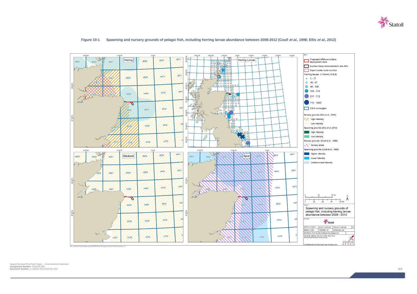
Figure 10-1 Spawning and nursery grounds of pelagic fish, including herring larvae abundance between 2008-2012 (Coull et al., 1998; Ellis et al., 2012)
Hywind Scotland Pilot Park Project – Environmental Statement Assignment Number: A100142-S35 Document Number: A-100142-S35-EIAS-001-004 10-6
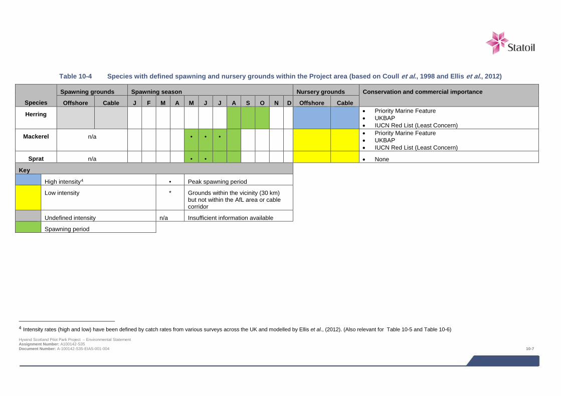
Table 10-4 Species with defined spawning and nursery grounds within the Project area (based on Coull et al., 1998 and Ellis et al., 2012)
Species
Spawning grounds Spawning season Nursery grounds Conservation and commercial importance
Offshore Cable J F M A M J J A S O N D Offshore Cable
Herring • Priority Marine Feature • UKBAP • IUCN Red List (Least Concern)
Mackerel n/a • • • • Priority Marine Feature • UKBAP • IUCN Red List (Least Concern)
Sprat n/a • • • None
Key
High intensity4 • Peak spawning period
Low intensity * Grounds within the vicinity (30 km) but not within the AfL area or cable corridor
Undefined intensity n/a Insufficient information available
Spawning period
4 Intensity rates (high and low) have been defined by catch rates from various surveys across the UK and modelled by Ellis et al., (2012). (Also relevant for Table 10-5 and Table 10-6) Hywind Scotland Pilot Park Project – Environmental Statement Assignment Number: A100142-S35 Document Number: A-100142-S35-EIAS-001-004 10-7
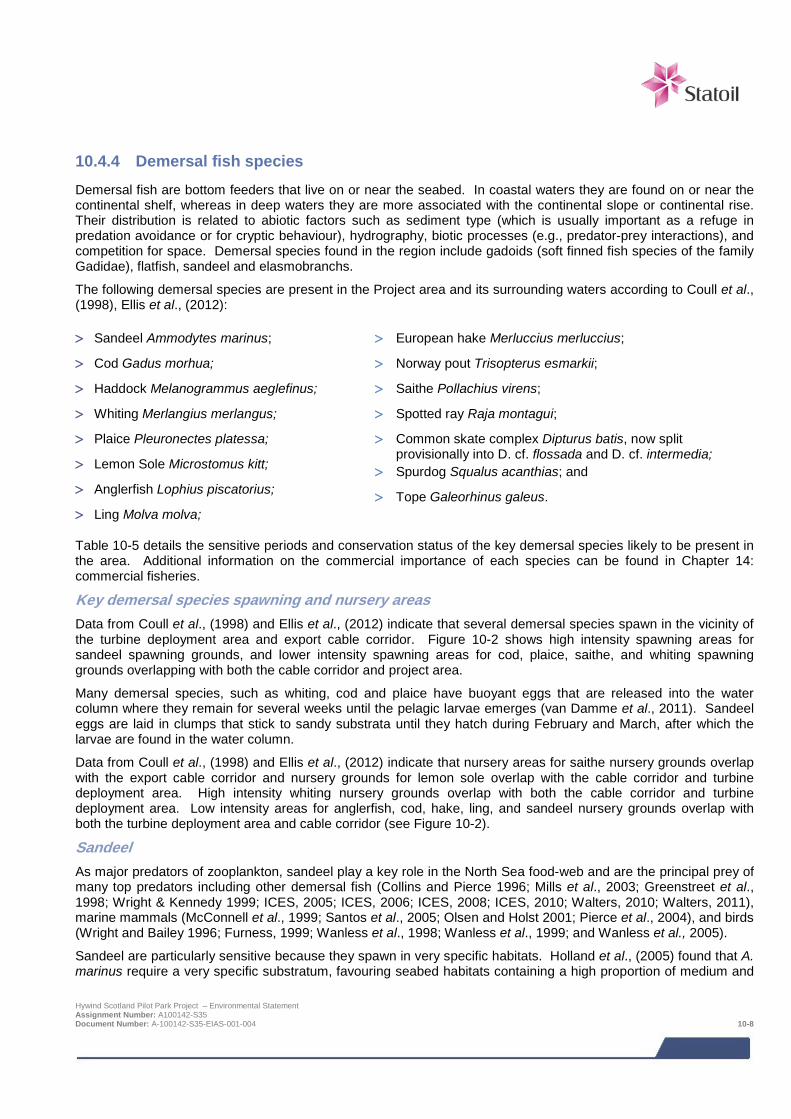
10.4.4 Demersal fish species Demersal fish are bottom feeders that live on or near the seabed. In coastal waters they are found on or near the continental shelf, whereas in deep waters they are more associated with the continental slope or continental rise. Their distribution is related to abiotic factors such as sediment type (which is usually important as a refuge in predation avoidance or for cryptic behaviour), hydrography, biotic processes (e.g., predator-prey interactions), and competition for space. Demersal species found in the region include gadoids (soft finned fish species of the family Gadidae), flatfish, sandeel and elasmobranchs.
The following demersal species are present in the Project area and its surrounding waters according to Coull et al., (1998), Ellis et al., (2012):
> Sandeel Ammodytes marinus;
> Cod Gadus morhua;
> Haddock Melanogrammus aeglefinus;
> Whiting Merlangius merlangus;
> Plaice Pleuronectes platessa;
> Lemon Sole Microstomus kitt;
> Anglerfish Lophius piscatorius;
> Ling Molva molva;
> European hake Merluccius merluccius;
> Norway pout Trisopterus esmarkii;
> Saithe Pollachius virens;
> Spotted ray Raja montagui;
> Common skate complex Dipturus batis, now split provisionally into D. cf. flossada and D. cf. intermedia;
> Spurdog Squalus acanthias; and
> Tope Galeorhinus galeus.
Table 10-5 details the sensitive periods and conservation status of the key demersal species likely to be present in the area. Additional information on the commercial importance of each species can be found in Chapter 14: commercial fisheries.
Key demersal species spawning and nursery areas Data from Coull et al., (1998) and Ellis et al., (2012) indicate that several demersal species spawn in the vicinity of the turbine deployment area and export cable corridor. Figure 10-2 shows high intensity spawning areas for sandeel spawning grounds, and lower intensity spawning areas for cod, plaice, saithe, and whiting spawning grounds overlapping with both the cable corridor and project area.
Many demersal species, such as whiting, cod and plaice have buoyant eggs that are released into the water column where they remain for several weeks until the pelagic larvae emerges (van Damme et al., 2011). Sandeel eggs are laid in clumps that stick to sandy substrata until they hatch during February and March, after which the larvae are found in the water column.
Data from Coull et al., (1998) and Ellis et al., (2012) indicate that nursery areas for saithe nursery grounds overlap with the export cable corridor and nursery grounds for lemon sole overlap with the cable corridor and turbine deployment area. High intensity whiting nursery grounds overlap with both the cable corridor and turbine deployment area. Low intensity areas for anglerfish, cod, hake, ling, and sandeel nursery grounds overlap with both the turbine deployment area and cable corridor (see Figure 10-2).
Sandeel As major predators of zooplankton, sandeel play a key role in the North Sea food-web and are the principal prey of many top predators including other demersal fish (Collins and Pierce 1996; Mills et al., 2003; Greenstreet et al., 1998; Wright & Kennedy 1999; ICES, 2005; ICES, 2006; ICES, 2008; ICES, 2010; Walters, 2010; Walters, 2011), marine mammals (McConnell et al., 1999; Santos et al., 2005; Olsen and Holst 2001; Pierce et al., 2004), and birds (Wright and Bailey 1996; Furness, 1999; Wanless et al., 1998; Wanless et al., 1999; and Wanless et al., 2005).
Sandeel are particularly sensitive because they spawn in very specific habitats. Holland et al., (2005) found that A. marinus require a very specific substratum, favouring seabed habitats containing a high proportion of medium and
Hywind Scotland Pilot Park Project – Environmental Statement Assignment Number: A100142-S35 Document Number: A-100142-S35-EIAS-001-004 10-8

coarse sand (particle size ≥ 0.25 to < 2 mm) and low silt content (Holland et al., 2005). Overall, sandeels are considered to be rare in sediments where the silt content (particle size < 0.63 μm) is greater than 4%, and absent where the silt content is greater than 10% (Holland et al., 2005).
The Turbot Bank Marine Protected Area (MPA) which is located approximately 18 km to the east of the turbine deployment area is designated for the protection of sandeels. The Project will not impact this protected area.
The highly specific habitat requirements of sandeel also mean that the distribution of post-settled sandeel is very patchy (Jensen et al., 2011; Wright and Kennedy, 1999). Sandeel are most active in late spring/early summer, during which time they move freely, on a diurnal basis, between the seabed and the water column. During autumn and winter, sandeel lie dormant in the sediment except for a brief midwinter emergence to spawn (Greenstreet et al., 2010). Post settled sandeel are very rarely found at depths greater than 15 m from known habitats and the maximum distance travelled by tagged fish displaced from grounds was 64 km (Jensen et al., 2011).
Results of a desk based predictive habitat map (presented in Chapter 9: benthic and intertidal ecology indicate discrete patches of relatively high sand content within the turbine deployment area and cable corridor. Based on the nature of the sediments present in the Project area is therefore likely to support sandeels.
Increases in suspended solid concentrations may affect movement and shoaling behaviour causing avoidance of the area by certain species (for example cod and plaice). Increase in sediment load may also affect fish species with pelagic eggs, causing them to sink before hatching, potentially having an influence on survivability (Birklund and Wijsman, 2005).
Hywind Scotland Pilot Park Project – Environmental Statement Assignment Number: A100142-S35 Document Number: A-100142-S35-EIAS-001-004 10-9
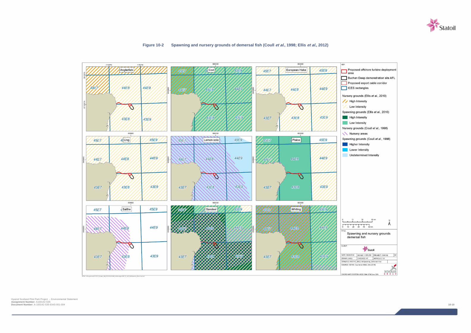
Figure 10-2 Spawning and nursery grounds of demersal fish (Coull et al., 1998; Ellis et al., 2012)
Hywind Scotland Pilot Park Project – Environmental Statement Assignment Number: A100142-S35 Document Number: A-100142-S35-EIAS-001-004 10-10

Table 10-5 Species with defined spawning and nursery grounds within the Project area (based on Coull et al., 1998 and Ellis et al., 2012)
Species Spawning grounds Spawning season Nursery grounds Conservation and commercial importance
Offshore Cable J F M A M J J A S O N D Offshore Cable
Sandeels
• Priority Marine Feature • UKBAP
Cod • •
• Priority Marine Feature • UKBAP • OSPAR Species (stock depleted and in danger of collapse) • IUCN Red List (Vulnerable) (IUCN recognise that this status needs to be
updated)
Haddock n/a n/a
• IUCN Red List (Vulnerable) (IUCN recognise that this status needs to be updated)
Whiting
• Priority Marine Feature • UKBAP
Plaice • •
n/a n/a • UKBAP • IUCN Red List (Least Concern)
Lemon sole n/a n/a
• None
Anglerfish n/a n/a
• Priority Marine Feature • UKBAP
Ling n/a n/a
• Priority Marine Feature • UKBAP
European hake n/a n/a • •
• UKBAP
Saithe n/a n/a • •
n/a • Priority Marine Feature
Key
High intensity • Peak spawning period
Low intensity * Grounds within the vicinity (30 km) but not within the AfL area or cable corridor
Undefined intensity n/a Insufficient information available
Spawning period Hywind Scotland Pilot Park Project – Environmental Statement Assignment Number: A100142-S35 Document Number: A-100142-S35-EIAS-001-004 10-11

10.4.5 Elasmobranch species Sharks and rays are particularly sensitive because they have slow growth rates and low reproductive output compared to other species groups (Camhi et al., 1998). This results in slow rates of stock increase and low resilience to fishing mortality (Holden, 1974). Directed fisheries have caused stock collapse for many species (Musick and Musick, 2005), although at present, mortality in mixed-species and by-catch fisheries appears to be a more significant threat (Bonfil 1994). As a result the stocks of most elasmobranch species are currently at low levels and spatial management measures have been introduced to protect the remaining stocks (ICES 2008).
Table 10-6 details the sensitive periods and conservation status of the key elasmobranch species likely to be present in the area.
Key elasmobranch species breeding patterns No basking sharks were observed during the Hywind ESAS survey (NRP, 2015), and there appears to be no known recent records in the area (Witt et al., 2012).
Data from Ellis et al., (2012) indicate that no elasmobranch species spawn in the vicinity of the project area and export cable corridor (Figure 10-3). There are, however, low intensity nursery areas for spurdog, tope, common skate complex, and spotted ray nursery grounds overlap with both the turbine deployment area and the export cable corridor (Figure 10-3). No further data were found for these species occurring within the Project area during the literature review, however the preferred habitats of common skate complex and spotted ray may be indicate their presence.
The common skate complex occupies sandy and muddy bottom habitats similar to those found in the turbine deployment area and cable corridor. Younger specimens may be more prevalent in the Project area as they prefer shallower water compared with adults (Neal et al., 2008).
The spotted ray inhabits inshore and shallow shelf seas, in depths of 8 to 283 m, though it is most abundant in waters less than 100 m. Juveniles tend to occur closer inshore on sandy sediments, whereas adults are more common offshore on sand and coarse sand-gravel substrates. These substrates are typical of the turbine deployment area and cable corridor (MMT, 2013). Juveniles feed on small crustaceans, with adults feeding on larger crustaceans and fish (Ellis et al., 2008).
Hywind Scotland Pilot Park Project – Environmental Statement Assignment Number: A100142-S35 Document Number: A-100142-S35-EIAS-001-004 10-12
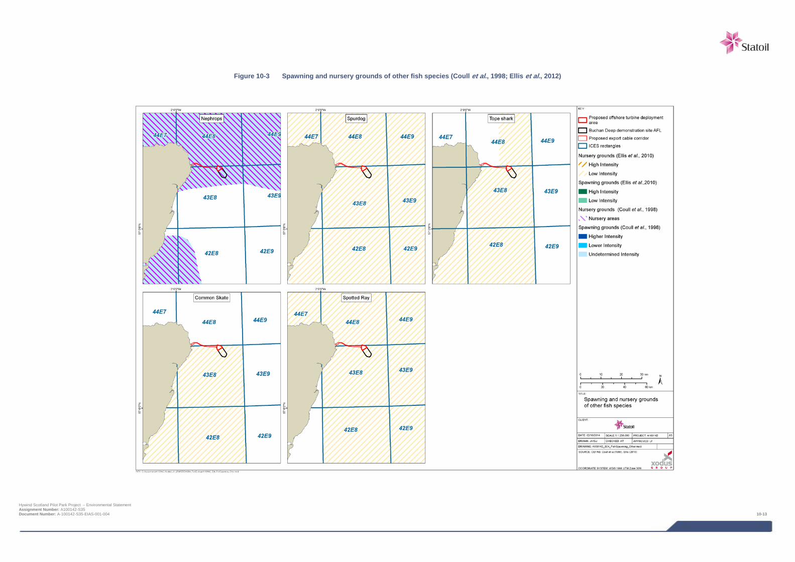
Figure 10-3 Spawning and nursery grounds of other fish species (Coull et al., 1998; Ellis et al., 2012)
Hywind Scotland Pilot Park Project – Environmental Statement Assignment Number: A100142-S35 Document Number: A-100142-S35-EIAS-001-004 10-13

Table 10-6 Species with defined spawning and nursery grounds within the Project area (based on Coull et al., 1998 and Ellis et al., 2012)
Species Spawning grounds Spawning season Nursery grounds Conservation and commercial importance
Offshore Cable J F M A M J J A S O N D Offshore Cable
Spurdog n/a • Scottish Nature Conservation MPA search feature (marine life stages) • OSPAR species (stock depleted and in danger of collapse) • IUCN Red List (vulnerable) • Priority Marine Feature • UKBAP
Tope n/a • UKBAP • IUCN Red List (vulnerable)
Common skate
complex
n/a • Scottish Nature Conservation MPA search feature (marine life stages) • OSPAR species (stock depleted and in danger of collapse) • Priority Marine Feature • UKBAP
Spotted ray n/a • OSPAR • IUCN Red List (Least concern)
Key
High intensity • Peak spawning period
Low intensity * Grounds within the vicinity (30 km) but not within the AfL area or cable corridor
Undefined intensity n/a Insufficient information available
Spawning period
Hywind Scotland Pilot Park Project – Environmental Statement Assignment Number: A100142-S35 Document Number: A-100142-S35-EIAS-001-004 10-14
10.4.6 Diadromous migratory species The following diadromous species are expected to transit the Project area on an occasional basis:
> Atlantic salmon Salmo salar;
> Sea trout Salmo trutta;
> European eel Anguilla anguilla;
> River lamprey Lampetra fluviatilis; and
> Sea lamprey Petromyzon marinus.
Table 10-7 details the sensitive periods and conservation status of the key diadromous species likely to be present in the area.
Several species of fish living in Scottish rivers migrate between the sea and the upper reaches of rivers during their life cycle. Atlantic salmon, sea trout and lampreys are anadromous, meaning they spend the majority of their adult lives in the oceans but return to freshwater to reproduce. European eel are also migratory diadromous fish, but their lifestyle differs from anadromous fish; adult eels migrate out to sea to spawn and their larvae make the return journey (termed catadromous).
Although no diadromous species have nursery or breeding areas directly within the turbine deployment area or cable corridor, some may regularly cross the area as part of their migration and/or transit adjacent areas as part of their foraging activity. Salmon are present in the River Ugie which is directly to the north of the cable landfall area. The closest Special Areas of Conservation (SACs) with a qualifying interest in diadromous species whose dominant migratory routes have potential to pass through the Project area are the River Dee (40 km) and South Esk (80 km) (Figure 10-4).
Smolts are believed to move offshore in schools to deep-sea feeding areas. Adult and sub-adult salmon from Scottish rivers pass through or make use of areas around west Greenland and the Faroe Islands (Malcolm et al., 2010). Not only will salmon associated with the River Ugie be present, but the long range movements of salmon smolts leaving other rivers and adult salmon returning to other rivers, means they could pass through the Project area. The routes by which they depart and return to rivers on the north east coast of Scotland are in a northerly direction (Malcolm et al., 2010).
Hywind Scotland Pilot Park Project – Environmental Statement Assignment Number: A100142-S35 Document Number: A-100142-S35-EIAS-001-004 10-15
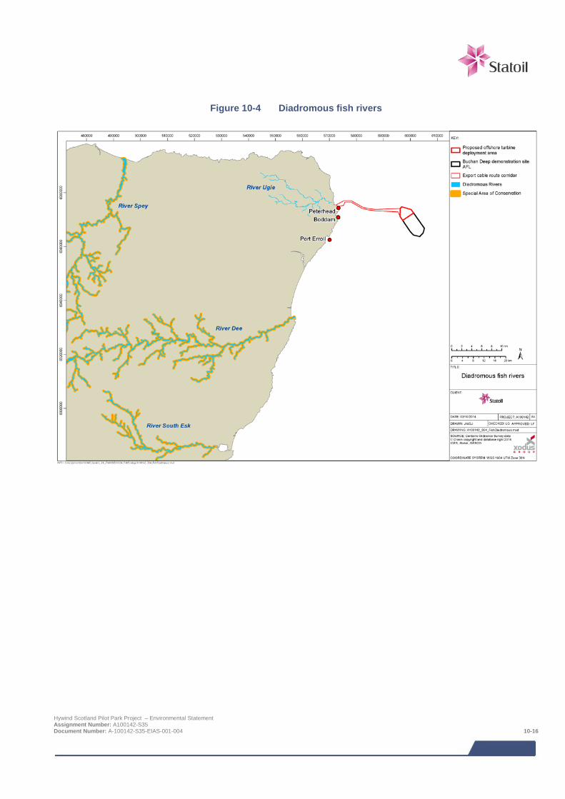
Figure 10-4 Diadromous fish rivers
Hywind Scotland Pilot Park Project – Environmental Statement Assignment Number: A100142-S35 Document Number: A-100142-S35-EIAS-001-004 10-16
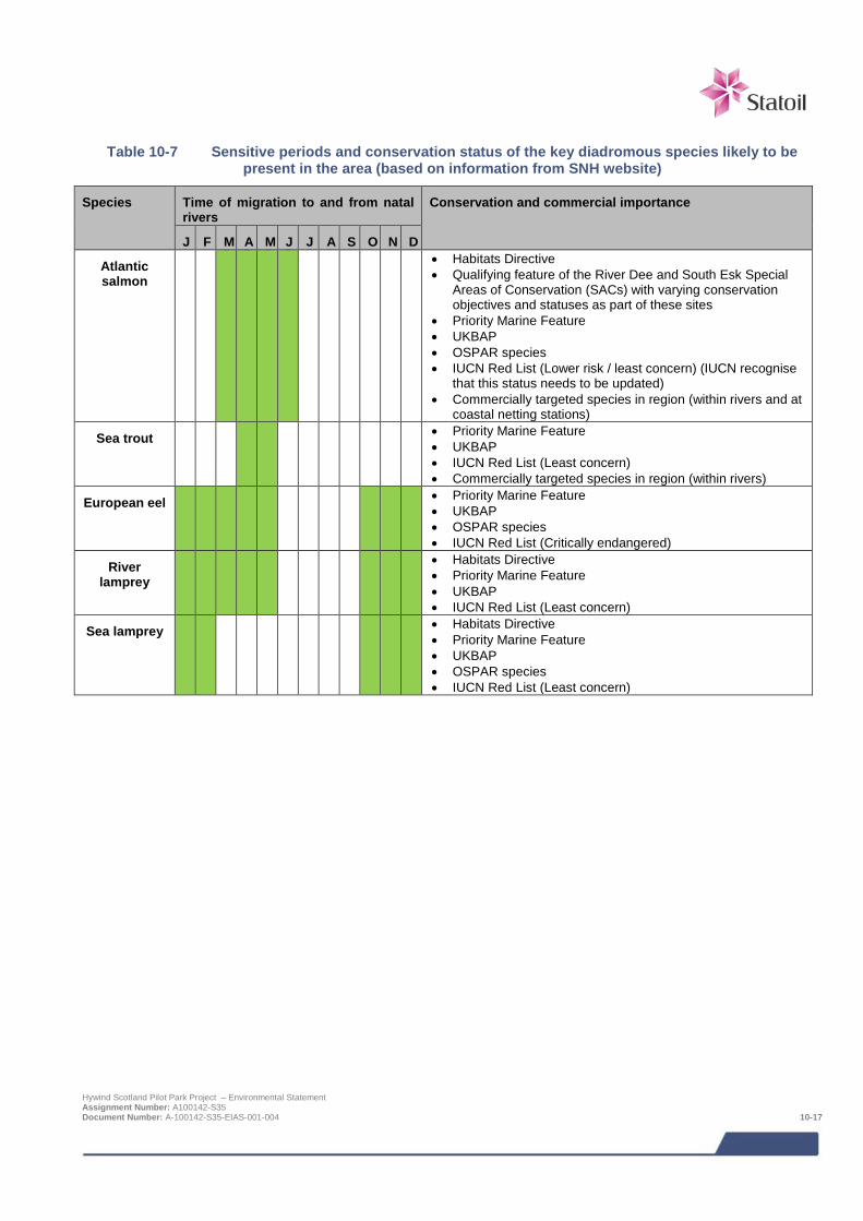
Table 10-7 Sensitive periods and conservation status of the key diadromous species likely to be
present in the area (based on information from SNH website)
Species Time of migration to and from natal rivers
Conservation and commercial importance
J F M A M J J A S O N D
Atlantic salmon
• Habitats Directive • Qualifying feature of the River Dee and South Esk Special
Areas of Conservation (SACs) with varying conservation objectives and statuses as part of these sites
• Priority Marine Feature • UKBAP • OSPAR species • IUCN Red List (Lower risk / least concern) (IUCN recognise
that this status needs to be updated) • Commercially targeted species in region (within rivers and at
coastal netting stations)
Sea trout • Priority Marine Feature • UKBAP • IUCN Red List (Least concern) • Commercially targeted species in region (within rivers)
European eel • Priority Marine Feature • UKBAP • OSPAR species • IUCN Red List (Critically endangered)
River lamprey
• Habitats Directive • Priority Marine Feature • UKBAP • IUCN Red List (Least concern)
Sea lamprey • Habitats Directive • Priority Marine Feature • UKBAP • OSPAR species • IUCN Red List (Least concern)
Hywind Scotland Pilot Park Project – Environmental Statement Assignment Number: A100142-S35 Document Number: A-100142-S35-EIAS-001-004 10-17
10.4.7 Shellfish species According to commercial landings, the following shellfish species are present in the Project area:
> Veined squid Loligo forbesi;
> Brown crab Pagurus cancer;
> Velvet crab Necora puber;
> Scallop Pecten maximus;
> Norway lobster Nephrops norvegicus; and
> European lobster Homarus gammarus.
Table 10-8 details the sensitive periods, preferred habitats and prey species of the key shellfish species listed above.
The northeast Scotland region hosts important inshore populations of European lobster, brown crab, large offshore populations of Norway lobster Nephrops norvegicus (commonly referred to as Nephrops), squid Loligo forbesi and king scallops. Shellfish are locally important for commercial fishing in the Project area (Chapter 14 commercial fisheries) but also have an important ecological role as principal prey items for several larger fish species, marine birds and mammals.
10.4.8 Data gaps and uncertainties The spawning and nursery grounds described above are primarily based on the information presented in Ellis et al., (2012) and Coull et al., (1998). The limitations of these sources of information should, however, be recognised. These publications provide an indication of the general location of spawning and nursery grounds. They do not define precise boundaries of spawning and nursery grounds, particularly in the context of the relatively small footprint of the Project area. Similarly, the spawning seasons given in these publications represent the maximum duration of spawning on a species/stock basis. In some cases, the duration of spawning may be much more contracted, than reported in Ellis et al., (2012) and Coull et al., (1998). Where available, therefore, additional research publications have also been reviewed to provide site specific information. Overall it is considered the data available provides a robust baseline against which impacts can be assessed.
In addition, it is recognised that there are gaps in the understanding of the distribution of migratory species including several species of known conservation importance (e.g. lampreys and salmonids). For migratory species the exact routes they will take on their movements to and from feeding and spawning grounds are not always known. The lack of these data however has not compromised the impact assessment.
Hywind Scotland Pilot Park Project – Environmental Statement Assignment Number: A100142-S35 Document Number: A-100142-S35-EIAS-001-004 10-18
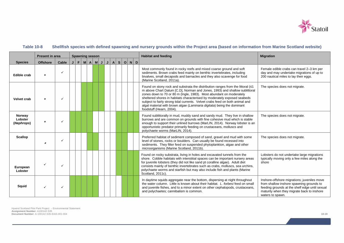
Table 10-8 Shellfish species with defined spawning and nursery grounds within the Project area (based on information from Marine Scotland website)
Species
Present in area Spawning season Habitat and feeding Migration
Offshore Cable J F M A M J J A S O N D
Edible crab
Most commonly found in rocky reefs and mixed coarse ground and soft sediments. Brown crabs feed mainly on benthic invertebrates, including bivalves, small decapods and barnacles and they also scavenge for food (Marine Scotland, 2011a).
Female edible crabs can travel 2–3 km per day and may undertake migrations of up to 200 nautical miles to lay their eggs.
Velvet crab
Found on stony rock and substrata the distribution ranges from the littoral (≤1 m above Chart Datum [C.D], Norman and Jones, 1993) and shallow sublittoral zones down to 70 or 80 m (Ingle, 1983). Most abundant on moderately sheltered shores in habitats characterised by moderately exposed seabeds subject to fairly strong tidal currents. Velvet crabs feed on both animal and algal material with brown algae (Laminaria digitata) being the dominant foodstuff (Hearn, 2004).
The species does not migrate.
Norway Lobster
(Nephrops)
Found sublittorally in mud, muddy sand and sandy mud. They live in shallow burrows and are common on grounds with fine cohesive mud which is stable enough to support their unlined burrows (MarLIN, 2014). Norway lobster is an opportunistic predator primarily feeding on crustaceans, molluscs and polychaete worms (MarLIN, 2014).
The species does not migrate.
Scallop
Preferred habitat of sediment composed of sand, gravel and mud with some level of stones, rocks or boulders. Can usually be found recessed into sediments. They filter feed on suspended phytoplankton, algae and other microorganisms (Marine Scotland, 2011b).
The species does not migrate.
European Lobster
Found on rocky substrata, living in holes and excavated tunnels from the shore. Cobble habitats with interstitial spaces can be important nursery areas for juvenile lobsters (they did not like sand pt coralline algae). Adult diet consists mainly of benthic invertebrates such as crabs, molluscs, sea urchins, polychaete worms and starfish but may also include fish and plants (Marine Scotland, 2011c).
Lobsters do not undertake large migrations typically moving only a few miles along the shore
Squid
In daytime squids aggregate near the bottom, dispersing at night throughout the water column. Little is known about their habitat. L. forbesi feed on small and juvenile fishes, and to a minor extent on other cephalopods, crustaceans, and polychaetes; cannibalism is common.
Inshore-offshore migrations; juveniles move from shallow inshore spawning grounds to feeding grounds at the shelf edge until sexual maturity when they migrate back to inshore waters to spawn.
Hywind Scotland Pilot Park Project – Environmental Statement Assignment Number: A100142-S35 Document Number: A-100142-S35-EIAS-001-004 10-19
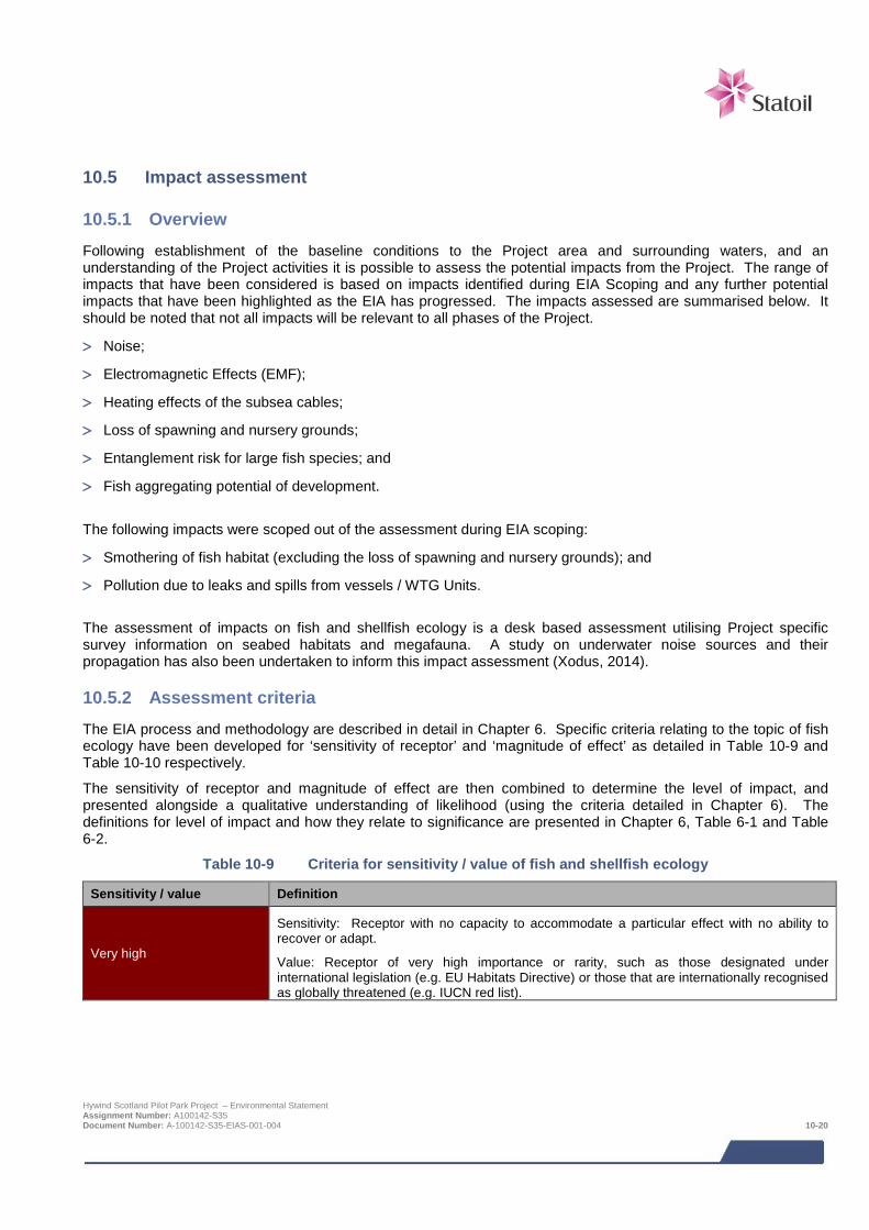
10.5 Impact assessment
10.5.1 Overview Following establishment of the baseline conditions to the Project area and surrounding waters, and an understanding of the Project activities it is possible to assess the potential impacts from the Project. The range of impacts that have been considered is based on impacts identified during EIA Scoping and any further potential impacts that have been highlighted as the EIA has progressed. The impacts assessed are summarised below. It should be noted that not all impacts will be relevant to all phases of the Project.
> Noise;
> Electromagnetic Effects (EMF);
> Heating effects of the subsea cables;
> Loss of spawning and nursery grounds;
> Entanglement risk for large fish species; and
> Fish aggregating potential of development.
The following impacts were scoped out of the assessment during EIA scoping:
> Smothering of fish habitat (excluding the loss of spawning and nursery grounds); and
> Pollution due to leaks and spills from vessels / WTG Units.
The assessment of impacts on fish and shellfish ecology is a desk based assessment utilising Project specific survey information on seabed habitats and megafauna. A study on underwater noise sources and their propagation has also been undertaken to inform this impact assessment (Xodus, 2014).
10.5.2 Assessment criteria The EIA process and methodology are described in detail in Chapter 6. Specific criteria relating to the topic of fish ecology have been developed for ‘sensitivity of receptor’ and ‘magnitude of effect’ as detailed in Table 10-9 and Table 10-10 respectively.
The sensitivity of receptor and magnitude of effect are then combined to determine the level of impact, and presented alongside a qualitative understanding of likelihood (using the criteria detailed in Chapter 6). The definitions for level of impact and how they relate to significance are presented in Chapter 6, Table 6-1 and Table 6-2.
Table 10-9 Criteria for sensitivity / value of fish and shellfish ecology
Sensitivity / value Definition
Very high
Sensitivity: Receptor with no capacity to accommodate a particular effect with no ability to recover or adapt.
Value: Receptor of very high importance or rarity, such as those designated under international legislation (e.g. EU Habitats Directive) or those that are internationally recognised as globally threatened (e.g. IUCN red list).
Hywind Scotland Pilot Park Project – Environmental Statement Assignment Number: A100142-S35 Document Number: A-100142-S35-EIAS-001-004 10-20
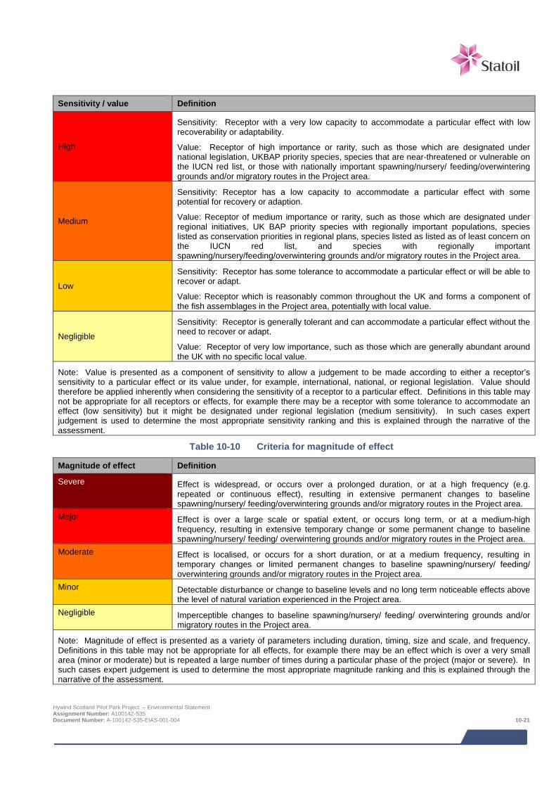
Sensitivity / value Definition
High
Sensitivity: Receptor with a very low capacity to accommodate a particular effect with low recoverability or adaptability.
Value: Receptor of high importance or rarity, such as those which are designated under national legislation, UKBAP priority species, species that are near-threatened or vulnerable on the IUCN red list, or those with nationally important spawning/nursery/ feeding/overwintering grounds and/or migratory routes in the Project area.
Medium
Sensitivity: Receptor has a low capacity to accommodate a particular effect with some potential for recovery or adaption.
Value: Receptor of medium importance or rarity, such as those which are designated under regional initiatives, UK BAP priority species with regionally important populations, species listed as conservation priorities in regional plans, species listed as listed as of least concern on the IUCN red list, and species with regionally important spawning/nursery/feeding/overwintering grounds and/or migratory routes in the Project area.
Low
Sensitivity: Receptor has some tolerance to accommodate a particular effect or will be able to recover or adapt.
Value: Receptor which is reasonably common throughout the UK and forms a component of the fish assemblages in the Project area, potentially with local value.
Negligible
Sensitivity: Receptor is generally tolerant and can accommodate a particular effect without the need to recover or adapt.
Value: Receptor of very low importance, such as those which are generally abundant around the UK with no specific local value.
Note: Value is presented as a component of sensitivity to allow a judgement to be made according to either a receptor’s sensitivity to a particular effect or its value under, for example, international, national, or regional legislation. Value should therefore be applied inherently when considering the sensitivity of a receptor to a particular effect. Definitions in this table may not be appropriate for all receptors or effects, for example there may be a receptor with some tolerance to accommodate an effect (low sensitivity) but it might be designated under regional legislation (medium sensitivity). In such cases expert judgement is used to determine the most appropriate sensitivity ranking and this is explained through the narrative of the assessment.
Table 10-10 Criteria for magnitude of effect
Magnitude of effect Definition
Severe Effect is widespread, or occurs over a prolonged duration, or at a high frequency (e.g. repeated or continuous effect), resulting in extensive permanent changes to baseline spawning/nursery/ feeding/overwintering grounds and/or migratory routes in the Project area.
Major Effect is over a large scale or spatial extent, or occurs long term, or at a medium-high frequency, resulting in extensive temporary change or some permanent change to baseline spawning/nursery/ feeding/ overwintering grounds and/or migratory routes in the Project area.
Moderate Effect is localised, or occurs for a short duration, or at a medium frequency, resulting in temporary changes or limited permanent changes to baseline spawning/nursery/ feeding/ overwintering grounds and/or migratory routes in the Project area.
Minor Detectable disturbance or change to baseline levels and no long term noticeable effects above the level of natural variation experienced in the Project area.
Negligible Imperceptible changes to baseline spawning/nursery/ feeding/ overwintering grounds and/or migratory routes in the Project area.
Note: Magnitude of effect is presented as a variety of parameters including duration, timing, size and scale, and frequency. Definitions in this table may not be appropriate for all effects, for example there may be an effect which is over a very small area (minor or moderate) but is repeated a large number of times during a particular phase of the project (major or severe). In such cases expert judgement is used to determine the most appropriate magnitude ranking and this is explained through the narrative of the assessment.
Hywind Scotland Pilot Park Project – Environmental Statement Assignment Number: A100142-S35 Document Number: A-100142-S35-EIAS-001-004 10-21
10.5.3 Design Envelope This assessment considers the Project parameters which are predicted to result in the greatest environmental impact. This approach ensures that impacts of a greater adverse significance would not arise should any other development scenario be taken forward in the final scheme design. With regards to the assessment of impacts on fish and shellfish ecology the assessment comprises:
> WTG Unit anchoring systems which will include anchor chains present on the seabed (150 - 850 m of mooring line per anchor and a maximum of 15 anchors for the whole Pilot Park);
> Scour protection around the anchors is unlikely to be required, but if it is, could be required over an area of up to 15 m beyond the edge of anchors;
> Inter array cables of which it is assumed there could be up to 15 km and up to 7.5 km could be rock dumped for cable stabilisation purposes;
> An export cable of up to 35 km in length and requiring rock protection along approximately 2 km of its length. The rock protection would occupy a 6 m wide corridor;
> Four cable crossings, each requiring 360 m2 of rock protection; and
> Cable landfall installation as a surface laid cable across the foreshore requiring a working corridor of 6 m wide (although it should be noted that the base case solution for the cable landfall is HDD).
The impacts from potential alternative development options are addressed in Section 8.
10.5.4 Data gaps and uncertainties For many of the impacts that are discussed in Section 10.6 and Section 10.7, there has been some research into the potential for these impacts to occur and the severity of these impacts. In some instances (e.g. Electromagnetic Fields (EMF)) the evidence is inconclusive however the assessment of potential impacts has made best use of the available research to indicate the potential significance of impacts from the Project.
10.6 Impacts during construction and installation Effects arising from the wind farm construction and installation have the potential to impact directly on fish and shellfish species and their related habitats. This is particularly so if a species has specific requirements or if the habitat is vital for population survival (e.g., feeding, spawning and nursery grounds and migration routes).
10.6.1 Noise The potential impact of underwater noise and vibration on fish and shellfish populations within the proposed Project area is associated with vessels involved in the installation of the export cable (trenching and protection). Many marine animals use sound during their everyday lives to track prey, avoid predators, navigate, and communicate with one another (e.g., Hawkins and Myrberg, 1983). Even species that do not communicate by sound use the acoustic scene (or soundscape) to learn about and exploit their environment (Fay and Popper, 2000). Thus, anything in the environment that interferes with the ability of a fish to detect and use sounds of biological relevance could have an impact on fitness and survival. Bringing the cable ashore with horizontal directional drilling (HDD) will not be of significance as all noise generating equipment is onshore and the expected breakthrough to the seabed from underground is expected to be negligible. Vessels associated with the installation of the export cable and wind turbines will introduce noise into the marine environment. The main sound source that has been traditionally associated with offshore wind farm installation is hammer (percussive) piling, an activity which will not be required during the installation of this Project. This assessment therefore focus on the assessment of impacts from vessel noise.
Hywind Scotland Pilot Park Project – Environmental Statement Assignment Number: A100142-S35 Document Number: A-100142-S35-EIAS-001-004 10-22

Hawkins and Popper (2014) divided fishes into several different categories of hearing groups based on the structures associated with hearing and then developed generalized guidelines that do not depend on the audiograms of individual species. The functional groups include:
> Fishes without a swim bladder (these can only detect kinetic energy – e.g., sharks, gobies, flounder, some tuna including Atlantic mackerel);
> Fishes with a swim bladder that is far from the ear and thus not likely to contribute to pressure reception, so the fishes are primarily kinetic detectors (e.g., salmon, cichlids); and
> Fishes where the swim bladder or other air bubble is close to the ear and enables sound pressure to be detected, broadening the hearing range and increasing hearing sensitivity (e.g., goldfish, herring, sprat, catfish, cod).
Noise modelling
An underwater noise technical assessment (Xodus, 2014) has been prepared to provide an overview of the potential impacts. This report includes details of criteria for injury and behavioural response that have been used to inform this assessment. The criteria are largely based on the Acoustical Society of America guidelines; Popper et al., 2014) which are qualitative, so have been supplemented where required by other references. A full explanation is provided in the underwater noise technical report (Xodus, 2014). The report also provides predictions of potential injury and disturbance zones from installation and operational phases of the Project have been made.
Lethal / injury effects from installation vessel noise
The noise modelling undertaken (Xodus, 2014) indicates that the most sensitive types of fish (i.e. those with a swim bladder involved in hearing) could be injured within a zone of 15 m radius around the cable lay, trenching and rock placement vessels and a zone of less than 5 m radius around anchor handling and survey vessels. The injury range for all other fish categories will be less. These zones of effect are based on 48 hours continuous exposure to the noise source which is considered unlikely as fish would be able to move away from the noise source.
In addition, the Project area is fairly busy with fishing and offshore support vessels and the types of sound associated with the Project are similar to those already in abundance in the area, therefore, there is unlikely to be any significant change in the acoustic character as a result of the Project.
Assessment of impact significance – injury
The overall sensitivity of fish species with a swim blabber is considered medium; despite these species being sensitive to underwater noise their distribution is widespread beyond the boundaries of the Project area. Due to the extremely small areas of effect around the installation activities and the temporally and spatially restricted nature of the cable and anchor installation activities (installation will take place over a few weeks), the magnitude of effect is considered to be negligible. The level of impact is negligible and not significant. This impact is likely to occur.
Sensitivity /value Magnitude of effect Level of impact Medium Negligible Negligible
Impact significance - NOT SIGNIFICANT
Behavioural responses from installation vessel noise
The noise modelling undertaken (Xodus, 2014) indicates that fish species could be disturbed within a zone of 160 m radius around the cable lay, trenching and rock placement vessels and a zone of 25 m around anchor handling and survey vessels.
Hywind Scotland Pilot Park Project – Environmental Statement Assignment Number: A100142-S35 Document Number: A-100142-S35-EIAS-001-004 10-23

Assessment of impact significance – behavioural response
The overall sensitivity of fish species to underwater noise disturbance is considered medium; despite some species being sensitive to underwater noise their distribution is widespread beyond the boundaries of the Project area. Due to the extremely small areas of effect around the installation activities and the temporally and spatially restricted nature of the cable and anchor installation activities (installation will take place over a few weeks), the magnitude of effect is considered to be negligible. The level of impact is negligible and not significant. This impact is likely to occur.
Sensitivity /value Magnitude of effect Level of impact Medium Negligible Negligible
Impact significance - NOT SIGNIFICANT
MITIGATION
> No mitigation measures proposed as no significant impact predicated.
10.6.2 Loss of spawning and nursery grounds
Spawning grounds
The loss of seabed areas as a result of the installation of anchors, the mooring system, cables and their associated stabilisation and protection (if required) has the potential to remove key habitats crucial to the survival of fish nursery and spawning grounds. The Project will disturb less than 1.5 km2 of seabed habitat during installation (see Chapter 9 benthic and intertidal ecology). Although the Project area encompasses spawning grounds of sensitive demersal spawning species (herring, sandeel and Nephrops) and less sensitive pelagic spawners (cod, plaice and whiting), these grounds are widely distributed outside the Project area (Figure 10-1, Figure 10-2 and Figure 10-3) and are likely to provide sufficient progeny (descendants) to ensure the continuation of future fish stocks.
The species with most sensitive spawning grounds spawn from August to October (herring), September to April (Nephrops) and November to February (sandeel). Whilst some activities that may impact these species may occur during the spawning period, these activities are limited in their duration (few weeks) and will not span the entire spawning period thus potential impacts will be minimal.
Assessment of impact significance – spawning grounds
The sensitivity of the spawning grounds for the demersal spawning species is considered medium (low for pelagic spawning species), particularly in view of its larger extent beyond the boundaries of the Project area, which can compensate for any potential loss of spawning grounds. Due to the temporally and spatially restricted nature of the Project installation activities, the effects will be highly localised and short term. As a result of this, the magnitude of effect is considered negligible. The overall level of impact is negligible and not significant. This impact is likely to occur, although will depend on the timing of activities in relation to the spawning periods for different species.
Sensitivity /value Magnitude of effect Level of impact Medium Negligible Negligible
Impact significance - NOT SIGNIFICANT
MITIGATION
> No mitigation measures proposed as no significant impact predicated.
Hywind Scotland Pilot Park Project – Environmental Statement Assignment Number: A100142-S35 Document Number: A-100142-S35-EIAS-001-004 10-24
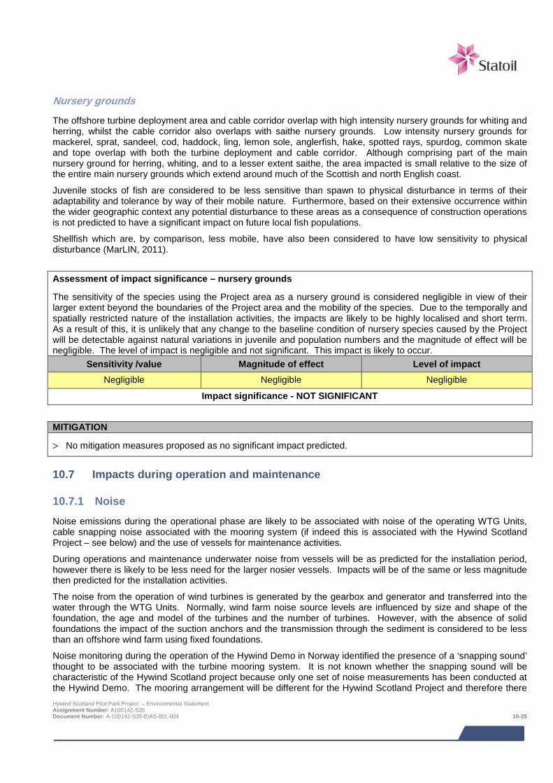
Nursery grounds
The offshore turbine deployment area and cable corridor overlap with high intensity nursery grounds for whiting and herring, whilst the cable corridor also overlaps with saithe nursery grounds. Low intensity nursery grounds for mackerel, sprat, sandeel, cod, haddock, ling, lemon sole, anglerfish, hake, spotted rays, spurdog, common skate and tope overlap with both the turbine deployment and cable corridor. Although comprising part of the main nursery ground for herring, whiting, and to a lesser extent saithe, the area impacted is small relative to the size of the entire main nursery grounds which extend around much of the Scottish and north English coast.
Juvenile stocks of fish are considered to be less sensitive than spawn to physical disturbance in terms of their adaptability and tolerance by way of their mobile nature. Furthermore, based on their extensive occurrence within the wider geographic context any potential disturbance to these areas as a consequence of construction operations is not predicted to have a significant impact on future local fish populations.
Shellfish which are, by comparison, less mobile, have also been considered to have low sensitivity to physical disturbance (MarLIN, 2011).
Assessment of impact significance – nursery grounds
The sensitivity of the species using the Project area as a nursery ground is considered negligible in view of their larger extent beyond the boundaries of the Project area and the mobility of the species. Due to the temporally and spatially restricted nature of the installation activities, the impacts are likely to be highly localised and short term. As a result of this, it is unlikely that any change to the baseline condition of nursery species caused by the Project will be detectable against natural variations in juvenile and population numbers and the magnitude of effect will be negligible. The level of impact is negligible and not significant. This impact is likely to occur.
Sensitivity /value Magnitude of effect Level of impact Negligible Negligible Negligible
Impact significance - NOT SIGNIFICANT
MITIGATION
> No mitigation measures proposed as no significant impact predicted.
10.7 Impacts during operation and maintenance
10.7.1 Noise
Noise emissions during the operational phase are likely to be associated with noise of the operating WTG Units, cable snapping noise associated with the mooring system (if indeed this is associated with the Hywind Scotland Project – see below) and the use of vessels for maintenance activities.
During operations and maintenance underwater noise from vessels will be as predicted for the installation period, however there is likely to be less need for the larger nosier vessels. Impacts will be of the same or less magnitude then predicted for the installation activities.
The noise from the operation of wind turbines is generated by the gearbox and generator and transferred into the water through the WTG Units. Normally, wind farm noise source levels are influenced by size and shape of the foundation, the age and model of the turbines and the number of turbines. However, with the absence of solid foundations the impact of the suction anchors and the transmission through the sediment is considered to be less than an offshore wind farm using fixed foundations.
Noise monitoring during the operation of the Hywind Demo in Norway identified the presence of a ‘snapping sound’ thought to be associated with the turbine mooring system. It is not known whether the snapping sound will be characteristic of the Hywind Scotland project because only one set of noise measurements has been conducted at the Hywind Demo. The mooring arrangement will be different for the Hywind Scotland Project and therefore there Hywind Scotland Pilot Park Project – Environmental Statement Assignment Number: A100142-S35 Document Number: A-100142-S35-EIAS-001-004 10-25
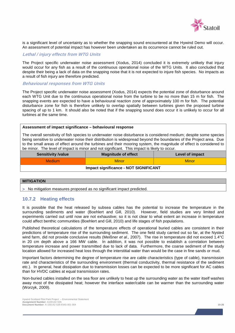
is a significant level of uncertainty as to whether the snapping sound encountered at the Hywind Demo will occur. An assessment of potential impact has however been undertaken as its occurrence cannot be ruled out.
Lethal / injury effects from WTG Units
The Project specific underwater noise assessment (Xodus, 2014) concluded it is extremely unlikely that injury would occur for any fish as a result of the continuous operational noise of the WTG Units. It also concluded that despite their being a lack of data on the snapping noise that it is not expected to injure fish species. No impacts as a result of fish injury are therefore predicted.
Behavioural responses from WTG Units
The Project specific underwater noise assessment (Xodus, 2014) expects the potential zone of disturbance around each WTG Unit due to the continuous operational noise from the turbine to be no more than 15 m for fish. The snapping events are expected to have a behavioural reaction zone of approximately 100 m for fish. The potential disturbance zone for fish is therefore unlikely to overlap spatially between turbines given the proposed turbine spacing of up to 1 km. It should also be noted that if the snapping sound does occur it is unlikely to occur for all turbines at the same time.
Assessment of impact significance – behavioural response
The overall sensitivity of fish species to underwater noise disturbance is considered medium; despite some species being sensitive to underwater noise their distribution is widespread beyond the boundaries of the Project area. Due to the small areas of effect around the turbines and their mooring system, the magnitude of effect is considered to be minor. The level of impact is minor and not significant. This impact is likely to occur.
Sensitivity /value Magnitude of effect Level of impact Medium Minor Minor
Impact significance - NOT SIGNIFICANT
MITIGATION
> No mitigation measures proposed as no significant impact predicted.
10.7.2 Heating effects It is possible that the heat released by subsea cables has the potential to increase the temperature in the surrounding sediments and water (Boehlert and Gill, 2010). However, field studies are very limited and experiments carried out until now are not exhaustive; so it is not clear to what extent an increase in temperature could affect benthic communities (Boehlert and Gill, 2010) and life stages of fish populations.
Published theoretical calculations of the temperature effects of operational buried cables are consistent in their predictions of temperature rise of the surrounding sediment. The one field study carried out so far, at the Nysted wind farm, did not provide conclusive results (Meißner et al., 2007). The rise in temperature did not exceed 1.4°C in 20 cm depth above a 166 MW cable. In addition, it was not possible to establish a correlation between temperature increase and power transmitted due to lack of data. Furthermore, the coarse sediment of the study location allowed for increased heat loss through the interstitial water than would be the case in fine sands or mud.
Important factors determining the degree of temperature rise are cable characteristics (type of cable), transmission rate and characteristics of the surrounding environment (thermal conductivity, thermal resistance of the sediment etc.). In general, heat dissipation due to transmission losses can be expected to be more significant for AC cables than for HVDC cables at equal transmission rates.
Non-buried cables installed on the sea floor are unlikely to heat up the surrounding water as the water itself washes away most of the dissipated heat; however the interface water/cable can be warmer than the surrounding water (Worzyk, 2009).
Hywind Scotland Pilot Park Project – Environmental Statement Assignment Number: A100142-S35 Document Number: A-100142-S35-EIAS-001-004 10-26
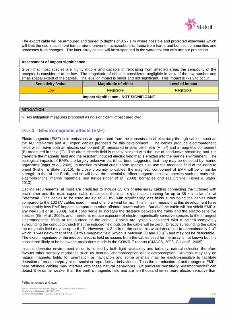
The export cable will be armoured and buried to depths of 0.5 - 1 m where possible and protected elsewhere which will limit the rise in sediment temperature, prevent macrozoobenthic fauna from harm, and benthic communities and processes from changes. The inter-array cables will be suspended in the water column with armour protection.
Assessment of impact significance
Given that most species are highly mobile and capable of relocating from affected areas the sensitivity of the receptor is considered to be low. The magnitude of effect is considered negligible in view of the low number and small spatial extent of the cables. The level of impact is minor and not significant. This impact is likely to occur.
Sensitivity /value Magnitude of effect Level of impact Low Negligible Negligible
Impact significance - NOT SIGNIFICANT
MITIGATION
> No mitigation measures proposed as no significant impact predicted.
10.7.3 Electromagnetic effects (EMF) Electromagnetic (EMF) field emissions are generated from the transmission of electricity through cables, such as the AC inter-array and AC export cables proposed for this development. The cables produce electromagnetic fields which have both an electric component (E) measured in volts per metre (V m-1) and a magnetic component (B) measured in tesla (T). The direct electric field is mostly blocked with the use of conductive sheathing and it is therefore the magnetic field and the resultant induced electric field that is emitted into the marine environment. The ecological impacts of EMFs are largely unknown but it has been suggested that they may be detected by marine organisms (Inger et al., 2009); in addition to visual cues, some species also use the magnetic field of the earth to orient (Fisher & Slater, 2010). In close proximity to cables, the magnetic component of EMF will be of similar strength to that of the Earth, and so will have the potential to affect magneto-sensitive species such as bony fish, elasmobranchs, marine mammals, sea turtles (Inger et al., 2009), barnacles and sea urchins (Fisher & Slater, 2010).
Cabling requirements, at most are predicted to include 15 km of inter-array cabling connecting the turbines with each other and the main export cable route, plus the main export cable running for up to 35 km to landfall at Peterhead. The cables to be used are up to 33 kV, with significantly less fields surrounding the cables when compared to the 132 kV cables used in most offshore wind farms. This in itself means that this development have considerably less EMF impacts compared to other offshore power cables. Burial of the cable will not shield EMF in any way (Gill et al., 2009), but it does serve to increase the distance between the cable and the electro-sensitive species (Gill et al., 2005), and, therefore, reduce exposure of electromagnetically sensitive species to the strongest electromagnetic fields at the surface of the cable. Cables are typically designed with a screen completely surrounding the conductor, such that the induced field outside the cable will be zero. Directly surrounding the cable the magnetic field may be up to 6 μT. However, at 2 m from the cable this would decrease to approximately 2 μT which is well below that of the Earth’s magnetic field (which is between 30 and 70 μT) and may not be detectable. The exact magnitude of the induced electric field emissions from the cables used for the array is not known but it is considered likely to be below the predictions made in the COWRIE reports (CMACS, 2003, Gill et al., 2005).
In an underwater environment vision is limited by both light availability and turbidity, natural selection therefore favours other sensory modalities such as hearing, chemoreception and electroreception. Animals may rely on natural magnetic fields for orientation or navigation and some animals may be electro-sensitive to facilitate detection of predators/prey or for social or reproductive behaviours. Thus the introduction of anthropogenic EMFs near offshore cabling may interfere with these natural behaviours. Of particular sensitivity, elasmobranchs5 can detect B fields far weaker than the earth’s magnetic field and are ten thousand times more electro sensitive than
5 Sharks, skates and rays. Hywind Scotland Pilot Park Project – Environmental Statement Assignment Number: A100142-S35 Document Number: A-100142-S35-EIAS-001-004 10-27
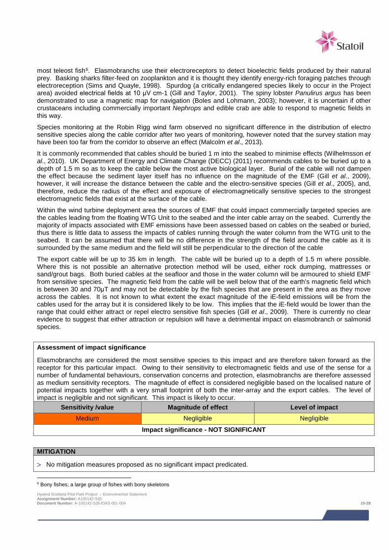
most teleost fish6. Elasmobranchs use their electroreceptors to detect bioelectric fields produced by their natural prey. Basking sharks filter-feed on zooplankton and it is thought they identify energy-rich foraging patches through electroreception (Sims and Quayle, 1998). Spurdog (a critically endangered species likely to occur in the Project area) avoided electrical fields at 10 μV cm-1 (Gill and Taylor, 2001). The spiny lobster Panulirus argus has been demonstrated to use a magnetic map for navigation (Boles and Lohmann, 2003); however, it is uncertain if other crustaceans including commercially important Nephrops and edible crab are able to respond to magnetic fields in this way.
Species monitoring at the Robin Rigg wind farm observed no significant difference in the distribution of electro sensitive species along the cable corridor after two years of monitoring, however noted that the survey station may have been too far from the corridor to observe an effect (Malcolm et al., 2013).
It is commonly recommended that cables should be buried 1 m into the seabed to minimise effects (Wilhelmsson et al., 2010). UK Department of Energy and Climate Change (DECC) (2011) recommends cables to be buried up to a depth of 1.5 m so as to keep the cable below the most active biological layer. Burial of the cable will not dampen the effect because the sediment layer itself has no influence on the magnitude of the EMF (Gill et al., 2009), however, it will increase the distance between the cable and the electro-sensitive species (Gill et al., 2005), and, therefore, reduce the radius of the effect and exposure of electromagnetically sensitive species to the strongest electromagnetic fields that exist at the surface of the cable.
Within the wind turbine deployment area the sources of EMF that could impact commercially targeted species are the cables leading from the floating WTG Unit to the seabed and the inter cable array on the seabed. Currently the majority of impacts associated with EMF emissions have been assessed based on cables on the seabed or buried, thus there is little data to assess the impacts of cables running through the water column from the WTG unit to the seabed. It can be assumed that there will be no difference in the strength of the field around the cable as it is surrounded by the same medium and the field will still be perpendicular to the direction of the cable
The export cable will be up to 35 km in length. The cable will be buried up to a depth of 1.5 m where possible. Where this is not possible an alternative protection method will be used, either rock dumping, mattresses or sand/grout bags. Both buried cables at the seafloor and those in the water column will be armoured to shield EMF from sensitive species. The magnetic field from the cable will be well below that of the earth’s magnetic field which is between 30 and 70μT and may not be detectable by the fish species that are present in the area as they move across the cables. It is not known to what extent the exact magnitude of the iE-field emissions will be from the cables used for the array but it is considered likely to be low. This implies that the iE-field would be lower than the range that could either attract or repel electro sensitive fish species (Gill et al., 2009). There is currently no clear evidence to suggest that either attraction or repulsion will have a detrimental impact on elasmobranch or salmonid species.
Assessment of impact significance
Elasmobranchs are considered the most sensitive species to this impact and are therefore taken forward as the receptor for this particular impact. Owing to their sensitivity to electromagnetic fields and use of the sense for a number of fundamental behaviours, conservation concerns and protection, elasmobranchs are therefore assessed as medium sensitivity receptors. The magnitude of effect is considered negligible based on the localised nature of potential impacts together with a very small footprint of both the inter-array and the export cables. The level of impact is negligible and not significant. This impact is likely to occur.
Sensitivity /value Magnitude of effect Level of impact Medium Negligible Negligible
Impact significance - NOT SIGNIFICANT
MITIGATION
> No mitigation measures proposed as no significant impact predicated.
6 Bony fishes; a large group of fishes with bony skeletons Hywind Scotland Pilot Park Project – Environmental Statement Assignment Number: A100142-S35 Document Number: A-100142-S35-EIAS-001-004 10-28
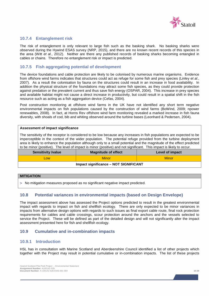
10.7.4 Entanglement risk The risk of entanglement is only relevant to large fish such as the basking shark. No basking sharks were observed during the Hywind ESAS survey (NRP, 2015), and there are no known recent records of this species in the area (Witt et al., 2012). Neither are there any published records of basking sharks becoming entangled in cables or chains. Therefore no entanglement risk or impact is predicted.
10.7.5 Fish aggregating potential of development The device foundations and cable protection are likely to be colonised by numerous marine organisms. Evidence from offshore wind farms indicates that structures could act as refuge for some fish and prey species (Linley et al., 2007). As a result the colonisation by fauna on the structures could result in an increase in food availability. In addition the physical structure of the foundations may attract some fish species, as they could provide protection against predation or the prevalent current and thus save fish energy (OSPAR, 2004). This increase in prey species and available habitat might not cause a direct increase in productivity, but could result in a spatial shift in the fish resource such as acting as a fish aggregation device (Cefas, 2004).
Post construction monitoring at offshore wind farms in the UK have not identified any short term negative environmental impacts on fish populations caused by the construction of wind farms (BoWind, 2009; npower renewables, 2008). In fact, at Horns Rev offshore wind farm monitoring revealed a marked increase in fish fauna diversity, with shoals of cod, bib and whiting observed around the turbine bases (Leonhard & Pedersen, 2004).
Assessment of impact significance
The sensitivity of the receptor is considered to be low because any increases in fish populations are expected to be imperceptible in the context of the wider population. The potential refuge provided from the turbine deployment area is likely to enhance the population although only to a small potential and the magnitude of the effect predicted to be minor (positive). The level of impact is minor (positive) and not significant. This impact is likely to occur.
Sensitivity /value Magnitude of effect Level of impact Low Minor Minor
Impact significance – NOT SIGNIFICANT
MITIGATION
> No mitigation measures proposed as no significant negative impact predicted.
10.8 Potential variances in environmental impacts (based on Design Envelope) The impact assessment above has assessed the Project options predicted to result in the greatest environmental impact with regards to impact on fish and shellfish ecology. There are only expected to be minor variances in impacts from alternative design options with regards to such issues as final export cable route, final rock protection requirements for cables and cable crossings, scour protection around the anchors and the vessels selected to service the Project. These will be defined as part of the detailed design and will not significantly alter the impact assessment presented here for fish and shellfish ecology.
10.9 Cumulative and in-combination impacts
10.9.1 Introduction HSL has in consultation with Marine Scotland and Aberdeenshire Council identified a list of other projects which together with the Project may result in potential cumulative or in-combination impacts. The list of these projects
Hywind Scotland Pilot Park Project – Environmental Statement Assignment Number: A100142-S35 Document Number: A-100142-S35-EIAS-001-004 10-29
including details of their status as of June 2014 and a map showing their location is provided in Chapter 6; Table 63 and Figure 6-1 respectively.
Cumulative impacts are impacts on fish and shellfish ecology caused by planned and consented offshore wind farms. In-combination impacts are impacts on fish and shellfish ecology as a result of offshore wind farms (and their associated activities) combined with impacts from other marine activities or users of the sea.
The consideration of which projects could result in potential cumulative or in-combination impacts is based on the results of the project specific impact assessment together with the expert judgement of the specialist consultant. Having considered the information presently available in the public domain, the projects for which there is a potential for cumulative or in-combination impacts are:
> European Offshore Wind Deployment Centre (EOWFL);
> Kincardine offshore wind farm;
> Eastern HVDC Link; and
> NorthConnect.
The following sections summarise the nature of the potential cumulative and in-combination impacts for each potential project phase.
10.9.2 Potential cumulative and in-combination impacts during construction and installation
Although there is the potential for the Hywind Project to result in cumulative impacts from the loss of spawning and nursery grounds and simultaneous noise generated during construction and installation phases, impacts from the Hywind Project will be restricted to very short timescales and only occur over very small geographical areas and not be significant. Due to the geographical separation of the other Projects and limited periods over which construction and installation impacts will occur together with the uncertainty of whether construction of the others projects will take place at the same time as Hywind, there is little likelihood of cumulative or in-combination impacts from the current Project and other proposed projects in the vicinity.
10.9.3 Potential cumulative and in-combination impacts during operation and maintenance
Similarly during the operation and maintenance phase of the Hywind Project, although the potential for cumulative impacts is possible e.g. from noise generated during vessel activities and turbine operation and changes in abundance of species, impacts are predicted to occur over only very small geographical areas and not to be significant. Therefore there is little likelihood of cumulative or in-combination impacts from the current Project and other proposed projects in the vicinity
10.9.4 Mitigation requirements for potential cumulative and in-combination impacts No mitigation is required over and above the Project specific mitigation.
10.10 Habitats Regulations Appraisal For Projects which could affect a Natura site (an SAC with fish interests for example) the competent authority (in this case Marine Scotland) is required to determine whether the Project will have a likely significant effect (LSE) on the qualifying interests of any such SACs. Depending on the outcome of this determination, the competent authority will undertake an Appropriate Assessment of the implications of the Project for the Project’s Natura site’s conservation objectives. The responsibility for provision of information to inform the Appropriate Assessment rests with the applicant (Xodus, 2015).
Based on the results of the assessment presented in the HRA report, it was concluded that the Project will not have any Likely Significant Effects on SACs where migratory fish species are a qualifying interest. Hywind Scotland Pilot Park Project – Environmental Statement Assignment Number: A100142-S35 Document Number: A-100142-S35-EIAS-001-004 10-30
10.11 Wildlife licensing Basking shark are afforded protection under Schedule 5 of the Wildlife and Countryside Act 1981 and the Nature Conservation (Scotland) Act 2004, which makes it illegal to intentionally kill, injure or recklessly disturb or harass basking sharks in British waters. Deliberate harm to species protected under this legislation is not anticipated as part of the Project Marine Scotland will determine if specific licensing requirements are needed as part of the application determination.
10.12 Monitoring No monitoring requirements have been identified with regards to fish and shellfish ecology.
10.13 References Boles, L. and Lohmann, K. (2003). True navigation and magnetic maps in spiny lobsters Nature 421 60-63.
Bonfil, R. (1994). Overview of world elasmobranch fisheries. FAO Fisheries technical paper 341. FAO, Rome, Italy.
BoWind (2009). Post construction monitoring report available online at http://www.dongenergy.co.uk/SiteCollectionDocuments/wind/Bowind%20Environment/Construction_Monitoring_Report-_Full_012009.pdf [Accessed 16/06/2014].
Camhi, M., Fowler, S., Musick, J., Brautigam, A. and Fordham, S. (1998). Sharks and thir relatives: Ecology and conservation. Occasional paper of the IUCN Species Survival Commission Occas. Pap. No. 20.
Cefas (2004). Offshore Wind Farms Guidance Note for Environmental Impact Assessment in respect of FEPA and CPA Requirements Version 2 – June 2004 available from http://www.cefas.co.uk/publications/files/windfarm-guidance.pdf [accessed 16/06/2014].
Cefas (2001). North Sea fish and fisheries technical report TR_003. Produced for Strategic Environmental Assessment (SEA) 2 Department of Trade and Industry. Available from http://www.cefas.co.uk/media/20461/tr_003.pdf [accessed 16/06/2014].
Collins, M. and Pierce, G. (1996). Size selectivity in the diet of Loligo forbesi (Cephahlopoda: Loliginidae). Journal of the Marine Biological Association of the United Kingdom 76, 1081-1090.
Coull, K., Hohnstone, R. and Rogers, S. (1998). Fishery sensitivity maps in British Waters. Published and distributed by UKOOA Ltd. Available from http://cefas.defra.gov.uk/media/29947/sensi_maps.pdf [accessed 01/06/2014].
DECC (2011). National Policy Statement for renewable Energy Infrastructure (EN-3). Presented to Parliament pursuant to section 5(9) of the Planning Act 2008.
Drapeau, E. (1973). Sedimentology of herring spawning grounds on Georges Bank. ICNAF Res. Bull 10: 151-162
Ellis, J., Burt, G. and Cox, L. (2008). Programme 19: Thames Ray Tagging and Survival, Cefas, Lowestoft Interim Report Fisheries Science Partnership 2007/2008 available online at http://www.pisces-rfr.org/UK/Chapter_%26_Verse/Entries/2009/4/4_Suffolk_long-line_fishery_LT1020_Jolene__Thornback_details_files/EllisBurtCox2008.pdf [Accessed 01/06/2014].
Ellis, J., Milligan, S., Readdy, L., Taylor, N. and Brown, M. (2012). Spawning and nursery grounds of selected fish species in UK waters. Sci. Ser. Tech. Rep., Cefas, Lowestoft, 147 56 pp.
Ellis, J., Milligan, S., Readdy, L., South, A., Taylor, N. and Brown, M. (2010). Mapping spawning and nursery areas of species to be considered in Marine Protected Areas (Marine Conservation Zones). Report No. 1: Final report on development of derived data layers for 40 mobile species considered to be of conservation importance. Project code MB5301.
Fay, R.R., and Popper, A.N. (2000). Evolution of hearing in vertebrates: the inner ears and processing. Hearing Research 149, 1-10.
Hywind Scotland Pilot Park Project – Environmental Statement Assignment Number: A100142-S35 Document Number: A-100142-S35-EIAS-001-004 10-31

Furness, R. (1999). Does harvesting a million metric tonnes of sand lance per year from the North Sea threaten seabird populations? Ecosystem approaches for fisheries management. Alaska Sea Grant College program, AK-SG-99-01 University of Alaska, Fairbanks, p 407-424.
Gill, A. and Taylor, H. (2001). The potential effects of electromagnetic fields generated by cabling between offshore wind turbines upon elasmobranch fishes. Countryside Council for Wales, Contract Science Report 488.
Gill, A., Gloyne-Phillips, I., Neal, K. J. and Kimber, J. A. (2005). The potential effects of electromagnetic fields generated by sub-sea power cables associated with offshore wind farm developments on electrically and magnetically sensitive marine organisms – a review. COWRIE 1.5 ELECTROMAGNETIC FIELDS REVIEW. Available from: http://www.thecrownestate.co.uk/media/554189/2005-07%20Cowrie%201.5%20electromagnetic%20fields%20review.pdf [accessed 06/06/2014].
Gill, A., Huang, Y., Gloyne-Philips, I., Metcalfe, J., Quayle, V., Spencer, J. and Wearmouth, V. (2009). COWRIE 2.0 Electromagnetic Fields (EMF) Phase 2: EMF-sensitive fish response to EM emissions from sub-sea electricity cables of the type used by the offshore renewable energy industry. Commissioned by COWRIE Ltd (project reference COWRIE-EMF-1-06).
Greenstreet, P., Holland, G., Guirey, E., Armstrong, E., Fraser, H. and Gibb, I. (2010). Combining hydroacoustic seabed survey and grab sampling techniques to assess “local” sandeel population abundance. ICES Journal of Marine Science, 67 (5), 971-984.
Greenstreet, P., McMillan, J. and Armstrog, E. (1998). Seasonal variation in the importance of pelagic fish in the diet of piscivorous fish in the Moray Firth, NE Scotland: a response to variation in prey abundance? ICES Journal of Marine Science, 55: 121-133.
Hawkins, A.D., and Myrberg, A.A. Jr. (1983). Hearing and sound communication underwater. In: Lewis B (ed), Bioacoustics, a comparative approach. Academic Press, London, p 347–405.
Hawkins and Popper (2014). Assessing the impact of underwater sounds on fishes and other forms of marine life. Acoustics Today.Hearn, A. (2004). Reproductive biology of the velvet swimming crab, Necora puber (Brahyura: Portunidae), in the Orkney Islands, UK. Sarsia 89, 318-25.
Holden, M. (1974). Problems in the rational exploitation of elasmobranch populations and some suggested solutions. Pp. 117-137 In F.R.H Jones (ed) Sea Fisheries Research, Elek Science, London.
Holland G., Greenstreet, S., Gibb, I., Fraser, H. and Robertson, M., (2005). Identifying sandeel Ammodytes marinus sediment habitat preferences in the marine environment. Marine Ecology Progress Series, 303, 269-282.
ICES 2010. Report of the Herring Assessment Working Group for the Area South of 62n (HAWG), 15 - 23 March 2010, ICES Headquarters, Copenhagen, Denmark. 688 pp.Inger, R., Attrill, M., Bearhop, S., Broderick, A., Grecian, W., Hodgson, D. Millis, C., Sheehan, E., Votier, S., Witt M and Godley, B. (2009). Marine renewable energy: potential benefits to biodiversity? An urgent call on research. Journal of Applied Ecology, 46: 1145-1153.
ICES 2008. North Sea-Ecosystems overview. ICES Advice 2008. Book 6.
ICES 2006. ICES CIEM ICES Fish Map – Herring. Available online from: http://www.ices.dk/marineworld/fishmap/ices/pdf/herring.pdf [Accessed 09/05/2014].
ICES 2005. Report of the Planning Group on North Sea Cod and Plaice Egg Surveys in the North Sea (PGEGGS), 10 -12 May 2005, Lowestoft, UK. ICES CM 2005/G:11. 85pp.
Ingle, R.W. (1983). Shallow water crabs. Synopses of the British Fauna 25, 1�206.
IUCN (2014). IUCN Red List of threatened species available online at http://www.iucnredlist.org/ [Accessed 01/06/2014].
Jensen, H., Rindorf, A., Wright, P. and Mosegaard, H. (2011). Inferring the location and scale of mixing between habitat areas of lesser sandeel through information from the fishery. ICES Journal of Marine Science, 68 (1), 43–51.
Leonhard, S. and Pedersen, J. (2004). Hard bottom substrate monitoring at Horns Rev Offshore Wind Farm. Annual Status Report 2003. Elsam Engineering.
Hywind Scotland Pilot Park Project – Environmental Statement Assignment Number: A100142-S35 Document Number: A-100142-S35-EIAS-001-004 10-32

Linley, E., Wilding, T., Black, K., Hawkins, S. and Mangi, S. (2007). Review of the reef effects of offshore wind farm structures and their potential for enhancement and mitigation. Report from PML Applications Ltd and the Scottish Association from Marine Science to the Department for Business, Enterprise and Regulatory Reform (BERR), Contract No.: RFC/005/0029P. Available from: http://webarchive.nationalarchives.gov.uk/+/http://www.berr.gov.uk/files/file43528.pdf [accessed 01/06/2014].
Malcolm, I., Armstrong, J., Godfrey, J., Maclean, J. and Middlemas, S. (2013). The scope of research requirements for Atlantic Salmon, Sea Trout and European Eel in the context of offshore renewables. Marine Scotland Science Report 05/13 available online at http://www.scotland.gov.uk/Resource/0042/00426601.pdf [Accessed 01/06/2014].
Malcolm, I., Godfrey, J. and Youngson, A., (2010). Review of migratory routes and behaviour of Atlantic Salmon, sea trout and European eel in Scotland’s coastal environment: implications for the development of marine renewables. Scottish Marine and Freshwater Science, 1, 14. Available from: http://www.scotland.gov.uk/Resource/Doc/295194/0111162.pdf [accessed 02/06/2014].
Marine Scotland (2011a) Brown Crab available online at http://www.scotland.gov.uk/Topics/marine/marine-environment/species/fish/shellfish/BrownCrab [Accessed 25/06/2014].
Marine Scotland (2011b) King Scallop available online at http://www.scotland.gov.uk/Topics/marine/marine-environment/species/fish/shellfish/scallop [Accessed 25/06/2014].
Marine Scotland (2011c) European lobster available online at http://www.scotland.gov.uk/Topics/marine/marine-environment/species/fish/shellfish/EuropeanLobsterBiology [Accessed 25/06/2014].
MarLIN (2014). Biodiversity and conservation – Nephrops. Available at:http://www.marlin.ac.uk/biotic/browse.php?sp=4390 [Accessed 25/06/2014].
MarLIN (2011). Biodiversity and conservation – Elasmobranchii Available at http://www.marlin.ac.uk/phylumdetails.php?phylum=2341#elasmobranchii [Accessed 05/06/2014].
McConnell, B., Hall, A. and Fedal, M. (1999). Seal foraging and sandeel distribution In Wright, P.J. and Kenedy, F.M., (1999).
Meißner, K., Bockhold, J. & Sordyl, H. (2007). Problem Kabelwärme? – Vorstellung der Ergebnisse von Feldmessungen der Meeresbodentemperatur im Bereich der elektrischen Kabel im dänischen Offshore-Windpark Nysted Havmøllepark (Dänemark). In: Meeresumwelt-Symposium 2006. Hrsg. Bundesamt für Seeschiffahrt und Hydrographie, Hamburg : 153-161. Cited in OSPAR (2009b).
Mills, D., Hadoke, G., Shelton, R. and Reid, J. (2003). Atlantic Salmon Facts. Atlantic Salmon Trust booklet. Prepared in 1986 revised in 2003.
MMT (2013) Environmental Survey Report Hywind offshore wind farm Environmental survey, Peterhead, Scotland August-September 2013 Doc No ST13828 Benthic report.
Musick, J. and Musick, S. (2005). Sharks FAO Fisheries and Aquaculture reviews and astudies. Rome, FAO 2011 10p Available online at ftp://ftp.fao.org/fi/DOCUMENT/reviews%26studies/sharks.pdf [Accessed 17/06/2014].
Neal, K., Pizzolla, P. and Wildling, C. (2008). Dipturus batis. Common Skate. Marine life information network: Biology and Sensitivity Key Information Sub-programme [on-line]. Plymouth: Marine Biological Association of the United Kingdom. Available from http://www.marlin.ac.uk/speciesfullreview.php?speciesID=3183 [Accessed 16/06/2014].
Norman, C. P. and Jones, M. B. (1993). Reproductive ecology of the velvet swimming crab, Necora puber (Brachyura: Portunidae), at Plymouth. Journal of the Marine Biological Association of the United Kingdom, 73, pp 379-389.
npower renewables (2008). Final annual FEPA monitoring report (2006-7) & five year monitoring programme summary. North Hoyle Offshore Wind Farm.
NRP (2015). Hywind Scotland Pilot Park Report on ESAS Surveys June 2013 to May 2014 and context information.
Hywind Scotland Pilot Park Project – Environmental Statement Assignment Number: A100142-S35 Document Number: A-100142-S35-EIAS-001-004 10-33
Olsen, E. and Holst, J. (2001). A note on common minke whale (Balaenoptera acutorostrata) diets in the Norwegian Sea and the North Sea. Journal of Cetacean Resource Management 3(2): 179-183.
OSPAR (2009a). Summary assessment of sand and gravel extraction in the OSPAR maritime area. Biodiversity Series ISBN 978-1-906840-74-7. Publication Number: 434/2009. Available online from: http://qsr2010.ospar.org/media/assessments/p00434_Sand_and_Gravel_Summary_Assessment.pdf [Accessed 01/06/2014].
OSPAR (2009b). Assessment of the environmental impacts of cables. Biodiveristy Series ISBN 978-1-906840-77-8. Publication Number: 437/2009. Available online from: http://qsr2010.ospar.org/media/assessments/p00437_Cables.pdf [Accessed 01/06/2014].
OSPAR (2008). Guidance on Environmental Considerations for Offshore Wind Farm Development. OSPAR Convention for the Protection of the Marine Environment of the North-East Atlantic.
OSPAR (2004). Problems and Benefits Associated with the Development of Offshore Wind-Farms. Biodiversity Series. ISBN 1-904426-48-4.
Pierce, G., Santos, M., Reid, R., Patterson, I. and Ross, H. (2004). Diet of minke whale (Baleonoptera acutostrata) diets in the Scottish (UK) waters with notes on strandings of the species in Scotland 1992-2002. Marine Biology Association UK 84: 1241-1244.
Popper, A.N., Hawkins, A.D., Fay, R.R., Mann, D.A., Bartol, S., Carlson, T.J., Coombs, S., Ellison, W.T., Gentry, R.L., Halvorsen, M.B., Lokkeborg, S., Rogers, P.H., Southall, B.L., Zeddies, D.G., and Tavolga, W.N. (2014). Sound exposure guidelines for fishes and sea turtles. A technical report prepared by ANSI – Accredited Standards Committee S3/SC1 and registered with ANSI. Springer Briefs in Oceanography.
Rogers, S. & Stocks, S. (2001). North Sea Fish and Fisheries. Technical report for Strategic Environmental Assessment (SEA). 72pp.
Santos, M., Pierce, G., Ieno, E., Addick, M., Smeenk, C., Kinze, C. and Sacau, M. (2005). Harbour porpoise (Phocoena phocoena) feeding ecology in the eastern North Sea. Marine Mammal Science. 20(1), pp. 1-27.
Scottish Natural Heritage (SNH) (2011) Priority Marine Features. Available online: http://www.snh.gov.uk/protecting-scotlands-nature/priority-marine-features/priority-marine-features/ [Accessed 01/06/2014].
Sims, D. and Quayle, V. (1998). Selective foraging behaviour of basking sharks on zooplankton in a small scale front. Nature, London 393: 460-464.
van Damme, C., Hoek, R., Beare, D., Bolle, L., Bakker, C., van Barneveld, E., Lohman, M., Os-Koomen, E., Nijssen, P., Pennock, I. and Tribuhl, S. (2011). Shortlist Master plan Wind Monitoring fish eggs and larvae in the Southern North Sea: Final report Part A. IMARES Wogeningenur.
Walters, M. (2011). Moray Firth Sea Trout Project Final Report. A summary of the project, progress, findings and next steps. Available online at: http://www.morayfirthtrout.org/ [Accessed at 01/06/2014].
Walters, M. (2010). Moray Firth Sea Trout Project. Progress Report February 2010. Available online at: http://www.morayfirthtrout.org/ [Accessed at 01/06/2014].
Wanless S., Harris M. and Rothery P. (1999). Intra-and Inter-Seasonal Variation in Sandeel, Ammodytes marinus Consumption by Kittiwakes, Rissa tridactyla on the Isle of May and Long-term Changes in Numbers, Reproductive Output and Adult Survival. In: Wright, P.J. and Bailey, M. C. 1996.
Wanless, S., Harris, M., and Greenstreet, P. (1998). Summer sandeel consumption by seabirds breeding in the Firth of Forth, south-east Scotland. ICES Journal of Marine Science, 55: 1141-1151.
Wanless, S., Wright, P.J., Harris, M.P. and Elston, D. A. (2005). Evidence for decrease in size of lesser sandeel Ammodytes marinus in a North Sea aggregation over a 30-yr period. Mar Ecol Prog Ser Vol. 279, pp. 237–246.
Wilhelmsson, D., Malm, T., Thompson, R., Tchou, J., Sarantakos, G., McCormick, N., Luitjens, S., Gullström, M., Patterson Edwards, J. K., Amir, O. and Dubi, A., eds. (2010). Greening Blue Energy: Identifying and managing the biodiversity risks and opportunities of offshore renewable energy IUCN. 102pp. Available online from:
Hywind Scotland Pilot Park Project – Environmental Statement Assignment Number: A100142-S35 Document Number: A-100142-S35-EIAS-001-004 10-34

http://www.iucn.org/about/work/programmes/marine/marine_resources/?5713/Greeningblue-energy-identifying-and-managing-the-biodiversity-risks-and-opportunities-of-offshorerenewable-energy [Accessed 01/06/2014].
Witt, M., Hardy, T., Johnson, L., McClellan, C.M., Pikesley, S.K., Ranger, S., Richardson, P.B., Solandt, J., Speedie, C., Williams, R., Godley, B.J. (2012). Basking sharks in the northeast Atlantic: spatio-temporal trends from sightings in UK waters. Mar Ecol Prog Ser. Vol. 459: 121–134 Available online at: http://www.manxbaskingsharkwatch.com/uploads/Witt%20et%20al%202012.pdf [Accessed 09/06/2014].
Wright, P. and Kennedy, F. (1999). Sandeel biology and its implications to management. Fisheries Research Services Report Number 12/99 Proceedings of a workshop held at FRS Marine Laboratory Available online at http://www.scotland.gov.uk/Uploads/Documents/Coll1299.pdf [accessed 17/06/2014].
Wright, P.J. and Bailey, M. C. (1996). Timing of hatching in Ammodytes marinus from Shetland waters and its significance to early growth and survivorship. Marine Biology, 126, pp.143-152. Cited in Jensen et al., 2003.
Xodus (2014). Marine noise inputs. Technical Note on Underwater Noise for Statoils Hywind Project.
Xodus (2015). Habitats Regulations Appraisal for the Hywind Scotland Project.
Hywind Scotland Pilot Park Project – Environmental Statement Assignment Number: A100142-S35 Document Number: A-100142-S35-EIAS-001-004 10-35
11 ORNITHOLOGY
The installation and operation of five floating wind turbines has potential to impact on seabirds primarily through indirect habitat loss caused by disturbance and displacement, and through additional mortality caused by collision with turbine rotors and small-scale accidental pollution incidents.
Baseline surveys showed that a range of common seabird species forage in and pass through the turbine deployment area and its vicinity. The Project area is regularly used by 13 seabird species and for eight of these species the Project area lies within the foraging range of breeding colonies in the region. For most species and at most times of year the abundance of these species in the area potentially affected by the Project was low or very low in the context of their population size. However during the breeding season the Project area has relatively high importance for breeding guillemots and razorbill. The Project area is also used by moderate numbers of four species considered to have a relatively high vulnerability to collision risk, namely gannet, herring gull, great black-backed gull and kittiwake.
With one exception, predictions of the size and duration of potential impacts shows that for all species for all times of year effects would have negligible impact on receptor populations. The exception is razorbill, for which a potential disturbance effect of low impact for the breeding population is identified owing to the very high densities sometimes present in August, a period when individuals of this species has heightened vulnerability to disturbance. This impact is nevertheless judged not significant.
Collision mortality was predicted for species that commonly fly at rotor height using a range of modelling scenarios. This showed that the predicted additional mortality was negligible compared to the numbers of birds that die from existing background mortality causes.
The Project has multiple embedded measures to minimise the risk of accidental pollution incidents.
The potential for the impacts arising from the Project to act cumulatively with other offshore wind projects in eastern Scotland is considered. This shows that there is negligible potential for the impacts from the Project to materially add to the combined impacts from other wind farms. This is mainly because the Hywind array would comprise only 0.7% (5 out 677) of the offshore wind turbines currently consented or proposed in the waters off the east coast of Scotland.
11.1 Introduction This chapter assesses the impacts of the Project on ornithology. To quantify spatial and temporal variation, ornithology interests are described at both a local and wider regional level in order to provide context to the baseline. Key lifecycle stages such as chick-rearing and moulting in auk species are given particular prominence. By characterising the existing environment the potential ecological impacts arising from the development can be identified and assessed. A number of different specialists have contributed to this assessment.
> Natural Research (Projects) Ltd (NRP) – European Seabird at Sea (ESAS) surveys, ESAS survey reporting; technical assessment, baseline description, impact assessment, ES chapter write up;
> Caloo Ecological Services – Survey design, statistical analysis and collision risk modelling; and
> Xodus – contributions to ES chapter write up.
The table below provides a list of the supporting studies which relate to the ornithology impact assessment. Supporting studies are provided on the accompanying CD.
Hywind Scotland Pilot Park Project – Environmental Statement Assignment Number: A100142-S35 Document Number: A-100142-S35-EIAS-001-005 11-1

Table 11-1 Supporting studies
Details of study Baseline survey study design. Hywind Scotland Pilot Park Project Seabird Discussion Document (Xodus, 2013) Baseline survey methods, results and context information. Report on ESAS Surveys June 2013 to May 2014 and context information (NRP 2015) And containing supporting annexes: Annex 1. Seabird Distance Sampling for Hywind Scotland Pilot Park Project (Caloo Ecological Services, 2014a) Annex 2. Seabird Collision Rate Modelling Hywind Scotland Pilot Park Project (Caloo Ecological Services, 2014b) Annex 3. Seabird Distance Sampling for Hywind Scotland Pilot Park Project, additional surveys (Caloo Ecological Services, 2014c) Alternative density, abundance and collision mortality estimates (Caloo Ecological Services, 2014d) The proposed approach to collision risk modelling with respect to seabirds for the Hywind II floating turbine project off Eastern Scotland (Caloo Ecological Services, 2014e)
To gain a better overall understanding of the baseline and potential impacts associated with ornithology, consideration is given to the following ES chapters:
> Fish Ecology (Chapter 10); and
> Commercial Fisheries (Chapter 14).
The focus of this impact assessment is to assess potential impacts on birds using the Project area and adjacent waters. There is variation in the area over which impacts occur and this area can vary significantly between species depending on their behaviour and range over which their populations can be found. Therefore, potential impacts have been set in the context of a wider regional area over which birds encountered within the Project area are thought to range and in the context of the regional populations to which species belong. The baseline descriptions for each species have therefore provided data as appropriate for the species and further details on the areas used is provided in the baseline description.
In order to establish those bird species present in the turbine deployment area European Seabird at Sea (ESAS) surveys were commissioned. The surveys commenced prior to the award of the AfL and the decision on where the WTG Units will be deployed in the AfL, therefore the survey area comprised the previously awarded Exclusivity Area with a buffer of 3 km.
The following areas are referred to in this impact assessment:
> Project area (see Figure 11.1), which comprises:
o Proposed offshore turbine deployment area: and
o Export cable corridor and landfall.
> Survey area –The Exclusivity Area with a buffer of 3 km.
> WT + 1 km – the locations of the wind turbine with a buffer of 1 km.
11.2 Legislative framework and policy context An integral aspect of the assessment of potential impacts on ornithology is the identification of species of conservation importance in the Project area and assessment of potential impacts on such species. There are a number of different statutes and guidance that are relevant in this regard these are listed below:
In addition to the EIA Regulations, key legislation for ornithological interest includes:
> Conservation (Natural Habitats, &c.) Regulations 1994 (as amended in Scotland) and the Offshore Marine Conservation (Natural Habitats, &c.) Regulations 2007 which implement species protection requirements of the EU Habitats Directive (92/43/EEC) and Wild Birds Directive (2009/147/EC);
> Wildlife and Countryside Act 1981 (as amended); and
> Nature Conservation (Scotland) Act 2004. Hywind Scotland Pilot Park Project – Environmental Statement Assignment Number: A100142-S35 Document Number: A-100142-S35-EIAS-001-005 11-2
The Habitats Regulations, implement the requirements of the EU Wild Birds Directive in the UK and aims to provide a comprehensive scheme of protection for all wild bird species naturally occurring in the EU. To meet the requirements outlined in Article 4 of the Birds Directive, particular emphasis is given to the protection of habitat for rare (i.e. as listed under Annex I) as well as migratory species via the establishment of a coherent network of Special Protection Areas (SPAs) comprising the most important territories for these species.
Plans or projects which are likely to have a significant impact on an SPA (and other European sites) either individually or in combination with other plans or projects (and are not connected with the management of the site) are subject to an ‘appropriate assessment’ under Article 6(3) of the EC Habitats Directive. The Habitats Directive is transposed into Scottish legislation through the Conservation (Natural Habitats, &c.) Regulations 1994 (as amended) and the Offshore Marine Conservation (Natural Habitats, &c.) Regulations 2007.
The Wildlife and Countryside Act (WCA) protects wildlife within the terrestrial environment and inshore waters (0-12 nm) within Great Britain. Amendments to the legislation, such as the Nature Conservation (Scotland) Act 2004 have altered the application of the WCA within Scotland. Part 1 of the WCA relates to the protection of wild birds affording various levels of protection to different species. Under the Wildlife and Countryside Act (1981) as amended, Scottish Natural Heritage (SNH) can designate Sites of Special Scientific Interest (SSSIs) in Scotland where land is considered to be of special interest by reason of any natural features. The purpose of SSSIs is to form a network of best examples of natural features throughout the Scottish landscape and support a wider network across Great Britain and the rest of the EU. The Nature Conservation (Scotland) Act 2004, requires that SSSIs in Scotland be subject to notifications regarding operations requiring consent and that management statements between SNH and the landowners or occupiers be agreed.
11.3 Scoping and consultation The bullets below summarise the key issues raised in the Scoping Opinion relevant to ornithology:
> Temporal and spatial impacts of construction in relation to the life cycle stages of species (JNCC & SNH);
> Impacts on bird species associated with SPAs within foraging range of the Project (JNCC & SNH);
> The large numbers of auks post-breeding (August) are noted. It would be of interest to discuss how any effects on these birds would be apportioned to relevant populations e.g. SPAs and also additional surveys beyond the initial 12 month survey should be undertaken (Marine Scotland Science);
> A number of species are highlighted as potential concern due to collision risk. Information on the method of estimating flight heights should be provided. There is a general concern that flight heights are being systematically underestimated and that collision risk is therefore being underestimated (Marine Scotland Science);
> Discussion and agreement required on species breeding seasons and regional population data with Statutory Nature Conservation Bodies (SNCBs) (Marine Scotland Science);
> Assessment of the impacts of the Project on gannets associated with Troup, Pennan and Lion’s Head SPAs and puffin at Fowlsheugh SPA (JNCC & SNH);
> Displacement of auk species during construction and assessment of potential displacement behaviour during operation (MS-LOT);
> Collision risk – mortality due to collision with rotor blades including migratory bird species. Collision risk should be presented for different model options, with justification or discussion provided as to which of the options is most likely to characterise the collision risks at the site. An attempt should also be made to convey the uncertainty in the estimate, aiming to express 95% confidence (Marine Scotland Science, RSPB);
> Consideration of collision risk, displacement and barrier effects are required and also advise that indirect effects are also considered such as impacts to prey species etc (JNCC & SNH);
> Avoidance rates alongside a discussion of current evidence of avoidance behaviour of each species in order to justify the preferred rate, if that differs from guidance. If the extended models are used, then there should first be an assessment of whether the generic flight height data will be more precise than site-based data, and whether the data sets are compatible (RSPB); and
Hywind Scotland Pilot Park Project – Environmental Statement Assignment Number: A100142-S35 Document Number: A-100142-S35-EIAS-001-005 11-3
> Population consequences (i.e. impact) of displacement (avoidance due to presence of WTG Units) (RSPB).
Table 11.2 summarises all consultation activities carried out relevant to ornithology.
Table 11-2 Consultation activities undertaken in relation to ornithology
Date Stakeholder Consultation May 2013 Marine Scotland (MS-LOT and
Marine Scotland Science) and statutory consultees
Pre-scoping meeting including discussion on proposed ESAS surveys impact assessment
June 2013 Marine Scotland (MS-LOT and Marine Scotland Science) and statutory consultees
Seabird discussion document and survey methodology submitted
October 2013 Marine Scotland, statutory consultees and non- statutory consultees
Submission of EIA Scoping Report – request for EIA Scoping Opinion from Marine Scotland and statutory consultees and request for comment from non-statutory consultees
December 2013 Marine Scotland Submission of interim survey report – reporting analysis on initial 5 months of data June 2013 to November 2013 and proposals for scope of impact assessment
March 2014 Marine Scotland, statutory consultees and non- statutory consultees
Receipt of Scoping Opinion, including comments on interim ESAS report
June 2014 Marine Scotland Provision of initial analysis of 12 month data June 2014 Marine Scotland Provision of feedback on comments raised on
interim ESAS report July 2014 Marine Scotland Submission of proposed approach to collision
risk modelling June 2014 – October 2014
Marine Scotland, JNCC, SNH Various e mails, meetings and teleconference meetings to discuss specific issues related to the ornithology assessment, its scope and data to be used to inform the assessment
February – March 2015 Marine Scotland, JNCC, SNH Gate Review feedback regarding: definition of species-specific seasons and regional breeding populations, choice of CRM model and avoidance rate, updated CIA information and proposed monitoring and mitigation.
11.4 Baseline description
11.4.1 Introduction The programme of baseline ESAS surveys is described in full in NRP (2014). The primary aim of the ESAS survey programme was to provide data that establish the distribution, abundance and behaviour of birds, within the defined survey area and how these change seasonally. The survey design and survey method is described in detail in the Seabird Discussion Document (Xodus, 2013). This document, which was approved by JNCC, SNH and MS in September 2013, describes in detail the layout of the survey design and the reasoning behind it. The survey was designed so that the bird data would be suitable for Distance Sampling statistical analysis (Thomas et al., 2010), and thereby allow absolute measures of abundance with confidence limits to be estimated for all common seabird species present. A further aim of the surveys was to collect data on flying seabirds suitable for Collision Rate Modelling (CRM) analyses (Caloo 2014b).
The survey area covered 170.5 km2 and comprises the original Exclusivity Area (awarded by The Crown Estate (TCE)) buffered to 3 km (Fig 11.1). This area is covered by 23 parallel transects spaced 0.75 km apart and with a total length of 228 km. Surveys of all 23 transects took two days to complete, with alternate transects surveyed on
Hywind Scotland Pilot Park Project – Environmental Statement Assignment Number: A100142-S35 Document Number: A-100142-S35-EIAS-001-005 11-4

one day and the other set of alternates on the other day. This regime meant that on each survey day the whole survey area was covered. Surveying was undertaken by a team of three accredited and highly experienced ESAS surveyors. A rotation system was used such that at any one time two surveyors were surveying and the other was on a rest period. Recording was undertaken from one side of the vessel only, whichever side presented the best conditions for detecting birds at the time.
All bird (and marine mammals) species, number, plumage, activity, flight direction and distance from the boat were recorded, together with information on environmental conditions in terms of sea state, swell height and standard weather metrics. Distance to birds sitting on the sea was recorded as one of five distance bands (0-50 m, 50-100 m, 100-200, 200-300 m, >300 m) (Camphuysen et al., 2004). The height of flying seabirds was estimated to according to 5-metre height bands (e.g., 0-5 m, 5-10 m, 10-15 m, etc. above sea level).
All survey work was conducted from the MV Eileen May, a vessel that complies with ESAS recommendations regarding vessel type, size and height of survey platforms. Two survey days of effort (i.e. surveying each transect once) were scheduled at monthly intervals from June 2013 to May 2014. A total of 20 surveys (days) were undertaken over this one-year period. Eight additional surveys (days) were undertaken in July to September 2014 to provide further information on key species using the survey area at this time of year.
Distance Sampling statistical analysis has been undertaken to provide abundance estimates with confidence limits for the survey area and the turbine deployment area buffered to 1 km (WT+1 km, an area of 13.0 km2) (Caloo 2014a and Caloo 2014c). Abundance estimates were calculated based on detection functions in which the data is analysed as clusters/observations and in which cluster size (i.e., the number of birds in an observation) is an explanatory variable. For the calculation of density/abundance estimates for the sub-areas, detection functions were fitted using data from either the whole survey area or the northern half of the survey area (see Caloo 2014a) as most appropriate for the species concerned. Only flying birds recorded as being ‘in transect’ were used to estimate abundance. Information from flying birds that were recorded as ‘not in transect’ (i.e., outside the 300 m x 300 m snapshot box when recorded) do not contribute towards the abundance measures.
A total of 13 seabird species were regularly recorded and the results for each of these are summarised in Table 11.3 and discussed alongside context information in the species accounts below. Eleven other species of seabird were recorded occasionally but only in very small numbers (Table 11.4). It is not considered plausible that the Project could have adverse impacts on the populations of these scarce species that could be rated as more than of a negligible magnitude, and therefore they are not considered further in EIA assessment.
Hywind Scotland Pilot Park Project – Environmental Statement Assignment Number: A100142-S35 Document Number: A-100142-S35-EIAS-001-005 11-5
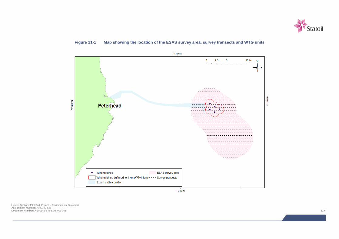
Figure 11-1 Map showing the location of the ESAS survey area, survey transects and WTG units
Hywind Scotland Pilot Park Project – Environmental Statement Assignment Number: A100142-S35 Document Number: A-100142-S35-EIAS-001-005 11-6
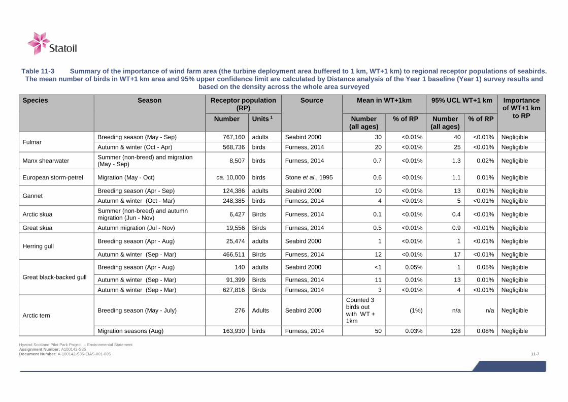
Table 11-3 Summary of the importance of wind farm area (the turbine deployment area buffered to 1 km, WT+1 km) to regional receptor populations of seabirds.
The mean number of birds in WT+1 km area and 95% upper confidence limit are calculated by Distance analysis of the Year 1 baseline (Year 1) survey results and based on the density across the whole area surveyed
Species Season Receptor population (RP)
Source Mean in WT+1km 95% UCL WT+1 km Importance of WT+1 km
to RP Number Units 1 Number (all ages)
% of RP Number (all ages)
% of RP
Fulmar Breeding season (May - Sep) 767,160 adults Seabird 2000 30 <0.01% 40 <0.01% Negligible Autumn & winter (Oct - Apr) 568,736 birds Furness, 2014 20 <0.01% 25 <0.01% Negligible
Manx shearwater Summer (non-breed) and migration (May - Sep) 8,507 birds Furness, 2014 0.7 <0.01% 1.3 0.02% Negligible
European storm-petrel Migration (May - Oct) ca. 10,000 birds Stone et al., 1995 0.6 <0.01% 1.1 0.01% Negligible
Gannet Breeding season (Apr - Sep) 124,386 adults Seabird 2000 10 <0.01% 13 0.01% Negligible Autumn & winter (Oct - Mar) 248,385 birds Furness, 2014 4 <0.01% 5 <0.01% Negligible
Arctic skua Summer (non-breed) and autumn migration (Jun - Nov) 6,427 Birds Furness, 2014 0.1 <0.01% 0.4 <0.01% Negligible
Great skua Autumn migration (Jul - Nov) 19,556 Birds Furness, 2014 0.5 <0.01% 0.9 <0.01% Negligible
Herring gull Breeding season (Apr - Aug) 25,474 adults Seabird 2000 1 <0.01% 1 <0.01% Negligible
Autumn & winter (Sep - Mar) 466,511 Birds Furness, 2014 12 <0.01% 17 <0.01% Negligible
Great black-backed gull Breeding season (Apr - Aug) 140 adults Seabird 2000 <1 0.05% 1 0.05% Negligible
Autumn & winter (Sep - Mar) 91,399 Birds Furness, 2014 11 0.01% 13 0.01% Negligible Autumn & winter (Sep - Mar) 627,816 Birds Furness, 2014 3 <0.01% 4 <0.01% Negligible
Arctic tern Breeding season (May - July) 276 Adults Seabird 2000
Counted 3 birds out with WT + 1km
(1%) n/a n/a Negligible
Migration seasons (Aug) 163,930 birds Furness, 2014 50 0.03% 128 0.08% Negligible Hywind Scotland Pilot Park Project – Environmental Statement Assignment Number: A100142-S35 Document Number: A-100142-S35-EIAS-001-005 11-7
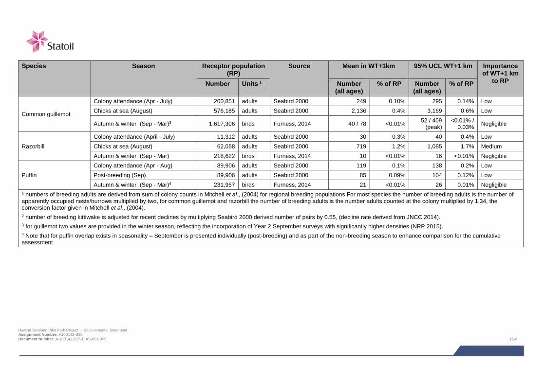
Species Season Receptor population
(RP) Source Mean in WT+1km 95% UCL WT+1 km Importance
of WT+1 km to RP Number Units 1 Number
(all ages) % of RP Number
(all ages) % of RP
Common guillemot
Colony attendance (Apr - July) 200,851 adults Seabird 2000 249 0.10% 295 0.14% Low Chicks at sea (August) 576,185 adults Seabird 2000 2,136 0.4% 3,169 0.6% Low
Autumn & winter (Sep - Mar)3 1,617,306 birds Furness, 2014 40 / 78 <0.01% 52 / 409 (peak)
<0.01% / 0.03% Negligible
Razorbill Colony attendance (April - July) 11,312 adults Seabird 2000 30 0.3% 40 0.4% Low Chicks at sea (August) 62,058 adults Seabird 2000 719 1.2% 1,085 1.7% Medium Autumn & winter (Sep - Mar) 218,622 birds Furness, 2014 10 <0.01% 16 <0.01% Negligible
Puffin Colony attendance (Apr - Aug) 89,906 adults Seabird 2000 119 0.1% 138 0.2% Low Post-breeding (Sep) 89,906 adults Seabird 2000 85 0.09% 104 0.12% Low Autumn & winter (Sep - Mar)4 231,957 birds Furness, 2014 21 <0.01% 26 0.01% Negligible
1 numbers of breeding adults are derived from sum of colony counts in Mitchell et al., (2004) for regional breeding populations For most species the number of breeding adults is the number of apparently occupied nests/burrows multiplied by two, for common guillemot and razorbill the number of breeding adults is the number adults counted at the colony multiplied by 1.34, the conversion factor given in Mitchell et al., (2004). 2 number of breeding kittiwake is adjusted for recent declines by multiplying Seabird 2000 derived number of pairs by 0.55, (decline rate derived from JNCC 2014). 3 for guillemot two values are provided in the winter season, reflecting the incorporation of Year 2 September surveys with significantly higher densities (NRP 2015). 4 Note that for puffin overlap exists in seasonality – September is presented individually (post-breeding) and as part of the non-breeding season to enhance comparison for the cumulative assessment.
Hywind Scotland Pilot Park Project – Environmental Statement Assignment Number: A100142-S35 Document Number: A-100142-S35-EIAS-001-005 11-8

Table 11-4 Summary of seabird species seen on less than six occasions during the initial 12 months of
surveys
Species Date Observation
Red-throated diver 25 November 2013 1 flying S, not in transect
Sooty shearwater 5 August 2013 5 on sea and 1 flying off effort 6 August 2013 1 flying off effort
Balearic shearwater 5 August 2013 1 on sea Common gull 2 April 2014 2 flying, not in transect
Lesser black-backed gull 8 June 2013, 1 flying and 1 off effort 8 July 2013 1 flying, not in transect 2 April 2013 1 flying
Glaucous gull 25 November 2013 1 flying off effort ‘white-winged’ gull sp. 9 November 2013 1 flying, not in transect Common tern 8 June 3 flying Pomarine skua 5 August 2013 1 on sea
Little auk
5 November 2013 1 on sea and 4 flying not in transect 25 November 2013 1 on sea 26 March 2014 1 on sea 2 April 2014 2 flying, not in transect 5 November 2013 1 on sea and 4 flying not in transect
11.4.2 Regional populations The importance to regional receptor populations of the Project area and adjacent waters, in particular the turbine deployment area buffered to 1 km (WT+1 km), is evaluated by comparing seasonal estimates of mean abundance with regional receptor population sizes (Table 11.3). The importance of the WT+1 km to a receptor population was defined on the basis of the percentage of a population present (based on the 95% UCL of the mean), as follows:
> High importance, >5% of the population;
> Medium importance, 1 - 5% of the population;
> Low importance, 0.1 - 1% of the population; and,
> Negligible, <0.1% of the population.
The definition of regional breeding seabird receptor populations appropriate for the assessment of impacts is discussed in NRP (2014). Colonies within each species-specific foraging range from the Hywind survey area (WT+3 km edge to edge) were selected for inclusion. For skuas, gulls and terns direct (over land) distances were used, with by-sea distances used for all other species (adjusting for non-direct flight lines to reflect the presence of mainland features such as Duncansby Head). Colonies which fell just outside a foraging range were considered for inclusion on a case by case basis. For example, for herring gull an approximate range of 70 km (MMFR of 61 km plus a 10% margin) would just exclude the large colony at Fowlsheugh by 8 km. However, given its location relative to the survey area, with the potential of a direct line of flight and the species capacity to forage over reasonably long distances, connectivity was assumed. Following advice from SNH/JNCC (letter, dated 5th February 2015) the original approach to defining regional breeding populations through using regions was changed to a foraging range-driven definition instead. In line with recommendations regional breeding populations were thus defined according to the likely connectivity of the survey area, in turn based on species-specific foraging ranges (e.g., Thaxter et al., 2012).
The above approach is inappropriate for guillemot and razorbill in the period shortly following colony departure (in particular August) as there is strong evidence that the regional population increases at this time due to an influx of Hywind Scotland Pilot Park Project – Environmental Statement Assignment Number: A100142-S35 Document Number: A-100142-S35-EIAS-001-005 11-9
birds from colonies further north. The question of how best to define the size of the regional context populations of guillemot and razorbill for this time of year is important as it effects the conclusions of some aspects of the impact assessment, and is therefore discussed in some detail. Although razorbill and guillemot typically vacate their breeding colonies in early to mid-July their breeding season continues for several more weeks, whilst dependent young are reared at sea. Thus the period between colony-departure to the end of August is part of these species’ breeding season; it is also the period when adults undergo primary moult and are thus temporarily flightless. During the chicks-at-sea part of the breeding season, despite most individuals being flightless, birds may nevertheless travel relatively large distances (100s of km) by swimming (Wernham et al., 2002), and by August the numbers off the east Scottish mainland south of the Moray Firth have increased markedly compared to numbers during the colony-attendance period (Skov et al., 1995). This increase coincides with a corresponding decrease in the numbers in the waters around Orkney and Shetland. Indeed, there appears to be a gradual southerly movement of these species down the east coast culminating in very large concentrations, especially of razorbill, in the outer Firth of Forth region in the autumn months (though smaller concentrations remain in the Moray Firth). Although the general pattern of late summer east Scotland guillemot and razorbill redistribution is approximately understood there remains considerable uncertainty about the detail of the movement patterns and the year-to-year consistency.
It is concluded from the above discussion that the birds using the Project area in August may originate from colonies anywhere in eastern mainland Scotland and Orkney, and possibly Shetland also, and therefore that the appropriate biologically defined regional population for this period has to be substantially larger than during the colony-attendance part of the breeding season when only birds from colonies over a much more restricted area (i.e., within foraging range) will be present. It is also concluded that because the post-colony departure dispersal is mainly by swimming, and thus relatively slow compared to flying, that the birds using the Project area in August are likely to mainly comprise birds from the relatively close colonies of the east coast mainland, and that Orkney birds, and even more so Shetland birds, are likely to be relatively scarce. Thus balancing the desire for the regional context populations to be based on ecological reality yet factoring in due caution to account for uncertainty it is considered that for assessment purposes the appropriate definition for regional populations of razorbill and guillemot in the chicks-on-sea part of the breeding season (defined as August) is the sum of birds breeding in east mainland Scotland (Caithness to Berwickshire). This is likely to underestimate the population size, and therefore is precautionary for assessment, as it excludes Orkney and Shetland.
Biologically defined minimum population size (BDMPS) populations for the periods of the year when seabirds are not breeding have recently been defined through a process of extensive literature review by Furness (2014). The BDMPS non-breeding population for a species that includes the waters off eastern Scotland (the North Sea area) is considered to be an appropriate for definition of non-breeding season seabird receptor populations. In case where Furness splits the non-breeding season into more than one period the smallest of the population sizes given is chosen as this provides the most cautious basis for assessments.
11.4.3 Vulnerability to impacts As part of the baseline description of the seabird species that use the site, the vulnerability of individuals of each species to the main impacts is determined according to Table 11.5. The methods used by Furness et al. (2012) and Furness et al., (2013) to assess vulnerability to impacts and the resulting species-specific vulnerability scores for disturbance by vessels, displacement by structures and collision risk to offshore wind turbines are considered to be appropriate for the Project’s assessments.
It should be noted that the terms sensitivity and vulnerability as used here refer to related but different concepts. Sensitivity is considered to be a characteristic of the receptor population under consideration and is a measure of the capacity of that population to absorb an impact. For example, in the cases of collision and pollution impacts it is a measure of the ability of a population to absorb additional mortality, and in the cases of disturbance and displacement impacts it is a measure of the extent to which a population can absorb habitat loss. The term vulnerability is considered to be a characteristic of a species and is a measure of how likely individuals are to experience a given impact or collection of impacts. For example a species that commonly flies at the height of wind turbine rotors are considered to be vulnerable to a collision impact.
Hywind Scotland Pilot Park Project – Environmental Statement Assignment Number: A100142-S35 Document Number: A-100142-S35-EIAS-001-005 11-10
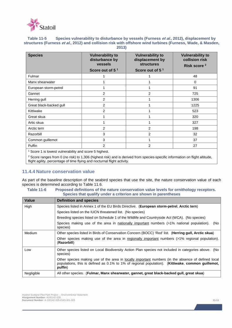
Table 11-5 Species vulnerability to disturbance by vessels (Furness et al., 2012), displacement by
structures (Furness et al., 2012) and collision risk with offshore wind turbines (Furness, Wade, & Masden, 2013)
Species Vulnerability to disturbance by
vessels Score out of 5 1
Vulnerability to displacement by
structures Score out of 5 1
Vulnerability to collision risk Risk score 2
Fulmar 1 1 48 Manx shearwater 1 1 0 European storm-petrel 1 1 91 Gannet 2 2 725 Herring gull 2 1 1306 Great black-backed gull 2 1 1225 Kittiwake 2 1 523 Great skua 1 1 320 Artic skua 1 1 327 Arctic tern 2 2 198 Razorbill 3 2 32 Common guillemot 3 1 37 Puffin 2 2 27 1 Score 1 is lowest vulnerability and score 5 highest. 2 Score ranges from 0 (no risk) to 1,306 (highest risk) and is derived from species-specific information on flight altitude, flight agility, percentage of time flying and nocturnal flight activity.
11.4.4 Nature conservation value As part of the baseline description of the seabird species that use the site, the nature conservation value of each species is determined according to Table 11.6.
Table 11-6 Proposed definitions of the nature conservation value levels for ornithology receptors. Species that qualify under a criterion are shown in parentheses
Value Definition and species High Species listed in Annex 1 of the EU Birds Directive. (European storm-petrel, Arctic tern)
Species listed on the IUCN threatened list. (No species) Breeding species listed on Schedule 1 of the Wildlife and Countryside Act (WCA). (No species) Species making use of the area in nationally important numbers (>1% national population). (No species)
Medium Other species listed in Birds of Conservation Concern (BOCC) ‘Red’ list. (Herring gull, Arctic skua) Other species making use of the area in regionally important numbers (>1% regional population). (Razorbill)
Low Other species listed on Local Biodiversity Action Plan species not included in categories above. (No species) Other species making use of the area in locally important numbers (in the absence of defined local populations, this is defined as 0.1% to 1% of regional population). (Kittiwake, common guillemot, puffin)
Negligible All other species. (Fulmar, Manx shearwater, gannet, great black-backed gull, great skua)
Hywind Scotland Pilot Park Project – Environmental Statement Assignment Number: A100142-S35 Document Number: A-100142-S35-EIAS-001-005 11-11
11.4.5 Species accounts The species accounts that follow are shortened versions of the species accounts in NRP (2015). Full details of the estimated numbers of birds of each species and their associated confidence limits present on each survey and during each season are presented in Caloo (2014a: Year-1 baseline surveys, Caloo (2014c: Additional Year-2 surveys) and Caloo (2014d: Year 1 baseline surveys using seasonality as per JNCC/SNH recommendations).
The species accounts include information on the likely breeding site origins of birds using the vicinity of the wind farm. Owing to the fact that all the species that use this area range widely and that birds from different breeding sites may share foraging areas to a greater or lesser extent, there is inevitably some uncertainty about the exact breeding site origins of the individuals present. During the breeding season information on typical foraging distances from a colony based on tagging studies (Thaxter et al., 2012) is used to give an indication of the likely geographic spread of source colonies. Where available, results from tagging birds at colonies in east Scotland may demonstrate direct connectivity between a colony and the wind farm area. Outside the breeding there is typically greater uncertainty about the origin of the birds present due to fewer studies at this time of year. Nevertheless for all species that use the area there is increasing evidence of widespread and often long-distance movement outside the breeding season typically with considerable mixing of populations from different breeding areas (Furness, 2014).
The seasonality used in the species accounts follows the recommendations of JNCC/SNH with the exception of Arctic tern. For Arctic tern August is defined as ‘autumn migration period’ rather than ‘breeding season’ as the birds present in the Survey Area in August were considered to be passage post-breeding birds for the reasons explained in detail in NRP (2015).
Fulmar
Fulmars were common in the survey area throughout the year, with a high proportion of birds seen in flight. Fulmars range very widely away from breeding colonies both to forage when they are breeding and at other times of year. The birds seen in the survey area are likely to be mainly from breeding areas across northern and eastern Scotland.
During the breeding season (May to September) the estimated mean number of fulmars in the WT+1 km area and was 30 individuals. The 95% upper confidence limit of this mean is 40 individuals. Both these numbers represent <0.01% of the regional breeding population of 767,160 adults (derived from Mitchell et al., 2004) and thus the WT+1 km area is considered to have negligible importance as a foraging area for the regional breeding population.
During the winter season (October to April) the estimated mean number of fulmars in the WT+1 km and 95% upper confidence limit of this mean was 20 individuals and 25 individuals respectively. Both these numbers represent <0.01% of the BDMPS non-breeding population of 568,736 birds for the North Sea waters area (Furness, 2014) and thus the WT+1 km area is considered to have negligible importance as a foraging area for the regional non-breeding population.
Fulmars are considered to have very low vulnerability to vessel disturbance, displacement by structures and offshore wind turbine collision risk (Table 11.5). This species has a negligible nature conservation value according to the criteria in Table 11.6) and has a favourable conservation status in Scotland (JNCC, 2014).
On account of the above information, fulmar is considered to be a species of low priority to the EIA assessment. Some fulmars using the Project area are likely to be from SPA colonies where this species is a qualifying feature, this is considered in the HRA Report.
Manx shearwater
Manx shearwaters are a summer and passage visitor to eastern Scotland and were occasionally recorded in low numbers. The birds seen were likely to be non-breeding immatures and passage birds.
Based on the estimated density in the survey area, the mean number present in the WT+1 km area was just 0.7 birds. The 95% upper confidence limit of this mean is 1.3 birds. The latter represents approximately 0.02% of the BDMPS migration season population of 8,507 birds for the North Sea area (Furness, 2014) and thus the WT+1 km area is considered to have negligible importance as a foraging area for the regional population.
Hywind Scotland Pilot Park Project – Environmental Statement Assignment Number: A100142-S35 Document Number: A-100142-S35-EIAS-001-005 11-12
It is unlikely that birds using the Project area during the summer were actively breeding individuals because it is further than the MMFR from the closest large breeding colonies. Ringing studies show that Manx shearwaters off the east coast of Scotland are likely to originate from the large breeding colonies in north-west Scotland, in particular Rum and St Kilda (Wernham et al., 2002). They also breed in very small numbers (<10 pairs) in Orkney and Shetland and a handful of pairs has recently established on the Isle of May in the Firth of Forth.
Manx shearwaters are considered to have very low vulnerability to vessel disturbance, displacement by structures and offshore wind turbine collision risk (Table 11.5). This species has a negligible nature conservation value according to the criteria in Table 11.6 and has a favourable conservation status in Scotland (JNCC 2014).
On account of the above information, Manx shearwater is considered to be a species of low priority to the EIA assessment.
European storm-petrel
European storm-petrels (hereafter just ‘storm-petrels’) are a summer and passage visitor to eastern Scotland and were occasionally recorded in low numbers. The birds seen were likely to be non-breeding immatures and passage birds.
Based on the estimated density in the survey area, the mean number present in the WT+1 km area was just 0.6 birds. The 95% upper confidence limit of this mean is 1.1 birds. Storm-petrel is not considered in the BDMPS review by Furness (2014) but the analysis of ESAS data undertaken by Stone et al. (1995) indicates mean densities of around 0.1 birds / km2 from July to September for the western North Sea, and suggesting a North Sea population size of at least 10,000 birds. On this basis the estimated bird numbers (95% UCL) using the WT+1 km area are likely to represent 0.01% of the North Sea migration season population and thus the WT+1 km area is considered to have negligible importance as a foraging area for the population.
It is unlikely that birds using the Project area during the summer were actively breeding individuals because it is further than the likely maximum foraging range (reported to be >65km by Thaxter et al., 2012) from the closest large breeding colonies in Orkney. Ringing studies show that storm-petrels range extremely widely as immatures and after breeding and birds off the east coast of Scotland could originate from colonies anywhere in Scotland (Wernham et al., 2002), though Orkney and Shetland colonies are the most likely.
Storm-petrels are considered to have very low vulnerability to vessel disturbance, displacement by structures and offshore wind turbine collision risk (Table 11.5). This species has a high nature conservation value according to the criteria in Table 11.6). Due to the difficulties of counting colonies, there has been no recent assessment of conservation status, the results of the Seabird 2000 census showed that it had a favourable conservation status at the start of the century.
On account of the above information, storm-petrel is considered to be a species of low priority to the EIA assessment.
Gannet
Gannets were commonly present in the survey area throughout the year, with a high proportion (76%) of the birds seen in flight. Approximately 9% of flying gannets were estimated to be at or above 20 m above the sea and the rest between 20 m and 50 m (Caloo, 2014b).
Based on the density in the survey area in Year 1, the estimated mean number of gannets in the WT+1 km during the breeding season (April to September) was 10 individuals. The 95% upper confidence limit of this mean is 13 individuals. The latter estimate represents approximately 0.01% of the regional breeding population of 124,386 adults (derived from SMP database) and thus the WT+1 km area is considered to have negligible importance as a foraging area for the regional breeding population. Approximately 92% of the gannets that were aged during the breeding season of the Year-1 surveys were birds in adult plumage.
The numbers of gannets using the survey area during the additional Year-2 survey work (July to September 2014) were similar to those for the same months in Year 1.
Based on the density in the survey area in Year 1, the estimated mean number of gannets in the WT+1 km during the winter period (October to March) was four individuals. The 95% upper confidence limit of this mean was five individuals. Both these numbers represent <0.01% of the minimum BDMPS non-breeding population of 248,385
Hywind Scotland Pilot Park Project – Environmental Statement Assignment Number: A100142-S35 Document Number: A-100142-S35-EIAS-001-005 11-13
birds for the North Sea waters and Channel area (Furness, 2014) and thus the WT+1 km area is considered to have negligible importance as a foraging area for the non-breeding season regional population.
Breeding gannets range long distances to forage; the mean foraging distance is 93 km and the MMFR is 229 km (Thaxter et al., 2013). The closest gannetry is the relatively small colony (approximately 5,574 adults in 2010) at Troup Head, approx. 60 km from the Project site and the only gannetry within the mean foraging distance. The next closest colony is the large gannetry at Bass Rock, 169 km to the south. Telemetry tags fitted to Bass Rock gannets show that the Hywind project lies in the peripheral part of the large area regularly used for foraging by birds from this colony (Hamer et al., 2007). The gannetry on Fair Isle (228 km to the north) lies at the limit of the MMFR and therefore breeding birds from this colony also potentially forage in the Hywind survey area. Outside the breeding season gannets range widely and tend to move south (Wernham et al., 2002). The birds seen in the survey area from September onwards are likely to originate from any of the colonies in eastern and northern Scotland, including colonies in Shetland.
Gannets are considered to have low vulnerability to vessel disturbance and displacement by structures (Table 11.5.). However, gannets are considered to have a relatively high vulnerability to collision risk because they commonly fly at the height of offshore wind turbines (Table 11.5). This species has a negligible nature conservation value according to the criteria in Table 11.6 and has a favourable conservation status in Scotland (Mitchell et al., 2004; JNCC, 2014).
Collision rate modelling has been undertaken for this species (Caloo, 2014b) on account of its apparent vulnerability to collision (Furness et al., 2013). On account of the above information, gannet is considered to be a species of moderate priority to the EIA assessment.
Many of the gannets using the Project area are likely to be from SPA colonies where this species is a qualifying feature, for example Forth Islands SPA (Bass Rock) and Fair Isle SPA. The effects of the project on the integrity of SPA gannet qualifying feature is considered in the HRA Report. Gannet also breed at Troup, Pennan and Lion’s Heads SPA but this species is not cited as a qualifying feature for this site; the colony on Troup Head established only recently and after the site was designated.
Arctic skua
Arctic skuas are a non-breeding summer visitor and passage migrant to eastern mainland Scotland. They were occasionally recorded in very low numbers in the survey area in the summer and autumn months.
Based on the estimated density in the survey area, the mean number present in the WT+1 km area during the summer and autumn passage period (June to November) was just 0.1 birds. The 95% upper confidence limit of this mean is 0.4birds. The latter estimate represents less than 0.01% of the BDMPS migration season population of 6,427 birds for the North Sea and Channel area (Furness, 2014) and thus the WT+1 km area is considered to have negligible importance as a foraging area for this species.
It is not plausible that the Arctic skuas seen in the survey area during the breeding season (April to July) were actively breeding because the closest colonies are at least 160 km away (in Caithness and Orkney) and this species maximum foraging range is reported to be 75 km (Thaxter et al., 2012). Birds present at this time of year are likely to be non-breeding immature birds from Caithness, Orkney and Shetland breeding grounds and perhaps Scandinavia too. From August onwards birds are likely to be passage birds from the same breeding areas (Wernham et al., 2002).
Arctic skuas are considered to have very low vulnerability to vessel disturbance and displacement by structures and moderate vulnerability to offshore wind turbine collision risk (Table 11.5). This species has a moderate nature conservation value according to the criteria in Table 11.6. The Scottish population has an unfavourable conservation status. It has undergone long term decline in numbers, amounting to a 74% reduction since 1986 (Mitchell et al., 2004, JNCC 2014).
On account of the above information, Arctic skua is considered to be a species of low priority to the EIA assessment.
Some Arctic skuas using the Project area are likely to be from SPA colonies where this species is a qualifying feature, and this is considered in the HRA Report. Arctic skua is a qualifying breeding species at seven SPAs in Orkney and Shetland.
Hywind Scotland Pilot Park Project – Environmental Statement Assignment Number: A100142-S35 Document Number: A-100142-S35-EIAS-001-005 11-14
Great skua
Great skuas are a non-breeding summer visitor and passage migrant to eastern mainland Scotland. They were occasionally recorded in very low numbers in the survey area in the summer and autumn months.
Based on the estimated density in the survey area, the mean number present in the WT+1 km area during the summer and autumn passage period (July to November) was just 0.5 birds. The 95% upper confidence limit of this mean is 0.9 birds. These numbers represent <0.01% of the BDMPS migration season population of 19,556 birds for the North Sea and Channel area (Furness, 2014) and thus the WT+1 km area is considered to have negligible importance as a foraging area for this species.
It is unlikely that the Great skuas seen in the survey area during the breeding season (April to August) were actively breeding because the closest colonies are approximately 180 km away (in Orkney), well beyond the MMFR of 86 km reported for this species (Thaxter et al., 2012). Birds present at this time of year are likely to be non-breeding immature birds from Orkney and Shetland breeding grounds. From August onwards birds are likely to be passage birds from the same breeding areas and Scandinavia (Wernham et al. 2002; Furness 2014).
Great skuas are considered to have very low vulnerability to vessel disturbance and displacement by structures and moderate vulnerability to offshore wind turbine collision risk (Table 11.5). This species has a negligible nature conservation value according to the criteria in Table 11.6. The Scottish population has shown a large long term population increase (Mitchell et al., 2004) but at strongholds in Orkney it has undergone moderate decline (by about 25%) since 2000 (Furness, 2014).
On account of the above information, great skua is considered to be a species of low priority to the EIA assessment.
Some great skuas using the Project area are likely to be from SPA colonies where this species is a qualifying feature, this is considered in the HRA Report. Great skua is a qualifying breeding species at Hoy SPA (Orkney) and five SPAs in Shetland.
Herring gull
Herring gulls were regularly present in the survey area in small numbers in the summer and moderate numbers in the winter. A high proportion of birds seen were in flight and some were associating with fishing vessels.
The breeding season is defined as April to August and the non-breeding season as September to March. Approximately 73% of the herring gulls in the survey area during the breeding season were in adult plumage.
Based on the density in the survey area, the estimated mean number of herring gulls during the breeding and post-breeding seasons was just in the WT+1 km area was just 1 individual (all age classes). The 95% upper confidence limit of this mean is 1 individual. These numbers represent <0.01% of the regional breeding population of 25,474 adults (Mitchell et al., 2004) and thus the WT+1 km area is considered to have negligible importance as a foraging area for the regional breeding population.
Based on the density in the survey area in the autumn and winter period (September to March), the estimated mean number of herring gulls in the WT+1 km area was 12 individuals. The 95% upper confidence limit of this mean is 17. These numbers represent <0.01% non-breeding BDMPS population of 466,511 birds for the North Sea and Channel region (Furness, 2014) and thus the WT+1 km area is considered to have negligible importance as a foraging area for the regional autumn and winter population.
On average, 97% of herring gulls estimated to be present were in flight, and approximately 47% of these were estimated to be at between 20 and 70 m height, i.e., within the height range of the proposed wind turbine rotors.
Breeding herring gulls range moderate distances to forage; the MMFR is 61 km (Thaxter et al., 2012). The closest colonies are those along the Buchan Ness to Collieston coast (22 km at closest) and roof top colonies in Peterhead (20 km at closest). Using the MMFR plus 10% the regional breeding population stretches west to colonies at Banff and south to Fowlsheugh. Although the latter lies slightly out with the foraging range definition used (by about 10 km) it is considered likely that birds from this relatively large colony can occur in the survey area.
Outside the breeding season herring gull from east Scotland breeding colonies show a mixture of sedentary behaviour and short to moderate distance southwards movements (Wernham et al., 2002). From November onwards these will be joined by birds from northern Scandinavia (Wernham et al., 2003).
Hywind Scotland Pilot Park Project – Environmental Statement Assignment Number: A100142-S35 Document Number: A-100142-S35-EIAS-001-005 11-15
Herring gulls are considered to have very low vulnerability to vessel disturbance and displacement by structures (Table 11.5.). However, herring gull are considered to have a relatively high vulnerability to collision risk because they commonly fly at the height of offshore wind turbines (Furness et al., 2013) and therefore collision rate modelling has been undertaken for this species (Caloo 2014b and d).
Herring gull has a medium nature conservation value according to the criteria in Table 11.6 on account of it being a UK BAP species and on the BOCC red list. The Scottish herring gull population has an unfavourable conservation status; it is has declined by approximately 58% over the past 25 years (JNCC 2014). The decline is linked to food supply and change in fishing practices and refuse management (Mitchell et al., 2004)
On account of the above information, herring gull is considered to be a species of moderate priority to the EIA assessment. Nevertheless, although this species has potential for collision risk and has a poor conservation status, the numbers using the turbine deployment area are very low in the context of regional populations.
Some herring gulls using the Project area are likely to be from SPA colonies where this species is a qualifying feature, this is considered in the HRA Report. Herring gull is a qualifying species at Buchan Ness to Collieston SPA, Troup, Pennan and Lion’s Head, Fowlsheugh SPA and East Caithness Cliffs SPA.
Great black-backed gull
Great black-backed gulls were regularly present in the survey area, with small numbers of mainly immature non-breeding birds present in the summer months and moderate numbers of all ages classes present in the winter. A high proportion of birds seen were in flight and some were associating with fishing vessels.
The breeding season is defined as April to August and the non-breeding season as September to March. During the breeding season on average 92% of the great-black backed gulls in the survey during were in immature plumage.
Based on the density in the survey area, the estimated mean number of great black-backed gulls in the WT+1 km area during the breeding and post-breeding seasons was <1 bird (all age classes). The 95% upper confidence limit of this mean is 1 bird, equating to 0.05% of the regional breeding population of 140 adults (Mitchell et al., 2004) and thus the WT+1 km area is considered to have negligible importance as a foraging area for the regional breeding population.
Based on the density in the survey area in the autumn and winter period (September to March), the estimated mean number of great black-backed gulls in the WT+1 km area was 11 individuals. The 95% upper confidence limit of this mean is 13. These numbers represent approximately 0.01% of the non-breeding period BDMPS population of 91,399 birds for the North Sea region (Furness, 2014) and thus the WT+1 km area is considered to have negligible importance as a foraging area for the regional autumn and winter population.
Breeding great-black backed gulls range relatively small distances (<40 km) to forage (Ratcliffe et al., 2000 in Langston, 2010), and any breeding birds that use the Project area are likely to be from colonies along the Buchan coast. The immature birds present in the summer are likely to mainly originate from colonies outside the defined breeding region, particularly those further north in Scotland where this species is much more numerous (e.g., there are approximately 5,000 pairs in Caithness and Orkney (Mitchell et al., 2004). Outside the breeding season Scottish great-black backed gulls show a mixture of sedentary behaviour and short to moderate distance southwards movements (Wernham et al., 2002). Scottish birds are joined in the autumn by large numbers of birds from northern Norway (Furness, 2014).
Great black-backed gulls are considered to have very low vulnerability to vessel disturbance and displacement by structures (Table 11.5). However, they are considered to have a relatively high vulnerability to collision risk because they commonly fly at the height of offshore wind turbines (Furness, Wade, & Masden, 2013) and therefore collision rate modelling has been undertaken for this species (Caloo, 2014b and d).
Great black-backed gull has a negligible nature conservation value according to the criteria in Table 11.6. The Scottish population has an unfavourable conservation status on account a long term decline. It is has declined by 40% since the mid 1980s (JNCC 2014). The causes of the decline are not fully understood but may be linked to decreases in food supply including changes to fishery practises (Mitchell et al., 2004).
On account of the above information, great black-backed gull is considered to be a species of moderate priority to the EIA assessment. Nevertheless, although this species has potential for collision risk and has a poor
Hywind Scotland Pilot Park Project – Environmental Statement Assignment Number: A100142-S35 Document Number: A-100142-S35-EIAS-001-005 11-16
conservation status, the numbers using the turbine deployment area are very low in the context of regional populations.
Some great black-backed gulls using the Project area are likely to be from SPA colonies where this species is a qualifying feature, this is considered in the HRA Report. Great black-backed gull is a qualifying species at East Caithness Cliffs SPA and several Orkney SPAs, however the Project area is beyond the foraging range of birds breeding in these colonies.
Kittiwake
Kittiwakes were regularly present in the survey area, with moderate numbers in the breeding season and low numbers in autumn and winter.
Kittiwakes breeding in Scotland are undergoing rapid decline, at an average rate of 4.2% per annum; in the 14-year period since the Seabird 2000 census numbers will have declined by approximately 45% (based on information in JNCC, 2014). Therefore the current regional breeding population is assumed to be the number estimated by Seabird 2000 census (133,528 adults) multiplied by 0.55, which is 73,440 adults. The actual number of kittiwakes present in this defined region during the breeding season is likely to be greater than this figure because of the presence of immature birds. However, poor breeding success in recent years (a feature of the decline) means that relatively few immatures are to be expected. This was borne out by the survey results, with approximately 99% of birds aged during the colony-attendance period being in adult plumage.
Based on the density in the survey area, the estimated mean number of kittiwakes during the breeding season (April to August) in the WT+1 km area was 81 individuals (all age classes). The 95% upper confidence limit of this mean is 112 individuals. These numbers represent 0.1% and 0.2% respectively of the regional breeding population of 73,440 adults (Mitchell et al., 2004) and thus the WT+1 km area is considered to have low importance as a foraging area for the regional breeding population.
Based on the density in the survey area in the autumn and winter period (September to March), the estimated mean number of kittiwakes in the WT+1 km area was 3 individuals. The 95% upper confidence limit of this mean is 4 individuals. These numbers represent <0.01% winter/spring migration BDMPS population of 627,816 birds for the North Sea region (Furness, 2014) and thus the WT+1 km area is considered to have negligible importance as a foraging area for the regional autumn and winter population.
The numbers of kittiwakes using the survey area during the additional Year-2 survey work (July to September 2014) were similar to or lower than estimated for Year 1 at the equivalent time. Despite undertaking more survey visits in this period in Year-2, the peak density on any one survey was substantially lower in Year 2 (14.3 birds/km2 compared to 42.1 birds/km2) with both peaks occurring in early August. On average, 19% of kittiwake in the survey area were in flight, and approximately 8% of these were estimated to be at between 20 and 45 m height, i.e., within the height range of the proposed wind turbine rotors.
Breeding kittiwakes range moderate distances to forage; the MMFR is 60 km (Thaxter et al., 2013). The closest large colonies are at those along the Buchan Ness to Collieston (22 km at closest), Troup, Pennan and Lion’s Heads (54 km at closest) and Fowlsheugh (74 km at closest). The regional breeding population is defined as far west as colonies between Rosehearty and Bay of Cullen, and as far south as the large Fowlsheugh colony. The birds seen in the survey area from August onwards are likely to originate from any of the colonies in eastern and northern Scotland, and by the winter month will also include birds from Barents Sea colonies (Furness, 2014).
Kittiwakes are considered to have very low vulnerability to vessel disturbance and displacement by structures (Table 11.5). However, they are considered to have a relatively high vulnerability to collision risk because they commonly fly at the height of offshore wind turbines (Furness et al., 2013) and therefore collision rate modelling has been undertaken for this species (Caloo 2014b and d). The Scottish population has an unfavourable conservation status on account a long term decline. It is has declined by approximately 66% over the past 25 years, equating to an average decline rate of 4.2% per annum (JNCC 2014, Mitchell et al., 2004). The decline linked to food supply and sea temperature changes (JNCC, 2014). Despite the unfavourable conservation status, kittiwake has a low nature conservation value according to the criteria in Table 11.6.
On account of the above information, kittiwake is considered to be a species of moderate priority to the EIA assessment. Nevertheless, although this species has potential for collision risk and has an unfavourable conservation status, the numbers using the turbine deployment area are very low in the context of regional populations. Hywind Scotland Pilot Park Project – Environmental Statement Assignment Number: A100142-S35 Document Number: A-100142-S35-EIAS-001-005 11-17
Some kittiwakes using the Project area are likely to be from SPA colonies where this species is a qualifying feature, this is considered in the HRA Report. Kittiwake is a qualifying species of Buchan Ness to Collieston SPA, Troup, Pennan and Lion’s Heads SPA, Fowlsheugh SPA and East Caithness Cliffs.
Arctic tern
The only Arctic terns seen during the colony-attendance period (May to July) were three ‘not-in-transect’ flying birds recorded in July outside the WT+1 km area. Because these birds were not in-transect they do not contribute to the density calculated by the Distance Analysis. Three birds represents approximately 1% of the assumed regional breeding population of 276 adults.
Based on the density in the survey area, the estimated mean number of Arctic terns during the autumn migration period (August) in the WT+1 km area was 50 individuals. The 95% upper confidence limit of this mean is 128 individuals. These numbers represent 0.03% and 0.07% respectively of the passage migration BDMPS population of 163,930 birds for the North Sea region and Channel area (Furness, 2014) and thus the WT+1 km area is considered to have negligible importance as a foraging area for the autumn passage population.
The additional Year-2 survey work (July to September 2014) recorded low densities (0.21 birds/km2) of Arctic tern in early August 2014, a density similar that present one of the early August 2013 surveys but much lower than the other early August 2013 survey date when 6.97 birds/km2 were present. Outside early August, the only other 2014 records were of single birds on the 28th July and 10th September. The results are consistent with an autumn passage of Arctic terns through the survey area primarily concentrated in early August, when the density of birds present can vary greatly even between consecutive days, but with occasional birds passing through the site from late July to early September.
On average, only 6% of Arctic terns in the survey area were in flight, and approximately no birds were estimated to be flying above 20m, i.e., no birds were seen flying within the height range of the proposed wind turbine rotors.
The maximum foraging range of breeding Arctic tern is 30 km, and the MMFR is 24 km (Thaxter et al., 2013). The WT+1 km area lies at the expected outer limit of the foraging range of Arctic terns breeding at the St Fergus Gas Terminal on the Buchan coast. Although this colony may have been the source of the birds seen in July, it is also likely that they were non-breeding birds or passage birds. The autumn passage birds are likely to be from breeding grounds further north in Scotland, and possibly Scandinavia and the Baltic also (Wernham et al., 2002; Furness, 2014).
Arctic tern is listed on Annexe 1 of the EU Birds Directive and therefore has a high nature conservation value according to the criteria in Table 11.6. The Scottish population has an unfavourable conservation status and has undergone a 72% decline in numbers since the mid 1980s; the decline is linked to poor food supply and nest predation (JNCC, 2014).
Arctic terns are considered to have low vulnerability to vessel disturbance and displacement by structures (Table 8.5) and a moderate vulnerability to collision risk because they occasionally fly at the height of offshore wind turbines (Furness et al., 2013). Collision rate modelling has been undertaken for this species (Caloo, 2014b and d) on account of its high nature conservation value.
On account of the above information, Arctic tern is considered to be a species of moderate priority to the EIA assessment. Nevertheless, although this species has potential for collision risk and has an unfavourable conservation status, the numbers using the turbine deployment area are very low in the context of regional populations.
Some Arctic terns using the Project area are likely to be from SPA colonies where this species is a qualifying feature, this is considered in the HRA Report. Arctic tern is a qualifying breeding species at ten SPAs in Orkney and Shetland, the closest of which is Pentland Firth Islands 167 km away.
Common guillemot
Common guillemots (hereafter just ‘guillemots’) were present in the survey area in large to very large numbers throughout the year, with the vast majority of birds seen being on the water. Particularly large numbers were present in August 2013, the period after adults have departed colonies and may have accompanying chicks.
After accounting for adults that were not attending the colonies at the time of counting (using a correction factor of x1.34, Mitchel et al., 2004), the size of the regional population for the colony-attendance part of the breeding Hywind Scotland Pilot Park Project – Environmental Statement Assignment Number: A100142-S35 Document Number: A-100142-S35-EIAS-001-005 11-18
season (April to July) is estimated at 200,851 adults. The actual number of birds present in this period is likely to be substantially larger because of the presence of non-breeding immature birds.
Based on the density in the survey area, the estimated mean number of guillemots during the colony-attendance part of the breeding season in the WT+1 km area was just 249 individuals (all age classes). The 95% upper confidence limit of this mean is 295 individuals. These numbers represent 0.10% and 0.14% respectively of the regional breeding population of 200,851 adults (Mitchell et al., 2004) and thus the WT+1 km area is considered to have low importance as a foraging area for the regional breeding population.
For the reasons explained earlier (Section 11.4.2), the assumed regional population during the chick-on-sea part of the guillemot breeding season (August) is based on a larger geographic area. Based on the density in the survey area, the estimated mean number of guillemots during this stage of the breeding season in the WT+1 km area was 2,136 individuals (all age classes). The 95% upper confidence limit of this mean is 3,169 individuals. These numbers represent approximately 0.4% and 0.6% respectively of the assumed regional population of 576,185 adults for the chick-at-sea stage of the breeding season (Mitchell et al., 2004) and thus the WT+1 km area is considered to have low importance as a foraging area for the regional breeding population. The maximum estimated number in the wider Hywind Survey Area in August 2013 was approximately 29,000 birds, which represents approximately 5% of the assumed regional population. This figure also represents approximately 1.6% of the national population, thus exceeding the 1% threshold (by convention) for national importance.
The Survey Area has low to moderate importance as a nursery area for guillemot chicks. In 2013 the percentage of guillemot in the survey area aged to be chicks was low, being approximately 2.5% in early July declining to approximately 1% in early August. In comparison to 2013, the chick percentage present in 2014 was much greater in July (up to 18%) and similar in August. The chicks present in early July will have been recently fledged and therefore likely to be from relatively local colonies compared to chicks seen on later dates by when birds would have had time to disperse well away from their breeding colonies.
The additional Year-2 survey work (July to September 2014) showed that the density of guillemot present in the survey area in July 2013 and 2014 were similar. The average density of guillemots in August 2014 was less than a third than that recorded in August 2013 (51 birds/km2 compared to 157 birds/km2). In contrast the average density for surveys in September 2014 was much higher than for surveys in 2013 (31 birds/km2 compared to 2.1 birds/ km2).
The survey results over two years show that the Project is located in a wider area that has high importance for guillemot in the late summer. High densities and the presence of chicks at this time are likely to be a regular feature of the area albeit with at least moderate year-to-year variability in the size of and timing of aggregations. The results are consistent with the late summer being a period of flux for this species and it is likely there is a considerable turnover of birds through this period as part of large scale seasonal dispersal movements. It is desirable to minimise disturbance to guillemots during the late summer period given their heightened vulnerability to disturbance and tendency to form large aggregations at this time of year.
Based on the density in the survey area, the estimated mean number of guillemots in the WT+1 km area in the autumn and winter period (September to March) was 40 individuals. The 95% UCL of this mean is 52 individuals. Including the high counts from additional surveys in September 2014 leads to a mean of 78 individuals. These numbers are <0.01% and 0.03% of the estimated minimum non-breeding period population of 1,617,306 birds for the North Sea and Channel BDMPS region (Furness, 2014) and thus the WT+1 km area is considered to have negligible importance as a foraging area for the autumn and winter population.
Breeding guillemots travel moderate distances to forage; the maximum foraging distance is reported to be 135 km and the MMFR is 84 km (Thaxter et al., 2012). During the colony-attendance part of the breeding season the birds using the Project area are most likely to be from colonies along Buchan, Gordon, Aberdeenshire and Kincardine coasts. The birds present in the chicks-on-sea part of the breeding season (August), by when guillemots will have departed breeding colonies, are likely to comprise a mix of birds from the areas listed above and from further afield, in particular from colonies in Caithness and perhaps Orkney and Shetland also (see Section 8.4.2). The birds seen in the survey area during the autumn and winter are likely to originate from any of the colonies in eastern and northern Scotland, and may also include birds from Scandinavia (Wernham et al., 2002; Furness, 2014).
The Scottish population has shown moderate long-term decline amounting to approximately -26% since 1986 (JNCC, 2014; Mitchell et al., 2004). The decline is linked to food supply and sea temperature changes (JNCC, 2014). Hywind Scotland Pilot Park Project – Environmental Statement Assignment Number: A100142-S35 Document Number: A-100142-S35-EIAS-001-005 11-19
The surveys show that the area potentially affected by the wind farm has disproportionately high value to guillemots during the colony attendance and chicks-on-sea periods (April to August) breeding season, particularly during August. Concerns are likely to be moderate at these times due to the potential to displace birds from important foraging grounds. Guillemots undergo complete wing moult in August and September, rendering them temporarily flightless and potentially making them more sensitive to disturbance.
Guillemots are considered to have moderate vulnerability to vessel disturbance (Furness et al., 2012); their vulnerability to disturbance is heightened during the chicks-on-sea part of the breeding season due to the presence of dependent chicks and because adults undergo complete wing moult at this time of year rendering them temporarily flightless. Guillemots have a low vulnerability to displacement by structures (Table 11.5.) and collision risk (Furness et al., 2013). Guillemot has a low nature conservation value according to the criteria in Table 11.6). However, on account of the high densities at times present in the chick-on-sea part of the breeding season, guillemot is considered to be a species of moderate priority to the EIA assessment.
Some guillemots using the Project area are likely to be from SPA colonies where this species is a qualifying feature, this is considered in the HRA Report. Guillemot is a qualifying species at Buchan Ness to Collieston SPA, Troup, Pennan and Lion’s Heads SPA, Fowlsheugh SPA and. also a qualifying species at East Caithness Cliffs SPA, eleven SPAs in Orkney and Shetland and Firth Islands SPA; all these colonies are a further away from the Project area than the maximum foraging distance of breeding birds when attending a colony.
Razorbill
Razorbills were present in the survey area in moderate to large numbers throughout the year, with the vast majority of birds seen being on the water. Particularly large numbers were present in August 2013, the period after adults have departed colonies and may have accompanying chicks.
After accounting for adults that were not attending the colonies at the time of counting (using a correction factor of x1.34, Mitchel et al., 2004), the size of the regional population for the colony-attendance part of the breeding season (April to July) is estimated at 11,312 adults. The actual number of birds present is likely to be substantially greater because of the presence of non-breeding immature birds.
Based on the density in the survey area, the estimated mean number of razorbills during the colony-attendance part of the breeding season in the WT+1 km area was 30 individuals (all age classes). The 95% upper confidence limit of this mean is 40 individuals. These numbers represent 0.3% and 0.4% respectively of the regional population for the colony-attendance part of the breeding season of 11,312 adults (Mitchell et al., 2004) and thus the WT+1 km area is considered to have low importance as a foraging area for the regional breeding population.
For the reasons explained earlier (Section 11.4.2), the assumed regional population of razorbill during the chick-on-sea part breeding season (August) is based on a larger geographic area. Based on the density in the survey area, the estimated mean number of razorbills in the WT+1 km area during this period was 719 individuals (all age classes). The 95% upper confidence limit of this mean is 1,085 individuals. These numbers represent approximately 1.2% and 1.7% respectively of the assumed regional population of 62,058 adults for the chick-at-sea stage of the breeding season (Mitchell et al., 2004) and thus the WT+1 km area is considered to have medium importance as a foraging area for the regional population at this time of year. The maximum estimated number in the wider Hywind survey area in August 2013 was approximately 12,500 birds, which represents approximately 20% of the assumed regional population. This figure also represents approximately 5.7% of the national population, thus comfortably exceeding the 1% threshold (by convention) for national importance.
The Hywind Survey Area has moderate importance as a nursery area for razorbill chicks. There was a similar pattern in the occurrence of chicks in both 2013 and 2014; relatively high percentages (approximately 19%) of razorbills present were aged to be chicks in early July surveys, dropping to a few percent by early August, and (in 2014 at least) to zero by late August. The chicks present in early July will have been recently fledged and therefore likely to be from relatively local colonies compared to chicks seen on later dates by when birds would have had time to disperse well away from their breeding colonies.
The additional Year-2 survey work (July to September 2014) showed that the mean density of razorbill present in the survey area in July 2014 was approximately twice as high as in the July 2013 (2.8 birds/km2 in 2014 compared to 1.5 birds/km in 2013). In both years peak densities occurred in early August but the density in early August 2014 was less than half that in early August 2013 (21.0 birds/km2 in 2014 compared to 52.9 birds/km in 2013). The
Hywind Scotland Pilot Park Project – Environmental Statement Assignment Number: A100142-S35 Document Number: A-100142-S35-EIAS-001-005 11-20
mean densities in late August and September 2014 were much lower and similar to the mean density in September 2013 (1.0 birds/km2 in 2014 compared to 1.2 birds/km in 2013).
The survey results over two years show that the Project is located in a wider area that has high importance for razorbill in the late summer. High densities and the presence of chicks at this time of year are likely to be a regular feature of the area albeit with at least moderate year-to-year variability in the size of and timing of aggregations. The results are consistent with the late summer being a period of flux for this species and it is likely there is a considerable turnover of birds through this period as part of large scale seasonal dispersal movements. It is desirable to minimise disturbance to razorbills during the late summer period given their heightened vulnerability to disturbance and tendency to form large aggregations at this time of year.
Based on the density in the survey area, the estimated mean number of razorbills in the WT+1 km area in the autumn and winter period (September to March) was 10 individuals. The 95% upper confidence limit of this mean is 16 individuals. These numbers are both <0.01% of the estimated minimum non-breeding period population of 218,622 birds for the North Sea and Channel BDMPS region (Furness, 2014) and thus the WT+1 km area is considered to have negligible importance as a foraging area for the autumn and winter population.
Breeding razorbills travel moderate distances to forage; the maximum foraging distance is reported to be 95 km and the MMFR is 49 km (Thaxter et al., 2012). During the colony-attendance part of the breeding season the birds using the Project area are most likely to be from colonies along the Buchan, Gordon, Aberdeenshire and Kincardine coasts. The birds present in the chicks-on-sea part of the breeding season (August), by when razorbills will have departed breeding colonies, are likely to comprise a mix of birds from the areas listed above and from further afield, in particular from colonies in Caithness and perhaps Orkney and Shetland also (see Section 11.4.2). The birds seen in the survey area during the autumn and winter are likely to originate mainly from overseas for example Faeroes, Iceland and Scandinavia (Wernham et al., 2002; Furness, 2014).
The Scottish population has shown approximate long-tern stability but with periods of medium term in the 1980 and 1990s followed by a period of population decline since around 2000 (20% decline) The reasons for these changes are not fully understood but are likely to be in part linked to breeding season food supply (JNCC, 2014; Mitchell et al., 2004). The decline is linked to food supply and sea temperature changes (JNCC, 2014).
Razorbills are considered to have moderate vulnerability to vessel disturbance (Furness et al., 2012); their vulnerability to disturbance is heightened during the chicks-on-sea part of the breeding season due to the presence of dependent chicks and because adults undergo complete wing moult at this time of year rendering them temporarily flightless. Razorbills are considered to have low vulnerability to displacement by structures (Table 11.5) (Furness et al., 2012) and collision risk (Furness et al., 2013). Although, razorbill has a low nature conservation value according to the criteria in Table 11.6, on account of the very high densities at times present in the chick-at-sea part of the breeding season, razorbill is considered to be a species of high priority to the EIA assessment.
Some razorbills using the Project area are likely to be from SPA colonies where this species is a qualifying feature, this is considered in the HRA Report. Razorbill is a qualifying breeding species at Buchan Ness to Collieston SPA, Troup, Pennan and Lion’s Heads SPA, and Fowlsheugh SPA. It is also a qualifying species at East Caithness Cliffs SPA, eleven SPAs in Orkney and Shetland and Firth Islands SPA; these colonies are further from the Project area than the maximum foraging distance of birds when attending a colonies, but birds from these colonies may be present in the turbine deployment area during the chicks-on-sea part of the breeding season.
As explained in Section 11.4.2, there is some uncertainty regarding the breeding colony origins of the birds present in late July and August.
Puffin
Puffins were present in the survey area in moderate numbers in the spring and summer months but were scarce in the winter. Particularly large numbers were present in August 2013.
Based on the density in the survey area, the estimated mean number of puffins during the breeding season (April to August) in the WT+1 km area was 119 individuals (all age classes). The 95% upper confidence limit of this mean is 138 individuals. These numbers represent 0.1% and 0.2% respectively of the regional breeding population of 89,906 adults (Mitchell et al., 2004) and thus the WT+1 km area is considered to have low importance as a foraging area for the regional breeding population. The actual number of birds present in the region in the breeding season is likely to be substantially greater because of the presence of non-breeding immature birds. Hywind Scotland Pilot Park Project – Environmental Statement Assignment Number: A100142-S35 Document Number: A-100142-S35-EIAS-001-005 11-21
Based on the density in the survey area, the estimated mean number of puffins in the WT+1 km area in the post-breeding period (September) was 85 individuals. The 95% upper confidence limit of this mean is 104 individuals. These numbers represent 0.09% and 0.12% respectively of the regional breeding population of 149,542 adults (Mitchell et al., 2004) and thus the WT+1 km area is considered to have low importance as a foraging area for the regional autumn and winter population. The actual number of birds present in the region in the breeding season is likely to be substantially greater because of the presence of non-breeding immature birds. Indeed, the estimated non-breeding BDMPS population for the North Sea and Channel for mid-August to March is 231,957 birds (Furness, 2014).
The additional Year-2 survey work (July to September 2014) showed that the numbers of puffins using the survey area during July and early August was similar in both years and that the number present in September was about four times lower in 2014 compared to 2013.
Based on the density in the survey area, the estimated mean number of puffins in the WT+1 km area in the autumn and winter period (September to March) was just 21 individuals. The 95% upper confidence limit of this mean is 26 individuals. These numbers represent <0.01% and 0.01% of the estimated minimum non-breeding period population of 231,957 birds for the North Sea and Channel BDMPS region (Furness, 2014) and thus the WT+1 km area is considered to have low importance as a foraging area for the regional winter population.
Breeding puffin travel large distances to forage; the maximum foraging distance is reported to be 200 km and the MMFR is 105 km (Thaxter et al., 2012). Only relatively small numbers breed within 105 km of the turbine deployment area in along the Buchan Ness to Collieston coast 22 km at closest, at Troup, Pennan and Lion’s Head 54 km at closest and Fowlsheugh 74 km at closest. However, it is unlikely that breeding birds from these colonies alone could account for the high densities recorded in June. It is likely that the high densities present in June were due to the presence of either large numbers of non-breeding immature birds and/or breeding birds from large colonies in the Firth of Forth or, perhaps, Orkney. The birds present in the post-breeding season, by when puffins will have departed breeding colonies, are likely to comprise a mix of birds breeding within the region and birds from further afield, in particular from colonies Orkney and Shetland, and Faeroes and Norway (Skov et al., 1995). During autumn and winter most puffins move out of the North Sea, those that remain in the region are likely to from breeding grounds in eastern Britain and Norway (Wernham et al., 2002).
Between the mid 1980s and 2000 numbers breeding in Scotland increased by 13% increase (Mitchell et al., 2004) Numbers breeding on the Isle May in 2013 were almost 10% greater than the number estimated in 2000 based on data on CEH website http://www.ceh.ac.uk/news/news_archive/puffin_isle_of_may_count_2013_37.html and in (Mitchell et al., 2004).
Puffins are considered to have low vulnerability to vessel disturbance, displacement by structures and offshore wind turbine collision risk (Table 11.5). This species has a negligible nature conservation value according to the criteria in Table 11.6 and has a favourable conservation status in Scotland (JNCC 2014).
On account of the above information, puffin is considered to be a species of low priority to the EIA assessment. Some puffins using the Project area are likely to be from SPA colonies where this species is a qualifying feature, this is considered in the HRA Report.
Puffin is a qualifying breeding species at Forth Islands SPA, East Caithness Cliffs SPA, North Caithness Cliffs SPA and Hoy SPA. The distance from these SPAs to the turbine deployment area is greater than MMFR distance of breeding puffin but below the maximum foraging distance. Puffin also breed in small numbers at Fowlshuegh SPA but are not cited as a qualifying feature for this site.
11.4.6 Data gaps and uncertainties As previously explained there is some uncertainty regarding the breeding colony origins of the guillemots and razorbills present in late July and August. There is also uncertainty over whether the very high densities of these species recorded in the survey area in August 2013 is a regular occurrence, or whether 2013 was an unusual year. The additional surveys undertaken in July to September 2014 showed that densities in 2014 were on average much lower than in the same months in 2013.
Overall the ESAS survey results are in line with what would be expected in this area of the North Sea, and these Project specific data together with the published information for specific species provides a robust basis for the
Hywind Scotland Pilot Park Project – Environmental Statement Assignment Number: A100142-S35 Document Number: A-100142-S35-EIAS-001-005 11-22
impact assessment. There are not considered to be any major data gaps regarding the use by seabirds of the Project area.
11.5 Impact assessment
11.5.1 Overview Following establishment of the baseline conditions of the Project and surrounding areas, and an understanding of the Project activities it is possible to assess the potential impacts from the Project. The range of impacts that has been considered is based on impacts identified during EIA scoping and any further potential impacts that have been identified as the EIA progressed. The impacts assessed are summarised below. It should be noted that not all impacts are relevant to all phases of the Project.
> Disturbance by vessel (all stages);
> Displacement caused by presence of infrastructure, in particular the WTG Units (operation and maintenance stage);
> Mortality from collisions with wind turbine rotor blades (operation and maintenance stage);
> Barrier effects to the free movement of birds (operation and maintenance stage);
> Indirect effects from changes in habitat on prey species (operation and maintenance stage); and
> Accidental release of contaminants, either from vessels or WTG Units (all stages).
The assessment of impacts on ornithology is based on Project specific survey data (NRP 2015) (Table 11.3) supported by published contextual information. Where possible assessment is based on a quantified evaluation of the impact on a receptor population. The assessment of collision risk is based on the results of collision rate modelling (Caloo, 2014b and d) following the guidance provided in Band (2012) and SNCBs Joint Guidance (25th November 2014).
In the cases of vessel disturbance, displacement by structures and direct habitat loss, and the assessment considers the effect on receptor populations of the loss of foraging habitat (or time) that may result because of these impacts. In the cases of collision strike and accidental release of contaminants, the assessment considers the impact on receptor populations of additional mortality that may be caused by these impacts. Consideration is also given to qualitative assessment of impacts on productivity of breeding populations. Where possible, impacts are assessed quantitatively.
The assessment of impacts on seabirds examines how each type of effect (e.g., disturbance, displacement, collision, accidental pollution, barrier effects and indirect effects on seabird prey) at each stage of the project (e.g., construction and installation, operation and maintenance) impacts seabird receptor populations of importance. The receptor considered are the regional breeding populations, and regional non-breeding populations (passage and overwintering) (as defined by Furness, 2014).
Anticipated Impact Footprint
The assessment considers the geographical area over which impacts from the Project may affect birds, i.e. the anticipated impact footprint (AIF). The definition of the AIF for a particular impact is based on a combination of the best information available and where necessary expert judgement. The area over which an impact may affect a species will vary according to the nature of the effect and the vulnerability of the species. Collision risk clearly cannot extend beyond the turbines, and therefore the AIF for this impact is defined by the turbine size (Caloo, 2014b). Disturbance, displacement and pollution impacts may affect birds at some distance from the source of the effect. Following discussion with SNH/JNCC/MS it was agreed that for the range of seabird species that occur in the turbine deployment area that an AIF of the wind turbine locations buffered to 1 km (herein after abbreviated to WT+1 km) was appropriate for assessing displacement and disturbance impacts.
Hywind Scotland Pilot Park Project – Environmental Statement Assignment Number: A100142-S35 Document Number: A-100142-S35-EIAS-001-005 11-23

11.5.2 Assessment criteria The EIA process and methodology are described in detail in Chapter 6. Specific criteria relating to the topic of ornithology have been developed for ‘sensitivity of receptor’ and ‘magnitude of effect’ as detailed in Table 11.8 and Table 11.7 respectively. The sensitivity of receptor and magnitude of effect are then combined to determine the level of impact on the receptor population. The definitions for level of impact and how they relate to significance are presented in Chapter 6, Table 6-1 and Table 6-2.
Table 11-7 Definition spatial magnitude for effects affecting birds.
Magnitude Definition Severe Severe reduction in the status or productivity of a bird population due to mortality or displacement or
disturbance. Guide:>50% of population affected, >50% change factor in mortality or productivity rate.
Major Major reduction in the status or productivity of a bird population due to mortality or displacement or disturbance. Guide: 21-50% of population affected, 21-50% change factor in mortality or productivity rate.
Moderate Partial reduction in the status or productivity of a bird population due to mortality or displacement or disturbance. Guide: 6-20% of population affected, 6-20% change factor in mortality or productivity rate.
Minor Small but discernible reduction in the status or productivity of a bird population due to mortality or displacement or disturbance. Guide: 1-5% of population affected, 1-5% change factor in mortality or productivity rate.
Negligible Very slight reduction in the status or productivity of a bird population due to mortality or displacement or disturbance. Reduction not detectable or barely discernible, approximating to the “no change” situation. Guide: <1% population affected, <1% change factor in mortality or productivity rate.
Table 11-8 Proposed definition of terms relating to the sensitivity of bird populations to an effect
Sensitivity Definition
Very high Receptor population has no tolerance of effect. e.g., no capacity to absorb change, a population level effect very likely to occur. Likely to be limited to populations with very poor conservation status
High Receptor population has very limited tolerance of effect. e.g., likely to have no capacity to absorb change, so a population level effect likely. Likely to be limited to populations with poor existing conservation status
Medium Receptor population has limited tolerance of effect. e.g., very minor capacity to absorb change so a population level effect possible. Likely to include but not be limited to populations with poor existing conservation status
Low Receptor population has some tolerance of effect. e.g., likely to have minor capacity to absorb additional mortality or reduced in productivity or habitat loss, so a population level effect unlikely.
Negligible Receptor population generally tolerant of effect. e.g., likely to have moderate capacity to absorb additional mortality or reduced in productivity or habitat loss, so a population level effect very unlikely.
Hywind Scotland Pilot Park Project – Environmental Statement Assignment Number: A100142-S35 Document Number: A-100142-S35-EIAS-001-005 11-24

11.5.3 Design envelope This assessment considers the Project parameters which are predicted to result in the greatest environmental impact. This approach ensures that impacts of greater adverse significance would not arise should any other development scenario be taken forward in the final scheme design. With regards to the assessment of impacts on seabirds, the project design predicted to result in the greatest environmental impact are summarised below:
> Maximum of 5 WTG Units operating 98.9% of the time over 20 years;
> Units to be spaced at a distance of between 800 m minimum and 1,600 m maximum;
> Maximum rotation rate during operation of 13 rpm;
> Hub height between 80 – 104 m above MSL;
> Height to tip of rotor blades between 140 – 181 m above MSL;
> Maximum turbine radius of 77 m;
> Three rotor blades per turbine;
> Maximum swept area 18,627 m2 (π*772) per WTG Unit;
> Maximum blade width 5.5 m;
> The blade pitch 10°;
> The WTG Units will contain various inventories of liquids in the auxiliary and electrical systems including
o Hydraulic fluid for pitch actuators, brakes and locks (typically 1 m3)
o Coolant for generator, convertors and transformers (typically 1m3)
o Transformer liquid (typically 2m3)
o Other very small oil quantities (typically less than 0.2 m3) in other self-contained units e.g. yaw system.
> Vessel requirement for installation will be:
o 1 anchor handler vessel and light subsea construction vessel (or similar) for 14 to 21 days;
o 1 installation vessel and 1 crew transfer vessel for 10 to 15 days of inter-array cable installation;
o 1 light subsea construction vessel and 2 ocean going tugs for 1 week of hook-up and mooring of WTG Units;
o 1 cable laying vessel and 1 trenching vessel for 5 to 8 days of export cable installation; and
o 1 cable trenching vessel for 8 to 12 days of export cable trenching.
> Vessel requirement for during operation and maintenance will be:
o 1 – 4 days of supply vessel (with an ROV) every 1 – 4 years for inspection of the export cable;
o 2 – 3 days of crew transfer vessel annually for servicing of WTG Units;
o 1 day of crew transfer vessel and supply vessel (with an ROV) every 1 – 4 years for inspection of the substructure, moorings and inter-array cables; and
o 25 – 100 days of supply vessel for unforeseen maintenance requirements.
The impacts from potential alternative development options are addressed in Section 11.8.
Hywind Scotland Pilot Park Project – Environmental Statement Assignment Number: A100142-S35 Document Number: A-100142-S35-EIAS-001-005 11-25
11.5.4 Data gaps and uncertainties There are considered to be no significant gaps or uncertainties relating to the outputs of analyses or assessment methods that compromise the ability to undertake robust assessment of impacts. Small uncertainties are overcome by adopting precautionary assumptions assessments so that assessment conclusions err on the side of caution.
11.6 Impacts during construction and installation
11.6.1 Vessel disturbance Construction and installation activities, especially those involving fast moving vessels, have the potential to disturb seabirds foraging in the marine environment. The construction and installation phase will take place over a number of months throughout 2017 and is predicted to require a total of 48-65 surface vessel days for the WTG Units and interconnecting cabling and 18-28 surface vessel days for the export cable. Construction disturbance would involve a series of temporary events over the short term. The impacts of disturbance by vessels and other associated construction and installation activities would be to temporarily displace birds from the vicinity of the disturbance and is thus akin to temporary habitat loss.
Construction disturbance would occur throughout the Project area but at any one time would be spatially limited to the proximity where vessels are operating, i.e. only part of the Project area. Vessels moving between their embarkation port and the Project area would also have the potential to disturb seabirds, but this would be relatively infrequent (e.g. a few vessel movements per day at most), and result in very short term and spatially limited disturbance as a vessel passed through an area.
For the purposes of assessment it is assumed that vessel disturbance causes all seabirds to leave the AIF (amounting to the turbine locations buffered to 1 km, an area of 13 km2) throughout the duration of the construction phase. This is unlikely and therefore a cautious assumption. In reality no species would be expected to respond so severely and disturbance would be restricted to only a portion of the Project area at any one time.
Vessel activity associated with the installation of the export cable could also potentially disturb seabirds. This disturbance will be highly localised and short-term in nature. Overall it would be restricted to the export cable corridor footprint and at any one time to the immediate vicinity of the cable laying and cable trenching vessels when they are operating. Installation of the export cable is predicted to require only between 18 and 28 vessel-days in total to complete. When operating the cable laying and trenching vessels will progress relatively slowly and thus seabirds of the species that regularly occur in the area are likely to show a relatively mild disturbance response to them compared to faster moving vessels (Ronconi and Cassady St. Clair, 2002). Indeed, it is judged that birds more than a few hundred metres from these vessels are unlikely to show any disturbance response, thus the instantaneous area potentially affected will be very small (likely to be less than 0.5 km2 of sea). Thus this source of disturbance would at most, affect only a few individuals. Taking all the above factors into consideration, and bearing in mind the extremely cautious assumptions used for assessing vessel disturbance in the WT+1 km area, it is not plausible that disturbance associated with export cable installation will materially add to the assumed disturbance resulting from the other construction activities Therefore, disturbance from vessel activity associated with the installation of the export cable is not considered further.
No seabird species that uses the Project area is considered to have a high vulnerability to vessel disturbance according to the review by Furness et al. (2012) (i.e., a score of 4 or 5 in Table 11.5). However, guillemot and razorbill are both rated by Furness et al. (2012) as having moderate vulnerability to disturbance (a score of 3) and as such are likely to show a disturbance response at distances of up to a few hundred metres from vessels. The other 11 seabird species that regularly use the Project area are all rated by Furness et al. (2012) as having low or very low vulnerability (a score of 1 or 2 in Table 11.5) and are therefore unlikely to show anything more than a very minor responses to vessels.
Disturbance would have two effects on the birds affected. First, it would effectively deprive them of foraging habitat. However, all receptor populations have very large foraging areas (1,000’s of km2) available to them. Second, and of greater importance, disturbance may result in birds having less time to forage and cause them to expend additional energy, for example if they are flushed and have to relocate. The effects on time/energy budgets are not likely to result in adult mortality, but could lead to a reduction in provisioning chick rates for the individuals affected and thereby potentially lead to a reduction in population productivity. Hywind Scotland Pilot Park Project – Environmental Statement Assignment Number: A100142-S35 Document Number: A-100142-S35-EIAS-001-005 11-26
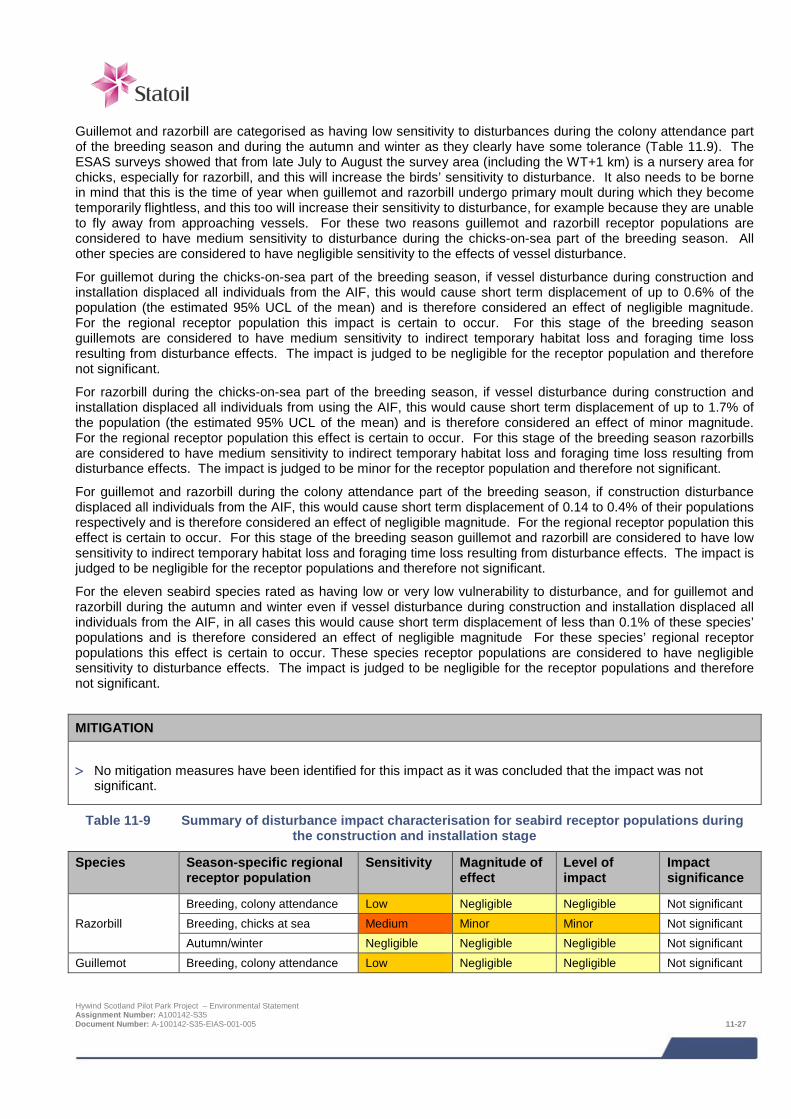
Guillemot and razorbill are categorised as having low sensitivity to disturbances during the colony attendance part of the breeding season and during the autumn and winter as they clearly have some tolerance (Table 11.9). The ESAS surveys showed that from late July to August the survey area (including the WT+1 km) is a nursery area for chicks, especially for razorbill, and this will increase the birds’ sensitivity to disturbance. It also needs to be borne in mind that this is the time of year when guillemot and razorbill undergo primary moult during which they become temporarily flightless, and this too will increase their sensitivity to disturbance, for example because they are unable to fly away from approaching vessels. For these two reasons guillemot and razorbill receptor populations are considered to have medium sensitivity to disturbance during the chicks-on-sea part of the breeding season. All other species are considered to have negligible sensitivity to the effects of vessel disturbance.
For guillemot during the chicks-on-sea part of the breeding season, if vessel disturbance during construction and installation displaced all individuals from the AIF, this would cause short term displacement of up to 0.6% of the population (the estimated 95% UCL of the mean) and is therefore considered an effect of negligible magnitude. For the regional receptor population this impact is certain to occur. For this stage of the breeding season guillemots are considered to have medium sensitivity to indirect temporary habitat loss and foraging time loss resulting from disturbance effects. The impact is judged to be negligible for the receptor population and therefore not significant.
For razorbill during the chicks-on-sea part of the breeding season, if vessel disturbance during construction and installation displaced all individuals from using the AIF, this would cause short term displacement of up to 1.7% of the population (the estimated 95% UCL of the mean) and is therefore considered an effect of minor magnitude. For the regional receptor population this effect is certain to occur. For this stage of the breeding season razorbills are considered to have medium sensitivity to indirect temporary habitat loss and foraging time loss resulting from disturbance effects. The impact is judged to be minor for the receptor population and therefore not significant.
For guillemot and razorbill during the colony attendance part of the breeding season, if construction disturbance displaced all individuals from the AIF, this would cause short term displacement of 0.14 to 0.4% of their populations respectively and is therefore considered an effect of negligible magnitude. For the regional receptor population this effect is certain to occur. For this stage of the breeding season guillemot and razorbill are considered to have low sensitivity to indirect temporary habitat loss and foraging time loss resulting from disturbance effects. The impact is judged to be negligible for the receptor populations and therefore not significant.
For the eleven seabird species rated as having low or very low vulnerability to disturbance, and for guillemot and razorbill during the autumn and winter even if vessel disturbance during construction and installation displaced all individuals from the AIF, in all cases this would cause short term displacement of less than 0.1% of these species’ populations and is therefore considered an effect of negligible magnitude For these species’ regional receptor populations this effect is certain to occur. These species receptor populations are considered to have negligible sensitivity to disturbance effects. The impact is judged to be negligible for the receptor populations and therefore not significant.
MITIGATION
> No mitigation measures have been identified for this impact as it was concluded that the impact was not significant.
Table 11-9 Summary of disturbance impact characterisation for seabird receptor populations during the construction and installation stage
Species Season-specific regional receptor population
Sensitivity Magnitude of effect
Level of impact
Impact significance
Razorbill Breeding, colony attendance Low Negligible Negligible Not significant Breeding, chicks at sea Medium Minor Minor Not significant Autumn/winter Negligible Negligible Negligible Not significant
Guillemot Breeding, colony attendance Low Negligible Negligible Not significant
Hywind Scotland Pilot Park Project – Environmental Statement Assignment Number: A100142-S35 Document Number: A-100142-S35-EIAS-001-005 11-27

Species Season-specific regional
receptor population Sensitivity Magnitude of
effect Level of impact
Impact significance
Razorbill Breeding, colony attendance Low Negligible Negligible Not significant Breeding, chicks at sea Medium Negligible Negligible Not significant Autumn/winter Negligible Negligible Negligible Not significant
All other species All populations Negligible Negligible Negligible Not significant
11.6.2 Accidental release of contaminants The installation of WTG Units and associated infrastructure has potential to give rise to a risk for vessel collision or collisions with infrastructure that could result in accidental release of contaminants. These risks have been assessed in detail in Navigation Risk Assessment (NRA) (Anatec, 2014).
The release of oil and other marine pollutants could have lethal and sub-lethal effects on seabirds and their prey. The potential for seabirds to be adversely affected by oil pollution is considered to be the type of accidental release incident which is predicted to result in the greatest seabird impacts. A special aspect of contaminants, especially oil, is that they can be spread by wind and currents over large areas and thus potentially affect birds in areas up to many kilometres away from the source. For this reason it is not possible to define an AIF, except in a very broad sense, though it is obvious that the area that might be affected by an accidental release will depend on the magnitude of the event, the type of contaminant involved, and the prevailing weather conditions at the time. It is also obvious that even quite modest accidental releases of oil can affect large areas. For these reasons, the Project has a strong emphasis is on preventing accidental release of contaminants through embedded mitigation (see below).
Given the Project’s many embedded mitigation measures to both reduce the likelihood of contamination events occurring and to minimise their magnitude and duration, it is considered that the scale of any reasonably foreseeable incident would be very small or small in the context of the range of sizes of marine pollution incidents that occur in the North Sea. With the exception of guillemot and razorbill during the chick-rearing part of the breeding season, all seabird receptor populations that use the Project area are considered to have low sensitivity to the additional mortality or reduced prey availability that could result from small scale pollution incidents. Guillemot and razorbill during the chick-rearing part of the breeding season are considered to have medium sensitivity to small scale pollution incidents. These species have heightened sensitivity to oil pollution at this time of year because they can be present in very large aggregations, are flightless as they undergo moult and include dependent chicks.
The potential impact of construction and installation stage accidental release of contaminants on guillemot and razorbill regional receptor populations during the chicks-on-sea part of the breeding season is assessed as a short term effect of negligible magnitude (as <1% of the assumed regional population will be affected) that is very unlikely to occur. These receptor populations are considered to have medium sensitivity to pollution effects at this time of the year. The impact is judged to be negligible for these receptor populations and therefore not significant.
For guillemot and razorbill receptor populations at other times of year and for all other species’ regional receptor populations that use the Project area at any stage of the year, the potential impact of the accidental release of contaminants during the construction and installation stage would have a short term effect on <1% of the assumed regional population and is therefore considered an effect of negligible magnitude that is very unlikely to occur. These receptor populations are considered to have low sensitivity to pollution effects. The impact is judged to be negligible for these receptor populations and therefore not significant.
Despite these conclusions it is recognised that at times high densities of seabirds occur in the Project area, especially guillemot and razorbill during the late summer, and that an oil pollution incident at such times could kill relatively large numbers of seabirds which would be highly undesirable.
Hywind Scotland Pilot Park Project – Environmental Statement Assignment Number: A100142-S35 Document Number: A-100142-S35-EIAS-001-005 11-28
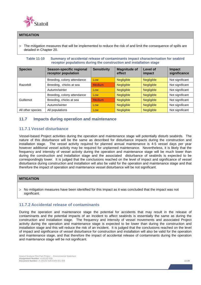
MITIGATION
> The mitigation measures that will be implemented to reduce the risk of and limit the consequence of spills are detailed in Chapter 20.
Table 11-10 Summary of accidental release of contaminants impact characterisation for seabird receptor populations during the construction and installation stage
Species Season-specific regional receptor population
Sensitivity Magnitude of effect
Level of impact
Impact significance
Razorbill Breeding, colony attendance Low Negligible Negligible Not significant Breeding, chicks at sea Medium Negligible Negligible Not significant Autumn/winter Low Negligible Negligible Not significant
Guillemot Breeding, colony attendance Low Negligible Negligible Not significant Breeding, chicks at sea Medium Negligible Negligible Not significant Autumn/winter Low Negligible Negligible Not significant
All other species All populations Low Negligible Negligible Not significant
11.7 Impacts during operation and maintenance
11.7.1 Vessel disturbance Vessel-based Project activities during the operation and maintenance stage will potentially disturb seabirds. The nature of this disturbance will be the same as described for disturbance impacts during the construction and installation stage. The vessel activity required for planned annual maintenance is 4-5 vessel days per year however additional vessel activity may be required for unplanned maintenance. Nevertheless, it is likely that the frequency and intensity of vessel activity during the operation and maintenance stage will be much lower than during the construction and installation stage and the associated disturbance of seabirds is expected to be correspondingly lower. It is judged that the conclusions reached on the level of impact and significance of vessel disturbance during construction and installation will also be valid for the operation and maintenance stage and that therefore the impact of operation and maintenance vessel disturbance will be not significant.
MITIGATION
> No mitigation measures have been identified for this impact as it was concluded that the impact was not significant.
11.7.2 Accidental release of contaminants During the operation and maintenance stage the potential for accidents that may result in the release of contaminants and the potential impacts of an incident to affect seabirds is essentially the same as during the construction and installation stage. The frequency and intensity of vessel movements and associated Project activity during the operation and maintenance stage is expected to be lower than during the construction and installation stage and this will reduce the risk of an incident. It is judged that the conclusions reached on the level of impact and significance of vessel disturbance for construction and installation will also be valid for the operation and maintenance stage, and that therefore the impact of accidental release of contaminants during the operation and maintenance stage will be not significant.
Hywind Scotland Pilot Park Project – Environmental Statement Assignment Number: A100142-S35 Document Number: A-100142-S35-EIAS-001-005 11-29
Despite this conclusion it is recognised that at times high densities of seabirds occur in the Project area, especially guillemot and razorbill during the late summer, and that an oil pollution incident at such times could kill relatively large numbers of seabirds which would be highly undesirable.
MITIGATION
> The mitigation measures that will be implemented to reduce the risk of and limit the consequence of spills are detailed in Chapter 20.
11.7.3 Displacement by structures The presence of structures in the marine environment, such as wind turbines, has the potential to displace seabirds from foraging habitat. Structures may also cause flying seabirds transiting through an area to change their course as they deviate around them, and this can reduce risk of collision strikes. The review by Furness et al., (2012) rates the likely response of seabird species to structures Table 11.5. The results of post-construction monitoring at offshore wind farms also provide good evidence of how the species that use the Project area are likely to be affected by the presence of the five Hywind WTG Units. The monitoring results from the Robin Rigg Wind Farm in the Solway Firth have particular relevance to the Hywind Project as this wind farm is in an area used by large numbers of guillemot and razorbill during the breeding season (this is not the case for the many monitoring studies of offshore wind farms in the southern part of the North Sea).
All seabird species that use the Project area are considered by Furness et al., (2012) to have low or very low vulnerability (a score of 1 or 2 in Table 11.5) to displacement. The results from Robin Rigg show that guillemot and razorbill incurred only a small displacement effect (around 30%), with large numbers present inside the wind farm during the operational phase. It is concluded that most of the species that use the Project area are unlikely to show more than a minor response to the presence of an array of five WTG Units. The effect of the displacement would be to deprive birds of foraging habitat. Given the very large size of foraging areas (1,000’s of km2) available to and used by all receptor populations it is not plausible that an extremely small reduction in foraging area could result in adult mortality (a theoretical effect on adult mortality is provided nonetheless). Instead this could lead to a reduction in provisioning rates to chicks and thereby lead to a minor reduction in population productivity. For these reasons it is considered that species’ breeding receptor populations have low sensitivity and non-breeding receptor populations have negligible sensitivity to this effect.
For all regional seabird receptor populations for which the WT+1 km area holds negligible importance, displacement by structures during the operation and maintenance stage would potentially cause the long term impact displacement of <1% of the assumed regional population and is therefore considered to be an effect of negligible magnitude that is likely to occur. These receptor populations are considered to have low sensitivity to displacement effects. The impact is judged to be negligible for these receptor populations and therefore not significant.
For regional breeding receptors for which the WT+1km area is at least of ‘low’ importance an overview of potential displacement impacts is provided (kittiwake, guillemot, razorbill and puffin, Table 11.11). A range of 30-60% displacement is provided, to allow for comparison with other projects. The Appropriate Assessment for the Moray Firth OWF referred to an evidence review which suggests that a 60% displacement for auks is likely to be an overestimate.
For the purposes of assessment it is cautiously assumed that the scenario resulting in the greatest impact is for 50% of the individuals of a species that would otherwise be present will be displaced from the AIF (amounting to the turbine locations buffered to 1 km) throughout the duration of the operation and maintenance stage. Furthermore it is assumed that all displaced birds are breeding adults and that each bird represents a pair failing to breed. Potential effect on adult mortality rate (AMR) is provided for context.
Displacement by structures during the operation and maintenance stage would potentially cause the long term impact displacement of <1% of the assumed regional populations of the four species in question and is therefore considered to be an effect of negligible magnitude that is likely to occur (and to be substantially lower still if not for the conservative assumptions). These receptor populations are considered to have low sensitivity to displacement effects. The impact is judged to be negligible for these receptor populations and therefore not significant. Hywind Scotland Pilot Park Project – Environmental Statement Assignment Number: A100142-S35 Document Number: A-100142-S35-EIAS-001-005 11-30
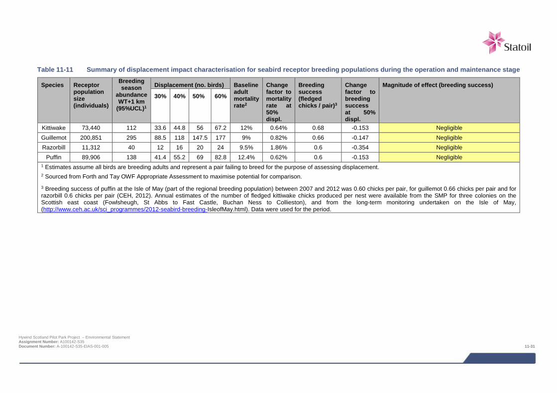
Table 11-11 Summary of displacement impact characterisation for seabird receptor breeding populations during the operation and maintenance stage
Species Receptor population size (individuals)
Breeding season
abundance WT+1 km
(95%UCL)1
Displacement (no. birds) Baseline adult mortality rate2
Change factor to mortality rate at 50% displ.
Breeding success (fledged chicks / pair)3
Change factor to breeding success at 50% displ.
Magnitude of effect (breeding success)
30% 40% 50% 60%
Kittiwake 73,440 112 33.6 44.8 56 67.2 12% 0.64% 0.68 -0.153 Negligible Guillemot 200,851 295 88.5 118 147.5 177 9% 0.82% 0.66 -0.147 Negligible Razorbill 11,312 40 12 16 20 24 9.5% 1.86% 0.6 -0.354 Negligible
Puffin 89,906 138 41.4 55.2 69 82.8 12.4% 0.62% 0.6 -0.153 Negligible 1 Estimates assume all birds are breeding adults and represent a pair failing to breed for the purpose of assessing displacement. 2 Sourced from Forth and Tay OWF Appropriate Assessment to maximise potential for comparison.
3 Breeding success of puffin at the Isle of May (part of the regional breeding population) between 2007 and 2012 was 0.60 chicks per pair, for guillemot 0.66 chicks per pair and for razorbill 0.6 chicks per pair (CEH, 2012). Annual estimates of the number of fledged kittiwake chicks produced per nest were available from the SMP for three colonies on the Scottish east coast (Fowlsheugh, St Abbs to Fast Castle, Buchan Ness to Collieston), and from the long-term monitoring undertaken on the Isle of May, (http://www.ceh.ac.uk/sci_programmes/2012-seabird-breeding-IsleofMay.html). Data were used for the period.
Hywind Scotland Pilot Park Project – Environmental Statement Assignment Number: A100142-S35 Document Number: A-100142-S35-EIAS-001-005 11-31
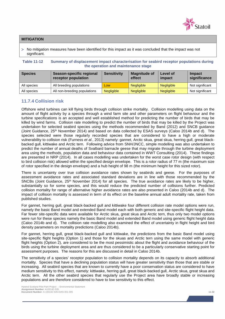
MITIGATION
> No mitigation measures have been identified for this impact as it was concluded that the impact was not significant.
Table 11-12 Summary of displacement impact characterisation for seabird receptor populations during the operation and maintenance stage
Species Season-specific regional receptor population
Sensitivity Magnitude of effect
Level of impact
Impact significance
All species All breeding populations Low Negligible Negligible Not significant All species All non-breeding populations Negligible Negligible Negligible Not significant
11.7.4 Collision risk Offshore wind turbines can kill flying birds through collision strike mortality. Collision modelling using data on the amount of flight activity by a species through a wind farm site and other parameters on flight behaviour and the turbine specifications is an accepted and well established method for predicting the number of birds that may be killed by wind farms. Collision rate modelling to predict the number of birds that may be killed by the Project was undertaken for selected seabird species using the methods recommended by Band (2012) and SNCB guidance (Joint Guidance, 25th November 2014) and based on data collected by ESAS surveys (Caloo 2014b and d). The species selected were those regularly recorded species that are considered to have a high or moderate vulnerability to collision risk (Furness et al., 2013) namely: gannet, Arctic skua, great skua, herring gull, great black-backed gull, kittiwake and Arctic tern. Following advice from SNH/JNCC, simple modelling was also undertaken to predict the number of annual deaths of Svalbard barnacle geese that may migrate through the turbine deployment area using the methods, population data and behaviour data contained in WWT Consulting (2014). These findings are presented in NRP (2014). In all cases modelling was undertaken for the worst case rotor design (with respect to bird collision risk) allowed within the specified design envelope. This is a rotor radius of 77 m (the maximum size of rotor specified in the design envelope) and a hub height of 98 m (the minimum height for this sized rotor).
There is uncertainty over true collision avoidance rates shown by seabirds and geese. For the purposes of assessment avoidance rates and associated standard deviations are in line with those recommended by the SNCBs (Joint Guidance, 25th November 2014) for all species. The true avoidance rates are likely to be higher, substantially so for some species, and this would reduce the predicted number of collisions further. Predicted collision mortality for range of alternative higher avoidance rates are also presented in Caloo (2014b and d). The impact of collision mortality is assessed in term of its effect on the baseline annual adult mortality rate, taken from published studies.
For gannet, herring gull, great black-backed gull and kittiwake four different collision rate model options were run, namely the basic Band model and extended Band model each with both generic and site-specific flight height data. Far fewer site-specific data were available for Arctic skua, great skua and Arctic tern, thus only two model options were run for these species namely the basic Band model and extended Band model using generic flight height data (Caloo 2014b and d). The collision rate modelling also examined the effect of uncertainty in flight height and bird density parameters on mortality predictions (Caloo 2014b).
For gannet, herring gull, great black-backed gull and kittiwake, the predictions from the basic Band model using site-specific flight heights (Option 1) and those for the skuas and Arctic tern using the same model with generic flight heights (Option 2), are considered to be the most pessimistic about the flight and avoidance behaviour of the birds using the turbine deployment area and are thus considered to be a particularly conservative starting point for assessment purposes. The reasons for this are discussed in detail in Caloo 2014b.
The sensitivity of a species’ receptor population to collision mortality depends on its capacity to absorb additional mortality. Species that have a declining population status will have greater sensitivity than those that are stable or increasing. All seabird species that are known to currently have a poor conservation status are considered to have medium sensitivity to this effect, namely: kittiwake, herring gull, great black-backed gull, Arctic skua, great skua and Arctic tern. All the other seabird species that regularly use the Project area have broadly stable or increasing populations and are therefore considered to have to low sensitivity to this effect. Hywind Scotland Pilot Park Project – Environmental Statement Assignment Number: A100142-S35 Document Number: A-100142-S35-EIAS-001-005 11-32
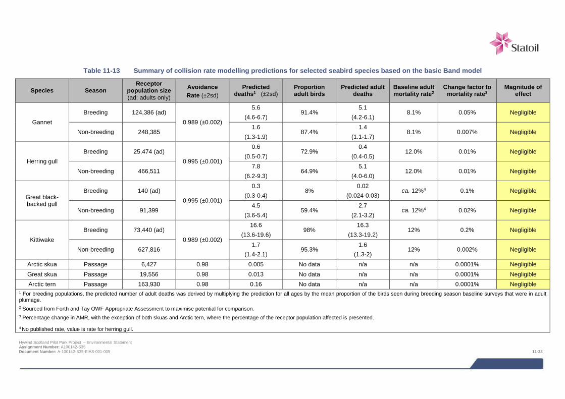
Table 11-13 Summary of collision rate modelling predictions for selected seabird species based on the basic Band model
Species Season Receptor
population size (ad: adults only)
Avoidance Rate (±2sd)
Predicted deaths1 (±2sd)
Proportion adult birds
Predicted adult deaths
Baseline adult mortality rate2
Change factor to mortality rate3
Magnitude of effect
Gannet Breeding 124,386 (ad)
0.989 (±0.002)
5.6 (4.6-6.7)
91.4% 5.1
(4.2-6.1) 8.1% 0.05% Negligible
Non-breeding 248,385 1.6
(1.3-1.9) 87.4%
1.4 (1.1-1.7)
8.1% 0.007% Negligible
Herring gull Breeding 25,474 (ad)
0.995 (±0.001)
0.6 (0.5-0.7)
72.9% 0.4
(0.4-0.5) 12.0% 0.01% Negligible
Non-breeding 466,511 7.8
(6.2-9.3) 64.9%
5.1 (4.0-6.0)
12.0% 0.01% Negligible
Great black-backed gull
Breeding 140 (ad) 0.995 (±0.001)
0.3 (0.3-0.4)
8% 0.02
(0.024-0.03) ca. 12%4 0.1% Negligible
Non-breeding 91,399 4.5
(3.6-5.4) 59.4%
2.7 (2.1-3.2)
ca. 12%4 0.02% Negligible
Kittiwake Breeding 73,440 (ad)
0.989 (±0.002)
16.6 (13.6-19.6)
98% 16.3
(13.3-19.2) 12% 0.2% Negligible
Non-breeding 627,816 1.7
(1.4-2.1) 95.3%
1.6 (1.3-2)
12% 0.002% Negligible
Arctic skua Passage 6,427 0.98 0.005 No data n/a n/a 0.0001% Negligible Great skua Passage 19,556 0.98 0.013 No data n/a n/a 0.0001% Negligible Arctic tern Passage 163,930 0.98 0.16 No data n/a n/a 0.0001% Negligible
1 For breeding populations, the predicted number of adult deaths was derived by multiplying the prediction for all ages by the mean proportion of the birds seen during breeding season baseline surveys that were in adult plumage. 2 Sourced from Forth and Tay OWF Appropriate Assessment to maximise potential for comparison. 3 Percentage change in AMR, with the exception of both skuas and Arctic tern, where the percentage of the receptor population affected is presented.
4 No published rate, value is rate for herring gull. Hywind Scotland Pilot Park Project – Environmental Statement Assignment Number: A100142-S35 Document Number: A-100142-S35-EIAS-001-005 11-33
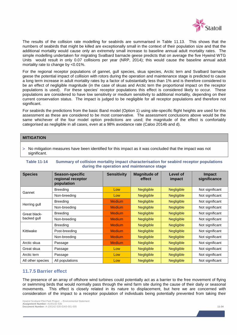
The results of the collision rate modelling for seabirds are summarised in Table 11.13. This shows that the numbers of seabirds that might be killed are exceptionally small in the context of their population size and that the additional mortality would cause only an extremely small increase to baseline annual adult mortality rates. The simple modelling undertaken for migrating Svalbard barnacle geese predicts that on average the five Hywind WTG Units would result in only 0.07 collisions per year (NRP, 2014); this would cause the baseline annual adult mortality rate to change by <0.01%.
For the regional receptor populations of gannet, gull species, skua species, Arctic tern and Svalbard barnacle geese the potential impact of collision with rotors during the operation and maintenance stage is predicted to cause a long term increase in adult mortality rates by a factor of substantially less than 1% and is therefore considered to be an effect of negligible magnitude (in the case of skuas and Arctic tern the proportional impact on the receptor populations is used). For these species’ receptor populations this effect is considered likely to occur. These populations are considered to have low sensitivity or medium sensitivity to additional mortality, depending on their current conservation status. The impact is judged to be negligible for all receptor populations and therefore not significant.
For seabirds the predictions from the basic Band model (Option 1) using site-specific flight heights are used for this assessment as these are considered to be most conservative. The assessment conclusions above would be the same whichever of the four model option predictions are used; the magnitude of the effect is comfortably categorised as negligible in all cases, even at a 98% avoidance rate (Caloo 2014b and d).
MITIGATION
> No mitigation measures have been identified for this impact as it was concluded that the impact was not significant.
Table 11-14 Summary of collision mortality impact characterisation for seabird receptor populations during the operation and maintenance stage
Species Season-specific regional receptor population
Sensitivity Magnitude of effect
Level of impact
Impact significance
Gannet Breeding Low Negligible Negligible Not significant Non-breeding Low Negligible Negligible Not significant
Herring gull Breeding Medium Negligible Negligible Not significant Non-breeding Medium Negligible Negligible Not significant
Great black-backed gull
Breeding Medium Negligible Negligible Not significant Non-breeding Medium Negligible Negligible Not significant
Kittiwake Breeding Medium Negligible Negligible Not significant Post-breeding Medium Negligible Negligible Not significant Non-breeding Medium Negligible Negligible Not significant
Arctic skua Passage Medium Negligible Negligible Not significant Great skua Passage Low Negligible Negligible Not significant Arctic tern Passage Low Negligible Negligible Not significant All other species All populations Low Negligible Negligible Not significant
11.7.5 Barrier effect The presence of an array of offshore wind turbines could potentially act as a barrier to the free movement of flying or swimming birds that would normally pass through the wind farm site during the cause of their daily or seasonal movements. This effect is closely related in its nature to displacement, but here we are concerned with consideration of the impact to a receptor population of individuals being potentially prevented from taking their Hywind Scotland Pilot Park Project – Environmental Statement Assignment Number: A100142-S35 Document Number: A-100142-S35-EIAS-001-005 11-34
preferred ravel route, be this the potential additional time and energy requirements imposed by taking a detoured route or the reduced access to an area. Post-construction monitoring studies at offshore wind farms, particularly radar studies, provide empirical evidence of the extent to which offshore wind farms may act as a barrier. These studies are reviewed Furness et al. (2013) though barrier effects are not considered separately from displacement effects. All seabird species that use the Project area are considered by Furness et al. (2013) to have low or very low vulnerability (a score of 1 or 2 in Table 11.5) to displacement by structures. For the range of species that occur in the Project area, wind turbines are likely to present no more than a partial barrier to a limited range of species, with most birds likely to pass unimpeded through the large gaps (approximately 600 – 1,400 m wide, depending on final spacing) between the WTG Units. In particular some flying gannets and auks are likely to be displaced and detour around the turbine deployment area, whereas gulls, terns and skuas are unlikely to perceive the array of WTG Units as a barrier.
All the seabirds that regularly use the Hywind turbine deployment area undertake large daily movements (typically 10s to 100s of km) and very large seasonal movements (typically 100s to 1,000s of km), and in doing so range over large to very large areas of sea. In the context of these movements an array of just five WTG Units measuring at maximum between 1.8 and 3.4 km across (depending on final WTG Unit spacing) is a small feature that could not present a serious barrier to any a receptor population. Furthermore, because of the relatively large distance offshore, the potential barrier formed by the WTG Units would be only affect a small proportion of the possible flight directions from breeding colonies. For example, the colony with the greatest potential to be affected is the closest colony (Buchan Ness). Birds at this colony have potential foraging flight headings spread across an arc of approximately 240 degrees and of this the turbine deployment area would form a potential barrier occupying approximately 5 degrees (2%) 24 km from the colony. Barrier effects can lead to two effects for the birds affected (Searle et al., 2014). First, a barrier can reduce access to an area of foraging habitat and thus be akin to habitat loss. However, all receptor populations have very large foraging areas (1,000’s of km2) available to them. Second, it can necessitate birds to fly further to reach foraging areas causing them to devote additional time and energy to flying. The small scale changes to individual bird’s time/energy budgets that could be result from the Hywind WTG Units acting as a barrier are not likely to result in adult mortality, but could lead to a reduction in chick provisioning rates and thereby lead to a reduction in population productivity (Masden et al., 2010; Searle et al., 2014). For these reasons all species are assumed to have a low sensitivity to barrier effects during the breeding season and negligible sensitivity at other times of year.
Even if some individual seabirds did perceive the array as a barrier (this is perhaps most likely for gannet) the maximum size of the detour that an individual would need to make to re-join their intended course would be small. For example, assuming the WTG Unit array is 3.4 km wide, and that the bird shows a precautionary 1 km avoidance zone around turbines and has a flight velocity of 15 m/s (WWT Consulting, 2014), the maximum detour would amount to an additional flight distance approximately 3 km and take approximately 3.5 minutes to complete. In the context of breeding season foraging trips that are typically over 100 km long and last several hours, the additional energetic and time costs of such small detours are considered to be negligible for the few individuals in a receptor population that may be affected.
For the regional breeding populations of gannet and auks (but no other species) the WTG Units have potential to cause a barrier effect during the operation and maintenance stage that is predicted to result in long term small-scale changes to the time/energy budgets of a small proportion of individuals and is therefore considered an impact of negligible magnitude that is likely to occur. These receptor populations are considered to have low sensitivity to barrier impacts. The impact is judged to be negligible for these receptor populations and therefore not significant.
MITIGATION
> No mitigation measures have been identified for this impact as it was concluded that the impact was not significant.
Hywind Scotland Pilot Park Project – Environmental Statement Assignment Number: A100142-S35 Document Number: A-100142-S35-EIAS-001-005 11-35

Table 11-15 Summary of barrier effect impact characterisation for seabird receptor populations during
the operation and maintenance stage
Species Season-specific regional receptor population
Sensitivity Magnitude of effect
Level of impact
Impact significance
All species Breeding season Low Negligible Negligible Not significant All species Non-breeding Negligible Negligible Negligible Not significant
11.7.6 Indirect effects on seabird prey The presence of the WTG Units and their mooring systems are not predicted to cause any adverse effects on seabird prey species (principally small fish such as sand eels, gadoids, clupeoids and mackerel); see fish ecology Chapter 10. Therefore no indirect effects on bird species are predicted.
11.8 Potential variances in environmental impacts The impact assessment above has assessed the Project options which are predicted to result in the greatest impacts with regards to ornithological receptors. Relative to the application of the Design Envelope approach in the consenting of other offshore renewables developments (e.g. large offshore wind farms), the Hywind Project consenting Design Envelope does not involve large scale variability in key design parameters or impact footprints with regards to the potential impacts on birds. Potential variance in impact will be restricted to limited changes in vessel days, and is not predicted to result in greater impacts than those already assessed.
11.9 Cumulative and in-combination impacts HSL has, in consultation with Marine Scotland and Aberdeenshire Council, identified a list of other projects which together with the Project may result in potential cumulative or in-combination impacts. The list of these projects including details of their status at the time of the EIA and a map showing their location is provided in Chapter 7; Table 7-3 and Figure 7-1 respectively.
The consideration of which projects could result in potential cumulative or in-combination impacts is based on the results of the project specific impact assessment together with the expert judgement of the specialist consultant. Having considered the information presently available in the public domain on the projects for which there is a potential for cumulative or in-combination impacts, these projects are listed below.
> European Offshore Wind Deployment Centre (EOWFL);
> Kincardine Offshore Wind Farm;
> Firth of Forth Offshore Wind Farm;
> Moray Offshore Renewables Wind Farm (eastern development area);
> Inch Cape Offshore Wind Farm;
> Beatrice Offshore Wind Farm Demonstrator Project;
> Beatrice Offshore Wind Farm Ltd (BOWL);
> Neart na Gaoithe Offshore Wind Farm; and
> Fife Energy Park Offshore Demonstration Wind Turbine.
Species receptor populations of relevance to assessing cumulative impacts for the Hywind project are defined as receptor populations for which there is indication of a potential adverse impact as a result of the project of a magnitude which may be exacerbated cumulatively. These regional breeding populations of guillemot and razorbill on account of potential disturbance and displacement impacts, and populations of gannet, herring gull, great black-backed gull and kittiwake on account of the potential for collision impacts.
Hywind Scotland Pilot Park Project – Environmental Statement Assignment Number: A100142-S35 Document Number: A-100142-S35-EIAS-001-005 11-36
11.9.1 Potential cumulative and in-combination impacts during construction and
installation
Cumulative vessel disturbance
The potential for the Project to materially contribute to a cumulative impact during the construction and installation stage is limited to breeding guillemots and razorbills. The potential Project disturbance effects large enough to do so at a regional level would only arise when conditions of high or very high bird density occur, such that a relatively high proportion of the population is concentrated in a small area. The timing of such concentrations differs spatially along the east coast thus making it relatively unlikely that it would occur simultaneously at other development sites. In any case, the potential for the Project to contribute to a regional cumulative vessel disturbance impact is very small because of its very limited spatial scale. For example the Project has only 0.7% (5 out 677) of the offshore wind turbines currently consented or proposed in the waters off the east coast of Scotland and the amount of vessel activity generated by a development will be largely proportional to the number of turbines.
It is judged that, during the construction and installation stage, the potential contribution made by the Project to a regional cumulative vessel disturbance impact is unlikely to be sufficient to make a material difference to the magnitude of the effect from all other developments combined.
Cumulative accidental release of contaminants
The potential effect on seabird populations from the accidental release of contaminants caused by the Project alone is rated as negligible magnitude. This was concluded on the basis that the various embedded mitigation measures make the probability of an incident very unlikely and, were an incident to occur, it would likely to be of a very small or small scale be quickly contained and dealt with. A similar conclusion applies to all the other offshore wind farm developments considered in this CIA. Although each development alone presents a very small risk, it is considered that the cumulative risk of an accidental release of contaminants event occurring must be several times greater. However, given all the embedded mitigation measures, incidents would at most be rare events and likely to be of a scale that cause less than a 1% change in the annual adult mortality rate of any species affected.
In any case, the potential for the Project to contribute to a regional cumulative accidental release of contaminants impact it is very small because of its relatively small spatial scale compared to the offshore wind developments currently consented or proposed in in the waters off the east coast of Scotland, while the risk of an accidental release of contaminants incident is expected to be proportional to the number of turbines.
11.9.2 Potential cumulative and in-combination impacts during operation and maintenance
Displacement from structures and vessel disturbance will not act additively in the operation and maintenance stage as a bird that is affected by one is assumed to move away and so would not be available to be affected by the other; i.e. the response is effectively the same (to move away) though the stimulus is different. The combined effects of displacement and disturbance would not act in an additive way with collision impacts because these impacts act antagonistically such that any displacement would cause a corresponding decrease in collision risk, i.e., a bird that is displaced would be at no risk of collision.
The potential for the Project to contribute to regional cumulative disturbance, displacement and accidental release of contaminants impacts are in each case very small because of the Project’s relatively small spatial scale. For example the Project has only 0.7% (5 out 677) of the offshore wind turbines currently consented or proposed in the waters off the east coast of Scotland and one would expect the size of the impact arising from each project to be approximately proportional to the number of turbines.
Cumulative vessel disturbance and accidental release of contaminants
The potential for cumulative impact to arise from vessel disturbance and accidental release of contaminants during the operation and maintenance will be the same in nature to that described above for the construction and installation stage, however the frequency and intensity of vessel activity during the operation and maintenance stage will be much lower but will occur over a longer time.
Hywind Scotland Pilot Park Project – Environmental Statement Assignment Number: A100142-S35 Document Number: A-100142-S35-EIAS-001-005 11-37
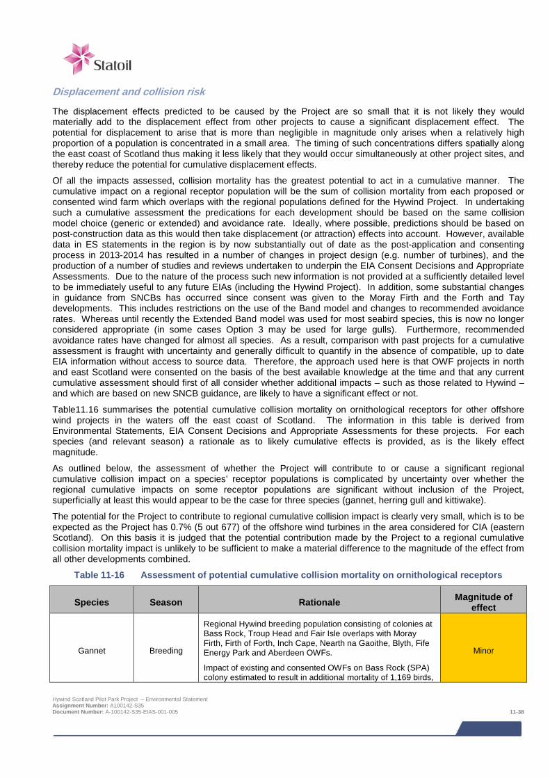
Displacement and collision risk
The displacement effects predicted to be caused by the Project are so small that it is not likely they would materially add to the displacement effect from other projects to cause a significant displacement effect. The potential for displacement to arise that is more than negligible in magnitude only arises when a relatively high proportion of a population is concentrated in a small area. The timing of such concentrations differs spatially along the east coast of Scotland thus making it less likely that they would occur simultaneously at other project sites, and thereby reduce the potential for cumulative displacement effects.
Of all the impacts assessed, collision mortality has the greatest potential to act in a cumulative manner. The cumulative impact on a regional receptor population will be the sum of collision mortality from each proposed or consented wind farm which overlaps with the regional populations defined for the Hywind Project. In undertaking such a cumulative assessment the predications for each development should be based on the same collision model choice (generic or extended) and avoidance rate. Ideally, where possible, predictions should be based on post-construction data as this would then take displacement (or attraction) effects into account. However, available data in ES statements in the region is by now substantially out of date as the post-application and consenting process in 2013-2014 has resulted in a number of changes in project design (e.g. number of turbines), and the production of a number of studies and reviews undertaken to underpin the EIA Consent Decisions and Appropriate Assessments. Due to the nature of the process such new information is not provided at a sufficiently detailed level to be immediately useful to any future EIAs (including the Hywind Project). In addition, some substantial changes in guidance from SNCBs has occurred since consent was given to the Moray Firth and the Forth and Tay developments. This includes restrictions on the use of the Band model and changes to recommended avoidance rates. Whereas until recently the Extended Band model was used for most seabird species, this is now no longer considered appropriate (in some cases Option 3 may be used for large gulls). Furthermore, recommended avoidance rates have changed for almost all species. As a result, comparison with past projects for a cumulative assessment is fraught with uncertainty and generally difficult to quantify in the absence of compatible, up to date EIA information without access to source data. Therefore, the approach used here is that OWF projects in north and east Scotland were consented on the basis of the best available knowledge at the time and that any current cumulative assessment should first of all consider whether additional impacts – such as those related to Hywind – and which are based on new SNCB guidance, are likely to have a significant effect or not.
Table11.16 summarises the potential cumulative collision mortality on ornithological receptors for other offshore wind projects in the waters off the east coast of Scotland. The information in this table is derived from Environmental Statements, EIA Consent Decisions and Appropriate Assessments for these projects. For each species (and relevant season) a rationale as to likely cumulative effects is provided, as is the likely effect magnitude.
As outlined below, the assessment of whether the Project will contribute to or cause a significant regional cumulative collision impact on a species’ receptor populations is complicated by uncertainty over whether the regional cumulative impacts on some receptor populations are significant without inclusion of the Project, superficially at least this would appear to be the case for three species (gannet, herring gull and kittiwake).
The potential for the Project to contribute to regional cumulative collision impact is clearly very small, which is to be expected as the Project has 0.7% (5 out 677) of the offshore wind turbines in the area considered for CIA (eastern Scotland). On this basis it is judged that the potential contribution made by the Project to a regional cumulative collision mortality impact is unlikely to be sufficient to make a material difference to the magnitude of the effect from all other developments combined.
Table 11-16 Assessment of potential cumulative collision mortality on ornithological receptors
Species Season Rationale Magnitude of effect
Gannet Breeding
Regional Hywind breeding population consisting of colonies at Bass Rock, Troup Head and Fair Isle overlaps with Moray Firth, Firth of Forth, Inch Cape, Nearth na Gaoithe, Blyth, Fife Energy Park and Aberdeen OWFs.
Impact of existing and consented OWFs on Bass Rock (SPA) colony estimated to result in additional mortality of 1,169 birds,
Minor
Hywind Scotland Pilot Park Project – Environmental Statement Assignment Number: A100142-S35 Document Number: A-100142-S35-EIAS-001-005 11-38
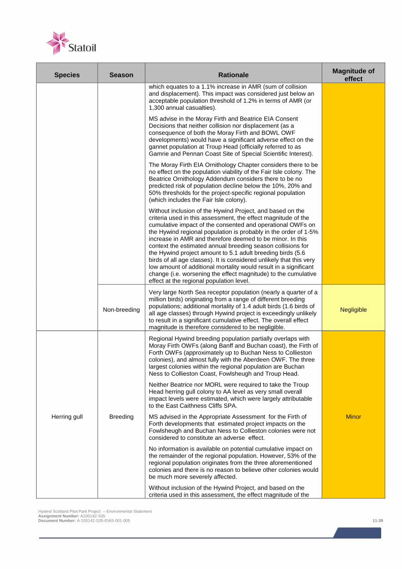
Species Season Rationale Magnitude of effect
which equates to a 1.1% increase in AMR (sum of collision and displacement). This impact was considered just below an acceptable population threshold of 1.2% in terms of AMR (or 1,300 annual casualties).
MS advise in the Moray Firth and Beatrice EIA Consent Decisions that neither collision nor displacement (as a consequence of both the Moray Firth and BOWL OWF developments) would have a significant adverse effect on the gannet population at Troup Head (officially referred to as Gamrie and Pennan Coast Site of Special Scientific Interest).
The Moray Firth EIA Ornithology Chapter considers there to be no effect on the population viability of the Fair Isle colony. The Beatrice Ornithology Addendum considers there to be no predicted risk of population decline below the 10%, 20% and 50% thresholds for the project-specific regional population (which includes the Fair Isle colony).
Without inclusion of the Hywind Project, and based on the criteria used in this assessment, the effect magnitude of the cumulative impact of the consented and operational OWFs on the Hywind regional population is probably in the order of 1-5% increase in AMR and therefore deemed to be minor. In this context the estimated annual breeding season collisions for the Hywind project amount to 5.1 adult breeding birds (5.6 birds of all age classes). It is considered unlikely that this very low amount of additional mortality would result in a significant change (i.e. worsening the effect magnitude) to the cumulative effect at the regional population level.
Non-breeding
Very large North Sea receptor population (nearly a quarter of a million birds) originating from a range of different breeding populations; additional mortality of 1.4 adult birds (1.6 birds of all age classes) through Hywind project is exceedingly unlikely to result in a significant cumulative effect. The overall effect magnitude is therefore considered to be negligible.
Negligible
Herring gull Breeding
Regional Hywind breeding population partially overlaps with Moray Firth OWFs (along Banff and Buchan coast), the Firth of Forth OWFs (approximately up to Buchan Ness to Collieston colonies), and almost fully with the Aberdeen OWF. The three largest colonies within the regional population are Buchan Ness to Collieston Coast, Fowlsheugh and Troup Head.
Neither Beatrice nor MORL were required to take the Troup Head herring gull colony to AA level as very small overall impact levels were estimated, which were largely attributable to the East Caithness Cliffs SPA.
MS advised in the Appropriate Assessment for the Firth of Forth developments that estimated project impacts on the Fowlsheugh and Buchan Ness to Collieston colonies were not considered to constitute an adverse effect.
No information is available on potential cumulative impact on the remainder of the regional population. However, 53% of the regional population originates from the three aforementioned colonies and there is no reason to believe other colonies would be much more severely affected.
Without inclusion of the Hywind Project, and based on the criteria used in this assessment, the effect magnitude of the
Minor
Hywind Scotland Pilot Park Project – Environmental Statement Assignment Number: A100142-S35 Document Number: A-100142-S35-EIAS-001-005 11-39
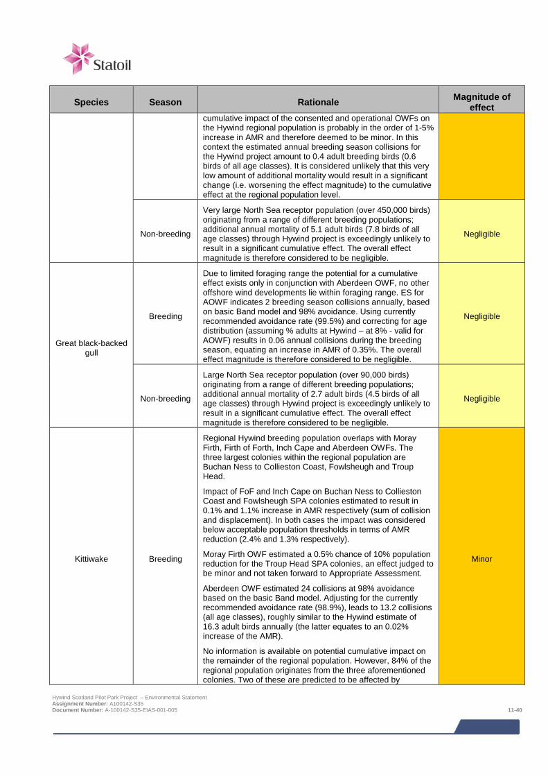
Species Season Rationale Magnitude of effect
cumulative impact of the consented and operational OWFs on the Hywind regional population is probably in the order of 1-5% increase in AMR and therefore deemed to be minor. In this context the estimated annual breeding season collisions for the Hywind project amount to 0.4 adult breeding birds (0.6 birds of all age classes). It is considered unlikely that this very low amount of additional mortality would result in a significant change (i.e. worsening the effect magnitude) to the cumulative effect at the regional population level.
Non-breeding
Very large North Sea receptor population (over 450,000 birds) originating from a range of different breeding populations; additional annual mortality of 5.1 adult birds (7.8 birds of all age classes) through Hywind project is exceedingly unlikely to result in a significant cumulative effect. The overall effect magnitude is therefore considered to be negligible.
Negligible
Great black-backed gull
Breeding
Due to limited foraging range the potential for a cumulative effect exists only in conjunction with Aberdeen OWF, no other offshore wind developments lie within foraging range. ES for AOWF indicates 2 breeding season collisions annually, based on basic Band model and 98% avoidance. Using currently recommended avoidance rate (99.5%) and correcting for age distribution (assuming % adults at Hywind – at 8% - valid for AOWF) results in 0.06 annual collisions during the breeding season, equating an increase in AMR of 0.35%. The overall effect magnitude is therefore considered to be negligible.
Negligible
Non-breeding
Large North Sea receptor population (over 90,000 birds) originating from a range of different breeding populations; additional annual mortality of 2.7 adult birds (4.5 birds of all age classes) through Hywind project is exceedingly unlikely to result in a significant cumulative effect. The overall effect magnitude is therefore considered to be negligible.
Negligible
Kittiwake Breeding
Regional Hywind breeding population overlaps with Moray Firth, Firth of Forth, Inch Cape and Aberdeen OWFs. The three largest colonies within the regional population are Buchan Ness to Collieston Coast, Fowlsheugh and Troup Head.
Impact of FoF and Inch Cape on Buchan Ness to Collieston Coast and Fowlsheugh SPA colonies estimated to result in 0.1% and 1.1% increase in AMR respectively (sum of collision and displacement). In both cases the impact was considered below acceptable population thresholds in terms of AMR reduction (2.4% and 1.3% respectively).
Moray Firth OWF estimated a 0.5% chance of 10% population reduction for the Troup Head SPA colonies, an effect judged to be minor and not taken forward to Appropriate Assessment.
Aberdeen OWF estimated 24 collisions at 98% avoidance based on the basic Band model. Adjusting for the currently recommended avoidance rate (98.9%), leads to 13.2 collisions (all age classes), roughly similar to the Hywind estimate of 16.3 adult birds annually (the latter equates to an 0.02% increase of the AMR).
No information is available on potential cumulative impact on the remainder of the regional population. However, 84% of the regional population originates from the three aforementioned colonies. Two of these are predicted to be affected by
Minor
Hywind Scotland Pilot Park Project – Environmental Statement Assignment Number: A100142-S35 Document Number: A-100142-S35-EIAS-001-005 11-40
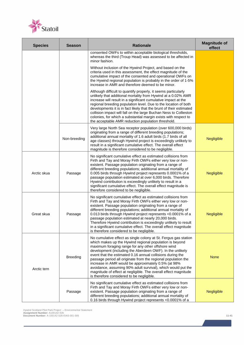
Species Season Rationale Magnitude of effect
consented OWFs to within acceptable biological thresholds, whereas the third (Troup Head) was assessed to be affected in minor fashion.
Without inclusion of the Hywind Project, and based on the criteria used in this assessment, the effect magnitude of the cumulative impact of the consented and operational OWFs on the Hywind regional population is probably in the order of 1-5% increase in AMR and therefore deemed to be minor.
Although difficult to quantify properly, it seems particularly unlikely that additional mortality from Hywind at a 0.02% AMR increase will result in a significant cumulative impact at the regional breeding population level. Due to the location of both developments it is in fact likely that the brunt of their estimated collision impact will fall on the large Buchan Ness to Collieston colonies, for which a substantial margin exists with respect to the acceptable AMR reduction population threshold.
Non-breeding
Very large North Sea receptor population (over 600,000 birds) originating from a range of different breeding populations; additional annual mortality of 1.6 adult birds (1.7 birds of all age classes) through Hywind project is exceedingly unlikely to result in a significant cumulative effect. The overall effect magnitude is therefore considered to be negligible.
Negligible
Arctic skua Passage
No significant cumulative effect as estimated collisions from Firth and Tay and Moray Firth OWFs either very low or non-existent. Passage population originating from a range of different breeding populations; additional annual mortality of 0.005 birds through Hywind project represents 0.0001% of a passage population estimated at over 6,000 birds. Therefore Hywind contribution is exceedingly unlikely to result in a significant cumulative effect. The overall effect magnitude is therefore considered to be negligible.
Negligible
Great skua Passage
No significant cumulative effect as estimated collisions from Firth and Tay and Moray Firth OWFs either very low or non-existent. Passage population originating from a range of different breeding populations; additional annual mortality of 0.013 birds through Hywind project represents <0.0001% of a passage population estimated at nearly 20,000 birds. Therefore Hywind contribution is exceedingly unlikely to result in a significant cumulative effect. The overall effect magnitude is therefore considered to be negligible.
Negligible
Arctic tern
Breeding
No cumulative effect as single colony at St. Fergus gas station which makes up the Hywind regional population is beyond maximum foraging range for any other offshore wind development (including the Aberdeen OWF). In the unlikely event that the estimated 0.16 annual collisions during the passage period all originate from the regional population the increase in AMR would be approximately 0.5% (at 98% avoidance, assuming 90% adult survival), which would put the magnitude of effect at negligible. The overall effect magnitude is therefore considered to be negligible.
None
Passage
No significant cumulative effect as estimated collisions from Firth and Tay and Moray Firth OWFs either very low or non-existent. Passage population originating from a range of different breeding populations; additional annual mortality of 0.16 birds through Hywind project represents <0.0001% of a
Negligible
Hywind Scotland Pilot Park Project – Environmental Statement Assignment Number: A100142-S35 Document Number: A-100142-S35-EIAS-001-005 11-41
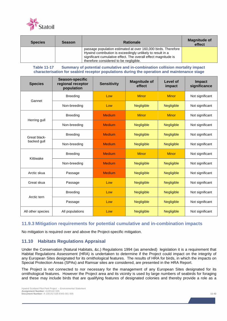
Species Season Rationale Magnitude of effect
passage population estimated at over 160,000 birds. Therefore Hywind contribution is exceedingly unlikely to result in a significant cumulative effect. The overall effect magnitude is therefore considered to be negligible.
Table 11-17 Summary of potential cumulative and in-combination collision mortality impact characterisation for seabird receptor populations during the operation and maintenance stage
Species Season-specific regional receptor
population Sensitivity Magnitude of
effect Level of impact
Impact significance
Gannet Breeding Low Minor Minor Not significant
Non-breeding Low Negligible Negligible Not significant
Herring gull Breeding Medium Minor Minor Not significant
Non-breeding Medium Negligible Negligible Not significant
Great black-backed gull
Breeding Medium Negligible Negligible Not significant
Non-breeding Medium Negligible Negligible Not significant
Kittiwake Breeding Medium Minor Minor Not significant
Non-breeding Medium Negligible Negligible Not significant
Arctic skua Passage Medium Negligible Negligible Not significant
Great skua Passage Low Negligible Negligible Not significant
Arctic tern Breeding Low Negligible Negligible Not significant
Passage Low Negligible Negligible Not significant
All other species All populations Low Negligible Negligible Not significant
11.9.3 Mitigation requirements for potential cumulative and in-combination impacts No mitigation is required over and above the Project-specific mitigation.
11.10 Habitats Regulations Appraisal Under the Conservation (Natural Habitats, &c.) Regulations 1994 (as amended) legislation it is a requirement that Habitat Regulations Assessment (HRA) is undertaken to determine if the Project could impact on the integrity of any European Sites designated for its ornithological features. The results of HRA for birds, in which the impacts on Special Protection Areas (SPAs) and Ramsar sites are considered, are presented in the HRA Report.
The Project is not connected to nor necessary for the management of any European Sites designated for its ornithological features. However the Project area and its vicinity is used by large numbers of seabirds for foraging and these may include birds that are qualifying features of designated colonies and thereby provide a role as a
Hywind Scotland Pilot Park Project – Environmental Statement Assignment Number: A100142-S35 Document Number: A-100142-S35-EIAS-001-005 11-42
supporting habitat to designated sites. The potential for Likely Significant Effects on SPA qualifying features is first examined by undertaking a screening exercise based on establishing the likely strength of connectivity between a designated breeding colony and the turbine deployment area and the vulnerability of a species to offshore wind farm impacts. SPA qualifying features for which potential for LSE cannot be ruled out then go on to be examined in greater detail, through the provision of information required to undertake appropriate assessment. The appropriate assessment stage aims to test if the impacts predicted to arise from the Project could compromise the site’s Conservation Objectives.
On the basis of the information presented in the HRA report (Xodus, 2015) it is concluded that the potential impacts of the Project alone or in-combination with other projects will not have a significantly adverse effect on Conservation Objective at any SPAs and therefore that site integrity at potentially effected sites will be maintained.
11.11 Monitoring As the Hywind Scotland Project is a small scale offshore wind farm project and the potential impacts on birds are considered not to be significant, no specific monitoring programme is proposed. If ornithological monitoring should be required, Statoil is prepared to discuss and agree a suitable approach with Marine Scotland and relevant stakeholders, e.g. linking in to more strategic and/or regional initiatives such as a seabird tagging project Statoil is already supporting.
11.12 References Anatec, (2014). Navigation Risk Assessment – Hywind Scotland Pilot Park. Ref A3207-ST-NRA-2.
Aberdeen Offshore Wind Farm Limited (2012). Aberdeen Offshore Wind Farm Ornithological Baseline and Impact Assessment Addendum. Final (revised) version, 31 July 2012.
Band, W. (2012) Using a Collision Risk Model to assess bird collision risks for offshore wind farms. Final report, March 2012 Cook, A.S.C.P., Wright, L.J. and Burton, N.H.K (2012). A review of flight heights and avoidance rates of birds in relation to offshore wind farms. Project SOSS-02. BTO report onbehaviour to The Crown Estate.
Beatrice Offshore Wind Farm Ltd (2013). Environmental Statement Addendum, Section 7: Ornithology.
Beatrice Offshore Wind Farm Ltd (2014), Marine Works (Environmental Impact Assessment) Regulations 2007 (Regulation 22) Environmental Impact Assessment Consent Decision, Marine Scotland, 18 March 2014.
Bureau Waardenburg (2012). Population, density and collision rate estimates of seabirds at Neart na Gaoithe - Distance analysis of ship-based survey data and collision rate modelling using the extended Band model. Report commissioned by Mainstream Renewable Power.
Caloo Ecological Services (2014a). Distance sampling analyses of year 1 ESAS survey results for the Hywind Scotland Pilot Park. Unpublished report from Caloo Ecological Services to Xodus. December 2014.
Caloo Ecological Services (2014b). Collision risk modelling with respect to seabirds for the Hywind Scotland Pilot Park. Unpublished report from Caloo Ecological Services to Xodus. December 2014.
Caloo Ecological Services (2014c). Distance sampling analyses of additional (July – September 2014) ESAS survey results for the Hywind Scotland Pilot Park. Unpublished report from Caloo Ecological Services to Xodus. December 2014.
Caloo Ecological Services (2014d). Alternative density, abundance and collision mortality estimates. Unpublished report from Caloo Ecological Services to Xodus.
Caloo Ecological Services (2014e). The proposed approach to collision risk modelling with respect to seabirds for the Hywind II floating turbine project off Eastern Scotland. Unpublished report from Caloo Ecological Services to Xodus.
Camphuysen, C.J., Fox, T., Leopold, M.F. & Petersen, I.K. (2004). Towards standardised seabirds at sea census techniques in connection with environmental impact assessments for offshore wind farms in the UK. A report for COWRIE.
Hywind Scotland Pilot Park Project – Environmental Statement Assignment Number: A100142-S35 Document Number: A-100142-S35-EIAS-001-005 11-43

Canning, S., Lye, G., Givens, L. & Pendlebury, C. (2013). Analysis of Marine Environmental Monitoring Plan Data from the Robin Rigg Offshore Wind Farm, Scotland. Operational Year 2. Chapter 5: birds. Technical report 1012206. 6 September 2013.
CEH website http://www.ceh.ac.uk/news/news_archive/puffin_isle_of_may_count_2013_37.html
Eaton, M.A., Brown, A.F., Noble, D.G., Musgrove A.J., Hearn, R., Aebischer, N.J., Gibbons, D.W., Evans, A. and Gregory, R.D. (2009). Birds of Conservation Concern 3: the population status of birds in the United Kingdom, Channel Islands and Isle of Man. British Birds 102: 296-341.
European Offshore Wind Deployment Centre (EOWDC), Marine Works (Environmental Impact Assessment) Regulations 2007 (Regulation 22) Environmental Impact Assessment Consent Decision, Marine Scotland, 11 August 2014.
FEPODWT (2012). Fife Energy Park Offshore Demonstration Wind Turbine, Environmental Statement Volume III - Technical Appendix 8.1: Ornithology.
Fife Energy Park Offshore Demonstration Wind Turbine, Consent Letter, Marine Scotland, 3 May 2013.
Forrester, R. and Andrews, I. et al. (eds) (2007). The Birds of Scotland. Scottish Ornithologists’ Club. Aberlady.
Furness, R.W., Wade, H.M. & Masden, E.A. 2013. Assessing vulnerability of marine bird populations to offshore wind farms. Journal of Environmental Management 119: 56-66.
Furness, R. W., Wade, H. M., Robbins, A. M. C., and Masden, E. A. (2012). Assessing the sensitivity of seabird populations to adverse effects from tidal stream turbines and wave energy devices. - ICES Journal of Marine Science, 69: 1466-1479.
Furness, R. W. (2014). Biologically appropriate, species-specific, geographic non-breeding season population estimates for seabirds. MacArthur Green. MGL/RWF/23-09-2014/v3.2. 30 September 2014.
Garthe, S. and Hüppop, O. (2004). Scaling possible adverse effects of marine windfarms on seabirds: developing and applying a sensitivity index. J. Ap. Ecol. 41: 724-734.
Hamer, K. C., Humphreys, E. M., Garthe, S., Hennicke, J., Peters, G., Grémillet, D., Phillips, R. A., Harris, M. P. and Wanless, S (2007). Annual variation in diets, feeding locations and foraging behaviour of gannets in the North Sea: flexibility, consistency and constraint. Marine Ecology Progress Series 338 295-305.
Inch Cape Offshore Ltd (2013). Offshore Environmental Statement, Chapter 15: Ornithology.
Inch Cape Offshore Wind Farm, Marine Works (Environmental Impact Assessment) Regulations 2007 (Regulation 22) Environmental Impact Assessment Consent Decision, Marine Scotland, 15 September 2014.
Jackson, D.B and Whitfield, D,P. Guidance on survey and monitoring in relation to marine renewables deployments in Scotland. Volume 4. Birds. Unpublished draft report to Scottish Natural Heritage and Marine Scotland.
JNCC (2014) Seabird Population Trends and Causes of Change: 2013 Report. Joint Nature Conservation Committee. Updated July 2014. Available at: http://www.jncc.defra.gov.uk/page-3201. (accessed 03 September 2014).
Kober, K., Webb, A., Win, I., Lewis, M., O’Brien, S., Wilson, L. and Reid, J.B. (2010). An analysis of the numbers and distribution of seabirds within the British Fishery Limit aimed at identifying areas that qualify as possible marine SPAs. JNCC Report No. 431.
Kincardine Offshore Wind Farm Ltd (2014). Kincardine Offshore Wind Farm Environmental Scoping Assessment (2014).Version 3.0, 15 April 2014.
Lindeboom, H., Kouwenhoven, H., Bergman, M., Bouma, S., Brasseur, S., Daan, R., Fijn, R., de Haan, D., Dirksen, S. & van Hal, R. (2011) Short‐term ecological effects of an offshore wind farm in the Dutch coastal zone; a compilation. Environmental Research Letters, 6, 035101.
Maclean, I. M. D., Wright, L. J., Showler, D. A. & Rehfisch, M. M. (2009). A review of assessment methodologies for offshore windfarms. British Trust for Ornithology commissioned by Cowrie Ltd.
Mainstream Renewable Power (2013). Environmental Statement, Chapter 12: Ornithology.
Hywind Scotland Pilot Park Project – Environmental Statement Assignment Number: A100142-S35 Document Number: A-100142-S35-EIAS-001-005 11-44
Masden, E. A., Haydon, D. T., Fox, A. D., & Furness, R. W. (2010). Barriers to movement: Modelling energetic costs of avoiding marine wind farms amongst breeding seabirds. Marine Pollution Bulletin, 60, 1085–1091Moray Offshore Renewables Limited development, consisting of the Telford Offshore Wind Farm, Stevenson Offshore Wind Farm, MacColl Offshore Wind Farm and Offshore Transmission Infrastructure, Marine Works (Environmental Impact Assessment) Regulations 2007 (Regulation 22) Environmental Impact Assessment Consent Decision, Marine Scotland, 18 March 2014.
MORL (2012). Environmental Statement, Technical Appendix 4.5A. Ornithology Baseline and Impact Assessment. Moray Offshore Renewables Ltd.
Mitchell, P.I., Newton S.F., Ratcliffe, N. and Dunnn, T.E. (2004). Seabird populations of Britain and Ireland.
Neart na Gaoithe Offshore Wind Farm, Marine Works (Environmental Impact Assessment) Regulations 2007 (Regulation 22) Environmental Impact Assessment Consent Decision, Marine Scotland, 2 October 2014.
NRP (2015). Hywind Scotland Pilot Park Report on ESAS Surveys June 2013 to May 2014 and context information.
Ratcliffe, N., Phillips, R. A., and Gubbay, S. (2000). Foraging ranges of UK seabirds from their breeding colonies and its implication for creating marine extensions to colony SPAs. Unpublished.
Ronconi, R. A. and Cassady St. Clair, C. (2002) Management options to reduce boat disturbance on foraging black guillemots Cepphus grylle in the Bay of Fundy. Biological Conservation 108 265-271.
Schwemmer, P., Mendel, B., Sonntag, N., Dierschke, V. & Garthe, S. (2010) Effects of ship traffic on seabirds in offshore waters: implications for marine conservation and spatial planning.
Seagreen Alpha Offshore Wind Farm, Seagreen Bravo Offshore Wind Farm and the transmission Asset Project, Marine Works (Environmental Impact Assessment) Regulations 2007 (Regulation 22) Environmental Impact Assessment Consent Decision, Marine Scotland, 15 September 2014.
Seagreen Wind Energy (2012). Firth of Forth Environmental Statement, Chapter 10: Ornithology.
Searle, K., Mobbs, D., Butler, A., Bogdanova, M., Freeman, S., Wanless, S., & Daunt, F. (2014). Population consequences of displacement from proposed offshore wind energy developments for seabirds breeding at Scottish SPAs. Final report to Marine Scotland Science. (CR/2012/03). Scottish Marine and Freshwater Science Report. Vol 15, No. 13.
Skov, H., Durinck, J., Leopold, M. F. & Tasker, M. L. (1995). Important bird areas in the North Sea, including the Channel and Kattegat. p156. Cambridge. Birdlife International.
Stone, C. J., Webb, A., Barton, C., Ratcliffe, N., Reed, T. C., Tasker, M. L., Camphuysen, C. J. & Pienkowski, M. W. (1995). An atlas of seabird distribution in north-west European waters. Table 3.5, p30. Joint Nature Conservation Committee, Peterborough, UK.
Thaxter, C. B., Lascelles, B., Sugar, K., Cook, A. S. C. P., Roos, S., Bolton, M., Langston, R. H. W. & Burton, N. H. K. (2012). Seabird foraging ranges as a tool for identifying Marine Protected Areas. Biological Conservation, 156, 53-61.
Thomas, L., Buckland, S. T., Rexstad, E.A., Laake, J. L., Strindberg, S., Hedley, S. L., Bishop, J. R., Marques, T. A. (2010) Burnham, Kenneth P Distance software: design and analysis of distance sampling surveys for estimating population size. Journal of Applied Ecology 47 (1) 5-14.
Thorne, M., Thorne, D. & White, D. (2014) Manx shearwaters breeding on the Isle of May. Scottish Birds 34 (1) 37-41.
Wernham, C.V., Toms, M.P., Marchant, J.H., Clark, J.A., Siriwardena, G.M. and Baillie, S.R. eds (2002). The Migration Atlas: movements of the birds of Britain and Ireland. T. & A.D. Poyser, London.
WWT Consulting Ltd., RPS & MacArthur Green Ltd. (2012). Demographic data, population model and outputs. The Crown Estate, Strategic Ornithological Support Services, Report SOSS-04 Gannet Population Viability Analysis. Wildfowl & Wetlands Trust (Consulting) Ltd., Slimbridge, Gloucestershire. WWT Consulting (2014). Strategic assessment of collision risk of Scottish offshore windfarms to migrating birds. Report by WWT Consulting to the Scottish Government. http://www.scotland.gov.uk/Resource/0046/00460528.pdf.
Hywind Scotland Pilot Park Project – Environmental Statement Assignment Number: A100142-S35 Document Number: A-100142-S35-EIAS-001-005 11-45

Xodus (2015). Habitats Regulations Appraisal for the Hywind Scotland Project.
Xodus (2013). Baseline survey study design. Hywind Scotland Pilot Park Project Seabird Discussion Document.
Hywind Scotland Pilot Park Project – Environmental Statement Assignment Number: A100142-S35 Document Number: A-100142-S35-EIAS-001-005 11-46
12 MARINE MAMMAL ECOLOGY A review of available literature on marine mammal presence in the Project area was ground-truthed with records of marine mammals from site-specific surveys it was determined that minke whale, harbour porpoise, white-beaked dolphin, Risso’s dolphin, grey seal and harbour seal are the species most likely to be present in the Project area. However, it was recognised that some other whales and dolphins (such as bottlenose dolphin) could potentially be present, especially nearer to shore.
Marine mammals may potentially be affected as a result of noise from vessels, anchoring and other operations, disturbance from vessels near seal haul outs, entanglement with mooring lines and inter-array cables, changes in habitat and distribution/abundance of prey species and pollution due to leaks and spills from vessels/WTG Units.
The potential sensitive receptors to such impacts are those species that have been identified as using the Project area. Overall mammals are not frequent visitors to the Project area and hence predicted to have infrequent interaction with the Project. Such interactions are unlikely to lead to impacts to individuals and even less likely to affect the species at the population level.
Considering the highly limited extent, both spatially and temporally, of potential effects, few, if any, marine mammals are likely to be impacted by the Project. As such, there is not expected to be any effect at the population level of any species using the Project area is not expected and therefore no significant impacts are anticipated.
Whilst the potential impacts on marine mammals are not considered to be significant in an EIA context, the legislation makes it an offence to deliberately or recklessly disturb any dolphin, porpoise or whale in Scottish waters.
12.1 Introduction This chapter assesses the impacts of the Project on marine mammal ecology. To quantify spatial and temporal variation, marine mammal populations are described both at the local level and at the wider regional (North Sea) level in order to provide context to the baseline. This baseline forms a key part of the Environmental Impact Assessment (EIA) by which the potential impacts that the development of the Project could have on these species. This chapter assesses the potential for, and possible magnitude of, these impacts, as well as specifying appropriate mitigation measures where necessary. A number of specialists have contributed to this assessment:
> Natural Research Projects (NRP) – European Seabirds at Sea (ESAS) surveys (which included marine mammal observations); and
> Xodus – marine mammal survey reporting, underwater noise technical assessment, baseline description, impact assessment and ES chapter write up.
Table 12-1 provides a list of the supporting studies which relate to the marine mammal ecology impact assessment. The supporting studies are provided on the accompanying CD.
Table 12-1 Supporting studies
Details of study
Seabird and marine mammal site surveys (NRP, 2015)
Underwater noise technical assessment (Xodus, 2014)
Marine noise desk study (Xodus, 2013a)
The impact assessment presented herein draws upon output from other impact assessments within this ES; where that information is used to inform assessment, reference to the relevant ES chapter is given.
The focus of the impact assessment is the potential impacts on marine mammals using the Project area and adjacent waters. There is variation in species’ behaviour and the range over which their populations can be found. Potential impacts have therefore been set in the context of a wider study area over which marine mammals
Hywind Scotland Pilot Park Project – Environmental Statement Assignment Number: A100142-S35 Document Number: A-100142-S35-EIAS-001-006 12-1
encountered in the Project area are thought to range and in the context of the regional populations to which those species belong.
The following areas are referred to in this impact assessment:
> Project area (see Figure 12-2 in the introduction chapter), which comprises:
o Proposed offshore turbine deployment area: and
o Export cable corridor and landfall.
> Study area – Different species of marine mammal have different home ranges (i.e. area within which they move to feed, breed etc.) so the study area for each species assessed differs. Broadly, however, ‘study area’ is used to mean the local population to which the species found in the Project area belong (this is also known as the relevant ‘marine mammal management unit’ and is described further in Section 12.6.1).
> Survey area – Area shown in Figure 12-1.
12.2 Legislative context and relevant guidance An integral aspect of the assessment of potential impacts on marine mammal ecology is the identification of habitats and species of conservation importance in the Project area and assessment of potential impacts on these. There are a number of different statutes and guidance that are relevant in this regard; these are listed below:
> The Habitats Regulations 1994 (as amended in Scotland) and the Offshore Marine Conservation (Natural Habitats, &c.) Regulations 2007 which implement species protection requirements of the EU Habitats Directive (92/43/EEC) in Scotland, on land, inshore and offshore waters;
> Wildlife and Countryside Act 1981;
> Nature Conservation (Scotland) Act 2004; and
> The Marine (Scotland) Act 2010 and The Marine and Coastal Access Act 2009 (which devolved authority for marine planning and conservation powers in the offshore region (12 to 200 nm) to Scottish Ministers).
All species of cetacean occurring in UK waters are listed in Annex IV (species of community interest in need of strict protection) of the European Union (EU) Habitats Directive as European Protected Species (EPS) where the deliberate killing, disturbance or the destruction of these species or their habitat is banned (this is reflected in their inclusion on Schedule 2 of the Habitats Regulations). Under the Habitats Regulations, fish species listed in Annex II of the European Union (EU) Habitats Directive which are native to the UK should be conserved through the designation of Special Areas of Conservation (SACs), two species, the bottlenose dolphin Tursiops truncatus and the harbour porpoise Phocoena phocoena, are listed in Annex II. Cetaceans are listed in Schedule 5 of the Wildlife and Countryside Act 1981 which prohibits their deliberate killing, injuring or disturbance. The Nature Conservation (Scotland) Act 2004 makes amendments to the Wildlife and Countryside Act 1981 in Scottish waters, including the addition of 'reckless' acts to species protection which make it an offence to intentionally or recklessly disturb a cetacean.
Although not afforded the strict protection of EPS through the Habitats Directive, pinniped species occurring in UK waters are listed in in Annex V (and hence Schedule 3 of the Habitats Regulations) such that they are defined as species of community interest and taking in the wild may thus be subject to management measures. Two species, the grey Halichoerus grypus and harbour Phoca vitulina seals, are also listed in Annex II as species whose conservation requires the designation of SACs and they are thus featured on Schedule 2 of the Habitats Regulations. The Marine (Scotland) Act 2010 and the Marine and Coastal Access Act (2009), amongst a suite of responsibilities that includes the designation of marine protected areas (MPAs), makes it an offence to disturb seals at any designated haul out location and to kill, injure or take seals anywhere.
In addition to the legislative protection afforded to cetaceans and pinnipeds, species of cetacean occurring regularly in UK waters are designated as UK Biodiversity Action Plan (UKBAP) species, as is the harbour seal. Seven cetacean and two seal species are listed on the Scottish Priority Marine Features (PMF) list (Howson et al., 2012). The Scottish Biodiversity List was published in 2005 to satisfy the requirement under Section 2(4) of The Nature Conservation (Scotland) Act 2004; 22 marine mammal species found in Scottish waters are included on this
Hywind Scotland Pilot Park Project – Environmental Statement Assignment Number: A100142-S35 Document Number: A-100142-S35-EIAS-001-006 12-2
list. Whilst providing no specific legal protection, inclusion on these lists ensures due consideration in impact assessments (as well as in other situations, such as development of strategic plans for environmental protection).
12.3 Scoping and consultation The bullets below summarise the key issues raised in the Scoping Opinion relevant to the marine mammal impact assessment:
> Marine Scotland advised that the potential impacts on marine mammals from noise be carefully assessed in the ES;
> Marine Scotland advised that the installation of the WTG Units and cables will require assessment due to increased vessel movements;
> Marine Scotland advised that the potential for collisions with marine mammals (so called corkscrew injuries) should be fully considered, particularly for the vessel movements related to cable laying1; and
> JNCC, SNH and Marine Scotland advised that the potential for entanglement of large whales in the moorings should be fully explored.
Table 12-2 summarises all consultation activities carried out relevant to marine mammals.
Table 12-2 Consultation activities undertaken in relation to marine mammals
Date Stakeholder Consultation undertaken
May 2013 Marine Scotland (MS-LOT and Marine Scotland Science) and statutory consultees
Pre-Scoping meeting including discussion on proposed ESAS surveys and scope of marine mammal impact assessment
October 2013 Marine Scotland, statutory consultees and non- statutory consultees
Submission of EIA Scoping Report – request for EIA Scoping Opinion from Marine Scotland and statutory consultees and request for comment from non-statutory consultees
March 2014 Marine Scotland, statutory consultees and non- statutory consultees
Receipt of Scoping Opinion
May 2014 Local stakeholders Public event in Peterhead to collate information / opinions on EIA scope
May 2014 Marine Scotland, SNH and JNCC
Project meeting with Marine Scotland and their advisors which included discussion of marine mammal issues raised in the Scoping Opinion
June – August 2014 Marine Scotland Various Project meetings and teleconferences with Marine Scotland to progress outstanding issues from the Scoping Opinion, including discussions and agreement of scope for assessment of impacts on marine mammals, including entanglement, with moorings
February 2015 Marine Scotland Provision of interim advice on risk of seal corkscrew injuries provided from Marine Scotland
1 Additional advice on corkscrew injury was issued by Marine Scotland in February 2015, based on the results of recent research. Hywind Scotland Pilot Park Project – Environmental Statement Assignment Number: A100142-S35 Document Number: A-100142-S35-EIAS-001-006 12-3
12.4 Baseline description
12.4.1 Introduction To understand the use of the Project site and surrounding areas by marine mammals, a desk-based review of marine mammal data available for the Project site and the wider region has been undertaken. This is supplemented by Project-specific ESAS surveys, which included marine mammal observations. The output of this work is summarised below and provides a robust baseline against which impacts can be assessed.
Marine mammal sightings were recorded in the Project area during boat-based ESAS surveys that took place from June 2013 to May 2014. The survey area covered 170.5 km2 and comprised the original Development Search Area (DSA)2 buffered out to 3 km. The survey area was covered by 23 parallel transects spaced 0.75 km apart, with a total length of 228 km. Surveys of all 23 transects took two days to complete, with alternate transects surveyed on one day and the other set of alternates on the other day. This regime meant that on each survey day the whole survey area was covered. Two survey days of effort (i.e. surveying each transect once) were scheduled at monthly intervals from June 2013 to May 2014 and a total of 20 surveys (days) were undertaken over the year. The survey methodology is described in detail in NRP (2015), but by way of a high level summary it involved all marine mammals seen during the ESAS surveys being recorded, along with information on age and behaviour.
In total, 328 marine mammals were observed and identified to species level, covering four species of cetacean and two species of seal; minke whale Balaenoptera acutorostrata, harbour porpoise, white-beaked dolphin Lagenorhynchus albirostris, Risso’s dolphin Grampus griseus, grey seal and harbour seal. The minke whale was the only large whale species recorded, whilst harbour porpoises dominated observations, accounting for 70% of sightings. Grey seals dominated seal sightings, accounting for 80% of sightings. The spatial distribution of sightings made during the boat based survey is shown in Figure 12-1 (NRP, 2015).
On the basis of the desk-based review and on the site-specific survey results, a number of marine mammal species have been identified as potentially making use of the Project area. In the sections below, information is presented for each of these species, covering both wider use of the region and of the Project area itself.
12.4.2 Most commonly occurring mysticetes (baleen whales3) and odontocetes (toothed whales and dolphins)
Minke whale
The minke whale is distributed throughout the northern hemisphere in tropical, temperate and polar seas, although the highest densities occur in relatively cool waters over the continental shelf at depths of less than 200 m (Reid et al., 2003). The minke whale is the most common baleen species recorded in British shelf waters (Evans, 2008) including in the north western North Sea. Minke whales throughout British and Irish waters are considered a single population of 23,163 individuals (SNCBs, 2013).
Comparisons between the 1994 Small Cetacean Abundance in the North Sea (SCANS-I) and 2005 Small Cetaceans in the European Atlantic and North Sea (SCANS-II) surveys show that the distribution of minke whale in the North Sea during this time appears to have moved from being mainly concentrated in the north western North Sea to being mainly concentrated in the central North Sea. It is likely that this change is a result of prey accessibility since minke whale distribution is heavily reliant on prey availability (Hammond et al., 2013). Minke whales were the fourth most frequently sited marine mammal during the ESAS surveys, with 16 animals recorded. Individuals were always alone and were never observed in pairs or a group. This equates to a sighting rate of 0.123 animals per hour and 0.006 animals per km. Sighting rates were calculated by dividing the total number of animals observed by hours spent on the transect (sightings per hour) or km of transect (sightings per km). The majority of minke whales observed (94%) were slow swimming whilst one individual (6%) was observed logging
2 This was the area which Statoil were investigating for deployment of the WTG Units at the time of the ESAS surveys commenced, since this time an Agreement for Lease (AfL) has been awarded by TCE for a refined area. 3 This group of whales is defined as having baleen (or hair like) plates for filtering food from water, rather than teeth as found in the odontocetes group. Hywind Scotland Pilot Park Project – Environmental Statement Assignment Number: A100142-S35 Document Number: A-100142-S35-EIAS-001-006 12-4
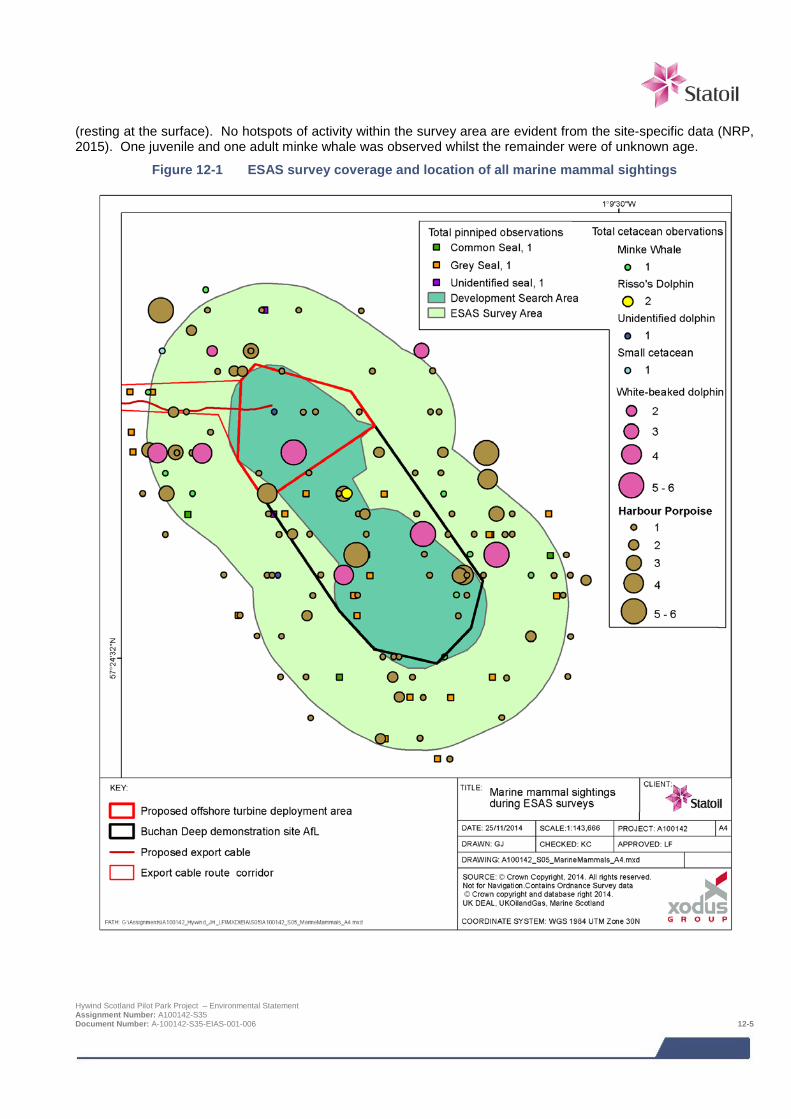
(resting at the surface). No hotspots of activity within the survey area are evident from the site-specific data (NRP, 2015). One juvenile and one adult minke whale was observed whilst the remainder were of unknown age.
Figure 12-1 ESAS survey coverage and location of all marine mammal sightings
Hywind Scotland Pilot Park Project – Environmental Statement Assignment Number: A100142-S35 Document Number: A-100142-S35-EIAS-001-006 12-5
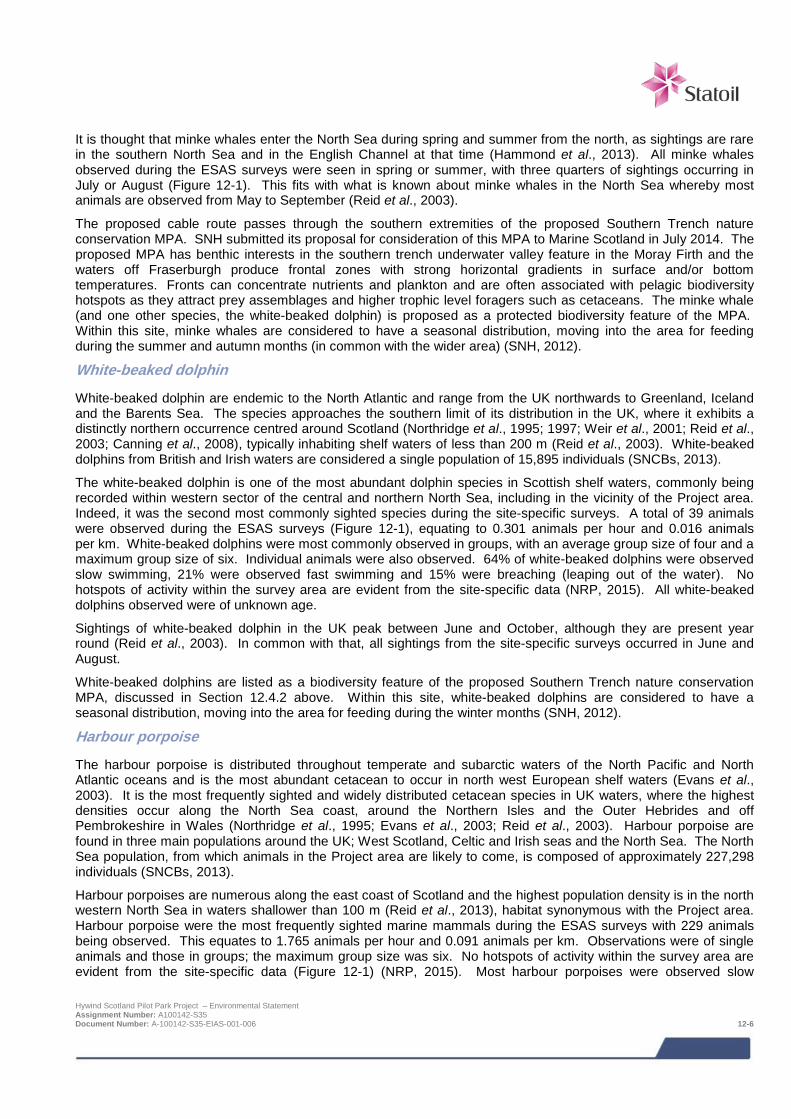
It is thought that minke whales enter the North Sea during spring and summer from the north, as sightings are rare in the southern North Sea and in the English Channel at that time (Hammond et al., 2013). All minke whales observed during the ESAS surveys were seen in spring or summer, with three quarters of sightings occurring in July or August (Figure 12-1). This fits with what is known about minke whales in the North Sea whereby most animals are observed from May to September (Reid et al., 2003).
The proposed cable route passes through the southern extremities of the proposed Southern Trench nature conservation MPA. SNH submitted its proposal for consideration of this MPA to Marine Scotland in July 2014. The proposed MPA has benthic interests in the southern trench underwater valley feature in the Moray Firth and the waters off Fraserburgh produce frontal zones with strong horizontal gradients in surface and/or bottom temperatures. Fronts can concentrate nutrients and plankton and are often associated with pelagic biodiversity hotspots as they attract prey assemblages and higher trophic level foragers such as cetaceans. The minke whale (and one other species, the white-beaked dolphin) is proposed as a protected biodiversity feature of the MPA. Within this site, minke whales are considered to have a seasonal distribution, moving into the area for feeding during the summer and autumn months (in common with the wider area) (SNH, 2012).
White-beaked dolphin
White-beaked dolphin are endemic to the North Atlantic and range from the UK northwards to Greenland, Iceland and the Barents Sea. The species approaches the southern limit of its distribution in the UK, where it exhibits a distinctly northern occurrence centred around Scotland (Northridge et al., 1995; 1997; Weir et al., 2001; Reid et al., 2003; Canning et al., 2008), typically inhabiting shelf waters of less than 200 m (Reid et al., 2003). White-beaked dolphins from British and Irish waters are considered a single population of 15,895 individuals (SNCBs, 2013).
The white-beaked dolphin is one of the most abundant dolphin species in Scottish shelf waters, commonly being recorded within western sector of the central and northern North Sea, including in the vicinity of the Project area. Indeed, it was the second most commonly sighted species during the site-specific surveys. A total of 39 animals were observed during the ESAS surveys (Figure 12-1), equating to 0.301 animals per hour and 0.016 animals per km. White-beaked dolphins were most commonly observed in groups, with an average group size of four and a maximum group size of six. Individual animals were also observed. 64% of white-beaked dolphins were observed slow swimming, 21% were observed fast swimming and 15% were breaching (leaping out of the water). No hotspots of activity within the survey area are evident from the site-specific data (NRP, 2015). All white-beaked dolphins observed were of unknown age.
Sightings of white-beaked dolphin in the UK peak between June and October, although they are present year round (Reid et al., 2003). In common with that, all sightings from the site-specific surveys occurred in June and August.
White-beaked dolphins are listed as a biodiversity feature of the proposed Southern Trench nature conservation MPA, discussed in Section 12.4.2 above. Within this site, white-beaked dolphins are considered to have a seasonal distribution, moving into the area for feeding during the winter months (SNH, 2012).
Harbour porpoise
The harbour porpoise is distributed throughout temperate and subarctic waters of the North Pacific and North Atlantic oceans and is the most abundant cetacean to occur in north west European shelf waters (Evans et al., 2003). It is the most frequently sighted and widely distributed cetacean species in UK waters, where the highest densities occur along the North Sea coast, around the Northern Isles and the Outer Hebrides and off Pembrokeshire in Wales (Northridge et al., 1995; Evans et al., 2003; Reid et al., 2003). Harbour porpoise are found in three main populations around the UK; West Scotland, Celtic and Irish seas and the North Sea. The North Sea population, from which animals in the Project area are likely to come, is composed of approximately 227,298 individuals (SNCBs, 2013).
Harbour porpoises are numerous along the east coast of Scotland and the highest population density is in the north western North Sea in waters shallower than 100 m (Reid et al., 2013), habitat synonymous with the Project area. Harbour porpoise were the most frequently sighted marine mammals during the ESAS surveys with 229 animals being observed. This equates to 1.765 animals per hour and 0.091 animals per km. Observations were of single animals and those in groups; the maximum group size was six. No hotspots of activity within the survey area are evident from the site-specific data (Figure 12-1) (NRP, 2015). Most harbour porpoises were observed slow
Hywind Scotland Pilot Park Project – Environmental Statement Assignment Number: A100142-S35 Document Number: A-100142-S35-EIAS-001-006 12-6

swimming (62%) whilst 22% were fast swimming and 16% were milling (swimming without observer being able to define specific purpose). The majority of harbour porpoises were of unknown age, however eight adults and nine non-adults were observed.
The harbour porpoise is found within UK and Irish waters throughout the year (Evans et al., 2003), with limited information on seasonal movements of harbour porpoise (JNCC, 2010; Reid et al., 2003). In line with this, harbour porpoises were observed throughout the year during site-specific surveys at the site, although numbers peaked between July and September.
Risso’s dolphin
The Risso’s dolphin is widely distributed in both the north and southern hemisphere and in north west Europe it is found both on the shelf (less than 200 m depth) and in slope waters along the Atlantic seaboard (Weir et al., 2001; Reid et al., 2003). Within the UK they are particularly concentrated in The Minch in north west Scotland, in parts of the Irish Sea and off south west Ireland (Reid et al., 2003). Risso’s dolphin in the North Sea, west of Scotland and Irish and Celtic seas are considered a single population (SNCBs, 2013). There is no population estimate for Risso’s dolphin as it is a comparatively uncommon species but animals occurring in UK waters are likely to be part of a population ranging from 500 animals to the low thousands (JNCC, 2010).
Risso’s dolphin were the least frequently sighted of the species observed during the ESAS survey, with only two observed (at a rate of 0.015 animals per hour and 0.001 animals per km) (Figure 12-1). These animals were both observed at the same time in November, as a pair slow swimming. One of the dolphins observed was an adult and the other was of unknown age. No hotspots of activity within the survey area have been observed for Risso’s dolphin (NRP, 2015).
The presence of Risso’s dolphin in UK waters varies seasonally and inter-annually (JNCC, 2010). On the continental shelf sightings are most common between May and October, and in the northern North Sea between July and August, although some animals have been observed off north east Scotland and Shetland in winter (Reid et al., 2003) which concurs with the ESAS survey sightings.
Bottlenose dolphin
Bottlenose dolphins have a worldwide distribution (Reid et al., 2003) and are distributed throughout the UK shelf waters, primarily close to shore; two larger aggregations are found in the Moray Firth (north east Scotland, approximately 92 km north west) and Cardigan Bay (Wales), both of which are designated as Special Areas of Conservation (SACs). There are six management units for bottlenose dolphin in British waters. Few animals have been sighted in the North Sea management unit and it is thought individuals observed in this offshore unit actually belong to the coastal population (SNCBs, 2013); in general this species is most commonly found within the 20 m depth contour. It is likely therefore that any individuals found in the Project area would belong to the ‘Coastal East Scotland’ population which is home to 195 individuals (SNCBs, 2013).
In the UK the greatest numbers of bottlenose dolphin sightings occur between July and October, with a secondary peak in some areas in March to April. Some nearshore animals are present all year round, including the Moray Firth population (Reid et al., 2003). No bottlenose dolphins were observed during the ESAS surveys (NRP, 2015).
12.4.3 Other mysticetes and odontocetes In addition to the species recorded during the site surveys, the baseline review has indicated there are a number of additional cetacean species that could be considered rare visitors to the site:
> Humpback whale - most sightings in the UK occur between May and September, although they are rare in the vicinity of the project (Reid et al., 2003; Xodus, 2013b);
> Fin whale - sightings occur between June and August in northern Britain (Reid et al., 2003) but acoustic data shows they are present throughout the year in UK waters (JNCC, 2010). There have been sightings of fin whales in the vicinity of the Project area albeit only rarely (Reid et al., 2003; Xodus, 2013b; NMPI, 2014);
> Atlantic white-sided dolphins – although relatively rare in the North Sea, there are some records off the north east coast of Scotland and in the vicinity of the Project area. This species appears to enter the North Sea during summer (Reid et al., 2003);
Hywind Scotland Pilot Park Project – Environmental Statement Assignment Number: A100142-S35 Document Number: A-100142-S35-EIAS-001-006 12-7

> Killer whales - recorded throughout the year in UK waters, primarily recorded off northern Scotland in the
summer (Evans et al., 2010). There have been sightings in the Project area, although only occasionally (Reid et al., 2003; Xodus, 2013b; NMPI, 2014);
> Common dolphin - comparatively rare in the North Sea but when sighted are usually seen in summer (Reid et al., 2003). There have been few sighting in the vicinity of the Project area (Reid et al., 2003; NMPI, 2014) and the majority of sightings in the North Sea are to the north of the Project area, east of Orkney and to the south east of the Project area, to the east of Dundee (NMPI, 2014); and
> Long-finned pilot whale - although there are some sightings along the east coast of Scotland, particularly to the east of the Moray Firth, long-finned pilot whales are not considered common in the vicinity of the Project area (Reid et al., 2003; NMPI, 2014). When sighted, it is most often between November and January.
12.4.4 Pinnipeds (seals)
Grey seal
Grey seals occur only in the north Atlantic and Barents and Baltic Seas, with their main concentrations located along the Canadian and US eastern seaboards and in north east Europe (SCOS, 2013). The UK contains around 38% of the total world breeding population of grey seals and 88% of those breed in Scotland, with major concentrations in the Outer Hebrides and Orkney (SCOS, 2013). In 2012 the total UK grey seal population was estimated to be 112,300 individuals (SCOS, 2013).
Grey seals breed in the autumn, with pupping occurring between August and December (SCOS, 2013) although in northern Scotland most pupping occurs between October and late November (Hammond et al., 2003). Moulting takes place between December and April (Hammond et al., 2003; SCOS, 2013). Seals spend more time ashore during the breeding and moulting seasons and at-sea densities will be lower at these times (Hammond et al., 2003). The total grey seal pup production in 2010 was estimated to be 50,200 (SCOS, 2013).
Designated breeding seal colony haul out sites are concentrated in the northern Isles, Orkney and Shetland, and in the Outer Hebrides. Non-breeding haul out sites are also concentrated at these locations in addition to various sites along the west coast of Scotland and along some of the east coast as far south as the Moray Firth. There are also some designated sites in the Firth of Forth (NMPI, 2014). There are no designated grey seal haul out sites near the Project area (Figure 12-2, Scottish Government, 2014a). Grey seal density in the WTG deployment area is expected to be 0.12 – 0.13 animals per km2 whilst in the cable route corridor it could range from 0.12 – 0.59 animals per km2, based on seal density maps published by the Scottish Government (Figure 12-2, Jones et al., 2013).
Grey seals were the third most common marine mammal observed during the ESAS surveys, with 38 animals being sighted at a rate of 0.293 animals per hour and 0.091 animals per km. Grey seals were most often observed independently, with a maximum group size of four.
55% of grey seals observed were slow swimming, whilst 42% were bottling (whereby their bodies were submerged with their heads exposed) and 3% were escape diving. Grey seals were observed during every month that surveys took place, with the exception of March. During the survey two non-adults, one juvenile and one immature individual were sighted. Although no hotspots exist for this species in the survey data, grey seals were largely absent from the north east of the survey area (NRP, 2015) (Figure 12-1).
Seals in the UK are divided into different management units; the Hywind Project lies within the east coast (Scotland) management area where the grey seal population is thought to consist of 6,800 individuals.
Potential Biological Removal (PBR) is a widely used method of calculating whether current levels of anthropogenic mortality are consistent with reaching or exceeding a specific target population for a species. Using this tool, the Scottish Government issues limits on the number of seals that can be removed from a population before that population might be affected. For grey seals in the east coast management area in 2014 this number is estimated to be 314 animals (Scottish Government, 2014b).
Hywind Scotland Pilot Park Project – Environmental Statement Assignment Number: A100142-S35 Document Number: A-100142-S35-EIAS-001-006 12-8
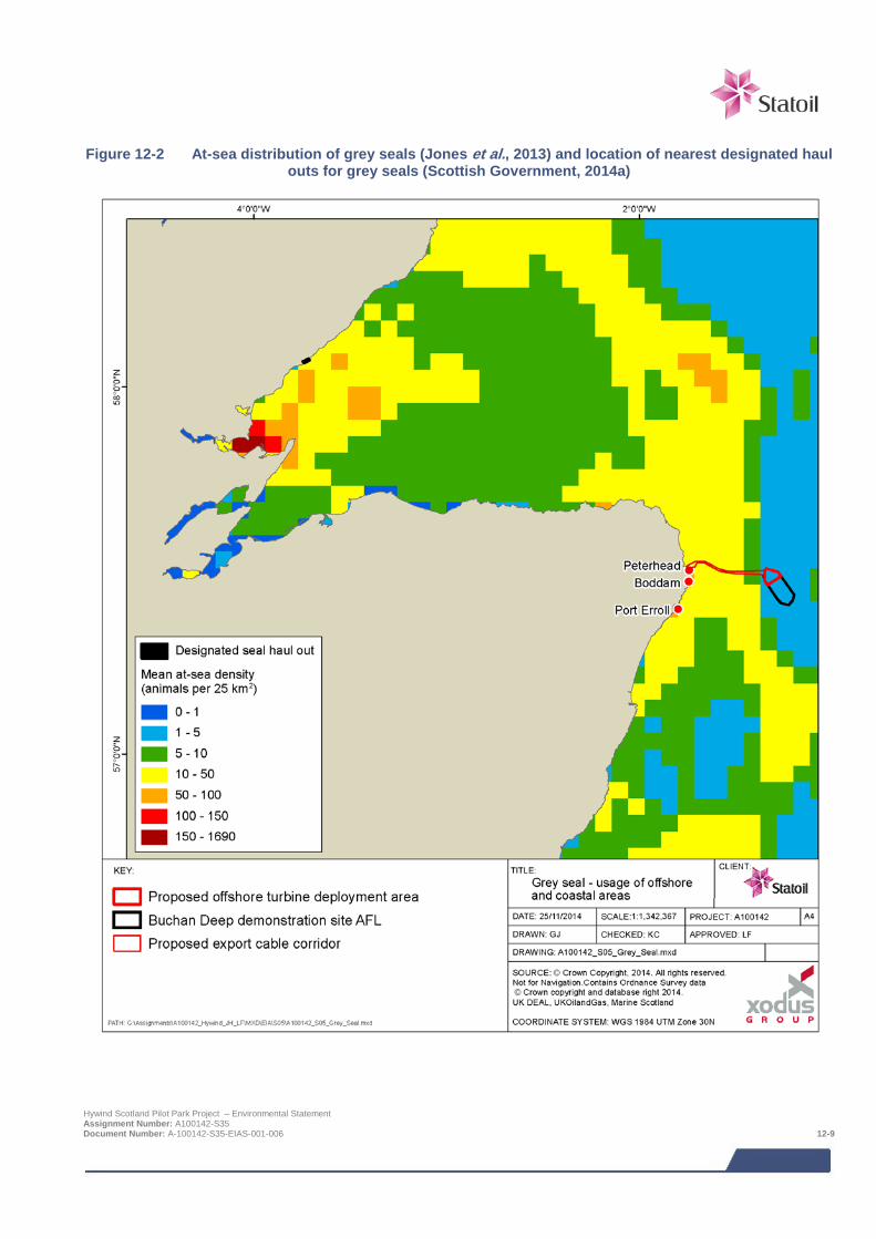
Figure 12-2 At-sea distribution of grey seals (Jones et al., 2013) and location of nearest designated haul
outs for grey seals (Scottish Government, 2014a)
Hywind Scotland Pilot Park Project – Environmental Statement Assignment Number: A100142-S35 Document Number: A-100142-S35-EIAS-001-006 12-9
Harbour seal
Harbour seals have a circumpolar distribution with 30% of the European population located in the UK; 79% of this population is found in Scotland. Harbour seals are widespread around the west coast of Scotland, throughout the Hebrides and Northern Isles. On the east coast their distribution is more restricted with concentrations in the major estuaries of the Firth of Tay and the Moray Firth (SCOS, 2013). The harbour seal count in Scotland is 21,219 (SNCBs, 2013). Dive involving foraging activity tend to occur in waters up to 50 m in depth (Tollit et al., 1998).
Harbour seals are present in UK waters year-round. Pups are born during the summer in June and July and during this period they disperse and females spend a high proportion of time ashore with their pups (Hammond et al., 2003; SCOS, 2010). Harbour seals moult in August (SCOS, 2013) and numbers at haul out sites are highest at this time. There are no designated haul out sites, breeding or otherwise, around Peterhead (NMPI, 2014) and the closest harbour seal haul out site to the Project area is in the Moray Firth (Figure 12-3, Scottish Government, 2014a). Harbour seal density in the WTG deployment area and in the export route corridor is expected to be between 0.003 and 0.004 animals per km2 (Figure 12-3, Jones et al., 2013).
Of the species recorded during the ESAS surveys (Figure 12-1), harbour seals were the second least sighted marine mammal; four individuals were observed at an encounter rate of 0.031 animals per hour and 0.002 animals per km. Two of the harbour seals observed were bottling whilst one individual was slow swimming and the other was escape diving. One of the seals was recorded as an adult whilst the remainder were of unknown age. No hotspots of activity were evident for harbour seals within the survey area (NRP, 2015).
The harbour seal population in the east coast management unit is 315 individuals. These estimates are made during the moulting season when individuals of the species aggregate and the distribution is not thought to change throughout the year (SNCBs, 2013). Given the small population size and the ongoing decline in harbour seals on the east coast of Scotland4, the PBR for harbour seals in the east coast management area for 2014 has been set at two animals (Scottish Government, 2014b).
12.4.5 Data gaps and uncertainties As part of the development of the survey methodology, extensive review work was undertaken to define marine mammal presence in the Project area and wider marine environment. Combined with the ground-truthing observations made during the site survey work, a robust baseline (as per Section 12.4) is available for the impact assessment and no data gaps regarding species use of the Project site are considered to be present.
4 Duck and Morris (2014) report a decline in numbers on the east coast (between Fraserburgh and Firth of Forth) of over 50% between 2007 and 2013. Declines in numbers in some areas of the east coast have been even greater; for example, there has been a 90% decline in numbers in the Firth of Tay from a high in the 1990s (Duck and Morris, 2014). Scottish Government (2011) note that the causes of the decline are unknown but comment it is possibly due to a combination of a number of factors such as competition with grey seals, reduced prey availability, disease, increased predation from killer whales, shooting, elevated biotoxin loading, reduced fecundity and corkscrew injury. Hywind Scotland Pilot Park Project – Environmental Statement Assignment Number: A100142-S35 Document Number: A-100142-S35-EIAS-001-006 12-10
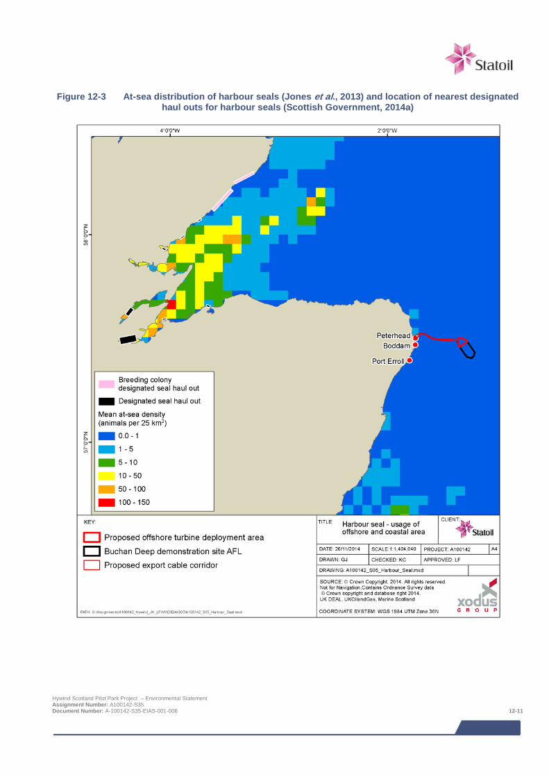
Figure 12-3 At-sea distribution of harbour seals (Jones et al., 2013) and location of nearest designated
haul outs for harbour seals (Scottish Government, 2014a)
Hywind Scotland Pilot Park Project – Environmental Statement Assignment Number: A100142-S35 Document Number: A-100142-S35-EIAS-001-006 12-11
12.5 Impact assessment
12.5.1 Overview Following establishment of the baseline conditions of the Project area, with an understanding of the Project activities it is possible to assess the potential impacts from the Project. The range of impacts that have been considered is based on impacts identified during EIA Scoping and any further potential impacts that have been highlighted as the EIA has progressed.
The EIA process has identified a number of potential impact mechanisms from construction and installation activities. The main impact mechanism is through the physical presence of the installation activities. The receptors sensitive to such impacts are those species that have been identified as using the Project area by the baseline review in Section 12.4 (since infrequent presence, and hence infrequent interaction with the development, is unlikely to lead to impacts to individuals and even less likely to affect the species at the population level). Species most likely to be present in the site are:
> Minke whale;
> Harbour porpoise;
> White-beaked dolphin;
> Risso’s dolphin;
> Grey seal; and
> Harbour seal.
However, other cetaceans such as bottlenose dolphin could potentially be present, especially nearer to shore, and these species are discussed where relevant.
The potential impacts which are assessed are summarised as follows (note that not all impacts will be relevant to all phases of the Project):
> Noise (including from vessels, anchoring and other operations) causing injury or disturbance;
> Physical disturbance due to vessel presence near seal haul outs;
> Corkscrew injury;
> Marine mammal entanglement;
> Indirect effects from changes in habitat and distribution/abundance of prey species (operational phase only);
> Pollution due to leaks and spills from vessels/WTG Units; and
> Cumulative and in-combination impacts.
Although no impact mechanisms were scoped out of the assessment during EIA Scoping, it has since been determined (by the Fish and Shellfish Ecology impact assessment in Chapter 10) that there will be no significant changes to the distribution or abundance of potential prey species. As such, the potential for indirect effects resulting from changes in prey availability are considered unlikely and are not considered further.
The assessment of these impacts on marine mammals has been undertaken as a desk-based assessment utilising Project-specific survey information (Section 12.4) and the following supporting technical studies:
> Marine noise desk study (Xodus, 2013a)
o This report provides a high level overview of the potential impacts due to underwater noise from Hywind on the surrounding environment. In particular, this report reviews the underwater noise measurements and analysis previously undertaken by SWL for the Hywind Demo installed offshore Norway, to assess operational noise from the WTG Units.
Hywind Scotland Pilot Park Project – Environmental Statement Assignment Number: A100142-S35 Document Number: A-100142-S35-EIAS-001-006 12-12
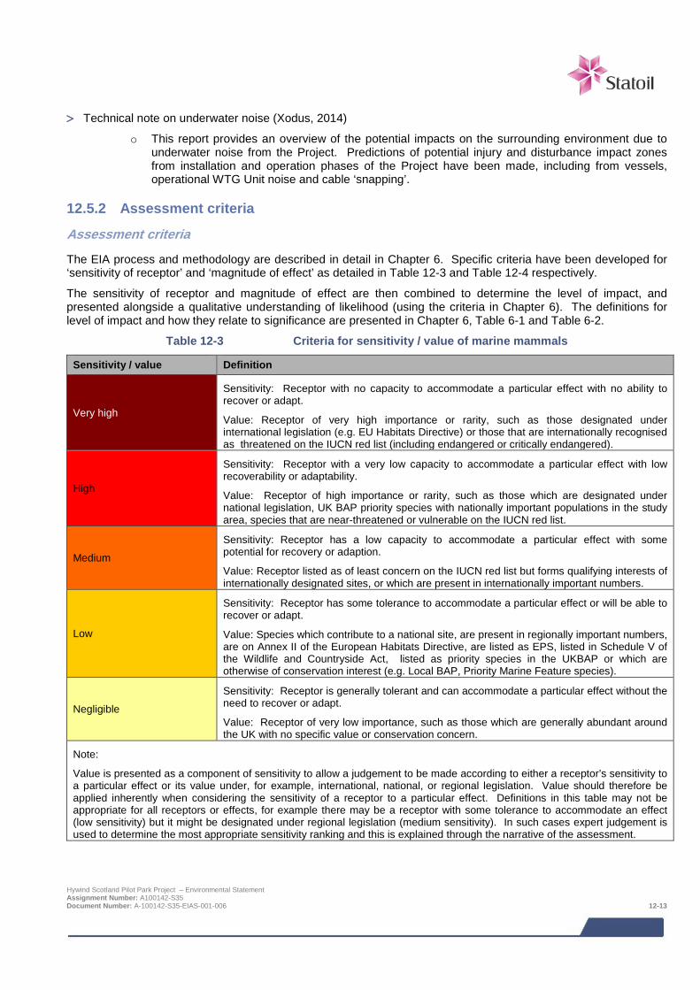
> Technical note on underwater noise (Xodus, 2014)
o This report provides an overview of the potential impacts on the surrounding environment due to underwater noise from the Project. Predictions of potential injury and disturbance impact zones from installation and operation phases of the Project have been made, including from vessels, operational WTG Unit noise and cable ‘snapping’.
12.5.2 Assessment criteria
Assessment criteria
The EIA process and methodology are described in detail in Chapter 6. Specific criteria have been developed for ‘sensitivity of receptor’ and ‘magnitude of effect’ as detailed in Table 12-3 and Table 12-4 respectively.
The sensitivity of receptor and magnitude of effect are then combined to determine the level of impact, and presented alongside a qualitative understanding of likelihood (using the criteria in Chapter 6). The definitions for level of impact and how they relate to significance are presented in Chapter 6, Table 6-1 and Table 6-2.
Table 12-3 Criteria for sensitivity / value of marine mammals
Sensitivity / value Definition
Very high
Sensitivity: Receptor with no capacity to accommodate a particular effect with no ability to recover or adapt.
Value: Receptor of very high importance or rarity, such as those designated under international legislation (e.g. EU Habitats Directive) or those that are internationally recognised as threatened on the IUCN red list (including endangered or critically endangered).
High
Sensitivity: Receptor with a very low capacity to accommodate a particular effect with low recoverability or adaptability.
Value: Receptor of high importance or rarity, such as those which are designated under national legislation, UK BAP priority species with nationally important populations in the study area, species that are near-threatened or vulnerable on the IUCN red list.
Medium
Sensitivity: Receptor has a low capacity to accommodate a particular effect with some potential for recovery or adaption.
Value: Receptor listed as of least concern on the IUCN red list but forms qualifying interests of internationally designated sites, or which are present in internationally important numbers.
Low
Sensitivity: Receptor has some tolerance to accommodate a particular effect or will be able to recover or adapt.
Value: Species which contribute to a national site, are present in regionally important numbers, are on Annex II of the European Habitats Directive, are listed as EPS, listed in Schedule V of the Wildlife and Countryside Act, listed as priority species in the UKBAP or which are otherwise of conservation interest (e.g. Local BAP, Priority Marine Feature species).
Negligible
Sensitivity: Receptor is generally tolerant and can accommodate a particular effect without the need to recover or adapt.
Value: Receptor of very low importance, such as those which are generally abundant around the UK with no specific value or conservation concern.
Note:
Value is presented as a component of sensitivity to allow a judgement to be made according to either a receptor’s sensitivity to a particular effect or its value under, for example, international, national, or regional legislation. Value should therefore be applied inherently when considering the sensitivity of a receptor to a particular effect. Definitions in this table may not be appropriate for all receptors or effects, for example there may be a receptor with some tolerance to accommodate an effect (low sensitivity) but it might be designated under regional legislation (medium sensitivity). In such cases expert judgement is used to determine the most appropriate sensitivity ranking and this is explained through the narrative of the assessment.
Hywind Scotland Pilot Park Project – Environmental Statement Assignment Number: A100142-S35 Document Number: A-100142-S35-EIAS-001-006 12-13

Table 12-4 Criteria for magnitude of effect
Magnitude of effect Definition
Severe Effect is widespread, or occurs over a prolonged duration, or at a high frequency (e.g. repeated or continuous effect), resulting in extensive permanent changes to baseline breeding grounds, feeding grounds or migration routes.
Major Effect is over a large scale or spatial extent, or occurs long term, or at a medium-high frequency, resulting in extensive temporary change or some permanent change to baseline breeding grounds, feeding grounds or migration routes.
Moderate Effect is localised, or occurs for a short duration, or at a medium frequency, resulting in temporary changes or limited permanent changes to baseline breeding grounds, feeding grounds or migration routes.
Minor Detectable disturbance or change to baseline levels and no long term noticeable effects above the level of natural variation experienced for breeding grounds, feeding grounds or migration routes.
Negligible Imperceptible changes to baseline breeding grounds, feeding grounds or migration routes.
Note:
Magnitude of effect is presented as a variety of parameters including duration, timing, size and scale, and frequency. Definitions in this table may not be appropriate for all effects, for example there may be an effect which is over a very small area (minor or moderate) but is repeated a large number of times during a particular phase of the project (major or severe). In such cases expert judgement is used to determine the most appropriate magnitude ranking and this is explained through the narrative of the assessment.
12.5.3 Design Envelope This assessment considers the Project parameters which are predicted to result in the greatest environmental impact. This approach ensures that impacts of greater adverse significance would not arise should any other development scenario be taken forward in the final scheme design. With regards to the assessment of impacts on marine mammal ecology, the assessment has considered the following project parameters, which are predicted to result in the greatest impact:
> There will be 5 WTG Units in water depths of 95 – 120 m;
> Each WTG Unit will require 3 anchors (15 anchors for the whole Pilot Park) with mooring lines of between 600 and 1,200 m length;
> Seabed marker buoys with approximately 10 m of rope will be required for the anchor retrieval system for up to 18 months prior to installation of the WTG Units;
> There will be 5 inter-array cables of up to 3 km each (a total of 15 km for the Pilot Park) suspended in the water column;
> An export cable of up to 35 km in length will be installed using jet/mechanical trenching;
> Vessel requirement for installation will be:
o 1 anchor handler vessel and light subsea construction vessel (or similar) for 2 – 3 weeks;
o 1 installation vessel and 1 crew transfer vessel for 10 to 15 days of inter-array cable installation;
o 1 light subsea construction vessel and 2 ocean going tugs for 1 week of hook-up and mooring of WTG Units;
o 1 cable lay vessel and 1 trenching vessel for 5 to 8 days of export cable installation; and
o 1 cable trenching vessel for 8 to 12 days of export cable trenching.
> Vessel requirement for during operation and maintenance will be:
Hywind Scotland Pilot Park Project – Environmental Statement Assignment Number: A100142-S35 Document Number: A-100142-S35-EIAS-001-006 12-14
o 1 – 4 days of supply vessel (with an ROV) every 1 – 4 years for inspection of the export cable;
o 2 – 3 days of crew transfer vessel annually for servicing of WTG Units;
o 1 day of crew transfer vessel and supply vessel (with an ROV) every 1 – 4 years for inspection of the substructure, moorings and inter-array cables; and
o 25 – 100 days of supply vessel for unforeseen maintenance requirements.
The impacts from potential alternative development options are addressed in Section 12.9.
12.5.4 Data gaps and uncertainties When undertaking the impact assessment the following uncertainties have been identified:
> Entanglement of marine mammals with mooring lines and suspended inter-array cables
o Evidence of marine mammals becoming entangled in man-made structures exists but these records are primarily related to fisheries (e.g. Read et al., 2005). The applicability of such studies to determine risk from moored wind turbines is currently unknown, although the work of Benjamins et al., (2014) has sought to better define this.
> Corkscrew injury
o Very recent research has indicated that there is now incontrovertible evidence that corkscrew injuries can be caused by grey seal predation on weaned grey seal pups (reported from the Isle of May). Furthermore, there have been recent observations of an adult male grey seal killing and eating young harbour seals in Germany. Based on these recent findings the Regulators and Statutory Nature Conservation Bodies (SNCBs) now consider that it is very likely that the use of vessels with ducted propellers may not in reality pose any increased risk to seals over and above normal shipping activities.
> Noise thresholds
o The levels of noise which result in disturbance or injury to marine mammals have been outlined in the technical notes on underwater noise (Xodus, 2013a; 2014). These levels have been selected on a precautionary basis using the best available data that represent the levels at which the onset of potential impact may occur; it is not specifically the level at which significant effects will definitely be observed.
The uncertainties around these impact mechanisms have been considered when defining sensitivity of receptor and magnitude of effect.
12.6 Impacts during construction and installation
12.6.1 Underwater noise A number of species of marine mammal are likely to be present in the Project area (Section 12.4); many of these species make use of underwater sound and have hearing that is highly tuned for the undersea environment (Richardson et al., 1995). Their susceptibility to impacts arising through the introduction of man-made noise into the marine environment is well-documented (e.g. Southall et al., 2007). The main sound source traditionally associated with offshore wind farm installation activities is hammer (percussive) piling, an activity which will not be required during the installation of this Project. Noise emissions during construction and installation will therefore arise from the use of vessels and other equipment which will produce noise during installation of the anchors, anchor lines, WTG Units and export cable.
Noise modelling
An underwater noise technical assessment (Xodus, 2014) has been prepared to provide an overview of the potential impacts on the surrounding environment. Predictions of potential injury and disturbance zones from installation and operation phases of the Project have been made, including from vessels and operational WTG Unit Hywind Scotland Pilot Park Project – Environmental Statement Assignment Number: A100142-S35 Document Number: A-100142-S35-EIAS-001-006 12-15

noise. The thresholds for onset of injury and disturbance in marine mammals that are used in this assessment are as per Table 12-5 and Table 12-6. It should be noted that the criteria are very precautionary (see section 3 of the underwater noise technical assessment; Xodus, 2014).
Table 12-5 Marine mammal criteria for onset injury (per 24 hour period)
Marine mammal group Type of sound
Injury criteria
Peak pressure, dB re 1 μPa SEL, dB re 1 μPa2s (M-weighted)
Low-frequency cetaceans
Single or multiple pulses 230 198
Non-pulses 230 215
Mid-frequency cetaceans
Single or multiple pulses 230 198
Non-pulses (e.g. continuous sound) 230 215
High-frequency cetaceans
Single or multiple pulses (not harbour porpoise) 230 198
Single or multiple pulses (harbour porpoise only) 194 177
Non-pulses 230 215
Pinnipeds in water Single or multiple pulses 218 186
Non-pulses 218 203
Table 12-6 Suggested marine mammal criteria for onset of disturbance
Type of sound/criteria metric Effect Marine mammal hearing group
All cetaceans Pinnipeds
Single pulses:
Peak pressure level, dB re 1 μPa2s Potential strong behavioural reaction
224 212
SEL, dB re 1 μPa2s 183 171
Multiple pulses:
RMS sound pressure level, dB re 1 μPa
Potential strong behavioural reaction 160
Low level marine mammal disturbance 140
Continuous sound:
RMS sound pressure level, dB re 1 μPa Potential strong behavioural reaction 120
Vessel noise
The modelling conducted for the EIA (Xodus, 2014) shows that the peak pressure criterion described by Southall et al., (2007) will not be exceeded even in very close proximity to the installation vessels and no fatal injury is likely from the operations. An assessment of the distance to onset of injury from each vessel category based on the SEL cumulative exposure criterion is presented in Table 12-7, along with an assessment of potential disturbance zones. The potential radii for injury are based on exposure levels over a 24 hour period and assume that all vessels are present at the same time (i.e. the cumulative impact from all vessels being present at the same time is considered in the impact ranges). For example, Table 12-7 shows that a seal would need to stay within 50 m of cable laying operations for a period of 24 hours to experience any injury. The table also presents the potential radius of disturbance for marine mammals based on conservative 120 dB re 1 μPa (rms) criterion. It is important to bear in mind when viewing these potential disturbance radii that the 120 dB re 1 μPa (rms) criterion is very precautionary and that ambient noise levels could well exceed this value.
Hywind Scotland Pilot Park Project – Environmental Statement Assignment Number: A100142-S35 Document Number: A-100142-S35-EIAS-001-006 12-16
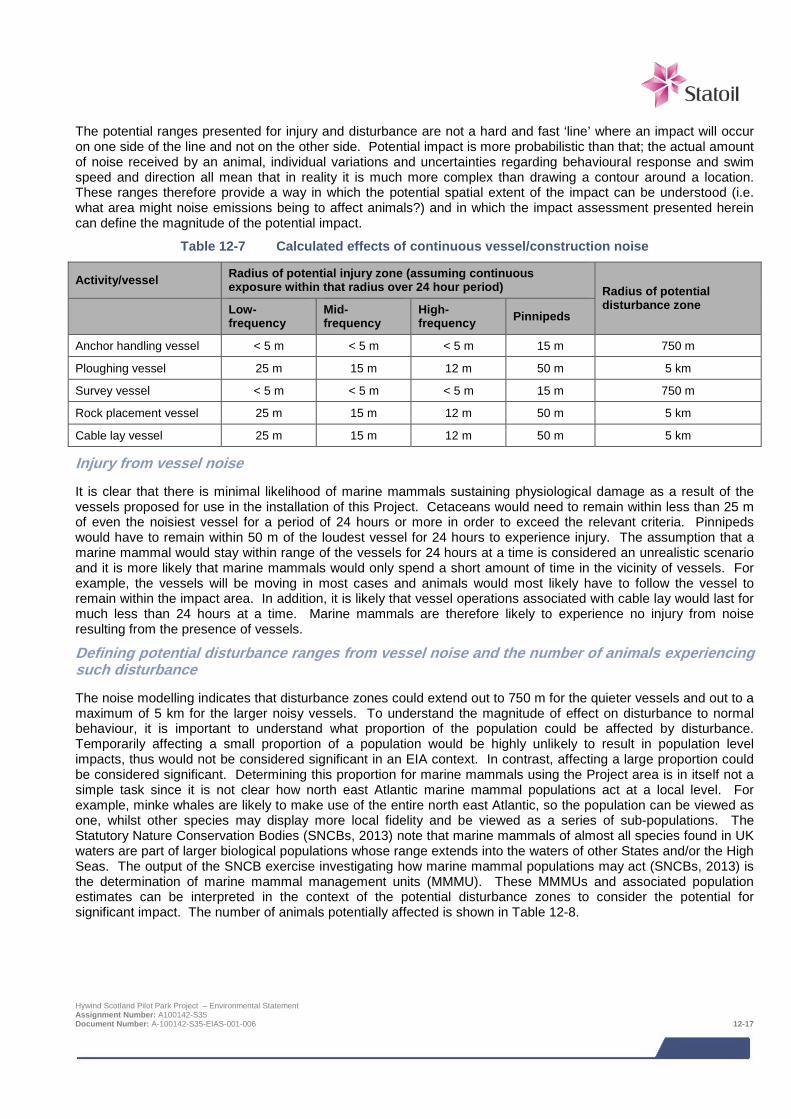
The potential ranges presented for injury and disturbance are not a hard and fast ‘line’ where an impact will occur on one side of the line and not on the other side. Potential impact is more probabilistic than that; the actual amount of noise received by an animal, individual variations and uncertainties regarding behavioural response and swim speed and direction all mean that in reality it is much more complex than drawing a contour around a location. These ranges therefore provide a way in which the potential spatial extent of the impact can be understood (i.e. what area might noise emissions being to affect animals?) and in which the impact assessment presented herein can define the magnitude of the potential impact.
Table 12-7 Calculated effects of continuous vessel/construction noise
Activity/vessel Radius of potential injury zone (assuming continuous exposure within that radius over 24 hour period) Radius of potential
disturbance zone
Low-frequency
Mid-frequency
High-frequency Pinnipeds
Anchor handling vessel < 5 m < 5 m < 5 m 15 m 750 m
Ploughing vessel 25 m 15 m 12 m 50 m 5 km
Survey vessel < 5 m < 5 m < 5 m 15 m 750 m
Rock placement vessel 25 m 15 m 12 m 50 m 5 km
Cable lay vessel 25 m 15 m 12 m 50 m 5 km
Injury from vessel noise
It is clear that there is minimal likelihood of marine mammals sustaining physiological damage as a result of the vessels proposed for use in the installation of this Project. Cetaceans would need to remain within less than 25 m of even the noisiest vessel for a period of 24 hours or more in order to exceed the relevant criteria. Pinnipeds would have to remain within 50 m of the loudest vessel for 24 hours to experience injury. The assumption that a marine mammal would stay within range of the vessels for 24 hours at a time is considered an unrealistic scenario and it is more likely that marine mammals would only spend a short amount of time in the vicinity of vessels. For example, the vessels will be moving in most cases and animals would most likely have to follow the vessel to remain within the impact area. In addition, it is likely that vessel operations associated with cable lay would last for much less than 24 hours at a time. Marine mammals are therefore likely to experience no injury from noise resulting from the presence of vessels.
Defining potential disturbance ranges from vessel noise and the number of animals experiencing such disturbance
The noise modelling indicates that disturbance zones could extend out to 750 m for the quieter vessels and out to a maximum of 5 km for the larger noisy vessels. To understand the magnitude of effect on disturbance to normal behaviour, it is important to understand what proportion of the population could be affected by disturbance. Temporarily affecting a small proportion of a population would be highly unlikely to result in population level impacts, thus would not be considered significant in an EIA context. In contrast, affecting a large proportion could be considered significant. Determining this proportion for marine mammals using the Project area is in itself not a simple task since it is not clear how north east Atlantic marine mammal populations act at a local level. For example, minke whales are likely to make use of the entire north east Atlantic, so the population can be viewed as one, whilst other species may display more local fidelity and be viewed as a series of sub-populations. The Statutory Nature Conservation Bodies (SNCBs, 2013) note that marine mammals of almost all species found in UK waters are part of larger biological populations whose range extends into the waters of other States and/or the High Seas. The output of the SNCB exercise investigating how marine mammal populations may act (SNCBs, 2013) is the determination of marine mammal management units (MMMU). These MMMUs and associated population estimates can be interpreted in the context of the potential disturbance zones to consider the potential for significant impact. The number of animals potentially affected is shown in Table 12-8.
Hywind Scotland Pilot Park Project – Environmental Statement Assignment Number: A100142-S35 Document Number: A-100142-S35-EIAS-001-006 12-17
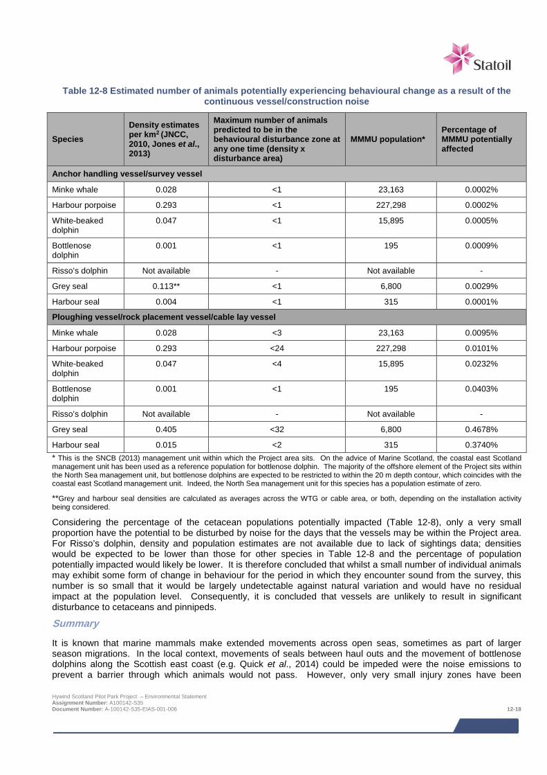
Table 12-8 Estimated number of animals potentially experiencing behavioural change as a result of the
continuous vessel/construction noise
Species Density estimates per km2 (JNCC, 2010, Jones et al., 2013)
Maximum number of animals predicted to be in the behavioural disturbance zone at any one time (density x disturbance area)
MMMU population* Percentage of MMMU potentially affected
Anchor handling vessel/survey vessel
Minke whale 0.028 <1 23,163 0.0002%
Harbour porpoise 0.293 <1 227,298 0.0002%
White-beaked dolphin
0.047 <1 15,895 0.0005%
Bottlenose dolphin
0.001 <1 195 0.0009%
Risso’s dolphin Not available - Not available -
Grey seal 0.113** <1 6,800 0.0029%
Harbour seal 0.004 <1 315 0.0001%
Ploughing vessel/rock placement vessel/cable lay vessel
Minke whale 0.028 <3 23,163 0.0095%
Harbour porpoise 0.293 <24 227,298 0.0101%
White-beaked dolphin
0.047 <4 15,895 0.0232%
Bottlenose dolphin
0.001 <1 195 0.0403%
Risso’s dolphin Not available - Not available -
Grey seal 0.405 <32 6,800 0.4678%
Harbour seal 0.015 <2 315 0.3740% * This is the SNCB (2013) management unit within which the Project area sits. On the advice of Marine Scotland, the coastal east Scotland management unit has been used as a reference population for bottlenose dolphin. The majority of the offshore element of the Project sits within the North Sea management unit, but bottlenose dolphins are expected to be restricted to within the 20 m depth contour, which coincides with the coastal east Scotland management unit. Indeed, the North Sea management unit for this species has a population estimate of zero.
**Grey and harbour seal densities are calculated as averages across the WTG or cable area, or both, depending on the installation activity being considered.
Considering the percentage of the cetacean populations potentially impacted (Table 12-8), only a very small proportion have the potential to be disturbed by noise for the days that the vessels may be within the Project area. For Risso’s dolphin, density and population estimates are not available due to lack of sightings data; densities would be expected to be lower than those for other species in Table 12-8 and the percentage of population potentially impacted would likely be lower. It is therefore concluded that whilst a small number of individual animals may exhibit some form of change in behaviour for the period in which they encounter sound from the survey, this number is so small that it would be largely undetectable against natural variation and would have no residual impact at the population level. Consequently, it is concluded that vessels are unlikely to result in significant disturbance to cetaceans and pinnipeds.
Summary
It is known that marine mammals make extended movements across open seas, sometimes as part of larger season migrations. In the local context, movements of seals between haul outs and the movement of bottlenose dolphins along the Scottish east coast (e.g. Quick et al., 2014) could be impeded were the noise emissions to prevent a barrier through which animals would not pass. However, only very small injury zones have been Hywind Scotland Pilot Park Project – Environmental Statement Assignment Number: A100142-S35 Document Number: A-100142-S35-EIAS-001-006 12-18
predicted and these are based on animals remaining within tens of metres of the vessels for 24 hours; since this would not occur for animals transiting through an area, animals can pass through the ensonified areas without injury. The disturbance zones, as described above, do not represent areas from which animals would be excluded and thus do not represent a barrier to long range movements. With a maximum radius of potential disturbance of 5 km and with a short duration of activity (up to 3 weeks for the longest activity, setting anchors), the noise emissions will not represent a barrier to wider, regional movements of marine mammals (such as seals making long distances movements between haul outs and such as bottlenose dolphins ranging along the Scottish east coast).
Assessment of impact significance
The sensitivity of receptors is considered either medium (in the case of bottlenose dolphin, due to animals being part of the Moray Firth SAC) or low (due to being on Annex II of the Habitats Directive or to being EPS), the magnitude of effect is considered minor (since few animals are expected to be affected in any way and the installation and construction operations will take place over a short timescale i.e. few weeks). The level of impact is minor and not significant. This impact is likely to occur.
Sensitivity / value Magnitude of effect Level of impact
Medium Minor Minor
Impact significance – NOT SIGNIFICANT
MITIGATION
> No mitigation measures proposed as no significant impact predicted.
12.6.2 Physical disturbance due to vessel presence near seal haul outs Although there are likely to be individual seals hauled out within the cable landfall corridor (e.g. the intertidal survey conducted for the Project (Xodus, 2013c) recorded a single grey seal in the south of potential landfall area), there are no seal haul outs designated under the Marine (Scotland) Act 2010 (so-called ‘designated haul outs’ – see Figure 12-2 and Figure 12-3) within the wider east coast area and no such haul outs could be disturbed by Project activities. Given the absence of sensitive receptor with regards to this impact mechanism, there will be no impact.
12.6.3 Corkscrew injury There has, since 2008, been concern over the number of seal carcasses washed up at various locations on the UK coast all displaying the same fatal injuries. These comprised predominantly adult female harbour seals in the summer months and newly-weaned grey seal pups in the winter. Each carcass displays a characteristic set of injuries consisting of a single smooth edged wound typically starting on the side of the head and spiralling around the body. Interaction with ship’s propellers, and more specifically ducted propellers, was considered the most likely cause. There is now incontrovertible evidence that such injuries can be caused by grey seal predation on weaned grey seal pups (on the Isle of May) (Sottish Government, 2015). Furthermore, there have been recent observations of an adult male grey seal killing and eating young harbour seals in Germany (van Neer et al., 2015). Based on the latest information it is considered very likely that the use of vessels with ducted propellers may not pose any increased risk to seals over and above normal shipping activities (Scottish Government, 2015). The installation and construction activities associated with the Project will not take place in the vicinity of any major seal breeding or haul out sites. The number of vessels involved is limited, and installation will take place over a short duration (few weeks). Therefore it is not considered that the Project will present any additional impacts to seals over and above normal shipping activities. This potential impact is therefore not considered further.
12.6.4 Marine mammal entanglement Suction anchors (for mooring the WTG Units) will be installed prior to the towing to the site of the preassembled WTG Units. Once these suction anchors are installed, between 150 m and 850 m of mooring line will be lowered to the seabed, along with a retrieval system; this may be in place up to 18 months prior to the installation of the WTG Hywind Scotland Pilot Park Project – Environmental Statement Assignment Number: A100142-S35 Document Number: A-100142-S35-EIAS-001-006 12-19
Units. The retrieval system will comprise a buoy connected to the suction anchor on the seabed. The buoy will float approximately 10 m above the seabed to be picked up later by ROV. Since there will be no real length of cable in the water column, there is no entanglement risk and there will be no impact.
12.6.5 Pollution due to leaks and spills from vessels There is potential for accidental contamination from vessels to occur as a result of collision during installation activities. The release of a large inventory of fuel oil from a vessel is considered to represent the greatest potential accidental pollution event from installation operations. The total oil inventory for the large installation vessels that may be required for the installation activities is likely to be in the region of 6 – 8,000,000 litres of marine diesel stored in a number of separate tanks with a worst case spill from a single tank rupture likely to be 600,000 litres. The effect of a release of fuel will vary depending on a wide range of factors including the volume and type of fuel released and the sea and weather conditions at the time of the spill. Effects will also be dependent on the presence of environmental sensitivities in the path of the spill (i.e. marine mammals being present in the vicinity of the spill).
Given the presence of marine mammals in the Project area, it is likely that some individuals would come into contact with a spill, potentially ingesting the fuel and experiencing toxic effects. For example, seals have been shown to develop conjunctivitis, corneal abrasion, and swollen eyelid membranes (St. Aubin, 1990). However, the spatial extent of such a release would be limited (i.e. it would not be on the scale of an oil and gas industry spill from for example an oil well blowout) and the fuel type involved would be dispersed quickly in the marine environment. As such, few animals would be expected to come into direct contact with such a release. Animals that did and which were not immediately overwhelmed would be able move out of the immediate area of pollution until the incident had passed. Evidence from some of the better-studied oil spills, such as the Braer incident in Shetland in 1993, is a useful proxy, although given the much greater volumes release in that incident they should be viewed as not directly comparable with an incident which may occur from the Project . Of the Braer oil tanker incident, Kingston (1999) reports that seal mortality was less than 10.
The main potential route for impact is likely to be on grey and harbour seal haul out sites, since an aversion by seals to the pollutant which may be accumulating at the haul out may displace them from the preferred haul out sites. However, there are no important known haul out sites (designated or otherwise) in the vicinity of the Project area (see Section 12.4).
MITIGATION
> The mitigation measures that will be implemented to reduce the risk of and limit the consequence of spills are detailed in Chapter 20.
Assessment of impact significance
The sensitivity of receptor is considered low for all marine mammals except for bottlenose dolphin for which it is considered medium (since individuals of this species found in the Project area are likely to be from the Moray Firth SAC population). The magnitude of effect could be considered moderate in the context that a large spill could result in the ‘Decline in abundance or change in distribution of a large minority of regional population with short-term, recoverable effects on breeding grounds, feeding grounds or migration routes’. However, the occurrence of a spill is considered highly unlikely and with the mitigation measures that will be implemented, a magnitude of effect of negligible has been assigned. This gives a level of impact of negligible not significant.
Sensitivity / value Magnitude of effect Level of impact
Medium Negligible Negligible
Impact significance – NOT SIGNIFICANT
Hywind Scotland Pilot Park Project – Environmental Statement Assignment Number: A100142-S35 Document Number: A-100142-S35-EIAS-001-006 12-20
12.7 Impacts during operation and maintenance
12.7.1 Underwater noise Noise emissions during the operational phase are likely to be associated with noise of the operating WTG Units, cable snapping noise associated with the mooring system (if indeed this is associated with the Hywind Scotland Project – see below) and the use of vessels for maintenance activities.
Operating WTG Units
SWL commissioned Fugro GEOS and Jasco Applied Sciences to undertake underwater noise measurements in the vicinity of the Hywind I installation at a test site north west of Stavanger, Norway (reported in Xodus, 2013a). The purpose of the measurement exercise was to quantify potential underwater noise emissions from the Hywind WTG Units during operation in order to inform any impact assessments that will be required for future Hywind project sites. Noise propagation modelling undertaken by Xodus (2014) using the noise measurements from the operational WTG Units showed that the noise emissions were below the predicted injury impact thresholds (as per Southall et al., 2007) and that marine mammals are unlikely to experience injury as a result of operational noise from the WTG Units.
The range of potential disturbance from operating WTG Units for marine mammals is 450 m based on exceeding the 120 dB re 1 μPa (rms) criterion for continuous noise. A potential disturbance zone of approximately 3.2 km2 (i.e. an area extending out to 450 m around each WTG unit of which there are 5) could therefore exist for the period of operation. Given the Project area is not a known breeding site for any marine mammal species and as the area of potential disturbance would not constitute a barrier to movement (since the disturbance zone is not an exclusion zone and since the operational component of the Project area is in open sea), the potential impact mechanism from disturbance due to noise is likely limited to effects on foraging. As a worst-case estimate, it could be assumed that the noise could cause no marine mammals to forage within the disturbance zone. However, the fish ecology assessment (Chapter 10) notes that the device foundations and cable protection are likely to be colonised by numerous marine organisms and that evidence from offshore wind farms indicates that structures could act as refuge for some fish and prey species (Linley et al., 2007). As a result the colonisation by fauna on the structures could result in an increase in food availability, as well as attracting some fish species for protection (e.g. against predation or the prevalent current). Indeed, the fish ecology assessment (Chapter 10) highlights the case of the Horns Rev offshore wind farm which saw a marked increase in fish fauna diversity, with shoals of cod, bib and whiting observed around the turbine bases (Leonhard & Pedersen, 2004). Additionally, Russell et al. (2014) report grey and harbour seals making repeat visits to an offshore wind farm, with evidence suggesting foraging specifically occurring around individual turbines. The Project area could therefore become a useful source of prey for marine mammals. It is possible therefore that marine mammals will continue to forage, or even begin foraging, at the location. The low frequency operating noise emissions will not interfere with the high-frequency echolocating abilities used by some marine mammal species during foraging.
The very low number of animals that could experience noise emissions above the onset of disturbance from the operating WTG Units is shown in Table 12-9. These numbers represent the greatest predicted impact. Note that bottlenose dolphins are not considered likely to be affected as they are generally restricted to within the 20 m depth contour, which is well shoreward of the operating WTG Units and the potential disturbance zones.
Hywind Scotland Pilot Park Project – Environmental Statement Assignment Number: A100142-S35 Document Number: A-100142-S35-EIAS-001-006 12-21

Table 12-9 Estimated number of animals potentially experiencing behavioural disturbance as a result of the operating WTGs
Species Density estimates per km2 (JNCC, 2010, Jones et al., 2013)
Maximum number of animals predicted to be in the behavioural disturbance zone at any one time
MMMU population
Percentage of MMMU potentially affected
Minke whale 0.028 <1 23,163 0.0004%
Harbour porpoise 0.293 <1 227,298 0.0004%
White-beaked dolphin 0.047 <1 15,895 0.0009%
Risso’s dolphin Not available - Not available -
Grey seal 0.113 <1 6,800 0.0053%
Harbour seal 0.004 <1 315 0.0002%
Cable snapping noise
The Hywind structure produces occasional ‘snapping’ transients that have received peak levels (at a monitoring point located 150 m from the Hywind Demo WTG Unit) above 160 dB re 1 μPa. The frequency content of the transients extends throughout the recorded frequency range of 0 – 20 kHz. These transients are thought to be related to tension releases in the mooring system. The snapping events were found to occur up to 23 times per day for a single WTG Unit. Assuming that multiple WTG Units could cause snapping sounds at the same rate under similar conditions, this could mean up to 115 snapping events per day (assuming 5 WTG Units). Calculations undertaken as part of the underwater noise study (Xodus, 2014) showed that the potential cumulative SEL (i.e. cumulative noise emissions) over a 24 hour period would be around 156 dB re 1 μPa2s at 150 m from the WTG Unit. This is well below the onset criteria for injury to marine mammals and as such, there is no likelihood of injury from these snapping noises.
In terms of disturbance from ‘snapping’, it is estimated that the 140 dB re 1 μPa (rms) criterion for mild behavioural disturbance marine mammals (for impulsive sounds) would be exceeded at a range of up to approximately 250 m from each turbine and the extent of the zone of potential strong behavioural disturbance will extend approximately 30 m around each turbine. The potential disturbance zone for marine mammals is therefore unlikely to overlap spatially between turbines given the proposed turbine spacing of up to 1 km. It should also be noted that it is unlikely that if the snapping sound does occur (see below) then it is unlikely to will occur for all turbines at the same time.
It is important to note that it is not known whether the snapping sound will be characteristic of the Hywind Scotland Project because only one set of noise measurements has been conducted at the Hywind Demo. The mooring arrangement will be different for the Hywind Scotland Project and there is therefore a significant level of uncertainty as to whether the snapping sound encountered at the Hywind Demo will occur.
Vessel noise
Maintenance activities during the operational phase of the Project may require the use of smaller survey, inspection and crew transfer vessels, which will emit noise with the potential not to injure marine mammals but only to disturb (out to approximately 750 m – see Table 12-7). The number of animals that might be disturbed at any one time is shown in Table 12-10.
Hywind Scotland Pilot Park Project – Environmental Statement Assignment Number: A100142-S35 Document Number: A-100142-S35-EIAS-001-006 12-22
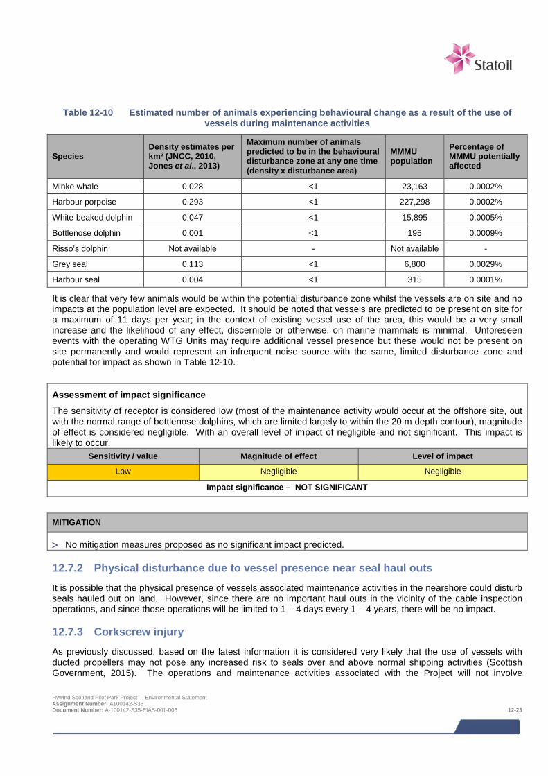
Table 12-10 Estimated number of animals experiencing behavioural change as a result of the use of vessels during maintenance activities
Species Density estimates per km2 (JNCC, 2010, Jones et al., 2013)
Maximum number of animals predicted to be in the behavioural disturbance zone at any one time (density x disturbance area)
MMMU population
Percentage of MMMU potentially affected
Minke whale 0.028 <1 23,163 0.0002%
Harbour porpoise 0.293 <1 227,298 0.0002%
White-beaked dolphin 0.047 <1 15,895 0.0005%
Bottlenose dolphin 0.001 <1 195 0.0009%
Risso’s dolphin Not available - Not available -
Grey seal 0.113 <1 6,800 0.0029%
Harbour seal 0.004 <1 315 0.0001%
It is clear that very few animals would be within the potential disturbance zone whilst the vessels are on site and no impacts at the population level are expected. It should be noted that vessels are predicted to be present on site for a maximum of 11 days per year; in the context of existing vessel use of the area, this would be a very small increase and the likelihood of any effect, discernible or otherwise, on marine mammals is minimal. Unforeseen events with the operating WTG Units may require additional vessel presence but these would not be present on site permanently and would represent an infrequent noise source with the same, limited disturbance zone and potential for impact as shown in Table 12-10.
Assessment of impact significance
The sensitivity of receptor is considered low (most of the maintenance activity would occur at the offshore site, out with the normal range of bottlenose dolphins, which are limited largely to within the 20 m depth contour), magnitude of effect is considered negligible. With an overall level of impact of negligible and not significant. This impact is likely to occur.
Sensitivity / value Magnitude of effect Level of impact
Low Negligible Negligible
Impact significance – NOT SIGNIFICANT
MITIGATION
> No mitigation measures proposed as no significant impact predicted.
12.7.2 Physical disturbance due to vessel presence near seal haul outs It is possible that the physical presence of vessels associated maintenance activities in the nearshore could disturb seals hauled out on land. However, since there are no important haul outs in the vicinity of the cable inspection operations, and since those operations will be limited to 1 – 4 days every 1 – 4 years, there will be no impact.
12.7.3 Corkscrew injury As previously discussed, based on the latest information it is considered very likely that the use of vessels with ducted propellers may not pose any increased risk to seals over and above normal shipping activities (Scottish Government, 2015). The operations and maintenance activities associated with the Project will not involve
Hywind Scotland Pilot Park Project – Environmental Statement Assignment Number: A100142-S35 Document Number: A-100142-S35-EIAS-001-006 12-23
significant numbers of additional vessels and therefore it is not considered the Project will present any additional impacts to seals and over above normal shipping activities. This potential impact is therefore not considered further.
12.7.4 Marine mammal entanglement Feedback from Marine Scotland and their statutory advisors during EIA Scoping indicate the mooring lines and cables present in the water column may represent an entanglement risk for large marine mammals.
There will be a maximum of 15 mooring lines (3 per WTG Unit) and 5 inter-array electric cables (1 per WTG Unit). The mooring lines will be made entirely of 100 – 140 mm thick metal chain and extend out to between 600 and 1,200 m from the WTG. It is expected that the full length of each mooring line will be suspended in the water column through a combination of inherent buoyancy and tension (i.e. without floats).
With regards to the mooring lines, the self-weight of the chain, combined with the static pre-tension in the mooring lines, result in a mooring system where all three mooring lines for each WTG Unit are always in tension. It is a design requirement that no line should ever go into slack, even in extreme conditions. Therefore, considering the large dimensions of the chain and the tension in the lines, it is considered virtually impossible for a marine mammal to get entangled in the lines.
The inter array cables of which there is one per WTG Unit, have a lower self-weight compared with the mooring lines, however the configuration of the cable in the water column is so that it will also always be in tension. It should however be noted that the majority of the inter array cables will be on / under the seabed. Furthermore, the cables have a large diameter (typically more than 200 mm), and a very high bending stiffness. The section of the inter-array cable in the water column will be kept taut through a combination of buoyancy elements (floats) and bend stiffeners, allowing the WTG Unit to move vertically on the surface without stretching or snapping the cable but ensuring that the inter-array cable is not moving loosely in the water column and will have a smooth out armour. The high bending stiffness of the cables result in a high minimum bending radius, which makes it impossible for the cable to bend around a marine mammal. It is therefore again very difficult to imagine how marine mammals could become entangled in the cables and this scenario is considered improbable.
A report from the U.S. Dept. of Energy (undated) discussed this risk for a floating wind turbine project off the coast of Maine, USA, and concluded that “Marine mammals are not likely to become entangled in the project mooring lines because the mass/buoyancy of the platforms and mass of the anchors is expected to create substantial tension in the mooring lines, which would prevent formation of loops around a passing marine mammal”. In addition, recent published research indicates no instances of entanglement of marine mammals with mooring systems of marine renewable devices have yet been reported (Sparling et al., 2013; Isaacman & Daborn, 2011) and there is a similar lack of entanglement recorded from the use of anchored floating production, storage and offloading (FPSO) vessels in the oil and gas Industry (e.g. Benjamins et al., 2014).
Murphy et al., (2012) and Benjamins et al., (2014) highlight that entanglement caused by lost fishing gear becoming attached to the mooring cables of marine renewable energy devices is an associated risk of such projects. Murphy et al., (2012) report that lost fishing gear (specifically nets) that becomes entangled in mooring lines could affect small cetaceans and pinnipeds. Thus, although the mooring and inter-array cable design does not present a risk in terms of the potential for entanglement risk, it is possible that smaller marine mammals, including dolphins and seals, could become entangled in lost (or derelict) fishing gear that drifts through the water column and becomes entangled in the Project mooring lines and inter-array cables. The smaller dolphin and seal species present in the northern North Sea such as bottlenose dolphin and both seal species are likely to absent from the deeper water of the turbine deployment area, but small cetaceans such as harbour porpoise, Risso’s dolphin and white-beaked dolphin could well be present.
Assessment of impact significance
The risk of marine mammal entanglement with the mooring lines and inter array cables is considered unlikely. Smaller whales and dolphins could be at risk from secondary entanglement in lost fishing gear that becomes entangled in the Project mooring lines and inter-array cables. Based on the species most likely to be at risk of entanglement (i.e. minke whale and smaller cetaceans using the offshore area) and based on the criteria for sensitivity in Table 12-3, the sensitivity of receptor has been set as low. Considering the small proportion of Hywind Scotland Pilot Park Project – Environmental Statement Assignment Number: A100142-S35 Document Number: A-100142-S35-EIAS-001-006 12-24
regional population likely to be affected, a magnitude of effect of negligible has been determined. This results in a level of impact of negligible and is therefore not significant. This impact is unlikely to occur (the risk of loss of fishing gear is low (Brown et al., 2005)).
Sensitivity / value Magnitude of effect Level of impact
Low Negligible Negligible
Impact significance – NOT SIGNIFICANT
12.7.5 Pollution due to leaks and spills from vessels and WTG Units Vessels will be required during maintenance activities. These vessels will be no larger than those used during installation activities and will contain no greater a fuel inventory than the installation vessels. As such, the impact ranking and proposed mitigation for leaks and spills from vessels is the same as for Section 12.6.5.
In addition, during the operation phase each WTG Unit could contain up to 5m3 of liquid in the auxiliary and electrical systems, including hydraulic fluid, coolant, transformer liquid and oil. The WTG Units will not discharge such liquid as part of normal operations. Given the extremely limited volume of liquid that could ever be released, there will be no impact.
12.8 Potential variances in environmental impacts (based on Design Envelope) The impact assessment above has assessed the Project options which are predicted to result in the greatest impacts with regards to impact on marine mammals. Relative to the application of the Design Envelope approach in the consenting of other offshore renewables developments (e.g. large offshore wind farms) the Hywind Project consenting Design Envelope does not involve large scale variability in key design parameters or impact footprints with regards to potential impacts on marine mammals. Potential variance in impact will be restricted to limited changes in vessel days and not significantly alter the impact assessment presented here for marine mammals.
12.9 Cumulative and in-combination impacts
12.9.1 Introduction HSL has in consultation with Marine Scotland and Aberdeenshire Council identified a list of other projects which together with the Project may result in potential cumulative or in-combination impacts. The list of these projects including details of their status at the time of the EIA and a map showing their location is provided in Chapter 6; Table 6-3 and Figure 6-1 respectively.
The consideration of which projects could result in potential cumulative or in-combination impacts is based on the results of the project specific impact assessment together with the expert judgement of the specialist consultant.
Cumulative impacts are impacts on marine mammal ecology caused by planned and consented offshore wind farms. In-combination impacts are impacts on marine mammal ecology as a result of offshore wind farms (and their associated activities) combined with impacts from other marine activities or users of the sea.
Having considered the information presently available in the public domain on the projects for which there is a potential for cumulative or in-combination impacts are:
> European Offshore Wind Deployment Centre (EOWFL);
> Beatrice Offshore Wind Farm Demonstrator Project;
> Firth of Forth Offshore Wind Farm;
> Moray Offshore Renewables Wind Farm (eastern development area);
> Neart na Gaoithe Offshore Wind Farm;
> Eastern High Voltage Direct Current (HVDC) Link;
> Offshore Renewables Masterplan, Whiteness Head, Ardersier;
> Kincardine Offshore Wind Farm;
> Beatrice Offshore Windfarm Ltd (BOWL);
> Fife Energy Park Offshore Demonstration Wind Turbine;
Hywind Scotland Pilot Park Project – Environmental Statement Assignment Number: A100142-S35 Document Number: A-100142-S35-EIAS-001-006 12-25
> Inch Cape Offshore Wind Farm;
> NorthConnect;
> Aberdeen Harbour Development, Nigg Bay; and
> Invergordon Service Base 3 Development. The following sections summarise the nature of the potential cumulative and in-combination impacts for each potential project phase.
12.9.2 Potential cumulative and in-combination impacts during construction and installation
The nature of the developments listed above, in so far as they are largely offshore wind farms and large construction projects, means that there is likely to be scope for cumulative and in-combination impacts during the construction and installation phase.
There is no injury impact expected from noise emissions from the Hywind Project and no cumulative or in-combination impact in that respect. The disturbance impact ranges from installation vessels for other projects are likely to be of a similarly small scale as predicted for the Project and therefore the scope for cumulative or in-combination impact is minimal since each project will be restricted to disturbing a limited range of behaviours in a few animals in a few areas. In terms of installation of the devices themselves, piling for numerous large diameter wind turbines is likely to dwarf the relatively small behavioural impact ranges from the Project WTG Units. However, the cumulative impact of each project excluding small areas and the wind projects excluding larger areas might make a larger proportion of sea area (and thus potential foraging and breeding areas) unavailable for a particular marine mammal species’ use. As described in Section 12.4; however, the home ranges of the cetaceans using the Project area are part of much wider areas and as a result it is unlikely that cumulative impacts of disruption to normal behaviour in a small area will have an impact magnitude of greater than minor.
12.9.3 Potential cumulative and in-combination impacts during operation and maintenance
The extremely limited nature of the potential impacts from the operational phase of the Project mean that cumulative or in-combination impacts with other projects are also considered highly unlikely.
12.9.4 Mitigation requirements for potential cumulative and in-combination impacts No mitigation is required over and above the Project specific mitigation.
12.10 Habitats Regulations Appraisal For projects which could affect a Natura site (in the case of marine mammals, an SAC), the competent authority (in this case Marine Scotland) is required to determine whether the Project will have a Likely Significant Effect (LSE) on the qualifying interests of any such SACs. Depending on the outcome of this determination, the competent authority will undertake an Appropriate Assessment of the implications of the Project for the Natura site’s conservation objectives. The responsibility for provision of information to inform the Appropriate Assessment rests with the applicant.
Given the distances over which marine mammal species for which SACs are designated can travel (e.g. bottlenose dolphins from the Moray Firth SAC are known to range down the Scottish east coast), there has been a need to investigate the potential Likely Significant Effects on a number of SAC sites designated for their marine mammal interests. This assessment is presented in a separate HRA report and concludes that there will be no implications to the integrity of any SACs (Xodus, 2015).
12.11 European Protected Species (EPS) licensing For any European Protected Species (EPS), Regulation 39 of the Conservation (Natural Habitats, &c.) Regulations 1994 which apply out to 12 nm and the Offshore Marine Conservation (Natural Habitats, &c.) Regulations 2007 (as amended) which apply beyond 12 nm makes it an offence to deliberately or recklessly capture, kill, injure, harass or disturb any such animal. Whilst the injury offence is related to acts against one or more animals, the disturbance
Hywind Scotland Pilot Park Project – Environmental Statement Assignment Number: A100142-S35 Document Number: A-100142-S35-EIAS-001-006 26
offence differs depending on location; out to 12 nm the offence covered by the Conservation (Natural Habitats, &c.) Regulations 1994 is to disturbance any EPS individual, whereas the offence beyond 12 nm covered by the Offshore Marine Conservation (Natural Habitats, &c.) Regulations 2007 is related to disturbance of a significant group of EPS. An EPS Licence is required for any activity that might result in injury to, or disturbance of, an EPS. Deliberate harm to any EPS is not anticipated as part of the Project.Marine Scotland will determine if specific licensing requirements are needed as part of the application determination.
12.12 Monitoring No monitoring requirements have been identified with regards to marine mammals.
12.13 References Benjamins, S., Johanning, L., Wilson, B., Harnois, V., Greenhill, L., Smith, H. & Carter, C. (2014). Understanding the potential for marine megafauna entanglement risk from renewable marine energy developments. Proceedings of the 2nd International Conference on Environmental Interactions of Marine Renewable Energy Technologies (EIMR2014), 28 April – 02 May 2014, Stornoway, Isle of Lewis, Outer Hebrides, Scotland.
Brown, J, G. Macfadyen, T. Huntington, J. Magnus and J. Tumilty (2005). Ghost Fishing by Lost Fishing Gear. Final Report to DG Fisheries and Maritime Affairs of the European Commission. Fish/2004/20. Institute for European Environmental Policy / Poseidon Aquatic Resource Management Ltd joint report.
Canning, S.J., Santos, M.B., Robert J Reid, R.J., Evans, P.G.H., Sabin, R.C., Bailey, N. & Pierce, G.J. (2008). Seasonal distribution of white-beaked dolphins (Lagenorhynchus albirostris) in UK waters with new information on diet and habitat use. Journal of the Marine Biological Association of the United Kingdom. 88, 1159 - 1166.
Evans, P.G.H. (Compiler) (2008). Whales, porpoises and dolphins - Order Cetacea. In: Mammals of the British Isles (eds. S. Harris and D.W. Yalden). Handbook. 4th Edition. The Mammal Society, Southampton. 800pp
Evans, P.G.H., Anderwald, P. & Baines, M.E. (2003). UK cetacean status review. Report to English Nature and the Countryside Council for Wales. Sea Watch Foundation, Oxford. 160pp.
Evans, P.G.H., Baines, M.E. & Coppock, J. (2010). Abundance and behaviour of cetaceans & basking sharks in the Pentland Firth and Orkney waters. Report by Hebog Environmental Ltd & Sea Watch Foundation. Scottish Natural Heritage Commissioned Report (iBids and Projects ID 1052).
Hammond, P.S., MacLeod, K., Berggren, P., Borches, D., Burt, L., Canadas, A., Desportes, G., Donovan, G., Gilles, A., Gillepsie, D., Gordon, J., Hiby, L., Kuklik, I., Leaper, R., Lehnert, K., Leopold, M., Lovell, P., Oien, N., Paxton, C., Ridoux, V., Rogan, E., Samarra, F., Scheidat, M., Sequeira, M., Siebert, U., Skov, H., Swift, R., Tasker, M., Teilmann, J., Van Canneyt, O. & Vazquez, J. (2013). Cetacean abundance and distribution in European Atlantic shelf waters to inform conservation and management Biological Conservation. 164 107 – 122.
Hammond, P.S., MacLeod, K., Northridge, S.P., Thompson, D. & Matthiopoulos, J. (2003). Background information on marine mammals relevant to Strategic Environmental Assessment 4. Sea Mammal Research Unit, St Andrews.
Howson, C. M., Steel, L., Carruthers, M. & Gillham, K. (2012). Identification of Priority Marine Features in Scottish territorial waters. Scottish Natural Heritage Commissioned Report No. 388.
Isaacman, L. & Daborn, G. (2011). Pathways of Effects for Offshore Renewable Energy in Canada. Report to Fisheries and Oceans Canada. Acadia Centre for Estuarine Research (ACER) Publication No. 102, Acadia University, Wolfville, NS, Canada. 70 pp.
JNCC (2010). The protection of marine European Protected Species from injury and disturbance; Guidance for the marine area in England and Wales and the UK offshore marine area.
Jones, E., McConnell, B., Sparling, C. & Matthiopoulos, J. (2013). Grey and harbour seal density maps. Sea Mammal Research Unit Report to Scottish Government.
Kingston, P. (1999). Recovery of the marine environment following the Braer spill, Shetland. http://www.ioscproceedings.org/doi/pdf/10.7901/2169-3358-1999-1-103 [Accessed 30/09/14]
Hywind Scotland Pilot Park Project – Environmental Statement Assignment Number: A100142-S35 Document Number: A-100142-S35-EIAS-001-006 12-27
McConnell, B.J., Fedak, M.A., Lovell, P. & Hammond, P.S. (1999). Movements and foraging of grey seals in the North Sea. Journal of Applied Ecology. 36, 573 - 590.
Murphy, S., Tougaard, J., Wilson, B., Benjamins, S., Haelters, J., Lucke, K., Werner, S., Brensing, K., Thompson, D., Hastie, G., Geelhoed, S., Braeger, S., Lees, G., Davies, I., Graw, K-U & Pinn, E. (2012). Assessment of the marine renewables industry in relation to marine mammals: synthesis of work undertaken by the ICES Working Group on Marine Mammal Ecology (WGMME). http://www.iwcoffice.co.uk/_documents/sci_com/premeetings/Synthesis%20of%20work%20undertaken%20by%20the%20ICES%20WGMME%20on%20the%20marine%20renewables%20industry.pdf [Accessed 13/08/14]
van Neer, A., Jensen, L.F. & Siebert, U. (2015). Grey seal (Halichoerus grypus) predation on harbour seals (Phoca vitulina) on the island of Helgoland, Germany. J. of. Sea. Res. 97, pp. 1 – 4.
NMPI (2014). Interactive Marine Planning Tool National Marine Plan Interactive. http://www.scotland.gov.uk/Topics/marine/seamanagement/nmpihome/nmpi [Accessed 18/07/2014]
Northridge, S.P., Tasker, M.L., Webb, A., Camphuysen, K. & Leopold, M. (1997). White-beaked Lagenorhynchus albirostris and Atlantic white-sided dolphin L. acutus distributions in northwest European and US North Atlantic waters. Reports of the International Whaling Commission. 47, 797-805.
Northridge, S.P., Tasker, M.L., Webb, A. & Williams, J.M. (1995). Distribution and relative abundance of harbour porpoises (Phocoena phocoena L.), white-beaked dolphins (Lagenorhynchus albirostris Gray), and minke whales (Balaenoptera acutorostrata Lacepède) around the British Isles. ICES Journal of Marine Science. 52, 55-66.
NRP (2015). Hywind Scotland Pilot Park Report on ESAS Surveys June 2013 to May 2014 and context information.
Read, A.J., Drinker, P. & Northridge, S. (2005). Bycatch of Marine Mammals in U.S. and Global Fisheries. Conservation Biology. 20(1), 163-169.
Reid, J.C., Evans, P.G.H. & Northridge, S.P. (2003). Atlas of cetacean distribution in Northwest European waters. Joint Nature Conservation Committee, Peterborough, UK.
SCOS (2010). Scientific advice on matters related to the management of seal populations: 2010. Reports of the UK special committee on Seals. http://www.smru.st-andrews.ac.uk/documents/389.pdf [Accessed 18/07/2014]
Scottish Government (2015). Interim advice on risk of seal corkscrew injuries. (February 2015).
Scottish Government (2014a). Haul out Sites. http://www.scotland.gov.uk/Topics/marine/marine-environment/species/19887/20814/haulouts [Accessed 21/07/14].
Scottish Government (2014b). Seal licensing. http://www.scotland.gov.uk/topics/marine/licensing/seallicensing [Accessed 21/07/14].
SNCBs (2013). Management Units for marine mammals in UK waters (October 2013).
SNH (2012). Scottish MPA Project. Data confidence assessment. Southern Trench MPA Location. http://www.snh.gov.uk/docs/B1191528.pdf [Accessed 30/09/14].
Sparling, C. E., Coram, A. J., McConnell, B., Thompson, D., Hawkins K. R. & Northridge, S. P. (2013). Paper Three: Mammals. Wave & Tidal Consenting Position Paper Series.
St. Aubin, D.J. (1990). Physiologic and toxic effects on polar bears. pp. 235-239. In: J.R. Geraci and D.J. St. Aubin (eds.), Sea mammals and oil: confronting the risks. Academic Press, San Diego. 282 p.
Tollit, D.J., Black, A.D., Thompson, P.M., Mackay, A., Corpe, H.M., Wilson, B., Van Parijs, S.M., Grellier, K. & Parlane, S. (1998). Variations in harbour seal Phoca vitulina diet and dive-depths in relation to foraging habitat. Journal of Canadian Zoology. 244, 209 – 222.
U.S. Dept. of Energy, Doc DOE/EA-1792 “Finding of no significant impact for the University of Maine’s deepwater offshore floating wind turbine testing and demonstration project, Gulf of Maine. (http://www.eere.energy.gov/golden/ReadingRoom/NEPA/Final/1792/UMaineDeepCWind_FONSI_Final%209.26.2011_final%20signed.pdf).
Hywind Scotland Pilot Park Project – Environmental Statement Assignment Number: A100142-S35 Document Number: A-100142-S35-EIAS-001-006 12-28

Weir, C.R., Pollock, C., Cronin, C. & Taylor, S. (2001). Cetaceans of the Atlantic Frontier, north and west of Scotland. Continental Shelf Research. 21, 1047-1071.
Xodus (2015). Habitats Regulations Appraisal for the Hywind Scotland Project.
Xodus (2014). Technical note on underwater noise. Document number A-100142-S20-TECH-001.
Xodus (2013a). Marine noise desk study. Document number A-100142-S00-TECH-003.
Xodus (2013b). Marine Mammal Discussion Document. Document number A-20564-S00-TECH-003.
Xodus (2013c). Hywind Scotland Pilot Park Project, Phase 1 Intertidal Survey Report. Report no A-100142-S00-REPT-009.
Hywind Scotland Pilot Park Project – Environmental Statement Assignment Number: A100142-S35 Document Number: A-100142-S35-EIAS-001-006 12-29
13 AVIATION AND RADAR The aviation and radar constraints associated with the Project have been assessed by means of detailed modelling and consultation with National Air Traffic Services (NATS) and the Ministry of Defence (MOD). The significant concerns that have been assessed relate to potential radar impacts and potential issues due to the proximity of the main helicopter routes and military interests.
The MOD has raised concerns with regard to potential impact on the air defence radar (ADR) at Remote Radar Head (RHH) Buchan. This potential impact is significant, and the Project is deemed unacceptable to MOD without any mitigating solution in place for the Buchan ADR. In a meeting in December 2013, the MOD informed Statoil about the recent completion of a developer-led purchase for the system upgrade of the Type-92 Buchan ADR that will ensure that the radar is at the same standard as the TPS-77 radars. Hywind (Scotland) Limited (HSL) subsequently appointed the aviation consultant Serco to perform a radar modelling report to identify a potential mitigation solution. The Serco mitigation modelling report was submitted to the MOD in July 2014. Statoil provided more information to the MOD in October 2014, following questions from the RAF regarding the movements of the Hywind floating turbine. Serco submitted an updated mitigation modelling report to the MOD on the 26th November 2014. Following a technical and operational assessment, the MOD informed Statoil in a letter dated the 27th January 2015 that the proposed mitigation solution was acceptable and that the MOD would wish to agree a suitable planning condition. The MOD and Statoil are currently in discussions regarding the wording of planning conditions appertaining to Buchan ADR and aviation lighting. Should agreement be reached on the wording of the planning conditions. The MOD will raise no objection to the Project subject to the inclusion of the agreed condition on any forthcoming consent.
The potential impact on the NATS Perwinnes radar is significant; however, a technical mitigation option has been identified and NATS has confirmed that the Project is acceptable to them with a blanking solution in place on the Perwinnes radar. HSL needs to agree upon a commercial agreement with NATS.
13.1 Introduction Wind developments have the potential to adversely affect aviation activity in their vicinity. This is generally due to potential interference to radar and other navigation equipment or to the potential impact of wind turbines as large structures in the vicinity of aircraft. The interference mechanisms with regard to radar are complex. The most significant impacts occur because wind turbine blades and towers can reflect and obstruct electromagnetic signals. Furthermore, wind turbines have large moving elements which can cause them to be detected and displayed as potential targets on a radar screen.
This chapter provides a summary of the aviation baseline conditions, both civil and military, relating to the Project. A summary of the assessment and stakeholder engagement is provided as well as the status of agreed solutions where applicable. A number of different specialists have contributed to the assessment:
> Pager Power – Analysis of issues and engagement with stakeholders and writing of ES chapter;
> NATS Ltd – Commissioned to undertake a Technical and Operational Assessment prior to agreeing a mitigation solution; and
> Serco Limited – Commissioned to undertake a mitigation modelling report of the Hywind Scotland Pilot Park Wind Farm (in radar line of sight of RRH Buchan Air Defence Radar) that has identified a potential mitigation solution in the report submitted to the MOD.
Table 13-1 provides a list of all the supporting studies which relate to the aviation and radar impact assessment. All supporting studies are provided on the accompanying CD.
Hywind Scotland Pilot Park Project – Environmental Statement Assignment Number: A100142-S35 Document Number: A-100142-S35-EIAS-001-007 13-1
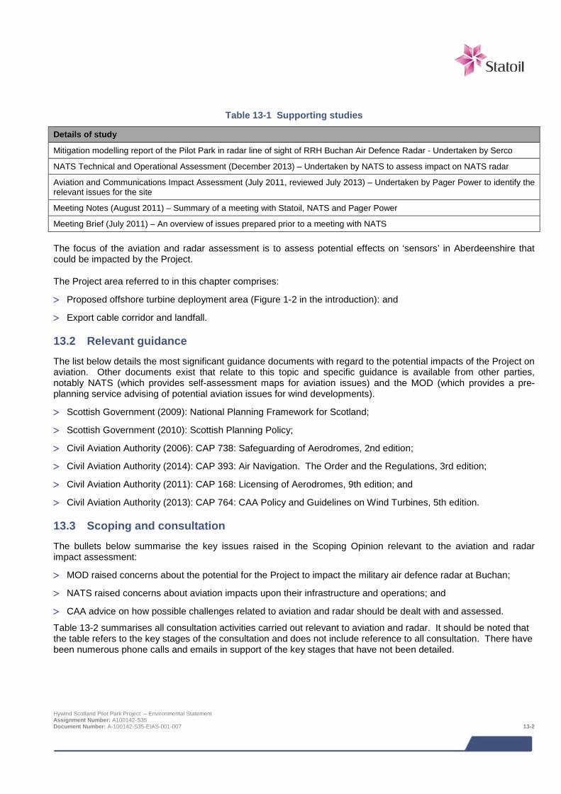
Table 13-1 Supporting studies
Details of study
Mitigation modelling report of the Pilot Park in radar line of sight of RRH Buchan Air Defence Radar - Undertaken by Serco
NATS Technical and Operational Assessment (December 2013) – Undertaken by NATS to assess impact on NATS radar
Aviation and Communications Impact Assessment (July 2011, reviewed July 2013) – Undertaken by Pager Power to identify the relevant issues for the site
Meeting Notes (August 2011) – Summary of a meeting with Statoil, NATS and Pager Power
Meeting Brief (July 2011) – An overview of issues prepared prior to a meeting with NATS The focus of the aviation and radar assessment is to assess potential effects on ‘sensors’ in Aberdeenshire that could be impacted by the Project.
The Project area referred to in this chapter comprises:
> Proposed offshore turbine deployment area (Figure 1-2 in the introduction): and
> Export cable corridor and landfall.
13.2 Relevant guidance The list below details the most significant guidance documents with regard to the potential impacts of the Project on aviation. Other documents exist that relate to this topic and specific guidance is available from other parties, notably NATS (which provides self-assessment maps for aviation issues) and the MOD (which provides a pre-planning service advising of potential aviation issues for wind developments).
> Scottish Government (2009): National Planning Framework for Scotland;
> Scottish Government (2010): Scottish Planning Policy;
> Civil Aviation Authority (2006): CAP 738: Safeguarding of Aerodromes, 2nd edition;
> Civil Aviation Authority (2014): CAP 393: Air Navigation. The Order and the Regulations, 3rd edition;
> Civil Aviation Authority (2011): CAP 168: Licensing of Aerodromes, 9th edition; and
> Civil Aviation Authority (2013): CAP 764: CAA Policy and Guidelines on Wind Turbines, 5th edition.
13.3 Scoping and consultation The bullets below summarise the key issues raised in the Scoping Opinion relevant to the aviation and radar impact assessment:
> MOD raised concerns about the potential for the Project to impact the military air defence radar at Buchan;
> NATS raised concerns about aviation impacts upon their infrastructure and operations; and
> CAA advice on how possible challenges related to aviation and radar should be dealt with and assessed.
Table 13-2 summarises all consultation activities carried out relevant to aviation and radar. It should be noted that the table refers to the key stages of the consultation and does not include reference to all consultation. There have been numerous phone calls and emails in support of the key stages that have not been detailed.
Hywind Scotland Pilot Park Project – Environmental Statement Assignment Number: A100142-S35 Document Number: A-100142-S35-EIAS-001-007 13-2
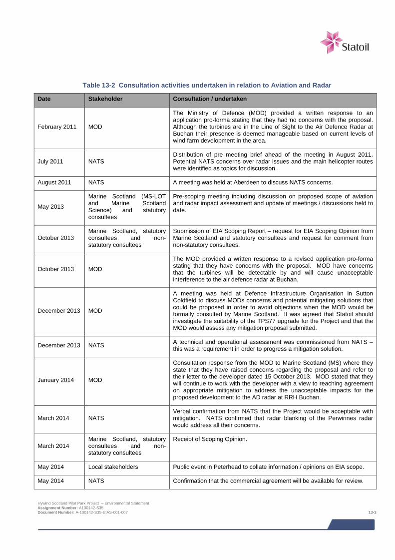
Table 13-2 Consultation activities undertaken in relation to Aviation and Radar
Date Stakeholder Consultation / undertaken
February 2011 MOD
The Ministry of Defence (MOD) provided a written response to an application pro-forma stating that they had no concerns with the proposal. Although the turbines are in the Line of Sight to the Air Defence Radar at Buchan their presence is deemed manageable based on current levels of wind farm development in the area.
July 2011 NATS Distribution of pre meeting brief ahead of the meeting in August 2011. Potential NATS concerns over radar issues and the main helicopter routes were identified as topics for discussion.
August 2011 NATS A meeting was held at Aberdeen to discuss NATS concerns.
May 2013
Marine Scotland (MS-LOT and Marine Scotland Science) and statutory consultees
Pre-scoping meeting including discussion on proposed scope of aviation and radar impact assessment and update of meetings / discussions held to date.
October 2013 Marine Scotland, statutory consultees and non- statutory consultees
Submission of EIA Scoping Report – request for EIA Scoping Opinion from Marine Scotland and statutory consultees and request for comment from non-statutory consultees.
October 2013 MOD
The MOD provided a written response to a revised application pro-forma stating that they have concerns with the proposal. MOD have concerns that the turbines will be detectable by and will cause unacceptable interference to the air defence radar at Buchan.
December 2013 MOD
A meeting was held at Defence Infrastructure Organisation in Sutton Coldfield to discuss MODs concerns and potential mitigating solutions that could be proposed in order to avoid objections when the MOD would be formally consulted by Marine Scotland. It was agreed that Statoil should investigate the suitability of the TPS77 upgrade for the Project and that the MOD would assess any mitigation proposal submitted.
December 2013 NATS A technical and operational assessment was commissioned from NATS – this was a requirement in order to progress a mitigation solution.
January 2014 MOD
Consultation response from the MOD to Marine Scotland (MS) where they state that they have raised concerns regarding the proposal and refer to their letter to the developer dated 15 October 2013. MOD stated that they will continue to work with the developer with a view to reaching agreement on appropriate mitigation to address the unacceptable impacts for the proposed development to the AD radar at RRH Buchan.
March 2014 NATS Verbal confirmation from NATS that the Project would be acceptable with mitigation. NATS confirmed that radar blanking of the Perwinnes radar would address all their concerns.
March 2014 Marine Scotland, statutory consultees and non- statutory consultees
Receipt of Scoping Opinion.
May 2014 Local stakeholders Public event in Peterhead to collate information / opinions on EIA scope.
May 2014 NATS Confirmation that the commercial agreement will be available for review.
Hywind Scotland Pilot Park Project – Environmental Statement Assignment Number: A100142-S35 Document Number: A-100142-S35-EIAS-001-007 13-3

Date Stakeholder Consultation / undertaken
July 2014 MOD Serco mitigation modelling report submitted to MOD
September 2014 NATS
Statoil received a draft commercial agreement for the mitigating solution from NATS.
October 2014- ongoing NATS
Updated coordinates of the turbines location sent to NATS. NATS has given a verbal confirmation that the new coordinates are acceptable. Ongoing negotiations with NATS related to commercial agreement for agreed mitigating solution.
October 2014 MOD
Telephone conference between the MOD and Statoil to answer questions from the Royal Air Force (RAF) regarding the movements of the Hywind floating turbine in order to ensure that they could complete their technical and operational assessment. The MOD submitted follow-up questions to Serco to understand what has been taken into account in the modelling.
November 2014 MOD Serco submitted an updated mitigation modelling report to the MOD on the 26th November 2014.
January 2015 MOD Statoil received a letter from the MOD dated 27th January confirming that the proposed mitigation solution was acceptable and that the MOD would wish to agree a suitable planning condition.
February 2015 Helicopter operators – Bond Offshore Helicopters, CHC and Bristow Group
E mail communication to update the helicopter operators on the progress of the project and application timescale.
13.4 Baseline description With regard to aviation and radar concerns for offshore wind developments, issues are most likely for long range radar (both military and civil) and helicopter routes that pass in the vicinity of the proposed WTG Units. In the case of this Project, the affected sensors are:
> A single military air defence radar (Buchan) located approximately 4 km south of Peterhead;
> Two civil en-route radar (Allanshill and Perwinnes) located approximately 9 km southwest of Fraserburgh and 6 km north of Aberdeen respectively; and
> Helicopter routes from the mainland over the North Sea.
The Buchan radar is safeguarded by the UK MOD. It is a Type-92 long-range air defence radar manufactured by Lockheed Martin, designed to provide 360 degree, low level through to high level, primary surveillance coverage as one of a network of 6 static homeland defence radars.
The two civil long range radar are safeguarded by NATS and are designed to provide radar surveillance for aircraft in the en-route phase of flight, including helicopters operating over the North Sea.
The turbines will be towed from an inshore assembly location to their final positions. The maximum height of the tow above the sea surface will be 176 m and the maximum tow speed 3.5 knots (1.8 m/s). Radar interference is highly unlikely to be significant during the tow because of the low speed, which will allow the radar returns to be filtered out. During the tow the turbines will present a temporary obstruction. Therefore, details of the tow route and the times at which the tow will take place will be made available to NATS and the helicopter operators.
Hywind Scotland Pilot Park Project – Environmental Statement Assignment Number: A100142-S35 Document Number: A-100142-S35-EIAS-001-007 13-4
13.5 Impact assessment
13.5.1 Overview Following the establishment of the baseline conditions of the Project and surrounding area and an understanding of the Project activities it is possible to assess the potential impacts from the Project. The range of impacts that has been considered is based on impacts identified during the EIA scoping and any further potential impacts that have been identified as the EIA has progressed. The impacts assessed are summarised below:
> Interference with radar; and
> Interferences with helicopter routes.
Assessment of the potential aviation and radar concerns was initially undertaken in 2011 (Pager Power, 2011a). This initial assessment identified the presence of the Buchan air defence radar (MOD), civil en-route radar (safeguarded by NATS) and helicopter routes in the area may be impacted by the proposed Project. Modelling was undertaken to determine the areas within the proposed Project area that would be most suitable for the WTG Units based on radar visibility and the location of the main helicopter routes (Pager Power, 2011a; Pager Power, 2011b and Pager Power, 2013). This initial assessment in conjunction with further engagement with the stakeholders was used to inform the turbine location within the AfL area that is now proposed.
The developer appointed NATS and Serco to undertake assessment with the purpose of identifying potential mitigating solutions. NATS Technical and Operational Assessment were undertaken by NATS December 2013 and Serco submitted their mitigation modelling report to the MOD in July 2014.
13.5.2 Assessment criteria The EIA process and methodology are described in detail in Chapter 6. Specific criteria relating to aviation and radar have bene developed for ‘sensitivity of receptor’ and ‘magnitude of effect’ as detailed in Table 13-3 and
Table 13-4 respectively.
The sensitivity of receptor and magnitude of effect are then combined to determine the level of impact. The definitions for level of impact and how they relate to significance are presented in Chapter 6, Table 6-1 and Table 6-2.
If the turbines present a physical obstruction, the impact can be thought of as continuous because the structure will remain where it is for the life of the development.
With regard to radar impact, the effects will not be continuous because they are sensitive to the wind speed and direction as well as the portion of the blade that is illuminated during the radar sweep. However, an intermittent radar impact can be considered as operationally significant as a regular or continuous one.
It is common for aviation stakeholders to require mitigation when a potential impact has been identified, almost without consideration of the likely frequency of the impact. Receptors within this chapter have been assessed on this basis.
Table 13-3 Criteria for sensitivity/value of aviation and radar
Sensitivity/value Definition
Very High A receptor of international importance.
High A receptor of national importance.
Medium A receptor of regional importance.
Low A receptor of local importance.
Negligible A receptor of negligible importance.
Hywind Scotland Pilot Park Project – Environmental Statement Assignment Number: A100142-S35 Document Number: A-100142-S35-EIAS-001-007 13-5
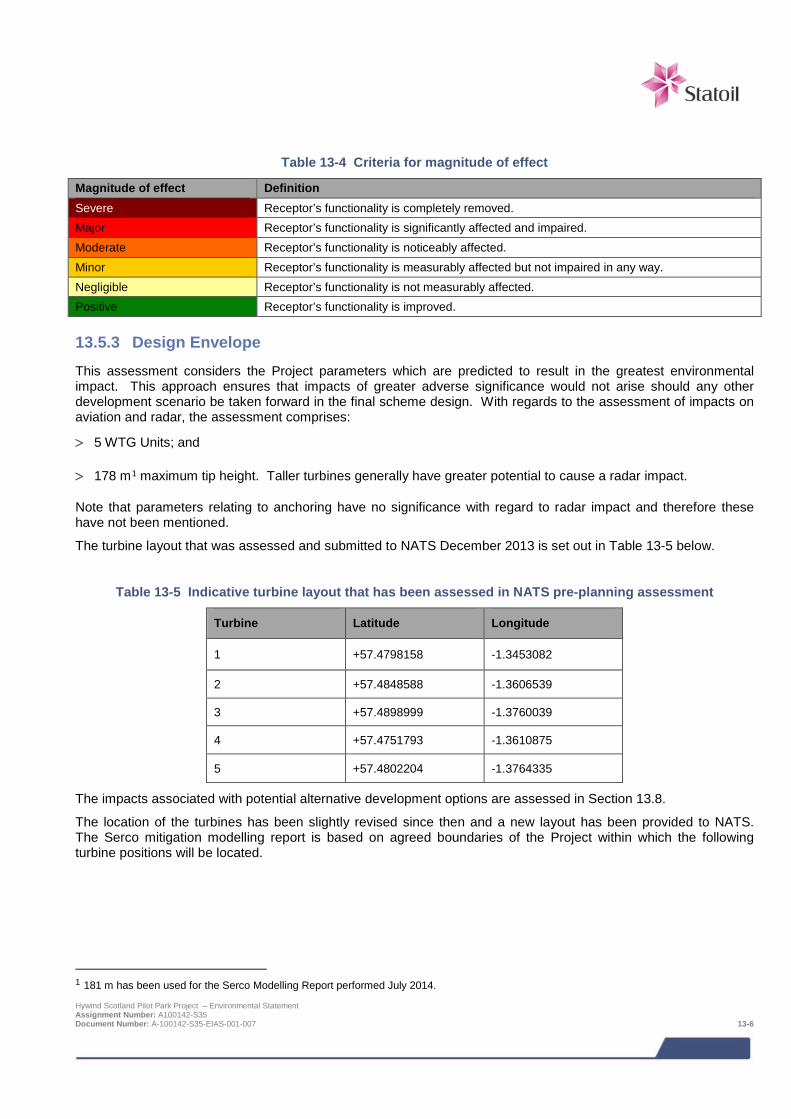
Table 13-4 Criteria for magnitude of effect
Magnitude of effect Definition Severe Receptor’s functionality is completely removed. Major Receptor’s functionality is significantly affected and impaired. Moderate Receptor’s functionality is noticeably affected. Minor Receptor’s functionality is measurably affected but not impaired in any way. Negligible Receptor’s functionality is not measurably affected. Positive Receptor’s functionality is improved.
13.5.3 Design Envelope This assessment considers the Project parameters which are predicted to result in the greatest environmental impact. This approach ensures that impacts of greater adverse significance would not arise should any other development scenario be taken forward in the final scheme design. With regards to the assessment of impacts on aviation and radar, the assessment comprises:
> 5 WTG Units; and
> 178 m1 maximum tip height. Taller turbines generally have greater potential to cause a radar impact.
Note that parameters relating to anchoring have no significance with regard to radar impact and therefore these have not been mentioned.
The turbine layout that was assessed and submitted to NATS December 2013 is set out in Table 13-5 below.
Table 13-5 Indicative turbine layout that has been assessed in NATS pre-planning assessment
Turbine Latitude Longitude
1 +57.4798158 -1.3453082
2 +57.4848588 -1.3606539
3 +57.4898999 -1.3760039
4 +57.4751793 -1.3610875
5 +57.4802204 -1.3764335
The impacts associated with potential alternative development options are assessed in Section 13.8.
The location of the turbines has been slightly revised since then and a new layout has been provided to NATS. The Serco mitigation modelling report is based on agreed boundaries of the Project within which the following turbine positions will be located.
1 181 m has been used for the Serco Modelling Report performed July 2014. Hywind Scotland Pilot Park Project – Environmental Statement Assignment Number: A100142-S35 Document Number: A-100142-S35-EIAS-001-007 13-6
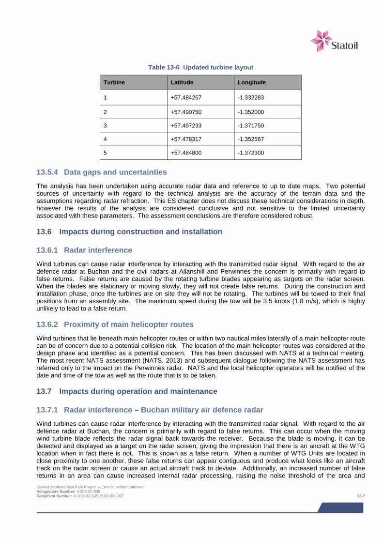
Table 13-6 Updated turbine layout
Turbine Latitude Longitude
1 +57.484267 -1.332283
2 +57.490750 -1.352000
3 +57.497233 -1.371750
4 +57.478317 -1.352567
5 +57.484800 -1.372300
13.5.4 Data gaps and uncertainties The analysis has been undertaken using accurate radar data and reference to up to date maps. Two potential sources of uncertainty with regard to the technical analysis are the accuracy of the terrain data and the assumptions regarding radar refraction. This ES chapter does not discuss these technical considerations in depth, however the results of the analysis are considered conclusive and not sensitive to the limited uncertainty associated with these parameters. The assessment conclusions are therefore considered robust.
13.6 Impacts during construction and installation
13.6.1 Radar interference Wind turbines can cause radar interference by interacting with the transmitted radar signal. With regard to the air defence radar at Buchan and the civil radars at Allanshill and Perwinnes the concern is primarily with regard to false returns. False returns are caused by the rotating turbine blades appearing as targets on the radar screen. When the blades are stationary or moving slowly, they will not create false returns. During the construction and installation phase, once the turbines are on site they will not be rotating. The turbines will be towed to their final positions from an assembly site. The maximum speed during the tow will be 3.5 knots (1.8 m/s), which is highly unlikely to lead to a false return.
13.6.2 Proximity of main helicopter routes Wind turbines that lie beneath main helicopter routes or within two nautical miles laterally of a main helicopter route can be of concern due to a potential collision risk. The location of the main helicopter routes was considered at the design phase and identified as a potential concern. This has been discussed with NATS at a technical meeting. The most recent NATS assessment (NATS, 2013) and subsequent dialogue following the NATS assessment has referred only to the impact on the Perwinnes radar. NATS and the local helicopter operators will be notified of the date and time of the tow as well as the route that is to be taken.
13.7 Impacts during operation and maintenance
13.7.1 Radar interference – Buchan military air defence radar Wind turbines can cause radar interference by interacting with the transmitted radar signal. With regard to the air defence radar at Buchan, the concern is primarily with regard to false returns. This can occur when the moving wind turbine blade reflects the radar signal back towards the receiver. Because the blade is moving, it can be detected and displayed as a target on the radar screen, giving the impression that there is an aircraft at the WTG location when in fact there is not. This is known as a false return. When a number of WTG Units are located in close proximity to one another, these false returns can appear contiguous and produce what looks like an aircraft track on the radar screen or cause an actual aircraft track to deviate. Additionally, an increased number of false returns in an area can cause increased internal radar processing, raising the noise threshold of the area and Hywind Scotland Pilot Park Project – Environmental Statement Assignment Number: A100142-S35 Document Number: A-100142-S35-EIAS-001-007 13-7
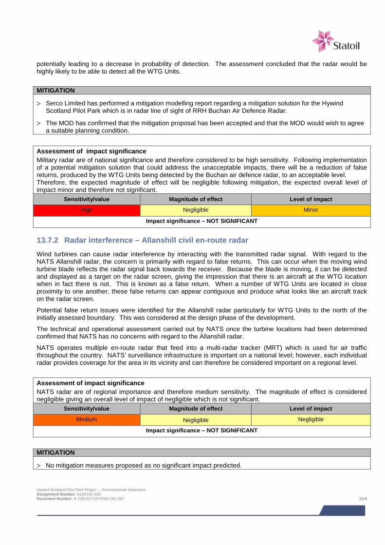
potentially leading to a decrease in probability of detection. The assessment concluded that the radar would be highly likely to be able to detect all the WTG Units.
MITIGATION
> Serco Limited has performed a mitigation modelling report regarding a mitigation solution for the Hywind Scotland Pilot Park which is in radar line of sight of RRH Buchan Air Defence Radar.
> The MOD has confirmed that the mitigation proposal has been accepted and that the MOD would wish to agree a suitable planning condition.
Assessment of impact significance Military radar are of national significance and therefore considered to be high sensitivity. Following implementation of a potential mitigation solution that could address the unacceptable impacts, there will be a reduction of false returns, produced by the WTG Units being detected by the Buchan air defence radar, to an acceptable level. Therefore, the expected magnitude of effect will be negligible following mitigation, the expected overall level of impact minor and therefore not significant.
Sensitivity/value Magnitude of effect Level of impact
High Negligible Minor
Impact significance – NOT SIGNIFICANT
13.7.2 Radar interference – Allanshill civil en-route radar Wind turbines can cause radar interference by interacting with the transmitted radar signal. With regard to the NATS Allanshill radar, the concern is primarily with regard to false returns. This can occur when the moving wind turbine blade reflects the radar signal back towards the receiver. Because the blade is moving, it can be detected and displayed as a target on the radar screen, giving the impression that there is an aircraft at the WTG location when in fact there is not. This is known as a false return. When a number of WTG Units are located in close proximity to one another, these false returns can appear contiguous and produce what looks like an aircraft track on the radar screen.
Potential false return issues were identified for the Allanshill radar particularly for WTG Units to the north of the initially assessed boundary. This was considered at the design phase of the development.
The technical and operational assessment carried out by NATS once the turbine locations had been determined confirmed that NATS has no concerns with regard to the Allanshill radar.
NATS operates multiple en-route radar that feed into a multi-radar tracker (MRT) which is used for air traffic throughout the country. NATS’ surveillance infrastructure is important on a national level; however, each individual radar provides coverage for the area in its vicinity and can therefore be considered important on a regional level.
Assessment of impact significance NATS radar are of regional importance and therefore medium sensitivity. The magnitude of effect is considered negligible giving an overall level of impact of negligible which is not significant.
Sensitivity/value Magnitude of effect Level of impact
Medium Negligible Negligible
Impact significance – NOT SIGNIFICANT
MITIGATION
> No mitigation measures proposed as no significant impact predicted.
Hywind Scotland Pilot Park Project – Environmental Statement Assignment Number: A100142-S35 Document Number: A-100142-S35-EIAS-001-007 13-8
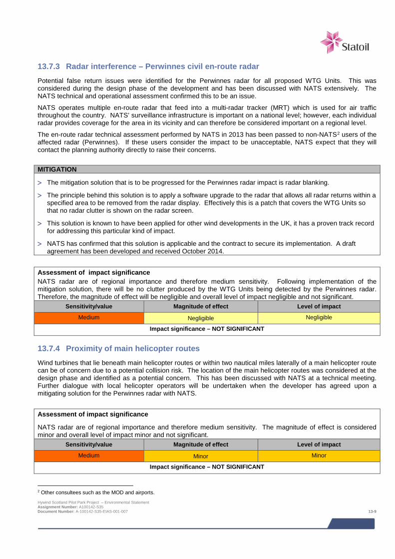
13.7.3 Radar interference – Perwinnes civil en-route radar Potential false return issues were identified for the Perwinnes radar for all proposed WTG Units. This was considered during the design phase of the development and has been discussed with NATS extensively. The NATS technical and operational assessment confirmed this to be an issue.
NATS operates multiple en-route radar that feed into a multi-radar tracker (MRT) which is used for air traffic throughout the country. NATS’ surveillance infrastructure is important on a national level; however, each individual radar provides coverage for the area in its vicinity and can therefore be considered important on a regional level.
The en-route radar technical assessment performed by NATS in 2013 has been passed to non-NATS2 users of the affected radar (Perwinnes). If these users consider the impact to be unacceptable, NATS expect that they will contact the planning authority directly to raise their concerns.
MITIGATION
> The mitigation solution that is to be progressed for the Perwinnes radar impact is radar blanking.
> The principle behind this solution is to apply a software upgrade to the radar that allows all radar returns within a specified area to be removed from the radar display. Effectively this is a patch that covers the WTG Units so that no radar clutter is shown on the radar screen.
> This solution is known to have been applied for other wind developments in the UK, it has a proven track record for addressing this particular kind of impact.
> NATS has confirmed that this solution is applicable and the contract to secure its implementation. A draft agreement has been developed and received October 2014.
Assessment of impact significance NATS radar are of regional importance and therefore medium sensitivity. Following implementation of the mitigation solution, there will be no clutter produced by the WTG Units being detected by the Perwinnes radar. Therefore, the magnitude of effect will be negligible and overall level of impact negligible and not significant.
Sensitivity/value Magnitude of effect Level of impact
Medium Negligible Negligible
Impact significance – NOT SIGNIFICANT
13.7.4 Proximity of main helicopter routes Wind turbines that lie beneath main helicopter routes or within two nautical miles laterally of a main helicopter route can be of concern due to a potential collision risk. The location of the main helicopter routes was considered at the design phase and identified as a potential concern. This has been discussed with NATS at a technical meeting. Further dialogue with local helicopter operators will be undertaken when the developer has agreed upon a mitigating solution for the Perwinnes radar with NATS.
Assessment of impact significance
NATS radar are of regional importance and therefore medium sensitivity. The magnitude of effect is considered minor and overall level of impact minor and not significant.
Sensitivity/value Magnitude of effect Level of impact
Medium Minor Minor
Impact significance – NOT SIGNIFICANT
2 Other consultees such as the MOD and airports. Hywind Scotland Pilot Park Project – Environmental Statement Assignment Number: A100142-S35 Document Number: A-100142-S35-EIAS-001-007 13-9
MITIGATION
Although no significant impact has been identified the following mitigation will be implemented to ensure this remains the case:
> Continued consultation with local helicopter operators to keep them informed about the Project development.
13.8 Potential variances in environmental impacts (based on Design Envelope) The impact assessment above has assessed the Project options which are predicted to result in the greatest impacts with regards to impact to aviation and radar.
The maximum turbine tip height has been considered. Shorter turbines generally have a smaller effect on radar. Based on the extent of coverage for the most crucial radar, it is likely that the overall conclusions for a shorter turbine would be similar to the conclusions that have been drawn here.
Alternative locations of the WTG Units would require careful consideration in order to ensure that the NATS Allanshill radar would not be affected.
13.9 Cumulative and in-combination impacts HSL has in consultation with Marine Scotland and Aberdeenshire Council identified a list of other projects which together with the Project may result in potential cumulative or in-combination impacts. The list of these projects including details of their status at the time of the EIA and a map showing their location is provided in Chapter 6; Table 6-3 and Figure 6-1 respectively.
Cumulative impacts are impacts on aviation and radar caused by planned and consented offshore wind farms. In- combination impacts are impacts on aviation and radar as a result of offshore wind farms (and their associated activities) combined with impacts from other marine activities or users of the sea.
The consideration of which projects could result in potential cumulative or in-combination impacts is based on the results of the project specific impact assessment together with the expert judgement of the specialist consultant (Pager Power). Based on the assessment presented here and the nearest distance to the closest wind turbine development, the European Offshore Wind Deployment Centre is located 37 km from the Project no cumulative or in-combination impacts are expected.
13.10 Monitoring No monitoring requirement has been specifically identified with regard to aviation and radar.
13.11 References Civil Aviation Authority (2014). CAP 393: Air Navigation. The Order and the Regulations, 3rd edition.
Civil Aviation Authority (2013). CAP 764: CAA Policy and Guidelines on Wind Turbines, 5th edition.
Civil Aviation Authority (2011). CAP 168: Licensing of Aerodromes, 9th edition.
Civil Aviation Authority (2006). CAP 738: Safeguarding of Aerodromes, 2nd edition.
NATS (2013). Technical and Operational Assessment (W(F)18232).
Pager Power (2013). Aviation and Communication Impact Assessment Report Update.
Pager Power (2011a). Meeting Briefing.
Pager Power (2011b). Meeting Notes.
Scottish Government (2010). Scottish Planning Policy.
Scottish Government (2009). National Planning Framework for Scotland.
Hywind Scotland Pilot Park Project – Environmental Statement Assignment Number: A100142-S35 Document Number: A-100142-S35-EIAS-001-007 13-10
14 COMMERCIAL FISHERIES A desk based review of available data was undertaken supported by consultation with fishermen. Low level demersal fisheries targeting haddock, Nephrops and squid are dominant in the turbine deployment area. There is also a low level of pelagic activity in the turbine deployment area (pelagic activity is greater in the export cable corridor). Scallop dredging is the fishery of highest economic value in the export cable corridor. Creels targeting crab and lobster and hand lining for mackerel are also present in the export cable corridor, particularly to the west of the 1°40’ longitude line and fishing intensity increases closer to the shore. Vessels fishing this inshore area operate out of local ports.
During construction and installation, safety zones will prevent all vessels, including fishing vessels entering within 500 m of construction works both in the turbine deployment area and along the cable route. These areas are only small and only present for a number of weeks, therefore impacts on fisheries will not be significant. HSL will follow FLOWW guidelines and continue to use the already appointed Fisheries Liaison Officer (FLO) during the construction period to minimise impacts on fisheries during this period.
Following installation, fishing activities will be able to resume along the cable route. However, in the turbine deployment area, there will be a period of up to 18 months after installation of the anchors and mooring systems before the WTG Units will be installed. During this period and the subsequent 20 year operational phase of the Project fisheries may be restricted from the turbine deployment area. However, due to the limited amount of fishing that takes place in the turbine deployment area and availability of suitable fishing areas in the surrounding waters, impacts on fisheries will not be significant.
Further liaison with Regulators and stakeholders is planned to ensure the appropriate mitigation is effectively implemented. In particular, the plans for safety zones and/or fishing prohibition, either compulsory or advisory, will need to be agreed with DECC, the MCA and Marine Scotland pre-construction.
Although the impacts from the Hywind Scotland Project are not predicted to be significant, in order to mitigate this challenge for new and larger floating wind farms in the future, Statoil is in the process of establishing a project with the objective to look at what activities can be carried out within a floating wind farm and how the area can be used positively in a biological and commercial manner.
14.1 Introduction This chapter assesses the impacts of the Project on commercial fisheries. To quantify spatial and temporal variation, commercial fisheries are described both at the local level and at the wider regional (North Sea) level in order to provide context to the baseline. The assessment has been undertaken by Xodus.
Table 14-1 shows the supporting study which relates to the commercial fisheries impact assessment. Supporting studies are provided on the accompanying CD.
Table 14-1 Supporting studies
Details of study
Navigation Risk Assessment Hywind Scotland Pilot Park Project (Anatec, 2014)
To gain a better overall understanding of the baseline and potential impacts associated with commercial fisheries; consideration should also be given to the following Environmental Statement (ES) chapters:
> Fish and shellfish ecology (Chapter 10); and
> Shipping and navigation (Chapter 15).
The focus of the impact assessment is potential impacts on commercial fisheries using the Project area. This requires an understanding of the fishing activities that take place in and in the waters adjacent to the Project area so that potential impacts can be out into wider regional context.
The following areas are referred to in this impact assessment:
Hywind Scotland Pilot Park Project – Environmental Statement Assignment Number: A100142-S35 Document Number: A-100142-S35-EIAS-001-008 14-1
> Project area (see Figure 1-2 in the introduction), which comprises:
o Proposed offshore turbine deployment area: and
o Export cable corridor and landfall.
14.2 Legislative context and relevant guidance There is no specific legislation which covers the scope of impact assessment on fisheries. However, guidance on licensing and environmental impact assessment (EIA) requirements for offshore wind farms (Centre for Environment, Fisheries and Aquaculture Science (Cefas), 2004) provides a ‘roadmap’ on how to assess impacts to fisheries from offshore wind farms. In addition the recently published guidelines by the Crown Estate (TCE) regarding best practice for fisheries liaison regarding offshore renewables developments are relevant to the Project (FLOWW, 2014).
14.3 Scoping and consultation The bullets below summarise the key issues raised in the Scoping Opinion relevant to the commercial fisheries impact assessment:
> Potential impacts on commercial fisheries must be considered given the importance of, and dependency on, fishing in the local area and the role that Peterhead port plays in the fishing sector;
> The main impacts to be considered from a commercial fisheries perspective will be for the export cable route affecting the inshore static gear fleet, also any vessels using mobile gear. For the turbine deployment area, the presence of cables and anchor chains will exclude any demersal or pelagic fishing within the area; and
> There may be disruption to fishermen in the inshore area from vessel traffic associated with the construction of the site and cable route. This could be mitigated against through the agreement of a transit corridor for construction and maintenance vessels.
The Scottish Fishermen’s Federation (SFF) have been consulted from early in the EIA process (see below) and are supportive of the Project.
Table 14-2 summarises all consultation activities carried out relevant to commercial fisheries.
Table 14-2 Consultation activities undertaken in relation to commercial fisheries
Date Stakeholder Consultation
May 2013 Scottish Fishermen’s Federation
Project update including dimensions and spacing between turbines and anchors.
May 2013 Marine Scotland (MS-LOT and Marine Scotland Science) and statutory consultees
Pre-scoping meeting including discussion on proposed scope of commercial fisheries impact assessment.
July 2013 Scottish Fishermen’s Federation (SFF)
Methodology and approach to the geophysical survey with reference to potential limitations in fishing activity.
Ongoing SFF Discussion of geophysical survey area, approach to survey of areas close to shore, discussion related to locations of current measurement buoys and discussions related to location of WTG Units
October 2013 Marine Scotland, statutory consultees and non- statutory consultees
Submission of EIA Scoping Report – request for EIA Scoping Opinion from Marine Scotland and statutory consultees and request for comment from non-statutory consultees.
March 2014 Marine Scotland, statutory consultees and non- statutory consultees
Receipt of Scoping Opinion.
Hywind Scotland Pilot Park Project – Environmental Statement Assignment Number: A100142-S35 Document Number: A-100142-S35-EIAS-001-008 14-2
Date Stakeholder Consultation
May 2014 Local stakeholders Public event in Peterhead to collate information / opinions on EIA scope.
June 2014 Various stakeholders Risk workshop to inform navigation risk assessment.
14.4 Baseline description
14.4.1 Introduction The fisheries baseline description is based upon a comprehensive desk-based study supported by consultation. Data sources used to determine the commercial fisheries baseline are detailed in Table 14-3.
Table 14-3 Summary of relevant data sources
Survey/study Date of survey/study Description
MMO landings values (£) and effort (time fished)
2008 - 2012 Vessel Monitoring System (VMS) datasets for UK vessels > 15 m were provided in GIS format. This included details at the International Council for the Exploration of the Sea (ICES) Statistical Sub-Rectangle level.
Marine Scotland landings value (£) and liveweight (tonnes)
2008 - 2012 Landings and effort data for UK vessels landing from ICES Rectangle 43E8 and 44E8 for the period 2008 – 2012 were provided in spreadsheet format by Marine Scotland. This data included details on effort by month, vessel size and gear type which the above source (better resolution data) did not show
Marine Scotland vessel landing data
2008 - 2012 Active vessel numbers for UK vessels landing from ICES Rectangle 43E8 and 44E8 for the period 2008 – 2012. This data included vessel numbers by landing port, and by month. Data were provided by Marine Scotland in spread sheet format.
Marine Scotland salmon and sea trout catch statistics by Salmon Fishery District
2012 Landings of salmon and sea trout catch from the north east region and rod and line catches from the rivers closest to the project area.
ScotMap spatial data, compatible with GIS
2013 Spatial information on fishing activity of Scottish registered commercial fishing vessels under 15 m in overall length. Includes data on creel activity, Nephrops trawls, other trawls, dredges and mackerel line fishing.
Marine Scotland seasonal landings of primary target species
2008 - 2012 Data on the monthly landings of the most targeted species in ICES rectangles 43E8 and 44E8 (excluding squid) including value (£) and liveweight (tonnes)
In addition to these datasets, relevant sources of information were consulted to inform the background and baseline commercial fishing conditions in the Project area, including:
> 2012 vessel and employment statistical tables (Marine Scotland, 2012);
> 2010 Survey of the UK Seafood Processing Industry. A report published for Seafish (Garrett, 2011);
> 2009 Economic Survey of the UK Fishing Fleet (Curtis and Brodie, 2011);
> UK Sea Fisheries Statistics 2011 (Marine Management Organisation, 2012); and
> Individual fishermen and their representatives during consultation (as detailed in Table 14-2).
14.4.2 Data gaps and uncertainties Analysis of the data and information sources used for the commercial fisheries assessment are subject to the qualifications, limitations, sensitivities and gaps discussed below. Despite these minor limitations the published
Hywind Scotland Pilot Park Project – Environmental Statement Assignment Number: A100142-S35 Document Number: A-100142-S35-EIAS-001-008 14-3

data supported by consultation is considered to have generated a robust baseline against which impacts can be assessed.
VMS- based statistics
Commercial catch statistics (landings value, tonnage and effort) exist for vessels > 15m length based on data from vessel monitoring systems (VMS). The MMO present these data in an ICES sub-rectangle grid system (3 x 1.75 nm) to provide a geographical context for interpretation. It should be recognised that fishing activity is unlikely to be uniform over the area of an ICES rectangle; the distribution of effort is actually a continuum between those squares which contain little effort and those which are actively exploited. Fishing activity also varies from year to year. In order to take account of this data is averaged over a 5 year period (2008 – 2012).
Some effort is being made to introduce VMS to the 12-15 m fleet and these data have been included in this assessment, however, there is as of yet, no way of currently addressing the lack of GPS information on where the < 12 m vessels fish.
Marine Scotland fisheries statistics
Marine Scotland collects and collates fisheries data for the whole of the Scotland. Licenced vessels of < 10 m in length are obliged to submit weekly returns which are the main source of fisheries data for the < 10 m fleet. For the purposes of analysing fishing vessels by length and in light of the varying management measures applying to vessels of different lengths, Marine Scotland datasets divide vessels into three categories: > 15 m vessels, 10-15 m vessels and < 10 m vessels.
Vessels statistics for the different length categories include species caught and ports landed to and are reported at the ICES statistical rectangle scale (30 x 30 nm). The areas of ICES rectangles are very large relative to the proposed development, which is situated in ICES rectangle 43E8 and 44E8. Analysis of these fisheries statistics by ICES rectangle should therefore be treated with caution as it may lead to an overestimation of the value of the fishery that the proposed Project covers.
ScotMap
Like VMS, ScotMap data has also been presented in a grid system. These data are based on interviews with the inshore fleet (representing <15 m vessel length). ScotMap provides the best available data for the inshore area but notable ‘gaps’ include:
> Not all vessels had been interviewed;
> Earnings information was not always available; and
> The way some fishermen have defined their fishing areas affected the output resolution of the maps, dispersing value and giving a false impression of where some types of fishing are taking place.
Catch statistics for salmon and trout fisheries
The catch data used for the purposes of this assessment are as reported to Marine Scotland Science (MSS) and refer to both commercial and recreational fisheries. It is recognised that there may be a degree of error within the catch dataset due to misclassification of fish between the grilse and salmon categories. In addition, further errors as a result of misreporting of catches may also exist.
14.4.3 Fishing activity overview The available fishing effort and landings data (for vessels > 15 m in length with mobile (trawling) gear) for the area of the North Sea surrounding the Project is summarised in Figure 14-1 and Figure 14-2. These averaged data cover the period 2008 - 2012 and indicate that fishing effort and value of landings varies throughout the Project area and surrounding waters. These data indicate effort and landings in the proposed turbine deployment area is relatively low compared to other areas of the North Sea. This general fishing pattern was also confirmed during consultation with the Scottish Fishermen’s Federation (SFF). Most vessels that actively fished in the Project area between 2008 and 2012 were registered within the UK.
Hywind Scotland Pilot Park Project – Environmental Statement Assignment Number: A100142-S35 Document Number: A-100142-S35-EIAS-001-008 14-4
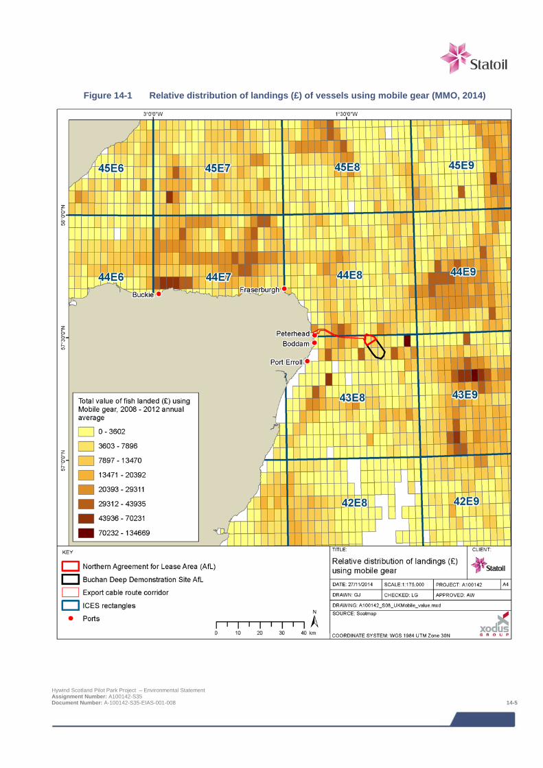
Figure 14-1 Relative distribution of landings (£) of vessels using mobile gear (MMO, 2014)
Hywind Scotland Pilot Park Project – Environmental Statement Assignment Number: A100142-S35 Document Number: A-100142-S35-EIAS-001-008 14-5
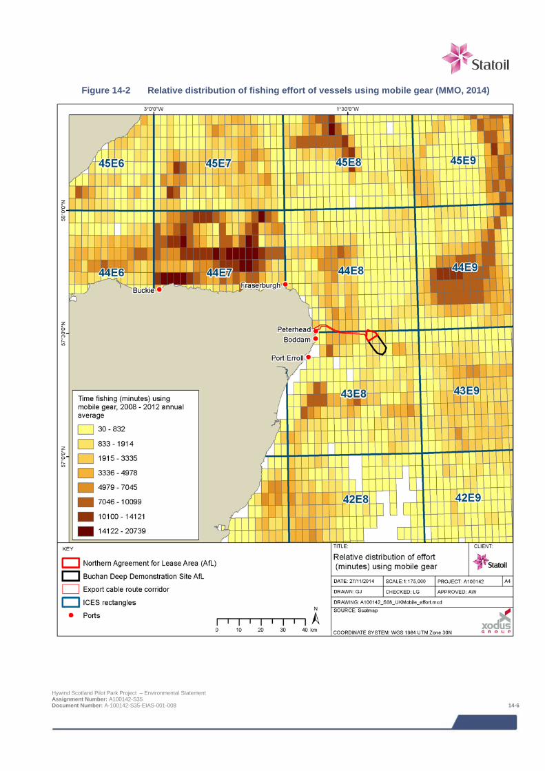
Figure 14-2 Relative distribution of fishing effort of vessels using mobile gear (MMO, 2014)
Hywind Scotland Pilot Park Project – Environmental Statement Assignment Number: A100142-S35 Document Number: A-100142-S35-EIAS-001-008 14-6
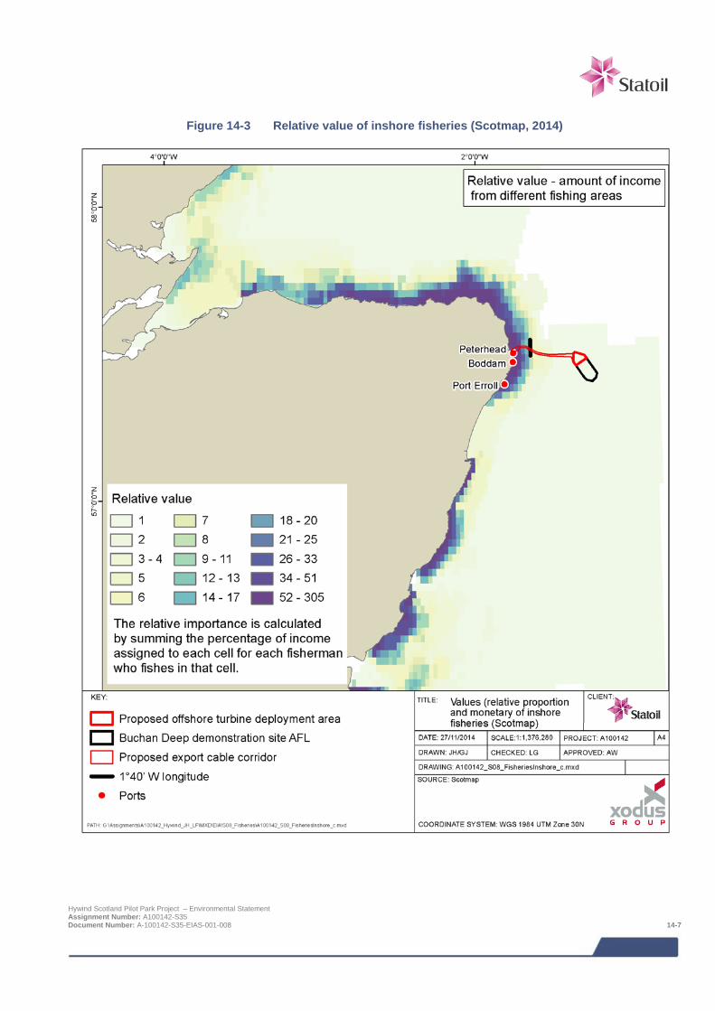
Figure 14-3 Relative value of inshore fisheries (Scotmap, 2014)
Hywind Scotland Pilot Park Project – Environmental Statement Assignment Number: A100142-S35 Document Number: A-100142-S35-EIAS-001-008 14-7

Figure 14-3 indicates the relative value of the inshore fishery based on ScotMap data and demonstrates the importance of the inshore areas of the export cable corridor, relative to the entire north east coast of Scotland. Inshore fisheries are concentrated west of 1°40’ longitude, as marked on the maps.
Figure 14-1 and Figure 14-2 combine multiple types of mobile gear activity in the area. The types of gear utilised are discussed in more detail in Table 14-4, as well as the species they typically target. In context of the Project demersal gear, including dredging, has the potential to interact with mooring lines, anchors, scour protection, inter array cables and export cable and its protection. Pelagic gear has the potential to interact with the mooring lines at the turbine deployment site. Table 14-4 details the likely mobile fishing gears used within the Project area.
Table 14-4 Fishing vessel information for different fishing gears active off the coast of Peterhead (Scottish Fishermen’s Federation, 2012)
Gear Type Number of
vessels require
for fishing
Number of nets require
for fishing
Towing Speed (knots)
Tow Duration (hours)
Vessel Movement
Additional information
Target species and fishery type
Single bottom trawl
One One 2-4 Up to 6 Good Nets used are chosen to be compatible with seabed conditions in the area being fished.
Mixed whitefish, Nephrops and squid - demersal
Twin-rig trawl
One Two 2-3 4-7 Fair to Good Sometime associated with heavy rock-hopper ground gear.
Mixed whitefish, Nephrops and squid - demersal
Demersal pair trawl
Two One 3-3.5 4-5 Fair Vessels 370 m apart; range will close during hauling and pairing up.
Mixed whitefish
Pelagic pair seining
Two One 2 4 Fair to Poor Nets follow ~2,200 m behind vessels; vessels between one quarter and one third of 1 nm from each other.
Herring and mackerel - pelagic
Siene net One One 1-2 2 Poor At greatest distance net is over 1 nm from vessel.
–Demersal species
Dredge One n/a 3-5 4 -5 hours Poor Dredges are towed up to 1 nm from the vessels
Scallops - shellfish
In ICES rectangle 43E8 the pelagic fishery is largest by liveweight (tonnes) although the shellfish fishery lands a greater value (£) of fish. In 44E8 the shellfish fishery is largest in terms of both economic value (£) and liveweight (tonnes). This is reflected in the species targeted from each rectangle, as shown in Table 14-5. The top five species landings values have been highlighted in red and are further discussed in the context of the relevant fishery in Section 14.4.4.
Scallops dominate the species landed from ICES rectangles 43E8, concurrent with dredging being the dominant fishing gear for vessels > 15 m. In the Project area and its immediate waters1:
> Dredge fishing accounts for 70% of effort and 38% of value;
> Haddock landings are second to scallops in ICES rectangle 43E8 but greater than scallops in 44E8;
> 29% of effort is demersal, targeting haddock, squid and Nephrops which accounts for 37% of value landed;
> Mackerel and herring are targeted by pelagic gear and make up approximately 20% of the value in both rectangles when combined;
> The use of pelagic gear accounts for <1% effort and 25% of the value;
1 12 nm, area advised by SFF as a reasonable area to help put fisheries within the Project area into context. Hywind Scotland Pilot Park Project – Environmental Statement Assignment Number: A100142-S35 Document Number: A-100142-S35-EIAS-001-008 14-8
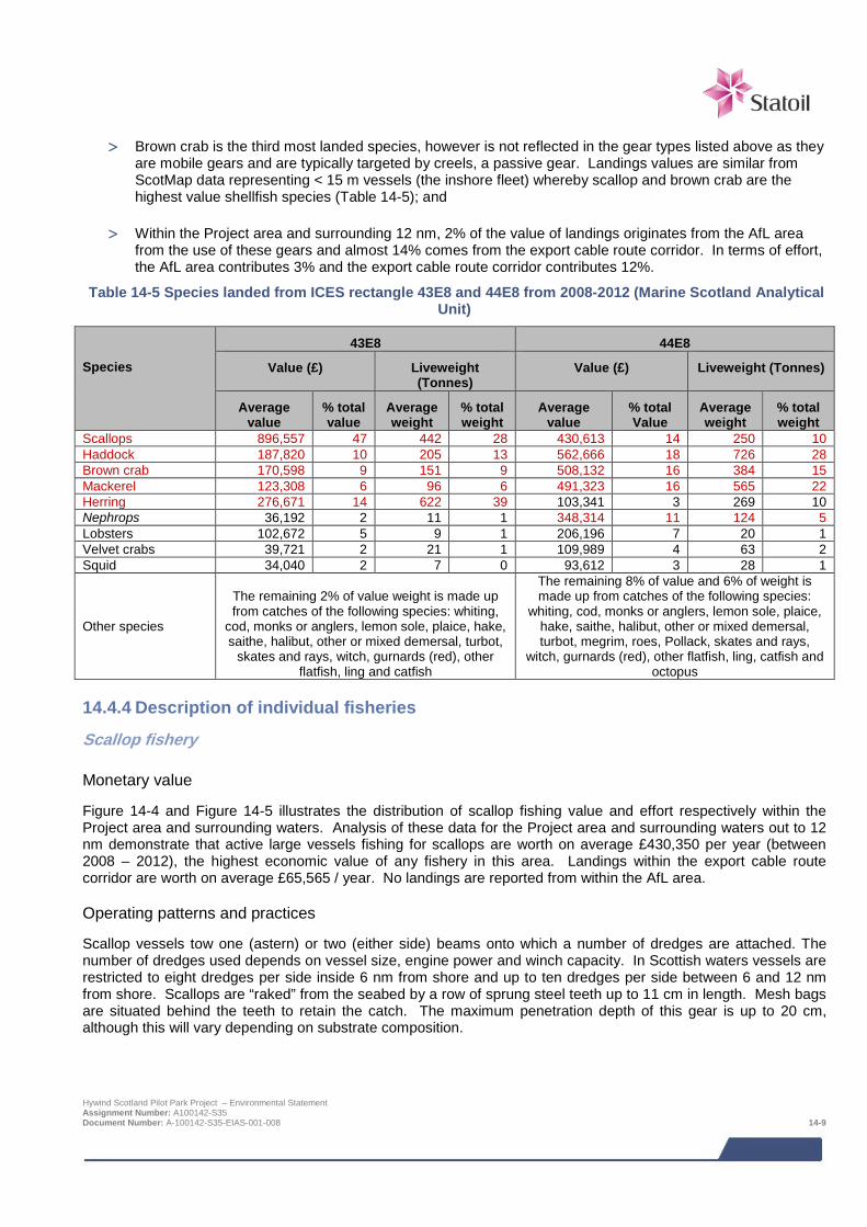
> Brown crab is the third most landed species, however is not reflected in the gear types listed above as they
are mobile gears and are typically targeted by creels, a passive gear. Landings values are similar from ScotMap data representing < 15 m vessels (the inshore fleet) whereby scallop and brown crab are the highest value shellfish species (Table 14-5); and
> Within the Project area and surrounding 12 nm, 2% of the value of landings originates from the AfL area from the use of these gears and almost 14% comes from the export cable route corridor. In terms of effort, the AfL area contributes 3% and the export cable route corridor contributes 12%.
Table 14-5 Species landed from ICES rectangle 43E8 and 44E8 from 2008-2012 (Marine Scotland Analytical Unit)
Species
43E8 44E8
Value (£) Liveweight (Tonnes)
Value (£) Liveweight (Tonnes)
Average value
% total value
Average weight
% total weight
Average value
% total Value
Average weight
% total weight
Scallops 896,557 47 442 28 430,613 14 250 10 Haddock 187,820 10 205 13 562,666 18 726 28 Brown crab 170,598 9 151 9 508,132 16 384 15 Mackerel 123,308 6 96 6 491,323 16 565 22 Herring 276,671 14 622 39 103,341 3 269 10 Nephrops 36,192 2 11 1 348,314 11 124 5 Lobsters 102,672 5 9 1 206,196 7 20 1 Velvet crabs 39,721 2 21 1 109,989 4 63 2 Squid 34,040 2 7 0 93,612 3 28 1 Other species
The remaining 2% of value weight is made up from catches of the following species: whiting,
cod, monks or anglers, lemon sole, plaice, hake, saithe, halibut, other or mixed demersal, turbot,
skates and rays, witch, gurnards (red), other flatfish, ling and catfish
The remaining 8% of value and 6% of weight is made up from catches of the following species:
whiting, cod, monks or anglers, lemon sole, plaice, hake, saithe, halibut, other or mixed demersal, turbot, megrim, roes, Pollack, skates and rays,
witch, gurnards (red), other flatfish, ling, catfish and octopus
14.4.4 Description of individual fisheries
Scallop fishery
Monetary value
Figure 14-4 and Figure 14-5 illustrates the distribution of scallop fishing value and effort respectively within the Project area and surrounding waters. Analysis of these data for the Project area and surrounding waters out to 12 nm demonstrate that active large vessels fishing for scallops are worth on average £430,350 per year (between 2008 – 2012), the highest economic value of any fishery in this area. Landings within the export cable route corridor are worth on average £65,565 / year. No landings are reported from within the AfL area.
Operating patterns and practices
Scallop vessels tow one (astern) or two (either side) beams onto which a number of dredges are attached. The number of dredges used depends on vessel size, engine power and winch capacity. In Scottish waters vessels are restricted to eight dredges per side inside 6 nm from shore and up to ten dredges per side between 6 and 12 nm from shore. Scallops are “raked” from the seabed by a row of sprung steel teeth up to 11 cm in length. Mesh bags are situated behind the teeth to retain the catch. The maximum penetration depth of this gear is up to 20 cm, although this will vary depending on substrate composition.
Hywind Scotland Pilot Park Project – Environmental Statement Assignment Number: A100142-S35 Document Number: A-100142-S35-EIAS-001-008 14-9
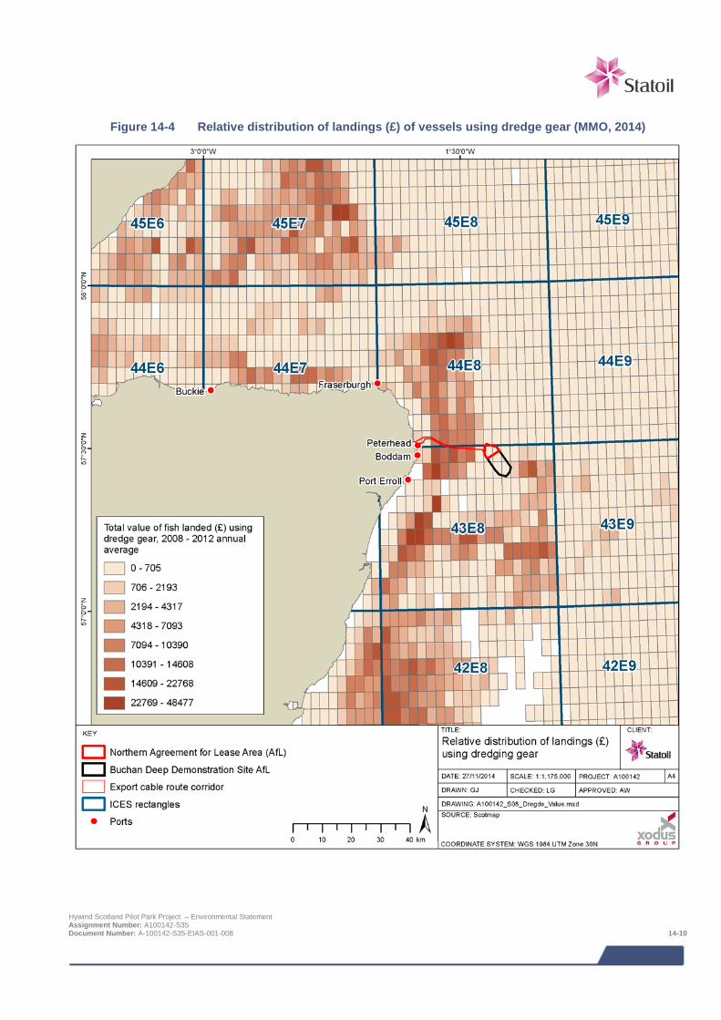
Figure 14-4 Relative distribution of landings (£) of vessels using dredge gear (MMO, 2014)
Hywind Scotland Pilot Park Project – Environmental Statement Assignment Number: A100142-S35 Document Number: A-100142-S35-EIAS-001-008 14-10
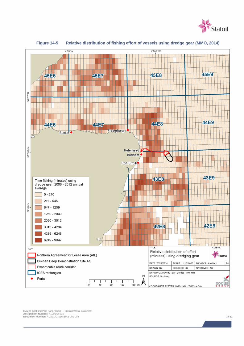
Figure 14-5 Relative distribution of fishing effort of vessels using dredge gear (MMO, 2014)
Hywind Scotland Pilot Park Project – Environmental Statement Assignment Number: A100142-S35 Document Number: A-100142-S35-EIAS-001-008 14-11
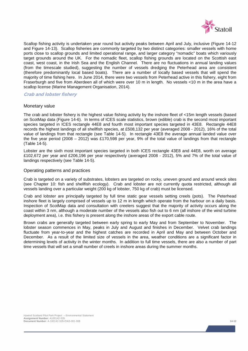
Scallop fishing activity is undertaken year round but activity peaks between April and July, inclusive (Figure 14-12 and Figure 14-13). Scallop fisheries are commonly targeted by two distinct categories: smaller vessels with home ports close to scallop grounds and limited operational range, and larger category “nomadic” boats which variously target grounds around the UK. For the nomadic fleet, scallop fishing grounds are located on the Scottish east coast, west coast, in the Irish Sea and the English Channel. There are no fluctuations in annual landing values (from the timescale studied), suggesting the number of vessels dredging the Peterhead area are consistent (therefore predominantly local based boats). There are a number of locally based vessels that will spend the majority of time fishing here. In June 2014, there were two vessels from Peterhead active in this fishery, eight from Fraserburgh and five from Aberdeen all of which were over 10 m in length. No vessels <10 m in the area have a scallop license (Marine Management Organisation, 2014).
Crab and lobster fishery
Monetary value
The crab and lobster fishery is the highest value fishing activity by the inshore fleet of <15m length vessels (based on ScotMap data (Figure 14-6). In terms of ICES scale statistics, brown (edible) crab is the second most important species targeted in ICES rectangle 44E8 and fourth most important species targeted in 43E8. Rectangle 44E8 records the highest landings of all shellfish species, at £508,132 per year (averaged 2008 - 2012), 16% of the total value of landings from that rectangle (see Table 14-5). In rectangle 43E8 the average annual landed value over the five year period (2008 – 2012) was £170,598 per year, 9% of the total value of landings from that rectangle (Table 14-5).
Lobster are the sixth most important species targeted in both ICES rectangle 43E8 and 44E8, worth on average £102,672 per year and £206,196 per year respectively (averaged 2008 - 2012), 5% and 7% of the total value of landings respectively (see Table 14-5).
Operating patterns and practices
Crab is targeted on a variety of substrates, lobsters are targeted on rocky, uneven ground and around wreck sites (see Chapter 10: fish and shellfish ecology). Crab and lobster are not currently quota restricted, although all vessels landing over a particular weight (200 kg of lobster, 750 kg of crab) must be licensed.
Crab and lobster are principally targeted by full time static gear vessels setting creels (pots). The Peterhead inshore fleet is largely comprised of vessels up to 12 m in length which operate from the harbour on a daily basis. Inspection of ScotMap data and consultation with creelers suggest that the majority of activity occurs along the coast within 3 nm, although a moderate number of the vessels also fish out to 6 nm (all inshore of the wind turbine deployment area), i.e. this fishery is present along the inshore areas of the export cable route.
Brown crabs are generally targeted between early spring to early May and from September to November. The lobster season commences in May, peaks in July and August and finishes in December. Velvet crab landings fluctuate from year-to-year and the highest catches are recorded in April and May and between October and December. As a result of the limited size of vessels in the area, weather conditions are a significant factor in determining levels of activity in the winter months. In addition to full time vessels, there are also a number of part time vessels that will set a small number of creels in inshore areas during the summer months.
Hywind Scotland Pilot Park Project – Environmental Statement Assignment Number: A100142-S35 Document Number: A-100142-S35-EIAS-001-008 14-12
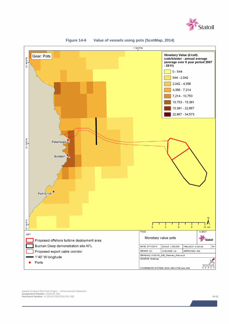
Figure 14-6 Value of vessels using pots (ScotMap, 2014)
Hywind Scotland Pilot Park Project – Environmental Statement Assignment Number: A100142-S35 Document Number: A-100142-S35-EIAS-001-008 14-13

Whitefish fishery
Monetary value
The demersal dredge and trawl fishery (which includes haddock, Nephrops and squid) is the second largest fishery within the Project area and immediate waters out to 12 nm, accounting for 36% of the landings value of all mobile gear fisheries Figure 14-7 and Figure 14-8). The whitefish fishery is worth on average £419,933 per year (averaged 2008 – 2012, based on landings from large vessels (> 15 m length)). Within the Project area, a marginally higher value of landings come from the export cable route corridor (£41,953) compared to the AfL area (£30,649).
Finfish - operating patterns and practices
There is a historic whitefish fishery in the region, targeting species such as haddock Melanogrammus aeglefinus cod Gadus morhua and whiting Merlangius merlangus using demersal otter trawl and Scottish seine netting fleets. Demersal trawling is the most common fishing method in Scottish waters in terms of vessel numbers.
The whitefish trawl fishery is for the most part a mixed fishery whereby multiple demersal species are simultaneously caught. EU quota restrictions and upon the landing of cod have reduced the fleet’s ability to fish alternative species. As a result of a lack of available quota, demersal trawlers have diversified into the Nephrops fishery, where quota levels are not so restrictive.
Although the Buchan Deep is not fished intensively, it is a specific area of greater individual importance than the surrounding area for haddock. This is because vessels target the species in the winter here, but the reason for this is quota-related rather than seasonal distribution. It is considered that the low level of cod landings recorded (Table 14-5) are by-catches from the other demersal fisheries.
Nephrops - operating patterns and practices
Nephrops gear is configured in the same way as that used to target whitefish but with modified nets. Nephrops inhabit burrows in the seabed and favour muddy and soft substrates. Vessels tow one or more trawl nets (single or twin rig) along the seabed.
Vessels target Nephrops year round in ICES Rectangles 43E8 and 44E8, although there are seasonal fluctuations in catches (Figure 14-12 and Figure 14-13). The majority of Nephrops vessels are < 15 m in length and therefore not satellite tracked. As a result of the limited size of vessel in the area, weather conditions are a significant factor in determining levels of activity in the winter months.
Squid - operating patterns and practices
Although not currently a high value species, this fishery is included in the assessment because consultation with fishermen’s associations and fishermen identified it as becoming increasingly important in the Peterhead / Buchan Deep area. The squid fishery currently provides an alternative to other quota restricted stocks. Annual landings values vary significantly as the fishery is dependent on the area’s highly variable population. The fishery is currently unregulated and unrestricted, although there is the potential for management measures to be put in place in the future.
Bottom otter trawlers targeting Nephrops reconfigure gear to target squid (using nets with a smaller mesh size and a higher headline). Squid is often targeted on rough ground and vessels may employ protective gear, such as rockhoppers. As mentioned previously, the majority of these vessels are <15 m in length and therefore not satellite tracked.
Hywind Scotland Pilot Park Project – Environmental Statement Assignment Number: A100142-S35 Document Number: A-100142-S35-EIAS-001-008 14-14
Figure 14-7 Relative distribution of landings (£) of > 15 m vessels using demersal gear (MMO, 2014)
Hywind Scotland Pilot Park Project – Environmental Statement Assignment Number: A100142-S35 Document Number: A-100142-S35-EIAS-001-008 14-15
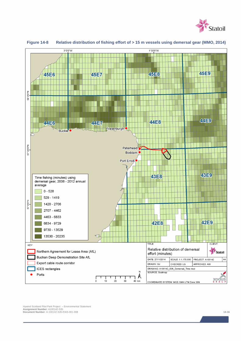
Figure 14-8 Relative distribution of fishing effort of > 15 m vessels using demersal gear (MMO, 2014)
Hywind Scotland Pilot Park Project – Environmental Statement Assignment Number: A100142-S35 Document Number: A-100142-S35-EIAS-001-008 14-16

Herring and mackerel fishery
Monetary value
The pelagic fishery (which includes herring and mackerel) is the least important fishery (in economic terms) within the Project area and immediate waters out to 12 nm, accounting for 25% of landings from all fisheries. The pelagic fishery is worth on average £285,041 per year (averaged 2008 - 2012) (Table 14-5). Within the Project area, a higher value of landings come from the export cable route corridor (£50,592) compared to the AfL area (£1,385) (Figure 14-10 and Figure 14-11).
Operating patterns and practices
Pelagic or mid-water trawl vessels are amongst the most powerful in European waters. They are also mainly multi-purpose vessels capable of pursing and pelagic pair-trawling as well as pelagic trawling. Pelagic species, mainly herring, mackerel, and sprat, are habitually mid-water shoaling fish, but during full daylight conditions they will congregate in dense shoals near the sea-bed. Normally they are caught while they are nearer the surface but it is possible to trawl for them near the bottom. In normal circumstances these nets would not come into hard contact with the seabed having no protective ground-line, but could potentially interact with a high structure.
The herring season is focused on the period July to September and the mackerel season on the period August to February (Coull et al., 1998). Herring, in particular, has a short season between July and October. Mackerel is fished over a longer season but remains concentrated over the summer and early autumn months, between June and October (Figure 14-12 and Figure 14-13) (Scottish Government, 2014).
Hand-lining for mackerel
There is a significant hand-line fishery for mackerel in the summer months between May and November. An estimated 45 vessels are understood to target the fishery from Peterhead (based on ScotMap data as shown in Figure 14-9). Consultation with local fishermen has identified the principal grounds, which are shown in Figure 14-3 and provided by ScotMap. It should be noted that these grounds have variable degrees of importance to local fishermen due to variations in quota allocation. It has been recently announced that the Scottish allocation of mackerel quota for inshore fishing will be increased by 1,000 tonnes in 2014 as part of a two year trial. This increase will bring the total quota to 1,300 tonnes for all vessels < 10 m which could be worth an additional £1.2m to the sector (Inshore Fisheries Conference, 2014).
Hywind Scotland Pilot Park Project – Environmental Statement Assignment Number: A100142-S35 Document Number: A-100142-S35-EIAS-001-008 14-17
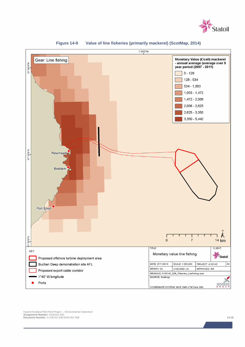
Figure 14-9 Value of line fisheries (primarily mackerel) (ScotMap, 2014)
Hywind Scotland Pilot Park Project – Environmental Statement Assignment Number: A100142-S35 Document Number: A-100142-S35-EIAS-001-008 14-18
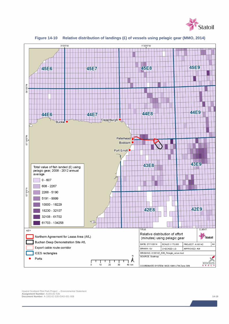
Figure 14-10 Relative distribution of landings (£) of vessels using pelagic gear (MMO, 2014)
Hywind Scotland Pilot Park Project – Environmental Statement Assignment Number: A100142-S35 Document Number: A-100142-S35-EIAS-001-008 14-19
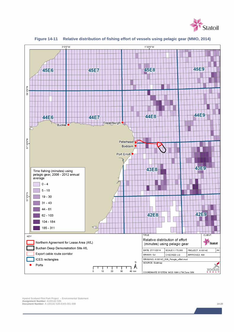
Figure 14-11 Relative distribution of fishing effort of vessels using pelagic gear (MMO, 2014)
Hywind Scotland Pilot Park Project – Environmental Statement Assignment Number: A100142-S35 Document Number: A-100142-S35-EIAS-001-008 14-20
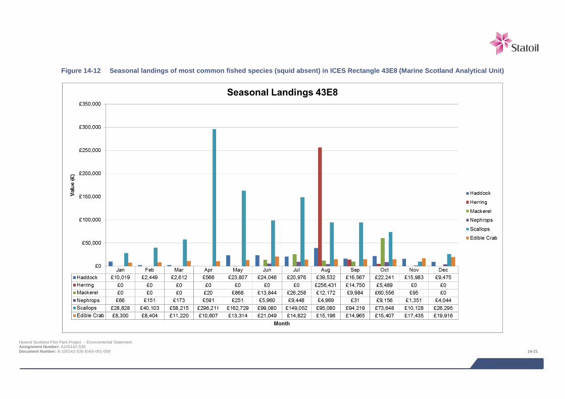
Figure 14-12 Seasonal landings of most common fished species (squid absent) in ICES Rectangle 43E8 (Marine Scotland Analytical Unit)
Hywind Scotland Pilot Park Project – Environmental Statement Assignment Number: A100142-S35 Document Number: A-100142-S35-EIAS-001-008 14-21
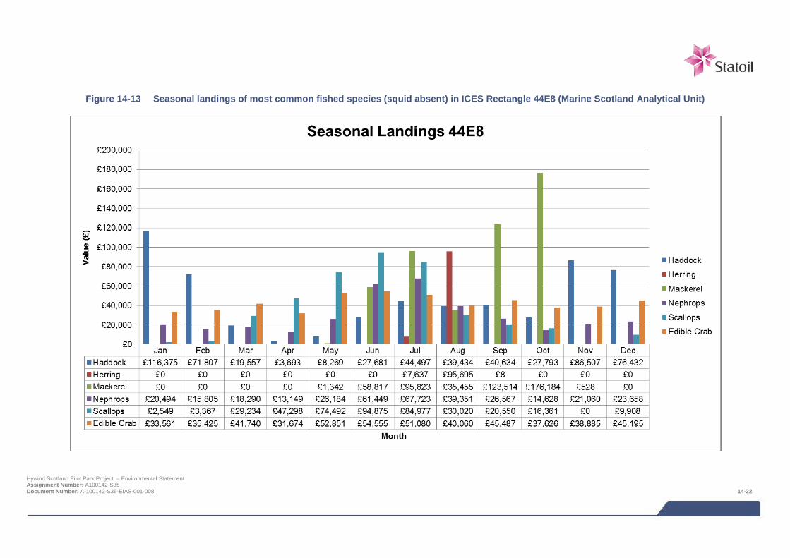
Figure 14-13 Seasonal landings of most common fished species (squid absent) in ICES Rectangle 44E8 (Marine Scotland Analytical Unit)
Hywind Scotland Pilot Park Project – Environmental Statement Assignment Number: A100142-S35 Document Number: A-100142-S35-EIAS-001-008 14-22
14.4.5 Key ports and vessel numbers Peterhead, Aberdeen and Fraserburgh are the nearest commercial UK fishing ports to the Project area. Peterhead is the UK’s largest commercial fishing port reporting landings of 105 thousand tonnes in 2012 worth £113.5 million (Marine Management Organisation, 2013).
Based on 2012 statistics Fraserburgh employs the largest number of people full time out of these three Scottish ports (797) (Marine Management Organisation, 2013). Fish processing in Fraserburgh and Peterhead collectively supports around 3,000 jobs (Peterhead and Fraserburgh Fish Processing Association, 2013).
The majority of vessels operating in rectangles 43E8 and 44E8 are based at local ports. Table 14-6 shows the number of active vessels fishing in ICES Rectangle 43E8 and 44E8 and compares this to the number of vessels registered at these ports and expresses this as a proportion. These figures represent the potential vessel numbers expected to be encountered. On average, 72% of the vessels from Peterhead and 47% from Fraserburgh have fished in ICES rectangles 43E8 and 44E8. The proportion of vessels utilising these rectangles is comparable with the proportion of landings into Peterhead coming from ICES rectangles 43E8 and 44E8 (71% and 73% respectively). Similarly, 20% of landings into Fraserburgh come from rectangle 43E8 and 74% from 44E8.Data held by Marine Scotland demonstrate that landings from within ICES Rectangle 44E8 were recorded every year at Peterhead, Fraserburgh (and Aberdeen for 43E8). Fish is also landed from 43E8 at a number of other smaller ports (Boddam and Port Errol) however these are not included in Table 14-6 as landings only occurred from two or less out of the five years. The smaller ports of Macduff, Gardenstown, Whitehills and Rosehearty are also important for landings from 44E8 having landed consistently for the past years. Given the location of these smaller ports (between 35 and 67 km from the turbine deployment area) and the smaller size of vessel, landings are likely to be from the northern half of the ICES rectangle, closer to the home port, rather than the Project area.
Table 14-6 Origin of active fishing vessels landing from ICES Rectangle 43E8 and 44E8 from 2008 to 2012 (Marine Scotland Analytical Unit)
Landing Port Number of active vessels Average no. of active
vessels
Total no. registered vessels in 2012
Proportion of home fleet landing from the Project area (%)
2008 2009 2010 2011 2012 < 10 m
10 – 15 m
> 15 m
Total
43E8
Peterhead 58 60 74 77 81 70 50 0 48 98 71
Aberdeen 24 22 22 15 12 19 82 8 1 91 20
Fraserburgh 53 13 53 61 24 41 102 6 96 204 20
44E8
Fraserburgh 147 149 169 150 138 151 102 6 96 204 74
Peterhead 72 62 62 69 94 72 50 0 48 98 73
14.4.6 Salmon and sea trout fishery Rivers on the northeast coast of Scotland have nationally and internationally important populations of salmon and sea trout. Both species form an important part of Scotland’s natural heritage and support and maintain the existence of commercial and recreational fisheries which are of importance to the Scottish economy (Scottish Executive Environment and Rural Affairs Department, 2004).
Atlantic salmon Salmo salar and sea trout Salmo trutta are diadromous or migratory species of fish, with a life cycle that includes time in freshwater river environments and at sea. After a period spent in a riverine environment, the individuals undertake a marine migration to offshore feeding grounds, returning after a varying number of years to their natal river to spawn (refer to Chapter 10: fish and shellfish ecology). It is probable they will transit the export cable corridor and migration and catch levels could therefore potentially be disrupted.
Hywind Scotland Pilot Park Project – Environmental Statement Assignment Number: A100142-S35 Document Number: A-100142-S35-EIAS-001-008 14-23
Each fishery in Scotland is required to provide the number and total weight of salmon and grilse and sea trout caught and retained in each month of the fishing season. The principal salmon and sea trout fisheries are rod and line (including catch and release), fixed engine (bag netting) and net and coble.
The fishery is managed through fishery districts, each of which has a District Salmon Fishery Board (DSFB). Salmon and sea trout catches are recorded under the following categories:
> Sea trout;
> Salmon (multi-sea winter fish); and
> Grilse (salmon that have only spent one year at sea).
Analysis of fisheries statistics for the north east of Scotland identified a very low level of netting activity in the area of the export cable corridor, throughout the year (Table 14-7).
The net fishery
The proposed cable landfall is located within the jurisdiction of the Ugie DSFB. The Ugie DSFB covers the whole of the River Ugie (located just north of the cable landfall area) catchment area, which is situated in the North East corner of Scotland. The river enters the sea to the north of Peterhead.
The majority of the catches in this region are in the Esk district (North and South Esk). The River Ugie is a relatively small river in terms of length but still operates a productive fishery by all methods (rod and line, fixed engine and net and coble). Salmon and sea trout are caught by the rod angling fraternity in the river and in the sea from Boddam to Cairnbulg. There are three active traps for fixed engine methods in the River Ugie, which operate April to September, and two traditional bag nets that operate between May and August.
Much of the caught and retained fish from the net fishery (Table 14-7) are smoked and sold by two companies based in Peterhead: Ugie Salmon Fishing Company Limited and Lunar.
The DSFB, along with the Ugie Angling Association and the river management team, operate a hatchery, commission electro surveys of the juvenile population, are constantly repairing the river banks and improving the accessibility to the spawning beds of the returning adult salmon and trout.
Table 14-7 Number of wild salmon, grilse and sea trout caught and retained by the north east salmon fishery region and by method during 2012 with the percentage values for the River Ugie in brackets (Marine
Scotland Analytical Unit)
Method
Number in north east fishery region
Salmon Grilse Salmon + grilse
Sea trout
Jan-Apr May-Dec Annual
Rod and line 39 1,149 1,188 711 1,899 988
Net and coble - 870 870 1,243 2,113 2,179
Fixed engine 49 1,958 2,007 1,841 3,848 725
All methods 88 (1%) 3,977 (2%) 4,065 (2%) 3,795 (1%) 7,860 (2%) 3,892 (5%)
The rod and line fishery
Wild catches by rod and line in-river that are released are low in the River Ugie. Data provided from the Marine Scotland Analytical Unit indicate catches of less than 100 sea trout and less than 60 salmon (individual fish) were caught in the river in 2012 (Table 14-8). Considerably higher numbers of fish (few hundred individuals) are caught in other east coast rivers such as the Rivers Dee, Don, Ythan, South Esk and North Esk and Bervie. Fishing by rod and line is seasonal: salmon is between September and October; grilse between July and October and sea trout are principally caught from April to October.
Hywind Scotland Pilot Park Project – Environmental Statement Assignment Number: A100142-S35 Document Number: A-100142-S35-EIAS-001-008 14-24
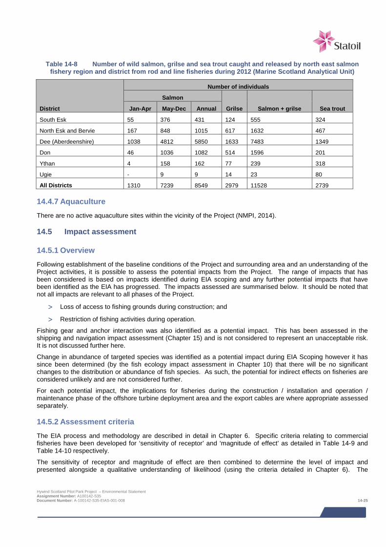
Table 14-8 Number of wild salmon, grilse and sea trout caught and released by north east salmon
fishery region and district from rod and line fisheries during 2012 (Marine Scotland Analytical Unit)
District
Number of individuals
Salmon
Grilse Salmon + grilse Sea trout Jan-Apr May-Dec Annual
South Esk 55 376 431 124 555 324
North Esk and Bervie 167 848 1015 617 1632 467
Dee (Aberdeenshire) 1038 4812 5850 1633 7483 1349
Don 46 1036 1082 514 1596 201
Ythan 4 158 162 77 239 318
Ugie - 9 9 14 23 80
All Districts 1310 7239 8549 2979 11528 2739
14.4.7 Aquaculture There are no active aquaculture sites within the vicinity of the Project (NMPI, 2014).
14.5 Impact assessment
14.5.1 Overview Following establishment of the baseline conditions of the Project and surrounding area and an understanding of the Project activities, it is possible to assess the potential impacts from the Project. The range of impacts that has been considered is based on impacts identified during EIA scoping and any further potential impacts that have been identified as the EIA has progressed. The impacts assessed are summarised below. It should be noted that not all impacts are relevant to all phases of the Project.
> Loss of access to fishing grounds during construction; and
> Restriction of fishing activities during operation.
Fishing gear and anchor interaction was also identified as a potential impact. This has been assessed in the shipping and navigation impact assessment (Chapter 15) and is not considered to represent an unacceptable risk. It is not discussed further here.
Change in abundance of targeted species was identified as a potential impact during EIA Scoping however it has since been determined (by the fish ecology impact assessment in Chapter 10) that there will be no significant changes to the distribution or abundance of fish species. As such, the potential for indirect effects on fisheries are considered unlikely and are not considered further.
For each potential impact, the implications for fisheries during the construction / installation and operation / maintenance phase of the offshore turbine deployment area and the export cables are where appropriate assessed separately.
14.5.2 Assessment criteria The EIA process and methodology are described in detail in Chapter 6. Specific criteria relating to commercial fisheries have been developed for ‘sensitivity of receptor’ and ‘magnitude of effect’ as detailed in Table 14-9 and Table 14-10 respectively.
The sensitivity of receptor and magnitude of effect are then combined to determine the level of impact and presented alongside a qualitative understanding of likelihood (using the criteria detailed in Chapter 6). The
Hywind Scotland Pilot Park Project – Environmental Statement Assignment Number: A100142-S35 Document Number: A-100142-S35-EIAS-001-008 14-25

definitions for level of impact and how they relate to significance are presented in Chapter 6, Table 6-1 and Table 6-2.
Table 14-9 Criteria for sensitivity of commercial fisheries
Sensitivity Definition
Very high No spatial adaptability due to operational range and ability to deploy only one gear type. No recoverability due to inability to mitigate loss of fishing area by operating in alternative areas.
High Low spatial adaptability due to limited operational range and ability to deploy only one gear type. Dependence mostly on one area but with some fishing activity occurring in other areas. Low recoverability due to inability to mitigate loss of fishing area by operating in alternative areas.
Medium Some spatial adaptability due to extent of operational range and/or ability to deploy an alternative gear type. Dependence on a limited number of fishing grounds. Limited recoverability with some ability to mitigate loss of fishing area by operating in alternative areas.
Low High spatial adaptability due to extensive operational range and/or ability to deploy a number of gear types. Ability to fish a moderate number of fishing grounds. High recoverability due to ability to mitigate loss of fishing area by operating in range of alternative areas of the North Sea.
Negligible Fisheries are not sensitive to change.
Table 14-10 Criteria for magnitude of effect
Magnitude of effect Definition
Severe Effect is widespread, or occurs over a prolonged duration, or at a high frequency (e.g. repeated or continuous effect), resulting in extensive permanent changes to baseline fishing areas and their condition.
Major Effect is over a large scale or spatial extent, or occurs long term, or at a medium-high frequency, resulting in extensive temporary change or some permanent change to baseline fishing areas and their condition.
Moderate Effect is localised, or occurs for a short duration, or at a medium frequency, resulting in temporary changes or limited permanent changes to baseline fishing areas and their condition.
Minor Detectable disturbance or change to baseline fishing areas and their condition and no long term noticeable effects above the level of natural variation experienced for commercial fisheries.
Negligible No change or an imperceptible change to the baseline fishing areas and their condition.
Note: Magnitude of effect is presented as a variety of parameters including duration, timing, size and scale, and frequency. Definitions in this table may not be appropriate for all effects, for example there may be an effect which is over a very small area (minor or moderate) but is repeated a large number of times during a particular phase of the project (major or severe). In such cases expert judgement is used to determine the most appropriate magnitude ranking and this is explained through the narrative of the assessment.
14.5.3 Design Envelope This assessment considers the Project parameters which are predicted to result in the greatest environmental impact. This approach ensures that impacts of greater adverse significance would not arise should any other development scenario be taken forward in the final scheme design. With regards to the assessment of impacts on commercial fisheries the assessment considers:
> Total area of sea occupied by the indicative turbine layout (including the area occupied by the anchors and mooring system and inter array cables) is 15 km2;
Hywind Scotland Pilot Park Project – Environmental Statement Assignment Number: A100142-S35 Document Number: A-100142-S35-EIAS-001-008 14-26

> The turbines will be anchored in a water depth of 95 - 120 m via mooring lines with a length of up to 600 -
1,200 m;
> WTG Unit anchoring systems which will include mooring lines present on the seabed (between 150 - 850 m of mooring line per anchor and a maximum of 15 anchors for the whole Pilot Park);
> Scour protection maybe required around the anchors which if required would occupy an area of up to 15 m beyond the edge of each anchor;
> Inter array cables of which it is assumed there could be up to 15 km of (5 cables, each of up to 3 km in length) and up to 7.5 km could be rock dumped for cable stabilisation purposes;
> An export cable of up to 35 km in length and requiring rock protection along up to 2 km of its length. The rock protection would occupy a 6 m wide corridor;
> Four cable crossings, each requiring 360 m2 of rock protection;
> Cable landfall installation as a surface laid cable across the foreshore requiring a working corridor of 6 m wide (however it should be noted that the base case is HDD);
> Installation of moorings and inter array cables prior to WTG Units; and
> 500 m safety zones may be present during construction and installation activities (safety zones will need to be applied for).
The impacts from potential alternative development options are addressed in Section 14.8.
14.5.4 Data gaps and uncertainties With regard to the operational phase of the Project, further consultation is still required with the MCA and DECC regarding safety zones, or other methods of protecting against fishing gear interaction. The agreed strategy, whether mandatory or advisory, will be implemented and notified to UKHO for suitable depiction on Admiralty charts.
14.6 Impacts during construction and installation
14.6.1 Loss of access to fishing grounds
Turbine deployment area
The monetary value of landings from within the proposed turbine deployment area is relatively low when taken in the context of the value of grounds around the northeast of Scotland and indeed the UK. The principal commercial species targeted by gear type in and around the turbine deployment area are pelagic trawling for herring and mackerel and demersal trawling for haddock, Nephrops and squid.
Safety zones of 500 m around areas of offshore works may be present during the construction and installation period (safety zones will need to be applied for). All vessels, including fishing vessels, will be excluded from the safety areas.
Following installation of the anchors and mooring system, there will be a time lag of up to 18 months before the hook-up of the WTG Units. The seabed infrastructure will pose a risk to fishing vessels at the turbine deployment site. Information on the location of the infrastructure may be provided to fishermen, for example via FishSafe, allowing them to manage the risk independently (Anatec, 2014).
Hywind Scotland Pilot Park Project – Environmental Statement Assignment Number: A100142-S35 Document Number: A-100142-S35-EIAS-001-008 14-27
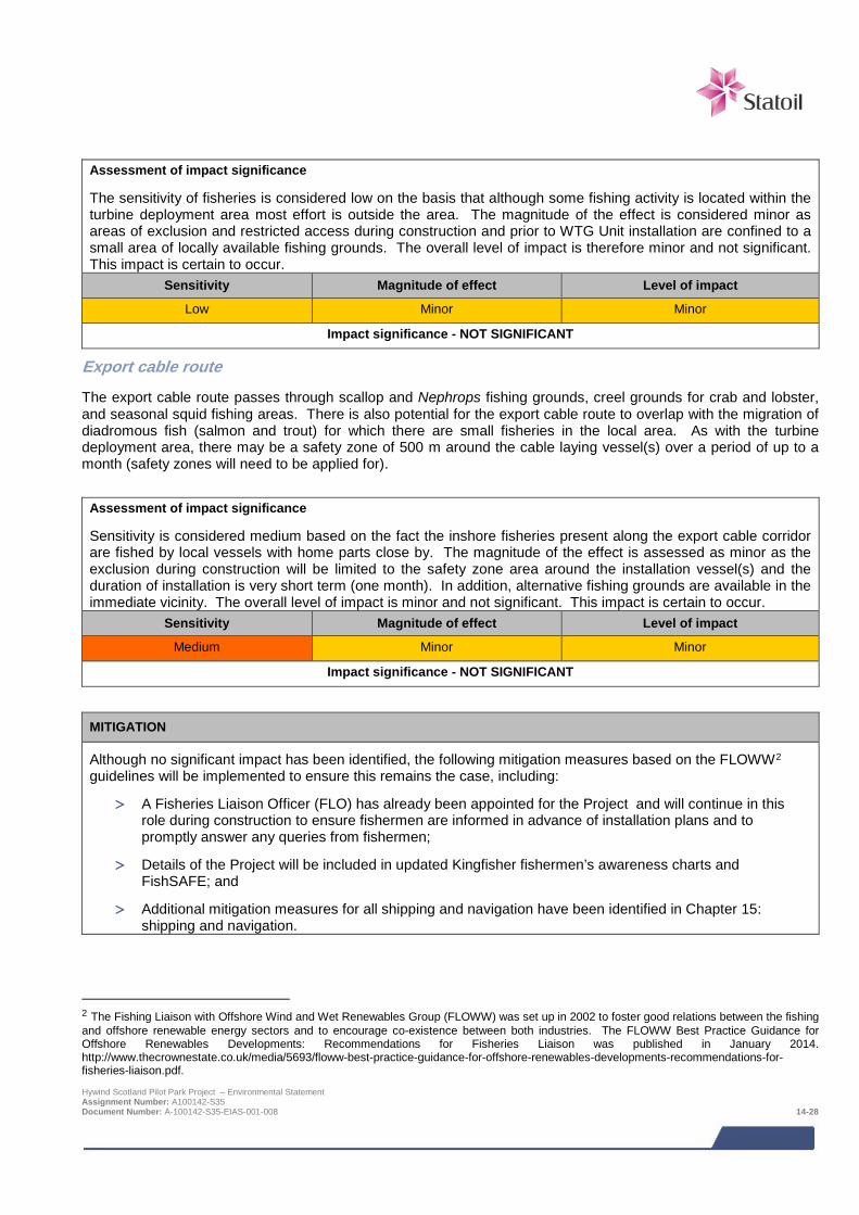
Assessment of impact significance
The sensitivity of fisheries is considered low on the basis that although some fishing activity is located within the turbine deployment area most effort is outside the area. The magnitude of the effect is considered minor as areas of exclusion and restricted access during construction and prior to WTG Unit installation are confined to a small area of locally available fishing grounds. The overall level of impact is therefore minor and not significant. This impact is certain to occur.
Sensitivity Magnitude of effect Level of impact
Low Minor Minor
Impact significance - NOT SIGNIFICANT
Export cable route
The export cable route passes through scallop and Nephrops fishing grounds, creel grounds for crab and lobster, and seasonal squid fishing areas. There is also potential for the export cable route to overlap with the migration of diadromous fish (salmon and trout) for which there are small fisheries in the local area. As with the turbine deployment area, there may be a safety zone of 500 m around the cable laying vessel(s) over a period of up to a month (safety zones will need to be applied for).
Assessment of impact significance
Sensitivity is considered medium based on the fact the inshore fisheries present along the export cable corridor are fished by local vessels with home parts close by. The magnitude of the effect is assessed as minor as the exclusion during construction will be limited to the safety zone area around the installation vessel(s) and the duration of installation is very short term (one month). In addition, alternative fishing grounds are available in the immediate vicinity. The overall level of impact is minor and not significant. This impact is certain to occur.
Sensitivity Magnitude of effect Level of impact
Medium Minor Minor
Impact significance - NOT SIGNIFICANT
MITIGATION
Although no significant impact has been identified, the following mitigation measures based on the FLOWW2 guidelines will be implemented to ensure this remains the case, including:
> A Fisheries Liaison Officer (FLO) has already been appointed for the Project and will continue in this role during construction to ensure fishermen are informed in advance of installation plans and to promptly answer any queries from fishermen;
> Details of the Project will be included in updated Kingfisher fishermen’s awareness charts and FishSAFE; and
> Additional mitigation measures for all shipping and navigation have been identified in Chapter 15: shipping and navigation.
2 The Fishing Liaison with Offshore Wind and Wet Renewables Group (FLOWW) was set up in 2002 to foster good relations between the fishing and offshore renewable energy sectors and to encourage co-existence between both industries. The FLOWW Best Practice Guidance for Offshore Renewables Developments: Recommendations for Fisheries Liaison was published in January 2014. http://www.thecrownestate.co.uk/media/5693/floww-best-practice-guidance-for-offshore-renewables-developments-recommendations-for-fisheries-liaison.pdf. Hywind Scotland Pilot Park Project – Environmental Statement Assignment Number: A100142-S35 Document Number: A-100142-S35-EIAS-001-008 14-28

14.7 Impacts during operation and maintenance The key impacts arising from the operation and maintenance of the project are long term, lasting through the operational phase of the Project (20 years).
14.7.1 Loss of access to fishing grounds
Turbine deployment area
The Pilot Park will be operational for 20 years and during this time fishing within the turbine deployment area may be restricted. The plans for safety zones and/or fishing prohibition, either compulsory or advisory, will need to be agreed with DECC, the MCA and Marine Scotland pre-construction. WTG Units will be marked according to MCA/NLB’s recommendations. The primary risk for fishing vessels is the presence of mid water mooring lines and the inter array cables which pose a snagging risk to fishing gear.
Assessment of impact significance
The sensitivity of fisheries is considered low on the basis that although some fishing activity is located within the turbine deployment area most effort is outside the area. The magnitude of effect is considered moderate as fishing will be restricted from an area of up to 15 km2 over a 20 year period. The overall level of impact is minor and not significant. This impact is certain to occur.
Sensitivity Magnitude of effect Level of impact
Low Moderate Minor
Impact significance - NOT SIGNIFICANT
Export cable route
Once the export cable has been installed fishing activities will be able to resume and there will be no long term loss of access to fisheries along the cable route.
14.8 Potential variances in environmental impacts (based on Design Envelope) The impact assessment above has assessed the Project options which are predicted to result in the greatest impacts with regards to commercial fisheries. Impacts arising from alternative design options are not predicted to result in impacts greater than the impacts presented. For example, it is most likely that the inter array cables will be installed after the WTG Units, therefore there will be less seabed infrastructure that may pose a risk to fishing during the construction phase of the Project.
14.9 Cumulative and in-combination impacts HSL has in consultation with Marine Scotland and Aberdeenshire Council identified a list of other projects which together with the Project may result in potential cumulative or in-combination impacts. The list of these projects and a map showing their location is provided in Chapter 6; Table 6.3 and Figure 6-1 respectively.
Cumulative impacts are impacts on commercial fisheries caused by planned and consented offshore wind farms. In-combination impacts are impacts on commercial fisheries as a result of offshore wind farms (and their associated activities) combined with impacts from other marine activities or users of the sea.
The consideration of which projects could result in potential cumulative or in-combination impacts is based on the results of the project specific impact assessment together with the expert judgement of the specialist consultant. Having considered the information presently available in the public domain on the projects for which there is a potential for cumulative or in-combination impacts are:
> European Offshore Wind Deployment Centre (EOWFL);
> Eastern HVDC Link; and
Hywind Scotland Pilot Park Project – Environmental Statement Assignment Number: A100142-S35 Document Number: A-100142-S35-EIAS-001-008 14-29

> NorthConnect.
The following sections summarise the nature of the potential cumulative and in-combination impacts for each potential project phase.
14.9.1 Potential cumulative and in-combination impacts during construction and installation
Cumulative and in-combination impacts on commercial fisheries include disturbance and displacement of the fishing fleet to alternative fishing grounds by project specific construction safety zones. There is potential for safety zones to be employed for the construction and installation phase of each project which could be up to a maximum radius of 500 m. Based on the information currently available on construction schedules for the other projects it is not likely there will be concurrent construction activities and therefore no cumulative or in-combination impacts are anticipated.
14.9.2 Potential cumulative and in-combination impacts during operation and maintenance
During the 20 year operation and maintenance phase of the Hywind Project fishing will be restricted from the area where the WTG Units and their mooring system are present; an area of 7.5 km2. Temporary safety zones may also be in place during maintenance works. Once the NorthConnect and Eastern HVDC Link cables have been installed there will be no fishing restrictions along these cables routes, however there may be fishing restrictions associated with EOWFL project. Given the distance between the EOWFL project and the Hywind turbine deployment area is 40 km; the EOWFL project Lease area is 20 km2 and fishing activity is expected to be able to take place around the wind turbines once installed there will be large areas of sea available for fishing activity to take place outside the areas where fishing is likely to be restricted.
14.9.3 Mitigation requirements for potential cumulative and in-combination impacts No mitigation is required over and above the Project-specific mitigation.
14.10 Long term initiatives The impact assessment has identified that fishing activities for safety reasons will be restricted from the turbine deployment area during the operational phase of the Project. Although the impacts from the Hywind Scotland Project are not predicted to be significant, in order to mitigate this challenge for new and larger floating wind farms in the future, Statoil is in the process of establishing a project with the objective to look at what activities can be carried out within a floating wind farm and how the area can be used positively in a biological and commercial manner.
The project will evaluate the potential for sustainable co-existence of marine activities and use of alternative fishing methods in planned offshore wind farm areas by way of a critical literature review, contacts with universities and research institutions, involvement in ongoing field studies and assessment of tools and technologies. In addition, considerations required to assess biological, legal, commercial, practical, safety, technical and socio economic impacts of co-location will be evaluated to provide a generic screening tool for investigating sites and activities that have the potential for co-existence among multiple users of marine resources.
14.11 References Anatec (2014) Navigation Risk Assessment Hywind Scotland Pilot Park Project (Technical Note) Reference A3207-St-NRA-1
BERR (2008). Review of Cabling Techniques and Environmental Effects applicable to the Offshore Wind Farm Industry. Technical Report form Royal Haskoning and BOMEL to the Department of Enterprise & Regulatory Reforms (BERR) in association with DEFRA Available from http://webarchive.nationalarchives.gov.uk/+/http://www.berr.gov.uk/files/file43527.pdf [accessed 02/06/2014].
Hywind Scotland Pilot Park Project – Environmental Statement Assignment Number: A100142-S35 Document Number: A-100142-S35-EIAS-001-008 14-30
Cefas (2004). Offshore Wind Farms Guidance Note for Environmental Impact Assessment in respect of FEPA and CPA Requirements Version 2 – June 2004 available from http://www.cefas.co.uk/publications/files/windfarm-guidance.pdf [accessed 12/06/2014]
Coull, K., Johnstone, R. and Rogers, S. (1998). Fishery sensitivity maps in British Waters. Published and distributed by UKOOA Ltd. Available from http://cefas.defra.gov.uk/media/29947/sensi_maps.pdf [accessed 01/06/2014]
Curtis, H. and Brodie, C. (2011). 2009 Economic Survey of the UK Fishing Fleet. Seafish Economics, Seafish, Edinburgh. Available at http://www.seafish.org/media/Publications/2009_Fleet_Economic_Short_Report_Final_6May11.pdf [Accessed 10/06/2014.
FLOWW (2014) FLOWW best practice guidelines for offshore renewables developments: recommendations for fisheries liaison available online here http://www.sff.co.uk/sites/default/files/FLOWW%20Best%20Practice%20Guidance%20for%20Offshore%20Renewables%20Developments%20Jan%202014.pdf [Accessed 15/10/2014]
Garrett, A. (2011). 2010 Survey of the UK Seafood Processing Industry. A report published for Seafish. Available at http://www.seafish.org/media/Publications/2010_Survey_of_the_UK_Seafood_Processing_Industry.pdf [Accessed 11/06/2014].
Inshore Fisheries Conference. (2014). Report of the Scottish Inshore Fisheries Conference 2014. Available at: http://www.scotland.gov.uk/Topics/marine/Sea-Fisheries/InshoreFisheries/IFConference2014/SIFC2014Report [Accessed 04/05/2014]
Marine Management Organisation (2014). UK Vessel Lists June 2014 available online at http://www.marinemanagement.org.uk/fisheries/statistics/vessel.htm [Accessed 21/05/2014].
Marine Scotland (2012) Scottish Sea Fisheries statistics tables vessel and employment tables available online at http://www.scotland.gov.uk/Topics/Statistics/Browse/Agriculture-Fisheries/PubFisheries [Accessed 01/12/2014]
NMPI (2014). National Marine Plan Interactive available online here http://www.scotland.gov.uk/Topics/marine/seamanagement/nmpihome/nmpi [Accessed 25/06/2014]
Peterhead and Fraserburgh Fish Processing Association (PFFPA) (2013). Employment figures. Available at http://www.pffpa.co.uk/ [Accessed 10/05/14].
Scottish Executive Environment and Rural Affairs Department (2004). The Economic Impact of Game and Coarse Angling in Scotland. Available online from: http://www.scotland.gov.uk/Publications/2004/03/19079/34383 [Accessed 25/05/2014].
ScotMap (2014). ScotMap - Inshore fisheries mapping project in Scotland. Available at: http://www.scotland.gov.uk/Topics/marine/science/MSInteractive/Themes/ScotMap [Accessed 10/05/14].
Scottish Government (2014) Fishing Effort and Quantity and Value of Landings by ICES Rectangle Available at http://www.scotland.gov.uk/Topics/Statistics/Browse/Agriculture-Fisheries/RectangleData [Accessed 23/04/2014].
Hywind Scotland Pilot Park Project – Environmental Statement Assignment Number: A100142-S35 Document Number: A-100142-S35-EIAS-001-008 14-31
15 SHIPPING AND NAVIGATION Maritime traffic surveys, covering a total of 16 weeks, identified that the majority of vessels operating in the vicinity of the Project were oil & gas industry vessels. An average of one fishing vessel every two days was tracked intersecting the turbine deployment area, and two recreational vessels were recorded passing through the turbine deployment area over the 16 week period. Potential impacts upon shipping and navigation associated with construction, installation, operation, maintenance and decommissioning of the Project have been assessed based on consultation, a Hazard Review Workshop involving a cross-section of local stakeholders, and quantitative risk modelling. The assessment identified a number of potential impacts, such as risk of collision with surface structures and fishing gear interaction with subsea equipment. By applying standard industry practice and additional project-specific mitigation measures identified during consultation and at the Hazard Review Workshop, all the residual risks are assessed to be either broadly acceptable or tolerable (ALARP). Further liaison with Regulators and stakeholders is planned to ensure the appropriate mitigation is effectively implemented. In particular, the plans for safety zones and/or fishing prohibition, either compulsory or advisory, will need to be agreed with DECC, the MCA and Marine Scotland pre-construction.
15.1 Introduction This chapter assesses the effects of the Project on shipping and navigation. It summarises the work of the Navigation Risk Assessment (NRA) undertaken by Anatec Ltd.
Table 15-1 provides a list of the supporting studies which relate to the shipping and navigation impact assessment. All supporting studies are provided on the accompanying CD.
Table 15-1 Supporting studies
Details of study
Navigation Risk Assessment Hywind Scotland Pilot Park Project (Anatec, 2014a)
Preliminary Hazard Analysis Hywind Scotland Pilot Park Project (Anatec, 2013a)
Draft Emergency Response Cooperation Plan ( ERCoP)
To gain a better overall understanding of the baseline and potential impacts, consideration should also be given to the following Environmental Statement (ES) chapters.
> Physical environment (Chapter 8); and
> Commercial fisheries (Chapter 14).
The focus of this impact assessment is to assess potential impacts on shipping and navigation in the vicinity of the Project and adjacent waters. A 10 nm buffer surrounding the initial Exclusivity Area, hereafter referred to as the Pilot Park Study Area, was used for analysis of data. In addition to the Pilot Park Study Area1, potential impacts were assessed for a 2 nm buffer surrounding the export cable, the Export Cable Study Area. Fishing vessel data were analysed within ICES sub-squares 43E8/1, 43E8/2, 44E8/3, 44E8/4.
A number of descriptive terms are used to characterise the predicted shipping and navigation impacts:
> Project area (see Figure 1-2 in the Introduction), which comprises:
o Proposed offshore turbine deployment area: and
o Export cable corridor and landfall.
> Pilot Park Study Area – Exclusivity Area plus 10 nm buffer.
> Export Cable Study Area – Export cable route plus a 2 nm buffer.
1 This area was revised as work on the Project progressed and a slightly modified Agreement for Lease (AfL) area awarded to Statoil but this does not significantly affect the findings of the shipping and navigation assessment. Hywind Scotland Pilot Park Project – Environmental Statement Assignment Number: A100142-S35 Document Number: A-100142-S35-EIAS-001-009 15-1
15.2 Legislative context and relevant guidance The EIA Regulations are the only legislation directly relevant to this assessment. However, there are a number of guidance documents available which provide further detail on the aspects of the shipping and navigation environment that should be assessed and how the assessment should be undertaken.
The primary guidance followed in the assessment is:
> Department of Energy and Climate Change (DECC) (in association with Maritime and Coastguard Agency (MCA)) Methodology for Assessing the Marine Navigational Safety Risks of Offshore Wind Farms (DECC, 2005); and
> MCA Marine Guidance Notice 371 (MGN 371 M+F) – Offshore Renewable Energy Installations (OREIs) Guidance on UK Navigational Practice, Safety and Emergency Response Issues, (MCA, 2008a).
Other forms of guidance used in this assessment are listed below:
> MCA Marine Guidance Notice 372 (MGN 372 M+F) OREIs Guidance to Mariners Operating in the Vicinity of UK OREIs (MCA, 2008b);
> DECC Guidance Notes on Safety Zones, DECC (DECC, 2011a);
> International Association of Marine Aids (IALA) Recommendation O-139 On The Marking of Man-Made Offshore Structures, Edition 2, (IALA, 2013);
> International Maritime Organisation (IMO), Guidelines for Formal Safety Assessment (FSA) (IMO, 2002);
> Royal Yachting Association (RYA) – The RYA’s Position on Offshore Renewable Energy Developments: Paper 1 – Wind Energy (RYA, 2013); and
> DECC Standard Marking Schedule for Offshore Installations (DECC, 2011b).
15.3 Scoping and consultation The bullets below summarise the key issues raised in the Scoping Opinion relevant to the shipping and navigation assessment:
> MCA noted that the provision of mooring cables, and floating and unburied inter-array cables will require to be managed within the array. If a ‘zone of exclusivity’ was created to manage vessel activity, this would require discussion.
> MCA also stated that the towing of WTG Units to Buchan Deep will need to be addressed (Note: This is not covered by the NRA; a separate towage operation risk review is planned once the inshore assembly area has been selected).
> RYA noted that the Project area is hardly frequented by recreational vessels, but will be crossed occasionally by some vessels on passage between Scotland and Norway, and others crossing the North Sea forced to alter course due to adverse weather.
> RYA has recently revised its Position Paper on Wind Offshore Renewable Energy Installations to which reference should be made.
> NLB noted the turbines will be towed out and connected to the pre-installed moorings and cables. It may be necessary to mark and light the site, moorings and chains or any riser or pickup lines and cable connectors deployed prior to the turbines arriving on site.
> NLB stated that marking and lighting will be required for each of the phases of the Project; construction, operation and decommissioning, to give the best possible indication to the mariner of the nature of the works being carried out. NLB also require that Notice(s) to Mariners, radio navigation warnings and publications in appropriate bulletins be issued stating the nature and timescale of and works carried out.
> Aberdeen Harbour Trust were consulted and indicated they had no concerns regarding the Project. Hywind Scotland Pilot Park Project – Environmental Statement Assignment Number: A100142-S35 Document Number: A-100142-S35-EIAS-001-009 15-2
> Scottish Fishermen’s Federation (SFF) have been consulted from early in the EIA process and are supportive of the Project.
> No other navigational comments or challenges were raised by any other organisations consulted, including Inshore Fisheries Groups and Marine Safety Forum.
Table 15-2 summarises all consultation activities carried out relevant to shipping and navigation.
Table 15-2 Consultation activities undertaken in relation to shipping and navigation
Date Stakeholder Consultation undertaken
Ongoing Scottish Fishermen’s Federation
The Project has held various meetings with SFF to discuss plans for the Project, the baseline data to be used to characterise fishing activity and potential issues.
July 2013 Peterhead Port Authority Meeting with Peterhead Port Authority and a discussion regarding Peterhead Port’s role in the development and potential users of the area who could be affected.
July 2013 MCA Meeting with MCA to discuss the scope of work for the NRA was discussed with the MCA including the various data sources planned to be used to characterise baseline traffic levels.
August 2013 NLB Meeting with NLB to discuss the marking and lighting of the Project.
August 2013 RYA Consultation meeting regarding recreational vessel activity in the area and potential impacts of the Project, including air clearance.
November 2013 MCA & NLB Meeting with MCA & NLB to discuss safety zones and towing operations. Agreed that extended Automatic Identification System (AIS), longer term data sets, e.g., fishing satellite data and local consultation would form a robust baseline.
December 2013 Cruising Association Email from Cruising Association confirming that air gap should be minimum 22m.
June 2014 DECC Meeting with DECC. Consultation regarding possibilities with respect to the use of safety zones or other methods to create a fishing-free area to protect against risk to fishermen as well as damage to the Project.
Ongoing MCA, NLB, UKHO, Cruising Association, Chamber of Shipping and SFF
Meetings to discuss potential for safety zones, area to be avoided or other method to protect against risk of collision and fishing interaction.
15.4 Baseline description
15.4.1 Introduction The main desk-based data sources used to identify the baseline navigational features and activity in the area of the Project are as follows:
> Maritime traffic survey data – 4 x 28 days shore-based (Anatec, 2014b).
o 28 days summer 2013;
o 28 days autumn 2013;
o 28 days winter 2014; and
o 28 days spring 2014.
> Raw vessel data from European Seabirds at Sea (ESAS) surveys (Natural Research (Projects) Ltd., 2014).
o June 2013 to May 2014. Hywind Scotland Pilot Park Project – Environmental Statement Assignment Number: A100142-S35 Document Number: A-100142-S35-EIAS-001-009 15-3

> Manual radar vessel traffic survey during Franklin geophysical survey (Anatec, 2013b).
o 6 to 28 August 2013.
> Fishing data.
o Sightings data for 2008-2012 (Marine Scotland Compliance, 2013); and
o Satellite (Vessel Monitoring System (VMS)) data for 2011-2012, (Marine Management Organisation (MMO), 2013).
> Maritime incident data from.
o Marine Accident Investigation Branch (MAIB) data for 2003-2012 (MAIB, 2013); and
o Royal National Lifeboat Institution (RNLI) data for 2001-2010 (RNLI, 2011).
> UK Coastal Atlas of Recreational Boating (2009) and Geographic Information Systems (GIS) Shapefiles (RYA, 2010).
> Offshore Renewables shapefiles (The Crown Estate (TCE), 2014a).
> Marine aggregate dredging data.
o Aggregate Dredging Licence and Active Areas shapefiles (TCE, 2014b); and
o British Marine Aggregate Producers Association (BMAPA) aggregates dredger transit routes (BMAPA, 2014).
> Marine Environmental High Risk Areas (MEHRA) (DfT, 2006).
> Admiralty Sailing Directions – North Sea (West) Pilot, NP 54 (United Kingdom Hydrographic Office (UKHO), 2009).
> UK Admiralty Charts:
o 1409_0 Buckie to Arbroath (UKHO, 2013);
o 1438_1 Approaches to Peterhead (UKHO, 2014a); and
o 1446_1 Approaches to Aberdeen (UKHO, 2014b).
15.4.2 Existing environment The turbine deployment area is located mainly within Buchan Deep which is an area of deep water (95 m – 120 m) situated approximately 12 nm (approximately 25 km) east of Buchan Ness, near Peterhead, on the north east coast of Scotland. The nearest port is located at Peterhead, with the harbour limits 11 nm (approximately 20 km) to the west of the turbine deployment area. Aberdeen Port harbour limits are located 27 nm (approximately 50 km) south west.
There are no IMO Routeing Measures in the vicinity. No wrecks exist within the turbine deployment area. In terms of oil and gas installations, Licence Block 20/16 lies 10 nm (approximately 18 km) east of the turbine deployment area. It is licenced to Sendero Petroleum Limited. The closest offshore installation is within the Buzzard Oil and Gas Field operated by Nexen Petroleum at a distance of 22.3 nm (approximately 41 km) north east of the turbine deployment area.
The AfL area for the proposed European Offshore Wind Deployment Centre (EOWDC), situated in Aberdeen Bay, is located approximately 22.2 nm (approximately 41 km) south west of the turbine deployment area. The total area of the EOWDC AfL area is approximately 5.8 nm2 (20 km2). It is planned to consist of 11 turbines with an installed capacity of up to 100 MW. It is currently being developed by Aberdeen Offshore Wind Farm Limited (AOWFL), a joint venture between Vattenfall and Aberdeen Renewable Energy Group (AREG). The consent application for the EOWDC has been granted approval and construction is planned to commence in 2015.
Hywind Scotland Pilot Park Project – Environmental Statement Assignment Number: A100142-S35 Document Number: A-100142-S35-EIAS-001-009 15-4
There are no aggregate dredging areas in the vicinity of the turbine deployment area. No BMAPA dredger routes transit in the vicinity.
The Forties Pipeline System crosses the AfL area running north east to south west between the Forties Oil Field and Port Errol at Cruden Bay. The BP CNS Fibre Optic Telecommunications Cable also runs the length of the pipeline route. Mariners are advised not to anchor or trawl in the vicinity of submarine cables and pipelines. Pipelines are not always buried. The Drums Links firing range, 21.2 nm (approximately 39 km) south west of the turbine deployment area, and Black Dog rifle range, 25.2nm (approximately 46 km) south west, are located along the coast near to Aberdeen. No restrictions are placed on the right to transit the firing practice areas at any time. The firing practice areas are operated using a clear range procedure, i.e. exercises and firing only take place when the areas are considered to be clear of all shipping. Red flags and occasionally red lights are displayed from flagstaffs on the shore when firing takes place. A Managed Defence Area (MDA) used by the RAF is 9.9 nm (approximately 18 km) to the south west of the turbine deployment area at its nearest point.
Newburgh MEHRA, located approximately 16 nm (approximately 29 km) south west of the turbine deployment area, has underlying statutory designations on wildlife, landscape and geological grounds. There is a high concentration of seabirds and a range of fishing activities. The MEHRA lies between Aberdeen and Peterhead and traffic to and from both ports passes by. Kinnaird Head MEHRA, located approximately 17 nm (approximately 31 km) north west of the turbine deployment area, has underlying statutory designations on wildlife, landscape and geological grounds. There is a very high concentration of seabirds and a range of fishing and amenity / economic activity.
15.4.3 Metocean data Wind, wave and tidal data for the Buchan Deep were used as input to the collision risk modelling process. This is presented in Chapter 8 (physical processes and sediment dynamics) of the ES and in the NRA.
15.4.4 Maritime traffic survey This section presents analysis of the maritime traffic data for the Project, using a combination of AIS and visual observations. Data analysis was carried out within the Pilot Park Study Area and the turbine deployment area.
It was agreed at the meeting with the MCA and NLB in November 2013 that, given the observations from the Franklin survey vessel which showed all fishing vessels in the area were broadcasting on AIS, as well as consultation with SFF on the size of fishing vessels in the area, an extended AIS survey was appropriate to develop the baseline for the Project as opposed to carrying out a dedicated vessel-based survey. Sixteen weeks of AIS data were used (4 x 4 weeks), encompassing seasonal fluctuations in shipping activity and accounting for a range of tidal conditions. This exceeds the minimum of four weeks specified in MCA MGN 371.
Vessels within Pilot Park Study Area Vessel types within the Pilot Park Study Area were analysed for the 16 weeks of data. Vessels working on behalf of the Project were excluded. The level of traffic was fairly regular over the periods, with an average of 50-56 unique vessels per day, slightly higher in summer / spring compared to autumn / winter. The vessel type distribution did not vary significantly during the four periods. The most common vessels in all periods were cargo vessels (40%-43%), followed by ‘other’ vessels (26%-30%).
Further research indicated that the majority of vessels broadcasting their type as cargo and ‘other’ on AIS were working for the offshore, oil & gas industry. Over the 16 week period, 63% of vessels tracked were offshore vessels. This includes supply vessels, Emergency Response and Rescue Vessels (ERRV), anchor handling tugs and fishing vessels working as guard vessels. A plot of the spring 2014 AIS track data with offshore vessels given a unique colour-coding is presented in Figure 15-1.
Passenger and Serco NorthLink ferries within Pilot Park Study Area An average of one to two unique passenger vessels per day was recorded on AIS during the 16 weeks survey period. The majority of these (79%) were the Serco NorthLink passenger ferries Hrossey and Hjaltland operating the timetabled service between Aberdeen and the Northern Isles. The majority of the passenger vessels tracked passed to the west of the Pilot Park Study Area, including the NorthLink ferries. These vessels, Hrossey and Hjaltland, passed on average 7.8 nm (approximately 14 km) west of the turbine deployment area, with the closest Hywind Scotland Pilot Park Project – Environmental Statement Assignment Number: A100142-S35 Document Number: A-100142-S35-EIAS-001-009 15-5
passage being at 2.3 nm (approximately 4 km). Three passenger vessels transited through the turbine deployment area over the 16 weeks survey, all of which were passenger cruise ships.
Serco NorthLink also operates two freight vessels, Helliar and Hildasay. These freight ferries normally passed 6-10 (approximately 11-18 km) nm to the west of the turbine deployment area. On one occasion, Hildasay was tracked passing at 0.9 nm (approximately 1 km) west.
Vessels within Turbine Deployment Area Vessel types within the turbine deployment area were analysed for the 16 week survey period. There was an average of 3-4 unique vessels per day intersecting the turbine deployment area, with the maximum number of vessels per day ranging from 7 to 11. The vessel type distribution did not very significantly over the four periods; however, there were fewer fishing vessels in winter 2014 and more ‘other’ vessels in spring 2014 than in the other periods. The vast majority of ‘other’ vessels were offshore industry vessels. A plot of the AIS tracks for the most recent spring 2014 period, thematically mapped by vessel type, with offshore vessels separated into a discrete category is presented in Figure 15-2.
The average length of vessel (excluding unspecified) was 85 m. The longest vessel transiting the turbine deployment area was the 294 m long container vessel, Duesseldorf Express, en route to Halifax, Canada, on 8 February 2014. The average vessel draught (excluding unspecified) was 5.6 m. The deepest draught vessel transiting the turbine deployment area was the 17.1 m draught bulk carrier, Australia Maru, en route to Teesport on 22 November 2013.
The average courses of vessels were broadly east bound from Peterhead and Aberdeen, or west bound to Peterhead and Aberdeen. The north east Scotland ports of Peterhead (21%) and Aberdeen (18%) were the most common destinations (excluding unspecified). ‘Fishing’ was recorded as a destination by 4% of vessels. A number of vessels were transiting to offshore oil and gas installations in the North Sea (usually departing from Peterhead or Aberdeen). This included temporary, mobile installations such as the Rowan Stavanger and Wilhunter drilling rigs, as well as fixed, permanent installations such as those present at the Montrose, Brae and Ettrick fields. Ten percent of vessels did not specify a destination, the majority of which were fishing vessels.
Visual observations Vessel traffic data were recorded as part of the ESAS survey work2 for the Project, to provide supplementary data on vessel activity. Visual observations of targets were recorded by surveyors onboard the Eileen May survey vessel. Survey diaries were used to manually log any vessels observed over the duration of the bird survey. Surveys undertaken on 17 days between June 2013 and April 2014 have been included in this assessment. A total of 133 hours was spent surveying in the vicinity, approximately eight hours per day. Surveys were never undertaken when the sea state was above 5 (rough), which is the limit for ESAS surveying.
A total of 15 vessels were tracked over the survey period, five trawlers, one military, one bulk carrier cargo, one passenger cruise liner, two yachts and five ‘other’ vessels. Four of the ‘other’ type vessels tracked were offshore supply / support vessels, and one was a survey vessel.
A manual traffic survey was also carried out from 6 to 28 August 2013, using visual observations of radar targets recorded on paper log sheets by the Franklin survey vessel during a geophysical survey of AfL area and export cable corridor. The objective was to record sightings of all vessels (including non-AIS, such as fishing and recreational craft). In addition to the position of the sighting, information on type and size was recorded. A total of 23 vessel sightings were recorded in proximity to the Project. The most common vessel type was fishing vessel (92%). The remaining 8% were survey vessels tracked travelling to Aberdeen.
2 The ESAS surveys took place over an area of 170.5 km2 and comprised the original Statoil Exclusivity Area buffered to 3 km. Hywind Scotland Pilot Park Project – Environmental Statement Assignment Number: A100142-S35 Document Number: A-100142-S35-EIAS-001-009 15-6
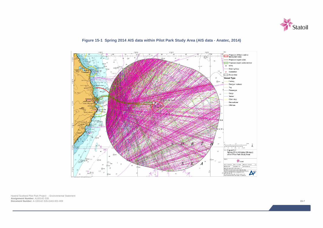
Figure 15-1 Spring 2014 AIS data within Pilot Park Study Area (AIS data - Anatec, 2014)
Hywind Scotland Pilot Park Project – Environmental Statement Assignment Number: A100142-S35 Document Number: A-100142-S35-EIAS-001-009 15-7
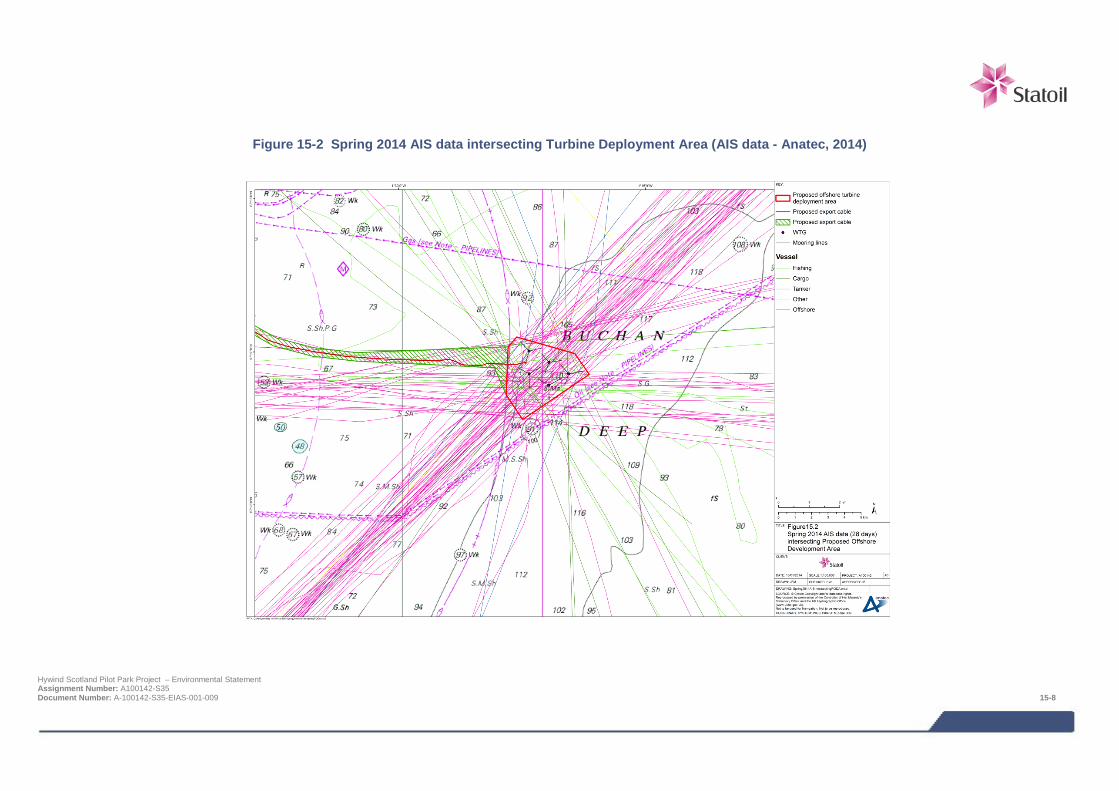
Figure 15-2 Spring 2014 AIS data intersecting Turbine Deployment Area (AIS data - Anatec, 2014)
Hywind Scotland Pilot Park Project – Environmental Statement Assignment Number: A100142-S35 Document Number: A-100142-S35-EIAS-001-009 15-8
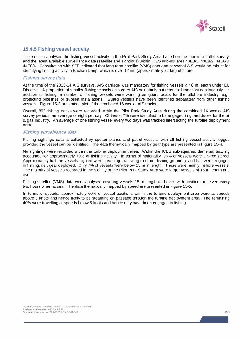
15.4.5 Fishing vessel activity This section analyses the fishing vessel activity in the Pilot Park Study Area based on the maritime traffic survey, and the latest available surveillance data (satellite and sightings) within ICES sub-squares 43E8/1, 43E8/2, 44E8/3, 44E8/4. Consultation with SFF indicated that long-term satellite (VMS) data and seasonal AIS would be robust for identifying fishing activity in Buchan Deep, which is over 12 nm (approximately 22 km) offshore.
Fishing survey data At the time of the 2013-14 AIS surveys, AIS carriage was mandatory for fishing vessels ≥ 18 m length under EU Directive. A proportion of smaller fishing vessels also carry AIS voluntarily but may not broadcast continuously. In addition to fishing, a number of fishing vessels were working as guard boats for the offshore industry, e.g., protecting pipelines or subsea installations. Guard vessels have been identified separately from other fishing vessels. Figure 15-3 presents a plot of the combined 16 weeks AIS tracks.
Overall, 892 fishing tracks were recorded within the Pilot Park Study Area during the combined 16 weeks AIS survey periods, an average of eight per day. Of these, 7% were identified to be engaged in guard duties for the oil & gas industry. An average of one fishing vessel every two days was tracked intersecting the turbine deployment area.
Fishing surveillance data Fishing sightings data is collected by spotter planes and patrol vessels, with all fishing vessel activity logged provided the vessel can be identified. The data thematically mapped by gear type are presented in Figure 15-4.
No sightings were recorded within the turbine deployment area. Within the ICES sub-squares, demersal trawling accounted for approximately 70% of fishing activity. In terms of nationality, 96% of vessels were UK-registered. Approximately half the vessels sighted were steaming (transiting to / from fishing grounds), and half were engaged in fishing, i.e., gear deployed. Only 7% of vessels were below 15 m in length. These were mainly inshore vessels. The majority of vessels recorded in the vicinity of the Pilot Park Study Area were larger vessels of 15 m length and over.
Fishing satellite (VMS) data were analysed covering vessels 15 m length and over, with positions received every two hours when at sea. The data thematically mapped by speed are presented in Figure 15-5.
In terms of speeds, approximately 60% of vessel positions within the turbine deployment area were at speeds above 5 knots and hence likely to be steaming on passage through the turbine deployment area. The remaining 40% were travelling at speeds below 5 knots and hence may have been engaged in fishing.
Hywind Scotland Pilot Park Project – Environmental Statement Assignment Number: A100142-S35 Document Number: A-100142-S35-EIAS-001-009 15-9
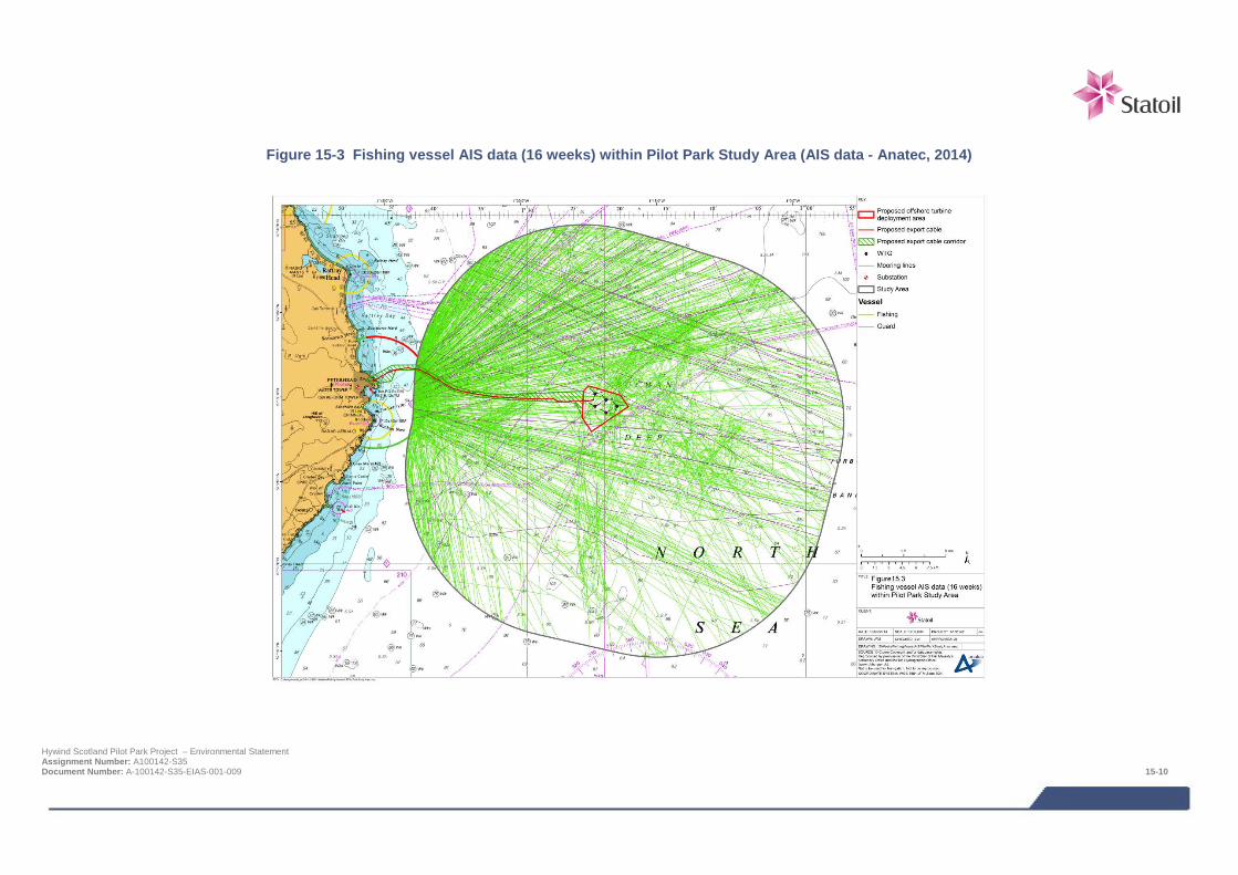
Figure 15-3 Fishing vessel AIS data (16 weeks) within Pilot Park Study Area (AIS data - Anatec, 2014)
Hywind Scotland Pilot Park Project – Environmental Statement Assignment Number: A100142-S35 Document Number: A-100142-S35-EIAS-001-009 15-10
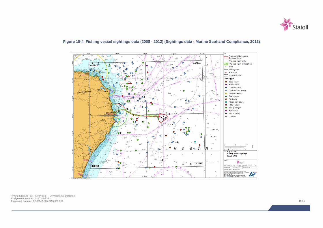
Figure 15-4 Fishing vessel sightings data (2008 - 2012) (Sightings data - Marine Scotland Compliance, 2013)
Hywind Scotland Pilot Park Project – Environmental Statement Assignment Number: A100142-S35 Document Number: A-100142-S35-EIAS-001-009 15-11
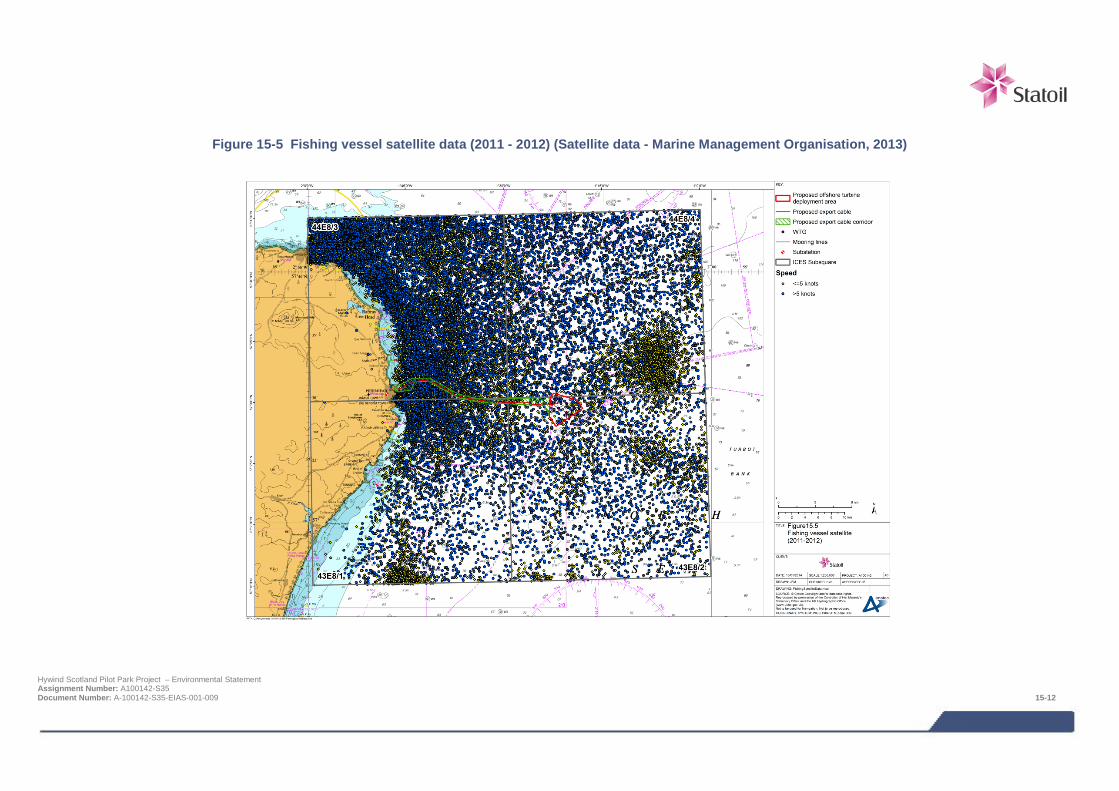
Figure 15-5 Fishing vessel satellite data (2011 - 2012) (Satellite data - Marine Management Organisation, 2013)
Hywind Scotland Pilot Park Project – Environmental Statement Assignment Number: A100142-S35 Document Number: A-100142-S35-EIAS-001-009 15-12
15.4.6 Recreational vessel activity Recreational vessel activity in the vicinity of the Pilot Park Study Area is reviewed in this section, based on available desktop information and consultation with the RYA and Cruising Association.
RYA coastal atlas data The latest RYA coastal atlas data indicates that the turbine deployment area does not fall within any racing or sailing areas. No cruising routes cross the turbine deployment area, as they all stay much closer to the shore. The nearest indicative route is 11 nm (approximately 20 km) to the west. In terms of facilities, the closest club is the Peterhead Sailing Club, 12 nm (approximately 22 km) west of the turbine deployment area, and the closest marina is Peterhead Bay marina.
Recreational survey data A total of 12 recreational vessels were tracked on AIS during the summer 2013 and spring 2014 survey periods within the Pilot Park Study Area. No recreational vessels were recorded in the autumn 2013 or winter 2014 surveys. Figure 15-6 presents the recreational vessel tracks recorded during the surveys, within the Pilot Park Study Area. It is noted again that AIS carriage is not mandatory for recreational vessels although some carry it voluntarily, especially larger vessels on longer routes. However, it is expected that AIS represents only a small minority of recreational traffic.
Two recreational vessels, both small sailing vessels, were tracked transiting through the turbine deployment area. Noa Noa II transited east on 7 August 2013, and Altair Af Skaftoe travelled east-south east on 19 August 2013.
Peterhead Bay marina Consultation with the marina manager from Peterhead Bay marina confirmed that there are several visits per year from Scandinavia which could pass in the vicinity of Buchan Deep, but the vast majority of their visitors are coming from other directions, e.g., north or south. Official records were not available but it is estimated that in the order of 20-30 yachts per year are transiting to or from a direction that could take them past Buchan Deep.
15.4.7 Export cable route review Maritime traffic data, for the most recent 28 days of data from spring 2014, were analysed within the Export Cable Study Area. Vessels working on behalf of the Project were excluded.
Vessel analysis A plot of the AIS tracks, thematically mapped by AIS type as broadcast on AIS, is presented in Figure 15-7.
An average of 64 unique vessels per day were recorded within the Export Cable Study Area, with the most common vessel types identified as cargo (33%), ‘other’ (28%) (mainly oil & gas), and fishing (27%).
Fishing survey data An average of 16 unique fishing vessels per day were recorded within the Export Cable Study Area over the spring 2014 period. The majority of these appeared to be transiting vessels steaming on passage to or from Peterhead. However, it should be noted that AIS at the time was only mandatory for vessels ≥ 18 m in length and above which will not fully represent fishing activity in inshore waters by smaller vessels. The AIS shows some evidence of fishing between the 6 and 12 nm (approximately 11-22 km) fisheries limits (where only UK-based vessels and foreign vessels with historic fishing rights are permitted to fish).
Chapter 14 (commercial fisheries) presents more information on fishing activity in the Export Cable Study Area. The sightings data (all sizes) and satellite data (15 m length and above) for ICES Rectangles 43E8 and 44E8 encompasses the Export Cable Study Area. As with AIS, the satellite data does not represent smaller fishing vessels, covering only vessels over 15 m in length, with the majority travelling at steaming speed. The sightings data includes all vessels and indicates a mixture of fishing and steaming activity but is based on a limited number of overflights.
Hywind Scotland Pilot Park Project – Environmental Statement Assignment Number: A100142-S35 Document Number: A-100142-S35-EIAS-001-009 15-13
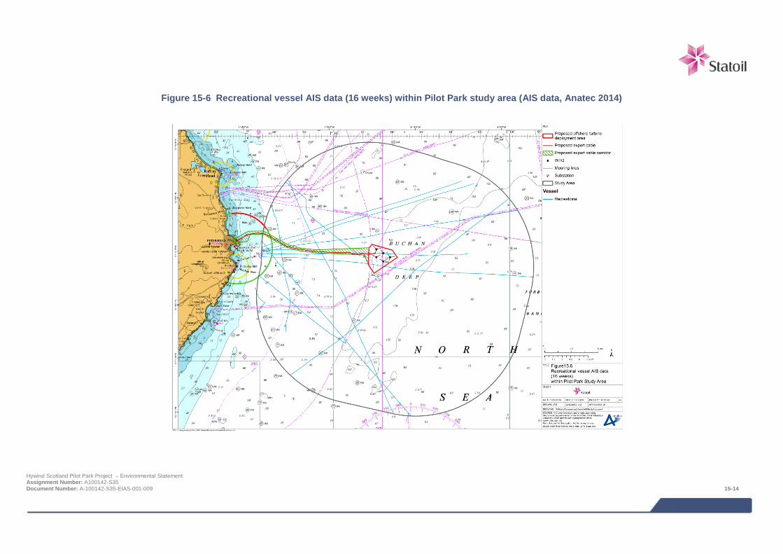
Figure 15-6 Recreational vessel AIS data (16 weeks) within Pilot Park study area (AIS data, Anatec 2014)
Hywind Scotland Pilot Park Project – Environmental Statement Assignment Number: A100142-S35 Document Number: A-100142-S35-EIAS-001-009 15-14
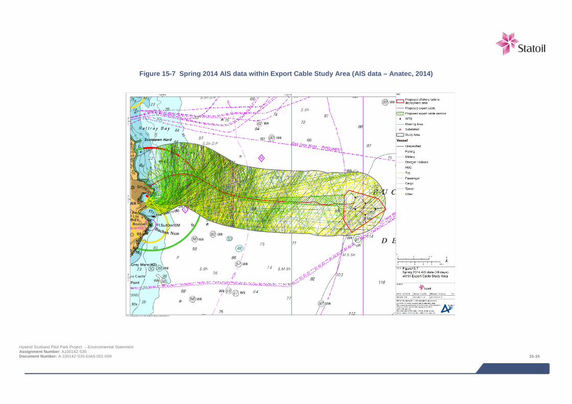
Figure 15-7 Spring 2014 AIS data within Export Cable Study Area (AIS data – Anatec, 2014)
Hywind Scotland Pilot Park Project – Environmental Statement Assignment Number: A100142-S35 Document Number: A-100142-S35-EIAS-001-009 15-15
15.4.8 Maritime incidents Maritime incidents recorded by the MAIB (2003-2012) and RNLI (2001-2010) in the vicinity of the Project have been analysed (some were recorded by both sources). These were the latest available from the respective organisations.
A total of nine MAIB incidents were recorded within the Pilot Park Study Area, corresponding to an average of just under one per year. No incidents were noted within the turbine deployment area. The closest incident was recorded approximately 6.6 nm north-west of the turbine deployment area and involved a machinery failure on board a fishing trawler. The incident took place on 24 August 2007 while the vessel was on passage.
Nine RNLI incidents were recorded in the Pilot Park Study Area, averaging one per year. All incidents were responded to by the Peterhead RNLI station with one exception, which was responded to by Fraserburgh RNLI. This was the most northerly incident recorded within the Pilot Park Study Area. No incidents were recorded within the turbine deployment area, with one incident noted within the AfL area. This incident involved a large fishing vessel which suffered a machinery failure on 22 June 2001 and was responded to by Peterhead lifeboat.
15.4.9 Emergency response overview A review of the assets in the area of the Project identified that the closest search and rescue (SAR) helicopter base is located at Lossiemouth, operated by the Royal Air Force (RAF), approximately 64 nm (approximately 118 km) west-north west of the turbine deployment area. This base has Sea King helicopters with a top speed of 125 knots and a radius of action up to 250 nm (approximately 463 km), which is well within the range of the Project area. Under new helicopter search and rescue plans, however, this base is due to close and be replaced with a new service by summer 2017. The Bristow Group will take over helicopter search and rescue operations, with a contract running for ten years from 2015. The closest helicopter base will be located at Inverness. Inverness is located approximately 86 nm (approximately 159 km) west of the boundary of the turbine deployment area. This base will operate two Sikorsky S-92s which have a maximum cruise speed of 151 knots and range of 539 nm (approximately 1,000 km). This will cover the Project.
The RNLI maintains a fleet of over 340 lifeboats of various types at 236 stations around the coast of the UK and Ireland. The nearest RNLI stations in the vicinity of the Project, and the ones that responded to the historical incidents in the vicinity, are at Peterhead and Fraserburgh. At each of these stations crew and lifeboats are available on a 24 hour basis throughout the year. The time for an all-weather lifeboat to reach the Project area would be approximately 45 minutes.
15.4.10 Data gaps and uncertainties It is recognised that small vessel activity is variable and dependent on numerous factors including weather conditions, tides, seasonal factors, and in the case of fishing vessels, quotas and the migration of fish species. This variability has been taken into account as far as possible by using long-term desk-based research and consultation with local stakeholders to inform an up-to-date baseline.
It is also recognised that vessel activity in the Buchan Deep area could vary over the life of the Project. There are varying factors that could influence the nature and extent of fishing, recreational and oil & gas activity. For example, almost two-thirds of the traffic in the AIS surveys was oil & gas industry related. There is an expectation that numerous fields in the North Sea will be decommissioned in the next few decades which could temporarily increase traffic during the decommissioning work but then lead to a long-term reduction in support vessel traffic. A 10% net increase in all traffic was assumed over the life of the Project to account for this uncertainty.
15.5 Impact assessment
15.5.1 Overview Following establishment of baseline conditions of the Project and surrounding areas, and an understanding of the Project activities it is possible to assess the potential impacts from the Project. The range of impacts that has been considered is based on impacts identified during the navigational PHA and any further potential impacts that have
Hywind Scotland Pilot Park Project – Environmental Statement Assignment Number: A100142-S35 Document Number: A-100142-S35-EIAS-001-009 15-16
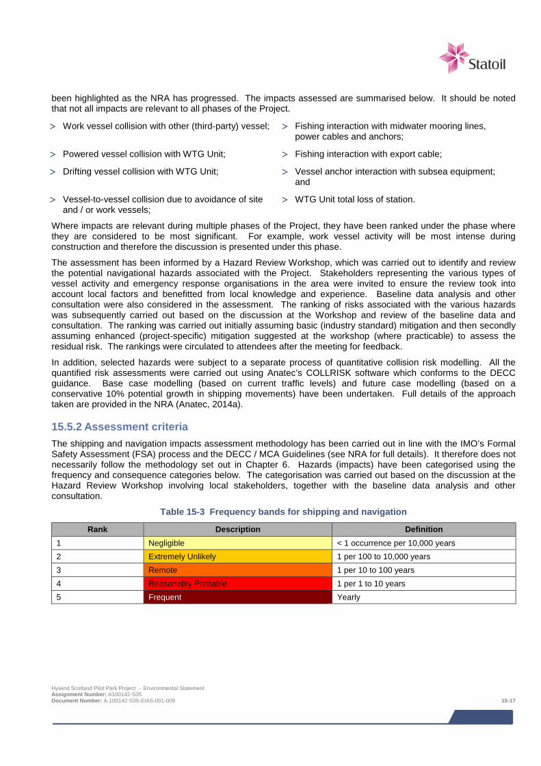
been highlighted as the NRA has progressed. The impacts assessed are summarised below. It should be noted that not all impacts are relevant to all phases of the Project.
> Work vessel collision with other (third-party) vessel; > Fishing interaction with midwater mooring lines, power cables and anchors;
> Powered vessel collision with WTG Unit; > Fishing interaction with export cable;
> Drifting vessel collision with WTG Unit; > Vessel anchor interaction with subsea equipment; and
> Vessel-to-vessel collision due to avoidance of site and / or work vessels;
> WTG Unit total loss of station.
Where impacts are relevant during multiple phases of the Project, they have been ranked under the phase where they are considered to be most significant. For example, work vessel activity will be most intense during construction and therefore the discussion is presented under this phase.
The assessment has been informed by a Hazard Review Workshop, which was carried out to identify and review the potential navigational hazards associated with the Project. Stakeholders representing the various types of vessel activity and emergency response organisations in the area were invited to ensure the review took into account local factors and benefitted from local knowledge and experience. Baseline data analysis and other consultation were also considered in the assessment. The ranking of risks associated with the various hazards was subsequently carried out based on the discussion at the Workshop and review of the baseline data and consultation. The ranking was carried out initially assuming basic (industry standard) mitigation and then secondly assuming enhanced (project-specific) mitigation suggested at the workshop (where practicable) to assess the residual risk. The rankings were circulated to attendees after the meeting for feedback.
In addition, selected hazards were subject to a separate process of quantitative collision risk modelling. All the quantified risk assessments were carried out using Anatec’s COLLRISK software which conforms to the DECC guidance. Base case modelling (based on current traffic levels) and future case modelling (based on a conservative 10% potential growth in shipping movements) have been undertaken. Full details of the approach taken are provided in the NRA (Anatec, 2014a).
15.5.2 Assessment criteria The shipping and navigation impacts assessment methodology has been carried out in line with the IMO’s Formal Safety Assessment (FSA) process and the DECC / MCA Guidelines (see NRA for full details). It therefore does not necessarily follow the methodology set out in Chapter 6. Hazards (impacts) have been categorised using the frequency and consequence categories below. The categorisation was carried out based on the discussion at the Hazard Review Workshop involving local stakeholders, together with the baseline data analysis and other consultation.
Table 15-3 Frequency bands for shipping and navigation
Rank Description Definition 1 Negligible < 1 occurrence per 10,000 years 2 Extremely Unlikely 1 per 100 to 10,000 years 3 Remote 1 per 10 to 100 years 4 Reasonably Probable 1 per 1 to 10 years 5 Frequent Yearly
Hywind Scotland Pilot Park Project – Environmental Statement Assignment Number: A100142-S35 Document Number: A-100142-S35-EIAS-001-009 15-17

Table 15-4 Consequence bands for shipping and navigation
Rank Description Definition People Environment Property Business
1 Negligible No injury <£10k <£10k <10k 2 Minor Slight injury(s) Tier 1: Local
assistance required £10k-£100k £10k-£100k
3 Moderate Multiple moderate or Single serious injury
Tier 2: Limited external assistance required
£100k-£1M £100k-£1M Local publicity
4 Serious Serious injury or single fatality
Tier 2: Regional assistance required
£1M-£10M £1M-£10M National publicity
5 Major More than 1 fatality Tier 3: National assistance required
>£10M >£10M International
publicity
The consequence scores are averaged (for a single impact there could be a range of consequences) and multiplied by the frequency to obtain an overall ranking (or score) which determined the hazard’s position within the risk matrix shown below in Table 15-5.
Table 15-5 Risk matrix for shipping and navigation
5 4 3 2 1
Con
sequ
ence
5 High High High Moderate Moderate 4 High High Moderate Moderate Low 3 High Moderate Moderate Low Low 2 Moderate Moderate Low Low Low 1 Moderate Low Low Low Low
Where: Broadly Acceptable
Region (Low Risk)
Generally regarded as acceptable and adequately controlled. None the less the law still requires further risk reductions if it is reasonably practicable. However, at these levels the opportunity for further risk reduction is much more limited.
Tolerable Region (Moderate Risk)
Typical of the risks from activities which people are prepared to tolerate to secure benefits. There is however an expectation that such risks are properly assessed, appropriate control measures are in place, residual risks are as low as is reasonably practicable (ALARP) and that risks are periodically reviewed to see if further controls are appropriate.
Unacceptable Region (High Risk)
Generally regarded as unacceptable whatever the level of benefit associated with the activity.
15.5.3 Design Envelope This assessment considers the Project parameters which are predicted to result in the greatest impact. This approach ensures that impacts of a greater adverse significance would not arise should any other development scenario be taken forward in the final scheme design. With regards to the shipping and navigation assessment these are:
> Total turbine deployment area of 4.4 nm2 (15 km2);
> The COLLRISK modelling that has been used to inform the risk assessment is based on 6 WTG Units with 15 m diameter turbines and a maximum spacing of 1,370 m;
> 3 anchors per WTG Unit with mooring lines a maximum of 1,200 m in length;
Frequency
Hywind Scotland Pilot Park Project – Environmental Statement Assignment Number: A100142-S35 Document Number: A-100142-S35-EIAS-001-009 15-18
> Anchors and mooring system and potentially inter array cables present on the seabed for up to 18 months prior to turbine installation;
> 5 inter array cables, each a maximum of 3 km in length and touching down on the seabed 250 m from the turbine;
> Export cable 35 km long, which with protection (as required but not expected to be more than 2 km) may occupy a 6 m wide corridor on the seabed; and
> Operational period of 20 years.
The impacts from potential alternative development options are addressed in Section 15.8.
15.5.4 Mitigation measures Standard industry practice which will be applied to minimise navigational impacts is presented below. These have been assumed as embedded mitigation in the initial rankings of each impact. Additional project specific (enhanced) mitigation measures identified during consultation and at the Hazard Review workshop is then presented specific to each impact and used to estimate the residual risk.
STANDARD INDUSTRY PRACTICE
The impact assessment assumes standard industry practice will be applied to minimise the impacts. Standard mitigation measures are presented below.
> Adverse Weather: There will be adverse weather working policies and procedures for periods of construction and maintenance;
> Cable Protection: Appropriate cable protection to be installed along the cable route, informed by a BPI study which will be submitted to the MCA prior to installation;
> Chart Marking: The Project will be depicted on Admiralty Charts produced by the UKHO;
> Emergency Response Cooperation Plan: An ERCoP will be prepared for the Project following the template provided by the MCA in MGN 371. This will be submitted to the MCA for approval prior to construction;
> Equipment and Training for Site Personnel: Site personnel will be suitably equipped and trained for work offshore including in fire fighting, first aid and offshore survival;
> Fisheries Liaison: The FLOWW (Fishing Liaison with Offshore Wind and Wet Renewables Group) best practice guidance for fisheries liaison will be followed, including the establishment of a fishing liaison plan. An FLO has been appointed for the Project and will continue in this role during construction.
> Guard Vessel during Construction: When there are work vessel(s) on site, one vessel will be nominated as a guard vessel with appropriate procedures for traffic monitoring and collision risk management;
> Inspection and Maintenance: There will be appropriate inspection and maintenance procedures in place for all elements of the Project;
> Kingfisher Charts and FishSAFE: Details of the Project will be included in updated Kingfisher fishermen’s awareness charts (paper and electronic) and on FishSAFE electronic safety devices which give and audible alarm when vessels are close to hazards;
> Maritime Safety Information (MSI) Broadcasts: HM Coastguard will be informed of work at the site to allow them to issue MSI broadcasts as appropriate;
> Marking and Lighting: The Project will be marked and lit according to NLB requirements;
> Minimum Air Clearance: There will be a minimum air clearance of 22 m from sea level in all tidal states due to the floating nature of the turbines. This is designed to help minimise the risk of rotor blade / yacht mast
Hywind Scotland Pilot Park Project – Environmental Statement Assignment Number: A100142-S35 Document Number: A-100142-S35-EIAS-001-009 15-19

STANDARD INDUSTRY PRACTICE
interaction in accordance with MCA and RYA guidance;
> Notice to Mariners: Notices to Mariners will be issued prior to the start of construction and where necessary during work at the site;
> Safety Management System (SMS): Statoil will have in place an SMS throughout the project; and
> Safety Zones during Construction: Safety zones of 500 m radii will be applied to protect working vessels on the site during construction work.
15.6 Impacts during construction and installation Work vessels will be required during construction and installation of the Project. One anchor handling vessel and one light subsea construction vessel will carry out anchor and mooring installation, one installation vessel and one crew transfer vessel will be required for the inter-array cable installation, and for the hook-up and mooring of WTG Units one light subsea construction vessel and two ocean going tugs will be used. Installation of the export cable will require one cable lay vessel and one trenching vessel. It is expected that installation of mooring lines and anchor chains will be carried out in 3Q 2016, followed by installation of the WTG Units in 2Q 2017.
15.6.1 Work vessel collision with other vessel The work vessels will have the potential to collide with other transiting vessels whilst operating at the Project or en route to / from the Project, during the construction and installation phase.
It is noted that a guard vessel will be used to mitigate risks and increase awareness of the Project when vessels are working at the Project site. In addition to this, construction safety zones are industry-standard to protect installation vessels and their personnel.
Assessment of risk
The risk was ranked based on discussion at the Hazard Review Workshop, review of baseline data, and stakeholder consultation. Consequence will depend on the vessels involved but will range from minor damage to sinking of vessels with potential fatalities, with the most likely outcome being ranker as serious. The frequency of a collision is considered to be remote due to standard mitigation measures that will be in place, including safety zones and Notices to Mariners. This gives an overall risk of moderate (tolerable) as summarised in the table below.
Consequence Frequency Risk
Serious Remote Moderate (tolerable)
MITIGATION
The above assessment assumes standard industry practice will be applied to minimise this impact. Additional project specific (enhanced) mitigation measures identified during consultation and at the Hazard Review workshop are presented below.
> AIS Traffic Monitoring: Live 24/7 shipping traffic monitoring on AIS by Statoil Marine in Bergen during the operational phase with procedures to follow in the event a vessel is identified to be heading on a potential collision course;
> AIS on Work Vessels: All vessels working at the site will broadcast on AIS;
> Lessons Learned: Experience and lessons learned from incidents, accidents and near-misses at other marine renewables projects will be taken into account. Statoil is a member of the G9 Offshore Wind Health and Safety Association, and is proactive in sharing incident data and lessons learned within the offshore wind industry. The
Hywind Scotland Pilot Park Project – Environmental Statement Assignment Number: A100142-S35 Document Number: A-100142-S35-EIAS-001-009 15-20
MITIGATION
Project will also benefit from experience gained at the Hywind Demo Project in Norway which has been operational since 2009;
> Passage Plans for Construction Vessels: Passage plans will be developed for vessels routing between the Project and the onshore base;
> Sailing Directions and Almanacs: Details of the Project will be circulated to relevant organisations for inclusion in updated Sailing Directions and Almanacs;
> Safety Zones during Construction: Additional safety zones of up to 500 m radii will be applied for around each WTG Unit once installed until the construction phase at site has ended; and
> Targeted Circulation of Information: Information on the Project will be circulated directly to local ports, ship operators (including the Marine Safety Forum representing oil industry vessels), fishermen and recreational organisations (including relevant international organisations).
Assessment of residual risk
Based on applying the enhanced, project-specific mitigation measures, in addition to following standard industry practice, the consequences remain serious but the frequency is considered to reduce to extremely unlikely with an overall residual risk of moderate (tolerable) as summarised in the table below.
Consequence Frequency Risk
Serious Extremely Unlikely Moderate (tolerable)
15.7 Impacts during operation and maintenance Impacts of the Project have been considered for the operation and maintenance phase of the Project.
15.7.1 Powered vessel collision with WTG Unit During operation, there will be a risk of vessels colliding with the WTG Units. This impact was considered for three scenarios:
> Merchant vessel (e.g. oil & gas);
> Fishing vessel; and
> Recreational vessel.
Based on the merchant ship routeing identified for the area and the anticipated change in routeing due to the Project, and assuming effective mitigation in terms of making mariners aware of the site through Notices to Mariners, charts, lights and markings, etc., the frequency of an errant ship under power deviating from its route to the extent that it comes into proximity with the Project site is not considered to be a likely event. From consultation with the shipping industry, including the Marine Safety Forum which represents offshore industry vessel operators, it is assumed that merchant ships will not attempt to navigate between turbines due to the restricted sea room. The main risk of powered collision with a wind farm structure is from human error on the bridge of the ship, e.g., watchkeeper asleep, absent or distracted. The proximity to port should mean mariners are attentive to their vessel’s position more than in open seas, although it was noted at the Hazard Review Workshop that outbound vessels leaving port will be beginning to stand down on the bridge, and the crew may be distracted by other tasks, such as paperwork. Inbound to Peterhead, there are likely to be “more eyes” on the bridge as the vessel prepares for arrival. This will vary for other destination / departure ports such as Aberdeen.
Fishing vessels when steaming on passage are also expected to avoid the turbine array but when fishing in the area they could be operating in proximity to turbines, if considered safe to do so by the Master.
Hywind Scotland Pilot Park Project – Environmental Statement Assignment Number: A100142-S35 Document Number: A-100142-S35-EIAS-001-009 15-21
Recreational collisions are considered to be low risk on the basis that the collision frequency will be low, due to the low levels of recreational traffic observed during the surveys and the consultation feedback which indicated low numbers of yachts crossing the North Sea in the vicinity of Buchan Deep.
Assessment of risk – merchant shipping
The merchant vessel powered collision risk was ranked based on discussion at the Hazard Review Workshop, review of baseline data and stakeholder consultation. The consequence to people is considered moderate as these vessels are of a reasonable size to withstand a collision and some of the energy will be absorbed by the floating WTG Unit moving on its moorings. The frequency is considered remote when taking into account standard mitigation such as marking and lighting and chart depiction, resulting in an overall risk of moderate (tolerable) as summarised in the table below.
Consequence Frequency Risk
Moderate Remote Moderate (tolerable)
Assessment of risk – fishing vessels
The fishing vessel powered collision risk was ranked based on discussion at the Hazard Review Workshop, review of baseline data and stakeholder consultation. The expected consequences to people were considered to be serious due to these being smaller vessels and hence more likely to suffer damage. The frequency is considered remote based on the levels of fishing vessels on passage in the area and standard mitigation such as marking and lighting. The overall risk was ranked as moderate (tolerable) as summarised in the table below.
Consequence Frequency Risk
Serious Remote Moderate (tolerable)
Assessment of risk – recreational vessels
The recreational vessel collision risk was ranked based on discussion at the Hazard Review Workshop, review of baseline data and stakeholder consultation. The consequence to people is considered serious as these tend to be smaller vessels and hence more likely to suffer damage. Frequency is considered extremely unlikely due to the low number of yachts crossing the North Sea in the vicinity of Buchan Deep, and the minimum air clearance of 22 m as standard. The overall risk is ranked as moderate (tolerable) as summarised in the table below.
Consequence Frequency Risk
Serious Extremely Unlikely Moderate (tolerable)
MITIGATION
The above assessment assumes standard industry practice will be applied to minimise this impact. Additional project specific (enhanced) mitigation measures identified during consultation and at the Hazard Review workshop are presented below.
> AIS Traffic Monitoring: Live 24/7 shipping traffic monitoring on AIS by Statoil Marine in Bergen during the operational phase with procedures to follow in the event a vessel is identified to be heading on a potential collision course;
> Lessons Learned: Experience and lessons learned from incidents, accidents and near-misses at other marine renewables projects will be taken into account. Statoil is a member of the G9 Offshore Wind Health and Safety Association, and is proactive in sharing incident data and lessons learned within the offshore wind industry. The Project will also benefit from experience gained at the Hywind Demo Project in Norway which has been operational since 2009;
> Operational Safety Zones: Further consultation will be carried out with the MCA and DECC regarding safety Hywind Scotland Pilot Park Project – Environmental Statement Assignment Number: A100142-S35 Document Number: A-100142-S35-EIAS-001-009 15-22
MITIGATION
zones, or other methods of protecting against collision and fishing gear interaction during the operational phase. The agreed strategy, whether mandatory or advisory, will be implemented and notified to UKHO for suitable depiction on Admiralty charts;
> Sailing Directions and Almanacs: Details of the Project will be circulated to relevant organisations for inclusion in updated Sailing Directions and Almanacs; and
> Targeted Circulation of Information: Information on the Project will be circulated directly to local ports, ship operators (including the Marine Safety Forum representing oil industry vessels), fishermen and recreational organisations (including relevant international organisations).
Assessment of residual risk - merchant vessels
Based on applying the enhanced, project-specific mitigation measures, in addition to standard industry practice, the consequence to people of a merchant vessel collision remains ranked as moderate but the frequency reduces to extremely unlikely giving an overall residual risk of moderate (tolerable) as summarised in the table below.
Consequence Frequency Risk
Moderate Extremely Unlikely Low (broadly acceptable)
Assessment of residual risk - fishing vessels
Based on applying the enhanced, project-specific mitigation measures, in addition to standard industry practice, the expected consequence to people of a fishing vessel collision remains serious but the frequency reduces to extremely unlikely with an overall residual risk of moderate (tolerable) as summarised in the table below.
Consequence Frequency Risk
Serious Extremely Unlikely Moderate (tolerable)
Assessment of residual risk – recreational vessels
Although the enhanced measures will assist in mitigating the risk to recreational vessels, the consequence to people and frequency remain within the same bands as before. Therefore, the residual risk remains moderate (tolerable) as summarised in the table below.
Consequence Frequency Risk
Serious Extremely Unlikely Moderate (tolerable)
In addition to the semi-quantitative risk rankings following the Hazard Review workshop, the frequency of a powered merchant vessel collision with a WTG Unit was also separately assessed using the COLLRISK software. This was based on the ship routeing identified for the area and the anticipated change in routeing due to the Project, and assuming effective mitigation in terms of Notices to Mariners, charts, lighting and marking, etc. The model predicted a frequency of a powered merchant vessel collision with a WTG Unit to be approximately 1 in 8,580 years (base case traffic) and 1 in 7,800 years (future case traffic). Both are within the ‘Extremely Unlikely’ frequency category, which is aligned with the ranking from the workshop based on enhanced mitigation.
The frequency of a fishing vessel collision with a WTG Unit was also assessed using the COLLRISK software, which is calibrated using fishing vessel activity data along with offshore installation operating experience in the UK and the experience of collisions between fishing vessels and offshore installations. The frequency of a fishing vessel collision with a WTG Unit was predicted to be approximately 1 in 3,400 years (base case) and 1 in 3,090 years (future case). This aligns with the frequency ranking of extremely unlikely.
There is a lack of robust data to model recreational vessel collisions therefore only the risk matrix approach was applied.
Hywind Scotland Pilot Park Project – Environmental Statement Assignment Number: A100142-S35 Document Number: A-100142-S35-EIAS-001-009 15-23
15.7.2 Drifting vessel collision with WTG Unit The risk of a vessel losing power and drifting into a WTG Unit was ranked following the workshop using the risk matrix approach. This took into account the extent of vessel activity in the area and the historical incidents that have been recorded in the area. It was noted that there is good (though variable) prospect of towing vessel availability in this area to recover a drifting vessel due to oil & gas activity, and also good holding ground for anchoring vessels.
Assessment of risk
The drifting collision risk was ranked based on discussion at the Hazard Review Workshop, review of baseline data and stakeholder consultation. The consequence is considered serious as there is a chance of injury or fatality even though these tend to be lower energy impacts. The frequency is considered extremely unlikely as historically there has not been a drifting collision with an offshore installation on the UKCS, despite several blackouts occurring each year. Vessels have either been able to repair themselves on time or receive external assistance. The overall risk is moderate (tolerable) as summarised in the table below.
Consequence Frequency Risk
Serious Extremely Unlikely Moderate (tolerable)
MITIGATION
The above assessment assumes standard industry practice will be applied to minimise this impact. Additional project specific (enhanced) mitigation measures identified during consultation and at the Hazard Review workshop are presented below.
> AIS Traffic Monitoring: Live 24/7 shipping traffic monitoring on AIS by Statoil Marine in Bergen during the operational phase with procedures to follow in the event a vessel is identified to be heading on a potential collision course.;
> Lessons Learned: Experience and lessons learned from incidents, accidents and near-misses at other marine renewables projects will be taken into account. Statoil is a member of the G9 Offshore Wind Health and Safety Association, and is proactive in sharing incident data and lessons learned within the offshore wind industry. The Project will also benefit from experience gained at the Hywind Demo Project in Norway which has been operational since 2009; and
> Towing Vessel Availability: The Project is located in an area of above average towing vessel activity due to the oil and gas industry bases at Peterhead and Aberdeen. This will be given consideration within the ERCoP to ensure benefit is obtained in the event of a drifting scenario.
Assessment of residual risk
Based on applying the enhanced, project-specific mitigation measures, in addition to standard industry practice, the expected consequence is considered to reduce to moderate due to there being increased potential for a timely response and despatch of a suitable towing vessel to recover the drifting vessel. The frequency remains extremely unlikely with an overall residual risk of low (broadly acceptable) as summarised in the table below.
Consequence Frequency Risk
Moderate Extremely Unlikely Low (broadly acceptable)
Separate to the risk ranking based on the workshop, Anatec’s COLLRISK software was used to model the drifting vessel risk. This is based on the premise that propulsion on a vessel must fail before a vessel will drift. The model takes account of the type and size of the vessel, number of engines and average time to repair in different conditions. Different weather and tidal states are simulated and the worst case result selected.
Hywind Scotland Pilot Park Project – Environmental Statement Assignment Number: A100142-S35 Document Number: A-100142-S35-EIAS-001-009 15-24

The exposure times for a drifting scenario are based on the ship-hours spent in proximity to the Project, estimated based on the traffic levels and speeds. The exposure is divided by vessel type and size to ensure these factors, which are based on analysis of historical accident data have been shown to influence accident rates, are taken into account within the modelling.
Using this information, the annual drifting ship collision frequency with the WTG Units was estimated to be approximately 1 in 106,700 years (base case) and 1 in 97,020 years (future case). This is an order of magnitude lower than the frequency ranking based on the workshop.
15.7.3 Vessel-to-vessel collision due to avoidance of site or work vessels Vessels will have to re-route around the WTG Units which will alter the rate of encounters and therefore potential vessel-to-vessel collision. The risk of a vessel-to-vessel collision was ranked following the workshop.
Assessment of risk
The vessel-to-vessel collision risk was ranked based on discussion at the Hazard Review Workshop, review of baseline data and stakeholder consultation. The consequence will depend on the vessels involved but on average is expected to be serious. The frequency is considered remote due to the WTG Units occupying a small footprint area and therefore not causing a great deal of displacement of existing routes. The overall risk is moderate (tolerable) as summarised in the table below.
Consequence Frequency Risk
Serious Remote Moderate (tolerable)
MITIGATION
The above assessment assumes standard industry practice will be applied to minimise this impact. Additional project specific (enhanced) mitigation measures identified during consultation and at the Hazard Review workshop are presented below.
> AIS Traffic Monitoring: Live 24/7 shipping traffic monitoring on AIS by Statoil Marine in Bergen during the operational phase with procedures to follow in the event a vessel is identified to be heading on a potential collision course;
> Lessons Learned: Experience and lessons learned from incidents, accidents and near-misses at other marine renewables projects will be taken into account. Statoil is a member of the G9 Offshore Wind Health and Safety Association, and is proactive in sharing incident data and lessons learned within the offshore wind industry. The Project will also benefit from experience gained at the Hywind Demo Project in Norway which has been operational since 2009;
> Sailing Directions and Almanacs: Details of the Project will be circulated to relevant organisations for inclusion in updated Sailing Directions and Almanacs; and
> Targeted Circulation of Information: Information on the Project will be circulated directly to local ports, ship operators (including the Marine Safety Forum representing oil industry vessels), fishermen and recreational organisations (including relevant international organisations)
Assessment of residual risk
Based on applying the enhanced, project-specific mitigation measures, in addition to standard industry practice, the expected consequence remains serious but the frequency is reduced to extremely unlikely resulting in an overall residual risk of moderate (tolerable) as summarised in the table below.
Consequence Frequency Risk
Serious Extremely Unlikely Moderate (tolerable)
Hywind Scotland Pilot Park Project – Environmental Statement Assignment Number: A100142-S35 Document Number: A-100142-S35-EIAS-001-009 15-25
Separate to the risk ranking based on the workshop, Anatec’s COLLRISK software was used to model the risk of vessel-to-vessel collisions. Firstly, an assessment of actual vessel-to-vessel encounters was carried out by replaying at high-speed one week of AIS survey data from spring 2014 and identifying where vessels passed within one nautical mile, which was assumed as a nominal encounter distance. This information was used to help calibrate Anatec’s COLLRISK model and estimate the vessel-to-vessel collision risk before and after the wind farm is installed.
The assessment of actual vessel-to-vessel encounters, analysed within a 5 nm (approximately 9 km) radius of the turbine deployment area, showed a total of 34 encounters, an average of four to five per day. The highest number of encounters involved ‘other’ vessels (36%), followed by cargo vessels (31%) and fishing vessels (28%). When further classifying these vessels, it was noted that 66% of vessels were offshore industry vessels. None of the encounters were considered as hazardous as there is ample sea room in the area.
Anatec’s COLLRISK model was used to estimate the background (without the Project) and predicted (with the Project) collision risk within the Pilot Park Study Area. The background vessel-to-vessel collision risk level is in the order of 1 major collision in 51.2 years. It is emphasised the model is calibrated based on major incident data at sea which allows for benchmarking, but does not necessarily consider all incidents, such as minor bumps in port. When the WTG Units are installed, it is assumed vessels will re-route around the array. Based on vessel-to-vessel collision risk modelling of the revised routes, the overall collision risk was estimated to be 1 in 50.8 years. This is a small increase in collision frequency over the background risk, estimated at 1 additional collision in 6,500 years. The change in frequency estimated by COLLRISK is therefore aligned with the ‘Extremely Unlikely’ ranking based on the workshop approach assuming enhanced mitigation.
15.7.4 Fishing interaction with midwater mooring lines, power cables and anchors Fishing vessel gear will have the potential to interact with midwater mooring lines, power cables and anchors at the Project.
Statoil have a preference to exclude fishing from the area of this subsea infrastructure for safety reasons (to protect mariners as well as the Project). Discussions have been held with the MCA and DECC regarding the potential for safety zones, an Area to be Avoided (ATBA) or a fishing prohibition area to achieve this. There is a mechanism to apply to DECC for up to 500 m operational safety zones but this is not standard, and the mooring lines and anchors will radiate beyond this distance from the turbines.
Fishermen and industry representatives at the workshop felt they could manage the risks themselves provided they were supplied with accurate information on the positions of the hazards on the seabed. There are effective means for circulating this information, such as FishSAFE, which is assumed as standard mitigation.
Given the potential consequences, which in the worst-case could be capsize of the vessel, personnel in the water and fatalities, others at the workshop were of the opinion that making it a ‘fishing-free’ area was essential. Assessment of risk
The risk of fishing interaction was ranked based on discussion at the Hazard Review Workshop, review of baseline data and stakeholder consultation. Consequences could include capsize of the fishing vessel, personnel in the water and fatalities, with the average consequence expected to be serious. Frequency is considered reasonably probable with an overall risk of high (unacceptable) as summarised in the table below.
Consequence Frequency Risk
Serious Reasonably Probable High (unacceptable)
MITIGATION
The above assessment assumes standard industry practice will be applied to minimise this impact. Additional project specific (enhanced) mitigation measures identified during consultation and at the Hazard Review workshop are presented below. Hywind Scotland Pilot Park Project – Environmental Statement Assignment Number: A100142-S35 Document Number: A-100142-S35-EIAS-001-009 15-26
MITIGATION
> AIS Traffic Monitoring: Live 24/7 shipping traffic monitoring on AIS by Statoil Marine in Bergen during the operational phase with procedures to follow in the event a vessel is identified to be heading on a potential collision course;
> Lessons Learned: Experience and lessons learned from incidents, accidents and near-misses at other marine renewables projects will be taken into account. Statoil is a member of the G9 Offshore Wind Health and Safety Association, and is proactive in sharing incident data and lessons learned within the offshore wind industry. The Project will also benefit from experience gained at the Hywind Demo Project in Norway which has been operational since 2009;
> Operational Safety Zones: Further consultation will be carried out with the MCA and DECC regarding safety zones, or other methods of protecting against collision and fishing gear interaction during the operational phase. The agreed strategy, whether mandatory or advisory, will be implemented and notified to UKHO for suitable depiction on Admiralty charts;
> Sailing Directions and Almanacs: Details of the Project will be circulated to relevant organisations for inclusion in updated Sailing Directions and Almanacs; and
> Targeted Circulation of Information: Information on the Project will be circulated directly to local ports, ship operators (including the Marine Safety Forum representing oil industry vessels), fishermen and recreational organisations (including relevant international organisations).
Assessment of residual risk
Based on applying the enhanced, project-specific mitigation measures, in addition to standard industry practice, the expected consequence remains serious but the frequency is considered to reduce to remote due to the planned measures (either advisory or compulsory) to be implemented to minimise interaction. The overall residual risk is moderate (tolerable) as summarised in the table below.
Consequence Frequency Risk
Serious Remote Moderate (tolerable)
15.7.5 Fishing interaction with export cable Fishing vessel gear will have the potential to interact with the export cable running from the turbine deployment area to the landfall point along the coast at Peterhead. The export cable will be installed prior to the WTG Units.
Once established, appropriate mitigation is needed to ensure the export cable is suitably protected against the type of fishing (i.e., scallop and clam dredging) in the area. This may include trenching, burial and the use of rock dumping, depending on the nature of the seabed. This will be informed by a BPI study as part of the industry standard mitigation.
Hywind Scotland Pilot Park Project – Environmental Statement Assignment Number: A100142-S35 Document Number: A-100142-S35-EIAS-001-009 15-27

Assessment of risk
The risk of fishing interaction with the export cable was ranked based on discussion at the Hazard Review Workshop, review of baseline data and stakeholder consultation.
Potential consequences include loss or damage to fishing gear, risk of vessel capsize and associated fatalities. Other consequences are damage to the Project itself, including severe damage and possible breakage of the export cable, which may occur when a large fishing vessel’s gear snags on the cable. Breaking of the cable will impact on business and may require total replacement of the cable. The average consequence is ranked as serious. The frequency is considered remote based on the standard cable protection measures. The overall risk is moderate (tolerable) as summarised in the table below.
Consequence Frequency Risk
Serious Remote Moderate (tolerable)
MITIGATION
The above assessment assumes standard industry practice will be applied to minimise this impact. Additional project specific (enhanced) mitigation measures identified during consultation and at the Hazard Review workshop are presented below.
> AIS Traffic Monitoring: Live 24/7 shipping traffic monitoring on AIS by Statoil Marine in Bergen during the operational phase with procedures to follow in the event a vessel is identified to be heading on a potential collision course;
> Lessons Learned: Experience and lessons learned from incidents, accidents and near-misses at other marine renewables projects will be taken into account. Statoil is a member of the G9 Offshore Wind Health and Safety Association, and is proactive in sharing incident data and lessons learned within the offshore wind industry. The Project will also benefit from experience gained at the Hywind Demo Project in Norway which has been operational since 2009;
> Sailing Directions and Almanacs: Details of the Project will be circulated to relevant organisations for inclusion in updated Sailing Directions and Almanacs; and
> Targeted Circulation of Information: Information on the Project will be circulated directly to local ports, ship operators (including the Marine Safety Forum representing oil industry vessels), fishermen and recreational organisations (including relevant international organisations).
Assessment of residual risk
Based on applying the enhanced, project-specific mitigation measures, including targeted circulation of information to fishermen who use the area, the consequence remains serious, the frequency reduces to extremely unlikely with an overall residual risk of moderate (tolerable) as summarised in the table below.
Consequence Frequency Risk
Serious Extremely Unlikely Moderate (tolerable)
15.7.6 Vessel anchor interaction with subsea equipment Third-party vessel anchors have the potential to interact with midwater mooring lines and power cables connected to the WTG Units and anchors at the turbine deployment area and with the export cable running from the turbine deployment area to the landfall point along the coast at Peterhead.
Anchoring is very unlikely in the deeper water of Buchan Deep, although it could take place by a transiting vessel in an emergency. Even then the vessel master should confirm there are no subsea obstructions prior to anchoring.
Hywind Scotland Pilot Park Project – Environmental Statement Assignment Number: A100142-S35 Document Number: A-100142-S35-EIAS-001-009 15-28

The Peterhead Harbour Master confirmed that vessels do not routinely anchor east of Peterhead, but there is occasional anchoring off the coast to the north and south. There have been no recent reports of dragged anchor incidents in the area so this is an uncommon event.
Assessment of risk
The risk of anchoring interaction was ranked based on discussion at the Hazard Review Workshop, review of baseline data and stakeholder consultation. Consequences are more likely to be financial than safety-related, with an expected average outcome of moderate. Frequency is ranked as remote due to there being very little anchoring occurring in the vicinity of the Project. The overall risk is moderate (tolerable) as summarised in the table below.
Consequence Frequency Risk
Moderate Remote Moderate (tolerable)
MITIGATION
The above assessment assumes standard industry practice will be applied to minimise this impact. Additional project specific (enhanced) mitigation measures identified during consultation and at the Hazard Review workshop are presented below.
> AIS Traffic Monitoring: Live 24/7 shipping traffic monitoring on AIS by Statoil Marine in Bergen during the operational phase with procedures to follow in the event a vessel is identified to be heading on a potential collision course;
> Lessons Learned: Experience and lessons learned from incidents, accidents and near-misses at other marine renewables projects will be taken into account. Statoil is a member of the G9 Offshore Wind Health and Safety Association, and is proactive in sharing incident data and lessons learned within the offshore wind industry. The Project will also benefit from experience gained at the Hywind Demo Project in Norway which has been operational since 2009;
> Operational Safety Zones: Further consultation will be carried out with the MCA and DECC regarding safety zones, or other methods of protecting against collision and fishing gear interaction during the operational phase. The agreed strategy, whether mandatory or advisory, will be implemented and notified to UKHO for suitable depiction on Admiralty charts;
> Sailing Directions and Almanacs: Details of the Project will be circulated to relevant organisations for inclusion in updated Sailing Directions and Almanacs;
> Targeted Circulation of Information: Information on the Project will be circulated directly to local ports, ship operators (including the Marine Safety Forum representing oil industry vessels), fishermen and recreational organisations (including relevant international organisations); and
> Towing Vessel Availability: The Project is located in an area of above average towing vessel activity due to the oil and gas industry bases at Peterhead and Aberdeen. This will be given consideration within the ERCoP to ensure benefit is obtained in the event of a drifting scenario.
Assessment of residual risk
Based on applying the enhanced, project-specific mitigation measures, in addition to standard industry practice, the expected consequence remains moderate but the frequency is considered to reduce to extremely unlikely with an overall residual risk of low (broadly acceptable) as summarised in the table below.
Consequence Frequency Risk
Moderate Extremely Unlikely Low (broadly acceptable)
Hywind Scotland Pilot Park Project – Environmental Statement Assignment Number: A100142-S35 Document Number: A-100142-S35-EIAS-001-009 15-29
15.7.7 WTG Unit total loss of station This impact is that the mooring system fails causing the WTG Unit to completely lose station and drift, causing a navigational hazard. The mooring system is being designed to DNV codes as a redundant system. The system is designed to be stable in the event of single line failure leaving two of the three lines in place (in fact there will be less tension as load will be shared by two anchors). This would lead to an additional excursion of the WTG unit from its central location of approx. 600 m – 700 m. If this were to happen, an automatic alarm would sound and an emergency response would be initiated, e.g., vessel sent from Peterhead to investigate.
Assessment of risk
The risk of loss of station was ranked based on discussion at the Hazard Review Workshop, review of baseline data and stakeholder consultation. Consequences to people are expected to be very low, but they could potentially be high for the environment, as well as damage to property and business if the WTG Unit drifted towards the Forties pipeline (unlikely given the prevailing wind direction). The frequency is extremely unlikely based on the redundancy in the system and Statoil’s North Sea experience. The overall risk is ranked as low (broadly acceptable) as summarised in the table below.
Consequence Frequency Risk
Minor Extremely Unlikely Low (broadly acceptable)
MITIGATION
The above assessment assumes standard industry practice will be applied to minimise this impact. Additional project specific (enhanced) mitigation measures identified during consultation and at the Hazard Review workshop are presented below.
> Excursion Alarm: The positions of the WTG Units will be monitored with an automatic emergency alarm to notify excursion from the central location;
> Lessons Learned: Experience and lessons learned from incidents, accidents and near-misses at other marine renewables projects will be taken into account. Statoil is a member of the G9 Offshore Wind Health and Safety Association, and is proactive in sharing incident data and lessons learned within the offshore wind industry. The Project will also benefit from experience gained at the Hywind Demo Project in Norway which has been operational since 2009;
> Mooring System Integrity: Speciality study carried out to examine in detail the risk of mooring system failure leading to impairment of the BP Forties Pipeline; and
> Third Party Verification of Mooring System: Design and third party verification of the mooring system will be carried out by a competent organisation.
> Towing Vessel Availability: The Project is located in an area of above average towing vessel activity due to the oil and gas industry bases at Peterhead and Aberdeen. This will be given consideration within the ERCOP to ensure benefit is obtained in the event of a drifting scenario.
Assessment of residual risk
Based on applying the enhanced, project-specific mitigation measures, in addition to standard industry practice, the expected consequence remains minor, the frequency is considered to reduce to negligible with an overall residual risk of low (broadly acceptable) as summarised in the table below.
Consequence Frequency Risk
Minor Negligible Low (broadly acceptable)
Hywind Scotland Pilot Park Project – Environmental Statement Assignment Number: A100142-S35 Document Number: A-100142-S35-EIAS-001-009 15-30

15.8 Potential variances in environmental impacts (based on Design Envelope) Consideration of the maximum potential impact has been undertaken throughout the NRA. The indicative WTG Unit layout used for this assessment is considered to be a realistic worst case as Statoil have indicated five turbines will be the maximum at Buchan Deep. Any minor changes to the layout are unlikely to be significant and would not materially alter the outcome of the assessment. It should also be noted that it is most likely that the inter array cables will be installed after the WTG Units therefore there will be less seabed infrastructure hazard during the construction phase of the Project.
15.9 Cumulative and in-combination impacts HSL has in consultation with Marine Scotland and Aberdeenshire Council identified a list of other projects which together with the Project may result in potential cumulative or in-combination impacts. The list of these projects including details of their status at the time of the EIA and a map showing their location is provided in Chapter 6; Table 6-3 and Figure 6-1 respectively.
Cumulative impacts are impacts on shipping and navigation caused by planned and consented offshore wind farms. In-combination impacts are impacts on shipping and navigation as a result of offshore wind farms (and their associated activities) combined with impacts from other marine activities or users of the sea.
As all the projects identified are in excess of 10 nm from the Hywind Project it is anticipated that these will not have a cumulative or in-combination impact on shipping and navigation when considered with the Project. It is noted that a proportion of the vessels passing the Project also pass close to the EOWFL site in Aberdeen Bay. However, this site layout has been designed to avoid any significant impact on the main shipping routes to and from Aberdeen Harbour.
Future traffic considered in the collision risk modelling takes into account potential increases in traffic over the life of the development due to changes such as the Aberdeen Harbour Development, North Sea oil and gas decommissioning and temporary traffic for subsea cable installation and maintenance. It is recognised that making such future forecasts is uncertain therefore a conservative 10% increase was modelled. It is not considered that there will be any further in-combination impact on shipping and navigation when considered with the Project.
15.10 Monitoring Vessel traffic will be monitored on AIS during construction and operation of the WTG Units to assess the effect the Project has on passing traffic.
15.11 References Anatec (2013a). Shipping and Navigation Preliminary Hazard Analysis – Hywind Scotland Pilot Park Project. Ref: A3207-ST-PHA-2.
Anatec (2013b). Manual radar vessel traffic survey data.
Anatec (2014a). Navigation Risk Assessment – Hywind Scotland Pilot Park Project. Ref: A3207-ST-NRA-2.
Anatec (2014b). Maritime traffic survey data.
BMAPA (2014). Aggregates dredger transit routes GIS data.
DECC (2011a). Applying for safety zones around offshore renewable energy installations. Guidance notes.
DECC (2011b). Standard Marking Schedule for Offshore Installations.
DECC (2005). Methodology for Assessing the Marine Navigational Safety Risks of Offshore Wind farms. London: DECC. DTI/Pub 8145/0.5k/12/05/NP. URN 05/1948.
IALA (2013). 0-139 the Marking of Man-Made Offshore Structures. Edition 2. Saint Germain en Laye, France: Internal Association of Marine Aids to Navigation and Light House Authorities.
IMO (2002). Guidelines for Formal Safety Assessment (FSA) for use in the IMO rule Making Process. London: International Maritime Organisation (IMO). Hywind Scotland Pilot Park Project – Environmental Statement Assignment Number: A100142-S35 Document Number: A-100142-S35-EIAS-001-009 15-31

MAIB (2013). Maritime incident GIS data.
Marine Scotland Compliance (2013). Fishing sightings GIS data.
MCA (2008a). Marine Guidance Notice 371, Offshore Renewable Energy Installations (OREIs) - Guidance on UK Navigational Practice, Safety and Emergency Response Issues. London: MCA.
MCA (2008b). Marine Guidance Notice 372, Guidance to Mariners Operating in the Vicinity of UK OREIs. London: MCA.
DfT (2006). MEHRAs GIS data.
MMO (2013). Satellite fishing VMS GIS data.
Natural Research (Projects) Ltd. (2014). Vessel data from ESAS surveys.
RNLI (2011). Lifeboat response GIS data.
RYA (2010). UK Coastal Atlas of Recreational Boating and GIS data.
RYA (2013). The RYA’s Position on Offshore Renewable Energy Developments. Southampton: RYA.
TCE (2014a). Offshore renewables GIS data.
TCE (2014b). Aggregate dredging licence and active areas GIS data.
UKHO (2009). Admiralty Sailing Directions – North Sea (West) Pilot, NP 54. Taunton: The United Kingdom Hydrographic Office.
UKHO (2013). Buckie to Arbroath. Admiralty Chart. Taunton: The United Kingdom Hydrographic Office.
UKHO (2014a). Approaches to Peterhead. Admiralty Chart. Taunton: The United Kingdom Hydrographic Office.
UKHO (2014b). Approaches to Aberdeen. Admiralty Chart. Taunton: The United Kingdom Hydrographic Office.
Hywind Scotland Pilot Park Project – Environmental Statement Assignment Number: A100142-S35 Document Number: A-100142-S35-EIAS-001-009 15-32
16 MARINE HISTORIC ENVIRONMENT No marine cultural heritage sites with statutory designations, no aircraft, no palaeo environmental or submerged landscape deposits have been identified that will be affected by the Project. No shipwreck sites with confirmed positions will be affected by the Project.
Potential impacts are possible on two anthropogenic geophysical anomalies along the cable route and another five in the proposed offshore turbine deployment area. The identity of these anomalies is uncertain and there is therefore potential for these to be remains from wrecks of high or moderate importance known to have sunk in the general area with unverified locations, or to be previously unrecorded cultural heritage.
Management and mitigation strategies have been identified, especially avoidance of geophysical anomalies of uncertain importance and high or medium potential (or subsequent phased mitigation if avoidance is not possible), and the implementation of a reporting protocol for the accidental discovery of cultural remains in line with The Crown Estate (2014) Protocol for Archaeological Discoveries: Offshore Renewables Projects, prepared by Wessex Archaeology Ltd for The Crown Estate http://www.thecrownestate.co.uk/media/148964/ei-protocol-for-archaeological-discoveries-offshore-renewables-projects.pdf.
The implementation of the management and strategies will avoid or reduce potential impacts so that the impacts of the Project on marine cultural heritage will be insignificant.
16.1 Introduction This chapter assesses the impacts of the Project on the marine historic environment.
A number of different specialists have contributed to this assessment:
> MMT - seabed survey data (multi-beam echo sounder (MBES), side scan sonar (SSS), Magnetometer and sub-bottom Profiler (SBP)) obtained by survey company MMT on behalf of HSL and report (Marine Survey Report: Hywind Offshore Windfarm; Statoil Doc. No. ST13828-Hywind OW);
> GEO – geotechnical data, namely cone penetration testing (CPT) and borehole (BH) results (Hywind Scotland Soil Investigation 2014, North Sea. British Sector Anchoring of Floating Wind Turbines and Cable Route. Unpublished Preliminary Client Report 3.0, Rev.01, 02/05/2014 GEO);
> ORCA Marine and SULA Diving – baseline description, including desk-based assessment (DBA), analysis of MMT’s seabed survey data and of GEO’s soil sample and geotechnical data (Hywind Marine Historic Environment Baseline Report ORCA Marine & SULA Diving 2014); and
> ORCA Marine - Impact assessment and ES chapter write up.
Table 16-1 provides a list of the supporting studies which relate to the marine historic environment impact assessment. Supporting studies are provided on the accompanying CD.
Table 16-1 Supporting studies
Details of study
Hywind Marine Historic Environment Baseline Report (ORCA Marine and SULA Diving, 2014)
Marine Survey Report: Hywind Offshore Windfarm; Statoil Doc. No. ST13828-Hywind OW (MMT, 2013)
Hywind Scotland Soil Investigation 2014, North Sea. British Sector Anchoring of Floating Wind Turbines and Cable Route. Unpublished Preliminary Client Report 3.0, Rev.01, 02/05/2014 (GEO, 2014)
Unexploded Ordnance Desk Based Study with Risk Assessment. Ordtek Ltd. Statoil Doc. No. C178-OTK-S-CA-0002 (Ordtek, 2014)
The baseline study identified marine historic environment assets in the export cable corridor and the proposed Agreement for Lease area (AfL) (ORCA Marine, 2014). Since the baseline study was conducted, the Project area has been refined and an AfL awarded from the Crown Estate (TCE). The focus of this marine historic environment
Hywind Scotland Pilot Park Project – Environmental Statement Assignment Number: A100142-S35 Document Number: A-100142-S35-EIAS-001-010 16-1

assessment is to assess potential impacts on marine cultural heritage along the proposed export cable route and in the proposed offshore turbine deployment area (Figure 16-1, Figure 16-2, Figure 16-3).
The following areas are referred to in this impact assessment:
> Project area (see Figure 1.2 in the Introduction), which comprises:
o Proposed offshore turbine deployment area; and
o Export cable corridor and landfall.
> Study area – the area over which baseline data has been collected. This is slightly larger than the Project area in order to capture data on shipwrecks that were lost in the vicinity, but the precise location of which is unknown and therefore have the potential to be in the Project area.
> Survey area – these are the areas that have been surveyed by HSL during geophysical and geotechnical surveys. These areas are larger than the Project area as the surveys were undertaken prior to (and used to inform) the selection of the Project area.
Hywind Scotland Pilot Park Project – Environmental Statement Assignment Number: A100142-S35 Document Number: A-100142-S35-EIAS-001-010 16-2
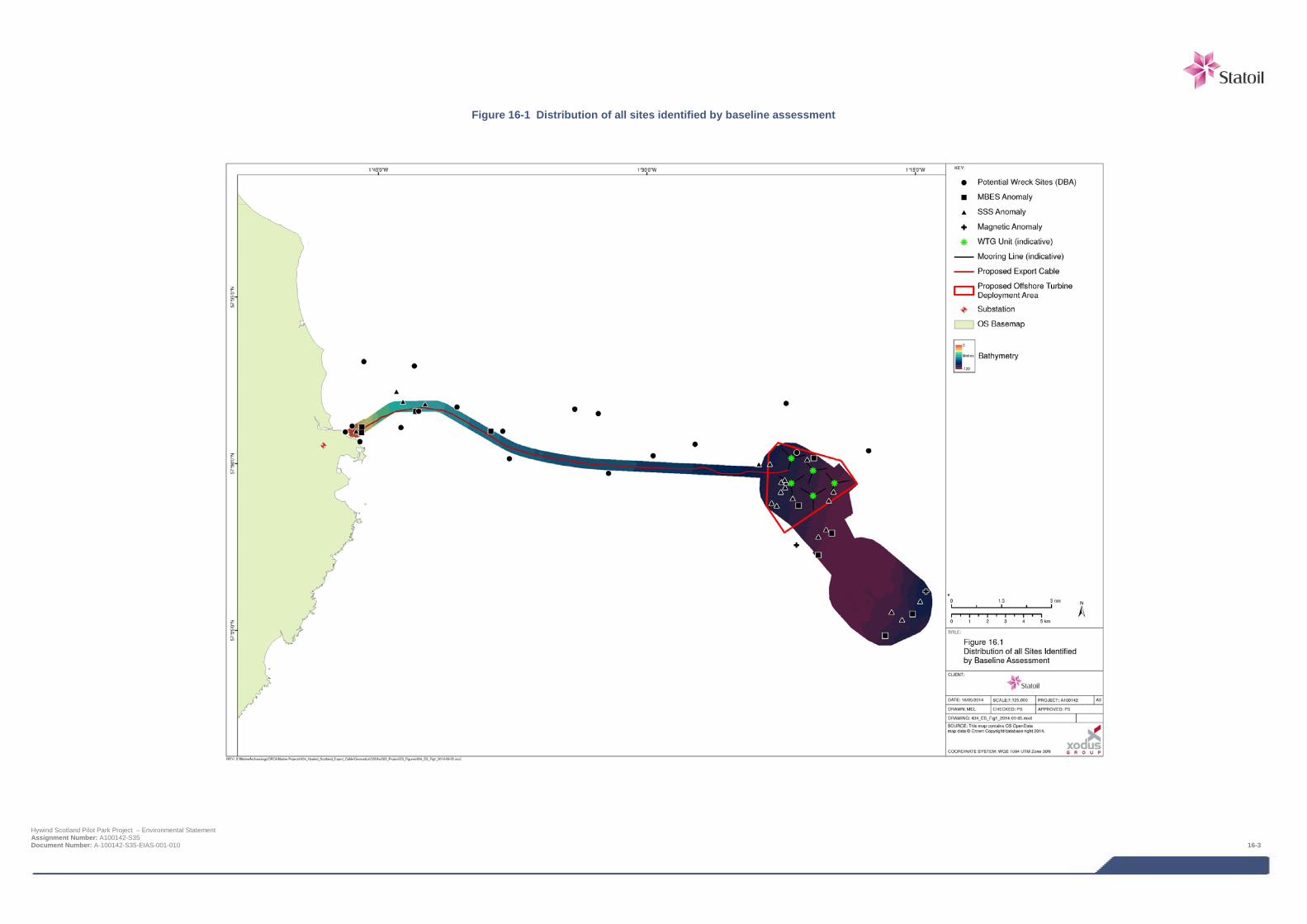
Figure 16-1 Distribution of all sites identified by baseline assessment
Hywind Scotland Pilot Park Project – Environmental Statement Assignment Number: A100142-S35 Document Number: A-100142-S35-EIAS-001-010 16-3
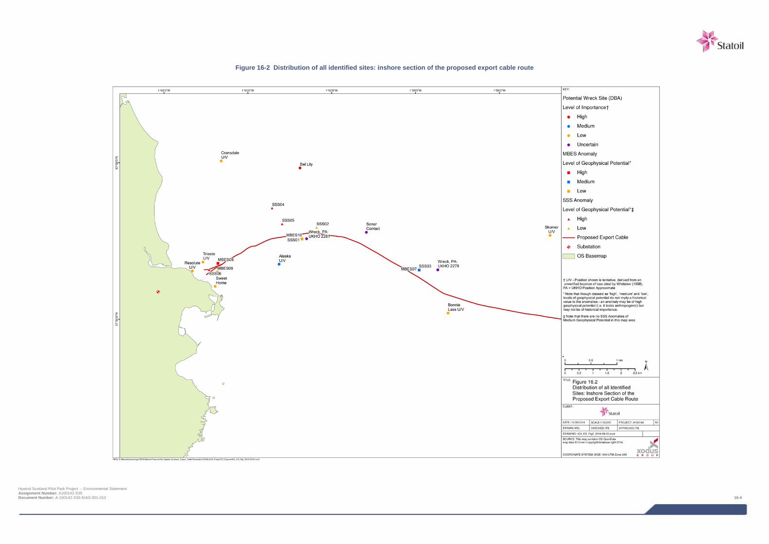
Figure 16-2 Distribution of all identified sites: inshore section of the proposed export cable route
Hywind Scotland Pilot Park Project – Environmental Statement Assignment Number: A100142-S35 Document Number: A-100142-S35-EIAS-001-010 16-4
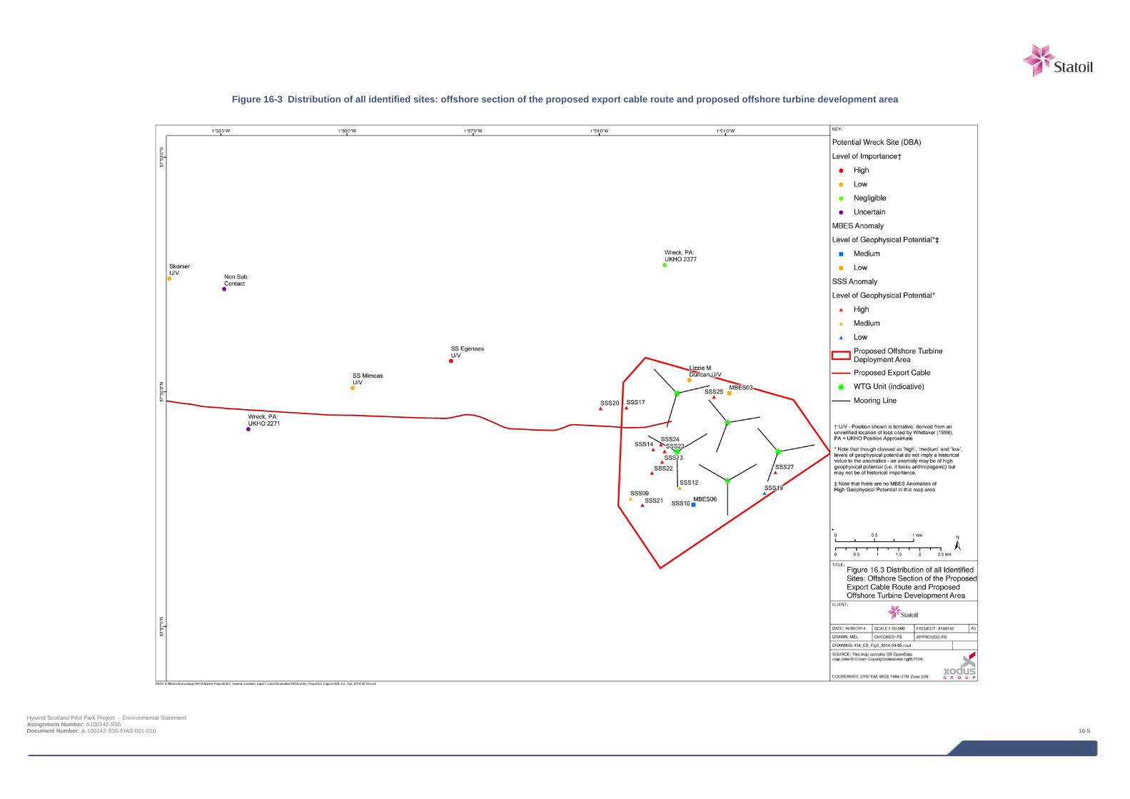
Figure 16-3 Distribution of all identified sites: offshore section of the proposed export cable route and proposed offshore turbine development area
Hywind Scotland Pilot Park Project – Environmental Statement Assignment Number: A100142-S35 Document Number: A-100142-S35-EIAS-001-010 16-5

16.2 Legislative context and relevant guidance There are international legally binding conventions, EU Directives, UK and Scottish legislation, policy frameworks and guidance to consider in relation to the historic environments, which are outlined below.
16.3 International / EU legislation and policy The United Nations Convention of the Law of the Sea (UNCLOS) was ratified by the UK in 1997. Article 303 stipulates that ‘states have the duty to protect objects of an archaeological and historical nature found at sea and shall co-operate for this purpose’.
The European Convention on the Protection of the Archaeological Heritage (revised), known as the Valletta Convention, was ratified by the UK government in 2000. This contains provisions for the protection of archaeological heritage both under water and on land, preferably in situ, but with provisions for appropriate recording and recovery if disturbance is unavoidable.
Various EU EIA Directives have been incorporated into UK and Scottish legislation, all of which include the requirement to address impacts on the historic environment (see Chapter 2).
16.3.1 UK legislation and policy The Merchant Shipping Act 1995 requires that all recovered wreck landed in the UK is reported to the Receiver of Wreck, whether recovered from within or outside UK waters and even if the finder is the owner.
The Protection of Wrecks Act 1973 is in two sections. Section 1 provides protection for designated wrecks which are deemed to be important by virtue of their historical, archaeological or artistic value. Approximately 56 wrecks around the coast of the UK have been designated under this section of the Act. Each wreck has an exclusion zone around it and it is an offence to tamper with, damage or remove any objects or part of the vessel or to carry out any diving or salvage operation within this exclusion zone. In Scotland the administration of this Act and associated licenses is the responsibility of Historic Scotland. This section of the Act is in the process of being repealed and replaced by Historic Marine Protected Areas (MPAs) as defined in the Marine (Scotland) Act 2010.
The Protection of Military Remains Act 1986 has the principal concern to protect the sanctity of vessels and aircraft that are military maritime graves. The purpose of this safeguard is not primarily archaeological, but the MoD liaises closely with Department for Culture, Media and Sport and Historic Scotland in the process of site designation. Any aircraft lost while in military service is automatically protected under this Act, which is of concern if aircraft are discovered during the proposed works.
The Marine and Coastal Access Act 2009 confirms that in assessing effects on or licensing activities in the marine environment, the marine environment includes any features of archaeological or historic interest.
Her Majesty's Government UK Marine Policy Statement (2011) states heritage assets should be conserved through marine planning in a manner appropriate and proportionate to their significance. Many heritage assets with archaeological interest are not currently designated as scheduled monuments or protected wreck sites but are demonstrably of equivalent significance. The absence of designation for such assets does not necessarily indicate lower significance and the marine planning authority should consider them subject to the same policy principles as designated heritage assets (including those outlined) based on information and advice from the relevant Regulator and advisors.
16.3.2 Scottish legislation and policy The Marine (Scotland) Act 2010, Section 73, concerns Historic Marine Protected Areas (MPA). The Act defines a marine historic asset as any of the following:
> a vessel, vehicle or aircraft (or a part of a vessel, vehicle or aircraft);
> the remains of a vessel, vehicle or aircraft (or a part of such remains);
> an object contained in, or formerly contained in, a vessel, vehicle or aircraft; Hywind Scotland Pilot Park Project – Environmental Statement Assignment Number: A100142-S35 Document Number: A-100142-S35-EIAS-001-010 16-6
> a building or other structure (or a part of a building or structure);
> a cave or excavation; and
> a deposit or artefact (whether or not formerly part of a cargo of a ship) or any other thing which evidences, or groups of things which evidence, previous human activity.
Scottish Historic Environment Policy (SHEP) 2011 outlines principles that underpin the designation of Historic MPAs, including that marine historic assets from all parts of the Scottish marine protection area are equally worthy of study and consideration for statutory protection.
Scottish Planning Policy (SPP) 2014 states that authorities should protect archaeological sites and monuments (and a range of other historic assets) as an important, finite and non-renewable resource and preserve them in situ wherever possible. Where preservation in-situ is not possible authorities should ensure that developers undertake appropriate excavation, recording, analysis, publication and archiving before and/or during development. If archaeological discoveries are made during any development, they should be reported to the authority to enable discussion on appropriate measures.
The Scottish Government’s Planning Advice Note (PAN 2/2011): Planning and Archaeology states for all developments, the principles (in SPP 2014 and SHEP 2011) of preservation in situ, or mitigation where necessary apply equally to sites on land or underwater.
Historic Scotland’s Operational Policy Paper HP6 (1999): Conserving the Underwater Heritage, outlines Historic Scotland’s interests in the areas of development control, protection, management, training, archaeological fieldwork and research concerning underwater archaeology. Much of this is superseded by later legislation and policy reviewed above.
Planning Scotland’s Seas: Scotland’s National Marine Plan is currently in consultation draft format. It recognises that there are environmental and economic effects along with spatial constraints caused by the existence of marine cultural heritage. As well as the designated marine heritage assets there are likely to be a number of undesignated sites of demonstrably equivalent significance, which are yet to be fully recorded or await discovery. It is recommended that Historic Marine Planning Partnerships and licensing authorities should seek to identify significant historic environment resources at the earliest stages of the planning or development process and preserve them in situ wherever feasible. Where this is not possible licensing authorities should require developers to archaeologically record the asset before it is lost.
16.3.3 Codes of practice, professional guidance and standards In addition to the above legislation and policy the following codes of practice, professional guidance and standards are directly relevant to the assessment of impacts on the marine historic environment:
> The Joint Nautical Archaeology Policy Committee and Crown Estate’s (2006) Maritime Cultural Heritage & Seabed Development: JNAPC Code of Practice;
> Wessex Archaeology Ltd (January 2007) Historic Environment Guidance for the Offshore Renewable Energy Sector, commissioned by COWRIE Ltd (project reference ARCH-11-05);
> Oxford Archaeology & George Lambrick Archaeology and Heritage (2008) Guidance for Assessment of Cumulative Impacts in the Historic Environment Offshore Renewable Energy, commissioned by COWRIE Ltd (project reference CIARCH-11-2006);
> Gribble, J and Leather, S for EMU Ltd. (2011) Offshore Geotechnical Investigations and Historic Environment Analysis: Guidance for the Renewable Energy Sector, commissioned by COWRIE Ltd (project reference GEOARCH-09);
> English Heritage (2013) Marine Geophysics Data Acquisition, Processing and Interpretation: Guidance Notes;
> The Crown Estate (2014) Protocol for Archaeological Discoveries: Offshore Renewables Projects, Wessex Archaeology Ltd for The Crown Estate;
Hywind Scotland Pilot Park Project – Environmental Statement Assignment Number: A100142-S35 Document Number: A-100142-S35-EIAS-001-010 16-7
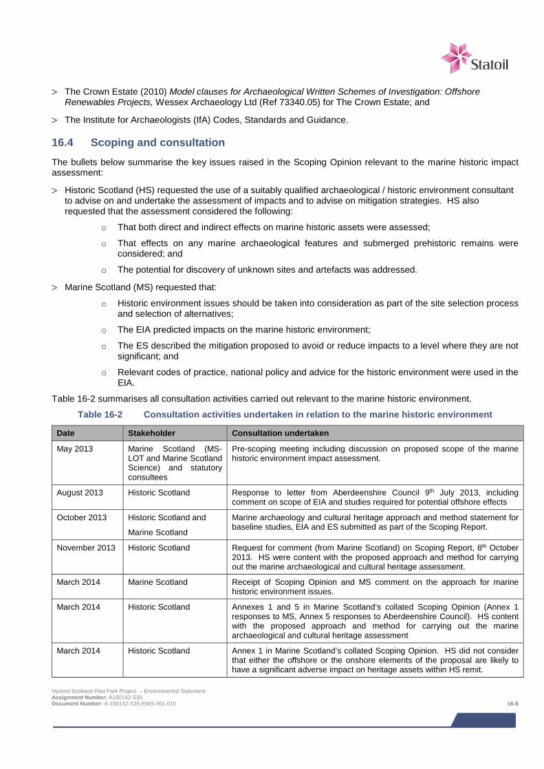
> The Crown Estate (2010) Model clauses for Archaeological Written Schemes of Investigation: Offshore
Renewables Projects, Wessex Archaeology Ltd (Ref 73340.05) for The Crown Estate; and
> The Institute for Archaeologists (IfA) Codes, Standards and Guidance.
16.4 Scoping and consultation The bullets below summarise the key issues raised in the Scoping Opinion relevant to the marine historic impact assessment:
> Historic Scotland (HS) requested the use of a suitably qualified archaeological / historic environment consultant to advise on and undertake the assessment of impacts and to advise on mitigation strategies. HS also requested that the assessment considered the following:
o That both direct and indirect effects on marine historic assets were assessed;
o That effects on any marine archaeological features and submerged prehistoric remains were considered; and
o The potential for discovery of unknown sites and artefacts was addressed.
> Marine Scotland (MS) requested that:
o Historic environment issues should be taken into consideration as part of the site selection process and selection of alternatives;
o The EIA predicted impacts on the marine historic environment;
o The ES described the mitigation proposed to avoid or reduce impacts to a level where they are not significant; and
o Relevant codes of practice, national policy and advice for the historic environment were used in the EIA.
Table 16-2 summarises all consultation activities carried out relevant to the marine historic environment.
Table 16-2 Consultation activities undertaken in relation to the marine historic environment
Date Stakeholder Consultation undertaken
May 2013 Marine Scotland (MS-LOT and Marine Scotland Science) and statutory consultees
Pre-scoping meeting including discussion on proposed scope of the marine historic environment impact assessment.
August 2013 Historic Scotland Response to letter from Aberdeenshire Council 9th July 2013, including comment on scope of EIA and studies required for potential offshore effects
October 2013 Historic Scotland and
Marine Scotland
Marine archaeology and cultural heritage approach and method statement for baseline studies, EIA and ES submitted as part of the Scoping Report.
November 2013 Historic Scotland Request for comment (from Marine Scotland) on Scoping Report, 8th October 2013. HS were content with the proposed approach and method for carrying out the marine archaeological and cultural heritage assessment.
March 2014 Marine Scotland Receipt of Scoping Opinion and MS comment on the approach for marine historic environment issues.
March 2014 Historic Scotland Annexes 1 and 5 in Marine Scotland’s collated Scoping Opinion (Annex 1 responses to MS, Annex 5 responses to Aberdeenshire Council). HS content with the proposed approach and method for carrying out the marine archaeological and cultural heritage assessment
March 2014 Historic Scotland Annex 1 in Marine Scotland’s collated Scoping Opinion. HS did not consider that either the offshore or the onshore elements of the proposal are likely to have a significant adverse impact on heritage assets within HS remit.
Hywind Scotland Pilot Park Project – Environmental Statement Assignment Number: A100142-S35 Document Number: A-100142-S35-EIAS-001-010 16-8
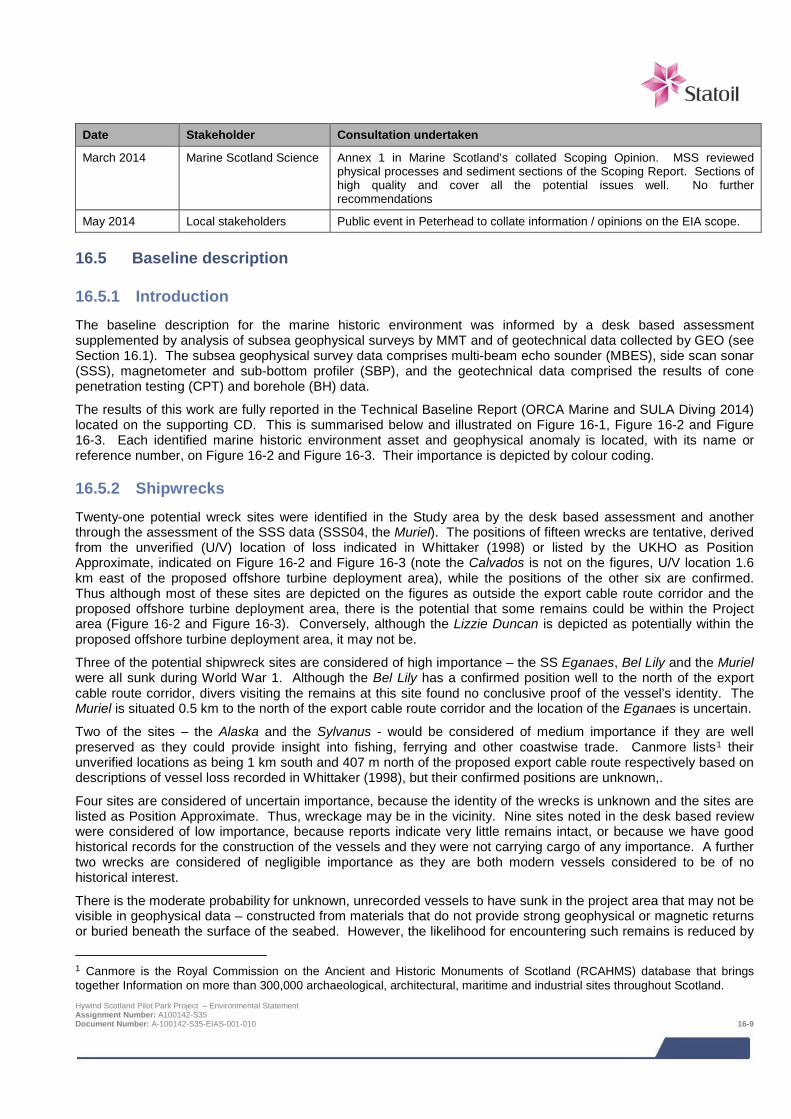
Date Stakeholder Consultation undertaken
March 2014 Marine Scotland Science Annex 1 in Marine Scotland’s collated Scoping Opinion. MSS reviewed physical processes and sediment sections of the Scoping Report. Sections of high quality and cover all the potential issues well. No further recommendations
May 2014 Local stakeholders Public event in Peterhead to collate information / opinions on the EIA scope.
16.5 Baseline description
16.5.1 Introduction The baseline description for the marine historic environment was informed by a desk based assessment supplemented by analysis of subsea geophysical surveys by MMT and of geotechnical data collected by GEO (see Section 16.1). The subsea geophysical survey data comprises multi-beam echo sounder (MBES), side scan sonar (SSS), magnetometer and sub-bottom profiler (SBP), and the geotechnical data comprised the results of cone penetration testing (CPT) and borehole (BH) data.
The results of this work are fully reported in the Technical Baseline Report (ORCA Marine and SULA Diving 2014) located on the supporting CD. This is summarised below and illustrated on Figure 16-1, Figure 16-2 and Figure 16-3. Each identified marine historic environment asset and geophysical anomaly is located, with its name or reference number, on Figure 16-2 and Figure 16-3. Their importance is depicted by colour coding.
16.5.2 Shipwrecks Twenty-one potential wreck sites were identified in the Study area by the desk based assessment and another through the assessment of the SSS data (SSS04, the Muriel). The positions of fifteen wrecks are tentative, derived from the unverified (U/V) location of loss indicated in Whittaker (1998) or listed by the UKHO as Position Approximate, indicated on Figure 16-2 and Figure 16-3 (note the Calvados is not on the figures, U/V location 1.6 km east of the proposed offshore turbine deployment area), while the positions of the other six are confirmed. Thus although most of these sites are depicted on the figures as outside the export cable route corridor and the proposed offshore turbine deployment area, there is the potential that some remains could be within the Project area (Figure 16-2 and Figure 16-3). Conversely, although the Lizzie Duncan is depicted as potentially within the proposed offshore turbine deployment area, it may not be.
Three of the potential shipwreck sites are considered of high importance – the SS Eganaes, Bel Lily and the Muriel were all sunk during World War 1. Although the Bel Lily has a confirmed position well to the north of the export cable route corridor, divers visiting the remains at this site found no conclusive proof of the vessel’s identity. The Muriel is situated 0.5 km to the north of the export cable route corridor and the location of the Eganaes is uncertain.
Two of the sites – the Alaska and the Sylvanus - would be considered of medium importance if they are well preserved as they could provide insight into fishing, ferrying and other coastwise trade. Canmore lists1 their unverified locations as being 1 km south and 407 m north of the proposed export cable route respectively based on descriptions of vessel loss recorded in Whittaker (1998), but their confirmed positions are unknown,.
Four sites are considered of uncertain importance, because the identity of the wrecks is unknown and the sites are listed as Position Approximate. Thus, wreckage may be in the vicinity. Nine sites noted in the desk based review were considered of low importance, because reports indicate very little remains intact, or because we have good historical records for the construction of the vessels and they were not carrying cargo of any importance. A further two wrecks are considered of negligible importance as they are both modern vessels considered to be of no historical interest.
There is the moderate probability for unknown, unrecorded vessels to have sunk in the project area that may not be visible in geophysical data – constructed from materials that do not provide strong geophysical or magnetic returns or buried beneath the surface of the seabed. However, the likelihood for encountering such remains is reduced by
1 Canmore is the Royal Commission on the Ancient and Historic Monuments of Scotland (RCAHMS) database that brings together Information on more than 300,000 archaeological, architectural, maritime and industrial sites throughout Scotland. Hywind Scotland Pilot Park Project – Environmental Statement Assignment Number: A100142-S35 Document Number: A-100142-S35-EIAS-001-010 16-9
the nature of the seabed within the Project area - bedrock and mobile sediments - which is not conducive to good preservation of submerged cultural heritage. Thus there is low potential for the Project to impact unknown significant remains.
16.5.3 Aviation losses No aircraft are known to have crashed along the export cable route or in the proposed offshore turbine deployment area.
16.5.4 Unexploded ordnance Although mines were laid in the northern North Sea during both World Wars there is no record of a minefield within the area of the export cable route corridor or proposed offshore turbine deployment area, even though a mine sank the FV Bel Lily (see Section 16.4.1 above). Mines that broke free from their moorings and drifted were often found around the Peterhead area. Several floating mines, both German and British, are reported to have been sunk by the minesweeping patrols off Peterhead without detonating, and it is possible that some of these might have sunk in the Project area.
The history of and risk to the Project from wartime ordnance has been fully reported by Ordtek Ltd in Unexploded Ordnance Desk Based Study with Risk Assessment, (Ordtek, 2014), Statoil Doc. No. C178-OTK-S-CA-0002. No mines or other obvious ordnance were identified in the geophysical data when reviewed by ORCA Marine, although this was not an ordnance specialist review.
16.5.5 Geophysical anomalies Ten MBES2, 27 SSS3 and two magnetic anomalies were noted during the assessment of the geophysical data. These are shown on Figure 16-2 and Figure 16-3.
. These anomalies were found to be of high, medium and low geophysical potential;
> High geophysical potential (anthropogenic):
o One MBES (MBES08);
o 15 SSS anomalies (SSS01, SSS04 – SSS06, SSS13 – SSS14, SSS17, and SSS20 – SSS27); and
o One magnetic anomaly (MAG01).
> Medium geophysical potential (possibly anthropogenic):
o Two MBES; and
o Seven SSS anomalies.
> Low geophysical potential (not considered to be anthropogenic) – the remaining seven anomalies.
Ten of the high and medium geophysical potential SSS anomalies were considered to be of negligible importance, identified as discarded sections of cable, chain or rope. All anomalies identified by MMT (2013) in their assessment of the magnetometer data are considered to be of low importance. The other anomalies of high or medium geophysical potential were considered to be of uncertain importance because they could not be identified, and therefore have the potential to be significant remains, perhaps of unlocated wrecks of high or medium importance.
16.5.6 Submerged landscapes The Project is located in an area considered to have low potential for the preservation of submerged cultural landscapes or materials. The MBES and SSS data show the area to be predominantly mega ripples and sand waves with rocky outcrops along the export cable route corridor, the nearshore area of the export cable route
2 Multi-beam echo sounder anomalies (MBES). 3 Side scan sonar anomalies (SSS). Hywind Scotland Pilot Park Project – Environmental Statement Assignment Number: A100142-S35 Document Number: A-100142-S35-EIAS-001-010 16-10
corridor comprising an extensive area of bedrock. The surficial deposits across the study area (excepting the areas of bedrock) tend to indicate highly mobile modern sediments, not conducive to the preservation of cultural remains and submerged landscapes. No palaeo-landscape features were observed in the assessment of the SBP survey tracks. Assessment of the geotechnical data indicates there is low potential for preservation of submerged palaeo-environmental remains and no submerged landscapes of archaeological interest were identified.
16.5.7 Data gaps and uncertainties The data sources accessed during the desk based assessment and geophysical data analysed are considered sufficient for an adequate baseline assessment on which to base a robust impact assessment, even though there were some minor limitations to the geophysical datasets, interpretation of some of the anomalies identified, potential data gaps in desk-based data sources and uncertainties in the location of some shipwrecks - identified as UV (unverified) or Position Approximate.
16.6 Impact assessment
16.6.1 Overview Direct effects predominantly occur during the construction and installation phase of a Project, but may to a lesser extend occur during operation and maintenance. These include potential damage to or destruction of either known or unknown marine cultural heritage sites through the deployment or removal of device anchors, deposition of materials (e.g. mooring chains, rock protection) and disturbance from trenching.
Indirect effects predominantly occur during the operational phase of a project, but may to a lesser extent occur during construction and installation. Potential indirect effects include the disturbance or deposition of sediment around and forming the context of a site as a result of potential changes in sediment dynamics.
The effects assessed are:
> Potential direct damage to or destruction of known marine cultural heritage; and
> Potential direct damage to or destruction of unknown marine cultural heritage.
The potential for indirect marine historic environment effects as a result of scouring or sediment deposition are not considered to be significant based on the results of the physical environment assessment (Chapter 8) and have therefore been scoped out of this assessment. The decision to scope scouring and sediment deposition out of the marine historic environment impact assessment is based on the assumption that anchors would not be placed within 15 m (maximum area over which scour protection, if required would be present) of any identified asset or anomaly of high or medium importance.
16.6.2 Assessment criteria The assessment of impact significance approach used for this assessment varies slightly from the core methodology in Chapter 6. This is due to the very specific assessment guidance for the assessment of impacts on marine historic interests. The specific details of the assessment methodology are presented in the following text.
The potential impacts of the Project on the marine historic environment has been assessed taking into account the importance or level of geophysical potential of each identified marine cultural area, site or feature and the magnitude of the effect.
The importance (or sensitivity) of each heritage asset or feature summarised in Table 16-3 incorporates general guidelines used by statutory authorities and agencies such as the Scottish Government and Historic Scotland, outlined in Scottish Historic Environment Policy (SHEP) 2011; Planning Advice Note (PAN 2/2011) Planning and Archaeology; the Marine (Scotland) Act 2010; English Heritage Designation Selection Guide: Ships and Boats, Prehistory to Present (2012); and Wessex Archaeology’s three-part Assessing Boats and Ships 1860-1950 (2011). Features for which further information is unavailable are recorded as of uncertain importance.
The weight given to historic environment considerations depends on a number of factors including:
> The relative rarity of the feature concerned; Hywind Scotland Pilot Park Project – Environmental Statement Assignment Number: A100142-S35 Document Number: A-100142-S35-EIAS-001-010 16-11
> The completeness of the feature / whether it is a particularly good example of its type;
> The historical or cultural associations of the feature;
> The value given to the feature by the local community;
> The potential value of the feature as an in situ educational or research resource; and
> The potential value of retaining the feature for tourism or place-making.
It should be noted that a site that has not been statutorily designated can still be of high importance.
Anomalies recorded in the analysis of the geophysical data (multi-beam echosounder (MBES), side scan sonar (SSS), magnetometer and sub-bottom profiler (SBP)) were initially assigned a ‘level of geophysical potential’ based on the potential for the anomaly identified to be anthropogenic. This is summarised in Table 16-4. Note that although classed as ‘high’, ‘medium’ and ‘low’, levels of geophysical potential do not imply a historical value to the anomalies – an anomaly may be of high geophysical potential (i.e. it looks anthropogenic) but may not be of historical importance.
Table 16-3 Criteria for importance or sensitivity of historic environment assets
Importance or sensitivity of receptor
Definition
Very high
Archaeological and historical sites, submerged prehistoric landscapes and deposits, wrecks, wreck cargos, or areas of international importance, such as World Heritage Sites, and may also include some Designated Wrecks or Historic Marine Protected Areas that are not only of national but of international importance. Shipwrecks dating to the prehistoric, Norse and medieval periods are rare and therefore of very high importance. This would also include vessels lost in international conflicts and aircraft, which may have involved large losses in life. Wreck cargos which contain rare artefacts or artefacts representative of a particular area or time period are also considered of very high importance.
High
Archaeological and historical sites, wrecks, wreck cargos or areas of national importance, Designated Wrecks and Historic MPAs. Up to 1913 the shipping industry was a major element in Britain’s world influence and wrecks up to this period may be of high importance if involved in national and international trade, particularly if the remains of its’ cargo survive; or it provides evidence of changes in the technology used in the construction of the vessel or changes in vessel design.
Medium
Archaeological and historical sites, wrecks, wreck cargos and areas of regional importance. This would involve shipwrecks, shipwreck cargos anchorages and fishing areas prior to 1913 involved in regional industry and trade. Wrecks or cargos considered representative of the changes in naval engineering or support the identification and preservation of the diversity of vessels from this period are considered of medium importance.
Low
Locally important sites, wrecks, wreck cargos or areas. Shipwrecks dating from after 1913 relating to fishing, ferrying or local coastwise trade. Wreck cargos of limited intrinsic, contextual or associative characteristics, or that are commonly recovered are considered on low importance.
Negligible Features that have been recorded but assessed as having no archaeological or historical interest, such as recent wrecks, or those wrecks whose structure or cargos have been so damaged they no longer have any historic merit.
Uncertain
Features that cannot be identified without detailed work, but potentially of some interest. Also, for example, if the date of construction and rarity of a vessel is not known, but potentially of some interest. Findspots, which may represent an isolated find, or could represent the location of a hitherto unknown site. Unidentified geophysical anomalies are also of uncertain importance and have been divided up further in Table 16-4.
Hywind Scotland Pilot Park Project – Environmental Statement Assignment Number: A100142-S35 Document Number: A-100142-S35-EIAS-001-010 16-12
Table 16-4 Level of geophysical potential
Level of geophysical potential
Definition
High Anomaly looks anthropogenic; or there is identifiable cultural material; or it is in the area of a known archaeological site, or another anomaly identified to be high potential.
Medium Anomaly lies in an area of intensive human activity such as near ports or areas of peat and other features relating to submerged landscapes. It would also be considered for an anomaly that is possibly anthropogenic but has no definite identification.
Low Anomaly is likely to be a natural formation such as a sand dune or bedrock formation. It could also be a processing error of the geophysical data.
The magnitude of any potential adverse direct and indirect effects on marine cultural heritage caused by the development proposals are determined using the criteria outlined in Table 16-5.
It should be noted that the categories are guideline criteria only, since assessments of magnitude are matters of professional judgement.
Table 16-5 Criteria for magnitude of effect
Magnitude of effects Direct effects Indirect effects
Severe Works would result in the complete loss of a site.
The removal of, or a fundamental and irreversible change to, the relationship between a marine heritage asset or environment and a historically relevant seabed context. Major change that removes or prevents appreciation of characteristics key to a heritage asset, or permanent change to or removal of surroundings of a less sensitive asset or seabed context.
Major Works would result in the loss of an area, features or evidence fundamental to the historic character and integrity of the site. Severance would result in the complete loss of physical integrity.
A noticeable change to a key relationship between a marine heritage asset or environment and a highly sensitive, valued or historically relevant seabed context over a wide area or an intensive change to a less sensitive or valued asset or seabed context over a limited area.
Moderate Works would result in the loss of an important part of the site or some important features and evidence, but not areas or features fundamental to its historic character and integrity. Severance would affect the integrity of the site, but key physical relationships would not be lost.
Noticeable change to a non-key relationship between a marine heritage asset or environment and a historically relevant seabed context. Relationship, asset, or context tolerant of moderate levels of change. Small changes to the relationship between a heritage asset and a historically relevant seabed context over a wide area or noticeable change over a limited area.
Minor Works or the severance of the site would not affect the main features of the site. The historic integrity of the site would not be significantly affected.
Minor changes to the relationship between a heritage asset or environment and a historically relevant seabed context over a wide area or minor changes over a limited area. Relationship, asset, or context considered tolerant of change.
Hywind Scotland Pilot Park Project – Environmental Statement Assignment Number: A100142-S35 Document Number: A-100142-S35-EIAS-001-010 16-13
Magnitude of effects Direct effects Indirect effects
Negligible Works or the severance of the site would be confined to a relatively small, peripheral and/or unimportant part of the site. The integrity of the site, or the quality of the surviving evidence would not be affected.
Changes to a historically relevant seabed context that cannot be discerned or perceived in relation to the heritage asset or environment.
Unknown Groundbreaking works over features that have not been fully interpreted would reduce the chance of interpretation in the future. In the event of significant features this would constitute impact of high magnitude; for sites of lesser significance it is less problematical. Nevertheless, it remains an issue where features have not been or could not be interpreted.
Changes to a seabed context, where it is uncertain how these contribute to our understanding of the site because the feature or asset itself could not or has not been understood or interpreted.
The importance of the marine cultural heritage asset or geophysical anomalies are combined with the magnitude of the effect to define the level of impact (Table 16-6).
Table 16-6 Criteria for level of impact
Magnitude of effect
Sensitivity (asset importance)
Very high High Medium Low Negligible Uncertain
Severe Severe consequence
Severe consequence
Major consequence
Moderate consequence
Minor consequence
Uncertain/ Severe
Major Severe consequence
Major consequence
Major consequence
Moderate consequence
Minor consequence
Uncertain/ Major
Moderate Major consequence
Major consequence
Moderate consequence
Minor consequence
Negligible consequence
Uncertain/ Moderate
Minor Moderate consequence
Moderate consequence
Minor consequence
Minor consequence
Negligible consequence
Uncertain/ Minor
Negligible Minor consequence
Minor consequence
Negligible consequence
Negligible consequence
Negligible consequence
Uncertain/ Negligible
Unknown Uncertain/ Severe
Uncertain/ Major Uncertain/ Moderate
Uncertain/ Minor Uncertain/ Negligible
Uncertain/ Negligible
The significance of impacts is then determined based on the definitions defined in Chapter 6, Table 6-2.
16.6.3 Design Envelope This assessment considers the Project parameters which are predicted to result in the greatest environmental impact. This approach ensures that impacts of greater adverse significance would not arise should any other development scenario be taken forward in the final scheme design. With regards to the assessment of impacts on the marine historic environment, the assessment has considered the maximum amount of infrastructure that could be located on the seabed, this comprises:
> As only an indicative WTG Unit layout is currently available and final positions of the WTG Units will be determined during detailed design it is assumed that any potential marine historic environment interest in the proposed turbine deployment area could be affected by the Project. However, effects will only be experienced where the following infrastructure is installed:
o WTG Unit anchoring systems which will include anchor chains present on the seabed (150 - 850 m of anchor chain per anchor and a maximum of 15 anchors for the whole Pilot Park);
o Scour protection, if required around anchors could occupy an area of up to 15 m beyond the edge of each anchor; and
Hywind Scotland Pilot Park Project – Environmental Statement Assignment Number: A100142-S35 Document Number: A-100142-S35-EIAS-001-010 16-14

o Inter array cables of which it is assumed there could be a total of up to 15 km. Should burial not be
possible then it is expected that up to 7.5 km of the inter array cables may need to be rock dumped for cable stabilisation purposes.
> An export cable of up to 35 km in length and trenched to a depth of up to 1.5 m and requiring rock protection along approximately 2 km of its length. The rock protection would occupy a 6 m wide corridor;
> Four cable crossings, each requiring 360 m2 of rock placement;
> Cable landfall installed as a surface laid cable across the foreshore requiring a working corridor of 6 m wide; and
> To allow room for manoeuvre and any accidental inaccuracy in cable laying, it has been assumed that any identified asset within 10 m of the edge of disturbance from export cable installation or associated protection activities could be affected.
The impacts associated with potential alternative development options are addressed in Section 16.9.
16.7 Impacts during construction and installation During construction, direct effects to cultural material on the seabed could be caused by the installation of anchors into the seabed; laying mooring chains on the seabed prior to WTG Unit installation; laying rock dump or mattress protection on the seabed for scour and cable protection (more extensive export cable protection will be laid at crossings with other cables); and trenching for the burial of sections of the export cable.
16.7.1 Potential direct damage to or destruction of known marine cultural heritage No sites with statutory designations, no aircraft and no submerged landscape deposits have been identified that will be affected. No shipwreck sites with confirmed positions will be affected by the development.
The significance of direct effects for geophysical anomalies of high or medium geophysical potential identified in the Technical Baseline Report (ORCA Marine & SULA Diving, 2014) is summarised below in Table 16-7. The anomalies of uncertain importance have the potential to be significantly impacted until proven otherwise. Effects on anomalies of low geophysical potential are not considered, as these are not interpreted as anthropogenic.
Impacts are predicted on two anomalies along the cable route (SSS06 and MBES08, see Table 16-7 and Figure 16-2). All other geophysical anomalies of high or medium geophysical potential in the export cable corridor will be missed by the proposed export cable route, because they are more than 10 m away from proposed installation activities (the closest is 176 m away). Should the export cable route be modified, then the potential impacts on these other anomalies would need to be reassessed.
SSS06 is only 9 m south of the proposed cable route, while MBES08 is 85 m north of the cable route close to an area where the route crosses other cables, which will require a protective rock berm. If avoidance cannot be guaranteed, then the anomalies can be investigated by ROV or diver surveys to attempt to determine their nature. Depending on the outcomes of these surveys, identifying whether the anomalies are important or not, further mitigation measures may need to be formulated and agreed with the Regulator.
It is predicted that there could be impacts on five anomalies (SSE09, 10, 12, 17, and MBES06, see Figure 16-3) within the turbine deployment area (all other anomalies in the turbine deployment area are of negligible importance). It will most likely be possible to avoid them in designing the location of the turbine anchors, mooring chains and inter-array cables. If avoidance cannot be guaranteed, then the anomalies can be investigated by ROV or diver surveys to attempt to determine their nature. Depending on the outcomes of these surveys, identifying whether the anomalies are important or not, further mitigation measures may need to be formulated and agreed with the Regulator and advisors.
Hywind Scotland Pilot Park Project – Environmental Statement Assignment Number: A100142-S35 Document Number: A-100142-S35-EIAS-001-010 16-15

MITIGATION
Where impacts are identified, the following mitigation measures will be incorporated into the design of the Project:
> Avoidance.
If avoidance is not possible, sites will be:
> Surveyed by diver, drop down camera or Remote Operated Vehicle (ROV) and the data assessed by a marine archaeologist. This work will provide a basis for devising appropriate management and mitigation strategies where necessary, such as:
o Redesign.
o Targeted very high resolution remote sensing survey to identify and record remains.
o Intrusive archaeological assessment for sites and wrecks with significant or unknown archaeological potential prior to any intrusive works. An intrusive assessment would groundtruth geophysical survey results and assess the nature, extent and preservation of archaeological remains.
o Detailed wreck survey and salvage, with full measured survey and photographic record, recorded in an appropriate manner by specialists in marine archaeology. Attempts will be made to retrieve and conserve representative examples of the fabric.
o Full archaeological excavation may be deemed necessary as a result of evidence gathered by other strategies and should be conducted by specialists in marine archaeology. Provision should be made for the examination and possible conservation of any artefacts recovered. Provision should be made for post-excavation work bringing the results together in a report of publication standard.
The following mitigation will also be applied:
> Implementation of a reporting protocol for the accidental discovery of cultural remains in line with The Crown Estate (2014) Protocol for Archaeological Discoveries: Offshore Renewables Projects, prepared by Wessex Archaeology Ltd for The Crown Estate http://www.thecrownestate.co.uk/media/148964/ei-protocol-for-archaeological-discoveries-offshore-renewables-projects.pdf
If the above management and mitigation strategies (with avoidance as the primary strategy) are implemented for potential direct damage to or destruction of known marine cultural heritage, the impacts will be removed, reduced or managed to an acceptable level, resulting in no significant impacts (Table 16-7).
Hywind Scotland Pilot Park Project – Environmental Statement Assignment Number: A100142-S35 Document Number: A-100142-S35-EIAS-001-010 16-16
Table 16-7 Impacts for the potential direct damage to or destruction of known marine cultural heritage
Site No. Proximity Level of geophysical potential
Importance of asset
Mitigation Magnitude of effect
Level of impact Significance
Cable corridor
SSS01 176 m south of cable High Uncertain None required because of distance from cable None None Not significant
SSS04 Muriel 1,080 m north of cable High High None required because of
distance from cable None None Not significant
SSS05 465 m north of cable High Negligible None required because of distance from cable None None Not significant
SSS06 9 m south of cable High Uncertain Phased as sequence in mitigation box Low Uncertain / Minor Not significant
SSS20 424 m north of cable High Negligible None required because of distance from cable None None Not significant
MBES07 240 m northeast of cable Medium Uncertain None required because of distance from cable None None Not significant
MBES08 85 m north of cable, but potentially affected by rock armour over intersection
High Uncertain Avoidance None None Not significant
Turbine deployment area
SSS09 In proposed offshore turbine deployment area Medium Uncertain Phased as sequence in
mitigation box Low Uncertain / Minor Not significant
SSS10 In proposed offshore turbine deployment area Medium Uncertain Phased as sequence in
mitigation box Low Uncertain / Minor Not significant
SSS12 In proposed offshore turbine deployment area Medium Uncertain Phased as sequence in
mitigation box Low Uncertain / Minor Not significant
SSS13 In proposed offshore turbine deployment area High Negligible None required because of
negligible importance Major4 Minor Not significant
4 Magnitude of effect is major as no mitigation is required, but level of impact is minor and impact not deemed significant due to the asset being of negligible importance. Hywind Scotland Pilot Park Project – Environmental Statement Assignment Number: A100142-S35 Document Number: A-100142-S35-EIAS-001-010 16-17
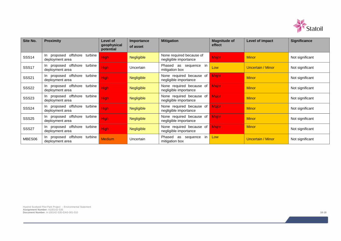
Site No. Proximity Level of
geophysical potential
Importance of asset
Mitigation Magnitude of effect
Level of impact Significance
SSS14 In proposed offshore turbine deployment area High Negligible None required because of
negligible importance Major Minor Not significant
SSS17 In proposed offshore turbine deployment area High Uncertain Phased as sequence in
mitigation box Low Uncertain / Minor Not significant
SSS21 In proposed offshore turbine deployment area High Negligible None required because of
negligible importance Major Minor Not significant
SSS22 In proposed offshore turbine deployment area High Negligible None required because of
negligible importance Major Minor Not significant
SSS23 In proposed offshore turbine deployment area High Negligible None required because of
negligible importance Major Minor Not significant
SSS24 In proposed offshore turbine deployment area High Negligible None required because of
negligible importance Major Minor Not significant
SSS25 In proposed offshore turbine deployment area High Negligible None required because of
negligible importance Major Minor Not significant
SSS27 In proposed offshore turbine deployment area High Negligible None required because of
negligible importance Major Minor Not significant
MBES06 In proposed offshore turbine deployment area Medium Uncertain Phased as sequence in
mitigation box Low Uncertain / Minor Not significant
Hywind Scotland Pilot Park Project – Environmental Statement Assignment Number: A100142-S35 Document Number: A-100142-S35-EIAS-001-010 16-18
16.7.2 Potential direct damage or destruction to unknown marine cultural heritage The tentative positions of fifteen shipwreck sites are based on unverified locations of loss cited in Whittaker (1998) or listed by the UKHO as Position Approximate (Figure 16-2 and Figure 16-3); note the Calvados is not on the figures, U/V location 1.6 km east of the proposed offshore turbine deployment area). Therefore, it is possible that these sites could be within the proposed offshore turbine deployment area or along the export cable route. It has been assumed that there could be a major direct effect on these sites, and the significance of direct effects for shipwreck sites with unverified locations is summarised in below in Table 16-8.
However, the likelihood of direct effects on these wrecks is considered low since they were not specifically observed in the geophysical data analysis and so if present, are most likely to be an identified anomaly, and impacts on these have been assessed and mitigated in Section 16.6.1 above.
As a maritime nation with a reliance on marine based trade and exchange, there have been countless shipwrecks in UK waters from all periods – many of which remain unreported. Founded in the late 17th century, Peterhead has played a key role in maritime shipping and trade – a key stop off point and trading post en-route to Iceland, and countries bordering the North Sea. As such, there is potential for previously unrecorded remains to be affected by the proposed development. Remains of such vessels and their associated artefacts may not be visible in geophysical data – constructed from materials that do not provide strong geophysical or magnetic returns or buried beneath the seabed.
However, the likelihood for encountering such unrecorded wreck remains or submerged palaeo-environmental and landscape remains is low, because of the nature of the seabed within the development area. It comprises predominantly highly mobile mega ripples and sand waves with rocky outcrops and an extensive area of bedrock towards landfall - not conducive to the preservation of cultural remains and submerged landscapes. Therefore there is no predicted significant impact on unrecorded shipwrecks, cultural remains or submerged landscapes. In order to ensure this remains the case, a reporting protocol for the accidental discovery of cultural remains will be instated.
Impacts are possible on wrecks with unverified locations. This is because the exact position of such a wreck is not known, so it is possible that the wreck might be present in the Project area. However, analysis of the marine geophysical data has reduced this possibility and along with the strategies outlined will manage and reduce any possible impacts to an acceptable level.
MITIGATION
Where impacts are identified, the following mitigation measures will be incorporated into the design of the Project:
> Avoidance of geophysical anomalies of uncertain importance and high or medium potential (see Section 16.6.1); and
> Implementation of a reporting protocol for the accidental discovery of cultural remains in line with The Crown Estate (2014) Protocol for Archaeological Discoveries: Offshore Renewables Projects, prepared by Wessex Archaeology Ltd for The Crown Estate http://www.thecrownestate.co.uk/media/148964/ei-protocol-for-archaeological-discoveries-offshore-renewables-projects.pdf.
If avoidance of geophysical anomalies is not possible, there will be:
> Implementation of the phased strategies outlined in the mitigation proposed for the potential direct damage to or destruction of known marine cultural heritage impact.
If the above management and mitigation strategies are implemented for the potential direct damage or destruction to unknown marine cultural heritage, impacts will be reduced or managed to an acceptable level, resulting in no significant impacts (Table 16-8).
Hywind Scotland Pilot Park Project – Environmental Statement Assignment Number: A100142-S35 Document Number: A-100142-S35-EIAS-001-010 16-19
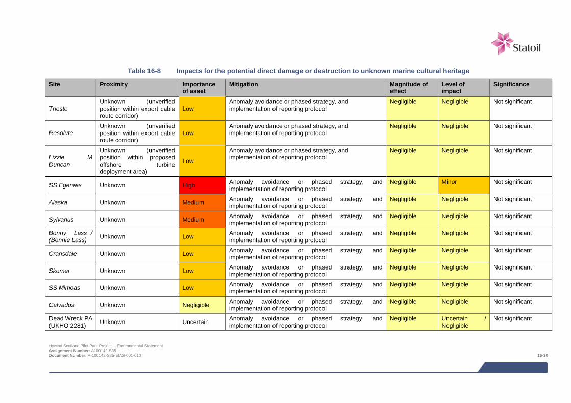
Table 16-8 Impacts for the potential direct damage or destruction to unknown marine cultural heritage
Site Proximity Importance of asset
Mitigation Magnitude of effect
Level of impact
Significance
Trieste Unknown (unverified position within export cable route corridor)
Low Anomaly avoidance or phased strategy, and implementation of reporting protocol
Negligible Negligible Not significant
Resolute Unknown (unverified position within export cable route corridor)
Low Anomaly avoidance or phased strategy, and implementation of reporting protocol
Negligible Negligible Not significant
Lizzie M Duncan
Unknown (unverified position within proposed offshore turbine deployment area)
Low
Anomaly avoidance or phased strategy, and implementation of reporting protocol
Negligible Negligible Not significant
SS Egenæs Unknown High Anomaly avoidance or phased strategy, and implementation of reporting protocol
Negligible Minor Not significant
Alaska Unknown Medium Anomaly avoidance or phased strategy, and implementation of reporting protocol
Negligible Negligible Not significant
Sylvanus Unknown Medium Anomaly avoidance or phased strategy, and implementation of reporting protocol
Negligible Negligible Not significant
Bonny Lass / (Bonnie Lass) Unknown Low Anomaly avoidance or phased strategy, and
implementation of reporting protocol Negligible Negligible Not significant
Cransdale Unknown Low Anomaly avoidance or phased strategy, and implementation of reporting protocol
Negligible Negligible Not significant
Skomer Unknown Low Anomaly avoidance or phased strategy, and implementation of reporting protocol
Negligible Negligible Not significant
SS Mimoas Unknown Low Anomaly avoidance or phased strategy, and implementation of reporting protocol
Negligible Negligible Not significant
Calvados Unknown Negligible Anomaly avoidance or phased strategy, and implementation of reporting protocol
Negligible Negligible Not significant
Dead Wreck PA (UKHO 2281) Unknown Uncertain Anomaly avoidance or phased strategy, and
implementation of reporting protocol Negligible Uncertain /
Negligible Not significant
Hywind Scotland Pilot Park Project – Environmental Statement Assignment Number: A100142-S35 Document Number: A-100142-S35-EIAS-001-010 16-20
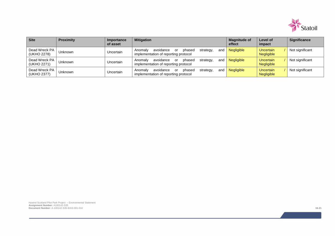
Site Proximity Importance
of asset Mitigation Magnitude of
effect Level of impact
Significance
Dead Wreck PA (UKHO 2278) Unknown Uncertain Anomaly avoidance or phased strategy, and
implementation of reporting protocol Negligible Uncertain /
Negligible Not significant
Dead Wreck PA (UKHO 2271) Unknown Uncertain Anomaly avoidance or phased strategy, and
implementation of reporting protocol Negligible Uncertain /
Negligible Not significant
Dead Wreck PA (UKHO 2377) Unknown Uncertain Anomaly avoidance or phased strategy, and
implementation of reporting protocol Negligible Uncertain /
Negligible Not significant
Hywind Scotland Pilot Park Project – Environmental Statement Assignment Number: A100142-S35 Document Number: A-100142-S35-EIAS-001-010 16-21
16.8 Impacts during operation and maintenance
16.8.1 Potential direct damage to or destruction of marine cultural heritage The potential for maintenance vessels dropping their anchors on marine cultural heritage assets was evaluated, but no direct effects on known or previously unrecorded marine cultural heritage were predicted. It is anticipated that as the WTG Units are located in deep water, maintenance vessels will moor to the WTG unit rather than anchoring.
16.9 Potential variances in environmental impacts (based on Design Envelope) The impact assessment above has assessed the Project options which are predicted to result in the greatest impacts with regards to the marine historic environment.
In reality it will only be certain seabed areas within the proposed offshore turbine deployment area that will be impacted from the installation and long term presence of the turbine mooring system. Therefore the number of identified assets that may be impacted (both directly and indirectly) will be fewer than those predicted in this assessment.
16.10 Cumulative and in-combination impacts HSL has in consultation with Marine Scotland and Aberdeenshire Council identified a list of other projects which together with the Project may result in potential cumulative or in-combination impacts. The list of these projects including details of their status at the time of the EIA and a map showing their location is provided in Chapter 6; Table 6-3 and Figure 6-1 respectively.
Cumulative impacts are impacts on the marine historic environment caused by planned and consented offshore wind farms. In-combination impacts are impacts on the marine historic environment as a result of offshore wind farms (and their associated activities) combined with impacts from other marine activities or users of the sea.
Based on the results of the project specific impact assessment together with the expert judgement of the specialist consultant it is not considered there is any potential for cumulative or in-combination impacts. This is because the impacts predicted for the Hywind Project on the marine historic environment are localised, and other Projects are located too far away to produce cumulative and in-combination impacts.
16.11 Monitoring A reporting protocol should be implemented to manage the potential discovery of previously unknown marine cultural heritage material in line with The Crown Estate (2014) Protocol for Archaeological Discoveries: Offshore Renewables Projects, prepared by Wessex Archaeology Ltd for The Crown Estate http://www.thecrownestate.co.uk/media/148964/ei-protocol-for-archaeological-discoveries-offshore-renewables-projects.pdf. In the event that any unknown marine cultural heritage is discovered as a result of this protocol, the significance of the find will be assessed and there may be a requirement for further investigation in line with the mitigations proposed in this chapter.
16.12 References GEO (2014). Hywind Scotland Soil Investigation 2014, North Sea. British Sector, Anchoring of Floating Wind Turbines and Cable Route. GEO. May 2014.
MMT (2013). Marine survey report Hywind offshore windfarm. Geophysical survey Peterhead, Scotlnad July – August 2013. MMT Doc No 101462-STO-MMT-SUR-REP-ST13828. Statoil Doc No ST13828-Hywind OW.
ORCA Marine & SULA Diving (2014). Hywind marine historic environment baseline report for Xodus Group Ltd and Hywind (Scotland) Limited.
Ordtek (2014). Unexploded Ordnance Desk Study with Risk Assessment. Hywind Offshore Wind Farm. Ordtek Project Reference: JM5035.
Hywind Scotland Pilot Park Project – Environmental Statement Assignment Number: A100142-S35 Document Number: A-100142-S35-EIAS-001-010 16-22

Whittaker, I.G. (1998). Off Scotland: a comprehensive record of maritime and aviation losses in Scottish waters. C-ANNE Publishing, Berwickshire.
Hywind Scotland Pilot Park Project – Environmental Statement Assignment Number: A100142-S35 Document Number: A-100142-S35-EIAS-001-010 16-23
17 OTHER SEA USERS The BP Forties crude oil pipeline system which transports 40% of the UK North Sea oil production, passes through the Agreement for Lease (AfL) area, 1 km to the south of the proposed turbine deployment area. There are several existing cables in the vicinity of the proposed turbine deployment area and export cable corridor, including one cable along the export cable route for which it has not been possible to identify the owner. Two active and one inactive at sea disposal sites are located adjacent to the export cable corridor close to shore. An explosive ordnance legacy from the two world wars and modern military exercises has potential to contaminate the Project area. The Project will have crossing agreements in place with other cable operators to ensure that no significant impacts result from the installation and operation the Project and procedures will be in place to minimise the risk of inadvertent detonation of unexploded ordinance. Discussions are ongoing with BP to ensure minimised risk to the BP asset.
17.1 Introduction Other chapters within this ES assess the impacts of the main sea user groups including shipping and navigation (Chapter 15) and commercial fisheries (Chapter 14). This section assesses the impact of the Project on other users of the sea including pipelines, at sea disposal sites, cables and unexploded ordnance (UXO). A number of different specialists have contributed to this assessment:
> Ordtek - Unexploded Ordnance (UXO) desk study and risk assessment (Ordtek, 2014); and
> Xodus - baseline description, impact assessment and ES chapter write up.
Table 17-1 provides details of the supporting study which relates to the other sea users impact assessment. The study is provided on the accompanying CD.
Table 17-1 Supporting studies
Details of study
Unexploded ordnance desk based study with risk assessment (Ordtek, 2014)
The following areas are referred to in this impact assessment:
> Project area (see Figure 1-2 in the introduction), which comprises:
o Proposed offshore turbine deployment area: and
o Export cable corridor and landfall.
17.2 Scoping and consultation The bullets below summarise the key issues raised in the Scoping Opinion relevant to the other sea users impact assessment:
> Proximity of the Hywind Scotland Park Project to the BP assets;
o Preference of use of permanent moorings to prevent drag across the seabed;
o Better understanding of the direct risks of catastrophic damage to BP assets;
o Assurance that maintenance and inspection of existing assets and infrastructure will not be hindered as a result of the Project; and
Hywind Scotland Pilot Park Project – Environmental Statement Assignment Number: A100142-S35 Document Number: A-100142-S35-EIAS-001-011 17-1
o Insurance that a full and detailed survey will be undertaken prior to construction to ensure existing
infrastructure is safeguarded.
> Assessment of in-combination and cumulative impacts in relation to other planned projects to be undertaken.
Table 17-2 summarises all consultation activities carried out relevant to other sea users.
Table 17-2 Consultation activities undertaken in relation to other sea users
Date Stakeholder Consultation undertaken
May 2013 Marine Scotland (MS-LOT and Marine Scotland Science) and statutory consultees
Pre-scoping meeting including discussion on proposed scope of other sea users impact assessment
October 2013 Marine Scotland, statutory consultees and non- statutory consultees
Submission of EIA Scoping Report – request for EIA Scoping Opinion from Marine Scotland and statutory consultees and request for comment from non-statutory consultees
March 2014 Marine Scotland, statutory consultees and non- statutory consultees
Receipt of Scoping Opinion
May 2014 Local stakeholders Public event in Peterhead to collate information / opinions on EIA scope
Various BP Series of meetings with to discuss and present the results of work associated with potential risks to the BP Forties pipelines
Various Marine Scotland, Crown Estate, BT and various survey companies that have worked in this area of the North Sea
Meetings and e mail communication in order to establish ownership of the unknown cables and agree procedures for handling of cables that were identified in the geophysical survey, but ownership cannot be traced
17.3 Baseline description
17.3.1 Introduction The baseline description of other sea users in the Project area has been compiled from available published data, supplemented by Project specific geophysical and geotechnical surveys.
17.3.2 Oil and gas activities The Project lies within oil and gas licensing Quadrant 19. Oil and gas activity is relatively low in this area of the North Sea, and few blocks within Quadrant 19 are currently licensed (Table 17-3). However, the BP Forties pipeline system that passes through the AfL area does transport 40% of the UK North Sea oil production. The closest licensed areas to the Agreement for Lease (AfL) area are Blocks 19/4, 19/5 and 19/10 (Figure 17-1). Blocks 19/2, 19/3 and part of 19/10 were in the previous 27th licensing round application process (DECC, 2014). An additional 24 Blocks within Quadrant 19 were recently on offer as part of the 28th licensing round (DECC, 2014). At the time of writing, these blocks were yet to be awarded.
Hywind Scotland Pilot Park Project – Environmental Statement Assignment Number: A100142-S35 Document Number: A-100142-S35-EIAS-001-011 17-2

Table 17-3 Currently licensed Blocks within Quadrat 19 (UK Oil and Gas Data, 2014)
Quadrant/Block Licence round Current licence operator Licence expiry date
19/1 26 Maersk Oil North Sea UK Limited 1 February 2038
19/2 27 Encounter Oil Limited 20 December 2039
19/3 27 Encounter Oil Limited 20 December 2039
19/4 26 Nexen Petroleum U.K. Limited 1 February 2038
19/5 and 19/5a 16 Nexen Petroleum U.K. Limited 25 July 2031
19/5b 26 Nexen Petroleum U.K. Limited 1 February 2038
19/10 27 Nexen Petroleum U.K. Limited 20 December 2039
19/10a 18 Nexen Petroleum U.K. Limited 23 December 2034
A total of 11 wells have been drilled in Quadrant 19, the majority being dry holes. The closest oil and gas activity to the Project is the Nexen operated Buzzard oil field, which is located in Blocks 19/5, 19/10, 20/1 and 20/6 approximately 40 km to the north west of the AfL area (UK Oil and Gas Data, 2014).
The HSL AfL area is split into northern and southern parts by the Forties to Cruden Bay pipeline system (crude oil) which passes through the area from the northeast to the southwest, shown in Figure 17-1. The pipeline system is located to the south of the turbine deployment area and the northern AfL and is located approximately 1 km from the proposed turbine deployment area. These pipelines are operated by BP and come ashore at Cruden Bay to connect the Cruden Bay Pressure Relief and Pumping Station, 35 km north of Aberdeen. Onshore pipelines carry the liquids to separation and processing facilities at Kinneil, Grangemouth and Firth Forth.
To the north of Peterhead, St Fergus is a landing point for numerous offshore pipelines, the closest of which is approximately 5 km from the cable route corridor and, further offshore, from the AfL area (Figure 17-1).
17.3.3 Submarine cables There are several existing submarine cables in the vicinity of the Project. These include the active CNS fibre optic cable, owned by BP, which runs parallel to the BP Forties to Cruden pipelines. The cable is located approximately 1 km from the proposed turbine deployment area. A possible cable ‘unknown cable 1’ was 5.8 km to the north east of the turbine deployment area at its closest point (Figure 17-1). Ownership of the possible cable could not be traced.
Figure 17-1 shows three cables passing through the proposed offshore turbine deployment area. The geophysical survey undertaken by MMT (2013) found no trace of the charted disused cable and concluded that it is likely that it may be the BT Aberdeen – Bergen cable. An additional cable ‘unknown cable 2’ was also found running east to west through the proposed offshore turbine deployment area. Ownership of the possible cable could not be traced.
Two subsea cables pass through the northwest edge of the export cable route corridor to the north of Peterhead. These cables (Peterhead to Alexandrovsk (installed 1914) and Peterhead to Egersund (1924)) have been identified as existing assets by The Crown Estate (Figure 17-1). Both cables are inactive.
The route for the proposed NorthConnect High Voltage Direct Current (HVDC) interconnector cable is from Peterhead in Scotland to Sima and Samnanger in Norway (NorthConnect, 2014). The proposed cable route is approximately 600 km long and crosses the export cable route corridor (Figure 17-1).
Hywind Scotland Pilot Park Project – Environmental Statement Assignment Number: A100142-S35 Document Number: A-100142-S35-EIAS-001-011 17-3
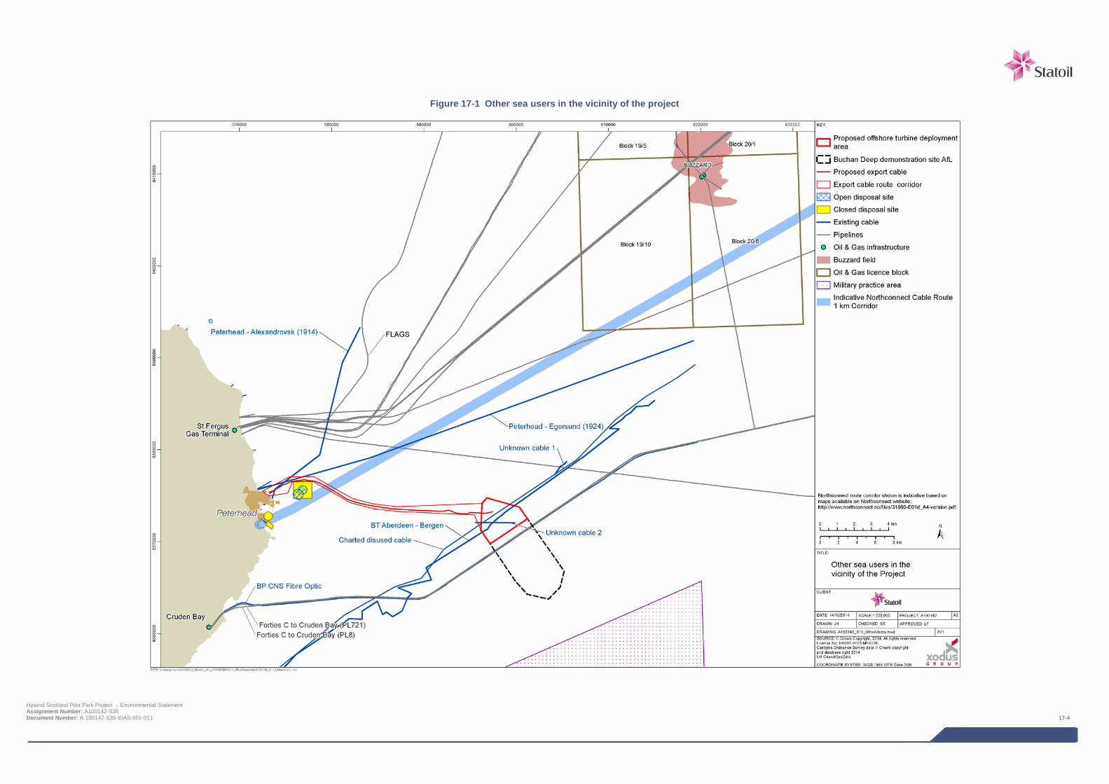
Figure 17-1 Other sea users in the vicinity of the project
Hywind Scotland Pilot Park Project – Environmental Statement Assignment Number: A100142-S35 Document Number: A-100142-S35-EIAS-001-011 17-4
17.3.4 Unexploded ordnance (UXO) Ordtek (2013) conducted a desk based study and risk assessment to assess the potential risk to the Project from UXOs. The report identified that the presence of dump sites, official and unofficial, and the explosive ordnance legacy from two World Wars and modern military exercises have the potential to contaminate the Project area with UXOs (Ordtek, 2013). The UXO threat items most likely to be encountered are German WWI and British WWII moored mines that have sunk to the seabed. Possible charge weights vary from 50 kg to 350 kg, but are most likely to be between 90 kg and 227 kg. The typical diameter of the buoyant mines likely to be present is 0.84 to 1.01 m.
17.3.5 Disposal sites There are two open (‘North Buchan Ness’ and ‘Peterhead’) and one closed disposal site (‘middle Buchan Ness’) adjacent to the export cable corridor (Figure 17-1). Over the past 13 years, the two open sites have been used for the deposition of dredged harbour material from Peterhead and / or Boddam Harbour (Walker pers. comm. Marine Scotland, 2013). Details of the chemical composition of the sediment at these sites are provided in Chapter 9 –benthic and intertidal ecology.
17.3.6 Data gaps and uncertainties A robust baseline is available to characterise the other sea users in and surrounding the proposed Project and inform the impact assessment. The only minor data gap is the inability to trace the owners of two of the unused cables; however, this does not compromise the ability to undertake a robust impact assessment.
17.4 Impact assessment
17.4.1 Overview Following establishment of the baseline conditions to the Project area, and an understanding of the Project activities it is possible to assess the potential impacts from the Project. The range of impacts that have been considered is based on impacts identified during EIA Scoping and any further potential impacts that have been highlighted as the EIA has progressed. The impacts assessed are summarised below. It should be noted that not all impacts will be relevant to all phases of the Project.
> Impacts on pipelines;
> Impacts on cables (existing and proposed); and
> Inadvertent detonation of unidentified unexploded ordnance.
The following impacts were scoped out of the assessment during EIA scoping:
> Restriction on the expansion potential of at sea disposal sites located adjacent to the export cable corridor; and
> Interference with military practice and exercise areas.
The following specialist studies have been completed to inform the assessment of impacts on other sea users:
> An unexploded ordnance desk based study with risk assessment was undertaken by Ordtek (2014). The study carried out an in-depth historical search into records in order to assess the potential risk to the project from UXO.
Hywind Scotland Pilot Park Project – Environmental Statement Assignment Number: A100142-S35 Document Number: A-100142-S35-EIAS-001-011 17-5
17.4.2 Proximity to the BP Forties Pipeline The Project will be located in the northern sector of the AfL area, north of the BP Forties pipeline system. Cable crossing of the pipeline is therefore not needed. The chosen location of the turbine deployment area is based on environmental, geophysical and geotechnical studies performed by Statoil. The closest anchor will be placed a minimum of 1 km away from the pipeline, while the closest turbine will be approximately 1.5 km away.
During scoping, BP raised concerns about the potential risk to the BP Forties pipeline system. Several of the concerns raised in the Scoping Opinion were related to potential crossing of the BP assets by inter-array cables and the export cable. This is no longer a concern, since the WTG Units will be located north of the pipeline. However, due to the proximity to the pipeline, BP has been fully consulted during the conceptual design and FEED (Front End Engineering and Design) phase, and will be further consulted during the detailed design phase. There have been several meetings between BP and Statoil to discuss how to ensure minimised risk to the BP assets1.
The main concern in relation to the pipelines is the design, fabrication, installation and operation of the mooring system, the potential risk of mooring line failure, and the potential consequences for the pipelines. The mooring system is designed according to the DNV standard for floating wind turbines2, with the purpose of designing a safe, redundant and robust system. A 3-line mooring configuration has been chosen, and designed in such a way that in the case of a mooring line failure, the remaining lines will keep the WTG Unit in place. Even in the case of a second line failure, the third line will be able to keep the WTG Unit in place. The mooring system is also designed with suction anchors rather than fluke anchors, and with pure chain rather than using clump weights, both of which reduces the risk of damage in case of mooring line failure.
DNV GL has performed a risk assessment of the probability of mooring line failures and the potential implications for the BP pipeline system. Mooring lines dragging over the pipelines will cause no significant damage to the pipelines itself. The only possible major damage to the pipelines is considered to occur if they were to be hit by the Hywind substructure. Such an event requires that all three mooring lines are lost, and the installation drifts south, and sinks and hits the pipelines. The probability of such an event is found to be very unlikely3.
There is limited experience with floating wind turbines; currently only a handful of demonstration projects have been installed and operated, whereas the Hywind demo off the west coast of Norway is the one with the longest operational time of 5 years. Due to lack of statistics from the floating wind industry, statistics from the oil & gas industry have been utilised for the DNV GL assessment. Unlike typical oil and gas facilities with multiple mooring lines, the maximum line tensions for the Hywind mooring system will not increase following a single or double mooring line failure. Failure of one mooring line will rather relax the system and decrease the mooring line forces in the other two lines.
Statistics from the oil and gas industry show that the actual rate of mooring line failure is higher than what is assumed in mooring design standards. Many of the failures are considered to be a result of faults during fabrication, installation or operation, and such failures can be avoided by ensuring proper inspection and maintenance during all phases of project development and operation. Statoil’s internal statistics for mooring line failures their own operated units show a failure rate far below the industry average, and it will be a target for the Project to achieve at least as good a standard for the mooring system on the Hywind Project as for the other units operated by Statoil.
Statoil will develop a robust Emergency Response Plan for the Project, based on experiences from oil and gas installations, other offshore wind projects and the Hywind Demo Project. BP will be invited to participate in a HAZID workshop in connection with this work. In relation to the development of the Emergency Response Plan evaluation of a realistic salvage time, if a drift-off situation occurs, will be carried out.
1 Minutes of meetings and reports will be made available to Marine Scotland if required. 2 DNV_OS-J103 Design of Floating Wind Turbine Structures. 3 DNV GL Assessment of the probability of mooring line failure and the implications for the Forties Pipeline System. Hywind Scotland Pilot Park Project – Environmental Statement Assignment Number: A100142-S35 Document Number: A-100142-S35-EIAS-001-011 17-6
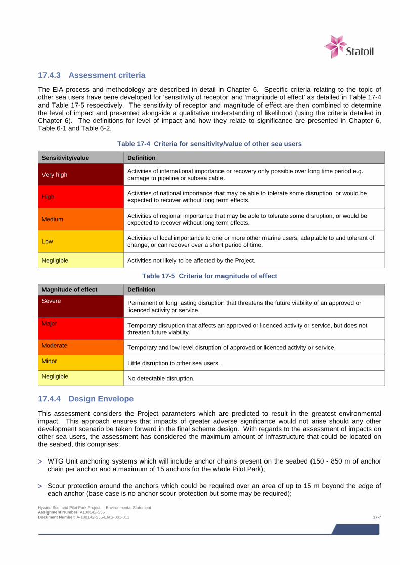
17.4.3 Assessment criteria The EIA process and methodology are described in detail in Chapter 6. Specific criteria relating to the topic of other sea users have bene developed for ‘sensitivity of receptor’ and ‘magnitude of effect’ as detailed in Table 17-4 and Table 17-5 respectively. The sensitivity of receptor and magnitude of effect are then combined to determine the level of impact and presented alongside a qualitative understanding of likelihood (using the criteria detailed in Chapter 6). The definitions for level of impact and how they relate to significance are presented in Chapter 6, Table 6-1 and Table 6-2.
Table 17-4 Criteria for sensitivity/value of other sea users
Sensitivity/value Definition
Very high Activities of international importance or recovery only possible over long time period e.g. damage to pipeline or subsea cable.
High Activities of national importance that may be able to tolerate some disruption, or would be expected to recover without long term effects.
Medium Activities of regional importance that may be able to tolerate some disruption, or would be expected to recover without long term effects.
Low Activities of local importance to one or more other marine users, adaptable to and tolerant of change, or can recover over a short period of time.
Negligible Activities not likely to be affected by the Project.
Table 17-5 Criteria for magnitude of effect
Magnitude of effect Definition
Severe Permanent or long lasting disruption that threatens the future viability of an approved or licenced activity or service.
Major Temporary disruption that affects an approved or licenced activity or service, but does not threaten future viability.
Moderate Temporary and low level disruption of approved or licenced activity or service.
Minor Little disruption to other sea users.
Negligible No detectable disruption.
17.4.4 Design Envelope This assessment considers the Project parameters which are predicted to result in the greatest environmental impact. This approach ensures that impacts of greater adverse significance would not arise should any other development scenario be taken forward in the final scheme design. With regards to the assessment of impacts on other sea users, the assessment has considered the maximum amount of infrastructure that could be located on the seabed, this comprises:
> WTG Unit anchoring systems which will include anchor chains present on the seabed (150 - 850 m of anchor chain per anchor and a maximum of 15 anchors for the whole Pilot Park);
> Scour protection around the anchors which could be required over an area of up to 15 m beyond the edge of each anchor (base case is no anchor scour protection but some may be required);
Hywind Scotland Pilot Park Project – Environmental Statement Assignment Number: A100142-S35 Document Number: A-100142-S35-EIAS-001-011 17-7
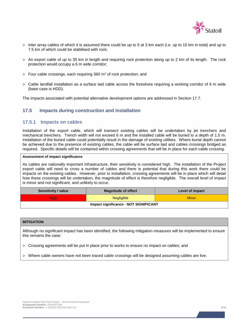
> Inter array cables of which it is assumed there could be up to 5 at 3 km each (i.e. up to 15 km in total) and up to
7.5 km of which could be stabilised with rock;
> An export cable of up to 35 km in length and requiring rock protection along up to 2 km of its length. The rock protection would occupy a 6 m wide corridor;
> Four cable crossings, each requiring 360 m2 of rock protection; and
> Cable landfall installation as a surface laid cable across the foreshore requiring a working corridor of 6 m wide (base case is HDD).
The impacts associated with potential alternative development options are addressed in Section 17.7.
17.5 Impacts during construction and installation
17.5.1 Impacts on cables Installation of the export cable, which will transect existing cables will be undertaken by jet trenchers and mechanical trenchers. Trench width will not exceed 6 m and the installed cable will be buried to a depth of 1.5 m. Installation of the buried cable could potentially result in the damage of existing utilities. Where burial depth cannot be achieved due to the presence of existing cables, the cable will be surface laid and cables crossings bridged as required. Specific details will be contained within crossing agreements that will be in place for each cable crossing.
Assessment of impact significance
As cables are nationally important infrastructure, their sensitivity is considered high. The installation of the Project export cable will need to cross a number of cables and there is potential that during this work there could be impacts on the existing cables. However, prior to installation, crossing agreements will be in place which will detail how these crossings will be undertaken, the magnitude of effect is therefore negligible. The overall level of impact is minor and not significant, and unlikely to occur.
Sensitivity / value Magnitude of effect Level of impact
High Negligible Minor
Impact significance - NOT SIGNIFICANT
MITIGATION
Although no significant impact has been identified, the following mitigation measures will be implemented to ensure this remains the case:
> Crossing agreements will be put in place prior to works to ensure no impact on cables; and
> Where cable owners have not been traced cable crossings will be designed assuming cables are live.
Hywind Scotland Pilot Park Project – Environmental Statement Assignment Number: A100142-S35 Document Number: A-100142-S35-EIAS-001-011 17-8
17.5.2 Inadvertent detonation with consequent damage to equipment or injury to personnel from interaction with UXO
The Project commissioned an UXO desktop study and risk assessment including analysis of seabed survey data (Ordtek, 2014). Based on these data there appears to be low probability of any UXO’s in the Project area. However, there will always be a residual risk for accidentally coming into contact with an UXO. The consequence of detonating an UXO would in this case be primarily equipment damage which could result in a schedule impact. Going forward the Project will consider different measures to assure that it has an acceptable approach to UXOs when it comes to installation work and overall Project design. This means that if disturbing seabed away from an existing survey area, the Project will consider performing additional magnetometer survey and possibly also video or ROV inspection to ensure no UXO’s.
Assessment of impact significance
The sensitivity of receptor is considered medium and magnitude of effect is considered negligible based on the fact that the above detailed procedures will be followed. The overall level of impact is negligible and not significant, and unlikely to occur.
Sensitivity / value Magnitude of effect Level of impact
Medium Negligible Negligible
Impact significance - NOT SIGNIFICANT
MITIGATION
> No mitigation measures are proposed as no significant impacts are predicted.
17.6 Impacts during operation and maintenance During operation of the Project, the WTG Units will undergo annual service assumed to take about 70 hours per year per unit with one crew transfer vessel. In addition to regular inspections an average of 10 visits per unit is assumed for unforeseen corrective actions. The substructure, moorings and cables will undergo inspections at an interval of 1-4 years depending on the result of each survey. One survey will require one supply vessel with ROV, each visit is assumed to take approximately 5 days.
Should there be any new users of the sea introduced to the Project area and its immediate vicinity during the operational life of the Project then potential interactions would be assessed as part of the applications being made by the new projects to ensure any impacts are managed and mitigated as required.
17.6.1 Impacts on other cables Maintenance activities during the operational phase of the Project will involve the inspection and servicing of the offshore Project infrastructure and if necessary implementation of corrective action in the event of any unexpected maintenance requirements. Routine maintenance activities will not be of a nature that could have an effect other cables in the area. If there was a requirement to undertake corrective action in the vicinity of existing cables, agreements with cable operators would be made to minimise the risk of any impacts.
Assessment of impact significance
As cables are nationally important infrastructure, their sensitivity is considered high. Should there be a requirement for any corrective maintenance, prior to this agreements will be in place which will detail how these works will be undertaken, the magnitude of effect is therefore negligible. The overall level of impact is minor and not significant, and unlikely to occur.
Hywind Scotland Pilot Park Project – Environmental Statement Assignment Number: A100142-S35 Document Number: A-100142-S35-EIAS-001-011 17-9
Sensitivity / value Magnitude of effect Level of impact
High Negligible Minor
Impact significance - NOT SIGNIFICANT
MITIGATION
Although no significant impact has been identified, the following mitigation measures will be implemented to ensure this remains the case:
> Agreements will be put in place prior to works to ensure no impact on cables.
17.6.2 Impacts from proposed cables Installation of the export cable will cross the proposed NorthConnect interconnector route between Scotland and Norway. Installation of the Hywind export cable is scheduled to take place in 2016 / 2017 prior to the installation and construction phase of NorthConnect which is scheduled for 2017 / 2021 (NorthConnect, 2014). Should the NorthConnect interconnector go ahead then Statoil will enter into a crossing agreement to ensure impacts on both infrastructure are avoided.
Assessment of impact significance
Cables are nationally important infrastructure therefore their sensitivity is considered high. The installation of the NorthConnect interconnector will need to cross the Hywind export cable and therefore could result in an impact on the Hywind export cable. Prior to installation, crossing agreements will be in place to detail how crossings will be undertaken, the magnitude of effect is therefore negligible. The overall level of impact is minor and not significant, and unlikely to occur.
Sensitivity / value Magnitude of effect Level of impact
High Negligible Minor
Impact significance - NOT SIGNIFICANT
MITIGATION
Although no significant impact has been identified, the following mitigation measures will be implemented to ensure this remains the case:
> A crossing agreement will be put in place with NorthConnect (should this interconnector go ahead) to ensure no impact on the Hywind export cable.
17.6.3 Inadvertent detonation with consequent damage to equipment or injury to personnel from interaction with UXO
During the operational phase of the Project no new areas of seabed are expected to be disturbed additional to those disturbed during construction and installation. However, the potential for UXO contamination to be present in the Project area is considered possible as munitions may migrate within the boundary of the site once the Project is operational.
Hywind Scotland Pilot Park Project – Environmental Statement Assignment Number: A100142-S35 Document Number: A-100142-S35-EIAS-001-011 17-10
Assessment of impact significance
Depending on the degree of maintenance work and the time lapsed from the original geophysical survey there may be the requirement for additional risk mitigation. However this will need to be evaluated on an activity specific basis. The sensitivity of receptor is considered medium and magnitude of effect is considered negligible. The overall level of impact is negligible and not significant, and unlikely to occur.
Sensitivity /value Magnitude of effect Level of impact
Medium Negligible Negligible
Impact significance - NOT SIGNIFICANT
MITIGATION
Although no significant impact has been identified, the following mitigation measures will be implemented to ensure this remains the case:
> Should items (or suspect items) of UXO be encountered during any upgrade and/or maintenance work, specific risk management advice will be sought and implemented to address this potential risk. In such circumstances HSL will consult a UXO specialist as appropriate to conduct a risk assessment and explore the options available. There are too many variables involved in such a scenario to make a rigid strategy at this stage.
17.7 Potential variances in environmental impacts (based on Design Envelope) The impact assessment above has assessed the Project options which are predicted to result in the greatest impacts with regards to other sea users. There may be minor variances in impacts depending on the final Project design e.g. turbine micro-siting and cables in the turbine deployment area. These will be defined as part of the detailed design and not significantly alter the impact assessment presented here for other sea users.
17.8 Cumulative and in-combination impacts HSL has in consultation with Marine Scotland and Aberdeenshire Council identified a list of other projects, which together with the Project, may result in potential cumulative or in-combination impacts. The list of projects including details of their status as of June 2014 and a map showing their location is provided in Chapter 6; Table 6-3 and Figure 6-2 respectively.
Cumulative impacts are impacts on other sea users caused by planned and consented offshore wind farms. In-combination impacts are impacts on other sea users as a result of offshore wind farms (and their associated activities) combined with impacts from other marine activities or other users of the sea.
The consideration of which projects could result in potential cumulative or in-combination impacts is based on the results of the project specific impact assessment together with the expert judgement of the specialist consultant. Having considered the information presently available in the public domain, the only project which is considered to have the potential to result in cumulative or in-combination impacts from any other sea users perspective is the NorthConnect interconnector. Discussions between Statoil and NorthConnect have already begun to ensure that if the NorthConnect project goes ahead in the future any impacts on either project will be managed and mitigated against as required to avoid any significant impacts.
17.8.1 Mitigation requirements for potential cumulative and in-combination impacts No mitigation is required over and above the Project specific mitigation. Hywind Scotland Pilot Park Project – Environmental Statement Assignment Number: A100142-S35 Document Number: A-100142-S35-EIAS-001-011 17-11

17.9 Monitoring Based on the results of the impact assessment no monitoring of impacts on other sea users is proposed.
17.10 References DECC (2014). 27th Licensing Round https://www.gov.uk/oil-and-gas-licensing-rounds#past-licensing-rounds [Accessed 13/02/2014].
MMT (2013). Marine survey report Hywind offshore windfarm. Geophysical survey Peterhead, Scotland July-August 2013. MMT Doc. No: 101462-STO-MMT-SUR-REP-ST13828. Statoil Doc. No: ST13828-Hywind OW.
NorthConnect (2014). NorthConnect Connecting Renewables website http://www.northconnect.no/ [Accessed 25/06/2014].
Ordtek (2014). Unexploded ordnance desk based study with risk assessment. Hywind offshore wind farm. Ordtek project reference: JM5035.
UK Oil and Gas Data (2014). UK Oil and Gas Data website https://www.ukoilandgasdata.com/dp/jsp/PleaseLogin.jsp [Accessed 12/02/2014].
Hywind Scotland Pilot Park Project – Environmental Statement Assignment Number: A100142-S35 Document Number: A-100142-S35-EIAS-001-011 17-12
18 SOCIO-ECONOMICS The economic benefits from the Project range from minor to moderate, where the economic benefits to Scotland will depend on the level of local content under two different development scenarios.
For the first scenario which assumes all construction, installation, operations and maintenance and decommissioning (except turbine manufacture and heavy lift charter) will take place in Scotland. In this instance the Project will create an estimated 39 direct FTE jobs, £5.6 million direct GVA and support a further 218 indirect jobs FTE jobs and £31 million GVA in the supply chain during construction. A total of 260 direct, indirect and induced FTE jobs and £40 million GVA during construction and installation in the first two years. This is considered to represent a moderate economic benefit. During operations and maintenance it is estimated that there will be £100 million spend per annum and 33 FTE jobs, along with £10 million spend and 21 temporary jobs during decommissioning. This is considered to represent a minor economic benefit.
For the second scenario which assumes only O&M and decommissioning will take place in Scotland, the economic impact significance of the Project will be minor. Under this scenario £44 million GVA and 33 FTE jobs will be sustained during operations and maintenance along with £10 million spend and 21 temporary jobs during decommissioning.
Economic impacts from new tourism and recreational activities specifically for boat tour operators are considered positive, although their magnitude is considered to be of minor impact and overall not significant. Impacts on existing tourism and recreational businesses during construction and installation is likely to be a combination of both positive (related to increase local spend) and negative (due to short term local disruption around onshore construction works). Both impacts are likely to be minor and not significant. During the operation stage the impacts from loss of scenic visual quality are predicated but will not be significant.
The Project has the potential to attract inward investment especially for turbine manufacture, tower/substructure fabrication and operation and maintenance which could have significant economic impact, although the five turbine pilot Project alone is unlikely to attract investors to setup facilities in Scotland.
The Project is also potentially a springboard to the wider opportunity for Scotland of developing expertise in floating offshore wind, where experience gained e.g. design, construction, installation, operation and decommissioning could lead to cumulative projects. For example, a potential larger offshore park off Scotland or in-combination with 12 other current/future offshore projects off Scotland.
18.1 Introduction This socio-economic impact assessment identifies the potential impacts associated with the construction, operation, maintenance and decommissioning of five floating offshore wind turbines located approximately 25 km east of Peterhead. The export cable will come ashore in Peterhead where the Project will connect to the grid at the SSE Peterhead Grange substation. Although other chapters of the ES have focused only on the offshore aspects of the Project, the potential economic benefits have been assessed for the Project as a whole including the onshore activities. This ES chapter provides a high level summary of the full socio economic assessment which is provided as a supporting study to the ES on the accompanying CD. A number of different specialists have contributed to this assessment: > Optimat – baseline description, supply chain mapping, offshore supply chain impact assessment, onshore
infrastructure supply chain impact assessment, local onshore local tourism and recreation impacts assessment and reporting and ES chapter write up;
> horner + maclennan and independent landscape architect Mike Wood - seascape, landscape and visual impact assessment; and
> Envision – Zone of Theoretical Visibility (ZTV) assessment.
Hywind Scotland Pilot Park Project – Environmental Statement Assignment Number: A100142-S35 Document Number: A-100142-S35-EIAS-001-012 18-1

18.2 Impact assessment
18.2.1 Overview The following socio-economic impacts were assessed for the EIA scoping study: > Direct economic impacts e.g. employment and gross value added (GVA) related to with construction &
installation, operation & maintenance and final decommissioning of the pilot turbines; > Indirect economic impacts e.g. employment and GVA generated in the economy of the study area by the supply
chain related to the direct activities e.g. construction, installation, operation and final decommissioning; > Induced economic impacts e.g. employment and GVA created by direct and indirect employment spending in
the Grampian area and wider Scottish economy; > Wider economic impacts e.g. employment and income generated in the economy resulting from the project
influencing economic activities and wider effects on inward investment; > Impacts on existing tourism and recreational activities. The tourism and recreation impacts are considered
within a 30 km radius around the proposed development site; and > Increased tourism/business interest resulting from the proposed development site becoming a tourist attraction. The assessment of impacts on socio-economics is a desk based assessment utilising: > A survey of over 20 supply chain companies was carried as part of the assessment of supplier capability and
gaps in the Scottish supply chain; and > Telephone interviews were carried out to survey key tourist groups in the Peterhead an Aberdeen area.
18.2.2 Impacts The following criteria were used to assess the magnitude and significance of the socio-economic impacts resulting from the Project.
Table 19-1 Socio-economic assessment criteria
Magnitude of
effect Definition
Economic Supply chain Tourism Recreation
Major
Greater than local scale or which exceeds accepted performance. Impact likely to occur.
>15% turnover change or substantial new job numbers. Impact likely to occur.
>15% turnover change. Impact likely to occur.
Major visual impact and/or physical interruption. Impact likely to occur.
Moderate
Noticeable and viewed as important at a local scale. Impacts will possibly occur.
10-15% turnover change or numerous new job numbers. Impact will possibly occur.
10-15% turnover change. Impact will possibly occur.
Moderate visual impact and/or physical interruption. Impact will possibly occur.
Minor
Limited or very local impact. Impact unlikely to occur.
5-10% turnover change or some new job numbers. Impact unlikely to occur.
5-10% turnover change. Impact unlikely to occur.
Minor visual impact and/or physical interruption. Impact unlikely to occur.
Negligible
Practically no local scale or wider impact. Impact highly unlikely to occur.
<5% turnover change or very few new job numbers. Impact highly unlikely to occur.
<5% turnover change. Impact highly unlikely to occur.
Negligible visual impact and/or physical interruption. Impact highly unlikely to occur.
Positive Direct benefit or enhancement to economic or perceived societal value of capital and natural resources
Hywind Scotland Pilot Park Project – Environmental Statement Assignment Number: A100142-S35 Document Number: A-100142-S35-EIAS-001-012 18-2

Direct, indirect and induced economic jobs and GVA supported by the Hywind Scotland project from construction, installation, O&M and decommissioning are summarised below.
Under Scenario 1 – where all construction, installation, operations & maintenance, decommissioning takes place in Scotland, except for turbine manufacture and heavy lift vessel charter costs, the cumulative economic impacts are projected to be:
> A total potential capital investment of £210 million, equating to around £84 million direct and indirect GVA.
> £5.6m GVA and 39 direct FTE jobs created supporting a further 218 indirect jobs FTE jobs and £31 GVA in the supply chain during construction.
> £100 million capital spend on construction and installation resulting in a potential £40 million direct, indirect and induced GVA in the Scottish economy within a two year project timeframe.£100 million long-term operational spend, generating a potential £40 million GVA and supporting 33 FTE net direct, indirect and induced jobs over the 20-year Project timeframe.
> Supporting nearly 260 FTE net direct, indirect and induced short-term jobs in Aberdeenshire and the rest of Scotland during the first two years of construction and installation of five offshore turbines off Peterhead.
> £10 million capital spend on decommissioning of five turbines after completion of the 20 year Project, supporting around 21 temporary short-term jobs within a 6 month time window.
> Around £8 million direct spend in and around the Peterhead area during the onshore construction phase, with potentially a high level of local content.
For Scenario 1, the economic impact significance of the Project will be moderate, where the magnitude and consequence of nearly 260 direct, indirect and induced FTE jobs supported and £40 million GVA during construction and installation in the first two years is judged to be moderate. The £100 million spend per annum and 33 FTE jobs during O&M, along with £10 million spend and 21 temporary jobs during decommissioning are considered to be of minor magnitude.
The Project has the potential to attract inward investment especially for turbine manufacture, tower/substructure fabrication and O&M operation which would have significant economic impact, although the five turbine pilot Project alone is unlikely to attract investors to setup facilities in Scotland.
Under Scenario 2 – where only operations & maintenance and decommissioning takes place in Aberdeenshire and the rest of Scotland, the cumulative economic impacts are projected to be: > £110 million operational spend over 20 years of the Project lifetime, generating an estimated £44 million of GVA
and supporting 33 long-term direct, indirect and induced jobs. > £10 million decommissioning expenditure for the removal, re-use and/or recycling of five offshore installations,
generating £4 million GVA after 20 years of operational life. > £4 million of direct and indirect GVA creating around 21 temporary jobs over a six month operational window.
For Scenario 2, the economic impact significance of the Project is minor, where the magnitude of the £44m GVA and 33 FTE jobs sustained during O&M along with £10 million spend and 21 temporary jobs during decommissioning.
Impacts on existing tourism and recreational businesses during construction and installation is likely to be a combination of both positive (related to increase local spend) and negative (due to short term local disruption around onshore construction works), although both impacts are likely to be minor and not significant.
Economic impacts from new tourism activities for boat operators are considered positive, although their magnitude, consequence and impact are considered to be of minor and not significant.
During the operation stage the impacts from loss of scenic visual quality are likely to be minor and not significant. Zone of Theoretical Visibility (ZTV) modelling suggests a potential negative impact and consequence on reducing visitor numbers will be short-term during construction and installation and therefore considered to be of minor impact and significance. Overall potential impacts from loss of scenic view quality resulting in a reduction in visitors to golf courses such as Cruden Bay Golf Club, Peterhead Golf Club and walkways e.g. Formatine and Buchan
Hywind Scotland Pilot Park Project – Environmental Statement Assignment Number: A100142-S35 Document Number: A-100142-S35-EIAS-001-012 18-3

Way. ZTV modelling suggests the turbines will only be visible from certain parts of these sites and the overall impact and consequence are considered minor and not significant.
18.2.3 Potential socio-economic impacts beyond the Hywind Project The Project is potentially a springboard to the wider opportunity for Scotland of developing expertise in floating offshore wind. Experience gained in the design, construction, installation, operation and decommissioning could provide significant expertise and supply chain capability in Scotland. This could lead to the development of the potential larger Projects offshore from Scotland and the opportunity for the Scottish supply chain expertise to take advantage of floating wind farm developments elsewhere. Other offshore projects1, which together with the Project could result in the potential cumulative or in-combination impacts are shown below.
Table 18-2 Projects considered for cumulative and in-combination impacts
Project name Distance
from Hywind Project
Project developer High level description
European Offshore Wind Deployment Centre (EOWFL)
37 km Aberdeen Offshore Wind Farm Ltd
Offshore wind turbine deployment centre for 11 turbines with up to 100 MW capacity.
Kincardine Offshore Wind Farm 47 km Kincardine Offshore
Wind Farm Limited
Offshore wind commercial demonstrator site, utilising floating semi-submersible technology to install approximately eight wind turbine generators.
Firth of Forth Offshore Wind Farm 83 km Seagreen Wind
Energy Limited Offshore wind farm and export cabling to be developed in three Phases with a total target capacity of 3.5 GW.
Moray Offshore Renewables Wind Farm (eastern dev area)
99 km Moray Offshore Renewables Ltd (MORL)
A 1,500 MW wind farm over an area of 125 km2 in the outer Moray Firth. Includes an export cable approximately 105 km in length offshore to Fraserburgh and 30 km onshore to substation.
Inch Cape Offshore Wind Farm 103 km Inch Cape Offshore
Wind Farm Ltd Offshore wind farm up to 213 turbines, covering an area of up to 150 km2 with capacity of approximately 1,000 MW.
Beatrice Offshore Wind Farm Demo Project
118 km SSE and Talisman A two-turbine (10 MW) demonstrator project.
Beatrice Offshore Windfarm Ltd (BOWL) 118 km SSE An offshore wind farm with a maximum of 227 offshore
turbines, generating up to 1,000 MW in the outer Moray Firth. Neart na Gaoithe Offshore Wind Farm 131 km Mainstream
Renewable Power Offshore wind farm, 75- 125 turbines, 450 MW with 33 km export cable to shore.
Fife Energy Pk Offshore Demo Wind Turbine 170 km Fife Energy Park Consent granted to test a single offshore wind turbine.
NorthConnect 0 – 30 km
(depending on cable route)
NorthConnect
Onshore component of NorthConnect Project for HVDC cable between Norway and UK. Erection of converter station, underground cabling and association infrastructure and improvement works.
Eastern HVDC Link 0 – 30 km
(depending on cable route)
SSE and National Grid Electricity Transmission
Upgrade of existing infrastructure in Peterhead (upgrade of existing HDVC converter station at existing power station) and installation of a subsea HDVC cable from Peterhead to Teesside.
Aberdeen Harbour Development, Nigg Bay
45 km Aberdeen Harbour Boards
The proposed (AHD) would occupy a large proportion of Nigg Bay, comprising approximately 1,400 m of new quays (13-14 new berths).
1 List of Projects agreed for cumulative and in combination assessment and a map showing their location is provided in Chapter 6; Table 6-3 and Figure 6-1 respectively. Hywind Scotland Pilot Park Project – Environmental Statement Assignment Number: A100142-S35 Document Number: A-100142-S35-EIAS-001-012 18-4

Project name Distance
from Hywind Project
Project developer High level description
Offshore Renewables Masterplan, Ardersier 132 km The Port of Ardersier
Limited Establishment of a port and port services for energy related uses.
Invergordon Service Base 3 Development 145 km Cromarty Firth Port
Authority Extension of the three piers to provide new berths, and laydown areas.
In addition to the potential for the Hywind Scotland Project to be a springboard to the wider opportunity for Scotland of developing expertise in floating offshore wind, the Project may also result in potential negative cumulative effects. The potential for negative cumulative effects for offshore receptors (ecology and other sea users, including fisheries) have been assessed in other chapters of this ES as appropriate.
Potential negative impacts on existing businesses and the local Peterhead population during construction and installation due to short term local disruption around onshore construction works will be very localised and restricted to only certain areas of Peterhead. Statoil is not aware of any other construction Projects that will be taking place in the same area of Peterhead as the Hywind Project at the same time and therefore cumulative impacts are not expected. However, should this situation change, then Statoil will ensure that measures are in place to avoid any significant cumulative impacts on existing business and the local population.
Hywind Scotland Pilot Park Project – Environmental Statement Assignment Number: A100142-S35 Document Number: A-100142-S35-EIAS-001-012 18-5
19 SEASCAPE, LANDSCAPE AND VISUAL IMPACT ASSESSMENT
Baseline surveys of the 50 km radius study area identified a total of 57 seascape, landscape, and visual receptors to be assessed, the most sensitive of which include local seascape units, special types of rural land, valued views, recreational routes, and settlements. Potential impacts on these receptors relate to the visibility of the five offshore WTG units, which in the case of seascape and landscape receptors, will be indirect. The WTG units will be located at distances ranging from approximately 22 km to a maximum of 50 km from the receptors, and their visibility will vary widely with weather conditions, and in daylight or night time.
All impacts are assessed as not significant. The primary determinant of the assessments relates to the magnitude of the predicted effects, which due their relatively small scale, limited geographical extent or size, or a combination of these factors, was considered to be minor or negligible for all receptors. Cumulative or in-combination impacts due to the proposed projects at the European Offshore Wind Deployment Centre and the Kincardine Offshore Wind Farm are predicted, but these are also assessed as not significant.
19.1 Introduction All Figures referred to in this Chapter are included as a separate Volume (Volume 2: SLVIA Figures).
The aim of the Seascape, Landscape and Visual Impact Assessment (SLVIA) process is to identify, predict and evaluate significant impacts on particular elements of the seascape, landscape and visual resources arising from the proposed Project.
The methodology for this chapter is based primarily on “Offshore Renewables – guidance on assessing the impact on coastal landscape and seascape” (SNH 2012a), and complies with the current overarching guidance on landscape and visual assessment, “Guidelines for Landscape and Visual Impact Assessment Third edition”, The Landscape Institute and the Institute of Environmental Management and Assessment (IEMA), 2013. The methodology is described in full in the paper referred to in the table of supporting studies below.
In this Environmental Statement, effects and impacts are defined as follows (Chapter 6).
> Effects are measurable physical changes in the environment (e.g. volume, time and area) arising from project activities.
> Impacts consider the response of a receptor to an effect.
It should be noted that the above terminology differs from the recommended use in “Guidelines for Landscape and Visual Impact Assessment Third edition”. However, these Guidelines also recognise (page 9) that where other practitioners involved in an EIA are adopting a different convention it may be appropriate to follow a consistent set of definitions, provided these are clearly defined at the outset and used consistently throughout the assessment. This is the approach adopted in this chapter.
It should also be noted however that where a specific statement from a guidance source is quoted in the chapter text, the terminology used is that used in the quoted source – NOT the terminology for the chapter as defined above.
For the purpose of the general reader, some further key definitions are set out below:
> Landscape is defined in the European Landscape Convention (Council of Europe 2000) as “an area, as perceived by people, whose character is the result of the action and interaction of natural and/or human factors”. The term does not mean just special or designated landscapes and it does not only apply to the countryside. Landscape can mean a small patch of urban wasteland as much as a mountain range and an urban park as much as an expanse of lowland plain. It results from the way that different components of our environment - both natural (the influences of geology, soils, climate, flora and fauna) and cultural (the historical and current impact of land use, settlement, enclosure and other human interventions) - interact together and are perceived by us.’
> Seascape is defined in “Offshore Renewables – guidance on assessing the impact on coastal landscape and seascape” SNH (2012a) as relating ‘to the visual and physical conjunction of land and sea which combines maritime, coast and hinterland character.’
Hywind Scotland Pilot Park Project – Environmental Statement Assignment Number: A100142-S35 Document Number: A-100142-S35-EIAS-001-013 19-1
> Assessment of visual impacts deals with “effects on specific views and the on the general visual amenity
experienced by people”. “Guidelines for Landscape and Visual Impact Assessment Third edition”, The Landscape Institute and the Institute of Environmental Management and Assessment (IEMA), 2013.
It is recognised that for the general reader these definitions may appear to include a degree of overlap. While this may be a valid perception, it is stressed that they have been drafted explicitly to take cognisance of the inevitable interaction between multiple physical and perceptual factors, and represent the result of a process of iteration and refinement which has taken place over a number of years. It is also stressed that they are the current definitions as adopted by professional practitioners, and are continually tested in a formal legal context in accordance with Scottish Government planning regulations.
The following specialists have contributed to this assessment:
> horner + maclennan, landscape architects, Inverness – baseline survey, impact assessment;
> Mike Wood, independent landscape architect, Edinburgh – support for horner + maclennan on impact; and assessment, ES chapter write up.
> Envision 3D – visibility modelling, ZTV production, visualisations.
Table 19-1 provides details of the supporting study which relates to SLVIA. Supporting studies are provided on the accompanying CD.
Table 19-1 Supporting studies
Details of study
Seascape, Landscape and Visual Assessment Methodology. (horner + maclennan with Mike Wood, 2014)
The proposed study area on which the will SLVIA focus will extend to include all areas from within which significant seascape, landscape and visual effects (as defined by EIA Regulations) are most likely to occur (this area will change as final sites are identified). The boundary which defines the study area was selected on a realistic and pragmatic basis, based on Zone of Theoretical Visibility (ZTV) mapping. The study area boundary shown on Figure 19.1 has been determined as:
> 50 km radius from the edge of the turbine deployment area (current base case is for the Pilot Park to be located in the northern section of the Agreement for Lease (AfL) area (north of the BP pipelines)).
The ‘Project’ for the purposes of this impact assessment refers to the offshore wind turbines only, as there will be no permanent above sea infrastructure associated with the export cable to shore.
It should be noted that the methodology is applicable to the assessment of potential impacts from the presence of the offshore wind turbines only. As only a minor ‘local’ planning application is required for the onshore Project infrastructure and this ES supports the offshore applications only any required onshore work will be undertaken separately to this offshore impact assessment.
19.2 Relevant guidance The methodology for the landscape, seascape and visual assessment has been agreed with MS, SNH, JNCC and Aberdeenshire Council. It takes into account best practice methodologies and policy and landscape and seascape characterisation guidance. The key sources referred to are as follows:
> Guidelines for Landscape and Visual Impact Assessment, The Landscape Institute and the Institute of Environmental Management and Assessment (IEMA), third edition (2013);
> “Offshore Renewables – guidance on assessing the impact on coastal landscape and seascape” (SNH 2012a)
> “Assessing the cumulative impact of onshore wind energy developments” (SNH 2012b);
> “Visual Representation of Wind Farms Version 2.1” (SNH December 2014);
> “Guidance for Landscape/Seascape Capacity for Aquaculture” (SNH 2008); and
Hywind Scotland Pilot Park Project – Environmental Statement Assignment Number: A100142-S35 Document Number: A-100142-S35-EIAS-001-013 19-2
> Mapping Scotland’s Wildness Phase 1 – Identifying Relative Wildness. Non –Technical Methodology, revised
October 2012”.( SNH 2012c)“.
19.3 Scoping and consultation The bullets below summarise the key issues raised in the Scoping Opinion relevant to SLVIA:
> Methodology to be agreed with MSLOT, SNH, and Aberdeenshire Council;
> Cumulative visual impacts to be included;
> Temporary supportive development required to assemble and deliver turbines to be included;
> Choice of viewpoints to include coastal and inland locations, and sequential routes1; and
> Impacts due to lighting to be included.
> Table 19-2 summarises all consultation activities carried out relevant to SLVIA.
Table 19-2 Consultation activities undertaken in relation to SLVIA
Date Stakeholder Consultation undertaken
May 2013 Marine Scotland (MSLOT and Marine Scotland Science) and statutory consultees
Pre-scoping meeting including discussion on proposed scope of work for the assessment of seascape, landscape and visual impacts.
October 2013 Marine Scotland, statutory consultees and non-statutory consultees
Submission of EIA Scoping Report – request for EIA Scoping Opinion from Marine Scotland, statutory consultees and non-statutory consultees.
March 2014 Marine Scotland, statutory consultees and non-statutory consultees
Receipt of Scoping Opinion.
May 2014 Local stakeholders Public event in Peterhead to collate information / opinions on EIA scope.
June 2014 Marine Scotland, SNH, JNCC, Aberdeenshire Council
Methodology document and initial ZTV and viewpoint proposals submitted for comment.
August 2014 Marine Scotland, SNH, JNCC, Aberdeenshire Council
Meeting to discuss the methodology document, initial ZTV and viewpoint proposals.
November 2015 Aberdeenshire Council Additional advice on viewpoints for consideration in the impact assessment.
March 2015 Marine Scotland, SNH, JNCC
Advice on viewpoints for consideration in the impact assessment and photomontages to be included in the ES.
19.4 Baseline description
19.4.1 Introduction The baseline for seascape and landscape impact assessment was prepared by desk study review of the existing Seascape and Landscape Character Assessments published by SNH, supplemented by detailed field survey where relevant. The baseline for visual impact assessment consists of the description of the nature of the views from the agreed viewpoint list, prepared by a combination of visibility modelling (Zone of Theoretical Visibility, ZTV preparation) and photography and field survey at the viewpoint locations. The ZTV is shown in Figure 19.2. Further detail on ZTV preparation is provided in the section on impact assessment below.
1 Sequential routes are defined as transport routes, including roads, footpaths, cycleways and ferry routes, from which visual impacts of the project may be experienced from a number of viewpoints in sequence, as distinct from simultaneously. Hywind Scotland Pilot Park Project – Environmental Statement Assignment Number: A100142-S35 Document Number: A-100142-S35-EIAS-001-013 19-3

19.4.2 Seascape character types In accordance with current guidance, a hierarchy of three levels of seascape units are identified and described below, these are termed respectively:
> National Seascape Character Types (NSCTs);
> Coastal Character Areas, (CCAs); and
> Local Coastal Character Areas (LCCAs).
National Seascape Character Types (NSCTs) Two national seascape character types apply to the study area (SNH Commissioned Report no 103). As shown in Figure 19.3 these are:
> Type 2 Mainland rocky coastline with open sea views: (The relevant location is referred to as Extensive stretches of the north-east (Angus and Aberdeenshire) coast); and
> Type 3: Mainland deposition coastline with open views. (The relevant location is referred to as East coast of Angus and Aberdeenshire).
Full details of these areas are available in the published report (SNH Commissioned Report no 103), and are accordingly not repeated here.
Coastal Character Areas (CCAs) For the purposes of this assessment CCAs have been identified by desk study. These reflect both a consistency in overall character at a broad scale or known geographical area. Consistent with the method described in “Guidance on Landscape/Seascape Capacity for Aquaculture” (SNH 2008), the descriptions of Coastal Character Areas are limited to a brief overview.
The study area comprises three CCAs as shown on Figure 19.4.
> Collieston to Boddam CCA: This stretch of east south east facing coast comprises two sections of indented rocky coastline flanking the gentle curving beach at Bay of Cruden. There are steep cliffs, skerries, caves, natural arches which contrast with the sweeping bay and Dunes at Cruden Bay. Most of the hinterland is characterised by agricultural land which extends right to the coast. Between the settlements of Collieston, Cruden Bay and Boddam, settlement is limited to dispersed farmsteads and houses generally set back from the coast. Slains Castle is a prominent feature on the headland just south of Broad Haven.
> Peterhead CCA: The coast around Peterhead protrudes out into the North Sea and is generally developed with the exception of a short section of coast at Sanford Bay. The promontories Of Buchan Ness and Keith Inch afford some degree of protection to Peterhead and Sandform Bay with the former’s shelter enhanced by harbour walls. The chimneys at Peterhead power station are prominent features in the landscape as is the large building at the Score Europe engineering works on the southern fringe of Peterhead.
> Peterhead to Fraserburgh CCA: This section of the coast is broadly north east facing and is formed by long gently curving beaches punctuated by small scale rocky headlands and offshore skerries. At Black Bar there is a long, narrow loch lying parallel to the coast. Settlement is limited to the towns of St Combs and Inverlochy to the north and scattered dwellings and farms. The St Fergus Gas Terminal and Boyndie Windfarm are prominent large scale developments when looking along this stretch of coast. Elsewhere, landuse is generally agricultural.
Local Coastal Character Areas (LCCAs) The CCAs have been further subdivided into nine LCCAs as shown on Figure 19.5. The identification of these LCCAs was undertaken by field survey and their key characteristics, including specific seascape elements, are described in Table 19-3.
Hywind Scotland Pilot Park Project – Environmental Statement Assignment Number: A100142-S35 Document Number: A-100142-S35-EIAS-001-013 19-4
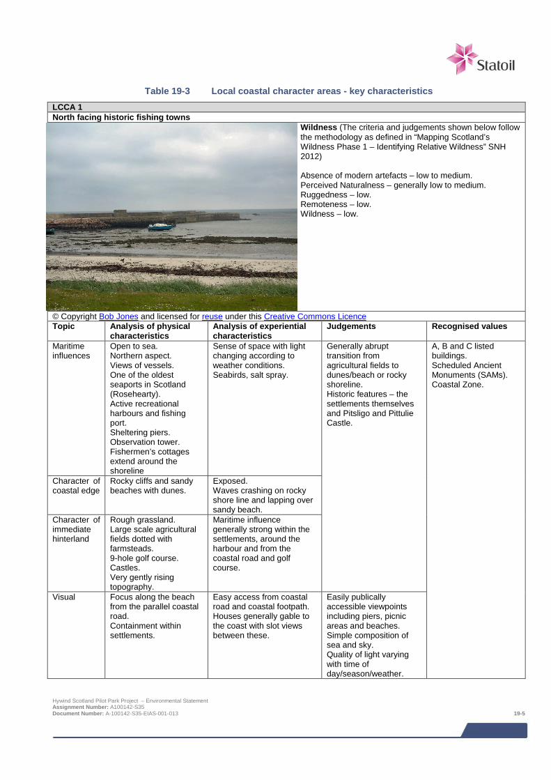
Table 19-3 Local coastal character areas - key characteristics
LCCA 1 North facing historic fishing towns
Wildness (The criteria and judgements shown below follow the methodology as defined in “Mapping Scotland’s Wildness Phase 1 – Identifying Relative Wildness” SNH 2012) Absence of modern artefacts – low to medium. Perceived Naturalness – generally low to medium. Ruggedness – low. Remoteness – low. Wildness – low.
© Copyright Bob Jones and licensed for reuse under this Creative Commons Licence Topic Analysis of physical
characteristics Analysis of experiential characteristics
Judgements Recognised values
Maritime influences
Open to sea. Northern aspect. Views of vessels. One of the oldest seaports in Scotland (Rosehearty). Active recreational harbours and fishing port. Sheltering piers. Observation tower. Fishermen’s cottages extend around the shoreline
Sense of space with light changing according to weather conditions. Seabirds, salt spray.
Generally abrupt transition from agricultural fields to dunes/beach or rocky shoreline. Historic features – the settlements themselves and Pitsligo and Pittulie Castle.
A, B and C listed buildings. Scheduled Ancient Monuments (SAMs). Coastal Zone.
Character of coastal edge
Rocky cliffs and sandy beaches with dunes.
Exposed. Waves crashing on rocky shore line and lapping over sandy beach.
Character of immediate hinterland
Rough grassland. Large scale agricultural fields dotted with farmsteads. 9-hole golf course. Castles. Very gently rising topography.
Maritime influence generally strong within the settlements, around the harbour and from the coastal road and golf course.
Visual Focus along the beach from the parallel coastal road. Containment within settlements.
Easy access from coastal road and coastal footpath. Houses generally gable to the coast with slot views between these.
Easily publically accessible viewpoints including piers, picnic areas and beaches. Simple composition of sea and sky. Quality of light varying with time of day/season/weather.
Hywind Scotland Pilot Park Project – Environmental Statement Assignment Number: A100142-S35 Document Number: A-100142-S35-EIAS-001-013 19-5

LCCA 2 Northern Port – Fraserburgh
Wildness (The criteria and judgements shown below follow the methodology as defined in “Mapping Scotland’s Wildness Phase 1 – Identifying Relative Wildness” SNH 2012) Absence of modern artefacts – low. Perceived Naturalness – low. Ruggedness – low. Remoteness – low. Wildness – low.
© Copyright Colin Smith and licensed for reuse under this Creative Commons Licence. Topic Analysis of physical
characteristics Analysis of experiential characteristics
Judgements Recognised values
Maritime Influences
Harbour. Large vessels. Fishing. Piers and slipways. Sheltered bay. South east facing shore. Views of ferries and other vessels. Slipway.
Sense of long settled landscape with seafaring history. Smells of the sea and fishing industry. Seabirds. Harbour activity.
Experienced by a large number of people of a daily basis – residents, visitors and the local workforce as well as crew on visiting vessels.
Conservation Area. B and C listed buildings. SAMs. Coastal Zone.
Character of Coastal Edge
Dunes and shallow slopes with sandy shoreline. Broad intertidal zone. Contrast of vertical edges at harbour and piers.
Harbour generally sheltered from the prevailing winds but other parts of the coast exposed.
Character of Immediate Hinterland
Urban. Industrial, residential, commercial recreation.
Enclosed urban streets. Properties with coastal views.
Visual Views to North Sea and Moray Firth. Views over activity at the harbour.
Overlooked by dwellings or commercial premises.
Views changing with the seasons, quality of light and activity around the harbour.
Hywind Scotland Pilot Park Project – Environmental Statement Assignment Number: A100142-S35 Document Number: A-100142-S35-EIAS-001-013 19-6

LCCA 3 North facing enclosed sandy bay
Wildness (The criteria and judgements shown below follow the methodology as defined in “Mapping Scotland’s Wildness Phase 1 – Identifying Relative Wildness” SNH 2012) Absence of modern artefacts – medium. Perceived Naturalness – high. Ruggedness – medium. Remoteness – low. Wildness – medium.
© Copyright Iain Macaulay and licensed for reuse under this Creative Commons Licence. Topic Analysis of physical
characteristics Analysis of experiential characteristics
Judgements Recognised values
Maritime Influences
Long, curving sandy beach with dues.
Views towards Fraserburgh harbour and associated sea going vessels. Waves lapping on the shallow shore. Seabirds, salt laden winds.
Experienced by local residents and visitors on the adjacent B9033, at the picnic area, car park and nature reserve and on the beach itself.
A and B listed buildings. SAMs. Coastal Zone.
Character of Coastal Edge
Smooth sandy beach with enclosing dune system.
Framing of bay by Kinnaird Head and Cairnbulg Point with lighthouses.
Character of Immediate Hinterland
Parallel B road. Golf course. Mixed woodland plantations and agriculture.
Varied relationship with shoreline – at times intimate at others non-existent where dunes obscure views.
Visual Views to boats entering and leaving the harbour. Views along the sweeping curve of the beach in both directions to the lighthouses.
Exposed but with a sense of enclosure afforded by the headlands. Few people – dependant on the season.
Easily accessible from the public road, car park and picnic site. Visible from the harbour at Fraserburgh.
Hywind Scotland Pilot Park Project – Environmental Statement Assignment Number: A100142-S35 Document Number: A-100142-S35-EIAS-001-013 19-7

LCCA 4 North East facing historic fishing villages
Wildness (The criteria and judgements shown below follow the methodology as defined in “Mapping Scotland’s Wildness Phase 1 – Identifying Relative Wildness” SNH 2012) Absence of modern artefacts – medium to low. Perceived Naturalness – generally low to medium. Ruggedness – low. Remoteness – low. Wildness – low.
© Copyright Anne Burgess and licensed for reuse under this Creative Commons Licence. Topic Analysis of physical
characteristics Analysis of experiential characteristics
Judgements Recognised values
Maritime Influences
Passing vessels. Sandy Beaches and dunes. Planned fishing villages. ‘Kitty Loch’. Harbour.
Sea spray and sounds. Seabirds. Sense of history and long settled villages with strong associations with the sea.
Experienced by local residents, golfers, dog walkers and other visitors.
Conservation Area. SAM. Coastal Zone.
Character of Coastal Edge
Houses abutting the shoreline with their gables to the sea. Rocky shorelines punctuated by sandy beaches.
Varied dependent on location, season and weather.
Character of Immediate Hinterland
Golf course. Coastal track. Gorse scrub and coniferous plantation. Disused airfield.
Managed landscape accessible to golfers and walkers along the coastal track between the villages.
Visual Views from village to village along the coast. Views out to sea from low lying locations on the beach with an enclosing backdrop of dunes.
Dominance of the sea where the immediate backcloth is formed by dunes or the buildings in the villages.
Easily accessible from the villages and the tracks and footpaths parallel to the coast.
Hywind Scotland Pilot Park Project – Environmental Statement Assignment Number: A100142-S35 Document Number: A-100142-S35-EIAS-001-013 19-8
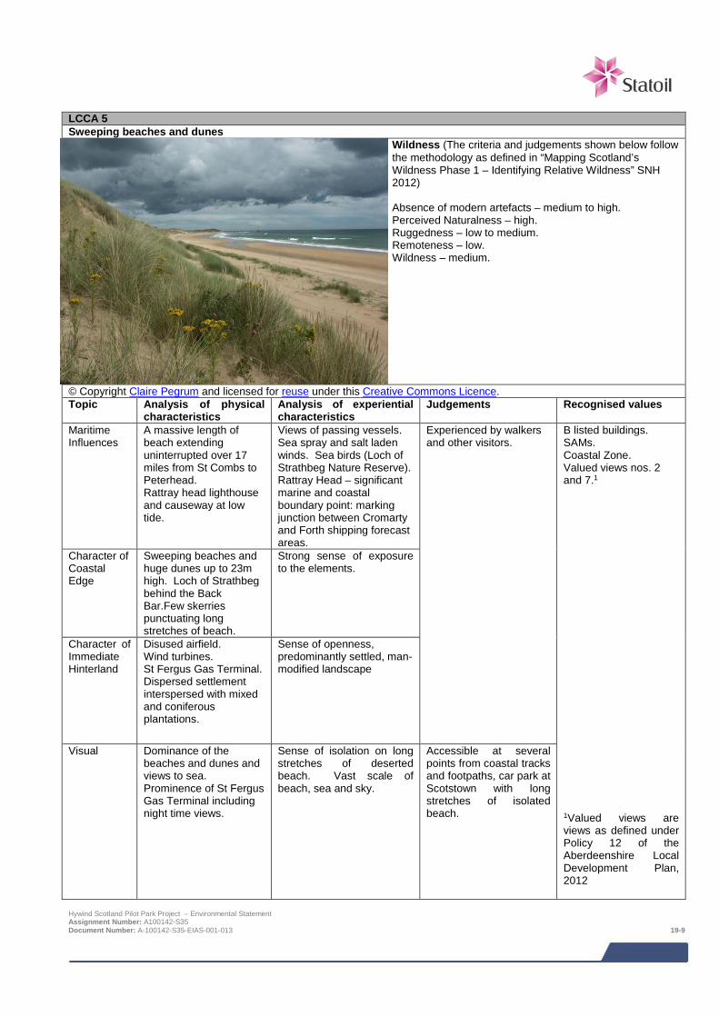
LCCA 5 Sweeping beaches and dunes
Wildness (The criteria and judgements shown below follow the methodology as defined in “Mapping Scotland’s Wildness Phase 1 – Identifying Relative Wildness” SNH 2012) Absence of modern artefacts – medium to high. Perceived Naturalness – high. Ruggedness – low to medium. Remoteness – low. Wildness – medium.
© Copyright Claire Pegrum and licensed for reuse under this Creative Commons Licence. Topic Analysis of physical
characteristics Analysis of experiential characteristics
Judgements Recognised values
Maritime Influences
A massive length of beach extending uninterrupted over 17 miles from St Combs to Peterhead. Rattray head lighthouse and causeway at low tide.
Views of passing vessels. Sea spray and salt laden winds. Sea birds (Loch of Strathbeg Nature Reserve). Rattray Head – significant marine and coastal boundary point: marking junction between Cromarty and Forth shipping forecast areas.
Experienced by walkers and other visitors.
B listed buildings. SAMs. Coastal Zone. Valued views nos. 2 and 7.1
1Valued views are views as defined under Policy 12 of the Aberdeenshire Local Development Plan, 2012
Character of Coastal Edge
Sweeping beaches and huge dunes up to 23m high. Loch of Strathbeg behind the Back Bar.Few skerries punctuating long stretches of beach.
Strong sense of exposure to the elements.
Character of Immediate Hinterland
Disused airfield. Wind turbines. St Fergus Gas Terminal. Dispersed settlement interspersed with mixed and coniferous plantations.
Sense of openness, predominantly settled, man-modified landscape
Visual Dominance of the beaches and dunes and views to sea. Prominence of St Fergus Gas Terminal including night time views.
Sense of isolation on long stretches of deserted beach. Vast scale of beach, sea and sky.
Accessible at several points from coastal tracks and footpaths, car park at Scotstown with long stretches of isolated beach.
Hywind Scotland Pilot Park Project – Environmental Statement Assignment Number: A100142-S35 Document Number: A-100142-S35-EIAS-001-013 19-9

LCCA 6 Eastern Port – Peterhead
Wildness (The criteria and judgements shown below follow the methodology as defined in “Mapping Scotland’s Wildness Phase 1 – Identifying Relative Wildness” SNH 2012) Absence of modern artefacts – low. Perceived Naturalness – generally low to medium. Ruggedness – low. Remoteness – low. Wildness – low.
© Copyright Kevin Rothwell and licensed for reuse under this Creative Commons Licence. Topic Analysis of physical
characteristics Analysis of experiential characteristics
Judgements Recognised values
Maritime Influences
Activity associated with the fishing industry around the busy harbour. Shipping vessels. Piers, harbour walls and light houses.
Strong historical association with the sea. Noise and activity around the harbour.
Experience by local residents and visitors travelling in Peterhead and Boddam.
Conservation Areas. B and C listed buildings. SAMs. Coastal Zone. Valued view no. 2.
Character of Coastal Edge
Rocky shoreline interspersed with the small sandy beaches including Sandford Bay. Peterhead Bay – natural harbour afforded greater protection by enclosing walls and piers.
Changing experience with sense of enclosure in Sandford Bay contrasting with the exposure experienced at the promontories. Prominence of Power Station and the large building at Score Europe.
Character of Immediate Hinterland
Generally urban and industrial with some agricultural grassland inland of Sandford Bay.
Sense of shelter and enclosure afforded by dense settlements.
Visual Very varied experience of views depending on location within the townscape.
Ever changing visual scene with a complex combination of views of harbour structures, vessels, indented coast, sandy beach overlooked by the power station towers.
Generally easily accessible shore from the urban areas although in part cut off from access by industrial developments.
Hywind Scotland Pilot Park Project – Environmental Statement Assignment Number: A100142-S35 Document Number: A-100142-S35-EIAS-001-013 19-10
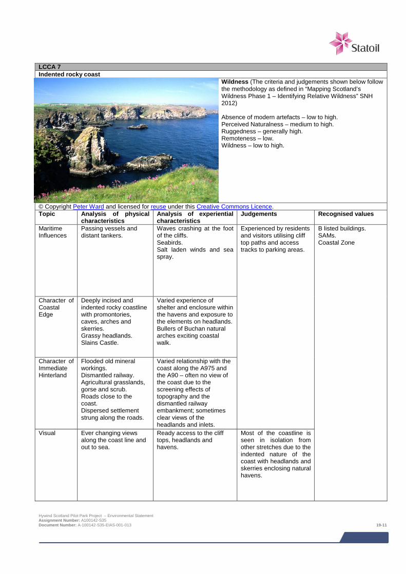
LCCA 7 Indented rocky coast
Wildness (The criteria and judgements shown below follow the methodology as defined in “Mapping Scotland’s Wildness Phase 1 – Identifying Relative Wildness” SNH 2012) Absence of modern artefacts – low to high. Perceived Naturalness – medium to high. Ruggedness – generally high. Remoteness – low. Wildness – low to high.
© Copyright Peter Ward and licensed for reuse under this Creative Commons Licence. Topic Analysis of physical
characteristics Analysis of experiential characteristics
Judgements Recognised values
Maritime Influences
Passing vessels and distant tankers.
Waves crashing at the foot of the cliffs. Seabirds. Salt laden winds and sea spray.
Experienced by residents and visitors utilising cliff top paths and access tracks to parking areas.
B listed buildings. SAMs. Coastal Zone
Character of Coastal Edge
Deeply incised and indented rocky coastline with promontories, caves, arches and skerries. Grassy headlands. Slains Castle.
Varied experience of shelter and enclosure within the havens and exposure to the elements on headlands. Bullers of Buchan natural arches exciting coastal walk.
Character of Immediate Hinterland
Flooded old mineral workings. Dismantled railway. Agricultural grasslands, gorse and scrub. Roads close to the coast. Dispersed settlement strung along the roads.
Varied relationship with the coast along the A975 and the A90 – often no view of the coast due to the screening effects of topography and the dismantled railway embankment; sometimes clear views of the headlands and inlets.
Visual Ever changing views along the coast line and out to sea.
Ready access to the cliff tops, headlands and havens.
Most of the coastline is seen in isolation from other stretches due to the indented nature of the coast with headlands and skerries enclosing natural havens.
Hywind Scotland Pilot Park Project – Environmental Statement Assignment Number: A100142-S35 Document Number: A-100142-S35-EIAS-001-013 19-11
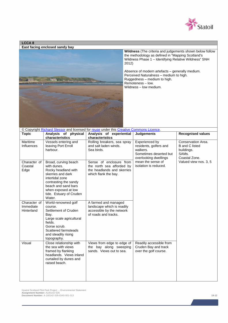
LCCA 8 East facing enclosed sandy bay
Wildness (The criteria and judgements shown below follow the methodology as defined in “Mapping Scotland’s Wildness Phase 1 – Identifying Relative Wildness” SNH 2012) Absence of modern artefacts – generally medium. Perceived Naturalness – medium to high. Ruggedness – medium to high. Remoteness – low. Wildness – low medium.
© Copyright Richard Slessor and licensed for reuse under this Creative Commons Licence. Topic Analysis of physical
characteristics Analysis of experiential characteristics
Judgements Recognised values
Maritime Influences
Vessels entering and leaving Port Erroll harbour.
Rolling breakers, sea spray and salt laden winds. Sea birds.
Experienced by residents, golfers and walkers. Sometimes deserted but overlooking dwellings mean the sense of isolation is reduced.
Conservation Area. B and C listed buildings. SAMs. Coastal Zone. Valued view nos. 3, 5 Character of
Coastal Edge
Broad, curving beach with dunes. Rocky headland with skerries and dark intertidal zone contrasting the sandy beach and sand bars when exposed at low tide. Estuary of Cruden Water.
Sense of enclosure from the north sea afforded by the headlands and skerries which flank the bay.
Character of Immediate Hinterland
World-renowned golf course. Settlement of Cruden Bay. Large scale agricultural fields. Gorse scrub. Scattered farmsteads and steadily rising topography.
A farmed and managed landscape which is readily accessible by the network of roads and tracks.
Visual Close relationship with the sea with views framed by flanking headlands. Views inland curtailed by dunes and raised beach.
Views from edge to edge of the bay along sweeping sands. Views out to sea.
Readily accessible from Cruden Bay and track over the golf course.
Hywind Scotland Pilot Park Project – Environmental Statement Assignment Number: A100142-S35 Document Number: A-100142-S35-EIAS-001-013 19-12

LCCA 9 Long beaches, links and dunes
Wildness (The criteria and judgements shown below follow the methodology as defined in “Mapping Scotland’s Wildness Phase 1 – Identifying Relative Wildness” SNH 2012) Absence of modern artefacts – medium to high. Perceived Naturalness – medium to high. Ruggedness – low to medium. Remoteness – low. Wildness – medium to high.
© Copyright C Michael Hogan and licensed for reuse under this Creative Commons Licence. Topic Analysis of physical
characteristics Analysis of experiential characteristics
Judgements Recognised values
Maritime Influences
Passing vessels and distant tankers. River Ythan Estuary.
Strong sense of exposure to the elements with wide stretches of beach. Some shelter afforded by the sand dunes. Sea birds, salt laden winds.
Sparsely populated by dog walkers and visitors. Large scale with simple relationship between the beach, the sea and the sky.
A, B and C listed buildings. SAMs. Coastal Zone. Greenbelt. Valued view no.11.
Character of Coastal Edge
Simple linear expanse of beach curving patterns where numerous burns discharge.
Consistent experience of exposure and views along the entire length of the beach.
Character of Immediate Hinterland
Dynamic system of dunes with marram and other grasses as well as gorse and scrub. Recently developed golf course on Menie Links (Trump International). Dispersed settlement pattern.
Active natural dune system in contrast to the managed links course at Menie.
Visual Vast expanse of beach, sea and sky with long views north and south along the beach.
Simplicity of composition and consistency of the types of view obtained.
Readily accessible from car parks and track. Scale of the LCCA means many people can be accommodated without detracting from the perceived size nor from the sheer scale of the elements in views.
Hywind Scotland Pilot Park Project – Environmental Statement Assignment Number: A100142-S35 Document Number: A-100142-S35-EIAS-001-013 19-13
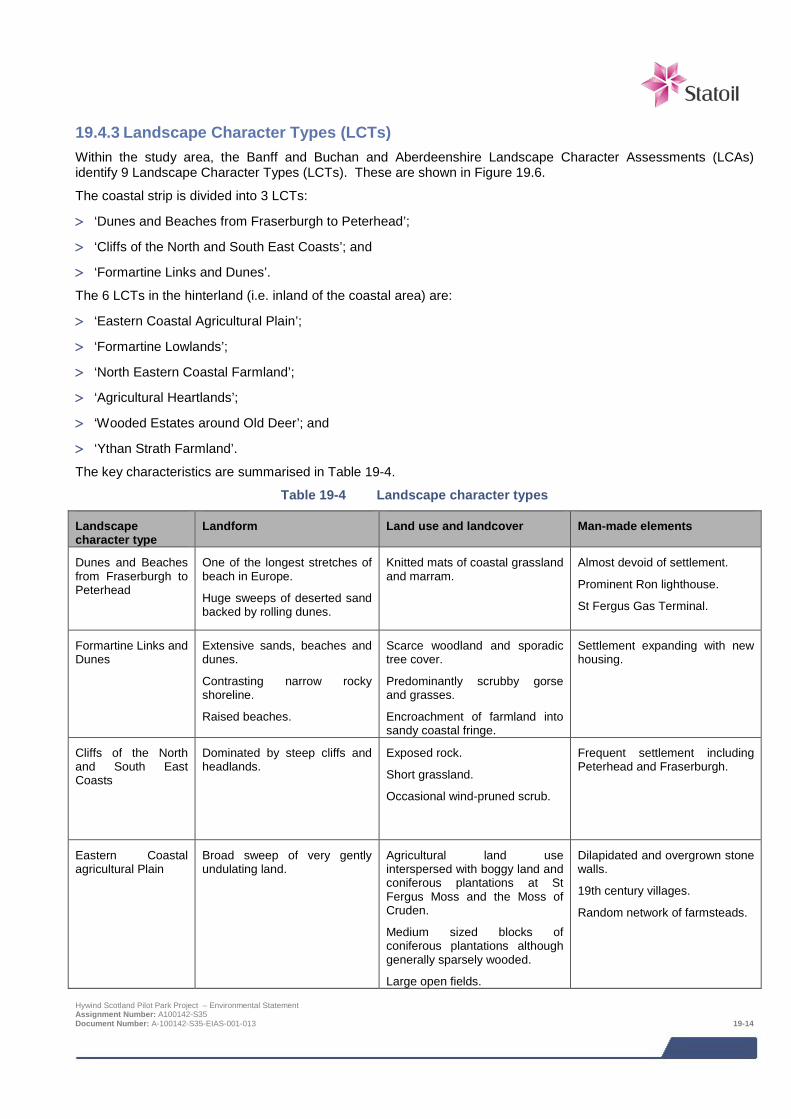
19.4.3 Landscape Character Types (LCTs) Within the study area, the Banff and Buchan and Aberdeenshire Landscape Character Assessments (LCAs) identify 9 Landscape Character Types (LCTs). These are shown in Figure 19.6.
The coastal strip is divided into 3 LCTs:
> ‘Dunes and Beaches from Fraserburgh to Peterhead’;
> ‘Cliffs of the North and South East Coasts’; and
> ‘Formartine Links and Dunes’.
The 6 LCTs in the hinterland (i.e. inland of the coastal area) are:
> ‘Eastern Coastal Agricultural Plain’;
> ‘Formartine Lowlands’;
> ‘North Eastern Coastal Farmland’;
> ‘Agricultural Heartlands’;
> ‘Wooded Estates around Old Deer’; and
> ‘Ythan Strath Farmland’.
The key characteristics are summarised in Table 19-4.
Table 19-4 Landscape character types
Landscape character type
Landform Land use and landcover Man-made elements
Dunes and Beaches from Fraserburgh to Peterhead
One of the longest stretches of beach in Europe.
Huge sweeps of deserted sand backed by rolling dunes.
Knitted mats of coastal grassland and marram.
Almost devoid of settlement.
Prominent Ron lighthouse.
St Fergus Gas Terminal.
Formartine Links and Dunes
Extensive sands, beaches and dunes.
Contrasting narrow rocky shoreline.
Raised beaches.
Scarce woodland and sporadic tree cover.
Predominantly scrubby gorse and grasses.
Encroachment of farmland into sandy coastal fringe.
Settlement expanding with new housing.
Cliffs of the North and South East Coasts
Dominated by steep cliffs and headlands.
Exposed rock.
Short grassland.
Occasional wind-pruned scrub.
Frequent settlement including Peterhead and Fraserburgh.
Eastern Coastal agricultural Plain
Broad sweep of very gently undulating land.
Agricultural land use interspersed with boggy land and coniferous plantations at St Fergus Moss and the Moss of Cruden.
Medium sized blocks of coniferous plantations although generally sparsely wooded.
Large open fields.
Dilapidated and overgrown stone walls.
19th century villages.
Random network of farmsteads.
Hywind Scotland Pilot Park Project – Environmental Statement Assignment Number: A100142-S35 Document Number: A-100142-S35-EIAS-001-013 19-14
Landscape character type
Landform Land use and landcover Man-made elements
Formartine Lowlands Gently undulating lowland plateau.
Low lying hollows of poorly drained ground.
Scrubby, rushy pasture supporting rough grazing.
Prominent lines of trees and policy woodlands.
Relatively large, compact settlements.
Large farms with storage buildings.
Roads and transmission lines.
Numerous archaeological remains.
North Eastern Coastal Farmland
Open, undulating high plateau. Cultivated crops.
Rushy pasture.
Moorland, mosses.
Small blocks of coniferous woodland.
Occasional broad-leaved trees.
Widely-scattered farmsteads.
Minor settlements including Mid Arlaw and Memsie.
Abandoned farmsteads.
Agricultural Heartlands
Gently rolling landform. Cultivated crops and pasture.
Frequent broadleaved trees, shelterbelts.
Small coniferous blocks.
Hedges, stone walls and dykes.
Well-settled.
Frequent farmsteads and small hamlets including New Byth. Larger villages including Strichen, New Deer, and Cuminestown.
Wooded Estates around Old Deer
Gently rolling hills. Dominance of woodland.
Mixed deciduous and coniferous planting.
Hedgerows, avenue planting, mainly beech.
Well-settled.
Planned villages including Stuartfield, Mintlaw, and Fetterangus.
Numerous farmsteads.
Estates (Aden, Pitfour) Old Deer Abbey.
Ythan Strath Farmland
Undulating landform centred on shallow strath.
Pasture, gorse and broom scrubland.
Small coniferous plantations.
Sparsely-settled.
Methlick only notable settlement.
19.4.4 Landscape designations There are no National Scenic Areas, Areas of Great Landscape Value or Special Landscape Areas within the study area.
Gardens and Designed Landscapes There is one Garden and Designed Landscape (G&DL) at Haddow House which lies within the study area (Figure 19.7).
Coastal Zone With the exception of the urban areas of Fraserburgh and Peterhead, all of the coast within the study area is included in the ‘Coastal Zone’ as defined in Policy 4 of the Aberdeenshire Local Development Plan, 20122 (Figure 19.7).
2 The aim of this policy is to protect the special nature of the coastal area and greenbelt, and to direct development to the least environmentally sensitive areas. Hywind Scotland Pilot Park Project – Environmental Statement Assignment Number: A100142-S35 Document Number: A-100142-S35-EIAS-001-013 19-15

Greenbelt A small section of the Aberdeen Greenbelt as defined in Policy 4 of the Aberdeenshire Local Development Plan, 2012 falls within the study area (Figure 19.7).
19.4.5 Viewpoints Introduction The visual assessment was undertaken by two chartered landscape architects specifically looking for the Project within specific views, and in conditions of good visibility, which is defined by the Meteorological Office as equating to when an observer can see further than 9.26 km. The visual assessment is therefore intended to represent a ‘worst case’ scenario of the likely effect of the Project on visual amenity.
ZTV mapping ZTV mapping has been undertaken to indicate the likely extent and pattern of potential visibility of the Proposed Development within the study area, and is used as a tool inform the visual impact assessment process. The ‘Bare Ground’ ZTV, as shown on Figure 19.2, demonstrates theoretical visibility of the proposed offshore components of the proposed development. It should be noted that the ZTV was generated to distinguish the number of blade tips theoretically visible (varying from one to all five WTGs). Areas where blade tips of less than five WTGs were theoretically visible however were of a minor extent, and accordingly, the ZTV indicates “areas where blade tips of one or more WTG are theoretically visible”. This accords with the principle of assessing the “worst case scenario” for all effects.
Selected viewpoints The 7 viewpoints selected were discussed and agreed with Marine Scotland, Aberdeenshire Council and Scottish Natural Heritage. The process initially resulted in agreement of 4 viewpoints (Nos.1-4 below). Aberdeenshire Council subsequently requested an additional 3 viewpoints to be added (Nos. 5-7). Finally Marine Scotland requested that full visualisations to SNH 2014 standards were to be prepared for all viewpoints. The locations of the viewpoints are shown on Figure 19.2. Information about the viewpoints is presented in Table 19-5 below. In discussion with Marine Scotland, Aberdeenshire Council and Scottish Natural Heritage, it was also agreed to assess the visual impacts of the Project on the Menie Links Golf Course (Trump International Golf Links), although a specific additional viewpoint was not required
Table 19-5 Viewpoint information
No. Viewpoint location Grid reference
Approx. height above ordnance datum (gps reading)
Approx. bearing to proposed turbines
Reason for selection
Main receptor group(s) represented
Approx. distance to proposed turbines
1 Scotstown Head 11348, 52191
19 m 105° Walkers 26 km
2 Gadle Braes, Peterhead
12574, 47281
11 m 95° Residents Visitors Walkers
23 km
3 Slains Castle Car Park
10216, 36960
18 m 80° Visitors
Road users
26 km
4 Near A950 Thunderton
07714, 46338
55 m 95° Road users 29 km
Hywind Scotland Pilot Park Project – Environmental Statement Assignment Number: A100142-S35 Document Number: A-100142-S35-EIAS-001-013 19-16
No. Viewpoint location Grid
reference Approx. height above ordnance datum (gps reading)
Approx. bearing to proposed turbines
Reason for selection
Main receptor group(s) represented
Approx. distance to proposed turbines
5 Peterhead Bay 12371, 45314
12 m 92° Requested by Aberdeenshire Council
25 km
6 Reform Tower 12167, 44655
50 m 91° Requested by Aberdeenshire Council
26 km
7 Stirling Hill 11655, 41107
92 m 83° Requested by Aberdeenshire Council
26 km
Table 19-6 Description of existing views
No. Viewpoint location
Description of existing view
1 Scotstown Head This view is experienced by people accessing the beach car park via the 1.2m long minor road/track from the A90 to the car park at Scotstown Head, and then walking over the sand dunes to the beach. The viewpoint location is to the east of the route through the dunes on an area of high ground.
The view from this location takes in a 360° panorama. Looking to the south the view is along the tops of the marram covered dunes which rise from the wide sandy beach. To the south west, the foreground is occupied by the marram grass on the dunes with a mid ground of rough grassland giving way to deciduous woodland along the A90 corridor, with coniferous forestry and moorland further inland. The three wind turbines on Bruxiehill are prominent large scale vertical objects towering above the electricity pylons which run along the skyline. The view west looks towards the settlement of St Fergus, with a wooded backdrop. Looking north west, the scene is one of subtle horizontal layers including a secondary dune ridgeline, rough grassland, deciduous woodland and arable fields backed by the distant profile of Mormond Hill. Overlaid on this landscape are vertical features such as electricity pylons, the four wind turbines at Overside and Greenwellhead Farm, lighting on the perimeter of the Peterhead Gas Terminal and some large scale structures of the terminal. The view north is along the dunes and beach towards Rattray Head with gas flares and other large structures within the terminal site and the distant Rattray Head Lighthouse.
Looking seaward, the lighthouse is the only scale indicator other than transitory vessels.
The overall impression is of a large scale, exposed coast with a very strong horizontal emphasis dominated by seaward views.
Hywind Scotland Pilot Park Project – Environmental Statement Assignment Number: A100142-S35 Document Number: A-100142-S35-EIAS-001-013 19-17
No. Viewpoint
location Description of existing view
2 Gadle Braes, Peterhead
This viewpoint represents residents, whose front rooms and gardens overlook the green, and people passing along the promenade or walking on the beach below.
Looking inland, the view is of houses, gardens, play equipment, roofscapes, roads, lighting and vehicles. The panorama is therefore concentrated on seawards views with the view being framed either side by buildings.
To the north, the distant lattice towers and gas flares at the St Fergus gas terminal provide an incongruous industrial contrast to the dynamic landscape of the sand dunes. The lighthouse at Rattray Head is a prominent vertical feature in the view to the north.
Looking north east, east and south east, the promenade forms the foreground of the view, consisting of a managed man made landscape of close mown grass, tarmac footpath, benches, retaining wall, railings and lighting columns abutting the natural rocky shoreline. Extending out into the sea is a concrete-encased outfall pipe which is visible to greater or lesser extents depending on the state of the tide. The only scale indicators out to sea are the various vessels moving along the coast.
The impression obtained from this location is one of an urban residential/recreational landscape bordering a vibrant and ever changing seascape.
3 Slains Castle Car Park
This viewpoint is located beside the A975 and is representative of the views seen by visitors to the Castle, and by road users travelling north.
Looking inland, the view takes in an agricultural landscape of large scale arable fields with mixed woodland and rough grassland overlying an undulating topography. Vertical features include masts on Mains of Ardiffery, wood poles and electricity pylons with the silhouette of Slains Castle perched on the cliff to the south. Looking north the eye is drawn to the large white sphere of the remote radar head near Longhaven with adjacent radio masts.
The foreground of seaward views is occupied by a mixture of arable fields and grazings with only a narrow sliver of sea being visible due to the slightly convex profile and the land above the cliffs.
Although very close to the coast, this viewpoint has a stronger relationship with the landscape than it does with the seascape as the sea occupies such a narrow band between the largely uniform agricultural foreground and the sky.
Hywind Scotland Pilot Park Project – Environmental Statement Assignment Number: A100142-S35 Document Number: A-100142-S35-EIAS-001-013 19-18

No. Viewpoint
location Description of existing view
4 Near A950 Thunderton
This viewpoint was modified to a location on the minor road south of the A950 as this position is at a higher elevation than the main road. The view is representative of that seen primarily by road users, but also by people working in the surrounding area.
There is a 360° panorama obtained from this location. Much of the view is over a working landscape with a mixture of arable land, grazing, wind turbines, industrial buildings, sand and gravel workings on the disused airfield at Thunderton, as well as pylons, wood pole mounted overhead lines, communications masts, roads and traffic interspersed with mature, mainly deciduous tree belts.
Looking in the direction of the proposed turbines, much of the horizon is occupied by mature trees and large scale buildings north of Clubcross - the sea surface is not visible.
The detailed landform at this viewpoint (a gently undulating plateau with convex gradients seawards) limits the distance of views, and in combination with the existing tree cover results in there being no visual relationship with the coastline.
5 Peterhead Bay This viewpoint is located adjacent to the A982 west of Peterhead Bay on the footpath leading from the harbour down to the bay and the campsite. The view is representative of that seen by people in the car park, walkers on the footpath and residents on the west of the A982.
Views to the north are curtailed by built development. Looking to the north east, the foreground of the view is occupied by the large expanse of grassy banks between the bay and the A982 with the waters of the bay, enclosed by the harbour walls, forming the mid ground. The view looks out over Peterhead with some low lying, large scale industrial buildings contrasting with the delicate church spires and smaller scale buildings which form the horizon. Large cable reels on the northern shore and vessels within the harbour add blocks of colour to the muted tones of the buildings in the town. Looking west, the lighthouses at the harbour mouth form two vertical visual foci with the horizon of the sea visible beyond. Looking south east, vessels in the marina are seen against a backdrop of cranes, much larger vessels and oil and shipping containers. The prison is visible above the marina. Looking to the south, the view is over the tops of static caravans to the curve of the sandy bay with yachts and other small vessels stored below the escarpment. Houses along the A982 screen views further south with the notable exception of one of the chimneys at the power station which forms a strong vertical visual focus.
Hywind Scotland Pilot Park Project – Environmental Statement Assignment Number: A100142-S35 Document Number: A-100142-S35-EIAS-001-013 19-19
No. Viewpoint
location Description of existing view
6 Reform Tower The tower is not accessible to the public and the viewpoint is therefore located at the base of the tower in an area of open ground east of the A982 at Invernettie. Looking north east, the view is over the Whitehill Industrial Estate with a backcloth of mature deciduous trees. The twin masts west of Meethill are prominent vertical features on the skyline. Traffic on the A982 is obscured by coniferous vegetation planted on the roadside cuttings. In views to the north, the scene is one of suburban roofscapes with a central open space at Clerkhill. Trees are infrequent in the view. Looking north east, the view is over the grassed area at the top of the escarpment above the bay. The sweeping curve of the coastline draws the eye round to the working port with vessels moored alongside cluttered piers. Large scale buildings and structures line the northern shore of the bay with the buildings in Peterhead forming the skyline beyond. From this location, the gap in the sea wall at the harbour mouth is not apparent although the twin lighthouses hint at its presence. Crainage at the marina is visible above the rooftops at Invernettie. Looking south east, a water tank is visible in the foreground with the chimneys and large scale buildings and structures at the power station being the main visual focus looking in this direction.
7 Stirling Hill This viewpoint is located on a newly formed footpath near Hillhead of Coldwells radio station. The view will be seen by walkers, visitors to the Den of Boddam flint quarry site and anglers accessing the nearby lochan. Looking west, the view is blocked by the chainlink and barbed wire fence surrounding the masts, buildings and structures at Hill of Coldwells. Views north west look over gently undulating agricultural fields with steel lattice towers and overhead electricity lines leading from the Millbank substation. Looking north, wind turbines are visible near Rattray Head. Looking directly along the line of the new path, the Reform Tower also punctuates the skyline with the structures, chimneys and buildings at the power station forming a strong, large scale visual focus to the north east. Looking east the mid ground is occupied by Boddam Quarry with a single radio mast above and a further pair of masts further to the south of the quarry.
19.4.6 Sequential routes Sequential routes are defined in this study as important transport and recreational routes which may experience visual impacts from the development. Their assessment was specifically requested during the scoping process. The following routes (shown on Figure19.8) fall within the study area and have some level of theoretical visibility of the proposed turbines:
> A90; > B977; > B9000; > B9030;
> A950; > B979; > B9107; > B9032;
> A952; > B997; > B9170; > B9033;
> A98; > B999; > B9029; > B9093;
> National Cycle Network Route 1;
> Formantine and Buchan Way; and
> Aberdeen to Orkney/Shetland Ferry Route.
Hywind Scotland Pilot Park Project – Environmental Statement Assignment Number: A100142-S35 Document Number: A-100142-S35-EIAS-001-013 19-20
19.4.7 Valued Views The following additional specific viewpoints identified as key or noteworthy locations were included in the assessment. These consist of the seven ‘valued views’ protected under Policy 12 the Aberdeenshire Local Development Plan, 2012. They are shown on Figure 19.7 and are listed below:
> Across Peterhead Bay from South Road;
> The River Ugie Estuary from North Road;
> Overlooking the Sea from Harbour Street, Cruden Bay;
> Overlooking the harbour from Cruden Bay Golf Course;
> St Fergus Gas Terminal from the A90, particularly at night;
> Slains Castle from Cruden Bay; and
> Ythan Estuary from A975 and associated passing places.
19.4.8 Settlements The primary settlement within the study area is Peterhead. The ZTV (Figure 19.2) indicates that the majority of the town will have theoretical visibility of the Project. Although a number of other smaller settlements fall within the study area and the ZTV, it was considered that due to the greater separation distances, generally more than 25 km, and the relatively smaller viewer numbers, significant visual impacts in relation to the overall settlement were not likely to occur, and accordingly they have not been assessed further.
19.4.9 Data gaps and uncertainties Publications relevant to the region have been reviewed, which when combined with fieldwork, provide a comprehensive baseline of the seascape, landscape and visual amenity of the Project area.
19.5 Impact assessment
19.5.1 Overview Following establishment of the baseline conditions of the Project and surrounding areas, and an understanding of the Project activities it is possible to assess the potential impacts from the Project. The range of impacts that has been considered is based on impacts identified during EIA scoping and any further potential impacts that have been identified as the EIA progressed. The impacts assessed are summarised below:
> Impacts on seascape;
> Impacts on landscape;
> Visual impacts; and
> Cumulative and in-combination impacts.
Seascape impacts are impacts on seascape as a resource and affect seascape receptors as defined in the baseline study.
Landscape impacts are impacts on landscape as a resource and affect landscape receptors as defined in the baseline study.
Visual impacts are impacts on views and visual amenity as experienced by people and affect visual receptors as defined in the baseline study.
Cumulative impacts may occur to the seascape, landscape, or visual resource and are defined as “the additional changes caused by a proposed development in conjunction with other similar developments or as the combined effect of a set of developments, taken together.”(SNH 2012b). Hywind Scotland Pilot Park Project – Environmental Statement Assignment Number: A100142-S35 Document Number: A-100142-S35-EIAS-001-013 19-21

The assessment of effects on seascape landscape and visual receptors derives from review of the ZTV figures, and examination of the photographs wirelines and photomontageviews, supported by field survey. All visualisations have been prepared in accordance with SNH guidance (Visual Representation of Wind Farms, Version 2.1, December 2014).
Design and Mitigation This assessment is based on an indicative layout within a fixed turbine deployment area, with the worst case options assumed for rotor size and number of WTG units. Although there is a small probability that the indicative layout may be revised, given the long distance offshore, it is not considered that this would result in a material change to the design, or provide opportunities for significant mitigation.
19.5.2 Assessment criteria The EIA process and methodology are described in detail in Chapter 6. However, as the definition of ‘sensitivity of receptor’ and magnitude of effect/change differs between different topics, topic specific criteria have been developed. In relation to this assessment and based on the published guidance it is necessary to present specific separate criteria for Seascape, Landscape and Visual Impacts. The sensitivity of the receptor and magnitude of effect/change criteria specific to Seascape are defined in Table 19-7 and Table 19-8 respectively, in Table 19-9 and Table 19-10 specific to Landscape, and in Table 19-11 and Table 19-12 specific to Visual Amenity.
Seascape sensitivity The relative sensitivity of the seascape within the Local Coastal Character Areas is specific to the proposed change and depends upon a range of criteria which take account of the coastline, and both landward and seaward perspectives. The published guidance (SNH, 2012; SNH, 2008; The Landscape Institute and the Institute of Environmental Management and Assessment 2013) has been referred to in developing and applying the criteria. For the purposes of this assessment the following definitions have been applied. It is stressed that in the assessment of a specific receptor/effect, the actual criteria applied may differ from the typical criteria noted below. In all cases a clear explanation of the reasons for the judgement of sensitivity is given.
Hywind Scotland Pilot Park Project – Environmental Statement Assignment Number: A100142-S35 Document Number: A-100142-S35-EIAS-001-013 19-22

Table 19-7 Sensitivity of seascape receptors
Sensitivity of receptor Typical criteria Very High Susceptibility to proposed change
Seascapes with very distinctive physical characteristics including shape, enclosure, fragmentation, and prominent historic, cultural, or geological features. Seascapes with spectacular views, very complex visual composition, very high diversity of detail, and aesthetic qualities which are intact and uncompromised. Value Seascapes located within and which contribute to the value of landscapes designated at national and international level. Seascapes with a very high degree of relative wildness3, with strong evidence of and exposure to natural forces. Seascapes where there is evidence of high or very high value associated with natural heritage, recreational activity, cultural associations, or other special interests.
High Susceptibility to proposed change Seascapes with distinctive physical characteristics including shape, enclosure, fragmentation, and specific historic, cultural, geological features. Seascapes with striking/expansive views, diverse visual composition and aesthetic qualities which are predominantly intact. Value Seascapes located within and which contribute to landscapes of high value, recognised at regional or local level. Seascapes with a high degree of relative wildness. Seascapes where there is evidence of value associated with natural heritage, recreational activity, cultural associations, or other special interests.
Medium Susceptibility to proposed change Seascapes with relatively unremarkable physical characteristics including linear shape, large-scale, and little fragmentation. Seascapes with relatively simple visual composition. Seascapes where settings of key views include some developed features and shipping or other maritime activity. Value Seascapes with a degree of relative wildness, which may be compromised by factors including existing development and accessibility. Seascapes with few specific features of natural heritage, cultural associations, or other special interest.
Low Susceptibility to proposed change Seascapes comprising well-settled and readily accessible coastlines and hinterlands. Seascapes with prominent and frequent shipping or other maritime activity. Value Seascapes with no specific features of natural heritage, cultural associations, or other special interest.
Negligible Susceptibility to proposed change Seascapes comprising urban coastlines and hinterlands dominated by development. Seascapes with seaward views dominated by shipping or other maritime activity. Value Seascapes with no specific features of natural heritage, cultural associations, or other special interest.
3 The level or degree of relative wildness will be assessed taking account of the existing SNH methodology as set out in “Mapping Scotland’s Wildness Phase 1 – Identifying Relative Wildness Non –Technical Methodology, revised October 2012”. The reasons for the judgements on levels of wildness are clearly set out and justified in the assessment Hywind Scotland Pilot Park Project – Environmental Statement Assignment Number: A100142-S35 Document Number: A-100142-S35-EIAS-001-013 19-23
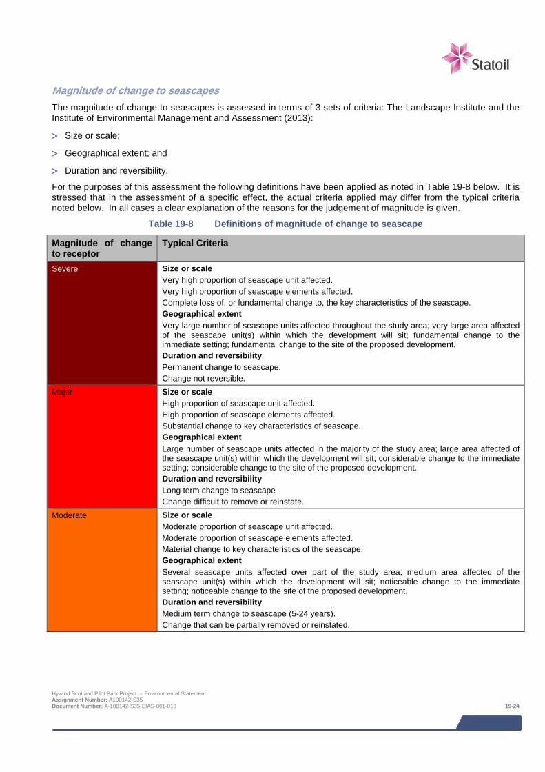
Magnitude of change to seascapes The magnitude of change to seascapes is assessed in terms of 3 sets of criteria: The Landscape Institute and the Institute of Environmental Management and Assessment (2013):
> Size or scale;
> Geographical extent; and
> Duration and reversibility.
For the purposes of this assessment the following definitions have been applied as noted in Table 19-8 below. It is stressed that in the assessment of a specific effect, the actual criteria applied may differ from the typical criteria noted below. In all cases a clear explanation of the reasons for the judgement of magnitude is given.
Table 19-8 Definitions of magnitude of change to seascape
Magnitude of change to receptor
Typical Criteria
Severe Size or scale Very high proportion of seascape unit affected. Very high proportion of seascape elements affected. Complete loss of, or fundamental change to, the key characteristics of the seascape. Geographical extent Very large number of seascape units affected throughout the study area; very large area affected of the seascape unit(s) within which the development will sit; fundamental change to the immediate setting; fundamental change to the site of the proposed development. Duration and reversibility Permanent change to seascape. Change not reversible.
Major Size or scale High proportion of seascape unit affected. High proportion of seascape elements affected. Substantial change to key characteristics of seascape. Geographical extent Large number of seascape units affected in the majority of the study area; large area affected of the seascape unit(s) within which the development will sit; considerable change to the immediate setting; considerable change to the site of the proposed development. Duration and reversibility Long term change to seascape Change difficult to remove or reinstate.
Moderate Size or scale Moderate proportion of seascape unit affected. Moderate proportion of seascape elements affected. Material change to key characteristics of the seascape. Geographical extent Several seascape units affected over part of the study area; medium area affected of the seascape unit(s) within which the development will sit; noticeable change to the immediate setting; noticeable change to the site of the proposed development. Duration and reversibility Medium term change to seascape (5-24 years). Change that can be partially removed or reinstated.
Hywind Scotland Pilot Park Project – Environmental Statement Assignment Number: A100142-S35 Document Number: A-100142-S35-EIAS-001-013 19-24
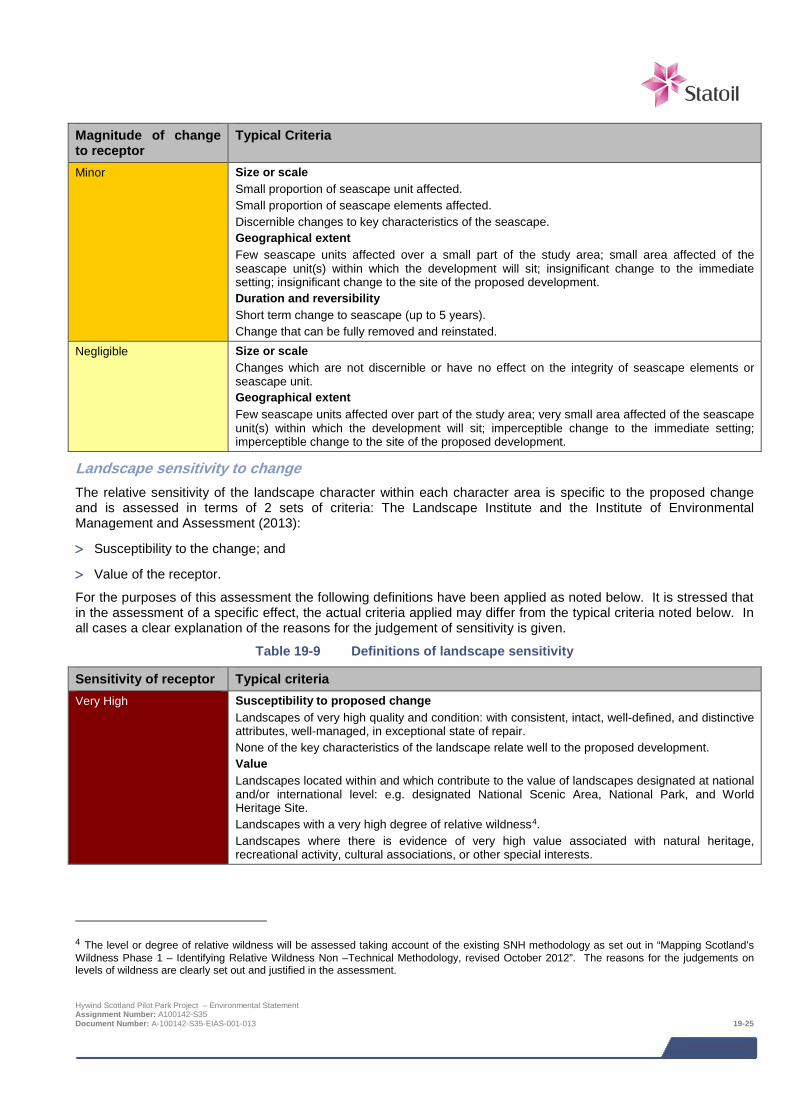
Magnitude of change to receptor
Typical Criteria
Minor Size or scale Small proportion of seascape unit affected. Small proportion of seascape elements affected. Discernible changes to key characteristics of the seascape. Geographical extent Few seascape units affected over a small part of the study area; small area affected of the seascape unit(s) within which the development will sit; insignificant change to the immediate setting; insignificant change to the site of the proposed development. Duration and reversibility Short term change to seascape (up to 5 years). Change that can be fully removed and reinstated.
Negligible Size or scale Changes which are not discernible or have no effect on the integrity of seascape elements or seascape unit. Geographical extent Few seascape units affected over part of the study area; very small area affected of the seascape unit(s) within which the development will sit; imperceptible change to the immediate setting; imperceptible change to the site of the proposed development.
Landscape sensitivity to change The relative sensitivity of the landscape character within each character area is specific to the proposed change and is assessed in terms of 2 sets of criteria: The Landscape Institute and the Institute of Environmental Management and Assessment (2013):
> Susceptibility to the change; and
> Value of the receptor.
For the purposes of this assessment the following definitions have been applied as noted below. It is stressed that in the assessment of a specific effect, the actual criteria applied may differ from the typical criteria noted below. In all cases a clear explanation of the reasons for the judgement of sensitivity is given.
Table 19-9 Definitions of landscape sensitivity
Sensitivity of receptor Typical criteria Very High Susceptibility to proposed change
Landscapes of very high quality and condition: with consistent, intact, well-defined, and distinctive attributes, well-managed, in exceptional state of repair. None of the key characteristics of the landscape relate well to the proposed development. Value Landscapes located within and which contribute to the value of landscapes designated at national and/or international level: e.g. designated National Scenic Area, National Park, and World Heritage Site. Landscapes with a very high degree of relative wildness4. Landscapes where there is evidence of very high value associated with natural heritage, recreational activity, cultural associations, or other special interests.
4 The level or degree of relative wildness will be assessed taking account of the existing SNH methodology as set out in “Mapping Scotland’s Wildness Phase 1 – Identifying Relative Wildness Non –Technical Methodology, revised October 2012”. The reasons for the judgements on levels of wildness are clearly set out and justified in the assessment. Hywind Scotland Pilot Park Project – Environmental Statement Assignment Number: A100142-S35 Document Number: A-100142-S35-EIAS-001-013 19-25
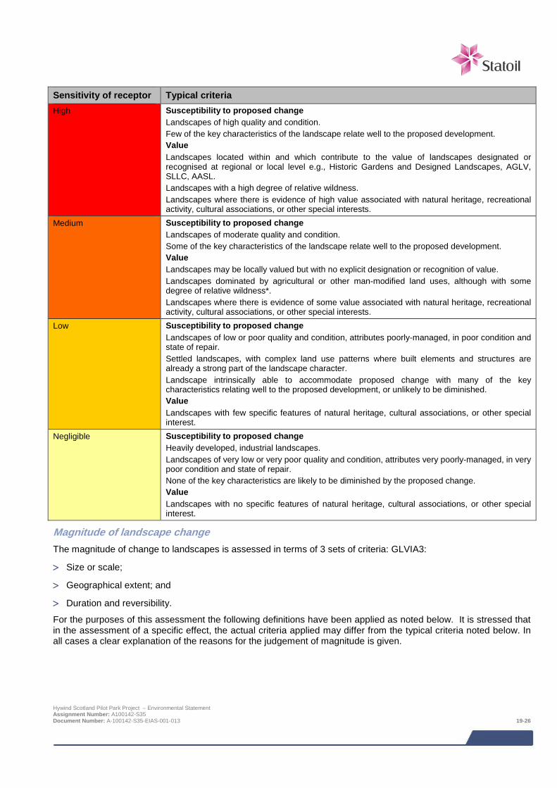
Sensitivity of receptor Typical criteria High Susceptibility to proposed change
Landscapes of high quality and condition. Few of the key characteristics of the landscape relate well to the proposed development. Value Landscapes located within and which contribute to the value of landscapes designated or recognised at regional or local level e.g., Historic Gardens and Designed Landscapes, AGLV, SLLC, AASL. Landscapes with a high degree of relative wildness. Landscapes where there is evidence of high value associated with natural heritage, recreational activity, cultural associations, or other special interests.
Medium Susceptibility to proposed change Landscapes of moderate quality and condition. Some of the key characteristics of the landscape relate well to the proposed development. Value Landscapes may be locally valued but with no explicit designation or recognition of value. Landscapes dominated by agricultural or other man-modified land uses, although with some degree of relative wildness*. Landscapes where there is evidence of some value associated with natural heritage, recreational activity, cultural associations, or other special interests.
Low Susceptibility to proposed change Landscapes of low or poor quality and condition, attributes poorly-managed, in poor condition and state of repair. Settled landscapes, with complex land use patterns where built elements and structures are already a strong part of the landscape character. Landscape intrinsically able to accommodate proposed change with many of the key characteristics relating well to the proposed development, or unlikely to be diminished. Value Landscapes with few specific features of natural heritage, cultural associations, or other special interest.
Negligible Susceptibility to proposed change Heavily developed, industrial landscapes. Landscapes of very low or very poor quality and condition, attributes very poorly-managed, in very poor condition and state of repair. None of the key characteristics are likely to be diminished by the proposed change. Value Landscapes with no specific features of natural heritage, cultural associations, or other special interest.
Magnitude of landscape change The magnitude of change to landscapes is assessed in terms of 3 sets of criteria: GLVIA3:
> Size or scale;
> Geographical extent; and
> Duration and reversibility.
For the purposes of this assessment the following definitions have been applied as noted below. It is stressed that in the assessment of a specific effect, the actual criteria applied may differ from the typical criteria noted below. In all cases a clear explanation of the reasons for the judgement of magnitude is given.
Hywind Scotland Pilot Park Project – Environmental Statement Assignment Number: A100142-S35 Document Number: A-100142-S35-EIAS-001-013 19-26
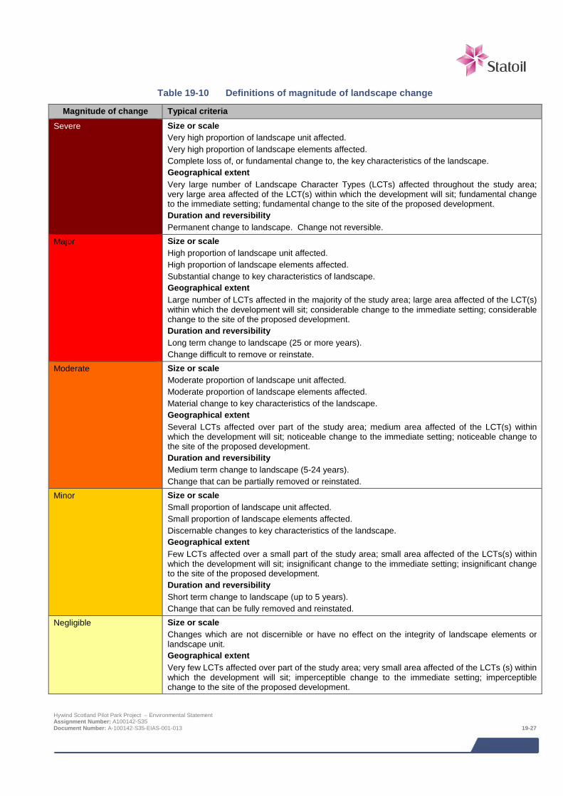
Table 19-10 Definitions of magnitude of landscape change
Magnitude of change Typical criteria
Severe Size or scale Very high proportion of landscape unit affected. Very high proportion of landscape elements affected. Complete loss of, or fundamental change to, the key characteristics of the landscape. Geographical extent Very large number of Landscape Character Types (LCTs) affected throughout the study area; very large area affected of the LCT(s) within which the development will sit; fundamental change to the immediate setting; fundamental change to the site of the proposed development. Duration and reversibility Permanent change to landscape. Change not reversible.
Major Size or scale High proportion of landscape unit affected. High proportion of landscape elements affected. Substantial change to key characteristics of landscape. Geographical extent Large number of LCTs affected in the majority of the study area; large area affected of the LCT(s) within which the development will sit; considerable change to the immediate setting; considerable change to the site of the proposed development. Duration and reversibility Long term change to landscape (25 or more years). Change difficult to remove or reinstate.
Moderate Size or scale Moderate proportion of landscape unit affected. Moderate proportion of landscape elements affected. Material change to key characteristics of the landscape. Geographical extent Several LCTs affected over part of the study area; medium area affected of the LCT(s) within which the development will sit; noticeable change to the immediate setting; noticeable change to the site of the proposed development. Duration and reversibility Medium term change to landscape (5-24 years). Change that can be partially removed or reinstated.
Minor Size or scale Small proportion of landscape unit affected. Small proportion of landscape elements affected. Discernable changes to key characteristics of the landscape. Geographical extent Few LCTs affected over a small part of the study area; small area affected of the LCTs(s) within which the development will sit; insignificant change to the immediate setting; insignificant change to the site of the proposed development. Duration and reversibility Short term change to landscape (up to 5 years). Change that can be fully removed and reinstated.
Negligible Size or scale Changes which are not discernible or have no effect on the integrity of landscape elements or landscape unit. Geographical extent Very few LCTs affected over part of the study area; very small area affected of the LCTs (s) within which the development will sit; imperceptible change to the immediate setting; imperceptible change to the site of the proposed development.
Hywind Scotland Pilot Park Project – Environmental Statement Assignment Number: A100142-S35 Document Number: A-100142-S35-EIAS-001-013 19-27
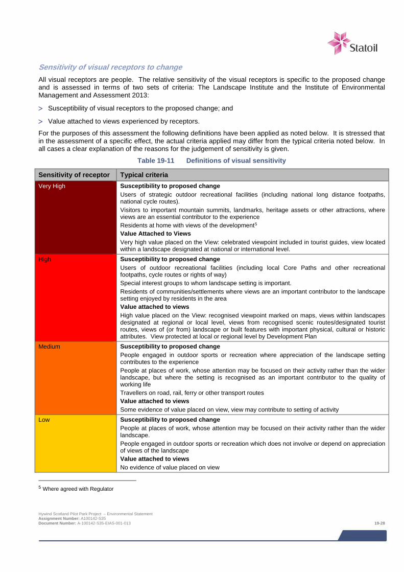
Sensitivity of visual receptors to change All visual receptors are people. The relative sensitivity of the visual receptors is specific to the proposed change and is assessed in terms of two sets of criteria: The Landscape Institute and the Institute of Environmental Management and Assessment 2013:
> Susceptibility of visual receptors to the proposed change; and
> Value attached to views experienced by receptors.
For the purposes of this assessment the following definitions have been applied as noted below. It is stressed that in the assessment of a specific effect, the actual criteria applied may differ from the typical criteria noted below. In all cases a clear explanation of the reasons for the judgement of sensitivity is given.
Table 19-11 Definitions of visual sensitivity
Sensitivity of receptor Typical criteria Very High Susceptibility to proposed change
Users of strategic outdoor recreational facilities (including national long distance footpaths, national cycle routes). Visitors to important mountain summits, landmarks, heritage assets or other attractions, where views are an essential contributor to the experience Residents at home with views of the development5 Value Attached to Views Very high value placed on the View: celebrated viewpoint included in tourist guides, view located within a landscape designated at national or international level.
High Susceptibility to proposed change Users of outdoor recreational facilities (including local Core Paths and other recreational footpaths, cycle routes or rights of way) Special interest groups to whom landscape setting is important. Residents of communities/settlements where views are an important contributor to the landscape setting enjoyed by residents in the area Value attached to views High value placed on the View: recognised viewpoint marked on maps, views within landscapes designated at regional or local level, views from recognised scenic routes/designated tourist routes, views of (or from) landscape or built features with important physical, cultural or historic attributes. View protected at local or regional level by Development Plan
Medium Susceptibility to proposed change People engaged in outdoor sports or recreation where appreciation of the landscape setting contributes to the experience People at places of work, whose attention may be focused on their activity rather than the wider landscape, but where the setting is recognised as an important contributor to the quality of working life Travellers on road, rail, ferry or other transport routes Value attached to views Some evidence of value placed on view, view may contribute to setting of activity
Low Susceptibility to proposed change People at places of work, whose attention may be focused on their activity rather than the wider landscape. People engaged in outdoor sports or recreation which does not involve or depend on appreciation of views of the landscape Value attached to views No evidence of value placed on view
5 Where agreed with Regulator
Hywind Scotland Pilot Park Project – Environmental Statement Assignment Number: A100142-S35 Document Number: A-100142-S35-EIAS-001-013 19-28

Sensitivity of receptor Typical criteria Negligible Susceptibility to change of viewers and value attached to views are of a level not considered
relevant to the assessment
Magnitude of Change to Views and Visual Amenity The magnitude of change to views and visual amenity experienced by the receptor is assessed in terms of 3 sets of criteria: The Landscape Institute and the Institute of Environmental Management and Assessment 2013:
> Size or scale;
> Geographical extent; and
> Duration and reversibility.
For the purposes of this assessment the following definitions have been applied as noted below. It is stressed that in the assessment of a specific effect, the actual criteria applied may differ from the typical criteria noted below. In all cases a clear explanation of the reasons for the judgement of magnitude is given.
Table 19-12 Definitions of magnitude of visual change
Magnitude of change Definition Severe Size or scale
Proposed change will define view. All of development visible. Very strong contrast with key visual characteristics of the baseline view e.g. scale, horizontality, composition. Duration of view long, view studied/enjoyed for considerable time. Geographical extent Angle of view to development directly coincides with focus of receptor activity/viewpoint/road alignment, etc. Very short distance from viewpoint to development. Development occupying the majority of the view. Duration and reversibility Permanent change to view. Change not reversible.
Major Size or scale Development will be the dominant feature in the view. High proportion of development visible, no significant screening effects. Strong contrast with key visual characteristics of the baseline view e.g. scale, horizontality, composition. Duration of view not curtailed by physical parameters. Geographical extent Angle of view to development coincides with focus of receptor activity/viewpoint/road alignment, etc. Short distance from viewpoint to development. Development occupying a high proportion of the view. Duration and reversibility Long term change to view. Change difficult to remove or reinstate.
Hywind Scotland Pilot Park Project – Environmental Statement Assignment Number: A100142-S35 Document Number: A-100142-S35-EIAS-001-013 19-29
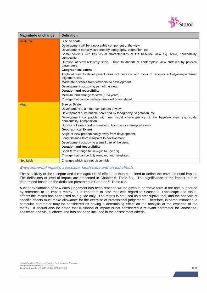
Magnitude of change Definition Moderate Size or scale
Development will be a noticeable component of the view. Development partially screened by topography, vegetation, etc. Some conflicts with key visual characteristics of the baseline view e.g. scale, horizontality, composition. Duration of view relatively short. Time to absorb or contemplate view curtailed by physical parameters. Geographical extent Angle of view to development does not coincide with focus of receptor activity/viewpoint/road alignment, etc. Moderate distance from viewpoint to development. Development occupying part of the view. Duration and reversibility Medium term change to view (5-24 years). Change that can be partially removed or reinstated.
Minor Size or Scale Development is a minor component of view. Development substantially screened by topography, vegetation, etc. Development compatible with key visual characteristics of the baseline view e.g. scale, horizontality, composition. Duration of view short or transient. Glimpse or interrupted views. Geographical Extent Angle of view predominantly away from development. Long distance from viewpoint to development. Development occupying a small part of the view. Duration and Reversibility Short term change to view (up to 5 years). Change that can be fully removed and reinstated.
Negligible Changes which are not discernible.
Environmental impact: seascape, landscape and visual effects The sensitivity of the receptor and the magnitude of effect are then combined to define the environmental impact. The definitions of level of impact are presented in Chapter 6, Table 6-1. The significance of the impact is then determined based on the definition presented in Chapter 6, Table 6-2.
A clear explanation of how each judgement has been reached will be given in narrative form in the text, supported by reference to an impact matrix. It is important to note that with regard to Seascape, Landscape and Visual effects this matrix has been used as a guide only. The matrix is not used as a prescriptive tool, and the analysis of specific effects must make allowance for the exercise of professional judgement. Therefore, in some instances, a particular parameter may be considered as having a determining effect on the analysis at the expense of the matrix. It should also be noted that likelihood of impact is not considered a relevant parameter for landscape, seascape and visual effects and has not been included in the assessment criteria.
Hywind Scotland Pilot Park Project – Environmental Statement Assignment Number: A100142-S35 Document Number: A-100142-S35-EIAS-001-013 19-30
19.5.3 Design Envelope This assessment considers the Project parameters which are predicted to result in the greatest environmental impact. This approach ensures that impacts of a greater adverse significance would not arise should any other development scenario be taken forward in the final scheme design. With regards to the assessment of impacts on ornithology, the worst case Project parameters are summarised below:
> Indicative layout for 5 WTG Units located within the northern area of the AfL area;
> Maximum turbine height of tip of rotor blade 181 m; and
> Maximum rotor diameter of 154 m.
> Vessel requirement for installation will be:
o 1 anchor handler vessel and light subsea construction vessel (or similar) for 2 – 3 weeks;
o 1 installation vessel and 1 crew transfer vessel for 10 to 15 days of inter-array cable installation;
o 1 light subsea construction vessel and 2 ocean going tugs for 1 week of hook-up and mooring of WTG Units;
o 1 cable lay vessel and 1 trenching vessel for 5 to 8 days of export cable installation; and
o 1 cable trenching vessel for 8 to 12 days of export cable trenching.
19.6 Impacts during construction and installation
19.6.1 Seascape, landscape, and visual Impacts During this phase, temporary impacts will occur related to technical operations associated with towing of the WTG Units from the inshore assembly site to the turbine deployment area, and the installation operations. A total of 5 shipping movements will be required. The route will originate in Norway and will approach the development area from the east, away from the SLVIA receptors. Changes to the landscape and seascape resource due to these operations will not be discernable. While activities associated with construction and installation of the WTGs will be visible to varying degrees, the magnitude of change relating to seascape, landscape and visual receptors is considered to be negligible. The reasons for this judgement relative to the criteria in the methodology are as follows:
> Size or scale: Negligible: very small area of sea surface directly affected by installation activity;
> Geographical extent: Negligible – long distance from activity to receptors (varies, but generally at least 24 km); and
> Duration and reversibility: Negligible: Very short term change to view (maximum 21 days).
Accordingly it is concluded that there will be no significant residual seascape, Landscape, or Visual Impacts during this phase.
19.7 Impacts during operation and maintenance
19.7.1 Impacts on seascape Impacts on Local Seascape Character Areas (LCCAs)
LCCA 1 North facing historic fishing towns
Although it is located within the study area this area of coast does not fall within the ZTV of the Project. There will therefore be no impact from the Project and this area is not assessed further.
Hywind Scotland Pilot Park Project – Environmental Statement Assignment Number: A100142-S35 Document Number: A-100142-S35-EIAS-001-013 19-31

LCCA 2 Northern Port – Fraserburgh 9 - The ZTV for this unit is shown on Figure 19.5. Assessment of impact significance
The sensitivity of this receptor is considered to be Low. The reasons for this judgement relative to the criteria in the methodology are:
> Susceptibility to proposed change: Low – well-settled and readily accessible coastline and hinterland, prominent and frequent shipping or other maritime activity.
> Value: Medium/low – evidence of value associated with cultural heritage (Conservation Area), low degree of relative wildness.
The magnitude of change is considered to be Minor. The reasons for this judgement relative to the criteria in the methodology are:
> Size or scale: Minor: small proportion of seascape area affected (small area in vicinity of Kinnaird Head falls within ZTV).
> Geographical extent: Negligible – indirect effect on seascape unit only due to visibility, long distance from seascape unit to development (c. 44 km).
> Duration and reversibility: Major: Long term change to view
The overall level of impact is considered to be Minor. Sensitivity of LCCA 2 Northern Port Magnitude of effect Level of impact
Low Minor Minor
Impact significance – NOT SIGNIFICANT
LCCA 3 North facing enclosed sandy bay
Although it is located within the study area this area of coast does not fall within the ZTV of the development. There will therefore be no impact from the development and this area is not assessed further.
LCCA 4 North east facing historic fishing villages - The ZTV for this unit is shown on Figure 19.5. Assessment of impact significance
The sensitivity of this receptor is considered to be Medium. The reasons for this judgement relative to the criteria in the methodology are:
> Susceptibility to proposed change: Medium – coastline with relatively simple linear shape with little fragmentation, degree of settlement, (Cairnbulg, Inverallochy) settings of key views include some developed features and shipping or other maritime activity.
> Value: Medium/low – evidence of value associated with cultural heritage (Conservation Area), low degree of relative wildness.
The magnitude of change is considered to be Minor. The reasons for this judgement relative to the criteria in the methodology are:
> Size or scale: High: majority of seascape area affected (falls within ZTV).
> Geographical extent: Negligible – indirect effect on seascape unit only due to visibility, long distance from seascape unit to development (c. 36-38 km).
> Duration and reversibility: Major: Long term change to view.
The overall level of impact is considered to be Minor. Sensitivity of LCCA 4 North east facing historic fishing villages Magnitude of effect Level of impact
Medium Minor Minor
Impact significance – NOT SIGNIFICANT
Hywind Scotland Pilot Park Project – Environmental Statement Assignment Number: A100142-S35 Document Number: A-100142-S35-EIAS-001-013 19-32

LCCA 5 Sweeping beaches and dunes - The ZTV for this unit is shown on Figure 19.5. Assessment of impact significance
The sensitivity of this receptor is considered to be High. The reasons for this judgement relative to the criteria in the methodology are:
> Susceptibility to proposed change: High/Medium – seascape with distinctive physical characteristics, (long open beaches, dunes) settings of key views include some developed features and shipping or other maritime activity.
> Value: High/Medium – evidence of value associated with views (includes two valued views), medium degree of relative wildness.
The magnitude of change is considered to be Minor. The reasons for this judgement relative to the criteria in the methodology are:
> Size or scale: Very High: entire seascape unit affected (falls within ZTV).
> Geographical Extent: Minor – indirect effect on seascape unit only due to visibility, long distance from seascape unit to development (c. 25-30 km).
> Duration and Reversibility: Major: Long term change to view.
The overall level of impact is considered to be Minor. Note that this judgement does not accord with the matrix at Chapter 6, Table 6-1. The reason for this is that the magnitude of change is considered to be the primary determinant in this instance, with the long separation distance being considered particularly important.
Sensitivity of LCCA 5 Sweeping beaches and dunes Magnitude of effect Level of impact
Medium Minor Minor
Impact significance – NOT SIGNIFICANT
LCCA 6 Eastern Port – Peterhead - The ZTV for this unit is shown on Figure 19.5. Assessment of impact significance
The sensitivity of this receptor is considered to be Low. The reasons for this judgement relative to the criteria in the methodology are:
> Susceptibility to proposed change: Low – well-settled and readily accessible coastline and hinterland, prominent and frequent shipping or other maritime activity.
> Value: Medium/low – evidence of value associated with cultural heritage (Conservation Area), valued view, low degree of relative wildness.
The magnitude of change is considered to be Minor. The reasons for this judgement relative to the criteria in the methodology are:
> Size or scale: Very High: entire seascape unit affected (falls within ZTV).
> Geographical extent: Minor – indirect effect on seascape unit only due to visibility, long distance from seascape unit to development (c. 23-25 km).
> Duration and reversibility: Major: Long term change to view.
The overall level of impact is considered to be Minor. Sensitivity of LCCA 6 Eastern Port
– Peterhead Magnitude of effect Level of impact
Low Minor Minor
Impact significance – NOT SIGNIFICANT
Hywind Scotland Pilot Park Project – Environmental Statement Assignment Number: A100142-S35 Document Number: A-100142-S35-EIAS-001-013 19-33
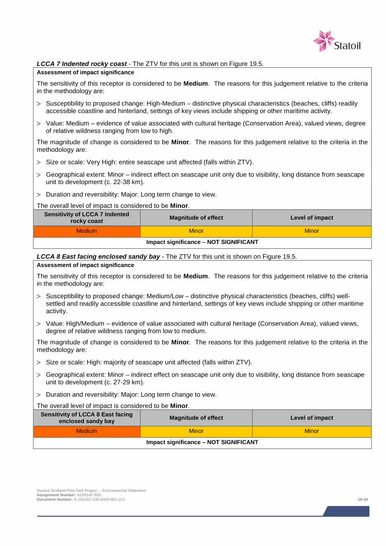
LCCA 7 Indented rocky coast - The ZTV for this unit is shown on Figure 19.5. Assessment of impact significance
The sensitivity of this receptor is considered to be Medium. The reasons for this judgement relative to the criteria in the methodology are:
> Susceptibility to proposed change: High-Medium – distinctive physical characteristics (beaches, cliffs) readily accessible coastline and hinterland, settings of key views include shipping or other maritime activity.
> Value: Medium – evidence of value associated with cultural heritage (Conservation Area), valued views, degree of relative wildness ranging from low to high.
The magnitude of change is considered to be Minor. The reasons for this judgement relative to the criteria in the methodology are:
> Size or scale: Very High: entire seascape unit affected (falls within ZTV).
> Geographical extent: Minor – indirect effect on seascape unit only due to visibility, long distance from seascape unit to development (c. 22-38 km).
> Duration and reversibility: Major: Long term change to view.
The overall level of impact is considered to be Minor. Sensitivity of LCCA 7 Indented
rocky coast Magnitude of effect Level of impact
Medium Minor Minor
Impact significance – NOT SIGNIFICANT
LCCA 8 East facing enclosed sandy bay - The ZTV for this unit is shown on Figure 19.5. Assessment of impact significance
The sensitivity of this receptor is considered to be Medium. The reasons for this judgement relative to the criteria in the methodology are:
> Susceptibility to proposed change: Medium/Low – distinctive physical characteristics (beaches, cliffs) well-settled and readily accessible coastline and hinterland, settings of key views include shipping or other maritime activity.
> Value: High/Medium – evidence of value associated with cultural heritage (Conservation Area), valued views, degree of relative wildness ranging from low to medium.
The magnitude of change is considered to be Minor. The reasons for this judgement relative to the criteria in the methodology are:
> Size or scale: High: majority of seascape unit affected (falls within ZTV).
> Geographical extent: Minor – indirect effect on seascape unit only due to visibility, long distance from seascape unit to development (c. 27-29 km).
> Duration and reversibility: Major: Long term change to view.
The overall level of impact is considered to be Minor. Sensitivity of LCCA 8 East facing
enclosed sandy bay Magnitude of effect Level of impact
Medium Minor Minor
Impact significance – NOT SIGNIFICANT
Hywind Scotland Pilot Park Project – Environmental Statement Assignment Number: A100142-S35 Document Number: A-100142-S35-EIAS-001-013 19-34
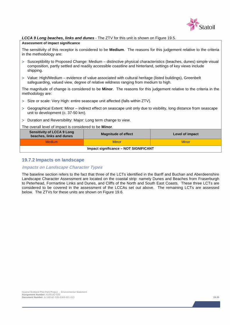
LCCA 9 Long beaches, links and dunes - The ZTV for this unit is shown on Figure 19.5. Assessment of impact significance
The sensitivity of this receptor is considered to be Medium. The reasons for this judgement relative to the criteria in the methodology are:
> Susceptibility to Proposed Change: Medium – distinctive physical characteristics (beaches, dunes) simple visual composition, partly settled and readily accessible coastline and hinterland, settings of key views include shipping.
> Value: High/Medium – evidence of value associated with cultural heritage (listed buildings), Greenbelt safeguarding, valued view, degree of relative wildness ranging from medium to high.
The magnitude of change is considered to be Minor. The reasons for this judgement relative to the criteria in the methodology are:
> Size or scale: Very High: entire seascape unit affected (falls within ZTV).
> Geographical Extent: Minor – indirect effect on seascape unit only due to visibility, long distance from seascape unit to development (c. 37-50 km).
> Duration and Reversibility: Major: Long term change to view.
The overall level of impact is considered to be Minor. Sensitivity of LCCA 9 Long beaches, links and dunes Magnitude of effect Level of impact
Medium Minor Minor
Impact significance – NOT SIGNIFICANT
19.7.2 Impacts on landscape Impacts on Landscape Character Types The baseline section refers to the fact that three of the LCTs identified in the Banff and Buchan and Aberdeenshire Landscape Character Assessment are located on the coastal strip: namely Dunes and Beaches from Fraserburgh to Peterhead, Formartine Links and Dunes, and Cliffs of the North and South East Coasts. These three LCTs are considered to be covered in the assessment of the LCCAs set out above. The remaining LCTs are assessed below. The ZTVs for these units are shown on Figure 19.6.
Hywind Scotland Pilot Park Project – Environmental Statement Assignment Number: A100142-S35 Document Number: A-100142-S35-EIAS-001-013 19-35

Eastern Coastal agricultural Plain LCT Assessment of impact significance
The sensitivity of this receptor is considered to be Medium. The reasons for this judgement relative to the criteria in the methodology are:
> Susceptibility to proposed change: Medium – landscapes of moderate quality and condition.
> Value: Medium/low – landscapes dominated by agricultural land use, settled landscapes where built elements and structures are already a strong part of landscape character, landscapes may be locally valued but with no explicit designation or recognition of value.
The magnitude of change is considered to be Minor. The reasons for this judgement relative to the criteria in the methodology are:
> Size or scale: High: large proportion of unit falls within ZTV.
> Geographical extent: Minor – indirect effect on landscape unit only due to visibility, long distance from unit to development (c. 25-42 km).
> Duration and reversibility: Major: Long term change to view.
The overall level of impact is considered to be Minor. Sensitivity of Eastern Coastal
agricultural Plain LCT Magnitude of effect Level of impact
Medium Minor Minor
Impact significance – NOT SIGNIFICANT
Formartine Lowlands LCT Assessment of impact significance
The sensitivity of this receptor is considered to be Medium. The reasons for this judgement relative to the criteria in the methodology are:
> Susceptibility to proposed change: Medium – landscapes of moderate quality and condition.
> Value: Medium/low – landscapes dominated by agricultural land use, settled landscapes where built elements and structures are already a strong part of landscape character, landscapes may be locally valued but with no explicit designation or recognition of value.
The magnitude of change is considered to be Minor. The reasons for this judgement relative to the criteria in the methodology are:
> Size or scale: Moderate: moderate proportion of unit falls within ZTV.
> Geographical extent: Minor – indirect effect on landscape unit only due to visibility, long distance from seascape unit to development (c. 32-50 km).
> Duration and reversibility: Major: Long term change to view.
The overall level of impact is considered to be Minor. Sensitivity of Formartine Lowlands
LCT Magnitude of effect Level of impact
Medium Minor Minor
Impact significance – NOT SIGNIFICANT
Hywind Scotland Pilot Park Project – Environmental Statement Assignment Number: A100142-S35 Document Number: A-100142-S35-EIAS-001-013 19-36
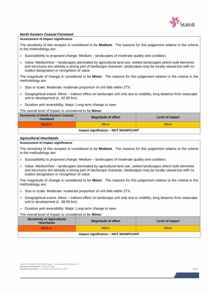
North Eastern Coastal Farmland Assessment of impact significance
The sensitivity of this receptor is considered to be Medium. The reasons for this judgement relative to the criteria in the methodology are:
> Susceptibility to proposed change: Medium – landscapes of moderate quality and condition.
> Value: Medium/low – landscapes dominated by agricultural land use, settled landscapes where built elements and structures are already a strong part of landscape character, landscapes may be locally valued but with no explicit designation or recognition of value.
The magnitude of change is considered to be Minor. The reasons for this judgement relative to the criteria in the methodology are:
> Size or scale: Moderate: moderate proportion of unit falls within ZTV.
> Geographical extent: Minor – indirect effect on landscape unit only due to visibility, long distance from seascape unit to development (c. 42-50 km).
> Duration and reversibility: Major: Long term change to view
The overall level of impact is considered to be Minor. Sensitivity of North Eastern Coastal
Farmland Magnitude of effect Level of impact
Medium Minor Minor
Impact significance – NOT SIGNIFICANT
Agricultural Heartlands Assessment of impact significance
The sensitivity of this receptor is considered to be Medium. The reasons for this judgement relative to the criteria in the methodology are:
> Susceptibility to proposed change: Medium – landscapes of moderate quality and condition.
> Value: Medium/low – landscapes dominated by agricultural land use, settled landscapes where built elements and structures are already a strong part of landscape character, landscapes may be locally valued but with no explicit designation or recognition of value.
The magnitude of change is considered to be Minor. The reasons for this judgement relative to the criteria in the methodology are:
> Size or scale: Moderate: moderate proportion of unit falls within ZTV.
> Geographical extent: Minor – indirect effect on landscape unit only due to visibility, long distance from seascape unit to development (c. 38-50 km).
> Duration and reversibility: Major: Long term change to view.
The overall level of impact is considered to be Minor. Sensitivity of Agricultural
Heartlands Magnitude of effect Level of impact
Medium Minor Minor
Impact significance – NOT SIGNIFICANT
Hywind Scotland Pilot Park Project – Environmental Statement Assignment Number: A100142-S35 Document Number: A-100142-S35-EIAS-001-013 19-37

Wooded Estates around Old Deer Assessment of impact significance
The sensitivity of this receptor is considered to be Medium. The reasons for this judgement relative to the criteria in the methodology are:
> Susceptibility to proposed change: High – landscapes of high quality and condition.
> Value: Medium – landscapes dominated by agricultural land use, settled landscapes where built elements and structures are already a strong part of landscape character, landscapes where there is evidence of cultural heritage value, landscapes may be locally valued but with no explicit designation or recognition of value.
The magnitude of change is considered to be Minor. The reasons for this judgement relative to the criteria in the methodology are:
> Size or scale: Moderate: moderate proportion of unit falls within ZTV.
> Geographical extent: Minor – indirect effect on landscape unit only due to visibility, long distance from seascape unit to development (c. 38-50 km).
> Duration and reversibility: Major: Long term change to view.
The overall level of impact is considered to be Minor. Sensitivity of Wooded Estates
around Old Deer Magnitude of effect Level of impact
Medium Minor Minor
Impact significance – NOT SIGNIFICANT
Ythan Strath Farmland Assessment of impact significance
The sensitivity of this receptor is considered to be Medium. The reasons for this judgement relative to the criteria in the methodology are:
> Susceptibility to proposed change: Medium – landscapes of moderate quality and condition.
> Value: Medium/low – landscapes dominated by agricultural land use, landscapes may be locally valued but with no explicit designation or recognition of value.
The magnitude of change is considered to be Minor. The reasons for this judgement relative to the criteria in the methodology are:
> Size or scale: Minor: small proportion of unit falls within ZTV.
> Geographical extent: Minor – indirect effect on landscape unit only due to visibility, long distance from seascape unit to development (c. 44-50 km).
> Duration and reversibility: Major: Long term change to view.
The overall level of impact is considered to be Minor. Sensitivity of Ythan Strath
Farmland Magnitude of effect Level of impact
Medium Minor Minor
Impact significance – NOT SIGNIFICANT
Impacts on Gardens and Designed Landscapes: Haddow House Although it is located within the study area Haddow House does not fall within the ZTV of the development. There will therefore be no impact from the development and this area is not assessed further.
Hywind Scotland Pilot Park Project – Environmental Statement Assignment Number: A100142-S35 Document Number: A-100142-S35-EIAS-001-013 19-38
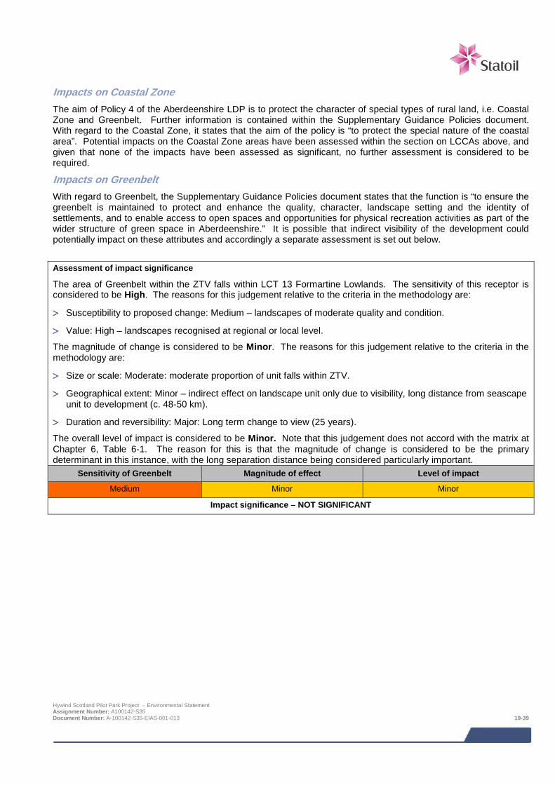
Impacts on Coastal Zone The aim of Policy 4 of the Aberdeenshire LDP is to protect the character of special types of rural land, i.e. Coastal Zone and Greenbelt. Further information is contained within the Supplementary Guidance Policies document. With regard to the Coastal Zone, it states that the aim of the policy is “to protect the special nature of the coastal area”. Potential impacts on the Coastal Zone areas have been assessed within the section on LCCAs above, and given that none of the impacts have been assessed as significant, no further assessment is considered to be required.
Impacts on Greenbelt With regard to Greenbelt, the Supplementary Guidance Policies document states that the function is “to ensure the greenbelt is maintained to protect and enhance the quality, character, landscape setting and the identity of settlements, and to enable access to open spaces and opportunities for physical recreation activities as part of the wider structure of green space in Aberdeenshire.” It is possible that indirect visibility of the development could potentially impact on these attributes and accordingly a separate assessment is set out below.
Assessment of impact significance
The area of Greenbelt within the ZTV falls within LCT 13 Formartine Lowlands. The sensitivity of this receptor is considered to be High. The reasons for this judgement relative to the criteria in the methodology are:
> Susceptibility to proposed change: Medium – landscapes of moderate quality and condition.
> Value: High – landscapes recognised at regional or local level.
The magnitude of change is considered to be Minor. The reasons for this judgement relative to the criteria in the methodology are:
> Size or scale: Moderate: moderate proportion of unit falls within ZTV.
> Geographical extent: Minor – indirect effect on landscape unit only due to visibility, long distance from seascape unit to development (c. 48-50 km).
> Duration and reversibility: Major: Long term change to view (25 years).
The overall level of impact is considered to be Minor. Note that this judgement does not accord with the matrix at Chapter 6, Table 6-1. The reason for this is that the magnitude of change is considered to be the primary determinant in this instance, with the long separation distance being considered particularly important.
Sensitivity of Greenbelt Magnitude of effect Level of impact
Medium Minor Minor
Impact significance – NOT SIGNIFICANT
Hywind Scotland Pilot Park Project – Environmental Statement Assignment Number: A100142-S35 Document Number: A-100142-S35-EIAS-001-013 19-39
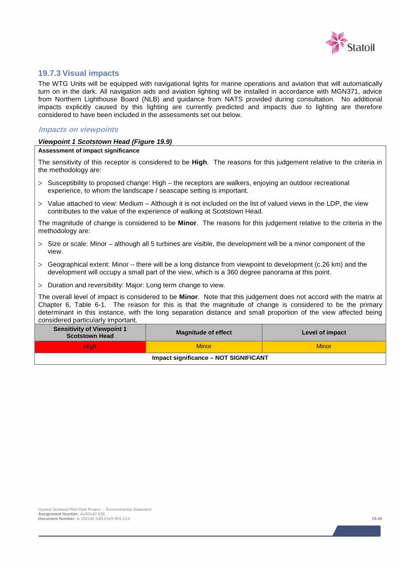
19.7.3 Visual impacts The WTG Units will be equipped with navigational lights for marine operations and aviation that will automatically turn on in the dark. All navigation aids and aviation lighting will be installed in accordance with MGN371, advice from Northern Lighthouse Board (NLB) and guidance from NATS provided during consultation. No additional impacts explicitly caused by this lighting are currently predicted and impacts due to lighting are therefore considered to have been included in the assessments set out below.
Impacts on viewpoints Viewpoint 1 Scotstown Head (Figure 19.9) Assessment of impact significance
The sensitivity of this receptor is considered to be High. The reasons for this judgement relative to the criteria in the methodology are:
> Susceptibility to proposed change: High – the receptors are walkers, enjoying an outdoor recreational experience, to whom the landscape / seascape setting is important.
> Value attached to view: Medium – Although it is not included on the list of valued views in the LDP, the view contributes to the value of the experience of walking at Scotstown Head.
The magnitude of change is considered to be Minor. The reasons for this judgement relative to the criteria in the methodology are:
> Size or scale: Minor – although all 5 turbines are visible, the development will be a minor component of the view.
> Geographical extent: Minor – there will be a long distance from viewpoint to development (c.26 km) and the development will occupy a small part of the view, which is a 360 degree panorama at this point.
> Duration and reversibility: Major: Long term change to view.
The overall level of impact is considered to be Minor. Note that this judgement does not accord with the matrix at Chapter 6, Table 6-1. The reason for this is that the magnitude of change is considered to be the primary determinant in this instance, with the long separation distance and small proportion of the view affected being considered particularly important.
Sensitivity of Viewpoint 1 Scotstown Head Magnitude of effect Level of impact
High Minor Minor
Impact significance – NOT SIGNIFICANT
Hywind Scotland Pilot Park Project – Environmental Statement Assignment Number: A100142-S35 Document Number: A-100142-S35-EIAS-001-013 19-40

Viewpoint 2: Gable Braes, Peterhead (Figure 19.10)
Assessment of impact significance
The sensitivity of this receptor is considered to be High. The reasons for this judgement relative to the criteria in the methodology are:
> Susceptibility to proposed change: High/Very High – the receptors are residents at home, and walkers on the promenade or the beach, enjoying an outdoor recreational experience, to whom the landscape / seascape setting is important. The number of walkers relative to the number of residents predominates.
> Value attached to view: Medium/Low – the view is not included on the list of valued views in the LDP, and although the view contributes to the value of the experience of walking at Buchanhaven, it is of a predominantly urban character.
The magnitude of change is considered to be Minor. The reasons for this judgement relative to the criteria in the methodology are:
> Size or scale: Minor – although all 5 turbines are visible, the development will be a minor component of the view
> Geographical extent: Minor – there will be a long distance from viewpoint to development (c.23 km) and the development will occupy a small part of the view.
> Duration and reversibility: Major: Long term change to view.
The overall level of impact is considered to be Minor. Note that this judgement does not accord with the matrix at Chapter 6, Table 6-1. The reason for this is that the magnitude of change is considered to be the primary determinant in this instance, with the long separation distance and small proportion of the view affected being considered particularly important.
Sensitivity of Viewpoint 2: Buchanhaven Magnitude of effect Level of impact
High Minor Minor
Impact significance – NOT SIGNIFICANT
Hywind Scotland Pilot Park Project – Environmental Statement Assignment Number: A100142-S35 Document Number: A-100142-S35-EIAS-001-013 19-41

Viewpoint 3: Slains Castle Car Park (Figure 19.11)
Assessment of impact significance
The sensitivity of this receptor is considered to be Medium. The reasons for this judgement relative to the criteria in the methodology are:
> Susceptibility to proposed change: Medium/High – the receptors are visitors to the castle, and road users travelling north on the A975. The number of road users predominates relative to castle visitors, who will be a smaller subset.
> Value attached to view: Medium – the view is not included on the list of valued views in the LDP, but contributes to the value of the experience of viewing the coastal scene from the car park and the road.
The magnitude of change is considered to be Minor. The reasons for this judgement relative to the criteria in the methodology are:
> Size or scale: Minor – only a small proportion of the development will be visible (parts of 3 turbines, i.e. hubs and blades of two turbines and blade tips of one turbine) due a significant topographic screening effect, the development will be a minor component of the view.
> Geographical extent: Minor – with respect to the view towards the castle, the development does not coincide with the focus of the view, there will be a long distance from viewpoint to development (c.26 km), and the development will occupy a small part of the view.
> Duration and reversibility: Major: Long term change to view.
The overall level of impact is considered to be Minor. Sensitivity of Slains Castle Car
Park Magnitude of effect Level of impact
Medium Minor Minor
Impact significance – NOT SIGNIFICANT
Hywind Scotland Pilot Park Project – Environmental Statement Assignment Number: A100142-S35 Document Number: A-100142-S35-EIAS-001-013 19-42

Viewpoint 4: Near A950 Thunderton (Figure 19.12)
Assessment of impact significance
The sensitivity of this receptor is considered to be Medium. The reasons for this judgement relative to the criteria in the methodology are:
> Susceptibility to proposed change: Medium – the receptors are road users on the minor road, and people working in the area.
> Value attached to view: Low – no evidence of value attached to view.
The magnitude of change is considered to be Minor. The reasons for this judgement relative to the criteria in the methodology are:
> Size or scale: Minor – although all five turbines will be visible, the development will be a minor component of the view, the development is compatible with key visual characteristics of the baseline view including industrial buildings and other elements of a working landscape.
> Geographical extent: Minor – there will be a long distance from viewpoint to development (c. 29 km), the development will occupy a small part of the view, there is no direct visual relationship between the viewpoint and the coastline or sea.
> Duration and reversibility: Major: Long term change to view.
The overall level of impact is considered to be Minor. Sensitivity of Viewpoint 4: Near
A950 Thunderton Magnitude of effect Level of impact
Medium Minor Minor
Impact significance – NOT SIGNIFICANT
Hywind Scotland Pilot Park Project – Environmental Statement Assignment Number: A100142-S35 Document Number: A-100142-S35-EIAS-001-013 19-43

Viewpoint 5: Peterhead Bay (Figure 19.13)
Assessment of impact significance
The sensitivity of this receptor is considered to be Medium/High. The reasons for this judgement relative to the criteria in the methodology are:
> Susceptibility to proposed change: Medium/High – the receptors include a range of different groups, some of whom will regard the landscape setting as important.
> Value attached to view: Low – no evidence of value attached to view.
The magnitude of change is considered to be Minor. The reasons for this judgement relative to the criteria in the methodology are:
> Size or scale: Minor – although all five turbines will be visible, the development will be a minor component of the view, the development is compatible with key visual characteristics of the baseline view including large scale industrial buildings, port infrastructure, large vessels, and other elements of a working landscape.
> Geographical extent: Minor – there will be a long distance from viewpoint to development (25.4 km), the development will occupy a small part of the view.
> Duration and reversibility: Major: Long term change to view.
The overall level of impact is considered to be Minor. Sensitivity of Viewpoint 5:
Peterhead Bay Magnitude of effect Level of impact
Medium/High Minor Minor
Impact significance – NOT SIGNIFICANT
Hywind Scotland Pilot Park Project – Environmental Statement Assignment Number: A100142-S35 Document Number: A-100142-S35-EIAS-001-013 19-44

Viewpoint 6: Reform Tower (Figure 19.14)
Assessment of impact significance
The sensitivity of this receptor is considered to be Medium/High. The reasons for this judgement relative to the criteria in the methodology are:
> Susceptibility to proposed change: Medium/High – although the number of viewers is likely to be low given that the interior of the tower is not currently accessible, the overall landscape context will be important to any visitors.
> Value attached to view: High – although there is no evidence of value attached to the view as currently available, as a worst case scenario if the interior steps became accessible in future the view would be valued at least locally. There is also an archaeological record for a find at the site of the tower.
The magnitude of change is considered to be Minor. The reasons for this judgement relative to the criteria in the methodology are:
> Size or scale: Minor – although all five turbines will be visible, the development will be a minor component of the view, the development is compatible with key visual characteristics of the baseline view including water tank, cranes and other port infrastructure, residential buildings and other elements of a working landscape.
> Geographical extent: Minor – there will be a long distance from viewpoint to development (25.6km), the development will occupy a small part of the view.
> Duration and reversibility: Major: Long term change to view.
The overall level of impact is considered to be Minor. Sensitivity of Viewpoint 6: Reform
Tower Magnitude of effect Level of impact
Medium/High Minor Minor
Impact significance – NOT SIGNIFICANT
Hywind Scotland Pilot Park Project – Environmental Statement Assignment Number: A100142-S35 Document Number: A-100142-S35-EIAS-001-013 19-45

Viewpoint 7: Stirling Hill (Figure 19.15)
Assessment of impact significance
The sensitivity of this receptor is considered to be Medium/High. The reasons for this judgement relative to the criteria in the methodology are:
> Susceptibility to proposed change: High– the receptors are predominantly people engaged in outdoor recreation for whom the landscape setting will be important.
> Value attached to view: Low – no evidence of value attached to view.
The magnitude of change is considered to be Minor. The reasons for this judgement relative to the criteria in the methodology are:
> Size or scale: Minor – although all five turbines will be visible, the development will be a minor component of the view, the development is compatible with key visual characteristics of the baseline view including a quarry and communication masts in the direct line of view to the development.
> Geographical extent: Minor – there will be a long distance from viewpoint to development (26.2 km), the development will occupy a small part of the view.
> Duration and reversibility: Major: Long term change to view.
The overall level of impact is considered to be Minor. Sensitivity of Viewpoint 7: Stirling
Hill Magnitude of effect Level of impact
Medium/High Minor Minor
Impact significance – NOT SIGNIFICANT
Hywind Scotland Pilot Park Project – Environmental Statement Assignment Number: A100142-S35 Document Number: A-100142-S35-EIAS-001-013 19-46
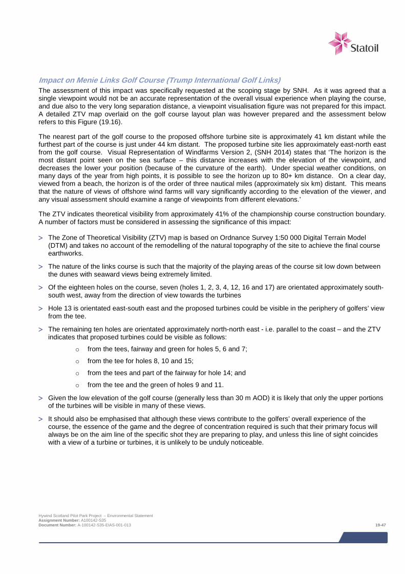
Impact on Menie Links Golf Course (Trump International Golf Links) The assessment of this impact was specifically requested at the scoping stage by SNH. As it was agreed that a single viewpoint would not be an accurate representation of the overall visual experience when playing the course, and due also to the very long separation distance, a viewpoint visualisation figure was not prepared for this impact. A detailed ZTV map overlaid on the golf course layout plan was however prepared and the assessment below refers to this Figure (19.16).
The nearest part of the golf course to the proposed offshore turbine site is approximately 41 km distant while the furthest part of the course is just under 44 km distant. The proposed turbine site lies approximately east-north east from the golf course. Visual Representation of Windfarms Version 2, (SNH 2014) states that ‘The horizon is the most distant point seen on the sea surface – this distance increases with the elevation of the viewpoint, and decreases the lower your position (because of the curvature of the earth). Under special weather conditions, on many days of the year from high points, it is possible to see the horizon up to 80+ km distance. On a clear day, viewed from a beach, the horizon is of the order of three nautical miles (approximately six km) distant. This means that the nature of views of offshore wind farms will vary significantly according to the elevation of the viewer, and any visual assessment should examine a range of viewpoints from different elevations.’
The ZTV indicates theoretical visibility from approximately 41% of the championship course construction boundary. A number of factors must be considered in assessing the significance of this impact:
> The Zone of Theoretical Visibility (ZTV) map is based on Ordnance Survey 1:50 000 Digital Terrain Model (DTM) and takes no account of the remodelling of the natural topography of the site to achieve the final course earthworks.
> The nature of the links course is such that the majority of the playing areas of the course sit low down between the dunes with seaward views being extremely limited.
> Of the eighteen holes on the course, seven (holes 1, 2, 3, 4, 12, 16 and 17) are orientated approximately south-south west, away from the direction of view towards the turbines
> Hole 13 is orientated east-south east and the proposed turbines could be visible in the periphery of golfers’ view from the tee.
> The remaining ten holes are orientated approximately north-north east - i.e. parallel to the coast – and the ZTV indicates that proposed turbines could be visible as follows:
o from the tees, fairway and green for holes 5, 6 and 7;
o from the tee for holes 8, 10 and 15;
o from the tees and part of the fairway for hole 14; and
o from the tee and the green of holes 9 and 11.
> Given the low elevation of the golf course (generally less than 30 m AOD) it is likely that only the upper portions of the turbines will be visible in many of these views.
> It should also be emphasised that although these views contribute to the golfers’ overall experience of the course, the essence of the game and the degree of concentration required is such that their primary focus will always be on the aim line of the specific shot they are preparing to play, and unless this line of sight coincides with a view of a turbine or turbines, it is unlikely to be unduly noticeable.
Hywind Scotland Pilot Park Project – Environmental Statement Assignment Number: A100142-S35 Document Number: A-100142-S35-EIAS-001-013 19-47

Assessment of impact significance
The sensitivity of this receptor is considered to be Medium. The reasons for this judgement relative to the criteria in the methodology are:
> Susceptibility to proposed change: Medium – the receptors are users of an outdoor sports facility, where the landscape setting contributes to the overall experience of the game, but is not its dominant focus.
> Value attached to views: Medium – views not included in list of valued views, but contribute to the setting of the activity.
The magnitude of change is considered to be Minor. The reasons for this judgement relative to the criteria in the methodology are:
> Size or scale: Minor – although parts or all of the development may be theoretically visible, the development will be a minor component of the view.
> Geographical extent: Minor – there will be a very long distance from viewpoints to development (41-44 km). the development will occupy a small part of the views.
> Duration and reversibility: Major: Long term change to view (25 years).
The overall level of impact is considered to be Minor. Sensitivity of Menie Links Golf
Course Magnitude of effect Level of impact
Medium Minor Minor
Impact significance – NOT SIGNIFICANT
Sequential Visual Impacts Sequential routes as defined in the baseline section above with sections falling within the ZTV are shown in Figure 19.8. Each is assessed in turn below in accordance with the methodology for visual impacts. Full details of each route including distance from the development, duration and percentage of journey time during which theoretical visibility will occur, and the number of incidences of views of the development, is provided in Table 19-13.
Table 19-13 Sequential assessment
Route/ direction of travel/ assumed average speed
Distance band from windfarm (km)
Approx. total distance travelled/duration of journey
Total length /duration of View of turbines/ no. of incidences of view
Impact on section of route
A90 southbound (100 kmph)
50 – 40 5.96 km/3.57 mins 0.11 km/0.07 mins/1 no 1.84%
40 – 30 11.14 km/6.68 mins 5.87 km/3.52 mins/17 no 52.69
Within 30 23.31 km/13.99 mins
3.82 km/2.29 mins/19 no 16.39%
30 – 40 11.48 km/6.89 ins - None
40 – 50 18.33 km/11 mins - None
Total journey time 42.13 mins
% of total journey with views of turbines 13.95%
Hywind Scotland Pilot Park Project – Environmental Statement Assignment Number: A100142-S35 Document Number: A-100142-S35-EIAS-001-013 19-48
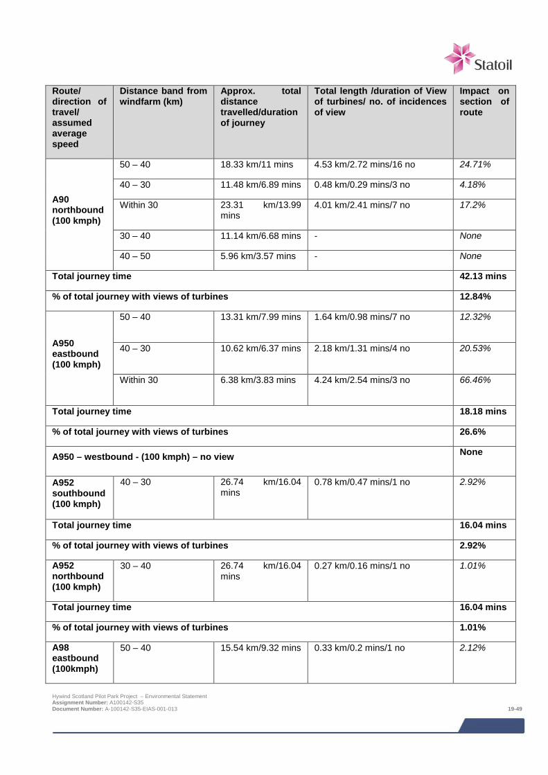
Route/ direction of travel/ assumed average speed
Distance band from windfarm (km)
Approx. total distance travelled/duration of journey
Total length /duration of View of turbines/ no. of incidences of view
Impact on section of route
A90 northbound (100 kmph)
50 – 40 18.33 km/11 mins 4.53 km/2.72 mins/16 no 24.71%
40 – 30 11.48 km/6.89 mins 0.48 km/0.29 mins/3 no 4.18%
Within 30 23.31 km/13.99 mins
4.01 km/2.41 mins/7 no 17.2%
30 – 40 11.14 km/6.68 mins - None
40 – 50 5.96 km/3.57 mins - None
Total journey time 42.13 mins
% of total journey with views of turbines 12.84%
A950 eastbound (100 kmph)
50 – 40 13.31 km/7.99 mins 1.64 km/0.98 mins/7 no 12.32%
40 – 30 10.62 km/6.37 mins 2.18 km/1.31 mins/4 no 20.53%
Within 30 6.38 km/3.83 mins 4.24 km/2.54 mins/3 no 66.46%
Total journey time 18.18 mins
% of total journey with views of turbines 26.6%
A950 – westbound - (100 kmph) – no view None
A952 southbound (100 kmph)
40 – 30 26.74 km/16.04 mins
0.78 km/0.47 mins/1 no 2.92%
Total journey time 16.04 mins
% of total journey with views of turbines 2.92%
A952 northbound (100 kmph)
30 – 40 26.74 km/16.04 mins
0.27 km/0.16 mins/1 no 1.01%
Total journey time 16.04 mins
% of total journey with views of turbines 1.01%
A98 eastbound (100kmph)
50 – 40 15.54 km/9.32 mins 0.33 km/0.2 mins/1 no 2.12%
Hywind Scotland Pilot Park Project – Environmental Statement Assignment Number: A100142-S35 Document Number: A-100142-S35-EIAS-001-013 19-49
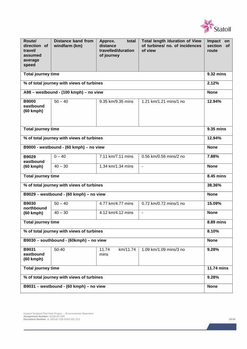
Route/ direction of travel/ assumed average speed
Distance band from windfarm (km)
Approx. total distance travelled/duration of journey
Total length /duration of View of turbines/ no. of incidences of view
Impact on section of route
Total journey time 9.32 mins
% of total journey with views of turbines 2.12%
A98 – westbound - (100 kmph) – no view None
B9000 eastbound (60 kmph)
50 – 40 9.35 km/9.35 mins 1.21 km/1.21 mins/1 no 12.94%
Total journey time 9.35 mins
% of total journey with views of turbines 12.94%
B9000 - westbound - (60 kmph) – no view None
B9029 eastbound (60 kmph)
0 – 40 7.11 km/7.11 mins 0.56 km/0.56 mins/2 no 7.88%
40 – 30 1.34 km/1.34 mins - None
Total journey time 8.45 mins
% of total journey with views of turbines 38.36%
B9029 – westbound - (60 kmph) – no view None
B9030 northbound (60 kmph)
50 – 40 4.77 km/4.77 mins 0.72 km/0.72 mins/1 no 15.09%
40 – 30 4.12 km/4.12 mins - None
Total journey time 8.89 mins
% of total journey with views of turbines 8.10%
B9030 – southbound - (60kmph) – no view None
B9031 eastbound (60 kmph)
50-40 11.74 km/11.74 mins
1.09 km/1.09 mins/3 no 9.28%
Total journey time 11.74 mins
% of total journey with views of turbines 9.28%
B9031 – westbound - (60 kmph) – no view None
Hywind Scotland Pilot Park Project – Environmental Statement Assignment Number: A100142-S35 Document Number: A-100142-S35-EIAS-001-013 19-50
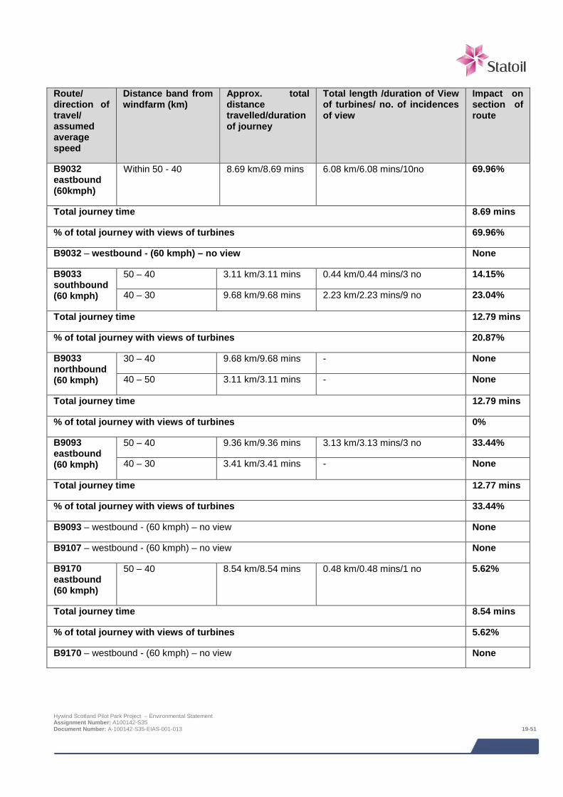
Route/ direction of travel/ assumed average speed
Distance band from windfarm (km)
Approx. total distance travelled/duration of journey
Total length /duration of View of turbines/ no. of incidences of view
Impact on section of route
B9032 eastbound (60kmph)
Within 50 - 40 8.69 km/8.69 mins 6.08 km/6.08 mins/10no 69.96%
Total journey time 8.69 mins
% of total journey with views of turbines 69.96%
B9032 – westbound - (60 kmph) – no view None
B9033 southbound (60 kmph)
50 – 40 3.11 km/3.11 mins 0.44 km/0.44 mins/3 no 14.15%
40 – 30 9.68 km/9.68 mins 2.23 km/2.23 mins/9 no 23.04%
Total journey time 12.79 mins
% of total journey with views of turbines 20.87%
B9033 northbound (60 kmph)
30 – 40 9.68 km/9.68 mins - None
40 – 50 3.11 km/3.11 mins - None
Total journey time 12.79 mins
% of total journey with views of turbines 0%
B9093 eastbound (60 kmph)
50 – 40 9.36 km/9.36 mins 3.13 km/3.13 mins/3 no 33.44%
40 – 30 3.41 km/3.41 mins - None
Total journey time 12.77 mins
% of total journey with views of turbines 33.44%
B9093 – westbound - (60 kmph) – no view None
B9107 – westbound - (60 kmph) – no view None
B9170 eastbound (60 kmph)
50 – 40 8.54 km/8.54 mins 0.48 km/0.48 mins/1 no 5.62%
Total journey time 8.54 mins
% of total journey with views of turbines 5.62%
B9170 – westbound - (60 kmph) – no view None
Hywind Scotland Pilot Park Project – Environmental Statement Assignment Number: A100142-S35 Document Number: A-100142-S35-EIAS-001-013 19-51

Route/ direction of travel/ assumed average speed
Distance band from windfarm (km)
Approx. total distance travelled/duration of journey
Total length /duration of View of turbines/ no. of incidences of view
Impact on section of route
B977 eastbound (60 kmph)
50 – 40 3.53 km/3.53 mins 1.62 km/1.62 mins/2 no 45.89%
Total journey time 3.53 mins
% of total journey with views of turbines 45.89%
B977 – westbound - (60 kmph) – no view None
B999 – southbound - (60 kmph) – no view
None
National Cycle Route (NCR1) southbound (24 kmph)
50 – 40 25.96 km/64.9 mins 2.08 km/5.20 mins/7 no 8.01%
Total journey time 64.9 mins
% of total journey with views of turbines 8.01%
National Cycle Route (NCR1) – northbound - (24 kmph) – no view None
Formartine and Buchan Way - Maud to Peterhead eastbound (5 kmph)
50 – 40 4.05 km/48.6 mins - None
40 – 30 10.32 km/123.84 mins
2.06km/24.72mins/5no 19.96%
30 – 20 6.41 km/76.92 mins 3.38 km/40.56 mins/13 no 52.73%
Total journey time 249.36 mins
% of total journey with views of turbines 26.18%
Formartine and Buchan Way - Maud to Peterhead – westbound (5 kmph) – no view None
Formartine and Buchan Way - Fraserburgh to Dyce southbound (5 kmph)
50 – 40 2.87 km/34.44 mins - None
Within 40 10.57 km/126.84 mins
2.13 km/25.56 mins/7 no 20.15%
40 – 50 40.34 km/484.08 mins
- None
Hywind Scotland Pilot Park Project – Environmental Statement Assignment Number: A100142-S35 Document Number: A-100142-S35-EIAS-001-013 19-52
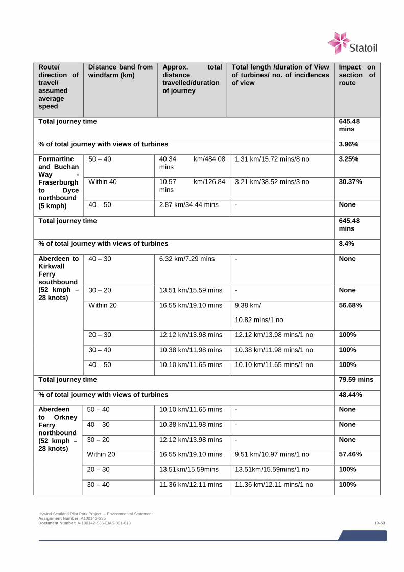
Route/ direction of travel/ assumed average speed
Distance band from windfarm (km)
Approx. total distance travelled/duration of journey
Total length /duration of View of turbines/ no. of incidences of view
Impact on section of route
Total journey time 645.48 mins
% of total journey with views of turbines 3.96%
Formartine and Buchan Way - Fraserburgh to Dyce northbound (5 kmph)
50 – 40 40.34 km/484.08 mins
1.31 km/15.72 mins/8 no 3.25%
Within 40 10.57 km/126.84 mins
3.21 km/38.52 mins/3 no 30.37%
40 – 50 2.87 km/34.44 mins - None
Total journey time 645.48 mins
% of total journey with views of turbines 8.4%
Aberdeen to Kirkwall Ferry southbound (52 kmph – 28 knots)
40 – 30 6.32 km/7.29 mins - None
30 – 20 13.51 km/15.59 mins - None
Within 20 16.55 km/19.10 mins 9.38 km/
10.82 mins/1 no
56.68%
20 – 30 12.12 km/13.98 mins 12.12 km/13.98 mins/1 no 100%
30 – 40 10.38 km/11.98 mins 10.38 km/11.98 mins/1 no 100%
40 – 50 10.10 km/11.65 mins 10.10 km/11.65 mins/1 no 100%
Total journey time 79.59 mins
% of total journey with views of turbines 48.44%
Aberdeen to Orkney Ferry northbound (52 kmph – 28 knots)
50 – 40 10.10 km/11.65 mins - None
40 – 30 10.38 km/11.98 mins - None
30 – 20 12.12 km/13.98 mins - None
Within 20 16.55 km/19.10 mins 9.51 km/10.97 mins/1 no 57.46%
20 – 30 13.51km/15.59mins 13.51km/15.59mins/1 no 100%
30 – 40 11.36 km/12.11 mins 11.36 km/12.11 mins/1 no 100%
Hywind Scotland Pilot Park Project – Environmental Statement Assignment Number: A100142-S35 Document Number: A-100142-S35-EIAS-001-013 19-53

Route/ direction of travel/ assumed average speed
Distance band from windfarm (km)
Approx. total distance travelled/duration of journey
Total length /duration of View of turbines/ no. of incidences of view
Impact on section of route
Total journey time 79.59 mins
% of total journey with views of turbines 39.67%
Assessment of Routes A90 northbound
Assessment of impact significance
The sensitivity of this receptor is considered to be Medium. The reasons for this judgement relative to the criteria in the methodology are:
> Susceptibility to proposed change: Medium – the receptors are road travellers.
> Value attached to views: Low – no evidence of value placed on view (NB View from A90 at Peterhead already assessed under valued views).
The magnitude of change is considered to be Minor. The reasons for this judgement relative to the criteria in the methodology are:
> Size or scale: Minor – although all of the development is theoretically visible, the development will be a minor component of the view.
> Geographical extent: Minor – the percentage of total journey time (measured at 100 kph) will be 12.8%, there will be a long distance to the development (c. 22-50 km), the development will occupy a small part of the view.
> Duration and reversibility: Major: Long term change to view
The overall level of impact is considered to be Minor. Sensitivity of A90 northbound Magnitude of effect Level of impact
Medium Minor Minor
Impact significance – NOT SIGNIFICANT
A90 southbound
Assessment of impact significance
The sensitivity of this receptor is considered to be Medium. The reasons for this judgement relative to the criteria in the methodology are:
> Susceptibility to proposed change: Medium – the receptors are road travellers.
> Value attached to views: Low – no evidence of value placed on view (NB View from A90 at Peterhead assessed below under “Valued views”).
The magnitude of change is considered to be Minor. The reasons for this judgement relative to the criteria in the methodology are:
> Size or scale: Minor – although all of the development is theoretically visible, the development will be a minor component of the view.
> Geographical extent: Minor – the percentage of total journey time (measured at 100 kph) will be 14%, there will Hywind Scotland Pilot Park Project – Environmental Statement Assignment Number: A100142-S35 Document Number: A-100142-S35-EIAS-001-013 19-54
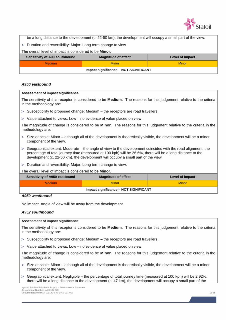
be a long distance to the development (c. 22-50 km), the development will occupy a small part of the view.
> Duration and reversibility: Major: Long term change to view.
The overall level of impact is considered to be Minor. Sensitivity of A90 southbound Magnitude of effect Level of impact
Medium Minor Minor
Impact significance – NOT SIGNIFICANT
A950 eastbound
Assessment of impact significance
The sensitivity of this receptor is considered to be Medium. The reasons for this judgement relative to the criteria in the methodology are:
> Susceptibility to proposed change: Medium – the receptors are road travellers.
> Value attached to views: Low – no evidence of value placed on view.
The magnitude of change is considered to be Minor. The reasons for this judgement relative to the criteria in the methodology are:
> Size or scale: Minor – although all of the development is theoretically visible, the development will be a minor component of the view.
> Geographical extent: Moderate – the angle of view to the development coincides with the road alignment, the percentage of total journey time (measured at 100 kph) will be 26.6%, there will be a long distance to the development (c. 22-50 km), the development will occupy a small part of the view.
> Duration and reversibility: Major: Long term change to view.
The overall level of impact is considered to be Minor. Sensitivity of A950 eastbound Magnitude of effect Level of impact
Medium Minor Minor
Impact significance – NOT SIGNIFICANT
A950 westbound
No impact. Angle of view will be away from the development.
A952 southbound
Assessment of impact significance
The sensitivity of this receptor is considered to be Medium. The reasons for this judgement relative to the criteria in the methodology are:
> Susceptibility to proposed change: Medium – the receptors are road travellers.
> Value attached to views: Low – no evidence of value placed on view.
The magnitude of change is considered to be Minor. The reasons for this judgement relative to the criteria in the methodology are:
> Size or scale: Minor – although all of the development is theoretically visible, the development will be a minor component of the view.
> Geographical extent: Negligible – the percentage of total journey time (measured at 100 kph) will be 2.92%, there will be a long distance to the development (c. 47 km), the development will occupy a small part of the
Hywind Scotland Pilot Park Project – Environmental Statement Assignment Number: A100142-S35 Document Number: A-100142-S35-EIAS-001-013 19-55

view.
> Duration and reversibility: Major: Long term change to view.
The overall level of impact is considered to be Minor. Sensitivity of A952 southbound Magnitude of effect Level of impact
Medium Minor Minor
Impact significance – NOT SIGNIFICANT
A952 northbound
Assessment of impact significance
The sensitivity of this receptor is considered to be Medium. The reasons for this judgement relative to the criteria in the methodology are:
> Susceptibility to proposed change: Medium – the receptors are road travellers.
> Value attached to views: Low – no evidence of value placed on view.
The magnitude of change is considered to be Minor. The reasons for this judgement relative to the criteria in the methodology are:
> Size or scale: Minor – although all of the development is theoretically visible, the development will be a minor component of the view.
> Geographical extent: Negligible – the percentage of total journey time (measured at 100 kph) will be 1.01%, there will be a long distance to the development (c. 47 km), the development will occupy a small part of the view.
> Duration and reversibility: Major: Long term change to view.
The overall level of impact is considered to be Minor. Sensitivity of A952 northbound Magnitude of effect Level of impact
Medium Minor Minor
Impact significance – NOT SIGNIFICANT
A98 eastbound
Assessment of impact significance
The sensitivity of this receptor is considered to be Medium. The reasons for this judgement relative to the criteria in the methodology are:
> Susceptibility to proposed change: Medium – the receptors are road travellers.
> Value attached to views: Low – no evidence of value placed on view.
The magnitude of change is considered to be Minor. The reasons for this judgement relative to the criteria in the methodology are:
> Size or scale: Minor – although all of the development is theoretically visible, the development will be a minor component of the view.
> Geographical extent: Negligible – the percentage of total journey time (measured at 100 kph) will be 2.12%, there will be a long distance to the development (c. 43-45 km), the development will occupy a small part of the view.
Hywind Scotland Pilot Park Project – Environmental Statement Assignment Number: A100142-S35 Document Number: A-100142-S35-EIAS-001-013 19-56
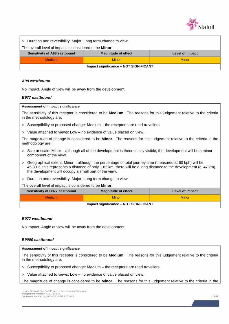
> Duration and reversibility: Major: Long term change to view.
The overall level of impact is considered to be Minor. Sensitivity of A98 eastbound Magnitude of effect Level of impact
Medium Minor Minor
Impact significance – NOT SIGNIFICANT
A98 westbound
No impact. Angle of view will be away from the development.
B977 eastbound
Assessment of impact significance
The sensitivity of this receptor is considered to be Medium. The reasons for this judgement relative to the criteria in the methodology are:
> Susceptibility to proposed change: Medium – the receptors are road travellers.
> Value attached to views: Low – no evidence of value placed on view.
The magnitude of change is considered to be Minor. The reasons for this judgement relative to the criteria in the methodology are:
> Size or scale: Minor – although all of the development is theoretically visible, the development will be a minor component of the view.
> Geographical extent: Minor – although the percentage of total journey time (measured at 60 kph) will be 45.89%, this represents a distance of only 1.62 km, there will be a long distance to the development (c. 47 km), the development will occupy a small part of the view.
> Duration and reversibility: Major: Long term change to view
The overall level of impact is considered to be Minor. Sensitivity of B977 eastbound Magnitude of effect Level of impact
Medium Minor Minor
Impact significance – NOT SIGNIFICANT
B977 westbound
No impact. Angle of view will be away from the development.
B9000 eastbound
Assessment of impact significance
The sensitivity of this receptor is considered to be Medium. The reasons for this judgement relative to the criteria in the methodology are:
> Susceptibility to proposed change: Medium – the receptors are road travellers.
> Value attached to views: Low – no evidence of value placed on view.
The magnitude of change is considered to be Minor. The reasons for this judgement relative to the criteria in the
Hywind Scotland Pilot Park Project – Environmental Statement Assignment Number: A100142-S35 Document Number: A-100142-S35-EIAS-001-013 19-57
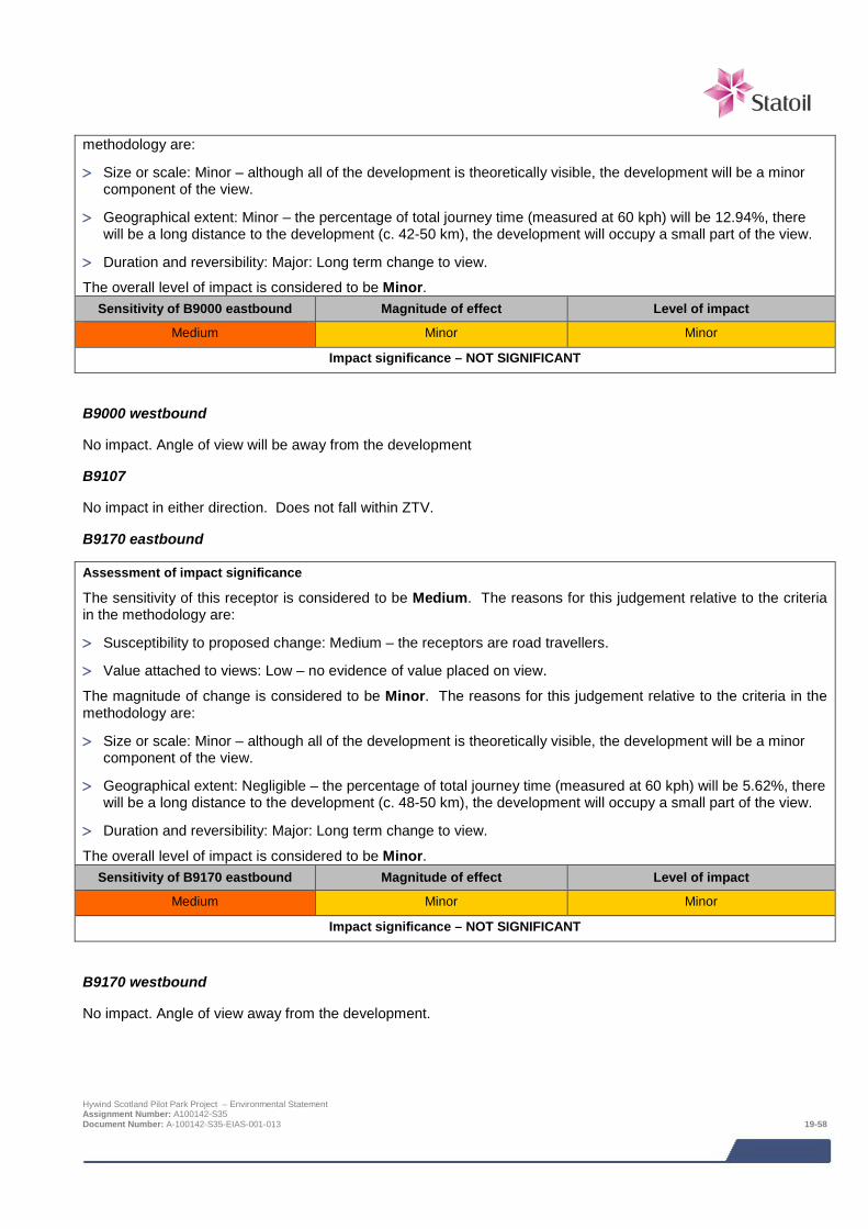
methodology are:
> Size or scale: Minor – although all of the development is theoretically visible, the development will be a minor component of the view.
> Geographical extent: Minor – the percentage of total journey time (measured at 60 kph) will be 12.94%, there will be a long distance to the development (c. 42-50 km), the development will occupy a small part of the view.
> Duration and reversibility: Major: Long term change to view.
The overall level of impact is considered to be Minor. Sensitivity of B9000 eastbound Magnitude of effect Level of impact
Medium Minor Minor
Impact significance – NOT SIGNIFICANT
B9000 westbound
No impact. Angle of view will be away from the development
B9107
No impact in either direction. Does not fall within ZTV.
B9170 eastbound
Assessment of impact significance
The sensitivity of this receptor is considered to be Medium. The reasons for this judgement relative to the criteria in the methodology are:
> Susceptibility to proposed change: Medium – the receptors are road travellers.
> Value attached to views: Low – no evidence of value placed on view.
The magnitude of change is considered to be Minor. The reasons for this judgement relative to the criteria in the methodology are:
> Size or scale: Minor – although all of the development is theoretically visible, the development will be a minor component of the view.
> Geographical extent: Negligible – the percentage of total journey time (measured at 60 kph) will be 5.62%, there will be a long distance to the development (c. 48-50 km), the development will occupy a small part of the view.
> Duration and reversibility: Major: Long term change to view.
The overall level of impact is considered to be Minor. Sensitivity of B9170 eastbound Magnitude of effect Level of impact
Medium Minor Minor
Impact significance – NOT SIGNIFICANT
B9170 westbound
No impact. Angle of view away from the development.
Hywind Scotland Pilot Park Project – Environmental Statement Assignment Number: A100142-S35 Document Number: A-100142-S35-EIAS-001-013 19-58
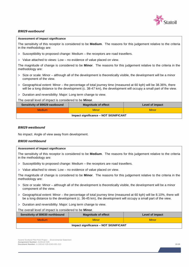
B9029 eastbound
Assessment of impact significance
The sensitivity of this receptor is considered to be Medium. The reasons for this judgement relative to the criteria in the methodology are:
> Susceptibility to proposed change: Medium – the receptors are road travellers.
> Value attached to views: Low – no evidence of value placed on view.
The magnitude of change is considered to be Minor. The reasons for this judgement relative to the criteria in the methodology are:
> Size or scale: Minor – although all of the development is theoretically visible, the development will be a minor component of the view.
> Geographical extent: Minor – the percentage of total journey time (measured at 60 kph) will be 38.36%, there will be a long distance to the development (c. 38-47 km), the development will occupy a small part of the view.
> Duration and reversibility: Major: Long term change to view.
The overall level of impact is considered to be Minor. Sensitivity of B9029 eastbound Magnitude of effect Level of impact
Medium Minor Minor
Impact significance – NOT SIGNIFICANT
B9029 westbound
No impact. Angle of view away from development.
B9030 northbound
Assessment of impact significance
The sensitivity of this receptor is considered to be Medium. The reasons for this judgement relative to the criteria in the methodology are:
> Susceptibility to proposed change: Medium – the receptors are road travellers.
> Value attached to views: Low – no evidence of value placed on view.
The magnitude of change is considered to be Minor. The reasons for this judgement relative to the criteria in the methodology are:
> Size or scale: Minor – although all of the development is theoretically visible, the development will be a minor component of the view.
> Geographical extent: Minor – the percentage of total journey time (measured at 60 kph) will be 8.10%, there will be a long distance to the development (c. 36-45 km), the development will occupy a small part of the view.
> Duration and reversibility: Major: Long term change to view.
The overall level of impact is considered to be Minor. Sensitivity of B9030 northbound Magnitude of effect Level of impact
Medium Minor Minor
Impact significance – NOT SIGNIFICANT
Hywind Scotland Pilot Park Project – Environmental Statement Assignment Number: A100142-S35 Document Number: A-100142-S35-EIAS-001-013 19-59
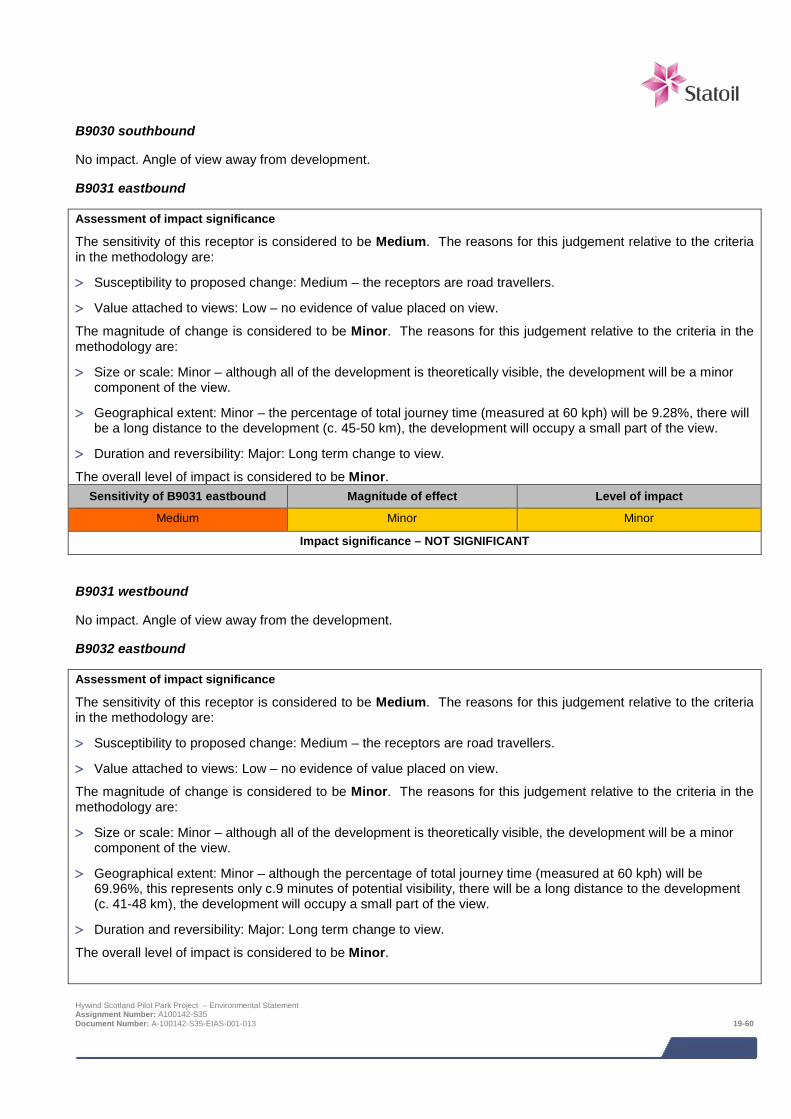
B9030 southbound
No impact. Angle of view away from development.
B9031 eastbound
Assessment of impact significance
The sensitivity of this receptor is considered to be Medium. The reasons for this judgement relative to the criteria in the methodology are:
> Susceptibility to proposed change: Medium – the receptors are road travellers.
> Value attached to views: Low – no evidence of value placed on view.
The magnitude of change is considered to be Minor. The reasons for this judgement relative to the criteria in the methodology are:
> Size or scale: Minor – although all of the development is theoretically visible, the development will be a minor component of the view.
> Geographical extent: Minor – the percentage of total journey time (measured at 60 kph) will be 9.28%, there will be a long distance to the development (c. 45-50 km), the development will occupy a small part of the view.
> Duration and reversibility: Major: Long term change to view.
The overall level of impact is considered to be Minor. Sensitivity of B9031 eastbound Magnitude of effect Level of impact
Medium Minor Minor
Impact significance – NOT SIGNIFICANT
B9031 westbound
No impact. Angle of view away from the development.
B9032 eastbound
Assessment of impact significance
The sensitivity of this receptor is considered to be Medium. The reasons for this judgement relative to the criteria in the methodology are:
> Susceptibility to proposed change: Medium – the receptors are road travellers.
> Value attached to views: Low – no evidence of value placed on view.
The magnitude of change is considered to be Minor. The reasons for this judgement relative to the criteria in the methodology are:
> Size or scale: Minor – although all of the development is theoretically visible, the development will be a minor component of the view.
> Geographical extent: Minor – although the percentage of total journey time (measured at 60 kph) will be 69.96%, this represents only c.9 minutes of potential visibility, there will be a long distance to the development (c. 41-48 km), the development will occupy a small part of the view.
> Duration and reversibility: Major: Long term change to view.
The overall level of impact is considered to be Minor.
Hywind Scotland Pilot Park Project – Environmental Statement Assignment Number: A100142-S35 Document Number: A-100142-S35-EIAS-001-013 19-60

Sensitivity of B9032 eastbound Magnitude of effect Level of impact
Medium Minor Minor
Impact significance – NOT SIGNIFICANT
B9032 westbound
No impact. Angle of view away from the development.
B9033 southbound
Assessment of impact significance
The sensitivity of this receptor is considered to be Medium. The reasons for this judgement relative to the criteria in the methodology are:
> Susceptibility to proposed change: Medium – the receptors are road travellers.
> Value attached to views: Low – no evidence of value placed on view.
The magnitude of change is considered to be Minor. The reasons for this judgement relative to the criteria in the methodology are:
> Size or scale: Minor – although all of the development is theoretically visible, the development will be a minor component of the view.
> Geographical extent: Minor– the percentage of total journey time (measured at 60 kph) will be 20.87%, there will be a long distance to the development (c. 36-42 km), the development will occupy a small part of the view.
> Duration and reversibility: Major: Long term change to view.
The overall level of impact is considered to be Minor. Sensitivity of B9033 southbound Magnitude of effect Level of impact
Medium Minor Minor
Impact significance – NOT SIGNIFICANT
B9033 northbound
No impact. Angle of view away from development.
B9093 eastbound
Assessment of impact significance
The sensitivity of this receptor is considered to be Medium. The reasons for this judgement relative to the criteria in the methodology are:
> Susceptibility to proposed change: Medium – the receptors are road travellers.
> Value attached to views: Low – no evidence of value placed on view.
The magnitude of change is considered to be Minor. The reasons for this judgement relative to the criteria in the methodology are:
> Size or scale: Minor – although all of the development is theoretically visible, the development will be a minor component of the view.
> Geographical extent: Moderate – the percentage of total journey time (measured at 60 kph) will be 33.44%, Hywind Scotland Pilot Park Project – Environmental Statement Assignment Number: A100142-S35 Document Number: A-100142-S35-EIAS-001-013 19-61

(3.13km), there will be a long distance to the development (c. 38-48 km), the development will occupy a small part of the view.
> Duration and reversibility: Major: Long term change to view.
The overall level of impact is considered to be Minor. Sensitivity of B9093 eastbound Magnitude of effect Level of impact
Medium Minor Minor
Impact significance – NOT SIGNIFICANT
B9093 westbound
No impact. Angle of view away from development.
National Cycle Network Route 1 southbound
Assessment of impact significance
The sensitivity of this receptor is considered to be High. The reasons for this judgement relative to the criteria in the methodology are:
> Susceptibility to proposed change: Very High– the receptors are users of a strategic outdoor recreational facility (NCNR 1).
> Value attached to views: Low – no evidence of value placed on view.
The magnitude of change is considered to be Minor. The reasons for this judgement relative to the criteria in the methodology are:
> Size or scale: Minor – although all of the development is theoretically visible, the development will be a minor component of the view.
> Geographical extent: Minor – the percentage of total journey time (measured at 24 kph) will be 8.01%, there will be a long distance to the development (c. 44-50 km), the development will occupy a small part of the view.
> Duration and reversibility: Major: Long term change to view.
The overall level of impact is considered to be Minor. Note that this judgement does not accord with the matrix at Chapter 6, Table 6-1. The reason for this is that the magnitude of change is considered to be the primary determinant in this instance, with the long separation distance, minor percentage of the route affected by visibility, and the small proportion of the view affected, being considered particularly important.
Sensitivity of National Cycle Network Route 1 Southbound Magnitude of effect Level of impact
Medium Minor Minor
Impact significance – NOT SIGNIFICANT
National Cycle Network Route 1 northbound
No impact. Angle of view away from development.
Formantine and Buchan Way (Maud to Peterhead) eastbound
Assessment of impact significance
The sensitivity of this receptor is considered to be High. The reasons for this judgement relative to the criteria in the methodology are:
> Susceptibility to proposed change: High– the receptors are walkers, users of an outdoor recreational facility, and Hywind Scotland Pilot Park Project – Environmental Statement Assignment Number: A100142-S35 Document Number: A-100142-S35-EIAS-001-013 19-62
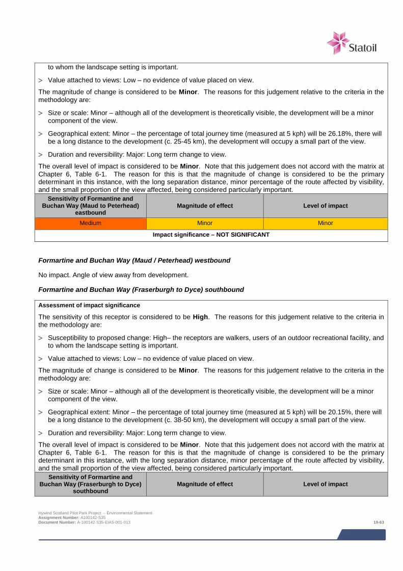
to whom the landscape setting is important.
> Value attached to views: Low – no evidence of value placed on view.
The magnitude of change is considered to be Minor. The reasons for this judgement relative to the criteria in the methodology are:
> Size or scale: Minor – although all of the development is theoretically visible, the development will be a minor component of the view.
> Geographical extent: Minor – the percentage of total journey time (measured at 5 kph) will be 26.18%, there will be a long distance to the development (c. 25-45 km), the development will occupy a small part of the view.
> Duration and reversibility: Major: Long term change to view.
The overall level of impact is considered to be Minor. Note that this judgement does not accord with the matrix at Chapter 6, Table 6-1. The reason for this is that the magnitude of change is considered to be the primary determinant in this instance, with the long separation distance, minor percentage of the route affected by visibility, and the small proportion of the view affected, being considered particularly important.
Sensitivity of Formantine and Buchan Way (Maud to Peterhead)
eastbound Magnitude of effect Level of impact
Medium Minor Minor
Impact significance – NOT SIGNIFICANT
Formartine and Buchan Way (Maud / Peterhead) westbound
No impact. Angle of view away from development.
Formartine and Buchan Way (Fraserburgh to Dyce) southbound
Assessment of impact significance
The sensitivity of this receptor is considered to be High. The reasons for this judgement relative to the criteria in the methodology are:
> Susceptibility to proposed change: High– the receptors are walkers, users of an outdoor recreational facility, and to whom the landscape setting is important.
> Value attached to views: Low – no evidence of value placed on view.
The magnitude of change is considered to be Minor. The reasons for this judgement relative to the criteria in the methodology are:
> Size or scale: Minor – although all of the development is theoretically visible, the development will be a minor component of the view.
> Geographical extent: Minor – the percentage of total journey time (measured at 5 kph) will be 20.15%, there will be a long distance to the development (c. 38-50 km), the development will occupy a small part of the view.
> Duration and reversibility: Major: Long term change to view.
The overall level of impact is considered to be Minor. Note that this judgement does not accord with the matrix at Chapter 6, Table 6-1. The reason for this is that the magnitude of change is considered to be the primary determinant in this instance, with the long separation distance, minor percentage of the route affected by visibility, and the small proportion of the view affected, being considered particularly important.
Sensitivity of Formartine and Buchan Way (Fraserburgh to Dyce)
southbound Magnitude of effect Level of impact
Hywind Scotland Pilot Park Project – Environmental Statement Assignment Number: A100142-S35 Document Number: A-100142-S35-EIAS-001-013 19-63

Medium Minor Minor
Impact significance – NOT SIGNIFICANT
Formartine and Buchan Way (Fraserburgh / Dyce) northbound
Assessment of impact significance
The sensitivity of this receptor is considered to be High. The reasons for this judgement relative to the criteria in the methodology are:
> Susceptibility to proposed change: High– the receptors are walkers, users of an outdoor recreational facility, and to whom the landscape setting is important.
> Value attached to views: Low – no evidence of value placed on view.
The magnitude of change is considered to be Minor. The reasons for this judgement relative to the criteria in the methodology are:
> Size or scale: Minor – although all of the development is theoretically visible, the development will be a minor component of the view.
> Geographical extent: Minor – the percentage of total journey time (measured at 5 kph) will be 8.4%, there will be a long distance to the development (c. 38-50 km), the development will occupy a small part of the view.
> Duration and reversibility: Major: Long term change to view.
The overall level of impact is considered to be Minor. Note that this judgement does not accord with the matrix at Chapter 6, Table 6-1. The reason for this is that the magnitude of change is considered to be the primary determinant in this instance, with the long separation distance, minor percentage of the route affected by visibility, and the small proportion of the view affected, being considered particularly important.
Sensitivity of Formartine and Buchan Way (Fraserburgh to Dyce)
northbound Magnitude of effect Level of impact
Medium Minor Minor
Impact significance – NOT SIGNIFICANT
Aberdeen to Orkney/Shetland Ferry Route southbound
Assessment of impact significance
The sensitivity of this receptor is considered to be Medium. The reasons for this judgement relative to the criteria in the methodology are:
> Susceptibility to Proposed Change: Medium– the receptors are ferry travellers.
> Value Attached to Views: Low – no evidence of value placed on view.
The magnitude of change is considered to be Minor. The reasons for this judgement relative to the criteria in the methodology are:
> Size or scale: Minor – although all of the development is theoretically visible, the development will be a minor component of the view.
> Geographical Extent: Moderate – the percentage of total journey time (measured at 52 kph) will be 48.44%, there will be a moderate to long distance to the development (c. 18-50 km), the development will occupy a small part of the view.
> Duration and Reversibility: Major: Long term change to view. Hywind Scotland Pilot Park Project – Environmental Statement Assignment Number: A100142-S35 Document Number: A-100142-S35-EIAS-001-013 19-64

The overall level of impact is considered to be Minor.
Sensitivity of Ferry Route Magnitude of effect Level of impact
Medium Minor Minor
Impact significance – NOT SIGNIFICANT
Aberdeen to Orkney/Shetland Ferry Route northbound
Assessment of impact significance
The sensitivity of this receptor is considered to be Medium. The reasons for this judgement relative to the criteria in the methodology are:
> Susceptibility to proposed change: Medium– the receptors are ferry travellers.
> Value attached to views: Low – no evidence of value placed on view.
The magnitude of change is considered to be Minor. The reasons for this judgement relative to the criteria in the methodology are:
> Size or scale: Minor – although all of the development is theoretically visible, the development will be a minor component of the view.
> Geographical extent: Moderate – the percentage of total journey time (measured at 52 kph) will be 39.67%, there will be a moderate to long distance to the development (c. 15-50 km), the development will occupy a small part of the view.
> Duration and reversibility: Major: Long term change to view.
The overall level of impact is considered to be Minor. Sensitivity of Ferry Route Magnitude of effect Level of impact
Medium Minor Minor
Impact significance – NOT SIGNIFICANT
Valued views Valued views protected under Policy under Policy 12 of the Aberdeenshire Local Development Plan, 2012 (LDP) are shown on Figure 19.7. It should be noted that precise locations are not identified in the LDP and the locations shown in the figure have been selected on a “worst case” basis, where the development will be most clearly visible.
Across Peterhead Bay from South Road, Peterhead
Assessment of impact significance
The sensitivity of this receptor is considered to be High. The reasons for this judgement relative to the criteria in the methodology are:
> Susceptibility to proposed change: Medium – the receptors are predominantly road travellers, and visitors to the outdoor recreation facilities overlooking the Bay.
> Value attached to views: High – view included in list of valued views.
The magnitude of change is considered to be Minor. The reasons for this judgement relative to the criteria in the methodology are:
> Size or scale: Minor – although all of the development is theoretically visible, the development will be a minor component of the view.
Hywind Scotland Pilot Park Project – Environmental Statement Assignment Number: A100142-S35 Document Number: A-100142-S35-EIAS-001-013 19-65
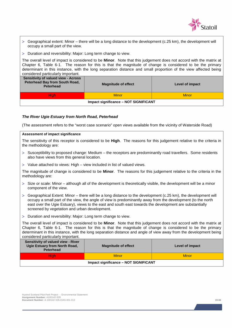
> Geographical extent: Minor – there will be a long distance to the development (c.25 km), the development will
occupy a small part of the view.
> Duration and reversibility: Major: Long term change to view.
The overall level of impact is considered to be Minor. Note that this judgement does not accord with the matrix at Chapter 6, Table 6-1. The reason for this is that the magnitude of change is considered to be the primary determinant in this instance, with the long separation distance and small proportion of the view affected being considered particularly important. Sensitivity of valued view - Across Peterhead Bay from South Road,
Peterhead Magnitude of effect Level of impact
High Minor Minor
Impact significance – NOT SIGNIFICANT
The River Ugie Estuary from North Road, Peterhead
(The assessment refers to the “worst case scenario” open views available from the vicinity of Waterside Road)
Assessment of impact significance
The sensitivity of this receptor is considered to be High. The reasons for this judgement relative to the criteria in the methodology are:
> Susceptibility to proposed change: Medium – the receptors are predominantly road travellers. Some residents also have views from this general location.
> Value attached to views: High – view included in list of valued views.
The magnitude of change is considered to be Minor. The reasons for this judgement relative to the criteria in the methodology are:
> Size or scale: Minor – although all of the development is theoretically visible, the development will be a minor component of the view.
> Geographical Extent: Minor – there will be a long distance to the development (c.25 km), the development will occupy a small part of the view, the angle of view is predominantly away from the development (to the north east over the Ugie Estuary), views to the east and south east towards the development are substantially screened by vegetation and urban development.
> Duration and reversibility: Major: Long term change to view.
The overall level of impact is considered to be Minor. Note that this judgement does not accord with the matrix at Chapter 6, Table 6-1. The reason for this is that the magnitude of change is considered to be the primary determinant in this instance, with the long separation distance and angle of view away from the development being considered particularly important.
Sensitivity of valued view - River Ugie Estuary from North Road,
Peterhead Magnitude of effect Level of impact
High Minor Minor
Impact significance – NOT SIGNIFICANT
Hywind Scotland Pilot Park Project – Environmental Statement Assignment Number: A100142-S35 Document Number: A-100142-S35-EIAS-001-013 19-66
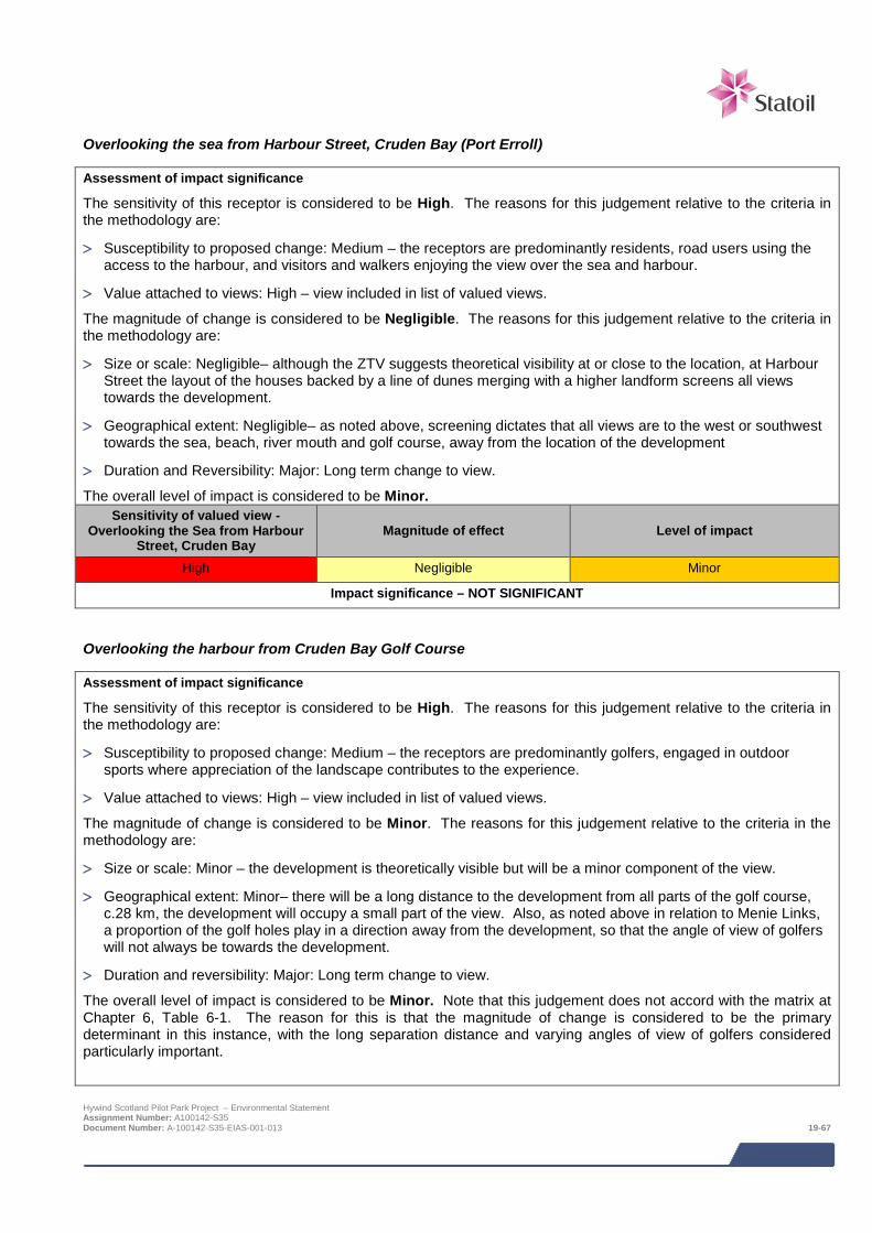
Overlooking the sea from Harbour Street, Cruden Bay (Port Erroll)
Assessment of impact significance
The sensitivity of this receptor is considered to be High. The reasons for this judgement relative to the criteria in the methodology are:
> Susceptibility to proposed change: Medium – the receptors are predominantly residents, road users using the access to the harbour, and visitors and walkers enjoying the view over the sea and harbour.
> Value attached to views: High – view included in list of valued views.
The magnitude of change is considered to be Negligible. The reasons for this judgement relative to the criteria in the methodology are:
> Size or scale: Negligible– although the ZTV suggests theoretical visibility at or close to the location, at Harbour Street the layout of the houses backed by a line of dunes merging with a higher landform screens all views towards the development.
> Geographical extent: Negligible– as noted above, screening dictates that all views are to the west or southwest towards the sea, beach, river mouth and golf course, away from the location of the development
> Duration and Reversibility: Major: Long term change to view.
The overall level of impact is considered to be Minor. Sensitivity of valued view -
Overlooking the Sea from Harbour Street, Cruden Bay
Magnitude of effect Level of impact
High Negligible Minor
Impact significance – NOT SIGNIFICANT
Overlooking the harbour from Cruden Bay Golf Course
Assessment of impact significance
The sensitivity of this receptor is considered to be High. The reasons for this judgement relative to the criteria in the methodology are:
> Susceptibility to proposed change: Medium – the receptors are predominantly golfers, engaged in outdoor sports where appreciation of the landscape contributes to the experience.
> Value attached to views: High – view included in list of valued views.
The magnitude of change is considered to be Minor. The reasons for this judgement relative to the criteria in the methodology are:
> Size or scale: Minor – the development is theoretically visible but will be a minor component of the view.
> Geographical extent: Minor– there will be a long distance to the development from all parts of the golf course, c.28 km, the development will occupy a small part of the view. Also, as noted above in relation to Menie Links, a proportion of the golf holes play in a direction away from the development, so that the angle of view of golfers will not always be towards the development.
> Duration and reversibility: Major: Long term change to view.
The overall level of impact is considered to be Minor. Note that this judgement does not accord with the matrix at Chapter 6, Table 6-1. The reason for this is that the magnitude of change is considered to be the primary determinant in this instance, with the long separation distance and varying angles of view of golfers considered particularly important.
Hywind Scotland Pilot Park Project – Environmental Statement Assignment Number: A100142-S35 Document Number: A-100142-S35-EIAS-001-013 19-67
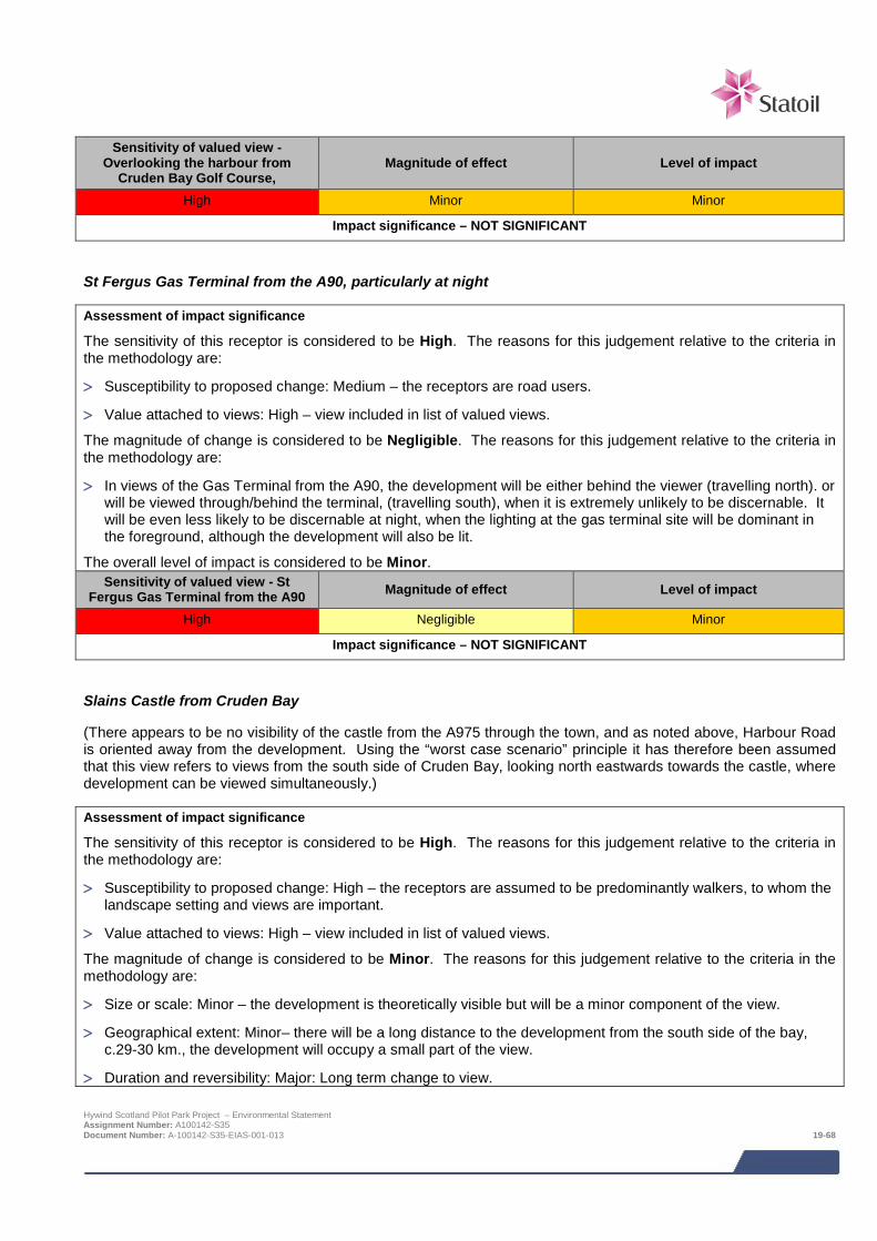
Sensitivity of valued view -
Overlooking the harbour from Cruden Bay Golf Course,
Magnitude of effect Level of impact
High Minor Minor
Impact significance – NOT SIGNIFICANT
St Fergus Gas Terminal from the A90, particularly at night
Assessment of impact significance
The sensitivity of this receptor is considered to be High. The reasons for this judgement relative to the criteria in the methodology are:
> Susceptibility to proposed change: Medium – the receptors are road users.
> Value attached to views: High – view included in list of valued views.
The magnitude of change is considered to be Negligible. The reasons for this judgement relative to the criteria in the methodology are:
> In views of the Gas Terminal from the A90, the development will be either behind the viewer (travelling north). or will be viewed through/behind the terminal, (travelling south), when it is extremely unlikely to be discernable. It will be even less likely to be discernable at night, when the lighting at the gas terminal site will be dominant in the foreground, although the development will also be lit.
The overall level of impact is considered to be Minor. Sensitivity of valued view - St
Fergus Gas Terminal from the A90 Magnitude of effect Level of impact
High Negligible Minor
Impact significance – NOT SIGNIFICANT
Slains Castle from Cruden Bay
(There appears to be no visibility of the castle from the A975 through the town, and as noted above, Harbour Road is oriented away from the development. Using the “worst case scenario” principle it has therefore been assumed that this view refers to views from the south side of Cruden Bay, looking north eastwards towards the castle, where development can be viewed simultaneously.)
Assessment of impact significance
The sensitivity of this receptor is considered to be High. The reasons for this judgement relative to the criteria in the methodology are:
> Susceptibility to proposed change: High – the receptors are assumed to be predominantly walkers, to whom the landscape setting and views are important.
> Value attached to views: High – view included in list of valued views.
The magnitude of change is considered to be Minor. The reasons for this judgement relative to the criteria in the methodology are:
> Size or scale: Minor – the development is theoretically visible but will be a minor component of the view.
> Geographical extent: Minor– there will be a long distance to the development from the south side of the bay, c.29-30 km., the development will occupy a small part of the view.
> Duration and reversibility: Major: Long term change to view.
Hywind Scotland Pilot Park Project – Environmental Statement Assignment Number: A100142-S35 Document Number: A-100142-S35-EIAS-001-013 19-68

The overall level of impact is considered to be Minor. Note that this judgement does not accord with the matrix at Chapter 6, Table 6-1. The reason for this is that the magnitude of change is considered to be the primary determinant in this instance, with the long separation distance and minor proportion of the view affected considered particularly important.
Sensitivity of valued view - Slains Castle from Cruden Bay Magnitude of effect Level of impact
High Minor Minor
Impact significance – NOT SIGNIFICANT
View eastwards from Culsh Monument towards Peterhead
Assessment of impact significance
The sensitivity of this receptor is considered to be High. The reasons for this judgement relative to the criteria in the methodology are:
> Susceptibility to proposed change: High – the receptors are assumed to be predominantly visitors to the monument or walkers, to whom the landscape setting and views are important. (It is considered that the number of viewers will be relatively small).
> Value attached to views: High – view included in list of valued views.
The magnitude of change is considered to be Minor. The reasons for this judgement relative to the criteria in the methodology are:
> Size or scale: Minor – the development is theoretically visible but will be a minor component of the view.
> Geographical extent: Minor– there will be a long distance to the development from monument, c.49-50 km, the development will occupy a small part of the view.
> Duration and reversibility: Major: Long term change to view.
The overall level of impact is considered to be Minor. Note that this judgement does not accord with the matrix at Chapter 6, Table 6-1. The reason for this is that the magnitude of change is considered to be the primary determinant in this instance, with the long separation distance considered particularly important. The relatively small number of potential viewers is also relevant.
Sensitivity of valued view - eastwards from Culsh Monument
towards Peterhead Magnitude of effect Level of impact
High Minor Minor
Impact significance – NOT SIGNIFICANT
Settlements Peterhead
The sensitivity of the settlement as a whole is considered to be high as a worst case condition, due to the majority of receptors being residents. The ZTV (Figure 19.2) indicates that a large proportion of the urban area of Peterhead would have theoretical visibility of the Project. For the majority of this area, however, buildings located on the line of sight between receptors (viewers) and the development will screen the Project. Three viewpoints with open views have been assessed above (Gadle Braes, South Road, and North Road) which are considered to be representative of the worst case views available from the town. The effects on all three views are assessed as being of Minor level of impact, i.e. Not Significant. Accordingly it is considered that the visual effects on the settlement as a whole will be Minor, and Not Significant.
Hywind Scotland Pilot Park Project – Environmental Statement Assignment Number: A100142-S35 Document Number: A-100142-S35-EIAS-001-013 19-69

Sensitivity of receptor Magnitude of effect Level of impact
High Minor Minor
Impact significance – NOT SIGNIFICANT
19.8 Potential variances in environmental impacts The impact assessment above has assessed the worst case Project options with regard to impacts on seascape, landscape and visual receptors. The assessment is based a maximum rotor size and number of WTG Units. The layout of the turbines that has been used to generate the visualisations is indicative at this time and will be finalised during detailed design. However based on the proposed turbine deployment area, even if this indicative layout were to be revised, the spatial extent of any resulting changes will be minimal. Taken together with the large distance offshore, it is considered that the changes will not significantly affect the visualisations that have been produced to support this assessment.
19.9 Cumulative and in-combination impacts HSL has in consultation with Marine Scotland and Aberdeenshire Council identified a list of other projects which together with the Project may result in potential cumulative or in-combination impacts. The list of these projects including details of their status at the time of the EIA and a map showing their location is provided in Section 6; Table 6-3 and Figure 6-1 respectively.
The consideration of which projects could result in potential cumulative or in-combination impacts is based on the results of the project specific impact assessment together with the expert judgement of the specialist consultant. Having considered the information presently available in the public domain on the projects for which there is a potential for cumulative or in-combination impacts, and applying worst case scenario 50 km radius study areas, there are only two projects where these will overlap with the project study area:
> European Offshore Wind Deployment Centre (EOWFL): located at a distance of 37 km from the development; and
> Kincardine Offshore Wind Farm: located at a distance of 47 km from the development.
Subject to the exact extent and configuration of the ZTVs for these developments, a degree of cumulative and in-combination impact may potentially occur relating to simultaneous or successive visibility. However, due to the low magnitude of change relating to any visibility should it occur, deriving from the very long separation distances both between the developments under consideration, and between each development and the receptors being assessed, it is not considered that any of these would result in a significant effect.
19.10 References The Landscape Institute and the Institute of Environmental Management and Assessment (IEMA), 2013. Guidelines for Landscape and Visual Impact Assessment Third edition.
SNH (2014). Visual Representation of Wind Farms Version 2.
SNH (2012a). Offshore Renewables – guidance on assessing the impact on coastal landscape and seascape. .
SNH (2012b). Assessing the cumulative impact of onshore wind energy developments.
SNH (2012c). Mapping Scotland’s Wildness Phase 1 – Identifying Relative Wildness. Non –Technical Methodology, revised October 2012.
SNH (2008). Guidance for Landscape/Seascape Capacity for Aquaculture.
Aberdeenshire Local Development Plan, 2012.
An Inventory of Gardens and Designed Landscapes http://www.historic-scotland.gov.uk/gardens.
Hywind Scotland Pilot Park Project – Environmental Statement Assignment Number: A100142-S35 Document Number: A-100142-S35-EIAS-001-013 19-70
20 POTENTIAL HYDROCARBON AND CHEMICAL SPILL
This chapter of the ES assesses the potential accidental and non-routine events that may occur as a result of the Project. The events assessed are oil spills from vessels, loss of diesel associated with WTG Unit diesel generators, a leak of fluid associated with WTG Units and total loss of inventory from HDD during cable landfall installation.
The consequence of an accidental event could be severe, e.g. large hydrocarbon spill; however, the likelihood of such a large scale event is unlikely. There will only be limited inventories of hydrocarbons and chemicals permanently present offshore in the Pilot Park infrastructure. The largest inventories will therefore be associated with fuel on board vessels used to install, operate and maintain the Project.
HSL will have appropriate procedures and plans in place to ensure the risk of any spill is minimised and in the unlikely event of a spill, the consequence minimised.
20.1 Introduction This section assesses the effects of the Project from hydrocarbon and chemical spill events in the marine environment. The EIA is concerned with ‘likely significant effects’; accidental events are by their nature not likely. However, although unlikely, they have been considered as part of the EIA process as they may have a significant effect should they occur. The probability or likelihood of such an event must therefore be taken into account when assessing the potential impacts. After detailing the nature and potential occurrence for these events, mitigation and management is identified to remove the risk and level of impact. This assessment has been undertaken by Xodus supported by vessel spill risk work undertaken by Anatec Limited has as part of the Navigation Risk Assessment (NRA).
Table 20-1 provides details of the Navigation Risk Assessment supporting study which relates to the potential hydrocarbon and chemical spill impact assessment. The supporting study is provided on the accompanying CD.
Table 20-1 Supporting studies
Details of study
Navigation Risk Assessment Hywind Scotland Pilot Park Project (Anatec, 2014)
The following areas are referred to in this impact assessment:
> Project area (see Figure 1.2 in Chapter 1), which comprises:
o Proposed offshore turbine deployment area: and
o Export cable corridor and landfall.
> Study area – to ensure that users of the offshore environment are captured (in terms of collision risk), that installation activities in both the offshore and nearshore environment are captured (in terms of potential spills from these activities) and that habitats and species which could be susceptible to any potential spill, the study area for this assessment covers an area stretching offshore to onshore from approximately 10 nm offshore of the initial Exclusivity Area to the Aberdeenshire coast and north to south stretching from around Fraserburgh to the Firth of Forth.
20.2 Legislative framework and relevant guidance There is no specific legislation or published guidance regarding the scope of the assessment of accidental and non-routine events. However the following legislation and guidance should be adhered to by the Project to ensure the risk and consequence of accidental event is appropriately managed:
Hywind Scotland Pilot Park Project – Environmental Statement Assignment Number: A100142-S35 Document Number: A-100142-S35-EIAS-001-014 20-1
> The International Convention for the Prevention of Pollution from ships (MARPOL) covers pollution of the marine environment by ships from operational or accidental causes;
> Regulation 37 of Annex I of MARPOL requires that all ships of 400 gross tonnage (GT) or more carry an approved Shipboard Oil Pollution Emergency Plan (SOPEP); and
> Scottish Environment Protection Agency (SEPA) Pollution Prevention Guidelines (PPG) 1 covers general guidance on the prevention of Pollution, PPG 5 provides guidelines for construction and maintenance work, on, in or near water, PPG 21 for producing emergency pollution incident response plans to deal with accidents, spillages and fires and PPG 22 for incident response and dealing with spills (in waters out to 3 nm).
20.3 Scoping and consultation The Scoping Report identified the need to assess potential impacts from hydrocarbon and chemical spills.
Table 20-2 summarises all consultation activities carried out relevant to potential hydrocarbon and chemical spill events.
Table 20-2 Consultation activities undertaken in relation to potential hydrocarbon and chemical spill
Date Stakeholder Consultation undertaken
May 2013 Marine Scotland (MS-LOT and Marine Scotland Science) and statutory consultees
Pre-scoping meeting including discussion on proposed scope of potential hydrocarbon and chemical spill impact assessment
October 2013 Marine Scotland, statutory consultees and non- statutory consultees
Submission of EIA Scoping Report – request for EIA Scoping Opinion from Marine Scotland and statutory consultees and request for comment from non-statutory consultees
March 2014 Marine Scotland, statutory consultees and non- statutory consultees
Receipt of Scoping Opinion
May 2014 Local stakeholders Public event in Peterhead to collate information / opinions on EIA scope
20.4 Baseline description Chapter 5 provides an overview of the environmental characteristics of the Project and surrounding areas.
20.5 Impact assessment
20.5.1 Overview Following establishment of the baseline conditions to the Project area, and an understanding of the Project activities it is possible to assess the potential impacts from the Project. The impacts assessed are summarised below. It should be noted that all impacts are relevant to all phases of the Project unless otherwise stated.
> Oil spills from vessels;
> Loss of diesel associated with WTG Unit diesel generators;
> Leak of fluid associated with WTG Units; and
> Total loss of inventory from HDD borehole (the base case for cable landfall installation is HDD).
The assessment of impacts from potential hydrocarbon and chemical spill is a desk based assessment utilising published data on the probability / likelihood of different types of accidental events. In addition, the NRA (Anatec, 2014; Appendix B) undertook a Consequence Assessment to estimate the probability of an oil spill resulting from a vessel accident. Hywind Scotland Pilot Park Project – Environmental Statement Assignment Number: A100142-S35 Document Number: A-100142-S35-EIAS-001-014 20-2

20.5.2 Assessment criteria The EIA process and methodology are descried in detail in Chapter 6. Specific criteria relating have been developed for ‘sensitivity of receptor’ and ‘magnitude of effect’ as detailed in Table 20-3 and Table 20-4 respectively. There is not one standard receptor that can be impacted by accidental events; therefore definitions refer generally to all possible receptors.
The sensitivity of receptor and magnitude of effect are then combined to determine the level of impact and presented alongside an understanding of the probability / likelihood of that particular impact occurring. The definitions for level of impact and how they relate to significance are presented in Chapter 6, Table 6-1 and Table 6-1.
Table 20-3 Criteria for sensitivity / value of receptor
Sensitivity / value Definition
Very high
Sensitivity: Receptor with no capacity to accommodate a particular effect with no ability to recover or adapt.
Value: Receptor of very high importance or rarity, such as those designated under international legislation (e.g. EU Habitats Directive) or those that are internationally recognised as globally threatened (e.g. IUCN red list).
High
Sensitivity: Receptor with a very low capacity to accommodate a particular effect without substantially altering its present character, with low recoverability or adaptability.
Value: Receptor of high importance or rarity, such as those which are designated under national legislation, and/or ecological receptors such as UK BAP priority species with nationally important populations in the study area, and species that are near-threatened or vulnerable on the IUCN red list.
Medium
Sensitivity: Receptor has a low capacity to accommodate a particular effect without substantially altering its present character, with some potential for recovery or adaption.
Value: Receptor of moderate value or regional importance, and/or ecological receptors listed as of least concern on the IUCN red list but which form qualifying interests of internationally designated sites, or which are present in internationally important numbers.
Low
Sensitivity: Receptor has some tolerance to accommodate a particular effect or will be able to recover or adapt with only small changes to its present character.
Value: Receptor of low value or local importance, and/or ecological receptors such as species which contribute to a national site, are present in regionally important numbers, are on Annex II of the European Habitats Directive, listed as EPS, listed in Schedule V of the Wildlife and Countryside Act, listed as priority species in the UKBAP or which are otherwise of conservation interest (e.g. Local BAP, Priority Marine Feature species).
Negligible
Sensitivity: Receptor is generally tolerant and can accommodate a particular effect without the need to recover or adapt.
Value: Receptor of very low importance, such as those which are generally abundant around the UK with no specific value or conservation concern.
Note:
Value is presented as a component of sensitivity to allow a judgement to be made according to either a receptor’s sensitivity to a particular effect or its value under, for example, international, national, or regional legislation. Value should therefore be applied inherently when considering the sensitivity of a receptor to a particular effect. Definitions in this table may not be appropriate for all receptors or effects, for example there may be a receptor with some tolerance to accommodate an effect (low sensitivity) but it might be designated under regional legislation (medium sensitivity). In such cases expert judgement is used to determine the most appropriate sensitivity ranking and this is explained through the narrative of the assessment.
Hywind Scotland Pilot Park Project – Environmental Statement Assignment Number: A100142-S35 Document Number: A-100142-S35-EIAS-001-014 20-3
Table 20-4 Criteria for magnitude of effect
Magnitude of effect Definition
Severe Severe alteration to key elements or features of the baseline conditions resulting in a fundamental change in character, composition or other attributes.
Major Major alteration to key elements or features of the baseline conditions resulting in a major change in character, composition or other attributes.
Moderate Alteration to one or more key elements or features of the baseline conditions such that post event character, composition or other attributes will be partially changed.
Minor Minor alteration in baseline conditions. Effect will be discernible but underlying character, composition or other attributes of baseline conditions will be similar to pre event circumstances and patterns.
Negligible Very slight change from baseline conditions. Change barely distinguishable, approximating to the no change situation.
For the assessment of hydrocarbon and chemical spill events the application of frequency / probability is applied to the level of impact. This allows the residual risk of the impact to be fully understood. This is particularly important for impacts where the level of impact is very high but the probability of such an event occurring is extremely low i.e. a major oil spill is a high impact event which has a very low probability of occurrence.
In order to assess the residual risk, the level of impact is combined with a frequency / probability of the impact occurring as defined in Table 20-5.
Table 20-5 Probability and / or likelihood definitions for accidental events
Frequency / likelihood category
Accidental event (probability)
Continuous / Likely 10-1 to >1 events per year
Event likely to occur more than once on the facility
Regular / Possible 10-2 – 10-1 events per year
Could occur within the lifetime of the development
Intermittent / Unlikely 10-3 – 10-2 events per year
Event could occur within the life of 10 similar facilities. Has occurred at similar facilities
One off Event / Remote 10-5- 10-3 events per year
Similar event has occurred somewhere in the industry or similar industry but not likely to occur with current practices and procedures
One off Event / Extremely Remote
<10-5 events per year
Has never occurred within industry or similar industry, but theoretically possible
The overall impact significance ranking is derived by combining level of impact and likelihood via the matrix presented in Table 20-6.
Table 20-6 Residual risk rankings for accidental events
Level of impact Likelihood / Frequency
Continuous / Likely
Regular / Possible
Intermittent / Unlikely
One off Event / Remote
One off Event / Extremely Remote
Will not occur
Severe Severe Severe Major Moderate Minor Negligible
Major Severe Major Moderate Minor Negligible Negligible
Hywind Scotland Pilot Park Project – Environmental Statement Assignment Number: A100142-S35 Document Number: A-100142-S35-EIAS-001-014 20-4
Level of impact Likelihood / Frequency
Continuous / Likely
Regular / Possible
Intermittent / Unlikely
One off Event / Remote
One off Event / Extremely Remote
Will not occur
Moderate Major Moderate Minor Minor Negligible Negligible
Minor Moderate Minor Minor Negligible Negligible Negligible
Negligible Minor Negligible Negligible Negligible Negligible Negligible
20.5.3 Design Envelope This assessment considers the Project parameters which are predicted to result in the greatest environmental impact. This approach ensures that impacts of a greater adverse significance would not arise should any other development scenario be taken forward in the final scheme design. With regards to the assessment of impacts from accidental events, the assessment has considered the following:
> Total vessel fuel inventory of 8,000,000 litres, with largest single tank of fuel in the region of 600,000 litres;
> 1 m3 hydraulic fluid, used in blade pitch (per WTG Unit);
> 1 m3 30/70 water glycol mix used in the cooling system (per WTG Unit);
> 2 m3 transformer liquid (synthetic ester) used for lubrication (per WTG Unit);
> 0.2 m3 320 grade synthetic or mineral based EP/gear oil (per WTG Unit); and
> 1,000 litres of diesel per temporary diesel generator.
The impacts from potential alternative development options are addressed in Section 20.7.
20.5.4 Data gaps and uncertainties Given the nature of an accidental event (i.e. non routine) there are a number of uncertainties associated with assessing the impact of these events. There are data available on the frequency of certain events (i.e. vessel collisions) and the consequences of such events to the environment. Where these data are available they have been used in assessing the impact of an accidental event. In addition available Project data on the inventory of vessels that may be used during Project installation and maintenance activities and the inventory of the turbines themselves have also been used to provide suitable information on what volumes could be spilled.
20.6 Impacts during all phases (construction and operation)
20.6.1 Oil spills from vessels Oil spills can have a number of environmental impacts. Actual effects will vary depending on a wide range of factors including the volume and type of oil spilt and the sea and weather conditions at the time of the spill. Impacts will also be dependent on the presence of environmental sensitivities in the path of the spill. In a dynamic offshore environment such as that at the Buchan Deep oil spills will be rapidly dispersed, however beaching could occur due to the proximity of vessel activity to shore.
Sources of data on spill risk associated with offshore support vessels are few. It is, however, indicated that the most frequently recorded spills from vessels offshore is associated with upsets in the bilge treatment systems and the losses are usually small (UKOOA, 2006). This type of loss is likely to result in 10’s of litres being lost to the environment.
Hywind Scotland Pilot Park Project – Environmental Statement Assignment Number: A100142-S35 Document Number: A-100142-S35-EIAS-001-014 20-5
A Consequences Assessment (Appendix B of the Navigation Risk Assessment) has estimated the probability of an oil spill resulting from a vessel accident1. The assessment has considered historical data to compare collision frequency with the average quantities of oil spilled per vessel (rather than the worst case presented in this ES). Based on this, the assessment estimates the overall increase in pollution due to the Project to be very low, at approximately 0.00003%.
The total oil inventory for large dynamic positioning (DP) installation vessels (which may be used for cable installation activities) is likely to be in the region of 6,000,000 to 8,000,000 litres of marine diesel stored in a number of separate tanks. The worst case spill from a single tank rupture is likely to be in the region of 600,000 litres of marine diesel released into the marine environment. Assessment of impact significance
Due to the range of species and habitats present in and surrounding the Project area and the presence of nationally important species and habitats, the sensitivity of the coastal and offshore environment to pollution is considered to be high.
Large spills
In the event of a loss of an entire vessel fuel inventory the magnitude of effect is considered to be severe which results in an overall level of impact of severe. The likelihood of such an event, based on best available data for offshore installation and support vessels (incident rate of one per 13,067 vessel years; DETR, 1999) is extremely remote and therefore residual risk is minor and not significant.
Sensitivity / value
Magnitude of effect Level of impact Likelihood /
frequency Residual risk
High Severe Severe Extremely remote Minor
Impact significance – NOT SIGNIFICANT
Small spills In the event of a smaller loss of inventory e.g. 10’s of litres, the magnitude of effect is considered minor which results in a moderate level of impact. The likelihood of such an event is unlikely (UKOOA, 2006) and therefore overall the residual risk is minor and not significant.
Sensitivity / value
Magnitude of effect Level of impact Likelihood /
frequency Residual risk
High Minor Moderate Unlikely Minor
Impact significance – NOT SIGNIFICANT
MITIGATION
The following mitigation measures will be implemented in order to reduce the risk of and impact from vessel spills:
> Vessels associated with all Project operations will comply with IMO/MCA codes for prevention of oil pollution and any vessels over 400 GT will have onboard SOPEP’s;
> Project specific emergency plans will be in place and cover potential pollution events;
> Vessels associated with all Project operations will carry onboard oil and chemical spill mop up kits;
> Where possible and practicable vessels with a proven track record for operating in similar conditions will be employed; and
> Vessel activities associated with installation, operation and, routine maintenance and decommissioning will occur in suitable conditions to reduce the chance of an oil spill resulting from the influence of unfavourable weather conditions.
1 13% of ship collisions result in a fuel oil spill and 39% of collision involving a laden tanker result in a cargo oil spill. Hywind Scotland Pilot Park Project – Environmental Statement Assignment Number: A100142-S35 Document Number: A-100142-S35-EIAS-001-014 20-6
20.6.2 Loss of diesel associated with diesel generators Portable diesel generators will be required to provide power to WTG systems, cranes and tools during construction and may be required during operation if grid connection is lost for a prolonged period of time. The diesel inventory of the generators to be used is expected to be in region of 1,000 litres. As the generators will be refuelled (bunkered) offshore there is the potential for spills during bunkering operations.
Assessment of impact significance
Due to the range of species and habitats present in and surrounding the Project area and the presence of nationally important species and habitats, the sensitivity of the offshore environment is considered to be high.
Loss of entire generator diesel inventory
In the event of a loss of entire fuel inventory from a diesel generator e.g. from a vessel collision, the magnitude of effect is considered to be moderate which results in an overall level of impact of major. The likelihood of such an event is considered to be remote and therefore residual risk is minor and not significant.
Sensitivity / value
Magnitude of effect Level of impact Likelihood /
frequency Residual risk
High Moderate Major Remote Minor
Impact significance – NOT SIGNIFICANT Bunkering spill In the event of a smaller loss of inventory e.g. few litres during bunkering, the magnitude of effect is considered minor which results in an overall level of impact of moderate. The likelihood of such an event is unlikely, based on UKCS oil and gas industry historical bunkering spill data (DECC, 2014) and therefore overall the residual risk is minor and not significant.
Sensitivity / value
Magnitude of effect Level of impact Likelihood /
frequency Residual risk
High Minor Moderate Unlikely Minor
Impact significance – NOT SIGNIFICANT
MITIGATION
The following mitigation measures will be implemented in order to reduce the risk of and impact from diesel spills:
> Project specific emergency plans will be in place and cover potential pollution events; and
> Bunkering procedures will be in place to ensure the risk of a spill during bunkering will be minimised.
20.6.3 Leak of fluid associated with WTG Units There are several instances which could cause leakage from the turbines either of chemicals or ballast water. The substructure includes a ballast tank which will hold ballast water, the volume of which is still being determined (although the required combination of solid and liquid ballast is 8,000 tons per WTG Unit). The proposed ballast water has a pH value above 10.5, therefore higher than the surrounding seawater. Depending on the assembly site (which may not be in UK waters), ballast water discharge may also result in the introduction of non-native species to the AfL area (discussed in Chapter 9: Benthic and intertidal ecology and not considered further here).
Other chemicals will also be used on WTG Units, including hydraulic fluid, coolant, transformer liquid and oil. The impact from loss of fluids from the WTG Units will be limited. Leaks will be localised to the immediate vicinity of the turbine and will be rapidly dispersed by currents around Buchan Deep or within the tow route. The quantities and types of fluids used will also be a limiting factor to the overall impact, as there will be a maximum of 21 m3
Hywind Scotland Pilot Park Project – Environmental Statement Assignment Number: A100142-S35 Document Number: A-100142-S35-EIAS-001-014 20-7
chemicals, combined for all WTG Units. The fluids will be mostly water based, biodegradable and have low aquatic toxicity.
Leaking of chemicals and ballast water could occur along the tow route during transit to the AfL area, construction at the site and during operation.
Assessment of impact significance
Due to the range of species and habitats present in and surrounding the Project area and the presence of nationally important species and habitats, the sensitivity of the offshore environment to pollution is considered to be high.
Based on the fact that only small inventories of hydrocarbons will be permanently present on the WTG Units and the ballast water if released is only slightly alkaline the potential magnitude of effect is considered to be no greater than minor. This gives an overall level of impact of moderate. Although there is a lack of data on the risk of leaks from wind turbines, the potential for such an event is considered to be no more than likely. Therefore the residual risk is minor and not significant.
Sensitivity / value
Magnitude of effect Level of impact Likelihood /
frequency Residual risk
High Minor Moderate Unlikely Minor
Impact significance – NOT SIGNIFICANT
MITIGATION
The following mitigation measures will be implemented in order to reduce the impact from leaks:
> Only recognised marine standard fluids and substances will be used in the turbine hydraulic systems;
> Hydraulic fluids will be mostly water based, biodegradable and be of low aquatic toxicity; and
> Turbine sensors will detect loss of fluid and leaks, enabling maintenance operatives to reduce the risk of further leaks.
20.6.4 Total loss of inventory from HDD borehole HDD is the most likely method of cable installation. The majority of drill cuttings generated from the drilling of the HDD bore will be returned to shore and not discharged to sea. At the offshore end of the borehole some cuttings may be lost to sea during seabed breakthrough. It is unlikely that the entire borehole inventory of cuttings will be lost to sea, however if they are the dynamic inshore environment will ensure that any discharge is rapidly dispersed and any increase in suspended sediment concentrations short lived. This impact is only relevant during the construction phase of the project.
Assessment of impact significance
The sensitivity of the receptor is assessed as medium on the basis of smothering and suspended sediment increasing mortality of marine life. The magnitude of effect is considered negligible on the basis of the relatively limited volume of drill cuttings (4 m3) that could be discharged as only one bore is being drilled. The level of impact is negligible. Although there is a lack of data on the risk of loss of entire bore inventories during HDD, the potential for such an event is considered to be possible. Therefore the residual risk is negligible and not significant.
Hywind Scotland Pilot Park Project – Environmental Statement Assignment Number: A100142-S35 Document Number: A-100142-S35-EIAS-001-014 20-8
Sensitivity / value
Magnitude of effect Level of impact Likelihood /
frequency Residual risk
Medium Negligible Negligible Possible Negligible
Impact significance – NOT SIGNIFICANT
MITIGATION
The following mitigation measures will be implemented in order to reduce the impact:
> In the event of any unplanned discharge to sea during HDD activities, the drilling contractor would activate its emergency response plan to ensure discharges were minimised.
20.7 Potential variances in environmental impacts (based on Design Envelope) The assessment has identified the Project options associated with installation, construction, operation and maintenance which are predicted to result in the greatest impacts. Although Project design is ongoing and contractors still to be appointed (e.g. vessels) and therefore details of oil/fluid inventories may vary to those quoted here, any variances are not expected to significantly influence the impact predictions made in the assessment.
20.8 Cumulative and in-combination impacts HSL has, in consultation with Marine Scotland and Aberdeenshire Council, identified a list of other projects which together with the Project may result in potential cumulative or in-combination impacts. The list of these projects including details of their status at the time of the EIA and a map showing their location is provided in Chapter 6; Table 6-3 and Figure 6-1 respectively.
Cumulative impacts are accidental events caused by planned and consented offshore wind farms. In-combination impacts are accidental events as a result of offshore wind farms (and their associated activities) combined with impacts from other marine activities or users of the sea.
Given the nature of an accidental event, i.e. non routine, the likelihood for cumulative impacts caused by accidental events (i.e. an accident occurring in the same time period as one or more projects and this Project) is considered to be extremely remote. There are no other projects in the immediate vicinity of the Hywind Scotland Project that are expected to be being constructed at the same time, however given that operations from different projects may be ongoing simultaneously there will be a slight increase in the risk of some of some events occurring (e.g. oil spills). Other projects will also have management and mitigation in place to reduce the likelihood of an accidental event and have emergency plans which will be activated to ensure impacts are minimised.
20.9 Monitoring No monitoring is required as part of routine operation of the Project, however in the unlikely event of a pollution incident, appropriate post incident monitoring will be implemented and agreed with the Regulator and their advisors.
20.10 References Anatec (2014). Navigation Risk Assessment. Hywind Scotland Pilot Park Project.
DECC (2014). PON1 spill data statistics. https://www.og.decc.gov.uk/eng/fox [Accessed 17/10/14].
DETR (1999). Identification of Marine Environmental High Risk Areas (MEHRAs) in the UK. Draft issued for consultation December 1999.
UKOOA (2006). Report on the analysis of DTI UKCS oil accidental release data from the period 1975 – 2005. A report prepared by TINA Consultants Ltd. October 2006.
Hywind Scotland Pilot Park Project – Environmental Statement Assignment Number: A100142-S35 Document Number: A-100142-S35-EIAS-001-014 20-9
21 ENVIRONMENTAL MANAGEMENT AND MONITORING
21.1 Introduction The previous chapters of this Environmental Statement (ES) outline the environmental studies and assessments carried out as part of the EIA and navigation risk assessment (NRA). The purpose of this chapter is to provide a summary of environmental mitigation, monitoring and management measures and that will be taken forward through the next phase of the Project. It also provides an overview of approaches to environmental management, monitoring, interfacing with contractors, and environmental awareness and training.
21.2 Environmental management system As a company, Statoil has a clear goal to ensure sustainable development and is committed to minimising environmental impacts. This section introduces Statoil’s Safety and Sustainability policy, the Management System and how this will be implemented within Hywind Scotland Pilot Park project.
21.2.1 Safety and sustainability policies Statoil’s Safety and Sustainability policies are two of several policies included in the Statoil Book, which forms the foundation of how we conduct our business. We will ensure safe operations which protect people, the environment, communities and material assets. We believe that accidents can be prevented.
We are committed to:
> Integrating safety in the way we do business;
> Improving safety performance in all our activities;
> Demonstrating the importance of safety through hands-on leadership and behaviour; and
> Openness on all safety issues and active engagement with stakeholders.
How we work:
> We take responsibility for the safety and security of ourselves and others;
> We work systematically to understand and manage risk;
> We provide our people with the necessary resources, equipment and training to deliver in accordance with their designated responsibilities;
> We cooperate with our contractors and suppliers on the basis of mutual respect;
> We stop unsafe acts and operations;
> We aim for a safe and attractive working environment characterised by respect, trust and cooperation;
> We monitor risk related to the working environment, and we monitor the occupational health of our people;
> We establish work processes as well as goals and performance indicators to control, measure and improve these processes;
> We run safety improvement processes based on surveys and risk assessments, and we involve our people in this work;
> We build robust installations/plants and maintain them to prevent accidents;
Hywind Scotland Pilot Park Project – Environmental Statement Assignment Number: A100142-S35 Document Number: A-100142-S35-EIAS-001-015 21-1

> If accidents occur, our emergency response organisation will do its utmost to reduce injury and loss. Saving lives is our highest priority; and
> We transform lessons learned into improved safety measures through continuous learning.
21.2.2 Our approach to sustainability We contribute to sustainable development through our core activities wherever we work. We use natural resources efficiently, and provide energy which supports sustainable development.
We are committed to:
> Integrating sustainability in the way we do business;
> Contributing to the development of sustainable energy systems and technology;
> Making decisions based on the way they affect our interests as well as the interests of the societies and the ecosystems in which we operate;
> Respecting human rights and labour standards;
> Ensuring anti-corruption and transparency on all sustainability issues and active engagement with stakeholders; and
> Contributing to local content by developing skills and opportunities in the societies in which we operate.
How we work:
> We identify and manage environmental and social risks and opportunities based on stakeholder dialogue, as well as risk and impact assessments;
> We apply clean and efficient technologies to reduce the negative environmental impact of existing operations;
> We work to limit greenhouse gas emissions;
> We respect international labour standards and the rights of indigenous peoples;
> We promote transparency through support for international industry standards, and by publishing our income, expenditures and taxes in all the countries in which we operate;
> We hire and develop local people and promote local sourcing;
> We ensure that local suppliers comply with applicable laws and meet our expectations and standards;
> We work with others to help establish sustainable local enterprises and support the efforts of our suppliers to close gaps in order to meet our standards;
> We exchange experience with national partners and support education and skill building in oil- and gas-related disciplines to build lasting capacity; and
> We undertake sustainable social investment projects in affected communities so that they can share in the benefits provided by our activities.
21.2.3 The Statoil management system The Statoil management system defines how we work and describes how we lead and perform our activities. Commitment to and compliance with our management system are a requirement.
Our management system has three main objectives:
> Contribute to safe, reliable and efficient operations and enable us to comply with external and internal requirements;
Hywind Scotland Pilot Park Project – Environmental Statement Assignment Number: A100142-S35 Document Number: A-100142-S35-EIAS-001-015 21-2
> Help us to incorporate our values, our people and our leadership principles in everything we do; and
> Support our business performance through high-quality decision making, fast and precise execution, and continuous learning.
Sustainability in Statoil means responsible environmental, social and economic performance enabling business resilience. The sustainability function in Statoil includes these elements:
> Balance reliable energy supply and climate impact;
> Aim for outstanding resource efficiency;
> Prevent harm to local environment;
> Create lasting local value;
> Respect for human rights; and
> Lead an open and transparent business. The Statoil environmental management system (EMS) is fully compatible with recognised environmental management standards including ISO 14001.
21.2.4 Technical standards Statoil’s governing documents stipulate technical and professional requirements which apply to all projects. These include, for example TR1011 – Technical Environment Standard for Design, Modifications and Operation for Offshore Plants, which defines the group’s technical environmental requirements for offshore developments and operations, including the Hywind Scotland Pilot Park. The guiding principles of this document include:
> Alternative concepts and technologies shall be identified and evaluated. Technology selection shall be prioritised in the following order: prevent, minimise, mitigate and compensate;
> Best Available Techniques (BAT) is the overriding principle. BAT assessments shall be performed and documented for the design and operation of each facility;
> BAT assessments shall include cost/benefit calculations;
> National laws and requirements; and
> Corporate goals and requirements shall be met.
21.2.5 Performance monitoring Monitoring in Statoil is conducted to manage risk, and drive performance and learning. The process ensures quality, effectiveness and assures compliance with the management system and provides a basis for improvement. Monitoring is performed by internal and external parties.
21.3 Environmental management Environmental assessment for the Project, including consultation with stakeholders, is an on-going, iterative process through final option selection, engineering design and through project execution. The primary mechanism for ensuring environmental assessment continues and that all environmental issues are addressed is through the Project Operational Management System. This management system will ensure that ES mitigation commitments, consent conditions and environmental monitoring requirements are taken through to implementation.
Where the EIA has identified potentially significant impacts that cannot be avoided, mitigation measures have been proposed. Such measures should remove, reduce or manage the effect to a point where the residual significance of that impact is reduced to an acceptable level. Mitigation has also been recommended tin order that impacts
Hywind Scotland Pilot Park Project – Environmental Statement Assignment Number: A100142-S35 Document Number: A-100142-S35-EIAS-001-015 21-3

remain ‘not significant’. Table 21-1 summarises all mitigation and management measures identified during the EIA process on a topic by topic basis.
These commitments will be integrated into the Project Environmental Management Plan (EMP). The full EMP will be implemented in agreement with the relevant Regulator and statutory advisors following successful award of Project consents. It will consist of a working document which details:
> Roles, responsibilities and chain of command for HSL personnel, and any contractors or sub-contractors in respect of environmental management for the protection of environmental interests during the construction and operation of the Project;
> Mitigation measures to prevent significant adverse impacts to environmental interests (as identified in the commitments register), and include a Construction Method Statement (CMS);
> Pollution prevention measures and contingency plans;
> Measures to minimise, recycle, reuse and dispose of waste streams; and
> Reporting mechanisms that will be used to provide the Regulator and relevant stakeholders with regular updates on construction activity, including any environmental issues that have been encountered and how these have been addressed.
The EMP will be submitted to and agreed with the Regulator prior to the commencement of construction and updated as required as the Project progresses.
21.3.1 Environmental commitments A commitments register has been developed to address each aspect of the Hywind Scotland Pilot Park (Table 21-1). This register will form part of an Environmental Management Plan and will be integrated into the relevant project execution and operational phases.
The commitments register provides a summary of key management and mitigation measures identified during the EIA process. The commitments register will be updated as each element of the project continues into detailed design, execution and subsequent operational phases.
Each commitment will be assigned an owner within the Marine Area Development team and will be reviewed periodically to ensure that the commitment is being met. During implementation of the project, objectives and targets will be co-jointly developed and used by Statoil and the contractors, to set goals for continuous improvement in performance. In this way, environmental management is an ongoing iterative process, continuing beyond the identification of mitigation measures during this EIA process. It also ensures that the development will remain responsive to continual improvement and changing regulatory requirements.
Hywind Scotland Pilot Park Project – Environmental Statement Assignment Number: A100142-S35 Document Number: A-100142-S35-EIAS-001-015 21-4
Table 21-1 Commitments register
Topic Mitigation commitment
Physical environment
The base case for the cable landfall is an HDD solution. In the unlikely event this should not be feasible, necessary actions will be taken to avoid/reduce adverse impacts:
> Ensure suitable measures are put in place to protect the seawall during export cable installation.
> Ensure suitable measures are put in place to protect the Scottish Water outfall during export cable installation.
Benthic
> All vessels involved in all stages of the project will adhere to all relevant guidance (including the IMO guidelines) regarding ballast water
and transfer of non-native marine species.
>
Fish ecology
No significant impacts are expected, and no specific mitigations are deemed necessary.
Ornithology
> The mitigation measures that will be implemented to reduce the risk of and limit the consequence of spills are detailed under
hydrocarbon and chemical spills (see below).
Marine mammals
> The mitigation measures that will be implemented to reduce the risk of and limit the consequence of spills are detailed under
hydrocarbon and chemical spills (see below).
>
Aviation and radar
> The MOD has confirmed that the mitigation proposal for the Buchan military air defence radar is acceptable and that they would expect
to see a consent condition.
> The mitigation solution proposed for the Perwinnes radar impact is radar blanking. NATS has confirmed that this solution is applicable and the contract to secure its implementation. An agreement has been drafted.
> Local helicopter operators will be notified about the project development.
Commercial fisheries The following mitigation measures based on the FLOWW(Note 1) guidelines will be implemented, including: Hywind Scotland Pilot Park Project – Environmental Statement Assignment Number: A100142-S35 Document Number: A-100142-S35-EIAS-001-015 21-5
Topic Mitigation commitment
> A Fisheries Liaison Officer (FLO) has already been appointed for the Project and will continue in this role during construction to ensure fishermen are informed in advance of installation plans and to promptly answer any queries from fishermen; and
> Details of the Project will be included in updated Kingfisher fishermen’s awareness charts and FishSAFE.
Additional mitigation measures for all shipping and navigation have been identified in shipping and navigation Chapter (see below). Note 1 - The Fishing Liaison with Offshore Wind and Wet Renewables Group (FLOWW) was set up in 2002 to foster good relations between the fishing and offshore renewable energy sectors and to encourage co-existence between both industries. The FLOWW Best Practice Guidance for Offshore Renewables Developments: Recommendations for Fisheries Liaison was published in January 2014. http://www.thecrownestate.co.uk/media/5693/floww-best-practice-guidance-for-offshore-renewables-developments-recommendations-for-fisheries-liaison.pdf.
Shipping and navigation
HSL will follow standard industry practice with regards to the management and mitigation of shipping and navigation activities. Standard mitigation measures are presented below.
> Adverse Weather: There will be adverse weather working policies and procedures for periods of construction and maintenance;
> Cable Protection: Appropriate cable protection to be installed along the cable route, informed by a Burial Protection Index (BPI) study which will be submitted to the MCA prior to installation;
> Chart Marking: The Project will be depicted on Admiralty Charts produced by the UKHO;
> Emergency Response Cooperation Plan: An ERCoP will be prepared for the Project following the template provided by the MCA in MGN 371. This will be submitted to the MCA for approval prior to construction;
> Equipment and Training for Site Personnel: Site personnel will be suitably equipped and trained for work offshore including in firefighting, first aid and offshore survival;
> Fisheries Liaison Officer (FLO): A FLO has been appointed for the Project and will continue in this role during construction;
> Guard Vessel during Construction: When there are work vessel(s) on site, one vessel will be nominated as a guard vessel with appropriate procedures for traffic monitoring and collision risk management;
> Inspection and Maintenance: There will be appropriate inspection and maintenance procedures in place for all elements of the Project;
> Kingfisher Charts and FishSAFE: Details of the Project will be included in updated Kingfisher fishermen’s awareness charts (paper and electronic) and on FishSAFE electronic safety devices which give and audible alarm when vessels are close to hazards;
Hywind Scotland Pilot Park Project – Environmental Statement Assignment Number: A100142-S35 Document Number: A-100142-S35-EIAS-001-015 21-6

Topic Mitigation commitment
> Maritime Safety Information (MSI) Broadcasts: HM Coastguard will be informed of work at the site to allow them to issue MSI broadcasts as appropriate;
> Marking and Lighting: The Project will be marked and lit according to NLB requirements;
> Minimum Air Clearance: There will be a minimum air clearance of 22 m from sea level in all tidal states due to the floating nature of the turbines. This is designed to help minimise the risk of rotor blade / yacht mast interaction in accordance with MCA and RYA guidance;
> Notice to Mariners: Notices to Mariners will be issued prior to the start of construction and where necessary during work at the site;
> Safety Management System (SMS): Statoil will have in place an SMS throughout the project; and
> Safety Zones during Construction: Safety zones of 500 m radii will be applied for around each WTG Unit once installed until the construction phase has ended.
In addition to the above standard industry practice, additional project specific (enhanced) mitigation measures identified during consultation and at the Hazard Review workshop will also be implemented. These are listed below:
> AIS Traffic Monitoring: Live 24/7 shipping traffic monitoring on AIS by Statoil Marine in Bergen during the operational phase with procedures to follow in the event a vessel is identified to be heading on a potential collision course;
> AIS on Work Vessels: All vessels working at the site will broadcast on AIS;
> Lessons Learned: Experience and lessons learned from incidents, accidents and near-misses at other marine renewables projects will be taken into account. Statoil is a member of the G9 Offshore Wind Health and Safety Association, and is proactive in sharing incident data and lessons learned within the offshore wind industry. The Project will also benefit from experience gained at the Hywind Demo Project in Norway which has been operational since 2009;
> Passage Plans for Construction Vessels: Passage plans will be developed for vessels routing between the Project and the onshore base;
> Sailing Directions and Almanacs: Details of the Project will be circulated to relevant organisations for inclusion in updated Sailing Directions and Almanacs;
> Targeted Circulation of Information: Information on the Project will be circulated directly to local ports, ship operators (including the Marine Safety Forum representing oil industry vessels), fishermen and recreational organisations (including relevant international
Hywind Scotland Pilot Park Project – Environmental Statement Assignment Number: A100142-S35 Document Number: A-100142-S35-EIAS-001-015 21-7
Topic Mitigation commitment organisations);
> Operational Safety Zones: Further consultation will be carried out with the MCA and DECC regarding safety zones, or other methods of protecting against collision and fishing gear interaction during the operational phase. The agreed strategy, whether mandatory or advisory, will be implemented and notified to UKHO for suitable depiction on Admiralty charts;
> Towing Vessel Availability: The Project is located in an area of above average towing vessel activity due to the oil and gas industry bases at Peterhead and Aberdeen. This will be given consideration within the ERCoP to ensure benefit is obtained in the event of a drifting scenario;
> Excursion Alarm: The positions of the WTG Units will be monitored with an automatic emergency alarm to notify excursion from the central location;
> Mooring System Integrity: Speciality study carried out to examine in detail the risk of mooring system failure leading to impairment of the BP Forties Pipeline; and
> Third Party Verification of Mooring System: Design and third party verification of the mooring system will be carried out by a competent organisation.
Marine historic environment
> Wherever possible HSL will avoid impacts on marine historic interests and avoidance of geophysical anomalies of uncertain importance and high or medium potential.
> If avoidance is not possible, sites will be surveyed by diver, drop down camera or Remote Operated Vehicle (ROV) and the data assessed by a marine archaeologist. This work will provide a basis for devising appropriate management and mitigation strategies where necessary.
> The following mitigation will also be applied:
o Implementation of a reporting protocol for the accidental discovery of cultural remains in line with The Crown Estate (2014) Protocol for Archaeological Discoveries: Offshore Renewables Projects, prepared by Wessex Archaeology Ltd for The Crown Estate.
Other sea users
> Cable crossing agreements will be put in place (including for NorthConnect should this interconnector go ahead) prior to works to ensure
no impact on cables.
> Where cable owners have not been traced cable crossings will be designed assuming cables are live. Hywind Scotland Pilot Park Project – Environmental Statement Assignment Number: A100142-S35 Document Number: A-100142-S35-EIAS-001-015 21-8
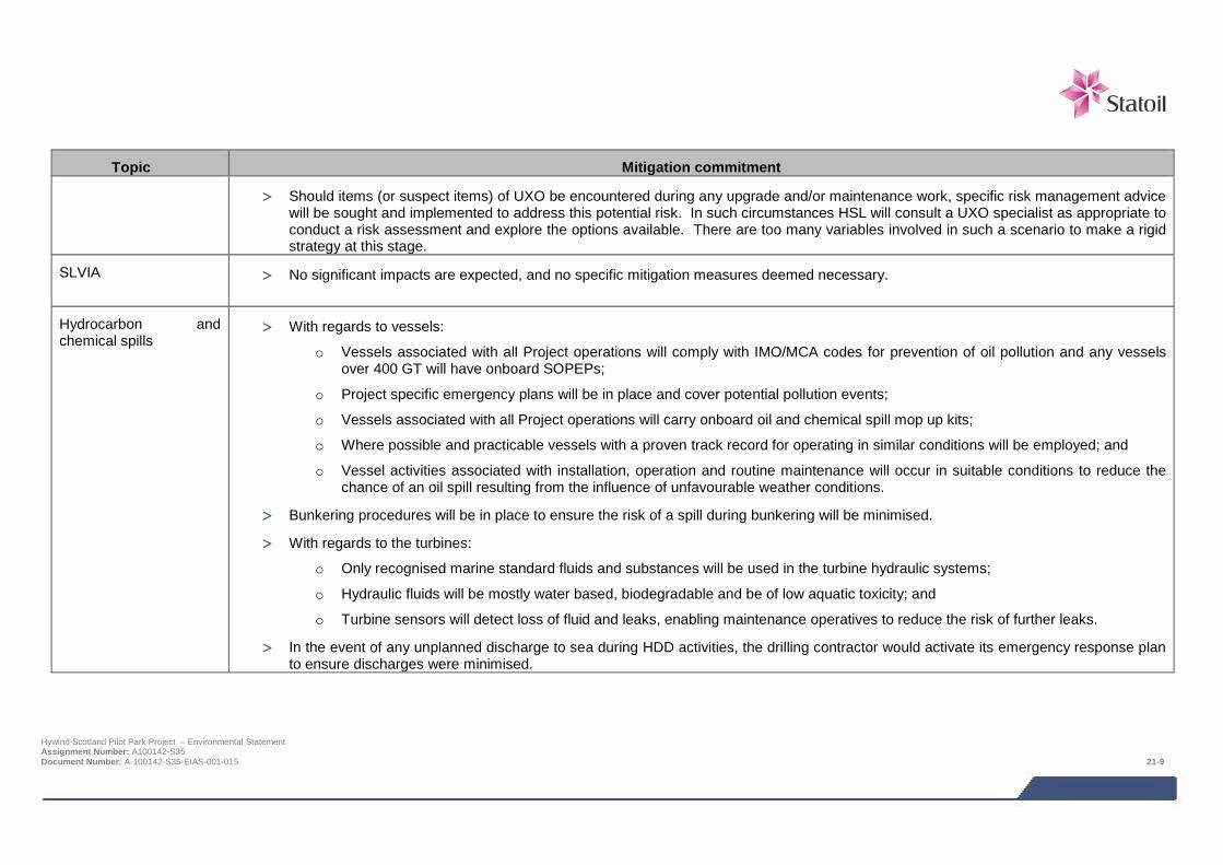
Topic Mitigation commitment
> Should items (or suspect items) of UXO be encountered during any upgrade and/or maintenance work, specific risk management advice will be sought and implemented to address this potential risk. In such circumstances HSL will consult a UXO specialist as appropriate to conduct a risk assessment and explore the options available. There are too many variables involved in such a scenario to make a rigid strategy at this stage.
SLVIA
> No significant impacts are expected, and no specific mitigation measures deemed necessary.
Hydrocarbon and chemical spills
> With regards to vessels:
o Vessels associated with all Project operations will comply with IMO/MCA codes for prevention of oil pollution and any vessels over 400 GT will have onboard SOPEPs;
o Project specific emergency plans will be in place and cover potential pollution events;
o Vessels associated with all Project operations will carry onboard oil and chemical spill mop up kits;
o Where possible and practicable vessels with a proven track record for operating in similar conditions will be employed; and
o Vessel activities associated with installation, operation and routine maintenance will occur in suitable conditions to reduce the chance of an oil spill resulting from the influence of unfavourable weather conditions.
> Bunkering procedures will be in place to ensure the risk of a spill during bunkering will be minimised.
> With regards to the turbines:
o Only recognised marine standard fluids and substances will be used in the turbine hydraulic systems;
o Hydraulic fluids will be mostly water based, biodegradable and be of low aquatic toxicity; and
o Turbine sensors will detect loss of fluid and leaks, enabling maintenance operatives to reduce the risk of further leaks.
> In the event of any unplanned discharge to sea during HDD activities, the drilling contractor would activate its emergency response plan to ensure discharges were minimised.
Hywind Scotland Pilot Park Project – Environmental Statement Assignment Number: A100142-S35 Document Number: A-100142-S35-EIAS-001-015 21-9
21.4 Environmental monitoring Monitoring is an important activity for measuring performance against the environmental regulatory and corporate requirements. Monitoring enables the assessment of progress against goals as well as the gathering of information to track overall environmental performance, from initial design work to installation, operation, and eventual decommissioning. There are three inter-related drivers in such monitoring:
> Statutory requirements e.g. the disposal of waste;
> Corporate and Project expectations and goals; and
> Validation of assessments conducted in the EIA process.
Monitoring can therefore be split into two broad categories: performance monitoring and potential environmental effects monitoring.
Performance monitoring involves the monitoring of emissions, discharges, and waste generations. This is required for a number of purposes:
> Monitoring data for compliance with consent conditions;
> Environmental data required by the Regulator; and
> To track performance against HSL corporate and Project requirements and expectations.
Environmental effects monitoring, if required, will be used to validate the findings of the EIA. All monitoring requirements will be the subject of a Project Environmental Monitoring Programme (PEMP), which will be submitted and agreed with the Regulator prior to the commencement of construction and updated as required as the Project progresses.
21.5 Interface with contractors Contractor management is an important element of the Project and HSL expects contractors to demonstrate a high level of environmental awareness, including suitable management.
The EMP and responsibilities for environmental standards and procedures will be included as part of all contract invitations to tender. This will ensure all contractors adhere to the requirements of the EMP.
Pre-mobilisation audits will be carried out as standard for any vessels, vehicles or equipment that will be used in the Project. This will ensure appropriate procedures and documentation are in place to meet measures identified during the EIA process and HSL’s statutory obligations.
Environmental commitments, objectives and targets identified for the Project through the EIA and NRA processes will be communicated to all contractors through contractual conditions. Contractor performance will be measured against these commitments.
21.6 Environmental awareness and training HSL understands that trained and knowledgeable staff can help prevent or reduce potential environmental impacts. HSL is therefore committed to ensuring all personnel who perform or manage Project work that may have the potential to have a significant impact on the environment are trained appropriately.
All personnel including contractors engaged in work which has the potential to impact on the environment will be audited and/or monitored to ensure they have procedures in place to manage their environmental responsibilities.
21.7 Summary Mitigation and environmental management is an iterative process and has been informed by the EIA and NRA processes, and consultation with stakeholders including Regulator. Mitigation measures will be monitored to enable HSL to track and assess the performance of the EMP, ensuring improvements can be made if necessary. Hywind Scotland Pilot Park Project – Environmental Statement Assignment Number: A100142-S35 Document Number: A-100142-S35-EIAS-001-015 21-10

With regards to environmental monitoring, measures will be the subject of a PEMP which will be agreed with the Regulator and updated as required throughout the Project.
Hywind Scotland Pilot Park Project – Environmental Statement Assignment Number: A100142-S35 Document Number: A-100142-S35-EIAS-001-015 21-11


