Embed Size (px)
Citation preview
The International Journal of
Technology, Knowledge, and Society
TechandSoc.com
VOLUME 8 2013
__________________________________________________________________________
How Scenarios can Enhance Serious Gameswith Augmented Reality“The Case of the MITAR Serious Game”MARGOT KASZAP, YAÏVES FERLAND AND CATINCA-ADRIANA STAN
THE INTERNATIONAL JOURNAL OF TECHNOLOGY, KNOWLEDGE, AND SOCIETY
http://techandsoc.com/ First published in 2013 in Champaign, Illinois, USA by Common Ground Publishing University of Illinois Research Park 2001 South First St, Suite 202 Champaign, IL 61820 USA www.CommonGroundPublishing.com ISSN: 1832-3669 © 2013 (individual papers), the author(s) © 2013 (selection and editorial matter) Common Ground All rights reserved. Apart from fair dealing for the purposes of study, research, criticism or review as permitted under the applicable copyright legislation, no part of this work may be reproduced by any process without written permission from the publisher. For permissions and other inquiries, please contact <[email protected]>. The International Journal of Technology, Knowledge, and Society is a peer-reviewed scholarly journal. Typeset in CGScholar. http://www.commongroundpublishing.com/software/

How Scenarios can Enhance Serious Games withAugmented Reality: “The Case of the MITAR
Serious Game”Margot Kaszap, Université Laval, Québec, CanadaYaïves Ferland, Université Laval, Québec, Canada
Catinca-Adriana Stan, Université Laval, Québec, Canada
Abstract: The Massachusetts Institute of Technology Augmented Reality (MITAR) game ap-plication is a “reinvented” serious game that can be classified as a kind of geocaching game inwhich one can add augmented reality (AR) objects and information. These games use a GlobalPositioning System (GPS) that allows children to explore and search the environment to findclues or information given by text, audio or video files added to the game. The MITAR seriousgame tools allow the teacher to build games with different scenarios for educational purposes.Following a historical overview of what might be serious with games, this paper discusses theimplications of selected educational scenarios and of the potential of games to enhance learningin new ways, as tested within the GeoEduc3D research project. Adapting the game to students’level and abilities, MITAR is particularly useful in geography and history classes as it invitesthem to explore their environment and then practice problem solving skills.
Keywords: Serious Game, Children, Augmented Reality, Geocaching, Educational Scenario,Mobile Learning, Global Positioning System (GPS), Map Reading, Problem Solving, Geotag
”Let my playing be my learning, and my learning be my playing.”Johan Huizinga
INTRODUCTION
Landscape studies, in which teachers lead their pupils on excursions and in fieldwork,were popular for centuries. Students took notes, asked questions, searched for moreinformation, wrote short reports, learned something about nature and places, andperhaps had fun outside of the classroom. Today, new technological devices and typesof representation have been added to their map sheets., like Global Positioning Systems
(GPS) (using real-time satellite data) and mobile Games displaying an “augmented reality”(AR). Such new technologies offer a live view of a real-world environment whose elements areameliorated with information generated by computer sensory input. Throughout the last decade,learning has become more related to digital technology than ever in both classroom and outdooractivities. The role of “games” in the educational curriculum and as important factors forlearning gets higher relevance today. This article presents different notions like “serious game”and “augmented reality” prior to introducing the particular MITAR1 tools (Klopfer, 2008a).It also examines some educational scenarios elaborated for using it while exploring the landscape
1MITAR (Massachusetts Institute of Technology-Augmented Reality) is a free tutorial software application, developedby MIT’s Scheller Teacher Education Program laboratory, for building location-based games.
The International Journal of Technology, Knowledge, and SocietyVolume 8, 2013, http://techandsoc.com/, ISSN 1832-3669©CommonGround,Margot Kaszap, Yaïves Ferland, Catinca-Adriana Stan, All Rights Reserved, Permissions:[email protected]

surrounding a village. Their usefulness will be discussed with their implications in children’selementary education curriculum (on both spatial awareness and technological skills). The po-tential of such serious games using scenarios of instructive trajectories to enhance geospatiallearning and environmental problem-solving, while adapting them to the developmental leveland abilities of young students, will be briefly described. The research and experimentation onthe use and potential integration of digital mobile devices in the educational setting is clearlyrelevant and timely due to the flourishing of products, definitions, usages, goals, terms, andfacets within the domain.
Serious Games…Definitions and Usages through History
Games have always been part of life in any human society and, from time to time, they appearto be very “serious”. It is in human behaviour to play games since it is the primary formativeactivity and a necessary condition (although not sufficient alone) for the generation of culture.This is because the absence of a play-spirit civilization is impossible (Huizinga, 1955). One ofthe most significant aspects of play is that it is fun and fair for both children and adults (Sutton-Smith, 1997); it is not just a circumstantial emotion but also an open-minded attitude that canmotivate to learn seriously. Among the four forms of play—competition, mimesis, chance, andvertigo (Caillois, 1961)—the two former ones are of interest here; although not all kinds ofgames can directly support learning. Competition encompasses contests, sports, board andtable games, verbal or physical battle (war), also trial against the self or toward animals(hunting), and even cooperation with partners engaged together in the same reflective process.About mimesis (or simulacra), we all know that children have always imitated their parentsrepetitively. Even if the family thought that they were “just playing”, for children this activityis still a serious one, because they recognize that there is a distance between their symbolicgames (individual or social) and the represented reality. That permits them learning to speak,think, and behave accordingly with the family and social environment (Piaget, 1962; Winnicot,1971; Bateson, 1972; Vygotsky, 1976; Pellegrini, 2009).Since ancient times, children have mimicked adults’ activities to develop their skills, sometimes
with dolls and toys. At the very least, boys engaged in this kind of mimicry as a means to learnto hunt wild animals for supplying food (Breuil, 1974). The word “game”, of Germanic origin,still has this sense in English today and, even in previous epochs, “gaming” referred to bothstudying by observation and learning by practice. Trying to achieve such competencies is theoutset to understand the surrounding world and the “essence of supernatural or magical forcesthat appear to sway or have power over its food supply and wellbeing” (Brockett et al., 2007).It was a matter of role-playing and simulation. For instance, one may presume that the gameKnucklebones (MacGregor et al., 1985), used as dice, appeared early along the humanity’stime-line, thanks to bones made available for children to play with adults who stayed at home,like the elderly.As civilization occurred and agricultural activities were adopted, hunting lost importance in
the socio-economic structure and game became a play, a situation it never leaves anymore since(Huizinga, 1988). Mimic gaming (i.e. mimesis) was replaced by more intellectual or abstractgames, in terms of playing social roles. For examples, the enactment of human dramas via thelives of gods and goddesses may have been instructive or part of a ritual. At the dawn of theWestern World, the Egyptians performed pageants honouring Osiris (the god of dead peoplewho assures their “survival” in the underworld) (Robinson, 2010). Later the ancient Greeksset a three-day contest for staged tragedy and comedy, which brought a winner (Brockett etal., 2007). Also, some board games (like Mancala, Chess, Go, Senet, Backgammon, and theRoyal game of Ur) brought another level of abstraction of the world, maybe replicated fromground plays sketched on sand, like Hopscotch. They had been developed (as early as 5000years ago, in some cases), by Minoans, Greeks, Chinese, Japanese and Egyptians in order to
THE INTERNATIONAL JOURNAL OF TECHNOLOGY, KNOWLEDGE, AND SOCIETY
have a good time competing against one another (Degann, 2008). Then schooling, writing andsporting activities, which became more diversified, replaced game hunting as the prime waysof learning. Ruled sports evolved at a higher standard with the Olympic Games, shortly followedby tournaments of all kinds. Playing became a fulltime job for athletes and gladiators, or foractors who played at tragedy or comedy (Brockett et al., 2007), especially during the Romanperiod and, a millennium later, since Renaissance. Also contrasting with working, the word“school” derives from the Greek σχολή (scholē) and Latin schola originally meaning “leisure”(both physical and intellectual activities other than work). Specifically, it referred to “that inwhich leisure is employed”, and only later a “group of pupils to whom lectures are given”(from various dictionaries). Even war could have been considered both a formal game (opponentsused strategies to compete and a winner was proclaimed at the end) and a drama (the metaphoricexpression “theatre of war” is still used to refer to a battlefield of any scale). As a result, onecannot consider longer a game in the simplest senses of a pastime or gambling, that bears fewor no social consequences.At this point, as the general characteristics of “play” gradually emerge, one can offer a frame
for the definition of the concept. It must be: free for player(s) to engage on common groundwith others; fictive (i.e. not in “real” life conditions or situations); distinct from “ordinary”life both as to locality and duration; regulated and limited in a certain order to settle the rulesto operate and to find a winner as it finishes (because the result remains uncertain from thestart till the end); and unproductive of external material gain with socio-economic interest(Huizinga, 1955; Caillois, 1961). Different mechanisms can be involved in a game: chance orrandomness, strategy and tactics, memory, dexterity and quick reflex, observation, logic orreflection and sense-making, and bluffing vs. free access to all the information about the situ-ation.In order to understand the evolution of the concept of game, one must make a difference
between the signification of the word “serious” in antiquity and its usual meaning today. Forinstance, according to Aristotle, only tragedy was serious literature, the comedy being a minorgenre, appreciated only by the illiterate people. Game meant “imitation”, so acting was playing.In the same period, physical work was serious, meanwhile the artist’s work was seen as needlessand, like art and school, game was leisure and, since it was an unproductive activity, the oppositeof work. The idea of comedy as being not serious was common through the Roman world too.The Latin words iocus (noun) and iocare (verb), meaning joy, a joke or a comic situation, gaveroot to the French words jeu, jou et, and jouer, which mean play or game, toy, to play, respect-ively. There are many phonetically equivalent terms with such meanings in all other Romancelanguages. Other Latin words, like ludus and ludere, meaning game, were associated withathletes, wrestlers, and gladiators (Botturi & Loh, 2008); that was a serious affair becauselosing the game might signify losing one’s life. Play time was called otius day; meanwhile thework time was reversely called negotius (i.e. “negation of the play”, or trade-off). At school,the teacher was a magister ludi (game master), because playing (i.e. imitating) came to signifylearning by apprehension.During the Middle Ages, after the collapse of the Western Roman civilization, all learning
activities were picked up by religious people (monks, priests, clerks, friars and nuns) and byapprenticeship work (master, journeyman and apprentice). The ancient opposition betweengame and work was kept too. St. Thomas Aquinas recommended games only when at rest afterworking. With the end of the era of tragedy, theatre diversified its forms of expression: on theone hand, drama continued in the high register of the tragedy, and on the other hand, comedybegan to cover lighter subjects with happy endings. Few women could play roles, and childrenwere completely excluded from being in such artistic plays.The Catholic Church forbade drama, sporting games and gambling from the 4th century to
the 8th century (Mazouer, 1998; Sauzeau, 1999). Learning was a serious matter for clerks andplaying was no longer considered to be an aspect of learning. At the turn of century in Aix-la-
KASZAP: HOW SCENARIOS CAN ENHANCE SERIOUS GAMES WITH AUGMENTED REALITY
Chapelle (Aachen in today’s Germany), Charlemagne founded a royal school for all the laychildren (Eginhard, c.830, 1994), so that learning essentials like reading, writing, counting andplaying music could again spread beyond the monastery or palace court. From the 9th to the15th centuries, religious dramas appeared and were tolerated if performed in a church or on itsparvis. Some represented (simulated) the life and death of Christ or saints, while others werecalled a “game”, like The game of Saint Nicolas, involved an active participation. These playsalso taught lessons. For example, even wooden toys represented the Christian characters. Atschool, children practiced their lessons using riddles like: “Who died and was not born? Adam”(Alexandre-Bidon & Riché, 2005). These riddles were not simply plays on words.People played cards and board games for fun at home and at inns, and numerous types of
games appeared to fulfill the personal and social need for leisure (Murray, 1952; Bell, 1983).During the Renaissance, in the 16th century, tragedy and comedy became popular anew andreligious dramas were mostly abandoned (Mazouer, 1998). In fact, the rebirth of the latter,with the creation of many masterpieces by European authors,2 brought concerns to light aboutthe morals of ancient or mythical characters who populate some of the pieces that are stillplayed or performed today. In the 17th century, a French educational game that consisted of aheraldic card game that combined history and geography reflected the values of medieval society.This game, used in a Jesuit college, stimulated the player’s visual memory with cards that wereactual geographical maps3. Accordingly to Palasi (2000), this sort of game was “a part of stu-dents’ school life by educating and allowing them to apprehend their future role in societythrough the heraldry” (p. 217, our translation).Beginning in the 18th century, many forms of games were introduced in schools to support
simulation, mathematical problem solving skills, or geographical exploration. For the teacher,such activities were not just games, but training techniques to learn humanities and liberal arts.The game, as understood today, was considered suspect. It was an epoch in which even bookslooked dangerous and writers were put in jail like criminals due to their novels, and pupilswere punished severely for not knowing by heart their daily prayers. Children were discouragedfrom playing; safe in the schoolyard, a constrained play space under moral supervision, wherethe teacher observed the children during their games to decipher their ideas and their thoughts.The goal was to educate “the whole child, not just the intellectual but also the moral andphysical sides” (Hunter, 1988; p. 57). The role of the master was to correct the “bad things”that children could learn in informal situations, like a song or a poem intended for adults. Thegame was the perfect occasion to listen to the initial conceptions of children, because in suchinformal contexts they said what they were sincerely thinking (whereas in the classroom, theycould be disciplined for such words).It was not until the 19th century that some schools reintroduced games into the curriculum
in the form of debates, poetry, quizzes, and contests. However, the word “games” was still notused to describe these activities. Academics began to consider games in mathematical works asa means to study rules, results, and probabilities (Cournot, 1838). But it was only in the mid-20th century that some table games began to be taught in school as learning means like Check-ers, orMonopoly as an economic case simulation, what eventually led to mathematical GameTheory (von Neumann & Morgenstern, 1944). Thereafter, many traditional board games(Snakes and Ladder, Mother Goose, etc.) were adapted with sets of questions and answers toplay and learn simultaneously in the classroom but not always for good reasons (sometime asa reward for good behaviour on Friday afternoon). Since some parents criticized this, seeing itas a waste of time, games were put aside and marginalised as extracurricular for a while(Masson-Vincent, 2005).
2Calderón de la Barca, Corneille, Garnier, Lope de Vega,Marlowe,Middleton,Molière, Racine, Ruzzante, Shakespeare,Tirso de Molina, Trissino, etc.3 In French, both a card and a map are called: «une carte».
THE INTERNATIONAL JOURNAL OF TECHNOLOGY, KNOWLEDGE, AND SOCIETY

Fortunately, with the emergence of the socioconstructivist paradigm in the 90s (Jonnaert,2009), new technological devices brought drastic changes in the way teachers managed theclassroom. Particularly, asking for teamwork and collaborative problem solving, educationalprojects became more easily supported by using the Internet, cellphones, GPS, and a variety ofinteractive mobile platforms in classroom and fieldwork courses (Kaszap et al., 2007, 2010;Sanchez et al., 2010). Games became qualified as “serious” anew in specialized literature atthe turn of the millennium (Étienne et al., 2005). Children’s facility with videogames mustsurpass instantaneous fun in order to integrate more seriously learning games within the so-called “knowledge society”. For educators, the new expression “serious games” refers to anytechnology-supported games and simulations with pedagogical content that sustain motivationfor learning, development of competencies, and the pleasant achievement of goals closely linkedto curriculum objectives at any levels (Kaufman et al., 2005; Power, 2005; Baek, 2010; Kaufman& Sauvé, 2010; Sanchez, 2008; Sauvé et al., 2010; Kaszap et al., 2010; Dumont et al., 2011).That hedonic view links to ideas of Bateson (1972) who stated: “In kid’s mind playing is aserious matter.”But from their literature review of the word “play”, Sutton-Smith (1997) draws the critical
idea that individuals in Western culture are not so “free” to play due to an implicit obligationto spend leisure time “wisely” for some purpose. As a moral consequence, parents ask for new“educational” toys and games to improve the psychomotor and cognitive abilities of theirchildren and to transfer social values to them. So, as these possibilities and demands convergewith digital technology capabilities, developing serious mobile games for participative andcollaborative learning raises beneficial opportunities for all. Such educational impacts are yetto be demonstrated, since research focuses mainly on student perceptions or attitudes, withonly a few on learning achievements (Pollara & Broussard, 2011); although some curriculahave been transformed through the usage of technological games.There are some researchers, in the subfields of computer science or information and commu-
nication technologies (ICT), for instance, who do not agree with these refined details in adefinition that restrains the scope of what can be a serious game (Sawyer, 2002; Becker, 2008),whatever the goal or the purpose. For them, it is rather like “complex” games with just ahigher level of difficulty, or requiring better abilities with more developed devices. Despite alarge variety of ad hoc definitions and alternative labels applied to this “market segment” invarious domains (Sawyer & Smith, 2008), serious games and educational games are generallyconsidered as synonymous throughout recent literature in learning sciences (Dumont et al.,2011). While mobile games are used within schooling contexts, they are considered by fieldprofessionals as “serious” and even “intelligent” games because they can help with training fordata collection, location assessment and planning (Michael & Chen, 2006; Rosenbaum et al.,2007).Thus, many authors reflect on the necessary characteristics and useful distinctions of games
within a theoretical frame, in plenty of interdisciplinary research projects (Becker, 2010). Hence,referring to “edutainment” (for “educational entertainment”) (Klopfer, 2011), the debate isno more about the determinant importance or the performance effects of digital devices, amongother game supports. Trends are to consider the relative impacts of focusing on the fun providedby more spectacular games (quicker interaction and impressive imagery like 3D effects), as in-troduced in schooling contexts, or instead of the kind of amusement characteristics that canstrengthen learning of specific curriculum matters by students playing them.Now in this 21st century educational context, a “serious game” may be defined as:
• any interactive application (i.e. a software program) based on enhanced complexity,• that requires one or more players to engage in a kind of race, quest, or competition,• that is framed by rules for reaching a predetermined, challenging, meaningful goal,
KASZAP: HOW SCENARIOS CAN ENHANCE SERIOUS GAMES WITH AUGMENTED REALITY

• that allows increasing degrees of difficulty and evaluation (points) adapted to each player’sevolution through rounds of the game,
• that generates feedback and random elements of surprise and novelty, for stimulating curi-osity and reflection, and emotionally appealing fantasy, and
• that has the potential to support or transfer new learning (to be recalled at will later) orbehaviour adapted to social situations, with respect to a specific theme.
With these aspects kept in mind, many classifications of electronic (mostly video) games wereproposed on the base of some “commonsense”, whatever their complexity level or the numberof players (Baek, 2010). Broadly, there are sports, simulations and socio- or psycho-motorgames (that reflect reality to engage with), and abstract games (the game itself is the focus ofinterest) (Solomon, 1984). The latter may be for general entertainment (e.g., fantasy and cartooncharacters), strategic or role-playing, and of course educational or informative (i.e., learning,quiz, reflection, problem solving, decision making, planning) (Strasburger & Wilson, 2002;O’Brien, 2010). According to another taxonomy specific to serious games, by Sawyer & Smith(2008), education is only one domain among seven others. Within it, the types of games thatinterest us are identified as: direct or distance learning and training, collection or productionof information (sense making), peer-to-peer constructivism and documentation, representationand visualization, and reflection on social issues (for instance). In the present case of geospatialmobile games for active fieldwork (Sanchez, 2008; Kaszap, 2011), pertinent game designsavailable on the market would be: geo-location games, evolution or simulation games, map-reading games, and display with “augmented reality” (Sawyer & Smith, 2008). But to be nottrivial, these games have to support landscape analysis, geographical awareness (a cognitiveinstead of kinetic “sense of place”), and map literacy.Serious games must have significant hardware in an easy-to-use device in order to carry out
the “flow state of experience” of play in an artificial environment, designed for specific learningpurposes (Quinn, 2005; Prensky, 2007; Klopfer, 2008b; Baek, 2010; Squire, 2011). It mustdisplay immediate and unambiguous feedback on a player’s progress (at least allowance to gofurther), to show some scoring adapted to multiple difficulty levels, and to adjust the game tothe learner’s skills (Malone, 1981; Bergeron, 2006; Frye, 2010). However, one finds few refer-ences that temper such pretentions relative to playing students who have different cognitivestyles or ability types (e.g., Kolb, 1984; Bloom, 1994), or that address the necessary assessmentof competencies and knowledge learned by themwhile reaching the goal at the end of the game,with respect to curriculum educational objectives (Anderson & Krathwohl, 2001; Davidson &Decker, 2006; Sanchez, 2008; Wastiau et al., 2009).
Under acceptance of the postulate that knowledge would be an intellectual emotion thatmakes sense, one should take advantage of acquiring it (and subsequently to recall it atneed in actual situations) with the best, most pleasant fashion, viz, interaction and funshared by the students, and their teacher, too. Interactivity and adaptation to variouslearner’s styles require that students manipulate variables (otherwise unalterable in thereal world), go beyond the content (data collected, answers to questions, tasks completed,information provided), and pose hypothetical inputs (not just clicks to capture, answer,or choose) in order to progress in a game. They must be able to view phenomenon fromnew perspectives while observing its behaviour and evolution, or to compare simulationswith their previous understanding (Squire, 2003). As for all games, a real-time assessmentshall mark points at each step of the play that a student achieves.
In fact, a game may be considered as formal (and serious) as a civil contract or scientific research,because it stands as an abstract reality with strictly defined rules, concentration on one well-
THE INTERNATIONAL JOURNAL OF TECHNOLOGY, KNOWLEDGE, AND SOCIETY

identified aspect in isolation from any other variables, and a reward (or satisfaction) when aplayer devotes all necessary motivation and attention to achieve the goal (or solution).
Serious Game as a Mobile Handheld Game with Augmented Reality
Mobile or portable games are interactive, spatially located, and partly immersive (Klopfer,2008b). They can be played with a handheld digital and telecommunication device like an“intelligent” cellphone or smartphone (e.g.,Android, Blackberry, iPhone) or a Personal DigitalAssistant (PDA) or a tablet (iPad). Such devices must usually be capable of accessing the Internetand/or to connect with servers and other collaborative or competitive players, to share on-linedata and images and to display them on screen. Those games need to use some navigationaltechnique like a Global Positioning System (GPS) receiver (using real-time satellite data) orsolid state compass to allow players locate and orient themselves in the physical environment,as displayed on a digital map. When used to explore and seek the surroundings and to findhidden or not-so-evident clues, the game may be called “geocaching” (a kind of outdoortreasure hunting or orienteering game that looks for containers called “geocaches” or “caches”).A mobile game is two-fold: an active participation in the real world to observe and analyzeinformation on-site, and then some reflective reasoning for selection of data to capture on thedevice (i.e., taking notes, checking lists, shooting photos). Data are any abstract or concretepiece of pertinent information for solving problems.The two main advantages of handheld displays for mobile games are their portable nature
and the ubiquitous nature of images from camera and/or video (or other sensors) sent by cellularor Wi-Fi input and output services (Klopfer, 2008b). But handheld technology has its ownconstraints, like limited resolution and scope on the small screen that impede precise display,drawing, and tagging, for instance. Technical capability to exchange can also slacken or restrainthe sending of messages, recording of data and downloading of photos, satellite images, ormaps to display. More importantly, multiple interactions may no longer be simply face-to-screen exchanges with other (not present) players since they provoke a loss of control andconsciousness about the intentions and acts of others in the game situation that dissolves itselfin the surrounding space and objects. Hopefully, that substitutes to random in the play.Augmented reality (AR) is not so much a newly coined concept (Azuma, 1997). AR is related
to a more general “mediated reality”, in which a digital representation of reality is modified(possibly even diminished rather than augmented), by a computer processing of virtual inform-ation. Reality, like potential types of representation of it, is not just concrete (physical) butabstract too, like in language, image, and social relations. Today, for instance, a concrete rep-resentation like a well-done paper map of a piece of land can be digitized as a virtual map,which is easy to modify as its reality evolves (Ferland, 2007). In this sense, a particular gameis an autonomous or social representation of defined reality that fulfills a semiotic function(Piaget, 1962) of mind by which an object (thing, person, behaviour, or idea) can stand (and“be present again”) for another. Representation-making appears to be an effective way forcreativity, learning, developing vocabulary, and thinking (Winnicot, 1971, 2005; Vygotsky,1976; Slade & Parmer, 1999). Then, the combination of multiple types of representationoverlaid on a coherent scene (landscape or map), even with varying degrees of accuracy orrealistic detail, permits to construct a denser and better comprehension of complex situationsor simulations, and to improve user’s senses, skills, views, and decisions, from virtual to cognitiverepresentation.There are three common characteristics of AR scenes: the combination of a real world envir-
onment with computer characters, interactive scenes, and scenes in 2D+ or 3D (Azuma, 1997).Augmentation is conventionally in real-time and representation elements must be in semanticcontext, such as sport scores on TV during a match or, like here in the case of a map game,pins and tags and lines put on a digital map, transforming it into an “augmented map”.
KASZAP: HOW SCENARIOS CAN ENHANCE SERIOUS GAMES WITH AUGMENTED REALITY
AR differs from fully immersive virtual reality (VR), which exceeds the bounds of physicalreality and completely replaces the real world with a simulated one. Within VR, time, spatialdistances, orientation, physical laws and material properties no longer hold in contrast to thereal-world environment. Although the synthesized objects or characters and artificial displayonto formal representations of the real world, ARworks with information about the surroundingenvironment of the user in order to become interactive and digitally handled.A key measure of AR system performance is how realistically its software integrates augment-
ations adjusted to geographical location coordinates. The process called “image registration”,which is part of Azuma’s (1997) definition of AR, uses different methods like computer vision(e.g., video tracking) that is two-fold. First, it detects points of interest as fiduciary markers,using feature detection from optical flow and image processing methods. The simplest way todo this is to select the position manually and tag it. Secondly, it restores a real-world coordinatesystem from data about the known geometry of the selected objects (or fiduciary markers) thatare present in the scene, for simultaneous location andmapping of AR elements of representationon right relative positions and orientation on real ground images.In addition to entertainment, there are many serious applications of spatial AR, with or
without personal head-up or glasses display to read superposed instructions and diagrams atspecific locations (in the field or on maps). They are mostly in navigation (inside buildings oroutdoors), for prospecting natural resources (through interactive analysis of terrain character-istics on 3D maps), a rchitecture and urban planning (façade construction projects), historyand archaeology (battle re-enactments or site reconstitution onto current landscapes), sightseeingand travel guides. Most of these domains can inspire serious AR games in education.Electronic learning (e-learning) is the usual term for referring to multimedia, Internet-based,
networked, computer-enhanced learning. A specific increasingly diffused e-learning is mobilelearning (m-learning) (Ally, 2009), which uses various kinds of mobile telecommunicationequipment, such as cellular phones. When a learner interacts within an m-learning contexttailored to support individual needs with AR, it is called “augmented learning” (Klopfer, 2008a).In the present study, AR might be used in two different situations. First, it could be a real
landscape imagery displayed on a mobile handheld screen with virtual information added to itby means of different modes like text, a drawing, graph, sketch map, photograph, and audioor video file (Figure 1). It is a superposition of virtual elements of 2D or 3D models (virtualimages) over the represented reality (pictures or maps), potentially in real-time and in the rightplace in real world. The perception of AR may be visual, textual, or auditory.
THE INTERNATIONAL JOURNAL OF TECHNOLOGY, KNOWLEDGE, AND SOCIETY

Figure 1: A Handheld with a Real landscape and Virtual Information
The Figures 1 to 11 Come from the GéoÉduc 3D Project, Kaszap (2011)
Second, it can also be a digital or virtual landscape like a sketch map displayed on a mobilehandheld device with real information added to it in different modes like title label, text,drawing, graph, photograph, and audio or video file possibly taken on site and fixed by a tag(Figure 2) or related to an external resource by hyperlink. AR is a matter of layers of supple-mentary information overlapping a real or virtual environment of precisely located places, land-marks, features, or infrastructures.Tagging and hyperlinks are the simplest forms of digital augmentation to the content of a
basic representation. Also, tags allow to add links in brief labels or texts (e.g., landmark nameand description, embedded story, comments, question/answer, decision node, hints, clues), toreference them with markers on satellite images or digital maps (what is called “geotagging”,as in Figures 1 and 2, respectively) in order to remember where was found that particular in-formation, reference data and clues, and to which location they refer.
Figure 2: A Handheld with a Virtual Landscape with Real Information
When the mobile game is loaded on the PDA, smartphone or other handheld device and isready to use outdoors on the terrain, the player comes to the starting location of interest where
KASZAP: HOW SCENARIOS CAN ENHANCE SERIOUS GAMES WITH AUGMENTED REALITY

cellular or Wi-Fi Internet connection is available. The player captures and merges observationsof the real world with data and clues collected on site about the game theme or imported fromdocument or Internet resources. After exploration outside, stimulated players compare, analyse,and debate their results with peers, in the classroom or at home.In the present study that was part of the GeoEduc3D project (Daniel & Badard, 2008; Du-
mont et al., 2011; Kaszap, 2011), the particular mobile handheld game used was the MITARtoolkit software (Klopfer, 2008a). Educational scenarios were elaborated for using it whileelementary school students explored the architectural landscape in a heritage village.
MITAR Tools
TheMITAR4 software, developed by the Teacher Education Program laboratory of the Depart-ment of Urban Studies and Planning at the Massachusetts Institute of Technology (MIT), is a“reinvented” educational game (Sawyer & Smith, 2008). It operates on a mobile technologicaldevice that incorporates a sort of Augmented Reality (AR) and a Global Positioning System(GPS) receiver. In fact, it is location-aware gaming software that helps to “build” outdoorgames, which can be classified as a kind of geocaching.With MITAR game tools, it is possible to add a simple form of AR to engage players in
simulations and field games that combine real-world experiences with additional objects andinformation supplied by handheld mobile devices. This field game takes advantage of a GPSreceiver that helps track the player’s precise location allowing to explore and search the realand virtual environments to find clues or information offered through observation of the terrain,to add in the game. Of course, GPS is useless without a digital map that shows the locationand display of the spatial organisation of streets and landmarks around that place. A map, beit paper or digital, remains the main pedagogical instrument to support reflection on the envir-onment and itineraries, and provides geographical literacy and awareness. This requires learningskills related to map-reading, field-note taking, and geospatial abstraction to compare with“ground truth” (the reality of the situation on the terrain).MITAR differs from most mobile AR software applications in that it is interactive (for game
building, location on terrain, data collection, tagging, and team work) with the real world andfirmly dedicated to educational purposes, especially to learning natural sciences; but it is notgood enough for all educational usages other than field games (Sanchez 2008). Being easy touse, even for students who are not currently comfortable with technologies, rather than “digitalnatives” (Prensky, 2007), its interest and challenge are still in support of learning.At MIT, school teachers are trained to use these tools with students who are about 12 to 16
years old. To interest these children in themes related to their immediate environment, ateacher builds a game scenario and introduces how to handle properly the mobile device andthe rules of the game, what encourages students to play. Afterward, the teacher may proposethat small teams of three to four students prepare their own new game scenario and share itwith another team for experimentation. Students learn not only by playing, but by buildinggames. The teacher’s supervision remains essential to define and incorporate educational contenteffectively.The MITAR toolkit has three components: the Map Editor (Figure 3), the Game Builder
(Figure 4), and an Emulator to test the game directly with the handheld keyboard. With thesetools, creating a game is quite easy and rapid: a treasure hunt or a local discovery route maybe settled in a dozen minutes, accordingly to experimenters (Kaszap, 2011; Sanchez et al.,2010). Design is essential for appeal and performance of handheld games, all the more so for
4 http://education.mit.edu/projects/mitar-games; download MITAR software at: http://education.mit.edu/ar; see shortvideo at: http://www.youtube.com/watch?v=SBG0_jfXt7o.
THE INTERNATIONAL JOURNAL OF TECHNOLOGY, KNOWLEDGE, AND SOCIETY
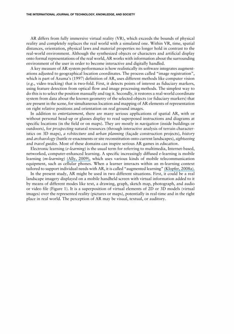
educational games with AR (Quinn, 2005; Becker, 2008; Kaszap et al., 2010). MITAR GameBuilder makes the design of games simple and easy for novices (Klopfer, 2008a).The first stage is to select the map that the player will use within the game. For instance, the
Map Editor builder tool allows a student to enter in the dialog box a request to reach the civicaddress of the school. Then, thanks to GPS absolute location, it “grabs” an appropriate mapduly geocoded (i.e., with integrated geographical coordinates). This is quite similar to function-alities available onGoogle™ earth and, centered on this location, it allows highly customizablegame content. The system will reach automatically the appropriate map (sheet, tile, or focus)and permits the player to have the choice between three types of map: a seamless traditionalstreet map, a satellite view imagery, and a hybrid map made by the coordinated superpositionof the two previous ones. Then, the player selects a scale for that built map: scale ranges fromsmall 1 (whole Earth view) to large 17 (i.e., local and detailed House view). To create a gamefor children, the house view sounds more effective. But depending of the complexity of thegame, the hybrid view might be the best one to use because it presents street names and thecolor and other relative information about features of the landscape like bushes, buildings, andtrees and how they are all spatially organized together.
Figure 3: The Map Builder Tool Window
KASZAP: HOW SCENARIOS CAN ENHANCE SERIOUS GAMES WITH AUGMENTED REALITY
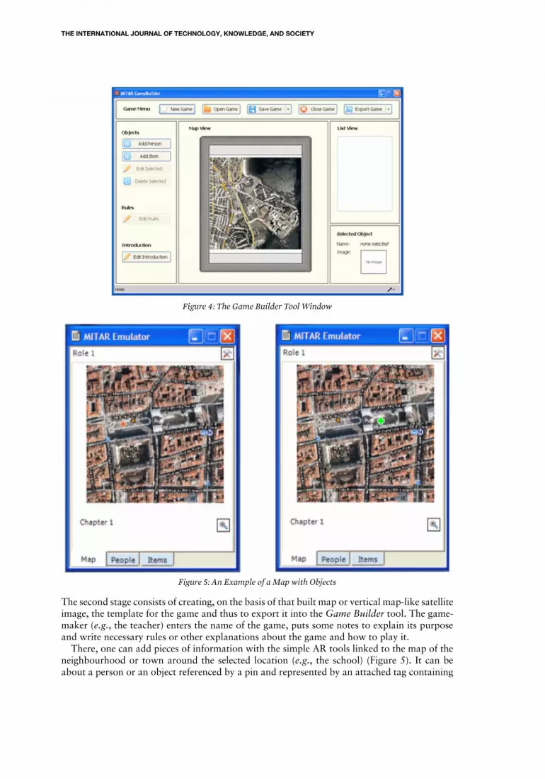
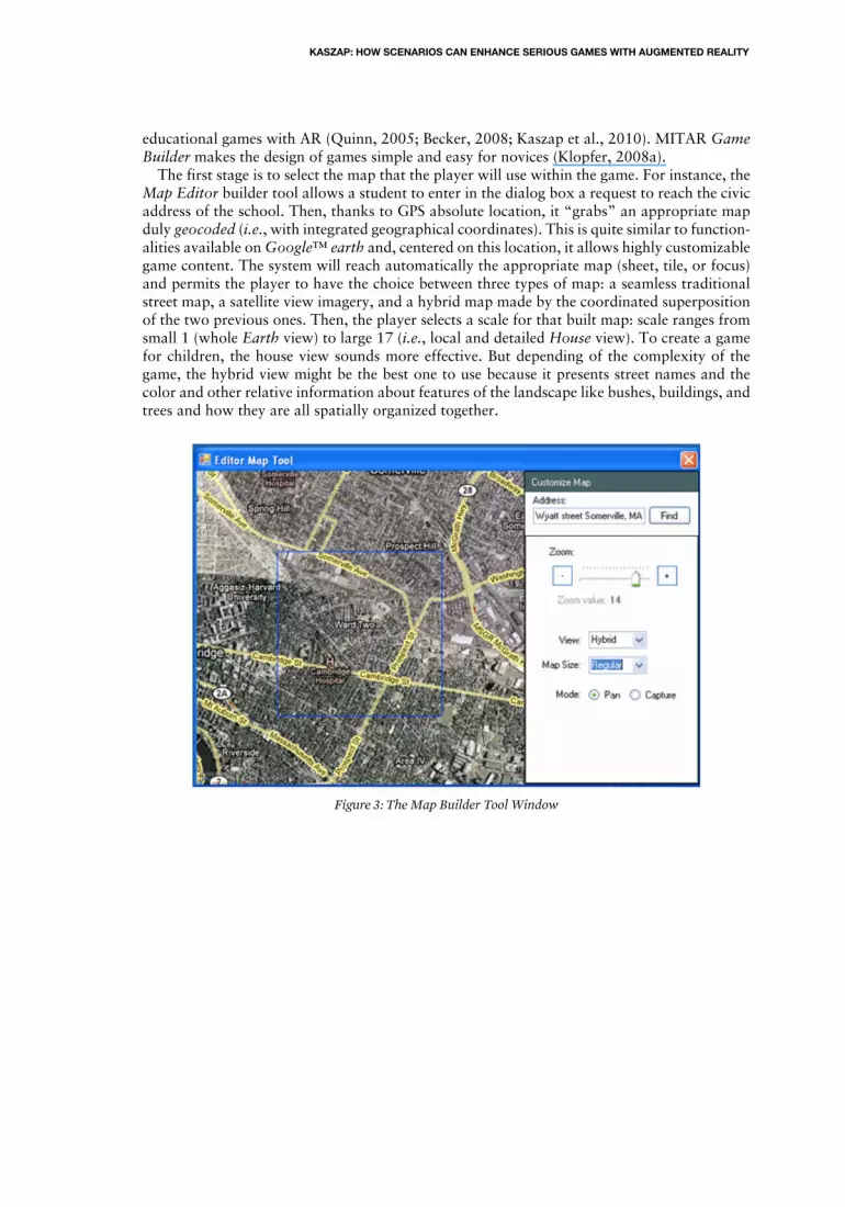
Figure 4: The Game Builder Tool Window
Figure 5: An Example of a Map with Objects
The second stage consists of creating, on the basis of that built map or vertical map-like satelliteimage, the template for the game and thus to export it into the Game Builder tool. The game-maker (e.g., the teacher) enters the name of the game, puts some notes to explain its purposeand write necessary rules or other explanations about the game and how to play it.There, one can add pieces of information with the simple AR tools linked to the map of the
neighbourhood or town around the selected location (e.g., the school) (Figure 5). It can beabout a person or an object referenced by a pin and represented by an attached tag containing
THE INTERNATIONAL JOURNAL OF TECHNOLOGY, KNOWLEDGE, AND SOCIETY
a text, a drawing, a schema, a photo, a video or an audio file. Further on, it is easy to locatethat person or object (and as many as needed) on the map by choosing a form (square, cross,etc.) and a color to relate with a type, a date, a character, or an event, for example.When all the necessary information is added to engage the game, including rules and goals,
it can start with the selection of the players and their rankings, if not concurrent. The gamewarden gives them clues, or not, and indicates the first locations, one by one or none, dependingon the level of game scenario, for geocaching, place discovery or problem solving. The scenariostipulates the sequence of events involving the persons and the objects: when a person appearsaccording to the role or must be retrieved, and when an item replaces another one. For example:After a player had visited Jenny, the object Book will appear, in which the player will try tofind a new clue and the person Jenny may disappear. The game-maker may choose to show ornot show the dots in their position on the handheld digital map, depending on the educationalgoals of the game theme.
Scenarios of Instructive Trajectories
The MITAR serious game tools allow teachers to build games with different scenarios of in-structive trajectories to enhance geospatial learning and environmental problem-solving, whileadapting them to the developmental level and abilities of young students. Three sorts of geospa-tial mobile games are possible to imagine with MITAR that require different methodical pre-paration for scenarios toward specific objectives. They are: itinerary by distances and directionsto next spots (passive, like for a tourist guided from post to post, or active, as for a re-enactmentof a historical event), “geocaching” (or treasure hunt), and thematic trajectory building (inwhich the player is more active and contributive).Each scenario brings a particular educative purpose to enhance some learning and problem-
solving objectives in appropriate new ways. The potential of these scenarios of instructive tra-jectories consists of adapting the game level to the developmental level and abilities of youngstudents with respect to elementary education curriculum. MITAR is particularly well suitedto the domains of architecture, geography, economics, and history, while a child explores hisor her environment to discover it, enhances his or her spatial awareness, or tries to solve differentlocated problems. Several scenarios are usable, thus some may be adopted. Five of them areexposed below with a few details and brief examples, from the easiest to the most complexlevel, in terms of both the aspects of the game and the theme to learn about. Figures were partof the GeoEduc3D project exercising MITAR in a proof of concept with children about 10years old by the end of elementary school (Kaszap, 2011). The GPS receiver provided actuallocation of the player bearing the device and simple AR comes with functions of pinning andgeotagging that location on the screen map in the correct position.
Scenario 1: One given dot followed by another one
At first, the teacher will always give all the information related to the game (directives, goal,process, rules, problem to solve, etc.) at a starting point on the real terrain, a given dot on thegame screen (Figure 6). This will allow all the children playing, particularly the younger ones,to locate themselves on the handheld virtual map and simultaneously recognize that placewithin the corresponding real environment. Then, each player shall have to walk to this firstdot location to access the first piece of information from the scenario, about a question to an-swer. As younger children would not know how to read, the information must be providedthrough an audio file or a video file that will pop up.When a player has retrieved the information, a new blinking dot will appear on the screen
map and the player will have to locate and orientate him or herself and walk to reach that newlocation next in the sequence along the discovery itinerary (Figure 7). They will continue in
KASZAP: HOW SCENARIOS CAN ENHANCE SERIOUS GAMES WITH AUGMENTED REALITY
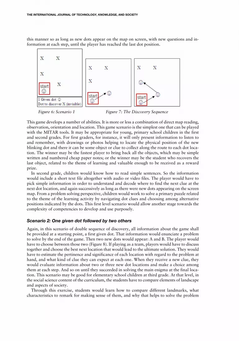
this manner so as long as new dots appear on the map on screen, with new questions and in-formation at each step, until the player has reached the last dot position.
Figure 6: Scenario 1 Figure 7: The Discovery Sequence
This game develops a number of abilities. It is more or less a combination of direct map reading,observation, orientation and location. This game scenario is the simplest one that can be playedwith the MITAR tools. It may be appropriate for young, primary school children in the firstand second grades. For first graders, for instance, it will only present information to listen toand remember, with drawings or photos helping to locate the physical position of the newblinking dot and there it can be some object or clue to collect along the route to each dot loca-tion. The winner may be the fastest player to bring back all the objects, which may be simplewritten and numbered cheap paper notes; or the winner may be the student who recovers thelast object, related to the theme of learning and valuable enough to be received as a rewardprize.In second grade, children would know how to read simple sentences. So the information
would include a short text file altogether with audio or video files. The player would have topick simple information in order to understand and decode where to find the next clue at thenext dot location, and again successively as long as there were new dots appearing on the screenmap. From a problem solving perspective, children would work to solve a primary puzzle relatedto the theme of the learning activity by navigating dot clues and choosing among alternativepositions indicated by the dots. This first level scenario would allow another stage towards thecomplexity of competencies to develop and use purposely.
Scenario 2: One given dot followed by two others
Again, in this scenario of double sequence of discovery, all information about the game shallbe provided at a starting point, a first given dot. That information would enunciate a problemto solve by the end of the game. Then two new dots would appear: A and B. The player wouldhave to choose between those two (Figure 8). If playing as a team, players would have to discusstogether and choose the best next location that would lead to the ultimate solution. They wouldhave to estimate the pertinence and significance of each location with regard to the problem athand, and what kind of clue they can expect at each one. When they receive a new clue, theywould evaluate information about two or three new dot locations and make a choice amongthem at each step. And so on until they succeeded in solving the main enigma at the final loca-tion. This scenario may be good for elementary school children at third grade. At that level, inthe social science content of the curriculum, the students have to compare elements of landscapeand aspects of society.Through this exercise, students would learn how to compare different landmarks, what
characteristics to remark for making sense of them, and why that helps to solve the problem
THE INTERNATIONAL JOURNAL OF TECHNOLOGY, KNOWLEDGE, AND SOCIETY
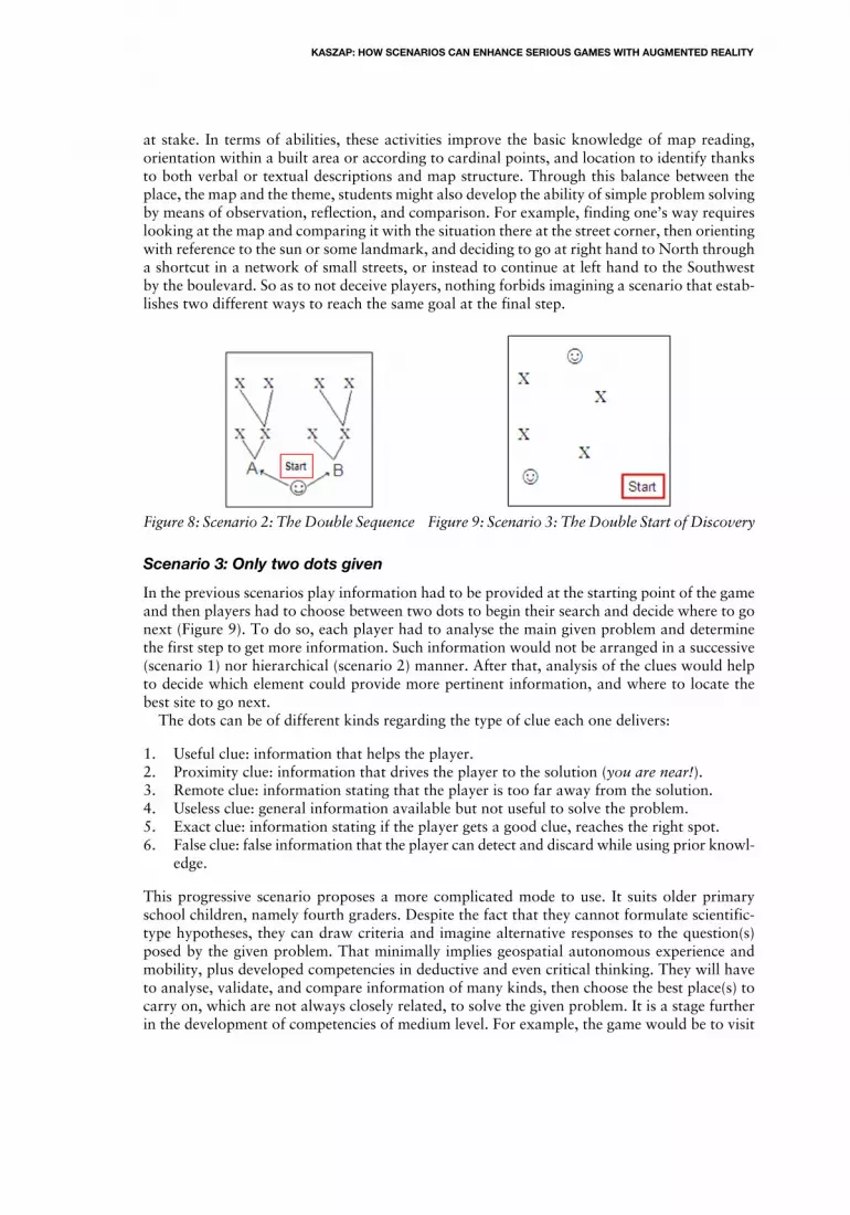
at stake. In terms of abilities, these activities improve the basic knowledge of map reading,orientation within a built area or according to cardinal points, and location to identify thanksto both verbal or textual descriptions and map structure. Through this balance between theplace, the map and the theme, students might also develop the ability of simple problem solvingby means of observation, reflection, and comparison. For example, finding one’s way requireslooking at the map and comparing it with the situation there at the street corner, then orientingwith reference to the sun or some landmark, and deciding to go at right hand to North througha shortcut in a network of small streets, or instead to continue at left hand to the Southwestby the boulevard. So as to not deceive players, nothing forbids imagining a scenario that estab-lishes two different ways to reach the same goal at the final step.
Figure 8: Scenario 2: The Double Sequence Figure 9: Scenario 3: The Double Start of Discovery
Scenario 3: Only two dots given
In the previous scenarios play information had to be provided at the starting point of the gameand then players had to choose between two dots to begin their search and decide where to gonext (Figure 9). To do so, each player had to analyse the main given problem and determinethe first step to get more information. Such information would not be arranged in a successive(scenario 1) nor hierarchical (scenario 2) manner. After that, analysis of the clues would helpto decide which element could provide more pertinent information, and where to locate thebest site to go next.The dots can be of different kinds regarding the type of clue each one delivers:
1. Useful clue: information that helps the player.2. Proximity clue: information that drives the player to the solution (you are near!).3. Remote clue: information stating that the player is too far away from the solution.4. Useless clue: general information available but not useful to solve the problem.5. Exact clue: information stating if the player gets a good clue, reaches the right spot.6. False clue: false information that the player can detect and discard while using prior knowl-
edge.
This progressive scenario proposes a more complicated mode to use. It suits older primaryschool children, namely fourth graders. Despite the fact that they cannot formulate scientific-type hypotheses, they can draw criteria and imagine alternative responses to the question(s)posed by the given problem. That minimally implies geospatial autonomous experience andmobility, plus developed competencies in deductive and even critical thinking. They will haveto analyse, validate, and compare information of many kinds, then choose the best place(s) tocarry on, which are not always closely related, to solve the given problem. It is a stage furtherin the development of competencies of medium level. For example, the game would be to visit
KASZAP: HOW SCENARIOS CAN ENHANCE SERIOUS GAMES WITH AUGMENTED REALITY

at least four supermarkets in the neighbourhood to collect the price of certain products and toreport on the average and the place(s) of the best buy.
Scenario 4: All given dots
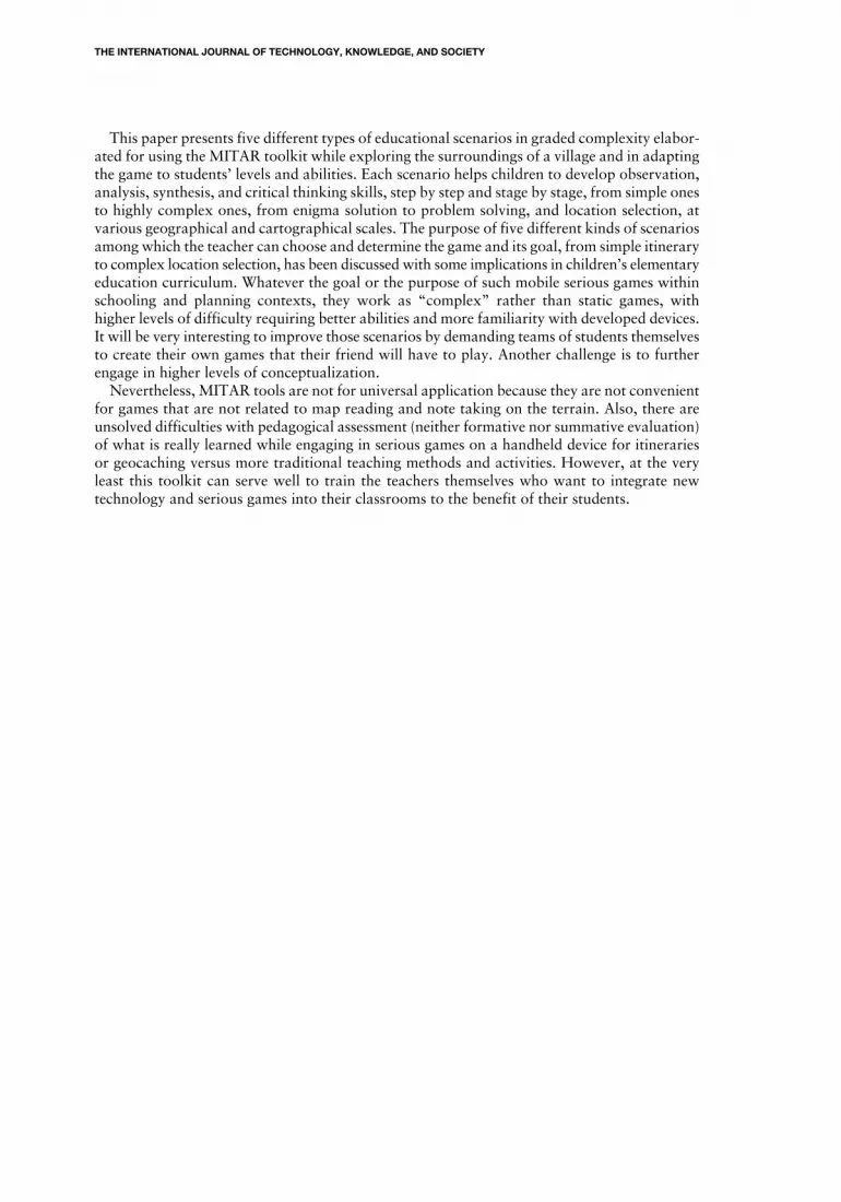
Most of the information on the game (goal, requirements, starting clues) is given to players ata starting point and then each one chooses among all dots where to begin the search and whereto go from there (Figure 10). To do so, the player must analyse the available information onaspects that address the main given problem, in order to determine the first (eventually theunique, if sufficient) location to get more necessary clues. After that, the player will have tothink about missing information and to decide which element can help to locate, among therest of dots, the next pertinent place to get it and where should it be. In fact, each player maycome to select a different location in the sequence of steps, running by criss-crossed ways indiverse order to reach the same goal at the final step, at the ultimate meeting point of the game,for instance.This scenario is much more complicated than the previous ones since there is neither formal
choice nor spatial links suggested by the game-maker, relationships being more abstract thancircumstantial. It is best suited to fifth graders, who are pleased with enigma and do not requireoverly strict guidelines. Competencies of a higher level are required to solve this kind of problem;players will have to analyse, compare, use both inductive and deductive reasoning, calculate,test, and merge information of all kinds. They will have to use their problem solving skills,imagination, double-scale, and critical thinking abilities, and collaborative discussion betweenteam members will be productive. The dot clues will be more complex to interpret and willrequire recalling content knowledge previously handled and learned in the classroom. Thewinning team will be the one that is best able to make links between information from manysources: documents and instructions from the classroom, maps and observations on the terrain.An example might be to trace the evolution and development of the particular sectors of thestreet grid or the bus line network in the larger neighbourhood.
Figure 10: Scenario 4: All Dots Seen Figure 11: Scenario 5: None Dots
Scenario 5: No dots given
This fifth scenario is the most difficult and abstract one; it involves more discovery than thefourth one, which focussed on exploration. It suits children from sixth grade up to those enteringsecondary school. It implies competencies of a very high level of creativity and multi-scalereasoning in problem solving and solution effects. Players have to use inductive reasoning, in-vestigate, analyse, discuss, synthesize, and merge information from data collected about theirsurrounding environment, from resource documents, and also from classroom content onvarious matters, including geography, history, architecture, ecology, economics, physics, mathe-matics, or geometry. Again, basic information and directives are distributed to players at a
THE INTERNATIONAL JOURNAL OF TECHNOLOGY, KNOWLEDGE, AND SOCIETY

starting point and then they have to decide on their own potential places to go, without anypredefined indication of dots or explicit clues to select on the screen map (Figure 11). To doso, wandering from the starting place, they will have to observe buildings and landforms, takenotes, analyse conditions of the main given problem, hypothesize and elaborate appropriatesolutions, and criticize them to determine where they propose to locate the best solution. It willbe their knowledge of the territory (school, neighbourhood, village or town) and their mapreading skills that will help them find where to go. It will also be their ability to synthesize andmind map information which will help them most, although collaborative discussion betweenteam members should be necessary. This scenario may imply that teachers will ask children toexplore a landscape, to determine a problem of self-choice, to enunciate statements as charac-teristics or conditions to validate on the terrain, and to confirm their inferences (i.e., logicalstatements drawn from the situation) on a foreseen solution to the problem by visiting locations.It is even a more open problem solving way to use the MITAR game. Among the simplest ex-amples, the problem would be to determine the best location for installation of a new localplayground with respect to three conditions: easy access, strong security, and good drainage,then placing marks on the map to point to the proposed site and secondary alternatives to it.
Conclusion
TheMITAR portable game toolkit was developed at theMassachusetts Institute of Technologyas an application to take advantage of the simplest “augmented reality” (AR). It is timely andvaluable since, after the long historical evolution of the concept of the game in Western society,it represents a “serious game”, i.e. dedicated to educational purposes. Since the recent decade,the role of serious games has gained increased relevance in education with the emergence ofnew digital information and communication technologies (ITC) in both classroom and outdooractivities. Nowadays, serious games have made their way to enhance learning and problemsolving by adapting to the developmental level and abilities of young students in new fashions.Serious games assist training, sustain student motivation, stimulate the pleasure of learning,and encourage student participation and acceptance of what they are being taught.The Global Positioning System (GPS) supplies real-time satellite data and images. It also allows
to locate field notes and photos taken with some mobile handheld device connected to the In-ternet that displays the game on digital maps. This classifies MITAR as a kind of outdoor gameassociated with tourist itineraries, geocaching (a treasure hunt), or planned discovery excursions.With digital maps and GPS applications altogether, AR supports such activities with enhancedrepresentations of geographical components adjusted accordingly to the school curriculumlearning objectives. AR functionality means a live view of a real-world place whose concreteor abstract characteristics of components are ameliorated with information generated by com-puter sensory input or by geotagging, which can add information, objects, photos, and commentsthat are linked to a specific place, thanks to its coordinates.Using the MITAR toolkit, teachers (and possibly supervised teams of students), can build a
spectrum of their own serious game with educational scenarios to study their environment onsite. It allows pupils at elementary school grades to explore and search their neighbourhood inorder to observe the landscape, to find clues or information, to analyse, and then to practicedecision making skills convenient to their age while reaching a localised goal. Young studentslearn to take notes, ask and answer questions, search for more information, write short reports,gain some new local knowledge about nature and places, and hopefully have fun outside theclassroom too. Such assisted fieldworks are particularly useful in domains like geography, history,architecture, economics, and mathematics as well, all parts of curricular learning objectives.The implications of selected educational scenarios and of the potential of games to improvelearning in new ways were tested within the GeoEduc3D research project (2011) in order toget a proof of concept.
KASZAP: HOW SCENARIOS CAN ENHANCE SERIOUS GAMES WITH AUGMENTED REALITY
This paper presents five different types of educational scenarios in graded complexity elabor-ated for using the MITAR toolkit while exploring the surroundings of a village and in adaptingthe game to students’ levels and abilities. Each scenario helps children to develop observation,analysis, synthesis, and critical thinking skills, step by step and stage by stage, from simple onesto highly complex ones, from enigma solution to problem solving, and location selection, atvarious geographical and cartographical scales. The purpose of five different kinds of scenariosamong which the teacher can choose and determine the game and its goal, from simple itineraryto complex location selection, has been discussed with some implications in children’s elementaryeducation curriculum. Whatever the goal or the purpose of such mobile serious games withinschooling and planning contexts, they work as “complex” rather than static games, withhigher levels of difficulty requiring better abilities and more familiarity with developed devices.It will be very interesting to improve those scenarios by demanding teams of students themselvesto create their own games that their friend will have to play. Another challenge is to furtherengage in higher levels of conceptualization.Nevertheless, MITAR tools are not for universal application because they are not convenient
for games that are not related to map reading and note taking on the terrain. Also, there areunsolved difficulties with pedagogical assessment (neither formative nor summative evaluation)of what is really learned while engaging in serious games on a handheld device for itinerariesor geocaching versus more traditional teaching methods and activities. However, at the veryleast this toolkit can serve well to train the teachers themselves who want to integrate newtechnology and serious games into their classrooms to the benefit of their students.
.
THE INTERNATIONAL JOURNAL OF TECHNOLOGY, KNOWLEDGE, AND SOCIETY
REFERENCES
Alexandre-Bidon, D. & Riché, P. (2005). La vie des enfants au Moyen Âge. Paris: Éditions duSorbier.
Ally, M. (ed.) (2009).Mobile Learning: Transforming the Delivery of Education and Training.Edmonton AB: Athabaska University Press (Issues in Distance Education Series).
Anderson, L. W. & Krathwohl, D. R. (ed.) (2001). A taxonomy for learning, teaching, andassessing: a revision of Bloom’s Taxonomy of educational objectives. New York:Longman.
Azuma, R. T. (1997). “A Survey of Augmented Realty”. Presence: Teleoperators and VirtualEnvironments, 6(4), 355–385, August 1997.
Baek, Y. (ed.) (2010). “Epilogue: Principles of Educational Digital Game Structure for ClassroomSettings”,Gaming for Classroom-Based Learning: Digital Role Playing as aMotivatorof Study, p. 281–292. Hershey PA & New York: Information Science Reference.
Bateson, G. (1972). Steps to an Ecology of Mind: Collected Essays in Anthropology, Psychiatry,Evolution, and Epistemology. University of Chicago Press.
Becker, K. (2008). The Invention of Good Games: Understanding Learning Design in Commer-cial Video Games (Ph.D. dissertation). University of Calgary.
Becker, K. (2010). “Distinctions between Games and Learning: A Review of Current Literatureon Games in Education”. In: Van Eck, R. (ed.).Gaming and Cognition: Theories andPractice from the Learning Sciences, p. 22–54. New York City: Information ScienceReference (IGI-Global).
Bell, R. C. (1979, 1983). Board and Table Games fromMany Civilizations. Mineola NY: DoverPublications. Reprint: New York City: Exeter Books.
Bergeron, B. (2006). Developing Serious Games. Charles River Media (Game DevelopmentSeries).
Bloom, B. S. (1994). Bloom’s Taxonomy: a forty-year retrospective. Chicago: University ofChicago Press.
Botturi, L. & Loh, C. S. (2008). “Once Upon a Game: Rediscovering the Roots of Games inEducation”. In: C. T. Miller (ed.), Games: Purpose and Potential in Education, p.1–20. [chapter 1]. New York City: Springer. http://ebookbrowse.com/2008-botturi-loh-pdf-d118534221
Breuil, H. (1974). Quatre cents siècles d’art pariétal: les cavernes ornées de l’âge du renne.Paris: Fourny.
Brockett, O. G. & Hildy, F. J. (2007).History of the Theatre (10th ed.). Boston/Toronto: Allyn& Bacon/Pearson Education Canada.
Caillois, R. (1961). Man,_Play_and_Games. New York City: Free Press of Glencoe.Cournot, A. (1838). Researches into the Mathematical Principles of the Theory of Wealth.
Paris: Hachette.Daniel, S. & Badard, T. (2008). “Mobile Geospatial Augmented Reality, Games and Education:
the GeoEduc3D project”. In: Second International Workshop on Mobile GeospatialAugmented Reality, Québec City, Canada.
Davidson, K. & Decker, T. (2006). Bloom’s and Beyond: Higher level questions and activitiesfor the creative classroom. [Marion, IL]: Pieces of Learning.
Degann, J. (2008). “What is this game about?”. Journal of Board Game Design. [blog]Dumont, M.-A., Power, T.M.& Barma, S. (2011). “GeoEduc3D: Evolution of Serious Gaming
towards Mobility and Augmented Reality in Science and Technology Education”. In:Canadian Journal of Learning and Technology, 37(2) 1–28 (Summer 2011).
Eginhard (c.830, 1922). Life of Charlemagne. (English translation by Arthur James Grant)London UK: Chatto & Windus.
KASZAP: HOW SCENARIOS CAN ENHANCE SERIOUS GAMES WITH AUGMENTED REALITY
Ferland, Y. (2007). Knowledge Representation, Montréal: McGill University, Graduate Schoolof Information and Library Sciences [slides.ppt].
Frye, J. (2010). Understanding “Serious” Games. New York University [slides.ppt].Huizinga, J. (1955). Homo ludens: A Study of the Play-element [of] Culture. Boston: Beacon
Press.Hunter, I. (1988). Culture and Government: The Emergence of Literary Education. New York
City: Palgrave.Jonnaert, P. (2009).Compétences et socioconstructivisme: Un cadre théorique (2e éd.). Bruxelles
BE: De Boeck.Kaszap, M. (2011). Project GéoÉduc3D. Université Laval, Québec: Département d’études sur
l’enseignement et l’apprentissage [slides.ppt].Kaszap, M., Rail, S. & Power, M. (2007). “Web-based Design for Board Games: Theoretical
and Empirical Socioconstructivist Considerations”, International Journal of IntelligentGames & Simulations, 4(2) 16–22.
Kaszap, M., IsaBelle, C. & Rail, S. (2010). “Design of a Socioconstructivist Game for theClassroom”. In: Kaufman, D.& Sauvé, L. (eds.)Educational Gameplay and SimulationEnvironments: Case Studies and Lessons Learned, p. 159–174.
Kaufman, D., Sauvé, L., Ireland, A. & Power, M. (2005). Simulations and Advanced Gaming.Environments for Use in Higher Education. Belfast, Northern Ireland UK: ICIE.
Kaufman, D. & Sauvé, L. (eds.) (2010). Educational Gameplay and Simulation Environments:Case Studies and Lessons Learned. Hershey PA & New York: Information ScienceReference (IGI Global, Premier Reference Source).
Klopfer, E. (2008a).Augmented Learning: Research and Design of Mobile Educational Games.Cambridge, MA: MIT Press.
Klopfer, E. (2008b).Handheld SimulationGames Augmenting Learning and Reality. Cambridge,MA: MIT Press.
Kolb, D. A. (1984). Experiential learning: experience as the source of learning and development.Englewood Cliffs, NJ: Prentice-Hall.
MacGregor, A. & Helm, C. (1985). Bone, Antler, Ivory & Horn: the technology of skeletalmaterials since the Roman Period. London UK/Sydney AU/Totawa NJ: Barnes andNoble.
Masson-Vincent, M. (dir.) (2005), Jeu, géographie et citoyenneté: De l’école à l’université,Paris: Éditions Séli Arslan.
Mazouer, C. (1998). Le Théâtre français du Moyen Âge. Paris: SEDES.Michael, D. &Chen, S. (2006). Serious games: Games that Educate, Train, and Inform. Boston
MA: Thomson.Murray, H.J.R. (1952). AHistory of Board-Games Other Than Chess. Oxford UK: Clarendon
Press.O’Brien, D. (2010). “A Taxonomy of Educational Games”. In: Baek, Y. (ed.). Gaming for
Classroom-Based Learning: Digital Role Playing as a Motivator of Study, p. 1–23.Hershey PA & New York: Information Science Reference.
Palasi, P. (2000). Jeu de cartes et de l’oie héraldiques aux XVIIe et XVIIIe siècles: une pédagogieludique en France sous l’Ancien Régime. Paris: Picard.
Pellegrini, A. (2009). The Role of Play in Human Development. New York City: Oxford Pub-licity Press.
Piaget, J. (1962). Play, Dreams, and Imitation in Childhood. New York City: Norton.Pollara, P. & Broussard, K. K. (2011). “Student Perceptions of Mobile Learning: A Review of
Current Research”. In: Proceedings of Society for Information Technology & TeacherEducation International Conference 2011, p. 1643–1650. Chesapeake VA: AACE.
Power, M. (2005). The Educational Game-Simulation Continuum. Belfast, Northern IrelandUK: EICC Annual Conference.
THE INTERNATIONAL JOURNAL OF TECHNOLOGY, KNOWLEDGE, AND SOCIETY
Prensky, M. (2001, 2007). Digital Game-Based Learning (2nd ed.). New York/St. Paul MN:McGraw-Hill/Paragon House.
Quinn, C.N. (2005). Engaged Learning: Designing e-Learning Simulation Games. San FranciscoCA: Pfeiffer.
Robinson, S. R. (2010). Theatre and Drama in Ancient Greece. http://www.cwu.edu/~robin-sos/ppages/resources/Theatre_History/Theahis_2.html.
Rosenbaum, E., Klopfer, E., & Perry, J. (2007). “On Location Learning: Authentic AppliedScience with Networked Augmented Realities”. Journal of Science Education andTechnology, 16(1) 31–45.
Sanchez, E. (2008). “Integrating Geomatics into the Curriculum: Inquiry-Based-Learning duringa Fieldwork Course”. In: Jekel, T., Koller, A. & Donert, K. (eds.), Learning withGeoinformation III, p. 78–87. Heidelberg, Germany: Wichmann.
Sanchez, E., Delorme, L., Jouneau-Sion, C. & Prat, A. (2010). “Designing a Pretend Game withGeotechnologies: Toward active citizenship”. In: Jekel, T., Koller, A. & Donert, K.&Vogler, R. (eds.), Learning with geoinformation V, p. 31–40. Heidelberg: Wichman.
Sauvé, L., Renaud, L. & Kaufman, D. (2010). “Games, Simulations and Simulation Games forLearning: Definitions and Distinctions”. “The Efficacy of Games and Simulations forLearning”. In: Kaufman, D. & Sauvé, L. (eds.). Educational Gameplay and SimulationEnvironments: Case Studies and Lessons Learned, p. 1–26, p. 252–270.
Sauzeau P. (1999). « La Tradition créatrice du théâtre antique », tomes I (En Grèce ancienne)et II (De Rome à nos jours). In: Cahiers du GITA, n° 11 et 12, Université Paul-Valéry,Montpellier FR.
Sawyer, B. (2002). “Serious Games: Improving Public Policy through Game-based Learningand Simulation”. Foresight and Governance Project. WoodrowWilson InternationalCenter for Scholars.
Sawyer, B. & Smith, P. (2008). Serious Games Taxonomy. Serious Games Initiative [slides.ppt].Slade, A. & Parmer, W. D. (1999). Children at play: clinical and developmental approaches to
meaning and representation. New York: Oxford University Press.Solomon, E. (1984). Games Programming. Cambridge University Press.Squire, K. (2011). Video Games and Learning: Teaching and Participatory Culture in the Di-
gital Age. New York City: Teachers College Press.Strasburger, V.C.&Wilson, B.J. (2002).Children,Adolescents and theMedia. Sage Publications.Sutton-Smith, B. (1997). The Ambiguity of Play. Cambridge MA: Harvard University Press.vonNeumann, J. &Morgenstern, O. (1944).Theory of games and economic behavior, Princeton
University Press.Vygotsky, L.S. (1976). “Play and its role in the mental development of the child”. Play. New
York City: Basic Book.Wastiau, P., Kearney, C., & Van den Berghe, W. (2009).How are digital games used in schools?
Brussels: European Schoolnet.Winnicott, D.W. (1971, 2005). Playing and Reality. London: Tavistock/Routledge.
KASZAP: HOW SCENARIOS CAN ENHANCE SERIOUS GAMES WITH AUGMENTED REALITY
ABOUT THE AUTHORS
Prof. Margot Kaszap:Margot Kaszap is Full Professor in Social Sciences didactic in the Facultyof Education at Laval University. She is an interdisciplinary scholar in the research team:GéoÉduc 3D and a specialist of qualitative methodologies who teaches and employs Qualitativedata analysis software like: NVivo, QDAMiner, Transana, Atlas/ti, MaxQDA. Her main areasof interest are serious gaming with augmented reality. Her current research focuses on howchildren can explore their social environment (history and geography) and solve problems usinga serious game like MITAR.
Yaïves Ferland: After a decade working as a community and co-operative organizer, YaïvesFerland got B.Sc. and M.Sc. grades in geomatics (surveying, cartography, land law) that ledhim to engage in doctoral studies in cognitive geography. The main research questions wereand remain: how do humans represent and understand (or not) space and maps and how newinformation technologies can effectively enhance appropriate skills? That training has been re-quired for another decade for professional researches in Information and Knowledge Manage-ment (IKM) by Department of National Defence, particularly about situation awareness. Recentteaching of courses in cartography and methodology maintain such orientations in order todevelop and experiment means of spatial recognition and thinking for students.
Catinca-Adriana Stan: Catinca-Adriana Stan, PH.D. in History, teaches geography and historyin the Faculty of Education Sciences, Laval University, in Québec City, Canada. Her doctoraldissertation was a comparative study of national history textbooks at high school level, in Ru-mania. She is concerned about the ways by which school develops the citizenship dimensionof students, especially through disciplines like geography, history, and literature. She has de-veloped an educational serious game on handheld device (iPad) within the application LavalVirtual. It allows foreign students enrolled in a Laval University’s programme to explore theirnew campus using a 3D map, GPS location, and augmented reality (AR).
THE INTERNATIONAL JOURNAL OF TECHNOLOGY, KNOWLEDGE, AND SOCIETY
The International Journal of Technology, Knowledge and Society explores innovative theories and practices relating technology to society. The journal is cross-disciplinary in its scope, offering a meeting point for technologists with a concern for the social and social scientists with a concern for the technological. The focus is primarily, but not exclusively, on information and communications technologies.
Equally interested in the mechanics of social technologies and the social impact of technologies, the journal is guided by the ideals of an open society, where technology is used to address human needs and serve community interests. These concerns are grounded in the values of creativity, innovation, access, equity, and personal and community autonomy. In this space, commercial and community interests at times complement each other; at other times they appear to be at odds. The journal examines the nature of new technologies, their connection with communities, their use as tools for learning, and their place in a “knowledge society”.
The perspectives presented in the journal range from big picture analyses which address global and universal concerns, to detailed case studies which speak of localized social applications of technology. The papers traverse a broad terrain, sometimes technically and other times socially oriented, sometimes theoretical and other times practical in their perspective, and sometimes reflecting dispassionate analysis whilst at other times suggesting interested strategies for action.
The journal covers the fields of informatics, computer science, history and philosophy of science, sociology of knowledge, sociology of technology, education, management and the humanities. Its contributors include research students, technology developers and trainers, and industry consultants.
The International Journal of Technology, Knowledge and Society is a peer-reviewed scholarly journal.
ISSN 1832-3669


