Embed Size (px)
Citation preview
1
Design and Testing of a Multi-1
Hazard Risk Rapid Assessment Questionnaire for Hill Communities in 2
the Indian Himalayan Region 3
Shivani Chouhan1*, Mahua Mukherjee2 4
1Research Scholar, Centre of Excellence in Disaster Mitigation and Management, Indian Institute of Technology 5
Roorkee, Roorkee, India 6
2Professor, Centre of Excellence in Disaster Mitigation and Management, Indian Institute of Technology 7
Roorkee, Roorkee, India 8
*Corresponding Author: Shivani Chouhan ([email protected]) 9
*Corresponding Author: 10
Name: Ms. Shivani Chouhan, 11
Email: [email protected], 12
Telephone: +91-9675457229 13
Postal Address: 1/21 Dhatpatti, west Rajpur Road, near GRD College, Dehradun, Uttarakhand, India 14
15
ABSTRACT 16
The Indian Himalayan Region (IHR) is prone to multiple-hazards and suffers great loss of life and damage to 17
infrastructure and property every year. Poor engineering construction, unplanned and unregulated development, 18
and relatively low awareness and capacity in communities for supporting disaster risk mitigation is directly and 19
indirectly contributing to the risk and severity of disasters. 20
A comprehensive review of various existing survey forms for Risk assessment has found that the survey 21
questionnaires themselves have not been designed or optimised, specifically, for hill communities. Hill 22
communities are distinctly different from low-land communities, with distinct characteristics and susceptibility to 23
specific hazard and risk scenarios. Previous studies have, on the whole, underrepresented the specific 24
characteristics of hill communities, and the increasing threat of natural disasters in the IHR creates an imperative 25
to design hill-specific questionnaires for multi-hazards risk assessment. 26
The main objective of this study is to design and test a hill-specific risk assessment survey form that contains 27
more accurate information for hill communities and hill-based infrastructure and allows for the surveys to be 28
completed efficiently and in less time. The enhanced survey form is described herein and is validated through a 29
pilot survey at several locations in the hills of Uttarakhand, India. The survey form covers data related to 30
vulnerability from Earthquake (Rapid Visual Screening), Flood, Landslide, High Wind, Industrial etc. The 31
proposed form is self-explanatory, pictorial with easy terminologies, and is divided into various sections for better 32
understanding of the surveyor etc. 33
The testing and validation process confirmed that the survey questionnaire performed well and met expectations 34
in its application. The form is readily transferrable to other locations in the IHR and could be internationalised 35
and used throughout the Himalaya. 36
Keywords: Survey, Questionnaire Design, Multi-Hazard, Rapid Visual Screening, Himalaya 37
https://doi.org/10.5194/nhess-2022-91Preprint. Discussion started: 26 April 2022c© Author(s) 2022. CC BY 4.0 License.
2
1 Introduction 38
The Himalayan region is prone to disasters, due to its susceptibility to earthquakes, landslides, floods, wildfires 39
etc. Numerous hazards interact at most locations, resulting in cascading or synergetic effects (Aksha et al., 2020). 40
The Indian Himalayan Region (IHR) being prone to multiple hazards suffers great loss of life and damage to 41
infrastructure and properties every year. Poor engineering and construction, reckless development, human 42
intervention, unrecognized practices, irresponsible development initiatives, and a lack of knowledge are directly 43
and indirectly contributing to the risk and severity of disasters (Chouhan, Narang and Mukherjee, 2022). Multi-44
hazard frequency has risen in recent decades, resulting in massive socio-economic losses. There has been a 45
constant rise in the number of deaths, property losses, and damage to infrastructure and facilities (Chandel and 46
Brar, 2010). As environmental conditions continue to change, multihazard assessments are becoming increasingly 47
crucial to communities. 48
One of the most challenging aspects of multi-hazard risk assessment (MHRA) is determining how to estimate the 49
risk of several hazards in the same region and how they interact. Various research work, disaster risk assessment 50
studies and, implementation projects are being executed by national and international organizations for disaster 51
risk reduction in the Himalayas. The data collection for any risk assessment in this difficult terrain is a crucial 52
task, as correct information documentation has played major significant role that directly or indirectly lead to an 53
influence in correct assessment of the risk factor. 54
Surveys using a well-crafted questionnaire is a proven method in the research fraternity. Questionnaires are the 55
backbone of every survey when it comes to data collection. Using data, one can gain a detailed understanding of 56
a community’s hazard profile, vulnerability interactions and their contribution to risk reduction (Buck and 57
Summers, 2020). The survey information is required to be coherent for data analysis since they lead to critical 58
decisions at many levels, represent the site's vital characters and society’s expectations and requirements too. All 59
of these outcomes hinge, of course, on the creation of a robust site-specific survey form. A well designed and 60
executed MHRA can lead to more robust strategies for disaster risk reduction (Kala, 2014; Sekhri et al., 2020a) 61
and can facilitate by prioritizing development planning decisions. 62
The foremost focus of the research described here is to critically review existing MHRA survey forms and their 63
suitability for assessing risk for the IHR. A close evaluation of the existing survey questionnaires reveals that 64
there is a need for the IHR-specific survey questionnaire form to facilitate a MHRA. In numerous accounts, this 65
can help to optimize time and efforts required to document underlying components of risk in difficult hilly terrains, 66
while improving the data quality. 67
2 Background 68
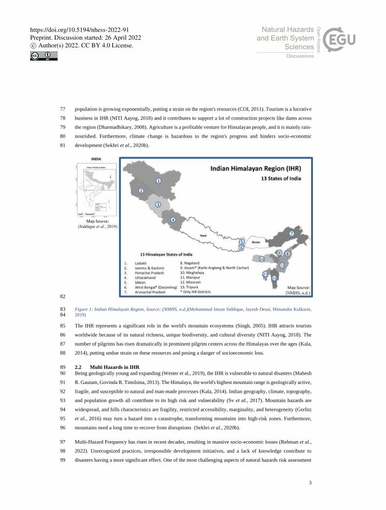
2.1 Defining the Indian Himalayan Region 69
The Indian Himalayan Region (IHR) straddles the northern latitudes of 26 20′ and 35 40′, and the eastern latitudes 70
of 74 50′ and 95 40′. In India, it comprises 16.2% of all the geographical land and is home to 76 million people. 71
Natural resources, biodiversity, and ethnic variety are abundant in IHR. (Goodrich, Prakash and Udas, 2019; 72
Sekhri et al., 2020b). It stretches from the Indus River to the Brahmaputra River in the east. (Srivastava et al., 73
2015). There are a total of 12 Indian Himalayan states and 1 Union territory as shown in Figure 1, which has 109 74
administrative districts (Kala, 2014). The region is socially and economically underprivileged, with 171 schedule 75
tribes accounting for almost 30% of India's total tribal population and a high literacy rate of 79 percent. The 76
https://doi.org/10.5194/nhess-2022-91Preprint. Discussion started: 26 April 2022c© Author(s) 2022. CC BY 4.0 License.
3
population is growing exponentially, putting a strain on the region's resources (COI, 2011). Tourism is a lucrative 77
business in IHR (NITI Aayog, 2018) and it contributes to support a lot of construction projects like dams across 78
the region (Dharmadhikary, 2008). Agriculture is a profitable venture for Himalayan people, and it is mainly rain-79
nourished. Furthermore, climate change is hazardous to the region's progress and hinders socio-economic 80
development (Sekhri et al., 2020b). 81
82
Figure 1: Indian Himalayan Region, Source: (NMHS, n.d.)(Mohammad Imran Siddique, Jayesh Desai, Himanshu Kulkarni, 83 2019) 84
The IHR represents a significant role in the world's mountain ecosystems (Singh, 2005). IHR attracts tourists 85
worldwide because of its natural richness, unique biodiversity, and cultural diversity (NITI Aayog, 2018). The 86
number of pilgrims has risen dramatically in prominent pilgrim centers across the Himalayas over the ages (Kala, 87
2014), putting undue strain on these resources and posing a danger of socioeconomic loss. 88
2.2 Multi Hazards in IHR 89
Being geologically young and expanding (Wester et al., 2019), the IHR is vulnerable to natural disasters (Mahesh 90
R. Gautam, Govinda R. Timilsina, 2013). The Himalaya, the world's highest mountain range is geologically active, 91
fragile, and susceptible to natural and man-made processes (Kala, 2014). Indian geography, climate, topography, 92
and population growth all contribute to its high risk and vulnerability (Sv et al., 2017). Mountain hazards are 93
widespread, and hills characteristics are fragility, restricted accessibility, marginality, and heterogeneity (Gerlitz 94
et al., 2016) may turn a hazard into a catastrophe, transforming mountains into high-risk zones. Furthermore, 95
mountains need a long time to recover from disruptions (Sekhri et al., 2020b). 96
Multi-Hazard Frequency has risen in recent decades, resulting in massive socio-economic losses (Rehman et al., 97
2022). Unrecognized practices, irresponsible development initiatives, and a lack of knowledge contribute to 98
disasters having a more significant effect. One of the most challenging aspects of natural hazards risk assessment 99
https://doi.org/10.5194/nhess-2022-91Preprint. Discussion started: 26 April 2022c© Author(s) 2022. CC BY 4.0 License.
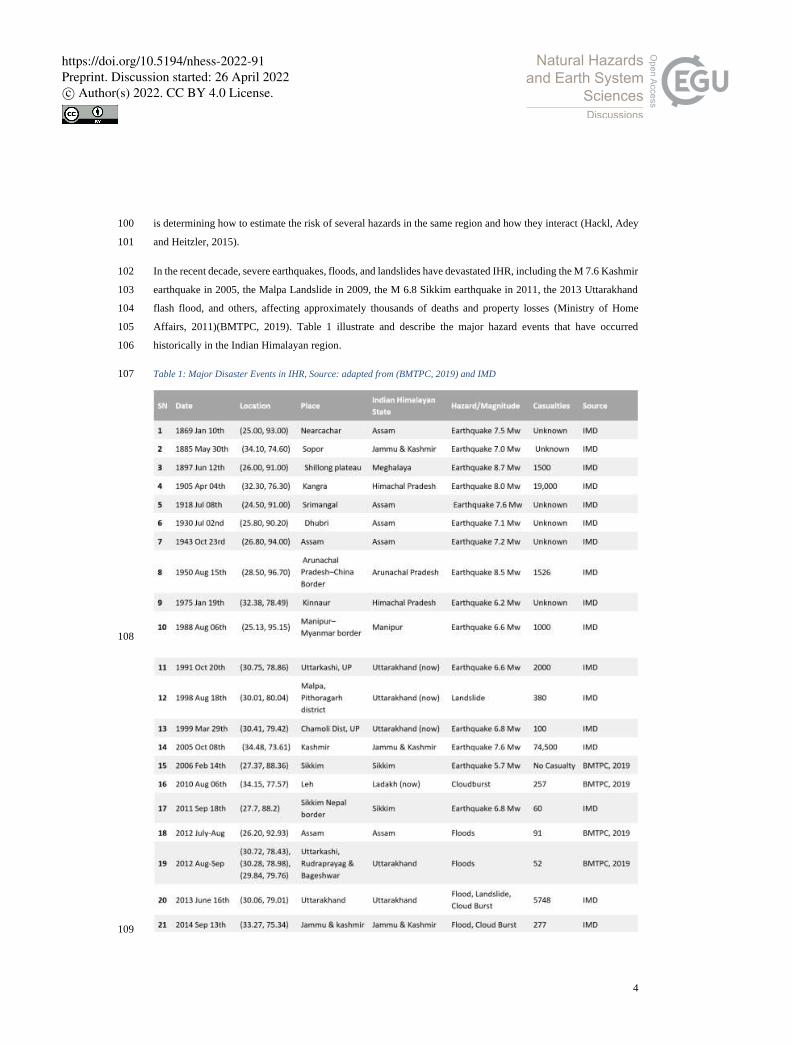
4
is determining how to estimate the risk of several hazards in the same region and how they interact (Hackl, Adey 100
and Heitzler, 2015). 101
In the recent decade, severe earthquakes, floods, and landslides have devastated IHR, including the M 7.6 Kashmir 102
earthquake in 2005, the Malpa Landslide in 2009, the M 6.8 Sikkim earthquake in 2011, the 2013 Uttarakhand 103
flash flood, and others, affecting approximately thousands of deaths and property losses (Ministry of Home 104
Affairs, 2011)(BMTPC, 2019). Table 1 illustrate and describe the major hazard events that have occurred 105
historically in the Indian Himalayan region. 106
Table 1: Major Disaster Events in IHR, Source: adapted from (BMTPC, 2019) and IMD 107
108
109
https://doi.org/10.5194/nhess-2022-91Preprint. Discussion started: 26 April 2022c© Author(s) 2022. CC BY 4.0 License.
5
The Himalayan region is among the most seismically active in the world due to the collision of the Indian and 110
Eurasian plates. A series of four major earthquakes has occurred within a short span of 53 years (Srivastava et al., 111
2015); namely Shillong (1897), Kangra (1905), Bihar-Nepal (1934) and Assam-Tibet (1950). Tectonic activities 112
on the mountains constantly threaten the stability of the mountains, being an active region. One of the most 113
frequent natural disasters in the Himalayas occurs when large landslides occur, destroying infrastructures, 114
destroying trees, and killing people. Landslides cause huge social and economic losses to mountain-dwelling 115
populations.(Sarkar et al., 2015). An area of near the River valley has witnessed a large number of mass 116
movements during recent years (Srivastava et al., 2010). A recent flash flood, along with a debris flow at 117
Kedarnath on 16-17 June 2013, which claimed over a thousand lives, was caused by cloudbursts and landslides 118
breaching temporary dams along river valleys (Simon Allen, 2015). More than 82 percent of the world's 119
population lived on land affected by floods between 1985 and 2003 (Mouri et al., 2013). There is an increase in 120
forest fire frequency globally, especially in Asia. There are major environmental and ecological impacts caused 121
by wildfires, which can result in the fatalities of tens of thousands of people and massive property losses (Parajuli 122
et al., 2020). 123
2.3 Need of Study 124
Without a comprehensive evaluation of multi-hazards, it is impossible to develop any concrete policy measures 125
to combat the potential risk posed by multiple hazards.(Sekhri et al., 2020a) IHR being prone to Multi Hazards 126
(Kala, 2014), Risk Resilient Development planning is the only way to prepare Himalayan community from 127
upcoming disasters. 128
It is well known that the Himalayas are a high-risk area for multi-hazards (Pathak et al., 2019), although fewer 129
risk assessments have been conducted in the IHR region. An assessment of hazards generally focuses on a single 130
threat, such as landslides, earthquakes, or flooding. As a result, physical processes are considered in isolation. In 131
most areas of the Himalayas, hazards are interrelated and generate cascading effects or synergies which make the 132
entire region vulnerable (Sekhri et al., 2020b). Probabilistic risk frameworks have been proposed, but as a result 133
of a lack of quality and quantity of data, these approaches are seldom feasible in developing countries (Aksha et 134
al., 2020). Furthermore, the existing risk assessment models/tools for a specific hazard in the region has limited 135
application and effectiveness from a policy standpoint (Sekhri et al., 2020b). 136
Researchers are involved in a number of research projects in IHR in the field of assessing the risk of disasters in 137
India, though there have been very few assessments of hazards associated with the IHR region, none of which 138
incorporate multi-hazards (Vaidya et al., 2019) In addition, risk resulting from a single hazard is not applicable 139
and cannot be considered effectively in policy analysis in the region (Sekhri et al., 2020b). 140
The comparative study of some of the most used survey form to assess risk in India in shown in the table 2. The 141
detail of all the mentioned survey form will be explain later in this paper. It has been observed from the table 2 142
that none of the forms (SN 1 to 6) are focusing on Multi Hazard Risk calculation/identification as per IHR 143
Scenarios, which is not only prone to earthquakes, but also prone to floods, landslides, high winds, industrial 144
hazards and at building level falling hazard (Non-Structural Hazard), fire and electrical hazards etc. 145
https://doi.org/10.5194/nhess-2022-91Preprint. Discussion started: 26 April 2022c© Author(s) 2022. CC BY 4.0 License.

6
Table 2: Comparison between survey forms used in India to assess Risk 146
Comparative Study between some survey forms used in India
SN 1 2 3 4 5 6 7
Developed by/for ARYA FEMA NDMA IIT-B HPSDMA BMTPC MH-RVS
(Enhanced)
Source: adapted from Arya, 2006
FEMA, 2015
NDMA, 2020
Sinha, 2004
Pradesh, 2016
BMTPC, 2019
Author
Understanding Pictorial ✓ ✓
IHR is prone to Multi Hazard
Earthquake ✓ ✓ ✓ ✓ ✓ ✓ ✓
Flood ✓ ✓ ✓ ✓
High Wind ✓ ✓
Landslide ✓ ✓ ✓ ✓ ✓ ✓
Fire and Electrical ✓ ✓
Industrial ✓
Climate Change ✓
Non-Structural /Falling Hazard
✓ ✓ ✓ ✓ ✓ ✓
147
There is no such survey form for comprehensive database for the IHR Region for informed decision-making, 148
related to multi hazard and other aspects of sustainable hill development. Considering the IHR scenarios, there is 149
immense need for a Hill specific survey form, that can help to gather important information from the field and 150
help in Risk assessment for further decision making, to prepare the hill community from future disasters. 151
3 Multi Hazard Survey Framework 152
3.1 Survey Form design methodology 153
The survey methodologies start with few recommendations for designing a good survey form (Roopa and Rani, 154
2012) (QuestionPro, n.d.). 155
• It should satisfy the objectives of the research. 156
• The number of essential parts to be covered in the questionnaires with dictate length. 157
• Easily understood, Simple language and pictorial explanation for better understanding 158
• The survey response rate can be increased by using multiple-choice questions. 159
• A single thought should be conveyed at a time 160
• As much as possible, be concrete and conform to the respondent's perspective 161
• The use of unclear words should be avoided 162
• Survey Logic: In designing a survey, logic is among the most important factors. There is no further 163
progress or possibility of further correspondence from the respondent, if the logic is flawed. It takes 164
practice and verification to ensure that when considering an option only the next logical question comes 165
to mind. 166
Its methodology involves selecting and analyzing a sample of individuals from a population and using various 167
techniques for collecting data. It is used to collect data from a predetermined sample of respondents, process the 168
data, and increase survey response rates (QuestionPro, n.d.). 169
https://doi.org/10.5194/nhess-2022-91Preprint. Discussion started: 26 April 2022c© Author(s) 2022. CC BY 4.0 License.
7
170
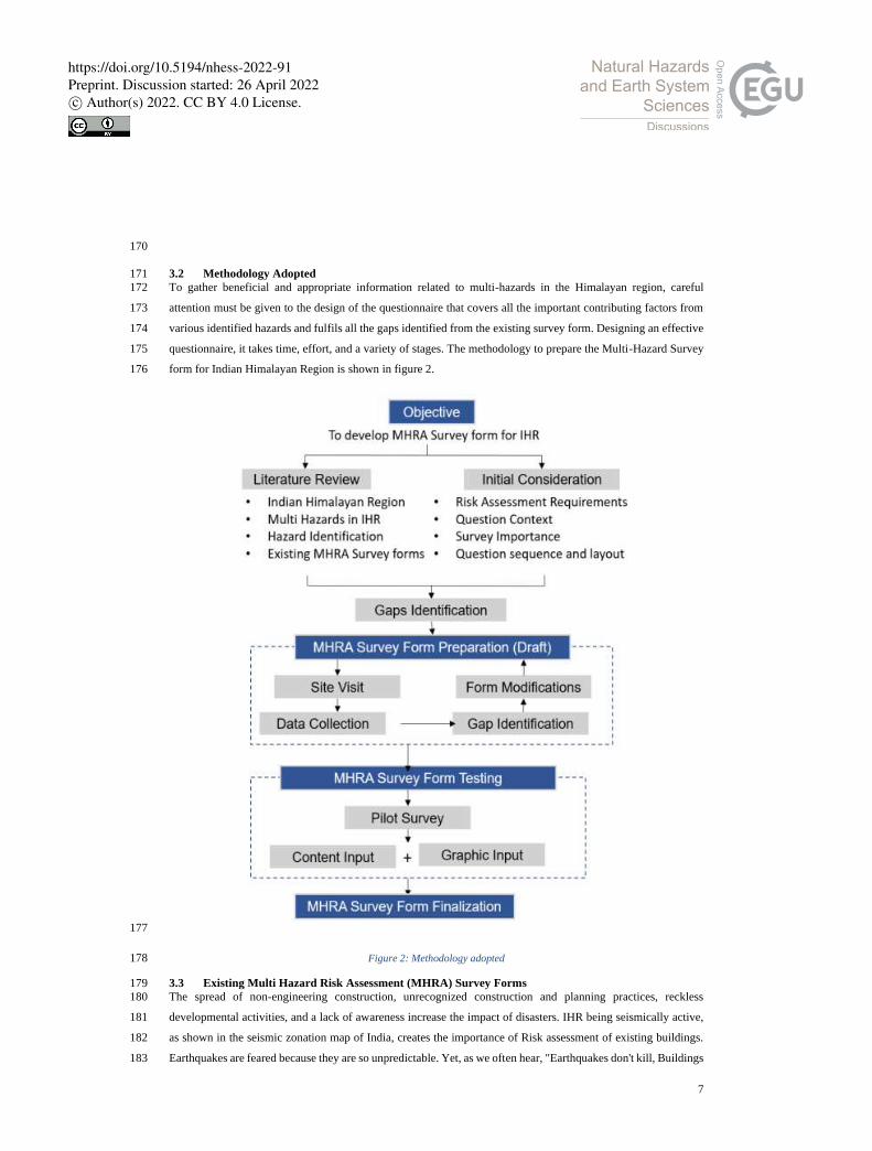
3.2 Methodology Adopted 171
To gather beneficial and appropriate information related to multi-hazards in the Himalayan region, careful 172
attention must be given to the design of the questionnaire that covers all the important contributing factors from 173
various identified hazards and fulfils all the gaps identified from the existing survey form. Designing an effective 174
questionnaire, it takes time, effort, and a variety of stages. The methodology to prepare the Multi-Hazard Survey 175
form for Indian Himalayan Region is shown in figure 2. 176
177
Figure 2: Methodology adopted 178
3.3 Existing Multi Hazard Risk Assessment (MHRA) Survey Forms 179
The spread of non-engineering construction, unrecognized construction and planning practices, reckless 180
developmental activities, and a lack of awareness increase the impact of disasters. IHR being seismically active, 181
as shown in the seismic zonation map of India, creates the importance of Risk assessment of existing buildings. 182
Earthquakes are feared because they are so unpredictable. Yet, as we often hear, "Earthquakes don't kill, Buildings 183
https://doi.org/10.5194/nhess-2022-91Preprint. Discussion started: 26 April 2022c© Author(s) 2022. CC BY 4.0 License.

8
do" (attributed to Francesca Valli, Change Management Thought-Leader), and as the detailed assessment is 184
limited to the number of homes and the cost, one of the considering approaches is Rapid Visual Screening (RVS) 185
that is used for seismic vulnerability assessment. Using this methodology, a risk assessment has been conducted 186
for areas subjected to earthquakes (Pradesh, Pradeep and Anoop, 2016). 187
3.3.1 Seismic Zonation Map of India 188
The first seismic zoning map of India was published in 1935 by the Geological Survey of India (G. S. I.) (Figure 189
3). Based on the damage earthquakes caused in various parts of India, this map has undergone numerous 190
modifications since its original creation. India is divided into four distinct earthquake risk zones shown here by 191
colour (Bilham and Laituri, 2003) in figure 3 below: 192
193
Figure 3: Seismic Zonation Map of India, Source: (India, n.d., p. Map of India) 194
3.3.2 About RVS 195
Applied Technology Council (ATC) developed the RVS method in the late 1980s and published it in the FEMA: 196
154 in 1988. In later versions, it was revised in FEMA: 178-1989, 1992 (revised), FEMA: 310-1998, and FEMA: 197
154-1988, 2002 (revised), for rapid visual screening of buildings. (Pradesh, Pradeep and Anoop, 2016) 198
Rapid Visual Screening (RVS) avoids the need for structural calculations by using a visual method. An evaluator 199
determines damageability grade by identifying (a) the primary structural lateral load resisting system as well as 200
(b) the structural features of the building that can impact seismic performance in combination with that system. 201
The process of inspecting, gathering data, and deciding on the next course of action occurs on site and may last 202
several hours, depending on the size of the building (Arya, 2006b). 203
3.3.2.1 Uses of RVS Results: 204
The foremost uses of this technique concerning seismic advancement of existing buildings are: 205
https://doi.org/10.5194/nhess-2022-91Preprint. Discussion started: 26 April 2022c© Author(s) 2022. CC BY 4.0 License.
9
Assess a building's seismic vulnerability to categorize it further. 206
• To determine the structural vulnerability (damageability) of buildings and determine the seismic 207
rehabilitation requirements. 208
• In cases where further assessments are not considered necessary or are not feasible, retrofitting 209
requirements are simplified (to a collapse prevention level) (Arya, 2006b). 210
3.3.3 Uses of the Four Levels of Earthquake Safety Assessments 211
3.3.3.1 Level 1: Rapid Visual Screening (RVS) 212
The method does not require any structural calculations to be performed. For the purpose of identifying the main 213
structural members that resist lateral loads and the characteristics of buildings that modify their performance 214
during earthquakes, the evaluator applies a scoring system. On average, each building inspection, data collection, 215
and decision-making takes about 30 minutes. 216
3.3.3.2 Level 2: Detailed Visual Study (DVS) 217
It can be used to assess a house as a first-level exercise before performing a detailed retrofit, and to assess the 218
performance and safety of a house of a certain type. 219
3.3.3.3 Level 3: Simplified Vulnerability Assessment (SVA) 220
In comparison to RVS, the simplified vulnerability assessment (SVA) is more complex and therefore more 221
precise. The technique uses engineering information for example the size and strength of lateral load resisting 222
members, along with more explicit data on ground motion. By analyzing this information, the building drift is 223
estimated using an extremely simplified breakdown. Based on a good correlation between drift and damage, the 224
analysis can be used to quantify the potential seismic hazard of a building. 225
3.3.3.4 Level 4: Detailed Vulnerability Assessment (DVA) 226
To perform a DVA of a building, an engineering analysis must be conducted taking into account the non-linear 227
behaviour of structural components and the potential impact of ground motions. The detailed vulnerability 228
assessment procedure requires a very high level of engineering knowledge, skills, and experience. 229
3.3.4 Multi Hazard Risk Assessment used in India 230
3.3.4.1 RVS Methodology Proposed by Prof. Anand S Arya for Masonry Buildings 231
RVS procedure that was designed for the Indian context, follows a grading system where the screener identifies 232
the primary load-resisting system of the building and determines parameters that may be modified to improve 233
seismic performance of the structure (NDMA, 2020) 234
Rapid Visual Screening form of Masonry Buildings developed by Prof. Anand S Arya consist of zoning, according 235
to Indian conditions, and buildings with importance are given consideration. Also, special hazards (liquefiable 236
area, landslide prone area, plan irregularities, and vertical irregularities) and falling hazards are taken into account. 237
Finally, a grading system was performed in the buildings. Refer (Arya, 2006b) for detail RVS survey forms for 238
masonry buildings prepared by Prof. A.S. Arya. 239
3.3.4.2 RVS Methodology Proposed by Prof. Anand S Arya for RC frame or Steel Frame 240
The Rapid Visual Screening form of Reinforced Concrete frame and Steel Frame for Seismic Hazards developed 241
by Prof. Anand S Arya has 6 components (i) general information (ii) Building typology based on foundation type, 242
https://doi.org/10.5194/nhess-2022-91Preprint. Discussion started: 26 April 2022c© Author(s) 2022. CC BY 4.0 License.

10
roof, floor, etc. (iii) Structural frame type (iv) Special Hazard (v) Non-Structural building components (vi) 243
Damageable Grades (Arya, 2006a). 244
Seismic safety features of RC Frame Buildings consist of parameters like Frame Action, Presence of Soft Storey, 245
Short Column Effect, Concept of Weak Beam Strong Column, Pounding of Buildings, Building Distress and 246
Other important features, Water Seepage, Corrosion of Reinforcement, Quality of Construction, Quality of 247
Concrete and non-structural falling hazards. Refer (Arya, 2006a) for detailed RVS Survey form for RC and steel 248
buildings prepared by Prof. A.S. Arya. 249
3.3.4.3 RVS Procedure developed by Dr. Sudhir K Jain 250
In this method, a checklist for pre-screened buildings is prepared based on Indian conditions. It is one of the first 251
methodologies in India featuring a points system. Performance scores are calculated based on factors such as zone, 252
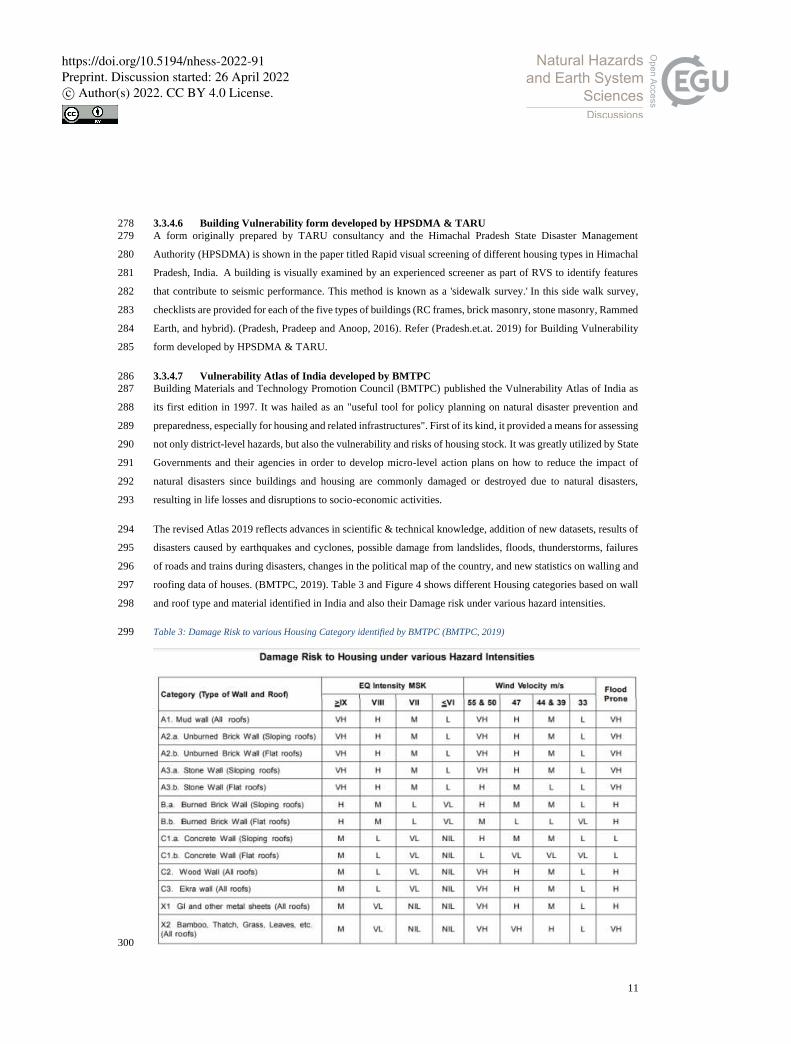
architectural considerations, structural parameters, and geotechnical characteristics. In India, this method is used 253
in many locations, with the first applications being in Gujarat after the Bhuj earthquake (Sudhir K Jain, Keya 254
Mitra, Manish Kumar, 2010). 255
3.3.4.4 RVS form developed by NDMA 2020 256
In the Disaster Management Act of 2005, a paradigm shift from Relief-centric approach to Mitigation- and 257
Preparedness-centric approach is sought, with continued emphasis on proactive, holistic and integrated Response. 258
With this Act in mind, NDMA initiated a series of discrete, comprehensive, and integrated initiatives. Among the 259
recommended actions was assessing earthquake risk within the existing built environment. 260
NDMA developed this report to make end users aware of RVS's outcomes by presenting RVS in clear and tangible 261
terms. On the basis of discussions with the relevant domain experts, NDMA have developed recommended forms 262
for Pre-Earthquake and Post-Earthquake Level 1 Assessments of 7 building typologies (i. Reinforced Concrete 263
Building, ii. Burnt Clay Bricks Building, iii. Confined Masonry Building, iv. Random Rubble Masonry Building, 264
v. Mud House, vi. Dhajji Dewari, vii. Ekra House). A form is developed to categorize the different building 265
attributes into three categories: Red (High Risk), Yellow (Moderate Risk), and Green (Low Risk). Refer (NDMA, 266
2020) for detailed survey form. 267
3.3.4.5 Seismic Vulnerability Assessment by Prof. Ravi Sinha and Prof. Alok Goyal 268
Prof. Ravi Sinha and Prof. Alok Goyal from Indian Institute of Technology Bombay (IIT-B) prepared a "National 269
Policy for Seismic Vulnerability Assessment of Buildings and Procedure for Rapid Visual Screening of Buildings 270
for Potential Seismic Vulnerability". A key feature of this procedure is that it allows a trained evaluator to conduct 271
a walkthrough of the building to determine vulnerability. It is compatible with GIS-based city databases, and can 272
also be used for a variety of other planning and mitigation tasks. 273
RVS analysed 10 different types of building, based on the materials and construction types most commonly found 274
in urban areas. There were both engineered and non-engineered constructions (built according to specifications) 275
in this category. Refer (Ravi Sinha, 2001) for detailed survey form. 276
277
https://doi.org/10.5194/nhess-2022-91Preprint. Discussion started: 26 April 2022c© Author(s) 2022. CC BY 4.0 License.
11
3.3.4.6 Building Vulnerability form developed by HPSDMA & TARU 278
A form originally prepared by TARU consultancy and the Himachal Pradesh State Disaster Management 279
Authority (HPSDMA) is shown in the paper titled Rapid visual screening of different housing types in Himachal 280
Pradesh, India. A building is visually examined by an experienced screener as part of RVS to identify features 281
that contribute to seismic performance. This method is known as a 'sidewalk survey.' In this side walk survey, 282
checklists are provided for each of the five types of buildings (RC frames, brick masonry, stone masonry, Rammed 283
Earth, and hybrid). (Pradesh, Pradeep and Anoop, 2016). Refer (Pradesh.et.at. 2019) for Building Vulnerability 284
form developed by HPSDMA & TARU. 285
3.3.4.7 Vulnerability Atlas of India developed by BMTPC 286
Building Materials and Technology Promotion Council (BMTPC) published the Vulnerability Atlas of India as 287
its first edition in 1997. It was hailed as an "useful tool for policy planning on natural disaster prevention and 288
preparedness, especially for housing and related infrastructures". First of its kind, it provided a means for assessing 289
not only district-level hazards, but also the vulnerability and risks of housing stock. It was greatly utilized by State 290
Governments and their agencies in order to develop micro-level action plans on how to reduce the impact of 291
natural disasters since buildings and housing are commonly damaged or destroyed due to natural disasters, 292
resulting in life losses and disruptions to socio-economic activities. 293
The revised Atlas 2019 reflects advances in scientific & technical knowledge, addition of new datasets, results of 294
disasters caused by earthquakes and cyclones, possible damage from landslides, floods, thunderstorms, failures 295
of roads and trains during disasters, changes in the political map of the country, and new statistics on walling and 296
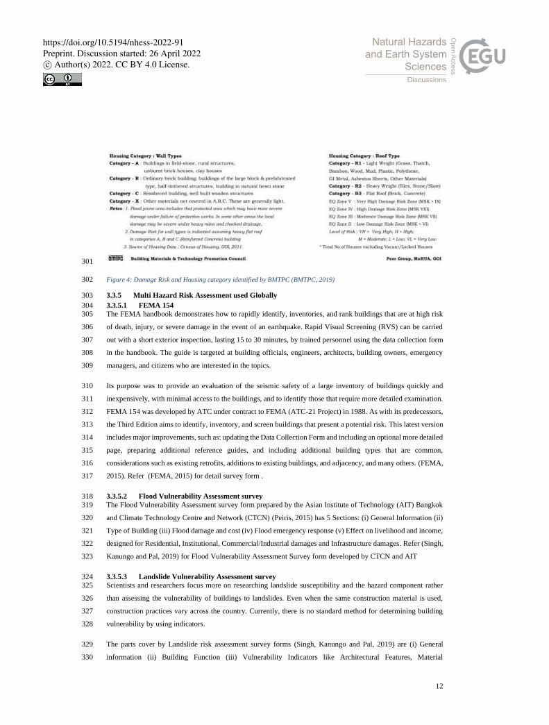
roofing data of houses. (BMTPC, 2019). Table 3 and Figure 4 shows different Housing categories based on wall 297
and roof type and material identified in India and also their Damage risk under various hazard intensities. 298
Table 3: Damage Risk to various Housing Category identified by BMTPC (BMTPC, 2019) 299
300
https://doi.org/10.5194/nhess-2022-91Preprint. Discussion started: 26 April 2022c© Author(s) 2022. CC BY 4.0 License.
12
301
Figure 4: Damage Risk and Housing category identified by BMTPC (BMTPC, 2019) 302
3.3.5 Multi Hazard Risk Assessment used Globally 303
3.3.5.1 FEMA 154 304
The FEMA handbook demonstrates how to rapidly identify, inventories, and rank buildings that are at high risk 305
of death, injury, or severe damage in the event of an earthquake. Rapid Visual Screening (RVS) can be carried 306
out with a short exterior inspection, lasting 15 to 30 minutes, by trained personnel using the data collection form 307
in the handbook. The guide is targeted at building officials, engineers, architects, building owners, emergency 308
managers, and citizens who are interested in the topics. 309
Its purpose was to provide an evaluation of the seismic safety of a large inventory of buildings quickly and 310
inexpensively, with minimal access to the buildings, and to identify those that require more detailed examination. 311
FEMA 154 was developed by ATC under contract to FEMA (ATC-21 Project) in 1988. As with its predecessors, 312
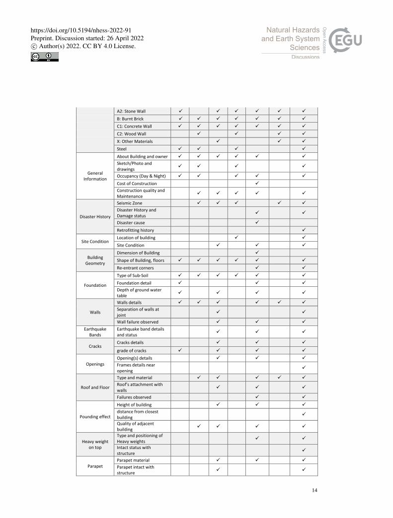
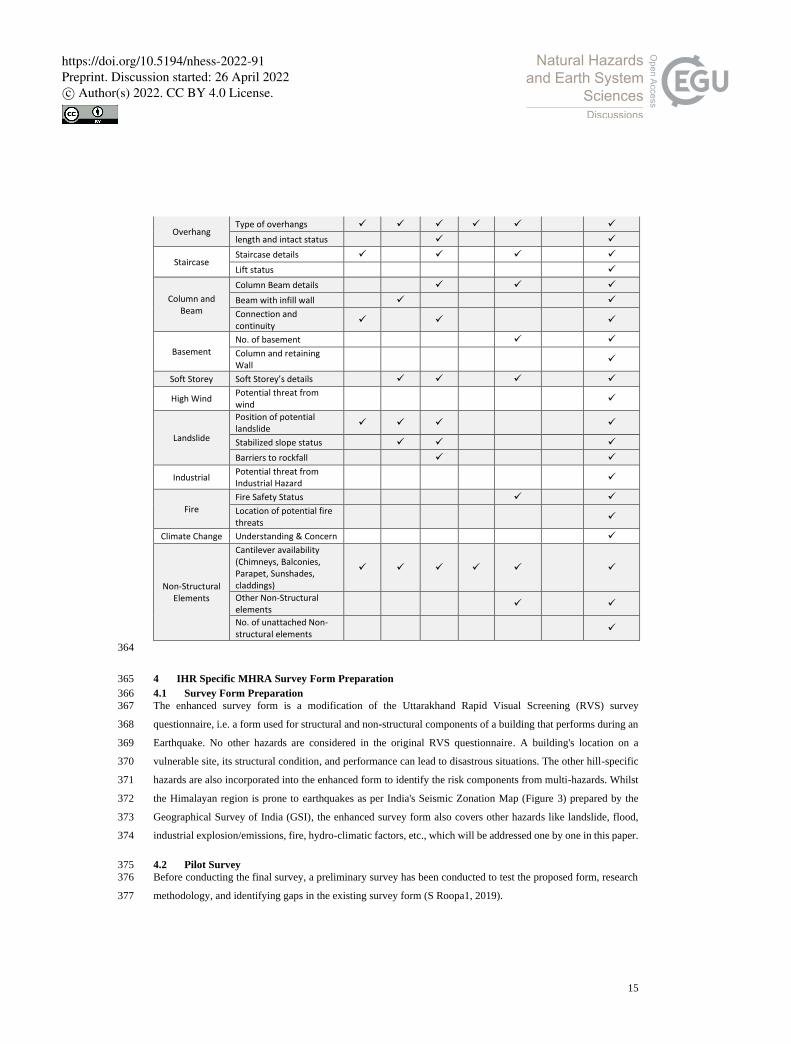
the Third Edition aims to identify, inventory, and screen buildings that present a potential risk. This latest version 313
includes major improvements, such as: updating the Data Collection Form and including an optional more detailed 314
page, preparing additional reference guides, and including additional building types that are common, 315
considerations such as existing retrofits, additions to existing buildings, and adjacency, and many others. (FEMA, 316
2015). Refer (FEMA, 2015) for detail survey form . 317
3.3.5.2 Flood Vulnerability Assessment survey 318
The Flood Vulnerability Assessment survey form prepared by the Asian Institute of Technology (AIT) Bangkok 319
and Climate Technology Centre and Network (CTCN) (Peiris, 2015) has 5 Sections: (i) General Information (ii) 320
Type of Building (iii) Flood damage and cost (iv) Flood emergency response (v) Effect on livelihood and income, 321
designed for Residential, Institutional, Commercial/Industrial damages and Infrastructure damages. Refer (Singh, 322
Kanungo and Pal, 2019) for Flood Vulnerability Assessment Survey form developed by CTCN and AIT 323
3.3.5.3 Landslide Vulnerability Assessment survey 324
Scientists and researchers focus more on researching landslide susceptibility and the hazard component rather 325
than assessing the vulnerability of buildings to landslides. Even when the same construction material is used, 326
construction practices vary across the country. Currently, there is no standard method for determining building 327
vulnerability by using indicators. 328
The parts cover by Landslide risk assessment survey forms (Singh, Kanungo and Pal, 2019) are (i) General 329
information (ii) Building Function (iii) Vulnerability Indicators like Architectural Features, Material 330
https://doi.org/10.5194/nhess-2022-91Preprint. Discussion started: 26 April 2022c© Author(s) 2022. CC BY 4.0 License.
13
Characteristics, Structural Features, Geographical features, and quality of Workmanship, Construction & 331
maintenance, etc. which are also covered during RVS and has been covered in the proposed survey form CitSci, 332
GIS based data collection app for landslide 333
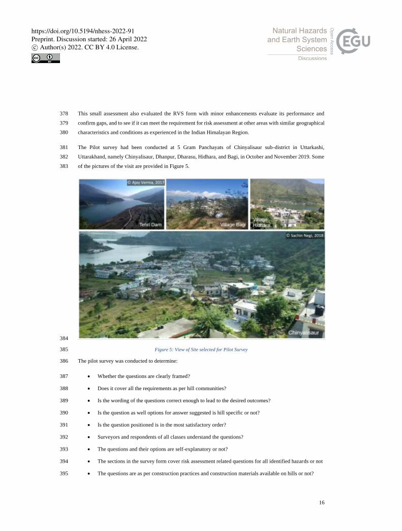
As a result of a collaboration between Departments of Geomatics Engineering and Geological Engineering, 334
Hacettepe University has created the CitiSci platform for geoscience research. A WebGIS platform supported by 335
CitSci and artificial intelligence (AI) was used in this study to assist landslide researchers. Data visualization and 336
display software is incorporated in the WebGIS application, mobile data collection software (LaMA), and an AI 337
system controls the quality control process for data (R. Can, 2020). 338
3.4 Features required for a Multi Hazard Survey Form for IHR 339
3.4.1 Gaps Identified 340
Existing Survey forms have their strengths & weaknesses. After studying various survey forms for Risk 341
assessment prepared by various national and international authorities, it is observed that hill-specific survey forms 342
that can take care of multiple aspects of risk and sustainability assessment together do not exist. Available forms 343
are complicated, not-so user friendly, consisting of terminologies difficult to communicate and comprehend, no 344
pictorial clues for understanding, involve several rounds of calculations for coherent multi-hazard risk evaluation 345
using the data, and most importantly, they not hill site-specific or designed for the Indian Himalayan region. 346
Hills have their own situation, condition, geography, climate, development trends, construction practices, culture, 347
etc., and they are distinctly different from other regions. RVS is mostly used in India to assess the visual structural 348
vulnerability of the building, as it involves no structural calculations. On the other hand, SVA and DVA are for 349
the detailed structural survey of a building, and therefore more precise and use engineering information along 350
with more explicit data on ground motion. Data filling is not easy enough for the surveyor and requires a very 351
high level of engineering knowledge, skills, and experience. Pictorial explanation from surveyor point of view 352
can ease the communication. Most of the survey forms are focused on single hazard, (mostly for seismic evaluation 353
of a building) irrelevant of multi hazard from Himalayan point of view, and how prone is buildings for its location 354
is from other hazards. Integration between risk understanding and sustainable development is too limited or non-355
existent. Thus, it has been observed that there is an immense need to design hill-specific questionnaires for multi-356
hazards risk assessment for Indian Himalayan Region. 357
3.4.2 Comparative Study of some risk assessment survey forms mostly used in India 358
Here is the comparative analysis of Risk assessment survey forms developed by various organizations and mostly 359
used in India with the enhanced Multi-Hazard RVS. It has been compared on various sections like typology, 360
General Information, History of Disasters, Site Conditions, Building geometry, structural and non-structural 361
component of a building etc. 362
Table 4: Comparative Study of some risk assessment survey forms mostly used in India 363
1 2 3 4 5 6 7 Developed
by/for ARYA FEMA NDMA IIT-B HPSDMA BMTPC
MH-RVS (Enhanced)
Source Arya, 2006
FEMA, 2015
NDMA, 2020
Sinha, 2004
Pradesh, 2016
BMTPC, 2019
Author
Typology A1: Mud & Unburnt Brick ✓ ✓ ✓ ✓
https://doi.org/10.5194/nhess-2022-91Preprint. Discussion started: 26 April 2022c© Author(s) 2022. CC BY 4.0 License.
14
A2: Stone Wall ✓ ✓ ✓ ✓ ✓ ✓
B: Burnt Brick ✓ ✓ ✓ ✓ ✓ ✓ ✓
C1: Concrete Wall ✓ ✓ ✓ ✓ ✓ ✓ ✓
C2: Wood Wall ✓ ✓ ✓ ✓
X: Other Materials ✓ ✓ ✓
Steel ✓ ✓ ✓ ✓
General Information
About Building and owner ✓ ✓ ✓ ✓ ✓ ✓
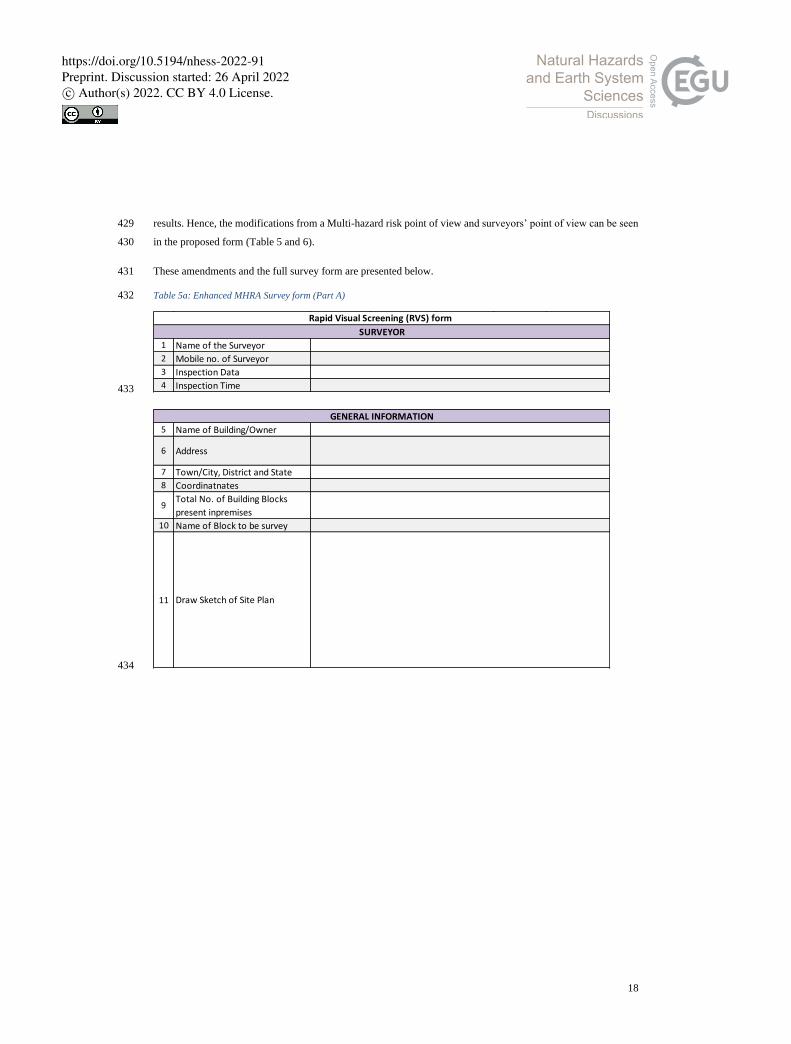
Sketch/Photo and drawings
✓ ✓ ✓ ✓
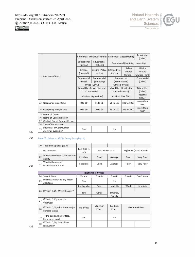
Occupancy (Day & Night) ✓ ✓ ✓ ✓ ✓
Cost of Construction ✓ Construction quality and Maintenance
✓ ✓ ✓ ✓ ✓
Disaster History
Seismic Zone ✓ ✓ ✓ ✓ ✓
Disaster History and Damage status
✓ ✓
Disaster cause ✓ Retrofitting history ✓
Site Condition Location of building ✓ ✓
Site Condition ✓ ✓ ✓
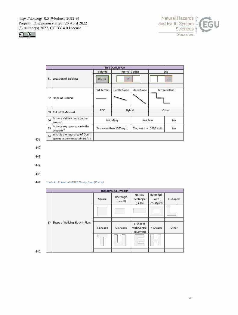
Building Geometry
Dimension of Building ✓ Shape of Building, floors ✓ ✓ ✓ ✓ ✓ ✓
Re-entrant corners ✓ ✓
Foundation
Type of Sub-Soil ✓ ✓ ✓ ✓ ✓ ✓
Foundation detail ✓ ✓ ✓
Depth of ground water table
✓ ✓ ✓ ✓
Walls
Walls details ✓ ✓ ✓ ✓ ✓ ✓
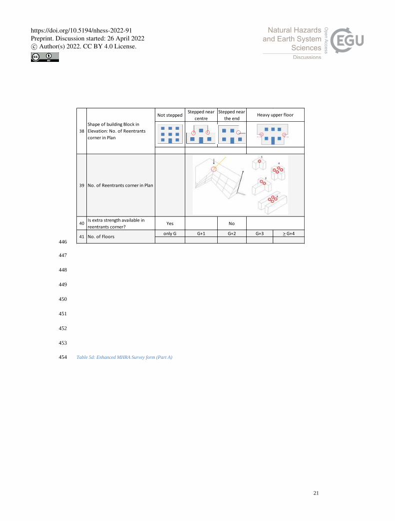
Separation of walls at joint
✓ ✓
Wall failure observed ✓ ✓ ✓
Earthquake Bands
Earthquake band details and status
✓ ✓ ✓
Cracks Cracks details ✓ ✓ ✓
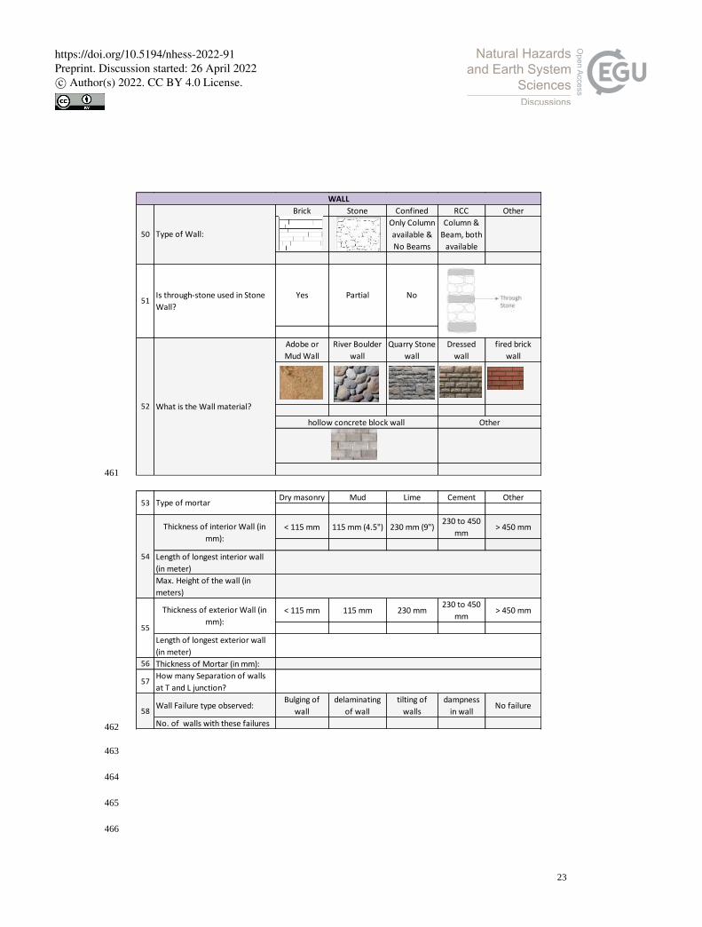
grade of cracks ✓ ✓ ✓ ✓
Openings
Opening(s) details ✓ ✓ ✓
Frames details near opening
✓
Roof and Floor
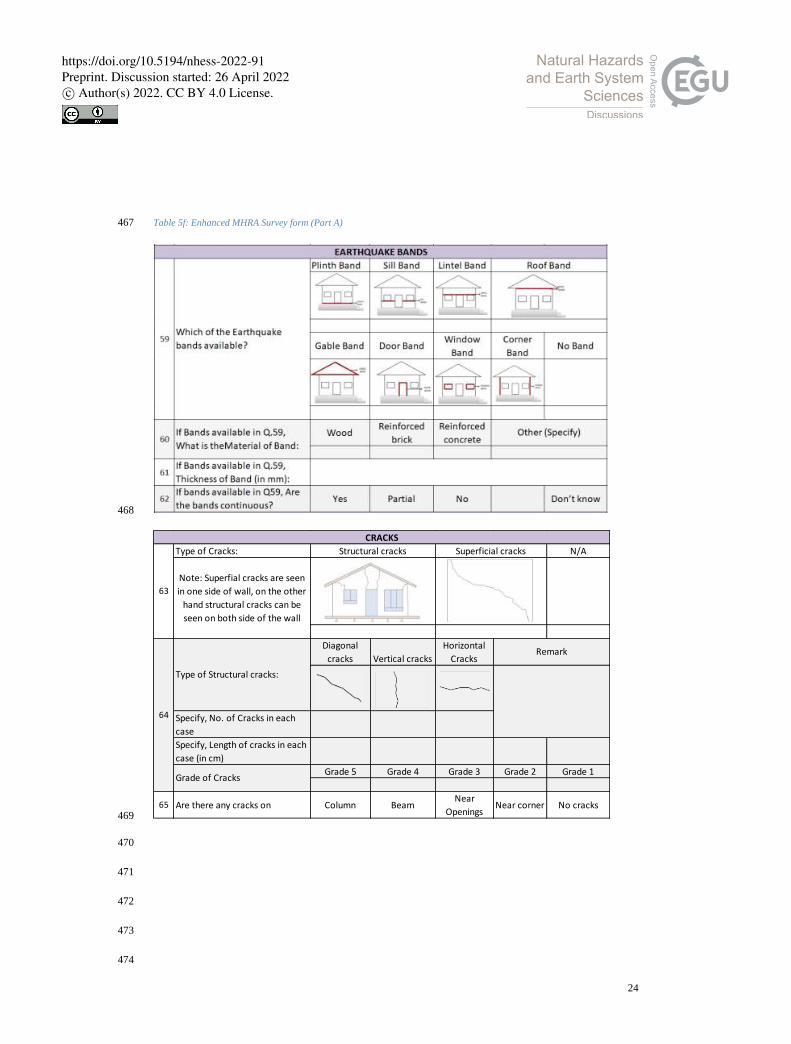
Type and material ✓ ✓ ✓ ✓ ✓
Roof’s attachment with walls
✓ ✓ ✓
Failures observed ✓ ✓
Pounding effect
Height of building ✓ ✓ ✓
distance from closest building
✓
Quality of adjacent building
✓ ✓ ✓ ✓
Heavy weight on top
Type and positioning of Heavy weights
✓ ✓
Intact status with structure
✓
Parapet Parapet material ✓ ✓ ✓
Parapet intact with structure
✓ ✓
https://doi.org/10.5194/nhess-2022-91Preprint. Discussion started: 26 April 2022c© Author(s) 2022. CC BY 4.0 License.
15
Overhang Type of overhangs ✓ ✓ ✓ ✓ ✓ ✓
length and intact status ✓ ✓
Staircase Staircase details ✓ ✓ ✓ ✓
Lift status ✓
Column and Beam
Column Beam details ✓ ✓ ✓
Beam with infill wall ✓ ✓
Connection and continuity
✓ ✓ ✓
Basement
No. of basement ✓ ✓
Column and retaining Wall
✓
Soft Storey Soft Storey’s details ✓ ✓ ✓ ✓
High Wind Potential threat from wind
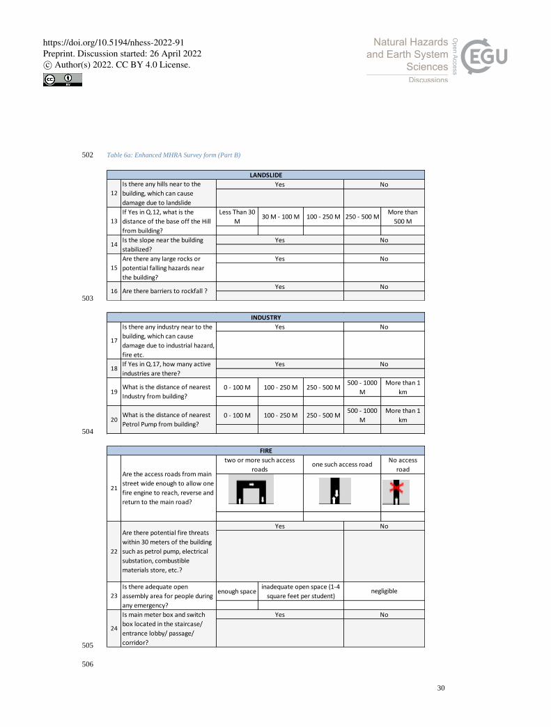
✓
Landslide
Position of potential landslide
✓ ✓ ✓ ✓
Stabilized slope status ✓ ✓ ✓
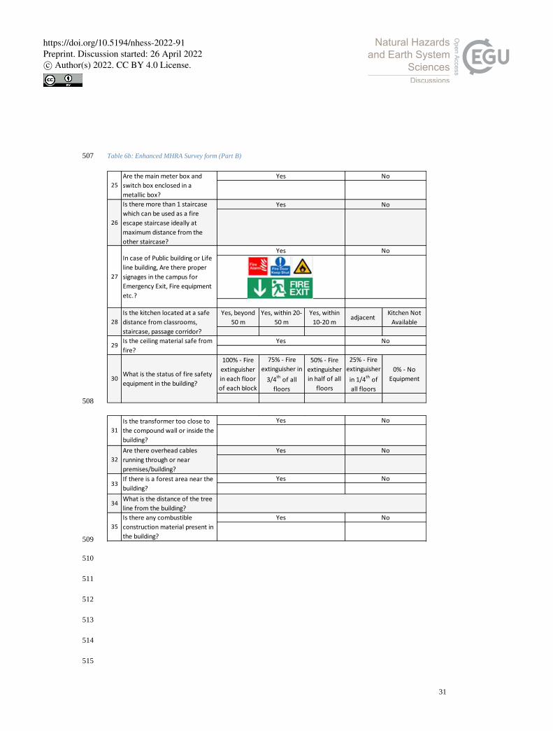
Barriers to rockfall ✓ ✓
Industrial Potential threat from Industrial Hazard
✓
Fire
Fire Safety Status ✓ ✓
Location of potential fire threats
✓
Climate Change Understanding & Concern ✓
Non-Structural Elements
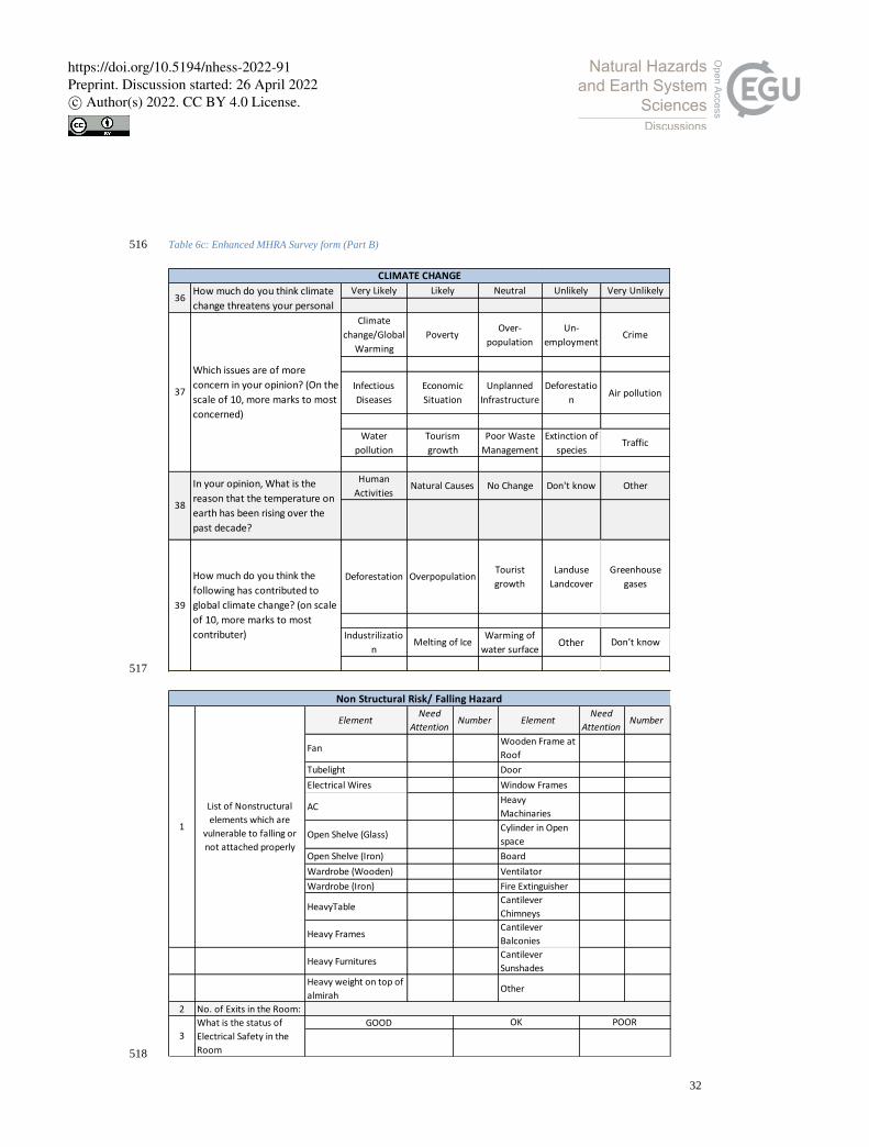
Cantilever availability (Chimneys, Balconies, Parapet, Sunshades, claddings)
✓ ✓ ✓ ✓ ✓ ✓
Other Non-Structural elements
✓ ✓
No. of unattached Non-structural elements
✓
364
4 IHR Specific MHRA Survey Form Preparation 365
4.1 Survey Form Preparation 366
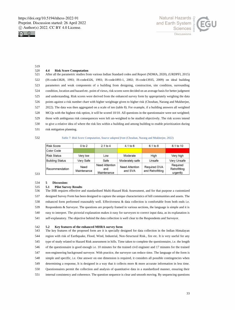
The enhanced survey form is a modification of the Uttarakhand Rapid Visual Screening (RVS) survey 367
questionnaire, i.e. a form used for structural and non-structural components of a building that performs during an 368
Earthquake. No other hazards are considered in the original RVS questionnaire. A building's location on a 369
vulnerable site, its structural condition, and performance can lead to disastrous situations. The other hill-specific 370
hazards are also incorporated into the enhanced form to identify the risk components from multi-hazards. Whilst 371
the Himalayan region is prone to earthquakes as per India's Seismic Zonation Map (Figure 3) prepared by the 372
Geographical Survey of India (GSI), the enhanced survey form also covers other hazards like landslide, flood, 373
industrial explosion/emissions, fire, hydro-climatic factors, etc., which will be addressed one by one in this paper. 374
4.2 Pilot Survey 375
Before conducting the final survey, a preliminary survey has been conducted to test the proposed form, research 376
methodology, and identifying gaps in the existing survey form (S Roopa1, 2019). 377
https://doi.org/10.5194/nhess-2022-91Preprint. Discussion started: 26 April 2022c© Author(s) 2022. CC BY 4.0 License.
16
This small assessment also evaluated the RVS form with minor enhancements evaluate its performance and 378
confirm gaps, and to see if it can meet the requirement for risk assessment at other areas with similar geographical 379
characteristics and conditions as experienced in the Indian Himalayan Region. 380
The Pilot survey had been conducted at 5 Gram Panchayats of Chinyalisaur sub-district in Uttarkashi, 381
Uttarakhand, namely Chinyalisaur, Dhanpur, Dharasu, Hidhara, and Bagi, in October and November 2019. Some 382
of the pictures of the visit are provided in Figure 5. 383
384
Figure 5: View of Site selected for Pilot Survey 385
The pilot survey was conducted to determine: 386
• Whether the questions are clearly framed? 387
• Does it cover all the requirements as per hill communities? 388
• Is the wording of the questions correct enough to lead to the desired outcomes? 389
• Is the question as well options for answer suggested is hill specific or not? 390
• Is the question positioned is in the most satisfactory order? 391
• Surveyors and respondents of all classes understand the questions? 392
• The questions and their options are self-explanatory or not? 393
• The sections in the survey form cover risk assessment related questions for all identified hazards or not 394
• The questions are as per construction practices and construction materials available on hills or not? 395
https://doi.org/10.5194/nhess-2022-91Preprint. Discussion started: 26 April 2022c© Author(s) 2022. CC BY 4.0 License.
17
• Are there any need to add some Questions or specified, or some need to be eliminated so as to mention 396
the flow of the survey session. 397
• Does surveyor and Respondent understand the importance of this survey or the objective behind this 398
survey and response in that way? 399
4.2.1 Observations during Pilot survey 400
Feedback from the pilot study proved very helpful in determining the key gaps and shortcomings of the form 401
design and in informing improvements to the enhanced form design. Specifically: 402
• The pilot study showed that a surveyor’s observations of a project site, his or her understanding of each 403
question, and his/her strategy for convincing the residents to provide accurate data played a significant 404
role in risk assessment. 405
• In some questions, the use of technical terms or difficult words, or questions designed to gather too much 406
data at once, discourage respondent interest in responding further and make the Surveyor uncomfortable 407
to proceed. 408
• The questionnaire may not be self-explanatory and requires someone with civil engineering training to 409
fill it out. 410
• Building geometric, Construction practices, Construction materials, development trend plays an essential 411
role during any hazard, thus existing building related questions and options must be incorporated 412
• Survey questions are developed primarily from observations made by surveys and engineers as opposed 413
to responses from residents. 414
• If the Surveyor is not familiar with the terminologies and aims behind filling that questionnaire, it leads 415
to no response or respondent sometimes loose interest to answer further. 416
• An unclear survey vision, study purpose, and inadequate training of the Surveyor will make it difficult 417
to explain the importance of data collection to the respondent, leading to unclear questions and less 418
accurate responses. 419
• Surveyors should be trained enough to pick out the correct option from respondents' lengthy responses. 420
• Need of pictorial representation of answers/options for better understanding of the Surveyor. 421
• Different answers are obtained when questions are arranged inappropriately or answers are arranged 422
incorrectly. 423
• Observing the interaction between multiple hazard types in the same area is a challenging aspect of 424
natural hazards risk assessment. 425
4.3 Enhanced MHRA Form 426
After the Pilot survey conducted at the Chinyalisaur sub-district, significant points were identified/observed that 427
has been incorporated in the Enhanced survey form of Multi-Hazard at hill locations for better risk assessment 428
https://doi.org/10.5194/nhess-2022-91Preprint. Discussion started: 26 April 2022c© Author(s) 2022. CC BY 4.0 License.
18
results. Hence, the modifications from a Multi-hazard risk point of view and surveyors’ point of view can be seen 429
in the proposed form (Table 5 and 6). 430
These amendments and the full survey form are presented below. 431
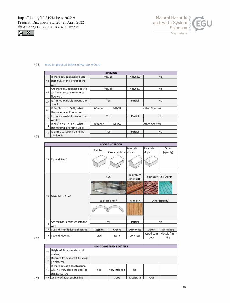
Table 5a: Enhanced MHRA Survey form (Part A) 432
433
434
1 Name of the Surveyor
2 Mobile no. of Surveyor
3 Inspection Data
4 Inspection Time
Rapid Visual Screening (RVS) form
SURVEYOR
5 Name of Building/Owner
6 Address
7 Town/City, District and State
8 Coordinatnates
9Total No. of Building Blocks
present inpremises
10 Name of Block to be survey
11 Draw Sketch of Site Plan
GENERAL INFORMATION
https://doi.org/10.5194/nhess-2022-91Preprint. Discussion started: 26 April 2022c© Author(s) 2022. CC BY 4.0 License.
19
435
Table 5b: Enhanced MHRA Survey form (Part A) 436
437
438
Residential
(Other)
Educational
(School)
Educational
(College)
Lifeline
(Hospital)
Lifeline (Police
Station)
Lifeline (Fire
Station)
Lifeline
(Power
Station)
Lifeline
(Water/
Sewage Plant)
Commercial
(Hotel)
Commencial
(Shopping)
Commercial
(Other)
Mixed Use
(Other)
Industrial
(Other)
13 Occupancy in day time 0 to 10 11 to 50 51 to 100 101 to 1000more than
1000
14 Occupancy in night time 0 to 10 10 to 20 51 to 100 101 to 1000more than
1000
15 Name of Owner
16 Name of Contact Person
17 Contact No. of Contact Person
18 Year of Construction:
19Structural or Construction
drawings available?Yes No
20 Total built up area (sq.m)
21 No. of FloorsLow Rise (1
to 3)
22What is the overall Construction
quality Excellent Good Average Poor Very Poor
23What is the overall
Maintainance StatusExcellent Good Average Poor Very Poor
Industrial (Live Stick)
12 Function of Block
Educational (Institute/ University)
High Rise (7 and above)Mid Rise (4 to 7)
Commercial
(Recreational)
Residential (Appartments)Residential (Individual House)
Office (Govt.) Office (Private)
Mixed Use (Residential and
Commercial)
Mixed Use (Residential
and Induustrial)
Industrial (Agriculture)
24 Seismic Zone Zone V Zone IV Zone III Zone II Don’t know
25Did this area faced any Major
disaster?:Yes No
Earthquake Flood Landslide Wind Industrial
Fire Other
27If Yes in Q.25, in which
date/year
No effectMinimum
Effect
Medium
Effect
29 Is the building Retrofitted/
Renovated ever?Yes No
30If Yes in Q.29, Year of last
renovated?
Maximum Effect
26 If Yes in Q.25, Which Disaster?:If Other,
Specify
28If Yes in Q.25,What is the major
damage status
DISASTER HISTORY
https://doi.org/10.5194/nhess-2022-91Preprint. Discussion started: 26 April 2022c© Author(s) 2022. CC BY 4.0 License.
20
439
440
441
442
443
Table 5c: Enhanced MHRA Survey form (Part A) 444
445
Isolated
Flat Terrain Gentle Slope Steep Slope
RCC
34Is there Visible cracks on the
groundNo
35Is there any open space in the
property?No
36What is the total area of Open
spaces in the campus (in sq.ft) :
32 Slope of Ground:
Terraced land
33 Cut & Fill Material: Hybrid Other
SITE CONDITION
31 Location of Building:
Internal Corner End
Yes, more than 1500 sq.ft Yes, less than 1500 sq.ft
Yes, Many Yes, few
SquareRectangle
(L<=3B)
Narrow
Rectangle
(L>3B)
Rectangle
with
courtyard
L-Shaped
T-Shaped U-Shaped
E-Shaped
with Central
courtyard
H-Shaped Other
BUILDING GEOMETRY
37 Shape of Building Block in Plan:
https://doi.org/10.5194/nhess-2022-91Preprint. Discussion started: 26 April 2022c© Author(s) 2022. CC BY 4.0 License.
21
446
447
448
449
450
451
452
453
Table 5d: Enhanced MHRA Survey form (Part A) 454
Not stepped Stepped near
centre
Stepped near
the end
39 No. of Reentrants corner in Plan
40Is extra strength available in
reentrants corner? Yes No
only G G+1 G+2 G+3 > G+4
38
Shape of building Block in
Elevation: No. of Reentrants
corner in Plan
Heavy upper floor
41 No. of Floors
https://doi.org/10.5194/nhess-2022-91Preprint. Discussion started: 26 April 2022c© Author(s) 2022. CC BY 4.0 License.

22
455
456
457
458
459
Table 5e: Enhanced MHRA Survey form (Part A) 460
RockSoft or
Medium Other
Isolated
Other
FOUNDATION
42 Type of Sub Soil:
Gravel or Sand
43 Type of Foundation: Pile Combined
Strip Raft
Adope Stone Brick RCC Other
Dry Masonry Mud Lime Cement Other
Yes No
Partial
Other
(specify)
49 Depth of ground water table Don't know
47 Sinking in Foundation? Yes No
44Basic Construction material of
Foundation:
45 Mortar Material in Foundation:
46 Plinth beam available?
48If Yes or Partial in Q.47, What is
the Reason for Sinking?
Cause of nearest water
resources
Without any water
resources
https://doi.org/10.5194/nhess-2022-91Preprint. Discussion started: 26 April 2022c© Author(s) 2022. CC BY 4.0 License.
23
461
462
463
464
465
466
Brick Stone Confined RCC Other
Only Column
available &
No Beams
Column &
Beam, both
available
Yes Partial No
Adobe or
Mud Wall
River Boulder
wall
Quarry Stone
wall
Dressed
wall
fired brick
wall
WALL
50 Type of Wall:
51Is through-stone used in Stone
Wall?
52 What is the Wall material?
hollow concrete block wall Other
Dry masonry Mud Lime Cement Other
< 115 mm 115 mm (4.5") 230 mm (9")230 to 450
mm> 450 mm
Length of longest interior wall
(in meter)
Max. Height of the wall (in
meters)
< 115 mm 115 mm 230 mm230 to 450
mm> 450 mm
Length of longest exterior wall
(in meter)
56 Thickness of Mortar (in mm):
57How many Separation of walls
at T and L junction?
Wall Failure type observed: Bulging of
wall
delaminating
of wall
tilting of
walls
dampness
in wall No failure
No. of walls with these failures
53 Type of mortar
54
Thickness of interior Wall (in
mm):
55
Thickness of exterior Wall (in
mm):
58
https://doi.org/10.5194/nhess-2022-91Preprint. Discussion started: 26 April 2022c© Author(s) 2022. CC BY 4.0 License.
24
Table 5f: Enhanced MHRA Survey form (Part A) 467
468
469
470
471
472
473
474
Type of Cracks: N/A
Diagonal
cracks Vertical cracks
Horizontal
Cracks
Specify, No. of Cracks in each
case
Specify, Length of cracks in each
case (in cm)
Grade 5 Grade 4 Grade 3 Grade 2 Grade 1
65 Are there any cracks on Column BeamNear
OpeningsNear corner No cracks
63
Structural cracks Superficial cracks
Note: Superfial cracks are seen
in one side of wall, on the other
hand structural cracks can be
seen on both side of the wall
CRACKS
64
Type of Structural cracks:
Remark
Grade of Cracks
https://doi.org/10.5194/nhess-2022-91Preprint. Discussion started: 26 April 2022c© Author(s) 2022. CC BY 4.0 License.
25
Table 5g: Enhanced MHRA Survey form (Part A) 475
476
477
478
Yes, few
Yes, few
Partial
Wooden MS/SS
Partial
Wooden MS/SS
Partial
68Is frames available around the
door?:
Yes No
OPENING
Are there any opening close to
wall junction or corner or to
floor/roof
67
Yes, all No
69If Yes/Partial in Q.68, What is
the material of Frame used:
other (Specify)
70Is frames available around the
window
Yes No
71If Yes/Partial in Q.70, What is
the material of Frame used:
other (Specify)
72Is Grills available around the
window?:
Yes No
Is there any opening(s) larger
than 50% of the length of the
wall
66
Yes, all No
Flat RoofOne side slope
two side
slope
four side
slope
Other
(specify)
Reinforced
brick slab Tile or slate CGI Sheets
Wooden
Partial
76 Type of Roof failures observed Sagging Cracks Dampness Other No failure
77 Type of Flooring Mud Stone ConcreteWood.bam
boo
Mosaic floor
tile
ROOF AND FLOOR
73 Type of Roof:
74 Material of Roof:
Jack arch roof Other (Specify)
75Are the roof anchored into the
wall
Yes No
RCC
78Height of Structure /Block (in
meters)
79Distance from nearest buildings
(in meters)
80
Is there any adjacent building,
which is very close (no gaps) to
thiS BUILDING
Yes very little gap No
81 Quality of adjacent building Good Moderate Poor
POUNDING EFFECT DETAILS
https://doi.org/10.5194/nhess-2022-91Preprint. Discussion started: 26 April 2022c© Author(s) 2022. CC BY 4.0 License.
26
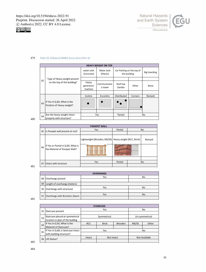
Table 5h: Enhanced MHRA Survey form (Part A) 479
480
481
482
483
484
water tank
(Concrete)
Water tank
(Plastic)Big hoarding
Heavy
generator/
machine
Communicatio
n tower
Roof top
GardenOther None
Centric Eccentric Distributed Corners Remark
Partial
Car Parking on the top of
the building
82Type of Heavy weight present
on the top of the building?
HEAVY WEIGHT ON TOP
83If Yes in Q.82, What is the
Position of Heavy weight?
84Are the heavy weight intact
properly with structure?
Yes No
Partial
Remark
Partial
PARAPET WALL
85 Is Parapet wall present at roofYes No
87 Intact with structureYes No
86If Yes or Partial in Q.85, What is
the Material of Parapet Wall?
Lightweight (Wooden, MS/SS) Heavy weight (RCC, Brick)
89 Length of overhangs (meters)
90 Overhangs with structuralYes No
OVERHANGS
88 Overhangs presentYes No
91 Overhangs with Brackets /beamYes No
RCC Brick Wooden MS/SS Other
Intact
STAIRCASE
92 Staircase presentYes No
96 Lift Status?Not Intact Not Available
94If Yes in Q.92, What is the
Material of Staircase?
95If Yes in Q.68, Is Staircase intact
with building structure?
Yes No
Symmetrical Un-symmetricalStaircase placed at symmetrical
location in plan of the bulding93
https://doi.org/10.5194/nhess-2022-91Preprint. Discussion started: 26 April 2022c© Author(s) 2022. CC BY 4.0 License.

27
Table 5i: Enhanced MHRA Survey form (Part A) 485
486
487
488
489
490
99 Material of Column ConcreteMasonry
(Brick/ Stone)Wood Steel Other
98If yes in Q.97, What is the type
of Column?
Short Column Long Column
COLUMN
97 Column available?Yes No
Partial
Other
Other
ConcreteMasonry
(Brick/ Stone)Wood Steel OtherIf Yes in Q.100., Material of
Beam
Beam -Beam Connection?103
104
BEAM
100 Beam available?Yes No
102If Yes in Q.100., Beam – Column
connections?
101If Yes in Q.100., Beam with infill
walls available?
Yes No
Centric Eccentric
Centric Eccentric
https://doi.org/10.5194/nhess-2022-91Preprint. Discussion started: 26 April 2022c© Author(s) 2022. CC BY 4.0 License.
28
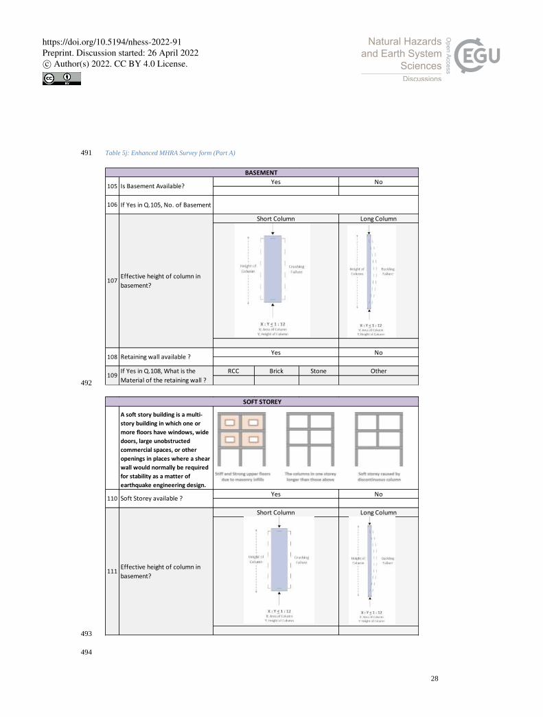
Table 5j: Enhanced MHRA Survey form (Part A) 491
492
493
494
106 If Yes in Q.105, No. of Basement
RCC Brick Stone
BASEMENT
Short Column Long Column
107
Yes No105 Is Basement Available?
Yes No
Effective height of column in
basement?
Retaining wall available ?108
109If Yes in Q.108, What is the
Material of the retaining wall ?
Other
A soft story building is a multi-
story building in which one or
more floors have windows, wide
doors, large unobstructed
commercial spaces, or other
openings in places where a shear
wall would normally be required
for stability as a matter of
earthquake engineering design.
Soft Storey available ?110
111Effective height of column in
basement?
Short Column Long Column
SOFT STOREY
Yes No
https://doi.org/10.5194/nhess-2022-91Preprint. Discussion started: 26 April 2022c© Author(s) 2022. CC BY 4.0 License.
29
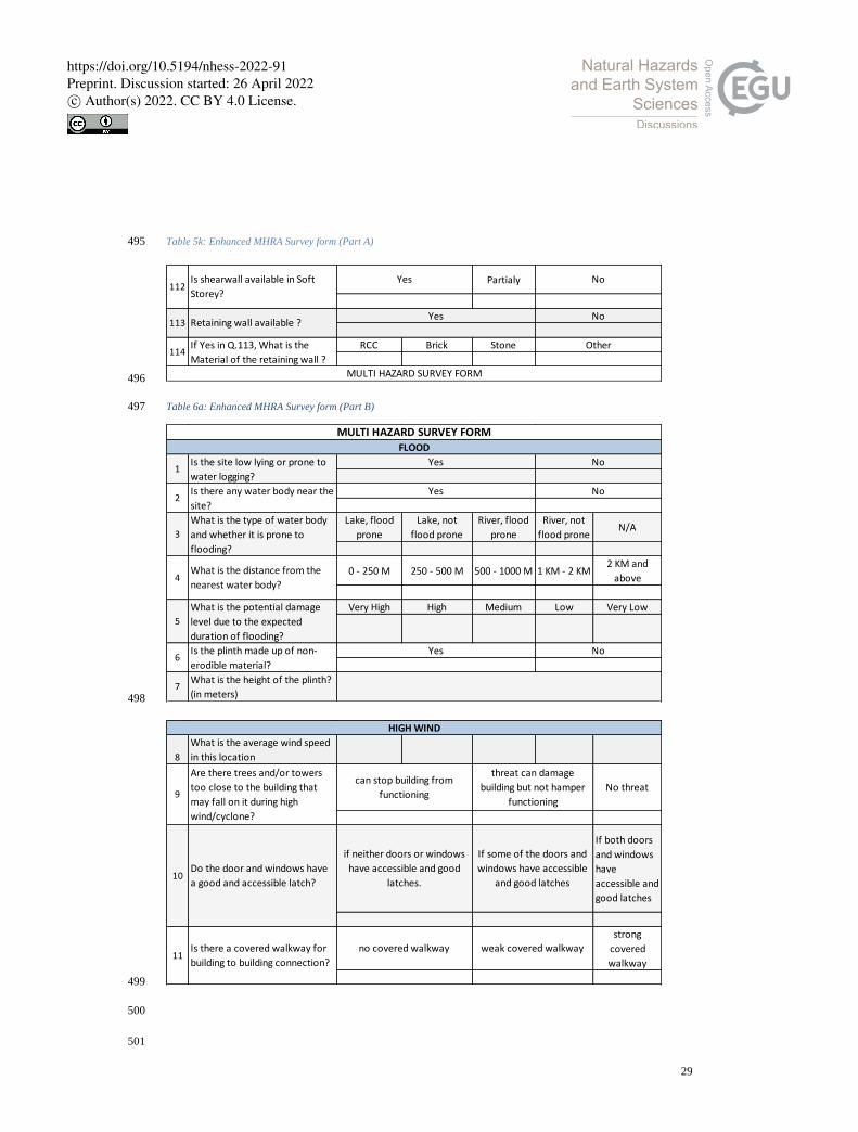
Table 5k: Enhanced MHRA Survey form (Part A) 495
496
Table 6a: Enhanced MHRA Survey form (Part B) 497
498
499
500
501
Partialy
RCC Brick Stone
MULTI HAZARD SURVEY FORM
Retaining wall available ?Yes No
If Yes in Q.113, What is the
Material of the retaining wall ?
Other
113
114
NoYesIs shearwall available in Soft
Storey?112
Lake, flood
prone
Lake, not
flood prone
River, flood
prone
River, not
flood proneN/A
0 - 250 M 250 - 500 M 500 - 1000 M 1 KM - 2 KM2 KM and
above
Very High High Medium Low Very Low
7What is the height of the plinth?
(in meters)
No
FLOOD
1Is the site low lying or prone to
water logging?
Yes No
3
What is the type of water body
and whether it is prone to
flooding?
4What is the distance from the
nearest water body?
5
What is the potential damage
level due to the expected
duration of flooding?
2Is there any water body near the
site?
Yes
6Is the plinth made up of non-
erodible material?
Yes No
MULTI HAZARD SURVEY FORM
8
What is the average wind speed
in this location
No threat
If both doors
and windows
have
accessible and
good latches
strong
covered
walkway
HIGH WIND
9
Are there trees and/or towers
too close to the building that
may fall on it during high
wind/cyclone?
can stop building from
functioning
threat can damage
building but not hamper
functioning
11Is there a covered walkway for
building to building connection?
no covered walkway weak covered walkway
10Do the door and windows have
a good and accessible latch?
if neither doors or windows
have accessible and good
latches.
If some of the doors and
windows have accessible
and good latches
https://doi.org/10.5194/nhess-2022-91Preprint. Discussion started: 26 April 2022c© Author(s) 2022. CC BY 4.0 License.
30
Table 6a: Enhanced MHRA Survey form (Part B) 502
503
504
505
506
Less Than 30
M30 M - 100 M 100 - 250 M 250 - 500 M
More than
500 M13
If Yes in Q.12, what is the
distance of the base off the Hill
from building?
14Is the slope near the building
stabilized?
Yes No
LANDSLIDE
12
Is there any hills near to the
building, which can cause
damage due to landslide
Yes No
16 Are there barriers to rockfall ?Yes No
15
Are there any large rocks or
potential falling hazards near
the building?
Yes No
0 - 100 M 100 - 250 M 250 - 500 M500 - 1000
M
More than 1
km
0 - 100 M 100 - 250 M 250 - 500 M500 - 1000
M
More than 1
km
18If Yes in Q.17, how many active
industries are there?
Yes No
INDUSTRY
17
Is there any industry near to the
building, which can cause
damage due to industrial hazard,
fire etc.
Yes No
19What is the distance of nearest
Industry from building?
20What is the distance of nearest
Petrol Pump from building?
No access
road
enough space
FIRE
21
Are the access roads from main
street wide enough to allow one
fire engine to reach, reverse and
return to the main road?
two or more such access
roadsone such access road
22
Are there potential fire threats
within 30 meters of the building
such as petrol pump, electrical
substation, combustible
materials store, etc.?
Yes No
24
Is main meter box and switch
box located in the staircase/
entrance lobby/ passage/
corridor?
Yes No
23
Is there adequate open
assembly area for people during
any emergency?
inadequate open space (1-4
square feet per student)negligible
https://doi.org/10.5194/nhess-2022-91Preprint. Discussion started: 26 April 2022c© Author(s) 2022. CC BY 4.0 License.
31
Table 6b: Enhanced MHRA Survey form (Part B) 507
508
509
510
511
512
513
514
515
Yes, beyond
50 m
Yes, within 20-
50 m
Yes, within
10-20 madjacent
Kitchen Not
Available
100% - Fire
extinguisher
in each floor
of each block
75% - Fire
extinguisher in
3/4th
of all
floors
50% - Fire
extinguisher
in half of all
floors
25% - Fire
extinguisher
in 1/4th
of
all floors
0% - No
Equipment
26
Is there more than 1 staircase
which can be used as a fire
escape staircase ideally at
maximum distance from the
other staircase?
Yes No
25
Are the main meter box and
switch box enclosed in a
metallic box?
Yes No
28
Is the kitchen located at a safe
distance from classrooms,
staircase, passage corridor?
29Is the ceiling material safe from
fire?
Yes No
27
In case of Public building or Life
line building, Are there proper
signages in the campus for
Emergency Exit, Fire equipment
etc.?
Yes No
30What is the status of fire safety
equipment in the building?
34What is the distance of the tree
line from the building?
32
Are there overhead cables
running through or near
premises/building?
Yes No
31
Is the transformer too close to
the compound wall or inside the
building?
Yes No
35
Is there any combustible
construction material present in
the building?
Yes No
33If there is a forest area near the
building?
Yes No
https://doi.org/10.5194/nhess-2022-91Preprint. Discussion started: 26 April 2022c© Author(s) 2022. CC BY 4.0 License.
32
Table 6c: Enhanced MHRA Survey form (Part B) 516
517
518
Very Likely Likely Neutral Unlikely Very Unlikely
Climate
change/Global
Warming
PovertyOver-
population
Un-
employmentCrime
Infectious
Diseases
Economic
Situation
Unplanned
Infrastructure
Deforestatio
nAir pollution
Water
pollution
Tourism
growth
Poor Waste
Management
Extinction of
speciesTraffic
Human
ActivitiesNatural Causes No Change Don't know Other
Deforestation OverpopulationTourist
growth
Landuse
Landcover
Greenhouse
gases
Industrilizatio
nMelting of Ice
Warming of
water surfaceOther Don’t know
How much do you think the
following has contributed to
global climate change? (on scale
of 10, more marks to most
contributer)
39
CLIMATE CHANGE
How much do you think climate
change threatens your personal 36
In your opinion, What is the
reason that the temperature on
earth has been rising over the
past decade?
38
Which issues are of more
concern in your opinion? (On the
scale of 10, more marks to most
concerned)
37
ElementNeed
AttentionNumber Element
Need
AttentionNumber
FanWooden Frame at
Roof
Tubelight Door
Electrical Wires Window Frames
ACHeavy
Machinaries
Open Shelve (Glass)Cylinder in Open
space
Open Shelve (Iron) Board
Wardrobe (Wooden) Ventilator
Wardrobe (Iron) Fire Extinguisher
HeavyTable Cantilever
Chimneys
Heavy FramesCantilever
Balconies
Heavy FurnituresCantilever
Sunshades
Heavy weight on top of
almirah Other
2 No. of Exits in the Room:
Non Structural Risk/ Falling Hazard
1
List of Nonstructural
elements which are
vulnerable to falling or
not attached properly
3
What is the status of
Electrical Safety in the
Room
GOOD OK POOR
https://doi.org/10.5194/nhess-2022-91Preprint. Discussion started: 26 April 2022c© Author(s) 2022. CC BY 4.0 License.
33
519
4.4 Risk Score Computation 520
After all the parametric studies from various Indian Standard codes and Report (NDMA, 2020), (URDPFI, 2015) 521
(IS-code13828, 1993; IS-code4326, 1993; IS-code1893-1, 2002; IS-code13935, 2009) on ideal building 522
parameters and weak components of a building from designing, construction, site condition, surrounding 523
condition, location and hazard etc. point of views, risk scores were decided on an average basis for better judgment 524
and understanding. Risk scores were derived from the enhanced survey form by appropriately weighing the data 525
points against a risk number chart with higher weightage given to higher risk (Chouhan, Narang and Mukherjee, 526
2022). The data was then aggregated on a scale of ten (table 8). For example, if a building answers all weighted 527
MCQs with the highest risk option, it will be scored 10/10. All questions in the questionnaire were not weighted; 528
those with ambiguous risk consequences were left un-weighted to be studied objectively. The risk scores intend 529
to give a relative idea of where the risk lies within a building and among building to enable prioritization during 530
risk mitigation planning. 531
Table 7: Risk Score Computation, Source adapted from (Chouhan, Narang and Mukherjee, 2022) 532
533
5 Discussion: 534
5.1 Pilot Survey Results 535
The IHR requires effective and standardised Multi-Hazard Risk Assessment, and for that purpose a customized 536
designed Survey Form has been designed to capture the unique characteristics of hill communities and assets. The 537
enhanced form performed reasonably well. Effectiveness & data collection is comfortable from both ends i.e. 538
Respondents & Surveyor. The questions are properly framed in various sections, the language is simple and it is 539
easy to interpret. The pictorial explanation makes it easy for surveyors to correct input data, as its explanation is 540
self-explanatory. The objective behind the data collection is well clear to the Respondents and Surveyor. 541
5.2 Key features of the enhanced MHRA survey form 542
The key features of the proposed form are it is specially designed for data collection in the Indian Himalayan 543
region with risk of Earthquake, Flood, Wind, Industrial, Non-Structural Risk., fire etc. It is very useful for any 544
type of study related to Hazard Risk assessment in hills. Time taken to complete the questionnaire, i.e. the length 545
of the questionnaire is good enough i.e. 10 minutes for the trained civil engineer and 17 minutes for the trained 546
non-engineering background surveyor. With practice, the surveyor can reduce time. The language of the form is 547
simple and specific, i.e. One answer on one dimension is required, it considers all possible contingencies when 548
determining a response, It is designed in a way that it collects more & more accurate information in less time. 549
Questionnaires permit the collection and analysis of quantitative data in a standardized manner, ensuring their 550
internal consistency and coherence. The question sequence is clear and smooth moving. By sequencing questions 551
https://doi.org/10.5194/nhess-2022-91Preprint. Discussion started: 26 April 2022c© Author(s) 2022. CC BY 4.0 License.
34
properly, the chances of misinterpreting individual questions are greatly reduced. The pictorial options make it 552
comfortable for the surveyor to fill the answer by looking at the building. 553
The survey form is divided into sections so that only one thought can be conveyed at a time. It is the advanced 554
version of RVS that covers risk status for foundation, wall, roof, openings, beam, column, site conditions, etc. of 555
a building. It is covering all the points required for building analysis in RVS. It covers questions related to all 556
identified hazards that are directly indirectly contributing to risk factors. It covers all the required Questions as 557
per hill condition, situation, climate, geography, construction practices, construction materials, etc. The format, 558
including the font and layout, is good enough to read by the surveyor. Before going into the field, the surveyor 559
must require a reading of the full survey form carefully with all terminologies clear. It covers the non-structural 560
risk survey form. The safety of occupants in a building following an incident can be at risk due to reduced capacity 561
of structural components or damage to non-structural components. 562
6 Conclusion 563
The Indian Himalayan region is facing disaster every year with significant loss of life and property, as it is very 564
prone to multi-hazards. Thousands of studies, research, and projects are funded nationally and internationally to 565
minimize the loss and prepare the community to face the upcoming disaster. Indian Himalayan Region is also the 566
point of attraction for tourists and pilgrims globally, and tourism plays an imperative role in enhancing the 567
economy of the state. Thus, safety is the immense need of the government at various levels. 568
The enhanced survey form designed and tested under this study will help all the stakeholders to collect better 569
information from the field. This form will also identify the weak components of a building, construction practices, 570
their development trend, and vulnerable location, so that future construction can be planned, considering the risk 571
factors and vulnerable zones. Most of the assessment criteria for multi-hazard risks are met by the proposed 572
survey. The more accurate the data, the better will be its results. 573
A questionnaire is the backbone for any survey, which is the base for all types of research work for better accuracy. 574
This article describes why there is a need for a hill-specific survey form that focuses on the multi-hazards in hills 575
and hill’s existing scenarios. It then described the steps of how a Hill-specific Multi-Hazard Risk Assessment 576
Survey form was developed, validated, and tailored specifically for hill communities. 577
The pilot survey conducted at Chinyalisaur validates the questionnaire and survey form, and provided invaluable 578
feedback now incorporated in to the final survey form design. 579
The proposed form is a self-explanatory, pictorial, and enhanced version of the standard RVS format, and it 580
addresses several hazards such as earthquakes, floods, landslides, industrial fires, and forest fires. 581
The suggested form is an enhanced version of Rapid Visual Screening (RVS), which can assess the risk of any 582
structure and includes all structural and non-structural components that respond during a seismic event. It also 583
includes information about the building's sensitivity to possible danger zones such as landslides, floods, wind, and 584
industrial hazards. Research is being undertaken to develop more accurate hill-specific risk assessment survey 585
form that requires less time, marginal effort. identify deficiencies and, most important suggest a site-specific 586
Multi-Hazard Survey form for hills. 587
https://doi.org/10.5194/nhess-2022-91Preprint. Discussion started: 26 April 2022c© Author(s) 2022. CC BY 4.0 License.
35
The data collected using this form can be used in any study related to Multi-Hazard Risk Assessment. It can be 588
used by civil engineers as well as non-civil engineering background people. People can self-assess their building. 589
To do this effectively, it is crucial to reinforce the networks of science, technology, and decision-makers and 590
create a sustainable technological outcome for disaster risk reduction. 591
Acknowledgment 592
This research was supported by National Mission for Himalayan Studies (NMHS), Project Grant No. 593
NMH_1334_DMC and CoPREPARE, Project Grant no. IGP2020-24/COPREPARE – funded by UGC. We are 594
indebted to the local residents who actively participated in the household survey. The authors are grateful to Mr. 595
Tom Burkitt, from DHI, for supporting editorial and proofreading. 596
Data availability Statement 597
This article is part of doctoral research and the data collection has been done by the first author physically on-site. 598
The data is available from the authors on the request basis. 599
Disclosure statement 600
No potential conflict of interest was reported by the authors. 601
References 602
Aksha, S. K. et al. (2020) ‘A geospatial analysis of multi-hazard risk in’, Geomatics, Natural Hazards and Risk. 603
Taylor & Francis, 11(1), pp. 88–111. doi: 10.1080/19475705.2019.1710580. 604
Arya, A. S. (2006a) Rapid Visual Screening of RCC Buildings. Available at: 605
https://nidm.gov.in/PDF/safety/earthquake/link11.pdf. 606
Arya, A. S. (2006b) ‘Rapid Visual Svreening of Masonry Buildings’, GOI – UNDP Disaster Risk Management 607
Programme, 13935(June), pp. 17–41. Available at: https://nidm.gov.in/PDF/safety/earthquake/link11.pdf. 608
Bilham, R. and Laituri, M. (2003) ‘Earthquake Loss Estimation for India Based on Macroeconomic Indicators’, 609
(April 2016). doi: 10.1007/978-94-010-0167-0. 610
BMTPC (2019) Vulnerability Atlas of India Vulnerability Atlas of India. 3rd edn. Available at: 611
https://bmtpc.org/DataFiles/CMS/file/Publication/VAI_3rd2019.pdf. 612
Buck, K. D. and Summers, J. K. (2020) ‘Application of a multi-hazard risk assessment for local planning local 613
planning’, Geomatics, Natural Hazards and Risk. Taylor & Francis, 11(1), pp. 2058–2078. doi: 614
10.1080/19475705.2020.1828190. 615
Chandel, V. B. S. and Brar, K. K. (2010) ‘Seismicity and vulnerability in Himalayas : the case of Himachal 616
Pradesh , India’, Geomatics, Natural Hazards and Risk, 5705. doi: 10.1080/19475701003643441. 617
Chouhan, S., Narang, A. and Mukherjee, M. (2022) ‘Multihazard risk assessment of educational institutes of’, 618
https://doi.org/10.5194/nhess-2022-91Preprint. Discussion started: 26 April 2022c© Author(s) 2022. CC BY 4.0 License.
36
International Journal of Disaster Resilience in the Built Environment. doi: 10.1108/IJDRBE-08-2021-0091. 619
Dharmadhikary (2008) Mountains of Concrete : Dam Building in the Himalayas. Available at: 620
https://archive.internationalrivers.org/sites/default/files/attached-files/ir_himalayas_rev.pdf. 621
FEMA (2015) Rapid Visual Screening of Buildings for Potential Seismic Hazards: A Handbook. Available at: 622
https://www.fema.gov/sites/default/files/2020-07/fema_earthquakes_rapid-visual-screening-of-buildings-for-623
potential-seismic-hazards-a-handbook-third-edition-fema-p-154.pdf. 624
Gerlitz, J. et al. (2016) ‘The Multidimensional Livelihood Vulnerability Index – an instrument to measure 625
livelihood vulnerability to change in the Hindu Kush Himalayas’, Climate and Development, 9 (2)(March), pp. 626
124–140. doi: 10.1080/17565529.2016.1145099. 627
Goodrich, C. G., Prakash, A. and Udas, P. B. (2019) ‘Gendered vulnerability and adaptation in Hindu-Kush 628
Himalayas: Research insights’, Environmental Development. Elsevier Ltd, 31(January), pp. 1–8. doi: 629
10.1016/j.envdev.2019.01.001. 630
Hackl, J., Adey, B. T. and Heitzler, M. (2015) ‘An Overarching Risk Assessment Process to Evaluate the Risks 631
Associated with Infrastructure Networks due to Natural Hazards’, International Journal for Performability 632
Engineering, 11(2), pp. 153–168. doi: 10.23940/ijpe.15.2.p153.mag. 633
IS-code13828 (1993) Indian Standard IMPROVING EARTHQUAKE RESISTANCE OF LOW STRENGTH 634
MASONRY BUILDINGS — GUIDELINES. Available at: 635
https://law.resource.org/pub/in/bis/S03/is.13828.1993.pdf. 636
IS-code13935 (2009) Indian Standard SEISMIC EVALUATION, REPAIR AND STRENGTHENING OF 637
MASONRY BUILDINGS — GUIDELINES ( First Revision ). Available at: 638
https://law.resource.org/pub/in/bis/S03/is.13935.2009.pdf. 639
IS-code1893-1 (2002) Indian Standard CRITERIA FOR EARTHQUAKE RESISTANT DESIGN OF 640
STRUCTURES PART 1 GENERAL PROVISIONS AND BUILDINGS ( Ffth Revision ). Available at: 641
https://law.resource.org/pub/in/bis/S03/is.1893.1.2002.pdf. 642
IS-code4326 (1993) Indian Standard EARTHQUAKE RESISTANT DESIGN AND CONSTRUCTION OF 643
BUILDINGS - CODE OF PRACTICE ( Second Revision). Available at: https://civil.sairam.edu.in/wp-644
content/uploads/sites/4/2019/06/IS.4326.1993.pdf. 645
Kala, C. P. (2014) ‘International Journal of Disaster Risk Reduction Deluge , disaster and development in 646
Uttarakhand Himalayan region of India : Challenges and lessons for disaster management’, International Journal 647
of Disaster Risk Reduction. Elsevier, 8, pp. 143–152. doi: 10.1016/j.ijdrr.2014.03.002. 648
Mahesh R. Gautam, Govinda R. Timilsina, K. A. (2013) Climate Change in the Himalayas Current State of 649
Knowledge. Available at: https://papers.ssrn.com/sol3/papers.cfm?abstract_id=2286555. 650
Ministry of Home Affairs, G. (2011) DISASTER MANAGEMENT Ministry of Home Affairs. Available at: 651
https://doi.org/10.5194/nhess-2022-91Preprint. Discussion started: 26 April 2022c© Author(s) 2022. CC BY 4.0 License.
37
https://www.undp.org/content/dam/india/docs/disaster_management_in_india.pdf. 652
Mohammad Imran Siddique, Jayesh Desai, Himanshu Kulkarni, K. M. (2019) Comprehensive report on Springs 653
in the Indian Himalayan Region. doi: 10.13140/RG.2.2.12104.06408. 654
Mouri, G. et al. (2013) ‘International Journal of Disaster Risk Reduction Probability assessment of flood and 655
sediment disasters in Japan using the Total Runoff-Integrating Pathways model’, International Journal of Disaster 656
Risk Reduction. Elsevier, 3, pp. 31–43. doi: 10.1016/j.ijdrr.2012.11.003. 657
NDMA (2020) A Primer on Rapid Visual Screening (RVS) Consolidating Earthquake Safety Assessment Efforts 658
in India. Available at: https://ndma.gov.in/sites/default/files/PDF/Technical Documents/RVS-Doc-11-2020.pdf. 659
NITI Aayog (2018) Report of Working Group II Sustainable Tourism in the Indian Himalayan Region. Available 660
at: https://www.niti.gov.in/writereaddata/files/document_publication/Doc2.pdf. 661
Parajuli, A. et al. (2020) ‘Forest fire risk mapping using GIS and remote sensing in two major landscapes of 662
Nepal’, Geomatics, Natural Hazards and Risk. Taylor & Francis, 11(1), pp. 2569–2586. doi: 663
10.1080/19475705.2020.1853251. 664
Pathak, R. et al. (2019) ‘Alien plant invasion in the Indian Himalayan Region : state of knowledge and research 665
priorities’, Biodiversity and Conservation. Springer Netherlands, (0123456789). doi: 10.1007/s10531-019-01829-666
1. 667
Peiris, T. A. (2015) Data collection for “ Flood Risk Assessment for Dungsum Chu Basin in Samdrup Jonkhar ”, 668
CTCN and AIT. Available at: https://www.ctc-669
n.org/system/files/dossier/3b/ctcn_bhutan_data_collection_report.pdf. 670
Pradesh, H., Pradeep, R. and Anoop, K. (2016) ‘Rapid visual screening of different housing typologies’, Natural 671
Hazards. Springer Netherlands. doi: 10.1007/s11069-016-2668-3. 672
Ravi Sinha, A. G. (2001) A National Policy for Seismic Vulnerability Assessment of Buildings and Procedure for 673
Rapid Visual Screening of Buildings for Potential Seismic Vulnerability. Available at: 674
https://www.civil.iitb.ac.in/~rsinha/Vulnerability_Assessment.pdf. 675
Rehman, A. et al. (2022) ‘Multi-Hazard Susceptibility Assessment Using the Analytical Hierarchy Process and 676
Frequency Ratio Techniques in the Northwest Himalayas , Pakistan’, Remote Sens, 14(3), pp. 1–31. doi: 677
https://doi.org/10.3390/rs14030554. 678
Roopa, S. and Rani, M. (2012) ‘Questionnaire Designing for a Survey’, Journal of Indian Orthodontic Society, 679
46(4_suppl1), pp. 273–277. doi: 10.1177/0974909820120509s. 680
Sarkar, S., Kanungo, D. P. and Sharma, S. (2015) ‘Landslide hazard assessment in the upper Alaknanda valley of 681
Indian Himalayas’, Geomatics, Natural Hazards and Risk. Taylor & Francis, 6(4), pp. 308–325. doi: 682
10.1080/19475705.2013.847501. 683
Sekhri, S. et al. (2020a) ‘Mountain speci fi c multi-hazard risk management framework ( MSMRMF ): Assessment 684
https://doi.org/10.5194/nhess-2022-91Preprint. Discussion started: 26 April 2022c© Author(s) 2022. CC BY 4.0 License.
38
and mitigation of multi-hazard and climate change risk in the Indian Himalayan Region’, Ecological Indicators. 685
Elsevier, 118(July), p. 106700. doi: 10.1016/j.ecolind.2020.106700. 686
Sekhri, S. et al. (2020b) ‘Mountain specific multi-hazard risk management framework (MSMRMF): Assessment 687
and mitigation of multi-hazard and climate change risk in the Indian Himalayan Region’, Ecological Indicators. 688
Elsevier, 118(April), p. 106700. doi: 10.1016/j.ecolind.2020.106700. 689
Simon Allen, M. A. (2015) ‘Lake outburst and debris flow disaster at Kedarnath , June 2013 : hydrometeorological 690
triggering and topographic predisposition Lake outburst and debris flow disaster at Kedarnath , June 2013 : 691
hydrometeorological triggering and topographic predisposition’, Landslides, 13(6). doi: 10.1007/s10346-015-692
0584-3. 693
Singh, A., Kanungo, D. P. and Pal, S. (2019) ‘Physical vulnerability assessment of buildings exposed to landslides 694
in India’, Natural Hazards. Springer Netherlands, 96(2), pp. 753–790. doi: 10.1007/s11069-018-03568-y. 695
Singh, J. S. (2005) ‘Sustainable development of the Indian Himalayan region: Linking ecological and economic 696
concerns’, Current Science, 90(6), pp. 784–788. 697
Srivastava, H. N. et al. (2015) ‘Discriminatory characteristics of seismic gaps in Himalaya’, Geomatics, Natural 698
Hazards and Risk. Taylor & Francis, 6(3), pp. 224–242. doi: 10.1080/19475705.2013.839483. 699
Srivastava, V., Srivastava, H. B. and Lakhera, R. C. (2010) ‘Fuzzy gamma based geomatic modelling for landslide 700
hazard susceptibility in a part of Tons river valley , northwest Himalaya , India’, Geomatics, Natural Hazards and 701
Risk, 5705. doi: 10.1080/19475705.2010.490103. 702
Sudhir K Jain, Keya Mitra, Manish Kumar, M. S. (2010) ‘A rapid visual seismic assessment procedure for RC 703
frame buildings in India’, in 9th U.S. National and 10th Canadian Conference on Earthquake Engineering. doi: 704
10.13140/2.1.2285.0884. 705
Sv, S. S. et al. (2017) ‘Extraction of detailed level flood hazard zones using multi-temporal historical satellite 706
data-sets – a case study of Kopili River Basin , Assam , India’, Geomatics, Natural Hazards and Risk. Taylor & 707
Francis, 5705. doi: 10.1080/19475705.2016.1265014. 708
URDPFI (2015) Urban and Regional Development Plans formulation and implementation (URDPFI) Guidelines. 709
Available at: https://mohua.gov.in/upload/uploadfiles/files/URDPFI Guidelines Vol I.pdf. 710
Vaidya, R. A. et al. (2019) Disaster Risk Reduction and Building Resilience in the Hindu Kush Himalaya. Springer 711
International Publishing. doi: 10.1007/978-3-319-92288-1. 712
713
https://doi.org/10.5194/nhess-2022-91Preprint. Discussion started: 26 April 2022c© Author(s) 2022. CC BY 4.0 License.


