Embed Size (px)
Citation preview

1
From Ocean Sensors to Traceable Knowledge by
Harmonizing Ocean Observing Systems
Joaquín del Rio i and Eric Delory
ii
Society is requesting more than ever being better informed on the state and effects of
Earth’s changing oceans. This has direct implications on ocean observing systems,
including scientific planning and technology. For instance better knowledge implies that
data on health, climate and overall dynamics of our oceans have a known level of
quality, be up-to-date, be easily discoverable, be easily searchable both in time and
space, and be human- and machine-readable in order to generate faster decisions when
and where needed. Requirements with respect to spatial regions and scales (seas and
ocean basins, from millimeters to hundreds of kilometers), time scope and scales (past,
present, future, from microseconds to decades) indeed have direct implications on
observing systems' spatio-temporal sampling capabilities. Possibly high spatial and
temporal resolution also means unprecedented amounts of data, communication
bandwidth and processing power needs. Technological implications are thus quite
substantial and in this short article we will try to provide a review of some initiatives of
global and local focus that are aiming to respond to at least some of these needs, starting
with the application of the Global Earth Observation System of Systems (GEOSS)
guidelines to ocean observatories. Then we will address real scenarios in real ocean
observing facilities, first with the European Seas Observatory Network and the
European Multidisciplinary Seafloor Observation(ESONET-EMSO), then two recently
associated Spanish initiatives, the Oceanic Platform of the Canary Islands (PLOCAN)
infrastructure and deep sea observatory in the Canary Islands, and the Expandable
Seafloor Observatory (OBSEA) shallow water Western-Mediterranean observatory of
the Technical University of Catalonia, one of the first real-time ocean observatories
implemented with state-of- the-art interoperable concepts, down to the sensor interface.
Instant Knowledge through GEOSSFrom a user’s perspective, the apparent ease of
downloading satellite images from the internet hides the daunting reality that it remains
very difficult for society at large, i.e. from individuals to intergovernmental
organizations, to obtain an answer to apparently simple questions such as: Is there a
toxic algal bloom nearing our aquaculture farms? Has ocean temperature rise had a
consequence on sea-level in my region in the last couple of years? In seismogenic areas
these questions may take more critical tone: Are there sensors monitoring possible
landslides on our shore and, if so, do they connect to an operational (read: useful) alert
system? Will I be warned in due time in case of an abnormal tidal wave? Can we
identify trends and predict climate critical inflection points, thresholds and
discontinuities with sufficient reliability to make predictions worthy of trust? These
issues are the whole point of the definition of the so-called GEOSS societal benefit
areas (SBAs). As a matter of fact, ecosystems, biodiversity, disasters, health, water,

2
energy and agriculture (also think aquaculture in our context), climate, and weather are
the nine SBAs in GEOSS and all are reflected in ocean science and are being
investigated via ocean observing systems in many places and continuously. The success
of building and operating the GEOSS will consequently and largely also depend on
efficient knowledge delivery of ocean observing systems.
Better Information: GEOSS and Data Quality
The GEOSS is tasked with providing guidelines on quality assurance/quality control.
Thus, the GCI IOC (GEOSS Common Infrastructure Initial Operating Capability) task
force has released a provisional set of requirements for GEOSS registered components
and services (also currently categorized as best-practice) among which content quality
management is required under the form of documentation, that will be provided by the
service provider. Herein, “identification of the quality of registry content should be
addressed and published by each GCI component operator” and “Each GCI registry
offer shall document its operational plan to declare the level of expected information
content quality and to monitor, manage, and assure the quality of such content on a
specified basis. Plan shall identify the responsible parties required for content
management.” Also note worthy, the component will demonstrate the overall quality of
service in GEOSS. Accuracy assessment and reporting of measurements uncertainty is
essential to assure data products consistency and interoperability, implying that the
instrument calibration and product validation need to be continuously monitored and
traceable to standards [1]. In ocean observatories, bio-fouling and sediment are the
prevailing factors that degrade and limit data quality. This is particularly true in
conductivity/temperature/depth, chlorophyll, dissolved oxygen, and turbidity sensors. In
[1] many generic quality assurance requirements are highlighted, among which, the
necessary provision of instrument characteristics and associated performance
descriptions in common formats for all sensors and across all observatories. In the
following we will show two standards able to encode such metadata and currently under
test.
How Does This Translate into Facts ?
A first step lies in adding the necessary connectivity and intelligence that will provide
easy access to high quality data rapidly, that to some extent a computer can process
without the intervention of a human operator. In this short article we will show how
ESONET-EMSO and two associated initiatives in Spain are planning or already
implementing the necessary technology, in situ.
ESONET-EMSO and the GEOSS

3
The European Seas Observatory Network (ESONET), a future component of and the
European deep-sea contribution to the GEOSS, integrates all European deep-sea
observatories under a common objective, i.e. the interconnection, standardization and
interoperability of current and future infrastructures that produce ocean data collected
from the seabed. ESONET-EMSO is one of the many large scale ocean observing
initiatives taking place around the globe, such as Dense Oceanfloor Network system for
Earthquakes and Tsunamies (Japan), NEPTUNE (Canada), and the Consortium for
Océan Leadership (USA).
Proposed Recommendations for the Registration of ESONET-EMSO in GEOSS
Considering the different states of progress and the overall distributed and
heterogeneous nature of ESONET-EMSO physical and virtual infrastructures, a
coherent registration of ESONET-EMSO within GEOSS can be approached through
surprisingly simple procedures considering the complexity of the system. Those can be
summarized as follows:
A first recommendation is that in ESONET-EMSO we identify which
observatories are ready today to offer a data access service as well as the
standards these services are based on. If services are not implementing a GEOSS
standard, the method utilized in the encoding of data shall be registered as
special arrangement
In an initial period, to accelerate the registration of current operational resources,
registered services can be owned and administrated by the regional observatory
owner, which means that each service will come up with its own URL and
service description with direct connection to the observatory cyber-
infrastructure. This registration will have to be accepted by ESONET-EMSO
Steering Committee which verifies compliance with the ESONET Label.
When ESONET-EMSO is ready to act as a service provider for all registered
services, URLs will be updated accordingly on the GEOSS component and
services registry. This will imply that the ESONET-EMSO clearinghouse takes
charge of the registration process for new services from then on. These URLs
will transparently redirect to the regional observatory services URLs. This will
insure that the user accessing these services can maintain their connection active
independently of a change in the regional URLs as they will be updated by the
regional observatory on the ESONET-EMSO clearinghouse service registry
ESONET-EMSO shall eventually be, as a component, the registrar of these
services for which there shall be a single point of contact

4
ESONET-EMSO will create a registry along with a registration interface where
all regional services will be registered so as to enable ESONET-EMSO to keep
the GEOSS service registry updated
ESONET-EMSO acting as a clearinghouse implies that regional services be
tested by expert users prior to registering these services on the GEOSS service
registry
Service operation shall be insured by the regional observatory, which will
inform the ESONET-EMSO clearinghouse on disconnection, failures, and
maintenance activities for that service. ESONET-EMSO will update the GEOSS
registry accordingly
ESONET-EMSO will be able to provide its own services as integrated
structure of regional observatories' services. These, for example, could be
services integrating data from different regional observatories. (These could be
called ESONET-EMSO integrated services)
ESONET-EMSO will encourage the use of a reduced set of standards and
will explicitly validate specific standard proposed by a particular regional
observatory.
For specific information on data interoperability, INSPIRE provides
implementing rules and metadata requirements which closely reflect GEOSS
guidelines, beside the resulting European directive which should guarantee its
progressive implementation. We will now describe the implementation plans
that will be pursued in PLOCAN and OBSEA, for which some of these
principles are already in operation. These two observatories will provide data
services compliant with the GEOSS guidelines, starting with interoperability
concepts right from the sensor. Thus in the following, sensor interoperability and
how it serves better data products is the main focus.
The PLOCAN Observatory infrastructure interoperability plans
The PLOCAN observatory is composed of: 1.- a coastal node (Fig. 1), supported by
two stations, located at 50 to 100m and 1500 to 2000m (cabled station) depth
respectively and 2.- a regional node, which is an extension of the recently upgraded
ESTOC station. These two nodes respond to a comprehensive series of scientific needs,
in the region and for the Atlantic Ocean at large, providing unprecedented
spatiotemporal sampling possibilities. Main scientific interests in this respect are the
continuous and real-time monitoring of global change and ocean acidification, water-
column and deep-sea ecosystems, ocean biogeochemistry and geophysics. PLOCAN’s
cyber infrastructure will respond to the above guidelines for interoperability: this will be
achieved at software level, implementing global data sharing principles in conformance
5
with the INSPIRE directive (see above) and open standards. At hardware level most of
the instrumentation is planned to follow the recommendations of ESONET-EMSO, thus
ensuring technological integration at European level (i.e. standard scientific package,
easy instrument development, exchange, testing, shared use of deployed resources and
deployment procedures). Physical or virtual standard interfaces will be used for
observatory sensors and systems interconnection, focusing on interoperability with
regard to sensor metadata and physical connection. Time synchronization will be
achieved across sensor platforms through the implementation of standard timing
protocols (PTP being a candidate, see OBSEA section below), in agreement with time
precision requirements in fields like seismic and acoustics. Generally, the PLOCAN
observatory nodes and sensor packages will seek progressive compliance and
harmonization with current practices in ocean and earth observation systems. This will
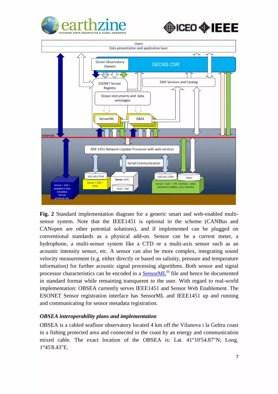
be achieved by implementing similar concepts as those described in Fig. 2.
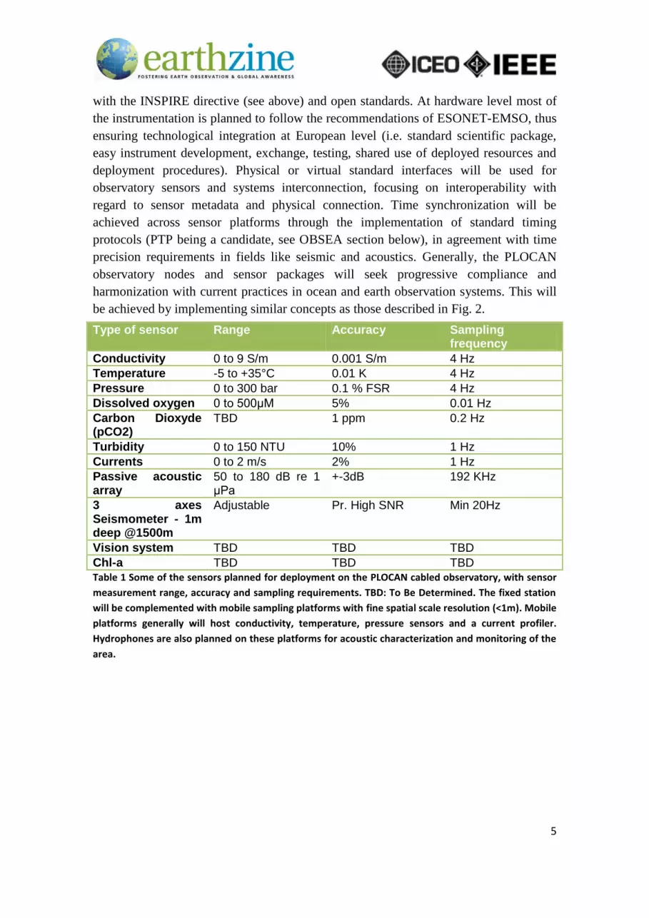
Type of sensor Range Accuracy Sampling frequency
Conductivity 0 to 9 S/m 0.001 S/m 4 Hz
Temperature -5 to +35°C 0.01 K 4 Hz
Pressure 0 to 300 bar 0.1 % FSR 4 Hz
Dissolved oxygen 0 to 500μM 5% 0.01 Hz
Carbon Dioxyde (pCO2)
TBD 1 ppm 0.2 Hz
Turbidity 0 to 150 NTU 10% 1 Hz
Currents 0 to 2 m/s 2% 1 Hz
Passive acoustic array
50 to 180 dB re 1 μPa
+-3dB 192 KHz
3 axes Seismometer - 1m deep @1500m
Adjustable Pr. High SNR Min 20Hz
Vision system TBD TBD TBD
Chl-a TBD TBD TBD Table 1 Some of the sensors planned for deployment on the PLOCAN cabled observatory, with sensor
measurement range, accuracy and sampling requirements. TBD: To Be Determined. The fixed station
will be complemented with mobile sampling platforms with fine spatial scale resolution (<1m). Mobile
platforms generally will host conductivity, temperature, pressure sensors and a current profiler.
Hydrophones are also planned on these platforms for acoustic characterization and monitoring of the
area.

6
Fig. 1 The coastal node extends from the shallow water areas’ observing component
down to 1000m (initial) and 3000m (extension). End of the cable initial stretch is
approximately 10 nautical miles from the shore.
7
Fig. 2 Standard implementation diagram for a generic smart and web-enabled multi-
sensor system. Note that the IEEE1451 is optional in the scheme (CANBus and
CANopen are other potential solutions), and if implemented can be plugged on
conventional standards as a physical add-on. Sensor can be a current meter, a
hydrophone, a multi-sensor system like a CTD or a multi-axis sensor such as an
acoustic intensity sensor, etc. A sensor can also be more complex, integrating sound
velocity measurement (e.g. either directly or based on salinity, pressure and temperature
information) for further acoustic signal processing algorithms. Both sensor and signal
processor characteristics can be encoded in a SensorMLiii
file and hence be documented
in standard format while remaining transparent to the user. With regard to real-world
implementation: OBSEA currently serves IEEE1451 and Sensor Web Enablement. The
ESONET Sensor registration interface has SensorML and IEEE1451 up and running
and communicating for sensor metadata registration.
OBSEA interoperability plans and implementation
OBSEA is a cabled seafloor observatory located 4 km off the Vilanova i la Geltru coast
in a fishing protected area and connected to the coast by an energy and communication
mixed cable. The exact location of the OBSEA is: Lat. 41°10'54.87"N; Long.
1°45'8.43"E.

8
Fig. 3 Two scuba divers performing maintenance tasks on OBSEA, located next to an
artificial reef.
The main advantage of having a cabled observatory is to be able to provide power
supply to the scientific instruments together with a high bandwidth communication link.
Continuous real time data is available through an optical Ethernet network.

9
Fig. 4 How standards make ocean sensors and data pop-up on a web-browser. The
objective goes further that displaying numbers with SI Units, this is in fact the user-end,
a machine-readable format is also provided through open standards for computers to
collect, process and trigger useful events like alerts. Here the Openioos site is used from
a web browser.
Tests of Sensor Web Enablement (SWE) from the Open Geospatial Consortium (OGC)
and IEEE 1451.0 standards are being carried out to share data in a standard way through
the internet [2]. Other initiatives have been tested such as PUCK protocol for plug &
play instruments and DataTurbine for real-time data streaming over the internet. All
these tests were implemented in parallel on the main software architecture allowing for
the experimentation of new data management standards, as well as data communication
and systems interoperability on a real ocean observatory [3, 4]. Transducer Electronic
Data Sheets (“TEDS”) are a key concept of IEEE 1451. A TEDS describes
characteristics and capabilities of components such as transducers, interfaces and
communications links in a standard way. Applications can retrieve TEDS through the
IEEE 1451 protocols to dynamically discover instruments, sensors and actuators as well
as other system metadata. Another format to store sensor metadata in a standard way is
SensorML, proposed by the OGC. In our context both SensorML and TEDS encodings
could be stored in an instrument using PUCK protocol [4]. These encodings can also be
stored on an on-line repository or any interface that provides retrievable data storage
over the network. Other standards have been implemented on OBSEA such as the IEEE
1588 protocol [5] for high precision timing requirements, particularly required in
seismic and acoustic array processing.

10
OGC Sensor ML and Sensor Web Enablement
Sensor Web refers to Web-accessible sensor networks and archived sensor data and
metadata that can be discovered and accessed using standard protocols and Application
Program Interfaces (APIs). The Open Geospatial Consortium is currently building a
framework of open standards for exploiting Web-connected sensors and sensor systems,
such as flood gauges, air pollution monitors, stress gauges on bridges, satellite-borne
earth imaging devices, and other sensors and sensor systems [6]. The OGC-SWE
initiative focuses on developing a set of standards to enable the discovery, exchange,
processing of sensor observations and tasking of sensor systems. SensorML is a key
component of SWE and provides standard models for sensors and an XML encoding for
describing any process associated with the sensors. All processes define their inputs,
outputs, parameters, and method, as well as provide relevant metadata. SensorML can
be used to describe instrument and systems properties. As SensorML is very general it
is important to define minimal description content for each instrument. Mapping
between instrument properties described in SensorML and TEDS, and user-friendly
interfaces to generate these encodings are being developed – see here some ESONET
SensorML instance template examples for a CTD and an ADCP resulting from prior
consensus between the ESONET-EMSO Sensor Registry and Oceansites.
Next steps
While middleware has just started to spread over ocean sensors and technologies it is
likely that current efforts to integrate observing systems under a set of common
practices may eventually result in implementations which will probably look different.
We have tried to show that technical priorities are now evolving towards harmonization
of the overall system, more intuitive solutions by injecting commonly accepted
protocols and encodings without having to modify existing technologies. While
observatory owners are working on the implementation of such concepts, we must now
think of inventing the tools on the user end, the ocean data “client”. A GEOSS universal
software application would be quite handy when ocean and earth observing systems
meet the interoperability milestone. Standards will evolve and new standards will also
be created, based on the lessons learned. Standard Development Organizations are
already on this path, such as the OGC and the IEEE (see SCC40).
Acknowledgements
Part of the work addressed in this article was funded by the EU FP6 ESONET Contract
036851, the ISOTER Project (co-funded by the Agencia Canaria de Investigación,
Innovación y Sociedad de la Información, Gobierno de Canarias, Spain). Thanks to Juan
Carlos Elgue for the GIS rendering application for the PLOCAN coastal observatory
area. We are also indebted to the ESONET-EMSO, OBSEA and PLOCAN teams.

11
References:
[1] S. Ungar, P. Campbell, M. Rast, and C. Cao, "Data Quality Guidelines for
GEOSS Consideration-The CEOS Working Group on Calibration and
Validation (WGCV)." in IEEE Geoscience and Remote Sensing Symposium,
2007. IGARSS 2007, 2007.
[2] E. Y. Song and L. Kang, "Understanding IEEE 1451-Networked smart
transducer interface standard - What is a smart transducer?," Instrumentation &
Measurement Magazine, IEEE, vol. 11, pp. 11-17, 2008.
[3] J. del Rio, T. O'Reilly, K. Headley, D. M. Toma, N. Cater, C. Rueda, D.
Edgington, C. Ng, I. Bghiel, L. Bermudez, J. Zedlitz, F. Johnson, G. Johnson, E.
Davis, R. Phillips, S. Tilak, T. Fountain, E. Delory, A. Manuel, and C.
Waldmann, "Evaluation of MBARI PUCK protocol for interoperable ocean
observatories," in MARTECH’09 INTERNATIONAL WORKSHOP ON MARINE
TECHNOLOGY, Spain, 2009.
[4] T. O'Reilly, J. Del Río, D. Toma, E. Delory, and A. Manuel, "Instrument
Interface Standards for interoperable Ocean Sensor Networks," in IEEE Oceans
2009, Bremen, Germany, 2009.
[5] J. del Rio, D. Toma, A. Mànuel, and H. Ramos, "Evaluation of IEEE1588
applied to synchronised acquisition in marine sensor networks " in IMEKO XIX
WORLD CONGRESS, Lisbon, Portugal, 2009.
[6] M. Botts, G. Percivall, C. Reed, and J. Davidson, "OGC Sensor Web
Enablement: Overview and High Level Architecture.," 2007.
i Univesitat Politècnica de Catalunya. SARTI. Rambla Exposición, 24. Vilanova i la Geltru, Barcelona, SPAIN e-mail: [email protected] ii dBscale Sensing Technologies, C/ León y Castillo 25, Telde 35200, SPAIN
e-mail: edelory @ieee.org iii SensorML is a standard from the Open Geospatial Consortium that provides standard models and an
XML encoding for describing sensors and measurements.


