Embed Size (px)
Citation preview

Chapter 16
Forests of East Australia:
The 35th Biodiversity Hotspot
Kristen J. Williams, Andrew Ford, Dan F. Rosauer, Naamal De Silva,
Russell Mittermeier, Caroline Bruce, Frank W. Larsen, and Chris Margules
Abstract The newly identified “Forests of East Australia” Global High Bio-
diversity Hotspot corresponds with two World Wildlife Fund (WWF) Ecoregions:
the Eastern Australian Temperate Forests and Queensland’s Tropical Rain forests.
The region contains more than 1,500 endemic vascular plants, meeting the criterion
for global biodiversity significance, and more than 70% of natural areas have been
cleared or degraded, meeting the criterion for a hotspot. The hotspot, although
covering a large latitudinal range (15.5�–35.6� South), has a predominantly summer
rainfall pattern with increasing rainfall seasonality northwards into tropical areas
of north Queensland. It covers large tracts of elevated tablelands and drier inland
slopes, particularly in New South Wales, where it extends inland beyond the New
England Tablelands and the Great Dividing Range. Varied soils result in a mosaic
pattern of vegetation. Sclerophyllous communities dominated by Australia’s iconic
plant, the gum-tree (Eucalyptus species), are the most prevalent vegetation type.
Significant areas of rain forest exist throughout the region, much of which has
persisted continuously since Gondwanan times, providing a rich living record of
evolution over more than 100 million years. The human population of the hotspot as
of 2006 was over nine million, with a population density of 36 people per square
kilometer, mainly concentrated along the coast. About 18% of the land area is under
some form of formal protection for its natural values. Gaps in the protected area
network include some centers of plant endemism and some areas of critical habitat
for threatened species. Whole of landscape conservation initiatives are enhancing
connectivity throughout the Great Dividing Range through voluntary protection and
restoration programs.
K.J. Williams (*) • A. Ford • D. F. Rosauer • N. De Silva • R. Mittermeier • C. Bruce • F.W.
Larsen • C. Margules
CSIRO Ecosystem Sciences – GPO Box 1700, Canberra, ACT 601, Australia
e-mail: [email protected]
F.E. Zachos and J.C. Habel (eds.), Biodiversity Hotspots,DOI 10.1007/978-3-642-20992-5_16, # Springer-Verlag Berlin Heidelberg 2011
295

Vital Signs
Hotspot Original Extent (sq. km.) 253,200
Hotspot Primary Vegetation Remaining (sq. km.) 58,900
Plant Species >8,257
Endemic Plant Species >2,144
Vertebrate Species >1,141
Endemic Vertebrate Species >152
Area Protected (km2) 46,600
Area Protected within IUCN categories I–IV (km2) 41,300
16.1 Overview
When the hotspots concept was first developed by Myers (1988), he included the
Queensland Wet Tropics as one of his ten original hotspots, in large part because of
its high plant endemism. Later, in the second major revision of the hotspots concept
(Mittermeier et al. 2004), the Queensland Wet Tropics was given an “honorable
mention” chapter (Stanton et al. 2004), even though it fell short of meeting the cutoff
criteria for full hotspots status. Subsequently, on comparing the size of the Queensland
Wet Tropics to other hotspots, and recognizing that it represented only a small portion
of a much larger forested area in eastern Australia, the authors decided that further
analysis was necessary to see if this larger Australian forest complexmerited inclusion
on the hotspots list. This analysis, led by the Australian co-authors of this chapter,
determined without a doubt that the Forests of East Australia should be added to
the list as the 35th hotspot. The results of this analysis are presented here.
The newly identified Forests of East Australia Hotspot consists of a discon-
tinuous coastal stretch along the Australian states of Queensland and New South
Wales, extending inland and further west, although it does include the New England
Tablelands and the Great Dividing Range. Its boundaries correspond to a combina-
tion of two World Wildlife Fund (WWF) Ecoregions: the Eastern Australian
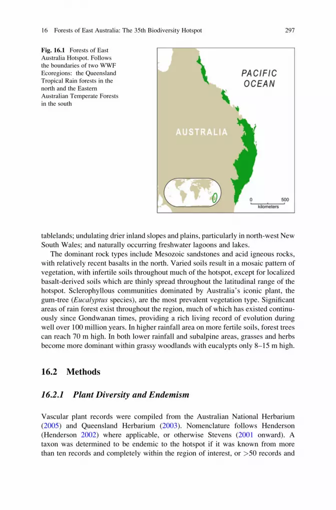
Temperate Forests and Queensland’s Tropical Rain Forests (Fig. 16.1).
The hotspot, although covering a large latitudinal range (15.5�–35.6� South), hasa predominantly summer rainfall pattern with increasing rainfall seasonality north-
wards into the tropical areas of north Queensland. Annual rainfall is unpredictable
from year to year varying on average between 550 mm in the more arid savanna
regions to 4,500 mm near the tropical coast. Mountain tops in the northern “Wet
Tropics” region have recorded annual rainfall events in excess of 12,000 mm.
Temperatures are also variable, with annual winter snowfalls at high elevations in
the south and a tropical climate in the far north. Altitudinal variation is from sea
level to about 1,600 m. The hotspot covers a broad range of environments including
flat to rolling and undulating coastal plains; riverine and estuarine systems with
accompanying deltas or floodplains; foothills of adjacent coastal ranges; coastal and
mountain range escarpments, some with exposed summits and peaks; elevated
296 K.J. Williams et al.
tablelands; undulating drier inland slopes and plains, particularly in north-west New
South Wales; and naturally occurring freshwater lagoons and lakes.
The dominant rock types include Mesozoic sandstones and acid igneous rocks,
with relatively recent basalts in the north. Varied soils result in a mosaic pattern of
vegetation, with infertile soils throughout much of the hotspot, except for localized
basalt-derived soils which are thinly spread throughout the latitudinal range of the
hotspot. Sclerophyllous communities dominated by Australia’s iconic plant, the
gum-tree (Eucalyptus species), are the most prevalent vegetation type. Significant
areas of rain forest exist throughout the region, much of which has existed continu-
ously since Gondwanan times, providing a rich living record of evolution during
well over 100 million years. In higher rainfall area on more fertile soils, forest trees
can reach 70 m high. In both lower rainfall and subalpine areas, grasses and herbs
become more dominant within grassy woodlands with eucalypts only 8–15 m high.
16.2 Methods
16.2.1 Plant Diversity and Endemism
Vascular plant records were compiled from the Australian National Herbarium
(2005) and Queensland Herbarium (2003). Nomenclature follows Henderson
(Henderson 2002) where applicable, or otherwise Stevens (2001 onward). A
taxon was determined to be endemic to the hotspot if it was known from more
than ten records and completely within the region of interest, or >50 records and
Fig. 16.1 Forests of East
Australia Hotspot. Follows
the boundaries of two WWF
Ecoregions: the Queensland
Tropical Rain forests in the
north and the Eastern
Australian Temperate Forests
in the south
16 Forests of East Australia: The 35th Biodiversity Hotspot 297

95% within the region. Taxa were defined as probably endemic if known from< 10
records, completely within the region of interest or<50 records and 88% within the
region. Some taxa were defined as requiring further assessment where there were
less than five records with >70% occurring within the region. Formal and popular
literature were used to validate the status of some species, including The Flora of
New South Wales (Harden 1990–1993), the Queensland Census (Henderson 2002),
Fairley and Moore (1989) from the Sydney Region, The Native Vegetation of New
South Wales (Keith 2004), Fruits of the Rainforest (Cooper 2004), Rainforest Trees
of Southeast Australia (Floyd 1989), Flora of Australia (Pteridophytes) (ABRS/
CSIRO Australia 1998), and Eucalypts (Brooker and Kleinig 1994). Taxa with
manuscript names were not considered. Taxa that satisfied the above criteria were
then further scrutinized with the use of the above-mentioned literature. Such an
approach reduced the effect of inaccurate locality information and geocodes.
16.2.2 Vertebrate Diversity and Endemism
For birds and reptiles, we used data compiled in the Australian Natural Heritage
Assessment Tool (ANHAT) current to August 2006 (Department of Environment
and Heritage 2006). Vertebrate taxonomy was based on the Australian Faunal
Directory (ABRS 2006). To allow for varying levels of spatial precision, distri-
bution records were summarized to a grid of 10 � 10 km cells covering the
hotspot. Records collected before 1950 or with a potential spatial error >20 km
were excluded from the analysis (see Slatyer et al. 2007) for more details on data
preparation for an Australia-wide endemism analysis). Species with <3 records
within the hotspot were assumed to be erroneous or vagrant and excluded from
the hotspot species list, unless these records were the only ones for the species.
In the latter case, further checks were performed to confirm the species ende-
mism within the region. Allowing for a small percentage of erroneous records,
species were found to be endemic to the hotspot if known from �50 records with
�95% of these records occurring within the hotspot or if known from 10–50
records with 100% of these within the hotspot. Species with <10 records or that
just missed inclusion based on the above thresholds were subject to manual
checking. Species found to be endemic were verified using published distribution
information.
For consistency with other regions, the numbers for mammals and amphibians
presented here are from a larger reanalysis for all hotspots based on the most
recent IUCN Global Mammal Assessment and Global Amphibian Assessment
(see chapter 1, Mittermeier et al., 2011). However, we also obtained results for
mammals and amphibians using the methods described above for birds and
reptiles. This more precise analysis yielded similar results to the IUCN Red
List analysis. Both analyses yielded much higher estimates of total numbers of
species and percent endemism than data obtained through WWF WildFinder
(WWF 2006).
298 K.J. Williams et al.

16.2.3 Primary Vegetation Extent
The extent of primary vegetation is a criterion, along with the number of endemic
vascular plants, in classifying a region as a global high biodiversity hotspot (Myers
et al. 2000). We consider primary vegetation to be relatively pristine natural areas
in which the majority of species and ecological processes are intact. Spatial analysis
of amount and percent of primary vegetation remaining in the hotspot was based
on data classified as “residual” by the Vegetation Assets, States and Transitions
(VAST) framework (Fig. 16.2, Table 16.1). The VAST framework orders vegeta-
tion by degree of anthropogenic modification as a series of condition states, from a
residual or baseline condition through to total removal (Thackway and Lesslie
2006; Thackway and Lesslie 2008). The residual classification corresponds well
with the definition of primary vegetation.
16.2.4 Land Use
Spatial analysis of amount and percent of land use classes in the hotspot (Table 16.3)
was based on the catchment-scale land use mapping for Australia (Bureau of Rural
Sciences 2009) which applies the Australian Land Use and Management Classifi-
cation (ACLUMP 2006).
16.2.5 Area Protected
Spatial analysis of amount and percent of hotspot area under formal protection
(Table 16.4) was based on the Collaborative Australian Protected Areas Database
current to 2006 (Department of the EnvironmentWater Heritage and the Arts 2009).
16.3 Unique Biodiversity
A number of prehistoric events were responsible for the high levels of diversity and
endemism found in the Forests of East Australia Hotspot. Geographic isolation of
this region over millions of years resulted in sclerophyllous flora evolving from
ancestral rain forest stock on nutrient-depleted soils, and desertification of central
Australia promoted further speciation. Speciation within rain forest flora occurred
in Gondwanan elements, gymnosperms, and basal lineage angiosperms. Subse-
quently, floral and vertebrate migrations occurred from the Indonesian plate,
increasing with lowered sea level during periods of glaciation. Although many
higher order taxa from the region have been catalogued, much of the biodiversity of
the hotpot, as for the rest of Australia, remains unknown to science.
16 Forests of East Australia: The 35th Biodiversity Hotspot 299

16.3.1 Plants
The hotspot consists of both rain forest and sclerophyllous communities with the
sclerophyllous vegetation being dominant. Of 8,257 species of vascular plants, at
150°0’0”E
150°0’0”E
30°0
’0”S
20°0
’0”S
20°0
’0”S
30°0
’0”S
CAIRNS
SYDNEY
0 250
kilometers
N
PACIFIC OCEAN
AUSTRALIA
LegendConservation
Natural environments
Production from relatively natural environments
Production from dryland agriculture and plantations
Production from irrigated agriculture and plantations
Intensive uses
Water
a b
Fig. 16.2 (a) Extent of primary vegetation in the Forests of East Australia Hotspot (source:Thackway and Lesslie 2008). (b) Landuse in the Forests of East Australia Hotspot (source: Bureauof Rural Sciences 2009)
300 K.J. Williams et al.

least 2,144 are endemic (26%); exceeding the 1,500 endemic species required for
a biodiversity hotspot (Table 16.2). Surprisingly, only 99 of 2,031 genera (5%) are
endemic, but a further 26 genera may include some endemics following further
review of their status. Of particular note is the fact that three families occur nowhere
else in the world (Doryanthaceae and the monotypic Austrobaileyaceae and
Petermanniaceae). This is a very high level of plant endemism at the family level,
Table 16.2 Species diversity and endemism recorded for the Forests of East Australia Hotspot
Taxonomic Group Species
Endemic
species
Percent
endemism
Endemic
generacEndemic
families
Plants – Flowering (dicots) 5,884 1,731 29.4 73 1
Plants – Flowering (monocots) 1,917 294 15.3 22 2
Plants – Gymnosperms 71 35 49.3 2 0
Plants – Ferns and allies 385 84 21.8 2 0
Vascular Plants – total >8,257 >2,144 25.9 99 3
Birds 549 28 5.1 3 0
Mammals 133 6a 4.5 0 0
Amphibians 120 38a 31.7 4b 0
Reptiles 259 70 27.0 14 0
Freshwater Fish >80 >10 12.5 >? >?
Vertebrates – total >1,141 >152 13.3 >21 >?aThe analysis described in Sect. 16.2.2 yielded higher total numbers of endemic species for
mammals (12) and amphibians (43) than shown. While these higher numbers are likely more
accurate, we used the IUCN analysis here for consistency with other regionsbOne amphibian genus included in this count, Rheobatrachus, is probably extinct, giving 3 extant
amphibian generacEndemic genera listed in Appendix 1 by family
Table 16.1 State of native vegetation in the Forests of East Australia Hotspot (after Lesslie et al.
2008; Thackway and Lesslie 2006; Thackway and Lesslie 2008). Primary forest remaining in the
hotspot is defined as the residual and naturally bare class
Category Vegetation State
Area
(km2)Percent
of total
Residual and
naturally
bare
Native vegetation structure, composition, and
regenerative capacity intact, including areas that are
naturally bare or naturally disturbed; not significantly
perturbed by land use / land management practice 58,900 23.3
Modified
Native vegetation community structure, composition,
and regenerative capacity intact, but perturbed by
land use/ and management practice 65,300 25.8
Transformed
Native vegetation community structure, composition,
and regenerative capacity significantly altered by
land use/land management practice 6000 2.4
Replaced-
Managed Native vegetation replaced with cultivated vegetation 120,300 47.5
Removed
Vegetation removed – alienation to nonvegetated land
cover 2,600 1.1
Total 253,200 100
16 Forests of East Australia: The 35th Biodiversity Hotspot 301

and places this hotspot second or third among all hotspots in this category. One
member of the Doryanthaceae family, the Giant or Gymea Lily (Doryanthesexcelsa), has edible roots and flower spikes, traditionally eaten roasted by Aborigi-
nal people (see Fig. 16.3). Basal angiosperms are a conspicuous component of the
rain forest flora, with both Austrobaileya (see Fig. 16.3) and Trimenia(Trimeniaceae) being members of the ANITA grade of magnoliids.
The hotspot is also home to the recently discovered and Critically Endangered
Wollemi Pine (Wollemia nobilis), which has fewer than 50 mature individuals. It
is considered a living fossil, with all other members of its genus extinct for over
2 million years. This species is restricted to the Wollemi National Park, within the
Blue Mountains World Heritage Area (Fig. 16.3).
The hotspot harbors 32 globally threatened plant species according to the 2009
IUCN Red List (IUCN 2009): one Critically Endangered, 12 Endangered, and
19 Vulnerable. It also contains 27% of the 1,296 plant species considered rare or
threatened in Australia by the Environmental Protection and Biodiversity Conser-vation Act 1999 (the EPBC Act).
16.3.2 Vertebrates
Overall vertebrate endemism is about 13%, including information for amphibians,
reptiles, birds, mammals, and freshwater fish. Of vertebrate species in the hotspot,
amphibian species endemism is the highest (32%; Table 16.2). However, there have
been several amphibian extinctions in the recent past, with the extinction of the two
remarkable species of gastric-brooding frog being the most noteworthy. More
hopeful is the story of the Yellow-Spotted Bellfrog (Litoria castanea, CR). Thespecies had not been sighted since 1980, and was thought to have declined mainly
due to chytridiomycosis. Widely thought to be extinct, the species was recorded in
2008 and a population of about 100 was confirmed in 2009. Possible resistance to
chytridiomycosis of remaining individuals is being studied.
Reptile endemism is also high (27%; Table 16.2). One endemic reptile, the rain
forest-dwelling Boyd’s Forest Dragon (Hypsilurus boydii), is unusual in that its
body temperature is generally within one degree of air temperature (see Fig. 16.3).
A total of 28 out of 549 birds (5%) are considered endemic (Table 16.2).
The extraordinary colorful Paradise Parrot (Psephotus pulcherrimus) was likely
endemic to the hotspot, but is considered extinct, with the last sighting in 1927.
The species fed mainly on grass seeds and nested in hollowed termite mounds. The
cause of extinction is unknown, but contributing factors may have included trapping
and egg collection, disease, predation by introduced mammals, changes to the fire
regime, and reduction of food supply due to overgrazing and land clearing.
We estimate that well over 80 freshwater fish species are present in the hotspot,
of which over 10 (or approximately 13%) are endemic (Unmack 2001; Wet Tropics
Management Authority 2010; Table 16.2). These numbers are almost certainly
underestimates, and further analysis of freshwater fish data using finer-scale basin
302 K.J. Williams et al.

The Wollemi National Park is the only place where the Wollemi Pine (Wollemia nobilis, CR) is known to occur.
D oryanthes excelsa, a member of the endemic Doryanthaceae family, has a number of traditional uses.
Hinchinbrook Island, in the Wet Tropics of Queensland. Austrobaileya scandens is a member of a family endemic to the Forests of East Australia Hotspot.
Wet sclerophyll forest occurs in the higher rainfall areas of the hotspot. At Crediton, west of Mackay, the dominant tree species is Eucalyptus grandis (Flooded Gum), which achieves heights of 80m.
Boyd’s Forest Dragon (Hypsilurus boydii) is found only in the wet tropics of Queensland.
Fig. 16.3 Example landscapes, flora and fauna in the Forests of East Australia Hotspot
16 Forests of East Australia: The 35th Biodiversity Hotspot 303

data is needed to generate a more accurate estimate of diversity and endemism
within the hotspot boundaries.
16.4 Human Impact
The human population of the hotspot as of 2006 was 9,147,190, with a population
density of 36 people per square kilometer (see Mittermeier et al. 2011) for details on
this analysis, which utilized LandScan™ GP2007 data (ORNL 2007). Much of the
population is concentrated along the coast.
Approximately 58,900 km2 (23%) of the hotspot comprises primary vegetation
(Table 16.1). This analysis used data compiled between 1995 and 2003 (Thackway
and Lesslie 2008) to determine that more than 70% of the total land area of the
hotspot has lost its primary vegetation. More than 65% of the hotspot is under some
form of production land use (Fig. 16.3, Table 16.3).
In the north of the hotspot, within the Queensland Tropical Rain Forests
Ecoregion, major threats include invasive pest species and habitat fragmentation,
although substantial areas are now protected in the Wet Tropics World Heritage
Area. Fragmentation within forest patches through road and powerline construction
also increases the spread of invasive species and facilitates the entry of fire.
Phytophthora cinnamomi, a highly invasive, soil-borne water mold, has resulted
in significant rain forest dieback at some sites. Pollution from agricultural runoff is
Table 16.3 Primary land use types in the Forests of East Australia Hotspot (ACLUMP 2006,
Bureau of Rural Sciences 2009)
Land uses Area (km2) Percent of total
Conservation and natural environments 82,200 32.5
Intensive land use (urban and agricultural) 13,700 5.4
Production from dryland agriculture and plantations 70,400 27.8
Production from irrigated agriculture and plantations 5,700 2.3
Production from relatively natural environments 75,600 29.9
Water 5,600 2.2
Total 253,200 100
Table 16.4 IUCN categories
of protection in the Forests of
East Australia Hotspot
(Department of the
Environment Water Heritage
and the Arts 2009)
IUCN category Area (km2)
Percent
of total
I: Strict Nature Reserve 15,800 6.24
II: National Parks 25,200 9.96
III: Natural Monument 200 0.09
IV: Habitat/species Management Area 100 0.04
V: Protected Landscape 100 0.04
VI: Managed Resource Protected Area 5,200 2.04
Total 46,600 18.40
304 K.J. Williams et al.

an additional threat. The Ecoregion itself is listed by WWF as “Vulnerable” (Olson
and Dinerstein 2002).
Human impact is even higher further south, within the Eastern Australian
Temperate Forests Ecoregion, listed by WWF as “Critical/Endangered” (Olson
and Dinerstein 2002). Population density is higher in this part of the hotspot, and
major threats are related to ongoing clearing of native vegetation for urban devel-
opment, introduced species, altered fire regimes, water pollution, and schemes for
water use.
Threats within protected areas throughout the hotspot include tourism, altered
fire regimes, sewage disposal, and invasive plants and animals. Specific threats to
amphibians include chytridiomycosis, which is suggested as a cause for a number of
recent species extinctions and was first detected as a major threat to amphibian
species in Queensland in the 1990s.
16.5 Conservation Actions
A combined total of about 46,600 km2 (18%) of the land area in the Forests of East
Australia Hotspot is under some form of formal protection, with a total of
41,300 km2 (16%) falling within IUCN protected area categories I–IV (Table 16.4).
The Royal National Park, south of Sydney, was the second proclaimed National
Park in the world. Fraser Island, the Blue Mountains, the Gondwana Rain Forests,
and the Wet Tropics of Queensland are all UNESCO World Heritage Areas
(e.g., Hinchinbrook Island, see Fig. 16.3) and the Noosa region is a UNESCO
Biosphere Reserve. Gaps in the protected area network include some centers of
plant endemism and some areas of critical habitat for threatened species.
Recent reductions in rabbit populations in the tablelands of New South Wales
and other areas and the introduction of voluntary habitat protection schemes on
farms have led to the recovery of some native vegetation. The cessation of broad-
scale clearing in Queensland at the end of 2006 will lead to a further reduction in the
rate of loss of native vegetation, though the condition of remnants in production
landscapes has continued to decline (Wilson et al. 2008). Biodiversity has become
increasingly vulnerable because of loss of habitat extent and reduced ecosystem
resilience, possibly aggravated by enhanced climatic variability (Beeton et al.
2006). Community-based landscape restoration programs, such as the Great Eastern
Ranges initiative (NSW Australian 2010) and environmental stewardships
(Government 2010; Wilson et al. 2008) are increasingly important mechanisms,
assisting land managers to protect the natural environment.
Acknowledgments We are grateful for the use of data or assistance provided by the following
institutions and individuals: CSIRO Sustainable Ecosystems, Atherton and Canberra; the
Queensland Herbarium, Department of Environment and Resource Management, Brisbane;
Australian National Herbarium, CSIRO Centre for Plant Biodiversity Research, Canberra; John
Benson and Doug Benson, Botanic Gardens Trust, Sydney; Daniel P. Faith and The Australian
Museum, Sydney; David Keith and Department of Conservation and Environment, Sydney;
16 Forests of East Australia: The 35th Biodiversity Hotspot 305
Cameron Slatyer and Department of the Environment, Water, Heritage and the Arts, Canberra;
Trevor Parker; Richard Thackway and Bureau of Rural Sciences, Canberra; National Land and
Water Resources Audit, Canberra; Queensland Museum, Brisbane; CSIRO Australian National
Wildlife Collection, Canberra; Birds Australia; NSW Department of Environment and Climate
Change; NSW Department of Primary Industry, Forests NSW; Geosciences Australia; World
Wildlife Fund; Kellee Koenig, Ian Harrison, and Conservation International; IUCN; Department
of Natural Resources, Mines and Energy, Queensland; Land and Property Information, New South
Wales; Museum and Art Gallery of the Northern Territory; Museum Victoria; South Australian
Museum; Western Australian Museum; Commonwealth Department of Defence; Northern Terri-
tory Department of Natural Resources, Environment and the Arts; WildNet, Queensland Environ-
mental Protection Agency, Brisbane; South Australian Department for Environment and Heritage;
Tasmanian Department of Primary Industries and Water; Victorian Department of Sustainability
and Environment. Support also was provided by the “2010 Working Group” within the Australian
Research Council, Environmental Futures Network (see Williams et al. 2006). Photographs in
Fig. 16.3 by A.F., CSIRO.
Appendix 1: List of Genus-level Endemic Vertebrate Animals
(Excluding Freshwater Fish) and Vascular Plants Known from
the Forests of East Australia Hotspot
Vertebrate group Family Genus
Birds Acanthizidae Oreoscopus
Birds Acanthizidae Origma
Birds Ptilonorhynchidae Scenopoeetes
Amphibians Myobatrachidae Taudactylus
Amphibians Myobatrachidae Rheobatrachus*
Amphibians Myobatrachidae Assa
Amphibians Myobatrachidae Adelotus
Reptiles Elapidae Tropidechis
Reptiles Elapidae Cacophis
Reptiles Gekkonidae Phyllurus
Reptiles Gekkonidae Carphodactylus
Reptiles Scincidae Calyptotis
Reptiles Scincidae Gnypetoscincus
Reptiles Scincidae Ophioscincus
Reptiles Scincidae Harrisoniascincus
Reptiles Scincidae Coeranoscincus
Reptiles Scincidae Eroticoscincus
Reptiles Scincidae Saiphos
Reptiles Scincidae Coggeria
Reptiles Scincidae Nangura
Reptiles Chelidae Elusor
306 K.J. Williams et al.

Vascular plant group Family Genus
Flowering (dicots) Akaniaceae Akania
Flowering (dicots) Alseuosmiaceae Crispiloba
Flowering (dicots) Anacardiaceae Rhodosphaera
Flowering (dicots) Araliaceae Cephalaralia
Flowering (dicots) Araliaceae Motherwellia
Flowering (dicots) Austrobaileyaceae Austrobaileya
Flowering (dicots) Celastraceae Hedraianthera
Flowering (dicots) Celastraceae Hexaspora
Flowering (dicots) Celastraceae Hypsophila
Flowering (dicots) Cunoniaceae Acrophyllum
Flowering (dicots) Cunoniaceae Davidsonia
Flowering (dicots) Cunoniaceae Pseudoweinmannia
Flowering (dicots) Cunoniaceae Vesselowskya
Flowering (dicots) Elaeocarpaceae Peripentadenia
Flowering (dicots) Ericaceae Rupicola
Flowering (dicots) Euphorbiaceae Hylandia
Flowering (dicots) Euphorbiaceae Rockinghamia
Flowering (dicots) Fabaceae Almaleea
Flowering (dicots) Flacourtiaceae Baileyoxylon
Flowering (dicots) Flacourtiaceae Streptothamnus
Flowering (dicots) Gesneriaceae Lenbrassia
Flowering (dicots) Grossulariaceae Cuttsia
Flowering (dicots) Hamamelidaceae Neostrearia
Flowering (dicots) Hamamelidaceae Noahdendron
Flowering (dicots) Hamamelidaceae Ostrearia
Flowering (dicots) Icacinaceae Irvingbaileya
Flowering (dicots) Loranthaceae Atkinsonia
Flowering (dicots) Loranthaceae Benthamina
Flowering (dicots) Meliaceae Synoum
Flowering (dicots) Menispermaceae Echinostephia
Flowering (dicots) Monimiaceae Austromatthaea
Flowering (dicots) Monimiaceae Endressia
Flowering (dicots) Monimiaceae Hemmantia
Flowering (dicots) Myrtaceae Anetholea
Flowering (dicots) Myrtaceae Austromyrtus
Flowering (dicots) Myrtaceae Barongia
Flowering (dicots) Myrtaceae Choricarpia
Flowering (dicots) Myrtaceae Lenwebbia
Flowering (dicots) Myrtaceae Mitrantia
Flowering (dicots) Myrtaceae Ristantia
Flowering (dicots) Myrtaceae Sphaerantia
Flowering (dicots) Myrtaceae Stockwellia
Flowering (dicots) Myrtaceae Tristania
Flowering (dicots) Myrtaceae Waterhousea
Flowering (dicots) Proteaceae Athertonia
Flowering (dicots) Proteaceae Austromuellera
Flowering (dicots) Proteaceae Buckinghamia
Flowering (dicots) Proteaceae Cardwellia(continued)
16 Forests of East Australia: The 35th Biodiversity Hotspot 307

Vascular plant group Family Genus
Flowering (dicots) Proteaceae Carnarvonia
Flowering (dicots) Proteaceae Catalepidia
Flowering (dicots) Proteaceae Darlingia
Flowering (dicots) Proteaceae Eidothea
Flowering (dicots) Proteaceae Floydia
Flowering (dicots) Proteaceae Hicksbeachia
Flowering (dicots) Proteaceae Hollandaea
Flowering (dicots) Proteaceae Megahertzia
Flowering (dicots) Proteaceae Musgravea
Flowering (dicots) Proteaceae Neorites
Flowering (dicots) Proteaceae Opisthiolepis
Flowering (dicots) Proteaceae Placospermum
Flowering (dicots) Proteaceae Sphalmium
Flowering (dicots) Proteaceae Triunia
Flowering (dicots) Rhamnaceae Schistocarpaea
Flowering (dicots) Rubiaceae Durringtonia
Flowering (dicots) Rutaceae Brombya
Flowering (dicots) Rutaceae Pentaceras
Flowering (dicots) Sapindaceae Castanospora
Flowering (dicots) Sapindaceae Sarcotoechia
Flowering (dicots) Sterculiaceae Franciscodendron
Flowering (dicots) Surianaceae Guilfoylia
Flowering (monocots) Anthericaceae Alania
Flowering (monocots) Arecaceae Laccospadix
Flowering (monocots) Arecaceae Normanbya
Flowering (monocots) Arecaceae Oraniopsis
Flowering (monocots) Asteliaceae Neoastelia
Flowering (monocots) Convallariaceae Kuntheria
Flowering (monocots) Convallariaceae Tripladenia
Flowering (monocots) Cyperaceae Ptilothrix
Flowering (monocots) Doryanthaceae Doryanthes
Flowering (monocots) Juncaginaceae Maundia
Flowering (monocots) Orchidaceae Cooktownia
Flowering (monocots) Orchidaceae Corunastylis
Flowering (monocots) Orchidaceae Corymborkis
Flowering (monocots) Orchidaceae Papillilabium
Flowering (monocots) Orchidaceae Peristeranthus
Flowering (monocots) Orchidaceae Rimacola
Flowering (monocots) Orchidaceae Schistotylus
Flowering (monocots) Petermanniaceae Petermannia
Flowering (monocots) Poaceae Alexfloydia
Flowering (monocots) Poaceae Notochloe
Flowering (monocots) Poaceae Potamophila
Flowering (monocots) Restionaceae Coleocarya
Gymnosperms Araucariaceae Wollemia
Gymnosperms Zamiaceae Lepidozamia
Ferns and allies Blechnaceae Pteridoblechnum
Ferns and allies Dryopteridaceae Revwattsia
*Probably extinct
308 K.J. Williams et al.

References
ABRS (2006) Australian Faunal Directory: http://www.environment.gov.au/biodiversity/abrs/
online-resources/fauna/afd/index.html, Access Date: 2006. Australian Biological Resources
Study, Canberra
ABRS/CSIRO Australia (1998) Flora of Australia Volume 48: Ferns, gymnosperms and allied
groups. CSIRO, Melbourne, Victoria
ACLUMP (2006) Guidelines for land use mapping in Australia: principles, procedures and
definitions: a technical handbook supporting the Australian Collaborative Land Use Mapping
Programme Edition 3. Bureau of Rural Sciences, Australian Government, Canberra
Australian Government (2010) Caring for our country – environmental stewardship, website
accessed 2nd July 2010: http://www.nrm.gov.au/stewardship/index.html. Australian Govern-
ment, Canberra
Australian National Herbarium (CANB) (2005) Australian National Herbarium Specimen Infor-
mation Register (ANHSIR) database [on-line, ASCII text]. Access Date: Jan 2005. Australian
National Herbarium, Canberra
Beeton RJS, Buckley KI, Jones GJ, Morgan D, Reichelt RE, Trewin D (2006) Chapter 5 –
Biodiversity, Australia State of the Environment 2006: http://www.environment.gov.au/soe/
2006/publications/report/biodiversity.html 2006 Australian State of Environment Committee,
Canberra
Brooker MIH, Kleinig DA (1994) Field guide to Eucalypts volume 3. Inkata, Port Melbourne
Bureau of Rural Sciences (2009) Metadata: catchment scale land use mapping for Australia update
May 2009 (CLUM Update 05/09) dataset. Department of Agriculture, Fisheries and Forestry,
Australian Government, Canberra
Cooper W (2004) Fruits of the Australian Tropical Rainforest. Nokomis Editions, Melbourne
Department of Environment and Heritage (2006) Australian National Heritage Assessment Tool
(ANHAT) [digital dataset]. Access Date: August 2006. Australian Government, Canberra
Department of the Environment Water Heritage and the Arts (2009) Collaborative Australian
Protected Areas Database – CAPAD 2006 (digital spatial data). Department of the Environ-
ment, Water, Heritage and the Arts, Australian Government, Canberra
Fairley A, Moore P (1989) Native plants of the Sydney district: an identification guide. Kangaroo
Press in association with Society for Growing Australian Plants, Kenthurst, NSW
Floyd AG (1989) Rainforest trees of Mainland South-eastern Australia. Inkata, Lismore, NSW
Harden GJ (1990–1993) Flora of New South Wales, (volumes 1–4). New South Wales University
Press, Sydney
Henderson RJF (2002) Names and distribution of Queensland plants, Algae and Lichens.
Environmental Protection Agency, Queensland Government, Brisbane
IUCN (2009) 2009 IUCN Red list of threatened species. Accessed online: February 2010. http://
www.iucnredlist.org. International Union for Conservation of Nature, Gland
Keith DA (2004) Ocean shores to desert dunes: the native vegetation of New South Wales and the
ACT. Department of Environment and Conservation, New South Wales National Parks and
Wildlife Service, Sydney
Lesslie L, Thackway R, Smith J (2008) A national-level Vegetation Assets, States and Transitions
(VAST) dataset for Australia, version 2.0 [Digital Data]. Bureau of Rural Sciences, Australian
Government, Canberra
Mittermeier RA, Robles Gil P, Hoffmann M, Pilgrim J, Brooks T, Goettsch Mittermeier C,
Lamoreux J, Da Fonseca GAB (2004) Hotspots revisited: earth’s biologically richest and
most endangered terrestrial ecoregions. CEMEX, Agrupacion Sierra Madre, SC
Mittermeier RA, Turner WR, Larsen FW, Brooks TM, Gascon C (2011) Global biodiversity
conservation: the critical role of hotspots. In: Zachos FE, Habel JC (eds) Biodiversity hotspots:
distribution and protection of conservation priority areas. Springer, Heidelberg
Myers N (1988) Threatened Biotas: “Hot Spots” in Tropical Forests. The Environmentalist
8:187–208
16 Forests of East Australia: The 35th Biodiversity Hotspot 309

Myers N, Mittermeier RA, Mittermeier CG, da Fonseca GAB, Kent J (2000) Biodiversity hotspots
for conservation priorities. Nature 403:853–858
NSW Government (2010) The Great Eastern Ranges, connecting people. . ..connecting nature, a
continental scale conservation vision for Australia, website accessed 2nd July 2010: http://
www.greateasternranges.org.au/. NSW Government, Sydney
Olson DM, Dinerstein E (2002) The Global 200: Priority ecoregions for global conservation. Ann
Mo Bot Gard 89:199–224
ORNL (2007) Population Density 2007, Available at http://www.ornl.gov/landscan/. UT-Battelle,
LLC, operator of Oak Ridge National Laboratory, Oak Ridge
Queensland Herbarium (BRI) (2003) Herbarium Records System (HERBRECS) database [digital
dataset]. Access Date: 2003. Environmental Protection Agency, Brisbane
Slatyer C, Rosauer D, Lemckert F (2007) An assessment of endemism and species richness
patterns in the Australian Anura. J Biogeogr 34:583–596
Stanton JP, Bostock PD, McDonald KR, Werren GL, Fleming A (2004) Queensland wet tropics.
In: Mittermeier RA, Robles Gil P, Hoffmann M, Pilgrim J, Brooks T, Goettsch Mittermeier C,
Lamoreux J, Da Fonseca GAB (eds) Hotspots revisited: Earth’s biologically richest and most
endangered terrestrial ecoregions. CEMEX, S.A. de C.V., Agrupacion Sierra Madre, S.C.
Stevens PF (2001 onwards) Angiosperm Phylogeny Website: http://www.mobot.org/MOBOT/
research/APweb/. Version 9, June 2008 [and more or less continuously updated since].
Missouri Botanical Garden and University of Missouri, St Louis
Thackway R, Lesslie R (2006) Reporting vegetation condition using the Vegetation Assets, States
and Transitions (VAST) framework. Ecol Manage Restor 7:S53–S62
Thackway R, Lesslie R (2008) Describing and mapping human-induced vegetation change in the
Australian landscape. Environ Manage 42:572–590
Unmack PJ (2001) Biogeography of Australian freshwater fishes. J Biogeogr 28:1053–1089
Wet Tropics Management Authority (2010) Freshwater fish – General information, http://www.
wettropics.gov.au/pa/pa_fish_info.html, accessed March 2010. Queensland Government,
Cairns
Williams KJ, Faith DP, Ford A, Metcalfe D, Pert P, Rosauer D, Slatyer C, Ferrier S, Cogger H,
Margules C, James R (2006) Progress in defining the status and extent of a global high-
biodiversity hotpot in Eastern Australia. In: Gole C (eds) Abstracts of the Conservation
Planning Symposium, 27–29 September 2006. WWF Australia and the Southwest Australia
Ecoregion Initiative, Perth Convention Centre, Western Australia, pp 11–12
Wilson B, Young P, Niehus R (2008) Habitat protection. In: Freeman J, Webber W (eds) State of
the environment Queensland 2007. Environmental Protection Agency, Queensland Govern-
ment, Brisbane
WWF (2006) WildFinder: www.worldwildlife.org/WildFinder, Online database of species
distributions, version Jan 2006, accessed January 2010. World Wildlife Fund, Washington,
DC, USA
310 K.J. Williams et al.


