Embed Size (px)
Citation preview

689
Technologies and new approaches used by the INGV EMERGEOWorking Group for real-time data sourcing and processingduring the Emilia Romagna (northern Italy) 2012 earthquake sequence
EMERGEO Working Group:Giuliana Alessio1, Laura Alfonsi2, Carlo Alberto Brunori3, Pierfrancesco Burrato4, Giuseppe Casula5,Francesca Romana Cinti4, Riccardo Civico4, Laura Colini3, Luigi Cucci4, Paolo Marco De Martini4,Emanuela Falcucci4, Fabrizio Galadini4, Germana Gaudiosi1, Stefano Gori4, Maria Teresa Mariucci4,*,Paola Montone4, Marco Moro3, Rosa Nappi1, Anna Nardi3, Rosa Nave1, Daniela Pantosti4,Antonio Patera4, Arianna Pesci5, Maurizio Pignone3, Stefania Pinzi4, Stefano Pucci4,Paola Vannoli4, Alessandra Venuti2, Fabio Villani4
1 Istituto Nazionale di Geofisica e Vulcanologia, Sezione di Napoli, Osservatorio Vesuviano, Napoli, Italy2 Istituto Nazionale di Geofisica e Vulcanologia, Sezione Roma 2, Roma, Italy3 Istituto Nazionale di Geofisica e Vulcanologia, Centro Nazionale Terremoti, Roma, Italy4 Istituto Nazionale di Geofisica e Vulcanologia, Sezione Roma 1, Roma, Italy5 Istituto Nazionale di Geofisica e Vulcanologia, Sezione di Bologna, Bologna, Italy
ANNALS OF GEOPHYSICS, 55, 4, 2012; doi: 10.4401/ag-6117
1. IntroductionOn May 20, 2012, a ML 5.9 seismic event hit the Emilia
Po Plain, triggering intense earthquake activity along a broadarea of the Po Plain across the provinces of Modena, Ferrara,Rovigo and Mantova (Figure 1). Nine days later, on May 29,2012, a ML 5.8 event occurred roughly 10 km to the SW of thefirst main shock. These events caused widespread damageand resulted in 26 victims. The aftershock area extended overmore than 50 km and was elongated in the WNW-ESE direc-tion, and it included five major aftershocks with 5.1 ≤ML ≤5.3,and more than 2000 minor events (Figure 1).
In general, the seismic sequence was confined to theupper 10 km of the crust. Minor seismicity with depths rang-ing from 10 km to 30 km extended towards the southern sec-tor of the epicentral area (ISIDe, http://iside.rm.ingv.it/).
The thrust faulting focal mechanisms of the mainshocks and the strongest aftershocks show fault planes withE-W, ENE-WSW, and WNW-ESE orientations [Pondrelli etal. 2012, Scognamiglio et al. 2012, this volume], compatiblewith the approximately N-S direction of the compression inthe area [Montone et al. 2012].
The extensive seismic reflection data used for oil explo-ration [Pieri and Groppi 1981, Picotti and Pazzaglia 2008, Fan-toni and Franciosi 2010] allowed the reconstruction of the
main tectonic elements of the area. The active Apenninethrust fronts that are buried under the Po Plain Plio-Quater-nary sediments locally consist of three N-verging arcs [Fer-rarese et al. 1998, Benedetti et al. 2000, Castiglioni and Pelle-grini 2001]. The most external structures, the active Ferraraand Mirandola thrusts and folds [Bigi et al. 1992], were re-sponsible for the Emilia Romagna 2012 earthquake sequence[Bignami et al. 2012, Salvi et al. 2012, this volume].
Historical and instrumental earthquakes [e.g. Boschi etal. 2000, Rovida et al. 2011], drainage anomalies controlled byburied anticlines, active compression, and a shortening rateof ca. <1 mm/a [Toscani et al. 2009] testify to the Quater-nary thrusts activity [DISS Working Group 2010]. In detail,the recent activity of the Ferrara and Mirandola thrusts [DISSWorking Group 2010] has been responsible for drainage di-versions of the Po, Secchia, Panaro and Reno rivers [Burratoet al. 2003, Burrato et al. 2012, this volume].
Just after the May 20, 2012, seismic event, the EMER-GEO Working Group was active in surveying the epicentralarea in the search for coseismic geological effects. The workin the field was organized according to EMERGEO proce-dures (http://emergeo.ingv.it/it/2012-06-11-07-35-01/887-protocollo-operativo.html/), and it lasted for one month,with about 30 researchers and technicians of the Istituto
Article historyReceived July 19, 2012; accepted August 10, 2012.Subject classification:Earthquake geology and paleoseismology, Coseismic effects, Liquefaction, GIS, Po Plain.
2012 EMILIA EARTHQUAKES

Nazionale di Geofisica e Vulcanologia (INGV; National In-stitute of Geophysics and Volcanology) involved alterna-tively in the survey. At the same time, a laboratory workinggroup gathered, organized and interpreted the records, pro-cessing them through the EMERGEO Information System(siE) based on a GIS environment. Ground and aerial surveyswere coupled with crowdsourcing data initiatives, such as theinternet, social networks, and information from residents.
The most common coseismic effects surveyed by theEMERGEO teams were: 1) liquefactions related to overpres-sure of aquifers in buried and confined sand layers (e.g. SanFelice sul Panaro, San Carlo, Sant'Agostino, and Bondeno),which occurred through several aligned vents that formed co-alescent flat cones (Figure 1a); 2) extensional fractures withsmall vertical throws, apparently organized in an en-echelonpattern, which were observed mainly in the eastern sectorand in the central area (Figure 1b); 3) liquefactions directly as-sociable to fractures (e.g. Bondeno and San Carlo) wherehuge amounts of fine sand were ejected from fractures thatwere tens of meters long (Figure 1c). Most of these coseis-mic effects were also reported by other authors [e.g. Bertoliniand Fioroni 2012, Di Manna et al. 2012, this volume].
The innovative tools that were employed for data gath-ering, processing and delivery during the EMERGEO surveyincluded: development of the EMERGEO Information Sys-
tem (siE), which turns unprocessed data into useful infor-mation; setting up of a webGIS; use of social networks for in-formation and data delivery; and experimental data-sourcingfrom the internet and from residents, which accompaniedthe traditional survey methods (field and aerial surveys). Thewhole architecture allowed the collection and processing ofabout 2400 observation points in less than one month. Thedetailed analyses of this dataset will be presented in an-other paper [EMERGEO Working Group, submitted].
2. Data: acquisition and methodsThrough different approaches, the EMERGEO teams
collected geological coseismic surface effects: (i) field and aer-ial surveys; (ii) crowdsourcing from the internet and personalcommunications (subsequently validated by field surveys).
In all, 2156 observations were gathered from field andaerial surveys alone (helicopter flights on May 23 and 30,2012, which were kindly made possible by the Corpo Fore-stale dello Stato, and a powered hang-glider trike flight onJune 8, 2012). Sixty-three percent of the total data providedreliable records concerning geologic coseismic surface ef-fects. The data were then stored in a geodatabase and ana-lyzed using geographical information system (GIS) tools.
Field surveys were mainly aimed at the definition of thetypologies and structural and morphological significance of
EMERGEO WORKING GROUP
690
Figure 1. Seismic sequence in the Emilia Po Plain from May 19 to June 19, 2012 (ISIDe, http://iside.rm.ingv.it/). In a month, more than 2000 seismic eventsoccurred, seven with ML ≥5.0 (red stars). Blue pinpoints, observation records made by the EMERGEO Working Group. Insets: Photographs of the co-seismic geological effects: (a) coalescent cones; (b) fracture; (c) liquefaction associated with fracture.

691
the observed phenomena. The locations of the geologicalobservations and photographs were registered using a pre-defined form, and stored directly as georeferenced data.Smartphones that allowed the collection and storage of fielddata in real-time were used also for rapid data-sharing amongfield teams. Through only the field surveys, 402 observationswere gathered, analyzed and stored in a week, and a total of662 data points were reported in a month (Figure 2a).
Aerial surveys were effective in integrating the datasetcollected in the field, by taking approximately 1500 georef-erenced photographs and recording more than 3 h of video.The low-altitude flights (~200-300 m above ground level) al-lowed the whole area struck by the seismic sequence to beinvestigated, supported the field survey planning, and led tothe identification of further features. This dataset was ana-lyzed and processed, and the features shown in each imagewere characterized and positioned on the GIS. These resultswere available two or three days after each flight, and theywere particularly useful for this specific seismic sequencethat affected a vast plain area where there are very few goodsites for panoramic views over large fields (Figure 2a).
For the first time, we used internet-based data sourcing,
and nine days after the main shock the experimental proce-dure was active, to receive information from people on thegeological earthquake effects. An internet form was specifi-cally designed to gather information on surface effects thatwere directly associated to the earthquake (available at:http://www.haisentitoilterremoto.it/emergeo.html). Theform provided a simplified list of possible geological featuresto be flagged and editable fields for other relevant informa-tion. A specific part of the form is related to the informationthat is useful to locate the phenomena (i.e. street, city, and/orgeographical coordinates). The entire system is based on anopen-source relational database management system, and itcan be queried through a graphic interface. The most reli-able information was selected and transmitted daily to thefield teams in the epicentral area, for verification. The re-sponse was remarkable (more than 200 completed forms),testifying to the curiosity towards an internet-based poll sys-tem (Figure 2a). Information received directly from residentsconstituted another important element concurring to thedata-flow implementation. Communication between theEMERGEO teams and the people was particularly intenseand useful during the days of the field surveys (Figure 2a).
NEW APPROACHES USED BY EMERGEO
Figure 2. (a) Information flow from the different investigation tools used (i.e., number of observations, log scale, vs. time). The time scale starts on May20, 2012, the day of the main shock of the Emilia 2012 sequence (ML = 5.9). (b) The EMERGEO Information System (siE): chart illustrating the data fluxand procedures adopted for data analysis, storage and output. (c) The input data are constructed as sets of layers, each of which contains information onone type of data. In detail, the layers shown include information on: 1) the seismic sequence (ISIDe, http://iside.rm.ingv.it/); 2) the DInSAR data(http://ingvterremoti.wordpress.com/2012/06/07/terremoto-in-pianura-padana-emiliana-spostamento-del-suolo-dovuto-al-terremoto-del-29052012-visto-dal-satellite-italiano-cosmo-skymed/); 3) the historical seismicity [Rovida et al. 2011]; 4) the seismogenic sources [DISS Working Group 2010]; 5) thegeological data [Bigi et al. 1992]; 6) the digital elevation model.

3. EMERGEO Information System (siE)The geodatabase, the procedures, the GIS tools, and the
people represent the core of the EMERGEO InformationSystem (Figure 2b). The system acts by transforming un-processed data into information that is ready to use for theemergency management, and it leads to the production ofpreliminary and final reports and maps [Burrough 1986,Maguire 1991, Brunori et al. 2007]. The input data in the siEare grouped into two main categories: (i) existing base maps(e.g., geographic, geological data; DEM) and other availabledatasets (e.g., INGV Kharita - Geoserver portal Project; CSI 1.1- Castello et al. [2006]; Bollettino Sismico Italiano; Italian Seis-mic Instrumental and Parametric Database - ISIDe; CPTI11 -Rovida et al. [2011]; DISS Working Group [2010]); (ii) geologi-cal coseismic surface effects collected during the post-earth-quake survey by the EMERGEO teams. The whole dataset isorganized into georeferenced (latitude/longitude WGS84)multilayer information in the GIS environment (Figure 2c).
The acquired data flowed into a webGIS that was specifi-cally created for the dissemination of original geo-informa-tion (Figure 2b). During the emergency phase, the siE systemwas necessary both for fixing the knowledge of the phenom-ena and its temporal and spatial evolution, and for planning
the field surveys and the fly-overs in progress (Figure 2b). The whole siE structure acts as a dynamic system,
which filters the data through the procedures into the data-base and which sends back real-time information to the fieldoperators. All of the process was constantly implementedduring the emergency.
4. Data disseminationDuring the Emilia 2012 seismic emergency, two experi-
mental procedures were used to perform the data dissemi-nation devoted to different target groups (general public,researchers, emergency operators, policy makers). The maininstrument was set up by implementing an existing platformfor image and data sharing [Pignone and Moschillo 2011,Pignone et al. 2012], and it was constituted by a webGIS ap-plication that was developed on the ESRI ArcGIS online plat-form (http://www.arcgis.com/). This system allowed acomplete parallel representation of the information gatheredby the EMERGEO Working Group and the principal data-bases used (Figure 2c). It provided access to geographic con-tent shared and registered by ESRI and GIS users around theworld (http://www.esriitalia.it/emergeo/). For the firsttime, all of the EMERGEO data collected and processed by
EMERGEO WORKING GROUP
692
Figure 3. Screen shot depicting a typical layer of the webGIS interface and the related information that is accessible at http://www.esriitalia.it/emergeo/.
693
the siE were immediately available to potential users throughan external interface (Figure 2c, Figure 3).
A further procedure was set up within the framework ofthe "Flickr" social network, as a dedicated EMERGEO space,for the diffusion of photographs of the geological effects ofthe earthquake. Georeferenced pictures from field and aerialsurveys were detailed with full descriptions of the phenom-ena. These free-access images are available at http://www.flickr.com/photos/emergeo_ingv/ and they represent a validcommunication tool between the EMERGEO researchersand the generic public (Figure 3).
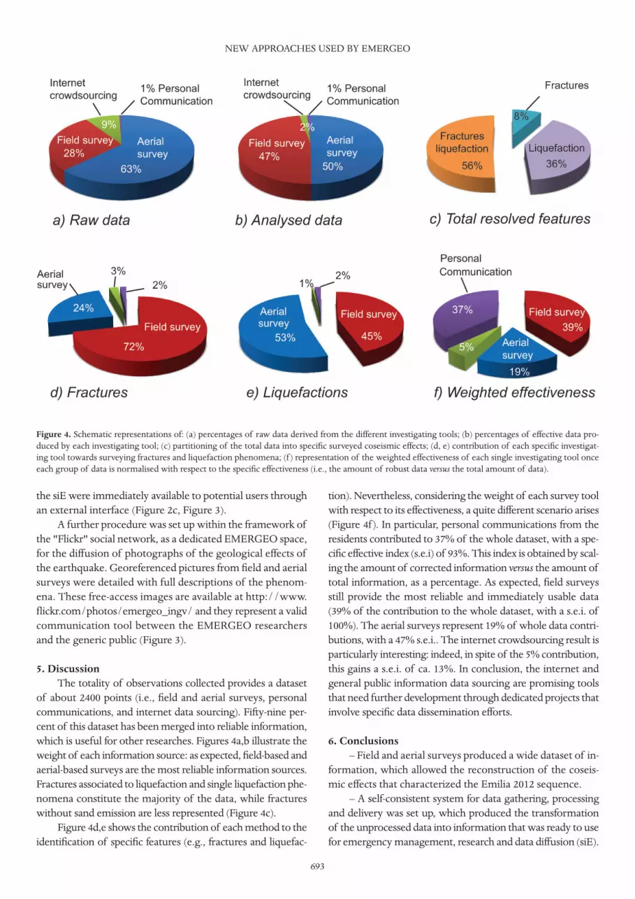
5. DiscussionThe totality of observations collected provides a dataset
of about 2400 points (i.e., field and aerial surveys, personalcommunications, and internet data sourcing). Fifty-nine per-cent of this dataset has been merged into reliable information,which is useful for other researches. Figures 4a,b illustrate theweight of each information source: as expected, field-based andaerial-based surveys are the most reliable information sources.Fractures associated to liquefaction and single liquefaction phe-nomena constitute the majority of the data, while fractureswithout sand emission are less represented (Figure 4c).
Figure 4d,e shows the contribution of each method to theidentification of specific features (e.g., fractures and liquefac-
tion). Nevertheless, considering the weight of each survey toolwith respect to its effectiveness, a quite different scenario arises(Figure 4f ). In particular, personal communications from theresidents contributed to 37% of the whole dataset, with a spe-cific effective index (s.e.i) of 93%. This index is obtained by scal-ing the amount of corrected information versus the amount oftotal information, as a percentage. As expected, field surveysstill provide the most reliable and immediately usable data(39% of the contribution to the whole dataset, with a s.e.i. of100%). The aerial surveys represent 19% of whole data contri-butions, with a 47% s.e.i.. The internet crowdsourcing result isparticularly interesting: indeed, in spite of the 5% contribution,this gains a s.e.i. of ca. 13%. In conclusion, the internet andgeneral public information data sourcing are promising toolsthat need further development through dedicated projects thatinvolve specific data dissemination efforts.
6. Conclusions– Field and aerial surveys produced a wide dataset of in-
formation, which allowed the reconstruction of the coseis-mic effects that characterized the Emilia 2012 sequence.
– A self-consistent system for data gathering, processingand delivery was set up, which produced the transformationof the unprocessed data into information that was ready to usefor emergency management, research and data diffusion (siE).
NEW APPROACHES USED BY EMERGEO
Figure 4. Schematic representations of: (a) percentages of raw data derived from the different investigating tools; (b) percentages of effective data pro-duced by each investigating tool; (c) partitioning of the total data into specific surveyed coseismic effects; (d, e) contribution of each specific investigat-ing tool towards surveying fractures and liquefaction phenomena; (f ) representation of the weighted effectiveness of each single investigating tool onceeach group of data is normalised with respect to the specific effectiveness (i.e., the amount of robust data versus the total amount of data).

– For this seismic sequence, the EMERGEO WorkingGroup dedicated efforts towards the development of alter-native methods for collecting information through citizenengagement. Although experimental, this data coupling pro-vided encouraging results in terms of the involvement of thepublic, which revealed at the same time their poor knowl-edge of the specific earthquake phenomenon.
– Use of social networks and internet sourcing to gathervalid earthquake-related information was tentative and needsfuture development through specific projects.
The dissemination effort can improve the interactionsamong geologists/seismologists and society at large, and in-crease the level of confidence of the population concerningthe service provided to society before, during, and after aseismic crisis.
Acknowledgements. The Corpo Forestale dello Stato is acknowl-edged for the flights over the seismic area, ESRI Italia for the webGIS fa-cilities, and last but not least, the residents directly affected by the seismicsequence who actively collaborated in spite of the uneasy living condi-tions. We are grateful to the anonymous reviewers and the Guest Editors.
ReferencesBenedetti, L., P. Tapponier, G.C.P. King, B. Meyer and I.
Manighetti (2000). Growth folding and active thrusting inthe Montello region, Veneto, northern Italy, J. Geophys.Res., 105, 739-766.
Bertolini, G., and C. Fioroni (2012). Aerial inventory of sur-ficial geological effects induced by the recent Emiliaearthquake (Italy): preliminary report, Annals of Geo-physics, 55 (4); doi:10.4401/ag-6113.
Bigi, G., D. Cosentino, M. Parlotto, R. Sartori and P. Scan-done (1992). Structural model of Italy and gravitymap,Quaderni della Ricerca Scientifica, 114, ConsiglioNazionale delle Ricerche (CNR), Roma.
Bignami, C., P. Burrato, V. Cannelli, M. Chini, E. Falcucci, A.Ferretti, S. Gori, C. Kyriakopoulos, D. Melini, M. Moro,F. Novali, M. Saroli, S. Stramondo, G. Valensise, P. Vannoli(2012). Coseismic deformation pattern of the Emilia 2012seismic sequence imaged by Radarsat-1 interferometry,Annals of Geophysics, 55 (4); doi:10.4401/ag-6157.
Bollettino Sismico Italiano, Istituto Nazionale di Geofisica eVulcanologia: http://bollettinosismico.rm.ingv.it
Boschi, E., E. Guidoboni, G. Ferrari, D. Mariotti, G. Valensiseand P. Gasperini (2000). Catalogue of strong Italian earth-quakes, 461 B.C. to 1997, Annali di Geofisica, 43 (4), 609-868, with database on CD-ROM.
Brunori, C.A., G. Siletto, A. Piccin, F. Berra and E. Mozzi(2007). Verso un Sistema Informativo Geologico: l'ap-plicativo CARGeo per la banca dati Geologica della Re-gione Lombardia, Rendiconti della Società GeologicaItaliana, Nuova Serie, 4, 91-96.
Burrato, P., F. Ciucci and G. Valensise (2003). An inventory ofriver anomalies in the Po Plain, northern Italy: evidence
for active blind thrust faulting, Annals of Geophysics, 46(5), 865-882.
Burrato, P., P. Vannoli, U. Fracassi, R. Basili and G. Valensise(2012). Is blind faulting truly invisible? Tectonic-controlleddrainage evolution in the epicentral area of the May 2012,Emilia-Romagna earthquake sequence (northern Italy),Annals of Geophysics, 55 (4); doi:10.4401/ag-6182.
Burrough, P.A. (1986). Principles of geographical informa-tion systems for land resource assessment, ClarendonPress, Oxford, UK, 194 pp.
Castello, B., G. Selvaggi, C. Chiarabba and A. Amato (2006).CSI Catalogo della sismicità italiana 1981-2002, versione1.1. INGV-CNT, Roma, http://csi.rm.ingv.it/
Castiglioni, G.B., and G.B. Pellegrini, eds. (2001). Note illus-trative della Carta Geomorfologica della Pianura Padana,Geogr. Fis. Din. Quat., Suppl. IV, 207 pp.
Di Manna, P., L. Guerrieri, L. Piccardi, E. Vittori, D. Castal-dini, A. Berlusconi, L. Bonadeo, V. Comerci, F. Ferrario,R. Gambillara, F. Livio, M. Lucarini and A.M. Michetti(2012). Ground effects induced by the 2012 seismic se-quence in Emilia: implications for seismic hazard assess-ment in the Po Plain, Annals of Geophysics, 55 (4);doi:10.4401/ag-6143.
DISS Working Group (2010). Database of Individual Seis-mogenic Sources (DISS), Version 3.1.1: A compilation ofpotential sources for earthquakes larger than M 5.5 inItaly and surrounding areas; http://diss.rm.ingv.it/diss/(© INGV 2010 – Istituto Nazionale di Geofisica e Vul-canologia. All rights reserved).
EMERGEO Working Group (2012). Coseismic geologicaleffects associated with the Emilia earthquake sequenceof May-June 2012 (northern Italy), Nat. Haz. Earth Sys.,submitted.
Fantoni, R., and R. Franciosi (2010). Tectono-sedimentary set-ting of the Po Plain and Adriatic foreland, Rend. Fis. Acc.Lincei, 21: S197-S209, doi:10.1007/s12210-010-0102-4.
Ferrarese, F., U. Sauro and C. Tonello (1998). The MontelloPlateau, karst evolution of an alpine neotectonic mor-phostructure, Z. Geomorphol. N. F., 109, 41-62.
ISIDe Working Group (INGV, 2010). Italian SeismologicalInstrumental and parametric database: http://iside.rm.ingv.it/
Kharita-Geoserver Portal: http://kharita.rm.ingv.it/dmap/Maguire, D.J. (1991). An overview and definition of GIS, In:
D.J. Maguire, M.F. Goodchild and D. Rhind (eds.), Geo-graphical Information Systems: Principles and Applica-tions, John Wiley & Sons, Inc., New York, 9-20.
Montone, P., M.T. Mariucci and S. Pierdominici (2012). TheItalian present-day stress map, Geophys. J. Int., 189, 705-716; doi:10.1111/j.1365-246X.2012.05391.x.
Picotti, V., and F.J. Pazzaglia (2008). A new active tectonicmodel for the construction of the northern Apenninesmountain front near Bologna (Italy), J. Geophys. Res.,
EMERGEO WORKING GROUP
694

695
113, B08412; doi:10.1029/2007JB005307.Pieri, M., and G. Groppi (1981). Subsurface geological struc-
ture of the Po Plain, Italy, Pubbl.414, Consiglio Nazionaledelle Ricerche, CNR, Agip, Progetto Finalizzato Geodi-namica, Rome, 1981, 23 pp.
Pignone, M., and R. Moschillo (2011). GEOSIS: dall'Earth-quake Report al webGIS, Quaderni di Geofisica, 94, ISSN:1590-2595.
Pignone, M., R. Moschillo and R. Cogliano (2012). Geodata-base e report di sismicità, Rendiconti Online della Socie-tà Geologica Italiana, vol. 19.
Pondrelli, S., S. Salimbeni, P. Perfetti and P. Danecek (2012).Quick regional centroid moment tensor solutions for theEmilia 2012 (northern Italy) seismic sequence, Annals ofGeophysics, 55 (4); doi:10.4401/ag-6146.
Rovida, A., R. Camassi, P. Gasperini and M. Stucchi, eds.(2011). CPTI11, the 2011 version of the Parametric Cata-logue of Italian Earthquakes, Milano/Bologna; http://emidius.mi.ingv.it/CPTI11/
Salvi, S., C. Tolomei, J.P. Merryman Boncori, G. Pezzo, S. At-zori, A. Antonioli, E. Trasatti, R. Giuliani, S. Zoffoli and A.Coletta (2012). Activation of the SIGRIS monitoring sys-tem for ground deformation mapping during the Emilia2012 seismic sequence, using COSMO-SkyMed InSARdata, Annals of Geophysics, 55 (4); doi:10.4401/ag-6181.
Scognamiglio, L., L. Margheriti, F.M. Mele, E. Tinti, A. Bono,P. De Gori, V. Lauciani, F.P. Lucente, A.G. Mandiello, C.Marcocci, S. Mazza, S. Pintore and M. Quintiliani (2012).The 2012 Pianura Padana Emiliana seimic sequence: lo-cations, moment tensors and magnitudes, Annals of Geo-physics, 55 (4); doi:10.4401/ag-6159.
Toscani, G., P. Burrato, D. Di Bucci, S. Seno and G. Valensise(2009). Plio-Quaternary tectonic evolution of the north-ern Apennines thrust fronts along the Bologna-Ferrarasection (Po Plain, Italy), based on geological observationsand analogue modelling: seismotectonic implications,Ital. J. Geosci., 128, 605-613.
*Corresponding author: Maria Teresa Mariucci,Istituto Nazionale di Geofisica e Vulcanologia, Sezione Roma 1,Roma, Italy; email: [email protected].
© 2012 by the Istituto Nazionale di Geofisica e Vulcanologia. All rightsreserved.
NEW APPROACHES USED BY EMERGEO


